Shrubsteppe - WDFW
99
September 2011 (Updated Sept. 2020)
-
Upload
khangminh22 -
Category
Documents
-
view
0 -
download
0
Transcript of Shrubsteppe - WDFW

September 2011 (Updated Sept. 2020)

i
This publication should be cited as: Azerrad, J. M., K. A. Divens, M. F. Livingston, M. S. Teske, H. L. Ferguson, and J. L. Davis.
2011. Management recommendations for Washington’s priority habitats: managing shrubsteppe in developing landscapes. Washington Department of Fish and Wildlife, Olympia, Washington. a
Cover photos (clockwise from top left) by Joe Rocchio, (shrubsteppe with three-tip sagebrush and Idaho fescue); Bob Davis, from Washington Department of Fish and Wildlife Image Library (Washington Ground Squirrel); Ryan Woolverton, from Oregon Department of Agriculture (Spalding’s catchfly); Richard Tveten, (spiny hopsage); Washington Department of Fish and Wildlife Image Library (Sagebrush Sparrow); Mike Livingston (shrubsteppe and development).
a This publication received a minor update in 2020 to ensure consistency with an update made to the PHS shrubsteppe definition to address the role of fire in shrubsteppe ecosystems.

ii
Acknowledgements The authors would like to thank the numerous individuals who contributed their time and expertise in developing this Priority Habitat and Species publication for shrubsteppe. Rex Crawford, Joe Rocchio, Debra Salstrom, and Richard Easterly all provided invaluable support when we were putting together the shrubsteppe mapping protocols. Don Larsen, Matt Monda, Nate Pamplin, Teresa Scott, and Lisa Veneroso generously offered their expertise in reviewing the policy implications of this publication. Perry Harvester also offered invaluable guidance that helped us get going early along. A team of resource specialists and shrubsteppe habitat experts in our Habitat and Wildlife programs also provided invaluable support in updating this publication in 2020 to address fire-disturbance. Although we wish we could personally acknowledge each and every reviewer of this publication, there are too many to call out individually. But without the feedback of the researchers, resource managers, and other land use professionals that reviewed drafts of this publication, we would have never been able to get this done. A special thank you goes out to Katie Knight and Elizabeth Rodrick for their guidance and support through-out all the phases of developing and writing this publication.

iii
State of Washington DEPARTMENT OF FISH AND WILDLIFE
Mailing Address: 600 Capitol Way N • Olympia, WA 98501-1091 • (360) 902-2200, TDD (360) 902-2207 Main Office Location: Natural Resources Building • 1111 Washington Street SE • Olympia, WA
September 1, 2020 Fire historically was the primary disturbance in shrubsteppe ecosystems and still is an important ecological process. Fire is particularly significant as a driver of the structure, composition, and abundance of shrubsteppe vegetation. Today, fires are more extreme than ever, primarily because of the spread of highly flammable invasive plants and because of climate change.
Fire has always been a key process in shrubsteppe ecosystems, and scientists have long accepted the inherent function of fire in shrubsteppe. However, until now, Washington Department of Fish and Wildlife’s (WDFW) definition of shrubsteppe in our Priority Habitats and Species List (PHS List) lacked recognition of the role of fire.
In spring 2020, WDFW fixed this omission by adding a limited but important amount of new content to the shrubsteppe definition in PHS. Then, because WDFW’s Management Recommendations for Washington’s Priority Habitats correspond to the definitions in our PHS List, we subsequently revised this PHS shrubsteppe publication by adding background and guidance on the role of fire disturbance.
Specifically, we updated this document solely to add new content on best practices for managing fire-disturbed shrubsteppe habitat and to propose measures to see to the safety and well-being of people and property. These changes provide a more complete representation of shrubsteppe and enhance this publication’s reputation a source of best available science. The substantive new content related to fire is shown in italics in the main body of the publication and is also summarized in Attachment A at the end, after the appendices.
We also used this opportunity to conduct limited, less substantive copy editing, such as updating contact information in the appendices and fixing broken hyperlinks.
Sincerely,
Margen Carlson Director Habitat Program

iv
State of Washington DEPARTMENT OF FISH AND WILDLIFE
Mailing Address: 600 Capitol Way N • Olympia, WA 98501-1091 • (360) 902-2200, TDD (360) 902-2207 Main Office Location: Natural Resources Building • 1111 Washington Street SE • Olympia, WA
November 1, 2011 The mission of the Washington Department of Fish and Wildlife (WDFW) is to preserve, protect and perpetuate fish, wildlife and the ecosystems they depend on while providing sustainable fish and wildlife recreational and commercial opportunities. One program created and managed by the WDFW to fulfill this mission is the Priority Habitats and Species (PHS) Program. The PHS program serves as the ultimate resource and the principal means by which WDFW provides important fish, wildlife, and habitat information to land use planners. This information includes list and location of the fish and wildlife that are of greatest importance for management and conservation, such as shrubsteppe habitat.
Shrubsteppe is one of Washington’s most richly diverse habitats and home to some species found nowhere else in the state. Because of this and because a large portion of Washington’s shrubsteppe has been disturbed or lost, shrubsteppe was added to our list of Priority Habitats and Species. The management recommendations enclosed with this correspondence were developed at the request of local governments to help them plan for rural and urban growth near shrubsteppe. We focused this publication on residential, commercial, and industrial development given the lack of guidance for this land use and excluded other land uses, such as agriculture and wind power because these topics are covered in existing publications. These management recommendations offer strategies for balancing community growth with the needs and requirements of wildlife that use healthy shrubsteppe. The intended audience is city and county governments, developers, landowners, conservation groups, and others planning for future homes and businesses. While this is not a regulatory publication, we encourage land managers who work in this field to consider the strategies we offer. We hope you find these guidelines useful and appreciate all you do to protect Washington’s rich fish and wildlife heritage. Sincerely, Lisa Veneroso Nathan Pamplin Assistant Director Assistant Director Habitat Program Wildlife Program
v
Priority Habitats and Species Toolbox
In 1991, WDFW published the first volume of PHS management recommendations. This volume provided guidance for managing 60 species the agency deemed to be of conservation priority. Since then, WDFW has published four other priority species volumes along with publications on managing for key priority habitat types. The PHS toolbox consists of a list of Priority Habitats and Species, a PHS database of occurrences, as well as published management recommendations. The PHS list is WDFW’s master catalog of species and habitats of conservation priority. Moreover, it is the underlying framework of the PHS toolbox. This is due to the fact that the other components of the toolbox feed directly from the PHS List. For example, we only write management recommendations for species and habitat found in our PHS List. This list is usually the place where users of PHS first go when looking for information on fish and wildlife. Next users tend go is to our PHS database. In this database, are known occurrences of priority habitats and species statewide. Because the data are limited by our knowledge of where occurrences are, you should never assume that the absence of data is the same as there not being an occurrence. But if while searching the database you see that a priority species or habitat is on a site of interest, you then may need additional information. Especially if the occurrence is on a site where a project is being planned. This is where our PHS management recommendations come in. Priority Habitat and Species Management Recommendations
Management recommendations like this one provide users with an important and comprehensive source of information on priority fish, wildlife, and habitat resources. Our recommendations are designed to help professionals working in various areas of land use planning consider the needs of fish and wildlife. The primary goals of our recommendations are to:
• maintain or enhance the attributes and ecological functions of habitat necessary for healthy fish and wildlife populations;
• maintain or enhance populations of priority species in their present and/or historical range to prevent future declines; and
• restore species that have experienced significant declines. Agency biologists review and synthesize a comprehensive body of peer-reviewed literature, technical reports, symposia, and best professional judgment to form these recommendations. These recommendations then undergo extensive review by the Department, users of PHS, and by a wide range of other resource professionals outside WDFW. Our management recommendations are generalized for statewide application. They are not intended as site-specific prescriptions, but rather as guidance. Because natural systems inherently are complex and because human activities have added to that complexity, our management recommendations may have to be modified when applying them on-the-ground. When modifying any recommendation, strive to retain or restore characteristics needed by fish and wildlife. We urge you to consult with a fish and wildlife professional whenever thinking about modifying a recommendation in a PHS publication. As with other areas of research, the body of science on the conservation of fish and wildlife is constantly evolving. Due to that fact, this and other PHS management recommendations may be revised as scientists learn more.

vi
In summary, our management recommendations...
Are: Are not:
Guidelines Regulations
Generalized Site specific
Updated with new information Static
Based on fish and wildlife needs Based on other land use objectives
A synthesis of current and relevant science A combination of science and policy
To be used for all occurrences To be used only for mapped occurrences Intended Audience of the PHS Management Recommendations
Although WDFW is responsible for protecting and maintaining species of fish and wildlife, the protection of their habitat often is achieved by the actions of counties and cities. The responsibility of local government to adopt and oversee critical areas ordinances, shoreline master programs, and comprehensive plans, as well as other plans directly affects local habitat resources. Because of this, jurisdictions often require information to ensure these plans are based on current science. Our PHS management recommendations have served as a source of science that many local governments use to address fish and wildlife habitat resources in their local planning processes. Although the primary users of our PHS management recommendations are local governments, they are not the only ones who have come to rely on PHS as an informational source on fish and wildlife. Local land trusts and other conservation organizations use our recommendations to help manage and restore their lands. Federal and state resource agency’s use our recommendations when reviewing projects and proposals for fish and wildlife impacts. The recommendations also are used by individuals who look to them as a literature review for researching subject matters about certain fish and wildlife.

vii
Table of Contents INTRODUCTION……………………………………………………………………………………………… 1
How we Organized this Publication…………………………………………………………………………....... 1 WHAT IS SHRUBSTEPPE?............................................................................................................................. 2 Vegetation………………………………………………………………………………………... …………....... 2
Washington Range……………………………………………………………………………….. …………....... 3
Climate Influences……………………………………………………………………………….. ….………….. 3
Topography and Soils……………………………………………………………………………………............ 3
Disturbance Processes…………………………………………………………………………………………... 4 WHY IS SHRUBSTEPPE HABITAT IMPORTANT?............................................................................ 5
Vulnerable Wildlife……………………………………………………………………………………………… 5
Rare Plants……………………………………………………………………………………..…………………6
Climate Change………………………………………………………………………………………………….. 6
Shrubsteppe Protection………………………………………………………………………….. …………....... 6
HISTORIC LOSS OF SHRUBSTEPPE……………………………………………………………………. 8 IMPACTS OF DEVELOPMENT ON SHRUBSTEPPE……………………………………………….. 9 Major Impacts to Wildlife……………………………………………………………………………………….. 9 MANAGEMENT RECOMMENDATIONS ……………………………………………………………... 12 Long-range Planning: Considering the Landscape……………………………………………………………...………………………. 12
Site-specific Management: How to Avoid and Minimize Impacts of Development…………………………………………………………. 20
RESTORING SHRUBSTEPPE…………………………………………………………...........................................29 REFERENCES……………………………………………………………………………………………………… 30 PERSONAL COMMUNICATIONS...………………………………………………………………………………35 GLOSSARY………………………………………………………………………………………………………… 36 APPENDICIES…………………………………………………………………………………………………….. A-1 ATTACHMENTS………………………………………………………………………………………………….. A-45

viii
List of Tables Table 1. State and federally listed native wildlife closely associated with shrubsteppe………….......................... 5 Table 2. Databases and resources to help identify occurrences of shrubsteppe habitat…………………………………………………………………………………………………...... 14 Table 3. Planning activities used to protect large-blocks of shrubsteppe.…………………………………………. 15 Table 4. Issues to consider when planning a cluster development………………………………………………… 18 Table 5. Information to obtain and review to help in developing and writing an HMP…………………………... 21 Table 6. Summary of important factors in determining the need for an HMP…………………………… ……… 22 Table 7. Publications for guiding land use activities that potentially impact Greater Sage-grouse habitat ………………………………………………………………………………28

ix
List of Figures Figure 1. Shrubsteppe dominated by Wyoming big sagebrush and bluebunch wheatgrass in Douglas County.........….........................................................................…………......... 1
Figure 2. Ponderosa pines in shrubsteppe with bitterbrush and Wyoming big sagebrush in Yakima County.........….................................................................................................... 2 Figure 3. Cryptobiotic crust provides many benefits to arid communities like shrubsteppe.........…................................................................................................................................ 3 Figure 4. Historical vs. current steppe and shrubsteppe in Washington State………………………...................4 Figure 5. Simplistic example of the linear sequence of shrubsteppe succession over time. Succession may not always happen in this order……………………………………………………... 4 Figure 6. Front page story from the Tri-City Herald……………………………………………………............. 9 Figure 7. The human footprint in Washington ……………………………………………………………......... 9 Figure 8. Roads and homes cutting through and fragmenting shrubsteppe habitat……………………........... ... 10 Figure 9. Basic steps to protect shrubsteppe taken through the long-range and current planning process………………………………………………………………………………………. 12 Figure 10. A map of potential locations of Big Sagebrush habitat using Shrubmap landcover data…………………………………………………………………………………............ 13 Figure 11. Map of shrubsteppe communities on the Hanford Reach National Monument…………..................... 14 Figure 12. Single rural residence surrounded by a large patch of shrubsteppe………………………................... 15 Figure 13. Predicted response to development for shrubsteppe species………………………………................... 17 Figure 14. Single home in a landscape of shrubsteppe and ponderosa pine forest……………………………… 20 Figure 15. A layout of lots using conventional design strategies…………………………………………............ 26 Figure 16. A layout of lots using cluster development…………………………………………………………… 26 Figure 17. Shrubsteppe being restored after a wildfire…………………………………………………………... 29

x
Appendices Appendix 1. Links to selected online guidance to address the management of shrubsteppe for lands use activities other than development………………………………………………… A-2 Appendix 2. Native wildlife closely associated with shrubsteppe and their conservation status…………….. A-3 Appendix 3. The common and Latin names of plants species and subspecies identified in the body of this publication…………………………………....................................................... A-4 Appendix 4. Rare plants associated with shrubsteppe habitat in Washington………………….......................A-5 Appendix 5. Summary of key shrubsteppe conservation efforts in Washington………...................................A-6 Appendix 6. Shrubsteppe ecological systems, related plant associations and their global conservation status ranks as defined by NatureServe……………………………………........... A-7 Appendix 7. A protocol for identifying and mapping shrubsteppe over broad landscapes…………............... A-9 Appendix 8. List of contacts to inform when a project is being proposed on or near an area of potential shrubsteppe........................................................................................................ A-22 Appendix 9. A protocol for identifying, mapping, and assessing quality of shrubsteppe on an individual parcel………………………………………………………………………….. A-25

xi
List of Acronyms
AA Assessment Area
BLM Bureau of Land Management
CAO Critical Areas Ordinances
CRP Conservation Reserve Program
DNR Washington Department of Natural Resources
EIA Ecological Integrity Assessment
ESA Endangered Species Act
GIS Geographic Information System
GMA Growth Management Act
GPS Global Positioning System
HMP Habitat Management Plan
LCMI Landscape Condition Model Index
NHP Washington Natural Heritage Program
ORV Outdoor Recreational Vehicle
PHS Priority Habitats and Species
PLSS Public Land Survey System
SAFE State Acres for Wildlife Enhancement
SEPA State Environmental Policy Act
UGA Urban Growth Area
USFS United States Forest Service
USGS United States Geological Survey
WDFW Washington Department of Fish and Wildlife
WNPS Washington Native Plant Society

1
Introduction This Priority Habitats and Spe-cies a (PHS) publication identifies how to avoid and minimize impacts to shrubsteppe from develop-ment. Here we offer science-based recommendations for planning and permitting new development near shrubsteppe (Figure 1). This PHS publication meets an unmet need since no other guidelines deal with the effects of development on shrubsteppe. Although we offer no direct guidance for other activities like agriculture or energy development, other available resources do (Appen-dix 1). We encourage local governments and other authorities to use our PHS shrubsteppe management recommendations when creating, revising, or amending relevant plans and ordinances such as comprehensive and sub-area plans, critical areas ordinances (CAO), and zoning codes. We also encourage landowners, developers, contractors and others to use this when planning, reviewing, or permitting an individual project proposal such as a single-family home, commercial development, or subdivision. How we Organized this Publication
To get the most out of this publication, you first need to understand how it was organized. Although intended as a guide for making land use decisions, your understanding is enhanced when you know more about shrubsteppe. To that end, we began this publication describing the vegetation, soils and geology common to shrubsteppe. We followed that with an overview of why shrubsteppe is important to wildlife and offered some perspective on why this habitat is in trouble. Here we also discussed the historic loss of shrubsteppe to give some sense of the severity of the problem. We then explained why shrubsteppe is valuable to wildlife and to Washington’s biodiversity. Finally, we gave an overview of the impacts of development. Given that planning for development happens at multiple scales, we divided our recommendations into two primary sections. The first aids in planning for development over large areas. Those making decisions that influence how development proceeds over entire counties, watersheds, or subareas will find this section useful. Here the guidelines present techniques for identifying potential shrubsteppe across larger areas and ways to use regulations and non-regulatory incentives to protect habitat.
a For PHS management recommendations for other species and habitats go to https://wdfw.wa.gov/species-habitats/at-risk/phs/recommendations.
Figure 1. Shrubsteppe dominated by Wyoming big sagebrush and bluebunch wheatgrass in Douglas County.
Photo courtesy of Joe Rocchio

2
Those planning to develop a site will refer to the second of the two management-oriented sections. Here the audience includes current planners, developers, and their consultants. The tools offered here help to identify habitat and spot where projects may have negative impacts. If impacts are probable, we offer strategies to develop a habitat management plan (HMP) to avoid or minimize impacts.
What is Shrubsteppe? Vegetation
The Washington Department of Fish and Wildlife’s (WDFW) Priority Habitat and Species List defines shrubsteppe as: “A non-forested vegetation type consisting of one or more layers of perennial bunchgrasses and a conspicuous but discontinuous layer of shrubs. Although big sagebrush is the most widespread shrubsteppe shrub, other dominant (or co-dominant) shrubs include antelope bitterbrush, three-tip sagebrush, scabland sagebrush, and dwarf sagebrush. Dominant bunchgrasses include (but are not limited to) Idaho fescue, bluebunch wheatgrass, Sandberg bluegrass, Thurber's needlegrass, and needle-and-thread. Sites can also have a layer of algae, mosses, or lichens. In areas with greater precipitation or on soils with higher moisture-holding capacity, shrubsteppe can also support a dense layer of forbs (i.e., broadleaf herbaceous flora). Shrubsteppe contains various habitat features, including diverse topography, riparian areas, and canyons. Another important component is habitat quality (i.e., degree to which a tract resembles a site potential natural community), which may be influenced by soil condition and erosion; and the distribution, coverage, and vigor of native shrubs, forbs, and grasses. At some more disturbed sites, non-natives such as cheatgrass or crested wheatgrass may be co-dominant species. Fire disturbance is an ecological component of shrubsteppe. Shrubsteppe disturbed by fire may lack the aforementioned vegetative components during periods of post-fire recovery.”
Although shrub canopy cover can be as high as 60%, less disturbed habitat typically has a canopy between 5% and 30% (29). In areas of higher precipitation, shrub cover is lower while grasses and forbs are more prevalent (12). Trees may occur in shrubsteppe (Figure 2), especially when near riparian habitat or wetlands. Isolated trees from adjacent forests or woodlands can also occur (29). Conifers such as juniper and pine (34, 42) sometimes encroach into shrubsteppe while planted trees can also sometimes be found.
Figure 2. Three isolated Ponderosa pines in shrubsteppe with bitterbrush and Wyoming big sagebrush in Yakima County.
Photo courtesy of Joe Rocchio

3
Healthy shrubsteppe supports a soil surface layer of cryptobiotic crust (Figure 3). Comprised of a complex and fragile community of blue-green algae, bacteria, fungi, lichens, or mosses, these crusts form in the spaces between perennial bunchgrasses, forbs, and shrubs. Soil crusts benefits habitat by locking in soil moisture, reducing erosion, and by increasing the soil’s nutrients and productivity (4, 30, 56). They also help prevent the establishment and spread of invasive plants such as cheatgrass (4).
Washington Range
Shrubsteppe extends from south-central British Columbia into eastern Washington, Oregon, and California, through Idaho, Nevada, and Utah, and into western Wyoming and Colorado (43). In Washington, it occurs throughout the Columbia Plateau and into the surrounding higher elevations regions (29). Of the 4.2 million ha (10.4 million ac) of shrubsteppe found in eastern Washington before non-indigenous settlers arrived in the mid-19th century, only 40% remains (17). Figure 4 shows Washington’s historical and current extent of shrubsteppe (and steppe a). Climate Influences
Precipitation in Washington’s semi-arid shrubsteppe zone occurs mainly in late autumn and winter. Annual precipitation ranges from 15 cm (6 in) in the lowest parts of the Columbia Plateau to 55 cm (22 in) in higher elevations near the transition with forested zones (12). Relatively cold winters and hot summers characterize the climate (67). Minimum January and maximum July temperatures in Moses Lake (approximately the center of Washington’s shrubsteppe zone) average -8 °C (17°F) and 33 °C (87°F), respectively. b By late spring, rainfall diminishes and temperatures rise rapidly and the foliage of most upland herbs gradually die back as summer heat increases (67). The ability of the soil to store winter moisture to support vigorous plant growth and flowering is critical during dryer months (12). Topography and Soils
Topography throughout Washington’s shrubsteppe region varies from gently undulating to moderately hilly (27). Steep slopes commonly occur in the foothills of the East Cascades and the Channeled Scablands. Elsewhere, steeper topography is restricted to isolated buttes, or canyons cut by rivers and streams. Elevations range from about 80 m (263 ft) at the Columbia River on the Oregon border to roughly 2,000 m (6,560 ft) on a few of the highest ridges.
a This map of the combined distribution of shrubsteppe and steppe is provided because no similar map showing only the distribution of shrubsteppe in Washington is available. Although steppe is designated as a priority habitat by WDFW (see Eastside Steppe in the PHS List), the scope of this publication is directed at shrubsteppe. b Source: U. S. Weather Bureau statistics, as found in Franklin and Dyrness (27).
Figure 3. Cryptobiotic crust such as this provides many benefits to arid communities like shrubsteppe.

4
A variety of soils occur in the shrubsteppe region (12, 27). The water holding capacity of these soils influences the native plant assemblages more than the chemical or profile characteristics of the soil (13). Although lithosol soils do not retain much moisture, these soils support a diverse array of wildflowers. Sandier soils in areas with lower
precipitation support dry-land grasses amongst shrub species such as Needle-and-thread and Indian ricegrass, while deeper soils with moderate precipitation support bluebunch wheatgrass and sagebrush. Disturbance Processes
Fire is an ecological component of shrubsteppe and was historically the primary disturbance in sage-brush-dominated ecosystems (83). Fire events and the collective fire regime were important drivers of structure, composition, and abundance of vegetation within sagebrush communities (41). Fire regimes in shrubsteppe were historically variable, both temporally and spatially. This helped maintain a patchy distribution of shrubs, both within local areas of shrubsteppe and across landscapes (84). Fire severity and frequency historically varied among different plant associations and site characteristics. This included fire return intervals that averaged from as little as 10 years in higher elevation sites to more than 200 years in dryer low elevations (34). In general, fire was a beneficial force that altered vegetation but did not remove shrubsteppe. Fire was, and still is, an important mechanism to reset mature shrubsteppe back to an earlier state of succession. This reset is valuable to shrubsteppe dependent wildlife that typically do not respond well to densely vegetated, overgrown habitat. Once reset, the system then can proceed through a cycle of succession back to a more mature state (Figure 5)
Figure 4. Historical (top) vs. current (bottom) shrubsteppe and steppe in eastern Washington (53). Green = forest; brown = shrubsteppe/ steppe; tan = agriculture; yellow = Columbia Plateau ecoregional boundary.
Figure 5. Simplistic example of the linear sequence of shrubsteppe succession over time. Succession may not always happen in this order.
Forbs and
grasses
Shrub cover
Succession Reset
Biological soil crusts Fire

5
Why is Shrubsteppe Habitat Important? Vulnerable Wildlife
As compared to shrubsteppe, only riparian and westside lowland mixed forest have more closely associated wildlife species in Washington (Appendix 2; 29). Although Pygmy Rabbit is the only one that is federally-listed under the Endangered Species Act (ESA; Table 1), many are state-listed. While none of Washington’s other sagebrush-obligates are ESA listed, additional species may eventually require ESA protection if the pace of habitat loss does not slow down. This includes Greater Sage-grouse, which is a highly sensitive sagebrush-obligate species that up until recently the U.S. Fish and Wildlife Service listed as a federal ESA candidate species. Sagebrush-obligate species require specific features found nowhere other than in shrubsteppe (67). Sagebrush and Brewer’s Sparrow a are examples of sagebrush obligates because of their affinity with big sagebrush habitat (79). Greater Sage-grouse also rely on big sagebrush for cover and as a year-round food source (54). The Federally Endangered Pygmy Rabbit is also an obligate that requires sagebrush and undisturbed deep-soil shrubsteppe (71). Table 1. State and federally listed native wildlife closely associated with shrubsteppe1, 2.
Species (species in blue text linked to PHS Management Recommendation)
Federal Status
Washington State Status
PHS Management Recommendation
State or Federal Recovery Plan
Ferruginous Hawk Threatened √ √
Greater Sage-grouse Concern Threatened √ √
Sharp-tailed Grouse Endangered √ √
Burrowing Owl Candidate √
Loggerhead Shrike Candidate √
Sage Thrasher Candidate √
Sagebrush Sparrow Candidate √
Pygmy Rabbit Endangered Endangered √
Black-tailed Jackrabbit Candidate
White-tailed Jackrabbit Candidate
Townsend’s Ground Squirrel Candidate
Washington Ground Squirrel Candidate
Sagebrush Lizard Candidate
Striped Whipsnake Candidate √ 1. Association with shrubsteppe described in Johnson and O’Neil (29). Sagebrush Lizard and Striped Whipsnake also considered a close
shrubsteppe associate (Hallock, Personal Communication) 2. State and Federal Status in this table are up to date as of August 2020.
Shrubsteppe alteration across landscapes fragmented what once were extensive tracts of habitat (67). Species dependent on these large habitat blocks were disproportionately affected. Because Sagebrush and Brewer’s Sparrow require large blocks of shrubsteppe, they have declined in fragmented habitat (35). Fragmented habitat also attracts undesirable species, like magpies and crows that prey on the broods of sensitive birds (68). Although
a See Appendix 3 for scientific names of shrubsteppe wildlife species mentioned in this publication.

6
sensitive species may use small patches when embedded in natural or semi-natural vegetation, smaller patches usually offer area-sensitive species with less effective nesting habitat (65). And because deep-soil shrubsteppe has all but vanished, species requiring deep-soil—such as Washington Ground Squirrels and Pygmy Rabbits—are seriously declining (25, 66, 71). Loss of shrubsteppe also substantially reduced habitat available to a wide range of other wildlife (47, 49, 52, 66). Although many shrubsteppe species are on the decline, this habitat continues to support a rich array of non-sagebrush-obligates. Some species, for instance, use a broad range of habitats including shrubsteppe (67). Elk (Cervus elaphus) is one such species that can live in shrubsteppe exclusively or can use shrubsteppe seasonally. Deer, Bighorn Sheep (Ovis canadensis), birds, bats, rabbits, rodents, frogs, snakes, and lizards also thrive in shrubsteppe. Streams running through otherwise arid shrubsteppe can support species not typically thought of as occurring in arid climates (e.g., beaver, porcupine). Rare Plants
Although this publication focuses on habitat management for shrubsteppe wildlife, we should point out that shrubsteppe also harbors many endemic plants as well as many rare non-endemic plants (8). Here we emphasize these plants given their crucial role as part of the state’s overall biodiversity. The presence of these plants also adds to the importance of protecting shrubsteppe. Some rare or endemic shrubsteppe plants include the federally Threatened Spalding’s catchfly, white bluffs bladderpod, and Umtanum desert buckwheat. These species are known from only a few records. Other endemics have state threatened status: Washington polemonium, beaked cryptantha, and white eatonella. Appendix 4 lists other rare and endemic shrubsteppe plants of Washington. For information about protecting rare plants and plant communities contact the Washington Natural Heritage Program (NHP) and also refer to the program’s rare plant site. Climate Change
Slight changes in temperature and precipitation can substantially alter the composition, distribution, and abundance of arid land species (51). Climate change presents a new challenge to protecting shrubsteppe wildlife already in decline due to other forces. Now they face the added hurdle of adapting to a changing physical environment. Factors that could impact wildlife include an increased frequency and intensity of fire. Such changes in fire regime may ultimately favor exotic plants, while hindering the survival of slow-growing woody plants such as sagebrush. While challenges like these may not harm more adaptable shrubsteppe wildlife, prospects may not be as bright for others. But by protecting habitat now, more options will be open to help sensitive wildlife make a living in a climate-altered landscape. Shrubsteppe Protection
Both the public and private sectors have invested in shrubsteppe by acquiring lands and funding conservation programs (Appendix 5). Although these programs benefit the cause of shrubsteppe conservation, these investments are far less effective unless more shrubsteppe habitat is protected and restored in Washington. Many state and federal agencies, tribes, and nonprofit organizations initiated programs to protect, restore, and enhance shrubsteppe. Although these groups play an important role, their collective impact is limited because most of Washington’s shrubsteppe is in private ownership and not protected (17). In order to slow the pace of habitat loss, larger tracts of shrubsteppe on private lands will need protection. Without protecting larger areas of shrubsteppe on private lands, populations of sensitive species will likely continue to decline. A number of groups have formed with the goal of identifying ways to protect and restore shrubsteppe. Some groups have developed useful resources to guide local land use planning activities. The Northwest Power and

7
Conservation Council’s Upper Columbia Main Stem and Yakima Sub-Basin Plans offer conservation strategies focused on local planning and zoning to maintain and enhance large patches of habitat. The Open Space Coalition of Benton and Franklin Counties is establishing an open space network focused in part on shrubsteppe. The Southcentral Washington Shrubsteppe and Rangeland Partnership is writing a strategy for shrubsteppe conservation in south-central Washington. The Washington Wildlife Habitat Connectivity Working Group is another group developing tools to identify important areas of habitat connectivity in the Columbia Plateau. One strategy taken to protect areas of shrubsteppe is the purchase of development rights. The Nature Conservancy has been a leader in this area by purchasing the rights on thousands of acres of shrubsteppe from willing landowners in eastern Washington. They also formed the Arid Lands Initiative, which brings together a range of stakeholders to develop shrubsteppe conservation strategies for Washington. State and federal resource agencies—WDFW, Washington Department of Natural Resources (DNR), U.S. Fish and Wildlife Service—also invested heavily in shrubsteppe protection through acquisitions of large blocks of habitat throughout eastern Washington. WDFW’s mission is to “Preserve, protect and perpetuate fish, wildlife and ecosystems while providing sustainable fish and wildlife recreational and commercial opportunities.” The agency works to secure that mission by conserving Washington’s fish and wildlife resources and ecosystems. Shrubsteppe habitat is one of the primary ecosystems that the department is dedicated to protecting in achieving its mission. Sustaining diverse and abundant shrubsteppe wildlife provides Washington citizens with recreational opportunities such as hunting and wildlife viewing. These opportunities enhance the quality of life for local communities and provide a reliable, long-term source of revenue a (76). WDFW offers assistance to local governments interested in carrying out the recommendations in this publication. Our staff can serve on technical advisory committees and can review draft plans, ordinances, and programs. Local WDFW biologists may also be available to talk to groups about shrubsteppe protection strategies and sometimes can visit and assess impacts and mitigation for projects near shrubsteppe.
a Spending by fishers, hunters and wildlife watchers generates more than $4.5 billion annually for Washington State’s economy (76).

8
Historic Loss of Shrubsteppe Intact high-quality shrubsteppe used to dominate Eastern Washington’s landscape. Although it still occurs across much of the region, more than half of what existed was converted to dry-land or irrigated crops and for developing homes and businesses. Recent energy development in Washington has also led to conversion. Fragmentation has isolated much of the remaining shrubsteppe due to these and other land uses (6, 33, 41, 47, 65). Wildfires, fire suppression, mismanaged grazing, and the spread of exotic plants also contributed to shrubsteppe degradation (29). In some Washington counties, over 75% of the historical shrubsteppe has been lost (17). Most of what remains in eastern Washington is altered to some degree, where deep-soil shrubsteppe is an extreme example. Although deep-soil shrubsteppe was once quite common, now it is extremely rare due to it being ideal for farming. Consequently, most was targeted for conversion. Now most shrubsteppe encompasses areas of less productive shallow and rocky soils (17, 66). Although the landscape of eastern Washington has dramatically changed due to cropland expansion, other farming practices have dramatically impacted habitat. For instance, grazing has altered nearly all shrubsteppe in the west (46). The United States Geological Survey (USGS) classified ungrazed native shrubsteppe as critically endangered and native shrubsteppe as endangered (46). The network of state Natural Heritage Programs (i.e., NatureServe) classified many shrubsteppe related plant associations as vulnerable, imperiled, or critically imperiled (Appendix 6). Because of difficulties in restoring shrubsteppe, some disturbances are irreversible, particularly in the lowest precipitation zones (35). Invasive weeds, increased fire frequency, and fragmentation caused by expanding roads and infrastructure and by agriculture continue to degrade shrubsteppe. Invasive plants out-compete native species altering the composition of shrubsteppe vegetation. Cheatgrass has invaded an estimated 31.5 million acres throughout the Intermountain West (39). By drying out early in the season, this annual grass can fuel and carry a fire across large areas (78). Where present, cheatgrass can extend the length of the fire season, while increasing wildfire risk and intensity. Following a wildfire event cheatgrass often spreads, contributing to more frequent cycles of intense wildfires (14). Although the exact historic extent of fire (e.g., frequency, intensity) is unknown (16), the shrubsteppe fire regime in Washington’s is certainly altered. Fire prior to European settlement likely returned to sites at intervals of 10 to more than 200 years (34, 78, 81), depending on site characteristics. Now return intervals are roughly 10 years, especially in cheatgrass dominated areas (78). This certainly has impacted Washington’s shrubsteppe ecosystems significantly. Fire can devastate stands of Wyoming big sagebrush—the most common sage in Washington—given this species does not easily reestablish post fire (3, 78). This slow growing species struggles where increased fire frequency leaves insufficient time for it to reestablish. Shrub loss through repeated fires has also eliminated habitat for shrub-nesting birds as well as some big game winter range (62, 67). Although the current pattern of frequent high intensity fire is detrimental, fire suppression also negatively affects shrubsteppe by altering natural fire cycles (16, 50). Fire suppression can produce very dense shrub cover, that then can set the stage for hot and explosive fires. Such catastrophic fires can wipe out important soil characteristics, seed stocks, and are also very dangerous to nearby residential areas.

9
Impacts of Development on Shrubsteppe Many local and state conservation plans identify development as a major impediment to shrubsteppe conservation (44, 57, 59, 80). Given the rise of development, roads, power lines and other infrastructure needed for the rapidly growing population in the western U.S. (37), there is little doubt of shrubsteppe wildlife being impacted. Although historically, agriculture led to most shrubsteppe conversion (17, 66), development now appears a more dominant impact (37). In fact, much of what used to be agricultural land is rapidly turning to development, and given the rising cost of land and development’s profitability until recently, the growth of agricultural is a fraction of what it was at its peak (2). And in light of eastern Washington’s growing population a (Figure 6), quite a challenge lies ahead in slowing the pace of its influence on wildlife. Major Impacts to Wildlife
Although we do not know exactly the pace of shrubsteppe conversion to development, we know where land use impacts are occurring in general (37). Specifically, the Columbia Plateau—the core of Washington’s shrubsteppe—has received disproportionate pressure (Figure 7). To address the pressure that development places on the state’s shrubsteppe lands, you need to first understand its influences on wildlife. The following summarizes the major impacts of development:
a Most metropolitan areas in eastern Washington are projected to experience a continued population growth of 15-35% between 2010 and
2020 (48).
Figure 6. Front page story from the Tri-City Herald pointing to the region’s population growth of 2 to 3 times the statewide average.
Figure 7. The human footprint of Washington (37) ranging from low (dark blue) to high (red). The human footprint is the combined effects of land uses like agriculture, development, and roads. The area in the thick black outline represents Washington’s shrubsteppe zone.

10
• Habitat conversion. Clearing vegetation and grading soils to make room for homes, roads, utilities, yards, and accessory structures directly removes shrubsteppe, wildlife habitat, and can fragment habitat. In addition to direct effects are indirect effects such as when impacts of a conversion affect habitat use elsewhere. This is particularly true for species that select habitat at a landscape scale like sage-grouse (18, 19). Because landscape-scale features influence Greater Sage-grouse leks (69), habitat loss in one area can lead to lek failure even if the lek was never touched.
• Habitat fragmentation. Although researchers have not examined how fragmentation caused by development impacts shrubsteppe species, studies have demonstrated how fragmentation by other land uses impacts shrubsteppe wildlife. In one study of shrub-nesting birds in eastern Washington, Sagebrush Sparrows avoided fragmented landscapes (66) and nested more often in large habitat areas >1,000 ha (2,500 ac; 65). Overall, several sagebrush-obligate birds showed lower reproductive success in fragmented versus continuous shrubsteppe (65).
Other studies further demonstrated the impacts of fragmentation. Nest predation has been shown to increase in fragmented shrubsteppe habitats (68). In Wyoming, habitat fragmented by gas development had far fewer hens nesting on leks within 3 km (1.8 mi) of a gas development as compared undisturbed areas (38). In addition to bird communities, fragmented shrubsteppe in the Snake River Plain of Idaho had fewer species of small mammals (28). The impacts of fragmentation on wildlife by roads and urbanization are well established (11, 26, 31, 45). Given that agriculture, energy development, urbanization, and roads have fragmented much of the shrubsteppe landscape (Figure 8) it is hard to imagine fragmentation not being a major player in shrubsteppe species decline.
• Loss of habitat connectivity. Extensive development can segregate key areas of habitat, leading to the isolation of shrubsteppe species. Although large-scale development can cutoff connectivity, more modest developments like an individual home or a subdivision can also sever connectivity when placed in areas key to wildlife movement. Sensitive and declining species like sage-grouse are especially sensitive to lost connectivity. These species will continue declining as populations become further isolated (32). While sage-grouse are extremely vulnerable, even more common shrubsteppe species (e.g., small rodents) are impacted when their habitat is isolated (28).
• Invasive plants. Urban areas, roads, railroads, and power lines fragment habitat and can aid in the spread of weeds (9). Construction equipment can disturb fragile soils and spread weed seeds. Invasive species can also spread
Figure 8. Roads and homes cutting through and fragmenting shrubsteppe.

11
from yards and gardens. Disturbance of fragile cryptobiotic crust increases erosion and allow weeds to establish. Fire. Nationally, nearly nine out of ten wildfires are caused by humans (85). Consequently, increased development and human presence raises risk. For example, discarded cigarettes, irresponsible recreational use of fire and fireworks, debris burning, and powerlines are all human-driven ignition sources that lead to increased wildfire risk (86). These wildfires can degrade shrubsteppe habitat function for many wildlife species by wiping out slow-growing sagebrush, compromising cryptobiotic crust and other sensitive vegetation, and escalating the spread of invasive plants. Across landscapes, wildfires also tend to create more fragmented and less functional habitat.
• Ongoing degradation. Activities associated with development that lead to habitat degradation include trail construction and use, building accessory structures, hobby farming, off-road vehicle use, noise, and wildlife predation and harassment by pets. Other impacts include the spread of nuisance wildlife such as raccoons, crows, and skunks that thrive in developed areas. Landscaping also compromises native habitat when homeowners put in plants that not only are nonnative, but also require long-term irrigation.
By considering the needs of shrubsteppe species during all phases of development, you can avoid or minimize the above impacts. The next few sections provide management recommendations to address various impacts during long-range and current (i.e., site-level) planning.

12
Management Recommendations Long-range Planning: Considering the Landscape Many requirements critical to shrubsteppe wildlife—large, unfragmented habitat patches; habitat connectivity—are impossible to manage on a site-by-site basis. Hence, many issues important to shrubsteppe wildlife must be handled at a landscape scale. This section serves as a guide for decisions that affect shrubsteppe from the perspective of a long-range planner (Figure 9).
Although long-range planning decisions influence individual projects, questions asked during this phase differ from what a site-level or current planner might ask. Given that long-range planners look at broad areas like an entire county or a sub-area, many questions that require a landscape perspective should be asked when developing or amending long-range plans—like comprehensive plans, critical area ordinances, and zoning maps. Long-range planning policies can help identify ways to protect shrubsteppe. Policies that look to accommodate new growth in existing urban areas can help maintain rural, shrubsteppe landscapes. Adopting policies to identify when an HMP is needed can limit the impacts of development on shrubsteppe. Long-range planning can also encourage property owners to use conservation-oriented incentive programs—such as transfer of development rights or open space/current use tax programs—in high priority shrubsteppe habitat.
Figure 9. Basic steps to protect shrubsteppe taken through the long-range and current planning process.
Identify and map high priority areas of shrubsteppe across a planning area.
Designate mapped areas of shrubsteppe in comprehensive plan.
Adopt policies, regulations, and incentives to protect shrubsteppe
Evaluate projects against guidelines adopted to look for potential impacts to shrubsteppe.
Call for the development of HMP for projects found to have impacts.
Follow up to ensure conditions of HMPs are met and produced desired outcome.
Long-Range Planning Activities
Current Planning Activities

13
Identifying and Mapping Shrubsteppe
A first step in making decisions is knowing where there is habitat. Having mapped information is critical when trying to protect shrubsteppe and areas of habitat connectivity. While most efforts to map large areas of shrubsteppe are coarse-scale, some data can inform long-range planning decisions. For example, USGS’s SAGEMAP project identified and collected spatial data for managing shrubsteppe. In Figure 10 is some of their shrubsteppe landcover data for a portion of the Columbia Plateau. This data, available for the entire Columbia Plateau, relies on satellite imagery that was refined in the field. Although you can acquire this and other land-scape scale shrubsteppe data sources, these should not be the sole sources of information to make planning decisions given their coarse nature. Instead, use it with other data sources such as local habitat and survey data, high resolution aerial photos, and input from experts familiar with the local shrubsteppe landscape. The Yakima Training Center, Yakama Reservation, and Hanford Reach National Monument all contracted out to have detailed shrubsteppe maps developed (19, 21, 22, 23). These maps were derived using a process of interpreting high resolution aerial photographs followed by ground-based reconnaissance (Figure 11). Although these maps only cover a small subset of eastern Washington, local groups and jurisdictions may find the protocol of value for mapping other areas of interest. Although a few communities have resources to carry out this type of detailed mapping, most will not. For those requiring maps that lie between the lower resolution Shrubmap data and the more detailed plant community mapping (see 20, 21, 22, 23), we developed a modified version of the latter protocol (Appendix 7). This protocol relies heavily on interpreting aerial photos but does not require quite as intense field survey. Although it still demands resources and expertise, communities needing greater detail across large planning areas will find it more practical.
Figure 10. A map of potential Big Sagebrush habitat using Shrubmap landcover data (64).

14
In addition to the resources and protocols identified above, other information can help in locating shrubsteppe. The WDFW PHS database is one source with mapped occurrences of shrubsteppe and shrubsteppe wildlife. A caveat when using this data is that much of Washington’s shrubsteppe has yet to be mapped into PHS. We, therefore strongly recommend site-specific surveys to rule out the presence of shrubsteppe. Mapped occurrences of Greater Sage-grouse and Sharp-tailed Grouse found in each of these species’ recovery plans can also help to identify important areas of shrubsteppe (57, 58). Additional resources in Table 2 also can help to locate shrubsteppe.
Table 2. Databases and resources to help identify occurrences of shrubsteppe habitat.
Resource Overseeing Agency Description PHS Database WDFW Known occurences of shrubsteppe habitat and associated
species Natural Heritage Database
NHP Mapped occurences of rare plant populations and high quality ecosystems
SAGEMAP USGS Spatial information needed to address sagebrush steppe management.
Landfire Database U.S. Forest Service (USFS) and USGS
A database to support fire management that includes data on existing vegetation types.
Columbia Plateau Connectivity Analysis
Washington Wildlife Habitat Connectivity Working Group
Mapped areas important for wildlife habitat connectivity in the Columbia Plateau ecoregion.
Figure 11. Map of shrubsteppe communities on the Hanford Reach National Monument. Data courtesy of Debra Salstrom and Richard Easterly.

15
What to Look For at the Landscape Scale
Producing maps with the tools just described is critical for locating shrubsteppe across an entire county or watershed. With these maps, you can take a number of approaches to protect habitat when development is planned. Important features to examine include shrubsteppe patch size, fragmentation, and connectivity. You should also consider what areas of shrubsteppe are adjacent to protected lands (e.g., WDFW wildlife areas). Knowing where these features occur help to make informed long-range planning decisions. Shrubsteppe Patch Size. – Given how important large shrubsteppe blocks are to sensitive wildlife, planners should locate these patches, and especially blocks of habitat >1,000 ha (2,500 ac; Figure 12). Various planning activities can aid in protecting these lands (Table 3).
Table 3. Planning activities used to protect large-blocks of shrubsteppe. Actions How it can work
Proposals to expand urban growth areas (UGAs)
Avoid UGA expansions in areas where large blocks of shrubsteppe occur.
Rezoning proposal Determine if proposal is compatible1. Proposals to rezone to more intensive land uses in these larger blocks of habitat are not recommended
Open Space Plan Designate large blocks of habitat and important corridors as open space.
Conservation Futures Give preference to large patches of shrubsteppe.
Local incentive programs2 Offer incentives for enrolling lands in large patches of shrubsteppe into conservation programs.
Mitigation banking Offset adverse impacts to shrubsteppe using a mitigation bank (see Ecology’s Wetland Mitigation Banking publication for guidance).3
Federal incentive programs
Federal tax credits or deductions are available under certain conditions for landowners who wish to donate or sell their land for conservation purposes to a land trust or to a government entity.
Farmland protection programs
Programs like the Conservation Reserve Program or Farmland Preservation Grants programs offer incentives to enhance habitat or purchase development rights.
1 Information on compatible development densities is found later in this section.
2 e.g., purchase or transfer of development rights, current use/open space tax, and bonus densities for clustering development. 3 Mitigation of no less than two acres of protected shrubsteppe is recommended for every acre of habitat that is lost (73)
Figure 12. A rural residence set in a large patch of shrubsteppe.
Photo courtesy of the Methow Conservancy

16
Most shrubsteppe in Washington is small and fragmented. Although large habitat patches require protection, smaller patches also merit conservation given they serve as stepping-stones between larger patches, high quality habitat for sagebrush-obligate species of wildlife, and potential areas for restoration. Given these small patches constitute a significant portion of remaining shrubsteppe, their systematic loss to development will further the decline of shrubsteppe habitat. Shrubsteppe Fragmentation and Connectivity. – Since most shrubsteppe patches are small, the degree to which they are fragmented is important to consider. Shrubsteppe “archipelagos” (i.e., clusters of nearby patches) are likely more important than small, isolated patches. In a study of how isolation affects small shrubsteppe mammals, most species did not move between patches over 200 meters apart (650 ft; 28). Protecting habitat clusters is important to species unable to move from more isolated habitats. When writing measures into long-range plans, you should identify these patches and give them high conservation priority. These areas are especially important when they adjoin protected lands or lands enrolled in the Conservation Reserve Program (CRP).
Long-Range Planning for Shrubsteppe
Once local jurisdictions map shrubsteppe across a landscape, they can take steps to prevent habitat degredation through regulatory and nonregulatory means. On the regulatory side, communities periodically evaluate and update their comprehensive plans, UGAs, CAOs, open space plans, and zoning maps. These and other relevant plans can help protect shrubsteppe. At the nonregulatory end, a community can use incentives to protect shrubsteppe. The most effective approach is offering a balanced strategy of combining regulatory and nonregulatory measures. Regulatory Protection of Shrubsteppe. – Reviewing and updating key documents helps ensure shrubsteppe is adequately protected. Critical area ordinances, zoning updates, proposals to annex or expand a UGA, and other pertinent plans all require a periodic evaluation to make sure they adequately protect habitat, and provide sufficient flexibility to respond to site-specific circumstances. The Growth Management Act (GMA) is a powerful tool for wildlife habitat conservation. The GMA administrative guidelines direct all Washington cities and counties to adopt regulations to designate and protect Fish and Wildlife Habitat Conservation Areas and habitats and species of local importance (Washington Administrative Code 365-190-130). In eastern Washington, shrubsteppe and many species associated with shrubsteppe are designated by WDFW as statewide priorities. We strongly advise eastern Washington jurisdictions to designate and protect these priority species and habitats in CAOs (see County-specific PHS List). By doing this, the risk of additional shrubsteppe species becoming endangered will likely diminish. WDFW also recommends that CAOs trigger a review whenever a proposal could impact shrubsteppe or associated species of wildlife (Table 1). Landscape scale shrubsteppe maps and other information like PHS data can aid in triggering a review. Regulations associated with other development phases like clearing and grading and road and utility planning also need triggers given these regularly are overseen outside of planning departments (e.g., public works, county roads) and often are overlooked. All municipal departments should coordinate so every phase of development receives adequate review. Proposals under review should also go to adjacent landowners and other interested parties for comment (Appendix 8). Although CAOs are important, shrubsteppe protection requires other measures as well. When making zoning or UGA boundary amendments, you should assess how future development might affect habitat. Consult landscape scale shrubsteppe maps before rezoning or expanding a UGA. If a proposed area is in shrubsteppe, you should assess the impacts of it reaching the proposed buildout density. Policies and plans that influence the infrastructure needed for development to proceed also should acknowledge how shrubsteppe will be protected. Specifically, these plans should have language to make sure there is a review of potential shrubsteppe impacts when a road or utility line is being developed near shrubsteppe habitat. These plans should also call for mitigation when impacts are likely.

17
Answering key questions prior to adopting long-range plans should reduce conflicts or other problems when homes are proposed. For instance, if an area proposed for UGA expansion has large patches of shrubsteppe as well as portions lacking shrubsteppe, you should make all efforts to expand away from shrubsteppe. However, if most of the proposed planning area is made up of shrubsteppe, you should significantly minimize the extent of the UGA expansion or consider expanding elsewhere. You should evaluate any proposals to increase development densities for potential impacts on shrubsteppe species. Figure 13 gives the predicted response of shrubsteppe species at different densities of development. Although this figure is a resource for making land use decisions, take caution to properly use this information. Specifically, you should use it along with other sources of ecological information to help plan for future growth. Also, do not use this information to assign densities based only on the species you know to inhabit an area. Rather we recommend you take a conservative approach and base your decision on what species could potentially occur in an area where an expansion is being proposed.
Figure 13. Predicted response to development for shrubsteppe species2. In green are densities where species are expected to persist; in orange species could occur if conservation measures are put in place; and in red are densities where species are not expected to occur.
___________________________
1 WDFW (74) 2 Species in figure were assigned by Johnson and O’Neil (29) as being “Closely Associated” with shrubsteppe.

18
You should regularly evaluate zoning and land use designations to make sure a secondary activity will not harm fragile habitat. Specifically, areas zoned at low densities are routinely used for non-commercial ranching, also known as hobby farming. Given a jurisdiction might have zoned areas to protect shrubsteppe, mismanaged grazing throughout a lot can often negate this intent. This especially holds true for hobby farms, where overgrazing can occur. Where important shrubsteppe can be developed, the zoning should require a substantial percentage of each lot be set aside as a shrubsteppe conservation area. The remaining proportion may be used for “sustainable” grazing practices (e.g., low to moderate stocking levels, carefully managed grazing), as long as it is restricted to more disturbed portions. Local CAOs should include language to address these same issues for hobby farming in shrubsteppe. Planning departments should also provide handouts to prospective hobby farmers on Best Management Practices. To ensure options are available to protect important habitat, innovative techniques can be written into long-range planning documents. Such techniques can provide avenues to balance habitat protection with other goals. Examples include provisions for cluster development, flexible densities and lot configurations, and native landscaping. Zoning and subdivision codes can give developers and landowners options to balance competing goals. Clustering development is a useful subdivision planning tool when written into CAOs and comprehensive plans. However, take caution if bonus densities are given as an incentive to cluster (Table 4). Innovative planning techniques are discussed in greater detail in the site-specific management section found later in this publication.
Table 4. Issues to consider when planning a cluster development.
Issue
Potential Solution
Set-aside habitat does not meet the needs of sensitive wildlife
• Increasing the patch size and managing for factors that affect connectivity, such as percent natural habitat retained and road traffic.
Lack of connectivity to other habitats
• Site open space adjacent to conservation lands, open space corridors, easement lands, and forest or other resource lands.
• Site roads, homes, and other infrastructure so that open space is not cut off from adjacent areas of habitat.
Home density too high near sensitive sites
• Buffer sensitive sites with widths appropriate to the affected species. • Clustering and especially the use of bonus densities may not be
appropriate for sites with highly sensitive species or high quality shrubsteppe.
Inadequate long-term open space protection
• Require permanent easement (or other means of protecting open space in perpetuity) to clearly define restricted activities such as clearing, construction of infrastructure as well as permitted activities (e.g., unpaved trails).
• Clearly state restricted and permitted uses on deeds and in covenants.
Poor management of open space
• Develop a management plan through homeowner’s association or a third party such as a land trust.
• Distribute educational materials to the homeowners. • Place signs around open spaces identifying permitted and restricted uses. • Use legal mechanism to ensure open space remains in perpetuity.
Inappropriate use of bonus densities
• Bonus densities should take into consideration the sensitivity of local species.
• Portions of the property that have been set aside and protected as open space should not be credited when determining / calculating a bonus density.

19
Use of Incentives to Protect Shrubsteppe. – Shrubsteppe conservation planning can benefit from the use of nonregulatory incentives. In local jurisdictions with transfer of development rights programs a, consider designating shrubsteppe as a key “sending area” for development rights more appropriately used in more urban areas. Also, consider using Conservation Futures funds to purchase land or development rights to secure shrubsteppe habitat b. Another option is reducing property taxes for those that enroll lands with shrubsteppe into a current use/open space tax program c. Farmlands containing important shrubsteppe may also be able to receive financial assistance in return for protecting habitat. For instance, the Farmland Preservation Grant program often purchases development rights to preserve working farms and to protect wildlife habitat. The Washington office of the Natural Resource Conservation Service can also provide information for other incentives to protect habitat on farmlands. A much more detailed overview of the use of these and other conservation-oriented incentives is found in Chapter 6 of WDFW’s Landscape Planning for Washington’s Wildlife: Managing for Biodiversity in Developing Landscapes (75).
a See Washington Department of Commerce Transfer of Development Rights website. b See a description of Spokane County’s program at https://www.spokanecounty.org/1592/Conservation-Futures. c Visit Department of Revenue fact sheet on Open Space Tax Act.

20
Site-specific Management: How to Avoid and Minimize Impacts of Development The first step in managing for development impacts to shrubsteppe is recognizing when shrubsteppe is nearby (Figure 14). While this step may seem obvious, many people do not recognize shrubsteppe nor know enough about it to assign it adequate value. In many instances, developers draft expensive plans and blueprints, only to later find that the site has critical habitat that needs protecting. To avoid being caught in this situation, communities can flag proposals at the earliest stages. One way to do this is by requiring developers to identify when a project is on or adjacent to potential shrubsteppe when filling out their State Environmental Policy Act (known by the acronym SEPA) checklist. To help developers identify potential shrubsteppe, local governments should make maps of potential habitat readily available online. If shrubsteppe impacts are likely, this section will serve as a useful guide to avoid or minimize the impacts by identifying:
• how to consider the surrounding landscape. • the type of features to measure and assess. • a protocol for mapping and ranking shrubsteppe quality on a lot or subdivision. • recommendations and techniques to incorporate into a development proposal. • ways of approaching mitigation.
Considering the Surroundings
Knowing what key habitat is immediately surround a proposed development is important given the impact rarely is confined to the project area. While it is not always possible to identify all key features on adjacent properties, any relevant information will help assess a project’s true impacts. By using aerial photos, landscape scale shrubsteppe maps (developed with the protocol outlined in Appendix 7), and PHS data, developers and planners can identify important features like the presence of shrubsteppe or a priority species on adjacent parcels. To ensure consistent planning across properties, we recommend jurisdictions keep a retrievable record of all previously developed HMPs. That way, new projects near a site with an HMP can be flagged. Planners can then proactively work to make sure any new project will not compromise conservation measures that were enacted as part of an earlier-developed HMP.
Figure 14. In the far background a single home located in a landscape of shrubsteppe and ponderosa pine forest.
Photo credit: Methow Conservancy

21
When to Request a Habitat Management Plan
To assess a project’s impacts and determine the need for an HMP, begin by gathering critical information. This includes information about the location of shrubsteppe in relation to the project site, amount of shrubsteppe within a parcel, and habitat quality. These and other important pieces of information (Table 5) will help determine when to write an HMP.
Table 5. Information to obtain and review to help in developing and writing an HMP. Information Source
Purpose How to obtain
Landscape scale shrubsteppe maps
To determine where shrubsteppe is likely to occur onsite or nearby
Available if jurisdiction or large landowner developed maps at this scale.
Most current high-resolution aerial photos
To get a general sense of important features.
Statewide Imagery
WDFW’s PHS data1 To determine if WDFW has identified locations of priority species or habitats.
https://wdfw.wa.gov/species-habitats/ at-risk/phs/maps
DNR’s Rare Plants and High-Quality Ecosystem data1
To determine if DNR’s Natural Heritage Program has identified rare plants or high quality ecosystems2.
NHP Data Products and Requests
PHS Management Recommendations
Recommendations for priority species or habitats on or near a site.
https://wdfw.wa.gov/species-habitats/ at-risk/phs/recommendations
Parcel (ownership) maps
To determine if nearby properties are owned by a resource agency or conservation organization.
http://depts.washington.edu/wagis/projects/ parcels/producers
1 The absence of data locations for any given site does not necessarily mean that shrubsteppe habitat is not present on the site 2 NHP’s database manager should be contacted since some data is deemed as sensitive. Sensitive data is not available online.
We recommend an HMP for any project having all factors identified in Table 6. However, a site does not necessarily need to fulfill all these factors for an HMP to be needed. In fact, HMPs can be important even when only a single factor is identified. We recommend you contact a WDFW regional biologist or other natural resource professionals to help evaluate the need for an HMP and to review your HMP.

22
Table 6. Summary of important factors in determining the need for an HMP.
Determinant factors Rationale
Shrubsteppe associated or obligate species present
If these species occur on or near the project site, typically that indicates the habitat is important for conservation.
Important landscape features present Large, connected, or less isolated patches of shrubsteppe are important for many wildlife species. Also, the landscape context of a patch is an important consideration. For instance, a small patch of lower-quality habitat could still be of high value if it functions as a wildlife corridor between larger shrubsteppe patches.
Shrubsteppe has been identified on or near the project site
If a conservation organization or resource agency mapped shrubsteppe on or near the site, high quality habitat is likely present.
Other on-site priority habitats occur The presence of multiple priority habitats (e.g., shrubsteppe and riparian) means the site is of even greater importance as habitat.
A qualified professional with a strong background in shrubsteppe wildlife ecology should develop your HMP. Other criteria to look for when hiring a consultant include the ability to readily identify common shrubsteppe plants and a demonstrated aptitude for keying out other shrubsteppe plants in the field.
Mapping and Assessing Shrubsteppe
In the long-range planning section, we describe ways to map shrubsteppe across landscapes. While these maps give a general sense of where potential shrubsteppe occurs, assessing impacts of individual projects necessitates more detailed maps. Here, we discuss a protocol for developing maps for assessing the impacts of a new home, subdivision, or business on shrubsteppe. This protocol not only allows the user to identify the whereabouts of shrubsteppe, but also the quality of the habitat. By knowing the location and quality of shrubsteppe, one can better determine how to avoid or minimize impacts. Appendix 9 summarizes this protocol. We recommend you use this protocol in the early stage of developing an HMP. Designed to accomplish several objectives, the protocol uses a modified version of the Ecological Integrity Assessment (EIA), which NatureServe developed for assessing habitat integrity (24). The Washington NHP developed the shrubsteppe EIA used in our protocol. The protocol helps you: • determine the habitat boundary, also referred to as the assessment area (AA). • identify the type of shrubsteppe occurring in each AA. • rank AA quality on a scale from “A” to “D”, where an “A” ranking is the highest quality. Information generated from this protocol can help you apply recommendations found later in this section. Resulting maps can help you locate the best quality habitat and can help you decide where to develop and what to protect. Although these habitat maps will sometimes lead you to a clear decision, the right conservation strategies will not always be obvious. For instance, a small parcel fully covered in shrubsteppe of consistent quality may be hard to manage; while a large parcel may be easier to manage given more options and fewer constraints. Final recommendations should ultimately be dictated by what key features are on the project site as well as on the surrounding lands.

23
General Recommendations
Protecting shrubsteppe where you are planning a home, subdivision, or business is not always that simple. However, some techniques can reduce impacts to wildlife when properly applied. Although research is limited on the impacts to shrubsteppe from residential development, researchers have done considerable investigations into the effects of land uses where similar infrastructure and disturbances exist. These studies have dealt with impacts of energy development, roads, and general habitat fragmentation. Many recommendations and techniques discussed in this section rely on this research. A major limitation with a number these studies—especially research on energy development—is that they often focus on impacts to Greater Sage-grouse. Arguably one of the most sensitive shrubsteppe species, measures to protect sage-grouse tend to be restrictive. Therefore, we provide recommendations for shrubsteppe with species that are particularly sensitive as well as recommendations for sites without these species. Development Densities. - Development densities in shrubsteppe should generally be no greater than what the majority of shrubsteppe species will tolerate (see Figure 13). Although most of these species can tolerate low development densities, certain provisions are needed to further ensure that functional habitat is not impacted. These include the use of cluster development (with the provision of open space set-aside areas), as well as terms to minimize the impacts of roads and utilities, auxiliary structures (e.g., outbuildings), yard maintenance, fences, and domestic animals. Later in this section are recommendations for dealing with each of these issues. Although low density development has less of an impact to shrubsteppe species compared to higher densities, any number of home sites can potentially lead to significant habitat impacts. For instance, a single home sited in the middle of the highest quality habitat or very close to the nest of a sensitive species will have considerable impacts, even if it is an individual home on a 160-acre lot. To avoid such a scenario, an HMP should include a map of all habitat, non-habitat, and priority species locations, on-site as well as on adjacent properties. Project applicants should then use these maps to site homes where habitat is the least sensitive and most disturbed. In larger planning areas like a watershed or sub-area, we recommend protecting any large patch of shrubsteppe, no matter what species occur there. Given the importance of these patches to area sensitive species, they are a high priority across the shrubsteppe landscapes. And because of our incomplete knowledge of where all sensitive species occur, well-distributed large patches of habitat help ensure there is sufficient habitat for all populations of sensitive species. The long-range planning section offers guidance on protecting sufficient amounts of large habitat blocks across landscapes. When planning a project with a known occurrence of a sensitive shrubsteppe species (e.g., Greater Sage-grouse, Sharp-tailed Grouse, Ferruginous Hawk), refer to the Parcels with Sensitive Species section found later in this publication. Also, refer to this section when a carrying out a project in the designated recovery area of a sensitive species or in an area critical to shrubsteppe habitat connectivity. Siting of Homes and Lots. – Given the mapping protocol in Appendix 9 can help you to locate shrubsteppe and measure its quality, this protocol can help to site new homes. When certain ecological factors make it difficult to site a home, measurements of habitat quality can help you find options. For example, where a parcel consists entirely of shrubsteppe, knowing where lower quality habitat occurs can help with finding options about where development is more appropriate. Specifically, homes should be built on the lowest quality habitat available on a parcel. And when there are multiple options, home building should occur as far as possible from important features such as high quality shrubsteppe, large habitat patches, important areas of connectivity, or wildlife burrows or nests. Most importantly, planners and developers should make every effort to minimize habitat fragmentation. Although the footprint of a home can seriously compromise shrubsteppe, other related activities and impacts also can harm sensitive habitat. The following are recommendations to address impacts related to development from

24
roads and utilities, landscaping and yard maintenance, domestic animals, fencing, water development, as well as fire-related considerations. Using these recommendations, your HMP should identify how you will avoid or minimize the impacts of these related activities and influences. Roads and Utilities. – Roads and utility corridors are a primary source of habitat fragmentation, especially when they cut through large patches of shrubsteppe. You should minimize the use of overhead utility lines or bury them when possible. Route larger transmission lines to avoid important habitats. We also recommend placing any type of linear structure along an existing road or utility rights-of-way. Along roads, vehicles spread invasive plant seed and the disturbance of road-side soils aid in establishing these plants. To reduce the spread of undesirable plants, take appropriate measures to minimize soil depths at roadside verges; use course, infertile soils as fill; build roads through more resistant plant communities; and reestablish native vegetation along roads after construction (unless actively maintaining it as a firebreak; 7). You should also time roadside maintenance such as mowing and herbicide use to maximize detrimental effects on exotics and to minimize impacts to native plants (5) and wildlife. To reduce mortality from road-kills, minimize the length of roads and reduce speed limits to the greatest extent possible. Using maps developed through the protocol in Appendix 9, planners and developers should locate new roads using factors mentioned earlier to guide the siting of homes and businesses. Landscaping and Yard Maintenance. – Landscaping and yard maintenance can greatly impact shrubsteppe. Although low density development can minimize impacts to shrubsteppe, this approach is undermined when a developer or home-owner disturbs or clears the remaining shrubsteppe on a lot. To keep this from happening, planners and developers should designate only a small portion of each lot for activities like clearing vegetation, grading, landscaping, or yard maintenance. Designated areas should occur in areas of non-habitat, disturbed habitat, or lower quality habitat. Restricting these activities to a small portion of a lot should be a condition of a legally binding site plan or an agreement that “runs with the land” to ensure it is carried over to future landowners. Although your dwelling should always have a fire-resistant buffer for safety, we encourage landscaping with native plants adapted to the shrubsteppe zone (see Washington Native Plant Society’s Native Plant and Seed Source link). We recommend a fire-resistant buffer width no greater than what is necessary to protect the occupied dwelling. Domestic Animals. – Outdoor pets and other animals including livestock on hobby farms can impact shrubsteppe wildlife. Dogs and especially cats harass and kill countless numbers of birds, mammals, reptiles, and amphibians each year (1). The Cats Indoors Campaign has materials on how to reduce these impacts. Large livestock like cattle and horses can also impact habitat, especially when they overgraze or disturb fragile soils. We recommend outdoor pets have a limited presence in developments near important shrubsteppe. Given the known impacts of livestock on shrubsteppe habitat and wildlife (36, 55, 61, 82), we recommend a limited presence of livestock on shrubsteppe lands not primarily intended for commercial ranching. You should also use Best Management Practices to address other factors like fencing, buffers, and seasonal rotations. Fences. – Fences affect wildlife by restricting their access to critical habitat. They can serve as perches for predators that injure or kill sensitive species. Fences become a problem for wildlife when they are too high to jump over, too low to crawl under, have loose or closely spaced wires, or when they create a barrier. Because of their impacts to wildlife, construct your fence only where absolutely necessary. We recommend a tailored design to minimize impacts to wildlife as well as careful fence placement. New and existing fences—especially in Greater Sage-grouse habitat—require clear markings to prevent collision (see Natural Resources Conservation Services Fence Considerations in Sage-Grouse Habitat fact sheet). Because wildlife can damage fences, wildlife-friendly designs reduce the frequency of costly and time-consuming repairs. Colorado Division of Wildlife’s Fencing with Wildlife in Mind describes how to build wildlife-friendly fences.

25
Developing Wetlands and Riparian Areas. – Given the limited water in arid lands, development proposals should carefully consider potential impacts to wetlands, seeps, springs, and riparian areas. Most shrubsteppe wildlife need these habitats to survive. For instance, Greater Sage-grouse require the succulent vegetation found in wet areas in the summer (47). And partly the result of hydropower development, water diversions, irrigation conveyance infrastructure, and agricultural development, native riparian and wetland habitat have been lost throughout the Columbia Basin (80). This likely has resulted in the decline of wildlife populations (15). We recommend avoiding development and other disturbances on or near springs, seeps, wetlands, and riparian areas. You should also leave soils with cryptobiotic crust undisturbed given the importance of these crusts in retaining soil moisture. Water Use and Development. – Water development for irrigation and supplying water can also impact shrubsteppe if not carefully planned. For instance, canals and ditches can fragment habitat just like roads and other rights-of-way. To the greatest extent possible, place water conveyance structures along existing rights-of-way and not through large patches of shrubsteppe. Also avoid diverting from or disturbing natural springs and seeps, especially in sage grouse summer range (10). Fire Management and Defenses. – Shrubsteppe disturbed by fire alters habitat condition but does not eliminate the shrubsteppe habitat. Thus, planners and developers should consider fire-disturbed shrubsteppe as a priority under WDFW’s PHS Program. This should consequently be factored into any decisions about developing in and around fire-disturbed shrubsteppe. Considerations that inform development should include fire size and intensity, adjacent shrubsteppe condition and connectivity, and the likely trajectory of habitat recovery, both with and without active restoration. Strategies to assess habitat recovery post-fire can include surveys to verify occupancy/presence of obligate shrubsteppe plants and wildlife as well as key structural components (e.g., biological soil crusts). Building in dry shrubsteppe landscapes comes with inherent wildfire risks. The risk increases with exacerbated drought seasons and increased fuel loads due to fire suppression. Planners have tools to reduce this risk, such as requiring that homes and yards meet wildfire-resistant standards. This includes non-combustible building materials as well as properly screened vents. These and other techniques should be used along with the creation of defensible space measured around the actual dwelling structure. Though defensible space is a critical tool to mitigate risk, removing vegetation can harm and eliminate habitat function when sites managed for defensible space overlap with shrubsteppe. To limit habitat loss, defensible space should be considered part of the development footprint and should prioritize protecting the residential dwelling unit rather than other structures (e.g. outbuildings). Residents and jurisdictions can also invest in restoring shrubsteppe health in and around residential areas to build resilience to catastrophic wildfires. This is particularly useful for shrubsteppe near residential areas disturbed by features commonly associated with large wildfire (e.g., broad expanses of dense cheatgrass).
Wildfire prevention education efforts, such as brochures, social media campaigns, and public service announcements, are successful and cost-effective ways to decrease human-caused wildfires. The “Wildfire Risk to Communities” website is a comprehensive resource to consult when approving new homes and subdivisions. It also has useful information that can guide local building codes as well as a Risk Explorer Tool that allows planners to identify site-specific development risks. The tool can be particularly useful to long-range planners who can use it to inform and add risk-prevention strategies into their local long-range plans (e.g., siting UGAs in low fire risk areas and in reasonable proximity to fire responders).

26
Conservation Development Techniques
Some techniques we just described can help protect any type of habitat, and not just shrubsteppe. For instance, cluster development and flexible lot sizes are effective at lessening impacts to wildlife habitat in general (60). Given this fact, a separate WDFW publication titled Landscape Planning for Washington’s Wildlife: Managing for Biodiversity in Developing Landscapes (see Chapter 7; 75) describes in detail many techniques presented in this section. We therefore only briefly touch upon certain techniques that our landscape planning publication describes in greater detail. Techniques such as cluster development, flexible densities, lot sizes and configurations, and the use of set-asides can help to develop homes while also protecting habitat. Clustering all development into the least sensitive portion of a site is useful (Table 4), since that can reserve a large portion of a parcel for shrubsteppe protection using a deed restriction, conservation easement, or another legally binding approach. Deed restrictions to set aside habitat should legally be tied to the land and not to the grantor. When jurisdictions allow for flexible densities, lot sizes and configuration, developers and planners can use this flexibility to balance the needs of wildlife and development. Under conventional development practices, lots tend to be evenly sized and spaced throughout a subdivision (Figure 15). Under these scenarios, residential lots tend to completely replace shrubsteppe habitat.
Figure 15. A conventional layout of eight home sites dispersed throughout an 80-acre parcel. The green area is shrubsteppe.
Figure 16. The same site as in the previous figure, except the eight homes are clustered and the shrubsteppe is placed in an area that has been designated and protected as open space.
27
But by using the techniques described above, shrubsteppe can be protected and set aside as a reserve (Figure 16). In the scenario shown in figure 16, the same number of homes was developed, but most of the shrubsteppe was protected using a combination of all techniques described earlier. Many communities can only use these techniques when their development code has certain provisions. If cluster development, flexible lot sizes, or other strategies are not mentioned in your local code, the previous section (Long-range Planning: Considering the Landscape) describes how to add these.
Incentives
Incentives can help when parcels have constraints that make it difficult or impossible to develop them without compromising important habitat. When development and habitat protection are incompatible, programs like Transfer of Development Rights, Open Space Tax incentives, and Conservation Futures all are useful options. Many incentive-based programs give tax-breaks, while others lead to the outright purchase of land for permanent conservation when there is a willing landowner. Some lands are eligible for purchased with Section 6 funds when there is habitat for a state or federally listed species. Chapter 6 in Landscape Planning for Washington’s Wildlife: Managing for Biodiversity in Developing Landscapes gives a detailed description of these and other incentives (75). Parcels with Sensitive Species
Planners and developers need to take extra precautions when known habitat for particularly sensitive species a is on or near a parcel. We strongly advise landowners with habitat for a sensitive species to consider pursuing a land use with less of an impact given development at even exceedingly low densities seem to harm these species. For many of the most sensitive species, WDFW has published species-specific Management Recommendations. These publications should be referenced, and their recommendations incorporated into HMPs. The management recommendations address the protection of these species by providing guidance for carrying out a variety of land use activities to minimize impacts. Given sage-grouse is arguably the most sensitive shrubsteppe species, much has been published about this upland bird. Construction of roads, power lines, and all types of development can wipe out sage-grouse habitat (6). The PHS management recommendations for Greater Sage-grouse is one useful source of guidance. Table 7 lists other sources to guide management of known or potential habitat in designated sage-grouse management units (see Stinson et al. 2004 for the locations of management units).
a The most sensitive species are identified in Table 1 in the long-range planning section of this publication. They are the Ferruginous Hawk,
Sage Grouse, and Sharp-tailed Grouse.

28
Table 7. Publications for guiding land use activities that potentially impact Greater Sage-grouse habitat.
Title Land Use Activities Addressed
WDFW’s Management Recommendations for Washington’s Priority Species: Birds
Guidelines for sagebrush alteration, fire management, grazing, use of herbicides/pesticides, restoration.
WDFW’s Washington State Recovery Plan for the Greater Sage-Grouse
Guidelines for the implementation of species recovery objectives to meet population goals.
Guideline to Manage Sage Grouse Populations and Their Habitats
Guidelines for fencing; power lines; water development; breeding, brood-rearing, winter habitat; and habitat restoration.
Sage-Grouse Habitat in Idaho: A Practical Guide for Landowners and Managers
Helps land managers recognize characteristics of productive and unfavorable sage-grouse habitat throughout different species life stages. Guidelines focus mainly on grazing.
SAGEMAP Sage-grouse and sagebrush mapping and research efforts clearinghouse from around the Western U.S.
WDFW's Wind Power Guidelines Guidance for developing land-based wind energy projects to avoid, minimize and mitigate impacts to fish and wildlife habitats.
Mitigation
Once you locate shrubsteppe in a project area, WDFW recommends a consistent application of the mitigation sequence going in the following order from the most to the least preferred option:
1. avoid impact by not taking a certain action; 2. minimize impacts by limiting the action; 3. remedy the impact by restoring the affected area; 4. reduce the impact over time by preservation or maintenance; 5. compensate for the impact by replacing or substituting resources.
You should enforce lasting mitigation using a binding site plan with restrictive covenants recorded on the plat and an HMP or equivalent that “runs with the land” to ensure it is carried to future landowners. Prior to this section we discussed ways to avoid and minimize shrubsteppe impacts. Methods of compensatory “off-site” mitigation usually do not prove as effective as protecting habitat on-site, because re-creating habitat rarely replace lost function (77). However, by using an established shrubsteppe mitigation bank, off-site mitigation may be acceptable. Specifically through using a mitigation bank, the loss of small, isolated patches of shrubsteppe can be acceptable when offset by protecting large, intact, well-connected areas of shrubsteppe. In most instances we recommend off-site mitigation only as a last resort and after all other options have received serious consideration. When using off-site mitigation, we recommend only using it to develop parcels of lesser quality shrubsteppe (e.g., small, isolated, and/or disturbed vegetation) in return for protecting examples of high quality shrubsteppe. We also recommend off-site mitigation ratios of no less than two acres of protected shrubsteppe for every acre of lost habitat (73). Mitigation sites should be as geographically close as possible to the affected habitat.

29
Restoring Shrubsteppe The most effective way of protecting shrubsteppe is by avoiding development and protecting the habitat. When this is not an option, restoration can serve to minimize or mitigate the impacts of development. Although shrubsteppe restoration is an option, keep in mind the challenges of restoring shrubsteppe, especially in comparison to restoring other habitats (e.g., forested communities). The presence of new weeds, dry conditions, seed availability, and the variable germination success of native plantings all complicate shrubsteppe restoration. When you have exhausted all the alternatives for avoiding impacts to shrubsteppe, restoration is a useful tool with a record of some success in Washington (Figure 17). Although complete recovery of a site’s former plant diversity is highly unlikely, our ability to establish native species following disturbance is encouraging. For instance, hundreds of thousands of acres of formerly cultivated dryland wheat fields in eastern Washington are enrolled in CRP. Replanted with perennial grasses, forbs and shrubs, many of these CRP sites have successfully been able to reestablish native or native-like bunchgrasses and sagebrush. On top of that, the response of wildlife to restoration on CRP lands has shown promise; several sagebrush-obligates like sage-grouse now use some of these lands (49). Other opportunities to fund restoration include the CRP State Acres for Wildlife Enhancement (SAFE) program. SAFE provides incentives to improve, connect, or create high quality wildlife habitat. The advent of new equipment and the availability of seeds and seedlings and other resources have made restoration more feasible. Seed for native bunchgrasses, shrubs and forbs are becoming more available and affordable. Specialized rangeland drills designed for the relatively small seeds of native species also exist, as are highly selective herbicides and biological weed controls. Government agencies, non-profits, and private companies also have personnel engaged in reestablishing native species on disturbed sites. Those wanting to learn ways of successfully restoring shrubsteppe can also seek out available reference guides. The Washington Department of Fish and Wildlife recently published “Shrubsteppe and Grassland Restoration Manual for the Columbia River Basin.” This manual shares the knowledge of local experts on how to properly plan and execute habitat restoration. The Methow Conservancy also published “Restoring Shrubsteppe in the Methow Valley,” a useful guide to shrubsteppe restoration for individual landowners (40). This guide goes over site layout, soil conservation, and native plant selection, among other helpful tools.
Courtesy of Roger Ferriel, BLM
Figure 17. Shrubsteppe being restored after a wildfire, where the photo on the left was taken before Big Sagebrush seedlings were hand planted on the site. The other photo shows the site augmented with the seedlings.
Photo courtesy of Roger Ferriel

30
References 1. American Bird Conservancy. 2007. Cats indoors! The campaign for safer birds and cats. Available
http://abcbirds.org/abcprograms/policy/cats/index.html (Accessed: 22 June 2010).
2. American Farmland Trust. 2008. WSDA future of farming project: working paper and statistics on farmlands in Washington.
3. Baker, W. L. 2006. Fire and restoration of sagebrush ecosystems. Wildlife Society Bulletin 34: 177-185. 4. Belnap, J., J. H. Kaltenecker, R. Rosentreter, J. Williams, S. Leonard, and D. Eldridge. 2001. Biological soil
crusts: ecology and management. BLM technical reference 1730–2. National Applied Resource Science Center, U.S. Bureau of Land Management, Denver, Colorado.
5. Benefield, C. B., J. M. DiTomaso, G. B. Kyser, S. B. Orloff, K. R. Churches, D. B. Marcum, and G. A. Nader. 1999.
Success of mowing to control yellow starthistle depends on timing and plant's branching form. California Agriculture 53:17-21.
6. Braun, C. E. 1998. Sage grouse declines in western North America: what are the problems? Proceedings of
the Western Association of State Fish and Wildlife Agencies 78:139-156. 7. Bugg, R. L., C. S. Brown, and J. H. Anderson. 1997. Restoring native perennial grasses to rural roadsides in the
Sacramento Valley of California: establishment and evaluation. Restoration Ecology 5:214-228. 8. Camp, P., and J. G. Gamon. 2011. Field guide to the rare plants of Washington. University of Washington
Press. Seattle, Washington. 9. Connelly, J. W., S. T. Knick, M. A. Schroeder, and S. J. Stiver. 2004. Conservation assessment of greater sage-
grouse and sagebrush habitats. Western Association of Fish and Wildlife Agencies. Unpublished Report. Cheyenne, Wyoming.
10. _____., M. A. Schroeder, A. R. Sands, and C. E. Braun. 2000. Guidelines to manage sage grouse populations
and their habitats. Wildlife Society Bulletin 28:967-985. 11. Crooks, K. R. 2002. Relative sensitivities of mammalian carnivores to habitat fragmentation. Conservation
Biology 16:488-502. 12. Daubenmire, R. 1970. Steppe vegetation of Washington. Technical Bulletin 62. Washington Agriculture
Experiment Station, Washington State University, Pullman, Washington. 13. _____. 1972. Annual cycles of soil moisture and temperature as related to grass development in the steppe
of eastern Washington. Ecology 53:419-424. 14. D’Antonio, C. M., and P. M. Vitousek. 1992. Biological invasions by exotic grasses, the grass/fire cycle, and
global change. Annual Review of Ecology and Systematics 23:63-87. 15. DeSante, D. F., and T. L. George. 1994. Population trends in the landbirds of western North America. Pages
173-190 in J. R. Jehl, Jr., and N. K. Johnson, editors. A century of aviafaunal change in western North America. Studies in Avian Biology. Cooper Ornithological Society, Lawrence, Kansas.
16. Dobkin, D. S., and J. D. Sauder. 2004. Shrubsteppe landscapes in jeopardy. distributions, abundances, and the
uncertain future of birds and small mammals in the Intermountain West. High Desert Ecological Research Institute, Bend, Oregon.

31
17. Dobler, F. C., J. Eby, C. Perry, S. Richardson, and M. Vander Haegen. 1996. Status of Washington’s shrub-steppe ecosystem:extent, ownership, and wildlife/vegetation relationships. Research Report. Washington Department of Fish and Wildlife, Olympia, Washington.
18. Doherty, K. E., D. E. Naugle, B. E. Walker, and J. M. Graham. 2008. Greater sage-grouse winter habitat
selection and energy development. Journal of Wildlife Management 72:187-195. 19. _____, _____, and _____. 2010. Greater Sage-grouse nesting habitat: the importance of managing at multiple
scales. Journal of Wildlife Management 74:1544-1553. 20. Easterly, R. T., and D. L. Salstrom. 1998. Vegetation cover map, Sage Grouse Conservation Area, Yakima
Training Center. Unpublished letter report and map submitted to Battelle Pacific Northwest National Laboratories, Richland, Washington.
21. _____, and _____. 1999. Vegetation cover map of the Yakima Training Center. Unpublished report and map
submitted to Battelle Pacific Northwest National Laboratories, Richland, Washington. 22. _____, and _____. 2002. Current vegetation map: shrub-steppe of East Satus: Yakama Nation. Unpublished
report and map submitted to Yakama Nation Wildlife Resources, Toppenish, WA. 23. _____, and ____. 2004. Current vegetation map of Saddle Mountain, Wahluke and Ringold units,
Hanford Reach National Monument. Unpublished report and map submitted to the Hanford Reach National Monument, Richland, Washington.
24. Faber-Langendoen, D., J. Rocchio, M. Shafale, C. Nordman, M. Pyne, J. Teague, and T. Foti. 2006. Ecological Integrity Assessment and Performance Measures for Wetland Mitigation. NatureServe, Available online at: http://www.natureserve.org/getData/eia_integrity_reports.jsp.
25. Finger, R., G. J. Wiles, J. Tabor, E. Cummins. 2007. Washington ground squirrel surveys in Adams, Douglas, and Grant counties, Washington, 2004. Washington Department of Fish and Wildlife, Olympia, Washington.
26. Forman, R. T. T., D. S. Friedman, D. Fitzhenry, J. D. Martin, A. S. Chen, and L. E. Alexander. 1997. Ecological
effects of roads: toward three summary indices and an overview for North America. Pages 40-54 in K. Canters, A. Piepers, and D. Hentriks-Heersma, editors. Fragmentation and Infrastructure. Ministry of Transportation, Public Works, and Water Management, Delft, The Netherlands.
27. Franklin, J. F. and C.T. Dyrness. 1988. Natural vegetation of Oregon and Washington. Oregon State University
Press, Corvallis, Oregon. 28. Hanser, S. E., and N. J. Huntly. 2006. The biogeography of small mammals of fragmented shrub-steppe
landscapes. Journal of Mammalogy 87:1165-1174. 29. Johnson, D. H., and T. A. O’Neil. 2001. Wildlife-habitat relationships in Oregon and Washington. Oregon State
University Press, Corvallis, Oregon. 30. Kaltenecker, J. H. 1997. The recovery of microbiotic crusts following post-fire rehabilitation on rangelands of
the western Snake River Plain. Boise State University, Boise, Idaho. 31. Knick, S. T., D. S. Dobkin, J. T. Rotenberry, M. A. Schroeder, W. M. Vander Haegen, and C. van Riper, III. 2003.
Teetering on the edge or too late? Conservation and research issues for avifauna of sagebrush habitats. Condor 105611-634.
32. _____., and S. E. Hanser. 2011. Connecting pattern and process in Greater Sage-Grouse populations and
sagebrush landscapes. Pages 383-405 in S. T. Knick and J. W. Connelly, editors. Greater Sage-Grouse: Ecology

32
and conservation of a landscape species and its habitats. Studies in Avian Biology Series, University of California Press, Berkeley, California.
33. _____., S. E. Hanser, R. F. Miller, D. A. Pyke, M. J. Wisdom, S. P. Finn, E. T. Rinkes, and C. J. Henny. 2011.
Ecological influence and pathways of land use in sagebrush. Pages 203-251 in S. T. Knick and J. W. Connelly, editors. Greater Sage-Grouse: Ecology and conservation of a landscape species and its habitats. Studies in Avian Biology Series. University of California Press, Berkeley, California.
34. _____, A. L. Holmes, and R. F. Miller. 2005. The role of fire in structuring sagebrush habitats and bird
communities. Studies in Avian Biology. 30:63–75.
35. _____, and J. T. Rottenberry. 1995. Landscape characteristics of fragmented shrub-steppe habitats and breeding passerine birds. Conservation Biology 9:1059-1071.
36. Krannitz, P. G. 2008. Response of antelope bitterbrush shrubsteppe to variation in livestock grazing. Western
North American Naturalist 68:138-152. 37. Leu, M., and S. E. Hanser, and S. T. Knick. 2008. The human footprint in the west: a large-scale analysis of
anthropogenic impacts. Ecological Applications 18:1119-1139. 38. Lyon, A. G., and S. H. Anderson. 2003. Potential gas development impacts on sage grouse nest initiation and
movement. Wildlife Society Bulletin 31:486-491. 39. Menakis, J. P., D. Osborne, and M. Miller. 2003. Mapping the cheatgrass-caused departure from historic
natural fire regimes in the Great Basin, USA. Pages 281-287 in P. N. Omi, and L. A. Joyce, technical editors. Fire, Fuel Treatments, and Ecological Restoration Conference Proceedings. General Technical Report RMRS-P-29. U.S. Forest Service, Fort Collins, Colorado.
40. Methow Conservancy. 2006. Restoring shrub-steppe in the Methow Valley. Available
http://www.methowconservancy.org/restoration.html (Accessed: 5 August 2011). 41. Miller, R. F., S. T. Knick, D. A. Pyke, C. W. Meinke, S. E. Hanser, M. J. Wisdom, and A. L. Hild. 2011.
Characteristics of sagebrush habitats and limitations to long-term conservation. in S. T. Knick and J. W. Connelly, editors. Greater Sage-Grouse: Ecology and conservation of a landscape species and its habitats. Studies in Avian Biology Series. University of California Press, Berkeley, California.
42. _____, and J. A. Rose. 1999. Fire history and western juniper encroachment in sagebrush steppe. Journal of
Range Management 52:550-559. 43. NatureServe. 2009. NatureServe Explorer: An online encyclopedia of life [web application]. Version 7.1.
NatureServe, Arlington, Virginia. Available http://www.natureserve.org/explorer (Accessed: 5 April 2010). 44. Northwest Power and Conservation Council (NWPCC). 2004. Wenatchee subbasin plan. Portland, Oregon. 45. Noss, R. F. 2004. Can urban areas have ecological integrity? Pages 2-8 in W. W. Shaw, K. Harris, and L.
VanDruff, editors. Proceedings of the 4th international urban wildlife symposium on urban wildlife conservation. University of Arizona, Tucson, Arizona.
46. _____. F., E. T. LaRoe, and J. M. Scott. 1995. Endangered ecosystems of the United States: a preliminary
assessment of loss and degradation. Biological Report 28. U.S. National Biological Service, Washington, D.C. 47. Paige, C., and S. A. Ritter. 1999. Birds in a sagebrush sea: managing sagebrush habitat for bird communities.
Partners in Flight Western Working Group, Boise, Idaho.

33
48. ProximityOne. 2011. Demographic trends 2000-2020: population estimates and projections for U.S., states, metros and counties. Alexandria, Virginia. Available http://proximityone.com/demographics2020.htm#using (Accessed: 4 October 2011).
49. Quigley, T. M., and S. J. Arbelbide. 1997. An assessment of ecosystem components in the interior Columbia
basin and portions of the Klamath and Great Basins. U.S. Forest Service General Technical Report PNW-GTR-405. Portland, Oregon
50. Rocchio, J., and R. Crawford. 2015. Field guide to Washington’s ecological systems. Washington Department
of Natural Resource’s Natural Heritage Program, Olympia, Washington. 51. Ryan, M. G. and S. R. Archer. 2008. Land Resources: Forests and Arid Lands. Pages 75-120 in T. Janetos and D.
Schimel, editors. The effects of climate change on agriculture, land resources, water resources, and biodiversity. SAP 4-3. U.S. Climate Change Science Program, Washington, DC.
52. Saab, V. A., and T. D. Rich. 1997. Large-scale conservation assessment for neotropical migratory land birds in
the interior Columbia River basin. U.S. Forest Service General Technical Report PNW-GTR-399. Portland, Oregon.
53. Schroeder, M. A., and W. M. Vander Haegen. 2006. Use of CRP fields by greater sage-grouse and other shrub-
steppe associated wildlife in Washington. Technical report prepared for U.S. Department of Agriculture Farm Service Agency. Washington Department of Fish and Wildlife, Olympia, Washington.
54. _____, J. R. Young, and C. E. Braun. 1999. Sage grouse ( Centrocercus urophasianus). Number 425 in A. Poole
and F. Gill, editors, The birds of North America. Academy of National Science and American Ornithologists’ Union, Philadelphia, Pennsylvania, USA.
55. Seefeldt, S. S., and S. D. McCoy. 2003. Measuring plant diversity in the tall threetip sagebrush steppe:
Influence of previous grazing management practices. Environmental Management, 32, 234–245. 56. St. Clair, L. L., and J. R. Johansen. 1993. Introduction to the symposium on soil crust communities. Great
Basin Naturalist 53:1-4. 57. Stinson, D. W., D. W. Hays, and M. A. Schroeder. 2004. Washington state recovery plan for the sage-grouse.
Washington Department of Fish and Wildlife, Olympia, Washington. 58. _____, and M. A. Schroeder. In Preparation. Columbian sharp-tailed grouse recovery plan. Available
http://wdfw.wa.gov/publications/pub.php?id=00882 (Accessed: 21 October 2011). Washington Department of Fish and Wildlife, Olympia, Washington.
59. The Nature Conservancy. 1999. The Columbia Plateau ecoregional assessment: a pilot effort in ecoregional
conservation. Available http://conserveonline.org/coldocs/2006/01/Columbia%20Plateau%20Final%20Assessment.pdf (Accessed: 05 August 2011). Portland, Oregon.
60. Theobald, D. M., J. R. Miller, and N. T. Hobbs. 1997. Estimating the cumulative effects of development on
wildlife habitat. Landscape and Urban Planning, 39:25-36. 61. Thines, N. J. S., L. A. Shipley, and R. D. Saylor. 2004. Effects of cattle grazing on ecology and habitat of
Columbia Basin pygmy rabbits (Brachylagus idahoensis). Biological Conservation 119:525–534. 62. Updike, D. R., E. R. Loft, and F. A. Hall. 1990. Wildfires on big sagebrush/antelope bitterbrush range in
northeastern California: implications for deer populations. Pages 41-46 in E. S. McArthur, R. M. Romney, S. D. Smith, and P. T. Tueller, editors. Proceedings on the Symposium on Cheatgrass Invasion, shrub die-off, and
34
Other Aspects of Shrub Biology and Management. General Technical Report INT-GTR-276. U.S Forest Service, Ogden, Utah.
63. USFWS. 2010. Notice of 12-month petition findings for the greater sage-grouse. Federal Register 75:13910-
14014. 64. USGS. 2005. Current Distribution of Sagebrush and Associated Vegetation in the Columbia Basin and
Southwestern Regions [Shrubmap]. Available http://sagemap.wr.usgs.gov/Shrubmap.aspx (Accessed 2 June 2011).
65. Vander Haegen, W. M. 2007. Fragmentation by agriculture influences reproductive success of birds in a
shrub-steppe landscape. Ecological Applications 17:934-947. 66. _____, F. C. Dobler, and D. J. Pierce. 2000. Shrubsteppe bird response to habitat and landscape variables.
Conservation Biology 14:1145–1160. 67. _____, S. M. McCorquodale, C. R. Peterson, G. A. Green, and E. Yensen. 2001. Wildlife of eastside shrubland
and grassland habitats. Pages 292-316 in Johnson, D. H. and O’Neil, T. A. Wildlife-Habitat Relationships in Oregon and Washington. Oregon State University Press, Corvallis, Oregon.
68. _____, M. A. Schroeder, and R. M. DeGraaf. 2002. Predation on real and artificial nests in shrubsteppe
landscapes fragmented by agriculture. The Condor 496-506. 69. Walker, B. E., D. E. Naugle, and K. E. Doherty. 2007. Greater sage-grouse population response to energy
development and habitat loss. Journal of Wildlife Management 71:2644-2654. 70. Washington Natural Heritage Program. 2019. Washington Vascular Plant Species of Special Concern. Olympia,
Washington. 71. WDFW. 1995. Washington state recovery plan for the pygmy rabbit. Olympia, Washington. 72. _____. 2015. Washington’s State Wildlife Action Plan: 2015 Update. Olympia, Washington. 73. _____. 2009a. Wind power guidelines. Olympia, Washington. 74. _____. 2009b. Species and development database. Appendix B in Landscape planning for Washington’s
wildlife: managing for biodiversity in developing areas. Available http://wdfw.wa.gov/publications/00023/app_b_species_development_database.xls (Accessed: 14 December 2010).
75. _____. 2009c. Landscape planning for Washington’s wildlife: managing for biodiversity in developing areas.
Olympia, Washington. 76. _____. 2010. Fish, wildlife and Washington’s economy. Available
http://wdfw.wa.gov/publications/01086/wdfw01086.pdf (Accessed: 10 December 2010). 77. Whigham, D. F. 1999. Ecological issues related to wetland preservation, restoration, creation and assessment.
Science of the Total Environment 240:21-40. 78. Whisenant, S. G. 1990. Changing fire frequencies on Idaho’s Snake River Plains: ecological and management
implications. Pages 4-10 in E. S. McArthur, R. M. Romney, S. D. Smith, and P. T. Tueller, editors. Proceedings on the Symposium on Cheatgrass Invasion, shrub die-off, and Other Aspects of Shrub Biology and Management. General Technical Report INT-GTR-276. U.S Forest Service, Ogden, Utah.

35
79. Wiens, J. A., and J. T. Rottenberry. 1981. Habitat associations and community structure of birds in shrub-steppe environments. Ecological Monographs 51:21-41.
80. Wisdom, M. J., R. S. Holthausen, B. C., B. C. Wales, C. D. Hargis, V. A. Saab, D. C. Lee, W. J. Hann, T. D. Rich, M.M. Rowland, W. J. Murphy, and M. R. Eames. 2000. Source habitats for terrestrial vertebrates of focus in the interior Columbia basin: broadscale trends and management implications. U.S. Forest Service General Technical Report PNW-GTR-485. Portland, Oregon.
81. Wright, H. A., and A. W. Bailey. 1982. Fire ecology: United States and southern Canada. John Wiley and Sons,
New York, New York. 82. Yeo, J. J. 2005. Effects of grazing exclusion on rangeland vegetation and soils, East Central Idaho. Western
North American Naturalist 65:91–102.
83. Ellsworth, L. M., Kauffman, J. B., Reis, S. A., Sapsis, D. and Moseley, K. 2020. Repeated fire altered succession and increased fire behavior in basin big sagebrush–native perennial grasslands. Ecosphere 11(5): e03124.
84. WDFW. 2015. Washington’s State Wildlife Action Plan: 2015 Update. Washington Department of Fish and Wildlife, Olympia, Washington, USA.
85. USDA Forest Service. 2020. Wildfire prevention: Reduce ignitions from campfires, debris burning, vehicles, and other sources. Available https://wildfirerisk.org/reduce-risk/wildfire-prevention/ (Accessed: 5-June-2020).
86. Keeley, J. E. and Syphard, A. D. 2018. Historical patterns of wildfire ignition sources in California ecosystems. International Journal of Wildland Fire 27:781-799.
Personal Communications
Lisa Hallock Wildlife Biologist Washington Department of Fish and Wildlife Olympia, Washington

36
Glossary (Click on definitions below to get back to the original page where each defined term is originally used in the publication)
Area-sensitive species A species requiring relatively large patches of habitat within which to reproduce successfully. Species with a high area-sensitivity are those most influenced by habitat fragmentation.
Buildout The maximum development that could occur in an area or community if every parcel of land were developed according to present zoning and resource protection laws.
Bunchgrass
The general name for perennial grass species that tend to grow in discrete tufts or clumps rather than in sod-like carpets. Bunchgrasses tend to have deep roots and can get moisture from the soil when shallow-rooted sod-like grasses would dry out.
Closely Associated Species
This term was originally was used in Wildlife-Habitat Relationships in Oregon and Washington (29). These are species known to depend on a specific type(s) of habitat (e.g., shrubsteppe) to obtain part or all of their life history requirements. The habitat(s) that these species are closely associated with are essential to an animal’s maintenance and to the species viability. While some closely associated species are dependent on one specific type of habitat (see sagebrush-obligate), other more flexible species can be considered closely associated with more than one type of habitat.
Cryptobiotic crust A thin crust made up of mosses, lichens, algae, and bacteria that forms in areas between shrubs, grasses, and flowering plants in undisturbed arid and semi-arid lands of the world.
Endemic A species having a range that is restricted to Washington State.
Fragmentation The subdivision of native habitat as a result of land conversions (e.g., urbanization) that results in decreases in habitat patch size and increases the isolation of patches of habitat from one another.
Increasers Plant species that increase in abundance with human stressors.
Lithosol A soil with poorly defined layers that consists mainly of partially weathered rock fragments.
Sagebrush-obligate A species that has very specific habitat requirements. Such a species cannot persist without an adequate amount of intact shrubsteppe habitat.
Set-aside A segment of a parcel of land that has been purposely left undeveloped. For example, in cluster developing a significant portion of the parcel is reserved and protected open space or as habitat.

A-1
Appendices

A-2
Appendix 1. Links to selected online guidance to address the management of shrubsteppe for lands use activities other than development.
Resource Publisher Addressed Activities
Fish and Wildlife Management Leaflets
Natural Resource Conservation Service
Natural Resources Conservation Services’ conservation planners also use the leaflets for working with farmers and ranchers to foster natural resources conservation on private lands. Shrubsteppe species with published leaflets are Greater Sage-grouse and Sharp-tailed Grouse
Wind Power Guidelines Washington Department of Fish and Wildlife
Intended to provide permitting agencies and wind project developers with an overview of the considerations are made by Washington Department of Fish and Wildlife (WDFW) in the review of wind energy project proposals.

A-3
Appendix 2. Native wildlife closely associated with shrubsteppe and their conservation status11F
a, b
Common Name Scientific Name
Species of Greatest Conservation Need c
WDFW Priority Species
Federal Status
Washington State Status
Swainson’s Hawk Buteo swainsoni Red-tailed Hawk Buteo jamaicensis Ferruginous Hawk Buteo regalis X X Threatened Prairie Falcon Falco mexicanus X Greater Sage-grouse Centrocercus urophasianus X X Concern Threatened Sharp-tailed Grouse Tympanuchus phasianellus X X Endangered Long-billed Curlew Numenius americanus Burrowing Owl Athene cunicularia X X Candidate Long-eared Owl Asio otus Say’s Phoebe Sayornis saya Loggerhead Shrike Lanius ludovicianus X X Candidate Northern Shrike Lanius excubitor Sage Thrasher Oreoscoptes montanus X X Candidate Brewer’s Sparrow Spizella breweri Green-tailed Towhee Pipilo chlorurus Vesper Sparrow Pooecetes gramineus Lark Sparrow Chondestes grammacus Sagebrush Sparrow Amphispiza belli X X Candidate Western Meadowlark Sturnella neglecta Merriam’s Shrew Sorex merriami X Western Small-footed Myotis Myotis ciliolabrum X Western Pipistrelle Pipistrellus hesperus Pallid Bat Antrozous pallidus X Pygmy Rabbit Brachylagus idahoensis X X Endangered Endangered Nuttall’s Cottontail Sylvilagus nuttallii White-tailed Jackrabbit Lepus townsendii X X Candidate Black-tailed Jackrabbit Lepus californicus X X Candidate Least Chipmunk Neotamias minimus Townsend’s Ground Squirrel Urocitellus townsendii X X Candidate Washington Ground Squirrel Urocitellus washingtoni X X Candidate Great Basin Pocket Mouse Perognathus parvus Ord’s Kangaroo Rat Dipodomys ordii Western Harvest Mouse Reithrodontomys megalotis Deer Mouse Peromyscus maniculatus Northern Grasshopper Mouse Onychomys leucogaster Bushy-tailed Woodrat Neotoma cinerea Sagebrush Vole Lemmiscus curtatus American Badger Taxidea taxus X Striped Whipsnake Masticophis Taeniatus X X Candidate Sagebrush Lizard Sceloporus graciosus X X Candidate
a List of closely associated shrubsteppe species was taken directly from Johnson and O’Neil (2001). Sagebrush Lizard and Striped Whipsnake
also considered a close shrubsteppe associate (Hallock, Personal Communication) b Washington State and Federal status up to date as of August 2020. c Source: WDFW’s Wildlife Action Plan (72).

A-4
Appendix 3. The common and Latin names of plants species and subspecies identified in the body of this publication.
Scientific Name Common Name
SHRUBS Artemisia arbuscula dwarf sagebrush A. campestris var. wormskioldii Wormskiold’s northern wormwood A. rigida scabland sagebrush A. tridentata var. tridentata basin big sagebrush A. tridentata var. vaseyana mountain big sagebrush A. tridentata var. wyomingensis Wyoming big sagebrush A. tripartita three-tip sagebrush Purshia tridentata antelope bitterbrush
GRASSES Achnatherum hymenoides indian ricegrass A. thurberianum Thurber’s needlegrass Festuca idahoensis Idaho fescue Agropyron cristatum* crested wheatgrass Bromus tectorum* cheatgrass Hesperostipa comata Needle-and-thread Poa secunda Sandberg bluegrass Pseudoroegneria spicata bluebunch wheatgrass
FORBS Cryptantha rostellata beaked cryptantha Eatonella nivea white eatonella Eriogonum codium umtanum desert buckwheat Physaria douglasii var. tuplashensis white bluffs bladderpod Polemonium pectinatum Washington polemonium Silene spaldingii Spalding’s catchfly
* Nonnative species

A-5
Appendix 4. Rare plants associated with shrubsteppe habitat in Washington a.
Scientific Name Common Name State Status
Federal Status
Global Rank
State Rank
Artemisia campestris var. wormskioldii Wormskiold's northern wormwood Endangered -- Secure Critically imperiled Astragalus sinuatus Whited's milk-vetch Endangered -- Critically imperiled Critically imperiled Eriogonum codium Umtanum desert buckwheat Endangered Threatened Critically imperiled Critically imperiled Lobelia kalmii Kalm's lobelia Endangered -- Secure Critically imperiled Oxytropis campestris var. wanapum wanapum crazyweed Endangered Concern Secure Critically imperiled Calyptridium rosea rosy pussypaws Threatened -- Secure Critically imperiled Cryptantha rostellata beaked cryptantha Threatened -- Apparently secure Imperiled Cuscuta denticulata desert dodder Threatened -- Apparently secure Critically imperiled Eatonella nivea white eatonella Threatened -- Apparently secure Imperiled Physaria douglasii var. tuplashensis white bluffs bladderpod Endangered Threatened Apparently secure Critically imperiled Polemonium pectinatum Washington polemonium Threatened -- Imperiled Imperiled Silene spaldingii Spalding’s catchfly Threatened Threatened Imperiled Imperiled Tauschia hooveri Hoover's tauschia Sensitive -- Imperiled Imperiled Texosporium sancti-jacobi woven-spored lichen Threatened -- Vulnerable Critically imperiled Astragalus columbianus Columbia milk-vetch Sensitive -- Vulnerable Vulnerable Astragalus misellus var. pauper pauper milk-vetch Sensitive -- Vulnerable Imperiled Camissonia minor small-flower evening-primrose Sensitive -- Apparently secure Imperiled Collomia macrocalyx bristle-flowered collomia Threatened -- Vulnerable Imperiled Cryptantha gracilis narrow-stem cryptantha Sensitive -- Secure Imperiled Erigeron piperianus Piper's daisy Sensitive -- Vulnerable Vulnerable Lomatium tuberosum Hoover's desert-parsley Sensitive -- Imperiled Imperiled Phacelia tetramera dwarf phacelia Threatened -- Apparently secure Critically imperiled
a As identified in the 2019 list of “Vascular Plant Species of Special Concern” in Washington Natural Heritage Program (70).

A-6
Appendix 5. Summary of key shrubsteppe conservation efforts in Washington.
Project Name Project Lead/ Coordinator Key Shrubsteppe Conservation Goals Counties or Region Covered
Conservation Reserve Program (CRP) General Signup
Farm Service Agency Help agricultural producers protect sensitive lands, decrease erosion, restore wildlife habitat, and safeguard ground and surface water.
Throughout eastern Washington
State Acres for Wildlife Enhancement (SAFE) a
Farm Service Agency, WDFW, Colville Tribe, Washington State Conservation Commission/ Foster Creek Conservation District
To enroll 68,200 acres to benefit sensitive shrubsteppe birds.
Adams, Asotin, Benton, Columbia, Douglas, Franklin, Garfield, Grant, Lincoln, Okanogan, Walla Walla, Whitman b
Subbasin Planning Northwest Power and Conservation Council
Identify priority restoration and protection strategies for habitat and fish and wildlife populations in the Columbia River system.
Columbia Basin-wide
Washington Arid Lands Initiative The Nature Conservancy Washington Field Office
Implement a coordinated strategy for conserving Washington’s priority arid lands.
Throughout eastern Washington
Southcentral Washington Shrubsteppe and Rangeland Partnership
U.S. Fish and Wildlife Service
Dedicated to the conservation of shrubsteppe/ rangeland with a focus on those private shrubsteppe lands surrounding and connecting the larger public and tribal shrubsteppe/rangeland ownership.
South-central Washington
Douglas/Grant Habitat Conservation Planning Group
Washington Department of Fish and Wildlife Greater Sage-grouse conservation and recovery Central Washington
Strategic Plan 2018-2021 Washington Department of Natural Resources
Strengthen the health and resilience of our lands by restoring ecosystem health, wildlife habitat and by managing for biodiversity.
Throughout eastern Washington
a A voluntary program available under CRP's continuous sign-up designed to address state and regional high-priority wildlife objectives. b These counties are where landowners are eligible for SAFE as of August 2020. For more details about eligibility, contact your local Farm Service Agency or Conservation District representative.

A-7
Appendix 6. Shrubsteppe ecological systems, related plant associations and their global conservation status ranks as defined by Natureservea.
Ecological System Plant Association Global Rank
Inte
r-M
ount
ain
Basin
s Big
Sag
ebru
sh S
tepp
e
Basin Big Sagebrush, Foothill Big Sagebrush / Bluebunch Wheatgrass Shrub Herbaceous Vegetation Critically imperiled
Threetip Sagebrush / Needle-and-Thread Shrub Herbaceous Vegetation Critically imperiled
Basin Big Sagebrush / Great Basin Wildrye Shrubland Imperiled
Threetip Sagebrush / Prairie Fescue Shrub Herbaceous Vegetation Imperiled
Antelope Bitterbrush / Needle-and-Thread Shrub Herbaceous Vegetation Imperiled
Threetip Sagebrush / Bluebunch Wheatgrass Shrub Herbaceous Vegetation Imperiled
Basin Big Sagebrush / Western Wheatgrass - (Streambank Wheatgrass) Shrubland Vulnerable
Threetip Sagebrush / Idaho Fescue Shrub Herbaceous Vegetation Vulnerable
Antelope Bitterbrush / Bluebunch Wheatgrass Shrub Herbaceous Vegetation Vulnerable
Antelope Bitterbrush / Idaho Fescue Shrub Herbaceous Vegetation Apparently secure Basin Big Sagebrush / Idaho Fescue Shrub Herbaceous Vegetation Apparently secure Basin Big Sagebrush / Needle-and-Thread Shrubland Apparently secure Wyoming Big Sagebrush / Curly Bluegrass Shrubland Apparently secure
Wyoming Big Sagebrush / Bluebunch Wheatgrass Shrub Herbaceous Vegetation Apparently secure
Inte
r-M
ount
ain
Basin
s M
onta
in
Sage
brus
h Mountain Big Sagebrush / Prairie Fescue Shrub Herbaceous Vegetation Vulnerable
Basin Big Sagebrush / Idaho Fescue Shrub Herbaceous Vegetation Apparently secure
Mountain Big Sagebrush / Idaho Fescue Shrub Herbaceous Vegetation Secure
a Columns color-coded to indicate current status of each plant association. Red = Critically Imperiled, Orange = Imperiled, Yellow = Vulnerable, Light green = Apparently secure, Dark green = Secure.

A-8
Colu
mbi
a Pl
atea
u Lo
w
Sage
brus
h St
eppe
Dwarf Sagebrush / Idaho Fescue Shrub Herbaceous Vegetation Secure
Dwarf Sagebrush / Bluebunch Wheatgrass Shrub Herbaceous Vegetation Secure
Colu
mbi
a Pl
atea
u Sc
abla
nd
Shru
blan
d Arrowleaf Wild Buckwheat / Curly Bluegrass Dwarf-shrub Herbaceous Vegetation Imperiled
Douglas' Wild Buckwheat / Curly Bluegrass Dwarf-shrub Herbaceous Vegetation Imperiled
Slender Wild Buckwheat - Oregon Bladderpod Dwarf-shrubland Imperiled
Scabland Sagebrush / Bluebunch Wheatgrass Shrub Herbaceous Vegetation Vulnerable Snow Wild Buckwheat / Curly Bluegrass Dwarf-shrub Herbaceous Vegetation Vulnerable Rock Wild Buckwheat / Curly Bluegrass Dwarf-shrub Herbaceous Vegetation Vulnerable Blue Mountain Wild Buckwheat / Curly Bluegrass Dwarf-shrub Herbaceous Vegetation Vulnerable
Thymeleaf Wild Buckwheat / Curly Bluegrass Dwarf-shrub Herbaceous Vegetation Vulnerable
Scabland Sagebrush / Curly Bluegrass Shrub Herbaceous Vegetation Apparently secure
Inte
r-M
ount
ain
Basin
s Big
Sa
gebr
ush
Shru
blan
d (Basin Big Sagebrush, Foothill Big Sagebrush) / Bluebunch Wheatgrass Shrub Herbaceous Vegetation Critically imperiled
Basin Big Sagebrush / Great Basin Wildrye Shrubland Imperiled Wyoming Big Sagebrush / Needle-and-Thread Shrubland Imperiled
Basin Big Sagebrush / Idaho Fescue Shrub Herbaceous Vegetation Apperently secure Basin Big Sagebrush / Needle-and-Thread Shrubland Apperently secure
Wyoming Big Sagebrush / Curly Bluegrass Shrubland Apperently secure
Basin Big Sagebrush Shrubland Secure

A-9
Appendix 7. A protocol for identifying and mapping shrubsteppe over broad landscapes. Introduction
This protocol helps you identify and map potential shrubsteppe across large planning areas like an entire county, sub-area, or a watershed. The maps can guide any long-range planning decision that could affect sensitive shrubsteppe habitat. Given this publication focuses on avoiding and minimizing development-related impacts to shrubsteppe, the protocol mainly will guide decisions surrounding development. However, the maps can also guide decisions regarding other types of land use practices. Planners and other land use authorities should use maps developed with this protocol to guide decisions that could affect shrubsteppe. Mapped shrubsteppe should be given serious consideration when making a decision. Specific long-range activities that should require a review of these maps include any changes in zoning or a land use designation. Decisions affecting critical areas policy or proposals to annex or expand an urban growth area (UGA) also should involve a review of these maps. Please refer to the long-range planning section of this publication for more on how these maps can guide local land use planning. Although other agencies, organizations and individuals have mapped shrubsteppe in Washington, only a handful of these maps are at scale for making long-range planning decisions. Natural Heritage and PHS data depicts known locations of priority shrubsteppe habitats and species. However, sources like the PHS data do not represent a complete survey of the landscape. On the other end of the spectrum are shrubsteppe maps/data that cover vast expanses (e.g., Sagemap). Although these maps serve a purpose, they are far too coarse to adequately guide countywide or regional long-range planning. Because maps at an appropriate scale are not widely available, we developed this protocol to help jurisdictions create intermediate scale maps of shrubsteppe. The maps will depict areas of potential shrubsteppe, but will not get at details like habitat quality, plant species composition, or disturbance history. What they do show are the locations of areas with more general characteristics of shrubsteppe. Intended Audience and Mapping Qualifications
We developed this protocol for those making land use decisions over substantial geographic areas (e.g., long-range planners). A specific skill-set is needed to develop these maps. Although some planning authorities have the resources to develop them in-house, you likely will need to contract outside your department. No matter who develops these maps, the protocol should only be carried out by someone:
• familiar with ArcGIS and is able to perform intermediate operations such as querying, digitizing, downloading Global Positioning System (GPS) data, and using geoprocessing tools (e.g., clipping, merging).
• skilled in interpreting aerial photography in arid regions.
• experienced with shrubsteppe plants and communities, preferably within the study region. Shrubsteppe Survey Methodology
Mapping potential shrubsteppe requires advanced office preparation followed by field visits. Choosing an Assessment Area The assessment area (AA) should capture where you want to map potential shrubsteppe habitat. Because the PHS shrubsteppe publication addresses the impacts of development, in selecting an AA you should focus on rural and undeveloped lands where the potential for development over the next 10 years is high. Areas with high potential for future development may include all lands within an area at least 5 miles of an existing UGAs as well as undeveloped and rural lands within existing UGAs. By prioritizing only areas of high development potential, you can focus your limited resources on mapping lands where shrubsteppe is at a greater risk of being impacted by development.

A-10
Data Collection and Analysis DATA COLLECTION – In the office, gather mapped shrubsteppe data within the AA. Although we list potential data sources (Table A1), our list is not exhaustive. Track down other sources of shrubsteppe data from local sources like environmental consultants, land trusts, conservation organizations, and university natural resource departments. Although ArcGIS compatible data is the preferred format, do not ignore hard copy data if it provides shrubsteppe or shrubsteppe species locations. Table A1. Known sources of shrubsteppe data habitat and species data. Data Source Description Location Fine Scale Data Sources
Rare Plants and High-Quality Ecosystems
Washington Department of Natural Resources (DNR)
Locations of known rare plant1 populations, occurrences of high-quality plant communities, and endangered ecosystems.
Statewide
Priority Habitat and Species WDFW
Locations of priority habitat areas and known locations of priority wildlife species2 Statewide
Course Scale Data Sources
Gap land cover U.S. Geological Survey (USGS) Nationwide
Sagestitch USGS SAGEMAP Project
Current distribution of sagebrush and associated vegetation Western U.S.
Sagebrush habitat in the western US
USGS SAGEMAP Project
Location of all sagebrush species land cover obtained from the LANDFIRE (90m) Western U.S.
Other Potentially Useful Data Sources
DNR Large Fires -1973-2019 DNR Dataset of large fires in Washington State
typically over 100 acres Statewide
DNR Fire Statistics (2008 – Present) DNR
Dataset used to track wildfire information, assess wildfire risks, and to plan wildfire prevention activities.
Statewide
1 List of rare shrubsteppe plants in Appendix 4 of Management Recommendations for Washington’s Priority Habitats: Shrubsteppe. 2 Priority shrubsteppe wildlife list in Appendix 2 of Management Recommendations for Washington’s Priority Habitats: Shrubsteppe.
In addition to ecological data, obtain some other key ArcGIS coverages (Table A2). High resolution digital orthophotos (aerial photos) covering the AAs are needed to begin mapping shrubsteppe. Also obtain a coverage to subdivide the AAs into manageable units such as Public Land Survey System [PLSS] sections. A road and highway coverage and elevational contours are critical for identifying the best field locations for identifying potential shrubsteppe.

A-11
Table A2. Equipment and data requirements. Access to ArcGIS GPS unit Most up-to-date and highest resolution digital orthoquads available (preferably at ≤ ½ meter resolution) Sources of local shrubsteppe habitat data (Table A1) Locational data of plants or animals commonly associated with shrubsteppe (Table A1). Coarse scale data showing potential shrubsteppe (Table A1) Geographic Information System (GIS) base layers (i.e., roads and highways, elevation contours, PLSS 1 square mile sections, Shapefile delineating AA boundary, stream layer) Binoculars Rangefinder with ability to make out distances of about 1 mile Write in rain field note book
Once you have gathered the aerial photos and the habitat and species data, you now have what you need to start mapping shrubsteppe. Any relevant spatial data that has been collected and is in ArcGIS format should now be added to a GIS map file (i.e., MXD file format). Using the map file, you will overlay different data layers for analysis. Before beginning the analysis, you will need an ArcGIS coverage showing the boundary of where you will be assessing. You should obtain an existing boundary coverage, or you might need to digitize it yourself. Once you have the AA boundary, project that coverage onto your map file.

A-12
DATA ANALYSIS – PHASE 1 –To begin the first phase, view the digital photography within the areas you are assessing and differentiate between areas of forest, grasslands, water, and shrublands. As you view the digital photography, assume all areas that look to have a shrub layer are “potentially” shrubsteppe. Delineate and digitize the boundary of any area that seems to have a relatively continuous shrub-layer (Figure A1). Obviously, there is no way to identify the shrubs down to the species by looking at a photo, but for this protocol species specific information is not all that critical. In this early stage of the mapping protocol, it is important be sure you are evaluating the entire AA and that no
portion is overlooked. To make sure you have not missed anything, add the PLSS section coverage to your project file. Use this coverage to systematically make sure the entire AA is evaluated. To do this, it may be helpful to list off all the sections in the AA. As you assess a section, check it off until all the sections are checked off. Once you have assessed all sections and digitized any potential shrubsteppe, save the mapped potential shrubsteppe as a GIS coverage using a filename that makes it clear this represent the Phase 1 data. PHASE 2 – Data on the locations of shrubsteppe and shrubsteppe species (Table A1) will now be used to classify the areas of potential shrubsteppe you mapped in Phase 1. Specifically, this species and habitat data will help you get a sense of the likelihood an area you mapped is shrubsteppe. Add all species and habitat data from Table A1 and any other local data to your project file to begin phase 2. By viewing the locations of plants and animals associated with shrubs-steppe, identify the proximity of these species to areas mapped in Phase 1. For instance, if a mapped area is near a sage-grouse lek, likely the area is shrubsteppe given this bird’s affinity to sagebrush. Areas of known or modeled shrubsteppe should also be evaluated in relation
Figure A1. One-half meter resolution aerial photos. The photo on the right seems to show a continuous shrub layer. On the left appears to be grassland with very little if any shrub cover.

A-13
to the areas mapped in Phase 1. Whenever an area you mapped in Phase 1 overlaps with mapped shrubsteppe from another data source, identify and digitize the area of overlap as a unique habitat area (Figure A2).
Figure A2. A map file of potential shrubsteppe overlaid with shrubsteppe habitat and species data. The areas in green were mapped potential shrubsteppe using aerial photography in phase 1. The area in orange was mapped shrubsteppe using a coarse scale data source. The four light green points represent the actual locations of shrubsteppe species found in WDFW’s Priority Habitat and Species database.

A-14
To take a systematic approach for evaluating other sources of data against areas you mapped in Phase 1, use the following rules to assess the likelihood a mapped area is shrubsteppe (Table A3). Using these rules, classify unique areas of potential shrubsteppe as follows: Category 1 – High probability shrubsteppe occurs in the mapped area,
Category 2 – Moderate probability the mapped area contains shrubsteppe,
Category 3 – Mapped area may have shrubsteppe, but the probability is undetermined due to a lack of any other sources other than the phase 1 mapped data.
Table A3. Rules to ascertain the likelihood an area is in fact shrubsteppe.
Data Present Rule Category Point depicting the location of a shrubsteppe wildlife species (see Table A1)1
Draw circle around a documented point location of shrubsteppe species. The radius should correspond to the distance given in Form 1A. When multiple circles overlap, the overlapping circles should be brought together as a single polygon using the merge function in ArcGIS. The output may include portions that lack a shrub-layer. Large areas lacking a distinct shrub component can be clipped out of the resulting polygon.
1
Polygon depicting an area of habitat used by a shrubsteppe species (see Table A1)
Portion of the polygon that overlaps an area mapped potential shrubsteppe in phase 1 should be clipped to represent a unique polygon. 1
Polygon depicting an area where there is a rare plant population. DNR’s Natural Heritage Program maps these areas for rare plants (see Table A1)
Portion of the polygon that overlaps an area mapped potential shrubsteppe in phase 1 should be clipped to represent a unique polygon. 1
Point depicting the location of a shrubsteppe plant species (see Table A1)
Draw 1 km circle around any documented point location of a rare plant associated with shrubsteppe.2 Mapping instructions are similar to that for shrubsteppe wildlife species described in first row of this table. This rule applies only when DNR Heritage has not already mapped the area (see rule in previous row).
1
Polygon depicting an area of shrubsteppe habitat mapped at a fine-scale (see Table A1)
These areas should be considered unique polygons. 1
Polygon depicting an area of shrubsteppe habitat mapped at a coarse-scale (see Table A1)
Portion of the polygon that overlaps an area mapped as potential shrubsteppe in phase 1 should be clipped in ArcGIS. 2
No data other than the area that was mapped potential shrubsteppe habitat in Phase 1.
Classify as category 3 due to lack of any additional data to verify the presence of shrubsteppe species or habitat. 3
1 See Form 1A. 2 For a list of rare shrubsteppe plants see Appendix 4 in Management Recommendations for Washington’s Priority Habitats: Shrubsteppe.

A-15
The categories shown above give you a better sense of the likelihood a polygon mapped in Phase 1 is shrubsteppe. In some situations, an area classified one category will overlap with an area classified another category. Where this occurs, clip the area of overlap and classify it as the higher of the two categories (e.g., reclassify as Category 1, when the area of overlap is a Category 1 and 2). Once you have categorized all areas of potential shrubsteppe, the map you will have for your AAs may look something like the example shown in Figure A3. PHASE 3 – Once you complete phase 2, the next phase will require you to locate the best places to take field observations. During this phase, add the road and elevational contour data to your project file. Use these data to locate the best vantages for viewing sites in the field. Since most roads are publicly accessible, these tend to be the most convenient locations to further assess the accuracy of what you mapped in phase 2. Use the elevation and road data to locate the best vantage points for viewing and assessing potential shrubsteppe in the field. Survey points should be located in all areas of potential shrubsteppe that you classified Category 2 or 3—
Figure A3. A map showing a portion of an assessment area where areas of potential shrubsteppe have been classified into the three categories. The areas in blue are mapped as Category 1 since these were mapped based on the presence of an actual observation of a shrubsteppe species. The area in orange is mapped as Category 2 since it came from a source of coarse scale data. The areas in green are Category 3 since they were identified through aerial photo interpretation.

A-16
Category 1 shrubsteppe is assumed to be shrubsteppe without field survey. Within each Category 2 and 3 sites, identify the point locations that will represent your field observation sites. Since you will use these observation sites to further verify the likelihood areas you mapped represent potential shrubsteppe, carefully select these points. In particular, identify at least one point for every 1 square mile of mapped Category 2 or 3 habitat (Figure A4). No
location in a category 2 or 3 site should be further than a mile from a field observation site. Although it may not always be possible to achieve this goal given that some areas are off limits (e.g., large inaccessible areas of private property), all attempts should be made to ensure a sufficient coverage of field observation sites. The following guidelines will help you choose the best field observation site locations:
• Where the land has relatively flat topography, observation points should be laid out in some type of grid. This method is only possible in areas where access to property is possible or where road density is high.
• Where the land has relatively flat topography, but property access is limited, roadside surveys will probably be necessary. Using the existing road system, lay out a series of observation points that allow for optimal visual coverage.
• Where topography is hilly or irregular, the topography contour layer in GIS can be used to locate optimal field observation sites (e.g., high points). Again, try to get the points laid out in such a way that they are not too far from each other. This method is only possible in areas where access to property is possible.
• Where topography is hilly or irregular, but property access is limited, roadside surveys will probably be necessary. Using the topography contour layer in GIS, identify high points along publicly accessible roads and lay out a series of observation points that allow for optimal visual coverage.
Figure A4. An area of potential shrubsteppe mapped in green, where each square is equal to a PLSS 1 mi2 section and the points correspond to field observation sites. In this example, every portion of the habitat polygon is less than a mile from a field observation site.

A-17
• Where there are features that could obstruct observer visibility (e.g., forested draws, buildings) additional observation points will usually be needed to adequately view an entire area of potential shrubsteppe.
Digitize the locations of each observation site and add these sites to the map file. Once you have completed that, create large-sized hard copy maps (or create map and data files that can be edited and refined in the field on a digital tablet device) at a scale that you can easily use them to redraw boundaries of potential shrubsteppe in the field. These maps should allow you to view the:
• orthophotography.
• labeled base layers (roads, streams, AA boundary, PLSS 1 square mile sections).
• boundaries of all mapped potential shrubsteppe habitat areas.
• locations of observation points. FIELD SURVEYS – In the field you will need:
• maps produced in previous GIS exercise (either hard copy maps or as an editable digital map for a tablet device).
• binoculars.
• long-range rangefinder.
• GPS unit.
• Writing instrument (stylist if using a tablet device) to mark up and edit hard copy or digital maps.
• Notebook with write-in-rain paper and something to write with or digital tablet to enter notes. The field visits will entail traveling to each observation point marked on your map. When you arrive at a point, you should view what you can with the naked eye and then look out further using binoculars. A 360° view of the surroundings will help you get a sense of the shrub cover on the land surrounding each observation point. Although you will be able to get some sense of the composition of understory plants (e.g., grasses, forbs) immediately surrounding where you are standing, it will be nearly impossible to get this kind of detail for most of what you will be surveying. Therefore, you should mainly focus on documenting the shrub cover. Specifically, what you will want to do is view your surroundings to simply make sure the area appears to consist of a shrub-layer with native shrubsteppe species (e.g., Artemesia, Chrysothamnus, Ericameria, Eriogonum Grayia, Purshia, Sarcobatus) Since differentiating shrubs from a distance will not be easy, begin by going to sites where you are already familiar with the shrub communities. These advance preparation sites should include different types of shrubsteppe communities found in the area you are assessing. Also try going to sites you know are dominated by other species common to the region not associated with shrubsteppe to get a sense of what these look like up close and from a distance. Once you have done some advanced field preparation, you should be better prepared. When arriving at an observation point, observe as much as you can from that vantage point. If there are visual obstructions, move around until your view is less obscured. By looking around with the naked eye and with binoculars, determine what areas surrounding the point appear to have Artemesia, Chrysothamnus, Ericameria, Eriogonum Grayia, Purshia, or Sarcobatus as dominant or co-dominant shrubs. The range finder will help you get a sense of the distance of objects and areas you are evaluating. Where it is obvious a shrubland is dominated by shrubs not associated with shrubsteppe, make appropriate adjustments to the hard copy map; these areas will need to be removed from the shrubsteppe GIS coverage you developed earlier. If there is considerable difficulty determining if an area is or is not potential shrubsteppe, move in closer to get a better look if access is permissible. Where access is not possible, retain the areas of shrubland you are not certain about on your shrubsteppe map.

A-18
While you are in the field you do not need to take detailed notes since this is really just a coarse level mapping exercise. However, do make a note of:
• the GPS location.
• observer’s name and affiliation.
• the date of field observation.
• the dominant species/genus of shrub within area of potential shrubsteppe, if that can be determined.
• whenever there was a high degree of uncertainty for a site mapped as potential shrubsteppe
• areas where there were problems getting close enough access or there were difficulties seeing around visual obstructions.
Refining the Potential Shrubsteppe Shapefile
Back in the office the information collected at each of the field observation sites should be used to correct the potential shrubsteppe boundaries previously delineated in ArcGIS. After corrections are made to the boundaries of mapped areas of potential shrubsteppe, attribute information needs to be entered for each mapped polygon. The attribute information is important because it provides the user with information essential to the decision-making process. It also provides a record of what was on site and when the area was assessed and the name of who assessed the sites in the field. Form 2A provides a summary of the attributes where information will need to be documented as part of the coverage’s tabular data. Fire-disturbed Shrubsteppe
This protocol relies largely on the presence of shrubs to identify potential shrubsteppe. Post-fire, few if any of the pre-fire shrubs may remain in shrubsteppe habitat (Figure A5). Because fire is a component of shrubsteppe, fire-disturbed shrubsteppe is still shrubsteppe, only in a temporarily altered or early successional state. Early succession is often preceded by fire (see Fig. 5 in the Introduction of this report). This is important to highlight when presenting maps developed with this protocol. We strongly advise reviewing data for sites lacking shrubs to look for signs of fire, traits of later successional vegetation, or use by obligate shrubsteppe wildlife. Past aerial photos like those shown in Figure A5 are an important tool to assess historic condition and signs of disturbance. DNR’s web-map tools show wildfire locations as early as 1973 (Table A1). Other data, such as verified occurrences of shrubsteppe plants and animals (Table A1) also help to assess past ecosystem condition. Together these tools can help identify evidence of shrubsteppe in the absence of shrubs and should be used to map fire-disturbed shrubsteppe.
Figure A5. Shrubsteppe in Black Rock Valley (Yakima County) along Highway 24 before the Range 12 fire (left) and after (right).

A-19
Glossary
Field observation sites – Designated location where potential shrubsteppe habitat that was mapped using aerial photography is further verified in the field. These observation sites are typically located on high points and/or along publicly accessible roadsides. Phase one – This is a stage in the data analysis where the boundaries of areas that appear to have a relatively continuous shrub-layer are delineated as potential shrubsteppe. During this phase, these areas of potential shrubsteppe are subsequently digitized as a shapefile in ArcGIS. Phase two – In this stage, each area mapped in phase one is evaluated against existing habitat and species data. This existing data is used to classify areas of potential habitat into categories that gives the user information about the likelihood that a mapped habitat area is in fact shrubsteppe. Phase three – During this stage, field observation sites are located and mapped (see field observation site definition above). Potential shrubsteppe – Given this protocol was never designed to generate the detail needed to definitively identify an area of shrubsteppe, the word “potential” has been used as a qualifier. Although many areas mapped using this protocol will ultimately have the necessary shrubsteppe habitat characteristics, a more detailed assessment is required to make that determination with complete certainty.

A-20
Forms
Form 1A. State and federally listed species commonly associated with shrubsteppe in Washington and inferred extent distance for each for each species.
1 The approximate distance surrounding a documented occurrence of a point location essential to provide for the requirements of a species typically based on the species average home range. Separation distances used for species
lacking enough information to calculate an inferred extend distance.
Species Federal Status State Status Inferred extent distance1
Ferruginous Hawk Concern Threatened 3 km
Greater Sage-grouse Candidate Threatened 5 km
Sharp-tailed Grouse Concern Threatened 3 km
Burrowing Owl Concern Candidate 5 km
Loggerhead Shrike Concern Candidate 5 km
Sage Thrasher Candidate 5 km
Sagebrush Sparrow Candidate 5 km
Merriam’s Shrew Candidate 5 km
Pygmy Rabbit Endangered Endangered 0.1 km
Black-tailed Jackrabbit Candidate 0.6 km
White-tailed Jackrabbit Candidate 0.6 km
Townsend’s Ground Squirrel Concern Candidate 5 km
Washington Ground Squirrel Candidate Candidate 5 km

A-21
Form 2A. Necessary attributes to include in the database.
Attribute Description
Site_Name A dominant landmark such as the name of a road, river, butte can be used.
GIS_Mapper Name of individual who originally mapped the site in the office.
Field_Mapper Name of individual who field-truthed the site.
Date Date(s) that the site was field-truthed. This can be a range of dates if the mapped area needed to be field-truthed over a period of more than one day.
Category Site category (i.e., Category 1, 2, or 3)
Habitat Description of habitat if it is a Category 1 site where you had habitat data from another source. This attributed should be classified “null” if no such data exists.
Wildlife_1 Common name of state or federally listed shrubsteppe species (see Form 1) known to occur on the site. Classify this attributed as “null” if no such data was found.
Wildlife_2 Common name of second state or federally listed shrubsteppe species known to occur on the site. Classify this attributed as “null” if no such data was found.
Wildlife_3 Common name of third state or federally listed shrubsteppe species known to occur on the site. Classify this attributed as “null” if no such data was found.
Plant_1 Scientific name of a rare shrubsteppe plant known to occur on the site1. This attributed should be classified “null” if there are no known rare plants on the site.
Plant_2 Scientific name of second rare shrubsteppe plant known to occur on the site1. This should be classified “null” if there is no known second rare plant on the site.
Plant_3 Scientific name of third rare shrubsteppe plant known to occur on the site1. This should be classified “null” if there is no known third rare plant on the site.
General_Descrip Any additional information about the site (e.g., dominant shrub species/genus if known, difficulties accessing portions of site).
1 Rare shrubsteppe plant list in Appendix 4 of Management Recommendations for Washington.

A-22
Appendix 8. List of contacts to inform when a project is being proposed on or near an area of potential shrubsteppe.
Organization Address Phone and email Area of interest Point of contacta
Government Agencies
Washington Department of Fish and Wildlife
Eastern Region 2315 North Discovery Place Spokane Valley, WA 99216
(509) 892-1001 [email protected]
Asotin, Columbia, Ferry, Garfield, Lincoln, Pend Oreille, Spokane, Whitman, and Walla Walla counties.
• Area Habitat Biologist North Central Region 1550 Alder Street NW Ephrata, WA 98823
(509) 754-4624 [email protected]
Adams, Chelan, Douglas, Grant, and Okanogan counties
South Central Region 1701 South 24th Avenue Yakima, WA 98902
(509) 575-2740 [email protected]
Benton, Franklin, Kittitas, and Yakima counties
Washington Natural Heritage Program
Washington Natural Heritage Program PO Box 47014 Olympia, WA 98504
(360) 902-1600 [email protected]
Statewide • Program Ecologist • Program Zoologist • Program Botanist
Washington Department of Commerce – Growth Management Services
Growth Management Services 1011 Plum Street SE PO Box 42525 Olympia WA 98504
Contact Information Statewide
• Long-range planning proposals should be directed to Growth Management Service’s local point of contact.
a Questions and land use proposals should be directed to the point of contact.
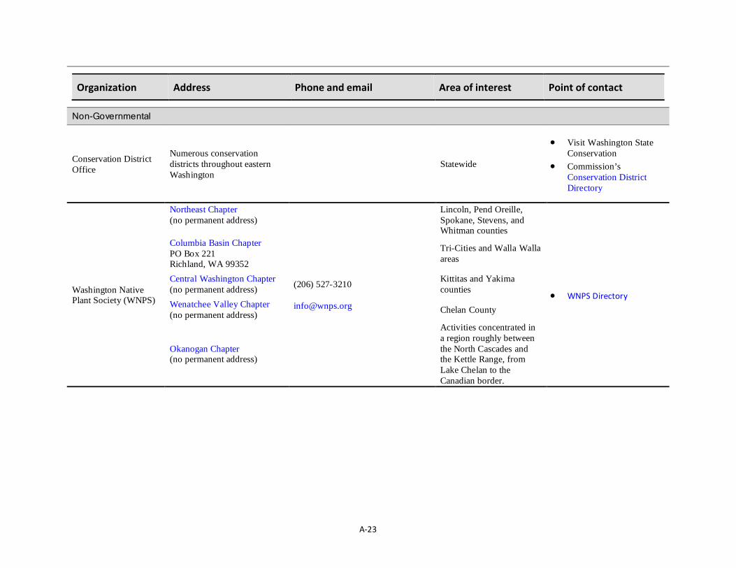
A-23
Organization Address Phone and email Area of interest Point of contact
Non-Governmental
Conservation District Office
Numerous conservation districts throughout eastern Washington
Statewide
• Visit Washington State Conservation
• Commission’s Conservation District Directory
Washington Native Plant Society (WNPS)
Northeast Chapter (no permanent address)
(206) 527-3210 [email protected]
Lincoln, Pend Oreille, Spokane, Stevens, and Whitman counties
• WNPS Directory
Columbia Basin Chapter PO Box 221 Richland, WA 99352
Tri-Cities and Walla Walla areas
Central Washington Chapter (no permanent address)
Kittitas and Yakima counties
Wenatchee Valley Chapter (no permanent address) Chelan County
Okanogan Chapter (no permanent address)
Activities concentrated in a region roughly between the North Cascades and the Kettle Range, from Lake Chelan to the Canadian border.

A-24
Organization Address Phone and email Area of interest Point of contact
Audubon Society Chapters
Kittitas Audubon Society P.O. Box 1443 Ellensburg, WA 98926
Kittitas County • Chapter’s conservation chair (directory)
Central Basin Audubon Society P.O. Box 86 Moses Lake, WA 98837
Primarily Grant County • Fill out Central Basin
Audubon’s online Contact Form
Lower Columbia Basin Audubon Soc. P. O. Box 1900 Richland, Washington 99352
Benton and Franklin counties
• Chapter’s designated contact for conservation issues (directory)
North Central Washington Audubon Soc. P.O. Box 2934 Wenatchee, WA 98807-2934
North Cascades and Methow Valley
• Chapter’s designated contact for conservation issues (directory)
Spokane Audubon Society P.O. Box 9820 Spokane, WA 99209
(509) 838-5828 Spokane County • See directory
Yakima Valley Audubon Society
(509) 248-1963 Yakima County • Chapter’s conservation chair (directory)
Local Land Trusts See the Land Trust Alliance’s directory for a list of local land trusts by county.
NA Statewide NA

A-25
Appendix 9. A protocol for identifying, mapping, and assessing quality of shrubsteppe on an individual parcel. Introduction This protocol provides a step-by-step to identify, map, and assess shrubsteppe. Although mainly for use on individual parcels, you can use the protocol to evaluate shrubsteppe on multiple adjoining properties. While not meant to map larger areas like Water Resource Inventory Areas (known by the acronym WRIA) or townships given the time it would take to cover larger areas, we did develop a companion protocol (see Manual for Mapping Shrubsteppe Landscapes) to map larger areas. The companion protocol can help determine when shrubsteppe will need evaluating at a finer scale with this protocol. Mapping Locating the Parcel. – To begin evaluating shrubsteppe with this protocol, acquire the highest resolution aerial image available for your project area. Then in ArcGIS, project the parcel boundary over the photo. GIS-ready parcel data can often be obtained from the county or city where your project is occurring (see Washington State Parcel Data web site). Figure A6 shows an example of a parcel boundary projected over an orthophoto. Preliminary Delineation of Assessment Areas. To determine where shrubsteppe occurs, delineate the assessment areas (AA). The AAs should encompass areas of recognizably discrete and relatively uniform vegetation. Delineate the AAs beyond the boundary of the assessed parcel. You should begin by delineating the AAs in the office on an aerial orthophoto in ArcGIS. If you do not have GIS, hand draw the boundaries onto the highest resolution aerial photo available. Figure A7 shows the parcel with AAs remotely delineated. Once you have mapped the AAs remotely, refine the boundaries in the field. Refining Assessment Area Boundaries. Maps of remotely delineated AA boundaries should be refined in the field. To do this, walk the entire length of the AA boundaries identified remotely to correct them. The following rules are to be used to identify where to locate boundaries:
Figure A6. Aerial image of site with parcel boundary delineated. Surrounding properties are also shown on map.

A-26
1. Significant changes in management or land use, which result in distinct ecological differences. For example, a heavily grazed pasture on one side of a fence line and ungrazed habitat on the other would result in separate AAs.
2. Natural changes in hydrology such as a transition from a wetland to an upland.
3. Abrupt geomorphologic changes.
4. Anthropogenic changes substantially altering a site relative to an adjacent site (e.g., impervious surface, manicured lawn).
5. Distinct transition between two different ecological systems.
6. Transition where site has undergone an environmental disturbance such as fire or flooding.
Because access to adjacent lands is not always possible, refine the boundaries on adjacent parcels by finding good vantages (e.g., edge of parcel, high point). With binoculars, identify where AA boundaries seem to occur. Information about habitat on adjacent parcels is important because it helps in appraising habitat value on the parcel you are assessing. For instance, information about adjacent lands helps determine the actual extent of a patch of habitat. In the field, boundary refinements should be hand-drawn onto the aerial photo and later digitized in the office (or refined in the field on maps that can be edited on a digital tablet). Figure A8 shows the refined map after it has been digitized in ArcGIS.
Figure A7. Parcel and surrounding lands after preliminary delineation of AAs.

A-27
Figure A8. Parcel and surrounding lands after refining AA boundaries in the field. Key AA boundary changes from the previous map are identified on this map.

A-28
Describing Assessment Areas. – While refining AA boundaries in the field, use the key in Form 1B to assign each AA to broad habitat categories. After doing this, any AA you identify as either a shrubland formation or a herbaceous formation with a shrub layer dominated by Artemisia spp. or Purshia tridentatea will require further assessment (Figure A9). Also, consult WDFW’s Priority Habitat and Species and DNR’s Rare Plants and High Quality Ecosystems databases to see whether important species or habitats are on or near the site. If they are nearby, consult WDFW's management recommendations to see how to address potential project impacts to a priority habitat or species.
a Do not assume that all AAs lacking shrubs are not shrubsteppe. In some cases, AAs without shrubs are fire-disturbed early succession shrub-steppe. Please consult the last section in Appendix 7 for tools to assess for fire-disturbed early successional habitat.

A-29
Ecological Integrity Assessment. – Using the Natural Heritage Field Guide to Washington’s Ecological Systems (Rocchio and Crawford 2015), assign each AA identified for further assessment to a shrubsteppe ecological system type. Washington shrubsteppe systems are:
• Intermountain Basins Big Sagebrush Steppe • Columbia Plateau Low Sagebrush Steppe • Intermountain Basins Montane Sagebrush
Steppe • Intermountain Basins Semidesert Shrubsteppe • Columbia Plateau Scabland Shrubland Once each AAs is assigned an ecological system, use the Ecological Integrity Assessment (EIA) to score and rank each shrubsteppe AA (Table A4). Table A4 is divided into several classes of important attributes for evaluating shrubsteppe integrity. Each attribute is subdivided into a series of metrics for measuring and obtaining a score and ranking. By ranking all metrics, an overall rank is calculated for each shrubsteppe AA. Using Table A4, measure each metric with the appropriate survey technique. Then record the scores for each metric on Form 2B. Also, use this form to get an overall EIA ranking for each shrubsteppe AA. Use a separate form for each AA being assessed. Necessary field equipment is listed in Form 3B.
Figure A9. Assessment areas are assigned to broad categories. Those shown in white text will undergo further assessment.
c

A-30
Table A4. Ecological integrity index measures to be evaluated for ranking the ecological quality of shrubsteppe habitat AAs found within a parcel.
Metric Justification Rank
A (5pts) B (4pts) C (3pts) D (1pts) Key Ecological Attribute: Buffer
RANK FACTOR: LANDSCAPE CONTEXT
Buffer Length
The buffer can be important to biotic and abiotic aspects of the site.
Buffer is > 75 – 100% of occurrence perimeter.
Buffer is > 50 – 74% of occurrence perimeter.
Buffer is 25 – 49% of occurrence perimeter
Buffer is < 25% of occurrence perimeter.
Buffer Width
Average buffer width of occurrence is >200 m (655ft),
adjusted for slope.
Average buffer width is 100–199m (330-655ft), after adjusting for slope.
Average buffer width is 50–99m (165-330ft),
after adjusting for slope.
Average buffer width is <49m (165ft), after adjusting for slope.
Buffer Condition
Abundant (>95%) cover native vegetation, little or no (<5%) cover of non-native
plants, intact soils, AND little or no trash or refuse.
Substantial (75–95%) cover of native vegetation, low
(5-25%) cover of nonnative plants, intact or moderately
disrupted soils; minor intensity of human visitation
or recreation.
Moderate (25–50%) cover of nonnative plants, moderate or
extensive soil disruption; moderate intensity of human
visitation or recreation.
Dominant (>50%) cover of non-native plants, barren
ground, highly compacted or otherwise disrupted soils, moderate or greater intensity
of human visitation or recreation, no buffer at all.
Key Ecological Attribute: Landscape Structure
Connectivity
Intact areas have a continuous corridor of natural or semi-natural vegetation between shrub steppe areas
Intact: Embedded in 90-100% natural habitat; connectivity is
expected to be high.
Variegated: Embedded in 60-90% natural or
semi-habitat; habitat connectivity is generally high, but lower for species sensitive
to habitat modification;
Fragmented: Embedded in 20-60% natural or semi-natural habitat;
connectivity is generally low but varies with mobility of species and arrangement on
landscape.
Relict: Embedded in < 20% natural or semi-natural habitat; connectivity is
essentially absent
Landscape Condition Model Index (LCMI) (see bottom of Page 71)
The intensity and types of land uses in the surrounding landscape can affect ecological integrity.
LCMI > 0.8
LCMI 0.65 – 0.79 (for Columbia Plateau Low Sagebrush Steppe only)
LCMI < 0.65 (for Columbia Plateau Low Sagebrush
Steppe only)
LCMI 0.5 - 0.79 (for all other shrubsteppe systems)
LCMI < 0.5 (for all other shrubsteppe systems)
Key Ecological Attribute: Vegetation Composition
RANK FACTOR: CONDITION
Native Plant Species Cover
Native species dominate this system; non-natives increase
with human impacts. Relative cover of native
plants = 95-100%. Relative cover of native
plants 80-95%. Relative cover of native
plants 50 to <85%. Relative cover of native
plants <50%.
Native Bunchgrass Cover
Native bunchgrass dominate; high cover is related to
community resistance to invasion
Relative cover of perennial bunchgrass > 80% or near site
potential. (for all other ecological systems)
Relative cover of perennial bunchgrass 50-80% or
reduced from site potential. (for all other ecological
systems)
Relative cover of perennial bunchgrass 30-49% or
reduced from site potential. (for all other ecological
systems)
Relative cover of perennial bunchgrass < 30% and much reduced from site potential.
(for all other ecological systems)
Cover of Native Increasers (assess in all systems except Columbia Plateau Scablands)
Some stressors such as grazing can shift or homogenize native
composition toward species tolerant of stressors. Absent or incidental <10% relative cover 10-20% relative cover >20% relative cover
Invasive Species Cover
Invasive species can inflict a wide range of ecological
impacts. Early detection is critical. None present.
Invasive species present, but sporadic
(<3% absolute cover) Invasive species prevalent (3–10% absolute cover)
Invasive species abundant (>10% absolute cover).
Key Ecological Attribute: Vegetation Structure
Biological Soil Crust (assess in all systems except Columbia Plateau Low Sagebrush Steppe)
Crust cover and diversity is greatest where not impacted
by trampling, other soil surface disturbance and
fragmentation (Belnap et al. 2001; Rosentreter and
Eldridge 2002; Tyler 2006; Hardman 2007)
Largely intact biological soil crust that nearly matches the site capability where natural site characteristics are not
limiting.
Biological soil crust is evident
throughout the site but its continuity is broken
Biological soil crust is present in protected areas and with a minor component elsewhere
Biological soil crust, if present, is found only in
protected areas
Fire-sensitive Shrubs (Columbia Plateau Low Sagebrush Steppe only)
Shrubs are part of the historic range of variation
Fire-sensitive shrubs mature and recovered from past fires; shrubs generally <25% cover
Fire-sensitive shrubs common yet not fully recovered from
past fires
Fire-sensitive shrubs present (but not common)
recovering from past fires Fire-sensitive shrubs absent
to rare due to past fires
Fire-sensitive Shrubs (Columbia Plateau Scablands only)
Fire, naturally rare, eliminates or reduces Artemisia rigida or
woody Eriogonum cover Fire-sensitive shrubs mature and recovered from past fires
Fire-sensitive shrubs common yet not fully recovered from
past fires
Fire-sensitive shrubs present (but not common)
recovering from past fires Fire-sensitive shrubs absent
or rare due to past fires
Fire-sensitive Shrubs (Intermountain Basins Big Sagebrush Steppe only)
Natural fire regime Promotes patchy low
cover big sagebrush or bitterbrush cover
Fire-sensitive shrubs mature and recovered from past fires; shrubs generally 3-10% cover
Fire-sensitive shrubs not recovered from past fires;
represented mostly as seedlings less than height of
bunchgrasses. shrubs generally <20% cover
Shrub >20% cover beginning to affect bunchgrass layer
Shrubs >20% cover reducing bunchgrass layer or sagebrush or bitterbrush only scattered
individuals or seedlings
Fire-sensitive Shrubs (Intermountain Basins Montane Big Sagebrush Steppe only)
Natural fire regime promotes patchy low cover mountain
big sagebrush cover (Johnson and Swanson 2005)
Fire-sensitive shrubs mature and recovered from past fires; shrubs generally 3-20% cover
Fire-sensitive shrubs not recovered from past fires;
represented mostly as seedlings less than height of bunchgrasses. shrubs generally <50% cover
Shrub >50% cover beginning to affect bunchgrass layer
Shrubs >50% cover reducing bunchgrass layer or sagebrush or bitterbrush only scattered
individuals or seedlings
Fire-sensitive Shrubs (Intermountain Basins Semidesert Shrubsteppe only)
Natural fire regime promotes patchy low shrub cover
Fire-sensitive shrubs mature and recovered from past fires; shrubs generally 3-10% cover
Fire-sensitive shrubs not recovered from past fires;
represented mostly as seedlings less than height of
bunchgrasses. shrubs generally <20% cover
Shrub >20% cover beginning to affect bunchgrass layer
Shrubs >20% cover reducing bunchgrass layer
Key Ecological Attribute: Vegetation Composition
RANK FACTOR: CONDITION
Soil Surface Condition
Soil disturbance can result in erosion thereby negatively affecting many ecological processes; the amount of
bare ground varies naturally with site type.
Bare soil areas are limited to naturally caused disturbances such as burrowing
or game trails
Some bare soil due to human causes but the extent and
impact is minimal. The depth of disturbance is limited
to only a few inches
Bare soil areas due to human causes are common. There
may be disturbance to several inches. Outdoor recreational
vehicles (ORV) or other machinery may have left
some shallow ruts.
Bare soil areas substantial and contributing to long-lasting
impacts. Deep ruts from ORVs or machinery may be present, or livestock and/or
trails are widespread.

A-31
Survey Techniques Although various methods are used to measure each EIA metrics in the field, we provide recommended techniques to ensure uniformity. These are widely accepted methodologies that will yield you with reliable and consistent results when carefully carried out. Our recommended techniques can also be carried out by a single observer in fairly short time, minimizing survey cost. We recommend you contract this work to a qualified expert who:
• can interpret digital orthophotos and aerial photos. • has access to and is familiar with GIS to perform basic operations such as viewing orthophotos, panning, zooming, editing. • can use GPS technology to pinpoint exact locations. • can identify common shrubs, grasses, and invasive plants associated with shrubsteppe and is experienced with using a plant key. • has demonstrated the ability to estimate cover of vegetation using widely accepted survey methods (e.g., Line Intercept, Daubenmire). Since a properly conducted EIA requires certain conditions, field season timing is critical to gathering reliable data. Carry out your shrubsteppe vegetation assessment in the middle of the growing season when plants are easily identifiable and representative of their abundance. Although the exact timing may vary depending on the conditions (e.g., temperatures, precipitation), the best months for survey are typically May and June. Laying out Sampling Plots. – Since many of the metrics are measured in established sampling plots, lay out a 10 x 50 meter plot in each identified shrubsteppe AA. Place the plot so as to minimize within-plot environmental heterogeneity, which would imply that the long (i.e., 50 m) axis encounter the least possible variation in vegetation (i.e., within plot vegetation is representative of vegetation in the AA). Permanently stake the plot corners and take a GPS reader of each corner. Also place stakes every 10 meters from the corners (Figure A10). Measure all metrics related to Vegetation Composition (e.g., native plant cover), Vegetation Structure (fire-resistant shrubs), and Physicochemical (e.g., soil surface condition) attributes in the plot (Table A4). Also, measure the relative cover of biological soil crust in 10 x 50 meter plots. The Buffer and Landscape Structural metrics are not evaluated in the plot. Measure all estimates of percent cover (absolute and relative) in the 10 x 50 meter plots using methods described by Daubenmire (1959). In a 20 cm x 50 cm Daubenmire plot, estimate all metrics related to Vegetation Composition and Structure. Information about construction of a Daubenmire frame is in BLM (1996;
Figure A10. An illustration of an assessment unit with a 10 x 50 m plot established within.

A-32
Page 63). A minimum of 50 sampling points should be located every 2 meters along both long axes of the established 10 m x 50 m sampling plot. Center the Daubenmire frame on each of these points as shown in Figure A11. Measuring Landscape Composition and Physiochemical Attribute Metrics. – Locate the center of each Daubenmire plot with GPS and take a close-up, overhead photo of each plot while standing due north of the plot. Save the GPS reading to relocate the plot if necessary. Save the photo and attached a copy to the completed data sheet (see Form 4B). Then proceed with following steps to estimate cover: (1) Observe the quadrat frame from directly above and estimate cover classes for each of the Vegetation Composition and Physicochemical metrics (Table A4).
“Cover class" (see Data Form 4B) is a term used to describe the proportion of an area occupied by a particular plant species or other feature of the environment (e.g., bare soil, biological soil crust)
(2) Imagine a line drawn about the leaf tips of the undisturbed canopies (ignoring inflorescence) and project these polygonal images onto the ground. This projection is considered “canopy coverage.” Assign cover class estimates for each metric (e.g., native plant species, native bunchgrass) and record that information on Form 4B.
(3) Canopies extending over the quadrat are estimated even if the plants are not rooted in the quadrat.
(4) Collect the data at a time of maximum growth of the key species.
(5) For tiny annuals, it is helpful to estimate the number of individuals that would be required to fill 5% of the frame (Figure A11). A quick count of the numbers of individuals in each frame will then provide a canopy class estimate.
(6) For measurements where an estimate of “relative” cover is needed (e.g. native plant species cover), overlapping canopy cover is included in the cover estimates; therefore, total cover may exceed 100 percent. Total cover may not reflect actual ground cover.
(7) For measurements where an estimate of “absolute” cover is needed (e.g., invasive species cover), the total amount of all plant cover within the frame should be assessed and the percentage of that which is comprised of what is being measured (Form 5B) would be the absolute cover.
(8) “Open” interspaces between the grasses and forbs will typically be comprised of bare soil or biological soil crust. The relative cover of each of these should be measured within the boundary of the frame. To be able to better view soil crust cover, moisten the entire plot with a spray bottle filled with water.
Figure A11. Overhead view of a Daubenmire plot that has been placed over a section of the 50-meter plot boundary. The plot should be positioned so that the center is situated every two meters (green dot) along both lengths of the 10 x 50-meter sampling plot. The long edge of the Daubenmire frame should be placed parallel to the 50-meter plot boundary line. To aid in estimating cover, string (dashed lines) should be used to divide the frame into 10 equally sized blocks. The hatch-marked portion represents 10% of the area (10 x 10-cm area).
ithi th f

A-33
Lists of common invasive species and native increasers are provided in Forms 5B and 6B as cover estimates for these types of plants need to be estimated in the Daubenmire plot as part of the EIA. Once you have collected all the data from at least 50 plots, calculate an average for each metric to ascertain the metric’s ranking. Document the ranking (on a scale from A– D-rank) and score data Form 2B. Measuring Vegetation Structural Attribute Metrics. – Using the 10 m x 50 m plot, measure cover of fire-sensitive shrubs along a line intercept transect. Establish two line intercepts, one along each of the 50 meter boundaries by stretching a tape measure along the entire 50 meter length as close to the ground as possible. Align the zero point on the tape with the head of the transect. Take a photos of the transect at both ends and also while standing parallel to the center of the transect just far enough back so the entire length is visible within the photo frame. Originally described by Canfield (1941), the line intercept is ideal for estimating canopy cover in semiarid bunchgrass-shrub vegetation types (BLM 1996). To perform the survey, walk alongside the 50 meter tape while measuring the horizontal linear length of each fire-resistant shrub intercepting the line transect (Figure A12). Then divide the total number of meters intercepted by shrubs by 50. Record all required information onto Form 7B. Since cover is measured along two 50-meter transects per AA, total shrub cover is the average of both transects.
Figure A12. Illustration of a tape measure lying along a 50 meter transect where canopy of fire-sensitive shrubs (green shrubs) is being measured. In this example, (A + B + C) ÷ 50 meters = Percent Canopy Cover using the line intercept method.

A-34
Measuring Buffer Attribute Metrics. – The buffer represents the area adjoining the AA in a natural or semi-natural state that is not dedicated to anthropogenic uses. A buffer is natural or semi-natural land cover adjacent to the outer boundary of the AA. To be considered a buffer, the adjacent areas of natural or semi-natural land cover must be least 5 meters wide and must extend at least 5 meters from the outer edge of the AA. The maximum buffer width is 250 meters. Any open water at least 30 meters wide adjoining an AA, such as a lake, large river, or large slough, is not considered a part of the buffer. Rather, open water is neutral, neither part of the shrubsteppe AA nor part of the buffer. To measure buffer length, use an aerial photo to estimate the percentage of the area just surrounding the AA comprised of natural or semi-natural vegetation. Measure buffer width along eight transects drawn at regular intervals from the edge of the AA boundary, extending out for 250 meters as shown in Figure A13. Measure the distances along each transect at which the buffers terminate and then record the average width of all eight transects. The buffer condition metric requires a visual estimate of the percentage of the buffer dominated by native plants. Only assess the condition of the area you identified as being part of the buffer length and width. Assign a score of “D” if no buffer is present. Measuring Landscape Structure Attribute Metric. – Landscape structural attribute metrics help assess an AAs continuity to its surroundings. The LCMI metric measures the intensity of human-dominated land uses within 100 meters of the AA boundary. The intensity of human activity in the landscape has a proportionate impact on the ecological processes of natural systems. Each land use type occurring in the 100 meters buffer is assigned a coefficient ranging from 0.0 to 1.0 (Table A5).
Figure A13. Transects drawn at regular intervals that are extending 250 m from the outer edge of an AA.

A-35
The LCMI is measured by documenting surrounding land use(s) within 100 meters of the entire AA boundary. Preferably, complete this in the field and later verified it with aerial photos or in GIS. With access to current aerial photo or digital orthophotos, a rough calculation of land use can be made in the office. Ideally though, use both field data and remote tools to accurately measure LCMI. To calculate a total score for each land use type, estimate the percent of the adjacent area (within 100 meters) comprised of each land use listed in Table A5. Then plug the corresponding coefficient (Table A5) into the following equation: Sub-land use score = Σ LU x PC⁄100 where: LU = score for each land use type; PC = percent of adjacent area in land use type.
Table A5. Current Land Use and Corresponding Land Use Coefficients (Hauer et al. 2002).
Current Land Use Type Coefficient Paved roads/parking lots/domestic or commercially developed buildings/gravel pit operation 0.0 Unpaved roads (e.g., driveway, tractor trail) / mining 0.1 Agriculture (tilled crop production) 0.2 Heavy grazing by livestock / intense recreation (All-terrain vehicle use/camping/popular fishing spot) 0.3 Hayed 0.5 Moderate grazing 0.6 Moderate recreation (high-use trail) 0.7 Light grazing / light recreation (low-use trail) 0.9 Fallow with no history of grazing or other human use in past 10 years 0.95 Natural area / land managed for native vegetation 1.0

A-36
Calculate a score for each land use within 100 m of the shrubsteppe AA edge, then sum the Sub-Land Use Score(s) to arrive at the LCMI. For example, if 30% of the adjacent area is moderately grazed (0.3 * 0.6 = 0.18), 10% composed of unpaved roads (0.1 * 0.1 = 0.01), and 40% is natural area (e.g. no human land use) (1.0 * 0.4 = 0.4), the total LCMI would = 0.59 (0.18 + 0.01 + 0.40). Final Ranking of Shrubsteppe Assessment Areas Once you have measured all metrics in each shrubsteppe AA, plug the scores and rankings into Form 2B. Fill out a separate data form for each AA evaluated. Once you complete all the forms and make the calculations, record the final ranking for each AA assessed. Figure A14 shows an example of a site where all AAs were ranked using the EIA process. This information can help in deciding how to proceed with a land use proposal. Given that we developed this protocol as part of the Management Recommendations for Washington’s Priority Habitats: Shrubsteppe (PHS Shrubsteppe), the result should be used to ensure a land use proposal will avoid or minimize shrubsteppe impacts. The section in PHS Shrubsteppe titled Designing and Reviewing Residential Proposals has recommendations relevant to individual projects. This protocol will help in applying these recommendations.
Figure A14. Mapped site with shrubsteppe AAs ranked.

A-37
References Belnap, J., J. Kaltenecker, R. Rosentreter, J. Williams, S. Leonard, and D. Eldridge. 2001. Biological Soil Crusts: Ecology and Management. Technical Report
1730-2, United States Department of the Interior. 110 pp.
BLM. 1996. Sampling vegetation attributes: interagency technical reference. BLM National Applied Resource Sciences Center. BLM/RS/ST- 96/002+1730. Supersedes BLM Technical Reference 4400- 4. 163 p.
Canfield, R. H. 1941. Application of the line-intercept method in sampling range vegetation. Journal of Forestry 39:388–394.
Daubenmire, R. F. 1959. A canopy-cover method of vegetational analysis. Northwest Science 33:43-46.
Hauer, F. R., B. J. Cook, M. C. Gilbert, E. J. Clairain Jr., and R. D. Smith. 2002. A regional guidebook for applying the hydrogeomorphic approach to assessing wetland functions of riverine floodplains in the Northern Rocky Mountains. U.S. Army Corps of Engineers, Engineer Research and Development Center, Environmental Laboratory, Vicksburg, MS. ERDC/EL TR-02-21.
Johnson, C.G. and D.K. Swanson. 2005. Bunchgrass Communities of the Blue and Ochoco Mountains: A Guide for Managers. U.S.D.A. For. Ser. PNW-GTR-641.
Rocchio, J., and R. Crawford. 2015. Field guide to Washington’s ecological systems. Washington Department of Natural Resources, Natural Heritage Program, Olympia, Washington.
Roché, B. Range plants: their identification usefulness and management. Washington State University, Department of Forestry and Range Management, Pullman, Washington.
Rostentreter, R. A. and D. J. Eldridge. 2002. Monitoring biodiversity and ecosystem function: grasslands, deserts, and steppe. Pages 199-233 in P. L. Nimis, C. Scheidegger, and P. A. Wolseley, editors. Monitoring with lichens – monitoring lichens. Kluwer Academic Publishers.
Tyler, K. J. 2006. Biological crusts: analysis of monitoring techniques at the Yakima Training Center, Washington. Thesis. Central Washington University, Ellensburg, Washington.
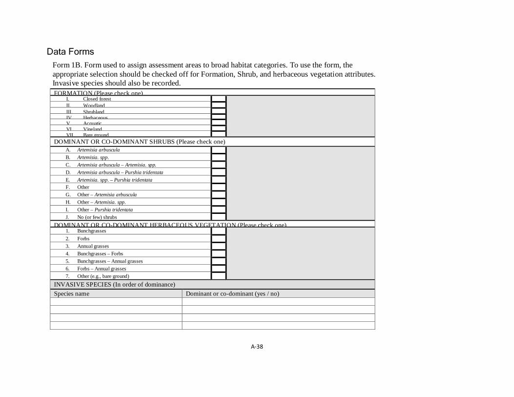
A-38
Data Forms
Form 1B. Form used to assign assessment areas to broad habitat categories. To use the form, the appropriate selection should be checked off for Formation, Shrub, and herbaceous vegetation attributes. Invasive species should also be recorded.
FORMATION (Please check one) I. Closed forest II. Woodland III. Shrubland IV Herbaceous V. Acquatic VI. Vineland VII. Bare ground DOMINANT OR CO-DOMINANT SHRUBS (Please check one) A. Artemisia arbuscula B. Artemisia. spp. C. Artemisia arbuscula – Artemisia. spp. D. Artemisia arbuscula – Purshia tridentata E. Artemisia. spp. – Purshia tridentata F. Other G. Other – Artemisia arbuscula H. Other – Artemisia. spp. I. Other – Purshia tridentata J. No (or few) shrubs
DOMINANT OR CO-DOMINANT HERBACEOUS VEGETATION (Please check one) 1. Bunchgrasses 2. Forbs 3. Annual grasses 4. Bunchgrasses – Forbs 5. Bunchgrasses – Annual grasses 6. Forbs – Annual grasses 7. Other (e.g., bare ground)
INVASIVE SPECIES (In order of dominance) Species name Dominant or co-dominant (yes / no)

A-39
Form 2B. Data form used for summarizing the findings from an assessment of each metric and for assigning an overall rank to an assessment area. Metric Attributes
Metric
Assigned Metric Points (M)
Assigned Metric Rank
Total Metric Score (∑M)
Overall EIA Score (∑M ÷ 5)
Overall EIA Rank*
Buffer
Edge length Edge width Edge condition Landscape Context
Connectivity Landscape condition model index Vegetation Composition
Native plant species cover Native bunchgrass cover Cover of native increasers Invasive species cover Vegetation Structure
Biological soil crust Fire-sensitive shrubs Physiochemical
Soil surface condition ∑M = (∑M ÷ 5) =
Overall EIA Rank =
* Ranking: A = > 4.5; B = 3.5 – 4.4; C = 2.5 – 3.4; D = < 2.4

A-40
Form 3B. Checklist of equipment and supplies for conducting an Ecological Inventory Assessment of shrubsteppe. Field Supplies
Sufficient number of data forms (see forms 1, 2, 4, and 7)
Hammer/mallet to drive in stakes
Permanent yellow or orange spray paint
Iron stakes for marking corners and midpoints of 10 x 50 m plots
100-meter metric tape, demarcated in tenths and hundredths
20 x 50 cm Daubenmire frame
Compass
Spray bottle to moisten ground to measure soil crust cover
GPS unit
Digital camera
Dichotomous key for field identification of eastern Washington Plants

A-41
Form 4B. Data sheet for recording information gathered in the field within the Daubenmire plots. EIA Field Data Sheet
(Daubenmire Plot Data) Study Location: Date: Observer: Plot #:
Latitude: Longitude
Metrics
Cover Class
Mid-point
Native Plant Species (Relative Cover)
Native Bunchgrasses (Relative Cover)
Native Increasers (Relative Cover)
[see form 6b]
Invasive Species (Absolute Cover)
[see form 5b]
Biological Soil Crust (Absolute Cover)
Bare Ground (Absolute Cover)
1-5% 2.5%
6-15% 10.5%
16-25% 20.5%
26-37% 31.5%
38-50% 44%
51-62% 56.5%
63-75% 69%
76-85% 80.5%
86-95% 90.5%
96-100% 97.5%
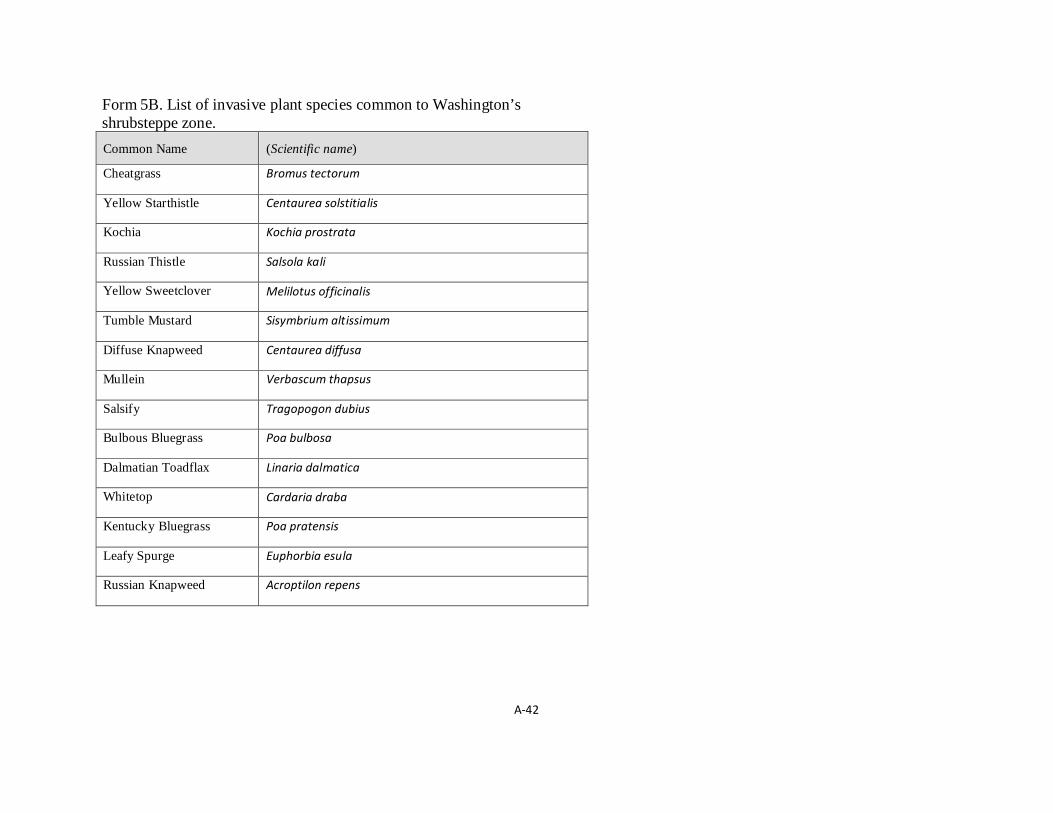
A-42
Form 5B. List of invasive plant species common to Washington’s shrubsteppe zone. Common Name (Scientific name)
Cheatgrass Bromus tectorum
Yellow Starthistle Centaurea solstitialis
Kochia Kochia prostrata
Russian Thistle Salsola kali
Yellow Sweetclover Melilotus officinalis
Tumble Mustard Sisymbrium altissimum
Diffuse Knapweed Centaurea diffusa
Mullein Verbascum thapsus
Salsify Tragopogon dubius
Bulbous Bluegrass Poa bulbosa
Dalmatian Toadflax Linaria dalmatica
Whitetop Cardaria draba
Kentucky Bluegrass Poa pratensis
Leafy Spurge Euphorbia esula
Russian Knapweed Acroptilon repens

A-43
Form 6B. List of native “increasers” in Washington’s shrubsteppe zone. Common Name Scientific Name Details
common yarrow Achillea millefolium Once established it is highly resistant to grazing and will increase with overegrazing.
small-leaf cat’s-foot Antennaria microphylla
Will increase with grazing as it is considered poor foraging for all classes of livestock and wildlife.
big sagebrush Artemisia tridentata On sites where it is part of a climax community it is an increaser with grazing.
milkvetches Astragalus spp. Most of these species increase with grazing
arrowleaf balsamroot Balsamorhiza sagittata
Associated perennial grasses are usually preferred and this plant will increase with grazing except on some sheep ranges.
douglas’ sedge Carex douglasii As more palatable plants are grazed hard and their competitive ability reduces, this plant usually increases.
rubber rabbitbrush Ericameria nauseosa
In associations where it is part of the climax community it increases with overgrazing and will invade into associations where it is not part of the climax community.
spiny hop-sage Grayia spinosa
silky lupine Lupinus sericeus
longleaf phlox Phlox longifolia Increases with heavy grazing.
Sandberg bluegrass poa secunda On shallow soils it is a decreaser, while on deep soils it tends to increase with overgrazing.
bottlebrush squirreltail Elymus elymoides With depletion of desirable perennials this species increases.
needle and thread Hesperostipa comata
On deeper, more fertile soils this species will increase initially when overgrazed.
gray horsebrush Tetradymia canescens
With overgrazing this shrub will increase with subsequent decrease of desirable forage plants.
littleleaf horsebrush Tetradymia glabrata With overgrazing this shrub will increase with subsequent decrease of desirable forage plants.
broom snakeweed Gutierrezia sarothrae
This species will invade sagebrush ranges that have been depleted by overgrazing, fire, or drought.

A-44
Form 7B. Data sheet for recording information gathered in the field using the Line Intercept method. EIA Field Data Sheet (Line Intercept Data)
Study Location: Date:
_ _ / _ _ / _ _ _ _
Observer name: Line intercept #:
Survey sheet #:
Indi
vidu
al le
ngth
s of s
hrub
or c
lust
er o
f shr
ubs (
cm) a
long
in
terc
ept (
use
othe
r sid
e of
this
shee
t if n
eces
sary
)
Fire Sensitive Shrub Species Artemisia arbuscula
Artemisia rigida
Artemisia tridentata
Artemisia tripartita
Purshia tridentata
Eriogonum spp.
Gutierrezia spp.
Krascheninnikovia lanata
Individual Species Lengths Summed
Summed lengths of all species (S) =
(S ∗ 0.01) ÷ 50 ∗ 100 = Total % Canopy Cover Total % Canopy Cover =

A-45
Attachment A
MANAGEMENT RECOMMENDATIONS FOR
WASHINGTON’S PRIORITY HABITATS:
Managing Shrub-steppe in Developing Landscapes
September 1, 2020

A-46
Fire historically was the primary disturbance in shrubsteppe ecosystems and still is an important ecological process. Fire is particularly significant as a driver of the structure, composition, and abundance of shrubsteppe vegetation. Today, fires are more extreme than ever, primarily because of the spread of highly flammable invasive plants and because of climate change.
Fire has always been a key process in shrubsteppe ecosystems, and scientists have long accepted the inherent function of fire in shrubsteppe. However, until now, Washington Department of Fish and Wildlife’s (WDFW) definition of shrubsteppe in our Priority Habitats and Species List (PHS List) lacked recognition of the role of fire.
In spring 2020, WDFW fixed this omission by adding a limited but important amount of new content to the shrubsteppe definition in PHS. Then, because WDFW’s Management Recommendations for Washington’s Priority Habitats correspond to the definitions in our PHS List, we subsequently revised this PHS shrubsteppe publication by adding background and guidance on the role of fire disturbance.
Specifically, we updated this document solely to add new content on best practices for managing fire-disturbed shrubsteppe habitat and to propose measures to see to the safety and well-being of people and property. These changes provide a more complete representation of shrubsteppe and enhance this publication’s reputation as a source of best available science. The substantive new content related to fire is shown in italics in the main body of the publication and is also summarized in this Attachment. New content is shown as underlined text in this attachment.
We also used this opportunity to conduct limited, less substantive copy editing, such as updating contact information in the appendices and fixing broken hyperlinks.

A-47
INTRODUCTION:
• No revisions to this section
WHAT IS SHRUBSTEPPE?
• Revised the shrubsteppe definition in the Vegetation subsection to make it consistent with the revised definition of shrubsteppe in the PHS List.
• Added a new subsection called Disturbance Processes. The following text and figure were written into that subsection:
Fire is an ecological component of shrubsteppe and was historically the primary disturbance in sage-brush-dominated ecosystems (83). Fire events and the collective fire regime were important drivers of structure, composition, and abundance of vegetation within sagebrush communities (41). Fire re-gimes in shrubsteppe were historically variable, both temporally and spatially. This helped maintain a patchy distribution of shrubs, both within local areas of shrubsteppe and across landscapes (84). Fire severity and frequency historically varied among different plant associations and site characteris-tics. This included fire return intervals that averaged from as little as 10 years in higher elevation sites to more than 200 years in dryer low elevations (34). In general, fire was a beneficial force that altered vegetation but did not remove shrubsteppe. Fire was, and still is, an important mechanism to reset mature shrubsteppe back to an earlier state of succession. This reset is valuable to shrubsteppe de-pendent wildlife that typically do not respond well to densely vegetated, overmature habitat. Once reset, the system then can proceed through a cycle of succession back to a more mature state (Figure 5).

A-48
WHY IS SHRUBSTEPPE HABITAT IMPORTANT?
• No revisions to this section
HISTORIC LOSS OF SHRUBSTEPPE: • We added the following text into this section:
Invasive weeds, increased fire frequency, and fragmentation caused by expanding roads and infrastructure and by agriculture continue to degrade shrubsteppe. Invasive plants outcompete native species altering the composition of shrubsteppe vegetation. Cheatgrass has invaded an estimated 31.5 million acres throughout the Intermountain West (39). By drying out early in the season, this annual grass can fuel and carry a fire across large areas (78). Where present, cheatgrass can extend the length of the fire season, while increasing wildfire risk and intensity. Following a wildfire event cheatgrass often spreads, contributing to more frequent cycles of intense wildfires (14). Although the exact historic extent of fire (e.g., frequency, intensity) is unknown (16), the shrubsteppe fire regime in Washington’s is certainly altered. Fire prior to European settlement likely returned to sites at intervals of 10 to more than 200 years (34, 78, 81), depending on site characteristics. Now return intervals are roughly 10 years, especially in cheatgrass dominated areas (78). This certainly has impacted Washington’s shrubsteppe ecosystems significantly. Fire can devastate stands of Wyoming big sagebrush—the most common sage in Washington—given this species does not easily reestablish post fire (3, 78). This slow growing species struggles where increased fire frequency leaves insufficient time for it to reestablish. Shrub loss through repeated fires has also eliminated habitat for shrub-nesting birds as well as some big game winter range (62, 67). Although the current pattern of frequent high intensity fire is detrimental, fire suppression also negatively affects shrubsteppe by altering natural fire cycles (16, 50). Fire suppression can produce very dense shrub cover, that then can set the stage for hot and explosive fires. Such catastrophic fires can wipe out important soil characteristics, seed stocks, and are also very dangerous to nearby residential areas.

A-49
IMPACTS OF DEVELOPMENT ON SHRUBSTEPPE:
• Added new section called Fire embedded in the “Major Impacts to Wildlife” subsection. The following text is written into the fire section:
Nationally, nearly nine out of ten wildfires are caused by humans (85). Consequently, increased development and human presence raises risk. For example, discarded cigarettes, irresponsible recreational use of fire and fireworks, debris burning, and powerlines are all human-driven ignition sources that lead to increased wildfire risk (86). These wildfires can degrade shrubsteppe habitat function for many wildlife species by wiping out slow-growing sagebrush, compromising cryptobiotic crust and other sensitive vegetation, and escalating the spread of invasive plants. Across landscapes, wildfires also tend to create more fragmented and less functional habitat.
MANAGEMENT RECOMMENDATIONS – LONG-RANGE PLANNING: CONSIDERING THE LANDSCAPE:
• No revisions to this section
MANAGEMENT RECOMMENDATIONS – SITE-SPECIFIC MANAGEMENT: HOW TO AVOID AND MINIMIZE IMPACTS OF DEVELOPMENT:
• Embedded small modifications to the following paragraph in a subsection of the “General Recommendations” section:
Although the footprint of a home can seriously compromise shrubsteppe, other related activities and impacts also can harm sensitive habitat. The following are recommendations to address impacts related to development from roads and utilities, landscaping and yard maintenance, domestic animals, fencing, water development, as well as fire-related considerations. Using these recommendations, your HMP should identify how you will avoid or minimize the impacts of these related activities and influences.
• Added a new section called “Fire Management and Defenses” embedded in the General Recommendations
subsection. The following text is written into this new section:
Shrubsteppe disturbed by fire alters habitat condition but does not eliminate the shrubsteppe habitat. Thus, planners and developers should consider fire-disturbed shrubsteppe as a priority under WDFW’s PHS Program. This should consequently be factored into any decisions about developing in and around fire-disturbed shrubsteppe. Considerations that inform development should include fire size and intensity, adjacent shrubsteppe condition and connectivity, and the likely trajectory of habitat recovery, both with and without active restoration. Strategies to assess habitat recovery post-fire can include surveys to verify occupancy/presence of obligate shrubsteppe plants and wildlife as well as key structural components (e.g., biological soil crusts). Building in dry shrubsteppe landscapes comes with inherent wildfire risks. The risk increases with exacerbated drought seasons and increased fuel loads due to fire suppression. Planners have tools to reduce this risk, such as requiring that homes and yards meet wildfire-resistant standards. This includes non-combustible building materials as well as properly screened vents.
A-50
These and other techniques should be used along with the creation of defensible space measured around the actual dwelling structure. Though defensible space is a critical tool to mitigate risk, removing vegetation can harm and eliminate habitat function when sites managed for defensible space overlap with shrubsteppe. To limit habitat loss, defensible space should be considered part of the development footprint and should prioritize protecting the residential dwelling unit rather than other structures (e.g. outbuildings). Residents and jurisdictions can also invest in restoring shrubsteppe health in and around residential areas to build resilience to catastrophic wildfires. This is particularly useful for shrubsteppe near residential areas disturbed by features commonly associated with large wildfire (e.g., broad expanses of dense cheatgrass). Wildfire prevention education efforts, such as brochures, social media campaigns, and public service announcements, are successful and cost-effective ways to decrease human-caused wildfires. The “Wildfire Risk to Communities” website is a comprehensive resource to consult when approving new homes and subdivisions. It also has useful information that can guide local building codes as well as a Risk Explorer Tool that allows planners to identify site-specific development risks. The tool can be particularly useful to long-range planners who can use it to inform and add risk-prevention strategies into their local long-range plans (e.g., siting UGAs in low fire risk areas and in reasonable proximity to fire responders).
REFERENCES:
• Added the following new references:
Ellsworth, L. M., Kauffman, J. B., Reis, S. A., Sapsis, D. and Moseley, K. 2020. Repeated fire altered succession and increased fire behavior in basin big sagebrush–native perennial grasslands. Ecosphere 11(5): e03124. WDFW. 2015. Washington’s State Wildlife Action Plan: 2015 Update. Washington Department of Fish and Wildlife, Olympia, Washington, USA. USDA Forest Service. 2020. Wildfire prevention: Reduce ignitions from campfires, debris burning, vehicles, and other sources. Available https://wildfirerisk.org/reduce-risk/wildfire-prevention/ (Accessed: 5-June-2020). Keeley, J. E. and Syphard, A. D. 2018. Historical patterns of wildfire ignition sources in California ecosystems. International Journal of Wildland Fire 27:781-799.
APPENDICES:
• Appendix 1 – No revisions to this appendix
• Appendix 2 – No revisions to this appendix
• Appendix 3 – No revisions to this appendix
• Appendix 4 – No revisions to this appendix
• Appendix 5 – No revisions to this appendix

A-51
• Appendix 6 – No revisions to this appendix
• Appendix 7 – Added a new section at the end of this appendix called “Fire-disturbed Shrubsteppe”. The following text is written into the that section along with a new figure:
This protocol relies largely on the presence of shrubs to identify potential shrubsteppe. Post fire, few if any of the pre-fire shrubs may remain in shrubsteppe habitat (Figure A5). Because fire is a component of shrubsteppe, fire-disturbed shrubsteppe is still shrubsteppe, only in a temporarily altered or early successional state.
Early succession is often preceded by fire (see Fig. 5 in the Introduction of this report). This is important to highlight when presenting maps developed with this protocol. We strongly advise reviewing data for sites lacking shrubs to look for signs of fire, traits of later successional vegetation, or use by obligate shrubsteppe wildlife. Past aerial photos like those shown in Figure A5 are an important tool to assess historic condition and signs of disturbance. DNR’s webmap tools show wildfire locations as early as 1973 (Table A1). Other data, such as verified occurrences of shrubsteppe plants and animals (Table A1) also help to assess past ecosystem condition. Together these tools can help identify evidence of shrubsteppe in the absence of shrubs and should be used to map fire-disturbed shrubsteppe.
• Appendix 8 – No revisions to this appendix
• Appendix 9 – Added a footnote to this appendix that states:
Do not assume that all AAs lacking shrubs are not shrubsteppe. In some cases, AAs without shrubs are fire-disturbed early succession shrub-steppe. Please consult the last section in Appendix 7 for tools to assess for fire-disturbed early successional habitat.
Figure A5. Shrubsteppe in Black Rock Valley (Yakima County) along Highway 24 before the Range 12 fire (left) and after (right).