Sensors Tell More than They Sense: Modeling and Reasoning about Sensor Observations for...
15
Sensors Tell More than They Sense: Modeling and Reasoning about Sensor Observations for Understanding Weather Events Anusuriya Devaraju *,1 and Tomi Kauppinen 1 1 Institute for Geoinformatics, University of Münster, Germany. Abstract: In this paper, we argue that sensors provide a better understanding of geographic events. They produce observations that reflect the natural events taking place at a particular location. The essential part of deriving information about geographic events from sensor observations is to formalize the relations between them. In this spirit, we develop an ontology to capture the relations between weather events and properties observed by sensors. A case study is investigated to illustrate how blizzard events can be formally represented in relation to a set of atmospheric properties observed by a weather station. Using the ontological structures, we define and implement rules to reason about blizzard events from hourly weather observations. We use the historical weather records from the Canadian Climate Archives database to evaluate our approach. The result includes an interactive timeline illustrating the events. The approach is evaluated in terms of reasoning and querying support against a local use. Keywords: Events, Observations, Ontology, Query, Rule-Based Representation and Reasoning, Sensors, Weather. INTRODUCTION Extreme weather events have a high impact on the society: blizzards, for example, can cause damages from smaller to large areas. To illustrate, the “February 5–6, 2010 North American blizzard” caused 41 fatalities and affected Midwest and East Coast of the United States. 1 In addition to the heavy snow, it created extensive flooding and landslide in Mexico. In order to reduce potential damages, weather agencies issue warnings when a hazardous event is likely, imminent, or occurring. 2 The following is an excerpt from a blizzard warning example issued by the National Weather Service Northern Indiana, 13th Feb 2007: “[…] a combination of heavy snow and strong northeast winds will result blizzard conditions developing over much of northern Indiana and northwest Ohio today and tonight […] falling and blowing snow with strong winds and poor visibilities are likely.” The warning example indicates how a blizzard event is classified based on a set of automated and human observations. For example, a weather station provides *Address correspondence to this author at Institute for Geoinformatics, University of Münster, Weseler Straße 253, D-48151 Münster, Germany; Tel: +492518333085; Fax: +492518339763; E-mail: [email protected] 1 http://en.wikipedia.org/wiki/February_5%E2%80%936,_2010_No rth_American_blizzard 2 http://www.crh.noaa.gov/lot/severe/wxterms.php continuous measurements of wind speed and visibility whereas a weather observer reports vision obscurations taking place in the vicinity of the weather station. Today, there has been a lot of effort in building geo- sensor networks to monitor geographic events such as winter storm, avalanche, flood, drought, and tornado. The Sensor Web opens up a new way to integrate observations from disparate sources. Sensors are linked to the Internet, which has changed the traditional way of monitoring the environment [1, 2]. In this way, individual sensors, or often limited number of sensors complement each other and together they form a powerful and large sensing environment. Despite the fact that sensor observations are made widely available, there is a gap between low-level sensor observations and high-level descriptions about geographic events. To illustrate this, we may ask what the measurements mean when a weather service reports hourly wind speeds. The service should perhaps include more descriptions than just the wind speed measurements; for instance, whether the wind occurring at a particular site is nearly calm or reflects a wind storm. Similarly, when a weather observation service reports the values of snow accumulated on the ground, perhaps it should provide information about the types of snow (e.g. soft hail, snow, snow pellets) and the duration of the associated snow event. Motivation In general, common specifications (e.g. SensorML 3 and Observation and Measurement 4 ) produced by the Open 3 http://www.opengeospatial.org/standards/sensorml
Transcript of Sensors Tell More than They Sense: Modeling and Reasoning about Sensor Observations for...

Sensors Tell More than They Sense: Modeling and Reasoning about Sensor Observations for Understanding Weather Events Anusuriya Devaraju*,1 and Tomi Kauppinen1
1 Institute for Geoinformatics, University of Münster, Germany.
Abstract: In this paper, we argue that sensors provide a better understanding of geographic events. They produce observations that reflect the natural events taking place at a particular location. The essential part of deriving information about geographic events from sensor observations is to formalize the relations between them. In this spirit, we develop an ontology to capture the relations between weather events and properties observed by sensors. A case study is investigated to illustrate how blizzard events can be formally represented in relation to a set of atmospheric properties observed by a weather station. Using the ontological structures, we define and implement rules to reason about blizzard events from hourly weather observations. We use the historical weather records from the Canadian Climate Archives database to evaluate our approach. The result includes an interactive timeline illustrating the events. The approach is evaluated in terms of reasoning and querying support against a local use.
Keywords: Events, Observations, Ontology, Query, Rule-Based Representation and Reasoning, Sensors, Weather.
INTRODUCTION
Extreme weather events have a high impact on the society: blizzards, for example, can cause damages from smaller to large areas. To illustrate, the “February 5–6, 2010 North American blizzard” caused 41 fatalities and affected Midwest and East Coast of the United States.1 In addition to the heavy snow, it created extensive flooding and landslide in Mexico. In order to reduce potential damages, weather agencies issue warnings when a hazardous event is likely, imminent, or occurring.2 The following is an excerpt from a blizzard warning example issued by the National Weather Service Northern Indiana, 13th Feb 2007: “[…] a combination of heavy snow and strong northeast winds will result blizzard conditions developing over much of northern Indiana and northwest Ohio today and tonight […] falling and blowing snow with strong winds and poor visibilities are likely.” The warning example indicates how a blizzard event is classified based on a set of automated and human observations. For example, a weather station provides
*Address correspondence to this author at Institute for Geoinformatics, University of Münster, Weseler Straße 253, D-48151 Münster, Germany; Tel: +492518333085; Fax: +492518339763; E-mail: [email protected] 1http://en.wikipedia.org/wiki/February_5%E2%80%936,_2010_No
rth_American_blizzard 2 http://www.crh.noaa.gov/lot/severe/wxterms.php
continuous measurements of wind speed and visibility whereas a weather observer reports vision obscurations taking place in the vicinity of the weather station. Today, there has been a lot of effort in building geo-sensor networks to monitor geographic events such as winter storm, avalanche, flood, drought, and tornado. The Sensor Web opens up a new way to integrate observations from disparate sources. Sensors are linked to the Internet, which has changed the traditional way of monitoring the environment [1, 2]. In this way, individual sensors, or often limited number of sensors complement each other and together they form a powerful and large sensing environment. Despite the fact that sensor observations are made widely available, there is a gap between low-level sensor observations and high-level descriptions about geographic events. To illustrate this, we may ask what the measurements mean when a weather service reports hourly wind speeds. The service should perhaps include more descriptions than just the wind speed measurements; for instance, whether the wind occurring at a particular site is nearly calm or reflects a wind storm. Similarly, when a weather observation service reports the values of snow accumulated on the ground, perhaps it should provide information about the types of snow (e.g. soft hail, snow, snow pellets) and the duration of the associated snow event.
Motivation In general, common specifications (e.g. SensorML3 and Observation and Measurement4) produced by the Open
3 http://www.opengeospatial.org/standards/sensorml

Geospatial Consortium (OGC) provide information about sensors, observed properties, and their results as well as features of interest (e.g. real-world features regarding which an observation is made about). Nevertheless, they do not explicitly represent information about the geographic events reflected in observations. The Semantic Sensor Web deals with ontologies to provide meaningful descriptions about sensors [3, 4] and observations [5-8], but still lacks details about geographic events, as pointed out by Broering et al. [9]. Moreover, there is not yet consensus on how to formally represent geographic events in relation to properties observed by sensors [10]. Henson et al. [6], for example, propose an ontological representation of time series observations based on the OGC’s Observation and Measurement specification. Henson’s work is built upon observation and its related concepts (e.g. observed property, geographic features, time, and location). Nevertheless, it provides no support for representing geographic events. In Earth Sciences, various ontologies have been developed. The most notable of these are the Semantic Web for Earth and Environmental Terminology (SWEET)5 ontology. SWEET represents broad information about Earth’s physical environment, including concepts like living and non-living substances, physical processes, earth realm and physical properties [11]. Elkiss [12] published a weather ontology6 that specifies the elements included in weather condition reports. Zhong et al. [13] developed an ontology of fractures for the Structural Geology domain. Their ontology emphasizes on the fractures formation mechanism, their geometry and physical properties [13]. Bermudez [14] proposes an upper hydrology ontology, providing a general schema to categorize hydrologic related concepts such as measurement, property and measurable particular. The CUAHSI’s Hydrologic Information System (CUAHSI-HIS) uses a hydrologic ontology7 to enable water observations discovery across various agencies. The ontology covers measured property, sample medium, and site type. Overall, the aforementioned ontologies primarily deal with physical properties, geographical features (e.g. soil, water body, forest, atmosphere, and vegetation); and some of them specify their relations. The exceptions are the SWEET and the fractures ontology; however, both focus only on the taxonomy of domain-specific events. Basic ontological relations to represent a complex geographic event and its sub-events are missing. For example, a runoff generation event is composed of several sub-events such as precipitation, interception, 4 http://www.opengeospatial.org/standards/om 5 http://sweet.jpl.nasa.gov/ 6 http://www.daml.org/ontologies/241 7 http://water.sdsc.edu/hiscentral/startree.aspx
infiltration, overland flow and channel flow. There is no support for characterizing geographic features in relation to an event, such as forested and non-forested lands involved in a wild fire event. In some cases, geographic events are not explicitly related to their sensing concepts (e.g., observed property, observation event and results). We consider such aspects as essential to infer information about geographic events from sensor observations. Moreover, many interesting queries over sensor observations concern geographic events rather than geographic features [15]. Queries expressed solely in terms of physical properties and geographic features are not sufficient to reason about natural events.
Scope and Outline of the Study The Sensor Web lacks an ontology of geographic events that are both formally described and at the same time well enough designed to reach the sensor-based applications [16]. We argue that the essential part of the solution for this challenge is to: (a) Formalize the relations between geographic events
and observed properties. (b) Exploit the formal specification with reasoning
mechanisms to infer information about geographic events.
The scope of the ontology modeling is restricted to concepts associated with surface weather events that are particularly significant from a sensing point of view. With respect to this, we present an ontology that captures the relations between a blizzard event and its related observed properties. We use a foundational ontology, the Descriptive Ontology for Linguistic and Cognitive Engineering (DOLCE) [17] as a starting point to represent the application concepts. DOLCE provides basic categories and relations for modeling natural events not only using spatial, temporal and thematic properties, but also in terms of their relations with other events and participating entities. We have used the ontological structures with rule-based reasoning, like in [18-22], to define blizzard events, and went beyond the state of the art by providing a formal representation of a blizzard, its sub-events and participating entities to allow applications such as facet-based browsing of blizzards information. With regard to this, several rules are introduced to infer blizzard events for a given observation site from real time series. The paper is organized into six sections. First, we introduce the foundational ontology DOLCE. The next section delivers an ontological representation of blizzard and related concepts; then, we present a method for reasoning about blizzard events based on a set of rules. In the follow up section, we describe the ontology implementation and discuss the results of our approach. The last section concludes our paper and outlines directions for future research.

SENSING GEOGRAPHIC EVENTS In general, there are two ways to extract information about geographic events from sensor observations. Some sensors are designed to capture explicit information about natural events [23]. For example, an automatic flood stage indicates an overflow of a river bank or of a flooding occurrence. In most cases, information about geographic events appear implicitly in sensor observations [23]. As a consequence, several properties are analyzed to infer information about them. For example, the weathering of spilled oil on the water is determined by oil composition, oil slick thickness, temperature of seawater and air, wind speed, and sea state. Another example is a blizzard which is characterized by low temperatures, strong winds and poor visibility due to falling or blowing snow.8 These characteristics are reflected in the observations produced by a weather station or by a human weather observer (Figure 1).
AN INTRODUCTION TO DOLCE
In this section, we describe a top-down approach where the ontology development process starts with the definition of the most general categories and then subsequent specialization of the domain categories. We choose the foundational ontology DOLCE for a basis to develop our blizzard ontology. The reason for this is that DOLCE provides a well-defined vocabulary denoting endurants, perdurants, qualities9 and relations between them. Further, DOLCE helps to represent an already formed conceptualization; “it does not state how things are, but how they can be classified based on some existing knowledge” [17]. The top categories of DOLCE are Endurant, Perdurant, Quality and Abstract [17]. Endurants exist in full at an instant of time; they may change their properties over some period of time (e.g. a lake, some soil). Perdurants are only partially present at any time, at which they exist. They unfold themselves through time (e.g. a plant transpiration process and an erosion event). Qualities are temporal or physical properties we perceive or measure (e.g. water level and precipitation duration). Abstract entities “do not have spatial nor temporal qualities” and they are not qualities themselves [17]. For instance, a temporal quality is associated with a calendar system (an abstract entity). Figure 2 shows the taxonomy of DOLCE basic categories. In the following sections, we briefly describe the related foundational categories. 8 http://www.ec.gc.ca/meteo-
weather/default.asp?lang=En&n=D9553AB5-1#blizzard 9 The notion of quality in DOLCE refers to the spatial, temporal or
thematic properties.
Physical Objects, Feature and Amount-of-Matter Physical objects are enduring entities with unity. Unity refers to recognition of all the parts that form an individual entity. Different subtypes of object have different unity criteria. Unity criteria are the specific conditions that must hold among the parts of a certain entity in order to consider it as a whole [24]. For example, a water body, a forest and a piece of land. Amount of matter refers to endurants with no unity. Instances of amount of matter are not wholes; they are not recognizable as isolated entities. They are mereologically invariant [17], in the sense that they change their identity when they change some parts [17]. Examples of amount of matter are some snow, some air, and some soil. In DOLCE, features are tangible and “parasitic” entities that are dependent on physical objects. For example, snow pack covering a site or straw covering a seedbed.
Perdurants DOLCE specifies the types of perdurants based on the following criteria: (a) a perdurant type is cumulative if it holds of the mereological sum of two of its instances, i.e. the sum of two occurrences is still a perdurant of the same kind; (b) a perdurant is homeomeric if all its temporal parts can be described in the same way used for the whole occurrence; (c) a perdurant is atomic if it does not have temporal sub-parts. In DOLCE, the category of perdurants is classified into four sub-categories: State : Cumulative AND Homeomeric Process : Cumulative AND Anti-Homeomeric Accomplishment : Anti-Cumulative AND Anti-Atomic Achievement : Anti-Cumulative AND Atomic There are possibly different views referred to a perdurant. There can be indecision on where to align a perdurant-oriented category. Such a classification is based solely on the modeler’s choices in design of an application. For example, an occurrence of “snow falling” can be conceptualized as a Process if we consider that (a) the two occurrences of “falling snow” are perdurants of the same kind, and (b) some temporal parts of a snow process are instances of the same most specific perdurant, and some are not (e.g. when snowflakes evaporate before they reach the ground). On the other hand, we can also classify the “snow falling” occurrence as an Achievement event to refer to the instantaneous moment when some snowflakes reach the ground. The whole event, for example, the “Ice Storm in Muenster” can be conceptualized as an Accomplishment event if we regard to what has brought such an event to occur. For instance, an ice storm is composed of sub-events like the melting of snowflakes and the formation of glaze on terrestrial objects.

Physical Quality and Temporal Quality In common words, one can think of an individual quality as a property. DOLCE emphasizes a strict existential dependence between individual qualities and their host. In other words, a quality exists as long
as its bearer exists. Examples of physical qualities are depth of an accumulated snow and area of a catchment. Duration and starting time can be assigned as temporal qualities of a blizzard event. Table 1 summarizes the relevant ontological relations defined in DOLCE.
Fig. (1). Relations among sensors, their observations and a blizzard event.
Fig. (2). Taxonomy of DOLCE basic categories [17]

Table 1. Examples of basic relations defined in DOLCE [17].
Relation Descriptions Examples
Parthood, Temporary Parthood
In DOLCE, two kinds of parthood relations can be differentiated: (a) Parthood is a time independent relation
holding between two instances of perdurant; (b) Temporary parthood is a relation between two instances of endurant where
one is part-of the other at a particular time; the parthood relation is temporalized since an endurant may lose and gain
parts throughout its existence.
An instance of supercooling event is part-of an instance of freezing rain event. An
upstream is part-of a stream at a particular time.
Constitution Constitution depends on some layering of the world. For example, scientific granularities or ontological “strata”
described by the ontology. There is “a typical discontinuity between the constituted and the constituent entity” [17].
An atmospheric-surface-layer is conceptualized at a different granularity
from the amount-of-air (i.e. a widespread body of mixture of gases) that constitutes
it.
Participation
In DOLCE, the participation relation holds between an endurant and a perdurant and it’s time-dependent. The
participation can be constant (i.e. an instance of endurant participates in all parts of the instance of perdurant) or
temporary (i.e. an instance of perdurant involves an instance of endurant in only some of its parts).
An amount of air participates in all parts of a wind event. A ground surface
participates at the initial stage of a blowing snow event (i.e. when an amount of snow
on the ground is lifted by the wind).
Inherence A physical quality is inherent-in a physical endurant whereas a temporal quality is inherent in a perdurant.
Physical quality of a lake is the surface temperature. Temporal quality of a flash
flood is the duration.
AN ONTOLOGICAL REPRESENTATION OF BLIZZARD Figure 3a and 3b depict ontological categories describing a blizzard event. These categories are identified and classified based on the basic categories specified in DOLCE. The proposed ontology10 is implemented using the Web Ontology Language (OWL DL).11 In the following, we will use italic to denote formal categories and relations.
Weather events A weather-event refers to a short term atmospheric occurrence as opposed to a long term, or climatic, changes. It is usually observed from a specified location on the earth’s surface, instrumentally and/or visually [25]. A weather station typically measures a certain property over a time interval; it is useful to view a weather event as a delineated episode that occurs over or throughout such temporal stretch. In our ontology, we limited the scope of event modeling to durative weather events. As of now, we do not consider instantaneous events (i.e. DOLCE calls instantaneous events as achievements). They are not relevant to the scope of our study since our approach mainly deals with weather events occurring over an
10 The blizzard ontology is downloadable at
http://observedchange.com/meteonto/ns/blizzard-2011-08-01.owl 11 http://www.w3.org/TR/owl-guide/
extended duration. Instantaneous events can be placed within a temporal stretch, but they cannot themselves occur over or throughout a temporal stretch. In addition to the definitions of accomplishment event introduced in DOLCE, we shall consider the following to classify a weather event based on sensor observations:
i. A weather-event is a durative event which has a start and an end. For example, a hurricane has a beginning and an end (i.e. the time the hurricane dissipated over a region). It is inferred from a set of observations.
ii. A weather-event is temporally anti-dissective (or anti-homeomeric), thus the time of the event is the whole interval, not any proper subinterval of it.
iii. A complex weather-event may have one or more sub-events as its parts. For example, sub-events like ice-crystals sublimation, aggregation and snowflakes partial melting are conceptualized as parts of a sleet event.
In general, weather events are classified into three main categories like precipitation, obscurations and other surface weather events [25]. We model this relation using the rdfs:subClassOf construct which is defined as part of the Resource Description Framework (RDF) Schema.12 Precipitation refers to deposition of any forms of water particles, whether liquid or solid from the atmosphere to the ground.
12 http://www.w3.org/RDF/

Vision-obstruction specifies any occurrence in the atmosphere, other than precipitation, that reduces the horizontal visibility [25]. Other weather events are surface-wind, tornado, waterspout, winter-storm, and so on. A winter storm is marked by a combination of freezing or frozen precipitation and strong wind. The winter-storm category subsumes the blizzard category
because blizzard is a specific type of winter storm. Every instance of blizzard category is also an instance of winter-storm category. For example, the ‘Ground Hog Day Blizzard of 2011’ is also an instance of winter-storm event. Other types of winter storms are ice-storm, lake-effect, snow-squall and hail-storm.
Fig. (3a). The blizzard event ontology. The prefix dul indicates DOLCE basic categories whereas the prefix met suggests domain categories.
Fig. (3b). The blizzard event ontology (cont.)

In the following sub-section, the prefix dul indicates DOLCE basic categories and relations. The rest are categories and relations defined in the blizzard ontology.
Blizzard and Its Sub-Events We use the proper parthood relation [17] to describe the composition of weather events. For example, an event is part of another, but not vice versa (Listing 1). Proper parthood relation is asymmetric, irreflexive and transitive [17] . Note that the parthood relations in DOLCE hold between individuals and not between classes. Listing 1:Proper-parthood relation dul:has-proper-part(p1,p2) ≡ dul:has-part(p1,p2) ∧ ¬ dul:has-part(p2,p1) A blizzard can be characterized by means of high winds and sufficient blowing or falling snow in the air to reduce atmospheric visibility.13 A blizzard event has a surface-wind as proper part, and can also have blowing-snow or frozen-precipitation events as proper parts (Listing 2). blizzard(e)stands for “e is a blizzard”.
Listing 2: Blizzard definition blizzard(e) ≡ ∃w(surface-wind(w) ∧ dul:has-properpart(e,w)) ∧ (∃b(blowing-snow(b) ∧ dul:has-proper-part(e,b)) ∨ ∃f(frozen-precipitation(f) ∧ dul:has-proper-part(e,f)) Relating Features-of-Interest to Observed Region Weather stations measure atmospheric conditions near the ground. In our ontology, the atmospheric-surface-layer category denotes the lowest atmospheric layer from which meteorological properties could be observed and is relatively close to the ground [26]. A snow-layer specifies a large body of snow that has accumulated on the ground. Each weather station is located at a site where the meteorological data obtained are representative of the state of the atmosphere over a specific observed-region. According to [27], the dimensions of such region may range from 2,000 square kilometers to 10,000 square kilometers for a plane or homogeneous. To tie a feature-of-interest to a specific observed region, we introduce the covers relation (refer Figure 4). An atmospheric-surface-layer covers a particular observed-region; the relation
13 http://www.weather.com/glossary/b.html
applies also to an observed snow-layer. Note that the snow layer is being assumed to be evenly spread over the region which it covers.
Blizzard Event Participants The participation relation holds between a perdurant and its involved endurants. We use the relation (refer Table 1) to specify the involvement of one or more geographical objects in a weather event. The event-participant relation is relevant for domain modeling since it “provides a richer basis and more expressive power for querying” dynamic systems [28]. For example, participation relation allows queries like “How many objects serve as event-initiating or facilitating objects?”, and “What are the objects that are related to event Y?” [28]. Examples of application-specific queries are: How much rain was produced by the storm? Which states were affected by hurricane Katrina? Who initiated the Korean War in 1950? We introduce the Listing 3 based on the participation relation specified in DOLCE. If a perduring entity is proper-part-of another, then the participants of the latter include all the participants of the former. We write dul:participant-in(ed,pd2)which reads “ed participates in pd2”.
Listing 3: Participants of an event and its sub-events dul:perdurant(pd1) ∧ dul:perdurant(pd2) ∧ dul:has-proper-part(pd2, pd1) ∧ dul:physical-endurant(ed) ∧ dul:participant-in(ed,pd1) → dul:participant-in(ed,pd2) The following Listing 4 describes the participants of a blizzard event which are classified based on the participants of its sub-event, e.g. a blowing snow event.
Listing 4: Participants of a blizzard event ∀a,s (blizzard(e) ∧ blowing-snow(b) ∧ atmospheric-surface-layer(a) ∧ snow-layer(s) ∧ dul:participant-in(a,b) ∧ dul:participant-in(s,b) ∧ dul:has-properpart(e,b))→ dul:participant-in(a,e) ∧ dul:participant-in(s,e)

Fig. (4). Features of Interest and Observed Properties. The dotted arrows represent dul:inherent-in relation.
Observed Properties In our ontology, we limit features of interest of observed properties to physical-objects or feature as defined in DOLCE. In other words, we shall not specify that an amount-of-matter has an observed property, especially in the context of sensing. The reason for this is that an observation event (i.e. the act of sensing performed by a sensor) is anchored in space and time. Thus, the target of an observation (i.e. features of interest) takes the form of a delimited quantity of matter, which therefore can be specified as a physical-object. For example, a snow event forms a snow layer on the ground. A human observer measures the depth of a snow layer (i.e. a feature) formed on a site. Of course, if necessary, one could extend this to describing a volume of snow as constituent-of the observed snow layer. The present-weather property specifies the types of precipitation, squalls, tornadic activity occurring at the time of observation [25]. For example, funnel cloud, thunderstorms, rain, snow, ice pellets, snow hail, freezing fog and so forth. Blowing snow is wind-driven snow that reduces surface visibility. Surface visibility is influenced by blowing snow and/or snowfall event. Visibility is the “greatest distance from an observer that a prominent object of known characteristics can be seen and unidentified by unaided, normal eyes” [29]. Namely, meteorological visibility is the representative of the clarity of the air
[30]. Thus, we conceptualize visibility as a physical property of an atmospheric-surface-layer covering an observed-region. Figure 4 depicts the features of interest and observed properties relevant to the blizzard representation.
Spatial and Temporal Properties The category event-interval indicates a specific interval of time when a weather event occurs. For example, the Great Midwest Blizzard occurred from 26th January, 1967 until 27th January, 1967. Each interval has a duration (i.e. a segment of time without reference to when the time interval begins or ends). We introduce the following datatype properties14 to relate an event to its temporal entities: has-duration, has-finish, has-start. The occurs-at relation holds between a weather event and a spatial region in which the event is occurred and observed.
USE CASE SCENARIO: INFERRING BLIZZARDS INFORMATION FROM WEATHER OBSERVATIONS Figure 5 illustrates the varying definitions for blizzard defined by different agencies for different regions (e.g.
14 http://www.w3.org/TR/2004/REC-owl-guide-
20040210/#Datatypes1

provinces of Manitoba, Saskatchewan and Alberta, Northwest Territories and Nunavut and United States). Each definition specifies a “collection of individual weather element thresholds, which when reached or exceeded in a simultaneous occurrence, along with a duration criterion, define a blizzard event at a location” [31]. When the blizzard conditions are expected, the agency responsible for forecasting weather issues a blizzard warning. Representing different interpretations (definitions) of the same event is not explored by us in this paper. The interested reader should consult Brodaric and Gahegan [32] for modeling “situated concepts” (i.e. context-driven concepts specified based on historical and geographical factors), and Scherp et al. [33] for describing different views on activities in which humans participate.
Criteria and Methodology for Identifying a Blizzard event Environment Canada has different definitions for blizzards and winter storms. We use the hourly historical weather data from the Canadian Climate Archives database15 to reason about blizzard events (Figure 6). At the time of assemblage of weather records, blizzards in Canada (except the Northwest Territories and Nunavut) are defined as “large amounts of falling or blowing snow with winds in excess of 40km/h, visibility of 1km or less, and wind-chill factor of 1600 watts per square meter or more, for a minimum of 4 hours” [31]. Note that the wind chill factor is a more scientific term for wind chill. The Environment Canada’s original wind chill index used the Siple-Passel equation [31]. From the blizzard definition, it can be inferred that high wind, presence of snow and restricted visibility are the main components of a blizzard event. Their measured values are used as a level marker for the beginning and ending of a blizzard event. We use the approach originally introduced in [31] to extract blizzard events from a set of hourly weather observations in Canada. Note that the approach is for identifying blizzards at observation sites only; it may not be fully representative of the occurrence of blizzards at surrounding area. Generally, when a blizzard occurrence is identified, its duration is preceded by a time period in which the criteria are no longer satisfied, then a further period that again meets the criteria. Consider the following example: for a given observation site, the weather conditions that satisfy the blizzard criteria sustained for 7 hours, followed by a period of 2 hours where the conditions are not satisfied and then resumed for another 4 hours. A strict interpretation of the duration criteria would results in
15
http://www.climate.weatheroffice.gc.ca/climateData/canada_e.html
two blizzard events. Here, an exception applies to the duration criterion. A lull period less than 3 hours is allowed before a new event is logged. A lull period does not imply the actual end of a blizzard event. It is subjectively judged to be of “sufficient duration to allow some resumption of activities on the part of the populace, and can be accompanied by cancellation of any warnings in effect” [31].
Sensor and Weather Observations Our study deals with surface weather observations including the occurrence of weather and obstructions to vision that observed visually and/or by a weather observation station. Using a sensor simulator16 (Figure 6), we simulate the historical hourly observations of several days for the Brandon Airport, Manitoba station (WMO Id: 71140).17 The WMO ID is an international identifier assigned by the Environment Canada to standards of the World Meteorological Organization for weather stations. The hourly data (Figure 6) consists of 24 sets of weather observations for each day. Each set is comprised of measured values of air-temperature, wind-speed, visibility, and present-weather properties. The sensor simulator is based upon the OGC’s sensor and observation data model. Our implementation reads the weather records from the observation archives and classifies them as instances of categories in our event ontology.
RULES AND REASONING
The blizzard ontology provides enhanced descriptions of the concepts associated with a blizzard event. We used the ontological categories and relations (refer Figures 3a, 3b, and 4) to define a set of rules. They are used to derive additional knowledge about a blizzard event from weather observations. Note that the rules are defined based on the blizzard criteria set by the Environment Canada for Canadian Prairies (i.e. provinces of Alberta, Saskatchewan, and Manitoba). In the rule sets, variables are marked by question mark prefix (?x) and represent the individuals. The rule has the form: conditions ⇒ consequent. To improve the readability of the rules, we omitted the namespace prefixes of classes and relations. The following rules (Rules 1-4) express that if there is certain participants (i.e. geographic features) involved in a weather event and inhere certain physical properties that exceed specified thresholds, it will be reclassified as a specific weather event (e.g. blowing snow, surface-wind, and
16 http://observedchange.com/tools/sensor-simulator/ 17http://www.climate.weatheroffice.gc.ca/climateData/hourlydata_e.
html?timeframe=1&Prov=MB&StationID=3471&hlyRange=1958-01-01&Month=8&Day=5&Year=2011#Year=1964&Month=3&Day=18

frozen precipitation). The newly classified weather events will be assigned parts of a winter storm event. Note that the weather events associated with a single observation site and the properties are observed at the same time interval. The observed region is determined prior to executing the related rules. Rule 1: Wind speed ≥ 40km/h and S-P Wind chill factor ≥ 1600 w/m2 winter-storm(?n) ∧ event-interval(?i) ∧ has-quality(?n,?i) ∧ weather-event(?e) ∧ atmospheric-surface-layer(?a) ∧ wind-speed(?m) ∧ has-quality(?e,?i)∧ has-participant(?e,?a) ∧ has-quality(?a,?m)∧ has-measured-value(?m, ?y) ∧ wind-chill(?c) ∧ has-quality(?a,?c) ∧ has-measured-value(?c,?x) ∧ swrlb:greaterthanorequal(?y,40.0) ∧ swrlb:greaterthanorequal(?x,1600) ⇒ surface-wind(?e) ∧ has-proper-part(?n,?e) Rule 2: Blowing snow that reduces visibility ≤ 1 km winter-storm(?n) ∧ event-interval(?i) ∧ has-quality(?n,?i) ∧ weather-event(?e) ∧ atmospheric-surface-layer(?a) ∧ snow-layer(?s) ∧ visibility(?v) ∧ has-quality(?e,?i) ∧ has-participant(?e,?a) ∧ has-participant(?e,?s) ∧ has-quality(?a,?v) ∧ has-measured-value(?v,?x) ∧ swrlb:lessthanorequal(?x,1.0) ⇒ blowing-snow(?e) ∧ has-proper-part(?n,?e) Rule 3: Presence of snow or snow flurries based on the weather descriptions winter-storm(?n)∧ event-interval(?i)∧ weather-event(?e) ∧ has-quality(?n,?i) ∧ atmospheric-surface-layer(?a)∧ present-weather(?p) ∧ has-quality(?e,?i) ∧ has-participant(?e,?a) ∧ has-quality(?a,?p) ∧ has-measured-value(?p,?z) ∧ swrlb:contains(?z,”snow”) ⇒ frozen-precipitation(?e) ∧ has-proper-part(?n,?e)
A winter storm event will be classified as a blizzard event when its duration exceeds 4 hours. Rule 5: Blizzard Classification winter-storm(?n)∧ event-interval(?i) ∧ has-quality(?n,?i) ∧ has-duration(?i,?t)∧ swrlb:greaterthanorequal(?t,4) ⇒ blizzard(?n)
IMPLEMENTATION
We used the Protege-OWL API18 to query and manipulate the ontology and also to perform reasoning. The reasoning mechanisms explained in the previous section were implemented using the Semantic Web Rule Language (SWRL)19 and were executed using the Jess20 rule engine. They were applied to simulated data to create Linked Data about detected blizzards. Linked Data approach allows to uniquely identify each blizzard and link it to its related participants, and to publish this information using standardized web techniques. As a result each blizzard instance has a unique Uniform Resource Identifier (URI), and a location, a time period, duration, participants, and temporal parts assigned to it. Linked Data allows for re-using of existing vocabularies: this has a promise to increase the semantic interoperability between different applications and data sets. Similarly organizations and researchers may re-use our blizzard ontology in order to compare results, and to have more integrated data to use in application scenarios. To summarize, Linked Data has two clear advantages since the data is on the web, applications can (a) access data easily and (b) other datasets can make references to the published data.
To give an example, Figure 7 shows a visualization of two blizzards identified at the Brandon Airport (Manitoba, Canada) on a timeline21 using the facet-based browsing functionality provided by the Simile Exhibit.22 Using the application users may browse blizzards by their characteristics, i.e. different facets such as location, time and duration. Moreover, because blizzards are linked to their temporal parts like blowing-snow and frozen-precipitation, these parts can also be explored and their characteristics can be used to narrow down the search. Identifiers of each blizzard may also be seen, and referred to from other datasets.
18 http://protege.stanford.edu/plugins/owl/api/ 19 http://www.w3.org/Submission/SWRL/ 20http://www.jessrules.com/ 21 http://ifgi.uni-muenster.de/~kauppine/visualization-sensor-
processes.html 22 http://www.simile-widgets.org/exhibit/
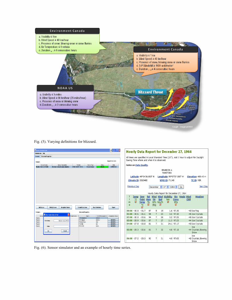
Fig. (5). Varying definitions for blizzard.
Fig. (6). Sensor simulator and an example of hourly time series.

Fig. (7). A blizzard instance visualized on a timeline with its basic information.
Fig. (8). An example of blizzard event report23.
EVALUATIONS AND DISCUSSIONS We performed two kinds of evaluation in our study. (a) An evaluation of the blizzard detection approach. (b) An evaluation of the ontology against a local use
case.
Blizzard Detection Evaluation We evaluated the blizzard detection approach against the blizzard event reports supplied by the Prairie and Northern Atmospheric Hazards.24 The report provided information about the number of blizzard hours in the study area (Brandon, Manitoba) for the period of 1958 to 1995 (Figure 8). We used our implementation to detect blizzard events that occurred during the year of 1964. Our results matched the number and duration of blizzard events
23http://pnr.hazards.ca/blizzard_website/ps_blizzard_climatology/p
rairie_events/event_log_web_pages/brandon.htm 24http://pnr.hazards.ca/blizzard.html
as specified in the report. Our approach detected a blizzard that occurred within the same day (e.g. 15th December 1964) as well as between two days (e.g. 18th-
19th December 1964). An allowance was made for lull period before a new event was counted (e.g. 27th November 1964).
Use Case Evaluation From the practical standpoint, it is expected that the ontology provides better solutions to reason and query about blizzard events. Two criteria have been taken into account in our comparison process. First, the ontology should capture sufficient knowledge for reasoning about weather events from observations. Here, the classes and relations for representing blizzard definition (Figure 5) are analyzed. Second, the ontological structures support reasoning as well as querying information about weather events. a. Comparing ontological representation of blizzard We found only a few weather ontologies which are available online, for example the NextGen Network-Enabled Weather (NNEW) weather ontology25, the METAR ontology26 and the Kno.e.sis weather ontology.27 These ontologies were developed to provide background knowledge related to the weather domain. However, they were not specifically developed to capture the relations between observed properties and weather events. Thus, in our evaluation process, we compared our approach with an existing work - SemSOS’s Observations and Measurements Ontology [34]. The work is very close to the scope of our study. It uses ontology and rules-based reasoning to infer blizzards28 from the sensor observations. In their model, a blizzard is represented as a feature-of-interest of certain observations (e.g. high wind speed, low visibility and snowfall). The ontology represents observation and its related concepts like location, time, features-of-interest and measured value. However, it provides no support for describing different temporal parts of a blizzard event. Further, the rules introduced by the authors do not consider all the criteria necessary for detecting blizzard events, especially from hourly sensor observations. For example, temporal duration (3 consecutive hours) and lull period as well as presence of blowing snow (refer definition in Figure 5) are not considered when reasoning about blizzard from sensor observations. In addition, the proposed model offers no support for describing participants of a blizzard event.
25http://external.opengis.org/twiki_public/MetOceanDWG/MetOntolo
gies 26http://www.daml.org/ontologies/241 27http://sonicbanana.cs.wright.edu/ssw/ont/weather.owl 28The authors uses the definition given by NOAA, US to reason about
blizzard events.

In our ontology, we have specified all the necessary concepts to represent a blizzard. This includes the presence of different types of frozen precipitation, blowing snow, spatial, temporal, and physical properties and duration criteria. It describes how a greater event like a blizzard is “made of” of other sub-events such as frozen precipitation, strong wind and blowing snow. The ontology also captures the relation between a blizzard event and its participating entities. This permits much flexibility in reasoning and querying about a blizzard event and its temporal parts as well as their participants. One might argue that the object-event and event-event relations are trivial matters for a straight forward reasoning about blizzard. However, existing studies [15, 28, 35, 36] suggest that these relations provide more expressive power for querying information about geographic events in general. As expressed by [35], the vision of Semantic Sensor Web includes developing “a system that can relate and reason with various entities and events, and potentially predict future occurrences of events or involvements of entities, by representing and reasoning with entities, events (themes), space and time” [35]. Our approach also analyzes hourly weather observations and identifies lull period from a given data set to produce a more “realistic” blizzard detection results. Note that comparing the SemSOS approach, in this paper, we do not provide details on how to represent sensor and observation concepts in relation to an observed property. We have included the descriptions in our previous work [4]. b. Comparing support for reasoning and querying Previous research [28, 37] listed general kinds of queries involving dynamic aspects that would not be captured by a strictly object-oriented model. We reformulated several general queries according to the domain requirements. We used the following event-based queries to compare both approaches. I. How many blizzards occurred at observed-region
X for a given time interval T? (Asking information about frequency based on an interaction constraints)
II. What are the weather events related to the blizzard E? (Asking information about event-event)
III. How long does the snow event S last during the blizzard E at observed-region X on YYYYMMDD? (Asking information about duration based on an interaction constraint event-event)
IV. What are the atmospheric features involved in the blizzard E? (Asking information about participants)
V. Which atmospheric feature(s) perpetuate(s) the blizzard E? (Asking information about roles of participants)
Table 2. Reasoning and querying
Query Our approach SemSOS
I II III IV V full support partial support no support
Table 2 indicates that SemSOS does not provide full support in query answering since some ontological structures are missing and the specified rules are incomplete. “Partial support” means that necessary classes and relations to form a query were missing or unsatisfactory query results were found. For example, the approach may retrieve all blizzards that occurred at a particular observation site (query I), but misses out some events since no consideration is given to the duration (i.e. lull period) of an extended blizzard. The “presence of snow” criterion as specified in the blizzard definition (Figure 5) should be interpreted in a broader sense. Thus, the query (III) requires concepts representing different types of snow event (e.g. snow, snow flurries), however this has not been addressed in the existing approach. On the other hand, our ontological structures provide a wider support for querying blizzard information. The ontological structures proposed in the study allow inferences about different temporal parts (i.e. sub-events) of a blizzard event and its related participants (refer Listing 2 and Listing 3). Our approach only provides partial support for query (V) since this query requires a more specific type of participation relation. One possible way is to specify functional participation relations based on thematic roles as proposed by Sowa [38].
CONCLUSIONS AND FUTURE WORK In this paper, we have presented an ontology to capture the relations between a weather event and observed properties. In particular, we have formally described information about a blizzard and its observed properties. The ontological vocabularies are exploited with a rule-based mechanism to infer information about blizzards. Such an inference also determines whether blizzard conditions are fulfilled for long enough in order to classify a winter storm as a blizzard. Unlike existing approaches [20-22, 34] which use rule-based reasoning to infer knowledge about events from sensor observations, our approach allows to make inferences about the different temporal parts of a weather event and its related participants. It offers a better query support exploiting the relations between the weather events and their sensor information.

Although our research focuses on a specific type of weather event, modeling of other weather events should also be possible following a similar approach, particularly to represent institutionalized occurrences [39]. Institutionalized occurrences refer to natural events that are classified based on certain spatial, temporal, and thematic bounds. The bounds may be established from empirical or theoretical methods. What is equally important is that the event definitions are defined and accepted at least by the formal organization, which is responsible for identifying the natural events. For instance, apart from the blizzard definition, weather agencies have come up with the definitions of other weather events such as sleet, tornado, hurricane, thunderstorm, etc. based a set of atmospheric properties. By formalizing these definitions, rules can be specified to derive additional knowledge about weather events. Our ongoing work focuses on extending the domain ontology to SWRL Temporal Ontology.29 The temporal ontology provides a set of controlled terms that can be used to represent complex interval-based temporal information. It offers a library of SWRL built-ins to perform temporal reasoning based on the standard Allen’s temporal operators. Other ongoing work aims to incorporate the Sensor and Sensor Network (SSN) ontology [40], developed by W3C Semantic Sensor Network Incubator Group to specify sensors and observations. The SSN ontology is aligned to DOLCE. Thus, the foundational ontology provides the theoretical underpinnings to incorporate both ontologies. There are different definitions of blizzards (Figure 5). We see that a useful extension would thus be to provide formalizations of multiple definitions from different countries and regions. These extensions should also take into account differences in units of measurements in use in different regions. In our approach, we infer events that occur at a particular observation site. Future work should make the location of an event more explicit, perhaps through reasoning about multiple nearby observation sites. Representation of temporal characteristics of blizzards is another potential topic, especially because there is uncertainty and imprecision related to the beginning and end times of blizzards. In order to develop a more common ontological framework, the approach should be also tested by representing and reasoning different types of weather events. Finally, it will be an interesting topic to examine optimal querying and browsing strategies by using ontological structures such as hierarchical and other relationships of the model.
29 http://protege.cim3.net/cgi-
bin/wiki.pl?SWRLTemporalOntology
Acknowledgements The sensor images in this paper were obtained from Wikimedia Commons. The research is funded through the International Research Training Group (IRTG) on Semantic Integration of Geospatial Information by the DFG (German Research Foundation), GRK 1498.
REFERENCES
[1] Botts ME, Percivall G, Reed C, Davidson J. OGC sensor web enablement: overview and high level architecture. Paper presented at the Second International Conference on GeoSensor Networks (GSN 2006), Boston, October 1-3, 2007.
[2] Broering A, Echterhoff J, Jirka S, et al. New generation sensor web enablement. Sensors 2011; 11(3): 2652-99.
[3] Compton M, Neuhaus H, Tran K-N, Taylor K. Reasoning about sensors and compositions. Paper presented at the 2nd International Workshop on Semantic Sensor Networks, 8th International Semantic Web Conference (ISWC 2009), Washington DC, 2009.
[4] Devaraju A, Neuhaus H, Janowicz K, Compton M. Combining process and sensor ontologies to support geo-sensor data retrieval. Paper presented at the Sixth International Conference on Geographic Information Science, Zurich, September 14-17, 2010.
[5] Horsburgh JS, Tarboton DG, Piasecki M, et al. An integrated system for publishing environmental observations data. Environ Modell Softw 2009; 24(8): 879-88.
[6] Henson C, Neuhaus H, Sheth A, Thirunarayan K, Buyya R. An ontological representation of time series observations on the semantic sensor web. Paper presented at the 1st International Workshop on the Semantic Sensor Web 2009, collocated with the 6th European Semantic Web Conference (ESWC 2009), Herkalion, Greece, June 1, 2009.
[7] Kuhn W. A functional ontology of observation and measurement. In: Janowicz K, Raubal M, Levashkin S, Eds. Geospatial semantics (GeoS 2009). Mexico City, Mexico: Springer, 2009: Pp. 26-43.
[8] Probst F. Ontological analysis of observations and measurements. In: Raubal M, Miller HJ, Frank AU, Goodchild MF, Eds. 4th International Conference of Geographic Information Science. Germany: Springer, 2006: Pp. 304-20.
[9] Broering A, Janowicz K, Stasch C, Kuhn W. Semantic challenges for sensor plug and play. Paper presented at the 9th International Symposium on Web and Wireless Geographical Information Systems, Maynooth, Ireland, December 7-8, 2009.
[10] Devaraju A, Kuhn W. A process-centric ontological approach for integrating geo-sensor data. In: Galton A, Mizoguchi R, Eds. Proceedings of the Sixth International Conference (FOIS 2010), Frontiers in artificial intelligence and applications. Toronto, Canada: IOS Press Amsterdam, 2010: Pp. 199-212.
[11] Raskin R. Semantic web for earth and environmental terminology (SWEET) [article on the internet]. NASA/Jet Propulsion Lab; 2004 [cited: 8 July 2011]. Available from: http://sweet.jpl.nasa.gov/guide.doc
[12] Elkiss A. METAR weather ontology [article on the internet]. University of Maryland; 2001 [cited: 21 July 2011]. Available from: http://www.daml.org/ontologies/241
[13] Zhong J, Aydina A, McGuinness DL. Ontology of fractures. J Struct Geol 2009; 31(3): 251-9.
[14] Bermudez LE. Ontomet: Ontology metadata framework [doctoral dissertation]. Philadelphia, PA: Drexel University 2004.
[15] Worboys MF. Knowledge discovery using geosensor networks [article on the internet]. UCGIS; 2003 [cited: 04 May 2011]. Available from: http://www.ucgis.org/visualization/whitepapers/worboys paper.pdf
[16] Albrecht J, Derman B, Ramasubramanian L. Geo-ontology tools: the missing link. Trans GIS 2008; 12(4): 409-24.
[17] Masolo C, Borgo S, Gangemi A, et al. WonderWeb EU project deliverable D18: the WonderWeb library of foundational ontologies. Trento, Italy: Laboratory For Applied Ontology - ISTC-CNR, 2003.
[18] Klien E. Semantic annotation of geographic information [PhD Thesis]. Muenster: University of Muenster 2008.
[19] Sheth A, Henson C, Sahoo SS. Semantic sensor web. IEEE Internet Comput 2008; 12(4): 78-83.
[20] Kessler C, Raubal M, Wosniok C. Semantic rules for context-aware geographical information retrieval. In: Barnaghi P,

Moessner K, Presser M, Meissner S, Eds. 4th European Conference on Smart Sensing and Context (EuroSSC): Springer, 2009: Pp. 77-92.
[21] Calder M, Morris RA, Peri F. Machine reasoning about anomalous sensor data. Ecol Inform 2010; 5(1): 9-18.
[22] Wei W, Barnaghi P. Semantic annotation and reasoning for sensor data. In: Barnaghi P, Moessner K, Presser M, Meissner S, Eds. Smart sensing and context: Springer Berlin / Heidelberg, 2009: Pp. 66-76.
[23] Beard K. Modeling change in space and time: an event based approach. In: Billen R, Joao E, Forrest D, Eds. Dynamic and mobile GIS: investigating changes in space and time CRC Press, Taylor & Francis Group, 2006: Pp. 55-74.
[24] Guarino N, Welty C. Evaluating ontological decisions with OntoClean. Commun ACM 2002; 45(2): 61-5.
[25] EnvironmentCanada. Manual of surface weather observations (MANOBS). Weather and Environmental Authority, 2011.
[26] Oke TR. Initial guidance to obtain representative meteorological observations at urban sites (WMO/TD-No. 1250). World Meteorological Organization, 2006.
[27] WMO. Guide to the global observing system (WMO-No. 488). World Meteorological Organization, 2007.
[28] Worboys M, Hornsby K. From objects to events: GEM, the geospatial event model. LNCS geographic onformation science: Springer Berlin / Heidelberg, 2004: Pp. 327-43.
[29] AMS. Glossary of meteorology [article on the internet]. Boston: American Meteorological Society (AMS); 2000 [cited: 01 July 2010]. Available from: http://amsglossary.allenpress.com/glossary
[30] WMO. Part 1: Measurement of meteorological variables (978-92-63-10008-5). WMO, 2008.
[31] Lawson BD. Trends in blizzards at selected locations on the canadian prairies. Nat Hazards 2003; 29(2): 123-38.
[32] Brodaric B, Gahegan M. Experiments to examine the situated nature of geoscientific concepts. Spat Cogn Comput 2007; 7(1): 61 - 95.
[33] Scherp A, Franz T, Saathoff C, Staab S. F--A model of events based on the foundational ontology dolce+DnS ultralight. Proceedings of the 5th International Conference on Knowledge Capture. Redondo Beach, California, USA: ACM, 2009: Pp. 137-44.
[34] Henson CA, Pschorr JK, Sheth AP, Thirunarayan K. SemSOS: Semantic sensor observation service. Paper presented at the International Symposium on Collaborative Technologies and Systems (CTS), Baltimore, MD, 2009.
[35] Thirunarayan K, Pschorr J. Semantic information and sensor networks. Paper presented at the ACM Symposium on Applied Computing, Honolulu, Hawaii, 2009.
[36] Ortmann J, Michels H. Modelling umwelten. In: Geertmann S, Reinhardt W, Toppen F, Eds. Advancing geoinformation for a changing world. Utrecht: Springer, 2010: Pp. 293-316.
[37] Yuan M. Representing complex geographic phenomena in GIS. Cartogr Geogr Inf Sci 2001; 28(2): 83-96.
[38] Sowa JF. Processes and participants. Conceptual structures: knowledge representation as interlingua: Springer Berlin / Heidelberg, 1996: Pp. 1-22.
[39] Reitsma FE. A new geographic process data model [doctoral dissertation]: University of Maryland, College Park 2005.
[40] Barnaghi P, Compton M, Corcho O, et al. Semantic sensor network XG final report. 2011.