Selma (8th Century BC) , Takusheyi and Surame: research in northern Nigeria
45
Selma (8th Century BC) , Takusheyi (13/14th Century AD) and Surame (16th/17th Century AD): Research on the Rise of the Iron Age, the States of Katsina, Gobir and Kebbi and “Fossilized” Urbanism in Northern Nigeria 1990-1994 and the impact of paradigms Gerhard Liesegang, U.E.M. Maputo 1 Introduction This paper is based on an exercise of historical archaeology in the context of a project on dynastic history and structural change in Northwestern Nigeria. I dedicate it to Ulrich Braukämper 2 because for almost a decade (1968-1977) he was with a Dierk Lange (who was to ask me to study Surame in 1990 and Takusheyi in 1992) part of a group of colleagues interested in the pre-imperialist history of West Africa and the History and Societies of Africa in general. Braukämper 1 The text includes large part of a paper which was submitted and presented to the 10th Panafrican Congress for Prehistory, 1995, Harare, under the title “Models of change for the regions of Kebbi and Katsina in northwestern Nigeria ca. 700 bc-1850” where it was integrated in a section on “growth of complexity”, which was one of the original subjects of this paper. “Model” stood for what Kuhn 1960 and this text designates as “paradigm”. I would like thank all who had given me the opportunity to return to West Africa in 1990 twenty years after having worked briefly on iron age settlements and clay buildings at Dogo, Cercel de Bougouni in Western Mali. D. Lange of the University of Bayreuth hired me on a campaign basis for the project. In the second place I am indebted to the Nigerian Commission for Museums and monuments, at the time headed by Prof. A. Obayemi and his successors, colleagues and workers and previous researchers like John Sutton. Special thanks are due to the Deutsche Forschungsgemeinschaft which supported the research, and Ms. Claudina Cossa who copied the earlier paper. The text consisted initially of the edited parts of chapters I, II, VIII, IX and X of Liesegang and Opadeji 1996. Sincere thanks also go to Richard Kuba, Detlev Gronenborn for having remembered the excavation in 2002-3 and asked me to write a report on Takusheyi and prepared the analysis of the finds in the Römisch-Germanisches Museum in Mainz in 2007-8, Jean Boyd and many of our local workers referred in the full report (Liesegang & Opadeji 1996, see also Liesegang 2004). I am also grateful to Prof. Adebayo Olukoshi for encouragement for attempting to publish this report. 1
-
Upload
eduardo-mondlane -
Category
Documents
-
view
4 -
download
0
Transcript of Selma (8th Century BC) , Takusheyi and Surame: research in northern Nigeria

Selma (8th Century BC) , Takusheyi (13/14thCentury AD) and Surame (16th/17th CenturyAD): Research on the Rise of the Iron Age, the States ofKatsina, Gobir and Kebbi and “Fossilized” Urbanism inNorthern Nigeria 1990-1994 and the impact of paradigms
Gerhard Liesegang, U.E.M. Maputo1
IntroductionThis paper is based on an exercise of historical archaeologyin the context of a project on dynastic history andstructural change in Northwestern Nigeria. I dedicate it toUlrich Braukämper2 because for almost a decade (1968-1977)he was with a Dierk Lange (who was to ask me to study Suramein 1990 and Takusheyi in 1992) part of a group of colleaguesinterested in the pre-imperialist history of West Africa andthe History and Societies of Africa in general. Braukämper1 The text includes large part of a paper which was submitted andpresented to the 10th Panafrican Congress for Prehistory, 1995, Harare,under the title “Models of change for the regions of Kebbi and Katsinain northwestern Nigeria ca. 700 bc-1850” where it was integrated in asection on “growth of complexity”, which was one of the originalsubjects of this paper. “Model” stood for what Kuhn 1960 and this textdesignates as “paradigm”. I would like thank all who had given me the opportunity to return toWest Africa in 1990 twenty years after having worked briefly on iron agesettlements and clay buildings at Dogo, Cercel de Bougouni in WesternMali. D. Lange of the University of Bayreuth hired me on a campaignbasis for the project. In the second place I am indebted to the NigerianCommission for Museums and monuments, at the time headed by Prof. A.Obayemi and his successors, colleagues and workers and previousresearchers like John Sutton. Special thanks are due to the DeutscheForschungsgemeinschaft which supported the research, and Ms. ClaudinaCossa who copied the earlier paper. The text consisted initially of theedited parts of chapters I, II, VIII, IX and X of Liesegang and Opadeji1996. Sincere thanks also go to Richard Kuba, Detlev Gronenborn forhaving remembered the excavation in 2002-3 and asked me to write areport on Takusheyi and prepared the analysis of the finds in theRömisch-Germanisches Museum in Mainz in 2007-8, Jean Boyd and many ofour local workers referred in the full report (Liesegang & Opadeji 1996,see also Liesegang 2004). I am also grateful to Prof. Adebayo Olukoshifor encouragement for attempting to publish this report.
1

had actually introduced me in about 1971 to Dierk Lange whowas to plan the project I shall refer to3. The objective of this study, apart from its reference to thecurriculum of Ulrich Braukämper is threefold: (a) informabout the findings of three campaigns of field work in 1990,1991, and 1992 and one of pottery and find analysis as wellas library and archival research in 1994, (b) discussimplications of the findings in terms of theory ofDevelopment of West Africa and evolution of urbanism andstate systems. Enclosed in this is a critique of simplifiedlinear micro-evolutionist models for development used byhistorians of West Africa around 1960-95. We shall thensketch elements of the cultural sequence in Northern Nigeriafrom the 8th century BC to the 19th century AD as we can nowconstruct. This has a big initial hiatus and a considerablenumber of smaller gaps. Many changes important for theprocess of growth of states and urbanization probablyhappened outside the two areas of Katsina and Sokoto/Kebbiscrutinized more closely, in Kano, Gobir or Gao4 andtherefore the basis for generalizations in very limited. Onealso has to consider that excavation of cultural materialdocuments civilizations rather than political history. Thearchaeological material corresponds at the epistemologicallevel and data content to social and cultural (includingtechnological) history. They do not document to identitiesand political structures referred to in oral traditions, butsome cultural identities may be presented correctly,especially in phases of predatory expansion.. Planning research The sites initially proposed for excavation in 1989 byLange and accepted by Ade Obayemi and the National MonumentsCommission in 1990 were Surame, Male and Gungu west ofSokoto. The choice was based on received knowledge laid downin publications like Hogben and Kirk-Greene (1966) whichwere based on almost sixty years of research by Britishadministrators and a special enquiry among Nigerian localhistorians and authorities5 as well as almost a decade ofresearch at Zaria after independence (cf. Obayemi 1976 and
2

Sutton 1976)6. Surame and Gungu are sites protected by drymoats and walls (or rather earth ramparts faced with stonewalls). Surame was even to be proposed, with good reason, asan Unesco Cultural Landscape site in 2007. The three sitesare settlements where early kings of Kebbi7, one of the 14Hausa states, are supposed to have resided according to oraltradition and the Infaq al-maysur by Muhamad Bello (1813) aswell as hints in the Tarikh-al Sudan8. (According to ourresearch the period of occupation starts apparently in theearly 16th century and extends into the 17th and possibly18th.) Already in 1990 Lange agreed that, if it had notbeen for received opinion and lack of identifiedarchaeological monuments, the area of Gobir farthernortheast would have been a more likely choice if lookingfor traces of an early Hausa state in the area. We shall seelater that this proposal remains valid9.In the course of local surveys of the settlement patternsand their sequence, following Sutton (1976), we added in1991 Selma and Bunza west and southwest of Surame to ourexcavation programme, looked for other older and youngerstructures in the region and attempted, without success, tofind traces of old palaces and settlements an their layoutin Argungu, Birnin Kebbi and parts of Zamfara (TalataMafara10). There were no adequate vehicles to visitAlkalawa, a late 18th century capital of Gobir, whoseconquest in 1808 had been sketched by Muhamad Bello in hisInfaq al-maysur in a description which is very important forthe understanding the functioning of urban centres anddefence systems in the 18th and 19th centuries. (It ispossible that Alkalawa had been swallowed by the waters of amajor agricultural dam built in the 1970s in the area, butthis has not been verified). Takusheyi east of Katsina, an ancestral Hausa royal burialsite, was added in 1992 at the recommendation of Lange andaccepted by the Nigerian partners when it became clear thatSurame and Male might be in fact later than initiallyexpected and possibly not central to early urban anddynastic Hausa history. Takusheyi was a well known sitedocumented in an extensive file of the National Monuments
3
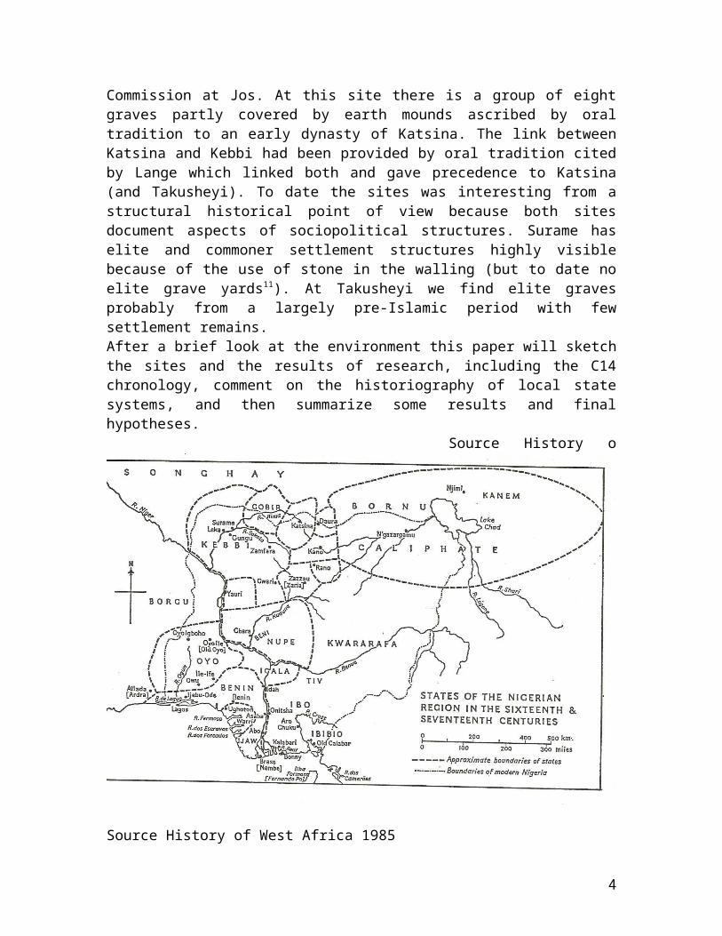
Commission at Jos. At this site there is a group of eightgraves partly covered by earth mounds ascribed by oraltradition to an early dynasty of Katsina. The link betweenKatsina and Kebbi had been provided by oral tradition citedby Lange which linked both and gave precedence to Katsina(and Takusheyi). To date the sites was interesting from astructural historical point of view because both sitesdocument aspects of sociopolitical structures. Surame haselite and commoner settlement structures highly visiblebecause of the use of stone in the walling (but to date noelite grave yards11). At Takusheyi we find elite gravesprobably from a largely pre-Islamic period with fewsettlement remains. After a brief look at the environment this paper will sketchthe sites and the results of research, including the C14chronology, comment on the historiography of local statesystems, and then summarize some results and finalhypotheses. Source History o
Source History of West Africa 1985
4

Environment and historical regionsThe area now inhabited by the Hausa and occupied by theformer Hausa cluster of states comprises several ecologicalzones of the savanna and sahel belt of the Central Sudan.Its centre is a flat plateau situated northwest of thehigher Jos plateau and northeast and east of the Rima riversystem. The Jos plateau in the south constituted in theearly 19th century a refuge for small-scale societies ofgreat linguistic diversity, either part of the Afroasiaticor Niger-Congo families, at a time when the Hausa area bycontrast formed a more uniform area of centralized Muslimstate structures with only a few less assimilatedcommunities. In the 12th century the situation may have beendifferent. Peoples with material cultures closer to what wefind in Southern Nigeria seem to have extended all the wayto the north. In mid-nineteenth century the Hausa were according to localexperts consulted by Heinrich Barth subdivided into theseven real Hausa: Biram, Daura, Katsina, Zaria, Kano, Rano,and Gobir and the seven “worthless” or later Hausa: Zamfara,Kebbi, Nupe, Gwari, Yauri, Yoruba and Kororofa12, amongwhom the Yoruba of Ilorin had come into the Hausa fold onlyin the beginning of the 19th century.. The old Hausa area comprises between Kano and Katsina somehigher moisture areas with inselbergs and periodicallyinundated valleys, in an area of older and younger granites.This region includes some fertile zones, such as the “Kanoclose settled zone” and the Katsina Laka (clay) area whereamongst other crops sorghum is grown and farmyard manure hasbeen used probably for centuries. Pennisetum prevails inmany of the lower and drier surrounding areas in the north,east and west. Many of the latter may again be subdividedinto areas with water supply accessible from the surface (bywells not exceeding 20-25m) and those which are dry bush,where the water table is sometimes at a depth of more than100m inaccessible by traditional wells.To the west and northwest of the higher and wetter plateauwe find the territories of Gobir, Zamfara and Kebbi in theupper basin of the Rima river. They are all are situated in
5
the drier area with wells on plateaus and in flat basins andriver valleys in the Gwandu formation composed of sand andlimestones (cf. Kogbe 1979). They receive an average of justbelow 700 mm of rain per year, mostly concentrated in threemonths of one rainy season. The preferred cereal ispennisetum (millet) which is hardier than sorghum. Thenorthernmost state of Gobir depended on a unique system ofriver valleys extending into the Sahel. Near the ruinedsite of Alkalawa, founded according to Barth in the mid-eighteenth century (shortly after 1764 towards the end ofwhat may have been a major drought period in the Sahel13).The same source indicates an extensive fadama or flood plainused for horticulture and cereal production14. In the early19th century the fadama there was already used for growingcassava15, which is still grown in the fadama near Surameand may have been introduced in the 17th or 18th centurytogether with tobacco . It is near Alkalawa that the Rimachanges her course from northwest to southwest, passingfurther down Wurno, Sokoto and Gande not far from Surame.West of Gand and Surame and south of Selma the flood valleyof the Rima or Gulbin Sokoto16 is opening to a plain ca. 20kilometres wide, flowing through what may have been theheartland of Kebbi. This and the region south of it is dryseason pasture for Fulani and Tuareg nomads from Niger, withherds of dromedars, cows or big Fulani goats. The plain mayhave had am unhealthy environment in the distant past andsettlements seem to have been mostly higher up in the hillsnorth and south, in places such as Selma. The flood plainnarrows at Argungu and remains narrow until after BirninKebbi. At Bunza south of Birnin Kebbi the valley is stillnarrow, but there are first millenium settlements in thevalley itself in the form of small tells. Surame issurrounded by a relatively close settled zone with adiameter of about 30 kms17, which includes a number of smallfadamas in the Binji and Sokoto River valleys and also thearea of Gungu.Takusheyi east of Katsina is in the same rainfall belt asthe Kebbi sites, where combretaceae dominate. It is situatedon the edge of the granite zone. A few kilometers to the
6
west there is the intermittent Kaita river flowing into theSahel. North and northeast we find sandstones overlying thegranites. Takusheyi lies halfway between Katsina and Daurawhich looms large in popular as place of origin in Hausatraditions, constructions which had been established by the17th century (Lange 1987) if not earlier. They were retakenby Barth in the 19th century and may contain traces ofgenuine historical tradition. The centres of the largest states in the 18th and 19th
century like Kano and Katsina are in plains and river basinsat the foot of the plateau. Some like early 19th centuryGobir, Zamfara and Kebbi do not include part of the higherplateau but must have relied on the water resources of theperiodically inundated river valleys, especially the GulbinSokoto and her tributaries, which has a branch penetratinginto the Sahel. Without these resources they would have beenan easy prey to long periods of drought and politicaldestabilization through wars, razzias and invasion byneighbours which would shake the systems of alliances onwhich states have to be based. States do not have tosituated in high rainfall areas, however. Some of the earlystates in Africa like Bunyoro-Kitara, Mapungubwe or centresof later state formation (Great Zimbabwe, Gaza) are situatedin relatively dry savannah areas with a potential forpastoral production and this in addition to the control ofcopper trade may have been an advantage for Gobir too andmay have helped to form a state. The savanna is subject to high erosion rates. This canlargely be linked to the downpours of tropical rainstormswhich have a high energy load (Kowal and Kassam 1978:88).Soil conditions and lack of permanent plant cover also playtheir part. This seems to be the reason why relatively fewNeolithic (or L.S.A.) and early Iron Age open air settlementsites are well preserved in this zone. Many were in higherosion areas. These were even more exposed afteragricultural activities had started four or five thousandyears ago. Thus older archaeological periods are not wellrepresented by sites with stratified settlement layers. AtSurame and Takusheyi one finds eroded pottery sherds and
7
some quartz artifacts (segments) of pre-Surame periods atseveral spots but no settlement layers. Thereforerockshelters are strategic for researchers, but none havebeen discovered in the areas under research.
Excavations at and around Surame and SelmaToday (2008) both Gungu and Surame, which appear on theNigerian 1:50.000 maps of 1969, can also be viewed asrelatively detailed satellite images at the site Google map-Planet. These show the large outer defence walls and moatsas dark bushy stretches. Their visibility is comparable tothe walls of Zaria and far better than those of Kano,Katsina or Sokoto. They also identify most of the visibleinternal settlements structures since the vegetation of thesite is sparse18. Agriculture destroyed traces of compoundsonly in about 10-20 % of the site. If the settlement had notbeen abandoned in the late 17th or early 18th century andnever reoccupied fewer traces would have been preserved.What was expected of the archaeologist in the campaigns of1990, 1991 and 1992 was the systematic dating of the Kebbiand Takusheyi sites. The objective was to check if the imageconveyed by the different kinds of traditions and sourcesand the accepted reconstructions of the past by historians(cf. Alkali 1969) agreed with the archaeological data. Thepresence of pipes at sites as Surame had been recognized butthe surveys had led to interpretations which had to bechecked19. From the very first campaign onwards there weresome signs that the stratigraphic evidence and distributionof these period markers did not support the historicalworking hypothesis dating the beginnings of Surame and Gunguto the 14th century and the assumption that they might havebeen abandoned in the 16th. But there were hopes to find earlier traces. In order tohave a clearer picture, tests pits to recover strata anddated material were also dug at a number of places mostlyidentified in 1975 by John Sutton and his informants in thewider region (Sutton 1976). These include Male (cf. Obayemi1976), Selma and Bunza. In order to try to obtain data forthe construction of settlement and pottery sequences, sites
8
were also surveyed and tested in 1991 which probablypreceded and followed Surame, Gungu and Male. There aredates for three older settlements, none of which comes closeto the dates from Surame and Gungu.. The dates led to the result that the site Selma III nearZaki ((13º 4´27” N, 4º 41´ E) included into the Suramepolitical sphere by “popular tradition” is in reality 2000years older and must belong to the local Early Iron Age.Bunza in the rice growing area of the Sokoto river is alsoolder than Surame. This means that there is one major andsome minor gaps in the chronology and documentation of theprocess of change in Northwestern Nigeria. It was then that I took a closer look at the historicalmodels used to reconstruct the past in order to see if theevidence on which they were based had more weight than thestill very hazy picture emerging from the archaeologicalresearch. As will be shown below, some of the written andoral sources can also be interpreted to support thearchaeological data. Some new lights on Selma III only camemore recently (cf. Breunig & Neumann 2002) when the wavyline decoration assumed a new meaning.. Evidence on the period 700 B. C. 1300 A.D. Selma andHilandambe
In the area west and southwest of Sokoto test trenches weresunk at two sites at Selma, (Selma II and III) and at BunzaMaidahini (by O. Opadeji) where samples for dating wereobtained, as well as at Gande- Hilandambe, where there was alayer containing cultural material but no living floors andcharcoal lenses (cf. Liesegang and Opadeji 1996, Ch. 1 andAppendix I ).At a partly disturbed site at Surame “Talaji ware” wasfound. This is characterized by cross hatching at the neckof some restricted vessels. There is also some twisted cordrouletting. It is not impossible that this ware is partlycontemporary with the tegef ware found in Niger.The oldest dated ware is Selma III ware. Selma is a sitevisited by Sutton in 1975 (Sutton 1976). It is situated
9
north of the Sokoto river and ca. 25-30 km west of Surame onthe slope of a mesa-topped witness mountain and on a highterrace of 3-4ha. The slope is affected by sheet and gullyerosion. Many pot circles or remains of abandoned pots arevisible. In the highest part in the west near a path wideenough for light cars there are several iron furnace baseswhich may be part of the site. Selma III ware seems to havebeen made from the local whitish kaolin rich clay which mayexplain its friable nature and the thickness of the necks ofthe water vessels. (The remainder of the pots has ratherthin walls). Typical decorations include a stepped ring ofthree or four circles of stabbed impressions at the base ofthe conical neck of water vessels. A sample from a test pitat this site (Tr. II) was dated to cal. BC 738-510 (KN 4467)which would make it an Early Iron Age. (Stone tools orflakes were absent at this site). Selma III pottery,reminiscent of stabbed wavy line pottery, and characterizedby heavy stabbed collars at the base of the neck and somewavy line fragments, is certainly distinct from Suramepottery, but we would not at first have suspected an earlyIron Age date20.The Bunza ware from mounds in the flat valley bottom of theSokoto River comes next in the chronological sequence of thewider region, more than a millennium later. As in the caseof the mounds in the lower Gongola valley and probably thoseat Wushishi (cf. Aiyedun and Shaw 1987) the people livingthere seem to have relied on resources like fishing and ricecultivation permitting a permanent settlement close to theriver and away from the terraces of the valley margin. Maybethe mounds had also defensive functions. Bunza ware mayrepresent a long local tradition continuing to the modernperiod. We did not find it near Surame.Selma II ware has been dated to approximately the 13th
century and comes from isolated or dispersed homesteads atSelma (13º 4´27” N, 4º 41´ E). It is characterized by bandsof combed grooved wavy lines on the neck. Similarity of rimshapes and decoration code FF
10
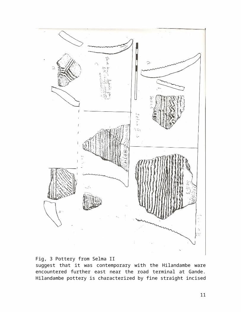
Fig, 3 Pottery from Selma IIsuggest that it was contemporary with the Hilandambe wareencountered further east near the road terminal at Gande.Hilandambe pottery is characterized by fine straight incised
11

lines, most of them parallel; hatching also occurs. Peopleusing this ware complex of straight incised or combed wavyline wares seem to have lived in hamlets or small villagesmost of whom may have been destroyed by cultivation and arenow reduced to mere pottery occurrences in fields andfloating sand. In terms of absolute chronology this SelmaII-Hilandambe pottery complex is almost contemporary withthe burial mounds of Takusheyi east of Katsina.
The graves of Takusheyi ca. 1300-1400 A.D.Takusheyi (12º 57´35” N, 7º 52´40” E) is a site with tracesof occupation in several periods. Excavations had takenplace at the site in 1907 in the presence and probably underthe direction of the British resident Henry R. Palmer withthe active help of the then Emir of Katsina. Palmerinterpreted what he saw in the light of Abu Obeid el Bekri´sdescription of Ghana (ca.1068) and Desplagnes´ then recentreport about the tumuli west of Timbuktu near Goundam inwhat is now Mali. He published a photo of the excavatedt.121 in 1908 and gave a descriptive interpretation in 1922(Palmer 1908, 1922). The villagers, mostly Sullebawa Fulani,pointed out eight graves in 1992 during the excavation. Twoof them are located at a certain distance north of a rivuletdry during the dry season.During our first exploratory visit during the harmattan inFebruary 1992 a local guide had interpreted the lower gravesof the southern group (t.4. and t.5) and which we were toexcavate as graves of females. It is probable that t.4 andt.7 are indeed that, but t.4 brought little conclusiveevidence in this respect. T. 5 was covered with lowergrinding stones, mostly broken, generally interpreted as afemale marker. As had been observed by previous visitors including RobertSoper who wrote a detailed report for the files of theNational Museum of Nigeria22 and Y.B. Usman, there are LateStone Age artifacts on this site. There are mostly quartz
21 T. or t. stands for tumulus. The numeration is ours and goes fromt.1 to t.8. T. 1. and t.3 had been excavated by Palmer.
12

flakes and segments in the southern group of mounds. Severalscrapers were found near the northern barrows, but none inthe southern group. This indicates that different stone agefacies are present, possibly LSA and early Neolithic (?).Pottery which can be subdivided into at least threedifferent wares (not including modern pottery) is also foundon the surface and partly in the grave fill of t.4. The LateStone Age artifacts and one or two of the pottery wares(including a quartz and mica tempered ware) are remains ofearlier occupations and are quite unrelated to the barrows.
Characteristics of the burials and barrowsThree burials were excavated (t. 4, 5, 7) but a trench alsogave evidence on the structure of a fourth grave (t.2). Itseems that two graves (t. 2, 4) had been placed in a pitjust big enough to place the body, while for the other two afairly wide pit (6-7 m in diameter) had been dug in a field.The traces of cultivation ridges and furrows in the top partof a slightly darker agricultural soil buried by the moundwere quite clear in the case of t. 7. in the eastern profileof our trench. The traces of a human skeleton and gravegoods only covered an area of about 2m²in both cases. Noclear remnants of chamber structures were found, but thereseemed to be parallel concentrations of termite tunnels atthe base of t. 7, suggesting the former presence of raftersor a bed. There is also indirect evidence that a hollowgrave chamber initially existed in t. 7. From differentinfill layers in this tumulus visible in the eastern profileit may be deduced that the tumulus was built in two stages.The first layer seems to have covered the grave chamber andsunk in when the chamber collapsed. The second layer thenfilled the pit and produced a flat mound delimited by a lineof stones which we also find in t. 4. There were almost ideal conditions for C 14 dating in one ofthe barrows (t.4). The burial pit there cuts through aslightly earlier or almost contemporary clay buildingapparently destroyed by fire. This had been built on top ofan older pit filled with refuse sealed by a floor. Weobtained samples from this pit sealed by this burnt floor of
13

clay and cow dung with grass that was in turn pierced forthe grave pit. From the sealed pit two samples were datedand one from the burial. The two from the pit (KI 3627 andHD 15569) have almost identical dates although they comefrom different labs, and one from the burial is indeedslightly later (KI 3626). The charcoal may come from thedestroyed building, because in the other graves no charcoalwas found. It is possible that the person buried died in anattack or context linked to the destruction of the building.The barrow t.4 certainly protected remains of the building,the only trace of an old building structure we saw at thesite. It was not checked whether outside the barrow moreremains could be found.After reading Palmer’s report not much in terms of gravegoods had been expected at Takusheyi and the finds, most ofwhich were recovered together with some of the surrounding22 Ulrich was a slightly junior colleague when we met at CologneUniversity around 1962 when he and his friends cultivated his image of anewcomer from the hilly country (Sauerland) east of Cologne and south ofthe Ruhr mining area. He quickly outgrew that image, wrote a criticaland almost exhaustive seminar paper on megaliths which earned him therespect of Helmut Straube who was to move to München shortly afterwards.In Cologne Braukämper submitted his Ph.D. dissertation and then obtaineda position in a Volkswagen Foundation sponsored research project andlater permanent position in the Frobenius-Institut in Frankfurt. Theinstitute was then directed by Africanist Eike Haberland and formercolleague of Straube. It was Braukämper who then recommended me as anhistorical Africanist to Haberland at the Frobenius Institut with whomhe was working in 1969 and where I stayed until 1977 after my firstfieldwork in Mozambique in 1969. In Frankurt I accompanied Ulrich’s workon Hadiya and Kambatta in Ethiopia and some of his studies ontranshumance in the Sudan and Chad. Impressive for me were the longgenealogies of the Hadiya, quite unlike the 4 to 8 generation time depthin many areas of South Eastern Africa (if we disregard theirfluctuating gaps) . We kept loosely in touch until he was nominated tosucceed Peter Fuchs, a passionate ethnographer and splendidphotographer, who is known mainly for this work on ethnic groups inChad. During the thirty-odd years I had contact with him acharacteristic trait of Braukämper was his dedication to his mother andsister and later his daughters and the establishment of long-lastingfriendships and personal alliances such as that with H. Straube, whichincluded agreements carried out by Straube’s successor MatthiasLaubscher.
14

soil in plaster of Paris packages, came as a big surprise,satisfying assistants and workers. Two graves containedwrought and chiseled chased copper vessels, some apparentlyquite fresh and suggested to have been, at least in part,imports from north Africa23 . In all three of them therewere items of adornment including objects made from iron,copper (with traces of textiles), ivory, cowries (allmonetaria moneta from the Red Sea area), glass (t. 5, t.7) anda necklace of ) and a necklace of carnelian beads (t. 7).There were long open cast copper or copper alloy ingots oftriangular cross section in two graves (t. 4, t.5), but no
3. Lange was then in Paris with a scholarship and later moved to Kairoand Bayreuth. The plans we made in 1976 materialized for me only in1991, and in a different region. Lange was by then an acknowledgedspecialist on medieval history of West Africa and editor of twoimportant Arabic sources on Borno². In 1976-77 both Braukämper and Langehad been engaged with me and a few others under E. Haberland’scoordination in attempting to put together a project on the history ofthe Chad area and the savannahs of West Africa, which was later realizedin Frankfurt in a different form, initially with the participation ofBraukämper. (It concentrated on Burkina Faso and northeastern Nigeria).Lange went to Bayreuth after living for some years on scholarships inParis and Kairo. I had moved to Maputo to teach Mozambican and Africanhistory in 1977. One could regard us as members of the second post WorldWar II generation active in West German Academia. The first had beentrained by some of the older survivors of WW II and benefited from afirst expansion or re-staffing of the universities in the 1950s. Thesecond was trained by the younger survivors of World War II like ourcommon teacher Helmut Petri, who tried to avoid some of the excesses ofpre-war “cultural historical” anthropologists and other socialscientists and had more field experience, as well as pre-historians likeH.Schwabedissen and sociologists like R. König who introduced us toepistemology. Our common teacher Helmut Petri had specialized inAustralia, Asia and North America but trained mostly Africanists.The underlying motivations if researchers are probably not easy tocapture, only conditioned by economic constraints of the pettybourgeoisie which had produced us and the opportunities and limits ofthe academic system which partly changed in the 1990s. The basic choicewas made in the teens. Once at the university of Cologne, in the earlysixties, we still lived in a workshop environment without formaldistinction between undergraduates and graduates, which was to change afew years later, and went to do practicals with prehistoricarchaeologists in 1965-66 such as Rudolf Kuper at several sites.Braukämper felt more comfortable in the world of concepts than in the
15
pottery grave goods. The ingots show that Takusheyi was thenpart of the area in West Africa where copper was animportant means of payment. The carnelian beads and cowrieslink it to the Indian Ocean.The mounds, which contain copper ingots and long distancetrade goods are certainly not graves of common people andseem to characterize a pre-Islamic concentration ofpolitical power. Perhaps they document a seigneurial classor aristocracy with both local roots and foreign contacts.geometry of real soil layers layers and material shapes, but later didnot avoid material culture altogether. The third generation of Africanists following us appeared after aMarxist interlude around 1968-74 in Western Germany. It was moreinvolved in post-modern constructivism, but otherwise partly followedthe footsteps of their predecessors with whom they remained united inprojects also breaking down the borders between history, ethnography,archaeology and historical anthropology or historical social sciences.The second and third generations were the first to have academicpartners in Africa. In the case of this research Ade Obayemi’s and otherlocal institutional and personal inputs should not be overlooked.Obayemi had suggested a cooperation in 1978 in Bamako, where I hadpresented data from research in Mali, and he welcomed me when he hadbeen nominated to the National Monuments Commission.The beginning of my own work in Nigeria started in 1990 (afterpreparations in 1989). It coincided with the height of the civil war inMozambique which made field work there very difficult. After the peaceagreement late in 1992 and after 1993 when university student numbers inMozambique rose the combination of work in Nigeria and Mozambique becamemore difficult. This was also the time when results had become morecomplex in the final extended 1992 campaign which confirmed the medievalposition of the Takusheyi mounds. By 1994/5 Lange had moved to adifferent set of hypotheses which made it necessary to expand his areaof reseach. After 1996 it became impossible to flog up support and timefor the technical part of the editing of excavation reports and that iswhy work became dormant until one of the accidental participants in1992, Richard Kuba, who had moved to Mainz, established a link with onof the former Frankfurt researchers in 2003, Detlef Gronenborn, and gotthe discussion and analysis moving again. 4 See e.g. Insoll 1997, 2000.5 In Nigeria I later consulted some transcripts of interviews made forthe revision.6 Obayemi in 1989-1990 stuck by a proposal or suggested agreement whichhe had presented in 1978 at the West African Archaeological Congress(presided by Alpha Oumar Konaré) to the writer and others. 7 Or members of the family of “Kanta” (title of the king of Kebbi).
16
Paulo Morais Farias recovered inscriptions from the Saheland Sahara from this period referring to domestic slaves oraskia probably servants to this class24.
The sites of Surame, Gungu and Male ca. 1450/1500?-1700Two of these sites (Surame and Gungu) are fortified by awall and moat system. The wall building techniques at Suramewere very similar to those observed in Daura east of Katsinain 1992. The plan of Surame shows seven separate wards and8 The Tarikh speaks of Leka, which has been identified with Male, butmight have been Surame. 9 Disappointed by the results of research on Kebbi, and the gaps it leftDierk Lange directed his attention more to the south and attempted tofill in the 2000 years of missing history in some of his essays andpapers in his 2004 collection (Lange 2004). His attitude is probablysimilar to that of the Tanzanian scholar Felix Chami (2006). They coverpartly the same time period and tried to sketch new structures. Bothcriticize local evolutionist models of early nationalist historiography.Otherwise they diverge. Maybe one might commend Paulo F Moraes Farias(2003) who summarized decades of research in a more conservative mannerwithout giving up intercontinental flights. On the other hand thesuggestion by Breunig and Neumann (2002) of a discontinuity in the firstmillennium B.C. suggests that movements from the east might in fact havebeen possible in period much later than until recently expected.10 At Talata Mafara the old Zamfara palace was destroyed in the 1930s,when a representative of the Sokoto lineage too over the title and putsalt on the site in order to prevent rebuilding. There was thehypothesis that Zamfara, along with Gobir, might have shared some of theolder cultural traditions of Kebbi. The palace of Talata Mafara mighthave had a structure similar to that of Surame.11 We found one eroding skeleton near a house almost at the surface andsome possible graves protected by stones as on Islamic cemeteries in thecentral part of Surame. In order to avoid problems with religiousauthorities we avoided probing the feature. In the nearby settlementsdeceased are buried in or near their houses and not in cemeteries. 12 Barth vol. II, Ch. 2 pp. 81-82 (German edition). Barth justified hisstudy of the history of Katsina and the Hausa with the words: “Thepopulation movements of Central Africa have their history too and onlyif they also enter the overall structure of the history of humanity,this can be regarded as concluded. It is a wrong approach to talk aboutthe Cushitic and Semitic population groups without looking at thecharacteristics of these population groups”. Here he assumed a definiteanti-Hegelian position, which may have come from his liberal bourgeoisbackground in a Hamburgian merchant family, whose fortune he partlysacrificed in his overseas travels.
17

probably 21 gates. For those who do not believe that sevencould have been a magic number to be translated into actualbuildings, the seven wards of Surame connected and accessedby 21 (three times seven) gates show that not only theactual walls, but also their numerical structure were usedto give security to the inhabitants of the site. In folkloreas collected by Frobenius and others at the beginning of the20th century, there are tales of seven times seven gates,but this number would have be difficult to attain in a realstructure. Surame includes, in about a third of the settlement, aneroded occupation layer containing tobacco pipes of thetypes known from the Niger valley and generally dated to theend of the 16th or early 17th century, following theirintroduction from North America (Philips 1983) or theCaribbean (?). Much of the site seems to date from the pre-pipe horizon, however, and includes two constructioncomplexes (palace walls and one building west of it) madewith solid mud-brick walls built with conical bricks of theHausa type (tubali). Surame is a town with a rectangular“citadel” or subdivided central palace with mosque andliving quarters which seems to have been repeatedly rebuilt.Another building may have been a tower built in pisétechnique erroneously identified as “Kanta’s stable” inlocal folklore. The fact that the last building stage of the
13 This is an assessment on the basis of a list for droughts and faminesin Tete in central Mozambique which I elaborated and the correspondenceof famines in this dry savanna zone and the Sahel.14 H. Barth 1857: Karte der Routen zwischen Kano, Katsina und Ssay in den Jahren 1853 und 1854 1:1000.00015 Lawal 1992: 67 on a title holder termed magajin rogo in Gobir in 1821.16 In the 18th century the name may have been Gulbin Kebbi.17 Actually only about 60% of the circle are fertile, the eastern third seems tyo have a laterite cover.18 One can locate Surame around Latitude 13.0748 and Long 4.9026 andGungu Lat. 12.9795 and Long.4..8151.19 In 1991 Obayemi shared with me reports and notes by P. Darling andMurray Last on Surame and Gungu.20 It is with 20-40 km at a distance lower than usual for the distancebetween pottery centres (60-80 km), but the raw material is different(friable caolin). This could have accounted for differences.
18

Surame palace and houses consisted of stone cased mud walls(but round living houses) makes the building highly visiblebecause the stone is not as easily eroded as the clay.In ca. 1970 the Provincial Engineer, Jesper Bo Hansen, wasconsulted by Jean Boyd about the volume of work done for theconstruction of walls and moats. He calculated that from themoats more than 860.000 cubic yards had been excavated andthat for the walls some 950.000 cubic yards had been put inplace. The sum of excavated and filled up material was about1.8 mill cubic yards or 2.5 millions t of rock and soil.Estimating that one man working very hard could shift about1.4 tons of earth per day he calculated that about "5000able bodied men would have to work for a year non stop tomove the earth mentioned above". Since the necessaryinfrastructure (wood cutters, food growers and processors,warriors, donkey leaders plus their respective families)would have required a vast population which was unlikely inthe vicinity, it was presumed "that the city was built overa much longer period of time".25
The third settlement, Male, had no visible town defencewalls but occupation layers of more than two metres inthickness (with tobacco pipes down to the lowest layers,which was different from previous findings). Some borrowpits there exposed thick clay walls and an extensive floorsystem at the southern edge of the settlement. Due todestruction of part of the site it is not clear if therewere big clay buildings also in the top layers. Gungu (12o 59’N 4o 49’E), also tested in 1991, showed no traces ofa larger settlement in the area and dated charcoal sampleswere obtained from deposits in the chambers of the twosouthern gates and isolated settlement remains. No testswere made in the modern village in the northwest, whichseems to be recent. Surame showed statigraphical signs ofcontinuity of use in the central palace compound, whichincorporated a square mosque or prayer area with quibla. Theside length of the prayer area is about seven metres. Two orthree other houses have minute prayer areas. There wasevidence for at least three occupation periods in thesettlement, and four or five in the central palace or
19
citadel area, partly separated by layers of floating sandindicating that the site lay abandoned for some time. Thelast occupation layer was associated with clay tobaccopipes.As referred above, Surame and neighbouring Gung and Male canbe attached to the Kebbi kingdom and its ruler, who had thename or title of Kanta. Kanta and Kebbi appear in connectionwith Songhai wars in about 1510-1520. They are mentioned inthe Tarikh al Sudan, a source written in Tumbuktu in the 17th
century. The length of the wall system is not in directrelationship with the occupation in the interior since thecity wall systems seem to have included empty spaces. - Thelength of the circumference walls for some northern Nigeriantowns have been given as follows: Kano city wall 18.5 km Zaria (city) wall 15.8 km Zaria (with Kufena loop) 31.2 km Katsina city wall 11.8km Katsina outer ("Amina") wall 32 km Turunku 12.826
This compares with the length of Surame and Gungu: Surame 8.75 km (outer wall27) Gungu 4.9-5km (outer wall)Surame was thus in the planning stage clearly one of thesmaller settlements. Certainly it was so when it was settledbecause the occupation of Surame was always not very dense.A count at the surface by field walking, controlled by airphotographs does no yield more than about 90 to 100compounds, among whom those belonging to the later periodsof the 17th century probably predominate. Many have only oneto three houses or sheds in the interior, for each of whichwe could estimate 2.5 to 3 habitants. That is why the totalpermanent population was assumed to have been at less than1.000 inhabitants in the final two periods. It is possiblethat Surame was then a more or less ceremonial capital thanand the kings often absent in defensive and offensivecampaigns and inspection visits.
20
Surame was thus both relatively late and of limited successas urban settlement, a situation which turned it into aunique museum of Nigerian urbanism in the 16th and17thcenturies, where wall building, two types of gate structuresand the layout of compounds can be observed. The compoundsmostly have a half public part in the west and a moreprivate section in the east. Visibility of social structuresat Male, which must be almost contemporary and possibly moresuccessful as a settlement, is much more limited.These sites are situated at a distance of about 6 - 7km fromeach other and must be partly contemporary. Normal domesticgrayish pottery ware from Male and Surame is very similar.One of the problems encountered for the interpretation ofthe sequence is the relatively poor stratigraphy at Surame,where settlement was dispersed over 3-4 square kilometers,while at Male there is less than a tenth, possibly some 14to 24ha, and layers have a depth of more than two metres28.Surame seems to have been occupied for a longer period thanMale. A large numbers of wares and decoration subtypes werefound at both. There are more than ten of them. Since theidentification of types and standardization of descriptionof decoration and shapes has to precede statisticaltreatment, finds have not yet been processed definitively.New categories were defined on the basis of paste, shape anddecoration like “Soro fine curvilinear incised” and “Soropaneled rocker stamped ware”. Some terms as “Soro finecurvilinear” found at Soro and Male were introduced at alate stage in 1994 and made earlier classifications andcounts obsolete. This is, however, not very important forthe overall chronology. For the interpretation of theeconomy and social structure a more definitive analysiswould be necessary, but Y.B. Usman’s (1981) reconstitutionof Katsina gives some idea of what may be expected in termsof institutional and social complexity. Some of the finerwares of the 17th century may have been produced at certainpottery centres. I would suggest that at any one time threeor more wares made from different clays at different placeswere used simultaneously at Surame and Male in the 17th and18th century. This means that wares overlap in time and
21
space in the layers. This mixture makes it difficult todistinguish and define some of them if one does not takeinto account the paste and certain elements of surfacetreatment, thickness and colour.Among the finds at Male we could single out fragments ofcoloured glass bangles (bracelelets which are rare atSurame), cowries (monetaria annulus) and Haji-Mani ware, atype of fine red pottery, often subcarinated, with sometimesnear vitrified surfaces (with a metallic hue) which belongsto a late period (possibly 17th century). The metallic hueindicates a relatively high firing temperature and possiblya use other than cooking (like prestige pots for the backinterior walls of houses, imitating some of the shapes ofcopper pots)29. These vessels may in part have been used forostentation like the ceramic and metal pot stacks kept bywomen in some better-off Hausa and urban Fulani householdsin modern times.The main factor in the choice of a site for Surame and theneighbouring walled settlement of Gungu was probably theavailability of stone for the construction of the walls. Itis laterite or laterized limestone. The site of Male at theedge of a small fertile river valley is farther away fromlarger easily accessible stone deposits. Some laterite isavailable at about 300 cm from the surface. No stone wallshave been traced there. There are some thick mud brick housewalls of the same kind documented at the central palace andone building west of it at Surame. In the northeasternquarter we find dyeing pits (still undated) absent fromSurame. This suggests that regionally produced consumergoods like dyed cotton textiles, tobacco and probably glassbangles may have become part of an economic boom in NorthernNigeria which supported the growth of towns. This growth mayonly have come in the 17th and 18th centuries.This and other evidence can be marshaled to show that atSurame there is very little reliable evidence for thechronology of the growth of states and towns before the 16th
century and it may be questioned whether there was astraight forward historical continuity from pre-sixteenthcentury to the sixteenth century.
22
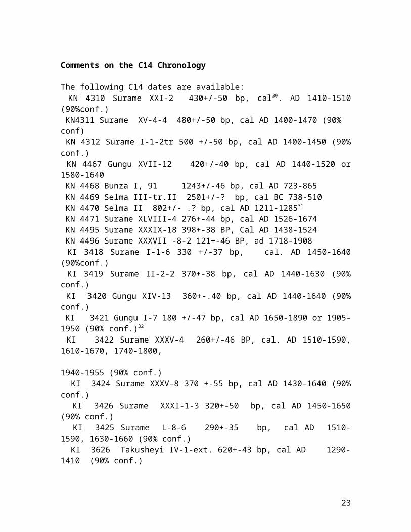
Comments on the C14 Chronology
The following C14 dates are available: KN 4310 Surame XXI-2 430+/-50 bp, cal30. AD 1410-1510(90%conf.) KN4311 Surame XV-4-4 480+/-50 bp, cal AD 1400-1470 (90% conf) KN 4312 Surame I-1-2tr 500 +/-50 bp, cal AD 1400-1450 (90%conf.) KN 4467 Gungu XVII-12 420+/-40 bp, cal AD 1440-1520 or1580-1640 KN 4468 Bunza I, 91 1243+/-46 bp, cal AD 723-865 KN 4469 Selma III-tr.II 2501+/-? bp, cal BC 738-510 KN 4470 Selma II 802+/- .? bp, cal AD 1211-128531
KN 4471 Surame XLVIII-4 276+-44 bp, cal AD 1526-1674 KN 4495 Surame XXXIX-18 398+-38 BP, Cal AD 1438-1524 KN 4496 Surame XXXVII -8-2 121+-46 BP, ad 1718-1908 KI 3418 Surame I-1-6 330 +/-37 bp, cal. AD 1450-1640(90%conf.) KI 3419 Surame II-2-2 370+-38 bp, cal AD 1440-1630 (90%conf.) KI 3420 Gungu XIV-13 360+-.40 bp, cal AD 1440-1640 (90%conf.) KI 3421 Gungu I-7 180 +/-47 bp, cal AD 1650-1890 or 1905-1950 (90% conf.)32
KI 3422 Surame XXXV-4 260+/-46 BP, cal. AD 1510-1590,1610-1670, 1740-1800, 1940-1955 (90% conf.) KI 3424 Surame XXXV-8 370 +-55 bp, cal AD 1430-1640 (90%conf.) KI 3426 Surame XXXI-1-3 320+-50 bp, cal AD 1450-1650(90% conf.) KI 3425 Surame L-8-6 290+-35 bp, cal AD 1510-1590, 1630-1660 (90% conf.) KI 3626 Takusheyi IV-1-ext. 620+-43 bp, cal AD 1290-1410 (90% conf.)
23

KI 3627 Takusheyi IV -2-sp.22 720+-34 bp, cal AD1270-1300 KI 3628 Surame LXXI -9 340+-35 bp, cal AD 1470-1640(90% conf.) KI 3629 Surame LXVII -8-10. 330+-36 bp, cal AD 1470-1650 (90% conf.) HD 15524 Surame LXVII -8-9 351+-27 bp, cal AD1478-1636 (2sigma according to probability distribution) HD 15668/15595 Surame LV-1-8 312+-24 bp, cal AD 1500-1650, with 77% for a
date in the 16th
century. HD 15569/15537 Takusheyi IV-2-19 753+- ? bp, cal AD1220-1300 The bp variation of all dates is indicated with aninterval of 1 sigma (68% confidence), the calibrated datafrom Kiel with 1,65 sigma = 90% confidence calculated by thelaboratory, and the rest for the first dates for Cologne bythe author, both on the basis of the Stuiver and Pearsoncurves. The 1.65 sigma interval means, that – not takinginto account errors of stratigraphic attribution and mixturedue to termite activity etc.- 9 out of 10 dates should fallinto the interval indicated. Heidelberg (HD) lab dates werecalibrated with a 2-sigma interval, which implies a still ahigher probabilityThe date for Selma III compares with a date for Do Dimmi,Niger (700 bc) for an early iron age site33. The date cameas a surprise, because there is apparently rouletteddecoration at Selma III which was not considered so old andoral traditions saw Selma as contemporary with Surame.The grave mounds of Takusheyi, if the dates are confirmedwould point to the existence, in the 13th and 14th centuries,of local dynasties able to accumulate from long distancetrade and local resources which linked this area to theMediterranean world, the Near East and zones of West Africa.On the basis of a hypothetical reconstruction of localgrowth of political structures, Surame and the other walledsite, Gungu, had been expected to date from around orshortly after 1350. According to the dates more probably
24

they started more than a century later. Kuba (1996: 204)suggests a tie-in with Bornu history and wars with a kingwho started to rule in 1455. This may be just possible.The numerous dates for layers at Surame are partly resultsof attempts to reconfirm the first 15th century dates fromthe laboratory in Cologne (KN) obtained in 1990 (KN 4310-4312). At Surame all but the three first dates obtained (KN4310-4312) would point to an occupation and building periodin the 16th century which may have started in the lastdecades of the 15th century. The sample from Tr. L-6-7 (HD15667) is from a pit which had existed before the northerncompound wall of the central “palace” (of phase three orfour) had been built over it. In the case of Surame therelatively early dates for samples from Tr. I, XV and XXIand the first date for Gungu (KN 4467) seem to becounterbalanced and corrected by the dates from Kiel andHeidelberg, which seem to have the same stratigraphicalprovenience. These include the samples from Tr.LXVII, st. 8,sp. 9 at the foot of the north wall of Kanta's compound atSurame, coming from a layer which must have accumulatedshortly after the wall had been built (KI 3629 and HD15666). In the same direction go dates from Tr. L. st. 7,sp. 6 (KI 3625) for a sample collected in a pit underneaththe wall foundations of the north wall, from Tr. LV, st. 1-8, from charcoal at the base of a deposit in the line of thewall (HD 15668) and Tr. LXXI (KI 3628). The dates KN 4471,KN 4495 and KN 4496 seem to fit the result from the otherlaboratories. These samples are among the reasons to suspectthat Surame was occupied for the first time only in thesecond half of the 15th century or even the first years ofthe 16th century. The dates for occupation of the fortification of Gungu (KN4467 and KI 3420) are statistically compatible34. This wouldsuggest a post-1440 date for the fortification of Gungu. Theproblem is that the statistical terminus ante quem is only inthe 17th century. It is therefore quite possible that thefortifications were built only in the 16th century. But thesamples could also indicate that Gungu and parts of Suramehad a common occupation period around 1470-1520. They may
25
have been started at the same time, but Gungu may not havebeen finished. The discussion of the position of Takusheyi which may bepartly contemporary to Selma II-Hilandambe also raisesquestions as to the chronology for Kano and Borno. If weassume the Takusheyi tumuli to be a sign of growth ofpolitical structures of an aristocratic largely pre-urbancharacter than the dates for Takusheyi around 1200-1300would put a question mark on hypothetical dates for thefoundation of Kano around 1095-1134 and expansion of Kanemelements into what was to become Borno35. Maybe the historyof these areas will have to be revised and chronologiesshortened. More attention will have to be paid to structuralchange and possible manipulation of sources. By thedetection of manipulations in medieval sources EuropeanHistory attempted to become a science in the 17th centuryand the revision of Egyptian chronology in the first half ofthe 20th century resulted in reducing it by almost 2000years. So taking out two hundred or three hundred yearsmight not be too revolutionary. In the discussions on the theory of urbanism it has beenunderlined that a multi-causal explanation includingpolitical and technical-economical causes should bepreferred.As to dating of wall systems, already research on the Jukunor Kororofa capital by de Meulemeester and Nenquin in 1969-70 and 1970-1971 had resulted in the measuring up of awalled settlement with a double wall 7.35 km in length,enclosing an area of 3.75 km². Dates from Brussels andGroningen (310 ± 35 BP and 315± 20 BP) referred to thesame relative late period. These dates were similar to thatobtained by Connah at Birnin Gazargamu (which, however, hada larger standard error). The resulting calendar date (c.1500-1640) agrees relatively well with references toKororofa activity in the Kano chronicle Palmer 1908). On the sherds reproduced from the Kororofa site we findamong others rouletted and grooved patterns. About 30-40% ofthe decorations have some similarity to those from Surame
26
and Male. Future research may show if this has anyrelevance. It may be suggested that the type of town walls we find atSurame may have been developed from diverse models and for aspecific use in the 15th century in the central Hausa areaand spread at the beginning of the 16th to areas like Kebbiand possibly slightly later to Kororofa. At the beginning ofthe 19th century different walls were already built.
Critique of the simple local growth model dominant in the1960s and 1970s
We agree with the proposition that historical andethnographical accounts are constructed according totheories and assumptions about growth processes andstructures and that paradigms or models of interpretation(sometimes even imported from field of political thinking)are very important. But much in line with Karl Popper Iassume that discussion, dissent of researchers even withinprojects, and individual affirmation of identity or socialterritory and critique of earlier generalizations andconstructions (including self critique) are constructiveelements leading to progress. The observations, structure ofthe finds and other evidence, the community of scholars helpto avoid an absolute dominance of single political andphilosophical paradigms and permit an approach to “reality”.But Nigeria shares with other areas the problem of gaps inthe geographical coverage of research which limits theinterpretation of structures and at present it is difficultto see if there was any articulation between the Yoruba-Benin area in the South, the Niger valley and areas furthernorth, which have slightly different wall types but perhapssimilarity in the gates. If Richard Kuba is right, therewere wide-scale contacts in the earlier period.At least nine historians and one archaeologist had between1856 and 1995 or 2008 attempted to delineate main periods inthe history of Northern Nigeria in the second millenniumA.D. Instead of describing the models proposed by individualhistorians, I intend to class them into groups and point out
27

a number of common traits and major differences. The modelsconcerned consist of a time scale and a number of processesdescribing elements of growth of institutional complexityand change. 1. A model contained in the histories of states startingwith the conquest of a foreign-born warrior or group ofwarriors accepted for a heroic act of liberation by thelocal population as overlord. This model emerges from localchronicles written mostly in the 19th century and partlyrevised in the 20th. It is based partly on older writtensources and oral tradition, carrying back the origin ofdynasties to approximately the 11th century. 2. A model for the development of Kebbi derived from theTarikh-al-Sudan which reflects the views of the Timbuktueducated elite on this area, describing Kebbi as an offshootof the Songhai-state of Askia Mohammed and possibly hispredecessor Sonni Ali. A sub-model 2a is based on the Tarikhal Sudan and supplemented by inclusion of earlier missionaryfrontier (cf.Alexander 1984) during the transformation ofcentral Hausaland.3. Local continuity and growth model proposed by H.N.N.Smith and others in the 1960s. It is based on anevolutionist approach and projects the origins of knownstates in the past, following model no.13a is a regional growth model with an attempt to uncover anearlier layer of states.4. More recently D. Lange (2004, 2008) proposed to date themigrations of foreign state founders into Hausaland in the7th Century B.C..
Narratives patterned according to model 1 generally presentchronologies based on king lists with their respectivenumbers of years of rule. The best known of these is theKano chronicle. It was finished somewhere around 1890.Almost all the known Hausa chronicles available in extractsor translations seem to have been written in the 19th and20th centuries but are partly based on older dynastic lists.They evidence status problems of dynasties and segments ofthe Hausa population as an underlying theme. Lange pointed
28

out that these histories constituted partly answers totraditions and political activities of Kanem-Borno andpossibly other regional elites. They thus may go back to the15th century. There may have been, already at this time,attempts by local men of letters to lengthen or reconstructdynastic records, create traditions of migration from Meccaor the Orient in order to establish precedence and socialstatus in the Islamic world (cf. Hunwick 1994). For Kanothis is the case before 1350 and even in periods before 1700A.D. After that we find real history with originalobservations. Very long rules, in some cases repetitions ofnames make up much of the data raising suspicions.For Katsina Barth seems to have found such a lengthenedchronology already by 1852. They are therefore not only latenineteenth century fabrications36. It would be premature,however, to dismiss all the chronicles en bloc withoutprevious study5. Periods where giants or djinns appear maybe written off as fiction introduced after Islamisation.Lange (1991a) proposed a model for possible reconstructionsof the Kebbi oral/written records but although criticalfollows still partly the nationalist tradition. Withregards to sites and the popular interpretation Sutton 1976commented: ".. it is clear that somewhere along the linesome ignorant and unperceptive tale tellers had succeeded inposing as historical authorities, and in substitutingfantasy for historical tradition and sensible archaeologicaldeduction." Sutton may have referred here to folklore onthe "siradi" of Surame, “Kanta’s stable” and similar inventedelements. Model 1 agreed well with nationalist historians of the post-independence period insisting on local continuity after aninitial period of foundation which was often pushed farback. Model no. 2 comes closest to the archaeological results. Itshows that some oral tradition controlled in itstransmission and reproduction by the interaction of theparticipants whose past is narrated can be relied on. It maygo back to the 15th and 16th centuries and is partlysupported by written evidence.
29

Model no 3. depends on the assumption of local or regionalevolutionary processes. The chronology and much of theevolution proposed by the author of the Kano chroniclefitted well with views dominant after independence. Thisresulted in a local growth model proposed by Smith asevolutionist speculation and synthesis of local historiesprobably in accordance with historiographic tendenciesexisting in Nigeria, because it is also evident in Alkali’sstudy (1969). The view of the origins of the Kebbi state andthe continuity of the population presented in Alkali’s M.A.thesis (1969) probably reflected in part some of theconcepts then current. He insisted on the continuity of thepopulation and proposes what may then have been a consensus:“… it is only too clear that the formation of a statestructure cannot have been the work of a single life-time.”This is a statement freighted with ideology of colonial andpost-colonial nation building. It could be argued, forexample, that changes in the political structure have to bequick in order to prevent people from innovating andorganizing their resistance to conquest. Cases in point arethe mfecane and rise of Zulu and other Nguni kingdoms, thejihad of Usman dan Fodio which took about two decades toconstitute a wide new political network and the Swahiliconquest of Eastern Zaire in the second half of the 19th
century. The Tarikh-al-sudan would support a speedy structuralchange. According to this chronicle Kebbi is supposed tohave become independent at the end of two campaigns againstKatsina and Agades in 1513 and 1514 as a result of arebellion.Model 3a is an elaboration of model 3 and 1. An example ofthis is the article of M. Last (1985). Last, like Sutton andLovejoy, had had experience of teaching in Nigeria and knewthe field since the preparation of his Ph. D. thesis. Herevised Smith’s contribution on “early kingdoms” in theCentral Sudan to the History of West Africa but had to rely partlyon unverified dates and data.Problems of some of the models seem to lie in the linearityof historical development suggested and a stressing of thecontinuity of states even in cases where they shifted
30

centres. It is difficult to be dogmatic here. This paperproposes less continuity for Kebbi and more for Gobir, whichmust have been responsible for the shift of the Kebbicapital to the south around the beginning of the 18th
century. Regarding Model 4, recently D. Lange proposed to take theBayayida myth literal and proposed a much earlier date, theearlier 7th century BC. This would follow shortly after theintroduction of the iron age in the region. Some doubtremains whether the Bayayida theme is not a younger parallelto the Kisra myth which for a long time fascinatedethnographers of West Africa like K. Dittmer and which Kuba(1996: 208, 216) tried to link to the Dugawa dynasty oustedfrom Borno in the 11th century.
Hypothetical ordering of the evidenceWest Africa has had a very long period of development ofagricultural production systems, which go back more thanfour millenia. Near Lake Chad agricultural systems werethought to have started around 1800 BC. Competition forresources was high and there were necessities to invest indefence, as the for example the existence and position ofsome stone age refuge settlements near Iffe Ijumu insouthern Nigeria suggests37. There were probably stone agecamps and villages for two or three millennia and then along span of possibly segmentary decentralized iron agesocieties, with occasional art objects. The early iron age site at Selma III confirms that alsonorthern Nigeria participated in that transition at the sameperiod as neighbouring regions. The question is whether thistransition was linked to a migration (cf. Breunig & Neumann2002) and whether it left a mark on the language situationof the region. It may be necessary to compare the culturalmaterial from the same period on other sites of the widerregion in order to be able to suggest a more specifichypothesis. It is possible that there was language contactin this period which led to traces of creolization in Haussaand Songhai. (But as regards fadama cultivation techniques
31
Songhai and Haussa share terms and concepts which werepossibly introduced as late as the 17th century AD)What we have to present as evidence for the next twomillenia, are isolated village and hamlet sites, includingsome which were possibly central ones or clustered. Theycover the Late Stone Age (or Neolithic, cf. Aiyedun &Shaw)and the period from the beginning of the iron age (7th
century BCs) to the beginning of towns in the 15the century.There may be a long term settlement structure at Bunza(floruit 8th-9th century AD).This paper does not consider the attempt to interpret theBayayida story as a trace of a mid first millenniumintrusion from the Arabian Peninsula but as a reflection ofattempts to gain social status in the 13th or 14th centuries,after Islamization. Islamization was probably preceded by social differention,visible at Takusheyi. Working urban structures and complexity38 came in stages todifferent regions of West Africa. In central Hausaland thismay have been later than suspected, around 1350-1450. Theformation of city states could have started as a reaction topressures from the outside, coming from the north, south,east and west, partly as pilfering and slave raiding andand not as a result of local growth only. Centres of statesmay have shifted in the 15th and 16th centuries and heads ofstates may not always have had the time to reside in thecapitals. “Urban” life, links between towns andtransformation of raw material need not always have sprungup in the political capital but also villages.Previous to that there may have been a period when theconcentration of political power was not as visiblearchaeologically as in later periods. This would make itadvisable to do more research on the pottery at Takusheyiand on the settlement traces west of the grave site largelydestroyed by agriculture and erosion. At present the archaeological chronology of the Surame andTakusheyi areas does not give very definitive answers toquestions about the sequence of political formations andsocial structures in Northern Nigeria. But there are
32

probabilities. Thus it seems improbable that the area aroundSurame was the hub of urban and imperial development in the14th or 15th century. Takusheyi seems to be earlier thanSurame and thus the images of "Bawo" coming down the Rimavalley with a fishing spear towards Kebbi and the image ofKanta as the son of a Katsina mother and Songhai (or SonghaiFulani) father may be chronologically correct39.Uncertainties as to dates could be narrowed down by lookingat later and earlier developments in the area around Gungu,Surame and Male. The grave goods show that Takusheyi was part of the area inWest Africa where copper was used as object of value. Theshapes of the ingots are not the same as those used twocenturies later on the Nigerian coast. More research is alsonecessary on the standard weights and accessory minerals andmetals which might help to identify the origin of thecopper. The discussion of the position of Takusheyi whichmay be partly contemporary to Selma-Hilandambe also raisesquestions as to the chronology for Kano and Borno and gapsin the geographical coverage of research. If we assume theTakusheyi tumuli to be a sign of growth of politicalstructures of an aristocratic largely pre-urban characterthan the dates for Takusheyi around 1200-1300 would put aquestion mark on hypothetical dates for the foundation ofKano around 1095-1134 and expansion of Kanem elements intowhat was to become Borno in the same period unless we assumethem to have has structures of the same type40. Maybe thehistory of these areas will have to be revised with moreattention to structural change. The so-called “inselberg complex” proposed by Obayemi andothers for the central Hausa region may also be inserted inthis period. The question is whether it was a centre ofgrowth and preparation to urbanism or a sign that refugesocieties had to organize themselves to defend themselvesfrom mobile invaders coming from the Sahel, Takusheyi andenvirons and early Rano/Kano and other centres. In the discussions of the theory of urbanism and states ithas been underlined that a multi-causal explanationincluding political and technical-economical causes
33

(transport, diversification of production) should bepreferred. During the Takusheyi period a transformationseems to have taken place in at least part of the area,giving rise to Gobir, which is one of the earliest states tobe mentioned, but presently still without a clearlyidentifiable centre or traces. In addition to Takusheyi(Katsina) probably other smaller states of unknown extensionexisted. What was the extension of the Hausa area at thistime? Did it include Kebbi? Possibly not.The trade relations reflected by the grave goods ofTakusheyi suggest the existence of long distance traders andthe need for a trade pidgin which would eventually give riseto creole language like Hausa. Internal migrations andconquests would also have acted as levelers of languagedistinctions.A further change seems to have taken place one or twocenturies later, around 1450-1550. By that time Kano hadbecome more powerful than Katsina which, however, retainedan important position on a trans-Saharan trade route and inthe regional political structure to the 18th century.Further south and west, the previously more segmentarystructures may have become victims of raids. Kebbi appearedin the same period. The former political centres of thisarea have not yet been located. Kebbi seems to have riseneither on the ruins of the local village and hamletstructures possibly supplemented by refugees from Katsina orother places. The local populations had to respond toSonghai expansion in the west and Kanem-Borno pressure inthe east, which had an impact on centres like Kano andKatsina. The infiltrated Fulani elements which gave rise tothe Askia Dynasty in Songhai may also have been alreadyimportant here. Surame almost looks like a sudden materialization of a newcentre, without local growth cells. Gungu seems to have beenan unfinished centre also without local urban antecedents.As referred many major states and empire emerged as theresult of a series of rapid conquests. This permitted toestablish political asymmetries in social reproduction.Conquered societies were not given time to reorganize to
34
ward off the conquest. The 19th century jihad in West Africaand mfecane in South East Africa, the imperialist conquestand earlier state formations in Africa seem to indicate thatthe element of surprise is important. Therefore a state likeKebbi does not have to be preceded by a growth of localcentres. It seems more likely that Surame and Gungu were akind of colonial settlement resulting from a creation of anew centre by a political nucleus which had immigrated,possibly attracting also Hausa urban dwellers from the East.They may have imported defensive technology already in useelsewhere, using it against the Songhai. The settlementswere not very successful as towns. Gungu apparently onlysupported a small camp settlement or uninhabited mudstructures now largely blown away and Surame seems to havehad a fluctuating population of sometimes less than athousand inhabitants and was abandoned in the 17th or early18th century. Male seems to have had a more successfuleconomic base. At Male there was textile dyeing, tobaccomust have been grown and bangles made from traded colouredglass. Black glass may have been manufactured in the area.(Male attracted more cowries which are more frequent therethan at Surame. They were encountered in small caches in thehouses or homesteads). The introduction of annulus cowriesvia the Atlantic, which according to Barth were to beintroduced to Bornu in mid-nineteenth century only is alsoattested by the Kano chronicle for the 18th century. Theymay not only have come from the south, but from the west. The graves excavated at Takusheyi were none of those forwhom male names had been proposed by local informants, infact two had been tentatively identified as female graves.But are these probably female graves of normal royal wivesor princesses or some other dignitaries? Did women normallywear these dangerously spiked anklets or leglets? Some ofthe authors dealing with the pre-Islamic Hausa area suspectthe existence of shrines41 and one the Islamic traditions ofthe origin of the Hausa dynasties (Bayayida ) refers to aqueen of Daura (cf. Palmer 1926a; Lange 1987, 1988.) Mightthere be a grain of truth in this myth of origin? The type
35

of ornament suggests that some women have public rolesbecause of its expressive value.In the following periods until the 19th century the publicposition of women as title holders declined, some of themonly disappearing during the Jihad. The 17th -18th centuries were probably still decisive for thegrowth of complexity in consumer goods production inNorthern Nigeria. It could be tested whether this was ageneral pattern in the area or if at other sites in thesouth or east proto-industrial expansion started earlier.Plans for research proposed by Nigerian archaeologists intowns should be put into practice. There is a need forfurther regional archaeological surveys to locate industrialsites (glass making, copper and iron working, textilemanufacture, etc.). Since early political or imperial structures (includingtemporary grass and stick capitals) are almost invisible inthe archaeological record in certain periods it is dangerousto hypothesize on the basis of the present archaeologicalevidence that a Kebbi empire did not yet exist in thefourteenth or early fifteenth century. But there is a chancethat Kebbi was really only founded at the turn from thefifteenth to sixteenth century. On the other hand, written sources from Ibn Batuta (mid-forteenth century) onwards refer to Guber/Gobir. If 14th
century Gobir or Guber was not in Kebbi where it wassometimes looked for in the 1980s, why not look in the areaof 18th century Gobir? The scant attention paid to it wasdue to lack of access from Nigeria during the colonialperiod and especially the 1950s and 1960s. The main roadlink to the north from Sokoto via Illela and Birnin Nkonniis west of the probably older 13th to 18th century route oraxis where Alkalawa was situated. This conditioned researchnegatively. If not swallowed by dam waters the search forold Gobir should start there, near old Alkalawa, checkingthe area in Nigeria and Niger along the valley stretchinginto the Sahel. It is probably in Gobir that a search toclose a gap should start, near the Alkalawa of Yunfa,conquered in 1808.
36
The graves at Takusheyi may stand at a final period of aflourishing pre-Islamic society with marked socialdifferentiation. Many historical maps seem to distort theimage of Gobir and place it too close to the Maradi valley.This presupposes accepting at least two periods of power(and relative prosperity) for Gobir, one in the 13th (?),14th and 15th century and another one in the 18th century, andsome kind of continuing geographical and socio-politicalidentity.In the 19th century a new set of structures was introducedin the Kebbi parts of Sokoto conquered by the jihad. Somenew elements were introduced in urban structures. Big townswere to have eight or twelve gates, or 4 or a multiple offour, according to the West Atlantic or Fulani patterns (seethe eight gates of Sokoto). Shehu Usman’s family established a lineage state in theSokoto and Gwandu areas. The fiscal system may also havebeen reformed and new settlements founded. The walls werenarrower now, to be used by foot soldiers, no longer byhorsemen. The Jihad also introduced a new ruling class inKatsina, but preserved more of the historical title system,which was replicated at Maradi, where part of Katsina’saristocracy fled..
CommentsThe research we reported was started in order to find outmore about the history of urbanism, state formation andchange of ethnic structure taking Surame, Kebbi andTakusheyi as research focuses. Some of the initial workinghypotheses were not confirmed. A date on the Early Iron Agefrom Selma III was also obtained. This gives some idea ofsome of the turning points in the regional sequence. We think that the discussion in community of scholars andsorting and interpretation of finds and other evidence(induction) helps to avoid an absolute dominance of a singlepolitical and philosophical paradigm and permits a greaterapproach to “reality”. Scientific revolutions are effectedafter the appearance of data which do not conform the basicexplanative model (Kuhn 1960). The dates for Surame were
37
such data. With the dates triangulations and cross-checkscan be effected with the written records and other materialsand a new model can be proposed possibly closing ahistoriographical chapter.Changes in paradigm may also be expected in other areas,e.g. in the reconstruction of language history, thebeginning of the Iron Age in West Africa. In the 1970s and1980s there was a tendency to apply the Greenbergclassification with the assumption of continuities ofoccupation after or even before the initiation of theneolithic. More and more case studies show that migrationsdid not only occur at the hunter gatherer stage or with theintroduction of agriculture, but also with the introductionof iron and during the iron age. This obliges us to analyzethe evidence case by case and do more archaeologicalresearch. Not only dates but the actual cultural content hasto be analyzed because some of it helps to understand thestructure of societies and to hypothesize about culturalidentities.Networks of scholars may not only avoid errors, they mayalso reinforce them, by enforcing political respectability,avoiding asking awkward questions and defending consensus.Demarcation from the previous generations may be over rigid.Thus, if we compare the dates proposed by Palmer with ourC14 dates for Takusheyi, they differ only about a century.This should teach us some humility towards previousresearchers and be lenient towards the generation who beforeus tried to understand and order the evidence from the past.If Palmer is half vindicated in dating, his diffusionistmodel may need reworking. The finds in t.4 identify thisarea more with the rest of the savannah and forest regionsof West Africa. After the confirmation of the late dates for Surame andGungu, which vindicates some popular Hausa tradition, theway is open to focus on Gobir, in order to identify ifpolitical and social conditions permit. Gobir may have beenimportant between 12th and 14th century, controlling some ofthe trade routes for copper and other goods, includingpossibly slaves from the south as well as other types of
38
interaction. Now its centre has to be identified. Otherareas may also become relevant.In some early post-colonial models of development of groupsof states there is possibly too much exclusion of effects ofpower politics, forced migrations and conquests. Late 20th
century observers may have a vantage point here. Localconflict had high human and economic costs and presentedlimitations to growth, but diversification of production andthe use of trade routes which avoided areas of conflictreduced damages. In some reconstructions the politicalsituation of the 17th and 18th century seems partly to havebeen projected backwards and the history of states made moreuniform than it really was. Power politics which may havepartly unpredictable internal results and do not alwaysleave clear traces in the archaeological and oral recordseem to have been partly eliminated from the reconstruction.The models of change with which African historian areexperimenting should thus include some suddentransformations of political structures and foundations oftowns. A case in point is the jihad of the early 19th centurywhich transformed the political scene of northern Nigeriaand led to the foundation of Sokoto in what seemed to havebeen a relatively sparsely inhabited rural area,substituting the political centre of Alkalawa andcomplementing the agrotown of Wurno, and creating newpolitical structures..ReferencesMaps H. Barth 1857: Karte de Routen zwischen Kano, Katsina undSsay in den Jahren 1853 und 1854 1:1000.000Nigeria 1: 50.000 Sheets: 9SE Binji SE (Edition 1, 1968),Binji SW, Argungu NE (for Gungu)Inernet sites: http/ Google/mapplanetBooks, Articles Manuscripts Abderrahman ben Abdallah.. Es-Sadi (1964) Tarikh al Soudantrad. O. Houdas. Adrien-Maisonneuve, Paris (reprint)
39

Aiyedun, K.O. and Shaw, (1989) Prehistoric settlement and subsistencein the Kaduna valley, Nigeria. Cambridge monographs in African Archaeology37 (B.A.R. Int. Series 541)Alexander, J.A. (1984) Early frontiers in southern Africa.In Hall, M. et al. (eds.) Frontiers: Southern African Archaeologytoday. (Cambridge Monographs in African Archaeology 10) B.A.R. Int. Series207, pp 12-23.Alkali, M. B. (1969) A Hausa community in crisis: Kebbi in the nineteenthcentury. M.A. Thesis. Ahmadu Bello University, Zaria. Andah, B.W. (1976) An archaeological view of theurbanization process in the earliest west African states. J.of the Hist. Soc. of Nigeria 8 (3): 1-20Andah, B.W. (1982) Urban origins in the Guinea-Forest withspecial reference to Benin. West African Journal of Archaeology 12:63-71Arnett, E.J. 1922 The rise of the Sokoto Fulani, being a paraphrase and insome parts a translation of the Infaku’l Maisuri of Sultan Mohammad Bello.Kano Ajayi, A. and Crowder, M. (eds.) History of West Africa ,vol. I(3rd ed.)Barth, H. (1856-8) Reisen und Entdeckungen in Nord-und Central-Afrika inden Jahren 1849 bis 1855. Tagebuch einer im Auftrage der britischen Regierungunternommenen Reise. Gotha: Justus Perthes (The Englishedition Travels and Discoveries in North and Central Africa (London 1856seqq.) is parallel and occasionally contains informationsnot in the German text, as pointed out by D. Lange. Barth´sEnglish was revised by an editor (according to Kirk-Greene).I suspect W.D.Cooley (the then dominant British armchairhistorian) to have been the editor. The three-volumeAmerican edition: Barth Henry (1860) Travels and Discoveries in North and Central Africa.New York: Harper [3vols, has the same text as the Britishversion and may be more accessible.Blench, R. (1993) Recent developments in African languageclassification and their implications for prehistory. InShaw, T. et al. (eds.) The archaeology of Africa: Food, Metals andtowns. Routledge, London & New York, pp. 126-138Breunig, Peter & Neumann, Katharina (2002) Continuity orDiscontinuity. The 1st Millenium BC: Crisis in West African
40

Prehistory. In: Tides of the Desert-Gezeiten der Wüste: Contributions to theArchaeology and Environmental history in Africa in Honour of Rudolf Kuper.Köln: Heinrich Barth Institut: Africa Praehistorica 14: 491-506Clark, Grahame 1979: Archaeology and Human Diversity. Annual Review of Anthropology ed. Bernard J. Siegel, Alan Beals, Stephen A. Tyler . 8: 1-20, Annual Reviews Inc. Palo AltoDe Meulemeester, J.. 1975: Cord-roulettes from Kororofa(Nigeria). W. Afr. J. Archaeol. 5: 209-21122 Kindly shown to us by Mr. Y. Bitiyong, then chief archaeologist.23 View of a specialist consulted by D. Gronenborn (D. Gronenbornpersonal communication 2007). Chasing means that the vessel is producedby pounding with a mallet on a kind of anvil starting from a flat sheet.This results in a vessel with a relative thick rim but a very thin body,especially near the widest diameter, sometimes also at the bottom. Thisthin copper body easily corrodes during centuries in the soil and needsrestoration or stabilization. One cauldron presents a chiselled decoration, probably floral orgeometric designs. The technique of production (chasing, chiselling andhorizontal lathe marks) might indicate that it was an imported objectproduced in a big workshop. Metal analysis might give some indications.
24 Farias 2003 and public lecture, Maputo 2007. 25 Personal Communication, Jean Boyd, 1992 and notes sent 1992.26. Obayemi 1976a: 5; Usman 1981: 39 for Zaria Amina walls (also researched by Sutton).
27. The combined length of inner and outer the entire wall system would be 16.25 km according to the scale used. Another calculation made earlier arrived at ca. 15km.
28 Some of the old site may be under the modern village and about 20% was destroyed by borrow pits.29 The thin black ware at Takusheyi with an almost hammered surface (washed over rouletting) may have had a similar function, although it dates possibly from a period 200 or 300 years earlier.30 Cal.= calibrated, corrected according to a correction curve based onthe dating of tree-rings. 31 The missing bp interval number disappeared due to a printerincompatibility in an earlier version and could not be retrieved.32 From a site which was s according to local information a subrecentvillage.33 Kiéthega 1993, quoting Holl 1983.34 A x square test was done according to Willkomm 1987
41
De Meulemeester, J. & Nenquin, J. 1972: Voorlopig berichtover twee seizonen protohistorisch onderzoek in het gebiedvan den Midden - Benue (Nigeria) Africa-Tervuren XVIII,3/4:123-132 Farias, Paulo F. Moraes 2003: Arabic Medieval Inscriptions from theRepublic of Mali: Epigraphy, chronicles and Songhay Turareg History. Oxford& New York: Oxford University Press & British Academy Fuglestad F. 1978: A reconsideration of Hausa history beforethe jihad. Journal of Afr. History 19: 319-339Gronenborn, D. 2008 Durbi Takusheyi – Preliminary Insights into a proto-Islamic Elite Burial Complex (preliminary paperNorwich)Hogben, S.J. and Kirk-Greene, A.H.M. (1966) The emirates ofNorthern Nigeria: A preliminary survey of their historical traditions. London:Oxford U.P.Holl, A. (1993) Transition from the late Stone Age to IronAge in the Sudano-sahelian Zone: a case study from the Peri-chadian plain. In: Shaw, Sinclair, Andah, Okpoku ed. 1993:330-343Hunwick, J. (1994) A historical Whodunit. The so-called“Kano-Chronicle” and its place in the historiography ofKano. History in Africa 21:127-146
35. cf. Adamu 1988(85): 288; Lange 1988(85): 271-3
36 Barth II, 80-85, especially p. 85. Barth places the founder of thesecond dynasty into the beginning of the 13th century (722 A. H.)without giving a list of the following rulers. This may be 100 years tooearly.37 Oral information O. Opadeji.38 The term growth if complexity was used for example by Grahame Clark in 1979 “progressive growth in the complexity of material culture” Clark, Grahame: Archaeology and Human Diversity. Annual Review of Anthropology 8:, p. 3. 39. Hogben & Kirk-Greene 1966. On Bawo and the myth of Hausa origins cf.Lange 1987.
40. cf. Adamu 1988(85): 288; Lange 1988(85): 271-3
41 Last 1985. Fuglestad 1985 also assumed a strong sacral component in the governments of pre-Islamic states.
42

Insoll , Timothy 1997: Iron age Gao: an archaeologicalcontribution. Journal of African History 38, 1-30 Insoll, Timothy 2002: The archaeology of Islam in Subsaharan Africa.Cambridge, U.P. Kiéthega, J.B. (1993) État des Recherches sur la productiontraditionelle du fer au Burkina Faso. Afrika Zamani N.S.1,1993: 221-246Kogbe, C.A. (1979) Geology of the South Eastern (Sokoto) Sector of theIullemiden Basin. Bull. Dep. Geology, A, B. U. Zaria vol. 2, nº 1, 420pp.Kowal, J.M. and Kassam, A.H. (1978) Agricultural ecology of Savanna:A study of West Africa. Clarendon Press, Oxford.Krieger, K. (1959) Geschichte von Zamfara, Sokoto-Provinz, Nord-Nigeria. Reimer. Berlin (Baessler Archiv, N.F.Beiheft (134pp, indexof names, comparison of content of dynastic histories ofZamfara, ca. 1300-1946). Kuba, Richard 1996 Wasangari und Wangara: Borgu und seine Nachbarnin historischer Perspektive, Hamburg: Lit Verlag (Studien zur AfrikanischenGeschichte 15. also Ph.D. thesis Bayreuth 1996 [Wasangari andWangara: Borgu and her neighbours in historical Perspective. Thehistorical perspective includes Bornu in the east, Hauslandin the northeast and Songhay in the northwest from the 12th
century onwards]. Kuhn, Thomas 1960 The structure of scientific revolutions. Chicago1970 (first edition 1960)Lange, D. (1987) The evolution of the Hausa story: From Bawoto Bayajidda. Afrika und Ubersee 70: 195-209 Lange, D. (1991a) Das frühe Kebbi und Mali: Versuch einerhistorischen Interpretation der Kanta-Traditionen. Zeitschriftder Deutschen Morgenländischen Gesellschaft 141, 1: 139-166 Lange, D. (1991b) Les rois de Gao-Sané et les Almoravides.Journal of African History 32: 251-275Lange D. (1992) Das Alte Mali und Ghana: Der Beitrag derOraltraditionen zur Kritik einer historiographischenFiktion. Historische Zeitschrift 255: 557-623Lange, D. (1993) Die Hausa-Traditionen in ihrer Abhängigkeitvon Kanem Borno und Nubien. Anthropos 88:47-76Lange, D. (1994) From Mande to Songhay: Towards a politicaland Ethnic History of Medieval Gao. J. Afr. History 35: 275-301
43
Lange, Dierk 2004: Ancient kingdoms of West Africa. AfricaCentered and Canaanite Israelite Perspectives. Dettelbach:H.J. RöllLast, M. (1983) Before Kebbi: written evidence for a RimaValley State at Gungu before 1500 A.D. (Unpublished paperfor Int. Sem. On Archaeology & Early History of SokotoState, Sokoto 5th -10th June 1983)Last, M. (1985) The early kingdoms of the Nigerian savanna.In: Ajayi, A. and Crowder, M. (eds.) History of West Africa ,vol.I (3rd ed.): 167-224Lawal, S.U. 1992: The fiscal policies of Amir-al-MumininMuhammadu Bello: Sl-Gaith al Wabl Fisirat al-Iman al-ade.African Economic History 20: 65-75 Liesegang, G. (with O. Opadeji) (1996) Empire, Tombs, and UrbanStructures: Archaeological Research on the Settlement Sites of Surame, Male, andGungu West of Sokoto and the Tumuli of Takusheyi East of Katsina, NorthernNigeria, 1990-1992 (unfinished manuscript for publication)Liesegang , G. 2004 Report on the excavation of threefourteenth century barrows at Takusheyi east of Katsina,Nigeria in 1992. (To be published with the finds) Liesegang. G. 2008 Reactions of African Lineage Societiesto the growth of their field of interaction: The Impact ofIslamization and other processes of growth, change andcompetition on myths of origin and lineage traditions ca.1000-1980 (unpublished paper) Obayemi, Ade 1976 A report on test excavations at Male andSoro, Sokoto Province. Zaria Archaeological Paper 2 {originallypublished 1973] Palmer, H.R. (1908) The Kano Chronicle, Translated, with anintroduction Journal of the Royal Anthropological Institute XXXVIII: 58-98 (also with some changes in the commentary in vol. III ofSudanese Memoirs, pp. 92-132)Palmer, H.R. (1922) Hausa Legend and Earth Pyramids in theWestern and Central Sudan. Bulletin of the School of Oriental StudiesVol. II (1921-23), part II: 225-233Palmer, H.R. (1926a) Sudanese Memoirs. Lagos (3 vols).Reprint:Cass, London, 1967 in 1 vol.Palmer, H.R. (1926b) History of Katsina. Journal of the AfricanSociety XXVI: 216-236.
44

Philips, J.E. 1983: African smoking pipes, Journal of AfricanHistory 24, 303-319Shaw, Sinclair, Andah, Okpoku 1993: The archaeology of Africa: Food,Metals and Towns. Sutton, J.E.G. (1976a) Kebbi valley preliminary survey 1975. ZariaArchaeology Paper 5, 17ppSutton, J.E.G. (1976b) The walls of Zaria and Kufena. ZariaArchaeology Paper 11Sutton, J.E.G. (1977) Kufena and its archaeology. ZariaArchaeology Paper 15Sutton, J.E.G. (1979) Towards a less orthodox history ofHausaland. Journal of African History 20: 179-201Usman, Y.B. (1981) The Transformation of Katsina: (1400-1883): Theemergence and overthrow of the Sarauta system and the establishments of theemirate. Ahmadu Bello university Press, Zaria. Willkomm, H. 1987: Statistische Interpretation von 14C-Daten. In P. Breunig 14C-Chronologie des Vorderasiatischen,südosteuropäischen und mitteleuropäischen neolithikums.Köln-Wien (Fundamenta A3): 248-253 Zaria Archaeological Papers (stenciled, Ahmadu Bello University,Zaria 1976-7)
45