European orogenic processes research transects the Eastern Alps
Upload
independentCategory
view
2download
0
This article was downloaded by:[Cossart, Etienne]On: 31 May 2008Access Details: [subscription number 793499122]Publisher: RoutledgeInforma Ltd Registered in England and Wales Registered Number: 1072954Registered office: Mortimer House, 37-41 Mortimer Street, London W1T 3JH, UK
Norsk Geografisk Tidsskrift -Norwegian Journal of GeographyPublication details, including instructions for authors and subscription information:http://www.informaworld.com/smpp/title~content=t713735796
Sediment release and storage in early deglaciatedareas: Towards an application of the exhaustion modelfrom the case of Massif des Écrins (French Alps) sincethe Little Ice AgeEtienne Cossart; Monique Fort
Online Publication Date: 01 June 2008
To cite this Article: Cossart, Etienne and Fort, Monique (2008) 'Sediment releaseand storage in early deglaciated areas: Towards an application of the exhaustionmodel from the case of Massif des Écrins (French Alps) since the Little Ice Age',
Norsk Geografisk Tidsskrift - Norwegian Journal of Geography, 62:2, 115 — 131
To link to this article: DOI: 10.1080/00291950802095145URL: http://dx.doi.org/10.1080/00291950802095145
PLEASE SCROLL DOWN FOR ARTICLE
Full terms and conditions of use: http://www.informaworld.com/terms-and-conditions-of-access.pdf
This article maybe used for research, teaching and private study purposes. Any substantial or systematic reproduction,re-distribution, re-selling, loan or sub-licensing, systematic supply or distribution in any form to anyone is expresslyforbidden.
The publisher does not give any warranty express or implied or make any representation that the contents will becomplete or accurate or up to date. The accuracy of any instructions, formulae and drug doses should beindependently verified with primary sources. The publisher shall not be liable for any loss, actions, claims, proceedings,demand or costs or damages whatsoever or howsoever caused arising directly or indirectly in connection with orarising out of the use of this material.
Dow
nloa
ded
By:
[Cos
sart,
Etie
nne]
At:
22:4
8 31
May
200
8
Sediment release and storage in early deglaciated areas: Towards anapplication of the exhaustion model from the case of Massif des Ecrins(French Alps) since the Little Ice Age
ETIENNE COSSART & MONIQUE FORT
Cossart, E. & Fort, M. 2008. Sediment release and storage in early deglaciated areas: Towards an application of the exhaustion
model from the case of Massif des Ecrins (French Alps) since the Little Ice Age. Norsk Geografisk Tidsskrift�Norwegian Journal of
Geography Vol. 62, 115�131. Oslo. ISSN 0029-1951.
Deglaciation in high mountain areas triggers a series of adjustments affecting the various geomorphic components of formerly
glaciated catchments. Active processes, part of the ‘paraglacial’ open system, release and transport sediments from formerly
glacierized sources to catchment sinks. Such cascade sedimentary systems may be disrupted by temporary sediments traps. To
evaluate the consequences of such traps on sediment export, several test areas were selected, where former glacial geometries and
glacial retreat chronology were reconstructed from field data. Special attention is given to the link between the glacial margins and
the glacio-fluvial systems. During glacial retreat, the presence of morainic ridges may temporarily interrupt the sedimentary cascade
system, thus forcing local aggradation and change in the glacio-fluvial pattern. The volume of trapped sediments is controlled by the
volume and the position of morainic ridges, while the storage residence time is strongly dependent upon the rate of moraine erosion.
The ice surface elevation and its lowering control ice-contact storages, as well as sedimentary and water fluxes. The time lag between
the rate of sediment accumulation on the valley floor and the rate of glacial shrinking influences the pattern and behaviour of
drainage many decades after the peak in glacial melting.
Keywords: deglaciation, Little Ice Age, Massif des Ecrins, paraglacial, sediment budget
Etienne Cossart, UMR PRODIG � 8586 CNRS, and University Paris 1 � Pantheon Sorbonne, 2 rue Valette, F-75005 Paris, France.
E-mail: [email protected]; Monique Fort, UMR PRODIG � 8586 CNRS, and University Paris-Diderot (Paris 7), Case
7001, UFR GHSS, Case postale 7001 (Site Javelot), 105 rue de Tolbiac, F-75 205 PARIS cedex 13, France. E-mail: fort@univ-paris-
diderot.fr
Introduction
Establishing a sediment budget generally means quantifying
sediment sources, sinks and pathways within a catchment
cell. During the last decade, new methods (geophysical
soundings, morphometry, GIS framework) have made the
assessment of sediment budgets easier in mountain areas
(Evans 1997; Trimble 1999; Hinderer 2001; Schrott &
Adams 2002; Schrott et al. 2002). The working of the
cascade sedimentary system as defined by Caine (1976) has
thus become better understood. Today, concepts such as
geomorphic coupling of sediment sources and sinks and
coupling of intermediate sediment storages (i.e. talus sheets,
debris cones, rockfall deposits) appear as fundamental to
model the sediment delivery from an alpine catchment
(Harvey 2002; Schrott et al. 2003), more specifically within
a paraglacial context (Jones 2000; Ballantyne 2002a).
However, since the definition of the paraglacial concept
proposed by Ryder (1971), most of the quantifications of the
evolution of sediment yield within a paraglacial context have
been fitted at large time-scales, specially at Holocene time-
scale (Church & Ryder 1972; Jackson et al. 1982; Church &
Slaymaker 1989; Beaudouin & King 1994; Muller 1999;
Hinderer 2001). Recently, Ballantyne (2002b; 2003) synthe-
sized and discussed such results, pointing out that the
sediment delivery from a catchment subject to paraglacial
readjustment may be quantified from an ‘exhaustion model’,
in which sediment yield is related to the amount of
remaining ‘available’ sediments by a negative exponential
function (Cruden & Hu 1993). The curves associating the
sediment yield with the time elapsed since the deglaciation
are quite smoothed, and may not reveal the complexity and
the efficiency of processes acting at the beginning of the
paraglacial stage (Ballantyne & Benn 1996), due to the
resolution of Holocene time-scale studies. Various authors
have assumed the occurrence of a peak of sediment yield a
few decades or centuries after the beginning of the deglacia-
tion due to a specific combination of processes (Jackson
et al. 1982; Eyles et al. 1988; Evans & Clague 1994;
Ballantyne & Benn 1996), but such assumptions are still
to be demonstrated. A shift from Holocene timescales to
shorter, decennial or centennial, timescales is used here to
provide the arguments for this demonstration.
During the first centuries or decades of the deglaciation
the possible perturbations to the sediment yield curve may
be caused by glacier decay and its intermingling, somewhat
contradictory, effects. At such short time-scales, meltwater
supply from glaciers and their consequences for the fluvial
systems have been well documented (Johnson 1995; Jansson
et al. 2003). The rate of glacier thinning influences the
modalities of reworking, and hence the erosion rate of lateral
moraines (Eyles 1983; Meigs et al. 2006) and the deposition
pattern of sediments along its flanks (Hewitt 1989; de Graaf
1996; Turbek & Lowell 1999). However, the final conse-
quences of glacier lowering on sediments transfer and release
remain poorly documented. Our contribution aims at
measuring the impacts of glacier waning on the functioning
of the cascade sedimentary system by comparing the
disruptive signal (glacier variations) with the response-signal
(sediment transfers).
Norsk Geografisk Tidsskrift�Norwegian Journal of Geography Vol. 62, 115�131. Oslo. ISSN 0029-1951
DOI 10.1080/00291950802095145 # 2008 Taylor & Francis
Dow
nloa
ded
By:
[Cos
sart,
Etie
nne]
At:
22:4
8 31
May
200
8 More specifically, we aimed to establish whether the rate
of sediment transfers is consistent with the rate of glacier
thinning or not. For this purpose, we selected two glacierized
catchments where glacial behaviour and shrinking patterns
had differed since the Little Ice Age. A fine temporal scale
approach was adopted to identify all stages of paraglacial
cascade-system evolution during the glacial retreat: the time
frame considered is the 20th century, a period which mainly
covers the post Little Ice Age (LIA) deglaciation.
In particular, we attempted to reconstruct the variations
of glacier tongues in three dimensions to document the
possible role of local base-level fluctuations on sediment
paths. We then surveyed the main storage units defined
within the paraglacial cascade sedimentary system (i.e.
deglaciated footslope and valley floor) to specify the
patterns of sediment transfers after glacier retreat.
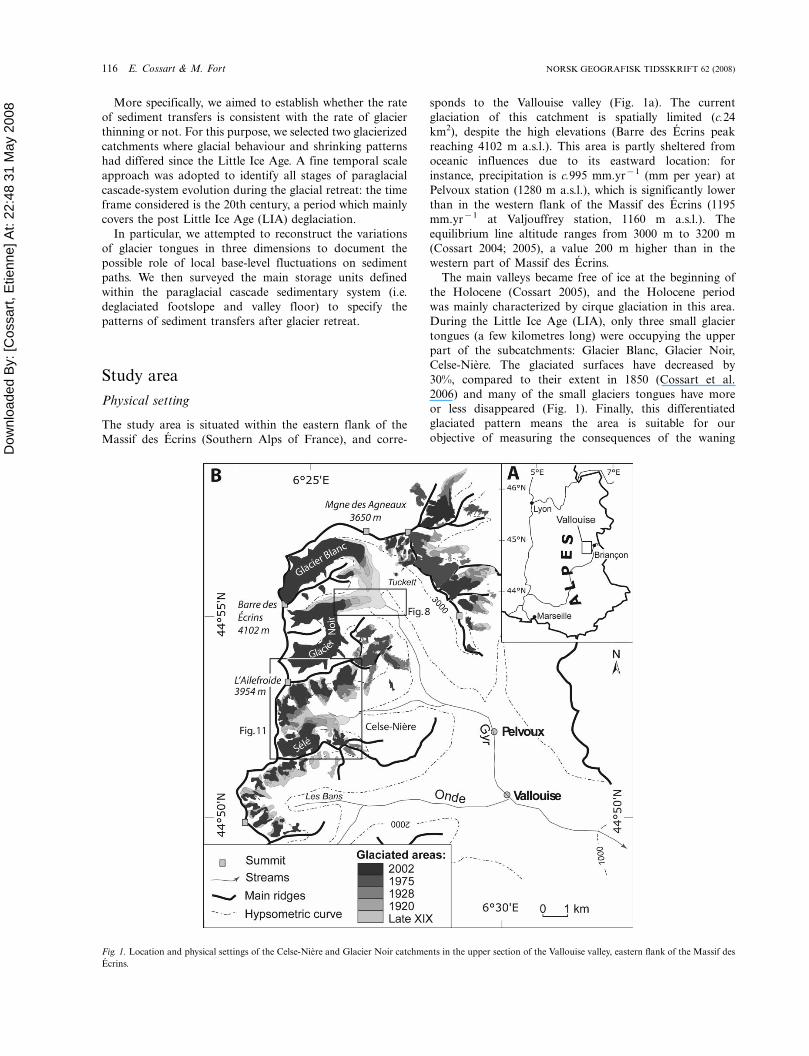
Study area
Physical setting
The study area is situated within the eastern flank of the
Massif des Ecrins (Southern Alps of France), and corre-
sponds to the Vallouise valley (Fig. 1a). The current
glaciation of this catchment is spatially limited (c.24
km2), despite the high elevations (Barre des Ecrins peak
reaching 4102 m a.s.l.). This area is partly sheltered from
oceanic influences due to its eastward location: for
instance, precipitation is c.995 mm.yr�1 (mm per year) at
Pelvoux station (1280 m a.s.l.), which is significantly lower
than in the western flank of the Massif des Ecrins (1195
mm.yr�1 at Valjouffrey station, 1160 m a.s.l.). The
equilibrium line altitude ranges from 3000 m to 3200 m
(Cossart 2004; 2005), a value 200 m higher than in the
western part of Massif des Ecrins.
The main valleys became free of ice at the beginning of
the Holocene (Cossart 2005), and the Holocene period
was mainly characterized by cirque glaciation in this area.
During the Little Ice Age (LIA), only three small glacier
tongues (a few kilometres long) were occupying the upper
part of the subcatchments: Glacier Blanc, Glacier Noir,
Celse-Niere. The glaciated surfaces have decreased by
30%, compared to their extent in 1850 (Cossart et al.
2006) and many of the small glaciers tongues have more
or less disappeared (Fig. 1). Finally, this differentiated
glaciated pattern means the area is suitable for our
objective of measuring the consequences of the waning
Fig. 1. Location and physical settings of the Celse-Niere and Glacier Noir catchments in the upper section of the Vallouise valley, eastern flank of the Massif des
Ecrins.
116 E. Cossart & M. Fort NORSK GEOGRAFISK TIDSSKRIFT 62 (2008)
Dow
nloa
ded
By:
[Cos
sart,
Etie
nne]
At:
22:4
8 31
May
200
8 and disappearance of the glacier tongues on sediment
transfers.
We selected the Glacier Noir and the Celse-Niere sub-
catchments, occupied by a debris-covered, low-sensitive
glacier and a ‘clean’, high-sensitive glacier respectively, based
on the assumption that they are characterized by different
rates of decay, and thus provide the opportunity to discuss
whether and how these characteristics exert a control on
sediment fluxes.
Glacier Noir area
The Glacier Noir catchment covers an area of 12 km2,
ranging in elevation from 1850 to 4102 m a.s.l. (Fig. 1b). It is
a classical glacially shaped alpine valley, characterized by
high (relief �1800 m) and steep (gradient �100%) moun-
tain slopes (Fig. 2a). Due to hillslope steepness, only a few
small glaciers (e.g. Momie glacier) are hanging above the
valley floor. As a consequence, an important surface with
ice-free faces constitutes a major source of sediments. Today,
the glacierized area is c.4 km2, but it was c.6 km2 during the
Little Ice Age. The glacier front was then situated at 1870 m
a.s.l. Both vertical decay and horizontal retreat of the glacier
tongue have been well documented and synthesized from
field data and archives (Allix 1924; Reynaud 1998).
Downward of the LIA glacier front, the catchment shows
a typical landform assemblage of a cascade system sub-
divided into three subsystems: free faces, slope deposits
(scree, avalanche deposits, rockfalls, etc.) and valley floor
(the glacio-fluvial plain Pre de Madame Carle) (Fig. 2a).
Upward of the glacier front, large lateral morainic ridges
disrupt the cascade system. Moraines are a source of
sediments but they intercept the slope deposits (Fig. 2b).
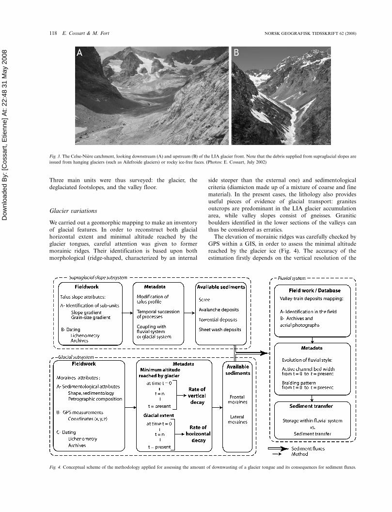
Celse-Niere area
The Celse-Niere catchment covers an area of 19 km2,
ranging in elevation from 1650 to 3954 m a.s.l. (Fig. 1b).
The topography is characterized by steep mountain slopes
(gradient �100%) with a relief of c.1000 to c.1500 m. The
glacierized area is c.6 km2, but it reached 9 km2 during the
Little Ice Age (Cossart et al. 2006). During that period, one
main glacier tongue (Sele glacier) occupied the valley, with
its front located at 2250 m a.s.l., whereas in the upper part of
the catchment some small tributaries (Ailefroide, Coup de
Sabre) were converging, with their front being blocked
against the Sele glacier valley tongue. Such small catchments
are today occupied by cirque glaciers that provided both
sediments and meltwater to the valley floor (Fig. 3a).
Within the catchment, the landform assemblages are
different upward and downward of the LIA glacier front.
Downward, the catchment shows a cascade system divided
into ice-free, rocky faces, slope deposits (scree, avalanche
deposits, rockfalls, etc.) and a narrow channel (Fig. 3b).
Upward the LIA glacier front, the cascade system is
disrupted by the presence of morainic ridges that locally
interrupt the continuity of slope deposits, while glacigenic
deposits are also intensely reworked.
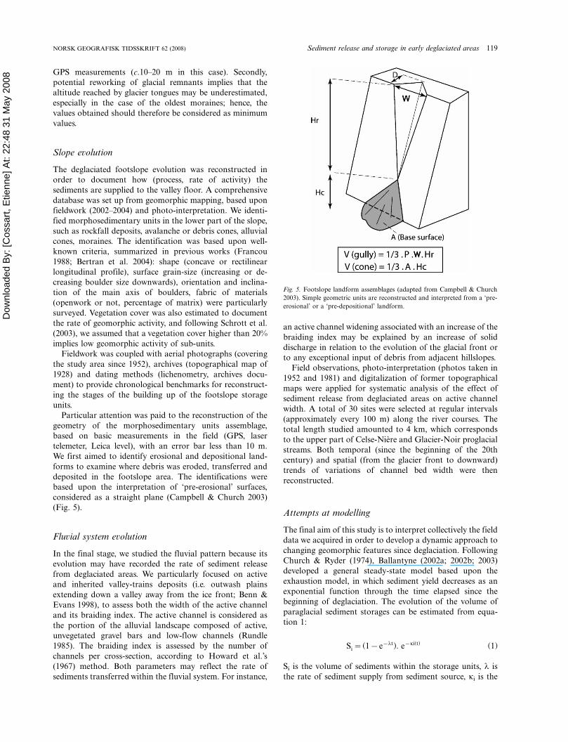
Methodology
In both Glacier Noir and Celse-Niere cases, the presence of
morainic ridges creates temporary sediments storage cells,
yet what are their impacts on sediment transfers, and hence
on the functioning of the cascade sedimentary system?
To specify the potential impacts of moraines on sediment
path transfers in a recently deglaciated area, we intended to
compare the spatio-temporal combination of processes (i) in
the Celse Niere catchment, where many morainic ridges have
been deposited (high sensitive glacier) with (ii) the Glacier
Noir catchment, where only one or two generations of
moraines have been deposited after the LIA (low sensitive
glacier). We proceeded in three steps. We first surveyed the
three dimensional geometric variations of the glaciers in
relation to their position at the time of moraine deposition
and abandonment. Second, we reconstructed the evolution
of deglaciated footslope to assess the rate of sediment stored
or supplied down to the valley floor. We finally assessed the
impacts of sediment storage or supplies from footslopes on
the evolution of the fluvial system (valley floor) (Fig. 4).
Fig. 2. Glacier Noir catchment, looking downstream (A) and upstream (B) of the LIA glacier front. Note that the sediments stored at the footslopes are mainly
supplied from rocky, ice-free faces. The morainic ridges create a slope break within footslopes units. (Photos: M. Fort, June 2004)
NORSK GEOGRAFISK TIDSSKRIFT 62 (2008) Sediment release and storage in early deglaciated areas 117
Dow
nloa
ded
By:
[Cos
sart,
Etie
nne]
At:
22:4
8 31
May
200
8
Three main units were thus surveyed: the glacier, the
deglaciated footslopes, and the valley floor.
Glacier variations
We carried out a geomorphic mapping to make an inventory
of glacial features. In order to reconstruct both glacial
horizontal extent and minimal altitude reached by the
glacier tongues, careful attention was given to former
morainic ridges. Their identification is based upon both
morphological (ridge-shaped, characterized by an internal
side steeper than the external one) and sedimentological
criteria (diamicton made up of a mixture of coarse and fine
material). In the present cases, the lithology also provides
useful pieces of evidence of glacial transport: granites
outcrops are predominant in the LIA glacier accumulation
area, while valley slopes consist of gneisses. Granitic
boulders identified in the lower sections of the valleys can
thus be considered as erratics.
The elevation of morainic ridges was carefully checked by
GPS within a GIS, in order to assess the minimal altitude
reached by the glacier ice (Fig. 4). The accuracy of the
estimation firstly depends on the vertical resolution of the
Fig. 4. Conceptual scheme of the methodology applied for assessing the amount of downwasting of a glacier tongue and its consequences for sediment fluxes.
Fig. 3. The Celse-Niere catchment, looking downstream (A) and upstream (B) of the LIA glacier front. Note that the debris supplied from supraglacial slopes are
issued from hanging glaciers (such as Ailefroide glaciers) or rocky ice-free faces. (Photos: E. Cossart, July 2002)
118 E. Cossart & M. Fort NORSK GEOGRAFISK TIDSSKRIFT 62 (2008)
Dow
nloa
ded
By:
[Cos
sart,
Etie
nne]
At:
22:4
8 31
May
200
8 GPS measurements (c.10�20 m in this case). Secondly,
potential reworking of glacial remnants implies that the
altitude reached by glacier tongues may be underestimated,
especially in the case of the oldest moraines; hence, the
values obtained should therefore be considered as minimum
values.
Slope evolution
The deglaciated footslope evolution was reconstructed in
order to document how (process, rate of activity) the
sediments are supplied to the valley floor. A comprehensive
database was set up from geomorphic mapping, based upon
fieldwork (2002�2004) and photo-interpretation. We identi-
fied morphosedimentary units in the lower part of the slope,
such as rockfall deposits, avalanche or debris cones, alluvial
cones, moraines. The identification was based upon well-
known criteria, summarized in previous works (Francou
1988; Bertran et al. 2004): shape (concave or rectilinear
longitudinal profile), surface grain-size (increasing or de-
creasing boulder size downwards), orientation and inclina-
tion of the main axis of boulders, fabric of materials
(openwork or not, percentage of matrix) were particularly
surveyed. Vegetation cover was also estimated to document
the rate of geomorphic activity, and following Schrott et al.
(2003), we assumed that a vegetation cover higher than 20%
implies low geomorphic activity of sub-units.
Fieldwork was coupled with aerial photographs (covering
the study area since 1952), archives (topographical map of
1928) and dating methods (lichenometry, archives docu-
ment) to provide chronological benchmarks for reconstruct-
ing the stages of the building up of the footslope storage
units.
Particular attention was paid to the reconstruction of the
geometry of the morphosedimentary units assemblage,
based on basic measurements in the field (GPS, laser
telemeter, Leica level), with an error bar less than 10 m.
We first aimed to identify erosional and depositional land-
forms to examine where debris was eroded, transferred and
deposited in the footslope area. The identifications were
based upon the interpretation of ‘pre-erosional’ surfaces,
considered as a straight plane (Campbell & Church 2003)
(Fig. 5).
Fluvial system evolution
In the final stage, we studied the fluvial pattern because its
evolution may have recorded the rate of sediment release
from deglaciated areas. We particularly focused on active
and inherited valley-trains deposits (i.e. outwash plains
extending down a valley away from the ice front; Benn &
Evans 1998), to assess both the width of the active channel
and its braiding index. The active channel is considered as
the portion of the alluvial landscape composed of active,
unvegetated gravel bars and low-flow channels (Rundle
1985). The braiding index is assessed by the number of
channels per cross-section, according to Howard et al.’s
(1967) method. Both parameters may reflect the rate of
sediments transferred within the fluvial system. For instance,
an active channel widening associated with an increase of the
braiding index may be explained by an increase of solid
discharge in relation to the evolution of the glacial front or
to any exceptional input of debris from adjacent hillslopes.
Field observations, photo-interpretation (photos taken in
1952 and 1981) and digitalization of former topographical
maps were applied for systematic analysis of the effect of
sediment release from deglaciated areas on active channel
width. A total of 30 sites were selected at regular intervals
(approximately every 100 m) along the river courses. The
total length studied amounted to 4 km, which corresponds
to the upper part of Celse-Niere and Glacier-Noir proglacial
streams. Both temporal (since the beginning of the 20th
century) and spatial (from the glacier front to downward)
trends of variations of channel bed width were then
reconstructed.
Attempts at modelling
The final aim of this study is to interpret collectively the field
data we acquired in order to develop a dynamic approach to
changing geomorphic features since deglaciation. Following
Church & Ryder (1974), Ballantyne (2002a; 2002b; 2003)
developed a general steady-state model based upon the
exhaustion model, in which sediment yield decreases as an
exponential function through the time elapsed since the
beginning of deglaciation. The evolution of the volume of
paraglacial sediment storages can be estimated from equa-
tion 1:
Si�(1�e�lt): e�ki(t) (1)
Si is the volume of sediments within the storage units, l is
the rate of sediment supply from sediment source, ki is the
Fig. 5. Footslope landform assemblages (adapted from Campbell & Church
2003). Simple geometric units are reconstructed and interpreted from a ‘pre-
erosional’ or a ‘pre-depositional’ landform.
NORSK GEOGRAFISK TIDSSKRIFT 62 (2008) Sediment release and storage in early deglaciated areas 119
Dow
nloa
ded
By:
[Cos
sart,
Etie
nne]
At:
22:4
8 31
May
200
8 rate of sediment release, and t is time. Here, it is assumed
that available sediments within the source equal 1 at t�0.
This model assumes that both l and k rates do not change
through time. More specifically, the exhaustion model
synthesizes a geomorphic evolution that can be subdivided
into specific sequences, each of them driven by a set of
geomorphic processes, the succession of which shifts
through time and space as soon as a new portion of land
becomes ice-free (Ballantyne 2002a; 2002b; 2003; Mercier
2002; Schrott et al. 2002; Jomelli et al. 2003; Cossart 2004;
Meigs et al. 2006). In the following, we aim to (i) recognizing
each distinctive sequence, (ii) establishing their chronological
succession, and (iii) describing the combination of active
processes distinctive of each sequence. Then we will discuss
how the succession of various geomorphic events can be
integrated to the equation 1.
Glacier Noir study case
Glacier retreat
The extent of the Glacier Noir during the LIA is easily
deduced from the large, latero-frontal, morainic ridges (c.100
m high). We observed a volume asymmetry between the
smaller right-flank moraine and the larger left-flank mor-
aine, caused by contrasted rock types and subsequent
uneven debris supply within the catchment (highly shattered
granites and gneisses on the left flank of the valley). The
surface of the Glacier Noir has reduced by c.35% since 1810.
This decay is associated with a horizontal retreat of the
glacier front by c.1.2 km. While the position of the glacier
front since the LIA has been recorded (data summarized in
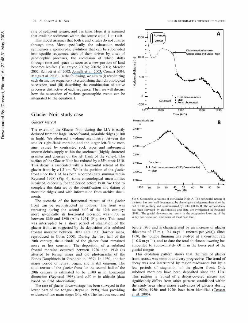
Reynaud 1998) (Fig. 6), some chronological uncertainties
subsisted, especially for the period before 1930. We tried to
complete this data set by the identification and dating of
morainic ridges, and with information from archive docu-
ments.
The scenario of the horizontal retreat of the glacier
front can be reconstructed as follows. The front was
retreating during the second half of the 19th century;
more specifically, its horizontal recession was c.700 m
between 1850 and 1890 (Allix 1924) (Fig. 6A). This trend
was interrupted by a short period of stagnation of the
glacier front, as suggested by the deposition of a subdued
frontal moraine between 1890 and 1900 (former maps,
reproduced in Colas 2000). During the first half of the
20th century, the altitude of the glacier front remained
more or less constant. The deposition of a subdued
frontal moraine occurred between 1920 and 1930 (as
attested by former maps and old photographs of the
Fonds Dauphinois in Grenoble in 1939). In 1950, another
major period of retreat began, and is still ongoing. The
total retreat of the glacier front for the second half of the
20th century is estimated to be c.500 m in horizontal
dimension (Reynaud 1998), and c.50 m in altitude (data
based on field observation).
The rate of glacier downwastage has been surveyed in the
lower part of the tongue (Reynaud 1998), thus providing
evidence of two main stages (Fig. 6B). The first one occurred
before 1930 and is characterized by an increase of glacier
thickness of 17 m (�0.4 m.yr�1 (metres per year)). Since
1930, the tongue thinning has evolved at a constant rate
(�0.8 m.yr�1), and to date the total thickness lowering has
amounted to approximately 60 m in the lower part of the
glacial tongue.
This evolution pattern shows that the rate of glacier
front retreat was smooth and very progressive. The trend of
decay was not interrupted by major readvances but by a
few periods of stagnation of the glacier front. Only
subdued moraines have been deposited since the LIA.
This pattern is typical of a debris-covered glacier and
significantly differs from other patterns established within
the study area where major readvances of glaciers during
the 1920s, 1950s and 1970s have been identified (Cossart
et al. 2006).
Fig. 6. Geometric variations of the Glacier Noir. A. The horizontal retreat of
the front has been well documented by glaciologists and geographers since the
end of 19th century, and is summarized by Colas (2000). B. The vertical decay
has been surveyed by glaciologists and data are synthesized in Reynaud
(1998). The glacial downwasting results in the progressive lowering of the
valley floor elevation, and hence of local base level.
120 E. Cossart & M. Fort NORSK GEOGRAFISK TIDSSKRIFT 62 (2008)
Dow
nloa
ded
By:
[Cos
sart,
Etie
nne]
At:
22:4
8 31
May
200
8 Slope evolution
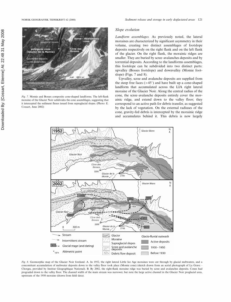
Landform assemblages. As previously noted, the lateral
moraines are characterized by significant asymmetry in their
volume, creating two distinct assemblages of footslope
deposits respectively on the right flank and on the left flank
of the glacier. On the right flank, the morainic ridges are
smaller. They are buried by scree�avalanches deposits and by
torrential deposits. According to the landforms assemblages,
this footslope can be subdivided into two distinct parts:
upvalley (Bosses footslope) and downvalley (Momie foot-
slope) (Figs. 7 and 8).
Upvalley, scree and avalanche deposits are supplied from
the steep free faces (�458) and have built up a cone-shaped
landform that accumulated across the LIA right lateral
moraine of the Glacier Noir. Along the central radius of the
cone, the scree�avalanche deposits entirely cover the mor-
ainic ridge, and extend down to the valley floor; they
correspond to an active path for debris transfer, as suggested
by the lack of vegetation. On the external radiuses of the
cone, gravity-fed debris is intercepted by the morainic ridge
and accumulates behind it. This debris is now largely
Fig. 7. Momie and Bosses composite cone-shaped landforms. The left-flank
moraine of the Glacier Noir subdivides the cone assemblages, suggesting that
it intercepted the sediment fluxes issued from supraglacial slopes. (Photo: E.
Cossart, June 2002)
Fig. 8. Geomorphic map of the Glacier Noir foreland. A. In 1952, the right lateral Little Ice Age moraines were cut through by glacial meltwaters, and a
concomitant accumulation of meltwater deposits down to the valley floor took place (Momie cone) (sketch drawn from an aerial photograph of La Grave �Chorges, provided by Institut Geographique National). B. By 2002, the right-flank moraine ridge was buried by scree and avalanches deposits. Cones had
prograded down to the valley floor. The channel width of the main stream was narrower, but note the large active channel in the Glacier Noir proglacial area,
upstream of the 1950 moraine (drawn from field data).
NORSK GEOGRAFISK TIDSSKRIFT 62 (2008) Sediment release and storage in early deglaciated areas 121
Dow
nloa
ded
By:
[Cos
sart,
Etie
nne]
At:
22:4
8 31
May
200
8 vegetated, thus suggesting its deposition is not currently
active.
Downvalley, the debris assemblage of the Momie cone-
shaped landform is a little more complex. Scree and
avalanche deposits are dammed upslope by the LIA
moraine. Their aggradation seems to be much less active
today (vegetation cover �20%); in fact, they are cut and
filled by the proglacial meltwaters issued from the Momie
hanging glacier. Also, the glacial meltwaters breached out
the LIA moraine. The reworked debris was partly redis-
tributed within a torrential cone which covers the inner side
of the moraine. According to the distribution of vegetation
cover, 40% of the area of this cone is now inactive.
On the left flank of the Glacier Noir, the LIA lateral
moraine is large and well preserved along a dominantly
concave, U-shaped, rocky slope. This massive and highly
compacted morainic ridge acts as an efficient barrier to large
rockfalls and scree taluses (several hundred metres high) that
are still supplied by the adjacent, steep rocky faces (vegeta-
tion cover less than 20%). In contrast, the inner (glacier
facing) slope of this morainic ridge is reworked by gullying,
the products of which accumulate below as small cones (c.10
m high) next to the glacio-fluvial stream and/or the debris-
covered glacier.
Interpretation. When glacial retreat occurred around the
second half of the 19th century, patterns of sediment
redistribution from the footslopes down to the valley bottom
were dependant upon both the characteristics of the
morainic ridges material (volume, cohesiveness) and the
presence (or not) of a continuous supply of glacial melt-
waters from the adjacent hillslopes (hanging glacier).
On the right flank of Glacier Noir, the small LIA moraine
created small sediment traps, forcing the aggradation of
scree and avalanche deposits:
. In the case of the Momie cone, the impoundment stage
was short because the waterfalls (collecting the melt-
waters of the Momie glacier) (Fig. 7) breached out the
morainic dam and gullied the scree�avalanche deposits
formerly built up below. This eroded debris started
accumulating within a torrential cone from the 1860s
(according to Jomelli et al. 2003), thus as soon as the base
level (i.e. the Glacier Noir surface) dropped. The
construction of the torrential cone became stabilized
during the second half of the 20th century, as evident
from the areal extent of the vegetation cover (from 8% in
1952 to 38% today, as assessed from photo-interpreta-
tion). Finally, large amounts of sediments were supplied
to the valley floor during the first half of the 20th century.
. In the case of the Bosses cone, the impoundment stage
lasted until 1950 (based on analysis of aerial photo-
graphs). Approximately between 1952 and 1960, the
sediment trap created by the lateral moraine was entirely
filled in, thus initiating a major period of progradation of
the debris over the moraine down to the valley floor.
Finally, the projected surface of the entire cone increased
by almost 100% after 1952, providing evidence of a
supply of debris directly to the valley floor during the
second half of the 20th century, many decades after the
Glacier Noir retreat.
Along the Glacier Noir left flank, the lateral moraines
formed a large and cohesive dam, thus generating upslope
and laterally an efficient sediment trap of a larger volume.
Nearly two centuries later, the trap is not yet full and the
damming effect by the morainic crest is still effective.
However, with the progressive lowering of the glacier
surface, the morainic ridge becomes more and more affected
by gullying on its internal face, thus ensuring the transfer of
some debris directly from the moraine flank to the valley
floor.
Fluvial system evolution
Along the valley floor, the evolution of the fluvial system can
be reconstructed by the distinction of three generations of
fluvio-glacial deposits.
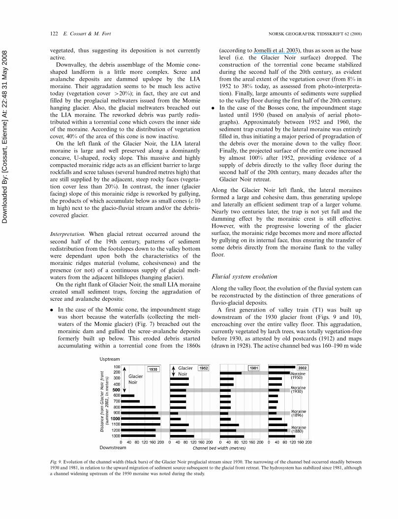
A first generation of valley train (T1) was built up
downstream of the 1930 glacier front (Figs. 9 and 10),
encroaching over the entire valley floor. This aggradation,
currently vegetated by larch trees, was totally vegetation-free
before 1930, as attested by old postcards (1912) and maps
(drawn in 1928). The active channel bed was 160�190 m wide
Fig. 9. Evolution of the channel width (black bars) of the Glacier Noir proglacial stream since 1930. The narrowing of the channel bed occurred steadily between
1930 and 1981, in relation to the upward migration of sediment source subsequent to the glacial front retreat. The hydrosystem has stabilized since 1981, although
a channel widening upstream of the 1950 moraine was noted during the study.
122 E. Cossart & M. Fort NORSK GEOGRAFISK TIDSSKRIFT 62 (2008)
Dow
nloa
ded
By:
[Cos
sart,
Etie
nne]
At:
22:4
8 31
May
200
8
(Fig. 8); we noted it was wider upstream (190 m) than
downstream (170 m) of the 1895 moraine.
A second generation of glacio-fluvial (T2) deposits can be
individualized downstream of the 1950 front of the Glacier
Noir. In between the two 1930 and 1950 morainic ridges, five
different proglacial channels developed and cut through
the ablation-basal tills abandoned during that period by the
Glacier Noir during its decay. The cumulative width of these
former active channels was c.70 m. We noted these channels
to be converging downstream close to the 1930 moraine,
with their width reduced consequently (50 m). Downstream
of the 1930 moraine, the T2 deposits are cut-and-filled into
the T1 deposits, in relation to an incision of 2�3 m (Fig. 10).
In this section the active channel becomes narrower (60�70
m), yet it is significantly wider downstream of the Momie
cone (120 m wide).
The third generation of glacio-fluvial deposits is currently
active, extending downstream of the present glacier front.
Upstream of the 1950 moraine, active deposits are occupy-
ing the whole valley floor, reworking the recent till deposits.
Downwards, proglacial streams are flowing into two main
channels that are cutting through the T2 terrace and the
1930 frontal moraine (incision c.2 m). In this area, the
channel bed width is c.60 m. In the lower part of the study
section (downstream of the Momie cone), the current
channel bed width is c.100 m.
To summarize, two stages can be individualized in the
recent evolution of the Glacier Noir margins. In the first
stage, between 1930 and 1950, the glacier front receded, down
to an elevation of 2100 m a.s.l. in 1950. The difference in the
fluvial pattern observed between the upstream (many active
channels) and the downstream (single channel) reaches of the
1930 frontal moraine suggests that the 1930 moraine was at
that time acting as a local base level. The significant decrease
(c.100�120 m) of channel bed width since 1930 and the
incision of T1 deposits collectively reveal a reduction of
debris supply downstream of the 1930 frontal moraine. This
indirectly demonstrates that such moraine behaved as a trap
for debris supplied from the upper section of the meltwaters
streams. Downstream of the studied section, the channel was
particularly wide, probably because of the large amounts of
materials supplied from the Momie cone. In the second stage,
since 1950, this overall pattern shifted upwards; the glacier
front is currently at 2150 m a.s.l. The active channel bed is
very wide upstream of the 1950 frontal moraine, occupying
the whole valley floor, whereas downstream of the 1950
moraine, the T2 terrace and the 1930 moraine are incised,
and the active channels have become narrower (�10 to �15
m). This corroborates the existence of a relative depletion of
debris brought downstream from the glacier front, depletion
that can be explained by a damming effect exerted by the
1950 frontal moraine.
Finally, the fluvial pattern evolved and shifted upwards in
relation to the retreat of the glacier front since the beginning
of the 20th century. We noted a constant decrease of channel
bed width, in relation to a progressive incision of glacial
meltwaters into older valley-train terraces. This quite regular
trend can be explained by two factors: (1) the relatively rapid
degradation of subdued frontal moraines that were never
sharply shaped and (2) the limited amount of sediment
reworked from the adjacent hillslopes due to the large
quantities of sediments that are still stored against the
footslopes cells, especially along the longitudinal furrow
between the left lateral moraine crest and the rock walls.
Celse-Niere catchment
Glacial setting
The deglaciation pattern in Celse-Niere catchment differs
from the Glacier Noir catchment, as the ‘clean’, debris-free
surface of the Sele glacier is more sensitive to climate varia-
tions. Five generations of moraines were deposited in
approximately 1860, 1925, 1950, 1975, and 1993 (Fig. 11).
The dates generally correspond to pauses in an overall trend
dominated by glacial retreat (Reynaud 1998; Cossart et al.
2006).
In 1860, all glaciers (except for the Glacier du Coup de
Sabre) were converging into one single trunk glacier, the
front of which was located at 2200 m a.s.l. The relative
elevation of the lateral moraines suggests the Sele glacial
tongue was at least 130 metres thick. In 1925, the glaciers of
Ailefroide and Boeufs-Rouges were disconnected from the
main Sele valley glacier. Meanwhile, the thickness of the
latter glacier had decreased significantly (�40 m next to the
Coup de Sabre subcatchment outlet) while the glacier front
had shifted upvalley, to c.2400 m a.s.l. Between 1925 and
1950 a major stage of vertical decaying occurred, with a
thickness lowering estimated to be c.60�70 m. From 1950
onwards, both the retreat of the glacier front (shifting 500 m
upwards) and vertical decaying of the glacier tongue (30 m
lower) were effective, until the Sele glacier tongue definitely
disappeared and the outlet of the Coup de Sabre small
catchment became ice free.
In sum, the glacier surface decreased of approximately
�40% since 1860. The total disappearance of the glacier
from the valley resulted in a lowering of the local base level
of c.80�90 m.
Lateral margins
Footslope assemblages. In the upper part of the Celse-Niere
catchment, deglaciated footslopes are mainly composed of
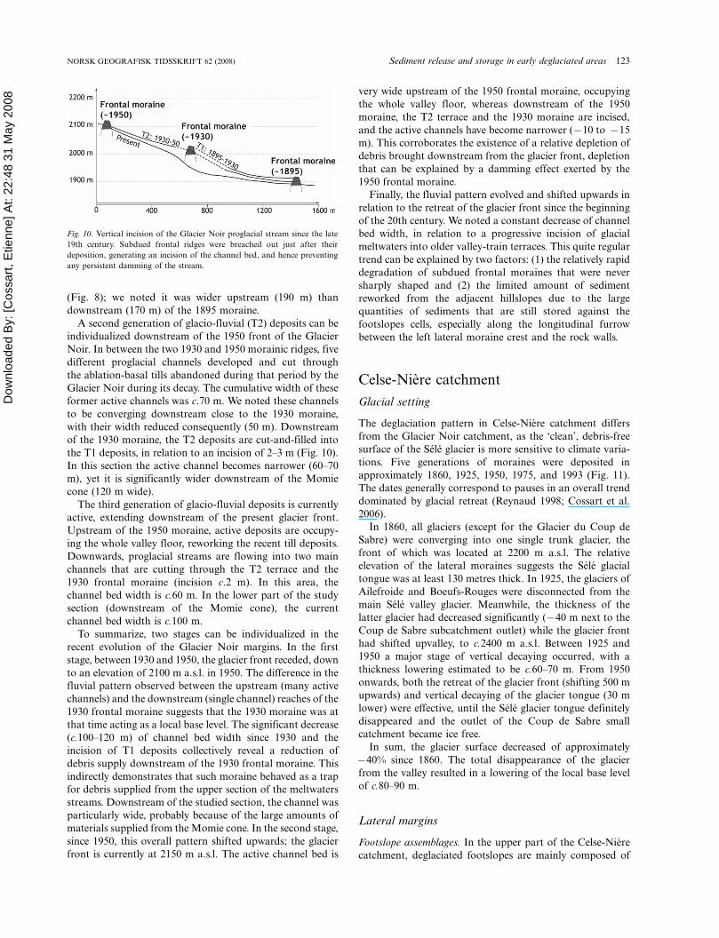
Fig. 10. Vertical incision of the Glacier Noir proglacial stream since the late
19th century. Subdued frontal ridges were breached out just after their
deposition, generating an incision of the channel bed, and hence preventing
any persistent damming of the stream.
NORSK GEOGRAFISK TIDSSKRIFT 62 (2008) Sediment release and storage in early deglaciated areas 123
Dow
nloa
ded
By:
[Cos
sart,
Etie
nne]
At:
22:4
8 31
May
200
8
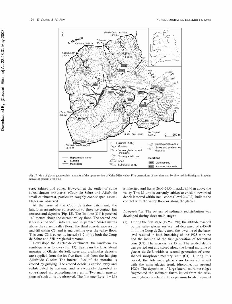
scree taluses and cones. However, at the outlet of some
subcatchment tributaries (Coup de Sabre and Ailefroide
small catchments), particular, roughly cone-shaped assem-
blages are observed.
At the issue of the Coup de Sabre catchment, the
landform assemblage corresponds to three ice-contact fan
terraces and deposits (Fig. 12). The first one (C1) is perched
140 metres above the current valley floor. The second one
(C2) is cut-and-fill into C1, and is perched 50�60 metres
above the current valley floor. The third cone-terrace is cut-
and-fill within C2, and is encroaching over the valley floor.
This cone C3 is currently incised (1�2 m) by both the Coup
de Sabre and Sele proglacial streams.
Downslope the Ailefroide catchment, the landform as-
semblage is as follows (Fig. 13). Upstream the LIA lateral
moraine of Glacier du Sele, scree and avalanches deposits
are supplied from the ice-free faces and from the hanging
Ailefroide Glacier. The internal face of the moraine is
eroded by gullying. The eroded debris is carried away and
redistributed by streams, and is eventually deposited as
cone-shaped morphosedimentary units. Two main genera-
tions of such units are observed. The first one (Level 1�L1)
is inherited and lies at 2600�2650 m a.s.l., c.140 m above the
valley. This L1 unit is currently subject to erosion: reworked
debris is stored within small cones (Level 2�L2), built at the
contact with the valley floor or along the glacier.
Interpretation. The pattern of sediment redistribution was
developed during three main stages:
(1) During the first stage (1925�1950), the altitude reached
by the valley glacier surface had decreased of c.45�60
m. In the Coup de Sabre area, the lowering of the base-
level resulted in both breaching of the 1925 moraine
and the incision of the first generation of torrential
cone (C1). The incision is c.15 m. The eroded debris
was carried out and stored along the lateral moraine of
glacier du Sele, within a second generation of cone-
shaped morphosedimentary unit (C1). During this
period, the Ailefroide glaciers no longer converged
with the main glacial trunk (disconnection around
1920). The deposition of large lateral morainic ridges
fragmented the sediment fluxes issued from the Aile-
froide glacier foreland: the depression located upward
Fig. 11. Map of glacial geomorphic remnants of the upper section of Celse-Niere valley. Five generations of moraines can be observed, indicating an irregular
retreat of glaciers over time.
124 E. Cossart & M. Fort NORSK GEOGRAFISK TIDSSKRIFT 62 (2008)
Dow
nloa
ded
By:
[Cos
sart,
Etie
nne]
At:
22:4
8 31
May
200
8
of the moraines was then infilled with glacio-fluvial
deposits (Ailefroide torrent) and by avalanches�scree
deposits.
(2) During the 1950�1975 stage, the Sele glacial tongue
retreated sufficiently so that the glacio-fluvial debris
issued from the Coup de Sabre small catchment could
freely prograde over the main valley floor to form the
last generation of torrential cone (C3). As shown in the
aerial photographs, the 1950 moraine was already
breached in 1960 and the older deposits (C1 and C2)
deeply incised to a depth of 5 m. During the same
period, the rapid lowering of the Sele glacier surface,
while favouring gullying of the inner faces of its lateral
moraines, also facilitated their incision by the progla-
cial outlet issued from the Ailefroide subcatchment
(�50 m), at such a pace that these moraine ridges were
breached out around 1965 (95 yrs), according to aerial
photograph interpretation. Released sediments were
then stored along the glacier left flank and along the
1975 lateral moraine, hence forming a perched, kame-
like accumulation (Level 1�L1).
(3) From 1975 onwards, a period of stabilization occurred
at the outlet of Coup de Sabre small catchment. The
three generations of cone terraces became vegetated;
the youngest cone was now incised c.1�2 m by the Coup
de Sabre outlet, an evolution that suggests the geo-
morphic activity was currently low. At the confluence
with the Ailefroide subcatchment, the valley floor
became partly ice-free in 1981; meanwhile the 1975
lateral moraine was breached due to active gullying and
torrential stream incision. The sediments were then
partly redistributed in a complex patchwork of storage
units connected either with the valley floor or the
glacier surface (Level 2�L2).
Thus, the pattern of sediment release was characterized by
temporal discontinuities, linked with the successive stages of
glacier waning and melting out. Lateral margins adjusted
rapidly to the lowering of glacier surface: morainic materials
and sediments which had accumulated along the moraines
were reworked and redistributed according to the new local
base-level. At each stage of valley glacier recession, some
temporary sediments storage units, especially along the
valley glacier flanks, again became available for the sediment
cascade. Such units can supply huge quantities of sediments
as soon as the valley floor becomes ice-free: these conditions
Fig. 12. Geomorphic evolution of the proglacial area of the Coup de Sabre catchment since the early 20th century. A. Geomorphic mapping, showing the different
generations of sediment storages units developed along the right flank of the former glacier of the Sele tongue. B. Longitudinal profile, showing the significant rate
of incision driven by the downwasting of the Sele glacier. Sediment storage developed between the morainic dams and the valley walls. While glacial retreat began
in the late 19th century, sediments were progressively released after the breaching of the 1950 moraine.
NORSK GEOGRAFISK TIDSSKRIFT 62 (2008) Sediment release and storage in early deglaciated areas 125
Dow
nloa
ded
By:
[Cos
sart,
Etie
nne]
At:
22:4
8 31
May
200
8
were fulfilled in the 1950s in the Coup de Sabre area, then in
1970s in the Ailefroide area.
Fluvial system evolution
To what extent was the fluvial system responding to the two
main periods of debris supply we identified? In the Celse-
Niere catchment, the valley floor is narrow, which limits the
storage potential of fluvial deposits, and hence field
evidence. Therefore, the evolution of the stream channel
planform and width was mainly deduced from archives
documents, especially from aerial photographs. Our obser-
vations were made in the upper Celse Niere area, 3 km
downstream of the 1880 morainic ridge (Fig. 11). Several
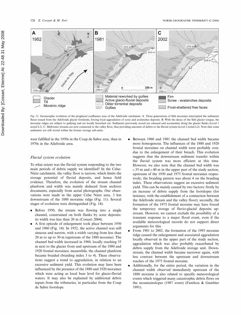
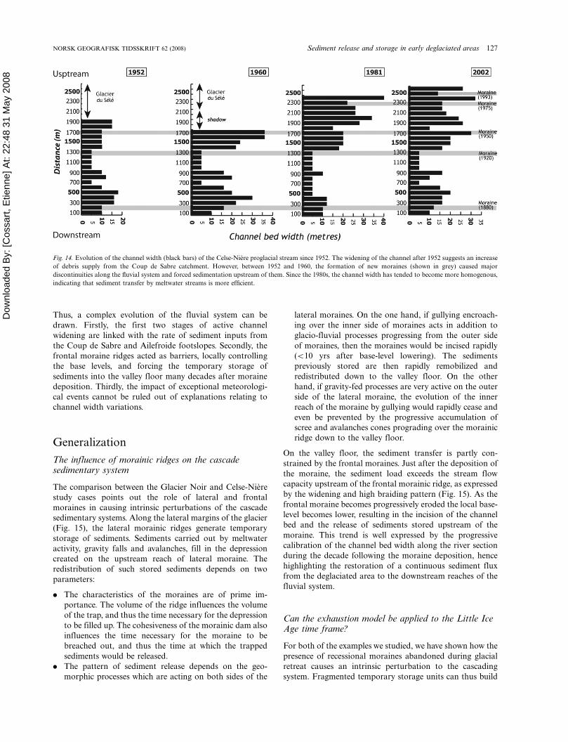
stages of evolution were distinguished (Fig. 14):
. Before 1950, the stream was flowing into a single
channel, constrained on both flanks by scree deposits:
its width was less than 20 m (Cossart 2004).
. A first episode of enlargement took place between 1950
and 1960 (Fig. 14). In 1952, the active channel was still
sinuous and narrow, with a width varying from less than
20 m to up to 30 m (upstream of the 1880 moraine). The
channel bed width increased in 1960, locally reaching 35
m next to the glacier front and upstream of the 1880 and
1920 frontal moraines; meanwhile, the channel planform
became braided (braiding index 3 to 4). These observa-
tions suggest a trend to aggradation, in relation to an
excessive sediment yield. This evolution may have been
influenced by the presence of the 1880 and 1920 moraines
which were acting as local base level for glacio-fluvial
waters. It may also be explained by additional debris
inputs from the tributaries, in particular from the Coup
de Sabre footslope.
. Between 1960 and 1981 the channel bed width became
more homogenous. The influences of the 1880 and 1920
frontal moraines on channel width were probably over,
due to the enlargement of their breach. This evolution
suggests that the downstream sediment transfer within
the fluvial system was more efficient at this time.
However, we also note that the channel bed width was
c.35 m and c.40 m in the upper part of the study section,
upstream of the 1950 and 1975 frontal moraines respec-
tively; the braiding pattern was about 4 on the braiding
index. These observations suggest an excessive sediment
yield. This can be mainly caused by two factors: firstly by
an increase of debris supply from the footslopes (for
instance, with the establishment of a connection between
the Ailefroide stream and the valley floor); secondly, the
formation of the 1975 frontal moraine may have forced
the temporary storage of fluvio-glacial deposits up-
stream. However, we cannot exclude the possibility of a
transient response to a major flood event, even if the
available meteorological records do not support direct
arguments for this.
. From 1981 to 2002, the formation of the 1993 moraine
ridge caused the enlargement and associated aggradation
locally observed in the upper part of the study section,
aggradation which was also probably exacerbated by
debris supply from the Ailefroide storage unit. Down-
stream, the channel width became narrower again, with
less contrast between the upstream and downstream
reaches of the 1975 frontal moraine.
. Additionally, for the entire period, the variation in the
channel width observed immediately upstream of the
1880 moraine is also related to specific meteorological
events which triggered many catastrophic debris flows on
the mountainslopes (1987 event) (Fanthou & Gambier
1991).
Fig. 13. Geomorphic evolution of the proglacial confluence area of the Ailefroide catchment. A. Three generations of Sele moraines interrupted the sediments
fluxes issued from the Ailefroide glacier forelands, forcing local aggradation of scree and avalanches deposits. B. With the decay of the Sele glacier tongue, the
morainic ridges are subject to gullying and are locally breached out. Sediments previously stored are released and accumulate along the glacier flanks (Level 1
noted L1). C. Meltwater streams are now connected to the valley floor, thus providing amounts of debris to the fluvial system (Level 2 noted L2). Note that some
sediments are still stored within the former storage sub-units.
126 E. Cossart & M. Fort NORSK GEOGRAFISK TIDSSKRIFT 62 (2008)
Dow
nloa
ded
By:
[Cos
sart,
Etie
nne]
At:
22:4
8 31
May
200
8
Thus, a complex evolution of the fluvial system can be
drawn. Firstly, the first two stages of active channel
widening are linked with the rate of sediment inputs from
the Coup de Sabre and Ailefroide footslopes. Secondly, the
frontal moraine ridges acted as barriers, locally controlling
the base levels, and forcing the temporary storage of
sediments into the valley floor many decades after moraine
deposition. Thirdly, the impact of exceptional meteorologi-
cal events cannot be ruled out of explanations relating to
channel width variations.
Generalization
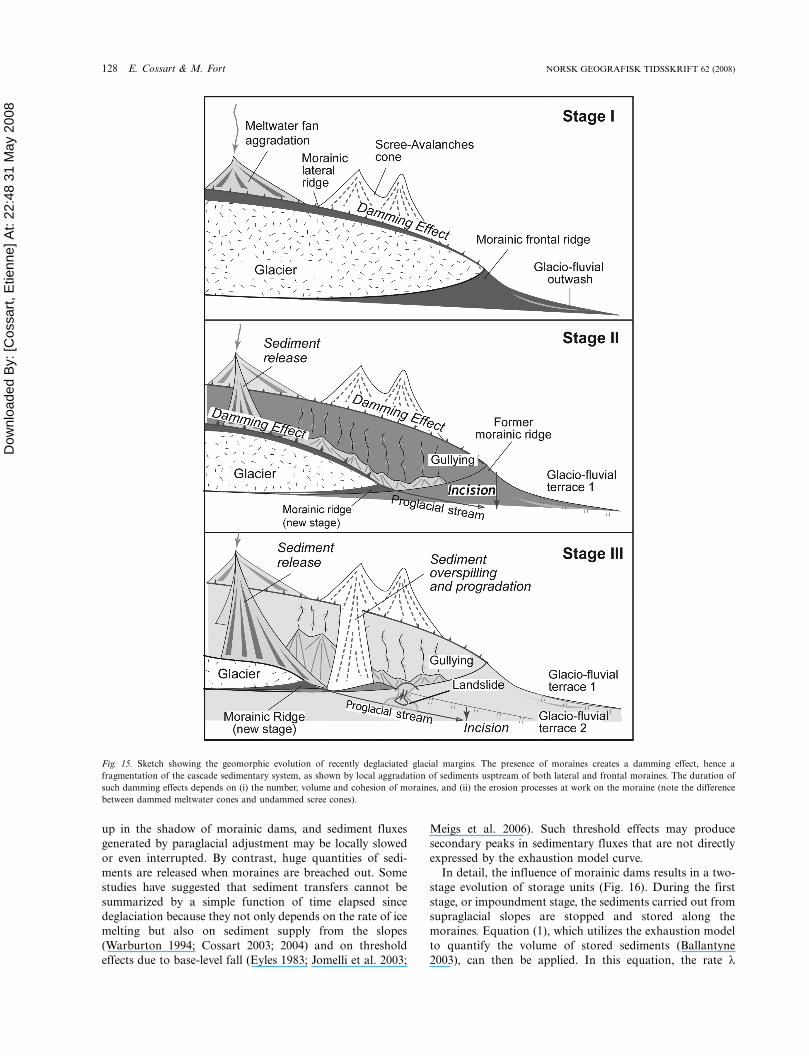
The influence of morainic ridges on the cascadesedimentary system
The comparison between the Glacier Noir and Celse-Niere
study cases points out the role of lateral and frontal
moraines in causing intrinsic perturbations of the cascade
sedimentary systems. Along the lateral margins of the glacier
(Fig. 15), the lateral morainic ridges generate temporary
storage of sediments. Sediments carried out by meltwater
activity, gravity falls and avalanches, fill in the depression
created on the upstream reach of lateral moraine. The
redistribution of such stored sediments depends on two
parameters:
. The characteristics of the moraines are of prime im-
portance. The volume of the ridge influences the volume
of the trap, and thus the time necessary for the depression
to be filled up. The cohesiveness of the morainic dam also
influences the time necessary for the moraine to be
breached out, and thus the time at which the trapped
sediments would be released.
. The pattern of sediment release depends on the geo-
morphic processes which are acting on both sides of the
lateral moraines. On the one hand, if gullying encroach-
ing over the inner side of moraines acts in addition to
glacio-fluvial processes progressing from the outer side
of moraines, then the moraines would be incised rapidly
(B10 yrs after base-level lowering). The sediments
previously stored are then rapidly remobilized and
redistributed down to the valley floor. On the other
hand, if gravity-fed processes are very active on the outer
side of the lateral moraine, the evolution of the inner
reach of the moraine by gullying would rapidly cease and
even be prevented by the progressive accumulation of
scree and avalanches cones prograding over the morainic
ridge down to the valley floor.
On the valley floor, the sediment transfer is partly con-
strained by the frontal moraines. Just after the deposition of
the moraine, the sediment load exceeds the stream flow
capacity upstream of the frontal morainic ridge, as expressed
by the widening and high braiding pattern (Fig. 15). As the
frontal moraine becomes progressively eroded the local base-
level becomes lower, resulting in the incision of the channel
bed and the release of sediments stored upstream of the
moraine. This trend is well expressed by the progressive
calibration of the channel bed width along the river section
during the decade following the moraine deposition, hence
highlighting the restoration of a continuous sediment flux
from the deglaciated area to the downstream reaches of the
fluvial system.
Can the exhaustion model be applied to the Little IceAge time frame?
For both of the examples we studied, we have shown how the
presence of recessional moraines abandoned during glacial
retreat causes an intrinsic perturbation to the cascading
system. Fragmented temporary storage units can thus build
Fig. 14. Evolution of the channel width (black bars) of the Celse-Niere proglacial stream since 1952. The widening of the channel after 1952 suggests an increase
of debris supply from the Coup de Sabre catchment. However, between 1952 and 1960, the formation of new moraines (shown in grey) caused major
discontinuities along the fluvial system and forced sedimentation upstream of them. Since the 1980s, the channel width has tended to become more homogenous,
indicating that sediment transfer by meltwater streams is more efficient.
NORSK GEOGRAFISK TIDSSKRIFT 62 (2008) Sediment release and storage in early deglaciated areas 127
Dow
nloa
ded
By:
[Cos
sart,
Etie
nne]
At:
22:4
8 31
May
200
8
up in the shadow of morainic dams, and sediment fluxes
generated by paraglacial adjustment may be locally slowed
or even interrupted. By contrast, huge quantities of sedi-
ments are released when moraines are breached out. Some
studies have suggested that sediment transfers cannot be
summarized by a simple function of time elapsed since
deglaciation because they not only depends on the rate of ice
melting but also on sediment supply from the slopes
(Warburton 1994; Cossart 2003; 2004) and on threshold
effects due to base-level fall (Eyles 1983; Jomelli et al. 2003;
Meigs et al. 2006). Such threshold effects may produce
secondary peaks in sedimentary fluxes that are not directly
expressed by the exhaustion model curve.
In detail, the influence of morainic dams results in a two-
stage evolution of storage units (Fig. 16). During the first
stage, or impoundment stage, the sediments carried out from
supraglacial slopes are stopped and stored along the
moraines. Equation (1), which utilizes the exhaustion model
to quantify the volume of stored sediments (Ballantyne
2003), can then be applied. In this equation, the rate l
Fig. 15. Sketch showing the geomorphic evolution of recently deglaciated glacial margins. The presence of moraines creates a damming effect, hence a
fragmentation of the cascade sedimentary system, as shown by local aggradation of sediments usptream of both lateral and frontal moraines. The duration of
such damming effects depends on (i) the number, volume and cohesion of moraines, and (ii) the erosion processes at work on the moraine (note the difference
between dammed meltwater cones and undammed scree cones).
128 E. Cossart & M. Fort NORSK GEOGRAFISK TIDSSKRIFT 62 (2008)
Dow
nloa
ded
By:
[Cos
sart,
Etie
nne]
At:
22:4
8 31
May
200
8
depends on the processes of sediment transfer from the
source; it may be considered as independent of time. k also
depends on the process of sediment release from storage unit
to valley floor, yet it is not independent of time in our case
studies. During the impoundment stage, as the sediments
transfer is low, k is close to 0.
As soon as the moraine is breached (stage 2), at time t]t?,amounts of materials are mobilized by erosion from morainic
sediments and supraglacial slopes. The sediment balance
within the store enters into deficit. As exemplified by storage
units such as Ailefroide, Coup de Sabre or Momie cones,
sediment release is mostly due to retrogressive erosion initially
caused by the incision along the main stream system, which
then propagates upward to the detriment of sediments stored
upstream of the moraine during the impoundment stage 1.
Considering the exhaustion model, the occurrence of a second
process for sediment redistribution implies that the storage
unit (of volume Si) is affected by a second rate of sediment
release (noted kj). The evolution of Sj, the volume of stored
sediments during the second stage, can be assessed from Si:
Sj�Si: e�kj(t�t?) (2)
kj is the rate of sediment release after the moraine breaching
out (at time t’), during the stage 2. Because ki and l are
supposed to be constant during stages 1 and 2, Si can be
quantified from equation 1:
Sj�[(1�e�lt): e�ki(t)]: e�kj(t�t?) (3)
The equation 3 is applied to plot curves showing the evolution
of sediment volume within storage units built up along
morainic dams (Fig. 17). These curves fit for different values
of ki and kj and show the threshold between stages 1 and 2,
which is marked by a major decrease of sediment volume
within the store, and hence by a huge transfer of materials
down to the valley floor. This result is more in accordance with
Fig. 16. Conceptual scheme of the hydrosystem evolution in frontal margins of glaciers. A. During the first stage the frontal moraine acts as a local barrier, forcing
the sediment aggradation upstream of it, hence causing channel widening. B. After the breaching out of moraine, sediments are progressively released
downstream, and a relative homogenization of the active channel width is observed on both sides of the moraine.
Fig. 17. Plotted curves in case of shifting rates of sediment release. The black
curve reflects the threshold effect due to the breaching out of the moraine: the
first stage corresponds to a forced aggradation upstream of the moraine;
during the second stage, sediments are rapidly released down to the valley
floor.
NORSK GEOGRAFISK TIDSSKRIFT 62 (2008) Sediment release and storage in early deglaciated areas 129
Dow
nloa
ded
By:
[Cos
sart,
Etie
nne]
At:
22:4
8 31
May
200
8
the descriptions of massive sediment yield in early deglaciated
areas than curves plotted with a constant rate k.
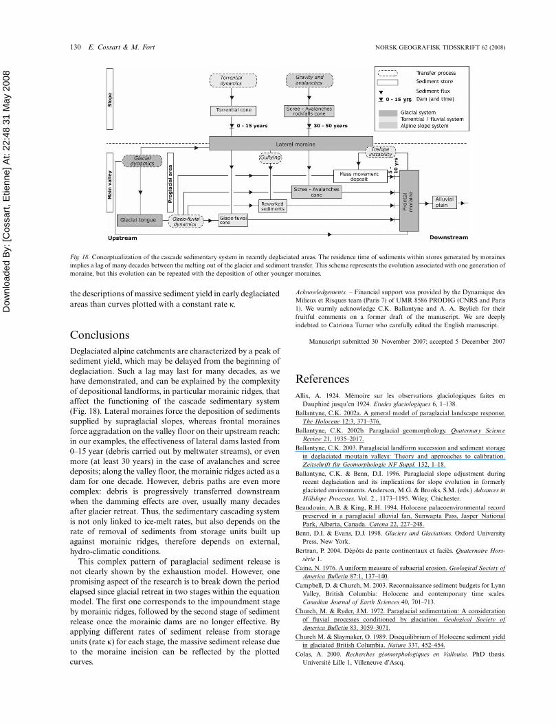
Conclusions
Deglaciated alpine catchments are characterized by a peak of
sediment yield, which may be delayed from the beginning of
deglaciation. Such a lag may last for many decades, as we
have demonstrated, and can be explained by the complexity
of depositional landforms, in particular morainic ridges, that
affect the functioning of the cascade sedimentary system
(Fig. 18). Lateral moraines force the deposition of sediments
supplied by supraglacial slopes, whereas frontal moraines
force aggradation on the valley floor on their upstream reach:
in our examples, the effectiveness of lateral dams lasted from
0�15 year (debris carried out by meltwater streams), or even
more (at least 30 years) in the case of avalanches and scree
deposits; along the valley floor, the morainic ridges acted as a
dam for one decade. However, debris paths are even more
complex: debris is progressively transferred downstream
when the damming effects are over, usually many decades
after glacier retreat. Thus, the sedimentary cascading system
is not only linked to ice-melt rates, but also depends on the
rate of removal of sediments from storage units built up
against morainic ridges, therefore depends on external,
hydro-climatic conditions.
This complex pattern of paraglacial sediment release is
not clearly shown by the exhaustion model. However, one
promising aspect of the research is to break down the period
elapsed since glacial retreat in two stages within the equation
model. The first one corresponds to the impoundment stage
by morainic ridges, followed by the second stage of sediment
release once the morainic dams are no longer effective. By
applying different rates of sediment release from storage
units (rate k) for each stage, the massive sediment release due
to the moraine incision can be reflected by the plotted
curves.
Acknowledgements. � Financial support was provided by the Dynamique des
Milieux et Risques team (Paris 7) of UMR 8586 PRODIG (CNRS and Paris
1). We warmly acknowledge C.K. Ballantyne and A. A. Beylich for their
fruitful comments on a former draft of the manuscript. We are deeply
indebted to Catriona Turner who carefully edited the English manuscript.
Manuscript submitted 30 November 2007; accepted 5 December 2007
References
Allix, A. 1924. Memoire sur les observations glaciologiques faites en
Dauphine jusqu’en 1924. Etudes glaciologiques 6, 1�138.
Ballantyne, C.K. 2002a. A general model of paraglacial landscape response.
The Holocene 12:3, 371�376.
Ballantyne, C.K. 2002b. Paraglacial geomorphology. Quaternary Science
Review 21, 1935�2017.
Ballantyne, C.K. 2003. Paraglacial landform succession and sediment storage
in deglaciated moutain valleys: Theory and approaches to calibration.
Zeitschrift fur Geomorphologie NF Suppl. 132, 1�18.
Ballantyne, C.K. & Benn, D.I. 1996. Paraglacial slope adjustment during
recent deglaciation and its implications for slope evolution in formerly
glaciated environments. Anderson, M.G. & Brooks, S.M. (eds.) Advances in
Hillslope Processes. Vol. 2., 1173�1195. Wiley, Chichester.
Beaudouin, A.B. & King, R.H. 1994. Holocene palaeoenvironmental record
preserved in a paraglacial alluvial fan, Sunwapta Pass, Jasper National
Park, Alberta, Canada. Catena 22, 227�248.
Benn, D.I. & Evans, D.J. 1998. Glaciers and Glaciations. Oxford University
Press, New York.
Bertran, P. 2004. Depots de pente continentaux et facies. Quaternaire Hors-
serie 1.
Caine, N. 1976. A uniform measure of subaerial erosion. Geological Society of
America Bulletin 87:1, 137�140.
Campbell, D. & Church, M. 2003. Reconnaissance sediment budgets for Lynn
Valley, British Columbia: Holocene and contemporary time scales.
Canadian Journal of Earth Sciences 40, 701�713.
Church, M. & Ryder, J.M. 1972. Paraglacial sedimentation: A consideration
of fluvial processes conditioned by glaciation. Geological Society of
America Bulletin 83, 3059�3071.
Church M. & Slaymaker, O. 1989. Disequilibrium of Holocene sediment yield
in glaciated British Columbia. Nature 337, 452�454.
Colas, A. 2000. Recherches geomorphologiques en Vallouise. PhD thesis.
Universite Lille 1, Villeneuve d’Ascq.
Fig. 18. Conceptualization of the cascade sedimentary system in recently deglaciated areas. The residence time of sediments within stores generated by moraines
implies a lag of many decades between the melting out of the glacier and sediment transfer. This scheme represents the evolution associated with one generation of
moraine, but this evolution can be repeated with the deposition of other younger moraines.
130 E. Cossart & M. Fort NORSK GEOGRAFISK TIDSSKRIFT 62 (2008)
Dow
nloa
ded
By:
[Cos
sart,
Etie
nne]
At:
22:4
8 31
May
200
8 Cossart, E. 2003. L’evolution des dynamiques paraglaciaires et periglaciaires
a l’echelle d’un bassin-versant alpin depuis le Petit Age de Glace, l’exemple
du vallon de Celse-Niere au cours du XXe siecle. Environnements
Periglaciaires 10, 13�33.
Cossart, E. 2004. La recrudescence de l’activite torrentielle dans un contexte
de deglaciation (Massif des Ecrins). Geomorphologie: Relief, Processus,
Environnement 3, 225�240.
Cossart, E. 2005. Evolution geomorphologique du haut bassin durancien depuis
la derniere glaciation (Brianconnais, Alpes francaises du Sud). PhD thesis.
Universite Paris 7 � Denis Diderot, Paris.
Cossart, E., Fort, M., Jomelli, V. & Grancher, D. 2006. Les variations
glaciaires en Haute-Durance (Brianconnais, Hautes-Alpes) depuis le XIXe
siecle: mise au point d’apres les documents d’archives et la lichenometrie.
Quaternaire 17:1, 75�92.
Cruden, D.M. & Hu, X.Q. 1993. Exhaustion and steady-state models for
predicting landslide hazards in the Canadian Rocky Mountains. Geomor-
phology 8, 279�285.
de Graaf, LW. 1996. The fluvial factor in the evolution of alpine valleys and
ice-marginal topography in Vorarlberg (W-Austria) during the Upper
Pleistocene and Holocene. Zeitschrift fur Geomorphologie NF Suppl. 104,
129�159.
Evans, S.G. 1997. Temporal and spatial representativeness of alpine sediment
yields: Cascade Mountains, British Columbia. Earth Surface Processes and
Landforms 22:3, 287�295.
Evans, S.G. & Clague J.J. 1994. Recent climatic change and catastrophic
geomorphic processes in mountain environments. Geomorphology 10, 107�128.
Eyles, N. 1983. The glaciated valley landsystem. Eyles, N. (ed.) Glacial
Geology, 91�110. Pergamon Press, Oxford.
Eyles, N., Eyles, C.H. & McCabe, A.M. 1988. Late Pleistocene subaerial
debris-flow facies of the Bow Valley, near Banff, Canadian Rocky
Mountains. Sedimentology 35, 465�480.
Fanthou T. & Gambier G. 1991. Atlas departemental des risques naturels et
technologiques. Prefecture des Hautes-Alpes, Conseil General, Gap.
Francou, B. 1988. L’eboulisation en haute-montagne (Andes et Alpes -, six
contributions a l’etude du systeme corniche � eboulis en systeme
periglaciaire). These d’Etat. Denis Diderot � Paris 7 University, Paris.
Harvey, A.M. 2002. Effective timescales of coupling within fluvial systems.
Geomorphology 44, 175�201.
Hewitt, K. 1989. The altitudinal organisation of Karakoram geomorphic
processes and depositional environments. Zeitschrift fur Geomorphologie
N.F. Suppl.-Bd 76, 9�32.
Hinderer, M. 2001. Late Quaternary denudation of the Alps, valley and lake
fillings and modern river loads. Geodinamica Acta 14:4, 231�263.
Howard, A.D. 1967. Drainage analysis in geologic interpretation: A summary.
American Association of Petroleum Geologists 51, 2246�2259.
Jackson, L.E., MacDonald, G.M. & Wilson, M.C. 1982. Paraglacial origin
for terraced river sediments in Bow Valley, Alberta. Canadian Journal of
Earth Sciences 19, 2219�2231.
Jansson, P., Hock, R. & Schneider, T. 2003. The concept of glacier storage: A
review. Journal of Hydrology 282, 116�129.
Johnson, P.G. 1995. Debris transfer and sedimentary environments: Alpine
glaciated areas. Slaymaker, O. (ed.) Steepland Geomorphology, 27�44.
Wiley, Chichester.
Jomelli, V., Bertran, P. & Kunesch, S. 2003. Le cone de la Momie: un nouveau
type de depot proglaciaire mis en place depuis la fin du Petit Age Glaciaire.
Quaternaire 13:3�4, 257�265.
Jones, A.P. 2000. Late quaternary sediment sources, storage and transfers
within mountain basins using clast lithological analysis (Pineta Basin,
central Pyrenees, Spain). Geomorphology 34, 145�161.
Meigs, A., Krugh, W.C., Davis, K. & Bank, G. 2006. Ultra-rapid landscape
response and sediment yield following glacier retreat, Icy Bay, southern
Alaska. Geomorphology 78:3�4, 207�221.
Mercier, D. 2002. La dynamique paraglaciaire des versants du Svalbard.
Zeitschrift fur Geomorphologie NF Suppl. 46:2, 203�222.
Muller, B.U. 1999. Paraglacial sedimentation and denudation processes in an
Alpine valley of Switzerland. An approach to the quantification of
sediment budgets. Geodinamica Acta 12:5, 291�301.
Reynaud, L. 1998. Suivis glaciologiques dans les Ecrins. Rapport au Parc
National des Ecrins. Universite Joseph Fourier, Grenoble.
Rundle, A. 1985. Braid morphology and the formation of multiple channels:
The Rakaıa, New Zealand. Zeitschrift fur Geomorphologie NF Suppl. 44:3,
317�342.
Ryder, J.M. 1971. The stratigraphy and the morphology of paraglacial alluvial
fans in southcentral British columbia. Canadian Journal of Earth Sciences
8, 1252�1264.
Schrott, L. & Adams, T. 2002. Quantifying sediment storage and Holocene
denudation rates in an alpine basin, Dolomites, Italy. Zeitschrift fur
Geomorphologie NF Suppl. 128, 129�145.
Schrott, L., Niederheide, A. Hankammer, M., Hufschmidt, G. & Dikau, R.
2002. Sediment storage in a mountain catchment: Geomorphic coupling
and temporal variability (Reintal, Bavarian Alps, Germany). Zeitschrift fur
Geomorphologie NF Suppl. 127, 175�196.
Schrott, L., Hufschmidt, G., Hankammer, M., Hoffmann, T. & Dikau, R.
2003. Spatial distribution of sediment storage types and quantification of
valley fill deposits in an alpine basin, Reintal, Bavarian Alps, Germany.
Geomorphology 55:1�4, 45�63.
Trimble, S.W. 1999. Decreased rates of alluvial sediment storage in the Coon
Creek Basin, Wisconsin, 1975-1993. Science 285, 1244�1246.
Turbek, S.E. & Lowell, T.V. 1999. Glacial deposition along an ice-contact
slope: An example from the southern lake district, Chile. Geografiska
Annaler 81A:2, 325�346.
Warburton, J. 1994. Channel change in relation to meltwater flooding, bas
glacier d’Arolla, Switzerland. Geomorphology 11, 141�149.
NORSK GEOGRAFISK TIDSSKRIFT 62 (2008) Sediment release and storage in early deglaciated areas 131
Copyright © 2022 FDOKUMEN