L'etude archeologique sur l'llet Oscar, Le François, Martinique
Science in Context 24(1), 1–41 (2011). Copyright C© Cambridge University Pressdoi:10.1017/S0269889710000256
Scaling the Period Eye: Oscar Drude and theCartographical Practice of Plant Geography, 1870s–1910s
Nils Robert Guttler
Humboldt-University, Berlin; Max Planck Institute for the History of Science, Berlin
Argument
The historiography of botanical maps has mainly concentrated on their alleged “golden age,”on maps drawn by famous first-generation plant geographers. This article instead describesbotanical maps after the age of discovery, and detects both a quantitative explosion and qualitativemodification in the late nineteenth century. By spotlighting the case of the plant geographerOscar Drude (1852–1933), I argue that the dynamics of botanical mappings were closely linkedto a specific milieu of knowledge production: the visual culture of Imperial Germany. Thescientific upgrading of maps was stimulated by a prospering commercial cartographical marketas well as a widespread practice of mediating between professionals and amateurs via maps inthe public sphere. In transferring skills and practices from these “popular” fields of knowledgeto scientific domains, botanists like Oscar Drude established maps as an indispensable elementof botanical observation. This wholesale dissemination of botanical maps had thus a formativeinfluence on collective perception – the botanist’s “period eye” – regarding plant distribution.
Introduction
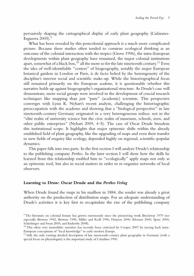
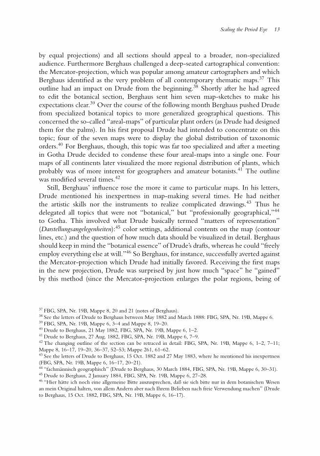
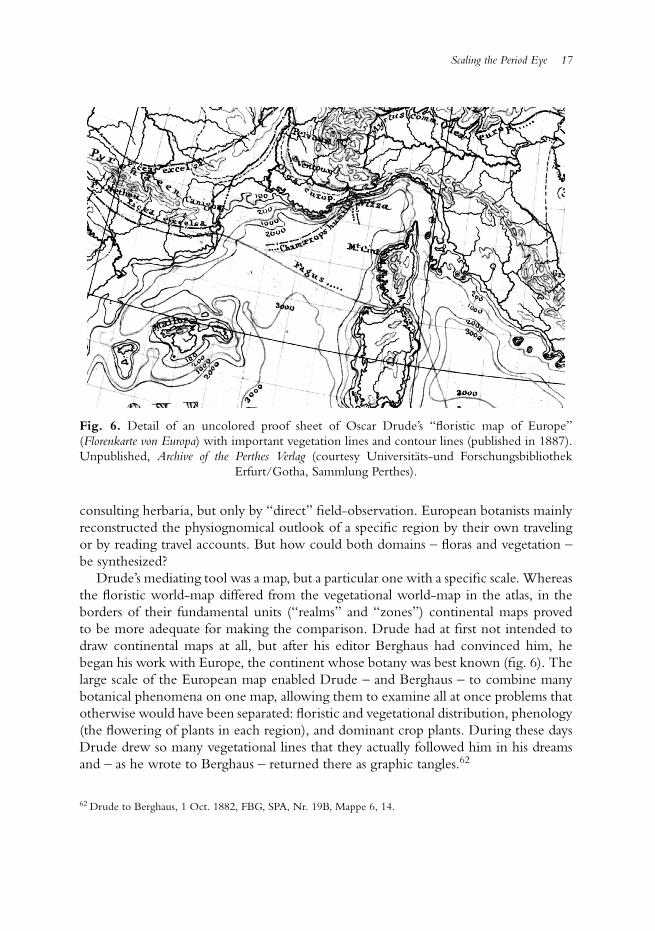
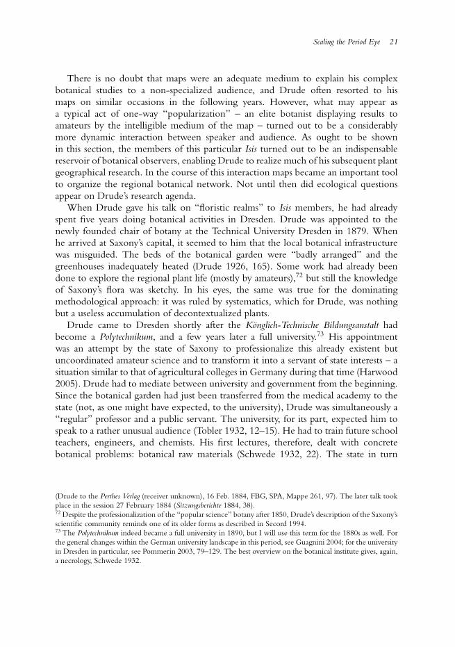
When opening his mail in late March 1884, the Dresden botanist Oscar Drude couldhardly believe his eyes. At that time his first major publication – suggesting a newfloristic division of the earth’s surface – was nearly ready for press (Drude 1884). Drudehad already finished his text and the one thing that remained to be done was the revisionof the accompanying maps. Although Drude had sent detailed hand-sketches to hispublishing company Perthes in Gotha, the appearance of the edited results (fig. 1), whichhe found in his mailbox that day, took him by surprise. Apparently, the cartographerhad rearranged the maps and changed a number of details, making for a visual qualityhitherto unseen. Enthusiastically, Drude replied to the responsible cartographer BrunoHassenstein: “Their Totaleindruck is such a pretty sight that I shall now refrain fromdeveloping the image I had originally intended to convey in the text.”1
1 “Dieselben machen einen im Totaleindruck so hubschen Anblick, daß ich ganz davon absehen mochte, dasBild, wie ich es eigentlich im Text erstrebt hat, noch jetzt daraus hervorgehen zu lassen” (Drude to Hassenstein,25 March 1884, FBG, SPA, Arbeitstagebucher Bruno Hassenstein, Heft XXI, 8).

2 Nils Robert Guttler
Fig. 1. Detail of Bruno Hassenstein’s revision of Oscar Drude’s hand-drawn templates. Itdepicts a new botanical division of the globe by means of different hues and symbols of“floristic realms.” Unpublished, Archive of the Perthes Verlag (1884) (courtesy Universitats-und
Forschungsbibliothek Erfurt/Gotha, Sammlung Perthes).
Looking at his edited maps “at a glance” (Totaleindruck), Drude perceived somethingnew and entirely fundamental. He identified therein, as he further wrote, new“principles.” Soon, the cartographer’s corrections would please the eyes and stir theimagination of much wider circles, contributing to the wide reception of those mapson the “floristic realms” even beyond the botanical scientific community. Decadeslater, they were still held as graphic standards within plant geography (Eckert 1921–25,2:389–390). In the meantime Drude, incited by the maps’ popularity, had intensified hiscartographic activities and was, as early as the 1920s, declared a “master of vegetationalmaps” (ibid., 2:393).
What is remarkable both about Drude’s surprise at the final appearance of his ownsketches, as well as his subsequent initiation into the graphical universe of botanicalmaps, is its seemingly stupendous belatedness. By the 1880s maps were an establishedmedium within plant geography. As historians have convincingly shown, they hadalready played a crucial role within scientific achievements of earlier key figures
Scaling the Period Eye 3
of nineteenth-century plant- and biogeography like Alexander von Humboldt andCharles Darwin, among others (Camerini 1993a; Godlewska 1999; Dettelbach 1999).Even the Totaleindruck, the technique of observing the interconnectivity of physicalphenomena in maps “at a glance,” had been a common visual practice among naturalistsfor decades (Bigg 2007). In Drude’s own days, the time of such spectacular epistemicinnovations was seemingly over. Some historians have therefore been prompted topinpoint the very end of the “golden age” of distribution maps – such as the oneDrude was holding in his hands in 1884 – in the early 1860s (Robinson 1982, 24).Scholars in the late nineteenth century, it is implied, certainly refined already existingtechniques, but the collective cartographical perception of plant distribution – thebotanist’s “period eye”2 – remained mostly static and still corresponded to the view oftheir predecessors.
Interestingly enough, Drude and his contemporaries had a contrary view of theprehistory of plant geography’s “period eye,” suggesting a different narrative on thehistory of botanical distribution maps. Whereas they seldom referred to those firstmaps from the “golden age” (which they just knew quite superficially), for them,the most trendsetting and reliable maps did not appear at all until the 1860s – mapsthat would facilitate a substantially new way of looking at plant distribution (Drude1884, 18–19; Engler 1887, 358–359, Engler 1899, 22–27). They were even convincedthat these “new” maps unfolded yet unknown dynamics in the field of botanicalmappings, leading to a quantitative explosion from the 1890s onward.3 Not until thendid maps become elementary to most plant geographical studies, and only then did theiruse as an argumentative tool became standard. Hence, when late nineteenth-centuryplant geographers considered their own endeavors, their self-perception contrastedsignificantly with the historiographical perception of the “development” of botanicalmapping at the time.
By analyzing the case of Oscar Drude in more detail, this article aims to mediatebetween these two contradictory narratives by arguing that there indeed exists a yetinvisible and nearly unwritten history of botanical map-making and map-perceptionin the second half of the nineteenth century. The practice of using maps withinplant geography changed substantially in the last decades of the nineteenth century.Although maps were unquestionably an established medium at that time, they were lessdisseminated and mainly used in order to fixate and present a final stage of knowledgebefore becoming a common and widespread discursive object in the last decadesof the century. This increasing dissemination of maps caused sustainable epistemicconsequences. As it were, late nineteenth-century circulation of maps led to a wholesale
2 This term was introduced by Baxandall 1988, 29–108. It aims to historically identify time-specific styles ofperception. The possibilities that this concept opens for the description of scientific “seeing collectives,” aswell as for a historicization of visual techniques as the Totaleindruck in a long-term perspective of scientificobservation, have recently been emphasized by Daston 2008, 107–110.3 The most detailed overview on the diversity of botanical maps after 1890 is to be found in contemporarysources (Schroeter 1910 [containing numerous reprints]; Eckert 1921–25, 2:385–411).
4 Nils Robert Guttler
cartographical calibration – say, scaling – of botany’s earlier “period eye,” enablingDrude and other plant geographers to look differently at distribution maps. They beganusing them for graphical experiments and also explored new applications of maps inorder to organize networks of botanical observers. Only then did maps become anindispensable element of botanical observation.
This “mapping impulse”4 within plant geography was not driven by semioticinventions made directly in the field, but rather forced by a broad change in the practiceof map-making and map-use. It was caused by specific geographies of knowledge inwhich plant geographers as Drude interacted with persons and institutions from theacademic periphery, i.e. cartographers employed by publishing companies or botanicalamateurs organized in regional societies of natural history. Oscar Drude’s map-makingexemplifies how skills and practices – developed in “popular” fields of knowledge suchas commercial cartography and originally conceived for classrooms and unprofessionalaudiences – affected the “scientific” reflection on the distribution of plants in latenineteenth-century Central Europe.5
The interaction between “popular” and “scientific” cultures also explains hownew methodological questions very suddenly appeared on the research agenda ofplant geographers as Drude. His maps namely shaped a field of study which becamea discipline of its own by the turn of the century: scientific ecology.6 “Ecology,”however, was by no means the actual goal of his plant cartographical research, butrather a by-product of his regional studies. Both areas – plant cartography and its later“spill-over” to ecology – were strongly interwoven in Drude’s every-day practice anddriven by the same milieu of “popular” knowledge production.
Focusing on such para-academic and practice-driven geographies of knowledge hasproven to be a promising approach to reconsider common narratives in the historyof plant geography.7 Whereas an older historiography had mainly concentrated onthe development of geobotanical theory,8 postcolonial studies have brought to lightthe “practical and useful” implications of biogeography in colonial infrastructures,
4 I borrow this term from Alpers 1983, 119–168.5 “Popularization” has been widely discussed in recent years. A historically complex description of the conceptof “popular science” – challenging the former top-down-model – has been recently demanded in an Isis focus(see Topham 2009, intro.). Regardless of the vast literature on this topic, the sustainable influence of “popular”institutions as publishing companies on “scientific” discourses has seldom been so convincingly described as bySecord 2000.6 Donald Worster has labeled Drude as part of the “great European triumvirate of ecological plant-geographers”(Worster 1994, 198; see also McIntosh 1985, 41–43; and Trepl 1987, 133–138).7 For the new explanatory possibilities this practice-based approach has for casting new light even on well-known key figures of plant geography, see Endersby 2008; and Lack 2009. See Ford 2007 for an overview ofnew research on “new” environmental history, which often covered, at least marginally, research milieus of plantgeographers.8 This more theory-based approach has, nevertheless, left very informative overviews (Hofsten 1917; Nelson1978; Browne 1983; Nicholson 1996). Plant geography is also a traditional part in summaries on the history ofecology (McIntosh 1985; Trepl 1987; Bowler 1992; Worster 1994).
Scaling the Period Eye 5
pervasively shaping the cartographical display of early plant geography (Canizares-Esguerra 2005).9
What has been revealed by this postcolonial approach is a much more complicatedpicture. Because these studies often tended to construe ecological thinking as anoutcome of the colonial interaction with the tropics (Grove 1996), the intra-Europeandevelopments within plant geography have remained, the major colonial institutionsapart, somewhat of a black box,10 all the more so for the late nineteenth century.11 Eventhe idea of well-identifiable “centers” of biogeography, notably the major Europeanbotanical gardens in London or Paris, is de facto belied by the heterogeneity of thediscipline’s interior social and scientific make-up. While the historiographical focusstill remained primarily on the European academe, it is questionable whether thisnarrative holds up against biogeography’s organizational structure. As Drude’s case willdemonstrate, more social groups were involved in the development of crucial researchtechniques like mapping than just “pure” (academic) scientists. This perspectiveconverges with Lynn K. Nyhart’s recent analysis, challenging the historiographicpreoccupation with the academe and showing that a “biological perspective” in latenineteenth-century Germany originated in a very heterogeneous milieu: not in the“elite realm of university science but the civic realm of museums, schools, zoos, andother public enterprises” (Nyhart 2009, 4–5). The case of Oscar Drude broadensthis institutional scope. It highlights that major epistemic shifts within the alreadyestablished field of plant geography, like the upgrading of maps and even their transferto new fields of enquiry like ecology, depended highly on regional, scientific-populardynamics.
This paper falls into two parts. In the first section I will analyze Drude’s relationshipto the publishing company Perthes. In the later section I will show how the skills helearned from this relationship enabled him to “ecologically” apply maps not only asan epistemic tool, but also in social matters in order to re-organize networks of localobservers.
Learning to Draw: Oscar Drude and the Perthes Verlag
When Drude found the maps in his mailbox in 1884, the sender was already a greatauthority on the production of distribution maps. For an adequate understanding ofDrude’s activities it is key first to recapitulate the rise of the publishing company
9 The literature on colonial botany has grown enormously since the pioneering work Brockway 1979 (seeespecially Browne 1992; Browne 1996; Miller and Reill 1996; Drayton 2000; Klemun 2000; Spary 2000;Schiebinger and Swan 2005; and Endersby 2008).10 This often very monolithic narrative has recently been criticized by Cooper 2007 by tracing back intra-European conceptions of “local knowledge” to early modern Europe.11 Still, the only existing detailed description of late nineteenth-century plant geography in Germany (with aspecial focus on physiologists) is the important study of Cittadino 1990.
6 Nils Robert Guttler
and its access to botanical mappings in the decades before. At that time the PerthesVerlag, located in the town of Gotha in today’s federal state of Thuringia, was notjust participating in nearly all developments within thematic cartography, it was alsodirectly carrying them out.12
Since the early nineteenth century the commercial market for cartographicalproducts had already grown to an exceptional level in the German states. Publishingcompanies like the Perthes Verlag profited from an increasing demand for “popular”atlases, especially for two new school subjects: geography and the more locally-orientated Heimatkunde (Brogiato 1996; Espenhorst 2003–08). The prospering marketcaused specific institutional developments. Whereas publishing companies in theUnited States and other countries seldom employed more than ten persons and map-making was more generally linked to state institutions, the German firms, workingunder fragmented political conditions, strengthened their position by systematicallyexpanding into all areas of cartographical production and especially that of “thematic”(distribution) mapping.13 They simultaneously employed innovative methods andtechnology in order to reduce production costs: all production steps were integratedinto one base where they also introduced new printing and coloring techniques(especially lithography).14 Thus, so-called “geographical institutes” like the PerthesVerlag had dozens of employees, ranging from editors and cartographers to printersand colorists. Therefore, they rapidly became the centers of the geographical scientificcommunity, successively accumulating skills, knowledge, and technology (Eckert 1921–25, i, 39–42).
By the 1840s the Perthes Verlag had become the primus inter pares, selling up to60,000 atlases a year (Brogiato 1996, 44). The “Perthes style”15 substantially shapedboth the contemporary view on the world as well as the world-view, determiningthe period eye of an always-growing part of society. Due to its increasing marketpower, the company was able to dictate the standardization of graphical languagewithin national and international cartography (i.e. the colors red and blue to displaytemperature in maps). This has been first and foremost a quantitative effect. Sincethe 1850s up to 800 maps a day were colored by about more than 160 women andgirls employed by Perthes-subcontractors (Kohler 1987, 85; Smits 2004, 47), to saynothing of the number of lithographed maps also being produced. All in all, the
12 For a history of the Perthes Verlag, see Kohler 1987; Espenhorst 2003–08, 1:179–204; and Smits 2004, 9–86.13 The history of popular map-markets is a largely unacquainted topic within the history of cartography.Concerning the eighteenth century, see the insightful study Pedley 2005. For nineteenth-century UnitedStates, see Ristow 1986. Thematic mapping seems to have been a specifically promoted feature of the privatecartographical market in the German states, since it was not directly linked to state institutions, especially ofagriculture and forestry (see Eckert 1921–25, 1:37–42). However, due to the still lacking comparative perspective,one should be cautious about overemphasizing “national” characteristics.14 The best overview on the economic development of the Perthes Verlag is Kohler 1987.15 This term is common within the history of cartography (see Kohler 1987, 94–103; and Smits 2004, 25).
Scaling the Period Eye 7
German “geographical institutes” more closely resembled “factories” than the smallerpublishing companies in other countries (Kohler 1987, 87–94).
In matters of distribution maps, the Perthes Verlag had entered the stage with aproduct that has been widely described as a graphical culmination and milestone of“Humboldtian science.” By the mid-1840s, the company published the Physical Atlas ofHeinrich Berghaus, the first compendium of thematic cartography, which containeda separate section on plant geography and was soon reissued in Great Britain (seeBerghaus 1845–48, especially section 5; and Johnston 1848).16 From an editorial pointof view this atlas was above all an attempt to establish a new product besides the already-existing “normal” topographical atlases, like, for example, the best-selling “Stieler.”However, the actual priming of distribution maps came only a decade later and wasclosely related to the activities of the new chief cartographer of the company, AugustPetermann.
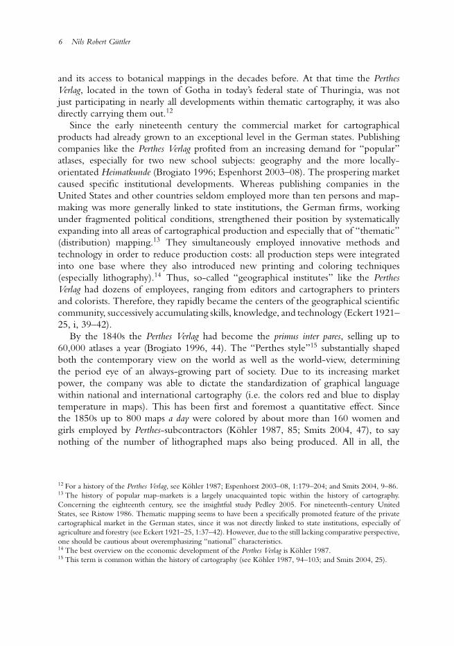
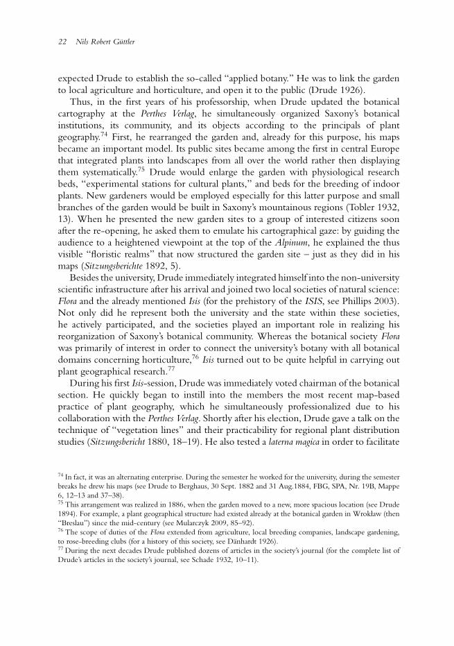
In the early 1850s, Petermann came to Gotha after having spent a long period ofcartographical activity in Great Britain (see Smits 2004, 37).17 On the British Isleshe had participated in a general epistemic and social upgrading of maps in Victorianscientific culture.18 During those years Petermann corresponded about botany with keyfigures of Victorian plant geography, like Hewett C. Watson. However, although mapswere fashionable among Victorian naturalists and botanists as a tool for reorganizingscientific inquiry and making visible the usefulness of costly scientific research, onlya few of those maps actually came into print due to their high production costs, andPetermann could hardly keep himself afloat in Great Britain (Felsch 2010, 117–129).
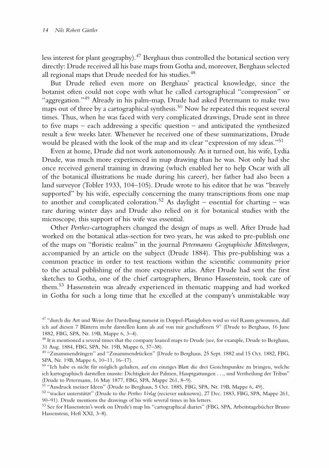
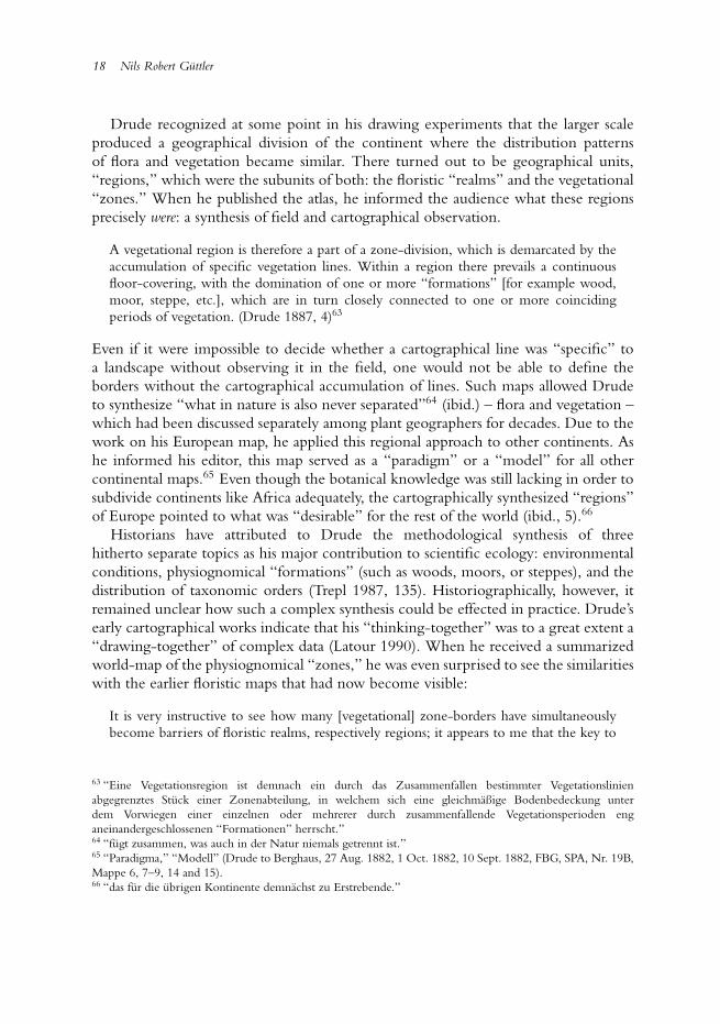
Returning to the German states, where there was a more prosperous cartographicalmarket, Petermann carried in his luggage dozens of hand-drawn and unprinted mapsfrom his British years (fig. 2).19 The Perthes Verlag allowed Petermann to put intopractice his former claims and circulate his sketches among a wide audience. Soonafter Petermann’s arrival a new cartographical journal, the Petermann’s GeographischeMitteilungen, was released.20 From 1855 onwards it appeared in short intervals,containing the results of the most recent geographical research, including many“thematic” studies on subjects such as plant geography. This economically successful
16 The history of the first edition of the physical atlas is well investigated, whereas later editions have arousedless interest. Later editions have been usually mentioned, if at all, as an epilogue (Engelmann 1964; Engelmann1977, 120–124; Camerini 1993b; Espenhorst 2003–08, 1:365–390).17 The “British years” of Petermann have been described in more detail by Felsch 2010, 43–134.18 With regard to botanists this “chartism” among Victorian naturalists has been described in detail by Endersby2008, 225–248.19 Today, these sketches and unprinted maps are to be found in the publishing companies archive (FBG,SPK, 547$111622417, 547$111599687, 547$111599695, 547$111595037, 547$112088562, 547$111594871,547$111594847, 547$111594901, 547$111594812, 547$111594782, 547$111594758).20 The original name of this journal was “Mittheilungen aus Justus Perthes’ Geographischer Anstalt” and waschanged several times. The later use, “Petermann’s Geographische Mitteilungen,” has become the commonhistoriographical term (for the history of this journal, see Smits 2004; Demhardt 2006; Schelhaas and Wardenga2007; and Lentz and Ormeling 2008).
8 Nils Robert Guttler
Fig. 2. Detail of an unpublished “skeleton map” (untitled) by William Brand, whichAugust Petermann brought to Gotha in 1854. It was financed by the British Associationfor the Advancement of Science. By locating the specimen’s place of discovery in thedepicted “sections” it was supposed to be used to control the global circulation ofplant material. Unpublished, Archive of the Perthes Verlag (1840) (courtesy Universitats-und
Forschungsbibliothek Erfurt/Gotha, Sammlung Perthes).
journal became a “cash cow” for the publishing company while simultaneouslyaffecting the epistemic setting of Central-European geography. In its very first issue,Petermann claimed that maps should become the “ultimate goal” (Endprodukt) ofall geographical research (Petermann 1855, 2). In a long-term perspective, this newimage-agenda for geography allowed for maps to become an increasingly “normal”part within other fields of geographical studies like plant geography.
In the beginning, Petermann published maps of so-called “cultural plants” (mainlycrops) from all over the world. These maps then became prototypes for “pure”
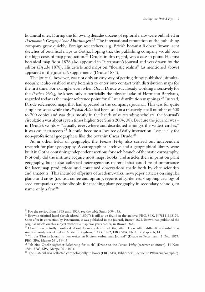
Scaling the Period Eye 9
botanical ones. During the following decades dozens of regional maps were published inPetermann’s Geographische Mitteilungen.21 The international reputation of the publishingcompany grew quickly. Foreign researchers, e.g. British botanist Robert Brown, sentsketches of botanical maps to Gotha, hoping that the publishing company would bearthe high costs of map production.22 Drude, in this regard, was a case in point. His firstbotanical map from 1878 also appeared in Petermann’s journal and was drawn by theeditor (Drude 1878). His article and maps on “floristic realms” (as mentioned above)appeared in the journal’s supplements (Drude 1884).
The journal, however, was not only an easy way of getting things published; simulta-neously, it also enabled many botanists to enter into contact with distribution maps forthe first time. For example, even when Oscar Drude was already working intensively forthe Perthes Verlag, he knew only superficially the physical atlas of Hermann Berghaus,regarded today as the major reference point for all later distribution mappings.23 Instead,Drude referenced maps that had appeared in the company’s journal. This was for quitesimple reasons: while the Physical Atlas had been sold in a relatively small number of 600to 700 copies and was thus mostly in the hands of outstanding scholars, the journal’scirculation was about seven times higher (see Smits 2004, 38). Because the journal was –in Drude’s words – “actually everywhere and distributed amongst the widest circles,”it was easier to access.24 It could become a “source of daily instruction,” especially fornon-professional geographers like the botanist Oscar Drude.25
As in other fields of geography, the Perthes Verlag also carried out independentresearch for plant geography. A cartographical archive and a geographical library werebuilt in Gotha containing independent sections for each branch of thematic cartography.Not only did the institute acquire most maps, books, and articles then in print on plantgeography, but it also collected heterogeneous material that could be of importancefor later map productions and contained observations made both by elite scientistsand amateurs. This included offprints of academy-talks, newspaper articles on singularplants and crops (i.e. tea, coffee and opium), reports of gardeners, shopping catalogs ofseed companies or schoolbooks for teaching plant geography in secondary schools, toname only a few.26
21 For the period from 1855 until 1929, see the table Smits 2004, 45.22 Brown’s original hand-sketch (dated “1870”) is still to be found in the archive: FBG, SPK, 547$111598176.Soon after its correction by Petermann, it was published in the journal, Brown 1872. Brown had published theoriginal article on this subject without a map two years earlier, in Brown 1870.23 Drude was actually confused about former editions of the atlas. Their often difficult accessibility issimultaneously articulated in Drude to Berghaus, 1 Oct. 1882, FBG, SPA, Nr. 19B, Mappe 6, 14.24 “in der That ja uberall in den weitesten Kreisen verbreitetes Journal” (Drude to Petermann, 2 Dec. 1877,FBG, SPA, Mappe 261, 14–15).25 “als eine Quelle taglicher Belehrung fur mich” (Drude to the Perthes Verlag [receiver unknown], 11 Nov.1884. FBG, SPA, Mappe 261, 101).26 The material was collected chronologically in boxes (FBG, SPA, Bibliothek, Konvolute Pflanzengeographie).
10 Nils Robert Guttler
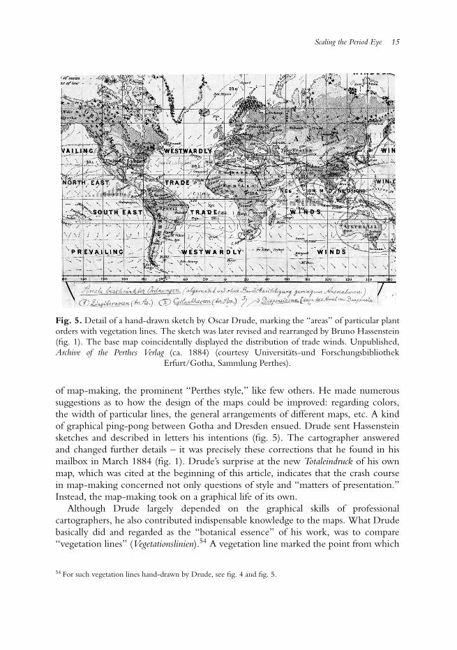
Fig. 3. August Grisebach’s Die Vegetations-Gebiete der Erde (published in 1866). The Germantitles were replaced by French at a later stage. Unpublished, Archive of the Perthes Verlag (courtesy
Universitats-und Forschungsbibliothek Erfurt/Gotha, Sammlung Perthes).
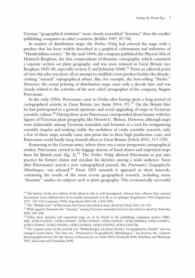
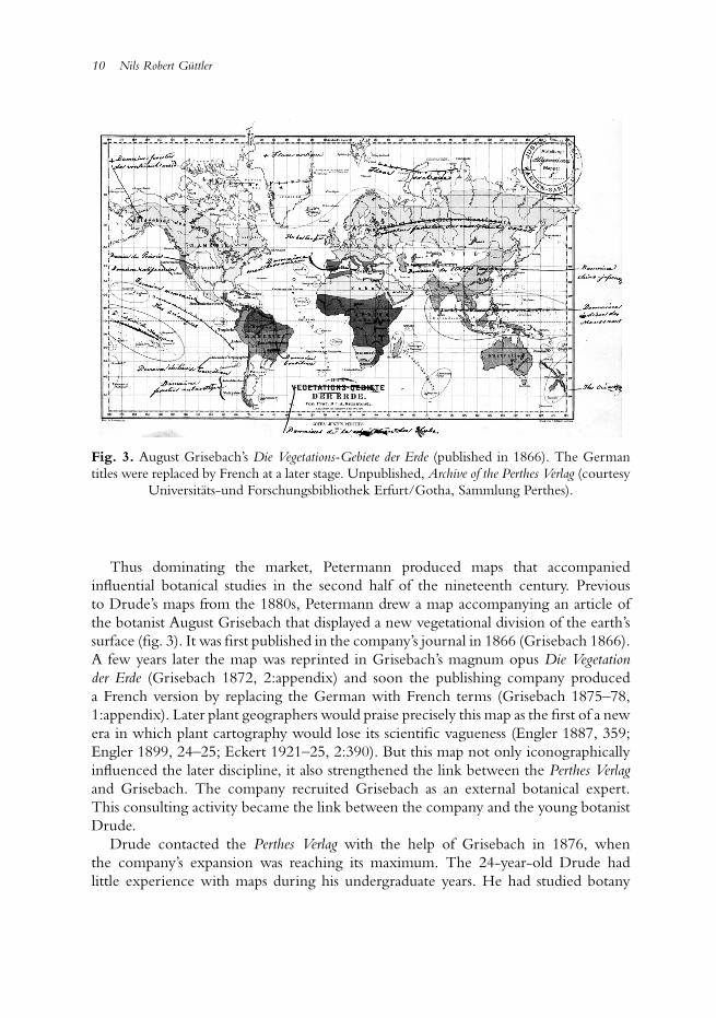
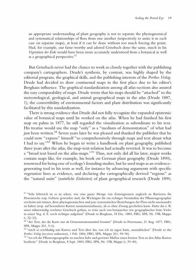
Thus dominating the market, Petermann produced maps that accompaniedinfluential botanical studies in the second half of the nineteenth century. Previousto Drude’s maps from the 1880s, Petermann drew a map accompanying an article ofthe botanist August Grisebach that displayed a new vegetational division of the earth’ssurface (fig. 3). It was first published in the company’s journal in 1866 (Grisebach 1866).A few years later the map was reprinted in Grisebach’s magnum opus Die Vegetationder Erde (Grisebach 1872, 2:appendix) and soon the publishing company produceda French version by replacing the German with French terms (Grisebach 1875–78,1:appendix). Later plant geographers would praise precisely this map as the first of a newera in which plant cartography would lose its scientific vagueness (Engler 1887, 359;Engler 1899, 24–25; Eckert 1921–25, 2:390). But this map not only iconographicallyinfluenced the later discipline, it also strengthened the link between the Perthes Verlagand Grisebach. The company recruited Grisebach as an external botanical expert.This consulting activity became the link between the company and the young botanistDrude.
Drude contacted the Perthes Verlag with the help of Grisebach in 1876, whenthe company’s expansion was reaching its maximum. The 24-year-old Drude hadlittle experience with maps during his undergraduate years. He had studied botany
Scaling the Period Eye 11
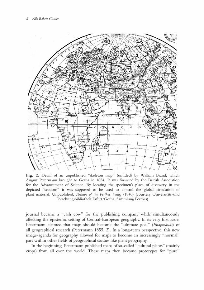
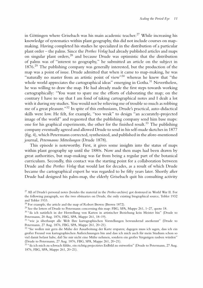
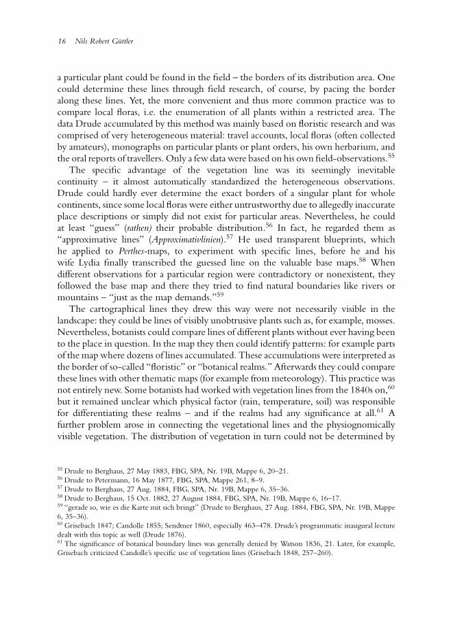
in Gottingen where Grisebach was his main academic teacher.27 While increasing hisknowledge of systematics within plant geography, this did not include courses on map-making. Having completed his studies he specialized in the distribution of a particularplant order – the palms. Since the Perthes Verlag had already published articles and mapson singular plant orders,28 and because Drude was optimistic that the distributionof palms was of “interest to geography,” he submitted an article on the subject in1876.29 The publishing company was generally interested, but the production of themap was a point of issue. Drude admitted that when it came to map-making, he was“naturally no master from an artistic point of view”30 whereas he knew that “thewhole world appreciates the cartographical ideas” emerging in Gotha.31 Nevertheless,he was willing to draw the map. He had already made the first steps towards workingcartographically: “You want to spare me the efforts of elaborating the map; on thecontrary I have to say that I am fond of taking cartographical notes and I dealt a lotwith it during my studies. You would not be relieving me of trouble so much as robbingme of a great pleasure.”32 In spite of this enthusiasm, Drude’s practical, auto-didacticalskills were low. He felt, for example, “too weak” to design “an accurately-projectedimage of the world” and requested that the publishing company send him base maps:one for his graphical experiments, the other for the finished result.33 The publishingcompany eventually agreed and allowed Drude to send in his self-made sketches in 1877(fig. 4), which Petermann corrected, synthesized, and published in the afore-mentionedjournal, Petermanns Mitteilungen (Drude 1878).
This episode is noteworthy. First, it gives some insights into the status of mapswithin plant geography up until the 1880s. Now and then maps had been drawn bygreat authorities, but map-making was far from being a regular part of the botanicalcurriculum. Secondly, this contact was the starting point for a collaboration betweenDrude and the Perthes Verlag that would last for decades, as a result of which Drudebecame the cartographical expert he was regarded to be fifty years later. Shortly afterDrude had designed his palm-map, the elderly Grisebach quit his consulting activity
27 All of Drude’s personal notes (besides the material in the Perthes-archive) got destroyed in World War II. Forthe following paragraph, see the two obituaries on Drude, the only existing biographical source, Tobler 1932and Tobler 1933.28 For example, the article and the map of Robert Brown (Brown 1872).29 See the letters of Drude to Petermann concerning this map: FBG, SPA, Mappe 261, 1–27, quote 18.30 “da ich naturlich in der Herstellung von Karten in artistischer Beziehung kein Meister bin” (Drude toPetermann, 20 Aug. 1876, FBG, SPA, Mappe 261, 18–19).31 “wie ja uberhaupt alle Welt Ihre kartographischen Vorstellungen bewundernd anerkennt” (Drude toPetermann, 27 Aug. 1876, FBG, SPA, Mappe 261, 20–21).32 “Sie wollen mir gern die Muhe der Ausarbeitung der Karte ersparen; dagegen muss ich sagen, dass ich eingroßer Freund von kartographischen Aufzeichnungen bin und dass ich mich auch fur mein Studium schon soviel damit befasst habe, daß Sie mir nicht eine Muhe nehmen, sondern ein großes Vergnugen rauben wurden”(Drude to Petermann, 27 Aug. 1876, FBG, SPA, Mappe 261, 20–21).33 “da ich mich zu schwach fuhlte, ein richtig projectirtes Erdbild zu entwerfen” (Drude to Petermann, 27 Aug.1876, FBG, SPA, Mappe 261, 20–21).
12 Nils Robert Guttler
Fig. 4. Detail of one of three of Oscar Drude’s hand-sketched templates for his map Diegeographische Verbreitung der Palmen auf der Erde printed in 1878. Unpublished, Archive of thePerthes Verlag (1877) (courtesy Universitats-und Forschungsbibliothek Erfurt/Gotha, Sammlung
Perthes).
for the company, recommending Drude as his successor. Apart from the examinationof articles and maps, this assignment also included yearly reviews on plant geographyfor a broader geographical audience of the company’s journals. Drude agreed.34
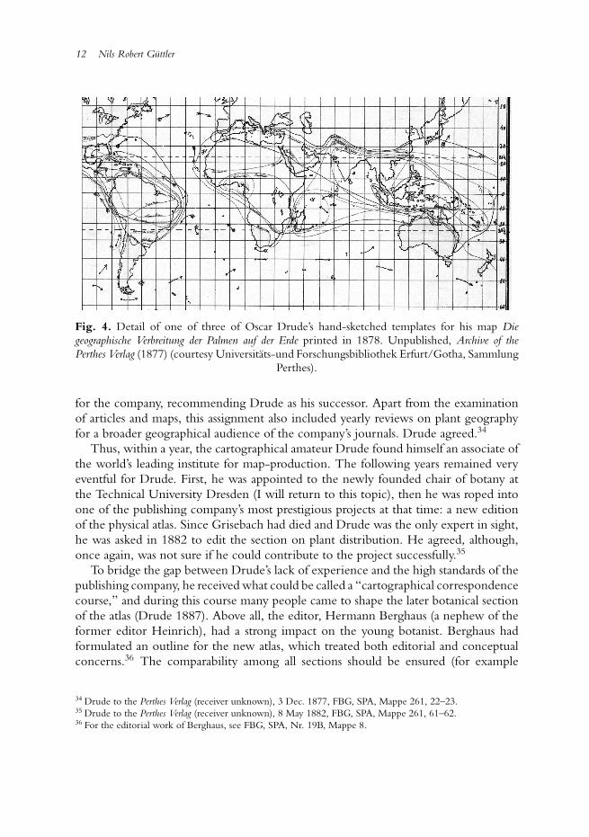
Thus, within a year, the cartographical amateur Drude found himself an associate ofthe world’s leading institute for map-production. The following years remained veryeventful for Drude. First, he was appointed to the newly founded chair of botany atthe Technical University Dresden (I will return to this topic), then he was roped intoone of the publishing company’s most prestigious projects at that time: a new editionof the physical atlas. Since Grisebach had died and Drude was the only expert in sight,he was asked in 1882 to edit the section on plant distribution. He agreed, although,once again, was not sure if he could contribute to the project successfully.35
To bridge the gap between Drude’s lack of experience and the high standards of thepublishing company, he received what could be called a “cartographical correspondencecourse,” and during this course many people came to shape the later botanical sectionof the atlas (Drude 1887). Above all, the editor, Hermann Berghaus (a nephew of theformer editor Heinrich), had a strong impact on the young botanist. Berghaus hadformulated an outline for the new atlas, which treated both editorial and conceptualconcerns.36 The comparability among all sections should be ensured (for example
34 Drude to the Perthes Verlag (receiver unknown), 3 Dec. 1877, FBG, SPA, Mappe 261, 22–23.35 Drude to the Perthes Verlag (receiver unknown), 8 May 1882, FBG, SPA, Mappe 261, 61–62.36 For the editorial work of Berghaus, see FBG, SPA, Nr. 19B, Mappe 8.
Scaling the Period Eye 13
by equal projections) and all sections should appeal to a broader, non-specializedaudience. Furthermore Berghaus challenged a deep-seated cartographical convention:the Mercator-projection, which was popular among amateur cartographers and whichBerghaus identified as the very problem of all contemporary thematic maps.37 Thisoutline had an impact on Drude from the beginning.38 Shortly after he had agreedto edit the botanical section, Berghaus sent him seven map-sketches to make hisexpectations clear.39 Over the course of the following month Berghaus pushed Drudefrom specialized botanical topics to more generalized geographical questions. Thisconcerned the so-called “areal-maps” of particular plant orders (as Drude had designedthem for the palms). In his first proposal Drude had intended to concentrate on thistopic; four of the seven maps were to display the global distribution of taxonomicorders.40 For Berghaus, though, this topic was far too specialized and after a meetingin Gotha Drude decided to condense these four areal-maps into a single one. Fourmaps of all continents later visualized the more regional distribution of plants, whichprobably was of more interest for geographers and amateur botanists.41 The outlinewas modified several times.42
Still, Berghaus’ influence rose the more it came to particular maps. In his letters,Drude mentioned his inexpertness in map-making several times. He had neitherthe artistic skills nor the instruments to realize complicated drawings.43 Thus hedelegated all topics that were not “botanical,” but “professionally geographical,”44
to Gotha. This involved what Drude basically termed “matters of representation”(Darstellungsangelegenheiten):45 color settings, additional contents on the map (contourlines, etc.) and the question of how much data should be visualized in detail. Berghausshould keep in mind the “botanical essence” of Drude’s drafts, whereas he could “freelyemploy everything else at will.”46 So Berghaus, for instance, successfully averted againstthe Mercator-projection which Drude had initially favored. Receiving the first mapsin the new projection, Drude was surprised by just how much “space” he “gained”by this method (since the Mercator-projection enlarges the polar regions, being of
37 FBG, SPA, Nr. 19B, Mappe 8, 20 and 21 (notes of Berghaus).38 See the letters of Drude to Berghaus between May 1882 and March 1888: FBG, SPA, Nr. 19B, Mappe 6.39 FBG, SPA, Nr. 19B, Mappe 6, 3–4 and Mappe 8, 19–20.40 Drude to Berghaus, 21 May 1882, FBG, SPA, Nr. 19B, Mappe 6, 1–2.41 Drude to Berghaus, 27 Aug. 1882, FBG, SPA, Nr. 19B, Mappe 6, 7–9.42 The changing outline of the section can be retraced in detail: FBG, SPA, Nr. 19B, Mappe 6, 1–2, 7–11;Mappe 8, 16–17, 19–20, 36–37, 52–53; Mappe 261, 61–62.43 See the letters of Drude to Berghaus, 15 Oct. 1882 and 27 May 1883, where he mentioned his inexpertness(FBG, SPA, Nr. 19B, Mappe 6, 16–17, 20–21).44 “fachmannisch geographisch” (Drude to Berghaus, 30 March 1884, FBG, SPA, Nr. 19B, Mappe 6, 30–31).45 Drude to Berghaus, 2 January 1884, FBG, SPA, Nr. 19B, Mappe 6, 27–28.46 “Hier hatte ich noch eine allgemeine Bitte auszusprechen, daß sie sich bitte nur in dem botanischen Wesenan mein Original halten, von allem Andern aber nach Ihrem Belieben nach freie Verwendung machen” (Drudeto Berghaus, 15 Oct. 1882, FBG, SPA, Nr. 19B, Mappe 6, 16–17).
14 Nils Robert Guttler
less interest for plant geography).47 Berghaus thus controlled the botanical section verydirectly: Drude received all his base maps from Gotha and, moreover, Berghaus selectedall regional maps that Drude needed for his studies.48
But Drude relied even more on Berghaus’ practical knowledge, since thebotanist often could not cope with what he called cartographical “compression” or“aggregation.”49 Already in his palm-map, Drude had asked Petermann to make twomaps out of three by a cartographical synthesis.50 Now he repeated this request severaltimes. Thus, when he was faced with very complicated drawings, Drude sent in threeto five maps – each addressing a specific question – and anticipated the synthesizedresult a few weeks later. Whenever he received one of these summarizations, Drudewould be pleased with the look of the map and its clear “expression of my ideas.”51
Even at home, Drude did not work autonomously. As it turned out, his wife, LydiaDrude, was much more experienced in map drawing than he was. Not only had sheonce received general training in drawing (which enabled her to help Oscar with allof the botanical illustrations he made during his career), her father had also been aland surveyor (Tobler 1933, 104–105). Drude wrote to his editor that he was “bravelysupported” by his wife, especially concerning the many transcriptions from one mapto another and complicated coloration.52 As daylight – essential for charting – wasrare during winter days and Drude also relied on it for botanical studies with themicroscope, this support of his wife was essential.
Other Perthes-cartographers changed the design of maps as well. After Drude hadworked on the botanical atlas-section for two years, he was asked to pre-publish oneof the maps on “floristic realms” in the journal Petermanns Geographische Mitteilungen,accompanied by an article on the subject (Drude 1884). This pre-publishing was acommon practice in order to test reactions within the scientific community priorto the actual publishing of the more expensive atlas. After Drude had sent the firstsketches to Gotha, one of the chief cartographers, Bruno Hassenstein, took care ofthem.53 Hassenstein was already experienced in thematic mapping and had workedin Gotha for such a long time that he excelled at the company’s unmistakable way
47 “durch die Art und Weise der Darstellung zumeist in Doppel-Planigloben wird so viel Raum gewonnen, daßich auf diesen 7 Blattern mehr darstellen kann als auf von mir geschaffenen 9” (Drude to Berghaus, 16 June1882, FBG, SPA, Nr. 19B, Mappe 6, 3–4).48 It is mentioned a several times that the company loaned maps to Drude (see, for example, Drude to Berghaus,31 Aug. 1884, FBG, SPA, Nr. 19B, Mappe 6, 37–38).49 “Zusammendrangen” and “Zusammendrucken” (Drude to Berghaus, 25 Sept. 1882 and 15 Oct. 1882, FBG,SPA, Nr. 19B, Mappe 6, 10–11, 16–17).50 “Ich habe es nicht fur moglich gehalten, auf ein einziges Blatt die drei Gesichtspunkte zu bringen, welcheich kartographisch darstellen musste: Dichtigkeit der Palmen, Hauptgattungen . . ., und Vertheilung der Tribus”(Drude to Petermann, 16 May 1877, FBG, SPA, Mappe 261, 8–9).51 “Ausdruck meiner Ideen” (Drude to Berghaus, 5 Oct. 1885, FBG, SPA, Nr. 19B, Mappe 6, 49).52 “wacker unterstutzt” (Drude to the Perthes Verlag (reciever unknown), 27 Dec. 1883, FBG, SPA, Mappe 261,90–91). Drude mentions the drawings of his wife several times in his letters.53 See for Hassenstein’s work on Drude’s map his “cartographical diaries” (FBG, SPA, Arbeitstagebucher BrunoHassenstein, Heft XXI, 3–8).
Scaling the Period Eye 15
Fig. 5. Detail of a hand-drawn sketch by Oscar Drude, marking the “areas” of particular plantorders with vegetation lines. The sketch was later revised and rearranged by Bruno Hassenstein(fig. 1). The base map coincidentally displayed the distribution of trade winds. Unpublished,Archive of the Perthes Verlag (ca. 1884) (courtesy Universitats-und Forschungsbibliothek
Erfurt/Gotha, Sammlung Perthes).
of map-making, the prominent “Perthes style,” like few others. He made numeroussuggestions as to how the design of the maps could be improved: regarding colors,the width of particular lines, the general arrangements of different maps, etc. A kindof graphical ping-pong between Gotha and Dresden ensued. Drude sent Hassensteinsketches and described in letters his intentions (fig. 5). The cartographer answeredand changed further details – it was precisely these corrections that he found in hismailbox in March 1884 (fig. 1). Drude’s surprise at the new Totaleindruck of his ownmap, which was cited at the beginning of this article, indicates that the crash coursein map-making concerned not only questions of style and “matters of presentation.”Instead, the map-making took on a graphical life of its own.
Although Drude largely depended on the graphical skills of professionalcartographers, he also contributed indispensable knowledge to the maps. What Drudebasically did and regarded as the “botanical essence” of his work, was to compare“vegetation lines” (Vegetationslinien).54 A vegetation line marked the point from which
54 For such vegetation lines hand-drawn by Drude, see fig. 4 and fig. 5.
16 Nils Robert Guttler
a particular plant could be found in the field – the borders of its distribution area. Onecould determine these lines through field research, of course, by pacing the borderalong these lines. Yet, the more convenient and thus more common practice was tocompare local floras, i.e. the enumeration of all plants within a restricted area. Thedata Drude accumulated by this method was mainly based on floristic research and wascomprised of very heterogeneous material: travel accounts, local floras (often collectedby amateurs), monographs on particular plants or plant orders, his own herbarium, andthe oral reports of travellers. Only a few data were based on his own field-observations.55
The specific advantage of the vegetation line was its seemingly inevitablecontinuity – it almost automatically standardized the heterogeneous observations.Drude could hardly ever determine the exact borders of a singular plant for wholecontinents, since some local floras were either untrustworthy due to allegedly inaccurateplace descriptions or simply did not exist for particular areas. Nevertheless, he couldat least “guess” (rathen) their probable distribution.56 In fact, he regarded them as“approximative lines” (Approximativlinien).57 He used transparent blueprints, whichhe applied to Perthes-maps, to experiment with specific lines, before he and hiswife Lydia finally transcribed the guessed line on the valuable base maps.58 Whendifferent observations for a particular region were contradictory or nonexistent, theyfollowed the base map and there they tried to find natural boundaries like rivers ormountains – “just as the map demands.”59
The cartographical lines they drew this way were not necessarily visible in thelandscape: they could be lines of visibly unobtrusive plants such as, for example, mosses.Nevertheless, botanists could compare lines of different plants without ever having beento the place in question. In the map they then could identify patterns: for example partsof the map where dozens of lines accumulated. These accumulations were interpreted asthe border of so-called “floristic” or “botanical realms.” Afterwards they could comparethese lines with other thematic maps (for example from meteorology). This practice wasnot entirely new. Some botanists had worked with vegetation lines from the 1840s on,60
but it remained unclear which physical factor (rain, temperature, soil) was responsiblefor differentiating these realms – and if the realms had any significance at all.61 Afurther problem arose in connecting the vegetational lines and the physiognomicallyvisible vegetation. The distribution of vegetation in turn could not be determined by
55 Drude to Berghaus, 27 May 1883, FBG, SPA, Nr. 19B, Mappe 6, 20–21.56 Drude to Petermann, 16 May 1877, FBG, SPA, Mappe 261, 8–9.57 Drude to Berghaus, 27 Aug. 1884, FBG, SPA, Nr. 19B, Mappe 6, 35–36.58 Drude to Berghaus, 15 Oct. 1882, 27 August 1884, FBG, SPA, Nr. 19B, Mappe 6, 16–17.59 “gerade so, wie es die Karte mit sich bringt” (Drude to Berghaus, 27 Aug. 1884, FBG, SPA, Nr. 19B, Mappe6, 35–36).60 Grisebach 1847; Candolle 1855; Sendtner 1860, especially 463–478. Drude’s programmatic inaugural lecturedealt with this topic as well (Drude 1876).61 The significance of botanical boundary lines was generally denied by Watson 1836, 21. Later, for example,Grisebach criticized Candolle’s specific use of vegetation lines (Grisebach 1848, 257–260).
Scaling the Period Eye 17
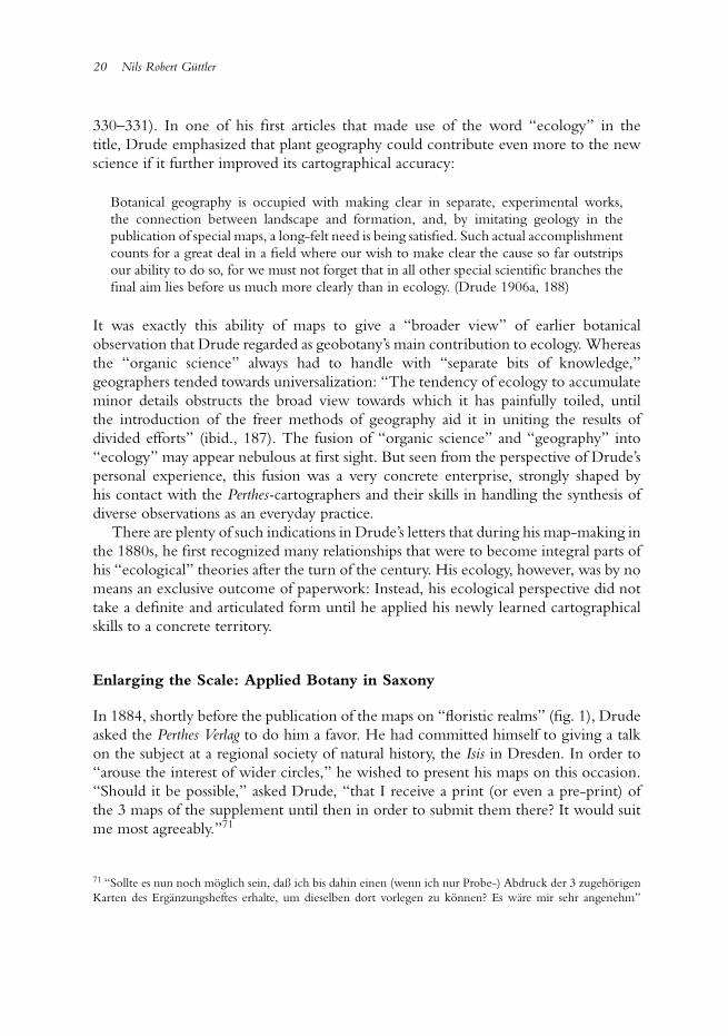
Fig. 6. Detail of an uncolored proof sheet of Oscar Drude’s “floristic map of Europe”(Florenkarte von Europa) with important vegetation lines and contour lines (published in 1887).Unpublished, Archive of the Perthes Verlag (courtesy Universitats-und Forschungsbibliothek
Erfurt/Gotha, Sammlung Perthes).
consulting herbaria, but only by “direct” field-observation. European botanists mainlyreconstructed the physiognomical outlook of a specific region by their own travelingor by reading travel accounts. But how could both domains – floras and vegetation –be synthesized?
Drude’s mediating tool was a map, but a particular one with a specific scale. Whereasthe floristic world-map differed from the vegetational world-map in the atlas, in theborders of their fundamental units (“realms” and “zones”) continental maps provedto be more adequate for making the comparison. Drude had at first not intended todraw continental maps at all, but after his editor Berghaus had convinced him, hebegan his work with Europe, the continent whose botany was best known (fig. 6). Thelarge scale of the European map enabled Drude – and Berghaus – to combine manybotanical phenomena on one map, allowing them to examine all at once problems thatotherwise would have been separated: floristic and vegetational distribution, phenology(the flowering of plants in each region), and dominant crop plants. During these daysDrude drew so many vegetational lines that they actually followed him in his dreamsand – as he wrote to Berghaus – returned there as graphic tangles.62
62 Drude to Berghaus, 1 Oct. 1882, FBG, SPA, Nr. 19B, Mappe 6, 14.
18 Nils Robert Guttler
Drude recognized at some point in his drawing experiments that the larger scaleproduced a geographical division of the continent where the distribution patternsof flora and vegetation became similar. There turned out to be geographical units,“regions,” which were the subunits of both: the floristic “realms” and the vegetational“zones.” When he published the atlas, he informed the audience what these regionsprecisely were: a synthesis of field and cartographical observation.
A vegetational region is therefore a part of a zone-division, which is demarcated by theaccumulation of specific vegetation lines. Within a region there prevails a continuousfloor-covering, with the domination of one or more “formations” [for example wood,moor, steppe, etc.], which are in turn closely connected to one or more coincidingperiods of vegetation. (Drude 1887, 4)63
Even if it were impossible to decide whether a cartographical line was “specific” toa landscape without observing it in the field, one would not be able to define theborders without the cartographical accumulation of lines. Such maps allowed Drudeto synthesize “what in nature is also never separated”64 (ibid.) – flora and vegetation –which had been discussed separately among plant geographers for decades. Due to thework on his European map, he applied this regional approach to other continents. Ashe informed his editor, this map served as a “paradigm” or a “model” for all othercontinental maps.65 Even though the botanical knowledge was still lacking in order tosubdivide continents like Africa adequately, the cartographically synthesized “regions”of Europe pointed to what was “desirable” for the rest of the world (ibid., 5).66
Historians have attributed to Drude the methodological synthesis of threehitherto separate topics as his major contribution to scientific ecology: environmentalconditions, physiognomical “formations” (such as woods, moors, or steppes), and thedistribution of taxonomic orders (Trepl 1987, 135). Historiographically, however, itremained unclear how such a complex synthesis could be effected in practice. Drude’searly cartographical works indicate that his “thinking-together” was to a great extent a“drawing-together” of complex data (Latour 1990). When he received a summarizedworld-map of the physiognomical “zones,” he was even surprised to see the similaritieswith the earlier floristic maps that had now become visible:
It is very instructive to see how many [vegetational] zone-borders have simultaneouslybecome barriers of floristic realms, respectively regions; it appears to me that the key to
63 “Eine Vegetationsregion ist demnach ein durch das Zusammenfallen bestimmter Vegetationslinienabgegrenztes Stuck einer Zonenabteilung, in welchem sich eine gleichmaßige Bodenbedeckung unterdem Vorwiegen einer einzelnen oder mehrerer durch zusammenfallende Vegetationsperioden enganeinandergeschlossenen “Formationen” herrscht.”64 “fugt zusammen, was auch in der Natur niemals getrennt ist.”65 “Paradigma,” “Modell” (Drude to Berghaus, 27 Aug. 1882, 1 Oct. 1882, 10 Sept. 1882, FBG, SPA, Nr. 19B,Mappe 6, 7–9, 14 and 15).66 “das fur die ubrigen Kontinente demnachst zu Erstrebende.”
Scaling the Period Eye 19
an appropriate understanding of plant geography is not to separate the physiognomicaland systematical relationships of flora from one another (respectively to unite it in eachcase on separate maps), at least if it can be done without too much forcing the point.Had, for example, our fame-worthy and adored Grisebach done the same, much in hisVegetation der Erde would have been more accurately understood from a botanical as wellas a geographical perspective.67
But Grisebach never had the chance to work so closely together with the publishingcompany’s cartographers. Drude’s synthesis, by contrast, was highly shaped by theeditorial program, the graphical skills, and the publishing interests of the Perthes Verlag.Drude had decided to draw continental maps in the first place due to his editor’sBerghaus influence. The graphical standardization among all atlas-sections also assuredthe easy comparability of maps. Drude wrote that his maps should be “attached” to themeteorological, geological, and animal geographical maps in the atlas (Drude 1887,1); the convertibility of environmental factors and plant distribution was significantlyfacilitated by this standardization.
There is strong evidence that Drude did not fully recognize the expanded epistemicvalue of botanical maps until he worked on the atlas. When he had finished his firstmap on palms in 1877, he still regarded the visualization as subordinate to his text.His treatise would use the map “only” as a “medium of demonstration” of what hadjust been written.68 Seven years later he was pleased and thanked the publisher that hecould now “express” himself “so comprehensively through maps and text about whatI had to say.”69 When he began to write a handbook on plant geography, publishedthree years after the atlas, the map-text-relation had actually reverted. It was to becomea “broad text based on the atlas-maps.”70 Thus, not only did all his later, major workscontain maps like, for example, his book on German plant geography (Drude 1890),renowned for being one of ecology’s founding studies, but he used maps as an evidence-generating tool in his texts as well, for instance by advancing arguments with specificvegetation lines as evidence, and declaring the cartographically derived “regions” asthe “natural units” (naturliche Einheiten) of plant geographical research (Drude 1890,
67 “Sehr lehrreich ist es zu sehen, wie eine ganze Menge von Zonengrenzen zugleich zu Barrieren furFlorenreiche resp. Gebiete geworden sind; das Wichtigste fur ein richtiges Verstandnis der Pflanzengeographieerscheint mir immer, diese physiognomischen und jene systematischen Beziehungen der Flora nicht auseinanderzu halten (resp. auf besonderen Karten zusammenzufassen), als es ohne Zwang geschehen kann. Hatte das z. B.unser ruhmwurdig verehrter Grisebach gethan, so ware auch von botanischer wie geographischer Seite Vielesin seiner Veg. d. E. noch richtiger aufgefasst” (Drude to Berghaus, 18 Dec. 1884, FBG, SPA, Nr. 19B, Mappe6, 32–33).68 “der Text, der die Karte nur als Demonstrationsmittel benutzt” (Drude to Petermann, 21 Aug. 1877, FBG,SPA, Mappe 261, 5–6).69 “mich so reichhaltig mit Karten und Text uber das, was ich zu sagen hatte, auszudrucken” (Drude to thePerthes Verlag (receiver unknown), 1 Feb. 1884, FBG, SPA, Mappe 261, 95–96).70 “wo ich die Pflanzengeographie zu machen habe und gewisser Maßen einen breiten Text zu den Atlas-Kartenbearbeite” (Drude to Berghaus, 8 Sept. 1884, FBG, SPA, Nr. 19B, Mappe 6, 39–40).
20 Nils Robert Guttler
330–331). In one of his first articles that made use of the word “ecology” in thetitle, Drude emphasized that plant geography could contribute even more to the newscience if it further improved its cartographical accuracy:
Botanical geography is occupied with making clear in separate, experimental works,the connection between landscape and formation, and, by imitating geology in thepublication of special maps, a long-felt need is being satisfied. Such actual accomplishmentcounts for a great deal in a field where our wish to make clear the cause so far outstripsour ability to do so, for we must not forget that in all other special scientific branches thefinal aim lies before us much more clearly than in ecology. (Drude 1906a, 188)
It was exactly this ability of maps to give a “broader view” of earlier botanicalobservation that Drude regarded as geobotany’s main contribution to ecology. Whereasthe “organic science” always had to handle with “separate bits of knowledge,”geographers tended towards universalization: “The tendency of ecology to accumulateminor details obstructs the broad view towards which it has painfully toiled, untilthe introduction of the freer methods of geography aid it in uniting the results ofdivided efforts” (ibid., 187). The fusion of “organic science” and “geography” into“ecology” may appear nebulous at first sight. But seen from the perspective of Drude’spersonal experience, this fusion was a very concrete enterprise, strongly shaped byhis contact with the Perthes-cartographers and their skills in handling the synthesis ofdiverse observations as an everyday practice.
There are plenty of such indications in Drude’s letters that during his map-making inthe 1880s, he first recognized many relationships that were to become integral parts ofhis “ecological” theories after the turn of the century. His ecology, however, was by nomeans an exclusive outcome of paperwork: Instead, his ecological perspective did nottake a definite and articulated form until he applied his newly learned cartographicalskills to a concrete territory.
Enlarging the Scale: Applied Botany in Saxony
In 1884, shortly before the publication of the maps on “floristic realms” (fig. 1), Drudeasked the Perthes Verlag to do him a favor. He had committed himself to giving a talkon the subject at a regional society of natural history, the Isis in Dresden. In order to“arouse the interest of wider circles,” he wished to present his maps on this occasion.“Should it be possible,” asked Drude, “that I receive a print (or even a pre-print) ofthe 3 maps of the supplement until then in order to submit them there? It would suitme most agreeably.”71
71 “Sollte es nun noch moglich sein, daß ich bis dahin einen (wenn ich nur Probe-) Abdruck der 3 zugehorigenKarten des Erganzungsheftes erhalte, um dieselben dort vorlegen zu konnen? Es ware mir sehr angenehm”
Scaling the Period Eye 21
There is no doubt that maps were an adequate medium to explain his complexbotanical studies to a non-specialized audience, and Drude often resorted to hismaps on similar occasions in the following years. However, what may appear asa typical act of one-way “popularization” – an elite botanist displaying results toamateurs by the intelligible medium of the map – turned out to be a considerablymore dynamic interaction between speaker and audience. As ought to be shownin this section, the members of this particular Isis turned out to be an indispensablereservoir of botanical observers, enabling Drude to realize much of his subsequent plantgeographical research. In the course of this interaction maps became an important toolto organize the regional botanical network. Not until then did ecological questionsappear on Drude’s research agenda.
When Drude gave his talk on “floristic realms” to Isis members, he had alreadyspent five years doing botanical activities in Dresden. Drude was appointed to thenewly founded chair of botany at the Technical University Dresden in 1879. Whenhe arrived at Saxony’s capital, it seemed to him that the local botanical infrastructurewas misguided. The beds of the botanical garden were “badly arranged” and thegreenhouses inadequately heated (Drude 1926, 165). Some work had already beendone to explore the regional plant life (mostly by amateurs),72 but still the knowledgeof Saxony’s flora was sketchy. In his eyes, the same was true for the dominatingmethodological approach: it was ruled by systematics, which for Drude, was nothingbut a useless accumulation of decontextualized plants.
Drude came to Dresden shortly after the Konglich-Technische Bildungsanstalt hadbecome a Polytechnikum, and a few years later a full university.73 His appointmentwas an attempt by the state of Saxony to professionalize this already existent butuncoordinated amateur science and to transform it into a servant of state interests – asituation similar to that of agricultural colleges in Germany during that time (Harwood2005). Drude had to mediate between university and government from the beginning.Since the botanical garden had just been transferred from the medical academy to thestate (not, as one might have expected, to the university), Drude was simultaneously a“regular” professor and a public servant. The university, for its part, expected him tospeak to a rather unusual audience (Tobler 1932, 12–15). He had to train future schoolteachers, engineers, and chemists. His first lectures, therefore, dealt with concretebotanical problems: botanical raw materials (Schwede 1932, 22). The state in turn
(Drude to the Perthes Verlag (receiver unknown), 16 Feb. 1884, FBG, SPA, Mappe 261, 97). The later talk tookplace in the session 27 February 1884 (Sitzungsberichte 1884, 38).72 Despite the professionalization of the “popular science” botany after 1850, Drude’s description of the Saxony’sscientific community reminds one of its older forms as described in Secord 1994.73 The Polytechnikum indeed became a full university in 1890, but I will use this term for the 1880s as well. Forthe general changes within the German university landscape in this period, see Guagnini 2004; for the universityin Dresden in particular, see Pommerin 2003, 79–129. The best overview on the botanical institute gives, again,a necrology, Schwede 1932.
22 Nils Robert Guttler
expected Drude to establish the so-called “applied botany.” He was to link the gardento local agriculture and horticulture, and open it to the public (Drude 1926).
Thus, in the first years of his professorship, when Drude updated the botanicalcartography at the Perthes Verlag, he simultaneously organized Saxony’s botanicalinstitutions, its community, and its objects according to the principals of plantgeography.74 First, he rearranged the garden and, already for this purpose, his mapsbecame an important model. Its public sites became among the first in central Europethat integrated plants into landscapes from all over the world rather then displayingthem systematically.75 Drude would enlarge the garden with physiological researchbeds, “experimental stations for cultural plants,” and beds for the breeding of indoorplants. New gardeners would be employed especially for this latter purpose and smallbranches of the garden would be built in Saxony’s mountainous regions (Tobler 1932,13). When he presented the new garden sites to a group of interested citizens soonafter the re-opening, he asked them to emulate his cartographical gaze: by guiding theaudience to a heightened viewpoint at the top of the Alpinum, he explained the thusvisible “floristic realms” that now structured the garden site – just as they did in hismaps (Sitzungsberichte 1892, 5).
Besides the university, Drude immediately integrated himself into the non-universityscientific infrastructure after his arrival and joined two local societies of natural science:Flora and the already mentioned Isis (for the prehistory of the ISIS, see Phillips 2003).Not only did he represent both the university and the state within these societies,he actively participated, and the societies played an important role in realizing hisreorganization of Saxony’s botanical community. Whereas the botanical society Florawas primarily of interest in order to connect the university’s botany with all botanicaldomains concerning horticulture,76 Isis turned out to be quite helpful in carrying outplant geographical research.77
During his first Isis-session, Drude was immediately voted chairman of the botanicalsection. He quickly began to instill into the members the most recent map-basedpractice of plant geography, which he simultaneously professionalized due to hiscollaboration with the Perthes Verlag. Shortly after his election, Drude gave a talk on thetechnique of “vegetation lines” and their practicability for regional plant distributionstudies (Sitzungsbericht 1880, 18–19). He also tested a laterna magica in order to facilitate
74 In fact, it was an alternating enterprise. During the semester he worked for the university, during the semesterbreaks he drew his maps (see Drude to Berghaus, 30 Sept. 1882 and 31 Aug.1884, FBG, SPA, Nr. 19B, Mappe6, 12–13 and 37–38).75 This arrangement was realized in 1886, when the garden moved to a new, more spacious location (see Drude1894). For example, a plant geographical structure had existed already at the botanical garden in Wrokław (then“Breslau”) since the mid-century (see Mularczyk 2009, 85–92).76 The scope of duties of the Flora extended from agriculture, local breeding companies, landscape gardening,to rose-breeding clubs (for a history of this society, see Danhardt 1926).77 During the next decades Drude published dozens of articles in the society’s journal (for the complete list ofDrude’s articles in the society’s journal, see Schade 1932, 10–11).
Scaling the Period Eye 23
more visual demonstrations in future lectures (Sitzungsbericht 1881, 14). The membersquickly took to the visual-cartographic fondness of the new university professor andfollowed his insistence on complementing their studies with maps. Already in 1883, forinstance, a school-teacher used maps when talking on the plant geography of Norwayin front of the Isis-members (Sitzungsberichte 1883, 13). Soon, an increasing numberof map-complemented local floras of Saxony’s territory were discussed in the Isis.78
Eventually, Drude would prepare the members for collective field excursions with hisown Perthes-maps.79
By that time, maps had become a rather fashionable tool within the Isis. Alreadybefore Drude’s arrival, maps had been used in other sections like geology.80 During thefollowing decades, distribution maps on regional topics – such as Saxony’s anthropology,population, settlement history, medical topography, ornithology, etc. – were discussedat Isis meetings (as a case in point, see Wiechel 1904). These studies often came intoprint in the society’s proceedings, but some members also contributed to the PetermannsMitteilungen. By the turn of the century, Drude could attend a meeting of nearly anysection to compare his map-research on plant distribution with other fields of studysuch as, for example, zoology (Sitzungsberichte 1896, 25).
This map-circulation, however, was not limited to final acts of presentation. Duringhis work on the atlas, Drude had already learned that maps could serve as a tool tostandardize heterogeneous observations from different sources. Combined with the co-operative-minded Isis audience, the “synthesizing” ability of the Perthes-cartographersnow became an adequate technique for Drude to mobilize the members in an organizedmanner. He basically repeated what he had done on the atlas-maps: accumulatingmultiple data that was to be synthesized cartographically later on. The maindifference being that he both commissioned and standardized the observations on hisown.
From the very beginning Drude announced several plant geographical enterprisesin collaboration with the Isis. In his first session as a chairman of the botanical section(and again three years later) Drude called on the society’s members to aid him inthe observation of the regional phenology, i.e. the seasonal life cycles of Saxony’splants (Drude 1880, 15; Sitzungsbericht 1883, 41–45). Phenological observations hadbeen carried out since the eighteenth century, especially at botanical gardens, butDrude wanted to expand the places of observation on the state’s territory in order tosynthesize them later on. The synthesis was to serve economical purposes. The regional“phenological phases,” especially the first flowering of specific plants in spring, wasimportant for public agriculture in determining the optimal date for sowing crops
78 Compare, for instance, the enumeration of local floras (Reiche 1888; Drude 1895, 36).79 Such a map-introduction took place before an Isis trip to the Carpathians, for instance (see Sitzungsberichte1893, 4).80 Detailed geological map in scale 1:25,000 were already discussed in the Isis when Drude joined the society(see Sitzungsberichte 1880, 7–8).
24 Nils Robert Guttler
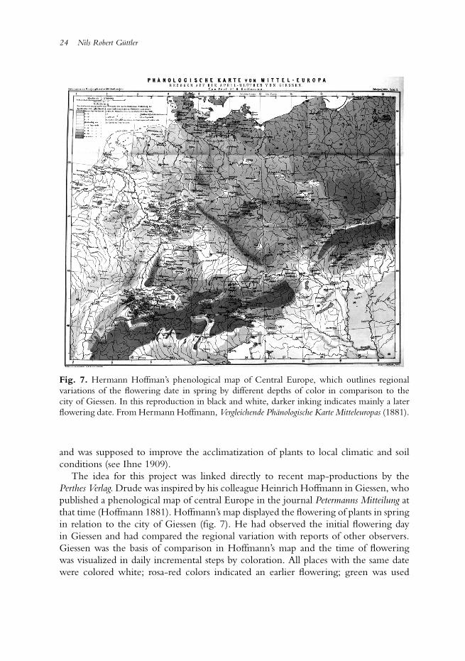
Fig. 7. Hermann Hoffman’s phenological map of Central Europe, which outlines regionalvariations of the flowering date in spring by different depths of color in comparison to thecity of Giessen. In this reproduction in black and white, darker inking indicates mainly a laterflowering date. From Hermann Hoffmann, Vergleichende Phanologische Karte Mitteleuropas (1881).
and was supposed to improve the acclimatization of plants to local climatic and soilconditions (see Ihne 1909).
The idea for this project was linked directly to recent map-productions by thePerthes Verlag. Drude was inspired by his colleague Heinrich Hoffmann in Giessen, whopublished a phenological map of central Europe in the journal Petermanns Mitteilung atthat time (Hoffmann 1881). Hoffmann’s map displayed the flowering of plants in springin relation to the city of Giessen (fig. 7). He had observed the initial flowering dayin Giessen and had compared the regional variation with reports of other observers.Giessen was the basis of comparison in Hoffmann’s map and the time of floweringwas visualized in daily incremental steps by coloration. All places with the same datewere colored white; rosa-red colors indicated an earlier flowering; green was used
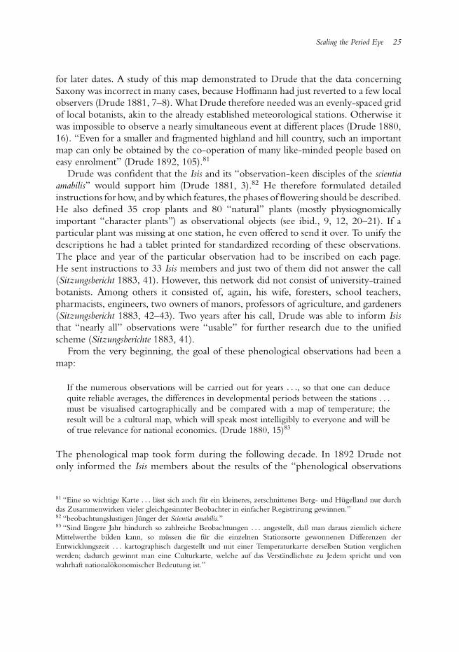
Scaling the Period Eye 25
for later dates. A study of this map demonstrated to Drude that the data concerningSaxony was incorrect in many cases, because Hoffmann had just reverted to a few localobservers (Drude 1881, 7–8). What Drude therefore needed was an evenly-spaced gridof local botanists, akin to the already established meteorological stations. Otherwise itwas impossible to observe a nearly simultaneous event at different places (Drude 1880,16). “Even for a smaller and fragmented highland and hill country, such an importantmap can only be obtained by the co-operation of many like-minded people based oneasy enrolment” (Drude 1892, 105).81
Drude was confident that the Isis and its “observation-keen disciples of the scientiaamabilis” would support him (Drude 1881, 3).82 He therefore formulated detailedinstructions for how, and by which features, the phases of flowering should be described.He also defined 35 crop plants and 80 “natural” plants (mostly physiognomicallyimportant “character plants”) as observational objects (see ibid., 9, 12, 20–21). If aparticular plant was missing at one station, he even offered to send it over. To unify thedescriptions he had a tablet printed for standardized recording of these observations.The place and year of the particular observation had to be inscribed on each page.He sent instructions to 33 Isis members and just two of them did not answer the call(Sitzungsbericht 1883, 41). However, this network did not consist of university-trainedbotanists. Among others it consisted of, again, his wife, foresters, school teachers,pharmacists, engineers, two owners of manors, professors of agriculture, and gardeners(Sitzungsbericht 1883, 42–43). Two years after his call, Drude was able to inform Isisthat “nearly all” observations were “usable” for further research due to the unifiedscheme (Sitzungsberichte 1883, 41).
From the very beginning, the goal of these phenological observations had been amap:
If the numerous observations will be carried out for years . . ., so that one can deducequite reliable averages, the differences in developmental periods between the stations . . .
must be visualised cartographically and be compared with a map of temperature; theresult will be a cultural map, which will speak most intelligibly to everyone and will beof true relevance for national economics. (Drude 1880, 15)83
The phenological map took form during the following decade. In 1892 Drude notonly informed the Isis members about the results of the “phenological observations
81 “Eine so wichtige Karte . . . lasst sich auch fur ein kleineres, zerschnittenes Berg- und Hugelland nur durchdas Zusammenwirken vieler gleichgesinnter Beobachter in einfacher Registrirung gewinnen.”82 “beobachtungslustigen Junger der Scientia amabilis.”83 “Sind langere Jahr hindurch so zahlreiche Beobachtungen . . . angestellt, daß man daraus ziemlich sichereMittelwerthe bilden kann, so mussen die fur die einzelnen Stationsorte gewonnenen Differenzen derEntwicklungszeit . . . kartographisch dargestellt und mit einer Temperaturkarte derselben Station verglichenwerden; dadurch gewinnt man eine Culturkarte, welche auf das Verstandlichste zu Jedem spricht und vonwahrhaft nationalokonomischer Bedeutung ist.”
26 Nils Robert Guttler
according to a collective concept” (Drude and Naumann 1892). He also gave a talk atSaxony’s economic society and presented to the audience a map of the onset of springin the territory (Drude 1891–92).
Whereas this phenological research should quickly clarify the public value of plantgeography, Drude also traced a map-complemented long-term project, which againdepended on the active Isis support. In his first introduction speech in 1880, Drudeannounced the compilation of the first modern “Flora Saxonica” (Drude 1880). Thisenterprise was partly financed by the government and embedded in the “systematicalresearch on the state territory” (systematische Landesdurchforschung). What Drude hadin mind was more than an enumeration of all plants within Saxony. Rather, the newflora should take into consideration “biological” phenomena as well – and this meantto him: plant geography. His goal was to describe exactly all of the formations in theterritory (woods, heath-lands, etc.).
Therefore, as Drude informed the Isis audience, new herbaria had to be builtat the garden. Besides the already-existing collection a special herbarium oughtto be established, consisting of plants from Saxony exclusively. Additionally, a so-called “formation herbarium” was to be designed that would contain only thephysiognomically important species of the plant geographical formations, serving as ateaching instrument (for this new kind of herbarium, see Schorler 1907). He naturallyneeded plants for these herbaria and he encouraged the society members to activelycollect plant specimens (Drude 1880, 13, 16). In order to avoid the continuation ofdisparate collecting practices among the amateurs, Drude distributed a formula thatrequired the collectors to record the exact place of discovery. The members were tosend in all local plants of interest for the “Flora Saxonica” fitting this scheme. Thegarden also systematically bought private herbaria and plants offered by plant exchangesocieties.84 This process of accumulation lasted for decades and was supplemented byDrude’s own excursions. It was based on the idea that all participants should collect andsend in their material in a form that could later be processed cartographically: “It goeswithout saying that the systematic botanical researches on state territory must finallylead to cartographical syntheses” (Drude 1900, 26).85 Thus, an accurate description ofthe place of discovery was mandatory, and only places to be found on a map should beregistered (Schorler 1915, 107). Hence, the “herbaria of Saxony” in Dresden not onlyconsisted of plants alone; dozens of maps, along with other media like photographs,accounted for an important part of the collection (Schorler 1894, 61; Drude 1915, 78).
The local botanists were not only instructed to keep in mind the future “mapability”of their collections: Drude also recommended that they use accurate maps in the field.
84 I can just briefly mention the important role of these societies concerning the standardization of collectingpractices in nineteenth-century Europe. Their history has only been described for Victorian Great Britain (seeLousley 1957; and Allen 1986, 69–129), whereas the continental developments still lack a historical description.85 “Dass die planmaßigen Landesdurchforschungen auch hinsichtlich der Flora schliesslich zu kartographischenZusammenfassungen fuhren mussen, ist selbstverstandlich.”
Scaling the Period Eye 27
This agenda was soon feasible. At that time, on behalf of the treasury department, thestate of Saxony was surveyed in the new high resolution scale of 1:25,000 (Torge 2007,271–275), and already in the mid-1880s, Drude received a complete edition of thismap for his botanical garden (Drude 1885, 86). Later, when the respective sectionsof the ordnance map were even more accessible in schools and local societies, Drudeand his employees encouraged the collectors to use them as a research tool in the field(Drude 1915, 98; Schorler 1915, 101–103, 108):
One can hardly overemphasise how much a botanist gains by using such accurate maps inhis research and how, in the first place, it enables him to bring together at once a series ofsingular facts that he had observed before; just think of how much plant geography mustdevelop scientifically according to the topographical image of the world. (Drude 1885,86)86
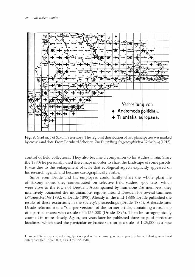
Over the years, the sections of Saxony’s ordnance map evolved into a grid by whichDrude and his employees organized spatially their observations and the objects thatreached the botanical garden in Dresden. In 1915, Drude and the curator of theherbarium, Bernhard Schorler, finally published the grid-map as the definitive spatialguideline for collectors (fig. 8). They also marked single plants with a cross, thusdisplaying the sections where a plant had been found. This map was intended, firstof all, to make visible “at a glance” the distribution patterns of particular plants.Furthermore, botanists should investigate whether the uncrossed gaps in the mapcorresponded with their knowledge of the local plant life (Drude 1915, 98). Thus, thissystem was simultaneously a social tool to mobilize future research.
Grid systems were by no means Drude’s invention. The Victorian botanist HewettC. Watson had already established a similar “vice-count system” for the British Islesfrom the 1840s onwards (Watson 1847–59, 1:10–14).87 Hermann Hoffmann, whosephenological mappings had already served as prototypes for Drude’s flowering studies,had parcelled out the territory of the Central-German state of Hesse in the 1870s(Hoffmann 1879).88 A similar plant cartographical inventory had also taken place inthe state of Wurttemberg by the turn of the century.89 For Drude, however, theapplication of the ordnance maps was not limited to the inventory and the spatial
86 “Es ist kaum zu sagen, wie sehr durch die Benutzung so sorgfaltig ausgearbeiteter Karten der Florist bei seinenSpecialstudien gewinnt und erst den Uberblick uber eine Reihe einzelner von ihm beobachteter Thatsachenerhalt; man merkt stets, wie sehr die Pflanzengeographie mit dem topographischen Erdbilde wissenschaftlichauf gleicher Hohe sich bewegen muss.”87 The map of William Brand (fig. 2) was another contemporary attempt to regulate the circulation of plantspecimen by section maps (on this contemporary context and the development of Watson’s system, see Allen1994, S. 94–103; and Egerton 2003, S. 24–37, 83–98).88 Hoffmann’s activities still lack a historical analysis. His maps are briefly mentioned in Walters 1957, 92–94.89 The results of this enterprise were also published in a journal of a regional society of natural history between1905 and 1926 (see especially Gradmann 1905). An enumeration of other plant geographical inventories inCentral Europe by the turn of the century is to be found in Meusel 1943, 1:46–53. Significantly, states as
28 Nils Robert Guttler
Fig. 8. Grid map of Saxony’s territory. The regional distribution of two plant species was markedby crosses and dots. From Bernhard Schorler, Zur Feststellung der geographischen Verbreitung (1915).
control of field collections. They also became a companion to his studies in situ. Sincethe 1890s he personally used these maps in order to chart the landscape of some parcels.It was due to this enlargement of scale that ecological aspects explicitly appeared onhis research agenda and became cartographically visible.
Since even Drude and his employees could hardly chart the whole plant lifeof Saxony alone, they concentrated on selective field studies, spot tests, whichwere close to the town of Dresden. Accompanied by numerous Isis members, theyintensively botanized the mountainous regions around Dresden for several summers(Sitzungsberichte 1892, 6; Drude 1898). Already in the mid-1880s Drude published theresults of these excursions in the society’s proceedings (Drude 1885). A decade laterDrude reformulated a “sharper version” of the former article, containing a first mapof a particular area with a scale of 1:135,000 (Drude 1895). Then he cartographicallyzoomed in more closely. Again, ten years later he published three maps of particularlocalities, which used the particular ordnance section at a scale of 1:25,000 as a base
Hesse and Wurttemberg had a highly developed ordnance survey, which apparently favored plant geographicalenterprises (see Torge 2007, 173–178, 183–198).
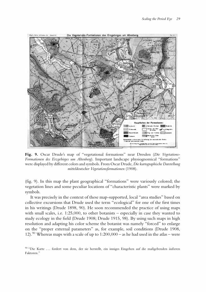
Scaling the Period Eye 29
Fig. 9. Oscar Drude’s map of “vegetational formations” near Dresden (Die Vegetations-Formationen des Erzgebirges um Altenberg). Important landscape physiognomical “formations”were displayed by different colors and symbols. From Oscar Drude, Die kartographische Darstellung
mitteldeutscher Vegetationsformationen (1908).
(fig. 9). In this map the plant geographical “formations” were variously colored; thevegetation lines and some peculiar locations of “characteristic plants” were marked bysymbols.
It was precisely in the context of these map-supported, local “area studies” based oncollective excursions that Drude used the term “ecological” for one of the first timesin his writings (Drude 1898, 90). He soon recommended the practice of using mapswith small scales, i.e. 1:25,000, to other botanists – especially in case they wanted tostudy ecology in the field (Drude 1908; Drude 1915, 98). By using such maps in highresolution and adapting his color scheme the botanist was namely “forced” to enlargeon the “proper external parameters” as, for example, soil conditions (Drude 1908,12).90 Whereas maps with a scale of up to 1:200,000 – as he had used in the atlas – were
90 “Die Karte . . . fordert von dem, der sie herstellt, ein inniges Eingehen auf die maßgebenden außerenFaktoren.”
30 Nils Robert Guttler
now primarily a “clear measure for representation” (ubersichtliches Hilfsmittel) that tohim would still reflect the scientist’s “thought” (Drude 1906b, 429), high-resolutionmaps permitted an epistemologically more accurate “ecological” comparison. Themap with a scale of 1:100,000 or less “really guides us through the landscape and, backin the study, enables comparison with other landscapes of the same floristic region andeven permits ecological comparisons concerning specific questions in remote regionsof the earth” (ibid.).91
Not coincidentally, Drude referred to the map as an active force. He believed thatthese small-scale maps clarified the “positive understanding” of ecological formationswithout requiring interpretation: “one can say that through topographical surveysthe definition of formations will be clarified by themselves, since the map, with itsstriking, geographically-caused traits, demands that one overlook some smaller featuresand recognise – in its great lines – the causal coherence of the vegetational image whichis stretched out in front of us” (ibid., 432).92
In Drude’s eyes, the probability of errors would necessarily decrease in such small-scale maps, since the graphical “fundament” of the ordnance section would still“dominate” the map (Drude 1908, 12).93
Regardless of such epistemic promises Drude, in fact, still depended on his employeesand the local members of the Isis as soon as it came to such concrete mappings.“Surveys” of that kind, he wrote, would still “require a familiarity with particulars thata single person is hardly able to secure” (Sitzungsberichte 1900, 5).94 This was especiallytrue for his local-ecological plant mappings. Thus he explicitly thanked several Isisamateurs who had accompanied him during his summer excursions. Due to their localknowledge, Drude pointed out, he had been able to chart the particular localities inthe first place (Drude 1895, 39–40).
Even though the later synopses of Saxony’s plant life appeared exclusively underDrude’s name, he left no doubt that they were an outcome of a collective enterprise.Already in the 1890s Drude mentioned his regional network as an empirical basis, whenhe described the plant geography of all of Germany (Drude 1896, V), an enterprise thathas been described as one of the earliest and most foundational studies of ecology.95 In
91 “nur sie fuhrt wirklich in die Landschaft hinein und erlaubt in der Studierstube den Vergleich mitentsprechenden Karten aus anderen Landschaften desselben Florengebiets, ja sogar okologische Vergleiche furbestimmte Fragen an weit entlegenen Punkten der Erde.”92 “man kann sagen, daß durch topographische Aufnahmen die Formationsbegriffe selbst sich klaren mussen,weil die Karte mit ihren hervorstechenden, geographisch bedingten Charakterzugen dazu zwingt, uber gewissekleine Zuge hinwegzusehen und den kausalen Zusammenhang des vor uns ausgebreiteten Vegetationsbildes inseinen großen Linien zu erfassen.”93 “Der Hersteller kann sich in der Tragweite der einzelnen Faktoren irren, aber die durch sie gebotene Grundlagewird trotzdem das ganze Kartenbild beherrschen.”94 “Denn kartographische Aufnahmen setzen eine Vertrautheit mit den Einzelheiten voraus, wie sie ein Einzelnersich schwer zu erwerben im Stande ist.”95 This book, for instance, highly influenced American ecologists, such as Frederic E. Clements (see McIntosh1985, 42).
Scaling the Period Eye 31
1902 he published a description of the plant geographical unit that Saxony was placedin, the “hercynian district” north of the Danube and east of the Rhine (Drude 1902a).In this study, comprising nearly 700 pages, he described all vegetational formations,distribution areas, vegetation lines of important “indicator plants” and phenologicalphases in Saxony and Thuringia. He contributed nearly a dozen maps. Small mapsdisplayed different localities, and the last one synthesized the general distributionpatterns. And it is precisely this enlargement of scale that could be realized withthis collective observation and accumulation of plants supported by the Isis.96
Although the local distribution maps were published by competing companieswithin Saxony, Drude’s tie to the Perthes Verlag was never severed during these years.Interestingly enough he used a Perthes-map, when he published his overview-map ofthe “hercyian district,” even though the work was printed by a competing publishingcompany. The exact causes for this choice remain unclear, but it may have been dueto Drude’s personal opinion that this particular publishing company was a predestinedplace to recapture on overview of the long-lasting and fragmented field studies. Andalthough Drude constantly enlarged the scale of his botanical maps by the turn of thecentury, he reminded his audience never to lose this overall sense.
In 1888, when he presented the first results of the collective observation in Saxony,he namely described them to the audience as a cartographical “zooming-in” (Drude1888a, 59–60). He referred to the section he had just published in the atlas in order todescribe the plant geography of the entire world. He then “zoomed in” on Europe andits main plant geographical regions, again subdivided into smaller “districts.” Saxonycould thus be identified as part of the “hercynian district.” Before he described itsborders by comparing vegetation lines, he reminded his audience how importantthis overview he just gave had been: “the flora of Saxony and Thuringia can only beunderstood correctly if one keeps an eye on the flora of the adjoined areas” (ibid., 60).97
Drude had learnt to “keep an eye” on the big picture during his work for the atlas.After enlarging the scale to particular localities during his Dresden years, he emphasizedthat neither the former plant geography nor the new science of ecology should getlost in details, for example by exclusively charting particular localities (Drude 1906a,187–188). Instead, both fields of research should always keep in mind the practice ofthe cartographer to synthesize local details in large-scale maps (Drude 1932, 19–23), apractice he had first experienced in collaboration with the Perthes Verlag.98 Scaling upand down, in that sense, was for Drude the appropriate link between plant geographyand ecology, a gap that he daily crossed in the scientific milieu of Saxony.
96 Drude explicitly pointed this out in Drude 1902b, esp. 142.97 “die Flora von Sachsen und Thuringen kann also nur so richtig aufgefasst werden, dass man die Flora dergesamten Anschlussgebiete im Auge behalt.”98 Drude suggested that botanists should map localities in the scale 1:25,000. It was, however, not important topublish these maps, but use them as working instrument for regional maps in large-scale 1:200,000 (see Drude1900, 27).
32 Nils Robert Guttler
No matter how deeply Drude’s mapping practices were grounded in the academicand popular milieu of Saxony and Thuringia, his approach quickly shaped the researchtechniques in plant geography and ecology on a much wider geographical level. Alreadyin the 1880s, Drude encouraged other botanists in Europe and the United States toparticipate in the improvement of world-wide plant cartographical knowledge. Afterpositive reactions to his atlas on plant distribution (see, e.g., the review Engler 1887),he sent his maps to other botanists, e.g. Charles Flahault in Montpellier, in order toprovide them with a graphical prototype for their regional mappings.99 The Danishbotanist Eugen Warming, whose Plantesamfund became the most prominent foundingstudy in plant geographical ecology (Warming 1895), carried around Drude’s bookand map on the “floristic realms” (fig. 1) while botanizing in Greenland.100 Fellowbotanists called Drude’s attention to numerous errors in his maps concerning particularareas, sometimes integrating small sketches in their letters to rectify the distribution ofsome vegetation lines.101 After Drude had been excoriated on the lack of perfectionin his South American atlas-map, he replied that the state of knowledge was naturallytentative. He demanded that his colleagues contribute more floristic and cartographicaldetails to his model-map: “Let us work on it together!” (Drude 1888b, 291).102
The number of botanical maps grew explosively from the 1890s onward.103
Simultaneously Drude reiterated his earlier personal appeals for a graphicalstandardization of maps and spatial collecting practices.104 He had been giving talkson these topics at national and international botanical and geographical congressessince 1895, mostly using his atlas-maps and his maps of Saxony as a model foradequate coloring (the most important aspect of standardization), but also for modelingother matters of display, projection, and scale.105 Other researchers ought to adopt hiscartographical zooming-in in order to gain unbiased results:
The cartographical method and representation is the last, indispensable complement ofspecial studies in vegetational formations. The great plant geographical overviews onthe whole earth depict the most striking as well as physiognomically and ecologically
99 See Letters of Flahault to Drude April 1887 to November 1896, Staatsbibliothek Dresden, Mscr. Drsd. App422, 61–76. Flauhault then published a detailed map on this region that was inspired by Drude’s maps, especiallyon the “floristic realms” (Flahault and Durand 1886). Flauhault also announced the compilation of a nationalbotanical and agricultural map, which in turn was not realized (Flahault 1894).100 E. Warming to Drude, 11 Nov. 1887, Staatsbibliothek Dresden, Mscr. Drsd. App 422, 195.101 For example, W. Koppen to Drude, 5 April 1888, Staatsbibliothek Dresden, Mscr. Drsd. App 422, 108 (seealso Engler 1887).102 “Arbeiten wir zusammen daran weiter!”103 An overview on the diversity of botanical maps after 1890 containing numerous reprints can be found inSchroeter 1910.104 For example, Drude contributed to a widely read instruction guide for the traveling naturalist, bothprofessional and amateur (Drude 1888c).105 For an enumeration of these talks, see Drude 1908, 10. At the 3rd International Botanical Congress inBrussels (1910) cartography was discussed as a normal part of geobotanical nomenclature (see Flahault andSchroeter 1910, 139–141).
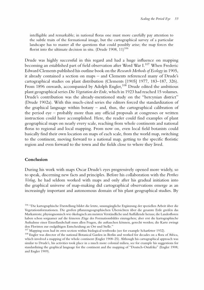
Scaling the Period Eye 33
intelligible and remarkable; in national floras one must more carefully pay attention tothe subtle traits of the formational image, but the cartographical survey of a particularlandscape has to master all the questions that could possibly arise; the map forces theflorist into the ultimate decision in situ. (Drude 1908, 11)106
Drude was highly successful in this regard and had a huge influence on mappingbecoming an established part of field observation after Word War I.107 When FredericEdward Clements published his outline book on the Research Methods of Ecology in 1905,it already contained a section on maps – and Clements referenced many of Drude’scartographical studies on plant distribution (Clements [1905] 1977, 183–187, 326).From 1896 onwards, accompanied by Adolph Engler,108 Drude edited the ambitiousplant geographical series Die Vegetation der Erde, which in 1923 had reached 15 volumes.Drude’s contribution was the already-mentioned study on the “hercynian district”(Drude 1902a). With this much-cited series the editors forced the standardization ofthe graphical language within botany – and, thus, the cartographical calibration ofthe period eye – probably more than any official proposals at congresses or writteninstruction could have accomplished. Here, the reader could find examples of plantgeographical maps on nearly every scale, reaching from whole continents and nationalfloras to regional and local mapping. From now on, even local field botanists couldbasically find their own location on maps of each scale, from the world map, switchingto the continent, moving forward to a national map, getting to the specific floristicregion and even forward to the town and the fields close to where they lived.
Conclusion
During his work with maps Oscar Drude’s eyes progressively opened more widely, soto speak, discerning new facts and principles. Before his collaboration with the PerthesVerlag, he had seldom worked with maps and only after his gradual initiation intothe graphical universe of map-making did cartographical observations emerge as anincreasingly important and autonomous domain of his plant geographical studies. By
106 “Die kartographische Darstellung bildet die letzte, unumgangliche Erganzung der speziellen Arbeit uber dieVegetationsformationen. Die großen pflanzengeographischen Ubersichten uber die gesamte Erde greifen dasMarkanteste, physiognomisch wie okologisch am meisten Verstandliche und Auffallende heraus; die Landesflorenhaben schon sorgsamer auf die feineren Zuge des Formationsbildes einzugehen; aber erst die kartographischeAufnahme einer Einzellandschaft muss allen Fragen, die auftauchen konnen, gerecht werden; die Karte zwingtden Floristen zur endgultigen Entscheidung an Ort und Stelle.”107 Mapping soon had its own section within biological textbooks (see for example Scharfetter 1932).108 Engler was director of the national Botanical Garden in Berlin and worked for decades on a flora of Africa,which involved a mapping of the whole continent (Engler 1908–25). Although his cartographical approach wassimilar to Drude’s, his activities took place in a much more colonial milieu, see for example his suggestions forstandardizing the graphical language for the continent and the mapping of “Deutsch-Ostafrika” (Engler 1908;and Engler 1909).
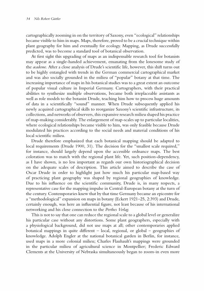
34 Nils Robert Guttler
cartographically zooming in on the territory of Saxony, even “ecological” relationshipsbecame visible to him in maps. Maps, therefore, proved to be a crucial technique withinplant geography for him and eventually for ecology. Mapping, as Drude successfullypredicted, was to become a standard tool of botanical observation.
At first sight this upgrading of maps as an indispensable research tool for botanistsmay appear as a single-handed achievement, emanating from the lonesome study ofthe academe. After a close analysis of Drude’s scientific life, however, this shift turns outto be highly entangled with trends in the German commercial cartographical marketand was also socially grounded in the milieu of “popular” botany at that time. Theincreasing importance of maps in his botanical studies was to a great extent an outcomeof popular visual culture in Imperial Germany. Cartographers, with their practicalabilities to synthesize multiple observations, became both irreplaceable assistants aswell as role models to the botanist Drude, teaching him how to process huge amountsof data in a scientifically “sound” manner. When Drude subsequently applied hisnewly acquired cartographical skills to reorganize Saxony’s scientific infrastructure, itscollections, and networks of observers, this expansive research milieu shaped his practiceof map-making considerably. The enlargement of map-scales up to particular localities,where ecological relationships became visible to him, was only feasible because Drudemodulated his practices according to the social needs and material conditions of hislocal scientific milieu.
Drude therefore emphasized that each botanical mapping should be adapted tolocal requirements (Drude 1900, 31). The decision for the “smallest scale required,”for instance, should largely depend upon the accessible ordnance maps. The bestcoloration was to match with the regional plant life. Yet, such position-dependency,as I have shown, is no less important as regards our own historiographical decisionon the adequate scales of description. This article aimed to describe the case ofOscar Drude in order to highlight just how much his particular map-based wayof practicing plant geography was shaped by regional geographies of knowledge.Due to his influence on the scientific community, Drude is, in many respects, arepresentative case for the mapping impulse in Central-European botany at the turn ofthe century. Contemporaries knew that by that time Germany became an epicentre fora “methodological” expansion on maps in botany (Eckert 1921–25, 2:393) and Drude,certainly enough, was here an influential figure, not least because of his internationalnetworking and his close connection to the Perthes Verlag.
This is not to say that one can reduce the regional scale to a global level or generalizehis particular case without any distortions. Some plant geographers, especially witha physiological background, did not use maps at all; other contemporaries appliedbotanical mappings in quite different – local, regional, or global – geographies ofknowledge. Adolph Engler at the national botanical garden in Berlin, for instance,used maps in a more colonial milieu; Charles Flauhault’s mappings were groundedin the particular milieu of agricultural science in Montpellier; Frederic EdwardClements at the University of Nebraska simultaneously began to zoom-in even more
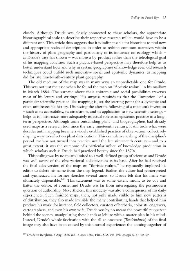
Scaling the Period Eye 35
closely. Although Drude was closely connected to these scholars, the appropriatehistoriographical scale to describe their respective research milieu would have to be adifferent one. This article thus suggests that it is indispensable for historians to find newand appropriate scales of descriptions in order to rethink common narratives withinthe history of plant geography and particularly of its influence on ecology, which –as Drude’s case has shown – was more a by-product rather than the teleological goalof his mapping activities. Such a practice-based perspective may therefore help us tobetter understand how and why in certain geographies of knowledge even old researchtechniques could unfold such innovative social and epistemic dynamics, as mappingdid for late nineteenth-century plant geography.
The old medium of the map was in many ways an unpredictable one for Drude.This was not just the case when he found the map on “floristic realms” in his mailboxin March 1884. The surprise about their epistemic and social possibilities traversesmost of his letters and writings. His surprise reminds us that the “invention” of aparticular scientific practice like mapping is just the starting point for a dynamic andoften unforeseeable history. Discussing the afterlife following of a medium’s invention– such as its accessibility, its circulation, and its application to new scientific settings –helps us to historicize more adequately its actual role as an epistemic practice in a long-term perspective. Although some outstanding plant- and biogeographers had alreadyused maps as a research tool since the early nineteenth century, it still took what weredecades until mapping became a widely established practice of observation, collectivelyshaping ways to reflect on plant distribution. This cumulative scaling of the discipline’speriod eye was not turned into practice until the late nineteenth century – and to agreat extent, it was the outcome of a particular milieu of knowledge production inwhich scholars such as Drude had practiced botany since the 1870s.
This scaling was by no means limited to a well-defined group of scientists and Drudewas well aware of the observational collectiveness as its base. After he had receivedthe final atlas-version of the maps on “floristic realms,” he repeatedly implored hiseditor to delete his name from the map-legend. Earlier, the editor had reinterpretedand synthesized his former sketches several times, so Drude felt that his name wasultimately dispensable.109 This statement was to some extent meant to be coy andflatter the editor, of course, and Drude was far from interrogating the postmodernquestion of authorship. Nevertheless, this modesty was also a consequence of his dailyexperiences. Such finished maps, then, not only made visible to him new patternsof distribution, they also made invisible the many contributing hands that helped himproduce his work: for instance, field collectors, curators of herbaria, colorists, engravers,cartographers, and even his own wife. Drude was by no means the powerful puppeteerbehind the scenes, manipulating these hands at leisure with a master plan in his mind.Instead, Drude’s whole fascination with the all-at-onceness (Totaleindruck) of the finalimage may also have been caused by this unusual experience: the coming together of
109 Drude to Berghaus, 5 Aug. 1886 and 15 May 1887, FBG, SPA, Nr. 19B, Mappe 6, 57–60, 69.
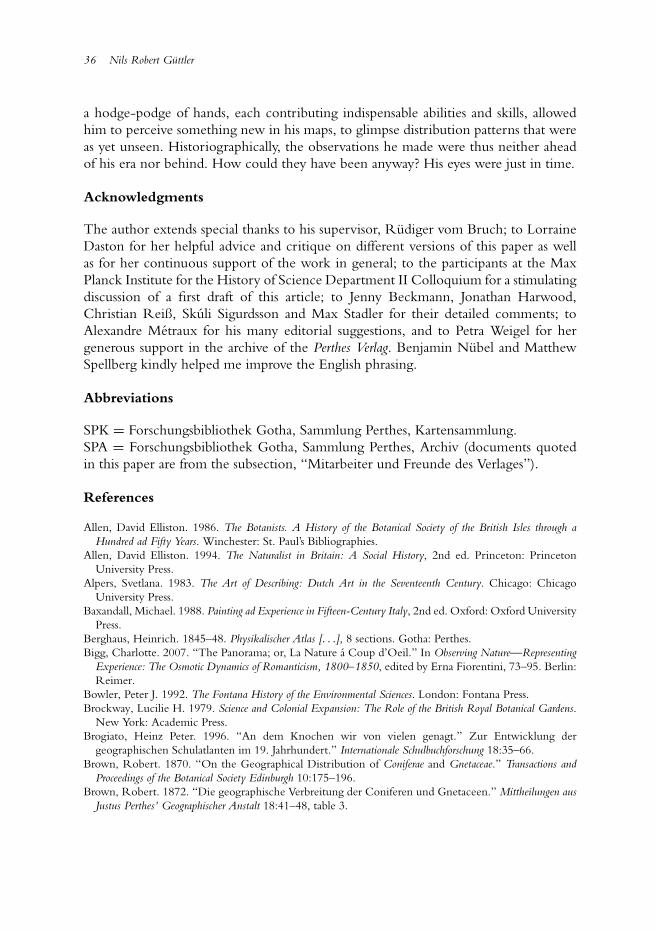
36 Nils Robert Guttler
a hodge-podge of hands, each contributing indispensable abilities and skills, allowedhim to perceive something new in his maps, to glimpse distribution patterns that wereas yet unseen. Historiographically, the observations he made were thus neither aheadof his era nor behind. How could they have been anyway? His eyes were just in time.
Acknowledgments
The author extends special thanks to his supervisor, Rudiger vom Bruch; to LorraineDaston for her helpful advice and critique on different versions of this paper as wellas for her continuous support of the work in general; to the participants at the MaxPlanck Institute for the History of Science Department II Colloquium for a stimulatingdiscussion of a first draft of this article; to Jenny Beckmann, Jonathan Harwood,Christian Reiß, Skuli Sigurdsson and Max Stadler for their detailed comments; toAlexandre Metraux for his many editorial suggestions, and to Petra Weigel for hergenerous support in the archive of the Perthes Verlag. Benjamin Nubel and MatthewSpellberg kindly helped me improve the English phrasing.
Abbreviations
SPK = Forschungsbibliothek Gotha, Sammlung Perthes, Kartensammlung.SPA = Forschungsbibliothek Gotha, Sammlung Perthes, Archiv (documents quotedin this paper are from the subsection, “Mitarbeiter und Freunde des Verlages”).
References
Allen, David Elliston. 1986. The Botanists. A History of the Botanical Society of the British Isles through aHundred ad Fifty Years. Winchester: St. Paul’s Bibliographies.
Allen, David Elliston. 1994. The Naturalist in Britain: A Social History, 2nd ed. Princeton: PrincetonUniversity Press.
Alpers, Svetlana. 1983. The Art of Describing: Dutch Art in the Seventeenth Century. Chicago: ChicagoUniversity Press.
Baxandall, Michael. 1988. Painting ad Experience in Fifteen-Century Italy, 2nd ed. Oxford: Oxford UniversityPress.
Berghaus, Heinrich. 1845–48. Physikalischer Atlas [. . .], 8 sections. Gotha: Perthes.Bigg, Charlotte. 2007. “The Panorama; or, La Nature a Coup d’Oeil.” In Observing Nature—Representing
Experience: The Osmotic Dynamics of Romanticism, 1800–1850, edited by Erna Fiorentini, 73–95. Berlin:Reimer.
Bowler, Peter J. 1992. The Fontana History of the Environmental Sciences. London: Fontana Press.Brockway, Lucilie H. 1979. Science and Colonial Expansion: The Role of the British Royal Botanical Gardens.
New York: Academic Press.Brogiato, Heinz Peter. 1996. “An dem Knochen wir von vielen genagt.” Zur Entwicklung der
geographischen Schulatlanten im 19. Jahrhundert.” Internationale Schulbuchforschung 18:35–66.Brown, Robert. 1870. “On the Geographical Distribution of Coniferae and Gnetaceae.” Transactions and
Proceedings of the Botanical Society Edinburgh 10:175–196.Brown, Robert. 1872. “Die geographische Verbreitung der Coniferen und Gnetaceen.” Mittheilungen aus
Justus Perthes’ Geographischer Anstalt 18:41–48, table 3.

Scaling the Period Eye 37
Browne, Janet. 1983. The Secular Arc: Studies in the History of Biogeography. New Haven/London: YaleUniversity Press.
Browne, Janet. 1992. “A Science of Empire: British Biogeography before Darwin.” Revue d’histoire dessciences 45:453–475.
Browne, Janet. 1996. “Biogeography and Empire.” In Cultures of National History, edited by NicholasJardine, Anne Secord, and Emma Spary, 305–321. Cambridge: Cambridge University Press.
Camerini, Jane R. 1993a. “Evolution, Biogeography, and Maps: An Early History of Wallace’s Line.” Isis84:700–727.
Camerini, Jane R. 1993b. “The Physical Atlas of Heinrich Berghaus: Distribution Maps as ScientificKnowledge.” In Non-Verbal Communication in Science Prior to 1900, edited by Renato G. Mazzolini,479–512. Florence: Olschki.
Candolle, Alphonse de. 1855. Geographie botanique raisonnee: ou exposition des faits principaux et deslois concernant la distribution geographique des plantes de l’epoque actuelle, 2 vols. Paris/Genf: Masson/Kessmann.
Canizares-Esguerra, Jorge. 2005. “How Derivative was Humboldt? Microcosmic Nature Narratives inEarly Modern Spanish America and the (Other) Origins of Humboldt’s Ecological Sensibilities.” InColonial Botany. Science, Commerce, and Politics in the Early Modern World, edited by Londa Schiebingerand Claudia Swan, 148–165. Philadelphia: University of Pennsylvania Press.
Cittadino, Eugene. 1990. Nature as a Laboratory. Darwinian Plant Ecology in the German Empire. Cambridge:Cambridge University Press.
Clements, Frederic Edward. [1905] 1977. Research Methods in Ecology (reprint). New York: Arno Press.Cooper, Alix. 2007. Inventing the Indigenious: Local Knowledge and Natural History in Early Modern Europe.
Cambridge: Cambridge University Press.Danhardt, Walter, ed. 1926. Festschrift aus Anlaß des hundertjahrigen Bestehens der Flora, 1826–1926. Dresden:
Heinrich.Daston, Lorraine. 2008. “On Scientific Observation.” Isis 99:97–110.Demhardt, Imre Josef. 2006. Der Erde ein Gesicht geben. Petermanns Geographische Mittleilungen und die
Entstehung der modernen Geographie. Gotha: Forschungsbibliothek Gotha.Dettelbach, Michael. 1999. “The Face of Nature: Precise Measurement, Mapping and Sensibility in the
Work of Alexander von Humboldt.” Studies in the History and Philosophy of Biology and Biomedical Sciences30:473–504.
Drayton, Richard. 2000. Nature’s Government. Science, Imperial Britain, and the “Improvement” of the World.New Haven/London: Yale University Press.
Drude, Oscar. 1876. Die Anwendung physiologischer Gesetze zur Erklarung der Vegetationslinien. Gottingen:Breithaupt.
Drude, Oscar. 1878. “Die geographische Verbreitung der Palmen auf der Erde.” Mittheilungen aus JustusPerthes’ Geographischer Anstalt 24:15–20, map 2.
Drude, Oscar. 1880. “Eine moderne Bearbeitung der Flora von Sachsen.” Sitzungsberichte derNaturwissenschaftlichen Gesellschaft Isis in Dresden, 12–16.
Drude, Oscar. 1881. “Anleitung zu phytophanologischen Beobachtungen in der Flora von Sachsen.”Abhandlungen der Naturwissenschaftlichen Gesellschaft Isis in Dresden, 3–24.
Drude, Oscar. 1884. Die Florenreiche der Erde. Darstellung der gegenwartigen Verbreitungsverhaltnisse der Pflanzen.Ein Beitrag zur vergleichenden Erdkunde (= supplement 74 of “Petermann’s Geographische Mitteilungen”).Gotha: Perthes.
Drude, Oscar. 1885. “Die Vertheilung und Zusammensetzung ostlicher Pflanzengenossenschaften in derUmgebung von Dresden.” In Festschrift der Naturwissenschaftlichen Gesellschaft Isis in Dresden zur Feierihres 50jahrigen Bestehens am 14. Mai 1885, 75–107. Dresden: Warnatz and Lehmann.
Drude, Oscar. 1887. Atlas der Pflanzenverbreitung (= Hermann Berghaus (ed.), Physikalischer Atlas, section 5).Gotha: Perthes.
Drude, Oscar. 1888a. “Die Vegetationsformen und Charakterarten im Bereich der Flora Saxonica.”Abhandlungen der Naturwissenschaftlichen Gesellschaft Isis in Dresden, 55–77.
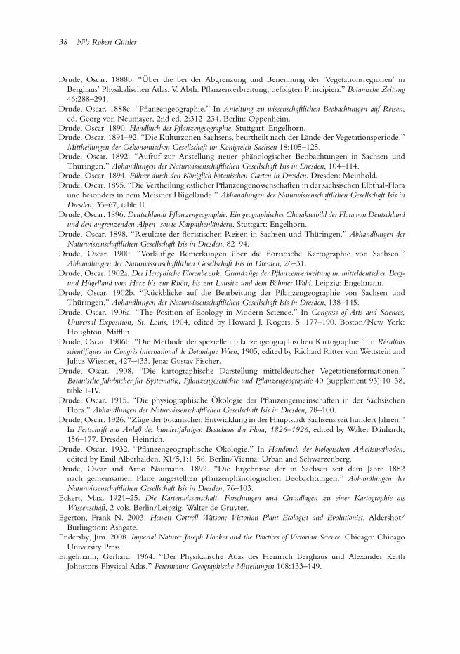
38 Nils Robert Guttler
Drude, Oscar. 1888b. “Uber die bei der Abgrenzung und Benennung der ‘Vegetationsregionen’ inBerghaus’ Physikalischen Atlas, V. Abth. Pflanzenverbreitung, befolgten Principien.” Botanische Zeitung46:288–291.
Drude, Oscar. 1888c. “Pflanzengeographie.” In Anleitung zu wissenschaftlichen Beobachtungen auf Reisen,ed. Georg von Neumayer, 2nd ed, 2:312–234. Berlin: Oppenheim.
Drude, Oscar. 1890. Handbuch der Pflanzengeographie. Stuttgart: Engelhorn.Drude, Oscar. 1891–92. “Die Kulturzonen Sachsens, beurtheilt nach der Lande der Vegetationsperiode.”
Mittheilungen der Oekonomischen Gesellschaft im Konigreich Sachsen 18:105–125.Drude, Oscar. 1892. “Aufruf zur Anstellung neuer phanologischer Beobachtungen in Sachsen und
Thuringen.” Abhandlungen der Naturwissenschaftlichen Gesellschaft Isis in Dresden, 104–114.Drude, Oscar. 1894. Fuhrer durch den Koniglich botanischen Garten in Dresden. Dresden: Meinhold.Drude, Oscar. 1895. “Die Vertheilung ostlicher Pflanzengenossenschaften in der sachsischen Elbthal-Flora
und besonders in dem Meissner Hugellande.” Abhandlungen der Naturwissenschaftlichen Gesellschaft Isis inDresden, 35–67, table II.
Drude, Oscar. 1896. Deutschlands Pflanzengeographie. Ein geographisches Charakterbild der Flora von Deutschlandund den angrenzenden Alpen- sowie Karpathenlandern. Stuttgart: Engelhorn.
Drude, Oscar. 1898. “Resultate der floristischen Reisen in Sachsen und Thuringen.” Abhandlungen derNaturwissenschaftlichen Gesellschaft Isis in Dresden, 82–94.
Drude, Oscar. 1900. “Vorlaufige Bemerkungen uber die floristische Kartographie von Sachsen.”Abhandlungen der Naturwissenschaftlichen Gesellschaft Isis in Dresden, 26–31.
Drude, Oscar. 1902a. Der Hercynische Florenbezirk. Grundzuge der Pflanzenverbreitung im mitteldeutschen Berg-und Hugelland vom Harz bis zur Rhon, bis zur Lausitz und dem Bohmer Wald. Leipzig: Engelmann.
Drude, Oscar. 1902b. “Ruckblicke auf die Bearbeitung der Pflanzengeographie von Sachsen undThuringen.” Abhandlungen der Naturwissenschaftlichen Gesellschaft Isis in Dresden, 138–145.
Drude, Oscar. 1906a. “The Position of Ecology in Modern Science.” In Congress of Arts and Sciences,Universal Exposition, St. Louis, 1904, edited by Howard J. Rogers, 5: 177–190. Boston/New York:Houghton, Mifflin.
Drude, Oscar. 1906b. “Die Methode der speziellen pflanzengeographischen Kartographie.” In Resultatsscientifiques du Congres international de Botanique Wien, 1905, edited by Richard Ritter von Wettstein andJulius Wiesner, 427–433. Jena: Gustav Fischer.
Drude, Oscar. 1908. “Die kartographische Darstellung mitteldeutscher Vegetationsformationen.”Botanische Jahrbucher fur Systematik, Pflanzengeschichte und Pflanzengeographie 40 (supplement 93):10–38,table I-IV.
Drude, Oscar. 1915. “Die physiographische Okologie der Pflanzengemeinschaften in der SachsischenFlora.” Abhandlungen der Naturwissenschaftlichen Gesellschaft Isis in Dresden, 78–100.
Drude, Oscar. 1926. “Zuge der botanischen Entwicklung in der Hauptstadt Sachsens seit hundert Jahren.”In Festschrift aus Anlaß des hundertjahrigen Bestehens der Flora, 1826–1926, edited by Walter Danhardt,156–177. Dresden: Heinrich.
Drude, Oscar. 1932. “Pflanzengeographische Okologie.” In Handbuch der biologischen Arbeitsmethoden,edited by Emil Alberhalden, XI/5,1:1–56. Berlin/Vienna: Urban and Schwarzenberg.
Drude, Oscar and Arno Naumann. 1892. “Die Ergebnisse der in Sachsen seit dem Jahre 1882nach gemeinsamen Plane angestellten pflanzenphanologischen Beobachtungen.” Abhandlungen derNaturwissenschaftlichen Gesellschaft Isis in Dresden, 76–103.
Eckert, Max. 1921–25. Die Kartenwissenschaft. Forschungen und Grundlagen zu einer Kartographie alsWissenschaft, 2 vols. Berlin/Leipzig: Walter de Gruyter.
Egerton, Frank N. 2003. Hewett Cottrell Watson: Victorian Plant Ecologist and Evolutionist. Aldershot/Burlingtion: Ashgate.
Endersby, Jim. 2008. Imperial Nature: Joseph Hooker and the Practices of Victorian Science. Chicago: ChicagoUniversity Press.
Engelmann, Gerhard. 1964. “Der Physikalische Atlas des Heinrich Berghaus und Alexander KeithJohnstons Physical Atlas.” Petermanns Geographische Mitteilungen 108:133–149.
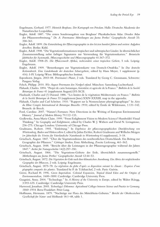
Scaling the Period Eye 39
Engelmann, Gerhard. 1977. Heinrich Berghaus. Der Kartograph von Potsdam. Halle: Deutsche Akademie derNaturforscher Leopoldina.
Engler, Adolf. 1887. “Die ersten Sonderausgaben von Berghaus’ Physikalischem Atlas: Drudes Atlasder Pflanzenverbreitung.” Dr. A. Petermanns Mitteilungen aus Justus Perthes’ Geographische Anstalt 33:358–361.
Engler, Adolf. 1899. Die Entwickelung der Pflanzengeographie in den letzten hundert Jahren und weitere Aufgabenderselben. Berlin: Kuhl.
Engler, Adolf. 1908. “Die Vegetationsformationen tropischer und subtropischer Lander. In ubersichtlicherZusammenstellung nebst farbiger Signaturen zur Verwendung fur Vegetationskarten.” BotanischeJahrbucher fur Systematik, Pflanzengeschichte und Pflanzengeographie 41:367–372.
Engler, Adolf. 1908–25. Die Pflanzenwelt Afrikas, insbesondere seiner tropischen Gebiete, 5 vols. Leipzig:Engelmann.
Engler, Adolf. 1909. “Bemerkungen zur Vegetationskarte von Deutsch-Ostafrika.” In Das deutscheKolonialreich. Eine Landerkunde der deutschen Schutzgebiete, edited by Hans Meyer, 1 supplement (p.416): I-IV. Leipzig/Wien: Bibliographisches Institut.
Espenhorst, Jurgen. 2003–08. Petermann’s Planet, 2 vols. Translated by Georg C. Grossmann, Schwerte:Pangaea Verlag.
Felsch, Philipp. 2010. Wie August Petermann den Nordpol erfand. Munchen: Sammlung Luchterhand.Flahault, Charles. 1894. “Projet de carte botanique, forestiere et agricole de la France.” Bulletin de la Societe
Botanique de France 41 (supplement August):LVI-XCII.Flauhault, Charles and (?) Durand. 1886. “Les limites de la vegetation Mediterranee en France.” Bulletin
de la Societe Botanique de France 33 (supplement June):XXIV-XXXIII, map in the appendix.Flahault, Charles and Carl Schroter. 1910. “Rapport sur la Nomenclature phytogeographique” In Actes
du IIIme Congres International de Botanique Bruxelles 1910, edited by Emile de Wildemann, 1:131–142.Brussels: de Boeck.
Ford, Caroline. 2007. “Nature’s Fortunes: New Directions in the Writing of European EnvironmentalHistory.” Journal of Modern History 79:112–133.
Godlewska, Anna Marie Claire. 1999. “From Enlightment Vision to Modern Science? Humboldt’s VisualThinking.” In Geography and Enlightment, edited by Charles W. J. Withers and David N. Livingstone,236–275. Chicago/London: University of Chicago Press.
Gradmann, Robert. 1905. “Einleitung.” In Ergebnisse der pflanzengeographischen Durchforschung vonWurttemberg, Baden und Hohenzollern I, edited by Julius Eichler, Robert Gradmann and Wilhelm Meigen(= Jahreshefte des Vereins fur Vaterlandische Naturkunde in Wurttemberg 61:supplement), 3–18.
Grisebach, August. 1847. “Uber die Vegetationslinien des nordwestlichen Deutschlands. Ein Beitrag zurGeographie der Pflanzen.” Gottinger Studien, Erste Abtheilung, Zweite Lieferung, 461–562.
Grisebach, August. 1848. “Bericht uber die Leistungen in der Pflanzengeographie wahrend des Jahres1847.” Archiv fur Naturgeschichte 14(2):257–350.
Grisebach, August. 1866. “Die Vegetations-Gebiete der Erde, ubersichtlich zusammengestellt.”Mittheilungen aus Justus Perthes’ Geographischer Anstalt 12:44–53.
Grisebach, August. 1872. Die Vegetation der Erde nach ihrer klimatischen Anordnung. Ein Abriss der vergleichendenGeographie der Pflanzen, 2 vols. Leipzig: Engelmann.
Grisebach, August. 1875–78. La vegetation du globe d’apres sa disposition suivant les climats : Esquisse d’unegeographie comparee des plantes. Translated by P. de Tchihatchef, 2 vols. Paris: Guerin.
Grove, Richard H. 1996. Green Imperialism. Colonial Expansion, Tropical Island Eden and the Origins ofEnvironmentalism, 1600–1800. Cambridge: Cambridge University Press.
Guagnini, Anna. 2004. “Technology.” In A History of the University in Europe, edited by Walter Ruegg,3:593–635. Cambridge: Cambridge University Press.
Harwood, Jonathan. 2005. Technology’s Dilemma: Agricultural Colleges between Science and Practice in Germany,1860–1934. Bern/Frankfurt: Peter Lang.
Hoffmann, Hermann. 1879. “Nachtrage zur Flora des Mittelrhein-Gebietes.” Bericht der OberhessischenGesellschaft fur Natur- und Heilkunde 18:1–48, table 1.
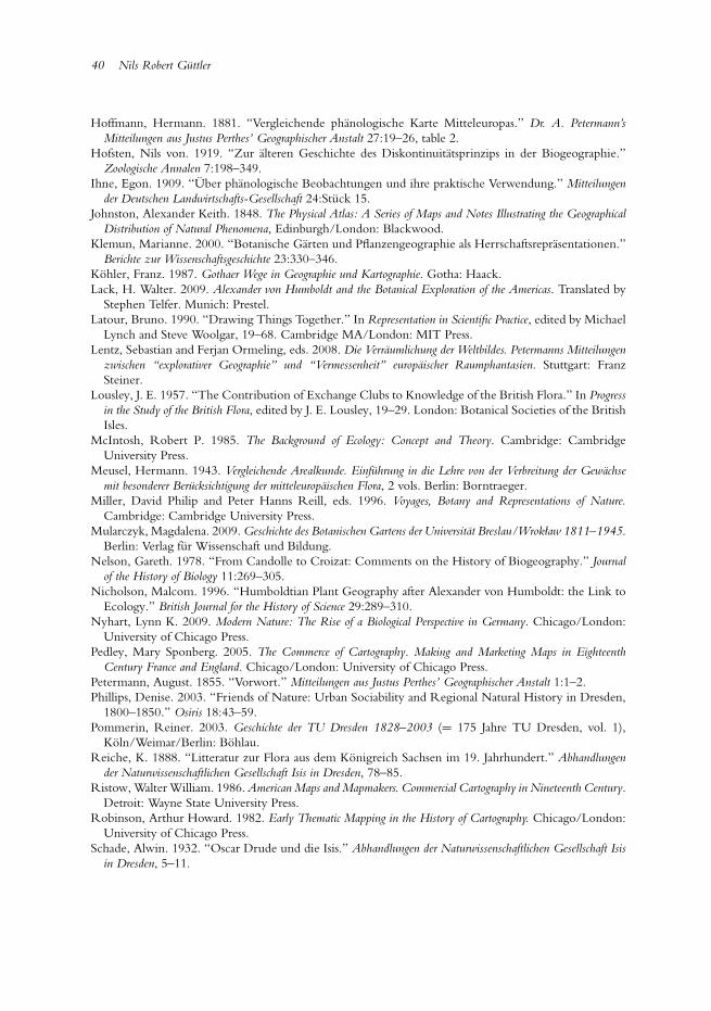
40 Nils Robert Guttler
Hoffmann, Hermann. 1881. “Vergleichende phanologische Karte Mitteleuropas.” Dr. A. Petermann’sMitteilungen aus Justus Perthes’ Geographischer Anstalt 27:19–26, table 2.
Hofsten, Nils von. 1919. “Zur alteren Geschichte des Diskontinuitatsprinzips in der Biogeographie.”Zoologische Annalen 7:198–349.
Ihne, Egon. 1909. “Uber phanologische Beobachtungen und ihre praktische Verwendung.” Mitteilungender Deutschen Landwirtschafts-Gesellschaft 24:Stuck 15.
Johnston, Alexander Keith. 1848. The Physical Atlas: A Series of Maps and Notes Illustrating the GeographicalDistribution of Natural Phenomena, Edinburgh/London: Blackwood.
Klemun, Marianne. 2000. “Botanische Garten und Pflanzengeographie als Herrschaftsreprasentationen.”Berichte zur Wissenschaftsgeschichte 23:330–346.
Kohler, Franz. 1987. Gothaer Wege in Geographie und Kartographie. Gotha: Haack.Lack, H. Walter. 2009. Alexander von Humboldt and the Botanical Exploration of the Americas. Translated by
Stephen Telfer. Munich: Prestel.Latour, Bruno. 1990. “Drawing Things Together.” In Representation in Scientific Practice, edited by Michael
Lynch and Steve Woolgar, 19–68. Cambridge MA/London: MIT Press.Lentz, Sebastian and Ferjan Ormeling, eds. 2008. Die Verraumlichung der Weltbildes. Petermanns Mitteilungen
zwischen “explorativer Geographie” und “Vermessenheit” europaischer Raumphantasien. Stuttgart: FranzSteiner.
Lousley, J. E. 1957. “The Contribution of Exchange Clubs to Knowledge of the British Flora.” In Progressin the Study of the British Flora, edited by J. E. Lousley, 19–29. London: Botanical Societies of the BritishIsles.
McIntosh, Robert P. 1985. The Background of Ecology: Concept and Theory. Cambridge: CambridgeUniversity Press.
Meusel, Hermann. 1943. Vergleichende Arealkunde. Einfuhrung in die Lehre von der Verbreitung der Gewachsemit besonderer Berucksichtigung der mitteleuropaischen Flora, 2 vols. Berlin: Borntraeger.
Miller, David Philip and Peter Hanns Reill, eds. 1996. Voyages, Botany and Representations of Nature.Cambridge: Cambridge University Press.
Mularczyk, Magdalena. 2009. Geschichte des Botanischen Gartens der Universitat Breslau/Wrokław 1811–1945.Berlin: Verlag fur Wissenschaft und Bildung.
Nelson, Gareth. 1978. “From Candolle to Croizat: Comments on the History of Biogeography.” Journalof the History of Biology 11:269–305.
Nicholson, Malcom. 1996. “Humboldtian Plant Geography after Alexander von Humboldt: the Link toEcology.” British Journal for the History of Science 29:289–310.
Nyhart, Lynn K. 2009. Modern Nature: The Rise of a Biological Perspective in Germany. Chicago/London:University of Chicago Press.
Pedley, Mary Sponberg. 2005. The Commerce of Cartography. Making and Marketing Maps in EighteenthCentury France and England. Chicago/London: University of Chicago Press.
Petermann, August. 1855. “Vorwort.” Mitteilungen aus Justus Perthes’ Geographischer Anstalt 1:1–2.Phillips, Denise. 2003. “Friends of Nature: Urban Sociability and Regional Natural History in Dresden,
1800–1850.” Osiris 18:43–59.Pommerin, Reiner. 2003. Geschichte der TU Dresden 1828–2003 (= 175 Jahre TU Dresden, vol. 1),
Koln/Weimar/Berlin: Bohlau.Reiche, K. 1888. “Litteratur zur Flora aus dem Konigreich Sachsen im 19. Jahrhundert.” Abhandlungen
der Naturwissenschaftlichen Gesellschaft Isis in Dresden, 78–85.Ristow, Walter William. 1986. American Maps and Mapmakers. Commercial Cartography in Nineteenth Century.
Detroit: Wayne State University Press.Robinson, Arthur Howard. 1982. Early Thematic Mapping in the History of Cartography. Chicago/London:
University of Chicago Press.Schade, Alwin. 1932. “Oscar Drude und die Isis.” Abhandlungen der Naturwissenschaftlichen Gesellschaft Isis
in Dresden, 5–11.
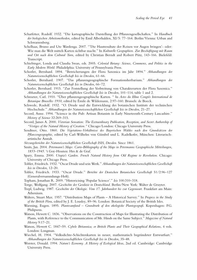
Scaling the Period Eye 41
Scharfetter, Rudolf. 1932. “Die kartographische Darstellung der Pflanzengesellschaften.” In Handbuchder biologischen Arbeitsmethoden, edited by Emil Alberhalden, XI/5: 77–164. Berlin/Vienna: Urban andSchwarzenberg.
Schelhaas, Bruno and Ute Wardenga. 2007. “’Die Hautresultate der Reisen vor Augen bringen’- oder:Wie man die Welt mittels Karten sichtbar macht.” In Kulturelle Geographien. Zur Beschaftigung mit Raumund Ort nach dem Cultural Turn, edited by Christian Berndt and Robert Putz, 143–166. Bielefeld:Transcript.
Schiebinger, Londa and Claudia Swan, eds. 2005. Colonial Botany: Science, Commerce, and Politics in theEarly Modern World. Philadelphia: University of Pennsylvania Press.
Schorler, Bernhard. 1894. “Bereicherungen der Flora Saxonica im Jahr 1894.” Abhandlungen derNaturwissenschaftlichen Gesellschaft Isis in Dresden, 61–66.
Schorler, Bernhard. 1907. “Das pflanzengeographische Formationsherbarium.” Abhandlungen derNaturwissenschaftlichen Gesellschaft Isis in Dresden, 66–72.
Schorler, Bernhard. 1915. “Zur Feststellung der Verbreitung von Charakterarten der Flora Saxonica.”Abhandlungen der Naturwissenschaftlichen Gesellschaft Isis in Dresden, 101–114, table 1 and 2.
Schroeter, Carl. 1910. “Uber pflanzengeographische Karten. “ In Actes du IIIme Congres International deBotanique Bruxelles 1910, edited by Emile de Wildemann, 2:97–160. Brussels: de Boeck.
Schwede, Rudolf. 1932. “O. Drude und die Entwicklung des botanischen Instituts der technischenHochschule.” Abhandlungen der Naturwissenschaftlichen Gesellschaft Isis in Dresden, 21–27.
Secord, Anne. 1994. “Science in the Pub: Artisan Botanists in Early Nineteenth-Century Lancashire.”History of Science 32:269–315.
Secord, James A. 2000. Victorian Sensation: The Extraordinary Publication, Reception, and Secret Authorship of“Vestiges of the Natural History of Creation.” Chicago/London: Chicago University Press.
Sendtner, Otto. 1860. Die Vegetations-Verhaltnisse des Bayerischen Waldes nach den Grundsatzen derPflanzengeographie, edited by Carl-Wilhelm von Gumbel und L. Radelkofer, Munchen: Literarisch-artistische Anstalt.
Sitzungsberichte der Naturwissenschaftlichen Gesellschaft ISIS, Dresden. Since 1861.Smits, Jan. 2004. Petermann’s Maps: Carto-Bibliography of the Maps in Petermanns Geographische Mitteilungen,
1855–1945. ‘t Goy-Houten: Hes & de Graf.Spary, Emma. 2000. Utopia’s Garden. French Natural History from Old Regime to Revolution. Chicago:
University of Chicago Press.Tobler, Friedrich. 1932. “Oscar Drude und sein Werk.” Abhandlungen der Naturwissenschaftlichen Gesellschaft
Isis in Dresden, 12–20.Tobler, Friedrich. 1933. “Oscar Drude.” Berichte der Deutschen Botanischen Gesellschaft 51/2:96–127
(Generalversammlungs-Heft).Topham, Jonathan R. 2009. “Historicising ‘Popular Science’.” Isis 100:310–318.Torge, Wolfgang. 2007. Geschichte der Geodasie in Deutschland. Berlin/New York: Walter de Gruyter.Trepl, Ludwig. 1987. Geschichte der Okologie. Vom 17. Jahrhundert bis zur Gegenwart. Frankfurt am Main:
Athenaum.Walters, Stuart Max. 1957. “Distribution Maps of Plants – A Historical Survey.” In Progress in the Study
of the British Flora, edited by J. E. Lousley, 89–96. London: Botanical Society of the British Isles.Warming, Eugen. 1895. Plantesamfund – Grundtræk af den økologiske Plantegeografi. Kopenhagen: P.G.
Philipsens.Watson, Hewett C. 1836. “Observations on the Construction of Maps for Illustrating the Distribution of
Plants, with Reference to the Communication of Mr. Hinds on the Same Subject.” Magazine of NaturalHistory 9:17–21.
Watson, Hewett C. 1847–59. Cybele Britannica; or British Plants and Their Geographical Relations, 4 vols.London: Longman.
Wiechel, H. 1904. “Volksdichte-Schichtenkarten in neuer, mathematisch begrundeter Entwurfsart.”Abhandlungen der Naturwissenschaftlichen Gesellschaft Isis in Dresden, 35–48.
Worster, Donald. 1994. Nature’s Economy. A History of Ecological Ideas, 2nd ed. Cambridge: CambridgeUniversity Press.
Copyright © 2022 FDOKUMEN