Safeguarding Heritage the People's Way Learning from the ...
12
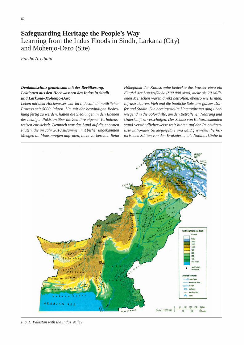
62 Denkmalschutz gemeinsam mit der Bevölkerung. Lektionen aus den Hochwassern des Indus in Sindh und Larkana–Mohenjo-Daro Leben mit dem Hochwasser war im Industal ein natürlicher Prozess seit 5000 Jahren. Um mit der beständigen Bedro- hung fertig zu werden, hatten die Siedlungen in den Ebenen des heutigen Pakistan über die Zeit ihre eigenen Verhaltens- weisen entwickelt. Dennoch war das Land auf die enormen Fluten, die im Jahr 2010 zusammen mit bisher ungekannten Mengen an Monsunregen auftraten, nicht vorbereitet. Beim Höhepunkt der Katastrophe bedeckte das Wasser etwa ein Fünftel der Landesfläche (800,000 qkm), mehr als 20 Milli- onen Menschen waren direkt betroffen, ebenso wie Ernten, Infrastrukturen, Vieh und die bauliche Substanz ganzer Dör- fer und Städte. Die bereitgestellte Unterstützung ging über- wiegend in die Soforthilfe, um den Betroffenen Nahrung und Unterkunft zu verschaffen. Der Schutz von Kulturdenkmalen stand verständlicherweise weit hinten auf der Prioritäten- liste nationaler Strategiepläne und häufig wurden die his- torischen Stätten von den Evakuierten als Notunterkünfte in Safeguarding Heritage the People’s Way Learning from the Indus Floods in Sindh, Larkana (City) and Mohenjo-Daro (Site) Fariha A. Ubaid Fig. 1: Pakistan with the Indus Valley
-
Upload
khangminh22 -
Category
Documents
-
view
2 -
download
0
Transcript of Safeguarding Heritage the People's Way Learning from the ...
62
Denkmalschutz gemeinsam mit der Bevölkerung. Lektionen aus den Hochwassern des Indus in Sindh und Larkana–Mohenjo-DaroLeben mit dem Hochwasser war im Industal ein natürlicher Prozess seit 5000 Jahren. Um mit der beständigen Bedro-hung fertig zu werden, hatten die Siedlungen in den Ebenen des heutigen Pakistan über die Zeit ihre eigenen Verhaltens-weisen entwickelt. Dennoch war das Land auf die enormen Fluten, die im Jahr 2010 zusammen mit bisher ungekannten Mengen an Monsunregen auftraten, nicht vorbereitet. Beim
Höhepunkt der Katastrophe bedeckte das Wasser etwa ein Fünftel der Landesfläche (800,000 qkm), mehr als 20 Milli-onen Menschen waren direkt betroffen, ebenso wie Ernten, Infrastrukturen, Vieh und die bauliche Substanz ganzer Dör-fer und Städte. Die bereitgestellte Unterstützung ging über-wiegend in die Soforthilfe, um den Betroffenen Nahrung und Unterkunft zu verschaffen. Der Schutz von Kulturdenkmalen stand verständlicherweise weit hinten auf der Prioritäten-liste nationaler Strategiepläne und häufig wurden die his-torischen Stätten von den Evakuierten als Notunterkünfte in
Safeguarding Heritage the People’s WayLearning from the Indus Floods in Sindh, Larkana (City) and Mohenjo-Daro (Site)Fariha A. Ubaid
Fig. 1: Pakistan with the Indus Valley
63Safeguarding Heritage the People’s Way ...
Beschlag genommen. Der Wiederaufbau bedeutete vor allem die Errichtung neuer Häuser und Infrastruktur.
Der Beitrag gibt einen Überblick über die Hochwasser-probleme und Vorsorgemaßnahmen bei den wichtigsten Denkmalstätten im Industal. Technisch-zivilisatorische Interventionen in die Landschaft, wie Dämme, Wehre, Ka-näle, Bewässerungssysteme und Hochwasserschutz-Vor-kehrungen, werden vor dem Hintergrund der historischen Bedeutung der Indus-Kulturen betrachtet. Mit einem der-art übergreifenden Blick wird für das Gebiet der heutigen Stadt Larkana und der benachbarten archäologischen Welterbestätte Mohenjo-Daro eine Analyse der Flutereig-nisse durchgeführt. Dabei zeigt sich, dass die staatlichen Schutzmaßnahmen nicht im Einklang stehen mit der öffent-lichen Wahrnehmung der Geschichte und ihrer Artefakte. Strategien wie die Stärkung von Dämmen, die Investition in Entwässerungsanlagen und das Abdecken der archäologi-schen Reste erweisen sich als (zu) wenig effektiv. Deshalb wird auf die Notwendigkeit hingewiesen, von den lebendigen Dörfern und Städten zu lernen, Planungen für den Schutz des archäologischen und architektonischen Erbes in die Regional- und Stadtentwicklung zu integrieren, die Bedürf-nisse der Bevölkerung dabei im Vordergrund zu sehen und ihre Visionen und Werte zu berücksichtigen, um das Erbe der Region gemeinsam mit den betroffenen Menschen zu schützen.
Introduction and Background
The Indus originates in the Himalayas, flows westward and then enters Pakistan. It runs for 2 880 km along varying topography and geography and flows into the Arabian Sea through a large delta. The river has changed its course sig-nificantly through the centuries. The flowing waters deposit heavy alluvial silts on the banks and flooded areas. The wa-ter level in the river is at its peak during the summer and di-minishes greatly during the winter months. The Indus plains have two sections; the upper area in the province of Punjab where the tributaries run separately before joining the main river and the southern part where only the main river flows, that is primarily in the province of Sindh. From the point where the river enters the plains, the land slopes gently from a level of about 300 meters above sea level to sea level over a distance of about 1 800 km.1 (Fig. 1)
Due to the fertility of the soil and the navigability of the river a large number of settlements have existed along it since ancient times and the Indus Valley cities such as Mo-henjo-Daro and Harappa date as far back as 3 000 BC. Until the damming of the river, human life existed in symbiotic relationship with water. The river nourished and provided sustenance. It flowed and it flooded. It was considered sa-cred and the fulcrum of life. In addition, thousands of saints travelled along the river, preached on its banks and were buried next to it, thus creating sites of pilgrimage. Myths and
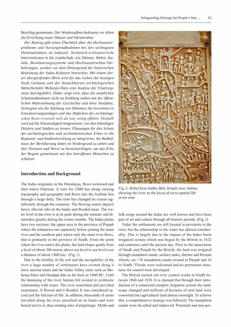
folk songs around the Indus are well known and have been part of art and culture through all historic periods. (Fig. 2)
Today the settlements are still located in proximity to the river, but the relationship to the water has altered consider-ably. This is largely due to the impact of the Indus basin irrigation system which was begun by the British in 1822 and continues until the present day. Prior to the annexation of Sindh and Punjab by the British, the land was irrigated through inundated canals, surface tanks, ditches and Persian wheels, etc.2 38 inundation canals existed in Punjab and 16 in Sindh.3 Floods were welcomed and no permanent struc-tures for control were developed.
The British carried out river control works in Sindh be-tween 1860 and 1930. It is claimed that through their intro-duction of a connected complex irrigation system the land-scape changed and millions of hectares of arid land were converted into agricultural land almost overnight. To achieve this, a comprehensive strategy was followed. The inundation canals were de-silted and improved. Perennial and non-per-
Fig. 2: Relief from Sadhu Bela Temple near Sukhur, showing the river as the focus of socio-spatial life at the time
64 Safeguarding Heritage the People’s Way ...
ennial canals were constructed along with barrages to con-trol the water flow. By 1947, a total of 29 canals existed, out of which 26 were perennial and 13 inundated.4 Now water flowed all times of the year and flooding was controlled by regulating the water flow and by creating bunds or embank-ments. This altering of the geography brought about changes in demography and urbanization. Many canal colonies were established as market towns. From there agricultural pro-duce could be brought and transported by train to the port cities. Larkana, which is the focus of this paper, is one such colony and is fed by the Rice Canal that originates from Sukkur Barrage.
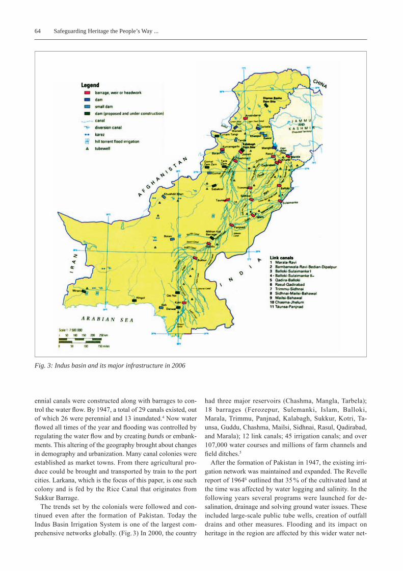
The trends set by the colonials were followed and con-tinued even after the formation of Pakistan. Today the Indus Basin Irrigation System is one of the largest com-prehensive networks globally. (Fig. 3) In 2000, the country
had three major reservoirs (Chashma, Mangla, Tarbela); 18 barrages (Ferozepur, Sulemanki, Islam, Balloki, Marala, Trimmu, Panjnad, Kalabagh, Sukkur, Kotri, Ta-unsa, Guddu, Chashma, Mailsi, Sidhnai, Rasul, Qadirabad, and Marala); 12 link canals; 45 irrigation canals; and over 107,000 water courses and millions of farm channels and field ditches.5
After the formation of Pakistan in 1947, the existing irri-gation network was maintained and expanded. The Revelle report of 19646 outlined that 35 % of the cultivated land at the time was affected by water logging and salinity. In the following years several programs were launched for de-salination, drainage and solving ground water issues. These included large-scale public tube wells, creation of outfall drains and other measures. Flooding and its impact on heritage in the region are affected by this wider water net-
Fig. 3: Indus basin and its major infrastructure in 2006
65Safeguarding Heritage the People’s Way ...
work and have to be understood within this macro perspec-tive.
Floods Caused by the Indus and Flood Control Mechanisms
The Indus receives its water from the melting glaciers and snow in the north. The increase in the water level is caused by both incoming water flow as well as the monsoon rains occurring between July and September. The flooding dura-tion is considered to be between 15th June and 15th October. Climate change has made prediction of torrential rain diffi-cult, thus most of the floods come without extended warning. Considerable damage was caused during the floods of 1973, 1978, 1986, 1988, 1992 and continued from 2000 onwards.
The flood control mechanisms are multi-dimensional and multi-institutional. Different departments are responsible for forecasting rains, measuring water levels, issuing flood warnings, designing irrigation channels, maintaining flood control works, flood relief works, managing heritage, etc.7 The design and maintenance of the flood control works lie with the Provincial Irrigation and Drainage Authorities.
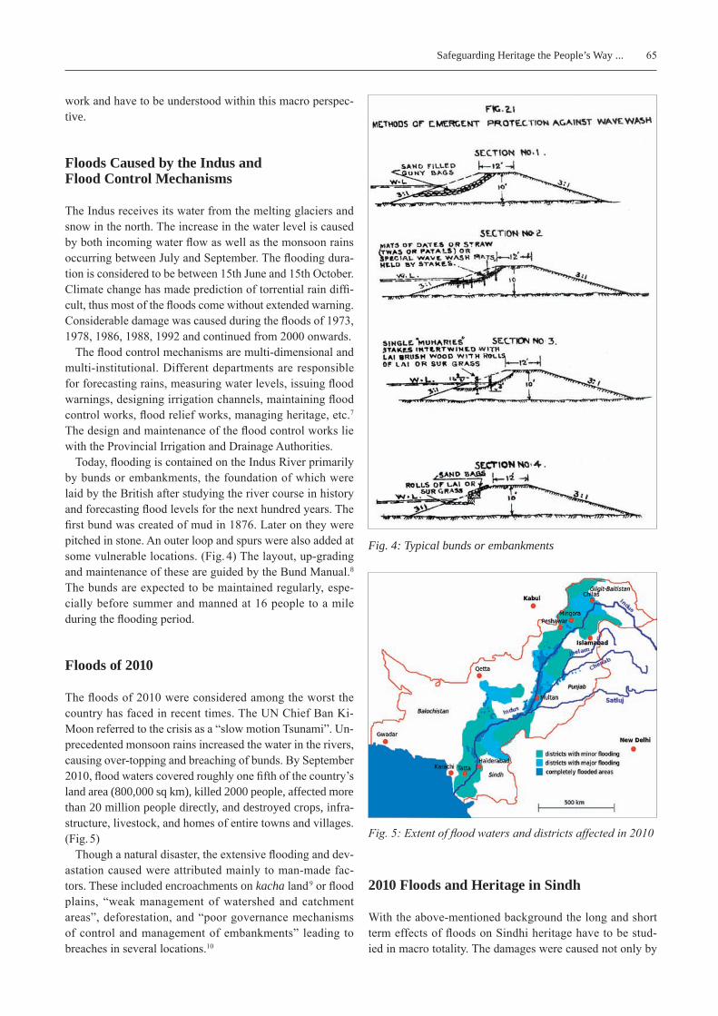
Today, flooding is contained on the Indus River primarily by bunds or embankments, the foundation of which were laid by the British after studying the river course in history and forecasting flood levels for the next hundred years. The first bund was created of mud in 1876. Later on they were pitched in stone. An outer loop and spurs were also added at some vulnerable locations. (Fig. 4) The layout, up-grading and maintenance of these are guided by the Bund Manual.8 The bunds are expected to be maintained regularly, espe-cially before summer and manned at 16 people to a mile during the flooding period.
Floods of 2010
The floods of 2010 were considered among the worst the country has faced in recent times. The UN Chief Ban Ki-Moon referred to the crisis as a “slow motion Tsunami”. Un-precedented monsoon rains increased the water in the rivers, causing over-topping and breaching of bunds. By September 2010, flood waters covered roughly one fifth of the country’s land area (800,000 sq km), killed 2000 people, affected more than 20 million people directly, and destroyed crops, infra-structure, livestock, and homes of entire towns and villages. (Fig. 5)
Though a natural disaster, the extensive flooding and dev-astation caused were attributed mainly to man-made fac-tors. These included encroachments on kacha land 9 or flood plains, “weak management of watershed and catchment areas”, deforestation, and “poor governance mechanisms of control and management of embankments” leading to breaches in several locations.10
2010 Floods and Heritage in Sindh
With the above-mentioned background the long and short term effects of floods on Sindhi heritage have to be stud-ied in macro totality. The damages were caused not only by
Fig. 4: Typical bunds or embankments
Fig. 5: Extent of flood waters and districts affected in 2010
66 Safeguarding Heritage the People’s Way ...
the overflow of high water in the Indus but also by severe rainfall,11 the inability of the land to drain water,12 and the collapse of infrastructure.
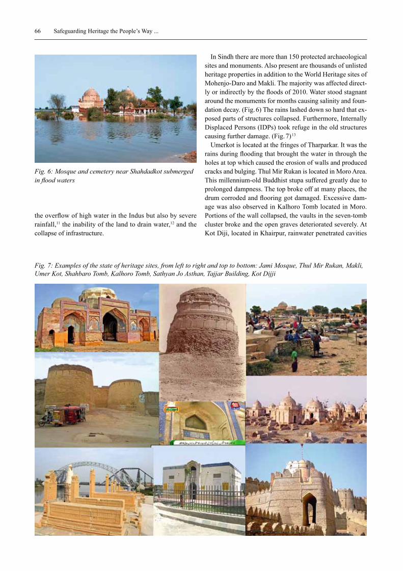
In Sindh there are more than 150 protected archaeological sites and monuments. Also present are thousands of unlisted heritage properties in addition to the World Heritage sites of Mohenjo-Daro and Makli. The majority was affected direct-ly or indirectly by the floods of 2010. Water stood stagnant around the monuments for months causing salinity and foun-dation decay. (Fig. 6) The rains lashed down so hard that ex-posed parts of structures collapsed. Furthermore, Internally Displaced Persons (IDPs) took refuge in the old structures causing further damage. (Fig. 7) 13
Umerkot is located at the fringes of Tharparkar. It was the rains during flooding that brought the water in through the holes at top which caused the erosion of walls and produced cracks and bulging. Thul Mir rukan is located in Moro Area. This millennium-old Buddhist stupa suffered greatly due to prolonged dampness. The top broke off at many places, the drum corroded and flooring got damaged. excessive dam-age was also observed in kalhoro Tomb located in Moro. Portions of the wall collapsed, the vaults in the seven-tomb cluster broke and the open graves deteriorated severely. At kot Diji, located in khairpur, rainwater penetrated cavities
Fig. 6: Mosque and cemetery near Shahdadkot submerged in flood waters
Fig. 7: Examples of the state of heritage sites, from left to right and top to bottom: Jami Mosque, Thul Mir Rukan, Makli, Umer Kot, Shahbaro Tomb, Kalhoro Tomb, Sathyan Jo Asthan, Tajjar Building, Kot Dijji

67Safeguarding Heritage the People’s Way ...
and potholes on the walls and seeped towards the bastions. A portion of Jailkhana (prison) roof and barracks also broke off. In Satyhan Jo Asthan at rohri parapets bulged, some pil-lars collapsed and others started to lean dangerously. rain-water penetrated into the entire structure through the cracks between the parapet and flooring, damaging the floor and widening the joints of the kashi tiles. Jami Mosque in Dadu was stagnant with rain water for months14 and was at risk of collapse. Both Tajjar Building and Shahabaro Tomb of Lar-kana were submerged in water overflowing from the drain-age and sewage lines in the city centre. And wherever water did not destroy the sites directly, the refugees did. A case in point is the World Heritage site of Makli near Thatta where more than 35,000 people found refuge with their cattle. The historic tombs were used as shelters for daily activities which impacted them severely. Similar was the case in Bhanbhore, where in one of the buildings known as the hotel the timber of the structure was used as fire wood. The districts of Shah-dadkot and Jacobabad were flooded heavily due to a breach at Tori. Thus, most of the heritage there got severely dam-aged.15
It is interesting to note that on the one hand considerable damage was inflicted upon the listed monuments, but on the other hand people’s places like Mai Makli’s Shrine were protected by the people themselves. The Tombs of khwaja khizr and Sadhu Bela situated on opposing islands in the Indus near Sukkur received their share of flooding but were in good condition after the event. When water came in Bhit Shah it was drained by the neighbours of the shrine. (Fig. 8) These sites were preserved by the people them-selves.
Why is there such a difference in people’s approach to-wards the two types of monuments? In almost all cases of state-protected heritage buildings they are secular, aban-doned and considered as places of djinns (super-natural be-ings) by the general population. Thus, visiting and protect-ing them is not part of the daily lives of the commoners. The latter mentioned monuments however are of lesser architec-
tural merit, but they are places of the saints and thus consid-ered sacred. The majority believes that if the soul of the saint is troubled the community will face difficulties. Therefore, if any plan of preserving heritage is to be sustainable it must evoke similar associative psychology.
Larkana and the 2010 floods
Mohenjo-Daro is located in Sindh on the west bank of the Indus in proximity to the city of Larkana. Larkana is a sec-ondary city of medium density that gains significance due to being the home of many prominent Pakistani politicians. The layout of the city is defined by the rice Canal which runs through the centre.16 When the floods came in 2010, unlike other water offshoots, the rice Canal did not over-flow but IDPs from all the flooded regions elsewhere found refuge next to the Canal. (Fig. 9) This indirect effect of the floods brought pressure to the city which eventually over-flowed to Mohenjo-Daro.
The protected buildings within the city were damaged more by the accumulated rainwater and overflowing drain lines. Tajjar Building was built in the early 19th century and is located in the heart of Larkana city inside Jinnah Park. Stagnant rainwater and overflowing drain lines brought dampness to the structure. The floors and walls were damaged in addition to the glazed tile work. The ceiling also developed cracks. In another monument, Shah Baharo Tomb (General Talpur’s tomb) sewage water caused damp-ness, leading to the deterioration of the foundations and lower portion of the walls. Thus, in this light how can herit-age be protected without taking into account the city’s mas-ter plans and infrastructure plans? Both have to go hand in hand.
Another example of how macro planning effects flood protection for heritage buildings can be the development of the Larkana Mohenjo-Daro road. The work on it is cur-rently in progress. The road design is away from the ar-
Fig. 8: Bhit Shah Fig. 9: Camps of IDPs along Rice Canal
68 Safeguarding Heritage the People’s Way ...
chaeological site, but in our estimation, once completed this corridor will affect the overall ecology of the area. Given the housing trends of the city, it will soon become the site for housing colonies and settlements. The negative effect on Mohenjo-Daro could be minimised by repositioning the extent of the buffer zone and informing about the ongo-ing development. For example, adequate water culverts can be provided in the new highway, thus enabling natural water flow and not adding to the salinity issues at Mohenjo-Daro.
Therefore, in this light conservation plans have to go hand in hand with urban plans of nearby cities. Plan-ning for Mohenjo-Daro will have to be ideally linked to the Larkana master plans. Only in this way, the landscape around Mohenjo-Daro can act as a buffer space and be man-aged without the pressure of floods, refugees and settle-ments.
Mohenjo-Daro and flood Preparedness in 2010
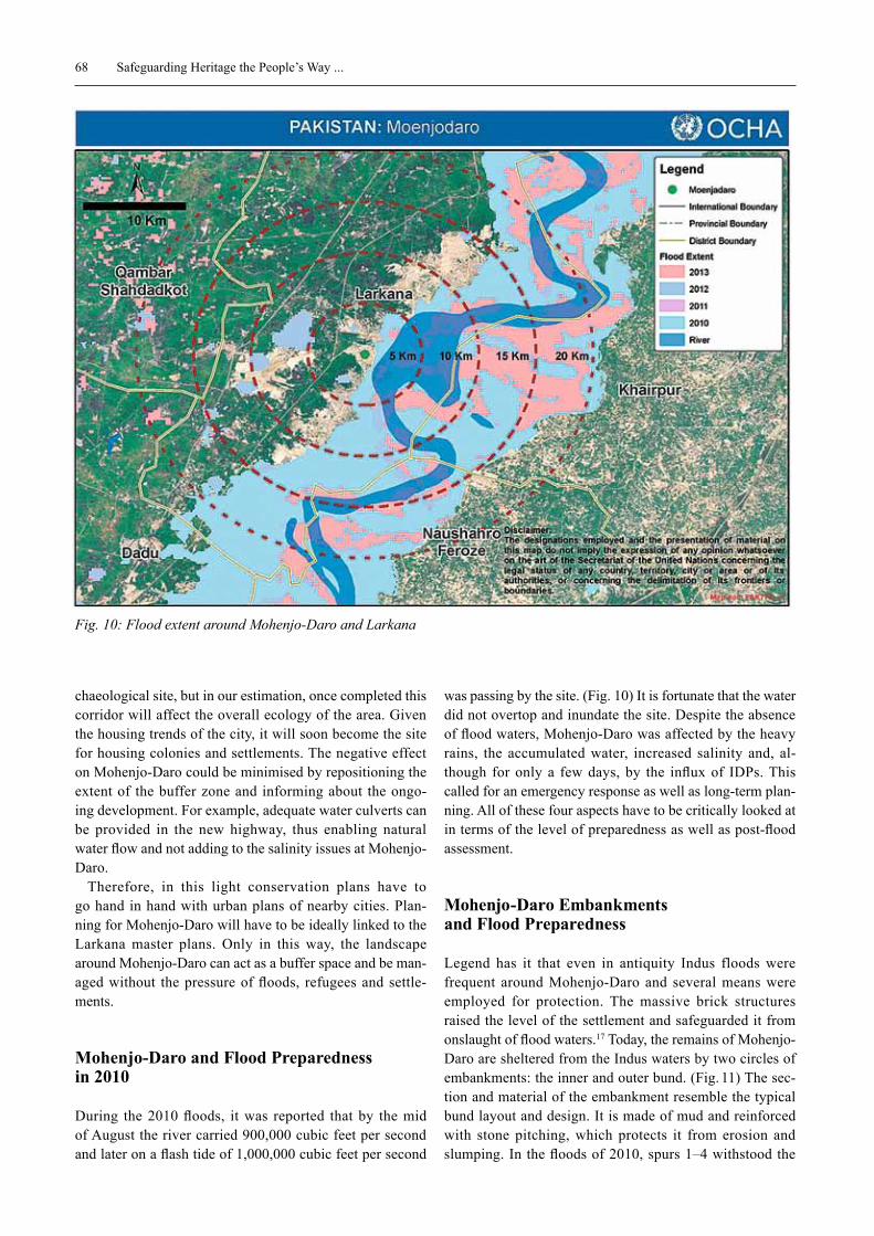
During the 2010 floods, it was reported that by the mid of August the river carried 900,000 cubic feet per second and later on a flash tide of 1,000,000 cubic feet per second
was passing by the site. (Fig. 10) It is fortunate that the water did not overtop and inundate the site. Despite the absence of flood waters, Mohenjo-Daro was affected by the heavy rains, the accumulated water, increased salinity and, al-though for only a few days, by the influx of IDPs. This called for an emergency response as well as long-term plan-ning. All of these four aspects have to be critically looked at in terms of the level of preparedness as well as post-flood assessment.
Mohenjo-Daro Embankments and flood Preparedness
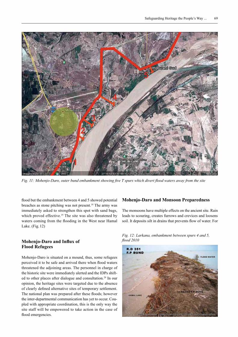
Legend has it that even in antiquity Indus floods were frequent around Mohenjo-Daro and several means were employed for protection. The massive brick structures raised the level of the settlement and safeguarded it from onslaught of flood waters.17 Today, the remains of Mohenjo-Daro are sheltered from the Indus waters by two circles of embankments: the inner and outer bund. (Fig. 11) The sec-tion and material of the embankment resemble the typical bund layout and design. It is made of mud and reinforced with stone pitching, which protects it from erosion and slumping. In the floods of 2010, spurs 1–4 withstood the
Fig. 10: Flood extent around Mohenjo-Daro and Larkana
69Safeguarding Heritage the People’s Way ...
flood but the embankment between 4 and 5 showed potential breaches as stone pitching was not present.18 The army was immediately asked to strengthen this spot with sand bags, which proved effective.19 The site was also threatened by waters coming from the flooding in the West near Hamal Lake. (Fig. 12)
Mohenjo-Daro and Influx of Flood refugees
Mohenjo-Daro is situated on a mound, thus, some refugees perceived it to be safe and arrived there when flood waters threatened the adjoining areas. The personnel in charge of the historic site were immediately alerted and the IDPs shift-ed to other places after dialogue and consultation.20 In our opinion, the heritage sites were targeted due to the absence of clearly defined alternative sites of temporary settlement. The national plan was prepared after these floods; however the inter-departmental communication has yet to occur. Cou-pled with appropriate coordination, this is the only way the site staff will be empowered to take action in the case of flood emergencies.
Mohenjo-Daro and Monsoon Preparedness
The monsoons have multiple effects on the ancient site. rain leads to scouring, creates furrows and crevices and loosens soil. It deposits silt in drains that prevents flow of water. For
Fig. 11: Mohenjo-Daro, outer bund embankment showing five T spurs which divert flood waters away from the site
Fig. 12: Larkana, embankment between spurs 4 and 5, flood 2010
70 Safeguarding Heritage the People’s Way ...
structures, it washes away part of the structure and causes tilting.
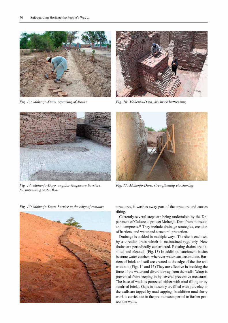
Currently several steps are being undertaken by the De-partment of Culture to protect Mohenjo-Daro from monsoon and dampness.21 They include drainage strategies, creation of barriers, and water and structural protection.
Drainage is tackled in multiple ways. The site is enclosed by a circular drain which is maintained regularly. New drains are periodically constructed. existing drains are de-silted and cleaned. (Fig. 13) In addition, catchment basins become water catchers wherever water can accumulate. Bar-riers of brick and soil are created at the edge of the site and within it. (Figs. 14 and 15) They are effective in breaking the force of the water and divert it away from the walls. Water is prevented from seeping in by several preventive measures. The base of walls is protected either with mud filling or by sundried bricks. Gaps in masonry are filled with pure clay or the walls are topped by mud capping. In addition mud slurry work is carried out in the pre-monsoon period to further pro-tect the walls.
Fig. 13: Mohenjo-Daro, repairing of drains
Fig. 14: Mohenjo-Daro, angular temporary barriers for preventing water flow
Fig. 15: Mohenjo-Daro, barrier at the edge of remains
Fig. 16: Mohenjo-Daro, dry brick buttressing
Fig. 17: Mohenjo-Daro, strengthening via shoring
71Safeguarding Heritage the People’s Way ...
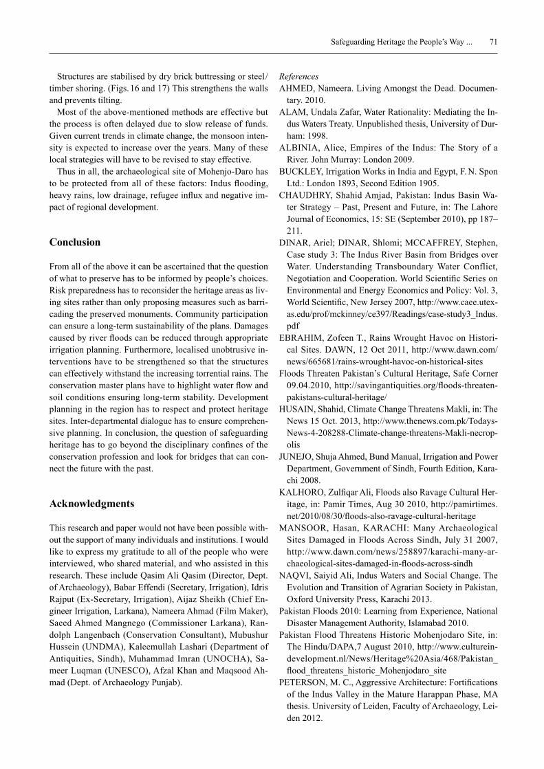
Structures are stabilised by dry brick buttressing or steel /timber shoring. (Figs. 16 and 17) This strengthens the walls and prevents tilting.
Most of the above-mentioned methods are effective but the process is often delayed due to slow release of funds. Given current trends in climate change, the monsoon inten-sity is expected to increase over the years. Many of these local strategies will have to be revised to stay effective.
Thus in all, the archaeological site of Mohenjo-Daro has to be protected from all of these factors: Indus flooding, heavy rains, low drainage, refugee influx and negative im-pact of regional development.
Conclusion
From all of the above it can be ascertained that the question of what to preserve has to be informed by people’s choices. risk preparedness has to reconsider the heritage areas as liv-ing sites rather than only proposing measures such as barri-cading the preserved monuments. Community participation can ensure a long-term sustainability of the plans. Damages caused by river floods can be reduced through appropriate irrigation planning. Furthermore, localised unobtrusive in-terventions have to be strengthened so that the structures can effectively withstand the increasing torrential rains. The conservation master plans have to highlight water flow and soil conditions ensuring long-term stability. Development planning in the region has to respect and protect heritage sites. Inter-departmental dialogue has to ensure comprehen-sive planning. In conclusion, the question of safeguarding heritage has to go beyond the disciplinary confines of the conservation profession and look for bridges that can con-nect the future with the past.
Acknowledgments
This research and paper would not have been possible with-out the support of many individuals and institutions. I would like to express my gratitude to all of the people who were interviewed, who shared material, and who assisted in this research. These include Qasim Ali Qasim (Director, Dept. of Archaeology), Babar effendi (Secretary, Irrigation), Idris rajput (ex-Secretary, Irrigation), Aijaz Sheikh (Chief en-gineer Irrigation, Larkana), Nameera Ahmad (Film Maker), Saeed Ahmed Mangnego (Commissioner Larkana), ran-dolph Langenbach (Conservation Consultant), Mubushur Hussein (UNDMA), kaleemullah Lashari (Department of Antiquities, Sindh), Muhammad Imran (UNOCHA), Sa-meer Luqman (UNeSCO), Afzal khan and Maqsood Ah-mad (Dept. of Archaeology Punjab).
ReferencesAHMeD, Nameera. Living Amongst the Dead. Documen-
tary. 2010. ALAM, Undala Zafar, Water rationality: Mediating the In-
dus Waters Treaty. Unpublished thesis, University of Dur-ham: 1998.
ALBINIA, Alice, empires of the Indus: The Story of a river. John Murray: London 2009.
BUCkLey, Irrigation Works in India and egypt, F. N. Spon Ltd.: London 1893, Second edition 1905.
CHAUDHry, Shahid Amjad, Pakistan: Indus Basin Wa-ter Strategy – Past, Present and Future, in: The Lahore Journal of economics, 15: Se (September 2010), pp 187–211.
DINAr, Ariel; DINAr, Shlomi; MCCAFFrey, Stephen, Case study 3: The Indus river Basin from Bridges over Water. Understanding Transboundary Water Conflict, Negotiation and Cooperation. World Scientific Series on environmental and energy economics and Policy: Vol. 3, World Scientific, New Jersey 2007, http://www.caee.utex-as.edu/prof/mckinney/ce397/readings/case-study3_Indus.pdf
eBrAHIM, Zofeen T., rains Wrought Havoc on Histori-cal Sites. DAWN, 12 Oct 2011, http://www.dawn.com/news/665681/rains-wrought-havoc-on-historical-sites
Floods Threaten Pakistan’s Cultural Heritage, Safe Corner 09.04.2010, http://savingantiquities.org/floods-threaten-pakistans-cultural-heritage/
HUSAIN, Shahid, Climate Change Threatens Makli, in: The News 15 Oct. 2013, http://www.thenews.com.pk/Todays-News-4-208288-Climate-change-threatens-Makli-necrop-olis
JUNeJO, Shuja Ahmed, Bund Manual, Irrigation and Power Department, Government of Sindh, Fourth edition, kara-chi 2008.
kALHOrO, Zulfiqar Ali, Floods also ravage Cultural Her-itage, in: Pamir Times, Aug 30 2010, http://pamirtimes.net/2010/08/30/floods-also-ravage-cultural-heritage
MANSOOr, Hasan, kArACHI: Many Archaeological Sites Damaged in Floods Across Sindh, July 31 2007, http://www.dawn.com/news/258897/karachi-many-ar-chaeological-sites-damaged-in-floods-across-sindh
NAQVI, Saiyid Ali, Indus Waters and Social Change. The evolution and Transition of Agrarian Society in Pakistan, Oxford University Press, karachi 2013.
Pakistan Floods 2010: Learning from experience, National Disaster Management Authority, Islamabad 2010.
Pakistan Flood Threatens Historic Mohenjodaro Site, in: The Hindu/DAPA,7 August 2010, http://www.culturein-development.nl/News/Heritage%20Asia/468/Pakistan_flood_threatens_historic_Mohenjodaro_site
PeTerSON, M. C., Aggressive Architecture: Fortifications of the Indus Valley in the Mature Harappan Phase, MA thesis. University of Leiden, Faculty of Archaeology, Lei-den 2012.
72 Safeguarding Heritage the People’s Way ...
QUrAeSHI, Samina, Sacred Spaces: A Journey with the Sufis of the Indus, Peabody Museum Press, Massachusetts 2010.
rOUGHNeeN, Simon, Floods Hit Hard in Southern Paki-stan, in: The Sunday Tribune / Today’s Zaman / evening Herald, Aug 28 2010, taken from http://www.simonrough-neen.com/aid-and-poverty/hands-on-at-the-dykes-of-courage-the-sunday-tribune/
SAMAD, rafi U., Ancient Indus Civilization, royal Book Company, karachi 2000.
SOOMrO, Ishak, Floods 2010 Breaches in the embank-ments. A Case of Poor Governance, Pakistan Institute of Labour research, karachi 2013.
UBAID, Fariha Amjad; SHAkIr, Masooma, report on Lar-kana City. research undertaken by DAPNeDUeT for UN Habitat, karachi 2011.
UNeSCO, Post Floods Assessment Mission to Pakistan, 8–10 October 2010. Mission report of Unesco, World Heritage Centre, DOAM and ICOMOS, 2010.
yUSUF, Huma, Dancing on the ruins, in: The New york Times, Sep 14 2012, http://latitude.blogs.nytimes.com/2012/09/14/flash-floods-threaten-pakistans-archaeo-logical-heritage
ZIA, Muhammad Farooq, Indus Basin Irrigation System, 2009, published online on Scribd: https://www.scribd.com/doc/21335422/Indus-Basin-Irrigation-System,
Credits:Fig. 1, 3: NAQVI 2013, p. 21, 11Fig. 2: Flickr images of Black-Z-ro, https://www.flickr.com/photos/irfanahmed76/7029061899Fig. 4: Bund Manual 2008 (1936)Fig. 5: Pakistan Disaster Knowledge Network, http://www.saarc-sadkn.org/countries/pakistan/hazard_profile.aspxFig.6: Simon Roughneen, http://www.simonroughneen.com/aid-and-poverty/hands-on-at-the-dykes-of-courage-the-sunday-tribune/Fig. 7: Various internet sourcesFig. 8: QURAESHI 2010, p. 115Fig. 9: UBAID/SHAKIR 2011Fig. 10: Muhammad Imran (UNOCHA)Fig. 11: Author on google earth mapFig. 12: Larkana Irrigation DepartmentFig. 13–20: Qasim Ali Qasim
1 Figures from SAMAD 2000, p. 25.2 refer to BUCkLey 1893 for details of the pre-British
irrigation system around the Indus.3 Figures from DINAr/MCCAFFrey 2007.4 ALAM 1998.5 Facts and figures from ZIA 2009, p. 3.6 Ground water study requested by President Ayub khan in
1961.7 The different departments and their respective respon-
sibilities are given in detail in the Standard Operating Procedures of the Pakistan Meteorological Departments at provincial levels.
8 The Bund Manual was first published in 1936 and has been modified and updated only slightly after partition.
9 kacha land is the land between the edge of the river and the flood control embankment. In many parts of Sindh this is a distance of 3000 feet.
10 SOOMrO 2013. p. 6.
11 What is important to note is not the amount of total rainfall but its intensity. For example in 2011 the equiv-alent of five years of rainfall got concentrated in four weeks.
12 As mentioned earlier, the land is at sea level in Sindh. Thus drainage of water is a serious issue. In addition to the low level several other factors further delay the run off of water. embankments protect on the one hand, but on the other they do not let the water flow back. New infrastruc-ture projects of roads and bridges are rarely designed and implemented with culverts, thus compromising the natural drainage of land. Thus after the floods of 2010, wherever water stood it did so for months, thus leading to water logging and salinity. This impacted in the long term the agricultural crops and heritage structures.
13 Details of damages to monuments are based on newspa-per articles and on interviews of Mr. Qasim Ali Qasim and Mr. kaleemullah Lashari conducted by the author.
14 rain water stood because the roads developed around the monument were higher than the natural ground level; they were constructed without culverts and thus water could not flow out naturally.
15 For outlay of monuments effected during yearly floods refer to the map in “ Pakistan: Flood Affected Heritage Sites (2010 –2014)”, see: http://reliefweb.int/map/paki-stan/pakistan-flood-affected-heritage-sites-2010-2014
16 rice Canal was constructed in 1932 and originates from the right side of Sukkur Barrage.
17 For details of flood protection methods in ancient times refer to Peterson 2012.
18 Based on interviews of Mr. Qasim Ali Qasim and find-ings of UNeSCO Mission report.
19 It is important to outline here that the management of these bunds is more important than their design. If dur-ing the monsoon season the irrigation department only deploys 16 men to a mile available to inspect and correct

73Safeguarding Heritage the People’s Way ...
breaches then that is insufficient. Communities living in nearby settlements have to be motivated to do the same for mutual benefits.
20 Generally the authorities are of the opinion that herit-age sites will shun the refugees once they are fenced and
have notice boards in local languages explaining the law regarding settlement in the site.
21 Information and photographs provided by Mr. Qasim Ali Qasim through status reports submitted by the Archaeol-ogy Department.