Roman military sentry posts in Crimea. New discoveries?
17
Transcript of Roman military sentry posts in Crimea. New discoveries?


Editor-in-chief of the publications of the Institute of Archaeology UW:Kazimierz Lewartowski
ŚwiatowitAnnual of the Institute of Archaeology of the University of Warsaw
Editor: Tomasz Nowakiewicz
All rights reserved© 2012 Institute of Archaeology UW
ISSN 0082-044XISBN 978-83-61376-17-0
Cover design: Joanna KalitaTypesetting: Jan Żabko-Potopowicz
Printed by: Janusz Bieszczad, Warszawa, ul. Moszczenicka 2
Editorial address: Institute of Archaeology of the University of Warsaw,Krakowskie Przedmieście 26/28, 00-927 Warsaw

Fascicle AMEDITERRANEAN AND NON-EUROPEAN ARChAEOLOgy
Fascykuł AARChEOLOgIA ŚRóDzIEMNOMORSKA I POzAEUROPEJSKA
Spis treści
Contents
EDITORIAL ....................................................................................................................................................................................5
ABBREvIATIONS..........................................................................................................................................................................7
Mirosław BarwikThE BOOK Of ThE DEAD PAPyRI fROM ThE PRINCES CzARTORySKICOLLECTION................................................................................................................................................................................9Papirusy Księgi Umarłych z kolekcji książąt Czartoryskich (Streszczenie) ......................................................................12
Iwona Modrzewska-PianettiLAS LáMPARAS DE ACEITE TARDOANTIgUASDEL MUSEO ARqUEOLógICO DE gERONA (CATALUñA) ..............................................................................13The late Roman terracotta lamps from the Archaeological Museum of gerona (Catalonia)(Summary) ........................................................................................................................................................................................24Późnorzymskie lampki terakotowe ze zbiorów Muzeum Archeologicznego w geronie(Katalonia) (Streszczenie) ............................................................................................................................................................24
Iwona Modrzewska-PianettiLUCERNE IBERIChE DELLA TARDA ANTIChITà.NOTE A MARgINE DELLE COLLEzIONI MADRILENA E BARCELLONESE ............................................25Iberian Late Antiquity oil-lamps. Marginal notes on the collections of Madridand Barcelona (Summary) ............................................................................................................................................................29Iberyjskie lampy późnoantyczne. Uwagi na marginesie kolekcji madryckieji barcelońskiej (Streszczenie) ........................................................................................................................................................30
Alessandro MorandiThE ETRUSCAN LANgUAgE: NEW ACqUISITIONS ..........................................................................................31Język etruski – nowe nabytki (Streszczenie) ............................................................................................................................40

Excavation Reports
Тaтяна М. Арсеньева, Томаш Шолль,Марцин Матера, Светлана А. Науменко, Александра Ровиньскa
Отчет Об исследОваниях в танаисе в 2006 гОду (раскОп XXv) ........................................41Report on research in Tanais in 2006 (trench XXv) (Summary) ......................................................................................43Sprawozdanie z badań w Tanais w 2006 roku (wykop XXv) (Streszczenie) ..................................................................44
Тaтяна М. Арсеньева, Томаш Шолль,Марцин Матера, Светлана А. Науменко, Александра Ровиньскa
Отчет Об исследОваниях в танаисе в 2007 гОду (раскОп XXv) ........................................45Report on research in Tanais in 2007 (trench XXv) (Summary) ......................................................................................52Sprawozdanie z badań w Tanais w 2007 roku (wykop XXv) (Streszczenie) ..................................................................53
Мaртин Мaтеpaкерамические клейма из раскОпОк варшавскОгО университетав танаисе. 2005-2007 ..........................................................................................................................................................55Stemple ceramiczne z wykopalisk Uniwersytetu Warszawskiego w Tanaisw latach 2005-2007 (Streszczenie) ............................................................................................................................................92
Radosław Karasiewicz-SzczypiorskiROMAN MILITARy SENTRy POSTS IN CRIMEA. NEW DISCOvERIES? ......................................................93римские военные наблюдательные посты в крыму. новые открытия? (Pезюме)..................................................97Rzymskie posterunki na Krymie. Nowe odkrycia? (Streszczenie) ......................................................................................98
Magdalena Wróbel, Joanna Piątkowska-Małecka, Radosław Karasiewicz-SzczypiorskiMEAT EATEN By ROMAN SOLDIERS AT ThE SENTRy POST ON KAzACKAyA hILLNEAR INKERMAN (SEvASTOPOL, UKRAINE) ....................................................................................................101мясной рацион пиптаниа римских соат с поста на высоте казацкая около инкермана(севастопоь, украина) (Pезюме)........................................................................................................................................113Pożywienie mięsne żołnierzy rzymskich z posterunku na Wzgórzu Kazackaja, koło Inkermanu(Sewastopol, Ukraina) (Streszczenie)......................................................................................................................................114
PLATES..........................................................................................................................................................................................117

ince 1997 the researchers from the Institute ofArchaeology, Warsaw University, together with the Archae-ological Expedition of the Tauric Chersonesos NationalPreserve in Sevastopol have been finding traces of Romanmilitary presence in Crimea. Numerous archaeological siteshave been excavated so far and surface survey has also beencarried out, using various techniques, such as geophysicalprospecting or aerial photography.
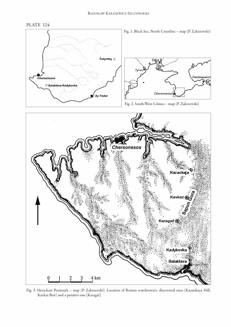
The excavations have helped to discover severalstructures connected with the presence of Roman troopson the outskirts of the rural area (chora) of Tauric Cherso-nesos (Fig. 3). The temple to Jupiter Dolichenus has beenexplored (SARNOWSKI, SAvELJA 2000). The remainsof two watchtowers have been unearthed on Sapun-gora(Fig. 5, 6). These two archaeological sites are referred toas Kazackaja hill (SARNOWSKI, SAvELJA, KARA-SIEWICz-SzCzyPIORSKI 2002) and Kavkaz Bair(SARNOWSKI, SAvELJA, KARASIEWICz-SzCzy-PIORSKI 2007).
Karagač – a search for anotherwatchtowerWith contribution of T. Sarnowski (Institute of
Archaeology, Warsaw University) and O. Ja. Savelja(National Preserve of Tauric Chersonesos, Sevastopol)
Sapun-gora is a distinct natural border. This moun-tain range separates the heraklean Peninsula inhabitedby the greeks from Chersonesos from the local valleys(Balaclava valley and Inkerman valley) In ancient timesthe Sapun-gora range was not brought under cultivation.As the place dominated the area, it enabled the observationof the whole border zone between the greeks and the bar-barians. The location of several watchtowers along themountain range did not ensure effective defence but it didensure advance warning about an approaching enemy. Itwas vital that the eye contact could be preserved betweenthe neighbouring installations. The discovery of two al-most identical sentry posts with watchtowers helped toestablish the following:• They were not parts of linear defence fortifications
(limes) but isolated fortifications adapted for circulardefence.
• They were set up according to the same plan. Thedimensions of the whole post, as well as the centrallylocated tower, are the same in both cases and the drymoats surrounding both posts have a v-shaped section.
• The distance between these two known posts is twoRoman miles.
from the above-mentioned data it could be infer-red that the sentry posts on Kazackaja hill and Kavkaz Bairwere the neighbouring parts of the same “early warning sys-tem” established by the Romans in the Chersonesos bord-erland (Fig. 3).
The question was who was the alarm signal meantfor? It seems obvious that it served the people who livednear Chersonesos, as well as the civilian inhabitants and thegarrison in town. however, sending a warning to the near-est fort located on the outskirts of the present day Balaklavacould have been equally important. The existence of a fortin Balaklava-Kadykovka requires further confirmation butthe following discoveries which have been made so farweigh in favour of this location:
• The foundation of a temple to Jupiter Dolichenus inthis place by the soldiers (confirmed by the discoveredinscriptions).
• A soldier’s gravestone found nearby. Most probablythe soldier was buried close to his place of stationing(SAvELJA, SARNOWSKI 2000: 191-196).
• The results of the excavations at the market inBalaklava-Kadykovka, where archaeological relics inter-preted to be part of a barrack-block were unearthed.The identified building phase is dated by a dinar treas-ure (fILIPPENKO, ALEKSEENKO 2000: 167-176).
had there been a fort in Kadykovka, the place wasperfectly chosen to block access to Balaklava and its har-bour. however, a fortification located there would havegiven restricted possibility to watch the approaches. Dueto the lie of the land in the Balaklava valley only the high-est hills in the neighbouring border zone of the ruralChersonesos can be seen from Kadykovka. Therefore,a warning about an approaching enemy could have beensent to the fort from two places only: the southern end ofSapun-gora, called Karagač, or located even further southsolitary gornaja hill. It must be stressed that because of thelandform features neither the post on Kazackaja hill northe one on Kavkaz Bair may have sent an alarm signal to thefort in Balaklava.
Karagač was chosen as a possible location of thethird watchtower. The distance between Karagač andKavkaz Bair, the previous post of the “early warning system”,is also two Roman miles! According to francois Dubois
93
RADOSłAW KARASIEWICz-SzCzyPIORSKI (IA UW)
RoMAn MIlItARy SentRy PoStS In CRIMeA. neW dISCoveRIeS?(Pl. 124-129)
S
ŚWIATOWIT • TOM vII (XLvIII) • fASC. A • 2006-2008

de Montpéreux, a Swiss who travelled round Crimea in the19th century, there were tower ruins surrounded by a wallin this area (DUBOIS DE MONTPÉREUX 1843: 189-190; Fig. 7). In order to make sending an alarm signal toBalaklava possible practically only one more watchtowershould have been built, and it should have been located onKaragač. A post there would have provided the necessaryeye contact with Balaklava. Nevertheless, we measured alsothe distance between Karagač and gornaja, which againappeared to be... two Roman miles!
All data considered, a decision was made to startexcavations on Karagač. The choice of Karagač also result-ed from the fact that gornaja had been heavily destroyedduring World War II and the clearing work after the war.At present the excavations cannot be conducted as there isa monument surrounded by trees on top of the hill.
A surface survey and a contour map of the hillhelped to choose the most probable location of the thirdwatchtower. The area was afforested after the war but, likeon Kavkaz Bair, the small elevation remained treeless, withlarge limestone blocks scattered on the surface.
As the area of the archaeological survey coincidedwith the line of fortifications defended twice during WorldWar II it was impossible to search for architectonic relicswith non-invasive methods. The abundance of metal frag-ments in the soil and numerous modern holes includingwar trenches and shell craters made geophysical survey im-possible.
Owing to the dimensions of the tower (6 x 6 m.)the researchers decided to penetrate the site with a series oftest pits which were one metre wide and dug in a 5 x 5 m.grid. The survey was carried out in 2008. It resulted in un-covering a poorly preserved stone structure made of irreg-ular limestone blocks (Fig. 8). A few ceramics fragmentsfound on the spot date the discovery back to the 8th - 9th
cent. AD. Neither the building material nor the movableartefacts link the find to the Roman period. Apart from theshovel test pit, no other exploration techniques could beused on the site. The place is covered with pine forest andthere are modern buildings in the vicinity. It is impossibleto establish how far the structure mentioned by the Swisstraveller could be from the explored place. As the attemptto find the watchtower was unsuccessful, francois Duboisde Montpéreux’s account remains the most important ar-gument in support of the above-mentioned theory.
Čatyrdag – an unknown Romansentry post on the southernCrimean coast?With contribution of V. Myc and A. Lysenko
(Institute of Archaeology, National Academy of Sciences ofUkraine )
The ruins of a fort on the Ay-Todor cape (ancientCharax) was the first Roman military installation in Crimea
(Fig. 1, 2) to be discovered and excavated (ROSTOvCEv1900; ROSTOWzEW 1902). A double enclosure wallmade of irregular and mostly huge stone blocks was un-covered on the site. It was built on an irregular plan andthe stones were laid without mortar (NOvIČENKOv,NOvIČENKOvA 2002). The stone blocks on the facewere hewn in order to obtain more or less even surface.Near the fort, just outside the walls, a barbarian burialground was found which revealed burying tradition un-typical of Crimea: common cremation, depositing ashes inamphorae and equipping graves with iron tools and piecesof weapon (BLAvATSKIJ 1951; ORLOv 1987). Similarburial sites are unique in Crimea. The most similar typol-ogically, excavated and described in print is Čatyrdag bur-ial ground (MyC et al. 2006).
It seems vital to establish whether the proximityof the burial site to the fort on the Ay-Todor cape is purelycoincidental. According to some publications, people ofthe barbarian garrison which was brought in the 3rd cent.AD after the Roman troops had been evacuated wereburied there (zUBAR’ 1998: 148-150). If this was the case,then the presence of a necropolis similar to the one on theAy-Todor cape in a place where no traces of a Roman mil-itary fort are known, should encourage a search for suchfortifications. Therefore, a research was initiated near theonly burial ground whose resemblance to the necropolis onthe Ay-Todor cape is unquestionable. The initial survey onČatyrdag site took place in March and at the end of Augustand the beginning of September 2008. No extensive exca-vation work was done. The research comprised surfacesurvey, laser tachometer measurements, aerial photographyfrom a paraplane and a kite (spring 2008) and clearingthe discovered relics of grass and leaves and photographingthem (summer 2008).
The research helped to find several sections ofstone embankments near the burial ground. These struc-tures do not form a self-contained whole. They differ inheight and width, as well as in the size of stone blocks vis-ible on their surface. These differences led to distinguish-ing three types of stone embankments:type 1. The most massive stone embankments made ofhuge stone blocks, some of which bear the signs of hewing.They are characterised by huge stone blocks on the faceand angular gravel in the core.type 2. Less visible embankments made almost entirelyof medium sized blocks. They required much less buildingmaterial than the embankments of the first type.type 3. Clearly visible embankments, yet less massive thanthose of the first type. They are built of big stone blocks,fine crushed stone and soil. The embankments of this kindrun along the local asphalt road.
The described diversity of embankments is inter-preted in the following way: type 3 embankments cameinto existence in the second half of the 20th century,when the ground was being levelled for the asphalt road,while type 2 embankments are probably present-day field
RADOSłAW KARASIEWICz-SzCzyPIORSKI
94

boundaries. Both their size and the used material indicatethat it did not cost much effort to build them, which is notat all true of type 1 embankments. Regardless of their timeof origin it must have taken a tremendous amount of effortto build them, including perfect work organisation andcoordination of people.
The extraordinary distribution of the buildingmaterial in the embankment, i.e. the facing of huge stoneblocks and the core of rock aggregate, may suggest that thisstone structure got destroyed. A total destruction of a stoneembankment laid without mortar could have been due toa large earthquake force. Big earthquakes occur in this partof Crimea. During one of them a village was completelydestroyed as the local Demerdži mountain fell apart leavinga vast rock debris field on its slope. Assuming a similar sit-uation on Čatyrdag, the wall was built of huge stone blocksfor the face and angular gravel mixed with soil for the core.Due to a large seismic shock the wall faces could have fall-en outwards and inwards, the core of the wall got loose andmarked the original alignment of the wall.
So far three stretches of the embankments havebeen classified as belonging to type 1 (Fig. 10). Because oftheir location they may have been fragments of the originalenclosure wall. In all three cases they were found in placeseasy to defend, as the potential enemy would have to attackup the slope (Fig. 4). Most of the embankments of types 2and 3 lack this important feature.
One difficulty in the study of the supposed defen-sive wall is the predominance of stones with no traces ofprocessing. Only some of the blocks have one or two facesdressed. Probably the stones were hewn only when it wasnecessary to make the face of the wall even. however, sin-gle well dressed stones scattered round the preserved struc-ture support the idea that the embankments are the re-mains of a defensive wall (Fig. 9, 12). These blocks are bigand one of them was even prepared to be part of an obtuseangle construction (Fig. 9).
In the course of a new fieldwork season in summer2008, the best preserved part of the defensive wall was dis-tinguished (Fig. 4, 11). Turf, weed, and accumulated leavesfrom nearby trees were removed in the designated area.After the clearing the straight line of the wall face could benoticed (Fig. 11). In some places only one row of massivestones remained. however, in one stretch of the structurethe second and third layer of stones was preserved. Theembankment is very massive there. A more detailed analy-sis helped to determine a probable line of the other face ofthe wall and to estimate the original width of the curtainwall to be 3,5 m.
The dating of type 1 embankments is problematic.Since no excavations of these relics have been undertaken,it impossible to solve this problem. So far it has been estab-lished that:• The building material and its use in places where the
wall face is preserved resemble the building techniqueof the walls on the Ay-Todor cape.
• The presumed highest point of the fortification is lo-cated on Čatyrdag burial site of the Ay-Todor type(Fig. 4).
The stratigraphic relation considered, the unpre-served or unbuilt section of the wall must have been anteriorto the burial ground which was in use in 3rd - 4th cent. AD.If this was the case then the wall may have been contempo-rary to defences on the Ay-Todor cape.
Neither the movable relics collected during thesurface survey and the embankment clearing nor the re-ports on chance findings from the local people helped toestablish the dating. An antoninianus of Philip the Arab(information after A. Lysenko) and fragments of Bosporanamphorae dating from the 2nd - 3rd cent. AD (zeest 76type, identified by v. Nessel) may come from the last phaseof Roman military presence on the southern Crimean coast.This dating corresponds to the presumed time of the evac-uation of Roman troops from Charax. however, the sameartefacts could have been part of the equipment of earlygraves similar to those on the Ay-Todor cape and connectedwith the alleged presence of a barbarian garrison. One hasto mention also a few pieces of hand mould ceramics dis-covered during the clearing of the conjectural wall. Thefragments are small and untypical. They were described as“not from the Middle Ages” (v. MyC) or “late ancient”(O. JA. SAvELJA). however, one has to bear in mind thatthey were found on the ground surface near a stone rumblewhich may indicate that they had moved down the slopefrom some high-elevation part of the site.The research done so far leads to the following conclusions:• Type 1 embankments seem to be the remains of a de-
fensive wall.• The fortifications most probably were not completed.
The fact that only stretches of the presumed enclo-sure wall were found as well as the presence of scattereddressed stones at a certain distance from the preservedembankments argue for the second conclusion. The mate-rial may have been abandoned on its way to the buildingsite. The hypothesis of an unfinished investment wouldaccount for the small number of movable artefacts accom-panying the alleged fortifications. The fort, which had notbeen inhabited or had been used for only a short period oftime, did not comprise any buildings or accumulated rub-bish (e.g. ceramics).
The Roman sentry post on Kavkaz Bair could alsohave been left unfinished. During the fieldwork very littlestone material from the enclosure wall was found. Therewere also no Roman roof tiles which should have remainedafter the tower roof had collapsed (unpublished informa-tion yet). The remains of a tiled roof were discovered onKazackaja hill (SARNOWSKI, SAvELJA, KARASIE-WICz-SzCzyPIORSKI 2002; 2007). Obviously, thematerial could have been used at some later time in otherbuildings. Nevertheless, some traces of the individualmaterials, such as tile pieces, should have been found on the
ROMAN MILITARy SENTRy POSTS IN CRIMEA. NEW DISCOvERIES?
95

spot. Their complete lack may indicate that either the postwas not completed or it was built in haste of the materialsavailable at that time, such as clay and timber. A parallelsituation may concern Čatyrdag site, as the enclosure wallthere was either left unfinished or the gaps in the fortifica-tion were filled with impermanent materials. further con-struction of the walls without the use of stones may havebeen the work of the barbarians whose crematory burialsite was found nearby.
It must be stressed that all data considered, it can-not be determined without doubt whether on Čatyrdag site,like on the Ay-Todor cape, the crematory burial ground wasadjacent to an older Roman sentry post. The discoveredand described remains of the conjectural enclosure wall pro-vide a new argument in favour for the Roman military pres-ence on the southern Crimean coast. further excavationsmay bring a clinching argument to this still unsettled issue.
RADOSłAW KARASIEWICz-SzCzyPIORSKI
96
Bibliography
BLAvATSKIJ, v. L.1951 Charaks, Materialy i issledovanija po archeologii SSSR 19, Moskva, p. 250-291.
DUBOIS DE MONTPÉREUX, f.1843 Voyage autour du Caucase, chez Tcherkesses et les Abkhases, en Colchide, en Géorgie, en Armenie et en Crimée 6,
Paris, p. 189-190.
fILIPPENKO, A. A., ALEKSEENKO, N. A.2000 Der römische Münzschatzfund von Balaklava [in:] Sarnowski, Savelja 2000, p. 167-176.
MyC, v. L. et al.2006 Čatyr-dag – nekropol’ rimskoi epochi v Krymu, Sankt Peterburg, Nestor-Istorija.
NIKOLAENKO, g. M.2001 Chora Chersonesa Tavričeskogo 2, Sevastopol, p. 147.
NOvIČENKOv, v. I., NOvIČENKOvA N. g.2002 O nižnej oboronitel’noj stene rimskoj kreposti Charaks, Materialy po archeologii, istorii i etnografii Tavrii 9,
p. 27-35.
ORLOv, K. K.1987 Aj-Todorskij nekropol, Materialy k etničeskoi istorii Kryma, Kiev, p. 106-125.
ROSTOvCEv, M. I.1900 Rimskie garnizony na Tavričeskom poluostrove i Aj-Todorskaja krepost’, Žurnal Ministerstva Narodnogo Pro-
sveščenija 308, Mart, p. 140-158.1902 Roemische Besatzungen in der Krim und das Kastell Charax, Klio 2, p. 80-95.
SARNOWSKI, T., SAvELJA, O. JA.2000 Balaklava Römische Militärstation und Heiligtum des Iupiter Dolichenus, Warschau.
SARNOWSKI, T., SAvELJA, O. JA., KARASIEWICz-SzCzyPIORSKI, R.2002 Extra fines Imperii. Rzymski posterunek wojskowy w okolicach Sewastopola na Krymie, Światowit 45, fasc, A,
p. 167-172.2007 (2009) Roman military sentry posts in the border zone of Crimean Chersonesos, Archeologia 58, p. 57-67.
SAvELJA, O. JA., SARNOWSKI, T.2000 Der Grabstein des Iulius Vales aus Balaklava [in:] Sarnowski, Savelja 2000, p. 191-196.
zUBAR’, v. M.1998 Severnyj Pont i Rimskaja Imperija (seredina I v. do n.è. - pervaja polovina VI v.), Kiev.

ачиная с 1997 года совместной экспедициейинститута археологии варшавского университета и на-ционального заповедника «херсонес таврический» про-водятся работы, в результате которых было обнаруже-но несколько памятников археологии, связанных с при-сутствием римских войск в крыму. было исследованосвятилище юпитера долихена в балаклаве-кадыковке.выявлены остатки двух наблюдательных башен, распо-ложенных вдоль хребта сапун-горы, которые вошли в на-учную литературу под названиями: казацкая и кавказ.
карагач – поиск следующейнаблюдательной башниС участием Т. Сарновского и О.Я. СавелиОткрытие двух почти идентичных постов,
снабжённых наблюдательной башней позволило опре-делить, что:• Они не были элементами оборонительной системы
(limes), а являлись изолированными военнымипунктами, приспособленными к круговой обороне.
• Они сооружены по одному образцу. размеры всейпостройки и расположенной в её центре башнив обоих случаях те же самые, а сухой ров, окружающийкаждый из постов, в разрезе имеет форму буквы v.
• расстояние между известными нам постами равно2 римским милям.
если принять, что самый близкий форт нахо-дился в кадыковке, то место было выбрано идеальнодля блокады доступа в балаклаву и находящийся тампорт. в то же время, расположенное таким образомукрепление, имело очень ограниченный обзор пригра-ничной зоны. рельеф местности в балаклавской долинепозволяет из кадыковки видеть только самые высокиевозвышенности, находящиеся вблизи границы сель-ской территории херсонеса. с этой перспективы сиг-нал о приближении врага мог быть замеченным в фортетолько с двух вершин: с южного края сапун-горы, на-зываемого карагач, или с расположенной далее на югодинокой высоты горная.
третий наблюдательный пост мог быть распо-ложен на вершине карагач. в таком случае «в системераннего предостережения» расстояние между даннымпунктом и предыдущим, расположенным в урочищекавказ, составляет также 2 римские мили! О существо-вании на данном участке руин башни с окружающей еёстеной сообщает швейцарец Франсуа дюбуа де мон-пере, путешествующий в XIX веке по крыму.
с целью проверки нашего предположения в ав-густе 2008 года на высоте карагач были осуществленыпредварительные раскопки. в результате обнаружены
только плохо сохранившиеся следы каменной застрой-ки из нерегулярных глыб известняка. немногочислен-ные фрагменты керамики датируют выявленные остат-ки vIII-IX вв. к сожалению, не представляется возмож-ным установить как далеко от места наших исследова-ний возвышалась постройка, упомянутая швейцарскимпутешественником. в связи с неудачей археологичес-ких изысканий донесение Франсуа дюбуа де монпереостаётся самым важным аргументом в пользу представ-ленной выше теории.
Чатыр-даг – неизвестный римский фортна южном берегу крымаС участием В.Л. Мыца и А. Лысенкопервым открытым римским укреплением
в крыму, на котором проводились раскопки, являетсяфорт на мысе ай-тодор, который отождествляют с ан-тичным пунктом под названием Charax. по соседствус фортом, среди всего прочего, обнаружен варварскиймогильник, расположенный сразу за стенами. средихарактерных черт могильника следует упомянуть: все-общую кремацию, помещение праха в амфоры, а такженаличие железных инструментов, элементов вооруже-ния и снаряжения. подобные могильники в крымуявляются абсолютно исключительными. самым близ-ким по типу, исследованным и доступным в публика-циях, является могильник чатыр-даг.
кажется существенным в данном случае вопрос– соседство могильника и форта на мысе ай-тодорявляется случайным? в литературе появляются мнения,что около укреплений хоронили особы, принадлежа-щие варварскому гарнизону, размещённому в III векепосле эвакуации римских отрядов. если это так, то су-ществование могильника типа «ай-тодор» в месте,где отсутствуют следы римского форта, должно скло-нить к поискам такого укрепления. именно для этого в2007 году была проявлена инициатива проведенияисследований в окрестностях одного из могильников,схожесть которого с некрополем на мысе ай-тодор невызывает сомнений.
три участка каменных валов, значительно болеемассивных по сравнению с остальными такого типаконструкциями, которые встречаются в окрестностях,расположены таким образом, что могут представлятьсобой фрагменты одного укрепления. в любом случае,они проходят на территории, подходящей для оборо-ны. речь идёт, прежде всего, о принуждении потенци-ального противника к атаке под гору. такой важнойчертой не обладают другие каменные насыпи на иссле-дуемой территории.
ROMAN MILITARy SENTRy POSTS IN CRIMEA. NEW DISCOvERIES?
97
радОслав карасевич-Щипёрски
Римские военные наблюдательные посты в кРыму. новые откРытия?(Pезюме)
н

d 1997 roku wspólna ekspedycja Instytutu Ar-cheologii Uniwersytetu Warszawskiego i Muzeum Cherso-nez Taurydzki odkrywa kolejne budowle związane z obec-nością wojsk rzymskich na Krymie. Przebadano świątynię Jo-wisza Dolicheńskiego w Bałakławie-Kadykowce. Odsłonię-to pozostałości dwóch wież obserwacyjnych położonychwzdłuż grzbietu Sapun-gora. Stanowiska te noszą w litera-turze nazwy: Kazackaja i Kavkaz.
Karagač – poszukiwania kolejnej wieżyobserwacyjnejPrzy współpracy T. Sarnowskiego i O. SaveliiOdkrycie dwóch niemal identycznych posterun-
ków wyposażonych w wieże obserwacyjne pozwoliło usta-lić, że:• Nie były one elementami systemu obrony linearnej
(limes), a jedynie izolowanymi umocnieniami dosto-sowanymi do obrony okrężnej.
• Wykonano je według tego samego wzoru. Wymiarycałego założenia i położonej centralnie wieży są w obuprzypadkach takie same, a suchy rów otaczający każdyz posterunków ma w przekroju kształt litery v.
• Odległość między znanymi posterunkami wynosi 2 milerzymskie.
Jeśli najbliższy fort znajdował się w Kadykowce,miejsce było doskonale wybrane, aby blokować dostęp doBałakławy i znajdującego się tam portu. Jednocześnie takpołożone umocnienie miało bardzo ograniczoną obserwa-cję przedpola. Ukształtowanie terenu w Dolinie Bałakław-skiej powoduje, iż z Kadykovki można było dostrzec je-dynie najwyższe wzniesienia sąsiedniego pogranicza wiej-skiego terytorium Chersonezu. z tej perspektywy sygnało nadchodzącym wrogu mógłby dotrzeć do fortu tylkoz dwóch wzniesień: południowego krańca Sapun-gory,zwanego Karagač, lub położonego dalej na południe sa-motnego wzgórza gornaja.
важным аргументом в пользу тезиса, что имеемдело с остатками стен, являются находки отдельных, хо-рошо обработанных блоков, разбросанных поблизостиот сохранившихся валов. Это огромные блоки, один изкоторых даже был подготовлен как элемент конструк-ции, обладающей тупым углом.
летом 2008 года нами были продолжены иссле-дования. в начале был выявлен наиболее хорошо сохра-нившийся участок предположительной стены. в вы-бранном месте снят дерновый слой, сорная траваи листья, опавшие с ближайших деревьев и слежавшие-ся со временем. в результате расчистки поверхностиудалось обнаружить лицо стены, проходящее по пря-мой линии. местами это был только один ряд массив-ных каменных глыб. Однако, на некоторых участках ис-следуемой структуры сохранились камни другого лицаи третьего ряда кладки, считая от поверхности грунта.
предположительный, самый высокий пунктлинии укреплений проходит по территории, занятоймогильником чатыр-даг, который принадлежит типуай-тодор. согласно с ситуацией несохранившийсяили недостроенный участок стены должен быть болееранним по сравнению с могильником, функционирую-щим в III-Iv вв. если так, то стена может являться одно-временной укреплениям на мысе ай-тодор.
в результате проводимых до настоящего време-ни исследований без осуществления масштабных рас-копок напрашиваются два заключения:
• некоторые валы по соседству с могильником соз-дают впечатление остатков оборонительной стены.
• скорее всего, строительство предполагаемых укреп-лений никогда не было закончено.
в пользу последней теории свидетельствует,между прочим, существование только фрагментов стен,а также разброс отдельных обработанных блоков нанекотором отдалении от сохранившихся валов. можетбыть строительный материал был брошен по дороге настроительную площадку? гипотеза о незаконченнойинвестиции, помогла бы объяснить – почему так малоархеологических находок сопровождают предполагае-мые укрепления. на территории форта, который небыл заселён или был использован очень короткое вре-мя не было постоянной внутренней застройки и нагро-мождения отходов жизнедеятельности (напримеркерамики).
следует подчеркнуть, что собранные до настоя-щего времени материалы не позволяют однозначноутверждать, что на памятнике археологии чатыр-даг,подобно как на мысе ай-тодор, могильник с трупо-сожжением был размещён рядом с более ранним рим-ским фортом. Однако, открытые и задокументирован-ные остатки предполагаемой стены, являются новымфактом в дискуссии на тему присутствия римлян наюжном берегу крыма. конкретную информацию дляосвещения данного вопроса могут дать будущие рас-копки.
RADOSłAW KARASIEWICz-SzCzyPIORSKI
98
RADOSłAW KARASIEWICz-SzCzyPIORSKI
RzymsKie posteRunKi na KRymie. nowe odKRyCia?
(STRESzCzENIE)
O

ROMAN MILITARy SENTRy POSTS IN CRIMEA. NEW DISCOvERIES?
99
Jako możliwe miejsce położenia trzeciej wieży wy-typowany został Karagač. Odległość pomiędzy nim a po-przednim w „systemie wczesnego ostrzegania” Kavkazemwynosi także 2 mile rzymskie! O istnieniu w tej okolicyruin wieży wraz z otaczającym murem donosił w XIX wie-ku podróżujący po Krymie Szwajcar – francois Dubois deMontpéreux.
Weryfikację wykopaliskową przeprowadzono w sier-pniu 2008. Natrafiono jedynie na źle zachowane relikty bu-dowli kamiennej z nieregularnych brył wapienia. Nielicz-ne towarzyszące fragmenty ceramiki datują odsłonięte po-zostałości na vIII-IX w. Nie sposób ustalić, jak daleko odmiejsca naszych badań wznosiła się budowla wzmianko-wana przez szwajcarskiego podróżnika. Wobec fiaska po-szukiwań archeologicznych relacja francois Dubois deMontpéreux pozostaje najważniejszym argumentem na ko-rzyść przedstawionej powyżej teorii.
Čatyrdag – nieznany fort rzymskina południowym wybrzeżu KrymuPrzy współpracy V. Myca i A. LysenkiPierwszym odkrytym i przebadanym wykopalis-
kowo rzymskim umocnieniem na Krymie był fort na przy-lądku Ay-Todor, utożsamiany z antyczną nazwą Charax.W sąsiedztwie fortu natrafiono m.in. na położone tuż zamurami cmentarzysko barbarzyńskie. Wśród cech charak-terystycznych wymienić należy: powszechną kremację,składanie prochów w amforach, a także obecność wśródwyposażenia żelaznych narzędzi i elementów uzbrojenia.Podobne cmentarzyska są na Krymie absolutnie wyjątko-we. Najbliższe typologicznie, przebadane i dostępne w pu-blikacjach, jest cmentarzysko Čatyrdag.
Istotne wydaje się pytanie, czy sąsiedztwo cmenta-rzyska i fortu na przylądku Ay-Todor jest tylko przypad-kowe? W literaturze pojawiają się głosy, że obok umocnieńchowano osoby należące do barbarzyńskiego garnizonu,sprowadzonego w III w. po ewakuacji oddziałów rzyms-kich. Jeśli tak, to istnienie cmentarzyska typu Ay-Todorw miejscu, gdzie brak śladów fortu rzymskiego, powinnoskłaniać do poszukiwań takiego umocnienia. Właśnie dla-tego zainicjowane zostały badania w okolicy jedynegocmentarzyska, którego podobieństwo do nekropoli Ay--Todor nie budzi wątpliwości.
Trzy odcinki wałów kamiennych, znacznie masyw-niejsze od pozostałych tego typu konstrukcji spotykanychw okolicy, są położone w ten sposób, że mogą stanowićfragmenty jednego umocnienia. W każdym przypadkubiegną w terenie dogodnym do obrony. Chodzi przedewszystkim o zmuszenie potencjalnego przeciwnika do ata-ku pod górę. Tej ważnej cechy pozbawione są inne nasypykamienne w okolicy.
Ważny argument na korzyść tezy, iż mamy do czy-nienia z pozostałościami murów, stanowią znaleziska po-jedynczych, dokładnie obrobionych bloków, rozrzuconew pobliżu zachowanych wałów. Są to ogromne bloki, z któ-rych jeden był nawet przygotowany jako element kon-strukcji posiadającej kąt rozwarty.
Powrót do prac latem 2008 pozwolił wytypowaćnajlepiej zachowany odcinek domniemanego muru. W wy-branym miejscu usunięto darń, chwasty i nagromadzonelatami liście z pobliskich drzew. W wyniku oczyszczeniapowierzchni udało się uchwycić biegnące po linii prostejlico muru. Miejscami był to tylko jeden rząd masywnychbrył kamienia. Część badanej struktury zachowała jednakkamienie lica drugiego i trzeciego rzędu, licząc od po-wierzchni gruntu.
Domniemany najwyższy punkt linii umocnieńbiegnie po terenie zajętym przez cmentarzysko Čatyrdagnależące do typu Ay-Todor. Wobec takiej relacji niezacho-wany lub niedobudowany odcinek muru musiałby byćwcześniejszy od cmentarzyska funkcjonującego w III-Iv w.Jeśli tak, to mur może być współczesny umocnieniom naprzylądku Ay-Todor.
Po dotychczasowych badaniach niewykopalisko-wych nasuwają się dwie konkluzje:• Niektóre wały w sąsiedztwie cmentarzyska robią wraże-
nie pozostałości muru obronnego.• Najprawdopodobniej budowy domniemanych umoc-
nień nigdy nie ukończono.za tą ostatnią teorią przemawiałoby m.in. istnienie
jedynie fragmentów postulowanego obwodu murów orazrozproszenie pojedynczych, obrobionych bloków, w pew-nym oddaleniu od zachowanych wałów. Być może budulecporzucono po drodze na plac budowy? hipoteza o pozo-stawieniu nieukończonej inwestycji wyjaśniałaby, dlaczegotak mało znalezisk ruchomych towarzyszy domniemanymumocnieniom. fortowi, który nie został zasiedlony lub byłużytkowany bardzo krótko, nie towarzyszyła trwała zabu-dowa wewnętrzna ani nagromadzenie odpadów (np. cera-miki).
Należy podkreślić, że zgromadzone dotychczas ma-teriały nie pozwalają jednoznacznie stwierdzić, iż na sta-nowisku Čatyrdag, podobnie jak na przylądku Ay-Todor,cmentarzysko ciałopalne ulokowano obok wcześniejszegofortu rzymskiego. Odkryte i zadokumentowane pozosta-łości domniemanego muru stanowią jednak nowy argu-ment w dyskusji na temat obecności Rzymian na połud-niowym wybrzeżu Krymu. Rozstrzygniecie w tej kwestiiprzyniosą być może przyszłe wykopaliska.
RADOSłAW KARASIEWICz-SzCzyPIORSKI
PLATE 124fig. 1. Black Sea. North Coastline – map (P. zakrzewski)
fig. 2. South-West Crimea – map (P. zakrzewski)
fig. 3. heraclean Peninsula – map (P. zakrzewski). Location of Roman watchtowers: discovered ones (Kazatskaya hill,Kavkaz Bair) and a putative one (Karagač)
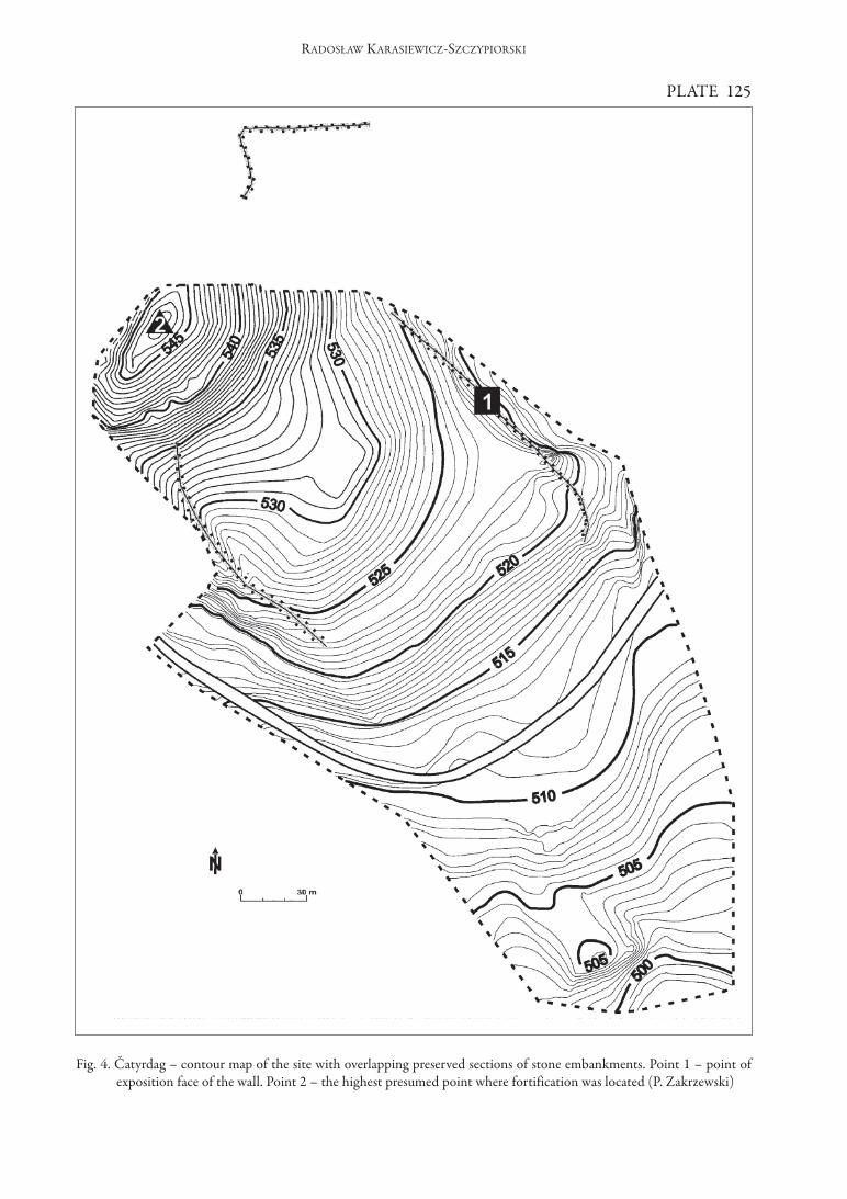
PLATE 125
RADOSłAW KARASIEWICz-SzCzyPIORSKI
fig. 4. Čatyrdag – contour map of the site with overlapping preserved sections of stone embankments. Point 1 – point ofexposition face of the wall. Point 2 – the highest presumed point where fortification was located (P. zakrzewski)

RADOSłAW KARASIEWICz-SzCzyPIORSKI
PLATE 126
fig. 6. Kavkaz Bair. Roman watchtower – plan ofexcavations ( J. Kaniszewski)
fig. 5. Kazackaja hill. Roman watchtower– reconstruction (T. Sarnowski,J. Kaniszewski)

PLATE 127
RADOSłAW KARASIEWICz-SzCzyPIORSKI
fig. 7. Karagač. Ruins of the watchtower? Plan by Dubois de Montpéreux(NIKOLAENKO 2001: 147)
fig. 8. Karagač. Summer 2008. Results of excavations.(R. Karasiewicz-Szczypiorski)

RADOSłAW KARASIEWICz-SzCzyPIORSKI
PLATE 128
fig. 9. One of the biggest stone blocks visible on surface (M. Bogacki). Situated to the north of Point 1 (see fig. 4)
fig. 10. fragment of preserved wall – aerial view (M. Bogacki). Segment to the south of Point 2 (see fig. 4)

PLATE 129
RADOSłAW KARASIEWICz-SzCzyPIORSKI
fig; 12. Dressed stones blocks on the site (M. Bogacki). Situated near the spot marked as Point 2 on the plan (see fig. 4)
fig. 11. Exposed face of the wall (R. Karasiewicz-Szczypiorski). Situated in the spot marked as Point 1 on the plan (see fig. 4)