Development and characterization of electrically conductive polyaniline coated fabrics
Upload
khangminh22Category
view
3download
0
Reweaving Urban Fabrics: Urbanisation, Industrialisation and Regeneration
in Southwest Montreal
Retissage de tissus urbains: urbanisation, industrialisation, et revitalisation
dans le Sud-Ouest de Montreal
Desmond Andrew Bliek
A Thesis in
The Department of
Geography, Planning, and Environment
Presented in partial fulfillment of the requirements for the degree of Master of Arts (Public Policy and Public Administration - Geography)
Concordia University
Montreal, Quebec, Canada
December, 2007
© Desmond Bliek, 2007

1*1 Library and Archives Canada
Published Heritage Branch
395 Wellington Street Ottawa ON K1A0N4 Canada
Bibliotheque et Archives Canada
Direction du Patrimoine de I'edition
395, rue Wellington Ottawa ON K1A0N4 Canada
Your file Votre reference ISBN: 978-0-494-42479-7 Our file Notre reference ISBN: 978-0-494-42479-7
NOTICE: The author has granted a nonexclusive license allowing Library and Archives Canada to reproduce, publish, archive, preserve, conserve, communicate to the public by telecommunication or on the Internet, loan, distribute and sell theses worldwide, for commercial or noncommercial purposes, in microform, paper, electronic and/or any other formats.
AVIS: L'auteur a accorde une licence non exclusive permettant a la Bibliotheque et Archives Canada de reproduire, publier, archiver, sauvegarder, conserver, transmettre au public par telecommunication ou par Plntemet, prefer, distribuer et vendre des theses partout dans le monde, a des fins commerciales ou autres, sur support microforme, papier, electronique et/ou autres formats.
The author retains copyright ownership and moral rights in this thesis. Neither the thesis nor substantial extracts from it may be printed or otherwise reproduced without the author's permission.
L'auteur conserve la propriete du droit d'auteur et des droits moraux qui protege cette these. Ni la these ni des extraits substantiels de celle-ci ne doivent etre imprimes ou autrement reproduits sans son autorisation.
In compliance with the Canadian Privacy Act some supporting forms may have been removed from this thesis.
Conformement a la loi canadienne sur la protection de la vie privee, quelques formulaires secondaires ont ete enleves de cette these.
While these forms may be included in the document page count, their removal does not represent any loss of content from the thesis.
Canada
Bien que ces formulaires aient inclus dans la pagination, il n'y aura aucun contenu manquant.

Abstract
Reweaving Urban Fabrics: Urbanisation, Industrialisation and Regeneration in Southwest Montreal
Desmond Bliek
In the pages that follow, this thesis examines the urbanisation, industrialisation, and
regeneration processes that have shaped the built landscape along Montreal's Lachine
Canal. Adopting an approach that sees urban tissue as more than the simple result of agents'
interventions, that is to say as a structuring influence itself, the thesis critically examines the
history and geography of urban industrialisation, particularly in relation to Montreal, and
takes a look at contemporary redevelopment paradigms.
After putting forward a morphological methodology and offering a short history of the
Canal, the thesis presents the results of an in-depth analysis of urban tissues in adjacent
industrial sectors. Proposing a typology of industrial complexes and sectors rooted in the
degree of differentiation between industrial elements and the surrounding urban tissue, this
thesis argues that urbanisation, industrialisation, and regeneration are diffuse, incremental
processes that dialectically engage with the landscapes left by the past. The thesis wraps up
with a discussion of the historiographical and practical implications of such a perspective.
i l l

Resume Retissage de tissus urbains: urbanisation, industrialisation, et
revitalisation dans le Sud-Ouest de Montreal
Desmond Bliek
Dans les pages qui suivent, cette these cible les processus d'urbanisation, d'industrialisation,
et de revitalisation qui ont contribue a la formation du paysage bati longeant le Canal
Lachine dans le sud-ouest montrealais. Empruntant une approche qui considere le tissu
urbain comme etant plus qu'un simple resultat des actions prises par les intervenants - c'est-
a-dire comme influence structurante en soi-meme - cette these examine de maniere critique
l'histoire et la geographie de l'industrialisation urbaine, surtout en relation au cas montrealais,
et jette un coup d'oeuil sur les pratiques de revitalisation contemporaines.
Apres la proposition d'une methodologie morphologique et une courte histoire du Canal,
suit une presentation d'une analyse approfondie des tissus urbains des secteurs industriels
avoisinants. En proposant une typologie des complexes et des secteurs industriels fondee
sur la specialisation manifestee par le degre de difFerenciation entre ces elements industriels
et les tissus urbains dans lesquels ils se trouvent, cette these maintient que les processus
d'urbanisation, d'industrialisation, et de revitalisation sont diffus, et precedent graduellement
dans un rapport dialectique avec les paysages legues par le passe. La these conclut avec une
discussion des implications theoriques (historiographiques) et pratiques de ces constats.
IV

Acknowledgements
Personal
My most sincere and deepest thanks go to Lindsay Pearce for having the patience to help
me through this work, and for sharing her insights along the way, which have surely made it
better. Thanks for your patience, Lins; and thanks also for knowing when to run out of it.
The ideas and perspectives developed in this diesis owe their origin in large part to the
hours I've been priveleged to spend with Dr Pierre Gauthier in courses and in rambling
conversations that usually touched on urban form at some point. This exchange has greatly
enhanced my understanding of urbanisation and will forever mark the way in which I
analyse and consider the city as a project. Dr Norma Rantisi s advice, questioning, and
encouragement should also be noted. To have such generous access to such a sharp mind,
just across the hall, was a privilege indeed. A big thanks go out to Annie Pollock, as well, as
without her genuine care and administrative savvy, there is simply no way I could last as a
graduate student.
I could not have gotten myself so far over my head into such a big undertaking without
the unconditional support of my parents. Hopefully I'll make it up to them some day.
My friends, in Montreal and elsewhere, are to be commended. Without them, the whole
experience would not have been as rich, and it would likely have been over sooner.
This research was funded in large part by the Social Sciences and Humanities Research
Council of Canada, as well as by support from various Concordia University programs.
Content
Certain sections of this work have appeared in the publications listed below. Content
from the literature review (chapter one) and the first section of the discussion (chapter
five), relating to brownfields regeneration, appeared in Bliek, D and P Gauthier (2007),
"Mobilising Urban Heritage to Counter the Commodification of Brownfield Landscapes:
Lessons from Montreal's Lachine Canal." Canadian Journal of Urban Research - Canadian
Planning and Policy Supplement, 16(1). Content from the literature review and from the third
chapter's historical overview of the Lachine Canal have also appeared (though in substantially
different form) in Bliek, D and P Gauthier (2006), "Understanding the Built Form of
Industrialisation along tlie Lachine Canal." Urban History Review, 35(1): 1-17.
V

Contents
List of Figures viii
0. Introduction 1
Problematique 1
Structure and organisation of the thesis 5
1. Literature review | Chapter one 8
Introduction 8
Canadian urban history and geography and the Lachine Canal 9
Towards a morphological understanding 16
The 'Montrealness of Montreal': Architecture et projet urbain 19
Urban regeneration, brownfields, and contemporary planning 22
A final word on trie literature 26
2. Morphology as a means of inquiry | Chapter two 29
Introduction 29
Putting morphological theory into operation: methodology 33
A word about the notion of type 33
Component sub-systems 34
Urban tissue as a conceptual device: a list of terms 34
Principal variables 36
Inter-relationships 37
(Trans)formative processes 38
Scales of change and agents' intervention 39
Incremental interventions 40
Planned interventions 40
Privileging a relatively autonomous built landscape:
morphological research agendas and initiatives 41
Conclusion 43
3. Montreal and the Lachine Canal | Chapter three 45
Introduction 45
The Early Canal 47
The Industrial Canal 51
Industrial urbanisation 54
Entering a period of decline 57
VI

4. Two Analytical Narratives | Chapter four 60
Introduction 60
Urbanisation and industrialisation in Griffintown:
reading Grifnntown's urban tissue 61
Introduction 67
Elements/constituent subsystems 67
Conclusion 104
The second narrative: a typology of industrial complexes 105
Introduction 106
A continuum of industrial complexes 107
Transhipment and transformation 115
The emergence of industrial complexes 116
Railyards in Montreal's southwest 142
Conclusion 155
5. Discussion | Chapter five 157
Brownfields and urban heritage 157
Introduction 157
Brownfields, urban transformation, and morphology 159
New readings of urban industrial heritage 163
Conclusion 168
The Lachine Canal as an interface between Montreal
and the Nor th American Project 171
Introduction 171
A short history of railways in Montreal 173
Drawing on the analysis 178
Saint-Henri 180
Built landscape as a mediator of political-economic forces 190
Privatism and understandings of urban neo-liberalism 190
Urban form as a mediator of neo-liberal restructuring 192
Urban form and neo-liberal restructuring along the Lachine Canal 193
Conclusion 196
6« Conclusion 198
7. References 203
8. Figures 218
vn

Figures
0. Introduction 1
0-1: The Lachine Canal 3
2. Morphology as a means of inquiry | Chapter two 29
2-1: Urban tissue broken down 32
2-2: Route types 35
3. Montreal and the Lachine Canal | Chapter three 45
3-1: La Nouvelle France, 1699 46
3-2: MacKenzie's voyage to the Northwest, 1801 47
3-3: Early plans for the Lachine Canal by Gedeon de Catalogne. 48
3-4: The early Canal to the west of a burgeoning city, 1830 50
3-5: A view of the city from just upriver, 1840 50
3-6: Industrial water intakes along the Lachine Canal 53
3-7: John Young, 1862 54
3-9: A panorama of the city's industrial corridor 55
3-8:JohnOstell,1876 55
3-11: Canada's metropolis 56
3-10 The Canal gave the city's harbour an interior 56
3-12: Recast as a linear park 58
4. Two Analytical Narratives | Chapter four 60
4-1: Grimntown, 1801 64
4-2: Grimntown, 1825 64
4-3: Grimntown, 1846 65
4-4: Grimntown, 1879 65
4-5: Grimntown, 1949 66
4-6: Grimntown, 2005 66
4-7: Route types in Grifhntown, 2005 67
4-8: Commercial streets in Grifflntown 69
4-9: Early seigneurial concessions and fiefs 71
4-10: The Saint-Gabriel Basins block 72
4-11: Block bounded by rues du Seminaire, Saint-Augustin (Rioux),
Bassin, and Ottawa 72
4-12: North of the Saint-Gabriel Locks 72
4-13: Parcels belonging to the Cote-Saint-Antoine area 74
Vll l

4-14: The area along rue Barre, 1890 74
4-15: The block bounded by Richmond, William, Notre-Dame,
and Saint-Martin; 1890 75
4-16: John Day's rowhouses, 1890 75
4-17a: Redmond Wholesale 77
4-17c: Union Cold Storage 77
4- 17e: J Wentworth Hill 77
4- 17d: Gould Cold Storage 77
4-17f: Outdoor lumber storage near the Saint-Gabriel basins 77
4-17b: Canada Cold Storage 77
4-18a: Jos Bonhomme, carriage maker 78
4- 18b: The Phoenix Foundry 78
4-18d: Augustin Cantin's Canada Marine Works 78
4-18c: Montreal Street Railway powerhouse 78
4- 18e: The Darling Foundry 78
4-18f: Fire at Ogilvie's Glenora Mills 79
4-18h: Gardner and Son's novelty works 79
4-18j: The Northern Electrics (corner Guy and Notre-Dame) 79
4-18g: Fitt's Steam Bakery 79
4-18i: Eagle Foundry 79
4-18k: Clendenning Foundry 79
4-181: Williamson factory 80
4-18n: Crescent Manufacturing 80
4-18p: Canada Paint 77
4-18m: GJ Esplin's mill and box factory 80
4-18o: Martin-Senour 80
4-18q: The Wire and Cable Company's works on Lusignan 80
4-18r:JW Patterson 81
4-18t: Island City Paint and Varnish Works 81
4-18s: IT Bell factory 81
4-18u: Ames-Holden 81
4-19: Residential building types according to Dubois (2005) 82
4-20: Brennan street, 1879 84
4-21: The CN Viaduct in the 1940s 84
4-22: The GTRs Bonaventure Freight Terminal 85
4-23: The autoroute Bonaventure 8
IX

4-24: The autoroute Ville-Marie's entry ramps 86
4-25: Poles, nodes, and axes on Grifnntown's territory. 87
4-26: Grifnntown's block types 89
4-27: Unites de paysage in Grifnntown, according to Dubois (2005) 90
4-28: Densification at the Northern Electric complex 91
4-29: Densification at the Northern Electric complex 92
4-30: Densification at the Saint-Gabriel locks hydraulic pole 93
4 -31 : Outdoor storage at the Saint-Gabriel Basins 94
4-32: Paco Building 95
4-33: Square Chaboillez 96
4-34: Chaboillez square mapped through time 97
4-35: The'Dalhousie Triangle' mapped through time 98
4-38: Canadian Portland Cement Co. 101
4-37: The Flour (Peel) Basins mapped through time 101
4-39: Union Cold Storage and Gallery Square 102
4-40: Augustin Cantin's Canada Marine Works, 1855 102
4-41: An urban-integrated industrial complex 108
4-42: An urban semi-autonomous industrial complex 109
4-43: A unified autonomous complex 111
4-44: Cunningham and Wells/Union Cold Storage 113
4-45: The LaSalle Coke plant 113
4-46: The Northern Electric 114
4-47: Manufacturing and transhipment 115
4-48: Shearer's lumberyard; Ogilvie's mill 116
4-49: The City Gas Works 116
4-50: The Clendenning Foundry 117
4-51: Industrial complexes of Grifnntown and Windmill Point 114
4-52: The studied industrial sectors arrayed along the Canal 118
4-53: Windmill Point mapped through time 120
4-54: Ogilvie's Windmill Point mill 121
4-55: The Saint-Gabriel locks hydraulic pole mapped through time 123
4-56: Sainte-Cunegonde mapped through time 128
4-57: Cote-Saint-Paul mapped through time 133
4-58: The autoroute comes to Cote-Saint-Paul, 1969 135
4-59: Saint-Ambroise mapped through time 137
4-60: The Saint-Ambroise sector pre-urbanisation, 1870 138

4-61: The Canadian Pacific Railway's Saint-Patrick street
4-62: The CPR and Grand Trunk Railways Cote-Saint-
4-63: The GTR's Saint-Henri yards
4-64: The CPR and GTR's Atwater yards
yards 3aul yards
4-65: The GTR (and subsequently CN)'s Bonaventure freight terminal
4-66: The GTR's Pointe-Saint-Charles yards and shops
4-67: The GTR's Turcot yards
5. Discussion | Chapter five
5-1: The Gardner Novelty works
5-2: Cane, 1846
5-3: The Redpath complex
5-4: The Steel Company of Canada's works in Sainte-Cunegonde
5-5: The Saint-Ambroise sector, 2002
5-6: Map of the Grand Trunk Railway and its connections, 1850s
5-7: Thomas Coltrin Keefer
5-8: Saint-Henri in 1866
5-9: Saint-Henri in 1878
5-10: Saint-Henri in 1890
5-11: Saint-Henri in 1907
5-12: Saint-Henri in 1949
5-13: Saint-Henri in 2002
5-14: Urban fabric (tissue) as a prism
5-15: The east side of square Sir-Georges-Etienne-Cartier
5-16: True North's Jardins/Terrasses Windsor
143
145
146-7
149-50
152
153
154
157
160
161
165
166
167
172
176
181
182
183
184
185
186
195
195
196
XI

0. Introduction
Problematique
A discussion of the set of issues popularly known as deindustrialisation, and their
consequences serve as a point of entry for this thesis. The flight of manufacturing from
central cities to locations in suburbia, the sunbelt,' and overseas had a profound impact on
the communities left behind. The classic negative features - severe job losses, capital flight,
shuttered storefronts, and disempowered unions - are now increasingly being superseded in
the popular imagination by the symbols of (an at least partial) recovery - galleries, boutiques,
public markets, condominiums, and lofts. The disused industrial areas that are a legacy of
deindustrialisation, far from lying fallow, are now provoking profound questioning on the
nature of the city and its future directions.
The wholesale conversion from zone of production to zone of consumption, and
the challenges encountered when attempting to insert the products and practices of
contemporary urbanisation into these now treasured landscapes have become critical issues.
Deindustrialisation has raised a whole new set of concerns for students of the city: what
do these former industrial districts tell us about the process of urbanisation, and more
practically, what actions can be taken to ensure their successful redevelopment? How can
the trauma of deindustrialisation and the significant functional and cultural changes it
presents us with be seen as still continuous within the larger historical thrust of the city?
The enlargement of notions of heritage to include entire urban landscapes and former sites of
industrial production poses new challenges; how can such areas contribute to contemporary
urban vitality while maintaining the continuity of the urban experience and keeping their
historical significance intact?
One must carefully situate the processes of urbanisation and industrialisation that
are intertwined with the landscapes of production that are now such controversial and
compelling sites. This is particularly true when dealing with the industrial North American
city, which has often been seen as lacking the cultural and physical coherence of pre-industrial
civilisation. In fact, many critics (Bodson, 2001; Caniggia & Maffei, 2001; Moudon, 1994;
Panerai, Castex, Depaule, & Samuels, 2004) have highlighted the emergence of a crisis in the
comprehension and production of the built landscape.
1

For architect Alan Knight: "I'avenement de la grande ville en Europe tend a
transformer la realite de la vie urbaine, elle ajfaiblie ces anciennes certitudes
et change les regies de son organisation interne, aux exigences naissantes de la
rationalite d'un lieu d'exercice defonctions bureaucratiques et industrielles. ...La
perte de I'intelligibilite de la vie metropolitaine constitue, depuis le XIXe siecle, le
fondement du 'choc moderne'" (Knight, www.archiurb.org - 2007-06-21).
An increased emphasis on rationality, through the logic of bureaucracy and industry, and
the interpretation of buildings as individual, architectural, objects rather than as anonymous
parts of an urban fabric, are all part of the decline in what the Italian architect Saverio
Muratori has labelled the spontaneous consciousness in favour of critically conscious
approaches that emphasise individual architectural monuments at the expense of the
connective tissue of the city. As Caniggia and Maffei put it, "in a panorama of emergences,
what is lacking is a global, basic, connective tissue" (2001: 33). The primary objective of this
thesis is to contribute to the discussion on deindustrialised urbanism by proposing, through
a reading of the urban form of the Lachine Canal basin, that the industrial city does indeed
have such connective framework.
"...the city is something that persists through its transformations, and that the
complex or simple transformations of functions that it gradually undergoes are
moments in the reality of its structure" -Aldo Rossi (Rossi & Eisenman, 1982:
55-56).
This thesis postulates the existence of a connective structure in the industrial city; structure'
in Malfroy's (1986: 200) sense of'formes qui conservent leurs caracteres malgre le renouvellement
de leurs composantes. Les permanences structurales fixent des limites au changement et exercent
une retroaction sur les processus deformation d'echelle inferieure" and aims to reveal it through a
historical reading of the urban form of one of its industrial districts, in a sense attempting to
excavate the "the operative vestiges of true spontaneous consciousness" (Caniggia & Maffei,
2001:47) . Thus, the work presented in the following pages constitutes an attempt to identify
and interpret significant patterns, or permanences, in the structure of the built landscape
along the Lachine Canal in terms of their impact on its urbanisation through history and
its contemporary redevelopment. In a sense, it makes explicit the persistence of certain
elements of the urban fabric dirough the moments in history that industrial urbanisation and
contemporary consumer-residential redevelopment represent. Through a set of inter-related
narratives, I propose that the Lachine Canal basin specifically, and the industrial districts of
2

North American cities more generally, can be read as thick palimpsests (Banham, 1971) upon
which projects of local and continental scale continually informed each other throughout
history - in essence providing each other with the structures within which they took shape.
Through the different eras of urbanisation, or moments in the history of the city - from
before the industrial revolution to the revitalizations associated with contemporary economic
restructuring - there is a remarkable tendency for subsequent interventions to be inserted
into the already existing urban fabric.
0-1: The Lachine Canal (the shaded band at centre-left) is identified as a major industrial heritage site by the Ville de Montreal. For source information on images, please consult the references at the end of the thesis.
The following chapters present a study of the form of the Griflintown district with a
view to understanding its progressive industrialisation, and then moves on to a typology of
industrial complexes along the length of the Canal, emphasising changes in their relationship
with the surrounding urban fabric. A discussion highlights the impact of these forms and
their emergence for concepts of urban heritage and the role they have played as interface
between the local city and the larger continent. The discussion also proposes the notion that
the structure of these forms mediates the transformation of the Lachine Canal from a space
of production to a space of consumption.
In this work I argue that the urban form of the Lachine Canal basin, a North American
industrial district par excellence, validates a structuralist approach to the city that sees die
built landscape as a durable and coherent structure that, by virtue of its collective and
non-intentional nature, provides agents of change widi a variably malleable material - full
3

of constraints and opportunities. The idea of the city plan as resource or as persistent, as
evoked by Poete and developed by Rossi implies that the plan of the city is fundamentally "a
past that we are still experiencing" (Rossi & Eisenman, 1982: 58).
Certain students of urban form - urban morphologists - have for some time proposed
such an interpretation, but have been reluctant to apply it to industrial or mass-produced
environments, which do not emanate from longstanding folk culture, centuries-old tradition,
or spontaneous consciousness. This thesis argues that the urbanisation of Canada's faded
industrial metropolis did indeed have a somewhat autonomous spatial logic, one that
played a considerable mediatory role in the historic industrialisation and decline, and the
contemporary reinvention and revitalisation of the Lachine Canal basin. That is to say,
although the Nor th American industrial city is indeed the product of explicitly conscious
and intentional practices in the production of the built environment, it most certainly
is not without an autonomous and legible underlying spatial logic, one that can be read
morphologically. To make explicit the underlying logic of the built landscape is thus to
shed light on the permanences that have variably constrained and furnished opportunity to
tlie agents involved in the shaping of the city. It is my hope that this may serve as a guide
of sorts for understanding the industrial metropolis, and ensuring effective contemporary
intervention.
4

Structure and organisation
The work is organised around a series of chapters; the first of which elaborates the
theoretical framework and situates this project in the literature pertaining to urban
historical geography and debates in contemporary urban planning and design, both globally
and in respect to Montreal in particular. Key concepts in historical urban geography
and the political-economic issues surrounding deindustrialisation are examined with a
view to constructing a foundation for the work presented in subsequent chapters. The
second chapter addresses urban morphology as a heuristic resource, and consists of a
multidisciplinary literature review emphasising the theoretical and practical roots of this
project. It is in this chapter that the basic concepts underlying the research undertaken are
laid out, particularly the morphological foundations in which this thesis is rooted. This
draws particularly from the work of theorists such as Sylvain Malfroy (1986a; 1986b;
1998), Philippe Panerai (1980; 2004; 1999), Gianfranco Caniggia and Gian Luigi Maffei
(2001), and Anne Vernez-Moudon (1986; 1992; 1994; 1997), for insights into the nature
of the elements and relationships that comprise the urban fabric. This chapter includes a
methodological discussion, in essence putting some of the above concepts (particularly those
of a morphological nature) into operational form and describing the process by which an
analytical framework was constructed.
This third chapter orients the reader to the history of the Lachine Canal and its place
in southwest Montreal, from its very beginnings to the present day, touching on its crucial
significance for Montreal in its Nor th American context. A narrative of the intertwined
fortunes of the Lachine Canal and Montreal integrates a variety of anthropological,
geographical, and historical research highlights the importance of the canal for Montreal's
industrialisation and the traces left behind on the landscape by each era of settlement and
development. This review contextualises the progressive sedimentation of the landscape
through history - from pre-industrial agricultural land holdings to the extensive network of
railway lines, spurs, and yards that peaked at the height of industrialisation. Crucially the
emphasis is placed upon the continuity and persistence of these traces, but also upon the
prevailing politics, technics, and economics.
The analysis around which this project takes shape is presented in chapter four. This is
broken down into two inter-related narratives sharing a common thread - the mediation
of increasingly specialised urban forms by a distinctive and persistent urban fabric and
the integration of industrial infrastructure into the urban fabric. These two narratives,
5

focus on the emergence of specialised industrial forms in the GrifEntown district and the
differentiated typology of industrial complexes along the Lachine Canal, from Cote-Saint-
Paul in the west to Windmill Point (near the Vieux-Port) in the east. Chapter four's analysis
is presented with a view to the importance of the persistence of the city plan, and the largely
incremental and adaptive integration of modernity and specialisation in the urban fabric. It
is upon these observations that the thesis bases its major claims and which the discussion, in
chapter five, takes further in terms of their implications for theory and practice.
Chapter five, the discussion, can be split into three related sections. The first part of the
discussion deals with the practical implications of a structural interpretation of industrial
urbanisation and the avenues opened up to contemporary practitioners by applying
morphological techniques to a non-traditional environment. Arguing that the perils of a
disembodied and atomized built environment, one disconnected from the deeply inscribed
history of working-class neighbourhoods that are supposed to benefit from regeneration, I
call for an integration of morphological analysis in the revitalisation process to ensure more
meaningful results. As noted earlier, deindustrialisation, while inciting significant discussion
on the nature of the post-industrial' city, has left professionals with a heavy burden in terms
of adapting these landscapes - often referred to as brownfields - to contemporary needs.
This part of the discussion focuses on the potential for morphological knowledge to assist in
the integration of new development in brownfield sites into the surrounding urban landscape
and the myriad, persistent traces that make up the urban palimpsest. Such knowledge lies at
the base of any successful projet urbain'; any redevelopment that attempts to be more than an
individual building or ensemble of buildings, but that seeks to be an extension of the urban
fabric, from the past, into the future.
The second part of the discussion examines the dialectic between continental
infrastructures and imperatives and the morphological characteristics of the local territory,
emphasising the dual nature of many of southwest Montreal's permanences. In this sense,
the discussion explores the permanence of southwest Montreal as an axis of development and
Montreal's link with the continental project of North American setdement, development,
and industrialisation, even while the material forms and configurations of much of the
infrastructure involved in these efforts changed dramatically and left a series of overlapping
and partially-faded traces on the landscape.
6

In the third part of the discussion, the emphasis is placed on the implications of an
autonomous, structural interpretation of the built environment for accepted understandings
of the history of Montreal and its industrial districts, suggesting that the built landscape
can be conceptualised as a mediator of political-economic forces. The implications of this
interpretation for the management of contemporary transformations, such as brownfields
regeneration, is taken up in light of a discussion of the varying grains' to the urban fabric and
their influence on redevelopment practices and the neo-liberal privatization of public space.
7

1. Literature review | Chapter one
Introduction
This chapter probes the contemporary issues raised by the Lachine Canal, in theoretical
and practical realms. Theoretically, this means probing the significance of the Lachine Canal
as a means for, I argue, augmenting our understanding of the urban history and geography
not just of Montreal, but that of North American industrial cities more broadly. On a
practical level, this implies addressing the crucial questions of deindustrialisation, economic
restructuring, and urban regeneration - particularly brownfield redevelopment - and
understanding the heritage value of industrial landscapes such as the Lachine Canal basin.
This progresses towards the following chapter s exploration of a morphological approach
to apprehending the built landscape in light of NJ Habraken's (1998) call for a means for
tackling everday, ordinary environments.
We start the chapter with a discussion on what I (in a respectful spirit) term the blind
spots of contemporary Canadian urban history and geography as revealed by the case of the
Lachine Canal. This is followed by a more critical discussion that examines the seeming
inability of contemporary city-building practices to address the existing built environment
as a coherent structure and to engage with its underlying logic. Taking a structuralist
understanding of the city centred on the concept of urban fabric, I argue that when
confronted with constraint and opportunity in the post-deindustrialisation urban landscape,
contemporary urban regeneration and planning falls short of honouring its nuanced and
significant heritage.
Finally, the discussion moves on to consider works that engage with the specificity of
Montreal - Charneys notion of'Montrealness' (1992) - i n both theory and practice. In the
context of these issues and perspectives, I introduce several morphological works that have
tackled the questions raised by Montreal as an urban phenomenon. The body of work and
practice known as urban morphology, upon which this thesis draws heavily, is addressed more
thoroughly in the next chapter's discussion, which reviews the basic tenets and conceptual
vocabulary of this emergent discipline.
8

Canadian urban history and geography and the Lachine Canal.
This argument is founded on two notions: the first is that typical agent-centred approaches
to interpreting urban history tell only part of the story, because cities are collective projects
created in temporal diffusion, and thus are properly structural. This is swiftly, even tersely,
observed in the first words of the Centre canadien de 1 architectures catalogue for its
exposition'Montreal metropole, 1880-1930: "[t]he city is a long-term collective work. It
cannot be reduced to the output of architects, for they have little impact on much of the
built environment" (Gournay & Vanlaethem, 1998: 9). No one person or even group has
complete control or can exercise total influence over the urban landscape and thus studying
the social history of the city - whether the emphasis is on the survival strategies of working
class women (Bradbury, 1989,1993) or on the architectural tastes of the elite (James,
1985) — can offer only an incomplete, though important, glimpse into the formation of the
city. For Dufresne et A,"{X)a premiere difficulteposeepar I'analyse morphologique du territoire
montrealais vient que les etudes historiques mettent I'emphase sur I'histoire sociale, economique ou
politique en traitant la forme urbaine comme unjond de scene presque neutre" (Dufresne, 2003:
72). Read this way, the built environment is accorded almost no autonomy, and thus serves
an incredibly neutral role, one that belies its quite variable malleability. This first notion,
that focusing on the agent in relating urban history tells only part of die story, recognises the
very partial control that any one agent has over the urban landscape, and that given shifting
circumstances amongst different agents of change.
Urban historiography often refers to the material city as a testimony of the living
conditions of one group of urban dwellers or another, and regularly cites its concrete forms as
evidence of the broad social and economic transformations that affect society. Mysteriously
though, the material city, in particular when considered as a dynamic entity undergoing
constant mutation, remains one of the great unknowns of urban history Bliek (Bliek &
Gauthier, 2006; Gauthier, 2003). Most theoretical perspectives treat it as a dependent
variable, either as a neutral stage on which the human drama is being played or as a passive
by-product of social or economic processes (Gauthier & Gilliland, 2006). By focusing on the
emergence of the built landscape of the Lachine Canal industrial district, this thesis theorizes
the built environment as a partially autonomous dynamic system, governed by internal sets
of relations. Although the city is a material projection of social, political, and economic
systems or structures, this projection proceeds through systems of spatial structuration, and
is manifested in a substance, the built space, that has its own consistency and resilience.
9
The second notion is that the physical form of the city is a hugely influential variable that
does much to condition the spatial patterns observed by geographers - to simply map or
plot, without taking into account physical forms such as the shape, size, streets, buildings,
and lots, again offers only a partial interpretation of what makes our cities tick. Though
rich, informative, and essential, urban history and geography suffer from these lacunae,
which I propose may be in part addressed by tackling the city as though its very physical
form has a degree of autonomy, that is to say that it is structural, and in a dialectic with
the agents that urban history so vividly describe and interpret; it is a rough, persistent,
and variably independent materialisation of the intriguing spatial patterns brought to life
by urban geography. This thesis approaches die study of urban form as something that is
partially autonomous and structural - in the sense of being composed of physical elements
(such as blocks, or parcels) that simultaneously (and differentially, in social and ecconomic
terms) constrain and furnish city-building opportunities. Similar to the perspective
proposed by urban morphologists (Caniggia & Maffei, 2001; Gerosa, 1992; Malfroy, 1986,
1998; Moudon, 1986,1994,1997; Panerai, Castex, Depaule, & Samuels, 2004; Panerai,
Demorgon, &C Depaule, 1999), such an approach promises to enrich the bodies of knowledge
that are urban history and geography, as they have enriched the interpretations presented in
this thesis.
Research into Montreal's urban history however, provides the crucial descriptions of the
agents who intervene in the built environment; without such work it would be difficult to
envisage the myriad practices: cultural, economic, political, and technological, which are
sustained by the urban landscape yet in turn alter it. As the built environment does change
over time, in some instances quite dramatically, it would be grossly inaccurate to attribute
no power or control whatsoever to the people who inhabit and modify their surroundings.
Such agents - from the humblest family erecting a post for a clothesline to the most powerful
industrialist whose investments determine the form and extent of an entire factory - do
indeed exercise some degree of control when it comes to the spaces in which they live,
though typically witliin a set of structures, whether those structures are the size of an urban
backyard, which would determine the length of the family's clothesline, or the spatially
variable availability of hydraulic energy, which would determine the localisation of the
industrialist's mill.
There is a vast scholarship on Montreal's urbanisation and industrialisation, which the
following paragraphs review in terms of its implications for understanding these processes
and the various contexts in which they have been situated. The emphasis is on how this

knowledge can be made to contribute to a more structural, morphological, reading of the city
as a collective work-in-progress, providing insight into the various agents of change and the
opportunities and constraints that confronted them in the built landscape. In essence, the
text below asks the following question: In what ways does the historical and geographical
literature have shed light on the structural qualities of Montreal's built landscape?
The history of industrial Montreal has been the subject of extensive research covering
questions of architecture and urban heritage: Where Marsan (1994) provides an overview
of the evolution of Montreal's built landscape and architecture, emphasizing the importance
of the rural cote and cadastral system, Burgess, Forget, Lauzon, and Rajotte (2004) use built
heritage as a window through which to read the history of Vieux-Montreal, Legault (1989)
examines the urban context in which the Montreal triplex emerged, and Senecal (2001)
explores the specificity of the port's massive grain-handling structures. These works not
only examine architectural achievements as isolated incidents, but integrate them into larger
frameworks. For Marsan this examination involves Montreal's history in its broadest sense,
while for Legault and Senecal, a greater emphasis is placed upon the reflection of cultural
origins and practices in urban architecture. Forays into understanding Montreal as a living
and working environment include Desloges and Gelly's (2002) well-illustrated glimpse into
life in the nineteenth-century industrial complex and Deverteuil's (2004) visual account
of the same landscape in post-industrial decline, both rich iconographic sources. Gilliland
and Olson's (1998) exploration of the strategic modification of household composition
and domestic space highlights the importance of the space inhabited by the working class
living along the Lachine Canal discussed by Bradbury (1989; 1993). Political dimensions
of Montreal's industrialization are explored by Linteau (1985) in his study of the blending
of public and private interests in east-end Maisonneuve, while Young (1986) explores
the unique and important role played by the Seminaire de Montreal in the parcelling and
development of agricultural land in the Pointe-Saint-Charles area. Linteau's and Young's
contributions are important in their situation of urbanization practices in their cultural,
economic, and political context as means for agents (both individuals and organizations) to
use urban land as a strategy for economic gain and social survival.
Tulchinskys (1960; 1977; 2000; 2000), Lewis' (1985; 1991a; 1992; 1995; 2000; 2001;
2002; 2004)'s, and Hanna's (1977; 1986; 1992; 2002) work on property development,
industrial geography and the emergence of industrial suburbs in the southwest of Montreal
is rich in its understanding of the pathways created and followed by industrial capitalists as
they fashioned already-shaped urban space in Vieux-Montreal and farmland on the fringes

of the city to meet their needs. Lewis's work serves as a valuable reminder of the tempor ally
and politically diffuse nature of urbanization through his notion of myriad manufacturing
pathways coalescing into an industrial district with complex inter-firm linkages and varying
control over the landscape. His work leads us to consider more deeply the morphology of the
built landscape as a structural component in that process.
It's worth examining Robert Lewis' work in more detail, as it simultaneously tackles the
problem of a geography somewhat detached from the material city it probes and provides a
wealth of insight absolutely central to understanding the actions, techniques, and investments
that shape the city. Lewis remarks that in "the case of Montreal, a process of rapid
industrialization beginning in the 1850s created opportunities and limitations on which
a residential structure could be forged" (1991b: 127). But in his analysis of the Lachine
Canal basin, he is by and large referring to the social and economic map of the city: centre
versus periphery as industrial locations, the agglomeration of certain firms and ethnicities
around particular points on that map, and not the physical qualities of built space. His work,
however, offers real insight into die deployment of industry and its workers in 19th and 20th
century Montreal, and his examination of manufacturing in Old Montreal (Lewis, 1995)
does indeed highlight the links between industry and the material city.
I will touch on a few of the crucial insights offered by Lewis' work on Montreal's industrial
history, much of it dealing specifically with the Lachine Canal basin in the following
paragraphs. In his examination of the industrial suburb (Lewis, 2002), which highlights
the transition of Saint-Henri and Sainte-Cunegonde from villages to industrial suburbs to
industrial districts of ill repute at the centre of an expanding metropolis, Lewis comments
on the paradox of a nineteenth-century solution becoming a problem in the twentieth. For
this thesis, the point of interest is then, how were twentieth-century slum clearance solutions
enacted on a nineteenth-century industrial suburban landscape? How did earlier traces
- from Saint-Henri as village and subsequently industrial suburb - guide later interventions;1
The built environment plays a significant figure in Lewis' 1995 look at the reorganisation of
manufacturing in Vieux-Montreal from 1850 to 1950, which shows that "as new productive
strategies emerged and old ones were reorganized, a built environment was constructed in
Old Montreal (the traditional core of Montreal) that was able to accommodate a diverse
range of productive formats in a multitude of industries" (Lewis, 1995: 5). Drawing on
knowledge of Vieux-Montreal, Lewis states that "The central districts of 19tli-century Nor th
American cities epitomizes the adaptability of urban space to changing forms of industrial

organization" (Lewis, 1995: 6). Processes such as densincation through vertical growth and
a comprehensive street-widening are highlighted, but unfortunately not at length. Lewis'
emphasis is placed instead on the intersection between manufacturers' strategies and the
flexible space of Vieux-Montreal, detailing the variety of approaches to the implementation
of new technologies (a theme he also examines in the context of interwar factory
modernisation), and the powerful attraction of agglomeration economies across a range of
industries.
This thesis seeks to take such insights in the direction of a more systematic examination
of the means by which densincation could occur, within a particular framework: the
urban fabric comprised by building types, parcels, and the route network. However,
as his argument progresses, the emphasis shifts more towards the economic aspects
- agglomeration economies and the advantages for small firms to be part of a vertically-
disintegrated production complex - and subsequent shifts away from manufacturing and
industrial activity in Vieux-Montreal are explained more by its increasing attractiveness as
a head-office location and the bid-rent consequences this had, which pushed lower-profit
activities out of the district. Gunter Gad's comparison of central Montreal and central
Toronto offers an excellent overview of these dynamics, and highlights the fragmentation of
different functions that occurred as Montreals central business district' developed (1999).
Again though, the emphasis is on functions and the analysis shies away from tackling
physical form. Did morphological configuration play a role? Has regeneration taken place
with particular intensity where parcels were of a certain shape and size, or where the route
network was configured in a particular way?
The historical geographer David Hanna, known for his study on the origins of Montreal's
New Town (1977; 1986; Hanna & Remiggi, 1981), has also done extensive research on die
neighbourhoods produced by industrialisation. Writing from the viewpoint of an historical
geographer, Hanna paints a detailed picture of the agents and strategies involved in the
urbanisation of the Lachine Canal basin, and offers significant comment on the relationships
between working-class neighbourhoods and the major factories around which they rose, but
not going so far as to present a systematic theorisation of a coherent urban fabric. Rather,
Hanna offers a spatialized or territorialized history, but does not furnish a key to the
structural logic of the built environment that resulted from die processes he describes and
analyses.

While historical geography has managed in large part to embrace a more structuralist
perspective on urban transformation, eschewing an overly agent-focused take, their significant
body of work tends to shy away from the material reality of the built environment. Gilliland
and Gauthier take the celebrated Canadian urban geographer Larry Bourne as an example,
lauding his multiple and significant contributions to Canadian urban geography, which they
characterise as having "contributed to our overall understanding of various processes driving
urban morphogenesis" but as not having "dealt explicitly with the physical elements of the
urban environment - buildings, plots/lots, streets - that are considered die common ground'
of all urban morphologists" (J. Gilliland 8c Gauthier, 2006: 56). The outlook is similar in
archaeology and studies commissioned within the realm of public policy, though in a slightly
different manner; where historians and geographers tend to neglect physical elements,
the policy-driven literature in archaeology and heritage tends towards the production of
inventories that only partially situate their contents within a systematic logic of urbanisation
capable of managing continuous change.
The archaeological works by Desjardins (1999) and Provencal (1999) referred to in the
previous chapter contribute archaeological studies that employ a unique combination of
archaeology and history to explore the character of the transformations of the industrializing
urban landscape and draw significantly upon material culture as a means of reading and
interpreting the city and its transformations. Desjardins recognises and emphasises the
structural quality of the cote system - the early rural routes by which the southwest of the
island was settled - but is then drawn into a deeper (and fascinating) discussion regarding
an early freight railway linking Griffintown with the Lachine Canal. Beauregard further
develops this dieme of the cote systems structural quality. H e emphasises tlieir role as "the
structural elements of the first setdement patterns" (1984: 47) in Montreal and observes
that in addition to serving as a territorial armature, they are also at the heart of a mode of
setdement, colonisation, village, and later, urban neighbourhood life. Regrouping much
of this work, Poitras and Berube (2004) offer a useful overview of the history of the canal,
which this chapter has drawn on, particularly in terms of periodisation and chronologically
organising the urbanisation of southwest Montreal, aligning events and phenomena from
demographic growth and municipal incorporation to the construction of specific factories,
neighbourhoods, and infrastructure.
From the 1970s on, studies geared towards understanding Montreal's industrialization
have been complemented by a plethora of planning- and redevelopment-oriented built
heritage studies regarding the Lachine Canal's potential for reuse, commissioned by public

agencies, largely by the Ville de Montreal, the Arrondissement Sud-Ouest, and Parks
Canada. The latter agency has produced an extensive body of historical and archaeological
research, work that has been crucial to the canal's full-blown conversion to a popular and
well-visited National Historic Site (Espesset, 1977; Parks Canada, 1977,1979, 2003, 2004;
Willis & Parks Canada, 1983). These schemes have largely focused on the redevelopment
possibilities presented by the presence of a major linear park, especially one that connects
with the Vieux-Montreal tourism cluster, though they have also included inventories of
archaeological and heritage assets (Dorion & Association quebecoise pour le patrimoine
industriel., 1996; Dubois, 2005; Dufresne, 2003). The eminent urbanist Jean-Claude La
Haye (1969) produced a study emphasising the unique juxtaposition of built and open
space - solids and voids - that characterised the canal basin, which is now increasingly lined
by condominium projects as factories give way to lofts and townhouses rise on abandoned
industrial lots. These transformations are full of inherent complexities; from attempting
to ensure that local businesses and all citizens benefit from this influx of capital to the
metamorphosis of a paradoxically peripheral urban form (the canal was both centralizing axis
of a regionally-scaled industrial corridor, yet also the barrier separating two neighbourhoods
and the edge of both) into a central and attractive amenity.
An initiative by the Ville de Montreal to produce cahiers d'arrondissement serving as
guides for heritage management also highlights the diverse and extensive heritage assets
along the Lachine Canal (Topp, 2005). Based on a framework that goes beyond buildings
and archaeology to include new notions of heritage such as ensembles (including industrial
ensembles) and traces fondateurs' or matrix routes, the study makes the valuable contribution
of identifying particularly significant sectors, though without going into detail on the
structure or processes of these areas' urban tissue. This appears to limit the utility of an
otherwise thorough document to highlighting the renovation potential of such sectors, and
raising awareness of their specificity, but without providing a structural means for guiding
change within the existing urban tissue.
1 5

Towards a morphological understanding
In their variety, these studies paint a rich picture of the history of industrialization
in Montreal, but do not generally go far enough to interpret the material culture of the
landscape or probe the elements, relationships, and processes at work in the industrial
landscape as a coherent system. Some morphological analysis of Montreal does exist,
including work on housing forms by Carey (2002) and Legault (1989). Carey explores the
decline of rear-lot housing in the context of regulatory shifts and the evolution of building
types, while Legault, studying the emergence of triplex housing in the Plateau Mont-
Royal, explicidy challenges the predominance of economic and demographic explanations,
proposing instead a heightened emphasis on the architectural constraints posed by the
characteristics of the route network and parcel system. Going into further detail, La Rue's
research on the built form of the Plateau Mont-Royal also privileges the role of allotment
practices in the formation of the built landscape (1987). By reconstructing the record of
land subdivision in the area, La Rue puts into vivid illustration the permanence of such rural
allotment traces and their crucial importance for the subsequent development of the urban
parcel system and route network. These structures, he proposes, then form the basis for
architectural types, grouped into urban blocks.
But, as historical geographers have made evident through their profiling and narrating
of the agents of change and their processes of urbanisation, the economy and demographic
change do matter. Several works integrate economic and morphological factors in attempting
to understand Montreal's built landscape. Exploring the weaving of economic conditions and
built form, Gilliland (2002; 2004; 2001) offers a comprehensive examination of tfie processes
of street widening and waterfront adaptation and transformation. Through physiological
metaphor, Gilliland meshes physical transformation in the port of Montreal with quantitative
increases in the volume of trade and vessel size. Revealing an intimate link between economy
and form, Gilliland's work nonetheless (except in the case of street widening) offers the
economy a determining role, perhaps underplaying the structural role of the urban fabric in
its response to such change.
Through case study findings relating to the emergence of a loft district in Montreal,
Zacharias (1990; 1991) shows that typo-morphological characteristics constitute a form
of resistance to redevelopment and have influenced the direction of the growth of the office
district. H e convincingly puts forward tfie idea that die morphological structure of the
built landscape (in lots, street patterns, and building types) is not only resilient over the long
term, but has an important influence over subsequent transformations. Recent research by
Zacharias on contemporary deindustrialization in China appears, on a preliminary basis at
least, to indicate similar permanence (Rossi, 1982) and highlights its possibility as an asset
for planners.
Morphological orientations also appear to have taken hold at the Ville de Montreal,
where, in the course of preparations for the 2004 Master Plan, a variety of studies were
commissioned to examine the city's urban form (Dubois, 2004; Dufresne, 2003) Following
from this initiative, the Arrondissement Sud-Ouest engaged a specialist firm to study the
boroughs urban form (Dubois, 2005). Led by Martin Dubois, the team systematically
mapped out the different'landscape areas' and smaller'landscape units' of the arrondissement,
based on the prevalence of particular morphological characteristics, principally building
types, but also features of the parcel system and route network. Their methodology involved
identifying periods of development, homogenous sectors, and the identification and analysis
of the boroughs architecture. Stemming from new conceptions of heritage that recognise the
value of'urban ensembles' and'industrial ensembles^ this study presents a thorough, mapped,
and systematic characterisation of southwest Montreal's vernacular architecture. Like
Beauregard and Desjardins, they also highlight the importance of the cote system, and follow
a similar periodisation to that of Poitras and Berube. The brief typological process that
they derive from their analysis is of great interest for this thesis, describing the densification
process in terms of changing relationships between buildings and between building and
parcel, and concomitant architectural shifts. Given their rigorous theoretical framework
and detailed approach, it is particularly unfortunate that they declined to provide a complete
typological description of the Sud-Ouest s considerable industrial zones, focusing instead on
the residential landscape.
Pierre Gauthier's work on the faubourg Saint-Sauveur of Quebec City has also emphasised
the historical evolution of urban form. An architect and morphologist by training, Gaudiier's
1997 thesis established the legibility and systematic nature of what he termed a spatial
syntax' in the urban fabric of that district (Gauthier, 1997). He argues that the particular
interweaving of 19th century land development practices after the repeal of seigneurialism,
a rural landholding configuration dominated by large institutional landlords, and small-
scale builders resulted in the evolution of dense, urban building types and streetscapes
from much lower-density and somewhat agricultural roots. Proceeding from die premise
that the faubourg's built environment presented a coherent and legible structure that could
be systematically and scientifically read as a sort of spatial syntax through morphological

analysis, Gauthier proceeds to identify a series of morphological structures. These structures
then form the backbone of a rigorous diachronic analysis exploring Saint-Sauveur's
parceling and edification through the detailed examination of particular subdivision
operations. Gauthier finishes with a typological analysis, offering not just an overview
of the many building types that emerged in the faubourg through its history, but also an
attempt to systematically characterise them in relation to one another and to the prevailing
morphological conditions (such as parcelling patterns) he earlier elaborates. Ultimately,
this serves to reinforce a theoretical perspective emphasising the dialectics between the
built landscape and agents' practices of building and dwelling as the central feature of
morphological change. In further work, Gauthier explores the interactions between these
processes and the conscious manipulation of tlie ideological connotations of urban fabric and
building types as urbanisation progressed (Gauthier, 2003).

The 'Montrealness of Montreal': Architecture etprojet urbain
Indeed, one of the major contributions of research into Montreal's exceptionally unique
and well-studied history and geography is the realisation that as a city, it is just that: unique.
Given that much of what makes Montreal so unique has to do with the structure of colonial
land occupation forms and the particular mix of cultures that later appropriated them, as
well as the specific role of Montreal in the historical geography of Nor th America, it is in fact
fairly difficult to successfully apply many of the conventional theoretical models of the city
and of urbanisation processes offered by urban geography and planning (Dufresne, 2003).
To a significant degree, this understanding has come from the field of urban architecture,
and more specifically from the work of several architects and faculty at the Universite de
Montreal's Groupe de recherche sur l'architecture urbaine, led by Alan Knight. Through
their studios and professional practice, these architects have done considerable work on
what Melvin Charney termed the'Montrealness of Montreal'. For Charney,"[t]he essential
structure of Montreal is to be found in the plan of its initial French setdement," especially "the
formation of an undifferentiated, orthogonal grid that subsumes the potential structure of a
town: it manifests a tacit representation of the knowledge of city building" (Charney, 1992:
17). Going beyond the grid, Charney observes that"[i]n Montreal, the essential structure
consisted of a rudimentary orthogonal street grid; the city block as a basic, urban unit; a
specific house type defined by party walls and by the street; and the street and the square
as defined spatial entities" (1992:18). Wha t Charney finds specifically compelling about
Montreal's grid in comparison with the characteristic North American version (Lipsky, 1999;
Reps, 1965) is its "sustained development of an architecture based on the predominance of
the street as a distinct physical entity that subsumed individual buildings" (1992:18). O n
Montreal's domestic architecture, Charney remarks that it "...was thrashed out by people
who had no choice but to use available means to humanize living conditions in the wake of
rapid industrialization. It cemented collective links built on common needs and extended the
individual flats into larger social units. It became the architecture of Quebec, an authentic
urban architecture; the 'knowledge' of its inhabitants to appropriate the city in an empirical
way for collective life" (1992: 25).
These comments, particularly those regarding the grid as potential structure' echo the
vision put forward by French architect-planners David Mangin and Philippe Panerai
under the name'projet urbain (Mangin & Panerai, 1999). Mangin and Panerai set out
the means by which an'urban project' can be undertaken; their examination of parcel

systems, route networks, and public space is founded on a constant preoccupation with
the longue duree. In essence, they describe the urbanist's task as one of laying out a frame
for the edification of an urban fabric. Following such a lead, the Division de la planification
du Service du developpement economique et urhain de la Ville de Montreal has commissioned
a variety of studies and projects for central Montreal, largely undertaken by architects,
planners, and urban designers affiliated with the Groupe de recherche sur I'architecture urbaine;
Gabriel Bodson, Alan Knight (1984; Knight & Vallee, 1988), and Aurele Cardinal figure
prominently in this group. In a catalogue publication, Bodson situates this work: "Tous ces
projets sont bases sur une connaissance et une actualisation d'un savoir-faire urbain. Ce savoir-
faire, souvent implicite pour ceux qui lepratiquent a travers leprojet, doit itre expliqueplus
largement" (Bodson, 2001).
Many of these studies take the forms of propositions that cast themselves as'repair'
operations. While they often do not explicidy examine the city's urban fabric, through their
ideas and proposals they betray a highly astute reading of the logic of their sites. True urban
projects (Courcier, 2005; Mangin & Panerai, 1999), these works are also wortli examining
for the understandings they reveal of the city in which tfiey seeks to intervene. Jean-Philippe
Brouillard, in a thesis produced under the auspices of Alan Knight's Groupe de recherche
sur I'architecture urbaine, adroitly synthesizes the role of the Lachine Canal as a Rossi-esque
fatto urbano with Pierre Lavedan's insight into persistence as generator of the urban plan
and Muratori's insistence on the route network as the most permanent aspect of the city
(Brouillard, 2003). In a similar vein, Bodson specifically targets the Lachine Canal, seeking
to restore its status as a grand axis of development by insisting on the interface between
neighbourhood and infrastructure - making the canal southwest Montreal's raison d'etre
once more in a changed cultural, economic, and political context.
Within the larger uniqueness of Montreal, the Lachine Canal basin presents another sort
of particularity, as it is the milieu in which Montreal's role as plaque tournante or hub in the
colonisation and industrialisation of the Nor th America is perhaps revealed most clearly. Two
facets of this role have etched themselves permanently into Montreal's urban fabric: the traces
left by the various means of production and transportation that inscribed themselves on a
landscape that has acted as a constant gateway to the interior of the continent in almost every
manner, from its parcelling to its route network; and its privileged place in die introduction
of increasingly specialised industrial infrastructure and architecture. To address this aspect
of the Lachine Canal basin's history and form, I've turned to a series of ideas: in order to
conceptualise the importance and permanence of the route network, the notions of Mangin

and Panerai term traces fondateurs, or what Muratori calls percoso matrice (matrix routes).
Their permanence, I would argue, and their deep inscription in the historical geography
not just of Montreal but of the North American continent, suggests approaching them as
structuring monuments, in die sense of Rossi. The insertion, progressively more imposing, of
specialised industrial facilities - factories, warehouses, infrastructure - suggests the writings
of Reyner Banham as a guide. Banham's notion of Los Angeles' transportation palimpsest on
the one hand, his evocation of a 'Concrete Adantis' on the other, offer a means for anchoring
massive industrial change in an already-established urban structure (Banham, 1971, 1986).
More locally, such themes are taken up, on a practical level by Bodson's preoccupation with
the interface between neighbourhood and canal, and on a theoretical one by Brouillard's
observations concerning die continental scale of the Lachine Canal industrial complex.
Following the next chapters' analytical narratives, I will return to these themes as a means of
interpretation.
2 1

Urban regeneration, brownfields, and contemporary planning
Continuing in this exercise of highlighting short-comings in our theoretical understanding
of urbanisation, I would like to now draw attention to a connected problem in the domain
of policy and planning. In a more critical tone, I argue that if the experience of the Lachine
Canal prompts the adoption of a structuralist approach to interpreting the urban landscape:
one that emphasises the partial determinism inherent in inter-scalar relationships (from
parcels to dwellings, for instance) and the legacy left by the presence and traces of prior
allotment and construction. Such a conception has significant implications for the practice
of city-building: many observers of our built environment would go so far as to argue that we
are in a period of deep and profound crisis when it comes to our human habitat. To pick one
example, Panerai et al, for instance use the word agony' to describe the decline of tlie urban
block as a truly integrated component of the city's urban fabric (Panerai et al., 2004: ix). This
concern, tiiat city-building has become a seemingly unending series of disconnected gestures,
linked only by arterial roads and regional infrastructure, void of meaningful public space and
lacking an adaptable and resilient logic that could be coherent across different scales - from
the dwelling to the urban district and beyond - has not only arisen in response to peripheral
suburbanisation but also (perhaps more vividly so) in response to attempts to intervene in
the existing city.
The notion that our contemporary city-building practices are proving incapable of
providing a framework for urban life that is adaptable to changing lifestyles, energy sources,
and economic regimes, that they are incapable of going beyond the simple production
of housing, or retail, or industrial buildings and creating an urban fabric, while certainly
troubling when it comes to peripheral development, is intimately connected to the significant
challenges (and opportunities) posed by the existing city. Hard hit by deindustrialisation,
the core of the North American industrial city has seen significant economic change, with
the solemn departure of traditional industry - the force that made places like southwest
Montreal a hub for manufacturing and logistics in the nineteenth century - now being
superseded by a new and optimistic current of revitalisation.
Such deindustrialisation can be theorised as part of a larger set of tensions within the
capitalist system. For Brenner, drawing upon the work of Lefebvre (1976) and Harvey
(1985; Harvey, 1989) this tension can be thought of as a "contradiction between fixity and
motion in the circulation of capital-between capital's necessary dependence on territory
or place and its space-annihilating tendencies" (Brenner, 1998:1) . Although capital is

relentlessly mobile and engaged in a constant storm of creative destruction (Schumpeter,
1987), production and consumption depend on assets that are fixed in the built environment:
infrastructure, factories, shops, and the housing that makes possible the reproduction of
labour. Not insignificantly, these assets - particularly those that represent large investment
into the future - also serve as a temporal fix for what Harvey terms capitalisms natural
tendency towards crises of accumulation (Harvey, 1985).
The reclamation of this landscape for a new round of accumulation poses significant
concerns in terms of the suitability of contemporary city-building techniques, largely adapted
to new construction in suburban greenfield locations (Tiesdell 8c Adams, 2004). When it
comes to existing environments whose character and urban quality comes in large part from
the aggregate or ensemble effect of the entire built landscape, professionals - from architects
to planners and activists to politicians - seem to be hard pressed to manage change in ways
that respect or enhance the relationships and processes diat hold such environments together,
in spite of a broadening and increasingly sophisticated appreciation for urban heritage
(Dufresne, 2003; Larochelle, 2005; Topp, 2005).
The term brownfield is often used to describe sites that are "abandoned, idle or
underutilized commercial or industrial properties where past actions have caused known
or suspected environmental contamination, but where there is an active potential for
redevelopment" (NRTEE, 2003). Brownfields are said to be the result of a variety of
inter-related changes in our society and economy, from disinvestment to the spread of
new technologies, forms of labour organisation, and modes of transport, often referred to
as deindustrialisation, which have been integrated into our uses of the urban landscape
(Bluestone & Harrison, 1982). Brownfields are thus "a tangible and visible result of the inter-
linkages between economic shifts and urban change" and of the radical restructuring of the
global economy in recent decades" (Moore, 2002: 325); transformations frequently associated
with significant trauma and difficulty for working class urban neighbourhoods.
The redevelopment of brownfields has been criticised for adopting a technocratic approach
that often results in "culturally disembodied and spatially atomised urban environments and
reduce them to landscapes of consumption" (Bliek & Gauthier, 2007). Others also question
such redevelopment practices, citing the emergence of disconnected tourist'bubbles' (Judd
& Fainstein, 1999), the creation o f fantasy cities' (Hannigan, 1998, 2005), and a forcible,
marginalizing differentiation of the post-industrial city from an industrial past increasingly
left to interpreters, museums, and edutainment' (Sieber, 1991). Zukin (1982) has examined

the role of artists and modern art in particular in the New York context - it's worth noting
that several proposals for Silo no 5 - a disused grain elevator on Windmill Point at the
Canal's mouth - include space for the Musee d'art contemporain de Montreal - while
Gauthier (2003) has explored the manipulation of building types connotations as a strategy
for their promotion or removal as an obstacle to redevelopment.
For over a decade, Canadian governments have identified brownfield redevelopment as a
critical policy issue. It has been estimated that there are approximately 30 000 brownfields
in Canada, concentrated in urban areas where industrial activities have occurred, and that
as much as 25% of the land in Canadian cities may be contaminated by its industrial past
or present (Benazon, 1995:18). Research on redevelopment has examined brownfields
from many angles: as key components of local economic development strategies (Howland,
2003), regional smart growth'plans (Greenberg, Lowrie, Mayer, Miller, 8>C Solitare, 2001),
and initiatives to improve environmental quality and increase the supply of urban parks (De
Sousa, 2003). Public agencies in Canada (NRTEE, 1997, 2003) and the United States (EPA,
2003) have tended to emphasise instrumental questions such as public health outcomes
and community development, and technical issues such as soil remediation (Benazon, 1995;
CEMRS, 2007), financing, and liability ( C M H C , 1997). This narrow focus has been
criticised by DeSousa (2002: 261; 2003:195-196; 2005), whose research has brought to
light a series of collective benefits associated with brownfield redevelopment in contrast with
greenfield development. As with Lange and McNeil's (2004) kindred effort to broaden the
definition of successful brownfield redevelopment, the literature largely eschews questions
of urban planning and design, and especially heritage in favour of a more technocratic and
instrumental approach.
Indeed, there is relatively little consideration of planning or design policy options for
when redevelopment actually does occur. Tiesdell and Adams claim that die creativity
and ingenuity of designers may be of more importance in brownfield projects due to
the innately challenging contexts of brownfield sites. They argue, based on the British
experience where sustainable urban revitalization has become a national priority that "the
involvement of skilled designers together with the need to overcome the intrinsic difficulties
of brownfield sites means that'typical' brownfield development is often better designed
than'typical' greenfield development" (2004: 23-25). Understanding and meeting these
'intrinsic difficulties' demands not just creativity but also an analytical framework capable of
conceptualising brownfields in terms of the complex historical sedimentation that saw these
sites become anchors of an industrial-era urban fabric that, in its character, organisation,

and familiarity to its inhabitants, is a central component of our material culture. Current
research, concentrating on communicating the collective benefits of and on resolving
barriers to brownfield regeneration, fails to address brownfields' historic spatial and material
characteristics, with troubling consequences in particular with respect to the complex links
between such sites and their surrounding inner-city neighbourhoods.
Often centrally and desirably located, brownfields are often conceived as part of larger
strategies for success in the post-industrial and cultural economies (Hutton, 2004, 2004a,
2006; N R T E E , 2003). Many researchers have criticised redevelopment projects emerging
in this context on the basis that they are simulacra of urbanity. Whatever urban heritage is
conserved is often ruthlessly appropriated and the sites reduced to globalised anddisneyfied'
landscapes of consumption, opening a fissure between the affected neighbourhoods' economic
livelihood and material culture and that of the implanted and commodified post-industrial
spaces (Hannigan, 1998,2005; Judd & Fainstein, 1999; Zukin, 1982,1998). In Montreal,
in response to such concerns, civil society, and in particular agents of the social economy,
have used the potential for these sites to become lynchpins in the development of the social
economy a recurring theme (Fontan, Klein, 8c Tremblay, 2004; Fontan, Levesque, & Klein,
2003). In the case of the Lachine Canal, the Regroupetnent pour la relance economique et sociale
du Sud-Ouest or R E S O has explicidy linked the capability of vulnerable neighbourhoods to
benefit from economic transition with physical planning and urban design (RESO, 2001).
The critical engagement of such agents raises the prospect that current redevelopment
approaches are problematic from the perspective of community development, in ways that
link community development and local identities to urban heritage issues.
Having been particularly hard hit by deindustrialisation (Germain & Rose, 2000; Kresl
& Proulx, 2000), Montreal is an excellent case through which to examine the intersection
between brownfields, heritage, and contemporary regeneration planning (Leslie & Rantisi,
2006; Rantisi & Leslie, 2006). The Lachine Canal has long figured prominently in the city's
revitalisation efforts, as a focal point for strategies from multiple levels of government; as
working canal (militarily and industrially) and national historic site, it falls under federal
jurisdiction. If the Lachine Canal is the key infrastructure of Canadian industrialisation
(it is often referred to as the'birthplace of Canadian industry') then by the 1950s, with the
opening of the Saint-Lawrence Seaway, and at the very latest by the 1970s, with the filling of
its eastern end the motion of capitalism (towards suburban greenfields or overseas) had let
it run aground on the shoals of its fixity. Originally created by state intervention (following
the insufficient efforts of private promoters), the canal has once again become a locus for state

investment in the decades following its closure to commercial traffic. Its managed descent
into picturesque ruin (a sort of'folie de Cassori) coupled with investments in recreational
infrastructure (bicycle paths, the reopening of locks to pleasure craft) speaks to two principal
phenomena related to permanence and continuity. In economic and cultural terms, such
reinvestment constitutes a state-led strategy to foster the creation of new wealth on the basis
of a rent gap (Smith, 1996) that emerged as the Canal and its banks slid into obsolescence.
If the trace of the Lachine Canal has morphological permanence, it is in some way
connected to the permanence of its status as a conductor of public investment, as well. In
more strictly morphological terms, recent changes also represent a speculative renewal of the
industrial logic of maximising canal-side linear footage in order to maximise opportunities
for waterside redevelopment; such strategies have been pursued elsewhere in Canada as well,
notably on the Vancouver waterfront (Beasley, personal communication, 2004).
A final word on the literature
Together with Gilliland, Gauthier has also offered an effective means for classifying and
interpreting contributions to the study of urban form. They make two crucial distinctions:
first, between cognitive (or descriptive) and normative (or prescriptive), and second, between
internalist and externalist approaches. The first distinction asks whether works are positive,
analytical descriptions, or if they are prescriptive recommendations. The second distinction
attempts to classify works according to whether they interpret the built landscape as a
structural accumulation that shapes the range of possibilities for subsequent interventions
— internalist — or if they are the inert and inactive result of human agency — externalist. The
aforementioned works fall all over the map, as it were.
Much of the historical and geographical research could be considered cognitive, consisting
of attempts to explain urban phenomena. On the other hand, the work of the Groupe de
recherche sur {'architecture urbaine constitutes a more normative approach, advising die Ville de
Montreal on what it should do in order to repair a fragmented inner city- though diis work
certainly has explanatory value through its reading of Montreal's urban structure. The second
distinction, between internalist and externalist is perhaps more crucial to the orientation of
this thesis. Much of the historical and geographical research reviewed above falls into an
externalist perspective: it tends to consider urban form "as a dependent variable, or passive
product of various external determinants." In contrast, the morphological analyses described
above - those of the GRAU- Bodson, Charney, Knight, Brouillard, as well as those of De la

Rue, Dubois, Dufaux, Dufresne, Gauthier, and Zacharias, as well as, to an extent, Marsan,
take, to varying degrees, a perspective wherein urban form is considered as "a relatively
independent system" and the "primary explanation for morphogenesis is in the constraints
and potential for change present within the system itself" (GautJiier & Gilliland, 2006: 44).
See Gilliland and Gauthier (2006) for the further application of these perspectives to the
study of urban form in Canada.
W h a t distinguishes morphological analyses from most of the body of work in architectural,
social, and economic urban history and geography is their shared emphasis upon the built
landscape as a coherent and to some degree autonomous system and a preoccupation with
urban form as a component of material culture, with important and particular physical
expressions (Gauthier 8C Gilliland, 2006). By offering a means to systematically examine
the processes of morphological change in the city, they go beyond the actions of the various
(often highly compelling) agents of change who populate the history books, and do more
than map out the social and economic patterns of a changing city. The mentioned works
(excepting Gauthier s, which deals with similar transformations in Quebec) emphasize
Montreal's rapid expansion during the nineteenth and early twentieth centuries, overlaying
a complex geography of industrial and residential districts comprising distinctive building
types upon an influential and long-lasting rural route and land subdivision framework,
complemented by successive infrastructural systems (canals, quays, railways, and highways).
But they offer a new explanation for the results, one that begins to tackle the specificity of
Montreal's built environment, examining it in a way that offers it a relative autonomy of form
(Malfroy, 1986; Moudon, 1986; Rossi, 1982).
For Gauthier and Gilliland, it is this internalist perspective, a common conceptualization
of the urban built environment as a dynamic system granted with relative autonomy," that lies
at the heart of urban morphology as a research programme (2006:45) . If this thesis were
to be characterised in such terms, it would fall into a cognitive/internalist category; many
of the issues taken with the works discussed above result from a sense of dissatisfaction
with their externalist perspective (though one must show a sincere appreciation for the
significant knowledge they contribute on that basis). For Habraken,"[p]ractices historically
developed to create unique and limited acts of monumentality cannot guide us in engaging
the commonplace" (1998: 3). In that sense, these last few works set a precedent for what
this thesis seeks to achieve, that is, an examination of the structural character of the everyday
industrial landscape.

Far from being a normative work, the goal of this thesis is to offer an understanding of
industrial urbanisation, though in chapter five's discussion, these findings are interpreted in
the light of the challenges faced by contemporary practitioners in the areas of heritage, urban
design, and planning. The following chapter deals more specifically with operational theory
and vocabulary of urban morphology and its foundations in a more autonomous perspective
on the built landscape.

2. Morphology as a means of inquiry | Chapter two Introduction
With the issues raised in the previous chapter in mind, why turn to urban morphology
as a means for coming to a more nuanced understanding of the city and for a more solid
foundation for city-building practice? The Swiss architect Sylvain Malfroy offers the
following idea:
"I'interet d'une analyse typologique des organismes territoriaux pour la pratique
contetnporaine tient alors a ceci: ily a actuellement baisse de la coherence d'ensemhle
de I'environnement construit, les interventions individuelles deviennent de plus
en plus contradictoires entre elles et avec les structures heritees (problematique
des centres historiques); d'autrepart, le patrimoine de notions typiques qui servait
traditionnellement a renouveler les structures de I'habitat sans compromettre leur
continuity s'est perdu, ou du moins, sa valeur de convention collective est tombee en
crise" (Malfroy, 1986a: 194).
Over the course of the twentieth century, urban morphology has developed as a discipline
that is preoccupied with the study of urban form, seeking to understand "the particular
character of the urban landscape: the detailed interplay of land subdivision, buildings and
their combined patterns of use" (M. P. Conzen, 1990:144). Addressing concern that "design,
planning, and building have for too long remained prescriptive activities lacking theoretical
and other heuristic bases," (Moudon, 1986: xix) urban morphology has emerged "within the
context of debates on architecture and urbanism, which formed part of the effort to overcome
abstract' controls of urban growth." Its research program focuses on the analysis of urban
tissue, or "the superimposition of several structures (roads, plots, and buildings) acting at
different scales, but which appears as a system with linkages in each part of the city" (Panerai,
Castex, Depaule, & Samuels, 2004:158). Dufresne, in an appendix to a report on the urban
form of central Montreal, echoes these concerns, emphasising a growing dissatisfaction with
the abstract bases of design, planning, and building:
"La plupart des differentes theories modernes en architecture et urbanisme
forment un exercice normatifafin de definir un monde ideal et rationalise, telle
une formidable abstraction projetee comme un acte defoi. Une critique de ces
diverses theories s'articule depuis les annees soixante, notamment face a I'echec du
developpement d'une vie urbaine dynamique dans les projets bases sur ces theories

spatiales etfonctionnalistes. Plutot que defender une analyse urbainejondie sur
une conception theorique de son fonctionnement, I'ohjectif des methodes d'analyse
morphologique vise en premier lieu a developper une approche objective visant a
comprendre la forme urbaine telle quelle existe" (Dufresne, 2003: 72).
A morphological approach stresses the structural qualities of the built environment, seeing
urban material culture not as a reflection of the modes of production or as the sole product
of decisions and purposeful building practices of social actors but as having its own structure
and logic, which are imposed on social agents by offering them a substance to work with that
is only partially malleable. In this sense, the urban built landscape is socially produced while
simultaneously producing society by offering (or withholding) opportunities for agents to
realize themselves socially, economically, and culturally (Bliek & Gauthier, 2006; Gauthier,
2003, 2005).
Urban morphology focuses "on the tangible results of social and economic forces: they
study the outcomes of ideas and intentions as they take shape on the ground and mould
our cities." (Moudon, 1997) The resulting anonymous and structural product, the urban
tissue, is the central object of study for urban morphology. (Malfroy, 1998) In their attempts
to understand and elaborate that framework, urban morphologists have pursued a variety
of strategies. Moudon (1994) offers an excellent breakdown of the contributions of these
different schools, highlighting their shared emphasis on process, or the development of
the urban fabric through time, and an internalist approach affording a degree of relative
autonomy to the built environment.
Some morphologists, such as Gianfranco Caniggia and Gian-Luigi Maffei (2001), grouped
into an Italian, or'Muratorian,' school, inspired by the work of Italian architect Saverio
Muratori, have analyzed the city as a means of deciphering an "operational history" of the
built environment as an organism in constant evolution. Other researchers, grouped into a
British, or'Conzenian,' school inspired by the work of British geographer M. R. G. Conzen
(1960; 1968), such as Jeremy Whitehand (1981; 1987; 1992; 1987), or M. P. Conzen
(1990), have concentrated more specifically on "town plan analysis," tracking changes in
circulation systems, cadastral arrangements, and building coverage. These studies have
situated relationships between agents of transformation and the built landscape in a dynamic
historical process.

Typo-morphology, as"wne discipline scientifique vouee a I'etude des processus historiques
degenese et de transformation des milieux batis" (Larochelle & Gauthier, 2002:1) is well-
positioned within the perspective outlined above to offer a means for understanding an
anonymous and structural city in which the logic of the built landscape conditions the
possibilities for its transformation. For Malfroy, it is that the building of the city belongs
to the longue duree that lends it such a structural character: "...for precisely this reason - the
temporal diffusion of interventions - that the resulting collective product is of an order that
is properly structural and therefore not intentional." Thus it is this theoretical precept that
lies at the heart of the conceptual tools and vocabulary of'urban tissue.' "These anonymous
structures, resulting from the interconnection of a multiplicity of successive acts of
construction, are, then, what is metaphorically called tissue" (1998: 29). The French urbanist
Albert Levy expands on this:
"...postuler I'existence d'une logique sous-tendant I'organisation du tissu urbain
(une morpho-logique du tissu), et cela a differentes epoques, la reconnaissance de
categories invariantes, de phenomenes de permanence, de regies de transformation
diachronique responsible de mutations tissulaires : I'organisation et le developpement
d'un tissu urbain ne sont pas le fruit de I'hasard, Us obeissent a des his propres"
(1992:9).
This thesis is intended to comment on how such a structural perspective can shed new
light on our knowledge of and practices of the city - to examine the structural character of
the industrial landscape as it evolved through history. A concise summary of the theoretical
bases for this undertaking would offer up the following precepts:
• The diffuse nature (in temporal and political-economic terms) of urbanisation
makes the city a collective project of a structural nature;
• Dialectical relations exist between the built landscape and the practices of its
inhabitants, thereby mediating them;
• One can read the structure of the built landscape and make explicit its order and
underlying logic; the landscape offers variable opportunities and constraints to its
inhabitants.
Synthesising the theoretical notions of typo-morphology with the conceptual device of
urban tissue in analytical practice involves a process of reconstruction and discovery. Malfroy
(1998: 30) notes that"the internal structure of built form (buildings, towns, or regions)

is never given from the start but must be discovered or invented, through intensive work
developing new hypotheses and techniques for analysis" and proposes z'methode de la lecture
urbaine [qui] consiste essentiellement dans une technique de reperage, par comparaisons, de
regularites et d'irregular ites for melles, et a leur mise en systetne" (1986b: 129). "As a theoretical
concept" the notion of urban tissue as an object of study "grew out of the slow process by
which significance was
attributed to a reality that,
while it lay in full view for
all to see, had remained
interpreted as chaos"
(Malfroy, 1998: 24). The
use of the term 'urban tissue'
has its roots in the Italian
tessuto urbano and the
French tissu urbain, and is
increasingly displacing the
more generic 'urban fabric'
which has an array of socio- _ , , , , . , , _ , , / x , ._ .... ' 2-1: Urban tissue broken down; streets, parcels (top), and buildings. The
cultural and non-material ''ne o n t n e street (below) represents tram and freight tracks embedded in the public right of way.
connotations.
For practitioners, careful study of the urban fabric can shed light on the compatibility
of potential redevelopment ideas with the permanent traces inscribed in a site through
history. Such an approach to urban design can allow for a continuation of that history by
means of a projet urbain that, through its reconstitution of the urban fabric - the parcels,
streets, and building possibilities - offers significant potential for weathering unexpected
transitions in a site's functional and economic life. Morphological analyses figure prominently
in two studies examining routes of entry into the cities of Quebec and Montreal, which
advocate for a deeper comprehension of the structuring effects of autoroute infrastructure.
In the former case, Larochelle and Gauthier et al call for a comprehensive restructuring
of the urban fabric as a means for correcting past deformations along the studied routes:
"Chacun des projets majeurs qui affectent la forme d'un tissu urbain existant devrait etre appuye
sur une analyse rigoureuse de la morpbologie et de la syntaxe du cadre bdti dans le contexte de
I'intervention" (2002:44). In the latter case, Gariepy et al suggest apprehending "la dialectique
entre I'autonomie des parcours d'entree comme objets et les liens qui sont a tisser avec les paysages,

de meme qu'avec les elements reperes ou emblematiques" (2006: 235). Both studies recommend
that the Ministere des transports du Quebec undertake a new approach to infrastructure
planning that privileges the urban fabric often scarred and disfigured by these routes of entry.
Putting morphological theory into operation: methodology
In order to theorise the built environment as a structure with a legible logic and order,
urban morphologists have turned to the notion of exploring the storia operante - the
operational history' - of the city, resorting to a particular vocabulary to identify a variety of
observable spatial and temporal patterns. In order to introduce these concepts, ahead of the
following chapter's analytical discussion, the following paragraphs provide an overview of the
most prominent terms in this operational vocabulary. In keeping with a conception of the
city as an ever-mutating structure made up of multiple, inter-related component sub-systems,
the terms and concepts discussed below encapsulate both static and dynamic phenomena.
Following Malfroy, the possibility of reading coherent patterns in space is coupled with the
possibility of identifying regularities in temporal transformation: "...in the flow of history any
built object (a house or several houses together) tends to be subject to a partial conditioning
from previous forms (the formative matrix) and to have a partial influence on the form of
successive interventions" (1998: 29).
A word about the notion of type
Typological analysis in morphology seeks to avoid falling into purely abstract classification
while also refusing to constrain itself to purely aesthetic contemplation (Panerai, Demorgon,
& Depaule, 1999:117). In the context of agents'practices of building, Caniggia and Maffei
(2001) define the type as a culturally-specific coherent system of knowledge of analogous
built examples that are drawn upon in the course of building. In a more theoretical and
analytical context, Moudon situates consideration of type within morphology, resulting in
what should be considered a typomorphological approach, offering "a working definition of
space and building types" (1994: 290). Though particular activities can be associated with
particular building types, the key distinctions are morphological, as "the relation between
form and use is not [necessarily] fixed" (1998:130) and are most meaningfully apprehended
within a particular built landscape (Panerai et al., 1999). A variety of urban elements can be
classified by type: buildings, open spaces, parcels, routes, and infrastructure. Panerai defines
type in a practical and operational manner:",. .un type est un objet abstrait, construitpar
{'analyse, qui rassemble les proprietes essentielles d'une categorie d'objets reels et permet d'en rendre
cotnpte avec economie" (1999:120-122). The resolutely grounded methodology Panerai sets

out for developing a typology - inventory classification according to observed differences,
elaboration of (Weberian) ideal-types, and finally their placement in relation with each other
- and practiced by Gauthier (1997; 2003) constitutes the backbone for this thesis' treatment
of the different component sub-systems detailed below.
Urban tissue as a conceptual device: a list of terms.
Derived from Caniggia and Maffei (2001), M R G Conzen (1960; 1968), Malfroy (1986a;
1986b; 1998), Panerai (2004; 1999), and Mangin and Panerai (1999).
C o m p o n e n t sub- Principal
systems variables
Inter
relationships
(Trans) formative
processes
Buildings Dimensions Relative position Aggregation
Parcels (plots) Configuration Polarity Densification
Routes Modularity Nodality Restructuration
Infrastructure Centrality Variance (time)
Component sub-systems
The urban fabric of the city is taken to be comprised of four interdependent component
sub-systems.
Buildings
The most evident and perhaps one of the most culturally visible is that of the different
buildings or le cadre bdti, which though frequendy examined on functional or aesthetic
criteria, are for the purposes of urban morphology, instead based upon volumetric
characteristics (of the building and its related open spaces), they include the parcel as
an element of analysis, and they are considered as malleable through time. In this thesis
buildings are therefore distinguished from each other on the basis of their dimensions,
configuration, and modularity, as well as their relations with other component sub-systems.
Routes
Routes are'structure(s) apt to providing access to a place" (Caniggia & Maffei, 2001:
124). They are often also discussed in the context of traces, which serve to structure and
orient urbanisation. Beyond distinctions between local and metropolitan, commercial and
residential, they can be morphologically categorized in the urban tissue as:

• matrix routes (percoso matrice / parcours m) — routes linking poles of settlement
that precede and subsequently structure urbanisation;
• planned, or settling routes specifically developed for the purpose of accessing
parcels and buildings - these often branch out perpendicularly from matrix routes;
• connecting routes, which link setding routes and facilitate access through the grid,
and;
• breakthrough routes, which are inserted after the fact into already defined urban
fabric - Haussmann's boulevards, or portions of Montreal's boulevard Saint-Joseph
or portions of rue Wellington, for example.
2-2: Route types. A Matrix route; B Settling routes branching off from original matrix route; C Connecting routes link the settling routes; D Breakthrough route restructures existing tissues.
Allotment system
For Panerai et al (1999: 75) as well as Caniggia and Maffei (2001), and M R G Conzen
(1960), dhe city's decoupage fancier, or the parcel system that underlies the subdivision and
urbanization of agricultural land, is one of the three key constituents of urban tissue, along
with the route network and buildings. The allotment system receives special mention
due to its permanence and greater persistence - a phenomenon also remarked upon by
Caniggia and Maffei (2001) in the European context and by Moudon (1986), Sandalack
and Nicolai (2006), and M P Conzen (1990) in a Nor th American context. As a means of
understanding the historical emergence of the parcel system, which given the permanence
of the parcel pattern is of crucial importance, morphological analysis must deal with the
anterior agricultural allotment system. On the island of Montreal these are the cotes
described by Beauregard (1984:198); their importance for subsequent urbanisation has
been argued by Marsan (1994) for Cote-des-Neiges and touched on in the context of the
Lachine Canal basin by Desjardins (1999). At an architectural scale, De la Rue (1987:
198) and Legault (1989:199) remark on the importance of the cote system and the form o
its particular agricultural parcels for the development of triplex housing and urban blocks
in the Plateau Mont-Royal. The French term decoupage is particularly eloquent in the

context of morphological analysis, as it draws attention to the also crucial task of identifying
and characterizing patterns in the subdivision of the agricultural allotment system as
urbanization progresses.
Infrastructure
One of the objectives of this thesis is to apply the concepts and techniques of urban
morphology to a relatively little explored territory, the modern industrial landscape, with
the object of uncovering elements and relationships of structural permanence. With this
in mind, it is essential to include another component sub-system, that of infrastructure. In
the context of this study, infrastructure largely refers to larger-scale elements, such as the
Lachine Canal itself and the railway network that steadily and increasingly grew to permeate
the industrial district. Constructed according to and to a large degree operating on logics
extending far beyond the city itself, these grand technical works of great importance to the
deployment of industry in the built environment constitute a component sub-system in
their own right. Using morphological concepts and techniques to understand the relations
between such infrastructure and the other components and sub-systems of the city sheds
a new light on their history, and the urbanisation that occurred around them; rather than
representing the absolute triumph of industrial imperatives and technology, they betray the
structural nature of the urban landscape, with characteristic implementations and effects.
For the purposes of a morphological analysis of the Lachine Canal basin, infrastructure
consists primarily of:
• Railways and their attendant branches (sidings and freight yards)
• Highways and their access/egress ramps
• The canal itself, and its attendant branches (basins, head and tail races)
Principal variables
These are the basic means for describing static elements of the city principal variables',
for they are the most elementary descriptors of any of the component sub-systems.
Straightforward, they include the dimensions and configuration of the object: "What size
and shape is the house?' o r 'How deep is die parcel;1' are questions that come to mind when
considering dimension. Syntactic relations refer to the arrangement of multiple elements:
questions such as 'Are houses built on a party-wall system?' or ' Are parcels oriented towards
east-west streets or north-south streets?' come to mind.

Modularity is a central part of the deployment of component sub-systems in the landscape,
as it refers to the systematic patterning of the urban elements that make up these component
sub-systems. "Cette notion de modularity (ou d'agglomeration modulaire) des structures de
I'hahitat est importante car elle permet de deriver les divers ordres de grandeur comme multiples
ou sous-multiples de I'unite de base" (Malfroy, 1986b: 198). Regularity in dimension and
configuration, for instance the identification of a standard parcel or block size and shape in a
given neighbourhood, can be highly influential in establishing the parameters within which
transformative processes in other component sub-systems can occur. The syntactic patterns
set by initial development patterns and the subdivision of agricultural land exert a crucial
and long-standing influence on subsequent intervention in the built landscape (Gauthier,
1997). For instance, given a particular standard parcel, aggregation is likely to take the
form of doubling building width, while densification is likely to fill in only certain parts of
the interior of the block. In addition to providing important clues that help to distinguish
one neighbourhood from another; if a parcel module has been identified, predicting and
managing these sorts of changes can become much more effective. As Malfroy observes,
"I'augmentation quantitative de la propriete fonciere ne procede pas de maniere continue a I'image
d'un ballon que Yon gonfle mais de maniere discontinue, soit par bonds successifs, par accumulation
d'unites modulaires prises en bloc" (1986b: 202).
Inter-relationships
As has been stressed throughout this thesis, the component sub-systems that form the
urban tissue (building forms, allotment systems, route networks, and infrastructure) do not
exist in isolation from one another; they are inter-dependent and play crucial roles in the
development of the component sub-systems with which they coexist. Parcels could not be
created without streets, while buildings must be built on a parcel of some sort. Processes
of change, too, bear witness to this interdependency: the densification of the building stock
is generally informed by the initial dimensions and configurations of parcels, even when
new construction involves merging or subdividing. Such merging or subdivision, in turn, is
frequently guided or influenced by the configuration of the route network, which makes some
parcels more suitable for subdivision than others and some locations better than others for
particular building forms.
Attributes pertaining to relative position are some of the more geographically compelling
aspects of the urban fabric. W h e n examining the relative position of an object, one must ask
'Where are the factory buildings in relation to the canal?' o r 'Do particular architectural traits
such as commercial space tend to occur in certain locations on the urban block, for instance

corner lots?' Relative position can serve as a means of indicating spatial variance, that is to
say the variation of a type of urban element, such as a building, due to its position within the
urban tissue or one element's (again, such as a building) situation within another (perhaps a
narrow lot) which can entail variation from the standard type in order to take advantage or
adapt to such particular circumstances.
Polarity and nodality refer to the organisational focal points present in urban tissue which
act in a structuring manner at different scales. For example, a bridge over the canal is a type
of node in that it is a focal point - an event' or exceptional occurrence - in the route network.
Routes leading to that point are more likely to be the focus of the surrounding parcel system,
as they are more likely to be intensively developed and less likely to have secondary facades.
Centrality plays into this dynamic as well, as a route or a node can be central (polar) within
- or peripheral to - a given urban district, with important repercussions for the structuring
of the urban tissue in that district. Trie Lachine Canal, for example, plays this logic in two
contradictory ways: regionally and industrially it is a central nodal axis, with a succession of
nodes at its locks; whereas locally and residentially it is a peripheral anti-nodal axis, forming
a very distinctive edge between two neighbourhoods. These properties are in constant flux as
the geography and experience of the city changes: the peripheral city gate of one century can
become the bustling, centrally-located square of the next.
(Trans)formative processes
For Malfroy (1986b: 128-129), morphological analysis makes use of three principal inter
connected processes as a means to conceptually englobe the logic of urban growth:
Aggregation
Aggregation refers to the grouping together of elementary units - buildings or parcels,
blocks or entire neighbourhoods, depending upon the scale of analysis - into ensembles of a
greater coherence. For instance, the grouping of dwellings into a triplex, parcels into a block,
or blocks into a district constitute aggregation. Such processes generally result in modular
formations, wherein the larger grouping can be broken down into smaller, repetitive modules,
visible through their consistent repetition. In the following analysis, the term aggregation
is used principally as a verb to refer to the process, while the product of aggregation is
typically referred to as a block, a row of housing, or an industrial complex, depending on the
circumstances.

Densification
Densification refers to the exploitation of growth opportunities within the existing
elementary units. At the scale of the individual parcel, this could refer to the addition of
extra storeys to a building, the construction of rear-lot housing or other ancillary structures,
while at the scale of a block or district, it could refer to the building up of a former alley or
of public space. Such processes can often be identified by virtue of their subordination to
the larger unit within which they are found. If aggregation involves autonomous elements
organised more globally, densification results in dependent and non-autonomous elements
constrained within an elementary unit. It's interesting to note that the French term for an
ancillary structure is a dependance, given that it in some sense, as a non-autonomous element,
it is dependent upon the principal structure of the parcel.
Restructuration
The densification described above naturally hits the limits imposed by the existing
elementary units within which it occurs. Restructuration refers to transformative processes
which result in a new coherence being established at another scale, for example the
merging of parcels, the resizing of blocks, or the enlargement of routes. Such processes
are interpreted through the identification of contrast and deformation; contrasts in scale
(dimension) and geometry (configuration) between anterior and posterior states of the urban
fabric being analysed, as well as the deformations or alterations imposed on the anterior state
by the posterior, and vice versa, thereby revealing contradictory organisational logics.
Temporal variance
The notion of temporal variance refers to the identification of changes in classified types
through time. Identified types can be compared through time and related to one another
on the basis of similarity. What Caniggia and MafFei (2001: 54) term the typological
process serves as an analytical means for articulating the temporal linkages - relations of
derivation - between urban elements, based on the notion of morphogenesis, where current
configurations re-enact part of previous configurations and contain the seeds of future ones;
the urban tissue thus acts as a morphogenetic matrix through time. Due to the staggering
cultural, economic, and technological diversity present in the Lachine Canal basin, this study
doesn't attempt to draw strict lines of temporal variance between elements in the urban
fabric, but it does, however, offer comment on observable progressions and tendencies, such
as the formation of particular types of industrial complexes and sectors, and their geographic
and temporal situation.

Scales of change and agents'intervention
Based on a rigorous study of San Francisco's Alamo Square neighbourhood, Moudon
echoes Malfroy s observations regarding the hierarchical nature of agents' ability to intervene
in their environment. Building on themes in the work of Rowe and Koetter (1978) and
Newman (1972), Moudon uses the notion of spatial structure to touch on this phenomenon:
"[tjhe physical elements of the different scales [of the built environment] do indeed
correspond to different territories, which are or should be used, owned, or managed by
different kinds of people - for example, individuals and small groups in rooms and small
buildings, large groups and small groups in rooms and small buildings, large groups and
communities in city blocks, and both individuals and communities in streets" (Moudon,
1986:132). In addition to highlighting the differential control agents (with varying degrees
of economic, cultural, and technological power) can exercise over a variably-scaled built
environment, Moudon notes that the pace of change also varies with scale. "Generally,
the smaller the scale of the physical environment, the more continuous and imperceptible
the change. And the larger the scale, the slower - and more radical - the pace of change"
(Moudon, 1986:133).
Continuing in this vein, Malfroy distinguishes between larger, planned interventions and
mutations capillaires or incremental changes. H e posits an uneven continuum between the
two where"[d]ans le premier cas, les operations impliquent la mise en marche de mecanismes tres
lourds (concertation politique ou application d'un acte d'autorite, mobilisation de moyens financiers
considerables, de techniques hautement specialisees, etc.) et s'itendent sur la longue duree; dans
le second cas, le chantier est presque une affaire privee, conduite entre individus et a court terme"
(1986a: 204). Through the course of urbanisation, these two types of change continually
alternate in complementary ways, rendering the idea of a wholly organic' or a wholly planned'
city a falsehood:"...leprocessus deformation des structures de I'habitat est unprocessus alterne,
ou actions individuelles et interventions collectives entretiennent des rapports de complementarite"
(Malfroy, 1986a: 206). The resulting patchwork of changes - some incremental, some
structural - is described by Moudon (1986:134) and by Rowe and Koetter (1978) as
Incremental interventions Planned interventions Duree of daily life Longue duree
Individual or small family/firm decisions Complex political coordination
Within individual means Mobilisation of significant funds
Basic, common knowledge Specialised, technical knowledge
Individual Collective

a collage, by Grame Shane (2005) as recombinant, and by Banham (1971) and Conzen
(1960) as a palimpsest, attesting to the validity of a non-intentional or structuralist
interpretation of urbanisation.
Privileging a relatively autonomous built landscape: morphological research agendas and initiatives
As part of a series of country-specific articles for the journal Urban Morphology, Gilliland
and Gauthier examined Canadian contributions to the study of urban form, highlighting a
significant research agenda, which they characterise based on the dual framework described
above (cognitive-normative; internalist-externalist). According to Gilliland and Gauthier
"[t]he most significant contributions to the study of urban form in Canada have come from
two largely isolated camps: first, architects/planners, mostly from Quebec, who examine form
as a relatively independent system and work in the tradition of the so-called'Italian school' of
process typology; and secondly, predominantly Anglophone urban and historical geographers
who deal with built forms and urban morphogenesis as a product of external forces" (2006:
51). As a conclusion, Gilliland and Gauthier remark that these two traditions appear to be
coming together - citing new interdisciplinary work by researchers such as Dufaux (2000),
Luka (2005), Sandalack and Nicolai (1998, 2006), and Vachon (1994; Vachon, Luka, &
Lacroix, 2004). It is my hope that this thesis, drawing on contributions from both - the
wealth of historical urban geography as practiced by the likes of Lewis and the theoretical
grounding offered by the more internalist work of Gauthier (though clearly favouring the
latter, more internalist approach), will be situated in this context.
One other intertwined contextual issues is worth pointing out at this time: that of how this
thesis relates to the notion, brought to prominence by the scholar Francoise Choay, of the
modern city, and a corresponding preoccupation with urban morphology's relative neglect, as
a discipline, of the modern, (post)industrial metropolis, a critique articulated by Albert Levy
(1999). Francoise Choay (1969) links urban modernity with the industrial revolution and
arrives at a distinction between modern and pre-modern that is rooted in a "new relationship
with respect to the urban complex" stemming from a "loss of partial conscious control and of
implicit subconscious control." Where in the pre-modern city, "the citizen in the process of
inhabiting his city is integrated into the structure of a given society at a specific moment in
time, and every plan that might exist corresponds implicitly to that structure which it both
institutes and controls," citizens of the modern city "experiencing the urban phenomenon

came to consider it as something alien. They no longer felt inside the process and determine
by it; they remained outside, observing the transformation with the eye of the spectator"
(Choay, 1969: 7-9).
Remarkably, Choay's definition also follows the emphasis placed by Williams (1977) on
process and transformation. The modern city is not principally a set of forms, but a way of
experiencing and relating to the built landscape. Two aspects characterise the modern city
for Choay: "First, there is die agent of the break, namely self-conscious reflective process
out of which came, through a series of problematic propositions, the actual concept of the
city (and especially in the case of pre-urbanism and urbanism, the associated concept of the
countryside). Secondly, there is die objectivising of urban space, for the first time conceived
as a value in itself; a status made possible only by the semantic reduction to which the
urban agglomeration was subjected as a consequence of the Industrial Revolution. Urban
space ceases, in fact, to be implicitly related to significant social systems" (1969:109).
Choay's narrative of a sort of pre-urbanism yielding to a more reflective set of artefacts
and practices, fusing material and ideal, is similar to the distinction made by Muratori
between spontaneous and critical consciousness and leads me to believe that the modern
city necessitates an emphasis upon the ideal as a means of understanding the thought and
rationales behind city-building that does not occur in a spontaneous manner. In this thesis,
I make use of the idea of the modern city as a heuristic device for conceptualising forms
and practices of urbanisation that are increasingly explicit; the product of critical, conscious
reflection and increasingly mediated by transaction and commodification.
Drawing attention to the emergence of a contemporary type of urban fabric, Levy
highlights a shift from "a closed fabric... in which the links between the different elements
(plot, street, constructed space, and open space) formed a system (the system of urban
architecture), to a peri-urban fabric which is open and fragmented, with autonomous
and atomized elements which do not relate to each other" (1999: 81). For Levy, die
corresponding increase in the importance of functional links (as opposed to architectural
links) means that transportation infrastructure plays an ever-increasing role. The
predominance of traditional sites and fabrics as subjects of morphological research is tlius a
worrying trend for Levy, who cites various French research that has attempted to deal with
exurbia - to which I would add the work of the researchers of Universite Laval's Groupe
interdisciplinaire de recherche sur les banlieues (Vachon et al., 2004) - that stand out
amidst a generalised lack of attention to the modern urban fabric. Levy suggests focusing
on transportation infrastructure - the freeway network, in particular - as a means for

addressing what at first seem like completely atomized urban landscapes, ascribing to it a
"dominant role" as the'principal agent" of contemporary urban change (1999: 82). While
Levy frequently refers to the freeway, the focus in this thesis will fall more upon the railway,
which I will argue represents an earlier phase of a similar transformation in the logic of the
urban fabric.
Echoing Levy's suggestion that morphologists seeking to better apprehend the industrial
city would do well to direct their gaze to its transportation infrastructure, Choay notes that
"In Europe and the United States, the scales did not tip in favour of the industrial system
until the (eighteen) forties, with the development of a new form of communication, the
railway. The railway is the major technical invention that brought into play the new forms of
production and promoted the growth of large urban concentrations. From 1840 on, railway
and capitalism were to develop hand in hand, and having weathered the crises of the years
around 1848, the'railways became the new economy's most powerful weapon,' causing the
new urban type to prevail" (Choay, 1969:10-11). If this assertion, and thus Levy's suggestion
to morphologists, could be confirmed by a'primary source,' it would be the words of Thomas
Keefer, a 19th century pamphleteer described as "the engineer of Montreal metropolitanism,"
(Nelles, 2000) whose poetic insistence on the revolutionary powers of the railway will be
returned to in the fifth chapter's discussion, as a means for comprehending the emergence of
the modern industrial metropolis.
Conclusion
An innovative discipline with diverse roots, urban morphology furnishes a highly suitable
set of tools for the interpretation of the urbanisation, industrialisation, and regeneration
of the Lachine Canal basin's unique landscape. Stemming from a structuralist perspective
on the city, the various initiatives and contributions - academic and professional - that
comprise urban morphology furnish researchers with a versatile descriptive and analytical
vocabulary with which to examine urban phenomena. This thesis can be situated within
both the global oeuvre produced by morphological researchers and the more local work
that has been undertaken that explores morphological themes in Montreal specifically.
Although the majority of morphological research to date has been conducted on residential
and non-specialised environments, this thesis seeks to extend the approach to an industrial
landscape of significant heritage value that is currently undergoing significant transition.
Building on the theoretical framework and methodology outlined in the above pages, the
following chapter presents the analysis undertaken in the course of this thesis. Starting

with a reading of the urbanisation and industrialisation of Griffintown that makes extensive
use of the analytical categories and formulations discussed above, the analysis goes on to
develop a morphological typology of industrial complexes, sectors, and railyards, anchored in
a preoccupation with the degree of integration between industrial infrastructure and urban
fabric.

3. Montreal and the Lachine Canal | Chapter three Introduction
The Lachine Canal has long been more than a simple infrastructure. It was and is a sort of
permanent trace in the landscape that tells of Montreal's roles and ambitions in the history of
the colonisation of Nor th America. The industrial landscape that arose along its banks was
part of a larger urban transformation in which urban form began to respond not strictly to
local circumstances and traditions, but to global flows of resources, capital, and immigration.
The tale of the canal and the relentless push for communication between Montreal and the
interior of the continent is also a narrative of a shift to metropolitanism and a fundamental
change in the nature of the city, from mercantile outpost to manufacturing metropolis to
post-industrial destination.
As such, the Lachine Canal has been the subject of a formidable and diverse scholarship.
From its key role in the Irish experience of Montreal to its importance to the early business
ventures of Square Mile luminaries such as John Redpath, the Lachine Canal has enjoyed
pride of place in the historiography of Montreal. A wide range of disciplines - from
archaeology and art history to geography and urban planning - have delved into the history
and contemporary implications of the Lachine Canal and its murky waters. This chapter of
the thesis is styled as part historical narrative, sketching an outline of the political, economic,
social, and technical context of the Lachine Canal in Montreal (and in Canada more broadly)
through history; and part literature review, commenting on the theoretical, practical, and
historiographical contributions and insights made by students of the Lachine Canal and
Montreal.
Montreal's history has always been marked by an enduring yet insecure relationship
with the continent whose interior it once kept gate for. Its formidable position at die
head of navigation on one of the continent's greatest rivers has endowed the city with an
almost constant relevance in the project of North American colonisation and setdement,
regardless of the political auspices - French, British, or Canadian - under which this
immense enterprise was conducted. While current maps of Canada show a vast land
that stretches from the Atlantic to the Pacific to the Arctic, bound together more by air
routes, transcontinental rail lines, and major highways connecting the dots never too far
from the United States border, it is important to recall that for much of its early (and pre-
confederation) history, Canada was conceived of as an'Empire of the Saint Lawrence,' to put
it in the configuration of the historian Donald Creighton (Creighton, 1956). Even today,

contrary to'up' and'down' as references to cardinal directions on a paper map, on descend a
Quebec, et on monte a Montreal ou a Toronto. The division, prior to 1840, of the Canadian
territory into upper and lower Canadas is equally revealing in this; to comprehend Montreal's
position in this logic, one has to read maps not in their typical north-south orientation, but as
though one was coming up the Saint-Laurent into Canada.
3-1: La Nouvelle France, 1699. Nicolas Bellin's map shows a Montreal that is gateway to the Great Lakes and Louisiana.
The axis of the Saint-Laurent has to be recognised as fundamental and multi-faceted in
its enduring impact upon the development of the Nortli American interior, the Canadian
national project, and of course, upon the development of Montreal. A quick examination
of cartography from the French and British regimes confirms this emphasis; first on the
Mississippi and Louisiana, by the (often Montreal or Ville-Marie-based) French explorers,
traders, and priests who first staked their claims to these lands - Joliet, Marquette, du Luth,
La Salle; later by the overwhelmingly Scottish Montreal-based establishment - Frobisher,
McTavish, and MacKenzie - and their fur trading companies, whose gaze tended to the
Northwest.

3-2: MacKenzie's voyage to the Northwest, 1801. Montreal is still the gateway, but the east-west axis of contemporary Canada has begun to replace the north-south possibilities of Louisiana and the Mississippi.
The Early Canal
By 1689, following the 1670 efforts of Francois de Salignac Fenelon, Francois Dollier de
Casson was undertaking ultimately unsuccessful work to construct a canal as a detour around
the Lachine rapids. For Casson, the principal advantages of the project were transport and
energy: a canal would allow canoes from other French territories around the Great Lakes
to bypass the Lachine rapids and it would lay the foundation for radical expansion of the
emergent complex of mills on lands held by the Sulpician order, southwest of the fortified
city. The project consisted of two canals: a Saint-Gabriel canal from the Saint-Laurent to
the Lac a la Loutre, and one from this now disappeared lake to Lac Saint-Louis, at Lachine.
Under the Sulpicians, however, the project of Dollier de Casson ran into a multitude of
problems, from reluctance amongst higher-ups in France due to construction cost overruns,
to the 1689 Iroquois attack on Lachine. While the Saint-Gabriel canal project was restarted
towards the end of Dollier de Casson's life, he died before work stopped in 1701 when the
canal again ran into excessively hard rock (Mathieu, 2000).
Post-conquest, the British regime was not immune to the territorial pressures felt by New
France. The emphasis on enhancing accessibility to the interior of the continent, on the basis
of fur, faith, and fortifications, was echoed by the post-American revolutionary war concerns

of Quebec merchant Adam Lymburner, and was taken up again following the war of 1812-
1814 with the incorporation of the Company of the Proprietors of the Lachine Canal. This
syndicates efforts to raise the necessary capital ultimately failed, and work was taken over by
the Lower Canadian government, and finished in 1825. In support of the project, Lymburner
evoked the pressing need for increased military mobility along the Saint Lawrence. However,
in fitting imperial fashion, it seems very likely that the deeper motivations behind this project
were largely mercantile: Lymburner s interests, stretching from Upper Canada to Labrador,
were routinely threatened by unstable relations with the United States during the American
Revolution, as well as by American competition and intrusion for fisheries in the peace that
followed (Roberts, 2000). Reinforcing the projects mercantile origins, the Company of the
Proprietors of the Lachine Canal was composed largely of successful Montreal merchants
seeking to better position die city in relation to an expanding Upper Canada and Great Lakes
basin (Tulchinsky, 1960). In this sense, Lymburner s evocation of military mobility may be
read as a merchants' ploy to secure co-operation from reluctant British and Upper Canadian
governments and a classic moment of empire-building.
• i lr J t / n w yi~n U
i~' its /yf f^Jartu, lie UJJU.
zZS&.^
T H E BEGINNINGS OF T H E LACHINE CAN A! T i n i'i \ v " i <
fh
t . , t , . * i»t-: 1.1.i i , ^ H K H i v i ; M . l*\. C.W <i **~-\t "s » n i ' l ^ i I T i i ' i iK*»r ' -n » h o > : i Jsi. i f i ! - > ' • M - . I":l ( i t T
3-3: Early success: Gedeon de Catalogne's successful cut linked the now-vanished Lac a la Loutre/Lac Saint-Pierre (Otter Lake) with the larger Saint-Lawrence river system; Chaussegros de Lery, nd. (late 1600s).

The Proprietors accessed the London connections of Alexander Auldjo, a semi-retired
merchant formerly based in Montreal in order to secure the technical expertise necessary
to launch the canal project. On the recommendation of the noted civil engineer Thomas
Telford, they hired Thomas Burnett on behalf of his Montreal associates (Tulchinsky,
2000a). Though they were unable to amass sufficient resources to complete the project as a
strictly private venture, the Proprietors were able to convince the Lower Canadian legislature
of the day to step in and fund the project to its completion. The historian Gerald Tulchinsky
(1960) notes that one of the cost-saving measures adopted in the course of the negotiations
between the Proprietors and the government involved routing the canal further southwest of
the city, through open land including the Sulpician religious orders Saint-Gabriel Farm.
Tulchinsky remarks that the 1825 canal was conceived above all as a military
transportation infrastructure aimed at reaching the continental interior, neglecting die local
possibilities for hydraulic power generation: "Following the completion of the canal in 1825,
there was no rush of industry to its banks" (1977: 220); indeed, many citizens appeared to
use the canal in ways very similar to its contemporary, recreo-touristic vocation: "The canal
graced the countryside and town through which it flowed. Along its landscaped banks,
the people of Montreal promenaded on a Sunday afternoon, or went aboard the 'Jane,' for a
pleasant two hour excursion from the town to Lachine" (1960: 97). Indeed, closely entwined
with the military rationale proffered to speed its construction, the merchants behind the
project seem to have largely seen it as a transport link instrumental to promoting trade. In a
sense, this makes visible the rationale behind the dates commonly attributed to the beginning
of industrialisation in Montreal being closer to the middle or third quarter of the 19th
century, and, as we will see, it is during this latter period that the Lachine canal truly comes
into its own as an industrial infrastructure.
According to Normand Lafreniere's (1983) periodisation of Canadian canal-building
activity, the construction of Canadian canals took place in four major periods: the first, from
1779 to 1847, responded to military and emerging mercantile imperatives; the second, from
1848 to 1872, was a period of enlargement and growing capacity that coincided with the start
of Canadian industrialisation; the third, from 1873 to 1959, saw Canada's, and particularly
Montreal's, greatest wave of urbanisation, propelled by continued industrialisation and the
settlement of Western Canada; the last phase, from 1959 onward, saw a rationalisation of
canal infrastructure, with smaller elements falling into disrepair or being recast as heritage
assets, and some key links being incorporated into the Saint-Lawrence Seaway.

3-4: The early Canal to the west of a burgeoning city, 1830. Note the terrestrial routes; the backbone of the island's cote system.
s
3-5: A view of the city from just upriver, 1840.

The Industrial Canal
If our discussion on the canal's history so far represents Lafreniere's first phase, the
renovation project undertaken by the government in the 1840s is entwined in the emergent
industrialisation of the Canadian proto-state, a process with Montreal as its cradle. By the
1840s, public works and infrastructure in the Canadas were perceived to be sufficiently
underdeveloped that funding was made available from the imperial government to undertake
a reworking of the Saint-Laurent - Great Lakes canal system, in order to ensure better flows
of goods and people to the increasingly populous Great Lakes region. Begun in 1841 but
plagued by labour strife, the project was taken over by the American engineer Alfred Barrett,
who had previously been involved in the Erie and Welland canal projects, in New York and
Upper Canada, respectively. By 1848, the width of the canal had been increased from 14 to
36 metres, and the number of locks had been cut from seven to five (Parks Canada, 2004:
2.3.2).
This increased width, coupled with the greater elevation changes at the Cote-Saint-
Paul, Saint-Gabriel, and port area locks, offered sufficient volumes of water for industrial
applications of hydraulic power. In addition to widening the canal and improving its locks,
Barrett insisted on the development of this hydraulic potential, going so far as to design the
necessary structures — headraces, tailraces, and water supply channels. "The headraces or
main channels were uncovered channels that ran along each side of the canal; their purpose
was to divert some of the water and maintain it at the upstream level of the lock, while the
tailraces emptied out the surplus water. Smaller channels (water supply channels) made
of stonework vaulting contained one or two turbines which supplied power to various
industries; additional tailraces were used to drain off the surplus water" (Parks Canada, 2004:
2.3.2). Along with basins, warehouses, and docks, these structures and improvements made
it possible for industry to take advantage of the energy source. For Barrett, a New Englander
likely familiar with recent developments at Lowell, Massachusetts, such infrastructure offered
the government an opportunity to recoup its investment by leasing rights to the surplus
water.
To tie this back to Lafreniere's canal-building phases, the British expertise obtained by
the Proprietors in the first cycle was subsequently added to by American expertise during
the second phase, which moved the infrastructure in a decisively more industrial direction
than the original project. There is a certain unintentionality here, it seems, whereby one
set of innovations under one logic lays the foundation for another set of innovations under
5 1

another logic. The transport canal of Montreal's merchants becomes, under the guidance
of new streams of expertise and capital, a major manufacturing asset, one that goes on to
play a key role in the transformation of Montreal's economy, and of course, built landscape.
Across these two economic logics, the line on the map that is the Lachine Canal, not only
persists but actually plays a major structural role in the unfolding of subsequent economic
development.
The use of this asset by Alexander Walker Ogilvie is a telling materialisation of this
persistence. Presaging the fuller-scale development of hydraulic energy on the Lachine
Canal, Ogilvie and Watson's flour mill relocated to the Saint-Gabriel locks in 1837 from
a more distant location near Ile-des-Soeurs. Brassard and Hamelin (2000) formulate
the interconnected political, demographic, infrastructural, technological, and scientific
circumstances that were to fuel growth along the Lachine Canal in the 1840s as such: "New
markets were developing as a result of the Crimean War, the Reciprocity Treaty, and the
urbanization of Europe and Nor th America. Westward expansion in the United States was
enlarging the wheat-growing region, while the construction of railways and the improvement
of canals facilitated transportation. A series of important innovations that in the long
run would transform milling was made: Cyrus Hall McCormick's harvester in 1834, grain
elevators in 1836, which made it possible to store grain by variety, the Hungarian process of
grinding by millstones and cylinders in 1839, and the introduction of red Galician wheat into
Upper Canada by David Fife in 1842. This combination of circumstances made the Ogilvie
family's success possible."
While Ogilvie was ahead of the curve in adopting a Saint-Gabriel location at such an early
date, he was certainly not alone in sensing the productive potential of southwest Montreal.
The Sulpician religious order, seigneurs of the Saint-Gabriel domain, had been leasing mill
sites at the mouth of the Lachine Canal (Windmill Point) by the early 1830s, and operating
their own mills for longer still. Ogilvie was soon joined at the Saint-Gabriel locks by a
syndicate of businessmen - the Saint-Gabriel Hydraulic Company. A partnership between
the entrepreneurs John Young and Jacob DeWitt , the miller Ira Gould, and the influential
architect and surveyor John Ostell, the Company "made immense profits by converting
what had been intended as a right to use restricted amounts of canal water into a licence to
use virtually unlimited quantities" (Tulchinsky & Young, 2000). Young and his associates
were able to be in such a position by taking advantage of the unique political and economic
circumstances of the 1840s.
52

In addition to the various factors mentioned above, Quebec was undergoing a transition
from feudal forms of territorial organisation - namely the seigneurial system, towards proto-
capitalist forms - such as freehold tenure. "High on the agenda of all [anglophone] reformers
was the elimination of seigneurialism, or at any rate the many rights of seigneurs that were
seen to impede good capitalist relations. For example, under seigneurialism landed property
could not be owned or sold outright, as it could under the terms of British land tenure, but
was subject to a variety of feudal dues such as cens et rentes and lods et ventes, which were
the bane of anyone attempting to make a profit on land transactions. Accordingly, the Special
Council passed an ordinance in 1840 permitting censitaires (people who had acquired land
from seigneurs) to terminate their ongoing financial obligations by making one assessed
payment" (Macleod, 2003: 170-171).
3-6: Industrial water intakes along the Lachine Canal; At the hydraulic poles, so much water was being used by industry that water levels for shipping were frequently in danger of falling below minimum.
Often interpreted as a consequence of the unrest that flared up in the form of the 1837-
1838 rebellions, the Ordinance of 1840 restricted seigneurial tenure on the island of
Montreal, placed increasing pressure on the Sulpician Seminary of Montreal. The seminary,
which had been relatively successful in co-existing with the international merchant elite
associated with Montreal's position in the staples trades, such as fur, was experiencing
53

increasing difficulty in the emergent industrial capitalist order. The seminary was given
a period of twenty years to dispose of their seigneurial landholdings, including the Saint-
Gabriel domain (See Young, 1986: 54-60 for further detail).
The seminary's shift from seigneurial prominence in Montreal's economic life to
ecclesiastical importance in the city's spiritual and social life was achieved with the help
of various professionals - notaries, surveyors, lawyers, politicians - who assisted in
negotiations with government, the collection of overdue cens et rentes, and in the surveying
of land to be commuted, or sold. It was in this latter role that John Ostell entered the
picture at the Saint-Gabriel locks. "From the early 1840s he was the preferred surveyor
of the influential Seminaire de Saint-Sulpice, for which he provided a variety of services
including representation in disputed cases relating to the
commutation of land tenure. H e subdivided the seminary's
lands along the Lachine Canal in the period 1842 to 1845,
creating more than 500 town lots" (James, 2000). At this
stage, Ostell appears to have drawn on his familiarity with
French surveying techniques,1 and the ambiguously large town
lots he laid out, arranged in two rows back to back, produce
an allotment system and constitute an urban artefact with
roots dating back to the French regime (Gauthier, 1997, 2003)
Ostell's Grifhntown lots were different than the urban parcels
elsewhere in the city; their relatively larger size and their
regularity offered particularly good conditions for warehousing 3 7 . , h Y 18G2-Prt
and industry. When these lots were slow to sell in an 1845 commissioner, entrepreneur, politician. Young was a major
auction, perhaps due to economic sluggishness in 1840s f o r c e in development around the Saint-Gabriel locks.
Lower Canada, Ostell invested in the property himself. In the
early 1850s he, along with his partners in the Saint-Gabriel
Hydraulic Company, continued this strategy, paying"bargain
prices for lots of surveyed seminary lands near the St Gabriel lock, which they bought up for
purposes of industrial land speculation and development" (James, 2000).
Industrial urbanisation
But die Company's activities went far beyond mere speculation, as they did more than
simply'flip' the hydraulic lots they acquired. Initially awarded five hydraulic lots capable of
powering twenty millstones, this was subdivided into 120 millstones worth of power over

twenty lots (Lewis, 2000: 115), leased to many of Montreal's largest new manufacturing
firms. In addition to assembling, leasing, and managing the land necessary for the creation of
a new industrial district, the Company also extended financing to manufacturers looking to
set up shop and its members pursued their own business
ventures: Ostell in particular was deeply involved in the
area, as surveyor, designer of John Redpaths Canada
Sugar Refinery, and the Saint-Ann's church in the nearby
Griffintown district. Many of the early manufacturers
who established themselves along the Lachine Canal
in the middle of the 19th century were recently-arrived
Americans, whose interventions in the Lachine Canal
landscape gave rise to the moniker'Little Lowell' to
describe the increasing buzz of activity (Marsan, 1994:
172). The case of Frederick Harris, who arrived in
Montreal in the early 1850s, is instructive in this sense.
With capital loaned by Ira Gould and John Young of
the Company, Harris established the three storey Saint-
Gabriel Cotton Mills on one of their hydraulic lots at the
Saint-Gabriel locks. Harris was one of the first textile
manufacturers in Montreal - an industry which rose enormously both absolutely and
relatively in the following half century, particularly along the Lachine Canal (Tulchinsky,
2000b).
3-8: John Ostell, 1876; Surveyor, architect, businessman. Ostell's work with the Sulpician Seminary of Montreal resulted in Griffintown and Pointe-Saint-Charles' distinctive street layouts.
Rather than a simple extension of existing proto-industrial activities that had been
emerging in die Griffintown sector, west of the walled city, or in the village of Saint-Henri
des Tanneries, new investment in manufacturing was largely in new firms; for Tulchinsky,
"the opening of [the Lachine Canal's] power potential was not simply an advance in the
industrial development of the city. It marked an entirely new departure in the city's economic
history by making possible a rapid acceleration and diversification of industry" (1977: 222).
However, some of this new wave of manufacturing came from adaptations made by already
established Montreal merchants, who engaged in the classic mode of economic growth
3-9: A panorama of the city's industrial corridor, looking up towards Mont-Royal, 1896.
55

- import replacement - discussed by Jane Jacobs
(1969). In Cote-Saint-Paul for instance, the
transition from mercantile to manufacturing in that '
community's largest firm, the hardware wholesalers \.
Frothingham and Workman occurred in 1853,
when the firm added manufacturing to its thriving
import activities. 3-10 The Canal gave the city's harbour an interior, which was soon heavily industrialised; 1875.
The industrial corridor that took shape around
these hydraulic complexes did so rapidly from the 1850s onward. Robert Lewis notes that
though it was a peripheral "agricultural area at midcentury, in 1861 Canal's firms accounted
for more than a quarter of the city's rent" (2000:106). In this way, the Lachine Canal
manufacturing district "represented the fusing of place-bound links with geographically
shifting capital. In each cycle of growth new territorial nodes consisting of new forms of
modern plant design, technological innovation, and factory methods were superimposed
upon the metropolitan landscape" (2000: 259). Railways were crucial to the structuring of
MONTREAL AND ITS ENVIRONS.
Wtat of Grleeinrich.
3-11: Canada's metropolis. By 1890, the city was at the centre of a vast network of rails reaching as far as the Pacific. Several lines paralleled the Canal, reinforcing its regional status as a vector of industrialisation.
this environment, as a means of linking "firms to one another and (integrating) individual
sites, districts, and the entire metropolitan area into one functioning entity" (Lewis, 2000:
264-265). This growth, though slowed by the challenging economic circumstances of
the 1870s and 1880s, continued vibrantly in the period from the early 1890s to the First
World War as Western Canada received increasing setdement and export markets thrived.
Development extended further west, through Saint-Henri and Cote-Saint-Paul towards
LaSalle and Lachine, increasing in scale and scope.
Entering a period of decline
The working-class neighbourhoods of Saint-Henri, Pointe-Saint-Charles, Petite-
Bourgogne, and Griffintown, through which the canal runs for much of its course, have been
dramatically shaped by the canal's presence, and industry. The canal, like the railways that
followed, was part of a larger continental system that lay at the basis of the colonization
and settlement of western North America, and whose infrastructures, industries, and built
landscape need to be understood not just as an urban tissue particular to Montreal, but as the
manifestation of a continental scale of territorial and economic development. This is equally
true of the canal's slow decline through much of the 20th century, as the fortunes of the area
were swept up by broader changes in the western economy, including the deindustrialisation
that was so hard felt in Montreal. The canal underwent a series of significant changes
following a gradual relative decline from the 1920s onward as industrial geographies shifted
at scales from regional to global. A relative decline was felt as industries shifted to more
modern locations elsewhere in Montreal (along the C P beltline separating Rosemont
from the Plateau, further west to Lachine and Lasalle, later on to suburban locations made
accessible by highway infrastructures), while a starker absolute decline was experienced due
to shifts at the continental scale following the 1959 opening of the Saint-Lawrence Seaway
and at the global scale as industries shifted increasingly offshore.
In the 1960s, construction debris from Montreal's metro system was used to fill in the
triangular turning basin immediately downstream of the Wellington Bridge. N o longer a
vital link in the Great Lakes shipping network, some industries near the Lachine end of the
canal continued to receive shipments by barge until the early 1970s, when it was finally closed
to navigation and turned into a park under federal jurisdiction, emphasising a peculiarly
semi-natural state, almost as though the canal was being recast as a folly; an uneasy mix of
tourism, ruins, and official government history. This newfound tranquility and recasting
as a landscape of consumption (as opposed to production) is being highlighted by all three
57
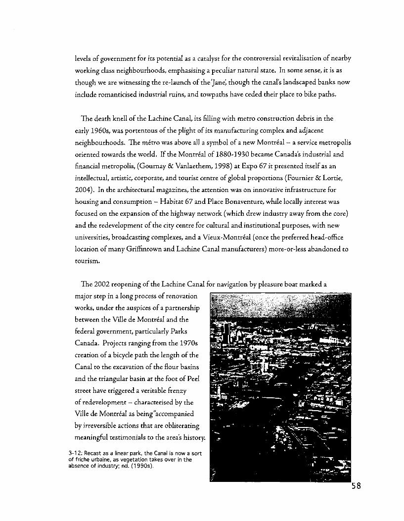
levels of government for its potential as a catalyst for the controversial revitalisation of nearby
working class neighbourhoods, emphasising a peculiar natural state. In some sense, it is as
though we are witnessing the re-launch of the 'Jane^ though the canal's landscaped banks now
include romanticised industrial ruins, and towpaths have ceded their place to bike paths.
The death knell of the Lachine Canal, its filling with metro construction debris in the
early 1960s, was portentous of the plight of its manufacturing complex and adjacent
neighbourhoods. The metro was above all a symbol of a new Montreal - a service metropolis
oriented towards the world. If the Montreal of 1880-1930 became Canada's industrial and
financial metropolis, (Gournay 8c Vanlaethem, 1998) at Expo 67 it presented itself as an
intellectual, artistic, corporate, and tourist centre of global proportions (Fournier & Lortie,
2004). In the architectural magazines, the attention was on innovative infrastructure for
housing and consumption - Habitat 67 and Place Bonaventure, while locally interest was
focused on the expansion of the highway network (which drew industry away from the core)
and the redevelopment of the city centre for cultural and institutional purposes, with new
universities, broadcasting complexes, and a Vieux-Montreal (once the preferred head-office
location of many Griffintown and Lachine Canal manufacturers) more-or-less abandoned to
tourism.
The 2002 reopening of the Lachine Canal for navigation by pleasure boat marked a
major step in a long process of renovation
works, under the auspices of a partnership
between the Ville de Montreal and the
federal government, particularly Parks
Canada. Projects ranging from the 1970s
creation of a bicycle path the length of the
Canal to the excavation of the flour basins
and the triangular basin at the foot of Peel
street have triggered a veritable frenzy
of redevelopment — characterised by the
Ville de Montreal as being "accompanied
by irreversible actions that are obliterating
meaningful testimonials to the area's history.
3-12: Recast as a linear park, the Canal is now a sort of friche urbaine, as vegetation takes over in the absence of industry; nd. (1990s).

Construction of residential complexes has occasionally led to privatization of land along the
Canal that runs counter to public-domain restoration efforts" (Montreal, 2004: 9). Wi th
projects stretching from Cote-Saint-Paul in the west to the Windmill Point mouth of the
Canal in the east, ranging from small-scale renovations or the construction of cooperative
housing on part of an urban block to (controversial) proposals for a contemporary art
museum, circus facilities, and a casino, the Lachine Canal now occupies a prominent place in
the discursive world of Montreal urbanism.
The challenges of southwest Montreal's decline and revitalisation have been met head
on by a remarkably engaged community. It was in Pointe-Saint-Charles that the first
community clinic, a precursor to the Quebec-wide network of Centres locaux de services
communautaires, and it is in the southwest that one of Montreal's most active Corporations
de developpement economique communautaire, the RESO, is based. The RESO's 'Rapport
synthese sur le forum du canal de Lachine' (2001) expresses the potential emergence of a new
economic climate, emphasising creative industries, the maintenance of a shrinking industrial
base, and strategies for maintaining affordability and socio-economic diversity in a gentrifying
neighbourhood.

4. Two analytical narratives | Chapter four
Introduction
This chapter presents two analytical narratives rooted in the analysis of historical context,
theoretical perspective and methodological vocabulary elaborated in the previous chapters.
Drawing on the notion of the city as a structural phenomenon - non-intentional, collective,
socially and temporally diffuse - this chapter undertakes a reading of the urban tissue of the
Lachine Canal basin. The first of the two analytical narratives examines the urbanisation
of Grifflntown, the southwest's first industrial district, by highlighting the elements,
relationships, and transformative processes that characterise Griffintowns urban tissue.
The second analytical narrative takes a closer look at the industrial complexes throughout
the eastern Canal basin - from Cote-Saint-Paul in the west to Windmill Point in the east.
After this second narrative develops a typology emphasising the degree to which industrial
complexes are integrated with the surrounding urban tissue, it proceeds to examine the
history and morphological composition of the different industrial sectors and railyards.
Though they tackle different aspects of the phenomenon of southwest Montreal's
industrial urbanisation, these two analytical narratives are linked together by an underlying
preoccupation with the integration of specialised industrial infrastructures, complexes, and
sectors within the broader urban tissue. Such an undertaking is somewhat innovative. In
contrast to studies focusing on the aesthetic qualities of industrial architecture - usually
most appreciated once it has fallen into, as Banham (1986) terms i t , picturesque ruin'
— and the thorough body of work that has been produced on the morphology of residential
environments, both generally and in southwest Montreal specifically (Dubois, 2005), these
two analytical narratives seek to systematically explore the logic of a Nor th American
industrial district through a morphological reading of its elements, relations, and processes,
with a particular emphasis on the variable degrees of integration between industrial
infrastructure and the urban tissue, in terms of the correspondence that specialised,
industrial forms show witli the non-specialised, largely residential urban fabric.
The reading of the city presented in the following pages is inherently a work of
interpretation. This chapter is preoccupied with presenting this take on urbanisation,
industrialisation, and regeneration, the implications of this analysis are explored more fully
in the fifth chapter; the discussion presents a more interpretive discussion that emphasises
the implications of these readings for our understanding of industrial urbanisation in a
theoretical sense, and for heritage and regenerative planning in a practical sense.

Urbanisation and industrialisation in Griffintown: reading Grifflntown's urban tissue
Introduction
Early urbanisation in the Griffintown area seems to have three principal aspects, namely
two tensions between different settlement forms. The first of these tensions is between
vernacular and planned settlement forms emanating from two different underlying territorial
systems. Beauregard's study of the cote system on the island of Montreal reveals a significant
border between two systems of landholdingjust south of present day rue Notre-Dame
(1984: 51). To the north, the typical seigneurial pattern prevails, anchored by tlie cote
Saint-Antoine further up the hill, in what is now Westmount. To the south, however, the
pre-urban landscape is marked by two large entities: the ferme Saint-Gabriel, and the fief
Nazareth. Significant differences emerge when these two systems are compared, particularly
in terms of modularity and in terms of processes such as aggregation and densification. In
some respects, due to the positioning of rue Notre-Dame in such close proximity to this
fault line, this tension foreshadows a tension between the differing scales and morphological
characteristics of residential and industrial urban tissues that marks the history of the
Lachine Canal. Rue Notre-Dame, with its high-street functions, its historic role as a multi
purpose and very urban matrix route, and its regional importance — it has always been one
of the key routes to Lachine, even in the tramway era - makes for a centralizing nodal axis
of very different character in comparison with the Lachine Canal. While Notre-Dame is
centralizing and nodal in relation to the residential urban tissues which it serves as a spine,
the Lachine Canal does the same at a regional scale, serving as a centralizing nodal axis for
industrialisation but acting as an edge or periphery to adjacent residential neighbourhoods.
Indeed, even within the fief/ferme system, distinctive forms of urbanisation took root.
While the fief Nazareth was largely developed as an extension of the typical Montreal
street grid, with tlie earliest blocks (on the east side of the C N viaduct and the autoroute
Bonaventure) coming to be known as the 'Faubourg des Recollets.' A long-standing property
line, rue de la Montagne (formerly McCord) separates the fief Nazareth from the Sulpician's
Ferme Saint-Gabriel, and emerges as an important dividing line between the continuation of
the Montreal grid and the creation of new forms linked specifically to the canal.
The area to the west of rue de la Montagne appears to show a greater tendency to change
structurally depending on the configurations of buildings and basins, at least until 1879. The
platting proposed by Ostell doesn't seem to get fully executed, while the triangular section

immediately north of the basins goes from four to two blocks between 1879 and 1949. East
of McCord, the only analogous restructurations are when the railway is pushed through to
the port, resulting in the creation of rue Brennan. Even the C N viaduct and the autoroute
Bonaventure more or less follow the existing street grid and parcel pattern.
The second source of tension is contained within the industrial sphere itself. While at a
regional scale, the Lachine Canal is a strongly centralizing nodal axis for the industrialisation
not just of Grifflntown, but of the entire southwest of Montreal, it is not without internal
variation. Within the Griffintown district, the Saint-Gabriel locks hydraulic pole is at
the core of a very different sort of urban tissue. Its primarily manufacturing-oriented
attractiveness contrasts greatly with the areas of Griffintown immediately eastward, where
canalside urbanisation is related far more to transhipment and warehousing, resulting in a
quite different parcel modularity, building vocabulary, and a different means of going about
aggregation and densification.
The physical traces left by the distinction in uses between the Saint-Gabriel locks area and
the basins (Saint-Gabriel and Flour) area prevail to this day.; the basins had an enormous
impact on adjoining urban tissue, encouraging the development of vast spaces for materials
handling. While the locks area is densely covered with buildings of a variety of forms, and
has relatively little open space, the basins area has minimal building and large open spaces.
In a sense, there is a morphological expression of the split between production and trans
shipment or materials handling (manutention); the Saint-Gabriel basins were used for lumber
and coal, while the locks area was a focal point in the hydraulic energy system. The two areas
both have somewhat irregular parcel and street patterns and are both coarse grain', but the
configuration of buildings and open spaces differs significantly. In a sense: water as energy
encouraged dense building configurations and water as shipping route encouraged discrete
buildings and open spaces. This notion of infrastructure exerting an impact on the urban
tissue can also be extended to the transportation infrastructures that followed the canal,
the railway and the autoroute; the rails in the 1879 map show this going further into the
urban tissue along Wellington near the Peel basin. This appears (by looking at the 1949 and
2005 maps) to have continued even after the canal lost its significance as an energy source.
The placement of the Canada Post sorting facility, while surely having much to do with the
fact that it was already government-owned, seems to continue this trend, as it was a trans
shipment facility (though not connected with the water). It was likely connected more with
the autoroute Bonaventure, as is the replacement facility in Pointe-Saint-Charles.

The element of government ownership and the limited spread of the Ostell group's interest
in Saint-Gabriel land (they only wanted land where they could exploit the hydraulic energy)
likely also comes into play here. The tight subdivision of Ostell and Cos St-Gabriel pole thus
contrasts with a vast area left vacant until prior to the public sector development of lumber
and coal transhipment basins, greatly expanding the interface between continental water-
borne transport and local, road-borne transport, and rebuilding the freight entry to the city
in a much more specialized fashion.
As a means for more precisely understanding the system that underwent the tensions
and transformations described above, the following pages catalogue the composition of
Griffintown's urban tissue. In presenting a reading of Grifflntown's urban tissue that
identifies its constituent elements, their inter-relationships, and (trans)formative processes,
this analytical narrative attempts to identify a structure of urbanisation and industrialisation
of the built landscape by profiling the component subsystems of Griffintown's urban tissue.
With this in mind, the analysis highlights elements such as the route network, parcel
structure, infrastructure (water and rails); and buildings, and their principal variables, such
as dimension, configuration, and in the case of parcels and industrial complexes, modularity.
The reading goes on to explore the inter-relationships between these components, and the
(trans)formative processes by which they emerge and change through time.

Griffintown l80fc=-O7'c7«T -^ ^ 3** * T " 4-1: Griffintown, 1801; Largely agricultural, parcels are beginning to be subdivided along the matrix routes.
n-iiv^-t.
l ^ L 111 --«;s:~£iiL. ^ i i '•'•••
---~--,J ,r :"' '%. 'r, f-^S
~ ~i rfirrTr^:
//
; \
WsBlmriB
1DS!¥f
Griffintown 182S O G C i I?,
4-2: Griffintown, 1825; The fief structure is still intact, though eastern Griffintown sets the tone for things to come.
64

i l M-
, + H — i
a .adBRD
«:4Jt mm^ :Jt#G
it",!
!'E3i L-*' -IP-- -
Griffintown 1846 © c~ K T ,» .J?"' 4-3: Griffintown, 1846; Ostell's scheme confirms the importance of the Canal.
i V > !
. • j - ju iac f f j ih i . ' - ' i
• • / / /
'..t af
-^J^;Xi\ • • l i l t ;-..-- . ^ ;H-ht
17
in- I L r i ^^.^ni-y^ck'^r^ ftpp
Griffintown 1879 9 »~ JT .* .-*, « *£**"*
4-4: Griffintown, 1879; The Saint-Gabriel locks complex takes shape and industry grows in scope near rue Wellington.

^
_ i L E J J L _ J irr N; ' ;
( — * !
m
Griffintown 1949 9 r ^ T ™ :»-~- *£*" 4-5: Griffintown, 1949; The industrial canal at its peak in terms of both transhipment and production.
iEHSi
7/ /'X ?n^
X "n
3 fly
~*i
.' v V-. ! f ! r-1 . I JI I !p3'
^ ' i 1
1 -/ / i
i.J n t ; F !yat V
Grif f intown 2005 © r ^ * 1 ^ ^ " - " - ' ^ „ ? " "
4-6: Griffintown, 2005; Consolidation and retreat, as Griffintown comes to house fewer, but larger buildings.

Elements/constituent subsystems
Routes
••»«»»••»*••» BriMkihrough route
G-iffincown 2005 O " * . ,~ r———• .'• "
4-7: Route types in Griffintown, 2005; Solid lines-matrix routes; largest dash-settling routes; medium dash-connecting routes; fine dash, breakthrough routes.
Matrix routes
Three matrix routes (see Caniggia and Maffei (2001) and Larochelle and Gauthier (2002)
for precise definitions) cross the Griffintown territory, linking Ville-Marie with points west:
Saint-Henri and Lachine. One of these routes, Notre-Dame, takes a fairly direct line to
Lachine, roughly parallel with the canal, while the others take'upper' - Saint-Jacques - and
'lower' — Wellington — lines. In addition to topographical and north/south distinctions, this
division into upper and lower also reflects the historical existence of two centres above the
Lachine rapids - Upper Lachine, which is present-day Lachine; and Lower Lachine, which
is in the territory of present-day Lasalle, near the entry for the aqueduct. All three, however,
exhibit a structuring influence not just on Grifflntown's territory, but on the entire southwest
of the island of Montreal.
• Notre-Dame - route to Lachine, subsequently paralleled by the canal; the western
extension of the Chemin du Roy leading to Quebec City
• Saint-Jacques - upper Lachine road, a 'high road' passable in winter and spring
• Wellington - route to Verdun and to Lachine via the band of lakeshore setdement
dating back to the French regime

Settling routes, connecting routes
By and large, the pattern of settling and connecting routes is straightforward. In eastern
Griffintown - the section formed by the old fief Nazareth and subdivided under the auspices
of Mary Griffin - the settling routes run perpendicular to the rue Notre-Dame and rue
Wellington matrix routes, while the connecting routes (William and Ottawa) run parallel.
Established early on, this pattern changes relatively little through time, aside from settlement
and infill development (splitting of parcels along the connecting routes so as to increase
frontage opportunities), addresses tend to be on the matrix and settling routes in a fairly
regular and consistent urban structure.
West of rue de la Montagne, the western half of the Griffintown district - subdivided
from the ferme Saint-Gabriel by John Ostell in the 1850s - has a much more complex
structure. Though Ostell's original scheme was quite legible in some respects - unlike
eastern Griffintown, it was explicitly anchored to the Canal and the basins as an industrial
matrix route - it recommended some major changes to the status of the connecting routes
mentioned above. In western Griffintown, rue William and rue Ottawa became settling
routes, accompanied by rue Bassin and rue Olier. The north-south setding routes of tlie
Cote-Saint-Antoine territory (rue Saint-Martin, rue Richmond, rue Guy) saw die reverse
configuration occur, becoming connecting routes once they crossed rue William.
Following the multiple configurations of the Saint-Gabriel basins, and their ultimate filling
and conversion for use by Canada Post as a massive sorting facility, this structure, with its
'east-west, parallel with the Canal' structure, is still distinct from that of eastern Griffintown,
though even it - as evidenced by Ostell's original plans - was originally informed by the
residential tradition and spatial configurations, though with a large parcel size well suited
to warehousing and industry. Subsequently it has seen its legibility in that sense radically
transformed as the scale of transhipment facilities grew to occupy entire blocks, thereby
blurring the distinctions between setding routes and connecting routes.
Breakthrough routes
Griffintown counts two breakthrough routes — streets (or passages) that have been cut
through existing blocks. One, Brennan street, was occasioned by the arrival of the G T R
and the necessity of connecting their Pointe-Saint-Charles yards with die port. This
restructuration involved the creation of an angled street leading from the Wellington bridge
to the port, along which new and unconventional building-parcel relationships could take
root, reflecting the need to accommodate the infrastructure and the industrial opportunities a

railside location offered. The Brennan street axis lost its railway function after 1949 and was
truncated by the construction of the Bonaventure autoroute in the 1960s, though it has since
been restored in an effort to improve connectivity between Griffintown and the Faubourg des
Recollets, on opposite sides of die highway.
The second breakthrough route, Smith, or Wellington street, was a rationalisation of
a previous matrix route, with Wellington street being rerouted along the Smith street
alignment, which was subsequently straightened and widened. Smith street was only
partially created by 1879, through the lower part of the blocks between Ottawa and
Wellington from Murray to Colborne. By 1890, its fuller alignment, also incorporating the
block-long Saint-James' lane between Dalhousie and Ann streets, was in place, though still
relatively narrow and somewhat irregular in routing. By 1949, as part of a restructuration of
the arterial road network in the Griffintown area (together with Colborne and Notre-Dame
streets) prior to the implementation of a new tunnel under the Lachine Canal, Wellington
street was rerouted to follow the alignment pierced by Smith street. The alignment was
straightened, with a large curve put in at the foot of Saint-Ann's church to link up with the
Wellington tunnel. In its latest incarnation, the Wellington tunnel has been replaced by a
bridge built to highway design standards.
• CDmmificifll l i i w l
;nrtinrcHvn 2gu2 4-8: Commercial streets in Griffintown; Note that these streets tend to occupy the 'short' side of the block and are those with the highest accessibility.

Commercial street formation
Commercialisation occurred unevenly on the territory of GrifEntown. Though principally
on the three matrix routes, the presence of commerce was most prominent on rue Notre -
Dame, though also present to a lesser extent on Wellington and Ottawa streets. This echoes
a Montreal tendency to commercialise streets that run against the dominant grain of the
grid (in Montreal, the long blocks are usually oriented in a distinctive northeast/southwest
fashion, inherited from the seigneurial agricultural land pattern that runs perpendicular
with the Saint-Lawrence river). Presumably, such streets profit from improved network
integration in a space syntax sense (Hillier &C Hanson, 1988), an abundance of higher-profile
corner locations, and a generally higher concentration of traffic. Since long and coherent
east-west streets are less common (many such streets run for only a handful of blocks), they
can thus be supposed to be more intensively-used thoroughfares. The fact that two such
routes in Griffintown, rues Notre-Dame and Wellington, are also matrix routes, reinforces
the above comments by virtue of their historical advantage as nodal axes.
Rue Notre-Dame was the first urbanised route, with detached dwellings as far west as rue
Guy by 1825 and a concentration near rue McCord as early as 1825. There is somewhat of
an equivalency of development along rue Wellington by 1825 as well (with some lots facing
it at the corner of Duke or Nazareth), but not to the same extent as rue Notre-Dame. It is
likely that rue Notre-Dame was die more trafficked of the two, as it was the direct route to
Lachine and Saint-Henri as opposed to swinging south through Verdun and along the river,
which had no major poles of settlement along the way to Lachine. There is fairly significant
densification (build-out within the modules, without restructuration) along rue Notre-Dame
between 1879 and 1949, whereas along Wellington, where the commercial mix seems to have
become a bit more industrial, it looks like there is a greater tendency towards aggregation
across parcels, with buildings therefore consisting of multiple lot modules, for instance at the
corner of Colborne (Peel)/Wellington, which is not a typical characteristic for a commercial
street.
There are a few lots facing Ottawa by 1846 in the western part of Griffintown, between
Colborne and McCord streets. These correspond to the typical module, which isn't the
case in the eastern section of GrifEntown subdivided by Mary Griffin, where it seems likely
that there was a splitting of lots along connecting routes. In the western section, this parcel
orientation seems more intentional due to its correspondence with the typical parcel module.
By 1949, it's Ottawa street that is the most clearly defined by a strong wall of buildings and
that conserves the most small buildings - characteristic of neighbourhood commerce.

Parcels
Griffintown is at the southern edge of an important frontierejonciere, or property limit, with
the southern limits of the fiefs Saint-Augustin and Saint-Joseph, both attached to the Petite
Cote-Saint-Antoine at their northern limit, meeting the domaine (ferme) Saint-Gabriel and
the fief Nazareth - the grid platted for Mary Griffin (see figure 4-9). Six different parcel
modules can be identified. While this section of the analytical narrative does discuss their
transformation (largely through aggregation), the section of this analytical narrative dealing
with (trans)formative processes tackles these transformations in more detail.
4-9: Early seigneurial concessions and fiefs. Note the stark division at left, which roughly follows rue William.
In the fief Nazareth, the typical parcel module is approximately 10x30m (33x98 imperial
feet or 30x92 French feet). Frequently aggregated into groups of two and often more; this
process usually occurs with parcel modules lying side-by-side, but aggregation can also
involve die fusion of parcels'through' the block to the next street. Such aggregation appears
to be considerably more widespread in the area east of present-day rue Peel, which could be
considered as being further from Griffintown's residential pole, centred on the Saint-Ann's
church, constructed in the late 1840s. These parcels have a strong modularity which is
reflected tlirough aggregative processes: double and triple modules involving the aggregation
of adjacent parcels are common, and also complemented by through' block aggregation,
involving parcels with addresses on different streets.
In the areas of the ferme Saint-Gabriel focused on the basins, the original 1840s Ostell
subdivision consisted of two basic parcel modules, one, near the original square basin and
facing the Canal, measuring approximately 6x30m (20x98 imperial feet or 18x92 French

..a.
_:j
ijj]
;nin
riT
;ri.
iirr
rniJ
il;
-~^J
t..
.J..J
L-l
"M
yr
>vl
4-1
0:
Th
e S
aint
-Gab
riel
Bas
ins
*J
blo
ck.
1846
250
i Met
ers
375
500
4-1
1:
Blo
ck b
ou
nd
ed
by
rues
du
Sem
inai
re,
Sa
int-
Au
gu
stin
(R
iou
x),
Bas
sin,
and
Ott
aw
a.
'"^-
m
1879
1949
2005
o 0
6
2i
«!S
KM
4-12
: N
ort
h o
f th
e S
aint
-Gab
riel
Lo
cks.

feet) and extending through the block; the other, inland, measuring approximately 12x25m
(40x82 imperial feet or 36x77 French feet) and extending to the mid-block (see figure 4-11).
Though demonstrating a keen insight of the relationship between city and water, these were
rapidly discarded as the area's scale shifted dramatically when it became the site of a major
transhipment complex centred on the Saint-Gabriel basins. Though cast aside as explicitly
available parcel modules in favour of a larger scale, these modules - particularly the latter
— remained crucial determinants of block size, as witnessed by the block between rue du
Seminaire, rue Saint-Augustin/Rioux, rue Bassin, and rue Ottawa, which though now
occupied by one large structure, is still broken up into parcels reflecting these origins.
In the areas of the ferme Saint-Gabriel focused on the hydraulic basins (the Ostell/Young
development), there are two typical parcel modules (see figures 4-11 and 4-12) The first, the
hydraulic parcels developed by the Ostell-Young consortium along the north side of the locks,
has a typical module of approximately 40x65m (131x213 imperial feet or 123x200 French
feet). The depth of these modules is highly variable due to the curve of the Canal and the
unusual alignment of rue des Seigneurs, yet their width is generally 40m. Further removed
from the water — and crucially, not in the realm of hydraulic parcels — yet still part of Ostell's
subdivision plan, the Saint-Gabriel locks area has a different typical parcel module, measuring
approximately 6x25m (20x82 imperial feet or 18x77 French feet). These very narrow parcels
were later almost entirely aggregated into larger groupings, often double modules, which
were widespread as early as 1879, but also into much larger complexes, which span as many
as seven adjacent modules. The small block dimensions in this sector result in a variety of
irregular aggregations through the course of time - over a relatively long period as initial
uptake was slow - though this module remains at their base.
In the Cote Saint-Antoine area of Griffintown, along the rue Notre-Dame matrix route,
the typical parcel module is approximately 10x30m (33x98 imperial feet or 31x92 French
feet). Along rue Notre-Dame these modules are rarely aggregated into groups of more than
three, in great contrast to the significant aggregations visible elsewhere in Griffmtown.
These modules have been crucially important for the subsequent transformation of
Griffintowns urban tissue. In the fief Nazareth, the modules have been the structure
according to which densification took place. It appears that parcels were first occupied by
one or two buildings at the front of the lot with (largely wooden) ancillary structures at the

rear. Subsequent densification and aggregation involved larger industrial buildings expanding
either across the width of the block or along one of its sides, with significant densification,
sometimes to the point of leaving no space unbuilt at all.
At the Saint-Gabriel locks, where the
hydraulic pole was developed by a syndicate
led by John Ostell and John Young, the
modules have been the structure according
to which significant densification occurred.
Hydraulic power was made available by
diverting water from the channel of die old
(pre-1840s) canal to a mill race. Parcels were
arranged in a deep/narrow configuration so as
to allow for as many water users as possible.
The module is particularly well-defined to the
west of the locks, where densification has filled
many of the original parcels.
rmvmnm 1846 ̂
mm T mm
1879 m I / !\mtn
SECTORS 1949
2005
m'rTTh FFJiira.1 ran
P*S0TR
62 5 125 250 375 • Meiers
600
4-13: Parcels belonging to the Cote-Saint-Antoine area, from along rue Notre-Dame.
Along the Notre-Dame matrix route, die modules have also been structurally important,
and can be distinguished from the remainder of Griffintown by their more vernacular form.
Along the southern side of Notre-Dame, minimal opportunities existed for expansion of land
holdings - the northern boundary of the Fief Nazareth and the Ferme Saint-Gabriel were
close at hand — thus prompting a less regular parcel module. In some cases, parcels stretch
quite deeply, to the boundary between the Fief/Ferme and cote systems, while in others, the
introduction of secondary streets such as Barre or Lusignan streets (see figure 4-14) adds
considerable variation even as it is clear that attempts were being made to impose a more
consistent - and smaller - parcel module on the tissue.
•S* J S i l f B - -
:il vm *N^̂ ~f
£T , i Z h -
> Kin •">. ' i --J. ,—
H'K--:- I.1 Z ' £- ">i--lJ.J,. 1 '
!-m ... J*ff i£-L _~_
i £-'.'. ^ ^ f ™ T ~ ' 1 , " . - . • - - - ~ •
- : - " • • -
mmm j^^-^:^m ' V'" ufe^V
tSJf F?4 '?->' - H TTTW^r'' " * H
i*fe."»r&''^ j""!0^
4-14: The area along rue Barre marks the transition between fief and cote and has a distinctive pattern of densification due to the insertion of smaller secondary streets, such as rue Lusignan; 1890.
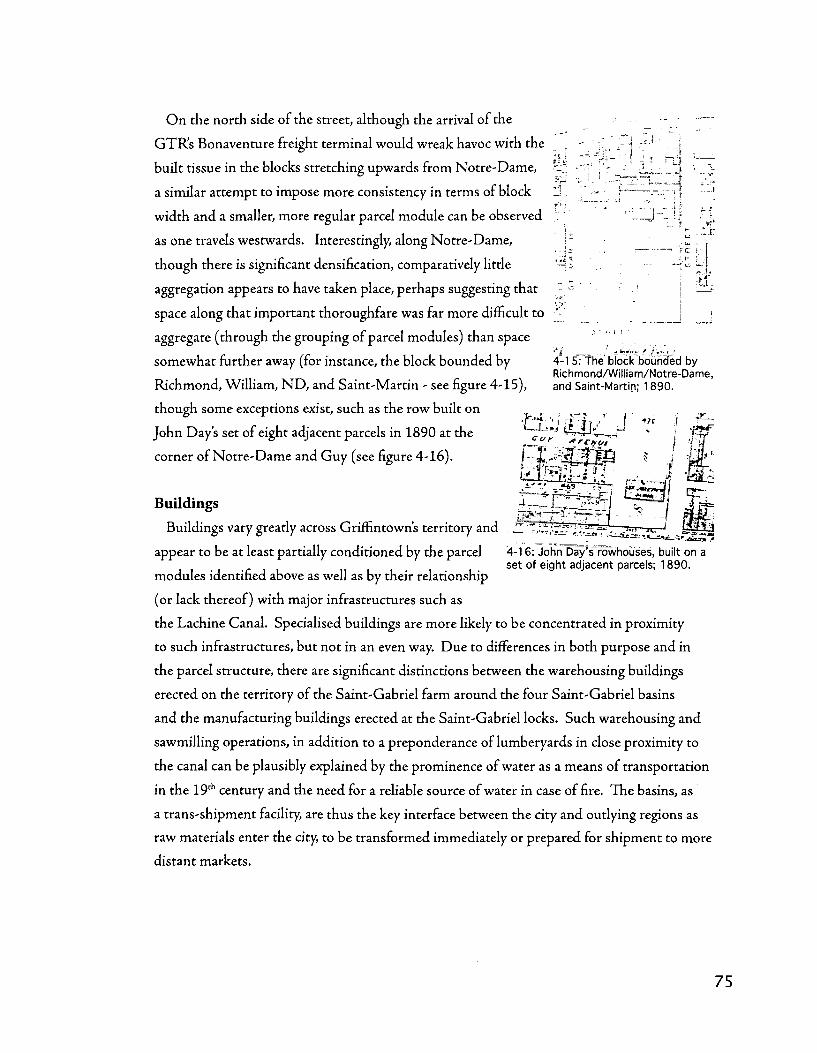
O n the north side of the street, although the arrival of the
GTR's Bonaventure freight terminal would wreak havoc with the
built tissue in the blocks stretching upwards from Notre-Dame, h
a similar attempt to impose more consistency in terms of block I_i - ---_ >f
width and a smaller, more regular parcel module can be observed
as one travels westwards. Interestingly, along Notre-Dame,
though there is significant densification, comparatively little
aggregation appears to have taken place, perhaps suggesting that
space along that important thoroughfare was far more difficult to ' , }
aggregate (through the grouping of parcel modules) than space ...... i i . ^l ; _ / ifcVw- / /•,'.-_• /
somewhat further away (for instance, the block bounded by 4-15: The' block bounded by Richmond/William/Notre-Dame,
Richmond, William, N D , and Saint-Martin - see figure 4-15), and Saint-Martin; 1890.
though some exceptions exist, such as the row built on
John Day's set of eight adjacent parcels in 1890 at the
corner of Notre-Dame and Guy (see figure 4-16).
Buildings
Buildings vary greatly across Griffmtowns territory and ^ S S ^ J T ^ ^ r ^ ^ — ^ r J W-g&
-?**-••[ rF*. G z/ y rffCAIVt
I
appear to be at least partially conditioned by the parcel 4-16: John Day's* rowhouses, built on a set of eight adjacent parcels; 1890.
modules identified above as well as by their relationship
(or lack thereof) with major infrastructures such as
the Lachine Canal. Specialised buildings are more likely to be concentrated in proximity
to such infrastructures, but not in an even way. Due to differences in both purpose and in
the parcel structure, tliere are significant distinctions between the warehousing buildings
erected on the territory of the Saint-Gabriel farm around the four Saint-Gabriel basins
and the manufacturing buildings erected at the Saint-Gabriel locks. Such warehousing and
sawmilling operations, in addition to a preponderance of lumberyards in close proximity to
the canal can be plausibly explained by the prominence of water as a means of transportation
in the 19th century and the need for a reliable source of water in case of fire. The basins, as
a trans-shipment facility, are thus the key interface between the city and outlying regions as
raw materials enter the city, to be transformed immediately or prepared for shipment to more
distant markets.

Contrasting locks and basins, factories and warehouses
Saint-Gabriel locks
• Manufacturing
• Significant densification
• Brick/stone
• Smaller parcels and
blocks
• Smaller footprint
., _,.... —
Saint-Gabriel basins
• Transhipment, warehousing
• Retention of open space
• Wood
• Larger parcels and blocks
• Larger footprint
Specialised buildings
The Griffintown district is home to a wide variety of specialised buildings. The industrial
building stock has emerged over a long period, from the earliest quayside stone warehouses
and small brick foundries to the sheet metal and gigantic scale of a building like Canada
Post's sorting facility, there is a significant degree of architectural diversity in the district.
Though this thesis' interests lie in the realm of the urban tissue and not in the architectural
characteristics of its buildings, the following pages catalogue images of relevant building
types into two groups as a means for gaining a better understanding of the internal contrasts
of the district, namely the spatial distinctions between manufacturing and transhipment and
their divergent relationships with the Canal.
Griffintown's urban tissue once hosted a thriving, largely Irish residential neighbourhood
amidst its industrial complexes. In the latter half of the 20th century, conscientious efforts
were made, through zoning and expropriation, to remove die residential component
from the district. The residential building stock is a compelling feature in two respects.
First, as a component aggregated into what this thesis terms 'urban-integrated industrial
complexes' general, non-specialised, urban building played an important role in the early
industrialisation of Griffintown. Second, as a component that was to a large degree/wiped
off the map,' the spaces left behind by residential buildings - largely between 1949 and 2004
— are now among the most feasible sites for small-scale urban regeneration.

Warehousing in Griffintown appears to have been more
concentrated in the eastern, gridded part of the district,
that laid out by Charland. Buildings are somewhat
specialised, in terms of the ornamentation of the facade,
but otherwise, their unique structures are relatively similar
in terms of volume and height to typical commercial or
residential buildings in the neighbourhood.
4-17b: Canada Cold Storage
4-17a: Redmond Wholesale
? :1\|A*&*
4-17d: Gould Cold Storage assess;
4-17c: Union Cold Storage
DM i»'„iAnuMrni
1 »'*\sS'J WAREHOUSEMAN T^ ' - 'F"
I.*'-
SlocajJKlo*. **!&»« « * Qw«o Steal* « - . . - , . • WC^TREAl.' - •"5s 4i*f «»* iwtw a n n u m - »*« nami'if * T & ^
4-17e: JWentworth Hill 4-17f: Outdoor sawn lumber storage near the Saint-Gabriel basins
77

Grimntowns manufacturing sector, largely
concentrated at the hydraulic pole at the Saint-Gabriel
locks, is characterised by structures that tend to be
more distinguishable from the general residential
fabric, though in many cases these can be seen as an
adaptation of residential buiding types, and in almost
all cases, an adaptive repurposing of the residential
block pattern that conserves much of its modularity.
These range from groupings of adjacent former
residences with afterthought smokestacks to modern
daylight factories.
4-18a: Jos Bonhomme, carriage maker
4-18b: The Phoenix Foundry 4-18c: Montreal Street Railway powerhouse
4-18d: At Augustin Cantin's Canada Marine Works, the product was stationary, while work processes shifted around it.
4-18e: The Darling Foundry; now home to Quartier Ephemere, an contemporary art venue.

V -*•--*--* "'• .:•' «#w^ . *» t»# j f iwi feasts'is ?* # M-, »*t .* J « > **«^? *"J»«I "
4-18f: Flammability in grain storage facilities was a major factor in the development of the silos that came to dominate the ciy's waterfront and serve as such vivid inspiration for European modernists.
4-18h: Gardner and Son's novelty works; A factory complex that works with the scale and modularity of the residential block.
4-18j: The Northern Electric's home prior to the massive plant in Pointe-Saint-Charles; an almost archetypal urban semi-autonomous complex (corner Guy and Notre-Dame).
4-18g: Fitt's Steam Bakery; Griffintown has a long tradition of hosting businesses that serve the adjacent urban core.
4-18i: Eagle Foundry; Note the increasing industrial specialisation of buildings towards the rear of the site, away from the street.
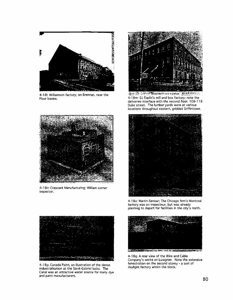
4-181: Williamson factory; on Brennan, near the Flour basins.
4-18n: Crescent Manufacturing; William corner inspector.
4-18p: Canada Paint; an illustration of the dense industrialisation at the Saint-Gabriel locks. The Canal was an attractive water source for many dye and paint manufacturers.
4-18o: Martin-Senour; The Chicago firm's Montreal factory was on Inspecteur, but was already planning to depart for facilities in the city's north.
4-18q: A rear view of the Wire and Cable Company's works on Lusignan. Note the extensive fenestration on the second storey - a sort of daylight factory within the block.
80

4-18r: JW Patterson, manufacturer of construction papers (tar paper, shingles) relocated to this set of one and two storey 'substantial' brick buildings on rue Murray from rue de la Commune. A few decades later, the exodus would be from Griffintown.
4-18t: Island City Paint and Varnish Works; Note the prominence accorded to the factory's ability to interact directly with the railway and the water, through large doors at street level.
4-18s: IT Bell factory, rue de I' Inspecteur; makers of fine footwear.
4-18u: Ames-Holden boot and shoe manufacturers; A combination of office and factory.
Dubois (2005) identified a variety of residential building types as part of a comprehensive
typo-morphological study of Montreal's Southwest. The 2005 morphological study of the
Arrondissement Sud-Ouest identified five residential building types in the Griffintown area,
almost all of which could be termed synchronic variants - newer building types current
at the then urban periphery yet also fitted to Griffintown's older and already established
urban tissue (Caniggia & Maffei, 2001: 76), thus occasioning variation from the type so as
to adjust to constraints (parcel dimensions and configuration, for example) particular to the
neighbourhood.
Three storey duplex, primarily found in parts of northern Ste-Cunegonde and
along the tracks in Pointe-Saint-Charles, but secondarily in Griffintown east of
Mountain.

Triplex with interior stairs, which has a similar distribution to above,
although also primarily located further west, in areas near the Turcot
interchange and in parts of Cote-Saint-Paul.
Apartment building, primarily found in the square Richmond area and
further west, as well as along the Ganal in the Saint-Ambroise sector.
Secondarily, it's found in Griffintown west of rue de la Montagne, from
the Canal up to rue Notre-Dame.
Mixed use building, found primarily along matrix routes (rue Notre-
Dame) and the most important commercial settling routes. Interestingly,
in Griffintown, its distribution is identified as stretching all the way
from rue Notre-Dame south to rue Barre, but stopping a block west of
the ETS, where the urban tissue changes dramatically in die square 4~19: Residential building types
Chaboillez area. In the past, the riviere Saint-Pierre and the industrial according to Dubois (2005).
complex of the Dow brewery served to distinguish this sector, Three storey r r J L u • ii i duplex; Triplex
currently marked by the restructurations imposed by the autoroutes with interior
Ville-Marie and Bonaventure, and the redevelopments around die building.
ETS campus.
Commercial building, which follows a similar pattern to the above, but with a larger
(secondary) distribution throughout most of the territory of Saint-Henri.

Infrastructure
Infrastructure has had an immense impact on Griffintown, from the construction of the
first canal in the 1820s to its upgrading and industrialisation in the latter half of the 19 th
century, and from the growth of the railway network to the implantation of the autoroute
Bonaventure, Griffintown, like many inner-city neighbourhoods, has accommodated a large
degree of metropolitan infrastructure on its relatively small territory.
Lachine Canal
The effects of the Lachine Canal have been multiple in Griffintown, but in terms of its
impact as a structuring axis for industrial growth, or a vector of industrialisation, there have
been two distinctive sets of consequences. As a transportation infrastructure, it has attracted
significant transhipment activities, largely (though not exclusively) in the vicinity of basins,
such as the Flour Basins at the foot of Peel street, or the set of four Saint-Gabriel Basins.
The urban tissue surrounding these areas - the deployment of particular building types,
the orientation and modularity of the parcel structure, and the characteristics of the route
network — are in large part distinct from more general urbanisation elsewhere in Montreal
due to their coarse grain. On the other hand, where the canal provided a hydraulic energy
potential, such as at the Saint-Gabriel locks, a very different, much finer grained urban tissue
emerged, with a tendency towards smaller parcels, a denser building coverage, and a tighter,
more permeable block structure.
A stronger edge between the neighbourhoods of Griffintown and Pointe-Saint-Charles
could not easily be imagined. In that sense, it's easy to qualify the Lachine Canal as a
peripheral/anti-nodal axis. However, in its latest incarnation, as a recreational amenity, the
canal is now an axis in a new sense, serving as an attractor for residential redevelopment
— whether through renovation of existing structures or new construction — and tourism. The
success of this transformation or repolarisation is highly uncertain and seems unlikely, given
the divergence between the canal's status as a structuring axis at a regional (and until recendy,
industrial) scale, and its impact as an internal periphery within the city, separating distinct
residential tissues.
Rail
The implantation of rails in Griffintown has taken a variety of forms that vary according
to their integration with the surrounding urban tissue, though almost all of them imply
restructuration of some degree.

Along Brennan street, when the breakthrough route was created to allow the Grand Trunk
Railway (GTR) to connect its Pointe-Saint-Charles yards with the port, the rails took the
form of an in-street freight railway, not impeding any crossings and with very little substantial
infrastructure other than the rails themselves. Business along the route could and did
connect to the infrastructure, making it more than just a through route.
Along the north bank of the canal itself, the G T R also ran a spur line, branching off from
its mainline just west of the Atwater market.
Terminating in the midst of the Saint-
Gabriel hydraulic complex, this line ensured
the continued viability of milling operations
on the Pointe-des-Seigneurs and has certain *|
formal links with the G T R s spur line to the 4-20: Brennan street 1879, highlighting the Grand , , , , , Trunk's connection with the Port. Mammoth Elevator on Windmill Point,
dating to the 1870s.
The third railway presence in Griffintown is the C N viaduct. Built to connect the
nationalised Canadian Northern and Grand Trunk railway systems by extending the
Canadian Northerns tunnel under Mont-Royal to the industrial southwest, the viaduct
was a key component of a metropolitan network that largely bypassed the by then declining
Griffintown district.
By the time the C N viaduct had split Griffintown from Vieux-Montreal and the faubourg
des Recollets, the city core had by and large shifted to tiie 'New Town centred along Sainte-
Catherine street. However, this shift still left Griffintown disconnected from the city's
business centre due to the presence of the
Bonaventure freight depot. Though lying
just outside Griffintowns limits per se,
the huge facility - at their 1949 peak die
yards stretched from square Chaboillez
in the east to what is now boulevard Sir-
Georges-Vanier, with a width of what
would otherwise often have been three city
blocks. The impacts of this infrastructure
were twofold - while the freight terminal , „ „ „...„._, . . „ „ ^ b 4-21: The CN Viaduct in the 1940s.

attracted a variety of transhipment businesses and some industries, such as slaughterhouses
and bakeries, it had a decisively constraining effect on Grifflntown's expansion to the north.
Even as the area has been largely renewed under the guise of'Little Burgundy' and long
vacant parcels near square Chaboillez begin to see construction with the growth of the Ecole
de technologie superieure (ETS), the coarse
grain of the urban tissue in this area remains
intact in the form of very large parcels and
blocks.
Highway
Three infrastructural elements warrant
particular mention in this discussion.
The bridge over the Lachine Canal at
rue Wellington, can be interpreted as an ° 4-22: The GTR's Bonaventure Freight Terminal,
extension of the regional highway network; between Notre-Dame and Saint-Jacques streets. Condominium towers would eventually occupy the site,
along with rue Bridge it forms highway
112 which connects Montreal with the south shore via another southwest landmark, the
Victoria Bridge. Characterised as "KM projet autoroutier en ville" (Bodson, 2001), the design
implemented in the late 1990s espouses a more highway-oriented design, particularly in its
treatment of square Gallery and the important intersection with rue de la Montagne, which
in some sense forms part of the parvis of the former Saint-Ann's church. A continuation of
the restructurations first launched with the rerouting and then widening of Wellington and
Colborne (now Peel) streets, this infrastructure had major impacts on the adjacent square
Gallery. Where an initial proposal suggested the re-establishment of Dock street and thus
the creation of a stronger linkage between rue Wellington and square Gallery and a more
urban treatment of the intersection with rue de la Montagne, the final project bypasses
the square and largely ignores the symbolic and landmark potential of the intersection
with rue de la Montagne. The restructuring of this area is taken up in further detail in the
'restructuration' section of this analytical narrative.
The other elements of highway infrastructure in Grifflntown are larger in scale, more
closely tied into a regionally-scaled network, and less compromising in their relations with
the local urban tissue. They are also more celebrated and figure more largely in the discourses
surrounding Grifflntown's revitalisation. First, the autoroute Bonaventure. Built through a
partnership between the Ville de Montreal and the federal government in the lead up to Expo
1967 - for which Pointe-Saint-Charles was a potential site (Fournier & Lortie, 2004:142-
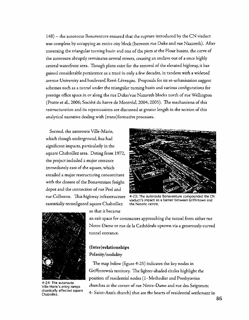
148) - the autoroute Bonaventure ensured that the rupture introduced by the C N viaduct
was complete by occupying an entire city block (between rue Duke and rue Nazareth). After
traversing the triangular turning basin and one of the piers at the Flour basins, the curve of
the autoroute abruptly terminates several streets, creating an enclave out of a once highly
central waterfront area. Though plans exist for the removal of the elevated highway, it has
gained considerable persistence as a trace in only a few decades, in tandem with a widened
avenue University and boulevard Rene-Levesque. Proposals for its re-urbanisation suggest
schemes such as a tunnel under the triangular turning basin and various configurations for
prestige office space in or along dhe rue Duke/rue NazaretJi blocks north of rue Wellington
(Pratte et al., 2006; Societe du havre de Montreal, 2004, 2005). The mechanisms of this
restructuration and its repercussions are discussed at greater length in the section of this
analytical narrative dealing with (trans)formative processes.
Second, the autoroute Ville-Marie,
which though underground, has had
significant impacts, particularly in the
square Chaboillez area. Dating from 1972,
the project included a major entrance
immediately east of the square, which
entailed a major restructuring concomitant
with the closure of the Bonaventure freight
depot and the connection of rue Peel and
rue Colborne. This highway infrastructure 4-23: The autoroute Bonaventure compounded the CN viaduct's impact as a barrier between Griffintown and
essentially reconfigured square Chaboillez the historic centre.
so that it became
an exit space for commuters approaching the tunnel from either rue
Notre-Dame or rue de la Cathedrale uptown via a generously-curved
tunnel entrance.
(Inter)relationships
Polarity/nodality
The map below (figure 4-25) indicates the key nodes in
Griffintown's territory. The lighter-shaded circles highlight the
position of residential nodes (1- Methodist and Presbyterian
churches at the corner of rue Notre-Dame and rue des Seigneurs;
4- Saint-Ann's church) that are the hearts of residential settlement in
4-24: The autoroute Ville-Marie's entry ramps drastically affected square Chaboillez.

the district, both on matrix routes (Notre-Dame and Wellington, respectively). The darkest-
shaded circles highlight GrifEntown's two hydraulic energy poles (2- Saint-Gabriel locks; 6-
Windmill Point), while the medium-shade circles highlight the districts transhipment nodes
(3- Saint-Gabriel basins; 5- Flour basins (at the foot of Peel).
4-25: Poles, nodes, and axes on Griffintown's territory.
Axes
The Griffmtown district has a somewhat complicated axial structure (figure 4-25, above).
Of three axes, two are centralising/nodal, Notre-Dame and Wellington streets. These
streets, both matrix routes, have been the focal axes for densification processes - from
attracting the earliest settlement to being the first areas in which parcel subdivision and the
pioneering of setding routes took place. The third axis, on the other hand, is the Lachine
Canal. While certainly a peripheral axis in residential terms - the canal acts as a formidable
barrier between Griffintown and Pointe-Saint-Charles across the water - the Canal was
also Canada's most dynamic industrial corridor for much of its history. For transhipment
and manufacturing, the Lachine Canal acted as a compelling centralising axis, though in an
industrial sense, and on a metropolitan and even regional scale that in many ways contributed
to a contradictory barrier effect in terms of GrifEntown's urban tissue, but also - as the third
narrative relates in greater depth - on die national and even continental scales.

(Trans)formative processes
Aggregation
Throughout Griffintown, parcel aggregation has been an important transformative process.
In the eastern part of Griffintown - that subdivided by Charland on behalf of Mary Griffin
and corresponding largely to the former fief Nazareth - parcel aggregation in the course
of industrial complex formation has altered a significant portion of the urban tissue. Two
types of aggregation, that of adjacent parcels within a single pertinent strip (the band of
parcels along one side of a street) into double, triple, or even quadruple modules, and that of
'through' block aggregation involving the fusion of parcels on opposite sides of a block. The
latter process appears most frequently along rue Smith and rue Wellington, in the vicinity
of the Flour basins, while the former process is quite widespread. In western Griffintown,
the areas subdivided by Ostell near the Saint-Gabriel locks - the hydraulic pole - and the
transhipment node centred on the Saint-Gabriel basins also show significant aggregation of
parcels, though with different characteristics. Nor th of die Saint-Gabriel locks, aggregation
has involved the fusion of parcels in a similar way to the process observed in eastern, gridded
Griffintown. At the transhipment pole, however, massively-scaled aggregation has resulted
in extremely large parcels - the entire Saint-Gabriel basins site (the recendy-closed Canada
Post sorting facility) — occupies one such parcel, while the blocks immediately north and east
of the site involve the fusing of parcels into aggregations ranging from three to as many as ten
(near the corner of rue Saint-Augustin and rue Bassin).
Parcels and streets are aggregated into blocks in a very coherent form in the gridded,
eastern part of Griffintown. Further west, due to presence of canal-related infrastructure,
this pattern becomes less coherent. Immediately west of McCord street, blocks become
much more irregular in order to accommodate the Saint-Gabriel basins, while near the Saint-
Gabriel hydraulic pole, die grid is offset due to tlie small space between Notre-Dame street
and its blocks, following from a more standard, seigneurial pattern, and die Canal, along
which parcels were arranged by Ostell to take advantage of the hydraulic potential
Along the Notre-Dame street matrix route, there are some vernacular block forms which
represent an attempt to more densely urbanise - through aggregation - the small strip of
land below Notre-Dame that is still part of the more standard, seigneurial pattern, and not
part of the Fief NazaretJi or the Ferme Saint-Gabriel. In contrast, the pattern to die north of
Notre-Dame is much more regular and similar in rhythm and dimension with die Montreal
standard. These streets and parcels, and the blocks into which they are aggregated, allow for
a much denser settlement pattern along the Notre-Dame matrix route, which as a nodal axis,

*---
would have in itself been an attractant for
settlement - especially given its role as the
leading route out of the west end of the city.
Many of the industrial buildings
described above are aggregated into what
can be termed urban integrated industrial
complexes, in which multiple buildings are
arranged together to facilitate production.
Visual evidence suggests that these are
composed of multiple buildings built at
different points in time, often with different
purposes in mind. Some of the buildings
in the complexes have the appearance of the
residential buildings mentioned in Dubois'
typology (2005), but are grouped together
in a new way. Certainly these aggregations
are conditioned by the parcel and route
pattern - the urban block - but there are
particular and distinctive arrangements for
two reasons: they're usually grouped around
a significant open space; and they usually
include at least one specialised industrial
building, geared towards either manufacturing or warehousing. These aggregations become
increasingly specialised and non-residential (in form) as one progresses through time and,
through space, further west along the Canal. The specific typological relations (of temporal
variance) between the most urban integrated industrial complexes in eastern Griffintown,
near the city walls, and those situated further west (largely built in the twentieth century) wi
be taken up further later on in this chapter, in the second analytical narrative.
4-26: Griffintown's block types; a- the standard urban block in eastern, gridded Griffintown; b- the more compact blocks of the Saint-Gabriel locks hydraulic pole; c- the blocks of the transhipment node west of Mountain street; d- the more vernacular blocks along the rue Notre-Dame matrix route, outside of the fiefs.
As part of a morphological study of Southwest Montreal, Dubois (2005) classified
portions of the urban tissue into'unites depaysage' based on the prevalence of common
formal characteristics in terms of street, parcel, and block layout, as well as the distribution
of particular architectural types. H e classifies all the industrial areas in the Sud-Ouest
as aire de paysage 5,' and break Griffintown into two unites de paysages (landscape units)
-'Griffintown est (5.1)' and'Griffintown ouest (5.2).' The boundaries of these two together

correlate almost precisely with the study area of this analytical narrative, though they exclude
the parcels on both sides Notre-Dame as their dividing line follows the southern contrada
limit of Notre-Dame (which is treated as its own unite de paysage), a distinction based
presumably on industrial/non-industrial distinctions tliat loosely follows rue Barre - though
the coarser grained industrial urban tissue that emerged south of rue Barre clearly did so on a
residentially-scaled and -configured substrate. The following paragraphs comment on these
aggregations and their emergence.
Stretching from rue de la Montagne
to die autoroute Bonaventure and
corresponding largely with the territory of
the former Fief Nazareth, Dubois observes
that in Griffintown Est, early industrial
development was linked to die removal
of the fortifications and the recreation of
rue McGill as a prestigious address. This c „• r • cc J 4-27: unites de paysage in Griffintown, according to
transformation, favouring offices and Dubois (2005)
retailers (though there were still warehouses
and a rail terminus) may have pushed lower-order activities further out. A key feature of diis
unite de paysage, for Dubois, is the massive aggregation witriin the allotment after die Second
World War; noting that while it's still possible to find trie original lot modules on many
of the Griffintown blocks, but observe diat these are in large part subsumed within larger
parcels. Though trie report goes on to state that" [n]ous retrouvons done des parcelles de formes
et de dimensions irregulieres sur chacun des ilots" (2005: 5.1.2), these irregular dimensions
appear to conform to aggregations of the established parcel module. The report includes
an interesting comment on the repercussions of this high degree of parcel aggregation: "[e]n
raison de la grande transformation du parcellaire de Griffintown Est, la promotion d'un paysage
risidentiel similaire a celui present avant les restructurations est difficile" (2005: 5.1.8); however,
given Grimntown's proximity to the CBD, this formulation perhaps dodges the more crucial
issue of how this inherited structure can accommodate denser forms of housing or mixed-
use redevelopment without compromising the integrity of trie more permanent aspects of its
urban tissue, such as the street grid and the relatively fine grain of Charland's 1801 allotment
system.
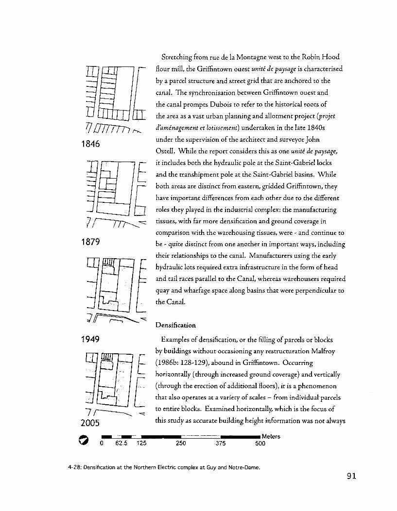
Varum. 1846
1879
1949
Stretching from rue de la Montagne west to the Robin Hood
flour mill, the Griffintown ouest unite de paysage is characterised
by a parcel structure and street grid that are anchored to the
canal. The synchronisation between Griffintown ouest and
the canal prompts Dubois to refer to the historical roots of
the area as a vast urban planning and allotment project (projet
d'aminagement et lotissement) undertaken in the late 1840s
under the supervision of the architect and surveyor John
Ostell. While the report considers this as one unite de paysage,
it includes both the hydraulic pole at the Saint-Gabriel locks
and the transhipment pole at the Saint-Gabriel basins. While
both areas are distinct from eastern, gridded Griffintown, they
have important differences from each other due to the different
roles they played in the industrial complex: the manufacturing
tissues, with far more densification and ground coverage in
comparison with the warehousing tissues, were - and continue to
be - quite distinct from one another in important ways, including
their relationships to the canal. Manufacturers using the early
hydraulic lots required extra infrastructure in the form of head
and tail races parallel to the Canal, whereas warehousers required
quay and wharfage space along basins that were perpendicular to
the Canal.
Densification
Examples of densification, or the filling of parcels or blocks
by buildings without occasioning any restructuration Malfroy
(1986b: 128-129), abound in Griffintown. Occurring
horizontally (through increased ground coverage) and vertically
(through the erection of additional floors), it is a phenomenon
that also operates at a variety of scales — from individual' parcels
to entire blocks. Examined horizontally, which is the focus of
this study as accurate building height information was not always
i Meters 62.5 125 250 375 500
4-28: Densification at the Northern Electric complex at Guy and Notre-Dame.

1846
1879
1
0
T]
1949
n 2005
© 0 62.5 125
available, densification largely takes two distinctive forms
depending upon the parcel organisation and the degree of
aggregation present in a given piece of urban tissue, such as
a block. Where a large number of contiguous parcels - up
to an entire block in some cases - are available, densification
may involve the filling of the whole block or the majority
of the available parcels. The Northern Electric (Northern
Electric) complex at the corner of rue Guy and rue Notre-
Dame, which progressively fills up almost the entire block in
stages from 1907 to 1949, or the blocks immediately north
of the Saint-Gabriel basins, which by 1949 house incredibly
large warehouse buildings, are examples of this. In cases
where individual parcels retain their integrity - suggesting
a more diffuse ownership pattern - densification may occur
through the addition of secondary buildings, such as rear-lot
housing or sheds.
The ETS block shows how densification in a'deep' block
can work: the perimeter block is built up, while deep lots
coming from Notre-Dame (a legacy of its status as matrix
route and of the boundary of the ferme Saint-Gabriel/Fief
Nazareth and the Cote Saint- Antoine agricultural patterns)
are in some cases significantly built up. The ETS in its
current incarnation is extremely dense, though not in a
way tJiat continues that past pattern; the division between
seigneurial and fief agricultural forms is subsumed within
a single building that occupies the entire block, while the
significance of rue Notre-Dame as a matrix route is expressed
only at the corner with rue Peel - the remainder is merely a
lateral facade.
i Meters 250 375 500
4-29: Densification at the Northern Electric complex on Saint-Patrick in Pointe-Saint-Charles.

1846
U
1879
375
Selected factories and warehouses have
filled many of the plots in the gridded, eastern
portion of Griffintown, for example, the block
between rue Nazareth and rue Shannon south
of rue Ottawa. To a lesser extent, this extends
southward to the flour basins and the rue de la
Commune frontage of the Canal. Many of the
parcels in these blocks are significantly built up
by 1907, with many rear-lot structures in wood
and brick and a very tight internal open space
system unique to each parcel (as opposed to
block-wide). This densification was subsequently
completely derailed by the restructurations
brought forth first by the C N viaduct, the effects
of which are seen on the 1949 map, and the
autoroute Bonaventure, the effects of which are
seen in contemporary satellite imagery.
There is also significant densification in the
area between rue Canning and rue des Seigneurs,
which looks like it makes an interesting
transition from residential building forms to
industrial ones from 1890 onwards. The semi-
irregular block pattern — with far more street
frontage in a comparable area than the blocks
from rue des Seigneurs to rue Guy — facilitates
intensive ground coverage. The Saint-Gabriel
hydraulic pole, particularly the area between
William street and the Canal, west of Richmond,
also shows significant densification, with the
canal frontage appearing to take priority over
the rear frontage, which is somewhat difficult
to understand (even now) in terms of how rue
M M H M Meters 500
4-30: Densification at the Saint-Gabriel locks hydraulic pole.

Basin and rue William come together. If any area had a principal front on the canal, this was
it, though this has now been discarded with the filling of the old canal (hydraulic channel).
The street wall is still largely in place (with one fairly large exception), but the canal is now
quite far away and the space thereby liberated has not been included in the public park as of
yet. I
Densification also takes place by means
of the erection of secondary structures on
standard (and also non-standard) parcels.
Up until 1912, growth can be observed
in the rear of standard parcels, either as
dwellings or as sheds for light industry,
storage, or stabling horses. By 1949, there
" r F F 4-31: Outdoor storage (principally of lumber) at the number of these buildings. Carey (2002) Saint-Gabriel Basins.
examines four explanations for this decline,
noting that it was more severe in the city's west end (including Griffintown) than in the east:
municipal regulation, the switch from a 40x105 to a 25x80 foot parcel, the expansion of
the city centre (in commercial, industrial, and infrastructural terms), and suburbanisation,
finding that though municipal regulation was relatively tolerant of rear-lot housing in die
40x105 foot parcels, it largely precluded such dwellings following the switch to a 25x80 foot
parcel. In terms of city centre expansion, Carey finds that while transition to non-residential
use prior to 1900 often involved a process of aggregating multiple residential buildings to
form a new complex - thus conserving rear-lot structures - after 1900 the tendency switched
towards wholesale transformation through demolition and substitution of new buildings.
Carey adds that with extensive suburbanisation in the early 20 th century - new districts such
as Rosemont and Villeray in the north, or Ville-Emard in the Southwest - the increase in the
housing stock limited the market for rear-lot dwellings.
Another interesting phenomenon to be considered in the industrial context is a sort of
reverse densification for industrial purposes: from 1912-1949, privately-held open space
becomes increasingly important in the makeup of industrial complexes. There seems to be
a polarisation occurring, where parcels are either built at full ground cover or they are left
mosdy unbuilt, though presumably (and photo evidence suggests so - see figure 4-31, at
right) they were intensively used for materials storage, transhipment activities, fleet storage,

etc. The block between the Saint-Gabriel basins and the Saint-Ann's church just west of rue
de la Montagne is a great case of this phenomenon, as it's identified (on the 1949 map) as
being used for storage purposes, has a wall, and appears to be linked to the adjacent basins.
Restructuring
This thesis focuses on two types of
restructuration in Griffintown: one involving
the route network, which in practice implies
the introduction/elimination/widening of
particular streets and infrastructure; the
other has to do with the railway and canal
infrastructure and its a posteriori insertion
into the landscape. Restructurations can
be read as a balance between anterior and
posterior states (Malfroy, 1986a), that
is to say that the restructuration can be
interpreted in light of the impact of the
insertion (be it a street widening, a new
railway line, or a highway) on the urban
tissue, but also in light of the urban tissue's
impact on the insertion and its particular 4 " 3 2 : P a c o Building; syntactically modified (in terms of r its relationships with the neighbouring building and the
characteristics, or the degree to which it has street) by the realignment of Wellington street.
been forced to conform to the pre-existing
urban tissue. The following pages discuss elements of restructuration in the Griffintown
district, first grouped into issues related to the introduction, disappearance, and widening of
streets; the second, on the introduction, disappearance, and expansion of infrastructure.
In the triangle north of the flour basins there is an almost complete restructuration as
the area finds itself becoming an enclave due to the viaduct and the freeway (warehousing
buildings take over). The Wellington street realignment is an interesting case, making
what is a very strong axis in that entire part of the city (all the way through Pointe-Saint-
Charles, as well) do a derivation to correspond to the Charland grid. A better illustration
of vestigialism in the urban tissue and of the inter-relationship between building and street
could not be found than the building at Wellington and Nazareth, where the addition follows
the'new' Wellington, while the old building still follows the old alignment. There appears
to be somewhat of a reduction in the legibility of the rue Wellington matrix route at this
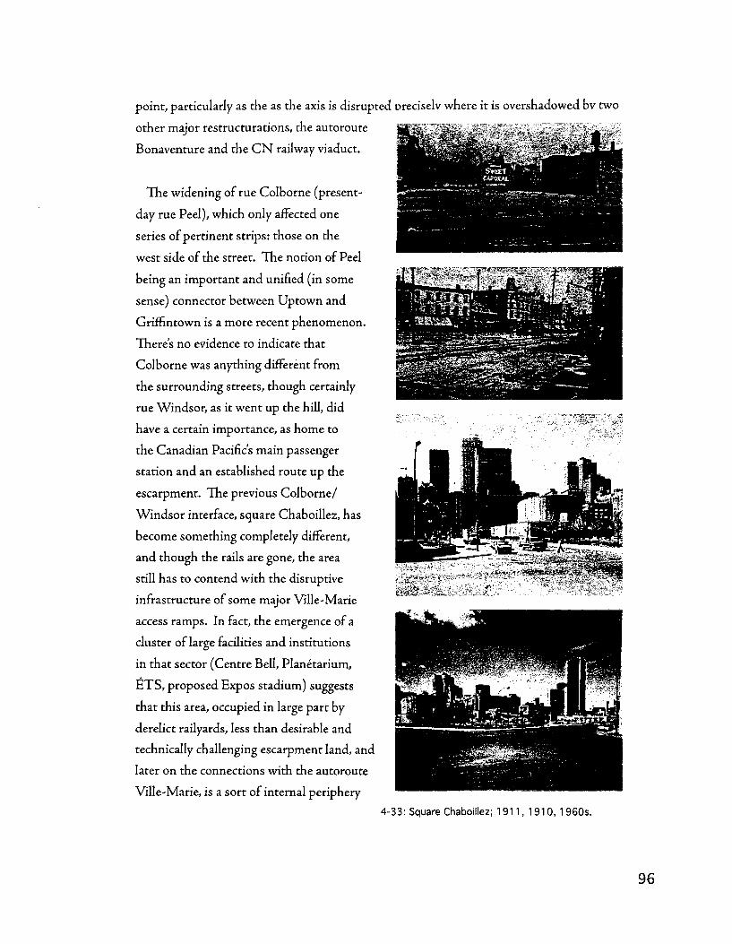
point, particularly as the as the axis is disrupte<
other major restructurations, the autoroute
Bonaventure and the C N railway viaduct.
The widening of rue Colborne (present-
day rue Peel), which only affected one
series of pertinent strips: those on the
west side of the street. The notion of Peel
being an important and unified (in some
sense) connector between Uptown and
Griffintown is a more recent phenomenon.
There's no evidence to indicate that
Colborne was anything different from
the surrounding streets, though certainly
rue Windsor, as it went up the hill, did
have a certain importance, as home to
the Canadian Pacific's main passenger
station and an established route up the
escarpment. The previous Colborne/
Windsor interface, square Chaboillez, has
become something completely different,
and though the rails are gone, the area
still has to contend with the disruptive
infrastructure of some major Ville-Marie
access ramps. In fact, the emergence of a
cluster of large facilities and institutions
in that sector (Centre Bell, Planetarium,
ETS , proposed Expos stadium) suggests
that this area, occupied in large part by
derelict railyards, less than desirable and
technically challenging escarpment land, and
later on the connections with the autoroute
Ville-Marie, is a sort of internal periphery
oreciselv where it is overshadowed bv two
-33: Square Chaboillez; 1911, 1910, 1960s.

fcpl*".J *-^i*
1846
T^U^. tl "I*1 *. 3-T S^
9??r 1879
»
1907
1949
2005
uniquely suited to offering large sites that would otherwise be
prohibitively expensive or virtually impossible to assemble in
closer proximity to the CBD.
As recently as 1949, Colborne/Windsor had an intricate
junction via what must have been a bustling Chaboillez square
(the station and freight depot forecourt - see images), while post-
1949 the square progressively lost its historic, industrial meaning
(no more station or freight depot) and though the square and the
Peel axis had been significantly rationalised, the decline of the
surrounding faubourg tissue - in large part due to the autoroute
access ramps and the widening of N D — and the insertion of
the planetarium (which really makes it not a square at all), have
resulted in difficult times for this square.
However, the Colborne widening preceded the reconfiguration
of Chaboillez square and the unification of Windsor/Colborne
into'Peel' It seems likely, judging by common dimensions and
timing - as well as the fact that the Colborne widening stops
abruptly at Wellington - that the Colborne widening was part
of a larger coordinated restructuring initiative that included the
rerouting and widening of Wellington and the construction of
the Wellington tunnel, likely geared towards accommodating
increasing automobile traffic related to the Victoria Bridge
and truck use along the Lachine Canal. This operation left the
blocks on the west side of Peel street extremely narrow for the
Southwest, though of a fairly standard width in comparison with
blocks in the Plateau Mont-Royal district, for instance.
The current contrast between the north and south sides of
Notre-Dame street is a testament to past restructuring that
involved only the north side of the street, that which bordered on
the GTR's Bonaventure freight yards. As with the restructuring
of Colborne street, the unbalanced nature of this operation
makes for an uneven streetscape, which was in turn amplified
4-34: Chaboillez square mapped through time; 1846, 1879, 1907, 1949, 2002.

by the scale of the urban renovation projects undertaken to replace the freight yards. A
wholesale reconfiguration of the'Petite-Bourgogne' neighbourhood along the western stretch
of Notre-Dame street's GrifFintown section, while along the eastern stretch, a long-standing
collection of vacant blocks, a proposed baseball stadium, the transformation of square
Chaboillez into a more or less regularly-dimensioned block containing the Dow Planetarium,
and the infrastructure of the Ville-Marie and Bonaventure autoroutes marked the street.
4-35: The 'Dalhousie Triangle' square mapped through time; 1879, 1949, 2002.
The introduction of the C N viaduct and the Bonaventure highway represent among the
most interesting cases of restructuring in Montreal. In the case of the railway, the viaduct
represents a dedicated infrastructure where before it was acceptable to combine railway
with street. In fact, for a long time, both in-street (Brennan) and viaduct railway coexisted,
though they betray very different ways of organising the railway in the city: on the surface, it's
possible to include frequent and multiple spur lines into specific industries within an urban
block pattern; the elevated viaduct was more about inter-city travel and providing access for
a metropolitan network - it's part of a system where the freight yards are in Cote-Saint-Luc
and industries are along lines such as those heading for Montreal Nord, rather than yards
and industries integrated into the urban tissue. The C C U M siding is an exception to this,
though it is perhaps indicative of what may have resulted in more quantity had the viaduct
been constructed earlier. The highway is also part of a larger, limited-access, and much more
hierarchical logic, spread out over a vast territory.
One of the most important impacts that the viaduct and the freeway had was to make rue
de la Commune (between Mill and Peel) a somewhat restricted enclave, at least until Peel
was passed under the viaduct in the early 2000s. This area was restructured in a big way as
a result of the new infrastructures; what was before a simple continuation of the Charland

grid, straight to the water, became a quite complicated collage of parking, ancient warehouses.
The area, the'Dalhousie Triangle,' is a palimpsest of multiple restructurations linked to the
introduction of infrastructure:
. . . i
UiJ^H-
Brennan street was pierced in order to connect the G T R from Pointe-Saint-
Charles to the port (1870s); Consequence for the tissue: introduction of a non-
orthogonal street and the arrival of new possibilities for building alignment due to
technical constraints of the new infrastructure;
The viaduct was pierced to allow C N to have an Uptown presence and to allow
diem to connect their Canadian Northern and Grand Trunk systems (1940s); as a
consequence for the tissue, die link between the 1801 Charland grid and the Flour
basins is severed, Dalhousie street is cut in two, reducing access to the Dalhousie
Triangle;
-:s,^\''r\ ;--/-* The Bonaventure autoroute was built as part of
"'V*";TvI^!J~*j?''̂ T'"*?""-i- p ,- efforts to modernise Montreal and to provide a
seamless, modern gateway between the City and
Expo (1960s); Consequence for the tissue: there
are virtually no connections between the Charland
grid and the Dalhousie Triangle (which, we should
remember, was part of the original Charland grid)
between Duke and Peel, excepting Brennan. In
/ 1 fact, there are almost no streets at all in the triangle
* any more, and only three buildings remain of a
once-thriving warehouse location. It has only been
since the early 2000s that Brennan was 'reinstated'
as a link between the old port and Griffintown, as
part of the same initiative as the rue Peel-rue de la
Commune reconnection.
The restructurations imposed by the C N viaduct
and the autoroute Bonaventure are an excellent case
in point of Malfroy s notion that restructurations
can be read in terms of a feedback loop, consisting of
both the influence of posterior on anterior (the effects
4-36: The Saint-Gabriel Basins mapped through time; 1846, 1879, 1912, 2002.
r A >v A I.

of the intervention on the pre-existing urban tissue) and of anterior on posterior states
(the influence of the pre-existing urban tissue on the intervention). In the course of the
restructuring imposed by the C N viaduct and the autoroute Bonaventure, the Griffintown
street grid is substantially altered, while both the viaduct and the autoroute do conform
to it in their further approaches to uptown. Clearly, however, anterior is more affected by
posterior tJian vice versa, though the nature of the vehicles is an important consideration, as
rail sidings were always far more limited than the extensive reconfiguration of street space
and elimination of building stock that was undertaken to accomodate highway-related
automobile traffic.
The Saint-Gabriel basins go several different incarnations before disappearing altogether.
Their return figures consistently in contemporary redevelopment schemes.
In 1846 there is one square basin, the centrepiece of a larger urban project platted by the
architect and surveyor John Ostell. Surrounding parcels are structured to take advantage
of the basin's location, oriented perpendicular to the water. The intent may have been for
businesses to benefit from the single-parcel blocks by having one front on the basin (via a
public quay), the other on the neighbourhoods internal street network.
By 1879, two rectangular basins have replaced Ostells initial configuration. This
arrangement provides significantly more quay frontage and injects value into a greater portion
of Ostells 1846 urban project. It's important to note that these basins are the key raison d'etre
for the majority of the eastern section of the ferme Saint-Gabriel that doesn't form part of
the hydraulic complex; the previous square basin didn't do much for the blocks at the interior
of this relatively large area, while the 1879 rectangular configuration appears to address
the larger needs of die projet urbain to a better degree, and seems to promote warehouse
development in the block between William and Ottawa. It seems as though this would have
been a less likely outcome had the square basin been retained.
By 1890, the two basin configuration has been extended westwards across the site to
total four rectangular basins. This scheme extends the advantages and configuration of
its predecessor, adding to the linear footage of transhipment space, and from notes and
remarks on the maps, it appears that it was a planned and intended extension of that
first double rectangular basin concept. One notes that the interbasin quay is significandy
wider in this second incarnation, and that where the eastern edge of the basin site affords
a public quay (likely exploited by the warehouses in the adjacent block), the western edge
is contained within a block and doesn't provide for a public quay. It's possible diat demand

for warehousing facilities and so forth was
less prominent in the sector just west of the
Saint-Gabriel basins due to the proximity
of the hydraulic pole and the manufacturing
cluster that it occasioned.
After 1949 all of the basins are filled
to make space for a Canada Post sorting
facility. The massive scale of the block is
retained, though Canada Post adopts an
office-park like appearance, with landscaped
parking, and truck access from all sides.
Once the creation of basins established
a large scale for a parcel, block, or group
of blocks, this state of affairs was largely
maintained when redevelopment — either
postwar industrial or postindustrial
commercial — occurred, as was the case
elsewhere along the Canal - for instance,
Augustin Cantin's Canada Marine Works
which became Robin Hood Flour, or the
GTR's Atwater Yard which became a large
format, 'big box,' grocery store.
The Flour, or Peel, basins (note that 4-37: The Flour (Peel) Basins mapped through time;
Peel has only been used to refer to the 1907, 1949, 2002.
combination of Colborne and Windsor
streets at the foot of which the basins lie since the latter half of the twentieth century) have
also been substantially altered since their introduction, particularly if one also considers
the triangular turning basin. Particularly interesting is their changing relationship with
the area of Griffintown to their north. In the 1907 map, they gave directly onto the area's
major thoroughfare. Two events between 1907 and 1949 resulted in this relationship being
dramatically severed. First, the restructuration of Wellington street, a change that moved
the basins from a prime position - next to a natural focal point (the Wellington bridge) and
alongside one of the Southwest's most important matrix routes, which afforded direct access
to other thoroughfares across Montreal via Mountain and McGill streets. The basins were

thus far more directly integrated into the 1801
Charland grid, by virtue of a cement factory (The
Canadian Portland Cement Co, see figure 4-38)
that allowed for waterside access at Mountain
and Colborne streets and served as an interface
between the tracks and the water. This location
choice by a cement company is interesting, in that
the cement industry requires a- significant loads
of raw materials (aggregate, water, e t c . ) and
b- rapid means of delivering its perishable product
to building sites throughout the city. Given the
presence of the Canadian Portland Cement Co, it
seems likely that this location had such attributes.
4-38: Canadian Portland Cement Co, Wellington street across from the Flour Basins, 1901.
. J^tAASW? jygnEfgy; IJ111 j I • I • 111MB The restructuration of rue Wellington
and the relative marginalisation of what
became rue Smith, in combination with
the construction of the Wellington tunnel,
resulted in the creation of Gallery square,
(see figure 4-39, next page) which appears
to have had its roots in the open space at the
corner of Saint-Leon and Mountain streets.
Reconfigured into a landscaped cover for
the tunnel entrance and the setting for an 4"3 9 : . U n i ° n Co? S t° r a9? a n d G a l i e ? Squ
uare; n 0 t e t h e
6 prominent position of Saint-Ann s church.
art deco chalet and ventilation structure,
the square was subsequently compromised by the bridge that replaced the tunnel, which
severed one of its sides and left it an enclave cut off from the surrounding tissue and the
canal. Gallery square, perhaps, is in microcosm, what the Bonaventure/ Viaduct triangle
£ experienced at a larger scale. ! 4-
| Second, the construction of the C N rail
-*i viaduct cut off even this downgraded link
between the basins and the 1801 Charland
grid to die north in its entirety. While the
C N viaduct, once it makes its final northwards
4-40: Augustin Cantin's Canada Marine Works, 1855.

approach to the Gare Centrale, is actually a relatively permeable structure (it prevents no
east-west streets from passing under) aligned with the Griffintown block system, by the flour
basins it is but an earthen berm without permeability. Subsequendy, the basins had their
northern access points removed at both Mountain and Colborne/Peel and were not even
related to the relatively secondary street (Smith) that carried the railway siding connecting
the Grand Trunk with the old port, but were hidden behind a berm. From this point it
seems justifiable to interpret that the basins became more a part of what would become
the ' Vieux-Port^ accessed primarily by de la Commune, than with the 1801 Charland grid
to the north. The arrival of the Bonaventure expressway, of course, restructured even that
relationship.
The basins at Augustin Cantins Canada Marine Works, perhaps by virtue of their
proximity to the Saint-Gabriel hydraulic pole, have an entirely different logic than die basins
discussed previously. One of the basins is not a basin at all, but would more accurately be
described as a dry dock. Belisle et al (1992) makes note of this type of manufacturing set
up and counts it in a three part typology of production facilities found along the Lachine
Canal. Rather than goods descending vertically through a multi-storey factory or moving
horizontally through a single-story factory, at a facility like Cantins Marine Works dry dock,
workers and tasks would move around the finished product. Therefore, one observes a basin
that is essentially a manufacturing facility, as opposed to a transhipment facility.
Scales of change and agents' intervention
In a sense, the (trans)formative processes that are observable throughout Griffintown can
be interpreted through a spectrum with small, incremental transformations at one end and
larger, planned interventions at the other. The aggregative formation of a block can serve to
illustrate die latter scenario. In eastern Griffintown, die subdivision of die Fief Nazaredi
into parcels serviced by a street grid was certainly a planned intervention. The corresponding
aggregation of vernacular buildings into an urban-integrated type industrial complex (such
as the Cunningham and Wells) however, is perhaps more incremental or gradual in nature.
The restructurations occasioned by the C N viaduct and the Bonaventure autoroute also
constitute planned interventions. Griffintown's convergence between vernacular and gradual
processes of aggregation and densification and more consciously planned, swifter processes
of restructuration, is striking. This is a deep coexistence: vernacular and planned processes
are both involved in producing even a simple element of the urban tissue, such as a block,
where the parcel layer is the conscious product of a trained surveyor and the grouping of
adjacent buildings into one complex the incremental product of a growing industrial firm.

The process thereby manifests an alternative to purposeful development practices and a more
spontaneous engagement with the urban tissue, while building on the earlier relatively large
scale, planned intervention.
Conclusion
Industrialisation has marked the Griffintown district in profound ways. The routing
of the Lachine Canal through the territory of what could otherwise have been a relatively
unremarkable faubourg launched a set of transformations that took a unique form.
Distinctive processes of aggregation and densification related to spatially separated
and functionally distinct links with the water - for hydraulic power or transhipment
- conditioned the districts' development. Where these processes ran into limits,
major restructurations were occasioned, largely surrounding the implantation of major
infrastructures such as the railway, changes to the configuration of the canal and its basins,
and the arrival of the autoroute in the mid 20 th century. The effects of these restructurations
are still being felt today and are central issues for contemporary urban planners and designers
seeking to revitalise Southwest Montreal. The Canal arrived with the formation of the
faubourgs but marked an important juncture as land in the corridor was packaged for
speculation and a variety of industrial and residential modes of territorial occupation took
hold.

The second narrative: a typology of industrial complexes
Introduction
The remaining narratives in this chapter extend their gaze to the canal basin as a whole.
This second one in order to examine the increasing specialisation of industrial complexes and
to explore the means by which such specialised elements are integrated into the urban tissue
as a whole. Relatively early in its industrialisation, the Lachine Canal was given the moniker
'Little Lowell,' in recognition of the concentration of mills and factories that clustered to
this birthplace of Canadian industry. But these facilities, as the different industrial building
types highlighted in the previous narrative suggest, were not uniform - in their individual
characteristics nor in their relations with their surroundings. And if the story of industrial
architecture during the late 19th and into the 20 th century is largely one of form becoming
increasingly tightly tethered to function - the work of Albert Kahn comes to mind - there
was significant variation in the strategies adopted by industrialists seeking to improve and
expand their production and warehousing facilities.
The architectural historian Reyner Banham characterises early 20 th century industrial
architecture as a'mixture of conservatism and adventure" (1986: 50). In his words,
"[hjardnosed patrons and the architects who served them conserved traditional usages
that were still serviceable. They had no ideological axes to grind, no revolutionary postures
to maintain, even if they knew - as Ransome did at the end of his life - that revolutions
in industrial architecture had been wrought. Piecemeal, the dynamics of building in a
market economy at a time of rapic technological advance would produce every aspect of an
architectural revolution except the revolutionary intent. The rationality of the economic/
industrial system that these architects served, required of them - as a daily commonplace
- innovations as constant as any European futurist of the day could demand as prerequisites
for some distant but desired Utopia" (Banham, 1986: 53). But it also required the pragmatic
conservatism to which he frequently alludes throughout 1986 s Concrete Atlantis.
Drawing on this variability inherent to industrial architecture, Robert Lewis notes that
rather than a wholesale adoption of die hyper-rationalised factory - Ford's River Rouge
model - many firms "chose selectively from a range of possible factory layouts and design
features, and tlieir strategy met with success" (2001: 668). Innovative design elements
introduced at the beginning of the twentieth century, from new materials and goods handling
devices to a more cellular (and horizontal) layout made possible by the increasing use of
electricity, were not, however, adopted uniformly across the board: "for pragmatic reasons

relating to their production strategies, they customized the ways cell-based layout, machine
sequencing, and material-handling equipment were incorporated into their buildings" (2001:
673). Even more crucially for the premise of this thesis, was the preponderance of renovation
and adaptation of existing facilities, due in part to financial constraints, but also due to what
Lewis terms the neighbourhood effect. Citing the case of a Philadelphia locomotive firm, Lewis
observes that their decision to rebuild in the inner city as opposed to relocating to a suburban
greenfield was rooted "not only in the partners' fiscal conservatism and their diversion of
capital to machine technology; Baldwin managers were reluctant to abandon their investment
of both capital and know-how in the existing plant and, importantly, in the surrounding
neighbourhood, with its varied labour pool" (2001: 677).
If River Rouge was but a sort of ideal type identified and lauded by the "triumvirate of
industrial architects, engineers, and manufacturers" (Lewis, 2001: 682) lavishing their
advice on firms engaged in a broad spectrum of practices, from the most incremental
renovations to, indeed, the construction of leading-edge suburban plants, then, this thesis
proposes to apprehend the Lachine Canal's industrial complexes according to the degree
to which they are integrated with their surroundings — or conversely, the degree to which
they are truly autonomous machines for production whose form is minimally structured
by the surrounding urban tissue. Indeed one of the principal challenges faced by an
application of morphological techniques to a more modern and industrial urban tissue is
an increased tendency away from a cohesive urban tissue and towards the autonomy of its
elements. But as with Lewis' industrialists, cities hardly adopted the mores of the Charte
d'Athenes wholesale (Panerai, Demorgon, & Depaule, 1999: 93). Rather, the variable (and
never complete) autonomy of the factory building or of transport infrastructure can be
interpreted as the base for a typology of industrial complexes and infrastructures. Key to the
contemporary challenges faced by planners and designers, the degree to which such facilities
are (or aren't) integrated into or structured by die urban tissue can serve as a valuable means
for classifying and analysing urban form. Adopting such an approach suggests the possibility
of arranging the Lachine Canal's industrial complexes along such a continuum.
The operative question central to such an exercise is 'To what degree is the complex
structured by the syntax present in the surrounding area?' The text below oudines a
typology of industrial complexes on this basis, emphasising the relation of each type and
its components with the surrounding and prevailing urban tissue - the degree to which the
complex is structured by elements such as parcel modules or block structures, followed by
a description of its spatial distribution within the Lachine Canal basin and examples. It's

crucial to keep the notion of a continuum in mind, as this three-element typology does not in
the least imply the existence of three discrete types of industrial complexes, but rather seeks
to punctuate and illustrate a continuum of different approaches to the relationship between
urban tissue and industrial complex.
A continuum of industrial complexes
At one end (typically the eastern, early end), urban integrated complexes formed largely
of aggregated residential buildings forming a perimeter around an industrially-used
open space, with maybe one or two specialised industrial buildings that are not markedly
different in terms of configuration and syntactic relations (it's principally their facade, or
maybe their height that differ). These complexes are structured principally by die parcel
and route pattern (which together form the urban block) and by the mode d'implantation
of the traditional, non-specialised buildings, frequently residential in origin, that were
aggregated in order to form them. Some of the complexes in the eastern, gridded portion
of Griffintown (east of rue de la Montagne) fit this description, such as Cunningham and
Wells (immediately north of the cold storage warehouse at rue de la Montagne and rue
Wellington), a cartage firm.
At the other end (typically the western, later end), are planned, unified, autonomous
complexes that represent specialised industrial projects that are less aggregate in nature than
their ancestors, both in terms of a typically reduced number of buildings, but also in terms of
a decreased modularity in terms of their components. These complexes, particularly if they
are liberated from the urban block (as they are west of Saint-Henri, along the Canal — Saint-
Ambroise) - but never the parcel - are more often found along major infrastructures (canal,
rail) and often end up as between one and three buildings that create a perimeter complex,
with some secondary structures in the courtyard or outside, depending upon the relationship
with the street. At their apogee, these complexes become what one sees with the Lasalle
Coke, where a vast area is taken up for the onsite movement of freight cars, trucks, and the
outdoor stockpiling of raw materials.

Modell ing the continuum
Type 1 - Urban integrated
4-41: An urban-integrated industrial complex (Cunningham and Wells/Union Cold Storage).
Relations with other structures:
• Structured by the parcel and street pattern together (ie by the urban block)
Infrastructure connections largely facilitated through public space — on-street
railway sidings, street-based quays, etc.
• In contrast with, the urban semi-autonomous type complex, the ad-hoc type
complex is usually strongly structured not just by the urban block, but in terms
of its own composition and modularity (such complexes are often serial in nature
- made of more or less interchangeable components), the effective parcel module
plays an important structuring role;
• Often a gap is left at some point in the perimeter, or porte-cocheres are provided to
connect the courtyard with the external street network
Components
• Evolve piecemeal through the aggregation of common, residential buildings, with
the gradual appearance of more specialised buildings in their midst
• Cellular aggregation of parcels and residential-type buildings
Courtyard configuration is common and a major organisational principle 108

Location and distribution
• Tendency to be located further east, and to date from earlier periods;
• Frequently in close contact with residential tissues
Examples
• Cunningham and Wells (between Murray and Young streets, at the corner of
Wellington) 1907;
• Union Cold Storage (same location and dates as above).
Type 2 — Urban semi-autonomous
4-42: An urban semi-autonomous industrial complex; The Northern Electric (Nordelec) factory at the corner of Guy and Notre-Dame streets, 1907.
Relations with other structures:
• Partially structured by the parcel and street pattern together (ie by the urban
block); the street pattern is vastly more influential than the parcel pattern, however.
• Such complexes will often take up a half block or more and are thus no longer
necessarily modular with respect to the parcel system, but are still bound by it in
terms of their boundary with the rest of the block.

• Their modularities begin to depart from those of the residential urban tissue,
differentiating themselves from the dimensional thresholds and configurations of
domestic space, while infrastructure connections increasingly take place on the
complex's own property, as opposed to on the street.
Components
• Declining importance of the perimeter block- buildings and open spaces are
no longer necessarily arranged in a courtyard configuration, though this is still
common;
• Buildings are much larger than in the ad-hoc type complex and usually span the
equivalent of multiple parcel modules (though without necessarily being structured
by these).
Location and distribution
• Still often located in residential tissues, but usually at their margins, where the
residential tissue comes into contact with an industrial infrastructure;
• Frequently found where regular block sizes/shapes give way to more irregular
patterns for other (ie topographical) reasons.
Examples
• Northern Electric corner Guy/Notre-Dame)
• Montreal Light Heat and Power (Ann/William)
Type 3 - Unifed autonomous complex
Relations with other structures
• Structured largely by connections with infrastructure (canal and rail) and the
underlying agricultural allotment system; such complexes usually go beyond being
structured by entities such as the urban block or the subdivided urban parcel
pattern but are still conditioned by the underlying agricultural holdings;
• In the case of the Lachine Canal, this usually involves the regrouping of several
strips' of seigneurially-organised land - the long and narrow units, attached to a
cote or a watercourse that characterise settlement in Quebec; more than the one to
three ordinarily present in an urban block structure;

• Infrastructural relations are paramount and typically arranged throughout die site,
with infrastructure and specialised buildings often closely interacting (ie a rail spur
enters a building, or a crane/grain hose goes over top of the canal/railway);
QO
4-43: A unified autonomous complex; the Lasalle Coke plant on the Canal's south bank west of Ville Emard, 1949. Buildings respond largely to the configuration of the multiple railway sidings that penetrate the site, and to the technical needs of coke production, overlaid on the original agricultural pattern of the Cote-Saint-Paul.
Components
• The components of the unified, autonomous complex are virtually all specialised
and not aggregated in a cellular/serial way
• The arrangement of components is done in accordance with the needs of
production/warehousing access and the perimeter block/courtyard form has
almost completely disappeared, ceding its place to a complex and highly variable
pattern of built and open spaces;
Location and distribution
• These complexes tend to be further west, though they have precedents in die
Windmill point hydraulic complex (however, that area was still structured in terms
of a street and urban parcels) and variants in the major grain elevators erected by
the port commissioners and the railway companies;

Examples
• This type of complex merits two examples as there are two principal and fairly
distinctive manifestations in the Sud-Ouest's territory: those linked primarily to
die Canal, and those linked primarily to the railway network;
• Lasalle Coke, which is tied to both the canal and the railway - in terms of property
lines to the canal, which it also links to via its crane - but in terms of its internal
structuring it is more tightly linked to the railway.
• Buildings are arrayed according to their place along the network of sidings
that penetrate the site, while roads are defined by dashed lines, white on white,
undefined by any built forms.
The spectrum examined
The former example, that of the Cunningham and Wells cartage firm's compound, typifies
the perimeter block/courtyard approach and is telling of the close connection between such
complexes and the urban tissue in which they are situated. Interestingly, the complex arose
on a site that, in 1846, was composed of double modules (tlie equivalent of two generic
residential parcels), perhaps resulting from proximity to the nearby flour basins south of
Wellington. Barely urbanised, the Cunningham and Wells site contained only one parcel
with buildings, one along the street and two along the back. The site changed fundamentally
when Smith Street was pierced through the long blocks between Wellington and Ottawa,
transforming what had once been mid-block parcels into a location accessible from three
sides. By 1879 then, these new corners had been taken advantage of, hosting buildings on
two separate (double module) parcels. Another quadruple-module parcel lay adjacent, with
one large building at its centre. Though Smith street seemed set to be widened in 1879, this
had not yet occurred by 1907, when the site was occupied by Cunningham and Wells, who
laid claim to the quadruple module and the two double module parcels.
Cunningham and Wells was hit hard by the widening of Wellington street and its re
alignment in accordance with the tunnel project that eviscerated Gallery Square. Losing
much of the northern double-module parcels, the site was reduced to two built-up sides,
along the south and east, while the open courtyard was left exposed to the street. The site has

been reconfigured post-1949 to accommodate a more recent industrial building that follows
precisely the alignment of Wellington street, but that still involves loading/unloading in the
public sphere through an indented truck bay supposing trucks being docked in the street.
* « , M\ H
:»i„il.
*
Q &**
4-44: Cunningham and Wells/Union Cold Storage mapped through time; 1 846, 1879, 1907 (left side), 1949, 2002 (above).
The latter example, that of the Montreal Coke Manufacturing (more popularly known,
along with its landmark canal-side crane, as the Lasalle Coke), is revealing in that it occupies
a part of the western reaches of the Cote-Saint-Paul that was eventually incorporated into
Ville Lasalle. It's a significant cote in that it is the one that opens up the space between
the falaise Saint-Jacques (Coteau Saint-Pierre) and the river, or between the upper and
lower Lachine roads. Made immensely more valuable by the construction of the Canal and
the drainage of the Lac-aux-Loutres (or the Petit Lac Saint-Pierre), the Cote-Saint-Paul
eventually became the backbone for a series of increasingly larger factories, warehouses,
and even entire neighbourhoods (Ville-Emard, for instance) in the late 19th and early 20 th
centuries, culminating in complexes like the Lasalle Coke or the Mount Royal Spinning
(1912).
At Montreal's western edge - the Lasalle Coke isn't even in Ville-Emard, the westernmost
extremity of pre-merger Montreal - the site spreads over the several seigneurial tracts that
define its shape - and
is virtually exurban in
character. Chosen due to
the abundant land supply
and the agglomeration of
nearby customers -
Desloges (2003:14) cites
the Simmons mattress
company in particular 4-45: The LaSalle Coke plant west of Ville-Emard; 1914, 1919, 1949, 2002.
1 1 3

•St ;<J ;W;_r g j . :
-x. r.r
th'.tU^
— the site is structured according to the gas-making workflow. A
canalside conveyor tower unloaded boats and distributed raw coal into
two long rows of heaps, with a thermal powerhouse and a gazometer at
opposite ends of the site. Virtually all other buildings are but accessory
in nature and distributed as part of an interconnected system of
enclosed conveyors. By 2004, the complex has virtually disappeared in
a gready changed Lasalle which emerged as a postwar suburb.
Complexes such as the Northern Electric (at its Guy/Notre-Dame
location) or the earlier incarnations of the Redpath and adjacent
industries when rue du Canal was still a functioning entity (prior to
1949) fit somewhere between these two poles. While the buildings
configuration is informed by the urban tissue in the area in terms of
being contained by the block and taking a perimeter/courtyard form,
its non-serial construction as one building all along Guy is of a new
scale that differs significandy from the aggregations of smaller, non-
specialised buildings that characterise the earlier, urban integrated
Type
Example
Transport interface
Structured by
Frequent uses
Urban integrated Cunningham and Wells 1907
On street
Block and parcel
Cartage, small inventory distribution
Urban semi-autonomous Northern Electric -Guy/ND1907
On street and in-house
Block, some parcel
Production/ assembly of smaller goods, often inputs for other businesses
Unified autonomous Lasalle Coke 1949
In-house
Rural 'meta-parcel' (seigneurial strip)
Bulk materials transformation, major production/ final assembly
4-46: The Northern Electric factory at the corner of Guy and Notre-Dame streets; 1846, 1879, 1907, 1949,2002.
1
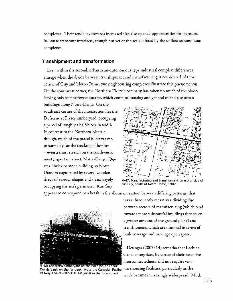
complexes. Their tendency towards increased size also opened opportunities for increased
in-house transport interfaces, though not yet of the scale offered by the unified autonomous
complexes.
' ' " ^ s l l
Transhipment and transformation
Even within the second, urban semi-autonomous type industrial complex, differences
emerge when die divide between transhipment and manufacturing is considered. At the
corner of Guy and Notre-Dame, two neighbouring complexes illustrate this phenomenon.
O n the southwest corner, the Northern Electric company has taken up much of the block,
leaving only its northwest quarter, which contains housing and general mixed-use urban
buildings along Notre-Dame. O n the
southeast corner of the intersection lies the
Dufresne et Freres lumberyard, occupying
a parcel of roughly a half-block in width.
In contrast to the Northern Electric
though, much of the parcel is left vacant,
presumably for the stocking of lumber
— even a short stretch on the southwest's
most important street, Notre-Dame. One
small brick or stone building on Notre-
Dame is augmented by several wooden
sheds of various shapes and sizes, largely
occupying the site's perimeter. Rue Guy
appears to correspond to a break in the allotment system between differing patterns, that
was subsequently recast as a dividing line
between sectors of manufacturing (which tend
towards more substantial buildings that cover
a greater amount of the ground plane) and
transhipment, which are minimal in terms of
built coverage and privilege open space.
Desloges (2003:14) remarks that Lachine
Canal enterprises, by virtue of their extensive
interconnectedness, did not require vast : Shearer's lumberyard on the near (south) bank, ~ , c ... . . , , .
Ogilvie's mill on the far bank. Note the Canadian Pacific warehousing facilities, particularly as the Railway's Saint-Patrick street yards in the foreground. 11 • • 1 • j j \ * 1
truck became increasingly widespread. Much
ii ! 8/ }fl I r* r'
4-47: Manufacturing and transhipment on either side of rue Guy, south of Notre-Dame, 1907.
K^Pfef^BSgjBs 9Tr***iM

of the warehousing and transhipment that can be observed along the canal can be roughly
divided into two categories: small carting enterprises such as Cunningham and Wells that
presumably engaged in the ferrying of intermediary products between enterprises or depots
for the commercial sale of construction materials such as lumber; and major bulk goods
terminals such as grain elevators or coal wharves and towers, and the large mills and factories
that punctuated the district.
The emergence of industrial complexes
Between 1846 and 1949, we are witness to a complex and differentiated process of
industrial urbanisation in southwest Montreal. The emergence of industrial forms in this
period follows varied trajectories, largely inline with the three-part typology of complexes
described above. In the paragraphs below, I examine this emergence as a means to shed
light on the city-building know-how that found its expression in the course of ever more
specialised and, to a degree, non-urban industrial complexes.
The first industrial complexes apparent on Hopkins' 1879 map are largely of the first,
urban/integrated type discussed above. At around this time, industrial forms really began to
penetrate the 1801 Charland grid. This phenomenon can be first remarked on Cane's 1846
map, where aggregation and densification are most prevalent in the eastern, gridded part of
Griffintown (the 1801 Charland grid) between McGill and Dalhousie streets. Densification
is most evident in the form of accessory buildings extending into the rear of the parcel,
and a marked aggregation of the parcels themselves into larger units. But at the periphery
of the regularized 1801 Charland grid, on sites close to the Notre-Dame and Wellington
matrix routes, close to the flour basins and to the west of the Haymarket - this latter on a
newly channelised creek — more complex and specialised structures are beginning to emerge,
associated with the Dow Brewery and the transhipment functions of the flour basins.
While there are some larger buildings in this area, the bulk of construction consists of
perimeter blocks formed by aggregations of smaller buildings. Larger
buildings became increasingly frequent, though this densification of
the urban tissue is still largely modular in nature, with most newly
large-scale buildings taking the form suggested by two or even, in
some cases, four or more parcels. Some cases, like the City Gas Works
(rue Ottawa, between rue Ann and rue Dalhousie) stand out for
the sheer degree to which they dominate a single urban block, while
4-49: The City Gas Works. others, like Theodore Har t and David
1 1 6

Mortice, display the new phenomenon of one business
occupying parcels on several blocks. In the cases of Har t
and Morrice, these holdings correspond with both quayside
and railside parcels, ideal for an integrated transhipment
operation geared towards multi-modality. (Note that Har t
and Morrice are in the triangle between the viaduct and
the Bonaventure, between Colborne and Dalhousie, on the
1879 Hopkins map). Various foundries (between Ann
and Shannon, south of Ottawa), planing mills (Esplin,
corner Duke and Ottawa), and small manufacturing establishments (Stove and Scale works,
between Duke and Nazareth south of Ottawa; Annett O'Connor Machine factory, between
Prince and Duke at Wellington), round out the picture by occupying anywhere from one to
three parcels.
4-50: The Clendenning Foundry, example of industrial integration into the urban landscape.
These larger complexes that emerged in slighdy more singular locations at the periphery of
the regularised 1801 Charland grid (east of Mountain), took advantage of larger parcel and
block sizes to adopt more unorthodox site configurations, often in close proximity to major
infrastructures, such as the Bonaventure freight depot, the basins of the Lachine Canal, and
the hydraulic channels at the canal's Saint-Gabriel locks. On a large'L' shaped block that was
a former creek bed, the Dow brewery and die Clendenning foundry make their homes in a
series of irregular (though mostly rectangular and not grossly wider than the average parcel

4-51: Industrial complexes of Griffintown and Windmill Point (lower right), 1879. Note the two hydraulic poles (Saint-Gabriel at middle left and Windmill Point at lower right).
in the 1801 Charland grid) stone and wood structures that form an interconnected series of
courtyards and a largely continuously-built up perimeter. Dow even goes so far as to occupy
both sides of rue Colborne, a move the ETS is set to echo at the present time.
Industrial sectors - agglomerations of complexes
As one moves further through time and further west, a more coherent type of industrial
sector begins to emerge. Precursors of this can be seen at two locations along the eastern
part of the canal - at Windmill Point and at the Saint-Gabriel locks, where industrial
expansions to the city were planned and implemented as part of an initiative to exploit the
hydraulic energy potential created when the canal was enlarged in the late 1840s. But it is
with the developments pioneered by industrial capitalists such as Alexandre Delisle, John

4-52: The studied industrial sectors arrayed along the Canal; From east to west, 1- Windmill Point; 2- Saint-Gabriel; 3- Sainte-Cunegonde; 4- Saint-Ambroise; 5- Cote-Saint-Paul; 1949.
Frothingham, and William Workman, which would become the suburbs of Saint-Cunegonde
and Cote-Saint-Paul, that the notion of a specialised industrial district took a fuller form,
which was to be realised more completely in the Saint-Ambroise and Turcot sectors of the
canal in Montreal as well as tJrie sector passing through Lasalle.
Windmill Point hydraulic pole
History and evolution
Located on a narrow spit of land separating the first reach of the Lachine Canal from
the Saint-Lawrence river, the Windmill Point hydraulic pole exhibits a novel relationship
juxtaposing regular urban parcels with a port-like relationship witli the water. This sector
can be read as an extension of the port (also a federal, or non-municipal jurisdiction) and
is shaped in large part by the maintenance and exploitation of the level difference between
the second canal reach and the river. It's no coincidence that it was at this point - interface
between canal and port, hydraulic pole, that some of the most sophisticated and specialised
transhipment infrastructures emerged, namely elevators and mills. By 1879, no fewer than
five such structures existed, dominating the sector. Due to the site constraints in the sector,
namely the existence of only one street (rue Mill) lined by two strips of regular parcels (one
of which had yet to be fully reclaimed from tlie water), industrial complexes aggregated
adjacent parcels and engaged in significant densification within these parcels. By 1890,
both the Montreal Warehousing Company and Peck Benny and Company had developed
substantial complexes that in addition to the practices mentioned above, made use of parcels
on both sides of rue Mill.
119

Goad's 1912 atlas depicts a similar situation, though with an important restructuring.
The Harbour Commissioners added a wharf on the river side of the sector, allowing for
railway access to all complexes along rue Mill, presumably rendering die case for complexes
spanning both sides of the street even more compelling, as the 1912 map also marks the
first appearance of a structure crossing the road. At this point, Mill street has its most
consistent framing; an almost uninterrupted street wall with brick/stone/concrete buildings
to die north and wooden structures to the south. This state testifies to significant horizontal
densification that occurred in tandem with the aggregation of parcels into ever larger
complexes. By 1949 this situation was no longer sufficient and many of the complexes were
X? GJ

levelled to provide room for transhipment between rail and boat involving fewer but larger
elevator complexes and an increased amount of open space suitable for marshalling trains and
accommodating the elevators' movable legs. By 2004, Windmill Point was dominated by the
dormant'Silo no 5' complex, a few functional elevators at its western end, and the site for an
annual tourism-oriented landscape architecture exhibition, located on fill.
Morphological composition
Elements
Only one street, Mill, which can be seen as a settling route but also as an important
thoroughfare from port to Pointe-Saint-Charles, the G T R yards, and Victoriatown or Goose
Village. A regular and highly modular
parcel system, with similar dimensions to
the standard urban parcels in southwest
Montreal present in non-specialised
residential settings.
The sector was created as a means to
exploit the new Canal infrastructure and the
hydraulic energy potential it created, thus 4 . 5 4 : ogilvie's Windmill Point mill. Flour gradually came i /- v j L J i i i to dominate the sector,
the Canal s second reach and the two lock
structures at Windmill point were critical to
the sector's emergence, as was it's location on the western edge of the Port of Montreal. As
land was filled towards the south, increasing railway access to the site made the emergence of
major grain elevators (from the Commissioners 'Mammoth Elevator' in the 1870s to the Silo
N o 5 in the 1960s) a possibility and re-oriented the sector away from manufacturing.
Spatial syntax
The Windmill Point sector is, as with many industrial components of the city,
simultaneously nodal yet peripheral. As the entry to the Lachine Canal and an alternate
route for trains passing from port to yards, capable of handling transhipment involving
trains and both ocean-going and lake vessels, it certainly was a hub of southwest Montreal's
industrial machine, on the scale of the city and region and considered in industrial terms.
But as a collection of large industrial buildings clustered along an ominous corridor of a
1 2 1
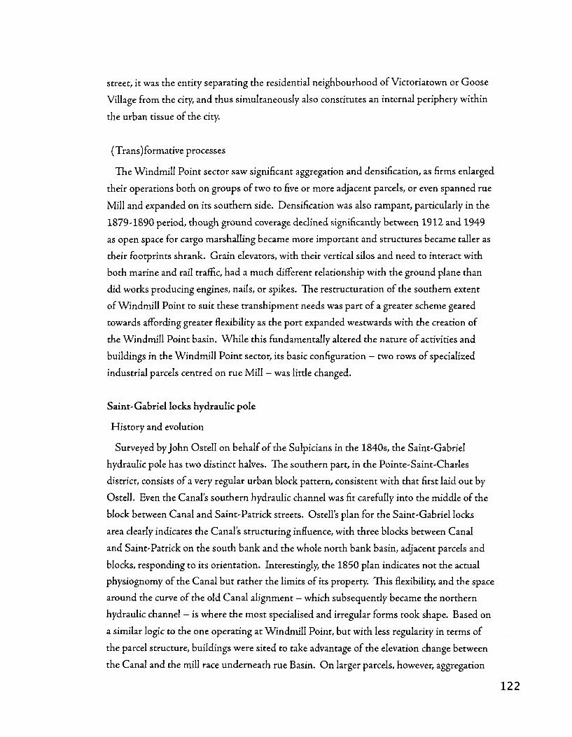
street, it was the entity separating the residential neighbourhood of Victoriatown or Goose
Village from the city, and thus simultaneously also constitutes an internal periphery within
the urban tissue of the city.
(Trans)formative processes
The Windmill Point sector saw significant aggregation and densification, as firms enlarged
their operations both on groups of two to five or more adjacent parcels, or even spanned rue
Mill and expanded on its southern side. Densification was also rampant, particularly in die
1879-1890 period, though ground coverage declined significantly between 1912 and 1949
as open space for cargo marshalling became more important and structures became taller as
their footprints shrank. Grain elevators, with tlieir vertical silos and need to interact with
both marine and rail traffic, had a much different relationship with the ground plane than
did works producing engines, nails, or spikes. The restructuration of the southern extent
of Windmill Point to suit these transhipment needs was part of a greater scheme geared
towards affording greater flexibility as the port expanded westwards with the creation of
the Windmill Point basin. While this fundamentally altered the nature of activities and
buildings in the Windmill Point sector, its basic configuration - two rows of specialized
industrial parcels centred on rue Mill - was little changed.
Saint-Gabriel locks hydraulic pole
History and evolution
Surveyed by John Ostell on behalf of the Sulpicians in the 1840s, the Saint-Gabriel
hydraulic pole has two distinct halves. The southern part, in the Pointe-Saint-Charles
district, consists of a very regular urban block pattern, consistent with that first laid out by
Ostell. Even the Canal's southern hydraulic channel was fit carefully into the middle of the
block between Canal and Saint-Patrick streets. Ostell's plan for the Saint-Gabriel locks
area clearly indicates the Canal's structuring influence, with three blocks between Canal
and Saint-Patrick on the south bank and the whole north bank basin, adjacent parcels and
blocks, responding to its orientation. Interestingly, the 1850 plan indicates not the actual
physiognomy of the Canal but rather the limits of its property. This flexibility, and the space
around the curve of the old Canal alignment - which subsequently became the northern
hydraulic channel - is where the most specialised and irregular forms took shape. Based on
a similar logic to the one operating at Windmill Point, but with less regularity in terms of
the parcel structure, buildings were sited to take advantage of the elevation change between
the Canal and the mill race underneath rue Basin. On larger parcels, however, aggregation

o o r\j oi
01
3 o
mm.
7
'tl, l^.
o
o oo
CD
oo
to
oo
I I
O
I I XI
u o
o
IT)
123

was a less prominent tendency, though densification certainly was. By 1879 all parcels were
occupied, with a range of industries present, using raw materials from wood and iron to grain
and marble. The landmark Ogilvie flour mill, with parcels on both sides of present day rue
des Seigneurs, was certainly the landmark of the sector. By 1890, Ogilvie's mill, McDougall's
foundry, and Smith's hat factory still share the distinctive triangular point, but the arrival of
the Montreal Woolen Mills Company on the west side of Canal street is emblematic of an
increasingly intensive building footprint, echoed also at John McDougall's car wheel works
further west. 17 and 22 years later, Pinsonneaults 1907 and Goad's 1912 adases indicate
remarkable stability in this sector, with some increasing densification, but little aggregation
and no decline in built coverage. But by 1949, the western end of the sector was more
densely built than ever, housing the works of Drummond McCall and Co., the Canada
Paint Company, and tJhe Canadian Paperboard Company - three establishments where in
1879 there had been at least eight - the area had also seen significant aggregation as parcels
were combined to house these larger enterprises. Meanwhile, the triangle had been entirely
consolidated into one parcel and reduced to a single building, that of the McDougall foundry,
which operated as Hall Engineering until the early 1990s.
O n the Canal's south bank, similar processes were occurring, though much more tightly
circumscribed by a more resilient block and parcel structure. Along the southern hydraulic
channel in 1879 could be found a variety of enterprises, mostly relating to the lumber trade
(Shearer's Sash and Door factory, Marland and Watson's saw works) though also including
a small tool factory. Immediately downstream, John Redpath's Canada Sugar Refinery was
one of Montreal's largest industrial complexes upon its 1854 opening. By 1879 the Redpath
complex consisted of two parallel rows of buildings along Canal and Saint-Patrick streets,
with several other buildings occupying a relatively open courtyard, with extensive unbuilt
landholdings on the adjacent inland block and next to the Priest's Basin, where the firm's
in-house cooper shop was housed. By 1890, the complex had taken the form of a perimeter
block, with only a small opening at the corner of Saint-Patrick and the oudet for the Priest's
Basin. Construction had begun on the inland block, with two massive buildings in 'third of a
block' modules - one spanning the entire block and fronting Saint-Patrick street, establishing
a distinctive and high-walled industrial streetscape. By 1912, the massive wooden shed
occupying Redpath's property along the Priest's Basin had been split into three and
reinforced, while the inland block had been largely vacated. See figure 4-55 on the following
page for a cartographic depiction of these transformations.

The adaptability of the subdivision techniques that were used, and the urban blocks
and standardised parcels that they encompassed, for both residential and industrial use is
made clear on the south bank of the Saint-Gabriel locks area through the early twentieth
century. The southern blocks - further from the canal - become tighdy closed perimeter
blocks populated by row housing, duplexes, and triplexes, while the northern blocks nearer
the waterway consolidate their industrial role, hosting firms such as Stelco, Redpath, and
a half-block Canadian Pacific Railway sorting yard. By 1949, significant densification and
restructuration had consolidated the industrial presence on Saint-Patrick street, with the
arrival of the Northern Electric complex, larger sheds built on former Redpath open storage
areas, and an expansion of the industries along the Canal's south bank, between the Redpath
and Saint-Patrick square. Following die closure to navigation of the Canal, and its partial
filling at the nearby triangular turning basin, these interventions were not questioned, and
the absence of Canal street was perceived as a benefit, ensuring a car-free linear park space,
which was subsequently equipped with a bicycle path and verdant landscaping.
Morphological composition
Elements
Streets play distinctive roles in the Saint-Gabriel industrial sector, split as it is by the Canal
into two distinct halves, yet connected by McGee's Bridge. On the north side, the Notre-
Dame matrix route skirts the sector — though settling routes branching off from it (from
Canning to Richmond) are crucial - the bulk of the northern side is structured by the Canal
itself. Infrastructure is crucial to reading this landscape - the differentiation between die
more specialised parcels responding to the Canal in their size, orientation, and configuration
and the more regularized, urban parcels fitting into die block pattern set by the Notre-Dame
matrix route (and the irregular strip between Basin and William streets that brings these two
units together) are part and parcel of the integration of the Lachine Canal into the city in a
way that is at its most intensively urbanised and built-up at this hydraulic pole.
On the Canal's soudi bank, the urban grid - its orientation already determined by the
Canal by virtue of Ostell s 1850s subdivision plan — in some sense eschews the idiosyncrasies
of the north bank. The Saint-Patrick settling route, diough not immediately adjacent
to the Canal, serves as the key land route - taken in strictly spatial terms, the waterside
cote' of this 'industrial seigneurie' - along which the bulk of industry is clustered. Though
regularised urban parcels grouped into blocks of familiar size and configuration (though

deep in comparison with the New Town above the escarpment, for example) predominate,
the blocks along the southern hydraulic channel and the Priest's Basin are largely intact and
unsubdivided, housing several large enterprises.
Spatial syntax
As a hydraulic pole and the site of McGees Bridge, the Saint-Gabriel locks were a highly
polar position, and not just from the industrial perspective. Multiple churches at the corner
of rue des Seigneurs and rue Notre-Dame in Sainte-Cunegonde and proximity to the village
core that emerged on rue Centre street at rue Island in Pointe-Saint-Charles testify to this,
as does the more intensively built-up cluster of manufacturing that emerged around the
locks, in contrast to the more space-hungry (and thus usually more peripheral) transhipment
and warehousing activities that emerged to the near east and west. The Canal is however, a
decisive barrier between the Pointe-Saint-Charles and the Grifnntown/Sainte-Cunegonde
neighbourhoods, with far-reaching implications that are still of key importance.
(Trans)formative processes
Significant aggregation and densification occurred along the north bank of the Canal,
where a band of specialised industrial conditions prevailed in the space where trie canal-
oriented grid and the rue Notre-Dame-oriented, less specialised grid met, just east of
the Cantin shipyard. In the northern, rue Notre-Dame/Cote-Saint-Antoine based grid,
densification occurred in two ways; the growth of perimeter blocks composed of aggregated
smaller buildings was juxtaposed with die construction of larger industrial structures that
spanned multiple parcels or stretched the width or length of an entire block. In the southern,
Canal based grid, slight aggregation occurred early on, widi industries taking two or diree
of the original parcels, followed by a slow densification that peaked in 1949. The small
block and parcel sizes in the transitional strip between rue Notre-Dame and the Canal may
have led to a dense tissue faster than in a more open or spacious setting, by virtue of die
juxtaposition of both perimeter block and industrial slab densification.
On the south bank of the Canal, these two types of aggregation and densification were
less tightly fused, with more purely industrial slab densification on aggregated parcels along
rue Saint-Patrick and the Canal, while perimeter blocks were consistendy formed in the
residential tissue further south towards die Grand Trunk, though on die same street pattern
and parcel structure. In terms of infrastructure, two in-street railway systems - one for
freight, a Canadian Pacific spur line that ran the length of die Canal, from Saint-Patrick
Square to western LaSalle, die other for urban mass transit, which ran along rue Centre in

Pointe-Saint-Charles - may have gone a long way in establishing a pattern of twin axes (one
for freight and industry, one for people and residential life), in an otherwise fairly uniform
street and parcel structure that characterizes northern Pointe-Saint-Charles.
The remarkably coherent and adaptable framework of parcels, streets, and blocks that
managed to seamlessly flow from serving the needs of a working class residential quarter
to providing the armature for one of Montreal's heaviest industrial sectors, had started to
unravel by 1949. The restructuration of rue du Canal, which ran for several blocks between
the outlet of the Priest's Basin and square Saint-Patrick, and the partial or full closures of
rue Richmond, rue Montmorency, and rue de Conde streets leading towards the canal marks
a turning point and a movement towards a differentiation of the grid into industrial and
residential sections, with different standards in terms of size, configuration, and connectivity,
permeability within the neighbourhood as a whole. But as square Saint-Patrick lost its
last vestiges of a residential scale in the mid 20 th century, redevelopment projects in die late
20th and early 21 s t centuries included the conversion of parts of die Redpadi and Shearer
complexes to office and residential use, though there is still a significant industrial presence
on both sides of die canal at the Saint-Gabriel locks. With the disappearance of the freight
siding and the tramway and the introduction of a new axis of leisure in the form of the
Canal's linear park, these redevelopments are occurring in a transitional phase in die balance
between forms and activities for the Points urban tissue.
Sainte-Cunegonde
History and evolution
Pioneered by the entrepreneurs and developers Alexandre Delisle and William Workman,
who purchased much of the former municipality's territory from Frederic-Auguste Quesnel
in the 1860s, Sainte-Cunegonde is commonly characterised and analysed in terms of being a
product of what Poitras and Berube (2004) term Southwest Montreal's periode de creation des
infrastructures municipales. Recognised as a parish in 1875, constituted as a village in 1876,
and annexed by Montreal in 1906, Sainte-Cunegonde's growth was fuelled considerably
by the arrival of industrial complexes belonging to firms such as Augustin Cantin's Canada
Marine Works and the Steel Company of Canada.

aw
aiT
»
_
' '
"W
tL
Au
^L
wj
i1
uf
e
'i
ts
af
„
f.
• ,1
. i!
,J
' T>
...
- 4
n
W,
,
-' • "
-
ST
-. .
1.
Jt
. .2
? ...
; .-
n"
VT
0*'1.
l,r
1 • a
j J
J
u
-J?
£££
laur
arW
BH
u u
: i
J;**
J i:
"'^'
-I'.'
iV^'
.vif
fr^
:«:.
.rv
;i:>
t*;^
<n
1»
- :, :
vj!
!,r f
tl,'
,. ,.
'V'jr
i>ii
.*r.
»-'
ni-
ji"*'
.'1
1
^••'
•'-f
:'n#^
> ^
fc
,;l,
J'
'\l.i'
.»'".
V.'.
j,.
l I!.
(»'
•V
T
i. [%
*'
4-56
: S
aint
e-C
uneg
onde
map
ped
thro
ugh
time;
At l
eft:
1890
, 19
12; a
t rig
ht,
1949
, 20
02
.
oo

Spottily developed by 1890, perimeter blocks were beginning to emerge north of rue
Duvernay, while closer to the canal, scattered saw and planing mills occupied both the
regularised grid of urban blocks as well as the more open parcels immediately adjacent to
the Canal. The Stelco complex was relatively contained, with a high proportion of wooden
structures along the Canal and up the middle of the site.
The period from 1890 to 1912 saw significant densification in the areas closer to rue
Notre-Dame, as parcels were increasingly built up. Construction often extended to the rear
of the parcel, whether in the form of wooden ancillary structures - work and storage sheds or
rear-lot housing. In areas closer to rue Notre-Dame, the perimeter block was consolidated,
by means of systematic infilling of the rear sections of corner parcels, presenting a closed
public facade and a more private block interior accessed by alleys, some of which were
beginning to take on autonomous names and street designations, for instance, avenue
Fabien. This period also saw the implantation of several industrial complexes along the
Canal - the Rutherford sash and door factory and the Redfern lumberyard and sawmill - as
well as expansion of the Stelco complex. By 1912, the replacement of the Brewster basin
by the G T R s Atwater yards was also complete, consolidating the quayside emphasis on
transhipment functions.
The 1949 Ville de Montreal land use map reveals a strengthening and rationalisation of the
structure present in 1912. Perimeter blocks near rue Notre-Dame are more clearly defined,
with fewer ancillary structures - these began their decline across die territory of Montreal
in this period, while the Stelco complex and the more industrial parts of Sainte-Cunegonde,
along the Lachine Canal, are somewhat more intensively built-up.
If the villages heart was originally marked by the eglise Saint-Joseph, at the corner of
Notre-Dame and Richmond streets, its hands and feet ended up firmly planted along the
Canal, to the west of Cantins shipyard. Where the Notre-Dame matrix route runs closely
parallel with the Canal, the Sainte-Cunegonde area hosts another pole near the Charlevoix
bridge, in which denser, manufacturing-oriented activities were brought closer to the water,
though for different reasons than at the Saint-Gabriel hydraulic pole. As with die grid in
Pointe-Saint-Charles, there is a transition between industrial blocks near the Canal and
more residential ones further away, with a similar distinction between densification by means
of industrial slab construction and the aggregation of smaller units into coherent perimeter

blocks. However, the sheer scale of the Stelco facilities and a very different type of interface
with the G T R spur line along the canal's north bank result in a significantly different urban
tissue, one which has had significant implications for contemporary redevelopment.
Morphological composition
Elements
Sainte-Cunegonde is characterised by a stark contrast in scale between its two
predominant building types. While composed primarily of perimeter blocks formed by
aggregations of working-class housing and mixed-use (residential/commercial/small
workshop) it also hosted some of the largest industrial complexes along the Canal, such as
the Stelco. A standard urban residential parcel - the basis of the perimeter block - also
served as a structuring element in the organisation of the larger industrial complexes,
such as the Dominion Wadding and the Stelco, with several of the buildings in the Stelco
complex fitting neady into multiples of this parcel module. Infrastructure, including the rue
Notre-Dame tramway, the Canal, and the G T R s canalside spur line, were also important in
establishing twin nodal axes in the area - rue Notre-Dame and the Canal.
Spatial syntax
As with the southern bank of the Canal near the Saint-Gabriel locks hydraulic pole in
Pointe-Saint-Charles, there is a dual character to development, with the emergence an
industrial axis — the Canal and the G T R spur line — and a residential axis — the Notre-
Dame matrix route. An important difference with the Stelco site, and perhaps one of the
factors tliat permitted its important inland expansion (along with the precedent set by
Cantin's adjacent Canada Marine Works) was the threading of railway sidings northward,
perpendicular to die Canal, through a residential block structure, complemented by
industrial buildings that by and large responded to that pre-existing grid.
(Trans)formative processes
As an example of a Sainte-Cunegonde industrial complex, the Stelco site appears to be
variably structured by a combination of infrastructure (rails and the Canal), streets, and
parcels. Its interface widi the Canal and the G T R s siding seems to be one of warehousing -
large wooden structures in combination with large open spaces - while the more inland part
of the site is a mass of brick structures, some with their own internal courtyards, organised
around a railway siding, the extension of rue Duvernay, and an unofficial extension of rue
Dominion south of rue Notre-Dame. In addition to this, buildings tend to occupy multiple

parcels and eschew street rights-of-way, even when these are part of the Stelco complex. On
the blocks east of rue Vinet, this leads to a tight cohabitation with the residential tissue.
Densification largely occurred within this framework; courtyard-based buildings on the
Stelco site were filled in, while many of the open spaces on that same complex, close to the
Canal or along its internal corridors, were also built up - the pertinent strips on both sides of
rue Tracy and the area southwest of the corner of rue Sainte-Cunegonde and rue Vinet are
exemplary of this process.
In terms of restructuration, the Sainte-Cunegonde sector hasn't seen a significant degree
of restructuration, excepting the construction of the Atwater tunnel in the 1950s. Two
significant changes have occurred, however it is uncertain that they represent changes that
go beyond the basic processes of aggregation and densification. The transformation of the
Brewster basin from docks to big box retail via railyard, though profound in socioeconomic
terms and as testimony to die deindustrialisation of the Lachine Canal (concomitant with
the'rebirth' of the Atwater market), is only partially a restructuration. Although founded on
an underlying and largely unrealised residential spatial order, the basic industrially-scaled
configuration is maintained, no changes are made to the street grid (regrettably, perhaps),
and the fundamental relations between the large-scale, more organic aggregations of parcels
into individual complexes versus the more serial aggregation of parcels into perimeter blocks
by means of a smaller, residential-scale building type aren't fundamentally challenged. A
proposal put forward by the GRAU (Bodson, 2001) to better integrate the tunnel approach
into the sector's block structure and to consolidate the Atwater market's relationship
with rue Notre-Dame as a continuous public space on the scale of the residential block
pattern, but was ignored. The dismantling of the Stelco complex verges perhaps closer to a
restructuration, as the industrial modes of densification along the mill's internal corridors
and the open warehousing spaces along the Canal was followed by a process of aggregation
geared towards the formation of perimeter blocks. However, given that the seeds of these
perimeter blocks were already encoded into the Stelco complex, through the street network
and parcel structure, it's a particular form of restructuring: an underlying residential spatial
order (block and parcel sizes) served as the framework for a massive industrial complex,
which was subsequently dismantled and redeveloped as a residential neighbourhood, still
maintaining that original structure. The introduction of new building types and the switch
from organic densification of open spaces to serial aggregation into perimeter blocks is
certainly a distinctive.
1 3 1

The one firm case of restructuration in the Sainte-Cunegonde sector - the introduction
of a breakthrough route in the form of the rerouted avenue Atwater, complete with tunnel
- is vivid, but also rooted in precedent. The routing of the north bank tunnel approach is
situated on a block that, like the neighbouring one hosting the Atwater market - but unlike
the identical blocks further west - housed a single industrial complex, always transhipment
related. In 1890 it hosted the Dominion Ice House company, in 1912 Pauze et fils, and
in 1949 by the Halladay and Dube lumberyard. Taking advantage of this particular set
of circumstances - a fully aggregated block (in terms of parcels) with very low density
- avenue Atwater was routed around the market block to the east and sunk under the Canal.
Though die market was always situated in somewhat of an enclave - between railyard and
lumberyard, the new curving configuration of avenue Atwater had a significant impact on
its northward connection to the rue Notre-Dame matrix route, and seemingly irreparably
altered the urban tissue along Dore and Berard streets and Greene avenue - replacing a set
of blocks that, by virtue of their high permeability, had seen significant densification (though
offset somewhat by the post-1912 decline in secondary structures) and had developed
a fine-grained mix of uses, with a large-scale intersection complete with stacking lanes,
attenuated somewhat by a creative landscaping intervention, but without any corresponding
restructuration of the underlying parcel structure.
Cote-Saint-Paul
History and evolution
In the early 1850s, William Parkin constructed a hydraulic channel along the south bank
of the canal, creating a spit of land serviced by quayside rue Saint-Patrick. In this area, at
the bottom of a slight slope, a specialised industrial area developed around Frothingham
and Workman's hardware manufacturing complex. As settlement climbed the hill, avenue
de l'Eglise served as the residential community's nodal axis. By 1890 a fairly significant
industrial sector had developed, including eight factories - producing blankets, shovels,
horse nails, tools, bells, files and springs, hats, and axes - drawing hydraulic energy from the
elevation change between the head race and the main Canal. A couple of blocks up the hill,
along the avenue de l'Eglise (Cote-Saint-Paul) axis, urbanisation was still in its early stages,
with most structures being rectangular in footprint, freestanding, and wooden. By 1912
the industrial mix had expanded to include wire and agricultural implements along four
flumes connecting the head race and the main Canal. These industrial parcels hosted larger
buildings, but with similar building-parcel relations. The most important change in the
industrial sector was the completion of rue Saint-Patrick, forming a quay-like space on the
Canal's south bank. Urbanisation in the residential sector up the hill was more substantial by 1 3 2

\
CM O O CM
"3-
A 'f^
m 39 S 3 fcT.',8^?5T . - w ;
?/ .* ' 4
tt^ W1*' njm.
co g
.g
CM"
en
i o en CO
Q. O I -
O
XI CU Q . Q .
CO CO
IT)
133

1912, though still in patchwork fashion, perhaps reflecting speculation on future industrial
growth following the arrival of the CPR's Saint-Patrick spur line. This speculation seems to
have been prescient, as by 1949, the map shows the arrival of the G T R , whose yards complex
completes the severing of the quayside industrial sector from the residential district up the
hill.
By 1949 it seems clear that residential urbanisation is destined for the blocks west of
avenue de l'Eglise and towards boulevard Monk in Ville-Emard more so than the blocks
closer to the Cote-Saint-Paul industrial sector, which had its head race truncated at the first
flume, ceding the filled right-of-way to the Canadian Pacific, whose Saint-Patrick spur line
had previously run alongside. The other three flumes have disappeared by this time, though
the complexes that they structured are relatively unchanged save for the construction of a
few secondary structures in their courtyard spaces. New complexes that have emerged to
the east of the core of the Cote-Saint-Paul industrial sector - Canadian Power Boats, Crane,
Congoleum, Sun Oil, a new, larger facility for Cunningham and Wells, and Imperial Oil
- are of a much vaster scale than the older complexes, and lack the courtyard configuration
characteristic of the structuring influence of the hydraulic flumes. These complexes face the
Canal and in some cases make extensive use of it (for instance, the Canadian Power Boats
basin) have large open spaces coupled with large, often oblong buildings, are connected to
the G T R in back and the C P R in front, and are removed from both logics governing the rest
of Cote-Saint-Paul's urban tissue; they are neither organised around hydraulic flume based
parcels nor on the residential street grid. Instead, they occupy a narrow enclave between the
Canal and the aqueduct formed by land and ponds that was the last remnant of the Sulpician
order's holdings in Southwest Montreal. However, while the size and shape of the buildings
appears conditioned almost entirely by the technical and economic needs of the individual
firms, their orientation in an almost seigneurial' (in spatial terms) relation to both the Canal
and the G T R siding seems to suggest a larger-scaled parallel to the Saint-Ambroise industrial
sector across the water.
The 2002 Navurb images reveal an industrial landscape in turmoil. Both railways have
pulled out, leaving a significant portion of the blocks between Cabot and de Roberval streets
vacant - reinforcing the fissure between the avenue de l'Eglise residential axis and tlie Saint-
Patrick street industrial axis. The introduction of autoroute 20 in the 1960s continues and
emphasises this rupture, while the Saint-Remi tunnel, which bisects the industrial sector
without offering it any additional connectivity, seems to confirm its perceived obsolescence.
However, compared with 1949, there appear to be significantly more buildings, particularly

in the blocks between Cabot and Dunn streets, while the larger complexes that emerged
between 1912 and 1949 to the east of Dunn and Angers streets - earlier characterised by
the relative lack of secondary or ancillary structures - have a larger footprint than before as a
result of various expansions.
Morphological composition
Elements
One of the most distinctive elements to be found in the Cote-Saint-Paul industrial sector is
the canalside parcel structured by the hydraulic flume. Wider than both the standard urban
residential parcel and the industrial parcels across the Canal along Saint-Ambroise street,
this flume-based parcel and the industrial complexes that it structured seems to be unique
to Cote-Saint-Paul, though it bears some resemblance to the mid-nineteenth-century era
hydraulic lots along Mill street in the Windmill Point sector. The post-1912 complexes to
the east, sandwiched between the Canal and the aqueduct, are also unique in their departure
in terms of scale, a lack of consistent parcel module, and the absence of a superior structure
such as a block to give them greater form. The draining of the Lac-aux-L6utres had an
enormous influence on the ability to lay out relatively large industrial parcels and to operate
at a sufficient scale that created the opportunity to introduce a planned separation between
industrial and residential parcel and block types.
In terms of infrastructure, the Cote-Saint-Paul sector is perhaps one of the clearest
expressions of a hydraulic complex, with a well-defined head race and a particular parcel/
complex module (the flume-based parcel) by which to structure industrial urbanisation.
Coupled with the reinforcement of the
elevation-based distinction between
residential and industrial by the insertion
of the C P R and GTR's spur lines and
autoroute 20, Cote-Saint-Paul presents a
sort of microcosm of die different impacts
infrastructure and industrial-residential
tensions have exercised across the territory
of the entire Lachine Canal.
4-58: The autoroute comes to Cote-Saint-Paul, 1 969.
135

Spatial syntax
As with the Sainte-Cunegonde and Saint-Gabriel sectors, the Cote-Saint-Paul sector also
shows a similar tendency towards a biaxial structure, with avenue de l'Eglise - the Cote-
Saint-Paul - as the residential axis and Saint-Patrick street (or rather the Canal and Head
race themselves) as the industrial axis, which was reinforced by both railways.
(Trans)formative processes
All of the transformative processes can be observed at work in Cote-Saint-Paul.
Densifkation within die flume-based industrial parcel and through the expansion of the
larger complexes just further east; aggregation to some degree within a perimeter block
formation in die residential axis, though not with the same clarity as in the other sectors, due
to a less vigorous residential densification process.
Restructuring, in large part due to the implantation of railway and freeway infrastructure,
is probably the most prominent transformative process to have occurred in Cote-Saint-Paul.
However, an examination of restructuring in Cote-Saint-Paul must also include the filling
of the head race, the completion of Saint-Patrick street, and the Saint-Remi tunnel project.
This area was later penetrated by both the G T R and the CPR, but what is perhaps most
interesting, and a testament to the perceived obsolescence of the area as an industrial sector
by the mid 20th century, is the Saint-Remi tunnel project, which runs non-stop between de
l'Eglise and Saint-Ambroise, bisecting the industrial strip without servicing it.
Saint- Ambroise
History and evolution
Rue Saint-Ambroise is an interesting street. Starting from Atwater avenue and continuing
to die Cote-Saint-Paul, it's a specialised industrial street laid out to serve uniquely deep and
wide lots with railway and canal access, and is in many ways a distinct urban project that,
though tightly woven into the social and economic tissue of Saint-Henri and the Village
Turcot, represents a departure from that tissue in a physical sense. Though fully subdivided
by 1890, the relatively small band of land along the Canal's north bank had only three tenants
- the Merchant's Manufacturing, which would become in turn Dominion Textile, and
Hodgson's Pipe Mill, and a small nondescript ice house. But die armature of the industrial
sector and its peculiar relationship with Saint-Henri was by then in place.

Much of the Saint-Ambroise urban project was the work of a syndicate including JL
Cassidy, Sir Louis-Amable Jette, T Arpin, A Laflamme, and Victor Hudon, who already
owned a successful cotton mill on the other side of town (see Rielle NMC map, 1870s).
Represented by George Washington Stephens and James Evans, this syndicate leveraged
lands amassed by the former's father, a successful hardware merchant (Jedwab, 2000).
Extensively involved in municipal politics and well-supported by the city's business
community, Stephens was renowned for his calls for fiscal responsibility during a period of
significant expansion at the municipal scale. The activities of this group attracted attention
at the federal level, when Jette - who had recently defeated Sir Georges-Etienne Carrier for
a seat in parliament - came under fire for speculation along the Lachine Canal: "In March
4-59: Saint-Ambroise mapped through time; 1870, 1890, 1912, 1949, 2002.

1875 Jette was taken to task by the Conservatives for his involvement in a questionable deal.
Informed of the imminent widening of the Lachine Canal by the federal government, in April
1874 he and some prominent Liberal colleagues, including his brother-in-law Laflamme,
had acquired some lots along this waterway for $102,000. The group had then instigated
speculative activity in order to inflate the value of their properties, which were sold that
autumn at quadruple the purchase price. Jette maintained in the House of Commons that he
and his associates knew nothing of the plans to widen the canal when they bought the land"
(Normand, 2000).
To judge by the built results in 1890, all of this action was mere speculation, but it
laid the foundation for what by 1912 was a strip of several large industrial complexes
- Standard Chemical, Canada Malting, Dominion Textile, Alaska Feather and Down,
Dominion Flour Mills, Stelco, Montreal Carriage Leather, and Dominion Cartridge all
joined the mix - stretching from the CPR's Atwater yard to the Cote-Saint-Paul. While
some industries are located on the north side of Saint-Ambroise, on standard residential
parcels, the vast majority are on the south side, served by the Canal and the GTR's spur line,
and accommodated by a special parcel module - wider than four regular residential parcel
modules. In spite of these dimensions, the typical industrial complex in this sector occupies
at least three adjacent parcels. This is a significant change of scale, from residential blocks
4-60: The Saint-Ambroise sector pre-urbanisation, 1870.
and parcels to industrial scale serviced lots no longer bounded by an urban block, responding
more to technical requirements such as hydraulic power availability or the turning radius
of railway cars, than to more traditional urban forms such as blocks or residentially-suited
parcels.
^

After 1949, deindustrialisation sets in. From the G T R mainline to square Sir-Georges-
Etienne-Cartier, industrial activity ceases entirely and the siding adjacent to the canal is
removed. While some complexes, such as the Dominion Textile plant, are converted to new
uses, including the McAuslan brewery, others are replaced by new residential construction
in the 2000s. Subject to rigorous study by the Ville de Montreal (Bodson, 2001; Montreal,
2000) - the Saint-Ambroise sector figures prominendy in their plans for the revitalisation of
the Lachine Canal - the square is extended right to the water, while a new street, rue Lea-
Roback stretches for two quayside blocks just eastward. West of the square not much has
changed, save for the Saint-Remi tunnel, and a significant number of the parcels are vacant or
abandoned.
Morphological composition
Elements
Comprising two distinctive parcel modules - residential and industrial - the Saint-
Ambroise sector also has a range of industrial complexes with very different building types.
On one end of the spectrum are a handful of industrial complexes on the north side of
Saint-Ambroise that occupy an aggregation of residential parcels, while on the south side of
the street, complexes tend to be larger and occupy an aggregation of industrial parcels. These
larger complexes, however, are still somewhat structured by the divisions imposed by these
parcels. The Standard Chemical complex's aggregation of two parcels by 1949, starting from
one in 1912, is indicative in this respect. However, this structuring relationship between
parcels and industrial complexes is somewhat ambiguous in this sector. While it can be
said with certainty that the complexes south of Saint-Ambroise can be clearly distinguished
from their neighbours on the north side of the street by virtue of their scale and in terms of
their relations with the urban tissue - dominated by open spaces, a lack of party walls - it is
difficult to assess the degree to which these larger complexes are consistently structured by
the larger industrial parcel module. Firms may have already purchased adjacent parcels for
future expansion needs; the extent of the lands owned by the Stephens and Evans syndicate
suggest the possibility of such a strategy.
In terms of infrastructure, the setup is in a sense the inverse of that which prevails in the
eastern portion of Cote-Saint-Paul; in the Saint-Ambroise sector, the complexes have their
addresses on an inland street (Saint-Ambroise) and tend to have extensive courtyards as an
interface with the Canal and the G T R spur line. In fact, the relationship between industrial
complex and the spur line is of some interest in terms of the parcel modularity of the

complexes. There appear to be two means by which complexes could access the G T R spur
line: first, they could presumably (un)load cars one at a time while trains slowly passed their
parcel on a siding traversing multiple parcels. This approach is used by several of die larger
complexes, such as the Simmons mattress factory. Second, a complex could host a siding that
branched off the main spur line in a perpendicular fashion, towards the north. This approach
is used by some of the smaller complexes with limited east-west space, such as the Canada
Malting and Coal shed immediately east of the Simmons mattress factory, and appears to be
the rationale for die form of die Standard Chemical complex; it's also a major feature of the
main Stelco complex in the Sainte-Cunegonde sector. In the case of the coal shed, it appears
that two parcels are used, one for the structure itself, and the adjacent one to accommodate
two sidings. The Canada Malting and the coal shed also appear to be die only industrial
complexes along this stretch that interface directly with the Canal, though the parcels are all
oriented to address both the city street network (through rue Saint-Ambroise) and the Canal
simultaneously, diough by die time most development occurs the emphasis is placed on
interfacing with the railway siding that occupies the former tow-path right of way.
Spatial syntax
Saint-Ambroise street, industrially speaking, appears to be a centralising vector of
industrial urbanisation, but as the reorganisation of die urban tissue west of square Sir-
Georges-Etienne-Cartier suggests, it had an anti-nodal impact in terms of the westward
expansion of Saint-Henri s residential area. Within the industrial complexes on the south
side of Saint-Ambroise street, there appears to be a convention which involves orienting the
principal facade towards Saint-Ambroise street and the variably open courtyards towards the
canal and railway, in a sense echoing this split polarity.
(Trans)formative processes
The industrial complexes of the Saint-Ambroise sector resemble those across the Canal
in the eastern portion of Cote-Saint-Paul in that the scale of the original constructions left
relatively little room for aggregation or densifkation. Aggregation was integrated into the
projects from the start by comprising multiple parcel modules, while densifkation occurs
principally dirough the addition of new wings within a particular complex. The Dominion
Textile or Merchants' Manufacturing complex at die sector's east end is an illustrative
example of how such densification takes place on an aggregation of multiple parcels. In 1890
a principal building aligned with Saint-Ambroise with five secondary buildings along the
canal and further east. By 1912 it is formed by seven interconnected buildings spanning both

sides of Saint-Ambroise - a rare exception to the sectors north-south dichotomy, occasioned
by the presence of the GTR's mainline - and includes significant additions to the principal
building.
The most striking instance of restructuration in the Saint-Ambroise sector occurred
between 1890 and 1912. The reorientation of streets west of de Courcelle street following
the creation of square Sir-Georges-Etienne-Cartier is an interesting restructuration that
can be read in two ways. First, as a response to the conversion into a park of the former site
of the West End Abbatoirs and an oil refinery, the switching of residential streets reflects
a change in polarity as the square emerges as one of the bourgeois address par excellence
in Saint-Henri. In that context of residential space, even if there remained two nortli-
south blocks between the square and the reoriented streets (judging from the stark edge
to development on the 1890 map, it seems likely that this was developed as a distinct and
separate property), the east-west axis of Notre-Dame took precedence over connectivity to
the canal.
If the above explanation can be characterised as a'pull' effect, it can be argued that a
complementary push' effect could also be perceived. Residential connectivity with the canal
was no longer seen as an asset in comparison with the square at the heart of Saint-Henri, and
had in fact been largely precluded by virtue of the Saint-Ambroise industrial sector urban
project. The barriers presented by a wide strip formed by a channelised river (Saint-Pierre),
an industrial thoroughfare, a set of deep industry-specific parcels, and the G T R spur line
had the effect of distancing residential Saint-Henri from the canal. In a sense, reorienting
the streets towards the square was an early tentative towards a functional separation between
residence and industry, expressed through the street grid.
Other restructuration in the area could include the Saint-Remi tunnel, which linked the
Saint-Ambroise sector with autoroute 20 and parts of western, residential, Cote-Saint-
Paul (but not the industrial sector across the water!) and the construction of the Turcot
interchange, which effectively ended the westward expansion of Saint-Henri and separated it
from the Turcot yards.
Railyards in Montreal's southwest
Introduction
As one of the key infrastructures in the transhipment process, railyards were a major
element in the built landscape of southwest Montreal. Though their functions range
somewhat, their basic technical and functional requirements are usually fairly similar.
Whether a yard for sorting or storing trains or a facility for discharging cargo into the city
or for its intermodal transfer, the basic logic of multiple parallel tracks with some space
alongside or at the end for freight handling activity remains relatively constant. Taking its
cue from the earlier notion that one of the most crucial distinguishing characteristics of
an industrial complex is the degree to which it is integrated into the surrounding urban
tissue, this section examines the southwest s railyards according to a similar schema - urban
integrated, urban semi-autonomous, and unified autonomous. The notion of restructuration
used in this discussion needs to be interpreted as more of a notion expressing the insertion
of a rupture in the general pattern of the urban tissue, whether diat rupture was introduced
a priori or a posteriori to the urbanisation of the yard's surroundings. While this is not fully
equivalent to Malfroy's elaboration of the term nor of its use above, the condition being
described is sufficiendy analogous to justify this use.
Urban integrated
The urban integrated yards are those where the form is determined almost entirely by
the surrounding urban tissue, particularly the pattern of streets and blocks. These yards
generally fit into already established urban parcel, street, and block patterns and have litde
impact in the form of restructuration, rather occasioning aggregation, densification, and
clearing open spaces in adjacent blocks for industrial use. These yards are frequently attached
to spur lines that are implanted in existing urban tissue, whether via an in-street right-of-
way, like the Canadian Pacific Railways spur line along Saint-Patrick street in Pointe-Saint-
Charles, or a separate right-of-way threaded through an existing parcel matrix, as is the case
with both the CPR and GTR spur lines in Cote-Saint-Paul, or on tow-path-like rights-of-
way along the quaysides of the Canal.
Though they do not involve significant restructuration, these yards still have an impact on
their surroundings, in terms of aggregation and densification processes or dieir reverse. The
CPRs Pointe-Saint-Charles yard, sandwiched between Litde Manufacturer's and Saint-
Patrick streets first appears on the map in 1912. By 1890, die adjacent block, immediately
south of Litde Manufacturer's street has built coverage on all but two parcel, oriented
142

largely towards Manufacturer's street to the
south, with some exceptions. By 1912, the
number of buildings fronting onto Little
Manufacturer's street has increased from
two to five, two of which include means for
courtyard access from the railyard - via a
porte-cochere and an unbuilt passage between
two buildings. By 1949 however, not only
is die entire block vacant, but for a small
freight office at its far west end, but Little
Manufacturer's street has disappeared from
the map.
The C P R and G T R yards in Cote-Saint-
Paul are both similar to the example above.
The C P R yards, in fact, are even part of die
same spur line as those in Pointe-Saint-
Charles. First appearing on the map in 1907,
the yards occupied a somewhat unstable part
of Cote-Saint-Paul, between the industrial
axis of the canal and (somewhat later) Saint-
Patrick street, and the residential axis of
avenue de l'Eglise. On a curve, the C P R yards
form an aggregation of five parcels on the
west side and three on the east of the block
formed by avenue Dufferin (now Cabot),
rue Maisonneuve (now de Roberval), rue
Eadie, and rue Hadley. The G T R yards, on
the other hand, occupy only a half block,
between rue Archibald (now Laurendeau)
and Angers streets, along avenue Dufferin
(now Cabot). Other than the aggregation
of parcels into a block, both sites have seen
very little densification or aggregation of
4-61: The Canadian Pacific Railway's Saint-Patrick street yards in Pointe-Saint-Charles; From the top, 1890, 1912, 1949, 2002.
%
t I*»T*Hr»
1 I • m. !- i
I
1 J |
r" VrL - :m^ T>"»
1 — — "1
l ' A T I
•> *- .3-1 J — ' — J-trtW *-*• ~* I ' M " * *+r t
*£ r "• *
SiLdUJCZI i • - . • • • • • - . ;
3
143
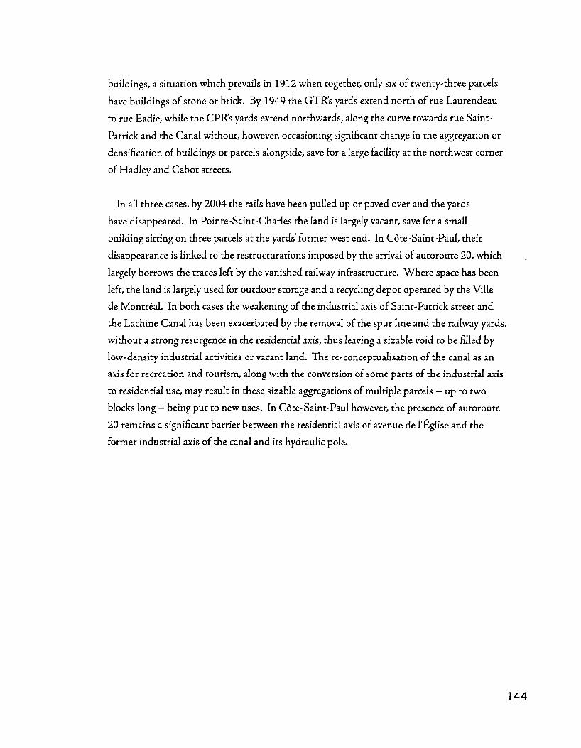
buildings, a situation which prevails in 1912 when together, only six of twenty-three parcels
have buildings of stone or brick. By 1949 the GTR's yards extend north of rue Laurendeau
to rue Eadie, while the CPR's yards extend northwards, along the curve towards rue Saint-
Patrick and the Canal without, however, occasioning significant change in the aggregation or
densification of buildings or parcels alongside, save for a large facility at the northwest corner
of Hadley and Cabot streets.
In all three cases, by 2004 the rails have been pulled up or paved over and the yards
have disappeared. In Pointe-Saint-Charles the land is largely vacant, save for a small
building sitting on tliree parcels at the yards' former west end. In Cote-Saint-Paul, their
disappearance is linked to the restructurations imposed by die arrival of autoroute 20, which
largely borrows the traces left by the vanished railway infrastructure. Where space has been
left, the land is largely used for outdoor storage and a recycling depot operated by the Ville
de Montreal. In both cases the weakening of the industrial axis of Saint-Patrick street and
the Lachine Canal has been exacerbated by the removal of the spur line and the railway yards,
without a strong resurgence in the residential axis, thus leaving a sizable void to be filled by
low-density industrial activities or vacant land. The re-conceptualisation of the canal as an
axis for recreation and tourism, along with die conversion of some parts of the industrial axis
to residential use, may result in these sizable aggregations of multiple parcels - up to two
blocks long - being put to new uses. In Cote-Saint-Paul however, the presence of autoroute
20 remains a significant barrier between the residential axis of avenue de l'Eglise and the
former industrial axis of the canal and its hydraulic pole.

Jul LM.EU
IH:_ . . . • 1, . . I l l
en
o 01
o CO
o u.
in o i I -UJ <D
^ # 6 - f % o c (U
JC ••-J
o
£ ro
^%-Kl'
;UT»:tl i t t jrrSrSB ITiiisTBlftttaliTFi?'r^
- . S . ^ • . . . .• l ; n^ . ' , - . ' . • ; : { • ; - . ; f : = J , : • ] , l
u
<o u
f -a c (0
C
145

Urban semi-autonomous
The urban semi-autonomous yards are those where the form is somewhat determined by
the surrounding urban tissue, but the yard's shape and relations with its context involve a
somewhat larger degree of restructuration due to a lack of precise correspondence between
the two. Frequently this involves the orientation of the infrastructure - such yards are
often but of alignment with respect to the parcel and street grid in terms of being roughly
perpendicular to the pattern of'long blocks' as well as being at a different angle. These yards
frequendy predate the surrounding urban tissue - the urbanisation of which is frequendy
importantly structured by their configuration and presence. This distinguishes them from
the'urban integrated' type of yard, which though it also structures its surroundings, does so
in a way more related to their presence than their configuration. Two of the four examples in
southwest Montreal are attached to the GTR mainline - the Bonaventure freight terminal
and the Saint-Henri yards - while the other two are scarcely removed from it and are
themselves conforming to the orientation of the Canal.

T-pjl^ r j - , •• tji'm * J Ot_ I*
- * - - ^ T " - - • - ^ ^ - . * ' . " • - - - v - » • _ • - •
"i:-^i-
liil^^i IV :y. • ^ /
$= :rvA ll&iiisioss'Bi H^?^
* - s ^ * A '•••.t
M i
4-63: The GTR's Saint-Henri yards; the complex emerged in the space between two formerly competing railways and had marked effects on the urban tissue of its surroundings. From the top, 1912, 1949,2002.
147

The GTR's Saint-Henri yards derive their location and configuration from the historical
twinning of the old railway to Lachine. The space between the two main lines - still visible
as late as 1907 - was filled in and used as a yard when the G T R assumed control of both.
By 1912 though, the full extent of the yard is evident and the empty spaces in the middle
have been filled in by more tracks. The yards don't appear to have a significant structuring
impact on the surrounding urban tissue in that the street grid and parcelling system is
largely determined by the previous seigneurial colonial land subdivision system. The yards
do, however, have a significant impact on die built tissue of the blocks to the south of the
yards towards Dagenais avenue. Industrial complexes in these blocks, though neither the
parcels nor the streets are adapted to the presence of the tracks in any way (de Courcelles
street is still a level crossing in 2007, though Saint-Remi follows a tunnel under the tracks),
take advantage of the nearby yards through a system of sidings that branch off the main
yard along Acorn street. The particular form of aggregation and densification here is all
the more striking given that it occurs in an urban tissue diat was reoriented away from the
Saint-Ambroise industrial sector and the Lachine Canal. While most of these streets are
residential - from Dagenais south to Sainte-Emilie streets - the residential parcel modules
and block widdis are adapted for industrial use near the yards through the introduction
of specialised building types that diverge from the residential footprint in terms of length
and a tendency to traverse rear lanes and thus stretch across complete blocks. By 2004,
these blocks still display significant industrial densification (principally the filling of open
courtyard spaces) and conserve an example of aggregation of industrial buildings within a
residential tissue.

The Atwater yards, hosting tracks from both the C P R and the G T R , were located
immediately east of the GTR's mainline crossing of the Lachine Canal and were the southern
and eastern neighbours (respectively) of the Atwater market. The CPR's southern yard first
appears in the 1907 map, predating the market, yet coming after the filling of the Brewster
basin and its subdivision into whole-block parcels. While on the nearby residential blocks
(largely to the northwest) densification in the form of rear-lot structures is striking between
1890 and 1912, the blocks immediately adjacent to the yards - between Berard street and
Atwater avenue - remain largely vacant. By 1949 the market is ensconced between the
two yards and a block devoted to an ice house and outdoor storage. The GTR's eastern
yard, which first appears on the map in 1912, occupies the space left behind by the filled-in
Brewster basin. Stretching over a superblock the size of three ordinary ones, it is directly
connected to the Redfern lumberyard and William Rutherford's sash and door factory.
By 2004, the removal of the railyards is followed by the construction of a condominium
complex, a big box grocery store and a parking lot on the same footprint.
4-64: The CPR and GTR's Atwater yards. From the Brewster basin to a big box, the scale remained remarkably distinct from the surrounding residential blocks, yet neatly packaged in the residential framework. An excellent example of the dialectic between residential and industrial forms along the Lachine Canal.The GTR's Saint-Henri yards; the complex emerged in the space between two formerly competing railways and had marked effects on the urban tissue of its surroundings. From the top, 1890, 1907.
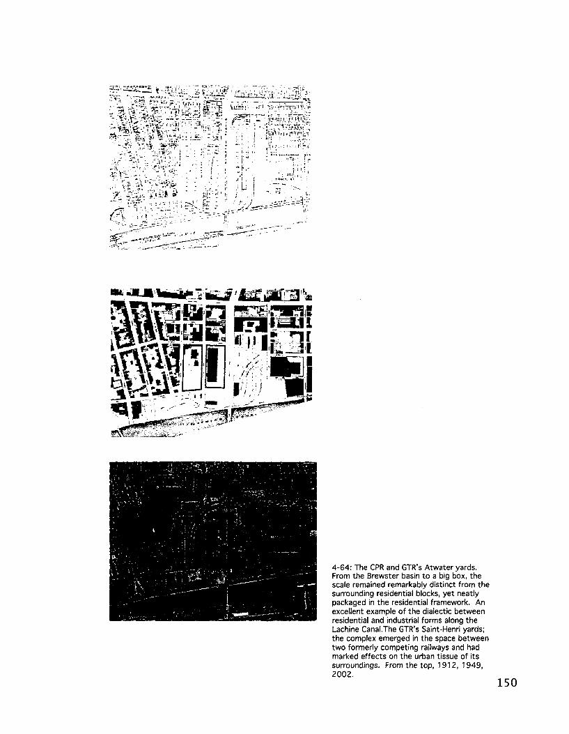
4-64: The CPR and GTR's Atwater yards. From the Brewster basin to a big box, the scale remained remarkably distinct from the surrounding residential blocks, yet neatly packaged in the residential framework. An excellent example of the dialectic between residential and industrial forms along the Lachine Canal.The GTR's Saint-Henri yards; the complex emerged in the space between two formerly competing railways and had marked effects on the urban tissue of its surroundings. From the top, 1912, 1949, 2002.
150

The GTR's Bonaventure Freight Terminal (see Notman panorama), which at its peak in
1949 stretched from boulevard Georges-Vanier in the west to square Chaboillez in the east,
is another example of an urban, semi-autonomous type of railyard. Though they conform
to the block layout, they impose a different and vaster scale upon it, in a sense echoing the
escarpment above as a filter allowing only select streets passage between the cities above
and below the hill. The Bonaventure Freight Terminal arguably acted as a the barrier to the
northward aggregation and densification of the urban tissue anchored by the Notre-Dame
matrix route - which is now marked by a contemporary north-south dichotomy in the
contrasting forms of urban renewal and historic conservation lining the respective sides of
the street. Following the path of the first railway on the island of Montreal, the yards stretch
from Versailles street to Chaboillez square in a relatively consistent form, with tracks fanning
off from the main line to the north and south. Between 1912 and 1949, the configuration of
the yards themselves changes dramatically, with a significant westward expansion. Although
from 1890 onwards industrial activities are increasingly present in the blocks between Notre-
Dame and the yards, there is little restructuration, or even aggregation into industrially-scaled
complexes evident in these areas. The 1949 map does, however, show a freight terminal
significantly larger - especially in the western and southern directions - than in 1912, with
multiple long sheds and overpasses for key north-south streets. Chaboillez square, with the
loss of its station functions in favour of the new Gare Centrale in the business centre has also
changed, as Railroad street has been integrated into the freight compound and serves as a
gated'lobby', offering connection with both Saint-Jacques and Notre-Dame streets.

* • - ' • * «> f w : [
i K -I fc * * • # t - *
-II T *••'
j isrotsBunip tin ̂ s j
4-65: The GTR (and subsequently CN)'s Bonaventure freight terminal occupied a massive swath between Griffintown and the uptown city centre. Following its postwar closure, it became the site for a series of new housing initiatives, introducing a variety of urban (and less urban) housing forms into the CBD. From the top, 1890, 1907, 1912, 1949,2002.

Unified autonomous
The unified autonomous yards, like the unified autonomous industrial complexes, are
largely independent of the urban tissue and conditioned principally by the agricultural
framework upon which they are sited. Even a posteriori, tlaough they act as significant
poles in the metropolitan framework, they have little structuring impact on the level of
urban tissue. The two examples in Southwest Montreal, the GTR's Turcot and Pointe-
Saint-Charles yards, demonstrate this
perhaps contradictory notion. While it
seems tliat the contemporary shape of
residential Pointe-Saint-Charles is largely
circumscribed by the territory of the yards,
much of the limits of the southern Point's
residential sector were defined more by
the edge of the Saint-Laurent river - the
yards were expanded on subsequent landfill
- than they were by the yards themselves.
The original land purchase for the approach
to the Victoria bridge and die shops, is still
largely the boundary between the GTR's
yards and tlie neighbourhood.
In the second case, the GTR's Turcot yards, the infrastructure is almost totally isolated
from an urban tissue of any kind, again drawing upon the underlying agricultural framework
in a manner similar to the Lasalle Coke across the Canal as well as drawing upon the
geomorphology of the site, as die yards were built on land reclaimed from the Lac-aux-
Loiitres wetlands. Separated from Notre-Dame-de-Grace by the Saint-Jacques escarpment
and from Ville-Emard and Lasalle by the Canal, die yards' configuration is largely determined
by the orientation of the GTR's mainline to Lachine and beyond, its extent defined by tlie
barriers of tlie Canal and the escarpment, only slightly altered by the routing of autoroute 20
and the Turcot interchange.
4-66: The GTR's Pointe-Saint-Charles yards and shops predated (and to a degree encouraged) the industrial urbanisation of the city's southwest. Arranged in relation to the GTR's mainline across the Victoria Bridge, their most significant alterations were more a matter of interacting with the growing port (via Brennan street) than an interplay with residential tissues or urban forms. 1949.
4-6
7: T
he G
TR's
Tur
cot
yard
s, a
mas
sive
com
plex
incl
udin
g th
e C
anad
a C
ar fa
ctor
y (b
uild
ings
at
cent
re l
eft
).
Occ
upyi
ng t
he s
ite o
f th
e fo
rmer
Lac
-aux
-Lou
tres
(O
tter
La
ke),
the
yard
s, w
hen
alig
ned
with
aut
orou
te 2
0 an
d th
e C
anal
, pow
erfu
lly a
ttes
t to
the
impo
rtanc
e of
the
Lac
hine
Can
al c
orrid
or.
Dis
used
by
the
end
of t
he 2
0th
ce
ntur
y, t
he f
ate
of t
he y
ards
and
the
rela
tions
hips
bet
wee
n th
e ur
ban
fabr
ic t
hat
will
rep
lace
the
m w
ith t
he e
scar
pmen
t an
d th
e C
anal
was
an
emer
gent
top
ic i
n th
e ea
rly 2
1 st
cen
tury
.

Conclusion
The analytical narratives presented in the course of the above pages elaborate a complex
system of urbanisation, industrialisation, and regeneration. Presenting a multi-scaled take on
the evolution of southwest Montreal, this chapter attempted to provide a structural reading
of the urban tissue by focusing on the GrifEntown district and developing a typology of
industrial complexes and railyards across the eastern Lachine Canal basin. This approach
highlighted several themes central to the particular evolution of industrial Montreal.
Notable among these themes is the conceptualisation of GrifEntown's urbanisation,
industrialisation, and regeneration as a process characterized by shifting between
manufacturing, transhipment, and residential projected different structural imperatives onto
the urban tissue and created vasdy divergent conditions over the course of more than 150
years, with considerable contemporary repercussions. This dynamic tension or balancing
between competing forms of territorial occupation must also be expanded to include die
notion, active within the GrifEntown district and throughout the eastern Lachine Canal
basin, that a biaxial structure in which the Canal itself, at a more citywide or regional scale,
coupled with adjacent infrastructures and industrial roads, can be thought of as an industrial
nodal axis funnelling industrial development that is mirrored by a more locally pertinent,
urban, residential centralising nodal axis formed by a variety of streets at the hearts of various
neighbourhoods, namely rue Notre-Dame, rue Centre, and avenue de l'Eglise.
The second important contribution of the above analysis is the situation of the eastern
Lachine Canal basins industrial complexes on a continuum according to the degree of their
integration with the surrounding urban tissue. Drawing from the work of Robert Lewis
(2001) and Reyner Banham (1986), the second analytical narrative's development of a
typology on this basis expanded on the distinctions made in the first narrative's analysis
of the GrifEntown district between tissues of manufacturing and transhipment. By
drawing attention to the often incremental and integrated character of industrial complexes
— highlighting their roots in aggregations of elements of non-specialised urban tissue, from
residential parcel modules to the residential buildings themselves, the second narrative traced
a process of increasing specialisation and decreasing integration as time progresses and, by
and large, distance away from Vieux-Montreal increases.
Expanding such an analysis to the emergence of the Lachine Canal basins industrial
sectors - Windmill Point, the Saint-Gabriel locks hydraulic complex, Sainte-Cunegonde,
Cote-Saint-Paul, and Saint-Ambroise - the previous pages explored in greater detail the
local specificities of the tensions between industrial axis and residential tissues, the particular
elements and (inter) relationships characteristic of each sectors urban tissue, and most
crucially, the unfolding of (trans)formative processes of aggregation, densification, and
restructuration in the various sectors.
The last section of this chapter expanded this approach to arguably the most crucial
transhipment infrastructures in the southwest, the railyards. More so than the Canal,
the southwest's railway infrastructure still fulfills its original purposes, though in a form
considerably scaled back from the heights attained in the middle of the twentieth century.
Extending throughout (and beyond) the urban territory, the railway meets the city most
intensively through its railyards. Indeed, as the railway overtook the canal basins and
quays as the city's key trans-shipment interface, a unique synthesis between different
technologies and scales of urban materials handling was developed, with a complex layering
of infrastructures with distinctive ways of relating to their urban surroundings. The
culmination of this mixture, the grain silo, is the product of this interaction, mixing basin
and rail. Adopting an approach to the classification of railyards according to their degree
of integration with the surrounding urban tissue, this last section revealed that railyards
entrained significant and particular (trans)formative processes, namely aggregation and
restructuration.
The following chapter consists of a three part discussion that takes the salient points
from the above analysis and examines their implications on several fronts: in terms of the
practices necessary to address brownfields regeneration and heritage preservation; in terms
of what a morphological analysis of Southwest Montreal reveals about the relation between
urban tissue and continental projects of economy and infrastructure; and finally, in terms of
the conceptual and practical roles urban tissue can play as a mediator of political-economic
forces.
5. Discussion | Chapter five
Brownfields and urban heritage
Introduction
Economic restructuring and deindustrialization have left large tracts of frequently
contaminated land and obsolete industrial buildings underused or unoccupied. The
redevelopment of such areas and facilities, often located at symbolic locations in close
proximity to city centres, for post-industrial purposes is high on the urban planning and
policy agenda in the West. The term brownfield redevelopment was coined to designate
these urban conversion operations, which are often seen as a desirable and more sustainable
counterpoint to greenfield development entailing the urbanization of agricultural or
forested land on the suburban periphery. As is argued in the second chapter, in Canada
and North America, the question of brownfield redevelopment has been, for tiie most part,
discussed solely from environmental or economic development and real-estate perspectives
Such predominantly technical and technocratic perspectives, discourses, and policies offer
pertinent vantage points and address critical issues but they can be too narrow and they may
fail to address the historical and cultural significance of tliese sites of production; landscapes
that testify to die historically important urban experience of generations of migrants and
immigrants who settled in close vicinity of their industrial workplaces. This first section of
the discussion attempts to go beyond the monumentalisation of industrial ruins towards a
fuller urban regeneration practice that builds on the heritage of the entire urban tissue.
Our current inability to situate brownfield redevelopment policies in a broader cultural
and historical framework allows for the irreversible destruction of an inherited built
landscape whose heritage value is not yet fully recognized. In some cases this insensitivity
paves the way for tabula rasa redevelopment tliat produces landscapes suffering from
economic, cultural, and spatial disconnects in relation to the urban neighbourhoods diat
form their surroundings. Even when brownfield redevelopment efforts entail maintaining
and converting old industrial buildings, fragmentary knowledge of the complex historical
stratification underlying landscapes of industrial production and their contiguous residential
neighbourhoods contributes to the generation of impoverished redevelopment schemes.
Overly technocratic planning approaches result in culturally disembodied and spatially
atomised urban environments and reduce them to landscapes of consumption. This
discussion introduces the expression culturally disembodied built landscapes' to evoke a
commodified built environment, the production of which is predicated on exchange value

determined by property investment as opposed to use value determined by inhabitants'
activities and habits on the one hand, and one that is severed from locally-generated cultural
models for urbanisation on the other. Through knowledge generated by an approach
that integrates the study of urban forms, i.e. urban morphology, this discussion proposes
a new path for conceptualising the heritage value of these landscapes and avoiding such
disembodiment and atomisation, and their economic and cultural ramifications.
The previous chapter's morphological reading of what is perhaps Canada's most important
brownfield redevelopment sites, the Lachine Canal basin in Montreal suggests that public
policy and planning could benefit from an approach that considers the industrial landscape
as a component of an active urban material culture: the culturally meaningful concrete
objects (Frantz, 1998: 791 ; Grassby, 2005; Hodder & Hutson, 2003) that constitute the
city, and a collective product enacted in the historical longue-duree. This approach finds its
roots in urban morphology, a research tradition focusing on the evolution of urban forms
(i.e. morphogenesis), examining the consistency and resilience of built space in the face of
social, political, and economic systems and structures, and the historical sedimentation of
urban artefacts by unveiling the mechanisms of transformation and conservation that affect
the evolution of a built environment. The knowledge hence produced, which stresses the
structural and genetic qualities of the city-building collective effort while shedding light on
the production of home grown cultural models of urban habitat (Moudon, 1994), could
prove invaluable for the production of post-industrial landscapes that resonate widi the
culture, history, and urban experience of local populations and that truly contribute to
rejuvenate the adjacent inner-city districts whose fates were so intimately tied to the rise and
fall of the urban industrial machine.
This section of the discussion calls for a leveraging of morphological knowledge in order
to suggest a matrix capable of guiding regeneration efforts and opening the door to new
solutions to planning, policy, and design challenges common to regeneration projects. It
ends with a discussion of the promise of this approach, emphasising its potential to address
two closely connected issues: cultural disembodiment and spatial atomisation, and their
manifestations in the reduction of redeveloped sites to landscapes of consumption and
heightened unevenness in the effects of revitalisation.

Brownfields, urban transformation, and morphology
The semantic pairing of the terms brownfield and greenfield, while downplaying barriers
related to fiscal, liability, and technical issues, evokes a blank-slate imagery that obscures the
richness of derelict industrial sites in terms of heritage and traces of still-relevant material
culture. In addition to the economic and cultural disconnects pointed to by the above
critics, this knowledge deficit has spatial and physical ramifications in that it facilitates
redevelopment practices that can rupture irreversibly with the material culture embedded
in the urban landscape, a source of significant meaning and important spatial connections
for the surrounding neighbourhoods and their populations. Even when the historical
significance of past sites of industrial production is recognized as an asset, the tendency is
to instrumentalize this heritage value through a commodification of the built landscape
that drains it of most of its historical substance. Once it is recognized that brownfield sites
are not tahulae rasae or blank slates, but rather significant repositories of urban industrial
heritage, the challenge becomes one of translating these qualities into a concrete planning,
policy, and design substance. The Swiss urban morphologist Sylvain Malfroy puts forward
the notion that the regeneration of derelict industrial areas should indeed be understood as
"a work of completion" (1998a: 141), in that such sites are embedded in the surrounding
urban tissues and bear the traces of a long sedimentation of urban material culture that could
inform and guide contemporary actions.
The industrial urbanisation of the Lachine Canal basin testifies to this sedimentation
process in a highly expressive way (Bliek & Gauthier, 2006). Unfortunately, recent
redevelopment in the area illustrates no less eloquently the risks of a predominantly
instrumentalist and entrepreneurial governance approach with a technocratic focus to
reduce a complex multi-layered and multifaceted space into an impoverished landscape of
consumption, culturally disembodied and spatially atomised. The following sections discuss
how the previous chapter's morphological reading of the Lachine Canal basin's urban tissue
could contribute to a reform of our brownfield redevelopment policies and practice.
The spatial history documented in the previous chapter showed how industrialisation along
the Lachine Canal took place in two waves, followed by deindustrialisation and an ongoing
post-industrial development wave. Through both the adaptation of residential urban tissues
to industrial use - from the Acorn street area in Saint-Henri to much of eastern Griffintown
- and the consistent presence of urban-integrated type industrial complexes which involve

the aggregation of residential-scale parcel and building elements, the landscape of production
has always been characterised by a complex interplay involving the emergence of a specialised
industrial spatial order and a pre-established residential spatial order.
5-1: The Gardner Novelty works, an 'urban-integrated' type industrial complex, is an excellent example of the interplay between residential and industrial forms, mixing technical imperatives with residential vernacular and block layout.
In the first wave, industrial development was largely informed by vernacular architecture
and residential settlement patterns, including masonry and carpentry techniques reminiscent
of the affluent houses and institutional buildings in Vieux-Montreal (see figure 1, above).
The configurations of and relationships between the street network and allotment
system, as well as the spatial deployment of buildings, were hardly distinguishable from
their counterparts in the old city. The second phase witnesses the gradual adaptation of
architectural forms to then emergent industrial imperatives, a process marked by increasing
specialisation and complexity in the architectural forms and spatial arrangement of industrial
facilities. This second phase took place on ground already laden with the traces of the first
phase, resulting in a distinctive dialectic between industrial and residential spatial orders.
This dialectical relationship between traditional extensions of the largely residential, non-
specialised city and the introduction of specialised urban elements related to the needs of
industry and continental transportation is visible on maps produced as early as 1846 (see
figure 2, below), and becomes increasingly pronounced with further industrialisation. A
historically-grounded reading of urban form along the Lachine Canal reveals the permanence
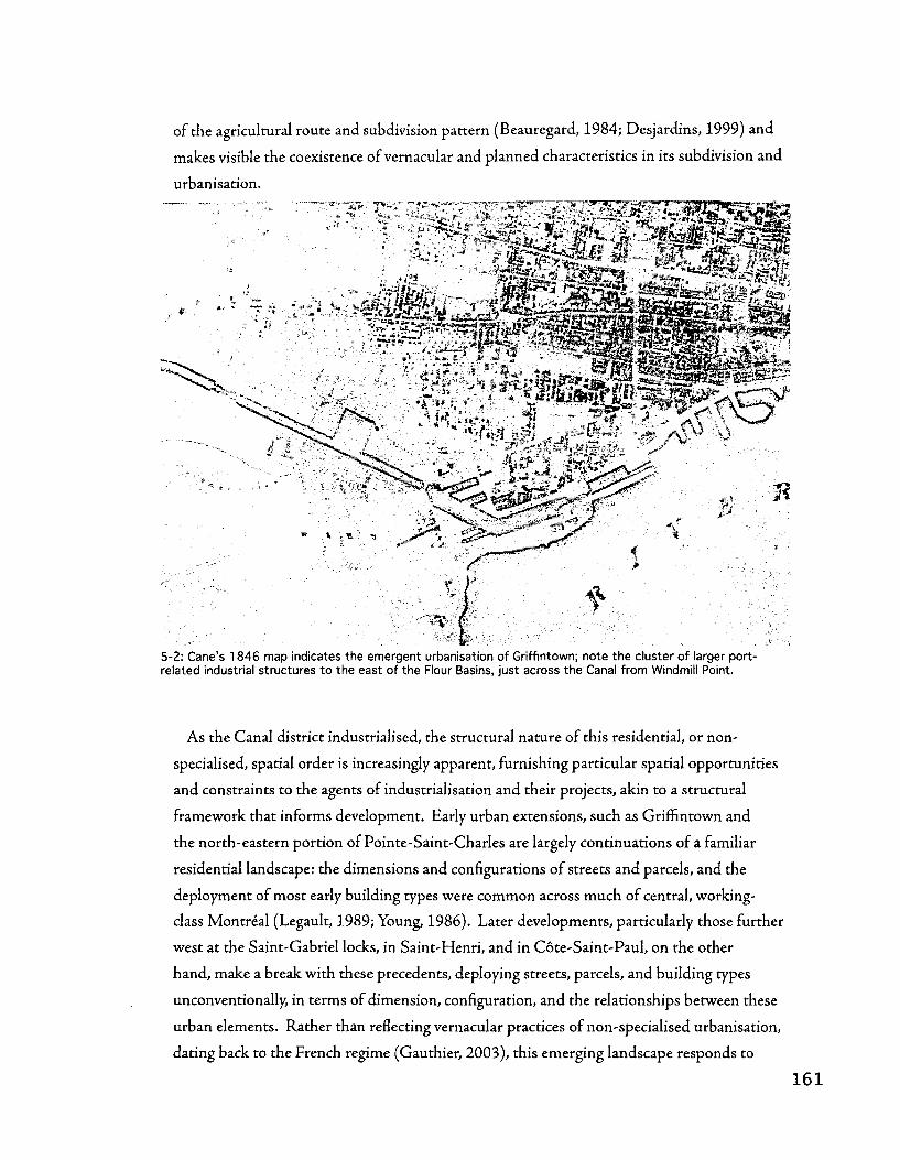
of the agricultural route and subdivision pattern (Beauregard, 1984; Desjardins, 1999) and
makes visible the coexistence of vernacular and planned characteristics in its subdivision and
urbanisation.
5-2: Cane's 1846 map indicates the emergent urbanisation of Griffintown; note the cluster of larger port-related industrial structures to the east of the Flour Basins, just across the Canal from Windmill Point.
As the Canal district industrialised, the structural nature of this residential, or non-
specialised, spatial order is increasingly apparent, furnishing particular spatial opportunities
and constraints to the agents of industrialisation and their projects, akin to a structural
framework that informs development. Early urban extensions, such as Griffintown and
the north-eastern portion of Pointe-Saint-Charles are largely continuations of a familiar
residential landscape: the dimensions and configurations of streets and parcels, and the
deployment of most early building types were common across much of central, working-
class Montreal (Legault, 1989; Young, 1986). Later developments, particularly those further
west at the Saint-Gabriel locks, in Saint-Henri, and in Cote-Saint-Paul, on the other
hand, make a break with these precedents, deploying streets, parcels, and building types
unconventionally, in terms of dimension, configuration, and the relationships between these
urban elements. Rather than reflecting vernacular practices of non-specialised urbanisation,
dating back to the French regime (Gauthier, 2003), this emerging landscape responds to

new imperatives, accommodating particular technologies, (hydraulic and coal-fired) energy
sources, and production processes. The characteristics of this new landscape might be more
dependent upon the transhipment or production needs of particular businesses (the creation
of a quay- or track-side staging area, or the need to access hydraulic energy or to store coal
supplies) than upon spatial models that have their roots in the residential tradition; an
ensemble of parcel and house dimensions and configuration informed by specific dwelling
habits and domestic requirements, with rows of dwellings that frame in familiar ways the
space of sociability constituted by the street. It is in these landscapes that the urban semi-
autonomous and unified-autonomous type industrial complexes emerge, and in which the
imposition of spatial needs relating to the exploitation of hydraulic energy or transhipment
infrastructure take prominence.
The earliest urban-integrated industrial complexes and the sectors they defined
- Grimntown and the Saint-Gabriel hydraulic pole - were characterised by processes of
aggregation and densification that were by and large the industrialisation of a residential
(or non-specialised) urban tissue. The previous chapter's analysis highlighted the degree to
which complexes such as the Cunningham and Wells were integrated into the urban tissue
and in large part were issued from the aggregation of largely vernacular, non-specialised
buildings. At the scale of the industrial sector, it seems that much of the landscape produced
under the auspices of emergent industrial necessities and spatial requirements had already
been subdivided and prepared for urbanisation (even if unbuilt) according to this earlier
residential spatial order, resulting in a long and fluid dialectic. This relationship is expressed
throughout the Canal district in the form of unique arrangements of industrial complexes, in
which numerous facilities responded to the particular framework provided by a residential
street and parcel configuration. In an era of de-industrialisation and conversion to residential
and recreational uses, the opposite can now take place: the layout of residential projects can
respond to the street and parcel configurations of superseded industrial complexes.
From a morphological perspective, the spatial characteristics of the industrial landscape
along the Canal are conceived of as the diffuse and collective result of a complex interplay
between the long-standing vernacular practices of urbanisation and the introduction of
new technologies, energy sources, and production processes. The traces of this interplay
and their meanings, inscribed deep in the landscape can be at the core of the planning and
design of any brownfield redevelopment projects in such a context. The following paragraphs
detail the contribution such knowledge can make towards the resolution of two important

issues associated with brownfield redevelopment projects: the tendency towards a cultural
disembodiment or disconnect, and their spatial atomisation or rupture in relation to their
material and social surroundings.
New readings of urban industrial heritage
Brownfield redevelopment projects are often promoted as major initiatives at the scale
of local communities and entire metropolitan regions. The attainment of objectives
related to broader revitalisation and economic development strategies (for instance the
de-stigmatisation of afflicted communities or the attraction of reinvestment to surrounding
neighbourhoods) can be hampered by a redevelopment approach that fails to take into
account the historical traces inscribed in the site and that are at the core of its economic,
cultural, and spatial linkages with the surrounding city. This is often recognised by economic
development strategies related to the project, particularly those that involve civil society and
social economy actors that deal with issues of employment and housing. For these efforts
to be genuinely successful however, we argue that reconfiguration must take into account
the underlying logic of the landscape, as it has emerged from the neighbourhood through
history. For Dubois et al, the recovery of these historical traces is crucial to the successful
redevelopment of the Lachine Canal basin: "La perte des principaux elements qui formaient
lepaysage industriel du XIXe siecle, notamment les bassins des chantiers maritimes, diminue la
qualite patrimoniale de I'ensemble de cette unite de paysage, notamment en raison d'une perte de
visibilite et d'accessibilite au canal de Lachine" (Dubois, 2005: 5.2.6).
The ability to read and draw from this logic in guiding contemporary transformation
is crucial to avoiding cultural disembodiment and spatial and material atomisation in
redevelopment projects, and to avoid disconnects between the new project and the material
culture of the city and its inhabitants. RatJier than a blank slate, redevelopment can
be rooted in and contributes to the spatial patterns of its urbanised surroundings. The
disappointment expressed by civil society and social economy actors in the Lachine Canal
basin in Montreal (see RESO (2001), for example) speaks to a lack in current brownfield
redevelopment practice that takes the form of economic exclusion, cultural disembodiment
and spatial atomisation. Research and analysis that reads the historically and collectively
produced spatial logic underlying the industrial landscape can provide the key to brownfield
redevelopment that is truly contextualised and meaningful for its residents.

A look at redevelopment along the banks of the Lachine Canal can clarify this point. This
area has been affected by the recent redevelopment of the Redpath sugar refinery, designed
in the early 1850s by the architect and surveyor John Ostell (James, 1985). Ostell was also
responsible for the platting of many of the surrounding blocks on behalf of the Sulpician
religious order (Young, 1986), in a configuration parallel to the Canal characteristic of
most urbanisation on the residential fringes of Montreal; indeed, many of the new parcels
and blocks were originally occupied by typical dwellings. As industrialisation progressed,
factories and transhipment facilities grew increasingly large and specialised, though they
remained contained within Ostell's mid-19th century street grid and the relationship
between factory and canal was expressed through a normal street, though home to particular
uses related to transhipment and observing maritime activity. After 1949 however, Canal
Street and die northern end of Montmorency and Conde Streets were closed, and more
recently, the grassy canal bank was converted into a linear park and bicycle path, detached
from the neighbourhood-wide public space system it once belonged to, even though not a
hospitable public space from a recreational or scenic point of view.
The Lachine Canal has seen high levels of public investment: from 1997 to 2002, the
federal and municipal governments invested over $100 million (Montreal, 2004: 231) in
an effort to transform disused industrial infrastructure into a're-naturalized' recreational
amenity, historical interpretation site, and magnet for economic revitalisation. Despite
these substantial capital infusions, the current redevelopment paradigm prevents the
successful integration of much of this new park into the public space networks of
surrounding neighbourhoods, constraining the diffusion of economic spin-offs and impeding
neighbourhood access to the new amenity. While most commentators commended the
preservation of old industrial buildings, such as those of the Redpath sugar refinery, and
more generally the residential revitalisation of the canal's formerly industrial banks, many
community members expressed serious concerns about the economic disparity induced by
an influx of residents espousing a 'loft-living' (Zukin, 1982) lifestyle that the vast majority
of the local population do not relate to and could ill afford. These very serious issues are in
fact symptoms of a deeper cultural disruption, with a spatial dimension. Transforming the
inherited industrial landscape involves an inevitable 'recoding,' but too frequently this results
in spatial configurations and material arrangements tJiat are at odds with earlier industrial
and residential spatial logics and cultural models that prevailed at its formation and through
later transformations.
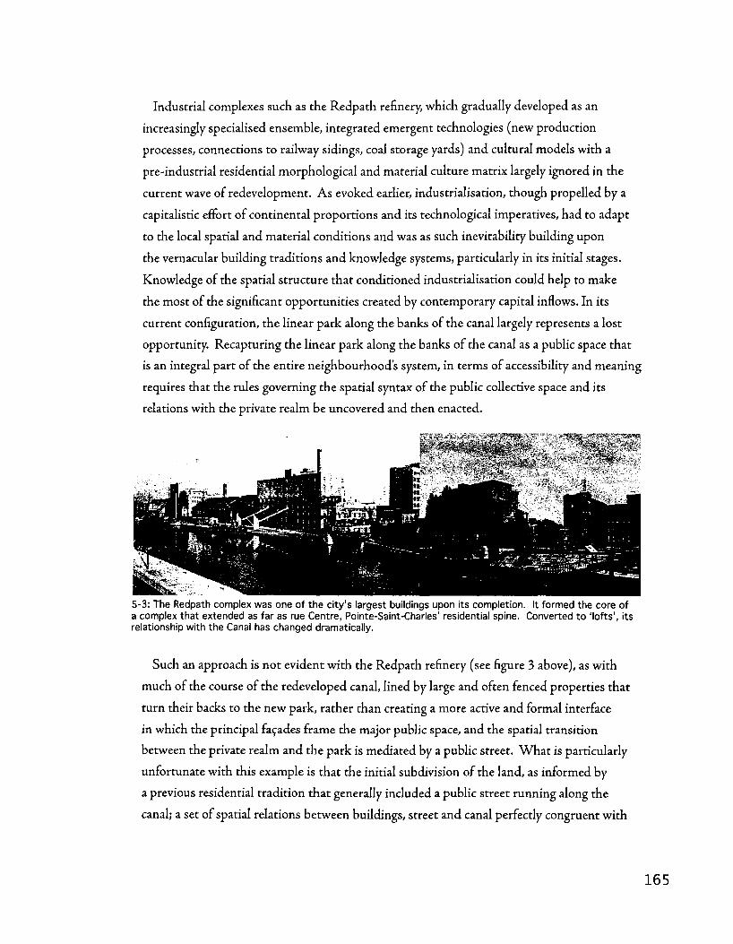
Industrial complexes such as the Redpath refinery, which gradually developed as an
increasingly specialised ensemble, integrated emergent technologies (new production
processes, connections to railway sidings, coal storage yards) and cultural models with a
pre-industrial residential morphological and material culture matrix largely ignored in the
current wave of redevelopment. As evoked earlier, industrialisation, though propelled by a
capitalistic effort of continental proportions and its technological imperatives, had to adapt
to the local spatial and material conditions and was as such inevitability building upon
the vernacular building traditions and knowledge systems, particularly in its initial stages.
Knowledge of the spatial structure that conditioned industrialisation could help to make
the most of the significant opportunities created by contemporary capital inflows. In its
current configuration, the linear park along the banks of the canal largely represents a lost
opportunity. Recapturing the linear park along the banks of the canal as a public space that
is an integral part of the entire neighbourhood s system, in terms of accessibility and meaning
requires that the rules governing the spatial syntax of the public collective space and its
relations with the private realm be uncovered and then enacted.
5-3: The Redpath complex was one of the city's largest buildings upon its completion. It formed the core of a complex that extended as far as rue Centre, Pointe-Saint-Charles' residential spine. Converted to 'lofts', its relationship with the Canal has changed dramatically.
Such an approach is not evident with the Redpath refinery (see figure 3 above), as with
much of the course of the redeveloped canal, lined by large and often fenced properties that
turn their backs to the new park, rather than creating a more active and formal interface
in which the principal facades frame the major public space, and the spatial transition
between the private realm and the park is mediated by a public street. Wha t is particularly
unfortunate with this example is that the initial subdivision of the land, as informed by
a previous residential tradition that generally included a public street running along the
canal; a set of spatial relations between buildings, street and canal perfectly congruent with

contemporary needs. Similarly, the residential retooling of the industrial complexes gradually
built on a residential substratum could gain incredibly in cultural pertinence and historical
appropriateness when informed by the underlying residential spatial logic active at its origins.
In most circumstances, redevelopment did not entail such attempts at reconnecting with
the site's morphogenesis, with the notable exception of the Stelco site (see figure 4 below),
located on the north bank of trie canal in the Sainte-Cunegonde sector, which rehabilitated
the residential parcels and blocks that structured the site's industrial configuration.
5-4: The Steel Company of Canada's works in Sainte-Cunegonde, 1949 (left) and 2002 (right); The residentially-structured urban tissue at the base of both the industrial complex and its subsequent redevelopment remains clear and constant.
The transformation of Sainte-Cunegonde can, in a sense, be read as a sort of non
traumatic restructuration, congruent with die structural permanences of the site. Though
the vocabulary of building types has changed dramatically, as has the pattern of uses and
activities, the bulk of the urban tissue - especially its most permanent elements, such as the
parcel structure and the street grid - has remained intact and continues to structure the
sector. Last chapter's analysis points to the Stelco and to Sainte-Cunegonde as examples of
an industrial complex and sector structured by a combination of a residential parcel module
and abundant connections to continental infrastructure. Redevelopment in the late 20th
and early 21st centuries continues this phenomenon, with a hybrid combining perimeter
block densification witii the renovation and adaptive reuse of select industrial buildings.
The eastern limit of this regeneration paradigm is demarcated roughly by the Robin Hood
flour mill at the boundary between Sainte-Cunegonde and Griffintown. A legacy of the
longstanding industrial scale of activities on that parcel - it got its start in the 1840s as
Augustin Cantin's Canada Marine Works - it has conserved that character and provides an
imposing and difficult to break-down counterpoint to the dismantling and regeneration of
the Stelco complex.

A similar duality of outcomes occurs in the Saint-Ambroise industrial sector, where two
projects, side-by-side, demonstrate the need for caution in adopting a planning approach
based solely on maintaining the established balance between industrial and residential spatial
orders. The approach adopted for the extension of square Sir-George-Etienne-Cartier to
the canal, including the development of the adjacent parcels, suggests that a requalification of
the Saint-Ambroise industrial sector (the strip of land between the street and the canal) is
underway, one in which supposes a the industrial scale is to be superseded by an extension of
the residential spatial order all the way to the water (Lea-Roback street).
5-5: The Saint-Ambroise sector, 2002; Square Sir-George-Etienne-Cartier extends to the square while new development takes place to its east (right).
Immediately downwater (west or right, in the above figure), however, the approach to
redevelopment is the opposite - an industrially-scaled residential complex stretches for
the same two block equivalent, resolutely preserving the distinction between the Saint-
Ambroise industrial sector and the residentially-scaled neighbourhood fabric of Saint-Henri.
While maintaining the scale and form of the industrial complex is an important tribute to
the history of the Lachine Canal, the more advantageous public accessibility afforded by a
'residentialising' approach - one that draws its structure from the adjacent neighbourhood,
and Montreal's traditional residential block configuration more generally - may be a more
effective means of recuperating the industrial axis.
Given that the previous chapter s analysis indicates that the majority of industrial sectors
along the Lachine Canal are characterised by a dual-axis configuration (one residential,
one industrial), this raises considerable site-specific challenges in terms of how planners
and designers can integrate the Canal into residential neighbourhoods without weakening
its identity and significance. On the flip side, planners and designers must also deal with
1 6 7

the integration with the residential axis of development occasioned by the injection of
recreational and tourist values into the industrial axis. In the Redpath example, the potential
embodied by a residentially-scaled substrate underlying industrial sectors could provide the
means for tying redevelopment into meaningful systems of neighbourhood space, while in the
Saint-Ambroise example, the tensions between industrial and residential axes is manifest and
seems to be an essential factor to address in any regeneration scheme. Elaborating a matrix
of urban elements and their syntax from the information provided by morphological analysis
can serve to enhance the integration of new construction into a deeper system of material
culture, going beyond facadism or superficial theming,' but structuring it in harmony with the
logic that guided previous urbanisation.
Conclusion
The policy implications of this type of urban redevelopment are a critical theme. Yet, in
both academic and policy terms, the discussion is often narrowed to a relatively small number
of technical and technocratic considerations. Little attention is given to the historical
economic, social, and cultural significance of these sites of production that is crucial to
understanding the inherited spatial framework of our cities.
This void has clear impacts on brownfields policy and particularly on the outcomes
of regeneration programs and projects. One such impact is the sense of alienation and
disenfranchisement felt by the populations of the urban neighbourhoods who experienced
first-hand the consequences of deindustrialisation, and who are not reaping the benefits
of the current wave of redevelopment. This latter claim, primarily supported by anecdotal
evidence collected in the context of contacts with community organisations, still needs
to be validated and clarified through further, empirical, research amongst community
organisations. The goals of this section of the discussion are to explore the up-stream
theoretical implications of the current conceptual framework and its lack of attention to
heritage considerations, and the downstream consequences of this framework as illustrated
by redevelopment projects in Montreal. This exploration is aimed at proposing a way to
broaden perceptions of the opportunities and challenges of brownfield redevelopment,
through the incorporation of knowledge produced by a morphological reading of such post-
industrial sites.
Such a reading has allows for a deeper understanding of the historical stratification
of spaces of industrial production and in particular of the historical interplay between
residential and industrial forms. It reveals the existence of a genus loci largely attributable to

a pre-existing sets of opportunities and constraints that shaped the local enactment of global
industrialisation processes. In revealing the operative potential of the traces and patterns
marking brownfield sites, urban morphology can provide innovative means to address lacunae
in current practices and curtail in particular their deleterious effects on the built heritage of
urban industrial neighbourhoods. From the identification of parallel axes of development
in canalside industrial sectors to highlighting the structural potential of a residential parcel
modularity in an industrial context, a morphologically-rooted approach could serve as a
cornerstone in a strategy to foster the collective reclamation of former spaces of production
so that local populations can benefit from these significant investments and continue to live
in an environment that holds meaning in terms of their material culture.
Even in situations when the morphological aspects of regeneration are taken into
account, the cases studied in the previous chapter reveal a landscape that is fraught widi the
challenges posed by dramatic shifts in scale, the coexistence of multiple polarities and axes
of development, and a unique, historically meaningful set of transformations that demand
to be figured into contemporary planning and design schemes. The next section of this
discussion treats the regional and continental importance of the Lachine Canal basin as an
axis of historical permanence and significant meaning; it has held fast as Montreal's link with
the Nor th American continent through vastly different political, economic, and technological
contexts, and has come to play a major structuring role in the territorial development of
Montreal as a metropolis. In fact, one could say that the Canal itself was one of the key
elements in Montreal's emergence as Canada's metropolis. With dhe regional importance of
the Lachine Canal in mind, handling the specific design of regeneration projects - balancing
the industrial and residential spatial orders, intervening in the spaces between the industrial
and residential axes, working with the transitions between hydraulic and transhipment
polarities - takes on even more importance.
Before moving on to the next section of the discussion, I would like to end with a quote
from the Swiss morphologist Sylvain Malfroy, who sums up these high stakes in an eloquent
fashion:
"The reuse of these'blighted' areas poses very serious problems in the choice
of operative criteria for the contextualization of new interventions. This is so
because interventions in these areas necessitate a choice between a more radical
restructuring and improvement at the scale of die entire agglomeration or
adapting the site to its context with small-scale development that plays a part in
1 6 9

the dynamic functional equilibrium of the area and its network of social spaces
established over time. On the one hand, to take this second choice for a large
site might prove insufficient for realizing its potential as a node or pole within
the hierarchy operating on the scale of the entire city. On the other hand, to
work on these large areas, taking for granted their quantitative and qualitative
transformation relative to the city as a whole, is to gamble on the progress of
history and potentially to precipitate the disintegration of entire portions of an
urban area.
Efforts to deal with urban blight have met a challenge in the design of
replacement tissue, because both the idea that various small-scale parts
might be 'interwoven' within the area and the methodology for large-scale
restructuring to take advantage of the real forces of transformation of the city
remain controversial" (Malfroy, 1998b: 24).

The Lachine Canal as an interface between Montreal and the North American Project
An exploration of the tensions between vernacular and modern as demonstrated in
Southwest Montreal.. . how does the city incarnate the paradoxes of modernisation, and how
can Montreal's industrial infrastructure be seen as a large-scale heritage asset?
Introduction
Through the concepts of permanence and resilience it is possible, I think, to accord a
sense of continuity and integration to the implementation and expansion of such a dramatic
element of transportation infrastructure. Innovations in transport are often thought to be
revolutionary in their situation on the built landscape and their character. W h a t the railways
in southwest Montreal offer is an indication to the contrary; that when seen through the lens
of permanence offered by Rossi (Rossi 8C Eisenman, 1982) they are a continuation in a long
line of projects with the design of accessing upper Canada and the interior of Nor th America,
albeit with a technological twist. And when the surrounding environment, the metropolitan
morass of George Herbert Ames's city below the hill, which seems at first glance to demand
a new way of being read (research on the Grofistadt and the shift from Mietskasernen to
Siedlungen or the creation of Tony Gamier s Cite Industrielle in architecture and planning)
and a new way of being lived (the classical sociological works of Max Weber, Georg Simmel
(Sennett, 1969; Simmel, Frisby, & Featherstone, 1997), and the sociology of die Chicago
school) is considered in light of Moudon's idea of resilience in the face of substantial change
in the built landscape of the twentieth-century American city, it becomes possible to think
of the city as a process that fuses the ideal and the material; Maurice Halbwachs' (1980)
collective memory with Saverio Muratori's typological process (Malfroy, 1986). Muratori's
view of the built landscape as a palimpsest of human culture already embodies this fusion,
but in the modern city and in the North American context particularly, the infrastructures of
urban industrialisation need to be conceptualised as a highly eloquent expressions of heritage
available due to its interactions and structuring impact on the surrounding urban fabric.
This section of the discussion puts forward the argument that southwest Montreal's
industrial infrastructure, and especially the Canal and the railway network, are something
beyond the merely picturesque ruins of an industrial era we now romanticise. Rather,
they are one incarnation of a unique fusion between ideal and material, between collective
consciousness and material permanence. As a hub for the settlement and colonisation of
the North American interior, southwest Montreal was, in a sense, un passage oblige through

which a variety of practices of urbanisation were funnelled. The cosmopolitan mix produced
by varying sources of city-building knowledge, from the subdivision of hydraulic energy
clusters to the layout of elite residential squares, and from the aggregation of residential
buildings into small foundries to the specialised design of immense industrial complexes is
testimony to the status of the Lachine Canal basin as a privileged interface between Montreal
and the world. The Lachine Canal basin is the materialisation of Montreal's collective efforts
to position itself as the gateway to a continent through successive political, technological,
and economic paradigms. Southwest Montreal has the legacy of being a privileged site of
interface between local and global and as such is uniquely endowed with a palimpsest of
savoir-faires of urbanisation, industrialisation, and now, regeneration.
The railway infrastructure of southwest Montreal represents the local, urban interface of
empire and the bricks-and-mortar connection between city and continent. The Lachine
Canal basin is a landscape marked by centuries through which this connection between city
and continent has achieved some degree of ideal permanence or resilience - that is what the
district is for - and the varying technological and economic means of achieving these aims
have added up into a sort of palimpsest of North American colonialism. We need to see
these traces - the materiality of old locks, tow paths, railyards, elevators, factories - but also
the less tangible but equally real configurations, polarities, tensions, axes, (trans)formative
processes - as perhaps the most eloquent testimony to Montreal's place in North America,
and to work with them, and recognise them as the incredibly valuable cultural heritage that
they are.
This recognition isn't about preserving these industrial infrastructures or freezing them
in time, but ratlier it's about understanding their structuring qualities and the fact that they
are but the most forceful manifestations of a continental axis that predates them and is part
of the collective consciousness, expressed through the permanence of the Lachine Canal
trace. Far from a call to monumentalise or freeze these infrastructures in a state of either
restored educationalism or pastoral ruin, the notion this section of the discussion seeks to
explore is that of a leveraging of the longstanding structuring powers — the permanence — of
such infrastructure. Syntfiesising the new political-economic imperatives of contemporary
regeneration with the historic permanence and considerable resilience of previous
infrastructures presents the opportunity to recognise heritage by working with it.
The paragraphs that follow outline a short history of the ideas underlying railway
development in Montreal with a view to situating the Lachine Canal basin's network of
railway infrastructure as an interface between the savoir-faire of local urbanisation practices
and the projects of continental settlement and global economic integration. This section of
the discussion then proceeds to draw on the previous chapters analysis - particularly the
segment on railyards - to propose an interpretation of the southwest Montreal's industrial
heritage that focuses on the dialectic between vernacular city-building knowledge and
specialised, technical infrastructure widi remarkable and significant structural implications
that belie a longstanding interplay of ideal and material permanence along this historic trace.
A short history of railways in Montreal
The first railway built in Montreal was not actually built in the city but across the river,
as a portage line connecting two important shipping channels, the Saint-Laurent and
Richelieu Rivers, at Laprairie and Saint-Jean. Part of an important first phase of railway
building that also included the Saint-Lawrence and Atlantic, the intent was to establish a
connection with American markets to the south and with ice-free ports to the east. The
second round of railway building, which included lines such as the Montreal and Lachine, the
Lake Saint-Louis and Province, and the Saint-Lawrence and Ottawa Grand Junction, was
preoccupied with gaining access to the commerce of the interior. For Gerald Tulchinsky, the
continuity between the expansion of railways along the same axis as the Lachine canal and
the larger Saint-Lawrence system is clear: "Just as the Lachine Canal a generation earlier had
provided the vital link for a Canadian canal system along both the Saint-Lawrence and the
Ottawa-Rideau routes, the Montreal and Lachine Railway anchored the westward growth of
Montreal's railway system in the forties and fifties" (1977: 169).
Tulchinsky makes explicit the connection between Montreal's pursuit of railway
connections and the problems posed by navigational difficulties along the Saint-Laurent:
"The Montrealers who first took up the challenge of railways and of ocean-going steamships
were above all attempting to solve the problems created by the inadequacies of lower Saint-
Lawrence River transportation, just as their predecessors had advocated the construction
of the Lachine and other canals in the upper section of the river." Considering the eastern
railways, Tulchinsky sees the other side of the same equation, that of securing Montreal's
place in a continental system of resource development, colonisation, and global trade. "There
was hard economic reasoning behind their promotion of railways down to die northeastern
US, which they viewed as a short land bridge to the Atlantic" (1977: 27).

Montreal's history is that of a staging ground for successive pushes west, and of a proving
ground for the development of a territorial know-how - the cote system - that was widely
exported, from Manitoba to the Gulf of Mexico. The pre-industrial history of the city
-referred to by Tulchinsky in the paragraph above - was one of adventurers and traders,
largely French and Scots, as the maps in chapter two, the gravestones on the higher grounds
of Mont-Royal's cemeteries, and place names and an entire territorial system tiie length of
the Mississippi can attest. But as the city transitioned from a mercantile economy to an
industrial one, and as the settlement of North America increased in intensity, the city found
itself competing to maintain its privileged position as an economic hub and sought, through
investment in railway infrastructure, to affirm its role as die gateway to the continental
interior and its 'natural' hinterland, ahead of the lake port of Buffalo, and the ocean port of
New York, linked to the interior by the Erie Canal system.
5-6: By 1850, Montreal was a major hub, linking the Great Lakes with the Atlantic, and connecting the Canadas with New York, Boston, and a burgeoning American economy. Transport links were so well-established that the Confederate general Jefferson Davis was able to spend time in the city as an exile (see plaque on the west side of the Bay department store, Montreal).
But beyond economic positioning, it's important to consider the high drama of railways
and the promise of transcendence of local idiosyncracy triat came with them as they opened
up North America. The relendess westward push of the frontier in pursuit of, south of the
border at least, manifest destiny and the comprehensive systems of land clearing, subdivision,
occupation, and urbanisation is well expressed in the works of historians and geographers
such as Gilbert Stelter and Alan Artibise (1979; 1984), William Cronon (1991), Frederick
Jackson Turner (1963), and John Reps (1965; 1979; 1981). The project of colonising,

settling, and ultimately - at least to an extent - urbanising, the continent amounts to an
enormous undertaking, and it marked not just the landscape of the West, but also inscribed
significant traces in the landscape of southwest Montreal, Canada's interface with this
globally significant process.
The driving engine of much of this transformation, the railway, was much more than a
simple technology. A force of continental standardisation and the advent of a new global
rationality, the railway was a civilising instrument of the highest order, the prime tool of
empire and colonisation. More locally, the civilising power of railways was evoked in the
writings of Thomas Keefer (Keefer & Nelles, 1972). Keefer, an engineer, was far more
prominent for his pamphleteering on behalf of a variety of railway interests, as well as his
eventual agitation for the professionalisation of engineering, tlian he was for any particular
project he undertook (though die Montreal aqueduct bears his signature), and has been
described as "the engineer of Montreal metropolitanism" (Nelles, 2000). The writings of
Keefer shed much light on the modernity that they brought to Montreal and can serve as
both a rationale for die necessity of understanding their infrastructure and related complexes
as a continental, if not global, phenomenon inscribed in local urban tissue, as well as a text
with singular interpretive value for the aforementioned task. Like Keefer more than a
century earlier, Choay (1969) ascribes a large role in this process to the railway; describing
the role the railway played in the genesis of the modern city and rational, capitalist society
across the West, Choay observes that"[i]In Europe and the United States, the scales did not
tip in favour of the industrial system until die (eighteen) forties, with the development of a
new form of communication, the railway. The railway is the major technical invention that
brought into play the new forms of production and promoted the growdi of large urban
concentrations. From 1840 on, railway and capitalism were to develop hand in hand, and
having weathered the crises of the years around 1848, the'railways became the new economy's
most powerful weapon,' causing [a] new urban type to prevail" (1969:10-11).
In 1850, as a promotional document for the Montreal and Lachine railroad, Keefer
published "The Philosophy of Railroads,' a document that "stands as one of the most rousing
hymns to railway promotion ever penned. Its immediate object was to turn Montreal's
attention away from local railways and projects connecting the city by rail to seaboard
ports towards a strategic linkage with Toronto, thereby allowing Montreal to outdistance
its American rivals for control of the interior trade. But in its rolling cadences and literary
allusions, Keefer's prose transcended the immediate commercial objectives of his Montreal
patrons to make a soaring general argument linking railways to the material improvement
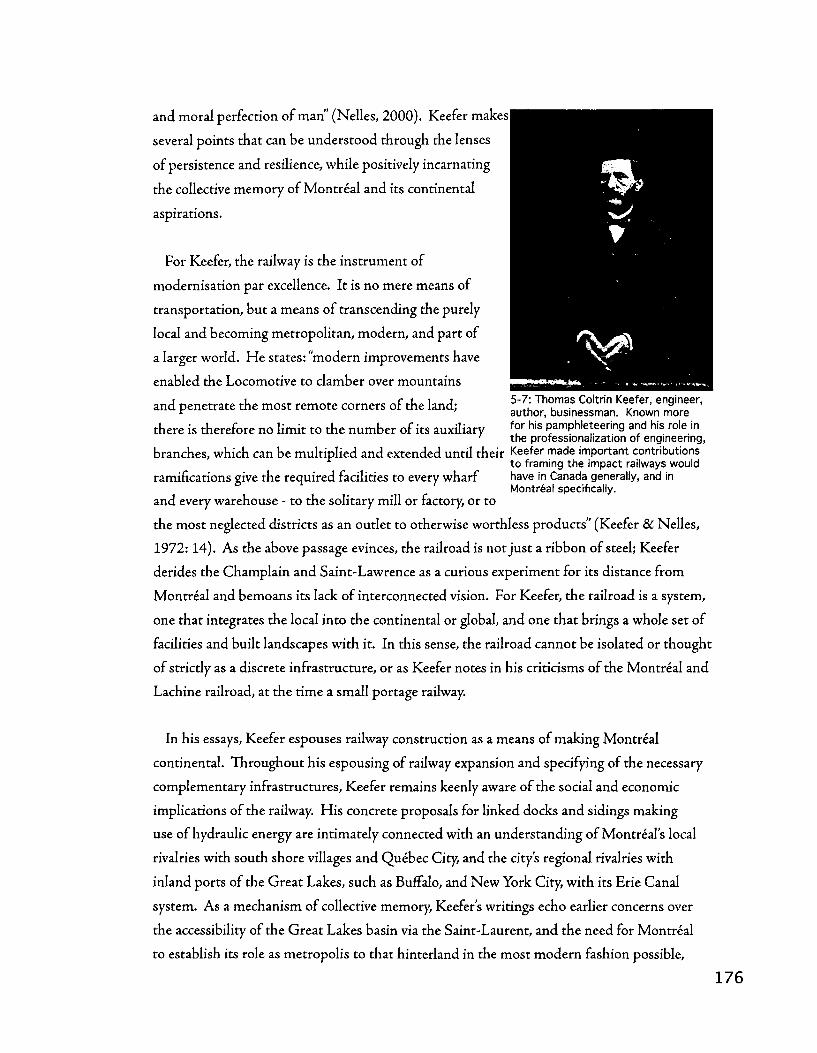
and moral perfection of man" ' (Nelles, 2000). Keefer makes
several points that can be understood through the lenses
of persistence and resilience, while positively incarnating
the collective memory of Montreal and its continental
aspirations.
For Keefer, the railway is the instrument of
modernisation par excellence. It is no mere means of
transportation, but a means of transcending the purely
local and becoming metropolitan, modern, and part of
a larger world. H e states: "modern improvements have
enabled the Locomotive to clamber over mountains
and penetrate the most remote corners of the land; S ^ S S ^ ^ n i S T
there is therefore no limit to the number of its auxiliary f ° r h i s Pamphleteering and his role in ' the professionalization of engineering,
branches, which can be multiplied and extended until their Keefer made important contributions to framing the impact railways would
ramifications give the required facilities to every wharf have in Canada generally, and in Montreal specifically,
and every warehouse - to the solitary mill or factory, or to
the most neglected districts as an outlet to otherwise worthless products" (Keefer & Nelles,
1972:14). As the above passage evinces, the railroad is not just a ribbon of steel; Keefer
derides die Champlain and Saint-Lawrence as a curious experiment for its distance from
Montreal and bemoans its lack of interconnected vision. For Keefer, the railroad is a system,
one that integrates the local into the continental or global, and one that brings a whole set of
facilities and built landscapes with it. In this sense, the railroad cannot be isolated or thought
of strictly as a discrete infrastructure, or as Keefer notes in his criticisms of the Montreal and
Lachine railroad, at the time a small portage railway.
In his essays, Keefer espouses railway construction as a means of making Montreal
continental. Throughout his espousing of railway expansion and specifying of die necessary
complementary infrastructures, Keefer remains keenly aware of the social and economic
implications of the railway. His concrete proposals for linked docks and sidings making
use of hydraulic energy are intimately connected witJi an understanding of Montreal's local
rivalries with south shore villages and Quebec City, and the city's regional rivalries with
inland ports of the Great Lakes, such as Buffalo, and New York City, with its Erie Canal
system. As a mechanism of collective memory, Keefer s writings echo earlier concerns over
die accessibility of the Great Lakes basin via the Saint-Laurent, and the need for Montreal
to establish its role as metropolis to that hinterland in the most modern fashion possible,

as a railway hub. In recognising the limitations of the Montreal and Lachine railroad and
insisting that it form the core of a system destined to reach ever farther westward, Keefer
situates contemporary railway building activities in the same dynamic as the construction of
the first Lachine Canal; these endeavours, admittedly of significant local importance, could
only see true success as part of a larger system integrated with the whole of the Great Lakes
basin. From this, I would argue tliat it follows that local transformations occasioned by these
infrastructures must be understood at a similarly large scale, while recognising the specificity
of their configuration as affected by the morphology of the local built landscape. Keefer s
writings situate the Lachine Canal corridor as something not built by, for, or according to
Montreal's specific local identity, but as a response to continental imperatives, making use of
international expertise from Europe and the United States.
Histories of tlie railway have much knowledge to offer on the proliferation of the Canadian
network, its role in the settlement of Western Canada, and the resource-industrial network
that they solidified on a continental scale. When, as is the case with Tulchinsky's work
River Barons, they connect die development of the railway with the major territorial and
political-economic tendencies present in the development of Montreal, they are a useful
indicator of what could be termed'ideal persistence;' rather than being solely the physical
persistence of a specific plan element, the railways reaching out from Montreal to the interior
are also products of the persistence of a certain remarkably consistent idea of Montreal's
relationship with North America and Europe - that of hub, entrepot, and trans-shipment
point. W h a t these histories often offer less of though, is knowledge on the impact and
context of this massive growth in infrastructure at a local level, in terms of urban tissue. For
this admittedly large change in scale we must turn to the analysis of maps and historical
record. The following paragraphs address the transformation of southwest Montreal from
a sleepy rural periphery to a continentally significant industrial suburb. While examining
urban tissue involves a rather large change in scale from a reading of the history of North
American railways, it is crucial to conceptualise the evidence not strictly in the morphological
terms of the Muratorian or Conzenian traditions, (Moudon, 1994) but to keep in mind
the larger persistences of collective memory and the continental, if not global nature of the
modernisation that can be observed in the built landscape of industrial south west Montreal.

Drawing on the analysis
Several aspects of the urbanisation and industrialisation of Griffintown documented in
the previous chapter suggest that the district evolved as a particular hybrid of vernacular
and specialised forms of urbanisation; a situation with significant impacts for the
modernisations enacted through industrialisation and regeneration. The Notre-Dame
street matrix route and the settlement patterns alongside, coupled with the co-presence of
gridded, eastern Griffintown developed from Charland s subdivision plan and the more
open, transhipment-oriented western section of Griffintown are all distinctive urban
landscape units whose permanence derives in large part from their occupancy of different
underlying agricultural parcels: the Cote-Saint-Antoine, the ferme Saint-Gabriel, and the
fief Nazareth. The permanence of these distinctions is remarkable, especially in light of
the transformations the Lachine Canal basin saw through the 19th and 20th centuries.
Though industrialisation touched all three of these areas, it did so variably, in that certain
areas - the ferme Saint-Gabriel - saw more specialised, less integrated, industrialisation,
while others - the fief Nazareth and the rue Notre-Dame axis - saw less specialised, more
integrated industrialisation. Processes of aggregation and densification in these latter areas
were more influenced by the vernacular, pre-modern structure of the urban grid (itself largely
a product of the agricultural armature). Early industrialisation in Montreal - part of the
modernisation of the mercantile economy - took forms that were tightly woven into tfie
existing urban fabric, such as the aggregation of smaller residential parcels and buildings into
small foundry complexes. The introduction of the railway fits squarely into this paradigm,
both within Griffintown and beyond, in other reaches of the Lachine Canal basin.
The creation of Brennan street, a restructuration of the urban fabric undertaken in
order to afford the G T R access to the port, is an excellent case in point. This was a fairly
dramatic transformation, with considerable regional repercussions, as it established a firm
rail link between the port, the Lachine Canal basin, and the mainline infrastructure of the
G T R - including the Victoria bridge and the Pointe-Saint-Charles shops, tying southwest
Montreal into an industrial network stretching from Chicago to Pordand, Maine. Given
the continental significance of this undertaking, it's worth noting that the industrialisation
of the blocks along Brennan street was nonetheless a transformation marked largely by
the permanence of the underlying urban fabric - the basic parcel modules and street
network remained intact and formed the basis for aggregation and densification processes.
Throughout Griffintown, such coexistence between vernacular and specialised urban forms
can be observed, though as industrialisation progresses and its scale increases, the balance
between vernacular and specialised tilts towards the latter. The restructurations imposed

by the construction of the C N viaduct and the autoroute Bonaventure, for instance, are
much more disruptive of the underlying vernacular urban fabric, especially in the immediate
vicinity of the Flour basins.
This dialectic between vernacular and specialised urban forms flows into another part
of the previous chapter's analysis. The notion of conceptualising industrial complexes
according to their degree of integration with the urban fabric betrays the existence of a
degree of interplay in this sense. Only in exceptional cases could industrialisation imply a
complete reconfiguring of the built environment to suit a new set of technical and economic
requirements. For the most part, much like the continuity of the Canal as a structuring
axis through political, economic, and technological change, the industrialising urban fabric
retained much of its integrity. Similarly, the varied impacts of urban railyards discussed in
the last section of chapter four's analysis indicates that a variable degree of integration exists
between infrastructure and urban fabric, and that, depending upon the placement of the
infrastructure in relation to the industrial and residential axes of development in a particular
industrial sector, processes of aggregation and densification in the surrounding urban fabric
can diverge quite significantly, with important consequences for regeneration.
As the analysis extends to encompass the eastern Lachine Canal basin more broadly, such
variation and the resilience of underlying patterns in the urban fabric remain evident. As
the Canal persists in fulfilling its role as link with the continent through the transition from
mercantilism to industrialism - going from fur trade thoroughfare to industrial shipping
channel — the wave of industrialisation that sweeps along its banks is anything but a
uniform repurposing of the urban landscape to meet the needs of a new paradigm. Instead,
remarkable variation can be observed along the Canal's banks, as hydraulic and transhipment
poles developed with differentiated characteristics, within Griffintown and beyond. The
hydraulic basins of Cote-Saint-Paul, the Saint-Gabriel locks, and Windmill Point are all
remarkable concentrations of a different kind of industrialisation that emerged at particular
points along the Canal, due to the availability of hydraulic energy. As the railway network
and the wider distribution of coal-fired and eventually electrical machinery extended the
range available to manufacturing operations throughout the southwest, these poles still
remained distinct punctuations in the urban landscape.
As conductive lines for the placement of manufacturing and transhipment - activities
that were crucial to consolidating Montreal's economic and political place as a hub for its
continental hinterland - the infrastructure of industrialisation has had a significant impact
on the urbanisation of the city's southwest. The resulting hybridized urban fabric, a montage
of vernacular patterns and specialised industrial infrastructures, complexes, and sectors, is
marked by the interaction between the traditional, localised city-building knowledge and
practices and the spatial strategies of increasingly larger industrial enterprises tapping into a
continental and global economy. The next section of this discussion goes into further detail
in the context of Saint-Henri, including the Saint-Ambroise industrial sector, examining one
community's transition from rural village to industrial suburb.
Saint-Henri
A comparison the 1866 Fortifications Survey with the insurance atlas prepared by
Pinsonneault in 1907 allows us to trace the evolution of the industrial landscape tliat grew
along the railway lines and the Lachine Canal in the vicinity of Saint-Henri during the late
nineteenth and early twentieth centuries. In order to understand the modernisation these
documents present, these are read as a depiction of urban fabric (or tissue) in the formulation
of Malfroy (Malfroy, 1986; 1998b), and the changes they depict are interpreted through the
concepts of permanence and resilience, formulations of Rossi (Rossi & Eisenman, 1982) and
Moudon (1986), respectively.
Saint-Henri's transition from tannery village to industrial suburb has interesting
implications and suggests a view of the city as a dynamic process in which the permanence
or persistence exhibited by certain features - significant traces or major infrastructures
- is complemented by a resilient underlying urban fabric composed of streets, parcels, and
buildings. The 1866 Fortifications Survey presents evidence that the agricultural allotment
system documented in maps produced by Jobin in 1834 remains in existence through a
period of rapid urbanisation. The orientation of the fields, the cote structure, and the
empty spaces occasioned by marshy or hilly areas unsuitable for development remain intact,
if somewhat more intensively subdivided and bisected by an enlarged Lachine Canal and
the twin rail lines of the Montreal and Champlain and the Grand Trunk railways. An
examination of maps by Henry Hopkins in 1879 and Charles Goad in 1890 shows a process
of modernisation in which existing primary elements are reconfigured and adapted to suit the
new practices of the modern industrial city.

5-8: Saint-Henri in 1866; The correspondence between the future square Sir-Georges-Etienne-Cartier and the agricultural pattern is evident, though significant restructuring will be needed to bring rue Notre-Dame south of the tracks and preparing for industry along the Canal.
In Saint-Henri, the industrialisation of the railway corridor had significant consequences
for the modernisation of the built landscape, a modernisation that is revealing for its use of
primary elements and the resilience of the allotment system. Saint-Henri-des-Tanneries
figures prominently into accounts of the incipient industrialisation of Montreal. First
an agricultural village on the edge of the Saint-Gabriel farm, it became a site of artisanal
production in leatherwork and slaughtering before taking in piecework organised out of
the urban production centre in Old Montreal. With the retrofitting of the canal to provide
hydraulic power and the arrival of die railway, an array of industrialisation opportunities
allowed for a transition to industrial production.

At the time of the 1866 Fortifications Survey, the matrix route of the village of Saint-
Henri-des-Tanneries, Notre-Dame street, after crossing to the north of the tracks, heads
up the Saint-Jacques escarpment. By 1890, in Goad's insurance atlas, there is evidence of
a reasonably large residential subdivision, replete with Edwardian blocks of the sort found
in the New Town on the southern slopes of Mount Royal on the western edge of built-up
Saint-Henri. The central street of this area, Saint-Joseph street, is cut-off by an oil refinery
and an abbatoir. By 1907 the entire situation has changed. Within the same agricultural
plot grouping, the proposed subdivision has been rotated 90 degrees and Notre-Dame street
rerouted to continue through its middle and continue as the main east-west artery north
of the canal. The finishing of the large industrial block results in what becomes Square
Sir-Georges-Etienne Carrier, which is capped by a major church and a small rail yard. The
northern end of the subdivision, closest to the G T R , ends up hosting industrial structures
accessed by railway sidings using Acorn street.
So here we have a vignette in the creation
of the modern industrial city, where rather
than an abrupt break with past conditions
there is a remarkable adaptation of past
structures for contemporary incarnations of
a long-standing purpose: domination of the
interior of the continent through commerce,
shipping, and industry. Conceptualised
through the phenomena of permanence,
it becomes possible to see these striking
changes as remarkably ordered; first, by the
persistence of the agricultural allotment
system and the deeply entrenched grid which
guided Saint-Henri's occupation of the
surrounding rural landscape, and second, by
the primary elements of the railway and the
canal's catalytic effect on industrial location.
In this sense, the physical transformation of
5-9: Saint-Henri in 1878; Development begins on the far side of the square. Note the contrast between the band of parcels along rue Saint-Jacques (angling northwest above the tracks and the larger-scaled blocks to the northeast and south.
182

5-10: Saint-Henri in 1890; The square is home to the West End Abbatoirs while the contemporary church site hosts an oil refinery. Rue Notre-Dame has not yet crossed to the south side of the tracks, but big developments are planned west of the square, and along the Canal.
Saint-Henri, from tannery to factory town, is exactly that, a transition, and one that echoes
Robert Lewis' (2000; Lewis, 2001a, 2001b, 2004) observations concerning gradualism in
industrialisation.
183

5-11: Saint-Henri in 1907; The square is ready to be transformed, the Saint-Ambroise industrial sector has seen major construction, rue Notre-Dame has adopted its current configuration, south of the tracks, and the 'tree' blocks (Acorn to Elm) have taken shape, industrially and residentially.
What is especially interesting about Lewis's thorough description of the industrial
urbanisation process is the way in which it operates as an extension of tendencies being
expressed in the already existing city; in terms of practice, there is a shift from artisanal
to industrial forms of labour and production "(b)uilding on a history of petty commodity
production in the older district of Grimntown;" while in terms of land subdivision and
development, "(t)he West End hive of industry forming after 1850 did not suddenly appear
on the urban landscape but emerged from an earlier pre-industrial form of manufacture."
Overall, the picture that is painted is one of a similar imperative adapting formally in a

rather spatially contiguous and temporally blended manner. Lewis conceptualises the
west end industrial district as an agglomeration "rooted in linkages operated at several
geographic scales" (Lewis, 2000: 242) and in this sense it can be understood as the physical
manifestation of the connection between Montreal, global raw material markets, shipping
lanes, railway networks, and the relationships of local producers, merchants, and financiers;
the expression of Montreal's place in North America and the world.
5-12: Saint-Henri in 1 949: The Saint-Ambroise sector is increasingly built out, while the square is lined with housing. Note also the use of the 'tree' blocks (upper left) for both industrial and residential purposes.
So what happened in Saint-Henri, the shift from a relatively compact rural and proto-
industrial village on the outskirts of Montreal to an important industrial suburb physically
and economically integrated into the larger metropolis, with distinctive and functionally
divided parts (the specifically and intentionally industrial area along Saint-Ambroise street)
is part of what Lewis discusses; it was a process. For Rossi, "everything must express as
faithfully as possible the particular life of the collective organism. At the basis of this
organism that is the city is the persistence of the plan" (Rossi & Eisenman, 1982: 51). This
longevity of the Saint-Laurent axis is expressed physically through the Lachine Canal and
the Grand Trunk Railway, while in the collective memory, it endures as a continentally
recognised site for trans-shipment and then manufacturing activity.

Furthermore, the growth of Saint-Henri from sleepy suburban village to one of Canada's
largest industrial complexes cannot be seen to have its genesis in any kind of natural growth
or development of Montreal. Rather, it is the product of continental forces that were
consciously harnessed by Montreal's elite at the urging of people like Keefer and their own
pocketbooks, and then structured by both the physical permanences in the built landscape
(the rural allotment system, for instance) and the collective memory of Montreal's place in
the continent and relationship with the ever-expanding hinterland (thus the need to push
into upper and then western Canada). The adaptability of the settlement in the face of social,
economic, and technological change is in large part, I would argue, a manifestation of the
resilience of its urban tissue in corresponding to the permanences of its place in the North
American historical context.
5-13: Saint-Henri in 2002; The square extends to the Canal, with adjacent residential redevelopment to the east (right).
What makes this possible is the collective memory as conceptualised by Halbwachs
(1980), and resilience as conceptualised by Moudon (1986). On an ideal level, it seems as
though it is collective memory is what permitted the retention through multiple regimes,

technologies, economies, and political climates, of the goal of becoming the entrepot and the
trans-shipment point for the interior of Nor th America. On a more material level, it appears
that the structures of the urban fabric: the vocabulary of building types, the street grid, and
especially the allotment system, were instrumental in permitting the necessary flexibility
to continue to fulfill the objectives ingrained in the collective memory in spite of some
significant changes in industrial, political, technological, and economic organisation. The
ability of the railways to make use of public streets, such as Acorn street, to route sidings and
the ability of industrialists to erect factories on multiple residential lots both testify to the
adaptability of the urban tissue and its ability to accommodate different functions.
Rossi's notion that "the city is something tJiat persists through its transformations, and that
the complex or simple transformations of functions that it gradually undergoes are moments
in the reality of its structure" (Rossi & Eisenman, 1982: 55-56) must be read both in terms
of morphology and collective memory in order to comprehend the modernisation generally
described by Choay and specifically experienced in Saint-Henri. Such a formulation allows
us to perceive seemingly dramatic shifts in the infrastructures and urban fabric of the Lachine
Canal corridor as connected expressions of a remarkably constant economic and political
drive on the part of Montreal to position itself as Europe's gateway to the North American
interior, and vice versa. This is crucial, as it also permits the reading of the morphology of
the industrial built landscape in a manner that avoids technological determinism and seeks
a deeper logic. Form is not predicated upon manufacturing or transportation technology
- though it responds to these - rather it is connected with a deeper tendency towards
establishing control over the Nor th American continent and ensuring Montreal's place in that
larger system, which has certainly been shaken through deindustrialisation and uncertainty
over the city's place as Canadian metropolis.
But to remove these phenomena from the influence of a local spatial structure on the
basis of their modernity is in my eyes problematic. It strikes me that there is a relationship
with local structure, especially in a context such as that of Montreal, which inherited a pre-
industrial land subdivision system, must exist. In view of resolving this tension between the
hyperbole of railway modernism that would be universal and morphological particularism
that cannot provide complete explanations for the industrial landscape, I have chosen to turn
to Moudon's notion of resilience at the scale of agricultural parcels, blocks, and lots. The
particular configurations of industrial equipment, certain railway infrastructures, and even
civic monuments and residential subdivisions, though phenomena that must be understood
in the terms described above, are implemented in ways that create an urban tissue specific

to Montreal. It might be fruitful to consider the modern North American city as a sort
of montage created by many collaborators through time, in the sense of Malfroy s ideas of
urban tissue as a properly structural product. Wha t gives the industrial landscape of the
Lachine Canal basin such exceptional heritage value is its situation as interface between local
and global, and the resulting urban fabric that fuses local vernacular tradition and savoir-
faire with the technical and political-economic exigencies of continental networks. There
are material and ideal continuities in the urbanisation process, which is also true of the
traditional city, but as the ideal continuities and the collective memory of what the city is
take on a continental dimension, the material continuities and material artefacts take on an
autonomy of form that cannot be understood in a purely local way, but rather as a montage of
global tendencies over a locally-rooted vernacular armature.
If modernisation can be described in such terms, as a montage of global and local, often
concentrated in particular areas of the city, then the evidence presented above suggests that
an emphasis is warranted, especially in North America, upon the continental and global
currents of colonisation, industrialisation, and trade that were often of primary importance
in denning the collective memories of cities and of fixing the primary elements of their built
landscapes. This is a question with some interesting implications for dhe study of the modern
city in terms of methodology, study area, and how processes of urban transformation can
be conceptualised. Thinking about cities as 'modern' is potentially problematic, as is amply
noted by Rossi, among others, but there are some useful distinctions that can be so made.
For Francoise Choay, the modern city is characterised by things no longer being implicit
and all-encompassed in one semiotic system or structure corresponding with the other
social systems. It now becomes an explicit object that is experienced as alien and strange,
to be analysed, lived, and exploited in an objective manner (Choay, 1969). This has two
consequences; first, there is a fracturing of local coherence, which can no longer be perceived
to be as determining or unified as a generative primary element. Plans can and are rapidly
and substantially changed or new building types or infrastructures introduced in manners
that can no longer be characterised as a slow, internal evolution. Second, urban space begins
to take on an intrinsic value; it becomes an object (that may be perceived speculatively) that
"ceases, in fact, to be implicitly related to significant social systems" (Choay, 1969:109).
Expertise, in canal or railway building for instance, no longer comes from local precedent, but
is hired from England or the United States; these are the economic and physical points that
such projects connect, why should this not figure in culturally and technologically?
1 8 8

This could, through further research along the lines of that done by Bernier and Salee,
(1992) be linked with the dismandement of the seigneurial system, the rise of urban property
as a speculative, tradable good, and the ability to enlist engineers, architects, and financiers
to alter die city in ways that, rliough they represent a complete rupture with the local system,
do correspond to a now larger structure, that of colonialism, settlement, industrialisation,
and globalisation; that of the grain-producing machine stretching from Alberta and Kansas
to south-western Ontario, and funnelling through the various lakeheads to the increasingly
gargantuan port of Montreal en route to Europe. In the modern city, the major question
is relating to international markets; in Canada, this implies to a large degree the receiving,
producing, processing, and shipping goods for export markets, as opposed to questions
of local production. In some ways this was a natural transition for Montreal to make,
as its roots in the fur trade and colonisation of Canada naturally lent it to long-distance
commercial relationships and thus it has never been a'subsistence city,' but this is a break
with the tighter pre-modern city. The preoccupation with developing Montreal's connection
with the Ottawa/Great Lakes hinterlands and ensuring that the city/port was die hub in
connecting that with ocean shipping and Europe was a near constant obsession.
Fundamentally, I would like to conclude this section of the discussion by observing that
trying to see industrial urbanisation as the modern, non-local implementation of long
standing tendencies rooted in die collective memory and possessing generative persistence
occurring in an already established morphological matrix (urban tissue, die agricultural
allotment system, and the earliest matrix routes) with a certain degree of resilience and
structure demands a view that reconciles the city's overall history in terms of its place in the
world and its 'destiny' as Rossi would put it, with the principles and logic of its urban tissue,
as Malfroy would put it. Only an approach that synthesises die two can give an accurate view
of the urban process.
1 8 9
Built landscape as a mediator of political-economic forces
Variability in the reconfiguration of urban residential environments has raised questions
concerning the interaction of neo-liberalism with specific local and regional contexts. This
section of the discussion presents an understanding of the particularity of contemporary
residential reconfiguration in the Lachine Canal basin by considering the historical and
spatial emergence of its built landscape as a structure influencing the outcomes of economic
strategies and forces. By drawing on die morphological analysis of the previous chapters,
this discussion attempts to reveal how contemporary processes of residential redevelopment
in the Lachine Canal industrial district can be viewed as an outcome of a dialectic between
structural permanencies present in die built landscape and prevailing economic forces
which privilege privately-funded, internationally-standardised development models. By
unveiling the role of the built landscape as a structure mediating neo-liberal privatisation
and privatism, the following pages suggest that tJhe analysis of patterns in the urban structure
can serve as a means for comprehending local and regional nuance in the enactment of neo-
liberal transformation, especially in cases of the reconfiguration of residential environments.
The built landscape, considered structurally, offers a variably malleable and uneven set of
opportunities and constraints for the realisation of neoliberal privatism, and thus exercises a
mediating effect.
Privatism and understandings of urban neo-liberalism
Neoliberalism has been one of the most important factors in urban transformation
in the past three decades and as a theoretical construct has contributed greatly to our
understanding of the contemporary city. Neoliberalism can be thought of as "...a theory
of political economic practices that proposes that human well-being can best be advanced
by liberating individual entrepreneurial freedoms and skills within an institutional context
characterized by strong private property rights, free markets, and free trade. The role of
the state is to create and preserve an institutional framework appropriate to such practices"
(Harvey, 2005: 2). Central to the discourses and practices of neoliberalism is a marked
privatism and recurrent emphasis upon the space occupied by private agents within the
market. As the geographer David Harvey observes,"...it seeks to bring all human action into
the domain of the market" (2005: 3). Neoliberalism's privatist bent is frequently expressed
through policies of deregulation, privatisation, state withdrawal.

In the urban setting, globalization is a prominent lens for interpreting contemporary
political-economic change. Based on a study of globalisation and territorial planning
initiatives in Buenos Aires, Crot surmises that"[w]ithin the geographical field, urban research
has granted globalization centerstage, based on the observation that the city constitutes
the strategic site where global forces are more intensively felt and may be more concretely
grasped" (2006: 228). Neo-liberalism is tightly entwined with the reconfiguration of urban
consumption - metaphors of tiie city as an entertainment machine (2002) inhabited by
a footloose and demanding creative class' (Florida, 2002) flocking to globally recognised
flashpoints of gentrification (Smith, 1996; Zukin, 1982,1998). But it also has impacts in
the realms of governance, finance, and economic development, through instruments such
as private-public partnerships and business improvement districts, tax-increment financing
and the privatization of public housing, and the status of tourism and consumption as the
foundations of economic development strategy. Wha t the bulk of analyses reveal is that
while such unifying diemes exist, their implementation and real-world forms are surprisingly
complex and diverse. Adding to this discourse, Kipfer (1998:177; Cited in Keil, 2002)
offers an interpretation of Lefebvre's notion of die'urban as a level of mediation between
the global/general and the personal/lived space, thus placing the city at the heart of the
lived experience of globalisation; an interpretation that in many ways resounds with the
understanding put forward in the previous section (Keil, 2002).
The complexity of neoliberalism - its contingency, path dependence, contradictory nature,
and its interactions witli pre-existing circumstances — has been a critical issue for urban
geographers. Commenting on research at the scale of individual metropolitan regions,
Crot (2006: 229) states that "too few studies have recognized - other than implicitly - that
globalizing pressures on cities are mediated by endogenous local institutional structures,
social practices, and political decisions whose transformative power may be much more
influential than globalization itself." Indeed, many critics have noted that far from being
a stable, monolithic, and coherent ideology, neoliberalism is actually far more diverse,
contradictory, and adaptive. Harvey has remarked that:"[t]he somewhat chaotic evolution
and uneven geographical development of state institutions, powers, and functions over the
last thirty years suggests, furthermore, that the neoliberal state may be an unstable and
contradictory form" (2005: 64).
For Bourdieu, neoliberalism attempts to "[bracket] die economic and social conditions
of rational orientations and the economic and social structures that are the condition of
their application" (Bourdieu, 1998). Despite the seeming hegemony of neoliberalism in

the contemporary world, this sort of task appears almost insurmountable. This notion
of conditions of application' also figures into the work of many theorists seeking a more
grounded approach to understanding the processes and forms taken by neoliberalism. This
perspective seems akin to Raymond Williams' (1977) take on the dominant, residual, and
emergent, in which the interactions between these different stages and variations. Australian
geographer Pauline McGuirk's work on metropolitan planning in Sydney Australia draws
upon such insights to suggest that neoliberalism needs to be understood "not as a unified
coherent project, but as a series of complex and overlapping strategies" (2005: 59-60). In this
sense, McGuirk suggests that neoliberalism appears to be more akin to a fractious process
than a clearly-defined or discrete end-state, and that it encounters variable levels of rigidity
and flexibility in the governance contexts it encounters.
The disjunctures that have accompanied the worldwide imposition of neoliberalism"
are amongst its "most essential features," to Brenner and Theodore. The multifaceted,
incomplete, and ongoing nature of neoliberalisation suggests to them a particular analytical
approach: that of considering a diverse, multifaceted, often contradictory actually existing
neoliberalism, as opposed to a static, defined, and coherent ideology (2002: 353). Such an
understanding, Brenner and Theodore state, "must therefore explore the path-dependent,
contextually specific interactions between inherited regulatory structures and emergent
neoliberal, market-oriented restructuring projects" (2002: 349). Analysis of actually existing
neoliberalism takes the "contextual embeddedness of neoliberal restructuring projects
insofar as they have been produced within national, regional, and local contexts defined by
the legacies of inherited institutional frameworks, policy regimes, regulatory practices, and
political struggles" (2002: 349). This is a useful frame of reference for understanding the
uneven implementation of neoliberal policy in both roll back and roll out forms and, we
argue, the variable spread of privatism in the contemporary city.
Urban form as a mediator of neo-liberal restructuring
As a means of addressing the multifaceted, complex, and above all contingent nature of
neoliberalism, the bulk of research has focused upon the interactions between neoliberal
reforms and the inherited set of governance networks, paradigms, and practices particular to
any given city. Ward's look at Birmingham, Leeds, and Manchester, (2003) is typical of this
stream of research, in that it is preoccupied with their governance more than their formal
substance. Through case studies of such cities as Birmingham, Dublin (McGuirk, 2000),
1 9 2

Sydney (McGuirk, 2005), and Toronto (Keil, 2002), the case has been consistently made
that neoliberal transformation does not proceed uniformly and does not fully replace the
underlying political or cultural terrain.
Relatively few authors however, have chosen to address the specific interactions between
neoliberalism and the built form of the city. In this sense, Hubbard's case study of
Birmingham (1996), Hut tons work on the relationships between economic restructuring
and built form in Vancouver (2004; 2004a; 2006), Turners case study of four US Sunbelt
cities (2002), and Nichols Clark et al's work on the increasing explanatory power of
consumer-oriented urban amenities are rare exceptions (2002). Hubbard's (1996) work
on Birmingham deals largely with the symbolic power of reconfigured urban environments
in legitimating neoliberal reform, through their embodiment of and implication in place
marketing and urban entrepreneurialism. Hut ton goes further in connecting political
economy and the urban fabric, noting the extensive engagement of the new economy
in adaptive reuse initiatives, remarking on the opportunities this presents for heritage
preservation while lamenting the potential for "the appropriation of authenticity for
commercial...purposes" (2006:1820).
These phenomena are all situated at the heart of the interface between the city and
contemporary shifts in the political economy, seemingly confirming Leitner et al's assertion
that the urban is a privileged site for the study (and experience) of neoliberal transformation.
We propose to add the structure of the built landscape to the contextual embeddedness at
the heart of Brenner and Theodore's notion of actually existing neoliberalism. Particularly
in circumstances of urban reconfiguration, the urban fabric assumes a key and structural
role in establishing patterns of variability, unevenness, and even in opening the possibility for
sites of resistance and counter-hegemony. This section of the discussion suggests that the
built landscape can also exercise a mediating effect, in that because it should be considered
as properly structural, it is variably malleable and offers an uneven set of opportunities
and constraints for the realisation of neoliberal privatism, particularly in the context of
urban reconfiguration. The following pages explore the above notion in the context of
contemporary regeneration along the Lachine Canal.
Urban form and neo-liberal restructuring along the Lachine Canal
The analysis in chapter four suggests that the urban fabric of the Lachine Canal basin is
in fact quite heterogeneous. Within Griffintown alone, several patterns of streets, parcels,
and buildings coexist and are interlaced by several major infrastructures that have had

a significant restructuring impact on the district. Through the eastern Lachine Canal
basin as a whole, it appears that there is a continuum upon which industrial complexes
can be typologically characterised, grounded largely in terms of their integration with
the surrounding urban fabric. A similar approach is implemented in the analysis of the
southwest s railyards and is drawn upon heavily in an examination of the various industrial
sectors along the Canal.
The three points along the spectrum of urban integration detailed in the previous chapter's
analysis can be thought to roughly correspond to a sort of grain' existing in the urban fabric.
Some areas, those that are most integrated and composed of the most tighdy woven small
elements - small parcel modules, small blocks, typically a permeable, gridded street network,
and smaller buildings (often aggregated together into a complex in the industrial context)
- can be thought of as being'fine grained', while others, at the opposite end of the spectrum,
those that are least integrated and composed of the most loosely woven large elements - large
parcel modules, large blocks, typically an impermeable street network, and larger buildings
(often the more autonomous type complexes in the industrial context) - can be thought of as
being coarse grained.'
This section of the discussion puts forward the notion that such a spectrum in the urban
fabric has structural consequences in terms of mediating contemporary regeneration. In
the following pages, the idea is advanced that some areas are more receptive than others to
neoliberal/privatist redevelopment models due to key morphological factors including the
configuration of the street grid, parcel size, and the'reusability' or'heritage value of buildings.
This implies the existence of a dialectic between the structural permanencies of the built
landscape and neoliberal/privatist redevelopment models; suggesting a conceptualisation of
the built landscape as a variably malleable set of constraints and opportunities for agents of
change. In this sense, morphological analysis of patterns in the urban structure can help to
explain unevenness in the implementation of neoliberal/privatist regeneration models.
Essentially, neo-liberal regeneration of the Lachine Canal landscape is thus filtered twice:
once through the varied practices, resources, and preferences of the various agents who are
engaged in contemporary transformation, and a second time through a the resilience of a
highly differentiated urban fabric. This second filtering can be conceptualised as though it
is a prism, resulting in a continuum or spectrum of outcomes that are, I argue, dependent to
a degree upon the characteristics of the urban fabric. These variable and contingent urban
outcomes range from small-scale sweat-equity renovations of existing small properties on

individual parcels to massive entertainment/private projects on the (larger) sites of former
industrial complexes. In fine and medium grained urban fabrics, the emphasis tends to be on
the renovation and upgrading of existing building stock, oftentimes resulting in conversion of
rental properties to condominiums, along with infill construction, largely preserving existing
urban block configurations and the public space of the residential street. In coarser grained
urban fabrics, the emphasis may switch to private space removed from the traditional public
realm.
Neo-liberalism privatism (marketisation,
entrepreneurialism,
deregulation, etc...)^
urban fabric
Variable and contingent
urban outcomes rent increases renovation/upgrading apartment-to-condo conversion retail/employment changes industry-to-'loft' conversion new infill construction new multi-parcel construction new block-scale construction creation of private spaces decontamination major urban plans/projects
finest
Grain/scale of
urban fabric
t coarsest
5-14: Urban fabric (tissue) as a prism; a potential conceptualisation of how urban tissue may mediate political-economic transitions in the built landscape.
Contrasting square Sir-Georges-Etienne-Cartier with the Jardins/Terrasses Windsor
(True North) complex at Notre-Dame and Peel streets serves as a useful comparison in
this case. Visual surveys indicate that considerable renovation and restoration activity has
taken place along the square and that the housing stock has been extensively renovated
and rehabilitated. In this sense, the square is at one end of the spectrum discussed above:
undoubtedly some of the once rented triplexes have been converted to condominium
ownership and prices have risen. However, the public quality of the square as an accessible
amenity available to all has been maintained, and in fact enhanced by recent work to extend
this residential spatial order to the edge of the Canal
itself.
At the other end of the spectrum, we could place the
'Jardins and Terrases Windsor' residential complex
occupies part of the former GTR Bonaventure Freight
5-15: The east side of square Sir-Georges-Etienne-Cartier.
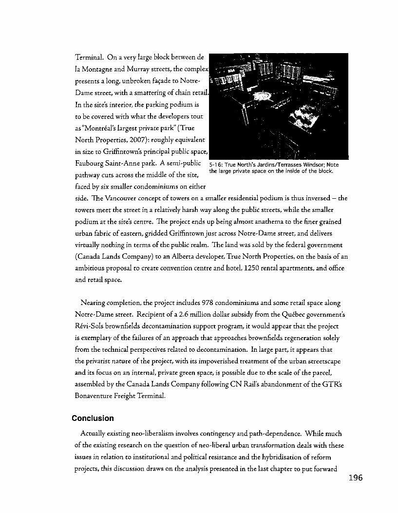
Terminal. O n a very large block between de
la Montagne and Murray streets, the complex
presents a long, unbroken facade to Notre-
Dame street, with a smattering of chain retail
In the site's interior, the parking podium is
to be covered with what the developers tout
as "Montreal's largest private park" (True
North Properties, 2007): roughly equivalent
in size to Griffintown's principal public space,
Faubourg Saint-Anne park. A semi-public 5.! 6: True North's Jardins/Terrasses Windsor; Note , 1 • j JI r r • the large private space on the inside of the block,
pathway cuts across the middle or the site,
faced by six smaller condominiums on either
side. The Vancouver concept of towers on a smaller residential podium is thus inversed - the
towers meet the street in a relatively harsh way along the public streets, while the smaller
podium at the site's centre. The project ends up being almost anathema to the finer grained
urban fabric of eastern, gridded Griffintown just across Notre-Dame street, and delivers
virtually nothing in terms of the public realm. The land was sold by the federal government
(Canada Lands Company) to an Alberta developer, True North Properties, on the basis of an
ambitious proposal to create convention centre and hotel, 1250 rental apartments, and office
and retail space.
Nearing completion, the project includes 978 condominiums and some retail space along
Notre-Dame street. Recipient of a 2.6 million dollar subsidy from the Quebec government's
Revi-Sols brownfields decontamination support program, it would appear that the project
is exemplary of the failures of an approach that approaches brownfields regeneration solely
from the technical perspectives related to decontamination. In large part, it appears that
the privatist nature of the project, with its impoverished treatment of the urban streetscape
and its focus on an internal, private green space, is possible due to the scale of the parcel,
assembled by the Canada Lands Company following C N Rail's abandonment of the GTR's
Bonaventure Freight Terminal.
Conclusion
Actually existing neo-liberalism involves contingency and path-dependence. While much
of the existing research on the question of neo-liberal urban transformation deals with these
issues in relation to institutional and political resistance and the hybridisation of reform
projects, this discussion draws on the analysis presented in the last chapter to put forward
the notion that some of the particularities in the enactment of neo-liberalism can understood
by analysing the urban fabric (through history). The built landscape is partially malleable
and offers variable opportunities and constraints: understood as a structure, it can be seen to
mediate the enactment of neo-liberalism.
For researchers, including urban form as a factor in actually existing neo-liberalism opens
up new research directions, such as the links between agents of change and different elements
of the built landscape (instances of control), a path explored by Gautliier (2003). This
highlights the importance of urban form in the pursuit and resistance of new strategies of
accumulation. Public and private sector investment in the regeneration of post-industrial
landscapes is a significant feature of the contemporary political-economic landscape and a
key issue in urban and economic geography. Taking the structuring effects of urban fabric
in such processes and investment cycles into account can help researchers develop fuller
interpretations of urban neo-liberalism and privatism.
For practitioners, urban form can be used as a means for countering neo-liberal
privatisation of space. The'publicness' of redevelopment can be preserved/enhanced through
the configuration and logic of the built landscape. Planners and urban designers seeking to
leverage contemporary transformations of disused industrial sites can think of the urban
fabric as a valuable tool for the reinforcement of public space and the discouragement
of privatism. In addition to thinking of the urban fabric as a valuable heritage asset
- especially in light of the unique character resulting from the fusion of vernacular patterns
with specialised industrial infrastructure - it can be leveraged as a tool for managing
transformations and ensuring diversity, adaptability, and resilience. The smaller parcel
modules and the permeable, small-blocked street network of finer grained urban fabrics
appear particularly well-positioned to resist the proliferation of private spaces and to
contribute to a strong and well-used public domain.

Conclusion
This thesis sought to achieve several goals. On the theoretical front, it constitutes an
attempt to enlarge the sphere of inquiry within the discipline of urban morphology by
addressing some of the key urban transformations brought forward by deindustrialisation
and major political-economic transitions occurring in the North American industrial city.
By examining the morphological evolution and composition of the Lachine Canal basin,
this thesis sheds light on the different component subsystems, inter-relationships, and
(trans)formative processes that collectively compose the urban fabric (Malfroy, 1986,1998)
of a uniquely significant industrial district. In other words, although the North American
industrial city is indeed the product of crisis tendencies in the production of the built
environment, it most certainly is not without an autonomous and legible underlying spatial
logic, one that can be read morphologically; the plan of the city is fundamentally "a past that
we are still experiencing" ' (Rossi 8C Eisenman, 1982: 58).
Through a set of inter-related narratives, this thesis proposes that die Lachine Canal basin
specifically, and the industrial districts of Nor th American cities more generally, can be read
as thick palimpsests (Banham, 1971) upon which projects of local and continental scale
continually informed each other throughout history - in essence providing each other with
the structures within which they took shape. Through the different eras of urbanisation,
or moments in the history of the city - from before the industrial revolution to the
revitalizations associated with contemporary economic restructuring - there is a remarkable
tendency for subsequent interventions to be inserted into die already existing urban fabric.
The analysis to support such an interpretation starts with a reading of the urban fabric of the
Griffintown district and progressing to the eastern Lachine Canal basin more broadly; one
that posits the existence of a connective structure in the industrial city that has remarkable
persistence and resilience through history. The tensions exposed between vernacular urban
patterns and specialised industrial infrastructures are, in chapter four's analysis, broken
down into a typology of industrial complexes rooted in a preoccupation with the degree of
industrial integration into the urban fabric. Moving on to deal with entire industrial sectors,
from Saint-Ambroise to Windmill Point, and the railyards that punctuate the landscape
of southwest Montreal, the analysis uncovers the existence of dual axes of development
in most parts of the Lachine Canal basin - along residential and industrial lines - and a
complex differentiation between poles of manufacturing developed around hydraulic energy
sources (along the canal) and vast areas configured around the needs of transhipment and
warehousing functions.

The first chapter's literature review brought attention to a vast body of work on urban
history and geography, with particular attention to work focused on Montreal. By examining
the ways in which urban history and urban geography tend to downplay the importance of
cities' materiality as a structuring influence on the course of agents' actions (history) and their
spatial distributions (geography), the review set the stage for a discussion of morphological
approaches to the city, again with an emphasis on Montreal. This discussion highlighted
research that adopt what Gauthier and Gilliland (2006) term a cognitive-internalist
perspective (works that seek to interpret urban form, while according it varying degrees of
structural influence) and provided the necessary critical foundations for the examination
of the political-economic context of contemporary urban regeneration that followed. This
last part of die literature review drew attention to the rather technocratic approach taken
by urban planning, particularly in the realm of brownfields regeneration - a theme which
resurfaced in trie first section of chapter five's discussion.
As such, this thesis offers a critical review of the scholarship that deals with the history
and geography of urbanisation, industrialisation, and now, regeneration. Touching on the
gaps left uncovered between the disciplines of urban history and geography, as well as the
examining the problematic aspects of current practices in urban regeneration, it also offers
commentary that bridges theory and practice to highlight the uniqueness of Montreal in
general and the Lachine Canal landscape in particular. By critically examining interpretations
of the history spelled out in chapter three, this thesis explores the potential offered by the
discipline of urban morphology as a means for addressing the significant heritage left by this
history and for tackling the complex problems posed by contemporary revitalisation.
Chapter two attempts to go beyond the criticisms offered in the literature review and sets
up the theoretical and methodological foundations of this thesis, suggesting the potential of
urban morphology as a means of inquiry that allows for more structuralist interpretations
of the relationship between agents of change and the built landscape. Reviewing the
theoretical contributions of various morphological researchers and practitioners - from
Moudon to Muratori - the second chapter also provides a relevant and concise guide to
the analyses presented in the fourth chapter, from concepts to vocabulary. The emphasis
is placed, following Malfroy (1986) on the notion of urban tissue as an analytical device
for understanding urbanisation as a diffuse process, outside of the control of any single
agent or the confines of any single period. This requires thinking in terms of the particular
constituent sub-systems, (inter)relationships, and (trans)formative processes that characterise
the portion of the city that is the object of study.
By the third chapter, the reader must be curious; 'What about the Lachine Canal? Are
we going to talk about it yet?' And so, the Canal gets its due. Drawn from a wide range of
sources (largely secondary), chapter three relates the history and geography of the Canal,
from its earliest days on paper in the 18th century to its rebirth as a recreational amenity at
the turn of the 21st. The idea behind this chapter is to set the stage for the fourth chapters
morphological analysis; to give a reasonable chronology and narrative that can complement
the more specific and perhaps technical considerations explored later on. But it also offers
a unique interpretation in its own right; by virtue of its interdisciplinarity and its perhaps
implicit objective of reinforcing the diffuse nature of urbanisation and industrialisation
(in terms of agents, periods, and paradigms technical and political-economic) it highlights
the palimpsest-like nature by which a single infrastructure can lay claim to remarkable
permanence and resilience.
If chapter three is largely about answering the question 'who did what, where?', then chapter
fours analysis examines the'where in greater detail. The bulk of this thesis' contribution,
the morphological analysis is roughly broken down into two analytical narratives' that
correspond to slightly different scales. The first examines the Griffintown district in detail,
'reading' its urban tissue through time and characterising distinctions between various
subareas, particularly in relation to variance in industrial activity; for example, the contrast
between clusters of manufacturing and transhipment zones. The analysis highlights the
historical contrast between different allotment patterns that derive from the meeting of two
agricultural parcel types, the cote and the fief, as well as the interplay between two powerful
axes of development: rue Notre-Dame and the Lachine Canal itself.
The second analytical narrative presented in chapter three expands the study area, taking
in the stretch of canal from its eastern end at Windmill Point in the port to just above the
Cote-Saint-Paul locks hydraulic pole. This second section develops a typology of industrial
complexes based on their integration with the surrounding urban tissue and the degree of
distinctiveness or specialisation in contrast with the typical residential patterns of southwest
Montreal. This notion is soon scaled to take in the'industrial sector' (agglomerations of
industrial complexes); several example cases are examined through time in terms of their
composition and transformation. Finally, the typology is applied to the railyards of southwest
200
Montreal. Key sites of interchange between the continental economy and the landscape of
local, urban space, these facilities also show a remarkable variability in terms of their interplay
with the urban tissue that surrounds and frames them.
This preoccupation with the specialisation of (certain parts of) the industrial metropolis
flows into the first section of the discussion in the fifth chapter, and is at die core of much
of the work presented in the fourth chapter's analysis. In a sense, much of what this thesis
seeks to highlight is the progressive and somewhat incremental nature of the modernisation
of the city; that the emergence of industrial complexes and vast industrial sectors was not
a simple reflection of technical or economic imperatives, but rather the fruit of myriad,
diffuse interactions between these new means of production and social organisation and
the underlying urban tissue - often residentially scaled. As the analyses of various industrial
sectors discuss conditions closer to the present, the to-and-fro character of this dialectic is
brought into focus; consider, for example, the case of the Stelco works in Sainte-Cunegonde.
Chapter five's discussion, meanwhile, emphasises three closely linked interpretations of the
analysis' observations. The first constitutes an attempt to go beyond the monumentalisation
of industrial ruins and recommend a fuller urban regeneration practice that builds on
the heritage of the entire urban fabric as a structural asset that is significant in terms of
how it connects the various traces of industrialisation - among them the centrepiece of
the Canal — with the working class neighbourhoods that host them. The second section
of the discussion comments on the remarkable persistence of the Lachine Canal axis as
a symbolic site linking Montreal with continental and global processes of colonisation,
settlement, and modernisation. For this thesis, such modernisation is characterised by
tensions between vernacular and modern; the discussion asks how the city incarnates the
paradoxes of modernisation by drawing on chapter four's analysis - in particular the dialectic
between industrial specialisation and vernacular forms of land subdivision as they impact
on urbanisation processes such as the aggregation and densification of the urban fabric into
industrial complexes.
This is supplemented by observations of the industrialisation of Saint-Henri and the
incomplete achievement of modernity, suggesting that this was not in fact a wholesale
imposition of new urban forms according to the technical and economic needs of a new
industrial paradigm. Rather, this thesis supports a view that such industrial modernisation
was in fact a montage of specialised infrastructures onto an existing territorial armature,
with unexpected and highly uneven consequences for urban form. This dialectic between
2 0 1

residential and industrial, between vernacular and specialised, spatially structured by the axes
of canal and rail, the poles of hydraulic energy and quay space, is at the heart of this thesis'
call, in the spirit of David Hanna's work, to conceive of Montreal's industrial infrastructure
and the spatial systems by which its urban form is organized, as a large-scale heritage asset.
The interplay between different infrastructures and their only partial imposition of new
ways of relating to their urban surroundings also plays a key role, as urban space takes on
varying characteristics in relation to different trans-shipment technologies and the legacies of
particular urban forms.
The last conclusions drawn from the fourth chapter's analysis consists of a commentary
on the structuring impact of the urban fabric and its varying grains' on the execution of
contemporary transformations and urban regeneration in the context of neoliberal privatism.
Paralleling the typology of industrial complexes and its preoccupation on integration with
the urban fabric, this thesis develops the idea that varying grains' of urban fabric - from
fine to coarse - play a mediating role in the implementation of neo-liberal privatism in
contemporary regeneration practice. Enlarging conceptions of neo-liberalism as contingent
and path dependent that largely frame these aspects in political-economic terms, this thesis
calls upon tliat discourse and stream of research to include the morphological characteristics
of a city's urban fabric.
For theorists and practitioners involved in current post-industrial urban transformations,
this can be a powerful tool. For theorists, such a conceptualisation opens new research paths
for the interpretation of contemporary change and offers a new means of understanding how
particular communities may be more or less resilient to redevelopment schemes that threaten
the public realm. For practitioners, the concerns are similar, though more immediate.
Echoing Moudon's call to recognise'the lot as an instrument of urban design" (1993: 31), this
thesis proposes that the protection of finer grained urban fabrics may actually be a practical
means for planners and urban designers to ensure that reinvestment does not contribute to a
privatised city. By constraining the ability to assemble sufficiendy large landholdings through
the morphological composition of the urban fabric, such practitioners may in effect, be able
to code the city's structural make-up in such a way that the public realm maintains primacy
and prominence.

7. References Banham, R. (1971). Los Angeles : the architecture of four ecologies. London: Allen Lane.
Banham, R. (1986). A concrete Atlantis : U.S. industrial building and European modern
architecture, 1900-1925. Cambridge, Mass.: M I T Press.
Beauregard, L. (1984). Geographie historique des cotes de l'ile de Montreal. Cahiers de
geographic du Quebec, 28(73-74), 47-62.
Belisle, J., Desy, L., Bumbaru, D., Miller, D., Gutsche, C , et al. (1992). Regards sur un
paysage industriel: le canal de Lachine, du 14juillet au 25 octobre 1992. Montreal: Centre
canadien d'architecture.
Benazon, N . (1995). Soil Remediation: A practical overview of Canadian clean-up
strategies and commercially available technology. Hazardous Materials Management, 7(5),
10-33.
Bliek, D., & Gauthier, P. (2006). Understanding the built form of industrialization along
the Lachine Canal in Montreal. Urban History Review, 35(1), 3-17.
Bliek, D., & Gauthier, P. (2007). Mobilising Urban Heritage to Counter the
Commodification of Brownfield Landscapes: Lessons from Montreal's Lachine Canal.
Canadian Journal of Urban Research, 16(1).
Bluestone, B., & Harrison, B. (1982). The deindustrialization of America : plant closings,
community abandonment, and the dismantling of basic industry. New York: Basic Books.
Bodson, G. (2001). Figures, syntaxe urbaine, projets: Architecture urbaine a la Ville de
Montreal 1990-2001. Montreal: Division de la planification urbaine et de la reglementation,
Service du developpement economique et urbain, Ville de Montreal.
Bradbury, B. (1989). Surviving as a Widow in 19th Century Montreal. Urban History
Review, 17(3), 148-160.

Bradbury, B. (1993). Working families : age, gender and daily survival in industrializing
Montreal. Toronto: McClelland & Stewart.
Brassard, M., & Hamelin, J. (2000). Ogilvie, Alexander Walker, Dictionary of Canadian
Biography Online. Retrieved 2007-10-15.
Brenner, N . (1998). Between fixity and motion: accumulation, territorial organization and
the historical geography of spatial scales. Environment and Planning D-Society & Space, 16(4),
459-481.
Brouillard,J.-P. (2003). La permanence et I'ephemere au sein du quartier Sainte-Anne: Regard
sur la morphologie d'un secteur industriel. Unpublished student paper. Montreal: Universite de
Montreal.
Burgess, J., Forget, M., Lauzon, G., Rajotte, N . (2004). L'histoire du Vieux-Montreal a
travers son patrimoine. Sainte-Foy: Publications du Quebec.
Caniggia, G., & Maffei, G. L. (2001). Interpreting Basic Building: Architectural Composition
and Building Typology (S.J. Fraser, Trans.). Firenze: Alinea Editrice.
Carey, L. (2002). Le declin de la maison de fond de cour a Montreal, 1880-1920. Urban
History Review, 31(1), 19-36.
C E M R S . (2007). Qui sommes-nous? Retrieved 2007-09-18,2007, from www.cemrs.qc.ca/
francais/mission
Charney, M . & Latek, I. (1992). Ville metaphore projet: architecture urbaine a Montreal
1980-1990 (City metaphors urban constructs : urban architecture in Montreal 1980-1990).
Montreal: Editions du Meridien.
Choay, F. (1969). The modern city : planning in the 19th century. New York: G. Braziller.
C M H C . (1997). The financial services sector and brownfield redevelopment: backgrounder.
Ottawa: National Round Table on the Environment and the Economy.
Conzen, M. P. (1990). The Making of the American landscape. Boston: Unwin Hyman.
2 0 4

Conzen, M. (1960). Alnwick, Northumberland: A study in town-plan analysis. London:
George Philip.
Conzen, M. (1968). The use of town plans in the study of urban history. In H. Dyos (Ed.),
The Study of Urban History. New York: St-Martin's Press.
Conzen, M. (1990). Town-plan analysis in an American setting: Cadastral processes in
Boston and Omaha, 1630-1930. In T. Slater (Ed.), The Built Form of Western Cities: Essays
for MRG Conzen on the occasion of his eightieth birthday. Leicester: Leicester University Press.
Courcier, S. (2005). Vers une definition du projet urbain, la planification du
reamenagement du Vieux-Port de Montreal. Canadian Journal of Urban Research, 14(1), 57-
80.
Creighton, D. G. (1956). The empire of the St. Lawrence. Toronto: Macmillan Co. of
Canada.
De Sousa, C. (2002). Measuring the Public Costs and Benefits of Brownfield Versus
Greenfield Redevelopment in the Greater Toronto Area. Environment and Planning B, 29,
251-280.
De Sousa, C. (2003). Turning Brownfields into Green Space in the City of Toronto.
Landscape and Urban Planning, 62,181-198.
De Sousa, C. (2005). Policy Performance and Brownfield Redevelopment in Milwaukee,
Wisconsin. Professional Geographer, 57(2), 312-327.
Desjardins, P. (1999). Lorganisation spatiale du corridor du canal de Lachine au 19e siecle.
Unpublished PhD Thesis. Montreal: Universite de Montreal.
Desloges, Y. (2003). Behind the Scene of the Lachine Canal Landscape. Industrial
Archaeology, 29(1), 7-20.
Desloges, Y., 8C Gelly, A. (2002). Le canal de Lachine : du tumulte desflots a I'essor industriel
et urbain, 1860-1950. Sillery, Quebec: Septentrion.

Deverteuil, G. (2004). The Changing Landscapes of southwest Montreal: A visual account.
The Canadian Geographer, 48(1), 76-82.
Dorion, N . (1996). Inventaire des sites industriels patrimoniaux au Quebec. Montreal:
Association quebecoise pour le patrimoine industriel.
Dubois, M. (2004). Etude typo-morphologique de I'arrondissement Plateau Mont-Royal
Montreal: Arrondissement Plateau Mont-Royal.
Dubois, M. (2005). Etude typomorphologique de I'arrondissement du Sud-Ouest: Rapport de
synthese. Montreal: Arrondissement Sud-Ouest.
Dufaux, F. (2000). A New World From Two Old Ones: The evolution of Montreal's
tenements, 1850-1892. Urban Morphology, 4, 9-19.
Dufresne, M. (2003). Etude de la forme urbaine: caracterisation du secteur Centre. Montreal:
Service du developpement economique et du developpement urbain, Ville de Montreal.
Espesset, H . (1977). ^importance historique du canal Lachine. Ottawa: Parks Canada.
Fontan, J.-M., Klein, J.-L., & Tremblay, D.-G. (2004). Collective Action in Local
Development: The case of Angus Technopole in Montreal. Canadian Journal of Urban
Research, 13(2), 317.
Fontan, J.-M., Levesque, B., & Klein, J.-L. (2003). Problematique de la reconversion
industrielle. Paper presented at the Actes de colloque Rendez-vous Montreal 2002: Les
initiatives de reconversion industrielle apartir de la societe civile — 28 au 31 mai 2002,
Montreal.
Fournier, M., & Lortie, A. (2004). The 60s : Montreal thinks big. Montreal, Vancouver:
Canadian Centre for Architecture, Douglas & Mclntyre.
Gad, G. (1999). Downtown Montreal and Toronto: Distinct Places with Much in
Common. Canadian Journal of Regional Science, 22(1-2), 143-170.

Gariepy, M., Lewis, P., Valois, N., & Desjardins, L. (2006). Le cadrage paysager des entrees
routieres de Montreal. Montreal: Ville de Montreal.
Gauthier, P. (1997). Morphogenese et syntaxe spatiale des tissus residentiels du quartier Saint-
Sauveur de Quebec. Unpublished MArch Thesis, Universite Laval, Quebec.
Gauthier, P. (2003). Le tissu urbain comme forme culturelle : morphogenese des faubourgs de
Quebec, pratiques de I'babiter, pratiques de mise en oeuvre et representations. Unpublished P h D
Thesis, McGill University, Montreal.
Gauthier, P. (2005). Conceptualizing the social construction of urban and architectural
forms through the typological process. Urban Morphology, 9(2), 81-91.
Gauthier, P., & Gilliland, J. (2006). Mapping Urban Morphology: a classification scheme
for interpreting contributions to die study of urban form. Urban Morphology, 10(1), 41-50.
Germain, A., 8C Rose, D. (2000). Montreal: the quest for a metropolis. Chichester, West
Sussex; New York: Wiley.
Gerosa, G. (1992). Elements pour une histoire des theories sur la ville comme artefact et forme
spatiale (XVIIIe - XXe siecles). Strasbourg: Universite des sciences humaines de Strasbourg.
Gilliland, J. (2002). The Creative Destruction of Montreal: Street widenings and urban
(re)development in the nineteenth century. Urban History Review, 31(1), 37-51.
Gilliland, J. (2004). Muddy shore to modern port: redimensioning the Montreal waterfront
time-space. Canadian Geographer, 48(4), 448-472.
Gilliland, J., & Gauthier, P. (2006). The study of urban form in Canada. Urban Morphology,
10(1), 51-66.
Gilliland, J., & Olson, S. (1998). Claims on Housing Space in Nineteenth-Century
Montreal. Urban History Review, 26(2), 448-472.
Gilliland, J. A. (2001). Redimensioning Montreal: circulation and urban form, 1846-1918.
Unpublished P h D Thesis, McGill University, Montreal.
2 0 7

Gournay, L, & Vanlaethem, F. (1998). Montreal Metropolis, 1880-1930. Toronto: Stoddart
in association with the Canadian Centre for Architecture.
Greenberg, M., Lowrie, K., Mayer, H., Miller, K. T., & Solitare, L. (2001). Brownfield
redevelopment as a smart growth option in the United States. The Environmentalist, 21 ,129-
143.
Habraken, N . J., & Teicher, J. (1998). The structure of the ordinary -.form and control in the
built environment. Cambridge, Mass. ; London: M I T Press.
Hanna, D. B. (1977). The new town of Montreal: creation of an upper middle class suburb
on the slope of Mount Royal in the mid-nineteenth century. Toronto, Ontario: University of
Toronto.
Hanna, D. B. (1986). Montreal, a city built by small builders, 1867-1880. Unpublished P h D
Thesis, McGill University, Montreal.
Hanna, D. B. (1992). Strategies ferroviaires: emprises et terminus a Montreal, 5e congres de
I'Association quebecoise pour le patrimoine industriel. Montreal: Association quebecoise pour le
patrimoine industriel.
Hanna, D. B., Dufaux, F. (2002). Montreal: a rich tradition in medium density housing.
Ottawa: Canada Mortgage and Housing Corporation.
Hanna, D. B., & Remiggi, F. W. (1981). New Neighbourhoods in Nineteenth Century
Montreal. In D. B. Frost (Ed.), Montreal: Geographical essays (pp. 91-117). Montreal:
Department of Geography, Concordia University.
Hannigan, J. (1998). Fantasy city : pleasure and profit in the postmodern metropolis. London ;
New York: Routledge.
Hannigan, J. (2005). The New Urban Political Economy. In H . H . Hiller (Ed.), Urban
Canada: sociological perspectives (pp. 254-267). Don Mills, Ont. : Oxford University Press.
Harvey, D. (1985). The urbanization of capital: studies in the history and theory of capitalist
urbanization. Baltimore, Md.: John Hopkins University Press.

Harvey, D. (1989). The urban experience. Baltimore: Johns Hopkins University Press.
Hillier, B., & Hanson, J. (1988). The social logic of space (1st pbk. ed.). Cambridge:
Cambridge University Press.
Hutton, T. A. (2004). Post-industrialism, Post-modernism and the Reproduction of
Vancouver's Central Area: Retheorising the 21st-century City. Urban Studies, 41(10), 1953-
1982.
Hutton, T. A. (2004a). The New Economy of the Inner City. Cities, 21(2), 89-108.
Hutton, T. A. (2006). Spatiality, built form, and creative industry development in the inner
city. Environment and Planning A, 38,1819-1841.
Jacobs, J. (1969). The Economy of Cities. New York: Random House.
James, E. S. (1985).John Ostell, architecte, arpenteur -John Ostell, architect, surveyor.
Montreal: McCord Museum McGill University.
James, E. S. (2000). Ostell, John, Dictionary of Canadian Biography Online. Retrieved 2007-
10-15.
Jean-Claude La Haye et associes. (1969). Canal Lachine. Montreal: Jean-Claude la Haye et
associes.
Jedwab,J. (2000). Stephens, George Washington. Dictionary of Canadian Biography Online.
Retrieved 2007-09-15
Judd, D. R., & Fainstein, S. S. (Eds.). (1999). The Tourist City. New Haven: Yale University
Press.
Knight, A. (1984). he Systeme d'architecture urbaine: le quartier Saint Jean-Baptiste : rapport
d'etape, projet de recherche en architecture urbaine. Montreal: Universite de Montreal Faculte de
l'amenagement.

Knight, A., & Vallee, M.-J. (1988). "Figures de I'espace": le systeme d'architecture urbaine a
Montreal Montreal: Universite de Montreal Ecole d'architecture Faculte de lamenagement.
Kresl, P. K., & Proulx, P.-P. (2000). Montreal's Place in the North American Economy.
American Review of Canadian Studies, 30(3), 283.
Kropf, K. S. (1998). Typological Zoning. Paper presented at the Typological Process and
Design Theory conference, Cambridge, MA.
La Rue, P. (1987). Essai d'une methode d'analyse typo-morphogenetique de I'information du bdti
par le loti: les ilots et les sections de rue du quartier Saint-Jean-Baptiste a Montreal, Unpublished
P h D Thesis, Universite de Montreal, Montreal.
Lafreniere, N . (1983). La canalisation du Saint-Laurent: deux siecles de travaux, 1779-1959.
Quebec: Parks Canada.
Lange, D., 8C McNeil, S. (2004). Clean it and they will come? Denning successful
brownfield development. Journal of Urban Planning and Development, 130(2), 101-108.
Larochelle, P. (2005). Application de la morphogenese des milieux batis a I'elaboration de la
politique du patrimoine bati. Quebec: Ville de Quebec, Service de lamenagement du territoire,
Division design architectural et patrimoine.
Larochelle, P., & Gauthier, P. (2002). Les voies d'acces a la Capitale nationale du Quebec et la
qualite de la forme urbaine. Quebec: Universite Laval: Faculte d'amenagement, d'architecture et
des arts visuels; Ecole d'architecture.
Lefebvre, H . (1976). De I'Etat. Paris: Union generale deditions.
Legault, R. (1989). Architecture et forme urbaine: Lexemple du triplex a Montreal de 1870
a 1914.jRevt<e d'histoire urbaine, 18(1), 1-10.
Leslie, D., & Rantisi, N . M. (2006). Governing the design economy in Montreal, Canada.
Urban Affairs Review, 41(3), 309-337.
2 1 0

Levy, A. (1999). Urban Morphology and the Problem of the Modern Urban Fabric: Some
questions for research. Urban Morphology, 3(2), 79-85.
Levy, A., & Spigai, V. (1992). La qualite de la forme urbaine : problematiaue et enjeux.
Nantes: Ville Recherche Diffusion.
Lewis, R. (1985). The segregated city : residential differentiation, rent and income in Montreal,
1861-1901. Unpublished MA Thesis, McGill University, Montreal.
Lewis, R. (1991a). The development of an early suburban industrial district: The Montreal
ward of Saint-Ann, 1851-71. Urban History Review, 19(3), 166-180.
Lewis, R. (1991b). The Segregated City: Class residential patterns and the development of
industrial districts in Montreal, 1861 and 1901. Journal of Urban History, 17(2), 123-152.
Lewis, R. (1992). Industry and space : the making of Montreal's industrial geography, 1850-
1918. Unpublished PhD Thesis, McGill University, Montreal.
Lewis, R. (1995). Productive strategies and manufacturing reorganization in Montreal's
central district, 1850-1900. Urban Geography, 16(1), 4.
Lewis, R. (2000). Manufacturing Montreal: The making of an industrial landscape, 1850-
1930. Baltimore: Johns Hopkins University Press.
Lewis, R. (2001). A city transformed: manufacturing districts and suburban growth in
Montreal, 1850-1929. Journal of Historical Geography, 27(1), 20-35.
Lewis, R. (2001). Redesigning the Workplace: The North American Factory in the
Interwar Period. Technology and Culture, 42(4), 665-684.
Lewis, R. (2002). The industrial suburb is dead, long live the industrial slum: suburbs and
slums in Chicago and Montreal, 1850-1950. Planning Perspectives, 17,123-144.
Lewis, R. (2004). Manufacturing suburbs : building work and home on the metropolitan fringe.
Philadelphia, PA: Temple University Press.

Linteau, P. A. (1985). The promoters' city : building the industrial town of Maisonneuve, 1883-
1918. Toronto: J. Lorimer.
Lipsky, F. (1999). San Francisco : la grille sur les collines - the grid meets the hills. Marseille:
Parentheses.
Luka, N . (2005). Reworking Canadian Landscape and Urban Form Through Responsive
Urban Design: Healthy housing and other lessons. In R. Cote, A. Dale & J. Tansey (Eds.),
Linking Industry and Ecology in Canada: A question of design (pp. 67-93). Vancouver: UBC
Press.
Macleod, R. (2003). The Road to Terrace Bank: Land Capitalization, Public Space, and
the Redpath Family Home, 1837-1861. fournal of the Canadian Historical Association, 14(1),
165-192.
Malfroy, S. (1986/1986a). L'approche typomorphologique de la ville et du territoire. Zurich:
E P F Z .
Malfroy, S. (1986b). Observations prealables a une analyse typologique du tissu urbain de la
Vieille Ville de Geneve. Geneva: Ville de Geneve.
Malfroy, S. (1998). Urban Tissue and the Idea of Urban Morphogenesis. Paper presented
at the Typological Process and Design Theory conference, Cambridge, MA.
Mangin, D., & Panerai, P. (1999). Projet urbain. Marseille: Parentheses.
Marsan, J.-C. (1994). Montreal en evolution : historique du developpement de I'architecture et
de I'environnement urbain montrealais. Laval: Editions du Meridien.
Mathieu, J. (2000). Casson, Dollier de, Dictionary of Canadian Biography Online.
Montreal. (2000). Mise en valeur des abords du Canal de Lachine: Concept
d'amenagement du secteur Saint-Ambroise.
Montreal. (2004). Directional Statement, The Ville de Montreal Heritage Policy. Montreal:
Ville de Montreal.
2 1 2

Moore, N. M. (2002). From indigenous industry to foreign finance: the changing face of
Dublin Docklands. Land Use Policy, 19(4), 325-331.
Moudon, A. V. (1986). Built for change : neighborhood architecture in San Francisco.
Cambridge, Mass.: MIT Press.
Moudon, A. V. (1992). A Catholic Approach to Organizing what Urban Designers Should
Know. Journal of Planning Literature, 6(4), 331-349.
Moudon, A. V. (1993). Is Urban Design on the Right Track? A review of two large
projects in San Francisco and Stockholm. Places, 5(4), 22-35.
Moudon, A. V. (1994). Getting to Know the Built Landscape: Typomorphology. In K. A.
Franck & L. H. Schneekloth (Eds.), Ordering Space: Types in architecture and design (pp. 289-
311). New York; Toronto: Van Nostrand Reinhold.
Moudon, A. V. (1997). Urban Morphology as an Emerging Interdisciplinary Field. Urban
Morphology, 1, 3-10.
Nelles, H. V. (2000). Keefer, Thomas Coltrin, Dictionary of Canadian Biography Online.
Newman, O. (1972). Defensible space : crime prevention through urban design. New York:
Macmillan.
Normand, S. (2000).Jette, Sir Louis Amable. Dictionary of Canadian Biography Online.
Retrieved 2007-09-12
NRTEE. (1997). Contaminated site issues in Canada : backgrounder. Ottawa: National
Round Table on the Environment and the Economy.
NRTEE. (2003). Cleaning up the past, building the future : a national brownfield
redevelopment strategy for Canada. Ottawa: National Round Table on the Environment and
the Economy.
Panerai, P. (1980). Elements d'analyse urbaine. Bruxelles: Archives dArchitecture Moderne.

Panerai, P., Castex, J., Depaule, J . -C , & Samuels, I. (2004). Urban forms : the death and life
of the urban block, Oxford England ; Boston: Architectural Press.
Panerai, P., Demorgon, M., & Depaule, J.-C. (1999). Analyse urbaine. Marseille:
Parentheses.
Parks Canada. (1977). Lachine Canal: redevelopment plan. Ottawa: Pares Canada.
Parks Canada. (1979). Canal de Lachine, plan directeur. Ottawa: Pares Canada Region du
Quebec Planification.
Parks Canada. (2003). La Montreal Warehousing Co.: inventaire archeologique au site BiFf
64 (601G), 1999-2000, Canal de Lachine. Montreal: Parks Canada.
Parks Canada. (2004). Lachine Canal National Historic Site of Canada: Management plan.
Montreal: Parks Canada.
Poitras, C , Berube, H., et al. (2004). Etude historique du developpement urbain: I'axe du canal
de Lachine -partie sud-ouest. Montreal: I N R S Urbanisation Culture Societe.
Pratte, S., Lebel, A., Saint-Arnault, J., Clouard, M., Pellerin, P., Dubois, E., et al. (2006).
Les dialogues de Griffintown: Les proprietes de I'Ecole de technologie superieure. Montreal:
Arrondissement Sud-Ouest, Design Montreal.
Provencal, M. -H. (1999). Larcheologie urbaine a Montreal: du reve a la realite. Montreal:
Groupe de recherche et de prospective sur les nouveaux territoires urbains Institut national
de la recherche scientifique.
Rantisi, N . M., 8c Leslie, D. (2006). Branding the design metropole: the case of Montreal,
Canada. Area, 38(4), 364-376.
Reps, J. W. (1965). The making of urban America. A history of city planning in the United
States. Princeton, New Jersey,: Princeton University Press.
RESO. (2001). Forum Canal de Lachine: Rapport Synthese. Montreal: Regroupement pour
la relance economique et sociale du Sud-Ouest.
2 1 4

Roberts, D. (2000). Lymburner, Adam Dictionary of Canadian Biography Online.
Rossi, A., & Eisenman, P. (1982). The architecture of the city. Cambridge, Mass.: M I T Press.
Rowe, C , & Koetter, F. (1978). Collage city. Cambridge, Mass.: M I T Press.
Sandalack, B. A., & Nicolai, A. (1998). Urban Structure - Halifax: An Urban Design
Approach. Halifax: T U N S Press.
Schumpeter, J. A. (1987). Capitalism, socialism, and democracy (6th ed.). London. Boston:
Unwin Paperbacks.
Senecal, N . (2001). The No.5 terminal grain elevator in the Port of Montreal: monument in a
shifting landscape. Unpublished M A thesis, Concordia University, Montreal.
Sieber, R. T. (1991). Waterfront Revitalization in Postindustrial Port Cities of Nor th
America. City and Society, 5(2), 120-136.
Smith, N . (1996). The new urban frontier : gentrification and the revanchist city. London ;
New York: Routledge.
Societe du havre de Montreal. (2004). Le havrt de Montreal, vision 2025 : la ville et son
fieuve : une proposition pour I'avenir. Montreal: la Societe du havre de Montreal.
Societe du havre de Montreal. (2005). L'autoroute Bonaventure, vision 2025 : synthese des
etudes du projet de reamenagement. Montreal: la Societe du havre de Montreal.
Tiesdell, S., & Adams, D. (2004). Design Matters: Major House Builders and the Design
Challenge of Brownfield Development Contexts. Journal of Urban Design, 9(1), 23-45.
Topp, C. (2005). Evaluation du patrimoine urbain: Arrondissement Sud-Ouest.
Tulchinsky, G.J.J. (1960). The construction of the first Lachine Canal, 1815-1826.
Unpublished M A Thesis, McGill University, Montreal.
Tulchinsky, G.J.J. (1977). The river barons : Montreal businessmen and the growth of industry
and transportation, 1837-53. Toronto ; Buffalo: University of Toronto Press.
Tulchinsky, G.J.J. (2000). Cantin, Augustin, Dictionary of Canadian Biography Online.
Retrieved 2007-10-15.
Tulchinsky, G.J. J., & Young, B.J. (2000). Young, John, Dictionary of Canadian Biography
Online. Retrieved 2007-10-15.
Tulchinsky, G.J.J. (2000a). Auldjo, Alexander. Dictionary of Canadian Biography Online.
Retrieved 2007-10-15.
Tulchinsky, G.J.J. (2000b). Harris, Frederick Warren, Dictionary of Canadian Biography
Online. Retrieved 2007-10-15.
Vachon, G. (1994). Histoire, developpement, etforme du auartier Limoilou a Quebec:
Morphogenese et morphologie d'un tissu residentiel (1906-1950). Unpublished MArch thesis,
Universite Laval, Quebec.
Vachon, G., Luka, N., & Lacroix, D. (2004). Complexity and contradition in the ageing
early postwar suburbs of Quebec City. In K. Stanilov & B. Scheer (Eds.), Suburban Form: An
international perspective (38-60). London: Routledge.
Whitehand, J. (1981). The Urban Landscape: Historical Development and Management:
Papers by MRG Conzen (Vol. 13). London: Academic Press.
Whitehand, J. (1987). The Changing Face of Cities: A study of development cycles and urban
form. Oxford: Blackwell.
Whitehand, J. (1992). The Making of the Urban Landscape. Oxford: Blackwell.
Whitehand, J. W. R. (1987). Urban Morphology. In M. Pacione (Ed.), Historical
Geography: Progress and Prospect (250-276). London: Croom Helm.
Williams, R. (1977). Marxism and literature. Oxford: Oxford University Press.
Willis, J., 8C Parks Canada. (1983). The Lachine Canal, 1840-1900: preliminary report (pp.
191). Quebec: Parks Canada.
Young. (1986). In its Corporate Capacity: The Seminary of Montreal as a business institution,
1816-1876. Kingston: McGill-Queen's University Press.
Zacharias, J. (1990). La morpbologie architecturale du centre-ville ou I'emergence d'un nouvel
ordre spatial a Montreal. Unpublished PhD Thesis, Universite de Montreal, Montreal.
Zacharias, J. (1991). The Emergence of a'Loft District in Montreal. Urban History Review,
19(3), 226-232.
Zukin, S. (1982). Loft living: culture and capital in urban change. Baltimore: Johns Hopkins
University Press.
Zukin, S. (1998). Urban Lifestyles: Diversity and standardisation in spaces of
consumption. Urban Studies, 35(5-6), 825-839.

8. Figures
0. Introduction
0-1: Ville de Montreal, Plan d'urbanisme, 2004. Map 2.6.1.
2. Morphology as a means of inquiry | Chapter two
2-1: Author illustration.
2-3: Caniggia and Maffei (2001); page 130.
3. Montreal and the Lachine Canal | Chapter three
3-1: Partie occidentale du Canada ou de la Nouvelle France. Du Tralage, Jean Nicolas, Sieur
deTillemon, 1699. Bibliotheque et archives nationales du Quebec (BANQ): 0002663713.
3-2: A Map of America between latitudes... exhibiting Mackenzie's track from Montreal to
Fort Chipewyan &from thence to the North Sea in 1789 & to the West Pacific Ocean in 1793.
MacKenzie, Alexander, 1801. BANQ: 0002662971.
3-3: Montreal &• Canal Lachine. Gedeon de Catalogne. nd. BANQ: Collection Massicotte,
c-33-a.
3-4: Map of the harbour city and environs of Montreal for McGregor's British America.
McGregor's British America, 1830. BANQ: G/3452/M65/1830/M36 CAR.
3-5: View of the City from the River. Lach, 1840. Library and Archives Canada: R-9266-
4-75.
3-6: Plan showing mode of laying water piper through bank St. Gabriel Basins No. 3 for Mr.
Falardeau. Department of Railways and Canals, Canada, 1883. Library and Archives
Canada: F/312/Lachine Canal/1883.
3-7: John Young. Notman Studio, 1862. Notman Photographic Archives, McCord
Museum: 4160.
3-8: John Ostell. Notman Studio, 1876. Notman Photographic Archives, McCord
Museum: 42096.1.
3-9: Montreal from Street Railway Power House Chimney. Notman Studio, 1896. Notman
Photographic Archives, McCord Museum: Views 2936-2944.
3-10: The Industrial Harbour, Montreal. Walker, 1875. McCord Museum: m93050359.
3-11: Montreal and its environs. JS Virtue & Co, Ltd, 1890. BANQ: G/3452/M65/1890/
M65 CAR
3-12: Source and date unknown. Retrieved from http://www.caroulemontreal.com/
images/album/5g_jpg.jpg (2007-03-26).

4. Two Analytical Narratives | Chapter four
Note: Many of the images in this chapter come from a small set of sources, and are drawn
upon repeatedly. These sources (all maps) are indicated immediately below. The remainder
of the figures in this chapter, which appear only once, are listed below.
1846: Topographical and pictorial map of the city of Montreal Cane, James. BANQ:
G/3454/M65/1846/C35 CARgf
1866: Contoured plan of Montreal and its environs, Quebec. Jervois et al, 1866. BANQ:
G/3452/M65/1869/C657 CAR
1879: Atlas of the city and island of Montreal, including the counties of Jacques Cartier and
Hochelaga. Hopkins, Henry Whitmer. BANQ: G/1144/M65G475/H6/1879 CAR
1890: Atlas of the City of Montreal Goad, Charles E. BANQ: G/1144/M65G475/
G6/1890 CAR
1907: Adas of the Island and City of Montreal and He Bizard. Pinsoneault, Adolphe
Rodrigue. BANQ: G/1144/M65G475/P5/1907 CAR
1912: Atlas of the City of Montreal and vicinity. Goad, Charles E. BANQ: G/1144/
M65G475/C3/1912 CAR
1949: Plans d'utilisation du sol de la ville de Montreal, novembre 1949. Montreal (Quebec),
Service d'urbanisme. BANQ: 0003343054 (IRIS)
2002: Navigateur Urbain (Navurb). Disponible a www.navurb.com. Ville de Montreal
4-1-4-8: Author illustration
4-9: Beauregard (1984); page 51
4-10 - 4-13: Author illustration
4-17a: BANQ/Massicotte: 2-172-b
4-17b: BANQ/Massicotte: 8-195-a
4-17c: BANQ/Massicotte: 8-160-g
4-17d: BANQ/Massicotte: 8-195-c
4-17e: Notman Studio, 1896. Notman Photographic Archives, McCord Museum: View
2936
4-18a: BANQ/Massicotte: 2-152-b
4-18b: Library and Archives Canada: pa024629
4-18c: Notman Studio, 1894. Notman Photographic Archives, McCord Museum: 106799
4-18d: Notman Studio, 1855. Notman Photographic Archives, McCord Museum:
81154000

4-18e: Library and Archives Canada: pa024537
4-18f: BANQ/Massicotte: 8-11-a
4-18g: BANQ/Massicotte: 2-172-a
4-18h: Haberer, Eugene., 1874. McCord Museum: m97987366
4-18i: BANQ/Massicotte: 2-189-b
4-18j: BANQ/Massicotte: 4-79-a
4-18k: BANQ/Massicotte: 8-196-b
4-181: Notman Studio, 1887. Notman Photographic Archives, McCord Museum: 83368
4-18m: BANQ/Massicotte: 2-125-b
4-18n: BANQ/Massicotte: 8-195-e
4-18o: BANQ/Massicotte: 2-172-c
4-18p: BANQ/Massicotte: 8-195-d
4-18q: BANQ/Massicotte: 2-260-a
4-18r: BANQ/Massicotte: 3-121-a
4-18s: BANQ/Massicotte: 2-174-al
4-18t: BANQ/Massicotte: 7-72-a
4-18u: BANQ/Massicotte: 2-174-c
4-19: Dubois (2005)
4-21: Source and date unknown. Canada Science and Technology Museum, CN Images of
Canada Gallery (CSTM-CN). Accessible at http://imagescn.technomuses.ca/about/index.
html (retrieved 2007-08-12)
4-22: CSTMC-CN: CN-003159
4-23: Societe du Havre de Montreal, Banque d'images. Disponible a http://www.
havremontreal.qc.ca/fr/medias/images_autoroute_bonaventure.html (accessed 2007-09-11)
4- 25: Author illustration
4-27: Dubois (2005)
4-28 - 4-30: Author illustrations
4- 31: Notman Studio, 1896. Notman Photographic Archives, McCord Museum: View
2944
4-32: Author photo
4-38: Notman Studio, 1901. Notman Photographic Archives, McCord Museum: View
8718
4-39: BANQ/Massicotte: 8-160-g
4-40: Notman Studio, 1855. Notman Photographic Archives, McCord Museum:
81154000
4-41 - 4-43: Author illustrations
220

4-46: Library and Archives Canada: nmcl2838; nmc20564
4-48: Library and Archives Canada: pa024655
4-49: BANQ/Massicotte: 4-106-b
4-50: BANQ/Massicotte: 8-196-b
4-54: BANQ/Massicotte: 3-35-a
4-58: Szilasi, Gabor, 1969. BANQ: 06M-E6S7SS1-P670823
4-60: Rielle, Joseph, 1877. Library and Archives Canada: r-312-1877
5. Discussion | Chapter five
5-1: Haberer, Eugene., 1874. McCord Museum: m97987366
5-3: Archives de la Ville de Montreal; Author photo
5-4: BANQ: M930-S-0-172
5-7: Notman Studio, 1855. Notman Photographic Archives, McCord Museum: Notman
13154
5-9: Plans ojficiels de la paroisse de Montreal. Sicotte, Louis-Wilfrid, 1878. BANQ:
G/1144/M65G46/S53/1878 CAR
5-14: Author illustration
5-15: Author photo
5-16: Garden View 2. True North Properties, early 2000s. Accessible at http://www.
truenorthproperties.eom/current_quebec.html#map (retrieved 2007-04-16)
Copyright © 2022 FDOKUMEN