Report for the Year 1872-73 - Zenodo
317
This is a reproduction of a library book that was digitized by Google as part of an ongoing effort to preserve the information in books and make it universally accessible. https://books.google.com
-
Upload
khangminh22 -
Category
Documents
-
view
0 -
download
0
Transcript of Report for the Year 1872-73 - Zenodo

This is a reproduction of a library book that was digitized by Google as part of an ongoing effort to preserve the information in books and make it universally accessible.
https://books.google.com

Reportfortheyear1872-73
AlexanderCunningham

1 .. I
y'
>')
n
Jnbian Institute, dsforfr.


||rc{wo%icaI §bmto% of $naw.
REPORT FOR THE YEAR 1872-73
Br
ALEXANDER CUNNINGHAM, C.S.I.,
lUgl-tHIUL, BOYAL BNOINBBBS (BBNQAL BBTIBBD) ; DIBBCTOE-GBlfBBAI, OF TBI ABCil.VOLOCIC.il.
BCBTBY OB IWDIA; MF.MI1KB. BOYAL ASIATIC SOCIBTY; BOX. MBMBEB, BB1TGAL ASIATIC
SOCIETY; HBKBBB OF THE ANTHBOPOLOGICAL IHSTITOTK AHD HCM1SMATI0
SOCIETY OF LOWDON ; COBBBSPONDINO MF.MUKR OF TUB
ORlU.1I.il. SOCIBTY OB GBBMANY.
VOLUME V.
" What iB aimed st is an accurate description, illustrated by plans, measurements, drawings or photo
graphs, and bj copies of inscriptions, of such remains as most deserve notice, with the history of them so
far u it may be traceable, and a record of the traditions that are preserved regarding; them." Loud
Casbtsg.
" Whatc the learned world demand of us in India is to be quite certain of our data, to place the monu
mental record before them exactly as it now eiists, and to interpret it faithfully and literally."—Jakes
Pxtssbf.
Bsngal Aiiatie Society'! Journal, 1838, p. 2?7.
CALCUTTA:
OFFICE CF THE SUPERINTENDENT OF GOVEKNMENT PBIKTINO.
187S.

CALCUTTA:
PBINTBD BY THE BFrBTITNTBNDSNT OV QOTBRVMBNT PBIXTOfd,
8, DASTIKOS STREET.

CONTENTS OF VOLUME V.
. Pasi.
ISTBODUCTION.
1. Yusnfzai district 1
2. Shahbaz-garhi 8
3. Takht-i-Bahi 23
4. Sahri-Bahlol 36
5. Jamal-garki 46
6. Eharkai 53
7. Sawal-dher 55
8. Nogram ib.
9. Inscriptions from Yusufzai 67
10. Khairabad 64
11. Shah-dheri, or Taxila. 66
12. Manikyala 75
13. Antiquities of the Salt Range 79
11 Mallot 85
15. Ketas 90
16. Kutanwala-pind 93
17. Maira ib.
18. Plains of the Panjab 94
19. Jobnathnagar 96
80. Shorkot 97
21. Bavanni 103
22. Harapa 105
23. Depalpnr 109
24. Tnlamba HI
25. Multan 114
26. Tusham 13g
27. Hisar Pillar 140
28. Delhi Pillars 142
29. Jalandhara 145
30. Pathankot 153
IL Kot-Kangra I55
32- Jwala-Mukhi I69
S3. Kanhiara iyg
**- Chari I77
35. Kiragrama 173
36. Asapuri 183
Appendix A.—Ancient Indian Architecture 185
Indo-Pcrsian and Indo-Grecian Styles.
- B.—List of sculptures from Jamfll-garhi, Sahri-BahloL
Kharkai and Takht-i-Bahi.

PLATES.
No.
I. Map of the Panjab.
II. Ditto Yusufzai district.
III. Ditto Shahbazgarhi.
IV. Cave of Sudatta.
V. Rock inscription of Asoka.
VI. Map of Takht-i-Bahi.
VII. General plan of Buddhist ruins.
VIII. Enlarged plan of Stupa Court.
IX. Views of ditto.
X. Single Chapel—Interior.
XI. Map of Sahri-Bahlol.
XII. Antiquities from Kharkai and Sahri Bahlol.
XIII. Map of Jamal-garhi.
XIV. General plan of ruins.
XV. Enlarged plan of Stupa and Vihars.
XVI. Yusufzai Inscriptions.
XVII. Ionic Vihar at Taxila.
XVni. Pillars of ditto.
XIX. Plan of Buddhist Vihar at Taxila.
XX. Babar-Khana Stupa and Monastery at Taxila.
XXI. Manikyala Tope—Plan.
XXII. Ditto Elevation and Section.
XXIII. Ditto Staircases.
XXIV. Ditto Pilasters and Entablature.
XXV. Mallot—Map.
XXVI. Ditto—Temple and Gateway.
XXVII. Ditto—Pillar of Temple.
XXVIII. Maira—Inscription.
XXIX. Shorkot—Plan and Section.
XXX. Ditto—Moulded and Inscribed Bricks.
XXXI. Bavanni—Map and Moulded Bricks.
XXXII. Harapa—Map.
XXXIII. Ditto—Antiquities.
XXXIV. Depalpur—Map and Section.
XXXV. Tulamba—Map and Moulded Bricks.
XXXVI. Multan—Map.
XXXVII. Ditto—Coins with bust of Sun-God.
XXXVIII. Ditto—Plan and Section of Roku-ialam Tomb.
XXXIX. Ditto—Specimens of Glazed Tile panels.
XL. Tusham Rock Inscriptions.
XLI. Hisar and Delhi Pillar Inscriptions.
XLII. KangTa Inscriptions.
XLIII. Kiragram—Baijnath Temple.
XLFV. Ditto—Siddhnath Temple.
XLV. Indo-Persian Style of Architecture.
XLVI. Illustrations from Bharhut.
XLVII. Indo Grecian Style of Architecture.
XLVIII. Indo-Corinthian Pillars.
XLIX. Ditto ditto.
L. Ditto ditto.

INTRODUCTION.
The present volume contains the results of a tour through
the Punjab during the cold season of 1872-73. The most
noteworthy results of this tour are the acquisition of a
new copy of the rock inscription of Asoka at Shahb&z-
garhi, and of an extensive and very valuable collection of
Buddhist sculptures of the Indo-Scythian period. A small
collection of similar sculptures which was taken to England
V Dr. Leitner has not only excited much attention, but has
caused some controversy both as to the age when the
sculptures were executed, and as to the alleged traces of
Grecian art which Dr. Leitner believes them to possess. On
the latter point I must say that I agree entirely with
Dr. Leitner. There are some of these sculptures which are
no doubt rather coarsely, and others perhaps even clumsily,
executed ; but the majority of them exhibit a boldness of
design and a freedom of execution which no Eastern artist
has ever yet shown. I do not of course attribute them to
actual Greek sculptors, but I firmly believe that they owe
all their beauty as well as all their truth of grouping to the
teachings of Greek artists, whose precepts were still under
stood and conscientiously followed long after the Greek
dominion in North-Western India had passed away. One of
the most characteristic marks which distinguishes these
Indo-Grecian sculptures from all other Indian examples
which I have yet seen, is that whenever a face is partly
turned to one side, that side is invariably cut away to nearly

VI INTRODUCTION TO VOL. V.
flatness so as to give a deeper shadow to it, and a greater
prominence to the unaverted side. Whether this was a
practice of any of the Greek sculptors I am unahle to say ;
but I can vouch that it was not an Indian practice.
That I am fully justified in holding this belief I need
only point to the fine specimens of Indo-Corinthian pillars
which I have given with the appendix of the present
volume. Of the Greek origin of their magnificent acanthus
leaf capitals there can be no doubt. But if the architecture
be Hellenic, it is only natural that we should look for some
traces at least of the same influence in the sculptures which
stood beside these Corinthian pillars.
As to the age of these specimens of Indo-Grecian archi
tecture and sculpture, my belief is that the great mass
of them belong to the most flourishing period of Indo-
Scythian rule under Kanishka and his immediate successors,
or from 40 B. C. to about 100 A. D. The beauty of some
specimens is so great that I should have been glad to have
assigned them to a still earlier period. A few specimens,
such as the figure of Athene with spear and helmet, now
in the Lahore Museum, may date as early as 80 B. C. during
the reign of Azas, on whose coins a similar figure of the
goddess is found. But there is no trace of any Greek writ
ing, and as nearly all of the subjects of the sculptures are
illustrative of the Buddhist religion, I think that they must
be later than the period of Greek rule in the Kabul valley,
which ended about B. C. 120.
One argument that has been brought forward against the
early date which I have assigned to these sculptures, is the
fact that no images of Buddha are found amongst the
sculptures of the Sanchi Stupa, which dates as late as 100
A. D. But though I believe this to be strictly true of
Central India, yet it is absolutely certain that images of
Buddha were known in the Kabul valley and Punjab before

INTRODUCTION TO VOL. V. vii
the Christian era, as the coins of Kanishka present us with
two unmistakeahle figures of Buddha—one as the teacher
seated, the other as the teacher standing,—in each case with
the right hand upraised as if in the act of speaking.* The
Greek legend which accompanies these figures has not heen
satisfactorily deciphered ; but as the one portion of it which is
clear on all the coins reads Saka «xx, there can he no douht
that the figure is that of Sakya Muni. It is equally certain
that images of Buddha had heen introduced into Northern
India about the same period, as several of them have been
found at Mathura with inscriptions of Kanishka and his
successors Huvishka and Vasu Deva. The colossal statue
of Buddha which I dug up in the Kosamha Kuti temple at
Sravasti is, I believe, of a somewhat earlier date, as the
syllable sya, which occurs in it more than once, is of an older
form than that of the Indo-Scythian records.
But these same sculptures also present us with another
style of architecture, which I have ventured to call the
Indo-Persian, as its prototype is to be found in the famous
pillars of the Achoemenian palaces at Persepolis and Susa.
In the Appendix I have given a brief notice of several
specimens of this Indo-Persian style, which is found to have
prevailed over the whole of Northern India both before and
after the Christian era. In the North-West it was sup
planted by the three different styles of Greek architecture
hy the Indo-Corinthian in the Kabul valley, by the Indo-
Ionic in Taxila, and by the Indo-Doric in Kashmir. But
no specimens of these styles have been found to the east
of the Sutlej, whereas the Indo-Persian style was spread
over the whole of Northern India from Kabul to Orissa,
and from the banks of the Ganges to the source of the
* See Ariana Antiqua, Plate XIII, Figs. 1, 2, 3, for the image of the standing
teacher, and Journal, Asiatic Society of Bengal, 1845, Plate II, Fig. 6, for the sitting
teacher, in my notice of unpublished coins of the Iudo-Scythians.

V1U INTRODUCTION TO VOL. V.
Godavari. Numerous specimens of it may be seen in the
sculptures of Bharhut, Gaya, and Sanchi, and in the actual
pillars of Mathura, Nasik, Bedsa, and Orissa.
A brief list of the sculptures obtained by my own explo
rations and by those of the Company of Sappers employed
under my instructions is given in the Appendix. A
selection of the finer and more interesting specimens is now
being photographed, and I hope ere long to be able to
publish a volume illustrative of the architecture and sculp
ture of the Kabul valley during the rule of the Indo-
Scythians. Most of the sculptured scenes are of course
religious, relating to events in the life of Buddha, either
true or legendry, in many of which Deva-datta plays a
prominent part. Two Jdtakas also have been identified, but
there are several others that still await recognition, besides
several domestic scenes, some of which are both curious
and novel. One of the sculptures represents the famous
scene where Buddha shows to Uruvilwa Kasyapa the Naga
whom he had overcome and imprisoned in his alms bowl.
The statues of the kings are perhaps equally interesting
for the great variety and elaborate richness of their head
dresses. Amongst more than twenty specimens I have not
found any two alike, although the same style prevails with
several. The hair is generally in wavy tresses, with knots
tied on the top of the head, or on the left or right side, or
on both sides, the different parts being separated and kept
in place by jewelled bands or strings of pearls. Some of
these intricate arrangements of the hair are magnificent
enough to raise the envy, perhaps to excite the despair, of
the most fashionable lady of the present day.

o^
?5 ^
AKCO0L0GICAL REPORT.
REPORT OF OPERATIONS OF THE ARCHAEOLOGICAL SURVEY
OF INDIA FOR THE SEASON 1872-73.
YUSUFZAI.
Yusufzai is the common name of the country which is
now occupied by the Tusufzai Afghans. It comprizes the
independent districts of Suwat and Buhner, to the north
of the Hazarno and Mahaban range of mountains, and the
level plains to the south of the mountains lying between
tie Suwat River and the Indus.1 Its boundaries are Chitral
and Yasin to the north, Bajawar and the Suwat River
to the west, the Indus to the east, and the Kabul River to
the south. The southern half of Yusufzai, which is now
under British rule, is the only portion of the country that
is accessible to Europeans. This is very much to be re
gretted, as the broad and fertile vaUey of the Suwat River
is known to be rich in ancient remains, which will only
lessen both in number and value as successive years pass
over them. During the past year Dr. Leitner procured
some specimens of Buddhist sculpture from Suwat; and
lately I have been fortunate enough to obtain two inscrip
tions from northern Yusufzai, one from Suwat and one
from Bajawar. These few trophies, which have been wrest
ed with difficulty from the forbidden territory of a bigoted
people, are sufficient to prove that both Suwat and Bajawar
must possess many ancient Buddhist remains of the same
style and date as those of Takht-i-Bahi and Jamal-garhi
to the south of the mountains.
1 See Plate II for a map of the Yusufzai District
VoL. V. A

2 ARCHAEOLOGICAL REPORT, 1872-73.
The British district of Yusufzai comprizes the whole of
the country to the south of the mountains except the
small and hilly district of Khodokhel in the north-east, and
the heads of a few small valleys in the north and north
west. British Yusufzai, therefore, corresponds with the
ancient district of Penkolaitis, or Pushkaldvati. It is
bounded by the Hazarno and Mahaban range of mountains
to the north, by the Kabul River to the south, and by the
Indus and Suwat Rivers to the east and west. It is about
65 miles in length from Hashtnagar to Topi on the Indus,
and about 30 miles in breadth from Kharkai to Noshehra
on the Kabul River, the area being rather less than 2,000
square miles. At the present day this district is very thinly
peopled, the whole population being estimated by Dr.
Bellew at not more than 140,000 Afghans and about
125,000 foreigners, or only 132 inhabitants to the square
mile. This dearth of population is no doubt mainly due
to the scarcity of water, which is only scantily distributed
over the northern half in several petty rills, and is entirely
wanting in the southern half.
But there is abundant evidence to show that the country
was once much more thickly populated, in the numerous
mounds of ruined cities and villages which still stud the
Yusufzai plain in all directions ; not only along the courses
of the petty streams, but far away from their banks, and
even in the very midst of the treeless and arid desert of
the present day. It has therefore been supposed that when
all these cities were in existence, the country must have
been more plentifully supplied with water. We know that
it must once have possessed a considerable extent of forest,
as the Emperor Baber and his soldiers, when in Yusufzai,
several times hunted the rhinoceros, an animal which is
never found except in the shelter of woods. On one oc
casion, indeed, the hunted rhinoceros is said to have escaped
to the woods. These woods are now gone, but I would
rather attribute their extinction to the improvident habits
of a lazy population, which is always cutting down and
never planting, than to any change in the supply of water.
Most of the Muhammadan burial-grounds are thickly shaded
by fine trees, which it would be considered a sacrilege to
fell. If these trees can continue to grow in such high and
dry situations in spite of the neglect of man, it seems to

YUSUFZAI. 'i
me to be almost certain that they would have flourished
it least equally well in other places had they not been cut
down by the hands of the improvident people themselves.
The natural formation of British Yusufzai offers many
advantages for securing an artificial supply of water, which
I can hardly suppose were lost sight of by the thrifty Bud
dhist population, that held the country for so many centuries
before the conquest of Mahmud of Ghazni brought in the
rapacious Musalmans. The upper or northern half of the
country is divided by mountain ridges into four distinct
valleys or basins, which form the present districts of
Lunkhor, Sudam, Razar, and Utmanzai. The Badraihhor,
which waters the last named district, joins the Indus just
below Ohind ; but all the streams of the other three valleys
converge and join their waters near Toru, from whence
they flow in one marshy bed down to the Kabul River op
posite Noshehra.
The valley of Lunkhor is watered by several streams
which now flow in deep beds of hard clay, and pass through
four separate openings in the Paja ridge between Jamal-
garhi and Takht-i-Bahi. The Bagiaraikhor and Wuchkhor
join their scanty streams under Kot Julga near Takht-i-Bahi ;
the Lunkhor and Chalpanikhor unite half way between
the Takht and Jamal-garhi ; and the Godar Bud, after pass
ing the large town of Katlang, flows through an opening
in the ridge immediately under Jamal-garhi. The main
stream of the Lunkhor valley is the Chalpani or Khalpani,
or " deceitful waters,'' so called from its sudden floodings and
changing quick-sands.1 It maintains this name throughout
its course, down to its junction with the Kabul River opposite
Noshehra. I think that the Khalpani or Chalpani Biver
may be identified with the Malamantos of Arrian, which he
joins with the Suastos and Garaios, as the tributaries of the
Kophas Biver, in the district of Penkolaitis. As the Suastos
and Garaios have long ago been identified with the rivers of
Suwat and Panjkora, the Malamantos can only be the Khal
pani ; and this notice of it by the Greeks of Alexander's
army would seem to show that in his time the stream was
of more importance than it is at the present day. I take
Malamantos to be only a slightly corrupt form of the name
of Khalpani.
1 Dr. Bellow's " Rciiort on Yusufzai," p. 2i.

4 ARCHAEOLOGICAL REPORT, 1872-73.
Between Takht-i-Bahi and Jamal-garhi there are four dis
tinct openings in the Paja ridge, each of which has been,
cut down to its present level by the annual floods of these
petty streams during many centuries. Now, any one who
has examined the large artificial lakes of Bundelkhand and
Rajputana, which were constructed by the old Hindu Rajas,
would see at once that embankments could easily be thrown
across all of these streams at the points where they pass
through the Paja ridge ; and what could now be done with
success, is not likely to have escaped the notice of the keen-
sighted practical Hindu of earlier days. I conclude, there
fore, that before the Muhammadan conquest the waters of
all these streams to the north of the Paja ridge were collect
ed during the floods by strong embankments, and afterwards
carefully distributed by irrigating channels over the thirsty
plains to the south of Takht-i-Bahi and Jamal-garhi.
The Sudam valley, which is drained by the Makam Rud,
lies between the two parallel ridges of Paja and Karamar,
and is quite open to the south for a distance of eight miles
between Jamal-garhi and Shahbaz-garhi. The channel of
the Makam Rud is not too deep to prevent its waters being
drawn up by Persian wheels for the irrigation of a narrow
strip of land on each bank. But there are traces on both
banks of a much more extensive system of irrigation having
existed in former days, and I conclude therefore that this
stream also must once have been embanked at various points,
and its waters distributed by numerous channels over a
much wider extent of land. These embankments need not
have been more than temporary ones constructed annually
of boulders, like those which are now made to guide small
branches of streams to turn water mills.
The Shagai-Kanda of Razar and the Badraikhor of
Utmanzai were most probably embanked in a similar manner,
and their waters, which are now lost, would have been dis
tributed over a broad belt of cultivation extending perhaps
as far as Yar-Husen and Zeda. That this is no imaginary
picture of the richer state of the country in early times, we
have the most complete proof in the description of Udyana
by the Chinese pilgrim Sung-Yun in A. D. 519. " At the
proper time," says this pilgrim, " they let the streams over
flow the land, by which the soil is rendered soft and
fertile."1
1 Beat's Sung-Yun, p. 189.

YUSUFZAI. 5
When all these embankments existed, and the collected
waters were distributed over a wide extent of land, the coun
try must have been much more thickly populated, and the
mounds of ruins, which now stud the plains in all directions,
would then have been nourishing towns and villages. Such
I believe to have been the general state of the Yusufzai
plain down to the time of Mahmud's invasion. As well
as I could judge, the number of ruined mounds appeared to
be greater than that of the existing villages; and as Dr.
Bellew estimates them at 200 or more,1 the population of the
Yusufzai plain before the Muhammadan conquest must have
been more than double that of the present day, or about
300,000 persons, who would have produced a yearly revenue
of from £30,000 to 40,000.
The most complete examination of the Yusufzai ruins that
has yet been made is due to Dr. Bellew, who resided for
many years at Mardan, and whose unequalled knowledge of
Fashtu commanded the best information which the country
could supply. To his published account of the district of
Yusufzai, as well as to his personal communications, I am
indebted for much information which I could hardly have
acquired elsewhere.
The principal groups of ruins are at Shahbaz-garhi, Sawal-
dher, and Sahri Bahlol in the plain ; and at Ranigat, Jamal-
garhi, Takht-i-Bahi, and Kharkai on the hills. There are
similar remains at many other places, as at Topi, Ohind, and
Zeda in TJtmanzai ; at Turli, Bakshali, and Gharyali in Sud
ani ; and at Matta and Sanghao in Lunkhor. I have visited
most of these myself, and I can now add to my own partial
and hurried researches the more complete and deliberate
explorations which have been made under my instructions
by the Sappers and Miners.
Of the smaller mounds, Dr. Bellew writes2 that they are
all " of the same character, and are often more extensive than
the modern villages built upon them. The surface soil on
and about them is thickly strewed with fragments of red
pottery. Below the surface the soil is loose, and contains
bone, human and other, pieces of red pottery, Hindu beads,
glass bracelets, ashes, charcoal, a few idols and coins, mostly
Hindu. In some parts, at four or five feet below the surface,
1 Dr. Beliefs Report on Yusufzai, p-145.
' Dr. Bellow's Report on Yusufzai, p. 145.
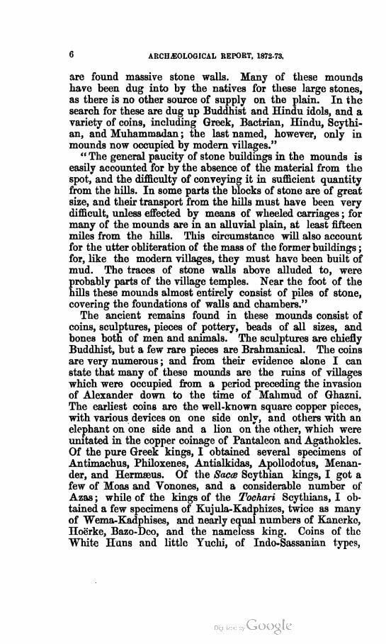
6 ARCH^OLOGICAL REPORT, 1872-73.
are found massive stone walls. Many of these mounds
have been dug into by the natives for these large stones,
as there is no other source of supply on the plain. In the
search for these are dug up Buddhist and Hindu idols, and a
variety of coins, including Greek, Bactrian, Hindu, Scythi
an, and Muhammadan ; the last named, however, only in
mounds now occupied by modern villages."
" The general paucity of stone buildings in the mounds is
easily accounted for by the absence of the material from the
spot, and the difficulty of conveying it in sufficient quantity
from the hills. In some parts the blocks of stone are of great
size, and their transport from the hills must have been very
difficult, unless effected by means of wheeled carriages ; for
many of the mounds are in an alluvial plain, at least fifteen
miles from the hills. This circumstance will also account
for the utter obliteration of the mass of the former buildings ;
for, like the modern villages, they must have been built of
mud. The traces of stone walls above alluded to, were
probably parts of the village temples. Near the foot of the
hills these mounds almost entirely consist of piles of stone,
covering the foundations of walls and chambers."
The ancient remains found in these mounds consist of
coins, sculptures, pieces of pottery, beads of all sizes, and
bones both of men and animals. The sculptures are chiefly
Buddhist, but a few rare pieces are Brahmanical. The coins
are very numerous ; and from their evidence alone I can
state that many of these mounds are the ruins of villages
which were occupied from a period preceding the invasion
of Alexander down to the time of Mahmud of Ghazni.
The earliest coins are the well-known square copper pieces,
with various devices on one side only, and others with an
elephant on one side and a lion on the other, which were
unitated in the copper coinage of Pantaleon and Agathokles.
Of the pure Greek kings, I obtained several specimens of
Antimachus, Philoxenes, Antialkidas, Apollodotus, Menan-
der, and Hermaeus. Of the Sacce Scythian kings, I got a
few of Moas and Vonones, and a considerable number of
Azas ; while of the kings of the Tochari Scythians, I ob
tained a few specimens of Kujula-Kadphizes, twice as many
of Wema-Kadphises, and nearly equal numbers of Kanerke,
Hoerke, Bazo-Deo, and the nameless king. Coins of the
White Huns and little Yuchi, of Indo-Sassanian types,

YUSUFZAI. 7
though not uncommon, were rarely in good order ; wbile
those of the Brahman kings of Kabul, both in silver and in
copper -were pretty common. I got only one coin of Mah-
mud of Ghazni, but I saw several copper specimens of some
of his successors, and a few of the earlier Pathan kings of
Delhi.
The only inscriptions yet found are all in the Arian char
acter, -which would appear to have fallen into disuse about
the beginning of the second century after the Christian era,
as the gold coins of the Indo-Scythian Tochari, even so early
as the time of Bazo-Deo, use only the Indian letters of the
Gupta period. It seems probable, therefore, that the great
mass of the Buddhist monasteries and temples of Yusufzai
must have been built during the reign of Kanishka and
his immediate successors, from about B. C. 50 to A. D. 150.
In the early centuries of the Christian era, as we learn
from the different Chinese pilgrims Pa-Hian, Sung-Yun, and
Hwen-Thsang, the district of Pakkalaoti or Penkolaitis was
full of Buddhist buildings. But in the time of the last
pilgrim the Brahmanists had already introduced the worship
of their god Maheswara Deva, and of his wife Bhima,
whose statue in blue stone was set up on the top of a high
mountain at 50 li, or upwards of eight miles, to the north-east
of Po-lusha. This I will hereafter show to be the Karamar
mountain, eight miles to the north-east of Shahbaz-garhi,
which place I have identified with Po-lusha, the native city
of the famous Prince Sudatta. This early introduction of
Brahmanism is amply confirmed by the coins of the little
Yuchi, on which we find both the trident of Siva and his bull
Nandi. It is corroborated by the statement of Sung-Yun1
that the king of Gandhara in A. D. 520 "did not believe
the laws of Buddha, but loved to worship demons." The
people of the country, however, " had a great respect for
the laws of Buddha, and loved to read the sacred books."
Here we see that the people were still attached to the old
faith, although their king was a determined Brahmanist.
But Buddhism continued to decline, and before the conquest
of the country by the Muhammadans it had probably disap
peared altogether. Its monuments, however, still survive
in such numbers, and of such striking beauty, as to attest
1 Beal's Chinese pilgrims, p. 197.

8 ARCHAEOLOGICAL REPORT, 1872-73.
beyond all doubt tbat it was once the dominant religion of a
rich and pious people, who were proud to expend their wealth
in costly monuments for the honour of their religion.
Of the Brahmanical period there are few remains, except
coins, which are, however, so exceedingly numerous, that
they alone are sufficient to prove the complete ascendancy
obtained by the Brahmans during the two centuries imme
diately preceding the Muhammadan conquest.
Of the Muhammadans themselves but few monuments
now remain except coins. The oldest is a red brick building
at Kapur-da-garhi, which the people attribute to Mahmud of
Ghazni. The place is said to have been originally founded
by Mahmud, who named it Langarkot, the present name
being a comparatively modern one, derived from a youth
called Kapur.
SHAHBAZ-GARHI.
The great rock inscription at Shahbaz-garhi was first dis
covered by General Court, who described it as being situated
quite close to Kapurdi-garhi, and almost effaced by time.1
Kapurdi-garhi, however, is two miles distant, and the rock is
actually within the boundary of the large village of
Shahbaz-garhi, from which it is less than half a mile distant.
Court's notice of the rock inscription stimulated the zeal
and curiosity of Masson, who, in October 1838, proceeded
to Shahbaz-garhi2, where he succeeded in making a very
fair copy of the inscription, which enabled Norris to identify
it as another transcript of Asoka's well-known edicts, but
engraved in Arian characters.
I visited the place in January 1847, but I had no means
of making an impression of the inscription ; and as I believed
that Masson had made a complete copy, I did not attempt
to take a hand copy. But my examination of Masson's
impression, now in London, showed me that it was very
desirable to have a more perfect copy ; and during my explora
tion of the Panjab in the past cold season I visited Shahbaz-
garhi, and after considerable trouble and delay from several
days of heavy rain, I believe that I succeeded in making as
complete a copy of the whole inscription as the rough sur
face of the rock will permit.
1 Bengal Asiatic Society's Journal V, page 481.
' Royal Asiatic Society's Journal VIII, page 297.

SHAHBAZ-GARHI. 9
During my stay at Shahbaz-garhi I made a survey of
the neighbourhood, and was surprised to find that the present
Tillage was the site of a very old and extensive city, which,
according to the people; was once the capital of the country.
They pointed to several mounds of ruins as having been
inside the city, and to two well-known spots named Khaprai
and Khapardarrd, as the sites of the northern and eastern
gates of the city. The truth of their statements was con
firmed by an examination of the ground within the limits
specified, which I found everywhere strewn with broken
bricks and pieces of pottery. The old name of the place
was not known ; but some said it was Sattdmi, and others
Setrdm and Sitardmi, all of which I believe to be simple
corruptions of the name of the famous Buddhist Prince
Suddna or Sudatta.
The present name of Shahbaz-garhi is not older than the
time of Baber, and was derived from the Ziarat, or shrine of
a famous saint named Shahbaz-kalandar, who died about thirty
years "before Baber's conquest of the Yusufzai country1. Ac
cording to the statements of the people, Shahbaz was a kafir ;
and this agrees with Baber's account of him as " an impious
unbeliever, who, in the course of the last thirty or forty years,
had perverted the faith of numbers of the Yusufzais and
Dilazaks." Baber thus continues : " At the abrupt termina
tion of the hill of Makam, there is a small hillock that
overlooks all the plain country ; it is extremely beautiful, com
manding a prospect as far as the eye can reach, and is con
spicuous from the lower grounds. Upon it stood the tomb
of Shahbaz-kalandar. I visited it, and surveyed the whole
place. It struck me as improper that so charming and
delightful a spot should be occupied by the tomb of an
unbeliever. I therefore gave orders that the tomb should
be pulled down and levelled with the ground." As this
was in A. D. 1519, the death of Shahbaz must have taken
place about A. D. 1490. The old name must therefore have
been in use down to the time of Baber ; but unfortunately
he gives only the name of Makam, which is that of the
stream of Shahbaz-garhi at the present day. Baber also
speaks of the hill above the shrine of Shahbaz as the hill
1 According to Akhun Darwaizah, qnoted by Dr. Bellow in his Yusufzai Report, page
116; and this date is confirmed by Baber's own account, which is quoted in the text.
VOL. V. B

10 ARCH5I0L0GICAL REPORT, 1872-73.
of Makam ; but the name is not that of the town but of
the valley, as he mentions that he " halted in the midst
of Makam." I accept therefore the statement of the people
that the old name of the town was something like Sattami
or Setram, or Sitaram, which I propose to identify with
the city of the famous Buddhist Prince Sudana.
The antiquity of the site of Shahbaz-garhi did not escape
the notice of Dr. Bellew, who describes the place as " built
on the actual ruins of an ancient stone-built town, the
foundations of some of the former houses still existing in
tolerable formation in different parts of the modern mud-
built village." As a proof " that this site was in past times
occupied by Buddhist and Hindu races, he adduces the
fact that " coins are still found in excavating the soil round
the old walls.1
In the accompanying map2 I have inserted all the prin
cipal mounds of ruins, which serve to mark the extreme
limits of the ancient city. The modern village occupies the
western slope of Mount Zarrai, which is a short spur thrown
off from the western extremity of the great mountain of
Karamar, which Baber calls "the hill of Makam." The
site of the old town is bounded to the west by the stream of
the Makam Rud for about one mile in length ; and to the
east for about the same length by the end of the great
mountain of Karamar ; the several distances between the
stream and the mountain ridge being about one mile, except
towards the south, where they approach within 3,000 feet. The
whole circuit is therefore about four miles, and the area about
one square mile, of which not less than one-fourth is occupied
by the rocky ridge of Zarrai. To the north, beyond Mount
Zarrai, the extreme limit of the old city is marked by the
presence of broken bricks and pottery for upwards of a quarter
of a mile farther, but I consider that this was only a suburb,
outside the city walls. The true limits of the city within
the walls I take to have been as follows : On the west, the
Makam Bud up to Khaprai, where the north gate is said to
have been situated ; on the north, the Zarrai ridge, from
Khaprai to the north-east gate in the Gel Pass, where no
wall was required, excepting for a short distance to join
Khaprai with a spur of the ridge ; on the east, the Karamar
1 Report on Yusufzai, page 116.
•' See Plutc III, Ruins at Shahbaz-garhi.
SHAHBAZGARHI. ] 1
ridge from the north-east gate at Gel to the east at Khapar
Darra, and thence to the end of the ridge in the rocky mound
called Hinduan Gundai ; and on the south, from Hinduan
Gundai to the Makam Rud, a distance of only 3,000 feet.
As the present village, which occupies about only one-
sirth of the old area, contains 400 houses, the ancient city
may have contained about 2,500 houses, and upwards of
12,000 inhabitants ; or with the suburbs on all sides perhaps
not less than 20,000 inhabitants.
The principal existing remains at Shahbaz-garhi consist
of the Pukai mound on the north, the Khere Gundai and
Butsahri mounds on the east, the Hinduan Gundai mound
oa the south, with the famous rock inscription half-way
up the hill immediately above it. There are also many smaller
mounds within the city limits, and several extensive mounds
at Chanak-ka-dheri, one mile to the north, and a large cave
in the Karamar hill to the north-east.
The Fukai mound is the extreme western end of the Zarrai
kill, immediately to the north of the present village, and
to the south of the north gate at Khaprai. It is 100 feet
square at top and 60 feet in height, and is composed chiefly
of large stones and huge bricks, 13 inches square by 3£
thick. On two sides I traced the remains of walls, and on
the north-west, facing the Makam Rud, I uncovered a flight
of steps. As I was informed by the people that this mound
had been excavated by the Sappers in 1871 without any
result, I was induced to give up my intended exploration.
The Khere Gundai mound is situated outside the Khapar
Darra Pass, which is said to have been the east gate of the
city. The mound is rather extensive, being 400 feet long
from north to south and 250 feet broad. At the south-east
corner there is a large mass of ruin, 25 feet in height, and
upwards of 80 feet square at base. A superficial excava
tion showed this to be the remains of a large Vihar, 58 square
outside with walls 5 feet 4 inches thick, standing on a terrace
71 feet square. The entrance was to the north, towards
the east gate of the city. Inside I found four massive
pillars, each 7 feet 5 inches square. I regret that I was
unable to explore this building further for want of time,
as it would appear from its size to have been of some
importance. Perhaps the Sappers may be able to complete
its excavation during the next cold season.

12 ARCHAEOLOGICAL REPORT, 1872-73.
The Btilsahri mound stands half a mile to the north-east
of Khere Gundai, and the name distance to the east of
Khapar Darra, and on the high road to the Indus at Ohind.
It is about equal in height to the Pukai mound, and is rather
more extensive ; but as it is entirely covered with Muham-
madan tombs, I found it quite impossible to make any ex
plorations whatever. Immediately to the south of the
mound stands the Zidrat, or shrine of Akhun Baba, sur
rounded by a few huts. The name of Butsahri, or Butseri,
most probably refers to some statue or monument of Bud
dha, which once stood on the mound.
The Sindudn Gundai, or " hillock of the Hindus," derives
its name from the practice of the Hindu inhabitants of
burying in it all their children who die young. It is an.
isolated eminence at the extreme south-west end of the
Karamar ridge, and about 250 yards distant from the great
rock inscription. It is about the same size as the Pukai
mound, and presents the remains of a square enclosure of
stone walls. It was excavated by the Sappers in 1871. but
without any results. It has already been identified by
Dr. Bellew1 with the site of the tomb of Shahbaz Kalandar
as described by Baber, whose account has been quoted
before. From its position at the extreme end of the Kara-
mar ridge, it commands, as correctly stated by Baber, "a
prospect as far as the eye can reach, and is conspicuous from
the lower grounds.2" Dr. Bellew is no doubt quite right
in his conclusion, that " this is probably the site of an an
cient Buddhist monastery."
Of the smaller mounds within the limits of the city I
explored only two, the greater number being covered with
Muhammadan tombs. These two were situated immediately
under the Zarrai hill, and about midway between the village
and the Gel Pass, or north-east gate of the ancient city.
Both showed the remains of large stone enclosures, the
more perfect one being 73 feet broad with a building 39 feet
square, at a distance of 56 feet from the south wall. This
may have been either a Vihar, or the square basement of a
Stupa. In this mound we discovered a broken statue of
Buddha, together with several fragments of others, and a
1 Report on Yusufzai, p. 116.
a Memoirs by Lejden snd Erskine, p. 252.
SHAHBAZ-GARHI. 18
copper coin of the Scythian king, Wema Kadphises, who
lived about 60 B. C.
Of the mounds lying outside the city to the north, the
nearest, marked G in the map, is one quarter of a mile to the
north of the Gel Pass, or north-east gate of the city. It is
a long low mound, not exceeding 10 feet in its highest part.
About one mile and a quarter to the north of the Gel Pass
there is a group of several mounds known as Chanaka-dheri.
The meaning of this is unknown. There are three principal
mounds, each several hundred feet in length, and from 15 to
20 feet in height. They all show the remains of massive
stone walls ; but as three days' superficial excavation disclosed
nothing of value except a number of walls, I gave up their
farther exploration for want of time.
The cave which I discovered in the Karamar hill is
situated in the north face of the ridge, just two miles to the
north-east of the village of Shahbaz-garhi. It has no special
name, and is simply known as " the Cave." It is a natural
hollow under an immense concave mass of rock, which has
been increased partly by the long-continued action of water
ranninEr through it, and partly by the hand of man in scoop
ing out the floor. The cave is about 80 feet up the side of
the hill, with its opening facing the north. The mouth is
15 feet long and rather low, but the height has been reduced
purposely by piling up stones to form a rough wall right
across the opening.1 The greatest depth from the mouth to
the back of the cave is 25 feet, and the greatest length 26
feet. The height varies very much, from 4£ feet at the
lowest point of the mouth to 9£ feet at the highest point of
the covering mass of rock. I had twenty people with me
when I visited the cave, and as it rained heavily for about an
hour, the whole party found shelter inside, and there was more
than sufficient room for the same number to have slept on the
floor.
As the cave of Sudatta is said to have had two chambers,
* had already made enquiries for a second room, but none
"'as known to any of my party. While the rain lasted and
tite men were employed in digging up the floor, I made a
more minute examination of the cave, and at the farthest
point I spied a small dark hole only If feet broad and 2J
1 Sec Plate IV for a plnn and section of this cave.

H ARCHAEOLOGICAL REPORT, 1872-73.
feet high. As no end could be felt with a long pole of 10
feet, a man crept inside through the narrow opening, which
he found to be 7 feet in length, when it suddenly increased
to 6 feet in breadth for a further length of 12 feet, with an
average height of 3 and 4 feet. Originally this second
room must have been somewhat higher, say from 5 to 6 feet,
as the bottom is now filled with a mass of small rounded
stones, which appear to have been washed in from above.
This, then, was the cave that I was in search of, and which I
will presently attempt to identify with the famous two-
chambered cave of Prince Sudana, or Sudatta.
In the accounts of the Chinese pilgrims Sung-Yun and
Hwen-Thsang, there are some very curious details regarding
the various spots wliich had been rendered famous by the
romantic and well-known story of Prince Sudana, who was
believed to have been one of the previous incarnations of
Buddha. The story is told at length in the Wessantara
Jataka, which is one of the most popular Buddhist legends
both in Ceylon and in Burma at the present day,1 and
which was no doubt equally popular in other Buddhist
countries of ancient India. It was certainly very well
known in Malwa as the whole history of the prince, and his
wife and their two children is represented at length in the
sculptures of the north gate of the great Bhilsa Tope.2
According to the legend, Prince Wessantara was the son of
Sanda Raja of Siwi, and his wife Phusati. The capital city
was named Jayatura, and the country adjoined that of
Chetiya, which also had its Raja. The prince was noted for
his unusual liberality, and for never refusing to give away
any of his possessions that he was asked for. This extreme
benevolence at length brought him into trouble, when the
people rose indignantly, and demanded his banishment for
giving away the richly-prized white elephant of Siwi to the
Raja of Kalinga. The religious history begins at this point,
and every spot connected with his after-career possessed a
monument commemorating the event. In the narratives of
the Chinese pilgrims, the prince is named Sudana and
Sudatta, or the " illustrious giver ;" but this was only a title
given to Wessantara on account of his great liberality, as
1 See Hardy's Manual of Buddhism, p. 116, and Bigandet's Burmese Buddha, p. 83.
* This was first pointed out by Mr. Beal ; sec Royal Asiatic Society's Journal, 2nd series,
vol. 1C9.

SHAHBAZ-GARHI. 15
!he histories of Sudana and Wessantara are precisely the
same.
In the legend of Wessantara there is nothing to indicate
in what part of India the country of Siwi and the city of
Jayatura -were situated ; ' but from the joint testimony of
Sung-Yun and Hwen-Thsang we learn that the people of
Northern Gandhara believed that their own chief city was
the actual scene of all the famous deeds of charity done by
Prince Sudatta. But there is no reason to suppose that the
country of Sibi or Siwi was to the west of the Indus. The
legend was most probably suggested by the actual name
of the district, Sudam, which, by a slight alteration, became
Sudana —" Aut ex re nomen, aut ex vocdbulo fabula."
The latter was, no doubt, the case in the present instance,
as we know it to have been in so many others of the most
famous Buddhist legends. Thus, by a slight alteration,
Tah»hasila, or the " cut stone, " became Taksha-sira, or the
"cut head," and originated the legend of Buddha presenting
bis head to a starving tiger. So also Ahi-kshetra, or the
"snake's field," became Ahi-Chhatra, or the " Snake's hood,"
and gave rise to the legend of the snake protecting Buddha
from the rain by canopying him with his hood.
The city of Sudatta is called Fo-lu-sha by Hwen-Thsang,
and Fo-sha-fu by Sung-yun, or simply Fo-sha, as the last
pliable fu means ' city'. The two transcripts are evidently
intended for the same, which M. Julien renders by Varusha.
The position assigned to it by Hwen-Thsang is about 40
ndles to the north-east of Peshawar, and 27 miles to the
north-west of Utakhanda, or Ohind. These bearings and
distances fix the site of the city somewhere in the valley of
the Makam Bud, which the subsequent mention of the
^antalok hill and of a cave within a few miles of the city
limits to the neighbourhood of Shahbaz-garhi. That this
^as one of the chief cities of the country in ancient times
ve learn from the traditions of the people, as well as from
the extent of the existing ruins and the presence of the
great rock inscription of Asoka. From all these concurring
circumstances I feel satisfied that the site of Shahbaz-garhi
^presents the ancient city of Fo-lu-sha or Fo-sha, an
1 1 believe that Sibi, and its capital Jayatura, may be identified with Saitedla and iUr'm f city Chitor. I propose to discuss this question when I come to speak of H&nsi and

16 ARCILEOLOGICAL REPORT, 1872-73.
identification which will be strongly corroborated by an
examination of some of the details furnished by the Chinese
pilgrims.
Outside the east gate of the city there was a monastery
containing fifty monks and a stupa of Asoka, which stood on
the spot where Sudana's son and daughter were sold by
the Brahman to whom they had been given in charity to
serve as slaves. The monastery and stupa are most
probably represented by the ruins of the Khere Qundai
and Butsahri mounds, which stand just outside the east
gate of the old city.
To the north of the city at a distance of 1 li, or 880 feet,
stood the temple of the white elephant palace, which,
according to Sung Tun,1 contained "stone images highly
adorned and very beautiful, very many in number, and
covered with gold sufficient to dazzle the eyes." Before the
temple was a tree called the white elephant tree, from which
the temple took its origin and name. Within the temple
there was a picture of Prince Sudatta with his wife and
children begging from a Brahman, which drew tears even
from the Tartar conquerors. From Hwen-Thsang we learn,
as might readily have been guessed, that this temple occu
pied the spot where the prince had taken leave of the
people, after being expelled from the city for giving away
in charity to the Brahmans the great elephant belong
ing to his father. The place was to the north of the town,
and was marked by a stupa. This site I take to be the
long low mound indicated by G in the map2 at a short
distance to the north of the Gel Pass. It is on the side of
the road direct from the city leading to the cave in the
mountain of Karamar. Around it stood fifty monasteries.
At 20 li, or 3£ miles to the north-east of the town, stood
Mount Dantalok,1 about which were several holy places.
One of these was the spot where the prince had given his
son and daughter to a Brahman ; this was marked by a
stupa. Another was the scene of the flogging of the two
children by the merciless Brahman, when their blood red
dened the earth. All the ground in this part is quite red,
and in January I found that the trees and plants were
1 Beal's Sung-Ynn, p. 201.
2 See Plnte III for this position.
' Julien's H wcn-Thsang, II, p. 123.

SHAHBAZ-GARHI. 1 7
snerally of a reddish brown colour. A third was the cave,
bra from the rock, where the prince and his wife gave
iemselves up to meditation. Sung-Yun1 places the rock-
,ave of Sudatta to the south-east of the crest of Mount
Slm-Chi, or the hill of " Illustrious Charity." He adds that
it had two chambers ; and that ten paces in front of it there
wsa" great square stone, on which it was said the prince
•as accustomed to sit."
Mount Dantalok I would identify with the south-western
peak of the Karamar hill, which is well known to the Afghans
tathe name of Mekha-Sanda, or the " male buffalo." Sanda
s no doubt the old name, although it is now a common
Hindi term for a buffalo. The name is closely rendered by
Sung-Yun in the Chinese syllables Shen-chi, where the
seond syllable represents the cerebral d of the Indian
ilphabet. On the northern slope of this hill I discovered a
To-chamhered cave, which I have no hesitation in identify
ing with the two-chambered cave of Sudatta and his family,
ad there still lies in front of it a great block of stone, 12 feet
square, as described by Sung-Yun. Its upper surface is
quite flat, hut it is not horizontal. It has, perhaps, by the
lapse of time, lost its original level by water running
teneath it. It is now cracked right across. The only
difficulty about this identification is the distance of the
rave from the city, which Hwen-Thsang makes 20 li, or
upwards of three miles, whereas the cave which I discovered
is not more than two miles from the present village and only
one mile from the nearest point of the old city.
At 3 li, or just half a mile to the west of the cave,
inng-Yun places the spot where Indra, in the shape of a
lion, concealed Mankia, or Madri Devi, the wife of Sudatta.
It was commemorated by a stupa, the ruins of which may
be identified with the small mound marked H in the map.
Both pilgrims speak of the beauty of the valley in which the
city was built ; and Sung-Yun adds that the soil was a rich
loam.4 This is true of the Sudam valley, but not of Lunkhor,
where there is much stiff clay. According to Sung-Yun, the
city walls had double gates, which is explained by Hwen-
Thsang when he speaks of passing " the gate of the outer
1 Bail's Sung-Yun, p. 194.
1 Bcal's Sung-Yun, p. 200.
VOL. V.

18 ARCHAEOLOGICAL REPORT, 1872-73.
walls." ' The city, therefore, had a double line of walls.
Within the city, he adds, there was a heretical temple of an
cient date called Sang-teh, or, as Mr. Beal suggests, this pas
sage may, perhaps, be rendered. " within and without this city ;
there are very many old temples, which are named Sang-teh."
This term recalls the name of Mekha Sanda, which is at the
present day given to the peak above the double-chambered
cave. Now, close to the peak of this hill there was a tem
ple of To-kin (Bhagavan) built by the Yakshas, which con
tained eighty priests. Perhaps To-kin Sangteh may be the
Chinese form of Mekha Sanda.
At 50 li, upwards of eight miles to the north-east of the city,
Hwen-Thsang places a high mountain, on which there was
a statue in blue stone of the Goddess Bhima, the wife of
Maheswara Deva. At the foot of the hill there was a tem
ple of the God himself, to whom the Pdsupatas, ash-smeared
devotees, paid their devotions. This lofty hill I would iden
tify with the Karamar peak, which rises to a height of 3,480
feet above the sea. Its distance from Shahbaz-garhi is just
eight miles, but its direction is rather east-north-east than
north-east. I have, however, no doubt whatever that Karamar
is the peak referred to by the Chinese pilgrim.
I have been disappointed in not being able to discover any
notice of this ancient city by the historians of Alexander the
Great. That it was a place of importance at the time of his
invasion is proved by its selection as the site of one of
Asoka's long inscriptions. I have a suspicion that it may be
Bazaria, of which the Fosha of Sung-Tun, represents the
first two syllables very closely, and if the middle syllable of
Hwen-Thsang's Po-lu-sha might be placed at the end, I think
that his name might be accepted as a very fair transcript of
Bazar or Bazaria. Arrian's description of Bazaria, as situ
ated upon an eminence and surrounded by a stout wall,e agrees
so closely with the actual position of Shahbaz-garhi as well
as with the accounts of Sudatta's city given by the Chinese
pilgrims that I feel a strong inclination to identify the
classical Bazaria, or Bazira, with the Fosha and Fo-lusha
of Sung-Yun and Hwen-Thsang. Quintus Curtius adds
nothing to the account of Arrian, except that Bazira was
" an opulent town."
1 Julicn's Hwen-Thsang— II, 122, " Qunnd il cut pass£ la porte dcs mure cxtcrienrs."
' Anabasis, IV, 27.

SHAHBAZ-GAKHI. 19
The great inscription of Asoka is engraved on a large
japeless mass of trap rock, lying about 80 feet up the slope
f the hill, with its western face looking downwards towards
ie village of Shahbaz-garhi. The greater portion of the
iscription is on the eastern face of the rock looking up the
ill, but all the latter part, which contains the names of the
ire Greek kings, is on the western face.1 The mass of rock is
U feet long and about 10 feet in height, with a general thick
ness of about 10 feet. "When I first saw the inscription in
January 1847 there was a large piece of rock, which had
alien from above, resting against the upper or eastern face
of the inscription. At my request this piece of rock had
tieen removed in 1871 by a party of Sappers, and I was thus
sble to take a complete impression of this side of the inscrip
tion. I cleared the ground both above and below the rock,
ffid built level terraces in front of both inscriptions so as to
'"* able to examine with tolerable ease any doubtful portions.
He eastern face, though not smooth, presents a nearly even
surface, the result of a natural fracture; but the western
'ace is rough and uneven, and the letters, though not much
»oni, do not afford a good impression. I therefore traced
iem out carefully with ink for the purpose of taking an eye
copy ; but the ink was washed out at night by a heavy fall
'f rain. The same thing happened a second time, but after
a third tracing the weather became fair, and 1 was able to
make a complete eye copy as well as an impression of this
important part of Asoka's inscription. Every doubtful letter
fas examined several times in different lights, and was
copied by my native assistants as well as by myself, until by
repeated comparisons the true form was generally obtained.
tmder these circumstances I believe that I have secured as
perfect and as accurate a copy of this famous inscription as
« is now possible to make. As no photographs can be taken
<>f either face of the inscription on account of the slope of
'he hill, an eye copy, thus checked by an impression, is, I
talieve, the best possible substitute. I propose hereafter to
collate the Shahbaz-garhi inscription with the Khalsi inscrip
tion, as both of these texts are nearly perfect in the important
13th Tablet which contains the names of the five Greek
tongs, and of several well known districts of India. The
1 See Plate V for a copy of this part of the inscription.
20 ARCHAEOLOGICAL REPORT, 1872-73.
words of the Shahbaz-garhi inscription in this part are as
follow : from near the beginning of the 9th line—
Antiyoka nama Yona raja, paran cha tena Antiyokena cha-
tura I1II rajani, Turamaye nama, Antikena nama, Maka
nama, Alikasandaro nama, nicha Choda Panda, Avam, Tam-
bapanniya, hevam meoam hevam mevam raja, vishamvidi ? Yona-
Kamboyeshu, Nabhaka-Nabhamateshu, Bhoja-Pitmikeshu,
Andhra-Pulindeshu, savatam, &c. The name of Alexander
is written Alikasandaro, which agrees with the Alikyasadale
of the Khalsi version. Then follow the names of several
countries of which not one was recognized by either Norris or
Wilson. Of these Choda and Panda are the well known
Chola and Pandya of early history. Avam or perhaps Avt*
may be the country of Ptolemy's Aii, an identification which
is rendered still more probable by the subsequent mention of
Tambapanniya or Ceylon. Of the last series of names the
Yonas and Kambojas are well known. Of the Nabhakas and
Nabhamatis (or Nobhapantis of the Khalsi text), I cannot
offer even a conjecture, but the Bhojas are mentioned both in
the Mahabharata and in the Puranas. The name of the
Pitinka8 occurs also in the 5th edict, and is probably the
same as the Padenekayika of the Bhilsa Tope inscriptions.1
The last people are the Andhras and the Pulindas.
This mention is of the highest importance for the ancient
history of India, as it proves that the generally accepted
chronology which assigns the rise of the Andhras to so late
a period as B. C. 21 is undoubtedly erroneous. I had already
discovered this error from an examination of the Kanhari
and Ndsik inscriptions of Gotamiputra Satakarni and his
successor Pudumavi, which clearly belong to the same period
as the well known Gupta inscriptions. After much con
sideration of the career of Gotamiputra Satakarni, I ventured
to suggest that he might be identified with the famous
Sdlivdhan, or Sdtavdhan, which would place him in A. D. 79
instead of A. D. 320, as generally adopted. That this con
clusion was well founded is now proved by the mention of
Andhras in the edicts of Asoka,2 which carries back the
foundation of the kingdom of Andhra from the latter part
1 Cunningham's Bhilsa Topes, No. 140 inscription.
- The name of Andhra, with the suffixed r is very distinct on the rock, and was so copied
by Masson, as may be seen in Noma's Plate of the Inscription ou the back of the rocl- in
vol. XII of the Royal Asiatic Society's Journal.

SHAHBAZ-GARHI. 21
'■' the first century B. C. to the earlier half of the third
sntury B. C. If we adopt the amount of correction, which
."had already made for Gotamiputra of A. D. 320—78=242
■ears, then the foundation of the Andhra kingdom will be
placed in B. C. 21 + 242=B. C. 263, or exactly contem
poraneous -with Asoka.
I am now preparing a reduced copy of the whole of the
shahbaz-garhi inscription for publication along with the texts
)f the K.kalsi and other versions of Asoka's edicts. The
Khalsi text is generally in good preservation, excepting only
the lower part of the front inscription and the upper part of
ieside inscription, containing the middle portion of the
13th edict. The Khalsi text is also important for its separa
tion of the words, and for the frequent use of the sibilant sh,
*hich was clearly borrowed from the Arian alphabet. That
it was a recent introduction may be gathered from the fact
'tot the same words are carelessly given in both the old and
the new forms even in the same edicts as in pasanda and
mhanda, smusa and sususha, vasa and vasha, and others.
The end of each edict is also distinctly marked by a curved
one or bracket. In the copy of the Shahbaz-garhi inscription
on the back of the rock prepared by Norris and Wilson, the
uppermost line is omitted altogether, their first line being my
second line, so that I have 14 lines altogether instead of 13.
This upper part, however, has so many gaps in it that it does
not promise to be of much service in recovering the missing
text of the first-half of the 13th edict. But the latter half
is in very fair preservation, fully equal to that of the Khalsi
text. Thus fortunately, for the purpose of comparison, we
now possess two good versions of the most important part of
Asoka's inscriptions preserved in the widely different charac
ters of Ariana and India.
The Arian version is of special value in determining the
true reading of many words in the Indian version, partly
from its possession of the three sibilants, and partly from its
use of the attached r.
The value of the last is best seen in the important name
of Andhra, which Wilson read as Andha, although he had
observed that the Shahbaz-garhi text " departs less from the
Sanskrit than the other, retaining some compound consonants,
as jw in priya instead of piya," to which he might have added
or in Bramana, sr in Sramana, and other equally distinct

22 ARCHAEOLOGICAL REPORT, 1872-73.
examples. The three sibilants are found together in the
word sususha, which is written simply sususa in all the
Indian versions excepting some parts of the Khalsi text,
where the sh is used of nearly the same form as the Arian
letter. The same letter is also found in the word vasha.
year which replaces vasa of the Indian texts, and in the
plural forms of Kamboyeshu and Pulindeshu, which take the
place of Kabojesu and Pulindesu of the other versions.
But the most remarkable departure from the Indian texts
is the use of the vernacular word baraya for twelfth, instead
of the Sanskrit dwddasa. This word occurs twice in the
inscription, near the beginning of the 3rd and towards the
end of the 4th edict. Strange to say it remained unrecog
nized by Wilson, who simply remarks, " in place of dwddasa,
twelve, and vasa, year, the inscription has baraya vasha, but
the first must be wrong." Of the second example, he says
that " there is a blank instead of the number," although
Norris's Arian text has the letters for vara + vasha quite
distinct, while his English transliteration gives va rana vasha ;
by thus separating va from the following letters it seems that
Norris also failed to recognize the true vernacular baraya for
"twelfth."
I observe that the word chatura, " four," in the 13th edict,
is followed by four upright strokes thus, 1 1 1 1, in the Shahbaz-
garhi text, and that the corresponding word chatura, ' four,'
in the Khalsi text, is followed by an upright cross, thus + ,
which must therefore be the old Indian cypher for 4. This
form was afterwards modified to a St. Andrews' cross, or x ,
in which shape it was adopted by all the people who used the
Arian characters, as may be seen in the different inscriptions of
the kings Kanishka, Huvishka, and Gondophares, and of the
Satrap Liako-Kujulaka. Previous to the adoption of this
Indian symbol, the cyphers of the western people would seem
to have been limited to single strokes, as the words pancheshu
pancheshu, " every five," are followed by five upright strokes,
which precede the words vasheshu, 'years.'
Before leaving the city of Sudatta both Sung-Yun and
Hwen-Thsang notice the house of a famous Rishi in the
middle of the valley. Hwen-Thsang gives no details, but the
place could not have been far from the cave, as Sudatta is
said to have taken exercise close to it. Sung-Yun calls the

TAKHT-I-BAHI. 23
Rishi Uh-po, and adds that the king of the country
dedicated a chapel to him, with a statue of the Rishi, which
iras ornamented with much gold leaf.1 This notice is of
some importance, as we learn from it that statues were
actually dedicated to holy men as well as to Buddha, and I
infer therefore that chapels may also have heen dedicated
to kings.
TAKHT-I-BAHI.
On leaving the city of Sudatta, Hwen-Thsang states that
he made about 100 li, or nearly 17 miles, to the north-west
from the Rishi's house, and crossing a little hill he reached
a great mountain, to the south of which there was a monas
tery containing a few monks who studied the Mahdydna.
Sear it was a stnpa built by Asoka on the spot where the
Rishi Ekasringa had formerly lived. The only notice of this
holy man is that he lost his divine powers through the
seductive arts of a courtesan, who actually persuaded him
to carry her on his shoulders through the town.
The bearing and distance of the high hill almost exactly
agree with that of the Takht-i-Bahi mountain, measured
from Shahbaz-garhi. The monument of the Rishi Eka
sringa with its neighbouring monastery I would identify
vith the great stupa of Sahri Bahlol, which was opened by
Dr. Bellew, and the monastery attached to it. As nothing is
said about any monuments on the high hill itself, I conclude
that the Buddhist establishments on Takht-i-Bahi had
already been abandoned before the time of Hwen-Thsang's
visit.
The hill of Takht-i-Bahi forms three sides of an oblong
square, of which the north face is open, and the south is
formed by the highest ridge of the hill, which is very nearly
straight. About half-way between the two long ridges,
which form the east and west sides of the square, there is a
shorter ridge or spur, which runs almost directly north from
the crest of the hill. The ruins of Bahi occupy this centre
spur and two other shorter spurs to the east of it, as well as
the main ridge, including the highest peak at the south-west
corner of the square, to which alone the name of Takht or
"scat" properly belongs. The religious buildings which are
i Bcal's " Chinese Pilgrims," p. 196.
>i ARCHAEOLOGICAL RErORT, 1872-73.
by far the most interesting portion of the ruins are nearly
all confined to the three shorter spurs or ridges, the mass of
the buildings along the crest as well as on the other two
ridges being apparently private dwellings, from one to three
and even four storeys in height.1
The hill of Takht-i-Bahi is situated 28 miles to the north
east of Peshawar, and eight miles to the north-west of Mardan.
It is an isolated hill, forming the extreme end of the long
broken ridge which separates the valleys of Lunkhor and
Sudam. Its height above the sea is 1,771 feet according to
the latest maps, or about 570 feet above the plain, assuming
the general level of the Yusufzai basin to be 1,200 feet.
According to my estimate, the spur on which the religious
buildings stand is rather more than one-half of this height,
or about 300 feet above the plain.
The ruins on Takht-i-Bahi have been described at some
length by Dr. Bellew2 and even more minutely by Sergeant
P. H. Wilcher of the Sappers and Miners, who superin
tended the excavation of the religious buildings early in
1871.5 The remains on the crest of the hill are thus de
scribed by Dr. Bellew :4 " These ruins are very extensive,
and still in very good preservation. They occupy the crest
and northern slope of the Takht-i-Bahi, a spur which pro
jecting westward from the Paja ridge, traverses the plain
for several miles, and separates the valley of Lunkhor from
that of Sudam. The ruins occupy the western end of this
ridge, which is a bare ledge of grey mica and quartz schists,
about three hundred feet above the plain, and cover about
a mile of surface along a central crest between terminal
eminences on the east and west. On these are the boundary
buildings of the city, the rest are on the intervening crest,
and the ridges sloping down from it to the plain on the
north. The hollows between these ridges are the natural
drains of the hill.
" The buildings on the eminences flanking the city on the
east and west appear to have been positions of observations
and defence; for, from their elevation, they completely
1 See Plate VI for a map of the Takht-i-Bahi hill.
3 Report on Yusufzai by Dr. Bcllcw—Lahor, 1864.
3 Report on excavations made in the Yusufzai District from January to April 1871—
Manuscript.
* Report on Yusufzai, pp. 125-127.

TAKHTI-BAHI. 25
overlook the city and command an extensive view of the
country around. They are compact square blocks, with
rooms opening inwards on a central court. The walls are
now only 4 or 5 feet above the surface, but they are
very substantial, everywhere 4 feet in thickness. Close
to tbese blocks of buildings are two or more deep cellars of
masonry entered by a small opening in the roof, which is
a very flat dome. They appear to have served as grain
stores. In these buildings we could discover no remains of
idols or sculptures.
" On the crest of the hill, and between the two flanking
heights just alluded to, is a succession of detached quad
rangles, the massive walls of which are still from 6 to
S feet high and about 40 feet each way. Along the inner
side of each wall is a series of small compartments, each
opening by a doorway into the courtyard in the centre.
" Close to each of these quadrangles, and only a few
paces distant, is a well defined circular mass of masonry
raised about 2 feet above the surface, and about 14 feet in
diameter. The debris around is rich in fragments of idols,
and carved slabs of slate ; and beyond these are the indis
tinct remains of a wall enclosing the circular platform in a
square. These circular platforms are probably the ruined
and excavated foundations of former topes, whilst the ad
joining quadrangles were the monasteries of the monks de
voted to their care and services.
" From their position these quadrangles (there are five or
six of them along the crest of the hill) command an exten
sive prospect of all the country around.
" Their ruins in part are still discernible from the plain on
the south of the hill, and in their perfect state they
must have been prominent objects of attraction from a con
siderable distance around.
" The southern slope of the hill on which stand these
ruins is steep and abrupt right down to the plain. In its
upper part are some small detached huts of well-made stone
walls, and below these is traceable, at intervals, the line of a
causeway that zigzagged to the plain. In some parts it is
interrupted by a few steps, and in others has been built up
the sides of precipices. In its upper part, for a short dis
tance, the causeway is tolerably entire, and forms a road 4
feet wide, and with an easy ascent."
VOL. v. D

26 ARCHAEOLOGICAL REPORT, 1872-73.
The principal religious buildings occupy the lower portion
of the central spur. Their several arrangements and con
nection are shown in the accompanying plan.1 The outer
walls are generally very lofty, being built on the steep slopes
of the spur. Some of them thus present a wall from 60 to
80 feet high on the outside, but not more than 20 feet inside.
They are generally built of shapeless blocks of stone, with
the evenest face downwards, each course being brought
to a level by the addition of numerous thin flat pieces.
This is the characteristic style of all the old buildings from
Kabul to Taxila.
In the accompanying plan I have marked all the principal
blocks of building by separate letters for more ready refer
ence. They consist of a stupa A, surrounded on three sides
by chapels ; an open court B, with lofty chapels for colossal
statues on three sides ; a monastery 0, with cells on three
sides ; and a number of other buildings which will presently
be described.
The stupa stands in the midst of an oblong court 56^ by
45^ feet. The basement of the stupa is a square of 20^-
feet, diminishing in three stages to 15^ feet, at a height of
8£ feet from the ground. The middle stage is only 9 inches
in height ; but the lower stage is 3 feet high with 10 pilasters
on the side ; and the upper stage is 3 feet 4 inches high with
6 pilasters on the side. To the north immediately in front
of the entrance to the court there is a flight of steps leading
to the top of the basement, to enable the pious to peram
bulate the stupa itself. The actual body of the stupa could
not therefore have been more than 12 feet in diameter and
about 20 feet in height, or with its basement not more than
30 feet.
The chapels surrounding the stupa are separate buildings,
each 8 feet square externally, with the side towards the
court open. On the two longer sides the spaces between
the chapels, 2 feet 10 inches broad, were originally open,
but these were soon utilized by building a cross wall in
the middle of each opening, thus forming a number of
smaller chapels open towards the court. I gather from this
arrangement that all the larger chapels must have been the
gifts of different individuals, and that the smaller ones were
1 See Plate VII for a general plan of the Buddhist ruius at Tultht-i-Bahi.

TAKHT-IBAHI. 27
an ingenious after-thought, each of which would have better
suited the slender means of less wealthy persons.
The side walls of the chapels were 1 foot 7^ inches thick,
leaving one opening of 4 feet 10 inches, and a depth of
5 feet 6 inches for the interior room. The end of each side
wall towards the court was faced with a pilaster crowned by a
rich Corinthian capital of acanthus leaves. Each chapel was
covered with a high dome of overlapping stones, springing
from a circle of broad projecting stones at the level of the
pilaster capital. Each dome was 2£ feet thick at the spring.
Kb example now remains of the mode of covering the
opening between the pilasters. I judge, however, from a
comparison of the representations of chapels in the sculp
tures with the few pieces of stone beams now lying about,
and with the appearances of the broken domes, that some of
them were covered by a horizontal architrave, and others by
a trefoil overlapping arch. Externally the dome was much
flattened at top, and on the top of it was raised a second
smaller dome, resting on a low cylindrical neck. But one
of the middle chapels, which is still standing, although much
injured, is differently finished, the upper dome having a
gable end with a small trefoil opening, the whole being
capped with a mushroom pinnacle.
The smaller chapels were" covered with semi-domes like
niches, the opening to the front having a flat or Egyptian-
shaped head, of which one example still remains at Takht-i-
Bahi. These Egyptian openings are represented in many
of the sculptures, alternating with circular openings, just as
in the present instance. In some of the sculptures the
interior of the semi-dome is shown as panelled.
These Egyptian-shaped heads would appear to have been
forced upon the builders by the converging capitals of the
pilasters between which they were placed.
The purpose for which these chapels were intended may
be gathered from their sculptured representations, as well as
from the remains of statues and sculptures which have been
found lying in front of them. From these sources we learn
that all the larger chapels must have contained single figures
of Buddha, either sitting or standing, and either alone or
accompanied by two or more auditors. Many of them were
dedicated to the memory of holy men, or of powerful kings,
whose statues were enshrined in them, as I have already

28 ARCHAEOLOGICAL REPORT, 1872-73.
shown in the case of the Rishi Ekasringa, which I have quoted
from Hwen-Thsang. No statues were found in situ at
Takht-i-Bahi, either by Dr. Bellew or by Sergeant Wilcher, nor
did I find any m situ at Jamal-garhi, but at Sahri-Bahlol I
discovered a row of upright statues, at nearly equal distances
apart along tbe base of a wall, which once formed the base
ment of a line of chapels. In this instance the statues, though
not actually in situ, were within 1 or 2 feet of their original
positions, having apparently been pushed forward by the
falling inwards of the chapel walls. The side walls of
chapels and probably also the blank spaces in the back
walls were ornamented with alto-relievo sculptures display
ing various memorable scenes in the life of Buddha. These
slabs were usually fixed to the walls by large iron nails
driven through some sunken portion of the sculpture.
The smaller chapels would have contained smaller statues
of Buddha, or of saints or of kings, or perhaps larger scenes in
alto-relievo. The pilasters also which divided the chapels
were frequently sculptured, as we learn by numerous minia
ture examples.
The chapels as well as the principal statues would also
appear to have been gilded, as they are even now in Burma.
This was perhaps nearly always the case with the plaster
statues, although it is possible that some may have been
simply coloured red. I have always found fragments of
gold leaf in company with the broken plaster statues. Two
of the alto-relievos and one of the pilaster capitals found at
Jamal-garhi still retain numerous patches of thick gilding.
In the accompanying plate,1 I have given both front and
back views of the least injured chapels at Takht-i-Bahi :
and I have added below a convential representation of simi
lar chapels from one of the Takht-i-Bahi sculptures. Other
examples of different sized chapels arranged in a circle will
be given hereafter in my account of Jamal-garhi.
A single chapel of larger size, which may be called a
Vihdr, will be seen in the general plan2 to the west of the
stupa court, where it is marked by the letter H. It is 10
feet square inside, with walls 2 feet 7 inches thick, and
a lofty front opening 5^ feet inside. The walls, which are
still 11 feet in height, are ornamented by two tiers of trefoil
i Sec Plate VIII.
1 Sec Plate IX.

TAKHT-I-BAKi. «9
ranels divided by pilasters. There is nothing to show what
was orginally placed in this building ; but I conclude that
ach panel must have contained some piece of sculpture ;
and that the whole may have surrounded a small stupa
placed in the middle of the room. From the stupa court a
short flight of steps leads down to an oblong court, marked
3, which is surrounded on three sides by lofty chapels, all
or most of which, judging from the numerous fragments
found in the ruins, must once have held a colossal statue
af Buddha in plaster. Each of these chapels, of which
there are 29, is a separate and distinct building, entirely open
towards the court. None of the roofs now remain, but there
can be little, if any, doubt that these chapels were originally
coTered with domes like those of the stupa court. Some of
the walls of these chapels are still from 25 to 30 feet in
height, and I conclude that the statues which they once
held must have been nearly as lofty. Dr. Bellew mentions
that he found fragments of plaster figures which "must
have belonged to statues of gigantic size. A hand, a foot,
and portion of the head, in this composition, were fullyfour
times the natural size." " These huge figures, " he adds,
" probably occupied positions outside the stupa court," for
their fragments are only found outside its limits." Here
also the same colossal fragments were exhumed by Sergeant
Wilcher. This part of the ruins has not, however, been com
pletely cleared, as the mass of debris was from 10 to 12 feet
deep. But the fronts of the chapels were opened out, and
all the remains of buildings in the middle of the court were
cleared and exposed to view.
The precise use of this " court of colossi " has not been as
certained. It is 116 feet long from east to west and 50
feet broad, and occupies a hollow between the stupa and the
Monastery of the establishment. From the stupa there is a
clear path through this court, 8 feet in width, between
small chapels, leading up to the monastery by a short flight
« steps. In the eastern portion of the court there is a
forge raised platform, 38 feet long and 20 feet broad, which is
Sained by a few steps on the western side.1 On this side
ako there are four small platforms, each from 4 to 5 feet
^uare, arranged in pairs facing the large one, one pair on
Sec Plate VII for the relative positions of these remains.

80 ARCHAEOLOGICAL REPORT, 1872-73.
each side of its steps. Sergeant Wilcher was inclined to
think that these platforms were intended for the reception of
statues ; hut according to my experience both of ancient
sites and of modern Buddhist establishments in Burma,
statues are always placed under canopies, or in niches or
chapels. And as Sergeant Wilcher notices that nearly all
the figures exhumed in this court had " some provision
at the back to fix them to walls," I conclude with some
certainty that they must have occupied the recesses or
chapels which are still standing on three sides of this court.
At first sight I thought that these platforms were the base
ments of stupas of various sizes, such as may even now be
seen around all the great stupas in Burma. This impression
I still hold, and the discovery of a similar court at Jamal-
garhi, with several of the small stupas still standing on
their basements, leads me to believe that my opinion is cor
rect. Of the four smaller basements I think there can be
no doubt ; and I would suggest that the large platform of
38 feet by 20 feet might perhaps have held one large stupa
in the middle with two small stupas at each end, as I have
marked by dotted lines in the plan. As the principal feature
in this court is the great number of its Vihdrs or chapels in
the middle as well as along the sides, I have ventured to call
it the " Vihdr Court."
The only other use to which these platforms might have
been applied, would have been as seats for the general meet
ings of the Fraternity. But as the court is open both to
the north and south, their meetings would have been at all
times liable to interruption. I believe, therefore, that this
was simply the great " Vihdr Court " of the establishment,
which contained, a greater number of chapels and enshrined
statues than any other part of the buildings. These number
38 in the present case, and 36 in the similar court at Jamal-
garhi.
This suggestion also seems to be confirmed by the similar
junction at Jamal-garhi of small stupas and chapels in a
court entirely surrounded by chapels. I think therefore
that the name of " Vihdr Court" is an appropriate one.
The largest block of building is the monastery, marked C
in the plan. The quadrangle is 62 feet square inside, with
15 cells, each 10 feet in depth, arranged on three sides. The
two corner cells are somewhat longer than the others, but
TAKHT-I-BAHI. 31
4 the same depth. In the south-east quarter of the square
there is a tank for water which was probably filled by drain-
^efrom the roofs of the cells. Near the middle of the
tank wall on the eastern side there is a door leading into
a small court 20 feet square, marked D. To the north this
has two doors, one leading to a room or cell 10 feet by 12
feet and the other to the outside of the building. To the'
south there is a single door leading into a court 32 feet by
30, marked E, and to the east there is a single door leading
o the outside, where two projecting buttresses in the corner
look as if intended for the latrine of the establishment. I
aw nothing that suggested what might have been the use
& E, but I conjecture that it may have been the kitchen
or cooking place of the monastery. The roofs of the cells
m longer exist, but I saw no reason to doubt that they were
originally covered with overlapping domes, which have fallen
in.
The size of this monastery is small, but I have little
foubt that it originally consisted of two storeys, as would
appear to have been the case with most of the dwelling
houses. Hwen-Thsang also describes the Sanghdrdmas as
having pavilions of two or three storeys at the four corners.1
They were built, he says, with extraordinary art, the windows
and partition walls were painted in different colours, and their
beams and architraves were ornamented with fine sculptures.2
If this monastery was two-storeys in height, it would have
held 30 monks, a number which would have found ample
sitting room in the large closed court, 50 feet square, to the
*est of the monastery. Indeed, I look upon the size of the
court as affording a very good indication of the number of
monks for whose use it was intended, and therefore also of
the size of the monastery.
In this south-east corner of the court of colossi or Vihar
Court a few steps lead up to a private passage, on one side of
wWch there are two rooms or cells, marked K in the plan.
These may perhaps have been solitary cells for the punish-
;Jn!ien'8 Hwen-Thsang, 11,66.
' Ibid II, 66.—" Les solives et les poutres" means simply the beams and rafters, bnt if
>m right in supposing that the rooms were domed, the only beams would have been over
™ floors and windows. I found several stone beams of this kind, but they were ornument-
™ *1th plain dentillated mouldings and not with figures. In the two-storeyed buildings,
""fver, the floor of the upper storey was supported on stone beams let into the walls.
32 ARCHAEOLOGICAL REPORT, 1872-M.
ment of refractory monks, but I think it more probable that
they were the cells of two of the chief monks of the
Fraternity.
The whole number of persons in this monastery would
therefore have been either 33 or 34. I conclude that the two
separate cells had upper storeys; but I suppose that the
Abbot and senior monk may have been allowed two rooms
each.
Outside the monastery on the west there is a long narrow
passage, only 5 feet in width, which separates the monastery
from the western pile of buildings. Of these the most
northerly is a large courtyard, marked F in the plan. This
is 50 feet square inside with only one entrance, and is sur
rounded by lofty walls, 30 feet high. There are no traces of
any other openings in the walls, nor of any seats or smaller
buildings on the ground, which is a grassy level, instead of
a confused pile of ruins, such as is found in the other courts.
Sergeant Wilcher conjectures that this high-walled quad
rangle may have been " a place of cremation or sepulture."
From its size, as he justly argues, " it could not have been
roofed by any means at the disposal of the people." The
only break in the interior of the walls is where a few
recesses for the small native chirdgh or oil-lamps have been
constructed. This mysterious structure is simply a high-
walled quadrangle, 50 feet square, with only one door. It
may have been used as a place of cremation, as suggested
by Sergeant Wilcher; but in Burma at the present day
the bodies of priests as well as those of the people are
burned in open places appointed for the purpose. It is
possible, however, that on this exposed bill, facing the north,
it may have been found necessary to surround the place of
cremation with lofty walls to screen the lighted piles from
violent gusts of wind. My own belief, however, is that this
was the place set apart for general meetings of the Fraternity.
The single opening and the high walls would secure
privacy, and it seems difficult to imagine any other object
for which they could have been intended. The only possible
objection that strikes me against this assignment is the want
of seats. But the assembled monks may have sat upon the
ground, each on his own mat, or on a small stool brought
from their cells. Here then I suppose that the monthly
meetings of the Fraternity were held for the purpose of
TAKHT-I-BAHI. 33
reading the Buddhist scriptures. Here the Dharma and
Ymaya were recited by the Abbot while the assembled
nonks responded " Sadhu." The small holes in the walls
for oil-lamps would only show that some meetings may have
been held by night. Extraordinary meetings were, I believe,
held at all times when urgency would not brook delay ; in
,uch a case for instance as the censure or expulsion of a
brother, either for serious neglect or wilful violation of the
religious rules. I believe therefore that this was the general
meeting hall of the Fraternity.
To the south of this mysterious quadrangle, there is a long
■pen space between two walls, marked G in the plan, which
contains a double-row of subterranean vaults divided by a
rarrow passage. This passage is continued to the south
for a distance of 50 feet, where it joins another vaulted pas
sage, which descends towards the west in the direction of
the valley. From the point of junction also, an open
passage, marked K in the plan, ascends towards the east
for a distance of 35 feet, in the direction of the stupa. This
double row of vaulted rooms, ten in number, I take to have
been the store-rooms or granaries of the establishment. They
were accessible from the country below by the vaulted pas
sage just described, and from the monastery by the open
passage. These vaults were first entered by Dr. Bellew,
who describes them as low, dark, arched cells, about 8 feet
square and 5 feet high. He also states that " the proper
and original entrances to the subterranean passages, of
which there are three or four, if not more, under these
buildings, are by separate arched openings on the western
slope of the spur, some feet below the level of its upper
surface. Amongst the heaps of debris covering the sur
face of this slope it was impossible to trace any pathway
to these entrances."
The great number of private dwellings, which are still
standing on the hill of Takht-i-Bahi, show that the place
must once have been of some consequence. Most of the
houses are two-storeyd, the access to the upper storey being
invariably on the outside. In some cases the steps were
mere projecting stones inserted at intervals in the outside
wall ; but, in most instances there was a substantial flight
of steps, supported on a pointed arch of overlapping stones.
In one case I found a much more elaborate staircase, which
VOL. V. E
,-'

34 ARCHjEOLOGICAL REPORT, 1872-73.
occupied three sides of a room upwards of 10 feet square. *
But under each flight there was the same pointed arch as in
the smaller staircases.
Most of the private houses which I saw consisted of two
rooms, from 10 to 12 feet square, placed one above the other.
But Dr. Bellew, who has several times visited these ruins
when they were in a more perfect condition, states that " in
positions where there is a sufficiency of level surface they
are in the form of quadrangles, with rooms along each side
opening into a central court-yard."2 At present we see
only bare walls ; but, as we learn from Hwen-Thsang, the
private dwellings of the people were ornamented inside,
and were covered with a plain coat of plaster outside. 3 In
accordance with this description, Dr. Bellew notices that
"over all was applied a thick coating of coarse gravelly-
mortar, patches of which still cling to the walls in many-
places." This fact I observed myself, and I find also that it
did not escape the notice of Sergeant Wilcher.
The walls of the houses are built of uneven blocks of
stone, very carefully laid so as to present a tolerably smooth
surface outwards, the interstices of each course being filled
up with thin flat pieces to bring them to a level. Dr. Bellew
remarks that " no mortar seems to have been used to bind
them together;" but Sergeant Wilcher, who excavated the
ruins, describes the walls as "built of stones quarried on
the spot, small wedges or slips of similar material being
inserted to ensure accurate fitting, which is further pro
vided for by the pouring in of a kind of liquid mud." It
seems most probable, therefore, that a thin mud mortar was
used, at least in some buildings, to fill up the interstices
inside the walls, while the exterior was invariably covered
with a coating of lime mortar mixed with sand.
The doors of the private dwellings were generally low,
many of them being only 4| feet in height. The rooms
would therefore have been very dark ; but the use of win
dows, which are also noticed by Hwen-Thsang, would appear
to have been very general. Sometimes these were placed
just over the door, but more usually in the opposite wall
just under the roof. In the latter case, the sill or lower edge
1 See Plate VIII for a plan and section of this staircase.
2 Report on Yusufzai, p. 124.
3 Julien's Hwen-Thsang, pp. 66-67.

TAKHT-I-BAHI. 35
ns bevelled from the outside downwards, so as to distribute
ie light over the room. A specimen of this kind will be
•xix in the plan and section of the single chapel to the west
f the stupa. J In the winter I suppose that these small
rindows -were covered with a sheet of thin paper to keep
at the "wind, in the same way that the large openings of
nxxlen trellis-work are now covered in Kashmir for the
ame purpose.
The name of Bahi, or Bahai, which means a reservoir
r haori, has been applied to the hill on account of its
iossession of two small artificial tanks. One of these on
ae very crest of the hill is about 8 feet square and re
gularly "built, but it is now nearly filled with debris. The
.".her is a few yards below the crest on its northern face
it the western end of the city. 2 It is about 14 feet square
sad 20 feet deep, and is excavated out of the solid
rock.
The Hindus of the present day refer these ruins to Raja
Txrdt ; but this name has only been adopted since the British
occupation, when the sepoys of India carried the Ramayana
and Mahabharata across the Indus. Before that time the
people knew only Raja Vara. Even now the Muhammadans
repeat the name of Vara, as they have not been influ
enced by any superstitious reverence for the authority of the
jreat Hindu epics. Fortunately this district was visited by
General Court as well as by myself, before the advent of the
Indian sepoy in the spring of 1849. Thus General Court,
rriting in 1836, says : s "To the north-east of Hashtnagar is
the mountain of Behhi, standing alone on a vast plain ; and
dose to it are the ruins of an ancient castle, which is
ittributed to Raja Vara, and which, according to the
traditions of the inhabitants, was the dwelling of the an
ient sovereigns of this country." The same name of Vara
«as given to me in January 1848, when I first visited
Xogram and Shahbaz-garhi. But General Abbott, writing
oil854, and on the Indian side of the Indus, where he derived
ill his information from Indians, states that " at Nogram in
Yusufzai, near Ranida-Gat, is the stable of Raja Virdt." *
1 See Plate Vlt for a specimen of the bevelled window.
• Dr. Bellew's Report on Yusufzai, p. 134.
* Bengal Asiatic Society's Journal, 1836, p. 480.
1 Bengal Asiatic Society's Journal, 1854, p. 362.

86 ARCHAEOLOGICAL REPORT, 1872-73.
In 1864 appeared Dr. Bellew's interesting and valuable
report on the Yusufzais, in which I find that " according to
the Hindus in this country, these ruins were formerly the
residence of Raja Bhardt and the Pandu Kings. ' There is
no doubt that the name of Raja Virdt is now widely known,
as I often heard it myself from the Hindu goldsmiths and
baniyas during my late visit to the Yusufzai district in Janu
ary 1873. I have brought the name of Raja Vara thus
prominently forward, because I believe that it may have some
connection with the famous Aornos of Alexander, and per
haps also with the Po-lu-sha of Hwen-Thsang.
The probable age of these ruins I will discuss hereafter
when I come to describe the various inscriptions which have
been found in the Yusufzai district.
SAHRI-BAHLOL.
The ruins of Sahri-Bahlol were discovered by Dr. Bellew,
who has given a general description of the place, with a full
and interesting account of his own explorations. Sahri-
Bahlol is situated in the open plain just 2\ miles to the
south-south-east of the crest of Takht-i-Bahi. The principal
feature of the place is great central mound, which now
represents all that remains of some old city. This mound is
1,200 feet in length from east to west, with a mean breadth
of about 600 feet, and a height of 90 feet. 2 It was sur
rounded with a stout wall, which still remains in very good
order along nearly the whole of the north face, and which
I traced in several other places by superficial excavations.
The northern wall was cleared by Dr. Bellew, s who describes
it as rising " straight up from the level of the plain, and
built with surprising neatness and accuracy of slabs of the
mica schist of the neighbouring Takht-i-Bahi hill." In
each of the four faces there was a gateway. The remains of
the northern gateway were cleared by Dr. Bellew, but the
positions of the others are well defined by deep depressions
flanked by ruined walls. On the western face the mound
extends for a further distance of 600 feet, but this portion,
1 Report on Yusufzai, p. 136.
* See Plate XI for a map of Sahri-Bahlol and its neighbourhood.
3 Report on Yusufzai, p. 136- Dr. Bellew by some inadvertence says that he cleared
the west face; but that face is still buried in debris, while the north face is cleared. A
similar mistake of ninety degrees occurs again in his account of Sahri-Bahlol.
SAHRI-BAHLOL. 37
which I take to have been a suburb of the city, is not more
than 30 to 35 feet in height. The whole circuit of the city
was somewhat under one mile, and its area about 1,000,000
square feet, which would have been sufficient for a population
of about 3,000 in time of peace, and of double that number
in time of war. But as the place is completely surrounded
with a number of ruined mounds, the remains of Buddhist
temples and monasteries, I would estimate the whole popu
lation at not less than 4,000 persons.
The city itself does not appear to have been occupied by
any religious establishment, as Dr. Bellew, who examined
the place carefully and made numerous excavations, states
that " there are no signs of any idol temple or other religious
edifice amongst this mass of ruins, nor are idols or sculp
tures found in their debris." ' All the old houses which I
excavated consisted of small rooms from 10 to 12 feet square,
such as might have been roofed with overlapping domes,
Precisely similar buildings appear to have been met with by
Dr. Bellew, who notes that " the buildings on this mound
are arranged in quadrangles, with small chambers opening
from each side on to a central court-yard, on one side of
which is an entrance gateway." 2
There are several circular pits on the top of the mound,
which look like old wells half-filled with rubbish. One of
these 8 feet in diameter was cleared by Dr. Bellew, who
found a slate pavement at a depth of 18 feet. " This was
removed, and the excavation carried down to 45 feet below
the surface." Down to the slate floor the sides of the well
were protected by a stone wall in good preservation. " Below
the flooring there was no masonry, but the earth was compact
and hard, and intermixed with it were fragments of red
pottery and stone." Beneath the pavement was found a
sitting figure of Buddha. This dry well was therefore a
common grain pit, such as is now in use all over Northern '
India. The figure of Buddha deposited under the floor shows
that the baniya who made the pit must have been a Buddhist.
But the most curious result revealed by Dr. Bellew's exca
vation is the fact that the soil beneath the pit was an accu
mulation of rubbish to a depth of 27 feet. The mound was
1 Report on Yusufzui, p. 137.
' Ibid, p. 137.
38 ARCHAEOLOGICAL REPORT, 1872-73.
therefore not less than 45 feet in height when Buddhism
was still flourishing in this district, or not later than A. D.
800. If the accumulation of rubbish be calculated at 1^
foot per century, which is the approximate rate ascertained
by excavations at Multan, then the site of Sahri-Bahlol must
have been occupied as early as 3,000 years before A. D. 800,
or about 2,000 B. C. The same date may be derived from
the present accumulation of 60 feet, if calculated at the same
rate of 1^ foot per century. At the present day the site of
Sahri-Bahlol offers no advantages to a settler, except its old
wells, which must have been dug by the original occupants,
or some of their early successors. But in ancient times, I
believe that a large lake or swamp must have existed on the
south side of the position, as the ground is low, and shows
the usual traces of land subject to inundation. Dr. Bellew,
speaking of the ground rather more to the east, says that
" it has the appearance of having been formerly very marshy,
for there are still stagnant pools in the vicinity, and the sur
face level is very low." ' From the general appearance of
the country, I think it possible that the Kabul River may
once have flowed from Charsada in a north-east direction
towards Sahri-Bahlol and Mardan, and from thence by Turu
down the broad bed of the Bagiarai-Khor, or present Turu
River, to a point below Noshehra. This course of the Kabul
River would account not only for all the marshy ground
about Sahri-Bahlol itself, but also for the broad swampy bed
of the present Bagiarai River below Turu. It would also
account in the most satisfactory manner for the much more
swampy state of this part of the district in the time of Baber,
as the deserted bed of the river must have become drier
every year since the stream forced its new passage through
the hills at Noshehra. Sahri-Bahlol, or the " City of Bahlol,"
is of course a comparatively modern name, and most prob
ably refers to some Afghan Bahlol, who re-occupied it after
its first desolation by the Muhammadans.
The old city is completely surrounded by a number of
ruined mounds of all sizes. On the south side there are
only a few small mounds on the edge of the low ground ;
but on the other three sides the mounds of ruins are
numerous, and many of them are large and conspicuous.
1 Report on Yasufzai, p. 140.
SAHRI-BAHLOL. 39
The most extensive mounds are on the west side, where
the largest is not less than 1,000 feet in length and 700 feet
in breadth, with a height of about 35 feet. But this, as
well as the other mounds on the west, shows no traces of
public buildings. On the north and east sides all the lower
mounds have been ploughed over, and to the drivers of the
plough I was indebted for many of the discoveries which
I -was able to make at Sahri-Bahlol.
The only conspicuous ruin is a lofty hemispherical
mound 30 feet in height, situated just half a mile to the
east, or a little to the south of east, from the nearest point
of the old city. ' This mound is called Dhamdmi, and its
unusual shape at once suggests an artificial origin. On
examination I found that it was a stupa standing in a
quadrangle of chapels, about 250 feet square, with a
monastery 200 feet square attached to its east side. This
stupa and the ruins connected with it were excavated by
Dr. Bellew, with the following results :—
" The tope is a bluntly conical tumulus, 34 feet high,
and with a flat circular surface above, about 16 feet in dia
meter. The base all round is completely enveloped in a
dense layer of rubbish and loose stones, amongst which are
found fragments of idols.
" In examining this structure, the ddbris was removed on
the east side, and a cutting on the level with the plain
carried right through the whole substance of the tumulus
to its centre. The mass throughout was composed of
great slabs of the slaty rock of the adjacent hills, placed
one above the other in intervening layers of clay and lime.
" The outline of the tope is circular at the base, where
are two ill-defined bands, one above the other, and 3 feet
each in depth and width. Above these the tope appears
to have been a thick circular column surmounted by a
domed mass, which, like the whole of the building, is of solid
masonry.
" In the centre of this tope, and on a level with the
ground, an oblong cavity, lying north and south, was dug
into. Its sides were formed of loose stones, partly fallen in,
and covering a quantity of ashes and fine dust, that gave
out a musty odour of the grave, and small bits of charcoal.
1 Dr. Bellew, in bis report, p. 139, at 800 yards to the south ; but bere again tbe
direction is just 90 degrees in excess of the true bearing. •

40 ARCHAEOLOGICAL KEPORT, 1872-73.
Oa turning over these contents, a very strong sepulchral
smell was noticed, and presently discovered to proceed from
a quantity of human and other hones, all more or less
hroken up and crumhling.
" From the corners of the cavity a few live toads hopped
out • and an idol, twenty inches high, was also found. It
represents a man in the standing position, and is better
carved than the generality of figures met with, from which
it also differs in many points. The hair was long, wavy,
and in curly ringlets hung over the shoulders, a double
necklace of beads hung in front of the chest, and the body
is enveloped in loose folds of drapery, like a sheet wrapped
round the loins, and thrown over the shoulders. Both hands
and feet were broken off, and the fragments were not discovered.
The bones were recognized as portions of a human skeleton,
mixed up with the rib bones of the cow or horse, the leg,
wino- and breast bones of various birds, of which the skulls
of the common fowl, kite, sand-grouse, and owl were re
cognized. There were, besides, the skulls and bones of the
common rat, and an animal of the same species, though
much larger in size. All these remains are now in the
Peshawar Museum. l
" About 3 feet above the grave just described, and im
bedded in a hard layer of clay, was found a second human
skeleton. It lay full length, with the head to the south and
feet to the north. In the process of extraction the bones
crumbled to powder; but the right hand and right knee, some
left ribs and the left foot, some of the lower bones of the
spine and portions of the hipbones, were recognized «t»
situ.' ' From this grave to the top of the centre of the tope
is a'height of 34 feet. ',,,... , -
"The tope thus explored stands m the centre ot a
court-yard, about 120 feet each way. Along each wall are
the remains of a series of chambers ; those at each corner
are larger and project outwards. The walls of this enclosure
are still between 1 and 3 feet high.
" Contiguous with the southern wall is a square mound,
some 12 feet high, and covered with weeds and thorny bushes.
On excavating it a waU was soon come upon ; and, following
i The small itatue has since been removed to the Labor Musenm, where I was able
to recognize it from Dr. Bellew's minute description.

SAHRI-BAHLOL. 41
:te course of this, a complete quadrangle, with chamhers
all round, was in time exposed to view. These rooms all
pen on to a central court-yard, raised about 8 feet above the
plain.
"Outside each corner of the quadrangle is a circular
platform continuous with the walls of the quadrangle.
" This building was probably the monastery or Vihara
of the monks attached to the service of the adjoining tope.
Several curious relics were found in its different chambers.
In a small arched recess in the wall of one room was found
a small urn of red pottery, full of cinerised human bones ;
in others were found agate and slate beads, fragments of
red pottery, as bowls, water vessels, lamps, and figures
moulded of the same materials, as bullocks, horse-and-rider,
&c., also a metal nose or earring, a wristlet, pieces of iron
spits, and a little bell like those used by Hindus in their
devotions. Besides these, was found a very remarkable plate
of copper.
" It consists of a circular wreath of olive ? leaves surround
ing a Maltese cross. In each compartment thus formed is
a circular disc of copper ; at the base of the wreath is a
projecting band, slit transversely, as if for the passage of a
ribbon, by which the whole was suspended.
" In an apartment on the north face, was found an idol
figure, nearly 8 feet high, carved out from a single slab
of blue slate. It stood on a granite pedestal, placed on the
ground 6 feet below the level of the other rooms.
" On this pedestal, and at each side of the feet, which were
destroyed, we found, exactly as they had been left, two
common chiraghs ; one of them was blackened at the tip
by the wick that had burnt out at the socket. The idol is
supposed to represent one of the Pandu kings. The hair
is frizzled and gathered into a top knot ; the ears are elon
gated and pierced for ornaments ; the tika is above the
root of the nose, the tip of which has been knocked off; the
right arm beyond the elbow is missing. This limb, it ap
pears, had been joined on to the rest of the figure in the
flexed position, for there are a number of holes in the folds
of drapery above and below on this side for the reception
of the binding pegs.
" The left hand hangs by the knee, on which rests the
weight of the body.
VOL. V. F

42 ARCHAEOLOGICAL REPORT, 1872-73.
" The whole figure is enveloped in a sheet thrown over the
shoulders and Drought across the chest. The folds of this
drapery are very cleverly done, whilst every crease and fold is
accurately carved, the contour of the body it covers is dis
tinctly perceptible."
The statues above described, along with all the other relics,
were sent by Dr. Bellew to the Peshawur Museum, from
whence they have since been removed to the Lahor Museum.
The two statues I have recognised from Dr. Bellew's
description ; and from their long hair and moustaches, I
take them to be the figures of kings, or laymen of rank,
who had been benefactors of this particular establishment.
Both of the figures have lost their feet. This mutilation
might have been expected in a statue exposed in an open
chapel of the monastery ; but it is difficult to account for
the mutilated state of the small statue which was found
imbedded in the solid mass of the stupa. The only explana
tion which I can think of, is that the tope may be of late
age, say 500 or 600 A. D., after the first persecution of
Buddhism by the Saiva kings of the Little Yuchi, when the
zeal of first converts had long since died away, and the
growing indifference of the people no longer required the
manufacture of new statues.
Under such circumstances, I can readily suppose that the
builders of the tope may have deposited any piece of Bud
dhist sculpture that came to hand, just as Brahmans at the
present day will set up and worship any statue which may
be found, caring little for its state of mutilation, and still
less for its possible connexion with Jainism or Buddhism.
I have already suggested that Sahri-Bahlol may be the
city mentioned by Hwen-Thsang, where the llishi Ekasringa
had resided before the time of Asoka.1
The place described by the pilgrim was situated to the
south of a high mountain which was 16 miles to the north
west of Po-lusha, or Shahbaz-garhi. It possessed a mon
astery and a stupa erected on the spot where the B-ishi had
lived. In all these particulars Sahri-Bahlol corresponds very
closely with the description of Hwen-Thsang. The high
mountain I would identify with Takht-i-Bahi, from which
Sahri-Bahlol lies south 2£ miles. The stupa and monastery
1 Julicn's Hwpn-Thsune. II, 123.

SAHRI-BAHLOL. 43
excavated by Dr. Bellew I would identify with the stupa
and monastery seen by the pilgrim. The name by which the
rains are now known, Dhamclmi, seems to be an old one, and
if so, it probably refers to the Saint, or Bishi, Ekasringa. I take
Dhamdmi to be derived from the Sanskrit Dharmmatman, a
" saint, " which in Pali would lose both the r and t, although
the Pali form of atman, according to Vararuchi,1 is not
amma, but appa, which would make Dhammappa.
About 700 feet from Dr. Bellew's tope, and a little to
the west of north, there is a long low mound, not more
than 6 feet in height, which is ploughed over annually. It
is only known as " Misri's field" from the name of the present
owner. 1'rom him I learned that pieces of sculpture were
frequently turned up by his plough, and that several statues
had been seen beneath the soil.
The field had already been sown with wheat, but as the
owner was willing to take compensation for the loss of his
seed, I began an excavation at once on the spot pointed out
by himself on the west side of the mound. There was
a hollow in the north side, from which the owner said a
" Sahib, " most probably Dr. Bellew, had taken several
statues. Here also I dug, but without any success. On the
west side, however, no less than ten statues were discovered,
several of them in an upright position, and all of them
in one line at the foot of a wall. On clearing a part of this
wall, I found that it was a basement which had once sup
ported a number of separate chapels. The distance between
the two extreme figures of the ten, both of which were
upright, was 84 feet 8 inches, which makes the mean space
between each pair of figures 9 feet 5 inches. Each chapel,
therefore, may have been 8 feet square with an interval of
lj foot, which is rather larger than those of the northern
range of chapela at Takht-i-Bahi.
All the ten statues thus discovered were figures of Buddha,
either seated or standing. Two of them were colossal ; the
others life size and half size. Along with them were found
two broken alto-relievos, one head of a king, with moustache,
taig hair, and a tall head dress, besides numerous fragments
°f statues and smaller sculptures, and several plaster heads,
and plaster lions. The niches or chapels were plastered;
1 Lassen, Institutioucs Linguoc Pracriticoe, p. 83.

44 ARCHAEOLOGICAL KKPORT, 1872-73.
but the semicircular hood of the upper dome of a central
chapel was of stone, and of larger size than the single
example now existing at Takht-i-Bahi. The two alto-re
lievos would also appear to have been of larger size than
those found at Takht-i-Bahi, as one of them must have been
nearly 3 feet in height, and the other was 22 inches in height
and the same in breadth.
The whole surface of the mound was thickly strewn with
small pieces of stone and broken pottery, amongst which I
found several pieces covered with a black shiny glaze both
inside and outside, and a single piece of bowl with a few letters
incised on the outside and distinctly legible. These letters
are Maghe-cha in the upper line and sa in the lower line. To
the cha of the upper line I would add tura, thus making
" MaghS chatura," on the fourth day of Mdgh.1 A whole
day's search proved unsuccessful in finding a second piece
of this inscribed bowl, but the fact that inscriptions do exist
in these ruins should be borne in mind by every explorer,
as every fragment is valuable.
This mound was about 125 feet square on the crest,
with a lower portion 75 feet in breadth on the west side. I
dug trenches at right angles across the middle of it, and in
other places, in the hope of finding some traces of the other
sides of the quadrangle. But these excavations were unsuc
cessful, and I was reluctantly obliged to give up the further
exploration of this promising site.
A second mound on the north side, marked D in the
map, also yielded several broken figures, and a portion of a
large alto-relievo, which must have been 2 feet in width.
This mound was 300 feet in length by 150 feet in breadth,
and from 10 to 12 feet in height. There were no traces of
walls, but the whole was ploughed over, and the surface was
covered with small pieces of stone and some broken pottery.
I made some excavations without success, and as the owner
of the field could not point out any spot where sculptures
had been seen, I gave up all further search.
Most of the other mounds had already been opened,
I believe, by Dr. Bellew ; but there was a small one, about
5,000 feet from the city on the north side, which appeared to
be intact. On the outside there was a square basement of
See Plate XVI, fig. 6, for a copy of this inscription.

SAHUI-BAHLOL. 40
bricks, but the interior was filled with rubble and earth, in
the middle of which was found a small pot of red earthen
ware, only 3 inches in diameter, filled with human bones.1
I conjecture that this mound was the remains of a small
brick stupa, about 10 feet in diameter, which had long ago
been pulled down to furnish materials for one of the houses
in the city.
The only other discovery made at Sahri-Bahlol was a
broken lingam of white marble. The cylindrical portion
was 5g inches in diameter, which was increased to 7 inches
on one side by the projection of a single face of Siva, with
his third eye conspicuous on his forehead.2 This is the only
sculptured evidence of the former existence of Brahmanism
that I discovered in the Yusufzai district. The numismatic
evidence, however, is very abundant in the number of silver
and copper coins of Syalapati Deva and Samanta Deva,
bearing the bull of Siva, which are constantly being found,
and which are procurable in every bazar in the country.
On one of the northern mounds close to a large old
well I found a seven-inch lotus flower very boldly carved out
of a block of kankar. 3 It had once been plastered. I
presume that it was a projecting boss ; but a careful search
failed to find another specimen or even a second piece of
kankar.
I obtained very few coins at Sahri-Bahlol, as the village
is very small, containing only a few houses, and possess
ing only one Baniya. But the few coins brought to me
comprised several of the early Indo-Scythians, which are
sufficient to show that the place must have been in existence
at the beginning of the Christian era. Both Fa-Hian and
Sung-Yun describe a famous stupa which was built to com
memorate the spot where " Buddha gave his eyes in charity."
The former places it at seven days' journey to the west of
Taxila,* which agrees exactly with the position assigned to
it by Sunsr-Yun in his record of three days west to the
Indus, plus three days west to Fo-sha-fu, plus one day west
to the stupa of the " Eye-gift." According to these accounts,
the site of this famous stupa must have been at Sahri
1 See Plate XII, fig. 5, for a sketch of this vessel.
2 See Plate XII, fig. 6, for a sketch of this lingam.
3 See Plnte XII, fig. 7, for a sketch of this flower.
' Bcal's Buddhist Pilgrims, p. 30, for Fa-Hinn, and p. 201 for Snng-Yuii.
4C ARCHAEOLOGICAL REPORT, 1872-73.
Bahlol. In this case I would identify it with the great
stupa, called Dhamami, which was opened by Dr. Bellew.
According to Fa-Hian this stupa was enriched with gold and
silver. Here also, according to Sung-Yun, there was a
temple, of which one stone possessed " the impress of the
foot of Kasyapa Buddha."
JAMAL-GARHI.
The village of Jamal-garhi1 is situated to the south of the
Paja ridge which separates Lunkhor from Sftdam, just at the
point where the Gadar Rud breaks through the hills. It is
nearly equidistant from Mardan, Takht-i-Bahi, and Shahbaz-
garhi. Prom the first it bears nearly due north eight miles ;
from the second it bears east-north-east ; and from the last
it is nearly north-west.
The Buddhist ruins occupy the top of the hill over
looking the village, and about 500 feet above the plain. The
general direction of the buildings lies across the hill from
north to south. The style of building is the same as that
which has already been described at other places, but the
great blocks of building are differently arranged and present
many new features which are wanting at Takht-i-Bahi. The
general state of both ruins is about the same ; but these are
on a ratlier larger scale, and their sculptures are more
numerous. They are also generally in a better state of preser
vation, and several of the statues and capitals show distinct
traces of having been richly gilded. The first actual dis
covery was made by myself in January 1848, during my
hurried visit to Shahbaz-garhi, when I obtained a very fine
head of Buddha in excellent preservation. The stupa itself
was opened by Colonel Lumsden in 1852, but without any
special result, although some very fine broken sculptures
were obtained in the enclosure. A man, who had often seen
the stupa before it was opened, informed me that it was
about 6 feet higher than at present, and that the platform
around it had a number of statues upon it, all of which
were removed by a Colonel Saheb on twelve camels some
ten or twelve years ago.
The accompanying map of the ruins* has been reduced
from the survey made by Sergeant Wilcher, who was em
1 See Plate II for the map of the Yusufzni District, and Plate XIII for a general plan
of the Jamal-garhi Hill.
» Set' Plates XIII and XIV.

JAMAL-GARHl. 47
ployed with the 8th Company of Sappers and Miners under
the command of Lieutenant Crompton, R. e., in excavating
these ruins. During the past cold season I twice visited
Jamal-garhi, and on the second occasion I made some partial
excavations within the enclosure marked A, which showed
me that this block consisted of a large stupa surrounded
with a circle of chapels, just as the Takht-i-Bahi stupa was
surrounded with a quadrangle of chapels. I traced the en
closing wall all round, and. cleared the upper part of the
flight of steps leading downwards to an oblong court-yard
which was then barely traceable. These partial excavations
brought to light so many statues and broken sculptures that
I decided upon employing the Sappers in clearing out the
whole of the ruins. The result is given in the accompany
ing map, which shows all the buildings of a complete
Buddhist establishment disposed in a series of courts, or
blocks of buildings, which differ from those of Takht-i-Bahi
in their general arrangement. The most striking difference
is the absence of any large monastery, the cells of the
monks being scattered over the position in small separate
buildings of from one to four rooms each. From this ar
rangement I infer that many of the smaller buildings outside
the monastery at Takht-i-Bahi may also have been the dwell
ings of monks.
The principal group, marked A in the map, consists
of a stupa, 22 feet in diameter, standing on a circu
lar base, and surrounded by a polygonal enclosure of
small vihdrs or chapels. The basement of the stupa is the
only portion now standing. This is divided into twenty sides
or faces, separated by pilasters, with a seated figure of
Buddha in each compartment ; the whole being executed in
coarse stucco, which bears many traces of having once been
coloured red. The circular space between the stupa and
chapels was paved throughout with large slabs of dark blue
slate. The chapels, which formed the enclosure, stood on a
continuous basement like that of the stupa itself. This was
divided into straight faces of unequal length, according to
the size of the chapels above them. Some of these faces
were covered with plain stucco ; but most of them were
ornamented with seated figures of Buddha, alternately
Ascetic and Teacher, and smaller standing figures of Buddha
between them.

48 ARCHAE0L00TCAL REPORT, 1872-73.
The chapels varied in size from 8^ to 11 feet square. Only
the lower parts of the walls now remain, and I did not see
a single figure in situ ; but on clearing the pavement below,
I found so many statues lying immediately in front of the
chapels, that the conclusion was quite irresistible that these
statues must once have stood in the chapels, or niches, above
them. I found also several Corinthian capitals of pilasters,
which once formed the ends of the side walls of the chapels.
These capitals are all of the Indo-Corinthian style, with
boldly designed volutes and two tiers of acanthus leaves,
deeply and delicately chiselled. Some of them have small
figures of Buddha, either sitting or standing, amongst the
acanthus leaves, and many of them still preserve the traces of
gilding. These capitals are of several distinct sizes, which
I suppose may be assigned to the several different sizes of
the chapels. Altogether there were 15 large chapels ; but in
some of the spaces between them small niches were formed
by making a cross wall, and covering the space with a flat
beam or frieze ornamented with a single line of moulding.
One of these small niches will be found in my plan of the
great stupa and its enclosure between Nos. 2 and 3 chapels1.
I found nothing to show how these chapels were roofed, but
there can be little doubt that they were covered with over
lapping stones, like the chapels at Takht-i-Bahi, and like all
the other buildings at Jamal-garhi itself.
In the accompanying plate, I have given a section of this
group of buildings, showing the various chapels completed
as I suppose them to have been. The open space between
Ihe stupa and the chapels varies from 11 to 12 feet in
breadth, but this space was not left empty, as I found a
piece of a round kankar shaft, 21 inches in diameter, still
standing in situ on the east side of the stupa, besides
numerous pieces of small votive stupas, and of stone um
brellas, varying in size from 2\ feet down to mere toys of
4 and 5 inches. The very same arrangements still exist in
Burma, and may be seen on a grand scale in Promc and
Bangoon. The court must have been closed by a door, as
I found two large flat slabs of kankar lying broken near
the top of the flight of steps and pierced with round
holes for the working of the tenon pivots of a door.
1 See l'latc XV.—The small opening shown in Nos. 2 nnri 6 in chapels arc in ihe
basement below them. This Date is from my own measurements.

JAMAL-GAKHI. 49
As the pavement of the floor was complete, I conclude
that some portion of the doorway must have been roofed in
with these large slabs. The kankar stone is called kanjur
both here and in the Rawal Pindi District. On the south
side a flight of 16 steps led to an oblong court below,
marked B in the map, which was surrounded by chapels on
all sides. I have, therefore, ventured to call it the " Vihar
Court." Lieutenant Crompton states that "a series of
sculptures was found in situ on the risers of steps," repre
senting various scenes. Some of these sculptures have been
broken since their discovery by the bigoted Muhammadan
people of the country. The middle of this court is nearly
filled with a number of chapels and small stupas, a pathway
varying in width from 5 to 10 feet being left all round
between them and the side chapels of the quadrangle. There
are eight stupas still remaining, and two square basements
on which others must once have stood. The largest of these
is only 6 feet in diameter, and the smallest 4 feet.
The remains of this court were entirely buried beneath
the ground when the excavation was begun by the Sappers.
I believe that some of this accumulated rubbish must have
been recent, as much of the material of the previous excava
tions was thrown out on this side, and completely covered
the flight of steps. Lieutenant Crompton writes that the
sculptures found in this court " were very good and interest
ing, including many statues of kings, i. e., figures with
mustachios and jewels round the neck and upper arm and
with sandals on the feet. One of these has a short inscrip
tion of seven letters on the nimbus or glory at the back of the
head.1 There were also discovered several half capitals of
pillars or pilasters in " excellent preservation, some as large
as 2 feet side ; no trace of the pillars or pilasters themselves."
The best preserved specimens of these capitals and of the
alto-relievos " had the remains of gold leaf about them,
showing that they were once gilt in whole or in part."2 This
Vihdr Court is 72 feet long and 33 feet broad, and contains
27 chapels in the four sides, and nine in the middle, with the
remains of 10 small stupas.
Near the east end of the south side of the Vihar Court
a flight of 10 steps leads down to a small court which is now
1 These letters appear to be Saphae Danamuhha.—See Plate XVI, No. 8.
3 Letter of Lientenant Crompton, K. £., dated 7th April 1873.
VOL V.

50 ARCHAEOLOGICAL KEPOET, 1872-73.
open towards the east. On the west it is closed by a row of
four chapels. There are two more chapels on the south side,
and a single isolated chapel on the east side. In the middle
there are three small square basements, the remains of small
stupas. This court being the lowest part of the position,
the remains of the buildings were deeply buried, and nothing
was visible on the surface. Sergeant Wilcher states that
the accumulation of debris was from 8 to 13 feet deep. On
the south side there is a flight of three steps leading to an
oblong court. On the northern flight of 10 steps, leading
into the Vihar Court, many beautiful sculptures were found,
most of them gilt, and one in particular, a large pilaster
capital, well carved and profusely ornamented.1 The court
itself also yielded several good sculptures.
To the south of the last there is another oblong enclo
sure of a totally different character. This consists of a block
of building 75 feet long and 38 feet broad outside, with three
rooms or cells at the southern end, and two niches in the
wall of the northern end, which is of the unusual thickness
of 6 feet. Between the cells and the niches this court is
entirely empty, and shows no traces of any buildings. It is
closed on all sides ; but there are five small openings in the
south wall, overlooking the plains below, and three larger
openings on the north wall, of which the middle one leads
into the small open court just described by a flight of three
steps. The court thus walled in is 54 feet long by 32 feet
broad, and is accessible only by the middle opening leading
from the small court on the north. There is nothing to show
what may have been the use of this court ; but its large
empty space surrounded by high walls with only one door
for access recalls the similar enclosure at Takht-i-Bahi, which
was also surrounded by high walls with only a single open
ing to the outside. I believe, therefore, that this was the
meeting hall of the fraternity, where they could assemble
either to read their scriptures or to judge a defaulting
brother, equally safe from observation or interruption. A
reference to the plan will show that a wall only 9 feet high
on the north side of this court would have screened the
whole assembly from observation from the nearest point of
1 Notes in Sergeant Wilcher's map. This capital is 34 inches broad, and is a magni
ficent specimen of the Indo-Corinthian style of architecture.

JAMALOARHI. 51
the platform of the great stupa. Beneath the floor, of this
court and on the south side facing down the hill, where the
wall is necessarily lofty, advantage has been taken of the
slope of the ground to make a row of vaulted chambers,
which I conclude must have been the granary of the
establishment.
At the north-east corner of this pile of building there is a
staircase for access to the top of the wall. The object of
ascending this wall is not obvious, but it may have been a
commanding point either for calling the brothers together
or for watching against interruption.
The most important block of building is situated at a short
distance to the north of the great stupa, and is marked E
in the plan. This is a small quadrangle, 24 by 21 feet inside,
with the basement of a small stupa in the middle 3 feet
2 inches high. Each side had four chapels, except on the
west where the place of one chapel was occupied by the
entrance door. Outside, on the west, there was a single cell,
marked H in the plan, which was separated from the build
ing by a staircase that led up to the roof. Erom this I
infer that there was an upper storey to the cell, and that this
was the dwelling of two monks who had charge of the
small stupa court. Both Lieutenant Crompton and Ser
geant Wilcher record that some very fine alto-relievos were
found in this court.
Still further to the west there is a single room, 19 by
12^ feet, marked K in the plan, which is connected
with the cell just described by a short wall from which
I suppose that it was one of the buildings belonging to the
small stupa establishment. It seems too large for a dwelling,
and I feel doubtful whether it was ever roofed.
Immediately to the north of the small stupa court there
is another isolated building, 17^ by 12^ feet, with unusually
thick walls, which would seem to have been a vihar or large
temple. The entrance is on the north, and there are open
ings for light on the other three sides, one on the west, two
on the east, and two on the south. Such openings were
necessary and usual in the temples. Lieutenant Crompton
thinks that it was "probably the dwelling-house of the
priest in attendance ;" but the number of windows is de
cidedly opposed to this suggestion, and I think that it must
have been a vihar or temple, with a large figure of Buddha

52 ARCHAEOLOGICAL REPORT, 1872-73.
at the south end between the two windows and immediately
opposite the dqpr, and with smaller figures disposed on the
north and south sides. Such an arrangement would require
several openings to throw full light on the figures, which
would be quite unnecessary in a dwelling-house. It is
rather against this conclusion, however, that neither Lieute
nant Crompton nor Sergeant Wilcher notice the discovery of
any sculpture inside. That the building was roofed I con
clude from the presence of the windows, which would other
wise have been unnecessary. But the space of 12^ feet was
a large one for the overlapping dome, which in nearly all
these Yusufzai examples is limited to about 8 feet, excepting
a single chapel at Takht-i-Bahi which is 10 feet square, and
which was certainly roofed, as it possesses a window as well
as a door.
To the west of the last, and to the south-west of the
small stupa court, there is a block of three rooms or cells,
marked G in the plan, which are very conveniently situated
for the dwellings of monks attached to this stupa. The
middle room is 13 feet by 9 feet, and the two end rooms are
9 feet square. There may also have been an upper storey,
but this is doubtful.
The only other large building on the top of the hill is a
square block to the east of the great stupa, which is marked
L on the plan. This building is 35 feet long and 27 feet broad
outside, and contains two rooms on the east and two on the
west side, each 8 feet square, divided by a passage into which
they open. From the great thickness of the walls of this
building I conclude that it must have had an upper storey
to which access was obtained by a staircase at the end of
the passage, which still exists in a ruined state. The position
of this building is on a level with the platform of the great
stupa. Sergeant Wilcher describes it as " a well built
dwelling-house on an eminence commanding the entire
ruins." *
Due east from the great stupa, and just 100 feet dis
tant from the last building, marked. L, stands a still larger
pile of ruins, 52 feet by 47 feet, which has not been excavated.
This I believe to be another large dwelling-house of two or
three storeys, which would have contained not less than 16
or 20 cells for monks. It is quite possible, however, that it
may have been the square court of another stupa.
JAMAL-GARHI. 53
The religious establishment on the hill of Jamal-garhi was
supplied with water by an artificial reservoir in which the
rain was collected. This- cistern lies to the west of the
great stupa, and at the time of my visit in January it still
held some water. According to the people it is quite full
in the rains, and generally lasts for the greater part of the
year. This it may easily do now as there is no one to drink
it, except a few shepherds who take their sheep to browse on
the hill. Dr. Bellew1 also notes that at the foot of the
hill there is a deep, wide, and substantial masonry reser
voir still in good preservation, and always containing water
throughout the year."
The ruins at Jamal-garhi are much more accessible than
those of Takht-i-Bahi, as they stand immediately above the
high road leading from Suwat, through Katlang and Shah-
baz-garhi, to the Indus. But as all the existing buldings are
of a religious character, the site was simply that of a large
monastic establishment with its topes and vihars, the
nearest town being that of Sawal-dher, distant 2^ miles to
the east, which is precisely the same relative position that
Sahri-Bahlol bears to Takht-i-Bahi.
Some account of the sculptures discovered at Jamal-garhi
will he given in an appendix, together with a few selected
specimens of the Indo-Corinthian capitals and other portions
of the exhumed buildings, for the purpose of showing
the very rich and beautiful style of architecture which
was so extensively used by the Buddhists of the Kabul
Valley about the beginning of the Christian era.
KHARKAI.
Kharkai is a small village in the extreme north of the
Lunkhor Valley, and within three miles of the Suwat frontier.
It is equidistant from Takht-i-Bahi and Jamal-garhi, being
16 miles to the east of north from the former and the same
distance to the west of north from Jamal-garhi. The ruins
have not yet been examined, but from the accounts that I
received from Mr. Beckett, the Assistant Commissioner of the
Yusufzai District, who had visited the place, they are quite
as extensive as those of Takht-i-Bahi and Jamal-garhi. I
saw a large collection of Kharkai sculptures in Mr. Beckett's
1 Report on Yusufzai, p. 137.

54 ARCHAEOLOGICAL REPORT, 1872-73.
possession, and I obtained a considerable number myself.
These are similar in all respects to the sculptures that have
been dug up at other places, but they are said to be very
numerous ; and as those which I have seen are generally in
good condition, the complete excavation of the ruins at
Kharkai is very desirable, and will, I hope, be carried out
during the ensuing cold season.
The most curious sculptures that I got from Kharkai
were three slabs which once formed three sides of a relic
chamber or small cell for the deposit of a relic casket. The
inner face of each stone bears a figure of Buddha, and the
three stones are grooved near the ends so as to fit together
accurately. They are also marked with four Arian letters,
a and r on one, a on the second, and de on the third. It is
scarcely possible that these can have been mason's marks
required for the proper fitting of the few places of such a
simple construction. I think it much more probable that
they were intended to record the name of the king or holy
man whose relics were enshrined in the receptacle. They
may be read as Ara-de (va) the common form of Arya Deva,
which would be the name of some famous saint, as Arya,
"the venerable" or "the reverend" was a title of great
respect which was given only to the most eminent members
of the Buddhist priesthood. Now, Arya Deva was one of
the most prominent disciples of Nagarjuna, and a well known
leader of the Buddhist church. He was also one of the ac
tive propagators of the Madhyamika doctrines of his master.1
As a disciple of Nagarjuna, his date cannot be placed later
than the beginning of the Christian era. As this date accords
with that which may be assigned to all the principal Bud
dhist remains in the Yusufzai District, it seems highly pro
bable that the relic receptacle found at Kharkai must have
contained some relics of this famous teacher. The same date
is assigned to him by Taranath and the Tibetan authorities,
who make him not only the contemporary of Kanishka but
also the converter of that monarch to Buddhism.2 The
enshrinement of his relics at Kharkai is thus satisfactorily
accounted for by his intimate connection with Kanishka and
the countries to the west of the Indus.
1 Csoma de Koros in Bengal Asiatic Society's Journal, Vol. VII, p. 144; BumouPs
Introd. a 1' Histoire du Buddhisme Indien, pp. 447, 560.—See Plate XII, Figs. 1, 2, 3, 4.
2 Vassilief's Taranatb, translated by La Comme, pp. 31, 76, Ac.

KHARKAI. 55
The mason's common practice of marking the stones of a
building for their guidance seems to have been generally
adopted in Gandhara. The usual marks are crosses and circles
and broad arrows; but at Kharkai I found three stones
marked with Arian letters. Two of these, n and b, were cut
in the rough backs of the sculpture ; but the third, j, is on the
upper edge, as if for the purpose of guiding the builder in
the proper adjustment of the stone to its neighbours.
SAWAL-DHER.
The remains at Sawal-dher, 2^ miles to the east of Jamal-
garhi, are mostly covered by the houses of the village and are,
therefore, inaccessible. It is believed, however, that some
of the finest sculptures in the Lahor Museum were obtained
at this place by Dr. Bellew.1
NOGRAM.
The small village of Nogram is situated just beyond the
British frontier, at 22 miles to the east of Mardan. and 16
miles to the north of Ohind (or Hoond of our maps).
Towering over the village is the steep hill of Rdni-gat, which
derives its name from a tall upright stone standing on the
top, that can be seen for many miles around. According
to the general belief of the people one of the ancient queens of
the country used to sit upon this rock, from whence she
could see over the whole plain even as far as Hashtnagar ;
and whenever any quantity of dust was observed, she knew
that several merchants were travelling together, and at once
dispatched a body of her soldiers to plunder them.
The ruins on the hill of Rani-gat have already been de
scribed both by Lowenthal and by myself.2 They have been
visited by many people, but owing to their position beyond
the British frontier not more than half of the existing ruins
have been examined, and the excavations in the nearest part
have, therefore, been very superficial. I believe, however,
that arrangements might easily be made with the Khudu
Khels, who are a friendly tribe, for the complete explorations
of this very promising site. The walls of the buildings at
B&ni-gat are quite different from all others in the Yusufzai
1 Memorandum by Mr. Bnden Powell on the sculptures in the Lahor Musoum.
1 See Lowcnthal's account in BenIr.il Asiatic Society's Journal, 1863, p. 5, and my own"•count in Archaeological Survey of India, Vol. II, p. 107.

56 ARCHAEOLOGICAL REPORT, 1872-73.
District. They are built of uneven blocks, neatly fitted to
gether by the insertion of small fragments of flat slates.
But the walls of the Rani-gat ruins are built throughout of
squared blocks of granite, neatly dressed and carefully fitted,
and their evident costliness would seem to show that Rani-gat
must have been one of the principal strongholds of the
country. I have previously suggested its identification
with Aornos ; and I think that my suggestion is a much
more probable one than any other that has yet been offered.
The ruins on the Rani-gat Hill have also been visited and
described by Dr. Bellew, whose intimate acquaintance with
all the old sites in the Yusufzai District and extensive ex
plorations at Sahri-Bahlol and other places give so much
weight and authority to his opinions that I am glad to be able
to quote his account of the remains on this remarkable site :
" They are very extensive," he says, " and differ from those
already described only in material, not in general plan or
architecture. There are the same pointed arches and under
ground passages, the same sort of doors and windows,
and the same sort of quadrilaterals with chambers, &c.
The statuary and sculptures also represent the same figures
and scenes, in the same material, a soft blue slate, of
coarse texture, but the general aspect of these ruins is very
different from that of others. The various structures are
built of accurately fitted and carefully chiselled blocks of
clean, light-coloured granite, evidently quarried on the spot.
The neatness and accuracy of the architecture is wonderful.
The generality of the blocks of granite measure 3 feet
by 2 feet by 1 foot. The scenery on the top of this ridge,
in the midst of its ruin and desolation, is most wild and
picturesque. Huge rocks rear up amongst rugged walls,
and heaps of chiselled stones that cover the surface in most
appropriate disorder, whilst scattered clumps of trees and
shrubs, forming dark retreats and hiding-places, add to the
charms of the scene. Our visit to the Nowagram ruins,
which are also called those of Rani-gat, from a prominent
boulder rising up from their midst, was hasty and incom
plete. We did not see the northern end of the ruins at all,
but were told that amongst them was a large tumulus
encircled by buildings in the debris of which were mixed
fragments of sculptures and idols. These ruins are also
called Bagram, as well as by the names above mentioned.

NOGRAM. 57
"Amongst the ruins we examined we noticed several
boulders of rock, the under-surfaces of which had been
carved out into domed cavities capable of sheltering from
two .to a dozen men. They are now used as the cooking and
sleeping places of shepherds, who graze their flocks on the
rich pastures of this hill."
INSCRIPTIONS FROM YUSUFZAI.
I have reserved to the last my notice of the various in
scriptions which have been discovered in the Yusufzai District,
as not one of them was found in situ, and nothing more is
known about them save the bare names of the places of
their discovery. I have arranged them chronologically
according to the dates recorded in them. I do not presume
to offer any translations of them. My sole wish is to make
them accessible to scholars, for which purpose I have collect
ed them together in one plate,1 and, as a possible assistance
towards their translation, I will now give my own trans
literations of them.
No. 1. LoWKNTHAL FOUND AT ZEDA, DATED S. 11 = B. C. 46.
1.—Sam 10+1 (= 11) Ashadasa masasa di 20, Udeyana gu.. 1
Isachhu nami.
2.—Chanam Uspa Khara daramardalcusa Kanishkasa raja Gan-
dharya dadabhasa Idadamukhastrape a de asa (9 letters) putra
(6 letters, the last two being perhaps puyae) .
8.—Ruda, Sec., (ending with) Sangha-mitra sa ddnam.
This inscription, which is engraved on a rough block of
quartz, 4 feet long and 1 foot broad, was found at Zeda, near
Ohind, by Lowenthal. It is now in the Lahor Museum,
where I have repeatedly examined it and have copied the
doubtful letters in different lights. It opens in the usual
way with the date: " In the Samvat year 11, on the 20th
day of the month of Ashada." Then follows the name of
Udeyana, which I take to be that of the district known as
TJdydna in Sanskrit ; and the following letters, gu 1, may
perhaps denote the particular portion of the district. At
first I read the whole as TIdeyanagara, for Udinagar, a name
which is known to all the people on both banks of the Indus,
but which is applied to at least three or four different places.
The following words—Isachhu nami—would seem to have
1 See Plate XVL
VOL. V. II
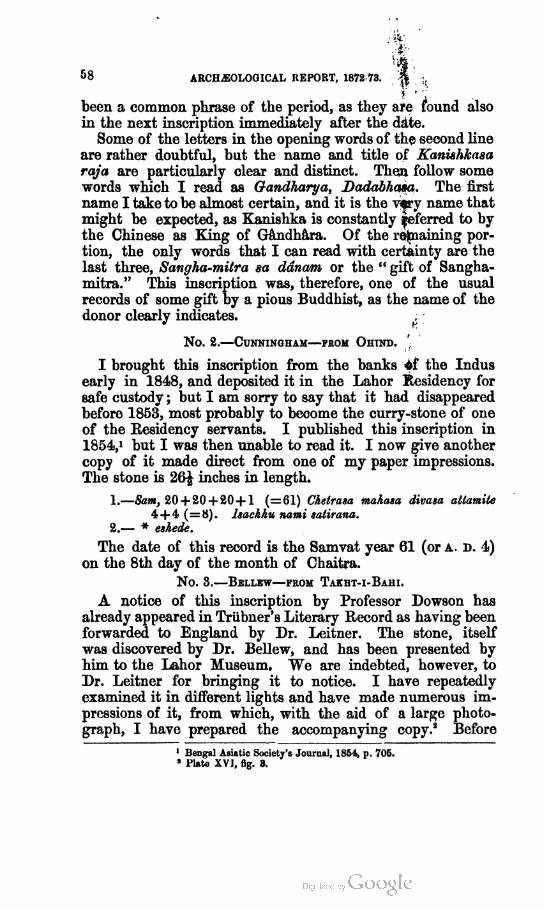
58 ARCHAEOLOGICAL REPORT, 1872 73.
--ft:
been a common phrase of the period, as they are found also
in the next inscription immediately after the date.
Some of the letters in the opening words of the second line
are rather doubtful, but the name and title of Kaniahkasa
raja are particularly clear and distinct. Then follow some
words which I read as Gandharya, Dadabhaaa. The first
name I take to be almost certain, and it is the very name that
might be expected, as Kanishka is constantly Referred to by
the Chinese as King of Gandhara. Of the remaining por
tion, the only words that I can read with certainty are the
last three, Sangha-mitra sa ddnam or the " gift of Sangha-
mitra." This inscription was, therefore, one of the usual
records of some gift by a pious Buddhist, as the name of the
donor clearly indicates.
No. 2.—Cunningham—from Ohtnd. ';
I brought this inscription from the banks <tf the Indus
early in 1848, and deposited it in the Lahor Residency for
safe custody ; but I am sorry to say that it had disappeared
before 1853, most probably to become the curry-stone of one
of the Eesidency servants. I published this inscription in
1854,> but I was then unable to read it. I now give another
copy of it made direct from one of my paper impressions.
The stone is 26£ inches in length.
1.—Sam, 20+20 + 20+ 1 (=61) Chetrasa mahasa divasa atlamile
4 + 4 (=8). hachhu aami satliana.
2.— * eshede.
The date of this record is the Samvat year 61 (or a,, d. 4)
on the 8th day of the month of Chaitra.
No. 3.—Bellew—from Takht-i-Bahi.
A notice of this inscription by Professor Dowson has
already appeared in Triibner's Literary Record as having been
forwarded to England by Dr. Leitner. The stone, itself
was discovered by Dr. Bellew, and has been presented by
him to the Lahor Museum. We are indebted, however, to
Dr. Leitner for bringing it to notice. I have repeatedly
examined it in different lights and have made numerous im
pressions of it, from which, with the aid of a large photo
graph, I have prepared the accompanying copy.2 Before
1 Bengal Asiatic Society's Journal, 1831, p. 705.
• Plate XVI, fig. 3.
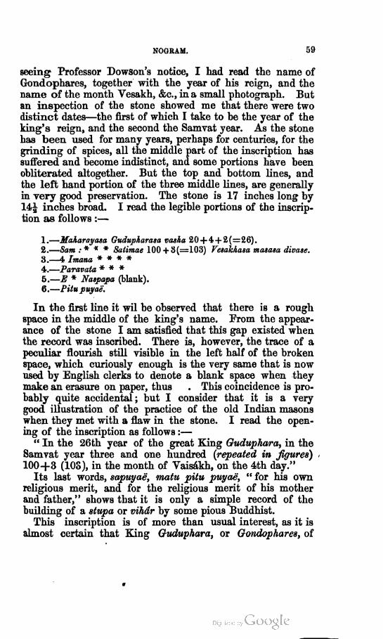
NOGRAM. 59
seeing Professor Dowson's notice, I had read the name of
Gondophares, together with the year of his reign, and the
name of the month Vesakh, &c., in a small photograph. But
an inspection of the stone showed me that there were two
distinct dates—the first of which I take to be the year of the
king's reign, and the second the Samvat year. As the stone
has been used for many years, perhaps for centuries, for the
grinding of spices, all the middle part of the inscription has
suffered and become indistinct, and some portions have been
obliterated altogether. But the top and bottom bines, and
the left hand portion of the three middle lines, are generally
in very good preservation. The stone is 17 inches long by
14£ inches broad. I read the legible portions of the inscrip
tion as follows :—
1.—Maharayasa Gudupharasa rasha 20 +4 + <J(=26).
2.—Sam:* * * Satimae 100 + 3 (=103) Fesakhasa masasa divase.
3.—4 Imana * * * *
4.—Paravata * * *
5.—E * Naspapa (blank).
6.—Pitupuyae.
In the first line it wil be observed that there is a rough
space in the middle of the king's name. From the appear
ance of the stone I am satisfied that this gap existed when
the record was inscribed. There is, however, the trace of a
peculiar flourish still visible in the left half of the broken
space, which curiously enough is the very same that is now
used by English clerks to denote a blank space when they
make an erasure on paper, thus . This coincidence is pro
bably quite accidental; but I consider that it is a very
good illustration of the practice of the old Indian masons
when they met with a flaw in the stone. I read the open
ing of the inscription as follows :—
" In the 26th year of the great King Guduphara, in the
Samvat year three and one hundred (repeated in figures)
100+3 (103), in the month of Vaisakh, on the 4th day."
Its last words, sapuyae, matu pitu puyae, " for his own
religious merit, and for the religious merit of his mother
and father," shows that it is only a simple record of the
building of a stupa or vihdr by some pious Buddhist.
This inscription is of more than usual interest, as it is
almost certain that King Guduphara, or Gondophares, of

60 ARCH.EOLOGICAL REPORT, 1872-73.
the coins is the same as King Gundoferna of the Saxon
Legenda Aurea, who is recorded to have put St. Thomas to
death. This identification, which is, I believe, generally
admitted as certain, although not proved, is of especial
value in determining the era that is used in all these
inscriptions. I have already assumed that the Samvat of
Kanishka, Huvishka, and Vasu-Deva is the same as the
present Vikramaditya Samvat of India, as the dates of their
inscriptions, if referred to this era, correspond exactly with
the known dates which have been ascertained from other
sources. The very same inference may be drawn in the
present case, as the date of Samvat 103, or A. D. 46, will
make King Gondophares an actual contemporary of St.
Thomas, with whom he is always connected in the ancient
legends. According to this view the reign of Gondophares
must have begun in A. D. 21, and as his coins are abundant
he may be supposed to have reigned for at least 30 years. His
death would thus have taken place in A. D. 51, or perhaps a
few years later. That Gondophares was a contemporary of
the Parthian king Artabanus III we have a distinct proof
in some silver drachms of that king which are counter-
marked with the peculiar monogram of Gondophares. Now,
Artabanus reigned from A. D. 14 to 42, which agrees exactly
with the period assigned to Gondophares on the authority
of the legend.
There are two distinct versions of the legend of St. Thomas
and King Gondophares—the one preserved in the " Legend
Aurea,1 " and the other in the Apocryphal Acts of the
Apostles written by Leucius and his copyist Abdias.* In
the first version the apostle is said to have converted the
sister of the king's wife, named Migdonia, for which he was
thrown into prison, and afterwards put to death. In the other
version St. Thomas is sold to Gundophares as a slave, and is
said to have converted the king himself. He then left
Gundophares and went to the country of King Meodeiis, by
whom he was eventually put to death. The scene of his death
is said to have been the city of Calamina in India.3"
1 See Turner's Anglo-Saxons, Vol. II, p. 147, note, and Mrs. Jameson's Sacred and Legen
dary Art, Vol. I, pp. 225-6.
5 See Fabrieius' Codex Apocryphus Novi Testament], and Yule's Catbay, Vol. II, p. 376
where a short version of the legend is given.
3 Sophronius C. VIII " Dormivit in civitate Calaminn, qure est India.

NOGRAM. 61
No. 4.—Cunningham—from Panjtar.
I brought this inscription from the banks of the Indus in
1848, and deposited it along with No. 2 in the Lahor
Residency, where it no doubt shared the same fate as the
other as it has not been seen since. I published it in 1854, but
the date of the reading then given was afterwards corrected
by myself;1 and as the remarks which accompanied my
corrected reading apply equally to the important date in the
inscription of Gondophares just given, I will repeat them
here in justification of the value of 100 which I have as
signed to one of the symbols. " In the remarks on my
Yusufzai inscription from Panjtar I have read the date as
the year 122, the only doubtful figure being that for hundreds,
which I have taken as 100, on the ground that the power
of the Yuchi kings, according to the Chinese, did not last
beyond the beginning of the 3rd century of the Christian
era. Since writing these remarks I have referred to
Gesenins,2 where I find the fullest confirmation of the value
which I have assigned to the centenary figure. The con
tracted word earn for Samvat, " year," is followed by an
upright stroke, which in Phoenician, Aramseo Egyptian, and
Palmyrenian is the index for hundreds, the two symbols to
gether signifying simply one hundred, as £1 signifies one
pound."
I have also made another important correction in my
previous reading of masa sudi prathame, which should be
masasa di prathame, where di is the usual contraction for
divasa or " day." The reading now given is quite certain,
and means simply the "first day of the month." This
correction is of considerable importance, as the form corres
ponds with that of all the Arian inscriptions hitherto
discovered in the use of the solar reckoning of 30 days to
the month, instead of the lunar reckoning by the bright and
dark fortnights of the moon, as in the first erroneous read
ing. The following is a transliteration of this short record :—
1.—Sam. 100 + 20 + 20 ( = 122) Sravanasa masasa di prat/tame 1,
Maharayasa Gushanasa Ra.*
2.—Spesam asa praii * * mo Ika anlumujaputra kaira videsi vathala-
khatra deme.
8.—Dana mitra raka 2 panya karena vaha makhu sirathala bama **
- Bengal Asiatic Society's Journal, 1854, p. 705, anil Ibid, 1868, pp. 145, 150.
' Monumenta Phoenicia?, pp. 88, 89.
S

62 ARCMOLOGICAL REPORT, 1872-73.
It is very unfortunate that the name of the king is broken
off at the end of the first line, the initial letter 22, or perhaps
N, being the only one unmutilated. The second letter,
which is very doubtful, may be either re, or ha or we. The
date points to one of the successors of Gondophares ; but
the only names at present known are those of Abdagases,
Orthagnes, Sasan, and Pakores. It is very doubtful, how
ever, whether Orthagnes and Pakores reigned in Gandhara,
and no portion of either of the names can be traced in
the few doubtful letters of the inscription. The title of
Maharayasa Gushanasa, or " king of the Gushan tribe," is
already known from the Manikyala inscription of Court's
Tope and the coins of Kujula Kadaphes, or Kadphizes. On
the coins, however, the tribal name is written Kushan and
Khushan, which I have identified with the Kuei-Shwang of
the Chinese authors. To this powerful race belonged Ka-
nishka, Huvishka, and Vasu Deva, the last of whom was
still reigning in Samvat 98, or only 24 years prior to the
date of this inscription.1 It is probable, therefore, that it
may belong to one of Vasu Deva's immediate successors ; and
if his family may be identified with the Pauranic Kanwayas,
as I have already suggested, then the name of the reigning
king in Samvat 122, or A. D. 65, would have been Ndrdyana.
Now, as the first two letters of the name may be read as
Nare, it is quite possible that the name of the king recorded
in this inscription may have been Ndrdin, which is the com
mon spoken form of Ndrdyan. In the Jain books this king
is apparently represented by Nailla, which is only another
form of Ndrdyana derived through the abbreviated Naina,
of which we have a well-known example in the name of
Naini Devi, for Ndrdyani Devi, who gives her name to
Naini-Tal. Of the remaining portion of the inscription I
am not able to offer any account.
No. 5.—Cunningham—feom Saddo in Suwat.
The village of Saddo is situated on the left or eastern bank
of the Malizai Sin, or Panjkora River, and 25 miles to the
north of the British boundary. The inscription is engraved
on a rock in large letters. The copy taken by my servants
was made under great difficulties, and not without danger.*
It is therefore much less distinct and complete than it would
1 Archteological Survey of India, Vol. Ill, pp. 42—13.
8 The same men procured copies of an inscription of Kamran, the rebellious brother of
Humayun, from Ayasera in Bajawar, 16 miles to tbe north of Saddo and 40 miles beyond
the British frontier.
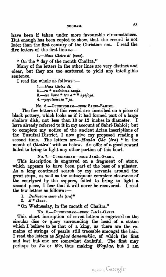
NOGRAM.63
have been if taken under more favourable circumstances.
But enough has been copied to show, that the record is not
later than the first century of the Christian era. I read the
five letters of the first line as—
1.—Mam Chetra di (vase).
" On the * day of the month Chaitra."
Many of the letters in the other lines are very distinct and
clear, but they are too scattered to yield any intelligible
sentence.
I read the whole as follows :—
1.—Masa Chetra di.
2.—ru * mudelama samja.
3.—esa liana * tra a * * nyajoya.
4.—yegatuheaw * ja.
No. 6.—Cunningham—from Sahri-Bahlol.
The few letters of this record are inscribed on a piece of
black pottery, which looks as if it had formed part of a large
shallow dish, not less than 10 or 12 inches in diameter. I
have already referred to it in my account of Sahri-Bahlol ; but
to complete my notice of the ancient Arian inscriptions of
the Yusufzai District, I now give my proposed reading a
second time. The letters are—Magha Che (tra) " in the
month of Chaitra" with sa below. An offer of a good reward
failed to bring to light any other portion of this bowl.
No. 7.—Cunningham—prom Jamal-Garhi.
This inscription is engraved on a fragment of stone,
which appears to have been part of the base of a pilaster.
As a long continued search by my servants around the
great stupa, as well as the subsequent complete clearance of
the courtyard by the sappers, failed to bring to light a
second piece, I fear that it will never be recovered. I read
the few letters as follows :—
1. Budhavara masa che (tra)*
2. E * thuna.
" On Wednesday, in the month of Chaitra."
No 8.—Cunningham—feom Jamal-Garhi.
This short inscription of seven letters is engraved on the
circular disc or glory surrounding the head of a statue
which I believe to be that of a king, as there are the re
mains of strings of pearls still traceable amongst the hair.
I read the letters as Saphae danamukha, of which the first
and last but one are somewhat doubtful. The first may
perhaps be Va or Wa, thus making Waphae, but I am

64 ARCHAEOLOGICAL REPORT, 1872-73.
inclined to prefer the value of sa. I take Danamukha to be
the name of the king ; but I cannot even guess at the pro
bable meaning of the term Saphae which precedes it.
I have also observed the following Arian letters on the bas-
reliefs, a, b, de, he, ho, j, kh, n, p, r, th, ti, tr, which are
evidently only mason's marks, besides the figures 1, 2, 4.
As no Indian letters have been found upon any of them, I
conclude that the whole of the sculptures must belong to
the two centuries before and after the Christian era, as the
Arian characters are known to have fallen into disuse about
A. D. 100 or a little later.
KHAIRABAD.
One of the most important places on the western bank of
the Indus in ancient times would appear to have been the
great fort of Khairabad, opposite Attak, which is well known
to all the people on both banks of the river as the strong
hold of Raja JELodi or TJdi. It was first brought to notice
by General Court, who says that its foundation was attri
buted to Raja Hodh? and it has since been described by
Lowenthal, who speaks of the tradition about Raja Hodi or
TJdi, extending to the " topes and altars in the neighbourhood
of Amerakhel, near the Surkhab« " Of Raja Hudi or TJdi
Masson says : " This prince has attained a great traditionary
fame in the countries between Jalalabad and the Hydaspes." "
But the name is not limited by the Hydaspes, as the large
ruined city of Asarur is also said to have been called Udam-
nagar, or Udinagar.* Lowenthal suggests that the name
may have been derived from that of the district of JJdydna
or the " garden," and he quotes Vivien de St. Martin for
ihe extension of this name to Jalalabad on the west and to
Hasan Abdal on the east. But this extension of the name
of TJdyana to the west is, I believe, entirely founded on the
possible identity of the modern Adinapur with the ancient
Udyana, which seems to me to be quite untenable. I have
doubts also of its extension to the east beyond the Indus, as
I know of no authority for its application to Hasan Abdal
as stated by St. Martin. But even admitting that it was so
applied, this will not account for the attachment of the
name of Raja Hudi to the ruins of Darapur on the Jhelam,
and to those of Asarur, near Sangala, to the west of Lahor.
1 Bengal Asiatic Society's Journal, Vol. V, p. 395.
3 „ „ „ 1863, p. 17.
3 Ariana Antiqua, p, 105.
* Archaeological Survey of India, Cunningham, Vol. II, p. 200.
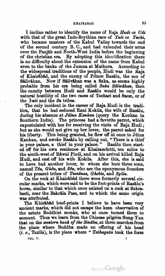
KHAIRABAD. 65
I incline rather to identify the name of Raja Hudi or Udi
with that of the great Indo-Scythian race of Yuti or Yuchi,
who became masters of the Kabul Valley towards the end
of the second century B. C, and had extended their arms
over the Panjab and North-West India before the beginning
of the christian era. By adopting this identification there
is no difficulty about the extension of the name from Kabul
even to the banks of the Jumna at Mathura. According to
the widespread traditions of the people, Hudi was the Raja
of Khairabad, and the enemy of Prince Rasalu, the son of
Salivahan. Now if Salivahan was a Saka, as seems highly
probable from his era being called Saka Sdlivdhan, then
the enmity between Hudi and Rasalu would be only the
natural hostility of the two races of Tochari and Sacse, or of
the luti and the Su tribes.
The only incident in the career of Raja Hudi is the tradi
tion, that he had seduced Rani Kokila, the wife of Rasalu,
during his absence at Julna Kankan (query the Konkan in
Southern India). The princess had a favorite parrot, which
expostulated with her for receiving the visits of Raja Hudi ;
but as she would not give up her lover, the parrot asked for
his liberty. This being granted, he flew off at once to Julna
Kankan, and awoke Rasalu by calling out, " There is a thief
in your palace, a thief in your palace. " Rasalu then start
ed off for his own residence at Khairamurtti, ten miles to
the south-west of Rawal Pindi, and on his arrival killed Raja
Hudi, and cast off his wife Kokila. After this, she is said
to have had another lover, to whom she bore three sons,
named Teu, GhSu, and Seu, who are the eponymous founders
of the present tribes of Tuwdnas, Ghebis, and Sydls.
On the rock at Khairabad there were formerly several cir
cular marks, which were said to be the foot-prints of Rasalu's
horse, similar to that which once existed on a rock at Sakra-
basti, near the Bakrala Pass, and to which the same origin
was attributed.
The Khirabad hoof-prints I believe to have been very
ancient marks, which did not escape the keen observation of
the astute Buddhist monks, who at once turned them to
account. Thus we learn from the Chinese pilgrim Sung-Yun
that on the western bank of the Sindhu, at three marches from
the place where Buddha made an offering of his head
(i. e., Taxila), is the place where " Tathagata took the form
VOL. v. I

C6 ARCHAEOLOGICAL REPORT, 1872-73.
of a great fish called Ma-Kie (i. <?., Makara), and for twelve
years supported the people with his flesh. On this spot is
raised a memorial tower. On the rock are still to be seen
the traces of the scales of the fish '."
All remains of the memorial tower have long since dis
appeared; but the circular marks were in existence a few
years ago, and they are still remembered as the hoof-prints
of Raja Rasalu, while by others they are called either the
foot-prints of Raja Man, or the hoof-prints of his horse.
But this last name of Man I take to be only a slight altera
tion of the old Buddhist legend of the fish {Mahi or Makara).
This fish incarnation of Buddha is not mentioned by
either of the other pilgrims, Fa Hian or Hwen-Thsang ; but
the scene of its occurrence is sufficiently well marked by
Sung-Yun, as three days to the west of Taxila, and the same
distance to the east of Fo-sha-fu, which I have identified with
Shahbaz-garhi. I believe that Khairabad satisfies these con
ditions better than any other place on the Indus.
SHAHDHERT OR TAXILA.
In my previous account of the ruins at Shahdheri, I gave
some very strong reasons for its identification with the ancient
Taxila2. These may be summed up under two heads : 1st,
that the Chinese pilgrims are unanimous in placing the city
three marches to the east of the Indus, which agrees exactly
with the position of Shahdheri ; and, 2nd, that the ruins
about Shahdheri are so much more extensive than those of
any other site between the Indus and the Hydaspes, that
they can only be the remains of the ancient capital of the
country which the Greeks called Taxila and the Hindus
Takkasila and Takshasila. This identification I proposed
just nine years ago, and a second visit to the site, which I
have now made, has only strengthened my conviction of its
truth. To the several significant names which I first gave3,
I can now add that of Hatidl or Athidl, which is still given to
the lower hill immediately above the city. This hill I would
1 Beal's Snng-Yun, p. 200.
3 Archfcolopicul Survey of India, Vol. II, p. Ill,
* These were—1st, Babar Khdna, or the " Tiger's house, " the site of the temple where
Buddha gave his head to a hungry tiger ; 2nd, Mdrgala, or the " beheaded, " from
Qala-mdrna to " behead," becanse Buddha cut off his head to present it to the tiger ; 3rd,
Sir-ka-Pind, or the "head mound," which I take to have been the remains of some monu
ment raised to commemorate thelegend of the "head gift."
SHAHDHERI OR TAXILA. 67
identify with the temple of " Collected Bones," mentioned
by the Chinese pilgrim Sung-Yun. According to his text,
the site of this temple was the place where Buddha made
an offering of his body, which I have already shown to be
Manikyala. His words are1—" From the royal city going
south-east over a mountainous district, eight days' journey,
we come to the place where Tathagata, practising austerities,
gave up his body to feed a starving tiger. It is a high
mountain, with scarped precipices and towering peaks that
pierced the clouds." Now, there is no hill of any kind
either at Manikyala, or at any place within many miles
of it. But this mountain is the chief feature of the place
referred to, as " Sung-Yun and Hoei Seng devoted a portion
of their travelling funds to erect a pagoda on the crest of
the hill, and they inscribed on a stone in the square char
acter an account of the great merits of the Wei dynasty.
"This mountain also possessed the temple called " Collected
Bones.2" As we cannot get rid of the mountain, it is clear
that this was not the scene "where Buddha gave up his
body to feed a starving tiger;" I would therefore suggest
that instead of "body" we should read "head," and transfer
the scene to Shahdheri, or Taxila, where the lofty fortified
hill of Sur-garh, with its precipices, overlooks the ancient city.
Now the lower half of this hill, which has once been covered
with buildings, is still called Hati&l or Athidl, a name which
may be referred either to the Sanskrit Asthydla or Athidl,
or to the Hindi Haddial, both of which mean the " place of
bones." It is probably the Hattidr Lank of Abul Fazl,
which he places in the Sindh Sagur Doab.
To this identification I can also add the still stronger
evidence afforded by the Taxila copper-plate inscription of
the Satrap Liako Kujuluka. In this record he states that
he was the " Satrap of Chhahara and Chukhsa to the north
east of the city of Takhasila." Now we know from the
enquiries of Mr. Delmerick, that this copper-plate was found
in the village of Thupkia, in the middle of the ruined city
of Sir-sukh. As this old city lies to the north-east of Sir-
kap, it follows that Sir-kap must be Taxila, as I have already
i Beal's Sung Yun, page 193 The eight days' journey are to be reckoned from the
capital of Suw&t. Romusat makes the pilgrims put up a statue in the Yihar, in front of
the mountain. Sec also Laidlay, page 50, note at bottom of page.
- Jbid, psigc 193.

68 ARCHAEOLOGICAL REPORT, 1872-73.
attempted to prove, and that Sir-sukh must be Chhahara
Chukhsa. In fact, if we read Shahara Sukhsa, after the
example of Chhatrapasa for Satrap, then Sahar-sukh will be
almost an exact transcript of Chhahar Chukhs. I have spelt
the names as Sir-kap and Sir-sukh, because the people are
unanimous in their belief that Sir-kap was in the habit of
cutting off heads ; but the common pronunciation of Shahr is
like Ser or Sir. Thus, General James Abbott writes Shihr as
the Panjabi pronunciation of Shahr.
I have already, in a previous report1, described the different
parts of the ruins around Shah-dheri, which I believe to have
constituted the ancient Taxila. But during my late visit to
the place I was able to make several excavations, which have
cleared up many doubtful points as to the external appearance
and internal arrangement of Buddhist Vihars, and have
brought to light the bases and capitals of some Ionic columns
of pure Greek design. Both results are valuable, as no large
Vihars have yet been excavated to the west of the Indus ;
while the Ionic bases and capitals are the only specimens of
this style that have yet been found in India, as the whole of
the buildings exhumed in the Yusufzai district are ornament
ed with pilasters of the Corinthian style.
The village of Mohra-Malidr is situated three quarters of
a mile to the north-east of Shah-dheri, and 500 yards to the
west of the old city of Sir-kap, which was the actual city of
Taxila. Between the two runs the Tabra or Tamra Nala,
on the left bank of which, to the north of the village, and
high above the stream, stands the old mound of the Ionic
temple. The position is a very fine one, as it commands an
extensive view of the surrounding ruins, with the Balar
Tope to the north, and the lofty hills of Margala and Hasan
Abdal to the east and west. In my former report I noticed
that the base of a sandstone pillar of pure Greek style had
been discovered by the people of Mohra-Maliar, who have
used the mound as a quarry ever since their village was estab
lished. All the upper walls had thus disappeared long ago ;
but the subsequent discovery of three more sandstone bases by
Mr. Delmerick showed that the foundations and some por
tions of the superstructure still remained to be exhumed.
I therefore determined on clearing out the interior, with the
Arctueological Survey of India, Vol. Ill, p. 111.

SHAHDHERI OR TAXILA. 69
view of finding the shafts and capitals of the Ionic pillars,
and of ascertaining the use and purpose of the building.
My explorations were successful in both of these points,
and the discovery of several portions of Ionic capitals is of
special interest and value, as this is the only instance in
which any remains of the Ionic order of Greek architecture
have yet been found in India.
In the accompanying plates1 1 have given the result of
my explorations, which disclose the remains of a Buddhist
temple of the Ionic order of architecture. The temple
itself was 91 feet long by 64 feet broad, with its entrance on
the eastern side towards the city. It was raised on a
elevated platform, which gave a clear width of 15 feet all
round the building. The exact object of this platform is
not certain. My first impression was, that it was a mere
terrace intended to give additional height ; but as all the
villagers agreed that numerous pieces of plaster statues had
been found outside the back wall of the temple at D, it
seems almost certain that this terrace must have been a
roofed cloister or colonnade which surrounded the whole
building.
The entrance to the temple was on the east side, through
a portico of four massive sandstone pillars of the Ionic order
into a hall 39J feet long by 15f feet broad, marked A.
There is nothing to show the purpose of this room, which
would appear to have been a mere entrance hall, on each
side of which there was a small room, 20^ x 15f feet, marked
B, which were most probably the residences of two attendant
monks. On the west side a wide doorway led into the
sanctum of the temple, which was a long room, 79 feet by
23^ feet, marked C. This room was entirely surrounded by
a continuous pedestal or basement for statues, which was
4 feet 8£ inches broad and 2 feet high. The central portion
of this part of the temple had been previously excavated by
a well-known digger for antiquities, named Nur, who found
numerous pieces of large plaster statues, and a considerable
quantity of gold leaf. Here I discovered the foundations of
two pillars, of which the bases had been previously removed.
But I found several portions of their circular shafts, as well
as large pieces of their capitals, with the usual volutes of the
1 Plates XVII mid XVJU.

70 ARCHAEOLOGICAL REPORT, 1872-73.
Greek Ionic order. I also obtained some gold leaf, and
small fragments of plaster statues.
The plaster statues were all Buddhist, with curly hair, and
hands in the lap or raised in the attitude of teaching. I
must confess that I was disappointed at this result, as I had
hoped, from the presence of the Ionic pillars, that the build
ing would prove to be a pure Greek temple dedicated to the
worship of the Greek gods. There is, however, no doubt
that it was a Buddhist Vihar, adorned with pure Greek Ionic
columns.
The lower diameter of each pillar was 2 feet 4^ inches,
which, at the usual proportion of 9 diameters, would give a
total height of rather more than 21 feet. The mouldings of
the base are accurately given in the accompanying plate,
from a clay cast which was taken with considerable care.
The bases which have been found are all of sandstone, and
belong to the four pillars of the entrance porch ; but the
pieces of capital are all of kankar, or kanjur as it is called in
the Panjab, and were found in the inner room. From their
rough state it seems certain that they must originally have
been plastered. This would increase the upper diameter
from 19 inches to 20 or 21 inches : but as this would still
leave a difference of 7J inches between the upper and lower
diameters, which is much too great for any known amount
of diminution, I conclude that the two inner pillars must have
been of somewhat smaller size than the four outer ones. I
found no less than eleven pieces of circular shaft, giving a
total height of 8 feet 4^ inches, of which the largest dia
meter was 25 inches, and the smallest only 18 inches. But
as all the larger pieces were found in the village and all the
smaller pieces inside the temple, I conclude that the former
must have belonged to the four larger pillars of the entrance
porch, and the smaller pieces to the two inner pillars.
The bases of these columns correspond exactly with the
pure Attic base, which was very commonly used with the
Ionic order, as in the Erectheium at Athens. But the
capitals differ from the usual Greek forms very considerably,
and more especially in the extreme height of the abacus.
The volutes also differ, but they present the same side views
of a baluster, which is common to all the Greek forms of
the Ionic order. Altogether this unique specimen of the
Indian Ionic seems to me to be of a ruder and more primitive
SHAHDHERI OR TAXILA. 71
type than any of the pure Greek examples to which I have
access.
I have been much puzzled as to the nature and style of
the roof of this temple. As timber must have been easily
procurable in the valley of the Haro river, I conclude that
the main portion of the roof was of wood. But the object
of the pillars is not at all clear. The two inner pillars in the
sanctum most probably supported a gorgeous canopy over
the principal figure of Buddha, which would have been
placed against the middle of the back wall. The room must
then have been lighted by windows, as we know to have
been the case with the smaller temples both at Takht-i-Bahi
and Jamal-garhi. With regard to the four pillars in front,
I think that they must have been intended to support a
vaulted roof presenting a pointed arch gable to the front, as
in the smaller chapels across the Indus. The extra height
thus gained, would have admitted the rising sun to illuminate
the middle figure in the sanctum, which would appear to
have been the principal object of the builder in every
Buddhist temple. I suspect, however, that the principal
statue of the Vihar must have been enshrined under the
four pillars at the entrance.
In my former report I suggested that this temple on the
Maliar mound might possibly be the ruins of the temple
described by Philostratus, in which he and his fellow
traveller Damis waited until their arrival was made known
to Phraotes, the King of Taxila. The position and the
dimensions agree very well ; but time has left us no means
of judging whether any other parts of the description were
applicable or not. The account of Philostratus is as follows1 :
" Before the walls of the city stood a temple, whose dimen
sions were nearly 100 feet, built of porphyry, within which
was a chapel, too small in proportion to the size of the
temple, which was large, spacious, and surrounded with
pillars ; but, notwithstanding, the chapel was worthy of
admiration." Tablets of brass were hung on the walls with
becoming inscriptions, representing the deeds of Alexander
and Porus, in orichalcum, and silver, and gold, and bronze.
The elephants, houses, soldiers, helmets, shields, spears, and
javelins, were all represented in iron. It is just possible
i Vita Apollouii, II, 20.

74 ARCHJIOLOGICAL REPORT, 1872-73.
Near the north end of the city of Sir-kap there is
another variety of temple, which was described in my former
report as No. 281. I now give a plan of the building with
its curious circular pit, 32 feet in diameter and 18 feet deep*.
This pit communicates on its east side with a large room,
43 feet 4 inches long and 32 feet broad, which I take to have
been a hall of statues, as I found in clearing it numerous
pieces of burnt clay statues of colossal size. The statues
would have been arranged round the four sides, as they were
in the central rooms of the other Vihars at Taxila, which I
have just described, and as they still are in Burma. This
room was connected with the circular pit by a grand door
way, 14 feet wide. The walls of the pit are plastered, and
its floor is solidly paved with rough stones to a depth of
more than 4 feet. As to the purpose of this pit, I can
make no probable conjecture. It may have been a bath or
reservoir for water, or a granary ; but the great width of
the doorway leading into the hall of statues is against both
of these suppositions ; and the only other possible use that
I can suggest is that it may have been the receptacle either
of a stupa, or of a colossal statue of Buddha.
In Plate XX I have given a plan of a great monastery
surrounding the ruins of a stupa, marked No. 40 in my map
of the ruins of Taxila, which was upwards of 40 feet in
diameter. This central stupa was surrounded by an open
cloister, 8 feet wide, forming a square of 90 feet, behind
which were the cells of the monks, each 9^ feet broad and
14| feet long. The outer wall of the monastery was 3 feet,
and the inner wall 2 feet thick ; the whole building forming
a square of 145 feet outside. The entrance was in the cen
tre of the south face, towards the city of Sir-kap. As it
stands in the very midst of the lands now called Babar
Khdna, or " House of the Tiger," I have suggested that it
may have been the famous monument which Asoka erected
on the spot where Buddha had made an offering of his head
to appease the hunger of a starving tiger.
It will be observed that the four corner rooms of this
monastery are square, and therefore could not have had any
direct openings to the light. On this account I believe
that these four rooms were the basement storeys of the
1 See Archaeological Survey of India, Vol. II, Plate 57 and p. 126.
3 Plato XIX.

MAN1KYALA. 75
corner pavilions mentioned by Hwen-Thsang1. " The san-
ghdrdmas (or monasteries), he says, are built with ex
traordinary art. At the four corners they have pavilions
of three or four storeys." The possession of a verandah
or cloister also leads me to infer that there must have
been a second storey to the cells, as the roof of the cloister
would have given ready access to the rooms of the upper
storey. Allowing only one person to each room, this double
storied monastery could have contained about 60 monks.
In Plate XX I have given a sketch of a Buddhist railing
pillar which I excavated from the great mound of Seri-ka-
Pind, which is marked No. 42 in my map of the Ruins of
Taxila. This pillar is only 18^ inches in height, and 3^
inches broad by 3 inches thick. But, though small, it is of
a novel pattern, different from any other that I have yet
seen. The front face is bevelled on both edges in the usual
manner, but the sockets for the reception of the rails are
curved only in front, with a flat back instead of the usual
double segments. On the back there is an Arian letter,
which looks like tre, and may possibly be intended for the
number of the pillar.
MANIKYALA.
"When I visited the Manikyala Tope in the end of 1863,
I made some excavations at different points around the base,
which showed me that there was once a broad terrace orna
mented with pilasters which completely surrounded the
monument. I therefore made a request to my old and kind
friend, Sir Donald McLeod, then Lieutenant-Governor of
the Panjab, that he would order the whole of this lower
part of the tope to be uncovered, and the ground for some
distance to be cleared and levelled. This work was accord
ingly done at once ; and when I visited Manikyala early in
the present year, I made fresh measurements of the whole
building and examined it carefully throughout. The de
scription and drawings which I am now able to give, may
therefore be depended upon for the fullness and accuracy of
the details.
The great tope of Manikyala is a hemisphere 127 feet
9 inches in diameter, resting on a cylindrical neck, 15 feet
1 Julien's Hwen-Thsang, II, 66.

76 ARCHAEOLOGICAL REPORT, 1872-73.
in height1. This is surrounded by a raised terrace 18f feet
in breadth, and 13 feet 4f inches in height. The total
height of the dome, as it now stands, is therefore 92 feet
3£ inches*. Four broad flights of steps facing the cardinal
points led to the top of the terrace for the perambulation of
the tope by pilgrims. The side walls of the staircases were
covered with a massive coping3. The whole was most
probably surrounded with a Buddhist railing, but after a
most minute search I found no traces of any pillars and
only one fragment of rail, which was 3^ inches thick in
the middle, and about 16 inches broad. Allowing three rails
with intervals of 4 inches, and a coping of 16 inches, the
total height of the railing, including 6 inches for a plinth,
would have been about 7 feet4.
The great mass of the tope is built of huge rough blocks
of sandstone inside, with a carefully-smoothed facing of
kankar outside the dome, and of sandstone in the spaces
between the pilasters, both of the cylindrical neck and of
the terrace plinth.
The stones are of many colours—dirty yellow, dirty red,
and grey. All the mouldings and all the pilasters, except
ing only the shafts and bases of the upper row, are made of
kankar blocks. The outer faces of all the stones have been
worked smooth, but the inner faces show the chisel marks
as sharp as when they were first cut. Prom this mixture of
stones I conclude that the tope must have been built of
sandstone originally, and was afterwards extensively repaired
with kankar blocks in all its lines of mouldings, in the
capitals of all the pilasters, and in the entire facing of the
dome.
Behind the frieze which surmounts the upper row of
pilasters, there is one worked stone built into the body of
the tope. Its mouldings are of the same character as those
of the frieze itself, but their arrangement is different, and
their depth greater. The frieze of the tope has only 5
inches of moulded lines, with a plain face of 7 inches;
whereas the single block has 7 inches of moulded lines,
with only 5 inches of plain face.
i Mr. Fergusson, History of Architecture, II, 468, makes the dome spring from the
top of the upper line of pilasters; hat I have again very carefully examined the space
above the pilasters, and I am quite satisfied that the dome springs from the upper line of
moulding, which is more than 7 feet above the capital of the pilasters,
2 See Plate XXI for a plan, and Plate XXII for an elevation and section of the tope.
3 See Plate XXIII for a view of one of these staircases.
4 See Plate XXIII for a sketch of this fragment of Buddhist rail.

MANIKYALA. 77
For the course immediately above the frieze the blocks at
the back were under-cut to receive them, thus—
with the view, as I suppose, of securing them more firmly
in their places. As this under-cutting would have been
Juite unnecessary at the original construction of the tope,
conclude that the building must have been extensively
repaired at some subsequent period, when the facing of the
dome and all the mouldings and capitals were renewed with
kankar blocks.
The carving of the capitals has suffered so much from the
weather that I found it quite impossible to obtain any satis
factory drawing of the details. Enough, however, remains
to show that the pilasters were of the Indo-Corinthian style,
similar to those of Takht-i-Bahi and Jamal-garhi. The
result of my examination is shown in the accompanying
plate1, where the broad masses of acanthus foliage are still
plainly visible. Each pilaster was covered with a long
bracket capital in addition to its own low abacus. Experience
had, no doubt, shown that this addition was absolutely neces
sary to assist in carrying the weight of the frieze where the
intercolumniations were purposely enlarged to admit statues
of Buddha between the pillars.
This great tope was opened in 1830 by General Ventura,
and the account of its exploration was first published by
"Wilson and afterwards by Prinsep*. Erom this account it
would appear that the lowest deposit, marked C in my
section3, which was discovered just below the centre of
hemisphere, was certainly intact, as it contained nothing
later than the age of Hoverke or Huvishka. The single
gold coin, as well as three out of the five copper coins
of this deposit, belonged to him, the other two being
of his predecessor, Kanerke or Kanishka. "With these
coins there were also found a brass cylindrical casket,
with an Arian inscription around the lid, and a small
circular piece of silver with two lines of Arian letters on
i See Plate XXIV of M&uikyala mouldings.
8 Bengal Asiatic Society's Transactions, XVII, 601; and Bengal Asiatic Society's
Journal, III. 316. '
3 See Plate XXII.

78 ARCHAEOLOGICAL REPORT, 1872-73.
one side. The presence of Arian writing, unmixed with
anything of later date, is another proof of the early period
of this deposit, as I know of no example of Arian writing
of a later date than the end of the first century A.D.
Two other deposits, marked respectively A and B in my
section, also contained coins of Kanishka and Huvishka;
but those of A were mixed with others of a much later date,
while three broken Sassanian coins are said to have been found
below B. As all these later coins belong to the same period,
I conclude that the extensive repairs of the tope, and the
consequent disturbance of the upper deposits of Huvishka's
time, may be referred to the date of these coins. The close
agreement of their dates is very remarkable.
One silver Sassanian coin of Khusru, with Bismillah,
632 to 690 A. D.
One gold coin of Yaso Varmma of Kanoj, 700 to 730
A.D.
Two silver trilingual coins with sun-god of Multan, 600
to 700.
I would therefore fix the date of the repairs of the tope
at about A. D. 720.
The conclusions at which I have arrived regarding this
tope are as follow :—
I suppose the tope to have been built originally, in the
time of Huvishka, by his Satrap Karaswa. It was then
entirely of sandstone. But after the lapse of several cen
turies, when the lines of moulding and the capitals of the
pilasters, as well as the rounded surface of the dome had
been worn away by weathering, I suppose that it was re
paired with Kankar facings and mouldings about A.D. 720,
perhaps by Yaso Varmma of Kanoj, whose gold coin was
found inside.
I have a strong suspicion, however, that General Ventura's
record of the three decayed Sassanian coins having been
found below the B deposit may be erroneous. My impres
sion is that they formed part of the uppermost deposit A,
which was found at the bottom of the square well. If we
suppose this to have been the case, then the disturbance
of the interior of the tope down to a depth of about 60 feet
at the time of its repair may be dismissed at once ; and the
amount of opening would be limited to the deposit at the
bottom of the square well, which contained a large gold coin

ANTIQUITIES OF THE SALT RANGE. 79
of Huvishka. I suppose that down to this date the square
well was an open shaft, and that the relic box deposited
therein was accessible to the priests. At the time of the
repair of the tope, in A. D. 720, the other coins must have
been added to this deposit, and the well was then finally
closed.
During my last visit to Maniky&la I made some excava
tions in a new site, called mahal, or the " palace," on
account of the apparent extent of the buildings, which stand
on another of the coarse sandstone ridges, 1,000 yards to the
south-east of the great tope. Its exact bearing is 154°
east. The only discoveries which I made on this site were
two gigantic heads of Buddha in coarse sandstone. The
smaller one, which was much damaged, was 22 inches high
and 20 inches broad ; but the larger one, which had lost the
top of the head with all the hair, was 21 inches across the
forehead, and 22 inches in height ; to which must be added
about 3 inches more for the lost part of the head. The
statue to which this head belonged, must therefore have been
fully 20 feet in height.
ANTIQUITIES OF THE SALT RANGE.
The large tract of country which is bounded by the
Jhelam and Indus on the east and west, and includes the
Gandgarh Mountain in the north and the Salt Range in the
south, is described by the astronomer Varaha Mihira as the
north-western division of India under the general name of
Hdrahaura or Mdrahuna. No trace of this name now remains,
except perhaps in the Haro river which flows past the old
town of Haro, now called Hasan Abd&l. Under the rule of
the early Muhammadans this district was known simply as
the " Mount Jud," from the resemblance of one of the hills
of the Salt Range to Mount Jud, or Ararat, in Armenia1.
Under Akbar and the Mughal Emperors it formed the nor
thern half of the Sindh Sagar Doab. The southern half of
the Doab, or the plain country to the south of the Salt Range,
is known by the general name of Kachhi or the " low-lands."
According to the Purans the whole of the Panjab was
peopled by the descendants of Anu, who would have been
Babct^s Memoirs by Lcyden and Erskiuc, p. 254.

80 ARCHAEOLOGICAL REPORT, 1872-73.
called Anavaa or Anuwan. In the lapse of time this would
naturally have been shortened to Awan, which is the name
of one of the most numerous tribes in the north-western Pan-
jab. The western half of the high-lands between the Indus
and Jhelam is chiefly peopled by them, and is therefore com
monly called Atcdnkari. The eastern half of the high-lands
is divided into the two well-known districts of Potwar and
Dhani ; the former being chiefly occupied by Gakars, Jats,
and Gujars, and the latter by Januhas and Awans, with a
smaller number of Jats and Gujars. In the extreme north
west of Awankari are the two small districts of Chach and
Panj-katta; the former name being applied to the rich
alluvial plain lying between the Indus and Haro rivers;
the latter to the level plain around Shahdheri or Taxila,
which is irrigated by five small canals (Panj-kattaJ or the
" five cuts " drawn from the Haro river.
The distribution of races was much the same in the time
of Baber, but with the marked absence of the Awans as a
prominent tribe. His words are—" In the hill country be
tween Nilab and Bhira, but apart from the tribes of Jud
and Janjuhah, and adjoining the hill country of Kashmir,
are the Jats, Gujars, and many other men of similar tribes,
who build villages, and settle on every hillock and in every
valley. Their Hakim was of the Gakar race, and their
government resembles that of the JMs and Janjuhah1."
Here there is no mention of the Awans, and even supposing
that they may be included amongst "the other men of
similar tribes," yet this refers only to the northern half of
the province adjoining the hill country of Kashmir and not
to the large district of Jhand or Awankari. I conclude
therefore that the Awans were then tributary to the Janju-
hahs, and I have a strong suspicion that they may be the
same tribe as the J4d. It is certain that they occupy the
hills of Jud, as Baber describes this range as " branching off
from the hill country of Kashmir in a south-west direction,
and terminating below Dinkot on the river Sindh. On the
one-half of this hill are the Jud, and on the other the
Janjuhah." Now the country of the Janjuhahs is well known.
Their chief now occupies Mallot, but the ancient seat of the
family was at Makhiala in the hills to the north north-east
1 Baber's Memoirs by Leydon and Erskine, p. 259.

ANTIQUITIES OF THE SALT RANGE. 81
of Pind Dadan Khan. In the time of Baber, one of their
inferior chiefs named Malik Hast lived near the Suhan
river, on the high road leading from Nilab on the Indus to
Kalar Kahar. His residence was most probably at Nila,
an old town on the south bank of the Suhan river, 30 miles
to the north of Kalar Kahar. In the time of Baber, there
fore, the Janjuhahs must have possessed the whole of the
Chakowal district. As this is the eastern half of the Salt
Bange, the Juds must have possessed the western half, that
is the very country which has been from time immemorial
occupied by the Awans. But in addition to this evidence,
I can adduce an equally strong proof which has come under
my own observation, that there is no tribe in existence at
the present day which calls itself by the name of Jud. I
think, therefore, that this name must have been given by
the first Muhammadan conquerors to the inhabitants of
Mount Jud, who would therefore appear to have been Awans.
Baber describes the Jud and Janjuhah as " two races of
men descended from the same father." The chief had the
title of Rai, but his younger brother and sons were styled
Malik. The title of Rai proves their Hindu origin, and
that of Malik their conversion to Islam. " From old times,"
says Baber, "they have been the rulers and lords of the
inhabitants of this hill, and of the lis and JJluses which
are between Nilab and Bhira.1" According to this statement
they must once have held the whole of the table-land
between the Indus and Jhelam, with the exception of the
north-east tract occupied by the Gakars. This view is
supported by a fact mentioned by Baber after his capture of
Parhala (Pharwala), the stronghold of the Gakars, that
Andardba on the Suhan river " depended from old times on
the father of Malik Hast2."
Now these statements as to the extent of territory for
merly held by the Janjuhahs agree with the traditions of the
people themselves, that their forefathers were the lords of
the whole table-land between the Indus and the Jhelam,
and of a broad belt of country on the western bank of the
Indus. These statements agree also with the present distri
bution of the Awans, who are found in considerable num
bers to the west of the Indus as far as Peshawar.
i Baber's Memoirs, p. 259.
* Baber's Memoirs, p. 262,
VOL V.
82 ARCHjEOLOGICAL REPORT, 1872-73.
At the present day the Janjuhahs call themselves Januha,
although they continue to spell their name Jajuha. They
also say that they are called Bdja, because their tribe have
always given Kings to the country. These two statements
at once recall the account given by Masudi of the Kings of
Gdndhdra in the middle of the tenth century. " The King of
El-Kandahar," says he, " who is one of the Kings of Es-Sind
ruling over this country, is called Jahaj ; this name is com
mon to all sovereigns of that country.1" Masudi further
adds, that " Kandahar (or Gandhar) is called the country of
Rajput." Putting these two statements together, we learn
that the Kings of Gandhara, in the middle of the 10th
century, were Rajputs, all of whom bore the common title
of Jahaj. Now both of these conditions are fulfilled by the
Rajput Jajuhas, who would thus appear to have been the
rulers of the country immediately preceding the Muhamma-
dan conquest. The only objection to this identification is the
positive statement of Al Biruni, that these Kings were Brah-
mans8 ; but as the statement of Masudi is equally positive
that they were Rajputs, and as the well-known usage of the
country, so far as my experience goes, rarely gives the name
of Pala to Brahmans, the balance of evidence is strongly in
favour of the identification of the Jajuha Rajputs with the
last dynasty of the Hindu Kings of Gandhara. It is possible,
perhaps, to explain Al Biruni's statement as referring to their
religion as Brahmanists, in opposition to the previously pre
vailing religion of Buddhism.
The names of these Princes preserved by Al Biruni are
the following, to which I have added the approximate dates
at the rate of 26 years to each generation :—
A. D. 875.—Kallar.
900.—Samand.
925.—Kamlu or Kamlua \jLf
950.—Bhima.
975.—Jay-pal.
1000.—Anand-pal.
1021.—Trilochan-pals.
1026.—Bhim-p&l.
1 Sponger's Masudi, p. 381. See also H, M. Elliot's Muhammadan Historians of
India, p. 57.
* Reinand's Fragments Arnbes, &c, p. 153. See also Thomas' edition of Prinsep's
Essays, I, 314.
* I have restored this name from Nardajan, Tarvajan, 4c., to its proper reading. I
have fonnd the very same mistake in Persian lists of the Rajas of Gwalior, where Nardajan
takes the place of Trilochan of the Nagnri lists.

ANTIQUITIES OF THE SALT RANGE. 83
I agree with Mr. Thomas in identifying Kallar with the
well-known Syala-pati Deva of the coins ; but I would take
Kallar as his true name, and Syala-pati as the title, which he
assumed on ascending the throne. This title of " lord of the
Syals," or Syal tribe, is another proof of his Rajput origin, as
the Syals claim to be descended from Rasalu, the son of
Salivahan. The coins of the second Prince, Samanta Deva, are
extremely common, while those of the fourth Prince, Bhima
Deva, are just the reverse, being extremely rare. The coins of
another Prince have also been found, but the reading of the
name is not quite clear. I make it Khamarayakah, which I
would identify with that of the third Prince, Kamalua, by
changing } to J, and thus reading Kamalaka. No coins of
the other four Princes have yet been found. Their names,
it will be observed, all end in Pal, which may perhaps de
note a change of dynasty. Trilochan is mentioned in the
History of Kashmir1, as having been defeated by Hammir,
the general of the Turushkas, or Turks, when he took
refuge with Sangrama Deva, who ruled from A.D. 1005 to
1028. He is called Sdhi himself, and also lord of Sdhi.
This I take to be the title of Sdhi, which his ancestors had
derived from their predecessors, the Turki Kings of Cabul.
The title of Sdhi also leads me to suspect that the name of
Kallar may perhaps be identified with that of Lalli2, as
another Sdhi of the country of Lalli is mentioned as the
contemporary of Sankara Varmma, who reigned from A.D.
883 to 901. *
Of the early history of the table-land between the Indus
and Jhelam, we have no details. We know generally that
it belonged first to the Mauryas of Pataliputra, next to the
Greek successors of Alexander the Great, and afterwards
to the Indo-Scythians. But in A. D. 631, when visited by
the Chinese pilgrim Hwen-Thsang, it had already become
tributary to Kashmir. This extension of the Kashmirian
dominions was most probably due to Pravarasena, whose long
reign certainly embraced the middle of the 6th century A.D.
Before his time the country must have been subject to the
little Yuchi of Gandhara.
The ascendancy of the Kashmirian Kings would appear to
have remained undisturbed during the whole period of the
1 Raja Tarangini, VII, 47-57-65.
1 By reading j) instead of jlf.
84 ARCHAEOLOGICAL REPORT, 1872-73.
ruie of the Karkota dynasty, or from A.D. 625 to 854.
But during the reign of Avanti Varmma, A.D. 854 to 883,
the Rajput Jajuhas of Gandhara must have annexed the
whole of the outlying provinces between the Indus and the
Jhelam, as his son Gopala Varmma, A.D. 883 to 901, is said
to have conquered Alakhana Raja of Gurjjara, who was
protected by Sriman Lalli Sdhi1. Here we see that the
Sdhi or King of Gandhara had already extended his power
eastward to the district of Gurjjara between the Jhelam and
the Chenab.
This Lalli Sahi I take to be the founder of the dynasty,
whom Al Biruni calls Kallar, and who was certainly reign
ing towards the end of the 9th century, and was therefore a
contemporary of Sankara Varmma. On this occasion the
Raja of Gurjjara surrendered the district of Takka-desa to
the Kashmir King. But the troubles of a long disputed
succession, which followed his premature death in A.D. 901,
must have left the whole of the district between the Indus
and the Jhelam at the mercy of the powerful King of Gan
dhara Samanta Deva, into whose hands they most probably
fell without a struggle. From him they passed to his suc
cessors down to Trilochan Pal, who was finally dispossessed
by Mahmud of Ghazni. The family would then appear to
have sought refuge at Bhira on the Jhelam in the midst of
their Jajuha kinsmen.
I have thought it necessary to give this rapid sketch of
the history of the table-land between the Indus and Jhelam
to account for the existence of a number of old Hindu
temples in the Salt Range, which all belong to the Kash-
mirian style of architecture, with its fluted pillars and
peculiar trefoil arches. These temples are found at Amb,
Mallot, Ketas, and Baghanwala. They are all Brahmanical
buildings, and from their style alone they must be assigned
to the most flourishing period of the Kashmirian rule or
from about A.D. 650 to 900. They appear to me to belong
to the same age as the temples of Avanti Varmma, as they
have the same style of pillars ornamented with spiral twists,
with a superabundance of ornament about the trefoil arches,
which betokens a late age. As Avanti Varmma's reign ex
tended from A.D. 854 to 883, these temples of the Salt
' Raja Tarangini, IV, 154.

MALLOT. 85
Range may be assigned with much probability to the latter
half of the 9th century. The spiral twisted pillars had,
however, been introduced as early as the beginning of the
century, as there are several specimens in the temple of
Siddhnath at Kirgram in the Kangra district, which
dates as high as A.D. 804. At the same time I must
admit that the plan of the temple, with its entrance porch
and gateway, agrees much more nearly with the earlier
example of Marttand, than with those of Avantipur.
MALLOT.
The Chinese pilgrim Hwen-Thsang describes Seng-ho-pu-lo,
or Singhapura, the capital of the Salt Range, as being about
700 U, or 117 miles to the south-east of Taxila. It was
14 or 15 H, or 2\ miles, in circuit, and was situated on a
high mountain, which was both difficult and dangerous of
access. All these conditions are fulfilled in the site of
the ancient city of Mallot. I have now marched the whole
way from Shahdheri, or Taxila, to Mallot, via Rawal Pindi,
Manikyala, Chakowal, and Kalar Kahar, and the distance
is just 114 miles. It is certain, however, that the pilgrim did
not travel by this route, otherwise he would not have visited
Manikyala after his return to Taxila. He must therefore
have gone by the more direct, but more difficult, route by
Fatebjang and Nila to Kalar Kahar and Mallot. By this
route the distance is just 101 miles, which is sufficiently
near the pilgrim's vague estimate of " about 117 miles."
I believe, therefore, that Mallot is the place indicated1 ; and
as Hwen-Thsang eventually returned to China by Singhapura,
it would seem that the most frequented road through this
table-land must then have been by Kalar Kahar, and not
by the Bakrala Pass. By this route Baber made all his
invasions of India, and the road was so well known that
Kalar Kahar received the name of Dartodza Kahar, or " Gate
Kahar," because it was the gate leading to so many places.
By Nila it led to Taxila and the Indus ; by Chakowal to
Manikyala and Jhelam ; by Karuli to the salt mines and
Bhira ; and by Nurpur to Kushab and to the valleys of the
Kuram and Gomal across the Indus.
1 Sco Archaeological Survey of India, Vol. II, p. 192, where this identification is
suggested.

86 ARCHAEOLOGICAL REPORT, 1872-73.
The fort of Mallot is situated on a precipitous outlying
spur of the Salt Range, 9 miles to the west of Ketas, and
the same distance to the south-east of Kalar Kahar. The
spur rises gently for some distance towards the south, and
at its highest point ends abruptly in a precipitous cliff, over
looking the plains at a height of nearly 3,000 feet above the
sea. The fort is of oblong shape, 2,000 feet from east to
west and 1,500 feet from north to south, with a citadel on a
higher level to the south, 1,200 feet long by 500 feet in
width. The whole circuit is therefore about 8,000 feet1. At
present the plain is nearly deserted, there being only a few
houses near the gate on the north. But it is full of ruined
houses, and the spur to the north is also covered with the
remains of buildings to a distance of 2,000 feet beyond the
fort. In its most flourishing days, therefore, the town and
fort of Mallot must have had a circuit of not less than
12,000 feet, or upwards of 2\ miles, which agrees exactly
with the 2\ miles circuit of Singhapura, as estimated by
Hwen-Thsang. The fort also fully justifies his description
of being difficult of access, as it has a precipitous cliff of
from 100 to 300 feet in height on three sides, and is pro
tected by a cliff from 40 to 50 feet high, with high stone
walls and towers on its only approachable face to the north.
It would be utterly defenceless against guns, which could
sweep its entire area from the opposite hill on the west.
But as the nearest point of this hill is 1,500 feet distant, with
a deep ravine between, Mallot must have been quite impreg
nable in the days of bows and arrows.
The fort is said to have been built by Raja Mallu, a
Jajuha chief, whose date is quite unknown. Some refer
him to the age of the Mahabharat, and some to the time of
Mahmud. He is also said to have been the first Musalman
of the Jajuha tribe. But whatever may be Raja Mallu's
true date, all the people agree that the tribe of Jajuha
became Muhammadans in the time of Mahmud of Ghazni.
Some say that the fort was originally called Mamrod,
Marrod, or Ramr6d ; but all these names appear to be only
anagrams of Mallot with the change of r to I. It is pos
sible, however, that R&mrddmay be connected withRdvikatta,
which is another name still remembered by the people.
1 Sec Plntc XXV for a plnn of the fort.

MALLOT. 87
General Abbott also mentions the name of SMhgarh, but
this was unknown to my informants. It is, however, a very
probable name for the stronghold of a tribe whose chief had
borne the title of Shdhi.
The only remains of any antiquity at Mallot are a temple
and gateway in the Kashmirian style of architecture. They
are built of a coarse sandstone of various shades of ochreous
red and yellow, and many parts have suffered severely from
the action of the weather, the surface having altogether
crumbled away. The few statues which still remain are of
course much mutilated, but the wonder is that any portions
have escaped the iconoclastic hands of the Muhammadans
during the long period of more than eight centuries.
The temple is a square of 18 feet inside, with a vestibule
or entrance porch on the east towards the gateway1. On
each side of the porch there is a round fluted pilaster
or half pillar supporting the trefoiled arch of the opening,
and on each side of the entrance door there is a smaller
pilaster of the same kind with a smaller trefoiled arch.
All these trefoiled arches have a T shaped key-stone two
courses in depth, similar to those in the temples of Kash
mir. The four corners of the building outside are orna
mented with plain massive square pilasters, beyond which
each face projects for 2^ feet, and is flanked by two semi
circular fluted pilasters supporting a lofty trefoil arch.
On each capital there is a kneeling figure under a half
trefoil canopy ; and from each lower foil of the arch there
springs a smaller fluted pilaster for the support of the cor
nice. In the recess between the large pilasters there is a
highly ornamented niche with a trefoiled arch, flanked by
small fluted pilasters. The roof of the niche first narrows
by regular steps, and then widens into a bold projecting
balcony, which supports three miniature temples, the middle
one reaching up to the top of the great trefoiled recess.
The plinth of the portico and the lower wall outside are
ornamented all round with a broad band of deep mouldings
nearly 2 feet in height, beneath which is the basement of
the temple still 4 feet in height above the ruins.
The general effect of this facade is strikingly bold and
picturesque. The height of the trefoiled arch and the
1 See Plate XXVI for plans of the temple and gateway.

88 ARCHAEOLOGICAL REPORT, 1872-73.
massiveness of the square pilasters at the corners give an
air of dignity to the building which is much enhanced by its
richly fluted semi-circular pillars. This effect is rather mar
red by the introduction of the two small pilasters for the
support of the cornice, as their bases rest on the evidently
unsubstantial foundations of the half foils of the great
arch.
The exterior pyramidal roof of the temple has long ago
disappeared, but the ceiling or interior roof is still intact.
That of the entrance porch or vestibule is divided into three
squares, which are gradually lessened by overlapping stones.
In the temple itself, the square is first reduced to an octagon
by seven layers of overlapping stones in the corners ; it then
takes the form of a circle and is gradually reduced by fresh
overlapping layers until the opening is small enough to be
covered by a single slab. This slab has been removed, but
all the overlapping layers are still in good order. The form
of the dome appeared to me to be hemispherical. I was
unable to measure the height; but according to my eye
sketch of the facade the height of the cornice above the
basement is exactly equal to the breadth of the temple, that
is just 30 feet. In the interior there are 27 courses of stone
to the first overlapping layer of the pendentives, which con
tain seven more courses. At 10 inches to each course, the
height of the interior to the spring of the dome is therefore
28 feet 4 inches, to which must be added 1 foot 9 inches
for the height of the floor of the temple above the exterior
basement, thus making the spring of the dome 30 feet 1 inch
above the basement. I believe therefore that the true height
of the walls of the temple is just 30 feet.
The interior of the temple is quite plain, and there is no
trace of statue or pedestal of any kind. It is said, however,
that a lingam was once enshrined in the centre of the room.
This is most probably true, as this form of temple in
Kashmir would seem to have been peculiar to the Brahma-
nical worship of Mahadeva. The figures that are still left on
the outside are so much mutilated that I was quite unable to
recognize any one of them. It is certain, however, that they
are not Buddhist figures, which are easily recognizable even
in fragments1.
1 The temple was visited in 1848 by General Abbott, whose account will be found in
the Bengal Asiatic Society's Journal for 1849, p. 105, accompanied by a sketch of the
temple.

MALLOT. 89
The gateway is situated at 58 feet due east of the temple.
It is a massive building, 25 feet by 24 feet, and is divided
into two rooms, each 15 feet 4 inches by 8 feet 3 inches'.
On each side of these rooms to the north and south there
are highly decorated niches for the reception of statues,
similar to those in the portico of the temple. These niches
are covered by trefoil arches which spring from flat pilasters.
Each capital supports a statue of a lion under a half trefoil
canopy, and on the lower foils of the great arch stand two
small pilasters for the support of the cornice, like those
which have been already described on the outside of the
temple. The roof is entirely gone; but, judging from the
square shape of the building, I conclude that it must have
been pyramidal outside, with flat panelled ceilings of over
lapping stones inside.
The shafts of the large pilasters have 12 flutes in the
semi-circle. The accompanying sketch* was made by eye, as
the capitals of the pilasters, which are 20 feet in height, were
quite inaccessible without scaffolding. The capitals are of
the true Kashmirian style of Doric, with the usual orna
mented torus; but the spread of the cavetta, or hollow
moulding above it, is greater than in any of the Kashmirian
examples, which are more like the apophyges of the Greeks.
But the base is the most peculiar feature of the Mallot pilas
ter. It is everywhere of the same height as the plinth
mouldings, but differs entirely from them in every one of its
details. In the accompanying plate I have given a sketch of
one of these bases, with its curious opening in the middle, where
I thought that I could detect the continuation of the flutes of
the shaft. But the mouldings of the exterior have been so
much worn away by the weather, that it is not easy to ascer
tain their outlines correctly. The mouldings thus cut away
are portions of a semi-circle, and as the complete semi-circle
would have projected beyond the mouldings of the base
ment, it struck me that this device of removing the central
portion was adopted to save the making of a projection in
the basement to carry it. The effect is perhaps more singu
lar than pleasing. At first I thought that these pilasters
were without bases ; but as these peculiar mouldings are found
nowhere except immediately under the pilasters, they are
1 See Plate XXVI.
• See Plate XXVII.
VOL. V. M
90 ARCHAEOLOGICAL REPORT, 1872-73.
clearly intended for bases, however strange and unusual their
forms,,may appear.
The people have no tradition about the temple, and ascribe
its erection to the Kauru-Pandu, or Kauravas and Pandavas.
The same thing is also said of all the temples in Kashmir.
Hwen-Thsang mentions that there was a stupa of Asoka
at a short distance to the south of the town, and beside it a
deserted monastery. If I am right in identifying Mallot with
his Singhapura, the position must have been to the north of
the town, where the ground is covered with the ruins of
houses and. broken pottery, whereas there are no signs of any
occupation beneath the cliffs to the south.
KETAS.
From Singhapura the Chinese pilgrim travelled for 40 or
50 li, upwards of 3 miles, to the south-east to a stone stupa of
Asoka, about 200 feet in height, which was surrounded by
ten springs of water. I have already identified these springs
with the holy fountain of Keta\s', and as 1 have again visited
the place on my way from Mallot, I am now prepared to
complete the identification. The relative positions of Mallot
and Ketas do not quite agree with Hwen-Thsang's state
ment, as Ketas is exactly 9 miles distant from Mallot towards
the east, instead of to the south-east. But the difference
is only in the bearing, and I think there can be no doubt
that Ketas is the place that was visited by the pilgrim.
The ten tanks are described as forming a circle of moisture
around the stupa. Their walls were of stone, sculptured
with strange and wonderful figures. Their waters were clear,
brawling and rapid, and swarmed with fish. Now this descrip
tion agrees very exactly with what must have been the
actual state of the Ketas' stream at some former period.
Immediately above the holy pool itself, I counted no less than
seven other pools, some of which are still distinctly marked
by the remains of walls attached to the bank. All these
pools exist in a bend of the stream which forms three sides
of a rough square, with a side of 500 feet. This bend
is caused by a rocky spur about 50 feet in height, on
the top of which now stands a Bairagi's house. This
point I take to have been the site of Asoka's stupa, 200
1 See Archaeological Survey of India, Vol. II, p. 191, and Plate LXVII.

KETAS. 91
feet in height, as it corresponds exactly with the description
of Hwen-Thsang. This identification is further confirmed
by the existence of a ruined monastery on a mound 400 feet
to the west, as it answers to the deserted monastery of Hwen-
Thsang, which was close by the stupa. This building was
1 50 feet square, with numerous cross walls, and a well in the
middle of the court-yard. As the walls were being dug
out during my recent visit, there will probably be nothing
left for a future visitor to inspect.
The stream is called the Ghata Nala", most probably from
the ghat, through which it flows from the holy pool of
Ketas. The pool itself is said to have been called by various
names. At first it was Vis-Kund, or "poison spring"
because its waters were unwholesome. It was next called
Amar-Kund, then Chdmar-Kund, and lastly Katdksh-Kund,
or the " spring of raining eyes," because on this spot tears
rained from Siva's eyes on the death of his wife Sati. I
suspect, however, that these other names must have belonged
to different pools, and that in them we have the names of
some of the ten pools mentioned by Hwen-Thsan°\ At
present there is no visible flow of water in the bed of the
stream above the holy pool of Ketas ; but as water lies every
where above the holy spring in pools, there must be some
constant source of supply in the upper part of the bed.
Separate tanks might therefore be easily formed by building
walls across the bed ; and as the water fell from one tank to
another, there would be a continuous gurgling or brawling
noise, as noticed by the Chinese pilgrim. Below the holy
pool itself, the stream is both rapid and brawlin°\
In my former account of Ketas I noticed the broken em
bankment across the bed of the stream above the holy pool,
which once retained the accumulated waters of the valley for
irrigation. This embankment is said to have been made by
Rajah Patak, the dewan of the Raja of Kashmir, many
hundreds of years ago2. On the east side there was a deep
cutting through the rock, 122 feet in length, 19 feet deep,
and 10 feet wide, for the escape of the flood waters during
the rains. This has now been widened to 21 feet, and is
used for the passage of the high road between Kalar Kahar
• In my former report, Archaeological Survey of India, II, 192, it ia called the Qaniya
Nala, a mistake for Qh&tya, which has the same meaning as Ghata.
• In Vol. II, p. 188 of the Archaeological Survey of India, this embankment is said to bo
2J feet thick, which ia a misprint for 21} feet.

92 ARCH^OLOGICAL REPORT, 1872-73.
and Pind Dadan Khan. The construction of these useful
works, and of the great temples at Mallot and other places,
gives a better idea of the solid advantages of the Kashmirian
rule, than all the windy panegyrics of the Raja Tarangini.
At a short distance from the stupa there was an inscrip
tion set up, to commemorate the spot where the founder of
the heretical sect who wear white garments, that is, the Jain
Swetambaras, was converted to Buddhism.1 " Beside it there
was a temple of the gods, whose followers practised severe
austerities day and night. The law which the founder of
this sect put forth was mainly stolen from the Buddhist
books. The statue of their god resembled that of Buddha ;
there was no difference in the dress, and the marks of beauty
were absolutely identical. The elders of these sectaries were
called Bhikshus, and the younger Sramaneras." From this
account it is clear that these sectaries were Jains ; and as
the pilgrim adds that they went naked, they must have
belonged to the Digambara sect, whose only covering was
the sky. But there were also some members of the other
sect of Swetdmbara, or " white vested" Jains, as he mentions
that if they wore garments they were always white2.
This early notice of the Jains is interesting and valuable,
as it seems not improbable that some of the Swetdmbara
statues may easily have been mistaken for figures of Buddha.
The site of the Jaina temple may, I think, be identified
with that of the large ruined temple, marked C in my plan
of the ruins of Ketas3. The basement, which is the only
part now remaining, measures 68£ feet in length by 56J feet
in breadth. It is ornamented with a row of dumpy pilasters
supporting a dentilled frieze, similar to the basements of
Buddhist buildings at Shahdheri and Manikyala. It belongs
therefore to a very early age, and is certainly much older
than the group of Brahmanical temples in the Kashmirian
style, which stand immediately above it.
To the north of this ruined temple there is a modern
temple of the later Sikh period, which contains a lingam
inside. But over the entrance door there is a standing
figure in red stone, with four arms and three heads, a man's
in the middle, a boar's to the right, and a lion's to the left.
1 Julien's Hwen-Thsang, II, 163.
' Ibid, II, pp. 163-164.
5 Archaeological Survey of India, Vol. II, P. LXVII.

MAIRA. 9■i
This I take to be a figure of the Tantrika god Vajra-
Varaha. It was found on this site when the foundations of
the present temple were being dug, along with two bas-
reliefs and an inscription. The last is said to have been
taken away on an elephant by a European and a Sikh chief
about 25 years ago, and just before the annexation of the
Punjab in 184.9. On this site there was formerly a large
ruined building, called the " Dewan Khana of the Pandus."
It was therefore an ancient site.
KUTANWALA—PIND.
A good test of the antiquity of a place is the age of the
coins that are found in its ruins. This test has been satis
factorily passed by both Ketas and Mallot, as they have
produced numerous coins of the early Indo-Scythian, as
well as of the Kashmirian Rajas and the Jajuha Princes
of Gondhara. Both places must therefore have been occu
pied before the Christian era. Ealar Kahar has also yielded
the same series of coins with the addition of a single speci
men of the early coinage of Taxila. But the most prolific
site for coins is a ruined town near Bhon, just half way
between Chakowal and Kalar Kahur. The mound which is
called Kutdnwdla, or Kahutantodla Find, is very large, and
has furnished stone sufficient to build Bhon itself, and all
the neighbouring villages. Here I obtained no less than -
250 coins, of which I recognized 197. Of these, two were
pure Greek, of Heliokles and Antialkidas ; eighty-nine were
Indo-Scythian, from Vonones and Moas down to Vasu Deva,
with a single gold coin of Basata ; ten were of the Hindu
Bajas of Kashmir, twelve of the Jajuha Rajas of Gandhara,
and two of Prlthi Raj of Delhi. The remainder were forty
Muhammadans of Kashmir and thirty-seven Muhammadans •
of Delhi, from Muhammad-bin-Sam to Humayun. This
site is on the high road from Shahdheri via Nila to Kalar
Kahar. The mound is covered with foundations of stone
buildings and broken bricks of large size. It possesses one
square ruin like the remains of monastery, and a circular
ruin like the remains of a tope ; but the latter has been
excavated, and its nature may therefore be doubtful.
MAIRA.
Ten miles to the west of Kalar Kahar there is an old
village called Maira, with a square-mouthed well containing

94 ARCHAEOLOGICAL RKPORT, 1872-78.
an Arian inscription on three sides. The place is rather
difficult of access, and does not appear to have ever heen
of any consequence.
The inscription was discovered hy Colonel Robinson, of the
Engineers, during his survey of the Salt Range, and he
kindly sent me his copy of it, which is marked A in the
accompanying plate1. A second copy, marked B, was
obtained through Colonel Bristow. The third copy, marked
C, was made by one of my native servants by eye with
a pencil over a paper impression ; and the fourth copy,
marked D, was pencilled by myself over a similar paper
impression. Even with all these aids I can make but
little out of the inscription, except the date which is
contained in the upper line of the north side. Beginning
with the sixth letter, I read " Sam 20 + 20 + 10+4 + 4
(=58) in the Samvat year 58." This seems to be followed
in the upper line of the west side by Chetrasa 4. The fol
lowing are only tentative readings :—
East Side.
1. Suprachhasa dhainavadasa-cha la
2. Apadalacha nanayapa ilana.
North Side.
1. Savasa + + Sam 20—20—10- 4- 4 (=58.)
2. Illegible.
3. Amami nama namathava.
West Side.
1. Chhatrasa 4 ya aira kha atia.
The date seems to me to be nearly certain ; but I can find
no trace of any royal title. I think it probable, however,
that the two opening lines on the east side may contain only
the names of the builders of the well. This is a very
meagre account of an ancient record ; but the difficulty of
making a good copy is very great ; and until the stones are
taken out of the well and properly cleaned, I am afraid that
it will continue to baffle the most expert copyist. The well
is square above for about 10 feet, like many ancient Buddhist
wells and like the Burmese wells of the present day.
PLAINS OF THE PANJAB.
The sites of all the old cities in the plains of the Panjab
are marked by great mounds of ruins, similar to those on
1 See Plate XXVIII for four copies of this inscription-

PLAINS OP THE PANJAB. 95
the Tusufzai plain. But the latter are formed entirely of
the remains of stone buildings, of which the mouldings and
sculptures still retain their original shapes, and thus serve
to give a very fair idea of the style and character of the
architecture of ancient Gandhara. The former, on the con
trary, are wholly composed of brick ruins, from which it is
almost impossible to form even the faintest idea of the style
of building that prevailed throughout the plains of the
Panjab. There are, however, numerous specimens of carved
and moulded bricks to be found on all these ancient sites,
but they are too few and too much broken to give more than
a few hints as to the style of the buildings to which they
belonged. Most of the carved bricks that I have seen are
parts of cornices ; but there are several specimens of dentils,
which, with a few pieces of alto-relievos, lead me to sup
pose that the temples and principal buildings of the brick
country were of the same character as those of the stone
country, but the ornamentation was probably less bold
owing to the brittleness of the material. The old Hindus,
however, would seem to have been very skilful in brick
carving as well as in brick moulding, as many well executed
specimens may be found on almost every site. The art is
still preserved in Multan and a few other places.
Nearly all the old cities of the Panjab were built on the
banks of its great rivers. Such are—Kafir Kot and Billot
on the Indus ; Jhelam, Darapur, and Jobnathnagar, on the
Jhelam ; Sodra, Chanyot, and Shorkot, on the Chenab ;
Lahor, Akbar, Bavanni, Tulamba, and Multan, on the Ravi ;
Kasur and Depalpur on the Bias ; and Ajudhan and Kehror
on the Sutlej. Several cities, however, were placed on the
smaller streams ; as Pathankot on the Chakki, Jalandhar on
the Kali Vehi, and Amba-Kapi on the Bagh-bacha, within
the Panjab : and to the east of the Satlej, but still belong
ing to the Panjab river system, are, Sarhind on the Choya,
Bhatner on the Ghaghar, Thanesar on the Sarsuti, and Hansi
on the Chitang. The few exceptions are Taxila, Manikyala,
and Sangala, in the Panjab, and Tusham to the east of
Satlej. But the choice of these positions was influenced by
military or religious considerations, which must have led to
their occupation at an early date. Both Taxila and Sangala
are strong military positions, while Manikyala and Tusham
were most probably only religious sites.

96 ARCHAEOLOQICAL REPORT, 1872-73.
JOBNATH NAGAR.
On the right bank of the Jhelam, to the north-east of
Ahmedabad, there are two large mounds close together, now
called Bhurdri and Bhadrdri, both of which names are said
to be contractions of Bhadrdvati-nagari, the capital of Raja
Jobnath, whose wife was Prabhavati. In Buddhist history
the husband of Prabhavati, named Kusa, is famous for the
strength of his voice, which could be heard through the
whole of Jambudwipa. He was the king of Sdgal, or
Sangala, and " when the seven kings went to Sagal to carry
off Prabhavati, he entered the street upon an elephant, accom
panied by the queen, and called out, ' I am King Kusa1'." I
have already suggested the identity of Jobnath and Sophytes
or Sopeithes, the contemporary of Alexander, whose capital
was three days' journey by boat below Bukephala and
Nikaea on the Hydaspes2, or exactly in the position of
Bhurari. But as I take Jobnath to have been only the title
and not the name of the king, I do not suppose that
Kusa can be identified with Sophytes, the contemporary of
Alexander. Jobnath is said to have had a son, named Suveg,
, who had the strength of ten thousand elephants,
and he purposed to perform an Aswamedha " or horse
sacrifice." When the Pandus heard of his intention, they
determined to prevent it. Then Bhim and Meghavarn and
Brikh-ket came to Bhadravatinagari to carry off the horse.
Meghavarn caused darkness to fall around the place where
the horse was kept, so that it might be carried off quietly.
But Suveg advanced against the Pandus, and a great battle
was fought, and the Pandus were victorious, and carried off
the horse and all Raja Jobnath's family to Hastinapur.
This account is said to exist in the Pandava Aswamedha
of Jyaman Rikhi, who was a disciple of Vyas. But other
accounts say that the horse was carried off during the reign
of Raja Jobnath, the husband of Prabhavati.
The antiquity of the mound of Bhurdri is proved by the
numbers of ancient coins and beads of all sizes which are
dug up amongst its ruins. These coins begin with the
earliest Hindu pieces which were current before the Greek
occupation of the Panjab, and comprise specimens of the
1 Hardy's Manual of Buddhism, p. 263, note.
9 Archaeological Survey Report, Vol. II, pp. 89-40. I hare a strong suspicion that
.Tobmith is only a slightly altered form of Jobnas, or Yuvunaswa, whose Aswamedha horse
was carried off by the Paudus from Bhadrarati.
SHORKOT. 07
Greek, Indo-Scythian, Indo-Sassanian, and Kashmirian mints,
ending with the well-known silver and copper pieces of the
Jajuha Princes of Gandhara.
SHORKOT.
The old fort of Shorkot is the loftiest of all the mounds •
that I have seen in the Panjab, being just 100 feet in height
above the surrounding fields. In shape it is a rectangle,
1,600 feet in length from east to west, by 1,200 feet in
breadth, with a general height of 70 feet in the main line of
walls, and of 100 feet in the loftiest part of the citadel.1
Beyond the main line of wall there was also a broad fausse-
braie, with an outer line of works, 35 feet in height. There is
no trace of a ditch at present ; but from the appearance of the
country on the two sides towards the Chenab, I think it
nearly certain that there must have been a ditch on those faces.
The original site would appear to have been a natural
eminence on the bank of the Chenab River, but the greater
portion of the mass is certainly artificial, as numerous walls
both of burnt and sun-dried bricks are found at all depths, •
down to 50 and 60 feet below the main level of the fort.
The towers and curtain walls were formed of solid masses of
sun-dried bricks, faced with burnt bricks ; and the same solid
masses are found at all depths in the numerous channels
which have been scooped out of the mound by the
annual rains of many centuries. Some of these sections are
more than 50 feet deep, at a distance of 300 feet inside the
line of wall. The faussebraie also was constructed of solid
masses of sun-burnt bricks, which may still be seen in the
lower tower at the south-east corner. It is possible that
the walls of this outer line were not faced with burnt brick,
as no portions now remain ; but it seems more probable that
they were so faced, and that the burnt bricks have been
gradually removed to build the houses in the present town.
There are two great openings, one on the east and the other
on the south, which are now used as entrances, and which
the people say were the gates of the fort. There would
appear also to have been a third gate at the north-west
corner, where there is at present a deep channel.
To the east there is a large sheet of water abounding in
fish. It looks very much like the bed of an old branch of
1 See Plate XXIX for a plan of the fort.
VOL. V. N

98 ARCHAEOLOGICAL REPORT, 1872-73.
the Chenab ; but it is no doubt partly artificial, and was the
source from whence the many millions of sun-dried bricks
were obtained for raising the mass of the fort. It is remark
able that there are no old brick kilns at Shorkot, unless the
mounds to the south, which are now covered with Muham-
madan tombs, were originally kilns, and not the ruins of
the southern half of the city. I have noticed the absence
of kiln-mounds at other ancient places, such as Harapa and
Bavanni, from which I infer that the mass of the houses at
all these places must have been made of sun-dried bricks.
At Multan, as well as at Lahor and Agra, the number of
lofty brick kilns girdling the city is one of the most striking
features on approaching the place, and on entering it their
number is satisfactorily accounted for by finding that nearly
all the houses are built of burnt bricks. The relative import
ance of Multan and Shorkot may be fairly judged by this
striking evidence of the superior wealth that was lavished
on the buildings of Multan.
Shorkot was visited by Burnes, in 1831, on his way to
Lahor. He describes it as being " much larger than Sehwan,
and of the same description ; viz., a mound of earth, sur
rounded by a brick wall, and so high as to be seen for a
circuit of 6 or 8 miles1." This estimate of the size of Shorkot
is correct, as Sehwan is only half its size, or 750 feet by 1,200
feet ; whereas Shorkot is 1,600 feet by 1,200 feet. Burnes
adds that " the traditions of the people state that a Hindu
Raja of the name Shor ruled in this city, and was attacked
by a king from Wilayet or the ' countries westward', about
thirteen hundred years ago and overcome through super
natural means."
The common belief amongst the Hindus is that the fort
was built by Raja Shor. But the Muhammadans generally
refer the origin of the name to their local saint, Taj-ud-din
Shorkoti, who is buried on the very top of the fort. Their story
is, that when the fort was built, one side of it repeatedly gave
way and fell down. A fakir [my informant was a Muham-
madan] advised the Raja to put a first-born boy under the
rampart. The sacrifice was made, and the wall stood. Then
the mother of the victim went to Mecca, and returned with
a Muhammadan army, but the place was too strong to
i Travels into Bokhara, III, 131.

SHORKOT. 99
be taken by force. Then a fakir, named Tajan Short, trans
formed himself into a cock, and entered the Raja's palace,
where he suddenly set up a loud crow. The Raja was
frightened, and instantly abandoned the fort. Then turning
round towards the place, he exclaimed : " Shame on thee, O
Fort, to remain standing," when the walls at once fell down,
and the place has ever since been called Shorkot, after the
Fakir Tajan Shor.
But the title of Shori or Shorkoti given to this saint was
certainly derived from the place. He is said to have been
both a Ghdsi and a Shdhid, or " warrior and martyr " for the
faith ; and his tomb, by frequent repairs and additions, has
now assumed the proportions of a Nao-gaja, or giant. He
was most probably one of the original Muhammadan in
vaders who was killed at the capture of the fort, and was
afterwards revered as a martyr.
The antiquity of Shorkot is proved by the number of
ancient coins which are annually found in its ruins. Bumes
obtained a single coin of the Greek King Apollodotus ; and
during my long residence at Multan, I received annually
large parcels of Indo-Scythian coins from Shorkot. During
my late visit I got several Indo-Scythian coins, and a num
ber of Muhammadan coins of all ages, along with two old
Hindu coins. The great antiquity of the place is therefore
undoubted ; and I have a suspicion that it may have been
the city named after Alexander the Great, Alexandria
Soriane. I once thought that the silence of Timur's histo
rians as to Shorkot might be taken as a proof that the fort
was no longer defensible. But Timur's march lay along the
opposite bank of the Chenab, and Shorkot thus escaped the
notice of that merciless savage. I have now found clear
evidence of its existence upwards of 30 years later, during
the reign of his grandson, Shah Rokh. Amir Shekh Ali, the
Governor of Kabul, under Shah Rokh invaded the Panjab
in A.D. 1432, during the reign of Mubarak Sayid. He
captured both Shor1 and Lahor, and placed a garrison of
2,000 men in the former under the command of his nephew,
Muzafar Khan. Mubarak proceeded in person into the
Panjab, and " crossed the river near Tulamba and invested
Shor. Muzafar Khan defended the place for a whole
1 Briggs's Ferishta, 1, 528. The translator writes the name as Skivur, but it is clearly
the famous fort of Shor, or Shorkot.

100 ARCHAEOLOGICAL REPORT, 1872-73.
month, but being hard-pressed he capitulated, and moreover
gave his daughter to the king, and paid a large ransom for
his liberty."
The fort of Shor was still occupied in A.D. 1469, when
Husen Langa of Multan obtained possession of it from
Ghazi Khan after a gallant resistance1. At a still later date,
in 1502, the fort of Shor was occupied by Jam Bayazid, the
rebel minister of Mahmud Langa, and transferred by him to
Sikander Ludi, king of Delhi2.
The Brahmans say that the original name of the place was
Shivanagari or Sheopur, which was gradually contracted to
Shor. This receives some countenance from Ferishta, who
writes the name Shiur or Shivr, (jy±») as if it was a contrac
tion of Sheopur. If this be the correct derivation, there is pro
bably a very early mention of the place in the campaign of
Muhammad Bin K&sim as Sobur {jjiy*) or Sorbadr (j&jy3).
In these two different readings I recognize the forms of
pur and nagar by a slight alteration of the diacritical points.
There are no remains of any building in the fort except
at a great depth under ground—all remains near the surface
having been dug up long ago to build houses in the town.
The only relics of antiquity that are now obtainable are
coins, beads, and moulded bricks.
The first I have already noticed. The second are mostly
formed of hard stone, such as crystal, agate, cornelian,
jasper, lapis-lazuli, with a few of sard, and an occasional
sardonyx ; some of the beads are upwards of an inch in
length, but in general they are round or flat, varying from
a quarter to half an inch in diameter.
The moulded bricks are the most characteristic feature of
all the old cities in the plains of the Panjab. They are
found of all sizes, from about 6 inches to 18 inches in
length. The variety of patterns is infinite, and some of
them are very bold and effective. In the accompanying
plate* I have made a selection of the most striking speci
mens, which will be sufficient to show the general style of
ornamentation that prevailed at Shorkot.
Figure 1 is a diaper pattern, which is very common in the
Muhammadan buildings of Bengal, of which the earliest
1 Briggs's Ferishta, IV, 385.
• Ibid, IV, 394.
a Chachnama in Dowson's edition of Sir H. Elliot, I, 207.
4 Sec Plate XXX, figures 1 to 8.

SHOkKOT. 101
specimen is in the great Adina Masjid of Sikandar at
Hazrat Pandiia. In Bengal the bricks are small squares
with the pattern on the face ; but in this ancient Shorkot
example the pattern is formed on the edge of the brick,
which is built into the wall as a regular course.
Figure 2 is a large brick, 14\ by 10 by 2\ inches, which I
dug up in one of the water channels more than 50 feet below
the surface of the mound. It is a hard, vitrified brick of
a mixed black and yellow colour. It looks as if it had
formed part of a cornice.
Figure 3 is a hard, vitrified brick of a dark-blue colour. The
edges of the leaves are as sharp as when first cut in the wet
state. I conjecture that this must have formed part of a
string course.
Figure 4 is a dentil of hard, vitrified brick of a black colour,
which was found placed upside down in one of the buildings
of the town. It is clearly intended for an elephant's head,
with the trunk upraised for support, which is a common
design for a stone bracket even at the present day. With
its projection of 7 inches, the cornice which it supported must
have stood out at least one foot beyond the face of the
building to which it belonged.—Figure 5 shows the front
view of the bracket.
Figure 6 is part of a cornice with the favorite pattern of
sunken squares on the flat face, and the leaf pattern on
the rounded face. The height is 2| inches, and the total
projection 3 inches.
Figure 7 is one of two perfect specimens of a very common
leaf pattern. These bricks are of large size, 13 by 8^ by 3
inches, and are generally well vitrified. The specimen here
given is enriched by a second row of leaves, I presume that
it formed part of a cornice.
Figure 8 is another specimen ofcornice moulding on a much
smaller scale, the brick being only 2f inches thick with a
double line of moulding. The projection is decidedly marked
by bines on both sides as well as underneath. A line of
these bricks may have rested on a row of dentils or brackets
like No. 4, and if the bricks were 13J inches long, the clear
spaces between the brackets would have been 9 inches or
just twice the width of the dentil or bracket. The diaper
pattern of small sunken squares has always been a favorite
with the Hindu sculptors. It is of common occurrence in
the Yusufzai alto-relievos, and forms one of the most effective

102 ARCHAEOLOGICAL REPORT, 1872-73.
lines of moulding in the ornamentation of the great Tope
of Dhamek at Sarnath, near Banaras.
Some of the moulded bricks of Shorkot have been found
bearing short inscriptions1, which, although they are simple
mason's marks, are valuable on account of their antiquity, as
their characters belong to the age of the Guptas, or from
A.D. 79 to 319.
Figure A is a large brick, 13J inches by 10J by 2£ inches,
with three lines of writing, which I read as—
Pala 8 a : Chatu-
rddasamika
14.
" Panel, 8 ; fourteenth, 14 {brick or course)."
This brick has one corner cut out of it 2£ inches in depth ;
hence the necessity for some record to guide the mason in
placing it as the 14th brick in the 8th pala or panel.
Figure B has one-third of its length cut out in a sloping
direction ; hence the necessity for the mason's record as to
its position. The writing is in two lines—
Dakshina paschem kundala
vadaka Chaturlhika 4.
" South-west circle, vadaka, the fourth, 4." The kundal
or circle most probably refers to a round tower at the south
west corner of the building to which it belonged. Vadaka
probably means a string course or horizontal moulding, as
the same word is apparently intended by vatta in the next
inscription, which signifies " level or even."
Figure C has one corner cut out in a curved slope 4 inches
in depth. It is 10^ inches square and Z\ inches thick. The
inscription on the face of the brick is in two lines.
Iiri Mulasya
Kundaleka vatta.
In this record I take Isri Mula to be the name of the
owner of the house, and I read the whole simply as " vatta
(string course) of the tower of Isri Mula."
Figure D is a large brick 10£ inches square by 3J inches
thick, with the half of the inscribed face curved as in the
1 See Plate XXX, Figs. A to E. These inscribed bricks were obtained by General
Van Cortlandt, and arc now in the Labor Musenm.

BAVANNI. 103
sketch. The inscription consists of two lines, of which the
lower one is much injured ; but enough is left to show that
it was the same as the lower line of the next record marked E.
fig. D reads—
A : pama dwi—
—mplatika.
Fig. E is a large brick, with one corner cut out, and a
legible inscription in two lines—
Ipama dwi—
—saplatika.
Both of these bricks, T> and E, belonged to the " seventy-
second pama" of the building. I cannot even guess what
may be the meaning of pama, but I conjecture that the
opening letters A and I of the two records may refer to
lettered portions of the building in contradistinction to the
other parts that were numbered.
As the forms of both letters and numbers in these inscrip
tions agree exactly with those of the later Indo-Scythian and
early Gupta inscriptions, which belong to first and second
centuries of the Christian era, I do not hesitate in assign
ing these records to the same period or from 50 to 150 A D.
I searched in vain for other inscribed bricks. Some of the
people, who professed to remember the discovery of the five
bricks just described, informed me that they were found in
an excavation in the southern entrance. Accepting this
statement as true, I think it probable that they belonged to
one of the towers of the great southern gateway looking
towards Multan. I have not met with any inscribed bricks
at other places, but I believe that some will be found here
after, as it has been the custom of the Hindu masons of all
ages to mark particular stones and bricks in this very
practical and useful fashion for the guidance of the builders.
BAVANNI.
Bavanni is a lofty, ruined fort, on the old bank of the Ravi,
10 miles from the new station of Montgomery, and 16 miles
above Harapa. The fort is a square of 800 feet each side,
with massive towers of large sun-dried bricks, rising to a
height of 60 feet above the country. In the rains it is
surrounded by the flood waters of the Ravi. The Sikhs
occupied it for some time, and erected a small castle on the
104 ARCILKOLOOICAL RKPOItT, 1872-73.
top of the mound. The remains of two large wells have
been found in the deep channels cut by the annual rains in
the northern and western faces, that to the west being
18 feet in diameter.
Nothing is known of the origin of the place, but it is said
to have derived its present name from Walt Bavanni, a
Muhammadan who restored it several hundred years ago.
On an old mound to the westward, there is the tomb of a
Ndogaza, or " nine-yarder," named Muhammad Shah, which
is 32 feet long. As usual he is said to have been a Ghdzi
and a Shdhid, or " a warrior and martyr for the faith," and I
conclude that he must have been one of the original
Muhammadan invaders who fell in the attack on Bavanni.
The name of the place is written Banvanni in our maps,
but it is spelt Bavanni by the Baniyas, who are the only
villagers that can write. During my stay at the place, I
obtained a small silver coin with a few letters on one side,
which appear to be Sri * *Bhavan\ This may be either the
name of the place or of its founder.
Numerous ornamented bricks are found in the ruins of
Bavanni, but all that I saw appeared to have been carved
after burning, and not moulded before burning. I have
selected a number of specimens to show the general style of
ornamentation which prevailed in the plains of the Panjab
before the Muhammadan invasion. Several of these patterns
have been found also at Shorkot and at other places.
Eig. 2 is now used as an ornament over the entrance door
of the simple village masjid. It was a favourite ornament in
the old Buddhist caves, and was afterwards adopted by the
Brahmans in their temples.2
Eig. 3 seems intended for a small panel, as it has a border
all round, but it may have been only a single portion of a
continuous diaper facing.
Eig. 4 is worked only on the edge. As I presume from
the leaf pattern that the brick was probably placed upright,
it may have formed part of the side architrave of a door.
Eig. 5 was a favourite pattern at Shorkot and Tulamba.
The surface is divided into squares, every alternate square
being sunk in a sloping direction. These cuts were made by
1 See Plate XXXI, Fig. 1.
2 See Archaeological Survey of India, Vol. II, Plates 79, 80 and 83.

HARAPA. 105
a chisel, or small hammer with one chisel end, called basuli.
The brick probably formed part of a string course.
Pig. 6 is a simple pattern of running leaves not very deeply
cut.
Fig. 7 is rounded at one end and straight at the other, and
has only one place ornamented. I cannot even guess for
what purpose it was intended.
Pig. 8 is a single flower of a continuous string course of
the same pattern.
Pigs. 9 and 10 are projecting leaf patterns of parts of a
cornice. They are very common, and are found in all the
old mounds of the Panjab.
Pigs. 11 and 12, basement courses of plain flat leaves.
Both of these patterns are in common use at the present
day as string courses of plinths and basements.
HARAPA.
The ruins of Harapa are the most extensive of all the old
sites along the banks of the Ravi. On the north, the west,
and the south, there is a continuous line of mounds about
3,500 feet in length ; but on the east side, which is only
2,000 feet in length, there is a complete gap of 800 feet,
for which I am unable to account. The whole circuit
of the ruins is therefore about 12,500 feet, or nearly 2^
miles.1 The highest mound is that to the north-west,
which is 60 feet above the fields. On the south-west and
south the mounds range from 40 to 50 feet in height,
and on the north side towards the old bed of the
Ravi, from 25 to 30 feet. Burnes speaks of "a ruined
citadel on the river-side of the town,2" by which I suppose
he means the icestern side, which is the most commanding
portion of the ruins. Masson calls it "a ruinous brick
castle," and distinctly states that it was situated to the west,
on what he erroneously supposed to be a natural rocky
height3, but which is only an accumulation of masses of
brick walls and broken bricks. He describes " the walls
and towers of the castle" as being "remarkably high,
though, from having been long deserted, they exhibit in
some parts the ravages of time and decay." I believe that
1 See Plate XXXII.
3 Travels into Bokhara, III, 137.
' Journeys in Beluchistan, &c, I, 452.
VoL. V. o

10(5 AROH.EOLOU1CAL KEPOHT, 1872-73.
Masson's visit was made in 1826 ; and just five years later,
when Burnes was on his way to Lahor, the hrick castle was
already "ruinous." In 1853 I was informed that Mer
Singh, a Sikh, had built a fort at Harapa, some 70 years
ago, or about A. D. 1780. Perhaps this was the castle seen
by Masson and Burnes.
In 1853, and again in 1856, I traced the remains of
nights of steps on both the eastern and western faces of
the high mound to the north-west, as well as the basement
of a large square building. Here the people say was the
site of a great Hindu temple in the time of Raja Har Pal
or Hara Pala. But there are no traces of any castle at
the present day.
On the same mound, but lower down towards the east,
there is a tomb of a Naogcya named Nur Shah, which is
46 feet long and 3^ feet broad.1 Besides the tomb there were
formerly three large stones, which the people believed to
be the thumb rings of the gigantic Naogaja.2 These three
stones are now on the plain below. The largest one is a
black stone, 2 feet 9 inches in diameter, which is said to
have been the nag, or gem of the ring. The other two
are each 2 feet in diameter and 1 foot 1^ inch high, with
a hole through the middle, 10^ inches in diameter. These
are called ndl and manka, and are said to be the thumb
rings of the giant. They are made of yellow ochreous
limestone, and are very peculiar in shape, which is difficult
to describe. They may be called undulated rings of stone ;
but the best idea of their shape will be derived from the
accompanying sketch.3
About 70 feet still lower down the eastern slope of the
mound there is a small ruined Idgah, which is said to have
been built in the reign of Akbar.
On the south face of the southern mound, there are the
traces of a large square building with rooms on four sides
surrounding a court-yard, as in a Buddhist monastery. The
walls were very massive; but the whole have now been
removed to form ballast for the Railway. Perhaps the best
1 Burnes, by some oversight, makes this tomb ouly 18 feet in length.—Travels into
Bokhara, III, 137.
1 Masson's Travels, &c, I, 452.—" I examined the remains on the height, and found two
circular perforated stones." See also Bnrnes's Travels, III, 137.—"A large stone of a circular
form and a huge black slab of a novel shape which lie near the grave, 4c."
• See Plate XXXIII, Figs. 6 and 7.

HARAPA. 107
idea of the extent of the ruined brick mounds of Harapa
may be formed from the fact that they have more than
sufficed to furnish brick ballast for about 100 miles of the
Lahor and Multan Railway.
The people refer the ruin of Harapa to the wickedness
of a Raja named Har Pal, or Hara Pala, who was in the
habit of claiming the sovereign's rights at every bridal.
At last, in the exercise of this royal privilege, he committed
incest with a near relative. Some say his own sister, others
his wife's sister, or his wife's sister's daughter. The girl
prayed to heaven for vengeance, and then the city of
Harapa was instantly destroyed. Some say it was by fire,
and some • by an earthquake ; others say that an invader
suddenly appeared, and that the city was taken by storm,
and the Raja killed. The period of its destruction is vaguely
said to be 1,200 or 1,300 years ago. If the date is correct,
the city of Harapa must have been destroyed by Muhammad-
bin-Kasim in A. D. 713, just 1,260 years ago. I am in
clined to put some faith in this belief of the people, as
they tell the same story of all the ruined cities in the
plains of the Panjab, as if they had all suffered at the
same time from some sudden and common catastrophe,
such as the overwhelming invasion of the Arabs under
Muhammad-bin-Kasim. The story of the incest also be
longs to the same period, as Raja Dahir of Alor is said to
have married his own sister.
In another place1 I have advocated the claims of Shorkot
to be identified with the city of Po-fa-to, or Po-fa-to-lo,
where the Chinese pilgrim halted for two months to study
the principles of the sect of Sammitiyas? But I have
now visited Shorkot, and I have satisfied myself that it
never could have reached the size of 20 li, or upwards of
three miles in circuit, which the pilgrim assigns to Po-fa-to,
or Po-fa-to-lo. But the size agrees almost exactly with
that of Harapa,' and as the position otherwise corresponds,
I believe that Harapa must be the very city visited by the
Chinese pilgrim. He describes the population as very
dense. There were four stupas and twelve monasteries
counting about 1,000 monks, besides twenty Brahmanical
1 Ancient Geography of India, I, 203.
• Julien's Hwon-Thsang, I, 210.
3 Burnes' Travels into Bokhara, III, 137, makes the circumference of Harapa *' about
three miles."
108 ARCHAEOLOGICAL REPORT, 1872-73.
temples. Near the town there was a large ruined monastery
which had been destroyed by lightning.
I am unable to offer any explanation of the name of
Po-fa-to, or Po-fa-to-lo, which M. Julien has altered to
Po-lo-fa-to, for the purpose of making it agree with a
known Sanskrit word, parvata, or "mountain." But as
Harapa is in the open plain, this reading does not commend
itself for acceptance. The name of Bavanni seems to
offer the best equivalent of the first two syllables Po-fa,
but Bavanni could never have been even one-half the size
of the Po-fa-to-lo of Hwen-Thsang.
I made several excavations at Harapa, but the whole
surface had been so completely cleared out by the Railway
contractors that I found very little worth preserving. My
chief discovery consisted of a number of stone implements
for scraping wood or leather. Several specimens of these
are given in the accompanying plate.1 Most of them have
one edge more obtuse than the other, with a flat surface
between ; but a few have the two edges alike, with a single
ridge between them. They are nearly all made of a dull
cream coloured stone, but a few of these are nearly black
in colour.
My excavations also brought to light numerous speci
mens of ancient pottery, of which I have given some sketches
in the accompanying plate. Fig. 22 appears to be a clay
spoon or ladle.
The most curious object discovered at Harapa is a seal,
belonging to Major Clark, which was found along with two
small objects like chess pawns, made of a dark brown jasper.
All these are shewn in the accompanying plate.2 The seal
is a smooth black stone without polish. On it is engraved
very deeply a bull, without hump, looking to the right, with
two stars under the neck. Above the bull there is an
inscription in six characters, which are quite unknown to
me. They are certainly not Indian letters ; and as the bull
which accompanies them is without a hump, I conclude
that the seal is foreign to India.
Harapa has yielded thousands of coins of the Indo-
Scythians and their successors ; but I am not aware of the
discovery of a single Greek coin.
1 See Plate XXXIII, Figa. 3, 4, and 5.
3 See Plate XXXIII, Figa. 1 and 2.

DEPALPUR. 109
DEPALPUR.
The great fortified city of Depalpur was one of the princi
pal places in the Panjab throughout the whole period of the
JPathan rule. In the middle of the thirteenth century, it
formed one of the chief places under the government of the
famous Shir Khan, the terror of the Mughals. Towards the
end of that century it was held by Muhammad, the eldest son
of Balban, who was killed after gaining a well-contested fight
against the Mughals. In the beginning of the fourteenth
century, it came under the rule of Ghazi Beg Tughlak, who
was afterwards king of Delhi. It was a favourite residence
of Eiroz Tughlak, who is said to have drawn a canal from
the Sutlej to irrigate the lands of Depalpur. Shortly after
his death it was under the government of Sarang Khan,
who, after several fights with Sayid Khizr Khan, Governor
of Multan, was at length defeated and killed by his oppo
nent in A. D. 1405. Khizr Khan had prudently waited
upon Timur, and from him had received the appointment of
Governor of the Panjab and Depalpur.1 With the combined
troops of Multan, Panjab, and Depalpur, Khizr Khan
marched by Rohtak to Delhi, but was obliged to retire.
On a second advance he was successful, and became king of
Delhi in A. D. 1414. Some years later, in A. D. 1436, it
fell into the hands of Bahlol Lodi, who held " Panjab,
Depalpur, and Sarhind,2" as an independent sovereignty,
until 1450, when he seized the kingdom of Delhi.
Erom this brief sketch we learn that, during the short
space of two centuries, no less than three Governors of the
Eastern Panjab had succeeded in seizing the kingdom of
Delhi. Their power was, doubtless, derived from the martial
character of the people over whom they ruled, which had
been continuously strengthened by repeated victories over
the Mughals.
After Bahlol's accession to the throne of Delhi, we hear
nothing more of Depalpur until the time of Baber, who took
it by storm from the Lodi King, and plundered the town after
killing all its defenders.5 Its subsequent fate is unknown ;
but I infer that it continued to decline, as the successors of
Baber adopted Lahor as the seat of government of the
1 Briggs's Ferishta, I, 607.
- Briggs's Ferishta, I, 541.
3 Erskine's Baber and Humayun,! ,418.

1 10 ARCHAEOLOGICAL REPORT, 1872-73.
Eastern Panjab, and made a new road to it far to the north
ward, through Sarhind and Jalandhar. At present it is very
nearly deserted, there being only one inhabited street run
ning between the two gates. But a tradition of its former
importance still remains amongst the people, who affirm that
it originally possessed 84 masjids, 84 towers, and 84 wells.
Of the towers, 61 still remain standing, and there must have
been at least 23 more in the fortified walls of the two out
works to the south.1 It is quite possible, therefore, that the
story of the 84 masjids and 84 wells may also be true.
In shape Depalpur is a square of nearly 1,600 feet side,
with a square projection of 500 feet side on the south-east.
On the south-west, there is a ruined mound outside the ditch,
which is said to have been the citadel. This is most probably
true, as the mound is lofty and commanding, and is con
nected with the town by a bridge of three arches, which is
still standing. To the south and east, there are also long
mounds of ruins, which are, no doubt, the remains of the
suburbs. The actual ruins of Depalpur, including the cita
del and suburbs, occupy a space of three quarters of a mile
in length by half a mile in breadth, and 2\ miles in circuit.
But in its flourishing days, it must have been much larger,
as the fields to the east are strewn with bricks right up to
the bank of a canal on which there formerly stood a masjid
of Feroz Shah. In another place2 1 have argued that " this
extension of the city beyond the walls may also be inferred
from the fact that the people of Depalpur, on Timur's inva
sion, sought refuge in Bhatner, which they would not have
done if their own city had been defensible.
The foundation of the city is ascribed to Raja Deva Pala,
of whom nothing is known. Its antiquity is proved by the
accumulation of ruins inside the walls, which has raised the
level of the greater part of the interior, on which the pre
sent houses are built, up to the terreplein of the ramparts.
The old coins which are found there in great numbers also
vouch for its antiquity, as they begin with the Indo-
Scythians, and continue through an unbroken series down to
the present day. Depalpur is first mentioned in the cam
paign of Muhammad-bin-Kasim, who in A. D. 714, after
the capture of Multan. advanced by Depalpur towards
1 See Plate XXXIV.
' Ancient Geography of India, 1213.
TULAMBA. 1 1 1
Kashmir. But the coins show that it had existed for many
centuries previously.
The old masjid ascribed to Firoz Shah was the only ancient
building existing when I visited Depalpur in November
1838. This was pulled down soon after our occupation of
the Panjab to furnish materials for some civil buildings.
Externally it consisted of a front of five low-pointed arches
resting on massive piers, with a similar arch at each end. But
the interior was highly decorated with diaper and arabesque
medallions in white stucco on a sky-blue ground. The roof
consisted of fine, stout, low domes, which sprang from arched
pendentives spanning the corners of the inside squares.
There was no inscription about the building, but I see no
reason to doubt the accuracy of the people's attribution to
Firoz Shah, as the building was of the same massive character
as the Kalan and Khirki Masjids at Delhi, which undoubtedly
belong to his reign.
TULAMBA.
The present town of Tulamba is said to have been built
by Shujawal Khan, the son-in-law and Minister of Mahmud
Langa of Multan, between A. D. 1510 and 1525. The old
fortress, which had escaped the arms of Timur, was situated
upwards of one mile to the south of the modern town. It
was upwards of 1,000 feet square, the outer rampart being
about 200 feet thick, and from 35 to 40 feet in height above
the fields. Inside there is a clear space of 100 feet in width
and 15 feet above the country, surrounding an inner fort
upwards of 400 feet square and 60 feet in height above the
level of the faussebraie. The eastern ramparts of this inner
fort are still upwards of 50 feet in thickness.1 The whole
was originally faced with brick walls, the traces of which
still exist in the horizontal lines of the courses on the outer
faces of the ramparts, and in the numerous pieces of brick
lying about in all directions. This strong, old fort is said to
have been abandoned in consequence of a change in the
course of the Bavi, which took a more northerly course, and
thus cut off the principal supply of water. The brick
facings of the old ramparts were then removed to build the
walls of the new town, in which it is curious to see numer
ous carved and moulded bricks placed in various odd posi
1 PlateXXV for a plan and section of the fort of Tnlnniba.
112 ARCHAEOLOGICAL REPORT, 1872-73.
tions, sometimes singly, sometimes in lines of five or six, and
frequently upside down.
The true name of the place is said to have been Kulamba, or
Kulambha ; but no meaning is assigned to the name, and
no reason is given for the change to Tulamba. Masson
writes the name as TUMmba; but all the Muhammadan
authors, from Sharf-ud-din downwards, spell the name
Tulamba, just as it is pronounced at the present day.
The earliest notice of Tulamba that I am aware of is in
Sharf-ud-din's History of Timur. The town capitulated on
terms, which, as usual, were broken by Timur and his troops.
" During the night the soldiers, under pretence of making a
search (for grain), marched towards the town, which they
sacked and pillaged, burning all the houses, and even making
the inhabitants slaves.1" But the fort escaped, as its siege
would have delayed Timur for some time, and he was impa
tient to push on to Delhi.
In A. D. 1430, just one generation later, the unfortunate
town of Tulamba again capitulated to a Muhammadan inva
der, Amir Shekh Ali, Governor of Kabul, under Shah Rokh.
Again the invader broke his pledge, and after plundering the
town and killing all the males able to bear arms, he burned
the place and carried off the women and children as slaves.2
In the accompanying plate,3 1 have selected a few speci
mens of the ornamented bricks which I found built into the
walls of the modern town. They are all of the same size,
namely, 14 by 9 by 3 inches.
Fig. 1 is a specimen of a diaper pattern, which most pro
bably formed part of a string course.
Fig. 2 is a Vandyke pattern, which appears to have been
curved after the brick was burned. It must have belonged
to a plinth or basement, as it is of common use at the present
day as the string course of all kinds of pediments.
Fig. 3 is part of a flowered string course, which was appa
rently carved after burning.
Figs. 4 and 6 are different specimens of flowered ornament,
which probably belonged to cornices.
Fig. 5 is a simple pattern of string course, which may have
been moulded before burning.
1 Sharf-ud-din, B. VI, C II.
' Briggs's Ferishta. I, 526.
J See Plate XXXV.

TULAMBA. 113
Fig. 7 is a favourite pattern of string course in sunken
squares, of which I found no less than nine specimens huilt
into the walls of the present town.
Kg. 8 is a diaper pattern, which appears to have formed
part of a cornice.
Tig. 9 is a similar diaper pattern, but carved on the broad
face of the brick. It must therefore have formed part of the
diaper facing of a wall.
.Figs. 10 and 11 are moulded bricks from the ruins of
Asarur, a large mound 60 miles to the west of Lahor. The
first is a simple specimen of contiguous leaves, forming one
of the projecting courses of a cornice. The latter is the only
specimen that I have met with of distinctly formed dentils,
similar to those of the stone buildings in the Western Panjab
and Trans-Indus districts. Asarur is one of the large ruined
cities of the Panjab, which I have identified1 with Tse-kai or
Taki, the capital of the country in the seventh century, when
it was visited by the Chinese pilgrim Hwen-Thsang. In sup
port of this identification, I can now adduce a statement from
the Chach-nama that Jaisiya, the son of Dahir, on his way
from Chitor to Kashmir, passed through Takiya2.
In the Lahor Museum there are four specimens of small
corbels, or dentils, from the ruins of Akbar, near Gugera. On
each of these there is a squatted figure with arms upraised
to support a cornice or other projecting moulding. These
four figures were certainly moulded before burning. Other
figures from Akbar, and a single large specimen which I got
at Harapa, were certainly modelled in the wet clay, as they
still retain the sharp upturned edges received from the last
touches of the modelling tools. This is more especially
noticeable in the teeth of the large head from Akbar, which
have been protected from injury by the lips. But most of
the ornamented bricks that I have seen were carved or chisel
led after the bricks had been burned, a practice which is still
in use at Multan. Stamping, which would have been the
easiest as well as the quickest and most perfect method of
executing small and intricate patterns, does not seem to have
been practised.
1 See Archaeological Surrey of India, Vol. II, p. 200.
9 Dowson's Edition of Sir 11. Elliot's Muhammadon Hiitorians, I, p. 17a
VoL. V.

114 ARCHAEOLOGICAL REPORT, 1872-73.
For projecting ornaments the most common form is that
of a large leaf, or of two or three smaller leaves on the same
hrick. String mouldings were also formed of a continuous
row of leaves. Plain surfaces were ornamented with various
diaper patterns. One of the most common specimens is a
series of small squares, each alternate square being sunk
with a slope.
Many of the specimens found at Bavanni and Shorkot
were vitrified, and were therefore certainly moulded before
burning. The Shorkot bricks with mason's marks must also
have been inscribed in the moist state, as the edges of all
the letters more or less turned up.
MULTAN.
The ancient fortress of Multan is situated four miles from
the left bank of the Chenab River, and 62 miles to the south
west of Tulamba. Originally it stood on an island in the
Ravi, but several centuries ago this river changed its course
from Sarai Siddhu, two miles to the westward of Tulamba,
and continuing its westerly direction joined the Chenab 32
miles above Multan. During the high floods the waters
of the Ravi still flow down their old bed ; and I have twice
seen the ditches of Multan filled by the annual overflow of
the river. The details of the campaign of Chach Raja of
Sindh show that the Ravi still continued to flow under its
walls in the middle of the seventh century. They show also
that the Bias River then flowed in an independent channel
to the east and south of Multan. In approaching from Sindh
Chach had to cross both the Sutlej and the Bias rivers before
he reached the bank of the Ravi at Sikka, at a short distance
to the eastward of Multan. Sikka was deserted by its gar
rison, who joined Raja Bajhra in opposing Chach on the bank
of the Ravi. After a sharp fight Raja Bajhra was driven back
into Multan, which was only surrendered after a long siege.
This took place about A. D. 650, in the early part of Chach's
reign.
In the Chach Nama the two names of Sikka and Multan
are always joined together as Sikka-Multan. In one place
Sikka is called " the fort of Sikka opposite Multan." In
another place, it is called a large fort on the south bank of
the Ravi.1" From these statements I infer that the name of
1 Chach Nama, in Dowson's Edition of Sir B. Elliot, I, pp. 142—203.
MULTAN.
Multan belonged to the strong fort on the north bank
Ravi, and that Sikka was the present city of Multan
south bank of the river, which then flowed between th
A similar conjunction of the names of two places on oj
banks of the Ganges is that of Karra-Manikpur.
probable, therefore, that the Sikki Darw&za of the
Multan derived its name from its position opposite i
fort of Sikka.1 At the time of Muhammad-bin-K
invasion Sikka was occupied by Bajhra Taki, who aftei
" passed over the Ravi and went into Multan." The
was then pillaged by the Arabs, and Muhammad-bin-
" crossed over towards Multan at the ferry below the
The Ravi, therefore, was not fordable between Mult£
Sikka so late as the beginning of the eighth century.
In later times, the distinction between Sikka and 1
was lost sight of, and Multan alone is mentioned by B
and Masudi and other Muhammadan authors.
The earliest mention of Multan by name is that
Chinese pilgrim Hwen-Thsang, who visited Meu-lo-sat
or Mulasthdnipura in A. D. 641. The people then
refer the name to Mula-tana, quoted by Abu Rihan
Kashmirian writer. The city was then 30 li, or just fiv<
in circuit, and the province was a dependency of Taki
worship of Buddha had almost disappeared, and the i
teries were in ruins. But there were eight temples
Brahmanical gods, and the temple of the sun-god, i
was very magnificent. The statue of the sun-go
made of pure gold, and adorned with precious an
things. This worship, he adds, had lasted from tin
memorial.
The next notices refer to the capture of Mull
Muhammad-bin-Kasim in A.D. 714. Biladuri, who
about A. D. 875, states that " the Bud (idol) of Multan n
rich presents and offerings, and to it the people of
resorted as a place of pilgrimage. They circumambul;
and shaved their heads and beards. They conceive
the image was that of the prophet Job.3" This read
the name of the idol must have been obtained by the i
of Adit to Ayub, which in Persian characters would 1
1 See the accompanying map of Mult&n, Plate XXXVI.
• Julien's Hwen-Thsang, III, 173.
• Dowson's Edition of Sir H. Elliot, I, 123.

116 ARCHJ20L0QICAL REPORT, 1872-73.
slight. The two contemporaries, Abu-Zaid and Masudi, who
wrote about A. D. 920, both say that the idol was known by
the name of Multan.1 According to Masudi, the meaning
of Multan was " boundary of the house of gold," a mistake
which is repeated by subsequent writers.
Istakhri, who wrote about A. D. 950, describes the idol
of Multan as being " held in great veneration by the Hindus.
The temple of the idol is a strong edifice, situated in the most
populous part of the city, in the market of Multan, between
the bazar of the ivory dealers and the shops of the copper
smiths. The idol is placed under a cupola in the midst of
the building, and the ministers of the idol, and those devoted
to its service, dwell around the cupola. In Multan there are
no men either of Hind or Sind who worship idols, except
those who worship this idol and in this temple. The idol
has a human shape, and is seated with its legs bent in a
quadrangular posture on a throne made of brick and mortar.
Its whole body is covered with a red skin like morocco leather,
and nothing but its eyes are visible. Some believe that the
body is made of wood ; some deny this ; but the body is not
allowed" to be uncovered to decide the point. The eyes of the
idol are precious gems, and its head is covered with a crown
of gold. It sits in a quadrangular position on the throne,
its hands resting upon its knees, with the fingers closed, so
that only four can be counted. When the Indians make war
upon them and endeavour to seize the idol, the inhabitants
bring it out, pretending that they will break it and burn it.
Upon this the Indians retire, otherwise they would destroy
Multan.8"
Ibn Haukal was a contemporary of Istakhri, and actually
met him in the valley of the Indus, but the account of his
travels was written some years later, or about A. D. 976.
He states that Multan means "boundary of the house of
gold," and that it derived its name from the idol. He adds
afterwards that " the reason why Multan is thus designated
is, that the Muhammadans, though poor at the time, con
quered the place, and enriched themselves by the gold which
they found in it." He describes both the idol and temple
almost in the same terms as Istakhri ; but as there are some
1 Dowson'a Edition of Sir H. Elliot, I, pp. 11, 23.
1 Ibid., I, p. 27.

. . MULTAN. 117
slight differences as well as additions, it is better to give bis
account entire.1
" The temple of the idol is a strong edifice, situated in the
most populous part of the city, in the market of Multan,
between the bazar of the ivory dealers and the shops of the
coppersmiths. The idol is placed under a cupola in the
centre of the building, and the ministers of the idol, and
those devoted to its service, dwell around the cupola. In
Multan there are no men either of Hind, or of Sind who
worship idols, except those who worship tkis idol and in this
temple. The idol has a human shape, and is seated with its
legs bent in a quadrangular posture, on a throne made of
brick and mortar. Its whole body is covered with a red skin
like morocco leather, and nothing but its eyes are visible.
Some believe that the body of the idol is made of wood ;
some deny this. The body is not allowed to be uncovered to
decide this point. The eyes of the image are precious gems,
and its head is covered with a crown of gold. The hands rest
upon the knees, with the fingers all closed, so that only four
can be counted. The sums collected from the offerings of the
pilgrims at the shrine are taken by the Amir of Multan, and
distributed amongst the servants of the temple. As often as
the Indians make war upon them and endeavour to seize the
idol, they bring it out, pretending that they will break it and
burn it. Upon which the assailants retire, otherwise they
would destroy Multan."
Shortly after the visit of Ibn Haukal, Multan was captured
by the Karmatian Chief, Jelem, the son of Shaiban, when
the priests of the temple were massacred, the statue of the
sun-god was broken to pieces, and the temple itself was
converted into a mosque.2 As the Karmatians were Shiahs,
their success excited the wrath of the great Sunni champion,
Mahmud of Ghazni, and Multan was re-captured in A. D.
1005. Mahmud restored the old masjid of Muhammad-bin-
Kasim, which had been neglected by the Karmatians, and
gave up their mosque to vulgar uses.3 But these sectarians
again entered Multan, and were not finally ejected until
A. D. 1175 by Muiz-ud-din-bin-Sam.4
1 Dowson's Edition of Sir H. Elliot's Mnhammadan Historians of India, I., pp. 35-36.
* Reinand—M£moire Sur 1' Inde, p. 249.
» Ibid, p. 255.
4 Dowson's Edition of Sir B. Elliot, II, 293.

118 ARCH.EOLOGICAL REPORT, 1872-73.
When Abu Rihan visited Multan, neither temple nor
statue was in existence,1 but both were soon restored by the
religious zeal of the Hindus; and when Idrisi wrote his geo
graphy, about A. D. 1130, the worship of the sun-god of
Multan was as flourishing as ever. His description of the
temple and idol is very minute and interesting, although
some parts of it seem to have been borrowed from the ac
counts of his predecessors.
"There is an idol here which is highly venerated by
the Indians, who come on pilgrimages to visit it from the
most distant parts of the country, and make offerings of
valuables, ornaments, and immense quantities of perfumes.
This idol is surrounded by its servants and slaves, who feed
and dress upon the produce of these rich offerings. It is in
the human form, with four sides, and is sitting upon a seat
made of bricks and plaster. It is entirely covered with a
skin like red morocco, so that the eyes are only visible.
Some maintain that the interior is made of wood, but others
deny this ; however it may be, the body is entirely covered.
The eyes are formed of precious stones, and upon its head
there is golden crown set up with jewels. It is, as we have
said, square, and its arms below the elbows seem to be four
in number. The temple of this idol is situated in the middle
of Multan, in the most frequented bazar. It is a dome-
shaped building ; the upper part of the dome is gilded, and the
dome and the gates are of great solidity. The columns are
very lofty, and the walls coloured. Around the dome are
the dwellings of the attendants of the idol, and of those
who live upon the produce of that worship of which it is
the object. There is no idol in India or Sindh which is
more highly venerated. The people make it the object
of a pious pilgrimage, and to obey it is a law. So far
is this carried that when the neighbouring princes make
war against the country of Multan, either for the pur
pose of plunder or for carrying off the idol, the priests
have only to meet and threaten the aggressors with its anger
and predict their destruction, and the assailants at once
renounce their design. Without this fear the town of Mul
tan would be destroyed. It is not surprising, then, that the
inhabitants adore the idol, exalt its power, and maintain that
its presence secures divine protection. Being ignorant of
1 Keinand—Memoire Sur l'Inde, p. 249.

MULTAN. • 119
the name of the man who set it up, they content themselves
with saying that it is a wonder.1"
Apparently the Ravi still continued to flow past Multan,
as Idrisi states that " the environs of this city are watered
by a little river, which falls into the Mihran of Sindh."
But from his description of it as a little river, it seems pro
bable that the change in the course of the main stream of
the Ravi had already taken place, and that only a small
branch of it then reached Multan.
The account of Kazwini, which was written ahout
A.. D. 1263, is of little value, as it is copied from Istakhri
and other previous writers. He notes, however, that the
great mosque was near the temple, that is, in the very middle
of the fort.
The only other description of Multan that I am aware
of, is the brief account of the French traveller Thevenot,
-who visited the place after A. D. 1666, in the early part of
the reign of Aurangzib, before he had begun his bigoted
persecution of the Hindu religion.
The temple of the sun-god was still standing, and the
idol is described as being clothed in red leather, and having
a black face, with two pearls for eyes.2
The destruction of the temple and statue of the sun is
universally attributed to Aurangzib, and I see no reason to
doubt the truth of the tradition. In 1818, when the Sikhs
took possession of Multan, there was not a trace left of the
old temple, and in revenge they turned the tomb of Shams-i-
Tabrez into a hall for the reading of the Granth. In 1853,
when I first went to Multan, the very site of the temple
was unknown. Its true position, however, would appear to
be indicated by the names of the De gate, and the D& drain,
of which the former must have led up to the Dewal, or
temple, and the latter from it. Now the road from the Be
gate inwards led straight up to the Jami masjid, which
the DS drain led directly from it. The Jami masjid was
turned into a powder magazine by the Sikhs, and was acci-
dently blown up in December 1848. But I saw its ruins
in 1853 on the high ground in the very middle of the
fort, which agrees exactly with the position of the temple
of the Sun, as stated by Istakhri, Ibn Haukal, and Idrisi.5
1 Dowson's Edition of Sir H. Elliot, I, p. 82.
' Thevenot's Travels, English translation, folio, Part III, pp. 55-56.
3 See Plate XL1, in which the position of the Jami Masjid is shown.

120 ARCHAEOLOGICAL REPORT, 1872-73.
Abu Rihan relates that the temple and statue of the
Sun, which existed just before his time, were said by the
people to be 216,432 years old.1 But this monstrous anti
quity must have been a comparatively rare invention, as
only three centuries previously Muhammad-bin-Kasim was
thus addressed by a Brahman:2 "I have heard from
the elders of Multan that in ancient times there was a
chief in this city, whose name was Jibawin, and who was
a descendant of the Bai of Kashmir. He was a Brahman
and a monk ; he strictly followed his religion, and always
occupied his time in worshipping idols. When his treasure
exceeded all limit and computation, he made a reser
voir on the. eastern side of Multan, which was a hundred
yards square. In the middle of it he built a temple fifty
yards square, and he made there a chamber, in which he
concealed forty copper jars, each of which was filled with
African gold-dust. A treasure of three hundred and thirty
mans of gold was buried there. Over it there is a temple
in which there is an idol made of red gold, and trees are
planted round the reservoir. It is related by historians, on
the authority of Ali-bin-Muhammad, who had heard it from
Abu Muhammad Hindui, that Muhammad Kasim arose and
with his counsellors, guards, and attendants, went to the
temple. He saw there an idol made of gold, and its two
eyes were bright red rubies. Muhammad Kasim thought
it might perhaps be a man, so he drew his sword to strike it ;
but the Brahman said : '0 just commander, this is the image
which was made by Jibawin, King of Multan, who concealed
the treasure here and departed.' Muhammad Kasim ordered
the idol to be taken up. Two hundred and thirty mans of
gold were obtained, and forty jars filled with gold-dust.
They were weighed, and the sum of thirteen thousand and
two mans weight of gold was taken out. This gold and the
image were brought to the treasury, together with the gems
and pearls and treasure which were obtained from the
plunder of the city of Multan."
The name of Jibawin, as is always the case in Persian
manuscripts, has several various readings, as Jaswin, Jasur,
Jalbur ; besides the numerous changes that may be made with
unpointed letters. The true reading of the name is therefore
1 Reinand—M^moire Sur V Inde, p. 07.
1 Chach Nama in Dowson's Edition of Sir H. Elliot. I, p. 205.

MULTAN. 121
doubtful. It is certain, however, that if Jibawin was a
Brahman, he could not have been a descendant of the Rai of
Kashmir, as none of the Rajas of Kashmir were Brahmans.
I have a suspicion, however, that the name of Jibawin may
perhaps be only an altered form of Diwahij, who was the
founder of the dynasty of kings which ruled over Multan and
Sindh for 137 years prior to the usurpation of the Brahman
Chach. My suspicion is not founded solely upon the
similarity of name, but on the fact derived from coins that
the dynasty of Diwahij was conspicuous for its devotion to
sun worship. In the accompanying plate1 I have given
sketches of three different silver coins, all of which I
believe to refer to the worship of the Sun-god of Multan.
The first of these coins is the well-known trilingual
silver piece, of which two specimens were found in the great
Manikyala Tope. On the obverse is the . bust of the king
half turned to the right, covered with a head dress ornamented
with two trisuls, and surmounted by a tiger's head. Imme
diately before the face are three Scythic letters, which are at
present quite unknown. Around the margin there is a
long legend in Nagari characters, which has not yet been
satisfactorily read, owing to the imperfect delineation
of the letters by a person not familiar with the character.
James Prinsep read this legend as follows :—2
Sri HUivira Airdna cha Parameswara
Sri Vdhitigdn Devajanita.
Mr. Thomas has also given a tentative reading of this
legend, which generally agrees with Prinsep's, but with the
improvement of Shdhi for Vdhi. His various readings of
some of the letters are suggested by the variations in their
forms as exhibited on different coins. I have seen a large
number of these coins, and, after a careful comparison of all
the variant legends, I have adopted the following reading as
the most satisfactory :—
Sri Hilivi cha Airdn cha Parameswara
Sri Shdhitigin Devajarila.
The conjunction cha preceding Airdn is distinct on one
of my coins, and of exactly the same form as the following
1 Scd Plate XXXVII.
* Bengal Asiatic Society's Journal.
Vol. v.

122 ARCH.EOL0GICAL REPORT, 1872-73.
cha. Hitivi—I take to be Hind or India. The first half of
the legend will therefore be simply
" The fortunate lord of India and Persia."
In the latter half I take Shdhi to be certain, although it is
also written Chahi and Jahi. On one of my coins, also, the
letter gi in tigin is quite unmistakeable. I therefore read Shd
hitigin, or the " valiant king," the word being a compound like
Alptigin, Subuktigin, Sipastigin, fyc. The real name I take to
be Devajarit, which may possibly be identical with Diwahij.
James Prinsep read Deoajanita, and Mr. Thomas reads
Devandrita ; but my coins certainly do not agree with either
of these readings. I must admit, however, that Prinsep's
reading gives a meaning to the word, as " son of heaven,"
which is equivalent to the Devaputra of the Scythian Kings
Kanishka, Huvishka, and Vasu Deva. This would there
fore be the title, and the name of the king would be
Shdhitigin.
On the reverse is a bust of a god, which Prinsep refers to
the Mithra of the Persians, but which I believe to be the
Multan Sun-god called Aditya. The head is surrounded by
rays arranged after the Indian fashion, and quite different
from the head dress of the Persian Mithra. The legend is in
Pehlvi, that to the left being read by Mr. Thomas1 as Saf,
Tansaf, Tef, and that to the right as * * Khorasdn Malkd,
the first words being doubtful. If, as I believe, the name
of the king is Diwahij or Devajarit, its representative in
the Pehlvi legend will be Tef ox Tefi, as there are two strokes
beyond the/. Saf or Sif, as we know from another coin, re
presents Sri, and thus we have Tansaf left as the equivalent
of Shdhitigin.
As it cannot well be a transcript, it can only bo a translation,
and must therefore be a title ; and, consequently, I take Tef,
which is clearly a transcript, to be the real name. His date,
if my identification with Diwahij be correct, will be about
A. 3). 500, or 137 years before the accession of the Brahman
Chach to the throne of Sindh and Multan.
The second coin belongs to Khusru Parvez of Persia ; but
it is connected with the foregoing by the bust of the Sun-god
on the reverse. The coin is in the imperial cabinet of
Vienna, and was published by Adrien de Longperier in 1840;"
1 Prinsep's Essays, II, p. 111.
* Essai sur lcs Mcdaillca des Rob Peraes dc la Dynastic Sassanidc— Plate XI, Fig. 3, p. 78.

MULTAN. 123
but the legends were first read by Mr. Thomas.1 On the
obverse is the bust of the king to the front, with the usual
winged head-dress, and to the right the Pehlvi legend Mils-
mi Malkdn Mailed. On the reverse is the bust of the
Indian Sun-god, with the rayed head-dress ; and to the left, in
Pehlvi, the words haft-sih, or the year " 37" of his reign,
which is equivalent to A. D. 626 or 627, according as we
reckon his accession either from 590 or 591 A. D.
The appearance of the Sun-god of Multan on a coin of
Khusru Parvez is of special value, as it enables us to fix
with some probability the date of an important event re
corded in the Chach Nama. This event is the invasion of
Sindh by an army from Pars, under the king of Nemruz or
Sistdn, and the defeat and death of Rai Siharas, the father
of Eai Sdhasi Shahi, who was the immediate predecessor
of the Brahman Chach. I suppose that this coin may have
been struck by Khusru Parvez in honor of this temporary
conquest of the Indian kingdom.
The third coin is similar in appearance to the last. On
the obverse is the bust of a king with a winged head-dress
like that of Khusru Parvez. The legends are in Pehlvi,
which have been read by Mr. Thomas as follows :2 to the
left of the head Siv Varsu Tef; and round the margin
Tun Shami ddt Siv Varsao Tef, Wahmdn Ach Multdn Malka,
" in nomine justi judicis Siv Varsao Tef, Brahmdn, king of
Multan." On the reverse there is the same rayed head of
the Sun-god which appears on the two coins previously de
scribed. To the right of the head in Nagari Sri Vasu JDeva,
and to the left panchai Zdwulistdn. On my specimen, which,
like General Abbott's, has the Nagari legend reversed, there
is a slight difference in the arrangement of the Pehlvi letters
preceding the name of Multan, but, like the Nagari, it may
be blundered. One thing, however, is certain, that the coin
belongs to Vdsu Deva, King of Multan, who must have been
nearly contemporary with Khusru Parvez. This chief I am
inclined to identify with JBajhra, who was the ruler of
Multan at the time of Chach's usurpation. He was a rela
tive of Sahasi; and "he had large dominions and great
abilities.3" Sahiwal, his nephew, governed the fort of Sikka,
1 Priuscp's Essays, II, 114.
2 Prinsep's Essays, Vol. II, pp. 112-113.
3 Chacli Nama in Dowson's Edition of Sir H. Elliot, I, 142.

124 ARCHAEOLOGICAL REPORT, 1872-73.
opposite Multan, and with Ajin, his cousin, opposed Chach's
advance, on the banks of the Bias River, for three months.
On this last coin we see the bust of the Sun-god directly
associated with Multan ; and as two of the three varieties of
coins which hear this special type have Nagari legends, I
think that there is a strong reason for identifying the rayed
bust on these coins with the famous Sun-god Aditya of
Multan.
I have already given a general description of Multan in
another work j1 but, as I have lately visited the place again,
I am now able to add something to my former brief account.
Multan now consists of a walled city and a dismantled fort
ress, situated on opposite banks of an old bed of the Ravi,
which once flowed between them, as well as around them.
The sites were originally two islands, which would appear to
have been about 8 or 10 feet above the general level of the
plain on all sides. The present height varies from 45
to 50 feet, the difference of 35 to 40 feet being simply the
accumulation of rubbish during the lapse of many centuries.
This fact I ascertained personally by sinking several wells
from the high ground of the fort down to the level of the
natural soil, that is, of earth unmixed with bricks, ashes,
and other evidences of man's occupation. In shape the fort
may be described as the half of an irregular octagon, with
its diameter or long straight side of 2,500 feet facing the
north-west, and its four unequal sides, 4,100 feet in length
on the east, south, and west, towards the city. The whole
circuit of the fort was therefore 6,600 feet, or just one mile
and a quarter. It had forty-six towers or bastions, including
the two flanking towers at each of the four gates. The
walled city, which envelopes three faces of the fort on the
south, is 4,200 feet in length, and 2,400 feet in breadth,
with the long straight side facing the south-west. Altogether
the walled circuit of Multan, including both city and
citadel, is 15,000 feet, or very nearly three miles ; and the
whole circuit of the place, including the unwalled suburbs,
is from four and half to five miles. This last measurement
agrees exactly with the estimate of Hwen-Thsang, who makes
the circuit of Multan 30 li, or just five miles.2 It agrees also
with the estimate of Elphinstone, who, with his usual accuracy,
1 Aucient Geography of India, I, 230.
- Julicu's Hwea-Thsaug, III, 173.
MULTAN. 1 25
describes Multan as " above four miles and a half in circum
ference.1 The fortress had no ditch when it was seen by
Elphinstone and Burnes ; but a broad deep ditch, which
could be readily filled by the waters of the Ravi canals, was
shortly afterwards added by Sawan Mall, the energetic
Governor of Multan, under Ranjit Singh. The walls are
said to have been built by Murad Baksh, the youngest son
of Shah Jahan, who was Governor of Multan for a few years
towards the close of his reign. But the work of Murad
Baksh must have been confined to repairs, including a com
plete facing of the greater part ; for when I dismantled the
defences of Multan in 1854, I found that the brick walls
were generally double, the outer wall being about 4 feet
thick, and the inner wall from 3| to 4 feet. The whole was
built of burnt bricks and mud-mortar, excepting the outer
courses, which were laid in lime-mortar to a depth of 9 inches.
In the beginning of the twelfth century Idrisi describes
Multan as " a large city commanded by a citadel, which has
four gates, and is surrounded by a moat.2" The citadel still
has its four gates, which are doubtless the same as in ancient
times.3 That to the north is called the Khidri gate, perhaps
after Sayid Khizr, or Khidr Khan, who was the Governor
of Multan for many years after the invasion of Timur ; that
to the west is called the DS gate, a name which I believe to
have been derived from its being the principal approach to
the temple or Dewal; that to the south was called the
Mehri gate, of which no one knows the meaning ; and that
to the east was called the Sikki gate, because, as I believe, it
formerly led to the fortified town of Sikka, which was on
the opposite bank of the Ravi.
The walled city of Multan also had its gates, of which
the Bor gate led to the west, and the Delhi gate to the
south. There were three gates leading towards the citadel,
of which the only name now preserved is that of the Daolat
gate.
The only Hindu remains at Multan are several gigantic
stone rings, called Mankas, such as I have already described
at HarapS, and some fragments of statues in a temple near
Elphinstone's Kabul, I, 27.
Dowaon's Edition of Sir H. Elliot, 1, 82.
Set 1'latc XXXVI.

120 ARCHAEOLOGICAL REPORT, 1872-73.
the Haran or Maram Darwaza, which are said to have been
made by Ader, the father of Abraham. I resided in the
fort of Multan for more than a year, and after the strictest
search, the only relic that I could find was a single bit of
ornamented stone, a few inches long, built into the northern
wall. So complete has been the clearance of idolatry during
the Muhammadan rule of upwards of twelve centuries.
This complete eradication of every trace of Hindu occupa
tion is no doubt partly due to the fact that all the buildings
of Multan were made of brick. Even the great temple
of the Sun-god is said by Abu Rihan to have been built of
bricks.1 Now the ornamental mouldings of the ruined stone
temples of the Hindus can still be distinguished in all the
early Muhammadan buildings of Delhi, Kanoj, and Jonpur;
but the ruined walls of the brick temples of Multan and
other places in the plains of the Panjab have preserved no
traces of their first use, but were resolved at once into their
original elements of plain bricks.
The only places which the Hindus point to as preserving
any traces of their sovereignty are the temple of Pahladpuri
in the fort, and the tank called Suraj Kund, five miles to the
south of Multan, on the road to Bahawalpur. This tank is
said to be a place of pilgrimage. It was a mere circular
pool of water, until it was surrounded by an octagonal wall
by Diwan Sawan Mall. It is 132 feet in diameter, and 10
feet deep when full. Two melas are held on the site annu
ally ; the first on the 7th of the waxing moon of Bhadon,
and the other on the 7th of the waxing moon of Magh.
These numbers would appear to have reference to the seven
horses of the sun's chariot according to the Hindu mythology.
In this utter absence of Hindu remains, I sank several
wells in the fort, in the hope of finding something that
might be more ancient than the Muhammadan conquest.
Only one of these well yielded any objects of interest. This
one was sunk just outside the wall of the roofless temple of
Pahladpuri ; the earth was all sifted carefully, and nothing
larger than a pea could have escaped notice. The well was
carried down to 40 feet in depth, and the work was then
stopped, as the last 4 feet consisted of undisturbed earth,
without any mixture of bricks, pottery, or ashes, or other
1 Reinand—M£moire Sur 1' Inde, p. 249.

MULTAN. 127
evidences of man's occupation. I give the results in a
tabular form, with the view of making my remarks upon
them more readily intelligible :—
Arcileological Well.
Sunk in ihe Fort of Multdn in 1864.
Depth, ProbableDiscoveries.
feet. date.
1[ 1700
J Upper stratum : English broken bottles ; pieces of iron
( shells ; leaden bullets.2
3 1600
4
5I 1500 Glazed pottery and glazed tiles.
6 1400 Small bricks, 6x4x1.
7
8i 1300
9 1200
10
j 1100
rCoin of Muiz-ud-din, Kaikobad, A. D. 1286—89 : glazed
\ blue chiragh, or oil-lamp.11
12 1000 Coin of Sri Samanta Deva—Circa, A. D. 900—950.
13
14I 900 Bricks, 11 x 6£ x 2 : glazed tiles and pottery ceased.
15 800 1 }
16
17} 700
V Red ashes, 2 feet deep. ( ^^ u x 6| x 2
18 600 Black ashes, 6 to 9 inches. )
19
j 50020
21 400 Fragments of large bricks, 14 x 11 x 2J.
221 300
23
24 200
25[- 100
26
27 B.C.
281 100
29
30
31
32
200
I 300
)„-,, , , ( Silk spinner's ball./ 2 feet of ashes and 1 g^^s sharpening rtone.
33 400
) burnt eartn- I Copper vessel with about 200 coins.
34I 600
35
36 600
)37[ 700 > Natural soil unmixed.
38
39 800 140

128 ARCHAEOLOGICAL REPOKT, 1872-73.
One of my objects in sinking these wells was to obtain
some trustworthy data for fixing the approximate rate of ac
cumulation of debris. The two coins discovered respectively,
at depths of 10 and 12 feet, appear to furnish exactly what
was wanted. The upper one gives a period of 600 years for
10 feet of accumulation, and the lower one a period of 900
years for 12 feet. The two together give 22 feet of accu
mulation in 1,500 years, or as nearly as possible 1-J foot per
century. Taking this amount as a fair rate, I have filled up
the second column for the sake of obtaining approximate
dates for the other discoveries.
In the upper 10 feet the fragments of glazed tiles and
glazed pottery were very numerous. At 12 feet a glazed
blue oil-lamp was found, below which no more coloured frag
ments were discovered. This fact corresponds with the de
ductions made from existing buildings, that the use of glazed
tiles was brought into India by the Muhammadans. Glazed
vessels were probably in use at an earlier date ; but they
would seem to have been confined chiefly to oil-lamps, and
to the one colour of azure blue.
It will be observed that the bricks increase in size with
the depth. This also is known to be the fact from existing
buildings, as the bricks of all the Mughal buildings are
very small and thin, not more than 5 or 6 inches in length
and 1 inch thick ; while those of the Pathan buildings are
nearly double the size, and those of undoubted Buddhist
buildings of an early date are still larger.
But the two chief discoveries made in this archaeological
well were the great masses of ashes and burnt materials at
two different depths. The upper one was nearly 3 feet
in thickness, extending from 15 feet down to nearly 18 feet.
Two feet of this deposit consisted of red ashes overlying
a thinner layer of black ashes from 6 to 9 inches thick.
This was not a small deposit limited to the area of the well,
at it was found to extend on every side as far as could be
traced with safety. Now, it is curious that the position of
this deposit corresponds with the period of Muhammad
Kasim's conquest of Multau in A. D. 712, when the garrison
was massacred.1
The only other discovery of consequence was a similar
deposit of 2 feet of ashes and burnt earth at a depth of
from 30 to 32 feet, which corresponds very nearly with the
1 Chach Kama and Biladuri in Dowson's Edition of Sir H. Elliot, I, pp. 123 to 205.

MtfLTAN. 129
period of Alexander's capture of the capital city of the
Malli. This, as I have elsewhere shown, was almost certainly
Multan, and as the Macedonian soldiers were enraged hy
Alexander's dangerous wound, they massacred the whole
garrison.1 It seems probable that this deep layer of ashes
may be the remains of some conflagration that attended
this wholesale massacre, which is said to have included even
the women and children.
Just below the level of the burnt earth, a further discovery
was made of a silk spinner's ball of clay, a shoe-maker's
sharpening stone, which was recognized by the peculiar marks
upon it, and a copper vessel filled with about 200 coins.
These appeared to have been square in shape, but they
were otherwise quite unrecognizable, being almost entirely
corroded.
The Hindu temple of Pahladpuri was unroofed by the
explosion of the powder magazine in December 1848, and it
was quite deserted during my residence at Multan. It
was a square brick building with some very finely carved
wooden pillars for the support of the roof. During my late
visit I found that the building had been re-roofed, and that
a new image of the Narsinh Avatar had been set up for
worship. This incarnation of Vishnu is generally believed
to have taken place at Multan during the reign of the
Daitya chief Hiranya Kasipu, who was a disbeliever in the
divinity of Vishnu, while his son Prahldd was a devout
worshipper of that god. The original temple is said to have
been built by this prince, after whom it received its name
of Prahladpuri, or in the spoken form Pabladpuri. An
annual mela used to be held around the temple on the
traditional anniversary of Narsinh's appearance. In 1854
this took place on the 12th May. Some troops were in
attendance, as the mirth was accustomed to get rather furious
from a general and rather promiscuous throwing of cucum
bers.
Multan is said to have been founded by Rdsyapa, the father
of Hiranya Kasipu, after whom it was named Kdsyapapura.
This is the oldest name of the place which is preserved by
Abu Bihan under its Sanskrit form. But the spoken form
is Kasappur ; and this I believe to be the Kaspapuros of
Hekatseus, and the Kaspaturos of Herodotus. I think also
that it must be the Kaspeira of Ptolemy, which he places
1 Diodorus—XVIII, 10—Curtius— IX, 5, 17—Arrinn, VI.
VoL. V. B

130 ARCHAEOLOGICAL REPORT, 1872-73.
at a bend on the lower course of the Rhuadis or Ravi, just
above its junction with the Sandobdg or Chandrabhdga.
The position of Kaspeira, therefore, agrees very exactly with
that of Kasyapapura or Multan, which is situated on the
bank of the old bed of the Ravi, just at the point where the
channel changes it course from south-west to west, and only
a few miles above its old junction with the Chenab. Abu
Rihan mentions other names of Multan, as Hattsapua,
Bhdgapura, and Sdmbapura, but they appear to be only book
names, as Hansa and Bhdga are synonimes of the sun.
The Muhammadan remains at Multan consist of several
of the long brick tombs assigned to Nao-gajas, the two large
tombs in the fort of the famous Saints Bahawal Hak and his
grandson Bukn-ud-din, and a large tomb to the east of
the fort of another saint named Shams-i-Tabrez.
Nao-goja means literally " nine-yarder", and the term is
applied throughout the North-West Provinces and the Panjab
to all the existing tombs of Muhammadans who fell inaction
against the Hindus. Every one of them is described as a
Ghdzi and Shdhid, or a " warrior and martyr" for the faith,
and all are supposed to have been of gigantic size. I have
now seen about one hundred of these tombs varying in
length from 10 to upwards of 50 feet. There are two of
these long tombs at Ajudhya, which are ascribed to the
Paigambars Ayub and Sis, that is, to the Prophets Seth and
Job, and there is one in Lamghan beyond the Indus, which
is ascribed to Lamek Paigambar, or the Prophet Lamech.
These are the extreme limits of their occurrence to the east
and west, as far as I have observed.
I have already described two of these tombs at Harapa
and Bavanni ; but at Multan there were no less than twelve
of them, all situated close to some of the gates either of the
fort or of the city. All the fort ones had been buried under
the dismantled parapets before my arrival at Multan in 1853,
and I can only give their names—
1. Near the Sikki gate, tomb of Lai Husen Bairagi, a
converted Hindu.
2. Near the De gate, tomb of Miran King Samar, 4 gaj
in length.
3. Near the Kehri gate, tomb of Sabz Ghazi, 3^ gaj
in length.
4. Near the De gate, outside, tomb of unknown Ghazi.
5. Near the Jami Masjid, tomb of Kazi Kutb Kushani.
There was no trace of this in 1854.

MULTAN. 131
The Nao-gaja tombs about the city are still in existence.
Their names are—
6. Near the Bor gate and inside the city, tomb of Pir
Adham.
7. Near the Bor gate and outside the city, tomb of Pir
Dindar, 54^ feet long.
8. Above Husen Gai, in the Nandh Mohalla, tomb of
Pir Kamzan Ghazi, 21 feet 3 inches long.
9. Outside the Delhi gate, 450 feet distant, tomb of
Pir Gor Sultan. This tomb is 35£ feet in length. Beside
it there is a large circular stone, 27 inches in diameter
and 18 inches thick, with a hole through the middle,
9 inches in diameter. The stone is of a chocolate colour,
with many marks of a light yellow. It is called Manka.
Some say that the Saint wore it round his neck; but
the general belief is that it was his thumb ring. This
tomb is said to be 1,300 years old. It is possible, therefore,
that it may belong to the time of the first invasion under
Muhammad Kasim.
10 & 11. Near Sagar, two tombs, each 3£ gaj in length.
Names not known.
12 & 13. At Shadana Shahld, tombs of the Shadana him-
self, and of some unknown martyr, each 3| gaj in length.
14. In Sajjika Mahalla, unknown tomb.
15. In Mangar-ka-Mahalla, unknown tomb.
It is a curious fact that Hindus as well as Musalmans pay
their devotions at these tombs, and place lights before them
on Fridays.
The tomb of Bahawal Hak was almost a complete ruin
after the siege in 1848. It was afterwards repaired, and
carefully plastered over. It is now quite safe, but so very
little is left of the original building that it would be difficult
to say to what period it belonged did we not know the
name and history of the Saint who is buried inside. Shekh
Baha-ud-din Zakhariya, commonly called Baha-ul-Hak or
Bahawal Hak, was for about 50 years the great Saint of
Multan. He was visited by Kutb-ud-din Bakhtiar Kaki,
during the time of Nasir-ud-din Kuhachah, who was drowned
in A. D. 1225, and he was still living at the accession of
Balban in A. D, 1264,' during whose reign he died. His
1 Niam.it Ullah, History of tbe Afghans, translated by Dorn, II, 3, and Briggs'i
Fcrishta, I, 271.

132 ARCHAEOLOGICAL REPORT, 1872-73.
tomb, therefore, belongs to the age of Balban, from A. D.
1264 to 1286, a period of which we possess only one other
specimen of architecture at Sonipat. The lower part of the
tomb is a square of 51 feet 9 inches outside. This is sur
mounted by an octagon, about one-half of the height of the
square, above which is a hemispherical dome. The greater
part of the building is a mass of white plaster ; but on the
eastern side there are still existing some fairly preserved
specimens of diaper ornament in glazed tiles, from which
I conclude that the general state of the building was some
thing like that of the tomb of his grandson, which is said to
have been built by Tughlak for himself while he was Go
vernor of Multan, that is, before A. D. 1321, when he took
possession of the throne of Delhi. The son of the Saint,
named Sadr-ud-din, is also buried in this tomb.
But the glory of Multan is the great tomb of Ptukn-ud-
din, the grandson of Bahawal Hak, which is commonly
known as the Rokn-i-Alam.1 This fine building is an octagon
of 51 feet 9 inches diameter inside, with perpendicular walls
41 feet 4 inches high and 13 feet 3 inches thick, supported
by sloping towers at the angles. This is surmounted by a
smaller octagon of 25 feet 8 inches exterior side, and 26
feet 10 inches in height, which leaves a narrow passage all
round the top of the lower storey for the Muazzin to call
the faithful to prayers from all sides. Above this is a hemi
spherical dome of 58 exterior diameter. The total height
of the tomb, including a plinth of 3 feet, is just 2 inches
over 100 feet. But as the building stands on the high
ground on the north-western edge of the fort, its total height
above the country is 1 50 feet. This great height makes it
one of the most striking objects on approaching Multan,
as it can be seen for a distance of 12 or 15 miles all
round.
The Bokn-i-Alam is built entirely of red brick, bonded
with beams of sisu wood, which are now much decayed.2
The whole of the exterior is elaborately ornamented with
glazed tile panels and string courses and battlements. The
only colours used are dark blue, azure, and white ; but these
1 See Plate XXXVIII.
2 One of these towers was thrown down by the explosion of the powder magazine
in December 1848, It was afterwards rebuilt in faithful imitation of the old one, includ
ing all the timber bonds.

MUI/TAN. 133
are contrasted with the deep red of the finely polished
bricks, and the result is both effective and pleasing. These
mosaics are not like those of later days, mere plain surfaces,
but the patterns are raised from half an inch to two inches
above the back-ground. This mode of construction must
have been very troublesome, but its increased effect is un
deniable, as it unites all the beauty of variety of colour
with the light and shade of a raised pattern. In the
accompanying plate I have given a few specimens of these
curious and elaborate panels.1
The interior of the Rokn-i-Alam was originally plastered
and painted with various ornaments, of which only a few
traces now remain. The sarcophagus of Rukn-ud-din is a
large plain mass of brick-work covered with mud plaster.
About one hundred of his descendants lie around him under
similar masses of brick and mud, so that the whole of the
interior is now filled with rows of these unsightly mounds.
There are several curious stories about this tomb, some of
which would appear to have originated in the fact that it was
first built by Tughlak for himself, and was afterwards given
up by his son Muhammad Tughlak for the last resting place
of Rukn-ud-din. Tughlak first began to build close to the
tomb of Bahawal Hak, when a voice was heard from the tomb
of the Saint saying, " you are treading on my body."
Another site was then chosen at a short distance, when again
the Saint's voice was heard, saying, " you are treading on my
knees." A third site still farther off was next taken, when a
third time the voice was heard, saying, " you are treading
on my feet." Tughlak then selected the present site at the
very opposite end of the fort ; and as the voice was not heard
again, the tomb was finished. Some say that the voice was
heard only once, exclaiming, " you are treading on my
feet."
Another story is, that Rukn-ud-din, who was originally
buried in the tomb of his grandfather Bahawal Hak, re
moved himself to his present tomb after his burial.2 It would
appear from the account of Ibn Batuta that the mysterious
death of Tughlak was really planned by his son Muham
mad, and earned out by Malik Zada, then inspector of build
ings, who afterwards became the chief Wazir of Muhammad,
1 See Plate XXXIX.
' This story was also heard by Barnes, III, 117.

134 ARCHAEOLOGICAL REPORT, 1872-73.
with the title of Khwaja-i-Jahan. The Multan Saint was
present at the catastrophe, and Ibn Batuta's account was
obtained direct from him. His words are : " Shekh Rukn-ud-
din told me that he was then near the Sultan, and that
the SultAn's favourite son Mahmud was with them.
Thereupon Muhammad came and said to the Shekh—
' Master, it is now time for afternoon prayer, go down and
pray.' I went down, said the Shekh, and they brought the
elephants up on one side, as the Prince and his confidant had
arranged; when the animals passed along that side, the
building fell down upon the Sultan and his son Mahmud.
I heard the noise, continued the Shekh, and I returned with
out having said my prayers. I saw that the building had
fallen. The Sultan's son Muhammad ordered pickaxes and
shovels to be brought to dig and seek for his father, but he
made signs for them not to hurry, and the tools were not
brought till after sunset. Then they began to dig, and they
found the Sultan, who had bent over his son to save him
from death.1"
Here we see the anxiety of Muhammad for the safety of
Rukn-ud-din, as testified by the Saint himself, and at the
same time we learn from this trustworthy eye-witness that
Muhammad made signs to the people not to hurry in bring
ing tools to extrieate his father. His anxiety for the safety
of the Saint betrays his guilty intentions towards his father ;
and I think that the people of Multan are right in their
belief that the great tomb at Multan was given by Muham
mad to Rukn-ud-din as a bribe to keep him quiet regarding
the death of Tughlak Shah.
The tomb of Shams-i-Tabrez is situated about one quarter
of a mile to the east of the fort on the high bank of the old
bed of the Ravi. The main body of the tomb is a square of
34 feet side, and 30 feet in height, surrounded by a verandah
with seven openings on each side. Above this it takes an
octagonal shape, and is surmounted by a hemispherical dome
covered with glazed sky-blue tiles. The whole height is
62 feet. I could not learn the date of Shams-i-Tabrez himself,
as the people of Multan are profoundly ignorant of every
thing except certain silly miraculous stories of their Saints.
But the building itself cannot be earlier than the time of
the Mughals, and the people themselves say it is not quite
1 ll.ii BntuU in Dowboii's Edition of Sir U. Elliot, HI, 610.

MUIiTAN. 135
200 years old. Portions of the walls are ornamented with
patterns in glazed tiles ; but the colours are chiefly blue
and white, with a perfectly even surface, which betrays a
late age. There are, however, many fragments of glazed
tile work of an earlier age let into the gateway and walls
of the surrounding court-yard, which, according to the
people, belonged to the old original tomb of the Saint,
which is referred to the time of " Tugal Padshah" (Tughlak)
by some, and to a much earlier date by others.
There are several legends about Shams-i-Tabrez, but they
all agree in attributing the great heat of Multan to the direct
influence of the Saint in causing the sun to approach
nearer to Multan than to other parts of the earth. One
of the stories is related by Burnes, who calls him " Shams-i-
Tabrezi, a Saint from Bagdad, who is believed to have per
formed many miracles, and even raised the dead. This
worthy, as the story is told, was flayed alive for his preten
sions. He had long begged his bread in the city, and in
his hunger caught a fish, which he held up to the sun, and
brought that luminary near enough to roast it. This es
tablished his memory and equivocal fame on a firmer basis.
The natives to this day attribute the heat of Multan which
is proverbial to this incident.1" According to another
version, the Saint had begged for food through the city
in vain, and when he was dying from hunger he prayed to
the sun in his anger, " O sun, your name is Shams, and
my name is Shams, come down and punish the people
of Multan for their inhumanity." The sun at once drew
nearer, and the heat of Multan has ever since been greater
than that of any other place. Another version attributes
the prayer of the Saint to the persecutions and taunts of
the people, who used to disturb and worry him when he
was at his devotions.
In all the versions of this legend, there is the same at
tempt to account for the well known heat of Multan by
a miracle which was no doubt suggested by the name of
Shams. But the real cause is simply the want of rain, as
the average yearly fall is only 7 inches. The dustiness
of Multan is due to the same cause, and so also is the
amazing number of the small mud tombs which would
1 Travels into Bokhara, III, 116.
136 A RCILF.OLOGICAL REPORT. 1872-73.
gradually melt away, if the rainfall was like that of other
places. The number of beggars is another of the nui
sances of this rainless place, all of which have been tersely
included in the following Persian couplet :—
Chahar chiz hast luhfajdt-i-Multdn,
Gard, guda, garma, wa gorisldn,
which may be literally translated—
" With four rare things Multan abounds,
Heat, beggars, dust, and burial grounds."
During my residence at Multan I became aware of two
curious customs connected with the Baniyas, which I have
not observed elsewhere. On every Saturday the Baniyas
pour oil and grain over small raised spots at the meeting of
three streets ; 2nd, one day I noticed about 100 crows in
a long straight line busily picking up grain which had been
deposited for them. In a few minutes a long net on which
they were standing was suddenly turned over them, and
about three-fourths of them were prisoners. When I en
quired for what purpose they were catching crows, I was told
that on certain occasions pious people would buy them for
the purpose of letting them go again. But their chief
customers were Baniyas' wives, as there is a belief that
they are more liable than others to transmigrate into crows.
The men who catch the birds accordingly take their stand
in front of each Baniya's house in succession, and holding
up a crow call out—"behold so and so Baniya's wife." This
generally has the desired effect of bringing out the Baniya's
wife, who buys the crow and immediately lets it loose.
Another custom is of a different kind. The Multanis be
lieved that if they can catch a hailstone before it reaches
the ground, and cut it in two with a pair of scissors, the
storm will begin to decrease from that moment.
TUSHAM.
About 28 miles to the south of Hansi, near the village of
Tusham, there is a very remarkable steep hill which rises
abruptly out of the sandy plain to a height of 800 feet, and
is a striking and conspicuous object for 20 miles around.
There are two inscribed rocks about half way up the hill, of
which the larger one is a semi-detached block, some 7 or
8 feet high and 5 or 6 feet broad. On this there are three
different inscriptions, two in large rough characters, and the

TUSHAM. 137
third in characters rather more than 1 inch in height, and
very neatly and correctly engraved. The other rock, a
smooth shining block of basalt, is situated about 40 feet
lower down the hill, and was discovered by Mr, Bird, who
kindly paid a visit to Tusham at the request of Colonel
McMahon, the Commissioner of the district, to whom I am
indebted for the first copies of these inscriptions. This
second rock has two separate inscriptions, the upper one
in middle sized letters of about 2 inches, and the lower
one in large letters from 2\ to Z\ inches rather roughly cut.
Mr. Bird spent some days in the village, and from his
letter I quote the following interesting account : " The
people know nothing about the place beyond the time of
Raja Pithora. They say that the ruined fort on the summit
of the hill, as well as an immense masonry causeway, of
which clear traces still remain, were both constructed by
that monarch. The fort appears to have been built partly
of granite and partly of brick, but is now a complete ruin.
Inside there is a large cistern for storing rain water, which
is still in fair order.
" The causeway was nearly one mile in length. It ex
tended from the fort to a Barahdari, built on the summit of
another small hill, which lies parallel to the Tusham hill.
All around the Barahdari and along the spurs of both hills,
masses of masonry and solid concrete, composed of lime and
coarsely ground brick, still remain. The space between was
bridged by an aqueduct, of which the solid remains, now
nearly enveloped in sand, may still be seen on the side of
the Tusham hill.
" There are several holy places on the Tusham hill. One
of the bathing places is said to be equal in virtue to three
places of pilgrimage elsewhere." Three melas are held
during the year, which are frequented by a considerable
number of pilgrims, who come to visit the holy pools. Mr.
Bird, however, was unable to learn whether these pools are
mentioned in the Purans or other holy books of the Hindus.
Colonel McMahon describes these pools as " small caverns
partially filled with water, which seem to be regarded as
sacred, as the Hindus resort to them to bathe in considerable
numbers.
Mr. Bird mentions that the people were all impressed
with the idea that he had come to search for hidden treasure,
VOL. V. S
138 ARCHAEOLOGICAL REPORT, 1872-73.
and asserted their respective claims to a share. They believe
that the necessary information is given in the principal
inscription for finding the treasure, regarding which they
have a tradition that " nine crores will be found to the left,"
bdin or, nau karor.
No. 1 inscription in large characters consists of a single
line—'
Jita Bliagavatohhakte chaturdise.
" May the worshippers of Bhagavata increase throughout the
four quarters."
No. 2 consists of the word Achdrya or " teacher " written
twice in large characters.
No. 3 appears to have been intended for a repetition of
No. 1, but the only portion now legible is Jita Bhagavata.
No. 4 consists of three lines—
Gautamasa gotrena Ravanya
pulrena Achdrya Achala-bhatla
* threna.
" written hy the descendant of Gautama, the son of Ravani, the
Teacher Achala-hhatta."
These four inscriptions are later by one generation than
the longer and more neatly executed record No. 5, as the
name of Bdvani is the last in it, while No. 4 is a record of
her son.
No. 5 inscription consists of eight lines, of which the
first two begin more to the left, and are somewhat larger
than the rest. Below the middle of the inscription there is a
sun-standard, exactly similar to that which is found on all
the gold coins of the Gupta King Ghatotkacha, who probably
reigned from about 50 A. D. to 79. The inscription is cer
tainly as old as the time of the later Indo-Scythians, as the
form of the letter n is earlier than that in any of the Gupta
inscriptions. Indeed the name of Ghatotkacha himself is
found in the beginning of the second line, but the inscription
is not a record of the Gupta King himself, but of his con
queror, the Tushara' King Vishnu, which was engraved by a
Buddhist mendicant named Jivama.
1 See Plate XL of Tusham inscriptions.

TUSHAM. 139
For the following translation and notes I am indebted
to the kindness of Babu Pratapa Chandra Ghosha, the learned
Librarian of the Asiatic Society of Bengal :—
Line 1.—" Let the (halo ? ) arising from the lotus face
of Jambavati protect the Bhikshu Jivama.
„ 2.—" By the frost of Vishnu (or by Tushara
Vishnu) the glory of the lotus face of the
ladies of Ghatotkacha.
„ 3.—" Many people, uninvited, Aryas, followers
of Vishnu, professors of the Yoga philo
sophy.
„ 4.—"The great-grandson of the faithful in
Bhagavat Yasatrdta, the grandson of the
professor Vishnutrdta,
„ 5.—" the son of Vasu Deva, born of Bavani,
the grandson of Sravama, professor and
teacher,
„ 6.—"of (Pa) dmagatanaya, professor, giver of
opinion (or counsel) * * * of
the feet of Bhagavata.
" The first record in line 1 is doubtless the name of the
Buddhist mendicant, or Bhikshu, in whose favour protection
is sought. The word ava, protect, is the verb.
" In the 2nd line, Vishnu is evidently the name of a hero
or king, who, having conquered Ghatotkacha, causes the
face of his enemy's wife to be downcast, poetically whose
frost causes the lotus of the lady's face to close. But if
Tushara be taken as a proper name, Vishnu becomes an
epithet following tue tone. The lotus face is compared to
Lakshnii (glory).
" In the 4th line, the word Satvata means a follower of
Vishnu.
" The word Matdnaprada is doubtful. I have rendered it
as an epithet. If it be taken as a proper name, the gram
mar becomes faulty, as in line 2nd ; for it then could not
coalesce into one word with the epithet which follows. It
would require a sya, the mark of the genitive case, as in the
epithet which precedes- it."
When I submitted this inscription to the learned trans
lator, I brought to his notice the name or epithet Tushdra,
which occurs in the 2nd line in connection with the purely
Hindu name of Vishnu. In my account of the Mathura

140 ARCHAEOLOGICAL REPORT, 1872-73.
inscriptions, in which the name of the Tushara King Vasu
Deva occurs so often, I pointedly drew attention to this
evidence of the early adoption of Hindu names by the
Indo-Scythians.1 1 then suggested the identity of this
Vasu Deva of the coins and inscriptions with Vasu Deva,
the first of the four princes of the Kanwa dynasty, accord
ing to the lists of the Puranas. I now propose to identify
the present Tushara chief Vishnu with the 3rd Kanwa
Prince named Ndrdyana, who reigned from A. D. 57
to 69. This identification is corroborated by the date of
Ghatotkacha, who, as the father of Chandra Gupta I, must
have reigned from about A. D. 50 to 79, so that he and the
Kanwa Prince Narayana were actually contemporaries.
According to my view, the Kanwas (or Tushdras of India)
held sway in Mathura, Delhi, and the Panjab until A. D.
79, when their power was either subverted altogether, or
much reduced in extent by Chandra Gupta I, to whom the
consolidation of the Gupta dominions was certainly due, as
he is the first of the race who assumed the title of king of
kings or Ifahdrdjddhirdja.
The name of Tushdm itself also appears to me to be
derived from these Tushara Princes, as its original form was
most probably Tushdrdrdma, or the " Tushara Monastery,"
which was first shortened to Tushdrdm, and then to Tushdm.
I conclude therefore that the neighbouring fortress of Hansi,
which in later times became the head quarters of the first
Musalman King, Kutb-ud-din, must have been one of the
chief strongholds of the Indo-Scythian Princes in Northern
India.
HISAR PILLAR.
The pillar at Hisar was first brought to notice by Captain
Brown in 1838.2 On seeing the pillar, he says, " it imme
diately struck me that the base part of the column was one
of the ancient Budh monuments, corresponding with those
at Allahabad and Delhi. The stone appears of the same
description, but has suffered much from exposure to climate.
It has also the appearance of having been partially worked
1 Archaeological Survey of India, Vol. Ill, p. 42. The same early adoption of
Hindu names by families of foreign origin is seen in that of Jayadama, the son of the Satrap
Chashtan, and in that of Vishnu Dasa, the son of Chhagaliga; the former about B. C. 30,
and the latter about A. D. 100, contemporary with Samudra Gupta,
2 Bengal Asiatic Society's Journal, VII, 429.

HISAR PILLAR. 14-1
by Firoz's orders, and probably some inscription was cut
upon it by his workmen, but of which there is now no trace
owing to the peeling off of the exterior surface. I, however,
observed near the upper part of the stone some of the
ancient letters, which apparently have been saved by acci
dent, and having procured a ladder, I copied them as
correctly as possible, and few and indistinct as they are, I
think it is likely they will satisfy you that this is one of the
lats erected by Piyadasi. * * The ancient stone * *
is of one piece, and is 10 feet 10 inches high * * and
the greatest circumference above ground is 8^ feet. The
rest of the pillar is of the red sandstone common at Agra,
and there is part of the column near the second cornice
made of coarse white marble."
Regarding the ancient letters copied by Captain Brown,
James Prinsep remarks : * " The faint traces of letters on the
Hansi pillar have much more the appearance of English
capitals than old Indian letters. If read, however, as the
latter, they form no word met with on the other lats."
I have now had copies made of the ancient letters observed
by Captain Brown, and they prove to be easily legible.
They are not, however, as he supposed, remains of one of
Asoka's inscriptions, but the separate names of pilgrims
who visited the spot where the pillar originally stood.
There are eight of these records engraved on different parts
of the pillar, and, from the shapes of the letters m and n,
I conclude that they belong to the first century after Christ,
that is, to the same period as the inscriptions on the Tusham
Rock. In fact, one of them marked A would appear to
have been recorded by the very same person who engraved
the Tusham inscription. Copies of these short records will be
found in the accompanying plate— c
On one side of the pillar—
a.—Bhagavad bhaktah— /
" The worshipper of Bhagavat."
b.—Sri Nandila Suvarnakdra liudra— * * *
" The auspicious Nandila, the goldsmith (son of) Rudra."
c.—Sri Umadd (so.) sya
" Of the auspicious Umadasa."
Beng-al Asiatic Society's Journal, p. 430— note.
See Plate XLI, inscriptions A to H.
,
142 _ AROILEOLOOICAL REPORT, 1872-73.
d.—Suvarnnta * sya—
"Of the gold-smith Ut (tama)? * * * "
On the opposite side of the pillar—
e.—* Pucha-trata, or Nucha-trata.
This name is followed by the Greek letter B, with a per
pendicular stroke under it, which probably led to Prinsep's
remark that the characters had more the appearance of
English capitals than of old Indian letters. One or more
letters must be lost at the beginning.
f.—** dya.il/it—
" Of (name last) Upadya."
.g.—Satra-yasa—
" Satra-yasa."
h.—Sri (Na) ga-bhadra— ,
" The auspicious (Na) ga-bhadva."
Regarding the position of the pillar, I think it very doubt
ful that Hisar was its original site. Hansi or Asi was the
capital of this part of the country, while Hisar was only
a village until it became a pet place of Firoz Tughlak.
Ferishta calls the village J basin or Raisin, ' while in the
Tarikh-i-Mubarak Shahi it is named Ardman, " and in the
Tarikh-i-Firoz Shahi it is called Laras. ' All these different
spellings are only varieties of one name, due to the wonder
ful imperfection of the Persian characters. But both agree
in stating that Firoz brought a canal from the hills to Hansi,
and from thence to Abasin (or Araman), where he built a
strong fort which he called Hisar Firozah. It is true, as
Captain Brown remarks, that Hisar is on the high road from
Delhi to Kabul, but it was only a village ; and when we
remember that both of the Delhi pillars were brought from
other places by Firoz Shah, I think it most probable that the
Hisar pillar was removed from some other place to its
present site. I have a suspicion that the other portion of
the Hisar pillar is now standing at the neighbouring town of
Fatehabad, where it was set up by Firoz Shah's eldest son,
Fateh Khan, the founder of Fatehabad.
DELHI PILLARS.
The smaller inscriptions on the two Delhi pillars were not
noticed by Prinsep, because he had no impression of the
1 Briggs's Ferishta, I, 450, Raisin—other copies—Abasiu.
2 Dawson's Edition of Sir H. Elliot, IV, 8.
3 Dowson's Edition of Sir H. Elliot, III, 298.

DELHI PILLARS. 143
whole surface of the column, but only a hand copy of
Asoka's edicts and of the long inscription of the Chauhan
king Visala Deva. These short records of pilgrims' visits are
not of much value, but they are curious as showing some
of the vernacular forms at different periods.
There are two of Asoka's pillars at Delhi, one standing
on the top of a building in Piroz Shah's Kotila in Piroza-
bad, and the other on the ridge to the south of Shahjahanabad,
near a ruined building called Pirgheb. Both of these pillars
were brought to Delhi by Firoz Shah ; the first from Topar
or Tobra, at the foot of the Siwalik hills near Khizrabad,
on the Jumna, and the other from Mirat. ' I have there
fore added the names of their original sites to that of Delhi
for the sake of distinction, as the Delhi-Siwalik pillar
and the Delhi-Mirat pillar. The first has remained erect
since it was set up by Piroz Shah 500 years ago, but the
other was thrown down and broken into several pieces by
the explosion of a powder magazine in the beginning of the
last century. After lying on the ground for nearly one
hundred and fifty years, it has again been set up by the
British Government on the same ridge where it was placed
by Piroz Shah.
The smaller inscriptions on the Delhi-Siwalik pillar are
of several different periods from the first century of the
Christian era down to the last. The most modern records
are not legible, but the others are generally in fair con
dition, although all of them are roughly executed, when
compared with the beautiful engraving of Asoka's edicts—
a.—Farapuhali achata Savora—
b.—Surya Vishnu Subarn.alc6.rena—
" By the goldsmith Surya Vishnu."
e.—H&riti (beside a leaf)—
" Hariti."
d.— Varma Suvarnakdra—
" Varma, the goldsmith."
e.—Hara Mirgha Subarnakdra pahila barma * * kumdra
subarnakdra sa putra—
" Hara Mirgha, the goldsmith, * * and his son
Kumara, the goldsmith."
1 Downon's Edition of Sir H. Elliot, III, p. 350.

144 ARCII.EOLOGICAL REPORT, 1872-73.
f.—-Sidhi Bhayankara Ndtha Jogi—
" To the holy one, Bhayankar Nath, the devotee."
g.—Sam 1581.
Varashe Chaitra badi—
5 li. Ama.
" In the Samvat year 1581 (A. D. 1524), on the 5th of the
waning moon of Chaitra, the writing of Ama."
h.—Sidhi Sri Samvat 1581 va
Chaitra badi 13 Bhauma dine
le. Vidsah—sayana
Suta Sulitdna Ibardhi—
ma ki * * * * rajah-mi Ba
hadur Khan bin mi. * Vya
^k 7C *7T 7T 7T 7T W2-
" To the holy one. In the Samvat year 1581 (A. D.
1524), on Tuesday, the 13th of the waning moon of Chaitra,
the writing of Vyas, the son of Sayana in the reign of
Sultan Ibrahim (Ludi)."
The Subarnakdras of the early records b, d, and e are the
sonars or goldsmiths of the present day. Bhayankar Ndth
Jogi, the writer of/, is an old acquaintance, as I found
his name in the caves of Barabar in Bihar. All these in
scriptions were engraved while the pillar was standing on
its original site at Topar, the point where the Jumna leaves
the hills. The two remaining records, dated in Samvat
1581, were engraved long after the removal of the pillar to
Delhi; and just one year and a half before the conquest
of Delhi by Babar.
On the Delhi-Mirat pillar the small inscriptions are all
comparatively modern, only two of them being earlier by a
few years than the date of its removal from Mirat—
k.—Samvat 1369, Pausha dasamydm Sanau
le. Vira Pdla Suta Sindhddhipati krodavdsa * * *
Vithu Samdydtdm.
" In the Samvat year 1369 (A. D. 1312), on Saturday, the
10th (day) of Pausha, the writing of Vira Pala's son."
L—Samvat 1416 * * * Sudi 15.
* * S&ha suta mala Sdha Sunar likhilain.
" In Samvat year 1416 (A. D. 1359), written by * *
Saha's son, Mala Saha, the goldsmith."
m.—Samvat 1581 varashe.
Pausha sudi 1 li. Amara Kuperojya vdlli.
" In the Samvat year 1581 (A. D. 1524), on the 1st (day)
of the waning moon of Pausha, written by Amara." * * *
JALANDHAR. 145
JALANDHAR.
The rich district of Jalandhar formerly comprised the
whole of the Upper Doabs between the Ravi and the Satlej.
The capital of the country was the city of Jalandhar, and
Kot Kangra, or Nagar Kot, was only the stronghold or place
of refuge in times of trouble. The name is said to have
been derived from the famous Danava Jalandhara, the son
of the Ganges by the Ocean, who is considered the " Father
of Rivers". " At his birth the Earth trembled and wept, and
the three worlds resounded ; and Brahma having broken the
seal of meditation, and having perceived the universe lost in
terror, mounted his hansa, and reflecting on this prodigy,
proceeded to the sea — * *. Then Brahma said—' Why, O Sea !
dost thou uselessly produce such loud and fearful sounds ? '
Ocean replied—' It is not I, O chief of gods ? but my mighty
son, who thus roars ' * * * When Brahma beheld the won
derful son of Ocean he was filled with astonishment, and
the child having taken hold of his beard, he was unable
to liberate it from his grasp, but Ocean, smiling, approach
ed and loosed it from the hand of his son. Brahma, admir
ing the strength of the infant, then said—* From his holding
so firmly let him be named Jdlandhara ;' and further with
fondness bestowed on him this boon—' This Jdlandhara shall
be unconquered by the gods, and shall through my favour
enjoy the three worlds.1'
" When the boy was grown up, Sukra, the preceptor of the
Daityas, appeared before his father and said to Ocean—
' Thy son shall through his might firmly enjoy the three worlds;
do thou, therefore, recede from Jambudwipa, the sacred
abode of holy men, and leave unwashed by thy waves an
extent of country sufficient for the residence of Jalandhara.
There, O Sea ? give a kingdom to this youth, who shall be
invincible.' Sukra having thus spoken * * the Sea sportively
withdrew his waves, and exposed, devoid of water, a country
extending 300 zojanaa in length, which became celebrated
under the name of the Holy Jalandhara.' "
I have quoted this passage at length, as it seems to contain
a very distinct allusion to the physical fact that the plains
of Jalandhar, which form the junction point of the valleys of
1 Colonel Vans Kennedy from the Uttara Khanda of the Padma Purina.—Researches in
Mythology, Appendix, p. 457.
VOL. V. T

146 ARCHAEOLOGICAL REPORT, 1872-73.
the Indus and Ganges, were once covered by the ocean.
This is what Professor Huxley calls the " river-plain," which
extends from the Arabian Gulf to the Bay of Bengal, and
bears the water of the Indus to the west and those of the
Ganges to the east.1 The fact of the former extension of
the sea up the valleys of the Ganges and Indus was first
published by Wilford towards the end of the last century
after he had discovered some sea beaches in the recesses of
the Rajmahal Hills. These sea beaches have since been
traced by the Geological Survey as high as Ghazipur on the
Ganges; and as there seems to be no doubt that the ocean
once filled the valleys of both rivers, I think it very probable
that the legend of Jalandhar is rather a traditionary remem
brance of the curious physical fact than the invention of the
Puranic author.
The story of Jalandhar is related at full length in the
Padma Purana ; but as this has no special connection with
the province of Jalandhar, it need not be repeated here.
The account of his death, however, is very meagre and un
interesting, and I must refer to the local Purana, which is
supported by the traditions of the people, for the closing
scene of the Titan's career. The invincibility of Jalandhar
was derived from the spotless purity of his wife, Vrinda,
which was overcome by the fraud of Vishnu in personating
her husband. The Titan was then conquered by Siva, who
cut off his head ; " but quickly the head rejoined the trunk,
and repeatedly did it regain its wonted place after having
been dissevered by Siva." To prevent this continuous resusci
tation Siva buried the giant under ground, and so vast was
his size that his body covered a circuit of 48 kos, or about
64 miles, which is said to be the exact extent of the present
pilgrim's route called Jalandhar tirath. But as all the places
of note in this line of pilgrimage lie to the north of the Bias
Pviver, with the single exception of Kalesar on its south
bank, the city of Jdlandhara, which derives its name from
the Titan, is most inexplicably excluded from the holy circuit.
That this was not the case in former times is quite certain,
as the Hindu name of the district in which the town of
Jalandhar is situated is Jdlandhar-pith, or Jdkmdhar's back.
The story which I heard in 1846, when I first visited the
1 Juuniu of the Ethnolopicul Society of London. Now Scries, Vol. I. p. 91.

iai.andhar. 1+7
Kangra Valley, placed the head only of the Titan to the
north of the Bias, with his mouth at Jwala Mukhi, while his
body covered the whole extent of country lying between
the Bias and the Satlej Rivers, his back being immediately
beneath the district of Jalandhar and his feet at MultAn.
A glance at the map will show that this version of the
legend must have originated in the shape of the country as
denned by its two limiting rivers, not unlike that of the
constellation of Orion. From Nadaon to the south of Jwala
Mukhi, that is, just below the Titan's mouth, the Satlej and
Bias approach each other within 24 miles to form his neck.
Both rivers then recede from each other, until they are 96
miles apart, at Rupar and Adinanagar, which form the two
shoulders. The two rivers now join at Firozpur, but only a
few centuries ago they did not approach each other nearer
than 16 miles between Kasur and Firozpur, where they formed
the giant's waist, and then ran parallel courses, like a pair of
legs, down to MultAn.
Another version of the legend I owe to General Saunders
Abbott, who for a long time was Deputy Commissioner of
the Kangra District : "Jalandhar was a rakshas or demon,
who would not allow the Doab, now called by his name,
to be located. Bhagwan (or Vishnu) took the form of a
dwarf (bau-rup) and killed the demon, who fell upon
his face, and the city of Jalandhar was then built on
his back (pith). The demon was 48 kos in extent, or
12 kos in every direction from the middle of his back, that
is, from the city of Jalandhara. This was the first place oc
cupied ; all others are of later date." I have a suspicion that
the name of Jdlandhar-pith may have suggested to Akbar
his new appellation of Bist Jdlandhar, which is given in the
Ain-i-Akbari. It is at any rate quite certain that the name
is not confined to the short 48 kos tirath, as I found an in
scription in 1846 in a temple at Nirey&na at the junction of
the Gaj River with the Bias, which distinctly stated that
that temple was situated in Jalandhar-pith, although it is far
beyond the limits of the Jalandhar-tirath of the Brahmans
of the present day. According to them the top of the head
of the Titan lies under the temple of Nandkeswara Mahddeva
at Jindrangol on the Nigwal River. Between this place
and Palampur the pine tree forest is called Vrinddvana or
" forest of Vrinda" after the wife of Jdlandhar. The head

148 AKCHAEOLOGICAL REPORT, 1872-73.
itself is said to be under the Mukteswar temple in the village
of Sunsol, 5 miles to the north-east of Baijnath. One hand
is placed at Nandikeswara (that is on the top of the head),
and the other at Baijnath (near the head), while the feet are
at Kalesar on the left bank of the Bias river to the south
of Jwala Mnkhi.
Another name for the country lying between the Ravi and
Satlej is Trigartta or Traigartta-desa, the " land watered by
three rivers," which are the Ravi, the Bias, and the Satlej.
Similarly the district lying between the Ravi and the Chenab
is called Dogardes or Dogartta-desa, the " land watered by
two rivers." The name of Trigartta is found in the Maha
bharata and in the Purans, as well as in the Raja Tarangini
or history of Kashmir. It is also given as synonimous with
Jalandhar by Hema Chandra, who says—
Jdlandharas Trigartdh syuh.
" J&landhara, t. e., Trigarta"—
and the Trikanda Sesha has
Bdhlikdscha Trigartaka—
which Lassen renders by
Bahlici iidem sunt ac Trigartici.'
But here the name should be Bdhika, as we know from
the Mahabharata that Bdhi and Hika were the names of
two demons of the Bias River, after whom the country was
called Bahika.
The account which the people of the country give of
themselves is simple and perhaps true, and the genealogy of
the royal family from the time of its founder, Susarma
Chandra, appears to me to have a much stronger claim on our
belief than any of the long strings of names now shown by
the more brilliant and more powerful Kshatriya families of
Rajputana. They claim to be descendants of the Moon, and
they assert that their ancestor, Susarma, held the district of
Multan, and fought in the Great War on the side of Duryo-
dhana against the Pandus.5 After the war they lost their
lands and retired under Susarma Chandra to the district of
Jalandhara, where they established themselves and built the
strong fort of Kot Kangra.
1 Pentapotamia Indica, p. 62.
3 See Wilson's Vishnu Parana, p. 193, for extract from Mahabharata in which the
Trigartt&s are mentioned, and Note 122, where Wilson mentions that the; were engaged in
the Great War.

JALANDHAH. ]49
As Chandravansis, the Raja of Jalandhara, took the
title of Chandra, which the family profess to have bome
from the time of Susanna Chandra down to the present day,
it is quite certain that this title has been borne for many
centuries. Thus the inscription in the temple of Baijnath
at Kiragrama, which is dated in A. D. 804, calls the Raja
of Jalandhara by the name of Jaya Chandra ; and towards
the end of the same century Kalhana Pandit records that
Prithvi Chandra, Raja of Trigartta, fled before the arms of
Sankara Varmma. His son also was Bhuvana Chandra.1
At a later date, or about A. D. 1040, Kalhana speaks of
Indu Chandra as the Raja of Jalandhara.2 That the same
cognomen was continued in the family down to the present
time, we know from their coins and inscriptions as well as
from the casual mention of some of the princes by Muham-
madan authors.
The extent of country which was subject to the Rajas of
Trigartta is not easy to fix, as it must have been continually
changing in accordance with the fluctuating strength or
weakness of their more powerful neighbours in the°south
At the time of the composition of the Mahabharata, the
capital of the Bdhikaa was the famous Sakala or Sangala to
the west of the Ravi.' But soon after the strong fort of
Kangra must have been occupied by the Indo-Scythians,
who would appear to have retained possession of it until the
time of Mahmud. But as the rajas of Trigartta or Jalan
dhara are frequently mentioned before his time, it is certain
that they were not deprived of all their territories, and I
conclude that their early position under the Indo-Scythians
was that of tributaries, similar to their later position under
the Muhammadan emperors of Delhi. But whenever the
ruling power was weakened by intestine dissensions or
foreign invasions, the rajas of Trigartta took advantage of
the opportunity to seize their family stronghold of Kot
Kangra and to re-assert their independence. Thus we find
that Kangra, which had been captured by Muhammad
Tughlak\ had fallen into the hands of Raja Rup Chand
from whom it was again taken by Firoz Shah. The fort was
1 liaja Tarangini, Vol. V. p. 144-145.
2 Ibid, Vol. VII, p. 150 and 182.
3 Lassen's Pentapotamia Indies.
« Kassaid of Badr Chach in Dowson's Edition of Sir H. Elliot, Vul m n Wn ti
place was taken in A. H. 738, or A. D. 1337. ' ' P' °~TLe
150 ARCHAEOLOGICAL RRPOKT, 1872.73.
then held by the Muhammadans for about 40 years, until
the terrible invasion of Timur, when the Trigart chief
again got possession of his stronghold and kept it until the
time of Akbar, when Raja Dharma Chandra became tribu
tary to the Mughal empire of Delhi. His descendant,
Trilokya Chandra, rebelled against Jabangir, but was soon
reduced. Erom that time the rajas of Trigartta were mere
tributaries of Delhi, until the rise of the Sikhs and the
consequent downfall of the empire gave Sansara Chandra
the opportunity of retaking Kot Kangra, and of extending
his dominions to the Satlej on the east and to the Ravi on
the west. So elated was he with these acquisitions that it
seemed quite possible to him to extend his rule over the
plains of Jalandhar, and to grasp once more the sceptre of
the wider domains of his ancestors. But his dream of res
toring the ancient kingdom of the Trigarttas was rudely
disturbed by the advance of the Gorkhas, against whom he
was obliged to seek the assistance of Ranjit Singh. The
aid of the Sikh was readily given, but with the sacrifice of
Kot Kangra, which then passed away from the descendants
of Susarma Chandra for ever.
Although the Trigartta rajas have played but an unim
portant part in history, so far as we know, yet their names
are so frequently brought to notice either in inscriptions, or
in the Hindu history of Kashmir, or in the Muhammadan
history of Delhi, that their genealogy for a limited period
may be useful for reference both to the historian and to the
numismatist. I have had the advantage of consulting
several genealogical lists, of which the principal were the
two family rolls of the Guler and Kangra rajas—a roll
obtained by Mr. E. C. Bayley through the Kazi of Kangra,—
and a roll procured by myself from Chaju Brahman at the
time of the British occupation in March 1846.
The earliest notice of a Raja of Jalandhara by name is by
the Chinese pilgrim Hwen Thsang, who, when he was about
to start on his return journey, was placed by Harsha Vard-
dhana of Kanoj under the protection of TJ-ti-to, King of
Jalandhara,1 who was tributary to Kanoj. Now, the seventh
name in the lists preceding Jaya Chandra, or Jayamalla
Chandra, who was reigning in A. D. 804 according to the
Julien's Hwen-Tbsnng, Vol. I, p- 259.
JALANDHAR. 151
Baijnath inscription, is Adima, which is very probably the
same as U-ti-to, or TJdita of Hwen Thsang, as seven genera
tions at 25 years each would place Adima in A. D. 804—175,
or A. D. 629, that is during the very period of Hwen Thsang's
travels in India. But after Jaya Chandra the list of names
is so full that the average length of reign is reduced to
12 or 13 years, or just eight reigns per century. Thus from
Jaya Chandra down to Indra Chandra, a contemporary of
Ananta of Kashmir, A. D. 1028 to 1081, there are 18 reigns,
which at 12£ years each would place Indra Chandra in
A. D. 1029. From that time down to Rupa Chandra, the
contemporary of Firoz Tughlak, there are 34 kings, covering
a space of about 340 years, or only 10 years to each reign.
This was most probably in consequence of the troubles which
succeeded the Muhammadan conquest by Mahmad of Ghazni.
From Rupa Chandra down to the expulsion of Ranavira
Chandra in 1847, there are 47 names which give an average
of just 17 years. This last portion of the Mst is most pro
bably quite correct, excepting perhaps in the spelling of a
few names, as we possess numerous coins of many of the
rajas, and have besides the parallel genealogy of the rajas
of Guler from the time of Hari and Karmma, the great-
grandsons of Rupa Chandra. Hari was the elder brother,
and he succeeded his father as Raja of Traigartta. But
shortly after his accession he accidently fell down a well at
Harsar when out sporting, and could not be found. His
younger brother, Karmma, was then proclaimed, and the
wives of Hari became satis. But after two or three days
Hari was discovered by a baipdri, who took him out and
revived him. But as his funeral ceremonies had been per
formed he could not recover his original kingdom, and was
obliged to be content with the smaller state of Guler. As
a reward to the baipari for his assistance, Hari Chandra
remitted all duties on his goods—an exemption which was
respected by the succeeding rajas, including the Sikhs, and
only became obsolete on the general remission of duties by
the British Government.

152 AKCII.E 1L00ICAL REPORl, 1872-73.
RAJAS OF TRIGARTTA.
Accession.
A. I).Lists. Coins.
1315 Jaya Sinha
1330 Prithvi ... Pithama ...
1345 Purva Apurwa ...
1360 Rupa Rupa Contemporary of Firoz.
1375 Sringara ... Singara
1390 Megha Megha
1405
1420
Hari
Karmma ...
Hari ...
Karmma ...
}• Brothers.
1435 Sansara Sansara Contemporary of Muhammad Sayid of
Delhi (inscript.) A. D. 1433-1446.
1450 Devangga ... Avatara
1465 Narendra ... Narendra ...
1480 Suvira
1495 Prayaga . . .
1510 Rama ... Rama Died Samvat 1585=A. D. 1528.
1528 Dharmma ... Dharmma . . . j Accession of Akbar, A. D. 1556.
•J Still alive in Samvat 1619= A. D.
1563 Manikya . . . I 1562 (date of poem).
1570 Jaya 17th and 18th of Akbar=1571-1573.
1585 Vriddhi ... 35th of Akbar=l 588-1589.
1610 Triloka Triloka Rebelled against Jahangir, A. D. 1 G 1 9.
1030 Hari ... ...
1650 Chandrabhan Rebelled against Aurangzib.
1070 Vijaya Rama Died in 1687—Sati monument
1687 Bhima Reigning in S. 1747=A. D. 1690.
1697 Alama Reigned four years, 1697 to 1700.
1700 Hamira
1747 Abhaya
1761 Ghamanda... In Samvat 1821=A. D. 1764; for
tified Pathiar.
1773 Tega^
1776 Sansara ... ...
1823 Anirnddha .. . •••
1829 Ranavira ...
1847
The chief places of note in the ancient province of
Jalandhara, or Trigartta, are the city of Jalandhara and the
old fort of Pathankot in the plains, the forts of Dharmeri
and Kot Kangra, and the famous temples of Baijnath and
Jwala Mukhi in the hills. A few sculptured stones have
been found about Jalandhar, but no remains of any conse
quence have yet been discovered.

PATHANKOT. 153
PATHANKOT.
The old fort of Pathankot is, I believe, one of the most
ancient sites in the Panjab, as its position is especially
favorable as a mart for the interchange of produce between
the hills and plains. Situated in the middle of the narrow
neck of land, only 16 miles in width, which divides the valleys
of the Bias and Ravi, at the point where they leave the hills,
Pathdnkot naturally became the great emporium between
the two rich valleys of Kangra and Chamba in the hills, and
the great cities of Lahor and Jalandhar in the plains. The
name of the place is said to have no reference to the Pathan.
Afghans, but is a genuine Hindu word derived from Pathan—
a road—as if it was intended to describe the great meeting
of the roads which here takes place. The fort is certainly
very much older than any Muhammadan Pathans ; but I
have a suspicion that the name may perhaps have been
derived from some modern Pathan restorer. This is admit
ted by the Muhammadans, although it is stoutly denied by
the Hindus, who point to the title of Pathcmiya, which was
home by the rajas of Nurpur as a proof that the name is
an Indian one.
Indeed, some of them spell the name Pathiydn, but this is
uncommon, and may be either simple ignorance, or a wish
to avoid the appearance of a Muhammadan origin. The
only separate name of a mahalla is Gopalpur, which may
perhaps be the real name of the town, and Pathankot that
of the fort after restoration by some Pathdn governor. The
name is generally spelt with the cerebral th and the cere
bral n.
The old fort is now a mere mound, about 600 feet square
and 100 feet high, with a raoni, or faussebraie, of about 80
feet in width all round. The town lies chiefly on the east
and south-west sides, where the ground is still much elevated,
rising to a height of 10 and even 15 feet in some places.
The mounds to the north-east are now ploughed up and
divided into fields. This is said to have been the site of
the original city, and here old coins are found in consider
able numbers by the village boys.
The present town to the south and east of the fort is said
to be only 400 years old; but the name of Pathankot is
probably older, as it occurs repeatedly in the rhyming Hindi
poem of the capture of Kot Kangra by Firoz Tughlak, which
VOL. V. U

154 ARCHAEOLOGICAL REPORT, 1872-73.
was written shortly after the accession of Akbar.1 The
walls of the fort were still standing at the time of the
British occupation ; but they were soon after pulled down
to furnish bricks for the works of the Bari Doab Canal, and
for the canal officers' houses at Madhopur. They are of very
large size, which is a sure sign of Hindu origin, as well as of
great age.
Amongst the coins which I obtained at Pathankot were
a Greek zollus with specimens of the Indo-Scythian kings—
Vonones, Kanishka, Huvishka, and Gondophares—and one
,of the satraps of Surashtra.
The Muhammadan coins ranged from Khusru the Ghazni-
vide down to Shah Jahan, and the coins of the Kangra rajas
from Pithama Chandra down to Triloka. I was surprised
to get only two specimens of the Hindu rajas of Kashmir,
which are so abundant in the north-western provinces of the
Panjab. But this scarcity only confirms what we know
from history, that the rule of Kashmir even at its most
flourishing period did not extend to the east of the Bavi.
There was a single specimen of the Indo-Sassanian period,
with the name in Nagari letters of Sri Vagatndrisa, which
recalls the name of Barkamdris preserved by Eashid-uddin
in the Mojmal-ut-Tawarikh.*
But the most curious, and by far the most interesting,
coins discovered at Pathankot were six early Hindu coins,
which certainly date as high as the beginning of the Christian
era. As I have not found a single specimen of these
coins elsewhere, I take them to be the ancient coinage of
Pathankot itself. These coins are thin pieces of copper,
either square or oblong, with a temple on one face and an
elephant on the other. Beside the temple are the symbols
of Swasti and Dharma, and underneath it a snake. Before
the elephant there is a tree surrounded by a Buddhist
railing, with an Arian legend on two sides, of which the
first half is illegible, but the latter half is distinct, and
reads Odumbara. It is possible that the inscription may
refer to the tree which it accompanies, an " TJdumbara"
or Ficns glornerata ; but I think it more probable that it
must be the name of the town or district, as we have several
examples of such names being placed on coins, as Yaudheya,
1 The Dharm Chand Natak was written in Hie Samvat year 1619, or A. D. 1562.
2 Reiuand's " Fragments Aralies et Persans," p. 48.

KOT KANORA. 155
Sibi, TJjeniya, and Mdlavdna. "We know also that Audum
bara was actually used as the name of the province of
Kachh as early at least as the time of Pliny, who mentions
the Odombeores. But as JJdumbara is also a name of copper,
it is quite possible that Audumbara may simply refer to
the prevailing red colour of the hilly district of Nurpur.
This suggestion receives some support from the fact that
the old Hindu name of Nurpur was Darmeri or Dharmeri,
which is not an improbable abbreviation of Audumbara,
The name was changed to Nurpur by Jahangir in honor
of his wife Nftr Jahan.
KOT KANGRA.
The famous fort of Kot Kangra, or Nagarkot as it is more
generally called by the Muhammadan historians, is said to
have been built by Susanna Chandra shortly after the close
of thej Mahdbhdrata or Great War, Its strong position in
the precipitous fork at the junction of the Manjhi and Ban
Ganga Rivers must have ensured its occupation at a very
early date ; but there is nothing now remaining of an earlier
date than the 9th or 10th century. There is no notice
of the fort before the time of Mahmud in A. D. 1009, but
the vast wealth obtained by the captor was, according to
TJtbi, the " accumulation of years, which had attained such
an amount that the backs of camels would not carry it, nor
vessels contain it, nor writers' hands record it, nor the ima
gination of an arithmetician conceive it." But he afterwards
gives the details as follows : " The stamped coin amounted
to 70,000 royal dirhams, and the gold and silver ingots
amounted to 700,000, 400 mdns in weight.1" There is no
means of estimating the value of the ingots, as the gold and
silver are lumped together ; but the value of the stamped
coin alone amounted to upwards of £1,750,000. In con
nection with this great accumulation of treasure I may quote
the statement of Abu Rihan, that the genealogical roll of
the Indo-Scythian princes of Kabul for 60 generations was
found in the fortress of Nagarkot by Mahmftd's soldiers.2
From this statement I infer that the fort of Kangra must
have belonged to the rajas of Kabul for several generations,
1 Utbi, in Dowson'S Edition of Sir H. Elliot, pp. 34-35.
* M Biruni, in ditto Vol. 11, p. 10.

156 ARCHAEOLOGICAL REPORT, 1872-73.
and that it was their chief stronghold in which they
deposited their treasures, after they had been driven from the
banks of the Indus. It is almost impossible that such a vast
amount of treasure could have been accumulated by the
petty rajas of the Kangra Valley, but it is quite conceivable
that it may have been the hoard of the Hindu princes of
Kabul. Ferishta calls the amount 700,000 golden dinars,
which would be less than half a million sterling ; but the
account of the contemporary writer, Utbi, is given in royal
dirhams, which were silver coins of 50 grains each. We know
also that the circulating medium of the Panjab in the time
of Mahmud consisted of the silver pieces of the Hindu rajas
of Kabul, weighing about 50 grains each. As many
thousands of these coins have been found throughout the
Panjab, while not a single gold piece of these kings has yet
been discovered,I am satisfied that the treasure obtained by
Mahmud in Nagarkot must have consisted chiefly of the
silver pieces, or drammas, of the Hindu rajas of Kabul.
In his account of this siege, Ferishta states that Nagarkot
was then called the "fort of Bhim," which was the name of
the founder.1 But in Utbi's chronicle it is named Bhim-
nagar, or " town of Bhim," which, as well as I could ascer
tain, was strictly confined to the town on the level ground
outside the fort, which was properly called Kot Kangra, or
the fort of Kangra. When both places were intended to be
mentioned, then the two names were joined together, as
Nagarkot, which comprises both Bhimnagar and Kot Kangra.
Before the time of Mahmud there is no notice of the fort
of Kangra, but the country of Trigartta is repeatedly men
tioned in the native history of Kashmir. The earliest
notice is about A. D. 470, when Pravarasena I. bestowed the
land of Trigartta on Pravaresa (Siva), the protector of
towns.2 The next notice is about A. D. 520, when his
grandson. Pravarasena II is recorded to have " conquered
the country of the Trigarttas.3" The last notice is just before
A. D. 900, when " Prithivi Chandra, Raja of Trigartta, is
said to have fled before the arms of Sankara Varmma.*
Though these notices are rather vague, yet they serve to
1 Hriggs's Ferishta, Vol. I, p. 48.
3 Raja Tarangini, Vol. Ill p, 100.
3 Ibid, Vol. Ill, p. 285.
1 Ibid, Vol. V, p. 144.

KOT KANGRA. 157
show that Trigarita had existed as a separate kingdom for at
least six centuries before the time of Mahmud.
The next notice of Kot Kangra is in A. D. 1043, or just
32 years after its capture by Mahmud, when the Hindus
of the north-west, led by the Raja of Delhi, retook Hansi
and Thanesar from the Governors of Modud Ghaznavi, and
then " marched towards the fort of Nagarkot, which they
besieged for four months ; and the garrison being distressed
for provisions was under the necessity of capitulating.1"
A new idol was then set up in place of that which had been
carried away by Mahmud. This was the image of the great
goddess Mdta Devi, whose temple still flourishes in the
suburb of Bhawan on the north side of the hill of
Nagarkot.
Prom this time the fort probably remained in the hands of
the Hindus for nearly three centuries until A. D. 1337,
when it was taken by Muhammad Tughlak. A notice of
this capture is found in the Odes of Badr Chach, who says
that the " stone fort of Nagarkot is placed between rivers,
like the pupil of an eye, and the fortress has so preserved
its honour, and is so impregnable, that neither Sikandar nor
Dara was able to take it.2"
Kot Kangra again fell into the hands of the Hindus in the
unsettled times which followed the death of Muhammad
Tughlak in A. D. 1351, but it was recovered by his succes
sor Firoz Tughlak in the early part of his reign. No date
is given either by Shams-i-Siraj or by Eerishta, nor in the
Tarikh-i-Mubarak Shahi, but it took place some time be
tween A. D. 1361 and 1370, or say about A. D. 1365.
This expedition, however, would appear to have been brought
about by an actual invasion of the Delhi territory by the
Raja of Trigartta, as Ferishta relates that Shahab-ud-din,
King of Kashmir, shortly after his accession in A. D. 1357,
was met on the banks of the Sutlej by " the Raja of Nagar
kot, who had returned from a plundering excursion into the
Delhi country, and having come back laden with spoils, he
placed them at the feet of Shahab-ud-din, and acknowledged
fealty to that monarch.3"
1 Badr Chach, in Dowson's Edition of Sir H. Elliot, III, 570.
' Ibid.
• Briggs's Ferishta, IV, 458.

158 ARCHAEOLOGICAL REPORT, 1872-73.
Of this siege we have two separate Muhammadan accounts
in the chronicles of Shams-i-Siraj and Ferishta,1 and some
references to it in the doggrel rhymes of the Hindu bard
Manik Chand written in Samvat 1619, or A. D. 1562, during
the reign of Raja Dharm Chand, the year hefore his sub
mission to Akbar.
" According to Ferishta, the siege lasted for six months,
when one day as Firoz was examining the fortress, he per
ceived the Raja standing on the top of his citadel. There
he stood in an attitude of humility, and stretching forth his
hands bowed in subjection ; when the Sultan observed this,
lie drew a handkerchief from his bosom, and waving it kindly
towards the Rai, he signed for him to come down.** So
the Rai throwing his pride away came down from his fort,
and making apologies, cast himself at the feet of the Sultdn,
who with much dignity placed his hand on the back of the Bai,
and having bestowed on him robes of honor and an umbrella,
sent him back to his fort.2"
The humble submission of the Raja is not shirked by the
Hindu writer, who also mentions the fact of Firoz placing
his hand on the Raja's back, and at the same time gives the
name of the Raja, which is omitted by both of the Muham
madan historians—
Bup Chandar barkar charho Dileswar Surldn,
Bahut hvl kar pag-paro, pith hath lei Sdn.
«' Rup Chandar went forth to meet the Sultan, lord of Delhi,
and bowing very lowly down to his feet, the king put his
hand on his back."
Shams-i-Siraj states that Firoz found Nagarkot to be
" very strong and secure." This timely submission of the
Raja must therefore have been very welcome to Firoz, who
after a long siege of six months was thus able to return to
Delhi. The Raja saved his dominions at the expense of his
stronghold, which was left in charge of a Muhammadan
garrison. Upwards of twenty years later, in A. D. 1388, it
was still in the possession of the king of Delhi, when Mu
hammad Shah, the son of Firoz, took refuge in Nagarkot
from the pursuit of his nephew Ghias-ud-din Tughlak II.
"That fortress," says Ferishta, "being very strong, his
1 Tarikh-i-Firoz Shahi, in Dowson's Edition of Sir H. Elliot, III, 318, and Tarikh-i-
Ferishta, in Sir H. Elliot's Muhammadan Historians, p. 328.
3 Shams-i-Siraj, in Dowson's Edition of Sir H. Elliot, III, 319.
KOT KANGRA. 159
enemies did not think proper to besiege it, but left him
in quiet possession, and returned to Delhi.1"
At a still later date, as we learn from an inscription
in the temple of Vajreswari Devi in Bhawan, Raja San-
sara Chandra I, the son of Karmma Chandra, and the
grandson of Megha Chandra, was a tributary of Muham
mad Shah. The only prince of this name whose date
will suit is Muhammad Sayid of Delhi, who reigned from
A. D. 1433 to 1446. I conclude therefore that the fortress
of Kangra was still in the hands of the Muhammadans,
and that it most probably remained in their possession
until the death of Ibrahim Ludi in A. D. 1526, when the
troubled state of the country, consequent on the accession
of a new dynasty, gave the Hindus a favorable opportunity
of recovering their ancient stronghold. That they did ob
tain possession of Kot Kangra seems to be quite certain,
as the famous Khawas Khan was sent by Shir Shah to
Kagarkot to bring the hill country under subjection. He
" succeeded in conquering it, and having sacked the infidel's
temple of Devi Shankar, brought away the stone which they
worshipped, together with a copper umbrella, which was
placed over it, and on which a date was engraved in Hindu
characters, representing it to be 2,000 years old. When the
stone was sent to the king, it was given over to the butchers
to make weights out of it, for the purpose of weighing
their meat. From the copper of the umbrella, several pots
were made in which water might be warmed, and which
were placed in the masjids, and in the king's own palace, so
that every one might wash his hands, feet, and face in them,
and perform purifications before prayers2" This must have
taken place early in the reign of Shir Shah, or about A. D.
1540.
The next notice of Kangra is just after the accession of
Akbar in A. D. 1556. The young king received the news
of his father's death at Kalanor, when he was in pursuit of
Sikandar Shah Sur, who had taken refuge in the hills. On
this occasion Akbar is said to have subdued the country of
Nagarkot, and received Dharm Chand, the Indian Prince
of that province, into favour, but the rains coming on he
took up his residence at Jalandhar.5 " Dharma Chandra,
1 Briggs's Ferishta, I, 467.
' Wuki&t-i-Mushtaki, in Dowson's Elliot, IV, 544.
* 3 Briggs's Ferishta, II, 183.
160 ARCHAEOLOGICAL REPORT, 1872-73.
who was then an old man, was allowed to retain the fort
of Kangra, which passed to his son Manikya Chandra in
A. D. 1563. About ten years later he was succeeded by
Jaya Chandra, who soon incurred the suspicions of Akbar,
and in A. D. 1571 his country was invaded by the emperor's
orders by Khan Jahan.1 Akbar had Jay Chand imprisoned,
and Bidhi Chand, his son, thinking that his father was dead,
rebelled. Khan Jahan, on his way, conquered fort Kotlah,
reached Nagarkot in the beginning of Rajab 980, and
took the famous Bhawan temple outside of the fort. The
siege was progressing, and the town reduced to extremities,
when it was reported that Ibrahim Husain Mirza and
Masftd Mirza had invaded the Panjab. Khan Jahan there
fore accepted a payment of 5 Mans of gold and some valu
ables, and raised the siege. He is also said to have erected
a masjid in front of Jay Chand's palace in the fort, and to
have read the Khutbah in Akbar's name" (Friday, middle
of Shawwal 980, end of February 1573 A. D.)
Fifteen years later Raja Bidhi Chandra again rebelled,
apparently in concert with Rai Pratap of Mankot and
Rai Parasram of Jammu. Zain Khan was sent against the
rebels, who submitted and accompanied him to Court.2 This
was in the 35th year of Akbar, or A. D. 1588-89.
Bidhi Chandra was afterwards restored to his kingdom,
on leaving his son Treloka Chandra as a hostage at Delhi.
This was Akbar's policy to ensure the fidelity of the chiefs ;
and it is said that the sons of no less than twenty-two hill
Rajas were present at Delhi in the beginning of Jahangir's
reign. The people have a story that when Jahangir and
Treloka Chandra were boys together at Delhi, the Kangra
Prince had a parrot which Jahangir wished to possess, but the
Rajput refused to part with it. On this account Jahangir,
after he became emperor, marched against him. The fort
surrendered after three days' siege, and the Raja received
the district of Rajgiri, yielding one lac of rupees as a
jaghir. This story is widely spread amongst the people ;
but in spite of its general currency, I believe that the em
peror's suspicions were aroused by the Kangra Raja's
revival of the local coinage in his own name, a right which
l.lochmann's Aiu-i-Akbari, p. 330. In the quotation which follows, I have altered
Budi to Bidhi, as the Sanskrit form of this Raja's name was Vriddhi Chandra..
Ibid, p. 315.

KOT KANGRA. 161
had not been exercised by either his father or grandfather.
But whatever may have been the cause of Jahangir's action,
the result was fatal to the Raja of Kangra, whose famous
stronghold was placed under Nawab Ali Khan with a
Muhammadan garrison. He was succeeded by his son, whose
name is supposed to have been Hurmat Khan.
During the reign of Shah Jahan the charge of the fortress
was held by the Nawabs Asad Ullah Khan and Koch Kalli
Khan, the latter for 17 years until his death. He is buried
on the banks of the Mununi River, a branch of the Ban
Ganga which flows under Kangra.
During the reign of Aurangzib Kangra was successively
under the charge of Sayid Husain Khan, Hasan Abdulla
Khan, Pathan, and Nawab Sayid Khalilullah Khan. Their
rule was probably marked by the same intolerant bigotry
which distinguished Aurangzib's governors in other places,
as in Multan, Mathura, Gwalior, and Banaras, where the
Hindu temples were destroyed to make way for mosques.
But even without such an insult the young Raja of Trigartta
had no doubt many personal indignities sufficient to pro
voke him into open rebellion. The Raj was then held by
Chandrabhan Chandra, the grandson of Treloka; and his
spirited but useless defiance of the Delhi governors still
lives in the grateful memories of the people, who love to
tell of the long resistance which he offered. He began by
plundering the country on the plea that the whole of the
district of Trigartta had belonged to his ancestors. A force
was sent against him from Delhi, when he retired to the
lofty hill, 9,000 feet high, which has ever since been called
by his name Chandrabhdn ka-tila. He was eventually
captured and taken to Delhi, where he was kept a close
prisoner.
After Aurangzib's death, the charge of the fort was held by
several different persons until Nawab Seif-ullah succeeded in
A. D. 1743, and kept possession for 40 years until his death in
1783, when he was followed for a short time by his son Zulfikar
Khan. During the early part of Seif-ullah's governorship, the
famous Adina Beg was appointed Eaujdar of Jalandhar by
Alamgir Sani, A. D. 1749 to 1759. After the invasion of
Ahmed Shah Abdali in A. D. 1757 Adina Beg made himself
virtually independent, and took possession of Lahor. A
force was sent against him from Delhi, which he defeated
VoL. V. V

162 ARCH.EOLOGICAL REPORT, 1872-73.
near Sarhind, and the whole of the hill chiefs between the
Sutlej and Jhelam, including the Muhammadan Governor of
Kangra, then became tributary to him. He founded Adina-
nagar near Pathankot, and was rapidly extending his
influence, when he died in 1758.
In 1783 Kangra was besieged by Jay Singh Ghani, a
Sikh leader. The old Governor Seif-ullah died during the
siege, and after holding out for five months the fort was
surrendered by his son Zulfikar. Sansar Chandra, the titular
Raja of Kangra, is said to have instigated this siege, and
to have been disappointed when the Sikh Chief kept Kangra
for himself. Four years later he obtained the aid of other
Sikh leaders, and in 1787 Jay Singh was reluctantly obliged
to surrender the fort into the hands of Sansar Chandra,
which thus after a century and a half of Muhammadan rule
became once more a part of the Hindu kingdom of Trigartta.
But the ambition of Sansar Chandra was not satisfied with
the acquisition of this ancient stronghold of his family, and
his successful attempts to enlarge his territories at the
expense of his neighbours led the Raja of Kahlur to call
in the powerful aid of the Gorkhas, who then occupied some
of the hill states to the east of the Sutlej. Amar Singh
Thapa, the Gorkha Commander-in-Chief, was delighted with
the prospect of extending his power to the west. A strong
force was despatched against Sansar Chandra, who retired
before it, and took refuge in Kot Kangra, where he was
closely besieged by the Gorkhas for four years. At last in
1809, seeing that there was no chance of the Gorkhas retiring,
he applied to Ranjit Singh for succour, which was readily
granted on the condition of surrendering Kot Kangra. In
his despair Sansar Chandra sacrificed his stronghold for the
sake of preserving the rest of his kingdom. The Gorkhas
were defeated and driven across the Sutlej, and the fort of
Kangra was occupied by Sikhs, who held it for nearly 37
years, until the surrender of the Jalandhar states to the
British Government in March 1846.
The fort of Kangra occupies a long narrow strip of land
in the fork between the Manjhi and Ban Ganga rivers. Its
walls are upwards of two miles in circuit ; but its strength
does not lie in its works, but in the precipitous cliffs over
hanging the two rivers, which on the side of the Ban Ganga
rise to a height of about 300 feet. The only accessible

KOT KANGRA. 163
point is on the land side towards the town ; but here the
ridge of rock which separates the two rivers is narrowed
to a mere neck of a few hundred feet, across which a deep
ditch has heen hewn at the foot of the walls. The only
works of any consequence are at this eastern end of the
fort, where the high ground appears to be an offshoot
from the western end of the Malkera hill, which divides
the town of Kangra from the suburb of Bhawan. The
highest point is occupied by the palace, below which is a
courtyard containing the small stone temples of Lakshmi
Narayan and Ambika Devi, and a Jain temple with a large
figure of Adinath. The courtyard of the temples is closed
by a gate called the Darsani Darw&za or " Gate of wor
shipping," and the gate leading from it to the palace is
called the Mahalon-ha Darw&za or " Palace Gate." Below
the temple gate is the upper gate of the fort called the
Andheri or Handeli Darwdza. This is now a mere lofty
arch ; but formerly it was a long vaulted passage, which, on
account of its darkness, received the name of Andheri, or
" Dark Gate," which is sometimes corrupted to Handeli.
The next gate, which is at the head of the ascent, is called
the Jahdngiri Darwdza. This is said to have been the outer
gate of the fortress in the Hindu times, but its original
name is unknown. Below this are the Amiri Darwdza, or
" Nobles' Gate," and the Ahini Darwdza, or " Iron Gate,"
which received its name from being covered with plates of
iron. Both of these gates are attributed to Nawab Alif
Khan, the first Mughal Governor under Jahangir. At the
foot of the ascent, and on the edge of the scarped ditch,
there is a small courtyard with two gates, called simply
Phdtak or " the Gate," which is occupied by the guard.
The small temples in the fort are of the same style as
the much larger temples of Baijnath and Siddhnath at
Kiragrama, which will be hereafter described. Their walls
are highly ornamented outside, but they are without
pillars or pilasters, and are mere square rooms of small
size, and without either inscriptions or traditions attached
to them. So little in fact is known about them that one
of the temples is simply called Basui, or the kitchen. The
Jain figure of Adin&th in the small temple dedicated to
Parasnath has an inscription on its pedestal, which is dated
in Samvat 1523, or A. D. 1466, during the reign of Sans&ra
Chandra I. There was formerly an inscription in the temple

164 ARCH.EOLOGICAL REPORT, 1872-73.
dedicated to Kali Devi, which still contains a figure of
Ashtabhuja Devi slaying the Mahesasur. On my late visit
I could not find this inscription, nor could any one give me
any information about it. Luckily I have two copies of it,
both taken by hand in 1846. It bore the two dates of
Samvat 1566 and Saka 1413, both equivalent to A. D. 1509.
It opens with an invocation to Jma, thus,—
Aum Swasli Sri Jinayanamah.
There is an old inscription of six lines cut in the scarped
rock just outside the Jahangiri Gate, but it is unfortunately
too much worn by the weather to be read. This is very
much to be regretted, as it is by far the oldest inscription
now existing at Kangra, the forms of the letters showing
that it cannot be later than the 6th century. It begins with
an invocation to Vishnu.
In the city of Kangra, the only place of any antiquity is
the small temple of Indreswra, which is said to have been
built by Raja Indra Chandra, who, as the contemporary of
Ananta of Kashmir, must have lived between A. D. 1028
and 1031. The temple, which is only 9 feet 2 inches square
outside, has a porch to the west before the entrance sup
ported on four pillars. The floors of both temple and porch
are 2 feet below the level of the paved street, which shows
the amount of accumulation that has taken place since
the temple was built. Inside the temple there is only a
common lingam ; but ranged around the porch outside—there
are numbers of figures, of which two are certainly old.
Both of these figures belong to the Jains. One is a seated
male with hands in lap, and a bull on the pedestal, the
symbol of Adinath. Beneath there is an inscription of eight
lines which opens with the words Aum Samvat 30 Gachche
Raja Kulesuri} From the forms of the letters, I judge
the record to belong to the 10th or 11th century. Its date
would therefore be either A. D. 954 or 1054. The only
name mentioned is that of Abhay Chandra, and as there was
a Raja of this name, who preceded Indra Chandra by five
reigns, his date would be from 75 to 100 years prior to
A. D. 1028 to 1081, or about A. D. 950.
The second Jain figure, a companion statue of the other,
is apparently a seated female with hands in lap, and a
1 See Plate XL1I, >o. 4.

KOT KANGRA. 165
two-armed female in the middle of the pedestal with an
elephant on the right.
These Jain figures are fixed in the wall of the porch, but
the porch itself is probably a late addition,—its four pillars
being all different. At any rate, the two Jain figures can
have no connection with the lingam temple. There are no
Jains now in Kangra, but formerly there were Digambari
Jains as Dewans under the Delhi Emperors ; and there is a
Jain inscription at the Baijnath temple, to be noticed here
after, which is dated in Samvat 1096, or A. D. 1039, or
only 70 years later than the presumed date of the Indreswra
Jain statues.
Twenty yards to the south of the Indreswra temple there is
an old inscription forming the lowest step of the entrance to
the Purohit's house. It is of course nearly obliterated, but
enough remains to show that it is engraved in the Kutila
character of the 9th or 10th century.
In the suburb of Bhawan, and about half way down the
northern slope of the Malkera hill, stands the famous temple
of Vajreswari Devi, more commonly known as Mdtd Devi.
This is the holy shrine that was desecrated by Mahmud
of Ghazni, and restored by the Hindus during the reign of
Modud. It was again desecrated by Muhammad Tughlak,
but a few years later it was restored a second time just before
the capture of Kot Kangra by his successor Firoz Tughlak,
who would appear to have respected the places of worship.
A third desecration took place about A. D. 1540, when the
fort was captured by Khawas Khan, the General of Shir Shah.
It was again repaired by Rajah Dharma Chandra in the
beginning of the reign of Akbar. Of its fate during the
long reign of the intolerant Aurangzib the people are igno
rant, but there is no reason to suppose that it would have
escaped the itching fingers of his iconoclastic governors.
The old stone temple, which is said to have been built by
Sansar Chandra I about A. D. 1440 during the reign of
Muhammad Sayid of Delhi, is now entirely concealed under
a modern brick building erected by Desa Singh, the Sikh
Governor of Kangra. The style is that of a modern dwell
ing house, with the exception of the bulb-shaped Mughal
dome, which was afterwards gilded by Chand Kuar, the wife
of Shir Singh. Over the middle of the entrance gate of the
courtyard there is a seated figure of Dharma Raja, or

166 ARCHAEOLOGICAL REPORT, 1872-73.
Yama holding a club in his right hand and a noose in his
left hand. In the courtyard there are numerous small
temples, most of them modern, and all insignificant.
Several of them are dedicated to the Ashtabhuja and
Dwadasabhuja Devi, or " eight-armed" and " twelve-armed"
goddess, who is represented as slaying the Bhainsasur or
buffalo demon. A single temple, one of the few that I have
seen, is dedicated to the goddess Ana Purna Devi, who is the
same as the Anna Perenna of the Romans.
Ferishta states that " the people of Nagarkot told Firoz,
that the idol which the Hindus worshipped in the temple of
Nagarkot was the image of Noshdba, the wife of Alexander
the Great, and that that conqueror had left the idol with
them, which the Brahmans had made at the time that con
queror was in those parts, and placed within their temple,
and that now that image was the idol of the people of this
country. The name by which it was then known was
Jwala-Mukhi.1" In this account Ferishta has confounded
two different goddesses, the great Mata Devi of Nagarkot,
and the Jwala-Mukhi, or fiery-mouthed goddess of Jwala-
Mukhi, two places which are upwards of 20 miles apart.2
Shams-i-Siraj, who derived his information from his own
father who accompanied Firoz, more correctly states that the
idol Jwala-Mukhi, much worshipped by the infidels, was
situated in the road to Nagarkot.3
Terry, the Chaplain of Sir Thomas Roe, in Jahangir's
reign, states, on the authority of the well known Tom Coryat,
who visited the Kangra valley, that in Nagarkot there was
"a chapel most richly set forth, being seeled and paved
with plates of pure silver, most curiously imbossed over head
in several figures, which they keep exceeding bright." In
this province likewise there is another famous pilgrimage
to a place called Jalla Mukee, where out of cold springs,
that issue out from amongst hard rocks, are daily to be seen
continued eruptions of fire, before which the idolatrous
people fall down and worship. Both these places were seen
and strictly observed by Mr. Coryat.4"
1 Sir H. Elliot's Muhammadan Historians of India, page 329.
2 It is, however, generally stated that the deity at Bhawan is a headless figure of the
goddess, whose head is at Jwala-Mukhi.
» Tarikh-i- Firoz Shahi, in Uowaon's Edition of Sir H. Elliot, III, page 318.
A voyage to East India by Edward Terry, London, 1665, pp. 27-28.

KOT KANORA. 167
A somewhat similar description is given by the French
traveller Thevenot in A. D. 1666.1 "There are pagodas
of great reputation in Ayoud, the one at Nagarcot and the
other at Calamac (Jwala-Mukhi), but that of Nagarcot far
more famous than the other, because of the idol Malta, to
which it is dedicated; and they say that there are some
Gentiles that come not out of that pagod without sacrificing
part of their body."
This story about the sacrifice of some part of the body
by the pilgrims is also related by Abul Fazl.2 He says,
" Nagarkot is a city situated upon a mountain, with a fort
called Kangra. In the vicinity of this city, upon a lofty
mountain, is a place Mahdma-ey (read Mahd mdya) which
they consider as one of the works of the divinity, and come
in pilgrimage to it from great distances, thereby obtaining
the accomplishment of their wishes. It is most won
derful that in order to effect this, they cut out their
tongues, which grow again in the course of two or three days
and some times in a few hours.* * * According to the
Hindu mythology, Mahdma-ey was the wife, but the learned
of this religion understand by this word the power of
Mahadeva, and say that she, upon beholding vice, killed
herself, and that different parts of her body fell on four
places. That the head with some of the limbs alighted on
the northern mountains of Kashmir, near Kamraj, and which
place is called Sardha. That some other members fell near
Bijapur in the Dakhin at a place thence called Talja-
Bhawani. That others dropped in the east near Kamrup,
and which place is called Kamcha ; and that the rest
remained at Jdlandhar, on the spot above described."
There are two inscriptions attached to the temple of
Bhawan, which the people are unable to read. The older
one consists of four lines of large coarse letters, with the date
10007, which is a common way amongst half-educated persons
of expressing 1007, which would be equivalent to A. D.
950.*
The second inscription consists of 24 lines, and is very
nearly perfect. The first two lines are in the Tdkari charac
ter, opening with an invocation to Jwdla-Mukhi,—" Aum
1 Travels, Part III, chap. 37, fol. 62.
s Gladwin's Ain-Akbari, II, 109.
3 A similar mistake occurs in the date of a short inscription on one of the pillars of the
Baijnath temple, which is recorded as S. 10221 instead of S. 1221, or A. D. 1164.

168 ARCHAEOLOGICAL REPORT, 1872-73.
Swasti ; aum namo Jwdla-Mukhi." The remaining 22
lines are in Nagari. The record was made in the time of
"Eaja Sansara Chandra I, the son of Karmma Chandra,
and grandson of Megha Chandra, during the reign of
Srimat Sahi Mahammad," that is, Muhammad Sayid, Em
peror of Delhi, from A. D. 1433 to 1446. This date accords
exactly with the position of Sansara in the list of Rajas.
He is the 4th after Rupa, the contemporary of Firoz Tughlak,
in A. D. 1360, and the 6th before Dharma, the contemporary
of Akhar in A. D. 1560.
The people of Kangra have a very exaggerated idea of the
strength of their fort, which they firmly believe to have
baffled the power of the greatest kings. Thus Akbar is said
to have besieged Kot Kangra for ten years, during which
time he made the garden called Ram Bagh, and remained
to eat the fruit of the mango trees which he had planted. I
first heard this story in 1846 and again in 1873 ; but in 1783,
when Forster was in the Kangra country, the resistance
offered by Kangra to the great Akbar who commanded the
expedition in person, was then said to be only one year.1
According to the universal traditions of the people, Akbar
was told that Kangra was famous for four things :—
1.—Manufacture of new noses.
2.—Treatment of eye complaints.
3.—Bansmati rice.
4.—Its strong fort.
I could learn nothing about the treatment of the eyes ; but
the repair of noses still goes on, although the numbers
requiring this operation have greatly fallen off since the
close of the Sikh rule, when amputation of the nose was a
common punishment. But people still come from Kabul
and Nepal to be treated. Noses lost by disease are said to
defy restoration, but if so, the disease cannot have been cured.
In the Kangra practice of nasotomy, the flesh for the new
nose is obtained by cutting a piece from the forehead of the
patient. This is sewn over the vacant spot, and supported
by rolls of cotton with quills inserted for breathing. Thorn
ton refers to this practice as an example of what Butler calls
" Supplemented snout."2 But this is a mistake, as the
author of Hudibras describes the supposed results of the
1 Journey from Bengal to England, I, 241.
3 Gazetteer of Simla, Afghanistan and Punjab in v. Kot Kangra.

JWALA-MUKHI. 169
famous Taliacotian operation, in which the required flesh
was taken from some other healthy person, and not from the
•patient. But the drawback to this operation was the imme
diate decay of the nose on the death of the person from
whom the flesh had been taken. In Butler's words they—
Would last as long as parent breech,
But when the date of Nock was out
Off dropped the supplemental snout.
It seems strange that there is no mention of this practice
by Abul Fazl, although perhaps it may not have come into
use until late in Akbar's reign after the Ain-Akbari had been
completed. According to my information, it was already in
existence when Akbar first visited Kangra ; but Vigne was
told that it was first originated during the reign of Akbar,
who was surprised to see a criminal whose nose had been
cut off by his order appear with a new nose. The nose had
been made by one of his own surgeons named Buddin, to
whom the Emperor gave a jaghir in the Kangra district as a
reward for his skill.1
JWALA-MUKHI.
The famous temple of Jwdla-Mukhi or the " flaming mouth"
is built over a fissure at the base of a high range of hills,
about 20 miles to the south-east of Kangra, from which an
inflammable gas has continued to issue from time immemo
rial. The earliest notice of the place by name is by Shams-i-
Siraj in his account of Firoz Shah's expedition against
Kangra.2 The place is described by Abul Fazl, but without
giving the name,3 The first actual account is that of Tom
Coryat, as told by him to Chaplain Terry in the reign of
Jahangir : " In this province likewise there is another
famous pilgrimage to a place called Jallamakee (Jwala-
Mukhi), where out of cold springs that issue out from
amongst hard rocks, are daily to be seen continued eruptions
of fire before which the idolatrous people fall down and
worship. Both these were seen and strictly observed by
Mr. Coryat.4"
Early in the reign of Aurangzib Jwala-Mukhi is thus
described by Thevenot :5 " The devotion which the Gentiles
1 Vigne's Kashmir, I, 140.
2 Dowson's Edition of Sir H. Elliot, III, 318.
3 Gladwin's Ain-Akbari, II, 110.
4 Voyage to East India, Loudon, 1G35, page 87.
5 Travels, Part III, chapter 37, fol. 62.
Vol. v. w

170 ARCHAEOLOGICAL REPORT, 1872-73.
make show of at the pagod of Calcmac proceeds from this,
that they look upon it as a great miracle, that the water of
the town, which is very cold, springs out of a rock of Calamac,
is of the mountain of Balagnate {Balaghat), and the Brahmans
who govern the pagod make great profit of it."
I have given these two descriptions of the English and
French travellers in detail for the purpose of comparing them
with an account of thejourney of a Chinese envoy who was
deputed by the emperor in A. D. 650 to travel through India in
search of " the philosopher's stone and the drug of immortal
ity." The account of his journey is very brief, but also very
curious : " He travelled over all the kingdoms of the Po-lo-
mati (Brahmans) in the country called the { waters of Pan-
cha-fa' (Panjab), which come from the midst of calcareous
rocks, where are elephants and men of stone to guard them.
The waters are of seven different species,—one is hot, another
very cold.1"
On comparing this account of the hot and cold waters
springing from the rocks with the cold springs and burning
flames of the descriptions of Coryat and Thevenot, I think
that the Chinese envoy must have heard the popular account
of Jwala-Mukhi, which looks upon the issue of cold springs
and burning flames from the same rock as a miracle. The
Chinese writer naively adds that " the drug of immortality
could not be found or verified by this envoy," and he was
recalled. If my suggestion be correct, the flame of Jwala-
Mukhi must have been in existence as early as A. D. 650.
The present temple of Jwala-Mukhi is built against the
side of the ravine, just over the cleft from which the gas
escapes. It is plain outside in the modern Muhammadan
style of plaster and paint, with a gilt dome and gilt pinnacles.
The roof is also gilt inside, but the gilding is obscured by
smoke. By far the finest part of the building is the splendid
folding door of silver plates, which was presented by Kharak
Singh, and which so struck Lord Hardinge that he had a
model made of it.
The interior of the temple consists of a square pit about 3
feet deep with a pathway all round. In the middle the rock
is slightly hollowed out about the principal fissure, and on
applying a light the gas burst into a flame. The gas escapes
1 Chinese account of India in Journal of Bengal Asiatic Society, VI, 70, aad Journal
Asiatique, 1839, p. 402. The French translator omits the elephants.

JWALA-MUKHI. 171
at several other points from the crevices of the walls on the
sides of the pit. But the gas collects very slowly, and the
attendant Brahmans, when pilgrims are numerous, keep up
the flames by feeding them with ghi. There is no idol of any
kind, the flaming fissure being considered as the fiery mouth
of the goddess, whose headless body is said to be in the
temple of Bhawan.
There are several crevices in other parts of the rock outside
the temple from which gas escapes ; and to these I think
that Abul Fazl refers in the following description : " Near
this place appear on the sides of the mountain lights re
sembling links and lamps, which people go to visit, and throw
different things into the flames, thinking the ceremony to be
beneficial to the eye sight. Over those places are erected
temples, which are continually thronged with people. Cer
tainly these lights which the vulgar consider as miraculous,
are only the natural effects of a brimstone mine."
It appears that Firoz Tughlak paid a visit to the temple on
his way to Kangra. He was no doubt prompted simply by
natural curiosity to see the flame of Jwala-Mukhi. But the
visit gave rise to a rumour that the emperor had gone to see
the idol, which would seem to have been circulated by the
Hindus, but which was vehemently denied by the Musalmans.
Shams-i-Siraj's account of this visit is as follows : " Some
of the infidels have reported that Sultan Firoz went specially
to see this idol, and held a golden umbrella over its head.
But the author was informed by his respected father, who
was in the Sultan's retinue, that the infidels slandered the
Sultan, who was a religious God-fearing man,—who, during
the whole forty years of his reign, paid strict obedience to
the law, and that such an action was impossible. The fact
is, that when he went to see the idol, all the Rais, Ednas, and
Zamindars who accompanied him were summoned into his pre
sence, when he addressed them, saying,—' O fools and weak-
minded, how can ye pray to worship this stone, for our holy
law tells us that those who oppose the decrees of our religion
will go to hell.' The Sultan held the idol in the deepest
detestation, but the infidels, in the blindness of their delusion,
have made this false statement against him.1"
But some zealous Muhammadans, in their anxiety to
relieve Firoz from this " false statement of the infidels," have
1 Dowson's Edition of Sir H. Elliot, III, 318.

172 ARCHAEOLOGICAL REPORT, 1872-73.
rushed into the other extreme, and have not hesitated to say
that " Firoz on this occasion broke the idols of Nagarkot,
and, mixing the fragments with pieces of cow's flesh, filled
bags with them, and caused them to be tied round the necks
of Brahmans, who were then paraded through the camp.
It ia said also that he sent the image of Noshaba to Mecca,
to be thrown on the road, that it might be trodden under foot
by the pilgrims.1"
This accusation against the Hindus is fully borne out by
the mendacious statements of M&nik Chand regarding Firoz
Shah's visit to the temple of Jalpa Devi. It is true that his
Dharm-Chand-Natak was written just two centuries after
the submission of his ancestor Hup Chand to Firoz ; but the
detailed account which he gives of the Emperor's proceedings
must have been derived either from the traditions of the
story which had been handed down, or more probably from
some written account which he would appear to have adopted
bodily, as the whole of the verses regarding Firoz Shah have
not the least connection with the rest of the poem. The
story, as told by the Hindu bard, is worth being quoted as
a glaring example of the childish and mendacious absurdities
which are invented by Brahmans in support of their religion.
The Hindu bard introduces his story of Firoz at the 43rd
verse. After detailing the marriages which might be made
between the sons and daughters of the different hill chief
tains, with a proper regard to their dignity, he suddenly
exclaims, " this marriage should not be made, even should
Firoz Shah attack (Nagarkot)."
Piroj Shah toiar charho, to mat diyo bahai—
That is, a daughter of Kangra should not be given to the
Pathaniya Raja (ofPathankot and Nurpur), because that
chief intended to give a daughter to the king of Delhi, and
should a son be born of that marriage, then both Chamba and
Nagarkot would fall into the hands of the Pathaniya
Chief.
Having thus denounced an alliance with Pathankot, even
at the risk of incurring an attack by Firoz Shah, the bard
plunges at once into the description of Firoz's appearance at
Kangra.
1 Briggs's Ferishtn, I, 454.

JWALAMCKHI. 173
V. 44.—Prathame dine Piroj-pd bhulo phire udds
Nagar Bardhat Jdlpd ditto lahi nivds.
" On the first day Firoz wandered about desponding till
Jalpa gave him an abode in the town of Bairat."
Jalpa is the goddess of Jwala-Mukhi, who is worshipped also
at Bhawan in Kangra under the form of Vajreswari Devi,
whose temple is also popularly known as Bairat or Bairat-
than.
The poet then goes on to describe Firoz Shah's proceed
ings as follows :—
V. 45.—Bhikh mdngke nagar men rahe Bardhat-thdn
Bhavan pradakshin bin bina kare pydse karena pan.
" He remained at the temple of Bairat begging his food,
and until he had made the circuit of Bhavan (temple), he
would not drink, however thirsty he might be."
V. 46.—-Prat nisa karjor-ke, amid ambd mai,
Rak nichhajai Chhatrpat karo mohi par sah.
"Every night he repeated, O Ambd, Amba, mother!
Grant, 0 supreme ruler that I may become a king" !
V. 47.—Bir Paksh Jogi rahe Bir-bhadr ke thdn
Dhuni lakri sisdhar bhakti kare din rdl.
" Then Bir Paksh Jogi lived near Bir-bhadr's temple, and
he (Firoz) brought wood for his dhuni (fire alter) and served
him day and night."
V. 48.—Tapasa ke bas sabbhayo Devi, Deva, Oanes,
Sidh, sddh, tapasa kare, dhar-dhar, ndna b/ies.
"Then Siva, Devi, and Ganes were subdued by this
austerity (tapasa) like that of Siddhs and Sadhs, who do
penance naked."
V. 49.—Sdt divas barsha bhai ag najarijay,
Agjaray Piroj-pd dhuni dejagay.
" During seven days' rain it was difficult to kindle a fire,
but Firoz kept up the dhuni (fire alter) of Bir Paksh."
V. 50.—Bir Paksh topi dai dhariju sis Peroj
Tahi din tubi Jwdlpd Dilli dini laid.
" Then Bir Paksh placed a cap on the head of Firoz, and
the gratified Jwalpa gave him (the throne of) Delhi."
V. 51.—Bir Paksh Amba nacAan Dilli dini laid
So abhi darsan kar jaklain bliqjog Padsahi.
" So Bir Paksh, by direction of Amba, gave him Delhi,
and by paying devotion to her he became a king."

174 ARCHAEOLOGICAL REPORT, 1872-73.
V. 52.—J)ino dan saman bhumi Saheb sah Piroj
Jo mange soi mile Dilli dini tahi.
" Then the King Firoz made gifts of land ; whatever was
asked he gave, because he had got Delhi."
V. 53.—So Piroj Dilliswar bhayo, gayo Jdlpa than
Birbhadr darson kare diyo bhoj ki dan.
" Then Firoz, the lord of Delhi, went to Jwalpa's shrine,
and worshipping Birbhadr, made a great feast."
V. 54.—Sndn Saraswati Kund, Kus, til,jao le hath
Sis Samarpyo Jwdlpd pathen joi gdlh .
" Having bathed in the Saraswati Kund, and taking Kusa
grass, linseed, and barley in his hand, he prostrated himself
before Jwalpa with joined hands."
V. 55.—Pardakshinaprandm kari pindi parsi jay
Sahasr Mahes, aj, bal, diyo naubat dwdr bajay.
" Then having made the circuit of the pindi (or lingam
stone) he gave for sacrifice one thousand buffaloes and male
goats, and ordered the naubat to be played."
V. 56.—Panchdmrit asndn kar bahut sugandh chathay
Janam janam ko Jwdlpd moko hohu sahay.
" He poured the fragrant panchdmrit (over the image) and
prayed to Jw&lpa to be favorable to him in each succeeding
birth."
V. 57 —Gandhdkshat pUshpan jdli mukla akshat kin
Hempushp barsha kari Sah Piroj pratin.
" Firoz then presented fragrant rice and flowers, with
water, and pearls, and showered Asoka flowers (over the
pindi)."
V. 58.—Har-mudraka our sim-jar diyor leg
Patrangani, aswa, gaj, go, hiranyapatideg.
"Then performing Har-mudra1 he presented silver and
gold-worked swords, with numbers of plates, horses, ele
phants, cows, and golden chased vessels."
V. 59.—Sis samarpyo Jwdlpd phir pradakshina kin
Paramtatwa man rat bhayo deye darsan kin.
" And having again bowed down and perambulated Jwalp&,
he attained through his devotion the sublime state of par-
amtatwa.3"
1 Panch&mrita, or the " five ncctarious substances," namely, honey, milk, ghi, curd, and
Ganges water.
3 Sara + mudra, a peculiar position of the hands in saluting Hara or Siva.
3 JParamlatwa or the supreme spirit.

KANHIARA. 175
V. 60.—Kar-prandm Sri Jwdlpd Bhavan parikram din
Khat-ras kar maiddn dejagmen kirat tin.
" And having again perambulated the temple of Jwalpa
at Bhavan, he gained renown by giving the feast of Khat-
ras1 to the people."
Here ends the story of Firoz's visit to the temple of
Jwalpa, which is so indignantly denied by the Muhammadan
chronicler. I think it highly probable that Firoz actually
visited the temple of Jwala-Mukhi out of curiosity to see
the "naming mouth," and that the Hindus adroitly took
advantage of it by attributing his success against Kangra to
the favour of the goddess Jwalpa, who had been propitiated
by his visit. But it is quite inconceivable that any Muham
madan king in the height of his power, and in the very
presence of his followers, would have been so insane as to
prostrate himself before the pindi, or to go through any one
of the puerile mummeries which are so unctuously dwelt
upon by the Hindu bard. I fully believe in the visit ; but
I utterly repudiate all the rest except the main fact of the
story, the submission of the Raja and the surrender of
Nagarkot.
KANHIARA.
Twelve miles to the north of Kangra is the large village
of Kanhiara, with its well known slate quarries, which have
been worked much more extensively under British rule than
formerly, owing to the greater demand for durable roofing.
To the west of the village, amongst a crowd of huge
boulders, there are two massive blocks of granite, inscribed
with very large characters more than a foot in height, one
on the face, and the other on the top. Both inscriptions
were first discovered by Mr. E. C. Bayley, who published an
account of them with a translation in 1854,2 from which
I take the following extracts : " They are situated in a field
about half way beween the village itself and the station of
Dharmsala, on the edge of the high bank of a mountain
torrent. They are so clearly cut that there can be little
doubt as to the reading of either, one being simply—
Krishna-yasasa drama, in Arian Pali ; the other, —
Krishna-yasasya drdma medangisya (in Indian Pali).
1 Khat + ras, " the six flavours," consisting of sugar, milk, ghi, curd, salt, and oil.
2 Journal of Bengal Asiatic Society, XXIII, 57.

170 ARCHAEOLOGICAL REPORT, 1872-73.
"The purport of both inscriptions is therefore identical,
• the garden of Krishnayasas,' to which in the second inscrip
tion some wag has apparently added the epithet medangisya,
• corpulent,' from vned, fat, and anga, ' a body.'
Mr. Bayley also assigned the date of the inscription to
the first century A. D., which I then thought rather too
early on account of the use of foot-strokes to the Arian
letters. But since then I have found that these foot-strokes
were of common use in the beginning of the first cen
tury A. D., and were occasionally used in the middle of the
first century B. C. A more extended acquaintance with
Indian inscriptions has also shown me that the form of
the attached y in yasasya is certainly not later than the
beginning of the first century A. D.1 I am inclined there
fore to assign the inscription to the end of the first cen
tury B. C. during the flourishing reign of the Indo-Scythian
Kanishka.
I think also that the name of Ardma refers to a Buddhist
monastery, as one of the commonest meanings of the word.
I therefore translate the Arian Pali inscription simply as
the " monastery of Krishna-yasas," and I look upon it as the
true original of the modern name of the village, Ranhi&ra.
Both Kanhiya and Kdnh are synonimes of Krishna, for
which we find them substituted in the modern name of the
famous Kdnhari hill in the island of Salsette, which in the
inscriptions is called Krishnagiri. Kdnhari is therefore only
an abbreviation of Kdnhagiri, and by the same process I
believe that Kanhidra has been obtained from Kdnhiya-yasas-
drdma, by simply dropping the middle word. I made dili
gent enquiries, as well as extensive search, for any remains
of antiquity ; but both were fruitless. I obtained, however,
four Indo-Scythian coins in good preservation, two of Wema
Kadphises, one of Kanerke, and one of Bazo Deo, all of which
had been found in the village lands ; from which I conclude
that the village of Kanhiara was certainly occupied during
the period of the Indo-Scythian rule.
The additional word in the Indian Pali version I read
preferably as mddangisya, as the vowel stroke attached to m
is turned to the right. Mddangi may perhaps have been the
1 Sue Plate XLII, Figs. 1 and 2, for these inscriptions.

CHAM. 177■
name of the district or possibly of the recorder of the inscrip
tion. The last two characters are monograms of the two
auspicious words aum and swasti, which are so frequently
attached to Indian inscriptions. Perhaps the most curious
feature about these two boulder records is the fact that the
Arian version is expressed in Pali, and the Indian version in
Sanskrit.
The name of the spot or land on which these inscribed
rocks are found is Ghar-kurpar, of which no one knows the
meaning.
CHARI.
The small village of Chart is situated eight miles to tho
east of Kangra, and just one mile to the north-east of
Nagarota in one of the richest parts of the Kangra district.
In 1854, when stones were being collected for a bridge over
the Baner River, the foundations of a temple were discovered
by Mr. T. D. Forsyth, c. s., together with an inscribed stone.
A copy of the inscription was kindly sent to me by the dis
coverer, from whose letter I take the following account of
the place : " The temple is called Lakha-Mandar ; it was
evidently a building of much importance, as the stones are
fastened together with iron clamps. Some of them are of
large size, one being 9 feet long, 1\ feet broad, and 1^ foot
thick. They are all squared stones, most carefully cut.
There are some huge bases and capitals of pillars, and
several fluted shafts. On one carved stone there is an
inscription which I have had carefully copied. The bricks
used about the building are very large, such as I have never
seen in any other Hindu temples."
The inscription thus found was engraved in characters of
the 7th or 8th century and was perfectly legible. It opened
with the two auspicious words aum, swasti; but the rest was
simply the well known formula of the Buddhist faith, begin
ning with ye dharmma hetu, fyc. When I was at Kangra
lately, I found this inscription lying outside the circuit house
on the top of the Malkera Hill. Here it was no doubt
deposited for the sake of safety. But a flat block of sand
stone offers an irresistible temptation to tool sharpening, and
consequently the right half of the inscription has been
ruthlessly destroyed. I found, however, that there had origin
ally been one line of letters above the Buddhist formula, of
vol. v. x

178 ARCHAEOLOGICAL REPORT, 1872-73.
which only the tails of some letters now remain. ' I found
also that the block of stone was the pedestal of a statue, and
that the inscription was on the upper face before the statue.
On the front of the stone are carved seven boars, which
lead me to conclude, from my experience of the numerous
sculptures in Bihar, that the figure was that of the Tantrika
goddess of the later Buddhists, named Vajra Vardhi, who
is always represented with three heads, of which one is
porcine, and with seven boars on the pedestal. This is the
only trace of Buddhism that I have seen in the Kangra
Valley, although it is clear from the size and style of the
temple described by Mr. Forsyth, that the Kangra Buddhists
must have been both powerful and wealthy about the 7th or
8th century A. D.
KIEAGRAMA.
The fine temple of Vaidyandth or Baijndth has only be
come known to us since the British occupation, and its name
has now eclipsed that of the village of Kiragrdma in which it
stands. Some excellent photographs of it have been made by
Messrs. Bourne and Shepherd, but unfortunately all the well-
preserved portions of the exterior are quite modern, while
most of the old work is hidden under thick masses of plaster.
But a very good idea of the style of the exterior may be
gathered from that of the smaller temple of Siddhnath,
which is of the same age, and which has luckily escaped the
hands of the restorer.
The temple of Baijnath consists of a mandapa, or hall,
19^ feet square inside, and 48 square outside, with four
massive pillars for the support of the roof. 2 The entrance
is on the west side, and to the east there is the sanctum
of the temple, 7^ square, containing a lingam of Siva as
Vaidyandtha. Inside the roof is divided into squares and
oblongs, which are closed in the usual manner by large flat
overlapping slabs. Exteriorly the straight lines of the walls
are broken by projections and recesses enriched with pillared
niches for statues. The roof of the sanctum was a high
truncated pyramid with curved sides, surrounded by the
usual pinnacle of an amalaka fruit. The roof of the
Mandapa was a very low straight sided pyramid covered
1 See Plate XLII, No. 3.
2 See Plate XLII I for a plan of this temple.

K1RAGRAMA. 179
with overlapping slabs, with a small amalaka pinnacle at
the apex. But the greater part of both of these roofs is
a mere mass of plaster.
In A. D. 1786, Raja Samara Chandra II made some ex
tensive repairs to the Baijnath temple, and at the same
time added the present entrance • porch and the two large
side balconies. These had previously existed, but had fallen
down and disappeared. I think it probable that the porch
may be not unlike the original ; but I have a very strong
suspicion that the restorer did not adhere too strictly to the
style of the original side niches, as their mouldings differ
very much from those of the old basement of the main
body of the building.
In front of the porch there is a small figure of the Bull
Nandi, under a canopy supported on four stone pillars.
At a short distance further to the west, there is a second
figure of Nandi, much larger than the other. The smaller
one I take to be the original, which was set up at the
dedication of the temple, the larger one I believe to have
been added by Sansar Chandra.
Inside the Mandapa of the temple, in the side spaces
between the pillars, low walls are raised so as to form seats
for attendant Brahmans.
The smaller temple of Siddhndth is similar in its arrange
ment both inside and outside to that of Baijnath. But
it faces towards the east, and the side openings of the
Mandapa are without pillars, and are closed by stone
trellises. It differs also in having two small doorways in
the back wall of the Mandapa leading past the outer walls
of the sanctum. In the interior the roof is similarly
supported on four pillars, and the ceiling is formed in the
same way by overlapping slabs. Exteriorly the walls and
roofs are ornamented after the manner of the Baijnath
temple, which has already been described. The small pillars
of the niches are fluted with 16 sides. In the western
niche outside the back of the sanctum, there is a figure of
Surya with his seven horses on the pedestal. Inside the
sanctum there is only a large boulder Ivngam, which does
duty as Siddhnath Mahadeva.
In the left hand wall of the Mandapa, inside this temple,
there is an old inscription, 16 by 13 inches, which is too
much obliterated by the peeling away of the surface to be
legible. Enough, however, remains to show that it belongs

180 ARCHAEOLOGICAL REPORT, 1872-73.
to the same age as the great inscription in the larger temple
of Baijnath, which is fortunately in very good order. The
people attribute the erection of these temples to two
Baniya brothers named Baijndth and Siddhndth, or, as they
are more familiarly called, Baijn and Siddhu. The name of
the village in which the temples are situated is Kirgraon,
or Kiragrdma. This name is given in the Siva Purana,
and also in a Jaina inscription on white marble, dated in
S. 1296, or A. D. 1239, which has most unaccountably
found its way into the back niche of the Baijnath temple.
The great inscription of the Baijnath temple is on two
slabs, one let into the south wall, and the other into the
north wall, both inside. The former slab has 34 lines,
and the latter 33 lines. I copied both in 1846, and in
1849 my friend Babu Siva Prasad made an abstract trans
lation of the principal portion, for the Simla Akhbar, which
he then edited. From his abstract I take the following
account of the building of the temple :—
On each side of the door there is a stone slab with an
inscription. The upper half of the one inscription is occu
pied with the praises of Siva and Gauri. The lower half
contains the names of the headman of the district and of the
builder, with the date in the hill cycle of Samvat 80. This
date is recorded in the following manner :—l
Samva1»arasititame prasidiihe jyesihasya sukle prali pati-
thaicha Lakshana Chandra * * * dwija kritoyam
8icasti aum namah Sivdyah.
A Banika or Baniya named Siddha had two sons, Manyuk
and Ahuk, of whom the latter and his wife Oulhu were the
builders of the temple. A Brahman of Sardapur named
Ralhana gave two dronas of dhdnya in Navagrama, and
Ganeswar, the son of Govind Brahman of Navagrama, gave
four ploughs of land for the support of the temple.
The second slab opens with praises of Mahadeva, after
which comes the name of the reigning king Jaya Chandra
of Jdlandhara, expressed as follows :—
J&landharddhirdjo jayati gundndn
Jaya Chandra * * * yasya rajai devayatdnani jdtani.
Next follows one sloka in praise of Manyuk and Ahuk, and
then two slokas in praise of their wives ; after which there
are no less than twelve slokas occupied with the praises of
1 See Plate Xl.II, Xo. 5.

KIRAGRAMA. 181
Lakshmana Chandra, from which I extract the following
genealogy with their probable dates :—
A. D. 625.—Atr Chandra,
650.—Vigraha Chandra,
675.—Brahma Chandra,
700.—Kalhana Chandra,
725.—Vilhana Chandra,
750.—Hridaya Chandra,
775.—(Daughter) Lakshani has two sons,
800.—Kama Chandra and Lakshmana Chandra,
the latter of whom was the endower of the temple. From
the family name of Chandra, I infer that Lakshana or
Lakshmana belonged to a younger branch of the royal
descendants of Susarma Chandra, of whom Jaya Chandra,
Raja of Jalandhar, was then the head. According to this
genealogy, Atr Chandra must have been the contemporary
of TJ-ti-to, or TJdita, Raja of Jalandhar, who was deputed
by Harsha Vardhana to escort the Chinese pilgrim Hwen-
Thsang from Prayag to the Panjab. As the name of Atr
Chand is the first in this local line, I think it most probable
that he was the Raja from whom this branch of the family
traced its descent. In this case he would be identical with
Hwen-Thsang's TJdita, and the Adama or Adima of the genea
logical lists.
On seeing the temple Lakshmana Chandra gave a grant
of money for its support. This second inscription ends with
the words Sakakdla gaidvdah 726—that is, " Sakak&l years
elapsed 726," equivalent to A. D. 804, which is therefore the
date of the temple.1 This date also corresponds with the year 80
of the local cycle, which is the Lok-kdl of Kashmir, or cycle
of 2,700 years, counted by centuries named after the 27
nakshatras or lunar mansions. The reckoning, therefore,
never goes beyond 100 years, and as each century begins in
the 25th year of the Christian century, the 80th year of the
local cycle is equivalent to the 4th year of the Christian
century. In the present instance this is A. D. 804, as we
learn from the Saka date at the end of the inscription.
On one of the pillars of the temple there is the following
record of a pilgrim :—
Sam 10221 Vaudkh pra : 27.
"In the Samvat year 1221 (A. D. 1164) on the 27th
of Vaisakh"—This is followed by the name of the writer,
which I cannot read satisfactorily, as the letters are large
cursive Tdkari.
-^__ . *
1 See Plate XLII, No. 6.

182 ARCHAEOLOGICAL REPORT, 1872-73.
On a second pillar there is a similar record in small Takari
characters, which is dated in the year 74 of the hill cycle,
equivalent to 98 of some Christian century; probably 1198 or
1298 A. D.
Two other records in Takari letters which are more care
fully engraved, are easily legible, although they are unfortu
nately without dates ; one of them reads—
Sri Thakura Pramdra Karama Sinhaputra.
" The fortunate Thakur Pramara, son of Karma Sinha."
The other reads—
Sri Thakur Kana Chandra jputra Baiia Vira * *
" The fortunate Thakur Kana Chandra, son of Bana Vira"—
The r of Thakur is omitted in the original.
There are four similar inscriptions on the pillars of the
temple of Siddhnath; one of them consists of seven lines
opening with the date in the hill cycle as follows:—
Sam 74, Sra. pra. 4—that is, " in the Samvat year 74 on
the 4th day of Sravana." The letters of this record seem
clear enough; but the cursive Takari is difficult to read,
and the Brahmans of the place were quite unable to assist
me in deciphering it. I can read the word likhite " written"
in the 6th line and the name of Pramdra in the 3rd line.
A second inscription of one line reads thus—
Samvat 74 Chhe pra 7 Siddhi.
" In the Samvat year 74 on the 7th day of Chitra." The
last word Siddhi perhaps refers to the name of the god to
whom the shrine was dedicated, as the temple itself is now
called Siddhnath.
A third record of six Nagari letters gives the name of
Spechetaru Jogi.
A fourth record gives simply the date of Samvat 74,
followed by two illegible letters.
The repairs and additions to the temple of Baijnath were
made by Baja Sansara Chandra II in A. D. 1786, as noted
on a small inscribed slab let into the pavement of the
courtyard of the temple leading towards the ghat on the
Nigwal River. This record is as follows :—
Samvat 1843, Jeth pravishie 15 Sri Raja Sansdr Chand Prohit Qanga
Ramie hulcam mdphak Bate/tare Jite ne ghari.
" In the Samvat year 1843 (A. 1). 1786) on the 15th day
of Jyesth, during the reign of the fortunate Raja Sansar

ASAPURI. 183
Chand, according to the order of the family priest Ganga
Earn, the mason Jite engraved (this writing)."
I have reserved the Jaina inscription, which is carved on
the base of a figure standing in the back niche of the temple
to the last, as it certainly cannot have any connection with
the history of the temple itself. The record consists of two
lines of neatly executed Nagari letters in excellent preserva
tion. It reads as follows:—
1.—Aum. Samvat 1296 varshe Phdlguna badi 5 Ravo. Kiragrdme
Brahma Dol/iana Alhanabhyam Sukarila Sri man Mahdvira
Deva Chaityem.
2.—Sri Mahdvira Jinn Mula vini-atma Srenyarx Karitam\\ Madra-
pattiya Sri Mad Abhaya Sevachari Sikhyih Sri Seva Rudra
Suritih.
Here we have the most unequivocal record of the dedica
tion of a Jaina building (Chaitya) recorded on the base of a
statue of Mahavira, which the Brahmans have set up in the
great niche at the back of the temple of Baijnath.
ASAPURL
Twelve miles to the south-west of Baijnath, there is a
lofty hill crowned with a temple dedicated to Asapuri Devi.
It was built according to an inscription by Vijaya Rdma,
the eldest son of Raja Chandrabhdna. The record is simple
and short :—
Sri Asapuri
Sahai Kama Sri Bije Ram-
damandar liajaputra Narena
"Narayan, the Raja's son, (offers adoration) to the auspi
cious Asapuri Devi, the helper, in the temple of Vijaya
Rama." Jsdrdyan must have been a younger son of Raja
Yijaya Rama, as his successor was Bhima Chandra.
A second inscription recorded an a slab, which is said to
be the Sati Pillar of Raja Vijaya Rama's widows, gives the
date of Samvat 1744 or A. D. 1687. It is as follows :—
Samvat 1744
Mdgh pravishla*
Chandravansi Rajedd
Chandrabhdne da putra Pi-
Je Rdme dd.
" In the Samvat year 1744, on the * day of Magh, (in
the temple) of Vije Ram, the son of the Chandravansi Raja
Chandrabhan."

184 ARCHAEOLOGICAL REPORT, 1872-73.
A third inscription is of a rather earlier date, S. 1721 or
A. D. 1664—
Aum Samvat 1721, din I.
Bhadr pra. 1 likhita Kanungo
Kami—Deviya, lalha Musadi
Gopdl—Sri Asapuri
De Siyok das ghirth
"To the Triad.—In the Samvat year 1721 on the first day
of Bhadrpad, 1st, the writing of the Kanungo Kansi—
Deviya, (and) of the Mutsadi Gopal, to the auspicious
goddess Asapuri De (vi). By Sewak Das Kahar (or hearer
caste)."
A fourth inscription is without date :—
Aum Sri Devi agd
Sri Vidhu patha
Kardd Sadd Suihi.
"To the Triad—Before the auspicious goddess, the fortu
nate Vidhu read religious books ever pleased."
A. CUNNINGHAM, Major- General,
Director General, Archeeological Survey of India.
Simla, ")
28^ October 1878. J

APPENDIX A.
ANCIENT INDIAN ARCHITECTURE—INDO-PERSIAN and INDO-
GRECIAN-STYLES.
In the numerous ancient ruins of the Yusufzai country two very
distinct styles of architecture may be traced, which, judging from their
leading features, must certainly have been derived from the widely differ
ent styles of Persia and Greece. These I propose to call the Indo-
Persian and Indo- Grecian styles of Indian architecture. The former
would appear once to have spread over the whole of Northern India from
Kabul to the banks of the Ganges, while the latter is found only to the
west, in the districts of Peshawar, Rawal-Pindi, and Kashmir, which
formed the ancient provinces of Peukelaotis and Taxila. I look upon the
former therefore as an older style, which had once prevailed over the
whole of the Kabul Valley and Western Panjab, previous to the occupa
tion of those districts by the Greeks. This deduction is in strict accord
ance with the early history of the Indus Valley, which, as we learn from
Herodotus, as well as from the cuneiform inscriptions, had originally
formed one of the twenty satrapies of the ancient Persian Empire
under Darius Hystaspes.
The name of Indo-Persian is the more appropriate for this style, as
it was most extensively used over the whole of Northern India for
several centuries. I would accordingly assign its introduction to the
period of Persian supremacy in the valley of the Indus from B. C. 500
to 330. It is true that the most ancient of the existing specimens of
this style, at Bharhut and Bodh Gaya, cannot be dated earlier than the
time of Asoka, or about B. C. 250 ; while the latter specimens, at
Mathura and Sanchi, belong to the time of the Indo-Scythians of
Northern India and the Andhra kings of Western India, from B. C. 50
to A. D. 100. But as none of the Indo-Grecian examples can be
placed before the beginning of the first century B. C, I think that the
joint evidence of the earlier occupation of the country by the Persians
and of the earlier occurrence of examples of the styles, is sufficient to
establish the priority of the Indo-Persian to the Indo-Grecian. The
introduction of the former may therefore be ascribed to the AchsBmeni-
des of Persia, and that of the latter to the successors of Alexander
the Great.
INDO-PERSIAN STYLE.
The prototype of the Indo-Persian style may be seen in the well-
known pillars of Persepolis and Susa. The chief characteristics of the
Persian pillars are a bell-shaped lower capital surmounted by an upper
member formed of recumbent animals, back to back.* Both of these
• S«e Plate XL VI, figs. 1 and 2.

186 ARCHAEOLOGICAL REPORT, 1872-73.
peculiar features are preserved in the fine Indian specimens at Bharhut,
Mathura, and Sanchi, while the bell capital alone now remains on the two
grand columns near KSbul.* But the general prevalence of the style is
perhaps best shown by the numerous examples of similar pillars which are
represented in the basreliefs of Bharhut, Bodh Gaya, Sanchi and Yusufzai.
I have found also several small pillars, only 1 6 inches in height, of the
same style at Bharhut, where they were placed somewhat after the
fashion of balusters between the horizontal beams of the gateways.
Iu K&bul and the PanjSb the Persian style would appear to have
been in a great measure superseded by the three well-known orders of
Grecian architecture ; in Gandhara by the Corinthian, in Taxila by the
Ionic, and in Kashmir by the Doric, in which countries they would
seem to have flourished for several centuries. In India, where the supply
of wood was abundant, the pure Greek style seems never to have taken
root, and the builders of Mathura, Ujain, and Pataliputra adhered to
the tall pillars, the bell capitals, and recumbent animal brackets of their
Persian prototypes. But the finished beauty and the harmonious sym
metry of Greek forms were not lost upon the Indian architects. Their
influence was early shown in the adoption of the beaded astragalus and
the honeysuckle as ornaments of the monoliths of Asoka, and of the
gateway pillars and medallion borders of Bharhut. I have a suspicion
also that it was owing to their influence that the bell capitals of Asoka's
pillars were reduced in height. It is certain at least that the bell portion
was gradually increased by the Indo-Scythians and their successors,
the Guptas, until at last the Indian architects reached their former style
of lofty capitals, as shown in the Kahaon pillar of Skanda Gupta, circa
A. D. 219, and iu the well-known iron pillar at Delhi of about a
century later.
The only specimens of the Indo-Persian style which yet remain
beyond the Indus are the two lofty columns near Kabul, which are now
called the Surkh Mindr, and the Mindr Chdkri, Mr. Fergusson has
already pointed out " that their upper members are meant to be copies of
the tall capitals of the Persepolitan pillars."f. These pillars were first
brought to notice by Masson, who, arguing from their position amongst
the topes of the Shewaki group, concluded that they were " clearly of
the same age as the topes." Mr. Fergusson also thinks that the pillars
are coeval with the topes, an opinion in which I fully agree. But when
he goes on to say that they are " probably of the 3rd or 4th century
of our era, I dissent from him altogether. He has apparently been led
to this conclusion about the age of the pillars by his belief that " their
" shape and outline exhibit great degeneracy from the purer forms with
" which architecture commenced in India, and which were there retained
" to a much later period than in this remote province." Now, the age
of this group of topes can be ascertained, within very narrow limits,
from their contents, which were extracted by Dr. Honigberger. Only
two of the topes yielded any results ; but these were a gold coin of
* Seo Plate XLVI, fig. 3.
t History of Architecture ii, 160.
APPENDIX A. 187
Wema Kadphises, and an ink inscription in Arian letters on a steatite
vase.* As the date of Wema Kadphises is certainly not later than the
middle of the 1st century B.C., and as the Arian alphabet had fallen
into disuse by the end of the 1st or the beginning of the 2nd century
A.D., the age of this group of topes, and consequently that of the two
pillars must range between B.C., 50 and A.D., 100, or about three
centuries earlier than Mr. Fergusson's date.
la the accompanying Plate I have given a sketch of the Chakri
Minar of Kabul, with two examples of pure Persian columns from
Persepolis and Susa, for the more ready comparison of the peculiar type
of capital which distinguishes this style. In form it may be compared
to a bell surmounted by a tulip-sliaped bowl, with a hemispherical cover,
the whole being capped by a broad-spreading abacus,f The abacus of
the Kabul column has long ago fallen down j but the lower portion still
remains intact, and its absolute identity of outline with that of the two
examples from Persepolis and Susa, seems to me to point with certainty
to Persia as its original source.
The base of the Kabul column is composed of a series of steps, and
has nothing whatever in common with the Persian style ; my first impression
was, that these steps were only a natural expansion of the plinth,
adopted for the purpose of giving greater stability to a heavy pillar.
But the Yusufzai and Indian bas-reliefs showed me that the stepped base
was one of the most characteristic features of this style of architecture,
a conclusion which was made absolutely certain by the discovery at
Mathura, in situ, of four full-sized bases which had formerly been capped
by true Indo-Persian capitals.}
The only other examples of this style to the west of the Indus are
found in the numerous bas-reliefs of the Yusufzai sculptures. Of
these sculptured examples, which exist literally in thousands, I have
given three different specimens in the accompanying Plate. § In all of
these will be seen the same bowl-and-bell capital, which forms the con
necting link with the architecture of Persia, joined with the stepped base
of the Kabul Column and Mathura Pillars, which forms one of th«
peculiar characteristics of this style. Although the mouldings are much
exaggerated in these sculptured representations, yet there can be no
difficulty in recognising the characteristic bowl-and-bell capitals of Persia.
Fig. 6 also presents a further agreement with the Persian prototype
in the adoption of four recumbent animals for the ornamentation of the
upper member of the capital. The age of these sculptures is still a
disputed point ; but in my opinion they belong to the two centuries
between B.C. 50 and A.D. 150, which embraced the most flourishing
period of Indo-Scythian rule. That they are not of later date than
• Annn* Antiqua, p. 114.
t See Plato XLV, fig .3, from a sketch by Sir Vincent Eyre. For figs. 1 and 2 of the
columns of Persepolis and Susa I am indebted to Mr. Fergusson's History of Architecture.
X A sketch of one of these bases is given in Plate XLVI. For a drawing of the
capital, which I found on the same spot, see Archceological Survey of India, Vol. iii,
Plate 3.
§ See Plate XLV, figs. 4, 5, and 6.

188 archjEOLoqical report, 1872-73.
A. D. 150 I infer from the use of Arian letters only as masons' marks, as
it would appear from the testimony of both coins and inscriptions that
the Arian alphabet fell into disuse shortly after A.D. 100, when it was
supplanted by the Indian alphabet.
The earliest examples of the use of the Indo-Persian style in India
are found at Bharhut, in the gateways and sculptures of the magnificent
Buddhist railing which I had the good fortune to discover towards the
end of 1873. Each of its four gateways consisted of two clustered
columns of four octagonal shafts, surmounted by bell capitals carrying
four recumbent animals.* These are humped Indian bulls and fabulous
lions with men's and griffins' heads. These pillars have no bases, which
was, perhaps, a necessity, as the heavy top weight which they had to
carry made it imperative that their shafts should be sunk deeply into the
ground. I infer that these early Indian columns usually had bases from
the smaller specimens of similar pillars in the Bharhut gateway. These
I have called baluster pillars, as their height is only sixteen inches, and
they were placed in a row between two beams of the gateway, just after
the fashion of similar small pillars in a balustrade.f Each of these
Bharhut balusters has a bell-shaped capital surmounted by recumbent
animals, but the bowl, with hemispherical cover of the KSbul and
Yusufzai example, is altogether wanting. The stepped base, however, is
similar to that of the Kabul column, and there can be no doubt that
these Bharhut and trans-Indus specimens belong to the same class
of architecture, which, on account of the peculiar features of the capital,
I have ventured to call the Indo-Persian style.
The Bharhut specimens are the more valuable from their early date,
which is certainly two centuries older than the Yusufzai sculptures, or
about 250 to 200 B.C. This was no doubt the prevailing style of the
period, as the whole of the pillars represented in the Bharhut sculptures
have bell-shaped capitals. That the style was not indigenous to India, but
was imported from the countries on the Indus, is rendered almost certain
by my curious discovery of the existence of Arian letters on the small
baluster pillars of the Bharhut gate-ways. As these characters were
never used in Central India, I attribute their occurrence at Bharhut to
foreign sculptors, who must have been brought from the North-West by
the Rajah of Srughna for the special purpose of erecting the four orna
mental gateways of the great Stupa.
Similar specimens of the Indo-Persian style may be seen in the
sculptures of the Buddha Gaya railings, which, on the evidence of
their inscriptions, may be assigned to the third century B.C. The
Mathura pillars belong to a much later date, during the flourishing period
of Indo-Scythian rule under Kanishka, Huvishka, and Vasu Deva, or
from B.C. 50 to A.D. 50. The same style was used by the Andhra kings
of "Western India, as shown in the sculptures of the SSnchi Stupa near
Bhilsa, of which a specimen is given in the accompanying Plate.J The
• See Plate XLVI for one of these capitals.
t See Plate XLVI for a specimen of these small pillars
j See Plate XLVI.

APPKND1X A. 189
date of these sculptures I would assign to the end of the first century
A.D., as one of the gateways was erected by Ananda son of Vasishtha,
during the reign of Raja Satakarni, whom I would identify with Go-
tamiputra Satakarni, because his successor was Pudumavi, also a son of
Vasishtha, and consequently a brother of Ananda.
Still later specimens of the same style, but much changed, may be
seen at Eran in the monolith of Buddha Gupta, and in the pillars of
the Narsinh temple. In these examples the abacus or slab beneath the
recumbent figures is of the same height as the animals themselves. The
bell capital still preserves its true form in the Eran monolith ; but it is
altogether lost in the neighbouring monolith of Pathari, where it has
been changed to a gigantic ribbed fruit. The Buddha Gupta column is
dated in the year 165, which I would refer to the Saka era, thus fixing
the latest known specimen of the Indo-Persian style to A.D. 242, in
the very middle of the third century.
INDO-GRECIAN STYLE.
As all the existing specimens of Indo- Grecian architecture which
I have seen are limited to the provinces on the banks of the Indus, I
infer that its use was confined to those districts, where it would appear to
have completely superseded the Indo-Persian style of earlier days. There
can, however, be no doubt that the ornamentation of the Indian architec
ture was much influenced by the beauty of many of the Greek forms, as
we find both the honey-suckle and the beaded astragalus on the capitals
of Asoka's pillars at Sankisa and Allahabad, while the latter alone is
found both at Bharhut and at Mathura.
As the different styles of Greek architecture must certainly have
been introduced into the KSbul Valley and the districts lying along the
Indus as early as B.C. 200, it is a source of much disappointment to me
that no specimen of Indo- Grecian architecture has yet been discovered to
which I can assign an earlier date than about 80 B.C. It is quite
possible that the first sweep of the Indo- Scythian inundation may have
been as fatal to the temples of the Greeks as was that of the Muham-
madan deluge to the temples of the Hindus. This would account for the
total disappearance of pure Greek architecture ; while the subsequent
conversion of the Indo-Scythians to Buddhism, and the consequent erec
tion of Buddhist Vihars may be more than sufficient to account for the
numerous remains of semi-Greek, or Indo-Grecian architecture, on
the banks of the Indus, most of which, at least so far as I can judge,
must belong to the two flourishing centuries of Indo-Scythian rule, or
from B. C. 50 to A.D. 150.
The Indians would appear to have adopted each of the three great
styles of Grecian architecture, the Ionic, the Corinthian, and the Doric,
of which the first prevailed in Taxila, the second in Gandhara, and the
last in Kashmir. Of all these the earliest that I am aware of is the
unique specimen of an Indo-Ionic temple, which has been already de
scribed in the present volume.* A very brief notice will therefore be
sufficient in this place.
• See ante pp. 69 to 72, and Plates XVII and XVIII.

190 ARCH.E0I.0GICAI. REPORT, 1872-73.
INDO-IONIC STYLE.
The only building in which any remains of the Indian Ionic style
have been found is a Buddhist Vihar at Shah-dheri, which place I have
identified with the ancient Taxila. In the portico of this temple there
were four massive sandstone columns of the Ionic order, forming a square;
and in the inner room, which was 79 feet long and 23 £ feet wide, there
was probably a row of similar, but smaller, pillars running down the
middle for the support of the roof. These last were made of kankar
blocks. Of the larger pillars the bases only remained, of which two
are now carefully preserved in the Lahore Museum. Their mouldings
correspond very exactly with those of the pure Attic base, as used in the
Erechtheium at Athens. The shafts are circular and plain. The capitals
have the peculiar volutes of the Greek Ionic order, presenting the same
baluster shape on the two sides. But the abacus is heavier, and alto
gether this unique specimen of Indian Ionic is of a very primitive and
rather rude type. It seems probable that the shafts were originally
plastered, and their capitals gilded, as gold leaf was found in several places.
During my exploration of this temple I found twelve large copper
coins of Azas, deposited carefully together, under the corner of one of
the statue platforms. As the place of discovery was below the level of
the floor, and as the coins adhered pretty firmly together, I have little
doubt that this was an original deposit of the time when the statue plat
form was in course of building. I conclude therefore that the temple is
certainly as old as the time of Azas, or about 80 B.C., as some of the
coins belong to the latter part of his reign. As I was able to recognise
every one of the twelve coins, I look upon this discovery as a most trust
worthy evidence of the age of the temple.
INDO-CORINTHIAN STYLE.
The Corinthian order is found in all the Buddhist ruins in Gandhara
to the West of the Indus, and in Mauikyala to the East. All the large
capitals hitherto found in Peshawar and Yusifzai belong exclusively
to the Corinthian order. Not even a single fragment of the well-known
Indian Doric of Kashmir, or of the Taxilan Ionic, has yet been met with,
nor is there any trace of either of these styles in the sculpture. Per
haps the hard, but easily worked, slate of the Gandhara quarries, which
readily lends itself to the execution of the most delicate and elaborate
carvings, may first have suggested the rich- foliage of the Corinthian
order, which was afterwards universally adopted for the Buddhist build
ings to the west of the Indus.
The general features of the Indo-Corinthian columns will be more
clearly understood from an examination of the accompanying illustrations
than from any description.* The similarity of the capital to that of the
Corinthian order is too obvious to require any particular notice, more
especially as I am able to give no less than four very fine examples of
it from the ruins of Jamal-garhi. Only two pieces of base have yet been
found, both of which are shown in the accompanying Plates.f Along
« See Plates XLVII, XLVIII. XLIX and L.
t See Plates XLVII and XLVIII.

APPENDIX A. 191
with the larger piece 1 have given for comparison a sketch of the base
from the well-known monument of Lysikrates. By examining these it
will be seen that the Indian specimen differs from the original solely in
giving an inward slope to the perpendicular narrow fillet which separates
the scotia and torus. As this pecul iarity is found in both of the Indian
specimens, it is probable that it was the recognised form of the Indo-
Corinlhian fillet. In both of the Indian examples it will also be observed
that the torus, or round projecting moulding, is thickly foliated, like that
of most of the Corinthian bases. Of the upper part of the base not
even a fragment has yet been found ; and the representations in the
bas-reliefs do not offer any assistance, as they show only one large and
one small torus, separated by an astragal, and altogether want the deeply
marked scotia which forms the leading characteristic of the Corinthian
base, and which is carefully preserved in both of the full-sized Indian
specimens.
No piece of shaft has yet been discovered, but the bas-reliefs show
that there were both round and square pillars. Judging however from
the full-sized capitals, of which I possess eight specimens from Jamal-
garhi, the round shaft was the more common form, as only one of the
eight belonged to a square pillar
In the bas-reliefs there is no trace of flutes ; and, as they might
easily have been represented, I look upon their absence as a proof that
they were but little, if at all, used. All the round shafts in the bas-reliefs
are quite plain ;* but the square shafts are frequently ornamented with
sculptures, generally of single figures in attitudes of adoration>which
are turned toward the central figure of Buddha in the bas-reliefs of the
intercolumniation.f Sometimes the square shaft is simply panelled,
with semicircular curves inwards at top and bottom. J
The capitals of the Indo-Corinthian pillars are by far the most beau
tiful examples of Indo-Greek architecture which have come down to us.
The remains are very numerous; but unfortunately there are very few
perfect specimens, which is partly due to the brittle nature of the clay
slate in which they were carved, and partly to the custom, which would
appear to have been invariable in all the larger specimens, of manufactur
ing each capital out of several distinct pieces. Thus the lower half of
acanthus leaves was formed of two, three, or four pieces of equal size,
which were carefully fastened with iron cramps. The upper half, compris
ing the abacus and volutes, was always made in four pieces, of which two,
for the front and back, embraced the whole breadth of the capital,
each having two volutes, while the other two were small straight pieces
to fill in the side gaps between the volutes. All of these were carefully
joined by iron cramps, but this mode of construction was so weak that
when the pillars fell, the larger pieces were usually much broken, while
the side pieces being both straight and small were easily carried off to
be built into the walls of the destroyers. The result is that in no in-
» See Plate XLVIII, left-hand figure below.
t See Plate XLVII, right-hand figure below.
% Sec Plate XLVII, middle figuro below.

192 AHCH.EOLOGICAL HEPORT, 1872-73.
stance have all the pieces of any one capital yet been found, and that
even good specimens of single pieces are very rare, and more especially
of those of the lower half of the capital.
In the Lahore Museum there are three well-preserved upper halves
and two pieces of a lower half, which, on bringing together, I found to
fit to each other in every respect, including the positions of the cramp-holes.
All of these are believed to have been found at Takht-i-Bahi. There are
also two good side pieces, but unfortunately they do not fit any one of the
capitals. In my own collection there are no less than eight upper
halves of different sizes, with two side pieces, of which one belongs to
the largest capital, and several pieces of lower halves, of which two fit
the largest capital, one the second-sized capital, and two others the small
est capital. There is also one complete lower half in a single piece,
together with two portions of its upper half. Pour of my eight capitals
are therefore tolerably complete. Three of these are represented in the
accompanying plates*, together with the best-preserved and most charac
teristic specimen of the upper halves only.
On comparing these Indian examples of the Corinthian style with
the pure Corinthian order of Greece, the general resemblance of the
two is obvious. But at the same time the differences are so great as
fully to warrant the separation of the former as a most pronounced and
distinct variety under the name of Indo-Corinthian.
The chief points of similarity are :—
\st.—The three rows of acanthus leaves, eight in each row, which
are ranged around the drum or bell of the capital.
2nd.—The broad, but not deep, volutes at the four corners.
3rd.—The four pointed abacus with a curved recess in the middle of
each side.
The most marked points of difference are the following :—
lal.—The wide spread of the abacus, which is equal to 2£ heights
of the whole capital, that of the Greek examples being little
more than li height.
2nd.—The retention of the points at the four corners of the abacus,
which in all the Greek examples have been cut off.
3rd.—The insertion of a fourth row of acanthus leaves which is
projected forward to the line joining the horns of the
abacus. The abacus is thus formed from a square having a
curved recess on each side of the central projection.
Hh.—The placing of flowers on the abacus which are supported on
twisted stems springing from the roots of the volutes. In a
single instance fabulous animals are added to the flowers
on the horns of the abacus.
hth.—The insertion of human figures amongst the acanthus leaves,
whose overhanging tufts form canopies for the figures.
• See Plates XLVIII, XLIX and L.

APPENDIX A. 193
The following table gives the dimensions of ten of these capitals : —
Shape
of
Width
HlIORT 0» CAPITAL
No.
Shaft. abacus.
ofUpper
Member.
Lower
Member.Total.
Inches. Revises.
» 1 o 34$ 8 6 14 *24= 35# 2
3
□
O
28
24
6 54 114 x2i = 28J
44
• 4 O 21f
a5 o 21* — ... ... ... Plain acanthus.
6 o 21 5* No figures.
*7 o 20 44 3J n x24= 19*
8 o 164 4 21 6} x2*= 18*
9 D 25J 54
10 D 25± 5*
Besides the four specimens, Nos. 1, 2, 7 and 8, whose height is
known, I have given the theoretical height calculated at 2J heights of
the capital. These numbers agree very closely, the sum of the four
actual widths being 99 inches, while that of the calculated widths is
just 100 inches. It is impossible to make any comparison with the
diameter, as no piece of any shaft has yet been discovered. But it is
very probable that the height was about equal to the lower diameter,
as the circles chiselled on the under surface of the capitals, which would
seem to represent the necks of the shafts, are always somewhat less
than the height. Thus the upper diameter of No. 1 would appear to
have been 12J inches, which would give a lower diameter of about
14 inches, the exact height of the capital.
The human figures which are introduced in the spaces between the
acanthus leaves aie all small and do not interfere in the least degree with
the treatment of the foliage. When there is only one figure, it is
always that of Buddha, either sitting or standing, and when there are
three figures, the middle one is of Buddha and the others are attendant
Arhans. These figures are never obtrusive, and they are always so placed
that to my eye they harmonise most agreeably with the surrounding and
overhanging foliage.
I am aware that Roman capitals of a somewhat similar kind have
been found amongst the ruins of the Baths of Caracalla, which are de
scribed as being of singular splendour and interest. " The artist has been
so far from confining himself to one prescribed pattern, either of volutes
or of acanthus leaves, that he has ventured to employ vigorously carved
human or divine figures as parts of the enrichment of his capitals,f"
The early date of these Roman examples, in the beginning of the
1st century of the Christian era, is almost contemporary with that which
• Sketches of the four specimens thus noted are given in the accompanying Plates
XLVIII, XLIX and L.
t Article by Mr. Freeman in Macmillan's magazine, as noticed in the Academy.

194 ARCH^OLOOICAI. REPORT, 1872-73.
I assign to the finest specimen of the Indo-Corinthian capitals just de
scribed, namely, the latter half of the 1st century B. C. The grounds
on which I have arrived at this conclusion are the following :—
1st.—Numerous pieces both of the sculptures and of the architecture
found in the Yusufzai ruins are marked with Arian letters, which I take to
be the masons' marks of the actual builders. But as these characters had
certainly fallen into disuse about the close of the first century A.D., the
works which bear such characters cannot be of a later date than A.D. 100.*
'Ind.—The limitation of the figures enshrined amongst the acanthus
leaves to Buddha and his attendant Arhans shows that these particular
forms of capital must have belonged to Buddhist buildings, and as the .
great spread of Buddhism over the countries to the west of the Indus
was in all probability due to the conversion of the great Indo-Scythian
king Kanishka, we have a limit to their antiquity in the period of his
reign, which ranged from about 57 to 27 B. C. But this date refers
to the introduction of Buddhist figures only, and not to the possible
or even probable introduction of other figures at an earlier period.
That the great Buddhist establishment on the hill above Jamal-
garhi dates from the early period of Indo-Scythian rule is almost con
clusively shown by the coins that were discovered during the excavations.
These were eight in number, of which no less than seven belong to
Bazo-Deo or Vasu Deva, whose reign is known to have filled the whole
period between the Samvat years 44 and 98, or B.C. 13 and A.D. 41.
"With respect to the style itself, we know positively that it must
have been derived originally from the Greeks, as the small volutes and
triple row of acanthus leaves of the pure Corinthian style were un
doubtedly the prototypes of these Indian capitals. In fact, all the
different styles of Grecian architecture must have been introduced into
the Kabul Valley at least two centuries before the Christian era. Many
changes must have been gradually introduced, and when Buddhism was
firmly established under the patronage of Kanishka, the overhanging
curls of the acanthus leaves offered themselves as fitting canopies for
the enshrinement of small figures of Buddha. That this was an original
innovation of the semi- Greek architects of North-West India, I have
little doubt ; and if it was suggested to them by any earlier works, the
suggestion must have come from the creative Greeks of Ariana, and not
from the imitative Romans.
Another innovation was the great width of the capital, which, as
I have already shown, was about 2 \ diameters, compared with the usual
Greek proportion of 1J to If diameter. This greater breadth was pro
bably adopted either for the sake of increasing the intercolumniation in
buildings, or for the purpose of giving a larger space for statues or other
sculptures with which the Indians were accustomed to crown all their isolat
ed columns. As no increase appears to have been made in the diameters
of the shafts, this widening of tne abacus necessitated a much bolder pro
jection of the volutes and a more massive treatment of the acanthus foliage.
Such at least is my idea of the probable origin of this peculiar variety of
• See page 64 of this volume.

APPENDIX A. 195
the Corinthian style in India. We have no clue to any intermediate steps
of its development, as no buildings of the pure Greek, or pre-Buddhist
period have come down to us. But whatever may have been the origin
of this development, there can be no question as to its Greek prototype
in several important points. Of these the most prominent are the bolder
play and freedom of its outlines, the richer luxuriance of its tracery,
and the greater variety of its details. Its bending acanthus leaves also,
with their deep overhanging curls, compare with advantage beside the
rather stiff and monotonous primness of the Greek foliage, with its some
what meagre curls.
I have already noted that no specimens of the buildings to which
these Indo-Corinthian columns may have belonged have come down
to us. But taking the bas-reliefs as our authority, it would seem that the
6quare, three-quarter, and half pillars were sometimes used for the fronts
of the small Vihars for the support of the rich frieze of acanthus leaves,
or of other ornament.* But it is probable that many of them were
only executed in plaster, as only one out of my eight capitals from the
Jam&l-garhi ruins belonged to a square pillar. All the seven circular
pillars therefore must have been either isolated columns supporting
statues or symbols, or members of a group of 4 columns forming a canopy
over a statue, or a small open hall, or bedi, for the use of readers. It
is certain that there was at least one isolated pillar in the court-yard of
the Jam&l-garhi Stupa, as I found a square block in situ just inside the
entrance and close to the Stupa itself. On referring to the table of
dimensions it will be seen that Nos. 4 and 5, and perhaps also No. 6,
may have been used as the supports of a statue canopy. But as this
certainly could not have been the case with the remaining five specimens,
I conclude that they must have belonged to single isolated columns for
the support of statues of men or animals, or of significant Buddhist
symbols. Such figures we still see on existing pillars in India, as well
as in ancient sculptures and coins, and such also we read of in the
journals of the two Chinese pilgrims Fa Hian and Hwen Thsang.
Amongst the sculptures exhumed from the courtyard of the Jamal-
garhi Stupa there were several small figures of elephants of two different
sizes, but all in the same position, with the trunk resting on the ground
and holding a flower. Judging from their small size, and bearing in
miud the several groups of four elephants which are shown in the
Sanchi bas-reliefs and on numerous coins, as crowning the summits of an
cient Buddhist pillars, it struck me that these small Jamal-garhi elephants
must have stood originally on the top of one of the pillars beside which
they were found ; I therefore arranged three of the same size on No. 7
capital, with the result shown in the accompanying plate.f Each of the
elephants originally carried a rider on his back, as is seen on all the
coins, but these are either broken or lost, only one fragment of a figure
now remaining amongst them all.
• See Plate IX of this volume for a view of ruined Viharg surrounding the
Takht-i-Bahi Stupa.
t See Plate XLVIII, and compare the Sanchi Pillar iu my Blnilsa Topes, Plate XXXI,
fig I.

196 AUCH.EOLOGICAL REPORT, 1872-75.
Something of the magnificence of these Buddhist establishments
may be gathered from the fact that no less than eight of these highly
decorated columns once stood in the small courts surrounding the Jamal-
garhi Stupa. But the effect of this gorgeousness will be increased
when we learn that all the finer specimens of these richly carved capitals
were thickly gilded. This was undoubtedly the case with the largest
specimen No. 1, with its span of nearly 86 inches, which, when first
found, still retained much cf its original gilding. It would appear also
that all the finer specimens of the alto-relievos had originally been gilded.
In every case the result has been the better state of preservation of all
the good sculptures, which are now very slightly, if at all, discolored.
INDO-DORIC STYLE.
The Indian examples of the Doric style are found only in Kashmir
and in the Salt Range of the Punjab, after that part of the country had
fallen under the dominion of Kashmir. The earliest known specimen is
that of the great temple of the Sun, or Marttand, which was built by
king Ranatlitya about A.D. 400. But as such a distinct and complete
style could not have sprung fully matured from any one architect's brain,
the temple of Marttand can only be looked upon as an example of a
style which had become almost stereotyped from long use. Its original
derivation from the Grecian Doric seems to me to be quite certain, as it
has all the same distinguishing features in the great ovolo of the capital
and in the hollow flutes of the shaft which characterise the Greek style.
The principal examples of this style have already been fully de
scribed by myself, as well as by Mr. Fergusson.* One of the later
examples in the Salt Range is described in the present volume. The
style appears to have continued in use in Kashmir without much change
until the Muhammadan conquest of the valley.
• See Iieognl Asiatic Society's Journal for 1848, and Fergusson's History of Archi
tecture.

APPENDIX B.
LIST OF SCULPTURES FROM YUSUFZAI.
The following list contains a brief notice of 165 pieces of sculpture
and architectural ornament which have been collected chiefly from the
ruins of the great religious establishment that once occupied the hill above
Jamal-garhi in the Yusufzai district. Some few of the specimens were
obtained at Sahri-Bahlol, others at Kharkai, and at Takht-i-Bahi ; but
the great mass, or about nine-tenths of the whole, was found at Jamal-
garhi.
In the absence of illustrations, I have not thought it worth whde
to describe the scenes in any detail, but have merely given a concise but
clear account of each, which I trust will be sufficient to show the great
value of these curious sculptures. I would draw special attention to the
great flight of sixteen steps which led up to the Stupa of Jamal-garhi,
every one of which has the " riser " completely sculptured with differ
ent subjects, in which the Buddhist Jatakas appear to prevail.
The statues, especially those which I have noticed as royal portraits,
seem to me to be more specially interesting and valuable. There are also
several very fine statues of kings in the Lahore Museum, of which one
has the ends of the royal diadem floating behind the head, just as we see
them represented on the coins of the Greek Princes both of Europe and
of Asia.
ALTO-RELIEVOS of CHAPELS, ob VIHARS.
No.
2 33x19*
3 15X19
1 15x13*
.". 12* x Hi
»', 15X12
7 13JX1H
8 12&X11J
it 12x7*
1<I 14^X14
11 26x12
12 18* x|20j
i:i 18 x 12
1 1 12x9
15 ...
C. 1
IncheB.
34^x20
u;
Uravilwa Kasyapa receiving a visit from Buddha. Kasyapa
remains sitting before his hut, with a fire-altar burning.
Buddha attended by Devadatta.
Buddha,—two men to right, two women to left.
Prince Siddhartha leaving his home to become an ascetic.
Ditto ditto ditto.
Dandapani (?)
Two pieces with figures.
Upper portion of a chapel.
Half of lower part of chapel. Figure and altar under tree.
Top piece of chapel, with pinnacle complete.
Two pieces of a chapel.
Top piece of chapel from Takht-i-Bahi.
Fragment of top piece of chapel of large size.
Ditto ditto ditto.
3 Tiers of sculpture. Bowl on throne at top.
Buddha sitting in middle.
Buddha standing below.
Chapel broken. Buddha in each of the three tiers.
198 ARCHJEOLoGICAL REPORT, 1872-73.
DOMESTIC SCENES.
No. Sin SlTBJIOT.
lochee.
D. 1 ... Mother washing her child in large howl.
Mare with foal, on the same slab.
2 ••• Wrestlers.
3 ••• Two females seated.
4 ... Female standing with hand on hip.
5 ..* King and queen seated, with four children.
(i Conventional view of a row of chapels.
7 ... Man and woman standing, with child between them, and
several attendants behind.
8 ••• A king standing, small ; and a bearded man, small.
9 " Female standing in an oblong frame of beaded astragalus
border (?) Athene.
10 Man bearded, with woman and child, under tree.
11 ... Two groups of two figures each, male and female.
12 ... Male figures carrying off females.
13 ... Lady seated, holding a mirror in one hand, and dipping
other hand in a bowl held by a female attendant, whilst a
second female attendant is combing her hair.
14 Lady carried in a covered litter on men's shoulders. A man
on horseback precedes.
ENTABLATURES.
Subject.
Line of dentils of cornice.
Ditto
Ditto
ditto,
ditto.
9 I 7 Seated winged figures, 9 inches square.
71 | 7 ditto .lilt...
5J i 4 .|>!!u .Int..
.. 5 ditto ditto.
N. B.—These 23 winged figures are square compositions,
the upper portion projecting beyond the lower. All of
the figures are seated with one knee bent, and the hands
resting either on the ground or on the knee, showing that
they were intended to represent figures supporting a heavy
weight. Several have been found as much as 16 inches
in height. The exact position which they occupied is
unknown ; but I think it possible that they may have
filled the spaces between the large dentils which supported
the heavy mouldings of the Stupas.

APPENDIX B. 199
FLIGHT of STEPS.
No.
F. 1
2
3
4
SUBJBCT.
Row of figures seated behind a Buddhist railing.
A J&taka (P) ; subject not identified, as the sculpture is much
mutilated.
There are several scenes with men, oxen, deer, &c.
Row of female busts springing out of foliage, divided into
compartments by pilasters.
Wessantara J&taka ; in several scenes, divided by trees ; one
or two scenes are missing, but the following are nearly
perfect :—
1.—Brahman from Orissa receiving the white elephant.
2.—Prince Sudatta leaving his father's city, his wife and
children in a chariot, as he is leading on foot
he is met by a Brahman who asks him for the
horses.
3.—The Prince and his wife continuing their journey on
9
10
foot, each carrying one of the children.
4.—Prince Sudatta seated in a cave with his two children
is asked by a Brahman to give them up.
5.—The Princess Madri Devi, who is hurrying to the
cave under a presentiment of evil, is met by Indra
in shape of a lion.
6.—The Brahman having received the two children as
slaves beats them to make them hurry on their way.
A J&taka (?) ; subject unknown ; several different scenes with
men and animals, divided by trees.
A J&taka (?) ; subject unknown, and the sculpture much
broken. The different scenes are divided by pilasters. To
the right there is a large boat.
A J&taka (P) ; subject unknown. The different scenes are
divided by trees and pilasters. A bird enters into every
scene, and in one a monk is being flogged. About ten
scenes still remain, of which two are injured at bottom and
two at top.
The S&ma J&taka.—This is unfortunately incomplete, but
the following scenes have been recognized :—
1.—The young lad, son of blind parents, filling a vessel
with water from a lake frequented by deer.
2.—The youth, shot accidentally by the Raja of Ban&ras,
who aimed at the deer, is lying on the ground with
an arrow sticking in his side.
3.—The Raja in a pensive attitude, his head resting on
his hand, promises to take care of the lad's parents.
4.—The Raja presents a vessel of water to the blind
parents.
6.—The Raja leads the two blind people by the hand to
the spot where their child's body is lying,
6.—The youth restored to life.
A long procession of men and women, musicians and dancers.
Hunting scenes ; sculpture much injured in the middle.
To the left are two scenes, in each of which a lion is being
attacked by archers and spearmen. To the left there is a
third similar scene, and a boar hunt.

200 ARCH.EOLOGICAL RKPORT, 1872-73.
FLIGHTS OF STEPS-co»<■/.
So
11
12
Siz«. SCBJicT.
A Jdtaka (?) ; sculpture incomplete, but divided into scenes
by trees. Archer on horseback, musicians, dancers, &c.
A Jdtaka (?) ; sculpture divided into scenes by trees and
L3
11
16
16
pilasters. A man on horseback appears in four of the
scenes, and in a fifth he is leading the horse dismounted.
A continuous undulated hollow streamer, with figures of men
in each undulation.
A Jdtaka (?) ; sculpture divided into scenes by trees and
pilasters much mutilated.
A row of human figures with double fish tails, divided into
compartments by pilasters.
Procession of musicians and dancers. The female dress is
not Indian, but Greek.
N. B.—These 16 subjects are found on the " risers" of a single
flight of 16 steps, which led up to the Jamal-giri Stupa.
HEADS.
No. Sill. Subj»ct.
H. lto
20
Iuch«s.
Heads of Buddha, with hair peculiarly arranged, and
Heads of kings with mustaches, and curious head-dresses,
with strings and chaplets of jewels interwoven with the
hair.
Miscellaneous.
M. 1
2
3
4
5
A centaur.
Herakles fighting with a snake-legged giant.
_ Hippo-camp.
Peacock.
Three elephants.
Pillars.
P. 1
2
34| Half capital of Indo-Corinthian pillar.
Ditto ditto ditto.
3 Ditto ditto ditto.
4
5
6
Ditto ditto ditto.
Ditto ditto ditto.
7
Ditto ditto ditto.
Half capital of ditto with lower member complete and half
8
9
of base.
Half capital with part of lower member.
Pilaster with figure on shaft.
10
11
...> Pair of square pillars.
12
13
14
...
Small round pilaster.
Small square pillar, two faces.
Ditto, ditto.
APPENDIX B. 201
RELIGIOUS SCENES.
R.
10
11
12
13
11
15
16
17
18
19
20
21
2-1
27
30
31
32
33
34
35
36
37
38
Inches!.
Subjict.
Birth of Buddha. Maya Devi under the sal tree.
Ditto ditto.
Ditto ditto.
Ditto ditto.
Nirvana of Buddha.
Numerous figures, and dog on a table, finely executed,
formerly gilt.
Figure kneeling before Buddha formerly gilt.
Buddha attended by Devadatta, with other figures, under a
built arch.
Devadatta's attempt to kill Buddha by clubmen lying in
wait behind a wall.
Ditto ditto ditto.
Procession with dancing figures.
Two scenes of Buddha sitting and standing.
Ditto ditto with other small figures.
From Sahri Haldol. Curious sculpture in two compart
ments : upper—Buddha standing, with figures, to right of a
door ; lower—Buddha sitting, pouring water over the back
of a man's head.
Buddha sitting with attendants in upper compartment.
Ditto standing : some figures are flinging rocks at him ?
Broken figures, making obeisance to Buddha.
Buddha seated teaching, with two standing and two kneeling
figures.
Buddha seated under Bodbi tree : Buddha standing.
{Various scenes.
Broken, but one monk's head shaved in capital order.
Buddha with two attendants.
Buddha with seven figures, including one kneeling figure
and two shaved monks.
Buddha seated teaching, two attendants standing.
From Sahri Bahlol : Buddha seated with several attendants
to right.
Buddha standing teaching, with numerous auditors.
Buddha sitting teaching ditto.
Three females and several other figures attending Buddha.
Two seated Buddhas with pilaster between.
Figure feeding flame of fire-altar.
Buddha seated with two kneeling and two standing attendants.
Royal figures presenting offerings to Buddha.
Buddha standing with attendants.
Buddhist symbol of Dharma Ckakra, or "Wheel of the
Law," under trefoil canopy, with several worshippers.
Buddha placing his right hand on an elephant's head.
Buddha standing to right of Bodhi tree and throne, with two
attendants. To left four attendants. Two flying figures above.
Figure seated in cave or hut, through the side of which his
right arm is projected, the hand resting on a man's head.

S02 ARCHAEOLOGICAL REPORT, 1872-78.
RELIGIOUS SCENES—contd.
No. 8m. BVMMfc
I in hi a.
ft 39 M Buddha with four attendants.
40 ... A long undulated garland carried in procession.
41 ... From Kharkai : Several trumpeters.
42 ... A long undulated garland carried in procession.
Ditto ditto with dancing figures.43 •M
Two sitting and two standing Buddhas in one frieze.44 ...
Two pieces of procession of undulated garland.45 ...
Several pieces of frieze.46 •M
Two panels with Buddha and followers.47 ^
Four groups, with Buddha between pilasters.48 •M
Ditto ditto ditto.49 ...
STATUES.
No. HglDHT. SuiJICT.
Ft. In.
Buddha.
S. 1 2 11* Buddha standing ; broken across ankles, but complete.
2 2 104 Ditto ditto with pedestal perfect.
3 1 7 Ditto ditto ditto.
4 1 5J Ditto seated ditto.
Kings.
5 3 24 King standing ; pedestal complete.
6 3 1* Ditto ditto, feet and pedestal gone.
7 2 64 Ditto ditto, pedestal complete.
8 2 64 Ditto ditto, ditto.
9 2 6 Ditto ditto, ditto.
10 2 9 Ditto ditto, one leg and both feet gone.
11 2 0 Ditto ditto, feet and pedestal gone.
12 1 10 Ditto ditto, ditto ditto.
13 1 8 Ditto ditto, pedestal complete.
14 1 3 Ditto ditto, feet and pedestal gone.
16 1 9 King sitting.
16 1 104 Ditto.
17 1 64 Ditto.
18 1 6 Ditto.
19 •M Female standing in a frame surrounded by beaded astragalus.
Fragment of seated statue of king, left knee and leg with20 1 3
brightly ornamented seat.
21 Figure seated in a four-horse chariot.
N. B.—These royal statues are known by their mustaches,
and the numerous strings of gems worked into their head
dresses. The arrangement of the hair is different in each
separate specimen, and as the features also differ, their
seems little doubt that they are portrait statues.
O. S. O. P.—No. 30 H. D.—23-4-76.-7S0.

INDEX.
Andhras, mentioned in the Shahbaz-garhi
inscription - - - - 20
Antiquities of the Salt Range - - 79
Aaapuri hill, inscriptions from • - 183
Assembly Hall at Tukht-i-Bahi - - 82
—— at Jamal-garhi - - 50
Athial or Hatial hill at Taxila - - 66
Baijnath temple at Kiragrama - • 178
Bavanni, ruins at - - - - - 103
Bazaria, perhaps the same as Shahbaz-
gnrhi - - - - - 18
Bellew, Dr., his researches ... 5
Cave of Sudatta in Karamarhill 13, 17
Chari, Buddhist inscription from - - 177
Coins of Greek kings fonnd in Yusufzai 6
Azas discovered in Ionic Vihar at
Taxila 71
found at Kutanwala Paid - - 93
— of silver from Bavanni- - - 104assigned to Mult an - 121, 122, 123
—- found at Pathankot - - -154
—- of Kangra Rajas - - - 152
Coryat, Tom, his account of Jwala-Mukhi 169
Dantalok Mount, identified with Karamar
hill - - - - 16, 17
Delhi pillars, small inscriptions on— - 142
Depalpur, account of— .... 109
-^——— old masjid at - - - - 111
Ekasringa Rishi, his stupa at Sahri-
Bahlol 43
Gondophares, inscriptions of— - - 59
Gushans, King of, his inscription - - 61
Hall of Assembly at Takht-i-Bahi . - 32
■ ——— at Jamal-garhi - • 50
Harahanra, or Ilurahuna, ancient name
of N. W. Panjftb ... 79
Harapa, ruins of— - - - 105
■ tomb of a Naogaja - - - 106
i identified with Po-fa-to-lo - - 107
i stone implements - - - 108
. seal and stone counters - - ib.
Hatial hill at Taxila ... 66
Hisar pillar, small inscriptions - - 140
Hodi or Udi, Raja - - - . 6-1
Inscriptions of Asnka at Shahbaz-garhi 8, 19
—— Greek names mentioned there
in . ... 20
Inscriptions on halo of statue at Jamil
garhi ...on three sides of relic recep
tacle from Kharkai .
^^—— from Zeda, LSwenthal -
Ohind, Author
Takht-i-Bahi, Bellew
Panjtar, Author -
Saddo in Suwat, Author
Sahri Bahlol, Author
—— Jamal-garhi, Author
on copper plate from Shah
dheri, or Taxila
at Maira, in well
on bricks from Shorkot
on rock at Tusham
——— — on pillar at Hisar
small, on Delhi pillars
at Kangra
on rock at Kanhiara
Buddhist from Chari
in Baijnath Temple, Kira
gramaJain, from Kiragrama
Jamal-garhi
plan of ruins
stupa and vih&rs
Jed Mount, in Salt Range
Januhas, or Janjuhas, of Salt Range
Princes of the—
Jobnathungar, or Bburari
Jalandhar, district of—
called also Trigartta
Rajas of— .
Jwala-Mukhi
5,
51
57
58
it.
61
62
63
ib.
67
y+
102
138
140
142
168
175
177
181
183
46
47
ib.
79
80
82
96
145
148
ib.
ItiC,
168
ib.
- description by Tom Coryat -
by Thevenot
holy flame visited by Firoz
Shah .... i7i
account of Firoz Shah's
visit by a Hindu bard - 172
Kangra, or Nagarkot - . . -155
captured by Mahmud of Ghazni - ib.
by Muhammad Tughlak 157
by Hroz Tughlak
by Shir Shah
poem of Manik Chand about—
rise of Sansara Chandra — Raia
of - - - . .
description of Kangra
its inscriptions
nasotomy practised -
ib.
169
158
162
ib.
163
168

204 INDEX.
Kanhiara, inscribed rocks at—
Kanishka, inscription of—
Karaniar hill
Ketas, description of— -
——— holy pools at— -
ancient temples -
three-headed statue -
Khairabad fort, attributed to Raja
hoof-prints at— -
- prints of fish scales
Kharkai, ruins of—
Kiragrama, its temples -
Kokila, Queen of Kasalu
13,
175
57
, 17, 18
90
01
92
93
61
05
66
58
178
65
Ilodi
Maira, inscription on well at—
Makam Kftd -
Mallot, occupied by Janjuhas -
ancient temple at— -
Mallu Raja, founder of Mallot
M&nikyala stftpa -
■ opened by Ventura
colossal heads at—
Monastery at Takht-i-Bahi
• at Taxi la
idol destroyed by Aurangzib
ancient Raja named Jibawin
description of, in 1873
- by Idrisi
results of excavation -
temple of Pahladpuri-
tombs of Naogajas
tomb of Babawal Hak
Rukn-ud-din
Shams-i-Tabrez
Liugam of white marble found at Sahri-
Bahlol 45
Lftukhor valley ----- 3
Mftltan and Sikka Milltan
. ancient notices of— -
taken by Muhammad-bin-Kasim
Jelem, the Karmatian - 117
its great idol - 115,116,117,118
91
9
SO
85
86
75
77
79
30
71
111
115
ib.
119
120
121
125
127
129
130
131
132
131
186
15.-,
168
55
56
58
——— proverb about
Nagarkot, sec Kangra -
Nasototny, practised at Kangra
Nogram, ruins at—Dr. Bellew's description of-
Ohind, inscription from—
Paja mountain - - - - 3, 4
Pathaukot, ancient site - 153
Plains of the Panjab - - - - 94
Po-lusha city identified with Shahhaz-
garhi - - - - - 15
Bani-gat, or Nogram - - - - 55
Rasalu, son of 8alivahan - - - 65
hoof-prints of his horse at Khaira
bad ib.
Ruins at Shabaz-garhi - • 5, 10
Sahri Bahlol - - 5, 23, 36
Ruins at Ranigat • - 5, 55
——^— Jamal-garhi - - - 5, 4fi
Takht-i-Bahi - - - 5, 23
- Kharkai - - 5, 53
Sawal-dher - - 5, 55
Nogram - - - - ib.
Shahdheri, or Taxila - - 66
Salt Range, antiquities of
annexed by Kashmir -
Sahri Bahlol - 5, 23,
• description of its ruins 10 to
■ circular pit opened by Dr.
Bellew - - - - -
description of ruins at —
row of statues found -
— ' Dr. Bellevv'sstntuesfrom—40,
^—^—— inscribed fragment of pottery
lingam of white marble
Satrap Liako Kujulaka
Shahbaz-garbi
——— description of ruins -
—- cave iu Karauiar hill
believed by people to be
the scene of the We
santara Jatakaidentified with Po-lu-sha
of IIwen-Thsang -
Mount Dantalok
great inscription of Asok;
Greek names mentioned
names of people mentioned
Shahdheri or Taxila ...
hill of Hatial or Athial -
copper-plate inscription -
- Vihar with Ionic pillars -
12 coins of Azas found iu Viha
Tabra Nala Vihar -
Babar-Khaua Stftpa, and mo
nastcry
pillar of Buddhist railing
Shorkot, ruins of—
- moulded bricks at— -
• inscribed bricks at—
Siddhnath temple at Kiragrama
Statues of holy men ...
found in situ at Sahri Bahlol
colossal, at Takht i-Bahi
of Buddha in well, Sahri Bahlol
found in stftpa at Sahri Bahlol
colossal, found in monastery at
Sahri Bahlol -
row of ten, at Sahri llahlol
of the suu at Mftltan -
Stupa at Takht-i-Bahi
of Rishi Ekasringa
called Dhamami at Sahri Bahlol
opened by Ur
Bellewat Jamal garhi
79
8lf
36
23
37
39
-13
41
•It
45
07
8
11
13
15
ib.
16
19
20
ib.
G6
67
ib,
68
72
ib.
71
75
■J7
100
102
179
23
20
29
37
10
II
43
115
as
28
39
io.
17

INDEX. 205
Stupa at Taxila
at Manikyala ....
Stupa at Manikyala opened by General
Ventura -
Takht-i-Bahi, ruins of— - 6,
■ description of, by Dr.
Bellew
— stupa of, with vih&r
■ monastery
subterranean vanlts
private dwellings
Taxila or Shahdheri
—^— bill of " collected bones"
■ temple described by Philostratus
monastery and stupa -
Trigartta, name of Julandhar -
^—— Bujns of -
— their genealogy
Tulumba, description of—its moulded bricks -
71
73
77
23
21
26
30
33
33
66
C7
71
71
lis
it.
152
111
112
Tushani hill, description of—
inscribed rock on—
Udi or Hodi, Raja -
Udinagar, ruined city -
Vihars or chapels at Takht-i-Bahi
rJGH.
- 136
- 138
- 64
- 64
20,
at Jamal-gurhi
Vihftr Court at Takht-i-Bahi -
at Jamal-garhi
Vihar with the Ionic pillars at Taxilaof Tabra Nala at Taxila
Wessantara Jataka ...
Wilcher, Sergeant, his account of Takht
i-Buhi
——— his plan of Jamal
garhi -
Yusufzai, disti ict of
Zcda, inscription from -
29
48
30
49
68
72
14
21
•17
1
07

Plate !
A. Cunning'ham. de!
Litho. at the Survr. Genl'a. Office, Cal. June 1*74.


Plate II.
«<X
v.1
HM X
-<
a.
H
„ -ft
A. Cunningham, del.
Lithe at the Survr. Genl's. Office, Cal. June 1874.


PUte III
A. Cunningham, del.
Lilko V. thr Survr. Gcnl's. Office. Cal. June 1374.

SHAHBAZ-GARH IPlate IV
CAVE of SUDATTA
. - , ■ ■
A Cuiimntfriain, del,
J.itho. at the Survr. Gi-nl's. Office. Cal. June 1374.


? RO
'1-
n
yt
hi*
;u]iTun«hara, dtt.
i.iMio. at the Sum. Genl's. Oflico, Cal. June 1974.

TAKHT-L-BAHIHal* VII.
GBNERAT. PLAN of BUDDHIST BUI.LDINGS
>
51 XM
MEETING COURT
G
,l.J""'L-T
Irn....
Oi '
1
T
d
n
_i_
MONASTERY
r^
tat.I:
7
20X20
o
-
1!>JI
E
nininiprjninninininininiri
iC H A P E L SE
PVIHAR OO'fRT Lr-
□ffi
d h a r e l a |
rr
C
pc
IZ
lzPC
LZ
nr
IZ
UOUSODIDT.
J
D
HC
L
^r
CHAPELS
OOD
zi
!
1
1
i
l■M.ll,J 1_ _1_ _L-
A. Cunningham, reduced from 3orgt. Wilcher,
Litho. at the Survr. Geri's. ("Wice, Cal. June 1874.


TAKHT-I-BAHI Plate VIII
u
Enlarged Plan of
STUPA COURT
________ _____ __ _
rftS
t— iv tV
O
LwT-. „ i--.^l-<j_; . _ ,—-—- _L
_M__
r
E
__"
I _rm
j_i
c
■ 11 11 81
STAIRCASES
Three-Storeyed House.
_HH1 Ti
T*'o-Storeye_ House
wmmMmm
ii 1 1 1 1 1 1 1 ii
10
A Cunningham, del,
«o 70 "Feet
Lil,.o. at the Survr. Genl'a. Office, Cal. June 1S?4.

T A K H T-I-B A H I Plate IX.
GREAT STUPA COURT.
Interior View—East Side
restored.
g->-,»..,IVI ■<<• t,T,.*'■> »-..«*
1 ' I ■ : ■ 1 i
Exterior View of But Siie
30 F««t.
TAKUT-1-BAHI SCULPTUPa'l
Conventional representation of airoilar Chapel.'.
A A \/ A \/A A\/ A \/A A
A A /, A A / A A
A Cunningham,eel.
Lithographed at the Surveyor Ucu^rttl'a OfTw, Caicr'..*, December 3874.

TAKHTtI-BAHI.Plate X
SINGLE CHAPEL
bt Jril :—Ir^j - "jJ
y
_
DonrWindow
U_l_
A. Cunnmehair.. c.:.
ijittio. at the Sun-r. Ueru's. Office, Oal. June 1874.

I' I ate XI.
-<-» -
ti09
A '"J!
O1
o o
i-5>
u
m
5 n
a
O
i—i
< i2
-J
P 00
Pia if ■3O
3
a
O
«*^*
V
o
CO c>
< m o
/
u:-
-*•*-
A. Cunningham, -!el.
Litho. at the Survr. Genl'a. Office, Cal. June 1871.


.1 AMA.L-GARHIHate XIII
A<f
/
I:
i
A ui r.. .({' -it.
Litno. »t the Survr. Genl'a. Office. C»l. September 187*.

Plate XIV.

\

JAMAL-GARHIPlate XV.
STUPA
with Buclosure of
VIHARS
drain
A Cunningham del,
Li'.liograpnea at trie Surveyor General's Office, Calcutta, December 1374.


Y U S U P Z A I.
Plate XVI.
I. Ijowcnthal. ZEDA Samvat 11 «= B.C. 46
'tfptflMW izlflnWWrth^l
u^w-of" — ^ki'ii^S'
ywf
2. Cunningham. OIIIND. -Samvat 61-=A.D. 4.
3. Bellew. TAKHT-I-BAHI Samvat 103— A.D. 46
>r*f YfaflW**
6. SAHRI-BAHLOL
7. JAMAX-GARHI
pb.rnymh j ffrfi*
8. JAMAL-GARHl.
4. Cunningham. PANJTAR. Samvat 193-A.D. 65.
6. Cunningham. ■ SADDO in SUWAT On a Rock.
A. Connmgham del ni■noiiTUX]gr«ph«d »t the Sai-rpynr Graeril'l OfiftM Calcutta.


PQ< £i o -JZ X, 3 <
j»»ao9
I'ioi-aVS
ccao

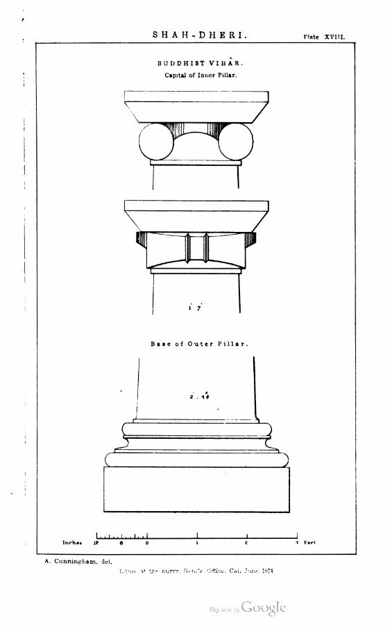
SHAH-DHERI Plate XVI II.
BUDDHIST VIHAR.
CaDitol of Inner Pillar.
1 7
Base of Outer Pillar.
^
2 . 4#
IJ
-■'-■1■
lnch»t It
A. Cunningham, del,
Lit^o *tf th*■ Surrr. CicniV Otticx-. Cai. June 1874


SHAH-DHERI Plate XIX
K
MALIAR-MORA.
Buddhist V i h a r .
-I Jf"'"" L^_
CITY of SIR-KAP,
Unknown Building.
v. >'■,--'■--■ 1
i■ic Feet
A. Cunningham, del,
Litho. at the Survr. Geni'a. Office, Cal. June 1874.


SHAH-DHERI Plate XX
BA3AR- KHANA.
Jtupa and Monastery.
JT~L nc x=c
ST
II
"
H t—r
Entranc<
xzc
n ir
iin.i.n, i i -U 1_ J_
1(1
SERI - KA - FIND
Pillar of Buddhist Railing
too Pttt
T
r^
<
,'
^ V
back side front
A. Cunningham. del.
Litho. at the Survr. Genl'a. Office, Cal. September 1*74.

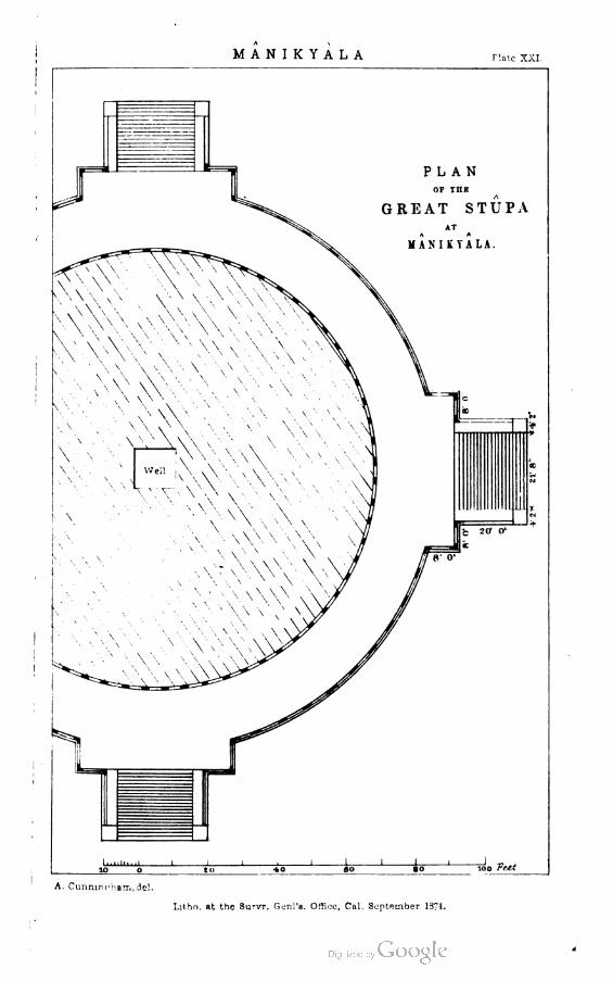
MANIKYALA Hate XXI.
rg=4 ■ I
PLAN
OF IIIK
GREAT STUPA
AT
MANIKYALA.
A. Curminrham,de!.
Litho. at the SurvT. Genl's. Office, Cal. September 1374.


MANIKYALA Plate XXII.
A 'J'j:imnki.am. ae*
Litho. 8t tbo Survr. G ma Orf-.oj, Calcutta September 1=71.
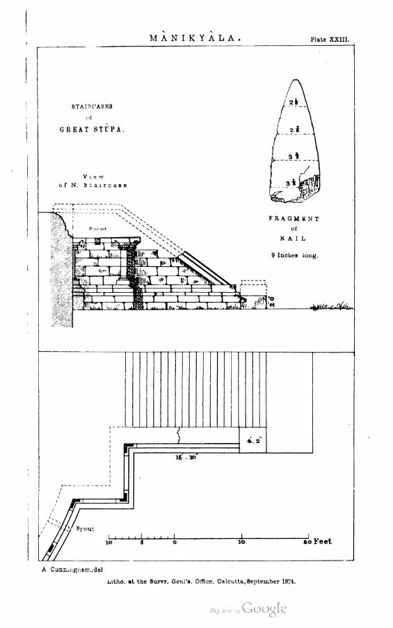
MANIKYALA Plate XXIII.
8TAIRCASK3
of
GKEAT STUPA.
Vie iv
of N, Staircase
FRAGMENT
of
RAIL
9 Inches long.
i1..i».Ij li J.iJte i.4« Jtf■«sr.\r«&>
*. 2
pout
lol'eet
A Cunningham, del.
Litho. at the Survr. Genl'a. Office, Calcutta, September 1874.

3

M A N I K Y A L A r;aie XXIV
MOULDINGS.
SUPERSTRUCTURE BASEMENT
A Cui.nir.g. ara.del.
Litho. »t ctie Survr. Genl's. Otfwe, Calcutta, 3rptpu.b■:r !-?1.


MALLOT Plate XXV.
FORT
M A L
J_l_ _J
»ooo F:
A. Cunnir.ghau. ,;lel.
LtlSio -»*. tr:v Stir.T (ionl'a. Office. Cn. Se^tea^bei 1374.


MALL.OT Plate XXVI.
'.*
SS
°1
M X
-^N-
a, o
S
sa
en
:-;
, Jr "
LXll I
_ c
.1
A. Cunningham, dei,
,ltho. at the Survr. fjeni's. Otfioc, Ca'.. Mar 1374.


MALLOTFate XXVII.
Floor of-
-
Floor jof
*c
PILLAR and BASEMENT
of
TEMPLE.
rfiaAijj^2m 3
-. Tempi *
m=^
i
Z_« Veatibule
£ iT
^^Ki^^^^^S^^r.^1^^j^-:^^m^U^
J
I- .1 I .1 I I l_
I I I
^feftfY^--.
A. Cunningham, del,
Litho. at the Survr. Grnl'a. Office, Cai. June 1871.


WestS1ie
ini
Itflncxrir Y\$V/\x.yv
IN3CKIPTI0NmaSQUAREWELLatMAIItA.
NorthSide
9/vJuQ^'-hy f*93?nlfYCVAfui
X.X133
rnalbni
EastSide
^X

SHORKOT iLt XXIX
RUINS
Ot
SHORKOT
A
Hindu Temple
JImiiiiiiiI I I - 1 . '
200 Tout
A Cunnirtuam. del.
Lit'iO. at th'- Surrr. fn-n 'a. Or*;.-. , Cur r h S, l 'em'jcr l»74.


SHORKOT.Plate "SJCX.
Carved and Moulded Bricks.
Jillii'
4mMI -■ »i.,.■■■tit■.i■■M
pmrrrrng^
^
FV
i&ii_Z--3s
.Ik
1
k ^
^jegg
Inscribed Bncka
uir^00j/j
ovo £/ ly
^TM9A Cunningham, eel.
Lui.ogr«j>U»d a:, the S-nrveyor General's urLcs. Calcutta, December 1374.

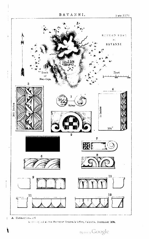
B A V A N N I . Kate XXXI.
A
H
R I-" I X B D F 0 H '
II A V A N S I
A **.•
'•-.V Mynr11?^* -* ' *
Of
Nao-Gaja.
Feet
i—i i i i I i i i ■ i0 M>0 1000
10
. 111
ii 12
.JL. A. A,.
A Cunmnfhaii. eel
h.'.noj: ai ..cd at trie Surveyor Genera. 'a Office, Calcutta, December 1874.


H A R A P APlate XXXII.
A. Remains of Temple. (!1
B. Tomb of Nao-Gaja
C- Thumb- Hint? of Nao-Gaja
D. Masaea of Charred Gram
E. Foundations of Monastery
RUINS
at.
HARAPA.
a.«•,•. «*.,
t >.
Welle
l*v.-
*r;r • ■ *. .1
.*-
~3', A .* H*"
A. Cunningham del
Litho. at the Survr. Geni's. Office, Cal. September 1974.

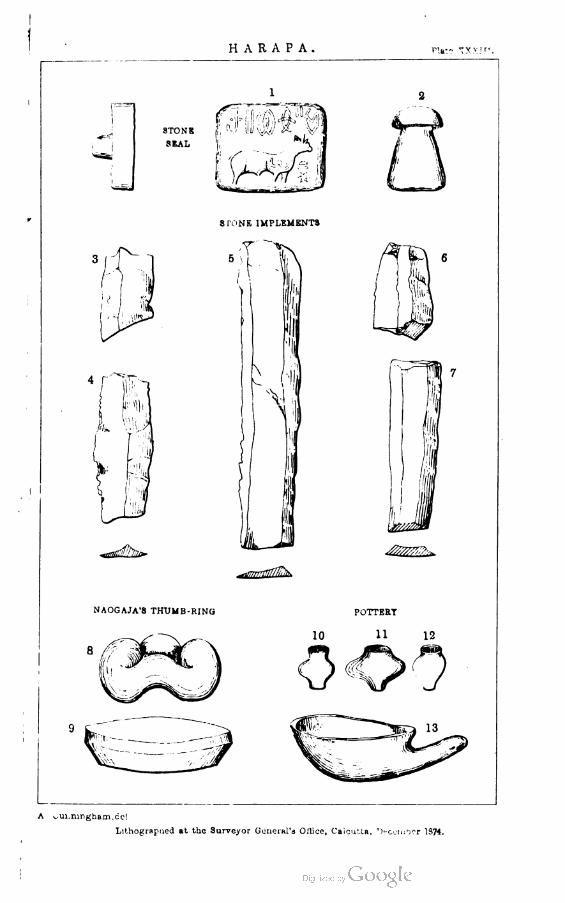
H A R A P A p'.»t? "jxxIr'
i .-—
STONB f, fJ ill) VA
SSAL
8 TONE IMPLEMENTS
^asjsSJ!^
NAOGAJA'S THUMB-RING
A ^ui.mnghann.ccl
Lithograpued at the Surveyor General's Oilice, Calcutta, '^cumber 1374.


DEPALPUR,Plate VXXIV.
PLAN
OF THE FORT
OF
DEPALPUR
Firoz
Section on A. B.
,,:,,, '...
i ■ ■ I I I I I ■ I
1004 soo »oo& Fe*t
A Cunningham, del.
Lithographed »t the Surveyor General's Office, Calcutta, December 1974.


T U L A M B APlate XXXV.
DESERTED FORT.
u*
A '
X
CARVED BRICKS
2
liAiflyk
msimsuoi HH
f:»% HI B9 IBB a E B r-
llilri ilk J
Sn f**' "^ r-*y**-3 /
CARVED BRICKS
from
A S A R t R
A Cunningham. del.
LihoflraphcJ at trie Surveyor Genera. 'a jtuoe, A-a.cirta, JiiCM.uun 1874.


M -" t. T A NPlate XXXVI.
A Cunningham del.
L.'i, - :if' ..". Rt *'.? Su-ve.'or ^••utTnl's • "£c- t ^.Vicit'a, T'-f.^.ier }S74.


M U L T A N P;ate XXX-.'li.
DEV A" A1U
King of luun mi J Pe; ail
Sri Hi Uvi-cha ALran-cha-pa'-ame3vvnra Vi Suahi-' tg na r■F.\'A ' ARliI
I'l Jl I A-IAtv.w.a
KHUSKU II.
King of Persia
A. U E7.
vAsu-i fc ■ a
X Hi t; of M v i ' an
L..-V r'-Kii'i-ii at. the S.vve.vor (jmera.'a OrL'.i, Calcutta, Dseemuer IS74.


MULTAN Plate XXXVIII.
East
EOKN-I-ALAM.
OB
TOMB of EUKN-UD-DIN
A. D. 1320
A CunniDgbam.del.
Lithographed at the Surveyor General's Office, Caieu'ta, December 1374.


M U LT A NPlate XXXIX.
GLAZED TILE MOSAICS.
Tomb of Bahawal Oak.
A. D. 1360.
Tomb of Rokn-;-Alam.
A. D. 1300.
Ialhoy.apbcd as. the Surveys General', ■jfflu., Calcutta, ljMfffli,w W/i.

tusham;
Plate XL.
ROCK INSCRIPTIONS
.wiiiiaJTft
A. Cunningham del. Photosmno^-ejiad ai th* ScrvfTor Onanl'l r'A':.;t OaJ■.iV.i


HISAR and DELHI PILLARS. pute xli.
HISAR PILLAR.
-Jia^g "n^'ft* ■-wr.r
DELHI-SIWALIK PILLAR.
c. it? 5 D" ai/<vaap ^f
UELHI-MIRAT PILLAR
A Cunningham,del
J.anofcrnI':iea at the Surveyor General's Office, Calcutta, December 1974.


KANGRA Plato XLI1.
KANHIARA
Hock Inscriptions
r^
FROM RUINED TEMPLE AT CHARI.
rop
pmrnr if|'m,niiiw 'uu rrt
Hollow for Base of Statue
FROM INDRESWARA TBMPLE AT KANGRA.
DATB of BAIJNATH TEMPLE at K1RAQRAMA.
Saka-Kala gatabdah 736.
A Cunningham.del.
Liwograplied at the Surveyor Oeneral'a Office, Calcutta, December 1874


KIR A GRAMA PIMP XLlll.
TEMPLE of SAIJ.N'ATH
A. D. SM
^c ^
S. S. S. -• '■!"'• '-*'.' flixl Si Je Balconies
ad lei by HAJA SANSAR CHANI'
m A. D. 1756
1 , , , , I
A. Uuuuiii^h&ii-.
I,/.1... at t^ ^'urvr. Gc:-'j. C:l—i, Cal. Mav l-'l.


ANCIENT INDIAN ARCHITECTURE.
Plate XLV
PERSIAN
i
PEHSEP0L1S.
INDO-PERSIAN.
5 4
from Y U 3 U K Z A I Sculpture*
KABUL
C h i. k r l Mmii
Y USUFZ A I
Sculpture.
A Cunningham, del.
Litnoeraphed at the Surveyor General'* Office, Ca■cutta, June1876.

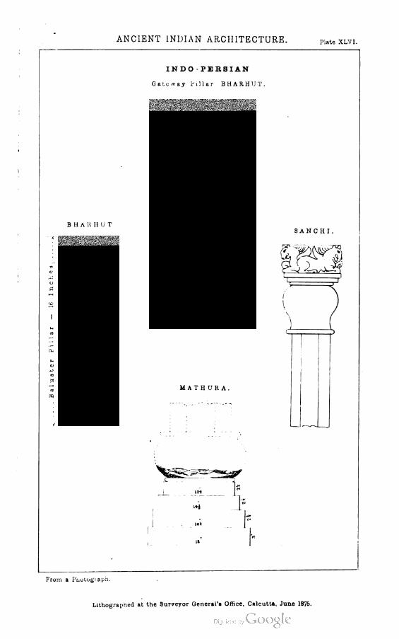
ANCIENT INDIAN ARCHITECTURE.Plate XLVI.
3
INDO PERSIAN
Gateway Pillar BHARHUT.
M AT H UR A.
1J?_
l->1
let
SANCHI.
From a Photograph.
Lithographed at the 3urveyor General's Office, Calcutta, June 1875.


ANCIENT INF-IAN ARCHITECTURE. Plate XLVII.
GREEK
Monument of Lysicrates.
INDO CORINTHIAN
Sahri-Bahlol. YUSUTZAI.
I
Bound Pilaster
SCOLPTURB3
Jamal-Garhi: YUSUFZAI
Square Pillar Square Pilaater.
A Cunningham, del.
Lithographed at tne Surveyor General's Office, Calcutta. June 1875.


ANCIENT INDIAN ARCHITECTURE. Plate xlviii.
INDO- CORINTHIAN.
JAMAL-GAP. HI.
From a Photograph.
Lithographed at the Surveyor General's Office, Calcutta, June 1875.


ANCIENT INDIAN ARCHITECTURE.Hate XLIX.
INDO-CORINTHIAN.
JAMAL-GARHI.
(*>3
o
From it Photograph.
Litnographed at. me Surveyor Generai's Office, Calcutta, June 1875.


ANCIENT INDIAN AFCHITECTURE
INDO CORINTHIAN
JA.MAL-GARHI
Fi-uin a pho'oeraPii.
Luriogralmed at tne Surve\ur Genertti'a urM -e. Calciua. Ju ie tS'5.

'
-- T \ '


r