Renewed Excavations at Beisamoun: Investigating the 7th Millennium cal. BC of the Southern Levant
99
JOURNAL OF THE ISRAEL PREHISTORIC SOCIETY Mitekufat Haeven Volume 44 Editors: Dani Nadel Danny Rosenberg Daniel Kaufman Guy Bar-Oz Supported by the Irene Levi-Sala CARE Archaeological Foundation THE ISRAEL PREHISTORIC SOCIETY 2014
Transcript of Renewed Excavations at Beisamoun: Investigating the 7th Millennium cal. BC of the Southern Levant
JOURNAL OF THE ISRAEL PREHISTORIC SOCIETY
Mitekufat HaevenVolume 44
Editors:Dani Nadel
Danny RosenbergDaniel Kaufman
Guy Bar-Oz
Supported by the Irene Levi-Sala CARE Archaeological Foundation
THE ISRAEL PREHISTORIC SOCIETY
2014

ISSN: 0334-3839
© All rights reserved to the Israel Prehistoric Society
Graphic Design: Sapir Haad
Printed by Print Unit, University of Haifa
English cover: An anthropomorphic stone image from a Neolithic cult site in the Negev (site 263/10/9)
Hebrew cover: A decorated bowl from Tel Tsaf

Table of ContentsEditors’ forward 4
Renewed Excavations at Beisamoun: Investigating the 7th Millennium cal. BC of the Southern Levant 5Fanny Bocquentin, Hamoudi Khalaily, Daniella E. Bar-Yosef Mayer, Francesco Berna, Rebecca Biton, Doron Boness, Laure Dubreuil, Aline Emery-Barbier, Harris Greenberg, Yuval Goren, Liora K. Horwitz, Gaëlle Le Dosseur, Omri Lernau, Henk K. Mienis, Boris Valentin and Nicolas Samuelian
A Survey of Neolithic Cult Sites in the Eilat Mountains, Israel 101Uzi Avner, Moti Shem-Tov, Lior Enmar, Gideon Ragolski, Rachamim Shem-Tov and Omry Barzilai
Hanaton: Interim Report on a Neolithic-Chalcolithic Settlement in the Lower Galilee 117Assaf Nativ, Ron Shimelmitz, Nuha Agha, Inbar Ktalav, Danny Rosenberg
Back to Tel Tsaf: A Preliminary Report on the 2013 Season of the Renewed Project 148Danny Rosenberg, Florian Klimscha, Philip J. Graham, Austin (Chad) Hill, Lior Weissbrod, Inbar Ktalav, Serena Love, Sonia Pinsky, Emily Hubbard and Elisabetta Boaretto
Fazael 1, A Chalcolithic Site in the Jordan Valley: Report of the 2013-2014 Excavation Seasons 180Shay Bar, Guy Bar-Oz, Haggai Cohen-Klonymus and Sonia Pinsky
The Chalcolithic Settlement of Khirbet Dalhamiya: The 2007 Excavations 202Walid Atrash, Jacob Vardi, Nuha Agha and Ianir Milevski
Fifty Years Later: A Critical Review of the Stratigraphy, Chronology and Context of the Nahal Mishmar Hoard 226Isaac Gilead and Milena Gošić
The Bone Tools from the Cave of the Treasure in Nahal Mishmar 240Guy Bar-Oz and Reuven Yeshurun
Book reviewsBar S. 2014. The Dawn of the Bronze Age: The Pattern of Settlement in the Lower Jordan Valley and the Desert Fringes of Samaria during the Chalcolithic Period and Early Bronze Age I (Culture and History of the Ancient Near East 72). Boston and Leiden: Brill. 248Eliot Braun
Nativ A. 2013. Prioritizing Death and Society. The Archaeology of Chalcolithic and Contemporary Cemeteries in the Southern Levant. Approaches to Anthropological Archaeology. London: Acumen. 251Ianir Milevski
Note for authors 256
Hebrew abstracts 4*

Journal of the Israel Prehistoric Society 44 (2014), 5–100
5
Renewed Excavations at Beisamoun: Investigating the 7th Millennium cal. BC of the Southern Levant
Fanny Bocquentin1, Hamoudi Khalaily2, Daniella E. Bar-Yosef Mayer3, Francesco Berna4, Rebecca Biton5, Doron Boness6, Laure Dubreuil7, Aline Emery-Barbier8, Harris Greenberg9,
Yuval Goren10, Liora K. Horwitz5, Gaëlle Le Dosseur8, Omri Lernau5, Henk K. Mienis5,3, Boris Valentin11 and Nicolas Samuelian1, 12
1 Centre de Recherche Français à Jérusalem, USR 3132 CNRS (UMIFRE 7 CNRS-MAEE), POB 547, Jerusalem, Israel. [email protected]
2 Israel Antiquities Authority, POB 586, Jerusalem, Israel. [email protected] The Steinhardt Museum of Natural History and National Research Center, Tel Aviv University, Tel Aviv, Israel.
[email protected] Department of Archaeology, Simon Fraser University, Burnaby, Canada. [email protected] National Natural History Collections, The Hebrew University, Jerusalem, Israel. [email protected];
[email protected]; [email protected]; [email protected] Laboratory for Comparative Microarchaeology, Department of Archaeology and Ancient Near Eastern Cultures, Tel
Aviv University, Ramat Aviv, Israel. [email protected] Department of Anthropology, Trent University, Peterborough, Ontario, Canada.
[email protected] CNRS, UMR 7041 ArScAn, Equipe Ethnologie Préhistorique, Maison de l’Archéologie et de l’Ethnologie René
Ginouvès. Nanterre Cedex, France. [email protected]; [email protected] Department of Archaeology, Boston University, Boston, USA. [email protected] Laboratory for Comparative Microarchaeology, Department of Archaeology and Ancient Near Eastern Cultures, Tel
Aviv University, Ramat Aviv, Israel. [email protected] Université Paris 1-UMR 7041, ArScAn, Equipe Ethnologie Préhistorique, Maison de l’Archéologie et de l’Ethnologie
René Ginouvès, Nanterre Cedex, France. [email protected] Institut National de la Recherche Archéologique Préventive, Paris, France. [email protected]
ABSTRACTThe site of Beisamoun is located on the western side of the marshes of the former Hula Lake in the upper Jordan Valley, in the northern part of the Southern Levant. It is known as a major Middle and Late Pre-Pottery Neolithic B settlement from excavations and surveys undertaken by A. Assaf, J. Perrot and M. Lechevallier and colleagues up to the 1970’s. However, the phases currently being excavated (under the direction of F. Bocquentin and H. Khalaily) represent a later settlement. Ongoing field work has uncovered about 300 m² with five occupation levels. Radiocarbon dates as well as the flint assemblage, the architectural remains, the funerary practices and the absence of pottery indicate a cultural attribution to the Pre-Pottery Neolithic C, dated to the first half of the 7th millennium BC.
We present here the results of six excavation seasons (2007–2012), including the geoarchaeological background of the site and its surroundings, the stratigraphy, sediment micromorphology, palynology and architecture, as well as preliminary results from analyses of some of the finds including human burials, lithics, groundstone artifacts, personal ornaments, bone tools and faunal remains.
KEYWORDS: Beisamoun, Hula Basin, Pre-Pottery Neolithic B, Pre-Pottery Neolithic C, Bladelet production, Hunting, Micromorphology, Funerary practices, Environment, Tool production.

Bocquentin et al.
6
INTRODUCTIONBeisamoun is a large Neolithic site located in the Hula Valley in northern Israel. It lies on the western side of the former marshes of the now drained Hula Lake, near the perennial spring of Eynan (or Aïn Mallaha), with Iron Age Tell Mallaha to its south (Figs. 1, 2). The site was discovered in 1955 by A. Assaf when fishponds were built. As these artificial ponds were regularly drained for cleaning, A. Assaf and a team directed by M. Lechevallier (CNRS), who was working at the same time at the Natufian site of Eynan with J. Perrot (Fig. 3), surveyed the area and dug several soundings in the fishponds in 1965, 1969 and 1971 (Fig. 2). In 1972, a large plaster floor dating to the Pre-Pottery Neolithic B (PPNB) period was discovered following which the team undertook a one month rescue excavation (Lechevallier 1978). Damage to the site continued due to exploitation of the fishponds and agricultural development in the area until 1999, the year when Beisamoun was proclaimed a protected archaeological site by the Israel Antiquities Authority. In 2007 a large test excavation was undertaken under the auspices of the IAA along Road 90 at the southwestern margin of the site (Khalaily et al. 2009) followed by a salvage excavation undertaken by D. Rosenberg and I. Groman-Yaroslavski (Rosenberg 2010a).
In 2007, our team started a long-term excavation project in the northern part of Beisamoun, adjacent to the area explored by Lechevallier’s team (Bocquentin et al. 2007). We uncovered occupational remains spanning the transition between the Pre-Pottery Neolithic B (PPNB) and the Early Pottery Neolithic (EPN), a period that is poorly known and has alternately been named the Pre-Pottery Neolithic C (PPNC) (Rollefson and Köhler-Rollefson 1993), or the Final PPNB (Goring-Morris and Belfer-Cohen 1998). This is not a simple question of terminology but a major issue of how to define a chrono-cultural complex. Some authors consider the material culture of this phase as directly inherited from the PPNB period (e.g. Kuijt and Goring-Morris 2002); others, to the contrary, see it as a major cultural shift heralding the PN (Clare 2010; Rollefson and Köhler-Rollefson 1993). This issue will not be discussed in the current paper since it is dedicated to the presentation of our preliminary results. At this stage of our research we have chosen to use the more conventional and widespread term of PPNC.
BACKGROUND TO THE CURRENT STUDYThe Beisamoun locality has yielded two major cultural horizons: on the one hand, a Pre-Pottery Neolithic (PPN) component located in the northern part and, on the other, Early and Late Pottery Neolithic components (EPN/PN) in the southwestern part (Fig. 2). The two components are separated by approximately 800 m of terrain that is, as yet, unexplored. As far as we know today, the PPN and EPN/PN cultural horizons are not directly superimposed, leading to the conclusion that either the settlement and its inhabitants moved towards the southwest over time, or that they are independent settlements, possibly even different communities. In order to clarify the successive occupation phases in this area, we will refer to the EPN/PN components as “Beisamoun-West” (see also Khalaily et al. 2009) and the PPN occupation as “Beisamoun”.
Based on surface prospection and soundings to the north of Tell Mallaha, the Pre-Pottery Neolithic B site of Beisamoun covers more than 10 ha (Lechevallier 1978). About 70 long segments of walls were mapped by Lechevallier and colleagues at the bottom of several fishponds—Ponds #1, #2, #10 and #12 (Fig. 4)—revealing a low density of rectangular houses grouped in clusters, all oriented according to the cardinal points. The remains were usually found at the edge of the fishponds. There are probably two reasons for this: (a) the site was less severely damaged in these areas and, (b) these areas were more accessible for survey while the centers of the ponds were still wet. Soundings performed at the base of some of the mapped walls were unsuccessful and the team concluded that only the foundations of the houses were preserved, the floors having been destroyed. House 150, exposed in 1972, is an exception. With its large extent, well preserved inner structures, the abundance and quality of the tools collected and the discovery of two plastered skulls, it has contributed to the reputation of the site. The site was considered to have been occupied for a short time period, about one or two centuries, at the end of the PPNB (Lechevallier 1978:280), a period which is today called the LPPNB and dates to the second half of the 8th millennium Cal BC (in the 1970’s the end of the PPNB was placed at the end of the 7th millennium Cal BC).
Thanks to having full access to the archives and finds of Lechevallier’s excavations, our team revised the material remains in the light of recent studies of the PPNB. We

Journal of the Israel Prehistoric Society 44 (2014), 5–100
7
separated the surface collections from the remains found in situ (this is to say within or under House 150) (Bocquentin et al. 2011). We have shown that House 150 was certainly occupied during the MPPNB (first half of the 8th millennium) while the rest of the assemblage, found on the surface, probably represents mixed remains from the LPPNB (second half of the 8th millennium) and the PPNC period (first half of the 7th millennium Cal BC). This later occupation is, moreover, clearly present in our current excavation and addressed below. However, the LPPNB
was not found in situ except perhaps in exploratory trenches that we have dug (see below), but samples are too small to be decisive. As such, a clear picture of this period is still missing from our excavations in order to verify that the site was occupied continuously.
The EPN and LPN settlements found at Beisamoun-West were established on sterile terra rossa soil (Khalaily et al. 2009; Rosenberg 2010a). Approximately 750 m² were investigated during test and salvage operations of the western margin of the settlement (Fig. 2). The lithics
Figure 1. Geographical location of (A) the Hula Valley and (B) Beisamoun and other nearby sites dating to the 7th millennium Cal BC.

Bocquentin et al.
8
Figure 2. Aerial image of Beisamoun and location of the archaeological operations related to the Pre-Pottery and Pottery Neolithic periods. White dashed lines in the PPN area are the limits of the former fishponds. The pink-brown color shows the area surveyed. Google Earth picture courtesy © 2012 Google and © 2012 DigitalGlobe.
Figure 3. From left to right: Amnon Assaf, Jean Perrot and Geneviève Dollfus during prospection of the bottom of the fishponds, taken in the year 1961 (Copyright: CRFJ).

Journal of the Israel Prehistoric Society 44 (2014), 5–100
9
from Beisamoun-West resemble those characteristic of the Yarmukian culture (Khalaily et al. 2009), but with close similarities to the few PPNC assemblages known so far (Gorman-Yaroslavski and Rosenberg 2010). The pottery sherds—which might be the earliest ones in the area—lack a clear cultural attribution (Rosenberg 2010b). Architectural components include segments of walls, pavements, pits and hearths (Khalaily et al. 2009; Rosenberg 2010b). The small faunal assemblage is dominated by sheep, goat, cattle and pigs, most probably domesticated (Raban-
Gerstel and Bar-Oz 2010). Although no 14C dates are available, the occupation is placed in the second half of the 7th millennium Cal BC at the very beginning of the PN. Numerous pottery sherds of the Wadi Rabah culture were found slightly to the north of the EPN village (Rosenberg et al. 2006), a feature also noted by Lechevallier (1978) during her surveys. No in situ remains of a Wadi Rabah occupation have been discovered so far.
At present, we do know that Beisamoun was occupied for a much longer period of time than previously thought
Figure 4. Aerial image of the archaeological operations regarding the PPN occupation layers. Google Earth picture courtesy © 2012 Google and © 2012 DigitalGlobe.

Bocquentin et al.
10
Figure 5. Foreground: fishermen working in Pond 11; background: J. Perrot exploring the dry part of the pond, taken in the year 1961 (copyright: CRFJ).
and this raises the issue of the extent of the village during each phase. Do the 10 ha of PPN remains reflect a mega -site or shifts in settlement locales over the centuries? Unfortunately, this question remains unresolved due to the fact that the relationship between the structures mapped by Lechevallier could not be established, nor could the architectural remains be dated. Moreover, the destruction of the site during the conversion of the fishponds into agricultural fields is a major drawback for future investigations.
THE CURRENT ExCAVATION Objectives and methodsOur team, directed by F. Bocquentin and H. Khalaily, commenced a long-term excavation project at Beisamoun in 2007 (Bocquentin et al. 2007, 2011; Samuelian et al. 2010). Some 20 specialists are part of the project today. Thanks to financial support from several sources, two weeks of excavation were undertaken in September 2007 and 2008; three weeks in September 2009, June 2010 and June 2011, and finally five weeks in June 2012 with an average of 15 excavators on site. Two sectors were opened:
Sector E and Sector F (this list follows the previous one that ended with « Sector D »: Lechevallier 1978).
Sector E was explored for a total of 16 weeks and Sector F for 11 weeks; both are in a former fishpond (Pond #11), and there are several trenches in the vicinity of this pond. The selection of this location was made by considering several aspects. According to A. Assaf, the south part of the site (under Ponds #1, #2, #12 and #13) was severely damaged by drainage pipes and intensive agricultural activities. To the north, Pond #10 yielded a huge quantity of material during surface survey, far too numerous even to consider that the site was still well preserved in this location. Moreover, the bottom of this pond is currently used for intensive agricultural activities.
Pond #11 appeared to be the most relevant area to be explored. It occupies the central part of the known extension of the PPN village; it was dug more superficially than others for fish breeding activities and was never converted into an agricultural field but was abandoned after drying up. Moreover, the archaeological survey of this pond was never very successful and no walls were reported in this area by Lechevallier (Fig. 5). We have supposed that this situation was due to the very superficial

Journal of the Israel Prehistoric Society 44 (2014), 5–100
11
destruction of the archaeological occupation. Finally, Kibbutz Manarah permitted us to work in the area of Pond #11 at our convenience. Future investigation at Beisamoun should be focused on the northwest quarter of the village, inside Pond #11 or outside the location of the former fishponds where there is no reason to believe that the site has been destroyed in recent years.
Our preliminary objectives were to verify which parts of the site were preserved, not only the walls but also the floor levels, and provide high resolution data on a settlement which was explored by Lechevallier only under salvage conditions. Our goals were not to have a comprehensive picture of the Neolithic village, but rather to document discrete structures, micro-succession events and spatial organization within domestic units. The important issue of spatial organization of Pre-Pottery Neolithic villages and diversity among structures is better known today thanks to several extensive salvage excavations recently conducted in Israel (e.g. Garfinkel et al. 2012).
The grid was set according to the cardinal points (Fig. 4). Sector E was opened in 2007 not far from the south edge of the Pond #11 at a central location. The same year, three trenches were opened using a backhoe, and Sector F was established in 2008 in the eastern extremity of Trench III where the backhoe exposed a well-preserved plaster floor. Both sectors were enlarged year after year according to discoveries. Currently, the sectors are about 20 m apart and together cover more than 300 m² of excavated area. The squares were dug in successive décapages, following the archaeological units as much as possible or the horizontal plan when no diagnostic features were available. Drawing on A. Leroi-Gourhan’s approach (Leroi-Gourhan 1950), the décapage technique used here consists of exposing items, structures and fillings strictly contemporaneous
over a large surface area and leaving them in situ as long as needed to understand their relationship and more generally the organization of space in a specific phase of the site. In contrast to the artificial horizontal approach, the décapage approach might result in irregular surfaces of excavation. Each excavation operation receives a unique bank of catalogue numbers that are recorded in a file, and for which the excavated volume of sediment is systematically logged. Each feature receives a locus number and is recorded, described, carefully excavated and all sediments are wet-sieved (2–3 mm mesh). In addition, three dimensional coordinates are taken of in situ finds and each relevant item is given a unique number within the locus.
Stratigraphic description of the sectorsLayer 0 is present in both sectors. It corresponds to the leveling and filling of the fishpond (Fig. 6; Table 1). This modern layer is of irregular depth and is rich in artifacts. In the southern sector, Sector E, we have identified four sedimentological layers (0a, I, Ib, Ic) which are intersected by Layer 0 which has an irregular pattern. Extension of the sector boundaries over the years to the south and west towards the edge of the pond, has shown that the upper archaeological levels are much better preserved in these directions. Sector F is less disrupted by the modern infill. Five different strata underlying Layer 0 were identified in the field (Fig. 6; Table 1). Layers A, 01 and D are the uppermost layers with different spatial extensions. Layer B of Sector F and Layer I of Sector E are the only ones closely resembling each other on a macro-scale. To date, Sector E comprises at least six successive architectural events. For the moment, three successive building levels have been recognized in Sector F (Fig. 6).
Figure 6. Schematic lithological layers in Sectors E and F.

Bocquentin et al.
12
Chrono-cultural considerations and radiocarbon datesWhen we started the project in 2007, we were expecting to excavate Late PPNB levels. Surprisingly, both sectors and all layers explored so far have yielded a typo-technological flint assemblage not typical of the PPNB but closely resembling, according to our first observations, Yarmukian industries with an earlier component. First of all, bidirectional blade technology remains an important part of the debitage; within the tools, small arrowheads typical of the PN are absent and finely denticulated sickle blades, reminiscent of the PPNB period, are present. Moreover, pottery is virtually absent: 20 possible Neolithic sherds, on average 2 cm in size, have been found to date within the upper layers including Layer 0, and none of them were found in the underlying Layers Ib or Ic; on the other hand, ‘white ware’ vessels are present in very small quantities.
Despite many attempts, no radiocarbon dates are available for Sector F where bone collagen and charcoal are not preserved. In Sector E, charcoals are hardly found in the upper layers (0a and I) but are present in Layers Ib and Ic. Samples were analyzed by E. Boaretto at the Weizmann Institute of Science. So far, eight samples have given results of which five concur with the archaeological data. The range of the ages is from 7,300 Cal BC to 6,200
Cal BC. The samples were recovered from Layers I, Ib and Ic and the dates follow the stratigraphic order of the layers. Layer Ib was dated by three samples ranging from 7,000 to 6,600 cal BC, thus supporting the hypothesis that the bulk of the levels being explored by us can be attributed to the PPNC.
It should be mentioned that J. Perrot (Perrot 1966) first attributed Beisamoun to the transitional period between the PPNB and PN, which he called the “Palestinian Hiatus” (placed during the 6th Millennium before calibration), an idea that was not supported after the excavation of House 150 (Lechevallier 1978). It seems that this phase was severely destroyed in other ponds surveyed by M. Lechevallier and A. Assaf as shown by the material collected from the surface (Bocquentin et al. 2011). There is little doubt today that Beisamoun was indeed occupied during a long period, probably over a millennium.
The trenchesIn addition to Sectors E and F, we dug seven deep trenches using a backhoe: four within Pond #11; one at the southwestern edge of Pond #10; and two outside the fishpond area to the west of Pond #11 (Fig. 4). The trenches were dug to depths of 1.8 or 2.30 m and all revealed archaeological layers. Trenches II, III, IV and VI were of particular interest exposing well preserved, in
Sector E Sector F0: 5 to 40 cm (NE). Black, coarse topsoil surface with a mixture of sand and gravel components. This layer may appear as blocky peds of dried clay or dry and crumbly. It is heavily bioturbated and disturbed, with a mixture of artifacts, modern items, and organic material.0a: A dark brown compact clayey soil that dries in blocks and breaks apart easily.
A: Mixed black-brown sandy-clay sediment with tan inclusions. Compact but friable clay peds are common.01: Coarse and compact blackish-brown clay loam layer.D: Fine-grained, light brown, pink, and orange clay sediment. It is soft and friable.
I: Grayish-brown sandy-clay material that gradually becomes yellowish. It is dense but friable, with some fine-grained inclusions including clay, ochre, and charcoal fragments. More blackish in the vicinity of floor levels.
B: Grayish-brown sandy-clay sediment. More blackish in the vicinity of floor levels.
Ib: Compact pinkish-brown sandy-clay sediment with numerous fine-grained inclusions of charcoal, clay, and ochre.
B1: Yellow sandy-clay sediment with a soft, powdery feel.
Ic: Very compact pinkish-brown sediment with numerous fine-grained inclusions. It is very dense and compact, and shimmers when cut, either because of moisture retention or heavy sand content.
Table 1. Brief description of the lithostratigraphic layers distinguished during fieldwork.

Journal of the Israel Prehistoric Society 44 (2014), 5–100
13
situ anthropogenic features such as massive walls, plaster floors and dense lithic accumulations, all relating to the PPN horizon. In Trench IV, at 1.30 m below surface, we found an accumulation of overlapping laminar flint artifacts. The assemblage, slightly encrusted and cemented by carbonates, is remarkably fresh, and represents a bipolar core reduction that can be attributed to the Middle or Late PPNB. Consequently, the site of Beisamoun must have extended further west than previously thought. Except for Trench VII, still accessible, all others had to be backfilled after a few hours. Numerous soil samples were taken and micromorphological blocks were made and are currently being analyzed.
GEOARCHAEOLOGICAL INVESTIGATION AND PRELIMINARY MICROMORPHOLOGICAL RESULTS FROM PoND #11 (H.G. AND FR.B.)Here we provide background on the geography, geology and sediment history of the Beisamoun area before presenting the results of our micromorphological analyses of the archaeological and natural control deposits. We then conclude with a discussion of how these data relate to our research questions, and how we can further enhance our understanding of this site.
Geological and geographical backgroundThe Hula Valley is a “pull-apart” basin that formed during the Plio-Pleistocene and is the northern portion of the larger Jordan Valley Rift system (Garfunkel 1981; Sneh and Weinberger 2003). The northern boundary of the basin is the elevated Beqa’a Valley, while the southern border is bounded by Late Pleistocene basaltic hills, both of which restrict drainage out of the basin (Shtober-Zisu 2010). The basin collects sedimentary materials transported by the Jordan River that runs through it, by ephemeral streams flowing from the calcareous Naphtali Mountains to the west and the basaltic Golan Heights to the east, and by waters originating from numerous springs that drain into the Hula Basin (Dimentman et al. 1992; Shtober-Zisu 2010).
These various sources of water fed an ancient, central freshwater lake (Lake Hula) and a vast complex of surrounding swamps, pools and shallows (Dimentman et al. 1992 and citations within). This complex water system
naturally prograded and retrograded until it was ultimately drained in the 1950s, when the land was reclaimed for agriculture (Karmon 1960). Today, only a small artificial lake (Agmon Ha’Hula) remains in the Hula Basin. Initially, a number of fishponds were built throughout the valley for aquaculture, but these were later replaced with agricultural fields that have dramatically altered the water tables and the pH of the region (Litaor et al. 2011).
Recent sedimentological research in the basin shows that the region of the paleo-lake itself displays a rich calcareous marl, with the extinct surrounding swamps containing peats and a mixture of calcareous and alluvial material found along the edges (Dimentman et al. 1992: 33–35). To the west, away from the ancient lake and towards the Naphtali mountains (where Beisamoun is situated), these sediments increasingly display a mixture of calcareous materials and terra rossa originating from the Naphtali slopes (Litaor et al. 2011; Shtober-Zisu 2010).
Materials, methods, and samplingAn essential element of a micromorphological study is identifying the arrangement and structure of the sediment and soil components. In order to achieve this goal, intact blocks of sediment were collected from the excavation sectors and trenches, as well as from control areas around the Hula Valley (e.g., terra rossa from Ein Gev; vertisol developing on basalt; modern river and marsh deposits; paleo-lake sediments). These intact blocks were collected from within and across the lithostratigraphic boundaries observed in the field, and from archaeological features uncovered during excavations. The blocks were shipped to the MicroStratigraphy Laboratory at Boston University where they were impregnated with unpromoted polyester resin diluted with styrene at a ratio of 7:3. Once hardened, the blocks were processed into petrographic thin sections and polished to a thickness of 30 µm. In addition to the intact blocks, a number of loose samples of sediment were collected, both for FTIR analysis and for grain size analysis.
Summary of resultsBrief summaries of the analysis of four selected samples are provided here, two from Sector E, one from Sector F, and a column from Trench VII (GPS coordinates at the southwest corner of trench VII are: N 33.094037, E

Bocquentin et al.
14
35.579686), located 40 m north of the northwest corner of sector F. These samples are being highlighted because they shed light on the major research questions presented above. See Tables 2 and 3 for a list of slides from these samples and their features. Descriptive nomenclature follows that of Stoops (2003).
Summary of Sector E (Figs. 7, 8)our excavations have revealed at least five layers in Sector E. In descending order they are: 0, 0a, I, Ib, and Ic (see above for more details). The top four of these layers may be found in sample blocks BN10-2 and BN10-20, presented here. Changes in composition (e.g., the frequency of sand-sized quartz and the relative abundance of biogenic silicates such as phytoliths and diatoms), pedogenic features (e.g., the development of secondary calcite), and porosity indicate different sedimentary deposits and regions of stability. These layers also show a trend that is repeated in Sector F and Trench VII: the lowest layers exhibit an abundance of biogenic silicates, small grains of charcoal, and small bone fragments. The higher layers have far fewer of these components, but do
have more terra rossa nodules. The structure of the higher layers also displays features consistent with the shrinking and swelling of clays (“vertic”). The implication is that at some time between the accumulation of these strata (potentially between Layer I and 0a) the major source of sediment input became the nearby limestone and terra rossa-rich slope of the western side of the Hula valley.
Summary of Sector F (Fig. 9)Six layers have been encountered in Sector F: 0, 01, D, A, B and B1. Some of these strata (such as Layer D) appear to have limited horizontal development, but samples from these layers have yet to be fully analyzed. Within Block BN10-6, Layers 0, A, and B are visible. Although Block BN10-6 does exhibit multiple strata, it does not provide the same sedimentary time depth as the blocks from Sector E. However, the lower Layer B does show more biogenic silicates than the higher Layer A, leading to the hypothesis that Layers A and B come from the same sedimentary source, but that Layer B might be mixed with a different sedimentary material that will be found deeper in the column.
Sample Sector Square Height masl Slides Layer Noted features
BN10-6 F R26c 75.22 to 75.10 BN10-6A 0/A Abundant sand-sized quartz and terra rossa nodules.
BN10-6B B Abundant secondary precipitation of calcite.
BN10-20 E V9 75.52 to 75.24
BN10-20A 0/0a Blocky microstructure with planar voids. Abundant sand-sized quartz and terra rossa nodules.
BN10-20B 0a Blocky microstructure with planar voids. Abundant sand-sized quartz and terra rossa nodules.
BN10-20C 0a/I Abundant secondary precipitation of calcite.
BN10-20D I Many biogenic silicates.
BN10-2 E O9b 75.08 to 74.91 Ib Abundant charcoal and biogenic silicates.
Table 2. List of slides from Sectors E and F used in this paper, with a brief description of the important features. Note that the heights refer to the sample block as a whole, and not the individual slides made from the block.
Summary of Trench VII (Fig. 10)Six depositional units (A, B, B/C, C, D, and E) were identified in the field, and a number of block samples were collected in a column from within and across these units. These units were locally defined and thus the names (Layer A, B, and D) are not intended to imply association with the layers of Sector F. Along the column, Trench VII displays a number of significantly diverse pedological and
sedimentary units and suggests a dynamic environmental history defined by at least three major sediment/soil regimes, and possibly more (Layers E and D; Layer C; Layers B and A).
The lowest units (Layers E and D) show a clear mix of anthropogenic material (flint, rubefied soil aggregates, bone, and charcoal) with lake and marsh sediments, though these do not show the characteristic signs of

Journal of the Israel Prehistoric Society 44 (2014), 5–100
15
Figure 7. Block BN10-20 with the location of thin section samples shown. Layers are labeled. Thin sections are shown in plain-polarized light (PPL) and cross-polarized light (xPL).

Bocquentin et al.
16
Figure 8. Block BN10-2 with the location of thin section samples shown. The white line on the slides denotes the boundary between Layers Ia/Ib and the suspected building material. Thin sections are shown in PPL and xPL.

Journal of the Israel Prehistoric Society 44 (2014), 5–100
17
Figure 9. Block BN10-6 with the location of thin section samples shown. Proposed layers are labeled. Thin sections are shown in PPL and xPL.

Bocquentin et al.
18
Samples Height masl Slides Layer Noted features
TVIIB7 75.14 to 74.96
TVIIB7a A/BVertic features with a blocky to crumbly microstructure. Biogenic silica is found in discrete regions and in calcitic concretions. A number of soil nodules and terra rossa aggregates.
TVIIB7b A/BVertic features with a blocky to crumbly microstructure. Biogenic silica is found in discrete regions and in calcitic concretions. A number of soil nodules and terra rossa aggregates.
TVIIB3 74.64 to 74.50
TVIIB3a CRelatively massive with vughs and channels. Biogenic silicates are present, but few. There are several soil aggregates with different compositions from the background.
TVIIB3b CRelatively massive. Biogenic silicates are present, but few. There are several soil aggregates with different compositions from the background. Charcoal fragments throughout.
TVIIB2 74.26 to 74.17 C/DHigher portion has some terra rossa nodules. The lower portion has numerous charcoal fragments and biogenic silicates. Some gypsum crystals are present.
TVIIB4 73.94 to 73.86 D Massive microstructure. Abundant biogenic silicates and charcoal fragments. Several clay crusts.
TVIIB1 73.63 to 73.55 E Massive microstructure. Abundant biogenic silicates and charcoal fragments. Some gypsum crystals. Some clay crusts.
Table 3. List of slides from Trench VII used in this paper, with a brief description of the important features. Note that the heights listed refer to the sample block as a whole, and not the individual slides made from the blocks.
Figure 10. A southern profile in Trench VII with the locations of the soil samples shown. Layers A–E are described locally and are not intended to imply any relation to layers in Sector F.
having been deposited by water. The occurrence of a few gypsum crystals is consistent with the drying of an organic rich (e.g., marshy) environment (Poch et al. 2010). In their biogenic silica content and archaeological components these layers resemble Layer Ib/Ic in Sector E.
The second major unit in Trench VII is Layer C, which appears to be colluvium composed of mixed anthropogenic materials, lake and marsh sediments and soil aggregates. The higher portion of this layer shows signs of pedogenesis, such as changing porosity and

Journal of the Israel Prehistoric Society 44 (2014), 5–100
19
clay hypocoatings around voids. Understanding how and when this layer was deposited in relation to the several Neolithic occupation phases is of considerable importance to the interpretation of site formation processes, and will be a key component of our future research. The top unit consists of Layers B and A. These layers contain more clay than their lower counterparts and have a “vertic” aspect. Their components and microstructure make them appear similar to the higher layers in Sectors E (Layer 0a) and F (Layer A) present in our above-described blocks.
DiscussionThe integration of the micromorphological data from the lithostratigraphic columns in Sectors E and F and the data from Trench VII suggest several trends. First, the lower layers documented in our sample blocks (Sector E: Layer I, Ib; Sector F: possibly Layer B; Trench VII: Layers D, E) show several common traits, most notably a combination of anthropogenic materials (such as charcoal fragments) and nearby marsh or lake materials (such as phytoliths, diatoms, and gypsum). It is important to note that though the lower layers display components indicative of a marsh or a lake, they lack the bedding that characterizes lacustrine or alluvial deposits, and are mixed with anthropogenic materials. This does not eliminate the possibility that these strata were deposited through lacustrine or alluvial action, but would suggest that they have been disturbed or mixed since deposition. The upper layers (Sector E: Layers 0, 0a,; Sector F: Layer 0, A; Trench VII: Layers A, B, C) are distinct from the lower ones, and appear to be similar in origin, containing a range of analogous components (e.g. terra rossa soil aggregates) and enough clay to be vertic.
The composition, microstructure and general eastward inclination of the layers point to a colluvial fan deriving from the gentle slope of the nearby limestone hills west of Beisamoun. The preliminary results from micromorphology thus suggest that the major sedimentary regime changed from one heavily influenced by the nearby paleo-water systems to the east to one dominated by mass movement of terra rossa-like material from the west of the site. This is consistent with geoarchaeological observations of the EPN features excavated southwest of Pond #11 (Shtober-Zisu 2010). It thus appears that our earliest archaeological layers exposed so far were closer to the river bank, marshes and lake. On the other hand, the later archaeological settlement was established in what
appears to be an environment similar to the modern one, with the nearby hills as the major source of sediment.
Layer C in Trench VII appears to be formed by colluviation of local sediment that contains a great deal of minute anthropogenic material (flint, bone, charcoal), even though in the field this layer appears to contain neither large amounts of macroscopic artifacts and ecofacts, nor typical midden or fill characteristics. Layer C does contain many interesting components, however, including pollen (Emery-Barbier, personal communication), phytoliths, and several aggregates of oriented and laminated clays and sand, though these are small isolated fragments (<2 mm in size) and are not ubiquitous to the samples. The deposit also shows signs of soil formation, for example, an increase in porosity and the development of a blocky structure in the upper portion of the stratum. It thus appears that Layer C, once deposited, remained stable enough for pedogenesis to occur before being covered by the terra rossa-rich colluvium of Layers B and A. The slope of these layers as seen in profile suggests that the top of Layer C may have been eroded down-slope (eastward) prior to being covered by colluvial deposits from the west.
Another key point is that Layer C sediments have not been found yet within the site itself. Should it be confirmed that, as we suspect, Layer E and D are related to Sector E Layer Ib, then the absence of the higher Layer C needs to be explained. One hypothesis is that the sediment was purposely cleared from the site by new inhabitants and deposited into a nearby channel or depression. This might have been done to level the space around the site, or to simply clear the area in preparation for new construction. The lack of significant amounts of macro-artifacts is puzzling, however, as one would expect to find far more material remains in sediments cleared from occupied settled area.
ConclusionThe preliminary micromorphological work conducted at the Beisamoun Pond #11 locality shows clear evidence for a major change in landscape dynamics associated with the different occupational periods at the site, in particular between Layers 0a and I in Sector E, and potentially between Layers 01 and A/B in Sector F. As we continue to identify the sedimentary sources, transportation mechanisms, and pedogenic processes that occurred during the cultural occupation, these trends will become

Bocquentin et al.
20
clearer. We have shown that specific pedological and sedimentary components (sand size silicates, carbonates, gypsum, organic residues, diatoms, phytoliths, rubefied terra rossa aggregates, etc.) and their relative proportions are important to a comprehensive understanding of how the site developed and may even indicate how the Neolithic peoples were actively engaged with their landscape. Such human and environmental interactions provide a ubiquitous backdrop to all human activities, and must be fully accounted for in any archaeological investigation.
THE ARCHITECTURAL REMAINS (N.S. AND F.B.)More than a hundred loci have been exposed during the current excavations at Beisamoun (Table 4). They are of various types but are dominated by walls, floors and different kinds of pits (garbage pits, burial pits, pits of unknown function). A majority of the loci are incomplete partly due to modern activities but mainly due to continuous Neolithic occupation: over time, the structures were built directly on top of each other and testify to dense occupation activities. It is noteworthy that Beisamoun provides the most complete architectural remains ever found in Israel for the PPNC period.
Sector FSector F comprises 39 loci (Fig. 11). Despite numerous clusters of contemporaneous loci, horizontal interpretation of the sector is somewhat challenging. In 2007 a thick plaster floor (Locus 209, part of Layer B, Samuelian et al. 2010) was found in Trench III. We enlarged the excavated area around it and found its extension mainly towards the north (Fig. 12). The plastered surface is preserved on about 7 m² and is cut in the middle by a rodent burrow. The northern part is delimited by well-defined corners and linear limits. To the south the plaster covers a wider area but is irregularly preserved. Altogether the pattern of the initial structure remains obscure. No walls are clearly related to the plaster floor. Wall 218 is some distance from the linear contour of the floor and is certainly associated with a deeper structure built of huge stones. Aligned stones of Locus 219 were probably contemporaneous with the floor (Locus 209), but their function is unknown.
Loci 224, 229 and 248 (segments of a wall made of two rows) are actually the most likely candidates for the south and east walls associated with Floor 209: their base corresponds to the level of the floor and the space in between was notably rich in artifacts and plaster chunks as if the floor initially extended in this direction (Fig. 13). Noteworthy are Loci 220 and 221, two post-holes (15 cm inner diameter) embedded in the plaster floor and therefore contemporaneous with its construction. Locus 220 was placed at the northeast corner of the plastered floor; Locus 221 at the southern part of its preserved surface. The topmost stones of the structures were placed vertically; basalt elements, higher and bigger, were placed in both cases to the east, more likely to reinforce resistance against the westerly winds (Samuelian et al. 2010). Before its abandonment, the floor (Locus 209) was cut by a 10 cm deep pit (Locus 217), almost triangular in shape. The pit was empty except for three superimposed elements: a heavily polished basalt fragment on top of a piece of plastered floor placed in turn above a human mandibular condyle. Is this pit related to a process of skull removal? This will be checked next season when the floor will be removed.
Layer B also yielded what seem to be a large garbage pit (Locus 216) containing numerous faunal remains (see below), basalt fragments and several beads. Next to it, Locus 222 is an elongated platform constructed of dense and well-organized pebbles, whose function is unknown.
Type of structures NMassive walls 12Other walls 18Floors 12Structures associated with fire 5Post-holes 4Garbage pits 6Other types of pits 6Funerary clusters 14Cobble basins 3Structure collapse 7Artifact concentrations 6Undefined piles of stones 5Platforms (stones, plaster) 4Inner space defined by different loci 1Total loci (partial or complete) 103
Table 4. Categories and numbers of loci found at Beisamoun from 2007 to 2012.

Journal of the Israel Prehistoric Society 44 (2014), 5–100
21
To the south of the sector another cluster of loci was found: Wall 228, and its inner (Locus 238) and outer (Locus 236) areas. Wall 228 was exposed to a length of 4.5 m (Fig. 13), its eastern part is made of two rows of big boulders exposed on two courses. To the west, the northern row of stones is angled further to the north and creates a gap filled with cobblestones. This shape is quite unusual but seems to correspond to the initial feature. Adjoining the wall on its northern side, a row of unidentified shaped material was found that were aligned at the same level as the base of the lower course of stones. We believed that it was a row of mud-bricks but this identification is not confirmed by the micromorphological analysis (Boness and Goren, below). Remains of a floor (Locus 238) were exposed (plastered areas and large quantities of artifacts) on the
same level. To the east of the wall (Locus 228), the top of another well-preserved wall (Locus 245) was exposed, a wall that closely resembles Wall 301 of Sector E in its building technique (large boulders at its base, covered by a rubble fill). It was covered by a stony layer very rich in faunal remains (Locus 243: Fig. 11). Despite the fact that Wall 245 follows the same line as Wall 228, it is likely that these are part of two independent features, Wall 245 being older than Wall 228.
Concerning the upper layers, only one short segment of a massive wall (Locus 213) was excavated (Figs. 11, 13). Ending in two big boulders, its south end is complete but the north extremity was cut by Trench III. Not far from its end, a well-built channel interrupts the wall by crossing it perpendicularly. The other remarkable structures in the
Figure 11. General plan of Sector F (in 2012): All loci belonging to Layers 01, A, B, B1 and D are mapped.

Bocquentin et al.
22
Figure 12. Photograph of plaster Floor 209, Post-holes 220 and 221, Wall 218 and Pit 217 cutting the floor.
Figure 13. View of the south part of Sector F taken from the west. Foreground: Structure 235 (probable kiln).

Journal of the Israel Prehistoric Society 44 (2014), 5–100
23
upper layers are a stone platform (Locus 227), large basins filled with cobblestones and artifacts (Loci 215 and 237), post-holes (Loci 241 and 244) and the six graves in Layer 01.
Layer D contains a large but shallow pit (3.20×2.60× 0.30 m) with a clear U-shaped contour (Locus 235, Fig. 13). The pit was filled with burnt limestone cobbles and, mainly in the southern part with pieces of burnt mud-brick blocks. Besides that, not a single artifact was found inside. It likely functioned as a kiln (see also Boness and Goren, below). This structure is the latest feature attested to in Sector F before its final abandonment.
Sector ESector E comprises 64 loci. Four main phases of construction are currently known. The latest construction activity is attributed to Layer 0a (Fig. 14). This layer is preserved only in the western (Squares V9 and V10) and southern (Squares U8 and T8) excavated areas. Two parallel walls oriented northwest-southeast and a large
oval pit, mainly filled with basalt fragments, were found. Layer I comprised two phases of building. Remains of the later phase were found almost everywhere except in the northeast corner of the excavation, an area severely damaged by the initial excavation of the fishpond (Fig. 14). The structures of this upper layer are, however, greatly eroded and the segmented loci (seven walls, two pits, one basin) are impossible to combine to form an intelligible dwelling zone.
In contrast, the earlier phase of Layer I, although eroded in some areas, provides a clear pattern of spatial organization (Fig. 15). The western part of the sector yielded a multicellular structure (the exposed floor, Locus 306, was later used to name the complete structure; Figs. 16, 17, 20) linked to a possible courtyard extending towards the central area of the excavation. Up until now, four rooms have been identified, containing poorly preserved plastered floors and delimited by light walls. To the north, the space is divided into two parts by Wall 308 built over the floor (Locus 306) (Samuelian et al. 2010). A
Figure 14. Sector E (in 2012), plan of Layer 0a and Upper Layer I (grey scale): except in Squares T8 and U8, loci are partially eroded.

Bocquentin et al.
24
narrow path was left open to the north, next to Wall 301, probably permitting movement between the two rooms.
The northern limit of the structure was delimited by a wall that had mostly collapsed (Loci 307 and 317), which was partly built on the stone base of the earlier massive Wall 301. However, Wall 307 was obviously much narrower as Floor 306 partly covers the remains of Wall 301. The eastern limit of the structure is made up by Wall 302, adjoining the highest stones of Wall 301. Locus 304, a post-hole, was built into the southern part of the wall.
To the west no wall was found; the floor sloped rather sharply and then disappeared. A large opening may have existed toward the west. However, it is worth noting that the limit of Floor 306 in Square U10 corresponds exactly to the eastern limit of Wall 318 found some 30 cm below. The possibility that part of the mud-brick elevation of this wall was still preserved and was used as a new base when Structure 306 was built, must be taken into consideration. Further west, despite the fact that Wall 315 (Layer Ic) was most probably still visible, no specific discoveries attest to
this having been a major area of activity. The sole locus found in the vicinity, Locus 319, is an irregular-shaped spot containing ash and small burnt bones, and it is most probably the result of the emptying of a hearth.
To the south, Wall 303 does not adjoin Wall 302: a large corridor about 70 cm wide was found here. Wall 303 and the post-hole Locus 304 are in the same alignment, leading to the idea that Locus 304 played a role in holding up the door and/or the roof.
The third room is delimited to the west by Wall 313. To the east, Wall 302 continues beyond Locus 304 with three aligned stones and then disappears; the floor (Locus 314) is not preserved in this area. It is clear that Wall 303 was built on top of the floor and that Loci 306 and 314 were part of the same plaster coating before the internal divisions were installed. The fourth room was partially excavated. It is constrained to the west by Wall 346 that slightly deviates to the west of Wall 313 and is deeper, but still perfectly parallel to it. The floor is covered by a large pebble platform (Locus 325) rectilinear to the east and to
Figure 15. Sector E, general plan of loci attributed to the lower phase of Layer I (in 2012). The west and central area of the excavation are part of one dwelling unit, House 306. Thick limit of excavation concerns only exposition of layer I.

Journal of the Israel Prehistoric Society 44 (2014), 5–100
25
the north delimited by a well-defined corner, but destroyed to the west. Adjoining the platform, the plaster floor Locus 334 is well preserved. The limits of Loci 346, 325 and 334 follow a linear pattern which is interpreted as an internal division between Rooms 3 and 4 that is not preserved. The former extends to the south within the section.
Structure 306 was found directly under the surface cleaned by the backhoe. The floors are heavily eroded. In the case of Floor 314, only the cobble bed is preserved. In the case of Floor 306, the bed of cobbles is well preserved as well as its overlying layer, about 3–5 cm thick, made of a mix of lacustrine shells, rounded pebbles and eroded pieces of flint (Fig. 17). Although no plaster coating was identified during excavation, including under Wall 308 protecting the floor, numerous chunks of plaster were found during wet sieving which illustrates that plaster was involved in floor preparation at some point. Indeed, the floor of the fourth room (Locus 334) has a relatively well-preserved coating of plaster (probably of poor quality lime plaster that still needs to be analyzed) covering a similar cobble bed with overlying layers of mixed materials. Some reddish areas might represent traces of burning or traces of pigmentation on the white plaster. Except for Locus 346, the walls of Structure 306 are built of one row of stones and a single course of stones. Boulders involved in the building are on average between 10 and 20 cm in diameter. No trace of mud-brick was found in that level. Walls made of reeds or branches are more likely to have been used.
Adjoining Structure 306, an open area rich in artifacts was found covering squares Q–S/9–10. The partial remains of two directly superimposed levels of floor were characterized by concentrations of objects and pebble/shells mixed with patches of plaster. Towards the south, the floor levels are better preserved than in the northern area. Except for a very short segment (Locus 207), no surrounding walls were found, leading to the conclusion that this area may have been a courtyard, probably protected by a roof as the floor levels resemble those of the neighboring structure. The courtyard is found about 10 cm below the floor level of Structure 306, following the abrupt slope (ca. 45°) of Layer I which existed to the east of Wall 302. In this case, the artificial leveling of Layer I by cutting into Layer Ib in order to prepare the courtyard, is most probable. The micromorphological analysis of this section should give a definite answer.
The eastern part of the sector contained additional loci. They are part of the same Layer I but are lower and most probably precede the construction of Structure 306 (Fig. 15). Locus 202 is a segment of a wall made of one row and one course of stones. Fallen fragments of mud-bricks have been found at the base level of the stones on the north side. This wall is certainly related to an aggregated platform (Locus 205; see description below) discovered 35 cm away to the south and parallel to it. This platform is 20 cm thick and has three well-preserved perpendicular corners and one rounded end in the northeast. Towards the east and the north of these two complementary structures, a dense stony layer was found that was rich in well preserved artifacts, and among them a concentration of bone tools.
Layer Ib (Fig. 18) is a thick layer of infilling in between Structure 306 and Structure 354 (Layer Ic). No buildings are found in this layer; however, it is clear that the area was not totally open at that time as the remains of the preceding structure, Locus 354, were still visible. The stone foundation of Walls 315 and 301 were uncovered; the elevation of the walls may have been partially in situ and partially collapsed (Locus 345) with mud-brick collapse as well (Loci 326, 336, 332). The south part of Wall 318 was in the process of being covered while its northern part survived longer. During the transformation of the area, anthropogenic activities continued. Several pits were dug, mainly funerary structures (see Bocquentin, below) but not only for this purpose. A large pit (Locus 333) was filled with ashy sediments (maybe a result of the emptying of a hearth); another (Locus 353) contained faunal remains, a flint core and some flint debitage products. Most interesting is the presence of a large, shallow oval pit (Locus 340) covered with a partially preserved level of pebbles and shells (Locus 342), resembling floor levels we already identified. The structure destroyed part of the massive Wall 203. It covered about eight m² and continued within the south section of the sector; it has yielded an important assemblage (fauna and flints). This locus strongly recalls the subterranean dwelling pits found in PPNC Ashkelon (Garfinkel and Dag 2008). Loci 340-342 were found adjoining Locus 339 and both are most probably contemporaneous. Half a circle (1.80 m of diameter) of well-arranged limestone boulders, destroyed in the middle, has been exposed so far. The stones are burnt and lie on a rubified soil which indicates

Bocquentin et al.
26
Figure 16. House 306 during excavation (in 2011) (Wall 308 already removed). View from south-east corner.
Figure 17. Details of Floor 306. The matrix includes a mixture of lacustrine shells, rounded pebbles and eroded pieces of flint; chunks of plaster are present as well.

Journal of the Israel Prehistoric Society 44 (2014), 5–100
27
a structure dedicated to fire. Broken stone vessels were used in its construction. Immediately under Locus 339, another structure (Locus 351) was found that resembles the former one but smaller (1.20 m of diameter) and with a less regular contour. The soil under it was also burnt such that the same function is likely. Numerous pieces of basalt, flint and faunal remains were found, as well as a high quality, polished plaster fragment inserted into the structure. This choice of recycled material might be linked to their higher heat conductivity though a symbolic explanation (see Rosenberg, 2013) will be tested and discussed when spatial data will be analyzed.
We have started to expose Layer Ic (Fig. 18). It was sometimes extensively damaged by the pits of Layer Ib. Layer Ic reveals the presence of a massive rectangular structure (Locus 354: Fig. 18) oriented northeast-southwest. At this stage of the excavation, it covers the area between squares Q–V/8–11. Its space is divided into two major areas
by a cross-wall, Locus 318 (Fig. 19). Locus 315 to the west and Locus 301 to the east are part of the north wall from each side of the cross-wall. The top of its stone foundation is well preserved and its base is still to be found deeper. The wall is 45 cm wide, made of large boulders at its base and covered by a rubble fill. The wall has been exposed so far to a depth of 40 cm but its lowest row is still to be found deeper, and the same is true for the occupation floor. To the east, Structure 354 is delimited by another massive wall (Locus 203) preserved by a single row of stones and partly destroyed by Loci 340–342. The south and west walls of the rectangular structure are beyond the current border of our excavation which will be extended accordingly in the future. Wall 335, used as an internal division, and Locus 344 (a concentration of sickle blades) were found within Layer Ic and attest to activities and floor levels post-dating the construction of Structure 354.
In sum, two major superimposed dwelling structures
Figure 18. Plan of Sector E (in 2012): Layers Ib and Ic (grey scale). Layer Ib is a thick layer of infilling between Structure 306 and Structure 354. No buildings are found in this layer but several pits were dug attesting to an important multipurpose activity area. Layer Ic reveals the presence of a massive rectangular structure only partly excavated. Thick limit of excavation concerns only exposition of layer Ib.

Bocquentin et al.
28
have been found in Sector E (Fig. 20). The earlier one (Structure 354) is a massive rectangular house. It is as yet only partially exposed (11×6 m). A major cross-wall divides this dwelling space into two unequal surfaces strongly reminiscent, despite its larger dimensions, of House 150 discovered in 1972. Moreover, both of them are oriented in the same direction northeast-southwest with the smaller partition towards the southwest. In some areas, collapsed and melted mud-bricks or pisé were found, certainly used for its upper parts of the walls. The floor of this house has not yet been exposed.
The upper dwelling, Structure 306, shows a totally
different architectural technique and spatial organization. It is a multicellular house surrounded and divided by poorly constructed walls. No adobe seems to have been used to construct the upper parts of the walls and organic materials (reeds/wood) were most likely used. The house is related to an open area probably covered by a roof as well. The floors of the house and the courtyard resemble each other and both have an underlying cobblestone bed, and a layer of mixed shells, pebbles and flint chunks compacted and covered by plaster. Most of the artifacts were found within the courtyard, deeper and consequently less eroded. Structures 354 and 306 are separated by a thick layer of
Figure 19. Photograph of Sector E taken from the west. The north walls (Walls 301 and 315) of Structure 354 as well as its internal division (Wall 318) appear in the foreground. The eastern wall of the structure (Locus 203) is visible in the background.

Journal of the Israel Prehistoric Society 44 (2014), 5–100
29
fill (at least 40 cm), Nevertheless, anthropogenic activities never stopped in this area and numerous pits were dug within the ruins of the earlier structure. Burials are found in the majority of the pits, but dwelling installations are also present. Despite this thick fill, it is noticeable that some segments of the walls of Structure 354 were still visible at the time Structure 306 was established. The highest stone course of their preserved stone foundation served as a point of departure and support for a new and higher course, such that despite major discrepancies, both houses have the same orientation.
PYROTECHNOLOGY AND FIRE-RELATED PRACTICES (D.B. AND Y.G.)During the 2010 and 2011 excavation seasons, 24 samples were taken from the site for micromorphological analysis aimed at identifying the spatial patterning of activities at the site, with special emphasis on pyrotechnology and fire-related practices. Samples were thus taken from
various architectural features, suspected mud-bricks, and presumed activity areas. This is a short preliminary report of the results.
The sampling and laboratory research procedures followed, with some changes, the methods advocated by Courty et al. (1989). Sample preparation methods and descriptive protocols followed, with some changes, the procedures and terminology advocated by Fitzpatrick (1993), Bullock et al. (1985), and Courty et al. (1989).
The results of this study show that post-depositional processes at the site consist of expansion-contraction cycles caused by water-logging and drying. However, due to the high calcareous component in the otherwise argillaceous matrix, this phenomenon is minor. The high calcareous content in the matrix may be explained by the high precipitation rate of calcium carbonate originating in dissolved calcareous coarse fraction particles in a waterlogged environment. Prolonged immersion in water and a marshy evaporitic environment are also indicated by the frequent presence of dendritic manganese dioxide
Figure 20. Proposed reconstructions of House 306 (in white: Walls 301, 302, 303, 308, 313, 346 and floors 306, 314, 324-328, 334: cf. fig. 15) and Structure 354 (in grey: Walls 203, 301, 315, 318: cf. fig. 18) considering, as a working hypothesis, that the internal division (Wall 318) was placed at 1/3 of the structure, as in the case of House 150 (see Lechevallier 1978, fig. 47 p. 135).

Bocquentin et al.
30
concretions, lozenge-shaped gypsum crystals and large euhedral calcite crystals (Fitzpatrick 1993).
Evidence for human functional division of space is present to some extent in the sampled sections. One multi-cellular building (Locus 306) was exposed in Sector E, belonging to the earlier phase of Layer I. Two distinct room floors (Locus 306 and Locus 314) were identified in the field and reflected also in the thin-sections. The compact structure of the matrix and the repetitive horizontal preferred orientation of the coarse particles embedded in it, point to compaction by trampling. Much of the matrix and many of the coarse fraction particles exhibit evidence for fire.
The feature situated immediately outside the structure and west to it (Locus 319), suggests domestic activity. The coarse particles in the thin section are randomly distributed and poorly-sorted, with large particles being more frequent than in the samples taken from within the building. The fabric is irregular-blocky, and is thus much looser than in the other samples; no signs of compaction are evident. The presence of relatively sharp-edged, angular flint chips is reminiscent of Molist’s (1998: 120) account of flint-rich fillings of burning installations dug into the ground, typical of Middle Euphrates PPNB sites. Another possibility is that flint knapping took place in this location, leaving mainly the nearly microscopic debris there. As these chips are probably not burnt, it is likely that they were debris from inside the structure or remnants of local activities.
Lastly, charred particles and phytoliths are frequent here, as opposed to the sediment from the floors in the internal rooms. This may be interpreted as an accumulation of grasses, perhaps due to their use as fuel in this feature (Fig. 21a-b). Large burnt bone splinters are the most prominent feature in the coarse fraction. However, the sediment in the structure is also burnt, the difference being only in degree rather than in kind, and in its confined circular shape, located just outside of the structure. In addition, no distinct layering of burnt sediment and ash is identified, which could potentially point to in situ fire-related activities (e.g. Courty et al. 1989; Mallol et al. 2007; Shahack-Gross et al. 2004). It is thus unclear whether in situ burning activities were taking place here, or this was a secondary heap of ash resulting from the cleaning of a nearby hearth. Very general functional division of space is thus evident here. Other evidence for burning activities
at the site is extensive, but such in situ occurrences are absent and lack clear archaeological contexts.
of the five large installations that were excavated in Sector F at the time of sampling, three have been sampled. They are all assigned to the very top layer, with which no clear dwelling features are associated. Locus 235 may have functioned as a large kiln with temperatures reaching 800ºc, as indicated by the presence of oxyhornblende (a mineral of the Amphibole group indicating alteration of hornblende at high temperatures) in the silt fraction. Moreover, the occurrence of temperatures reaching 700ºc in Locus 215 has been indicated by the partial decalcination of carbonate minerals (e.g., calcite) in the coarse fraction. Installation 235 is also associated with large heated chunks of highly silty material, identified in this study as mud-brick (see below). The presence of an unheated coarse fraction in the samples and unheated artifacts in the large finds may also point to this feature’s subsequent use as refuse disposal facilities and designated work areas.
Finally, construction material used at Beisamoun reflects the site’s particular environment. Locus 205 (Sector E) is a thick platform made of silty fine calcareous material, sometimes mixed to varying degrees with burnt clay. The sediment is fine-grained and relatively well-sorted. Larger particles, mainly bone splinters and Melanopsis shells, are present as well as small charred particles horizontally embedded within the matrix (Fig. 21c-d). As foraminifers are frequent in the calcareous matrix and no signs of alteration by heat are apparent, the origin of the material seems to be geogenic. However, the deliberate shape of the podium (see Samuelian and Bocquentin, above) makes the possibility of in situ formation unlikely, and it is suggested that the material was brought to the location from an as yet unidentified source. Chunks of this material are also present in other samples, bearing mostly clear boundaries, but diffused boundaries are also occasionally present. This material is often associated with Melanopsis shell fragments, foraminifers and sometimes with charred material and tiny burnt bone splinters, and with patches of discolored clay-depleted sediment around it. The platform (Locus 205) is 30 cm thick and is delimited by an architectural feature making its deliberate construction more likely. Also, examination of one randomly-chosen burnt chunk originating at the bottom of this platform has shown that the same material had been heated in

Journal of the Israel Prehistoric Society 44 (2014), 5–100
31
reduced atmosphere conditions and incorporated into the feature.
Heated mud-brick crumbs have been identified in the samples originating in the multi-cellular structure. These are present mostly at the top of the samples from the Locus 319 feature, but smaller crumbs were also identified in samples of the indoor floors. These chunks reach a few millimeters in length, and appear angular with sometimes serrated contours. They are rich in large elongate pores with smooth walls and sharp edges, sometimes with phytoliths inside (Fig. 22a-b). Aside from coarse vegetal inclusions, only a few sand-size inclusions of quartz and micrite are present and it seems that the material
was deliberately sorted for particle size. Another type of material, however, found both in installation L235 and in some other contexts, also exhibits clear traits of mud-brick. In installation L235, the abundance of silt in the matrix and the presence of diatoms point to neighboring marshes as a possible source of the raw material (Fig. 22c-d). The use of highly silty material for making mud-bricks is familiar from Chalcolithic and Bronze Age sites from the Negev (e.g. Goldberg 1979; Goren and Fabian 2001). Despite the fact that loess soil is abundant there, it has been argued that this was practiced by choice, and not by chance. Similarly, the PPN residents of Beisamoun seem to have deliberately chosen this raw material from
Figure 21. Thin sections. (A) BSN 11-02, L319 installation; ashy matrix with frequent burnt vegetal inclusions (vg), exhibiting isotropic properties, particularly rich in relatively large inclusions (40x, xPL). (B) BSN 11-02, L319; a chunk of burnt ferruginous clay with charred vegetal particles, still retaining their original morphology (vg); also included are a burnt bone splinter (bn) and a shell fragment still retaining its crystalline structure (shl) (40x, PPL). (C) BSN 10-18, L205 platform; a zone of silty fine calcareous material exhibiting massive structure (40x, xPL). D) BSN 10-18, L205 platform; the matrix is in shades of cream to light-tan colors and exhibits massive structure; the coarse particles consist of, almost exclusively, Melanopsis shell fragments (mps), with the sole exception of one large, flat-lying, bone splinter (bn, on the left); the darker zones contain higher percentages of clay (scan of thin-section).

Bocquentin et al.
32
the marshy source in the immediate vicinity of the site. After all, clay-rich alluvial terra rosa soil was readily available at the site as well. Exploitation of local resources is understandable in light of time and energy expenditure. In contrast, identification of some features as possible mud-bricks in the field has been refuted in this study. In particular, a row of rectangular features aligned with Wall 228 immediately to its north, identified as fallen mud-bricks in the field, do not show in the thin-sections signs of compaction and no deliberate inclusions of vegetal material were identified. Instead, the matrix is highly calcareous (Fig. 23), containing heated zones, as well as heated coarse fraction particles. The evidence thus does not point to any other alternative in situ human activity.
To conclude, in situ burning installations were identified outside the multicellular structure in Sector E (Locus 319), probably representing domestic activities, and a kiln
Figure 22. Thin sections. (A) BSN 11-02, L319 installation; phantoms of coarse vegetal inclusions, probably chaff, inside chunks of heated clay; burnt in reducing atmosphere. (B) Same as (A); burnt in oxidizing atmosphere (40x, PPL). (C) BSN 10-23, L235 installation; a sharp-edge plain embedded within a silty matrix with phytoliths (pht) within it, representing vegetal phantoms deliberately added as temper (vg) (40x, PPL). (D) BSN 10-23, L235 installation; abundant siliceous particles embedded within a silty matrix and measuring about 50μm in length, interpreted here as diatoms (100x, PPL).
Figure 23. Thin section. BSN 11-04, L238; a calcified zone with almost no clay content; note the massive structure and the authigenically-grown calcite inside the pores (ct); the matrix and coarse fraction are rich in burnt components (40x, PPL).

Journal of the Israel Prehistoric Society 44 (2014), 5–100
33
in Sector F (Locus 235) representing larger scale activities related to mud-brick production. The multicellular structure’s floor was clearly identified. This floor is rich in heated material, but no in situ burning activities there were identified in this study. However, the presence of heated mud-brick crumbs at the top of thin sections in both the multicellular structure and the burning installation outside, may point to burning of the structure at the end of its life cycle. The nature of the studied installations located in Sector F is unclear. The nature of the finds is highly varied and may be attributed to either post-depositional processes or to their use as waste disposal facilities. Lastly, the mud-brick material identified in Locus 235 points to the use of local marshy sediment. The material used in the construction of the platform in Sector E (Locus 205) is yet undefined.
THE BURIALS (F.B.)To date, 13 single burials and one double burial have been found at Beisamoun making the total number of individuals recovered 15; seven are neonates and children and eight are adults (Table 5). The following description is preliminary, based only on field observations.
Graves in Sector FLocus 210 is a secondary burial of an adult (Fig. 24). The elongated pit, oriented northeast-southwest, was dug from the overlying Layer 01 into Layer B below. The skeleton is represented by about 40 elements, mainly long bones (femora, tibiae, left fibula, ulnae, humeri, parts of the cranium – parietal bones, mandible), several other large bones (fragments of coxae, scapulae and right clavicle) or smaller ones (vertebrae, metacarpals, ribs, right patella). None of these bones were found in articulation. The parietal bones were the first to be placed in the grave, at the northeast extremity of the pit. They were covered by the rest of the bones except all long bones occupying the central part of the grave, clustered parallel to each other. The mandible, at the top of the pile of bones, must have been placed last.
Within Locus 211 (Fig. 25) a cluster of burnt human remains was found. The deposit was partly cut off at its northern edge by Trench III. A perforated limestone cylinder and a bone spatula, both showing signs of burning, were associated with the human remains. The limit of the
pit was not very clear except at its bottom which cut the grey sediment of Layer B. About 40 small fragments of bones of one adult were collected. The assemblage is dominated by remains of the lower limbs (tibiae, femora, coxae). All remains are heavily fragmented. The degree of burning is heterogeneous from brown-colored bones to calcined white and warped elements. No anatomical coherence is shown and the regular color of the sediment does not support in situ combustion, despite the fact that some burnt limestone boulders were present. The current assemblage is likely the result of a secondary and selected deposit.
Locus 214 is the primary burial of a neonate (Fig. 26). The skeleton is nearly complete except for the skull and right upper limb which were cut by Trench III. The infant was lying on its back oriented northeast-southwest. The knees were drawn up above the chest; the legs were superimposed one upon the other. The left hand, located between the abdomen and the thigh, appeared in palmar view. The infant was placed directly in the ground. This
Figure 24. Locus 210, a secondary grave of an adult represented by about 40 fragmentary bones not in their anatomical order. Upper layer of exposure: the mandible is upside-down at the top of the deposit (white cross).

Bocquentin et al.
34
grave was found in close proximity to, and at the same level as, the plaster floor Locus 209. Although the floor was not preserved in this area, it is likely that the grave was contemporaneous with the time of its use and dug into it.
Loci 230-234 represent concentrations of mixed human and animal bones with the majority of animal remains in the east and the majority of human remains in the west. At first, it was thought that both clusters were independent of each other but since no interruption was found between them, it appears that this is a single assemblage. The concentration was eroded by recent activity and what remains must be the bottom of the initial pit. In addition, a rodent had destroyed part of the concentration during the course of the excavation. About 60 fragments of human bones were found; all can be attributed to the same adult. Although no anatomical connection of the remains was preserved, the location of the fragments follows a coherent, though loose, anatomical relationship and the categories of bones (mainly skull fragments, mandible, scapula, and vertebrae) are part of the upper part of the skeleton. This is why, despite major disturbances, it is not possible to rule out the hypothesis of a primary burial, though secondary burial is more likely. Amongst the 38 fragments of animal bones identified, 34 are pig remains – mainly skull fragments from a single animal. This quantity
of pig remains from a single animal is highly suggestive of an intentional association.
Locus 231 is the grave of a child (6-10 years old) placed in a pit that had been dug against Wall 228 (Fig. 27). The child is oriented west-east and was lying on its back, the head maintained in an upright position on the wall of the pit looking towards the north. The knees were drawn up above the chest; ankles were crossed above the pelvis. Part of the left lower leg, at an upper level than the rest of the skeleton, was eroded. The absence of bones of the skeleton between the neck and the lower part of the thorax is probably due to an ancient animal burrow. Both elbows were flexed. The pit cuts Layer B and its contour is testimony to the presence of a narrow hollow wider in the north-south direction, which permitted the collapse of the ilium bones on both sides during the decay process. The preserved anatomical connections show that the corpse was placed directly in the ground (no funerary container). A Mediterranean seashell (Cerastoderma glaucum) was found under the left coxal bone. The apex is broken and it is not possible to know if the shell was perforated or not.
Locus 232 is a pit containing an adult cranial vault. The frontal was placed towards the northwest. The contour of the pit is not clear. The cranium is isolated and is probably part of a selected secondary deposit.
Locus Layer Age Treatment Clusters Position Orientation210 01 Adult Secondary Single211 01 Adult Cremation Single214 B Neonate Primary Single Back, tightly flexed NE-SW
230-234 01 Adult Secondary? Single231 01 Child Primary Single Back, tightly flexed W-E232 01 Adult Secondary Single233 01 Adult Primary Single Back, tightly flexed NNE-SSW321 I Child Primary Single Right Side NE-SW331 Ib Neonate Primary Single Right side NW-SE337 Ib Neonate Primary Single Seated?338 Ib Adult Cremation Single
341-A Ib Adult Primary Double Left side, tightly flexed E-W341-B Ib Neonate Primary Double Left side, tightly flexed E-W343 Ib Neonate Primary Single Back, tightly flexed NE-SW347 Ib Adult Cremation Single
Table 5. List of human remains recovered from PPN deposits at Beisamoun by Layer, Age and Burial type.

Journal of the Israel Prehistoric Society 44 (2014), 5–100
35
Figure 25. A schematic plan of Locus 211, a grave of a cremated adult: colors correspond to the skeletal segments as illustrated on the right. The limestone cylinder (catalogue number 1535-1), shown on the left (two opposite views), was found in the middle of the pile of burnt bones (black item).
Figure 26. Locus 214, a primary grave of a neonate. The body was placed on its back, legs crossed and tightly flexed on its chest. Bones of the left hand, in palmar view, are perfectly preserved and in approximate anatomical position. The skull and right upper limb were cut by Trench III.

Bocquentin et al.
36
Locus 233 is a grave of an adult dug within the inner stony layer of Wall 228 (Fig. 28). The contour of the pit is clear as it cuts the grey soil of Layer B. The thoracic cage of the interred individual was later cut through the middle by Structure 235, and was subsequently slightly eroded. What is preserved testifies to a primary burial of an adult lying on its back, with lower legs tightly flexed and turned to the left. The knees and the ankles were placed directly on the large stones of Wall 228. The body was placed in a north northeast-south southwest direction. The left elbow was placed under the knees and the forearm on the abdomen. Of the right arm only the hand was preserved; it was found on the dorsal aspect placed above the heart. The corpse was placed directly in the ground and decomposed progressively as evidenced by many unstable joints that were discovered still articulated. The pelvis, however, slid to the bottom of the grave due to decay of the gluteal muscles and the effect of gravity.
Graves in Sector EA young child was found in Locus 321 placed on its right side in a northeast-southwest direction, with the face towards the northwest (Fig. 29). The position of the left femur, perpendicular to the thoracic cage, suggests that the lower limbs might have been flexed prior to the destruction of this part of the skeleton by a rodent or a later pit. The upper limbs were tightly flexed. A clear “wall effect” (bones standing vertically) was observed on the southeast side of the grave and might be due to the vertical pit limit or to the presence of a funerary container made of perishable materials. The grave was dug against Wall 301.
Grave 341 is located against the stone base of Wall 315, the north wall of the massive house 354. The pit was dug before the collapse of the mud-brick wall. An adult and a neonate were buried lying next to each other. The grave was not intact; it was first deeply eroded and, later, cut by a pit from Layer I. This explains why some pieces of skull, ribs and vertebrae of the adult were found at a much higher level. Although fragmentary, both lower legs of the adult were found partly articulated. They show that the body was lying on its left side, tightly flexed. The left ilium and the right foot were on the west edge of the grave evidenced by an upward slope. Next to Wall 315, on top of the neonate, pieces of radius and humerus shafts were found. Considering the location of the lower legs, the body of the adult must
Figure 27. Locus 231, a primary burial of a child. The funerary pit was dug against Wall 228. The child was lying on its back, the knees were drawn up above the chest and ankles were crossed above the pelvis. A Mediterranean Sea shell was found under the left coxal bone. The skeleton was partly destroyed, most probably by an ancient animal burrow.
Figure 28. Locus 233, a primary burial of an adult inserted within Wall 228 after the collapse of the super-structure. The body was placed on its back, lower legs tightly flexed. The skeleton was later partly cut by Locus 235, a possible kiln.
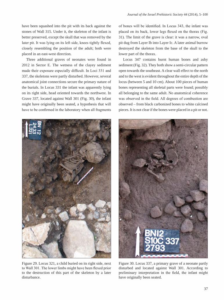
Journal of the Israel Prehistoric Society 44 (2014), 5–100
37
have been squashed into the pit with its back against the stones of Wall 315. Under it, the skeleton of the infant is better preserved, except the skull that was removed by the later pit. It was lying on its left side, knees tightly flexed, closely resembling the position of the adult; both were placed in an east-west direction.
Three additional graves of neonates were found in 2012 in Sector E. The wetness of the clayey sediment made their exposure especially difficult. In Loci 331 and 337, the skeletons were partly disturbed. However, several anatomical joint connections secure the primary nature of the burials. In Locus 331 the infant was apparently lying on its right side, head oriented towards the northwest. In Grave 337, located against Wall 301 (Fig. 30), the infant might have originally been seated, a hypothesis that will have to be confirmed in the laboratory when all fragments
of bones will be identified. In Locus 343, the infant was placed on its back, lower legs flexed on the thorax (Fig. 31). The limit of the grave is clear: it was a narrow, oval pit dug from Layer Ib into Layer Ic. A later animal burrow destroyed the skeleton from the base of the skull to the lower part of the thorax.
Locus 347 contains burnt human bones and ashy sediment (Fig. 32). They both show a semi-circular pattern open towards the southeast. A clear wall effect to the north and to the west is evident throughout the entire depth of the locus (between 5 and 10 cm). About 100 pieces of human bones representing all skeletal parts were found; possibly all belonging to the same adult. No anatomical coherence was observed in the field. All degrees of combustion are observed – from black carbonized bones to white calcined pieces. It is not clear if the bones were placed in a pit or not.
Figure 29. Locus 321, a child buried on its right side, next to Wall 301. The lower limbs might have been flexed prior to the destruction of this part of the skeleton by a later disturbance.
Figure 30. Locus 337, a primary grave of a neonate partly disturbed and located against Wall 301. According to preliminary interpretation in the field, the infant might have originally been seated.

Bocquentin et al.
38
Figure 31. Locus 343, a neonate lying on its back, lower legs flexed on the thorax within a narrow, oval pit.
Figure 32. Locus 347, a well-delimited cremation cluster where selected burnt bones of an adult were mixed with ash.
However, the organization of the bones demonstrates, without any doubt, that the bones were placed in a container — basket, leather bag, wooden box — which has disintegrated, resulting in this narrow pile of fragmented bones. It is likely that this container was used to transport the cremated remains from the primary location of burning to their last resting place. Probably soon after cremation, selected fragments of bone were collected and reburied here by the Neolithic inhabitants together with some ash.
Locus 338 is the most intriguing funerary locus of our corpus. The structure is a bell-shaped pit, 1 m in diameter (Fig. 33). Its clayey walls are entirely burnt. The structure is filled with two kinds of sediment: at the top there was regular Layer Ib soil containing three unburnt human bones; the lower layer was rich with ash and burnt human bones. We have dug to a depth of 35 cm in the structure but its bottom is still unexposed. Its exploration will hopefully be accomplished during the next field season. As in Loci 211 and 347, the human bones assemblage shows all degrees of combustion but the bones are far less fragmented than in the other loci. A mandible and a sacrum were found almost complete despite their calcined state. This probably means that the bones were left undisturbed after combustion, otherwise they would have been more fragmented as fire treatment facilitates bone breakage. Although no joint articulation has been identified as yet, an in situ combustion is very likely; this is also supported by the fact that the structure itself is burnt. Very similar structures have been found in Tell-el-Kherk in Northern Syria in an EPN context (Tsuneki et al. 2011).
Preliminary conclusion on burial customs at BeisamounBurial pits are rarely associated with contemporaneous floors; the only one possible case, Locus 214, was a neonate found in association with a plaster floor (Locus 209). The graves are most frequently dug into fills. However, they are sometimes closely associated with abandoned, but still visible, features such as ancient walls. This deliberate association is obvious for Graves 231 and 233 linked to Wall 228, and for Graves 321, 337 and 341 linked to Wall 301/315.

Journal of the Israel Prehistoric Society 44 (2014), 5–100
39
In Sector F, the burials are part of the last activities performed in this zone by the Neolithic population before abandonment of the village. A few more structures were built later, but they are obviously outside the houses (e.g. Locus 235), installed in courtyards or even further from dwelling areas. The situation is different in Sector E where, except for one grave (Locus 321), all the graves discovered so far were dug within the ruins of Structure 354 and pre-date Structure 306 and its courtyard that were constructed over them. The burials were consequently dug during a temporary period of reorganization of this dwelling zone.
The funerary treatment shows interesting variations. The majority of the burials are primary. The deceased were placed on their backs or on their sides, heads preferentially to the northeast or to the east. When preserved, the lower legs were systematically tightly flexed. In these primary contexts, no signs of secondary handling were documented: no deliberate removal of skulls was observed, skeletons are still articulated except in the case of later disturbances. However, it is apparent from other graves that adults
were sometimes accorded a more complex burial. Two clear secondary graves were unearthed and a third one is likely (although erosion limits a definitive statement). In one case the cranium was reburied while in the other, a number of large bones of the skeleton were selected for removal and reburial. These cases document the existence of several complex steps in funerary practices alongside more simple ones. Worth noting is the fact that for infants and children, primary burial was the exclusive treatment, but it was the case only for a minority of the adults. The most unexpected discoveries are the clusters of burnt bones. When we unearthed Locus 211 in 2008, conscious of the fact that cremation had not been documented in PPN contexts, we considered this as due to an accidental act. This hypothesis is not valid after the discoveries made in 2012: Locus 347 is obviously a secondary deposit of selected burnt human remains; and Locus 338 is likely a combustion-burial structure. These three cases highlight one of the oldest, if not the oldest, examples of deliberate and controlled burning as a funerary practice known so far in the Levant. Despite their general scarcity, burial
Figure 33. The south limits of Locus 338, a burnt bell-shaped pit which served for cremation and as a burial pit.

Bocquentin et al.
40
offerings such as perforated shells and portions of animal carcasses are found in different funerary contexts (primary, secondary and cremation). Noteworthy are the numerous fragments of a pig skull in Loci 230-234, which is strongly reminiscent of the PPNC grave from ‘Ain Ghazal (Rollefson 1998: 118).
THE LITHIC ASSEMBLAGES (H.K.)Large quantities of flint artifacts were recovered from both the site’s surface and occupational levels. The recovered material from all layers went through systematic dry and selected wet sieving using a 2–3 mm mesh. The analysis has shown uniformity and homogeneity in both technology and typology of the flint tools, despite the different excavation sectors and the various occupation levels; apparently the assemblage represents a single lithic tradition.
A relatively large number of artifacts were collected during the six excavation seasons at Beisamoun (n=44, 398). Altogether 54% were retrieved from Sector F and the remaining 46% were from Sector E (Tables 6, 7). Debitage and debris comprise approximately 97% of the total assemblage. The flint industry appears to have been produced on site as all components of the knapping process are present. The small number of cores reflects a high degree of exploitation, especially those designated for bladelet production.
The raw materials display variability as the assemblage is comprised of at least five flint types (Bocquentin et al. 2011); the dominant type is a fine-grained, dark grey nodular flint containing white inclusions which could be fossils. The nodules are covered with a thick lime cortex. This flint was favored for blade production. The second type is a fine-grained, brown variety present as large nodules and chunks. This type also exhibits a thick lime cortex and was mainly used for flake production and ad hoc tools. The third is distinct due to the fact that the flint is extra fine-grain, translucent and grey in color. Apparently, this flint was heat-treated and preferred for narrow blades and bladelet production. The fourth is a coarse-grained flint, beige in color and used mainly for bifacial tools. The last type, which is a lustrous purple/red flint, is rare within the assemblage and was probably used for bi-directional blade technology. While flint nodules and blocks are not abundant on-site, most of the flint outcrops are located
within a radius of five to seven km, and the majority of the flint originates in the eastern slopes of Naphtali Mountains to the west of the site (Delage, 1997: 54).
CoresDifferent types of cores and degrees of exploitation are present which provide further evidence of on-site knapping activities. The majority of the cores were fully exploited and usually discarded in an amorphous shape, and many of the single striking platform cores show the removal of only a few flakes. Based on the low number of core trimming elements (Tables 6, 7), only a few cores were rejuvenated.
A total of 432 cores were recovered from both sectors (49.3% from Sector E, 50.7% from Sector F). Comparison between the type frequencies in both sectors shows a great similarity, especially in the main categories such as flake and blade cores. The cores in both sectors range from 1.2 to 7.6 cm in length. Only a few cores (see below) were shaped from large pebbles up to 8 cm in length and a few of them were partially utilized as part of their debitage surface is still covered with lime cortex. Only eight cores were fully exploited due to the fact that these are of high quality purple raw material. Almost half of the cores are flake cores (Table 8). The flake cores are mostly with a single striking platform although many are amorphous (Fig. 34). A distinct group of cores was designated to produce small flakes (flakelets) (Fig. 34:1–3) (technologically, this type of core is discussed below by B.V.).
Blade cores are relatively few in both sectors, with 15.7% from Sector E and 23.3% from Sector F (Table 8). The majority are cores with two striking platform (e.g. Fig. 35:1–2) although bidirectional blade cores were also recovered (Fig. 35:1). Debitage surfaces of many were fully exploited as evidenced by the high degree of core exploitation. Even so, the low number of blade cores in general is in accordance with the low number of blade blanks in the debitage, a further indication of local production and consumption. Bidirectional blade cores are of two types: one has a dominant single platform (Barzilai 2010: 142), which was used to produce blades used mainly for ad hoc tools. The other, however, was a predetermined type that was used to produce well controlled blades used mainly for shaping arrowheads, sickle blades and other formal tools. This group includes two bi-directional cores known as naviform cores. This type of core is not common

Journal of the Israel Prehistoric Society 44 (2014), 5–100
41
Type / season 2007 2009 2010 2011 2012 Total
Debitage
Primary elements 41 173 139 107 820 1,280
Flakes 331 940 960 630 2,471 5,332
Blades / bladelets 363 525 487 260 1,704 3,339
Core trimming elements 16 60 13 12 33 134
Burin spalls 6 18 8 0 24 56
Total 757 1,716 1,607 1,010 5,052 10,142
Debris
Chips 608 2,328 2,030 515 3,650 9,131
Chunks 58 499 228 69 260 1114
Total 666 2,827 2,258 581 3,910 10,242
Debitage 757 1,716 1,607 1,010 5,052 10,112
Debris 666 2,827 2,258 581 3,910 10,242
Cores 26 34 31 18 104 213
Tools 121 131 130 39 162 583
Total 1,570 4,708 4,026 1,648 9,228 21,180
Table 6. General flint breakdown for Sector E.
Type / season 2008 2009 2010 2011 Total
Debitage
Primary elements 246 148 332 259 985
Flakes 1,580 635 1964 1,522 5,701
Blades / bladelets 754 647 1029 735 3,165
Core trimming elements 20 8 9 6 43
Burin spalls 14 12 17 21 64
Total 2,614 1,450 3,351 2,543 9,958
Debris
Chips 2,730 2,174 3,885 2,537 11,326
Chunks 327 444 271 123 1,165
Total 3,057 2,618 4,156 2,660 12,491
Debitage 2,614 1,450 3,351 2,543 9,958
Debris 3,057 2,618 4,156 2,660 12,491
Cores 50 17 103 49 219
Tools 162 89 187 112 550
Total 5,883 4,174 7,797 5,364 23,218
Table 7. General flint breakdown for Sector F.

Bocquentin et al.
42
in PN assemblages (but see Matskevich 2005) and is more characteristic of PPNB assemblages (Khalaily 2006). The frequencies of the bladelet cores in both sectors are somewhat similar (Table 8). The majority of these were shaped from high quality flint, either grey or brown in color and a few are semi-translucent. Some display a uniform luster as if they were heat treated. The dominant type is a single platform pyramidal core. Other types are dihedral and bipolar. Bladelet cores preserve little cortex on their surface, the result of their intense exploitation. This supposition is also reflected by the high number of scars discernible on their debitage surface – an average of nine scars on each core.
The presence of a high number of core fragments and cores on flakes is worth noting. Such a high frequency is not a result of intensive knapping due to the lack of raw material but rather of knapping choice. Most of the fragments were of coarse-grained, medium quality flint which was chosen to create bifacial tools. Some resulted from knapping mistakes, and others were primarily bifacial wastes that were re-used as a core.
In both sectors, core trimming elements (CTE) are
rare; this could be explained either by the small size of the primary nodules, or because core maintenance and rejuvenation were uncommon. A prominent group of 22 ridge blades prepared so that the initial removal surfaces are long and straight, are longer than any of the large cores discovered so far. Judging from their shaping technique and raw material, we assume that these re-used artifacts originated from the assemblage ascribed to the earlier PPNB occupation.
Figure 34. Flake cores. 1–3) single platform cores; 4) amorphous core.
Core TypeSector E Sector F TotalN % N % N %
Flake/flakelet 104 48.4 93 42.5 197 45.6
Blade 32 15.7 51 23.3 83 19.2
Bladelet 28 11.6 42 19.2 70 16.2
Core on flake 15 7.9 10 4.6 25 5.8
Fragment 34 16.8 23 10.5 57 13.2
Total 213 100.0 219 100.0 432 100.0
Table 8. Core type frequencies by sector.

Journal of the Israel Prehistoric Society 44 (2014), 5–100
43
ToolsThe tool assemblage (n=1,133) comprises 2.55% of the total flint assemblage. Tools derive from all occupation levels in equal frequencies and there were no notable differences between architectural complexes and open spaces. In general, the tool assemblages of both sectors display similar technological and typological characteristics and, accordingly, they are presented together (Table 9). Of note is the small number of formal tools such as arrowheads and bifacial tools.
Arrowheads (Fig. 36)A total of 87 arrowheads manufactured from blade segments were recovered in both sectors, constituting 7.7% of the total tool assemblage. Many of them were broken, but this does not hinder the possibility of recognizing the morphological stylistic groups to which they belong. Two types were encountered:
Amuq points (n=53). This type comprises the majority of arrowheads. Ten are complete specimens and the remainders are broken. This type is classified in Gopher’s type list (Gopher 1989, 1994) as Type A-6 and described as a leaf-shaped point with a pointed base that has no barbs. Pressure flaking was used to shape either part of, or the whole, point. Fourteen tools are fashioned on dark grey flint that has whitish spots, which could be fossils. In addition, there are six on beige flint, five from light brown flint, and one distinct point shaped on pinkish flint. These frequencies indicate that this type of tool was shaped on-site using the available local raw material. Pressure flaking, which shaped mainly the tangs and extends to a limited part of the body, is the most characteristic of this type (Fig. 36:1–3). Two points show bifacial denticulation along their lateral edges; the denticulations are deep and fashioned by pressure retouch. There are three arrowheads associated with this type that were shaped by pressure
Figure 35. Blade and bladelet cores. 1) bidirectional blade core; 2–3) cores with two striking platforms.

Bocquentin et al.
44
Figure 36. Arrowheads. 1–5) Amuq points; 6–7) Byblos points.
flaking (Fig. 36:4–5), which is visible on both the dorsal and ventral surfaces leaving no smooth surface. The Amuq points from Beisamoun range in length between 6–11 cm. Byblos Points (n=34). This type of arrowhead is shaped on two different types of blanks. The first subtype is made from thin, wide blades with triangular cross-section. The second is shaped on thick blades with a trapezoidal cross-section. Eight arrowheads belong to this latter subtype: four complete items, two body fragments, and two tangs. Like the Amuq type, dark-grey and beige flints were
the main raw materials used for the preparation of these points.
The average length of the complete arrowheads is 4.0 cm. Such points are characterized by a prominent tang which measures about half the length of the body. The angle between the tang and the shoulder is greater than 90° and is compatible with the general definition of this type of arrowhead. There are three types of shaped tangs for the Byblos points. The first is typified by trapezoidal cross-sectioned tangs. They are characterized by a central flat

Journal of the Israel Prehistoric Society 44 (2014), 5–100
45
scar on the dorsal side and semi-abrupt retouch fashioned the both lateral sides. The retouch direction usually extends from the ventral to the dorsal sides (Fig. 36:7). The second is typified by a triangular cross-section and modified tips (Fig. 36:6). Tangs of this sort were shaped by convergent pressure retouch to the central dorsal axes. The third is similar to the second type but the tangs are shorter, narrower, and the pressure retouch is less symmetrical.
Sickle Blades (Fig. 37)Sickle blades are the dominant formal tool representing 10.8% of the tools. The preservation of the sickle blades in Beisamoun is poor, and more than 90% are broken and missing the essential distal end for defining the original length and width of the blanks. For this reason, only complete items were chosen for attribute analysis; they are not a good representative sample due to their low number. Even so, three types can be distinguished: the first (type A, n=98) is the most common at Beisamoun and represents 79% of the sickle group. Items of this type are mostly fashioned on dark grey flint or grey flint with dark spots, and a few were shaped on brown flint. This type was shaped on rectangular blade blanks that have only one defined working edge (Fig. 37:1–6). The opposite sides are,
in many cases, plain and most of the items are truncated on both ends. The working edges are sharpened by deep, but irregular, denticulation. The denticulation was often made by bifacial pressure retouch. Sickle gloss is visible along the working edge; some show evidence of long-term use. Most sickle blades were shaped on relatively long and narrow blanks, and their working edges are straight. The second type (type B, n=18), is similar to the first in form and shaping technique. However, the working edges of this type display deep and wide denticulation shaped by bifacial pressure retouch (e.g. Fig. 37:4–5). The other sides, in most cases, are backed by semi-abrupt retouch. Most distal and proximal ends were truncated by semi-abrupt to abrupt retouch. Both types A and B are characteristic of EPN assemblages (Gopher 1989:126; Khalaily 2006:319).
The third type (type C, n=8) differs from those described above in blank choice and shaping technique. The tools of this type are generally fashioned on bidirectional blade blanks. Their working edges were shaped by continuous coarse denticulation which occurs on the ventral and the dorsal surfaces. Many have two working edges (Fig. 37:7–9). The sickle blades of this type resemble the EPN sickle blades (Groman-Yaroslavski and Rosenberg 2010:71), but differ in retouch location and type of sickle gloss; the gloss of those tools is more prominent, possibly hide polish (Yamada 2003:56). Seven of these tools display damage signs and one has scalar pressure retouch on the ventral side (Fig. 37:9).
Bifacial tools (Figs. 38, 39)Bifacial tools are all core tools that were shaped by bifacial flaking and include axes, adzes, and chisels (Barkai 2005:10). The main differences between these types are reflected in their shape and the form of the cross-sections. This type comprises 49 items (4.3 % of the assemblage): 42 axes, three adzes, five chisels, and one miscellaneous.
All the recovered axes were produced on white or beige flint, carefully flaked with little cortex remaining. They have an elongated body and biconvex cross-sections. Twenty-three of the axes are robust, thick in the middle and thinned toward the sides. The sides are usually straight and some of them have a pointed base (e.g. Fig. 38:1; Fig. 39:1). Their working edges are arched and many display polishing. Seven of the axes are broken medially in a special type of break named “The Hula break” (Lechevallier 1978; Barkai 2005) (Fig. 39:2). The
ToolsSector E Sector F Total
N % N % N %
Arrowheads 52 7.2 35 8.5 87 7.7
Sickle blades 86 12.0 38 9.2 124 10.8
Bifacials 32 4.5 17 4.1 49 4.3
Perforators 62 8.6 11 2.7 73 6.4
Scrapers 33 4.6 7 1.7 40 3.5
Burins 46 6.4 39 9.4 85 7.5Notches and denticulates 89 12.4 24 5.8 113 10.0
Truncations 26 3.6 4 1.0 30 2.6
Retouched blades 93 12.9 139 33.6 232 20.5
Retouched flakes 184 25.6 96 23.2 280 24.7
Knives 2 0.3 0 2 0.2
Multiples 9 1.3 0 9 0.8
Miscellaneous 5 0.7 4 1.0 9 0.8
Total 719 100.0 414 100.0 1,133 100.0
Table 9. Tool frequencies by sector.

Bocquentin et al.
46
Figure 37. Sickle blades. 1–6) deep denticulated sickle blade with one working edge; 7–9) deep denticulated sickle blade with two working edges.

Journal of the Israel Prehistoric Society 44 (2014), 5–100
47
Figure 38. Bifacial tools. 1, 3) axes; 2) adze.
most common are those missing the active working edges. There are also eight fragments of this type that exhibit polishing and signs of resharpening.
Adzes are uncommon in the tool assemblage, and only three were encountered. Adzes were shaped on thick pebbles (Fig. 38:2); their dorsal aspect was partially flaked with most of the cortex removed while the ventral aspect was completely flaked. Their working edges are straight and well-shaped. Remains of polishing are visible on all three tips indicating a maintenance method by resharpening and reuse. The lateral side of one item was damaged and patina covers the break surface.
The five chisels in this group are proximally broken, and only their cross-sections and pointed working edges give an indication of this type. They have plano-convex cross-sections, elongated narrow bodies, and working edges that were laterally flaked. Two tools were classified under the miscellaneous category and defined by Khalaily (2006) as “fan axes”. This type is characterized by thin and broad flakes that have a convex-convex section and shaped by bifacial flaking on both dorsal and ventral sides.
Ad hoc tools (Fig. 40)The ad hoc tools comprise all the types that were shaped

Bocquentin et al.
48
on-site by non-craft specialists and include retouched flakes and blades, notches and denticulates, perforators, burins and scrapers. These types usually appear in high percentages on readily available raw materials. From the lithics of the 2011 field season, three of the above types (perforators, scrapers and burins) are of interest and worthy of a detailed description due to their formality and raw material preferences.
PerforatorsIn many Neolithic assemblages, perforators are classified under the formal tools as they are much more standardized than the ad hoc tools and were manufactured mainly on blade blanks (Khalaily 1999, 2006). In the Beisamoun
lithic assemblage they are less standardized and shaped on a variety of raw materials. All display points that vary in form from short and slightly modified to long and steeply retouched along the lateral sides of the points. A total of 73 perforators subdivided into 49 awls, 19 borers and five massive drills were found. The drills (e.g. Fig. 40:6) were shaped on thick elements and two of them are shaped by bifacial flaking.
ScrapersThis artifact type comprises 3.5% of the tool assemblage. Scrapers were manufactured on a range of flint types using available flakes and blades. Most of the implements exhibit cortex on their surface covering 10–30% of the
Figure 39. Bifacial tools. 1) large axe; 2) axe with the “The Hula break”.

Journal of the Israel Prehistoric Society 44 (2014), 5–100
49
total surface. End scrapers (Fig. 40:1–3) are the most frequent type followed by side scrapers. Double-ended scrapers and rounded cortical scrapers are a minority. Side scrapers are represented in lower numbers (Fig. 40:7), most of them shaped on thick flakes.
BurinsAltogether 85 burins were identified; approximately 60% were shaped on blade blanks, 35% on flakes and the
reminder on various kinds of waste material. Burins on truncations (Fig. 40:5) are the most common in this group; there are a few on natural surfaces, while the remainder are dihedral (Fig. 40:4). All the types were shaped on blades, and the burin blows appear on one lateral side, usually from the distal end toward the proximal. There are indications that this type of tool was manufactured by craft specialists due to their formality and raw material choices which are similar to sickle blades.
Figure 40. Ad hoc tools. 1–3) end scrapers; 4–5) burins; 6) awl; 7) side scraper.

Bocquentin et al.
50
Figure 41. Bladelet production. 1–5) unretouched bladelets; 6–9) retouched bladelets; 10) product from the rejuvenation of the bladelet debitage surface.
DiscussionThe techno-typological analysis of the flint assemblage from both excavated sectors of Beisamoun contributes much to our understanding of the 7th millennium flint industry in the site and its relation to the nearby Neolithic sites in the Hula region. The abundance of cores representing various knapping stages, as well as the high frequency of waste material, indicate that flint knapping took place on-site using the available raw materials. The long Amuq points that were partially shaped by pressure retouch, together with deeply denticulated sickle blades characterize the tool assemblage. These two types are characteristic of EPN assemblages, resembling the well-known Yarmukian flint assemblages (Garfinkel 1993; Garfinkel and Miller 2002; Groman-Yaroslavski and Rosenberg 2010; Khalaily 2006; Matskevich 2005).
However, the tool assemblage lacks certain types such
as small arrowheads. In addition, it contains a few tools associated with earlier Pre-Pottery Neolithic assemblages such as some sickle blades that have fine denticulation on their ventral sides and shaped on pink flint. Such an assemblage has much in common with transitional PPN/EPN assemblages in the Hula Basin such as Tel Te’o Stratum xI (Eisenberg et al. 2001:51) and Tel Roim West Layer IV (Nadler-Uziel 2007; Nadel and Nadler-Uziel 2011), and shows some similarity to Layer VI in Hagoshrim (Khalaily 2006). The flint assemblages in these two sites share tool types, shaping techniques and tool frequencies. The frequencies of the main tools in these three sites closely resemble each other (see also Groman-Yaroslavski and Rosenberg 2010: table 5.14) and are characterized by low frequencies of arrowheads compared to high frequencies of sickle blades, while both types were partially shaped by pressure retouch.
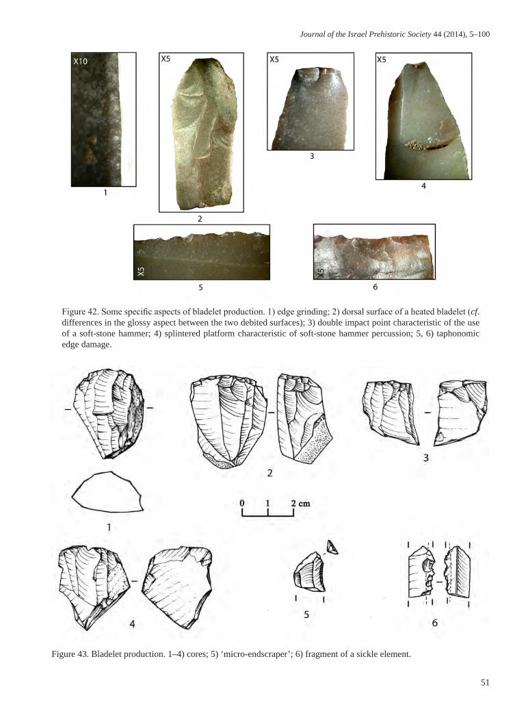
Journal of the Israel Prehistoric Society 44 (2014), 5–100
51
Figure 42. Some specific aspects of bladelet production. 1) edge grinding; 2) dorsal surface of a heated bladelet (cf. differences in the glossy aspect between the two debited surfaces); 3) double impact point characteristic of the use of a soft-stone hammer; 4) splintered platform characteristic of soft-stone hammer percussion; 5, 6) taphonomic edge damage.
Figure 43. Bladelet production. 1–4) cores; 5) ‘micro-endscraper’; 6) fragment of a sickle element.

Bocquentin et al.
52
Figure 45. Flakes. 1) striking platform rejuvenation flake removed during bladelet production; 2–4) thin bifacial shaping flakes; 5, 6) thick retouched flakes.
Figure 44. Some aspects of bladelet production. 1–3) diagnostic breaks due to projectile impact; 4) blunting of the extremity of a bladelet used as a projectile.

Journal of the Israel Prehistoric Society 44 (2014), 5–100
53
Figure 46. 1) thin shaping flake from a bifacial tool; 2) core on a flake which produced a single micro-flake.
Figure 47. 1, 2) flake cores; 3, 4) heavily patinated flakes from Layer 0.

Bocquentin et al.
54
A TECHNOLOGICAL, STRATIGRAPHIC AND SPATIAL APPROACH TO THE LITHIC INDUSTRY (B.V.)In this section the results of the techno-typological analysis of the lithic material recovered between 2007 and 2011 are presented (ca. 45,000 artifacts, based on Khalaily’s work, see above). This work was undertaken in two study sessions, in 2010 and 2012, and benefited from the collaboration of L. Chesnaux, C. Guéret and J. Pelegrin.
Main research questionsThe chronological attributions recently proposed for the new excavations at Beisamoun (Bocquentin et al. 2007, 2011) rest essentially on the typology of three large groups of retouched artifacts - arrowheads, sickle blades and bifacial tools - coupled with the different methods of blade production. Given that identifying significant techno-typological contrasts in these artifact types between layers still remains beyond our ability, we focused on simpler questions familiar to all technologists:
1. It has been noted that the importance of bladelet production in all layers may represent another criterion for their possible attribution to a late phase of the PPN (see also Khalaily 2006). Therefore, we focused on their production method, unexpectedly finding evidence for intentional heat treatment, as well as examining the function(s) of the significant quantity of bladelets.
2. The relative proportions of flakes employed in
several attempts of seriation in preliminary unpublished reports between 2007 and 2012 led us to investigate the method used for producing these particularly abundant elements. The question was to determine which portion derives from an independent flake production and which portion derives from other chaînes opératoires carried out on-site (i.e. blade and bladelet production as well as the shaping of bifacial tools).
3. Substantial variation in the quantity of shaping flakes was documented from one sector to another in the sampled zones with some areas reflecting especially high concentrations. We paid particular attention to this spatial differentiation which is also evident for both the blades and bladelets and appears to be considerably clearer than stratigraphic variation.
The sampleAfter assessing the entire industry (ca. 45,000), we proceeded with a sampling strategy that took into consideration both the stratigraphic and spatial distribution of the material resulting in ca. 6,500 pieces being examined in more detail. In terms of their stratigraphic distribution, we retained the sedimentological partition produced in 2011 for this PPNC archaeo-sequence.
Given that each of the five stratigraphic assemblages was well represented in the sample and the impossibility of targeting the entire spatial extent of the site, we settled on a sampling strategy as a function of the differential spatial distributions documented during the preliminary assessment. The goal of this preliminary analysis was to begin to document this spatial differentiation which will eventually need to be described in its entirety.
Bladelet production: a major assemblage componentThe basic quantitative method adopted (which excludes a clear estimation of Minimum Number of Individual [MNI] counts for the products, or attempts at conjoining and still less, refitting) and the various features of spatial differentiation (see below) have rendered it impossible to discern whether or not bladelet production was the dominant chaîne opératoire.
Nevertheless, counts from the 2010 and 2011 excavations (Table 10) already highlight bladelet production as present across the site in all layers and sectors with the most distinct elements including: 1)
Total number of analyzed
flint artifacts
Bladelets
N %
Sector F, Layer D/A/01 989 134 13.5
Sector E, Layer 0a 582 55 9.4
Sector F, Layer B 1,553 188 12.1
Sector E, Layer I 298 32 10.7
Sector E, Layer Ib 414 49 11.8
Table 10. Total number of flint artifacts in our sample of material from the 2010 and 2011 excavations together with the number of bladelets (complete and fragments) by sector and layer.

Journal of the Israel Prehistoric Society 44 (2014), 5–100
55
numerous complete or broken bladelets (Fig. 41:1–9; Fig. 42), sometimes very lightly retouched (ca. 12 % of 6,500 items examined in detail) and often on a grey, fine-grained flint whose glossy aspect resulted in some cases from intentional heat treatment; 2) the presence of cores of the same raw material dedicated entirely to bladelet production (Fig. 43:1–4), although their numbers vary significantly between layers and especially between different sectors (Table 11).
Furthermore, among the numerous small flakes (1–3 cm) present in all the samples (the fine fraction has not yet been systematically examined and many samples are still being sorted), clear evidence of bladelet production comes in the form of platform rejuvenation flakes (Fig. 45: 1). The technical affiliation of the overwhelming majority of the remaining small flakes is difficult to determine (see below); however, it is very likely that a considerable portion made on a glossy grey flint correspond to products from the shaping or rejuvenation of bladelet cores.
Evidence for intentional heat treatmentGlossy and matte zones coexist on the surfaces of numerous bladelets which, when taken together, suggest thermal modification (Fig. 42:2). However questions remain as to its origin and possible intentionality.
One hypothesis that can easily be ruled out is the possible recycling of knapped elements which were subsequently burnt by accident (as seen, for example, at the Natufian site of Eynan, personal observations); in other words, the re-exploitation of material randomly exposed
to hearths. Unlike the case with Eynan, at Beisamoun the debate concerns only objects with a very homogeneous thermal modification rather than those covered with small pot lids on all, or part of, their surfaces. At Beisamoun, only a handful of thermofracts in the form of large pot lids (one of which later served as a bladelet core) are certain to result from a too rapid temperature increase in relation to the volume of the block. Moreover, these pot lids may also result from accidents connected to intentional heat treatment. A second interpretive problem is that these thermal modifications may also have resulted from natural processes given the region’s past tectonic and volcanic activity (Khalaily, pers. comm.).
The small sample of heated elements at our disposal significantly limits our discussion, and the matte zones on the bladelets are generally too small to verify if they correspond to previously knapped surfaces rather than natural surfaces. Furthermore, the often heavily exploited cores retain no traces of matte surfaces from which this distinction can be made. For example, of the 24 bladelet cores recovered from Sector F in 2011, 17 present matte surfaces of which only nine were large enough to be examined by J. Pelegrin. Incontestable evidence of a homogeneous thermal treatment after first knapping sequences (flake removals connected to core shaping) is evident on five cores eliminating, at least for these examples, the possibility that natural blanks already heated by volcanic activity were preferentially selected. Evidence for genuine intentional heat treatment by the knappers, although limited, is robust and renders it possible to reintegrate more frequent, but still somewhat ambiguous, evidence. Glossy and matte surfaces coexist (the latter are always overlain by more recent removals in the diacritic schemes) on more than 50% of the cores (see above), a pattern which can also be observed on a similar proportion of bladelets. Furthermore, in our opinion, the most consistent and secure indication is the aspect of the matte surfaces presenting evidence of a homogeneous thermal modification whose regularity renders it difficult to imagine a natural process that could produce an identical result.
This aspect of bladelet debitage ought to be the subject of a more focused analysis in order to clarify the intensity of heat treatment (was all the flint used in bladelet production pre-treated?), its exact objective such as improving the flint and/or fracturing blocks as suggested
Total numberof cores
Bladelet coresN %
Sector F, Layer D/A/01 23 16 69.6
Sector E, Layer 0a 7 1 14.4
Sector F, Layer B 21 8 38.1
Sector E, Layer I 7 1 14.3
Sector E, Layer Ib 0 0 0.0
Table 11. Total number of cores in our sample from the 2010 and 2011 excavations and number of bladelet cores by sector and layer.

Bocquentin et al.
56
in other contexts (Guilbert, 2001), the stage when heat treatment was introduced (although, it seems this took place after the core’s initial shaping), and where it took place on the site (this question overlaps with those related to the distribution of different activities involving flint).
Remarks concerning other stages of bladelet production The thermal pre-treatment at Beisamoun displays a very specific and painstaking investment in the bladelet chaîne opératoire which, when combined with other complementary evidence, attests to high-quality bladelet production. Numerous bladelets, as well as corresponding negatives frequently observable on cores and thick core rejuvenation bladelets, are long (two length thresholds of about 35–40 mm and 20–25 mm), consistently thin (average: 2.5 mm) and narrow (average: 8.0 mm). Their edges are semi-parallel with the distal extremity more often plunging than hinged, despite what we consider a strict unipolar core conception (21 of the 24 cores recovered from Sector F in 2011 were exploited using only a single striking platform with three others having two striking platforms, although each served for removals from a different surface).
While evidence for heat treatment is present, several of J. Pelegrin’s observations indicate no unequivocal evidence for the use of pressure flaking which is often associated with this process (see Tixier and Inizan 2000; see Binder 2007 for the PPN). At Beisamoun, several forms of evidence indicate soft-stone percussion to be the only conclusively demonstrable technique employed (sub-millimeter punctiform butts occasionally associated with splintered striking platforms, see Pelegrin 2000) (Fig. 42:3, 4). The regularity and thinness of the products clearly demonstrates that this soft-stone percussion involved considerable care which is evident, for example, in the meticulous abrading of the striking platform edges.
This attention to detail is also apparent in the high quality blades which also form part of the assemblage, so much so that the possibility of the two types of production sometimes being intimately connected cannot be ruled out. However, the dimensions of the final negatives visible on the blade cores considerably exceed the size classes typical of the bladelet component (see above). Could some of these bladelets have been manufactured between blades in the course of laminar sequences? While this remains a possibility, a series of arguments plead in favor of the
independent production of bladelets: 1) the preferential selection of grey flint which is less prevalent in the blade sample; 2) the lack of evidence for heat treatment among the blades; 3) the use of smaller initial volumes (small blocks, as well as unmodified or debited flakes: Fig. 43:2– 4); 4) a strictly unipolar method for bladelet manufacture, unlike the case with blade production; 5) the frequency of bladelets with three parallel scars provides evidence of dedicated bladelet reduction sequences supported further by scars visible on several core rejuvenation bladelets (Fig. 41:10).
Overall, preliminary information recovered from recent excavations at Beisamoun complements what is already known from, for example, the Yarmukian at Sha’ar Hagolan, where independent bladelet production employing a semi-translucent flint has been clearly documented (Gorman-Yaroslavski and Rosenberg 2010; Matskevich 2005: 63). While these bladelets were occasionally retouched into ‘micro-endscrapers’ (also known from the PN Layer V at Hagoshrim: Khalaily 1999), the majority bear a very light lateral retouch.
Bladelet function?At Beisamoun, some doubts persist concerning the origin of the blanks employed for the single ‘micro-endscraper’ (Fig. 43:5), the occasional piercer and the sickle elements (Fig. 43:6). All were manufactured on narrow (7–12 mm), not very thick (3–4 mm) blanks which fall within the range of overlap comprising the largest unipolar bladelets (see above) and the smallest blades associated with bipolar debitage. However, only genuine bladelets were lightly retouched over at least a third of their edge (Fig. 41:6–9; Fig. 42:1). This very limited transformation (minute grinding) of the bladelets, while evident in all samples from Beisamoun regardless of the layer or sector, is present only in limited frequencies (no more than 10% of the bladelets).
A use-wear analysis concerning some 100 bladelets, including lightly retouched examples, was conducted by C. Guéret which, although preliminary, nonetheless entailed a systematic examination using a stereo microscope (Perfex Zoom Pro 10, up to 40x magnification) occasionally in conjunction with higher magnifications (Nikon optiphot, 50x to 200x). Unfortunately, artifacts from Layers B and I were too poorly preserved for any possible functions to be determined (Fig. 42:5, 6). However, despite the presence

Journal of the Israel Prehistoric Society 44 (2014), 5–100
57
of soil sheen, the preservation is better in Layer A (Sector F). C. Guéret (in litteris, pers. comm.) has provided the following very preliminary assessment of the bladelets from this layer: “no functional polish, microscopic damage and/or organized microscopic chipping was observed, thus eliminating the prolonged working of plant materials, skins or hard animal or mineral materials. On the other hand, bearing in mind the site’s taphonomy, short uses involving these materials nevertheless remain possible. Notwithstanding the possibility that in addition to these brief and non-detectable usages, these elements may have been used in butchery or as lateral projectile elements – two of the most difficult functions to detect. However, seven bladelets, several of which were backed, bear diverse scars suggesting their functioning as lateral projectile elements (for example, lateral chipping oblique to the cutting edge on one example, a burin like fracture on another and possible complex fractures on a final four examples).”
C. Guéret recommended a second opinion to confirm this possibility which appears both logical, given the frequent use of bladelets as projectile elements when the entire range of possibilities is considered, and exciting as it suggests their possible coexistence during this period with what are still somewhat large arrowheads. L. Chesnaux (in litteris, pers. comm.), who specializes in microlith use, has provided the following opinion: “Of the seven bladelets selected by C. Guéret, the damage on four of them provides irrefutable evidence of their use as projectile elements (Fig. 44:1–4). They bear transverse bending fractures either being tongued and/or spin-offs whose lengths exceed 2 mm. Both the hafting method and position on the shaft are more difficult to reconstruct as these three distal bladelet fragments could have easily functioned as either axial or lateral projectile elements. Nevertheless, the hafting mode of the fourth piece, a proximal fragment, appears clearer given the presence of significant blunting beginning from the butt and covering the adjacent dorsal and ventral faces (Fig. 44:4). This blunting could indicate intentional abrasion connected to the creation of a point. Furthermore, given the orientation of the damage (a perpendicular transverse break associated with a facial spin-off parallel to the axis of the piece), it is likely that this projectile element served as part of an axial point.”
Clearly a more systematic sampling strategy is needed to better characterize this previously unknown functional
category amongst the regional industries from the end of the PPN; occasionally lightly retouched bladelets served as lateral cutting edges for projectiles or perhaps as micro-points. This discovery also poses much larger questions concerning the types of game hunted.
Questions regarding flakesStratigraphic differences?In an unpublished preliminary report of the lithics, H. Khalaily and O. Barzilai initially noted a general increase in the frequencies of flakes in the upper layers, possibly indicative of a technical evolution. This observation was subsequently nuanced with the addition of further counts and we confirmed this reservation by our own sample which identified more spatial rather than stratigraphic variation (see below).
However, our initial sample of material from the 2007 to 2009 excavations demonstrated an increase in Layer A (Sector F) of a special artifact category amongst the flakes: waste derived from the final stages of shaping bifacial tools (Fig. 45:2–4; Fig. 46:1). These relatively large flakes (20 to 70 mm in their largest dimension) are easily recognizable based on both lithological (coarse-grained flint) and technical criteria (thin, generally arched flakes tending to be invasive and often presenting parallel scars on their dorsal surface). Furthermore, spatial concentrations of this artifact type were recognized during excavations.
The second sample comes from the 2010 and 2011 excavations and shows no increase in shaping flakes in the upper layers. However, this new sample portrays significant differences between sectors, once again underlining a clear spatial differentiation, but on a larger scale (Table 12). These differences, which we will return to below, may introduce substantial biases into the stratigraphic analysis whose effects would therefore vary according to the zone excavated.
Intentional flake production?The question of intentional flake production remained unanswered after analyzing our first sample comprising a large quantity of fine-grained flint, not derived from the shaping of bifacial tools. Although a large part was technologically relatively uninformative, several pieces undoubtedly result from bladelet manufacture (essentially platform rejuvenation flakes). Few cores were present in

Bocquentin et al.
58
the analyzed sample (n=23), being relatively rare overall. Fortunately, the 2011 excavations in Sector F provided slightly more cores (Table 11), once again highlighting these now well-documented spatial variations.
The final removal scars (sometimes overlying bladelet removals) on 29 of these cores correspond to micro-flakes (their largest dimensions measuring between 10 and 20 mm with thicknesses ranging between 2 to 3 mm, Fig. 46:2). The cores show evidence of hard-hammer percussion with blows applied away from the edge of the striking platform employing a very basic method (facial and multi-facial). Therefore, several forms of evidence at Beisamoun, which were also observed in the Hagoshrim material (personal observation), demonstrate the production of small flakes whose function remains to be determined.
On the other hand, during the new excavations at Beisamoun, we have not yet found conclusive evidence for the intentional production of larger flakes. All of the large tools were manufactured on blanks perfectly compatible with their being by-products of blade debitage (Fig. 45:5–6) or shaping flakes. Very occasional indications of the dedicated production of large flakes are nevertheless evident amongst the cores, but the only two flake cores identified (Fig. 47: 1–2) are so heavily damaged that they undoubtedly represent recycled elements from a Mousterian production as can be seen with several heavily rolled and patinated flakes from the uppermost layer, Layer 0 (Fig. 47:3, 4).
Preliminary observations concerning the spatial distributions of the lithic artifactsAlthough the technological content of the stratigraphic assemblages ultimately demonstrated little variation, samples taken from different zones show a clear
fluctuation in the densities of all technological categories of the lithic artifacts. However, at this stage of the study we are not yet able to fully compare these densities (i.e. the available quantities still require correlation with the volume of excavated sediments).
At the moment, we have made the most progress in documenting spatial fluctuations in frequencies which can be seen as clear concentrations of bladelets (and sometimes blades), and of shaping flakes from bifacial tools in a coarse-grained flint. However, in these areas, the majority of the material comprises fine-grained flint flakes connected to different chaînes opératoires which are difficult to distinguish (see below). Zones where blades and bladelets are weakly represented also exist, as do those with shaping flakes. on other occasions the latter are absent and the homogeneous category of ‘other flakes’ once again overwhelmingly dominates.
Furthermore, use-wear analysis (see above) revealed the very poor preservation of a large part of the bladelet edges, especially those from Layer B in Sector F. Their very damaged edges bear significant (several millimeters) bifacial chipping which is unorganized and associated with marked bulbs (Fig. 42:5–6). The origin of this damage is undoubtedly taphonomic, posing questions as to the role water action (and/or trampling) may have played in the preferential concentration of certain artifacts (for example, relatively small pieces).
However, the spatial distribution tests that we attempted, in particular granulometric examination, produced no simple rule that explains these clear concentrations. For example, in Layer B of Sector F, where the heavily damaged bladelets were recovered, bladelets were exceptionally numerous in all four quadrants of Square T26 and in Locus 209. Amongst the other artifacts, small-sized elements (<3cm) are frequent, but by no means exclusive, making it very difficult to support the hypothesis of a taphonomic bias (preferential selection of the fine fraction) underlying the bladelet concentration in T26 and Locus 209. On the other hand, also by way of example, bladelets are exceptionally rare in Locus 237 (waste pit) where shaping flakes are numerous throughout and large elements (>3cm) are generally abundant. In the other areas of sector F, shaping flakes are generally rare (<5%) including in Loci 238 (floor) and 243 (cobble bed very rich in faunal remains) where large elements are however numerous.
Total number of analyzed
flint artifacts
Shaping flakes
N %Sector F, Layer D/A/01 989 157 16.0Sector E, Layer 0a 582 6 1.0Sector F, Layer B 1,553 396 25.5Sector E, Layer I 298 11 3.5Sector E, Layer Ib 414 7 1.5
Table 12. Total number of flint artifacts in our sample from the 2010 and 2011 excavations and number of shaping flakes by sector and layer.

Journal of the Israel Prehistoric Society 44 (2014), 5–100
59
Finally, the documented concentrations resulting from natural phenomena can be reasonably eliminated in most, if not all, cases. Determining the functional characteristics of each concentration (zones of use vs. production vs. discard) now requires more focused analyses which take into account a more refined break down of the lithic artifact classes (for example, bladelets having particular economic objectives and use vs. unused vs. bladelet by-products). The surface states of larger objects, some of which may have served as construction material, also need to be considered in detail. For instance, on the floor (L208) in Layer I (Sector E), numerous patinated and rolled pieces, particularly cores, form an integral part of the cobble bed.
THE GROUNDSTONE TOOLS AND OTHER STONES (L.D.)The groundstone artifact analysis combines morphological, typological, technological, and use-wear approaches (Dubreuil 2002, 2004; Dubreuil and Savage 2013). The objectives are to establish an inventory of the various groundstone implements present at the site, and to better understand the techniques of manufacture and the life history of the tools including their mode of use, as well as episodes of resharpening (sensu Wright 1992a) and recycling. Preliminary results are presented here, focusing on the material collected during four of the six excavation seasons, 2007, 2008, 2011 and 2012.
The stone assemblage analyzed here comprises 679 items, including 211 tools and various stone fragments (manuports), bearing no obvious traces of utilization or manufacture (n=468, 68.9%). The majority of the objects are made of basalt (52.7%) and limestone (41.5%). Sandstone (2.7%), flint (0.9%), quartz and quartzite (0.7%) as well as a conglomerate-like raw material (0.3%) are also present, all in small quantities.
This sample was analyzed using low and high magnifications to screen for evidence for use or manufacture. Most of the manuports and tools are fragmented (99.1%, n=464). The cause of the fragmentation is difficult to assess, and could be related to human action or natural processes. High frequencies of pebble, slab and block fragments, showing no obvious traces of manufacture and/or use, have been observed in several assemblages from the southern Levant ranging
from the early Epipaleolithic to the Pre-Pottery Neolithic periods (personal observation). It is, therefore, a broader phenomenon that still needs to be understood. Minimally, it can at least be said that these implements were transported to the site. Some may be related to the building of structures or to many other uses. It is important to note that experiments have shown that use-wear can be difficult to detect on groundstone tools which are only used for a short period of time. Therefore, some of the specimens classified in this category may correspond to unidentified, ad hoc tool fragments. Detailed analysis of the spatial distribution of these artifacts may provide crucial data for a better understanding the utilization of these stones.
The categorization of the items with obvious traces of manufacture and/or utilization (n=211) is presented in Table 13. Description of some of the tool categories found at Beisamoun is provided in the following paragraphs: debitage, heavy-duty tools, vessels, grinding and pounding implements and disks. Tool types are defined based on the terminology proposed by Wright (1992) and Adams (2002).
Type Number %
Grinding slab 1 (1) 0.5
Handstone 9 (1) 4.3
Vessel 22 (1) 10.4
Grooved stone 1 0.5
Perforated piece 2 0.9
Cupped stone 2 0.9
Pounder 5 2.4
Spheroid 3 1.4
Notched pebble 4 1.9
Disc 9 4.3
Heavy duty tool 6 (3) 2.8
Used pebble or block 27 (7) 12.8
Debitage 80 (23) 37.9
Indeterminate tool fragment 38 (6) 18.0
Possible art object 2 0.9
Total 211 (42) 100.0
Table 13. Break down of the groundstone objects showing traces of manufacture and/or utilization (n=211) according to tool categories. In brackets: probable/uncertain attributions.

Bocquentin et al.
60
The debitage and heavy duty toolsFollowing Wright’s definition (Wright 1992b), the debitage category includes flakes, waste products, cores, pieces with removal scars, and preforms. Eighty pieces (37.9% of the manufactured assemblage) are classified in this category (23 items with probable attribution). Twenty-two pieces (10 probable) have removal scars. Among them, 19 are made of limestone, one of basalt, and two of quartzite or quartzitic sandstone. Most commonly, several knapping scars are present on the objects; however, no specific organization could be noted in the arrangement of the removals. In two instances, the scars are smaller than 1 cm, and can better be described as chipping.
Still in the debitage category, 58 items (13 probable) were classified as flakes. Among them, 10 present removal scars on the dorsal surface, while the others have a neo-cortical dorsal face. Regarding the raw material, 27 are of basalt, 28 of limestone, and three are made of some kind of quartzitic sandstone.
Evidence of knapping may be difficult to recognize on some of the raw materials represented at the site, such as coarse-grained basalt, quartzite or sandstone. Consequently, both flakes and pieces with removal scars may be underestimated in our figures. Therefore, the debitage category, which is the dominant artifact type in the assemblage, may be even more significant. Despite the quantity of flakes, it is argued here that the current dataset is not consistent with the hypothesis of a complete in situ production of the groundstone implements, at least not of the largest ones. One of the main arguments in support of this interpretation is that no preforms have as yet been identified. Furthermore, the dimensions of the flakes are rather small compared to what would be expected, especially in the earliest phases of tool production (e.g. Hayden 1987; Runnels 1981; Rosenberg et al. 2008; Schneider 1996; Wilke and Quintero 1996). Less than 15% of the sample is greater than 5 cm in length and more than 43% measure less than 3 cm. Flakes may be related to the final manufacturing phases and to the re-sharpening or recycling of non-flint tools. otherwise, they may have been produced accidentally during tool use.
Heavy-duty tools have been defined by Belfer-Cohen (1988) as rather large flaked tools, such as scrapers, made on non-flint raw materials. Although these items could be classified in the debitage category, following Wright’s definition, it was preferred to separate them because they
clearly show evidence of intentional shaping by flaking. Heavy duty tools are found at least since the Natufian period, sometimes in large assemblages such as that from Hayonim Cave (Belfer-Cohen 1988). Six objects (three possible) have been classified in this category at Beisamoun, five of which are made of limestone and one of basalt. The identified tools include: a chopper-hammerstone; two slabs with removals; a bi-truncated that was also possibly used as an anvil and three scraper-like implements.
The vesselsThe vessels represent 10.4% of the tools (n=22, 1 probable) and are the fourth most abundant tool type in this assemblage, after the indeterminate tool fragments, and the used pebbles or blocks (Table 13). All are fragments, and no refits have been found so far. The majority of the implements are made of limestone (n=20) while only one is made of basalt, and one of an indeterminate type of raw material. Some of the varieties of limestone used are very soft, and at least two fragments can be attributed to white ware vessels (Fig. 48).
The vessel assemblage demonstrates a variety of forms and manufacture techniques. Nevertheless, all the fragments most likely come from rounded or oval vessels and portable implements. Some fragments may have been part of open vessel shapes, such as platters and V-shaped bowls (following Wright’s typology, 1992a) while others can be attributed to narrow, smaller forms, such as bowls. No decoration has been found. In general, softer raw materials tend to be associated with thinner walls, and more readily record manufacture traces related to finishing operations, such as fine and parallel striations indicating grinding and polishing. However, thick walled vessels made of soft limestone are also present, as well as cruder objects, such as one showing chisel-like marks (Fig. 49). Harder raw materials, on the other hand, tend to be associated with a wider range of traces related to various stages of manufacture including removals, battering and pecking, as well as fine abrasion.
The range of techniques and vessel types echoes that described in other Neolithic sites (e.g. Dorrell 1983; Gopher 1997; Gopher and Orrelle 1995; Lebreton 2003, 2008; Rosenberg et al. 2008; Samzun 1994; Wright 1992, 2000); however, not all types are represented here. Use-wear analysis has been undertaken in order to further

Journal of the Israel Prehistoric Society 44 (2014), 5–100
61
investigate the wear present on the surfaces. Our study also includes 3D modeling, with the aim of reconstructing the initial shape of the vessels.
The grinding and pounding implementsThis category encompasses tools which were used to reduce a material into smaller particles and includes handstones, grinding slabs, mortars and pestles. In the
sample analyzed so far there are 10 items (two probable). This assemblage consists of nine handstones (one probable) and one probable grinding slab. It should be noted that one pestle at least is present in the rest of the collection that remains to be analyzed.
The probable grinding slab implement (from Square S24ab-1789) is a basalt fragment with a concave working surface. The other surfaces correspond to fracture planes.
Figure 48. Example of a white-ware vessel (Catalogue #1553-1).

Bocquentin et al.
62
The fragment most probably comes from a rather thick tool. The concave working surface is dominated by wear related to pecking. The formation of small, leveled areas on the top of some asperities indicates however, that the surface was used for grinding activities after pecking, but most probably for a limited time. The matter processed is difficult to assess because the use-wear related to grinding is not extensive; nevertheless, the characteristics indicate the processing of non-oily vegetal matter. This is based on the morphology of the plateau, the type of grain alteration observed at low magnification and their distribution (Dubreuil 2002, 2004).
Four out of the nine handstones are made of a pumice-like type of basalt. All are fragments with part of a lateral margin and of the two opposing faces, although one fragment consists mostly of the lateral margin and little of the faces is preserved. The handstones are oval or rounded in plan, two are bi-convex in profile with a thick lateral side and the two others are plano-convex. The faces are generally irregular on these handstones and show little
evidence of plateaus indicating a leveling of the high topography.
Because of its porosity, use-wear analysis is difficult to perform on this type of raw material. In general, more experiments are required to better understand use-wear formation on highly vesicular basalt. However, preliminary observations at low and high magnifications revealed interesting patterns on one of these handstones. With a naked-eye, and at low magnifications, the topography of the faces of this piece is irregular and does not show wear commonly associated with contact with another hard surface (as in grinding activities). At high magnifications, small spots of thick, bright, domed and striated micropolish are apparent. Some characteristics of this micropolish may also indicate that the tool was used as an abrader rather than a grinding implement (following the criteria discussed in Dubreuil 2002, 2004).
The five other handstones in the assemblage are made of more compact basalts, with the exception of a single item made of porous basalt. All are rounded or oval in
Figure 49. Example of a vessel with chisel marks (Catalogue #2788-2). Bottom: macro-view of the external surface with chisel marks (macro-objective with Canon SRL camera).

Journal of the Israel Prehistoric Society 44 (2014), 5–100
63
plan and plano-convex in cross-section. The exact shape in plan is however often difficult to specify, due to the small size of most of the fragments. In longitudinal cross-section, one implement was found to have a unique shape, which will be discussed at the end of the section. First, the main results of use-wear analysis will be outlined for this sample of five items.
One of these plano-convex handstones (from Square T10a-2567) shows use-wear related to the grinding of non-oily vegetables, most probably cereals (following the criteria discussed in Dubreuil 2002, 2004). The object is made of fine-grained, compact basalt and exhibits part of the lateral side and both of the opposing surfaces. The flattest surface shows well-leveled and extended plateaus. At low magnifications, the presence of dark and reflective interlinked grains (homogeneous zones) with edge rounding indicates cereal processing. At higher magnifications, a superficial, translucent, and generalized sheen is observed, while on some grains, a thicker, brighter, and flatter micropolish is apparent, sometimes associated with micro-pitting. The opposite surface is much more irregular and, at low magnifications, does not show evidence of use for grinding. At high magnifications, use-wear related to prehension (or hand manipulation) is well developed. It can be described as moderately bright, smooth, domed micropolish that follows the topography. Small areas of a thicker, flat, and opaque micropolish are also observed, which might indicate that this face was also used for grinding but to a much lesser extent than the flat face.
Another fragment of a plano-convex grinding implement shows a rather uncommon type of use-wear. This fragment consists of a segment of the lateral side, including both opposing surfaces. Given its relative large size, the object has been classified as a possible handstone. On the working surface, pecking marks are evident as deep, pronounced asperities; however, peaks are truncated by the formation of small flattened plateaus. On these plateaus, grain leveling and edge rounding are associated with a translucent sheen. These wear patterns are occasionally found in the low topography, but not in deep interstices.
The same use-wear distribution is noted at high magnifications, confirming that grain damages and reflectivity are not well developed in the low topography. Sheen and edge rounding can be associated with the
processing of a soft material and/or with the presence of a lubricant. The low incidence of use-wear across the micro-topography indicates that the matter might not have been fluid. Some of the use-wear characteristics found on this handstone are associated, according to our experiments, with the processing of animal material, such as dried meat or fish (Dubreuil 2002, 2004); however, additional experiments are required in order to better understand the function of this particular tool.
Among the remaining three plano-convex handstones made of compact basalt, two show use-wear dominated by pecking marks, while the working surface of the third is covered with concretion. This last handstone is worth discussing, however, because of its unique shape, which was documented in the PPNB material excavated in 1972 (Lechevallier 1978). This type of handstone is particularly large. The largest complete piece described for the 1972 excavation measures 20×12.6×4.2 cm. These tools present a plano-convex profile with a convexity on the flat surface at both ends of the long axis (Fig. 50). The convexity is associated with a pronounced leveling of the topography probably related to a more intensive contact with the border of the lower implement. The opposite convex surface generally does not present obvious traces of use which are typically associated with grinding activities, such as abrasion, plateaus, or intensive leveling. Prehension wear was observed on the convex surface of several specimens from the 1972 excavations, and on the fragment discussed here as well (Fig. 50). The observations made so far indicate the utilization of two-handed handstones used in a back and forth motion, in combination with a bordered grinding slab, probably with an open end (a trough quern in Wright’s typology; see Fig. 50). Such lower implements are present in the surface collection (Lechevallier 1978), but none have as yet been identified in our sample.
Similar handstones were also observed, among others, in the PPNB assemblage of Kfar HaHoresh (pers. obs.). They are, however, not abundant at this site, the assemblage being largely dominated by smaller plano-convex handstones which could be operated with one hand. For the PPNB layers of Jericho, Dorrell (1983: 537) describes large handstones on which ‘the ends of the longer sides are turned up, corresponding with the cross-profiles of troughs of the querns’. This description might correspond to the type of handstone discussed here, although the drawings to which it refers do not

Bocquentin et al.
64
show the specific features described. To the best of our understanding, Wright’s typology does not mention this type of handstone; however, in general, the profile of the long axis is not taken into account in the descriptions of the various tool types.
Similarly, clear reference to this type of handstone is not found in Wright’s (1992a, 2008) analysis of the various PPN and PN assemblages from the Azraq Basin. Nevertheless, the presence of trough querns and slabs (potentially matching lower implements) is mentioned in several sites, such as in the PPNB layers of Beidha (Wright 1992a:426) and Ba’ja (Wright 1992a:231). At Mureybet, Nierlé (1983, 2008) also describes the presence of trough
querns with borders in both the Khiamian and PPNB layers, but the author does not mention flat handstones with convexities. At Çatalhöyük, small one-hand, plano-convex handstones seem to dominate (Baysal and Wright 2005; Wright and Baysal 2010). However, in these various reports, longitudinal profiles are not commonly mentioned. Furthermore, some of the handstones might actually have been described as bi-convex rather than having one flat surface with convexity at both ends of its long axis. In general, bifacial, rounded or oval, as well as smaller plano-convex implements seem to prevail in PPN and PN handstone assemblages. It is important to expand the comparison with other sites and to increase our
Figure 50. A fragment of a large plano-convex handstone with convexity at both ends of the flat surface, and prehension (or hand manipulation) wear on the convex surface (from Sector F, R28, catalogue #1794, Layer A, Locus 226).

Journal of the Israel Prehistoric Society 44 (2014), 5–100
65
use-wear sample in order to gain a better understanding of the development of the grinding tools identified at Beisamoun.
The discsFollowing the definition of Rosenberg et al. (2008), discs correspond to round or oval objects made on various blanks such as pebbles, flakes or fragments, and are generally plano-convex or bi-convex in cross-section. It should be noted that this definition differs from other classifications previously used in which discs are included in the perforated items category (e.g. Wright 1992b). Discs, as defined by Rosenberg et al. (2008), are found in groundstone tool assemblages from the PPNB through the Chalcolithic period (Rosenberg et al. 2008). In our selected Beisamoun assemblage, they represent 4.3% (n=9) of the objects with traces of manufacture and/or use.
The Beisamoun discs are well preserved and tend to be complete or partially fragmented. Two are made of basalt and seven of limestone. In our sample, their weights vary between 98 and 350 g, their diameter or maximum length between 6.3 and 9.9 cm, and their thickness between 1.6 and 4.1 cm. In section they are plano-convex, and in one case bi-planar. Removals along the border are observed on all tools. They can be described as unifacial, with the point of impact located on the margin, or on the periphery of one face, with the scars all oriented in the same direction. Removals can be continuous, but are generally discontinuous along the periphery of the disc. In several instances, pecking marks are also observed on the margins. Most of these marks seem to be associated with the manufacture process. Use-wear analysis of the discs did not reveal clear evidence of use as hide scrapers, one of the several functional hypotheses listed by Rosenberg et al. (2008). The fact that the disc’s borders in our sample are rather irregular, sometimes with sharp projections, is also not compatible with the hypothesis of hide processing as such irregularities would cause damages to the skin. Clearly more experimental and functional analysis are required to better understand the function of the discs.
Discussion The sample analyzed in this study comprises 679 stone objects, among which 211 show traces of manufacture and/or use. The debitage represents the most abundant category of the assemblage and mostly consists of
flakes. It is suggested that these items cannot be taken as evidence of a complete in situ production of groundstone tools, as large flakes and preforms are missing. However, part of the debitage may be related to the final phases of manufacture, which are characterized by small removals. Alternatively, they may be attributed to the production of heavy-duty tools and discs, to the re-sharpening of the tools, or accidental damage.
The indeterminate tool fragments and the used pebbles or blocks represent, respectively, the second and third most abundant categories of artifacts in our sample, followed by the vessels. Variability of the shape of the vessels and their technique of production seem in accordance with what has been described in other PPN and PN assemblages (e.g. Dorrell 1983; Gopher 1997; Gopher and Orrelle 1995; Lebreton 2003, 2008; Rosenberg and Gopher 2010; Samzun 1994; Wright 1992, 2000).
Discs, another characteristic element of Neolithic groundstone assemblages (Rosenberg et al. 2008), are represented in our sample by nine objects. They generally show plano-convex cross-section. Manufacture wear seems to dominate on these artifacts. Further use-wear analysis will particularly aim at testing this interpretation.
The assemblage of grinding implements is rather small (10 objects, 4.8% of the assemblage) and dominated by types such as grinding slabs and handstones. Overall, this composition conforms well to a trend of decreased importance of mortars and pestles identified in some sites following the end of the Natufian period (e.g. Belfer-Cohen and Hovers 2005; Wright 1992a.
At Beisamoun, handstones are the most numerous items among the grinding implements, and only one possible grinding slab fragment has been identified. Discrepancies between the number of lower and upper implements have been found in numerous sites and in various contexts. Handstones frequently outnumber the grinding slabs in southern Levantine sites dated to the Epipalaeolithic and Pre-Pottery Neolithic periods (e.g, Dubreuil 2002). In the literature on groundstone tools, several explanations have been proposed to account for this discrepancy in the number of the lower and upper implements. These include, as examples, communal use of the lower implement and individual ownership of the upper one (Belfer-Cohen and Hovers 2005), the fact that handstones wear out faster (e.g. Delgado-Raack and Risch 2009), or that lower grinding stations may be set in

Bocquentin et al.
66
other places, perhaps closer to the field. It also should be stressed, however, that the comparison of tool frequencies is impeded by fragmentation issues and sample size in several sites (including Beisamoun).
Despite its relatively small size, the assemblage of grinding implements from Beisamoun shows some variability in shape, raw material, and use-wear, which can in part be related to a variety of uses. The processing of vegetables is identified, and probably the grinding of a greasy matter, as well as abrading activities. One handstone in particular, made of a pumice-like raw material, might present use-wear characteristics associated with abrading activities.
one fragment testifies to the use of a particular type of grinding technique involving two-handed prehension, a back-and forth motion, and the use of an open grinding slab. Further use-wear analysis and comparison with other collections are needed to better understand the origins of this grinding system and the matters processed with the tools. Use-wear analysis also indicates surface rejuvenation by pecking. Flint pounders with extensive battering marks found at the site might have been used for this purpose.
other findings, not described in this paper, also attest to the diversity of the groundstone tools, and of the variety of tasks to which this diversity may testify. These findings include notched pebbles, used pebbles or blocks, including hammer stones, fragments with striations, and pebbles with sheen that might be related to burnishing activities.
SHELL AND STONE ORNAMENTS (D.E. B.- Y. M.)Personal ornaments at Beisamoun consist of shell beads, stone beads and pendants. Here we present eleven imported marine shells and eleven beads and ornamental artifacts from the recent excavations at Beisamoun. Numbers in brackets refer to catalogue numbers given by the excavators.
Marine shellsThe shells discovered originated both in the Red Sea and in the Mediterranean. A single Polinices mammilla, a gastropod from the Red Sea, was perforated in the body whorl (#1788). Four Conus sp. were worked and therefore
could not be identified at species level. They had either naturally or artificially perforated spires, and all belong to small species or juvenile specimens. One shell (Fig. 51: 1659) was especially small, measuring just 4 mm in diameter [the largest [#1741] was 10.28 mm in diameter). Another specimen worth noting (#1808) had the basal part of the shell removed so that both the spire and about half of the body whorl were present, a type commonly encountered in PPNB sites in Sinai and Jordan (Bar-Yosef Mayer 1997; Spatz et al. 2014).
All the perforated Conus beads are heavily worn and could originate either in the Mediterranean or the Red Sea. The third taxon, Cerastoderma glaucum, is a Mediterranean bivalve that inhabits brackish waters. Three valves and three fragments were discovered. Within this group two of the valves (#1827-2; #1764) were complete and the third (#1805-2) was naturally perforated by abrasion at the umbo and slightly broken at the hole. This species is very common in PPNB sites in Israel (Bar-Yosef Mayer 2005) and could have originated in marshes that existed during that period along Israel’s coastal plain (Cohen-Seffer et al. 2005).
Other species including Columbella rustica, Acanthocardia tuberculata and Clanculus corallinus, were also present at the site (see Horwitz et al., below). One Phalium granulatum ‘cassid lip’ is also known from the site (Le Dosseur 2008).
Because they were perforated, most marine shells may have served as beads, while ‘cassid lips’ could be worn as pendants (with similar examples known from Yiftah’el, Kfar HaHoresh and Nahal Zehora II; Bar-Yosef Mayer 2012; Le Dosseur 2008). Complete Cerastoderma valves, known from other Neolithic sites as non-perforated items, may have had a different function, possibly as amulets, but this is as yet unclear.
Figure 51. Both sides of a Conus sp. bead; 4 mm in diameter (catalogue #1659).

Journal of the Israel Prehistoric Society 44 (2014), 5–100
67
Other beads and ornaments were made of various rocks and minerals. All material identifications presented here are tentative, as they were based on visual inspection under a stereoscopic microscope and no elaborate testing took place.
Perforated itemsFour items are short beads or disk beads (#1668; #1729; #1659; #1738), around 4–5 mm in diameter and their colors range between brown and grey. Three were made of apatite, and the fourth (#1668) was heavily patinated and the raw material could not be identified. Another fragment of apatite (#1668) had no defined shape and could have been a small chip of bead or manufacturing waste. Apatite is the most common material used for making stone beads in the Late Natufian and Early Neolithic. It appears in different colors and is found in exposures of the Hatrurim formation in the Judean Desert and Trans-Jordan (Bar-Yosef Mayer and Porat 2008). As a general rule, from the final Natufian onwards disk beads are the most common type of stone bead (Bar-Yosef Mayer 2013), therefore the presence of apatite disk beads at Beisamoun is not surprising.
Another bead, tentatively identified as made of calcite (Fig. 52: 2087-1), is larger and measures 13–15 mm in diameter, typologically a “short convex bicone” (Beck 1928, and see Bar-Yosef Mayer 2013). Its relatively large perforation of 2.54 mm in diameter sheds doubt on whether it served as a personal ornament as it may have also had a functional role. This requires further research.
Another perforated item, a large oval “pendant” made of limestone (length: 36.9 mm; width: 31.4 mm), found in Layer 0, is likely to have served as a net sinker or another functional item, rather than a personal ornament. Similar items were encountered in a few other Neolithic sites such as Gilgal I, Salibiya Ix, Jericho and Tel Aswad (Bar-Yosef Mayer 2010, p. 230 and fig. 13.2:9, and references therein). However, having been found on the surface raises the possibility that it does not necessarily belong to the Neolithic, or more specifically to the PPNC. Similar items are known from many later periods.
Non-perforated itemsTwo items are tentatively called “bangle fragments”. one fragment (#1608), made of limestone, has a rectangular cross-section (varying in thickness
between 5.58–6.7 mm) and is 21.77 mm long. It seems like a fragment of a stone bangle but its ends are smooth, meaning the breakage is not fresh. It is unclear whether it was meant to be a different type of artifact, or whether the item was rolled and became smooth post-deposition. The second item (#1856) seems to be made of iron oxides (possibly clay) and is mostly reddish in color with some black spots. It has a more or less round cross-section, 10.56 mm thick, and 21.72 mm long. While it may also be a bangle fragment, another possibility is that it was a limb (arm?) of a clay figurine. The last item (Fig. 53, 1760) is most intriguing. It is a natural elongated calcite pebble that was incised across its top quarter. The item is 51.11 mm long, it was incised about 14 mm from its wider end. The pebble is 16 mm wide at one end and 9 mm wide at its narrow end, and is 9.64 mm thick. The incision is most evident on one face, and is deepest on the two narrow sides (Fig. 53). Under magnification (x40) numerous faint incisions are visible above and below the main groove, as well as on the “back” or “bottom” side. It is proposed here to consider three possible interpretations: One, it represents a pendant that was suspended by tying (as proposed by the excavators who marked it as “pendeloque”). Another possibility is a small pebble figurine, comparable to those with two slits that mark the eyes, and here they would be the deep grooves on the sides. A third proposal, supported by the additional incision marks which suggest it might have been an expedient implement, is that it was a type of “net sinker” for fishing.
To conclude, the artifacts described here had an ornamental role, but their possible functional and ritual roles should also be considered. Furthermore, the ones
Figure 52. A short convex biconebead possibly made of calcite; 13–15 mm in diameter; perforation: 2.54 mm diameter (item #2087-1).

Bocquentin et al.
68
made of materials foreign to the immediate vicinity of the site (apatite and marine shells) testify to long-term interactions during the Neolithic, reaching as far as the Red Sea, Mediterranean, and possibly the Judean desert or Trans-Jordan.
THE BONE INDUSTRY (G.L.D.)To date, the bone industry comprises 84 objects whose spatial and chronological distributions are shown in Tables 14 and 15. The main objectives of research on this assemblage were to characterize the bone industry from a typological as well as from a technical and economic point of view, since this aspect of the PPNC is still relatively
unknown in the southern Levant. The composition of the equipment and the representation of operational sequences in time and space yield information on the function of the site and the manner in which it was occupied. It was also worthwhile exploring how the faunal material was used for the manufacture of the bone industry given the peculiarity of the site (a large amount of wild boar, see below section by L.K.H.).
The equipment: a limited range of activities?The bone equipment of Beisamoun is dominated by two types of tools: flat cutting tools and awls (Tables 16 and 17).
The knives are flat laminar tools with sharp thin edges (Fig. 54:1–6). Their width is generally between 12 and 17 mm with a thickness of 1–3 mm. Some have a convex distal portion that is heavily smoothed (Fig. 54:5–6). The edges also show a dull luster due to friction against the material during working or handling. One of the knives also bears mesial fractures resulting from pressure on the tool during its use (Fig. 54:1). Two fragments, comparable to flat knives, have perforations with diameters of between 3.5 and 5 mm (Fig. 54:7). It is difficult to say whether these perforations had a role in the function of these tools, for example to pull a string, or if they were simply used for their suspension. One of these tools has a break in the perforation and a dull luster, more pronounced towards the edge of the tool.
The most common awls have a handle formed by the half of a distal epiphysis of a metapodial belonging to a small ruminant (Fig. 54:8–10, 14–15). Their lengths range between 55 and 107 mm. The distal sections are round or oval, while mesial sections are convex-concave. Only a few awls have a base which is not an articulation but only part of the diaphysis. One of them is much more massive than any other tool (Fig. 54:12). It is made on a thick bone divided in two near the epiphysis. Three tools combine features of flat knives and awls: the distal part is a point while the haft is quite flat, sometimes with sharp edges (Fig. 55:1).
In terms of personal adornment, there are only two small tubular beads simply made on sections cut from very small bone shafts. They measure between 11 and 15mm in length and no more than 4.5 mm in width. One of them is completely smoothed and glossy (Fig. 55:2). At one end a small notch can be seen which resulted from the friction of
Sector ESurface 1Layer 0 1Layer 0a 3Layer 0/I 3Layer I 30Layer Ib 8Layer Ic 1Total 47
Table 14. Bone implements according to layers in Sector E.
Sector F
Surface 2
Layer 0 1
Layer D 4
Layer 01 5
Layer A 7
Layer B 18
Total 37
Table 15. Bone implements according to layers in Sector F.
Figure 53. An incised elongated limestone pebble. Numerous faint incisions are visible above and below the main groove (catalogue #1760).

Journal of the Israel Prehistoric Society 44 (2014), 5–100
69
the thread that passed through the bead.Finally, one piece that is very encrusted with calcite,
has a blunt end with a few incisions, some prominent parts that are smoothed and flakes removed on the superior face (Fig. 55:4). The piece is reminiscent of the ones identified as tools used to knap flint by pressure during the Natufian (Stordeur 1988). This function should be checked by further analysis of the use-wear traces. We know already that large flint points found at the site have indeed been manufactured by pressure flaking/retouch (see section by H.K. above).
As far as we know, the bone assemblage of Beisamoun is not very rich in terms of the variety of tools, much less than those found at other late Neolithic sites and those dated to the PPNC, such as ‘Ain Ghazal (Le Dosseur 2010) or Atlit Yam (Galili 2005). One wonders if this situation
reflects a functional orientation of the site, as suggested by the very specific range of animals found in the faunal assemblage. To verify this, it is necessary to determine the precise function of the tools because they could have been used for a variety of activities. There is also a need to verify or eliminate the possibility of specialization of space: the material collected throughout the excavated area has not yet been studied in the same manner as other materials that seem to reveal significant spatial variability (see section by B.V. above).
It is much too early to analyze the spatial distribution of the bone industry since not all the fauna has been sorted and it probably includes more tools and waste. However, it is already possible to say that the objects were found in houses as well as in graves, whatever their type (Table 18). In addition, it seems that the flat knives are
Surface 0 0a 0/I I Ib Ic TotalPointed tools 1 1 1 4 1 8Awls 1 1 4 1 7Awls with a partial articulation 2 1 3
Flat pointed tools 1 1 2Flat tools perforated 1 1Flat tools 2 2Flat cutting tools 8 4 12Total 1 0 2 2 22 7 1 35
Table 16. Composition of the bone implement assemblage according to layers in Sector E.
Surface 0 D 01 A B TotalPointed tools 1 1Awls 1 2 3Awls with a partial articulation 1 1 1 3
Awls with no articulation 1 1Flat pointed tools 1 1Flat tools, perforated 1 1Flat tools 1 2 3Flat cutting tools 2 4 1 6 13Tubular beads 1 1 2Total 2 0 4 5 5 12 28
Table 17. Composition of the bone implement assemblage according to layers in Sector F.

Bocquentin et al.
70
Figure 54. Bone tools: Flat cutting tools and awls. 1–4) mesial fragment of a flat cutting tool (catalogue #1427: breaks are from use; catalogues #1340, #1711, 1591-1595); 5–6) convex distal fragment of a flat cutting tool (catalogues #1496, #1731); 7) fragment of a flat tool, perforated (catalogue #1442); 8–10, 14–15) awl on half a metapodial (catalogues #2066, #1810, #1542-5, #1424, #1650); 11) awl on ulna (catalogue #2880-1); 12–13) awl made by percussion (catalogues #1506, #2833).
more abundant in Sector F than in Sector E, even when one considers contemporaneous Layers I and B. So there might be some specialization of space even for bone tools (cf. supra). Finally, the absence of even a single bone hook in the assemblage is surprising, given the proximity of the Hula Lake, and the amount of small hooks found at the
neighboring, though much older, site of Eynan (Valla et al. 2004). Were the hooks made of a different, perishable material such as wood? Were the fishing techniques different? Maybe the people used nets, and the common awls and flat tools found in Beisamoun could have been used to make? Similar tools used this way are attested

Journal of the Israel Prehistoric Society 44 (2014), 5–100
71
Figure 55. Bone tools. 1) flat pointed tool (catalogue #2959); 2) tubular bead (catalogue #1668); 3) fragment of a small bone cut in section by sawing (catalogue #1946); 4) tool on flake (catalogues #1449); 5, 7) awl made by percussion (catalogues #1426, #1731); 6) fragment of a bone cut by percussion.
to ethnographically (references in Galili et al. 2004). Again, the precise functions of the tools found in Beisamoun need to be checked to test these hypotheses.
The raw material: a selective exploitationThe bone toolmakers made precise choices of species and anatomical parts, depending on the tools they wanted to make and the technical constraints attached to them. For example, they chose large mammal ribs to make flat tools. This choice is perfectly understandable since the natural shape of the bone is very close to the shape of the planned tool. Tubular beads were made on long bones of small-sized animals such as birds, hare or foxes: it sufficed to cut them in section to get proper blanks for beads. Finally, the majority of the awls were made on small ruminant metapodials, the distal parts being preferred to the proximal ones to serve
Sector Locus Type of locus Bone tools
Types of pieces present
E 201 Oval basin 1 Flat toolE 204 Wall 1 Flat pointed tool
E 208 Pebble floor 11 Flat knives and awls
E 209 Plaster floor 5 Flat knives and awls
F 211 Cremation pit 3 Flat knives (burnt)F 214 Child grave 1 Undetermined
F 216 Garbage pit 5 Flat knives/pointed tools/beads
F 230 Grave pit 1 Pointed tools
F 236 Pebble floor 1 Waste, cut in section
F 239 Plaster waste 1 UndeterminedF 226/227 Pebble Platform 1 Flat tool
Table 18. Distribution of bone tools according to location of discovery.

Bocquentin et al.
72
I Ib TotalLarge mammal (Bos, Equus…) 3 0 3Medium or large mammal (Bos, Equus, Sus) 3 2 5
Small mammal (Ovis/Capra, Gazella, Capreolus…) 5 2 7
Total 11 4 15
Table 19. Animals exploited in Sector E.
Surface 0 01 A B TotalLarge mammal (Bos, Equus…) 1 4 5Medium or large mammal (Bos, Equus, Sus) 1 3 2 6Small mammal (Ovis/Capra, Gazella, Capreolus…) 2 1 1 4Smaller animals (Lepus, Vulpes, Aves…) 1 1 2Total 2 2 4 2 7 17
Table 20. Animals exploited in Sector F.
tubular beads sectioned by sawing, was found in Sector F (Fig. 55:3). It also comes from a thin bird bone or from a very small mammal, but its diameter (9.6×8.2 mm) does not correspond to the beads found on site (4.1×3.0 mm; 4.3×3.8 mm). It shows that at least part of the production took place on site.
Some awls were made on blanks coming from long bones cut longitudinally by percussion, and then lightly shaped by shaving (Fig. 54:12–13; Fig. 55:5, 7). Lateral notches on some tools and on some fragments found in the faunal assemblage correspond to impact points (Fig. 55:5–6). Given the small dimensions of the impact points, we can exclude the use of a big hammer. But it remains difficult to decide whether direct or indirect percussion was used. As far as we know, it is also difficult to decide if the blanks were made on purpose for tool manufacture or if they were simply selected among the kitchen waste. In some cases, the flakes modified into awls were already pointed (Fig. 55:7). The shaping stage was then reduced, as is the case for all the tools on blanks cut by percussion found at Beisamoun.
At this site, the majority of blanks were produced by bipartition controlled by grooving. This method was used on long bones to make awls (Fig. 54:8, 15; Fig. 56:7) and on ribs to make flat cutting tools (Fig. 56:1). It represents a controlled debitage type and is the preferred type at Beisamoun. It is reminiscent of the investment put in the laminar debitage used for the lithic industry at the site.
Many products that were longitudinally cut by grooving, come from the distal parts of small ruminant metapodials (Fig. 54:8, 15). Pieces coming from proximal parts are extremely rare, and only one waste piece that was longitudinally cut by grooving comes from the proximal part of a small ruminant long bone (Fig. 56:7). However, it is impossible to connect it to the production of awls on distal parts of metapodials since we cannot ascertain that this waste comes from the same bone element. Either way,
as a handle. Since the Epipalaeolithic, metapodials were chosen to make this kind of tool since they are straight, particularly robust and have regular epiphysis suitable for handles. Less frequently tibiae or radii were exploited to make objects of unknown types (Fig. 55:6). At Beisamoun, a small ruminant ulna, a naturally pointed bone, was used to make an awl (Fig. 54:11).
There are some discrepancies between the fauna identified at the site and the animals selected for the bone industry (Tables 19 and 20; and see L.K.H., below). In particular, small ruminants are over-represented in the bone industry, especially in Sector E. This underscores one selection which is highly understandable given the technical advantages of small ruminant bones for making tools, awls in particular. It is also worthwhile noting that many tools are made on bones of immature individuals (Fig. 54:9, 14–15) while the large majority of small ruminants in the fauna are adult.
Bone modification and tool manufactureMost of the debitage methods are predetermined. In a few cases, the bone toolmakers selected whole bones that were only lightly transformed to make tools. This is exemplified by the small ruminant ulna, naturally pointed, that has been used to make an awl (Fig. 54:11). Thin bones of birds, hare or foxes were simply sectioned by sawing to obtain tubular beads (Fig. 55:2). One waste remnant, like the two

Journal of the Israel Prehistoric Society 44 (2014), 5–100
73
many products on proximal parts that are complementary to the objects made on distal parts, are missing. It might be that the proximal parts were removed from the bones by percussion before these were cut by grooving on the distal part (Fig. 56:9). In such a case, the waste could well have remained with the faunal material, mixed with kitchen waste and so would be extremely difficult to distinguish. Alternatively, the missing proximal parts were left outside the area excavated so far, or off site (cf. supra). Finally, the technique of sawing is often used on ribs once the blank
has been removed (Fig. 56:2–6), either to adjust this item to the final shape (Fig. 56:5–6) or to recycle a damaged tool (Fig. 56:4). In this case, we acquire information about the maintenance of the tool set.
The collection of bone tools found in Beisamoun already helps to add another angle to a poorly known period. It also raises questions about the animal selection and the organization through time and space of animal exploitation and bone tool production.
Figure 56. Bone tools. 1) Flat bone cut by grooving (n°84: Cat n°1689); 2–3, 5,6) rib longitudinally cut and then sawn (catalogues #2260, #1402, #1461, #1599); 4) damaged flat cutting tool, cut by sawing (recycling) (catalogue #1480); 7) half of a proximal part of a long bone longitudinally cut by grooving (catalogue #1468); 8, 9) bipartition of a long bone by grooving along the whole length of the bone. This kind of debitage provides distal and proximal products with traces of grooving.

Bocquentin et al.
74
POLLEN, PHYTOLITHS AND NON-POLLEN PALYNOMORPHS: RESULTS AND PROS-PECTS (A.E.-B.)Here we present the evidence for the presence of plant micro-remains – pollen, phytoliths and non-pollen palynomorphs – found at the site since 2007. This study was aimed at reconstructing climatic conditions prevailing in the Hula Basin during the 7th millennium BC, at the time of the site’s occupation. Another goal was to elucidate the relationship between past peoples and their environment in this region by examining the palaeo-ecosystems they exploited through examination of palaeoethnological information on the use of plants, their circulation and manipulation.
Pollen Assemblage Zone 2 (PAZ 2) of the pollen diagram from Lake Hula, at a depth between 15 and 12 m, is dated to 8,000 Cal BC to 6,420 Cal BC (Baruch and Bottema 1991, 1999; Meadows 2005; van Zeist et al. 2009). It corresponds to the PPN period studied here. This diagram shows that under both warm and humid conditions, Mt. Tabor oak (Quercus ithaburensis) reached its maximum expansion while Chenopodiaceae and Artemisia frequencies declined. The development of Mt. Tabor oak (60%) in the Jordan Valley and on the adjacent slopes is related to the increase in precipitation and temperature corresponding to the Holocene climatic optimum (Baruch and Bottema 1991, 1999).
Unfortunately, the Beisamoun sediment samples had low pollen concentrations and/or taphonomic problems (differential preservation) that has severely limited the number of taxonomic units that could be identified. We further observed in some samples, pollution of archaeological levels by pollen from the current vegetation present on and around the site, which is probably due to bioturbation by burrowing animals. It should be noted that several of these limiting factors may be combined in the same sample. Consequently, no valid interpretation is possible of the recovered pollen and the project to correlate the occupation of the site with the palynological sequence of the lake was soon abandoned.
Phytolith analysisThe analysis of phytoliths includes samples from Layers 0, I, Ib, Ic of Sector E and Layers B and D from Sector F at the site, as well as fragments of mud-brick and sediments from the trenches. A graph (Fig. 57) shows the percentage
of morphotypes identified in four samples. The extraction of phytoliths was done for 20 g of sediment per sample and at least 300 of them were counted by sample. As the results are recurrent we show here those of two different types: a soil sample from Layer Ib, Sector E, Square P9c (Fig. 58) and a sample of mud-brick from Layer 01, Sector F, Square U25c (Fig. 59).
Plants produce different types of phytoliths (Fig. 60). Fragments of epidermis, parenchyma, mesophyll, stomata, bulliform, rectangular and short cells, and vascular tissues are present in leaves and stalks. These phytoliths are mostly present in the mud-bricks where grasses were used as temper (Fig. 59). The inflorescences of Poaceae have, among other organs, several husks protecting the grains (caryopses). Their phytoliths are very characteristic with dendritic long cells, silica cells, and papillae. In the soil samples, several dendritic cells can remain joined together and form a spodogram.
The results obtained consistently show that phytoliths of Poaceae inflorescences are present in all the samples: dendritic cells and spodograms. The wave pattern of the dendritic long cells from cereal husks (glume, lemma and palea) allows identification to the genus and sometimes species level (Ball et al. 1996, 1999; Madella et al. 2005; Miller-Rosen 1992). Many of the cereal phytoliths identified from wavy long cells correspond to emmer wheat (Triticum dicoccoides/dicoccum). The precise determination of emmer is an important issue since Triticum dicoccoides is wild emmer and Triticum dicoccum is the domesticated one. C. White (pers. comm.) previously identified seeds of Triticum dicoccoides in one of the Beisamoun samples (BN07-FL02: Locus 201, Sector E).
A study of silica cells and papillae did not allow distinction of wild and cultivated emmer according to the variability of the number of pits for the first and the diameter for the second (Shillito 2013). A morphometric study of dendriform cells, very frequent in the site’s samples, compared to the study of the dendritic cells of modern Triticum dicoccum and Triticum dicoccoides would perhaps resolve the problem in the future. Husks of barley (Hordeum sp.) are less frequent in the samples and could not be determined more precisely. Two grains of Hordeum spontaneum have been observed in sample BN07-FL02 (White pers. comm.).
Phytoliths of wood or bark were observed, though

Journal of the Israel Prehistoric Society 44 (2014), 5–100
75
their frequencies are variable. Their source may have been firewood brought to the site or building materials. Some phytoliths of sedges (Carex) were observed as well; Phragmites and Carex may have been used on the site for lightweight construction as well as crafts.
Study opportunities of non-pollen palynomorphs (Fig. 61)More recently, we focused our research on a poorly known aspect of micro-archaeological remains, non-pollen palynomorphs (NPPS): remains of algae (diatoms, green algae.), fungi, dinocysts, protozoa and invertebrate animals such as microscopic insects or crustaceans. The significance of NPPS as paleoecological markers has been widely demonstrated in palynological studies of peat deposits, in archaeological sites, as well as in European and African lake sediments. Numerous examples can illustrate the potential use of NPPS in highlighting current
and past environmental conditions as well as climate changes and human impacts (van Geel 2006). Even so, palynological studies including non-pollen palynomorphs are uncommon in the Levant in spite of their demonstrated usefulness in many other parts of the world.
The fact that more NPPS morphotypes than pollen types are present in some samples of Beisamoun confirms the potential of NPPS for palaeoecological research in the Hula Basin. In addition to palaeoenvironmental and palaeoclimatic reconstructions, they can reflect marshlevel changes as well as eutrophication of the Hula Lake, which may be explained by more nutrient-rich habitats around it due possibly to agriculture and grazing. Furthermore, the frequency of parasite and/or coprophilous fungi may indicate human activities or breeding.
Preliminary results and future perspectives The first analyses were performed on the archaeological
Figure 57. Phytolith analysis results: a few examples.

Bocquentin et al.
76
Figure 60. Phytolith morphotypes.
Figure 59. Sample #1772-2 (mudbrick), detailed results of phytolith analysis.
Figure 58. Sample #2198, detailed results of phytolith analysis.

Journal of the Israel Prehistoric Society 44 (2014), 5–100
77
samples (Table 21) and on samples taken from the trenches opened in 2011 within and outside Pond 11 (Table 22).
In the site samples, one can observe high frequencies of fungal spores and/or testate amoebae. Among the main types of identified fungi, Glomus sp. reflects soil erosion (van Geel et al. 2003). The Sordariaceae family is represented by many ascospores; most often coprophilous, Sordaria multiplies in eutrophic environments (van Geel 1978; Carrion and Van Geel 1999; Carrion et al. 2000). Given this information, we will have to take into account the presence of aquaculture in the recent past at the location of the site to interpret the presence of Sordaria.
Other fungi (Polyadosporites sp.) grow on decaying organic matter (van Geel et al. 1981). The testate amoebae or thecamoebians are a group of unicellular eukaryotic organisms with rigid, highly resistant testes and thus well fossilized. They represent an important component of terrestrial ecosystems (in mud, soils, mosses etc.) and of aquatic freshwater ecosystems. The thecamoebians are described and studied as indicators of the quality of the natural environment: eutrophication, pH, temperature, and oxygen concentration (Wall 2010).
The presence of Pediastrum sp. algae can testify to periods of flooding. In this regard, we remark that this algae is particularly abundant at the end of PAZ 2 of the Hula Lake pollen diagram. The frequency of Pediastrum is interpreted as reflecting increased rainfall and rising lake waters resulting from the Holocene climatic optimum (van Zeist et al. 2009). Other levels are rich in remains of tubers, sedges and sclerites of water lily, reflecting the existence of a wetland or shallow water.
In the trench sediments, the number of non-pollen palynomorphs does not facilitate their quantification as percentages. Assemblages differ between layers and within layers depending on their location within the section of the trench. Decomposers, such as fungi, are most common in Trenches IV, V and VI. The sediments of Trench VII show the presence of Glomus and of the algae Pediastrum associated with semi-aquatic plants tissues.
ConclusionThe absence of pollen in the sediment of Beisamoun is regrettable, and it echoes the absence of macro-plant remains despite a major effort invested in the flotation of hundreds of liters of sediments (White, pers. comm.; Shelton and White 2010). However, we hope to obtain
palaeo-environmental and palaeo-ecological information from the on-going study of non-pollen palynomorphs, while the study of phytoliths may complete and refine the palaeo-ethnobotanical data. At Beisamoun, the relationship between people, climate and the environment appears to be particularly linked to the seasonal variations in lake level and wetlands but also on a larger scale to its temporal variations.
ARCHAEOZOOLOGY AND ARCHAEO-MALACOLOGY (L.K.H., R.B., O.L. AND H.K.M.)The renewed excavation has offered a stratigraphic and chronological framework for examining diachronic changes in the Neolithic faunal record of the Hula Basin. This report provides preliminary faunal findings from the 2007–2010 seasons of excavation.
MethodsSediments within loci were consistently wet-sieved using a 2–3 mm mesh, and a large number of control sediments from outside the loci were wet sieved as well. Moreover, more than 700 liters of sediment were treated in a flotation tank with a 250 micron mesh in order to collect palaeobotanical remains (Shelton and White 2010). The heavy fraction was also saved for ‘picking’ to extract small-sized faunal remains. It was hoped that this retrieval method would yield remains of small-sized species of reptiles, rodents, fish or birds, taxa whose bones are frequently lost due to the large mesh size used on excavations (Reitz and Wing 1999).
The faunal remains, as well as the human bones (see section by F.B. above), are covered with a thick calcium carbonate (CaCO3) matrix. As noted by Boness and Goren (above), this is the result of the high precipitation rate of calcium carbonate in the sediment that originates from the dissolved calcareous coarse fraction particles in the waterlogged environment. As demonstrated by Fernández (2012), a carbonate coating such as this significantly limits the number of faunal remains that can be identified and measured, as well as the quantity of surface modifications (cut marks, percussion fractures, carnivore damage etc.) visible to the researcher. This has necessitated the cleaning of all remains in a dilute acetic acid solution, a process that is still ongoing since most remains need at least

Bocquentin et al.
78
Figure 61. Non-pollen palynomorphs.

Journal of the Israel Prehistoric Society 44 (2014), 5–100
79
two rounds of washing. Consequently, what follows are preliminary impressions given that more material awaits cleaning.
Terrestrial faunal remains and molluscs were identified with reference to the National Natural History Collections of The Hebrew University. Fish were identified with reference to a private collection held by O. Lernau. Identification of sheep and goat was aided by criteria given in Boessneck (1969), while ageing of caprines and pigs was based on long bone fusion stages (Silver 1969), dental eruption, and dental attrition (Grant 1982; Payne 1973; Silver 1969). Cattle were aged using Grigson (1982) and
Grant (1982). Osteological measurements follow von den Driesch (1976). Where possible, surface modifications on the remains (burning, butchery or animal damage) were identified and scored.
Species IdentifiedMolluscsFreshwater, terrestrial and marine shells were recovered at Beisamoun (Table 23). Aside from the Mediterranean species, all are local species and give the impression that they were part of the natural sedimentation process. None of the recorded species seem to have been exploited for
Group Type U10a - I S10c - Ib V9a - Ib T10d - Ic
Nymphaeaceae tissuesaerenchyma 1.0% sclereids 28.0% 45.2%
Poaceae tissues epidermis 9.0% Bryophyts leaves 2.2%
Fungi
Glomus 15.0% 20.0% 0.7% 0.7%Sordaria 17.0% 12.8% 29.0% 90.6%Sordaria fruitbodies 4.4% 5.0% 2.2% Polyadosporites 4.4% 3.3% 14.0% 3.5%
Thecamoebians 8.1% 16.2% 6.6% 2.1%
AlgaePediastrum 1.1% Pseudoschizaea 0.7%
Indeterminate 12.6% 38.6% 2.2% 2.4%Total NPPs 159 86 135 138
Table 21. Results of the analysis of non- pollen palynomorphs from Sector E.
Trench Layer Sample number
Depth cm Pollen Fungi Fibers-Vegetal tissues -Algae
IVB 50007 50-135 5 taxaC 50001 135-180 19 taxa
VD 50103 110-155 SordariaceaeE 50106 Sordariaceae
VI
D 50203 100-140E 50204 120-130
F 50205 130-160 saprophytic cellulose decomposers & coprophilous
G 50206 140-170
VII
B 50304 50-60 Glomus Papyrus
C 50305 60-100 11 taxa Glomus Sordariales Pediastrum, tissues of sedges, tubers
D 50306 100-140 PediastrumE 50308 120-130 reeds
Table 22. Presence of different types of plant micro-remains in the samples of Trenches IV, V, VI and VII.

Bocquentin et al.
80
Figure 62. Extinct freshwater and terrestrial gastropods from the current excavation. 1) Melanopsis corrugate, height 9.39 mm; 2) Heleobia longiscata, height 6.04 mm; 3) Calaxis sp., height 12.02 mm.
food by the site’s inhabitants.Three freshwater species are the most commonly
found at the site: Melanopsis costata, Unio terminalis and Theodoxus jordani. All other species are represented by only a few specimens. Of particular interest is the absence of Melanoides tuberculata, a species which is commonly encountered in the Beisamoun area in all kinds of aquatic biotopes. Three species that are now extinct in Israel, Melanopsiscorrugata, Heleobia longiscata and Calaxis sp. were identified (Fig. 62).
The freshwater taxa form a mixture of species characteristic for the Jordan River, former Hula Lake and the Sea of Galilee; another group is composed of species inhabiting springs and small streams; and a third group which is usually confined to marshland. The latter group includes also two terrestrial species, Oxyloma elegans and an undescribed form, or subspecies, of Xeropicta vestalis, which are characteristic of stream and lake banks and wetlands in general. Four marine species from the Mediterranean Sea were represented by small fragments: Clanculus corallinus, Columbella rustica (modified to form a bead), Acanthocardia tuberculata and Cerastoderma glaucum (with an artificial hole most
probably to use as a shell pendant, see section by D.E. B.-Y.M. above).
FishThe assemblage of fish remains from the current excavation at Beisamoun (up to the 2010 season), is composed of 520 remains (Table 24), most of them tiny vertebrae measuring between 2–5 mm across. The calcified crust had to be mechanically removed under a binocular microscope before analysis. The preservation of many of the bones under that crust was rather good and a preliminary taxonomic identification placed some of the remains to at least two families – Cyprinidae and Cichlidae. Both are freshwater fish families that are represented by numerous species native to the Levant as well as species endemic to the Hula and/or Israel.
Cyprindae and Cichlidae are found today in the Jordan River system and were present in ancient times in the Hula Lake nearby and in the Sea of Galilee. Unfortunately, species belonging to these same families were raised in the fish pond that was in use between 1950 and 1978. A third kind that had been raised there, mullets, have not yet been identified in the archaeological material. The pond

Journal of the Israel Prehistoric Society 44 (2014), 5–100
81
Species Current distributionFreshwater
Theodoxus jordani Jordan River, former Lake Hula and Sea of Galilee Theodoxus michonii Springs and small streams throughout Israel (but not south of the Yarqon) Bithynia phialensis Aquatic biotopes throughout Israel (not in desert areas)Heleobia contempta Springs and small streams throughout IsraelHeleobia longiscata Extinct, inhabited former marshes (Hula, Kurdani)Melanopsis buccinoidea Springs and small streams throughout IsraelMelanopsis corrugata Extinct, inhabited the Jordan ValleyMelanopsis costata Jordan River, former Lake Hula and Sea of Galilee Melanopsis saulcyi Hybrid of M. costata x M. buccinoideaValvata saulcyi Aquatic biotopes throughout IsraelGyraulus piscinarum Aquatic biotopes throughout Israel (not in desert areas)Planorbis planorbis Aquatic biotopes throughout Israel (not in desert areas)Radix auricularia virginea Jordan River, former Lake Hula and Sea of Galilee Radix balthica Extinct, was living in marshland and slow flowing streamsPotamida littoralis semirugata Jordan River, former Lake Hula and Sea of Galilee Unio terminalis Jordan River, former Lake Hula and Sea of Galilee Corbicula fluminalis Jordan River, former Lake Hula and Sea of Galilee
TerrestrialOxyloma elegans Wetlands especially on banks of aquatic biotopesEuchondrus septemdentatus Mediterranean mountain areasCalaxis hierosolymarum Subterranean, throughout IsraelCalaxis saulcyi Subterranean, throughout IsraelCalaxis species Subterranean, but extinct since the ChalcolithicCecilioides acicula Subterranean, throughout IsraelProlimax species Mediterranean mountain areasSphincterochila cariosa Mediterranean mountain areasMonacha obstructa Throughout Israel especially on heavy soilsMonacha syriaca Mediterranean area of IsraelXeropicta vestalis joppensis Mediterranean area of IsraelXeropicta vestalis subspecies? Wetlands especially on banks of aquatic biotopesHelix engaddensis Throughout Israel
Table 23. The freshwater and terrestrial mollusks found at Beisamoun (current excavation, PPNC) and their current distribution in Israel.
Skeletal element NISPBody 31Vertebrae 250Face 20Neuro 3Unknown element 216Total NISP 520
Table 24. Fish remains from Beisamoun by skeletal element.
contained also some other kinds of “wild” fish like catfish, which also have not yet been identified in this assemblage. Current research is focusing on the identification of the bones to the level of the species. Thus, if the Cyprinid bones turn out to belong to Cyprinus carpio, the common carp which had been introduced from Europe into this region only to be raised in fishponds, this would of course indicate that we are dealing with modern remains of fish from the ponds and not archaeological material.

Bocquentin et al.
82
Sectors F ELayers A 01 B B1 0a I IbSpecies % % % % % % %Sheep/Goat (Ovis/Capra sp.) 15.9 15.3 14.6 15.0 16.6 15.5 -Cattle/Aurochs (Bos sp.) 31.8 16.9 38.7 27.5 43.5 37.0 25.0Pig/Boar (Sus scrofa) 52.2 67.6 37.9 57.5 25.6 42.2 70.8Mountain gazelle (Gazella gazella) - - 3.4 - 3.8 5.1 -Fallow deer (Dama mesopotamica) - - 0.8 - - -Hare (Lepus capensis) - - 1.7 - 2.5 - -Spur-thighed tortoise (Testudo graeca) 6.4Bird sp. (Aves sp.) - - 2.5 - 1.2 - -Eastern European Hedgehog (Erinaceus concolor) - - - - - - 4.2NISP 44 65 117 40 78 116 36Sample Total 496
Table 25. Breakdown of terrestrial fauna represented by layer.
Other Small Sized TaxaNumerous bags of wet-sieved residue and sediment samples were ‘picked’, but almost no remains of small-sized taxa were recovered, with most finds representing splinters of bones and fragments of teeth of medium and large-sized mammals. The meager remains of small-sized taxa recovered comprised several snake (Ophidia) vertebrae, a lizard (Lacertilia) mandible, an amphibian caudal vertebra and long bone, and two rodent long bones.
Terrestrial MammalsTo date, 496 bones of terrestrial taxa have been identified to skeletal element and taxon from samples excavated in seasons 2007 to 2010 (Table 25). This is not the complete sample of bones from these seasons since not all the material has been sufficiently acid-treated to facilitate analysis. The studied collection derives from a sample of over 3,000 faunal remains that has been examined to date. The bones, though physically robust, are highly fragmented with most long bones fragmented into shafts or epiphyses, with very few that were whole, limiting metrical analyses. Consequently, biometric data are presented for all layers combined. The majority of faunal remains represent small fragments, 5 cm or less in length.
The faunal remains derive from a range of contexts, mainly pits, floors, hearths, and fillings. They usually occur comingled with artifacts, debitage, and other finds. In a few instances, bones were found in anatomical
articulation and in at least one instance, faunal remains of an immature pig were clearly associated with a human burial (Layer 01, Loci 230-234, Square T24a and d).Pig. Numerically (NISP=253), remains of pig are the most commonly found in the sample studied to date. Cranial and post-cranial elements are found, with slightly more cranial remains, probably the result of extreme fragmentation. Since most of the remains represent immature animals (unfused long bones, jaws with unerupted permanent M2’s or M3’s), few remains could be used to distinguish wild from domestic pigs biometrically, a method commonly applied in archaeozoology (e.g. Payne and Bull 1988). The remains of adult pigs that could be measured point to their belonging to large and robust animals, similar if not equal in size to fossil and modern wild boar from Israel and markedly larger than domestic animals from archaeological sites in the region (Fig. 63). Admittedly, sample sizes are small, but the results point to the Beisamoun animals as representing wild boar (Sus scrofa fer.) rather than domestic pigs (Sus scrofa dom.).Cattle. Cattle are the second-most common species in terms of bone counts (NISP=168), but when meat-weight is considered they clearly constitute the most important protein source. Bos are represented by both cranial and post-cranial elements. With the exception of the most robust elements in the skeleton, such as distal metapodials, phalanges and astragali, most long bones and jaws are highly fragmented. The majority of remains belong to

Journal of the Israel Prehistoric Society 44 (2014), 5–100
83
adult animals, but remains of calves are present as well. Whether the Beisamoun cattle represent domestic or wild animals was primarily based on a biometric analysis of their remains, where a reduction in size indicates a higher proportion of females in the population and/or domestic status (e.g. Grigson 1989).
Despite the fact that many of the bones are incomplete,
while many others belong to immature animals, a sufficient sample of fused bones could be measured and a size index histogram calculated (Fig. 64a). When compared to size indices of Bos from other Neolithic sites in the southern Levant (Fig. 64b), it is evident that the upper size range of animals from Beisamoun falls below that of wild aurochs from EPPNB Kfar Hahoresh, but above the
Figure 63. High-low graphs comparing the size of pigs from Beisamoun with those of modern male (M) and female (F) wild boar from the Upper Galilee and Hula region (Kusatman 1991); Gilat (Chalcolithic; Grigson 2006: Appendix 6.4), Ein Gev (Kebaran), Beisamoun (mixed Neolithic: Ducos, 1978), Tel Teo (PN-Early Bronze) and Qiryat Ata (Early Bronze) (data collected by L.K.H). A: upper third molar left; B: lower third molar left; C: scapula left; D: astragalus left.

Bocquentin et al.
84
Figure 64. (A) Histogram showing size index values on postcranial remains for Bos from current excavations at Beisamoun. The size index was calculated after Ducos and Horwitz (1998) as: SI= x/Rf; Where x = measurement of archaeological sample, Rf = reference specimen. The reference animal used is a Holocene aurochs from Etival (Chaix and Arbogast 1999). (B) Box plots summarizing the range and mean values of size indices for different sites. A. Kfar Hahoresh, EPPNB (‘Bos pit’); B. Basta, LPPNB; C. Beisamoun, PPNC, this study; D. Atlit Yam, PPNC; E. Neve Yam, PN. Data from Horwitz and Ducos (2005: Erratum) and Horwitz et al. (2006).
Figure 65. Left: Goat mandible severed behind the third molar (Sector E, Square T10b #2805-2); Right: Pig mandible severed behind the first molar (Sector E, Square Q9d #2802).

Journal of the Israel Prehistoric Society 44 (2014), 5–100
85
lower size range of PPNC and PN (Wadi Rabah) animals from Atlit Yam and Neve Yam, respectively, overlapping with the upper size range of animals from the PPNC assemblage (Horwitz et al. 2006; Horwitz and Ducos 2005). The Beisamoun animals most closely conform to the size range of LPPNB Basta, thought to represent animals that are undergoing domestication (Horwitz and Ducos 2005). MPPNB sites in the southern Levant have far lower numbers of cattle than later Neolithic sites, and Horwitz and Ducos (2005) suggested that their elevated numbers in PPNC and later sites is an indication of the domestic status of the majority of animals. At Beisamoun the high frequency of Bos remains supports the metric evidence indicative of animals in the early stages of domestication. Caprines. To date, only remains of goat and none of sheep have been identified (NISP=67). The frequency of caprine remains in the PPN–EPN strata is exceptionally low relative to other Neolithic assemblages in the southern Levant (e.g. Haber 2001; Horwitz et al. 1999; Horwitz and Ducos 2005; Rollefson and Köhler-Rollefson 1993). The majority of caprine skeletal elements belong to adult animals, but given the paucity of their remains, few specimens could be measured. The goats at Beisamoun are relatively large and robust animals and at least two horn cores in the sample studied exhibit the typical wild-type form – a straight horn with an almond shaped cross-section. They probably represent early domestic animals resembling those found in the PPNC deposits at Atlit Yam (Horwitz and Tchernov 1987).Other taxa. Based on the presence of adult male horn cores, the gazelle remains have been attributed to the mountain gazelle, Gazella gazella, the species that still inhabits the Mediterranean region of Israel today (Mendelssohn and Yom-Tov 1999). All gazelle remains identified derive from adult animals. Other taxa represented include a fallow deer, hare, hedgehog, tortoise and bird (Table 24). These are represented by isolated or only a few bones.
ModificationsMany of the bones in the Beisamoun assemblage are black in color while a few are white and appear to be calcined, i.e. burnt at high temperatures. Few of the blackened bones show typical signs of burning such as warping, cracking or shrinkage, suggesting that other taphonomic factors may be responsible for this discoloration. Indeed, the color
of buried bones may be affected by the presence of iron oxides in the soil (Manganese/Iron) which stains them dark brown or black. To distinguish between archaeological bones that are merely discolored as opposed to those that have been burnt, samples from a variety of contexts are being studied using x-ray diffraction (xRD) and Fourier transform infra-red spectroscopy (FTIR) (e.g. Lebon et al. 2008).
Cursory examination of the cleaned remains using a magnifying glass has demonstrated the presence of butchery damage on a small number of the bones (Fig. 65). An in depth analysis using a microscope will be undertaken once the assemblage is adequately cleaned.
DiscussionBased on the preliminary findings, there are no significant differences in the range of faunal species represented in the different archaeological phases, this despite the important palaeo-environmental findings of Greenberg and Berna (this paper) that during the earliest phases (Sector E - Layer I and Ib; Sector F - Layer B), the site was closer to the shore of the lake while in the later phases (Sector E - Layers 0a, I; Sector F - Layer 01, A) the site’s environs were more similar to those prevailing today.
The PPNC assemblage of Beisamoun stands out when the relative frequencies of the three main taxa represented are compared to other faunal assemblages from the same locality (Fig. 66). The PPNB assemblage from Beisamoun is admittedly rather small (Davis 1978) while a large hand-picked collection from the site’s surface (NISP = >900) that was studied by Ducos (1978), derived from mixed stratigraphic contexts. Fauna from more recent excavations of the EPN levels have also been studied by Raban-Gerstel and Bar-Oz (2010) and Marom (cited in Raban-Gerstel and Bar-Oz 2010), but only in the latter instance was the sample larger than 500 bones. Although the apparent inter-excavation variation may have been influenced by the uneven nature of the sample sizes, or by methodological biases such as hand picking, differences in site function and/or chronology appear to have also played a role.
Another interesting feature of the faunal representation is that the narrow range of species found at Beisamoun sets this site apart from other LPPNB, PPNC and PN faunal assemblages in the Hula Basin, such as Tel Roim West (Aga-Saiid 2012), Beisamoun-West (Raban-Gerstel

Bocquentin et al.
86
and Bar-Oz 2010; Marom, cited in Raban-Gerstel and Bar-Oz 2010) and Hagoshrim (Haber 2001). All of these sites contained a wider range of medium and large-sized terrestrial taxa than found during our current work at Beisamoun (including numerous remains of cervids, gazelle, equids and carnivores).
Our current faunal assemblage is also notably poor in remains of smaller-sized taxa such as small carnivores, amphibians, reptiles, rodents and birds, this despite the fact that the Hula and environs (the plain, marsh, lake and surrounding mountains) have always been characterized by high habitat and species diversity (Dimentman et al. 1992; Gutman et al. 2001; Hambright and Zohary 1998).
The presence of fish remains in the current sample, in stark contrast to other small-sized taxa, as well as the presence of remains of only two fish species, may signify that they originate from the modern fish pond and not in the archaeological deposits. These results are surprising given that the Hula Lake contained 16 species of fish (Dimentman et al. 1992; Paz 1975) and in the late 19th
century was considered as amongst the finest fishing and hunting areas in Syria, where panthers, leopards, bears, wild boars, wolves, foxes, jackals, hyenas, gazelles and Eurasian otters could be found (Thompson 1882). Today one can still find jungle cats, golden jackals, wild boar, Egyptian mongoose and otters in this area (Gutman et al. 2001). In the past the Hula was also a noted locale for bird hunting, while today it is considered a paradise for bird watchers (Dimentman et al. 1992; Gutman et al. 2001; Hambright and Zohary 1998;). None of this faunal richness is expressed in the PPNC Beisamoun faunal assemblage.
Several explanations for the biased species representation from the current excavation come to mind: taphonomic considerations that have constrained bone preservation and hence the range of species represented, or else issues relating to the function and/or timing of site occupation. Bone preservation is influenced by numerous factors, with the pH of the soil one of the most influential (e.g. Gill-King 1997; Gordon and Buikstra 1981). Bone preservation is especially poor in acidic soils
Figure 66. Bar diagram showing the relative proportions of caprines, cattle and pigs in all excavations carried out at Beisamoun to date. MPPNB,-(Davis 1978, NISP = 63); mixed Neolithic (Ducos, 1978, NISP = 796); PPNC, this study (NISP = 496); PN samples from Beisamoun Test Pit (Marom 2007, cited in Raban-Gerstel and Bar-Oz, 2010; NISP = 569) and Beisamoun West (Raban-Gerstel and Bar-Oz, 2010; NISP = 122).

Journal of the Israel Prehistoric Society 44 (2014), 5–100
87
such as found in swamps and bogs (pH 3-5), a feature that characterizes the Hula Lake sediments. However, if pH was a factor, then it is expected to have influenced all bones equally and not reflect a species bias. Admittedly, the more fragile bones of smaller-sized species would be more vulnerable to the ravages of diagenetic agencies, however this would not explain the absence of remains of medium and large-sized terrestrial species – equids, large and medium sized carnivores, and cervids such as red or roe deer, and the paucity of remains of caprines, fallow deer, and gazelle whose bones are as robust as those of the species recovered.
Winnowing by water is a further possibility, especially since the site was located on the shores of the paleo-Hula Lake. Micro-morphological evidence demonstrates that at times the site was submerged in water either due to the high groundwater table and/or due to the recent fishponds. Thus, it is possible that seasonal high-water levels that periodically inundated the site ‘washed‘ away the lighter and smaller fraction of the bone assemblage, resulting in a winnowed assemblage. However, prior to its drainage in the early 1950s, the depth of the lake was only about 1.5 m in summer and 3 m in winter (Dimentman et al. 1992), supporting the contention of Greenberg and Berna (above) that rising and falling water levels rather than wave action characterized the water movement at the site. Thus, there is no evidence for high energy water action that may have sorted (winnowed) the faunal assemblage, a finding that is borne out by the presence of large quantities of small flakes and bladelets (see sections by H.K. and B.V. above) as well as remains of fragile human neonates (see F.B. above). Moreover, like the human burials, many of the faunal remains were buried in pits which should have favored their preservation. Thus, it seems unlikely that taphonomic agencies are responsible for the narrow faunal spectrum.
According to the preliminary archeozoological results presented here, one possible explanation to be explored is that, at least in the upper layers of the site, Beisamoun could have functioned as a seasonal camp mainly for hunting of wild boar and grazing of domestic cattle and caprines. The summer would have been the logical period of occupation given the availability of water and pasture in the Hula Basin, while in the surrounding areas these resources would have been sparse at that time of year. The quantity and age profile of the pigs from the site, the
majority representing immature animals, provides the basis for such an interpretation, since in Israel, wild boar births peak in March-April (Mendelssohn and Yom-Tov 1999). Moreover, a summer occupation of the site would have enabled people to hunt the less ferocious, immature animals.
In contrast to the wild boar, the majority of caprines at the site represent adults (i.e. with fully fused epiphyses, permanent dentition erupted and in wear), probably reflecting domestic animals kept for breeding, and perhaps even secondary products. The herds would have benefited from summer grazing on the lush pasture offered by the Hula. A summer seasonal occupation would also explain the paucity of bird remains in the assemblage since birds, especially waterfowl, are most abundant in the region in the winter months and are least common in the summer. These avian species were intensively exploited in the winter by communities inhabiting archaeological sites such as Natufian Eynan (Simmons 2004) as well as Neolithic settlements in the central Jordan Valley to the south (e.g. Horwitz et al. 2010). Since the fauna from the lowermost layers of Beisamoun (Layers Ib and Ic) are yet to be examined, this seasonal camp hypothesis cannot be proposed for all phases.
BEISAMOUN, A KEY SITE FOR UNDERSTANDING A CHALLENGING CULTURAL TRANSITIONBased on 14C dates, the PPNB–PPNC transition is estimated as falling in the broad time range of 7,000 to 6,700 Cal BC (for a recent synthesis on available radiocarbon dates see: Gopher 2012; Maher et al. 2011). Ceramics are clearly attested to in the southern Levant only from the second half of the 7th millennium BC with the advent of the Yarmukian culture (about 6,400/6,300–5,900 Cal BC), despite the fact that a few pieces were found as early as MPPNB at Kfar HaHoresh (Biton et al. 2014). Falling between these two chronological landmarks in the early part of the 7th millennium BC, the PPNC and EPN entities were originally defined on the basis of only a few sites. Recent research, incorporating new sites, has highlighted significant regional variation in the lithic assemblages in these early 7th millennium BC sites (Groman-Yaroslavski and Rosenberg 2010; Nadel and Nadler-Uziel 2011; Rosenberg 2010a). In light of this new evidence, a clear

Bocquentin et al.
88
separation between the PPNC and EPN entities on the basis of lithic production appears now to be even more problematic (e.g. Groman-Yaroslavski and Rosenberg 2010; Khalaily, 2006, 2009; Nadel and Nadler-Uziel 2011; Rosenberg 2010a). Similarly, published 14C dates from sites identified as Final PPNB, PPNC or EPN show an overlap between them (Gopher 2012).
Moreover, the absence of ceramics might not be a definitive criterion in chrono-cultural attribution as communities may have rejected or may have not used this new material. While numerous sites were abandoned right at the end of the PPNB, others were deserted only later. New sites were settled in the PPNC and others only at the beginning of the EPN (see for instance Table 26). We do not know if these changes in settlement pattern observed during the transition stem from endogenous factors such as site function, cultural affinities, social organization, and/or land-use, or on exogenous factors such as population dynamics, changes in resources or local climatic conditions.
While large PPNC sites have been found in Jordan (Wadi Shu’eib and ‘Ain Ghazal), the settlement pattern in Israel for this period is documented in only a few sites with atypical architectural features (Ashkelon, Atlit Yam) or from deep soundings (Tel Ali, Sha’ar Hagolan, Yiftahel) (Galili et al. 2004; Garfinkel and Dag, 2008; Garfinkel and Ben-Shlomo, 2009). In the Hula Basin, PPNC settlements appear to be numerous in comparison to the few sites known in the rest of the southern Levant (Fig. 1). Salvage excavations recently carried out at the western and northern margins of the former Hula Lake and surrounding swamps, as well as our work at Beisamoun, have totally changed our perception of the 7th millennium in this region.
In several sites, a clear stratigraphic break between PPNC and PN-like occupations has been documented in the field (Table 26) which raises questions as to the direct link usually made between these two cultural entities. To date, no clear evidence for a Yarmukian presence in the Hula Basin has been found, notwithstanding extensive surveys and excavations, suggesting that another EPN entity, still undefined, may have existed in this region. Chrono-cultural markers, based on classic pottery or flint typological studies, seem to fail in identifying cultural changes in the Hula Basin during the 7th millennium,
which raises specific questions related to site function and the place of the Hula Basin in Levantine chrono-cultural frameworks. In this period, the cultural interactions within the Levant were less integrated. The particular case of the northern part of the Southern Levant is poorly known. The PPNC entity may have spread to the Damascus Basin as suggested for Tell Ramad (e.g. De Contenson 2000; Gopher 2012). However, by the EPN, the Hula Basin seems to have been a border area: Jericho Ix pottery did not spread further north and Tell Ramad was part of the Pre-Halaf entity (De Contenson 2000; Kozlowski and Aurenche 2005).
In addition to the chrono-cultural issue, the environmental question is also of major interest. In the southern Levant, the sudden decline of PPNB mega-sites is linked by some authors to human mismanagement and over-exploitation of their environment (Bar-Yosef and Bar-Yosef Mayer 2002; Simmons 2007). The abrupt decrease of deciduous Quercus pollen in the cores from the Ghab Valley (northwest Syria) as well as in the Beqa’a Valley dating to 7,000 Cal BC, have been interpreted as indicative of human deforestation due to cultivation and farming (Hajar et al. 2010; Yasuda et al. 2000). However, problems of dating pollen from lakes or wetlands due to the hard water effect and contamination are as yet unresolved (Meadows 2005). The decrease of primary forests might in fact be correlated with the 8.2 ka BP climatic event, linked to an abrupt change in the atmospheric and oceanic circulation pattern, resulting in a widespread regional or hemispheric centennial-scale cold event (see recent synthesis in Daley et al. 2011). The climatic impact of this phenomenon was shown to have different representations throughout Europe and the Near East (Berger and Guilaine 2009).
Concerning the Jordan Valley, the possible impact of the northern Atlantic phenomenon has been noted, but it is poorly dated. In this region, climatic instability associated with cooler conditions was noted as was a significant decrease in the level of the Sea of Galilee and the Dead Sea (e.g. Berger and Guilaine 2009). These data are interpreted as a severe period of drought sporadically interrupted by intense precipitation events leading to recurrent flash-floods. These latter episodes have been linked to the genesis of Yarmukian rubble layers that cover numerous late Aceramic sites in the Southern Levant (Weninger et

Journal of the Israel Prehistoric Society 44 (2014), 5–100
89
Sites in the Hula basinKnown occupations from the 7th millennium BC
Excavation type PPNB-like occupation
PPNC- likeOccupation
EPN-like occupation
Tel Roim West Salvage Str V Str IV Str III-II = “Early Jericho Ix”Beisamoun-West Salvage No No? “Early Pottery Neolithic”Beisamoun On-going Yes Yes NoTel Te’o Salvage Str xIII-xII Str xI Str x-Ix =“Jericho Ix”Hagoshrim Salvage No Str VI Str V = “Jericho Ix”Tel Dan Salvage No Areas D-E ? NoAïn Hashomer Salvage Surface finds No? Str IV? And Str II-III ?Aïn Avazim Surface collection Yes? Yes? NoTannour/Qat/Zug Fuqani Surface collection Yes? Yes ? NoDjalabina/ Metzad Ateret Surface collection Yes?Points 13 and 19 (IAA survey) Surface collection Yes?
Table 26. Archaeological sites in the Hula Valley with occupations dating to the 7th millennium Cal BC. Cultural attributions after Eisenberg et al. 2001; Getzov 2008; Gopher and Greenberg 1996; Lechevallier and Dollfus 1973; Nadel and Nadler-Uziel 2011; Rosenberg 2010. Surface collections were carried out by the Israel Antiquities Authority (IAA), and local collectors (A. Assaf and Y. Arbel). The vertical bold black line highlights a clear stratigraphic interruption observed in the field. Letters or Roman numbers refer to specific stratigraphic layers (Str) as named by the excavators.
al. 2009).Isotopic analysis (δ18o and δ13C) of speleothems from
Soreq Cave has confirmed the identification of an abrupt and short regional arid event, with a temperature drop of ca. 1°C, dated to ca. 8,200 Cal BP (Bar-Matthews et al. 1999). This climate change followed a wet event named the “Levantine Moist Period”, recognized as an approximately 1,400-year long period (Weninger et al. 2009). Few authors consider the 8.2 ka climatic event to be directly responsible for the PPNC/EPN transition in the southern Levant (e.g. Clare 2010; Weninger et al. 2009). However, a thorough examination of the available dates place the 8.2 ka event within the Yarmukian period, at least 100 years after the PPNC/Yarmukian boundary which falls at about 8,460–8,350 Cal BP with 68% of confidence (Maher et al. 2011).
Still, the chronological gap is not enormous and the so-called “8.2 ka event” might have occurred a little earlier, ranging from ca. 8,500–8,250 years Cal BP according to different proxies (Daley et al. 2011). It should be borne in mind that a comprehensive investigation of the archaeological site of Tell Sabi Abyad (northern Syria), supported by more than 300 14C dates analyzed by Bayesian statistics, has demonstrated that this climatic event and evidence for social change synchronize well.
This is interpreted as reflecting successful adaptive strategies (van der Plicht et al. 2011).
Climatic and environmental information available for the Hula area during the Holocene is based on palynological examination of a sediment core drilled within the former Hula Lake. As radiocarbon dates of this core are problematic (Meadows 2005), the Hula pollen diagram was recently correlated with other well-dated biostratigraphic records in the eastern Mediterranean. In order to date the complete sequence, an average sedimentation rate was calculated, which is admittedly a weak point (Van Zeist et al. 2009). The part of the diagram attributed to the first half of the 7th millennium BC is consistent with dense arboreal vegetation dominated by Tabor oak. The second half of the 7th millennium shows a drastic decline of oak together with a strong increase in herbaceous pollen. The marked shift in vegetal cover cannot be attributed to human activity and a major increase in aridity must be the reason (Van Zeist et al. 2009). This interpretation matches well the climatic reconstruction proposed by Weninger et al. (2009) for a Levantine moist period, followed by a major drought due to the 8.2 ka event, documented by the comprehensive database from the Eastern Mediterranean and other regions.
Our investigations at Beisamoun provide

Bocquentin et al.
90
comprehensive data sets that can clarify this poorly known transitional period. Moreover, this research will serve as a major contribution towards a better understanding of the role of this region in cultural exchange between the Northern and Southern Levant. It seems that Beisamoun is still an important center during the 7th millennium BC. Architectural features, assemblages, and grave offerings testify to a dense occupation. The most remarkable feature is the superposition, over numerous phases of occupation, of the building and activity areas with no major interruption. Sector E clearly shows that when a building was abandoned, the space was used for a different purpose such as for a burial ground, ephemeral camp, or waste area. These activities were performed within the visible ruins of the previous building while mud-brick or pisé above-ground structures were still in the process of collapsing and decaying. The layout of the graves, preferentially placed against previous stone wall bases, also testifies to a tight link between successive generations. The same is true when the area was rebuilt with newcomers changing the architectural organization but partially re-using the ancient walls.
A micromorphological study that was conducted on some of the architectural features, various pits and installations, as well on some building materials, points to choice of raw material for mud-brick construction, exploiting particular aspects of the site’s surroundings. Spatial patterning of activities is tentatively suggested for the multi-cellular structure. At least in the latest phases of the occupation in Sector F, an area of larger-scale non-domestic activities is apparent. However, with the exception of the kiln (in Locus 235) associated with mud-brick material, identification of activities within the various pits and installation is difficult.
On-going analyses of the assemblages open various perspectives on the research. The lithic industry is especially stimulating as the chaîne opératoire seems to represent a conversion from a well-defined blade production typical of the PPNB, to a less standardized debitage with an important bladelet component. If bladelets are presented in all Neolithic assemblages, the bladelet production in this assemblage is unique in knapping methods and function (see section by B.V., above). The bladelets were produced in a full and separate reduction sequence starting from raw material choice and ended at discard stages. The full sequence was
designed to produce only bladelets and is different from other assemblages, such as in Jericho Ix assemblage of Hagoshrim (Khalaily 1999), where bladelets were bi-products of core maintenance or opportunistic production. The innovation in the assemblage of Beisamoun is also reflected in core treatment as most of the bladelet cores were probably heat treated.
The grinding implements show, through typology and use-wear analysis, that a wide diversity of activities was carried out at the site. The stone vessels are of particular interest as we are on the eve of the invention of pottery. Moreover, basalt and limestone items, never found complete, appear to be part of an interesting recycling series. Bone tool and bead studies support long-distance and long-term interactions, as well as technical choices and ranges of activities which corroborate our knowledge derived mostly from lithics.
In terms of the subsistence economy, the results given by the faunal and malacological assemblages reveal a surprisingly narrow spectrum of taxa, especially considering the known biodiversity of the Hula Basin, one that is dominated by medium to large-sized wild mammals. This uncommon faunal assemblage raises the possibility that the site functioned, at least in its later years of occupation, as a summer hunting camp focused on hunting wild boar. This hypothesis finds some support in the more ephemeral nature of the architecture of the upper layers of the site. An ethnographic analogue for the seasonal use of the site, perhaps relevant only to the later occupation phases, may be found in the record of historical settlement of the Hula Basin. From the end of the 13th century AD until the 1830’s, following the Egyptian occupation of the region, Bedouins had taken hold of the region and no permanent settlement was found in the Hula region. Karmon (1956) and Tyler (1994) both note that the Hula Basin was used at this time by transhumant herders from the surrounding mountains for summer grazing (cattle and caprines) as well as for seasonal cultivation of maize and rice, while they moved up into the Golan and Hauran for the winter.
It was only from the 1830’s on that the area in and around the Hula swamps was permanently inhabited (Karmon 1953–4, 1956; Larsson 1936; Tyler 1994). Nevertheless, this working hypothesis (based on the faunal remains), is brought into question by the density of occupation (reuse of constructions one on top of another),
Journal of the Israel Prehistoric Society 44 (2014), 5–100
91
the diversity of the loci (kiln, graves, cremation pits, big hearths, floors), the extensive lithic production and the investment in large building construction, at least during the early occupation phases. Conversely, it might suggest that, despite a permanent occupation, the inhabitants of Beisamoun had, as yet, not fully invested in animal husbandry and took advantages of the environment where game were plentiful.
The preservation of the site is not optimal and organic remains as well as micro-faunal remains are unfortunately scarce. With these adverse taphonomic conditions, palaeoclimatic data, as well as information on plant exploitation are especially challenging. For botanical remains we are focusing henceforth on phytoliths and non–pollen palynomorphs that are better preserved. Micromorphological studies reveal that the landscape changed in the uppermost layers of the lithostratigraphic sequence to conditions similar to those of today. Despite the fact that only few architectural remains are attributed to these upper layers (recently eroded), it is clear that the site was not abandoned at that point. It was deserted a little later.
There are several possible explanations for the abandonment of the PPN settlement of Beisamoun, in addition to a choice that could have been made by the community. Considering the influence of natural pressures, in addition to the above-mentioned global climatic event, there are potential explanations that are specific to the Hula Basin, such as paleo-seismic activity, since Beisamoun is located along a major active fault (Zilberman et al. 2000), or even more likely, the rising of the nearby Hula Lake and swamp levels, which may have submerged the site or created inhospitable conditions for permanent occupation.
ACKNOWLEDGMENTSThe Beisamoun project is indebted to many helpful people and several supportive institutes which make possible the on-going research. Field work receives financial and logistic support from the Centre National de la Recherche Scientifique (CNRS UMR 7041 and USR 3132), the Israel Antiquities Authority, The Institut National de Recherches Archéologiques Préventives, The French Ministry of Foreign Affairs (MAEE), The Iren Levi-Sala Care
Archaeological Foundation and the Arkin Foundation. The Centre de Recherche Français à Jérusalem hosts the project and strongly supports it. We are especially grateful to O. Tourny, L. Baer, M. Barazani, B. Darly and L. Mouchnino for their help through the years. Lab work also benefited from the financial support of the NSF (grant number: BCS-0917739), the Creighton Gabel Memorial Fellowship for partially funding travel, logistics, and sample preparation of H. Greenberg and F. Berna. L. Dubreuil received a grant from the Conseil de la Recherche en Sciences Humaines (Canada Gouvernement). The Ecole Biblique et Archéologique Française de Jérusalem has generously hosted us during part of the lab work; we are especially grateful to J.-B. Humbert who gives us since the beginning of the project a warm welcome.
We are grateful to M. Lechevallier and to M. Barazani (Curator of the Archives of the CRFJ) for giving us full authorization to work on unpublished documents. We would like to thank Prof. Y. Garfinkel who examined our pottery assemblage. We would like to thank Dr. P. Goldberg for his invaluable help with the micromorphological analysis and edits to the manuscript (H.G.). We are grateful to Erin Rice who edited the manuscript of one of us (H.K.). We warmly thank J. Pelegrin (UMR 7055) for his insightful contribution to the difficult issue of heat treatment. We are very grateful to C. Guéret (université Paris 1 – UMR 7041) and L. Chesnaux (université Paris 1 – UMR 7041) for their preliminary observations on use-wear in order to search for bladelet function. Lithics were drawn by o. Dubovskya (Figure 41: #1, 3–10; Figure 43: #2, 5, 6) and L. Ziegler (Figure 41: #2; Figure 43: #1, 3, 4; Figure 46). Photographs were taken by L. Davin (Figure 25: 1535-1), C. Guéret (Figures 42, 44), M. Hardy (Figure 45), M. Barazani (Figure 47), O. Rittner (Figure 62). Our anonymous reviewers contributed greatly to improve the initial manuscript.
We are indebted to all the students who participate with a lot of enthusiasm in field work and to L. Davin and A. Lambert who served as sector supervisors during these seasons of excavation.
We are grateful to Kibbutz Manarah which allows us to work in their field and provides us with water facilities. Finally, we heartily thank A. Assaf who discovered the site and, year after year, encourages us to pursue our work.

Bocquentin et al.
92
REFERENCESAga-Saiid N. 2012. Diachronic Taphonomic and
Zooarchaeological Study of the Faunal Remains from the Neolithic Site of Tel-Roim-West. Unpublished M.A. Thesis. The University of Haifa, Haifa (Hebrew).
Ball T., Gardner J. and Brotherson J. 1996. Identifying phytoliths produced by the inflorescence bracts of three species of wheat (Triticum monoccocum L., T. dicoccon Schrank. and T. aestivum L.) using computer-assisted image and statistical analysis. Journal of Archaeological Science 23: 619–32.
Ball T., Gardner J., Anderson N. 1999. Identifying inflorescence phytoliths from selected species of wheat (Triticum monococcum, T. dicoccum, T. dicoccoides, and T. aestivum) and barley (Hordeum vulgare and H. spontaneum) (Gramineae). American Journal of Botany 86 (11): 1615–1623.
Barkai R. 2005. Flint and Stone Axes as Cultural Markers. Socio-Economic Change as Reflected in Holocene Flint Industries of the Southern Levant (Studies in the Early Near Eastern Production, Subsistence and Environment 11). Berlin: ex orient.
Bar-Matthews M., Ayalon A., Kaufman A. and Wasserburg G.J. 1999. The Eastern Mediterranean paleoclimate as a reflection of regional events: Soreq cave, Israel. Earth and Planetary Science Letters 166: 85–95.
Baruch U. and Bottema S. 1991. Palynological evidence for climatic changes in the Levant ca. 17,000-9,000 B.P. In: Bar-Yosef O. and Valla F.R. (eds.), The Natufian Culture in the Levant (Archeological Series 1), pp. 11–20. Ann Arbor: International Monographs in Prehistory.
Baruch U. and Bottema S. 1999. A new pollen diagram from Lake Hula. In: Kawanabe H., Coulter G.W. and Roosevelt A.C (eds.), Ancient Lakes: Their Cultural and Biological Diversity, pp. 75–86. Gand: Kenobi productions.
Bar-Yosef Mayer D.E. 1997. Neolithic shell bead production in Sinai. Journal of Archaeological Science 24: 97–111.
Bar-Yosef Mayer D.E. 2005. The exploitation of shells as beads in the Palaeolithic and Neolithic of the Levant. Paléorient 31(1): 176–185.
Bar-Yosef Mayer D.E. 2010. Chapter 13: The stone beads of the Gilgal sites. In: Bar-Yosef O., Goring-Morris A.N. and Gopher A. (eds.), Gilgal: Early
Neolithic Occupations in the Lower Jordan Valley, The Excavations of Tamar Noy, pp. 223–237. Boston: Brill.
Bar-Yosef Mayer D.E. 2012. The shells of Nahal Zehorah. In: Gopher A. (ed.), Village Communities of the Pottery Neolithic Period in the Menashe Hills, Israel: Archaeological Investigations at the Sites of Nahal Zehora, Volume III (Monograph Series Number 29), pp. 1162–1169. Tel Aviv: Emery and Claire Yass Publications in Archaeology.
Bar-Yosef Mayer D.E. 2013. Towards a typology of stone beads in the Neolithic Levant. Journal of Field Archaeology 38(2): 129–142.
Bar-Yosef Mayer D.E. and Porat N. 2008. Green stone beads at the dawn of agriculture, Proceedings of the National Academy of Sciences of the U.S.A. 105(25): 8548–8551.
Bar-Yosef O. and Bar-Yosef Mayer D.E. 2002. Early Neolithic tribes in the Levant. In: Parkinson W.A. (ed.), The Archaeology of Tribal Societies (Archaeological Series 15), pp. 340–371. Ann Arbor: International Monographs in Prehistory.
Barzilai O. 2010. Social Complexity in the Southern Levantine PPNB as Reflected Through Lithic Studies: The Bidirectional Blade Industries (BAR International Series 2180). Oxford: Archeopress.
Baysal A. and Wright K.I. 2005. Cooking, crafts and curation: the ground stone artefacts from Çatalhöyük, 1995-1999. In: Hodder I. (ed.), Excavations at Çatalhöyük, Volume 5. Changing Materialities at Çatalhöyük: reports from the 1995-1999 seasons (Monographs of the McDonald Institute for Archaeological Research), pp. 313–324. Cambridge: University of Cambridge.
Beck H.C. 1928. Classification and nomenclature of beads and pendants. Archaeologia (Second Series) 77: 1–76.
Belfer-Cohen A. 1988. The Natufian settlement of Hayonim Cave. A hunter-gatherer band on the threshold of agriculture. Unpublished Ph.D. Dissertation. The Hebrew University of Jerusalem, Jerusalem.
Belfer-Cohen A. and Hovers E. 2005. The ground stone assemblages of the Natufian and Neolithic societies in the Levant - A brief review. Journal of the Israel Prehistoric Society 35: 299–308.
Berger J.F. and Guilaine J. 2009. The 8200 cal BP abrupt environmental change and the Neolithic transition: A Mediterranean perspective. Quaternary International

Journal of the Israel Prehistoric Society 44 (2014), 5–100
93
200: 31–49.Berna F., Behar A., Shahack-Gross R., Berg J., Zorn J.,
Boaretto E., Gilboa A., Sharon I., Shalev S., Silshtein S. and Weiner S. 2007. Sediments exposed to high temperatures: Reconstructing pyrotechnological practices in Late Bronze and Iron Age strata at Tel Dor (Israel). Journal of Archaeological Science 34: 358–373.
Binder D. 2007. PPN pressure technology: Views from Anatolia. In: Astruc L., Binder D. and Briois F. (eds.), Systèmes techniques et communautés du Néolithique précéramique au Proche-Orient. Actes du 5e colloque international de Fréjus, pp. 235–243. Antibes: APDCA.
Biton R., Goren Y. and Goring-Morris N. 2014. Ceramics in the Levantine Pre-Pottery Neolithic B: evidence from Kfar HaHoresh, Israel. Journal of Archaeological Science 41: 740–748.
Bocquentin F., Khalaily H., Samuelian N., Barzilai O., Le Dosseur G., Horwitz L.K. and Emery-Barbier A. 2007. Renewed excavations of the PPNB site of Beisamoun, Hula Basin. Neo-Lithics 2/07: 17–21.
Bocquentin F., Barzilai O., Khalaily H. and Horwitz L.K. 2011. The PPNB site of Beisamoun (Hula Basin): Present and past research. In: Healey E., Campbell S. and Maeda O. (eds.), The State of the Stone Terminologies, Continuities and Contexts in Near Eastern Lithics. Proceedings of the Sixth PPN Conference on Chipped and Ground Stone Artefacts in the Near East (Studies in Early Near Eastern Production, Subsistence, and Environment 13), pp. 197–212. Berlin: ex oriente.
Bottema S. 2002. The use of palynology in tracing early agriculture. In: Cappers R.T.J. and Bottema S. (eds.), The dawn of farming in the Near East (Studies in Early Near Eastern Production, Subsistence and Environment 6), pp. 27–38. Berlin: ex oriente.
Bullock P., Federoff N., Jongerius A., Stoops G., Tursina T. and Babel U. 1985. Handbook for Soil Thin Section Description. Wolverhampton: Waine Research Publications.
Carrion J.S. and Van Geel B. 1999. Fine resolution Upper Weichselian and Holocene palynological record from Navarrés (Valencia, Spain) and a discussion about factors of Mediterranean forest succession. Review of Palaeobotany and Palynology 106: 209–236.
Carrion J.S., Scott L., Huffman T. and Dreyer C. 2000. Pollen analysis of Iron Age cow dung in southern
Africa. Vegetation History and Archaeobotany 9: 239–249.
De Contenson H. 2000. Ramad, site néolithique en Damascène (Syrie) aux viiie millénaire et viie millénaire millénaires avant l’ère chrétienne. Beyrouth: B.A.H. 157.
Chaix L. and Arbogast R.-M. 1999. Holocene Aurochs from Western Europe: Osteometrical data. In: Weniger G.-C. (ed.), Archaeologie und Biologie des Aurochsen (Wissenschaftliche Schriften des Neanderthal Museums 1), pp. 35–48. Mettman: Neanderthal Museum.
Clare L. 2010. Pastoral clashes: Conflict risk and mitigation at the Pottery Neolithic transition in the Southern Levant. Neo-Lithics 1/10: 13–31.
Cohen-Seffer R., Greenbaum N., Sivan D., Jull T., Barmeir E., Croitoru S. and Inbar M. 2005. Late Pleistocene-Holocene marsh episodes along the Carmel coast, Israel. Quaternary International 140–41: 103–20.
Courty M.A., Goldberg P. and Macphail R. 1989. Soils and Micromorphology in Archaeology. (Cambridge Manuals in Archaeology). Cambridge: Cambridge University Press.
Daley T.J., Thomas L., Holmes J.A., Street-Perrott F.A., Chapman M.R., Tindal J.C., Valdes P.J., Loader N.J., Marshall J.D., Wolff E., Hopley P.J., Atkinson T., Barber K.E., Fisher E.H., Robertson I., Hughs P.D.M. and Roberts C.N. 2011. The 8200 yr BP cold event in stable isotope records from the North Atlantic region. Global and Planetary Change 79: 288–302.
Davis S.J. 1978. Etude de la faune. In: Lechevallier M. (ed.), Abou Gosh et Beisamoun. (Memoirs et Travaux du Centre de Recherches Prehistorique Francais de Jerusalem No. 2.), pp. 195–197. Paris: Association Paléorient.
Delage C. 1997. Chert procurement and management during the prehistory of northern Israel. Bulletin du Centre de Recherche Français de Jérusalem 1: 53–58.
Delage C. 2001. Les ressources lithiques dans le nord d’Israël: la question des territoires d’approvisionnement Natoufiens confrontée à l’hypothèse de la sédentarité. Unpublished Ph.D. Dissertation. Paris 1 University, Paris.
Delgado R.S. and Risch R. 2009. Towards a systematic analysis of grain processing technologies. In: de Araujo I.M. and Clemente I. (eds.), Recent functional studies on non flint stone tools: Methodological improvements
Bocquentin et al.
94
and archaeological inferences, 23-25 May 2008, Lisboa – Proceedings of the workshop, pp. 1–20. Lisbon: http://www.workshop-traceologia-lisboa2008.com.
Dimentman C., Bromley H.J. and Por F.D. 1992. Lake Hula: reconstruction of the fauna and hydrobiology of a lost lake. Jerusalem: The Israel Academy of Sciences and Humanities.
Dorrell P.J. 1983. Stone vessels, tools and objects. In: Kenyon K.M. and Holland T.A. (eds.), Jericho V: The Pottery Phases of the Tell and Other Finds, pp. 485–575. London: British School of Archaeology in Jerusalem.
Dubreuil L. 2002. Etude fonctionnelle des outils de broyage natoufiens: nouvelles perspectives sur l’émergence de l’agriculture au Proche-Orient. Unpublished Ph.D. Dissertation. Bordeaux University, Bordeaux.
Dubreuil L. 2004. Long-term trends in Natufian subsistence: A use-wear analysis of ground stone tools. Journal of Archaeological Science 31: 1613–1629.
Dubreuil L. and Savage D.U. 2013. Ground stones: A synthesis of the use-wear approach. Journal of Archaeological Science 48: 139–153.
Ducos P. 1978. La faune de Beisamoun dans les collections du Musée Préhistorique de la vallée du Houleh. In: Lechevallier M. (ed.), Abu Gosh et Beisamoun, deux gisements du VIIème millénaire avant l’ere Chrétienne en Israël (Mémoires et Travaux du Centre de Recherches Préhistoriques Français de Jérusalem 2), pp. 257–268. Paris: Association Paléorient.
Ducos P. and Horwitz L.R.K. 1998. The influence of climate on artiodactyl size during the late Pleistocene-early Holocene of the southern Levant. Paléorient 23 (2): 229–247.
Driesch von den A. 1976. A Guide to the Measurement of Animal Bones from Archaeological Sites (Peabody Museum of Archaeology and Ethnology Bulletin 1). Cambridge, M.A.: Harvard University Press.
Eisenberg E., Gopher A. and Greenberg R. 2001. Tel Teo: A Neolithic, Chalcolithic and Bronze Age Village in the Hula Basin (IAA Reports 13). Jerusalem: Israel Antiquities Authority.
Fernández J.C. 2012. El carbonato de calcio y sus implicancias en el análisis de conjuntos arqueofaunísticos. El caso Laguna El Doce (departamento General López, provincia de Santa Fe). Revista del Museo de Antropología 5: 185–194.
Fitzpatrick E.A. 1993. Soil Microscopy and Micromorphology. Chichester: John Wiley & Sons LTD.
Galili E. 2005. Submerged 6th to 7th millennium BP settlements off the Carmel Coast Israel. unpublished Ph.D. Dissertation. Tel Aviv, Tel Aviv University.
Galili E., Lernau O., Zohar I. 2004. Fishing and coastal adaptations in Atlit Yam: a submerged PPNC fishing village off the Carmel Coast, Israel. ‘Atiqot 48: 1–34.
Garfinkel Y. 1993. The Yarmukian culture in Israel. Paléorient 19: 115–134.
Garfinkel Y. and Ben-Shlomo D. 2009. Sha‘ar Hagolan Vol. 2: The Rise of Urban Concepts in the Ancient Near East. (Qedem Reports 9). Jerusalem: Institute of Archaeology.
Garfinkel Y. and Dag D. 2008. Ashkelon. The Neolithic site in the Afridar Neighborhood. In: Stern E. (ed.), The New Encyclopedia of Archaeological Excavations in the Holy Land 5, pp. 1777–1778. Jerusalem: Israel Exploration Society.
Garfinkel Y., Dag D., Khalaily H., Marder o., Milevski I. 2012. The Pre-Pottery Neolithic B Village of Yiftahel: The 1980s and 1990s Excavations. Berlin: ex oriente.
Garfinkel Y. and Miller M. A. 2002. Sha’ar Hagolan 1: Neolithic art in context. Oxford: Oxbow.
Garfunkel Z. 1981. Internal structure of the Dead Sea leaky transform (rift) in relation to plate kinematics. Tectonophysics 80: 81–108.
Getzov N. 2008. Ha-Gosherim. In: Stern E. (ed.), The New Encyclopedia of Archaeological Excavations in the Holy Land 5, pp. 1759–1761. Jerusalem: Israel Exploration Society.
Gill-King H. 1997. Chemical and ultrastructural aspects of decomposition. In: Haglund W.D. and Sorg M.H. (eds.), Forensic Taphonomy: The Post Mortem Fate of Human Remains, pp. 93–108. Boca Raton: CRC Press.
Goldberg P. 1979. Geology of Late Bronze Age mudbrick from Tel Lachish. Tel-Aviv 6: 60–67.
Goldberg P. and Berna F. 2010. Micromorphology and context. Quaternary International 214: 56–62.
Gopher A. 1989. The Flint Assemblages of Munhata (Israel) (Les Cahiers du Centre de Recherche Francais de Jérusalem 4). Paris: Association Paléorient.
Gopher A. 1994. Arrowhead of the Neolithic Levant: a seriation analysis (Dissertations of the American Schools of Oriental Research 10). Winona Lake:

Journal of the Israel Prehistoric Society 44 (2014), 5–100
95
Eisenbrauns.Gopher A. 1997. Ground stone tools and other stone
objects from Netiv Hagdud. In: Bar-Yosef O. and Gopher A. (eds.), An Early Neolithic Village in the Jordan Valley. Part I: The Archaeology of Netiv Hagdud (American Schools of Oriental Research Bulletins 43), pp. 151–176. Cambridge, M.A.: Peabody Museum Press, Harvard University.
Gopher A. 2012. The Pottery Neolithic in the southern Levant – A second Neolithic revolution. In: Gopher A. (ed.), Village Communities of the Pottery Neolithic Period in the Menashe Hills, Israel: Archaeological Investigations at the Sites of Nahal Zehora, Volume III (Monograph Series Number 29), pp. 1521–1611. Tel Aviv: Emery and Claire Yass Publications in Archaeology.
Gopher A. and Orrelle E. 1995. The Ground Stone Assemblages of Munhata. Paris: Association Paléorient.
Gopher A. and Greenberg R. 1996. The Pottery Neolithic Levels. In: Biran A., Ilan D. and Greenberg R.R. (eds.), Dan I: a chronicle of the excavations, the pottery Neolithic, the early bronze age, and the middle bronze age Tombs, pp. 67–81. Jerusalem: Hebrew Union College.
Gordon C.G. and Buikstra J.E. 1981. Soil pH, preservation, and sampling bias at mortuary sites. American Antiquity 46(6): 566–571.
Goren Y. and Fabian P. 2001. A Chalcolithic Mortuary Site at Kissufim Road. Jerusalem: Israel Antiquities Authority.
Goring-Morris A.N. and Belfer-Cohen A. 1998. The articulation of cultural processes and Late Quaternary environmental changes in Cisjordan. Paléorient, 23(2): 71–93.
Grant A. 1982. The use of tooth wear as a guide to the age of domestic ungulates. In: Wilson B., Grigson C. and Payne S. (eds.), Ageing and sexing animal bones from archaeological sites, pp. 91–108 (BAR International Series 109). Oxford.
Grigson C. 1982. Sex and age determination of bones and teeth of domestic cattle: a review of the literature. In: Wilson B., Grigson C. and Payne S. (eds.), Ageing and sexing animal bones from archaeological sites, pp. 7–73 (BAR International Series 361). Oxford.
Grigson C. 1995. Farming? Feasting? Herding? Large mammals from the Chalcolithic of Gilat. In: Levy
T.E. (ed.), Archaeology Anthropology and Cult, the Sanctuary at Gilat Israel, pp. 215–319. London: Equinox.
Groman-Yaroslavski I. and Rosenberg D. 2010. The lithic assemblage. In: Rosenberg D. (ed.), An Early Pottery Neolithic Occurrence at Beisamoun, The Hula Valley, North Israel (BAR International Series 2095), pp. 569–574. Oxford: Archaeopress.
Guilbert R. 2001. “Le Sansonnet” et “Les Agnels” (Vaucluse), un exemple de fragmentation thermique intentionnelle du silex au Sauveterrien. Paléo 13: 245–250.
Gutman M., Kaplan D. and Gutman R. 2001. Restoration and Conservation of Fauna and Flora in the Re-Flooded Hula Wetland in Northern Israel, Final Report (1997-2001). Israel Agricultural Research Organization and Israel Nature and Parks Authority. http://www.migal-life.co.il/history.htm
Haber A. 2001. The Faunal Analysis of Hagoshrim: Biological and Economical Aspects of Prehistoric Agricultural Societies and The Process of Domestication. Unpublished M.A. Thesis. Tel-Aviv University, Tel Aviv (Hebrew with English summary).
Hajar L., Haïdar-Boustani M., Khater C. and Cheddadi R. 2010. Environmental changes in Lebanon during the Holocene: Man vs. climate impacts. Journal of Arid Environments 74 (7): 746–755.
Hambright K.D. and Zohary T. 1998. Lakes Hula and Agmon: destruction and creation of wetland ecosystems in northern Israel. Wetlands Ecology and Management 6: 83–89.
Hayden B. 1987. Lithic Studies Among the Contemporary Highland Maya. Tucson: The University of Arizona Press.
Horwitz L.K. and Ducos P. 2005. Counting cattle: Trends in Neolithic Bos frequencies from the Southern Levant. Revue de Paleobiologie, Geneve 10: 209–224.
Horwitz L.K., Tchernov E., Ducos P., Becker C., von den Driesch A., Martin L. and Garrard A. 1999. Animal domestication in the Southern Levant. Paléorient 25(2): 63–80.
Horwitz L.K., Galili E. and Lernau O. 2006. Fauna from the Pottery Neolithic site of Neve Yam. Journal of the Israel Prehistoric Society 36: 139–171.
Horwitz L.K., Simmons T., Lernau O. and Tchernov E. 2010. Fauna from the sites of Gilgal I, II and III. In: Bar-

Bocquentin et al.
96
Yosef O., Goring-Morris A.N. and Gopher A. (eds.), Gilgal. Neolithic Occupations in the Lower Jordan Valley: The Excavations of Tamar Noy (American School of Prehistoric Research Monograph), pp. 251–283. Oxford: Oxbow Books.
Karmon Y. 1953-4. The Settlement of the Northern Huleh Valley since 1838. Israel Exploration Journal 3: 4–25.
Karmon Y. 1956. The Northern Huleh Valley. Its Natural and Cultural Landscape. Jerusalem: Magnus Press (Hebrew).
Karmon Y. 1960. The drainage of the Huleh swamps. Geographical Review 50(2): 169–193.
Khalaily H. 1999: The Flint Assemblage of Layer V at Hagoshrim: A Neolithic Assemblage of the Sixth Millennium B.C. in the Hula Basin. Unpublished M.A. Thesis. The Hebrew University of Jerusalem, Jerusalem. (Hebrew with English summary).
Khalaily H. 2006. Lithic traditions during the late Pre-Pottery Neolithic B and the question of the Pre-Pottery Neolithic C in the Southern Levant. Unpublished Ph.D. Dissertation. Ben-Gurion University, Beersheva (Hebrew with English summary).
Khalaily H. 2009. The “Ghazalian culture”, a transitional phase from Pre-Pottery to the early Pottery Neolithic periods: Technological innovation and economic adaptation. In: Rosen S. and Roux V. (eds.), Techniques and People: anthropological perspectives on technology in the archaeology of the proto-historic and early historic periods in the southern Levant (Mémoires et Travaux du Centre de Recherche Français de Jérusalem 9), pp. 179–192. Jerusalem: Centre de Recherche Français à Jérusalem.
Khalaily H., Barzilai O. and Bezal’el Jaffe G. 2009. Beisamoun (Mallaha). Preliminary report. Hadashot Arkheologiyot ESI 121. http://www.hadashotesi.org.il/
Kuijt I. and Goring-Morris A.N. 2002. Foraging, farming and social complexity in the Pre-Pottery Neolithic of the Southern Levant. Journal of World Archaeology, 16(4): 361–440.
Kusatman B. 1991. The Origins of Pig Domestication with Particular Reference to The Near East. Unpublished Ph.D. Dissertation. The University of London, London.
Larsson T. 1936. A visit to the mat makers of Huleh. Palestine Exploration Fund Quarterly Statement. October: 225 –229.
Lebon M., Reiche I., Frohlich F., Bahain J.-J. and
Falguères C. 2008. Characterization of archaeological burnt bones: contribution of a new analytical protocol based on derivative FTIR spectroscopy and curve fitting of the ν1ν3 PO4 domain. Analytical and Bioanalytical Chemistry 392: 1479–1488.
Lebreton M. 2003. Le récipient et les premiers ‘arts du feu’ au Proche-Orient durant le Néolithique précéramique (10eme-7eme millénaires av. J.-C. cal.). Unpublished Ph.D. Dissertation. Paris I University, Paris.
Lebreton M. 2008. Les récipients en pierre. In: Ibanez J. (ed.), Le site Néolihitique de Tell Mureybet (Syrie du Nord). En hommage à Jacques Cauvin (BAR International Series 1843), pp. 569–574. Oxford: Archaeopress.
Lechevallier M. 1978. Abou Gosh et Beisamoun: deux gisements du VIIe millénaire avant l’ère Chrétienne en Israël. Paris: Associations Paléorient.
Lechevallier M. et Dollfus G. 1973. Nouveaux sites du VIe millénaire en Haute Galilée. Eretz Israel 9: 9–21.
Le Dosseur G. 2008. Deux nouvelles lèvres de Cassidae au PPNB. Les découvertes de Beisamoun et Yiftahel. Bulletin du Centre de Recherche Français de Jérusalem 19: 1–7. http://bcrfj.revues.org/index5842.html
Le Dosseur G. 2010. Contribution of a craft production, bone industry, to the question of the transition from PPNB to PPNC in the Southern Levant. In: Matthiae P., Pinnock F., Nigro L., Marchetti N. and Romano L. (eds.), Actes du 6ème ICAANE (International Congress of Archaeology in Ancient Near East), pp. 703–719. Rome: Harrassowits Verlag, Wiesbaden.
Leroi-Gourhan A. 1950. Les fouilles préhistoriques (technique et méthodes). Paris: A. and J. Picard.
Litaor M.I., Reichmann O. and Shenker M. 2011. Genesis, classification and human modification of peat and mineral-organic soils, Hula Valley, Israel. Mires and Peat 9: 1–9.
Madella M., Alexandre A. and Ball T. 2005. International code for phytolith nomenclature 1.0. Annals of Botany 96: 253–260.
Maher L.A., Banning E.B. and Chazan M. 2011. Oasis or mirage? Assessing the role of abrupt climate change in the prehistory of the Southern Levant. Cambridge Archaeological Journal 21(1): 1–29.
Mallol C., Marlowe F.W., Wood B.M., and Porter C.C. 2007. Earth, wind and fire: Ethnoarchaeological signals of Hadza fires. Journal of Archaeological Science 34:

Journal of the Israel Prehistoric Society 44 (2014), 5–100
97
2035–2052.Matskevich Z. 2005. The Lithic Assemblage of Sha’ar
Hagolan. The typo-technological and the chrono-cultural aspects. Unpublished M.A. Thesis. The Hebrew University of Jerusalem, Jerusalem.
Meadows J. 2005. The Younger Dryas episode and the radiocarbon chronologies of the lake Huleh and Ghab Valley pollen diagrams, Israel and Syria. The Holocene 15(4): 631–636.
Mendelssohn H. and Yom-Tov Y. 1999. Fauna Palaestina. Mammalia of Israel. Jerusalem: The Israel Academy of Sciences and Humanities.
Miller-Rosen A. 1992. Preliminary identification of silica skeletons from Near Eastern archaeological sites: an anatomical approach. In: Rapp G., Jr. and Mulholland S.C. (eds.), Phytolith systematics, pp.129–147. New-York: Plenum Press.
Molist M. 1998. Espace collectif et espace domestique dans le Néolithique ixème et viiième millénaires B.P. au nord de la Syrie: Apports du site de Tell Halula (Vallée de l’Euphrate). In: Fortin M. and Aurenche O. (eds.), Natural Space, Inhabited Space in Northern Syria (10th-2nd millennium B.C.) (Canadian Society for Mesopotamian Studies Bulletin 33), pp. 115–130. Quebec: Canadian Society for Mesopotamian Studies.
Nadel D. and Nadler-Uziel M. 2011. Is the PPNC really different? The flint assemblages from three layers at Tel Roim West, Hula Basin. In: Healey E., Campbell S. and Maeda O. (eds.), The state of the stone terminologies, continuities and contexts in Near Eastern lithics, pp. 243–255. Berlin: ex oriente.
Nadler-Uziel M. 2007. The Pre-Pottery Neolithic C and Pottery Neolithic Flint Assemblages from Tel Roim West. Unpublished M.A. Thesis. The University of Haifa, Haifa.
Nierlé M.C. 1983. Mureybet et Cheik Hassan (Syrie): outillage de mouture et de broyage (9e et 8e millénaires). Cahiers de l’Euphrate 3: 177–216.
Nierlé. M.C. 2008. L’outillage de broyage et de mouture. In: Ibanez J. (ed.), Le site Néolihitique de Tell Mureybet (Syrie du Nord). En hommage à Jacques Cauvin (BAR International Series 1843), pp. 539–568. Oxford: Archaeopress.
Patterson R.T. and Kumar A. 2002. A review of current testate rhizopod (thecamoebian) research in Canada. Palaeogeography, Palaeoclimatology, Palaeoecology
180: 225–251.Payne S. 1973. Kill-off patterns in sheep and goats: The
mandibles from Aşvan Kale. Anatolian Studies 23: 281–303.
Payne S. and Bull G. 1988. Components of variation in measurements of pig bones and teeth and the use of measurements to distinguish wild from domestic pig remains. Archaeozoologia 11(1-2): 27–66.
Paz U. 1975. Rehabilitation of the Hula Nature Reserve. Nature Conservation in Israel 1: 116–206 (Hebrew).
Pelegrin J. 2000. Les techniques de débitage laminaire au Tardiglaciaire: critères de diagnose et quelques réflexions. In: Valentin B., Bodu P. and Christensen M. (eds.), L’Europe centrale et septentrionale au Tardiglaciaire. Confrontation des modèles régionaux de peuplement (Mémoire du Musée de Préhistoire d’Île-de-France 7), pp. 73–86. Nemours: Ed. A.P.R.A.I.F.
Perrot J. 1966. Beisamoun. Israel Exploration Journal 16 (4): 271–272.
Poch R.M., Artieda O., Herrero J. and Lebdeva-Verba M. 2010. Gypsic features. In: Stoops G., Marcelino V. and Mees F. (eds.), Interpretation of micromorphological features of soils and regoliths, pp. 195–216. Amsterdam: Elsevier.
Procopiou H. 1998. L’outillage de mouture et de broyage en Crète minoenne. Unpublished Ph.D. Dissertation. Paris I University, Paris.
Raban-Gerstel N. and Bar-Oz G. 2010. The faunal remains. In: Rosenberg D. (ed.), An Early Neolithic Occurrence at Beisamoun, The Hula Valley, Northern Israel: The results of the 2007 salvage excavation (BAR International Series 2095), pp. 97–104 Oxford: Archaeopress.
Reitz E.J. and Wing E.S. 1999. Zooarchaeology. Cambridge: Cambridge University Press.
Rollefson G.O. 1998. The aceramic Neolithic of Jordan. In: Henry D.O. (ed.), The Prehistoric Archaeology of Jordan (BAR International Series 705), pp.102 –126. Oxford: Archaeopress.
Rollefson G.O. and Kohler-Rollefson I. 1993. PPNC adaptations in the first half of the 6th millennium b.c. Paléorient 19(1): 33–42.
Rosenberg D. 2010a. An Early Pottery Neolithic occurrence at Beisamoun, the Hula Valley, Northern Israel: the results of the 2007 salvage excavation (BAR International Series 2095). Oxford: Archaeopress.

Bocquentin et al.
98
Rosenberg D. 2010b. The Early Pottery Neolithic of Beisamoun and the Neolithic of the Hula Valley: summary and discussion. In: Rosenberg D. (ed.), An Early Pottery Neolithic occurrence at Beisamoun, the Hula Valley, Northern Israel: The results of the 2007 salvage excavation (BAR International Series 2095), pp. 109–118. Oxford: Archaeopress.
Rosenberg D. 2013. Not ‘just another brick in the wall?’ The symbolism of groundstone tools in Natufian and Early Neolithic Southern Levantine constructions. Cambridge Archaeological Journal 23: 185–201.
Rosenberg D., Assaf A., Eyal R. and Gopher A. 2006. Beisamoun - the Wadi Raba occurrence. Journal of the Israel Prehistoric Society 36: 129–137.
Rosenberg D., Assaf A., Getzov N., and Gopher A. 2008. Flaked stone discs of the Neolithic and Chalcolithic periods in the Southern Levant. Paléorient 34: 137–151.
Rosenberg D. and Gopher A. 2010. Food processing tools and other groundstone implements from Gilgal I and III. In: Bar-Yosef O., Goring-Morris A.N. and Gopher A. (eds.), Gilgal: Excavations at Early Neolithic Sites in the Lower Jordan Valley. The Excavations of Tamar Noy (American School of Prehistoric Research Monograph), pp. 139–176. Oxford: Oxbow Books.
Runnels C. 1981. A Diachronic Study and Economic Analysis of Millstones from the Argolid. Unpublished Ph.D. Dissertation. Ann Arbor: University Microfilms International, Indiana University, Bloomington.
Samuelian N., Bocquentin F. and Khalaily H. 2010. La mission Beisamoun: sur les traces des premiers paysans de la vallée du Jourdain. Archéopages. Hors-série: 135–141.
Samzun A. 1994. Le mobilier de pierre. In: Lechevallier M. and Ronen A. (eds.), Le gisement de Hatoula en Judée Occidentale, Israël (Mémoires et Travaux du Centre de Recherche Français de Jérusalem 8), pp. 211–226. Paris: Association Paléorient.
Schneider J. 1996. Quarrying and production of milling implements at Antelope Hill, Arizona. Journal of Field Archaeology 23: 299–311.
Shahack-Gross R., Marshall F., Ryan K. and Weiner S. 2004. Reconstruction of spatial organization in abandoned Maasai settlements: Indication for site structure in the pastoral Neolithic of East Africa. Journal of Archaeological Science 31: 1395–1411.
Shelton C.P. and White C.E. 2010. The hand-pump flotation system: A new method for archaeobotanical recovery. Journal of Field Archaeology 35(3): 316–326.
Shillito L.-M. 2013. Grains of truth or transparent blindfolds? A review of current debates in archaeological phytolith analysis. Vegetation History and Archaeobotany 22: 71–82.
Shtober-Zisu N. 2010. Geological and geomorphological settings. In: Rosenberg D. (ed.), An early Pottery Neolithic occurrence at Beisamoun, the Hula Valley, Northern Israel: the results of the 2007 salvage excavation, pp. 15–18. Oxford: Archaeopress.
Simmons A.H. 2007. The Neolithic Revolution in the Near East. Transforming the Human Landscape. Tucson: University of Arizona Press.
Simmons T. 2004. “A feather for each wind that blows”: Utilizing avifauna in assessing changing patterns in palaeoecology and subsistence at Jordan Valley archaeological sites. In: Goren-Inbar N. and Speth J. (eds.), Palaeoecology of the Levantine Corridor, pp. 191–206. Oxford: Oxbow Books.
Silver I.A. 1969. The ageing of domestic animals. In: Brothwell D.R. and Higgs E.S. (eds.), Science in Archaeology, pp. 283–302. New York: Praeger.
Sneh A. and Weinberger R. 2003. Geology of the Metulla quadrangle, northern Israel: implications for the offset along the Dead Sea Rift. Israel Journal of Earth Sciences 52: 123–138.
Spatz A.J., Bar-Yosef Mayer D.E., Nowell A. and Henry D.O. 2014. Ornaments of shell and stone: Social and economic insights. In: Henry D.O. (ed.), Sands of Time: The Early Neolithic Encampment of Ayn Abu Nukhayla, pp. 245–258. Bibliotheca Neolithica Asiae Meridionalis et Occidentalis. Berlin: ex Oriente.
Stein J.K. 2001. A review of site formation processes and their relevance to geoarchaeology. In: Goldberg P., Holliday V.T. and Ferring C.R. (eds.), Earth Sciences and Archaeology, pp. 37–51. New York: Kluwer Academic / Plenum Publishers.
Stoops G. 2003. Guidelines for analysis and description of soil and regolithic thin sections. Madison: Soil Science Society of America.
Stordeur D. 1988. Outils et armes en os de Mallaha (Mémoires et Travaux du C.R.F.J. 6). Paris: Association Paléorient.
Tepper Y. 2010. Cremation from the Hellenistic period

Journal of the Israel Prehistoric Society 44 (2014), 5–100
99
at Beisamoun and other finds of historic periods. In: Rosenberg D. (ed.), An Early Pottery Neolithic Occurrence at Beisamoun, the Hula Valley, Northern Israel: The results of the 2007 Salvage Excavation, pp. 105–108. Oxford: Archaeopress.
Thompson W.M. 1882. The Land and the Book. Vol. 2 Central Palestine and Phoenicia. New York: Harper & Brothers.
Tixier J. and Inizan M.-L. 2000. L’émergence des arts du feu: le traitement thermique des roches siliceuses. Paléorient 26(2): 23–36.
Tsuneki A., Hydar J., Dougherty S., Hasegawa H., Hironag N., Masumori K.D., Tatsumi Y., Itahashi Y., Iizuka M., Matsushima Y., Miyauchi Y., Makino M. and Sha’abaan H. 2011. Life and Death in the Kerkh Neolithic Cemetery. Tsukuba: University of Tsukuba.
Tyler W.P.N. 1994. The Huleh concession and Jewish settlement of the Huleh Valley, 1934-48. Middle Eastern Studies 30(4): 826–859.
Valla F.R., Khalaily H., Valladas H., Tinerat-Laborde N., Samuelian N., Bocquentin F., Rabinovich R., Bridault A., Simmons T., Le Dosseur G., Miller-Rosen A., Dubreuil L., Bar-Yosef Mayer D. and Belfer-Cohen A. 2004. Les fouilles de Mallaha en 2000 et 2001: 3ème rapport préliminaire. Journal of The Israel Prehistoric Society 34: 49–244.
Van der Plicht J., Akkermans P.M.M.G., Nieuwenhuyse O., Kaneda A. and Russell A. 2011. Tell Sabi Abyad, Syria: Radiocarbon chronology, cultural change, and the 8,2 ka event. Radiocarbon 53: 229–243.
Van Geel B. 1978. A palaeoecological study of Holocene peat bog section in Germany and the Netherlands. Review of Palaeobotany and Palynology 25: 1–120.
Van Geel B. 2006. ‘Quaternary non-pollen palynomorphs’ deserve our attention ! Review of Palaeobotany and Palynology 141(1–2): vii–viii.
Van Geel B., Bohncke S.J.P. and Dee H. 1981. A palaeoecological study of an upper Late Glacial and Holocene sequence from “de Borchert” (The Netherlands). Review of Palaeobotany and Palynology 31: 367–448.
Van Geel B., Buurman J., Brinkkemper O., Schelvis J., Aproot A., Reenen van G. and Hakbijl T. 2003. Environmental reconstruction of a Roman period settlement site in Uitgeest (The Netherlands) with special reference to coprophilous fungi. Journal of
Archaeological Science 30: 873–883.Van Zeist W., Baruch U. and Bottema S. 2009. Holocene
palaeoecology of the Hula area, northern Israël. In: Kaptijn E. and Petit L.P. (eds.), A Timeless Vale: Archaeological and Related Essays on the Jordan Valley in Honour of Gerrit van der Kooij on the Occasion of His Sixty-Fifth Birthday (Archaeological Studies 19), pp. 29–64. Leiden: Leiden University Press.
Wall A. 2010. Les communautés benthiques d’amibes à thèque des lacs: Application à l’étude des changements climatiques. Unpublished Ph.D. Dissertation. Université de Franche-Comté, Besançon.
Weninger B., Clare L., Rohling E., Bar-Yosef O., Böhner U., Budja M., Bundschuh M., Feurdean A., Gebel H.G., Jöris O., Linstädter J., Mayewski P., Mühlenbruch T., Reingruber A., Rollefson G., Schyle D., Thissen L., Todorova H. and Zielhofer C. 2009. The impact of rapid climate change on prehistoric societies during the Holocene in the Eastern Mediterranean. Documenta Praehistorica 36: 7–59.
Wilke P.J. and Quintero L.A. 1996. Near Eastern Neolithic millstones production: Insights from research in the arid Southwestern United States. In: Koslowski S.K. and Gebel H.G.K. (eds.), Neolithic Chipped Stone Industries of the Fertile Crescent, and Their Contemporaries in Adjacent Regions, pp. 243–260. Berlin: ex oriente.
Wright K. 1992a. Ground Stone Assemblage Variation and Subsistence Strategies in the Levant, 22 000 - 5 500 BP. Unpublished Ph.D. Dissertation. Yale University, New Haven.
Wright K. 1992b. A classification system for ground stone tools from the prehistoric Levant. Paléorient 18: 53–81.
Wright K. 2000. The social origins of cooking and dining in early villages of Western Asia. Proceedings of the Prehistoric Society 66: 89–121.
Wright K.I. 2008. Craft production and the organization of ground stone technologies. In: Rowan Y. and Ebeling J. (eds.), New Approaches to Old Stones, pp. 130–143. London: Equinox Publishing Ltd.
Wright K.I. and Baysal A. 2010. Ground stone tools and technologies associated with Building 3 at Çatalhöyuk. In: Tringham R. and Stevanovic M. (eds.), House Lives: Building, Inhabiting, Excavating a House at Çatalhöyük, Turkey, pp. 1–14. Los Angeles: Cotsen Institute of Archaeology Publications, University of

Bocquentin et al.
100
California.Yamada S. 2003. Use-wear analysis of sickles and glossed
pieces from Abu Gosh. In: Khalaily H. and Marder O. (eds.), The Neolithic Site of Abu Gosh: Final Report of the 1995 Excavations, pp. 47–57. IAA Report 19: Jerusalem.
Yasuda Y., Kitagawa H. and Nakagawa T. 2000. The earliest record of major anthropogenic deforestation in the Ghab Valley, northwest Syria: a palynological
study. Quaternary International 73/74: 127–136.Zilberman E., Amit R., Heimann A. and Porat N. 2000.
Changes in Holocene paleoseismic activity in the Hula pull-apart basin, Dead Sea Rift, northern Israel. Tectonophysics 321(2): 237–252.
Zohary D. and Hopf M. 2000. Domestication of Plants in the Old World: The origin and spread of Cultivated Plants in West Asia, Europe and the Nile Valley. Oxford: University Press.