RENDER UNTO CAESAR..........-1
104
Giulio Pizzati Render unto Caesar the things that are Caesar's . . . . . The World Survey made by Caesar in 44 B.C. 2012
-
Upload
independent -
Category
Documents
-
view
3 -
download
0
Transcript of RENDER UNTO CAESAR..........-1

Giulio Pizzati
Render unto Caesar the things that are Caesar's . . . . .
The World Survey made by Caesar in 44 B.C.
2012


INDEX
1. FOUR GLOBES OF NAPLES Pag. 5
2. MITHRA PLANETARIUMS Pag. 13
3. ERATOSTHENES SURVEY Pag. 27
4. CAESAR SURVEY Pag. 29
5. AUGUST AND CAPRICORN Pag. 55
6. WWW AND WWN Pag. 68
7. CONCLUSION Pag. 93
8. BIBLIOGRAPHY Pag. 95

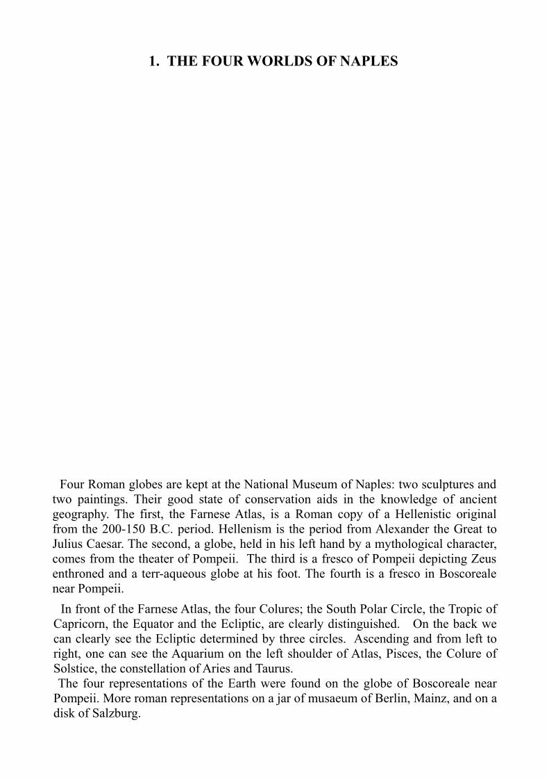
1. THE FOUR WORLDS OF NAPLES
Four Roman globes are kept at the National Museum of Naples: two sculptures and two paintings. Their good state of conservation aids in the knowledge of ancient geography. The first, the Farnese Atlas, is a Roman copy of a Hellenistic original from the 200-150 B.C. period. Hellenism is the period from Alexander the Great to Julius Caesar. The second, a globe, held in his left hand by a mythological character, comes from the theater of Pompeii. The third is a fresco of Pompeii depicting Zeus enthroned and a terr-aqueous globe at his foot. The fourth is a fresco in Boscoreale near Pompeii. In front of the Farnese Atlas, the four Colures; the South Polar Circle, the Tropic of Capricorn, the Equator and the Ecliptic, are clearly distinguished. On the back we can clearly see the Ecliptic determined by three circles. Ascending and from left to right, one can see the Aquarium on the left shoulder of Atlas, Pisces, the Colure of Solstice, the constellation of Aries and Taurus. The four representations of the Earth were found on the globe of Boscoreale near Pompeii. More roman representations on a jar of musaeum of Berlin, Mainz, and on a disk of Salzburg.

FARNESE ATLAS
Front: the two Colures, South Polar Circle, the Tropic of Capricorn, the Equator and the three Ecliptic circles.

FARNESE ATLAS
Back: the three Ecliptic circles, Aquarius (left), Pisces, Colure, Aries and Taurus; Capricorn, Equator and Cancer.

CHARACTER HOLDING THE TERRAQUEUS GLOBE

JUPITER’S CORONATION, IN THRONE WITH GLOBE

It is a widespread belief that, before Columbus, everyone was convinced that the Earth was flat. Pàez Cano in his thesis: “The sphere: the flat earth as a medieval invention of 19th century" (1) shows that such a belief never existed. Moreno Gallo in his “Elements of Roman Engineering” (2) explains how the falsehood was originally written by William Whewell (1794-1866) in “History of inductive sciences" (1840). According to Gallo, Christopher Columbus did not have to convince anyone of the spherical of the Earth, but only on its size. Jeffrey Burton Russell in 1991 was the first to investigate this extraordinary legend in “Inventing the flat Earth” (3). By virtue of this legend, the Farnese Atlas is interpreted even today as a representation of the universe that the ancients would have considered spherical, while the earth was considered flat. A letter written by Columbus to the Spanish Royal Family during his third voyage in the Caribbean revealed his surprising belief: “I have always maintained that the world - land and water - was a sphere, but now I have seen so many irregularities that I am induced to form another idea of the World. Lands that Their Majesties have discovered (America) are part of a sphere, but on the other hand, the earth is shaped like a pear to whose summit is the Earthly Paradise from which descend the four rivers, as written in the holy scriptures...... ' (4)Columbus had come to this conclusion after having arrived at the mouth of the Rio Orinoco River. For a whole day he met a strong current of fresh water that obstructed navigation. What could be behind such a mass of fresh water? Columbus concluded that it was one of the four rivers falling from Earthly Paradise. The first three were already known: the Nile, the Indus and the Ganges. The fourth was the Orinoco, which he had now discovered. When it approached the coast, the natives of the Macuro village went to meet him with canoes loaded with a variety of gifts. The Italian navigator noticed that the natives wore gold ornaments around their arms and necks. Since there was gold, he believed he was close to paradise! This letter sheds new light on his following research of 'Eldorado' located right at the headwaters of the Rio Orinoco (River of the Gold). We do not know if Columbus believed his own statements or if he would secure the funding for future shipments. Maybe he just wanted to provoke fascination of contemporary beliefs in heaven and gold. It was the first incitement that eventually led to the gold rush of the New World. The rest is history.
(1) Ruben Paez Cano “ La esfera ” Gudalajara, Mexico. 2003.. (2) Isaac Moreno Gallo “ Elementos de ingenieria romana ” . Tarragona. 2004.(3) Burton Russell shows all the uncertainty of history. First because it is difficult to establish what really happened, then why we love the false. He cites Washington and Irvine as the first authors of the false history, with Christopher Columbus (1828) and Jean Letrone 'On the cosmographic idea of the Church' (1834).(4) L. Lavonto “Los primeros italianos en America” Caracas. 2001.
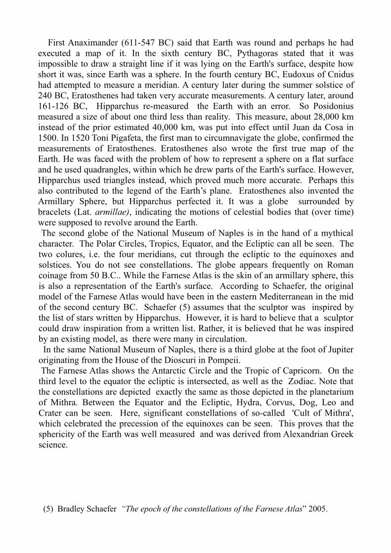
First Anaximander (611-547 BC) said that Earth was round and perhaps he had executed a map of it. In the sixth century BC, Pythagoras stated that it was impossible to draw a straight line if it was lying on the Earth's surface, despite how short it was, since Earth was a sphere. In the fourth century BC, Eudoxus of Cnidus had attempted to measure a meridian. A century later during the summer solstice of 240 BC, Eratosthenes had taken very accurate measurements. A century later, around 161-126 BC, Hipparchus re-measured the Earth with an error. So Posidonius measured a size of about one third less than reality. This measure, about 28,000 km instead of the prior estimated 40,000 km, was put into effect until Juan da Cosa in 1500. In 1520 Toni Pigafeta, the first man to circumnavigate the globe, confirmed the measurements of Eratosthenes. Eratosthenes also wrote the first true map of the Earth. He was faced with the problem of how to represent a sphere on a flat surface and he used quadrangles, within which he drew parts of the Earth's surface. However, Hipparchus used triangles instead, which proved much more accurate. Perhaps this also contributed to the legend of the Earth’s plane. Eratosthenes also invented the Armillary Sphere, but Hipparchus perfected it. It was a globe surrounded by bracelets (Lat. armillae), indicating the motions of celestial bodies that (over time) were supposed to revolve around the Earth. The second globe of the National Museum of Naples is in the hand of a mythical character. The Polar Circles, Tropics, Equator, and the Ecliptic can all be seen. The two colures, i.e. the four meridians, cut through the ecliptic to the equinoxes and solstices. You do not see constellations. The globe appears frequently on Roman coinage from 50 B.C.. While the Farnese Atlas is the skin of an armillary sphere, this is also a representation of the Earth's surface. According to Schaefer, the original model of the Farnese Atlas would have been in the eastern Mediterranean in the mid of the second century BC. Schaefer (5) assumes that the sculptor was inspired by the list of stars written by Hipparchus. However, it is hard to believe that a sculptor could draw inspiration from a written list. Rather, it is believed that he was inspired by an existing model, as there were many in circulation. In the same National Museum of Naples, there is a third globe at the foot of Jupiter originating from the House of the Dioscuri in Pompeii. The Farnese Atlas shows the Antarctic Circle and the Tropic of Capricorn. On the third level to the equator the ecliptic is intersected, as well as the Zodiac. Note that the constellations are depicted exactly the same as those depicted in the planetarium of Mithra. Between the Equator and the Ecliptic, Hydra, Corvus, Dog, Leo and Crater can be seen. Here, significant constellations of so-called 'Cult of Mithra', which celebrated the precession of the equinoxes can be seen. This proves that the sphericity of the Earth was well measured and was derived from Alexandrian Greek science.
(5) Bradley Schaefer “The epoch of the constellations of the Farnese Atlas” 2005.

2. MITHRA PLANETARIUMS
Comparing Roman Atlases with the sculptures and painting of Mithra's planetariums, we note that it is a very popular iconography. In particular, the constellations of Corvus, Scorpio, Crater, Hydra, Leo and Dog (Sirius) are identically represented. In the Mithreus, the Ecliptic with the Zodiac was set as an arc crown of central composition. It was probably the main chair where the Astronomy courses were given. In more than three hundred Mithreus cataloged, many are underground. The night sky is painted on the ceiling of the classroom as a function of the planetarium. Seven examples are in the Naples area, seventy throughout all of Italy. In Greece, there are only four and they are generally rare throughout the Eastern Mediterranean. Most are distributed on the military front of the Danube and Rhine and along Hadrian Wall in Scotland, where there were concentrations of military cantonments. They were also concentrated in the vicinity of the 'Naval Academys' of Hostia, Misenum, and Frejus, in view of the fact that the astronomical orientation was essential for navigation. This was a typical Western scientific activity, not a cult, even if the name has an Iranian origin. The planetariums were built into the ground to simulate the darkness of the night during daytime theoretical courses, and held in a vault painted with stars. We can refer to the established parallel activity of 'Gromatici', which was militarily organized by Caesar, with precise laws. Gromatici was a Cadastral survey school with qualified teachers. There were progressive examinations to be overcome and were classified into proper hierarchies. In order to better understand Mithra, it is useful to refer to the structure of Gromatici. (6) Inside Astronomy, planetarium students settled on the couches to comfortably observe the painted ceiling without twisting their necks upwards. At the center of the sculpture or the painting is Mithra with his index and middle fingers of his left hand in the nostrils of the bull forcing him to twist his neck to watch the sky, while the sword pierces him right in the heart. This scene reminded the students of the effort, nose up, to observe the night sky to study the stars. However, this could always be done comfortably by lying on the couches at the school. On either side of Mithra there are two characters with the same Eastern hat as Mithra, wielding a torch to indicate that the training course lasted from sundown (torch down) to sunrise (torch up). In the middle of the classrooms is a passageway where passed characters masked by Planets mimic the revolution of the orbits around the Earth. Not really a depiction of religious rites, but rather the seven progressive courses of Astronomy.
(6) Giulio Pizzati “Atlante di geografia Romana” 2004. Pag. 32/35, 50/53

CORVUS, CRATER, HYDRA, CANIS AND LEO.
However, much remains unknown, since all was transmitted by memory. The terms were far from mysterious, but hard to remember. Such occurrences were probably memorized through repetition with very simple rhyming litanies such as:
Thirty Days count in November as April, June and September.
February there is only one all others will have thirty-one.
A nursery rhyme entirely plausible if you think of the year of confusion when Caesar changed the calendar introducing the leap-year. The best way to circulate the change of date was to set training courses similar to those of the "Gromatici". The Gromatici body was established and organized by Cesar with clear hierarchies in detection of Civil register (See Gromatici p. 395, 15). Mithra, however, was a military order of geographers. Mithra was a small congregation that was challenging, learning, and involved self denial, to which a few fit, similar to the sacrifice of Taurus, the bull. The silence was the delivery of followers. Women were excluded because they distracted the attention. To indicate this, the constellation of the Scorpion is depicted as severing the genitals of the bull.

These planetariums are located near troops. The school was practiced by border troops and sailors that were familiar with geodetic measurements of astronomy and cultivated it for practical purposes, i.e. to determine orientation in unknown lands and seas that they had yet to explore. This probably dates back to well before the first century AD and are related to Caesar's World Survey. At the end of the expansion sanctioned by Augustus, all this was lost and mingled with religious rites. In addition to Mithra, Aion is also passed, the mythological character with the head of a lion and surrounded by a coiling snake and 12 zodiac signs, represents the best possible precession of the Equinoxes. Before Hipparchus, the precession was already known to the Assyrians and Egyptians. (7) Egyptian papyri records the Fenix and Milcham of Genesis (Job 29:18). According to Plutarch, the Roman Mithra was born in Tarsus among the pirates of Cilicia in 67 BC as a result of studies on the Hipparchus precession, with respect to astronomical technical guidance useful for navigation. In those days, Caesar was taken prisoner by pirates and he was certainly aware of these techniques. His book “De Astris" , unfortunately lost, testifies to his familiarity with astronomy.
(7) (http:/it.wikipedia.org/wiki/Fenice)

The world of magic has taken possession of many representations of astronomy denoting them with a bizarre connotation. Unlike other sciences, such as alchemy, which has evolved into chemistry, astronomy has degenerated into astrology to answer our uncertainties. Plutarch in "The fate and superstition" Chapter 8 said:'In reality, the fact that the earth is standing between the sun and the moon and the shadow is projected on top of one, at some point in their respective orbits, has nothing exceptional. Outstanding are the darkness of superstition and blind that disrupt human reason just when this would no longer need to work.' Today science is declining. Historical truths as a measure of Caesar are universally denied, leaving more room to the irrational. On February 22, 2008, the "Flat Earth Society" had 13,000 members. On the other hand, it would not be the first time we have distanced ourselves from the rational, such declines in the Middle Ages have also been known to happen. (8) The Mithra planetariums are widespread only in the West. They are estimated to number from 400 to 500, up to a maximum of 700. Most of them are yet to be discovered because they were built underground. Many were used as bases for churches that were to follow. No-one doubted that this was a figure very different from the Iranian Mithra. Mithra celebrated the passage of the equinox of spring from the constellation of Aries to the constellation of Taurus. So the bull was sacrificed by Mithra. (9)
CAESAR'S COMET
In Eratosthenes Armillary the colure was the meridian, Alexandria-Istanbul. That is, the prime meridian of his depiction of the world, the 'Greenwich' of the first atlas of which this was reported. Regarding the constellations in the Atlas Farnese and their position, 41 of them are attributable by Schaefer to observations made by Hipparchus. De Luca enumerates, instead of 49 notes, 19 and 14 Southern Lights as well as an unknown stool placed among the Big Dipper and the constellation of Cancer, which held the throne of Caesar, respectively, a comet that appeared in the last millennium BC. A significant addition to Roman astronomical updates. (10)
(8) (theflatearthsocety.org.cms/) (9) (http:www.well.com/user/davidu/Mitras.html)(10) Claudio De Luca 'Farnese Atlas' on (Astroarte.it) .

Seven planetariums are concentrated near the military port of Forum Julii, Frejus, in the south of Gaul, built by Caesar in 49 BC. This was achieved with excavation in the hinterland and served as a model for the later port of Misenum near Naples, built by Agrippa around 27 BC. The navy composed of 30% Egyptians, and the rest was made up from other nationalities of the empire, with levers for a period of 25/28 years. This cosmopolitanism of Mithra became a unifying element of the Roman Empire. The 13th fleet was stationed on Euphrates river to prepare for the invasion of Persia and to control the commerce between Persia and India. This was the mercantile roman fleet trade with India in connection with Egypt.
DISPLACEMENT OF 12 + 1 ROMAN NAVY.

CAPUA PLANETARIUM
The Planetarium of Capua of the first century AD refers to the Classis Praetoria Miseniensis, near Naples, and shows a typical Mithraeus layout: Chair of Mithra, underground barrel vault depicted with stars, stretched banks for students to look more comfortably at the ceiling and the corridor for the passage of the masked characters of the planets and constellations.

MARINO PLANETARIUM
The starry mantle of Mithra, in the central fresco of the Marino Planetarium in Italy, shows the band of the Ecliptic with six first size stars: four above (perhaps the Great Bear) and two below.

FELICISSIMO PLANETARIUM
The Planetarium of Felicissimo close to the port of Ostia, near Rome, Italy, shows the simplicity of the plan: A small dark classroom with one access opening. On both sides are couches for students and in the center of the floor are the symbols of the seven degrees of initiation. It was designed to hold a school of no more than 20 students and a teacher.

PLANETARIUM INSIDE A BUILDING
This example, inside a building, perhaps a school, shows the planetarium insulated from the light entering the courtyard by an antechamber. There is a small slit to permit enough light to move. The planetariums were often buried and least protected by daylight. The analysis of all plans shows a type construction far from the temple. The spans do not exceed 12 feet for a length of 20 feet. Their widespread use, more than the termae (spas), reveals a novel aspect of Roman society, i.e. propensity for Astronomy. The Romans were people with their noses up to peer at the day and night time sky. They had inherited the practice from the Etruscan. Mithra was never in the Roman Pantheon. Although welcoming all kinds of deities, he never had a temple or a clergy: further confirmation of his scientific, and not religious, pursuits.

IMPERIAL PLANETARIUM

VIEW OF IMPERIAL PLANETARIUM

OTHER PLANETARIUM LAYOUTS

RECONSTRUCTION OF A PLANETARIUM (W. Sauber)
This reconstruction forms a better understanding of what a Mithreus and its function was. Comparing the Corps of Gromatici with Mithreus concludes that these were classrooms of 'Military and Naval Academies'. A little like the science classroom of our current high schools, adapted to a specific teaching. They were located near the concentrations of troops and military ports of Ostia, Misenum, Forum Julii ( Frejus). This makes the points of logistical support to the Mensores (Surveyors), to map the territory to explore with astronomical systems. Where were the ports from which they sailed. What were the resources available and what lines of connection could they count on.
To better understand these surveying operations, we must return to the astronomical measurements of Eratosthenes.

ERATOSTHENES ATLAS
The axis Syene: Alexandria became the prime meridian of the Earth. The current Meridian 16° 30' West was the most west location on the African continent where the Tropic of Cancer could be measured. From Tabula Peutingeriana it follows that the reliefs are correct, as the Canary Islands (Fortunatae) and Iceland (Tule) lie on the same meridian, the current 16° 30' West. Marinus of Tyre also confirmed this on the same meridian alignment. Cronio, which Pytheas described as a sea of ice, is maybe Greenland or maybe the entire polar cap in the shape of a jellyfish. (http:/www.vialattea.net/eratostene/cosmimetria/metodo.htm)
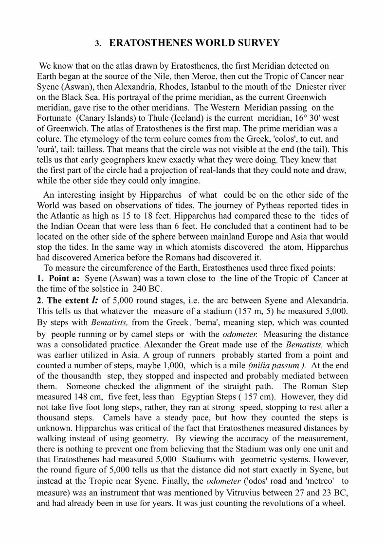
3. ERATOSTHENES WORLD SURVEY
We know that on the atlas drawn by Eratosthenes, the first Meridian detected on Earth began at the source of the Nile, then Meroe, then cut the Tropic of Cancer near Syene (Aswan), then Alexandria, Rhodes, Istanbul to the mouth of the Dniester river on the Black Sea. His portrayal of the prime meridian, as the current Greenwich meridian, gave rise to the other meridians. The Western Meridian passing on the Fortunate (Canary Islands) to Thule (Iceland) is the current meridian, 16° 30' west of Greenwich. The atlas of Eratosthenes is the first map. The prime meridian was a colure. The etymology of the term colure comes from the Greek, 'colos', to cut, and 'ourà', tail: tailless. That means that the circle was not visible at the end (the tail). This tells us that early geographers knew exactly what they were doing. They knew that the first part of the circle had a projection of real-lands that they could note and draw, while the other side they could only imagine. An interesting insight by Hipparchus of what could be on the other side of the World was based on observations of tides. The journey of Pytheas reported tides in the Atlantic as high as 15 to 18 feet. Hipparchus had compared these to the tides of the Indian Ocean that were less than 6 feet. He concluded that a continent had to be located on the other side of the sphere between mainland Europe and Asia that would stop the tides. In the same way in which atomists discovered the atom, Hipparchus had discovered America before the Romans had discovered it. To measure the circumference of the Earth, Eratosthenes used three fixed points: 1. Point a: Syene (Aswan) was a town close to the line of the Tropic of Cancer at the time of the solstice in 240 BC. 2. The extent l: of 5,000 round stages, i.e. the arc between Syene and Alexandria. This tells us that whatever the measure of a stadium (157 m, 5) he measured 5,000. By steps with Bematists, from the Greek, 'bema', meaning step, which was counted by people running or by camel steps or with the odometer. Measuring the distance was a consolidated practice. Alexander the Great made use of the Bematists, which was earlier utilized in Asia. A group of runners probably started from a point and counted a number of steps, maybe 1,000, which is a mile (milia passum ). At the end of the thousandth step, they stopped and inspected and probably mediated between them. Someone checked the alignment of the straight path. The Roman Step measured 148 cm, five feet, less than Egyptian Steps ( 157 cm). However, they did not take five foot long steps, rather, they ran at strong speed, stopping to rest after a thousand steps. Camels have a steady pace, but how they counted the steps is unknown. Hipparchus was critical of the fact that Eratosthenes measured distances by walking instead of using geometry. By viewing the accuracy of the measurement, there is nothing to prevent one from believing that the Stadium was only one unit and that Eratosthenes had measured 5,000 Stadiums with geometric systems. However, the round figure of 5,000 tells us that the distance did not start exactly in Syene, but instead at the Tropic near Syene. Finally, the odometer ('odos' road and 'metreo' to measure) was an instrument that was mentioned by Vitruvius between 27 and 23 BC, and had already been in use for years. It was just counting the revolutions of a wheel.

3. The meridian L: perpendicular to the Tropic of Cancer was a fixed datum. The surveyors definitely had to orientate themselves along the way. They made constant reference to the North, having no other way to go. Along the way they could establish landmarks for easy sighting. We do not know which systems were used to determine the route of its meridian. However, after attempting, Eudoxus of Cnidus determined the first meridian of the world. Regarding the actual orientation of the meridian of Alexandria, it is not certain that its North corresponds to the current North. In its revolution, the axis is constantly changing because of the meteoric impact or telluric or because of the expansion of the earth. In the year 2010, the axis of the Earth moved approximately 9 miles towards Siberia. This occurred regardless of the precession of the equinoxes, which is a far greater phenomenon. 200 years after Eratosthenes, in Caesar's time, the meridian Rome-Altino seems about 1° 30' East of modern day North. This corresponded to 7th Cardo East (VII KS) of Caesar's Survey, which joined the Mons Septorium (Montecitorio) in Rome to Altino. (See Pg. 40)

4. CAESAR’S SURVEY
In 44 BC, the city of Altino was used as a center of a radial system. Due to its importance and its accuracy, the following passage by Julius Honorius (11) is very relevant.
“Iulio Caesare et Marco Antonio consulibus, (44 a. C.) omnis orbis peragratus est per sapientissimos et electos viros quattuor: Nicodemo orientis, Didymo occidentalis, Theudoto septentrionalis, Policlito meridiani. A consulibus supra scriptis usque in consulatum Augusti IIII et Crassi: annis XXI mensibus quinque diebus novem oriens dimensa est. Et a consulibus supra scriptis usque in consulatum Augusti VII et Agrippae III annis XXVI mensibus III diebus XVII occidui pars dimensa est. A consulibus supra scriptis usque in consulatum Augusti X annis XXVIII mensibus VII septentrionalis pars dimensa est. A consulibus supra scriptis usque in consulatum Saturnini et Cinnae annis XXXII mense I diebus XX meridiana pars dimensa est.”
Translation
-[During the consulship of Julius Caesar and M. Antonius (44 BC) the entire Earth was surveyed by four highly knowledgeable and chosen men: Nicodemus, who surveyed the East, Didymus, who surveyed the West, Theudotus, who surveyed the North and Polyclitus, who surveyed the South. From the period of office of the above-mentioned consuls until the consulship of Augustus (4th period of office) and Crassus, the eastern part was measured in 21 years, 5 months and 9 days; from the period of office of the above-
mentioned consuls until the consulship of Augustus (7th period of office) and Agrippa Augustus (3rd period of office). The western part was measured in 26 years, 3 months and 17 days; from the period of office of the above-mentioned consuls until the consulship of Augustus (10th period of office), the northern part was measured in 28 years and 7 months; and, from the period of office of the above-mentioned consuls until the consulship of Saturninus and Cinna the southern part was measured in 32 years, 1 month and 20 days.]
(11) Jiulius Honorius, “Cosmographia I.; C. Nicolet and P. Gautier Dalché “Les quatre sages de Jules César et la mesure du monde....” “Journal des savants” Oct-Dec. 1986.


Caesar assigned surveying the East to Nicodemus, the West to Didymo, the North to Theodotus and the South to Policlytus, probably starting from Altino. The World measure was made by an Indictio. The Indictio was a Multi-Year Implementation State Low for a period of 15 years. This deadline was extended by Augustus by more than 15 years, thus totaling 32 years in total. It was identified as a colure, opposite to Alexandria, at the current Meridian 108° and Meridian 111° West in the American Continent. The error of this supposed colure was originated by Posidonius’ measurement of the circumference of the Earth (12). The colure of the equinoxes, which was believed to be 180° was based on
erroneous measurements by Posidonius of Apamanea who estimated the circumference of the Earth at 28,000 km: less than twelve thousand kilometers short of accurate (-30%). Whereby Didymo, who measured the West and perhaps with him Theodotus, who measured the North, incurred the same mistake when measuring America. They faced the same problem as Christopher Columbus, 1500 years later: Asia was much further than expected. The Pacific coast of America was detected with great accuracy from Alaska to Tierra del Fuego, to the Tres Montes Peninsula, at least down to Chile, the arrival destination of the Cardo 30th East. Perhaps they even travelled down to Antarctica.
(12) Giulio Pizzati, 'The Four Surveyors' GoogleBooks 2010. Pag.54/66

THE SUPPOSED COLURE: THE MERIDIAN 111° WEST

THE SUPPOSED COLURE: MERIDIAN 108 WEST

A MISTAKE 17 CENTURYS LONG
Theodotus, sent by Caesar to survey the North, believed to be at the halfway location of the sphere estimated by Posidonius, the opposite of Alexandria, but rather he reached only the current Meridian at 108° and 111° West leaving unmistakable traces of is passage in the toponymy. Theodotus had made use of the local Anazasi, who inhabited North America at the time of Caesar and who accompanied him on his expeditions. Anazasi legend tells of a meeting point of four worlds, perhaps Altino. The route of the supposed colure is evident and recognizable in North American place names. The name Altus is repeated dozens of times from Canada to Mexico. The current meridian is 111° west of the belt of Colure. The other side is determined by the meridian 108° West. Along this meridian numerous Anazasi sites are aligned, evidence of their participation in the measurements. Archaeology says that the Anazasi migrated in a straight line to the south during the time of Caesar and onwards. Their extinction was due to the lack of food along an artificial path, namely the terrestrial meridian. Their settlements were modeled on the Roman military camps, especially New Alto near Pueblo Bonito in New Mexico, the last town before the famine. (See “Geografia Romana” Pgs 63/70)

A WORLD LARGER THAN SUPPOSED
Another survey started before 44 BC, perhaps during Caesar's first consulship of 59 BC. The proof is in the place names with numbers in the text of the 'De bello gallico', the Gallic War. Theodotus or Teodoto had taken over this line on the tip of Baja, believing it to be at the antithesis of Alexandria, along the colure of a smaller world than reality, according to measurements of the hearth of Posidonio. One hundred years after Eratosthenes had just measured the Earth, Posidonius (135-51 BC) repeated the measure with a different method, but he made a critical mistake. He measured the maximum height reached by Canopus at Rhodes and compared it with the maximum height of the same star at Alexandria. It was a better way, but he did not take into account the refraction of the horizon, which deceived the eye just enough to give a misleading reading. This erroneous assessment explains why the Romans surveyed today's meridians as 108° and 111° in North America and considered it to be the middle of the sphere.

ALTINUM, VENETO, ITALY
NUMBERS ALONG POSTUMIA ROAD (DM)
Altino was the center of the radial system. Each ray (Cardo) was measured on Via Postumia, the numerator, using the unit of one roman mile (1,482 km) along the Decumanus Maximus (DM). The zero was the crossroad with Via Augusta (the KM).

INTERSECTION AUGUSTA ROAD (KM) - POSTUMIA ROAD (DM)
Caesar had chosen Altino as trustee point for measuring the world for various reasons; it was on the Meridian of Rome, it was the northern most point of the Mediterranean, it was equidistant from the war fronts of the Rhine and Danube rivers, but it was especially opened to view a wide arc of the Alps and was secured and protected by lagoons.

A VERY LARGE SURVEYING INSTRUMENT
From Altino, the Via Augusta determined the KM intersecting the Via Postumia, determining the DM. At the intersection between Cardo and Decumanus was the 'VMBILICVS', i.e. the zero. To the West, the Decumano Left (DS) and to the East the Decumano Right (DX) were identified. With progressive numbers for every roman mile (1.482 km). This colossal work appeared to cartographers for the first time in the early XIX century by detecting the Roman Graticulatum of Padua. The evidence that this crossroad was made before the Indictio of 44 BC, comes from the fact that: Novocomum, modern Como lies on Cardo 49th west .Novidunum (Soissons in France) lies on Cardo 19° ovest. Cardo 19° west. Two more Novidunum in Gaul lies on Cardo 29° west.Otogesa in Spain lies on 80° east.So does Octoduro in Switzerland lies on 38th west.All names appear in Commentaries of Caesar dating from the 58 and 57 B.C. However, it is possible that before Caesar, Caius Marius had already performed same measurements in Po Valley territory. The Romans had approached the political geography much later than the Greeks. The development seems tied to the popular party. To remember the previous survey made by the Gracchis in Sardinia in 177 b. C. (Sardiniae forma erat. Forma meaning map).

THE CITY AND PORT OF ALTINO TODAY
It is easy to check the veracity of Cardo lines. Just point the Google Earth ruler in Altino. Take measures along the Postumia road along the DM (trend 170° Est.). Consider the zero at the 'Umbilicus’, the intersection with the route of the Via Augusta and Via Augusta the Cardo Maximus (trends 71° West). Cardo and Decumanus are not perpendicular to each other as believed throughout all the roman centuries. This is a non-orthogonal system of Cardines Transversi, set perhaps to match the 7th Cardo East (SX K VII) with the North. Today, the geographic North seems to be 1° 30 ' to the east of the 7th Cardo East. The 7th Cardo East starts in Seven Island in Svalborg, Norway and ends in Sette Cama in Gabon, Africa. (13)
(13) Giulio Pizzati “The Four Surveyors” Google Books 2010. Pag.132/134

To SETTE Cama (Gabon)
CARDO 7th EAST THE MERIDIAN ROME TO ALTINO

MAP OF BARTHOLOMEW COLUMBUS
The map of the New World, designed by Zorzi and based upon work done by Bartholomew Columbus, brother of Christopher, shows the Caribbean and the bend of the Gulf of Mexico, which is between America and Asia. The Tropic of Cancer and the Equator are the lines of support on which the survey was geographically developed. Along the Equator the meridians can be clearly seen. Based on their survey, the four Greek Mensores were founded on the same lines of support as the 'Farnese Atlas: Equator and the tropics’. It is known that they did not return from their last relief accounts, so Agrippa had to intervene several times to correct the 'error numeri'. Pliny Sr confirms this (Books 3-6), citing Agrippa for his work on the size of the provinces of the World at least thirty times. Pliny was familiar with these calculations. He, like Agrippa, was also a sailor and in 79 AD had been commander of the fleet of Misenum. Caesar had identified the colure of antipodes of Alexandria. Its findings were based on Posidonius’ incorrect measurements of the circumference of the Earth: 28.000 km. Twelve thousand km less than accurate (-30%). This was the same mistake made by Columbus, corrected only by Juan de la Cosa in 1500. Didymo and Theodotus found the same problem that Columbus had found 1500 years later. The survey made by Caesar with the Indictio of the 44 a. B.C. and continued by Agrippa and Augustus lasted over 31 years. It was incorrectly identified as the Colure a band including among current meridians 108° / 111° West. This is because the circumference of 28,000 km of Posidonius felt good, instead of the 39,000 km of Eratosthenes. So when they arrived in the middle of 28,000 km, that is 14,000 km, they thought that they had arrived at the antipodes of Alexandria on the 'tail' of the colure. Instead, they were only on the 108°/110° meridian West of the real world. They were at the Rocky Mountains. Along this supposed appointed colure they left place names that are still ascertainable by anyone looking at any map today.

Nicodemus was the first to deliver his survey. Starting from Altino in 44 B.C., he measured the East in 21 years, 5 months and 9 days, completing his work in 23 B.C.. Evidently he did not find it difficult to detect Siberia. India and China probably had their own cards already. Nicodemus may have supported the troops stationed along the Danube and the fleet of the Euphrates River.
Didymo, starting from Altino the same year, had completed the survey of the West in the year 18 A.D., in 26 years, 3 months and 17 days.
Theodotus had completed surveying the North by 16 B.C., in 28 years and 7 months.
Polyclyto spent the longest time surveying of all. He measured the south in 32 years, 7 months and 15 days. He handed over his work in 12 B.C. 32 years is a lot of time if you considers that Toni Pigaffeta went around the world in less that 3 years, from 1519 to 1522.
In 44 B.C., shortly after proclaiming Indictio, Julius Caesar was assassinated. Anthony had committed suicide and Agrippa had died during the surveying work. Only Augustus remained alive. In 29 BC he had to renew the Indictio and thus asked the Senate for new funds. In 27 BC, after some good results, he changed his name from Octavian to Augustus, Augur, that is the surveyors, the gauger. Nothing is known about the four Mensores. Their Greek names suggest an Alexandrian origin. Caesar met the Hellenistics for the second time during the Civil War. Much earlier, during his first consulate in 59 BC, he deduced the colony Novocomum, modern Como, along Cardo 39th west (Novum is going to Novem, nine) made up of 5,000 Romans and 500 Greeks. The 10% of Greeks could not have been laborers, but a qualitative option aimed at a scientific endeavor. Theodotus, also known as Teudoto or Teodoto or Theudutus or Teodoxo ( Qeoz-dotus, God's gift) could have been the inventor of the Theodolite, an instrument known as Theodolite that was in use until recent times. According philology, Teodolite derives from Arabic, but we know that the Arabs came into contact with the Hellenistic civilization conquering the eastern shores of the Mediterranean. Vitruvius (De architectura, 9.8.1) writes that some Theudotus invented a solar instrument suitable for all latitudes. Strabo (Geography, 12.5.66) says to have known Theodotus, the inventor of a portable instrument living in Egypt at the time of Caesar. Another of the four: Didymo was perhaps a twin brother. Didymo in fact means twins. The name Didymo appears also in relation of a list made in Egypt at Caesar time connected to Heron. We do not know their ages nor how long they lived and how they participated in the survey. We do not know where the operations center was, where they resided, or who provided their checks. Apparently it was at Altino, but it could have been somewhere else, such as Alexandria, where the Guinevere line was measured.

The title given to them is 'Sapientissimos et Electos Viros': indicating the super scientists selected among the best scientists. What the boundaries of jurisdiction between them exactly was is difficult to establish. However, it helps to know that Agrippa had divided Ecumene into 24 regions. Regarding the text of “Cosmographia" , there are 135 well-known manuscripts. Even during the Middle Ages, Cassiodorus confirms Caesar's surveying of the World. This was perhaps the ambitious plan that led to his death. During 44 B.C. tells that , the Indictio might have been proclaimed only from the 1st of January until the15th of March, the day of Caesar’s assassination. The “Orbis Pictus”, the relief of the world exhibited by Augustus in 9 B.C. as the result of the survey, on Vispania's porch in Rome, contained the error of Posidonius. The Romans had very accurately surveyed the entire World. Drusus, the commander of a fleet of 1000 ships in the North Atlantic during a pause in the war against the Germans, was ordered by Augustus to reach the Pacific. The reason for that order can only be found in Caesar's Indictio to Survey the World. Augustus writes (Res Gestae. 27): “From the mouths of the Rhine, my fleet sailed up the lands of the East". To reach East from Rhine, the Germananica Fleet of Drusus could move to the North East or North West (Cardo Frigoris) and circumnavigate Africa or America. Another hypothesis is the crossing of Central America by land and the further exploration with a new fleet. Or, perhaps a combination of all five cases. Reading Caesar’s Commentaries reveals the ease and speed with which a fleet is built during military operations. Three of the twelve Praetorian fleets operated in the Atlantic: the Mauretanica, the Britannica and the Germanica. The breadth of the area explains the 32 years necessary to Polyclytus to measure the South. Augustus' naval force consisted of 45,000 sailors and 300,000 salaried soldiers, not to mention the number of slaves, which numbered twice as . It is not certain that all the men sent to detect the world returned. Indeed, it is likely that very few returned. Augustus suffered many setbacks in his life. The only certain thing is the impressive number of place names left along the route assigned to them, place names detectable on any accessible geography map. The Romans in America and Australia is an unacceptable, inconvenient truth that disturbs our childhood dreams.
Not all documents were destroyed in the Library of Alexandria fire. In 'Parallel Lives', Plutarch recalls an episode of the life of Caesar in Egypt (Caesar, Chapter 39). Before the arrival of the Jews to save him from a desperate situation, Caesar was on the island of Faro off the coast of Alexandria, surrounded by the Egyptians. Resisting capture, he threw himself into the sea and swam within range of enemy arrows. He swam frantically with one hand while the other held a roll of parchment out of the water. No one knows what was written on the parchment, or why he risked his life to save it, but the narrative depicts a Caesar that must tell us something more.
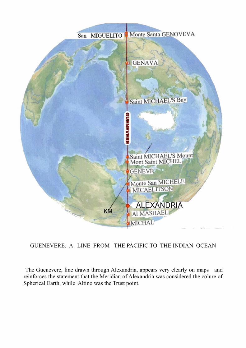
GUENEVERE: A LINE FROM THE PACIFIC TO THE INDIAN OCEAN
The Guenevere, line drawn through Alexandria, appears very clearly on maps and reinforces the statement that the Meridian of Alexandria was considered the colure of Spherical Earth, while Altino was the Trust point.
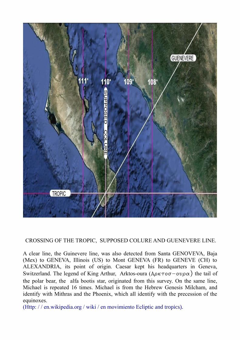
CROSSING OF THE TROPIC, SUPPOSED COLURE AND GUENEVERE LINE.
A clear line, the Guinevere line, was also detected from Santa GENOVEVA, Baja (Mex) to GENEVA, Illinois (US) to Mont GENEVA (FR) to GENEVE (CH) to ALEXANDRIA, its point of origin. Caesar kept his headquarters in Geneva, Switzerland. The legend of King Arthur, Arktos-oura (Arktos-oura) the tail of the polar bear, the alfa bootis star, originated from this survey. On the same line, Michael is repeated 16 times. Michael is from the Hebrew Genesis Milcham, and identify with Mithras and the Phoenix, which all identify with the precession of the equinoxes. (Http: / / en.wikipedia.org / wiki / en movimiento Ecliptic and tropics).

THE GUENEVERE LINE IN EUROPE
Saint Michael's Mount UK, Mont Saint Michel FR, Monte San Michele Arcangelo, Gargano, IT, Monte San Michele, Puglia IT, Micaelitson, GR.

EXAMPLE OF IDENTIFICATION OF CARDO 14th EAST AND 14th WEST
CARDO 14th WEST CROSSING ENGLISH CHANNEL

18th CARDO WEST: THE HOMING PIGEONS LINE Before Rutupiae (Richborough), the base of the Britannica fleet was in Gaul, in Boulogne-sur-Mer. Not far from where the 18° Cardo West passes through the Atlantic. Cardo 18° West repeats the name COLUMBUS (pigeon). A line from Altino to the Atlantic indicates a line of connection with homing pigeons. For military communications the Romans made use of Columbaria, 4-5000 homing pigeons. A homing pigeon can travel over 250 miles a day and could maintain links with the outposts of the fleet. The Cardo 18° West identifies Eleutheropoli in Israel where there is still a buried Columbarium for 2,000 pigeons. Around Eleutheropoli there are 60 other Columbaria commemorating an estimated total of more than 5,000 homing pigeons.

19th CARDO WEST: THE HOMING PIGEONS LINE Also the 19th Cardo West is related to COLUMBUS, the homing pigeons line. Final point in Mexico, in the coast of the Pacific Ocean is Nonas, caming from Nueva in the coast of Golf of Mexico Coast. In Us number Nine is repeated 14 times: New Orleans, New York, New Jersey, New Amphsire, New Bronswich, Nova Scotia, Terranova and then Europe. Novidunum (Soisson, France) Neuchatel and Mount Combolo elev 2,902 mt, is in Switzerland, near Bernina and Altinum. See “The Four Surveyors”, pgs. 94 and 155.
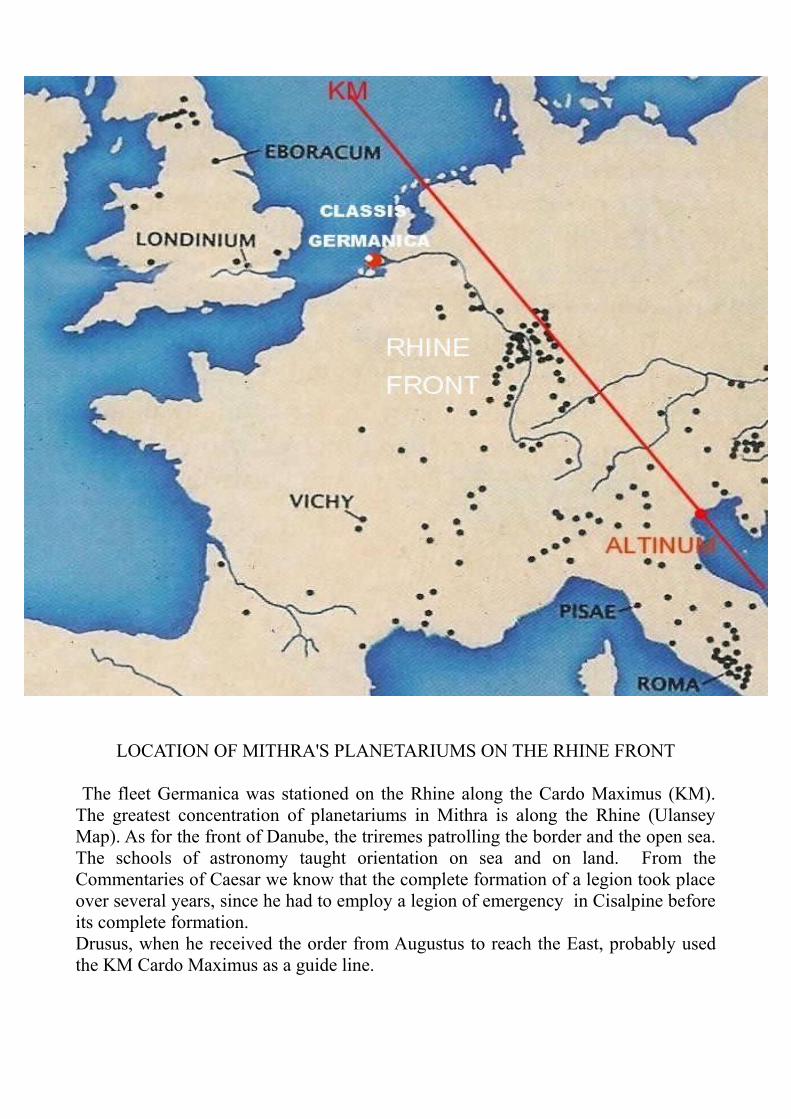
LOCATION OF MITHRA'S PLANETARIUMS ON THE RHINE FRONT
The fleet Germanica was stationed on the Rhine along the Cardo Maximus (KM). The greatest concentration of planetariums in Mithra is along the Rhine (Ulansey Map). As for the front of Danube, the triremes patrolling the border and the open sea. The schools of astronomy taught orientation on sea and on land. From the Commentaries of Caesar we know that the complete formation of a legion took place over several years, since he had to employ a legion of emergency in Cisalpine before its complete formation. Drusus, when he received the order from Augustus to reach the East, probably used the KM Cardo Maximus as a guide line.

THE 40th CARDO WEST
This example of the Cardo 40th West, shows how far the Mensores of Caesar had travelled. Further reading on this can be found in "The Four Surveyors”, (pgs 124 and 125). Point the ruler of Google Earth on Cerro QUARENTA Panama (9° 10') Panama, then QUARENTA Bollos, always in Panama (9° 10' South, 78° 59' West). Move the ruler to Altino and check the alignment starting from Panama. Along the way there is: Batey Number QUARENTA in the Dominican Republic; near Guaymas; In France the mouth of the river CHARENTE; QUARANTA near Aosta Italy; and then in QUARONA, Borgosesia. Then FOUR WALLS in Lessini Mountains, then the 40-mile West from Umbilicus, measured on the Decumanus Massimo, then Altino. Islote CUATRO Ermanos in Gallapagos Islands, Cerro QUARENTA e QUARENTA Bollos in Panama speak of a land crossing of Central America. Thousands of surveying place names are still to be discovered.
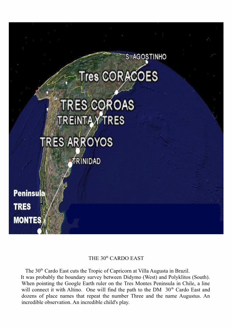
THE 30th CARDO EAST
The 30th Cardo East cuts the Tropic of Capricorn at Villa Augusta in Brazil. It was probably the boundary survey between Didymo (West) and Polyklitos (South). When pointing the Google Earth ruler on the Tres Montes Peninsula in Chile, a line will connect it with Altino. One will find the path to the DM 30 th Cardo East and dozens of place names that repeat the number Three and the name Augustus. An incredible observation. An incredible child's play.

THE 23rd CARDO EAST
The 23th Cardo East was measured from Altino to the Strait of Magellan, up to 23 ERMANOS in Patagonia. Didymo and Polyklitos, or who for them, evidently had temporary settlements constructed for them with names that have persisted through time. A few thousand of these place names have been discovered around the world. It is not difficult to check, indeed, one can use a ruler and Google or any other geographic system.

THE 119th CARDO WEST
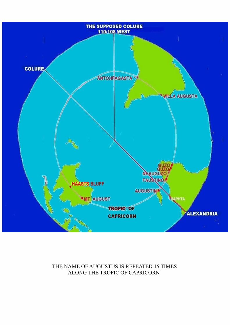
This Cardo identifies Australian Continent from Augustus Island near Volcano Island to Austinmere crossing the Tropic of Capricorn in Haasts near Alice Spring. The Cardo line is: from Altinum to Grozzana [G(r)ozza(na)] near Trieste, Italy to Alusta, in Crimea, Ukraina, to Augustus Island and to Austinmere, Australia. Volcano is also repeated five times along this Cardo. See 'Augustus and Volcanoes' in “The Four Surveyors” Pgs 72/85.

5. AUGUSTUS AND CAPRICORN
Along the Tropic of Capricorn the name Augustus is repeated 15 times. Many other Roman place names remain yet to be discovered. Presumably the Southern Hemisphere and the Tropic of Capricorn were detected after 27 B.C. when Octavian changed his name to Augustus, from the verb augere, arise. As the sun rose the Augur, called upon to make the measurements, was placed with his right hand to the rising sun. He supported the navel (umbilicus) a curved stick with a three-round spiral (lituus) to the heart (cardio) and determined the Cardo (K) before them, which was northward. The shadow of lituus projected on the ground determining the Decumanus, (D) (deci-manus), i.e. the ten fingers. Five on the right hand (DD) to the East and five in the left hand (DS) to the West. The Decumanus served as a numerical scale with ten fingers. Note that Raphta in Africa is not far from the Tropic of Capricorn. From the port of Raphta ivory was imported to Rome. Writing of the first century AD, the 'Periplus Maris Erythrei' (Cap.16/18) says that to the south of this port the unexplored ocean curved to the west, around Africa and mingled with the Atlantic Ocean. To remember the importance of the mines of South Africa, which were used since prehistory by foreign populations, and were likely to be involved in the Roman trade network. (14) A dozen place names derived from Augustus can be found in Africa throughout the tropic from the Atlantic to the Indian Oceans. The navigation of the Atlantic know at the time of Alexander, reveals that the Greek Pytheas had reached the expanse of ice that he called Cronio (Cron-land, Greenland?). The Greeks had played a long time without success of the Atlantic to the Phoenicians. Only after the defeat of Carthage did the Romans take control of the Atlantic. It is certain that after that the Roman military and commercial ships sailed far and wide around the entire sphere.
(14) Giulio Pizzati 'La Globalizzazione' 2001, pag. 62.

TROPIC OF CAPRICORN
THE NAME OF AUGUSTUS IS REPEATED 15 TIMES ALONG THE TROPIC OF CAPRICORN
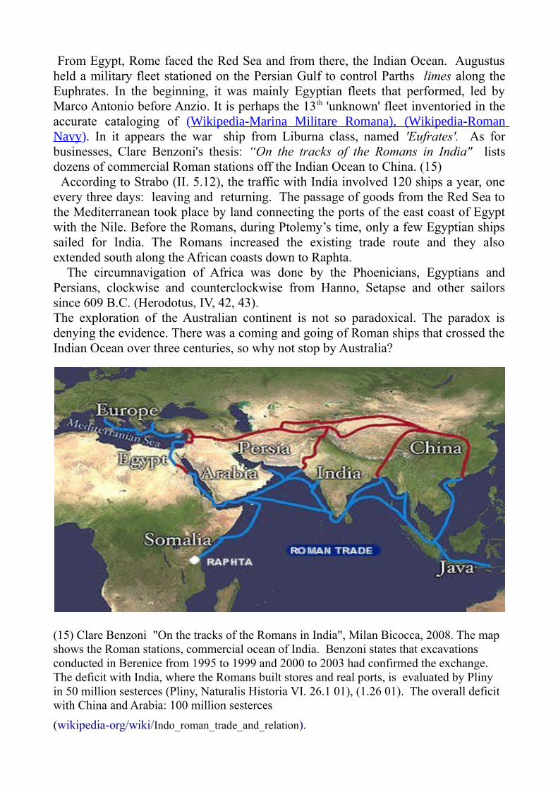
From Egypt, Rome faced the Red Sea and from there, the Indian Ocean. Augustus held a military fleet stationed on the Persian Gulf to control Parths limes along the Euphrates. In the beginning, it was mainly Egyptian fleets that performed, led by Marco Antonio before Anzio. It is perhaps the 13th 'unknown' fleet inventoried in the accurate cataloging of (Wikipedia-Marina Militare Romana), (Wikipedia-Roman Navy). In it appears the war ship from Liburna class, named 'Eufrates'. As for businesses, Clare Benzoni's thesis: “On the tracks of the Romans in India" lists dozens of commercial Roman stations off the Indian Ocean to China. (15) According to Strabo (II. 5.12), the traffic with India involved 120 ships a year, one every three days: leaving and returning. The passage of goods from the Red Sea to the Mediterranean took place by land connecting the ports of the east coast of Egypt with the Nile. Before the Romans, during Ptolemy’s time, only a few Egyptian ships sailed for India. The Romans increased the existing trade route and they also extended south along the African coasts down to Raphta. The circumnavigation of Africa was done by the Phoenicians, Egyptians and Persians, clockwise and counterclockwise from Hanno, Setapse and other sailors since 609 B.C. (Herodotus, IV, 42, 43). The exploration of the Australian continent is not so paradoxical. The paradox is denying the evidence. There was a coming and going of Roman ships that crossed the Indian Ocean over three centuries, so why not stop by Australia?
(15) Clare Benzoni "On the tracks of the Romans in India", Milan Bicocca, 2008. The map shows the Roman stations, commercial ocean of India. Benzoni states that excavations conducted in Berenice from 1995 to 1999 and 2000 to 2003 had confirmed the exchange. The deficit with India, where the Romans built stores and real ports, is evaluated by Pliny in 50 million sesterces (Pliny, Naturalis Historia VI. 26.1 01), (1.26 01). The overall deficit with China and Arabia: 100 million sesterces(wikipedia-org/wiki/Indo_roman_trade_and_relation).

ROMAN TRADE ON SEA AND LAND (wikipedia-org/wiki/Indo_roman_trade_and_relation)

Claude Nicolet (“Space, Geography and Politics in the Early Roman Empire” 1991. Pags 15/17) commit a blunder asserting that Augustus was born under the sign of Capricorn. According to Suetonius (The lives of Caesars. V.), Augustus was born just before sunrise on the ninth day before Kalends of October (September 23, 63 BC). Augustus was born under the sign of Virgo, but he adopted the Capricorn symbol, not due to astrological significance, but rather because he had identified the Tropic of Capricorn line. The sun of 2,000 years ago, at time of the winter Equinox, entered the Constellation of Capricorn, represented here by embracing the front hoofs around the globe on which we very clearly see the circle of the Tropics.

The oar means the fleet and the symbol of Cornucopy was useful to list the new revenue to the Treasury accrued during the wars of Augustus: The treasure of the Ptolemies and the grain of Egypt after the defeat of Mark Antony. The gold mines of Cantabrigian were conquered by the Spanish campaign (29/19 B.C.) where Augustus intervened personally. The silver mines of Illyricum were gained after a long war in Dalmatian (35 B.C. / 6 AD), where Augustus was also wounded.

The instrument depicted on the reverse of the coin of Augustus is the instrument of Augur: the Lituus.
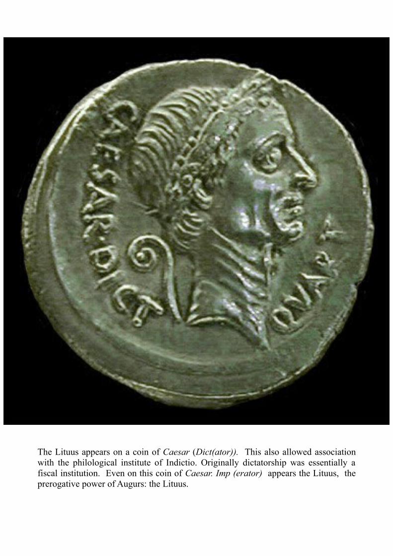
The Lituus appears on a coin of Caesar (Dict(ator)). This also allowed association with the philological institute of Indictio. Originally dictatorship was essentially a fiscal institution. Even on this coin of Caesar. Imp (erator) appears the Lituus, the prerogative power of Augurs: the Lituus.

In Mathematics “Lituus” is called the 'Spiral of Archimedes'. The function is the same: with the Spiral of Archimedes is possible to determined by the origin the axes of x and y: Decumanus (DM) and Cardo (KM). Obviously the four surveyors possessed tools much more sophisticated, but it is Litvvs that remained as a symbol of technical power of Pontifex Maximus. Other tools like the Antikythera computer, were made of extremely sophisticated mechanisms, even according to Cicero (De Re Publica, I, 14,21,22. and Tusculanae Dispitationes, I, 63). In fact to take the ship’s bearing, an astrolabe, invented by Hipparchus, was sufficient. According to Strabo (Geography 12.5.66) the teodolite was invented by a certain Theodotus, perhaps identifiable in one of the four Surveyors of Caesar.

This gem, preserved in the National Museum of Vienna, shows the apotheosis of Augustus holding the Lituus on his right hand, sitting next to Rome in arms and crowned by Ecumenik (the habitable Earth). Above is situated the sphere of the world with the Tropic of Capricorn, which celebrates its full glory: the performance of Caesar's World Survey.
THE GEM OF VIENNA
WORLD UNDER AUGUSTUS’S FOOT
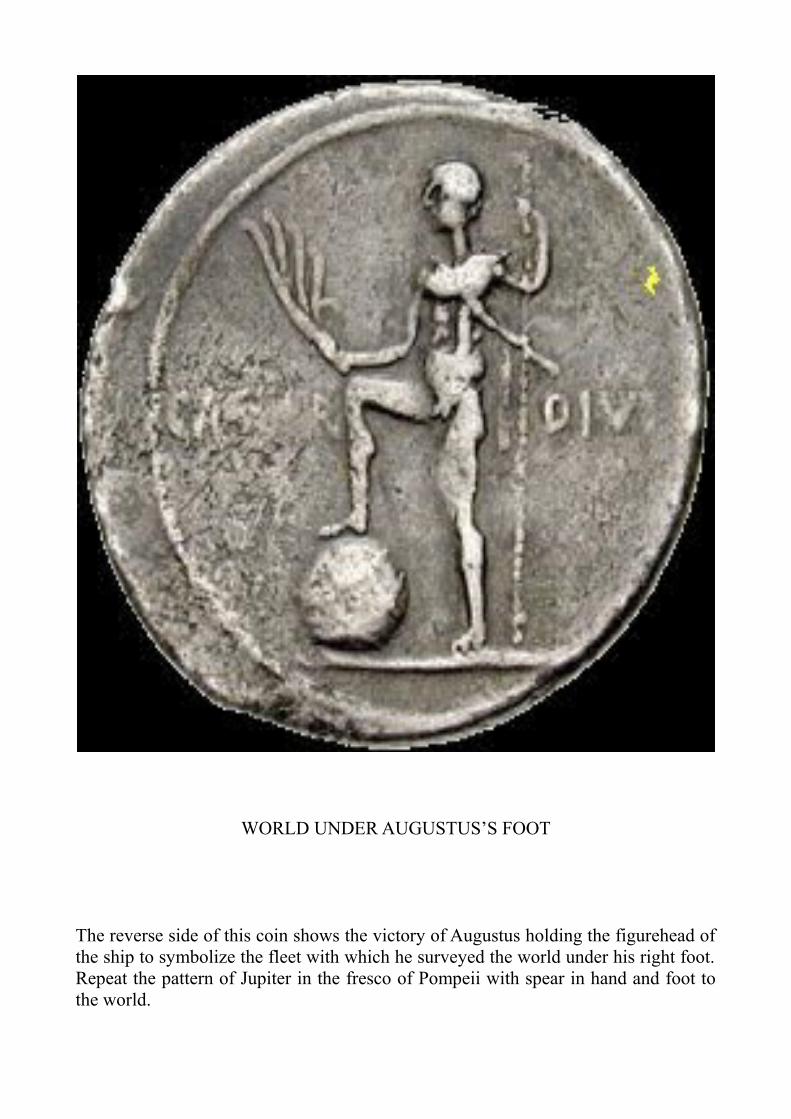
The reverse side of this coin shows the victory of Augustus holding the figurehead of the ship to symbolize the fleet with which he surveyed the world under his right foot. Repeat the pattern of Jupiter in the fresco of Pompeii with spear in hand and foot to the world.

WORLD ON CAPRICORN’S HOOFS
The reverse of this other coin shows identical symbols: Cornucopy, World, Oar (the fleet), Lituus on Capricorn’s Hoofs.The Polar Bear constellation indicated the presence of an animal that lived under the North sky. In the same way the constellation of Capricorn indicated the presence of a fish looking vaguely human along the east coast of Africa near the Tropic of Capricorn. The first navigators Assyrians, Egyptians, Greeks, did not fail to note it and to describe it.

6. WWW AND WWN
In addition to a network made around the world like a spider web (World Wide Web), Caesar had done with Meridians and Parallels also a fishing net (World Wide Net). They are the two different methods used by the Greeks to represent the Earth. The method of Eratosthenes: the net. and that of Hipparchus the web. Eratosthenes represented the sphere divided into many squares that inevitably became a trapezius who joined at the poles, however, producing a spider web. Hipparchus instead drew the terrestrial sphere 30% less and divided into triangles easier to measure. Caesar had adopted both systems. In Altino had made a halo of rays of Cardos and also a series of Meridians with his central Meridian in Altino like modern Greenwich. 900 Roman Miles from Erathostenes Meridian of Alexandria.


Eratosthenes had divided the parallel of Rhodes in 15 Meridians starting from the Fortunatae islands which was the western Meridian reacheble. Each Erathostenes Meridian was about 700 kilometers long.Caesars Meridian was 150 kilometers longThe distance between Meridians: Alexandria to Altino was 900 roman Miles.

OCTODURUS Having pacified Gaul, Caesar had returned to Cisalpine in Northern Italy. On the way back he sent the general Servius Galba with the Twelfth Legion and part of the cavalry in modern Canton Valais. The purpose of the expedition was to keep open the Gran San Bernardo pass linking Italy to Switzerland. Usually the merchants traveling along at great risk. The local people were charging exorbitant tolls. Galba, with some military operations had delivered the pass. He had left two cohorts to guard the mountain passes. Descended the opposite slope and decided to spend the winter with the rest of the legion of about 7,000 soldiers in Octoduro, a fort near modern City of Martigny in the Rhone Valley. From there, controlling the pace of the Great St. Bernard Pass, the road to Chamonix, the road to Lake Geneva and the road to Germany. It had been several days of accommodation, when suddenly the Gauls revolted and surrounding the fort. They found that there were only a few guards. It was the winter between 56 and 57 B. C. In small groups the Romans were sent to patrol the high mountains. Fearing that they were occupying the summit of the Alps to possess it, at night time the Gauls attacked. It seems like at least half of infantry and cavalry, 3-4000 men had left the fort. In part to provide food, but in part to perform unspecified operations on the high peaks of the Alps (perpetuæ possesionis culminates Alpium). It is clear that the aim was to detect the geography of an area still unknown to Roman intelligence. Probably at that time was named Octoduro and the overlying Mont d'Ottan. Octodurus takes its name from the Cardo 38 ° West passing through that point starting from Altino. Octo stay for eight. To name a new built military camp was used only the last digit of the Cardo number, ignoring the decimal point. There was no risk of confusion as to the Cardo 28 ° and 48 ° ran many miles away and were assigned to other detectors. The same operation was done in Spain for the fort of Octogesa that appears in De Bello Civil and lies at 80 ° East Cardo. Always in the Commentaries of Caesar also appear Novidunum (City of Soisson) Cardo on 19 West and two other Novidunum in Gaul on 29 ° West. The oldest numeral name is Novocomum (modern City of Como) at 39 ° West, founded by Julius Caesar in 59 to. C., 14 years before 44 b. C. The Cardo 39 ° West passed north of Novocomum. Novo indicated novem, nine and was therefore detected before 59 a. C. About Octoduro it is possible that the Surveyors started from Altino before 59 a. C. to trace the Cardo 38 ° West. After determining the 38th Mile West on Decumanus Massimus, in Dueville, near Vicenza they directed to the Lake Garda, Como and Maggiore in progress still had to detect the Matterhorn and Mount Rosa before reaching Octoduro. To do that you must achieve in the tributary valleys of the Rhone and this would be done only two years later, in the winter between 57 and 56 a. C. precisely by the Twelfth Legion of Galba. It is not known if these surveyng have been completed by Augustus after 44 a. C. Often place names refer either to Julius Caesar Augustus and subsequent emperors. In the scarcity of documents there remains only the analysis of numeral place names, hydronyms and acronyms. We can find them in the military topographic maps, but especially so in and out of Google Earth. so you can came out from the field of hypotheses with conclusive evidence. With numbers can not go wrong.

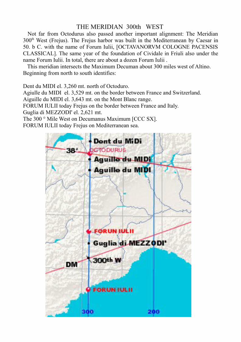
THE MERIDIAN 300th WEST Not far from Octodurus also passed another important alignment: The Meridian 300th West (Frejus). The Frejus harbor was built in the Mediterranean by Caesar in 50. b C. with the name of Forum Iulii, [OCTAVANORVM COLOGNE PACENSIS CLASSICAL]. The same year of the foundation of Cividale in Friuli also under the name Forum Iulii. In total, there are about a dozen Forum Iulii . This meridian intersects the Maximum Decuman about 300 miles west of Altino. Beginning from north to south identifies:
Dent du MIDI el. 3,260 mt. north of Octoduro.Agiulle du MIDI el. 3,529 mt. on the border between France and Switzerland.Aiguille du MIDI el. 3,643 mt. on the Mont Blanc range.FORUM IULII today Frejus on the border between France and Italy.Guglia di MEZZODI' el. 2,621 mt.The 300 ° Mile West on Decumanus Maximum [CCC SX].FORUM IULII today Frejus on Mediterranean sea.

THE SUMMITS ROGNOSA Some acronyms ROGNOSA are located near the route of the meridian 300th Forum Iulii (Frejus):
Mont ROGNEUX el. 3,084 in Valais CH.Monte ROGNOSO el. 1,952, Rubiana, Piedmont.Punta ROGNOSA el. 3,286, Sestriere, Piedmont, on the 300th mile of the DM.Monte ROGNOSA of Etiance, el. 3,382 on the Mont CenisTesta ROGNOSA della Quercia in Vallestura, Cuneo.Cap ROGNOSO or Cap d'Ail near Monaco on the Mediterranean Sea.
A series of similar place names are also found along others rays of Altino. Along the Cardo is 37th West:
The river PROGNO in Verona district.Mont ROGNEUX in Valais in Switzerland.The PROGNON in France.

The Cardo 36th West identifies:
IGNA, Thiene, VI.AGNO, (Santa GIULIANA) VI.ROGNO, BG (10 ° 08 '00 "E)ARTOGNE, BG (10 ° 09 '58 "E),OGGIOGNO (46 ° 01'21 "N08 ° 40'11")AGNO, CH (45 ° 59'N 8 ° 54'E)VAUDAGNE, Geneva. CH.ROGNA (05 ° 44 '53 "E) Oyonnax, FR.
The connection Altino-Mont Blanc was:
MAROGNE of Valdagno.MAROGNE of Altissimo.Madonna della CORO(G)NA in Baldo Mount.Mont Blanc (Bianco).


THE LIVER OF PIACENZA
The acronym Rognosa derived from the French Rogneux indicating a rock in the shape of the liver, 'kidney' emerging from the snows. The Late Latin rhenium, genitive rhenionis, the liver is connected to the ritual sacrifices of animals practiced by Mensores before commencing the measurement. See the "Liver of Piacenza" bronze reproduction of a sheep liver engraved with the name of the Etruscan deity connected to every part of the organ. As is well known, the ancient interpreted the presumed will of the gods by examining the entrails of sacrificed animals. This would be a small "instruction manual" for the oracles. The artifact was found in 1877 and is preserved in the museum of the city. The object in bronze dating back to the I-II century B.C. measuring 126 x 76 x 60 mm. Forty inscriptions are carved, and is divided into sixteen boxes that represent the distribution of the sky (according to the Etruscans), each bearing the name of a celestial body: Sun, Jupiter, Saturn, Mars, Venus. Maybe it was a topographyc square lost in the middle of the field during the measurements. Other interpretations see in the Liver of Piacenza a map with topography and hydrography schematic or simply ROGNOSA it can be the term given by Mensores allining fires, ignis or without specific reference.

Liver of Piacenza in profile.

Liver of Piacenza.
Etrurian wrighting.

MERIDIAN 200th WEST
Other meridians are detectable in Cisalpine. Another FORUM IULII modern Voghera determines meridian 200th West. Departing from:
MITLODI (Medium dies) near Glarus in Switzerland.Mons ADULA quoted several times from the classics.NOVOCOMUM today Como is located slightly away from the meridian.Corte di MEZZO (Mid day).LoMAZZO (Mid day).Intersects the DM to 200 ° Mile West.MEZZANA (Mid day)..FORUM IULII, today Voghera.Altomassso of MEZZO (Mid day).
Novocomum (Como) and FORUM IULII (Voghera) are the most important settlements of this meridian. Seems to indicate that Meridians were placed on major settlements, or vice versa, that the settlements were placed on the major Meridians. FORUM IULII Irensium is the current Tortona near Voghera over which passed the Mile 200th. Another FORUM IULII is Cividale in Friuli. In the 'History of the Longobards' (2.14) Paulus Diaconus gives to Caesar the foundation of FORUM IULII, Cividale. Another FORUM IULII Corcuniense lies on the Meridian 0 th the Meridian of Rome (Pliny St.Nat. ,14, III,112-113). They are the signatures placed by Caesar on his greatest work.

MERIDIAN 200 WEST

MERIDIAN 100 WEST

THE MERIDIAN 100th WEST Forum Claudi
The Meridian of Roia near the Reschenpass is identified with three nearby peaks: Top 10, Top 11 and Top 12. Were used to determine the axis north / south. This intersects the meridian 90th Mile West on DM near Lake Garda. In parallel with the 100th Meridian West the name Centenaro a village south of Desenzano then:MEDOLE, Castiglione delle Stiviere.MEZZANA, Sabbioneta.MEZZANO.FORUM CLAUDI at Lucca.MEZZANTA on the Tuscan coast.

THE MERIDIAN 44th WEST TELVE
The next Meridian Telve, in Valsugana Valley determined its axis to the South with Top Twelve, Top Eleven and Top Ten in top of the Asiago plateau. Intersect Decumano Maximo about 44,4 miles west of Altino. The repetition of acronyms 10, 11 and 12 of the Alps, in Italian, French, German or Ladin says that these peaks were used to determine the south of a Meridian. In the case of Telve, Peaks 10, 11 and 12 correspond to both Cardi 10 th, 11th and 12th West of Altino. It is the determinate the south of Meridian Telve. From there passed a variant of the Via Claudia Augusta. Was probably associated with the Longobard Duchy of Trento and there were, however, immigrants of German origin. The Old Saxon adjacent to Longobard has the term Twelfth, twelve, which seems to just come Telve. Telves and Tulver near Vipiteno, Sudtyrol have the same derivation from duodecim and determine the same meridian. Departing from:
TULVER (TWELVE).TELVE (TWELVE).Cima TWELVE (11 ° 28 '5.11 ") el. 2.300 mt.DM, Mile 24th West (11 ° 27 '38.01 ") Twice 12.DOCCIA (TWELVE) (11 ° 25 '32.06 ") on CARDO 12 ° EastMEZZANA (11 ° 25 '42.24 ").This meridian has a derivation from the current North of 0.77 ° East

Tulver and Telves near Vipiteno, are the translation from Latin duodecim to Saxon Twelfth, compare the English, twelve. South of Telves:
Val di MEZZO(day) DOCCIA in Tuscany near the meridian passing through the 48 th West Cardo identifies DECIMA (tenth). [4 x12 = 48] This Meridian runs 11 ° 23 '10:59 " East is determined from north to south:
TELVES,Val di MEZZO.


THE MERIDIAN 24th WEST MISCI
Even at Noon of Misci a location near Villa in South Tyrol, there is a Top TWELVE or Crep Deles DODESC indicating the meridian 24th West Mile and was intersected by KM. Telve and Misci are connections between the orthogonal network of meridians and the radial system of Altino. Dozens are well signposted: 12th East and 12th West and 24th West.

THE MERIDIAN 14th WEST Forum Livii (Forlì)
The Meridian Forum Livii, Forlì is aligned on:Valdora di MEZZO (half day).Tofane di MEZZOMoiazza. Intersects the Decunano Maximum at the 14th Mile West.
MEZZOGOROMEZZANO.FOUM LIVIIMEDOLA.ROGNOSI Mountains.Valle di MEZZOFavalto di MEZZO
Forum Livii, was founded in 188 B. C, more than a century before 44 B. C. It means that was outlined at the Meridian. It is not belivable that Romans Meridians already exists in 188 B. C. Along the Via Emilia exists Forum Popilii (Forlimpopoli) and Cornelii Forum (Imola).The acronym ROGNOSI Mountains is associated with several peaks ROGNOSI along Meridian 300th of Forum Iulii (Frejus). The rock formations emerging Monti ROGNOSI recall the anatomy of the kidney. The acronym can also be a reference mineralogical related to mining activities.

MERIDIAN 0

THE MERIDIAN 0th Forum Iulii Concupiensium
This is perfectly in line with the Meridian 0th (Zero)Sexten South from the Top 12 to Rome via various numerical place names.Starting from the top Grossevenedigher in Austria:SEXTEN.Top TWELVE.Campo di MEZZO(half day).Borghi, repeated several times on the meridians.SESTINO.San SISTO.Forum Iulii Concupiensum.SESTOMAZZANO.Rome.

THE MERIDIAN 700 WEST
0°08'28”"WEST
The westernmost point where it is possible to identify the meridians is in the Pyrenees Mountains. It is supposed to have been drawn by Didymus or whoever measured the West. Two peaks of MIDI (Mid-day) shows unmistakably that there were lines from the North to South. It seems logical they are on the side of Gaul as the peaks had to besighting up to determine the South from the North. Not far passes the Decumano Maximum that allowed to establish a fairly accurate distance from Umbilicus, the navel, that is the Zero. The two Peaks of MIDI are on the French side of the Pyrenees.
a. Pic du midi d'Ossau (0° 26 '17.08"West) mt. 2,819. b. Pic du midi de Bigorre (0°08'28.14"West) and. Mt 2781aligned to: Embelse de MEDIANO (0°12'00.00"west).


7. CONCLUSIONS
In conclusion, one wonders why things so obvious they are not come to light before. Nothing is better hiden than that which is under the eyes of all. All look and see reality distorted. History is something other than what is written in books. All that is exposed in this paper we did not know before. The subject matter is completely new. It's called History of Urban Planning and tells the way in which man has become aware of the world in which he lives and how he changed the space that surrounds it. Bruno Marano in his “Measure of the World" questions how Eratosthenes could have been so precise. There was perhaps a subsequent rounding to use in school. Zichichi attributed to Eratosthenes a defect of 2% in the measurement. That is 6314,5 km in diameter, about 2% less than the modern day measurement. I note here that the Earth, like any heavenly body is expanding. To confirm this, Al-Biruni gave an intermediate measurement of 6339,6 km, made in the year 990, about 1% less than the current. Since the time of Eratosthenes, the Earth has expanded to the current 6378,38 km, i.e. 2% more. Its diameter has today increased by about 63,88 km. Eratosthenes was right if you consider the 2% expansion factor. The measure of Eratosthenes did not become part of the culture of his time and had to wait for the next Map of the World made by Juan de la Cosa in 1500 and the first trip around the world compleated by Antony Pigafetta in 1522. The Survey of the World made by Caesar in 44 B.C. is still universally denied. Only the author supports it. How the author supports it can be seen in the following bibliography. Since 1982 many writings have been gradually published detailing support of this discovery. Until today, after 2,055 years, we have yet to render to Caesar the things that are Caesar's.


8. BIBLIOGRAPHY
Convention of the Archaeological Associations of Veneto held on May 15-16, 1982. (pgs 141-143). Treviso 1982. (A presentation of surveying methods adopted by the ancient Romans).
Le tree dell'Alto Vicentino. Vicenza 1983 (A discussion of ancient land surveying methods and the Mundus).
Geografia Romana. GSAAC, Cornedo, 1984. (An analysis of the Roman system for tracing and marking out the consular highroads the via Aemilia and the via Postumia).
L'oro di Marana. Vicenza, 1985 (An analysis of methods of tracing the via Postumia between Verona and Padua).
Il campanile di San Clemente. Tipografia Pavan, Valdagno, 1986 (Another analysis of how the via Postumia was traced out).
Toponimi numerici delle Vie Postumia e Claudia. Al Leon d'oro, Valdagno, 1988 (The first indication of place-names containing numbers determined by Roman land-surveying methodology and their progressive distribution).
Claudia Augusta, Quaderni Padani # 31 (pgs 36 - 42) Sept. Oct. 2000. (How Roman world was surveyed.)
La Globalizzazione. Al Leon d'oro, Valdagno, 2001 (The first description of the great land instrument used by the Romans to measure the Earth).
Atlante di Geografia Romana.. Al Leon d'oro, Valdagno, 2004 (An detailed explanation of how four Greek surveyors measured the entire world in the first century BCE).
The Four Surveyors. Al Leon d'oro, Valdagno 2010 (The Altinum coordinates. A study of place-names in connection with world surveying of 44 BCE.)

2012


APPENDIX Archaeological finding in America
Coins:Roman coins have been found in Venezuela and Maine.• Roman coins were found in Texas at the bottom of an Indian mound at Round Rock. The mound is dated at approximately 800 AD.• In 1957 near Phoenix City, Alabama, a small boy found a coin in a field from Syracuse on the island of Sicily, dating 490 B.C.• In the town of Heavener, Oklahoma, another out-of-place coin was found in 1976. Experts identified it as a bronze tetradrachm originally struck in Antioch, Syria in 63 A.D. and bearing the profile of the emperor Nero.• In 1882, a farmer in Cass County, Illinois picked up a bronze coin later identified as a coin of Antiochus IV, one of the kings of Syria who reigned from 175 B.C. to 164 B.C., and who is mentioned in the Bible.
Language:. Language of Karankawan Indians living on the Texas coast was similar to Latin.

Pottery:• Roman pottery was unearthed in Mexico that, according to its style, has been dated to the second century A.D.
Inscriptions:• In 1966, a man named Manfred Metcalf stumbled upon a stone in the state of Georgia that bears an inscription that is very similar to ancient writing from the island of Crete called "Cretan Linear A and B writing".• In the early 1900s, Bernardo da Silva Ramos, a Brazilian rubber-tapper working in the Amazon jungle, found many large rocks on which was inscribed more than 2,000 ancient scripts about the "Old World".• Near Rio de Janeiro, high on a vertical wall of rock - 3,000 feet up - is an inscription that reads: "Tyre, Phoenicia, Badezir, Firstborn of Jethbaal..." and dated to the middle of the 9th B.C.• Near Parahyba, Brazil, an inscription on Phoenician has been translated, in part, as: "We are sons of Canaan from Sidon, the city of the king. Commerce has cast us on this distant shore, a land of mountains. We set [sacrificed] a youth for the exalted gods and goddesses in the nineteenth year of Hiram, our mighty king. We embarked from Ezion-Geber into the Red Sea and voyaged with ten ships. We were at sea together for two years around the land belonging to Ham [Africa] but were separated by a storm, and we were no longer with our companions. So we have come here, twelve men and three women, on a... shore which I, the Admiral, control. But auspiciously may the gods and goddesses favor us!"• The Kensington Runestone , discovered in Kensington, Minnesota in 1898 contains an inscription describing an expedition of Norsemen into the interior of what is now North America. It's estimated that this expedition took place in the 1300s.• In 1980, P.M. Leonard and J.L. Glenn, from the Hogle Zoological Gardens, Salt Lake City, visited a rock outcropping in Colorado that was reputed to be inscribed with "peculiar markings". Leonard and Glenn believe they are excellent examples of Consainne Ogam writing - a type ascribed to ancient Celts. One of the many inscriptions was translated as: "Route Guide: To the west is the frontier town with standing stones as boundary markers".• A round, fist-sized stone was found during the early 1890s in a cemetery near Nashville, Tennessee. Its front was inscribed with symbols thought to be Libyan, pre-100 A.D. style. It translates as: "The colonists pledge to redeem".

Pictures:• An experienced botanist has identified plants in an ancient fresco painting as a pineapple and a specific species of squash - both native to the Americas. Yet the fresco is in the Roman city of .Pompeii.
Statues:• In 1933, in a burial at Calixtlahuaca, Mexico, archaeologist José García Payón discovered a small carved head with "foreign" features in an undisturbed burial site. It was later identified by anthropologist Robert Heine-Geldern as "unquestionably" from the Hellenistic-Roman school of art and suggested a date of "around AD 200."

Structures:
• Many stone chambers dot the New England countryside and most archaeologists insist they are all potato cellars built long ago by farmers. Others argue that they are too sophisticated for such a mundane application. One, is built into a hillside at Upton, Massachusetts, and has sophisticated corbelling that follows the style of Irish and Iberic chambers. It is theorized that it was really built by Europeans around 700 AD - long before the Leif Eiriksson voyage.Ships:• In 1886, the remains of a shipwreck (BOAT) and a bridge (BRIDGE) were found in Galveston Bay, Texas. Its construction is typically Roman.
Toys:• A doll made of wood and wax was found deep in a "Well of Sacrifice" at Chichén Itzá, Mexico, on which is written Roman script.•Tombs:• In the Mayan ruins of , Palenque stone sarcophagus was found that is very much in the style of the ancient Phoenicians.