Reconstruction of ancient rivers in the Najaf wetland area – Southern Mesopotamia, by Jaafar...
17
-
Upload
csm-qadiss -
Category
Documents
-
view
2 -
download
0
Transcript of Reconstruction of ancient rivers in the Najaf wetland area – Southern Mesopotamia, by Jaafar...


Reconstruction and Dating of ancient rivers in the Najaf wetland area - Southern
Mesopotamia
Jaafar Jotheri 1, Tony Wilkinson 2 and Mark Allen 1
1 Earth Sciences Department, Durham University , UK 2 Archaeology Departments, Durham University, UK I am Jaafar Jotheri, currently a PhD student in the Earth Sciences Faculty at Durham University. I am originally from Iraq where I work as a lecturer in the Archaeology Department at Al-Qadisiya University in Iraq. [email protected] or [email protected]

Baghdad
Basra
Mosul
Najaf
Syria
Saudi Arabia
Iran
Turkey
Kuwait Arabian Gulf
Location map of the Najaf marshland
The Najaf wetland area is located in central Iraq on the Euphrates River. It lies west of the ancient site of Babylon.
Najaf
Ancient site of Babylon
20 Km

(Cole and Gasche, 1998; Gasche et al., 2002 and Steinkeller, 2001) in Heyvaert,2008.
Present study mapping
Babylon
Najaf
Najaf
Active river
Ancient river
Ancient rivers in the Najaf wetland area has not been mapped before this study
Gap

CORONA
SRTM
Topographical
Geological
Digital Globe
Historical text
Landsat
Fieldwork and
ground-truthing
Historical map
Orientalists Map
GIS
Laboratory
Methodology I have used several methods of research in this study such as:
Pottery and cuneiforms

Methodology - Remote sensing
CORONA 1968
DigitalGlobe 2006
3 Km
1 Km
Landsat 2000
20 Km
Examination of several types of satellite image like CORONA, SRTM, Landsat and DigitalGlobe, based on ArcGIS .

Methodology - Historical texts
Petermann, 1862 Ibn Hawqal (died in 978 AD)
Corona Image 1968 British Survey map ,1916
Ottoman map,1848
Najaf branch
Babylon branch
Najaf
Najaf Najaf
These are different maps showing the Najaf wetland area in the past. The oldest map is from the tenth century by the Islamic writer Ibn Hawqal.

Ancient river Active river
Ground Truthing (Ancient river)

Ground-Truthing (river Channels and canals)
ancient canal levees
Archaeological t site
Active canal
Ancient levees of river Active canal across archaeological site
Flooded area
Earlier this year I undertook fieldwork, across the area to carry out a ground-truth for what I had detected before in remotes sensing work. Here in this picture are the canal levees; in this one is the active one. Here you can see the flooded area and the ancient river levees. Here in this picture, this canal was constructed across an archaeological site.

Methodology – Ground truthing (Archaeological sites on satellite images)
50 m 100 m
In this slide, you can see how archaeological sites are visible in high resolution satellite images. They have since been confirmed during ground truthing.
Ancient foundations
Landsat Images DigitalGlpe Images

Methodology – Ground truthing (Buried archaeological sites)
Not all the archaeological sites can be seen in the satellite images because many of them are buried by river sediments as in these examples.
Buried Site

Drilling several shallow boreholes (4-7m in depth) and collection of organic materials for radiocarbon test
Using hand gauge auger
Selected organic materials
Molluscs shell for Radiocarbon dating
To reveal the lithology of the Najaf marshland area, several boreholes were drilled by hand-auger to depths between 4 and 7 m. Then radiocarbon dating tests were carried out on three selected samples from three selected locations.
Boreholes locations

Methodology - Radiocarbon dating boreholes
22
21
20
19
18
17
16 Grey medium sand
Con 4100 + - 30 year BP Cal 4700 to 4670 BP
Con 2710 +/- 30 BP Cal 2860 to 2760 BP
Silt, clay, silty clay rich in molluscs and organic materials
Con 2120 BP+/- 30 Cal 2150 to 2000 BP
Above SL
Buried Sites , have been dated around 4000 BP
Boreholes locations
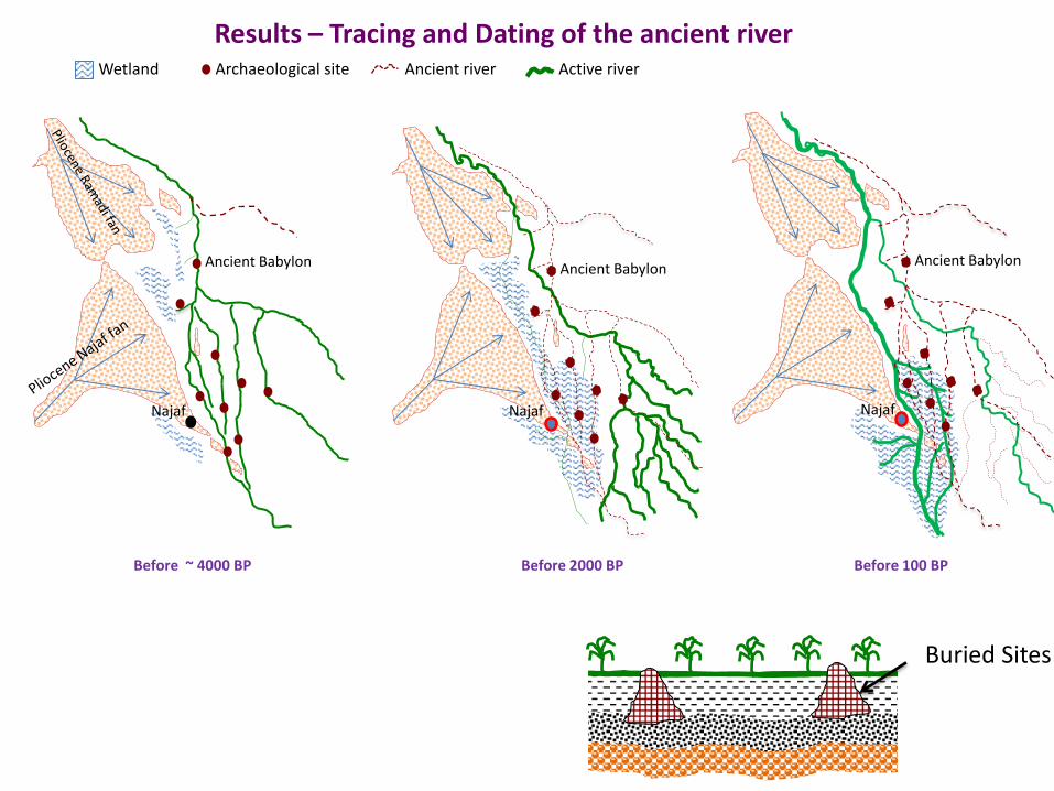
Results – Tracing and Dating of the ancient river
Ancient Babylon
Najaf
Before ~ 4000 BP Before 2000 BP Before 100 BP
Najaf
Ancient Babylon
Archaeological site Wetland Ancient river Active river
Ancient Babylon
Najaf
Buried Sites

Archaeological sites
Active river
Ottoman river
Islamic river
Babylonian River
Babylon
60 m above SL
25 m
SRTM
Wetland
Results – Tracing and Dating of the ancient river

Conclusions
3- This scenario (changing of rivers and buried of archaeological sites) may be occurred in several area in the Mesopotamian floodplain , such as , the area of marshes in the south.
1- Najaf wetland area was a wetland region from about 4000 BP years until now .
Recommendations
To discover more hidden archaeological sites in this area , geophysical exploration methods are useful, such as GPR (Ground Penetrating Radar ) especially alongside ancient channels.
2- Many archaeological sites were totally or partially buried by (4-6 m) of Euphrates river sediments when river changed its waterway from Babylonian course to Najaf course .

Thank you for your attention