Recently Found Ancient Monastery and Other Buddhist Remains at Vadnagar and Taranga In North...
34
209 CHAPTER 11 Recently Found Ancient Monastery and Other Buddhist Remains at Vadnagar and Taranga In North Gujarat, India
-
Upload
hnbgarhwal -
Category
Documents
-
view
0 -
download
0
Transcript of Recently Found Ancient Monastery and Other Buddhist Remains at Vadnagar and Taranga In North...

209
CHAPTER 11Recently Found Ancient Monastery and Other
Buddhist Remains at Vadnagar and Taranga In North Gujarat, India

210
VADNAGAR (Taluka: Vadnagar, District: Mehsana)
Vadnagar (23° 47’ N; 72° 39’ E), located in the north eastern part of Gujarat, is one of the state’s ancient towns. Known by various names such as Anartapura, Anandapur, Chamatkarpur, Skandpur, Nagaraka, etc. during different periods of its history, it is an important site for Buddhist studies and for understanding the historical and cultural development of the state as revealed by literary references and archaeological evidence. The Chinese traveller Hiuen Tsiang, who visited Vadnagar (o-nan- to- pu-lo = Anandpur) around 641 CE, records that there were more than 1,000 monks of the Sammitiya School or Little Vehicle in 10 monasteries at Vadanagar. This suggests that Vadnagar was one of the important centres of Buddhist learning in western India during that period.
Geographically, as the topographical map of the area reveals, the initial settlement of Vadnagar was established on the left bank of a wide shallow depression, possibly a remnant of the palaeo-channel of the Sabarmati River, presently flowing about 15km southeast of the town, with the other river, Rupen, lying about 4 km to the northwest. Local tradition holds that the town was located on the right bank of a small river Kapila. It is believed that this river was later linked to Sharmistha Talav (lake) as its feeder canal in mediaeval times. Ain-e-Akbari, a 17th century CE biography of the Mughal ruler Akbar, records that during his time there were about 360 water bodies around the town, each having a temple. The sandy loam soil around the town provides good agricultural yields. The Aravali hill range, which could have been a source of a variety of natural products, is not far away from it.
In ancient times, Vadnagar was situated at a strategic location where two major trade routes (one from central India to Sindh, and the other from the port towns on the Gujarat coast to Rajasthan and north India) crossed each other. While these routes remained vibrant, it could therefore have been a city of considerable opportunity. Traditionally, it was also known as one of the important land ports (Sthal Pattan) of Gujarat.
The main town of Vadnagar is still situated within the ancient fortified area. The present settlement is perched on a high mound that has been formed due to the gradual deposition of cultural debris during the last 2,300 to 2,400 years of uninterrupted occupation. The ancient fort wall is still visible on all sides of the town, although its complete height with the latest battlemented parapet
CHAPTER 11
RECENTLY FOUND ANCIENT MONASTERY AND OTHER BUDDHIST REMAINS AT VADNAGAR AND TARANGA IN NORTH GUJARAT, INDIA
Yadubir Singh Rawat

211
is visible only in a few places. The fortified area measures approximately 995m east to west and 660m north to south. The six entrance gates, two in the western and southern walls and one each in the northern and eastern walls, appear to have been originally constructed during the 12th century CE, possibly at the location of earlier gates. At present only two, Amther Mata Darwajo (gate) in the east and Pithori Darwajo in the south, are more or less in their original condition, and thus in the Hindu style of gate architecture. The other three gates show later renovations carried out at various times up to the 17th century CE. The Ghaskol gate through the southern wall has survived only in the form of a wide opening, without any architectural features.
On a plane view, the fortified town appears to be composed of two rectangles placed side by side in such a way that two large offsets are created externally, one in the northeast and another in the southwest. Sharmistha Talav, a large and roughly circular lake believed to have been built around the 13th century CE, occupies the northeast area while the southwest area outside the fortification is at present an open space. Internally, the town was divided into several Muhallas (residential blocks) by streets, lanes and bye-lanes. The major Muhallas are locally known as Mahad and each one was named after a prominent temple located therein or the community or the occupation of the community or the individual who lives therein. Most of the houses inside are elaborate and of the Haveli type. These Mahad are set along the major arterial streets oriented in the cardinal directions. An entrance gate of the same name, the only entry or exit point, serves to secure each Mahad. The smaller divisions of the town are known as Khadki or Sheri. The houses are generally constructed along a narrow lane. On elevation, the present settlement appears to be perched upon a high mound with its apex near the ruins of the ancient citadel known as Darbargadh. This area is about 25m above the surrounding ground level of the town. The present houses or group of houses follow the contour of different streets and lane are located at different altitudes. The town’s existing major streets show a gradual ascent towards the Darbargadh from all the six entrances constructed during the 12th century CE. The present layout plan of the town is datable to the mid 19th century CE.
The presence of early historical period ceramics, i.e. Red Polished Ware (RPW), was reported at Vadnagar as far back as 1952 by S. R. Rao. In 1953, the Department of Archaeology of the M. S. University of Baroda conducted small-scale excavation in the east of the town, outside the fortification, in order to ascertain the cultural sequence of the area. The excavation revealed a sequence of three cultural periods (Subbarao et al. 1955). Period I was characterised by the absence of Red Polished Ware (RPW) while Period II yielded a large quantity of RPW. Period III was identified as the mediaeval period, from the 7th to the 11th century CE. However, nothing could be determined about the settlement planning, growth and significance of the ancient town. Therefore, the excavation’s objective of obtaining the complete ceramic sequence for north Gujarat could not be fully achieved. In fact, the ancient mounds lying outside the fortification contain cultural deposits from only limited periods.

212
In view of the above findings, the Directorate of Archaeology, Gujarat State, has undertaken further excavations at the site since the year 2006 in order to understand the historical character of the ancient town, its planning and growth during successive phases of its history; to study the Buddhist remains, if any, and to understand the role of Vadnagar in the ancient trade mechanism of Gujarat in particular and the western India in general.
The Cuttings
Excavations have been so far carried out at seven locations, three within and four outside the fortified town. The cuttings outside the town were only small trial trenches, which provided information regarding the expansion of the town during different periods of its history. However, the following three locations within the fortified area have provided more fruitful results for the reconstruction of the complete cultural sequence of the site.
Ghaskol Darwaza Area
An area measuring about 30m x 25m was subjected to excavation at this location near the Ghaskol Darwaza (Gate). Archaeological remains so far exposed and recovered from this area indicate that regular human occupation in this part of the town began possibly around the foundation of the settlement i.e. before the 3rd century BCE. Excavation revealed that a Buddhist complex, with monasteries and stupas, was established at this location around the 1st century CE, and that occupation continued until the 7th century CE. However, thereafter this location remained unoccupied except for sporadic structural activities carried out during different periods. A stepped square tank made of reused bricks, built around the 12th century CE possibly to store water for the repair work of the fort wall, seems to be the only later major construction. The next period of building activities at this area started around the 19th century CE but interestingly the area overlying the ancient Buddhist complex has remained unoccupied. As a result, the accumulation in this part is only about 10m thick, in comparison to the 15m to 25m thick deposit of the central zone of the town. Only an 8.15m thick deposit could be excavated here, yielding remains belonging to the Pre-Kshatrapa, Kshatrapa, Maitraka and Solanki (Chaulukyan) periods. However, the basal natural soil could not be reached due to water logging. Ruins of a Buddhist monastery dating between the 1st century CE and the 7th century CE are the most significant findings from this location.
Durgamata Temple Area
This area along the southern fortification near a Durgamata Temple, about 230m east of Ghaskol Darwaza, was taken up for excavation. Two trenches at this location were excavated up to the depth of about 14.00m and 13.85m respectively, below the extant top of the fort wall. The deposit was found to continue further down, but the basal natural soil could not be reached due to water

213
logging. However, the excavated deposit has provided valuable information about the initial stages of the settlement and growth of the fortification as well as the development and internal expansion of the town.
In a trench which was laid against the southern fort wall, a 13.85m thick cultural accumulation was excavated. It revealed the presence of a 0.52m thick cultural deposit underlying a 2.25m high earthen rampart, indicating that initially the settlement possibly began without a permanent fortification and the rampart was provided subsequently. The earthen rampart was followed by a burnt brick wall showing five major and two minor phases of repairs at this part of the wall. The burnt brick wall with all its phases of repairs and reconstruction is datable from the beginning of the Common Era to the late 19th century CE, while the rampart and its antecedent deposit pre-dates the Common Era.
In another trench, a 10.70m high composite wall, comprising seven phases of construction
by successive builders one on top of the other and consisting of 142 brick courses, was exposed at a distance of about 10m to the north of the earthen rampart. It appears that during reconstruction the builder followed the orientation and plumb line of the preceding building. The earliest wall was built on a well-prepared hard bed of clay. The foundation of the first wall, consisting of five courses, revealed that all the bricks were laid header wise. The size of these bricks measured (?) x 26/25cm x 7cm in length, breadth and thickness respectively. The underlying deposit of this wall yielded ceramics, which may pre-date the Common Era. A few circular and square coins also have been recovered. Further depth could not be reached due to water logging. However taking into consideration the contour level, the cultural deposit may go further to 1.00m below. The street deposit lying between the fortification and the residential blocks yielded a large variety of antiquarian remains belonging to successive periods of the history of Gujarat in general and Vadnagar in particular. These include a variety of ceramics, coins, seals, sealings and large number of other minor objects of terracotta, metal, shell, bone, glass, semiprecious stones and stones.
Khari Kui (Primary School-3) area
A large open and neglected area located in the south central part of the town, locally known as Khari Kui (Primary School-3) area, was also subjected to excavation. This location lies about 80m north of the Durgamata temple site mentioned above. Six squares, each measuring 10m x 10m, were excavated to various depths. A small part of a trench in the southern margin of the area was brought down to a depth of about 18.10m below the trench surface and about 20.60m below the highest point of a trench located in the northern sector. The initial 6.05m thick deposit of this trench was found to consist mainly of successive occupation levels belonging to the different phases of the early periods of the site. These occupation levels were found to be overlaid by a 9.00m thick deposit which comprised successive levels of a north-South street flanked by a row

214
of house blocks on either side. The succeeding 3.00m thick deposit revealed that for a long period no structural activity took place in this area but later on, most possibly at the beginning of the 19th century CE, it was reoccupied but with changed planning that continued till recently. At present, the area is again unoccupied. The deep cutting here reached to a depth of 18.10m below the surface. Stratigraphically, a total number of 44 layers, many of them divisible further into sub-layers, have been broadly identified in this cultural accumulation. The basal natural soil, however, could not be reached due to water logging. Nevertheless, the composition and content of the earliest strata of calcareous earth mixed with greyish clay excavated so far yielded very few antiquarian remains, suggesting that the natural soil was not far below.
RESULTS
Recent excavation by the Gujarat State Archaeology has brought to light a continuous sequence, assignable to various periods of history of the town, beginning around the 4th–3rd century BCE to the present. The excavation of a thick cultural deposit of about 20.60m, which had accumulated as the result of a continuous occupation of the site for more than 2,300 years, revealed that the settlement began without a permanent fortification. Subsequently an earthen rampart was added around 3rd century BCE and remained until a major change in town planning took place around the beginning of the Common Era. This period was followed by a phase of major change in the internal planning of the town, the old lay out was replaced with a new plan that ushered in a new era of development and growth in the life of the town and its people, as evident from the excavated remains of well laid streets, lanes and profuse use of burnt bricks in the construction of houses as well as the fort wall. This planning seems to have lasted without any major change for more than 1,000 years, possibly till the 11th–12th centuries CE. In the 12th century CE, the Solanki ruler Kumarpal (C. 1144-74 CE) undertook major repairs of the fort wall as one of his stone inscriptions fixed at the Arjuna Bari (Gate) records.
It appears that during this phase of major repairs and renovations, the then existing town expanded along some of the broad streets in order to meet the demand of more space for residential purposes, possibly due to an increase in the town’s population. As a result, the overall lay-out plan of the town remained the same but some of the broad streets of earlier periods were turned into narrow lanes. The town seems to have expanded on all sides, on the wide-open road running along the fortification as well as in the internal broad streets. The cutting near Durgamata temple revealed that the 15m broad road running along the fortification was narrowed down to about 7m, simply in order to obtain more space to expand the town. This 12th century CE planning remained unchanged until further expansion of the town took place within the fortified area around the beginning of the 18th century CE. This change is represented by the existing plan of the town. Around this time, as is evident, most of the streets running along the fort wall were turned into a narrow gulley as new

215
residential buildings were constructed on them close to the fort wall. However, some new lanes also came into existence between the already existing house blocks and these new houses. These new additions brought changes in orientation of many lanes and streets. The fortification wall lost its functionality or purpose. Houses were erected on the streets running along it. The deep gully between the row of new houses and the old fort became an area for dumping garbage. However, the process of development and growth is continuing and as a result, at present, the town is expanding further outside the fortified area in all directions, especially in the west and northwest.
The above description clearly indicates that the history of the town may be divided broadly into five major periods based on the major events evident in the excavation and through the exposed remains datable from its beginning to the present day. Since the excavated materials, especially the ceramics, beads, building material, etc, do not reflect an abrupt change in the overall cultural milieu at any level, the author has not followed the conventional way of periodisation based on the ruling dynasty at a particular period. Instead, the major periods of events of settlement have been identified at the site itself:
a. Formative stage of the settlement (pre-3rd century BCE).
b. First fortified settlement (3rd century BCE to 1st century BCE).
c. Re-planned town with burnt brick fortification (1st century CE to 11th century CE).
d. Modification in internal planning (12th century CE to 17th century CE).
e. Period of present town planning (18th century CE to date).
Each of the above-mentioned five episodes is further divisible into sub-periods on the basis of findings of coins, seals and sealing, inscriptions, various types of objects of different materials, brick construction, ceramic industry and availability of contemporaneous foreign objects or their influence on local material.
a. Formative Stage of the settlement (pre-3rd century BCE)
Excavation of the trench, laid out against the southern arm of the existing fortification near Durgamata temple, has revealed that the initial settlement at Vadnagar was without a fortification, particularly one of a permanent nature. This is attested by a 0.52m deposit that has been found underlying the earliest earthen rampart exposed in the trench mentioned above. This deposit of dark clay mixed with compact earth yielded potsherds, bones, charcoal and other cultural materials, which possibly belong to a pre- fortification phase of settlement at the site. However, the precise nature of this deposit could not be ascertained due to its being water logged.

216
In another trench, located in the Khari Kui (Primary School-3) area about 80m north of the southern arm of fortification, the earliest 2.40m thick deposit (still continuing) could be contemporaneous to the pre-fortification phase noticed at the Durgamata temple site. The deposit comprised three layers, numbering 42, 43 and 44 and is devoid of any structure so far. However, it appears that during this period structures could have been built of perishable materials, as evident from the findings of handmade broken roof tiles of terracotta from the upper layer (42) of this deposit. These tiles have one or two holes nearer the thickened upper end, which also show parallel shallow grooves across the breadth, possibly created with the pressure of fingers while the tile was in leather-hard condition. Externally the lower end of the tile was slightly curved inward, which made it sharper. Besides pottery and minor antiquities, this deposit yielded considerable quantity of charred bones, some of which also show cut marks.
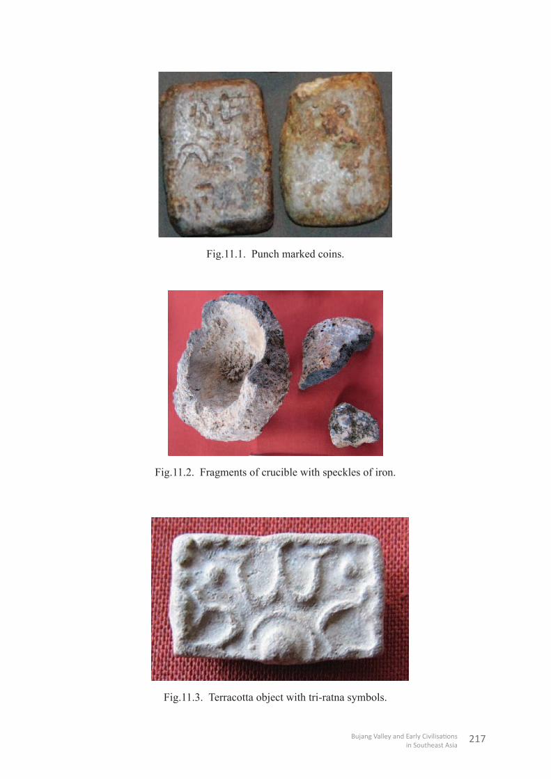
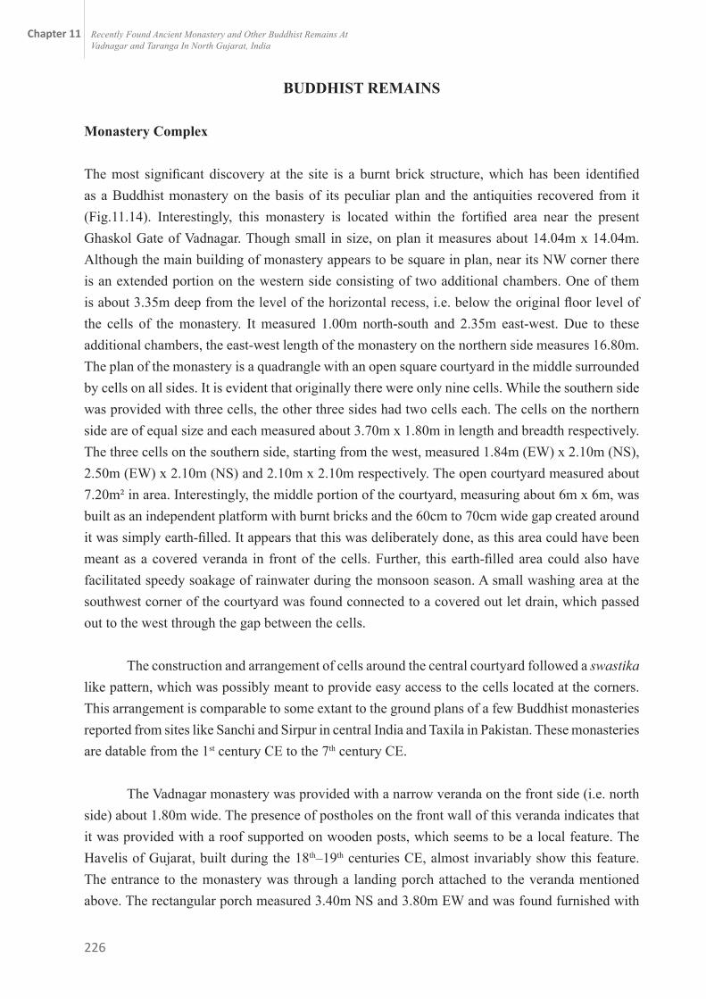
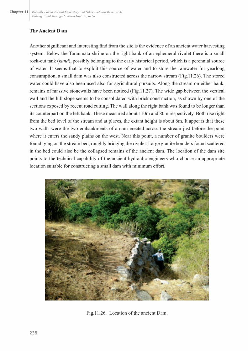
Among the minor antiquities recovered from this level mention may be made of punch marked coins (Fig.11.1) both circular as well as square /or rectangular and made of copper and silver/ alloy, a small copper ring, bone points, glass beads, cowrie shells, terracotta objects like areca nut-shaped beads, hopscotch, etc. Finding of a fragmentary crucible (Fig.11.2) with a vitrified surface containing speckles of iron indicates that iron smelting could have been an important occupation at the site. However, the most significant finding from layer 43 is a rectangular terracotta object, which seems to have been refinished out of a square pendant depicting originally four tri-ratna symbols placed around an elevated circular object, possibly, representing a stupa. At each of the corners of the square in between the symbol another four similar objects are depicted, though of smaller dimensions (Fig.11.3). Can this scene be conjectured to be the depiction of an early Buddhist stupa? This certainly requires further confirmation by experts on Buddhist art.
217
Fig.11.1. Punch marked coins.
Fig.11.2. Fragments of crucible with speckles of iron.
Fig.11.3. Terracotta object with tri-ratna symbols.

218
b. First fortified settlement (3rd century BCE to 1st century BCE)
Remains of this period have been noticed in the early levels of the deep trenches at all three sites within the fortification. Trenches in Durgamata Temple area yielded clear evidences of the first rampart (Fig.11.4) made of calcareous earth and clay deposits overlying the 0.52m thick deposit, which has been identified as a pre-fortification period. The earthen rampart oriented in an east-west direction was exposed only up to a length of 2.35m with an extant height of about 2.25m in this trench. The core of this wall revealed successive dumping of earth, which was brought from different sources. Its top was found to be gently sloping towards the north, possibly due to later erosion. Its breadth, exposed partially, measured 4.25m. The full breadth could not be ascertained as it continued on either side. On the southern side, this wall underlies the burnt brick wall of a subsequent period, while on the north side it could not be found although it continued on the other side of a 2.46m wide baulk. Therefore, if it is presumed that the external face of the wall of this period followed the exterior of the wall from the preceding period, the breadth of this earthen rampart would not have been less than 10m.
A north-south oriented burnt brick wall in the deepest trench in the Khari Kui area and an east-west oriented wall in the lowest levels of the Durgamata Temple area represent the contemporaneous residential structures of this rampart. In the former, a brick wall was found overlaying the initial deposit that was devoid of any brick structure.For this wall, the bricks were laid with mud mortar. Exposed partially up to a length of 3.80 m, it was found continuing in both directions (Fig.11.5). The partially exposed breadth measured about 42cm, but the confirmed actual breadth was 70cm. The masonry was laid in English bond style with the first course being of headers only. The brick sizes measured 49/48cm x 30/29cm x 9/8cm in length, breadth and thickness respectively. The extant height of the wall measured 1.74m with nineteen courses of bricks. Interestingly, on the top of the wall, along its longitudinal centre, three postholes were noticed, dug at a distance ranging from 80cm to 1.40m from each other. The available depth of each of the postholes measured 45cm with a diameter ranging from 14cm to 16cm. It appears that this was a composite structure with the lower portion built of bricks and the upper portion of wood. It seems to have remained in use for a considerably long period represented by deposits numbered 41, 40 and 39 from bottom to top. The overlaying layer, numbered 38, which consists of brickbats, appears to be composed of the debris from destruction and was found sealed by a dark ashy deposit layer numbered 37, which was most probably formed because of some major conflagration. Thus, layers 38 and 37 indicate a major phase of disturbance at the site during this period. The succeeding 1.00m thick cultural deposit, represented by layers numbered 36, 35 and 34, was composed of well-laid successive floors made of whitish clay. The presence of postholes on these floors indicated that during the early stages use of wood could have been more prevalent in building the construction.

219
It has also been found that after the destruction of the first wall, another wall was built exactly above it in the same orientation over a deposit of about 1.00m. The bricks used in its construction are of the same size used in the preceding wall. Only seven courses of this wall are available with an extant height of about 0.55m. A 30cm thick deposit devoid of any structure but consisting of well-prepared floors with hearths and fire activities was noticed overlaying this.
The deposit associated with the above mentioned two structural phases has yielded a good number of antiquities, some of which are unique and interesting. Mention may be made of a few punch-marked coins both circular and square/and rectangular shape. Interestingly, the motifs depicted are of a peculiar type and seem to be of a regional nature. A few coins recovered from the upper level of the deposit depict sun and moon motifs on one and three arched hills on the other side. Two button type seals, one made of ivory and another of terracotta, are additional significant findings. The ivory seal, measuring about 1.47cm in height, is about 2.40cm in diameter at its engraved front end. This front shows a very interesting depiction consisting of religious motifs and symbols with a legend in Brahmi characters of the 2nd - 3rd century BCE (Fig.11.6). The surface is divided into two distinct registers within a circular decorated boarder; the upper register depicts a double storey pillared structure with an apsidal roof. The structure is shown standing on the back of two swans facing in opposite directions. This is a depiction of a celestial or ‘Vimana’ type structure, particularly the ‘hamsa Vimana’ type referred in ancient literature. On the right side of the structure stands a ‘dwaja stambha’ (flag on a pole) within a vedika (railing). However, there is another railing on the top of the pole, just below the flag. The flag shows double straps, each with a truncated triangular end resembling the Indra dhwaja of the later Vedic literature (V.S. Agrawal 1965).
On the left side of the Vimana a tree is engraved, possibly a fig tree within a railing. A man wearing a turban is shown worshiping the tree. The turban shows a long strap at the back. On the lower register is the Brahmi legend, which reads as ma-ha-ya-ta-ka-sa (of Maha Yataka). The second seal, which is of terracotta, depicts negative impressions of five Brahmi characters engraved around the central letter, possibly, ka. These letters resemble Mauryan Brahmi in style. Preliminary reading shows that the letters are bha, ka, ta, i, and tha. The small knob at the rear end of this seal shows an engraved swastika symbol (Fig.11.7). Both of the seals have a hole across the constricted neck in between the engraved front and the rear knob, which indicates that these could have been hung as a pendant. Another object of interest is an ivory bead depicting painted motifs which are used in textile printing. This is clear-cut evidence of the very old tradition of textile printing in Gujarat (Fig.11.8). Recovery of 11 (including fragments) beautifully finished terracotta pendant-cum-spacers, possibly of a necklace with ram head shaped lower ends (Fig.11.9), is a fine example of jewellery designing in ancient India.

220
Fig.11.4. Earthen rampart underlying the brick wall.
Fig.11.5. Brick wall with post-holes.
Other findings are areca nut-shaped beads, glass beads, simple shell bangles, bone points, ivory comb, terracotta animal figurines of bull, tortoise, wheel, pendant, ear-studs etc.

221
Fig.11.6. Ivory seal. Fig.11.7. Terracotta seal.
Fig.11.8. An ivory bead with textile print design.
Fig.11.9. Terracotta pendant-cum-spacers.
The ceramic industry during the early periods comprises a variety of red ware, black-and-red ware, grey ware and micaceous red ware. The main forms include bowls with incurved rim, dishes, vases and bowl-cum lid. A fragment of a spouted vessel made of fine clay, a vase of stone with constricted neck and a corrugated neck of a large pot were also recovered.
The lower level deposit of Vadnagar measuring about 6.05m in thickness with two visible structural phases may tentatively be dated between the 1st and 4th centuries BCE based on the recovery of ceramics, script and brick sizes.

222
b. c. Re-planned town with burnt brick fortification (1st century to 11th century CE)
This period is represented by a 7.60m to 9.00m thick cultural deposit found in deep trenches at Durgamata Temple area and Khari Kui area respectively. This period ushered in a new beginning in the life of the town. The interior of the prosperous town seems to have been re-laid according to new planning, and the earthen rampart was replaced with a strong burnt-bricks fortification, though with reduced breadth. This new wall, however, remained a guiding factor for the subsequent repairers and renovators. The composite height of this wall shows seven phases of reconstruction and repairs, four major and three minor (Fig.11.10).
In the residential area, large building blocks were found on a hard packed earth bed. It is evident that at this level the settlement planning was done afresh along with some alteration in the fortification. Although, the general orientation of walls and other structures remains unchanged, their position shifted considerably. During excavation, many of the structures of preceding periods have been found underneath the street of the newly planned town. The plans and sections of the excavated trenches indicate that this revised planning of the town remained unchanged for a very long period -- more than 1,000 years. Supporting this conclusion was cultural accumulation about 7.6m thick in a street. This deposit, which represents successive street levels between two opposite rows of buildings, shows that the breadth of the street remained unchanged and the successive occupants meticulously raised their houses on the walls of the buildings of their predecessors (Fig.11.11). However, after five successive phases of building reconstruction, the breadth of street was narrowed down to 3.80m from the original breadth of 6.40m.
Fig.11.10. Successive phases of repairs of fort.

223
It appears that Vadnagar continued through several dynasties that ruled over Gujarat. Archaeologically, this deposit has yielded cultural material that can be associated with hitherto known periods of Gujarat history such as Kshatrapa, Maitraka, Gurjar Pratihara, Solanki, etc. However, there is no direct evidence to indicate that the town was under a particular king during a given time. It is possible that Vadnagar could have been under a local authority that was paying tribute to the powerful king of a larger area of Gujarat or the Malawa region. Hiuen Tsiang also records that during his visit there was no king but that it was under Malawa.
Fig.11.11. Wall consisting of successive constructions.

224
c. d. Town with modified internal planning (12th century CE to 17th century CE)
This period begins with major repairs and renovations to the fort wall carried out during the time of Solanki king Kumarpal (1143–1173 CE). Excavation of the interior face of the wall and the successive street levels revealed that the wall was in very bad shape and missing at places which caused large and wide pits/holes in its core. The street became uneven and undulating due to erosion. It appears that it was completely neglected for a long period, possibly because the local administration was not in position to repair it. Therefore, a major repair operation seems to have been carried out by laying out the road afresh and levelling it by earth filling. This repaired phase is evident in a 1.86m thick silt deposit, numbered as layer 13 in the trench abutting the wall. This layer represents a onetime filling episode. The wall elevation reveals that simultaneously the wall was also repaired and its height was increased. The road was paved with flat dressed stone slabs at places to prevent further erosion as well as to facilitate transport and the movement of the public (Fig.11.12). The repaired road also maintained the pre-existing slope on either side. The road was gradually sloping down towards the Ghaskol gate in the west. During this time the width of the pre-existing road, which was over 14.00m wide, was reduced to about 5.72m by erecting a 1.20m thick divider wall along its longitudinal direction. The space thus created by this reduction seems to have been utilized for the inner expansion of the town. This archaeological evidence noticed in this cutting during the excavation corroborates well with the description of the 12th century CE inscription of king Kumarpal that is exhibited at the Arjunbari gate in the northern wall. The above mentioned repair and reconstruction of the wall also entailed plastering on the interior. The interior as well as the outer face of the wall had a batter.
In the Khari Kui area the north-south oriented street mentioned above remained functional but was narrowed down to provide a 2.60m wide space within the breadth for building construction along its eastern edge, possibly to accommodate the increasing population. A
structure, which was added during this phase to the old main building, shows three successive phases of construction. It appears that at the end of this phase the occupants abandoned this area and with that, the old street ended here, at least in this area.
Fig.11.12. Major phases of repairs of fort and road.

225
Fig.11.13. Post street levels and a short abandonment of the area.
d. e. Period of present Town Planning (18th century CE to date)
The uppermost level, a deposit of more than 3.00m in the excavated trenches at the Durgamata temple and Khari Kui locations, indicates a major change in the inner lay out of the town. At the former site, the street along the fortification became a dumping ground for discarded materials such as broken potsherds etc. The pottery makers who used the street and the flattened top of the fortification as a backyard for their activities occupied the area. The north-south oriented street of the Khari Kui area was no longer in use, the buildings flanking it had turned into ruins, and many of them were robbed for bricks (Fig.11.13). A deposit of about 1.50m to 1.90m thickness overlaying the street level has been found devoid of any structure in the present cutting. The nature and composition of this deposit indicates that this area remained unoccupied for a long period. However, it was reoccupied, most possibly in the early to mid-19th century CE, and remained so until the early 20th century CE, as revealed by the succeeding two phases of structural activities. At present, the area is again abandoned.
The stratigraphy of the excavated trenches, along with the present plan of the town, indicates that the last two-three centuries have seen considerable modification in the internal planning of the town, possibly to accommodate more people, particularly in the marginal areas. The last renovation to the fortification seems to have been done during the mid-18th century CE. It was also provided with a parapet with battlements.
226
BUDDHIST REMAINS
Monastery Complex
The most significant discovery at the site is a burnt brick structure, which has been identified as a Buddhist monastery on the basis of its peculiar plan and the antiquities recovered from it (Fig.11.14). Interestingly, this monastery is located within the fortified area near the present Ghaskol Gate of Vadnagar. Though small in size, on plan it measures about 14.04m x 14.04m. Although the main building of monastery appears to be square in plan, near its NW corner there is an extended portion on the western side consisting of two additional chambers. One of them is about 3.35m deep from the level of the horizontal recess, i.e. below the original floor level of the cells of the monastery. It measured 1.00m north-south and 2.35m east-west. Due to these additional chambers, the east-west length of the monastery on the northern side measures 16.80m. The plan of the monastery is a quadrangle with an open square courtyard in the middle surrounded by cells on all sides. It is evident that originally there were only nine cells. While the southern side was provided with three cells, the other three sides had two cells each. The cells on the northern side are of equal size and each measured about 3.70m x 1.80m in length and breadth respectively. The three cells on the southern side, starting from the west, measured 1.84m (EW) x 2.10m (NS), 2.50m (EW) x 2.10m (NS) and 2.10m x 2.10m respectively. The open courtyard measured about 7.20m² in area. Interestingly, the middle portion of the courtyard, measuring about 6m x 6m, was built as an independent platform with burnt bricks and the 60cm to 70cm wide gap created around it was simply earth-filled. It appears that this was deliberately done, as this area could have been meant as a covered veranda in front of the cells. Further, this earth-filled area could also have facilitated speedy soakage of rainwater during the monsoon season. A small washing area at the southwest corner of the courtyard was found connected to a covered out let drain, which passed out to the west through the gap between the cells.
The construction and arrangement of cells around the central courtyard followed a swastika like pattern, which was possibly meant to provide easy access to the cells located at the corners. This arrangement is comparable to some extant to the ground plans of a few Buddhist monasteries reported from sites like Sanchi and Sirpur in central India and Taxila in Pakistan. These monasteries are datable from the 1st century CE to the 7th century CE.
The Vadnagar monastery was provided with a narrow veranda on the front side (i.e. north side) about 1.80m wide. The presence of postholes on the front wall of this veranda indicates that it was provided with a roof supported on wooden posts, which seems to be a local feature. The Havelis of Gujarat, built during the 18th–19th centuries CE, almost invariably show this feature. The entrance to the monastery was through a landing porch attached to the veranda mentioned above. The rectangular porch measured 3.40m NS and 3.80m EW and was found furnished with

227
two flights of steps, one on the east and other on the west side. The steps are much worn and show phases of successive repairs. The exteriors of the veranda wall and the landing porch were provided with a moulded base. Burnt bricks were used for construction. The average breadth of the walls of this construction is 72cm. The sizes of bricks measured 40-44cm x 25-27cm x 6-7 cm in length, breadth and thickness respectively.
Fig.11.14. General view of the excavated monastery.
Another interesting feature of the Vadnagar monastery was that it was built on a 1.60m high plinth. The base of the plinth was decorated on the exterior with a moulded band. Due to this elevation, the threshold level of the entrance of the monastery automatically rose to the same height from the surrounding ground level. However, the height of the plinth was utilized to provide an internal cellar underneath each of the cells of the monastery, which is attested by presence of a 10cm deep horizontal recess at this level in every wall, externally as well as internally. It seems that at this level a wooden floor supported on wooden beams was provided. Interestingly, the recess was oriented in an east-west direction and is one brick course higher than the recess oriented in a north-south direction in the walls. This indicates that these two different levels were meant for the supporting beams and the planks placed over them. A series of square/rectangular holes through the wall were found at the top of these recesses in each wall. The holes do not follow a regular pattern but are located at different intervals (Fig.11.15). This arrangement of recesses and holes appears to be made for the laying of the wooden floors of the cells.

228
Fig.11.15. Horizontal recess and holes through the walls of monastery.
Fig.11.16. Cross section showing elevation of the monastery.
The extant height of one of the walls has been measured at 3.30m, excluding the foundation. The stratigraphical position of the building suggested that it was built around the 2nd–3rd century CE after the two major events of the initial period at the site. The foundation trench, 1.41m deep, was found cut into the preceding deposit (Fig.11.16) to build this massive structure. All the cells exposed so far have been badly robbed for bricks and as a result no entrance was found. The exteriors of the walls have been found to be perfectly finished and smooth but the interiors are not so.

229
Excavation revealed that the upper deposit in this area was very badly disturbed due to regular human activities and erosion in subsequent periods. The upper deposit, 0.70m to 1.20m thick, seems to be of recent origin and consists of only Aeolian sand and recent garbage. Underlying this deposit a lot of debris was found, comprising mainly brick bats mixed with sand and potsherds, which conceal several ghost walls within. It was noticed that the walls have been robbed in the later period. The various walls of monastery were found at different depths from north to south. On the northern side, these walls were found at a depth of 1.25m, while the southwestern corner has been traced to a depth of 3.30m.This indicates the destruction was more towards the slope on the south. The monastery appears to have been constructed around the 1st century CE on the basis of the ‘Red Polished Ware’ (RPW) pottery which appeared for the first time with the construction of the monastery.
Votive Stupas
Two small stupas, one square and another circular in plan, have been uncovered outside, near the northeastern corner of the monastery (Fig.11.17). Their sizes indicate that they are votive stupas. The elevation of the stupa with a square plan shows that it was erected in a terraced fashion i.e., square platforms in diminishing dimensions were raised over one another with the topmost surmounted by a semi-circular solid dome known as ‘anda’. The stupa at Vadnagar consists of three diminishing square terraces. The topmost terrace was surmounted by the ‘anda’ made of moulded bricks. At present only the circular base remains. The extant height of the stupa measures 1.25m. In elevation, the lowermost terrace consists of four courses, the middle one with ten and the topmost with only two extant courses. The partially exposed plan shows that the dimension of the lowest terrace would have been about 6.15sq.m, the middle one about 4.75sq.m and the topmost about 2.95sq.m. The circular base of the ‘anda’ measures 2.0m in diameter. The sizes of burnt bricks used in the construction measured 38cm x 26cm x 7cm; 39cm x 25cm x 6cm; 37cm x 25cm x 7cm; and 40cm x 26cm x 7cm in length, breadth and thickness respectively.
The second votive stupa, circular in plan, measures 2.24m in diameter and only the lowest three courses are extant. It lies to the north of the square stupa. Stratigraphically, these votive stupas seem to have been built after the construction of the monastery at a later date, i.e. around the 4th–5th century CE. The presence of the votive stupas and the monastery has reconfirmed that during the early centuries of Common Era, there was a strong Buddhist presence in Vadnagar. These findings suggest that further excavation may bring to light a large complex with many such votive stupas. These findings also corroborate the records of Hiuen Tsiang who visited Anandapur (o-nan- to- pu-lo), the present Vadnagar, in c. 640–641 CE.

230
Fig.11.17. Votive stupas near the monastery.
Fig. 11.18. Mutilated Buddha head.
Antiquities: Among the antiquities of Buddhist interest mention may be made of a red sand stone broken head of Buddha (Fig.11.18), stylistically datable to the 2nd century CE, a votive tablet with a foot impression, six petalled flowers, and a crescent shaped stone tray depicting the scene of a monkey offering honey to Buddha (Fig.11.19). Sherds of Black Polished Ware with inscriptions in Brahmi legend, dev-shri-ri-shi, sha-ka-sya and dha-ma written in the 2nd–3rd century CE style have also been recovered from the monastery. A sandstone human head sculpted in the Gandhara art style and terracotta human head pendants could probably have been used as cult objects since they depict a terrifying face with a trident on its forehead. There are other finds, including many fragments of incense burners.
Fig.11.19. Depicting a Buddhist tale.

231
Objects of foreign origin/influence: The monastery area has yielded a few valuable antiquities, which indicate a foreign origin or influence. Mention may be made of an amphora-like handled jar, broken sherds of a large vessel known as a ‘torpedo jar’ and a terracotta plaque with mouldings of acanthus leaves and a head. According to Tomber (personal communication), the terracotta plaque is in the classical style but may be a local imitation. The ‘torpedo’ jar was a Mesopotamian vessel during the 3rd–7th century CE (Tomber, 2007). In addition, an impression of Roman coins belonging to Valentinian-I (364–367 CE) has been found on terracotta sealing, which interestingly depicts Brahmi legend on its other face.
TARANGA (Taluka: Kheralu, District: Mehsana)
An isolated hill of the Aravali range known as Taranga (lat.23°, 58’ N and 23°, 59’ N; long.72°, 48’ E and 72°, 45’ E) is located twenty kilometres northeast of Vadnagar. Its highest peak known as Siddha-Shila or Mallinath peak is approximately 446m above the mean sea level and about 206m above the surrounding plains. This hill is spread over an area of about 11km in circumference and consists of many peaks and deep valleys. Recently, this author has noticed many significant archaeological remains, which confirm the presence of an ancient fort and a settlement of greater antiquity on and around the hill peaks at Taranga. This hill contains evidence of occupation in early historical to mediaeval periods in the form of ruins of a fort, structures, rock shelters, sculptures and other valuable archaeological materials. Since the 12th century CE it has been a prominent Jain pilgrimage centre.
Historical and Archaeological Background
The earliest archaeological remains from Taranga so far belong to a Buddhist establishment, possibly from a tantric Buddhist tradition. In 1938 a marble image of the goddess Tara and a few Buddhist images, including Avalokiteshvara Padmapani, were found in two shrines, locally known as Dharanmata and Taranmata. The latter is a modified natural rock shelter (Fig.11.20). These shrines are located on artificially raised high terraces along the right bank of a small stream. In addition to these, a small stone panel depicting four dhyani Buddhas was reported from Jogida hill inside a natural rock shelter. Among these findings, the marble image of Tara is datable to the 8th - 9th century CE (Shah, 1964). The sculpture of Tara is a fine work of art and also incorporates in the lowest register, below the goddess and above the inscription, inter alia the symbolic representations of Buddha - an ‘elephant’, a ‘horse’ and a ‘chakra,’ which form the seat for the deity. There is a dispute among scholars about the identification of this image as Varada-Tara. Some of the scholars identify it as Sukla-Kurukulla, one of the female divinities that emanate from Amitabha Buddha (Sompura, 1969). Many scholars have previously studied these remains but none seems to have paid proper attention to the details of the site. However, all the presiding and associated deities in these shrines belong to the Buddhist pantheon, and the local people, of whom the majority are tribal,

232
worship them as their local gods and goddesses. No one practices Buddhism in this area at present. The general belief is that this hill on the southwestern spurs of the Aravali owes its name to the Buddhist goddess Tara. Further, the Kumarapala-pratibodha of Somprabhacharya, composed in V.S.1241 in Prakrta-Apabhramsa language, records that King Veni-Vachcharaja (Veni-Vatsaraja), a Buddhist and contemporary of the famous Jain monk Arya Khaputacarya, built a temple dedicated to the Goddess Tara in a city, which came to known as Tarapura after her. Tarapura is identified with Taranga (Sompura, 1968).
Fig.11.20. Dharanmata shrine with Buddhist images.
Recent findings
In view of the above mentioned Buddhist remains from the Taranga ill and the recently excavated Buddhist monastery complex at Vadnagar, this author has conducted a cursory survey of the Taranga Hill in order to understand the relationship between the two ancient sites of north Gujarat. These sites are situated at about 20km distance from each other as the crow flies. The survey revealed the presence of an ancient fortified settlement besides a unique cave dwelling site located alongside. The total combined area covered by these two settlements has been estimated to be more than 6km in circumference.

233
Fig.11.21. Site map of Taranga divisions.
Fortified Settlement
As mentioned above, the ancient settlement comprised two distinct divisions. The first, a strong hill fort, is located on the south eastern side of the highest peak of Taranga Hill, and the second is an open settlement that lies on the western side of the same peak. The fortification with two gates, one in the east and another in the west, covers an area that may be more than 3km in circumference. This fortified division covers the highest peak – the Siddha-Shila/ Mallinath Peak on one hand and the adjacent low-lying hill ridges that surround the well-known Ajitnath Temple complex from all sides on the other (Fig.11.21). A close examination of the elevation of the fort wall has revealed that it consists of two distinct phases of construction – the lower part built of large fractured granite boulders in dry masonry and the upper portion, preserved at a few places only, built of large-sized burnt bricks. However, of the upper portion only two to five brick courses are extant (Fig.11.22). The sizes of the bricks measured 49cm x 29cm x 8cm and 40-42cm x 25-26cm x 7cm in length, breadth and thickness respectively. On the base, the sizes of the bricks of the upper portion of the wall are datable to the early centuries of Common Era with certainty. Hence, the lower portion of the fort wall might have been constructed at a much earlier date, possibly during early historical times.

234
Fig.11.22. Ancient fort running on the one of the peaks of Taranga.
The stone fortification was furnished with rectangular bastions, flights of steps and water outlets. It was constructed in a terraced fashion according to the contours of the hill. The overall makeup it appears to be contemporaneous with the cyclopean wall of Rajgir, Bihar in eastern India, which has been dated to the 6th century BCE.
Buddhist Shrines and Cave-dwellings
This desolate location, in a surrounding area of hill peaks consisting of huge granite boulders, creates a feeling of being in a mysterious land. It lies to the west of the fortified area behind the highest peak, i.e. Siddha-Shila. Although no fortification has been noticed in this part, it is naturally secured on all sides by high hills. This division comprises the ruins of terraced cave dwellings, the two Buddhist shrines on the slopes of the hills and the remains of an ancient dam. There is a natural spring at the right bank of a seasonal stream, the only perennial source of water presently available. The only entrance to this area is through the narrow valley of the rivulet, which opens into the sandy plains on the west. It has been noticed that, to utilise the existing natural rock shelters for dwelling purposes, the ancient inhabitants raised several artificial terraces on the slopes of hills. These terraces are of different dimensions. Their length ranges from 5m to 30m while the width is from 5m to 19m; similarly, the height ranges from 0.50m to 6m. The Buddhist shrines are also constructed on the top of two such high and broad terraces. Most of the terraces have been found associated with natural rock shelters that were made habitable by providing walls at the vulnerable

235
points inside them. It appears that a sizeable number of people were living in these shelters. The size and area of the artificially built tabled land/terrace provided in front or beside them supports this fact. The above mentioned peculiarity of the site indicates that it could have been a Buddhist sanctuary, possibly of the early Hinayana School.
Terracotta Buddhas and other Remains
As stated above, a natural spring is the only perennial source of water in the area. A small rock-cut kund (tank) with a flight of steps from the streamside supplies potable water throughout the year. The Taranmata and Dharanmata shrines are located on a high terrace just above this tank. Near the water tank, further downstream at the top of a terrace which seems to be the right side embankment, a few brick constructions were discovered. The brick size measured 40cm x 25cm/26cm x 7cm in length, breadth and thickness respectively. Remains of brick constructions strewn with flat roof tiles datable to the early historical period have been noticed on many of the terraces at the site (Fig.11.23). One of the constructions on the right bank of the rivulet appears to be an altered base of a small stupa because two large sized terracotta images of the Buddha in padmasana have been recovered from its top surface (Fig.11.24). These images resemble those recovered from Devnimori Mahastupa, which was excavated in the early sixties of the last century (Mehta and Chaudhary, 1966). The images of Devnimori have been dated to the last quarter of the fourth century CE. Therefore, these images may also be dated at least to that period.
The site has also yielded a variety of pottery, which may be dated to the Kshatrapa and the pre-Kshatrapa periods. Some of the pottery is comparable to that of the early levels of Vadnagar that have been dated to the 1st–4th centuries BCE. It has been observed that the cave deposits have yielded more pottery than the open areas. From one of the cave shelters, a broken piece of an iron vessel has also been recovered. The ceramic assemblage comprises red, grey, black and red and fine polished black and/or grey wares. The last one resembles the Northern Black Polished (NBP) Ware. The main shapes are saucer-cum-cup type lids, convex sided bowls, carinated handi (a wide mouth pot used for cooking), medium sized jars and a vase with a narrow elongated neck and with a featureless rim and a corrugated exterior, etc. Some sherds were found decorated with simple appliqué designs while others had simple horizontal bands painted in black, white or purple colours. However, no sherd of Red Polished Ware of the Kshatrapa times has been found so far. The site has also yielded a variety of pottery which may be dated to the Kshatrapa and the pre-Kshatrapa periods. Some of the pottery is comparable to that of the early levels of Vadnagar, which have been dated to the 1st–4th centuries BCE.

236
Fig.11.23. Terracotta roof tiles.
Fig.11.24. Terracotta Buddha and a brick structure.

237
Fig.11.25. Jogida Gupha-An Ancient Palace (?).
Jogida Gupha - An Ancient Palace(?) on the Hill Top
The Jogida Peak, the second highest peak of Taranga, is located just 20m below and to the west of the Siddha-Shila, on the edge of a narrow terrace. This peak consists of innumerable granite boulders of very large sizes, under which is a Gupha (cave) sheltering the panel of the four dhyani Buddhas. The local tribal people call it the ‘Palace of the Displeased Queen’ (Ruthi Rani-ka Mahal?). However, it is possible that this largest shelter, which is located at a commanding position on the highest point of the peak, was intended for someone in high authority, either a religious or an administrative head. A secret path from this shelter descends to the Buddhist shrines of Taranmata and Dharanmata located down below in the valley. This Gupha is approachable through a narrow cavity from the eastern side. Above this cave another large rock shelter lies at the highest point of the peak. It is approachable through a long flight of steps (Fig.11.25). This large shelter measures approximately 5m x 2.5m x 3m in width, depth and height respectively. It commands a view of the whole of the western valley spreading down below where the ancient dam and Buddhist shrines are located. A few potsherds, brickbats and a few fragmentary roof tiles with two perforations have been found inside the cave. These antiquarian remains are datable to the early historical period.
238
The Ancient Dam
Another significant and interesting find from the site is the evidence of an ancient water harvesting system. Below the Taranmata shrine on the right bank of an ephemeral rivulet there is a small rock-cut tank (kund), possibly belonging to the early historical period, which is a perennial source of water. It seems that to exploit this source of water and to store the rainwater for yearlong consumption, a small dam was also constructed across the narrow stream (Fig.11.26). The stored water could have also been used also for agricultural pursuits. Along the stream on either bank, remains of massive stonewalls have been noticed (Fig.11.27). The wide gap between the vertical wall and the hill slope seems to be consolidated with brick construction, as shown by one of the sections exposed by recent road cutting. The wall along the right bank was found to be longer than its counterpart on the left bank. These measured about 110m and 80m respectively. Both rise right from the bed level of the stream and at places, the extant height is about 6m. It appears that these two walls were the two embankments of a dam erected across the stream just before the point where it enters the sandy plains on the west. Near this point, a number of granite boulders were found lying on the stream bed, roughly bridging the rivulet. Large granite boulders found scattered in the bed could also be the collapsed remains of the ancient dam. The location of the dam site points to the technical capability of the ancient hydraulic engineers who choose an appropriate location suitable for constructing a small dam with minimum effort.
Fig.11.26. Location of the ancient Dam.

239
Fig.11.27. Right side embankment of the rivulet.
In Gujarat, the activities of dam/water reservoir construction go back to Harappan times as evidenced at Dholavira (Bisht, 1998) and the tradition continued all through subsequent times, as seems to be testified by the Junagadh inscription of Rudradaman (150 CE) and Skandagupta (456 CE). The former records that the Sudarshana Lake was first built by Chandragupta Maurya, possibly in the last quarter of the 4th century BCE. Rudradaman records the large-scale reconstruction of a reservoir, Sudarshana Lake that was destroyed due to flooding caused by torrential rains. Most interestingly, he refers to its construction by Chandragupta Maurya (last quarter of fourth century BCE) and to its being furnished with canals by Asoka (273–232 BCE). During Skandagupta’s reign (455–67 CE), the lake met with eventual destruction, followed by its reconstruction. In central India, around the well-known Buddhist site of Sanchi, remains of as many as 16 dams have been documented which were built between the 1st and 3rd centuries BCE. Therefore, it appears that during subsequent times dam construction became a necessity for various purposes in response to environmental constraints as well as part of a cultural package that accompanied the spread of Buddhism, urbanisation and the development of centralised state politics (Shaw et al, 2007).
Moreover, as mentioned above, this narrow valley could have served as an outer entry point from the western side to the inner hill fort of Taranga or as an escape route from the same. Regardless of its purpose, this narrow passage appears to have been a place that was strongly guarded by the cave dwellers of the hills. The large bastion mentioned above on the highest point of the fort and the Jogida-Gupha commands a view of this valley. Therefore, the overall picture that emerges is that Taranga Hill was located at a strategic point beside the main route connecting Gujarat with north India through Rajasthan during the early historic period. The hill fort seems to have been intended to keep a watch on the movement of caravans and passing armies moving from Gujarat to Rajasthan or vice versa.

240
REFERENCES
Agrawal, V.S1965 Indian Art. Prithvi Prakashan, Varanasi.
Beal, Samuel. 1884 ‘SI-YU-KI’: Buddhist Records of the Western World. London. pp268.
Bisht, R.S. 2002 Dholavira Excavation: 1990-94. In Facets of Indian Civilisation. Recent Perspectives. Essays in Honour of Professor B.B.Lal, edited by Jagat Pati Joshi,
New Delhi: Aryan Books International. pp 107-20.
Campbell, M. 1896 Gazetteer of the Bombay Presidency. Vol. I. Part I. History of Gujarat. Second
reprint 1989. Vintage Books, Gurgaon. pp 6-8.
Deborah E. Kalimburg-Salter2007 The Buddhist Art of Gujarat: on Taranath’s Old Western Indian Style. Silk Road Art
and Archaeology-6, pp 253-266
ACKNOWLEDGMENTS
The author is grateful to the Government of Gujarat and its Department of Sports, Youth & Cultural Activities for providing all help and support. I thank all the staff of the Gujarat State Archaeology, especially M.V. Joshi, D.K. Rathore and Hitesh Shah and also Dilip Kushwaha, Shishir Jain, Bhimraj Varhat and Mukesh Thakore for assisting me at various stages of the excavation at site.
CONCLUSION
The recent excavation and survey conducted by this author at Vadnagar and Taranga Hill has confirmed that north Gujarat was an area where Buddhism flourished from its very beginning and that this continued until the 10th-11th century CE. The ancient fort showing two stages of constructions at Taranga can be dated between the 2nd–3rd century BCE and the 1st century CE. Later inscriptional records indicate that this fortified settlement could have been the legendary town of Anartapur. The hill slopes of three peaks on the western side of the fortified town revealed the presence of several natural rock shelters with walls, floors and potsherds which were used for residential purposes. It appears that this area was a comprehensive Buddhist sanctuary from at least the 3rd century BCE to the 11th century CE. This discovery puts north Gujarat firmly on the Buddhist map of ancient India.

241
Gadre, A.S. 1939 Buddhist Influence in Gujarat and Kathiavad. Journal of the Gujarat Research
Society, Bombay. Vol. I. iv: pp.67-69
Gazetteer of India 1975 Gujarat State Gazetteers: District Mehsana. Ahmedabad. p 836.
Hirananda Shastri 1938 Annual Report of the Department of Archaeology Baroda State 1935-36. Baroda.
p 7.
Indian Archaeology 1953-54 A Review. Archaeological Survey of India. New Delhi. p10
Joshi Umashankar 1946 Puranoma Gujarat (Bhaugolik Khand). Sheth B.J. Vidhya Bhavan, Ahmedabad. pp
35-43 &163-168.
Majmudar, M.R. 1960 Historical and Cultural Chronology of Gujarat. The M. S. University of Baroda,
Baroda. pp 288-289 & 301-302
Majumdar, R. C. 1926 The Gwalior Prasasti of the Gurjara Pratihara King Bhoja. Epigraphia Indica, Vol.
XVIII. Calcutta. pp 107, ff., vs.11.
Mehta, R. N. and S. N. Chaudhary 1966 Excavation at Devnimori: A Report of the Excavation Conducted from 1960 to
1963. M. S. University Archaeological Series, No.8. Baroda.
Morey, M. S. 1985 History of Buddhism in Gujarat. Reprint, 2007. Ahmedabad. pp 99-101
Muniraja Jinvijaya (Ed.)1920 Kumarapala Pratibodha of Somaprabhacharya. Central Library, Baroda. pp 437-
440.
Parikh, R. C. & H.G. Shastri 1974 Gujaratnu Rajkiya Ane Sanskritic Itihas. Vo.3, B. J. Institute. Ahmedabad. pp 104.
Rawat,Y. S. 2009 Hill Fort of Anart: Discovery of a unique Early Historical Fort with Cave Dwellings,
Buddhist Idols and Remains at Taranga in North Gujarat. Puratattva, Vol.39. pp 96-106. New Delhi.

242
Roberta Tomber. 2007 Rome and Mesopotamia - importers into India in 1st millennium CE. Antiquity 81.
London. pp 972- 988.
Sir Jhon Marshal. 1917 Archaeological Survey of India, Annual Report 1913-14. The Monuments of
Sanchi, pp 32-33.
1918 Archaeological Survey of India, Annual Report 1915-16, pp 27-29.
Shah, U.P. 1964 Gujaratma Bauddh Dharma. Svadhaya, Book. I. No. iii. Vadodara. pp 317-21.
Shashtri, H.G.2000 Gujarat under the Maitrkas of Valabhi. Gaekwad’s Oriental Series, No. 180. The
Maharaja Sayajirao University of Baroda, Vadodara.
Shaw, J, et al. 2003 Water Management, Patronage Networks and Religious Change: New Evidence
from the Sanchi dam complex and counterparts in Gujarat and Sri lanka. South Asian Studies 19. pp 73-104.
Shaw, J. et al. 2007 Ancient Irrigation and Buddhist History in Central India. Optically stimulated
Luminescence Dates and Pollen Sequence from the Sanchi Dams. Asian Perspectives. 46 (i): pp 166.
Sompura, K. F. 1968 The Structural Temples of Gujarat. Gujarat University, Ahmedabad. pp 72.
Sompura, K. F. 1969 Buddhist Monuments and Sculptures in Gujarat-A Historical Survey.
Vishveshvaranand Institue, Hoshiarpur. pp 29-30.
Subbarao. B and R. N. Mehta 1955 Excavation at Vadnagar. Journal of the Maharaja Sayajirao University of Baroda.
Vol. IV, No. I: pp 20-35.