Ramparts in the Görgényi, Hargita and Persányi Mountains. In: Aerial Archaeology and Remote...
33
-
Upload
independent -
Category
Documents
-
view
0 -
download
0
Transcript of Ramparts in the Görgényi, Hargita and Persányi Mountains. In: Aerial Archaeology and Remote...
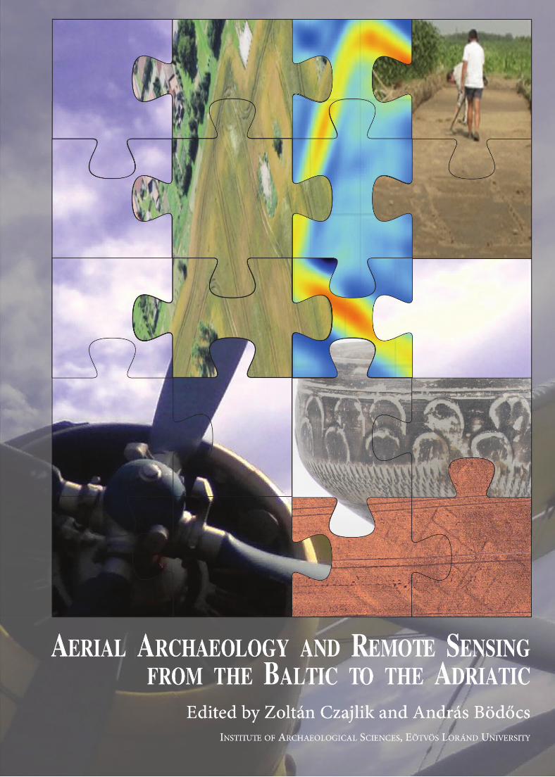

AERIAL ARCHAEOLOGY AND REMOTE SENSINGFROM THE BALTIC TO THE ADRIATIC

Institute ofArchaeological Sciences, Faculty ofHumanities, Eötvös Loránd University
Budapest2013
AERIAL ARCHAEOLOGY AND REMOTE SENSING
FROM THE BALTIC TO THE ADRIATIC
Selected Papers
of the Annual Conference of the Aerial Archaeology Research Group,
13th–15th September 2012, Budapest, Hungary
Edited by Zoltán Czajlik and András Bödőcs
Translated by
Magdaléna Seleanu and the Authors
The publication ofthis volume was supported by
© The Authors, 2013
© L'Harmattan, Budapest, 2013
© Institute ofArchaeological Sciences, Faculty ofHumanities, Eötvös Loránd University, Budapest, 2013
ISBN 978-963-7343-95-7
Cover design
András Bödőcs
(photos and illustrations: András Bödőcs, Zoltán Czajlik, Balázs Holl, Sándor Puszta, FÖMI, Museum ofMilitary History)
Printed in Hungary in 2013
Eötvös Loránd University, Faculty ofHumanities
NKA (National Cultural Fund ofHungary)
AARG (Aerial Archaeology Research Group)

TABLE OF CONTENTS
Foreword .... . . . . . . . . . . . . . . . . . . . . . . . . . . . . . . . . . . . . . . . . . . . . . . . . . . . . . . . . . . . . . . . . . . . . . . . . . . . . . . . . . . . . . . . . . . . . . . . . . . . . . . . . . . . . . . . . . . . . . . . . . . . . . . . . . . . . . . . . . . . . . . . . . . . . . . . . . 7
Editorial preface .... . . . . . . . . . . . . . . . . . . . . . . . . . . . . . . . . . . . . . . . . . . . . . . . . . . . . . . . . . . . . . . . . . . . . . . . . . . . . . . . . . . . . . . . . . . . . . . . . . . . . . . . . . . . . . . . . . . . . . . . . . . . . . . . . . . . . . . . . . . . . . 9
METHODOLOGY
Aerial Archaeology
René GOGUEY—Alexandra CORDIER: Les techniques de la photographie aérienne
en France et dans le Bassin des Carpates: photographie oblique en couleurs
et en infra-rouge, photographie verticale .... . . . . . . . . . . . . . . . . . . . . . . . . . . . . . . . . . . . . . . . . . . . . . . . . . . . . . . . . . . . . . . . . . . . . . . . . . . . . . . . . . . . . . . . . . . . . . . 11
Vedrana GLAVAŠ—Rog PALMER: Aerial and field reconnaissance ofVelebit mountain .... . . . . . . . . . . . . . . . . . . . . . . . . . 19
Balázs HOLL—Zoltán CZAJLIK: Where are all the tumuli? ... . . . . . . . . . . . . . . . . . . . . . . . . . . . . . . . . . . . . . . . . . . . . . . . . . . . . . . . . . . . . . . . . . . . . . . . . . 25
Remote Sensing
Łukasz BANASZEK: Lidarchaeology .... . . . . . . . . . . . . . . . . . . . . . . . . . . . . . . . . . . . . . . . . . . . . . . . . . . . . . . . . . . . . . . . . . . . . . . . . . . . . . . . . . . . . . . . . . . . . . . . . . . . . . . . . . . . . . . 31
Dimitrij MLEKUŽ: Roads to nowhere? .... . . . . . . . . . . . . . . . . . . . . . . . . . . . . . . . . . . . . . . . . . . . . . . . . . . . . . . . . . . . . . . . . . . . . . . . . . . . . . . . . . . . . . . . . . . . . . . . . . . . . . . . . . 37
Cezary SOBCZAK: An Experimental Application of Airborne Laser Scanning for
Landscape Archaeology in Northeastern Poland .... . . . . . . . . . . . . . . . . . . . . . . . . . . . . . . . . . . . . . . . . . . . . . . . . . . . . . . . . . . . . . . . . . . . . . . . . . . . . . . . . . 43
CASE STUDIES
Prehistory
Gábor BERTÓK—Csilla GÁTI: Circles in the Field through Circles in the Air.... . . . . . . . . . . . . . . . . . . . . . . . . . . . . . . . . . . . . . . . . . . 49
László REMÉNYI—Ákos PETŐ—Árpád KENÉZ—Szandra BAKLANOV: Archaeological
and pedological investigations at the fortified Bronze Age settlement of
Perkáta–Forrás-dűlő .... . . . . . . . . . . . . . . . . . . . . . . . . . . . . . . . . . . . . . . . . . . . . . . . . . . . . . . . . . . . . . . . . . . . . . . . . . . . . . . . . . . . . . . . . . . . . . . . . . . . . . . . . . . . . . . . . . . . . . . . . . . . . . . . . 55
Roman Period
András BÖDŐCS: Borders. The problems of the aerial archaeological reserach
of a Roman limitatio in Pannonia.... . . . . . . . . . . . . . . . . . . . . . . . . . . . . . . . . . . . . . . . . . . . . . . . . . . . . . . . . . . . . . . . . . . . . . . . . . . . . . . . . . . . . . . . . . . . . . . . . . . . . . . . . . . . . 59
Florin FODOREAN: Roman Potaissa and its surroundings .... . . . . . . . . . . . . . . . . . . . . . . . . . . . . . . . . . . . . . . . . . . . . . . . . . . . . . . . . . . . . . . . . . . . . . . . . . 67
László RUPNIK—Zoltán CZAJLIK: Aerial archaeological survey of the legionary camp
and military town at Brigetio .... . . . . . . . . . . . . . . . . . . . . . . . . . . . . . . . . . . . . . . . . . . . . . . . . . . . . . . . . . . . . . . . . . . . . . . . . . . . . . . . . . . . . . . . . . . . . . . . . . . . . . . . . . . . . . . . . . . 71
Máté SZABÓ: Using remote sensing and non-invasive archaeological methods
in the research of Roman villas and the ancient landscape of Pannonia .... . . . . . . . . . . . . . . . . . . . . . . . . . . . . . . . . . . . . . . . . . . . 79
Middle Ages
Zsuzsa MIKLÓS: Aerial archaeological investigation of Árpádian Age
earthen forts and castles in Hungary .... . . . . . . . . . . . . . . . . . . . . . . . . . . . . . . . . . . . . . . . . . . . . . . . . . . . . . . . . . . . . . . . . . . . . . . . . . . . . . . . . . . . . . . . . . . . . . . . . . . . . . 85
András SÓFALVI: Ramparts in the Görgényi, Hargita and Persányi Mountains .... . . . . . . . . . . . . . . . . . . . . . . . . . . . . . . . . . . . . . 89
References .... . . . . . . . . . . . . . . . . . . . . . . . . . . . . . . . . . . . . . . . . . . . . . . . . . . . . . . . . . . . . . . . . . . . . . . . . . . . . . . . . . . . . . . . . . . . . . . . . . . . . . . . . . . . . . . . . . . . . . . . . . . . . . . . . . . . . . . . . . . . . . . . . . . . . . 95
Plates .... . . . . . . . . . . . . . . . . . . . . . . . . . . . . . . . . . . . . . . . . . . . . . . . . . . . . . . . . . . . . . . . . . . . . . . . . . . . . . . . . . . . . . . . . . . . . . . . . . . . . . . . . . . . . . . . . . . . . . . . . . . . . . . . . . . . . . . . . . . . . . . . . . . . . . . . . . . . 109
Authors .... . . . . . . . . . . . . . . . . . . . . . . . . . . . . . . . . . . . . . . . . . . . . . . . . . . . . . . . . . . . . . . . . . . . . . . . . . . . . . . . . . . . . . . . . . . . . . . . . . . . . . . . . . . . . . . . . . . . . . . . . . . . . . . . . . . . . . . . . . . . . . . . . . . . . . . . . 127
Conference Programme ..... . . . . . . . . . . . . . . . . . . . . . . . . . . . . . . . . . . . . . . . . . . . . . . . . . . . . . . . . . . . . . . . . . . . . . . . . . . . . . . . . . . . . . . . . . . . . . . . . . . . . . . . . . . . . . . . . . . . . . . . . . . . . 131
The first scientific description of the easternTransylvanian ramparts was written by Balázs Or-bán (ORBÁN 1868–1873), who believed that theyhad been defenceworks which, together with thestone castles near them, had protected the easternconfines of the Hungarian Kingdom. In the late19th century, Gábor Téglás contended that theramparts had been part of the eastern Dacianlimes (TÉGLÁS 1895). The systematic investigationof the eastern Transylvanian ramparts was onlybegun in the 1970s. They were mapped in detailby István Dénes, a geologist and amateur archaeo-logist, who surveyed the earthworks and cutthrough them in several locations (DÉNES 2001 ,DÉNES 2003, DÉNES 2007). In his interpretation ofthe ramparts, Dénes accepted the theory proposedby the archaeologists Géza Ferenczi and István Fe-renczi that at the turn of the 11 th and 12th centu-ries, the borders of the medieval HungarianKingdom had been defended by a sophisticatedsystem of stone castles and ramparts (FEREN-CZI–DÉNES 1994). A new chapter was opened inthe research of the ramparts after 2000. Togetherwith Antal Kosza, I mapped their exact courseusing GPS and began the systematic aerial archae-ological photography of these monuments. Thecharcoal samples taken from the burnt woodenstructure of the ramparts were submitted to ra-diocarbon analysis – the dates thus gained setthese earthworks in an entirely new perspective.Lying at 600–900 m a.s.l., the ramparts in the Gör-gényi, Hargita and Persányi Mountains can bedivided into two main types in terms of their for-mal traits; as shall be shown below, these formal di-
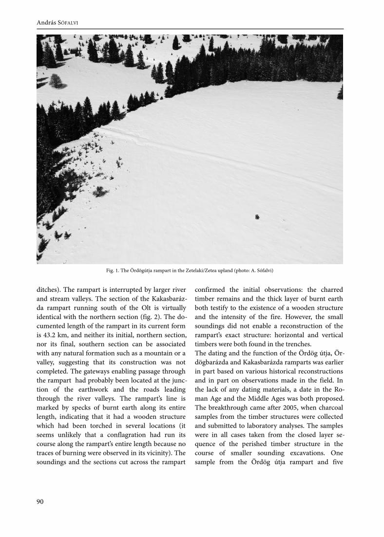
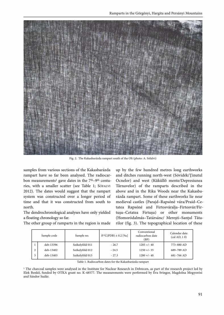
vergences can be traced to chronological and,presumably, functional differences.The Ördög útja rampart extending west–north-west to east–south-east across the Görgényi–Har-gita upland (fig. 1) is an earthwork whose line canbe traced for several kilometres. Its line is only in-terrupted by river and stream valleys. The 0.5–1.5 m high, 4–8 m wide rampart has a trapezoidalor rounded section and is flanked by shallow dit-ches. It was used as a road during the past few cen-turies. Although the rampart is strongly eroded, itsperished sections can be securely identified fromthe specks of burnt earth. The Ördögbarázda ram-part running perpendicular to the former, startsfrom the eastern side of the Hargita Mountains. Itsfirst section was constructed from stone, while theother sections were raised from earth. A ditchflanks its eastern side. In the south, the rampartextends across the Lövéte/Lueta Plateu along thewestern edge of the deep valley of the Var-gyas/Vârghiş Stream. The width of the alternatelyconvex and flattish earthwork ranges between 7and 12 metres, while its height exceeds 1.5 m insome spots. Following a gap of several kilometres,the rampart continues in the Rika Woods south ofthe Vargyas Pass, its line following the watershedridge of the Persányi Mountains. The earthworkknown as the Kakasbarázda rampart is perhaps themost impressive earthwork among the easternTransylvanian monuments of this type. The 2 mhigh rampart, whose width exceeds 10 m in somespots and is flanked by a ditch on the eastern side,is in some areas complemented by a double and,occasionally, a triple rampart (together with the
Ramparts in the Görgényi, Hargita and Persányi MountainsAndrás SÓFALVI
Keywords: Eastern Transylvania, ramparts, radiocarbon dates, aerial archaeological photography
The ramparts in eastern Transylvania constitute a territorially distinct and independent class among
the similar monuments in the Carpathian Basin. Earlier known as the Szeklerland ramparts, these
earthworks extend across the volcanic plateau of the Görgényi/Gurghiu and Hargita/Harghita Moun-
tains, part of the eastern Carpathians, and the ridge of the Persányi/Perşani Mountains from north-
west to south-east and north to south, from the headwater of the Kis-Nyárád/Niraju Mic to the Bogata
Pass south of the Rákos Gorges of the Olt (pl. 16). Several theories have been proposed for their date
and function during the past 150 years. This study presents the findings of my archaeological research
on these earthworks, especially regarding their date, which can now be determined more accurately as
a result of archaeometric analyses. The Homárka rampart in the Háromszék/Trei Scaune Basin and the
Papok sánca rampart in the Barcaság/Ţara Bârsei region are not discussed here.
89
ditches). The rampart is interrupted by larger riverand stream valleys. The section of the Kakasbaráz-da rampart running south of the Olt is virtuallyidentical with the northern section (fig. 2). The do-cumented length of the rampart in its current formis 43.2 km, and neither its initial, northern section,nor its final, southern section can be associatedwith any natural formation such as a mountain or avalley, suggesting that its construction was notcompleted. The gateways enabling passage throughthe rampart had probably been located at the junc-tion of the earthwork and the roads leadingthrough the river valleys. The rampart’s line ismarked by specks of burnt earth along its entirelength, indicating that it had a wooden structurewhich had been torched in several locations (itseems unlikely that a conflagration had run itscourse along the rampart’s entire length because notraces of burning were observed in its vicinity). Thesoundings and the sections cut across the rampart
confirmed the initial observations: the charredtimber remains and the thick layer of burnt earthboth testify to the existence of a wooden structureand the intensity of the fire. However, the smallsoundings did not enable a reconstruction of therampart’s exact structure: horizontal and verticaltimbers were both found in the trenches.The dating and the function of the Ördög útja, Ör-dögbarázda and Kakasbarázda ramparts was earlierin part based on various historical reconstructionsand in part on observations made in the field. Inthe lack of any dating materials, a date in the Ro-man Age and the Middle Ages was both proposed.The breakthrough came after 2005, when charcoalsamples from the timber structures were collectedand submitted to laboratory analyses. The sampleswere in all cases taken from the closed layer se-quence of the perished timber structure in thecourse of smaller sounding excavations. Onesample from the Ördög útja rampart and five
Fig. 1 . The Ördögútja rampart in the Zetelaki/Zetea upland (photo: A. Sófalvi)
90
András SÓFALVI
Sample code Sample no. δ13C(PDB) ± 0.2 [‰]Conventional
radiocarbon date(BP)
Calendar date(cal AD, 1 δ)
1 deb-13396 Székelyföld 011 - 26.7 773–880 AD
2 deb-13402 Székelyföld 012 - 24.5 1250 +/- 35 689–789 AD
3 deb-13403 Székelyföld 013 - 27.3 1280 +/- 40 681–766 AD
samples from various sections of the Kakasbarázdarampart have so far been analysed. The radiocar-bon measurements1 gave dates in the 7th–9th centu-ries, with a smaller scatter (see Table 1; SÓFALVI2012). The dates would suggest that the rampartsystem was constructed over a longer period oftime and that it was constructed from south tonorth.The dendrochronological analyses have only yieldeda floating chronology so far.The other group of ramparts in the region is made
up by the few hundred metres long earthworksand ditches running north-west (Sóvidék/ŢinutulOcnelor) and west (Küküllő mente/DepresiuneaTârnavelor) of the ramparts described in theabove and in the Rika Woods near the Kakasba-rázda rampart. Some of these earthworks lie nearmedieval castles (Parajd–Rapsóné vára/Praid–Ce-tatea Rapsóné and Firtosváralja–Firtosvár/Fir-tuşu–Cetatea Firtuşu) or other monuments(Homoródalmás–Tatársánc/ Mereşti–Sanţul Tăta-rilor (fig. 3). The topographical location of these
Fig. 2. The Kakasbarázda rampart south of the Olt (photo: A. Sófalvi)
Table 1 . Radiocarbon dates for the Kakasbarázda rampart
91
1 The charcoal samples were analysed in the Institute for Nuclear Research in Debrecen, as part of the research project led byElek Benkő, funded by OTKA grant no. K-48577. The measurements were performed by Éva Svingor, Magdolna Mogyorósiand Sándor Sudár.
1205 +/- 40
Ramparts in the Görgényi, Hargita and Persányi Mountains
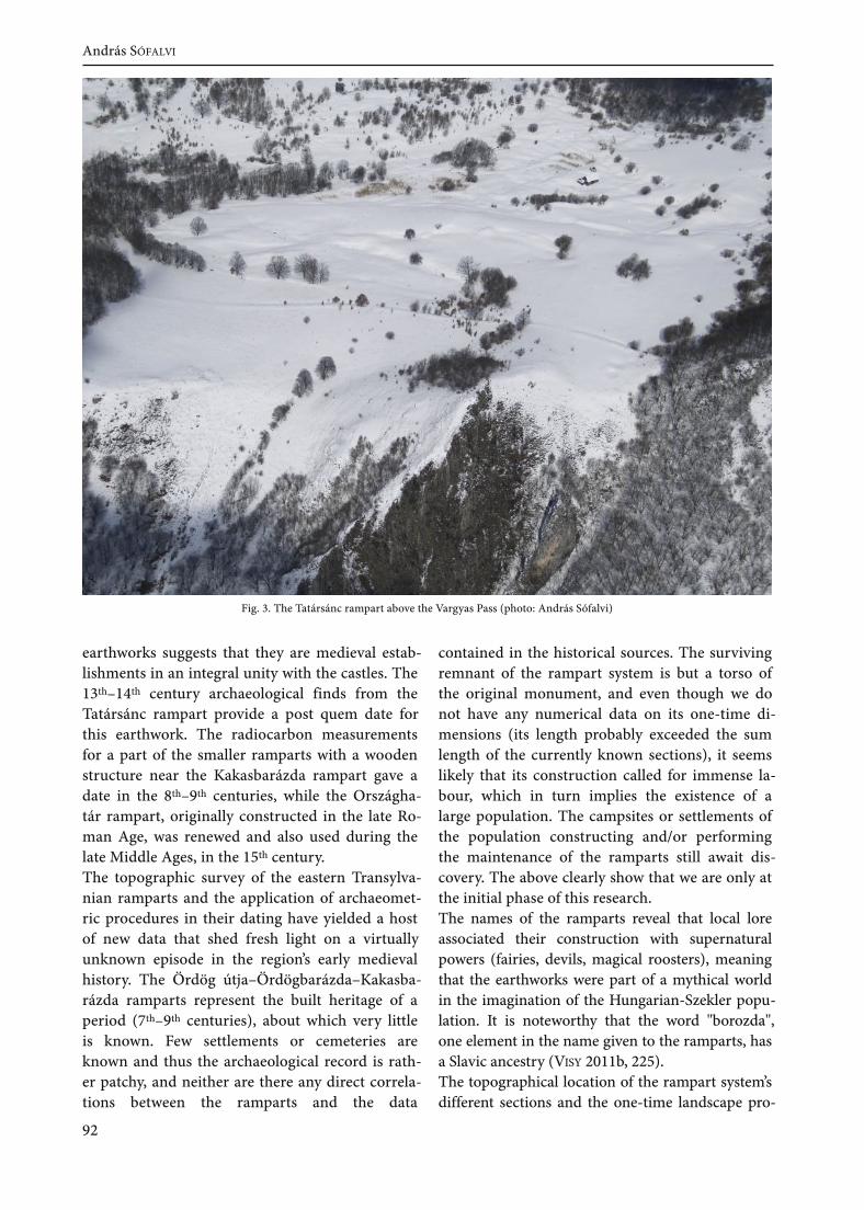
earthworks suggests that they are medieval estab-lishments in an integral unity with the castles. The13th–14th century archaeological finds from theTatársánc rampart provide a post quem date forthis earthwork. The radiocarbon measurementsfor a part of the smaller ramparts with a woodenstructure near the Kakasbarázda rampart gave adate in the 8th–9th centuries, while the Országha-tár rampart, originally constructed in the late Ro-man Age, was renewed and also used during thelate Middle Ages, in the 15th century.The topographic survey of the eastern Transylva-nian ramparts and the application of archaeomet-ric procedures in their dating have yielded a hostof new data that shed fresh light on a virtuallyunknown episode in the region’s early medievalhistory. The Ördög útja–Ördögbarázda–Kakasba-rázda ramparts represent the built heritage of aperiod (7th–9th centuries), about which very littleis known. Few settlements or cemeteries areknown and thus the archaeological record is rath-er patchy, and neither are there any direct correla-tions between the ramparts and the data
contained in the historical sources. The survivingremnant of the rampart system is but a torso ofthe original monument, and even though we donot have any numerical data on its one-time di-mensions (its length probably exceeded the sumlength of the currently known sections), it seemslikely that its construction called for immense la-bour, which in turn implies the existence of alarge population. The campsites or settlements ofthe population constructing and/or performingthe maintenance of the ramparts still await dis-covery. The above clearly show that we are only atthe initial phase of this research.The names of the ramparts reveal that local loreassociated their construction with supernaturalpowers (fairies, devils, magical roosters), meaningthat the earthworks were part of a mythical worldin the imagination of the Hungarian-Szekler popu-lation. It is noteworthy that the word "borozda",one element in the name given to the ramparts, hasa Slavic ancestry (VISY 2011b, 225).The topographical location of the rampart system’sdifferent sections and the one-time landscape pro-
Fig. 3. The Tatársánc rampart above the Vargyas Pass (photo: András Sófalvi)
92
András SÓFALVI
vide important clues for the function of the ram-parts. The Ördögútja rampart constructed acrossthe flat Görgényi–Hargita upland, south-west ofthe high mountains, was no more than a symbolicboundary at the most. The rampart sections ex-tending behind a high ridge, such as the few hund-red metres long section of the Kakasbarázdarampart in the Rika Woods south of the NádasStream, or the rampart sections running along astream bank were obviously unsuited to a militaryfunction. The reconstruction of the one-time vege-tation in the direct environs of the ramparts throughpalaeobotanical sampling can yield fresh insights inthis respect. The earthworks in a woodland environ-ment could hardly have fulfilled a military functionowing to poor visibility conditions, and it thereforeseems more likely that they can be associated with
economic and/or commercial activities, such as di-recting the flow of trade along certain routes or toparticular gateways. In this case, the system could bemaintained by a smaller population too.Research on the eastern Transylvanian rampartsshould focus on the sections in the southern part ofthe Persányi Mountains and the Görgényi uplandbecause the determination of the exact spatial ex-tent of these earthworks can be crucial for deter-mining their function. Aerial archaeological recon-naissance will continue to play an important role inthe research of these monuments. Obviously, ourfindings will remain incomplete without a study ofthe region’s early medieval settlement history, whilea comparison with the other Eastern and South-East European rampart system from this periodcan also contribute to elucidating their function.
93
Ramparts in the Görgényi, Hargita and Persányi Mountains


References


AGACHE 1978
ALDRED–SEKEDAT 2010
ALDRED–SEKEDAT 2011a
ALDRED–SEKEDAT 2011b
ALDRED–SEKEDAT 2011c
APORTA 2004
ARNUP 1998
B. THOMAS 1964
BAJUSZ 2005
BANASZEK–RĄCZKOWSKI 2010
BĂRBULESCU 1987
BĂRBULESCU 1994BARKÓCZI 1949
BARKÓCZI 1951BARNA 2005
BAUCON et al. 2008
BELLA 1891
Agache, R., La Somme pré-romaine et romaine d'après les prospectionsaériennes à basse altitude. Mémoires de la Société des Antiquaires de Pi-cardie. Amiens, 1978.Aldred, O. – Sekedat, B., Part 1 of Moving on to Mobility: Archae-ological Ambulations on the Mobile World. Archaeolog (2010).http://traumwerk.stanford.edu/archaeolog/2010/12/moving_on_to_mobility_archaeol.htmlAldred, O. – Sekedat, B., Part 2 of Moving on to Mobility: Archae-ological ambulations on the mobile world. Archaeolog (2011).http://traumwerk.stanford.edu/archaeolog/2011/01/part_2_of_mov-ing_on_to_mobilit.htmlAldred, O. – Sekedat, B., Part 3 of Moving on to Mobility: Archae-ological ambulations on the mobile world. Archaeolog (2011).http://traumwerk.stanford.edu/archaeolog/2011/02/part_3_of_mov-ing_on_to_mobilit.htmlAldred, O. – Sekedat, B., Part 4 of Moving on to Mobility: Archae-ological ambulations on the mobile world. Archaeolog (2011).http://traumwerk.stanford.edu/archaeolog/2011/05/part_4_of_mov-ing_on_to_mobilit.htmlAporta, C., Routes, trails and tracks: Trail breaking among theInuit of Igloolik’, Études/Inuit/Studies, 28/2 (2004), 9–38.Arnup, R. W., The extent, effect and management offorestry-related soildisturbance, with reference to implications for the Clay Belt: a literature re-view. Ottawa, 1998.B. Thomas, E., Römische Villen in Pannonien. Beiträge zur rö-mischen Siedlungsgeschichte. Budapest, 1964.Bajusz, I., Téglás István jegyzetei. Régészeti feljegyzések I/2, Ko-lozsvár, 2005.Banaszek, Ł. – Rączkowski, W., Archeologia w lesie. O identyfi-kacji stanowisk archeologicznych w gminie Polanów (i nie tylko).In: Rączkowski, W. – Sroka, J. (eds), Historia i kultura Ziemi Sławi-eńskiej. Tom X. Miasto i gmina Polanów. Fundacja Dziedzictwo. Sław-no–Polanów 2010, 117–132.Bărbulescu, M., Din istoria militară a Daciei Romane. Legiunea VMa-cedonica şi castrul de la Potaissa, Cluj-Napoca, 1987.Bărbulescu, M., Potaissa. Studiu monografic, Turda, 1994.Barkóczi, L., A brigetiói tábor és canabae topográfiája (Nouvellesdonées pour la topographie de Brigetio). Antiquitas Hungarica III(1949) 67–72.Barkóczi, L., Brigetio. DissertationesPannonicaeSer. 2, No. 22, Budapest, 1951.Barna, J. P., Sormás – Török-földek településtörténeti áttekintése.A középső neolitikum (The history of a settlement at Sormás–Tö-rök-földek. Middle Neolithic). Zalai Múzeum 14 (2005) 17–37.Baucon, A. – Privitera, S. – Morandi Bonacossi, D. – Canci, A. –Neto de Carvalho, C. – Kyriazi, E. – Loborel, J. – Loaborel-Degu-en, F. – Morhange, C. – Marriner, N., Principles of Ichnoarchaeo-logy: new frontiers for studying past times. Studi Trentini discienze naturali. Acta Geologica 83 (2008) 43–72.Bella, L., A Sopron melletti Purgstall földvára és urnatemetője. Ar-chaeologiai Értesítő 11 (1891) 313–320.
97
References
BENDER 2002
BERKOVICS-BOROTHA 1886BERTÓK et al. 2008a
BERTÓK et al. 2008b
BERTÓK–GÁTI 2011
BÍRÓ 1974
BÍRÓ 2006
BÓNA 1975
BORHY 2006
BORHY et al. 2011
BÖDŐCS 2008
BÖDŐCS 2009
BÖDŐCS–KOVÁCS 2011
BRAASCH 2003
BRAASCH 2007
BRADFORD 1957
BRZOZOWSKI–SIEMASZKO 2009
Bender, B., Time andLandscape. CurrentAnthropology43 (2002) 103–102.Berkovics–Borotha, M., Ásatásom az ó-szőnyi római táborban.Archaeologiai Értesítő 6 (1886) 392–397.Bertók, G. – Gáti, Cs. – Lóki, R., Előzetes jelentés a Belvárdgyulahatárában (Baranya megye) talált késő neolitikus település és kör-árok kutatásáról (Vorbericht über den Forschungstand der spätneo-lithischen Siedlung und Kreisgrabenanlage in der Gemarkung vonBelvárdgyula (Komitat Baranya)). Ősrégészeti Levelek 10 (2008) 5–17.Bertók, G. – Gáti, Cs. – Vajda, O., Előzetes jelentés a Szemely–He-gyes lelőhelyen (Baranya megye) található neolitikus körárok-rendszer kutatásáról (Preliminary report on the research at theneolithic Kreisgrabenanlage at Szemely–Hegyes, Baranya county,Hungary). Archaeologiai Értesítő 133 (2008) 85–106.Bertók, G. – Gáti, Cs., Neue angaben zur spätneolithischen Sied-lunsstruktur in Südostransdanubien. Acta Archaeologica AcademiaeScientiarum Hungaricae 62 (2011) 1–28.Bíró, M., Roman Villas in Pannonia. Acta Archaeologica AcademiaeScientiarum Hungaricae 26 (1974) 23–57.Bíró, Sz., Római villához tartozó temető Szombathely–Zanat határá-ból. Savaria. A VasMegyei Múzeumok Értesítője 29 (2005) [2006] 53–61.Bóna, I., Die mittlere Bronzezeit Ungarns und ihre südöstlichen Be-ziehungen. Archaeologia Hungarica Series Nova 49. Budapest, 1975.Borhy, L., Brigetio/Komárom–szőny, Komárno. In: Humer, F.(hrsg.) , Legionsadler und Druidenstab. Vom Legionslager zur Donau-metropole. Textband, Carnuntum–Wien, 2006, 152–153.Borhy, L. – Bartus, D. – Czajlik, Z. – Rupnik, L. – Számadó, E.,Brigetio (Komárom/Szőny): Tábor – város a Duna mellett. Brige-tio (Komárom/Szőny) – Fortress/City next to the Danube. In: Visy,Zs. (ed.) , Rómaiak a Dunánál. A Ripa Pannonica Magyarországon mintvilágörökségi helyszín. – Romans on the Danube. The Ripa Pannonica inHungary as a World Heritage Site. Pécs, 2011 . 42–51 .Bödőcs, A., A római kori úthálózat térinformatikai vizsgálata a mai Ma-gyarország területén /A study ofthe roman road network in Hungary usingGIS. PhD dissertation. Eötvös Loránd University. Budapest, 2008.Bödőcs, A., A római kori Savaria környéki centuriatio területének vizs-gálata térinformatikai eszközökkel / The analysis of the centuriatioaround the Roman Savaria using GIS. Thesis. Budapest University ofTechnology and Economics. Budapest, 2009.Bödőcs, A. – Kovács, G., A római kori birtokrendszer kialakítása és táj-formáló hatása Pannoniában. Geodézia és kartográfia 63/3 (2011) 20–25.Braasch, O., Die Donau hinab – archäologische Flüge in Ungarn.In: Visy, Zs. (ed.) , Régészeti műemlékek kutatása és gondozása a 3. év-ezred küszöbén. Pécs, 2003, 41–65.Braasch, O., Gallipoli ahead – Air survey between the Baltic andMediterranean. Študijné zvesti Archeologického ústavu Slovenskej aka-démii vied 41 (2007) 84–96.Bradford, J., Ancient landscapes. Studies in Field Archaeology. Lon-don, 1957.Brzozowski, J. – Siemaszko, J., Dwa nowe grodziska na Su-walszczyźnie. In: Bitner–Wróblewska, A. – Iwanowska, G., Bałto-
98
References
BUATOIS–MANGANO 2011
BUDZISZEWSKI–WYSOCKI 2012
CHALLIS 2006
CORDIER 2012
CORNS–SHAW 2009
CRAWFORD 1929CRESCIOLI et al. 2000
CRIŞAN et al. 1992
CRUTCHLEY 2006
CZAJLIK 2004
CZAJLIK 2007
CZAJLIK 2008
CZAJLIK 2010
CZAJLIK et al. 2012a
CZAJLIK et al. 2012b
DAWKINS 1989
wie i ich sąsiedzi. Marian Kaczyński in Memoriam, SeminariumBałtyjskie II. Warszawa, 2009, 637–642.Buatois, L. A. – Mangano G. M., Ichnology. Organism–Substrate In-teractions in Space and Time. Cambridge, 2011 .Budziszewski, J. – Wysocki, J., Nowe możliwości detekcji materi-alnych śladów historii terenów leśnych – lotnicze skanowani lasero-we (LiDAR). In: Kobyliński, Z. – Wysocki, J. (eds), ArchaeologicaHereditas. Konserwacja Zapobiegawcza Środowiska 1. Instytut Archeo-logii UKSW. Warszawa-Zielona Góra, 2012, 117–126.Challis, K., Airborne Laser Altimetry in Alluviated Landscapes.Archaeological Prospection 13 (2006) 103–127.Cordier, A., Archéologie aérienne en Côte-d’Or en 2011: les aléas d’unesécheresse précoce, Revue Archéologique de l’Est 61 (2012) 371–383.Corns, A., Shaw, R., High resolution 3-dimensional documentationof archaeological monuments and landscapes using airborne Li-DAR. Journal ofCultural Heritage 10 Sup. 1 . (2009) 72–77.Crawford, O.G.S., Air-Photography for Archaeologists, London, 1929.Crescioli, M. – D’Andrea, A. – Niccolucci, F., A GIS-based analysisof the etruscan cemetery of Pontecagnano using fuzzy logic. In:Lock, G. R. (ed.) , Beyond the Map: Archaeology and Spatial Technolo-gies, European University Centre for Cultural Heritage, Ravello, Italy, Oc-tober 1–2 1999. Amsterdam, 2000, 157–179.Crişan, I. H. – Bărbulescu, M. – Chirilă, E. – Vasiliev, V. – Wink-ler, I., Repertoriul arheologic al judeţului Cluj, Cluj-Napoca, 1992.Crutchley, S., Light Detection and Ranging (LiDAR) in the Wit-ham Valley, Lincolnshire: an Assessment of New Remote SensingTechniques. Archaeological Prospection 13/4 (2006) 251–57.Czajlik, Z., Aerial archaeological investigations in Hungary in2003. In: Kisfaludi, J. (ed.) , Archaeological Investigations in Hungary2003. Budapest, 2004, 111–125.Czajlik, Z., Aerial archaeological prospection and documentation.The aerial archaeological archive of the Institute of ArchaéologicalSciences of the Eötvös Loránd University of Budapest (Summary ofthe activity in 1993–2005), Archeometriai Műhely 4 (2007) 1–10.Czajlik, Z., Aerial archaeology in the research of burial tumuli inHungary. Communicationes Archaeologicae Hungariae 28 (2008) 95–107.Czajlik, Z., Les possibilités de la prospection aérienne convention-nelle en Hongrie, In: Borhy, L. (ed.) , Studia Celtica Classica et Roma-na Nicolae Szabó septuagesimo dedicata, Budapest, 2010, 80–96.Czajlik, Z. – Király, G. – Czövek, A. – Puszta, S. – Holl, B. – Brolly,G., The Application of Remote Sensing Technology and Geophy-sical Methods in the Topographic Survey of Early Iron Age BurialTumuli in Transdanubia. In: Berecki, S. (ed.) Iron Age Rites and Ri-tuals in the Carpathian basin. Proceedings of the International Colloqui-um from Târgu Mureş, 7–9 October 2011 . Târgu Mureş, 2012, 65–76.Czajlik, Z. – Bödőcs, A. – Rupnik, L., Légi fényképezéses régé-szeti kutatások Magyarországon 2010-ben. In: Kisfaludi, J. (ed.) ,Aerial photographic archaeological investigations in Hungary in2010. Régészeti kutatások Magyarországon. Budapest, 2012, 111–132.Dawkins, R., The Extended Phenotype. Oxford, 1989.
99
References
DE MAN et al. 2005
DÉNES 2001
DÉNES 2003
DÉNES 2007
DEVEREUX et al. 2008
DOMBAY 1939
DOMBAY 1960a
DOMBAY 1960b
DONEUS 2004
DONEUS 2006
DONEUS–BRIESE 2006
DONEUS–BRIESE 2010
EDGEWORTH 2011ENGEL et al. 2009
FERENCZI–DÉNES 1994
De Man, J. – Cordemans, K., – Verkeyn, J. – Mestdagh, H., A LaserBased Digital Elevation Model. New Possibilities for Flemish Ar-chaeologists. In: Bourgeois, J. – Meganck, M. (eds), Aerial Photo-graphy and Archaeology 2003. A Century of Information. Conferenceheld at the Ghent University, December 10th–12th, 2003. AcademiaPress. Ghent 2005, 151–161 .Dénes, I., Székelyföldi töltésvonulatok 1 . ACTA – A Csíki SzékelyMúzeum és a Székely Nemzeti Múzeum Évkönyve 2000, 215–236.Dénes, I., Székelyföldi töltésvonulatok 2. ACTA – A Csíki SzékelyMúzeum és a Székely Nemzeti Múzeum Évkönyve 2003, 99–110.Dénes, I., Székelyföldi töltésvonulatok 3. Acta Siculica – A SzékelyNemzeti Múzeum Évkönyve 2007, 253–285.Devereux, B.J. – Amable, G.S. – Crow, P., Visualisation of LiDARterrain models for archaeological feature detection. Antiquity 82(2008) 470–79.Dombay, J., A zengővárkonyi őskori telep és temető (The prehistoric set-tlement and cemetery at Zengővárkony). Archaeologia Hungarica 23,Budapest, 1939.Dombay, J., Próbaásatás a villánykövesdi kőrézkori lakótelepen(Probegrabung in der aeneolithischen Ansiedlung bei Villánykö-vesd, Kom. Baranya). Janus Pannonius Múzeum Évkönyve 1959(1960) 55–75.Dombay, J., Die Siedlung und das Gräberfeld von Zengővárkony. Archae-ologia Hungarica 37. Budapest, 1960.Doneus, M., Aerial Archaeology in the Landscape of Carnuntum.Archaeologia Aerea. Studi di Aerotopografia Archaeologica, No. I, Lib-reria dello Stato, Istituto Poligrafico e Zecca dello Stato, Roma,2004, 215–234.Doneus, M., Luftbildarchäologie in Carnuntum. In: Humer, F.(hrsg.) , Legionsadler und Druidenstab. Vom Legionslager zur Donau-metropole. Textband, Carnuntum–Wien, 2006, 23–32.Doneus, M. – Briese, C., Full-waveform airborne laser scanning as atool for archaeological reconnaissance. In: Campana, S. – Forte, M.(eds), From Space to Place. 2. International Conference on Remote Sensingin Archaeology. Archaeopress. Oxford 2006, 99–106.Doneus, M. – Briese, C., Airborne Laser Scanning in forested are-as – potential and limitation of an archaeological prospectiontechnique. In: Cowley, D. C. (ed.) , Remote Sensing for ArchaeologicalHeritage Management. Proceedings of the 11th EAC Heritage Manag-ement Symposium, Reykjavik, Iceland, 24-27 March 2010, EAC Occas-ional Paper No. 5, Occasional Publication of the AerialArchaeology Research Group No. 3, Budapest 2011 , 59–76.Edgeworth, M., Fluid Pasts. Archaeology offlow. Bristol, 2011 .Engel, M. – Okulicz–Kozaryn, J. – Sobczak, C., Warowna siedzibajaćwieskiego nobila Шюрпы? Architektura obronna kompleksuosadniczego w Szurpiłach. In: Bitner–Wróblewska, A. – Iwanows-ka, G. (eds), Bałtowie i ich sąsiedzi. Marian Kaczyński in Memoriam,Seminarium Bałtyjskie II. Warszawa 2009, 517–544.Ferenczi, I. – Dénes, I., Udvarhelyszéki töltésvonulatokról. AdalékErdély Szent-László kori határvédelmének kérdéséhez. In: A Zürichi
100
References
FODOREAN 2006FODOREAN 2011a
FODOREAN 2011b
FODOREAN 2012
FÜLEP – BURGER 1979
GABLER 1994
GALLAGHER–JOSEPHS 2008
GARBACZ 2009
GLAVAŠ 2011
GOGÂLTAN 2002
GOGUEY 1966
GOGUEY 1968
Magyar Történelmi Egyesület Első (Székelyudvarhelyi) Övezeti Történész-találkozó Előadásai és Iratai. Zürichi Magyar Történelmi Egyesület Kiad-ványa. Budapest – Zürich, 1994. 85–106.Fodorean, F., Drumurile din Dacia romană. Cluj-Napoca, 2006.Fodorean, F., The aqueducts of Potaissa. Frontinus–Schriftenreihe(Internationale Gesellschaft für Wasser und Energie zur Förderung derWissenschaft, Forschung und Bildung aufdem Gebiet der Geschichte derRohrleitungs-, Energie- und Wassertechnik sowie der rohrleitungstech-nischen Fachausbildung) 28 (2011) 95–108.Fodorean, F., The Bridges of Roman Dacia. In: Archäologie derBrücken. Vorgeschichte. Antike. Mittelalter. Neuzeit (Archaeology ofBridges. Prehistory. Antiquity. Middle Ages. Modern Era). Bayerische Ge-sellschaft für Unterwasserarchäologie (Herausgeber), in Verbindungmit dem Bayerischen landesamt für Denkmalpflege, Verlag Fried-rich Pustet, Regensburg, 2011, 143–147.Fodorean, F., Die Strassen des Römischen Dakiens. Forschungs-stand, neue Entdeckungen und Perspektiven der Forschung. Gym-nasium. Zeitschrift für Kultur der Antike und Humanistische Bildung 119(2012) 255–279.Fülep, F. – Burger, A., Baranya megye a római korban (BaranyaCounty in the Roman Age). In: Bándi, G. (ed.) , Baranya megye tör-ténete az őskortól a honfoglalásig (The history of Baranya County fromthe Prehistoric period to the Hungarian Conquest). Pécs 1979, 223–317.Gabler, D., Die ländliche Besiedlung Oberpannoniens. In: Bender,H. – Wolff, H. (eds), Ländliche Besiedlung und Landwirtschaft in denRhein – Donau – Provinzien des Römischen Reiches, Band 2. PassauerUniversitätsschriften zur Archäologie. Espelkamp, 1994, 377–419.Gallagher, J.M. – Josephs, R.L., Using LiDAR to Detect Cultural Re-sources in a Forest Environment: an Example from Isle Royale NationalPark, Michigan, USA. Archaeological Prospection 15 (2008) 187–206.Garbacz, K., Osadnictwo kultury przeworskiej we wschodniej części Ni-ecki Nidziańskiej, Warsaw, 2009Glavaš, V., Problems of reconnaissance of the karst landscape – anexample of the north sub-Velebit littoral. Croatia, AARGnews 43(2011) 24–30.Gogâltan, F., Die Tells der Bronzezeit im Karpatenbecken. Termi-nologische Fragen. In: Rustoiu, A. – Ursuţiu, A. (eds), Interregionaleund Kulturelle Beziehungen im Karpatenraum (2. Jahrtausend v. Chr.–1.Jahrtausend n. Chr.) – Interferenţe etnice şi culturale în mileniile I a.Chr.–I. p. Chr. Vol. IV — Ethnische und Kulturelle Interferenzen im 1.Jahrtausend v. Chr.–1. Jahrtausend n. Chr. Band 4., Cluj-Napoca, 2002,11–45.Goguey, R., Recherches sur l'influence des dates et des conditionstechniques des prises de vues dans la détection aérienne des indicesd'origine archéologique, In: Archives Internationales de Photogrammét-rie, vol. XVI, Actes du IIe Symposium International de Photo-Interprétati-on, Paris, 1966, 3–12.Goguey, R., De l'aviation à l'archéologie : recherches sur les techniques etles méthodes de l'archéologie aérienne, Thèse de l'Ecole Pratique desHautes Etudes, Paris, 1968.
101
References
GOGUEY 1969
GOGUEY 1972
GOGUEY 1991
GOGUEY 1997
GOGUEY 1999
GOGUEY 2000
GOGUEY 2005
GOGUEY–REDDÉ 1995
GOGUEY–SZABÓ 1995
GUGL et al. 2006
H. KELEMEN 2010
HANNAM et al. 2006
HESSE 2010
HINDLE 2001HOLDEN et al. 2002
ILON 2001
INGOLD 2004
Goguey, R., Archéologie aérienne, In: Kodeko, Paris, XXIe numérospécial, janv. 1969, 30–31 .Goguey, R., Mirebeau: les fouilles de 1970 sur les thermes, In: Mé-moires de la Commission des Antiquités de la Côte d'Or, t. XXVII,1970–1971 , Dijon, 1972, 14–20.Goguey, R., Alésia: les travaux de César sur la Montagne de Bussyd'après les dernières révélations de la photographie aérienne,Académie des Inscriptions et Belles Lettres (1991), 43–51 .Goguey, R., Vix: les données de l’archéologie aérienne sur le site etson environnement, In: Brun, P. – Chaume, B. (dir.), Vix et les ép-hémères principautés celtiques. Les VIe et Ve siècles avant J.-C. en Europecentre-occidentale, Actes du colloque de Châtillon-sur-Seine (27-29 octobre1993), Paris, 1997, 179–200.Goguey, R. – Violot A., Recherches d’archéologie aérienne sur lesiège d’Alésia (1959–1999), In: Le siège d’Alésia, Académie desInscriptions et Belles Lettres, 1999.Goguey, R., Sur la route de Dijon… au limes romain de Pannonie,In: Hommage à Charles Léva, Centre Interdisciplinaire de recherchesaériennes. Bruxelles, 23, 30–31 .Goguey, R., Un exemple de recherches diachroniques: l’archéologieaérienne en Hongrie, In: Archéologies: 20 ans de recherches françaisesdans le monde - Ministère des Affaires Etrangères, Paris, 2005, 111–112.Goguey, R. – Reddé, M., Le camp légionnaire de Mirebeau, Mayence,Römisch–Germanisches Zentralmuseum, 1995Goguey, R. – Szabó, M., L’histoire vue du ciel – A történelem madár-távlatból : photographie aérienne et archéologie en France et en Hongrie,Catalogue d’exposition, Budapest, 1995.Gugl, Ch. – Humer, F. – Klein, M. – Pregesbauer, M., Versuch ei-ner Wiederherstellung des antiken Carnuntum auf virtuellem We-ge. In: Humer, F. (ed.) , Legionsadler und Druidenstab. VomLegions-lager zur Donaumetropole. Textband, Carnuntum-Wien 2006,33–42.H. Kelemen, M., Adatok egy új római objektumról Tokodon (Re-sults from a newly identified building from Roman Tokod). In:Tari, E. – Tóth, E. (ed.) , Tanulmánykötet Horváth István 70 éves szüle-tésnapjára. Esztergom-Budapest 2010 (2012) 69–93.Hannam, K. – Sheller, M. – Urry, J. Editorial, Mobilities, Immobi-lities and Moorings. Mobilities 1 (2006) 1–22.Hesse, R., LiDAR-derived Local Relief Models – a new tool for ar-chaeological prospection. Archaeological Prospection 17 (2010) 67–72.Hindle, P., Roads and Tracks for Historians. Chichester, 2001 .Holden, N. – Horne, P. – Bewley, R.H., High-resolution digitalairborne mapping and archaeology. In: Bewley, R.H. – Rączkows-ki, W. (eds), Aerial Archaeology: Developing Future Practice. Procee-dings of the NATO Advanced Research Workshop on Aerial Archaeology– Developing Future Practice. Leszno, Poland 15–17 November 2000.IOS Press. Amsterdam, 2002, 173–80.Ilon, G., Egy valódi „via rustica” Savaria territoriumán. Savaria. AVas Megyei Múzeumok Értesítője 25/3 (2000–2001) 69–80.Ingold, T., Culture on the ground: The world perceived through
102
References
INGOLD 2007INGOLD 2011
JASKANIS 1996
KALICZ 1983–84
KOBYLIŃSKI et al. 2012
KOŁAKOWSKI 1972KOVÁCS 1969
KOVÁCS 1984
KUZMA 1995
KWINTER 2001
LÁNG 1941
LASAPONARA et al. 2010
LEFEBVRE 1991ŁOSIŃSKI et al. 1971
MÁTYÁS 2007
MELVIN et al. 2004
MILCH 1910
MLEKUŽ 2012MLEKUŽ 2013
the feet. Journal ofMaterial Culture 9(3) (2004) 315–40.Ingold, T., Lines: A briefhistory. London and New York, 2007.Ingold, T., Being Alive: Essays on movement, knowledge and description.London and New York, 2011 .Jaskanis, D., Próba oceny metody Archeologicznego Zdjęcia Polskina podstawie doświadczeń ogólnokrajowego koordynatora. In:Jaskanis D., Archeologiczne Zdjęcie Polski – metoda i doświadczenia.Próba oceny. MKiS. Warszawa, 1996, 9–38.Kalicz, N., Übersicht über den Forschungsstand der Entwicklungder Lengyel-Kultur und die ältesten "Wehranlagen" in Ungarn.Mitteilungen der Österreichischen Arbeitsgemeinschaft für Ur-und Frühgeschichte 33–34 (1983–84) 271–293.Kobyliński, Z. – Borowski, M. – Budziszewski, J. – Herbich, T. –Kobyliński, Ł. – Sławik, Ł. – Wach, D. – Wysocki, J. – Jaszewska,A., Kompleksowe, niedestrukcyjne rozpoznanie zasobów archeo-logicznych Starego Kraju w województwie lubuskim. ArcheologiaŚrodkowego Nadodrza 9 (2012) 11–42.Kołakowski, L., Obecność mitu, Paris, 1972.Kovács, T., A százhalombattai bronzkori telep (The Bronze-Age Sett-lement at Százhalombatta). Archaeologiai Értesítő 96 (1969) 161–169.Kovács, T., Die Vatya–Kultur. In: Tasić, N. (ed.), Kulturen der Frühb-ronzezeit des Karpatenbeckens undNordbalkans. Beograd, 1984, 217–233.Kuzma, I., Luftbildarchäologie in der Slowakei. In: Kunow, J. (ed.) ,Luftbildarchäologie in Ost- und Mitteleuropa. Forschungen zur Archäo-logie im Land Brandenburg 3. Berlin, 251–258.Kwinter, S., Architectures of time: Towards a theory ofEvent in Moder-nist Architecture. Cambridge, 2001 .Láng, F., Das Dolichenum von Brigetio. In: Alföldi, A. (hrsg.) ,Laureae Aquincenses Memoriae valentini Kuzsinszky dicatae II. Disser-tationes Pannonicae Ser. 2, No. 11 , Budapest, 1941 , 165–181 .Lasaponara, R., Coluzzi, R., Gizzi, F.T., Masini, N., On the LiDARcontribution for the archaeological and geomorphological study ofa deserted medieval village in Southern Italy. Journal of Geo-physics and Engineering 7 (2010), 155–63.Lefebvre, H., The Production of Space. Oxford, 1991 .Łosiński, W. – Olczak, J. – Siuchniński K., Źródła archeologiczne dostudiów nad wczesnośredniowiecznym osadnictwem grodowym naterenie województwa koszalińskiego, T. IV, Poznań, 1971.Mátyás, Sz., Egy kora római település Savaria territóriumáról. Sa-varia. A Vas Megyei Múzeumok Értesítője 30 (2006) 2007, 159–198.Melvin, G. R. – Larsen, R. E. – McDouglald, N. K. – Tate, K. W. –Gerlach, J, D. – Fulgham, K. O. Cattle grazing has varying impacton stream-channel erosion in oak woodlands. California agriculture58/3 (2004) 138–143.Milch, Á., A bregetiumi Jupiter-dolichenus szentély. A Komáromvár-megyei és Városi Muzeum-Egyesület 1900. évi értesítője 14 (1901) 28–35.Mlekuž, D., Messy landscapes manifesto. AARGNews 44 (2012) 22–23.Mlekuž, D., Messy landscapes: lidar and the practice of landsca-ping. In: Opitz, R. S – Cowley, D. C., Interpreting Archaeological To-pography: 3D, Visualization and Observation. Oxford, 2013, 88–99.
103
References
MÓCSY 1965
MÓCSY 1974
MÓCSY 1990
MUIR 2000
MRT 4
MRT 7
NEOGRÁDY 1948–50
NESTUPNÝ 2006
OLWIG 2007
ORBÁN 1868–1873
ORLICKA–JASNOCH 2012
OSZTÁS et al. 2004
P. FISCHL–REMÉNYI 2007
PAITIER 2012
PARCAK 2009
PAULOVICS 1941
PELISIAK 2003
PELIVAN 2007PERICA–OREŠIĆ 1999
PETRASCH 1990a
Mócsy, A., Savaria utcarendszerének rekonstrukciójához. Archaeo-logiai Értesítő 92 (1965) 27–36.Mócsy, A., Pannonia and Upper Moesia (The Provinces of the RomanEmpire). London and Boston, 1974.Mócsy, A., Földbirtok. In: Mócsy, A.–Fitz, J., Pannonia Régészeti Ké-zikönyve. Budapest, 1990. 125–127.Muir, R., The New Reading The Landscape: Fieldwork in Landscape His-tory. Exeter, 2000.Dax, M. – Éri, I. – Mithay, S., Veszprém megye régészeti topográ-fiája. A pápai és zirci járás. Magyarország régészeti topográfiája 4.Budapest, 1972.Dinnyés, I. – Kővári, K. – Lovag, Zs. – Tettamanti, S. – Topál, J. –Torma, I., Magyarország Régészeti Topográfiája 7. Pest megye ré-gészeti topográfiája. A Budai és Szentendrei járás. Budapest, 1986.Neogrády, S., A légifénykép és az archaeológiai kutatások. Térképé-szeti Közlöny 7 (1948–50) 283–332.E. Nestupný., Enclosures and fortifications in Central Europe. In:Harding, A. – Sievers, S. – Venclová, N. (eds), Enclosing the Past:inside aind outside in the prehistory. Sheffield Archaeological Monographs15 (2006) 1–4.Olwig, K. R., Perambulatory Practice, Sight and the Sense of Be-longing. In: Ingold, T – Vergunst, J. L. (eds), Ways ofWalking: Ethno-graphy and Practice on Foot. Farnham, 2007, 81–91.Orbán, B., A Székelyföld leírása történelmi, régészeti, természetrajzi snépismei szempontból I–VI. Pest – Budapest, 1868–1873.Orlica–Jasnoch, J., Inwentaryzacja wybranych cmentarzysk kurha-nowych ludności kultury łużyckiej z terenu województwa lubuski-ego przy pomocy lotniczego skaningu laserowego (LiDAR).Archeologia Środkowego Nadodrza 9 (2012) 53–80.Osztás, A. – Marton, T. – Sófalvi, A., Szólád–Kisaszó. In: Honti, Sz.(ed.), A tervezett M7-es autópálya Somogy megyei szakaszának megelőzőrégészeti feltárása III (2002–2003). Somogyi Múzeumok Közleményei 16(2004) 61–62.P. Fischl, K. – Reményi, L., Possibilites of the Bronze Age Tell Sitesin the Carpathian Basin. In: Uglešić, A. (ed.) , European Associationof Archaeologist 13th Annual meeting. Zadar, Croatia 18th – 23rd Sep-tember 2007. Abstract Book. Zadar, 246–247.Paitier, H.–P., Archéologie et photographie : un rendez-vous manqué ?In: L'archéo-Théma : Les métiers de l’archéologie, (Hors-Série n°5), 2012.Parcak, S., Satellite Remote Sensing for Archaeology, Abingdon-NewYork, 2009.Paulovics, I., Funde und Forschungen in Brigetio (Szőny). In: Alföldi,A. (hrsg.), Laureae Aquincenses Memoriae valentini Kuzsinszky dicatae II.Dissertationes Pannonicae Ser. 2, No. 11 , Budapest, 1941, 118–164.Pelisiak, A., Osadnictwo. Gospodarka. Społeczeństwo. Studia nad kul-turą pucharów lejkowatych na Niżu Polskim, Rzeszów, 2003.Pelivan, A., Velebit, Donja Lomnica, 2007.Perica, D. – Orešić, D., Klimatska obilježja Velebita i njihov utjecajna oblikovanje reljefa. Senjski Zbornik 26 (1999) 1–50.Petrasch, J., Mittelneolithische Kreisgrabenanlagen in Mitteleuropa.
104
References

PETRASCH 2004
PLIT 2010
PODBORSKÝ 1988
RĄCZKOWSKI 2003
RĄCZKOWSKI 2005
RĄCZKOWSKI 2006
RĄCZKOWSKI 2011
RĂDEANU–FODOREAN 2011
RADNÓTI 1939–40
RADNÓTI 1946–48
REDDÉ–SCHNURBEIN 2001
REDŐ 2006
RIU 1
RÓMER 1878
RYBICKA 1995
SCHIFFER 1987
Bericht der Römisch-Germanischen Kommission 71 (1990) 407–564.Petrasch, J., Von Menschen und Hunden: Befunde aus Kreisgra-benanlagen der Oberlauterbacher Gruppe und der Lengyel–Kulturund deren Interpretationen. In: Bertemes, F.–Biehl, P.F.,–Meller,H. (Hrsg.) , Neolithische Kreisgrabenanlagen in Europa internationaleArbeitstagung, 7.-9. Mai 2004 in Goseck, 2004, 295–308.Plit, J., Przestrzenne zmiany zasięgu lasów i gospodarowania w la-sach gminy Polanów w ciągu ostatnich 400 lat. In: Rączkowski, W. –Sroka, J. (eds), Historia i kultura Ziemi Sławieńskiej. Tom X. Miasto igmina Polanów. Fundacja Dziedzictwo. Sławno-Polanów, 2010, 269–288.Podborský, V., Tešetice–Kyjovice 4: Rondel osady lidu s moravskou malo-vanou keramikou (Tešetice–Kyjovice 4: Rondel from a settlement of theMoravian painted pottery culture). Brno, Czech Republic: UniverzitaJana Evangelisty, 1988.Rączkowski, W., Wobec mitu naukowego: gród wczesnośrednio-wieczny w interpretacji archeologicznej. Biuletyn Historyczny 23(2003) 173–188.Rączkowski, W., Tradition in power: vicious circle(s) of aerial sur-vey in Poland. In: Brophy, K. – Cowley, D. (eds), From the Air. Un-derstanding Aerial Archaeology. Tempus. Stroud, 2005, 151–167.Rączkowski, W., Towards integration: two prospection methods andsome thoughts. In: Campana, S. – Forte, M. (eds), From Space toPlace. 2nd International Conference on Remote Sensing in Archaeology.BAR International Series 1568. Archaeopress. Oxford, 2006, 203–206.Rączkowski, W., Integrating survey data – the Polish AZP andbeyond. In: Cowley, D. C. (ed.), Remote Sensing for Archaeological Heri-tageManagement. EACOccasional PaperNo. 5. Brussels, 2011 , 153–160.Rădeanu, V. – Fodorean, F., Archeological structures in Dacia identifiedon aerial photographs. Archeologia Aerea IV–V (2010–2011) 329–332.Radnóti, A., Sopianaeból kiinduló római utak (Roman roads startingfrom Sopianae). Pécs sz. kir. Város Majorossy Imre Múzeumának Értesítője1939–40, 27–39Radnóti, A., Bronz Mithrasz-tábla Brigetioból (Le bas-reliefMithriaquede bronze de Brigetio). Archaeologiai Értesítő 7–9 (1946–48) 137–146.Reddé, M. – Schnurbein, S. (von) (dir.) , Alésia. Fouilles et recher-ches franco-allemandes sur les travaux militaires romains autourdu Mont-Auxois (1991 – 1997), Paris: Académie des Inscriptions etBelles-Lettres, 2001 , 33–53.Redő, F., The Kerka Valley in the Roman Age In: Bánffy, E. (ed.)Archaeology and Settlement History in the Kerka Valley, So-uth–West Hungary. Antaeus 28 (2006) 101–115.Barkóczi, L. – Mócsy, A. (eds), Die römische Inschriften Ungarns.1 .Savaria, Scarbantia und die Limes-Strecke ad Flexum–Arrabona.Budapest, 1972.Rómer, F., Résultats généraux du Mouvement Archéologique en Hongrie.Budapest, 1878.Rybicka, M., Przemiany kulturowe i osadnicze w III tys. przed Chr. naKujawach: Kultura pucharów lejkowatych i amfor kulistych na PagórachRadziejowskich. Łódź, 1995.Schiffer, M.B., Formation processes of the archaeological record. Albu-
105
References
SEKULER – BLAKE 1994SHAW–CORNS 2011
SHELER–URRY 2006
SKRZYPEK 2010
SÓFALVI 2012
SOMOGYI 2007
SZABÓ 2011a
SZABÓ 2011b
SZABÓ–VISY 2011
SZÁMADÓ 1997
SZÁMADÓ 2010
querque, 1987.Sekuler, R. – Blake, R., Perception. NewYork: Mcgraw–Hill College, 1994.Shaw, R. – Corns, A., High resolution LiDAR specifically for ar-chaeology: are we fully exploiting this valuable resource? In:Cowley, D. C. (ed.) , Remote Sensing for Archaeological Heritage Ma-nagement. EAC Occasional Paper No. 5. Brussels, 2011 , 77–86.Sheller, M. – Urry, J. The new mobilities paradigm. Environmentand Planning 38 (2006) 207–222.Skrzypek, J., Z pradziejów gminy Polanów. In: Rączkowski, W. –Sroka, J. (eds), Historia i kultura Ziemi Sławieńskiej. Tom X. Miasto igmina Polanów. Fundacja Dziedzictwo. Sławno-Polanów, 2010, 39–116.Sófalvi, A., A székelység határvédelme és önvédelme a középkortól a feje-delemség koráig. Várak és más védelmi objektumok Udvarhelyszék telepü-léstörténetében / The Border and Self-defence of the Szeklers from theMedieval Age till the Age ofPrincipality. Castles and other Defence Objectsin the Settlement History of Udvarhelyszék. PhD dissertation. EötvösLoránd University. Budapest, 2012.Somogyi, K., Die besonderen Grabenanlagen der Lengyel–Kulturin Kaposújlak – Várdomb-dűlő im Komitat Somogy (SW–Un-garn). In: Kozłowski J. K. – Raczky, P. (eds), The Lengyel, Polgárand Related Cultures in the Middle/Late Neolithic in central Europe.Kraków, 2007, 329–344.Szabó, M., Élet a hadsereg árnyékában – Life in the shadow of thearmy. In: Visy, Zs. (ed.), Rómaiak a Dunánál. A Ripa Pannonica Ma-gyarországon mint világörökségi helyszín. – Romans on the Danube. TheRipa Pannonica in Hungary as a World Heritage Site. Pécs, 2011, 89–93.Szabó, M., Régészeti kutatások a Ripa Pannonica polgári telepü-lésein (Archaeological research on the civilian settlements of theRipa Pannonica). In: Visy, Zs. – Szabó, M. – Priskin, A. – Lóki, R.(eds), A Danube Limes program régészeti kutatásai 2008-2011 között(The Danube Limes project archaeological research between 2008-2011),Pécs 2011 , 147–162.Szabó, M., – Visy, Zs., Menettáborok Brigetio környékén – Mar-ching camps in the vicinity of Brigetio. In: Visy, Zs. – Szabó, M. –Priskin, A. – Lóki, R. (eds), A Danube limes program régészeti kuta-tásai 2008–2011 között. Jelentés a Danube Limes Unesco World HeritageSite pályázat keretében a PTE BTK Régészet Tanszékének kutatócsoport-ja által végzett kutatásokról – The Danube Limes project archaeologicalresearch between 2008–2011 . Report on the research carried out by theresearch team of the Department ofArchaeology, University ofPécs wit-hin the framework of the Danube Limes Unesco World Heritage Siteproject. Pécs, 2011 , 107–112.Számadó, E., Brigetio kutatástörténete (Research History of Bri-getio, Forschungsgeschichte Brigetios). Komárom Megyei Múzeu-mok Közleményei 5 (1992/1997) 149–174.Számadó, E., Régészeti kutatások Komárom/Szőny területén a ró-mai kori Brigetióban, 1990–2010 között (The Archaeological Re-search at Komárom (Szőny Neighbourhood) on the Territory ofthe Roman Brigetio, 1990–2010); (Cercetarea archeologica de laKomárom (cartierul Szőny), pe teritoriul Brigetio-ului roman,
106
References
SZÁMADÓ–BORHY 2003
TÉGLÁS 1895
TOKAI 2008
TÓTH 1977a
TÓTH 1977b
TÓTH 2009
TRNKA 1991
URRY 2007VICZIÁN–HORVÁTH 2006
VIDA 1996
VISY 1994
VISY 1995
VISY 2000VISY 2003a
VISY 2003bVISY 2011a
VISY 2011b
VMFNWAGNER et al. 2006
1990–2010). Terra Sebus 2010/2 (2010) 141–176.Számadó, E. – Borhy, L., Brigetio Castra Legionis. In: Visy, Zs.(ed.) , The Roman Army in Pannonia. An Archaeological Guide of theRipa Pannonica. Pécs, 2003, 75–77.Téglás, G., A Limes Dacicus két Küküllő és Olt közötti részleteUdvarhelymegye éjszaki és keleti hegységeiben Oroszfalutól Al-só–Rákosig. Archaeologiai Közlemények 19 (1895) 5–54.Tokai, Z.–M., 0711 Nagykanizsa–Palin – Anyagnyerőhely.http://www.zmmi.hu/gm/m7_kiadvany/Htm/031_0711 .htmTóth, E., Geschichte der Oberen Wart im 1. Jahrtausend. In: Triber,L. (ed.), Die Obere Wart. Festschrift zum Gedenken an die Wiedererrich-tungder Oberen Wart im Jahre 1327. Innsbruck, 1977, 77–100.Tóth, E., A Savaria–Bassiana útszakasz. Archaeologiai Értesítő 104(1977) 65–75.Tóth, E., Studia Valeriana. Az alsóhetényi és ságvári késő római erő-dök kutatásának eredményei (Results of the research on the LateRoman inner fortresses at Alsóhetény and Ságvár). Dombóvár, 2009Trnka, G., Studien zu mittelneolithischen Kreisgrabenanlagen.Mitteilungen der Prähistorischen Kommission 26 (1991).Urry, J. 2007. Mobilities. Cambridge, 2007.Viczián, I. – Horváth, F., A tatai mocsarak a római korban és Mi-koviny Sámuel lecsapoló munkája (Marshes in the environs of Ta-ta at the Roman Age and their draining by Sámuel Mikoviny).Földrajzi Értesítő LV/3–4 (2006) 257–272.Vida, T., Külsővat és környékének régészeti emlékei a római kortólaz árpád-korig. In: Ilon, G. (ed.) , Tanulmányok Külsővat történetéből.Külsővat, 1996, 75–104.Visy, Zs., Die ländliche Besiedlung und Landwirtschaft in Nieder-pannonien. In: Bender, H. – Wolff, H. (eds), Ländliche Besiedlungund Landwirtschaft in den Rhein – Donau – Provinzien des RömischenReiches, Band 2, Passauer Universitätsschriften zur Archäologie.Espelkamp, 1994, 421–449.Visy, Zs., Luftbildarchäologie am römischen Limes in Ungarn. In:Kunow, J. (ed.), Luftbildarchäologie in Ost- und Mitteleuropa. Forschun-gen zur Archäologie im Land Brandenburg 3. Berlin, 213–218.Visy, Zs., A ripa Pannonica Magyarországon. Budapest, 2000.Visy, Zs., A pécsi légirégészeti műhely. Régészeti kutatások a RipaPannonica mentén. In: Visy, Zs. (ed.) , Régészeti műemlékek kutatásaés gondozása a 3. évezred küszöbén. Pécs, 2003, 107–122.Visy, Zs., The ripa Pannonica in Hungary. Budapest, 2003.Visy, Zs. (ed.) , Rómaiak a Dunánál. A Ripa Pannonica Magyarországonmint világörökségi helyszín. – Romans on the Danube. The Ripa Panno-nica in Hungary as a World Heritage Site. Pécs, 2011 . 42–51 .Visy, Zs., Régi sáncok a székely hagyományban. In: Sófalvi, A. –Visy, Zs., (eds), Tanulmányok a székelység középkori és fejedelemségkori történelméből. Énlaka–Székelyudvarhely, 2011 , 219–232.Balogh, L. – Végh, J., Vas megye földrajzi nevei. Szombathely 1982.Wagner, W. – Ullrich, A. – Ducic, V. – Melzer, T. – Studnicka, N.,Gaussian decomposition and calibration of a novel small-footprintfull-waveform digitising airborne laser scanner. ISPRS Journal of
107
References

WEINER 1991
WYCZÓŁKOWSKI 2011
ZAKŠEK et al. 2011
ZALAI-GAÁL 1990a
ZALAI-GAÁL 1990b
Photogrammetry and Remote Sensing 60 (2006) 100–112.Weiner, J. F., The Empty Place: Poetry, Space and Being among the Foi ofPapua New Guinea. Bloomington (In), 1991 .Wyczółkowski, M., Archeologia leśna. Nowe metody. Nowe perspektywy,Kętrzyn, 2011.Zakšek, K. – Oštir, K. – Kokalj, Z., Sky-view factor as a relief visu-alization technique. Remote Sensing 3 (2011) 398–415.Zalai–Gaál, I., Neue Daten zur Erforschung der spätneolithischenSchanzwerke im südlichen Transdaunbien (Újabb adatok a későneo-litikus körsáncok kutatásához a Dél–Dunántúlon). Zalai Múzeum 2(1990) 31–46.Zalai–Gaál, I., A neolitikus körárokrendszerek kutatása a Dél–Du-nántúlon. Archaeologiai Értesítő 117 (1990) 3–24.
108
References

Plates

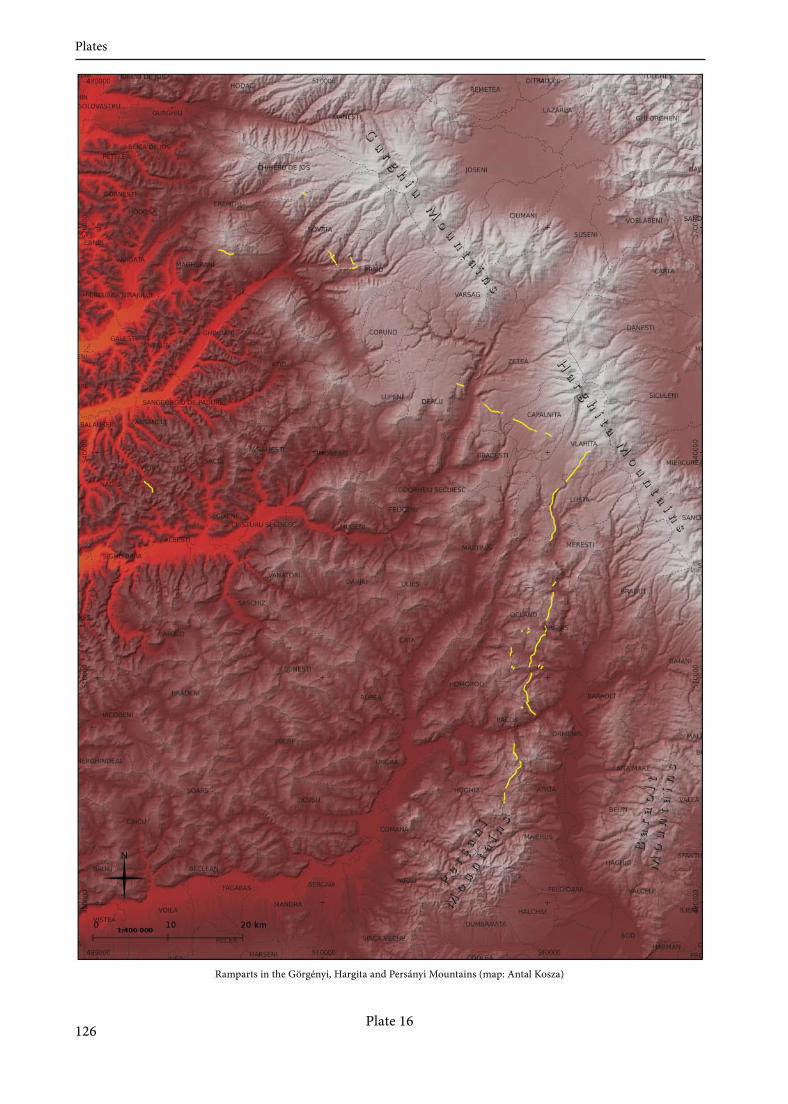
Plate 16
Ramparts in the Görgényi, Hargita and Persányi Mountains (map: Antal Kosza)
126
Plates

Authors

BAKLANOV, SzandraHungarian National Museum, Centre for National HeritageH-1113 Budapest, Daróci u. [email protected]
BANASZEK, ŁukaszInstitute of Prehistory, Adam Miczkiewicz UniversityPL-61-809 Poznań, ul. Św. Marcin [email protected]
BERTÓK, GáborDepartment ofArchaeology, Janus Pannonius MuseumH-7621 Pécs, Káptalan u. [email protected]
BÖDŐCS, AndrásInstitute ofArchaeological Sciences, Faculty ofHumanities, Eötvös Loránd UniversityH-1088 Budapest, Múzeum krt. 4/[email protected]
CORDIER, AlexandraUniversité de Bourgogne, UMR 6298 ARTEHISF-21000 Dijon, 6 Boulevard [email protected]
CZAJLIK, ZoltánInstitute ofArchaeological Sciences, Faculty ofHumanities Eötvös Loránd UniversityH-1088 Budapest, Múzeum krt. 4/[email protected]
FODOREAN, FlorinDepartment ofAncient History and Archaeology, Babeș-Bolyai UniversityRO-400084 Cluj-Napoca, Str. Mihail Kogălniceanu [email protected]
GÁTI, CsillaDepartment ofArchaeology, Janus Pannonius MuseumH-7621 Pécs, Káptalan u. [email protected]
GLAVAŠ, VedranaDepartment ofArchaeology, University ofZadarCR-23000 Zadar, Obala Kralja Petra Krešimira IV., [email protected]
GOGUEY, RenéF-21240 Talant, 4 rue Colonel [email protected]
129
Authors
KENÉZ, ÁrpádCentre for National Heritage, Hungarian National MuseumH-1113 Budapest, Daróci u. [email protected]
MIKLÓS, ZsuzsaInstitute ofArchaeology, Research Centre for the Humanities, Hungarian Academy of SciencesH-1014 Budapest, Uri u. [email protected]
MLEKUZ, DimitrijDepartment ofArchaeology, Faculty ofArts, University of LjubljanaSL-1000 Ljubljana, Aškerčeva [email protected]
PALMER, RogAir Photo Services21 Gunhild Way Cambridge CB1 8QZ, [email protected]
PETŐ, ÁkosCentre for National Heritage, Hungarian National MuseumH-1113 Budapest, Daróci u. [email protected]
REMÉNYI, LászlóCentre for National Heritage, Hungarian National MuseumH-1113 Budapest, Daróci u. [email protected]
RUPNIK, LászlóMTA-ELTE Research Group for Interdisciplinary Archaeology, Eötvös Loránd UniversityH-1088 Budapest, Múzeum krt. 4/[email protected]
SOBCZAK, CezaryState Archaeological Museum in WarsawPL-00-241 Warsaw, ul. Długa [email protected]
SÓFALVI, AndrásMuzeul Haáz Rezső / Haáz Rezső MúzeumRO-535600 Odorheiu Secuesc / Székelyudvarhelystr. Kossuth Lajos [email protected]
SZABÓ, MátéDepartment ofArchaeology, University of PécsH-7624 Pécs, Rókus u. [email protected]
130
Authors