Quantifying Position Accuracy of Multimodal Data from Global Positioning System—Enabled Cell...
7
54 and emergency evacuation and position data (for 911 operators and fire departments). Of particular interest to the transportation indus- try are new opportunities to push real-time travel information sub- ject to an individual’s current location, which is determined by a GPS-enabled cell phone. GPS-enabled cell phones offer new, sophisticated real-time appli- cations made possible by embedded GPS technology, two-way com- munication, and the portable nature of the cell phone. The results of complicated processes or subsets of records from large databases [e.g., geographic information system (GIS) databases of public trans- portation routes and stops] can be relayed to the phone, which can fur- ther analyze these data or display them to the user. Such information may be used to facilitate the use of public transportation by cogni- tively disabled people or new transit riders. As part of a research project to develop a travel assistant device (TAD) to aid transit riders with special needs, a software application that uses multimedia GPS-enabled cell phones was built to alert rid- ers of events such as when to board and when their stop is approach- ing. It also would allow family members to track a rider’s trip on the Internet and be notified should the rider deviate from the anticipated route (e.g., fail to get off the bus at the correct stop). Although riders with cognitive disabilities are the initial target market for this application, TADs may be used by any travelers, such as tourists who are unfamiliar with a region and its transit system. Potential impacts of such personal TADs include increased transit ridership; decreased costs to the transit agency, by shifting some rid- ers from paratransit to fixed-route transit; increased independence and improved quality of life for transit riders; and increased productivity of transit agencies’ “travel trainers” (also called travel instructors), whose sole job is to provide one-on-one instruction (to new riders or to existing paratransit riders) on how to use fixed-route transit. As with all next-generation location-based applications, a TAD relies heavily on reasonably accurate real-time position data. Because many applications that use real-time position information are begin- ning to emerge in the telecommunications market, the need for quan- tified position accuracy performance data of GPS-enabled cell phones is current and of greater importance than ever before. GPS has been analyzed in many past transportation studies (2–8). Results have indicated that GPS is an objective technology that can be used to accurately record historical travel behavior data and poten- tially even replace the travel diary (4, 5, 8). However, many of these studies have used either personal digital assistants (PDAs) with sup- plemental equipment (2, 4) or vehicle-based GPS systems (3, 5, 6). Although other studies discuss the use of cell phones and GPS, many discuss their use hypothetically (9) or have used a regular cell phone in conjunction with a separate GPS device (10, 11). Quantifying Position Accuracy of Multimodal Data from Global Positioning System–Enabled Cell Phones David P. Aguilar, Sean J. Barbeau, Miguel A. Labrador, Alfredo J. Perez, Rafael A. Perez, and Philip L. Winters The emergence of cell phones with embedded Global Positioning System (GPS) chips provides opportunities to push personalized real-time travel information subject to an individual’s current location. One such appli- cation, a travel assistant device, notifies cognitively disabled public trans- portation users when it is time to request a stop and exit the vehicle. GPS-enabled cell phones must provide highly accurate real-time location data for this type of service. The components used in the data-collection process are identified, and a quantitative analysis of real-time GPS data obtained with a cell phone while walking, driving a vehicle, and riding public transportation is provided. The expectation was that position accuracy would suffer when the GPS signal was obstructed by a vehicle or the user’s clothing. The obtained data demonstrate the results of loca- tion fix attempts over different transportation modes in an urban envi- ronment. The highest percentage of GPS fixes (79.0%) was obtained by users walking with the cell phone open and unobstructed; walking also produced valid GPS data (i.e., location data estimated to be accurate within 30 m of the true position) 66.2% of the time. For bus trips, GPS and valid fix percentages were 71.7% and 66.1%, respectively, when the phone was held near the window; when the phone was placed in the traveler’s lap, these numbers fell to 51.3% and 27.8%, respectively. Car trips provided higher numbers: 77.7% and 71.6%, respectively. Location- based transportation applications are feasible using current technology, but predictive algorithms may be required to deliver highly accurate and timely location-aware services to cell phone users in highly obstructed environments. Cell phones are quickly becoming the world’s most common com- puting device, outselling PCs by a ratio of 4 to 1 in 2004, with an ever-increasing market (1). With recent developments in commu- nication technology, including satellite broadcasts and high-speed wireless data transmissions, numerous manufacturers have been incorporating high levels of functionality into cell devices that were recently found only on the desktop PC. With the recent incorpora- tion of Global Positioning System (GPS) technology into cell phones, many location-based applications have become possible, including travel behavior tracking, region-specific weather and traffic reports, D. P. Aguilar, M. A. Labrador, A. J. Perez, and R. A. Perez, Department of Computer Science and Engineering, and S. J. Barbeau and P. L. Winters, Center for Urban Transportation Research, University of South Florida, Tampa, FL 33620-5375. Corresponding author: S. J. Barbeau, [email protected]. Transportation Research Record: Journal of the Transportation Research Board, No. 1992, Transportation Research Board of the National Academies, Washington, D.C., 2007, pp. 54–60. DOI: 10.3141/1992-07
-
Upload
independent -
Category
Documents
-
view
0 -
download
0
Transcript of Quantifying Position Accuracy of Multimodal Data from Global Positioning System—Enabled Cell...
54
and emergency evacuation and position data (for 911 operators andfire departments). Of particular interest to the transportation indus-try are new opportunities to push real-time travel information sub-ject to an individual’s current location, which is determined by aGPS-enabled cell phone.
GPS-enabled cell phones offer new, sophisticated real-time appli-cations made possible by embedded GPS technology, two-way com-munication, and the portable nature of the cell phone. The results ofcomplicated processes or subsets of records from large databases[e.g., geographic information system (GIS) databases of public trans-portation routes and stops] can be relayed to the phone, which can fur-ther analyze these data or display them to the user. Such informationmay be used to facilitate the use of public transportation by cogni-tively disabled people or new transit riders.
As part of a research project to develop a travel assistant device(TAD) to aid transit riders with special needs, a software applicationthat uses multimedia GPS-enabled cell phones was built to alert rid-ers of events such as when to board and when their stop is approach-ing. It also would allow family members to track a rider’s trip on theInternet and be notified should the rider deviate from the anticipatedroute (e.g., fail to get off the bus at the correct stop).
Although riders with cognitive disabilities are the initial targetmarket for this application, TADs may be used by any travelers, suchas tourists who are unfamiliar with a region and its transit system.Potential impacts of such personal TADs include increased transitridership; decreased costs to the transit agency, by shifting some rid-ers from paratransit to fixed-route transit; increased independence andimproved quality of life for transit riders; and increased productivityof transit agencies’ “travel trainers” (also called travel instructors),whose sole job is to provide one-on-one instruction (to new riders orto existing paratransit riders) on how to use fixed-route transit.
As with all next-generation location-based applications, a TADrelies heavily on reasonably accurate real-time position data. Becausemany applications that use real-time position information are begin-ning to emerge in the telecommunications market, the need for quan-tified position accuracy performance data of GPS-enabled cell phonesis current and of greater importance than ever before.
GPS has been analyzed in many past transportation studies (2–8).Results have indicated that GPS is an objective technology that canbe used to accurately record historical travel behavior data and poten-tially even replace the travel diary (4, 5, 8). However, many of thesestudies have used either personal digital assistants (PDAs) with sup-plemental equipment (2, 4) or vehicle-based GPS systems (3, 5, 6).Although other studies discuss the use of cell phones and GPS, manydiscuss their use hypothetically (9) or have used a regular cell phonein conjunction with a separate GPS device (10, 11).
Quantifying Position Accuracy ofMultimodal Data from Global PositioningSystem–Enabled Cell Phones
David P. Aguilar, Sean J. Barbeau, Miguel A. Labrador, Alfredo J. Perez, Rafael A. Perez, and Philip L. Winters
The emergence of cell phones with embedded Global Positioning System(GPS) chips provides opportunities to push personalized real-time travelinformation subject to an individual’s current location. One such appli-cation, a travel assistant device, notifies cognitively disabled public trans-portation users when it is time to request a stop and exit the vehicle.GPS-enabled cell phones must provide highly accurate real-time locationdata for this type of service. The components used in the data-collectionprocess are identified, and a quantitative analysis of real-time GPS dataobtained with a cell phone while walking, driving a vehicle, and ridingpublic transportation is provided. The expectation was that positionaccuracy would suffer when the GPS signal was obstructed by a vehicleor the user’s clothing. The obtained data demonstrate the results of loca-tion fix attempts over different transportation modes in an urban envi-ronment. The highest percentage of GPS fixes (79.0%) was obtained byusers walking with the cell phone open and unobstructed; walking alsoproduced valid GPS data (i.e., location data estimated to be accuratewithin 30 m of the true position) 66.2% of the time. For bus trips, GPSand valid fix percentages were 71.7% and 66.1%, respectively, when thephone was held near the window; when the phone was placed in thetraveler’s lap, these numbers fell to 51.3% and 27.8%, respectively. Cartrips provided higher numbers: 77.7% and 71.6%, respectively. Location-based transportation applications are feasible using current technology,but predictive algorithms may be required to deliver highly accurate andtimely location-aware services to cell phone users in highly obstructedenvironments.
Cell phones are quickly becoming the world’s most common com-puting device, outselling PCs by a ratio of 4 to 1 in 2004, with anever-increasing market (1). With recent developments in commu-nication technology, including satellite broadcasts and high-speedwireless data transmissions, numerous manufacturers have beenincorporating high levels of functionality into cell devices that wererecently found only on the desktop PC. With the recent incorpora-tion of Global Positioning System (GPS) technology into cell phones,many location-based applications have become possible, includingtravel behavior tracking, region-specific weather and traffic reports,
D. P. Aguilar, M. A. Labrador, A. J. Perez, and R. A. Perez, Department of ComputerScience and Engineering, and S. J. Barbeau and P. L. Winters, Center for UrbanTransportation Research, University of South Florida, Tampa, FL 33620-5375.Corresponding author: S. J. Barbeau, [email protected].
Transportation Research Record: Journal of the Transportation Research Board,No. 1992, Transportation Research Board of the National Academies, Washington,D.C., 2007, pp. 54–60.DOI: 10.3141/1992-07
To date, few quantified data exist regarding the accuracy of loca-tion data provided by GPS-enabled cell phones, assisted GPS (A-GPS)technology (12). A-GPS uses location information from the cellu-lar network in addition to embedded GPS technology to quicklyobtain more accurate location data for the mobile device (12).Because the E911 mandate by the U.S. Federal CommunicationsCommission requires wireless carriers to provide location informa-tion within 50 to 300 m for emergency calls (9, 13), embedded loca-tion technology such as A-GPS is becoming more common inphones for many cellular networks (14–16). In the remainder of thispaper, GPS refers to location data obtained with the use of A-GPStechnology.
The performance of GPS-enabled systems relies heavily on howaccurately each unit of location data, called a GPS fix, indicates thedevice’s true position. GPS-enabled cell phones provide additionaldata, related to the estimated accuracy of each fix, that are not read-ily available from traditional GPS devices. The degree of certaintyassociated with fix accuracy depends on signal quality, geographiclocation, satellite position and accuracy, clock discrepancies, envi-ronmental obstructions, and numerous other variables (12, 17). Thisestimated accuracy can be used to evaluate whether the provideddata meet certain accuracy criteria specified for each particular cellphone application.
To date, little quantitative information is available about the reli-ability of GPS data obtained from GPS-enabled cell phones in mostreal-world application settings, including those relevant to real-world transportation applications (18). Therefore, this paper pre-sents a quantitative analysis of the accuracy of travel behavior datacollected using GPS-enabled cell phones over various transportationmodes, including walking, riding a bus, and traveling in a car amongenvironmental obstructions in an urban setting.
The rest of this paper is organized as follows. First, the researchmethods used—including the data description and the software toolsused in the collection process—are discussed. Next, study results anda discussion of their implications are provided. Finally, conclusionsare presented.
METHODS
Data Representation and Collection
Accuracy Uncertainty
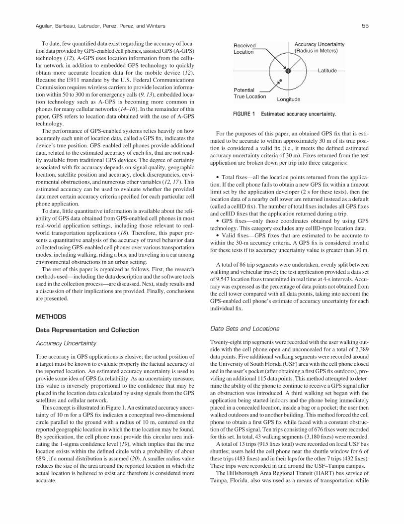
True accuracy in GPS applications is elusive; the actual position ofa target must be known to evaluate properly the factual accuracy ofthe reported location. An estimated accuracy uncertainty is used toprovide some idea of GPS fix reliability. As an uncertainty measure,this value is inversely proportional to the confidence that may beplaced in the location data calculated by using signals from the GPSsatellites and cellular network.
This concept is illustrated in Figure 1. An estimated accuracy uncer-tainty of 10 m for a GPS fix indicates a conceptual two-dimensionalcircle parallel to the ground with a radius of 10 m, centered on thereported geographic location in which the true location may be found.By specification, the cell phone must provide this circular area indi-cating the 1-sigma confidence level (19), which implies that the truelocation exists within the defined circle with a probability of about68%, if a normal distribution is assumed (20). A smaller radius valuereduces the size of the area around the reported location in which theactual location is believed to exist and therefore is considered moreaccurate.
Aguilar, Barbeau, Labrador, Perez, Perez, and Winters 55
For the purposes of this paper, an obtained GPS fix that is esti-mated to be accurate to within approximately 30 m of its true posi-tion is considered a valid fix (i.e., it meets the defined estimatedaccuracy uncertainty criteria of 30 m). Fixes returned from the testapplication are broken down per trip into three categories:
• Total fixes—all the location points returned from the applica-tion. If the cell phone fails to obtain a new GPS fix within a timeoutlimit set by the application developer (2 s for these tests), then thelocation data of a nearby cell tower are returned instead as a default(called a cellID fix). The number of total fixes includes all GPS fixesand cellID fixes that the application returned during a trip.
• GPS fixes—only those coordinates obtained by using GPStechnology. This category excludes any cellID-type location data.
• Valid fixes—GPS fixes that are estimated to be accurate towithin the 30-m accuracy criteria. A GPS fix is considered invalidfor these tests if its accuracy uncertainty value is greater than 30 m.
A total of 86 trip segments were undertaken, evenly split betweenwalking and vehicular travel; the test application provided a data setof 9,547 location fixes transmitted in real time at 4-s intervals. Accu-racy was expressed as the percentage of data points not obtained fromthe cell tower compared with all data points, taking into account theGPS-enabled cell phone’s estimate of accuracy uncertainty for eachindividual fix.
Data Sets and Locations
Twenty-eight trip segments were recorded with the user walking out-side with the cell phone open and unconcealed for a total of 2,389data points. Five additional walking segments were recorded aroundthe University of South Florida (USF) area with the cell phone closedand in the user’s pocket (after obtaining a first GPS fix outdoors), pro-viding an additional 115 data points. This method attempted to deter-mine the ability of the phone to continue to receive a GPS signal afteran obstruction was introduced. A third walking set began with theapplication being started indoors and the phone being immediatelyplaced in a concealed location, inside a bag or a pocket; the user thenwalked outdoors and to another building. This method forced the cellphone to obtain a first GPS fix while faced with a constant obstruc-tion of the GPS signal. Ten trips consisting of 676 fixes were recordedfor this set. In total, 43 walking segments (3,180 fixes) were recorded.
A total of 13 trips (915 fixes total) were recorded on local USF busshuttles; users held the cell phone near the shuttle window for 6 ofthese trips (483 fixes) and in their laps for the other 7 trips (432 fixes).These trips were recorded in and around the USF–Tampa campus.
The Hillsborough Area Regional Transit (HART) bus service ofTampa, Florida, also was used as a means of transportation while
ReceivedLocation
Accuracy Uncertainty(Radius in Meters)
Latitude
Longitude
PotentialTrue Location
FIGURE 1 Estimated accuracy uncertainty.
56 Transportation Research Record 1992
the user recorded GPS fixes. A total of 12 segments (4,272 fixes)were recorded over 4 separate bus routes; users held the cell phonenear the window for 6 of these trips (2,204 fixes) and in their lapsfor the other 6 trips (2,068 fixes).
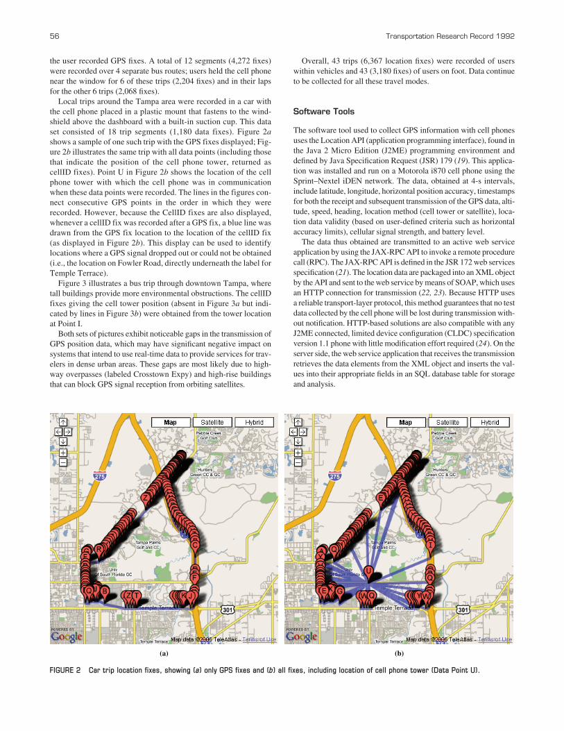
Local trips around the Tampa area were recorded in a car withthe cell phone placed in a plastic mount that fastens to the wind-shield above the dashboard with a built-in suction cup. This dataset consisted of 18 trip segments (1,180 data fixes). Figure 2ashows a sample of one such trip with the GPS fixes displayed; Fig-ure 2b illustrates the same trip with all data points (including thosethat indicate the position of the cell phone tower, returned as cellID fixes). Point U in Figure 2b shows the location of the cellphone tower with which the cell phone was in communicationwhen these data points were recorded. The lines in the figures con-nect consecutive GPS points in the order in which they wererecorded. However, because the CellID fixes are also displayed,whenever a cellID fix was recorded after a GPS fix, a blue line wasdrawn from the GPS fix location to the location of the cellID fix(as displayed in Figure 2b). This display can be used to identifylocations where a GPS signal dropped out or could not be obtained(i.e., the location on Fowler Road, directly underneath the label forTemple Terrace).
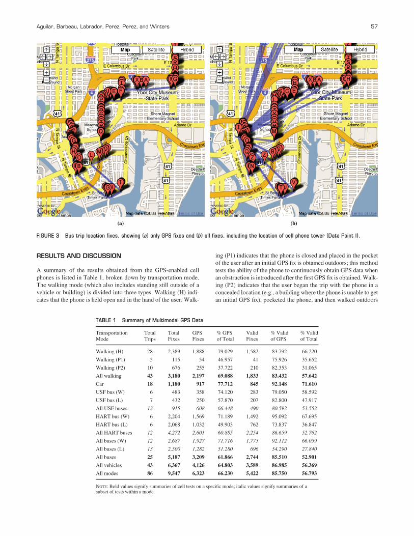
Figure 3 illustrates a bus trip through downtown Tampa, wheretall buildings provide more environmental obstructions. The cellIDfixes giving the cell tower position (absent in Figure 3a but indi-cated by lines in Figure 3b) were obtained from the tower locationat Point I.
Both sets of pictures exhibit noticeable gaps in the transmission ofGPS position data, which may have significant negative impact onsystems that intend to use real-time data to provide services for trav-elers in dense urban areas. These gaps are most likely due to high-way overpasses (labeled Crosstown Expy) and high-rise buildingsthat can block GPS signal reception from orbiting satellites.
Overall, 43 trips (6,367 location fixes) were recorded of userswithin vehicles and 43 (3,180 fixes) of users on foot. Data continueto be collected for all these travel modes.
Software Tools
The software tool used to collect GPS information with cell phonesuses the Location API (application programming interface), found inthe Java 2 Micro Edition (J2ME) programming environment anddefined by Java Specification Request (JSR) 179 (19). This applica-tion was installed and run on a Motorola i870 cell phone using theSprint–Nextel iDEN network. The data, obtained at 4-s intervals,include latitude, longitude, horizontal position accuracy, timestampsfor both the receipt and subsequent transmission of the GPS data, alti-tude, speed, heading, location method (cell tower or satellite), loca-tion data validity (based on user-defined criteria such as horizontalaccuracy limits), cellular signal strength, and battery level.
The data thus obtained are transmitted to an active web serviceapplication by using the JAX-RPC API to invoke a remote procedurecall (RPC). The JAX-RPC API is defined in the JSR 172 web servicesspecification (21). The location data are packaged into an XML objectby the API and sent to the web service by means of SOAP, which usesan HTTP connection for transmission (22, 23). Because HTTP usesa reliable transport-layer protocol, this method guarantees that no testdata collected by the cell phone will be lost during transmission with-out notification. HTTP-based solutions are also compatible with anyJ2ME connected, limited device configuration (CLDC) specificationversion 1.1 phone with little modification effort required (24). On theserver side, the web service application that receives the transmissionretrieves the data elements from the XML object and inserts the val-ues into their appropriate fields in an SQL database table for storageand analysis.
(a) (b)
FIGURE 2 Car trip location fixes, showing (a) only GPS fixes and (b) all fixes, including location of cell phone tower (Data Point U).
RESULTS AND DISCUSSION
A summary of the results obtained from the GPS-enabled cellphones is listed in Table 1, broken down by transportation mode.The walking mode (which also includes standing still outside of avehicle or building) is divided into three types. Walking (H) indi-cates that the phone is held open and in the hand of the user. Walk-
ing (P1) indicates that the phone is closed and placed in the pocketof the user after an initial GPS fix is obtained outdoors; this methodtests the ability of the phone to continuously obtain GPS data whenan obstruction is introduced after the first GPS fix is obtained. Walk-ing (P2) indicates that the user began the trip with the phone in aconcealed location (e.g., a building where the phone is unable to getan initial GPS fix), pocketed the phone, and then walked outdoors
(a) (b)
FIGURE 3 Bus trip location fixes, showing (a) only GPS fixes and (b) all fixes, including the location of cell phone tower (Data Point I).
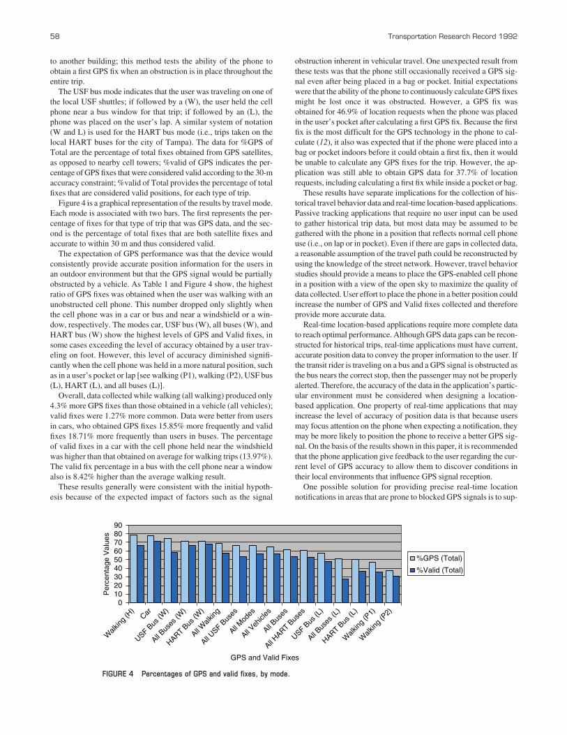
TABLE 1 Summary of Multimodal GPS Data
Transportation Total Total GPS % GPS Valid % Valid % ValidMode Trips Fixes Fixes of Total Fixes of GPS of Total
Walking (H) 28 2,389 1,888 79.029 1,582 83.792 66.220
Walking (P1) 5 115 54 46.957 41 75.926 35.652
Walking (P2) 10 676 255 37.722 210 82.353 31.065
All walking 43 3,180 2,197 69.088 1,833 83.432 57.642
Car 18 1,180 917 77.712 845 92.148 71.610
USF bus (W) 6 483 358 74.120 283 79.050 58.592
USF bus (L) 7 432 250 57.870 207 82.800 47.917
All USF buses 13 915 608 66.448 490 80.592 53.552
HART bus (W) 6 2,204 1,569 71.189 1,492 95.092 67.695
HART bus (L) 6 2,068 1,032 49.903 762 73.837 36.847
All HART buses 12 4,272 2,601 60.885 2,254 86.659 52.762
All buses (W) 12 2,687 1,927 71.716 1,775 92.112 66.059
All buses (L) 13 2,500 1,282 51.280 696 54.290 27.840
All buses 25 5,187 3,209 61.866 2,744 85.510 52.901
All vehicles 43 6,367 4,126 64.803 3,589 86.985 56.369
All modes 86 9,547 6,323 66.230 5,422 85.750 56.793
NOTE: Bold values signify summaries of cell tests on a specific mode; italic values signify summaries of a subset of tests within a mode.
Aguilar, Barbeau, Labrador, Perez, Perez, and Winters 57
58 Transportation Research Record 1992
to another building; this method tests the ability of the phone toobtain a first GPS fix when an obstruction is in place throughout theentire trip.
The USF bus mode indicates that the user was traveling on one ofthe local USF shuttles; if followed by a (W), the user held the cellphone near a bus window for that trip; if followed by an (L), thephone was placed on the user’s lap. A similar system of notation(W and L) is used for the HART bus mode (i.e., trips taken on thelocal HART buses for the city of Tampa). The data for %GPS ofTotal are the percentage of total fixes obtained from GPS satellites,as opposed to nearby cell towers; %valid of GPS indicates the per-centage of GPS fixes that were considered valid according to the 30-maccuracy constraint; %valid of Total provides the percentage of totalfixes that are considered valid positions, for each type of trip.
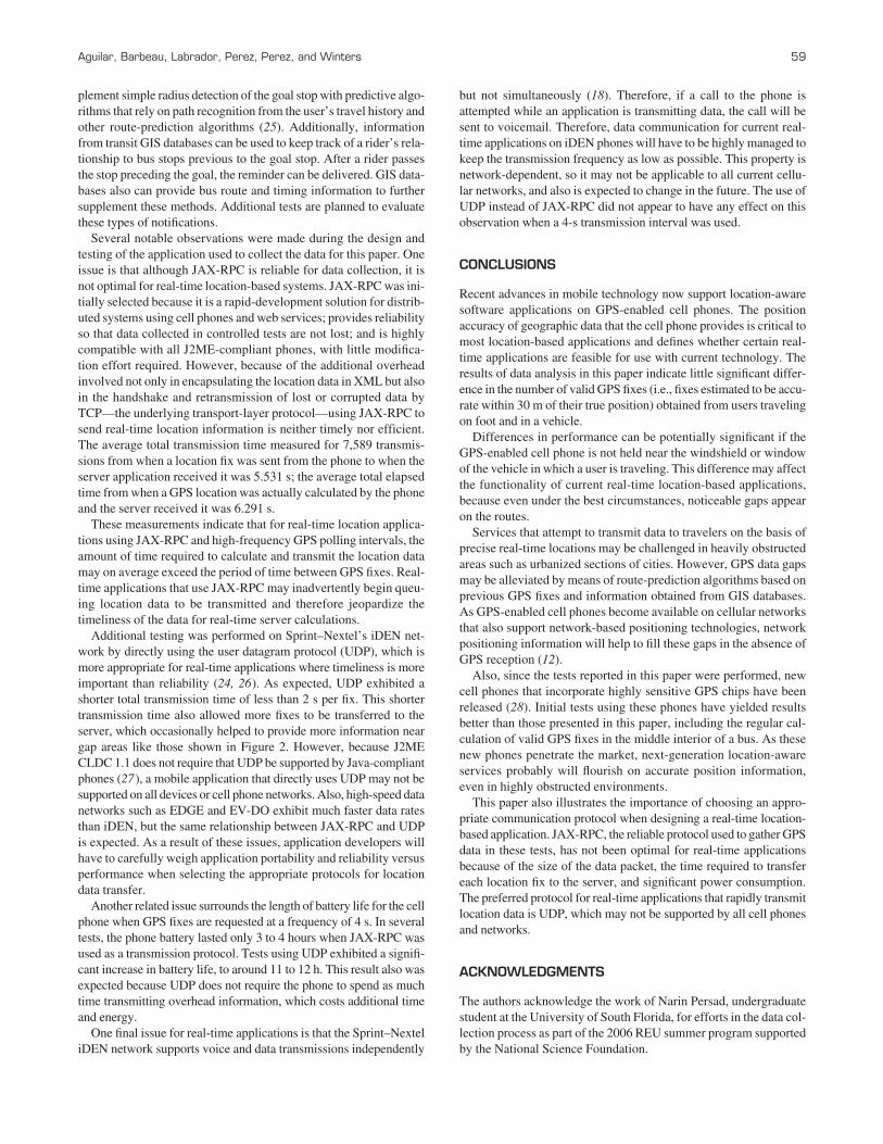
Figure 4 is a graphical representation of the results by travel mode.Each mode is associated with two bars. The first represents the per-centage of fixes for that type of trip that was GPS data, and the sec-ond is the percentage of total fixes that are both satellite fixes andaccurate to within 30 m and thus considered valid.
The expectation of GPS performance was that the device wouldconsistently provide accurate position information for the users inan outdoor environment but that the GPS signal would be partiallyobstructed by a vehicle. As Table 1 and Figure 4 show, the highestratio of GPS fixes was obtained when the user was walking with anunobstructed cell phone. This number dropped only slightly whenthe cell phone was in a car or bus and near a windshield or a win-dow, respectively. The modes car, USF bus (W), all buses (W), andHART bus (W) show the highest levels of GPS and Valid fixes, insome cases exceeding the level of accuracy obtained by a user trav-eling on foot. However, this level of accuracy diminished signifi-cantly when the cell phone was held in a more natural position, suchas in a user’s pocket or lap [see walking (P1), walking (P2), USF bus(L), HART (L), and all buses (L)].
Overall, data collected while walking (all walking) produced only4.3% more GPS fixes than those obtained in a vehicle (all vehicles);valid fixes were 1.27% more common. Data were better from usersin cars, who obtained GPS fixes 15.85% more frequently and validfixes 18.71% more frequently than users in buses. The percentageof valid fixes in a car with the cell phone held near the windshieldwas higher than that obtained on average for walking trips (13.97%).The valid fix percentage in a bus with the cell phone near a windowalso is 8.42% higher than the average walking result.
These results generally were consistent with the initial hypoth-esis because of the expected impact of factors such as the signal
obstruction inherent in vehicular travel. One unexpected result fromthese tests was that the phone still occasionally received a GPS sig-nal even after being placed in a bag or pocket. Initial expectationswere that the ability of the phone to continuously calculate GPS fixesmight be lost once it was obstructed. However, a GPS fix wasobtained for 46.9% of location requests when the phone was placedin the user’s pocket after calculating a first GPS fix. Because the firstfix is the most difficult for the GPS technology in the phone to cal-culate (12), it also was expected that if the phone were placed into abag or pocket indoors before it could obtain a first fix, then it wouldbe unable to calculate any GPS fixes for the trip. However, the ap-plication was still able to obtain GPS data for 37.7% of locationrequests, including calculating a first fix while inside a pocket or bag.
These results have separate implications for the collection of his-torical travel behavior data and real-time location-based applications.Passive tracking applications that require no user input can be usedto gather historical trip data, but most data may be assumed to begathered with the phone in a position that reflects normal cell phoneuse (i.e., on lap or in pocket). Even if there are gaps in collected data,a reasonable assumption of the travel path could be reconstructed byusing the knowledge of the street network. However, travel behaviorstudies should provide a means to place the GPS-enabled cell phonein a position with a view of the open sky to maximize the quality ofdata collected. User effort to place the phone in a better position couldincrease the number of GPS and Valid fixes collected and thereforeprovide more accurate data.
Real-time location-based applications require more complete datato reach optimal performance. Although GPS data gaps can be recon-structed for historical trips, real-time applications must have current,accurate position data to convey the proper information to the user. Ifthe transit rider is traveling on a bus and a GPS signal is obstructed asthe bus nears the correct stop, then the passenger may not be properlyalerted. Therefore, the accuracy of the data in the application’s partic-ular environment must be considered when designing a location-based application. One property of real-time applications that mayincrease the level of accuracy of position data is that because usersmay focus attention on the phone when expecting a notification, theymay be more likely to position the phone to receive a better GPS sig-nal. On the basis of the results shown in this paper, it is recommendedthat the phone application give feedback to the user regarding the cur-rent level of GPS accuracy to allow them to discover conditions intheir local environments that influence GPS signal reception.
One possible solution for providing precise real-time locationnotifications in areas that are prone to blocked GPS signals is to sup-
0 10 20 30 40 50 60 70 80 90
Walk
ing (H
) Car
USF Bus
(W)
All Bus
es (W
)
HART Bus
(W)
All Walk
ing
All USF B
uses
All Mod
es
All Veh
icles
All Bus
es
All HART B
uses
USF Bus
(L)
All Bus
es (L
)
HART Bus
(L)
Walk
ing (P
1)
Walk
ing (P
2)
GPS and Valid Fixes
Per
cent
age
Val
ues
%GPS (Total)
%Valid (Total)
FIGURE 4 Percentages of GPS and valid fixes, by mode.
plement simple radius detection of the goal stop with predictive algo-rithms that rely on path recognition from the user’s travel history andother route-prediction algorithms (25). Additionally, informationfrom transit GIS databases can be used to keep track of a rider’s rela-tionship to bus stops previous to the goal stop. After a rider passesthe stop preceding the goal, the reminder can be delivered. GIS data-bases also can provide bus route and timing information to furthersupplement these methods. Additional tests are planned to evaluatethese types of notifications.
Several notable observations were made during the design andtesting of the application used to collect the data for this paper. Oneissue is that although JAX-RPC is reliable for data collection, it isnot optimal for real-time location-based systems. JAX-RPC was ini-tially selected because it is a rapid-development solution for distrib-uted systems using cell phones and web services; provides reliabilityso that data collected in controlled tests are not lost; and is highlycompatible with all J2ME-compliant phones, with little modifica-tion effort required. However, because of the additional overheadinvolved not only in encapsulating the location data in XML but alsoin the handshake and retransmission of lost or corrupted data byTCP—the underlying transport-layer protocol—using JAX-RPC tosend real-time location information is neither timely nor efficient.The average total transmission time measured for 7,589 transmis-sions from when a location fix was sent from the phone to when theserver application received it was 5.531 s; the average total elapsedtime from when a GPS location was actually calculated by the phoneand the server received it was 6.291 s.
These measurements indicate that for real-time location applica-tions using JAX-RPC and high-frequency GPS polling intervals, theamount of time required to calculate and transmit the location datamay on average exceed the period of time between GPS fixes. Real-time applications that use JAX-RPC may inadvertently begin queu-ing location data to be transmitted and therefore jeopardize thetimeliness of the data for real-time server calculations.
Additional testing was performed on Sprint–Nextel’s iDEN net-work by directly using the user datagram protocol (UDP), which ismore appropriate for real-time applications where timeliness is moreimportant than reliability (24, 26). As expected, UDP exhibited ashorter total transmission time of less than 2 s per fix. This shortertransmission time also allowed more fixes to be transferred to theserver, which occasionally helped to provide more information neargap areas like those shown in Figure 2. However, because J2MECLDC 1.1 does not require that UDP be supported by Java-compliantphones (27), a mobile application that directly uses UDP may not besupported on all devices or cell phone networks. Also, high-speed datanetworks such as EDGE and EV-DO exhibit much faster data ratesthan iDEN, but the same relationship between JAX-RPC and UDPis expected. As a result of these issues, application developers willhave to carefully weigh application portability and reliability versusperformance when selecting the appropriate protocols for locationdata transfer.
Another related issue surrounds the length of battery life for the cellphone when GPS fixes are requested at a frequency of 4 s. In severaltests, the phone battery lasted only 3 to 4 hours when JAX-RPC wasused as a transmission protocol. Tests using UDP exhibited a signifi-cant increase in battery life, to around 11 to 12 h. This result also wasexpected because UDP does not require the phone to spend as muchtime transmitting overhead information, which costs additional timeand energy.
One final issue for real-time applications is that the Sprint–NexteliDEN network supports voice and data transmissions independently
Aguilar, Barbeau, Labrador, Perez, Perez, and Winters 59
but not simultaneously (18). Therefore, if a call to the phone isattempted while an application is transmitting data, the call will besent to voicemail. Therefore, data communication for current real-time applications on iDEN phones will have to be highly managed tokeep the transmission frequency as low as possible. This property isnetwork-dependent, so it may not be applicable to all current cellu-lar networks, and also is expected to change in the future. The use ofUDP instead of JAX-RPC did not appear to have any effect on thisobservation when a 4-s transmission interval was used.
CONCLUSIONS
Recent advances in mobile technology now support location-awaresoftware applications on GPS-enabled cell phones. The positionaccuracy of geographic data that the cell phone provides is critical tomost location-based applications and defines whether certain real-time applications are feasible for use with current technology. Theresults of data analysis in this paper indicate little significant differ-ence in the number of valid GPS fixes (i.e., fixes estimated to be accu-rate within 30 m of their true position) obtained from users travelingon foot and in a vehicle.
Differences in performance can be potentially significant if theGPS-enabled cell phone is not held near the windshield or windowof the vehicle in which a user is traveling. This difference may affectthe functionality of current real-time location-based applications,because even under the best circumstances, noticeable gaps appearon the routes.
Services that attempt to transmit data to travelers on the basis ofprecise real-time locations may be challenged in heavily obstructedareas such as urbanized sections of cities. However, GPS data gapsmay be alleviated by means of route-prediction algorithms based onprevious GPS fixes and information obtained from GIS databases.As GPS-enabled cell phones become available on cellular networksthat also support network-based positioning technologies, networkpositioning information will help to fill these gaps in the absence ofGPS reception (12).
Also, since the tests reported in this paper were performed, newcell phones that incorporate highly sensitive GPS chips have beenreleased (28). Initial tests using these phones have yielded resultsbetter than those presented in this paper, including the regular cal-culation of valid GPS fixes in the middle interior of a bus. As thesenew phones penetrate the market, next-generation location-awareservices probably will flourish on accurate position information,even in highly obstructed environments.
This paper also illustrates the importance of choosing an appro-priate communication protocol when designing a real-time location-based application. JAX-RPC, the reliable protocol used to gather GPSdata in these tests, has not been optimal for real-time applicationsbecause of the size of the data packet, the time required to transfereach location fix to the server, and significant power consumption.The preferred protocol for real-time applications that rapidly transmitlocation data is UDP, which may not be supported by all cell phonesand networks.
ACKNOWLEDGMENTS
The authors acknowledge the work of Narin Persad, undergraduatestudent at the University of South Florida, for efforts in the data col-lection process as part of the 2006 REU summer program supportedby the National Science Foundation.
The research presented in this paper was conducted through theNational Center for Transit Research at the University of South Florida,with funding provided by the Florida Department of Transportationand the U.S. Department of Transportation.
REFERENCES
1. Thaw, J. Google, Yahoo! Expand Cell-Phone Options. SeattlePi.comBusiness News, Nov. 8, 2005. seattlepi.nwsource.com/business/247449_googlemaps08.html. Accessed July 27, 2006.
2. Draijer, G., N. Kalfs, and J. Perdok. Global Positioning System as DataCollection Method for Travel Research. In Transportation ResearchRecord: Journal of the Transportation Research Board, No. 1719, TRB,National Research Council, Washington, D.C., 2000, pp. 147–153.
3. Chung, E., and A. Shalaby. Development of a Trip Reconstruction Toolfor GPS-Based Personal Travel Surveys. Presented at 83rd AnnualMeeting of the Transportation Research Board, Washington, D.C.,2004.
4. Murakami, E., D. P. Wagner, and D. M. Neumeister. Using GlobalPositioning Systems and Personal Digital Assistants for PersonalTravel Surveys in the United States. Presented at International Confer-ence on Transport Survey Quality and Innovation, Grainau, Germany, 1997.gulliver.trb.org/publications/circulars/ec008/session_b.pdf. Accessed Aug.2, 2006.
5. Murakami, E., and D. P. Wagner. Can Using Global Positioning System(GPS) Improve Trip Reporting? Transportation Research Part C, Vol. 7,No. 2/3, 1999, pp. 149–165.
6. Griffin, T., Y. Huang, and R. Halverson. Computerized Trip Classifica-tion of GPS Data. In Proc., CITSA 2006—3rd International Conferenceon Cybernetics and Information Technology Systems and Applications.Orlando, Fla., July 20–23, 2006, pp. 212–216.
7. Wolf, J., R. Guensler, S. Washington, and L. Frank. Use of ElectronicTravel Diaries and Vehicle Instrumentation Packages in the Year 2000Atlanta Regional Household Travel Survey. In Transportation ResearchCircular E-C026: Personal Travel: The Long and Short of It. TRB,National Research Council, Washington, D.C., 2001. onlinepubs.trb.org/onlinepubs/circulars/ec026/19_wolf.pdf.
8. Wolf, J., R. Guensler, and W. Bachman. Elimination of the TravelDiary: An Experiment to Derive Trip Purpose from Global PositioningSystem Travel Data. In Transportation Research Record: Journal of theTransportation Research Board, No. 1768, TRB, National ResearchCouncil, Washington, D.C., 2001, pp. 125–134.
9. Zhao, Y. Mobile Phone Location Determination and Its Impact on Intel-ligent Transportation Systems. IEEE Transactions on Intelligent Trans-portation Systems, Vol. 1, No. 1, March 2000, pp. 55–64.
10. Makino, H., I. Ishii, and M. Nakashizuka. Development of NavigationSystem for the Blind Using GPS and Mobile Phone Combination. Pre-sented at 18th Annual International Conference of the IEEE–Engineeringin Medicine and Biology Society, Amsterdam, Netherlands, 1996.
60 Transportation Research Record 1992
11. Patterson, D., L. Liao, K. Gajos, M. Collier, N. Livic, K. Olson, S. Wang,D. Fox, and H. Kautz. Opportunity Knocks: A System to Provide Cog-nitive Assistance with Transportation Services. In UbiComp, Springer-Verlag, Berlin, 2004, pp. 433–450.
12. Küpper, A. Location-Based Services, Fundamentals and Operation.Wiley, New York, 2005, p. 152.
13. Enhanced 911—Wireless Services. Federal Communications Commission,Washington, D.C. www.fcc.gov/911/enhanced. Accessed Aug. 2, 2006.
14. Wireless Issues: Enhanced 911. Verizon Wireless, Basking Ridge, N.J.www.verizonwireless.com/b2c/aboutUs/wirelessissues/enhanced911.jsp.Accessed Aug. 2, 2006.
15. Sprint Extends Customer Choice and Flexibility with TeleNav GPS Nav-igator. Press release. Sprint–Nextel, Santa Clara, Calif., Sept. 26, 2005.
16. Nextel GPS—Find. Navigate. Sprint–Nextel, Santa Clara, Calif. www.nextel.com/en/services/gps/gps.shtml?audience=INDIVIDUAL&id12=Personal_Wireless;GPS&language=EN. Accessed Aug. 2, 2006.
17. El-Rabbany, A. Introduction to GPS, the Global Positioning System.Artech House, Norwood, Mass., 2002.
18. iDEN J2ME Developer’s Guide 2005, Version 1.98. Motorola, Chicago,Ill., 2005, pp. 497–499.
19. JSR 179: Location API for J2ME. Sun Microsystems, Santa Clara, Calif.jcp.org/en/jsr/detail?id=179. Accessed Aug. 2, 2006.
20. Wild, C. J., and G. A. F. Seber. Chance Encounters: A First Course inData Analysis and Inference. Wiley, New York, 1999.
21. JSR 172: J2ME Web Services Specification. Sun Microsystems, SantaClara, Calif. jcp.org/en/jsr/detail?id=172. Accessed Aug. 2, 2006.
22. Ortiz, C. E. Introduction to J2ME Web Services. Sun Microsystems,Santa Clara, Calif., April 2004. developers.sun.com/techtopics/mobility/apis/articles/wsa/. Accessed Aug. 2, 2006.
23. Skonnard, A. SOAP: The Simple Object Access Protocol. MicrosoftInternet Developer, January 2000. www.microsoft.com/Mind/0100/soap/soap.asp. Accessed Aug. 2, 2006.
24. Postel, J. RFC 768: User Datagram Protocol. USC/Information Sci-ences Institute, Aug. 28, 1980. www.faqs.org/rfcs/rfc768.html.
25. Ashbrook, D., and T. Starner. Using GPS to Learn Significant Locationsand Predict Movement Across Multiple Users. Personal and UbiquitousComputing, Vol. 7, No. 5, 2003, pp. 275–286.
26. TCP/IP User Datagram Protocol (UDP). TCP/IP Guide Version 3.0.Charles M. Kozierok, Sept. 20, 2005. www.tcpipguide.com/free/t_TCPIPUserDatagramProtocolUDP.htm. Accessed Aug. 2, 2006.
27. Java ME: Connected Limited Device Configuration (CLDC); JSR 30,JSR 139. Sun Microsystems, Santa Clara, Calif. java.sun.com/products/cldc/. Accessed Nov. 8, 2006.
28. van Diggelen, F. Indoor GPS Theory and Implementation. In IEEEPosition, Location & Navigation Symposium, 2003. Institute of Elec-trical and Electronics Engineers, Washington, D.C., 2002, pp. 240–247.ieeexplore.ieee.org/xpl/freeabs_all.jsp?arnumber=998914. AccessedOct. 8, 2006.
The New Public Transportation Systems and Technology Committee sponsoredpublication of this paper.