
(Public Pack)Agenda Document for Joint Planning Committee ...
54
Waverley Borough Council Council Offices, The Burys, Godalming, Surrey GU7 1HR www.waverley.gov.uk To: All Members and Substitute Members of the Joint Planning Committee (Other Members for Information) When calling please ask for: Ema Dearsley, Democratic Services Officer Policy and Governance E-mail: [email protected] Direct line: 01483 523224 Calls may be recorded for training or monitoring Date: 13 May 2016 Membership of the Joint Planning Committee Cllr Peter Isherwood (Chairman) Cllr Maurice Byham (Vice Chairman) Cllr Mike Band Cllr Brian Adams Cllr Carole Cockburn Cllr Kevin Deanus Cllr Brian Ellis Cllr David Else Cllr Mary Foryszewski Cllr Pat Frost Cllr John Gray Cllr Christiaan Hesse Cllr Stephen Hill Cllr Nicholas Holder Cllr David Hunter Cllr Anna James Cllr Andy MacLeod Cllr Stephen Mulliner Cllr Jeanette Stennett Cllr Stewart Stennett Cllr Chris Storey Cllr Nick Williams Cllr John Williamson Substitutes Appropriate Substitutes will be arranged prior to the meeting Dear Councillor A meeting of the JOINT PLANNING COMMITTEE will be held as follows: DATE: WEDNESDAY, 25 MAY 2016 TIME: 7.00 PM PLACE: COUNCIL CHAMBER, COUNCIL OFFICES, THE BURYS, GODALMING The Agenda for the Meeting is set out below. Yours sincerely ROBIN TAYLOR Head of Policy and Governance Agendas are available to download from Waverley’s website (www.waverley.gov.uk/committees), where you can also subscribe to
-
Upload
khangminh22 -
Category
Documents
-
view
0 -
download
0
Transcript of (Public Pack)Agenda Document for Joint Planning Committee ...
Waverley Borough CouncilCouncil Offices, The Burys, Godalming, SurreyGU7 1HRwww.waverley.gov.uk
To: All Members and Substitute Members of the Joint Planning Committee(Other Members for Information)
When calling please ask for:Ema Dearsley, Democratic Services OfficerPolicy and GovernanceE-mail: [email protected] line: 01483 523224Calls may be recorded for training or monitoring
Date: 13 May 2016
Membership of the Joint Planning CommitteeCllr Peter Isherwood (Chairman)Cllr Maurice Byham (Vice Chairman)Cllr Mike BandCllr Brian AdamsCllr Carole CockburnCllr Kevin DeanusCllr Brian EllisCllr David ElseCllr Mary ForyszewskiCllr Pat FrostCllr John GrayCllr Christiaan Hesse
Cllr Stephen HillCllr Nicholas HolderCllr David HunterCllr Anna JamesCllr Andy MacLeodCllr Stephen MullinerCllr Jeanette StennettCllr Stewart StennettCllr Chris StoreyCllr Nick WilliamsCllr John Williamson
SubstitutesAppropriate Substitutes will be arranged prior to the meeting
Dear Councillor
A meeting of the JOINT PLANNING COMMITTEE will be held as follows:
DATE: WEDNESDAY, 25 MAY 2016
TIME: 7.00 PM
PLACE: COUNCIL CHAMBER, COUNCIL OFFICES, THE BURYS, GODALMING
The Agenda for the Meeting is set out below.
Yours sincerely
ROBIN TAYLORHead of Policy and Governance
Agendas are available to download from Waverley’s website (www.waverley.gov.uk/committees), where you can also subscribe to
updates to receive information via email regarding arrangements for particular committee meetings.
Alternatively, agendas may be downloaded to a mobile device via the free Modern.Gov app, available for iPad, Android, Windows and Kindle Fire.
Most of our publications can be provided in alternative formats. For an audio version, large print, text only or a translated copy of this publication,
please contact [email protected] or call 01483 523351.
This meeting will be webcast and can be viewed by visiting www.waverley.gov.uk/committees
Please note that spaces for the public in the Council Chamber are limited but their will be an opportunity to view proceedings via a live video link in an overflow room.
NOTES FOR MEMBERS
Members are reminded that contact officers are shown at the end of each report and members are welcome to raise questions etc in advance of the meeting with the appropriate officer.
AGENDA
1. MINUTES
To confirm the Minutes of the Meetings held on 16 and 17 May 2016 (to be laid on the table half an hour before the meeting).
2. APOLOGIES FOR ABSENCE AND DECLARATIONS OF SUBSTITUTES
To receive apologies for absence.
Where a Member of the Committee is unable to attend a meeting, a substitute Member from the same Area Planning Committee may attend, speak and vote in their place for that meeting.
3. DECLARATIONS OF INTERESTS
To receive from Members declarations of interests in relation to any items included on the Agenda for this meeting in accordance with the Waverley Code of Local Government Conduct.
4. QUESTIONS BY MEMBERS OF THE PUBLIC
The Chairman to respond to any questions received from members of the public of which notice has been given in accordance with Procedure Rule 10.
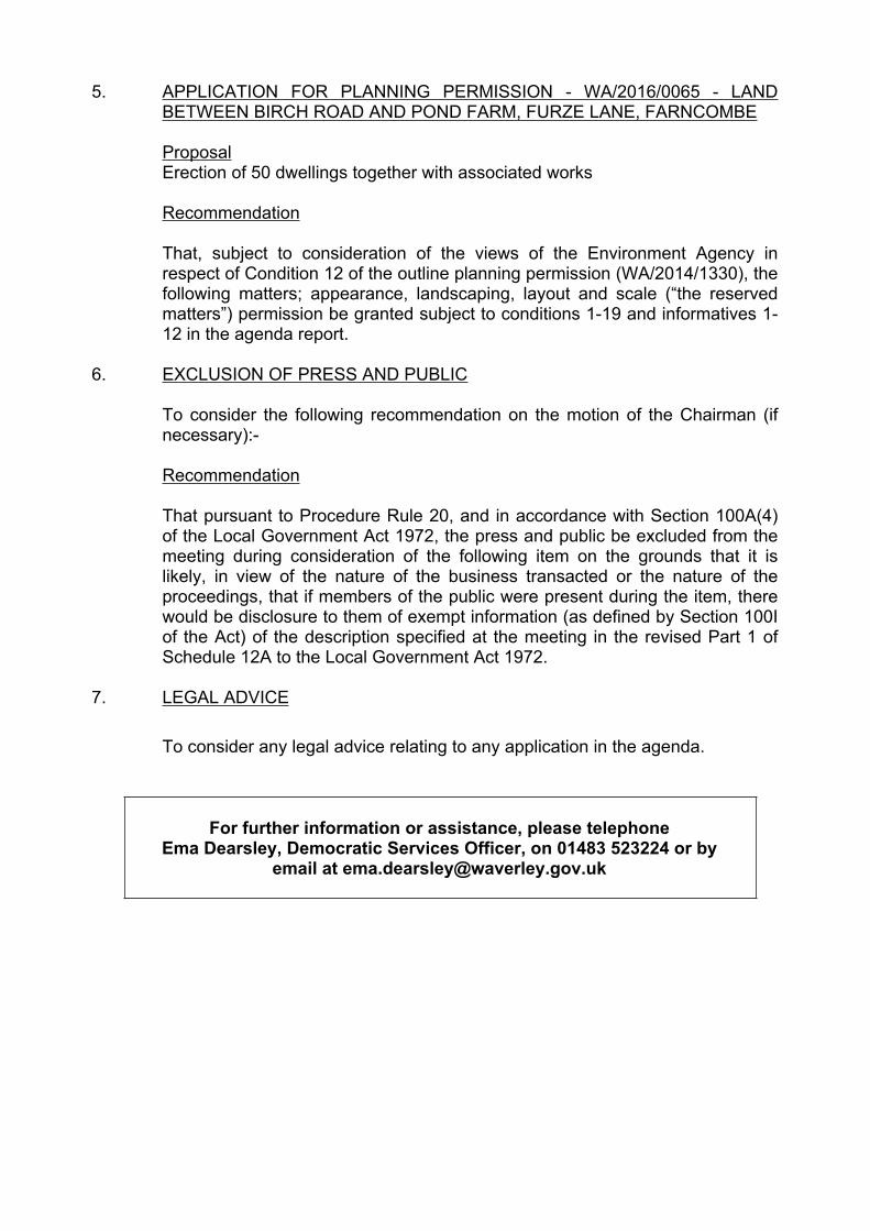
5. APPLICATION FOR PLANNING PERMISSION - WA/2016/0065 - LAND BETWEEN BIRCH ROAD AND POND FARM, FURZE LANE, FARNCOMBE
ProposalErection of 50 dwellings together with associated works
Recommendation
That, subject to consideration of the views of the Environment Agency in respect of Condition 12 of the outline planning permission (WA/2014/1330), the following matters; appearance, landscaping, layout and scale (“the reserved matters”) permission be granted subject to conditions 1-19 and informatives 1-12 in the agenda report.
6. EXCLUSION OF PRESS AND PUBLIC
To consider the following recommendation on the motion of the Chairman (if necessary):-
Recommendation
That pursuant to Procedure Rule 20, and in accordance with Section 100A(4) of the Local Government Act 1972, the press and public be excluded from the meeting during consideration of the following item on the grounds that it is likely, in view of the nature of the business transacted or the nature of the proceedings, that if members of the public were present during the item, there would be disclosure to them of exempt information (as defined by Section 100I of the Act) of the description specified at the meeting in the revised Part 1 of Schedule 12A to the Local Government Act 1972.
7. LEGAL ADVICE
To consider any legal advice relating to any application in the agenda.
For further information or assistance, please telephone Ema Dearsley, Democratic Services Officer, on 01483 523224 or by
email at [email protected]

1
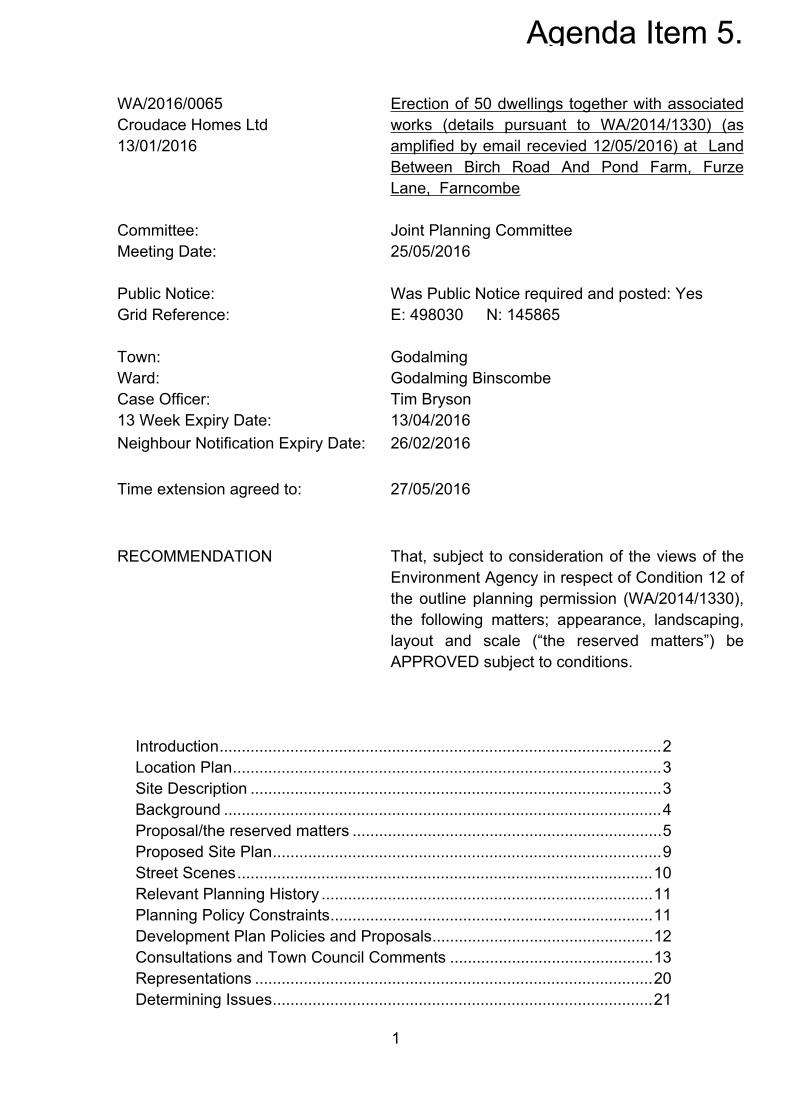
WA/2016/0065Croudace Homes Ltd13/01/2016
Committee:Meeting Date:
Erection of 50 dwellings together with associated works (details pursuant to WA/2014/1330) (as amplified by email recevied 12/05/2016) at Land Between Birch Road And Pond Farm, Furze Lane, Farncombe
Joint Planning Committee25/05/2016
Public Notice: Was Public Notice required and posted: YesGrid Reference: E: 498030 N: 145865
Town: GodalmingWard: Godalming BinscombeCase Officer: Tim Bryson13 Week Expiry Date: 13/04/2016Neighbour Notification Expiry Date: 26/02/2016
Time extension agreed to: 27/05/2016
RECOMMENDATION That, subject to consideration of the views of the Environment Agency in respect of Condition 12 of the outline planning permission (WA/2014/1330), the following matters; appearance, landscaping, layout and scale (“the reserved matters”) be APPROVED subject to conditions.
Introduction....................................................................................................2Location Plan.................................................................................................3Site Description .............................................................................................3Background ...................................................................................................4Proposal/the reserved matters ......................................................................5Proposed Site Plan........................................................................................9Street Scenes..............................................................................................10Relevant Planning History ...........................................................................11Planning Policy Constraints.........................................................................11Development Plan Policies and Proposals..................................................12Consultations and Town Council Comments ..............................................13Representations ..........................................................................................20Determining Issues......................................................................................21
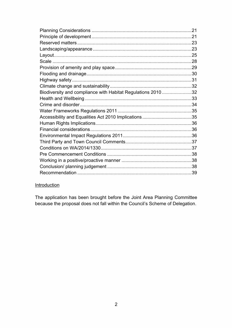
2
Planning Considerations .............................................................................21Principle of development .............................................................................21Reserved matters ........................................................................................23Landscaping/appearance ............................................................................23Layout..........................................................................................................25Scale ...........................................................................................................28Provision of amenity and play space...........................................................29Flooding and drainage.................................................................................30Highway safety ............................................................................................31Climate change and sustainability...............................................................32Biodiversity and compliance with Habitat Regulations 2010 .......................32Health and Wellbeing ..................................................................................33Crime and disorder......................................................................................34Water Frameworks Regulations 2011 .........................................................35Accessibility and Equalities Act 2010 Implications ......................................35Human Rights Implications..........................................................................36Financial considerations..............................................................................36Environmental Impact Regulations 2011.....................................................36Third Party and Town Council Comments...................................................37Conditions on WA/2014/1330......................................................................37Pre Commencement Conditions .................................................................38Working in a positive/proactive manner ......................................................38Conclusion/ planning judgement .................................................................38Recommendation ........................................................................................39
Introduction
The application has been brought before the Joint Area Planning Committee because the proposal does not fall within the Council’s Scheme of Delegation.

3
Location Plan
Site Description
The application site lies on the eastern side of Furze Lane and comprises 2.47 hectares of undeveloped agricultural land with a direct frontage onto Furze Lane measuring approximately 100m in length. The site is currently used for the occasional grazing of livestock. The lawful use appears to be for agricultural purposes.
The application site lies at the northern end of Furze Lane close to the ‘T’ junction with New Pond Road (B3000). New Pond Road provides a further connection to Guildford, Compton and the A3 trunk road.
The application site is rectangular in shape and is generally level throughout with the land gently sloping towards the north and northeastern boundaries. The western boundary of the site abuts Furze Lane and is delineated by a post and wire fence on the southern boundary is a mixture of hedging, trees and garden boundary fencing of properties situated along Birch Road. The eastern boundary of the site is delineated by a mixture of hedging and trees with a drainage ditch situated immediately beyond, which is outside of the application site. Beyond this is situated the rear gardens of properties along Birch Road, plus a small courtyard of private garages. The northern boundary of the site extends to the top of a drainage ditch/watercourse (within the applicant’s ownership), hedging and trees. Further north of the application site is agricultural land which is occupied as a small holding with New Pond Road (B3000) situated beyond.

4
The application site does not contain any significant trees or other features of note.
The administrative boundary between Waverley Borough and Guildford Borough runs along the northern boundary of the site.
Farncombe railway station is situated approximately 950m south of the application site and bus stops are located immediately outside of the application site on Furze Lane.
Background
Section 92 of the Town and Country Planning Act 1990 defines “Outline Planning Permission” as planning permission granted with the reservation for subsequent approval by the local planning authority of matters not particularised in the application (“reserved matters”).
Part 1 of the Town and Country Planning (Development Management Procedure) (England) Order 2015 defines “Reserved Matters” as access, appearance, landscaping, layout and scale. The Joint Planning Committee resolved to grant outline planning permission Ref WA/2014/1330 for up to 50 dwellings with access determined. The current application seeks the “reserved matters” (appearance, landscaping, layout and scale) for approval.
A definition for each of the reserved matters is contained within the Town and Country Planning (Development Management Procedure) (England) Order 2015 where it states:
“scale” means the height, width and length of each building proposed within the development in relation to its surroundings;
“appearance” means the aspects of a building or place within the developmentwhich determine the visual impression the building or place makes, including the external built form of the development, its architecture, materials, decoration, lighting, colour and texture;
“landscaping”, in relation to a site or any part of a site for which outline planning permission has been granted or, as the case may be, in respect of which an application for such permission has been made, means the treatment of land (other than buildings) for the purpose of enhancing or protecting the amenities of the site and the area in which it is situated and includes—
(a) screening by fences, walls or other means;

5
(b) the planting of trees, hedges, shrubs or grass;
(c) the formation of banks, terraces or other earthworks;
(d) the laying out or provision of gardens, courts, squares, water features,sculpture or public art; and
(e) the provision of other amenity features;
“layout” means the way in which buildings, routes and open spaces within thedevelopment are provided, situated and orientated in relation to each other and to buildings and spaces outside the development.
Whilst the above matters were “reserved” for further approval under the outline permission, access was the single matter that was included, considered and approved subject to the inclusion of relevant conditions. As such, the principle of the development and means of access have been approved and established. These matters are not therefore before the Committee for consideration under the current application.
In determining this application, it is relevant to consider whether there have been any material changes in planning circumstances since the outline planning permission reference WA/2014/1330 was granted. Since the granting of the outline planning permission, the Council’s Local Plan remains the same (2002) and the NPPF 2012 remains in force. It is considered that there has not been a material change in planning policy circumstances since the outline permission.
Members should note that if the reserved matters are approved, such an approval is not a planning permission in its own right but has to be read in conjunction with the outline planning permission. Planning conditions imposed on the outline planning permission will remain in force and would not therefore be repeated on any reserved matters approval.
Proposal/the reserved matters
This application comprises the information which was reserved for future consideration (reserved matters) by way of planning Condition 2 imposed on outline permission Ref WA/2014/1330. The reserved matters were appearance, landscaping, layout and scale. It is these matters which are now before the Committee for consideration.
6
The outline planning permission established the principle of the development and conditionally approved details of access, off site highway improvements and details of drainage and surface water run-off. These matters are the subject of planning conditions imposed upon the outline planning permission.
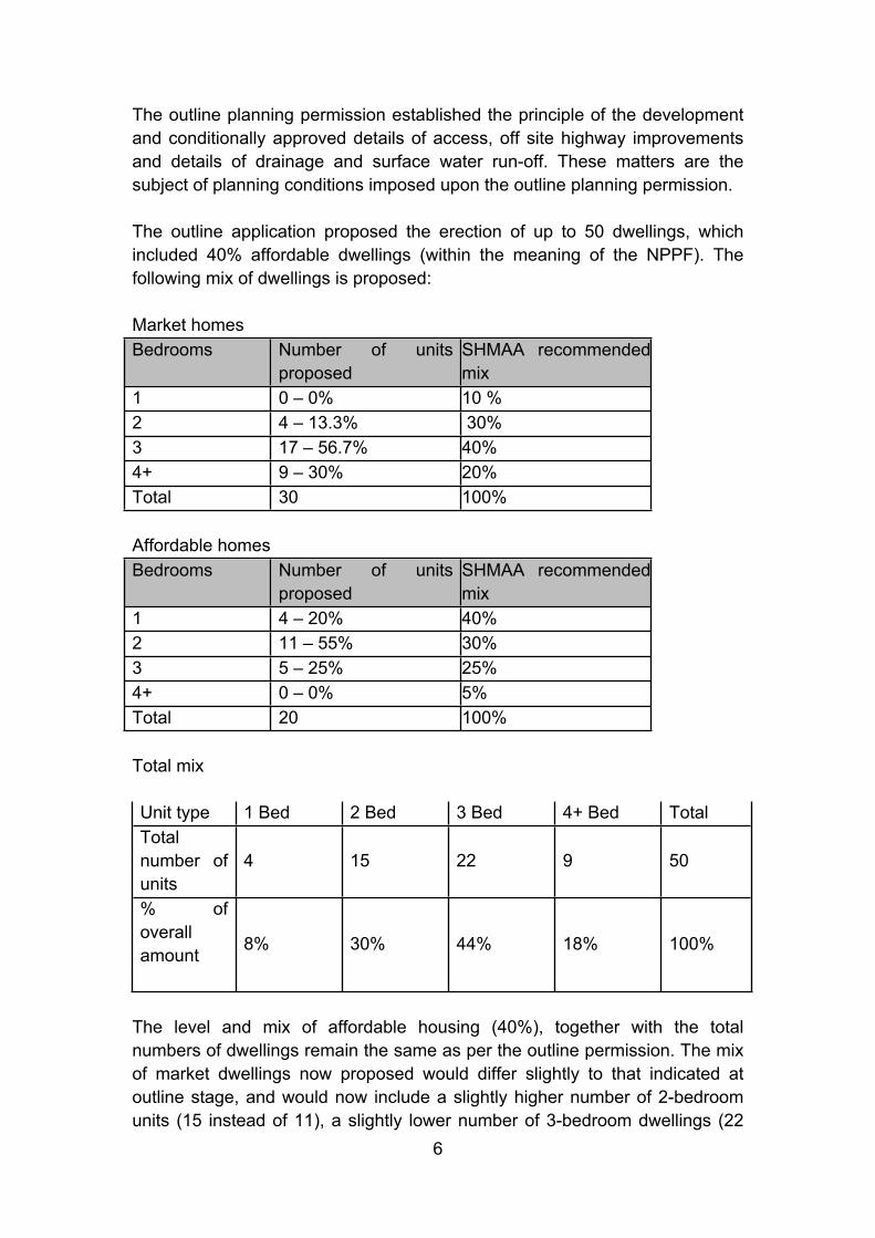
The outline application proposed the erection of up to 50 dwellings, which included 40% affordable dwellings (within the meaning of the NPPF). The following mix of dwellings is proposed:
Market homesBedrooms Number of units
proposedSHMAA recommended mix
1 0 – 0% 10 %2 4 – 13.3% 30%3 17 – 56.7% 40%4+ 9 – 30% 20%Total 30 100%
Affordable homesBedrooms Number of units
proposedSHMAA recommended mix
1 4 – 20% 40%2 11 – 55% 30%3 5 – 25% 25%4+ 0 – 0% 5%Total 20 100%
Total mix
Unit type 1 Bed 2 Bed 3 Bed 4+ Bed TotalTotal number of units
4 15 22 9 50
% of overall amount 8% 30% 44% 18% 100%
The level and mix of affordable housing (40%), together with the total numbers of dwellings remain the same as per the outline permission. The mix of market dwellings now proposed would differ slightly to that indicated at outline stage, and would now include a slightly higher number of 2-bedroom units (15 instead of 11), a slightly lower number of 3-bedroom dwellings (22

7
instead of 25) and 9 instead of 10 4-bedroom dwellings. However it is considered that this mix would remain broadly consistent with the requirements of the SHMA and Policy H4 by providing the greatest number of 2- and 3-bedroom dwellings.
1. Layout
The submitted plans show 50 dwellings spread within the site. The layout would be based around an internal road network toward the southern end of the site. The access point off Furze Lane roundabout has already been determined and accepted by the Council under the outline permission. The internal road network would comprise a single access road 5.0 m in width, which would turn within the site in a northern direction toward a turning area.
The majority of dwellings would be laid out with front elevations facing the internal road network apart from the side flank elevation for plot 49. Three dwellings would front Furze Lane (plots 1, 2 and 3).
Small pockets of courtyard-style parking areas would be spread within the layout. Each dwelling (including the 1-bedroom dwellings) would have a private outdoor amenity space and allocated vehicle parking.
The affordable housing would be fully integrated and would be spread throughout the site in three clusters.
Parking would be provided either within the front gardens of the properties or in parking forecourts.
The position of the proposed dwellings and internal infrastructure would be to the southern half of the site in order to avoid development within Flood Zones 2 or 3.
A Locally Equipped Area of Play (LEAP) is proposed in the northern part of the site, along with large area of open space which would be grassed.
2. Scale
The submitted plans show that the proposed dwellings would be two storeys in height, with single storey components (e.g. garaging, bay windows and porches). The height of the proposed dwellings would vary between 7.8 m – 8.8 m and would be two storey in appearance. A variety of design and scale of dwellings are proposed throughout the site. The dwellings would consist of a variety of detached, semi-detached and terraced properties.

8
The proposal includes 1.1 ha of greenspace and 1.37 ha of residential development (including access roads).
3. Landscape
The application plans show that the northern half of the site would be landscaped with natural grass surface with informal recreational paths and a LEAP. An emergency access gate would be provided in the north-west corner off Furze Lane. Additional tree planting and landscaping is proposed around the perimeters of the residential development.
Natural landscaped planting areas are proposed to the front of the dwellings which provide natural separation between car parking spaces in the streetscene. A feature ‘square’ is proposed on the internal access road which would have a different surfacing material to that of the access road and incorporate vehicle parking. This is proposed in order to provide a natural buffer to slow vehicle speeds within the site. Low level black railing is proposed to the front of Plots 1 – 3, which would provide a low level formal boundary treatment to the start of the residential development entrance. Brick walls and hedge planting is proposed to plot boundaries which front the internal road network. Further, walls and low level black railing would be used to separate the residential properties from the open space to the north. Each private amenity space would have natural grass surface.
The Design and Access Statement states that the following key principles have been applied to the landscaping;
The retention and enhancement of surrounding hedgerows and trees where appropriate to contribute toward local landscape character.
The maintenance of existing, and provision of new, tree and hedge planting to contribute to local micro-climate management.
The incorporation of new tree and shrub planting throughout the development to reduce the apparent scale of the development and assimilate it into this part of Godalming and the wider landscape.
The provision of a landscape which maintains and supports wildlife habitat and diversity, and
The provision of residential amenity to new residents.
4. Appearance
The proposal provides for several design types of dwellings throughout the site. The design of the dwellings would reflect traditional new build properties, with use of various traditional materials. Two different types of roof tile would be used: Redland Heathland Autumn tile and Redland Heathland Manor House Mix tile, both with a variety of dark orange colours. The elevations of

9
dwellings would comprise a mix of ivory render, clay tile hanging and facing brick. Single storey elements to some dwellings would have a sandtoft tile.
The roof forms of the dwellings would vary throughout the scheme, including barn-hip ends, fully hipped and vertical gable end roof designs. The same scale and design type of dwellings would be repeated throughout the scheme, but positioned in various plots on the site to ensure that variety of built form would be provided within the street scenes. Small features, such as chimneys, porches and bay windows, are proposed throughout the scheme to add individual character to each dwelling.
Then Design and Access Statement outlines that the proposal would take account of the local context to ensure that the design fits harmoniously into its surroundings.
Proposed Site Plan

10
Street Scenes
Street Scene 1:
Street Scene 2:
Street Scene 3:
Street Scene 4.1:
Street Scene 4.2:

11
Street Scene 5:
Street Scene 6:
Relevant Planning History
WA/2014/1330 Outline Application for the erection of up to 50 dwellings together with new access, parking, landscaping, open space, a children's play area and associated works with all matters reserved except access
Full Permission15/10/2015 – extant
SO/2013/0006 Request for Screening Opinion for the erection of 71 dwellings and associated works.
Screening Opinion Given12/07/2013 – does not require EIA
WA/1977/1104 Construction of permanent Guildway bungalow with garage and access (Outline)
Refused18/11/1977
GOD6490 Residential development – four houses to the acre
Refuse08/06/1960
Planning Policy Constraints
Countryside beyond Green Belt – outside of any defined settlementReserved Site under Policy H3 of the Waverley Borough Local Plan 2002Area of Great Landscape Value (AGLV)Section 106 agreement (WA/2014/1330)Neighbourhood Plan DesignationFlood Zone 3 (northern part of the site)Flood Zone 2 (northern part of the site)
12
Development Plan Policies and Proposals
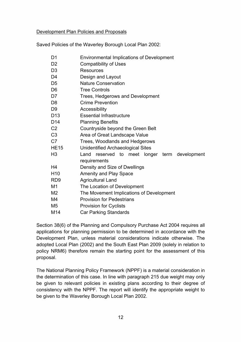
Saved Policies of the Waverley Borough Local Plan 2002:
D1 Environmental Implications of DevelopmentD2 Compatibility of UsesD3 ResourcesD4 Design and LayoutD5 Nature ConservationD6 Tree ControlsD7 Trees, Hedgerows and DevelopmentD8 Crime PreventionD9 AccessibilityD13 Essential InfrastructureD14 Planning BenefitsC2 Countryside beyond the Green BeltC3 Area of Great Landscape ValueC7 Trees, Woodlands and HedgerowsHE15 Unidentified Archaeological SitesH3 Land reserved to meet longer term development
requirementsH4 Density and Size of DwellingsH10 Amenity and Play SpaceRD9 Agricultural LandM1 The Location of DevelopmentM2 The Movement Implications of DevelopmentM4 Provision for PedestriansM5 Provision for CyclistsM14 Car Parking Standards
Section 38(6) of the Planning and Compulsory Purchase Act 2004 requires all applications for planning permission to be determined in accordance with the Development Plan, unless material considerations indicate otherwise. The adopted Local Plan (2002) and the South East Plan 2009 (solely in relation to policy NRM6) therefore remain the starting point for the assessment of this proposal. The National Planning Policy Framework (NPPF) is a material consideration in the determination of this case. In line with paragraph 215 due weight may only be given to relevant policies in existing plans according to their degree of consistency with the NPPF. The report will identify the appropriate weight to be given to the Waverley Borough Local Plan 2002.

13
The Council is in the process of replacing the adopted 2002 Local Plan with a new two part document. Part 1 (Strategic Policies and Sites) will replace the Core Strategy that was withdrawn in October 2013. Part 2 (Development Management and Site Allocations) will follow the adoption of Part 1. The new Local Plan will build upon the foundations of the Core Strategy, particularly in those areas where the policy/approach is not likely to change significantly. Public consultation on potential housing scenarios and other issues took place in September/October 2014. In the latest provisional timetable for the preparation of the Local Plan (Part 1), the Council is scheduled to approve the plan for publication in July 2016.
Other guidance:
National Planning Policy Framework (2012) National Planning Practice Guidance (2014) Strategic Housing Land Availability Assessment (2014) West Surrey Strategic Housing Market Assessment (2015) Infrastructure Delivery Plan (2012) Settlement Hierarchy (Draft 2010 and factual update 2012) Climate Change Background Paper (2011) Open Space, Sport and Recreation (PPG17) Study 2012 Statement of Community Involvement (2014 Revision) Strategic Flood Risk Assessment (2015) Affordable Housing Viability Assessment (Addendum 2010 and update
2012) Planning Infrastructure Contributions SPD (2008) Cycling Plan SPD (April 2005) Technical Space Standards DCLG Council’s Parking Guidelines (2013) Residential Extensions SPD (2010) Vehicular and Cycle Parking Guidance (Surrey County Council 2012) Waverley Local Plan Strategic Transport Assessment (Surrey County
Council, September 2014) Surrey Design Guide (2002) Surrey Hills Management Plan (2014-2019)
Consultations and Town Council Comments
Godalming Town Council
No objection although Town Councillors asked that particular attention be paid to the flood plain location and the impact of surface run-off and the maintenance of the means of run-off; and the proximity of vehicle access to Plot 3 to the current bus stop.
14
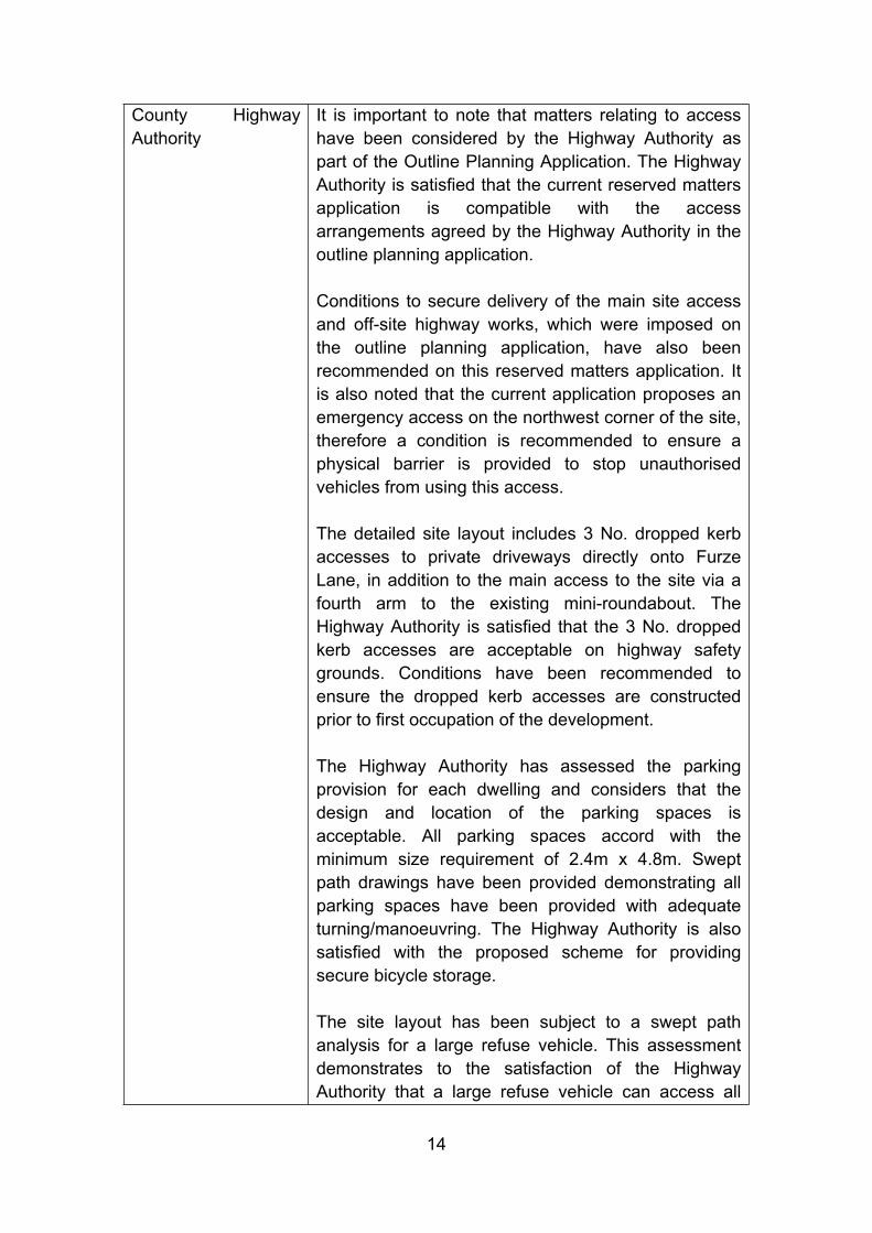
County Highway Authority
It is important to note that matters relating to access have been considered by the Highway Authority as part of the Outline Planning Application. The Highway Authority is satisfied that the current reserved matters application is compatible with the access arrangements agreed by the Highway Authority in the outline planning application.
Conditions to secure delivery of the main site access and off-site highway works, which were imposed on the outline planning application, have also been recommended on this reserved matters application. It is also noted that the current application proposes an emergency access on the northwest corner of the site, therefore a condition is recommended to ensure a physical barrier is provided to stop unauthorised vehicles from using this access.
The detailed site layout includes 3 No. dropped kerb accesses to private driveways directly onto Furze Lane, in addition to the main access to the site via a fourth arm to the existing mini-roundabout. The Highway Authority is satisfied that the 3 No. dropped kerb accesses are acceptable on highway safety grounds. Conditions have been recommended to ensure the dropped kerb accesses are constructed prior to first occupation of the development.
The Highway Authority has assessed the parking provision for each dwelling and considers that the design and location of the parking spaces is acceptable. All parking spaces accord with the minimum size requirement of 2.4m x 4.8m. Swept path drawings have been provided demonstrating all parking spaces have been provided with adequate turning/manoeuvring. The Highway Authority is also satisfied with the proposed scheme for providing secure bicycle storage.
The site layout has been subject to a swept path analysis for a large refuse vehicle. This assessment demonstrates to the satisfaction of the Highway Authority that a large refuse vehicle can access all

15
parts of the site, and enter and exit the site in forward gear.
No objection, subject to conditions and informatives.
Natural England Statutory nature conservation sites – no objection
Natural England has assessed this application using the Impact Risk Zones data (IRZs) and is satisfied that the proposed development being carried out in strict accordance with the details of the application, as submitted, will not damage or destroy the interest features for which Wey Valley Meadows has been notified. Therefore advises LPA that this SSSI does not represent a constraint in determining this application. Should the details of this application change, Natural England draws your attention to Section 28(I) of the Wildlife and Countryside Act 1981 (as amended), requiring the LPA to re-consult Natural England.
Protected landscapes
Having reviewed the application Natural England does not wish to comment on this development proposal. The development, however, relates to the Surrey Hills AONB. Therefore advise you to seek the advice of the AONB Office. Their knowledge of the location and wider landscape setting of the development should help to confirm whether or not it would impact significantly on the purposes of the designation. They will also be able to advise whether the development accords with the aims and policies set out in the AONB management plan.
Protected species
Has not assessed this application and associated documents for impacts on protected species.
Natural England has published Standing Advice on protected species. LPA should apply the Standing Advice to this application as it is a material consideration in the determination of applications in
16
the same way as any individual response received from Natural England following consultation. The Standing Advice should not be treated as giving any indication or providing any assurance in respect of European Protected Species (EPS) that the proposed development is unlikely to affect the EPS present on the site; nor should it be interpreted as meaning that Natural England has reached any views as to whether a licence is needed (which is the developer’s responsibility) or may be granted.
Local sites
If the proposal site is on or adjacent to a local site, e.g. Local Wildlife Site, Regionally Important Geological/Geomorphological Site (RIGS) or Local Nature Reserve (LNR) the authority should ensure it has sufficient information to fully understand the impact of the proposal on the local site before it determines the application.
Biodiversity enhancements
This application may provide opportunities to incorporate features into the design which are beneficial to wildlife, such as the incorporation of roosting opportunities for bats or the installation of bird nest boxes. The authority should consider securing measures to enhance the biodiversity of the site from the applicant, if it is minded to grant permission for this application. This is in accordance with Paragraph 118 of the National Planning Policy Framework. Additionally, we would draw your attention to Section 40 of the Natural Environment and Rural Communities Act (2006).
Landscape enhancements
This application may provide opportunities to enhance the character and local distinctiveness of the surrounding natural and built environment; use natural resources more sustainably; and bring benefits for the
17
local community, for example through green space provision and access to and contact with nature. Landscape characterisation and townscape assessments, and associated sensitivity and capacity assessments provide tools for planners and developers to consider new development and ensure that it makes a positive contribution in terms of design, form and location, to the character and functions of the landscape and avoids any unacceptable impacts.
Environment Agency The planning application falls outside of its remit as a statutory planning consultee.
No comments to make. County Rights of Way Officer
No comments received.
Thames Water Waste commentsRecommend Grampian style condition be imposed should permission be granted.
Surface water drainageRecommended that the applicant should ensure that storm flows are attenuated or regulated into the receiving public network through on or off site storage. When it is proposed to connect to a combined public sewer, the site drainage should be separate and combined at the final manhole nearest the boundary. Connections are not permitted for the removal of groundwater. Where the developer proposes to discharge to a public sewer, prior approval from Thames Water Developer Services will be required.
Approval should be sought from Thames Water where the erection of a building would come within 3 metres of a public sewer.
Recommend informative
Surrey Wildlife Trust The Trust would advise that the Preliminary Ecological Appraisal Report by Thomson Ecology dated November 2015, which the applicant has provided in support of the above outline planning application, provides much useful information for the Local
18
Authority to be able to start to assess the potential status of protected and important species on the proposed development site and the likely effect of the development on them.
Therefore advises the Local Authority, that should they be minded to grant this planning application for this site, the applicant should be required to undertake all the recommended actions in section 6. (Recommendations) of the Report, including the biodiversity enhancements detailed in sub-sections 6.2.
This will help prevent adverse effect to legally protected species resulting from the proposed development works and help to off-set adverse effects to the biodiversity value of the site resulting from the proposed development.
The applicant does not appear to have specifically addressed SWT’s comments made in response to the Outline application for this site (WA/2014/1330) dated 4th March 2015.
County Archaeologist No objection – recommends condition. Crime Prevention Design Advisor
Surrey Police requests that the developers seek Secured by Design accreditation for this development. SBD NH 2014 (Secured by Design New Homes 2014) gives guidance around layout as well as the physical security of the buildings.
Compton Parish Council
No comments received.
Shalford Parish Council
Object.Volume of discharge water from the development.The water storage capacity of the development will need to be increased significantly in order for the development to comply with clause 20.This needs to be agreed before the development starts and with additional space allocated to it. No SUDS scheme plans to comment on.
Guildford Borough Council
No comments have been received.
19
Council’s Environmental Health Officer (Air Quality)
No objection subject to conditions.
The planning application proposes to increase accommodation at this location with the addition of 50 houses on agricultural land. The area surrounding the proposed site is currently and predominantly residential; therefore, future use of the site is unlikely to adversely affect the nature of the area. However, as the works are being carried out, should levels of noise from the site be excessive, there will be little respite for the existing residents.
The application does not specify the type of work or equipment in conjunction with this application, but is considered likely to be above the significant observed adverse effect level due to the nature of the works. Conditions recommended.
Council’s Environmental Health Officer (Pollution Control)
No objection – recommends conditions
Council’s Environmental Health Officer (Waste and Recycling)
Advice given on bins per household and that the road should be capable of accommodating a collection vehicle and suitable turning provision to be included.
Network Rail No objection.Director of Public Health, Surrey County Council
No comments received.
NHS England No comments received.Guilford and Waverley Clinical Commissioning Group
No comments received.
Health Watch No comments received.AONB Officer Whilst the site was allocated in the 2002 Local Plan as
a reserve housing site and outline planning permission for housing has been permitted, it is still within the AONB, as too is the neighbouring land to the north within the Borough of Guildford.
The landscaping proposals include not as much tree
20
planting in the northern part of the site that borders land also in the AONB as would have expected. Suggests that in order to provide an effective screen of the development from the remaining AONB to the north, the proposals should include the planting of additional native trees.
Lead Local Flood Authority (Surrey County Council)
No comments received.
Representations
In accordance with the statutory requirements and the “Reaching Out to the Community – Local Development Framework – Statement of Community Involvement – August 2014” the application was advertised in the newspaper on 05/02/2016, site notices were displayed around the site and neighbour notification letters were sent on 25/01/2016.
11 letters have been received raising objection on the following grounds: Serious flooding on the site. Footings from the dwellings will prevent the existing land from taking up
any surplus rain water thus increasing flooding to adjoining properties. Who will be responsible for damage to neighbouring properties? Flooding will get worse if developer directs rain water to drainage ditch. Increased water flow into culvert. Doctors and schools capacity problems. Increase in traffic onto Pond Road. Impact on road infrastructure. Sewage problems. Overlooking. Out of keeping. Noise and disturbance from use of wheelie bins. Density too high. Concerns over maintenance of the surface water run-off systems. Conflict with NPPG Developer should not be allowed put drainage system within flood
zone. Proposal does not meet requirements of clause 20 of 14/1330. Overbearing and cramped form of development. Need to review telecommunications network capacity. Culvert capacity could not take the level of outflow.

21
Aware of court case Bybrook Barn Garden Centre and others v Kent CC.
Contamination. Dwellings proposed outside of Flood Zone 1.
Determining Issues
Principle of developmentLandscaping/appearance- Design/Impact on Visual Amenity- Impact on residential amenityLayout- Design/Impact on visual amenity- Impact on residential amenity- Parking ProvisionsScale- Design/Impact on visual amenity- Impact on residential amenityClimate change and sustainabilityBiodiversity and compliance with Habitat Regulations 2010Effect upon Special Protection AreaCrime and disorderWater Frameworks Regulations 2011Accessibility and Equalities Act 2010 ImplicationsHuman Rights ImplicationsFinancial considerationsEnvironmental Impact Regulations 2011Waste (England and Wales) Regulations 2011Third Party and Parish Council CommentsConditions on WA/2014/1330Pre Commencement ConditionsWorking in a positive/proactive manner
Planning Considerations
Principle of development
This application is for reserved matters following an outline planning permission reference WA/2014/1330. Therefore, the principle of development has already been established and only the reserved matters are to be considered in the assessment of this application. The matters which have been reserved for consideration are the appearance, landscaping, layout and
22
scale of development. The report will consider the reserved matters in turn, in addition to any other relevant considerations.
The NPPF attaches great importance to the design of the built environment as a key part of sustainable development. Although planning policies and decisions should not attempt to impose architectural styles or particular tastes, they should seek to promote or reinforce local distinctiveness. Policies D1 and D4 of the Local Plan 2002 accord with the NPPF in requiring development to have a high quality design and to be well related in size, scale and character to its surroundings.
The NPPF identifies that within the overarching roles that the planning system ought to play, a set of core land use planning principles should underpin both plan making and decision making. These 12 principles include that planning should seek to secure a good standard of amenity for all existing future occupants of land and buildings.
The principles are supported by Policies D1 and D4 of the Local Plan and guidance contained within the Council’s SPD for Residential Extensions. Policy D4 of the Local Plan outlines the Council’s overarching guidance regarding the design and layout of development, and states under criterion c) that development should not significantly harm the amenities of occupiers of neighbouring properties by way of overlooking, loss of daylight or sunlight, overbearing appearance or other adverse environmental impacts. Similarly, Local Plan Policy D1, which outlines the considerations the Council will have to the environmental implications of development, states that development will not be permitted where it would result in material loss of general amenity, including material loss of natural light and privacy enjoyed by neighbours and disturbance resulting from the emission of noise, light or vibration.
Paragraphs 56 to 68 of the NPPF refer to requiring good design. These principles are taken forward from guidance previously contained in PPS1 on ‘Delivering Sustainable Development’.
Paragraph 56 states that the Government attaches great importance to the design of the built environment and that food design is a key aspect of sustainable development.
Paragraph 58 sets out that planning policies and decisions should aim to ensure that development:
Will function well and add to the overall quality of the area, not just for the short term but over the lifetime of the development;
Establish a strong sense of place, using streetscapes to create attractive and comfortable places to live, work and visit;

23
Optimise the potential of the site to accommodate development, create and sustain an appropriate mix of uses and support local facilities and transport networks;
Respond to local character and history, and reflect the identity of local surroundings and materials, while not preventing or discouraging appropriate innovation;
Create safe and accessible environments; Are visually attractive as a result of good architecture and appropriate
landscaping.
Paragraph 64 states that permission should be refused for development of poor design that fails to take opportunities available for improving the character and quality of an area and the way it functions.
Paragraph 65 states that local planning authorities should not refuse planning permission for buildings or infrastructure which promote high levels of sustainability because of concerns about incompatibility with an existing townscape.
Policies D1 and D4 of the Local Plan state that the Council will ensure that development is of a high quality design which integrates well with the site and complements its surroundings.
Reserved matters
Landscaping/appearance
a) design/impact on visual amenity
The NPPF attaches great importance to the design of the built environment as a key part of sustainable development. Although planning policies and decisions should not attempt to impose architectural styles or particular tastes, they should seek to promote or reinforce local distinctiveness. Policies D1 and D4 of the Local Plan 2002 accord with the NPPF in requiring development to have high quality design and to be well related in size, scale and character to its surroundings.
The main public views into the site would be from Furze Lane, and wider long distance views from New Pond Road to the north. North and east of the site lies open field. The proposal would position the residential dwellings toward the southern side of the site, where existing residential development lies beyond to the south. The northern part of the site would be landscaped with natural grass surface to provide a communal open space. The provision of the open space and landscaping in the northern part of the site would provide a
24
buffer to the open fields north of the site. Further, landscaping is proposed along the western boundary, comprising a mix of planting and low level black railings. This would help provide a soft frontage to the three dwellings which would front Furze Lane and the main site entrance. Soft landscaping is proposed to the front of dwellings within the site.
The individual dwellings would be two storeys in height with elevations broken up and a variety of traditional materials, including render, brick and tiles, would be used. This would reflect the local pallet in the area. The buildings would further have roof forms which are typical of the Surrey Vernacular. The site would be inward looking and centred around the main internal access road. This would give the development a sense of cohesion with existing neighbouring development south of the site on Birch Road.
The site lies within the designated AGLV. The Surrey Hills AONB Officer has commented on the application and advises that additional tree planting should be included in the northern part of the site to provide effective screening from the north. Officers note these comments, however, the northern part of the site would provide informal recreational footpaths and communal open space for use by the future residents. A natural tree line exists along the north boundary and the additional tree planting would help re-inforce this natural tree line. A condition is therefore recommended securing a tree planting plan.
The main trees on site are present around the site boundaries. The proposal would include the pruning and crown lifting of several trees along the south and east boundaries. The trees along the north boundary would remain and would not be affected by the proposed residential development. Overall, and subject to the imposition of suitable protection measures, officers are satisfied that the proposed layout and landscaping would respect the key trees on and off site.
Overall, officers are satisfied that the proposed landscaping and appearance details are compliant with Policies D1, D4 and C3 of the Local Plan and would harmonise with the local surroundings and proposed residential development.
b) Impact on residential amenity
The NPPF identifies that within the overarching roles that the planning system ought to play, a set of core land use planning principles should underpin both plan-making and decision making. These 12 principles include that planning should seek to secure a good standard of amenity for all existing and future occupants of land and buildings. These principles are supported by Policies D1 and D4 of the Local Plan and guidance contained within the Council’s SPD for Residential Extensions.

25
It is considered that as far as the landscaping is concerned, the proposal would not include landscaping aspects which would cause material harm to neighbouring residential occupiers. The landscaping would therefore comply with Policies D1 and D4 with respect to impact upon residential amenity.
Layout
a) Design/Impact on visual amenity
The layout of the buildings and routes and open spaces would provide a permeable development which would enhance the settings of the individual buildings and provide a residential development which would contribute toward the surrounding residential area. The layout of the buildings would face the internal road network and provide private rear gardens. A number of the rear gardens would adjoin the south and east boundaries, where beyond lie neighbouring residential gardens. The layout would be commensurate with the local area, centred around a simplistic access road.
The proposal would utilise several designs of dwellings and sited each throughout the scheme, providing a variety to the streetscenes and overall character of the development. Officers consider that the layout and position of dwelling type proposed would provide a residential development of visual interest which would contribute positively to the local area, creating a sense of place.
The open space in the northern part of the site would be separated from the residential development and access road with a variety of boundary treatments. Pedestrian access on to the open space would be via 3 points within the site. The use of various boundary treatments would allow for subtle division between the residential development, access road and the open space/LEAP, whilst ensuring no vehicles could park on the open space. The position of the LEAP would ensure that it is sited away from the main road, whilst being accessible via pedestrian links and overlooked by residential dwellings for natural surveillance.
Vehicle parking at the front of residential properties would be broken up with natural landscaping areas. Courtyard style parking layout areas would be well hidden within the scheme, and would not result in large expanses of hard-standing due to their relatively low numbers of spaces provided in each of the courtyards.
There would be space within the individual gardens for the storage of bins for refuse and recycling (as shown on the submitted refuse storage plan). A
26
condition could be recommended, in the event that the reserved matters are approved, requiring the provision of the refuse/recycling storage.
The layout would be appropriate having regard to the character of the area and would represent an appropriate transition with the surrounding countryside. The provision of open space in the northern part of the site would provide a visual enhancement to both the existing landscape and to the amenities of future occupiers of the dwellings.
The proposed layout of the development is considered to comply with Policies D1 and D4 of the Local Plan and the NPPF 2012.
b) Impact on residential amenity
Individual dwellings would be orientated to make use, where possible, of solar gains. The extensive area of open space with individual secure gardens would ensure that there would be adequate amenity space for the future occupiers of the units.
The proposed layout and position of plots 4 – 27 would be such that the rear gardens would adjoin the existing rear gardens of properties in Birch Road to the south. The proposed position of these dwellings would remain compliant with the Council’s guideline of a separation distance of 21 m being maintained between new windows and neighbouring windows. The closest position of a new dwelling to the south boundary would be Plot 23. The south elevation of this proposed dwelling would be the side elevation and would have 1 first floor bathroom window. Officers are therefore satisfied that no material overlooking would from this neighbouring window, subject to it being obscurely glazed.
The southern boundary treatment would comprise a mixture of hedging, fencing and trees. Some of the trees are not within the ownership of the site. The position of the proposed dwellings at plots 4 – 27 is such that the rear elevations at first floor level would be visible from the rear gardens of the existing properties on Birch Road. However, owing to the proposed separation distance and overall height of the proposed dwellings, officers are satisfied that the layout would not cause planning harm by way of overlooking or loss of daylight or sunlight to the existing neighbouring plots to the south. The view from the rear outlook from these neighbouring properties would be affected; however, the loss of a view is not a material planning consideration.
Plot 3 would be sited north of 61 Furze Lane. Plot 3 would be sited over 4.5 m from the shared southern boundary and would not project beyond the rear building line of number 61. Officers are satisfied this relationship would be
27
acceptable and no material harm would be caused to the amenities of number 61.
Plot 29 would be sited up to 2.0 m (at its closest) from the eastern boundary. The immediate area beyond the site at this location comprises single storey garaging and hardstanding for vehicle access/parking. Beyond this area lie the rear gardens of residential properties. Owing to the separation distances, officers are satisfied that the position of this proposed dwelling in relation to the eastern boundary is acceptable.
Plot 28 would be sited 4.5 m to the eastern boundary at its closest point. The rear-most elevation, closest to the boundary would not have any first floor windows. Whilst the recessed east facing elevation would feature first floor windows, owing to the separation distance proposed to the boundary, officers are satisfied that there would be no material harm by way of overlooking or loss of light to number 47 Birch Road.
Overall, the distances between the proposed dwellings and neighbouring dwellings, and the orientation of the dwellings, would not lead to materially harmful relationships, including overlooking or dominance both to new and existing dwellings.
The layout would therefore comply with Policies D1 and D4 of the Local Plan and the NPPF 2012 with respect to residential amenity.
c) Parking Provisions
The NPPF supports the adoption of local parking standards for both residential and non-residential development. The Council has adopted a Parking Guidelines Document which was prepared after the Surrey County Council Vehicular and Cycle Parking Guidance in January 2013. Development proposals should comply with the appropriate guidance as set out within these documents.
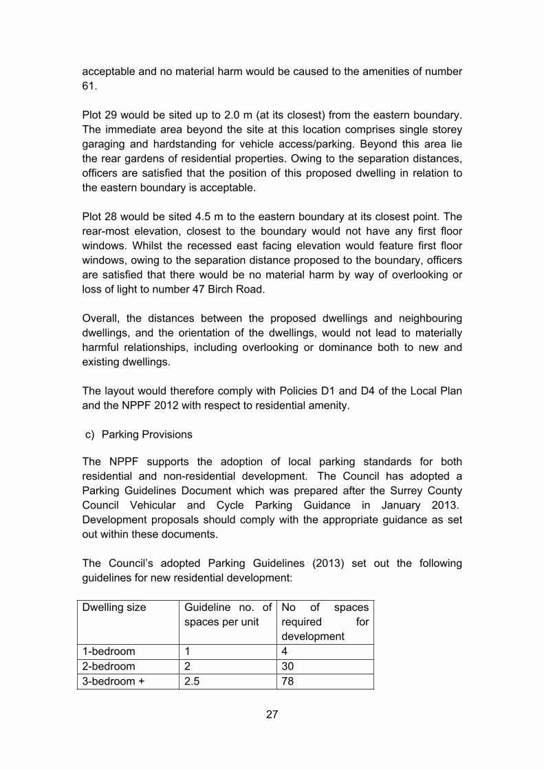
The Council’s adopted Parking Guidelines (2013) set out the following guidelines for new residential development:
Dwelling size Guideline no. of spaces per unit
No of spaces required for development
1-bedroom 1 42-bedroom 2 303-bedroom + 2.5 78
28
The Parking Guidelines indicate that proposal would generate a need for 112 parking spaces to be provided. The proposal would provide 119 on-site vehicle parking in accordance with the above guidelines, including 10 visitor spaces. The applicants have provided a parking strategy plan, which outlines and labels each proposed vehicle parking space for each proposed dwelling. A number of spaces would be achieved through tandem parking, including integral garaging. Officers are satisfied that the development would not be dominated by vehicle parking and that vehicle parking spaces would be well integrated within the scheme. The visitor parking spaces would be spread throughout the site, with a number of them in a ‘lay-by’ format at the northern part of the site. A suitably worded condition ensuring the integral garages could not be converted to habitable accommodation is recommended by officers to ensure that the level of vehicle parking within the development remains compliant with Council guidelines, in the event that reserved matters approval is given
Cycle storage is proposed within each residential plot, either within the integral garaging or in rear gardens.
As such, the proposal would comply with Policies M1 and M14 of the Waverley Borough Local Plan 2002 and the Council’s Parking Guidelines 2013.
Scale
a) Design/Impact on visual amenity
The individual dwellings would be two storeys in height. The widths and length of the buildings would be in proportion to their height. Although the properties on Birch Road to the south are predominantly bungalows, there are a number of chalet bungalows with first floor accommodation. There are two storey properties present on Furze Lane and beyond the site to the east on Birch Road. The scale of the individual dwellings would be proportionate to the plot size. Sufficient spacing would be proposed between each dwelling and where groups of dwellings are proposed, these would be in small terraces of 3 properties. The use of single storey garaging in between dwellings would help reduce terracing effect within the site. The building heights of the dwellings would not be out of keeping with typical two storey dwellings in the local surrounding area.
Each individual residential plot would accommodate off-road vehicle parking, private amenity space of sufficient size and cycle/bin storage. The scale of the proposed development is considered to be commensurate with the local surrounding area and would not result in visual harm.

29
b) Impact on residential amenity
The scale of the proposed residential development demonstrates that sufficient spacing would be achieved between new dwellings and existing neighbouring properties. The two storey height of the dwellings maintains outlook from properties to be at ground and first floor only.
Overall, officers are satisfied that the proposed scale of the development can be accommodated on site without causing material harm to surrounding residential occupiers amenities, in accordance with Policies D1 and D4 of the Local Plan.
Provision of amenity and play space
On promoting healthy communities, the NPPF sets out that planning policies and decisions should aim to achieve places which promote safe and accessible developments, with high quality public space which encourage the active and continual use of public areas. These should include high quality open spaces and opportunities for sport and recreation which can make an important contribution to the health and well-being of communities.
Policy H10 of the Local Plan addresses amenity and play space in housing developments. Although there are no set standards for garden sizes, the policy requires that a usable ‘outdoor area’ should be provided in association with residential development and that ‘appropriate provision for children’s play’ is required.
It is indicated that each proposed dwelling would have a private outdoor amenity space (including the four 1-bedroom dwellings).
The proposal includes the provision of a locally equipped area of play (LEAP). This would be located to the north of the dwellings, set well within the site away from the main road. Officers are satisfied that the location of the LEAP would be suitable and well linked via informal recreational footpaths within the site. The LEAP would be naturally overlooked by plots 29 to 34.
The proposal also includes the provision of a large area of communal open space. This is considered to provide a significant benefit to the future occupiers of the dwellings as well as existing neighbouring properties, and could be used for informal recreation.
Overall, officers are satisfied the proposal provides good amenity space for future occupiers and is compliant with Policy H10 and the NPPF.

30
Flooding and drainage
The application is a ‘reserved matters’ application where landscaping, scale, design and appearance are for determination. The matter of flood risk and drainage was considered under the outline permission WA/2014/1330. A number of conditions were recommended in this respect, following consultation with relevant statutory bodies.
Condition 11 – requirement to carry out mitigation measures (finished floor levels) in accordance with details in FRA
Condition 12 – requirement to confirm that no land raising will take place outside of Flood Zone 1, prior to application for reserved matters
Condition 20 – requirement to submit a surface water drainage scheme prior to commencement of development
Condition 21 – requirement to submit a foul water drainage scheme prior to commencement of development
Condition 22 – requirement to submit details of SUDS and/or off site drainage works, prior to commencement of development
Condition 23 – requirement to undertake Impact Studies of the existing water supply infrastructure, prior to commencement of development
Condition 24 – requirement to submit a pollution prevention strategy to detail control measures to minimise the impact of the development on local ground water during and after construction, prior to commencement of development.
The application does include details to satisfy condition 12 of the outline permission and officers are satisfied that no land raising to take place outside of flood zone 1 as detailed on plan number DES/010/111/A, which shows details of the proposed finished levels for the proposed residential development and LEAP. Officers are satisfied that this information satisfies this condition, however, a response from the Environment Agency is still outstanding and an oral report will be made to committee.
With regards to condition 22, the applicant’s agents have confirmed that the proposed layout scheme submitted with this application has been designed to take account of the SuDS strategy indicated in the outline permission, namely the use of cellular storage and permeable paving.
31
Whilst conditions on an outline permission can be discharged through a reserved matters permission, this cannot be insisted upon by the Local Planning Authority and the applicant will still be required to discharge any outstanding conditions on the outline permission, as well as any further conditions appended to a reserved matters permission.
Overall, all matters of flood risk and drainage are to be secured via the above conditions and are not to be determined under the current reserved matters application.
Highway safety
The National Planning Policy Framework 2012 outlines that transport policies have an important role to play in facilitating sustainable development but also in contributing to wider sustainability and health objectives. In considering developments that generate significant amounts of movements local authorities should seek to ensure they are located where the need to travel will be minimised and the use of sustainable transport modes can be maximised. Plans and decisions should take account of whether improvements can be taken within the transport network that cost-effectively limit the significant impact of the development.
Paragraph 32 of the NPPF states: “All developments that generate significant amounts of movement should be supported by a Transport Statement or Transport Assessment. Plans and decisions should take account of whether:
the opportunities for sustainable transport modes have been taken up depending on the nature and location of the site, to reduce the need for major transport infrastructure;
safe and suitable access to the site can be achieved for all people; and improvements can be undertaken within the transport network that cost
effectively limit the significant impacts of the development.
Development should only be prevented or refused on transport grounds where the residual cumulative impacts of development are severe”.
Local Plan Policy M4 states that the Council will seek to improve conditions for pedestrians by providing or securing safe and attractive pedestrian routes and facilities in both urban and rural areas. Developments should include safe, convenient and attractively designed pedestrian routes linking to existing or proposed pedestrian networks, to public open space, to local facilities and amenities, or to public transport.
32
The main vehicle access to the site has already been granted under the outline planning application. Taking into account the proposed fixed layout and sizes of dwellings, the CHA is satisfied that the detailed access road directly on to the existing roundabout on Furze Lane would be acceptable.
The detailed site layout includes 3 No. dropped kerb accesses to private driveways directly onto Furze Lane to serve plots 1, 2 and 3, in addition to the main access to the site via a fourth arm to the existing mini-roundabout. The CHA is satisfied that the 3 No. dropped kerb accesses would be acceptable on highway safety grounds. Conditions have been recommended to ensure the dropped kerb accesses are constructed prior to first occupation of the development. Officers note that the dropped kerb vehicle access for plot 3 would be in close proximity to a bus stop. The bus stop is a standing stop and officers do not consider that this would lead to a material conflict arising between users, such that this element of the scheme could be objected to.
The applicants have demonstrated through a swept path analysis plan that a refuse truck could enter and leave the site safely in a forward gear.
Subject to compliance with the recommended conditions from the County Highway Authority, officers are satisfied that the proposed layout, vehicle and pedestrian road access and driveways access to the dwellings would be safe in terms of highway safety. The proposal is considered to be compliant with Policies M2 and M4 of the Local Plan and the NPPF.
Climate change and sustainability
The Local Plan does not require this type of development to achieve a particular rating of the Code for Sustainable Homes or include renewable energy technologies. The lack of any policy backing in this regard, therefore, prevents conditions being added to require this.
Biodiversity and compliance with Habitat Regulations 2010
The NPPF requires that when determining planning application, local planning authorities should aim to conserve and enhance biodiversity by applying the following principles:
If significant harm resulting from a development cannot be avoided (through locating on an alternative site with less harmful impacts), adequately mitigated, or, as a last resort, compensated for then planning permission should be refused.
33
In addition, Circular 06/2005 states ‘It is essential that the presence or otherwise of protected species and the extent that they may be affected by the proposed development, is established before planning permission is granted.’
The application property does not fall within a designated SPA, SAC, SNCI or SSSI. It is not within 200m of ancient woodland or water, and is not an agricultural building or barn. The application has been accompanied with an ecological appraisal (dated November 2015). The Surrey Wildlife Trust has commented on the application and has outlined that should the LPA grant permission then the applicant be required to undertake the recommended actions in section 6 of the ecological report. Compliance with this report is controlled by condition 10 on the outline permission.
Health and Wellbeing
Local Planning Authorities should ensure that health and wellbeing, and health infrastructure are considered in local and neighbourhood plans and in planning decision making. Public health organisations, health service organisations, commissioners and providers, and local communities should use this guidance to help them work effectively with local planning authorities in order to promote healthy communities and support appropriate health infrastructure.
The NPPG sets out that the range of issues that could be considered through the plan-making and decision-making processes, in respect of health and healthcare infrastructure, include how:
development proposals can support strong, vibrant and healthy communities and help create healthy living environments which should, where possible, include making physical activity easy to do and create places and spaces to meet to support community engagement and social capital;
the local plan promotes health, social and cultural wellbeing and supports the reduction of health inequalities;
the local plan considers the local health and wellbeing strategy and other relevant health improvement strategies in the area;
the healthcare infrastructure implications of any relevant proposed local development have been considered;
opportunities for healthy lifestyles have been considered (e.g. planning for an environment that supports people of all ages in making healthy choices, helps to promote active travel and physical activity, and promotes

34
access to healthier food, high quality open spaces and opportunities for play, sport and recreation);
potential pollution and other environmental hazards, which might lead to an adverse impact on human health, are accounted for in the consideration of new development proposals; and
access to the whole community by all sections of the community, whether able-bodied or disabled, has been promoted.
The Council sought the views of NHS England, Health Watch, Guildford and Waverley Clinical Commissioning Group and the Director of Public Health for Surrey during the consideration of the outline planning application and under this reserved matters application. These bodies have not raised comment on the proposal and therefore no infrastructure is considered to be required in respect of health and well-being.
The provision of open space in the scheme, provision of LEAP and private outdoor amenity space for the dwellings is considered to be positive in terms of the health and well being of future residents.
Officers conclude that the proposed development would ensure that health and wellbeing, and health infrastructure have been suitably addressed in the application.
Crime and disorder
S17(1) of the Crime and Disorder Act 1998 places a duty to consider crime and disorder implications on local authorities. In exercising its various functions, each authority should have due regard to the likely effect of those functions on, and the need to do all that it can to prevent, crime and disorder in its area. This requirement is reflected in the National Planning Policy Framework, which states that planning policies and decisions should promote safe and accessible environments where crime and disorder, and the fear of crime, do not undermine quality of life or community cohesion.
Paragraph 69 of the National Planning Policy Framework 2012 highlights that the planning system can play an important role in facilitating social interaction and creating healthy, inclusive communities.
To this end, planning policies and decisions should aim to achieve places which promote inter alia safe and accessible environments where crime and disorder, and the fear of crime, do not undermine quality of life or community cohesion.
35
The proposal has been designed to have an active internal road frontage, with the fronts of dwellings facing the road. Further, the open space and LEAP to the north of the site would be sufficiently overlooked, providing a natural surveillance across these communal areas. The Crime Prevention Design Officer has recommended that the final build is designed in accordance with the Secure by Design Standards. Overall, officers are satisfied the proposal would create a sense of community and place within the site and is of an appropriate layout which would not lead to crime and disorder in the wider community. Water Frameworks Regulations 2011
The European Water Framework Directive came into force in December 2000 and became part of UK law in December 2003.
It gives us an opportunity to plan and deliver a better water environment, focusing on ecology. It is designed to:
enhance the status and prevent further deterioration of aquatic ecosystems and associated wetlands which depend on the aquatic ecosystems
promote the sustainable use of water reduce pollution of water, especially by ‘priority’ and ‘priority hazardous’
substances ensure progressive reduction of groundwater pollution
The proposal would not conflict with these regulations.
Accessibility and Equalities Act 2010 Implications
Policy D9 of the Waverley Borough Local Plan encourages and seeks provision for everyone, including people with disabilities, to new development involving buildings or spaces to which the public have access.
Officers consider that the proposal complies with this policy. A full assessment against the relevant Building Regulations would be captured under a separate assessment should permission be granted.
From the 1st October 2010, the Equality Act replaced most of the Disability Discrimination Act (DDA). The Equality Act 2010 aims to protect disabled people and prevent disability discrimination.
36
Officers consider that the proposal would not discriminate against disability. It is considered that there would be no equalities impact arising from the proposal.
Human Rights Implications
The proposal would have no material impact on human rights.
Financial considerations
Section 70 subsection 2 of the Town and Country Planning Act 1990 (as amended) states that any local financial considerations are a matter to which local planning authorities must have regard to in determining planning applications; as far as they are material for the application.
The weight to be attached to these considerations is a matter for Committee/decision maker.
Local financial considerations are defined as grants from Government or sums payable to the authority under the Community Infrastructure Levy (CIL). This means that the New Homes Bonus (NHB) is capable of being a material consideration where relevant. In the current case, the approval of the application would mean that the NHB would be payable for the net increase in dwellings from this development. The Head of Finance has calculated the indicative figure of £1,450 per net additional dwelling (total of £72,500) per annum for six years. A supplement of £350 over a 6 year period is payable for all affordable homes provided for in the proposal (total £7,000).
Environmental Impact Regulations 2011
Prior to the submission of the outline application (WA/2014/1330), a request for a Screening Opinion was made by the developer under Regulation 6 of the Town and Country Planning (Environmental Impact Assessment) Regulations 2011 (EIA Regulations), reference SO/2013/0006. This concluded that the development falls to be classed as a Schedule 2 Urban Project (paragraph 10b), however, it would not be likely to have a significant environmental effect and as such would not constitute EIA development.
The proposal is therefore considered not to be EIA development under either Schedule 1 or 2 of the EIA Impact Regulations 2011 (as amended) or a variation/amendment of a previous EIA development nor taken in conjunction with other development that is likely to have a significant environmental effect.
37
Third Party and Town Council Comments
The comments raised by third parties in relation to residential and visual amenity considerations have been addressed in the relevant sections of this reserved matters application.
With regards to issues of flooding and drainage, officers acknowledge that these remain of concern locally. However officers are satisfied that the conditions attached to the outline planning permission will ensure that no additional flood risk arises to local residents as a result of the proposal.
Finally, the compatibility of the proposed vehicular accesses onto Furze Lane with the existing bus stop has been carefully considered by the County Highway Authority, which raises no objection on highway safety, capacity or policy grounds.
Conditions on WA/2014/1330
The conditions on the outline planning permission are still relevant and must be complied with by the applicant. Several pre-commencement conditions have been already been discharged:
Condition 9 – submission of a Construction Environmental Management Plan
Condition 15 – submission of a Construction Transport Management Plan
Condition 16 – submission of a scheme to prevent dangerous conditions on the road during construction process
Condition 18 – submission of details of a Residents Travel Pack
Condition 19 – submission of a Waste Minimisation Statement
Condition 29 – submission of an arboricultural method statement (in relation to access only)
As the conditions under the outline permission are still valid and must be complied with, they do not need to be repeated for the current reserved matters application, should it be granted permission. All the conditions on the outline permission remain in force and would need to be complied with, in addition to any further conditions recommended in this report.
38
Pre Commencement Conditions
Article 35 of the DMPO 2015 requires that for any application for planning permission, the Notice must state clearly and precisely the full reasons, in the case of each pre-commencement condition, for the condition being a pre-commencement condition. This is in addition to giving the full reason for the condition being imposed.
“Pre commencement condition” means a condition imposed on the grant of permission which must be complied with: before any building/ other operation/ or use of the land comprised in the development is begun.
Where pre commencement conditions are justified, these are provided with an appropriate reason for the condition.
Working in a positive/proactive manner
In assessing this application, officers have worked with the applicant in a positive and proactive manner consistent with the requirements of paragraphs 186-187 of the NPPF. This included:-
Provided or made available pre application advice to seek to resolve problems before the application was submitted and to foster the delivery of sustainable development.
Provided feedback through the validation process including information on the website, to correct identified problems to ensure that the application was correct and could be registered;
Have proactively communicated with the applicant through the process to advise progress, timescales or recommendation.
Conclusion/ planning judgement
The principle of development for 50 new dwellings and access have been approved by the outline permission under WA/2014/1330. The site is an allocated site for housing development in the current adopted Local Plan. The current application is in connection with the reserved matters; scale, appearance, landscaping and layout, including the provision of 40% affordable housing.
In relation to impact on visual and residential amenities, officers consider that the appearance, layout, scale and landscaping would not materially impact on neighbouring residential occupiers and would provide a level of amenity and play space in accordance with Local Plan requirements. Officers consider that
39
the appearance, scale, landscaping and layout of the proposal would result in a form of development that would be visually acceptable to the local character of the area.
With regards to the landscape and visual amenity impact it is considered that, due to the relatively contained nature of the site, the development would not have a significant effect on the landscape and visual amenities. Furthermore, the package of landscaping, and in particular the provision of the large open space and additional tree planting, would provide opportunities to improve the landscape value of the site.
The conditions under the outline permission remain in force and would be required to be discharged prior to any commencement of development, in addition to any pre-commencement conditions imposed via this application.
Having regard to these considerations, and to all other material matters, set out in the report, officers conclude that the proposed development is in accordance with the aims and objectives of the development plan and the NPPF. The loss of green field is outweighed by the benefits in terms of the provision of housing to meet local need. The proposal should therefore be supported.
RecommendationThat, subject to consideration of the views of the Environment Agency in respect of Condition 12 of the outline planning permission (WA/2014/1330),the following matters; appearance, landscaping, layout and scale (“the reserved matters”) permission be GRANTED subject to the following conditions: 1. Condition
The development hereby approved shall not be commenced unless and until the proposed main vehicular access to the site onto Furze Lane has been constructed in general accordance with the approved plans and subject to the Highway Authority's technical and safety requirements. Thereafter the visibility splays shall be kept clear of any obstruction between 0.6m and 2.0m above ground level.
ReasonIn order that the development should not prejudice highway safety nor cause inconvenience to other highway users, in accordance with Policies M2 and M4 of the Waverley Borough Local Plan 2002 and the NPPF 2012. This is a pre-commencement condition as it relates to the demolition and construction phases of the development.

40
2. ConditionThe development hereby approved shall not be first occupied unless and until the proposed dropped kerb accesses onto Furze Lane have been constructed in general accordance with the approved plans and subject to the Highway Authority's technical and safety requirements. Thereafter the visibility splays shall be kept clear of any obstruction between 0.6m and 2.0m above ground level.
ReasonIn order that the development should not prejudice highway safety nor cause inconvenience to other highway users, in accordance with Policies M2 and M4 of the Waverley Borough Local Plan 2002 and the NPPF 2012.
3. ConditionPrior to first occupation of the development the applicant shall provide the off-site highway improvement works, in general accordance with the approved plans and subject to the Highway Authority's technical and safety requirements.
ReasonIn order that the development should not prejudice highway safety nor cause inconvenience to other highway users, in accordance with Policies M2 and M4 of the Waverley Borough Local Plan 2002 and the NPPF 2012.
4. ConditionThe development hereby approved shall not be first occupied unless and until a scheme for providing a physical barrier fronting the proposed emergency access, to prevent its use by unauthorised vehicles, has been submitted to and approved in writing by the Local Planning Authority and thereafter that physical barrier shall be permanently retained and maintained to the satisfaction of the Local Planning Authority.
ReasonIn order that the development should not prejudice highway safety nor cause inconvenience to other highway users, in accordance with Policies M2 and M4 of the Waverley Borough Local Plan 2002 and the NPPF 2012.
5. Condition
41
The development hereby approved shall not be first occupied until space has been laid out within the site in accordance with the approved plans for: a) vehicles to be parked and for vehicles to turn so that they may enter and leave the site in forward gear. b) secure bicycle storage for every dwelling. c) electric vehicle charging points for every dwelling.
Thereafter the parking / turning areas shall be retained and maintained for their designated purpose.
ReasonIn order that the development should not prejudice highway safety nor cause inconvenience to other highway users, in accordance with Policies M2 and M4 of the Waverley Borough Local Plan 2002 and the NPPF 2012.
6. ConditionNo construction above ground level shall take place until samples of the materials to be used in the construction of the external surfaces and hard surfaces of the development hereby permitted have been submitted to and approved in writing by the Local Planning Authority. Development shall be carried out in accordance with the approved details.
ReasonIn the interests of the visual amenities of the area in accordance with Policies D1 and D4 of the Waverley Borough Local Plan 2002.
7. ConditionThe garaging for each residential dwelling hereby approved shall be used for purposes incidental to the residential occupation and enjoyment of the dwelling as such and not for any trade or business or habitable accommodation.
ReasonIn the interest of the amenities of the area and to ensure appropriate levels of parking are maintained on site, in accordance with Policies D1, D4 and M14 of the Waverley Borough Local Plan 2002.
8. ConditionPrior to the occupation of any development hereby permitted detailed drawings of any walls, fences or other means of enclosure and outbuildings within or around the site shall be submitted to and
42
approved in writing by the Local Planning Authority. The design of any wall, fence or other means of enclosure must be permeable to flood water. Development shall be carried out in accordance with the approved details prior to the occupation of the dwellings and thereafter retained. No further outbuildings or walls or means of enclosure shall be erected without the prior written approval of the Local Planning Authority.
ReasonIn the interests of the visual amenities of the area in accordance with Policies D1 and D4 of the Waverley Borough Local Plan 2002.
9. ConditionNotwithstanding the provisions of the Town and Country Planning (General Permitted Development) Order 2015 (or any other Order revoking or re-enacting that Order with or without modification), no extension or alteration to any dwelling house as defined within Part 1 of Schedule 2, Classes B and C inclusive of that order, shall be implemented on the site without the written permission of the Local Planning Authority.
ReasonIn the interests of the visual amenities of the area in accordance with Policies D1 and D4 of the Waverley Borough Local Plan 2002.
10. ConditionNotwithstanding the provisions of the Town and Country Planning (General Permitted Development) Order 2015 (or any order revoking and re-enacting that Order with or without modification), no windows/dormer windows or other openings other than those expressly authorised by this permission shall be constructed at first floor level or above in the south-west elevation of Plot 23 and east elevation of Plot 28 without the written permission of the Local Planning Authority.
ReasonIn the interests of the neighbouring amenities of the area in accordance with Policies D1 and D4 of the Waverley Borough Local Plan 2002.
11. ConditionThe first floor window in the south-west elevation of Plot 23 shall be glazed with obscure glazing to the extent that intervisibility is excluded and shall be retained.
Reason
43
In the interests of the neighbouring amenities of the area in accordance with Policies D1 and D4 of the Waverley Borough Local Plan 2002.
12. Conditiona) No retained tree as shown on the submitted plans shall be cut
down, uprooted or destroyed, nor shall any retained tree be pruned other than in accordance with the approved plans and particulars, without the written approval of the Local Planning Authority. Any pruning shall be carried out in accordance with British Standard 3998 (tree work) and in accordance with any supplied arboricultural method statement.
b) If any tree shown to be retained on the approved plans is removed, uprooted, destroyed or dies, another tree shall be planted at the same place and that tree shall be of an appropriate size and species, and shall be planted at such time, as agreed in writing by the Local Planning Authority.
Paragraphs (a) and (b) below shall have effect until the expiration of 5 years from the first occupation of the development.
ReasonTo adequately protect all trees worthy of retention from development harm and to provide for their amenity contribution thereafter, in accordance with Policy D7 of the Waverley Borough Local Plan 2002.
13. Condition No development shall commence, including any ground remediation, demolition or groundwork preparation, until a detailed, scaled Tree Protection Plan 'TPP' and related Arboricultural Method Statement has been submitted to and approved in writing by the Local Planning Authority. These shall include details of the specification and location of exclusion fencing, ground protection and any construction activity that may take place within the Root Protection Area of trees shown to scale on the TPP including installation of 'no-dig' hard standing and service routings. All works shall be carried out in strict accordance with the approved details.
ReasonTo adequately protect all trees worthy of retention from development harm and to provide for their amenity contribution thereafter, in accordance with Policy D7 of the Waverley Borough Local Plan 2002.
44
This is a pre-commencement condition as it relates to the demolition and construction phases of the development.
14. ConditionNo development, groundworks or demolition processes shall be undertaken until an agreed scheme of supervision for the arboricultural protection measures has been submitted to and approved in writing by the Local Planning Authority. The supervision and monitoring shall be undertaken in strict accordance with the approved details. The scheme shall include details of a) a pre-commencement meeting between the retained arboricultural consultant, local planning authority Tree Officer and personnel responsible for the implementation of the approved development and b) timings, frequency & methods of site visiting and an agreed reporting process to the Local Planning Authority.
This tree condition may only be fully discharged on completion of the development subject to satisfactory written evidence of contemporaneous monitoring and compliance by the pre-appointed tree specialist during construction.
ReasonTo adequately protect all trees worthy of retention from development harm and to provide for their amenity contribution thereafter, in accordance with Policy D7 of the Waverley Borough Local Plan 2002. This is a pre-commencement condition as it relates to the demolition and construction phases of the development.
15. ConditionBefore work begins, cross sections/details indicating the proposed finished ground levels, surface materials including sub-base and depth of construction and method/materials used for edging, within protected zone around retained trees shall be submitted and approved in writing by the Local Planning Authority.
ReasonTo adequately protect all trees worthy of retention from development harm and to provide for their amenity contribution thereafter, in accordance with Policy D7 of the Waverley Borough Local Plan 2002. This is a pre-commencement condition as it relates to the demolition and construction phases of the development.
16. ConditionPrior to commencement of any works on site, details of any services to be provided or repaired including drains and soakaways, on or to the
45
site, shall be submitted to and approved by the Local Planning Authority in writing and shall be carried out as shown. This requirement is in addition to any submission under the Building Regulations. Any amendments to be agreed with the Local Planning Authority in writing.
ReasonTo adequately protect all trees worthy of retention from development harm and to provide for their amenity contribution thereafter, in accordance with Policy D7 of the Waverley Borough Local Plan 2002. This is a pre-commencement condition as it relates to the demolition and construction phases of the development.
17. ConditionPrior to commencement of any works on site, demolition or other development activities, space shall be provided and clearly identified within the site or on other land controlled by the applicant to accommodate:
1. Parking of vehicles of site personnel, operatives and visitors.2. Loading and unloading plant and materials.3. Storage of plant and materials including demolition arisings.4. Cement mixing.
The space referred to above and access routes to them (if not existing metalled ones) to be minimally 8 metres away from mature trees and 4 metres from hedgerows, or as may otherwise be agreed in writing by the Local Planning Authority.
ReasonTo adequately protect all trees worthy of retention from development harm and to provide for their amenity contribution thereafter, in accordance with Policy D7 of the Waverley Borough Local Plan 2002. This is a pre-commencement condition as it relates to the demolition and construction phases of the development.
18. ConditionNo development shall take place until a detailed landscaping scheme has been submitted to and approved by the Local Planning Authority in writing. The landscaping scheme shall be carried out strictly in accordance with the agreed details and shall be carried out within the first planting season after commencement of the development or as otherwise agreed in writing with the Local Planning Authority. The landscaping shall be maintained to the satisfaction of the Local
46
Planning Authority for a period of 5 years after planting, such maintenance to include the replacement of any trees and shrubs that die or have otherwise become, in the opinion of the Local Planning Authority, seriously damaged or defective. Such replacements to be of same species and size as those originally planted.
ReasonIn the interest of the character and amenity of the area in accordance with Policies D1 and D4 of the Waverley Borough Local Plan 2002. This is a pre-commencement condition as it relates to the construction phases of the development.
19.ConditionThe plan numbers to which this permission relates are DES/010/100, DES/010/111/A, DES/010/125, DES/010/101/E, DES/010/108/B, DES/010/122, DES/010/123, DES/010/104A, 3682, DES/010/120, DES/010/121, DES/010/301, DES/010/102/A, DES/010/200, DES/010/103/A, DES/010/108/A, DES/010/105/A, DES/010/124, DES/010/219, DES/010/106/A, DES/010/107/A, DES/010/110/A, DES/010/204/A, DES/010/205, DES/010/200/A, DES/010/206, DES/010/207, DES/010/203, DES/010/202, DES/010/210, DES/010/201, DES/010/209, DES/010/216/A, DES/010/217/A, DES/010/218, DES/010/214/A, DES/010/215, DES/010/211/A, DES/010/212/A, DES/010/213/A, DES/010/208, DES/010/222, DES/010/221, DES/010/109/A, DES/010/220, DES/010/123/A, DES/010/122A, CTC1351-TCP, CTC1351-TCP. The development shall be carried out in accordance with the approved plans. No material variation from these plans shall take place unless otherwise first agreed in writing with the Local Planning Authority.
ReasonIn order that the development hereby permitted shall be fully implemented in complete accordance with the approved plans and to accord with Policies D1 and D4 of the Waverley Borough Local Plan 2002.
Informatives
1. Design standards for the layout and construction of access roads and junctions, including the provision of visibility zones, shall be in accordance with the requirements of the County Highway Authority.
2. The Highway Authority has no objection to the proposed development, subject to the above conditions but, if it is the applicant's intention to
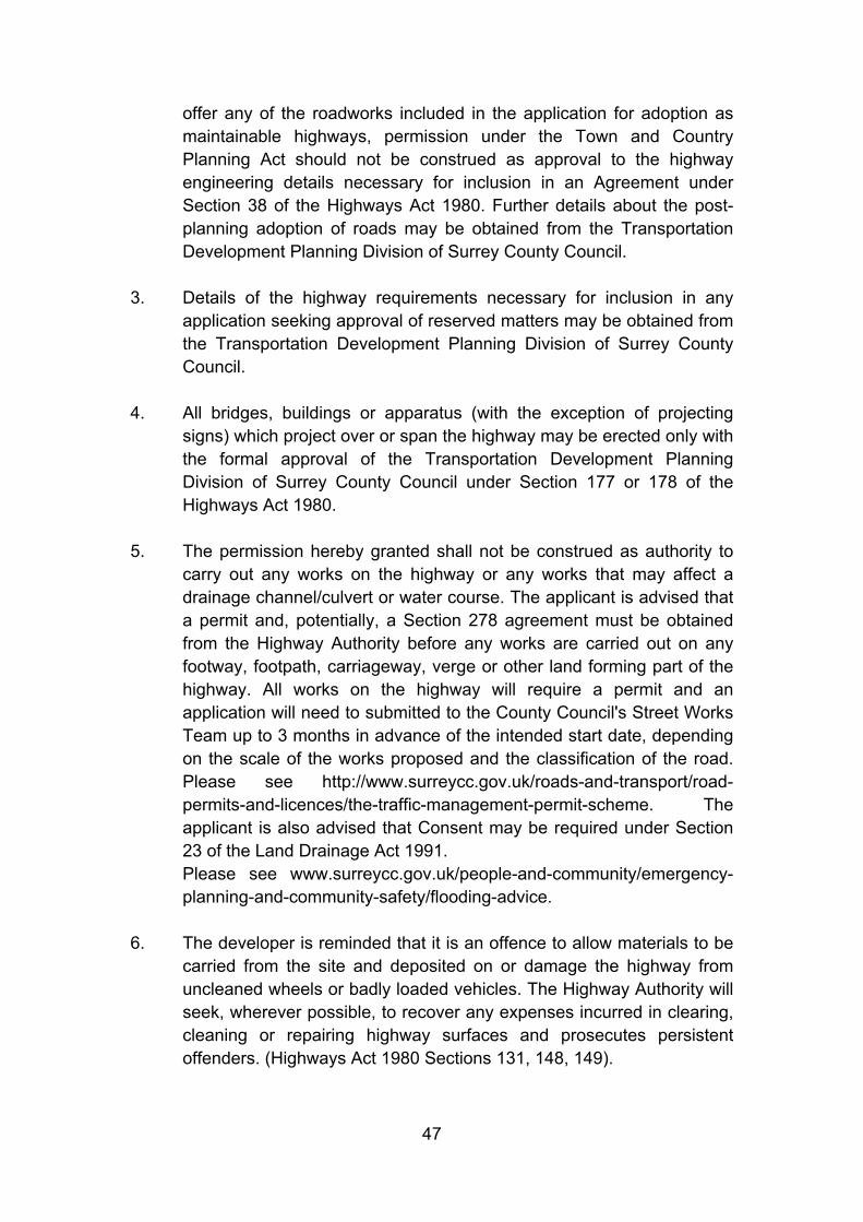
47
offer any of the roadworks included in the application for adoption as maintainable highways, permission under the Town and Country Planning Act should not be construed as approval to the highway engineering details necessary for inclusion in an Agreement under Section 38 of the Highways Act 1980. Further details about the post-planning adoption of roads may be obtained from the Transportation Development Planning Division of Surrey County Council.
3. Details of the highway requirements necessary for inclusion in any application seeking approval of reserved matters may be obtained from the Transportation Development Planning Division of Surrey County Council.
4. All bridges, buildings or apparatus (with the exception of projecting signs) which project over or span the highway may be erected only with the formal approval of the Transportation Development Planning Division of Surrey County Council under Section 177 or 178 of the Highways Act 1980.
5. The permission hereby granted shall not be construed as authority to carry out any works on the highway or any works that may affect a drainage channel/culvert or water course. The applicant is advised that a permit and, potentially, a Section 278 agreement must be obtained from the Highway Authority before any works are carried out on any footway, footpath, carriageway, verge or other land forming part of the highway. All works on the highway will require a permit and an application will need to submitted to the County Council's Street Works Team up to 3 months in advance of the intended start date, depending on the scale of the works proposed and the classification of the road. Please see http://www.surreycc.gov.uk/roads-and-transport/road-permits-and-licences/the-traffic-management-permit-scheme. The applicant is also advised that Consent may be required under Section 23 of the Land Drainage Act 1991. Please see www.surreycc.gov.uk/people-and-community/emergency-planning-and-community-safety/flooding-advice.
6. The developer is reminded that it is an offence to allow materials to be carried from the site and deposited on or damage the highway from uncleaned wheels or badly loaded vehicles. The Highway Authority will seek, wherever possible, to recover any expenses incurred in clearing, cleaning or repairing highway surfaces and prosecutes persistent offenders. (Highways Act 1980 Sections 131, 148, 149).

48
7. When access is required to be 'completed' before any other operations, the Highway Authority may agree that surface course material and in some cases edge restraint may be deferred until construction of the development is complete, provided all reasonable care is taken to protect public safety.
8. The developer is advised that as part of the detailed design of the highway works required by the above conditions, the County Highway Authority may require necessary accommodation works to street lights, road signs, road markings, highway drainage, surface covers, street trees, highway verges, highway surfaces, surface edge restraints and any other street furniture/equipment.
9. Section 59 of the Highways Act permits the Highway Authority to charge developers for damage caused by excessive weight and movements of vehicles to and from a site. The Highway Authority will pass on the cost of any excess repairs compared to normal maintenance costs to the applicant/organisation responsible for the damage.
10. The applicant is advised that the S278 highway works will require payment of a commuted sum for future maintenance of highway infrastructure. Please see the following link for further details on the county council's commuted sums policy: http://www.surreycc.gov.uk/environment-housing-and-planning/planning/transport-development-planning/surrey-county-council-commuted-sums-protocol
11. The applicant is advised that in providing each dwelling with integral cycle parking, the Highway Authority will expect dedicated integral facilities to be provided within each dwelling for easily accessible secure cycle storage/garaging.
12. The Council confirms that in assessing this planning application it has worked with the applicant in a positive and proactive way, in line with the requirements of paragraph 186-187 of the National Planning Policy Framework 2012.

1