Pub. 123, Sailing Directions (Enroute) Southwest Coast of ...
219
PUB. (ENROUTE) SAILING DIRECTIONS ★ ★ 2021 123 SOUTHWEST COAST OF AFRICA Prepared and published by the NATIONAL GEOSPATIAL-INTELLIGENCE AGENCY Springfield, Virginia © COPYRIGHT 2021 BY THE UNITED STATES GOVERNMENT NO COPYRIGHT CLAIMED UNDER TITLE 17 U.S.C. SEVENTEENTH EDITION For sale by the Superintendent of Documents, U.S. Government Printing Office Internet: http://bookstore.gpo.gov Phone: toll free (866) 512-1800; DC area (202) 512-1800 Fax: (202) 512-2250 Mail Stop: SSOP, Washington, DC 20402-0001
-
Upload
khangminh22 -
Category
Documents
-
view
1 -
download
0
Transcript of Pub. 123, Sailing Directions (Enroute) Southwest Coast of ...
PUB.
(ENROUTE)SAILING DIRECTIONS
★
★
2021
123
SOUTHWEST COAST OF AFRICA
Prepared and published by theNATIONAL GEOSPATIAL-INTELLIGENCE AGENCY
Springfield, Virginia
© COPYRIGHT 2021 BY THE UNITED STATES GOVERNMENTNO COPYRIGHT CLAIMED UNDER TITLE 17 U.S.C.
SEVENTEENTH EDITION
For sale by the Superintendent of Documents, U.S. Government Printing Office
Internet: http://bookstore.gpo.gov Phone: toll free (866) 512-1800; DC area (202) 512-1800Fax: (202) 512-2250 Mail Stop: SSOP, Washington, DC 20402-0001
III
Pub. 123
Preface
0.0 Pub. 123, Sailing Directions (Enroute) Southwest Coast ofAfrica, Seventeenth Edition, 2021, is issued for use inconjunction with Pub. 160, Sailing Directions (PlanningGuide) South Atlantic Ocean and Indian Ocean. Thecompanion volume is Pub. 124.0.0 Digital Nautical Chart 1 provides electronic chart coveragefor the area covered by this publication. 0.0 This publication has been corrected to 10 July 2021,including Notice to Mariners No. 28 of 2021. Subsequentupdates have corrected this publication to 18 June 2022,including Notice to Mariners No. 25 of 2022.
Explanatory Remarks
0.0 Sailing Directions are published by the National Geospatial-Intelligence Agency (NGA) under the authority of Departmentof Defense Directive 5105.60, dated 29 July 2009, and pursu-ant to the authority contained in U. S. Code Title 10, Chapter22, Section 451 and Title 44, Section 1336. Sailing Directions,covering the harbors, coasts, and waters of the world, provideinformation that cannot be shown graphically on nauticalcharts and is not readily available elsewhere.0.0 Sailing Directions (Enroute) include detailed coastal andport approach information which supplements the largest scalechart produced by the National Geospatial-IntelligenceAgency. This publication is divided into geographic areascalled “Sectors.”0.0 Bearings.—Bearings are true, and are expressed in degreesfrom 000° (north) to 360°, measured clockwise. Generalbearings are expressed by the initial letters of the points of thecompass (e.g. N, NNE, NE, etc.). Adjective and adverbendings have been discarded. Wherever precise bearings areintended, degrees are used.0.0 Charts.—Reference to charts made throughout thispublication refer to both the paper chart and the DigitalNautical Chart (DNC). 0.0 Corrective Information.—Users should refer corrections,additions, and comments to NGA’s Maritime Operations Desk,as follows:
0.0 New editions of Sailing Directions are corrected through thedate of publication shown above. This publication is updated asneeded and made available as a downloadable correctedpublication on the NGA Maritime Safety Office Web site.
0.0 Courses.—Courses are true, and are expressed in the samemanner as bearings. The directives “steer” and “make good” acourse mean, without exception, to proceed from a point oforigin along a track having the identical meridional angle asthe designated course. Vessels following the directives mustallow for every influence tending to cause deviation from suchtrack, and navigate so that the designated course iscontinuously being made good.0.0 Currents.—Current directions are the true directions towardwhich currents set.0.0 Distances.—Distances are expressed in nautical miles of 1minute of latitude. Distances of less than 1 mile are expressedin meters, or tenths of miles.0.0 Geographic Names.—Geographic names are generallythose used by the nation having sovereignty. Names in paren-theses following another name are alternate names that mayappear on some charts. In general, alternate names are quotedonly in the principal description of the place. Diacritical marks,such as accents, cedillas, and circumflexes, which are related tospecific letters in certain foreign languages, are not used in theinterest of typographical simplicity.0.0 Geographic names or their spellings do not necessarily re-flect recognition of the political status of an area by the UnitedStates Government.0.0 Heights.—Heights are referred to the plane of referenceused for that purpose on the charts and are expressed in meters.0.0 Internet Links.—This publication provides Internet links toWeb sites concerned with maritime navigational safety, includ-ing but not limited to, Federal government sites, foreign Hy-drographic Offices, and foreign public/private port facilities.NGA makes no claims, promises, or guarantees concerning theaccuracy, completeness, or adequacy of the contents of these
NGA Maritime—Contact Information
Maritime Operations Desk
Toll free 1-800-362-6289
Commercial 571-557-5455
DSN 547-5455
E-mail [email protected]
Maritime Safety Office
DNC web site https://dnc.nga.mil
Maritime Domain web site
https://msi.nga.mil
E-mail [email protected]
Maritime Quality Feedback System (MQFS)
https://marhelp.nga.mil
Mailing address Maritime Safety OfficeNational Geospatial-Intelligence AgencyMail Stop N64-SFH7500 Geoint DriveSpringfield VA 22150-7500
NGA Maritime Safety Office Web Site
https://msi.nga.mil
NGA Maritime—Contact Information
IV
Pub. 123
Web sites and expressly disclaims any liability for errors andomissions in the contents of these Web sites.0.0 International Ship and Port Facility Security (ISPS)Code.—The ISPS Code is a comprehensive set of measures toenhance the security of ships and port facilities developed inresponse to the perceived threats to ships and port facilities inthe wake of the 9/11 attacks in the United States. Informationon the ISPS Code can be found at the International MaritimeOrganization Web site:
0.0 Lights and Fog Signals.—Lights and fog signals are notdescribed, and light sectors are not usually defined. The LightLists should be consulted for complete information.0.0 National Ocean Claims.—Information on national oceanclaims and maritime boundary disputes, which have been com-piled from the best available sources, is provided solely in theinterest of the navigational safety of shipping and in no wayconstitutes legal recognition by the United States. These non-recognized claims and requirements may include, but are notlimited to:
1. A requirement by a state for advance permission ornotification for innocent passage of warships in the territorialsea.
2. Straight baseline, internal waters, or historic watersclaims.
3. The establishment of a security zone, where a stateclaims to control activity beyond its territorial sea for securi-ty reasons unrelated to that state’s police powers in its terri-tory, including its territorial sea.
0.0 Radio Navigational Aids.—Radio navigational aids and ra-dio weather services are not described in detail. PublicationNo. 117 Radio Navigational Aids and NOAA Publication, Se-lected Worldwide Marine Weather Broadcasts, should be con-sulted.0.0 Soundings.—Soundings are referred to the datum of thecharts and are expressed in meters. 0.0 Telephone and Facsimile Numbers.—Within this publica-tion, the international telephone and facsimile numbers provid-ed as contact information contain the minimum digitsnecessary to dial. Please note that these contact numbers do notinclude additional digits or special characters, such as (0) or(+), which may be required when dialing. The necessity ofsuch digits and characters depend upon numerous factors andconditions, such as the user’s geolocation and service provider.Mariners are advised to consult their communications equip-ment and service provider manuals for guidance. 0.0 Time.—Time is normally expressed as local time unlessspecifically designated as Universal Coordinated Time (UTC).
0.0 Time Zone.—The Time Zone description(s), as well as in-formation concerning the use of Daylight Savings Time, are in-cluded. The World Time Zone Chart is available on the Inter-net at the Web site given below.
0.0 U.S. Maritime Advisory System.—The U.S. MaritimeAdvisory System is a streamlined inter-agency approach toidentifying and promulgating maritime security threats. Thesystem replaces Special Warnings to Mariners (StateDepartment), MARAD Advisories (Maritime Administration),and Marine Safety Information Bulletins (U.S. Coast Guard)and consists of the following items:
1. U.S. Maritime Alert—Provides basic information(location, incident, type, date/time) on reported maritimesecurity threats to U.S. maritime industry interests. U.S.Maritime alerts do not contain policy or recommendationsfor specific courses of information.
2. U.S. Maritime Advisory—Provides more detailedinformation, when appropriate, through a “whole-of-gov-ernment” response to an identified maritime threat.
0.0 Winds.—Wind directions are the true directions from whichwinds blow.
Reference List
0.0 The principal sources examined in the preparation of thispublication were:0.0 British Hydrographic Department Sailing Directions.0.0 South African Sailing Directions.0.0 Various port handbooks.0.0 Reports from United States naval and merchant vessels andvarious shipping companies.0.0 Other U.S. Government publications, reports, and docu-ments.0.0 Charts, light lists, tide and current tables, and other docu-ments in possession of the Agency.0.0 Internet Web site:
0.0Simon Baillie-Cooper and the Lighthouses of South Afri-ca Home Page (http://www.lighthouses.co.za)
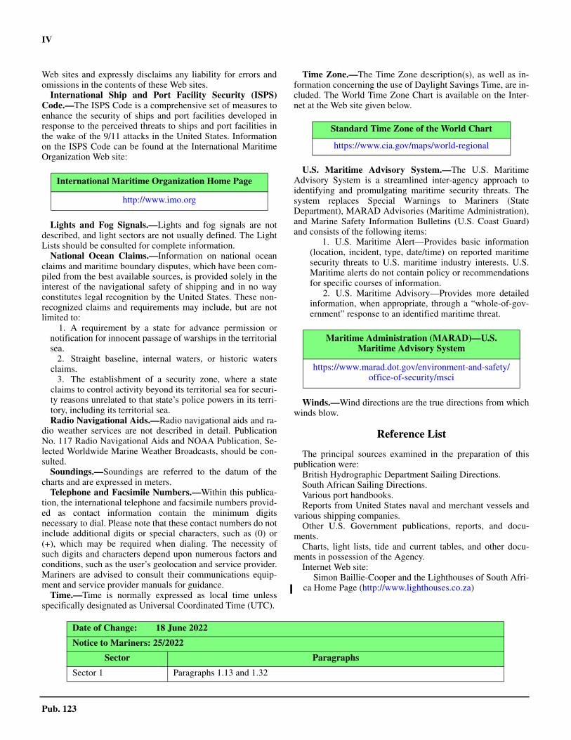
International Maritime Organization Home Page
http://www.imo.org
Standard Time Zone of the World Chart
https://www.cia.gov/maps/world-regional
Maritime Administration (MARAD)—U.S. Maritime Advisory System
https://www.marad.dot.gov/environment-and-safety/office-of-security/msci
Date of Change: 18 June 2022
Notice to Mariners: 25/2022
Sector Paragraphs
Sector 1 Paragraphs 1.13 and 1.32

V
Pub. 123
Sector 3 Paragraphs 3.12, 3.13, 3.14, 3.15, 3.50, and 3.68
Date of Change: 15 January 2022
Notice to Mariners: 3/2022
Sector Paragraphs
Sector 1 Paragraphs 1.13, 1.21, and 1.32
Sector 2 Paragraph 2.10
Sector 6 Paragraphs 6.16 and 6.23
Date of Change: 18 June 2022
Notice to Mariners: 25/2022
Sector Paragraphs

Pub. 123 VII
0.0SECTOR LIMITS—PUB. 123

VIII
Pub. 123
Conversion Tables
Feet to MetersFeet 0 1 2 3 4 5 6 7 8 9 0 0.00 0.30 0.61 0.91 1.22 1.52 1.83 2.13 2.44 2.74 10 3.05 3.35 3.66 3.96 4.27 4.57 4.88 5.18 5.49 5.79 20 6.10 6.40 6.71 7.01 7.32 7.62 7.92 8.23 8.53 8.84 30 9.14 9.45 9.75 10.06 10.36 10.67 10.97 11.28 11.58 11.89 40 12.19 12.50 12.80 13.11 13.41 13.72 14.02 14.33 14.63 14.93 50 15.24 15.54 15.85 16.15 16.46 16.76 17.07 17.37 17.68 17.98 60 18.29 18.59 18.90 19.20 19.51 19.81 20.12 20.42 20.73 21.03 70 21.34 21.64 21.95 22.25 22.55 22.86 23.16 23.47 23.77 24.08 80 24.38 24.69 24.99 25.30 25.60 25.91 26.21 26.52 26.82 27.13 90 27.43 27.74 28.04 28.35 28.65 28.96 29.26 29.57 29.87 30.17
Fathoms to MetersFathoms 0 1 2 3 4 5 6 7 8 9
0 0.00 1.83 3.66 5.49 7.32 9.14 10.97 12.80 14.63 16.46 10 18.29 20.12 21.95 23.77 25.60 27.43 29.26 31.09 32.92 34.75 20 36.58 38.40 40.23 42.06 43.89 45.72 47.55 49.38 51.21 53.03 30 54.86 56.69 58.52 60.35 62.18 64.01 65.84 67.67 69.49 71.32 40 73.15 74.98 76.81 78.64 80.47 82.30 84.12 85.95 87.78 89.61 50 91.44 93.27 95.10 96.93 98.75 100.58 102.41 104.24 106.07 107.90 60 109.73 111.56 113.39 115.21 117.04 118.87 120.70 122.53 124.36 126.19 70 128.02 129.85 131.67 133.50 135.33 137.16 138.99 140.82 142.65 144.47 80 146.30 148.13 149.96 151.79 153.62 155.45 157.28 159.11 160.93 162.76 90 164.59 166.42 168.25 170.08 171.91 173.74 175.56 177.39 179.22 181.05
Meters to FeetMeters 0 1 2 3 4 5 6 7 8 9
0 0.00 3.28 6.56 9.84 13.12 16.40 19.68 22.97 26.25 29.53 10 32.81 36.09 39.37 42.65 45.93 49.21 52.49 55.77 59.06 62.34 20 65.62 68.90 72.18 75.46 78.74 82.02 85.30 88.58 91.86 95.14 30 98.42 101.71 104.99 108.27 111.55 114.83 118.11 121.39 124.67 127.95 40 131.23 134.51 137.80 141.08 144.36 147.64 150.92 154.20 157.48 160.76 50 164.04 167.32 170.60 173.88 177.16 180.45 183.73 187.01 190.29 193.57 60 196.85 200.13 203.41 206.69 209.97 213.25 216.54 219.82 223.10 226.38 70 229.66 232.94 236.22 239.50 242.78 246.06 249.34 252.62 255.90 259.19 80 262.47 265.75 269.03 272.31 275.59 278.87 282.15 285.43 288.71 291.99 90 295.28 298.56 301.84 305.12 308.40 311.68 314.96 318.24 321.52 324.80
Meters to FathomsMeters 0 1 2 3 4 5 6 7 8 9
0 0.00 0.55 1.09 1.64 2.19 2.73 3.28 3.83 4.37 4.92 10 5.47 6.01 6.56 7.11 7.66 8.20 8.75 9.30 9.84 10.39 20 10.94 11.48 12.03 12.58 13.12 13.67 14.22 14.76 15.31 15.86 30 16.40 16.95 17.50 18.04 18.59 19.14 19.68 20.23 20.78 21.33 40 21.87 22.42 22.97 23.51 24.06 24.61 25.15 25.70 26.25 26.79 50 27.34 27.89 28.43 28.98 29.53 30.07 30.62 31.17 31.71 32.26 60 32.81 33.36 33.90 34.45 35.00 35.54 36.09 36.64 37.18 37.73 70 38.28 38.82 39.37 39.92 40.46 41.01 41.56 42.10 42.65 43.20 80 43.74 44.29 44.84 45.38 45.93 46.48 47.03 47.57 48.12 48.67 90 49.21 49.76 50.31 50.85 51.40 51.95 52.49 53.04 53.59 54.13
IX
Pub. 123
Abbreviations
The following abbreviations may be used in the text:
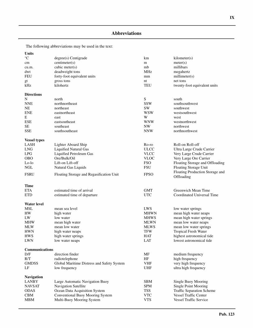
Units°C degree(s) Centigrade km kilometer(s)cm centimeter(s) m meter(s)cu.m. cubic meter(s) mb millibarsdwt deadweight tons MHz megahertzFEU forty-foot equivalent units mm millimeter(s)gt gross tons nt net tonskHz kilohertz TEU twenty-foot equivalent units
DirectionsN north S southNNE northnortheast SSW southsouthwestNE northeast SW southwestENE eastnortheast WSW westsouthwestE east W westESE eastsoutheast WNW westnorthwestSE southeast NW northwestSSE southsoutheast NNW northnorthwest
Vessel typesLASH Lighter Aboard Ship Ro-ro Roll-on Roll-offLNG Liquified Natural Gas ULCC Ultra Large Crude CarrierLPG Liquified Petroleum Gas VLCC Very Large Crude CarrierOBO Ore/Bulk/Oil VLOC Very Large Ore CarrierLo-lo Lift-on Lift-off FSO Floating Storage and Offloading NGL Natural Gas Liquids FSU Floating Storage Unit
FSRU Floating Storage and Regasification Unit FPSOFloating Production Storage and Offloading
TimeETA estimated time of arrival GMT Greenwich Mean TimeETD estimated time of departure UTC Coordinated Universal Time
Water levelMSL mean sea level LWS low water springsHW high water MHWN mean high water neapsLW low water MHWS mean high water springsMHW mean high water MLWN mean low water neapsMLW mean low water MLWS mean low water springsHWN high water neaps TFW Tropical Fresh WaterHWS high water springs HAT highest astronomical tideLWN low water neaps LAT lowest astronomical tide
CommunicationsD/F direction finder MF medium frequencyR/T radiotelephone HF high frequencyGMDSS Global Maritime Distress and Safety System VHF very high frequencyLF low frequency UHF ultra high frequency
NavigationLANBY Large Automatic Navigation Buoy SBM Single Buoy MooringNAVSAT Navigation Satellite SPM Single Point MooringODAS Ocean Data Acquisition System TSS Traffic Separation SchemeCBM Conventional Buoy Mooring System VTC Vessel Traffic CenterMBM Multi-Buoy Mooring System VTS Vessel Traffic Service
X
Pub. 123
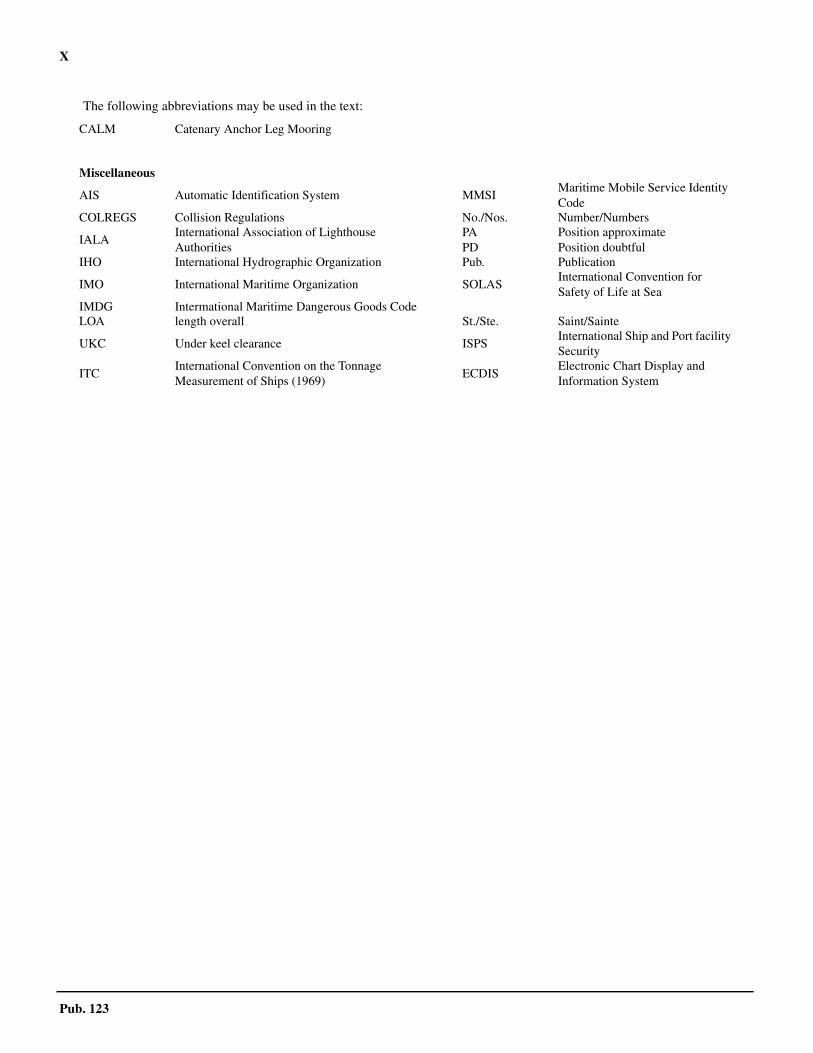
CALM Catenary Anchor Leg Mooring
Miscellaneous
AIS Automatic Identification System MMSIMaritime Mobile Service Identity Code
COLREGS Collision Regulations No./Nos. Number/Numbers
IALAInternational Association of LighthouseAuthorities
PAPD
Position approximatePosition doubtful
IHO International Hydrographic Organization Pub. Publication
IMO International Maritime Organization SOLASInternational Convention for Safety of Life at Sea
IMDG Intermational Maritime Dangerous Goods CodeLOA length overall St./Ste. Saint/Sainte
UKC Under keel clearance ISPSInternational Ship and Port facility Security
ITCInternational Convention on the Tonnage Measurement of Ships (1969)
ECDISElectronic Chart Display and Information System
The following abbreviations may be used in the text:

Pub. 123 XI
Contents
Preface. . . . . . . . . . . . . . . . . . . . . . . . . . . . . . . . . . . . . . . . . . . . . . . . . . . . . . . . . . . . . . . . . . . . . . . . . . . . . . . . . . . . . . . . . . . . . . . . IIIChartlet—Sector Limits . . . . . . . . . . . . . . . . . . . . . . . . . . . . . . . . . . . . . . . . . . . . . . . . . . . . . . . . . . . . . . . . . . . . . . . . . . . . . . . . . VIIConversion Tables. . . . . . . . . . . . . . . . . . . . . . . . . . . . . . . . . . . . . . . . . . . . . . . . . . . . . . . . . . . . . . . . . . . . . . . . . . . . . . . . . . . . . VIIIAbbreviations . . . . . . . . . . . . . . . . . . . . . . . . . . . . . . . . . . . . . . . . . . . . . . . . . . . . . . . . . . . . . . . . . . . . . . . . . . . . . . . . . . . . . . . . . . IX
Sector 1
Sector 1—Ivory Coast and Ghana—Cape Palmas to Cape Saint Paul . . . . . . . . . . . . . . . . . . . . . . . . . . . . . . . . . . . . . . . . . . . . . . . 1
Sector 2
Sector 2—Togo, Benin, and Nigeria—Cape Saint Paul to Cape Formoso . . . . . . . . . . . . . . . . . . . . . . . . . . . . . . . . . . . . . . . . . . . 27
Sector 3
Sector 3—Nigeria to Gabon—Cape Formoso to Cap Lopez . . . . . . . . . . . . . . . . . . . . . . . . . . . . . . . . . . . . . . . . . . . . . . . . . . . . . . 53
Sector 4
Sector 4—Gabon to Angola—Cap Lopez to Ponta Albina . . . . . . . . . . . . . . . . . . . . . . . . . . . . . . . . . . . . . . . . . . . . . . . . . . . . . . 101
Sector 5
Sector 5—Angola, Namibia, and South Africa—Ponta Albina to the Cape of Good Hope . . . . . . . . . . . . . . . . . . . . . . . . . . . . . 145
Sector 6
Sector 6—Islands and Seamounts in the South Atlantic Ocean . . . . . . . . . . . . . . . . . . . . . . . . . . . . . . . . . . . . . . . . . . . . . . . . . . 185
Glossaries . . . . . . . . . . . . . . . . . . . . . . . . . . . . . . . . . . . . . . . . . . . . . . . . . . . . . . . . . . . . . . . . . . . . . . . . . . . . . . . . . . . . . . . . . . . . 203
Index—Gazetteer .. . . . . . . . . . . . . . . . . . . . . . . . . . . . . . . . . . . . . . . . . . . . . . . . . . . . . . . . . . . . . . . . . . . . . . . . . . . . . . . . . . . . . . . . . . 215

1
Pub. 123
1. Sector 1—Ivory Coast and Ghana—Cape Palmas to Cape Saint Paul
1.0Additional chart coverage may be found in NGA/DLIS Catalog of Maps, Charts, and Related Products (Unlimited Distribution).SECTOR 1 — CHART INFORMATION
3
Pub. 123
SECTOR 1
IVORY COAST (COTE D’IVOIRE) AND GHANA—CAPE PALMAS TO CAPE SAINT PAUL
1.0 Plan.—This sector describes the coasts of Liberia, IvoryCoast (Cote d’Ivoire), and Ghana between Cape Palmas andCape Saint Paul. The descriptive sequence is from W to E.
General Remarks
1.1 The coast described in this sector is bordered by reefsand relatively elevated as far as the W approaches to CapeThree Points (4°45'N., 2°05'E.), a distance of about 230 miles.It is fronted by a low, sloping, and sandy beach backed by tallvegetation. The W part of the coast, between Cape Palmas(4°22'N., 7°44'W.) and Cape Three Points, is high, rocky, andrises gradually to the interior. The E part of this coast is low,sandy, and backed by a number of lagoons. Several rivers dis-charge through this stretch of the coast, but are of little naviga-tional value. The shoreline, which is subject to a dangeroussurf, consists mostly of a sandy beach backed by tall brush-wood. 1.1 Winds—Weather.—The SW trade wind system is the basicand most extensive wind regime in the area. Between 15°N and3°N, winds blow from the SW quadrant just about all yearround. 1.1 The most significant of the local wind regimes in the area isthe Southwest Monsoon. This large scale sea breeze occurs inthe N sections over the Gulf of Guinea and extends 100 to 200miles inland. It is strongest from June through August, but isprevalent all year round. The monsoon is a deflection of the SEtrade winds toward the heated continental interior. Its influenceis felt up to 10°S and it acts very much like a land-sea breezeregime. At Douala (4°03'N., 9°41'E.), for example, while SWwinds are prevalent during the afternoon, their frequency dropsto 5 per cent in the early morning hours.1.1 To the N of 20°N and to the W of 10°W, in accordance withthe counterclockwise flow around the South Atlantic Anticy-clone, the winds take on a mostly E component.1.1 The Harmattan, a wind of continental origin, is hot, dry, andblows from the NE quadrant. It reaches the shores of the Gulfof Guinea and extends seaward. This wind is prevalent fromDecember through early March and is usually laden with finedust, which can seriously impair visibility in the form of haze.The Harmattan is found mainly between Cape Palmas andDouala.1.1 The Doldrums, which is associated with the equatorialtrough, is a band of light and variable winds. For most of theyear, this band is located in the N part of the area, but from lateFebruary through March, it reaches the portion of the area ly-ing N of the Equator. During these months, winds to the N ofthe Equator are calm for about 40 per cent of the time.1.1 A local wind occurring to the N of the Congo River is knownas a tornado. This should not be confused with the phenome-non, known by the same name, which occurs in the UnitedStates. African tornadoes are violent wind squalls which oftenaccompany thunderstorms. They are most frequent from Janu-ary to early May and from September to November. Tornadoes
can originate either on the land and move seaward or over thewater and move onshore.1.1 The barometer gives no warning, but a dark bank of cumulo-nimbus clouds, with tops reaching 6,000m or more, usually in-dicates the approach of a tornado. At the base of the cloudbank, there is generally a roll of low clouds and the atmospherebecomes still and oppressive as it approaches. A sudden windsquall, with gusts of 50 knots or more, occurs as the roll of lowclouds passes overhead. Then, a few minutes later, rain beginsand is accompanied by thunder and lightning. The rain is oftenvery heavy and may reduce visibility to practically zero. Thewind usually lasts for less than one hour, but the rain may con-tinue longer. These tornadoes may be local or they may havethe characteristics of a squall line, 100 miles or more wide. Oc-casionally, these tornadoes occur without any rain and areknown appropriately as dry tornadoes.1.1 All sea areas lying near the shores of the continents and larg-er islands are influenced by land and sea breezes. Modificationof the prevailing winds by onshore winds during the afternoonand offshore winds during the early morning causes corre-sponding increases or decreases in sea heights. Gravity windsusually result when dense cold air, which accumulates on thecontinental highlands, flows rapidly down the slopes and outover the sea. They can produce high waves for a short distancefrom the shore.1.1 Tides—Currents.—The Guinea Current is felt in the vicini-ty of Cape Palmas and as far E as Pointe Tafou. It disappearsabout 100 miles ENE of this latter point and then resumesweakly to the E of Abidjan. The currents generally begin about80 miles E of Abidjan and set inshore between this locationand Cape Three Points. 1.1 The currents in the vicinity of Cape Three Points are variablein both strength and direction. A current setting E, with a rateas high as 3 knots, has been reported. 1.1 Vessels heading W from Cape Saint Paul to Cape ThreePoints are advised to stay as close to the coast as safety per-mits. Such vessels usually encounter only a weak current witha rate of 0.4 knot. However, vessels taking the direct route gen-erally encounter a current, which at times attains a rate of 3knots.1.1 Depths—Limitations.—Depths in the approaches to thiscoast are deep and clear of dangers. The 200m curve lies gen-erally parallel to the coast and between 13 and 23 miles off-shore. The only exception is Le Trou Sans Fond, in theapproaches to Abidjan (see paragraph 1.13), where the 30mcurve lies almost parallel to the coast and between 1 mile and 6miles offshore. There are no known dangers outside of the200m curve.1.1 Regulations.—The Maritime Domain Awareness forTrade—Gulf of Guinea (MDAT—GoG) is a virtual reportingsystem for maritime security operating in the maritime area ofcentral and west Africa. The system includes voluntary report-ing from vessels and output from MDAT—GoG to contributeto maritime situational awareness. For further information, see
4 Sector 1. Ivory Coast (Cote d’Ivoire) and Ghana—Cape Palmas to Cape Saint Paul
Pub. 123
South Atlantic Ocean—Ship Reporting System in Pub. 160,Sailing Directions (Planning Guide) South Atlantic Ocean andIndian Ocean. 1.1 Caution.—Vessels should not approach within 2.5 miles ofthe coast between Cape Palmas and the Cavalla River (4°22'N.,7°32'W.). The depths lying off the coast are very irregular, par-ticularly in the vicinity of Growa Point (4°21'N., 7°37'W.) andCavalla Point (4°21'N., 7°36'W.).1.1 Numerous fishing boats may be encountered in the waterslying adjacent to the coasts described in this sector.1.1 When transiting near the coasts described in this sector, asharp lookout should be kept for canoes.1.1 Acts of piracy have occurred in the waters described withinthis sector but they have generally taken place at the anchorag-es or in the approaches to the ports. Vessels should not allowany unauthorized craft to come alongside.1.1 Oil and gas development areas and fields, with associatedrigs, platforms, riser pipes, wellheads, submarine pipelines,terminal buoys, and storage vessels, may be encountered offthe coasts described in this sector.1.1 The West African Gas Pipeline runs from 7.5 miles NE ofTakoradi, Ghana through the coastal waters of Togo and Beninto 6.75 miles ESE of Badagri, Nigeria. There area several areaswith connections along this route. The pipeline, which can bestbe seen on the chart, has been buried in some areas but not inothers. Caution is advised when navigating these areas and an-choring is prohibited within 1 mile of the pipeline. The pipe-line is marked by numerous virtual AIS transmitters. 1.1 Some of the well heads may protrude more than 5m abovethe sea bed and may be unmarked. Some of the platforms andstructures may be disused, abandoned, and unlit. In many cas-es, the submarine pipelines are not buried in the sea bed anddepths over them may be reduced by as much as 2m. In addi-tion, many temporary structures and objects associated with oiland gas exploration may not be charted.
Cape Palmas to Abidjan
1.2 Cape Palmas (4°22'N., 7°44'W.), 19m high, is arocky peninsula connected to the mainland by a low and sandyisthmus. Russwurm Island, 8m high, lies close S of the capeand is connected to it by a causeway. This island is coveredwith verdure and is difficult to distinguish against the cape.The town of Harper stands on the isthmus.
For a description of the approaches to the cape; the smallharbor, known as Harper Point; and the nearby roadstead an-chorage, which is used for the export of logs and rubber, seePub. 143, Sailing Directions (Enroute) West Coast of Europeand Northwest Africa.
A light is shown from a prominent tower, 22m high, standingclose to the W extremity of Cape Palmas.
Between the cape and Growa Point, 6.7 miles E, the coastconsists of a high sandy beach. A conspicuous mass of blackrock lies on the beach about 2.5 miles E of the cape.1.2 A shallow lagoon lies close behind the sandy foreshore andextends parallel to it for about 3.5 miles. The village of Budduis situated near the E end of this lagoon. During the rainy sea-son, the lagoon breaks through to the sea and flows out be-tween the groups of houses standing in the village.1.2 Newill Rock, with a least depth of 6m, lies 0.7 mile offshore,
about 1.7 miles ESE of Cape Palmas. Athol Rock, with a leastdepth of 6.4m, lies 1.9 miles offshore, about 3 miles WSW ofGrowa Point. Two rocky heads, with depths of 6.4 and 9.1m,lie about midway between Newill Rock and Athol Rock.1.2 A shoal patch, with a depth of 16.5m, was reported (1967) tolie about 4.5 miles SSE of Cape Palmas.1.2 A prominent hill, 70m high, rises 1.2 miles inland, about 3.3miles ENE of Cape Palmas. A conspicuous college building,white with a black roof, stands on this hill.1.2 Growa Point (4°21'N., 7°37'W.) is a long, low, and rockyprojection. Growa Reefs, on which the sea breaks heavily, ex-tend up to about 0.8 mile SW and 0.4 mile S from this point.During good weather, landing is possible in the vicinity of thepoint, but a surf boat is necessary. The town of Growa, alsoknown as Whole Graway, stands about 1 mile NW of the point.1.2 Helene Woerman Rock, with a least depth of 3.7m, liesabout 2.5 miles SW of Growa Point. This steep-to rock, whichwas reported not to break in the dry season (November toMarch), forms the outermost danger along this part of thecoast.1.2 A shoal patch, with a depth of 10m, lies about 1.7 milesSSW of Growa Point and another patch, with a least depth of9m, lies between it and Growa Reefs. Harvey Rock, on whichthe sea always breaks, lies 1.3 miles offshore, about 1.2 milesWSW of Growa Point. Several rocky patches, with depths of 5to 10m, lie within 0.5 mile of Harvey Rock.1.2 Cavalla Point (4°21'N., 7°36'W.), fronted by rocks, is situat-ed 1.2 miles E of Growa Point. A village stands among trees0.5 mile NE of the point. 1.2 An isolated shoal patch, with a least depth of 9.1m, liesabout 1 mile SSW of Cavalla Point.1.2 Foul ground, with several above-water rocks, extends up to0.8 mile from the coast between Growa Point and CavallaPoint. Cavalla Ledge, formed by a group of shoals, liescentered 1 mile offshore, about 2.8 miles ESE of Cavalla Point.The shallowest shoal of this group, with a depth of less than2m, breaks and lies at the NW end.
1.3 The Cavally River (4°22'N., 7°32'W.) indents thecoast 4 miles E of Cavalla Point. It is navigable up to about 40miles above the entrance by small power vessels. The first rap-ids are located about 80 miles above the mouth.
The boundary between Liberia and Ivory Coast (Coted’Ivoire) is situated in the vicinity of the Cavally River.1.3 Two umbrella trees stand close together on the W side of theentrance and a small house, with a tiled roof, is situated closeW of them. The entrance channel, which is about 90m widebetween the sand banks, is constantly changing. Sunken rockslie close offshore at the W side of this channel and the bar,which fronts the entrance, has the reputation of being the mostdangerous along this part of the coast. The village of Blieron issituated on the E side of the entrance. The Custom house, aprominent white building with a red roof and a flagstaff, issituated in the village.1.3 Anchorage may be obtained, in a depth of 15m, sand andmud, about 1 mile S of the Customhouse.1.3 Willett Hill, a prominent flat-topped hill, rises 3 miles N ofthe entrance to the river and has a conspicuous knob, 94m high,standing close W of its center. In clear weather, this knob is re-ported to be visible from up to 18 miles seaward.
Sector 1. Ivory Coast (Cote d’Ivoire) and Ghana—Cape Palmas to Cape Saint Paul 5
Pub. 123
1.3 Between the Cavally River and Pointe Tafou, 10.5 milesENE, the coast is low, sandy, and backed by a dense forest. It isbroken occasionally by clumps of trees up to 60m high. 1.3 A rounded, sandy point is located 2.7 miles E of the mouthof the Cavally River and is fronted by extensive reefs, whichextend up to about 0.8 mile seaward. Several rocks, up to 3.7mhigh, lie in the vicinity of these reefs. A stranded wreck, report-ed to be radar conspicuous (1987), lies in the vicinity of theserocks.1.3 A hill, with treetops 55m high, rises close N of this sandypoint and is prominent.1.3 Subra Meno Point (4°22'N., 7°27'W.) is located 4.5 milesENE of the mouth of the Cavally River and forms the W en-trance point of the Tahauru River. A stranded wreck, reportedto be radar conspicuous (1968), lies on a group of rocks about0.4 mile S of the river mouth.1.3 An isolated shoal patch, with a depth of 9m, is reported(1966) to lie about 2.7 miles SE of Subra Meno Point.1.3 The village of Biahuin stands 2.5 miles ENE of Subra MenoPoint. A group of rocks, which breaks, lie about 0.7 mile S ofthis village.1.3 Pointe Tafou (4°25'N., 7°22'W.) is a low and rocky point lo-cated at the W side of the entrance to the Tafou River. This riv-er is small and used only by canoes. It was reported (1969) thatthe entrance had silted up and only the beach was in use.1.3 A light is shown from a tower, 14m high, standing on PointeTafou; a radio mast is situated 0.2 mile WSW of it. The town ofTabou is situated close within the entrance on the N bank of theriver. A mission building, with a prominent clock tower, standsin the town.1.3 It is reported (1971) that a vessel grounded about 0.3 mile Sof the light. Therefore, a preferred anchorage lies, in a depth of15m, about 0.8 mile SE of the light.
1.4 Pointe Basha (4°28'N., 7°15'W.), fringed by reefs, islocated 7.5 miles NE of Pointe Tafou. The coast between con-sists of a sandy beach backed by densely-wooded country.
Point Tabou, low and fronted by foul ground, is located 2.7miles NE of Pointe Tafou. The large village of Segre stands 1.4miles NE of this point. Anchorage may be obtained in a depthof 24m, sand and mud, about 1 mile SE of the village. The bot-tom is foul in any lesser depths.
Pointe Basha, which shelters a roadstead anchorage, is sur-mounted by a rock resembling the outline of a fort when seenfrom the W. A buoy is moored 1.6 miles ENE of this point.1.4 Grand Basha, a village, stands on the N side of the entranceto the River Houo, 1 mile N of Pointe Basha. It may be identi-fied by a prominent long and low house with a gray roof.Pointe Boubele, the SW entrance point of the river, is markedby two beacons. A post, with a triangular daymark, stands 0.9mile NNE of Pointe Boubele, but it is situated near the shoreand not easily distinguished. A wharf, used by lighters, frontsthe shore close N of Pointe Boubele and is reported to be radarconspicuous.1.4 Anchorage may be obtained in depths of 12 to 16m about 1mile E of Pointe Boubele. The bottom consists of sand, brokenshells, and gravel, with good holding ground. This roadstead isused for exporting timber. 1.4 The coast continues ENE for 13 miles from Pointe Basha toPointe Poor. A long and narrow lagoon lies close behind the
beach, which fronts the coast for the last 8.2 miles. The sandybeach barrier that separates this lagoon from the sea is coveredwith trees, but occasional bare spots show where the watersburst through in the rainy season.1.4 Pointe Ouappou (Point Wappu), rocky and 20m high, is lo-cated 3.5 miles NE of Pointe Boubele. The village of Wappustands on this point and the mouth of the River Tuhobre liesclose WSW of it. 1.4 Pointe Poor (4°32'N., 7°03'W.) is low, rocky, and fringed byrocks extending up to about 0.3 mile seaward. The mouth ofthe River Nebano lies close N of this point. Pointe Klama,fronted by rocks, is located 1.5 miles ENE of Pointe Poor. Aconspicuous gray rock stands about 0.5 mile N of this point. Ahill, 90m high, rises 2 miles NNW of this point.1.4 A stranded wreck, reported (2002) to be no longer conspicu-ous, lies close ENE of Pointe Klama.
Poste de Bereby (Point Sagree) (4°34'N., 7°01'W.), located0.7 mile NNE of Pointe Klama, is one of the few places alongthis part of the coast where landing is possible. A village standson the point. Two moderately-high mountains rise 8 and 12miles NNW of this point and provide good landmarks. Anchor-age can be taken in a depth of 22m, sand, about 0.5 mile SE ofthe point.1.4 Pointe Ible, surmounted by a building, is located 1 mile NEof Poste de Bereby. A pinnacle rock. with a depth of 6m, liesabout 0.4 mile S of this point.
1.5 Pointe Kadabou (4°39'N., 6°54'W.) is located 8.5miles NE of Poste de Bereby. The coast between consists of asuccession of sandy bights divided by rocky points. The landbehind the beach consists of an extensive forest, which risesgradually to wooded hills.1.5 From about 1 mile NE of Poste de Bereby, an extensivechain of reefs lies parallel to the coast and extends for about4.5 miles. Ilot Devil, with a black base, lies 2.3 miles SW ofPointe Kadabou. This islet is 13m high and has a flat summitwhich has been whitened by numerous sea birds settling on it.A shoal, which breaks, lies 0.3 mile NNE of this islet.1.5 Pointe Kadabou consists of a bold and rocky cliff, 35m high,which can easily be recognized by a white rock standing nearits summit. The village of Basa (Grande Berebi) is situated onthis point and several reddish houses, with a group of palmtrees, are prominent from seaward. Two hills, rising close to-gether, stand 3 miles WNW of the village and are 95m high.1.5 It is reported (1993) that the stranded wreck of a ro-ro ferrylies near Basa (Grande Berebi).1.5 It is reported (1995) that a tug grounded in the vicinity ofBasa (Grande Berebi) and has been abandoned as a construc-tive total loss. 1.5 A roadstead, used mostly for loading timber, lies at the headof the bight entered N of Pointe Kadabou. A river, with a la-goon at its entrance, empties into the head of this bight. An-chorage may be obtained in a depth of 11m about 0.5 mile E ofPointe Kadabou or in a depth of 14m about 1 mile ESE of thepoint.
Gumara Reefs (Turpin Rock), with depths of less than 1m,lie 0.5 mile NNE of Pointe Kadabou. Roche Katoum, a graniterock, lies about 1 mile NE of Pointe Kadabou. It is 11m highand fringed by shoals on its W and NE sides. The top of thisrock is covered with white guano, but it becomes brown during
6 Sector 1. Ivory Coast (Cote d’Ivoire) and Ghana—Cape Palmas to Cape Saint Paul
Pub. 123
the rainy season. Several other shoals and obstructions lie inthe vicinity of this rock and Gumara Reefs.
Pointe Tahu (Pointe Tahou) (4°42'N., 6°42'W.), fronted byreefs, is located 13 miles ENE of Pointe Kadabou. It is low andwooded. A factory stands close W of the point. The coast be-tween this point and Point Kadabou consists mostly of sandybeaches and is wooded with numerous villages. The River Ne-ma enters the sea through a lagoon about 3.2 miles W of PointeTahu. The shore is rocky and steep-to in places. Numerousrocks, both above and below-water, lie off this stretch of coastand it should be given a wide berth.
A dangerous rock (existence doubtful) is reported to lieabout 2 miles S of Pointe Tahu. 1.5 The coast from Pointe Tahu continues ENE for 6 miles to theharbor of San-Pedro. It is generally sandy, low, and backed bya lagoon. The shore is fronted by numerous shoals and otherdangers and should be given a wide berth.
1.6 San-Pedro (4°44'N., 6°37'W.) (World Port Index No.45963) is a partly-sheltered harbor used mostly for the exportof timber. It is situated in a lagoon about 1 mile SW of themouth of the River San-Pedro.
1.6 Winds—Weather.—The harbor is exposed to E and NEwinds and seas. At such times, a heavy swell may also beexperienced at the quays.1.6 Tides—Currents.—The tides rise about 1.5m at springs and1.1m at neaps.1.6 The tidal currents attain rates of 0.5 to 1 knot at the entrance,but are less inside the harbor. A strong undertow may be feltwithin the harbor between June and September.1.6 Depths—Limitations.—The harbor is protected by two
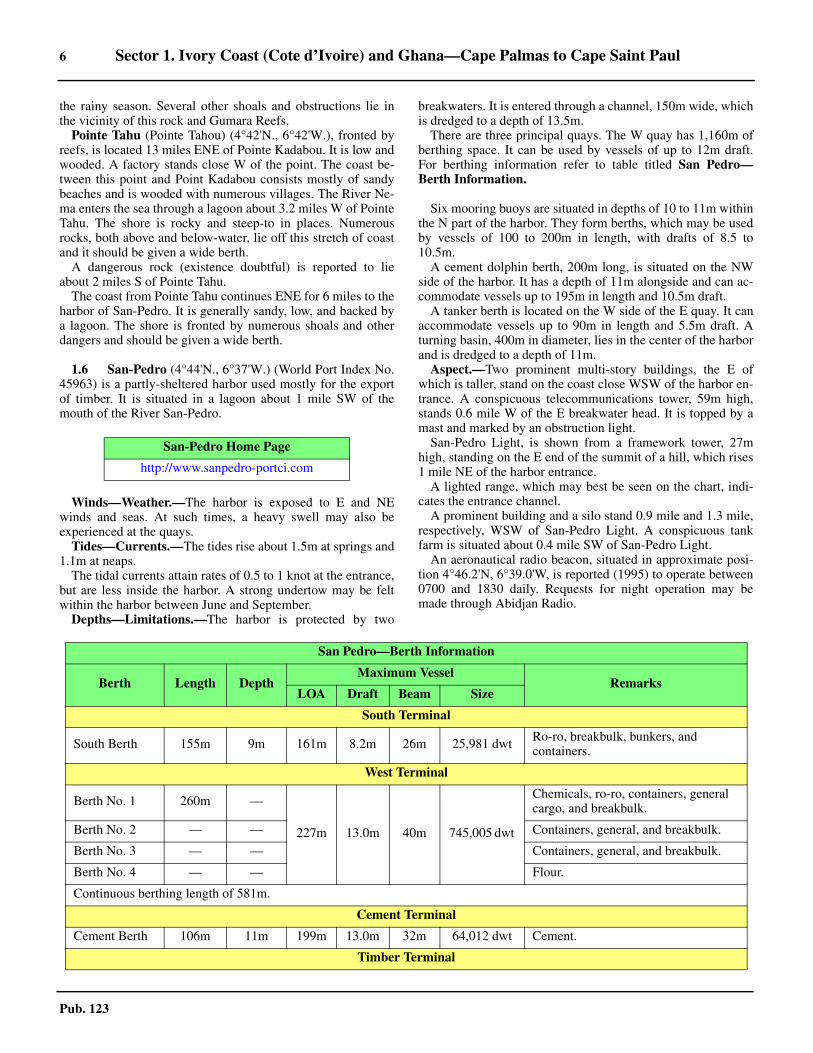
breakwaters. It is entered through a channel, 150m wide, whichis dredged to a depth of 13.5m. 1.6 There are three principal quays. The W quay has 1,160m ofberthing space. It can be used by vessels of up to 12m draft.For berthing information refer to table titled San Pedro—Berth Information. 1.6
1.6 Six mooring buoys are situated in depths of 10 to 11m withinthe N part of the harbor. They form berths, which may be usedby vessels of 100 to 200m in length, with drafts of 8.5 to10.5m.1.6 A cement dolphin berth, 200m long, is situated on the NWside of the harbor. It has a depth of 11m alongside and can ac-commodate vessels up to 195m in length and 10.5m draft.1.6 A tanker berth is located on the W side of the E quay. It canaccommodate vessels up to 90m in length and 5.5m draft. Aturning basin, 400m in diameter, lies in the center of the harborand is dredged to a depth of 11m. 1.6 Aspect.—Two prominent multi-story buildings, the E ofwhich is taller, stand on the coast close WSW of the harbor en-trance. A conspicuous telecommunications tower, 59m high,stands 0.6 mile W of the E breakwater head. It is topped by amast and marked by an obstruction light.1.6 San-Pedro Light, is shown from a framework tower, 27mhigh, standing on the E end of the summit of a hill, which rises1 mile NE of the harbor entrance.1.6 A lighted range, which may best be seen on the chart, indi-cates the entrance channel.1.6 A prominent building and a silo stand 0.9 mile and 1.3 mile,respectively, WSW of San-Pedro Light. A conspicuous tankfarm is situated about 0.4 mile SW of San-Pedro Light.1.6 An aeronautical radio beacon, situated in approximate posi-tion 4°46.2'N, 6°39.0'W, is reported (1995) to operate between0700 and 1830 daily. Requests for night operation may bemade through Abidjan Radio.
San-Pedro Home Page
http://www.sanpedro-portci.com
San Pedro—Berth Information
Berth Length DepthMaximum Vessel
RemarksLOA Draft Beam Size
South Terminal
South Berth 155m 9m 161m 8.2m 26m 25,981 dwt Ro-ro, breakbulk, bunkers, and containers.
West Terminal
Berth No. 1 260m —
227m 13.0m 40m 745,005 dwt
Chemicals, ro-ro, containers, general cargo, and breakbulk.
Berth No. 2 — — Containers, general, and breakbulk.
Berth No. 3 — — Containers, general, and breakbulk.
Berth No. 4 — — Flour.
Continuous berthing length of 581m.
Cement Terminal
Cement Berth 106m 11m 199m 13.0m 32m 64,012 dwt Cement.
Timber Terminal
Sector 1. Ivory Coast (Cote d’Ivoire) and Ghana—Cape Palmas to Cape Saint Paul 7
Pub. 123
1.6 Pilotage.—Pilotage is compulsory. Pilots board about 1.5miles S of the W breakwater at position 4°42.5'N, 6°36.6'W. 1.6 Regulations.—Vessels should send their ETA 48 hours inadvance, with a confirmation 24 hours before arrival, statingthe following information:
1. Port services required.2. Vessel’s security.3. Quality and quantity of cargo.4. Declaration of dangerous goods.
1.6 If the vessel is over 200m in length, the draft should be in-cluded in the messages. 1.6 Generally, vessels may enter by day only, but can depart byday or at night.1.6 Vessels should send their ETD 24 hours in advance.1.6 Contact Information.—San-Pedro pilots can be contacted,as follows:
1.6 Anchorage.—Vessels may anchor, while awaiting a pilot, ina depth of 18m, sand, good holding ground, about 0.8 mile SSEof the W breakwater head. Anchorage is not recommended tothe W of the meridian passing through the head of the Wbreakwater.1.6 Caution.—It is reported (1996) that the dredged areas with-in the harbor are no longer maintained and depths are less thancharted in many places.
1.7 Between San-Pedro and Sassandra, 34 miles ENE, the
coast generally consists of cliffs backed by mountains, somepeaks of which are conspicuous. Collines Temple, 158m high,rises 7 miles NE of San-Pedro and marks the W end of a coast-al mountainous chain which extends ENE for 27 miles.
The River San-Pedro enters the sea about 0.3 mile NE ofSan-Pedro Light. This river is shallow and its mouth is only15m wide.
Pointe Monoho (Pointe Drewin) (4°48'N., 6°26'W.) is locat-ed 10 miles ENE of San-Pedro Light and 5 miles E of CollinesTemple. This point, 19m high, is prominent, rocky, and wood-ed. It is fringed by several rocks on the NE side. A hill, 60mhigh, rises 0.4 mile W of the point. Landing can be made on thegently sloping beach which lies in a sheltered inlet, close W ofthe point. Anchorage may be obtained in a depth of 11m about0.3 mile E of the point.1.7 Two small rivers, the mouths of which are obstructed bysand bars, enter the sea 0.7 mile NNE and 1.2 miles NE ofPointe Monoho. 1.7 Pointe Enframa (4°52'N., 6°13'W.) is located 14 miles ENEof Pointe Monoho. The coast between is formed by a succes-sion of small rocky points with sandy beaches extending be-tween them. The shore is fringed, in places, by reefs. PointeAbrapa is situated 6.4 miles WSW of Pointe Enframa. It ismarked by a white cliff, but is not easily identified.1.7 The villages of Basa and Lolieko are situated 6.2 miles and7.5 miles, respectively, ENE of Pointe Enframa.
1.8 Sassandra (4°57'N., 6°05'W.), a small harbor, isdominated on the W side by an abrupt headland which is 53mhigh and covered with luxuriant vegetation. The town standsbetween this headland and the entrance to the River Sassandra,0.8 mile NNE. The headland is fringed by rocks on which thesea breaks. It forms the E end of a chain of hills known asHautes Terres de Drewin. The river is obstructed by a shallowbar and is used only by small boats. It expands close above themouth into a large lagoon, in which lies Ile Fisolagpo.1.8 A light is shown from a tower, 10m high, standing on the topof the cliffs of the headland; however, it is reported that thelights of the town are usually seen before this aid.
It is reported (1983) that the harbor is permanently closed.1.8 A school stands near the coast, 0.7 mile SW of Sassandra. Itis conspicuous, well-lighted, and reported to be visible from upto about 15 miles seaward. A conspicuous hospital, consistingof a large white building with a gray roof, stands on a rockyspur, 45m high, and overlooks the town.
1.9 The coast extending to the E of Sassandra is flat for3.5 miles and fronted by a steep, sandy beach. It is then hillyfor the next 2.5 miles. The hills attain heights of about 110mand are broken by ravines.
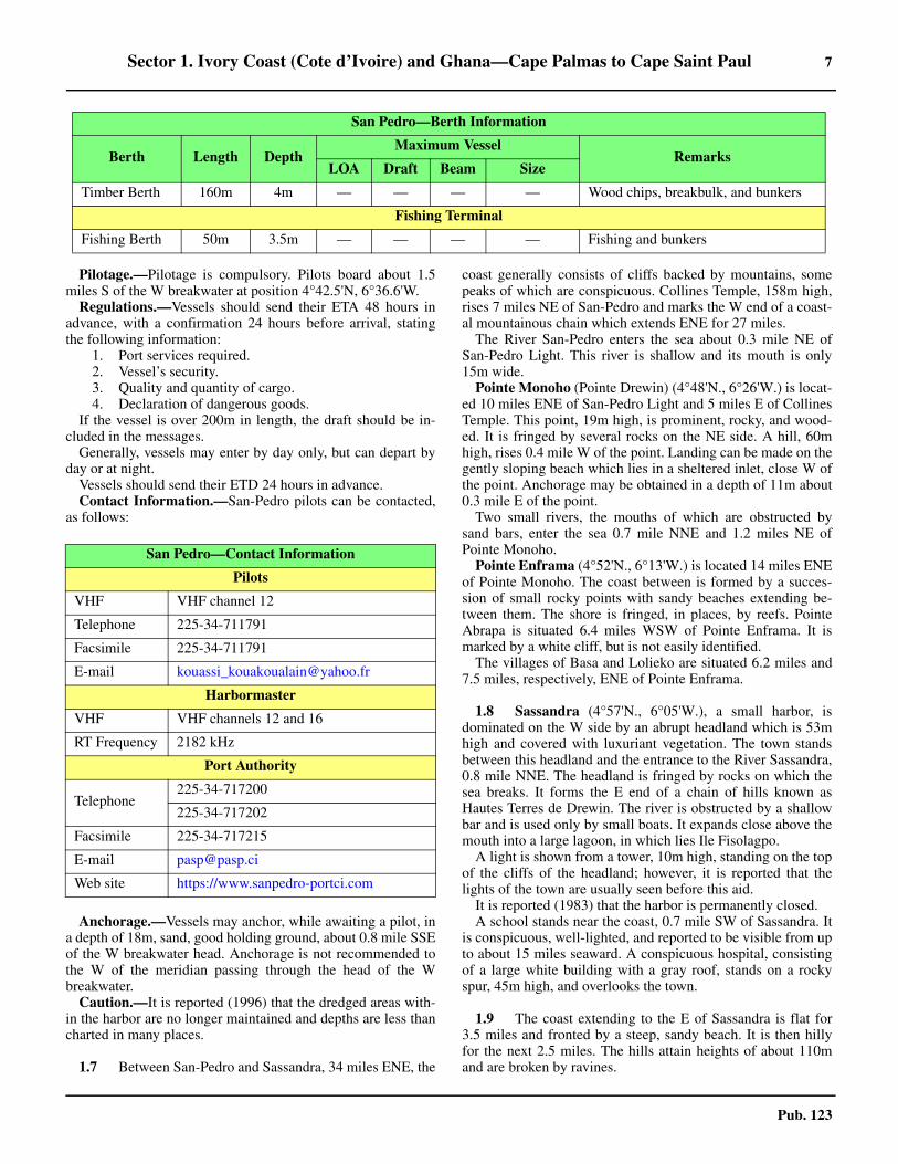
Timber Berth 160m 4m — — — — Wood chips, breakbulk, and bunkers
Fishing Terminal
Fishing Berth 50m 3.5m — — — — Fishing and bunkers
San Pedro—Berth Information
Berth Length DepthMaximum Vessel
RemarksLOA Draft Beam Size
San Pedro—Contact Information
Pilots
VHF VHF channel 12
Telephone 225-34-711791
Facsimile 225-34-711791
E-mail [email protected]
Harbormaster
VHF VHF channels 12 and 16
RT Frequency 2182 kHz
Port Authority
Telephone225-34-717200
225-34-717202
Facsimile 225-34-717215
E-mail [email protected]
Web site https://www.sanpedro-portci.com

8 Sector 1. Ivory Coast (Cote d’Ivoire) and Ghana—Cape Palmas to Cape Saint Paul
Pub. 123
Pointe Brouko (Pointe Mortality) (4°59'N., 5°58'W.) is lo-cated 7 miles ENE of Sassandra. Several villages are situatedin this vicinity. The point is prominent, bold, and steep-to.1.9 From a point on the shore located about 7 miles ENE ofPointe Brouko, a series of red cliffs begin and extend for 18miles to Fresco. A beach stretches to the E of Fresco and isbordered by a row of trees in the middle of which is a wood.1.9 Between Fresco and Grand-Lahou, 34 miles E, the coast islow and thinly wooded. It is bordered by a sandy beach, onwhich the heavy surf frequently makes communication withthe shore impossible. A narrow lagoon, resembling a canal,runs parallel to the coast close behind the beach.
1.10 Grand-Lahou (5°09'N., 5°00'W.) stands on the Wside of the entrance to the Bandama River. This town can beidentified by two prominent houses, one with a black and theother with a red roof, standing at the W end.
Mont Lahou, 106m high, rises 5 miles N of the town and iscovered by trees.
A light, equipped with a racon, is shown from a tower, 13mhigh, standing in the town.
The entrance to the river is very narrow and is fronted by adangerous bar. It is sheltered by a prominent mole projecting Efrom the W entrance point. The yellowish water from the rivercan be seen to the E of the mouth and up to nearly 2 miles off-shore. 1.10 Anchorage may be taken in a depth of 15m, sand and mud,about 0.5 mile SSE of the light. The holding ground is good,but vessels roll heavily. This roadstead is reported (1989) to beseldom used. 1.10 Foxtrot Platform (5°02'N., 4°41'W.), an oil and gas plat-form, is situated 20 miles ESE of Grand-Lahou and about 7miles E of Lion Terminal. A submarine pipeline extends NNEfrom this platform to the shore.1.10 Between Grand-Lahou and Abidjan, 61 miles E, the coast isbordered by a sandy beach. Numerous villages are situatedalong the shore, but are difficult to identify. Lagune Eerie liesbehind this stretch of the coast. This lagoon extends in a W toE direction for about 65 miles and contains numerous islands.1.10 Grande Jack (5°11'N., 4°28'W.) is situated 32 miles E ofGrand-Lahou. This village can be identified by the mass of fo-liage in the background and a prominent house, with a whiteroof, standing close E of it.1.10 It is reported (2003) that a light is shown from a tower stand-ing on the coast about 4.5 miles W of Grande Jack.1.10 Jacqueville (5°12'N., 4°23'W.) is situated 37 miles E ofGrand-Lahou and 5 miles E of Grande Jack. It can be identifiedby a group of white houses, two water towers, and a church.The entire length of the village is fronted by palms.1.10 A dangerous wreck lies about 0.7 mile offshore, 5 miles E ofJacqueville.1.10 A wreck with an unsurveyed depth of at least 20m lies SW ofJacqueville and W of the charted abandoned oil field in posi-tion 5°03.8'N, 4°34.5'W.
1.11 Espoir Terminal (5°03'N., 4°27'W.) (World Port In-dex No. 46008), located about 9 miles S of Jacqueville, con-sists of a platform and a Floating Production Storage and Off-loading (FPSO) Vessel. Oil and gas submarine pipelines extendNW from this facility to the shore.
1.11 Depths—Limitations.—The terminal has a depth of 110malongside and can handle tankers up to 160,000 dwt. Vesselsare berthed in tandem, bow to stern, with the FPSO.1.11 Pilotage.—Pilotage is compulsory. The pilot will advise theboarding position after VHF contact has been established withthe terminal. Pilots usually board about 3 miles ENE of the FP-SO. The pilot can be contacted on VHF channel 14.1.11 Regulations.—Vessels should send their initial ETA to theCNR Offshore Representative on departure from the previousport (or immediately on departure if the port is less than 72hours from the terminal). Vessels must send ETA messages 72hours, 48 hours, and 24 hours prior to arrival.1.11 The first message should contain the following:
1. Vessel name, Call sign, and INMARSAT numbers.2. Cargo requirements.3. Maximum loading rate.4. Arrival draft fore and aft.5. Last port of call.6. Confirmation of clean bill of health.7. Any sickness onboard.8. Distance (in meters) from bow to loading manifold.9. Length.10. A statement that vessel can perform closed loading.11. Confirmation that the vessel is equipped with a bow
stopper able to receive 76mm chain.12. Local agent’s name and details.
1.11 The CNR Offshore Representative must be notified shouldthe vessel’s ETA change by 6 hours or more following the 72-hour and 48-hour notice or by 1 hour or more following the 24-hour notice.1.11 Berthing is available 0600 to 1500 local time. Vessels arriv-ing after 1500 will be berthed the following day. Vessels maydepart at any time.1.11 Contact Information.—The CNR Offshore Representativemay be contacted, as follows:
1.11 The FPSO Control Room can be contacted on VHF channels16 and 69. 1.11 Anchorage.—A designated anchorage area for tankers iscentered about 4 miles NE of the FPSO.1.11 Caution.—A restricted area, with a radius of 2 miles, is cen-tered on the terminal. Vessels must receive permission to enterthis area.1.11 A restricted area, which may best be seen on the chart, liescentered about 10 miles S of Jacqueville. Due to the existenceof underwater obstructions, anchoring and fishing are prohibit-
Espoir Terminal—Contact Information
Pilots
VHF VHF channel 14
FPSO Control Room
VHF VHF channels 16 and 69
CNR Offshore Representative (UK)
Telephone 44-1224-331900
Facsimile 44-1224-331902
E-mail [email protected]
Sector 1. Ivory Coast (Cote d’Ivoire) and Ghana—Cape Palmas to Cape Saint Paul 9
Pub. 123
ed within this area.
1.12 Baobab Marine Terminal (4°58'N., 4°33'W.) (WorldPort Index No. 45970) is located about 13 miles offshore, 29miles ESE of Grand-Lahou. It consists of a Floating Produc-tion Storage and Off loading (FPSO) vessel, which is turret-moored in a depth of 970m. The terminal can handle vessels upto 320,000 dwt. Submarine pipelines extend about 2.5 milesENE and SE from the FPSO (Baobab Ivoirien MV10) to pro-duction manifolds.1.12 Pilotage is compulsory. Pilots can be contacted on VHFchannel 74 and board about 2 miles from the terminal. Vesselsberth during daylight hours only but may depart at any time.Tankers moor in tandem, bow to stern, with the FPSO.1.12 Vessels should send their ETA (in UTC) to the Baobab Ma-rine Terminal at least 7 days in advance, if at sea, or as soon asorders are received to proceed to the terminal. Vessels shouldsend their ETA to the Baobab Marine Terminal and AbidjanPort Authority 72 hours, 48 hours, and 24 hours prior to arrival.Additional notification should be given if the ETA reported onthe 72-hour or 48-hour message changes by 4 hours or more. 1.12 If the transit time from the vessel’s last port of call is lessthan 72 hours, vessels should also send notice of their ETA im-mediately upon leaving the previous port to confirm or updatetheir initial ETA. 1.12 Vessels should immediately contact the terminal if the ETAchanges by more than 1 hour following the submission of the24-hour message. Vessels should also contact the Baobab Ma-rine Terminal via VHF 74, when approximately 10 miles out.
1.12 A circular restricted area, with a radius of 2 miles, is
centered on the terminal. Vessels must receive permission toenter this area.1.12 Tankers moored at the terminal must fly the flag of the Re-public of Ivory Coast.
1.12 A designated anchorage area, with a radius of 1 mile, liescentered about 11.5 miles NE of the terminal.1.12 Contact Information.—See the table titled Baobab MarineTerminal—Contact Information.1.12 Caution.—Small craft, with no lights, may be encounteredin the vicinity of the anchorage and FPSO.
Abidjan (5°15'N., 4°01'W.)
World Port Index No. 46000
1.13 Abidjan is the former capital and principal port ofIvory Coast (Cote d’Ivoire). It provides a large sheltered har-bor. The city is an industrial center and also a major railroadterminal. Works are currently in progress to expand the Coted’Ivoire Terminal (2022), as described in the following para-graphs.
1.13 Winds—Weather.—The wind usually blows from the SWwith frequent calms, especially during the dry seasons. A drywind blows occasionally from ENE between December andFebruary. Hurricanes are frequent, particularly in April, May,October, and November. The weather in this vicinity consistsof four seasons, as follows:
1. A long dry season from December to April.2. A long rainy season from May to the middle of July.3. A short dry season from the middle of July to Septem-
ber or October.4. A short rainy season from September or October to
November.
1.13 A swell from the SW, which never quite subsides, generallyattains a height of 0.3m and causes rollers along the beach inthe vicinity of the port. This swell has been reported to occa-sionally attain a height of 1.8m during June, July, and August.1.13 Tides—Currents.—The tides rise about 1.2m at springs and0.9m at neaps.1.13 At springs, the ebb tidal current attains a rate of about 6knots at the seaward end of Canal de Vridi. The flood current isweaker and at neaps and during the rainy season, it is imper-ceptible.
Baobab Marine Terminal—Contact Information
Call sign C6FV6
VHF VHF channel 74
Offshore Installation Manager
Telephone 870 600-254-559 (INMARSAT)
Cargo Control Room
Telephone 870 763-616-981 (INMARSAT)
Facsimile870 763-616-983 (INMARSAT)
870 600-254-560 (INMARSAT)
Bridge
Telex581 431-148-810 (INMARSAT C)
583 431-148-810 (INMARSAT C)
Abidjan Home Page
http://www.portabidjan.ci
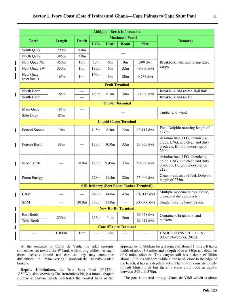
Abidjan—Berth Information
Berth Length DepthMaximum Vessel
RemarksLOA Draft Beam Size
North Quay Terminal

10 Sector 1. Ivory Coast (Cote d’Ivoire) and Ghana—Cape Palmas to Cape Saint Paul
Pub. 123
1
800m (cont.) — 200m
9.0m32m 63,000 dwt
Grain, ro-ro, passengers, PCC, and breakbulk.
2 Ro-ro, passengers, PCC, and breakbulk.3
49.4m Breakbulk.
5 36m 64,794 dwt
West Quay Terminal
06 174m —
200m 9.4m 36m 65,000dwt
Breakbulk.07 174m 10.0m
08 174m 10.0m
Breakbulk and refrigerated cargo.
09 174m 10.0m
10 174m 10.0m
11 174m 10.0m
12 174m 10.0m
13 174m 10.0m
14 174m 10.0m
15a 140m — Breakbulk.
South Quay Terminal
17 134m 11.5m
—
Chemical products, vehicles, breakbulk, containers, and timber. Ro-ro facilities for vessels with self-loading ramps.
18 134m 11.5m
19 134m 11.5m
20 134m 11.5m
Vridi Container Terminal
21 201m — —
11.5m
—
—Containers and reefer.
22 201m —
227m 40m23 201m 12.5m
24 201m 12.5m
25 195m 12.5m 161m 27m Containers, ro-ro, and lo-lo.
Fertilizer Terminal
Quai Siveng 86m 9.0m 170m 8.2m 27m 28,000dwt Fertilizer.
Minerals Terminal
Quai Socopao 153m 9.8m 154m — 26m 24,351 dwt Mineral ore, breakbulk, and bunkers.
Main Quay (Fishing Port)
Abidjan—Berth Information
Berth Length DepthMaximum Vessel
RemarksLOA Draft Beam Size
Sector 1. Ivory Coast (Cote d’Ivoire) and Ghana—Cape Palmas to Cape Saint Paul 11
Pub. 123
1.13 At the entrance of Canal de Vridi, the tidal currentssometimes set toward the W bank with strong eddies. At suchtimes, vessels should use care as they may encounterdifficulties in maneuvering, particularly heavily-loadedtankers.
1.13 Depths—Limitations.—Le Trou Sans Fond (5°13'N.,3°58'W.), also known as The Bottomless Pit, is a funnel-shapedsubmarine canyon which penetrates the coastal bank in the
approaches to Abidjan for a distance of about 11 miles. It has awidth of about 3.5 miles and a depth of over 820m at a distanceof 9 miles offshore. This canyon still has a depth of 200mabout 1.3 miles offshore, while at the head, close to the edge ofthe beach, it has is a depth of 40m. The bottom consists mostlyof soft bluish mud but there is some coral rock at depthsbetween 345 and 370m.
1.13 The port is entered through Canal de Vridi which is about
South Quay 290m 5.0m—
Breakbulk, fish, and refrigerated cargo.
North Quay 385m 7.0m
New Quay NE 450m 10m 50m 6m 9m 500 dwt
New Quay SW 350m 10m 185m 6m 32m 49,990 dwt
New Quay (pier head) 165m 10m 146m 6m 20m 9,734 dwt
Fruit Terminal
North Berth185m
—189m 8.7m 30m 30,000 dwt
Breakbulk and reefer. Rail link.
South Berth — Breakbulk and reefer.
Timber Terminal
Main Quay 185m —— Timber and wood.
Side Quay 85m —
Liquid Cargo Terminal
Petroci Soutes 10m — 145m 8.4m 22m 19,117 dwt Fuel. Dolphin mooring length of 177m.
Petroci Berth 38m — 183m 10.0m 32m 53,755 dwt
Aviation fuel, LPG, chemicals, crude, LNG, and clean and dirty products. Dolphin moorings of 260m.
SIAP Berth — 10.0m 183m 9.45m 32m 50,000 dwt
Aviation fuel, LPG, chemicals, crude, LNG, and clean and dirty products. Dolphin moorings of 212m.
Puma Energy — — 228m 11.5m 22m 75,000 dwt Clean products and fuel. Dolphin length of 275m.
SIR Refinery (Port Bouet Tanker Terminal)
CBM — — 246m 14.0m 42m 107,113 dwt Multiple mooring buoys. Crude, clean, and dirty products.
SBM — 30.0m 350m 21.0m — 300,000 dwt Single mooring buoy. Crude.
New Ro-Ro Terminal
East Berth250m — 236m 14m 36m
63,478 dwt Containers, breakbulk, and bunkers.West Berth 61,411 dwt
Cote d’Ivoire Terminal
— 1,100m 16m — 16m — — UNDER CONSTRUCTION. (Open November, 2022)
Abidjan—Berth Information
Berth Length DepthMaximum Vessel
RemarksLOA Draft Beam Size
12 Sector 1. Ivory Coast (Cote d’Ivoire) and Ghana—Cape Palmas to Cape Saint Paul
Pub. 123
1.5 miles long. The seaward mouth of the canal has recentlybeen widened (2019), giving the canal a width of about 370mthroughout. The canal has a dredged depth of 12.5m, but someobstructions lie at 11.3m or shallower. 1.13 Vessels can transit through the canal only when the tidalcurrent is setting at a rate of less than 2 knots. At neaps, thisoccurs anytime. At springs, this occurs from 1 hour before to 1hour after HW and from 1 hour before to 30 minutes after LW.Large vessels are advised to arrive at the entrance to the canalat HW.1.13 Overhead power cables, with a minimum vertical clearanceof 66m, span the canal, 0.6 mile NW of the entrance.1.13 There are facilities for general cargo, ro-ro, container,timber, reefer, bulk, tanker, and fishing vessels. Vessels of up to250m in length and 11.5m draft can be accommodated.However, the maximum draft for entry is sometimes reduced to9m during periods of heavy swell. The maximum draft foroutbound vessels is 11.5m.1.13 Current works in progress to expand the Cote d’IvoireTerminal adjacent to Anchorages No. 7 and No. 8, between theVridi Container Terminal’s Berth No. 21 and the New Ro-RoTerminal to the N. Alongside depths currently range between15m and 18m. This new terminal is expected to be operationalby November 2022 with 1,100m of quay, two rail lines, and upto six post-panamax gantries. It will accommodate vessels witha maximum draft of 16m and have space for 1,100 containers.1.13 Aspect.—Lighted ranges, which may best be seen on thechart, indicate the approach channel leading into the entranceof Canal de Vridi. The E and W entrance points of the canal aremarked by lights.1.13 Lighted Buoy R (5°12'N., 4°00'W.), equipped with a racon,is moored about 1.5 miles S of the entrance to the canal.Lighted Buoy AN is moored about 1.2 miles SE of the entranceto the canal; vessels should pass E of it.1.13 Port Bouet Light is shown from a conspicuous tower, 34mhigh, standing 2.5 miles E of the entrance to the canal. 1.13 A prominent signal station, with a radio mast, stands on theE entrance point of the canal. A tank farm, several flares, and arefinery, all prominent, are situated about 1 mile NE of the ca-nal entrance. Two conspicuous chimneys stand near a powerstation on the E side of the canal, about 0.7 mile NW of the sig-nal station. Pylons, supporting the overhead power cable, standclose S of the power station and are also conspicuous. A con-spicuous crane is reported to stand on the W side of the en-trance to the canal.1.13 Ile Boulay (5°16'N., 4°06'W.) is situated at the W side of theinner harbor. A wall, painted white and bearing 313° ahead, issituated on this island. It is used as a mark by vessels transitingthe canal.1.13 The inner harbor is part of Lagune Ebrie. It is bounded by IleBoulay on the SW side and Ile de Petit-Bassam on the E side.The town stands on a promontory which extends S toward Ilede Petit-Bassam. The government palace, a large prominentbuilding, stands on a small hill in the SW part of the town.1.13 A light is shown from a water tower standing on the NW partof Ile de Petit-Bassam, about 3.5 miles NNW of the entrance toCanal de Vridi. A conspicuous silo, 36m high, is situated about0.4 mile WNW of this light.1.13 The new Cote d’Ivoire Terminal under construction extendsabout 500m W from the Vridi Container Terminal, forming a
90 trapezoid-shaped quay where it adjoins the New Ro-Ro Ter-minal to the N. 1.13 Pilotage.—Pilotage is compulsory for vessels of more than150 nt and is available 24 hours. Pilots board about 0.8 mileSSW of AN Lighted Buoy (5°13'27.4''N., 3°59'39.6''W.). 1.13 Regulations.—Vessels must send an ETA and request for pi-lotage to Abidjan Port Conrol 24 hours, 6 hours, and 1 hour inadvance. The message must include their draft. 1.13 Vessels moored at the outer anchorage must maintain a con-tinuous listening watch on VHF channel 12 or 16. Vesselsmoored at the inner anchorage must maintain a watch from1000 to 1030 local time (after the port meeting). 1.13 Vessel Traffic Service.—A Vessel Traffic Service (VTS)system operates in the approaches to Canal de Vridi. The VTSarea (control zone) is formed by a circle, with a radius of 1mile, centered on the Approach Lighted Buoy (5°12.9'N.,4°00.2'W.).1.13 Vessels are prohibited from entering the VTS area withoutauthorization from the VTS Center or to anchor, except in cas-es of force majeure (emergency).1.13 After being identified and given instructions by the VTSCenter, vessels will proceed to embark the pilot. Vessels de-parting must follow the route determined by the VTS Center insuch a way as not to restrict the approach of inbound vessels.1.13 Contact Information.—For detailed contact information,see the table titled Abidjan—Contact Information.
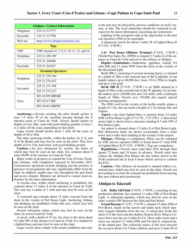
Abidjan—Contact Information
Pilot
VHF VHF channels 6, 11, 12, and 16
Telephone225 21 238-655
225 21 238-656
Vessel Traffic Service (VTS)
Call sign Vigie
VHF VHF channel 12
Telephone 225 21 275-850
Facsimile 225 21 270-677
Harbor Master
Call sign Abidjan Port Control
VHF VHF channels 6, 11, 12, 16 (Port Operations 13; Port Security 85)
Telephone 225 21 238697
225-21-275850
Facsimile 225 21 270677
Port Authority
Telephone 225 21 238-000
Facsimile 225 21 238-080
E-mail [email protected]
Web site https://www.portabidjan.ci
Abidjan Terminal
Sector 1. Ivory Coast (Cote d’Ivoire) and Ghana—Cape Palmas to Cape Saint Paul 13
Pub. 123
1.13 Anchorage.—Vessels awaiting the pilot should anchor atleast 1.5 miles W of the meridian passing through the Sentrance point of Canal de Vridi. Vessels should anchor indepths of over 20m, sand with good holding ground, at least 1to 2 miles off the coast, depending on their draft.1.13 Large vessels should anchor about 1 mile off the coast, indepths of 40 to 50m.1.13 The inner anchorage berths, within the harbor, lie S, E, andN of Ile Boulet and may best be seen on the chart. They havedepths of 8 to 23m, hard mud, with good holding ground.1.13 Caution.—An area obstructed by wrecks, the limits ofwhich may best be seen on the chart, lies centered about 8miles WSW of the entrance to Canal de Vridi.1.13 Major works in progress to expand the Cote d’Ivoire Termi-nal continue, with completion expected in November 2022.Construction operations include dredging and the position orpresence of navigational aids may significantly differ from thechart. In addition, depths may vary throughout the port basinand access channel. Mariners are advised to contact local au-thorities for the latest information. 1.13 A circular area, within which anchoring is prohibited, liescentered about 1.5 miles S of the entrance to Canal de Vridi.This area has a radius of 1 mile and may best be seen on thechart.1.13 A restricted area extends about 15 miles seaward from theshore in the vicinity of Port Bouet Light. Anchoring, fishing,and dredging are prohibited within this area, which may bestbe seen on the chart.1.13 Several submarine cables, which may best be seen on thechart, lie across Canal de Vridi.1.13 A wreck, with a depth of 15.1m, lies close to the shore about0.5 mile SW of the entrance to Canal de Vridi. It is marked bya lighted buoy and may best be seen on the chart.1.13 Large vessels must comply with certain conditions and entry
to the port may be delayed by adverse conditions of swell, cur-rent, or tide. The local authorities should be contacted in ad-vance for the latest information concerning any restrictions.1.13 Lighting of the navigation aids in the approaches to the portwas reported (1998) to be unreliable.1.13 A dangerous wreck lies about 3 miles W of Lighted Buoy R(5°12'N., 4°00'W.).
1.14 Port Bouet Offshore Terminal (5°14'N., 3°58'W.)(World Port Index No. 45990) is situated 2.7 miles E of the en-trance to Canal de Vridi and serves the refinery at Abidjan.1.14 Depths—Limitations.—Submarine pipelines extend 0.9mile SSE and 2.1 miles SSW from the shore in the vicinity ofthe directional light.1.14 Berth SIR I, consisting of several mooring buoys, is situatedin a depth of 20m at the seaward end of the E pipeline. It canhandle tankers up to 80,000 dwt, from 170 to 250m in length,and up to 14m draft. 1.14 Berth SIR II (5°14'N., 3°58'W.) is an SBM situated in adepth of 49m at the seaward end of the W pipeline. It can han-dle tankers up to 250,000 dwt and 21m draft, with a minimumlength of 300m. Vessels over 150,000 dwt require specialmooring arrangements. 1.14 The SSW swell in the vicinity of the berths usually attains aheight of 1.5m, but can reach a height of 2.7m during July andAugust.
Aspect.—An outer lighted buoy is moored about 1.6 milesSSW of Port Bouet Light (5°14.7'N., 3°57.5'W.). A directionalsector light is shown from a structure standing 0.3 mile NW ofPort Bouet Light.
An airport is situated about 1.5 miles E of Port Bouet Light.Red obstruction lights are shown occasionally from a watertower and a radio mast standing in the vicinity of the airport.1.14 Pilotage.—Pilotage is compulsory. Pilots can be contactedby VHF and are reported (2005) to board about 0.7 mile ENEof Lighted Buoy R (5°12'N., 4°00'W.). Tugs are compulsory.1.14 Regulations.—Vessels must send their ETA through theiragents 72 hours and 24 hours in advance. Vessels must alsocontact the Abidjan Port Master the day before arrival at theVridi roadstead and at least 6 hours before arrival to confirmthe ETA.1.14 Caution.—The offshore oil terminal is situated within a re-stricted area, which may best be seen on the chart. Vessels notproceeding to or from the terminal are prohibited from enteringthis area without prior permission.
Abidjan to Takoradi
1.15 Belier Oil Field (5°05'N., 3°50'W.), consisting of oneproduction platform, lies centered 11 miles SSE of Port BouetLight. A submarine pipeline, which may best be seen on thechart, extends NW between this field and Port Bouet.
Grand Bassam (5°12'N., 3°43'W.), situated 15 miles ESE ofPort Bouet, stands on the narrow and sandy neck which sepa-rates Lagune Ouladine from the sea. A ruined pier fronts theshore S of the town and the shallow Komoe River (Flueve Co-moe) flows into the sea 2 miles E of it. Three radio masts and atower are situated 2.7 miles ENE and 0.8 mile E, respectively,of the ruined pier. The yellowish waters of the river discolorthe sea up to about 4 or 5 miles offshore and up to 2 miles W of
Telephone 225-21-217777
Facsimile 225-21-217790
Web site https://www.abidjan-terminal.com
Tugs
VHF VHF channels 6, 7, 8, 9, 10, 11, 12, and 16
Telephone 225 21 240-189
225-21-240466
Facsimile 225-21-241627
Terminal Operators
Telephone225 21 270-160
225 21 270-427
Facsimile225 21 271-798
225 21 273-217
Telex
983 42399 DIRSIR
983 43317 SIR
983 43442 SIRFIN
Abidjan—Contact Information
14 Sector 1. Ivory Coast (Cote d’Ivoire) and Ghana—Cape Palmas to Cape Saint Paul
Pub. 123
the mouth. It is reported (1999) that a light is shown from astructure, 32m high, standing in the vicinity of the town.1.15 Vessels anchoring at Grand Bassam usually moor in depthsof 11 to 18m, good holding ground, off the ruined pier. Localknowledge is advised.
1.15 The Riviere Assinie (Assinie River) (5°07'N., 3°17'W.),which receives water from an extensive area, lies with itsmouth located about 27 miles E of Grand Bassam. The coastbetween is fringed by trees, 30 to 35m high, and numerous hutsare situated along the beach. The bar, which fronts the river, isoften impassable and can only be crossed by small craft. It issituated close S of the town of Assinie. Prior to 1976, themouth of this river was situated about 8 miles W of its presentposition in the vicinity of Assouendi, a large village. Within theentrance of the river, Canal d’Assinie leads W to join theKomoe River (Flueve Comoe).
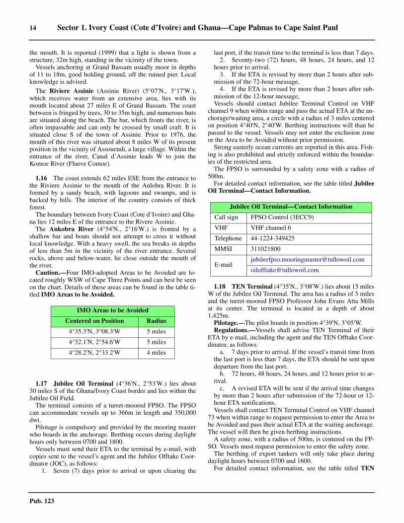
1.16 The coast extends 62 miles ESE from the entrance tothe Riviere Assinie to the mouth of the Anlobra River. It isformed by a sandy beach, with lagoons and swamps, and isbacked by hills. The interior of the country consists of thickforest.1.16 The boundary between Ivory Coast (Cote d’Ivoire) and Gha-na lies 12 miles E of the entrance to the Rivere Assinie.1.16 The Ankobra River (4°54'N., 2°16'W.) is fronted by ashallow bar and boats should not attempt to cross it withoutlocal knowledge. With a heavy swell, the sea breaks in depthsof less than 5m in the vicinity of the river entrance. Severalrocks, above and below-water, lie close outside the mouth ofthe river.1.16 Caution.—Four IMO-adopted Areas to be Avoided are lo-cated roughly WSW of Cape Three Points and can best be seenon the chart. Details of these areas can be found in the table ti-tled IMO Areas to be Avoided.
1.17 Jubilee Oil Terminal (4°36'N., 2°53'W.) lies about30 miles S of the Ghana/Ivory Coast border and lies within theJubilee Oil Field.1.17 The terminal consists of a turret-moored FPSO. The FPSOcan accommodate vessels up to 366m in length and 350,000dwt.1.17 Pilotage is compulsory and provided by the mooring masterwho boards in the anchorage. Berthing occurs during daylighthours only between 0700 and 1800.1.17 Vessels must send their ETA to the terminal by e-mail, withcopies sent to the vessel’s agent and the Jubilee Offtake Coor-dinator (JOC), as follows:
1. Seven (7) days prior to arrival or upon clearing the
last port, if the transit time to the terminal is less than 7 days.2. Seventy-two (72) hours, 48 hours, 24 hours, and 12
hours prior to arrival.3. If the ETA is revised by more than 2 hours after sub-
mission of the 72-hour message,4. If the ETA is revised by more than 2 hours after sub-
mission of the 12-hour message,1.17 Vessels should contact Jubilee Terminal Control on VHFchannel 9 when within range and pass the actual ETA at the an-chorage/waiting area, a circle with a radius of 3 miles centeredon position 4°40'N, 2°40'W. Berthing instructions will than bepassed to the vessel. Vessels may not enter the exclusion zoneor the Area to be Avoided without prior permission. 1.17 Strong easterly ocean currents are reported in this area. Fish-ing is also prohibited and strictly enforced within the boundar-ies of the restricted area. 1.17 The FPSO is surrounded by a safety zone with a radius of500m. 1.17 For detailed contact information, see the table titled JubileeOil Terminal—Contact Information.
1.18 TEN Terminal (4°35'N., 3°08'W.) lies about 15 milesW of the Jubilee Oil Terminal. The area has a radius of 5 milesand the turret-moored FPSO Professor John Evans Atta Millsat its center. The terminal is located in a depth of about1,425m.
Pilotage.—The pilot boards in position 4°39'N, 3°05'W. Regulations.—Vessels shall advise TEN Terminal of their
ETA by e-mail, including the agent and the TEN Offtake Coor-dinator, as follows:
a. 7 days prior to arrival. If the vessel’s transit time fromthe last port is less than 7 days, the ETA should be sent upondeparture from the last port.
b. 72 hours, 48 hours, 24 hours, and 12 hours prior to ar-rival.
c. A revised ETA will be sent if the arrival time changesby more than 2 hours after submission of the 72-hour or 12-hour ETA notifications.Vessels shall contact TEN Terminal Control on VHF channel
73 when within range to request permission to enter the Area tobe Avoided and pass their actual ETA at the waiting anchorage.The vessel will then be given berthing instructions.
A safety zone, with a radius of 500m, is centered on the FP-SO. Vessels must request permission to enter the safety zone.
The berthing of export tankers will only take place duringdaylight hours between 0700 and 1600. 1.18 For detailed contact information, see the table titled TEN
IMO Areas to be Avoided
Centered on Position Radius
4°35.3'N, 3°08.3'W 5 miles
4°32.1'N, 2°54.6'W 5 miles
4°28.2'N, 2°33.2'W 4 miles
Jubilee Oil Terminal—Contact Information
Call sign FPSO Control (3ECC9)
VHF VHF channel 6
Telephone 44-1224-349425
MMSI 311021800
Sector 1. Ivory Coast (Cote d’Ivoire) and Ghana—Cape Palmas to Cape Saint Paul 15
Pub. 123
Terminal—Contact Information.
1.18 Anchorage.—The waiting anchorage is an area with a radi-us of 3 miles centered on position 4°48.0'N, 3°00.0'W.
1.18 OCTP Development Area (4°28'N., 2°33'W.) lies closeESE of the Jubilee Oil Terminal. The area has a radius of 4miles, centered on position 4°28'N, 2°33'E, and has the mooredstorage tanker PSO John Agyekum Kufuor at its center. 1.18 Axim Bay is entered close S of the entrance to the AnkobraRiver. It lies between Akrumasi Point and Pepre Point, 2.5miles SSE. The N shore of this bay is sandy and the E shore isrocky. The shores are backed by densely wooded land whichrises to hills, 60 to 90m high. Round Hill, 77m high, rises 1.2miles E of Akrumasi Point.
1.19 Axim (4°52'N., 2°15'W.) (World Port Index No.46020), an anchorage port for timber, lies at the E side of thebay, 0.7 mile N of Pepre Point.1.19 Bobowasi Island lies 0.4 mile NNW of Pepre Point. It is 14mhigh and is connected to the coast by a reef. Axim Light isshown from a structure, with a signal station, standing on theisland.1.19 Litton Rock, with a least depth of 6.4m, lies about 2.3 milesW of the S extremity of Bobowasi Island. It is surrounded byrocky patches, with depths of 7 to 9m, which extend up to 0.3mile seaward. Watts Rock, with a least depth of 6.7m, lies 0.7mile S of Pepre Point and is surrounded by foul ground. Heav-en Rock, with a least depth of 2.1m, lies about 1 mile W ofBobowasi Island and is also surrounded by foul ground. Depthsof less than 9m lie close W, N, and ESE of this rock. BeninRock, with a least depth of 6.4m, lies 0.4 mile NW of Bobo-wasi Island.1.19 Anchorage may be obtained in a depth of 9m, good holdingground, about 0.7 mile WNW of Bobowasi Island and midwaybetween Heaven Rock and Benin Rock.1.19 The town of Axim stands on the slopes of the hills behind thecoast. A fort is situated on a small rocky point in front of thetown.
1.20 Cape Three Points (4°45'N., 2°05'W.) is located 12miles SE of Axim; the coast between is indented by severalbays. The name is given to the middle one of three pointswhich form a 3.5-mile long section of the coast. The entire faceof this section, from West Point to East Point, consists of a se-ries of hills with abrupt sides and rocky points.1.20 A light is shown from a prominent tower, 19m high, standing
on the S extremity of the cape.1.20 Cape Shoal, a group of dangerous rocks, lies 0.8 mile SSWof Cape Three Points Light and has a least depth of 4.6m. Thesea does not always break on this group and even with heavyrollers, the rocks only break at considerable intervals of time.Vessels are advised to stay in depths of at least 35m in thisvicinity.
Achowa Point (4°46'N., 1°58'W.) is located 6 miles ENE ofCape Three Points. The coast between is bold and rocky fornearly 1 mile. It then becomes an undulating plain fronted by asandy beach. The depths offshore between these points arevery irregular and vessels should not approach the coast with-out local knowledge.1.20 Achowa Point is composed of several rocky projections, withreefs extending a short distance from each of them. Severalabove-water rocks lie close off the W side of the point and maybe seen distinctly from seaward. A rock, with a least depth of5.5m, lies 0.4 mile SSW of the outermost above-water rock. Arock, with a least depth of 18m, lies about 2.5 miles S of thepoint.1.20 Dix Cove lies 2.5 miles NE of Achowa Point. It is encum-bered with reefs but may be used by small craft. A prominentfort, with walls 9m high, stands above the NE entrance point.Mount Swanzy, 119m high, rises about 3 miles NNW of thecove. A low and rocky islet lies about 0.5 mile offshore, 1 mileNE of the entrance to the cove. It is covered with coarse grassand surrounded by reefs.1.20 Butre Point, bold and rocky, is located 2.5 miles NE of DixCove. A river enters the sea close N of this point and the ruinsof a small fort stand on the W bank near the mouth. MountBartensteen, 134m high, rises 2 miles NNW of this point and iscovered with tall trees.
1.20 Adoblo Rock (4°50'N., 1°53'W.) lies at the end of a sandyprojection which extends from the coast 1.5 miles ENE ofButre Point. It is large, black, and shaped like a haystack.1.20 Between this rock and Takoradi, 9 miles ENE, the characterof the coast changes and the shore is fronted by reefs, irregulardepths, and rocky shoals.1.20 Pumponi, a village, stands on a point located 3.5 miles ENEof Adoblo Rock. The point is composed of two hillocks. A bea-con, 18m high, stands on the W most hillock. 1.20 Caution.—An obstruction was reported (1945) to lie about2.8 miles SE of Achowa Point.1.20 An obstruction, with a depth of 5.9m, was reported (1924) tolie (position approximate) about 0.6 mile SE of Dix Cove.1.20 Due to reefs extending up to about 1.3 miles from the shorein places and numerous other dangers, vessels transiting thecoast between Adoblo Rock and Takkoradi are advised to keepin depths of at least 20m.
1.21 Takoradi (4°53'N., 1°44'W.) (World Port Index No.46040), a sheltered harbor, lies in the SW part of Takoradi Bay,which is entered between Takoradi Point and Sekondi Point, 4miles NE.
TEN Terminal—Contact Information
Call sign TEN Terminal Control (C6BG3)
VHF VHF channel 73
Telephone 44-2089-785571
MMSI 311000254
[email protected] (Offtake Coor-dinator)
Web site http://www.tullowoil.com
Takoradi Home Page
http://www.ghanaports.gov.gh
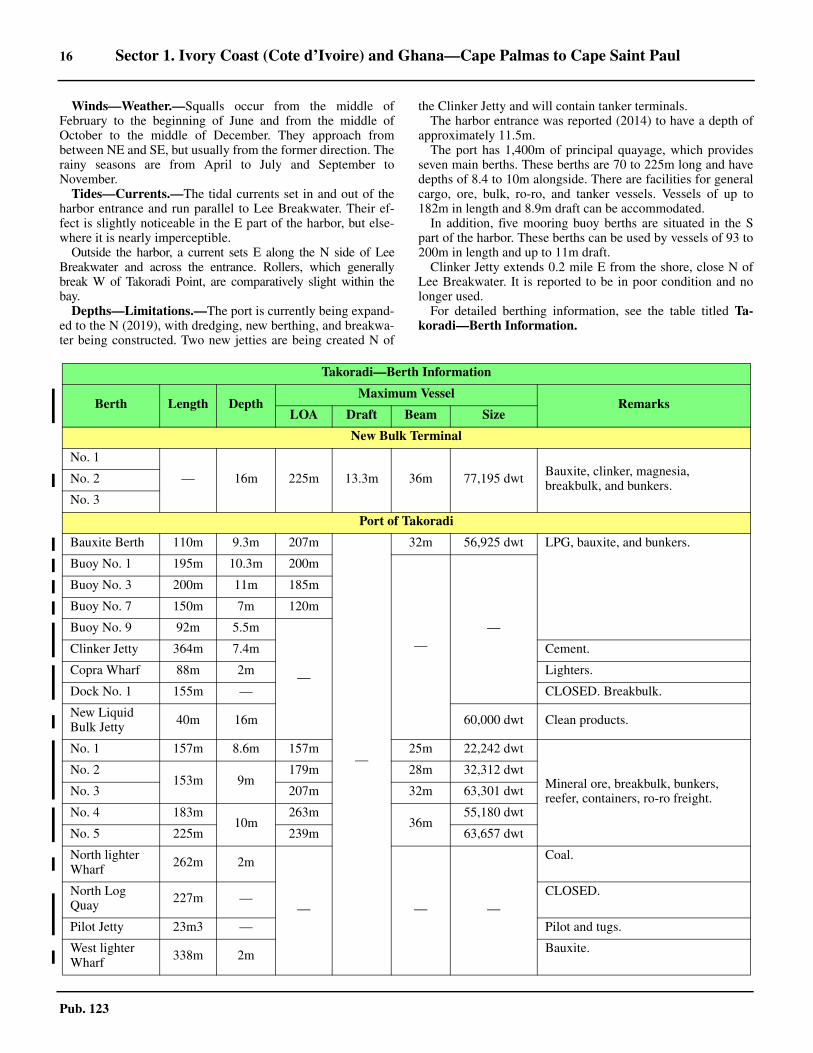
16 Sector 1. Ivory Coast (Cote d’Ivoire) and Ghana—Cape Palmas to Cape Saint Paul
Pub. 123
1.21 Winds—Weather.—Squalls occur from the middle ofFebruary to the beginning of June and from the middle ofOctober to the middle of December. They approach frombetween NE and SE, but usually from the former direction. Therainy seasons are from April to July and September toNovember.1.21 Tides—Currents.—The tidal currents set in and out of theharbor entrance and run parallel to Lee Breakwater. Their ef-fect is slightly noticeable in the E part of the harbor, but else-where it is nearly imperceptible.1.21 Outside the harbor, a current sets E along the N side of LeeBreakwater and across the entrance. Rollers, which generallybreak W of Takoradi Point, are comparatively slight within thebay.1.21 Depths—Limitations.—The port is currently being expand-ed to the N (2019), with dredging, new berthing, and breakwa-ter being constructed. Two new jetties are being created N of
the Clinker Jetty and will contain tanker terminals. 1.21 The harbor entrance was reported (2014) to have a depth ofapproximately 11.5m.1.21 The port has 1,400m of principal quayage, which providesseven main berths. These berths are 70 to 225m long and havedepths of 8.4 to 10m alongside. There are facilities for generalcargo, ore, bulk, ro-ro, and tanker vessels. Vessels of up to182m in length and 8.9m draft can be accommodated.1.21 In addition, five mooring buoy berths are situated in the Spart of the harbor. These berths can be used by vessels of 93 to200m in length and up to 11m draft.1.21 Clinker Jetty extends 0.2 mile E from the shore, close N ofLee Breakwater. It is reported to be in poor condition and nolonger used.1.21 For detailed berthing information, see the table titled Ta-koradi—Berth Information.
Takoradi—Berth Information
Berth Length DepthMaximum Vessel
RemarksLOA Draft Beam Size
New Bulk Terminal
No. 1
— 16m 225m 13.3m 36m 77,195 dwt Bauxite, clinker, magnesia, breakbulk, and bunkers.No. 2
No. 3
Port of Takoradi
Bauxite Berth 110m 9.3m 207m
—
32m 56,925 dwt LPG, bauxite, and bunkers.
Buoy No. 1 195m 10.3m 200m
——
Buoy No. 3 200m 11m 185m
Buoy No. 7 150m 7m 120m
Buoy No. 9 92m 5.5m
—
Clinker Jetty 364m 7.4m Cement.
Copra Wharf 88m 2m Lighters.
Dock No. 1 155m — CLOSED. Breakbulk.
New Liquid Bulk Jetty 40m 16m 60,000 dwt Clean products.
No. 1 157m 8.6m 157m 25m 22,242 dwt
Mineral ore, breakbulk, bunkers, reefer, containers, ro-ro freight.
No. 2153m 9m
179m 28m 32,312 dwt
No. 3 207m 32m 63,301 dwt
No. 4 183m10m
263m36m
55,180 dwt
No. 5 225m 239m 63,657 dwt
North lighter Wharf 262m 2m
— — —
Coal.
North Log Quay 227m — CLOSED.
Pilot Jetty 23m3 — Pilot and tugs.
West lighter Wharf 338m 2m Bauxite.
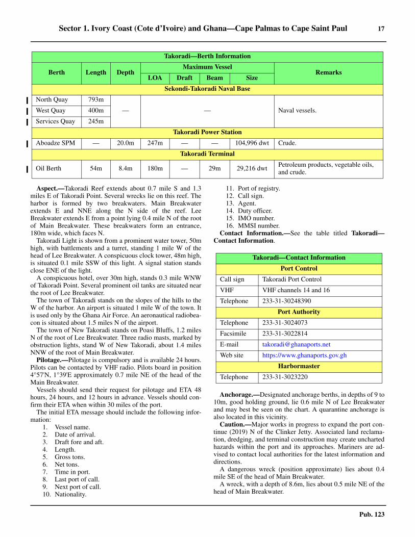
Sector 1. Ivory Coast (Cote d’Ivoire) and Ghana—Cape Palmas to Cape Saint Paul 17
Pub. 123
1.21 Aspect.—Takoradi Reef extends about 0.7 mile S and 1.3miles E of Takoradi Point. Several wrecks lie on this reef. Theharbor is formed by two breakwaters. Main Breakwaterextends E and NNE along the N side of the reef. LeeBreakwater extends E from a point lying 0.4 mile N of the rootof Main Breakwater. These breakwaters form an entrance,180m wide, which faces N.1.21 Takoradi Light is shown from a prominent water tower, 50mhigh, with battlements and a turret, standing 1 mile W of thehead of Lee Breakwater. A conspicuous clock tower, 48m high,is situated 0.1 mile SSW of this light. A signal station standsclose ENE of the light.1.21 A conspicuous hotel, over 30m high, stands 0.3 mile WNWof Takoradi Point. Several prominent oil tanks are situated nearthe root of Lee Breakwater.1.21 The town of Takoradi stands on the slopes of the hills to theW of the harbor. An airport is situated 1 mile W of the town. Itis used only by the Ghana Air Force. An aeronautical radiobea-con is situated about 1.5 miles N of the airport.1.21 The town of New Takoradi stands on Poasi Bluffs, 1.2 milesN of the root of Lee Breakwater. Three radio masts, marked byobstruction lights, stand W of New Takoradi, about 1.4 milesNNW of the root of Main Breakwater. 1.21 Pilotage.—Pilotage is compulsory and is available 24 hours.Pilots can be contacted by VHF radio. Pilots board in position4°57'N, 1°39'E approximately 0.7 mile NE of the head of theMain Breakwater.1.21 Vessels should send their request for pilotage and ETA 48hours, 24 hours, and 12 hours in advance. Vessels should con-firm their ETA when within 30 miles of the port.1.21 The initial ETA message should include the following infor-mation:
1. Vessel name.2. Date of arrival.3. Draft fore and aft.4. Length.5. Gross tons.6. Net tons.7. Time in port.8. Last port of call.9. Next port of call.10. Nationality.
11. Port of registry.12. Call sign.13. Agent.14. Duty officer.15. IMO number.16. MMSI number.
1.21 Contact Information.—See the table titled Takoradi—Contact Information.
1.21 Anchorage.—Designated anchorage berths, in depths of 9 to10m, good holding ground, lie 0.6 mile N of Lee Breakwaterand may best be seen on the chart. A quarantine anchorage isalso located in this vicinity.1.21 Caution.—Major works in progress to expand the port con-tinue (2019) N of the Clinker Jetty. Associated land reclama-tion, dredging, and terminal construction may create unchartedhazards within the port and its approaches. Mariners are ad-vised to contact local authorities for the latest information anddirections.1.21 A dangerous wreck (position approximate) lies about 0.4mile SE of the head of Main Breakwater.1.21 A wreck, with a depth of 8.6m, lies about 0.5 mile NE of thehead of Main Breakwater.
Sekondi-Takoradi Naval Base
North Quay 793m
— — Naval vessels.West Quay 400m
Services Quay 245m
Takoradi Power Station
Aboadze SPM — 20.0m 247m — — 104,996 dwt Crude.
Takoradi Terminal
Oil Berth 54m 8.4m 180m — 29m 29,216 dwt Petroleum products, vegetable oils, and crude.
Takoradi—Berth Information
Berth Length DepthMaximum Vessel
RemarksLOA Draft Beam Size
Takoradi—Contact Information
Port Control
Call sign Takoradi Port Control
VHF VHF channels 14 and 16
Telephone 233-31-30248390
Port Authority
Telephone 233-31-3024073
Facsimile 233-31-3022814
E-mail [email protected]
Web site https://www.ghanaports.gov.gh
Harbormaster
Telephone 233-31-3023220
18 Sector 1. Ivory Coast (Cote d’Ivoire) and Ghana—Cape Palmas to Cape Saint Paul
Pub. 123
1.21 A wreck, with a depth of 0.9m, lies about 2 miles NE of thehead of Main Breakwater.1.21 An obstruction is reported to lie in the vicinity of the E sideof the anchorage area, about 0.5 mile N of the head of MainBreakwater.1.21 An area, within which anchorage is prohibited, extends 0.5mile N of the port entrance and may best be seen on the chart.1.21 A submarine pipeline, which can best be seen on the chart, islocated in close proximity to the anchorage zone. 1.21 At times, a scend is experienced within the harbor and ves-sels are advised to moor securely alongside.
Takoradi to Tema
1.22 Sekondi Point (4°56'N., 1°42'W.), located 4 milesNE of Takoradi, is formed by a bold, prominent, and rockycliff, 29m high. The coast between is composed of severalsmall bights divided by rocky points. The shore is fronted, inmany places, by foul ground.
Fort Orange, a conspicuous square building, is situated on ahill close N of the point. Fort Orange Light is shown from atower standing on the S corner of the fort.1.22 The town of Sekondi extends W and N from the point andstands between the fort and Sekondi Lagoon.
Sekondi Naval Harbor (4°56'N., 1°42'W.), located close Eof Sekondi Point, is formed by two breakwaters. Main Break-water extends E and NE from the point and forms the S and SEside of the harbor. Lee Breakwater extends ESE from a pointlying 0.4 mile N of the root of Main Breakwater and forms theN side. The entrance faces N and has depths of 9 to 10m. Theharbor basin has general depths of 10 to 11m, deceasing to 4mat the inner end.
Fort Orange Light and a light shown from a tower standingon the head of Main Breakwater form a range, which leadsWSW between the banks lying in the approaches.
Butatel Point, backed by rocky cliffs 12 to 18m high, is lo-cated 0.4 mile N of Fort Orange Light. A prominent building,with twin towers, stands close W of this point.1.22 Tsiakur Bansu Point, fronted by a breakwater, is located 0.7mile NNE of Fort Orange Light. It is surmounted by a conspic-uous boundary pillar standing at an elevation of 13m. A con-spicuous green house, with a dark roof, is situated 0.3 mile SWof this point.
1.22 Sherbro Bank (4°57'N., 1°39'W.), with a least depth of5.6m, lies about 2.5 miles ENE of the harbor entrance andbreaks when the rollers are heavy. Vessels are advised to givethis shoal bank a wide berth.1.22 Roani Bank (4°55'N., 1°38'W.), with a least depth of 12m,lies about 3.5 miles ESE of the harbor entrance.
Sekondi Bay (4°57'N., 1°42'W.) lies between Sekondi NavalHarbor and Suchu Point, 1.5 miles NNE. It is shallow and en-cumbered by numerous rocks. Suchu Reef lies 0.3 mile E ofSuchu Point and extends parallel to the coast.1.22 Caution.—It is reported that numerous fishing craft are of-ten encountered in the vicinity of Roani Bank.
1.23 Aboadi Point (4°58'N., 1°38'W.), fronted by a reefwith several above-water rocks, is located 3 miles ENE of Su-chu Point. The coast between consists of sandy beaches sepa-
rated by rocky points, which are fronted by rocks. The point islow, with a conspicuous clump of palm trees located near itsextremity.
Takoradi (Aboadi) Oil Terminal (4°58'N., 1°38'W.) con-sists of a lighted SPM moored about 2 miles SE of AboadiPoint, in a depth of 18.5m. A submarine pipeline, which maybest be seen on the chart, extends NW from the offshore termi-nal to the coast. Vessels are required to remain outside the pro-hibited area extending 2 miles from either side of the pipelineunless a pilot is on board. The terminal supplies oil to a thermalpower station situated E of Takoradi. Tankers up to 55,000 dwtand 300m in length can be accommodated.
Pilots are provided by the station in Takoradi and boardabout 3 miles SW or 3 miles E of the SPM. 1.23 For contact information, see the table titled Takoradi OilTerminal—Contact Information. 1.23 Caution.—A wreck, with a depth of 0.8m, lies near the Eside of Sherbro Bank, about 1.2 miles S of Aboadi Point.
1.24 Bassubu Rocks (4°59'N., 1°38'W.) front the shoreabout 0.7 mile NE of Aboadi Point and are fringed by a reefwhich extends up to 0.5 mile E. The coast in this vicinity isfronted by reefs and foul ground which extend up to 0.8 mileoffshore in places.1.24 Shama Bay (5°01'N., 1°36'W.) lies between Aboadi Pointand Kafodzidzi (Kotobrai), 6.5 miles NE. The bay affords con-siderable shelter from the swell, even during the rainy season.A conspicuous fort stands 2.3 miles NNE of Aboadi Point. It isformed by a square building with a wall and is situated on ris-ing ground behind the town of Shama. The ground W of thefort rises considerably above it.1.24 The Pra River discharges into the bay between two lagoons,about 0.5 mile N of Shama. It is fronted by a shallow bar andonly used by small craft. Anchorage may be obtained withinthe bay in a depth of 13m, sand and mud, between 1.5 milesand 2 miles ESE of the fort.1.24 A straight beach, 4.5 miles long, extends from the mouth ofthe Pra River to Kafodzidzi, a point composed of prominentred cliffs. An irregular reef, lying 0.2 mile offshore, commenc-es 1 mile W of the red cliffs and fronts their whole length.
1.25 Assay Point (5°03'N., 1°30'W.), located 3 miles ENEof Kafodzidzi, is surmounted by Gold Hill, an isolated hum-mock, which has a remarkable appearance when seen from theW. Foul ground and depths of 5 to 9m extend up to 1.2 milesSE of the point.1.25 Between Assay Point and Komenda, 1 mile ENE, the coast islow and fronted by reefs. A lagoon lies close E of Komenda.Ampenyi (Ampeni), a small village, stands 3.5 miles ENE ofKomenda and the town of Brenu-Achinum (Breni-Akyim) is
Takoradi Oil Terminal—Contact Information
Telephone 233-31-3021700
Facsimile 233-31-3021900
E-mail [email protected]
Web site https://www.vra.com
Sector 1. Ivory Coast (Cote d’Ivoire) and Ghana—Cape Palmas to Cape Saint Paul 19
Pub. 123
situated on the summit of a small hill, close ENE of it.Nkwanda (Ankwana) (5°04'N., 1°24'W.), a village, stands
on the beach, 2.3 miles E of Brenu-Achinum.1.25 Busum Accra Reefs fringe the coast in the vicinity of Nkwanda.These reefs appear in four distinct patches on which the rollersbreak heavily. Depths of less than 8m lie close to the outer edge ofthe reefs which extend up to about 0.5 mile offshore.
Elmina Point (5°05'N., 1°20'W.), formed by the extremityof a low and rocky peninsula, is situated 2.7 miles E of Nkwan-da. It is fronted by a reef off which rollers break, depending onthe state of the sea and swell. The coast between is formed by ahard and sandy beach. Elmina Bay, about 0.5 mile wide, is en-tered close N of the point.
Elmina, a small town, extends around the shores of the bay.A small fort is located on Elmina Point and a prominent fort,30m high, stands on a hill and overlooks the S part of the town.1.25 Anchorage may be obtained off the bay in a depth of 13m,sand and mud, about 1.5 miles SE of the fort on Elmina Point.Anchorage may also be taken in a depth of 9m, black mud,about 0.9 mile E of the fort or in a depth of 5m, fine black sandwith fair holding ground, about 0.3 mile offshore.
1.26 Cape Coast (5°06'N., 1°14'W.) is situated 6.7 miles Eof Elmina. The coast between is bordered by a sandy beachwith regular soundings offshore, with the only exception beingat the W end of the beach where there are two small rivers,each closed by a bar, which have a rocky stretch between them.1.26 Cape Coast Castle, white and conspicuous, stands on a greatmass of red sandstone lying on a projecting point. The town ofCape Coast stands behind this castle. A prominent mast, withan elevation of 210m, is situated 1 mile N of the castle and ismarked by obstruction lights at night. The conspicuous build-ing of a school is located 2 miles W of the town.1.26 During the dry season, vessels can anchor in a depth of 9mabout 0.5 mile SE of the castle. During the rainy season, thereis usually a long swell. Vessels should then anchor in a depth of18m about 1.5 miles SE of the castle.1.26 Between Cape Coast and Queen Ann’s Point (Queen AnnePoint), 2 miles NE, the coast consists of many small bays andpoints which are fronted by rocks. Generally, an almost contin-uous line of breakers appears along these rocks.1.26 Queen Ann’s Point is bold and steep. Its summit is sur-mounted by a village and the ruins of a fort. A small river, themouth of which is closed by a bar, lies on the W side of thepoint. The adjacent land is hilly and covered with trees.1.26 Between Queen Ann’s Point and Moree Point, 1.3 miles NE,the shore is fronted by several rocks. The ruins of a fort, whichare difficult to distinguish against the dark background, are sit-uated on the heights above Moree Point. A black rock, withtwo heads on which the sea breaks, lies 0.2 mile E of MoreePoint.1.26 The coast between Moree Point and Kromantse, 8.3 miles NE,is foul; rocks extend up to 0.3 mile offshore in places.
1.27 Anashun Point (5°09'N., 1°10'W.), located 1.8 milesNE of Moree Point, is bold and consists partly of sand andpartly of rock. Several prominent hills, covered with largetrees, rise 5 miles NW of this point.1.27 Biriwa Rock, over which the sea breaks, lies 0.7 mile ENE ofAnashun Point. The village of Biriwa is situated on the coast,
0.3 mile NNW of this rock.1.27 Anomabu Fort (5°10'N., 1°07'W.) is conspicuous and standsin front of the town of Anomabu, at the entrance to a cove. An-chorage may be obtained in a depth of 16m, blue mud and sandwith good holding ground, about 2 miles SE of the fort.
Kromantse (Kromanti) (5°12'N., 1°04'W.), a town, stands atthe corner of a ridge of high ground on the E side of a river val-ley. It may be identified by several very tall trees. A conspicu-ous fort stands on a bold rocky base, 1 mile SW of the town. Itis a square building, constructed of reddish earth, with a tower,44m high, rising at the SW side.1.27 Saltpond (5°12'N., 1°03'W.), a principal commercial center,is situated 1.2 miles E of Kromantse. The town can be recog-nized by its numerous white houses, two churches, and a largered earth building standing on a height to the N.1.27 Anchorage may be obtained in a depth of 13m, hard sand,about 1.5 miles S of the town.1.27 AGP1 Terminal (5°05'N., 1°00'W.), an offshore oil termi-nal, lies 7.5 miles SSE of Saltpond, in a depth of 26m. It con-sists of a lighted production platform and a storage vessel(Farmer).
1.28 The character of the coast changes in the vicinity ofSaltpond. It extends 14 miles E to the village of Aboana in anunbroken straight line of sandy beach. The shore, most ofwhich is cleared of trees and covered with long grass, is verylow. Several villages, each standing near clumps of coconuttrees, are situated along this stretch and two salt water lagoonslie behind the coast. The approach to this stretch of coast isclear, without any off-lying rocks, and the bottom is composedof fine sand and broken shells, with occasional mud.1.28 Barbara Pow Hill, 97m high and peaked, stands 3 miles in-land, 7.8 miles ENE of Saltpond.
Tantamkweri Point (Tantum Point) (5°13'N., 0°48'W.) islocated 2.3 miles E of Aboana. The coast between is composedalternately of rock and sand. The village of Tantum, with theruins of an old fort covered with jungle close NE, stands on thepoint.1.28 Babli Point, located 1.2 miles NE of Tantamkweri Point, isformed by a large black rock fronted by foul ground.
Kwaben Hill (Obusumadi) (5°17'N., 0°47'W.), rising 3.5miles N of Babli Point, is 146m high and table-topped. It formsan excellent landmark for this part of the coast.1.28 Between Babli Point and Winneba Point, 12.5 miles NE, thecoast is formed by several small and sandy bays which areseparated by points fringed with some detached rocks.1.28 Apam Point (5°17'N., 0°44'W.), located 5 miles NE of BabliPoint, is fringed by above and below-water rocks. This pointappears like a small hummock on the E side of a saddle-shapedhill which rises immediately from the sea. A ruined fort standson the hummock.1.28 Abrekum (5°18'N., 0°43'W.), a village, stands 1.5 miles NEof Apam Point. Assakri, consisting of two groups of above andbelow-water rocks, lies about 0.4 mile SSE of this village.1.28 Ejisimanku Hill (5°20'N., 0°41'W.) is a bold and conspicu-ous headland with a steep ascent from the sea. Its summit,180m high, is the E of two peaks. When viewed from the SE, itappears as a single conical hill with a flat top.1.28 Muni Lagoon, lying 1 mile E of Ejisimanku Hill, is open tothe sea only at the height of the rainy season. A heavily-break-
20 Sector 1. Ivory Coast (Cote d’Ivoire) and Ghana—Cape Palmas to Cape Saint Paul
Pub. 123
ing reef, about 1 mile long, fringes the shore at the W side ofthe foot of Ejisimanku Hill.
1.29 Winneba (5°20'N., 0°37'W.), a town and resort,stands near the beach of a small inlet. It is situated within a hol-low lying between two arms of slightly higher ground whichextend to the sea. The higher ground, located on either side ofthe town, is about 30m high and mostly covered with trees ofmedium size. A white customs shed, situated on the beach, anda radio mast, standing about 1.7 miles N of it, are conspicuousfrom seaward. A prominent administrative building, with aflagstaff standing close SW of it, is situated 0.5 mile S of thecustoms shed. Vessels can anchor in a depth of 7m, sand, about0.8 mile SE of the customs shed.1.29 Meredith Point (5°23'N., 0°30'W.) is located 7.8 miles ENEof Winneba. The coast between consists of a low and sandybeach. It then turns to the N and becomes rocky. The land risesclose inland to several hills which are generally bare of trees,but covered with low and stunted bushes. The most prominenthill is 114m high and stands 2 miles WNW of the point. In ad-dition, several conspicuous hills rise farther inland. Apra, withtwo hummocks, is 218m high and stands 10 miles N of Mere-dith Point. Camels Hump, about 360m high, stands 5.5 milesNNW of Apra. It is the central peak of a range which extendsabout 6 miles in a NE to SW direction.1.29 Dampa Hill (5°29'N., 0°23'W.), 103m high, stands 9.3 milesNE of Meredith Point. It is conspicuous and forms the SW endof a range of hills which extend NE. Mount Bannerman, 148mhigh, rises 6.5 miles NE of Dampa Hill.1.29 Caution.—It was reported (1994) that a wreck lies 2.3 milesoffshore, about 11.5 miles NE of Meredith Point. The twomasts of the sunken vessel are visible at HW; the wreck ismarked by a buoy.1.29 Oil exploration is being carried out along this coastal areaand vessels are warned that numerous well heads, submergedpipelines, drilling rigs, and platforms may be encountered.Vessels should also exercise care when navigating in this vicin-ity, as many of the installations are often moved and are notcharted.
1.30 Accra Point (5°32'N., 0°13'W.), on which stands afort, is located 19 miles NE of Meredith Point. It is fronted byshoals, with depths of less than 5m, and foul ground. Kawli La-goon lies close to the coast, 0.5 mile W of the fort. Accra Lightis shown from a prominent tower, 28m high, standing closeSW of the fort.1.30 Accra (5°32'N., 0°12'W.), the capital of Ghana, extends NWand NE from Accra Point, but has no docking facilities and lit-tle protection from heavy seas. Several prominent tall buildingsand churches stand in the town, which is fronted by red cliffs,about 8m high.1.30 An aeronautical light is occasionally shown from the roof ofa hanger standing near the airport, 4.6 miles NE of AccraLight.1.30 Christiansborg Castle, a conspicuous white building, standson a rocky point, 1.9 miles ENE of Accra Light.1.30 An open roadstead lies S of the city, but is encumbered bynumerous foul areas, obstructions, and wrecks. Since the open-ing of the port of Tema, this roadstead is reported to be no lon-ger used by cargo vessels.
1.30 Caution.—Due to the existence of submarine cables and ob-structions, areas, within which anchoring and fishing are pro-hibited, front the town and may best be seen on the chart.1.30 An area, which prohibits anchoring, straddles the coast of thecity in an arc shape, with the NE end terminating near thenewly constructed portion of Tema port. This restricted areacan best be seen on the chart.
1.31 Between Accra and Tema, 14 miles ENE, the coast isgenerally low and featureless. Inland, the country is grassy,partly open, and diversified with groves of trees, bushes, andscrub. A ridge, 24m high to the top of the trees, runs along theshore and is broken at intervals by lagoons and stretches oflow-lying country. These lagoons, which are not open to thesea, flood large areas behind this ridge during the rainy season. 1.31 The Shai Hills rise to a height of 289m and stand 28 milesNE of Accra Point. This picturesque range is very broken andrugged in outline. It is conspicuous in clear weather from sea-ward.1.31 Caution.—The West African Gas Pipeline is a prominentsubmarine pipeline in the area between Accra and Tema. Virtu-al AIS transmitters mark portions of this pipeline.
Teshe (Teshi) (5°34'N., 0°06'W.), a small town, stands 7miles ENE of Accra. It is situated on the top of a ridge andextends down to the sea, where there are rocky cliffs, about10m high. A number of prominent white buildings stand on theoutskirts close W of the town. A church, with a low white roofand belfry, stands at the W end of the town and is conspicuousfrom S and W. Landing is extremely difficult and dangerous. Itis only practicable in surf boats within a small bay lying nearthe mouth of a lagoon, close NE of the town.1.31 Between Teshe and Tema, 7 miles NE, the coast consists of asandy beach. Nungwa Point (Nungua Point), located 2 milesENE of Teshe, is the SW of two points, 0.7 mile apart, and isfringed with rocky ledges. A shallow bay, in which canoes maybe landed, lies between these two points. The village ofNungwa (Nungua), almost hidden by trees, stands on risingground, 0.3 mile inland.
1.31 Greenwich Rock (5°37'N., 0°01'W.), 2.1m high, lies closeoffshore, 3.5 miles ENE of Nungwa Point. It can be easily rec-ognized against the white background of the beach. Severalother rocky ledges, over which the sea breaks heavily, front theshore in this vicinity.1.31 Caution.—Between Accra and Tema, numerous fishing ca-noes may be encountered offshore within the 200m curve.They fish with drift nets, moored nets, and hand lines by dayand at night.
Tema (5°37'N., 0°01'E.)
World Port Index No. 46070
1.32 The port of Tema, which sits on the Prime Meridian,is the principal port in the Republic of Ghana. Tema providesextensive cargo facilities and is a major fishing center. The
Tema Home Page
http://www.ghanaports.gov.gh

Sector 1. Ivory Coast (Cote d’Ivoire) and Ghana—Cape Palmas to Cape Saint Paul 21
Pub. 123
town stands on a ridge close N of the main harbor, which isformed by two rubble breakwaters.1.32 The port has recently completed a vast expansion project,adjacent to the SW corner of the original port facilities. Thenew port contains extensive berthing and now serves as theprincipal container port. 1.32 Winds—Weather.—Winds from the W and SW prevailthroughout the year, except between December and February,when the harmattan prevails from the NE. Dangerous squallsfrom the E occur mostly between May and July. The dryseason lasts from December to February while the monsoonseason continues from March to November.1.32 Tides—Currents.—The tides rise about 1.5m at springs and1.2m at neaps.1.32 The Guinea Current, at a distance of about 3 miles SE ofTema, sets NE along the coast at a rate of about 0.5 knot.1.32 Depths—Limitations.—The main harbor entrance is 240mwide. It was reported (2001) that the access channel, 125mwide, had been dredged to a depth of 12.5m.1.32 For berthing information refer to table titled Tema—BerthInformation. A new pier has been constructed at the NE endof the No. 1 Quay. This new pier extends about 450m SE fromthe shore.
1.32 Aspect.—The old port’s main breakwater, which is 2,800m
long, extends ESE and then ENE to form the S side of theharbor. The main breakwater has recently (2019) beenextended to the ENE with an L-shaped segment about 800mlong. The lee breakwater, 1,500m long, extends S from a pointon the shore about 1 mile NE of the root of Main Breakwater. Itforms the E side of the harbor and the W side of the fishingbasins. These breakwaters are composed of rubble and are 4mhigh. It is reported (2012) that the entrance to the harbor maybe obscured by vessels in the anchorage.1.32 The new container port, which has been constructed adjacentto the SW corner of the of the old port, consists of an area ofreclaimed land, which hosts the berthing, and an L-shapedbreakwater that protects it. The breakwater extends SE fromthe shoreline for about 1,500m before turning ENE andextending the length of the berthing pier. The basin is enteredfrom the SE corner. Lights are shown from these breakwaters,marking the entrance to the new harbor basin. 1.32 Chemu Point Light is shown from a prominent tower, 45mhigh, standing 1.2 miles NNE of the head of Main Breakwater. Aconspicuous chimney, 152m high, is situated about 1 mile N ofthis light. A conspicuous hotel, marked by a light, and the portadministration building, 35m high, stand 0.7 mile NNW and 0.5mile N, respectively, of the root of Main Breakwater.1.32 A racon is situated at the light structure standing on the headof Main Breakwater.
Tema—Berth Information
Berth Length DepthMaximum Vessel
RemarksLOA Draft Beam Size
Meridian Port Services
No. 1288m
11.2m 265m 11.2m37m 66.347 dwt
Containers, breakbulk, bunkers.No. 2 11.4m 274m 11.4m
No. 4300m
9.4m 277m 9.2m 40m 68363 dwt
No. 5 8.8m 236m 8.5m 36m 57631 dwt
Tema Port Terminal
No. 6
165m
8.3m 189m 8.2m
32m
52,342 dwt
General cargo and containers. Continuous berthing length of 1,160m.
No. 7 7.5m 190m 7.5m 58,787 dwt
No. 8 8.2m 199m
8.2m
63,301 dwt
No. 9
8.4m
212m 54,200 dwt
No. 10 166m
199m
63,800 dwt
No. 11167m
63,556 dwt
No. 12 8.2m 36m 64,942 dwt
Tema Finger Pier
East Berth450m —
225m— 32m
64,043 dwt Refrigerated bulk cargo and vehicles. West Berth 189m 57,937 dwt
VALCO Terminal
VALCO Berth 117m — 179m 9.6m 28m 35,217 dwt Aluminum, breakbulk, and bunkers.
Fishing Harbor
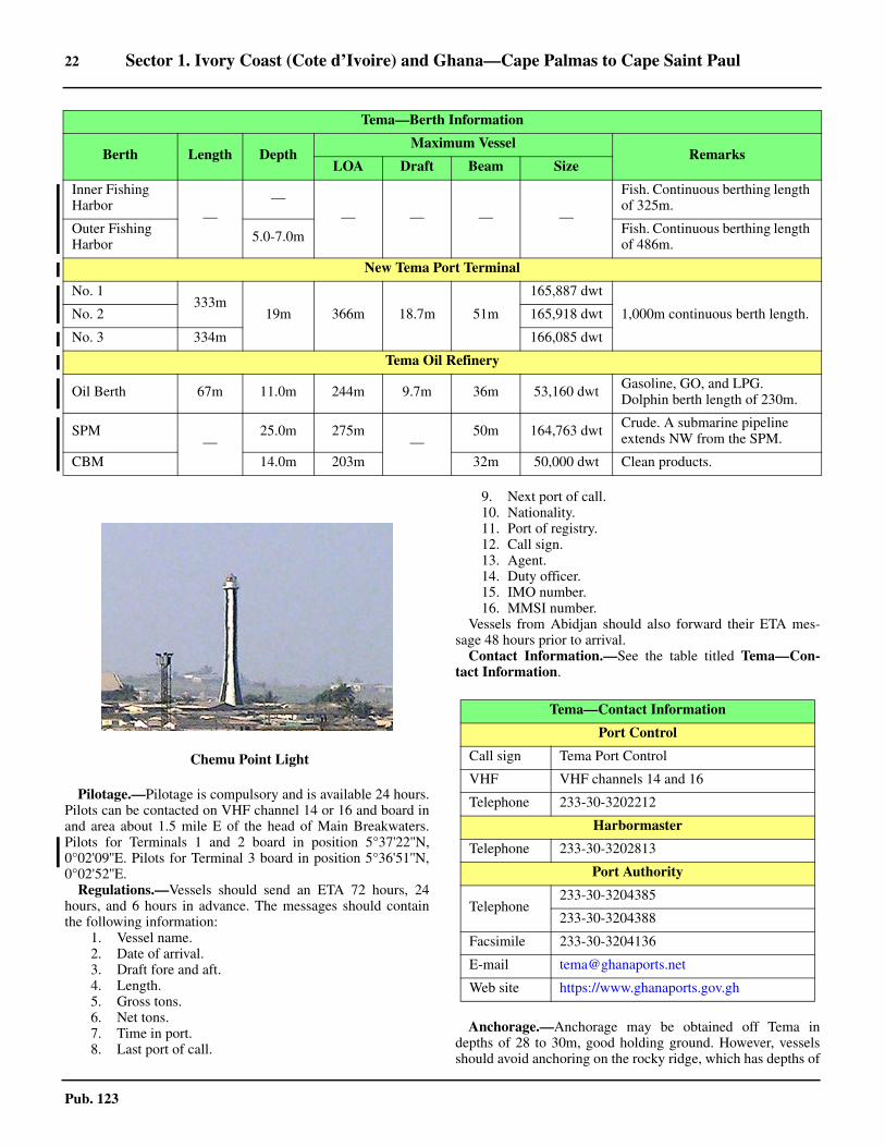
22 Sector 1. Ivory Coast (Cote d’Ivoire) and Ghana—Cape Palmas to Cape Saint Paul
Pub. 123
1.32 Pilotage.—Pilotage is compulsory and is available 24 hours.Pilots can be contacted on VHF channel 14 or 16 and board inand area about 1.5 mile E of the head of Main Breakwaters.Pilots for Terminals 1 and 2 board in position 5°37'22''N,0°02'09''E. Pilots for Terminal 3 board in position 5°36'51''N,0°02'52''E. 1.32 Regulations.—Vessels should send an ETA 72 hours, 24hours, and 6 hours in advance. The messages should containthe following information:
1. Vessel name.2. Date of arrival.3. Draft fore and aft.4. Length.5. Gross tons.6. Net tons.7. Time in port.8. Last port of call.
9. Next port of call.10. Nationality.11. Port of registry.12. Call sign.13. Agent.14. Duty officer.15. IMO number.16. MMSI number.
1.32 Vessels from Abidjan should also forward their ETA mes-sage 48 hours prior to arrival.1.32 Contact Information.—See the table titled Tema—Con-tact Information.
1.32 Anchorage.—Anchorage may be obtained off Tema indepths of 28 to 30m, good holding ground. However, vesselsshould avoid anchoring on the rocky ridge, which has depths of
Inner Fishing Harbor
——
— — — —
Fish. Continuous berthing length of 325m.
Outer Fishing Harbor 5.0-7.0m Fish. Continuous berthing length
of 486m.
New Tema Port Terminal
No. 1333m
19m 366m 18.7m 51m
165,887 dwt
1,000m continuous berth length.No. 2 165,918 dwt
No. 3 334m 166,085 dwt
Tema Oil Refinery
Oil Berth 67m 11.0m 244m 9.7m 36m 53,160 dwt Gasoline, GO, and LPG. Dolphin berth length of 230m.
SPM—
25.0m 275m—
50m 164,763 dwt Crude. A submarine pipeline extends NW from the SPM.
CBM 14.0m 203m 32m 50,000 dwt Clean products.
Tema—Berth Information
Berth Length DepthMaximum Vessel
RemarksLOA Draft Beam Size
1.32Chemu Point Light
Tema—Contact Information
Port Control
Call sign Tema Port Control
VHF VHF channels 14 and 16
Telephone 233-30-3202212
Harbormaster
Telephone 233-30-3202813
Port Authority
Telephone233-30-3204385
233-30-3204388
Facsimile 233-30-3204136
E-mail [email protected]
Web site https://www.ghanaports.gov.gh
Sector 1. Ivory Coast (Cote d’Ivoire) and Ghana—Cape Palmas to Cape Saint Paul 23
Pub. 123
17 to 18m, lying 1.5 miles off the port. 1.32 An anchorage area, which contains anchorage berths Athrough I, sits about 2 miles WSW of the SW corner of the newport basin, and can best be seen on the chart.1.32 Caution.—An area, within which anchoring and fishing areprohibited, fronts the port entrance and may best be seen on thechart.1.32 The latest information should be requested from the authori-ties in advance, as actual depths in the harbor may be less thancharted due to siltation.1.32 The harbor entrance is affected by swell and vessels may ex-perience heavy rolling.1.32 Several dangerous wrecks lie S and SE of the harbor en-trance and can best be seen on the chart.1.32 It is reported (1992) that several uncharted wrecks and anumber of stranded wrecks lie in the vicinity of the harbor en-trance.1.32 A dangerous wreck lies about 1.8 miles ENE of the harborand is marked by a buoy. It was reported (2012) that the mastsare not visible. 1.32 It is reported (2018) that piracy has been a problem for ves-sels anchored off the port. 1.32 Major port expansion is largely finished, but some construc-tion remains ongoing (2020). The new port can be best seen onthe chart. Mariners are advised to contact the local authoritiesfor the latest information.
Tema to Cape Saint Paul
1.33 Breaker Point (5°39'N., 0°02'E.), located 0.7 mileNE of Tema, is fronted by a coastal bank, with depths of lessthan 5m, which extends up to 0.2 mile SE and 0.5 mile SW ofit.1.33 Grove Point (5°40'N., 0°03'E.) is located 1.5 miles NE ofBreaker Point. The coast between consists of a sandy beach in-terspersed with rocky ledges. Numerous rocks, over which thesea breaks heavily, front this point.1.33 Kpone Bay (5°40'N., 0°03'E.) is entered between GrovePoint and Tenpobo Point, 5.5 miles NE. It has depths of 7 to13m over a bottom formed by sand, shell, and coral. The vil-lage of Kpone, obscured by trees, stands on the top of a hillwhich rises close inland, 1.5 miles NNE of Grove Point. Awhite house, situated at the W side of the village, is conspicu-ous from the W.1.33 Prampram (5°43'N., 0°06'E.), a town, stands 3.5 miles ENEof Kpone. The coast between consists of a beach fringed withpalm trees. A lagoon lies in the flat country behind the beach.The town is composed of an upper and a lower part. The upperpart stands on the summit of a ridge, 50m high, but is partly ob-scured from seaward by trees. The lower part is not visible, buta white house is situated on the foreshore in front of it. Anchor-age can be obtained, in a depth of 11m, about 1 mile S of thiswhite house.1.33 Vernon Bank (5°42'N., 0°11'E.), a narrow spit, has depths of6 to 9m and extends about 12 miles ENE from the vicinity ofGrove Point. The bottom of this bank is very irregular and iscomposed of rocky ledges and patches of sand, stones, and cor-al. There is a pronounced swell over the bank and it sometimesbreaks in heavy weather.1.33 Jange Lagoon (River Ningo) enters the sea through a narrow
mouth lying between two sandy points, 4.5 miles NE of Pram-pram. It is reported to be always open and navigable by canoeswhenever the heavy surf, which rolls in on the bar, allows.1.33 The large white ruin of a fort is situated in a grove of tall treeson the E entrance point of Jange Lagoon.1.33 Caution.—Numerous stranded wrecks lie along the shorebetween Tema and Prampram.
1.34 The coast extending for about 4 miles E of the mouthof Jange Lagoon is fringed by a broad ledge of rocks, overwhich a small river discharges. The edge of this ledge is nearlysteep-to and heavy surf rolls over it incessantly.1.34 Between the above ledge of rocks and the Volta River, 26miles E, the shore consists of an uninterrupted beach. For 5miles E of the ledge, the coast is formed by a low, clay cliff.Then, for the next 13 miles, it is formed by a sandy ridge, 4 to5m high, which is covered by a few bushes. This ridge sepa-rates Songaw Lagoon, a large salt-water lagoon, from the sea.The lagoon is caused by the overflow from the Volta River. Itssurface is broken by large tracts of swamps, some covered bygrass and others by jungle, with a few high scattered trees.
Ada (5°47'N., 0°38'E.) is situated 2.5 miles W of the en-trance to the Volta River. This town may be easily identified bya prominent mission house standing near its W end. The houseis long, white, and flat-roofed.1.34 Anchorage may be obtained in a depth of 13m, sand, about 1mile SSE of the mission house. Vessels are advised not to an-chor any closer to the shore as the depths decrease quickly andthe swell is heavy at times.
1.35 The Volta River (5°46'N., 0°41'E.) empties into thesea between two low and sandy points, about 0.5 mile apart.The trees in the vicinity of the entrance attain an unusualheight. A dark grove stands on the E bank, 1 mile N of the en-trance; from a distance it resembles a bluff headland. Anothergrove, resembling a conical hill, stands 2 miles E. Three grovesof tall trees stand on the W side of the river entrance.1.35 The river is subject to considerable differences in water levelaccording to the season. It begins to rise early in June and com-mences to fall about the middle of October. The river is usuallyat its lowest in March and at its highest in September.1.35 The bar, 0.2 mile wide, lies between the extremities of twolines of very heavy breakers which extend up to over 1 mile SEfrom the river entrance points. It has a least depth of 2.4m andshould only be crossed in good weather.1.35 Within the entrance, the river expands into a wide basin con-taining several islands, most of which are covered with thickbushes and trees. Local knowledge is necessary. Vessels withdrafts up to 1.8m can ascend up to 45 miles from the mouth be-tween July and November. During the remainder of the year,vessels with similar drafts would experience difficulty in pro-ceeding only 40 miles above the entrance.1.35 For about 7 miles E of the river entrance, the land is coveredwith dense forest, principally consisting of fan palms.
Cape Saint Paul (5°50'N., 0°58'E.), marked by a light, is lo-cated 18 miles ENE of the mouth of the Volta River. The coastbetween is fronted by a beach. For further information, seeparagraph 2.2.1.35 Caution.—Depths in the approaches to the Volta River are
24 Sector 1. Ivory Coast (Cote d’Ivoire) and Ghana—Cape Palmas to Cape Saint Paul
Pub. 123
liable to change. When passing the river entrance, vesselsshould keep in depths of 22m or more in order to avoid gettingwithin the influence of the steep breakers and rollers.1.35 Vessels should also guard against the inward set of the floodtide.
1.35 A detached shoal patch, with a depth of 16.1m, is reported(1961) to lie about 13.5 miles SSW of Cape Saint Paul.1.35 A detached shoal patch, with a depth of 27m, is reported(1963) to lie about 11 miles S of Cape Saint Paul.
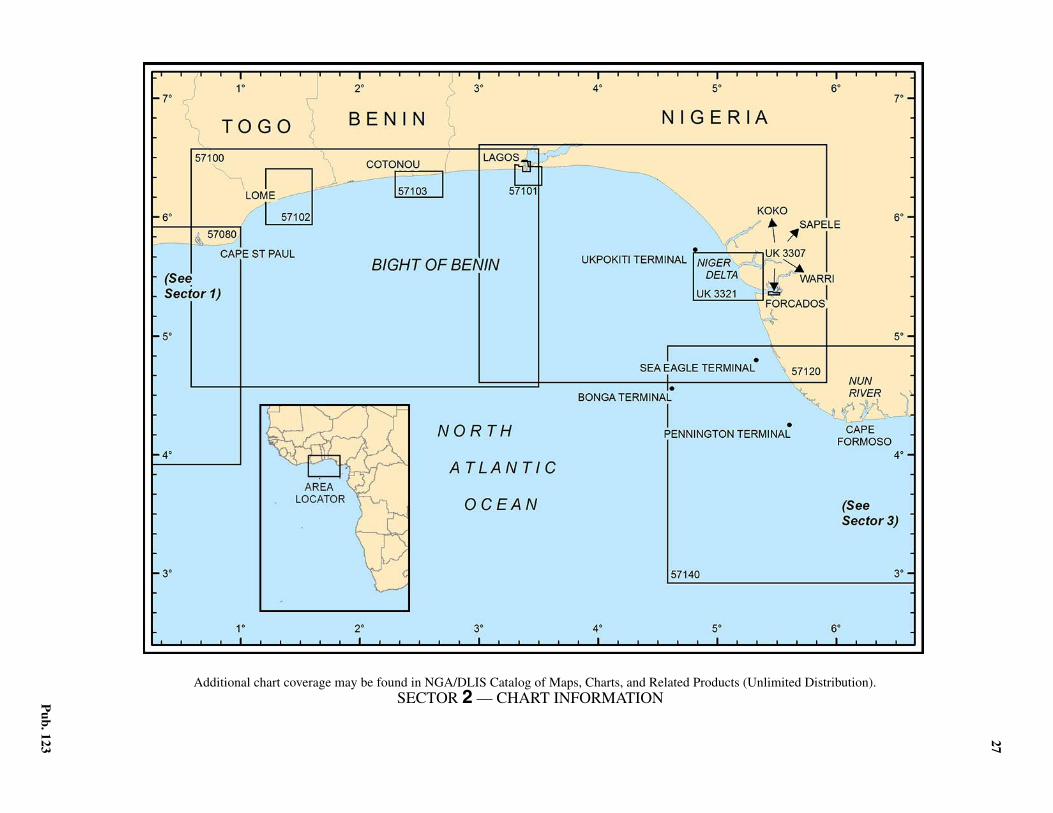
27
Pub. 123
2. Sector 2—Togo, Benin, and Nigeria—Cape Saint Paul to Cape Formoso
2.0Additional chart coverage may be found in NGA/DLIS Catalog of Maps, Charts, and Related Products (Unlimited Distribution).SECTOR 2 — CHART INFORMATION

29
Pub. 123
SECTOR 2
TOGO, BENIN, AND NIGERIA—CAPE SAINT PAUL TO CAPE FORMOSO
2.0 Plan.—This sector describes the African coast betweenCape Saint Paul and Cape Formoso, 325 miles ESE. The de-scriptive sequence is from W to E.
General Remarks
2.1 The coast of the Bight of Benin, lying between CapeSaint Paul and Cape Formoso, forms a monotonous beach souniformly low and flat that not a single inland landmark is visi-ble from offshore. The elevation of the ground seldom exceeds3m and even the most prominent clumps of trees do not rise toheights of more than 20m. This stretch of coast includes partsof Ghana, Togo, Benin (formerly Dahomey), and Nigeria.2.1 The W shore of the bight is covered with jungle and groupsof trees interspersed with numerous villages and detached huts.Near Keta, 5 miles N of Cape Saint Paul, the trees are high andform large and distinct groups. The trees then extend 45 milesENE in a continuous line to Agoue, where they terminate ex-cept for a few dotted here and there. Throughout the long ex-tent of coast forming the head of the bight, Lagos Harbor is theonly permanent opening or outfall for the water in the lagoons.However, several partial breaks in the sand hills, through whichthe lagoons pour the overflow, form during the wet season(April to October). The SE shore of the bight has a distinctivecharacter. It is no longer fringed by a bright sandy beach, buthas a continuous dense mass of trees growing on a muddy fore-shore. There are very few landmarks along this part of theshore, except for several rivers and creeks forming a delta.2.1 Winds—Weather.—The land is frequently obscured byhaze, locally known as “The Smokes,” which in the dry season(November to May) prevails throughout the entire Bight of Be-nin. On the windward or W side of the bight, this haze is not sostrong and the bright sandy beach, with its fringe of surf, canusually be distinguished. The haze generally lasts for about 3hours, beginning after sunrise, and is then replaced by a seabreeze.2.1 The harmattan, a wind of continental origin, is a hot, drywind from the NE quadrant. It reaches the shores of the Gulf ofGuinea and extends seaward. This wind is prevalent from De-cember through early March and is usually laden with fine dustwhich can reduce visibility in the form of haze. The harmattangenerally occurs between Cape Palmas (4°22'N., 7°44'W.) andDouala (4°03'N., 9°41'E.).2.1 Tides—Currents.—The beach has a tidal range of about1.5m, but the surf is so heavy and incessant along the shore andthe swell is so constant that actual measurements in the W partof the bight are very difficult. Along the SE side of the bightand in the vicinity of the river bars, where the water is smooth,tidal measurements have been established by the authoritiesand are used by local boats.2.1 The influence of the tidal currents generally extends up tobetween 4 and 9 miles off the mouths of the rivers. The ebbcurrent is increased by the discharge of fresh water and attainsa rate of about 3 knots at the river mouths. The rate of the flood
current is generally much less than that of the ebb. At half ebb,a volume of turbid and brownish water is discharged from therivers and usually carries floating uprooted trees, bushes, andclumps of leaves. This discharge discolors the sea with a brownscum for several miles. During the rainy season, the discolor-ation may extend up to 10 miles from the coast.2.1 Regulations.—It is reported that all Nigerian ports areclosed from 2000 to 0600. In addition, vessels are prohibitedfrom transiting or anchoring in the approaches to the portsduring this period unless they have been previously cleared forentry and are registered with the local authorities. Due to thecomplicated nature of the regulations, vessels are advised tocommunicate with their local agents well in advance in order toensure compliance.2.1 Two months prior to arrival in Nigerian waters, agents mustregister vessels with the Nigerian Ports Authority (NPA) in or-der to obtain a Ship Entry Notice (SEN). This does not apply tovessels carrying petroleum products in bulk or in ballast. Ves-sels cannot enter the territorial waters of Nigeria without aSEN.2.1 For information concerning the Nigerian Ship Entry Notice(SEN), Nigerian VHF communications regulations, and report-ing requirements for Nigerian oil terminals, see Pub. 160, Sail-ing Directions (Planning Guide) South Atlantic Ocean andIndian Ocean.2.1 The Maritime Domain Awareness for Trade—Gulf ofGuinea (MDAT—GoG) is a virtual reporting system for mari-time security operating in the maritime area of central and westAfrica. The system includes voluntary reporting from vesselsand output from MDAT—GoG to contribute to maritime situa-tional awareness. For further information, see South AtlanticOcean—Ship Reporting System in Pub. 160, Sailing Direc-tions (Planning Guide) South Atlantic Ocean and IndianOcean. 2.1 Anchorage.—The bight affords excellent holding groundout to a depth of about 30m. The inshore bottom is composedthroughout of stiff black mud and broken shells covered bysand. Outside the 30m curve, the bottom is generally composedof olive-colored mud, broken shells, and decayed vegetablematter. Anchoring anywhere within the bight must be prompt-ed by necessity and not by comfort, as vessels lie more or lessacross the swell and usually experience unceasing heavy roll-ing, according to the strength of the current. In the W part ofthe bight, particularly toward Cape Saint Paul, the swell is notso heavy. Along the SE shore of the bight, vessels should an-chor, in depths of 18 to 22m, about 9 miles offshore in order toavoid shoal water and because of the heavy ground swell that isperpetually rolling in.2.1 Caution.—All vessels which intend to enter Togo territorialwaters, whether in transit or bound for port, must report theirintentions to enter 3 hours prior to arrival at the territorialboundaries.2.1 In the inland waters of Nigeria, rafts formed of timber andoil drums may be encountered. These rafts usually show a red
30 Sector 2. Togo, Benin, and Nigeria—Cape Saint Paul to Cape Formoso
Pub. 123
light at each end at night.2.1 Although the surf may occasionally appear practicable, land-ing should not be attempted anywhere between Cape SaintPaul and the end of the sandy beach located 60 miles E of La-gos, except in local canoes and surf boats.2.1 The West African Gas Pipeline runs from 7.5 miles NE ofTakoradi, Ghana through the coastal waters of Togo and Beninto 6.75 miles ESE of Badagri, Nigeria. There area several areaswith connections along this route. The pipeline, which can bestbe seen on the chart, has been buried in some areas but not inothers. Caution is advised when navigating these areas and an-choring is prohibited within 1 mile of the pipeline. 2.1 Oil and gas development areas and fields, with associatedrigs, platforms, riser pipes, wellheads, submarine pipelines,terminal buoys, and storage vessels, may be encountered up to50 miles off the coasts described in this sector.2.1 Some of the well heads may protrude more than 5m abovethe sea bed and may be unmarked. Some of the platforms andstructures may be disused, abandoned, and unlit. In many casesthe submarine pipelines are not buried in the sea bed anddepths over them may be reduced by as much as 2m. In addi-tion, many temporary structures and objects associated with oiland gas exploration may not be charted.2.1 Vessels are cautioned that security in near-coastal waters ofthe Gulf of Guinea and within some of its ports is a serious andpersistent issue. In recent years (2000-2018) hundreds of at-tacks by pirates and thieves have been reported and the occur-rence of these incidents continues to rise despite an increasedmaritime security presence. These incidents can and have beenreported deep in the Niger Delta waterways and up to 100miles offshore. They generally occur in areas of marine oil andgas production but have occurred while berthed in port. The In-ternational Maritime Bureau advises that the true number isprobably higher due to a lack of reporting by vessels.
Cape Saint Paul to Lome
2.2 Cape Saint Paul (5°50'N., 0°58'E.) is formed by aprominent and rounded section of the coast, but its exact posi-tion is difficult to define. The cape is usually considered to belocated near the village of Woe (Weh).
A light is shown from a pile structure, 25m high, standing onthis cape near the village of Woe. A stranded wreck lies closeto the shore 1.5 miles SW of the light.2.2 The coast between Cape Saint Paul and the town of Keta, 5.5miles N, is formed by a narrow ridge or barrier of sand whichseparates the sea from Keta Lagoon. This lagoon extends N forabout 14 miles and W for about 5 miles. Keta, with a fort, isconspicuous from seaward. A large square bungalow, with aflagstaff at its W side, is situated close to the fort.2.2 Anchorage may be taken in a depth of 9m about 0.6 mile SE
of Keta. However, rollers may come in heavily and withoutwarning at this anchorage. Anchorage may also be taken in adepth of 18m about 1.8 miles SE of the fort. Vessels usually liehead to the swell at this anchorage due to the trend of the coast. 2.2 Between Keta and Lome, 18 miles NE, the coast is low andflat, with an occasional large clump of palms. It is fronted by ayellow sandy beach on which the surf breaks heavily. Denustands 15 miles NE of Keta. This village can be identified by aconspicuous house, situated near the beach, and some facto-ries, standing about 0.5 mile NE of it. Afloao, another village,is situated 0.4 mile NE of Denu.2.2 The border between Ghana and Togo lies about 0.3 mile E ofAfloao village and is indicated by a beacon.2.2 Caution.—A wave-recorder lighted buoy, with a topmark, ismoored about 3 miles E of Keta.
Lome (6°08'N., 1°17'E.)World Port Index No. 46090
2.3 Lome is situated 23 miles NE of Cape Saint Paul. It isalso a port of entry for Niger and Burkina Faso. The harbor,which is formed by breakwaters, lies 5 miles E of the city.
2.3 Winds—Weather.—During January and February, calm Nwinds are to be expected, but at other times W to SW windspredominate. The rainy season is from April to July and the dryseason is from February to March.2.3 Tides—Currents.—The tide rises about 1.6m at springs and1.3m at neaps.2.3 Depths—Limitations.—For detailed berthing information,see the table titled Lome—Berth Information.2.3 The harbor entrance channel is dredged to a depth of 14.5m.However, the dredged fairway, which may best be seen on thechart, acts as a sand trap and less water than charted may be re-ported to exist at times due to silting.2.3 There are facilities for general cargo, ro-ro, bulk, container,and tanker vessels.2.3 There are three main wharves within the harbor. They pro-vide 1,500m of total berthing space, with depths of 11 to 15malongside. Cargo vessels up to 270m in length and 12m draftcan be handled.2.3 A bulk berth is situated near the middle of the inner side ofthe E breakwater. It has a depth of 12.2m alongside and can ac-commodate vessels of up to 210m in length and 11.5m draft.2.3 A tanker berth is situated close to the head of the E breakwa-ter. It has a depth of 16m alongside and can accommodate ves-sels of up to 250m in length and 14m draft.
Lome Home Page
http://www.togo-port.net
Lome—Berth Information
Berth Length Depth Draft Remarks
Mole No. 1
1-2360m (cont.) 12.5m — General cargo and breakbulk.
3-4
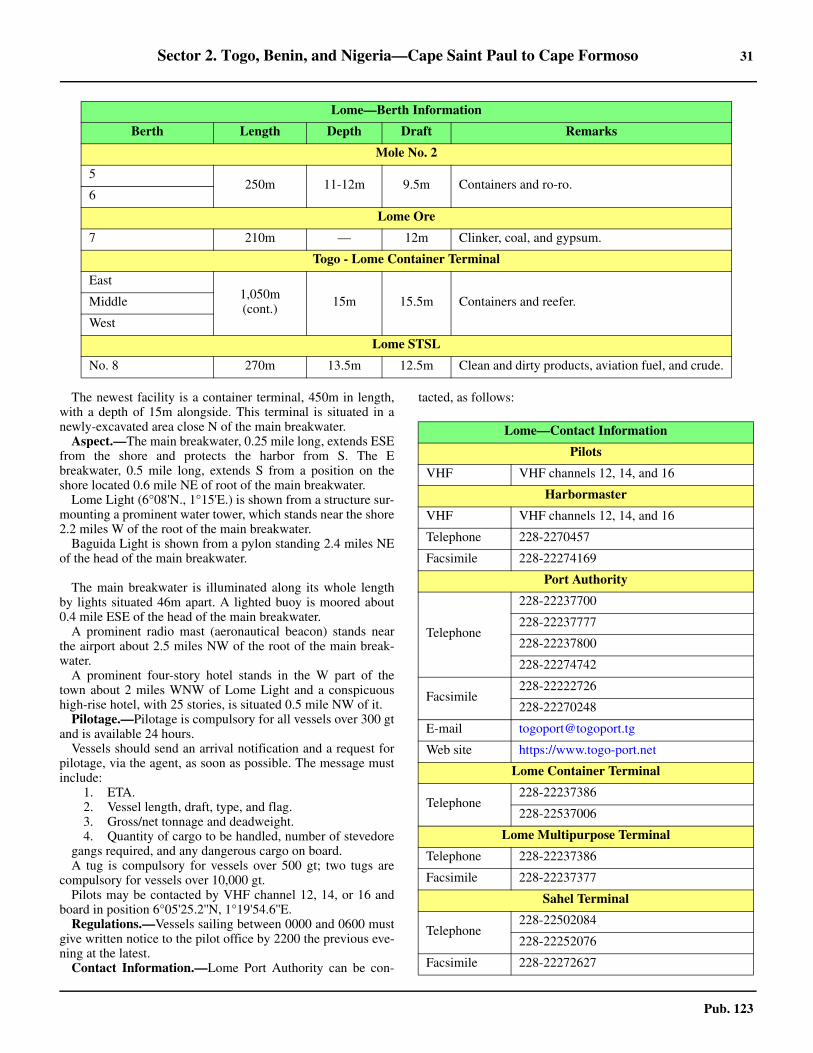
Sector 2. Togo, Benin, and Nigeria—Cape Saint Paul to Cape Formoso 31
Pub. 123
2.3 The newest facility is a container terminal, 450m in length,with a depth of 15m alongside. This terminal is situated in anewly-excavated area close N of the main breakwater.2.3 Aspect.—The main breakwater, 0.25 mile long, extends ESEfrom the shore and protects the harbor from S. The Ebreakwater, 0.5 mile long, extends S from a position on theshore located 0.6 mile NE of root of the main breakwater.2.3 Lome Light (6°08'N., 1°15'E.) is shown from a structure sur-mounting a prominent water tower, which stands near the shore2.2 miles W of the root of the main breakwater.2.3 Baguida Light is shown from a pylon standing 2.4 miles NEof the head of the main breakwater.
2.3 The main breakwater is illuminated along its whole lengthby lights situated 46m apart. A lighted buoy is moored about0.4 mile ESE of the head of the main breakwater.2.3 A prominent radio mast (aeronautical beacon) stands nearthe airport about 2.5 miles NW of the root of the main break-water.2.3 A prominent four-story hotel stands in the W part of thetown about 2 miles WNW of Lome Light and a conspicuoushigh-rise hotel, with 25 stories, is situated 0.5 mile NW of it.2.3 Pilotage.—Pilotage is compulsory for all vessels over 300 gtand is available 24 hours.2.3 Vessels should send an arrival notification and a request forpilotage, via the agent, as soon as possible. The message mustinclude:
1. ETA.2. Vessel length, draft, type, and flag.3. Gross/net tonnage and deadweight.4. Quantity of cargo to be handled, number of stevedore
gangs required, and any dangerous cargo on board.2.3 A tug is compulsory for vessels over 500 gt; two tugs arecompulsory for vessels over 10,000 gt.2.3 Pilots may be contacted by VHF channel 12, 14, or 16 andboard in position 6°05'25.2''N, 1°19'54.6''E. 2.3 Regulations.—Vessels sailing between 0000 and 0600 mustgive written notice to the pilot office by 2200 the previous eve-ning at the latest. 2.3 Contact Information.—Lome Port Authority can be con-
tacted, as follows:
Mole No. 2
5250m 11-12m 9.5m Containers and ro-ro.
6
Lome Ore
7 210m — 12m Clinker, coal, and gypsum.
Togo - Lome Container Terminal
East1,050m (cont.) 15m 15.5m Containers and reefer.Middle
West
Lome STSL
No. 8 270m 13.5m 12.5m Clean and dirty products, aviation fuel, and crude.
Lome—Berth Information
Berth Length Depth Draft Remarks
Lome—Contact Information
Pilots
VHF VHF channels 12, 14, and 16
Harbormaster
VHF VHF channels 12, 14, and 16
Telephone 228-2270457
Facsimile 228-22274169
Port Authority
Telephone
228-22237700
228-22237777
228-22237800
228-22274742
Facsimile228-22222726
228-22270248
E-mail [email protected]
Web site https://www.togo-port.net
Lome Container Terminal
Telephone228-22237386
228-22537006
Lome Multipurpose Terminal
Telephone 228-22237386
Facsimile 228-22237377
Sahel Terminal
Telephone228-22502084
228-22252076
Facsimile 228-22272627
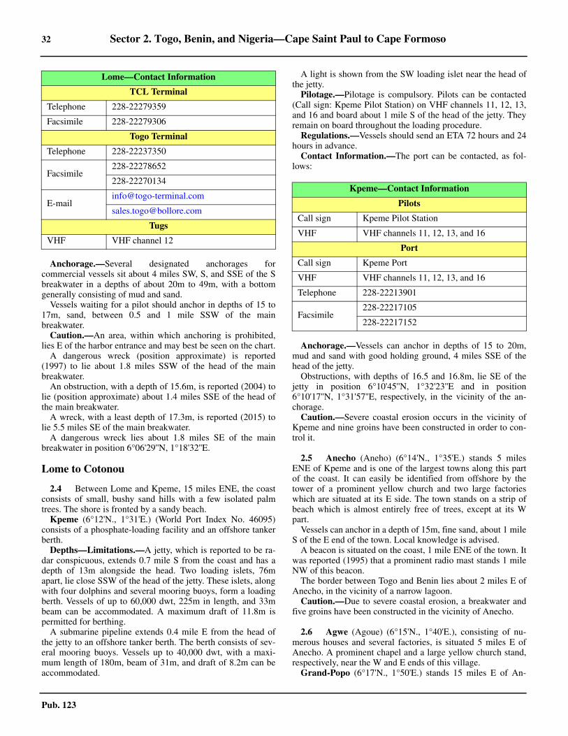
32 Sector 2. Togo, Benin, and Nigeria—Cape Saint Paul to Cape Formoso
Pub. 123
2.3 Anchorage.—Several designated anchorages forcommercial vessels sit about 4 miles SW, S, and SSE of the Sbreakwater in a depths of about 20m to 49m, with a bottomgenerally consisting of mud and sand.2.3 Vessels waiting for a pilot should anchor in depths of 15 to17m, sand, between 0.5 and 1 mile SSW of the mainbreakwater.2.3 Caution.—An area, within which anchoring is prohibited,lies E of the harbor entrance and may best be seen on the chart.2.3 A dangerous wreck (position approximate) is reported(1997) to lie about 1.8 miles SSW of the head of the mainbreakwater.2.3 An obstruction, with a depth of 15.6m, is reported (2004) tolie (position approximate) about 1.4 miles SSE of the head ofthe main breakwater.2.3 A wreck, with a least depth of 17.3m, is reported (2015) tolie 5.5 miles SE of the main breakwater. 2.3 A dangerous wreck lies about 1.8 miles SE of the mainbreakwater in position 6°06'29''N, 1°18'32''E.
Lome to Cotonou
2.4 Between Lome and Kpeme, 15 miles ENE, the coastconsists of small, bushy sand hills with a few isolated palmtrees. The shore is fronted by a sandy beach.
Kpeme (6°12'N., 1°31'E.) (World Port Index No. 46095)consists of a phosphate-loading facility and an offshore tankerberth.2.4 Depths—Limitations.—A jetty, which is reported to be ra-dar conspicuous, extends 0.7 mile S from the coast and has adepth of 13m alongside the head. Two loading islets, 76mapart, lie close SSW of the head of the jetty. These islets, alongwith four dolphins and several mooring buoys, form a loadingberth. Vessels of up to 60,000 dwt, 225m in length, and 33mbeam can be accommodated. A maximum draft of 11.8m ispermitted for berthing.2.4 A submarine pipeline extends 0.4 mile E from the head ofthe jetty to an offshore tanker berth. The berth consists of sev-eral mooring buoys. Vessels up to 40,000 dwt, with a maxi-mum length of 180m, beam of 31m, and draft of 8.2m can beaccommodated.
2.4 A light is shown from the SW loading islet near the head ofthe jetty.2.4 Pilotage.—Pilotage is compulsory. Pilots can be contacted(Call sign: Kpeme Pilot Station) on VHF channels 11, 12, 13,and 16 and board about 1 mile S of the head of the jetty. Theyremain on board throughout the loading procedure.2.4 Regulations.—Vessels should send an ETA 72 hours and 24hours in advance.2.4 Contact Information.—The port can be contacted, as fol-lows:
2.4 Anchorage.—Vessels can anchor in depths of 15 to 20m,mud and sand with good holding ground, 4 miles SSE of thehead of the jetty.2.4 Obstructions, with depths of 16.5 and 16.8m, lie SE of thejetty in position 6°10'45''N, 1°32'23''E and in position6°10'17''N, 1°31'57''E, respectively, in the vicinity of the an-chorage. 2.4 Caution.—Severe coastal erosion occurs in the vicinity ofKpeme and nine groins have been constructed in order to con-trol it.
2.5 Anecho (Aneho) (6°14'N., 1°35'E.) stands 5 milesENE of Kpeme and is one of the largest towns along this partof the coast. It can easily be identified from offshore by thetower of a prominent yellow church and two large factorieswhich are situated at its E side. The town stands on a strip ofbeach which is almost entirely free of trees, except at its Wpart.
Vessels can anchor in a depth of 15m, fine sand, about 1 mileS of the E end of the town. Local knowledge is advised.2.5 A beacon is situated on the coast, 1 mile ENE of the town. Itwas reported (1995) that a prominent radio mast stands 1 mileNW of this beacon.2.5 The border between Togo and Benin lies about 2 miles E ofAnecho, in the vicinity of a narrow lagoon.2.5 Caution.—Due to severe coastal erosion, a breakwater andfive groins have been constructed in the vicinity of Anecho.
2.6 Agwe (Agoue) (6°15'N., 1°40'E.), consisting of nu-merous houses and several factories, is situated 5 miles E ofAnecho. A prominent chapel and a large yellow church stand,respectively, near the W and E ends of this village.2.6 Grand-Popo (6°17'N., 1°50'E.) stands 15 miles E of An-
TCL Terminal
Telephone 228-22279359
Facsimile 228-22279306
Togo Terminal
Telephone 228-22237350
Facsimile228-22278652
228-22270134
Tugs
VHF VHF channel 12
Lome—Contact Information
Kpeme—Contact Information
Pilots
Call sign Kpeme Pilot Station
VHF VHF channels 11, 12, 13, and 16
Port
Call sign Kpeme Port
VHF VHF channels 11, 12, 13, and 16
Telephone 228-22213901
Facsimile228-22217105
228-22217152

Sector 2. Togo, Benin, and Nigeria—Cape Saint Paul to Cape Formoso 33
Pub. 123
echo. The shore between is bushy with a few scattered palmtrees. This town may be recognized by several prominent facto-ries and a number of relatively high houses.2.6 Bouche du Roi, lying 3.5 miles E of Grand-Popo, is the out-let of a lagoon which extends behind the coast. The water dis-charging from this outlet, which is subject to frequent change,discolors the sea for a considerable distance offshore, particu-larly during the rainy season (May to July).
Ouidah Plage (6°19'N., 2°06'E.), situated 16 miles E ofGrand-Popo, is conspicuous from seaward. This village con-sists of two groups of buildings with white roofs. An isolatedhouse, with a veranda and a prominent red roof, stands in thespace between the two groups. From E, the prominent whiteclock tower of a church standing in the town of Ouidah, 3 milesinland, can be seen above the trees. Anchorage may be ob-tained, in a depth of 13m, brown sand, about 1 mile S of thehighest storehouse in Ouidah Plage.2.6 Avrekrete-Plage is situated 7.5 miles E of Ouidah Plage.This village can be identified by a rather large, dark house anda white wall standing at its E end. The coastal bank, withdepths of less than 12m, extends up to about 1 mile seaward inthe vicinity of this village.2.6 Godomey Plage is situated 14 miles E of Ouidah Plage. Twoprominent radio masts and the conspicuous control tower of anairfield stand 4 miles ENE and 3 miles ENE, respectively, ofthis village.
Cotonou (6°21'N., 2°26'E.)
World Port Index No. 46110
2.7 Cotonou, a sheltered harbor, lies 6 miles E ofGodomey Plage and is protected by breakwaters. It is situatedclose W of the mouth of Lac Nokoue (Lagune de Cotonou),which is usually silted up.
2.7 Winds—Weather.—The prevailing winds are from the SW.From mid-November until late February, N winds sometimescarry sand and dust from the deserts and reduce visibility in thevicinity of the harbor to as little as 0.5 mile.2.7 The rainy season lasts from April until July and again fromSeptember to November. During December and January, nightfog sometimes occurs, but it usually dissipates during the earlymorning hours.2.7 Tides—Currents.—The tides rise about 1.6m at springs and1.3m at neaps.2.7 Tidal currents flow ENE across the harbor at rates of up to 2knots.2.7 Depths—Limitations.—The marked entrance channel,which extends 3.2 miles SE from the breakwater, is dredged toa depth of 15m. However, the dredged channel, which is bestseen on the chart, acts as a sand trap and less water than chart-ed is reported to exist due to silting, especially near the WestBreakwater. The harbor basin is dredged to a depth of 15m,with shallower portions lining the edge. Vessels with a maxi-mum draft of 10.0m can be accommodated.
2.7 The N Quay, 1,400m long, is situated along the N side of theharbor. It provides eight berths and has depths of 7 to 11.5malongside. There are facilities for general cargo, ro-ro, contain-er, and bulk vessels. Vessels of up to 260m in length and 10.5mdraft can be accommodated.2.7 A fuel oil berth, 160m long, is situated at the E end of themain quay and can be used by vessels of up to 250m in lengthand 9m draft.2.7 Two tanker berths, P2 Berth, 200m long, and QC Berth,180m long, are situated at the inner side of the E breakwater.Tankers of up to 180m and 200m in length and 9.0m draft canbe accommodated. 2.7 The Benin Container Terminal is situated on the S part of theharbor. It has two berths, a combined 550m in length, anddepths alongside up to 10m.2.7 For detailed berthing information, see the table titled Coto-nou—Berth Information.2.7 Aspect.—The E breakwater extends 0.4 mile SSW from apoint on the shore located 0.7 mile W of the mouth of LacNokoue. The W breakwater, about 0.3 mile long, extends ESEfrom the E extremity of the shore projection forming the S sideof the harbor basin. A groin extends S from this breakwater.2.7 The W breakwater has been extended to the SE (2015) andthe E breakwater has been shortened. The new harbor entranceis approximately 280m wide.2.7 Cotonou Light is shown at an elevation of 30m from aframework tower, 25m high, standing on the W side of themouth of Lac Nokoue.2.7 An outer fairway lighted buoy is moored about 1 mile ESEof the head of the W breakwater.2.7 A prominent white house surmounted by a flagstaff and achurch with a prominent clock tower are situated 1.2 miles NEand 0.3 mile NNW, respectively, of Cotonou Light. Aprominent radio mast, with obstruction lights, stands 0.7 mileNNE of the head of the W breakwater.2.7 The port control tower, 26m high and surmounted by a radarscanner, stands near the E end of the main quay, 0.4 mile NNWof the head of the W breakwater, and is conspicuous. 2.7 A prominent water tower and a conspicuous bank building,76m high, stand 0.6 mile NNW and 0.7 mile NW, respectively,of the head of the E breakwater. This bank building is reportedto be the tallest landmark in the area.2.7 Pilotage.—Pilotage, available from 0600 to 0000 (with afterhour service being made available by exception), iscompulsory for all vessels exceeding 100 net tons. Pilotagemust be requested at least 3 hours in advance or by 1830 at thelatest.2.7 The following types of vessels are exempt from compulsorypilotage:
1. Warships.2. Port service vessels.3. Vessels less than 100 net tons.4. Oceanographic and hydrographic vessels.
2.7 Pilots board in position 6°18.1'N, 2°28.3'E within about 1mile ESE of the harbor entrance. 2.7 Regulations.—Vessels should send an ETA 48 hours inadvance via the agent. Vessels should contact Port Controlwhen within VHF range to obtain berthing instructions. 2.7 Details of the roadstead anchoring conditions and pilotageare available on request.
Cotonou Home Page
http://www.portdecotonou.com
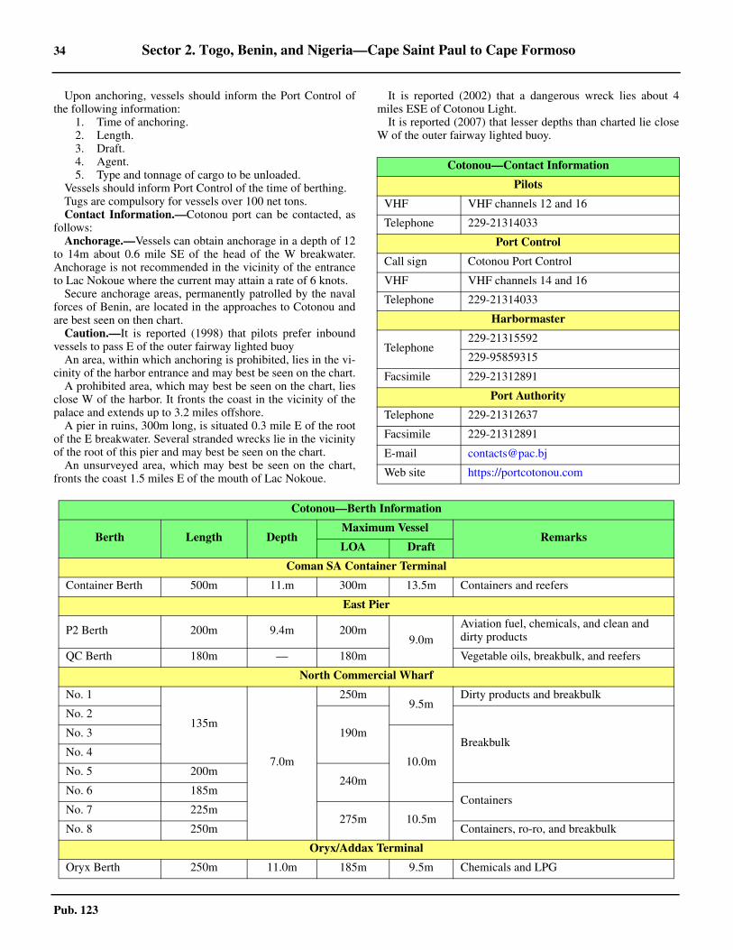
34 Sector 2. Togo, Benin, and Nigeria—Cape Saint Paul to Cape Formoso
Pub. 123
2.7 Upon anchoring, vessels should inform the Port Control ofthe following information:
1. Time of anchoring.2. Length.3. Draft.4. Agent.5. Type and tonnage of cargo to be unloaded.
2.7 Vessels should inform Port Control of the time of berthing. 2.7 Tugs are compulsory for vessels over 100 net tons. 2.7 Contact Information.—Cotonou port can be contacted, asfollows:2.7 Anchorage.—Vessels can obtain anchorage in a depth of 12to 14m about 0.6 mile SE of the head of the W breakwater.Anchorage is not recommended in the vicinity of the entranceto Lac Nokoue where the current may attain a rate of 6 knots.2.7 Secure anchorage areas, permanently patrolled by the navalforces of Benin, are located in the approaches to Cotonou andare best seen on then chart.2.7 Caution.—It is reported (1998) that pilots prefer inboundvessels to pass E of the outer fairway lighted buoy2.7 An area, within which anchoring is prohibited, lies in the vi-cinity of the harbor entrance and may best be seen on the chart.2.7 A prohibited area, which may best be seen on the chart, liesclose W of the harbor. It fronts the coast in the vicinity of thepalace and extends up to 3.2 miles offshore.2.7 A pier in ruins, 300m long, is situated 0.3 mile E of the rootof the E breakwater. Several stranded wrecks lie in the vicinityof the root of this pier and may best be seen on the chart.2.7 An unsurveyed area, which may best be seen on the chart,fronts the coast 1.5 miles E of the mouth of Lac Nokoue.
2.7 It is reported (2002) that a dangerous wreck lies about 4miles ESE of Cotonou Light.2.7 It is reported (2007) that lesser depths than charted lie closeW of the outer fairway lighted buoy.
Cotonou—Contact Information
Pilots
VHF VHF channels 12 and 16
Telephone 229-21314033
Port Control
Call sign Cotonou Port Control
VHF VHF channels 14 and 16
Telephone 229-21314033
Harbormaster
Telephone229-21315592
229-95859315
Facsimile 229-21312891
Port Authority
Telephone 229-21312637
Facsimile 229-21312891
E-mail [email protected]
Web site https://portcotonou.com
Cotonou—Berth Information
Berth Length DepthMaximum Vessel
RemarksLOA Draft
Coman SA Container Terminal
Container Berth 500m 11.m 300m 13.5m Containers and reefers
East Pier
P2 Berth 200m 9.4m 200m9.0m
Aviation fuel, chemicals, and clean and dirty products
QC Berth 180m — 180m Vegetable oils, breakbulk, and reefers
North Commercial Wharf
No. 1
135m
7.0m
250m9.5m
Dirty products and breakbulk
No. 2
190mBreakbulk
No. 3
10.0mNo. 4
No. 5 200m240m
No. 6 185mContainers
No. 7 225m275m 10.5m
No. 8 250m Containers, ro-ro, and breakbulk
Oryx/Addax Terminal
Oryx Berth 250m 11.0m 185m 9.5m Chemicals and LPG
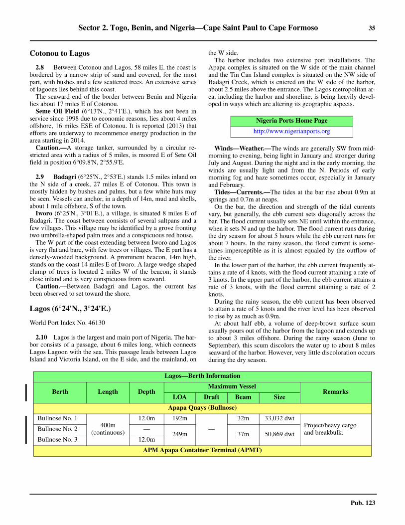
Sector 2. Togo, Benin, and Nigeria—Cape Saint Paul to Cape Formoso 35
Pub. 123
Cotonou to Lagos
2.8 Between Cotonou and Lagos, 58 miles E, the coast isbordered by a narrow strip of sand and covered, for the mostpart, with bushes and a few scattered trees. An extensive seriesof lagoons lies behind this coast.2.8 The seaward end of the border between Benin and Nigerialies about 17 miles E of Cotonou.2.8 Seme Oil Field (6°13'N., 2°41'E.), which has not been inservice since 1998 due to economic reasons, lies about 4 milesoffshore, 16 miles ESE of Cotonou. It is reported (2013) thatefforts are underway to recommence energy production in thearea starting in 2014. 2.8 Caution.—A storage tanker, surrounded by a circular re-stricted area with a radius of 5 miles, is moored E of Sete Oilfield in position 6°09.8'N, 2°55.9'E.
2.9 Badagri (6°25'N., 2°53'E.) stands 1.5 miles inland onthe N side of a creek, 27 miles E of Cotonou. This town ismostly hidden by bushes and palms, but a few white huts maybe seen. Vessels can anchor, in a depth of 14m, mud and shells,about 1 mile offshore, S of the town.2.9 Iworo (6°25'N., 3°01'E.), a village, is situated 8 miles E ofBadagri. The coast between consists of several saltpans and afew villages. This village may be identified by a grove frontingtwo umbrella-shaped palm trees and a conspicuous red house.2.9 The W part of the coast extending between Iworo and Lagosis very flat and bare, with few trees or villages. The E part has adensely-wooded background. A prominent beacon, 14m high,stands on the coast 14 miles E of Iworo. A large wedge-shapedclump of trees is located 2 miles W of the beacon; it standsclose inland and is very conspicuous from seaward.2.9 Caution.—Between Badagri and Lagos, the current hasbeen observed to set toward the shore.
Lagos (6°24'N., 3°24'E.)
World Port Index No. 46130
2.10 Lagos is the largest and main port of Nigeria. The har-bor consists of a passage, about 6 miles long, which connectsLagos Lagoon with the sea. This passage leads between LagosIsland and Victoria Island, on the E side, and the mainland, on
the W side.2.10 The harbor includes two extensive port installations. TheApapa complex is situated on the W side of the main channeland the Tin Can Island complex is situated on the NW side ofBadagri Creek, which is entered on the W side of the harbor,about 2.5 miles above the entrance. The Lagos metropolitan ar-ea, including the harbor and shoreline, is being heavily devel-oped in ways which are altering its geographic aspects.
2.10 Winds—Weather.—The winds are generally SW from mid-morning to evening, being light in January and stronger duringJuly and August. During the night and in the early morning, thewinds are usually light and from the N. Periods of earlymorning fog and haze sometimes occur, especially in Januaryand February.2.10 Tides—Currents.—The tides at the bar rise about 0.9m atsprings and 0.7m at neaps.2.10 On the bar, the direction and strength of the tidal currentsvary, but generally, the ebb current sets diagonally across thebar. The flood current usually sets NE until within the entrance,when it sets N and up the harbor. The flood current runs duringthe dry season for about 5 hours while the ebb current runs forabout 7 hours. In the rainy season, the flood current is some-times imperceptible as it is almost equaled by the outflow ofthe river.2.10 In the lower part of the harbor, the ebb current frequently at-tains a rate of 4 knots, with the flood current attaining a rate of3 knots. In the upper part of the harbor, the ebb current attains arate of 3 knots, with the flood current attaining a rate of 2knots.2.10 During the rainy season, the ebb current has been observedto attain a rate of 5 knots and the river level has been observedto rise by as much as 0.9m.2.10 At about half ebb, a volume of deep-brown surface scumusually pours out of the harbor from the lagoon and extends upto about 3 miles offshore. During the rainy season (June toSeptember), this scum discolors the water up to about 8 milesseaward of the harbor. However, very little discoloration occursduring the dry season.
Nigeria Ports Home Page
http://www.nigerianports.org
Lagos—Berth Information
Berth Length DepthMaximum Vessel
RemarksLOA Draft Beam Size
Apapa Quays (Bullnose)
Bullnose No. 1400m
(continuous)
12.0m 192m
—
32m 33,032 dwtProject/heavy cargo and breakbulk.Bullnose No. 2 —
249m 37m 50,869 dwtBullnose No. 3 12.0m
APM Apapa Container Terminal (APMT)

36 Sector 2. Togo, Benin, and Nigeria—Cape Saint Paul to Cape Formoso
Pub. 123
No. 16
250m 13.5m 267m
12.0m
37m 66,347 dwt
Containers and reefer. Rail link. Continuous berthing length of 1,000m.
No. 15
12.5mNo. 17
No. 18
ENL Consortium Ltd
No. 6
1745m (continuous)
11.5m 199m
10.5m
32m 63,118 dwt Ro-ro passengers/vehicles/rail, containers, breakbulk, and reefer.
No. 7 11.3m 228m 37m 63,647 dwt
No. 811.0m 199m
11m 64,942 dwt PCC, containers, breakbulk, and reefer.
No. 936m
66,614 dwt
Ro-ro passengers/vehicles/rail, containers, breakbulk, and reefer.
No. 10 9.9m 220m—
64,928 dwt
No. 11 9.6m 243m 37m 64,942 dwt
No. 12 10.1m 220m 10.0m 36m 64,793 dwt
No. 13 9.6m 239m—
50m 71,955 dwt
No. 14 9.7m 199m 36m 64,928 dwt
GDNL Terminal
No. 19523m
(continuous)
11.3m 199m 10.5m 36m 64,793 dwtGrain, sugar, and breakbulk.No. 20 10.3m 249m
—37m 66,509 dwt
No. 21 — 199m 36m 64,928 dwt
Apapa Bulk Terminal
No. 1
755m (continuous)
12.5m 144m 12.0m 23m 17,091 dwt Chemicals, dirty products, vegetable oils, and grain.No. 2 14.4m 224m
13.5m32m
74,086 dwt
No. 3 14.1m 199m 63,553 dwt Chemicals, dirty products, vegetable oils, grain, and breakbulk.
No. 4 10.2m 183m 9.5m 49,999 dwt
No. 5 11.0m 224m 10.5m 38m 74,356 dwt
Lagos Deep Offshore Logistics Base (LADOL)
LADOL Berth 200m 8.5m 249m — 43m 113,306 dwt Dirty products, project/heavy, and breakbulk.
Apapa Oil Terminal
Bulk Oil Plant Wharf (BOP) 54m 7.9m 195m
7.5m
32m
53,714 dwt
Clean products, and vegetable oils.
New Oil Jetty (NOJ) 52m
8.5m
189m 35m Aviation fuel, chemicals/gases, clean and dirty products, and LPG.
Petroleum Wharf Apapa (PWA)
110m 195m 32m
Atlas Cove Terminal
Lagos—Berth Information
Berth Length DepthMaximum Vessel
RemarksLOA Draft Beam Size

Sector 2. Togo, Benin, and Nigeria—Cape Saint Paul to Cape Formoso 37
Pub. 123
New Atlas Cove Jetty 54m 14.0m 183m 10.5m
32m53,160 dwt
Clean products.Offshore SBM (Lagos) — 17.0m 195m — 53,603 dwt
Asphalt Terminal
Berth 26m — 133m — 23m 14,911 dwt Clean products.
Folawiyo Terminal (Apapa)
Nispan Berth 60m 10.5m 195m 9.5m 32m 53,520 dwt Clean products.
Ijora
Ijora Wharf 128m 6.8m 150m 6.0m 23m 16,886 dwt Chemicals.
Navgas/Lister Oil (Ltd) Terminal
Navgas/Lister Oils Jetty 70m 11.0m 183m 10.5m 29m 29,590 dwt
Aviation fuel, chemicals, clean and dirty products, and LPG.
Tin Can Island—Berth Information
Berth Length DepthMaximum Vessel
RemarksLOA Draft Beam Size
Josepdam Terminal A
No. 1161m
— 199m 13.5m 36m
64,793 dwt Fertilizer, project/heavy cargo, and breakbulk.
No. 1A64,942 dwt
Project/heavy cargo and breakbulk.
No. 2 162m Grain and breakbulk.
Port and Cargo Handling Services Terminal C
No. 6
198m — 277m 13.0m 40m 74,375 dwt Ro-ro passengers and containers.No. 7
No. 7A
No. 8
PTML Grimaldi Terminal
No. 11 298m9m
249m 10.5m 37m 61,643 dwt PTCC, containers, breakbulk, and reefers.No. 12 199m 213m 9.5m 32m 26,881 dwt
Tin Can Island Container Terminal B (TICT)
No. 3
194m — 277m 13.0m 40m
73,235 dwt
Containers and reefers.No. 4 72,900 dwt
No. 4A74,375 dwt
No. 5
Tin Can Island Five Star Logistics Terminal D
No. 10 220m 10.5m 239m 10.0m37m
64,942 dwtRo-ro and containers.
No. 9 215m 10.5m 274m — 64,928 dwt
Lagos—Berth Information
Berth Length DepthMaximum Vessel
RemarksLOA Draft Beam Size
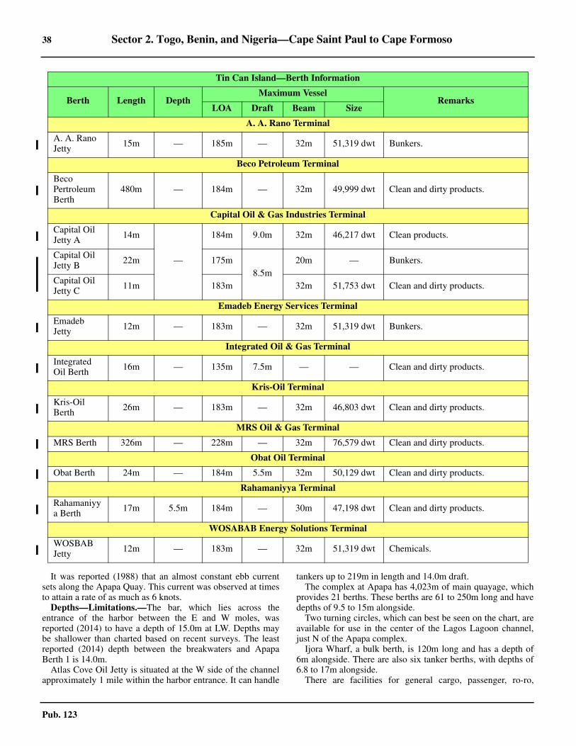
38 Sector 2. Togo, Benin, and Nigeria—Cape Saint Paul to Cape Formoso
Pub. 123
2.10 It was reported (1988) that an almost constant ebb currentsets along the Apapa Quay. This current was observed at timesto attain a rate of as much as 6 knots.2.10 Depths—Limitations.—The bar, which lies across theentrance of the harbor between the E and W moles, wasreported (2014) to have a depth of 15.0m at LW. Depths maybe shallower than charted based on recent surveys. The leastreported (2014) depth between the breakwaters and ApapaBerth 1 is 14.0m.2.10 Atlas Cove Oil Jetty is situated at the W side of the channelapproximately 1 mile within the harbor entrance. It can handle
tankers up to 219m in length and 14.0m draft.2.10 The complex at Apapa has 4,023m of main quayage, whichprovides 21 berths. These berths are 61 to 250m long and havedepths of 9.5 to 15m alongside.2.10 Two turning circles, which can best be seen on the chart, areavailable for use in the center of the Lagos Lagoon channel,just N of the Apapa complex.2.10 Ijora Wharf, a bulk berth, is 120m long and has a depth of6m alongside. There are also six tanker berths, with depths of6.8 to 17m alongside.2.10 There are facilities for general cargo, passenger, ro-ro,
A. A. Rano Terminal
A. A. Rano Jetty 15m — 185m — 32m 51,319 dwt Bunkers.
Beco Petroleum Terminal
Beco Pertroleum Berth
480m — 184m — 32m 49,999 dwt Clean and dirty products.
Capital Oil & Gas Industries Terminal
Capital Oil Jetty A 14m
—
184m 9.0m 32m 46,217 dwt Clean products.
Capital Oil Jetty B 22m 175m
8.5m20m — Bunkers.
Capital Oil Jetty C 11m 183m 32m 51,753 dwt Clean and dirty products.
Emadeb Energy Services Terminal
Emadeb Jetty 12m — 183m — 32m 51,319 dwt Bunkers.
Integrated Oil & Gas Terminal
Integrated Oil Berth 16m — 135m 7.5m — — Clean and dirty products.
Kris-Oil Terminal
Kris-Oil Berth 26m — 183m — 32m 46,803 dwt Clean and dirty products.
MRS Oil & Gas Terminal
MRS Berth 326m — 228m — 32m 76,579 dwt Clean and dirty products.
Obat Oil Terminal
Obat Berth 24m — 184m 5.5m 32m 50,129 dwt Clean and dirty products.
Rahamaniyya Terminal
Rahamaniyya Berth 17m 5.5m 184m — 30m 47,198 dwt Clean and dirty products.
WOSABAB Energy Solutions Terminal
WOSBAB Jetty 12m — 183m — 32m 51,319 dwt Chemicals.
Tin Can Island—Berth Information
Berth Length DepthMaximum Vessel
RemarksLOA Draft Beam Size
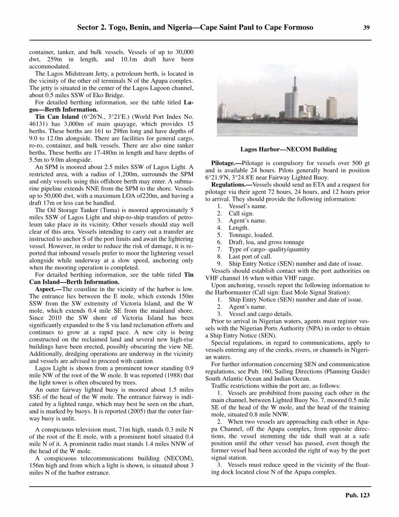
Sector 2. Togo, Benin, and Nigeria—Cape Saint Paul to Cape Formoso 39
Pub. 123
container, tanker, and bulk vessels. Vessels of up to 30,000dwt, 259m in length, and 10.1m draft have beenaccommodated.2.10 The Lagos Midstream Jetty, a petroleum berth, is located inthe vicinity of the other oil terminals N of the Apapa complex.The jetty is situated in the center of the Lagos Lagoon channel,about 0.5 miles SSW of Eko Bridge.2.10 For detailed berthing information, see the table titled La-gos—Berth Information.2.10 Tin Can Island (6°26'N., 3°21'E.) (World Port Index No.46131) has 3,000m of main quayage, which provides 15berths. These berths are 161 to 298m long and have depths of9.0 to 12.0m alongside. There are facilities for general cargo,ro-ro, container, and bulk vessels. There are also nine tankerberths. These berths are 17-480m in length and have depths of5.5m to 9.0m alongside.2.10 An SPM is moored about 2.5 miles SSW of Lagos Light. Arestricted area, with a radius of 1,200m, surrounds the SPMand only vessels using this offshore berth may enter. A subma-rine pipeline extends NNE from the SPM to the shore. Vesselsup to 50,000 dwt, with a maximum LOA of220m, and having adraft 17m or less can be handled.2.10 The Oil Storage Tanker (Tuma) is moored approximately 5miles SSW of Lagos Light and ship-to-ship transfers of petro-leum take place in its vicinity. Other vessels should stay wellclear of this area. Vessels intending to carry out a transfer areinstructed to anchor S of the port limits and await the lighteringvessel. However, in order to reduce the risk of damage, it is re-ported that inbound vessels prefer to moor the lightering vesselalongside while underway at a slow speed, anchoring onlywhen the mooring operation is completed.2.10 For detailed berthing information, see the table titled TinCan Island—Berth Information.2.10 Aspect.—The coastline in the vicinity of the harbor is low.The entrance lies between the E mole, which extends 150mSSW from the SW extremity of Victoria Island, and the Wmole, which extends 0.4 mile SE from the mainland shore.Since 2010 the SW shore of Victoria Island has beensignificantly expanded to the S via land reclamation efforts andcontinues to grow at a rapid pace. A new city is beingconstructed on the reclaimed land and several new high-risebuildings have been erected, possibly obscuring the view NE.Additionally, dredging operations are underway in the vicinityand vessels are advised to proceed with caution.2.10 Lagos Light is shown from a prominent tower standing 0.9mile NW of the root of the W mole. It was reported (1988) thatthe light tower is often obscured by trees.2.10 An outer fairway lighted buoy is moored about 1.5 milesSSE of the head of the W mole. The entrance fairway is indi-cated by a lighted range, which may best be seen on the chart,and is marked by buoys. It is reported (2005) that the outer fair-way buoy is unlit.
2.10 A conspicuous television mast, 71m high, stands 0.3 mile Nof the root of the E mole, with a prominent hotel situated 0.4mile N of it. A prominent radio mast stands 1.4 miles NNW ofthe head of the W mole.2.10 A conspicuous telecommunications building (NECOM),156m high and from which a light is shown, is situated about 3miles N of the harbor entrance.
2.10 Pilotage.—Pilotage is compulsory for vessels over 500 gtand is available 24 hours. Pilots generally board in position6°21.9'N, 3°24.8'E near Fairway Lighted Buoy. 2.10 Regulations.—Vessels should send an ETA and a request forpilotage via their agent 72 hours, 24 hours, and 12 hours priorto arrival. They should provide the following information:
1. Vessel’s name.2. Call sign.3. Agent’s name.4. Length.5. Tonnage, loaded.6. Draft, loa, and gross tonnage7. Type of cargo- quality/quantity 8. Last port of call.9. Ship Entry Notice (SEN) number and date of issue.
2.10 Vessels should establish contact with the port authorities onVHF channel 16 when within VHF range.2.10 Upon anchoring, vessels report the following information tothe Harbormaster (Call sign: East Mole Signal Station):
1. Ship Entry Notice (SEN) number and date of issue.2. Agent’s name.3. Vessel and cargo details.
2.10 Prior to arrival in Nigerian waters, agents must register ves-sels with the Nigerian Ports Authority (NPA) in order to obtaina Ship Entry Notice (SEN).2.10 Special regulations, in regard to communications, apply tovessels entering any of the creeks, rivers, or channels in Nigeri-an waters.2.10 For further information concerning SEN and communicationregulations, see Pub. 160, Sailing Directions (Planning Guide)South Atlantic Ocean and Indian Ocean.2.10 Traffic restrictions within the port are, as follows:
1. Vessels are prohibited from passing each other in themain channel, between Lighted Buoy No. 7, moored 0.5 mileSE of the head of the W mole, and the head of the trainingmole, situated 0.8 mile NNW.
2. When two vessels are approaching each other in Apa-pa Channel, off the Apapa complex, from opposite direc-tions, the vessel stemming the tide shall wait at a safeposition until the other vessel has passed, even though theformer vessel had been accorded the right of way by the portsignal station.
3. Vessels must reduce speed in the vicinity of the float-ing dock located close N of the Apapa complex.
2.10Lagos Harbor—NECOM Building
40 Sector 2. Togo, Benin, and Nigeria—Cape Saint Paul to Cape Formoso
Pub. 123
Vessels under 220m in length departing from Tin Can Is-land are limited to a maximum departure draft of 11.0m. Thedeparture draft restriction for vessels of 220m in length andgreater is 10.5m. Vessels departing from the container berthslocated on the S side of the Apapa Quay are limited to amaximum departure draft of 12.0m.
2.10 The Nigerian Maritime Administration and Safety Agency(NIMASA) has established a Secure Ship-to-Ship OperatingArea, best seen on the chart, SW of the entrance to the harbor.The area is patrolled by Nigerian naval vessels protecting com-mercial vessels conducting ship-to-ship operations either at an-chor or underway. Vessels may not enter the area withoutauthorization.
Contact Information.—See the table titled Lagos—Contact Information.2.10 Anchorage.—Vessels remaining outside the harbor shouldanchor in a depth of 15m, good holding ground, about 2.5miles S of Lagos Light, but clear of the wrecks. A heavy swelloccurs at this roadstead, particularly in July, August, andSeptember. Vessels may also obtain anchorage, in a depth of11m, about 1.5 miles S of Lagos Light. Loaded tankers mustanchor W of the prohibited anchorage. 2.10 Caution.—Numerous wrecks, many of them dangerous, liein the approaches to the port and while some may be depictedon the chart others remain unmarked. Several wrecks lie withina 1.5 mile radius of the W mole. 2.10 Buoys, which mark the harbor channels, may be frequentlyshifted to conform with changes in the depths and may not incharted position. Hence, mariners are advised to navigate withcaution in the approaches and in the port of Lagos.
2.10 Depths in the entrance fairway and within the harbor may befound to be as much as 2m less than charted.2.10 Vessels are cautioned that security in the vicinity of this portis a serious problem. In recent years (1986-2015), several at-tacks by pirates and thieves have been reported. These attackshave generally taken place at the outer anchorages, but somehave occurred while berthed alongside. It is reported (2005)that vessels are advised, once their pilot booking has been con-firmed, to stay at least 20 miles seaward of the roadstead atnight, reporting back only during daylight.2.10 An area, within which anchoring is prohibited, lies in the vi-cinity of the harbor entrance. It extends up to about 3 milesseaward and may best be seen on the chart. It has been reported
Lagos—Contact Information
Pilots
Call sign Lagos Pilotage District
VHF VHF channels 12, 13, 14, and 16
Telephone
234-1-5452687
234-1-8969401
234-803-3435120
E-mail [email protected]
Harbormaster
VHF VHF channels 12, 14, and 14
Telephone 234-815-2879709
Radio/Signal Office
VHF VHF channels 12, 13, and 16
Telephone 234-815-2879726
Scanship Port Radio
Call sign Scanship Company Radio
VHF VHF channels 11, 14 and 16
Apapa Bulk Terminal Limited
Telephone
234-705-6891000
234-705-6892000
234-705-6893000
E-mail [email protected]
Web site https://www.fmnplc.com
APM Terminal
E-mail [email protected]
Web site https://www.apmterminals.com
ENL Terminal
Telephone
234-1-2778400
234-1-2778401
234-1-2778402
E-mail [email protected]
Web site https://www.port.enlconsortium.com
Greenview Development Nigeria Terminal
Telephone234-1-4480815
234-1-4480816
Facsimile234-1-4630316
234-1-2712231
E-mail [email protected]
Web site https://www.dangote.com
Port Authority
Telephone
234-815-8794394
234-708-0811074
234-705-2677113
234-909-0903107
E-mail [email protected]
Web site https://www.nigerianports.org
Tugs
VHF VHF channels 13 and 16
Lagos—Contact Information
Sector 2. Togo, Benin, and Nigeria—Cape Saint Paul to Cape Formoso 41
Pub. 123
(2009) that an area of water with depths less than charted existwithin this prohibited anchorage. 2.10 It has been reported (2012) that anchored vessels may be en-countered in the prohibited anchorage area. 2.10 Due to the existence of submarine cables, an area, withinwhich anchoring is prohibited, fronts the coast at the E side ofthe harbor entrance. It extends up to 15 miles seaward and maybest be seen on the chart.2.10 An explosives dumping area, the limits of which may best beseen on the chart, lies centered 32 miles S of the harbor en-trance.
Lagos to the Niger Delta
2.11 Kuramo Island (6°27'N., 3°43'E.) forms the coast for40 miles E of Lagos. The shore is fronted by a steep, sandybeach with heavy surf breaking on it. A prominent beacon,14m high, stands near the coast 11 miles E of Lagos harbor.2.11 Mosherelkawga (Mosere Ikoga) (6°25'N., 3°41'E.), a vil-lage, stands 17 miles E of Lagos. A dangerous wreck, markedby a lighted buoy, lies about 2.7 miles SW of this village.2.11 Orimedu (6°25'N., 3°56'E.), a prominent village, stands onthe coast 16 miles E of Mosherelkawga.2.11 The coast extending E of Orimedu continues as a sandybeach for 36 miles. For the first 21 miles, the undulating anddark bushy foreground stands out sharply against the lightercolored background of the trees. The remaining part of thisstretch of coast is very flat, though bushy, with no groves in thebackground.2.11 Avon Canyon (Avon’s Deep) (6°16'N., 3°56'E.), a subma-rine canyon, lies about 7 miles S of Orimedu and interrupts theregularity of the coastal depths. It has depths that increase sud-denly from 40m to over 200m and may best be seen on thechart.
2.12 Lekki Sea Port (6°42'N., 4°05'E.), a new port com-plex under construction, lies within the Lagos Free Trade Zoneon the S shore of Victoria Island. It is scheduled for completionin 2020 and will feature a 1,500m-long quay and harbor depthsup to 16.5m. The port will be integrated with the Dangote OilRefinery, which is concurrently being constructed adjacent tothe port. Upon completion the port will able to accommodatecontainer, dry bulk, and liquid bulk vessels. Extensive dredgingoperations are taking place in the vicinity and vessels are ad-vised to navigate with caution. 2.12 Lekki (6°24'N., 4°07'E.), a village with a town situated closeN of the port site, stands 11 miles E of Orimedu and 1 mile in-land. It is situated W of three remarkable vistas. These vistas orlagoon entrances lie close to, 6 miles E, and 19 miles E of Lek-ki. They are 0.2 mile wide and appear open only when abreastof them.2.12 Ajumo (6°21'N., 4°26'E.), a village, stands 19 miles E ofLekki and near the E of the three vistas. Overfalls occur about9 miles S of this village.2.12 Caution.—It is reported that a fiber optic cable has been laidin a series of loops near to the coast between Lagos and Bon-ney River E Beach (4°23'N., 7°12'E.).
2.13 A village, with two conspicuous palm trees, stands onthe coast 5 miles E of Ajumo. An abrupt and remarkable
change from sand to mud occurs in the nature of the coast closeE of this village. The dry soil, palm trees, and brushwood aresucceeded by swamps and mangroves. The coast also changesits direction to SE and depths of less than 11m are found to lieup to 6 miles offshore.2.13 The termination of the sandy beach is a striking feature inthe Bight of Benin. Vessels approaching from the W may navi-gate along the coast about 1 mile offshore, except in the vicini-ty of Lagos. However, after passing Ajumo, numerous muddyshoals, with depths of 5 to 7m, are then found within 3 miles ofthe shore.2.13 The coast for about 6 miles SE of the termination of the sandis formed by a mud flat. The absence of any background treesmakes those trees scattered along the shore conspicuous andthe surf, which breaks about 2 miles offshore, is no longerheard. At the SE end of this mud flat, the coast assumes asomewhat firmer character and is interspersed with clumps oftrees and scattered huts for about 15 miles. From this positionto the entrance of the Benin River, 26 miles SE, the only distin-guishable landmarks are two trees, which stand about 11 milesNW of the river entrance, and a few scattered groups of huts.2.13 Caution.—Structures associated with oil and gas field de-velopment may be encountered along this stretch of coast.
The Niger Delta
2.14 The Niger Delta (5°30'N., 5°10'E.) is said to begin atAboh (5°32'N., 6°31'E.), a major trading station, which standsat the head, 130 miles from Forcados. It consists of numerousrivers, the best known being the Benin, Escravos, Forcados,Nun, Brass, New Calabar, and Bonny. All of these rivers unitewith the many streams of the River Niger at or below Ndoni(5°33'N., 6°33'E.).
The Niger River, one of Africa’s most famous rivers,originates in the King Mountains, which extend, about 200miles inland, parallel to the Guinea coast near the border withSierra Leone. From Bamako (12°40'N., 7°50'W.), the rivertrends NE for 450 miles to Timbuktu (16°40'N., 2°40'W.) andthen E for about 155 miles to Buram Island (16°50'N.,0°16'W.), which is known as The Great Bend of the Niger. Theriver then flows SE for 400 miles to Gomba (11°34'N.,3°58'E.), where it is joined by the Gulbi n’Sokoto River. It thencontinues S and SE to the vicinity of Aboh, where the deltacommences. Small shallow-draft boats, with flat bottoms,navigate the river, subject to seasonal limitations. The NigerRiver, like many other rivers, has a high level and a low level.However, the rise in the upper part takes almost 1 year to traveldown to the lower part due to the numerous openings into otherrivers and creeks.2.14 It is possible to ascend the River Niger from any of themouths of the numerous rivers by utilizing the many tortuouscreeks which connect the rivers and form inland waterways.These creeks are navigable throughout by boats and, in mostcases, small vessels with light drafts can transit between 15 and40 miles inland. However, the creeks and rivers of the deltashould only be used by vessels with local knowledge. Numer-ous oil and gas development installations and structures are sit-uated throughout the delta area.2.14 When approaching any of the delta entrances, vessels gener-ally first ascertain their proximity to land by the depths and the
42 Sector 2. Togo, Benin, and Nigeria—Cape Saint Paul to Cape Formoso
Pub. 123
discolored appearance of the sea. The low shoreline is only in-dicated by isolated trees. These trees may appear as discon-nected wooded islets because of the mirage distortion. Oncloser approach, the edge of the coastal forest appears as a sol-id line, broken only by the river entrance. Once over the barand within the estuary, the river banks are fringed with man-groves fronting masses of inland forest.2.14 Tides—Currents.—The current between the mouths of theForcados River and the Nun River generally sets SE, exceptduring the harmattan season (November to February), when itsets NW. Within depths of 16 to 18m, the current is irregular,with many eddies. Outside of these depths, the current sets at arate of about 0.5 knot.2.14 For the purpose of buoyage within the creeks and rivers lead-ing to Koko, Sapele, Burutu, and Warri, the direction of themain flood current is considered as flowing from the Escravosbar toward the ports.2.14 Directions.—Vessels should choose the river entrance wherethe bar offers the most favorable conditions for crossing. Onceinside, the deepest route through the creeks can be chosen forproceeding to the other parts of the delta. In this way, the dan-gerous and shallow bars are avoided. The entrance to the BeninRiver is difficult to distinguish from seaward. Vessels usuallydo not enter this river through its mouth, but proceed via theEscravos River and Nana Creek.2.14 Caution.—Vessels are warned that numerous well heads,submarine pipelines, flares, oil fields, oil rigs, and productionplatforms, some disused and abandoned, exist within the 200mcurve off the approaches to the rivers. The well heads may pro-trude over 5m above the sea bed and may be unmarked.2.14 Vessels are warned that a ground swell of varying amplitudeusually prevails on all of the bars fronting the river entrances.Adequate underkeel clearances must be ensured.
2.15 The Benin River (5°46'N., 5°03'E.), though joined tothe Niger Delta by Nana Creek and Chanomi Creek, has anorigin entirely distinct from that of the River Niger. Its sourceslie at the head of two small rivers which unite at Sapele, 40miles ENE of North Point. Between the bar and Koko, a portlying 33 miles NE, the river is intersected by several creeks.Nana Creek enters the river through the SE bank and connectsit with the Escravos River.2.15 North Point (5°46'N., 5°01'E.), the N entrance point of theBenin River, is well-defined; breakers and heavy rollers extendup to 2.5 miles SW of it. The shore extending from this pointon the S side of the river entrance forms only a gentle curveand is difficult to identify from the SW. Overfalls are reportedto occur about 10 miles W of the point.2.15 Discolored water may be observed as far as 9 miles seaward ofthe river mouth. The bar, composed of hard sand, is liable tochange. It was reported (1981) to have depths of 2.4 to 2.7m. Thisentire bar frequently breaks heavily and sometimes with over-whelming force. Passage across the bar is not recommended.2.15 The current off the mouth of the Benin River usually sets SE,but after the harmattan has been blowing, it is often reversedand sometimes sets with considerable strength. The tidal cur-rents over the bar usually set ENE on the flood and SW on theebb. In December, the flood current runs for 3 hours and attainsa rate of 3 knots. The ebb current runs for over 9 hours and at-
tains a rate of 5 knots.2.15 Benin Road, lying 3 miles outside the bar and 5.5 miles fromthe river mouth, is the only anchorage available in this vicinity.The holding ground is good, but much rolling and pitchingmust be expected. Vessels may anchor, in a depth of 9m, blackmud, about 5.5 miles SW of North Point.
2.16 Ukpokiti Marine Terminal (5°44'N., 4°50'E.)(World Port Index No. 46171) is located about 13 miles WSWof the mouth of the Benin River.2.16 Depths—Limitations.—The terminal is located in a depthof 26m and can accommodate tankers up to 150,000 dwt, 337min length, and 21m draft.
It consists of a Floating Production Storage and Off-loading(FPSO) facility (Trinity Spirit), which is lighted and equippedwith a racon. Vessels are berthed in tandem, bow to stern, withthe FPSO.2.16 Pilotage.—Pilotage is compulsory. The mooring master canbe contacted by VHF and boards about 3.5 miles SW of theterminal near the N limit of the anchorage area in position(5°41'N., 4°47'E.).
Regulations.—Vessels should send the following informa-tion via the agent 12 days and 7 days prior to arrival:
1. Vessel’s name.2. Vessel’s ETA.3. Master’s name.4. Arrival draft and dwt.5. Deballasting time, if any.6. Cargo requirements.
2.16 Vessels should then update their ETA 72 hours, 48 hours, 24hours, and 12 hours prior to arrival.2.16 Generally, vessels berth only during daylight hours but theymay depart at any time.
2.16 Contact Information.—See the table titled UkpokitiMarine Terminal—Contact Information.2.16 Anchorage.—An anchorage area, with a radius of 1.5 miles,lies centered about 5 miles SW of the terminal. Vessels at theanchorage must maintain a continuous listening watch on VHFchannel 16.
2.17 Abo Marine Terminal (5°43'N., 4°29'E.), locatedabout 36 miles W of the mouth of the Benin River, consists of aFloating Production Storage and Off-loading (FPSO) facility.The FPSO (Abo) is moored in a depth of 550m.2.17 Depths—Limitations.—The terminal can accommodatetankers up to 350,000 dwt with unrestricted drafts. Generally,
Ukpokiti Marine Terminal—Contact Information
Call sign FPSO Trinity Spirit (5MVQ)
VHF VHF channels 11 and 16
RT Frequency 6645 kHz (0600-1800)
Telephone870-761294123
870-762-634461
Facsimile870-600133398
870-600146053
Sector 2. Togo, Benin, and Nigeria—Cape Saint Paul to Cape Formoso 43
Pub. 123
vessels berth and depart only during daylight hours, weatherpermitting.2.17 Pilotage.—Pilotage is compulsory within 2 miles of the ter-minal. The mooring master can be contacted on VHF channels16 and 72 and boards in position 5°44.8'N, 4°31.1'E (about 3miles NE of the terminal).
Regulations.—Vessels should send an ETA message via theagent at least 7 days prior to arrival. This initial messageshould include the following:
1. Vessel’s name, Call sign, and INMARSAT numbers.2. ETA in local time. 3. Cargo requirements.4. Deballasting time.5. Maximum loading rate.6. Arrival draft fore and aft.7. Last port of call.8. Port of destination.9. Confirmation of clean bill of health.10. Details of any sickness onboard, if any.11. Distance (meters) from the bow to the loading mani-
fold and SWL of crane or derrick at manifold.12. Summer deadweight tons. 13. Port and country of registration.14. Name of master.15. Length overall.16. Does the vessel comply with the latest Oil Company
International Marine Forum (OCIMF) standards?17. A statement declaring that the vessel can perform
closed loading.18. Confirmation that the vessel is equipped with a bow
stopper which is able to receive 76mm chain.19. Name and particulars of local agent.
2.17 Vessels should then update their ETA 72 hours, 48 hours, 24hours, and 4 hours prior to arrival.2.17 Additional ETA notifications should be sent if the ETA in the72-hour or 48-hour messages differs by more than 4 hours. Ifthe ETA in the 24-hour message differs by more than 1 hour,the vessel should notify the terminal of the new ETA. 2.17 If the transit time from the vessel’s previous port is less than72 hours, the terminal should be notified immediately and theoriginal ETA confirmed or updated. 2.17 Vessels are prohibited from approaching within 2 miles ofthe terminal without prior permission.2.17 Vessels must arrive with clean ballast only, not less than 25percent of summer dwt, trim not exceeding 3m, and propellerfully immersed.2.17 All export tankers are required to fly the Nigerian nationalflag during daylight while berthed at the terminal.2.17 When on final approach to the terminal, vessels should sendthe following information 2 hours prior to arrival:
1. Draft and trim.2. Capacity for loading.3. Ballast details plus time required for discharge.4. Maximum freeboard.5. Quality of inert gas.6. Any other relevant information.
2.17 Contact Information.—See the table titled Abo MarineTerminal—Contact Information.
2.18 Escravos Terminal (5°32'N., 4°52'E.) (World PortIndex No. 46135) is situated 11 miles WSW of the mouth ofthe Escravos River. It consists of an Operations Platform, twoSBMs, and an FSO.
Depths—Limitations.—The Operations Platform(5°32.5'N., 4°52.3'E.), 26m high, provides a heliport, which issurrounded at night by red lights. No. 2 SBM is moored in adepth of 19.8m, about 1 mile W of the Operations Platform. Itcan handle tankers up to 200,000 dwt, with drafts up to 15.8m,and tankers from 200,000 to 308,000 dwt, with drafts up to15m.
No. 3 SBM is moored in a depth of 30.5m, about 5 milesWSW of the Operations Platform. It can handle tankers up to350,000 dwt, 365m in length, 61m beam, and 22.5m draft.Submarine pipelines extend in an ENE direction from theseberths to the shore and may best be seen on the chart.
The LPG facility is situated about 9 miles W of the Opera-tions Platform and consists of a Floating Storage and Off load-ing (FSO) barge. It is moored in a depth 43m and equippedwith a racon. A submarine gas pipeline extends E from theFSO to the shore and may best be seen on the chart.2.18 Aspect.—A fairway lighted buoy is moored about 2 milesSW of the Operations Platform. A designated anchorage arealies about 2.5 miles SW of the Operations Platform.
Pilotage.—Pilotage is compulsory. Pilots, who act as moor-ing masters, can be contacted by VHF and board in the vicinityof the anchorage area in position (5°28'N., 4°59'E.). They re-main on board throughout the loading procedure. Vessels musthave their engines ready for immediate use while moored atthis terminal.
2.18 A restricted area, which may best be seen on the chart, sur-rounds the terminal facilities. All vessels are prohibited fromentering this area without prior permission.2.18 Regulations.— All inbound vessels must send an ETA to theterminal and to Chevron Nigeria Limited, Lagos 72 hours, 48hours, and 24 hours prior to arrival. The following informationis required:
1. Vessel’s name.2. ETA.3. Master’s name.
Abo Marine Terminal—Contact Information
Call sign Abo FPSO (HOIQ)
VHF VHF channels 16 and 72
Telephone
65-67960441
870-600-843067
870-764-650359
Facsimile65-679-60459
870-764-650360
Telex581-435-183510
581-435-183511
E-mail [email protected]
Abo Marine Terminal—Contact Information

44 Sector 2. Togo, Benin, and Nigeria—Cape Saint Paul to Cape Formoso
Pub. 123
4. Flag/Port of Registry/Year Built 5. Summer dwt.6. Net tons.7. Last port of call.8. Next port of call.9. Owner’s name and address.10. Quantity of cargo required.11. Destination of cargo.12. Nationality of officers and crew.13. Quantity of cargo on board.14. Maximum draft on arrival and departure.15. US B/L Code if appropriate 16. Time of Notice of Readiness tender.
2.18 Berthing details may be obtained from the terminal on VHFchannel 10 or 16 when within range.2.18 Mooring at or departing from the oil berths is allowed in nor-mal weather conditions at any time. Mooring at the LPG berthis allowed only during daylight hours. Vessels may depart thisberth at any time.2.18 All export tankers shall fly the Nigerian national flag duringdaylight while berthed at the terminal.2.18 Contact Information.—See the table titled Escravos Ter-minal—Contact Information. 2.18 Caution.—The current in the vicinity of the terminal usuallysets NNW, but it sometimes reverses to set SSE. The rate of thecurrent varies between 0.5 knot and 1.5 knots. This current hasbeen observed to reverse direction very quickly and causevessels to swing heavily.
2.18 Unfavorable weather is usually expected from May throughNovember.2.18 Several platforms in ruins stand about 3.5 miles S of the Op-erations Platform. They barely show 5m above sea level andform poor radar targets.2.18 It was reported (1970) that the terminal is somewhat difficultto identify due to the existence of numerous gas flares in the ar-ea. However, the coast and breakwater lying to the S of the riv-er entrance are radar conspicuous (see paragraph 2.20).
2.19 Erha Oil Terminal (5°21'N., 4°20'E.), a deep-waterfacility, lies in the vicinity of the Erha Oil Field and is situatedwithin an exclusion zone bordered by a line joining the follow-ing positions:
a. 5°21.7'N, 4°17.7'E.b. 5°23.9'N, 4°20.4'E.c. 5°23.9'N, 4°22.5'E.d. 5°21.7'N, 4°23.6'E.e. 5°18.0'N, 4°21.5'E.f. 5°19.0'N, 4°17.7'E.
2.19 Winds—Weather.—The predominant winds are from be-tween SW to W from May to September. Winds are variableduring the rest of the year. 2.19 Tides—Currents.—The current normally sets E at a rate of0.5 to 1 knot, except during the harmattan, when it sets W. 2.19 Long swells prevail throughout the year. Squalls occur be-tween March and November and can increase the swell heightsand cause rough seas. 2.19 Depths—Limitations.—The terminal consists of a FloatingProduction Storage and Offloading (FPSO) vessel and anSBM. The SBM is moored 1 mile SE of the FPSO and is con-nected to it by two steel pipelines. The FPSO is located in adepth of 1,100m and is equipped with a racon.2.19 Tankers up to 350,000 dwt, with a maximum loa of 296mand a maximum beam of 63m, can be accommodated at theFPSO. Tankers up to 350,000 dwt, with a maximum beam of63m, can be accommodated at the SPM. 2.19 Pilotage.—Pilotage is compulsory. Pilots, who act as moor-ing masters, can be contacted by VHF and generally board inthe vicinity of the waiting area.2.19 Regulations.—Tankers may secure to the SBM at any time,weather permitting. Tankers may berth at the FPSO duringdaylight only but may depart at any time. 2.19 Tankers may secure to the SBM or berth in tandem, bow tobow, with the FPSO.2.19 Vessels must send an initial ETA message to the terminal 7days in advance. The ETA should then be confirmed 72 hours,48 hours, 24 hours, and 6 hours prior to arrival. 2.19 Anchorage.—A designated waiting area, with a radius of2.5 miles, lies centered about 9 miles SE of the terminal.
The Escravos River
2.20 The Escravos River (5°34'N., 5°10'E.) is the princi-pal entrance of the delta for the ports of Koko, Sapele, Burutu,and Warri. Nana Creek, entered 7 miles within the mouth, leadsinto the Benin River and then to the ports of Koko and Sapele.Chanomi Creek, entered 12 miles within the mouth, leads S tothe Forcados River and then to the ports of Burutu and Warri.2.20 A coastal bank, with depths of less than 5m, fronts the river
Escravos Terminal—Contact Information
Call sign Escravos Terminal
VHF VHF channels 10 and 16
Telephone
870-601-007284
870-765-041274
870-765-041275
Facsimile 870-765-041276
Telex 581-465-748510
CNL Escravos
Telephone234-1-260-0600 (ext. 73370)
234-1-367-3370
Facsimile 234-1-260-0600 (ext. 74725)
E-mail [email protected]
Crude Tanker Berthing and Cargo Operations
VHF VHF channels 10 and 10A
LPG Tanker Berthing and Cargo Operations
VHF VHF channel 77
PFSO
Telephone 234-1-260-0600 (ext. 73420)
Facsimile 234-1-260-0395
E-mail [email protected]
Sector 2. Togo, Benin, and Nigeria—Cape Saint Paul to Cape Formoso 45
Pub. 123
mouth and extends up to about 6 miles seaward. The river en-trance is subject to siltation. The channel leading across the barwas reported (1986) to have a dredged depth of 6.4m. It was re-ported (1993) that the channel leading across the bar had adredged depth of 6.7m and vessels with drafts up to 6.4m couldenter the river.
Tapa Oil Field (5°42'N., 5°00'E.) lies centered 12.5 milesNW of the river mouth.2.20 Delta Oil Field (5°41'N., 5°03'E.) lies centered 10 milesNW of the river mouth.2.20 Delta South Oil Field (5°36'N., 5°06'E.) lies centered 5miles W of the river mouth.2.20 Ejulebe Oil Field (5°35'N., 5°00'E.) lies centered 11.5 milesW of the river mouth.2.20 Okan Oil Field (5°33'N., 5°05'E.) lies centered 7 milesWSW of the river mouth.2.20 Mefa Oil Field (5°31'N., 5°04'E.) lies centered 9 miles SWof the river mouth.2.20 Awodi Oil Field (5°28'N., 5°01'E.) lies centered 12 milesSW of the river mouth.2.20 Sonam Gas Field (5°29'N., 4°50'E.), surrounded by a re-stricted area with a radius of 1 mile, lies centered 22 milesWSW of the river mouth.2.20 Numerous rigs, platforms, structures, well heads, submarinepipelines, storage vessels, flares, above-water pipes, and ob-structions are situated within the above oil and gas fields,which front the river entrance.
2.20 Aspect.—A main breakwater, about 4 miles long, extendsWSW from a point on the coast located 1 mile S of the S en-trance point of the river. A detached breakwater is located withits S end lying about 0.4 mile NNE of the head of the mainbreakwater. It extends NNE and is about 0.5 mile long. The en-trance channel, which is buoyed, leads between these breakwa-ters.2.20 A beacon, 9m high, is situated on the N entrance point of theriver and a radio mast, 98m high, stands 1.2 miles NE of it. Es-cravos Tank Farm is situated close N of the radio mast. 2.20 Ogidigbe, a prominent village, is situated 1.6 miles NE ofNorth Point. Another village, is situated 3 miles NE of NorthPoint.2.20 Nana Creek is entered 7 miles E of the mouth of the river. Itleads in a N direction for 23 miles, but has many sharp bends.
Pilotage.—Pilotage is compulsory within the river for ves-sels bound for Delta Ports (Burutu, Koko, Sapele, and Warri).Pilots can be contacted on VHF channel 16 and board about 2miles SW of the Escravos breakwater (5°29'N., 5°05'E.). Pilot-age is available during daylight hours only and should be ar-ranged through the vessel’s agent in the port of destination.2.20 The Escravos River Pilot Station requests the following in-formation via VHF channel 16 before the pilot boards:
1. Vessel’s name.2. Call sign.3. Nationality.4. SEN number.5. Crew.6. Length overall and draft.7. Cargo details.8. Master’s name.
2.20 Escravos River Pilots provide pilotage services from the barto Bennett Island Anchorage and Koko Anchorage. Nigerian
Ports Authority (NPA) Harbor Pilots provide pilotage servicesfrom these anchorages to the berths at Warri, Koko, andSapele. Pilots for Burutu are also available. Escravos River Pi-lots also provide pilotage services to the offshore oil and gasindustry.2.20 For security reasons, the movements of vessels are beingmonitored and coordinated by the Nigerian Naval Station (Del-ta) at Warri through the Nigerian Navy Gun Boat stationed atEscravos Tank Farm, near Lighted Buoy No. 19, where clear-ance is usually granted via VHF.2.20 Contact Information.—See the table titled Escravos Riv-er—Contact Information.2.20 Directions.—Due to numerous marked and unmarkedobstructions associated with the oil and gas fields, vesselsshould avoid taking an inshore route and should approach thepilot boarding area from seaward.
2.20 Vessels approaching from N or W should pass W and SW ofthe Escravos Terminal (see paragraph 2.18). They should thenpass S of No. 3 SBM (see paragraph 2.18) and proceed E to aposition located about 2.5 miles S of the Escravos OperationsPlatform (see paragraph 2.18), passing N of the ruinedplatforms. Vessels should then continue in an ENE direction tothe pilot boarding area.2.20 Vessels approaching from S should remain well offshore toavoid Meji Oil Field (see paragraph 2.23). They should thenproceed to a position located about 6 miles S of the EscravosOperations Platform (see paragraph 2.18), taking care to avoidthe ruined platforms standing about 3 miles S of it. Vesselsshould then continue in a NE direction to the pilot boarding ar-ea.2.20 Caution.—Due to piracy activity, vessels are advised to re-main 30 to 40 miles seaward of the breakwater during dark-ness.2.20 The entrance of the river is subject to frequent silting.2.20 During the flood tide, a strong NW current sets across thebar and within the entrance.2.20 It was reported (1995) that the buoys marking the approachand river channels were unreliable. Several were observed tobe unlit and many, including the outer fairway lighted buoy,were missing.2.20 Submarine pipelines extend across the river about 0.7 mileabove and below the tank farm. A submarine pipeline also ex-tends across Nana Creek, 4 miles NNE of its junction with theEscravos River. The depth may be reduced by as much as 2min the vicinity of these pipelines.2.20 Numerous fishing stakes are situated in the shallow depths
Escravos River—Contact Information
Pilots
Call sign Escravos River Pilot
VHF VHF channel 16
Telephone 234-805-332-1123
Port
Call sign Escravos Port
VHF VHF channels 10 and 16
46 Sector 2. Togo, Benin, and Nigeria—Cape Saint Paul to Cape Formoso
Pub. 123
fronting the river entrance and along the river banks.2.20 Vessels should approach the mouth of the Escravos Riverwith caution due to several unsurveyed areas lying off the coastin this vicinity.
2.21 Koko (6°00'N., 5°28'E.) (World Port Index No.46140) is situated on the N bank of the river. It is a large settle-ment and extends for about 1 mile along the shore. The mainquay is 137m long and has a depth of 7.3m alongside. Pilotageis not compulsory but is available from the Escravos River pi-lots (see paragraph 2.24). Berthing is only carried out duringdaylight hours. Vessels of up to 140m in length and 6.4m drafthave been accommodated alongside.
From Koko, the Benin River trends in a general ESE direc-tion, with two sharp bends, for 16 miles to Sapele. AboveKoko, the banks of the river revert to mangroves for about 3.8miles when they again change to open country with trees andpalms.2.21 Munro Island (5°55'N., 5°40'E.) divides the river and hasseveral log storage lagoons. The main channel passes SW ofthis island.2.21 Miller’s Point (5°54'N., 5°42'E.) is the NW entrance pointof the Ethiope River. A prominent radio mast stands closeWSW of this point. Another prominent radio mast stands onthe W bank of the Ethiope River, about 0.3 mile SSE of thispoint.2.21 Caution.—Vessels should keep a good lookout for floatinglogs in the river, many of which are nearly submerged.2.21 Vessels passing Koko should reduce speed to avoid damageto the river banks and to small craft moored at the quay.
Coast of Nigeria E of the Escravos River
2.22 Sapele (5°54'N., 5°41'E.) (World Port Index No.46150), a major logging port, stands on the S bank of the BeninRiver, abreast the SE extremity of Munro Island. A conspicu-ous church stands in the N part of the town.
2.22 Depths—Limitations.—A private timber quay is situatedon the W bank of the Ethiope River, 0.7 mile SE of Miller’sPoint. It provides 267m of berthing space, with a depth of 4.9malongside, and 144m of berthing space, with a depth of 4.6malongside.2.22 The principal port installations are situated at Ogorode, 5miles NW of Miller’s Point. There is a total of 1,115m of quay-age, which provides six main berths, with a depth of 10.5malongside. There are facilities for tankers, general cargo, con-tainer, and ro-ro vessels. Vessels of up to 170m in length and6.4m draft can been accommodated.2.22 In addition, several mooring buoy berths are situated in theriver. These berths lie in depths of 4.9 to 7.6m and can accom-modate vessels of up to 137m in length.
2.22 Pilotage.—For pilot information, see Escravos River Pilots.
2.22 Contact Information.—The port can be contacted, as fol-
lows:
2.22 Anchorage.—Vessels can anchor in a depth of 7m about 0.3mile above the E end of Munro Island.2.22 Caution.—A submarine cable, marked by beacons, extendsacross the river, about 0.2 mile E of the SE end of Munro Is-land.2.22 It was reported (1984) that the S bank had extended into theriver in places between Munro Island and Sapele.
2.23 The Forcados River (5°23'N., 5°16'E.) is enteredbetween Hughes Point and South Point, 7 miles SE. Anavigable channel, only about 1 mile wide, leads into the riverbetween the shoalbanks extending from these points.2.23 South Point (5°22'N., 5°19'E.) is steep and wooded. Astranded wreck lies on the beach on the N side of this point. Itis reported to be conspicuous in the afternoon but difficult toidentify in the morning.2.23 Hughes Point (5°27'N., 5°14'E.) is ill-defined, sandy, andbacked by tall mangroves. Middle Beacon, 18m high, is situat-ed 1.7 miles NW of this point. Yoki Beacon, 12m high, is situ-ated 0.5 mile SE of this point. Norman Beacon, 8m high, issituated 2 miles SE of the point and East Beacon, 17m high, issituated 1.5 miles SE of it. Moore Point, located 9 miles ESEof Hughes Point, is a steep and prominent bluff.2.23 A bar fronts the river entrance, 7 miles seaward of the mouth,and lies between two lines of breakers, which are usually visi-ble, except during the harmattan season. This bar was reported(1986) to have a least depth of 2.7m on it. Immediately withinthe bar, the water is smooth and the depths increase to over 9m.The channel leading over the bar and into the river is markedby buoys. It can be used by small craft with local knowledge.
Meji Oil Field (5°25'N., 5°10'E.) lies centered 10 milesWNW of the entrance to the Forcados River. A submarine oilpipeline extends in a NW direction from this field.
Afremo Oil Field (5°26'N., 5°10'E.) lies centered 10 milesWNW of the entrance to the Forcados River, close E of MejiOil Field.2.23 Forcados Oil Field (5°23'N., 5°18'E.) extends across the riv-er mouth within the bar.2.23 Mesan Oil Field (5°21'N., 5°13'E.) lies centered 5.5 milesW of South Point.2.23 Numerous rigs, platforms, structures, wellheads, submarinepipelines, flares, and obstructions are situated within the aboveoil fields, which front the river entrance and extend up to about10 miles seaward.2.23 Caution.—A submarine gas pipeline extends seaward in aSW direction from a point on the shore located about 2 milesSE of Hughes Point.
Sapele Home Page
http://www.nigerianports.org
Sapele—Contact Information
Port
VHF VHF channels 9, 11, 12, 13, 14, and 16
Telephone234-803-300-2587
234-705-595-9229
E-mail [email protected]
Web site https://www.nigerianports.org
Sector 2. Togo, Benin, and Nigeria—Cape Saint Paul to Cape Formoso 47
Pub. 123
2.23 A submarine oil pipeline extends across the river about 2miles E of South Point.2.23 It was reported (1990) that the buoys marking the entrancechannel are not reliable and some may be missing.
2.24 Forcados Oil Terminal (5°10'N., 5°10'E.), situated15 miles SW of South Point, consists of a platform, which isequipped with a racon, and two SBMs. A submarine pipeline,which may best be seen on the chart, extends in a NE directionfrom the terminal to the shore.
Depths—Limitations.—No. 1 SBM and No. 2 SBM are lo-cated in a depth of 22.8m about 1 mile WSW and 1 mile W, re-spectively, of the platform. Vessels of 45,000 to 350,000 dwt,with drafts up to 21m, can be accommodated. There are no re-strictions for length or beam.
Pilotage.—Pilotage is compulsory and is available 24 hours.Pilots, acting as mooring masters, can be contacted (Call sign:Forcados Pilots) on VHF channel 8 and board in position5°12.0'N, 5°08.0'E (3.5 miles NW of the Forcados crude oilloading buoy). They remain on board throughout the loadingprocedure.
Regulations.—Vessels must have their engines ready forimmediate use while at the terminal. Unfavorable weather isexpected at the terminal from June to September, when a heavyswell may be experienced. Fog may occur in the mornings inDecember and January.
A restricted area, with a radius of 3 miles, surrounds the ter-minal and may best be seen on the chart. All vessels are pro-hibited from entering this area without prior permission.
Vessels should send their ETA to Shell Lagos 7 days, 72hours, 48 hours, and 24 hours in advance. Vessels should thencontact the terminal on VHF channel 8 when within range, onarrival off the terminal, and when anchored.
Vessels at anchor must maintain a continuous listening watchon VHF channel 8.2.24 Contact Information.—See the table titled Forcados OilTerminal—Contact Information.
Anchorage.—A designated anchorage area, for vesselswaiting to berth, lies about 3 miles NW of the platform.
2.24 Caution.—It is reported (2004) that the former anchoragearea, lying about 4 miles W of the platform, is no longer useddue to the presence of a gas submarine pipeline. Vessels are ad-vised to contact the terminal for the latest information prior toanchoring.
2.25 Chanomi Creek (5°35'N., 5°23'E.), which connectsthe Escaravos River to the Forcados River, leads in a S direc-tion for 14 miles and is narrow and winding. The N entrance ofthis creek lies 12 miles E of the entrance to the Escravos River.The S entrance of the creek lies between Goshawk Point andWarri Point, 2.5 miles WNW. The coastal bank lying off WarriPoint is marked by a lighted buoy. The fairway, which ismarked by buoys and beacons, has general depths of 5 to 25m;the bar at the N end of the creek was reported (1986) to have adepth of 6.2m on it.
2.26 Port Forcados (5°22'N., 5°26'E.) (World Port IndexNo. 46160) lies 7 miles within the S entrance of the ForcadosRiver and S of the S entrance of Chanomi Creek. It also in-cludes the entrance to Muri Creek, lying E of the town ofForcados. The town is situated within Kwarra Point and is pro-tected by a seawall. Vessels can anchor in depths of 7 to 9m,good holding ground, N and E of Kwarra Point. During the tor-nado season (March to April and September to October), ves-sels should not anchor close to the shore.2.26 The government wharf, situated 0.4 mile SE of KwarraPoint, is 58m long and has a depth of 6m lying close off it. Ves-sels with drafts up to 5.2m can berth alongside with lightersmoored between them and the side of the wharf.2.26 Burutu (5°21'N., 5°30'E.) lies on the S bank of the ForcadosRiver, 4 miles E of Forcados. It is approached through BurutuChannel, marked by buoys, which has a least depth of 4m(1991). There is a main wharf, 229m long, and a new wharf,91m long. Both have depths of 6.4m alongside at HWS. Theport is no longer used by ocean-going commercial vessels.However, a local fleet of shallow-draft vessels operates fromthis harbor and carries cargo and passengers throughout the en-tire area. For pilotage information, see Escravos River (para-graph 2.20). The port can be contacted on VHF channels 9, 11,12, 14, and 16. Vessels can anchor, in a depth of 7m, goodholding ground, in the middle of the river, off the town.
2.27 Warri (5°31'N., 5°44'E.) (World Port Index No.46170) lies on the N bank of the Warri River, 21 miles aboveits junction, at Warri Point, with the Forcados River. This junc-tion is located close above the entrance to Chanomi Creek.2.27 Winds—Weather.—The prevailing winds are usually fromthe SSW, but are variable during the harmattan season. Torna-does are sometimes experienced at the beginning and end ofthe rainy periods (March to April and September to October).2.27 Depths—Limitations.—The river channel is narrow andmarked by buoys.
Forcados Oil Terminal—Contact Information
Pilots
Call sign Forcados Pilots
VHF VHF channel 8
Terminal
Call sign Forcados Terminal
VHF VHF channel 8
Telephone 234-1-260-1600
Facsimile 234-1-263-6681
Warri—Berth Information
Berth Length Depth Draft Remarks
New Port Terminal

48 Sector 2. Togo, Benin, and Nigeria—Cape Saint Paul to Cape Formoso
Pub. 123
2.27 Four oil jetties, fronting the refinery, provide 121m ofberthing space and have a depth of 7m alongside.2.27 A bulk quay, which fronts the Delta Steelworks, is situated atAladja on the S side of the river, about 4 miles above Warri. Itis 750m long and has a depth of 7m alongside.2.27 The old section of the port has 1,500m of main quayage. Itprovides four berths for ocean-going vessels, with depths of6.5m alongside.2.27 The new section of the port has 1,600m of main quayage. Itprovides six berths for ocean-going vessels, with depths of11m alongside. In addition, there are several mooring buoyberths situated in the river.2.27 The port has facilities for general cargo, container, tanker,bulk, and ro-ro vessels. Vessels of up to 250m in length and6.4m draft have been accommodated.2.27 For detailed berthing information refer to table titledWarri—Berth Information. 2.27 Pilotage.— Pilotage is compulsory for all vessels with theexception of those below 500 gt with a PEC. Vessels shouldadvise their ETA 12 hours before arrival. Amendments to theETA are not accepted within 4 hours of arrival. Pilots board off
Bennett Island in position 5°31'N, 5°36'E.2.27 Contact Information.—See the table titled Warri—Contact Information.
1150m
5.7m 4.3mGrain and breakbulk.
1A 5.5m 5m
2140 — 5.8m
Breakbulk.
2A
3150m
6.6m
—
3A 5.8m
4145m
5.9m
4A 6m Multipurpose.
4B150m
6.5mBreakbulk.
4C 6.3m
Old Port Terminal
1 215m 4.2m
—Breakbulk.
2 137m 4.8m
3 5.3m
4 150m 6m
General Cargo Berth 545m (cont.) — General cargo, breakbulk, and reefer.
Warri Refinery
1 33m 6.7m 6.4m Clean products, crude products, dirty products, LPG.2
— — —3Steel products and breakbulk.
4
Warri Oil Terminal
East Berth— — — Clean products, crude products, dirty products,
and LPGWest Berth
Warri—Berth Information
Berth Length Depth Draft Remarks
Warri—Contact Information
Pilots
VHF VHF channels 14 and 16
Telephone234-703-0125562
234-802-8533428
E-mail [email protected]
Port
Call sign Warri Port Control
VHF VHF channels 11, 12, 14, and 16
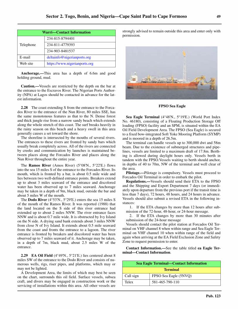
Sector 2. Togo, Benin, and Nigeria—Cape Saint Paul to Cape Formoso 49
Pub. 123
2.27 Anchorage.—This area has a depth of 6.6m and goodholding ground, mud.
2.27 Caution.—Vessels are restricted by the depth on the bar atthe entrance to the Escravos River. The Nigerian Ports Author-ity (NPA) at Lagos should be contacted in advance for the lat-est information.
2.28 The coast extending S from the entrance to the Forca-dos River to the entrance of the Nun River, 80 miles SSE, hasthe same monotonous features as that to the N. Dense forestand thick jungle rise from a narrow sandy beach which extendsalong the whole stretch of this coast. The surf breaks heavily inthe rainy season on this beach and a heavy swell in this areagenerally causes a set toward the shore.2.28 The shoreline is intersected by the mouths of several rivers.The entrances to these rivers are fronted by sandy bars whichusually break completely across. All of the rivers are connectedby creeks and communication by launches is maintained be-tween places along the Forcados River and places along theNun River throughout the entire year.
2.28 The Ramos River (Amos River) (5°08'N., 5°22'E.) flowsinto the sea 15 miles S of the entrance to the Forcados River. Itsmouth, which is fronted by a bar, is about 0.5 mile wide andlies between two well-defined entrance points. Breakers extendup to about 3 miles seaward of the entrance and discoloredwater has been observed up to 7 miles seaward. Anchoragemay be taken in a depth of 9m, black mud, outside the bar andabout 5 miles W of the mouth.2.28 The Dodo River (4°53'N., 5°29'E.) enters the sea 15 miles Sof the mouth of the Ramos River. It was reported (1988) thatthe land located on the S side of this river entrance hadextended up to about 2 miles NNW. The river entrance facesNNW and is about 0.7 mile wide. It is obstructed by Ivy Islandon the N side. A drying sand bank extends about 3 miles NNWfrom close N of Ivy Island. It extends about 0.5 mile seawardfrom the coast and fronts the entrance to a lagoon. The riverentrance is fronted by breakers and discolored water has beenobserved up to 7 miles seaward of it. Anchorage may be taken,in a depth of 7m, black mud, about 2.5 miles W of theentrance.
2.29 EA Oil Field (4°49'N., 5°21'E.) lies centered about 8miles SW of the entrance to the Dodo River and consists of nu-merous wells, rigs, riser pipes, and platforms, which may ormay not be lighted.2.29 A Development Area, the limits of which may best be seenon the chart, surrounds this oil field. Surface vessels, subseacraft, and divers may be engaged in construction work or theservicing of installations within this area. All other vessels are
strongly advised to remain outside this area and enter only withpermission.
2.29 Sea Eagle Terminal (4°48'N., 5°19'E.) (World Port IndexNo. 46180), consisting of a Floating Production Storage Offloading (FPSO) facility and an SPM, is situated within the EAOil Field Development Area. The FPSO (Sea Eagle) is securedto a fixed bow-integrated Soft Yoke Mooring Platform (SYMP)and is moored in a depth of 26.5m. 2.29 The terminal can handle vessels up to 300,000 dwt and 58mbeam. Due to the existence of submerged structures and pipe-lines, vessels are limited to a maximum draft of 17.8m. Berth-ing is allowed during daylight hours only. Vessels berth intandem with the FPSO.Vessels waiting to berth should anchor,in depths of 40 to 70m, NW of the terminal and well clear ofthe area.2.29 Pilotage.—Pilotage is compulsory. Vessels must proceed toForcados Oil Terminal in order to embark the pilot.2.29 Regulations.—Vessels should send their ETA to the FPSOand the Shipping and Export Department 7 days (or immedi-ately upon departure from the previous port if the transit time isless than 7 days), 72 hours, 48 hours, and 24 hours in advance.Vessels should also submit a revised ETA in the following in-stances:
1. If the ETA changes by more than 12 hours after sub-mission of the 72-hour, 48-hour, or 24-hour message.
2. If the ETA changes by more than 30 minutes aftersubmission of the 24-hour message
2.29 Vessels should contact the pilot station at Forcados Oil Ter-minal on VHF channel 8 when within range and Sea Eagle Ter-minal on VHF channel 10 when within range of the field andagain when arriving at the EA Field Exclusion Zone and SafetyZone to request permission to enter.
2.29 Contact Information.—See the table titled ea Eagle Ter-minal—Contact Information.
Telephone
234-815-8794401
234-811-4779393
234-903-8481537
E-mail [email protected]
Web site https://www.nigerianports.org
Warri—Contact Information
2.29FPSO Sea Eagle
Sea Eagle Terminal—Contact Information
Terminal
Call sign FPSO Sea Eagle (5NVQ)
Telex 581-465-790-110

50 Sector 2. Togo, Benin, and Nigeria—Cape Saint Paul to Cape Formoso
Pub. 123
2.30 Bonga Terminal (4°33'N., 4°37'E.), consisting of aFloating Production Storage Off loading (FPSO) facility andan SPM, is located about 65 miles SW of the entrance to theForcados River. It is situated in a depth of about 1,000m andcan handle vessels up to 350,000 dwt, 360m in length, and21.2m draft.
2.30 Pilotage.—Pilotage is compulsory. Vessels must proceed toForcados Oil Terminal in order to embark the pilot. Vesselsshould contact the pilot station at the Forcados Oil Terminal onVHF channel 8 when within range.
2.30 Regulations.—Vessels should send their ETA to the termi-nal and the Shipping and Export Department 7 days (or imme-diately upon departure from the previous port if the transit timeis less than 7 days), 72 hours, 48 hours, and 24 hours in ad-vance. Vessels should also submit a revised ETA in the follow-ing instances:
1. If the ETA changes by more than 12 hours after sub-mission of the 72-hour, 48-hour, or 24-hour message.
2. If the ETA changes by more than 30 minutes aftersubmission of the 24-hour message.
2.30 Vessels should contact Bonga Terminal on VHF channel 72when within range and again when arriving at the Bonga Pre-
cautionary Area and the Bonga Safety Zone to request permis-sion to enter. 2.30 Contact Information.—See the table titled Bonga Termi-nal—Contact Information.
2.31 The Pennington River (4°44'N., 5°32'E.) flows intothe sea 11 miles SE of the entrance to the Dodo River. Theriver entrance is 0.3 mile wide but appears as a small openingfrom WNW.
2.31 Pennington Oil Field (4°37'N., 5°25'E.) lies 7 miles SW ofthe entrance to the Pennington River. A gathering platformstands near the center of this field and a flare structure issituated close NE of it. A storage hulk is moored about 1 mileSW of this platform and several mooring buoys are situated 1mile SW of it. Several other platforms are situated within thefield.2.31 Caution.—A submarine pipeline connects the gatheringplatform, the storage hulk, and the mooring buoy berth. In ad-dition, a submarine pipeline, which may best be seen on thechart, extends 10 miles SSE from this oil field to Middleton OilField.
2.32 The Middleton River (4°32'N., 5°41'E.) flows into
E-mail [email protected]
MMSI 657901000
Control Room
Call sign Sea Eagle Control
VHF VHF channel 13
Telephone 234-807-025-3308
Marine Supervisor
Call sign Sea Eagle Marine
Telephone 234-807-025-3319
Offshore Installation Manager
Call sign Sea Eagle OIM
Telephone 234-807-025-3310
Administration
Facsimile 234-807-025-3359
Deck Foreman
Call sign Sea Eagle Deck
Offtake Tanker Operations
VHF VHF channel 10
Supply/Standby Vessels Operations
VHF VHF channel 9
Forcados Terminal
VHF VHF channel 8
Shipping and Export Department
E-mail [email protected]
Sea Eagle Terminal—Contact Information
Bonga Terminal—Contact Information
Terminal
Call sign FPSO Bonga (5NGJ)
Telephone 234-703-0125562
VHF VHF channel 72
Telephone870-765-091-754
870-765-091-786
Facsimile 870-765-091-755
Telex 581-465-779-110
E-mail [email protected]
MMSI 657791000
Control Room
Telephone 234-27-69419
Facsimile 234-844-753301
Marine Supervisor
Telephone 234-27-69400
Shipping and Export Department
E-mail [email protected]
Offtake Tanker Operations
VHF VHF channel 9
Supply/Standby Vessels Operations
VHF VHF channel 71
Forcados Terminal
VHF VHF channel 8
Sector 2. Togo, Benin, and Nigeria—Cape Saint Paul to Cape Formoso 51
Pub. 123
the sea 14 miles SE of the Pennington River. It appears fromoffshore to be a wide estuary with an island lying in theentrance. In reality, the island is actually a group of tall treesstanding on Hopkin Point, which divides the mouth into twobranches.2.32 Factory Point, the N entrance point of the river, is well-de-fined and several very high trees stand on the S entrance point,2.5 miles SE. Miller Island, lying close S of Hopkin Point, iscovered with grass and low scrub. It is reported not to be visi-ble until close inshore.2.32 The bar, which lies about 1.3 miles W of Factory Point, has aleast depth of 2.1m; however, the river entrance is obstructedby drying sand banks which lie between the bar and Miller Is-land.
Middleton Oil Field (4°30'N., 5°33'E.) lies centered 8 milesWSW of the entrance to Middleton River. It consists of a pro-duction platform and several oil rigs. Submarine pipelines,which may best be seen on the chart, connect this field to Pen-nington Oil Field, 10 miles NNW, and Pennington OffshoreTerminal, 15 miles S.
2.33 The Fishtown River (4°24'N., 5°50'E.) flows into thesea 12 miles SE of the Middleton River. Its entrance is 0.2 milewide and lies between two well-defined points. Between thesetwo river entrances, the forest is somewhat removed from thecoast and a belt of partially-cultivated land, with clumps ofpalms, intervenes.
The Kulama River flows into the sea 4 miles NW of theFishtown River but its entrance, 0.5 mile wide, is difficult toidentify from seaward.
The Sengana River, a branch of the River Niger, flows intothe sea 9 miles SE of the Fishtown River. Its entrance, which isabout 1 mile wide, is obstructed by a sand bank. Discoloredwater has been observed up to 4 miles seaward of the entrance.
North Apoi Oil Field (4°21'N., 5°47'E.) lies centered 3.5miles SW of the mouth of the Fishtown River. It consists of acentral gathering platform surrounded by several lighted wellheads. A submarine pipeline, which may best be seen on thechart, extends 13 miles SW and connects this field with thePennington Offshore Terminal.
Sengana Oil Field (4°17'N., 5°49'E.) lies centered 7 miles Sof the mouth of the Fishtown River.
Okubie Oil Field (4°14'N., 5°54'E.) lies centered 10 milesSSE of the mouth of the Fishtown River.
2.34 Pennington Offshore Terminal (4°15'N., 5°37'E.)(World Port Index No. 46200) is situated 16 miles SW of theentrance to the Fishtown River and consists of two SPMs. Sub-marine pipelines extend NE from the terminal toward the shoreand N to Middleton Oil Field.
A floating storage vessel (VLCC Oloibiri) is moored to SBMA. The export loading berth, SBM B, is moored in a depth of26.8m, about 0.7 mile NW of SBM A. The terminal can ac-commodate vessels having a maximum draft of 24.3m and upto 160,000 dwt.2.34 The wind and swell at the terminal are mostly from a SW di-rection. The weather is generally good from November to May,but it may be unfavorable during the wet season (May to No-vember). The currents in the vicinity of the terminal are report-ed to be irregular and strong at times.
2.34 A designated anchorage area lies 2.3 miles SW of the termi-nal. Vessels must have their engines ready for immediate usewhile at the terminal.2.34 Pilotage.—Pilotage is compulsory. Pilots, who act as moor-ing masters, may be contacted by VHF and board in position4°14.5'N, 5°34.5'E. They remain on board during the entireloading operation.2.34 Regulations.—Berthing is available during daylight hoursonly. Unberthing is available 24 hours. 2.34 Contact Information.—See the table titled PenningtonMarine Terminal—Contact Information.
2.34 Vessels should send an ETA 10 days, 96 hours, and 24 hoursprior to arrival via the oil company (Texaco Overseas [Nigeria]Petroleum Company). Vessels should then contact the terminal2 hours prior to arrival on VHF channel 16. 2.34 A restricted area, with a radius of 3 miles, is centered on theterminal. All vessels are prohibited from entering this areawithout prior permission.
2.35 The Nun River (Branch River) (4°16'N., 6°04'E.)flows into the sea 16 miles SE of the Fishtown River. It isentered between Cape Nun and Palm Point, 1.4 miles SE. Thisriver was formerly used as the principal entrance into the NigerRiver. However, because of shoaling on the bar and continualchanges in the channel above Akassa, 2 miles within theentrance, navigation is only possible by vessels with lightdrafts, even when the river level is high.2.35 The river mouth is imposing when first entered, but, afterreaching Akassa, the channel is almost entirely obstructed bynumerous flats and drying sand banks. It is not until 25 miles Nof Akassa that the river regains a width and depths commensu-rate with its importance.2.35 The shores on either side of the river entrance are heavilywooded and form areas of vast swamp as they are at a levelclose to that of the river.
Cape Nun (4°17'N., 6°04'E.), the N entrance point of theriver, is somewhat low, with trees standing close behind it. Be-tween this cape and Barracoon Point, 2 miles N, the W bank ofthe river is sandy, with trees extending almost to the edge of thewater. A beacon, 9m high, is situated on Barracoon Point.2.35 Palm Point (4°16'N., 6°05'E.), the S entrance point, is low,sandy, and covered with grass. Several trees stand about 0.3
Pennington Marine Terminal—Contact Information
Call sign Oloibiri (5NDF)
VHF VHF channels 8, 16, 18A
Telephone
870-600-875-514
870-761-119-984
870-761-119-985
Facsimile 870-761-119-986
Telex
581-465-749-121 (Inmarsat-C)
581-465-781-911 (Inmarsat-C)
581-465-781-912 (Inmarsat-C)

52 Sector 2. Togo, Benin, and Nigeria—Cape Saint Paul to Cape Formoso
Pub. 123
mile N of the point. A square clump of trees, situated 0.5 mileinland and 2.5 miles E of the point, is somewhat conspicuousabove the unbroken line of tree tops.2.35 A light is shown from a metal pile structure standing on thepoint; a beacon is situated 2 miles E of it.2.35 The bar fronting this river is considered to be one of theworst within the Niger Delta. The coast changes directionsharply in this vicinity and renders it fully exposed to the Wand S. There is always a heavy swell on the bar and calm daysare very few. The bar lies between the S extremities of twoshallow spits, which extend up to about 4 miles S from eachentrance point. The sea breaks heavily along the W spit andthere are heavy rollers and surf along the E spit. The bar iscomposed of hard sand, with mud immediately outside of it,and has a least depth of 1.8m (1963).2.35 During the rainy season, the bar frequently breaks all over,but it only breaks after half ebb in the dry season. Local knowl-edge is essential for crossing the bar. Discolored water hasbeen observed up to 4 miles seaward of the bar.2.35 Akassa (4°19'N., 6°04'E.), a small town, is situated on the W
bank of the Nun River, 2 miles N of Cape Nun and close NWof Barracoon Point. A small wharf, with a depth of 1.2m, frontsthe town. Vessels may anchor in a depth of 14m, mud, in themiddle of the channel, off Barracoon Point. Local pilots for theinland creeks are available here.2.35 Anchorage may be obtained offshore, free from rolling, in adepth of 11m about 5 miles S of Palm Point. In this vicinity, thecurrent from the river usually keeps the bow of the vessel head-ing N.2.35 Caution.—During the harmattan season (November to Feb-ruary) or during heavy rains, the river entrance may be oftenobscured for several days.
2.36 Anyala Oil Field (3°55'N., 5°54'E.) lies centered 24miles SSW of the mouth of the Nun River.2.36 Cape Formoso (4°16'N., 6°05'E.) is the low and wooded tractwhich forms the S extension of the Niger Delta. 2.36 This cape, located on the E side of the Nun River, also forms theE extremity of the Bight of Benin and is fully described in para-graph 3.2.
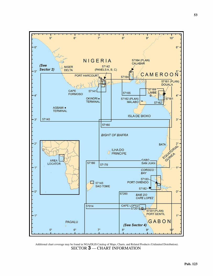
53
Pub. 123
3. Sector 3—Nigeria to Gabon—Cape Formoso to Cap Lopez
3.0Additional chart coverage may be found in NGA/DLIS Catalog of Maps, Charts, and Related Products (Unlimited Distribution).
SECTOR 3 — CHART INFORMATION
55
Pub. 123
SECTOR 3
NIGERIA TO GABON—CAPE FORMOSO TO CAP LOPEZ
3.0 Plan.—This sector describes the African coast betweenCape Formoso and Cap Lopez, and includes the islands lyingin the Bight of Biafra. It includes the coasts of Nigeria, Camer-oon, Equatorial Guinea, and Gabon. The descriptive sequenceis first from W to E and then from N to S.
General Remarks
3.1 The Bight of Biafra, known to Nigeria as the Bight ofBonny, is an extensive indentation in the African coast. Withinthe limits of this bight, numerous rivers discharge into the sea.The most important of these rivers are the New Calabar River,the Bonny River, and the Calabar River. The N shore of thisbight is almost flat and dark in color. It is intersected by themouths of the numerous rivers, forming the Niger Delta, eachof which is obstructed by bars or shoals at the entrance. Thecoast consists of a belt which is 10 to 60 miles wide andcovered with mangrove forests and swamps. Vast tropicalforests stand inland of this coastal belt beyond which theground becomes more open. There is little vegetation and verylittle rainfall in the extreme N part.3.1 Fako (4°13'N., 9°10'E.), also known as Cameroon Moun-tain, is the highest peak of the mountains which rise abruptlyfrom the land on the NE shore of the bight. This peak attains anelevation of about 4,095m and is covered with trees and ver-dure of luxuriant growth, except in the vicinity of the roundedsummit. It is very conspicuous from seaward but the summit isoften obscured by clouds. Fako is also a volcano. It last had aneruption in 2012. Another conspicuous peak, which standsabout 9 miles SSW of Fako, ascends from the SW slopes of themountain range. Although numerous other peaks rise from thesides of this range, they appear slight and scarcely break theuniformity of the slopes.3.1 The more distant mountains, which stand about 30 miles Nof Fako, attain elevations of 1,220 to 1,830m and tower aloft inhuge peaks and rugged masses. A plain, from whose surfaceseveral conical hills rise abruptly, extends between the bases ofthese mountains. Several other nearby peaks, which are extinctvolcanoes, are also visible from seaward.3.1 The islands lying in the Bight of Biafra are evidently of vol-canic origin and, together with the mountain ranges on themainland, are probably the gigantic results of one and the samesubmarine upheaval.3.1 Winds—Weather.—The Southwest Monsoon is the most sig-nificant of the local winds in this area. This large scale sea breeze,which extends up to about 150 miles inland, occurs in the N sec-tion over the Gulf of Guinea and adjacent coasts. It is strongestduring the summer (June-August), but is prevalent all year. Themonsoon is a deflection of the SE trade winds toward the heatedcontinental interior. It acts very much like a land-sea breeze sys-tem and is felt up to about 10°S. At Douala for example, whileSW winds are prevalent during the afternoon, their frequencydrops to 5 per cent during the early morning hours. The constantheavy surf along the coast generally prevents landing by boats
and renders the river bars dangerous.3.1 The harmattan, a wind of continental origin, is a hot, drywind from the NE quadrant. It reaches the shores of the Gulf ofGuinea and extends seaward. This wind is prevalent from De-cember through early March and is usually laden with fine dustwhich can reduce visibility in the form of haze. The harmattangenerally occurs between Cape Palmas (4°22'N., 7°44'W.) andDouala (4°03'N., 9°41'E.).3.1 Gales are infrequent over most of the area. Along the coastand to the N of the Equator, they occur on 1 to 6 days annually.From the Equator to Walvis Bay, gales occur on less than 1 dayper year. At Walvis Bay, gales can be expected on 14 days an-nually; 7 of these days occur in October while 4 of these daysoccur in July and August. 3.1 To the S and into the subtropics, gale frequencies increase.At Cape Town, gales occur on an annual average of 22 days,with most from December through March. Over the oceanarea, gales are infrequent to the N of 25°S. They occur for anaverage of 3 per cent of the time from April through Septemberbetween 25°S and 30°S. The frequency of the gales increasesrapidly to the S of 30°S and from May through September theyoccur for 10 to 20 per cent of the time between 30°S and 35°S.During this same period, gales occur for 12 to 25 per cent ofthe time between 35°S and 40°S. To the S of 40°S, data is toosparse for an accurate analysis.3.1 Tides—Currents.—The Guinea Current sets E along the Nshore of the Gulf of Guinea. During June through October, alarge part of this current is formed by an extension of the At-lantic Equatorial Countercurrent. During other months, it isconsidered to be an extension of the Canaries Current whichsets S along the NW coast of Africa. The Guinea Current at-tains rates of 1 to 2 knots, but generally becomes weaker as itflows E and is very weak in the Bight of Biafra.3.1 Regulations.—For information concerning Nigerian ShipEntry Notice (SEN), VHF communications regulations, and re-porting requirements for Nigerian oil terminals, see Pub. 160,Sailing Directions (Planning Guide) South Atlantic Ocean andIndian Ocean.3.1 The Maritime Domain Awareness for Trade—Gulf ofGuinea (MDAT—GoG) is a virtual reporting system for mari-time security operating in the maritime area of central and westAfrica. The system includes voluntary reporting from vesselsand output from MDAT—GoG to contribute to maritime situa-tional awareness. For further information, see South AtlanticOcean—Ship Reporting System in Pub. 160, Sailing Direc-tions (Planning Guide) South Atlantic Ocean and IndianOcean. 3.1 Caution.—Numerous oil and gas fields, with associatedrigs, platforms, obstructions, well heads, riser pipes, submarinepipelines, terminal buoys, and storage vessels, may be encoun-tered up to 100 miles offshore in the area covered by this Sec-tor. 3.1 Some of the well heads may protrude more than 5m abovethe sea bed and may be unmarked. Some of the platforms and
56 Sector 3. Nigeria to Gabon—Cape Formoso to Cap Lopez
Pub. 123
structures may be disused, abandoned, and unlit. In many cas-es, the submarine pipelines are not buried in the sea bed anddepths over them may be reduced by as much as 2m. In addi-tion, many temporary structures and objects associated with oiland gas exploration may not be charted.3.1 Several restricted areas lie offshore in the vicinity of the oiland gas installations. Vessels not proceeding to or departingfrom these installations should keep clear of the areas.3.1 Internal waves, known as solitons, have been experiencedwithin the waters described in this sector. These waves can re-sult in extremely rapid current changes of 3 to 4 knots within adistance of 300 to 400m. This phenomenon can be very haz-ardous for vessels engaged in offshore operations.3.1 Vessels are cautioned that security in near-coastal waters ofthe Gulf of Guinea and within some of its ports is a serious andpersistent issue. In recent years (2000-2020) hundreds of at-tacks by pirates and thieves have been reported and the occur-rence of these incidents continues to rise despite an increasedmaritime security presence. These incidents can and have beenreported deep in the Niger Delta waterways and up to 100miles offshore. They generally occur in areas of marine oil andgas production but have occurred while berthed in port. The In-ternational Maritime Bureau advises that the true number isprobably higher due to a lack of reporting by vessels.
Cape Formoso to the Cameroon River
3.2 Cape Formoso (4°16'N., 6°05'E.) is the general namegiven to the low, wooded tract which forms the S extension ofthe Niger Delta. This tract lies on the E side of the entrance tothe Nun River and Palm Point, which is marked by a light,forms its S extremity.
Between Palm Point and West Point, 8 miles E, the coast isfronted by a flat and sandy shore. The surf breaks heavily onthis shore and trees stand along it, close to the water.3.2 The Brass River (4°17'N., 6°13'E.), formed by theconfluence of several branches of the Niger River, is enteredbetween West Point and East Point, about 1 mile ENE. 3.2 West Point is low, sandy, and covered with small bushes. It isreported to be difficult to identify from seaward. The foresttrees extend close up to the HW mark in this vicinity.3.2 East Point is thickly wooded, but the trees on it have theappearance of a steep bluff and do not extend to the water. TheW bank of the river is backed by trees as far as the entrance toAkassa Creek, 2 miles N of West Point. Above the entrance toAkassa Creek, the mangroves and swamps begin. The E bankof the river has some small villages, hidden by trees, situatedwithin 0.5 mile of East Point.3.2 Anchorage may be obtained in a depth of 11m about 6 milesSW of West Point or 7 miles SE of East Point.
3.2 Brass (4°19'N., 6°14'E.), a small town, stands on the E bankof the river, about 1 mile NE of East Point. It is fronted by sev-eral small piers which are used by boats and small craft.3.2 A bar, consisting of shoals, connects the seaward ends of twospits which extend S for 1.5 miles from the entrance points.The outer part of this bar lies 2 to 3 miles S of the river mouth.Breakers mark the spits and the bar. A passage, about 0.5 milewide, leads over the center of the bar, where the breakers areless frequent than elsewhere. The fairway is shallow and
marked by buoys. It is only used by small craft with localknowledge. The approach is dangerous because of the heavyrollers which break at frequent intervals even at HW. The innerpart of the channel may also be obstructed by fishing nets.3.2 Caution.—Two unlit riser pipes, reported to be radar con-spicuous, lie about 7 miles S of West Point.3.2 In the rainy season, the Brass River entrance is often com-pletely obscured.
3.3 Brass Oil Terminal (4°04'N., 6°17'E.) (World PortIndex No. 46190), located about 14 miles SSE of the mouth ofthe Brass River, consists of a lighted central platform, which isequipped with a racon, and two SBMs. Submarine pipelines,which may best be seen on the chart, extend NNW to the shoreand SE to the Agbara Oil Field from the terminal.
No. 1 SBM and No. 2 SBM are situated 1 mile E and 1 mileW, respectively, of the central platform, in a depth of 27.4m.Vessels of up to 320,000 dwt and 27m draft can be handled,with a minimum length of 220m and a maximum length of366m.
Pilotage.—Pilotage is compulsory and available 24 hours.Pilots can be contacted by VHF and board in position 4°06'N,6°19'E about 3 miles NE of the Buoy Operating Platform. 3.3 Regulations.—Vessels should send an ETA to the terminal72 hours before arrival. This message should contain vesselparticulars and cargo request. Vessels should then contact theterminal by VHF before arrival and when anchoring.3.3 A restricted area, with a radius of 2.5 miles, is centered onthe terminal. Vessels must receive permission to enter this area.3.3 Contact Information.—See the table titled Brass Oil Ter-minal—Contact Information.
A designated anchorage area, with depths of 27 to 29m andfairly good holding ground, lies about 2.8 miles NE of theterminal platform.3.3 Agbara Oil Field (3°56'N., 6°24'E.) lies about 10 miles SEof Brass Oil Terminal and has a central platform, with a veryconspicuous flare.
3.4 Between the Brass River and the Bonny River, about50 miles E, the coast is intersected by several rivers. Themouths of these rivers are fronted by bars on which the seagenerally breaks heavily. The rivers are not entered throughtheir main mouths, but through creeks which connect them in-
Brass Oil Terminal—Contact Information
Terminal
VHF VHF channels 14 and 16
RT Frequency 6776 (kHz)
Facsimile 234-84-236-400 (ext. 3478)
Marine Superintendent
Telephone234-84-236-400 (ext. 3420)
234-84-236-400 (ext. 7223)
Swamp Area Manager
Facsimile 234-84-236-400 (ext. 3655)
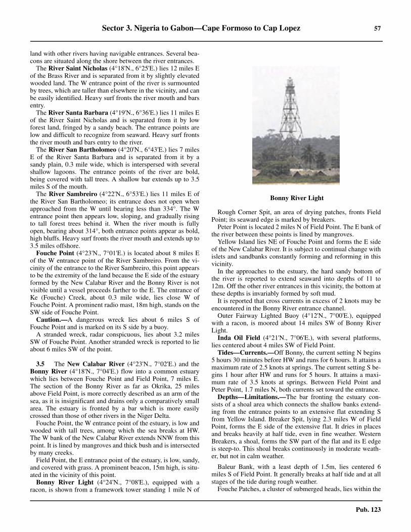
Sector 3. Nigeria to Gabon—Cape Formoso to Cap Lopez 57
Pub. 123
land with other rivers having navigable entrances. Several bea-cons are situated along the shore between the river entrances. 3.4 The River Saint Nicholas (4°18'N., 6°25'E.) lies 12 miles Eof the Brass River and is separated from it by slightly elevatedwooded land. The W entrance point of the river is surmountedby trees, which are taller than elsewhere in the vicinity, and canbe easily identified. Heavy surf fronts the river mouth and barsentry.3.4 The River Santa Barbara (4°19'N., 6°36'E.) lies 11 miles Eof the River Saint Nicholas and is separated from it by lowforest land, fringed by a sandy beach. The entrance points arelow and difficult to recognize from seaward. Heavy surf frontsthe river mouth and bars entry to the river.3.4 The River San Bartholomeo (4°20'N., 6°43'E.) lies 7 milesE of the River Santa Barbara and is separated from it by asandy plain, 0.3 mile wide, which is interspersed with severalshallow lagoons. The entrance points of the river are bold,being covered with tall trees. A shallow bar extends up to 3.5miles S of the mouth.3.4 The River Sambreiro (4°22'N., 6°53'E.) lies 11 miles E ofthe River San Bartholomeo; its entrance does not open whenapproached from the W until bearing less than 334°. The Wentrance point then appears low, sloping, and gradually risingto tall forest trees behind it. When the river mouth is fullyopen, bearing about 314°, both entrance points appear as bold,high bluffs. Heavy surf fronts the river mouth and extends up to3.5 miles offshore.3.4 Fouche Point (4°23'N., 7°01'E.) is located about 8 miles Eof the W entrance point of the River Sambreiro. From the vi-cinity of the entrance to the River Sambreiro, this point appearsto be the extremity of the land because the E side of the estuaryformed by the New Calabar River and the Bonny River is notvisible until a vessel proceeds farther to the E. The entrance ofKe (Fouche) Creek, about 0.3 mile wide, lies close W ofFouche Point. A prominent radio mast, 18m high, stands on theSW side of Fouche Point.3.4 Caution.—A dangerous wreck lies about 6 miles S ofFouche Point and is marked on its S side by a buoy.3.4 A stranded wreck, radar conspicuous, lies about 3.2 milesSW of Fouche Point. Another stranded wreck is reported to lieabout 6 miles SW of the point.
3.5 The New Calabar River (4°23'N., 7°02'E.) and theBonny River (4°18'N., 7°04'E.) flow into a common estuarywhich lies between Fouche Point and Field Point, 7 miles E.The section of the Bonny River as far as Okrika, 25 milesabove Field Point, is more correctly described as an arm of thesea, as it is insignificant and drains only a comparatively smallarea. The estuary is fronted by a bar which is more easilycrossed than those of other rivers in the Niger Delta.3.5 Fouche Point, the W entrance point of the estuary, is low andwooded with tall trees, among which the sea breaks at HW.The W bank of the New Calabar River extends NNW from thispoint. It is lined by mangroves and thick bush and is intersectedby many creeks.3.5 Field Point, the E entrance point of the estuary, is low, sandy,and covered with grass. A prominent beacon, 15m high, is situ-ated in the vicinity of this point.3.5 Bonny River Light (4°24'N., 7°08'E.), equipped with aracon, is shown from a framework tower standing 1 mile N of
3.5 Rough Corner Spit, an area of drying patches, fronts FieldPoint; its seaward edge is marked by breakers. 3.5 Peter Point is located 2 miles N of Field Point. The E bank ofthe river between these points is lined by mangroves.3.5 Yellow Island lies NE of Fouche Point and forms the E sideof the New Calabar River. It is subject to continual change withislets and sandbanks constantly forming and reforming in thisvicinity.3.5 In the approaches to the estuary, the hard sandy bottom ofthe river is reported to extend seaward into depths of 11 to12m. Off the other river entrances in this vicinity, the bottom atthese depths is invariably formed by soft mud.3.5 It is reported that cross currents in excess of 2 knots may beencountered in the Bonny River entrance channel. 3.5 Outer Fairway Lighted Buoy (4°12'N., 7°00'E.), equippedwith a racon, is moored about 14 miles SW of Bonny RiverLight.3.5 Inda Oil Field (4°21'N., 7°06'E.), with several platforms,lies centered about 4 miles SW of Field Point.3.5 Tides—Currents.—Off Bonny, the current setting N begins5 hours 30 minutes before HW and runs for 6 hours. It attains amaximum rate of 2.5 knots at springs. The current setting S be-gins 1 hour after HW and runs for 5 hours. It attains a maxi-mum rate of 3.5 knots at springs. Between Field Point andPeter Point, 1.7 miles N, both currents set toward the entrance.3.5 Depths—Limitations.—The bar fronting the estuary con-sists of a shoal area which connects the shallow banks extend-ing from the entrance points to an extensive flat extending Sfrom Yellow Island. Breaker Spit, lying 2.3 miles W of FieldPoint, forms the E side of the extensive flat. It dries in placesand breaks heavily at half tide, even in fine weather. WesternBreakers, a shoal, forms the SW part of the flat and its E edgeis steep-to. This shoal breaks continuously in moderate weath-er, but not in calm weather.
3.5 Baleur Bank, with a least depth of 1.5m, lies centered 6miles S of Field Point. It generally breaks at half tide and at allstages of the tide during rough weather.3.5 Fouche Patches, a cluster of submerged heads, lies within the
3.5Bonny River Light
58 Sector 3. Nigeria to Gabon—Cape Formoso to Cap Lopez
Pub. 123
bar and has a least depth of 1.5m. This cluster lies on a shoalwhich extends about 3.5 miles SE from Fouche Point.3.5 An entrance channel, 200m wide, extends NE across the barand leads to the Bonny River. This channel, which may best beseen on the chart, is marked by lighted buoys. Depths in theriver and its approaches have been reported (2016), as follows:.
1. Bonny River approach channel—13.5m.2. Bonny to Onne Junction—11.0m.3. Onne Junction to Okrika Creek—10.0m.4. Okrika Creek to Port Harcourt—9.5m.
3.5 Pilotage.—Pilotage is compulsory from Outer FairwayLighted Buoy (4°12'N., 7°00'E.) along the Bonny River to PortHarcourt. For further information, see paragraph 3.13.3.5 Vessel Traffic Service.—A VTS is in effect on the BonnyRiver. For further information, see paragraph 3.13.3.5 Caution.—Due to the continual coastal erosion near the en-trance of the estuary, the charted aspect of the land should notbe relied upon.3.5 When the harmattan is blowing, the land in the vicinity ofFouche Point will generally not be visible to vessels enteringthe river.3.5 The lighted buoys marking the entrance channel should notbe depended upon and are reported to be often unlit at night. Itwas reported (1995) that several of the buoys were missing.3.5 Vessels should contact the port authorities in advance to ver-ify the latest depths in the river and approach channel. 3.5 Several submarine pipelines, which may best be seen on thechart, extend across the river. The depths in the channel may bereduced by as much as 1.8m in the vicinity of these pipelines.
3.5 Fishing stakes line the sides of the river in numerous places.3.5 Several spoil ground areas lie in the approaches and withinthe river and may best be seen on the chart.3.5 Several oil fields and offshore terminals, with associatedstructures, lie in the approaches to the estuary and may best beseen on the chart.3.5 It was reported (1986-2014) that several vessels, while an-chored off the entrance channel, had been attacked by pirates.The authorities now advise vessels to drift within radar rangeof the outer lighted buoy instead of anchoring. During thissame period, serious theft was being carried out from vesselsberthed at the river ports and precautions should be taken.
3.6 Agbami Oil Terminal (3°28'N., 5°34'E.) (World PortIndex No. 46237), located about 62 miles SW of the Brass Riv-er, consists of the deep-water offshore terminal FPSO Agbamiand a SPM located approximately 1 mile to the N.
Vessels of up to 315,000 dwt and 329m in length have beenaccommodated at the SPM. Vessels of up to 150,000 dwt and286m in length have been handled at the FPSO Agbami.
Pilotage.—Pilotage is compulsory when within the exclu-sion zone and during mooring and unmooring operations. Pi-lots can be contacted on VHF channels 10 or 16 and board 3miles NW of the terminal in position 3°31'N, 5°31'E.
Regulations.—Tandem mooring at the FPSO Agbami takesplace during daylight hours only, but vessels may depart at anytime. Four tugs are available to assist when tandem mooring.Berthing and unberthing is available 24 hours when mooring tothe SPM, which is preferred, and two tugs are available to as-sist with this operation.
Anchorage is not advised in the area due to numerous sub-
marine pipelines and the excessive depth, more than 1,400m.3.6 Vessels should send an ETA to the terminal 7 days or upondeparture at previous port of call if less than 7 days, and also72 hours, 48 hours, and 24 hours before arrival. Vessels shouldalso provide the following information to the Nigerian Govern-ment Port Head Official via an agent at least 72 hours beforearrival:
1. Vessel name and Call sign2. ETA3. Tonnage of cargo to load4. Crew size and health status5. Doctor aboard or not6. Request for Free Pratique
3.6 Vessels should also advise of any change in ETA, greaterthan 30 minutes, within 12 hours of arrival.3.6 Two restricted areas exist, one with a radius of 1,850m, cen-tered on the SPM, and another with a radius of 1,500m, cen-tered on the terminal. Vessels must receive permission to enterthis area. 3.6 Contact Information.—See the table titled Agbami Termi-nal—Contact Information.
3.7 Egina Oil Terminal (3°04'N., 6°42'E.) (World PortIndex No. 46239) is located approximately 81 miles SSE ofPalm Point Light. The terminal exports crude oil via an SBMand consists of the ultra-deep water moored FPSO Egina. 3.7 Egina Oil Terminal can be contacted, as follows:
3.8 Okwori Oil Terminal (3°51'N., 6°59'E.) (World PortIndex No. 46240), located about 33 miles SSW of Field Point,consists of a Floating Production Storage and Offloading(FPSO) facility. The FPSO (Sendje Berge), alongside whichthe loading vessel is berthed, is moored in a depth of 138m.Vessels up to 250,000 dwt can be handled. 3.8 Pilotage.—Pilotage is compulsory. Pilots, who act as moor-ing masters, may be contacted on VHF channel 15 or 16 andboard about 3 miles E of the terminal in position (3°51'N.,6°59'E.). Berthing is available from 0600-1800 LT. Vesselsmay depart 24 hours a day.
Agbami Terminal—Contact Information
Terminal
Call sign Agbami Terminal
VHF VHF channels 10 and 16
Telephone 44-1224-34213
Offshore Installation Manager (OMI)
E-mail [email protected]
Operations Superintendent
E-mail [email protected]
Egina Terminal—Contact Information
Terminal
Call sign FPSO Egina (3EYT5)
Web site https://nigeria.total.com/en/total-nigeria/total
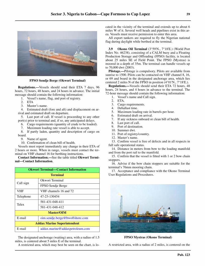
Sector 3. Nigeria to Gabon—Cape Formoso to Cap Lopez 59
Pub. 123
3.8 Regulations.—Vessels should send their ETA 7 days, 96hours, 72 hours, 48 hours, and 24 hours in advance. The initialmessage should contain the following information:
1. Vessel’s name, flag, and port of registry.2. ETA3. Master’s name.4. Estimated draft (fore and aft) and displacement on ar-
rival and estimated draft on departure.5. Last port of call. If vessel is proceeding to any other
port(s) prior to terminal and, if so, any anticipated delays. 6. Cargo requirements (quantity of crude to be loaded).7. Maximum loading rate vessel is able to accept.8. If partly laden, quantity and description of cargo on
board.9. Name of agent.10. Confirmation of clean bill of health.
3.8 Vessels must report immediately any change in their ETA of2 hours or more. When in range, vessels must contact the ter-minal on VHF channel 16 for berthing instructions.3.8 Contact Information.—See the table titled Okwori Termi-nal—Contact Information.
3.8 The designated anchorage (waiting) area, with a radius of 1.5miles, is centered about 5 miles E of the terminal.3.8 A restricted area, which may best be seen on the chart, is lo-
cated in the vicinity of the terminal and extends up to about 6miles W of it. Several well heads and pipelines exist in this ar-ea. Vessels must receive permission to enter this area.3.8 All export tankers are required to fly the Nigerian nationalflag during daylight while berthed at the terminal.
3.9 Okono Oil Terminal (3°59'N., 7°18'E.) (World PortIndex No. 46238), consisting of a CALM buoy and a FloatingProduction Storage and Offloading (FPSO) facility, is locatedabout 25 miles SE of Field Point. The FPSO (Mystras) ismoored in a depth of 35m. The terminal can handle vessels upto 70,000 dwt (2003). 3.9 Pilotage.—Pilotage is compulsory. Pilots are available fromsunrise to 1500. Pilots can be contacted on VHF channel 8, 16,or 69 and board in the designated anchorage area, which liescentered 2 miles N of the FPSO in position (4°01'N., 7°18'E.). 3.9 Regulations.—Vessels should send their ETA 72 hours, 48hours, 24 hours, and 4 hours in advance to the terminal. The72-hour message should contain the following information:
1. Vessel’s name and Call sign.2. ETA.3. Cargo requirements.4. Deballast time.5. Maximum loading rate in barrels per hour.6. Estimated draft on arrival.7. If any sickness onboard or clean bill of health.8. Last port of call.9. Port of destination.10. Summer dwt.11. Port of registry/country.12. Master’s name.13. Confirm vessel is free of defects and in all respects in
full safe operational status.14. Distance in meters from bow to the loading manifold
and from the port rail to the manifold.15. Confirm that the vessel is fitted with 1 or 2 bow chain
stoppers.16. Advise if the bow chain stoppers are suitable for the
terminal’s 76mm mooring chain.17. Acceptance and compliance with the Okono Terminal
User Regulations and Procedures.
3.9 A restricted area, with a radius of 2 miles, is centered on the
3.8FPSO Sendje Berge (Okwori Terminal)
Okwori Terminal—Contact Information
Terminal
Call signOkwori Terminal
FPSO Sendje Berge
VHF VHF channels 16 and 72
Telephone 47-23-130454
Telex581-431-048-411
581-431-048-412
Master/OIM
E-mail [email protected]
Addax Marine Superintendent
E-mail [email protected]
3.9FPSO Mystras (Okono Terminal)
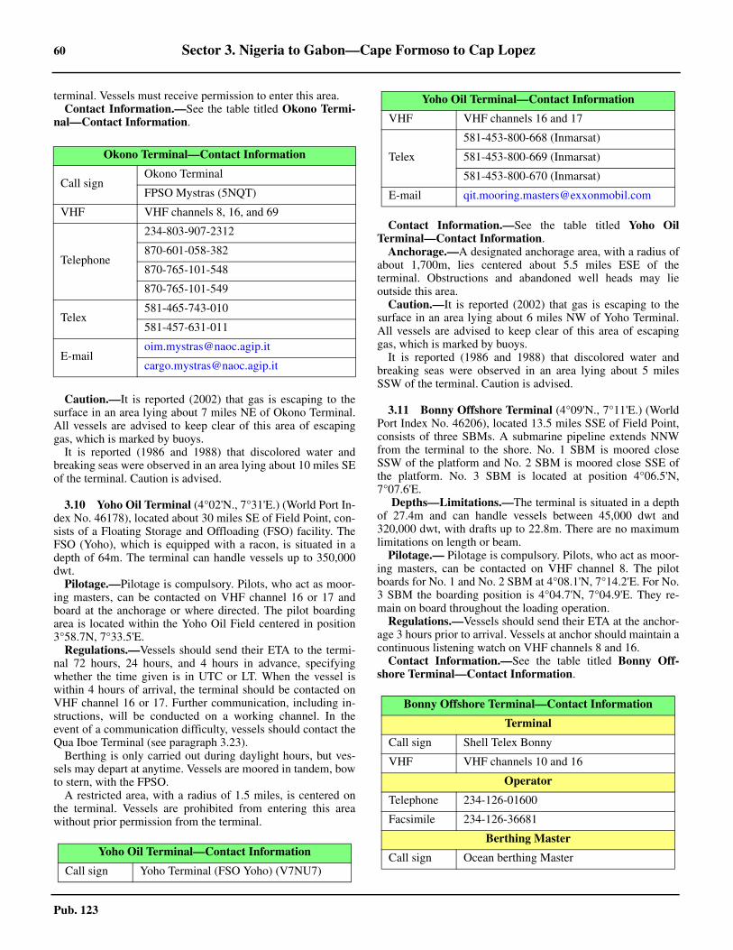
60 Sector 3. Nigeria to Gabon—Cape Formoso to Cap Lopez
Pub. 123
terminal. Vessels must receive permission to enter this area.3.9 Contact Information.—See the table titled Okono Termi-nal—Contact Information.
3.9 Caution.—It is reported (2002) that gas is escaping to thesurface in an area lying about 7 miles NE of Okono Terminal.All vessels are advised to keep clear of this area of escapinggas, which is marked by buoys.3.9 It is reported (1986 and 1988) that discolored water andbreaking seas were observed in an area lying about 10 miles SEof the terminal. Caution is advised.
3.10 Yoho Oil Terminal (4°02'N., 7°31'E.) (World Port In-dex No. 46178), located about 30 miles SE of Field Point, con-sists of a Floating Storage and Offloading (FSO) facility. TheFSO (Yoho), which is equipped with a racon, is situated in adepth of 64m. The terminal can handle vessels up to 350,000dwt.3.10 Pilotage.—Pilotage is compulsory. Pilots, who act as moor-ing masters, can be contacted on VHF channel 16 or 17 andboard at the anchorage or where directed. The pilot boardingarea is located within the Yoho Oil Field centered in position3°58.7N, 7°33.5'E.3.10 Regulations.—Vessels should send their ETA to the termi-nal 72 hours, 24 hours, and 4 hours in advance, specifyingwhether the time given is in UTC or LT. When the vessel iswithin 4 hours of arrival, the terminal should be contacted onVHF channel 16 or 17. Further communication, including in-structions, will be conducted on a working channel. In theevent of a communication difficulty, vessels should contact theQua Iboe Terminal (see paragraph 3.23).3.10 Berthing is only carried out during daylight hours, but ves-sels may depart at anytime. Vessels are moored in tandem, bowto stern, with the FPSO. 3.10 A restricted area, with a radius of 1.5 miles, is centered onthe terminal. Vessels are prohibited from entering this areawithout prior permission from the terminal.
3.10 Contact Information.—See the table titled Yoho OilTerminal—Contact Information. 3.10 Anchorage.—A designated anchorage area, with a radius ofabout 1,700m, lies centered about 5.5 miles ESE of theterminal. Obstructions and abandoned well heads may lieoutside this area.3.10 Caution.—It is reported (2002) that gas is escaping to thesurface in an area lying about 6 miles NW of Yoho Terminal.All vessels are advised to keep clear of this area of escapinggas, which is marked by buoys.3.10 It is reported (1986 and 1988) that discolored water andbreaking seas were observed in an area lying about 5 milesSSW of the terminal. Caution is advised.
3.11 Bonny Offshore Terminal (4°09'N., 7°11'E.) (WorldPort Index No. 46206), located 13.5 miles SSE of Field Point,consists of three SBMs. A submarine pipeline extends NNWfrom the terminal to the shore. No. 1 SBM is moored closeSSW of the platform and No. 2 SBM is moored close SSE ofthe platform. No. 3 SBM is located at position 4°06.5'N,7°07.6'E.
Depths—Limitations.—The terminal is situated in a depthof 27.4m and can handle vessels between 45,000 dwt and320,000 dwt, with drafts up to 22.8m. There are no maximumlimitations on length or beam.
Pilotage.— Pilotage is compulsory. Pilots, who act as moor-ing masters, can be contacted on VHF channel 8. The pilotboards for No. 1 and No. 2 SBM at 4°08.1'N, 7°14.2'E. For No.3 SBM the boarding position is 4°04.7'N, 7°04.9'E. They re-main on board throughout the loading operation.
Regulations.—Vessels should send their ETA at the anchor-age 3 hours prior to arrival. Vessels at anchor should maintain acontinuous listening watch on VHF channels 8 and 16.3.11 Contact Information.—See the table titled Bonny Off-shore Terminal—Contact Information.
Okono Terminal—Contact Information
Call signOkono Terminal
FPSO Mystras (5NQT)
VHF VHF channels 8, 16, and 69
Telephone
234-803-907-2312
870-601-058-382
870-765-101-548
870-765-101-549
Telex581-465-743-010
581-457-631-011
Yoho Oil Terminal—Contact Information
Call sign Yoho Terminal (FSO Yoho) (V7NU7)
VHF VHF channels 16 and 17
Telex
581-453-800-668 (Inmarsat)
581-453-800-669 (Inmarsat)
581-453-800-670 (Inmarsat)
E-mail [email protected]
Bonny Offshore Terminal—Contact Information
Terminal
Call sign Shell Telex Bonny
VHF VHF channels 10 and 16
Operator
Telephone 234-126-01600
Facsimile 234-126-36681
Berthing Master
Call sign Ocean berthing Master
Yoho Oil Terminal—Contact Information
Sector 3. Nigeria to Gabon—Cape Formoso to Cap Lopez 61
Pub. 123
3.11 Anchorage.—The designated anchorage area, which is re-ported to have poor holding ground, lies about 3.5 miles S ofthe platform. Vessels must not proceed any closer to the termi-nal without a pilot.3.11 Caution.—During the rainy season (June to September),heavy swells may be encountered at the anchorage.3.11 It is reported (2002) that gas is escaping to the surface in anarea lying about 11 miles SE of Bonny Offshore Terminal. Allvessels are advised to keep clear of this area of escaping gas,which is marked by buoys.
3.12 Bonny River (4°27'N., 7°10'E.) (World Port IndexNo. 46205) lies at the E side of the river. The town stands onvery low land among mangrove swamps.3.12 Tides—Currents.—The tides rise about 2.9m at springs and1.9m at neaps.3.12 Depths—Limitations.—The maximum draft to which avessel can load is governed by the datum depth in the channel,the height of tide, and the underkeel clearance allowed.3.12 For depth information in the Bonny River and its approach-es, see paragraph 3.5.3.12 The tide is variable, but the relevant factor is the height at thetime of transit. The underkeel clearance allowed is dependenton the time of the year and is related to the height of the swellexpected to be encountered in the channel. The underkeelclearance ranged from 0.76 to 1.22m (1989). The maximumsize of vessel permitted at the terminal (1989) was 135,000dwt, subject to review during the rainy season (May throughOctober). The maximum length allowed was 320m and themaximum draft allowed was 11.2m. Vessels must have a mini-mum length of 161m, but there is no restriction for beam.3.12 Mobil Jetty is a T-headed facility located on Peter Point, 2miles N of Field Point. There is an alongside depth of 12.5m.Vessels of 20,000 to 120,000 dwt can be accommodated. Thefacility is surrounded by an Entry Restricted zone.3.12 The Nigeria LNG Terminal (NLNG Terminal), a T-headedfacility, stands about 0.8 mile NE of the Mobil Jetty. The termi-nal normally accommodates product tankers of 30,000 to60,000 dwt, but partially-loaded vessels up to 100,000 dwt canbe handled. It also handles LNG vessels up to 140,000 cubicmeters. The facility is surrounded by an Entry Restricted Zone.3.12 The LPG Jetty, a T-headed pier, is situated between theabove two jetties. It can accommodate LPG vessels with capac-ities between 30,000 and 85,000 cubic meters. Caution is nec-essary when using this facility as a stranded wreck lies of theNE extremity of the jetty and a depth of 8.5m is located off the
SW extremity of the jetty. 3.12 Pilotage.—Pilotage is compulsory from the outer fairwaylighted buoy along the Bonny River up to Port Harcourt, in-cluding Onne and Okrika.3.12 The pilots are Nigerian Port Authority licensed and are re-quired for both inbound and outbound navigation of the BonnyInshore Oil Terminal Marine Operations. Pilotage is availableduring 24 hours.3.12 Pilots can be contacted by VHF channels 14 or 16 and boardin the following locations:
1. Bonny Inshore Terminal:a. Condensate and LNG vessels—1.5 miles SW of
Outer Fairway Lighted Buoy, generally between 2.5 hoursbefore LW and 2.5 hours before HW.
b. Other vessels—0.5 mile SW of No. 1 Lighted Buoy. 2. Port Harcourt, Onne, and Okrika—in the anchorage
off the NPA Jetty in position 4°27.5'N. 7°10.0'E.3.12 Regulations.—Vessels should send their ETA by e-mail viatheir agent 7 days, 4 days, 72 hours, 48 hours, 24 hours, and 6hours in advance, giving the following information:
1. On departure from discharge port—ETA and arrivaldraft.
2. Seven (7) days prior to arrival—ETA, arrival draft, es-timated arrival tank temperatures (vapor and liquid), and re-quired cool down period upon berthing.
3. Four (4) days prior to arrival—Vessel’s name, ETA atBonny Point pilot boarding station, cool down time required,crew list, and ISPS security information with list of person-nel embarking or disembarking.
4. Seventy-two (72) hours prior to arrival—ConfirmETA, average bottom liquid and tank vapor pressures, andaverage vapor pressure (mb absolute).
5. Forty-eight (48) hours prior to arrival—ETA and ar-rival draft; estimated tank temperatures and cool down peri-od required on berthing; confirm all navigation, mooring,safety, and engine systems are fully operational; and confirmvessel is free of tank leakage.
Confirmation that the following systems have been in-spected/tested and are operating correctly should be includedin the 48-hour report—Cargo system and boil off controlequipment; gas-detection analyzers, ESDS alarms, and inter-locks; tank high level alarms, tank high pressure and lowpressure alarms; remotely operated valves, cargo tanks andlines free of oxygen; stress calculations for cargo, ballast,and bunker transfers made and within recommended safetylimits; and estimated departure draft from Bonny.
6. Twenty-four (24) hours prior to arrival—ConfirmETA.
7. Six (6) hours prior to arrival— Vessel’s name, voyagenumber, cargo number, ETA at Bonny Point pilot boardingpoint, average bottom tank temperature, average tank vaporpressure and temperature (mb absolute) over the last 24hours, and confirm the vessel is ready to berth on arrival.
3.12 Vessels should then contact Bonny Signal Station on VHFchannel 14 to obtain permission to proceed into the entrancechannel. Vessels should also maintain a continuous listeningwatch on VHF channels 14 and 16. 3.12 All movements of vessels between the outer fairway lightedbuoy and the gas berths are restricted when gas or condensatesupertankers are maneuvering in the area.
VHF VHF channel 8
Oil Nigeria
Call sign Oil One
VHF VHF channel 10
Intels Agency
Call signOscar One (O1)
November One (N1)
VHF VHF channel 16
Bonny Offshore Terminal—Contact Information

62 Sector 3. Nigeria to Gabon—Cape Formoso to Cap Lopez
Pub. 123
3.12 Vessel Traffic Service.—A VTS is in service for all vesselstransiting the Bonny River. Reports to Bonny Signal Stationshould be made on VHF channels 12, 14, or 16, as follows:
1. Inbound vessels—Prior to entering the channel atthe lighted Entrance Fairway Lighted Buoy or on depart-ing the narrow channel at Lighted Buoy No. 22.
2. Outbound vessels—Report their ETD at least 2hours before departure. They shall also report before en-tering the narrow channel at Lighted Buoy No. 22 or upondeparting the channel at the Entrance Fairway LightedBuoy.
3.12 Contact Information.—See the table titled Bonny InshoreTerminal—Contact Information. 3.12 Anchorage.—Vessels proceeding to Bonny may anchor, indepths of 17 to 19m, within a designated area centered about 4miles W of the outer fairway lighted buoy. When anchored,vessels should report their date and time of arrival to the portauthority by VHF.3.12 Caution.— The Niger Delta, the Bonny River and its vari-ous tributaries, basins, and dredged channels and berths, aresubject to silting and extreme depth variations. Actual depthsmay significantly differ from the chart, mariners are to contactlocal authorities for the latest information.
3.13 Onne (4°41'N., 7°09'E.) (World Port Index No.46208) is situated in Ogu Creek.There are facilities for generalcargo, container, ro-ro, and bulk vessels.
Depths—Limitations.—The port consists of a quay,1,590m long, which provides 12 berths. The quay has a depthof 13.5m alongside and can accommodate vessels up to 55,000dwt.
The entrance channel within the creek has a least depth of10m.
For berthing information see the table titled Onne—BerthInformation.
Pilotage.—Pilotage is provided by Bonny NPA Pilots. Forfurther information, see paragraph 3.13 (Bonny River).3.13 Regulations.—Vessels should contact the Port Captain ofNicotes on VHF channel 16 to receive berthing instructions.Vessels should also contact Onne Signals on VHF channel 14and provide their ETA. In addition, vessels should contact thePort Captain and Onne Signals to advise them of the time of
berthing. 3.13 Vessels should maintain a listening watch on VHF channels8 and 14. 3.13 Vessels must obtain permission from the Port Captain priorto departing. 3.13 Contact Information.—See the table titled Onne—Con-tact Information.
3.14 Okrika (4°43'N., 7°05'E.) (World Port Index No.46207), an oil terminal, lies on the NE side of the river channel,about 0.5 mile SSE of the island on which the town of Okrikastands. The marine terminal consists of two L-shaped jettieswith dolphins at the outer ends. The oil refinery lies NNE ofthe terminal, about 3 miles inland. Outer Berth A has a lengthof 27m and Outer Berth B has a length of 80m, not includingdolphins. Both berths have an alongside depth of 9.5m. Coastaland ocean tankers up to 39,870 dwt, 193m in length, with amaximum beam of 30m and draft of 9m can be accommodated.Berthing is carried out during daylight hours only. Theapproach river channel has a least charted depth of 10.5m closeWSW of the Oil Jetty. Vessels with drafts up to 7.9m can berthand vessels with drafts up to 9m can depart on the flood tide.The port monitors VHF channels 14 and 16. For pilotageinformation, see Bonny River, paragraph 3.12.
3.15 Port Harcourt (4°46'N., 7°01'E.) (World Port IndexNo. 46210), a railroad terminal, lies on the E side of a bend inthe Bonny River, about 30 miles above the mouth.3.15 Depths—Limitations.—There are eight principal dry cargoberths, which are 128 to 196m long; one palm oil berth; and
Bonny Inshore Terminal—Contact Information
Telephone234-180-390-53130
234-180-390-53133
Facsimile234-184-232-900 (ext. 3152)
442-073-163-888 (ext. 3103)
Onne Home Page
http://www.nigerianports.org
Onne—Contact Information
Onne Signals
VHF VHF channel 14
Intels Port Captain
VHF VHF channel 16
E-mail [email protected]
Web site https://www.intelservices.com
West Africa Container Terminal (WACT)
Telephone234-809-033-5116
234-809-033-5101
E-mail [email protected]
Web site https://www.apmterminals.com
Port Authority
Telephone
234-903-400-0062
234-806-632-0148
234-185-879-4399
E-mail [email protected]
Port Harcourt Home Page
http://www.nigerianports.org
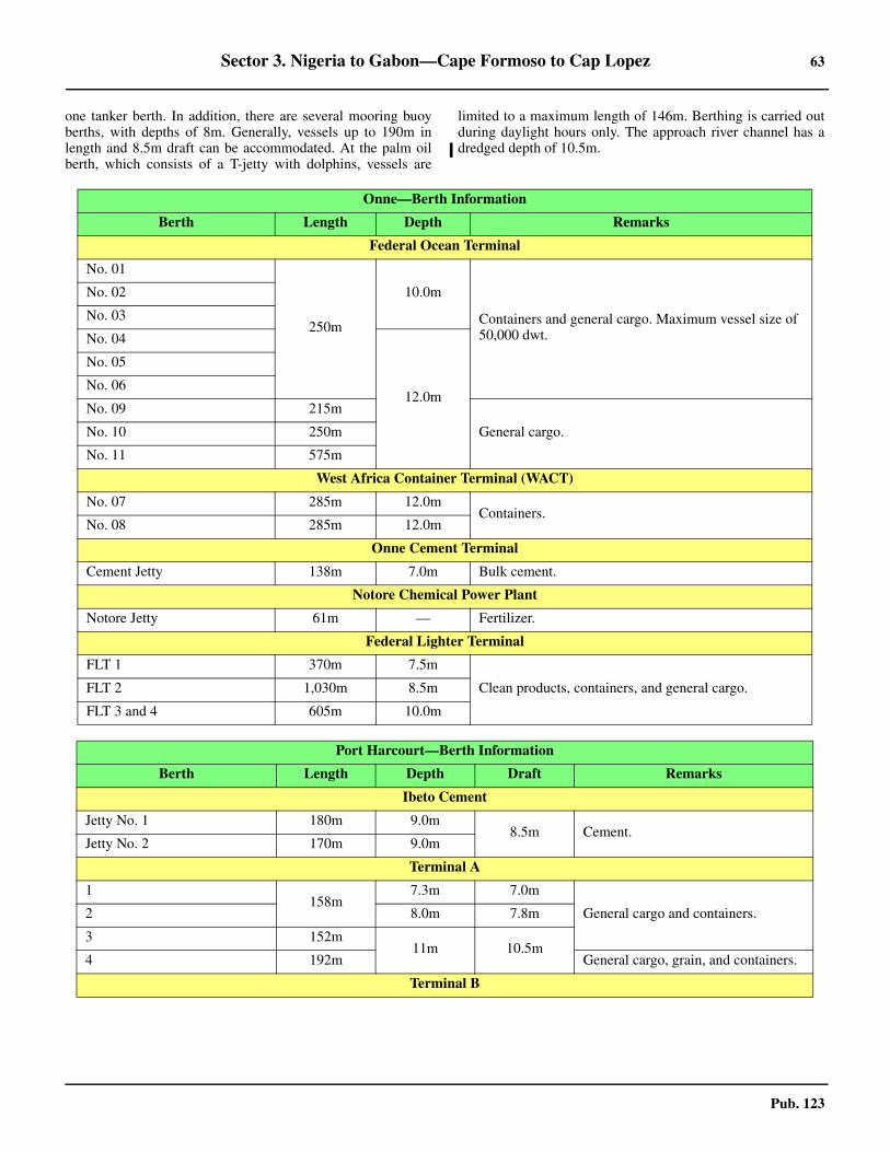
Sector 3. Nigeria to Gabon—Cape Formoso to Cap Lopez 63
Pub. 123
one tanker berth. In addition, there are several mooring buoyberths, with depths of 8m. Generally, vessels up to 190m inlength and 8.5m draft can be accommodated. At the palm oilberth, which consists of a T-jetty with dolphins, vessels are
limited to a maximum length of 146m. Berthing is carried outduring daylight hours only. The approach river channel has adredged depth of 10.5m.
Onne—Berth Information
Berth Length Depth Remarks
Federal Ocean Terminal
No. 01
250m
10.0m
Containers and general cargo. Maximum vessel size of 50,000 dwt.
No. 02
No. 03
No. 04
12.0m
No. 05
No. 06
No. 09 215m
General cargo. No. 10 250m
No. 11 575m
West Africa Container Terminal (WACT)
No. 07 285m 12.0mContainers.
No. 08 285m 12.0m
Onne Cement Terminal
Cement Jetty 138m 7.0m Bulk cement.
Notore Chemical Power Plant
Notore Jetty 61m — Fertilizer.
Federal Lighter Terminal
FLT 1 370m 7.5m
Clean products, containers, and general cargo.FLT 2 1,030m 8.5m
FLT 3 and 4 605m 10.0m
Port Harcourt—Berth Information
Berth Length Depth Draft Remarks
Ibeto Cement
Jetty No. 1 180m 9.0m8.5m Cement.
Jetty No. 2 170m 9.0m
Terminal A
1158m
7.3m 7.0m
General cargo and containers. 2 8.0m 7.8m
3 152m11m 10.5m
4 192m General cargo, grain, and containers.
Terminal B
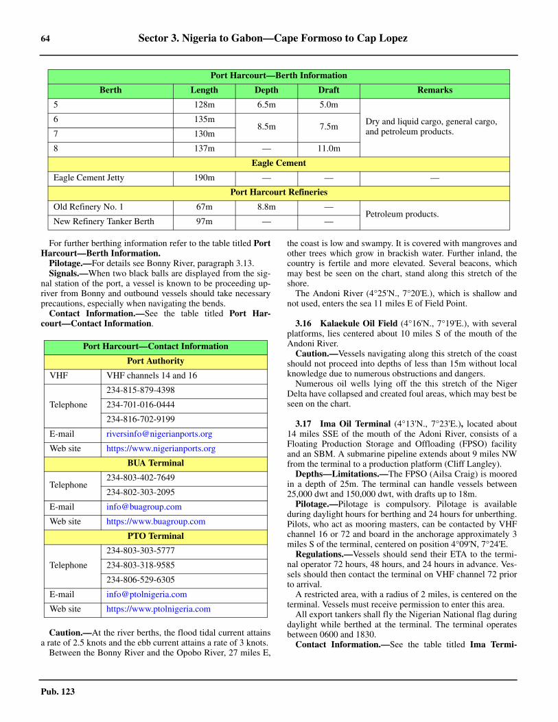
64 Sector 3. Nigeria to Gabon—Cape Formoso to Cap Lopez
Pub. 123
3.15 For further berthing information refer to the table titled PortHarcourt—Berth Information. 3.15 Pilotage.—For details see Bonny River, paragraph 3.13. 3.15 Signals.—When two black balls are displayed from the sig-nal station of the port, a vessel is known to be proceeding up-river from Bonny and outbound vessels should take necessaryprecautions, especially when navigating the bends.3.15 Contact Information.—See the table titled Port Har-court—Contact Information.
3.15 Caution.—At the river berths, the flood tidal current attainsa rate of 2.5 knots and the ebb current attains a rate of 3 knots.
Between the Bonny River and the Opobo River, 27 miles E,
the coast is low and swampy. It is covered with mangroves andother trees which grow in brackish water. Further inland, thecountry is fertile and more elevated. Several beacons, whichmay best be seen on the chart, stand along this stretch of theshore.3.15 The Andoni River (4°25'N., 7°20'E.), which is shallow andnot used, enters the sea 11 miles E of Field Point.
3.16 Kalaekule Oil Field (4°16'N., 7°19'E.), with severalplatforms, lies centered about 10 miles S of the mouth of theAndoni River.3.16 Caution.—Vessels navigating along this stretch of the coastshould not proceed into depths of less than 15m without localknowledge due to numerous obstructions and dangers. 3.16 Numerous oil wells lying off the this stretch of the NigerDelta have collapsed and created foul areas, which may best beseen on the chart.
3.17 Ima Oil Terminal (4°13'N., 7°23'E.), located about14 miles SSE of the mouth of the Adoni River, consists of aFloating Production Storage and Offloading (FPSO) facilityand an SBM. A submarine pipeline extends about 9 miles NWfrom the terminal to a production platform (Cliff Langley).
Depths—Limitations.—The FPSO (Ailsa Craig) is mooredin a depth of 25m. The terminal can handle vessels between25,000 dwt and 150,000 dwt, with drafts up to 18m.3.17 Pilotage.—Pilotage is compulsory. Pilotage is availableduring daylight hours for berthing and 24 hours for unberthing.Pilots, who act as mooring masters, can be contacted by VHFchannel 16 or 72 and board in the anchorage approximately 3miles S of the terminal, centered on position 4°09'N, 7°24'E. 3.17 Regulations.—Vessels should send their ETA to the termi-nal operator 72 hours, 48 hours, and 24 hours in advance. Ves-sels should then contact the terminal on VHF channel 72 priorto arrival.3.17 A restricted area, with a radius of 2 miles, is centered on theterminal. Vessels must receive permission to enter this area.3.17 All export tankers shall fly the Nigerian National flag duringdaylight while berthed at the terminal. The terminal operatesbetween 0600 and 1830. 3.17 Contact Information.—See the table titled Ima Termi-
5 128m 6.5m 5.0m
Dry and liquid cargo, general cargo, and petroleum products.
6 135m8.5m 7.5m
7 130m
8 137m — 11.0m
Eagle Cement
Eagle Cement Jetty 190m — — —
Port Harcourt Refineries
Old Refinery No. 1 67m 8.8m —Petroleum products.
New Refinery Tanker Berth 97m — —
Port Harcourt—Berth Information
Berth Length Depth Draft Remarks
Port Harcourt—Contact Information
Port Authority
VHF VHF channels 14 and 16
Telephone
234-815-879-4398
234-701-016-0444
234-816-702-9199
E-mail [email protected]
Web site https://www.nigerianports.org
BUA Terminal
Telephone234-803-402-7649
234-802-303-2095
E-mail [email protected]
Web site https://www.buagroup.com
PTO Terminal
Telephone
234-803-303-5777
234-803-318-9585
234-806-529-6305
E-mail [email protected]
Web site https://www.ptolnigeria.com
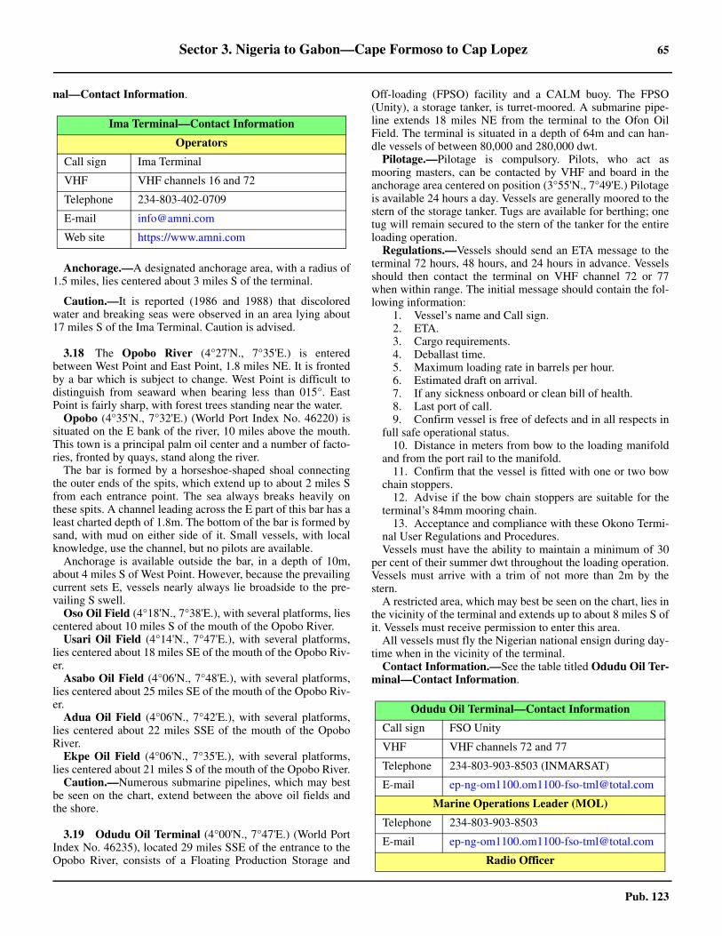
Sector 3. Nigeria to Gabon—Cape Formoso to Cap Lopez 65
Pub. 123
nal—Contact Information.
3.17 Anchorage.—A designated anchorage area, with a radius of1.5 miles, lies centered about 3 miles S of the terminal.
3.17 Caution.—It is reported (1986 and 1988) that discoloredwater and breaking seas were observed in an area lying about17 miles S of the Ima Terminal. Caution is advised.
3.18 The Opobo River (4°27'N., 7°35'E.) is enteredbetween West Point and East Point, 1.8 miles NE. It is frontedby a bar which is subject to change. West Point is difficult todistinguish from seaward when bearing less than 015°. EastPoint is fairly sharp, with forest trees standing near the water.3.18 Opobo (4°35'N., 7°32'E.) (World Port Index No. 46220) issituated on the E bank of the river, 10 miles above the mouth.This town is a principal palm oil center and a number of facto-ries, fronted by quays, stand along the river.3.18 The bar is formed by a horseshoe-shaped shoal connectingthe outer ends of the spits, which extend up to about 2 miles Sfrom each entrance point. The sea always breaks heavily onthese spits. A channel leading across the E part of this bar has aleast charted depth of 1.8m. The bottom of the bar is formed bysand, with mud on either side of it. Small vessels, with localknowledge, use the channel, but no pilots are available.3.18 Anchorage is available outside the bar, in a depth of 10m,about 4 miles S of West Point. However, because the prevailingcurrent sets E, vessels nearly always lie broadside to the pre-vailing S swell.3.18 Oso Oil Field (4°18'N., 7°38'E.), with several platforms, liescentered about 10 miles S of the mouth of the Opobo River.3.18 Usari Oil Field (4°14'N., 7°47'E.), with several platforms,lies centered about 18 miles SE of the mouth of the Opobo Riv-er.3.18 Asabo Oil Field (4°06'N., 7°48'E.), with several platforms,lies centered about 25 miles SE of the mouth of the Opobo Riv-er.3.18 Adua Oil Field (4°06'N., 7°42'E.), with several platforms,lies centered about 22 miles SSE of the mouth of the OpoboRiver.3.18 Ekpe Oil Field (4°06'N., 7°35'E.), with several platforms,lies centered about 21 miles S of the mouth of the Opobo River.3.18 Caution.—Numerous submarine pipelines, which may bestbe seen on the chart, extend between the above oil fields andthe shore.
3.19 Odudu Oil Terminal (4°00'N., 7°47'E.) (World PortIndex No. 46235), located 29 miles SSE of the entrance to theOpobo River, consists of a Floating Production Storage and
Off-loading (FPSO) facility and a CALM buoy. The FPSO(Unity), a storage tanker, is turret-moored. A submarine pipe-line extends 18 miles NE from the terminal to the Ofon OilField. The terminal is situated in a depth of 64m and can han-dle vessels of between 80,000 and 280,000 dwt.
Pilotage.—Pilotage is compulsory. Pilots, who act asmooring masters, can be contacted by VHF and board in theanchorage area centered on position (3°55'N., 7°49'E.) Pilotageis available 24 hours a day. Vessels are generally moored to thestern of the storage tanker. Tugs are available for berthing; onetug will remain secured to the stern of the tanker for the entireloading operation.
Regulations.—Vessels should send an ETA message to theterminal 72 hours, 48 hours, and 24 hours in advance. Vesselsshould then contact the terminal on VHF channel 72 or 77when within range. The initial message should contain the fol-lowing information:
1. Vessel’s name and Call sign.2. ETA.3. Cargo requirements.4. Deballast time.5. Maximum loading rate in barrels per hour.6. Estimated draft on arrival.7. If any sickness onboard or clean bill of health.8. Last port of call.9. Confirm vessel is free of defects and in all respects in
full safe operational status.10. Distance in meters from bow to the loading manifold
and from the port rail to the manifold.11. Confirm that the vessel is fitted with one or two bow
chain stoppers.12. Advise if the bow chain stoppers are suitable for the
terminal’s 84mm mooring chain.13. Acceptance and compliance with these Okono Termi-
nal User Regulations and Procedures.Vessels must have the ability to maintain a minimum of 30
per cent of their summer dwt throughout the loading operation.Vessels must arrive with a trim of not more than 2m by thestern.
A restricted area, which may best be seen on the chart, lies inthe vicinity of the terminal and extends up to about 8 miles S ofit. Vessels must receive permission to enter this area.
All vessels must fly the Nigerian national ensign during day-time when in the vicinity of the terminal.3.19 Contact Information.—See the table titled Odudu Oil Ter-minal—Contact Information.
Ima Terminal—Contact Information
Operators
Call sign Ima Terminal
VHF VHF channels 16 and 72
Telephone 234-803-402-0709
E-mail [email protected]
Web site https://www.amni.com
Odudu Oil Terminal—Contact Information
Call sign FSO Unity
VHF VHF channels 72 and 77
Telephone 234-803-903-8503 (INMARSAT)
E-mail [email protected]
Marine Operations Leader (MOL)
Telephone 234-803-903-8503
E-mail [email protected]
Radio Officer
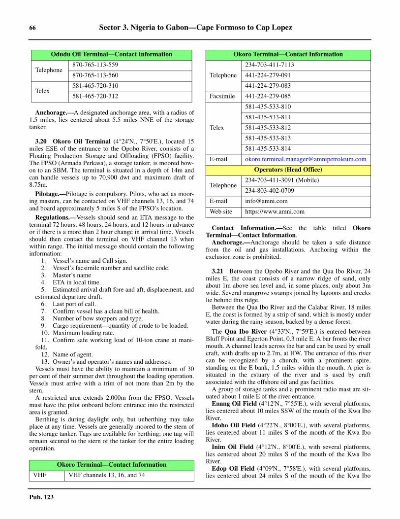
66 Sector 3. Nigeria to Gabon—Cape Formoso to Cap Lopez
Pub. 123
Anchorage.—A designated anchorage area, with a radius of1.5 miles, lies centered about 5.5 miles NNE of the storagetanker.
3.20 Okoro Oil Terminal (4°24'N., 7°50'E.), located 15miles ESE of the entrance to the Opobo River, consists of aFloating Production Storage and Offloading (FPSO) facility.The FPSO (Armada Perkasa), a storage tanker, is moored bow-on to an SBM. The terminal is situated in a depth of 14m andcan handle vessels up to 70,900 dwt and maximum draft of8.75m.
Pilotage.—Pilotage is compulsory. Pilots, who act as moor-ing masters, can be contacted on VHF channels 13, 16, and 74and board approximately 5 miles S of the FPSO’s location.
Regulations.—Vessels should send an ETA message to theterminal 72 hours, 48 hours, 24 hours, and 12 hours in advanceor if there is a more than 2 hour change in arrival time. Vesselsshould then contact the terminal on VHF channel 13 whenwithin range. The initial message should contain the followinginformation:
1. Vessel’s name and Call sign.2. Vessel’s facsimile number and satellite code.3. Master’s name4. ETA in local time.5. Estimated arrival draft fore and aft, displacement, and
estimated departure draft. 6. Last port of call.7. Confirm vessel has a clean bill of health.8. Number of bow stoppers and type.9. Cargo requirement—quantity of crude to be loaded.10. Maximum loading rate.11. Confirm safe working load of 10-ton crane at mani-
fold.12. Name of agent.13. Owner’s and operator’s names and addresses.
Vessels must have the ability to maintain a minimum of 30per cent of their summer dwt throughout the loading operation.Vessels must arrive with a trim of not more than 2m by thestern.
A restricted area extends 2,000m from the FPSO. Vesselsmust have the pilot onboard before entrance into the restrictedarea is granted.
Berthing is during daylight only, but unberthing may takeplace at any time. Vessels are generally moored to the stern ofthe storage tanker. Tugs are available for berthing; one tug willremain secured to the stern of the tanker for the entire loadingoperation.
3.20 Contact Information.—See the table titled OkoroTerminal—Contact Information.
Anchorage.—Anchorage should be taken a safe distancefrom the oil and gas installations. Anchoring within theexclusion zone is prohibited.
3.21 Between the Opobo River and the Qua Ibo River, 24miles E, the coast consists of a narrow ridge of sand, onlyabout 1m above sea level and, in some places, only about 3mwide. Several mangrove swamps joined by lagoons and creekslie behind this ridge.3.21 Between the Qua Ibo River and the Calabar River, 18 milesE, the coast is formed by a strip of sand, which is mostly underwater during the rainy season, backed by a dense forest.
3.21 The Qua Ibo River (4°33'N., 7°59'E.) is entered betweenBluff Point and Egerton Point, 0.3 mile E. A bar fronts the rivermouth. A channel leads across the bar and can be used by smallcraft, with drafts up to 2.7m, at HW. The entrance of this rivercan be recognized by a church, with a prominent spire,standing on the E bank, 1.5 miles within the mouth. A pier issituated in the estuary of the river and is used by craftassociated with the offshore oil and gas facilities. 3.21 A group of storage tanks and a prominent radio mast are sit-uated about 1 mile E of the river entrance.3.21 Enang Oil Field (4°12'N., 7°55'E.), with several platforms,lies centered about 10 miles SSW of the mouth of the Kwa IboRiver.3.21 Idoho Oil Field (4°22'N., 8°00'E.), with several platforms,lies centered about 11 miles S of the mouth of the Kwa IboRiver.3.21 Inim Oil Field (4°12'N., 8°00'E.), with several platforms,lies centered about 20 miles S of the mouth of the Kwa IboRiver.3.21 Edop Oil Field (4°09'N., 7°58'E.), with several platforms,lies centered about 24 miles S of the mouth of the Kwa Ibo
Telephone870-765-113-559
870-765-113-560
Telex581-465-720-310
581-465-720-312
Okoro Terminal—Contact Information
VHF VHF channels 13, 16, and 74
Odudu Oil Terminal—Contact Information
Telephone
234-703-411-7113
441-224-279-091
441-224-279-083
Facsimile 441-224-279-085
Telex
581-435-533-810
581-435-533-811
581-435-533-812
581-435-533-813
581-435-533-814
E-mail [email protected]
Operators (Head Office)
Telephone234-703-411-3091 (Mobile)
234-803-402-0709
E-mail [email protected]
Web site https://www.amni.com
Okoro Terminal—Contact Information

Sector 3. Nigeria to Gabon—Cape Formoso to Cap Lopez 67
Pub. 123
River.3.21 Ofon Oil Field (4°06'N., 8°02'E.), with several platforms,lies centered about 27 miles S of the mouth of the Kwa IboRiver.3.21 Etim Oil Field (4°09'N., 8°03'E.), with several platforms,lies centered about 24 miles S of the mouth of the Kwa IboRiver.3.21 Eku Oil Field (4°16'N., 8°06'E.), with several platforms, liescentered about 18 miles SSE of the mouth of the Kwa Ibo Riv-er.3.21 Unam Oil Field (4°17'N., 8°11'E.), with several platforms,lies centered about 20 miles SE of the mouth of the Kwa IboRiver.3.21 Ubit Oil Field (4°14'N., 8°10'E.), with several platforms,lies centered about 21 miles SSE of the mouth of the Kwa IboRiver.3.21 Lyak Oil Field (4°10'N., 8°10'E.), with several platforms,lies centered about 25 miles SE of the mouth of the Kwa IboRiver.3.21 Utue Oil Field (4°11'N., 8°15'E.), with several platforms,lies centered about 27 miles SE of the mouth of the Kwa IboRiver.3.21 Mfem Oil Field (4°16'N., 8°15'E.), with several platforms,lies centered about 23 miles SE of the mouth of the Kwa IboRiver.3.21 Okwok Oil Field (4°07'N., 8°18'E.), with a single well, liescentered about 32 miles SE of the mouth of the Kwa Ibo River.3.21 Caution.—Between the Opobo River and the Calabar River,40 miles E, numerous oil and gas structures, platforms, piperisers, and well heads lie up to 30 miles offshore. Numeroussubmarine pipelines, which may best be seen on the chart, alsoextend between the above-named oil fields and the shore.3.21 A dangerous wreck is reported to lie about 11.2 miles S ofthe entrance to the Kwa Ibo River.
3.22 Qua Iboe (Kwa Ibo) Offshore Terminal (4°13'N.,8°06'E.) (World Port Index No. 46195) is located 19 miles S ofthe entrance to the Qua Ibo River. It consists of an operationsplatform, equipped with a racon, and three SPMs which aremoored 1.2 miles SE, 1 mile SSE, and 3.4 miles ESE of it.
Depths—Limitations.—The terminal is situated in depthsof 25.9 to 27.4m and can handle vessels of up to 312,000 dwt,with drafts up to 21.9m. 3.22 Pilotage.—Pilotage is compulsory for export tankers. Pilots,who act as mooring masters, can be contacted on VHF chan-nels 16 and 67 and board at the anchorage or about 2.5 milesSE of the operations platform.3.22 The pilot requires the following information:
1. ETA at the pilot station.2. Time of Notice of Readiness (NOR).3. Boarding arrangement for officials.4. Propeller immersion.5. Portside derrick or crane to be ready for cargo gear
basket.6. Any defects.
3.22 Regulations.—Vessels should send an ETA 7 days, 72hours, 48 hours, 24 hours, and 6 hours prior to arrival at the an-chorage area.3.22 When communication has been established with Qua IboeControl on VHF vessels must provide the following informa-
tion:1. Vessel’s name and Call sign.2. ETA at the terminal.3. Last port of call.4. Cargo requirements.
3.22 All tankers enroute to the SPMs must switch on their radar toidentify the racon (K) signal on the operations platform as anaid to navigation.3.22 Contact Information.—See the table titled Qua Iboe Ter-minal—Contact Information.
3.22 Anchorage.—A designated anchorage area, which may bebest seen on the chart, lies centered 11 miles SE of the opera-tions platform.3.22 Caution.—Vessels should not anchor outside the designatedanchorage area.3.22 On rare occasions, winds of up to 60 knots have been record-ed at the terminal and are sometimes accompanied by heavyrain, thunder, and lightning. They are unpredictable in bothforce and direction.3.22 Vessels bound for the terminal should proceed with extremecaution and approach from the SE as numerous structures, ob-structions, platforms, riser pipes, and submarine pipelines aresituated in the vicinity.
3.23 Serpentina Offshore Terminal—Zafiro Oil Field(3°48'N., 8°04'E.) (World Port Index No. 46310) is locatedabout 22 miles SSE of Qua Iboe Offshore Terminal and 37miles W of Punta Europa (3°48'N., 8°43'E.), the NW extremityof Isla de Bioko. It is under the jurisdiction of Equatorial Guin-ea.
Depths—Limitations.—The terminal consists of a FloatingProduction Storage and Offloading (FPSO) facility (Serpenti-na), which is moored to an SPM. It is situated in a depth of475m and can handle vessels up to 350,000 dwt.
The terminal is situated within the restricted area surround-ing Zafiro Offshore Oil Terminal.
Pilotage.—Pilotage is compulsory. Pilots, who act as moor-ing masters, can be contacted on VHF channels 16 and 74 andboard about 2 miles W of the terminal or about 7.4 miles NNEof the terminal. Pilots may also board by helicopter.
Regulations.—Berthing is carried out by daylight only butvessels may depart at any time. Vessels berth in tandem withthe stern of the FPSO.Vessels must send an ETA to the terminal7 days, 6 days, 5 days, 96 hours, 72 hours, 48 hours, 36 hours,and 24 hours in advance. Changes of 3 hours or more to theETA must be reported immediately. Changes of 1 hour or more
Qua Iboe Terminal—Contact Information
Call sign Qua Iboe Control
VHF VHF channels 16 and 67
Telephone
234-824-43211
234-824-45186
234-824-43238 (ext. 5186)
Facsimile 234-824-43195
E-mail [email protected]
68 Sector 3. Nigeria to Gabon—Cape Formoso to Cap Lopez
Pub. 123
to the ETA following the 24-hour message must be reportedimmediately. 3.23 A restricted area, with a radius of 4.3 miles, surrounds theterminal. Vessels must receive permission to enter this area.Vessels should contact Zafiro Producer Radio on VHF channel16 or 74 when within range of the terminal FPSO.
Vessels must fly the Equatorial Guinea national ensignduring daylight when moored at the terminal.3.23 Contact Information.—See the table titled SerpentinaTerminal—Contact Information.
Anchorage.—Vessels may anchor in the designated area,with a depth of 64m, lying about 6 miles N of Zafiro OffshoreOil Terminal or in a similar depth about 2 miles W of the FPSO(Serpentina). Vessels must not pass through the restricted areawhen proceeding to the anchorage.3.23 Caution.—Thunder and lightning are common during therainy season and may delay cargo operations.3.23 Vessels approaching the terminal from the W must remainclear of the Nigerian offshore terminals an the restricted arealocated in the vicinity of Odudu Oil Terminal (see paragraph3.20) prior to adjusting course for the terminal.
3.24 The Calabar River (4°33'N., 8°23'E.) has an estuarywhich is entered between West Point (4°32'N., 8°17'E.),located 17.5 miles E of the Qua Ibo River, and East Point, 13miles ESE. This estuary is formed by the waters of severalrivers including the Cross River, the Akpa-Yafe River, and theLittle Kwa River. The Calabar River has no definite bar, but theentrance is obstructed by several shoal flats.3.24 The border between Nigeria and Cameroon (Cameroun) issituated on the E side of the estuary. It lies in the vicinity of theAkpa Yafe River, which is entered about 9 miles N of EastPoint. 3.24 Tides—Currents.—The tides at the entrance to the mainchannel rise about 2.1m at springs and 1.6m at neaps. At Cala-bar, the tides rise about 1.5m at springs and 1.3m at neaps.3.24 During the dry season (December to April), the flood currentas far as Calabar begins 4 hours 30 minutes before HW. Thiscurrent runs for 5 hours and attains its greatest rate 2 hours 45minutes before HW. The ebb current begins 1 hour 30 minutes
after HW. This current runs for 5 hours 45 minutes and attainsits greatest rate 4 hours 15 minutes after HW. At springs, theflood current attains a rate of 1.5 to 2 knots. At springs andduring the dry season, the ebb current usually attains amaximum rate of 2 to 2.5 knots. At the outer fairway buoy, thiscurrent has been observed to be less than 2 knots, but at ParrotIsland (4°49'N., 8°17'E.) it has been observed to attain a rate of3.5 knots.3.24 Depths—Limitations.—Tom Shot Bank, with depths of lessthan 5m, is a large shoal area which extends up to about 11miles S from the W side of the river entrance. Depths on thisbank are very irregular and it should not be approached withindepths of less than 7m.3.24 It was reported (1986) that a low and sandy islet, about 0.7mile long, had formed on the W side of Tom Shot Bank, 4miles SE of West Point.3.24 Outer Reef lies in the middle of the E edge of Tom ShotBank. It is marked by breakers, even in the calmest weather,and forms a useful mark for locating the river entrance. Inmisty weather, these breakers are frequently the first distin-guishing feature recognized in the area. The E side of OuterReef is steep-to and may be approached with safety.3.24 A minor channel, used by small craft with local knowledge,leads NE through the NW part of Tom Shot Bank, adjacent toWest Point.3.24 Bakasi Bank, with depths of less than 5m, is a vast shoal areawhich extends up to about 12 miles SW and 8 miles S from theE side of the river entrance. It is composed of soft mud andusually covered, in many places, by numerous fishing stakes.When the land is not visible, vessels approaching the estuarymay determine which side of the entrance they are on as thereare no fishing stakes on Tom Shot Bank. A secondary channelleads between the W side of Bakasi Bank and the E side ofTom Shot Bank. It is marked by buoys and has a least depth onthe centerline of 3.9m (1990). 3.24 The main entrance channel leads NE through Tom ShotBank and is entered about 13 miles S of West Point. It was re-ported (1995) to be 150m wide and to have a dredged depth of8m. The best time to enter the river channel is 3 hours beforeHW at Calabar. No night transit is allowed.3.24 Aspect.—The W side of the river entrance is low, sandy, andbacked by high trees and large bushes. From the SW, WestPoint appears low and sandy, but Tom Shot Point, a steep blufflocated 4 miles NE, is generally visible behind it. The E side ofthe river entrance is formed by the S shore of the Bakasi Penin-sula. Between East Point and Sandy Point, 3 miles N, the Ebank is sandy and backed by high mangroves.3.24 An outer fairway buoy (4°18.5'N., 8°14.9'E.) is mooredabout 13.5 miles S of West Point. The main channel is markedby buoys.3.24 Caution.—The aids to navigation marking the channels arereported to be unreliable. They may be unlit, or moved as con-ditions change. In addition, the outer buoys are very exposedand are liable at times to be out of position or missing.3.24 During the rainy season (May to October), the river entranceis often obscured by thick weather from seaward. During theHarmattan season (December through March), the river en-trance is at times enveloped within a dense haze. This hazemay last a week or more and reduce visibility to less than 2miles.
Serpentina Terminal—Contact Information
Call sign Zafiro Producer Radio
VHF VHF channels 16 and 74
Telephone
1-713-257-1160
1-713-257-1141
240-222-278040 (Mobile)
E-mail [email protected]
Pilots
Telephone
1-713-257-1132
1-713-257-1159
1-713-257-1192
1-713-257-1212
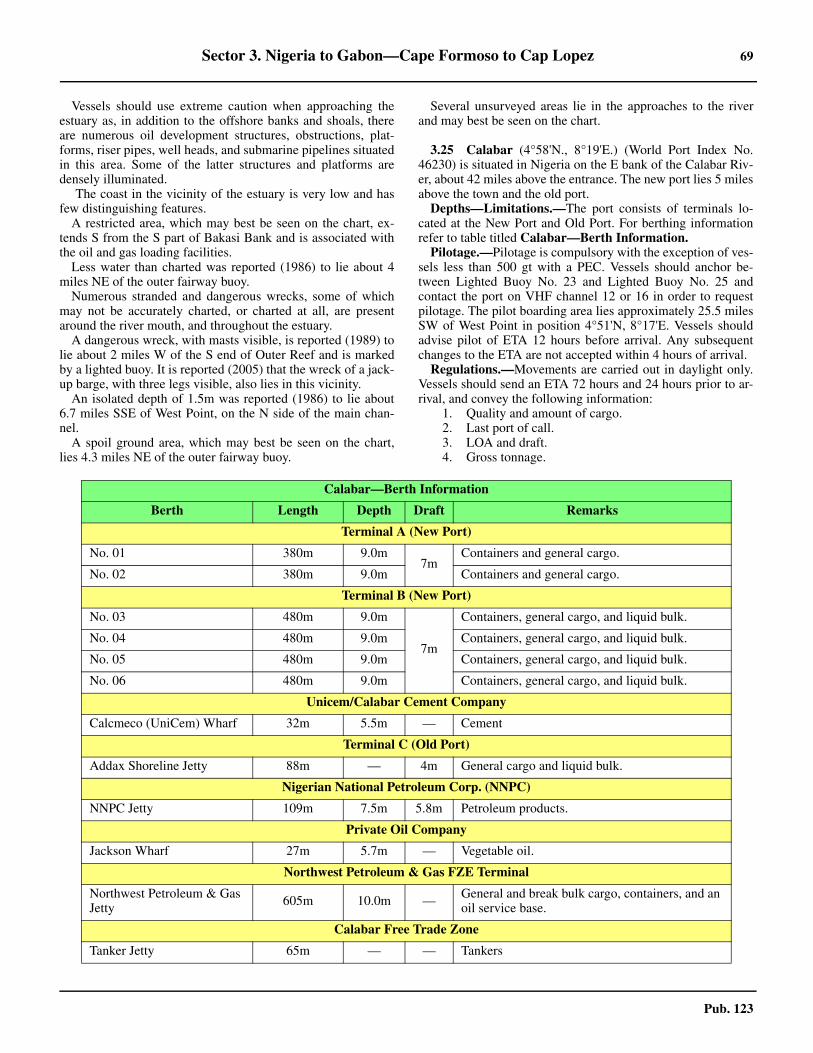
Sector 3. Nigeria to Gabon—Cape Formoso to Cap Lopez 69
Pub. 123
3.24 Vessels should use extreme caution when approaching theestuary as, in addition to the offshore banks and shoals, thereare numerous oil development structures, obstructions, plat-forms, riser pipes, well heads, and submarine pipelines situatedin this area. Some of the latter structures and platforms aredensely illuminated.3.24 The coast in the vicinity of the estuary is very low and hasfew distinguishing features.3.24 A restricted area, which may best be seen on the chart, ex-tends S from the S part of Bakasi Bank and is associated withthe oil and gas loading facilities.3.24 Less water than charted was reported (1986) to lie about 4miles NE of the outer fairway buoy.3.24 Numerous stranded and dangerous wrecks, some of whichmay not be accurately charted, or charted at all, are presentaround the river mouth, and throughout the estuary. 3.24 A dangerous wreck, with masts visible, is reported (1989) tolie about 2 miles W of the S end of Outer Reef and is markedby a lighted buoy. It is reported (2005) that the wreck of a jack-up barge, with three legs visible, also lies in this vicinity.3.24 An isolated depth of 1.5m was reported (1986) to lie about6.7 miles SSE of West Point, on the N side of the main chan-nel.3.24 A spoil ground area, which may best be seen on the chart,lies 4.3 miles NE of the outer fairway buoy.
3.24 Several unsurveyed areas lie in the approaches to the riverand may best be seen on the chart.
3.25 Calabar (4°58'N., 8°19'E.) (World Port Index No.46230) is situated in Nigeria on the E bank of the Calabar Riv-er, about 42 miles above the entrance. The new port lies 5 milesabove the town and the old port.3.25 Depths—Limitations.—The port consists of terminals lo-cated at the New Port and Old Port. For berthing informationrefer to table titled Calabar—Berth Information. 3.25 Pilotage.—Pilotage is compulsory with the exception of ves-sels less than 500 gt with a PEC. Vessels should anchor be-tween Lighted Buoy No. 23 and Lighted Buoy No. 25 andcontact the port on VHF channel 12 or 16 in order to requestpilotage. The pilot boarding area lies approximately 25.5 milesSW of West Point in position 4°51'N, 8°17'E. Vessels shouldadvise pilot of ETA 12 hours before arrival. Any subsequentchanges to the ETA are not accepted within 4 hours of arrival. 3.25 Regulations.—Movements are carried out in daylight only.Vessels should send an ETA 72 hours and 24 hours prior to ar-rival, and convey the following information:
1. Quality and amount of cargo.2. Last port of call.3. LOA and draft.4. Gross tonnage.
Calabar—Berth Information
Berth Length Depth Draft Remarks
Terminal A (New Port)
No. 01 380m 9.0m7m
Containers and general cargo.
No. 02 380m 9.0m Containers and general cargo.
Terminal B (New Port)
No. 03 480m 9.0m
7m
Containers, general cargo, and liquid bulk.
No. 04 480m 9.0m Containers, general cargo, and liquid bulk.
No. 05 480m 9.0m Containers, general cargo, and liquid bulk.
No. 06 480m 9.0m Containers, general cargo, and liquid bulk.
Unicem/Calabar Cement Company
Calcmeco (UniCem) Wharf 32m 5.5m — Cement
Terminal C (Old Port)
Addax Shoreline Jetty 88m — 4m General cargo and liquid bulk.
Nigerian National Petroleum Corp. (NNPC)
NNPC Jetty 109m 7.5m 5.8m Petroleum products.
Private Oil Company
Jackson Wharf 27m 5.7m — Vegetable oil.
Northwest Petroleum & Gas FZE Terminal
Northwest Petroleum & Gas Jetty 605m 10.0m — General and break bulk cargo, containers, and an
oil service base.
Calabar Free Trade Zone
Tanker Jetty 65m — — Tankers

70 Sector 3. Nigeria to Gabon—Cape Formoso to Cap Lopez
Pub. 123
3.25 Contact Information.—See the table titled Calabar—Con-tact Information.
3.25 Anchorage.—Vessels may anchor outside the estuary in adepths of greater than 22m, in areas of mud bottom. 3.25 An area, which prohibits anchorage, is located offshore,about 8 miles S of the river mouth, and can best be seen on thechart.3.25 Foul ground and submarine cables are present in theanchorage areas offshore of the mouth of the Calabar River,and can best be seen on the chart.3.25 Caution.—Several spoil ground areas lie within the riverand may best be seen on the chart.3.25 Large floating tree trunks, partly submerged, may beencountered within the river.3.25 Several submarine cables extend across the river and maybest be seen on the chart.
3.26 Antan Oil Terminal (4°13'N., 8°20'E.) (World PortIndex No. 46225) is situated about 19 miles SSE of West Point(4°32'N., 8°17'E.). It consists of a Tanker Manifold Platform, aCALM buoy, and a Floating Production Storage Offloading(FPSO) facility moored close SE. The FPSO (Knock Adoon) islocated in a depth of 38m and can handle vessels between60,000 dwt and 150,000 dwt. The CALM buoy can accommo-date vessels up to 350,000 dwt.
Pilotage.—Pilotage is compulsory and available 24 hours.Pilots, acting as mooring masters, can be contacted by VHFand board in the anchorage area 3 miles S of the terminal.
Regulations.—Vessels should send an ETA to the terminal 7
days, 96 hours, 72 hours, 48 hours, and 24 hours, in advance.Any change to the ETA of 2 hours or more should be reportedimmediately. The initial message should include the followinginformation:
1. Vessel’s name and Call sign.2. ETA in local time.3. Name of the master in full.4. Estimated arrival draft, forward and aft displacement,
and estimated departure draft.5. Last port of call.6. Cargo requirements-quantity of crude to be loaded.7. Name of agent.8. Confirm vessel has a clean bill of health.9. Maximum loading rate capabilities (barrels per hour).10. Owner’s and operator’s names and addresses.11. Flag and port of registry.12. Number of bow stoppers and type.13. Confirm 15-ton safe working load of crane/derrick. 14. Number of mooring bits and safe working load.
Vessels are moored only during daylight hours but may de-part at any time. Vessels should arrive at the pilot station no lat-er than 1500. 3.26 The messages should be sent, as follows:
1. Knock Adoon Mooring/Loading Master ([email protected]).
2. Addax Marine Superintendent ([email protected]).
3. Antan Marine Superintendent ([email protected]).
4. Vessel’s agent to pass to the terminal.5. As instructed by the charterer.
3.26 Contact Information.—See the table titled Antan Oil Ter-minal—Contact Information.
3.26 A restricted area, with a radius of 1.5 miles, is centered onthe terminal. Vessels must receive permission to enter this area.
All vessels must fly the Nigerian national ensign when in the
Calabar—Contact Information
Calabar Port Control
VHF VHF channel 12, 14, and 16
RT Frequency 2182 (kHz)
Oron Signal Station
VHF VHF channel 12, 14, and 16
Ecomarine Terminal
Telephone234-822-552-772
234-154-58858 (Lagos Office)
E-mail https://www.ecomarinegroup.com
Port Authority
Telephone
234-181-587-94397
234-703-974-5010 (Port Manager)
234-813-255-4556 (Servicom)
E-mail [email protected]
Web site https://www.nigerianports.org
Pilots
VHF VHF channel
Telephone 234-808-840-1600 (Mobile)
E-mail [email protected]
Antan Oil Terminal—Contact Information
FPSO Knock Adoon Mooring/Loading Master
E-mail [email protected]
FPSO Knock Adoon Control Room
Call sign Knock Adoon CCR
VHF VHF channels 15 and 16
Telephone475-120-6140
475-120-6142
Facsimile 475-120-6141
E-mail [email protected]
Addax Marine Superintendent
E-mail [email protected]
Antan Marine Superintendent
E-mail [email protected]
Sector 3. Nigeria to Gabon—Cape Formoso to Cap Lopez 71
Pub. 123
vicinity of the terminal.A designated anchorage area, with a depth of 45m, lies cen-
tered about 4 miles S of the terminal and may best be seen onthe chart.
3.27 Kita Oil Field (4°05'N., 8°26'E.), consisting of sever-al platforms, lies about 12 miles SE of West Point (4°32'N.,8°17'E.), the W entrance point of the Calabar estuary.
Ekoundou Oil Field (4°18'N., 8°25'E.), consisting of sever-al platforms, lies about 17 miles SSE of West Point.
Barombi Oil Field (4°15'N., 8°26'E.), consisting of severalplatforms, lies about 19 miles SSE of West Point.
Kombo Oil Field (4°17'N., 8°30'E.), consisting of severalplatforms, lies about 20 miles SE of West Point.
Bavo Oil Field (4°20'N., 8°37'E.), consisting of several plat-forms, lies about 23 miles SE of West Point.
Asoma Oil Field (4°17'N., 8°38'E.), consisting of severalplatforms, lies about 26 miles SE of West Point.
Kole Oil Terminal (4°13'N., 8°33'E.) (World Port Index No.46285), situated about 14 miles S of the Bakasi Peninsula, is anexport terminal under the port authority of Douala, Cameroon.It consists of a FSO (Kingsway) and two SBMs.
The main SBM (KLB2 Bluewater), to which export tankersare moored, is situated about 2.5 miles SSW of the storagetanker, in a depth of 26.5m. Vessels between 50,000 dwt and310,000 dwt, with drafts up to 22m, can be handled. The mini-mum underkeel clearance permitted is 4.5m.
3.27 Pilotage.—Pilotage is compulsory. Pilots, who act as moor-ing masters, are provided by the station at Douala. They can becontacted on VHF channels 11, 12, or 16 and board about 2miles SW of SBM Lighted Buoy KLB 2.
3.27 Regulations.—Vessels should send an ETA to Douala 72hours, 48 hours, and 24 hours before arrival and advise the ter-minal of any changes. Berthing is only carried out during day-light but vessels may depart at any time. The ETA messageshould contain the following information:
1. Vessel’s name and flag.2. Last port.3. Destination.4. Quantity to load.5. Duration of deballasting if not occurring simultane-
ously with loading.6. Maximum loading rate.7. Safe working load of derrick or crane.8. Dimensions of manifold flanges.9. Distance from bow to middle manifold.10. Master’s name.11. Gross tons, net tons, and dwt.
3.27 Contact Information.—See the table titled Kole Oil Termi-nal—Contact Information.
A designated anchorage area, with a depth of 38m, lies cen-tered about 1 mile S3.27 Caution.—The above-listed oil fields and offshore terminalare situated within an extensive restricted area. This area ex-tends up to about 17 miles seaward of the Bakasi Peninsula andmay best be seen on the chart. Numerous platforms, submarinepipelines, well heads, and riser pipes associated with oil andgas development exist within this area. Vessels are prohibitedfrom entering the area without prior permission.3.27 Only vessels using the tanker berths at the offshore terminalsmay enter the restricted areas surrounding them. All other ves-sels should remain at least 3 miles clear of the terminals. 3.27 Visibility at the Kole Terminal is often reduced to 2 miles orless during the harmattan season (December to February) andduring the wet season (June to September).3.27 Very strong E to SSE winds, up to 45 knots, can occur withthe passage of local thunderstorms at the terminal but they areshort lasting. The predominant swell is SSW with an averageheight of 2.5m.
3.28 Moko Abana Oil Field (4°11'N., 8°27'E.), consistingof several platforms, lies centered 23 miles SE of West Point(4°32'N., 8°17'E.).
Massongo Marine Terminal (Victoria Oil Terminal)(4°07'N., 8°28'E.), located 7 miles SW of Kole Oil Terminal, isan export terminal under the port authority of Douala, Camer-oon. It consists of a production platform, a storage tanker(Massongo), and an SBM.
3.28 The SBM, to which the export tankers moor, is situated in adepth of 57m. Vessels of between 50,000 dwt and 280,000 dwtcan be handled, with drafts up to 21.3m.3.28 Pilotage.—Pilotage is compulsory. Pilots, acting as mooringmasters, are provided by the station at Douala (paragraph 3.40)and board about 2 miles ENE of the SPM. 3.28 Regulations.—Vessels should send an ETA to Perenco, viaDouala, 72 hours, 48 hours, and 24 hours before arrival. Ves-sels should then contact the terminal on VHF when within 60miles.3.28 Vessels berthed at the terminal must have their engines avail-able at all times. Berthing is generally only carried out duringdaylight but the operation may take place at night with theagreement of the terminal operator. Vessels may depart at anytime.3.28 The terminal is situated within a restricted area, which maybest be seen on the chart. Vessels are prohibited from enteringthe area without prior permission.3.28 Contact Information.—See the table titled Massongo Ma-
Kole Oil Terminal—Contact Information
Terminal
Call sign Kole Terminal
VHF VHF channels 11, 12, and 16
Douala Office
Telephone 237-233-421-366
Facsimile 237-233-400-020
Pilots
VHF VHF channel 16
Kole Oil Terminal—Contact Information
72 Sector 3. Nigeria to Gabon—Cape Formoso to Cap Lopez
Pub. 123
rine Terminal—Contact Information.
3.28 Anchorage.—A designated anchorage area, with a depth of60m, lies 2 miles ENE of the SBM.3.28 Caution.—Alba Gas Field is centered about 9 miles SSE ofMassongo Marine Terminal.3.28 The average maximum height of the swell at the terminal is1.2m from October to February and 1.9m from March to Sep-tember.
3.29 Rio-del-Rey (4°30'N., 8°45'E.) is an extensive, open,and shallow bay formed by the confluence of several rivers. Itlies between West Point (4°29'N., 8°42'E.), located at the SEend of the Bakasi Peninsula, and Betika Point, 18 miles SE.This latter point forms the termination of a ridge of hills. Sev-eral villages stand along the shores of the bay and may be seenfrom offshore. A sandbank fronts the bay and only small craftwith local knowledge transit this area.3.29 The Meme River flows into the E side of the bay, about 12miles N of Betika Point. The coast turns abruptly S from themouth of this river and consists principally of low cliffs withmany large caves.3.29 Madale de Coto Point is located 2 miles SSE of Betika Point.Madale Rocks, the largest being 1.2m high, extend up to 1.5miles SW from this point.3.29 A wreck, with a depth of 15m, lies about 9 miles SW of Ma-dale de Coto Point.3.29 Caution.—Oil exploration and production are being carriedout off the entrance to Rio-del-Rey and numerous associatedplatforms, structures, well heads, riser pipes, and submarinepipelines are situated in this vicinity.
3.30 Bibundi Bay (Baie de Bibundi) (4°11'N., 8°58'E.) isentered between Madale de Coto Point and Debundscha Point,10 miles S. The Bibundi River empties into this bay, about 4miles SE of Madale de Coto Point. The entrance of the river isnarrow and difficult to identify. It lies between a sandy spit, onthe N side, and a steep and rocky bank, on the S side. The vil-lage of Bibundi stands close within the entrance of the riverand is a trading center for numerous large coca plantations. It ismostly concealed by trees.3.30 Anchorage may be obtained in a depth of 18m, sand andmud, in the S part of the bay, NNE of Debundscha Point. Ves-sels with local knowledge can also obtain good anchorage offBibundi in a depth of 11m, mud, about 0.8 miles offshore. Ves-sels entering the bay from the S should not approach closerthan 1.5 miles from the coast and should keep in depths of 10mor more.
Debundscha Point (Debunja Point) (4°06'N., 8°58'E.) con-sists of a bold headland terminating in red limestone cliffs up
to 15m high. A light is shown from a tower, 8m high, standingon this point.3.30 Fako (4°13'N., 9°10'E.), a conspicuous peak, is also knownas Cameroon Mountain. It attains an elevation of about 4,095mabout 14 miles NE of Debundscha Light.
3.31 Izongo Point (4°04'N., 9°01'E.), located 3 miles SEof Debundscha Point, appears as a prominent bluff from theNW or SE. It is fronted by a drying reef and several sunkenrocks. The village of Izongo, with several sheds, stands at thehead of a small bay lying close N of the point. It is fronted by asmall pier with a depth of 1.8m alongside at LW.3.31 Between Izongo Point and Batoki Rock, 6.5 miles SE, theshore is intersected by several small streams and the sea usual-ly breaks heavily on it.
Batoki Rock (Batoke) (4°01'N., 9°06'E.), 15m high, liesclose offshore and is connected to the coast by a rocky reef.Habicht Reef, with a least depth of 1m, lies 0.7 mile SE of thisrock and about 0.4 mile offshore. Foul ground extends betweenthe reef and the coast.
Limboh Point (4°01'N., 9°08'E.) is located 1.3 miles ESE ofBatoki Rock. It is fringed by shoals with depths of less than10m. A refinery (Sonara) is situated 0.3 mile N of the point anda tall chimney, marked by a light, stands close to it.
3.32 Limboh Oil Terminal (4°00'N., 9°08'E.) (World PortIndex No. 46262), located at Pointe Limboh, consists of an off-shore SBM and two jetties. The SBM is moored in a depth of21m about 1 mile S of the point. It can handle vessels up to150,000 dwt, 243m in length, and 18m draft.
The Old Jetty extends 915m seaward from the point and hasa depth of 10m alongside. It can accommodate vessels up to15,000 dwt, with a maximum length of 143m, draft of 8.5m,and beam of 17.5m.
The New Jetty has a length of 240m, including dolphins,with an alongside depth of 17m. It can accommodate vesselsup to 105,000 dwt with a maximum length of 247m, draft of14.5m, and beam of 45m.
Pilotage.—Pilotage is compulsory. Pilots can be contactedby VHF and board about 1 mile S of the SBM. Vessels shouldsend an ETA 72 hours, 48 hours, and 24 hours in advance.
Regulations.—Berthing at the SBM is carried out onlyduring daylight but vessels can depart anytime. There are norestrictions at the jetty berth.
A restricted area, which may best be seen on the chart, sur-round the terminal and extends up to 2 miles S from LimbohPoint. Only vessels proceeding to the terminal may navigatewithin this area.3.32 Caution.—Several wrecks and an obstructions, which canbest be seen on the chart, lie in the approaches to Limboh OilTerminal. A submerged rock is reported to lie close to the jettyand is marked by a buoy.
Limboh Shipyard (4°00'N., 9°08'E.) is located 0.3 mile NEof Limboh Point. A 700m breakwater has been constructed,while the shore side infrastructure is in varying states of com-pletion. It is reported that the site will be completed in 2014.
3.33 Nyeme Point (Ngeme Point) (4°01'N., 9°09'E.) is lo-cated l.5 miles E of Limboh Point. A small bay lies between
Massongo Marine Terminal—Contact Information
VHF VHF channels 13 and 16
[email protected] (mooring master)
[email protected] (offshore manager)
Web site https://www.perenco.com

Sector 3. Nigeria to Gabon—Cape Formoso to Cap Lopez 73
Pub. 123
these points, but it is foul in many places and should only beapproached by vessels with local knowledge.3.33 Ambas Bay (4°00'N., 9°10'E.) is entered between NyemePoint and Cape Nachtigal, 5 miles SE. The NW shore of thebay, up to 1.3 miles E of Nyeme Point, is fairly steep-to. TheNE shore of the bay is bold and overlooked by four hills, 153 to207m high.3.33 Ambas Island, located 2 miles SSE of Nyeme Point, is theouter and W island lying in the bay. It is 51m high, narrow, andcovered with trees and brushwood, except at the N end.3.33 Mondoleh Island is located 1.4 miles E of Ambas Island. It is98m high and the largest island in the bay. The island is com-posed of volcanic rock and is heavily wooded along its sides.3.33 The Pirate Islands, a group of islands and rocks, lie on ashoal spit which extends 0.8 mile S from the N shore of thebay. Bobia Island, located 1.5 miles N of Ambas Island, is 33mhigh and the largest of the group.
Cape Nachtigal (3°57'N., 9°13'E.), the SE entrance point ofAmbas Bay, forms the S extremity of the Monkey Peninsula. Alight is shown from a tower, 14m high, standing on this cape. Adangerous wreck is reported to lie about 0.5 mile S of the light.
3.34 Limbe (Victoria) (4°01'N., 9°12'E.), a roadstead port,is situated at the head of Morton Bay, which lies on the NE sideof Ambas Bay. It is operated by the Douala Port Authority andis the export harbor for Buea, which stands 10 miles inland.The town of Limbe fronts the bay; the village of Bota is situat-ed close WNW of it. Bota is fronted by a mole which is usedby small craft and lighters.
The main approach route, which leads NE, passes betweenAmbas Island and Mondoleh Island. The track leads to theroadstead where cargo is worked. Vessels can moor in depthsof 12 to 16m, good holding ground, within four designated an-chorage berths. Pilotage is not compulsory but local knowledgeis advised. 3.34 One berth is available but its capacity is questionable andmariners are advised to consult local authorities for the latestinformation. Lighter Wharf, which serves passengers and fish-ing vessels, has a length of 121m and alongside depths of 1.8mto 5.5m.3.34 The flood current sets S and the ebb current sets N betweenAmbas Island and the Pirate Islands. These currents are ofabout equal duration and at times are strong in the vicinity ofAmbras Island and Mondoleh Island.3.34 Caution.—Between May and September, the swell risesquickly in the bay and causes a heavy surf and violent under-tow. This swell makes landing very dangerous and at times im-possible. It consists of two principal parts. One of these partssets fairly constantly E between Ambas Island and the PirateIslands and varies according to existing conditions. The otherpart, which arises when the winds are fresh or after a localthunderstorm, enters from the S or SW between Ambas Islandand Mondoleh Island. This latter part of the swell runs straightinto Morton Bay, turning and combining with the usual swellfrom the W, and finally breaks on the rocks.3.34 It is reported (2001) that the lighted beacons forming the ap-proach range may be obscured at times by vessels anchored inthe roadstead. 3.34 It is reported (2008) that navigational aids were not visible atnight.
3.35 Man of War Bay (3°57'N., 9°13'E.), with depths ofless than 5m, lies between Cape Nachtigal and Reef Point, 1.3miles E. Cape Bimbia, located 0.7 mile SE of Reef Point, is theS extremity of the base of the Cameroon Mountains (Fako).The land behind this cape rises gradually and regularly fromthe coast. A shallow wreck fronts the E side of the cape. 3.35 Fish Point is located 0.7 mile NE of Cape Bimbia. A shallowbay lies between this point and Dikulu Point, 1.5 miles NE.Nicol Island, 73m high and thickly wooded, lies in the entranceto this bay. Dikulu Bay lies between Dikulu Point and PegelPoint, 0.8 mile NE. This bay is very shallow, but anchoragemay be obtained close outside it, in a depth of 7m.3.35 Several prominent factories, consisting of large white build-ings, stand at the Bamba Plantation, which is located on thecoast to the N of Nicol Island. Entrance Point, marked by alight, is situated 0.4 mile NE of Pegel Point.3.35 The Bimbia River (3°58'N., 9°17'E.) is entered betweenEntrance Point and the coast, 0.5 mile E. The approach to themouth is obstructed by a bar which lies SE of Cape Bimbia.This bar was reported (1994) to have a least depths of 2.7 to4.5m, but the depths in this vicinity are subject to frequentchange. A fairway, marked by buoys, leads over the bar to theriver. Above Entrance Point, the river deepens and has depthsof 5 to 9m.3.35 A ground swell is usually encountered on the bar and allow-ance must be made to ensure a minimum underkeel clearanceof 0.3m. Vessels normally cross the bar at half speed. The bot-tom consists of fine sand and mud. It is soft and vessels whichtouch bottom are not damaged.
3.36 Tiko (4°04'N., 9°22'E.), a large town, stands on themainland close W of Tiko Island, about 8.5 miles NE of En-trance Point.3.36 A narrow causeway connects the town with the W end ofTiko Island. Tiko Wharf, which serves passenger and generalcargo vessels. is situated at the E end of the island. It lies paral-lel to the river and has a berth 137m long, with depths of 5.8 to7.6m alongside. 3.36 Pilotage is compulsory. Pilots can be contacted by VHF andare provided from Douala. They generally board within AmbasBay, close NE of Mondoleh Island.3.36 It is reported (1990) that the port was seldom used and theberth could only be used by small vessels with drafts up to2.5m. 3.36 Caution.—Numerous fishing stakes generally obstruct theentrance bar.3.36 The buoys marking the fairway are moved to conform to fre-quent changes in the banks.3.36 The sharp turns in the river must be navigated with caution.
From the E entrance point of the Bimbia River, the coasttrends 8.5 miles SE and then 4.5 miles ENE to Cap Cameroun.The shore is low and covered with mangroves, but has been re-ported to be visible, in clear weather, from up to 12 miles sea-ward.
3.37 Bancs Bimbia (3°50'N., 9°20'E.) fronts this entireportion of the coast and the sea breaks heavily on it. This bankextends up to about 5 miles offshore and has depths of less than5m. Depths of less than 10m lie up to about 8.5 miles offshore.A drying shoal was reported (1961) to lie on the SE side of this
74 Sector 3. Nigeria to Gabon—Cape Formoso to Cap Lopez
Pub. 123
bank.Cap Cameroun (3°54'N., 9°28'E.), surmounted by a tower,
is a low but well-defined point which is covered by tall andbare trees. It is reported (2014) that the racon is no longer pres-ent and the tower has a pronounced lean to the W.
3.38 The Cameroon River (Estuaire Cameroun) (3°50'N.,9°26'E.) has its estuary lying between Cap Cameroun andPointe Souellaba, 7 miles SE. This estuary is formed by theoutlet of several rivers and creeks, the principal one being theRiver Wouri. The port of Douala lies on the SE side of theRiver Wouri, about 15 miles NE of the entrance.3.38 Pointe Souellaba, surmounted by a pylon, is a long, low, andnarrow point which is gradually being eroded by the action ofthe sea. The trees standing within 0.2 mile of the point appearthinned out and ragged, while only the trunks remain at theseaward extremity. A racon is situated at the pylon.3.38 Tetes de Chiens, with depths of less than 5m, fronts PointSouellaba. It extends up to about 6 miles W, 4 miles NW, and3.5 miles N from the point. The sea always breaks on thisshoal, except at high water slack, and can be seen from a con-siderable distance.3.38 Winds—Weather.—During the dry season (December toFebruary), the sea breeze may blow from the SW at up to force5. During the ebb current at spring tides, this breeze may pro-duce a very nasty, short sea in the estuary which is dangerousfor small boats.3.38 Tides—Currents.—At Cap Cameroun, the tides rise about2.3m at springs and 1.9m at neaps.3.38 The spring tides are fairly regular, but the neap tides cannotbe relied on. The water has been frequently observed to be ris-ing at Douala, although an ebb current has been running at thetime. Generally, the evening tides tend to be higher, especiallyafter a strong afternoon sea breeze. In the rainy season, the lev-el of the river is usually 0.4m higher than in the dry season.3.38 The flood tidal current attains its maximum strength about 2hours 30 minutes before HW at Bonny. The ebb current attainsits maximum strength about 3 hours 30 minutes after HW atBonny. The maximum strength of both these currents is usuallyabout 2.5 knots at springs. During the rainy season, the ebb tid-al current may run for as long as 8 hours and attain a rate of 2.7knots. The flood current may then run for only 4 hours 30 min-utes and attain a maximum rate of less than 2 knots.3.38 In the estuary S of Cap Cameroun, the ebb tidal current hasbeen observed to attain a rate of about 5 knots at springs.3.38 Vessels are cautioned against getting too close to the E sideof the channel, as the ebb tidal current sets strongly towardTetes de Chiens.3.38 Depths—Limitations.—The estuary is approached througha channel which leads over the outer bar and between BancsBimbia, on the NW side, and Tetes de Chiens, on the SE side.The outer bar lies between the seaward extremities of thesebanks.3.38 The channel leading to Douala has a least dredged depth of6.9m (2001). Generally, vessels of up to 200m in length cantransit the river. 3.38 Aspect.—The approach channel is marked by lighted buoysand unlighted buoys. An outer lighted buoy, marking the sea-ward entrance, is moored about 10.5 miles SSW of Cap Cam-eroun. Lighted tide gauges are situated 1.2 miles ENE of Cap
Cameroun and 5.5 miles W of Point Souellaba. Base/B9 Light-ed Buoy is moored about 3.2 miles E of Cap Cameroun. It isreported (2014) that Base/B9 Lighted Buoy is damaged, withthe superstructure missing, and the buoy float moored in theNW portion of the charted anchorage area. 3.38 Within the entrance, the estuary comprises Baie Mocouchouand Baie Modeaca, on its NW side, and Crique Malimba andBaie de Manoca, on its SE side. The main river channelextends NE to Douala. 3.38 Anchorage.—If obliged to anchor outside the bar, vesselscan ride easily, out of the strength of the tidal current, in adepth of 11m, about 12.5 miles SW of Cap Cameroun.3.38 Vessels may anchor off this coast during all seasons of theyear, but should never do so in a depth of less than 12m, exceptin cases of emergency. When in depths of less than 12m, theswell begins to assume the character of rollers and causes ves-sels to ride very uneasily.3.38 Caution.—Several dangerous wrecks lie in the approachesto the river entrance and may best be seen on the chart. 3.38 A local magnetic anomaly exists in an area lying about 7miles ENE of Cap Cameroun.3.38 Vessels should reduce speed when crossing the outer bar inorder to avoid a build up of water under the keel.3.38 The ebb tidal current flows very strongly over Tetes deChiens, especially at springs (see Tides—Currents).3.38 The buoys marking the channel are moved as necessary toconform to frequent changes in the banks. The navigationalaids were reported (2014) to be unreliable. Several of the chan-nel buoys were observed to be missing, damaged, or unlit.3.38 Less water was reported (2004) near Buoy B6 and Buoy B9.
3.39 Douala (4°03'N., 9°41'E.) (World Port Index No.46280) stands on the SE bank of the River Wouri which emp-ties into the estuary of the Cameroon River, 9.8 miles ENE ofCap Cameroun. Bonaberi, situated on the NW bank, is con-nected to Douala by a prominent bridge.
3.39 Winds—Weather.—Douala has a hot climate throughoutthe year. Along the coast in this vicinity, the rainy season lastsfrom April to November and the dry season lasts fromNovember until March. The prevailing winds are from the Wduring the day and from the E at night. Local thunderstormsfrom the E occur most frequently between February and April;they generally develop during the night.3.39 Tides—Currents.—The tides at Douala rise 2m at springsand 1.1m at neaps.3.39 Off the port, the flood current attains a maximum rate of 5knots and the ebb current a maximum rate of 3 knots. Thesetidal currents generally set in the direction of the channel axis.Depths—Limitations.—Generally, vessels of up to 30,000 dwt and 200m in length can be handled. Vessels up to 9.2m draft can transit the river channel and be accommodated in the port at springs. Vessels up to 6.4m draft can be accommodated at neaps. For further berthing information refer to table titled Douala—Berth Information. 3.39 A naval base is situated at the SW side of the timber basin.
Douala Port Home Page
http://www.portdedouala-cameroun.com
Sector 3. Nigeria to Gabon—Cape Formoso to Cap Lopez 75
Pub. 123
3.39 Aspect.—The port sits low and flat like the surroundingurban area. The main port facilities line the S bank of the riverand form a 2 mile-long, continuous quay. 3.39 The first port facility encountered upon entering the river is anaval base that sits at the mouth of the Timber Port, on the tipof a point of land S of the entrance channel. Timber Yardberthing begins along the shore of this small bay and continuesupriver. A large metal pier extends NW from the Timber Yardbank about 0.25 mile into the river. The Timber Yard gives wayto the main container terminal berthing. Floating dry-docksmay be moored along this quay and impede line-of-sight.About 2.2 miles upriver from the naval base the river turns N.A large basin, which extends NE from the principal quay, canbe entered by continuing alongside the S bank. 3.39 Bulk terminals sit among an industrial zone on PointeBonaberi, on the opposite bank about 0.5 miles NNW of thebasin entrance. The Wouri Bridge sits adjacent to the industrialzone, and impedes navigation further upriver.3.39 Pilotage.—Pilotage is compulsory for all vessels of 100 gtand over, except for naval ships, and is available 24 hours. 3.39 Pilots can be contacted by VHF and board at the anchoragein the vicinity of Base Lighted Buoy. It has been reported thepilot may request to embark or disembark in the vicinity ofB22/B23 Lighted Buoys. 3.39 Regulations.—Vessels should send an ETA message, with arequest for pilotage, at least 24 hours before arrival. This mes-sage must include the LOA and fresh water draft (in meters) ofthe vessel.3.39 Contact Information.—See the table titled Douala—Con-tact Information.
3.39 Vessels are required to maintain a listening watch on VHFchannel 16 while transiting the channel.3.39 Anchorage.—Anchorage may be obtained, in depths of 7 to11m, within a designated area lying SSE of Base/B9 LightedBuoy and about 4 miles E of Cap Cameroun. Vessels are re-quired to maintain a listening watch on VHF channel 16 whileat this anchorage. It is reported (2004) that less water thancharted exists within this anchorage area.3.39 Caution.—Heavy pieces of floating driftwood may be en-countered throughout the length of the River Wouri.3.39 The navigational aids were reported (2014) to be unreliable.Several of the channel buoys were observed to be missing, un-lit, damaged, or out of position.
Douala—Contact Information
Port Authority
Telephone 237-233-420-133
Facsimile 237-233-426-797
E-mail [email protected]
Web site https://www.portdedouala-cameroun.com
Harbormaster
VHF VHF channels 12, 14, and 16
Telephone 237-233-421-333
Facsimile 237-233-423-550
Douala International Container Terminal
Telephone 237-233-439-340
Facsimile 237-233-439-341
E-mail [email protected]
Web site https://www.apmterminals.com
Douala—Contact Information
Douala—Berth Information
Berth Length Depth Remarks
Douala Port
No. 01 141m 8.5m Provisional berth for tankers.
No. 02 150m 8.5-10.0m Iron ore.
No. 03
—
8.5m
General cargo. Continuous berthing length of 450m.
No. 04
No. 05
No. 06
No. 07
No. 08
8.5-10.0mNo. 09
No. 10
No. 11

76 Sector 3. Nigeria to Gabon—Cape Formoso to Cap Lopez
Pub. 123
3.39 It is reported that sand waves of up to 1.5m amplitude maybe present in the port, particularly in the anchorage area. 3.39 The port authorities should be contacted prior to arrival, asthe minimum depth in the channel is subject to siltation.3.39 Unlit fishing boats may be encountered in the river at night.3.39 Due to numerous armed robberies in the vicinity of the port,it was reported (1990-2013) that personnel should use cautionand not go ashore at night.3.39 It is reported (2014) that continuous dredging operations arein progress in the port.
The Cameroon River to Bahia de Corisco
3.40 Between Pointe Souellaba and Cabo San Juan, 120miles S, the hinterland is generally lower in the N part of thearea than in the central and S parts. The coast is uniformly lowand thickly wooded with large prominent forest trees lining theshore. The beaches are generally sandy, with detached rockypatches in places.3.40 At times, a heavy surf breaks along all of this coast andmakes landing dangerous. The coastal waters, up to a depth ofover 20m, have been reasonably well surveyed between the es-tuary of the Cameroon River and Baie Campo, 90 miles S.However, to the S of the latter bay, they have only been sketch-ily surveyed.
The Riviere Sanaga (3°34'N., 9°36'E.) lies 17 miles SSE ofPointe Souellaba and has two mouths. Bouche Benge, the Nmouth, and Bouche Boungo, the S mouth, are separated by IleMalimba. The island and the banks at the mouths changefrequently. The mouths are obstructed by a sandy bar withdepths of less than 1m. Depths of 2 to 2.7m lie within 1 mile ofthe river entrances and depths of less than 5m lie up to 2 milesoffshore. Edea, an administrative center, is situated on the Sbank of the river, about 45 miles above the entrance. It can onlybe reached by small craft. Lac Ossa, a large expanse of water,lies W of Edea and can be used to land seaplanes. Anchorage isavailable for small craft with local knowledge, in depths of 5 to14m, good holding ground, within Bouche Boungo.
3.41 Baie Panavia (3°10'N., 9°52'E.) lies between BoucheBoungo and Pointe Garajam, 37 miles SSE. This bay hasdepths of 9 to 12m lying between 3 and 6 miles offshore. Se-cure anchorage can be found by vessels, with local knowledge,in depths of 9 to 11m, mud, anywhere off the shore of the baybecause along this coast the local thunderstorms blow offshore.
3.41 The Riviere Nyong (Riviere Njong) (3°16'N., 9°54'E.) lies23 miles SE of Bouche Boungo; its mouth is hardly visiblefrom seaward. A sandy bar obstructs the entrance to this river.It has depths of 0.6 to 1.8m, but is subject to frequent changes.3.41 The Riviere Lokoundje (3°13'N., 9°56'E.), lying 3.5 miles Sof the Riviere Nyong, also has a mouth which is difficult toidentify from seaward. Its entrance is obstructed by a bar, witha depth of 1.5m, and is only used by small craft. Three mooringbuoys are reported to be situated about 1.5 miles W of the riverentrance and are used by barges.3.41 Longji (Londji) (3°05'N., 9°59'E.) lies 12 miles SSE of theRiviere Nyong and is the site of several prominent factories.An anchorage roadstead, with a depth of 7m, mud, lies off thissettlement and is marked by a buoy. 3.41 Several factories are situated 4 miles S of Longji. One ofthem, consisting of a white house standing on a hill, is veryprominent from seaward. Several dangerous rocks front thecoast in this vicinity and Roche Plantation, which dries, liesabout 0.5 mile offshore.3.41 Pointe Garajam (3°00'N., 9°56'E.), low and wooded, isrounded in shape and sometimes difficult to distinguish. It isfringed by several rocks which lie on the beach and show updistinctly against the white sand. Two groups of rocks lie about1 mile W of the point. One group consists of above-water rocksand the sea breaks on the other. 3.41 Caution.—Several dangerous wrecks, which may best beseen on the chart, lie up to 4 miles offshore in the vicinity ofthe entrances of the Riviere Njong and the Riviere Lokoundje.
3.42 From Pointe Garajam, the coast trends in a SSW di-rection for about 40 miles to the mouth of the Riviere Campo.The shore extending up to 23 miles S of Pointe Garajam is
No. 12200m 9.0-11.0m
Fruit.
No. 13 Bulk wheat.
No. 17 100m 9.0-11.5m Barges.
Douala International Container Terminal
No. 14225m 9.0-11.5m Containers. Continuous berthing length of
1,100m.No. 15
No. 16 250m 9.0-11.0m
Bonaberi Cement Plant
No. 51 145m 6.2m LPG and bitumen.
No. 52 200m 8.5m Cement.
Douala Offshore Base
Offshore Base Berth 200m — Tankers.
Douala—Berth Information
Berth Length Depth Remarks
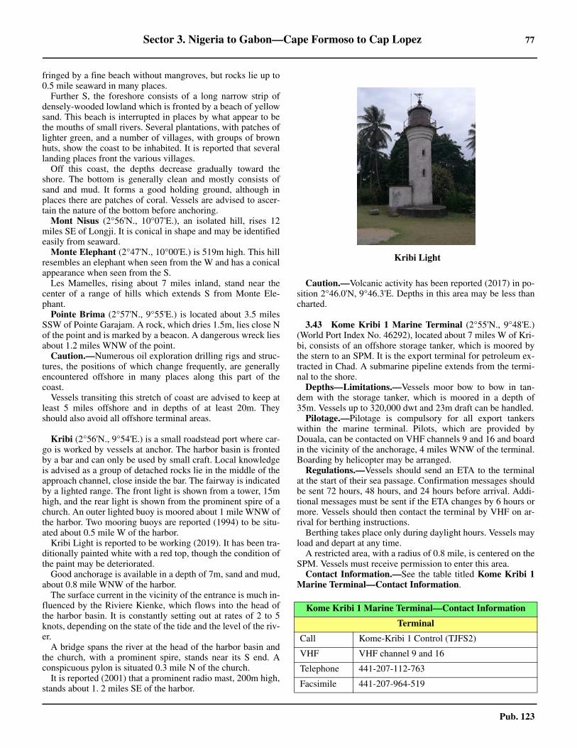
Sector 3. Nigeria to Gabon—Cape Formoso to Cap Lopez 77
Pub. 123
fringed by a fine beach without mangroves, but rocks lie up to0.5 mile seaward in many places.3.42 Further S, the foreshore consists of a long narrow strip ofdensely-wooded lowland which is fronted by a beach of yellowsand. This beach is interrupted in places by what appear to bethe mouths of small rivers. Several plantations, with patches oflighter green, and a number of villages, with groups of brownhuts, show the coast to be inhabited. It is reported that severallanding places front the various villages.3.42 Off this coast, the depths decrease gradually toward theshore. The bottom is generally clean and mostly consists ofsand and mud. It forms a good holding ground, although inplaces there are patches of coral. Vessels are advised to ascer-tain the nature of the bottom before anchoring.3.42 Mont Nisus (2°56'N., 10°07'E.), an isolated hill, rises 12miles SE of Longji. It is conical in shape and may be identifiedeasily from seaward.3.42 Monte Elephant (2°47'N., 10°00'E.) is 519m high. This hillresembles an elephant when seen from the W and has a conicalappearance when seen from the S.3.42 Les Mamelles, rising about 7 miles inland, stand near thecenter of a range of hills which extends S from Monte Ele-phant.3.42 Pointe Brima (2°57'N., 9°55'E.) is located about 3.5 milesSSW of Pointe Garajam. A rock, which dries 1.5m, lies close Nof the point and is marked by a beacon. A dangerous wreck liesabout 1.2 miles WNW of the point.3.42 Caution.—Numerous oil exploration drilling rigs and struc-tures, the positions of which change frequently, are generallyencountered offshore in many places along this part of thecoast.3.42 Vessels transiting this stretch of coast are advised to keep atleast 5 miles offshore and in depths of at least 20m. Theyshould also avoid all offshore terminal areas.
3.42 Kribi (2°56'N., 9°54'E.) is a small roadstead port where car-go is worked by vessels at anchor. The harbor basin is frontedby a bar and can only be used by small craft. Local knowledgeis advised as a group of detached rocks lie in the middle of theapproach channel, close inside the bar. The fairway is indicatedby a lighted range. The front light is shown from a tower, 15mhigh, and the rear light is shown from the prominent spire of achurch. An outer lighted buoy is moored about 1 mile WNW ofthe harbor. Two mooring buoys are reported (1994) to be situ-ated about 0.5 mile W of the harbor. 3.42 Kribi Light is reported to be working (2019). It has been tra-ditionally painted white with a red top, though the condition ofthe paint may be deteriorated.
Good anchorage is available in a depth of 7m, sand and mud,about 0.8 mile WNW of the harbor.3.42 The surface current in the vicinity of the entrance is much in-fluenced by the Riviere Kienke, which flows into the head ofthe harbor basin. It is constantly setting out at rates of 2 to 5knots, depending on the state of the tide and the level of the riv-er.3.42 A bridge spans the river at the head of the harbor basin andthe church, with a prominent spire, stands near its S end. Aconspicuous pylon is situated 0.3 mile N of the church.3.42 It is reported (2001) that a prominent radio mast, 200m high,stands about 1. 2 miles SE of the harbor.
3.42 Caution.—Volcanic activity has been reported (2017) in po-sition 2°46.0'N, 9°46.3'E. Depths in this area may be less thancharted.
3.43 Kome Kribi 1 Marine Terminal (2°55'N., 9°48'E.)(World Port Index No. 46292), located about 7 miles W of Kri-bi, consists of an offshore storage tanker, which is moored bythe stern to an SPM. It is the export terminal for petroleum ex-tracted in Chad. A submarine pipeline extends from the termi-nal to the shore.
Depths—Limitations.—Vessels moor bow to bow in tan-dem with the storage tanker, which is moored in a depth of35m. Vessels up to 320,000 dwt and 23m draft can be handled.
Pilotage.—Pilotage is compulsory for all export tankerswithin the marine terminal. Pilots, which are provided byDouala, can be contacted on VHF channels 9 and 16 and boardin the vicinity of the anchorage, 4 miles WNW of the terminal.Boarding by helicopter may be arranged.3.43 Regulations.—Vessels should send an ETA to the terminalat the start of their sea passage. Confirmation messages shouldbe sent 72 hours, 48 hours, and 24 hours before arrival. Addi-tional messages must be sent if the ETA changes by 6 hours ormore. Vessels should then contact the terminal by VHF on ar-rival for berthing instructions.
Berthing takes place only during daylight hours. Vessels mayload and depart at any time.3.43 A restricted area, with a radius of 0.8 mile, is centered on theSPM. Vessels must receive permission to enter this area.3.43 Contact Information.—See the table titled Kome Kribi 1Marine Terminal—Contact Information.
3.42Kribi Light
Kome Kribi 1 Marine Terminal—Contact Information
Terminal
Call Kome-Kribi 1 Control (TJFS2)
VHF VHF channel 9 and 16
Telephone 441-207-112-763
Facsimile 441-207-964-519
78 Sector 3. Nigeria to Gabon—Cape Formoso to Cap Lopez
Pub. 123
Anchorage.—A designated anchorage area, with a depth of40m, lies about 4 miles WNW of the terminal.3.43 Caution.—The wind is generally from the SW at force 3,but squalls, with gusts up to 50 knots, associated with localthunderstorms may occur, especially during the wettest period(between spring and autumn).
3.44 Grand Batanga (2°50'N., 9°53'E.), a village, stands 6miles SSW of Kribi. It has several prominent buildings, facto-ries, and churches. The waterfall of the Riviere Lobe, in the Npart of the village, is prominent during the rainy season, but isinsignificant during the dry season.
Anchorage can be obtained in depths of 10 to 12m, graysand, off Grand Batanga. Local knowledge is advised. A land-ing place lies between two factories, but it is reported to bevery dangerous.3.44 Baie Banoko (2°48'N., 9°54'E.) is a slight indentation whichextends S for about 5.5 miles from Grand Batanga. The shoresare low, wooded, and fronted by a sandy beach with severalfactories on it. A thick clump of large trees stands near the cen-ter of this indentation and appears as a dark hillock from a dis-tance. There is always a surf along the shores and landingshould never be attempted.
3.45 Ebome Marine Terminal (2°48'N., 9°49'E.), locatedabout 4 miles W of Baie Banoko, consists of an offshore stor-age tanker (La Lobe) and an SPM. It is situated in the vicinityof the KF Oil Field.
Depths—Limitations.—Vessels moor to the SPM, which islocated in a depth of 30m. Tankers up to 180,000 dwt can behandled.
Pilotage.—Pilotage is compulsory. Pilots, which are provid-ed by Douala (paragraph 3.40), can be contacted on VHF chan-nel 13 or 16 and board in the vicinity of the anchorage 1 mileW of the SPM.
Regulations.—Berthing takes place 24 hours.3.45 Vessels should send an ETA to operators and the terminalmanager 72 hours prior to arrival or as soon as possible if theprevious port is less than 72 hours away. The ETA should beconfirmed or updated 48 hours and 24 hours before arrival. The72-hour message should contain the following information:
1. Vessel’s name and flag.2. ETA (local time).3. Grade and quantity of cargo to load.4. Safe working load of derrick or crane.5. Dimensions of manifold flanges.6. Distance from bow to cargo manifold.7. ISPS information.
3.45 Vessels should maintain a continuous listening watch on
VHF channel 13 upon arrival at the terminal and during all op-erations. 3.45 A restricted area, about 2 miles wide, surrounds the terminal.Vessels must receive permission to enter this area.3.45 Contact Information.—See the table titled Ebome MarineTerminal—Contact Information.
Anchorage.—A designated anchorage area lies about 1.5miles W of the SPM.3.45 Caution.—The wind is generally from the SW at force 3,but squalls, with gusts up to 50 knots, associated with localthunderstorms may occur, especially during the wettest period(between spring and autumn).
3.46 Kribi Deep Water Port (Ebome Marine TerminalSouth) (2°44'N, 9°51'E.) is a large port project under develop-ment (2019) on the coast about 15 miles S of Kribi. The portwill eventually consist of 20 berths for container, multi-pur-pose hydrocarbon bulk, LNG, and iron ore cargo.
Offshore Manager
Telephone 44-207-074-1855
E-mail [email protected]
Mooring Master
Telephone 44-137-294-1887
E-mail [email protected]
Kome Kribi 1 Marine Terminal—Contact Information
Ebome Marine Terminal—Contact Information
VHF VHF channels 13 and 16
Facsimile 331-535-76311
Terminal Operators
Telephone237-233-407-620
237-233-414-717
Facsimile 237-233-414730
Web site http://www.perenco.com
Terminal Manager
Telephone
331-535-76311
237-699-996-458
237-699-681-077
Facsimile 237-699-681-077
E-mail [email protected]
3.46Kribi Deep Water Port
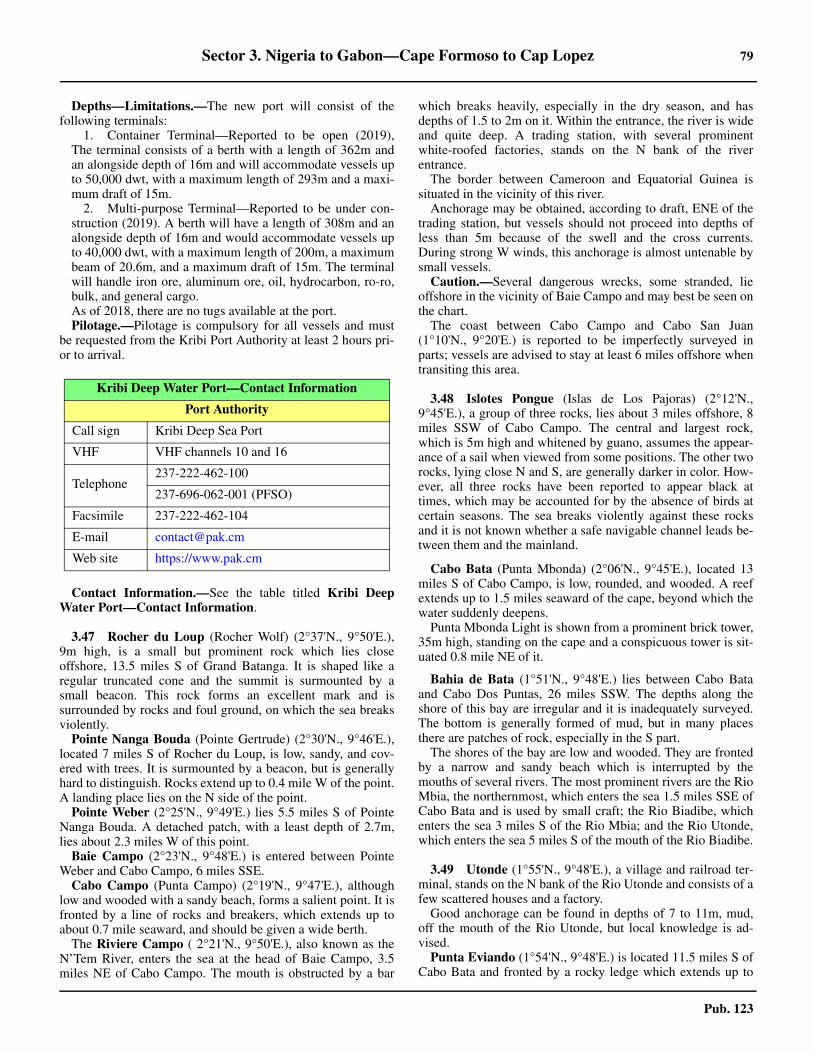
Sector 3. Nigeria to Gabon—Cape Formoso to Cap Lopez 79
Pub. 123
Depths—Limitations.—The new port will consist of thefollowing terminals:
1. Container Terminal—Reported to be open (2019),The terminal consists of a berth with a length of 362m andan alongside depth of 16m and will accommodate vessels upto 50,000 dwt, with a maximum length of 293m and a maxi-mum draft of 15m.
2. Multi-purpose Terminal—Reported to be under con-struction (2019). A berth will have a length of 308m and analongside depth of 16m and would accommodate vessels upto 40,000 dwt, with a maximum length of 200m, a maximumbeam of 20.6m, and a maximum draft of 15m. The terminalwill handle iron ore, aluminum ore, oil, hydrocarbon, ro-ro,bulk, and general cargo.
3.46 As of 2018, there are no tugs available at the port.3.46 Pilotage.—Pilotage is compulsory for all vessels and mustbe requested from the Kribi Port Authority at least 2 hours pri-or to arrival.
3.46 Contact Information.—See the table titled Kribi DeepWater Port—Contact Information.
3.47 Rocher du Loup (Rocher Wolf) (2°37'N., 9°50'E.),9m high, is a small but prominent rock which lies closeoffshore, 13.5 miles S of Grand Batanga. It is shaped like aregular truncated cone and the summit is surmounted by asmall beacon. This rock forms an excellent mark and issurrounded by rocks and foul ground, on which the sea breaksviolently.
Pointe Nanga Bouda (Pointe Gertrude) (2°30'N., 9°46'E.),located 7 miles S of Rocher du Loup, is low, sandy, and cov-ered with trees. It is surmounted by a beacon, but is generallyhard to distinguish. Rocks extend up to 0.4 mile W of the point.A landing place lies on the N side of the point.
Pointe Weber (2°25'N., 9°49'E.) lies 5.5 miles S of PointeNanga Bouda. A detached patch, with a least depth of 2.7m,lies about 2.3 miles W of this point.3.47 Baie Campo (2°23'N., 9°48'E.) is entered between PointeWeber and Cabo Campo, 6 miles SSE.3.47 Cabo Campo (Punta Campo) (2°19'N., 9°47'E.), althoughlow and wooded with a sandy beach, forms a salient point. It isfronted by a line of rocks and breakers, which extends up toabout 0.7 mile seaward, and should be given a wide berth.3.47 The Riviere Campo ( 2°21'N., 9°50'E.), also known as theN’Tem River, enters the sea at the head of Baie Campo, 3.5miles NE of Cabo Campo. The mouth is obstructed by a bar
which breaks heavily, especially in the dry season, and hasdepths of 1.5 to 2m on it. Within the entrance, the river is wideand quite deep. A trading station, with several prominentwhite-roofed factories, stands on the N bank of the riverentrance.3.47 The border between Cameroon and Equatorial Guinea issituated in the vicinity of this river.3.47 Anchorage may be obtained, according to draft, ENE of thetrading station, but vessels should not proceed into depths ofless than 5m because of the swell and the cross currents.During strong W winds, this anchorage is almost untenable bysmall vessels. 3.47 Caution.—Several dangerous wrecks, some stranded, lieoffshore in the vicinity of Baie Campo and may best be seen onthe chart.3.47 The coast between Cabo Campo and Cabo San Juan(1°10'N., 9°20'E.) is reported to be imperfectly surveyed inparts; vessels are advised to stay at least 6 miles offshore whentransiting this area.
3.48 Islotes Pongue (Islas de Los Pajoras) (2°12'N.,9°45'E.), a group of three rocks, lies about 3 miles offshore, 8miles SSW of Cabo Campo. The central and largest rock,which is 5m high and whitened by guano, assumes the appear-ance of a sail when viewed from some positions. The other tworocks, lying close N and S, are generally darker in color. How-ever, all three rocks have been reported to appear black attimes, which may be accounted for by the absence of birds atcertain seasons. The sea breaks violently against these rocksand it is not known whether a safe navigable channel leads be-tween them and the mainland.
Cabo Bata (Punta Mbonda) (2°06'N., 9°45'E.), located 13miles S of Cabo Campo, is low, rounded, and wooded. A reefextends up to 1.5 miles seaward of the cape, beyond which thewater suddenly deepens.
Punta Mbonda Light is shown from a prominent brick tower,35m high, standing on the cape and a conspicuous tower is sit-uated 0.8 mile NE of it.
3.48 Bahia de Bata (1°51'N., 9°48'E.) lies between Cabo Bataand Cabo Dos Puntas, 26 miles SSW. The depths along theshore of this bay are irregular and it is inadequately surveyed.The bottom is generally formed of mud, but in many placesthere are patches of rock, especially in the S part.3.48 The shores of the bay are low and wooded. They are frontedby a narrow and sandy beach which is interrupted by themouths of several rivers. The most prominent rivers are the RioMbia, the northernmost, which enters the sea 1.5 miles SSE ofCabo Bata and is used by small craft; the Rio Biadibe, whichenters the sea 3 miles S of the Rio Mbia; and the Rio Utonde,which enters the sea 5 miles S of the mouth of the Rio Biadibe.
3.49 Utonde (1°55'N., 9°48'E.), a village and railroad ter-minal, stands on the N bank of the Rio Utonde and consists of afew scattered houses and a factory.
Good anchorage can be found in depths of 7 to 11m, mud,off the mouth of the Rio Utonde, but local knowledge is ad-vised.3.49 Punta Eviando (1°54'N., 9°48'E.) is located 11.5 miles S ofCabo Bata and fronted by a rocky ledge which extends up to
Kribi Deep Water Port—Contact Information
Port Authority
Call sign Kribi Deep Sea Port
VHF VHF channels 10 and 16
Telephone237-222-462-100
237-696-062-001 (PFSO)
Facsimile 237-222-462-104
E-mail [email protected]
Web site https://www.pak.cm

80 Sector 3. Nigeria to Gabon—Cape Formoso to Cap Lopez
Pub. 123
0.4 mile seaward. A group of radio masts stands 0.4 mile SE ofthis point, in the vicinity of an airfield. A buoy is reported to bemoored about 4 miles NW of the point.3.49 Colline Selle and Colline Table are two hills which rise 24and 27 miles, respectively, inland from the mouth of the Riv-iere Campo. Both are very prominent and appear isolated fromoff this part of the coast. Las Siete Colinas, a mountain range,stands about 15 miles inland and presents seven distinctheights when viewed from seaward.
3.49 Monte Agudo (1°44'N., 9°54'E.), the central mountain ofthis range, rises to a height of 850m high and is very conspicu-ous.3.49 The Ecuco River (Rio Ecuco), with a shallow bar, flows intothe sea about 7 miles SW of Utonde. At the last of the ebb tidalcurrent, the water within the bar is fresh but dark in color andfull of organic matter.3.49 Punta Ngaba (1°45'N., 9°41'E.) is located 6.3 miles SW ofthe mouth of the Ecuco River and 6.7 miles NE of Cabo DosPuntas. A light is shown from a metal tower, 19m high, stand-ing on this point. 3.49 Caution.—It is reported (1991) that shoals are extendingseaward from the mouth of the Ecuco River and several dan-gerous wrecks lie off the entrance.
3.50 Bata (1°52'N., 9°46'E.) (World Port Index No. 46305)is located 5 miles SSW of Utonde. A dog-legged wharf, 370mlong, with depths of 3m alongside the inshore face, fronts thetown. A total of five berths are available at this pier. A new portarea to the S is being constructed adjacent to the small wharf.This new terminal extends W offshore, perpendicular to thecoast and consists of several large piers protected by an L-shaped breakwater, with the entrance to the basin facing N. Thenew port terminal is reported to host a Chinese naval base butgeneral cargo vessels may be permitted. Mariners are advisedto contact local authorities for the latest information. 3.50 A conspicuous mission building, with twin domessurmounted by an iron cross, stands in the NE part of the town.The government house, which stands on high ground, and acathedral, which is situated close S of the mission building, areprominent. Radio masts stand in the vicinity of an airport, 2.5miles NE of the wharf, and are prominent.3.50 Pilotage.—Berthing instructions are provided by the portauthority on VHF channel 16. The pilot boards in the followingposition: 1°48'48.0''N, 9°43'43.8''E.3.50 Anchorage.—Vessels can anchor, in a depth of 11m, sand,about 1.5 miles offshore, but local knowledge is advisable asseveral dangerous wrecks lie in the approaches. The holdingground is fairly good, but the swell can be heavy. Anchoragefor small vessels is also available in depths of 5 to 7m about 0.4mile WNW of the head of the wharf.3.50 Caution.—A dangerous wreck, best seen on the chart, lies inthe approach to Bata harbor. 3.50 A disused submarine pipeline, formerly used to dischargeoil, extends about 0.8 mile NW from the shore in the vicinity ofBata.3.50 The new port area of Bata may have military-restrictedaccess.
Puerto Nuevo (Puerto Macias Nguema) (1°49'N., 9°44'E.),situated 1 mile S of the mouth of the Ecuco River, is
considered to be the new part of the port of Bata. The harborconsists of an L-shaped jetty extending about 0.4 mile W fromthe shore. A basin, protected by breakwaters, lies near the rootof the jetty. It has depths of 3 to 4m and is used by fishingvessels and small craft.3.50 The outer leg of the jetty, which is 320m long, provides fourgeneral cargo berths, with depths of 11 to 12m alongside. Sev-eral mooring buoys are also available to assist in berthing. Ves-sels up to 19,300 dwt, 182m in length, and 8m draft can beaccommodated.3.50 Anchorage is available, in a depth of 20m, about 1 mile W ofthe head of the jetty.3.50 Pilotage requirements are the same as for Bata. 3.50 Caution.—It was reported (1993) that the local pilot at Puer-to Nuevo spoke only Spanish.3.50 It is reported (1999) that vessels moored at the inner berthsof the jetty at Puerto Nuevo are frequently subject to a heavyswell. The jetty is constructed of concrete piles and gives littleprotection. 3.50 Numerous oil and gas exploration drilling rigs, platforms,structures, and well heads may be encountered in the approach-es to Bata and Puerto Nuevo.
3.51 Cabo Dos Puntas (1°41'N., 9°36'E.), the S entrancepoint of Bahia de Bata, is low, wooded, and fringed by a sandybeach. It is fronted by a rocky reef, which extends up to about 1.5miles offshore, and should be given a wide berth. The sea breaksover the whole of this reef, but more violently at the N end.3.51 Punta Mbode (1°37'N., 9°36'E.) is located 2.3 miles S ofCabo Dos Puntas. A light is shown from a framework tower,14m high, standing on this point. Several shoals, with depths of0.9m and on which the seas break heavily during the ebb tide,extend up to about 0.8 mile seaward of the point.3.51 The Rio Benito (Rio Mbini) (1°36'N., 9°37'E.) is enteredbetween Punta Haybero, located 1.5 miles SE of Punta Mbode,and Punta Joho (Punta Arena), 0.8 mile SSW. It is navigable bysmall craft, with drafts up to 1.8m, for about 12 miles above themouth. The village of Rio Benito extends S from Punta Johoand is fronted by a small pier which can accommodate smallvessels with drafts up to 4.3m.3.51 The town of Bolondo is situated 0.5 mile N of Punta Haybe-ro and the American Mission, with a prominent white pigeonhouse, stands in it. A prominent church is situated near PuntaJoho and a light is shown from a framework tower standing 1mile SW of it.3.51 Large vessels can anchor in a depth of 12m about 4 milesNW of the river mouth. Smaller vessels can anchor in a depthof 8m about 2 miles W of Punta Joho, but during the dry sea-son (May to November) there may be considerable swell in thisposition. Cargo handling is carried out at these roadsteads.3.51 Caution.—Several wrecks, some dangerous, lie in the ap-proaches to the Rio Benito and may best be seen on the chart.
3.52 Between the Rio Benito and Cabo San Juan, 30 milesSSW, the coast is low, undulating, and wooded. It is fringed bya narrow and sandy beach which is intersected by the mouthsof several rivers. The shore is fronted in many places by rockyshoals, some of which uncover. Inland the land rises and attainsa height of 585m at Monte Bombouanyoko, which stands 10miles NE of Cabo San Juan.
Sector 3. Nigeria to Gabon—Cape Formoso to Cap Lopez 81
Pub. 123
3.52 La Mibia, a remarkable mountain, rises 26 miles SE of PuntaJoho. It is 1,200m high and has a double summit.3.52 Anchorage is available, in a depth of 5m, sand, off the mouthof the Rio Ndote, which flows into the sea 6 miles SE of PuntaJoho. This river may be entered by boats with local knowledge.
Punta Ilende (Dione) (1°23'N., 9°28'E.) is fronted by rockyledges which extend up to about 0.8 mile offshore.3.52 Banco Mitra (1°25'N., 9°19'E.) lies about 10 miles WNWof Punta Ilende. This bank has depths of 29 to 31m, withdepths of 69m close round it. A patch, with a depth of 11.9m(existence doubtful), lies approximately 10 miles SSW of thebank.
The Rio Etembue (1°17'N., 9°26'E.) flows into the sea 7miles SW of Punta Ilende. Several off-lying reefs front thebight, which lies between Punta Ilende and the river mouth.The town of Etembue stands on the N bank of the riverentrance. Punta Uloba, a headland, is located 1.7 miles WSWof the mouth of the river.
Mumunein Bank, a rocky shoal area, lies 2 miles NW ofPunta Uloba and has a least depth of 1.2m. The village ofEgombe-Egombe stands 1.5 miles SSW of Punta Uloba.3.52 Several shoal patches lie up to 2 miles off this part of thecoast, but the whole of this area is inadequately surveyed.3.52 Between Punta Uloba and Cabo San Juan, 6.7 miles SSW,the coast is fringed with reefs and numerous rocks, awash, lieup to 0.7 mile offshore. Islote Ebumya, a small islet, lies on areef, 1.5 miles SW of Punta Uloba. Roca Mumunein, with adepth of 1.5m, lies about 1.3 miles WSW of this islet.
3.53 Ceiba Terminal (1°24'N., 9°13'E.), located 16 milesNW of Cabo San Juan, consists of a Floating Production Stor-age and Offloading (FPSO) facility and a CALM buoy. TheFPSO (Sendje Ceiba) is moored in a depth of 40m and theCALM buoy, situated 1 mile SE, is moored in a depth of 67m.Vessels up to 350,000 dwt can be handled at the buoy.
Pilotage.—Pilotage is compulsory. Pilots board about 3miles N or 3 miles SW of the FPSO. Berthing and departuremay take place at any time.3.53 Regulations.—Vessels must send an initial ETA by facsimi-le to the terminal when starting their sea passage. They shouldthen send their ETA 72 hours, 48 hours, and 24 hours beforearrival. Vessels must also report if their ETA changes by 6hours or more. During the last 24 hours prior to arrival, vesselsshould report if their ETA changes by 1 hour or more. Vesselsshould then contact the terminal by VHF when within rangebut no less than 10 miles from the FPSO.3.53 Tankers should proceed to a position located about 5 miles Nof the FPSO and await instructions from the pilot. They shouldmaintain a continuous listening watch on VHF channels 16 and72 while approaching and operating in the terminal area.3.53 An exclusion zone, with a radius of 500m, surrounds the ter-minal. Vessels must receive permission from FPSO Operationsto enter this area. A reporting zone, with a radius of 10 miles, iscentered on the FPSO. Vessels must report by VHF to the ter-minal prior to entering this zone.
3.53 Contact Information.—See the table titled CeibaTerminal—Contact Information. 3.53 Caution.—Oil and gas development areas, which may bestbe seen on the chart, lie centered about 5 miles NW and 9 milesNE of Ceiba Terminal. Platforms, well heads, drilling rigs, andother associated installations may be found within these areas.Surface vessels, submarine craft, and divers engaged inservicing the installations may also be encountered. Vessels areadvised to stay clear of these areas.
3.54 Cabo San Juan (1°10'N., 9°20'E.) is covered withtrees and appears as three distinct heads when seen from the N.Its base is rocky and the sea breaks violently up to 0.2 mile off-shore. A light is shown from a framework tower, 18m high,standing on the cape.3.54 A large white mission building stands 2 miles ENE of thecape and is conspicuous from seaward. The Rio Nano entersthe sea between the cape and the mission building. Severalchimneys stand near the river mouth and a stranded wreck liesclose off the entrance. A detached shoal, with a depth of18.9m, lies about 4.8 miles W of Cabo San Juan.3.54 Anchorage is available in a depth of 11m about 2.4 milesNNW of Cabo San Juan. 3.54 Caution.—The shores in the vicinity of the Cabo San Juanare very low and the large trees often have the appearance ofhillocks when approaching from the W. In addition, the trunksof the trees assume a grayish tint and appear elongated. Thisdistortion, which is caused by a strong mirage effect, gives thecoast the appearance of being formed of cliffs intersected bybroad fissures or ravines. This illusion occurs frequently, but itis dispelled when vessels get closer to the land.3.54 The tidal currents near Cabo San Juan are complicated. Thecurrent setting NNE along the coast is influenced by the tidalcurrents running in and out of Bahia de Corisco.3.54 The coast between Cabo San Juan and Cabo Campo(2°19'N., 9°47'E.) is reported to be imperfectly surveyed inparts; vessels are advised to stay at least 6 miles offshore whentransiting this area.
Bahia de Corisco
3.55 Bahia de Corisco (Corisco Bay) (0°54'N., 9°16'E.) isentered between Cabo San Juan and Cap Esterias, 33 miles S(see paragraph 3.65). The name Corisco, derived from the Por-tuguese, was conferred upon this bay because of the frequentthunderstorms which are experienced in this locality. The E
Ceiba Terminal—Contact Information
Call sign Ceiba Terminal (C6WD)
VHF VHF channels 16, 17, and 72
Telephone44-203-958-3311
44-203-958-3112
Operators (Trident Equatorial Guinea Inc)
Telephone 44-203-958-3000
Ceiba Terminal—Contact Information

82 Sector 3. Nigeria to Gabon—Cape Formoso to Cap Lopez
Pub. 123
shore of the bay is known as Costa de Los Mosquitos.3.55 Punta Corona (1°06'N., 9°23'E.) is located 5 miles SSE ofCabo San Juan. The intervening coast is composed of two shal-low indentations separated by Punta Negra. The NW indenta-tion is fringed with rocks which also extend up to 0.3 mileoffshore in the vicinity of Punta Negra. The S indentation isfringed by a sandy beach.3.55 Piedra Ugoti and Piedra Biguma, both dangerous rocks, lie1.1 miles W and 0.6 mile SE, respectively, of Punta Corona.Banco Cakulle, with a least depth of 3m, lies about 1 mile SWof Punta Corona and a detached shoal, with a depth of 8.3m,lies 0.8 mile SW of it. 3.55 Banco Lauria (1°05'N., 9°16'E.) lies centered 7 miles WSWof Punta Corona. It consists of a stony patch and has a leastdepth of 3.2m.3.55 Punta Mosquitos is located 1.5 miles ESE of Punta Coronaand surmounted by several detached clumps of trees. Thispoint, along with the bay lying W of it, is fringed by numerousrocks and the village of Calatrava is situated in its vicinity.3.55 Good anchorage is available in a depth of 6m about 0.5 mileS of Punta Mosquitos.3.55 Between Punta Mosquitos and Punta Yeke, 11.5 miles ESE,the coast forms a shallow bay. A shelf, with depths of less than5m, extends in places up to 4.5 miles seaward from the shore ofthis bay. 3.55 Punta Dambe, Punta Bitimbe, Punta Belekeke, and PuntaBetika are located 1.7 miles, 2.7 miles, 4 miles, and 5.7 milesENE, respectively, of Punta Mosquitos. The Rio Malanchaflows into the bay close W of Punta Belekeke and the RioOdingue flows into the bay close E of Punta Betika.3.55 Punta Eboko is located 1.7 miles E of Punta Betika. Fromthis point, the coast trends 7 miles SSE to Punta Yeke; threesmall rivers discharge into the bay along this stretch. Severalvillages stand along the shore. The main village of Efule issituated 3.7 miles NW of Punta Yeke.3.55 Caution.—Numerous oil and gas exploration drilling rigs,platforms, structures, and well heads may be encountered inthe approaches to Bahia de Corisco.3.55 Transiting the coast between Cabo San Juan and Punta Mos-quitos is very dangerous and care should be taken, as there areno conspicuous landmarks and the seas are high during the dryseason (June to August). 3.55 Due to the possibility of undiscovered dangers lying in theapproaches to Bahia de Corisco, vessels navigating in this vi-cinity are advised to proceed into the bay from the N. Theyshould exercise great care and keep at least 11 miles offshoreuntil turning to head for the entrance. Vessels should then fol-low the recommended track, which may best be seen on thechart, leading SE between Cabo San Juan and Banco Lauria.
3.56 Isla de Corisco (Isla de Mandyi) (0°56'N., 9°19'E.)lies 14.5 miles S of Cabo San Juan and is administered byEquatorial Guinea. A light is shown from a tower, 28m high,standing on the N extremity of the island.3.56 Isla de Corisco is moderately high and has a diversifiedscenery, on a diminutive scale, consisting of hills, forests,prairies, and lakes. The climate of the island is consideredunhealthy, but it is healthier than that of the neighboring coast.Gobe, the principal village, is situated near the center of the Scoast.
3.56 A rocky patch, awash, lies 1.5 miles NNE of Punta Italo, theNE extremity of the island. It is located on Banco Corisco,which extends up to 3.5 miles NNE from Punta Italo and hasdepths of less than 9m. Banco Nengueamegue, which dries inplaces, extends up to 2.3 miles E from Punta Hoco (PuntaYoko), the SE extremity of the island. A small islet lies on thisbank. 3.56 Punta Uguni (Punta Ugoni), the SW extremity of the island,is rocky and bare. The trees standing along the S coast of theisland are thinly scattered as compared with those on the N andE coasts.3.56 Islote Leva, which is uninhabited, lies on a shoal area, 1 mileWSW of Punta Lembue, the S extremity of Isla de Corisco.This islet is of moderate height, covered with trees, and sur-rounded by breakers, especially on its N and E sides. Theshoals, which surrounds Isla de Corisco, extend up to 0.5 mileW and 2 miles S of the islet.3.56 The W coast of Isla de Corisco is rocky; the rocks, especiallyon their S sides, are covered with patches of white which areprominent from a distance. The mirage effect of the trees liningthe coast is similar to that in the vicinity of Cabo San Juan.3.56 Punta Gueliba (Punta Cucliva) is the NW extremity of the is-land. The coastal bank, with a least depth of 3m, extends up to1.3 miles NW from this point. A detached shoal, with a leastdepth of 7.9m, was reported (1959) to lie with its SW endabout 3.1 miles NNW of the point. Another detached shoal,with a least depth of 8m, was reported (1962) to lie 1.7 milesNNW of the point.3.56 Caution.—Vessels should not depend entirely on the chartin this vicinity, as the banks and shoals may shift from time totime.3.56 In order to clear the banks extending from the island, vesselsare advised to stay at least 2.5 miles from the N and W coastsof Isla de Corisco or in depths of more than 12m. In addition,vessels are advised to stay at least 4 miles from the NE side ofthe island or in depths of more than 22m. 3.56 The passages lying S of the island should only be used withlocal knowledge.
3.57 Banco Bane (Banco Mbane) (0°46'N., 9°21'E.) lies atthe S end of the coastal bank which has depths of less than 5mand extends up to about 10 miles S from Isla de Corisco.3.57 Banco Laval, a dangerous drying bank with several rocks,lies about 4.5 miles S of the SW extremity of the island. Astranded wreck lies 2 miles S of this bank.3.57 Islote Conga, a rock, lies almost at the center of BancoBane, with another above-water rock close SW of it. IslotaBane (Islote Mbane) is located 1 mile NE of Islote Conga. Thisislet, although low, is conspicuous, as it is covered with hightrees.3.57 Bancos del Este, an area of drying sands, extends nearly 2.8miles ENE from Islota Bane. Islote Cocotier, a rock, lies on asmall drying patch, about 2 miles E of Islota Bane. A lightedbuoy is moored about 2.5 miles E of this rock.3.57 Although Banco Bane lies about 8 miles from the S shore ofBahia de Corisco, the only available passage leads NE alongthe SE side of this bank. A least depth of 6.5m lies in this pas-sage near the time of HW, but local knowledge is essential.3.57 Tides—Currents.—Between the banks which encumberBahia de Corisco, the currents often attain rates of 1 to 2 knots;
Sector 3. Nigeria to Gabon—Cape Formoso to Cap Lopez 83
Pub. 123
their directions vary in accordance with the state of the tides.To seaward of Isla de Corisco, the current generally sets in aNNE direction at a rate of less than 1 knot. Within the bay, thetidal currents generally flow E on the flood and W on the ebb.In the S part of the bay, the current setting W sometimes attainsa rate of more than 3 knots during the rainy season although, inthe dry season, this current normally does not attain a rate ofmore than 2 knots.3.57 Tidal currents in the bay can be greatly affected by the out-going river currents.
3.58 Islas Elobey (1°00'N., 9°30'E.), administered by Equa-torial Guinea, lies 11 miles ENE of Isla de Corisco, on the S sideof the approach to the Rio Muni. It consists of a group of islands,islets, rocks, and shoal patches. Isla Elobey Grande and Isla Elo-bey Chico are the principal islands.3.58 Bancos de Elobey, with depths of less than 5m, extend up toabout 4 miles WNW from the NW extremity of the group. Sev-eral detached shoals, with depths of 5 to 7m, lie up to about 6.5miles W of the group.3.58 Isla Elobey Grande, inhabited by fishermen, is wooded.Islote Belobi, a small islet, lies close off Punta Belobi, the Nextremity of Isla Elobey Grande. The coast is formed of smalland steep cliffs, 10 to 12m high. Bancos de Bene, with severalrocks awash, lies 1 mile E of this island.3.58 Isla Elobey Chico, lying 1 mile NE of Isla Elobey Grande, iscompletely flat. This island has many coconut palms and fruittrees.
Anchorage.—Between Isla de Corisco and Islas Elobey, an-chorage can be found, in depths of 16 to 22m, at a moderatedistance from either.3.58 Good anchorage is available, in a depth of 8m, mud, about1.5 miles NE of Punta Hoco, the SE extremity of Isla deCorisco. This roadstead is sheltered from SW winds and theholding ground is so tenacious that local thunderstorms fromthe E need not be feared. Although the water is usually quitesmooth, without any surf on the beach, a swell occasionallysets in without any apparent cause and rollers break on all sidesof the island.3.58 Anchorage may be obtained S of Banco Nengueamegue. AtLW, the drying portions of this bank afford a guide. Anchorage,with fair shelter, is also available, in depths of 7m to 8m, mud,inside of Bancos de Elobey, about 1.2 miles NE of Isla ElobeyChico.
3.59 The Rio Muni (1°02'N., 9°35'E.) is approachedbetween the coastal bank extending off the N shore of Bahia deCorisco and Bancos de Elobey (see paragraph 3.59). It entersthe bay between Punta Yeke and Pointe Coco Beach, 1.4 milesSSW. Both of these entrance points are low, wooded, andfronted by rocks. A stranded wreck is reported to lie close offPointe Coco Beach.
The river is navigable as far as Isla Ngande, about 9 milesabove the entrance. The channel has a least depth of 6.2m.Pilotage is not compulsory, but pilots are available.
The border between Equatorial Guinea and Gabon is situatedalong the center of the Rio Muni above the mouth.
3.59 Caution.—The ebb current in the river can attain a rate of4.5 knots in places during the rainy season (October to May).
3.60 Cogo (Puerto Iradier) (Kogo) (1°05'N., 9°42'E.)(World Port Index No. 46340), lying 7.5 miles NE of the riverentrance, is situated on the N bank of the river and used for theexport of logs. It is fronted by a wharf which is used by barges.A prominent hospital surmounts the summit of the hill onwhich the town is built. Islote Ivelo lies off the E entrance ofthe Rio Congue, close SW of the town. 3.60 The roadstead, where cargo is worked, lies close SW of Is-lote Ivelo. It has depths of up to 11m and can accommodatevessels of up to 9,000 tons and 7.9m draft at HW. A directionallight indicates the channel leading to the anchorage. The tidesrise about 2.5m at springs and 2m at neaps. 3.60 Anchorage is also available in depths of 9 to 18m near a tim-ber loading place at the estuary of the river. Local knowledge isadvised due to strong tidal currents in some places.3.60 The tributaries of the Rio Muni above Cogo are navigableonly by small craft with local knowledge.
3.60 Directions.—A recommended approach route, which maybest be seen on the chart, leads SE between Cabo San Juan andBanco Lauria. It then leads E and ESE to the river mouth. Alighted buoy is moored about 5 miles NW of Isla Elobey Chi-co.3.60 Caution.—The buoys marking the approach channel are notto be depended upon.3.60 The banks and shoals lying in the approaches to the rivermouth are subject to frequent changes.
3.61 Pointe Ndombo (0°57'N., 9°34'E.) is located 4.5miles SSW of Pointe Coco Beach. The village of Ndombo issituated near the point and is visible from seaward. A light isshown from a tower, 7m high, standing on the point. Small ves-sels can anchor off the village, in a depth of 3m, good holdingground, about 0.5 mile offshore.3.61 The mouth of the Crique Massotie lies at the E side of theentrance to Baie de Mondah, 15 miles SSE of Pointe Ndombo.The coast between is wooded and intersected by the mouths ofnumerous small streams. It is also fronted by shoal water, withdepths of less than 5m, which extends up to 3.5 miles seawardin some places. Recif Buyumba, a drying reef on which the seabreaks, extends about 1.5 miles SW from a point on the coast,6.5 miles S of Pointe Ndombo. Another small patch of reef lies1.4 miles offshore, about 2.8 miles SSE of Recif Buyumba.This patch is marked by a beacon; the sea breaks on it.3.61 The S summit of Monts N’Keba, 209m high, rises about 7miles E of Recif Buyumba and is surmounted by a conspicuousround tree.
3.62 Pointe Acanda (0°40'N., 9°30'E.), located 7 milesWSW of the mouth of Crique Massotie, is the W entrancepoint of Baie de Mondah. The S shore of Bahia de Coriscotrends 11 miles in a WSW direction from this point to Cap Es-terias.3.62 Pointe Moka is located 2 miles WSW of Pointe Acanda andthe Riviere Moka, which connects with Crique N’Tsini, flowsinto the sea close W of it. Pointe Boulokouhoue, a salient rockypoint, is located 3.5 miles W of Pointe Moka. The shore ex-tending between Point Moka and Cap Esterias is shallow andfoul.3.62 An extensive shoal area, with depths of less than 5m, fronts
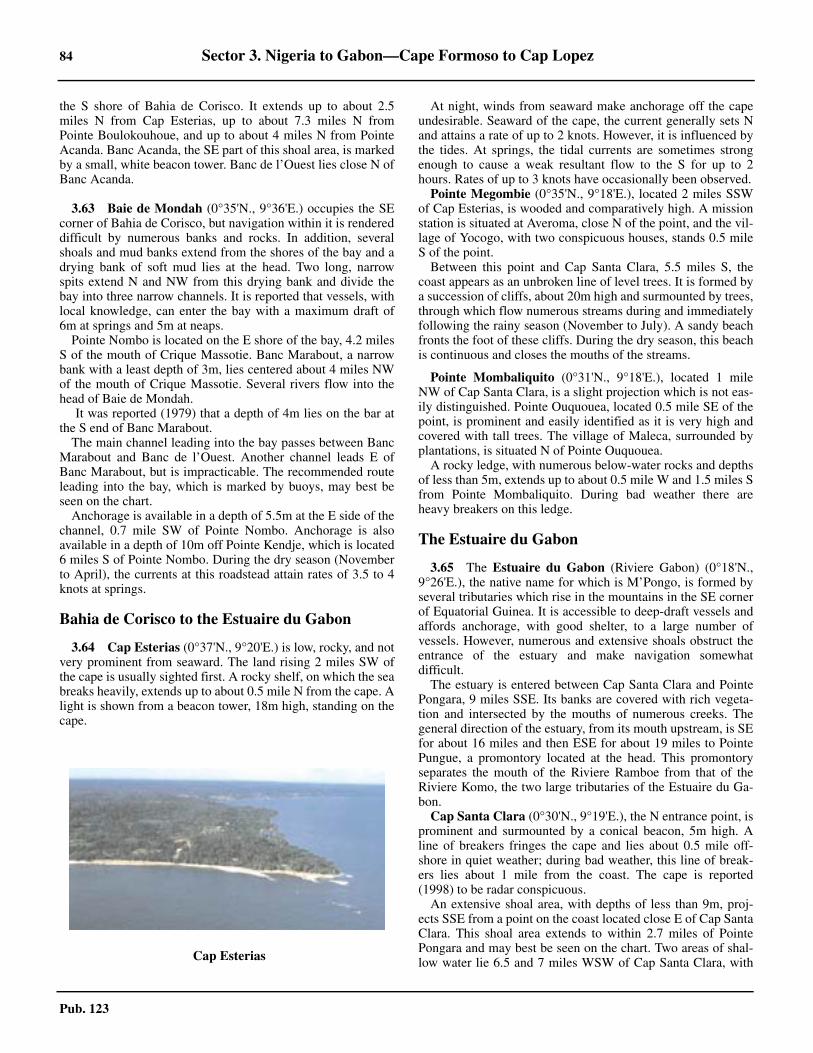
84 Sector 3. Nigeria to Gabon—Cape Formoso to Cap Lopez
Pub. 123
the S shore of Bahia de Corisco. It extends up to about 2.5miles N from Cap Esterias, up to about 7.3 miles N fromPointe Boulokouhoue, and up to about 4 miles N from PointeAcanda. Banc Acanda, the SE part of this shoal area, is markedby a small, white beacon tower. Banc de l’Ouest lies close N ofBanc Acanda.
3.63 Baie de Mondah (0°35'N., 9°36'E.) occupies the SEcorner of Bahia de Corisco, but navigation within it is rendereddifficult by numerous banks and rocks. In addition, severalshoals and mud banks extend from the shores of the bay and adrying bank of soft mud lies at the head. Two long, narrowspits extend N and NW from this drying bank and divide thebay into three narrow channels. It is reported that vessels, withlocal knowledge, can enter the bay with a maximum draft of6m at springs and 5m at neaps.3.63 Pointe Nombo is located on the E shore of the bay, 4.2 milesS of the mouth of Crique Massotie. Banc Marabout, a narrowbank with a least depth of 3m, lies centered about 4 miles NWof the mouth of Crique Massotie. Several rivers flow into thehead of Baie de Mondah.3.63 It was reported (1979) that a depth of 4m lies on the bar atthe S end of Banc Marabout.3.63 The main channel leading into the bay passes between BancMarabout and Banc de l’Ouest. Another channel leads E ofBanc Marabout, but is impracticable. The recommended routeleading into the bay, which is marked by buoys, may best beseen on the chart.3.63 Anchorage is available in a depth of 5.5m at the E side of thechannel, 0.7 mile SW of Pointe Nombo. Anchorage is alsoavailable in a depth of 10m off Pointe Kendje, which is located6 miles S of Pointe Nombo. During the dry season (Novemberto April), the currents at this roadstead attain rates of 3.5 to 4knots at springs.
Bahia de Corisco to the Estuaire du Gabon
3.64 Cap Esterias (0°37'N., 9°20'E.) is low, rocky, and notvery prominent from seaward. The land rising 2 miles SW ofthe cape is usually sighted first. A rocky shelf, on which the seabreaks heavily, extends up to about 0.5 mile N from the cape. Alight is shown from a beacon tower, 18m high, standing on thecape.
3.64 At night, winds from seaward make anchorage off the capeundesirable. Seaward of the cape, the current generally sets Nand attains a rate of up to 2 knots. However, it is influenced bythe tides. At springs, the tidal currents are sometimes strongenough to cause a weak resultant flow to the S for up to 2hours. Rates of up to 3 knots have occasionally been observed.3.64 Pointe Megombie (0°35'N., 9°18'E.), located 2 miles SSWof Cap Esterias, is wooded and comparatively high. A missionstation is situated at Averoma, close N of the point, and the vil-lage of Yocogo, with two conspicuous houses, stands 0.5 mileS of the point.3.64 Between this point and Cap Santa Clara, 5.5 miles S, thecoast appears as an unbroken line of level trees. It is formed bya succession of cliffs, about 20m high and surmounted by trees,through which flow numerous streams during and immediatelyfollowing the rainy season (November to July). A sandy beachfronts the foot of these cliffs. During the dry season, this beachis continuous and closes the mouths of the streams.
3.64 Pointe Mombaliquito (0°31'N., 9°18'E.), located 1 mileNW of Cap Santa Clara, is a slight projection which is not eas-ily distinguished. Pointe Ouquouea, located 0.5 mile SE of thepoint, is prominent and easily identified as it is very high andcovered with tall trees. The village of Maleca, surrounded byplantations, is situated N of Pointe Ouquouea.3.64 A rocky ledge, with numerous below-water rocks and depthsof less than 5m, extends up to about 0.5 mile W and 1.5 miles Sfrom Pointe Mombaliquito. During bad weather there areheavy breakers on this ledge.
The Estuaire du Gabon
3.65 The Estuaire du Gabon (Riviere Gabon) (0°18'N.,9°26'E.), the native name for which is M’Pongo, is formed byseveral tributaries which rise in the mountains in the SE cornerof Equatorial Guinea. It is accessible to deep-draft vessels andaffords anchorage, with good shelter, to a large number ofvessels. However, numerous and extensive shoals obstruct theentrance of the estuary and make navigation somewhatdifficult.3.65 The estuary is entered between Cap Santa Clara and PointePongara, 9 miles SSE. Its banks are covered with rich vegeta-tion and intersected by the mouths of numerous creeks. Thegeneral direction of the estuary, from its mouth upstream, is SEfor about 16 miles and then ESE for about 19 miles to PointePungue, a promontory located at the head. This promontoryseparates the mouth of the Riviere Ramboe from that of theRiviere Komo, the two large tributaries of the Estuaire du Ga-bon. 3.65 Cap Santa Clara (0°30'N., 9°19'E.), the N entrance point, isprominent and surmounted by a conical beacon, 5m high. Aline of breakers fringes the cape and lies about 0.5 mile off-shore in quiet weather; during bad weather, this line of break-ers lies about 1 mile from the coast. The cape is reported(1998) to be radar conspicuous.3.65 An extensive shoal area, with depths of less than 9m, proj-ects SSE from a point on the coast located close E of Cap SantaClara. This shoal area extends to within 2.7 miles of PointePongara and may best be seen on the chart. Two areas of shal-low water lie 6.5 and 7 miles WSW of Cap Santa Clara, with3.64Cap Esterias
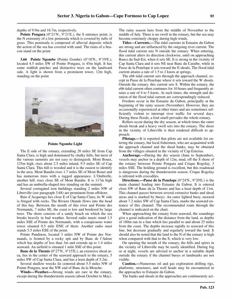
Sector 3. Nigeria to Gabon—Cape Formoso to Cap Lopez 85
Pub. 123
depths of 9.9m and 16.7m, respectively. 3.65 Pointe Pongara (0°21'N., 9°21'E.), the S entrance point, isthe N extremity of a low peninsula which is covered by tufts ofgrass. This peninsula is composed of alluvial deposits whichthe action of the sea has covered with sand. The ruins of a bea-con stand on the point.
3.66 Pointe Ngombe (Pointe Gombe) (0°18'N., 9°19'E.),located 4.5 miles SW of Pointe Pongara, is 45m high. It hassome reddish patches and distinctive trees on the landwardside. A light is shown from a prominent tower, 12m high,standing on the point.
3.66 The E side of the estuary, extending 20 miles SE from CapSanta Clara, is high and dominated by chalky hills, but most ofthe various summits are not easy to distinguish. Mont Bouet,125m high, rises about 2.5 miles inland, 9.5 miles SE of CapSanta Clara. This hill is wooded and it is the easiest to identifyin the area. Mont Baudin rises 1.7 miles SE of Mont Bouet andhas numerous trees with a ragged appearance. L’Ombrelle,another hill, rises close SE of Mont Baudin. It is 117m highand has an umbrella-shaped tree standing on the summit.3.66 Several corrugated iron buildings standing 2 miles NW ofLibreville (see paragraph 3.68) are prominent from offshore. 3.66 Baie d’Acquengo lies close E of Cap Santa Clara; its W sideis fringed with rocks. The Riviere Otande flows into the headof this bay. Between the mouth of this river and Pointe desNormands, 7 miles SE, the coast is low and bordered by largetrees. The shore consists of a sandy beach on which the seabreaks heavily in bad weather. Several radio masts stand 1.5miles SSE of Pointe des Normands, with a conspicuous watertower situated 0.5 mile ENE of them. Another radio maststands 5.5 miles ESE of the point.3.66 Pointe Pandinou, located 3 miles NW of Pointe des Nor-mands, is fronted by a rocky spit and by Banc de l’Adourwhich has depths of less than 3m and extends up to 1.4 milesseaward. An airfield is situated 1 mile SSE of this point.3.66 Banc de la Themis (0°27'N., 9°15'E.), an extensive shoal ar-ea, lies in the center of the seaward approach to the estuary, 5miles SW of Cap Santa Clara, and has a least depth of 5.2m. 3.66 Several shallow wrecks lie centered about 5.5 miles NW ofPointe Pongara, near the NW end of Banc da la Mouche.
Winds—Weather.—Strong winds are rare in the estuary,except during the thunderstorm season (about October to May).
The rainy season lasts from the middle of November to themiddle of July. There is no swell in the estuary, but the sea maybecome extremely choppy during high winds.3.66 Tides—Currents.—The tidal currents in Estuaire du Gabonare strong and are influenced by the outgoing river current. Theflood tidal current sets N outside the estuary. When entering,this current alters its direction clockwise, until on approachingBancs du Sud-Est, when it sets SE. It is strong in the vicinity ofCap Santa Clara and it sets NE near Banc du Caraibe, while inPasse de la Penelope it sets toward the E shoals. The flood tidalcurrent attains a rate of 1.5 to 2 knots at springs.3.66 The ebb tidal current sets through the approach channel, ex-cept in Passe de la Penelope where it sets toward the W shoals.Outside the estuary, this current sets S. Within the estuary, theebb tidal current often continues for 10 hours and frequently at-tains a rate of 4 to 5 knots. At such times, the strength and du-ration of the flood tidal current are correspondingly reduced.3.66 Freshets occur in the Estuaire du Gabon, principally at thebeginning of the rainy season (November). However, they areoccasionally experienced at other times and are sometimes suf-ficiently violent to interrupt river traffic for several days.During these floods, a foul smell pervades the whole estuary.3.66 Rollers occur during the dry season, at which times the outershoals break and a heavy swell sets into the estuary. The shorein the vicinity of Libreville is then rendered difficult to ap-proach.3.66 Pilotage.—It is reported that pilots are not available for en-tering the estuary, but local fishermen, who are acquainted withthe approach channel and the shoal banks, may be obtainedfrom the villages situated in the vicinity of Cap Esterias.3.66 Anchorage.—During the dry season (June to September),vessels may anchor in a depth of 12m, mud, off the S shore ofthe estuary between Pointe Pongara and Crique Rogolay, 3miles SSE. The holding ground is excellent, but this roadsteadis dangerous during the thunderstorm season. Crique Rogolayis infested with crocodiles.
Directions.—Passe de la Penelope (0°24'N., 9°20'E.) is themain channel leading into Estuaire du Gabon. It is enteredclose SW of Banc da la Themis and has a least depth of 11m.This channel passes between several extensive banks and shoalareas and is marked by buoys. An outer lighted buoy, mooredabout 7.2 miles SW of Cap Santa Clara, marks the seaward en-trance of this channel. The recommended route through thechannel is indicated on the chart.3.66 When approaching the estuary from seaward, the soundingsgive a good indication of the distance from the land, as depthsof 180m run in a line which lies parallel to and about 25 milesfrom the coast. The depths increase rapidly to seaward of thisline, but decrease gradually and regularly toward the land. Itshould also be noted that the land to the N of the estuary is highwhen compared with that to the S, which is very low.3.66 On opening the mouth of the estuary, the hills and spires inthe vicinity of Libreville may be easily identified. During fogor at night, vessels are advised to anchor in a suitable depthoutside the estuary if the channel buoys or landmarks are notvisible.3.66 Caution.—Numerous oil and gas exploration drilling rigs,platforms, structures, and well heads may be encountered inthe approaches to Estuaire du Gabon.3.66 The banks and shoals in the approaches are continuously act-
3.66Pointe Ngombe Light
86 Sector 3. Nigeria to Gabon—Cape Formoso to Cap Lopez
Pub. 123
ed upon by the strong currents. They may shift from time totime and too much dependence should not be placed on thechart. Banc de la Themis was reported (1986) to be extendingfurther to the S than charted. 3.66 Buoys marking the approach channel leading into the Estu-aire du Gabon are frequently reported to be out of their as-signed positions and cannot be depended upon. It is reported(2003) that many of these buoys were missing. 3.66 The lights marking the estuary are unreliable, especially theone shown from Pointe Ngombe, which is frequently reportedto be unlit.3.66 It was reported that Pointe Pongara is being eroded by theaction of the currents and is liable to be of a different shapefrom that shown on the charts.
3.67 Libreville (0°23'N., 9°27'E.), the capital of Gabon,stands along the edge of a small hill, 2.5 miles SSE of Pointedes Normands. The shore is fringed with reefs and cargo isworked by barges from vessels at anchor. 3.67 A church, with a spire, stands in the town. When the sunshines on this spire, it appears as a white obelisk and can beseen from a considerable distance.3.67 A wharf, which extends about 250m SW from the shore,fronts the town and has depths of less than 3m alongside. It isused by small coasters, local ferries, barges, yachts, and fishingvessels. The wharf is protected by a detached breakwater,300m long. Vessels may anchor in depths of 8 to 9m, mud andclay with good holding ground, about 1 mile SW of the wharf.3.67 It is reported (1990) that all cargo is being worked at PortOwendo.3.67 Caution.—A disused submarine pipeline extends about 0.9mile WSW from a point on the shore located close SE of thewharf. Several obstructions lie on the seabed in the vicinity ofthe outer end of this pipeline.3.67 A restricted area, within which anchoring and fishing areprohibited, lies close NW of the wharf. It extends up to 3 milesseaward from the shore and may best be seen on the chart.3.67 It is reported (2006) that a dangerous wreck lies about 0.7mile W of the SSE end of the breakwater.
3.68 Port Owendo (Port Ovendo) (0°17'N., 9°30'E.)(World Port Index No. 46435) lies on the SW side of PointeOwendo, 6 miles SE of the S end of Libreville.
3.68 Tides—Currents.—The tides rise about 2.4m at springs and1.9m at neaps.3.68 Depths—Limitations.—The port is approached through Es-tuaire du Gabon. The entrance channel has a least depth of9.6m. 3.68 There are facilities for general cargo, container, and ro-rovessels. Vessels up to 10m draft can be accommodated. 3.68 Vessels are usually berthed within the port at slack water,day or night.3.68 A manganese ore pier, with a dolphin berth at the head,extends 0.5 mile SSW from the shore, close NW of the maincargo terminals. It has a depth of 11.5m alongside and canhandle vessels up to 40,000 dwt and 11m draft, dependingupon the tide. Caution is necessary as a wreck, with a depth of6.9m, lies about 0.3 mile WNW of the berth, as seen on thechart. 3.68 The main cargo terminals include two quays. The W quay,which is situated on the SW side of Pointe Owendo and is thefirst encountered on the approach after the manganese ore pier,is 455m long. It provides three berths, with depths of 10malongside. Dolphins extend 150m from the W end of this quayand form additional, fourth berth. 3.68 The second quay is situated on the easternmost side of theterminal. It consists of two faces, with alongside depths of 13mand 14m, respectively, and an adjoining turning circle andbasin, dredged to 12m. For further berthing information see the table titled Owen-do—Berth Information.
Port Owendo Home Page
http://www.ports-gabon.com
Owendo—Berth Information
Berth Length Depth Draft Remarks
GSEZ Cargo Terminal
Bulk Quay 170m — — Barges and mineral ore.
Manganese Ore Terminal
Bulk Ore Jetty — 11.5m 11m Mineral ore.
Owendo Commercial Terminal
No. 1150m
10.0m 9.5m Ro-ro/Lo-lo, containers, and breakbulk. Continuous berthing length of 455m.No. 2
No. 3 155m
New Owendo International Port
No. 1250m 13.0m 10.0m
Containers, multipurpose, and bulk cargo. Continuous berthing length of 500m.No. 2

Sector 3. Nigeria to Gabon—Cape Formoso to Cap Lopez 87
Pub. 123
3.68 Aspect.—Pointe Owendo, 24m high, is the S extremity of awedge-shaped projection on which stand Montagnes de Coni-coue. These latter hills attain heights of 50 to 80m. A light isshown from a lattice tower, 46m high, standing on the point. Itis reported (2003) that the light structure is surrounded by veg-etation.3.68 Several rivers enter the estuary ESE of Pointe Owendo. Mostof these are navigable only by small craft with local knowl-edge.
3.68 Pilotage.—Pilotage is compulsory for vessels over 500 gtand is available 24 hours. Vessels should send an ETA andrequest for pilotage, through their agent, 24 hours in advance.A confirmation message should be sent 12 hours in advance.All vessels must announce their ETA at the pilot station byfacsimile or via the agent. Vessels must contact the pilot stationon VHF channel 12 upon arrival at the Themis Lighted Buoy(0°25.6'N., 9°13.6'E.) and maintain a continuous listeningwatch for further instructions. Pilots board in the vicinity ofposition 0°17'N, 9°27'E. 3.68 Regulations.—Information concerning the buoys markingthe approach channel is given by VHF. Vessels must announce
their arrival by early morning, if intending to enter in theafternoon, or by 1800 local time, if intending to enter at nightor the next morning.3.68 A timber loading area, best seen on the chart, is situatedabout 1 mile SSE of Pointe Owendo. 3.68 Contact Information.—See the table titled Owendo—Con-tact Information. 3.68 Anchorage.—Anchorage for vessels loading timber isavailable, in a depth of 10m, about 1 to 2 miles SW of PointeOwendo or, in depths of 7.5 to 8.5m, mud and sand, about 1mile SSE of Pointe Owendo. The latter berth has good holdingground and is sheltered from the swell. Other vessels may alsoanchor, in a depth of 8.5m, about 2 miles SSE of PointeOwendo. An outer waiting anchorage lies about 3.5 miles W ofPointe Owendo and has a depth of 11m, mud.3.68 Anchorage is prohibited in a large area that fronts thecoastline of Pointe Owendo. This prohibited zone can best beseen on the chart. 3.68 Caution.—The local authorities or agent should be contact-ed in advance, as silting may often reduce the depths alongsidethe berths.3.68 Large drifting logs may be encountered in the anchoragesand alongside the berths. 3.68 The river tidal currents run strongly at times and can attainrates of up to 6 knots after heavy rains.3.68 It is reported (2008) that there is no period of slack water atthe berths. 3.68 There is an area of shallow water with a depth of 3.9m ap-proximately 2.25 miles WSW of Pointe Owendo.
The Estuaire du Gabon to Baie du Cap Lopez
3.69 Between Pointe Ngombe and Cap Lopez, 67 milesSW, the coast forms a large bight the S part of which is knownas Baie du Cap Lopez. The coast in the N part of this bight,between Pointe Ngombe and the equator, is moderately highand level. It is fringed by a narrow, sandy beach which isintersected in several places by creeks.3.69 Near the Equator, a chain of hills and dunes, about 31m high,rises and extends S, parallel to the coast. A white sandy hill,covered with scrub, stands about 23 miles S of Pointe Ngombe.It is conspicuous from seaward and appears, over the treeswhich line the coast, with a reddish tint.
Pointe Ognone (Pointe Nyonie) (0°03'S., 9°20'E.) is located21 miles S of Pointe Ngombe and a small river flows into thebight close N of it. The position of this point may be deter-mined by a sudden break in the trees. The mouth of the riveroccasionally shifts by up to 0.5 mile in a short amount of time.A small airfield is situated close N of the point.3.69 Pointe Ekoueta Niliani (0°13'S., 9°18'E.) is located 6.5miles S of Pointe Ognone. Les Mamelles, two conspicuous
No. 3 300m 14.0m — —
Owendo Oil Terminal
No. 4 — 10.0m 9.5m Chemicals, clean products, and LPG. Continuous berthing length of 150m.
Owendo—Berth Information
Berth Length Depth Draft Remarks
Owendo—Contact Information
Pilots
VHF VHF channels 12 and 16
Telephone 241-704-306
Facsimile 241-704-305
Port Authority
Telephone241-700-048
241-701-759
Facsimile 241-703-735
E-mail [email protected]
Web site https://www.ports-gabon.com
Harbor Master
Telephone 241-017-00108
Tugs
VHF VHF channels 12 and 16
GSEZ Mineral Port
Telephone 241-060-05888
E-mail [email protected]
Web site https://www.gsezmineralport.com
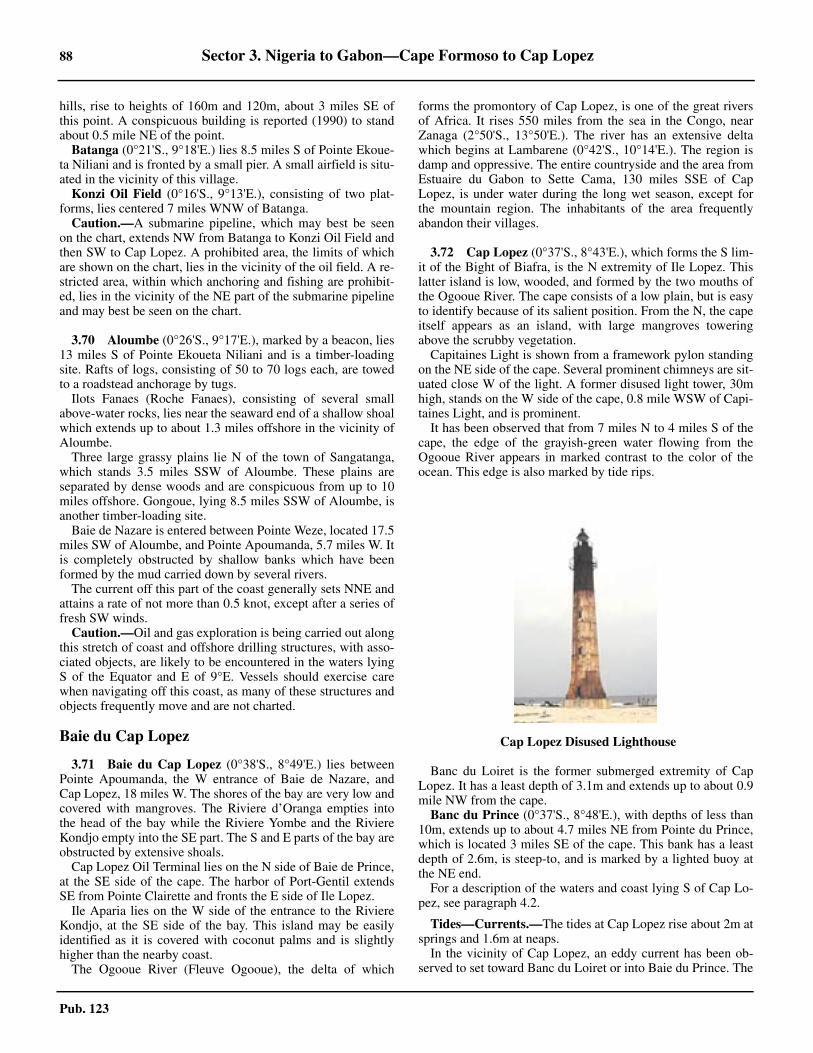
88 Sector 3. Nigeria to Gabon—Cape Formoso to Cap Lopez
Pub. 123
hills, rise to heights of 160m and 120m, about 3 miles SE ofthis point. A conspicuous building is reported (1990) to standabout 0.5 mile NE of the point.3.69 Batanga (0°21'S., 9°18'E.) lies 8.5 miles S of Pointe Ekoue-ta Niliani and is fronted by a small pier. A small airfield is situ-ated in the vicinity of this village.3.69 Konzi Oil Field (0°16'S., 9°13'E.), consisting of two plat-forms, lies centered 7 miles WNW of Batanga.3.69 Caution.—A submarine pipeline, which may best be seenon the chart, extends NW from Batanga to Konzi Oil Field andthen SW to Cap Lopez. A prohibited area, the limits of whichare shown on the chart, lies in the vicinity of the oil field. A re-stricted area, within which anchoring and fishing are prohibit-ed, lies in the vicinity of the NE part of the submarine pipelineand may best be seen on the chart.
3.70 Aloumbe (0°26'S., 9°17'E.), marked by a beacon, lies13 miles S of Pointe Ekoueta Niliani and is a timber-loadingsite. Rafts of logs, consisting of 50 to 70 logs each, are towedto a roadstead anchorage by tugs.3.70 Ilots Fanaes (Roche Fanaes), consisting of several smallabove-water rocks, lies near the seaward end of a shallow shoalwhich extends up to about 1.3 miles offshore in the vicinity ofAloumbe.3.70 Three large grassy plains lie N of the town of Sangatanga,which stands 3.5 miles SSW of Aloumbe. These plains areseparated by dense woods and are conspicuous from up to 10miles offshore. Gongoue, lying 8.5 miles SSW of Aloumbe, isanother timber-loading site.3.70 Baie de Nazare is entered between Pointe Weze, located 17.5miles SW of Aloumbe, and Pointe Apoumanda, 5.7 miles W. Itis completely obstructed by shallow banks which have beenformed by the mud carried down by several rivers.3.70 The current off this part of the coast generally sets NNE andattains a rate of not more than 0.5 knot, except after a series offresh SW winds.3.70 Caution.—Oil and gas exploration is being carried out alongthis stretch of coast and offshore drilling structures, with asso-ciated objects, are likely to be encountered in the waters lyingS of the Equator and E of 9°E. Vessels should exercise carewhen navigating off this coast, as many of these structures andobjects frequently move and are not charted.
Baie du Cap Lopez
3.71 Baie du Cap Lopez (0°38'S., 8°49'E.) lies betweenPointe Apoumanda, the W entrance of Baie de Nazare, andCap Lopez, 18 miles W. The shores of the bay are very low andcovered with mangroves. The Riviere d’Oranga empties intothe head of the bay while the Riviere Yombe and the RiviereKondjo empty into the SE part. The S and E parts of the bay areobstructed by extensive shoals.3.71 Cap Lopez Oil Terminal lies on the N side of Baie de Prince,at the SE side of the cape. The harbor of Port-Gentil extendsSE from Pointe Clairette and fronts the E side of Ile Lopez.3.71 Ile Aparia lies on the W side of the entrance to the RiviereKondjo, at the SE side of the bay. This island may be easilyidentified as it is covered with coconut palms and is slightlyhigher than the nearby coast.3.71 The Ogooue River (Fleuve Ogooue), the delta of which
forms the promontory of Cap Lopez, is one of the great riversof Africa. It rises 550 miles from the sea in the Congo, nearZanaga (2°50'S., 13°50'E.). The river has an extensive deltawhich begins at Lambarene (0°42'S., 10°14'E.). The region isdamp and oppressive. The entire countryside and the area fromEstuaire du Gabon to Sette Cama, 130 miles SSE of CapLopez, is under water during the long wet season, except forthe mountain region. The inhabitants of the area frequentlyabandon their villages.
3.72 Cap Lopez (0°37'S., 8°43'E.), which forms the S lim-it of the Bight of Biafra, is the N extremity of Ile Lopez. Thislatter island is low, wooded, and formed by the two mouths ofthe Ogooue River. The cape consists of a low plain, but is easyto identify because of its salient position. From the N, the capeitself appears as an island, with large mangroves toweringabove the scrubby vegetation.
Capitaines Light is shown from a framework pylon standingon the NE side of the cape. Several prominent chimneys are sit-uated close W of the light. A former disused light tower, 30mhigh, stands on the W side of the cape, 0.8 mile WSW of Capi-taines Light, and is prominent. 3.72 It has been observed that from 7 miles N to 4 miles S of thecape, the edge of the grayish-green water flowing from theOgooue River appears in marked contrast to the color of theocean. This edge is also marked by tide rips.
3.72 Banc du Loiret is the former submerged extremity of CapLopez. It has a least depth of 3.1m and extends up to about 0.9mile NW from the cape.
Banc du Prince (0°37'S., 8°48'E.), with depths of less than10m, extends up to about 4.7 miles NE from Pointe du Prince,which is located 3 miles SE of the cape. This bank has a leastdepth of 2.6m, is steep-to, and is marked by a lighted buoy atthe NE end.
For a description of the waters and coast lying S of Cap Lo-pez, see paragraph 4.2.
3.72 Tides—Currents.—The tides at Cap Lopez rise about 2m atsprings and 1.6m at neaps.3.72 In the vicinity of Cap Lopez, an eddy current has been ob-served to set toward Banc du Loiret or into Baie du Prince. The
3.72Cap Lopez Disused Lighthouse
Sector 3. Nigeria to Gabon—Cape Formoso to Cap Lopez 89
Pub. 123
ebb tidal current in the bay generally sets NNW at a distance ofup to 1 mile from the shore. It usually attains a rate of less thanl knot, but may reach 3 knots during the rainy season.3.72 Caution.—Strong eddies and discolored water may be en-countered in the vicinity of Banc de Loiret. Vessels are advisedto give Cap Lopez and this bank a wide berth.3.72 Oil and gas exploration and production are being carried outwithin the bay and in the waters lying off the W coast of Ile Lo-pez. Vessels should exercise care when navigating in the vicin-ity of the cape as numerous platforms, submarine pipelines,and associated structures are situated in this area.3.72 Several wrecks, some of which are dangerous, lie in the ap-proaches to the cape and may best be seen on the chart.
3.73 Cap Lopez Terminal (ELF Gabon Oil Terminal)(0°38'S., 8°43'E.) (World Port Index No. 46445) lies in Baie duPrince, on the SE side of Cape Lopez. An abandoned whalingstation is situated at the head of the bay and several oil tanksstand close N of it.3.73 Depths—Limitations.—The terminal, which should be ap-proached from the NE, consists of a loading platform with dol-phins which is connected to the shore by an L-shaped pier,340m long. The berth has a charted depth of 25m alongsideand can accommodate vessels of between 35,000 dwt and250,000 dwt, between 215m and 340m in length, and up to20.5m draft.
Pilotage.—Pilotage is compulsory. Vessels berth during day-light hours only but may depart at any time. Pilots can be con-tacted on VHF channel 72 and board in position 0°37'S,8°44'E. 3.73 Regulations.—Vessels should send an ETA 72 hours, 48hours, and 24 hours in advance via Libreville.3.73 A restricted area, which may best be seen on the chart, ex-tends up to 0.3 mile seaward from the N shore of Baie duPrince and from the E side of Cape Lopez. Only vessels pro-ceeding to the terminal may enter this area.3.73 Vessels must maintain a listening watch on VHF channel 16when approaching the terminal. During mooring and loadingoperations, vessels must maintain a listening watch on VHFchannel 72.3.73 Contact Information.—See the table titled Cap Lopez Ter-minal—Contact Information.
3.73 Anchorage.—An anchorage, designated for vessels waitingto proceed, is available in depths of about 65m, about 1.6 mileENE of the terminal pier.3.73 Caution.—A submarine pipeline, which may best be seenon the chart, extends E and NE from within Baie du Prince tothe Konzi Oil Field (0°16'S., 9°13'E.).3.73 A risk of local thunderstorms exists between January andApril.3.73 It has been reported that anchoring is prohibited in the vicin-ity of position 0°38'S., 8°44'E.
3.74 Pointe Clairette (0°41'S., 8°47'E.) is located 5 milesSE of the cape. A refinery, with a prominent flare, and a con-spicuous group of oil tanks are situated in the vicinity of thispoint.3.74 Prominent water towers stand 1.5 miles SSW and 3.2 miles Sof the point. An aeronautical radiobeacon is situated 1.4 milesSW of the point. A large and prominent factory building stands1 mile S of the point.3.74 Banc de l’Alcyon, with depths of less than 5m, extends up toabout 1.3 miles ENE from a point on the shore, 1 mile S ofPointe Clairette. Banc du Talisman, with depths of less than5m, extends up to about 1 mile NE from a point on the shoreclose S of Banc de l’Alcyon.
3.75 Port Gentil (0°41'S., 8°47'E.) (World Port Index No.46440), a deep sea port, extends S from Pointe Clairette. It issheltered from winds of all directions except the N.
3.75 Depths—Limitations.—Commercial Quay, the main wharf,fronts the shore, 0.6 mile SSW of Pointe Clairette. It is 450mlong and has depths of 9 to 11.0m alongside, with facilities forro-ro and container cargo. Vessels of up to 35,000 dwt and10.5m draft can be accommodated.3.75 A basin, 250m wide, lies at the N end of Commercial Quay.The quay on the S side of this basin is 280m long. It has depthsof 6 to 7m alongside and is mainly used by fishing vessels. TheN side of the basin is used by barges and small craft associatedwith the exploration and production of oil and gas. 3.75 Pointe Clairette (SER) Oil Terminal lies close SE of PointClairette and consists of two large dolphins and two mooringbuoys. It has a depth of 13m alongside and can accommodatetankers up to 80,000 dwt, 283m in length, and 10.1m draft.
Cap Lopez Terminal—Contact Information
Call signTotal Gabon Terminal
Cap Lopez Terminal
VHF VHF channel 16
Telephone 241-556-339
Facsimile 241-556-478
Pilots
VHF VHF channel 72
Port Gentil Home Page
http://www.ports-gabon.com
Cap Lopez Terminal—Contact Information
Port Gentil—Berth Information
Berth Length DepthMaximum Vessel
RemarksLOA Draft Size
Gentil Basin Berths
90 Sector 3. Nigeria to Gabon—Cape Formoso to Cap Lopez
Pub. 123
3.75 A naval base, with depths alongside of up to 5m and a ro-roberth for small vessels, is located in the vicinity of PointeAkosso.3.75 For further berthing information refer to table titled PortGentil—Berth Information. 3.75 Pilotage.—Pilotage is compulsory for vessels over 150 gt.Vessels should send a request for pilotage 12 hours prior toarrival. The pilots can be contacted on VHF channel 12. Pilotsgenerally board in position 0°39'S, 8°47'E.3.75 Pilots for Pointe Clairette (SER) Oil Terminal are providedby the station at Cap Lopez Oil Terminal.3.75 Regulations.—Vessels should send an ETA to the PortCaptain 48 hours and 24 hours in advance.3.75 The initial contact with Port Control should include thefollowing information:
1. Gross tonnage.2. Master’s name.3. Last port of call.
3.75 After contacting Port Control on VHF channel 16, vesselsshould maintain a listening watch on VHF channel 12.3.75 A restricted area, which may best be seen on the chart, ex-tends up to 2 miles seaward in the vicinity of Port-Gentil. Onlyvessels proceeding under pilotage to the harbor facilities mayenter this area.
3.75 Contact Information.—See the table titled Port Gentil—Contact Information. 3.75 Anchorage.—Anchorage for tankers can be obtained in adepth of 22m, mud, about 0.3 mile ESE of Pointe Clairette, butvessels must only proceed to this roadstead under pilotage. 3.75 Vessels awaiting a pilot can also anchor within the restrictedarea in a depth of 28m, mud, with Pointe Clairette 1.9 milesSW. 3.75 Caution.—A restricted area, within which anchoring andfishing are prohibited, lies centered 3 miles ENE of PointeClairette. This area, the limits of which may best be seen on thechart, has gas and oil development activity and contains nu-merous obstructions.3.75 Floating logs, up to 1.2m in diameter, may be encounteredadrift in the approaches to the harbor.3.75 Vessels should only turn S towards the port when well clearof Banc du Prince.3.75 Several wrecks, some of which are dangerous, lie in the ap-proaches to the port and may best be seen on the chart.3.75 It was reported (1994) that the navigation aids in the vicinityof the port are unreliable.3.75 It is reported that depths less than charted exist in the ap-proaches to Port Gentil.
Islands in the Bight of Biafra
3.76 The islands located in the Bight of Biafra, four innumber, lie nearly equidistant from each other along a lineextending SW from the head of the bight. The NE and largestisland is Isla de Bioko (Masie Nguema Biyogo) (Fernando
North Quay 180m — — — — Barges and small craft.
Fisherman Wharf 280m 6.0-7.0m — — — Fishing vessels.
Gentil Commercial Terminal
Main Quay 450m 9.0-11.0m — 11.0m 35,000 dwt Containers, ro-ro, general cargo, and petroleum-related cargo.
Sogara Oil Refinery
Refinery Berth 283m 13.0m 210m 11.0m 33,000 dwt Petroleum products, aviation fuel, and LPG.
Port Gentil—Berth Information
Berth Length DepthMaximum Vessel
RemarksLOA Draft Size
Port Gentil—Contact Information
Port Authority
Telephone241-553-811
241-553-812
Facsimile 241-555-303
Port Control
VHF VHF channel 16
Harbormaster
Telephone 241-015-64207
Tugs
VHF VHF channel 12
National Port Authority
Telephone
241-017-00048
241-017-01759
241-017-03735
E-mail [email protected]
Web site https://www.ports-gabon.com
Pilots
VHF VHF channel 12
Port Gentil—Contact Information
Sector 3. Nigeria to Gabon—Cape Formoso to Cap Lopez 91
Pub. 123
Poo); next is Ilha do Principe, then Ilha de Sao Tome, andfinally Pagalu (Annobon), the outer and SW island. 3.76 These islands and the Cameroun Mountains, on the main-land, are of volcanic origin. All of these features are in line andwere formed by the same upheaval. The basaltic and ferrugi-nous rocks, of which the islands are composed, and the blacksand found along the shores, are all evidences of volcanic ac-tivity.3.76 Isla de Bioko (Masie Nguema Biyogo) (Fernando Poo) andPagalu (Annobon) form a province of Equatorial Guinea.3.76 Ilha do Principe and Ilha de Sao Tome are an independent re-public.3.76 Caution.—Magnetic disturbances have been observed in theapproaches to the islands lying within the Bight of Biafra.
Isla de Bioko
3.77 Isla de Bioko (Masie Nguema Biyogo) (FernandoPoo) (3°30'N., 8°40'E.) is the most important of the four is-lands lying in the Bight of Biafra. A ridge of mountains tra-verses nearly the entire length of this island and culminates inthe magnificent cone of Pico de Santa Isabel (3°35'N.,8°46'E.), the summit of which is 3,007m high and almost con-stantly enveloped in clouds. It has been considered doubtfulwhether this volcanic cone can yet be considered extinct, assmoke is occasionally observed issuing from it.3.77 Winds—Weather.—On a clear day, the peak of Pico deSanta Isabel is sometimes visible from the W up to 100 milesseaward. However, the weather is sometimes so thick and hazythat the land cannot be seen. Due to the strong current settingE, vessels may even pass the island without sighting it.3.77 The rainy season lasts from April to October and the dry sea-son lasts from December to February. The prevailing winds aregenerally from the W. Mosquitoes, tsetse flies, and phalariaflies are prevalent in the cultivated areas of the island up to aheight of 600m, but only sand flies and mosquitoes are encoun-tered in the towns and villages.3.77 Tides—Currents.—The currents in the vicinity of Isla deBioko are variable. The Guinea Current, which sets so continu-ously toward the Bight of Biafra, impinges upon the shores ofIsla de Bioko and the island is therefore, to a certain extent,within its influence. During the winter months, the current gen-erally appears to set N off the W coast, E off the S coast, and Soff the E coast of the island. It usually attains a rate of 1 to 2knots. During the summer, the current generally appears to setN off the W and E coasts and W off the S coast of the island.However, the currents are variable in this locality and cannot berelied on.3.77 The general direction of the current setting along the N coastof the island is E. It is variable, but has been observed to attaina rate of 1.5 knots. When approaching the island, particularlyat night, this current should be given consideration.3.77 Caution.—It is reported (1993-2012) that the lights on Islade Bioka are unreliable and may be extinguished.3.77 Navigation in the claimed territorial waters, within 12 milesof the island, is also reported (1993) to be inadvisable.
3.77 Vessels should keep a lookout for pirates while in the waterslying off the coasts of Isla de Bioka.
3.78 Punta Europa (3°47'N., 8°43'E.), the NW extremityof Isla de Bioko, is a salient point surrounded by numerous talltrees. It is fronted by numerous above-water rocks which lieclose offshore. A light is shown from a framework tower stand-ing on the point, but both the light and the structure are ob-scured by trees on certain bearings. A prominent flare isreported (1990) to be situated close SW of the light.3.78 An aeronautical light is occasionally shown from a structurestanding in the vicinity of an airport, which is situated 2 milesS of Punta Europa.
Alba Gas Field (3°58'N., 8°33'E.), with three productionplatforms, is situated in an area centered about 16 miles NW ofPunta Europa. A submarine gas pipeline extends SE and Sfrom this area to a terminal standing close E of Punta Europa.It is marked in the vicinity of the shore by buoys. Anchoringnear this pipeline is prohibited.3.78 Caution.—Zafiro Offshore Oil Terminal (3°51'N., 8°07'E.)is situated about 37 miles W of Punta Europa (see paragraph3.24).
3.79 Punta Europa Marine Terminal (3°47'N., 8°43'E.)(World Port Index No. 46306), an oil loading facility, serves arefinery and lies close offshore, 0.7 mile ENE of Punta Europa. 3.79 Tides—Currents.—During the rainy season (April to Octo-ber), the current usually sets NW at a rate of up to 2.5 knots inthe vicinity of the terminal. It is usually weak and variableduring the dry season.3.79 Depths—Limitations.—There are two berths each, consist-ing of four mooring buoys, situated in a depth of 37m, andthere is also a LNG Terminal. A submarine pipeline extendsWSW from the berth to the shore. Tankers up to 110,000 dwtand 300m in length can be accommodated at the LNG Termi-nal. Berth No. 1 can accommodate vessels up to 210m inlength or 45,000 dwt, while Berth No. 2 can handle vessels upto 244m in length or 105,000 dwt. 3.79 Pilotage.—Pilotage is compulsory. Pilots, acting as mooringmasters, usually board about 1.5 miles NNE of the terminaland remain on board the vessels throughout the loadingoperations. Vessels berth and depart Terminal Berths Nos. 1and 2 during daylight hours only. The LNG Terminal allowsfor berthing and unberthing 24 hours. Vessels should not takeany instructions from Malabo Pilots or Malabo Port Control. 3.79 The pilots can be contacted by telephone (1-713-328-1288).3.79 Regulations.—Vessels should send an ETA via their agent 7days in advance or on departure from the last port. They shouldthen send an ETA via e-mail 72 hours, 48 hours, and 24 hoursin advance of arrival. LNG vessels should send an ETA via e-mail 96 hours, 48 hours, 24 hours, and 5 hours prior to arrival.3.79 Vessels should contact the terminal on VHF channel 16, 73,or 74, by e-mail, or by telephone when within 20 miles of theterminal. The terminal will then designate the method orworking frequency for further communications. 3.79 Contact Information.—See the table titled Punta
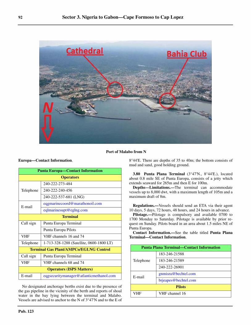
92 Sector 3. Nigeria to Gabon—Cape Formoso to Cap Lopez
Pub. 123
Europa—Contact Information.
3.79 No designated anchorage berths exist due to the presence ofthe gas pipeline in the vicinity of the berth and reports of shoalwater in the bay lying between the terminal and Malabo.Vessels are advised to anchor to the N of 3°47'N and to the E of
8°44'E. There are depths of 35 to 40m; the bottom consists ofmud and sand, good holding ground.
3.80 Punta Plana Terminal (3°47'N., 8°44'E.), locatedabout 0.8 mile SE of Punta Europa, consists of a jetty whichextends seaward for 265m and then E for 100m.3.80 Depths—Limitations.—The terminal can accommodatevessels up to 8,000 dwt, with a maximum length of 105m and amaximum draft of 8m.
3.80 Regulations.—Vessels should send an ETA via their agent10 days, 5 days, 72 hours, 48 hours, and 24 hours in advance.3.80 Pilotage.—Pilotage is compulsory and available 0700 to1700 Monday to Saturday. Pilotage is available by prior re-quest on Sunday. Pilots board in an area about 1.5 miles NE ofPunta Europa. 3.80 Contact Information.—See the table titled Punta PlanaTerminal—Contact Information.
3.79Port of Malabo from N
Punta Europa—Contact Information
Operators
Telephone
240-222-273-484
240-222-240-456
240-222-537-681 (LNG)
Terminal
Call sign Punta Europa Terminal
Punta Europa Pilots
VHF VHF channels 16 and 74
Telephone 1-713-328-1288 (Satellite, 0600-1800 LT)
Terminal Gas Plant/AMPCo/EGLNG Control
Call sign Punta Europa Terminal
VHF VHF channels 68 and 74
Operators (ISPS Matters)
E-mail [email protected]
Punta Plana Terminal—Contact Information
Telephone
183-246-21588
183-246-21589
240-222-26901
Pilots
VHF VHF channel 16
Sector 3. Nigeria to Gabon—Cape Formoso to Cap Lopez 93
Pub. 123
K5 Oil Center Terminal (3°46'N., 8°45'E.) is located about2 miles SE of Punta Europa, close W of the mouth of the RioSampaca. It is used as a supply base for the offshore oil and gasfields. The coast adjacent to the terminal is undeveloped andconsists of dense vegetation. The harbor consists of a jetty,which extends 400m N. The main berth at the head is 130mlong and has a depth of 8.5m alongside.3.80 Caution.—Due to insufficient information concerning thedepths in the approaches to these facilities and the aids to
navigation, vessels are advised to contact the terminals prior toarrival.3.80 Contact Information.— see Pilots, in the table titled PuntaPlana Terminal—Contact Information
3.81 Malabo (Santa Isabelle) (3°45'N., 8°47'E.) (WorldPort Index No. 46320) is situated on a plateau, 4.5 miles SE ofPunta Europa. It is not only the capital of the island, but is alsothe capital of Equatorial Guinea.3.81 Tides—Currents.—The tides rise about 1.8m at springs and1.4m at neaps.3.81 Depths—Limitations.—The entrance fairway has depths of18 to 22m over a width of about 90m.
3.81 The old part of the harbor (Muelle Vieja), at the SE side ofthe bay, has a quay, 250m long, with depths of 5m alongside. Apier, 45m in length and 15m wide, projects NW from the quay.Vessels usually moor and berth stern-to at this quay.3.81 The new part of the harbor (Muelle Nuevo), on the SW sideof the bay, has a bulk quay, 200m long, and a container quay350m long, with charted depths of 13.3 to 15.0m alongside. Aberth on the NE side of the bay is 350m long and has charteddepths alongside of 7 to 8.8m. 3.81 Vessels of up to 23,000 gt and 176m in length have beenhandled alongside in the port.3.81 A large floating dock, on a NW-SE axis, has been estab-lished in position 3°45'46.8''N, 8°46’21.6''E. 3.81 Aspect.—The town is fronted by Bahia de Malabo (Bahia deSanta Isabel) and stands at the top of some cliffs. Severalprominent buildings in the town may be identified fromseaward. 3.81 The Cathedral of Saint Isabel is conspicuous when approach-ing from the N, as it sits at the base of the harbor. Additionally,
Telephone 240-278-863
Punta Plana Terminal—Contact Information
Malabo—Berth Information
Berth Length Depth Remarks
K5 Oil Centre
K5 Oil Inner Dock (East) 160m 6.5m
Offshore, project/heavy, steel products, containers, and breakbulk.
K5 Oil Inner Dock (West) 102m 6m
K5 Oil Main Quay (East) — 9.5m
K5 Oil Main Quay (South) — —
K5 Oil Main Quay (West) 150m 7.5m
Malabo Port
Malabo Port East (New Pier) 177m — Offshore
Malabo Port East Quay 355m —
Ro/pax, Ro-ro/Lo-lo, containers, and breakbulk.Malabo Port East Ro-Ro — —
Malabo Port South Quay 295m —
Malabo Port West Quay 497m —
Old Port Quay — — Bunkers. Maximum vessel LOA of 175m. Maximum vessel size of 15,000 dwt.
Malabo MBM
MBM — — Clean products, dirty products, and bunkers.
3.81Steeples of the Cathedral of Saint Isabel
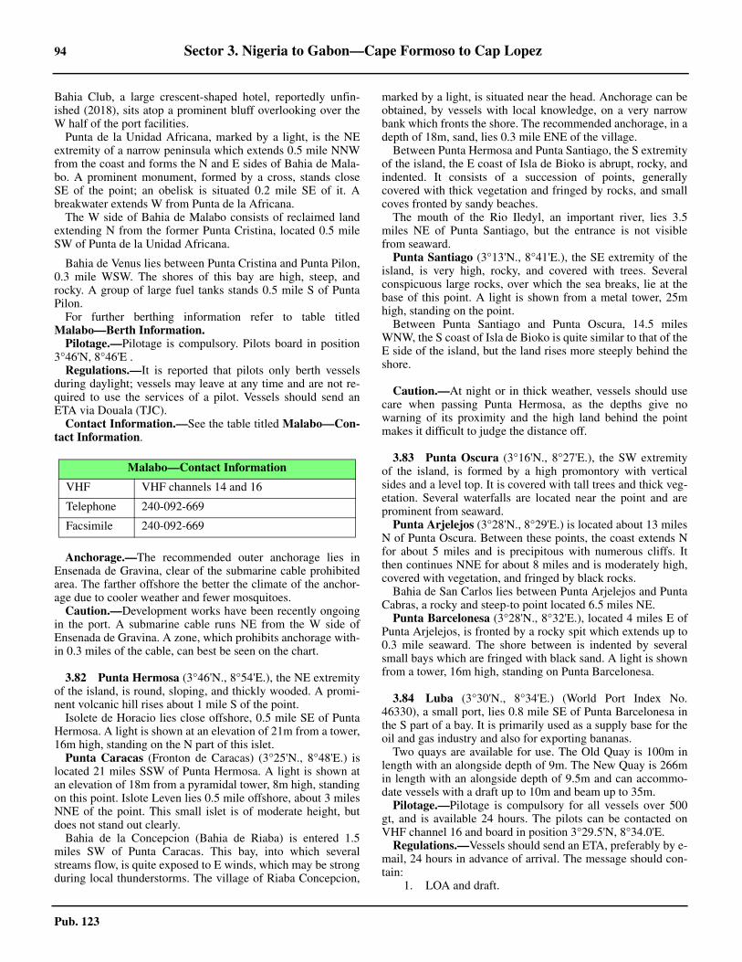
94 Sector 3. Nigeria to Gabon—Cape Formoso to Cap Lopez
Pub. 123
Bahia Club, a large crescent-shaped hotel, reportedly unfin-ished (2018), sits atop a prominent bluff overlooking over theW half of the port facilities. 3.81 Punta de la Unidad Africana, marked by a light, is the NEextremity of a narrow peninsula which extends 0.5 mile NNWfrom the coast and forms the N and E sides of Bahia de Mala-bo. A prominent monument, formed by a cross, stands closeSE of the point; an obelisk is situated 0.2 mile SE of it. Abreakwater extends W from Punta de la Africana.3.81 The W side of Bahia de Malabo consists of reclaimed landextending N from the former Punta Cristina, located 0.5 mileSW of Punta de la Unidad Africana.
3.81 Bahia de Venus lies between Punta Cristina and Punta Pilon,0.3 mile WSW. The shores of this bay are high, steep, androcky. A group of large fuel tanks stands 0.5 mile S of PuntaPilon.3.81 For further berthing information refer to table titledMalabo—Berth Information. 3.81 Pilotage.—Pilotage is compulsory. Pilots board in position3°46'N, 8°46'E . 3.81 Regulations.—It is reported that pilots only berth vesselsduring daylight; vessels may leave at any time and are not re-quired to use the services of a pilot. Vessels should send anETA via Douala (TJC).3.81 Contact Information.—See the table titled Malabo—Con-tact Information.
3.81 Anchorage.—The recommended outer anchorage lies inEnsenada de Gravina, clear of the submarine cable prohibitedarea. The farther offshore the better the climate of the anchor-age due to cooler weather and fewer mosquitoes.3.81 Caution.—Development works have been recently ongoingin the port. A submarine cable runs NE from the W side ofEnsenada de Gravina. A zone, which prohibits anchorage with-in 0.3 miles of the cable, can best be seen on the chart.
3.82 Punta Hermosa (3°46'N., 8°54'E.), the NE extremityof the island, is round, sloping, and thickly wooded. A promi-nent volcanic hill rises about 1 mile S of the point.3.82 Isolete de Horacio lies close offshore, 0.5 mile SE of PuntaHermosa. A light is shown at an elevation of 21m from a tower,16m high, standing on the N part of this islet.
Punta Caracas (Fronton de Caracas) (3°25'N., 8°48'E.) islocated 21 miles SSW of Punta Hermosa. A light is shown atan elevation of 18m from a pyramidal tower, 8m high, standingon this point. Islote Leven lies 0.5 mile offshore, about 3 milesNNE of the point. This small islet is of moderate height, butdoes not stand out clearly.3.82 Bahia de la Concepcion (Bahia de Riaba) is entered 1.5miles SW of Punta Caracas. This bay, into which severalstreams flow, is quite exposed to E winds, which may be strongduring local thunderstorms. The village of Riaba Concepcion,
marked by a light, is situated near the head. Anchorage can beobtained, by vessels with local knowledge, on a very narrowbank which fronts the shore. The recommended anchorage, in adepth of 18m, sand, lies 0.3 mile ENE of the village.3.82 Between Punta Hermosa and Punta Santiago, the S extremityof the island, the E coast of Isla de Bioko is abrupt, rocky, andindented. It consists of a succession of points, generallycovered with thick vegetation and fringed by rocks, and smallcoves fronted by sandy beaches.3.82 The mouth of the Rio Iledyl, an important river, lies 3.5miles NE of Punta Santiago, but the entrance is not visiblefrom seaward.3.82 Punta Santiago (3°13'N., 8°41'E.), the SE extremity of theisland, is very high, rocky, and covered with trees. Severalconspicuous large rocks, over which the sea breaks, lie at thebase of this point. A light is shown from a metal tower, 25mhigh, standing on the point.3.82 Between Punta Santiago and Punta Oscura, 14.5 milesWNW, the S coast of Isla de Bioko is quite similar to that of theE side of the island, but the land rises more steeply behind theshore.
3.82 Caution.—At night or in thick weather, vessels should usecare when passing Punta Hermosa, as the depths give nowarning of its proximity and the high land behind the pointmakes it difficult to judge the distance off.
3.83 Punta Oscura (3°16'N., 8°27'E.), the SW extremityof the island, is formed by a high promontory with verticalsides and a level top. It is covered with tall trees and thick veg-etation. Several waterfalls are located near the point and areprominent from seaward.3.83 Punta Arjelejos (3°28'N., 8°29'E.) is located about 13 milesN of Punta Oscura. Between these points, the coast extends Nfor about 5 miles and is precipitous with numerous cliffs. Itthen continues NNE for about 8 miles and is moderately high,covered with vegetation, and fringed by black rocks.3.83 Bahia de San Carlos lies between Punta Arjelejos and PuntaCabras, a rocky and steep-to point located 6.5 miles NE.3.83 Punta Barcelonesa (3°28'N., 8°32'E.), located 4 miles E ofPunta Arjelejos, is fronted by a rocky spit which extends up to0.3 mile seaward. The shore between is indented by severalsmall bays which are fringed with black sand. A light is shownfrom a tower, 16m high, standing on Punta Barcelonesa.
3.84 Luba (3°30'N., 8°34'E.) (World Port Index No.46330), a small port, lies 0.8 mile SE of Punta Barcelonesa inthe S part of a bay. It is primarily used as a supply base for theoil and gas industry and also for exporting bananas.
Two quays are available for use. The Old Quay is 100m inlength with an alongside depth of 9m. The New Quay is 266min length with an alongside depth of 9.5m and can accommo-date vessels with a draft up to 10m and beam up to 35m. 3.84 Pilotage.—Pilotage is compulsory for all vessels over 500gt, and is available 24 hours. The pilots can be contacted onVHF channel 16 and board in position 3°29.5'N, 8°34.0'E. 3.84 Regulations.—Vessels should send an ETA, preferably by e-mail, 24 hours in advance of arrival. The message should con-tain:
1. LOA and draft.
Malabo—Contact Information
VHF VHF channels 14 and 16
Telephone 240-092-669
Facsimile 240-092-669
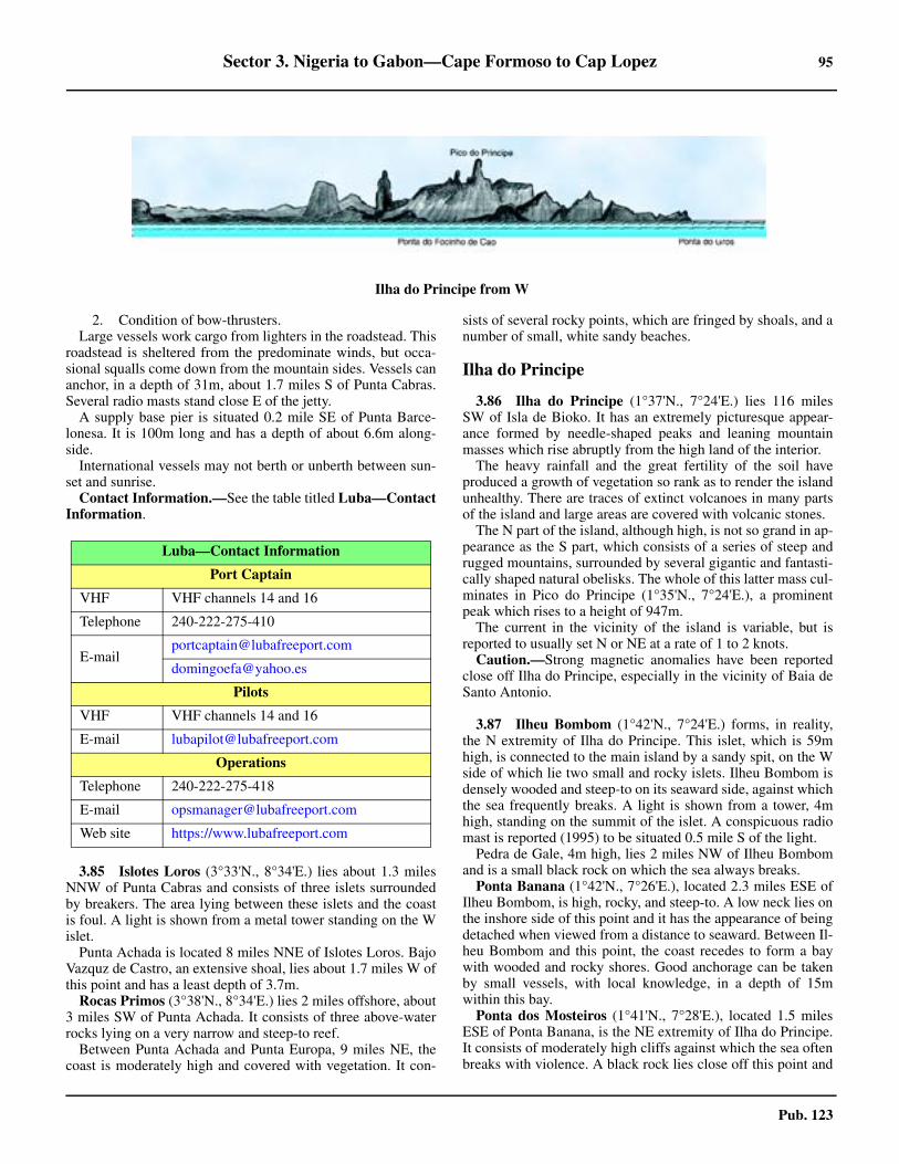
Sector 3. Nigeria to Gabon—Cape Formoso to Cap Lopez 95
Pub. 123
2. Condition of bow-thrusters.Large vessels work cargo from lighters in the roadstead. This
roadstead is sheltered from the predominate winds, but occa-sional squalls come down from the mountain sides. Vessels cananchor, in a depth of 31m, about 1.7 miles S of Punta Cabras.Several radio masts stand close E of the jetty.
A supply base pier is situated 0.2 mile SE of Punta Barce-lonesa. It is 100m long and has a depth of about 6.6m along-side.3.84 International vessels may not berth or unberth between sun-set and sunrise.3.84 Contact Information.—See the table titled Luba—ContactInformation.
3.85 Islotes Loros (3°33'N., 8°34'E.) lies about 1.3 milesNNW of Punta Cabras and consists of three islets surroundedby breakers. The area lying between these islets and the coastis foul. A light is shown from a metal tower standing on the Wislet.3.85 Punta Achada is located 8 miles NNE of Islotes Loros. BajoVazquz de Castro, an extensive shoal, lies about 1.7 miles W ofthis point and has a least depth of 3.7m.3.85 Rocas Primos (3°38'N., 8°34'E.) lies 2 miles offshore, about3 miles SW of Punta Achada. It consists of three above-waterrocks lying on a very narrow and steep-to reef.3.85 Between Punta Achada and Punta Europa, 9 miles NE, thecoast is moderately high and covered with vegetation. It con-
sists of several rocky points, which are fringed by shoals, and anumber of small, white sandy beaches.
Ilha do Principe
3.86 Ilha do Principe (1°37'N., 7°24'E.) lies 116 milesSW of Isla de Bioko. It has an extremely picturesque appear-ance formed by needle-shaped peaks and leaning mountainmasses which rise abruptly from the high land of the interior.3.86 The heavy rainfall and the great fertility of the soil haveproduced a growth of vegetation so rank as to render the islandunhealthy. There are traces of extinct volcanoes in many partsof the island and large areas are covered with volcanic stones.3.86 The N part of the island, although high, is not so grand in ap-pearance as the S part, which consists of a series of steep andrugged mountains, surrounded by several gigantic and fantasti-cally shaped natural obelisks. The whole of this latter mass cul-minates in Pico do Principe (1°35'N., 7°24'E.), a prominentpeak which rises to a height of 947m.3.86 The current in the vicinity of the island is variable, but isreported to usually set N or NE at a rate of 1 to 2 knots.3.86 Caution.—Strong magnetic anomalies have been reportedclose off Ilha do Principe, especially in the vicinity of Baia deSanto Antonio.
3.87 Ilheu Bombom (1°42'N., 7°24'E.) forms, in reality,the N extremity of Ilha do Principe. This islet, which is 59mhigh, is connected to the main island by a sandy spit, on the Wside of which lie two small and rocky islets. Ilheu Bombom isdensely wooded and steep-to on its seaward side, against whichthe sea frequently breaks. A light is shown from a tower, 4mhigh, standing on the summit of the islet. A conspicuous radiomast is reported (1995) to be situated 0.5 mile S of the light.3.87 Pedra de Gale, 4m high, lies 2 miles NW of Ilheu Bombomand is a small black rock on which the sea always breaks. 3.87 Ponta Banana (1°42'N., 7°26'E.), located 2.3 miles ESE ofIlheu Bombom, is high, rocky, and steep-to. A low neck lies onthe inshore side of this point and it has the appearance of beingdetached when viewed from a distance to seaward. Between Il-heu Bombom and this point, the coast recedes to form a baywith wooded and rocky shores. Good anchorage can be takenby small vessels, with local knowledge, in a depth of 15mwithin this bay.3.87 Ponta dos Mosteiros (1°41'N., 7°28'E.), located 1.5 milesESE of Ponta Banana, is the NE extremity of Ilha do Principe.It consists of moderately high cliffs against which the sea oftenbreaks with violence. A black rock lies close off this point and
3.83Ilha do Principe from W
Luba—Contact Information
Port Captain
VHF VHF channels 14 and 16
Telephone 240-222-275-410
Pilots
VHF VHF channels 14 and 16
E-mail [email protected]
Operations
Telephone 240-222-275-418
E-mail [email protected]
Web site https://www.lubafreeport.com
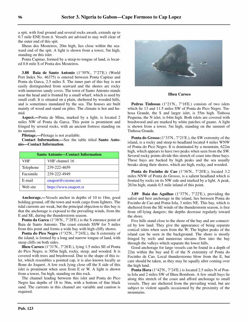
96 Sector 3. Nigeria to Gabon—Cape Formoso to Cap Lopez
Pub. 123
a spit, with foul ground and several rocks awash, extends up to0.7 mile ENE from it. Vessels are advised to stay well clear ofthe outer end of this spit.3.87 Ilheus dos Mosteiros, 20m high, lies close within the sea-ward end of the spit. A light is shown from a tower, 5m high,standing on this islet.3.87 Ponta Capitao, formed by a steep-to tongue of land, is locat-ed 0.8 mile S of Ponta dos Mosteiros.
3.88 Baia de Santo Antonio (1°39'N., 7°27'E.) (WorldPort Index No. 46375) is entered between Ponta Capitao andPonta da Garca, 2.5 miles S. The inner part of this bay is noteasily distinguished from seaward and the shores are rockywith numerous sandy coves. The town of Santo Antonio standsnear the head and is fronted by a small wharf, which is used bysmall craft. It is situated on a plain, sheltered by wooded hills,and is sometimes inundated by the sea. The houses are builtmainly of wood and stand on piles. The climate is hot and hu-mid.3.88 Aspect.—Ponta de Mina, marked by a light, is located 2miles NW of Ponta da Garca. This point is prominent andfringed by several rocks, with an ancient fortress standing onits summit.3.88 Pilotage.—Pilotage is not available.3.88 Contact Information.—See the table titled Santo Anto-nio—Contact Information.
3.88 Anchorage.—Vessels anchor in depths of 10 to 18m, goodholding ground, off the town and work cargo from lighters. Thetidal currents are weak, but the principal objection to this bay isthat the anchorage is exposed to the prevailing winds, from theE and SE, during the thunderstorm season. 3.88 Ponta da Garca (1°38'N., 7°28'E.) is the S entrance point ofBaia de Santo Antonio. The coast extends SSW for 5 milesfrom this point and forms a wide bay with high cliffy shores. 3.88 Ponta do Pico Negro (1°32'N., 7°24'E.), the S extremity ofthe island, is formed by a long and narrow tongue of land, withsteep cliffs on both sides.3.88 llheu Caroco (1°31'N., 7°26'E.), lying 1.5 miles SE of Pontado Pico Negro, is 305m high, rocky, steep, and wooded. It iscovered with trees and brushwood. Due to the shape of this is-let, which resembles a pointed cap, it is also known locally asBone do Joqueri. A low rock lying close off the S side of thisislet is prominent when seen from E or W. A light is shownfrom a tower, 5m high, standing on this rock.3.88 The channel leading between this islet and Ponta do PicoNegro has depths of 18 to 36m, with a bottom of fine blacksand. The currents in this channel are variable and caution isrequired.
3.88 Pedras Tinhosas (1°21'N., 7°18'E.) consists of two isletswhich lie 13 and 11.5 miles SW of Ponta do Pico Negro. Tin-hosa Grande, the S and larger islet, is 55m high. TinhosaPequena, the N islet, is 64m high. Both islets are covered withbrushwood and are marked by white patches of guano. A lightis shown from a tower, 5m high, standing on the summit ofTinhosa Grande.
3.88 Ponta do Grosso (1°33'N., 7°21'E.), the SW extremity of theisland, is a rocky and steep-to headland located 4 miles WNWof Ponta do Pico Negro. It is dominated by a mountain, 622mhigh, which appears to have two peaks when seen from the SW.Several rocky points divide this stretch of coast into three bays.These bays are backed by high peaks and the sea usuallybreaks along their shores, which are high, rocky, and wooded.
3.88 Ponta do Focinho de Cao (1°36'N., 7°20'E.), located 3.2miles NNW of Ponta do Grosso, is a salient headland which isfronted by rocks on its NW side and marked by a light. A peak,263m high, stands 0.5 mile inland of this point.
3.89 Baia das Agulhas (1°37'N., 7°22'E.), providing thesafest and best anchorage in the island, lies between Ponta doFocinho de Cao and Ponta Iola, 3 miles NE. This bay, which issheltered from the SE winds of the thunderstorm season, is freefrom off-lying dangers; the depths decrease regularly towardthe shore.3.89 Five hills stand close to the shore of the bay and are connect-ed by low land. They give the appearance of being separateconical islets when seen from the W. The higher peaks of theisland can be seen in the background. The shore is mostlyfringed by reefs and numerous streams flow into the baythrough the valleys which separate the lower hills. 3.89 Good anchorage for large vessels can be found in a depth of22m within the bay and E of the N extremity of Ponta doFocinho de Cao. Local thunderstorms blow from the E, butcare should be taken, as they may be squally after coming overthe high land.3.89 Ponta Hora (1°42'N., 7°24'E.) is located 2.5 miles N of Pon-ta Iola and 2 miles SW of Ilheu Bombom. A few small bays liealong this stretch of the coast and afford anchorage to smallvessels. They are sheltered from the prevailing wind, but aresubject to violent squalls occasioned by the proximity of themountains.
Santo Antonio—Contact Information
VHF VHF channel 16
Telephone 239-222-4659
Facsimile 239-222-4949
E-mail [email protected]
Web site https://www.enaport.st
3.88Ilheu Caroco
Sector 3. Nigeria to Gabon—Cape Formoso to Cap Lopez 97
Pub. 123
Ilha de Sao Tome
3.90 Ilha de Sao Tome (0°15'N., 6°37'E.) lies 82 milesSSW of Ilha do Principe. It is larger and of greater commercialimportance than Ilha do Principe, but has a lack of shelteredanchorages. Calms, variable winds, and strong currents prevailin the vicinity of this island.3.90 Ilha de Sao Tome is very mountainous and Pico de SaoTome, its summit, rises at the W side of the central part. Thissummit attains a height of 2,024m, but is often hidden byclouds. The sides of the peak are covered with dense forestsand numerous streams flow down them. The island is reportedto present three conspicuous peaks when seen from the NE at adistance of about 60 miles.3.90 The water in the vicinity of the island is very clear and thebottom can be seen distinctly in depths of 10m. During themonths of October and November, sperm whales are found offthe S end of the island.3.90 Tides—Currents.—When approaching Ilha de Sao Tomefrom the W, it is advisable, in order to take full advantage ofthe Guinea Current, for vessels to keep N of 1°30'N until thelongitude of 6°E has been attained. Vessels will thereby avoidthe South Equatorial Current, which is found in that latitude tothe W of the above meridian and, at times, even farther N. Thislatter current sometimes surrounds Ilha de Sao Tome and to theN of the island, in a longitude of about 6°E, has been found toset to the W. The current usually sets between NNE and NNWat the E side of the island.3.90 Caution.—It is reported (2004) that the navigation lights onIlha de Sao Tome are unreliable and may be missing or extin-guished.3.90 It was reported (1995) that several fish havens had been es-tablished up to 5 miles off the coasts of Ilha de Sao Tome. Theyare marked by red buoys which have bamboo masts and red oryellow flags.
3.91 Ponta do Cruzeiro (0°25'N., 6°40'E.) is the N ex-tremity of Ilha de Sao Tome. Between this point and PontaPraiao, 9.2 miles SE, the NE coast of the island is fronted by anextensive shoal with depths of less than 10m.3.91 Porto de Ferao Dias lies 0.8 mile ESE of Ponta do Cruzeiroand is fronted by a concrete pier. Large vessels can obtain an-chorage in a depth of 13m, sand, about 1 mile NE of Ponta doCruzeiro. 3.91 Ilheu das Cabras (0°25'N., 6°43'E.) lies 3.3 miles E of Pon-ta do Cruzeiro, near the edge of the coastal shoal bank. This is-land consists of two hills, about 90m high. A light is shownfrom a tower, 5m high, standing on the summit of the NE hill.
Baia de Ana Chaves (0°21'N., 6°44'E.) is entered betweenPonta Okedelrey, located 5 miles SE of Ponta do Cruzeiro, andPonta Sao Sebastiao, 1 mile SE. A hospital is situated on PontaOkedelrey and four radio masts, 30m high, stand close SW ofit. A conspicuous barracks building stands 0.3 mile SSW of thehospital. Range lights, indicating the approach to the anchorag-es, are shown from Ponta Okedelrey.3.91 A prominent fort, with white sides, stands on Ponta Sao Se-bastiao. A light is shown from a tower, 6m high, standing onthe fort.3.91 An area of reclaimed land projects 0.2 mile NNW from thispoint; its N end forms a quay, 200m long, with a depth of 3m
alongside.3.91 Although open to E and NE winds, the bay offers a conve-nient anchorage to small vessels, except during the thunder-storm season. Depths of less than 2m front the head of the bayand extend up to 0.3 mile seaward.3.91 Three detached banks, with depths of less than 5m, lie about2.7 miles NNE, 2 miles NNE, and 1.8 miles NE of Ponta SaoSebastio.3.91 Caution.—Unexploded ordnance is located in an area, witha depth of 7.5m, lying about 1.2 miles NE of Ponta Sao Sebas-tiao Light.3.91 A wreck, with a depth of 4.3m, lies about 0.7 mile E of PontaOkedelrey.
3.92 Sao Tome (0°21'N., 6°44'E.) (World Port Index No.46380), the capital and main port of the island, stands along asandy beach at the head of Baia de Ana Chaves. This town in-cludes several good buildings of modern construction. A cathe-dral and several churches are also prominent.3.92 Vessels can moor within and off the bay and work cargo vialighters. Vessels of moderate to deep draft should anchor, in anappropriate depth for their draft, on the alignment of the light-ed range shown from Ponta Okedelrey. It is reported (1986)that a vessel anchored, in a depth of 10m, mud and soft sand,about 0.7 mile NNE of Ponta Sao Sebastiao. There was goodholding ground, but poor protection from the open sea.3.92 A new terminal, which can accommodate containers andlarger cargo, is situated on the E side of Baia de Ana Chaves,on the end of the point, adjacent to the old colonial fort. Theport has two berths available. The Main Wharf is 200m inlength with an unreported depth and the Ana Chaves Ferry Pieris 80m long with an alongside depth of 1.5m.3.92 Pilotage is not available. However, the Port Authority andtugs can be contacted on VHF channel 16. 3.92 Vessels should send their ETA to the agent by facsimile orINMARSAT.3.92 Contact Information.—See the table titled Sao Tome—Contact Information.
3.92 Small vessels may anchor, in depths of less than 5m, withinthe inner part, but the sea breaks right across the bay after thun-derstorms or when the swell sets in.3.92 Caution.—The transit of the lighted range situated on PontaOkedelrey is not very restrictive and the structures are easily
Sao Tome—Contact Information
Harbor Master
VHF VHF channel 16
Tug
VHF VHF channel 16
Port Authority
Telephone 239-222-4659
Facsimile 239-222-4949
E-mail [email protected]
Web site https://www.enaport.st
98 Sector 3. Nigeria to Gabon—Cape Formoso to Cap Lopez
Pub. 123
concealed by the afternoon shadows.3.92 The long swell can often make lighterage operations diffi-cult.3.92 Vessels approaching from SE or S are advised to stay indepths of more than 35m and at least 1.5 miles offshore untilthey reach the lighted range leading to the anchorage.
3.93 Ponta Praiao (0°18'N., 6°46'E.), located 3.2 milesSSE of Ponta Sao Sebastiao, is the E extremity of Ilha de SaoTome. It is a salient point of moderate height and is surroundedby drying rocks. The point is located near the SE end of aplain, which constitutes the N part of the island, and the landrises steeply to the S of it. A number of radio masts, 33m high,stand close W of the point and a church, with a prominent tow-er, is situated 4.5 miles W of them.3.93 Ilheu de Santana (0°14'N., 6°46'E.) lies about 0.7 mile off-shore, 3.2 miles S of Ponta Praiao. It is 50m high, rocky, andcovered with bushes. A light is shown from a tower, 5m high,standing on this islet. The passage leading between this isletand the coast has no known dangers, but vessels are advised tokeep outside in order to avoid squalls which prevail inshore.3.93 Ponta do Io (Ponta Juntabudo) (0°07'N., 6°40'E.), promi-nent and cliffy, is located 13 miles SSW of Ponta Praiao. Thecoast between is irregular, with rocky heads and sandy bays.The land rises regularly from the shore and is intersected byseveral rivers. A light is shown from a tower, 5m high, standingon this point.
Sete Pedras (0°02'N., 6°38'E.) lies about 2.5 miles offshore,4.7 miles SSW of Ponta do Io. It consists of a group of rocks,the largest being 42m high. When seen from N, these rockshave the appearance of a vessel under sail. By day, these rocksdo not constitute a danger as they are steep-to, but they shouldnot be approached at night.
3.94 Ponta Homem da Capa (0°01'N., 6°31'E.), the S ex-tremity of Ilha de Sao Tome, is located 10 miles SW of Pontado Io. The coast between is indented by several bays. 3.94 Ilheu Gago Coutinho (0°00', 6°32'E.), known locally as Il-heu das Rolas, lies 1.2 miles S of Ponta Homem da Capa. It is96m high, covered with large trees, and is the largest of the is-lets lying off Ilha de Sao Tome. Two summits rise from this is-let; the N summit is a conical hill. A light is shown from atower with a dwelling, 9m high, standing near the center of theislet.3.94 Canal das Rolas separates llheu Gago Coutinho from the Sextremity of Sao Tome and should be used with great caution.3.94 Ponta Furada (0°14'N., 6°28'E.), the W extremity of the is-land, is located 14 miles NNW of Ponta Homem da Capa. Thecoast between is mostly rocky and cliffy, with a few beaches. Itis fringed by several small islets. The action of the sea haseroded an opening in the cliff face at the point. A light is shownfrom a tower, 5m high, standing on the point.3.94 Ponta Diogo Vaz (0°19'N., 6°30'E.), located 4.6 miles NNEof Ponta Furada, is rounded and steep-to. Enseada da Rosema,an indentation in the coast, lies between Ponta Figo, located 4miles NE of Ponta Diogo Vaz, and Morro Carregado, 4.7 milesNE. A small bay, which lies at the S end of this indentation, isreported to offer excellent anchorage with deep water. 3.94 Morro Carregado (0°25'N., 6°37'E.), rising 4.8 miles W ofPonta Cruzeiro, is high and peaked. The point on which it
stands is faced by steep, rocky cliffs. Lagoa Azul Light isshown from a tower, 5m high, standing on the point.3.94 Caution.—Magnetic anomalies have been reported to existin areas up to 10 miles SW of Ponta Praiao.
Pagalu
3.95 Pagalu (Annobon) (1°26'S., 5°37'E.) lies 105 milesSSW of Ilha de Sao Tome and is the smallest island lying in theBight of Biafra. It is mountainous and rises in varied andpicturesque forms to a considerable elevation in the centralpart, which is formed by three main peaks.3.95 Pico del Fuego (Pico do Figo), the northernmost of thesepeaks, is in the form of a truncated cone. It is 454m high andhas sides which are heavily wooded to within a short distanceof the summit. A small fresh water lake lies close to the foot ofthis peak, on its SW side.3.95 Pico del Centro, 629m high, rises 1 mile S of the lake. PicoSurcado, 654m high, rises 1 mile SE of Pico del Centro. 3.95 The prevailing winds, which are from the S and SW, blowwith moderate force and little variation throughout the year,enabling vessels under the shelter of the land to ride at anchorin a smooth sea. Only during the period from March to Sep-tember, when thunderstorms occur and strong E winds blow di-rectly into the anchorages, is any danger to be apprehended.The gloominess of the sky and the heavy thunder and lightningby which they are preceded always gives timely notice ofstorms.3.95 In the vicinity of the island, the current normally sets NWfrom November to April and NE from April to August. Thestrength varies and the current attains a rate of 0.5 knot to 1.8knots. The tidal currents are always very weak.3.95 A port basin, apparently under construction, is situated onthe N end of the island, near the E side of the main town of SanAntonio de Pale. The basin is protected by two largebreakwaters with the entrance approach made from the NW.Depths are unreported and the operational status of the port isunverified (March, 2020). 3.95 Caution.—The present charted position of Pagalu is basedon a 1991 ship’s report, which placed the island 1 mile E of itspreviously-charted position. Charted depths are also based onold surveys. Mariners should exercise caution when navigatingin the vicinity of Pagalu.
3.96 Punta del Palmar (1°24'S., 5°37'E.) is the N extremi-ty of Pagalu. A major airstrip terminates at the tip of the point,and is buttressed by rip-rap. 3.96 Punta Piramide, located 0.2 mile SE of Punta del Palmar, islow, sandy, and fronted by numerous rocks. Islote Piramide, thehighest and most conspicuous of these rocks, is bare and conical.3.96 San Antonio de Pale (1°24'S., 5°37'E.), the largest town onthe island, stands close S of Punta del Palmar. When approach-ing from seaward, the land in this vicinity is difficult to identi-fy, as the mountains are nearly always covered by clouds andthe town is not easily distinguished. At such times, Islote Pira-mide is a useful landmark. 3.96 Punta del Paso is located 1.2 miles SE of Punta del Palmar.The coast between is fronted by a shoal with depths of less than5m. This point rises almost perpendicularly to a bluff and hasneedle-shaped rocks on its seaward face.
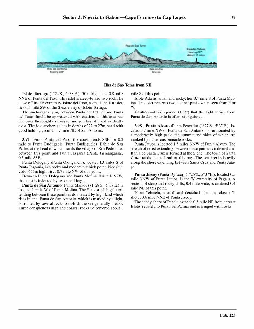
Sector 3. Nigeria to Gabon—Cape Formoso to Cap Lopez 99
Pub. 123
3.96 Islote Tortuga (1°24'S., 5°38'E.), 50m high, lies 0.8 mileNNE of Punta del Paso. This islet is steep-to and two rocks lieclose off its NE extremity. Islote del Paso, a small and flat islet,lies 0.3 mile SW of the S extremity of Islote Tortuga.3.96 The anchorages lying between Punta del Palmar and Puntadel Paso should be approached with caution, as this area hasnot been thoroughly surveyed and patches of coral evidentlyexist. The best anchorage lies in depths of 22 to 27m, sand withgood holding ground, 0.7 mile NE of San Antonio.
3.97 From Punta del Paso, the coast trends SSE for 0.8mile to Punta Dudjiguele (Punta Budjiguele). Bahia de SanPedro, at the head of which stands the village of San Pedro, liesbetween this point and Punta Jasgania (Punta Jasmangania),0.3 mile SSE.3.97 Punta Dologany (Punta Olonganchi), located l.3 miles S ofPunta Jasgania, is a rocky and moderately high point. Pico Sur-cado, 655m high, rises 0.7 mile NW of this point.3.97 Between Punta Dologany and Punta Mofina, 0.4 mile SSW,the coast is indented by two small bays. 3.97 Punta de San Antonio (Punta Manjob) (1°28'S., 5°37'E.) islocated 1 mile W of Punta Mofina. The S coast of Pagalu ex-tending between these points is dominated by high land whichrises inland. Punta de San Antonio, which is marked by a light,is fronted by several rocks on which the sea generally breaks.Three conspicuous high and conical rocks lie centered about 1
mile S of this point.3.97 Islote Adams, small and rocky, lies 0.4 mile S of Punta Mof-ina. This islet presents two distinct peaks when seen from E orW.3.97 Caution.—It is reported (1999) that the light shown fromPunta de San Antonio is often extinguished.
3.98 Punta Alvaro (Punta Penvadu) (1°27'S., 5°37'E.), lo-cated 0.7 mile NW of Punta de San Antonio, is surmounted bya moderately high peak, the summit and sides of which aremarked by numerous pinnacle rocks.3.98 Punta Jatupa is located 1.5 miles NNW of Punta Alvaro. Thestretch of coast extending between these points is indented andBahia de Santa Cruz is formed at the S end. The town of SantaCruz stands at the head of this bay. The sea breaks heavilyalong the shore extending between Santa Cruz and Punta Jatu-pa.
3.98 Punta Jiscoy (Punta Dyiscoj) (1°25'S., 5°37'E.), located 0.5mile NNW of Punta Jatupa, is the W extremity of Pagalu. Asection of steep and rocky cliffs, 0.4 mile wide, is centered 0.4mile NE of this point.3.98 Islote Yebatelu, a small and detached islet, lies close off-shore, 0.6 mile NNE of Punta Jiscoy.3.98 The sandy shore of Pagalu extends 0.5 mile NE from abreastIslote Yebatelu to Punta del Palmar and is fringed with rocks.
3.95Ilha de Sao Tome from NE

101
Pub. 123
4. Sector 4—Gabon to Angola—Cap Lopez to Ponta Albina
4.0Additional chart coverage may be found in NGA/DLIS Catalog of Maps, Charts, and Related Products (Unlimited Distribution).
SECTOR 4 — CHART INFORMATION
103
Pub. 123
SECTOR 4
GABON TO ANGOLA—CAP LOPEZ TO PONTA ALBINA
4.0 Plan.—This sector describes the SW coast of Africa fromCap Lopez to Ponta Albina, including the Congo River. It in-cludes the coasts of Gabon, The Congo (Republic of the Con-go), Angola (Cabinda), the Democratic Republic of the Congo(formerly Zaire), and Angola. The descriptive sequence is fromN to S.
General Remarks
4.1 The coast extending between Cap Lopez (0°37'S.,8°43'E.) and the Congo River, about 390 miles SE, is borderedby a narrow sandy beach on which the heavy surf breaks, par-ticularly during the dry season. The landing of boats is impos-sible on this coast, except in a few places, and then only onexceptionally fine days.
The lagoon entrances lying along this stretch of coast changeposition from year to year. These river mouths, which can beoften easily identified on radar, are marked by a discolorationof the water which extends, in places, up to more than 1 mileoffshore during the rainy season.
All of the small coastal indentations located S of the Equatorrecede in a SE direction and are protected on their W sides bylow tongues of land which are prolonged by shoals or spits.This peculiarity of form is probably caused by the combinedaction of the SW swell and the prevailing current. Most ofthese indentations are difficult to identify from seaward be-cause their low entrance points cannot be distinguished fromthe background.
Between Cap Lopez and the Congo River, the 200m curvelies nearly parallel with the coast at a distance of about 35miles offshore. Depths of 9 to13m are found about 2 miles off-shore. The bottom consists of mud in depths of over 100m, butconsists of sand closer inshore.
At Ponta das Palmerinhas, 185 miles SSE of the Congo Riv-er, the 200m curve approaches to within 5 miles of the coast.
The coast between the Congo River and Ponta das Salinas(12°50'S., 12°56'E.) provides several anchorages, the principalones being at Luanda, Porto Amboim (Benguela Velha), Lobi-to, and Baia de Benguela. Between Benguela and Tombua(Porto Alexandre), 210 miles SSW, great depths lie close to thecoast and anchorage is impossible, except in a few shelteredbays.
At a distance of 9 miles off the mouth of the Congo River,the surface water is still quite fresh. It is only partially mixedwith salt water at a distance of about 40 miles offshore. The re-sulting discoloration caused by the fresh water has, at times,been observed up to 300 miles from the coast.
Winds—Weather.—The SE trade wind system is the basicand most extensive wind regime in the area. Between 10°S and35°S, winds blow from the SE quadrant just about all yearround. These trade winds are most strongly developed between10°S and 25°S, where their frequency approaches 85 per cent.The average strength of these winds ranges from force 3 to 4 inthe waters of the N part to force 4 to 5 in the waters lying be-
tween 20°S and 30°S.Along most of this coast, a SW or Wbreeze (sea breeze) is prevalent from late morning until 2100hours. At about midnight, a SE or E breeze (land breeze) be-gins and becomes light and variable by morning.4.1 Within 100 miles of the coast, between Mayumba (3°24'S.,10°39'E.) and Cape Town, the SE trades are deflected and blowparallel to the coast, which results in a predominance of Swinds. To the N of 20°N and to the W of 10°W, in accordancewith the counterclockwise flow around the South Atlantic An-ticyclone, the winds take on a mostly E component.4.1 Intense tropical rain storms (thunderstorms), which areknown locally as tornadoes, develop in the region betweenCameroon and the River Congo. They mostly occur at the be-ginning (April and May) and end (October and November) ofthe rainy season. These storms generally last less than one hourbut may have wind gusts of 50 knots or more. The local name,tornado, should not be confused with the turbulent phenomenacommon in the United States.
Tides—Currents.—The range of tide is comparativelysmall along this coast, only exceeding 1.8m at springs in a fewof the river estuaries. The tidal currents are weak except in thevicinity of the few main rivers.
The Benguela Current flows N along the W coast of Africafrom the vicinity of the Cape of Good Hope to the Gulf ofGuinea. It attains rates of 1 knot within about 40 miles of thecoast and 0.4 to 0.8 knot farther offshore. This current is usual-ly stronger in December and January, when the SE trade windsare well established.
Between Cap Lopez and the Congo River, a current general-ly sets steadily in a NW direction, sometimes attaining a rate ofup to about 2 knots. It is formed by the Benguela Current andthe current which flows out of the Congo River. This resultantcurrent then turns W off Cap Lopez and becomes part of theSouth Equatorial Current. Inshore, the direction and rate of thecurrent are largely influenced by the formation of the land andthe winds. During steady N winds, which are very rare, the di-rection of the current is sometimes reversed.4.1 Regulations.—The Maritime Domain Awareness forTrade—Gulf of Guinea (MDAT—GoG) is a virtual reportingsystem for maritime security operating in the maritime area ofcentral and west Africa. The system includes voluntary report-ing from vessels and output from MDAT—GoG to contributeto maritime situational awareness. For further information, seeSouth Atlantic Ocean—Ship Reporting System in Pub. 160,Sailing Directions (Planning Guide) South Atlantic Ocean andIndian Ocean.
Caution.—During the rainy season, debris of all kinds maybe encountered at considerable distances from the coast and asfar N as Pagalu (1°26'S., 5°37'E.).
The light sandy color of the coast, as well as the extremehaziness of the atmosphere that generally prevails, may tend tocause mariners to overestimate the distance from the shore.Therefore, vessels are advised to maintain a prudent distancefrom the coast. This applies particularly in the area lying be-
104 Sector 4. Gabon to Angola—Cap Lopez to Ponta Albina
Pub. 123
tween Ponta das Salinas and Ponta de Sao Jose, 22 miles NE.Oil and gas development areas and fields, with associated
rigs, platforms, well heads, submarine pipelines, terminalbuoys, and storage vessels (FPSO), may be encountered off thecoasts described in this sector. The majority of these areas arewithin 50 miles of the coast, with many encompassed within arestricted area.
Vessels are cautioned that security in near-coastal waters ofSector 4 and within some of its ports is a serious and persistentissue. In recent years (2012-2022) numerous attacks by piratesand thieves have been reported and the occurrence of these in-cidents continues to rise despite an increased maritime securitypresence. These incidents can and have been reported withininland waterways and up to 100 miles offshore. They generallyoccur in areas of marine oil and gas production but have oc-curred while berthed in port. The International Maritime Bu-reau advises that the true number is probably higher due to alack of reporting by vessels.
Cap Lopez to Pointe Banda
4.2 Cap Lopez (0°37'S., 8°43'E.), the N extremity of IleLopez (Ile Mandji) has been previously described in paragraph3.73. Several flares are situated in the vicinity of the cape and aconspicuous flare, position approximate, stands on the shoreabout 57 miles SSE of them.
The coast between Cap Lopez and Ombue, 66 miles SSE, isuniformly thickly-wooded, while between Ombue and SetteCama, 64 miles SSE, it consists of large patches of bare groundalternating with thick jungle.
The mouth of the Animba River, which is an arm of the deltaof the Ogoove, lies 24 miles S of Cap Lopez. The river is notnavigable; its entrance is bordered on the W side by a long nar-row tongue of sand. During the rainy season, enormousamounts of fresh water discharge from the river mouth and ex-tend up to 4 or 5 miles offshore.
Grondin Oil Drilling Area (1°10'S., 8°40'E.), which maybest be seen on the chart, lies between 7 and 60 miles S of CapLopez. It extends up to 28 miles offshore and is marked bylighted buoys. A light shown from a structure standing (posi-tion approximate) 66 miles SSE of Cap Lopez indicates the SEend of this area.
Numerous wells, production platforms, drilling rigs, flares,submarine pipelines, and associated obstructions lie within thisdrilling area.
Caution.—A restricted area, which may best be seen on thechart, surrounds the Grondin Oil Drilling Area. Only vesselsemployed by the oil installations and tankers proceeding to andfrom the terminals may navigate within this area.
Drilling rigs and associated structures and obstructions,which may be unlit and not charted, are reported to be situatedwithin the restricted area.
A coastal fairway route, which may be used only by vesselsof less than 7 tons, and an area reserved for fishing are situatedadjacent to the shore within the Grondin Oil Drilling Area andmay best be seen on the chart.
4.3 Oguendjo Oil Terminal (1°27'S., 8°55'E.) (WorldPort Index No. 46446) lies within the Grondin Oil Drilling Ar-ea, 51 miles SSE of Cap Lopez. It consists of an SBM to which
a FSO (Fernan Vaz) is permanently moored. Production plat-forms are situated about 2 miles ENE and 1.5 miles SW of theterminal.
An access lane, 1.7 miles wide, leads in a NW direction tothe terminal and may best be seen on the chart. It has a leastdepth of 21.9m and extends about 11 miles from the anchoragearea. The terminal is located in a depth of 27.4m and can han-dle vessels up to 170,000 dwt and 18.2m draft. Vessels areberthed only during daylight but they may depart at any time.They are moored bow to bow with the storage tanker.
Pilotage.— Pilotage is compulsory. Pilots, who act asmooring masters, can be contacted on VHF channel 8 andboard about 2 miles S of Platform Charlie (0°30'S., 8°54'E.).While pilotage is available at all times, English speaking pilotsare only available from 0600 to 1800.
Regulations.—Vessels should send an ETA 7 days, 72hours, 48 hours, 24 hours, and 12 hours prior to arrival, statingthe following information:
1. ETA and name of local vessel agent2. Arrival draft fore and aft3. Quality and type of crude to be loaded4. 4. Estimated departure draft5. Last port of call6. Clean Bill of Health7. Distance from bow to manifold center8. Mooring equipment available on bow9. Confirmation that all essential systems are in good
working order10. If the vessel intends to load on top of existing cargo
and if so the quantity of cargo already held in tanks11. Confirmation that vessel can accept two (2) 16” dia
floating hoses fitted with a 150 ASA cam-lock couplingflangeAll tankers shall fly the Gabon national flag during daylight
while berthed at the terminal.4.3 Any change in ETA greater than 2 hours should be reportedas soon as possible. Vessels should send confirmation 24 hoursin advance of ability to load upon arrival and the expected timeof clean ballast discharge.4.3 Contact Information.—See the table titled Oguendjo OilTerminal—Contact Information.
A designated anchorage area, which may best be seen on thechart, lies centered 12 miles SE of the SBM.
Oguendjo Oil Terminal—Contact Information
Call sign Bon Bateau
VHF VHF channel 8
Telephone
241-550-641
241-550-642
241-550-643
Facsimile 241-550-647
Sector 4. Gabon to Angola—Cap Lopez to Ponta Albina 105
Pub. 123
4.4 Pointe Sainte-Catherine (1°53'S., 9°16'E.), a slightprojection, is fronted by a reef on which the sea breaks heavily.From the N, this point appears as an isolated clump of tall treesresembling an island, but from the S, the coast appears craggy.Some hills rising close S of the point give it a bold appearance.The land behind the shore, which is fringed by a beach, risesgently with clearings here and there.
Pointe Guega is located 4.5 miles N of Pointe Sainte-Cather-ine and fringed by rocks.
The village of Iguela, situated 4.5 miles SE of Pointe Sainte-Catherine, stands on a narrow strip of land which separatesLagune Ngobe from the sea. An airfield is situated near thisvillage.
Anchorage may be obtained in a depth of 9m SW of the vil-lage and about 1.5 miles offshore. Two beacons, each sur-mounted by a square, form a range which leads, clear ofdangers, in a NE direction toward the anchorage. From this an-chorage, the flagstaffs of some factories can be seen over thetops of the trees.
Lagune Ngobe, also known as Lagune d’Iguela, is an exten-sive lagoon which extends 20 miles SE to the mouth of the Riv-er Rembo Ngobe. The lagoon is used by small craft but theriver is encumbered with weeds.
Caution.—This part of the coast should not be approachedwithin a distance of about 4 miles by vessels without localknowledge.
4.5 Tchatamba Terminal (2°04'S., 9°10'E.), located 14miles SW of Pointe Sainte-Catherine, consists of a Mobile Off-shore Production Unit (MOPU). A submarine pipeline extendsfrom this production platform, Tchatamba A, to the shore forthe exporting of product at the Totalfina-Elf terminal near CapeLopez.4.5 There are two other platforms associated with this terminal.The Tchatamba West platform is situated 4 miles NW of Ter-minal A and the Tchatamba South platform lies 8.75 miles S ofTerminal A. It is reported (2013) that this terminal is decom-missioned.
4.6 Pointe Komandji (2°19'S., 9°36'E.) is located 34miles SE of Pointe Sainte-Catherine. The coast between re-cedes slightly and its aspect becomes more varied. A narrowbeach fronts the shore in some places and trees grow down tothe water in other places. In the S part of this stretch, themouths of rivers are indicated by narrow gaps in the trees. In-land, the country is more elevated and a few hills form a chainwhich runs parallel with the coast. The surf breaks heavilyalong this entire stretch of coast, except in a few places wherelanding may be effected in fine weather.
Pointe Komandji is rounded and difficult to identify from theW. However, several large green patches are located at the ex-tremity of Pointe de Gaca, 3 miles S, which help to distinguishthis locality. The neighboring coast is slightly elevated andcovered with brushwood, through which several streams wind.The large mouths of these streams form a succession of la-goons and marshes.
Drying rocks front the coast and the sea breaks about 1 mileoffshore. Several villages stand between Pointe Komandji andtwo points named Pointe Magamba and Pointe Milango, whichare located 4 miles and 7 miles, respectively, SSE.
Caution.—Oil and gas exploration is being carried out alongthis coastal area and vessels are warned that numerous wellheads, submerged pipelines, drilling rigs, and platforms may beencountered. Vessels should also exercise care when navigat-ing in this vicinity, as many of the associated structures and in-stallations are often moved and are not charted. In addition,some of the platforms and structures may be disused, aban-doned, and unlit.
4.7 Sette Cama (2°31'S., 9°45'E.), situated 15 miles SEof Pointe Komandji, stands at the root of a tongue of landwhich separates the channel leading to Lagune Ndogo from thesea. The seaward entrance of this channel lies 9 miles SE ofPointe Komandji. Several buildings stand in the vicinity ofSette Cama. In addition, a small airfield is situated nearby.
Lagune Ndogo, an extensive water area, extends 30 milesESE and is encumbered by numerous islets. Small craft associ-ated with oil and gas development navigate within this large la-goon.
Several rocky shoals front the coast and lie up to 1 mile off-shore. They have depths of less than 5m and are usuallymarked by breakers. A range, formed by two white beacons,indicates a passage which leads in a NE direction between theshoals to an anchorage. This passage is about 0.3 mile wideand provides access to vessels with drafts up to 5.8m. Vesselsare advised to stay at least 2 miles offshore until the range bea-cons have been identified. When approaching the anchorage,vessels are advised to keep the front beacon open a little N ofthe rear beacon. Large vessels can anchor, in a depth of 11m,on the range. Smaller vessels may proceed between the shoalsand anchor, in a depth of 6.7m, about 0.5 mile offshore. Thereis usually a heavy swell at the anchorage and the bottom is veryuneven with a rocky bottom. Landing should not be attempted.4.7 The N end of a chain of coastal hills, known as Monts SantoEspirito, rises to the S of Sette Cama and forms a good land-mark. Several large clearings are located S of these hills andgive the land a cultivated appearance.
Caution.—A dangerous wreck lies about 9 miles SW ofSette Cama.
4.8 Pointe Pedras (2°40'S., 9°53'E.), located 12 miles SEof Sette Cama, projects 1 mile from the line of the coast andshows up well from the S. Several isolated sand hills stand onthis point and slope S to the banks of the Riviere Massetche,which is the outlet of Lagune Massetche. A shoal patch, with adepth of 3.8m, lies about 3.5 miles SW of the point and severalrocks, some of which dry, lie up to about 2 miles NW of thepoint.
Between Pointe Pedras and Pointe Banda, 97 miles SE, the200m curve lies parallel with the coast and about 35 to 38miles offshore. The regularity of this depth curve may be of as-sistance to vessels during June, July, and August, when fogmay conceal the land.
The coast between Pointe Pedras and Pointe Matouti, 65miles SE, is low and wooded, with high flat ranges inland. Be-tween the latter point and Pointe Banda, 32 miles SE, it con-sists of a sandy beach backed by forests with inland ranges ofhills.
4.9 Gamba Oil Terminal (2°50'S., 10°00'E.) (World Port
106 Sector 4. Gabon to Angola—Cap Lopez to Ponta Albina
Pub. 123
Index No. 46453) is situated 10 miles SE of Pointe Pedras. Thetank farm stands 0.5 mile inland. Several conspicuous flaresare situated in its vicinity.
The offshore loading facility, consisting of an SBM, lies 5miles SW of the terminal and is connected to the shore by asubmarine pipeline. It is situated in a depth of 22m and canhandle vessels up to 150,000 dwt and 17.25m draft.
Pilotage.—Pilotage is compulsory within the restricted area.Pilots, who act as mooring masters, can be contacted on VHFchannel 6 or 12 and board in the anchorage area 3 miles NW ofthe SBM. Berthing can be undertaken 24 hours.
Regulations.—Vessels should send an ETA by facsimile ore-mail 96 hours, 72 hours, 48 hours, and 24 hours in advance.The 96-hour message should include the following informa-tion:
1. ETA and intended Notice Of Readiness.2. Cargo requirements in barrels and tanks to be loaded.3. Type, number, and safe working load of bowstoppers.4. Oil pollution certificate details.5. Last port of call.6. Owner, charterer, operator, flag, port of registry, and
year built.7. Summer dwt, gt, nt, loa, beam, and maximum sum-
mer draft.8. Master’s full name.9. Name of owner, operator, and charterer.10. Vessel’s Call sign.11. USCG identifier for bills of lading (if required).12. Arrival and departure drafts.13. Vessel inerted and IG system status. 14. Name of agent in Port Gentil.15. IMO Number.16. Vessel Tank Capacity.17. Vessel ISPS security level.18. Does vessel comply with the latest OCIMF Recom-
mendations of the Equipment Employed in the Bow Mooringof Conventional Tankers at Single Point Moorings?
4.9 Contact Information.—See the table titled Gamba OilTerminal—Contact Information.
Vessels should then contact the terminal on VHF channel 12when within range.
A restricted area, 4 miles wide, extends up to 7.5 miles SW
from the coast and encloses the offshore loading facility. Ves-sels are prohibited from entering this area without prior per-mission from the terminal. Fishing is prohibited within thisarea.
The designated anchorage area, with a depth of 25m, liesabout 2 miles NW of the SBM.
It is reported (2004) that a jetty situated 0.5 mile S of themain terminal light is radar conspicuous.
Caution.—The offshore loading facility is subject to heavyS to SW swells and operations are sometimes delayed. Localstorms, with violent winds, may be experienced between Octo-ber and May.
4.10 The Riviere Nyanga (2°58'S., 10°15'E.) lies with itsmouth located 29 miles SE of Pointe Pedras and runs parallelto the coast, behind a narrow spit of sand, for the last 2.5 miles.The entrance, which is fronted by a large and shallow bar, wasreported (1980) to be about 200m wide and radar conspicuous.It is reported to be dangerous as strong currents and a heavysea run across the bar. Within the bar there is a depth of 7m.
A light is shown from a structure standing 1.2 miles NW ofthe river entrance when a vessel is expected. A shoal, with aleast depth of 6m, lies about 4.5 miles SW of the light.
Vessels loading timber can anchor in depths of 12 to 13m,soft mud, about 1.5 miles SW of the light. It is reported (1980)that vessels up to 33,000 dwt and 176m in length can moor inthis roadstead. However, they may roll heavily due to a combi-nation of the NW current and the onshore SW wind.
Mayonami, a settlement located 5 miles above the rivermouth, is reported (2004) to be used as a base for oil field oper-ations.
4.11 Olowi Marine Terminal (3°08'S., 10°13'E.) (WorldPort Index No. 46452) lies 11 miles SSW of the mouth of theRiviere Nyanga. It consists of a FPSO (Knock Allan) connect-ed via pipeline to three production platforms. The FPSO ismoored in a depth of about 30m An anchorage is located 4miles W of the FPSO.
Pointe Panga (3°15'S., 10°32'E.) is located 24 miles SE ofthe mouth of the Riviere Nyanga. The coast between consistsof a sandy beach backed by marshy and brush-covered land. Itis featureless and has no prominent landmarks.
When seen from the N, Pointe Panga presents three or foursaddle-shaped summits and a conspicuous dark red cliff whichis surmounted by dense woods. It is one of the most prominentlandmarks along this part of the coast and cannot be mistaken.A rocky reef extends up to about 1 mile W of the point and asmall cove indents the shore close N of it. A pillar stands 2miles N of the point.
Baie de Mayumba is entered between Pointe Panga andPointe Matouti (Pointe Kouango), 12 miles SSE. It affordsgood shelter during S and SE winds. The shore consists of afine sandy beach which is fronted by breakers throughout al-most its entire length and is backed by wooded hills. LaguneMbanio empties via the Riviere Mayumba into the SE part ofthis bay.
4.12 Pointe Matouti (Pointe Kouango) (3°26'S., 10°38'E.)consists of several low hills which slope seaward. It terminatesin a low point which is surmounted by some huts. A prominent
Gamba Oil Terminal—Contact Information
Call sign Gamba Marine Terminal Control Room
VHF VHF channels 6 and 12
Telephone
241-0784-0095 (Duty Officer - 24 hours)
241-558-465 (office hours)
31-703-037-181 (office hours)
31-703-037-182 (office hours)
241-559-053 (AOH)
Facsimile317-0303-7164
241-558-577
E-mail [email protected]
Sector 4. Gabon to Angola—Cap Lopez to Ponta Albina 107
Pub. 123
radio mast stands near the village of Mayumba about 1 mileNE of the point.
Rocks, some of which dry, fringe the point and extend up toabout 0.2 mile seaward. A reef extends up to about 0.6 mileNNW from the point and an islet, just showing above the wa-ter, lies on it.
A hill rises E of Pointe Matouti and is surmounted by severalhouses which are conspicuous from the NW, but are not visiblefrom the S. The residency building, with a flagstaff, and somefactories are situated at Mayumba, 1 mile NE of Pointe Matou-ti. These buildings and the road leading to them are prominent.A small airfield is also situated in the vicinity.
Vessels loading timber can anchor in depths of 13 to 14m,sand and mud, about 1 mile offshore, 3.8 miles N of PointeMatouti. It is reported (1995) that vessels up to 19,500 dwt and156m in length can moor in this roadstead.
The coast between Pointe Matouti and Pointe Banda, 30miles SE, consists of a sandy beach which is backed by forests.Inland, the countryside rises to three ranges of hills. LaguneMbanio lies parallel to the coast, between 16 and 37 miles SWof Baie de Mayumba.
Rocher Noir, 1.5m high, lies close offshore, 5 miles SE ofPointe Matouti. Roche Massanga, a large black rock, lies about0.2 mile offshore, 3 miles SE of Rocher Noir. Both of theserocks are located on a coastal bank which extends up to 0.5mile seaward.
Pointe Banda to Pointe-Noire
4.13 Pointe Banda (3°49'S., 11°00'E.), located 30 milesSE of Pointe Matouti, is low, rounded, and difficult to distin-guish. It may be identified by Colline de la Table, 75m high,standing near the coast. This hill is surmounted by a clump ofpalm trees and a village. The village of Sainte-Marie, situated1.5 miles SSE of the point, is built on a hill, 20m high, and issomewhat prominent.
Anchorage may be taken by vessels, with local knowledge,in a depth of 11m, mud with good holding ground, about 1mile NNW of Pointe Banda.
Pointe Tshibobo (3°51'S., 11°01'E.), located 2.5 miles SSEof Pointe Banda, is surmounted by a round hill which is clearlyvisible from the S.
The border between Gabon and The Congo (Republic of theCongo) is situated in the vicinity of the entrance to the LaguneMekoundgi, about 9 miles SE of Pointe Tshibobo. The Congo(Republic of the Congo) is often referred to as Congo-Brazza-ville in order to distinguish it from the Democratic Republic ofthe Congo (formerly Zaire).
Caution.—Offshore drilling operations, including seismicsurveys, are in progress inshore of the 200m curve betweenPointe Banda and the mouth of the Riviere Massabi (5°02'S.,12°01'E.). Within this area, drilling rigs, platforms, wellheads,and submarine pipelines may be encountered. Vessels shouldexercise care when navigating in this vicinity as many of theassociated structures and installations are often moved and arenot charted. In addition, some of the platforms and structuresmay be disused, abandoned, and unlit.
4.14 Etame Terminal (3°45'S., 10°31'E.) (World Port In-dex No. 46451), is situated about 29 miles WNW of Pointe
Banco and consists of a Floating Production Storage and Off-loading (FPSO) facility. The FPSO (Petroleo Nautica) ismoored in a depth of 76m and tankers berth bow-to-bow withit. Vessels up to 150,000 dwt can be handled.
Pilotage.— Pilotage is compulsory within a 2-mile radius ofthe terminal. Pilots, who act as mooring masters, can be con-tacted on VHF channel 72 and board about 2 miles ENE of theFPSO. Berthing is carried out 24 hours.
Regulations.— Vessels should send an initial ETA on depar-ture from the previous port. Vessels should confirm the ETA 72hours, 48 hours, and 24 hours prior to arrival. Changes of 6hours or more to the ETA must be reported immediately.Changes of 1 hour or more to the ETA following the 24-hourmessage must be reported immediately. The initial ETA notifi-cation should include the following information:
1. Vessel’s name, Call sign, and INMARSAT numbers.2. Cargo requirements.3. Maximum loading rates4. Arrival draft fore and aft.5. Last port of call.6. Confirmation of clean bill of health.7. Any sickness on board.8. Distance in meters from the bow to the vessel’s load-
ing manifold.9. Length overall.10. A statement with respect to the ability of the vessel to
make a connection to floating hose 16 inch flange.11. A statement to the effect that the vessel can perform
closed loading.12. Confirmation that the vessel is equipped with a bow
stopper able to receive 76mm chain.13. Name and contact information of local agent.
4.14 Vessels should then contact the FPSO by VHF 2 hours priorto arrival and report their draft, trim, capacity for loading, de-tails of ballast and time required for discharge, maximum free-board, quality of inert gas, and any other relevant information.4.14 Vessels must maintain a continuous listening watch on VHFchannel 72 or other channel designated by the terminal. 4.14 Contact Information.—See the table titled Etame Oil Ter-minal—Contact Information.
Etame Oil Terminal—Contact Information
Call sign 9VHL7
VHF VHF channel 72
Telephone 472-262-7610
Facsimile 472-262-7611
Telex
581-456-507-710
581-456-507-711
581-456-507-712
E-mail [email protected]
Operators
Telephone 47-226-276-20
Facsimile 47-226-276-21

108 Sector 4. Gabon to Angola—Cap Lopez to Ponta Albina
Pub. 123
A restricted area, with a diameter of 2 miles, is centered onthe FPSO. Vessels are prohibited from entering this area with-out prior permission from the terminal.
There is no designated anchorage area. Vessels may anchoror drift at their discretion. The predominant current in the vi-cinity of the terminal sets ENE at a rate of 0.5 to 2 knots.
Caution.—Vessels approaching the terminal from the NWor SE are advised to stay well offshore to avoid the oil and gasdevelopment activities, most of which take place in depths ofless than 200m.
4.15 M’bya Terminal (3°53'S., 10°56'E.) (World Port In-dex No. 46454), an offshore loading facility associated with theLucina Oil Field and the M’Bya Oil Field, is situated 5 milesWSW of Pointe Tshibobo. It consists of a Floating Storage andOffloading (FSO) facility and numerous production platforms.The FSO (Mayumba) is moored in a depth of 28m; tankersberth bow-to-stern with it. Vessels up to 150,000 dwt can beaccommodated.4.15 In the vicinity of the terminal, the current generally setsNNW at velocities up to 1.5 knots.4.15 Pilotage.—Pilotage is compulsory. Pilots board 2 miles Wof the FSO in the waiting anchorage. Berthing available 24hours, with English-speaking pilots available from 0600 to1800.4.15 Regulations.—Vessels should send an ETA 7 days, 72hours, 48 hours, 24 hours, and 12 hours prior to arrival, statingany special requirements and/or quantity expected to be load-ed. 4.15 Contact Information.—See the table titled M’Bya Termi-nal—Contact Information.
4.15 The designated anchorage area, with a depth of 30m, is a cir-cular area with a radius of 1 mile centered on position 3°53.2'S,10°53.8'E. Anchoring outside the designated area is prohibitedwithin the terminal limits.
4.16 Dussafu Terminal (4°15'S., 10°49'E.) (World Port In-dex No. 46459), located approximately 27 miles SW of PointeTshibobo, is comprised of the FPSO BW Adolo and four sub-sea production wells. The BW Adolo is a 230,000 dwt tankermoored by 12 anchors. The export tanker limitation size is150,000 dwt. The area within a 3-mile radius of the terminal isrestricted and entry is prohibited without permission from thePort Authority. There is no designated anchorage for the termi-nal and mariners should take caution while on standby as thereare numerous submerged and superficial obstructions in the ar-ea which may not be charted. 4.16 Pilotage is compulsory. The pilot (along with the loadingmaster, surveyor, government representative, and customs offi-
4.17 The coast extending between Pointe Tshibobo andPointe Tchitembo, 29 miles SE, provides no shelter and ismoderately high. It rises from a thick belt of trees to one or tworanges of hills which are less elevated than those farther to theN. Depths of less than 10m lie up to 4 miles seaward of theshore in places.
The Riviere Conkouati (4°00'S., 11°14'E.) lies with itsentrance located about 15.5 miles SE of Pointe Tshibobo. Thesea breaks heavily about 0.4 mile off the mouth of this river,which is reported to be about 45m wide and radar conspicuous.Depths of less than 5m are reported to lie up to about 1.8 milesWSW of the mouth. The village of Conkouati is situated on atongue of sand at the S side of the river entrance.
The mouth of the Numbi River, lying 10 miles SE of theRiviere Conkouati, is also reported to be radar conspicuous. Itis narrow, discharges black water, and is encumbered withnumerous black rocks. The village of Madingo is situated closeinside the river mouth, on the E side.
Banc du Haoussa, with a least depth 8.8m, lies about 3.5miles W of the mouth of the Numbi River, in the approaches toBaie de Lekonde. This latter bay is a slight indentation in thecoast lying between the mouth of the Numbi River and PointeTchitembo (4°12'S., 11°23'E.), 4.5 miles S. The bay can onlybe entered by vessels with light drafts and local knowledge. Aheavy swell sometimes sets into the bay and landing is oftenvery difficult because of the surf.
Pointe Lekonde, located 1 mile N of Pointe Tchitembo, canbe identified by a small bare hill, with a flat top, which risesclose N of it. A conspicuous road descends from this hill. Anisolated shoal, with a depth of 6.4m, lies about 2.5 miles NWof this point.
Banc du Promethee extends up to about 3 miles W from thecoast between Pointe Lekonde and Pointe Tchitembo. It has
M’Bya Terminal—Contact Information
Call sign FSO Mayumba
VHF VHF channel 9
Telephone331-535-72265
870-773-202-866 (INMARSAT)
E-mail [email protected]
Dussafu Terminal (FPSO BW Adolo)
Sector 4. Gabon to Angola—Cap Lopez to Ponta Albina 109
Pub. 123
depths of less than 5m, but does not break in calm weather.4.17 An isolated shoal (existence doubtful), with a depth of 4m,lies about 4.2 miles W of Pointe Tchitembo.
4.18 The Kouilou River (4°29'S., 11°42'E.) lies 25 milesSE of Pointe Tchitembo (4°12'S., 11°23'E.). The coast betweenconsists of a sandy beach backed by forests. Several streamsflow into the sea along this stretch and a few small andlandlocked lagoons lie close inland.
A line of low, bare hills stands behind the forests and is bro-ken, 11.5 miles SE of Pointe Tchitembo, by a river. The villageof Longobonda is situated in the vicinity of this river. The coastbetween this village and the mouth of the Kouilou River con-sists of sand dunes which appear white from seaward and aresurmounted in a few places by palm trees.
Banc du Mulet (4°28'S., 11°33'E.), with a least depth of5.8m, lies centered about 8 miles W of the entrance to theKouilou River. It is a narrow ridge of hard sand and rock whichlies parallel to the coast. An obstruction is reported to lie about5 miles S of the N end of this bank.
The entrance to the Kouilou River is encumbered withshifting sand banks and a dangerous bar, on which the seabreaks heavily. During the rainy season, discolored waterextends up to 7 miles seaward of the river mouth. The villageof Bas Kouilou, a small wood-loading terminal, is situatedclose within the mouth of the river. Ocean-going vessels cananchor in a depth of 9m about 2 miles W of the river mouth,but cargo operations are frequently interrupted by winds,swells, and the condition of the bar.
Loango Oil Field (4°30'S., 11°16'E.), with several plat-forms, lies centered 26 miles W of the mouth of the KouilouRiver.
Ikalou Oil Field (4°33'S., 11°21'E.), with several wellheads, lies centered 22 miles WSW of the mouth of theKouilou River.
Kombi Oil Field (4°37'S., 11°21'E.), with several wellheads, lies centered 23 miles WSW of the mouth of theKouilou River.
Zatchi Oil Field (4°31'S., 11°25'E.), with several platforms,lies centered 17 miles W of the mouth of the Kouilou River.
Marine XI Oil Field (4°45'S., 11°34'E.), with several wellheads, lies centered 18 miles SSW of the mouth of the KouilouRiver.
Marine VI Oil Field (4°41'S., 11°24'E.), with several wellheads, lies centered 22 miles SW of the mouth of the KouilouRiver and close N of Yanga Oil Field.
Caution.—Several platforms, some of which have promi-nent flares, and numerous well heads are situated betweenabout 15 and 26 miles W of the mouth of the Kouilou River.These structures are connected by submarine pipelines whichmay best be seen on the chart.
4.19 Yombo Oil Terminal (4°27'S., 11°06'E.) (World PortIndex No. 46460), situated about 30 miles W of the mouth ofthe Kouilou River, consists of a Floating Production Storageand Offloading (FPSO) facility. The FPSO Conkouati ismoored in a depth of 100m and connected by submarine pipe-lines to production platforms which are situated 1.5 miles SSWand 1.5 miles SW of it. The terminal can handle vessels up to155,000 dwt, 280m in length, 53m beam, and 15m draft.
Pilotage.—Pilotage is compulsory for lifting vessels. Pilots,who act as mooring masters, can be contacted on VHF channel12 or 16 and board, weather permitting, in position 4°16'S,11°10'E. Berthing is carried out only during daylight hours butvessels may depart at any time. Tankers berth starboard side-toalongside the port side of the FPSO.
Regulations.—Vessels should send an ETA 72 hours, 48hours, and 24 hours in advance. The terminal should also benotified if the ETA changes by more than 2 hours. Vesselsshould then maintain a listening watch on VHF channel 12 and2182 kHz beginning 12 hours before arrival and contact the ter-minal when within range. 4.19 The 72-hour message should be sent by facsimile or e-mailto the terminal operators.
A restricted area, about 6 miles wide, surrounds the terminaland may best be seen on the chart. Vessels are prohibited fromentering this area without prior permission from the terminal.All tankers shall fly the Republic of Congo national flag duringdaylight while berthed at the terminal.4.19 Contact Information.—See the table titled Yombo Oil Ter-minal—Contact Information.
Anchorage.—A designated anchorage area, with a radius of3 miles, is centered on position 4°16.5'S, 11°12.0'E, about 12miles NNE of the FPSO, in a depth of 38m.
Caution.—Vessels approaching the terminal from the NWor SE are advised to stay well offshore to avoid the oil and gasdevelopment activities, most of which take place in depths ofless than 200m.4.19 Local storms, with violent winds for brief periods, may beexperienced between November and March, with January be-ing the month of greatest frequency.
4.20 Baie de Loango (4°38'S., 11°49'E.) is easilyidentified and lies between the entrance of the Kouilou River
Yombo Oil Terminal—Contact Information
VHF VHF channels 12 and 16
Telephone331-535-76296
331-535-76297
Facsimile 331-535-76296
Telex 581-463-711-419
E-mail [email protected]
Operators
Telephone
242-22-294-2470
242-22-294-1268
242-06-664-5807
33-1-535-76331 (VSAT)
Facsimile
242-22-294-1376
242-06-669-9919
33-1-535-76332 (VSAT)
E-mail [email protected]
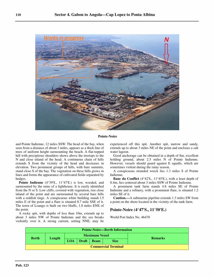
110 Sector 4. Gabon to Angola—Cap Lopez to Ponta Albina
Pub. 123
and Pointe Indienne, 12 miles SSW. The head of the bay, whenseen from a distance of about 3 miles, appears as a thick line oftrees of uniform height surmounting the beach. A flat-toppedhill with precipitous shoulders shows above the treetops to theN and close inland of the head. A continuous chain of hillsextends S from the vicinity of the head and decreases inelevation. Two prominent groups of hills, with bare summits,stand close S of the bay. The vegetation on these hills grows inlines and forms the appearance of cultivated fields separated byhedges.
Pointe Indienne (4°39'S., 11°47'E.) is low, wooded, andsurmounted by the ruins of a lighthouse. It is easily identifiedfrom the N or S. Low cliffs, covered with vegetation, rise closeinland of the point and are surmounted by several bare hillswith a reddish tinge. A conspicuous white building stands l.5miles E of the point and a flare is situated 0.7 mile SSE of it.The town of Loango is built on two bluffs, 1.8 miles ENE ofthe point.
A rocky spit, with depths of less than 10m, extends up toabout 3 miles NW of Pointe Indienne and the sea breaksviolently over it. A strong current, setting NNE, may be
experienced off this spit. Another spit, narrow and sandy,extends up to about 3 miles NE of the point and encloses a saltwater lagoon.
Good anchorage can be obtained in a depth of 8m, excellentholding ground, about 2.5 miles N of Pointe Indienne.However, vessels should guard against E squalls, which aresometimes violent during the rainy season.
A conspicuous stranded wreck lies 1.3 miles S of PointeIndienne.
Banc du Conflict (4°42'S., 11°45'E.), with a least depth of8.4m, lies centered about 3 miles SSW of Pointe Indienne.
A prominent tank farm stands 4.8 miles SE of PointeIndienne and a refinery, with a prominent flare, is situated 1.2miles SE of it.
Caution.—A submarine pipeline extends 1.3 miles SW froma point on the shore located in the vicinity of the tank farm.
Pointe-Noire (4°47'S., 11°50'E.)
World Port Index No. 46470
4.19Pointe-Noire
Pointe-Noire—Berth Information
Berth LengthMaximum Vessel
RemarksLOA Draft Beam Size
Commercial Terminal
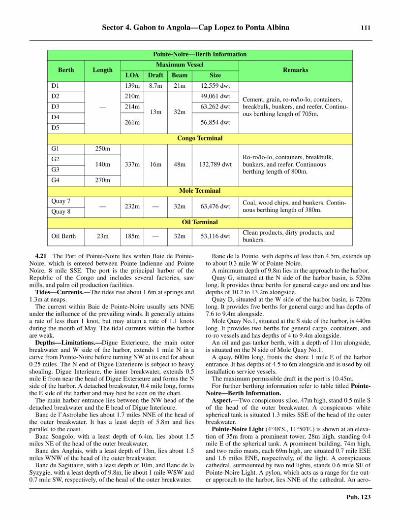
Sector 4. Gabon to Angola—Cap Lopez to Ponta Albina 111
Pub. 123
4.21 The Port of Pointe-Noire lies within Baie de Pointe-Noire, which is entered between Pointe Indienne and PointeNoire, 8 mile SSE. The port is the principal harbor of theRepublic of the Congo and includes several factories, sawmills, and palm oil production facilities.
Tides—Currents.—The tides rise about 1.6m at springs and1.3m at neaps.
The current within Baie de Pointe-Noire usually sets NNEunder the influence of the prevailing winds. It generally attainsa rate of less than 1 knot, but may attain a rate of 1.1 knotsduring the month of May. The tidal currents within the harborare weak.
Depths—Limitations.—Digue Exterieure, the main outerbreakwater and W side of the harbor, extends 1 mile N in acurve from Pointe-Noire before turning NW at its end for about0.25 miles. The N end of Digue Exterieure is subject to heavyshoaling. Digue Interieure, the inner breakwater, extends 0.5mile E from near the head of Digue Exterieure and forms the Nside of the harbor. A detached breakwater, 0.4 mile long, formsthe E side of the harbor and may best be seen on the chart.
The main harbor entrance lies between the NW head of thedetached breakwater and the E head of Digue Interieure.
Banc de l’Astrolabe lies about 1.7 miles NNE of the head ofthe outer breakwater. It has a least depth of 5.8m and liesparallel to the coast.
Banc Songolo, with a least depth of 6.4m, lies about 1.5miles NE of the head of the outer breakwater.
Banc des Anglais, with a least depth of 13m, lies about 1.5miles WNW of the head of the outer breakwater.
Banc du Sagittaire, with a least depth of 10m, and Banc de laSyzygie, with a least depth of 9.8m, lie about 1 mile WSW and0.7 mile SW, respectively, of the head of the outer breakwater.
Banc de la Pointe, with depths of less than 4.5m, extends upto about 0.3 mile W of Pointe-Noire.
A minimum depth of 9.8m lies in the approach to the harbor. Quay G, situated at the N side of the harbor basin, is 520m
long. It provides three berths for general cargo and ore and hasdepths of 10.2 to 13.2m alongside.
Quay D, situated at the W side of the harbor basin, is 720mlong. It provides five berths for general cargo and has depths of7.6 to 9.4m alongside.
Mole Quay No.1, situated at the S side of the harbor, is 440mlong. It provides two berths for general cargo, containers, andro-ro vessels and has depths of 4 to 9.4m alongside.
An oil and gas tanker berth, with a depth of 11m alongside,is situated on the N side of Mole Quay No.1.
A quay, 600m long, fronts the shore 1 mile E of the harborentrance. It has depths of 4.5 to 6m alongside and is used by oilinstallation service vessels.
The maximum permissible draft in the port is 10.45m.4.21 For further berthing information refer to table titled Pointe-Noire—Berth Information.
Aspect.—Two conspicuous silos, 47m high, stand 0.5 mile Sof the head of the outer breakwater. A conspicuous whitespherical tank is situated 1.3 miles SSE of the head of the outerbreakwater.4.21 Pointe-Noire Light (4°48'S., 11°50'E.) is shown at an eleva-tion of 35m from a prominent tower, 28m high, standing 0.4mile E of the spherical tank. A prominent building, 74m high,and two radio masts, each 69m high, are situated 0.7 mile ESEand 1.6 miles ENE, respectively, of the light. A conspicuouscathedral, surmounted by two red lights, stands 0.6 mile SE ofPointe-Noire Light. A pylon, which acts as a range for the out-er approach to the harbor, lies NNE of the cathedral. An aero-
D1
—
139m 8.7m 21m 12,559 dwt
Cement, grain, ro-ro/lo-lo, containers, breakbulk, bunkers, and reefer. Continu-ous berthing length of 705m.
D2 210m
13m 32m
49,061 dwt
D3 214m 63,262 dwt
D4261m 56,854 dwt
D5
Congo Terminal
G1 250m
337m 16m 48m 132,789 dwtRo-ro/lo-lo, containers, breakbulk, bunkers, and reefer. Continuous berthing length of 800m.
G2140m
G3
G4 270m
Mole Terminal
Quay 7— 232m — 32m 63,476 dwt Coal, wood chips, and bunkers. Contin-
uous berthing length of 380m.Quay 8
Oil Terminal
Oil Berth 23m 185m — 32m 53,116 dwt Clean products, dirty products, and bunkers.
Pointe-Noire—Berth Information
Berth LengthMaximum Vessel
RemarksLOA Draft Beam Size
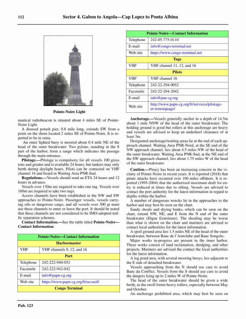
112 Sector 4. Gabon to Angola—Cap Lopez to Ponta Albina
Pub. 123
nautical radiobeacon is situated about 4 miles SE of Pointe-Noire Light.
A disused potash pier, 0.8 mile long, extends SW from apoint on the shore located 2 miles SE of Pointe-Noire. It is re-ported to be in ruins.
An outer lighted buoy is moored about 0.4 mile NE of thehead of the outer breakwater. Two pylons, standing in the Spart of the harbor, form a range which indicates the passagethrough the main entrance.
Pilotage.—Pilotage is compulsory for all vessels 100 grosstons and greater and is available 24 hours, but tankers may onlyberth during daylight hours. Pilots can be contacted on VHFchannel 16 and board in Waiting Area PNR-Sud.
Regulations.—Vessels should send an ETA 24 hours and 12hours in advance. 4.21 Vessels over 130m are required to take one tug. Vessels over160m are required to take two tugs. 4.21 Access channels have been established in the NW and SWapproaches to Pointe-Noire. Passenger vessels, vessels carry-ing oils or dangerous cargo, and all vessels over 300 gt mustuse these channels to enter or leave the port. It should be notedthat these channels are not considered to be IMO-adopted traf-fic separation schemes. 4.21 Contact Information.—See the table titled Pointe-Noire—Contact Information.
Anchorage.—Vessels generally anchor in a depth of 14.5mabout 1 mile NNW of the head of the outer breakwater. Theholding ground is good but rollers at this anchorage are heavyand vessels are advised to keep an underkeel clearance of atleast 3m.
Designated anchorage/waiting areas lie at the end of each ap-proach channel. Waiting Area PNR-Nord, at the SE end of theNW approach channel, lies about 4.5 miles NW of the head ofthe outer breakwater. Waiting Area PNR-Sud, at the NE end ofthe SW approach channel, lies about 1.75 miles W of the headof the outer breakwater.
Caution.—Piracy has been an increasing concern in the vi-cinity of Pointe-Noire in recent years. It is reported (2018) thatpirate attacks have occurred over 100 miles offshore. It is re-ported (1995-2004) that the authorized maximum draft for en-try is reduced at times due to silting. Vessels are advised tocontact the port authority for the latest information in regard todepths within the harbor.
A number of dangerous wrecks lie in the approaches to theharbor and may best be seen on the chart.
Sandy shoals and drying banks, which can be seen on thechart, extend NW, NE, and E from the N end of the outerbreakwater (Digue Exterieure). The shoaling may be worsethan what is shown on the chart and mariners are advised tocontact local authorities for the latest information.
A spoil ground area lies 1.5 miles NE of the head of the outerbreakwater, between Banc de l’Astrolabe and Banc Songolo.4.21 Major works in-progress are present in the inner harbor.These works consist of land reclamation, dredging, and otherprojects. Mariners are advised the contact the local authoritiesfor the latest information.
A log pond area, with several mooring buoys, lies adjacent tothe E side of detached breakwater.
Vessels approaching from the N should use care to avoidBanc du Conflict. Vessels from the S should use care to avoidthe dangers lying up to 2 miles W of Pointe-Noire.
The head of the outer breakwater should be given a wideberth, as the swell forms heavy rollers, especially between Mayand October.
An anchorage prohibited area, which may best be seen on
4.21Pointe-Noire Light
Pointe-Noire—Contact Information
Harbormaster
VHF VHF channels 9, 12, and 16
Port
Telephone 242-222-940-052
Facsimile 242-222-942-042
E-mail [email protected]
Web site https://www.papn-cg.org/fr/accueil/
Congo Terminal
Telephone 242-05-775-0110
E-mail [email protected]
Web site https://www.congo-terminal.net
Tugs
VHF VHF channel 11, 12, and 16
Pilots
VHF VHF channel 16
Telephone 242-22-294-0052
Facsimile 242-22-294-2042
E-mail [email protected]
Web site http://www.papn-cg.org/fr/services/pilotage-et-remorquage/
Pointe-Noire—Contact Information

Sector 4. Gabon to Angola—Cap Lopez to Ponta Albina 113
Pub. 123
the chart, extends up to 0.5 mile N of the main harbor entrance.Offshore oil drilling and production operations are in prog-
ress within the approaches to the port. Drilling rigs, platforms,well heads, and submarine pipelines may be encountered. Ves-sels should exercise care when navigating in the approaches, asmany of the associated structures and installations are oftenmoved and are not charted. In addition, vessels are prohibitedfrom anchoring or fishing in the vicinity of the submarine pipe-lines.
Oil production platforms may often be anchored within Baiede Pointe-Noire.
Pointe-Noire to the Riviere Massabi
4.22 The coast between Pointe-Noire and Pointe Mvasa, 7miles SE, consists of a narrow beach backed by a ridge, about12m high. The shore is exposed to the prevailing wind andswell and the surf breaks very heavily along it.
Pointe M’vassa (Fausse Pointe Noire) (4°53'S., 11°54'E.) is7m high, rocky, and steep. The mouth of Lagune M’Vassa liesclose N of this point.
The N end of Lagune Malonda lies about 11 miles SE ofPointe-Noire. This lagoon lies close inland and extends parallelto the coast for about 4 miles.
The Riviere Massabi (5°02'S., 12°01'E.) lies 19 miles SE ofPointe-Noire. Its mouth, which forms a common entrance withthe Riviere Loeme, is only about 60m wide and has a leastdepth of 0.5m. Anchorage can be taken, by vessels with localknowledge, in a depth of 10m, fairly good holding ground,about 1 mile offshore. This stretch of coast has very few prom-inent landmarks.
The border between The Congo (Republic of Congo) andAngola (Cabinda) is situated in the vicinity of the mouth of theRiviere Massabi and is marked by beacons.
4.23 Djeno (4°55'S., 11°56'E.), a submarine pipeline land-ing terminal, is situated 10 miles SE of Pointe-Noire. A light,which indicates the offshore oil installations, is shown from aframework pylon structure, 17m high, standing on the shore. Aprominent radio mast, with an elevation of 110m high, is situ-ated close to the light.
Djeno Offshore Terminal (4°56'S., 11°54'E.) (World PortIndex No. 46472) consists of two loading SBMs, which aremoored about 2 miles SW of Djeno, in a depth of 23m. The ter-minal can handle vessels of between 40,000 and 140,000 dwt,up to 320m in length, and up to 16m draft. Partially-loadedvessels up to 240,000 dwt can also be handled.
The terminal is approached from the NW via Baie de Pointe-Noire. The prevailing current in the vicinity of the terminalruns strongly NW.
Pilotage.—Pilotage is compulsory. Pilots, who act as moor-ing masters, are provided by the station at the Port of Pointe-Noire (see paragraph 4.21). They can be contacted on VHFchannel 16 and board about 2.3 miles W of the head of the out-er main breakwater. Pilotage for departures should be request-ed from Pointe Noire, as follows:
1. Daytime departures—3 working hours before theETD.
2. Night departures—before 1700 local time.3. Sunday departures—before 1200 local time the previ-
ous day.Regulations.—Vessels should send an ETA 72 hours, 48
hours, and 24 hours in advance. A restricted area, with a radius of 1 mile, is centered on the
SBMs. Vessels are prohibited from entering this area withoutprior permission from the terminal.4.23 Contact Information.—See the table titled Djeno OffshoreTerminal—Contact Information.
Anchorage.—An outer designated anchorage area (waitingarea) is situated about 4.5 miles NW of the head of the Pointe-Noire outer breakwater (see paragraph 4.21).
Caution.—If weather conditions are poor, the maximum au-thorized draft allowable for entry may be reduced.
4.24 Yanga Oil Field (4°44'S., 11°24'E.) lies centered 33miles WNW of Djeno. A prominent flare is located at the cen-tral platform.
Kitina Oil Field (4°55'S., 11°23'E.) lies centered 9 milesSSW of Yanga Oil Field.
Tchibouela Oil Field (4°54'S., 11°40'E.) lies centered 17miles W of Djeno.
Tchendo Oil Field (5°02'S., 11°39'E.) lies centered 18 milesWSW of Djeno.
Emeraude Oil Field (5°03'S., 11°47'E.), an extensive fieldwith several platforms, lies centered 11 miles SW of Djeno.
Likouala Oil Field (5°07'S., 11°46'E.), an extensive field,lies centered 22 miles SW of Djeno.
Caution.—Restricted areas, the limits of which may be seenon the chart, enclose some of the above oil fields. Vessels with-out permission are prohibited from navigating within these ar-eas.
Numerous submarine pipelines and submarine cables lie inthe vicinity of the above oil fields and may best be seen on thechart. Vessels are prohibited from anchoring or fishing in theirvicinity.
Oil and gas exploration and production operations are inprogress in the vicinity of the above offshore fields. Numerousdrilling rigs, platforms, and well heads may be encountered.Vessels should exercise care when navigating in this area asmany of the associated structures and installations are oftenmoved and may be unlit or not charted.
4.25 N’Kossa Oil Field (5°15'S., 11°34'E.) lies 30 milesSW of Djeno. It consists of two production platforms and alarge production barge, which displays a conspicuous flare atan elevation of 83m.
N’Kossa Terminal (5°15'S., 11°36'E.) (World Port IndexNo. 46473), operated by Elf Congo, consists of two FloatingStorage and Off loading (FSO) vessels. One FSO (N’Kossa 1),is used for crude oil storage; the second FSO (N’Kossa 2),which is moored 2 miles NW, is used for LPG storage. Vesselsup to 280,000 dwt can be handled at N’Kossa 1, which ismoored with a bow turret in a depth of 126m.
Djeno Offshore Terminal—Contact Information
VHF VHF channels 11 and 14
Telephone 241-222-942-041

114 Sector 4. Gabon to Angola—Cap Lopez to Ponta Albina
Pub. 123
4.25 Pilotage.—Pilotage is compulsory. Pilots, who act as moor-ing masters, can be contacted on VHF channel 9 and boardabout 3 miles N of the terminal. 4.25 Regulations.—Berthing is done only during daylight hoursbut vessels may depart at any time. Tankers moor bow to sternin tandem with the FSO. Vessels should send an ETA 72 hours,48 hours, and 24 hours in advance.4.25 A designated tanker waiting area, with a radius of 3 miles, iscentered 13 miles NW of the N’Kossa Terminal. Vessels wait-ing in this area must not allow themselves to drift E of11°27.5'E. A designated chemical tanker (waiting area) an-chorage, with a radius of 1.5 miles, is centered 12 miles W ofDjeno. This anchorage is also used by vessels proceeding toDjeno Offshore Terminal (see paragraph 4.23).4.25 There is no designated outer anchorage area due to the depthof water.4.25 A restricted area, which may best be seen on the chart, sur-rounds the oil field and the terminal. Vessels are prohibitedfrom entering this area without prior permission from the ter-minal.
The Riviere Massabi to the Congo River
4.26 Between the Riviere Massabi (5°02'S., 12°01'E.) andthe mouth of the Congo River, 62 miles SSE, the prevailingnature of the bottom near the coast and in depths of up to 20mis mud. Farther offshore, the bottom consists of gray muddysand, sand and gravel, and sand mixed with coral. The latter ismore general in the mouth of the Congo River.
A dangerous wreck, consisting of a former drilling platform,lies 11.5 miles SW of the mouth of the Riviere Massabi
Caution.—An extensive area, where oil and gas explorationand production operations are in progress, extends up to about40 miles offshore between the mouth of the Riviere Massabiand the mouth of the Congo River. Numerous drilling rigs,platforms, submarine pipelines, and wellheads may be encoun-tered. Vessels should exercise care when navigating in this areaas many of the associated structures and installations are oftenmoved and may be unlit or not charted.
4.27 Kuito Oil Field (5°28'S., 11°32'E.) lies centered 40miles SW of the mouth of the Riviere Massabi and about 10miles S of N’Kossa Oil Field.
Alima Terminal (5°23'S., 11°27'E.) consists of the FPU Ali-ma. Vessels not calling on the terminal should maintain a mini-mum 5-mile clearance from the FPU.
4.28 Takula Oil Field (5°15'S., 11°50'E.) lies centered 17miles SW of the mouth of the Riviere Massabi and consists ofseveral platforms, some with prominent flares.
Wamba Oil Field (5°12'S., 11°50'E.) lies centered 15 milesSW of the mouth of the Riviere Massabi and adjacent to the Nside of Takula Oil Field.
Banzala Oil Field (5°11'S., 11°55'E.) lies centered 10 milesSW of the mouth of the Riviere Massabi and 6 miles NE ofTakula Oil Field.
Numbi Oil Field (5°19'S., 11°55'E.) lies centered 17 milesSSW of the mouth of the Riviere Massabi and 6 miles SE ofTakula Oil Field.
Nemba Oil Field (5°24'S., 11°40'E.) lies centered 31 miles
SW of the mouth of the Riviere Massabi and 13 miles SW ofTakula Oil Field.
Lombo Oil Field (6°52'S., 12°24'E.) lies centered 30 milesSW of the mouth of the Riviere Massabi and 4 miles NNW ofNemba Oil Field.4.28 Caution.—Restricted areas, the limits of which may be seenon the chart, enclose some of the above oil fields. Vessels with-out permission are prohibited from navigating within these ar-eas.
Several production platforms are situated within the aboveoil fields. In addition, numerous submarine pipelines, subma-rine cables, and well heads lie in the vicinity of the above oilfields and may best be seen on the chart. Vessels are prohibitedfrom anchoring or fishing in their vicinity.
4.29 Takula Oil Terminal (5°13'S., 11°47'E.) (World PortIndex No. 46485) is situated 16 miles W of the mouth of theRiviere Massabi and at the NW side of the Takula Oil Field.The terminal, which can handle vessels up to 300,000 dwt,consists of an SBM moored in a depth of 69m.4.29 Pilotage.—Pilotage is compulsory. Pilots, who act mooringmasters, can be contacted by VHF and board about 1.5 milesNW of the SBM. Berthing is carried out only during daylighthours but vessels may depart at any time.
Anchorage.—A designated anchorage area about 1.5 milesNW of the SBM.
Caution.—A restricted area, which may best be seen on thechart, encloses the oil field and terminal. Vessels are prohibitedfrom entering this area without prior permission.
Takula Terminal is only used in an emergency as oil is pres-ently stored and exported via the Malongo Terminal.
4.30 The Rio Chiloango (5°12'S., 12°08'E.), with itsmouth lying 12 miles SSE of the Riviere Massabi, is indicatedby several red hills which fall steeply to the beach.Discoloration of the sea has been observed up to about 7 milesseaward of the entrance to this river. The bar fronting the riverentrance can be crossed by small vessels with local knowledge,but it is dangerous because of the surf.
The coast between the Riviere Massabi and the Rio Chiloan-go rises to moderately high hills. A ridge of hills extends Sfrom the vicinity of the Rio Chiloango to the mouth of theCongo River. It stands between 5 and 8 miles inland and attainsheights of 120 to 156m.
Ponta Cacongo (Ponta de Landana) (5°14'S., 12°07'E.) islocated 2.5 miles S of the mouth of the Rio Chiloango. It isconspicuous and presents a bold and bluff appearance. PontaCacongo Light is shown from a square tower with a dwelling,9m high, standing on the point. A prominent hospital, with ared roof, is situated 0.5 mile NNE of the light.
Baia de Cacongo (Enseada Landana) (5°14'S., 12°09'E.)lies between the mouth of the Rio Chiloango and Ponta Cacon-go. The village of Cacongo (Landana) (Vila Guilherme Cape-lo) is situated at the head of this bay. A conspicuousadministration building, with a flagstaff, stands on a bluff closeS of the village. Cargo can be worked at the roadstead by light-ers, but this bay is little frequented as the anchorage is poor, aconsiderable distance offshore, and subject to bad swells.Small vessels, with local knowledge, can anchor in a depth of9m, mud, about 3 miles W of the administration building. The
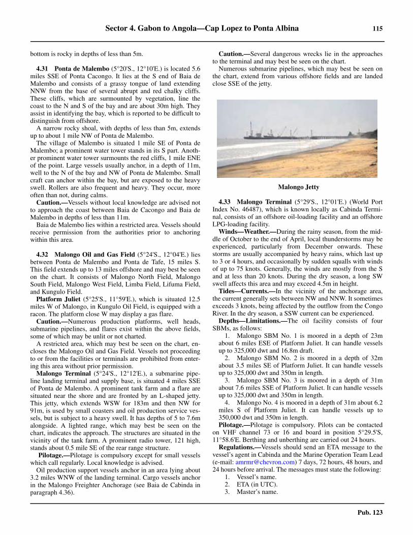
Sector 4. Gabon to Angola—Cap Lopez to Ponta Albina 115
Pub. 123
bottom is rocky in depths of less than 5m.
4.31 Ponta de Malembo (5°20'S., 12°10'E.) is located 5.6miles SSE of Ponta Cacongo. It lies at the S end of Baia deMalembo and consists of a grassy tongue of land extendingNNW from the base of several abrupt and red chalky cliffs.These cliffs, which are surmounted by vegetation, line thecoast to the N and S of the bay and are about 30m high. Theyassist in identifying the bay, which is reported to be difficult todistinguish from offshore.
A narrow rocky shoal, with depths of less than 5m, extendsup to about 1 mile NW of Ponta de Malembo.
The village of Malembo is situated 1 mile SE of Ponta deMalembo; a prominent water tower stands in its S part. Anoth-er prominent water tower surmounts the red cliffs, 1 mile ENEof the point. Large vessels usually anchor, in a depth of 11m,well to the N of the bay and NW of Ponta de Malembo. Smallcraft can anchor within the bay, but are exposed to the heavyswell. Rollers are also frequent and heavy. They occur, moreoften than not, during calms.
Caution.—Vessels without local knowledge are advised notto approach the coast between Baia de Cacongo and Baia deMalembo in depths of less than 11m.
Baia de Malembo lies within a restricted area. Vessels shouldreceive permission from the authorities prior to anchoringwithin this area.
4.32 Malongo Oil and Gas Field (5°24'S., 12°04'E.) liesbetween Ponta de Malembo and Ponta de Tafe, 15 miles S.This field extends up to 13 miles offshore and may best be seenon the chart. It consists of Malongo North Field, MalongoSouth Field, Malongo West Field, Limba Field, Lifuma Field,and Kungulo Field.
Platform Juliet (5°25'S., 11°59'E.), which is situated 12.5miles W of Malongo, in Kungulo Oil Field, is equipped with aracon. The platform close W may display a gas flare.
Caution.—Numerous production platforms, well heads,submarine pipelines, and flares exist within the above fields,some of which may be unlit or not charted.
A restricted area, which may best be seen on the chart, en-closes the Malongo Oil and Gas Field. Vessels not proceedingto or from the facilities or terminals are prohibited from enter-ing this area without prior permission.4.32 Malongo Terminal (5°24'S., 12°12'E.), a submarine pipe-line landing terminal and supply base, is situated 4 miles SSEof Ponta de Malembo. A prominent tank farm and a flare aresituated near the shore and are fronted by an L-shaped jetty.This jetty, which extends WSW for 183m and then NW for91m, is used by small coasters and oil production service ves-sels, but is subject to a heavy swell. It has depths of 5 to 7.6malongside. A lighted range, which may best be seen on thechart, indicates the approach. The structures are situated in thevicinity of the tank farm. A prominent radio tower, 121 high,stands about 0.5 mile SE of the rear range structure.4.32 Pilotage.—Pilotage is compulsory except for small vesselswhich call regularly. Local knowledge is advised.
Oil production support vessels anchor in an area lying about3.2 miles WNW of the landing terminal. Cargo vessels anchorin the Malongo Freighter Anchorage (see Baia de Cabinda inparagraph 4.36).
Caution.—Several dangerous wrecks lie in the approachesto the terminal and may best be seen on the chart.
Numerous submarine pipelines, which may best be seen onthe chart, extend from various offshore fields and are landedclose SSE of the jetty.
4.33 Malongo Terminal (5°29'S., 12°01'E.) (World PortIndex No. 46487), which is known locally as Cabinda Termi-nal, consists of an offshore oil-loading facility and an offshoreLPG-loading facility.
Winds—Weather.—During the rainy season, from the mid-dle of October to the end of April, local thunderstorms may beexperienced, particularly from December onwards. Thesestorms are usually accompanied by heavy rains, which last upto 3 or 4 hours, and occasionally by sudden squalls with windsof up to 75 knots. Generally, the winds are mostly from the Sand at less than 20 knots. During the dry season, a long SWswell affects this area and may exceed 4.5m in height.
Tides—Currents.—In the vicinity of the anchorage area,the current generally sets between NW and NNW. It sometimesexceeds 3 knots, being affected by the outflow from the CongoRiver. In the dry season, a SSW current can be experienced.
Depths—Limitations.—The oil facility consists of fourSBMs, as follows:
1. Malongo SBM No. 1 is moored in a depth of 23mabout 6 miles ESE of Platform Juliet. It can handle vesselsup to 325,000 dwt and 16.8m draft.
2. Malongo SBM No. 2 is moored in a depth of 32mabout 3.5 miles SE of Platform Juliet. It can handle vesselsup to 325,000 dwt and 350m in length.
3. Malongo SBM No. 3 is moored in a depth of 31mabout 7.6 miles SSE of Platform Juliet. It can handle vesselsup to 325,000 dwt and 350m in length.
4. Malongo No. 4 is moored in a depth of 31m about 6.2miles S of Platform Juliet. It can handle vessels up to350,000 dwt and 350m in length.Pilotage.—Pilotage is compulsory. Pilots can be contacted
on VHF channel 73 or 16 and board in position 5°29.5'S,11°58.6'E. Berthing and unberthing are carried out 24 hours. 4.33 Regulations.—Vessels should send an ETA message to thevessel’s agent in Cabinda and the Marine Operation Team Lead(e-mail: [email protected]) 7 days, 72 hours, 48 hours, and24 hours before arrival. The messages must state the following:
1. Vessel’s name.2. ETA (in UTC).3. Master’s name.
4.32Malongo Jetty

116 Sector 4. Gabon to Angola—Cap Lopez to Ponta Albina
Pub. 123
4. Arrival draft (fore and aft).5. Arrival displacement.6. Quantity of segregated ballast on board.7. Any anticipated delays enroute, cargo requirements,
vessel contact information (INMARSAT telephone number,INMARSAT facsimile number, and e-mail address).
8. Any defects in the vessel or its equipment which mayaffect maneuverability, cargo handling, or performance.
4.33 Vessels should then contact Security Control (Call sign: Ro-meo Oscar) upon arrival.
Restricted areas, which may best be seen on the chart, en-close the various loading facilities and terminals. Vessels areprohibited from entering these areas without prior permission.
Vessels must fly the national flag of Angola during daylightand at night when moored at the terminal.4.33 Contact Information.—See the table titled Malongo Ter-minal—Contact Information.
Anchorage.—A designated anchorage (waiting area), with aradius of 1 mile, lies centered about 4 miles SSW of PlatformJuliet and has depths of 38 to 40m.
Caution.—Numerous production platforms and submarinepipelines are situated in the approaches to the terminal. Vesselsare advised to approach the terminal during daylight hours. Atnight, the lights and flares of the various structures may be con-fusing and some obstructions may be unlit.
4.34 Praia de Futila (5°26'S., 12°13'E.), a village, stands3.5 miles SSE of Malongo. The coast in this vicinity is formedby a broad, low plain which is studded with palm trees. TheRiver Lulondo flows into the sea 1.5 miles S of this village.
A bank of sand and rock, with depths of less than 5m, frontsthis village and extends up to about 1.5 miles offshore. Thisbank also fronts the coast to the S and extends up to about 3miles seaward from the head of Baia de Cabinda. Shoal depthsof less than 5m lie on the outer edge of this bank, but the seadoes not usually break on it. Vessels without local knowledgeare advised to give this stretch of coast a wide berth.
Ponta de Tafe (5°33'S., 12°11'E.), low and covered by bush-es, is located 9.5 mile S of Malongo and forms the SW en-trance point of Baia da Cabinda. Ponta de Tafe Light is shownat an elevation of 27m from a tower with a hut, 20m high,standing on the point. A prominent monument surmounts acliff about 0.5 mile SSW of the point. A radio mast, 57m high,stands 1 mile SE of the point. An aeronautical light is occa-sionally shown from a structure standing in the vicinity of theairfield, about 2.5 miles SSE of Ponta de Tafe.
Several rocks, on which the sea breaks, front Ponta de Tafeand the coastal bank, with depths of less than 5m, extends up toabout 2 miles WSW of it.
4.35 Futila Oil Terminal (5°27'S., 12°11'E.) (World PortIndex No. 46495), an offshore facility, is located 2.3 miles SWof Praia de Futila. It consists of a CBM situated in a depth of6.8m. A submarine pipeline extends NE from the berth to theshore. Vessels up to 6,500 dwt and 4.5m draft can be handled.
Vessels must send an ETA 72 hours, 48 hours, and 24 hoursin advance. The message must state the following:
1. Vessel’s name and master’s name.2. ETA in UTC.3. Arrival draft (fore and aft).4. Intended departure draft (fore and aft).5. Quantity of cargo to load or discharge.
Vessels should then contact the terminal when within VHFrange. They should approach the terminal from the S.
Pilotage is compulsory. Berthing is carried out only duringdaylight hours but vessels may depart at any time. The pilot(mooring master) can be contacted on VHF channel 16 or 74and boards in the Malongo Freighter Anchorage (see paragraph4.36).
Regulations.—The terminal is situated within the restrictedarea which surrounds the Malongo Oil and Gas Fields. Vesselsare prohibited from entering this area without prior permission.4.35 Contact Information.—See the table titled Futila OilTerminal—Contact Information.
4.36 Baia de Cabinda (Enseada de Cabinda) (5°32'S.,12°12'E.) (World Port Index No. 46490) lies E of Ponta de Tafeand is mostly encumbered by the coastal bank. Baixo do Bele,a rocky shoal, lies in the middle of the bay. It has a least depthof 2.5m and is located 2 miles NNE of Ponta de Tafe (see para-graph 4.34).
The head of the bay consists of a sandy beach backed bylofty cliffs, green hills, and deep valleys. The town of Cabindais situated 0.7 mile E of Ponta de Tafe and is hidden by thetrees which stand on the sides and summit of an area of elevat-ed land. A prominent three-story structure stands in the town, 1mile SE of Ponta de Tafe. It was originally used as a light-house, but is now a clock tower. An airfield is situated on the Sside of the town.
Several factories stand along the bay and an L-shaped pier,100m long, fronts the shore, 0.5 mile E of Ponta de Tafe.
Vessels may anchor, to discharge or load cargo from barges,in a depth of 9m, mud, about 2.3 miles WNW of Ponta de Tafeor closer inshore according to their draft. Small vessels withlight drafts may anchor in a depth of 4.6m about 0.4 mile N ofthe head of the L-shaped pier. A lighted range, which may best
Malongo Terminal—Contact Information
Call sign Malongo Terminal
VHF VHF channels 16 and 73
Telephone 1-925-842-1111 (ext. 2775)
E-mail [email protected]
Pilots
Call sign Malongo Pilot
VHF VHF channel 16 and 73Futila Oil Terminal—Contact Information
Call sign Futila Terminal
VHF VHF channels 16 and 74
E-mail [email protected]
Marine Operations
Telephone 1-925-842-1111 (ext 2775)
Sector 4. Gabon to Angola—Cap Lopez to Ponta Albina 117
Pub. 123
be seen on the chart, indicates this inner roadstead. Pilotage isnot available.4.36 The Commercial Port Terminal has two berths available,both with a length of 110m. The berths handle containers andbreakbulk cargo and can accommodate vessels with amaximum draft of 6.5m.
Malongo Freighter Anchorage, a designated anchorage area,lies centered about 3.5 miles NW of Ponta de Tafe Light andhas depths of 10 to 11m.
Caution.—Several dangerous wrecks lie in the approachesto Baia de Cabinda and may best be seen on the chart.
4.37 Between Ponta de Tafe and the entrance to the CongoRiver, 30 miles SSE, the country is particularly fertile andwell-populated.
A prominent radio tower stands close to the shore, 5 milesSSW of Ponta de Tafe.
The coast between Ponta de Tafe and Ponta Vermelha, 7miles SSW, is fronted by a shoal bank which extends up toabout 1.5 miles offshore and is generally indicated in places bybreakers. Vessels should not approach this stretch of the coastin depths of less than 22m, as rollers have been known to breakin depths of 13m and up to about 5 miles offshore.
The shore extending to 4 miles SSE of Ponta Vermelha islow and fringed with forests. A chain of reddish-colored hills,with nearly uniform height, rises close inland 3 miles S of Cab-inda and extends almost to the N bank of the Congo River.
The border between Angola (Cabinda) and the DemocraticRepublic of the Congo (formerly Zaire) is situated about 8miles SSE of Pointe Vermelha and is marked by three beacons.4.37 Pointe Kipundji (Kupundji) (5°53'S., 12°18'E.) is located17 miles SE of Pointe Vermelha. The shore between is fringedby a narrow sandy beach. Pointe Kipundji Light is shown froma metal tower, 9m high, standing on this point and the conspic-uous village of Vista (Nsiamfumu), consisting of 30 houses,stands 1 mile NW of it. The village of Muanda (Moanda), withan airfield, is situated 4 miles SE of Pointe Kipundji.
Mona Mazea Bank (Banc Mona Mazea), an extensive shoal,fronts the coast between a point located 5 miles SSE of PontaVermelha and the entrance to the Congo River. This shoal hasdepths of less than 5m and extends up to about 5.5 miles off-shore in places. Vessels are advised to avoid this shoal bankand remain in depths of over 10m, as a constant swell, frequentrollers, and a strong current from the river are frequently expe-rienced in this vicinity. The bank is also reported to be extend-ing in a W direction.
Caution.—Numerous fishing canoes may be encounteredclose off the coast between Ponta de Tafe and the Congo River.
4.38 Kokonga Oil Field (5°36'S., 11°42'E.), with severalproduction platforms, lies centered 30 miles WSW of Ponta deTafe.
N’Dola North Oil Field (5°41'S., 11°46'E.), with severalplatforms, lies centered 26 miles SW of Ponta de Tafe.
South Sanha Oil Field (5°41'S., 11°49'E.), with severalplatforms, lies centered 24 miles SW of Ponta de Tafe.
Kambala Oil Field (5°43'S., 12°05'E.), with several produc-tion platforms, lies centered 12 miles SSW of Ponta de Tafe.
Caution.—Numerous platforms, well heads, submarinepipelines, and flares exist within the above fields, some of
which may be unlit or not charted.Restricted areas, which may best be seen on the chart, sur-
round several of the above fields. Vessels not proceeding to orfrom the facilities or terminals are prohibited from enteringthese areas without prior permission.
4.39 Sanha LPG Terminal (5°38'S., 11°51'E.) is situated20 miles WSW of Ponta de Tafe and about 2 miles NE of theSouth Sanha Oil Field. It consists of a Floating ProductionStorage and Offloading (FPSO) facility, which is moored in adepth of 62m. Vessels berth either in tandem or alongside theFPSO.
Pilotage.—Pilotage is compulsory. Pilots, who act asmooring masters, can be contacted by VHF channels 16 or 69and board about 3.5 miles NE of the FPSO. Pilotage andberthing is available 24 hours.
Regulations.—Vessels should send an ETA via the agent inCabinda and the Marine Operation Team Lead ([email protected])7 days, 72 hours, 48 hours, and 24 hours in advance.The message should state the following:
1. Vessel’s name and master’s name.2. ETA.3. Estimated arrival draft (fore and aft) and displace-
ment.4. Delays expected at any enroute ports.5. Quantity of cargo required and any special require-
ments.6. Vessel contact information (INMARSAT telephone
number, INMARSAT facsimile number, and e-mail address).7. Any defects in vessel equipment.8. Whether cargo tanks are cooled and ready to receive
cargo.9. Parallel body measurement.
Vessels should contact the terminal and the security patrolboat (Call sign: Rome Oscar) on VHF channel 16 when withinrange.
The terminal and the FSO can be contacted (Call sign: LPGFPSO) on VHF channels 16 and 69.
Vessels should approach the terminal from the NW or SW.There is a least depth of 53m in the NW approach and 47m inthe SW approach. Vessels should avoid passing between thevarious restricted areas surrounding the oil fields lying up to 30miles NW of the terminal.4.39 Vessels can anchor in the Malongo Tanker Anchorage Area(see paragraph 4.33).
Restricted areas, for the terminal and a new DevelopmentArea, which may best be seen on the chart, surround the termi-nal, the South Sanha Oil Field, and the N’Dola North Oil Field.Vessels are prohibited from entering this area without priorpermission.
4.40 Lukami Oil Field (5°51'S., 12°08'E.), with severalplatforms, lies centered 10 miles WNW of Pointe Kipundji.
Motoba Oil Field (5°51'S., 12°10'E.), with several plat-forms, lies centered 8 miles WNW of Pointe Kipundji.
Mibale Oil Field (5°50'S., 12°12'E.), with several platforms,lies centered 5 miles NW of Pointe Kipundji.
Mwambe Oil Field (5°51'S., 12°14'E.), with several plat-forms, lies centered 4 miles NW of Pointe Kipundji.
Moko Oil Field (5°53'S., 12°07'E.), with several platforms,

118 Sector 4. Gabon to Angola—Cap Lopez to Ponta Albina
Pub. 123
lies 10 miles W of Pointe Kipundji.Libwa Oil Field (5°56'S., 12°15'E.), with several platforms,
lies centered 3.5 miles SW of Pointe Kipundji.GCO Oil Field (5°57'S., 12°10'E.), with several platforms,
lies centered 8 miles SW of Pointe Kipundji.Caution.—A restricted area, which may best be seen on the
chart, encloses the above fields and extends up to about 12miles offshore. Vessels not proceeding to or from the facilitiesor terminals are prohibited from entering or anchoring in thisarea without prior permission.
4.41 Moanda Terminal (Muanda Terminal) (5°58'S.,12°07'E.), located 10 miles SW of Pointe Kipundji, consists ofa Floating, Storage and Offloading (FSO) facility and a SBM.The FSO (Kalamu) and the SBM to which it is moored, are sit-uated in a depth of 27m. Vessels up to 160,000 dwt and 16.5mdraft can be handled. 4.41 The current at the terminal usually sets NW in direction andattains a rate of to 2 to 3.5 knots. It is modified by the tidal cur-rents and greatly affected by the flow of water from the CongoRiver. When the water level in the river is high, the current ex-perienced at the terminal may attain a rate of 5 to 7 knots. Aheavy swell is also often experienced at the terminal betweenMarch and September.4.41 Pilotage.—Pilotage is compulsory. Pilots, who act asmooring masters, can be contacted by VHF channel 16 andboard 2.5 miles NW of the FSO Kalamu or in the vicinity ofthe anchorage area. Berthing is carried out 24 hours.4.41 Regulations.—Vessels should send an ETA, preferably viae-mail, to the terminal and their agent in Kinshasa as soon aspossible. Confirmation messages should be sent 72 hours, 48hours, and 24 hours before arrival. The messages must state thefollowing:
1. Vessel’s name2. ETA (in UTC).3. Master’s name.4. Arrival draft (fore and aft).5. Arrival displacement.6. Any anticipated delays enroute.7. Cargo requirements.8. Name of agent.
4.41 Vessels should then contact the terminal on VHF channel 16when within VHF range. 4.41 All tankers shall fly the Democratic Republic of Congonational flag while berthed at the terminal.
4.41 Contact Information.—See the table titled MoandaTerminal—Contact Information. 4.41 Anchorage.—A designated anchorage area is situated about2 miles NW of the SBM. It has a depth of 28m over a bottomof soft mud.4.41 Caution.—Moanda Terminal is situated within a restrictedarea which extends up to 12 miles offshore and may best beseen on the chart.
The Congo River (Flueve Zaire)
4.42 The Congo River (Flueve Zaire), the second largestriver in Africa, is over 2,700 miles long and is the fifth longestriver in the world. However, in volume of water, depending onthe season, it is second only to that of the Amazon. The CongoRiver is navigable by ocean-going vessels as far as Matadi,about 80 miles from the sea.
Above Matadi, the Congo River runs at rates of up to 10knots between the cliffs. The water is generally deep, butwhirlpools render navigation difficult. Rapids are located about3.5 miles and 6.5 miles upriver from Matadi.
The two Inga Dams (5°30'S., 13°37'E.) are situated about 21miles above Matadi. They were built across a once dry valley.Rapids are located at regular intervals upriver between the IngaDams and Kinshasa (4°20'S., 15°19'E.). This latter town standson the S side of the river, at the SW end of Pool Malebo, anextensive lake. Brazzaville is situated on the N bank, oppositeKinshasa. Pool Malebo is about 22 miles long and 14 mileswide.
The river between Pool Malebo and the town of Kisangani(0°31'N., 25°12'E.), about 940 miles upstream, is navigable byriver craft of up to 800 dwt. Stanley Falls are located oppositethe E end of Kisangani. Between Kisangani and Bukama(9°13'S., 25°51'E.), there are many areas of rapids, rivers, andswamp. The river source lies about 382 miles upstream fromBukama. Two dams have been built on this stretch of the riverand it is not used as a means of transportation.
The border between the Democratic Republic of the Congo(formerly Zaire) and Angola is situated, in the lower part, inthe vicinity of the middle of the river.
Tides—Currents.—The difference between the high riverlevel and the low river level at the following places are, as fol-lows:
1. Banana (6°02'S., 12°25'E.)—0.6m.2. Mateba (25 miles above Banana)—1.5m.3. Pedra do Feitico (10 miles above Mateba)—2.1m.4. Boma (7 miles above Pedra do Feitico)—2.7m.5. Matadi—7.0m.
4.42 The lower part of the Congo River is well-supplied with wa-ter throughout the year, since the tributaries of this river aredistributed on both sides of the Equator. The levels of the riversystem are usually either rising or falling and seldom remain attheir mean level for any length of time. The tributaries of theleft bank, on the S side, have two periods of high level and twoperiods of low level during the year. Those of the right bank, onthe N side, have only one period of high level and one period oflow level in the course of the year. The river is low in Marchand July, and high in May and December. The July low level isusually lower than that in March. The mean river level at Mata-di is about 26m above mean sea level.
Moanda Terminal—Contact Information
VHF VHF channel 16
Moanda Office

Sector 4. Gabon to Angola—Cap Lopez to Ponta Albina 119
Pub. 123
At Boma, the tidal influence is perceptible, but the range isless than 0.3m. At Matadi, the tidal influence is reported to bealmost not perceptible, being about 0.1m.
The river current always runs seaward. During the rainy sea-son, this current is very rapid and usually carries along with itfloating islands of papyrus and water hyacinths which havebeen torn away from the banks. Some of these floating islandsmay be more than 100m long and may be dangerous to vesselsunderway or at anchor. In addition, they frequently sweep awaythe buoys marking the channels. These floating islands may al-so be encountered during the low river season, but they are usu-ally not of sufficient size to be dangerous.
Observations indicate that the fresh water of the river,extending from the surface to the bottom, is found until justbelow Quissanga (6°02'S., 12°39'E.), where a body of saltwater is encountered in a deep gully. The fresh water thenflows over the denser water with decreasing depth andincreasing velocity. It also decreases in depth as the estuarywidens, but is deeper on the ebb current than on the floodcurrent.
About 5 miles below Quissanga, the layer of fresh waterextends from 5.5 to 9.1m below the surface, whereas afterpassing Pointe Bulabemba (6°03'S., 12°26'E.), it is only about1m in depth. The deep body of salt water is reported to beeither perfectly still or to have a very slight tidal flow.
In the Congo River, the nature of the bottom is invariablysand, but hard clay may be found in a few places. Theexception is within the deep gully lying at the mouth of theriver, where deposits of soft mud and decayed vegetable matterare found. The latter is proof of the tranquility of the water nearthe bottom.
Mud is found within the small creeks in the upper part of theriver and also on the mangrove-covered banks extending down-river from Quissanga. The water of the river is heavily chargedwith sand and it would appear that a very large proportion ofthe mud found in the deep gully at the mouth is from the wash-ings of the immediate neighborhood.
Depths—Limitations.—Depths of more than 200m extendinto the mouth of the river and may be found in the channel upto the vicinity of Lighted Buoy No. 16 (6°02'S., 12°34'E.). Theauthorities endeavor to maintain a depth of 9.1m throughoutthe year by surveying and dredging in the sandy passes of thewandering portion of the river below Boma. However,sometimes this depth cannot be maintained due to the break-upof banks or intensive shifting of sands. These periods arerelatively short and every effort is made to re-establish a depthof 9.1m as soon as possible.
The controlling depths in the river vary. It was reported(1995) that, due to the sandbanks lying between Banana and
Boma, vessels with drafts of 6.4 to 8.5m were permitted tomake the river transit, depending on the season. It was reported(1998) that, after the civil war, the maximum draft for rivertransit was reduced to 5.5m.
Consequently, the authorities should be contacted in advancefor the latest depth information.4.42 A gas pipeline, best seen on the chart, extends across themouth of the river about 8 miles W of Ponta da Padrao.
Aspect.—The estuary of the Congo River, which extendsabout 50 miles inland to Boma, is entered between Ponta Ver-melha (5°39'S., 12°08'E.) and Ponta da Moita Seca, 29 milesSSE.
The continental shelf, with depths of less than 200m, extendsup to about 40 miles W of this estuary. It is cut by a remarkabledeep gully, 2 to 8 miles wide, which has depths of over 1,400mat the outer end. This gully, which has steep and irregular sides,leads directly into the entrance of the Congo River. It is usefulwhen approaching the entrance in foul weather, as depths ofover 200m extend into the river mouth.
Presqu’ile de Banana (6°01'S., 12°24'E.), located 26 milesSE of Ponta Vermelha, is a low and narrow peninsula. Thissandy peninsula extends 2.5 miles S to Pointe Francaise, its Sextremity. Several prominent white buildings of the town ofBanana are situated on the peninsula and two conspicuous ra-dio masts stand 1.2 miles N of Pointe Francaise. The prominentflare of an oil refinery is situated about 2.5 miles NNE of theradio masts. When rollers occur along this part of the coast atthe time of the equinoctial tides, the greater part of this penin-sula is submerged.
This part of the coast is fronted by a continuation of MonaMazea Bank and depths of less than 5m lie up to 2 miles off-shore. Banc Stella, a sandbank, extends up to about 0.5 mile Sof Pointe Francaise. Its S edge is steep-to, but depths of lessthan 5m lie up to 1.5 miles W of the point. This bank was re-ported (1990) to be extending to the W and vessels should ex-ercise caution when navigating in its vicinity.
Stella Buoy No. 2 is moored about 1.8 miles WSW of PointeFrancaise and marks the edge of the coastal bank.
Pointe Bulabemba (6°03'S., 12°26'E.), a low point, is locat-ed 2.7 miles SE of Pointe Francaise. A light is shown from ametal tripod standing on this point.
Ponta da Moita Seca (6°07'S., 12°17'E.) is of moderateheight and appears as a steep cliff when seen from the N at adistance of about 7 miles. It is surmounted by a mound whichis covered by stunted bushes. Ponta da Moita Seca Light isshown from a fiberglass tower, 21m high, standing on thepoint.4.42 A stranded wreck is reported (2000) to lie about 1 mile NEof the point.
Ponta Padrao (Ponta do Padrao) (6°04'S., 12°20'E.), located4 miles ENE of Ponta da Moita Seca, is the NE extremity of along and low peninsula.
A village stands on Ponta Padrao and an old cemetery is situ-ated about 0.3 mile within the point. A prominent marble col-umn, 5m high, stands near the extremity of the point. It was setup by the famous Portuguese navigator Diego Cam in 1486.
Baia de Diogo Cao lies on the S side of the entrance to theCongo River and is entered E of Ponta Padrao. This bay ismostly shallow and not recommended as an anchorage.
Pilotage.—Vessels bound for the ports of Banana, Boma,
Currents in the Congo River
Location High River Level Low River Level
Banana to Boma 3 to 4.7 knots 2 to 3.5 knots
Boma to Matadi 7 knots 6 knots
Chaudron d’Enfer 10 to 11 knots 6 knots
Rade de Matadi 7.5 knots —

120 Sector 4. Gabon to Angola—Cap Lopez to Ponta Albina
Pub. 123
Ango-Ango, and Matadi board a pilot near Banana. Pilotage iscompulsory for vessels over 500 gt and is only available duringdaylight hours. Pilots board in position 6°02'34.2''S,12°24'24.6'E (between Stella Buoy No. 2 and Pointe Bulabem-ba) or in the vicinity of Buoy No. 16 (6°02'13.8''S.,12°33'34.2''E.). Vessels should send an ETA between 6 and 2days in advance, and again 24 hours prior to arrival through theagent.
Pilotage is available by day only; this may result in vesselshaving to anchor at Boma or Ango-Ango overnight if there isinsufficient time for them to reach Matadi during daylight.4.42 Contact Information.—See the table titled Banana Pi-lots—Contact Information.
4.43 Angola LNG Terminal (Soyo) (Santo Antonio doZaire) (6°07'S., 12°20'E.) (World Port Index No. 46545) con-sists of the newly completed Angola LNG Terminal, built onreclaimed land. The terminal has three berths, one each forLNG, LPG and pressurized butane. It is reported (2014) thatthe terminal has suspended operations.
Tides—Currents.—The tides rise about 1.5m at springs and0.6m at neaps.4.43 The rate of flow and the mixing of salt and fresh water at themouth of the Congo River can cause significant variations be-tween actual and predicted water levels. 4.43 At the outer parts of the Pululu Approach Channel, the W’lycurrent is the predominant force, in some cases exceeding 5knots. In this area, the flow is generally perpendicular to theaxis of the channel. Upon entering the channel, the currentweakens and gradually aligns with the channel axis. 4.43 At the LNG berth, currents are parallel to the shore, seldomexceeding 1 knot, while at the other berths, they may be stron-ger and less predictable.
Depths—Limitations.—The Angola LNG Terminal andport of Soyo are approached by the Pululu Channel. This chan-nel has a width at the entrance of 700m, a least width of 250m,with a maintained depth of 14m. 4.43 The LNG jetty can accommodate vessels up to 315m inlength and 147,000 tons displacement. The LPG jetty can ac-commodate vessels up to 250m in length and 143,000 tons dis-placement. The pressurized Butane Jetty can accommodatevessels up to 115m in length, 7,000 tons displacement and hasa maintained depth alongside of 7.5m.
Aspect.—The Pululu Approach Channel, marked by lightedbuoys, is assisted by two sectored lights, the first of whichleads into the channel, NE of Ponta Padrao and the secondleading up the channel to the turning basin in the vicinity of thecargo berths.
Pilotage.—Pilotage is compulsory for all vessels bound forthe Angola LNG Terminal.
Pilots board vessels of 120m and over in position 6°02'S,12°10'E, approximately 10 miles from the Pululu Channel en-trance. All other vessels are boarded in position 6°03'S,12°17'E. Pilots can be contacted (Call sign: LNG Pilot) onVHF channel 9 as well as by e-mail ([email protected]).
Regulations.—Vessels underway within the port limits mustmaintain an underkeel clearance of at least 1m. The maximumpermitted draft is 13m.
Vessels should send an ETA upon departure from dischargeport 7 days, 5 days, 72 hours, 48 hours, 24 hours, and when inVHF range.
Vessels should contact the terminal 2 hours prior to arrivalon VHF channel 9 to confirm pilotage and berthing arrange-ments.
Pululu Channel is closed to traffic while Angola LNG ves-sels are underway in the channel or turning basin. In addition,the channel is closed 30 minutes prior to any planned AngolaLNG ship arrival or departure. Angola LNG pilots will notifySoyo Port Control when the channel is open to traffic.4.43 The following information must be provided to Soyo PortControl:
1. The vessel’s ETA must be provided by e-mail 24hours prior to arrival or on departure from the previous portif sooner.
2. All vessels are to call Soya Port Control on VHF 2hours prior to arrival at the channel entrance buoys to verifyupdated ETA and maximum draft.
3. Inbound vessels will contact Soya Port Control onVHF channel 11 when passing position 6°03.5'S, 12°18.5'Eand request clearance to enter Pululu Channel.
4. All movements of vessels greater that 20m loa mu8stbe authorized by Soys Port Control.
4.43 Contact Information.—See the table titled Angola LNGTerminal—Contact Information.
Banana Pilots—Contact Information
VHF VHF channel 16
Telephone 243-819-010-409
Port
Telephone
243-81-904-1348
243-89-751-1535
243-97-379-6383
Angola LNG Terminal—Contact Information
Terminal
Call sign LNG Marine
VHF VHF channel 9
Telephone 244-232-675-792
E-mail [email protected]
Soyo Port Control
Call sign Soya Port Control
VHF VHF channels 11 and 16
Telephone 244-232-676-000 (ext. 5790)
E-mail [email protected]
Pilots
Call sign LNG Pilot
VHF VHF channel 9
E-mail [email protected]
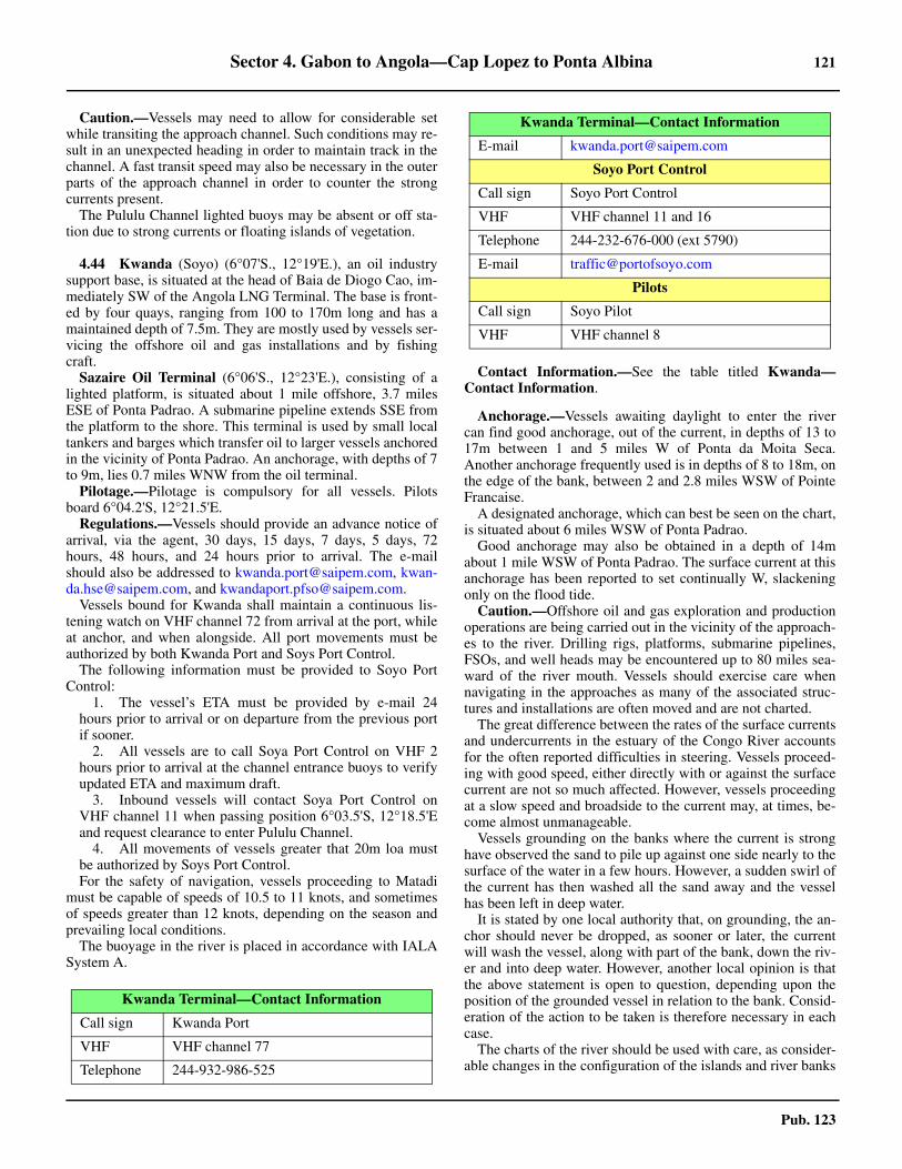
Sector 4. Gabon to Angola—Cap Lopez to Ponta Albina 121
Pub. 123
Caution.—Vessels may need to allow for considerable setwhile transiting the approach channel. Such conditions may re-sult in an unexpected heading in order to maintain track in thechannel. A fast transit speed may also be necessary in the outerparts of the approach channel in order to counter the strongcurrents present. 4.43 The Pululu Channel lighted buoys may be absent or off sta-tion due to strong currents or floating islands of vegetation.
4.44 Kwanda (Soyo) (6°07'S., 12°19'E.), an oil industrysupport base, is situated at the head of Baia de Diogo Cao, im-mediately SW of the Angola LNG Terminal. The base is front-ed by four quays, ranging from 100 to 170m long and has amaintained depth of 7.5m. They are mostly used by vessels ser-vicing the offshore oil and gas installations and by fishingcraft.
Sazaire Oil Terminal (6°06'S., 12°23'E.), consisting of alighted platform, is situated about 1 mile offshore, 3.7 milesESE of Ponta Padrao. A submarine pipeline extends SSE fromthe platform to the shore. This terminal is used by small localtankers and barges which transfer oil to larger vessels anchoredin the vicinity of Ponta Padrao. An anchorage, with depths of 7to 9m, lies 0.7 miles WNW from the oil terminal.
Pilotage.—Pilotage is compulsory for all vessels. Pilotsboard 6°04.2'S, 12°21.5'E.
Regulations.—Vessels should provide an advance notice ofarrival, via the agent, 30 days, 15 days, 7 days, 5 days, 72hours, 48 hours, and 24 hours prior to arrival. The e-mailshould also be addressed to [email protected], [email protected], and [email protected]. 4.44 Vessels bound for Kwanda shall maintain a continuous lis-tening watch on VHF channel 72 from arrival at the port, whileat anchor, and when alongside. All port movements must beauthorized by both Kwanda Port and Soys Port Control. 4.44 The following information must be provided to Soyo PortControl:
1. The vessel’s ETA must be provided by e-mail 24hours prior to arrival or on departure from the previous portif sooner.
2. All vessels are to call Soya Port Control on VHF 2hours prior to arrival at the channel entrance buoys to verifyupdated ETA and maximum draft.
3. Inbound vessels will contact Soya Port Control onVHF channel 11 when passing position 6°03.5'S, 12°18.5'Eand request clearance to enter Pululu Channel.
4. All movements of vessels greater that 20m loa mustbe authorized by Soys Port Control.For the safety of navigation, vessels proceeding to Matadi
must be capable of speeds of 10.5 to 11 knots, and sometimesof speeds greater than 12 knots, depending on the season andprevailing local conditions.
The buoyage in the river is placed in accordance with IALASystem A.
4.44 Contact Information.—See the table titled Kwanda—Contact Information.
Anchorage.—Vessels awaiting daylight to enter the rivercan find good anchorage, out of the current, in depths of 13 to17m between 1 and 5 miles W of Ponta da Moita Seca.Another anchorage frequently used is in depths of 8 to 18m, onthe edge of the bank, between 2 and 2.8 miles WSW of PointeFrancaise.
A designated anchorage, which can best be seen on the chart,is situated about 6 miles WSW of Ponta Padrao.
Good anchorage may also be obtained in a depth of 14mabout 1 mile WSW of Ponta Padrao. The surface current at thisanchorage has been reported to set continually W, slackeningonly on the flood tide.
Caution.—Offshore oil and gas exploration and productionoperations are being carried out in the vicinity of the approach-es to the river. Drilling rigs, platforms, submarine pipelines,FSOs, and well heads may be encountered up to 80 miles sea-ward of the river mouth. Vessels should exercise care whennavigating in the approaches as many of the associated struc-tures and installations are often moved and are not charted.
The great difference between the rates of the surface currentsand undercurrents in the estuary of the Congo River accountsfor the often reported difficulties in steering. Vessels proceed-ing with good speed, either directly with or against the surfacecurrent are not so much affected. However, vessels proceedingat a slow speed and broadside to the current may, at times, be-come almost unmanageable.
Vessels grounding on the banks where the current is stronghave observed the sand to pile up against one side nearly to thesurface of the water in a few hours. However, a sudden swirl ofthe current has then washed all the sand away and the vesselhas been left in deep water.
It is stated by one local authority that, on grounding, the an-chor should never be dropped, as sooner or later, the currentwill wash the vessel, along with part of the bank, down the riv-er and into deep water. However, another local opinion is thatthe above statement is open to question, depending upon theposition of the grounded vessel in relation to the bank. Consid-eration of the action to be taken is therefore necessary in eachcase.
The charts of the river should be used with care, as consider-able changes in the configuration of the islands and river banks
Kwanda Terminal—Contact Information
Call sign Kwanda Port
VHF VHF channel 77
Telephone 244-932-986-525
E-mail [email protected]
Soyo Port Control
Call sign Soyo Port Control
VHF VHF channel 11 and 16
Telephone 244-232-676-000 (ext 5790)
E-mail [email protected]
Pilots
Call sign Soyo Pilot
VHF VHF channel 8
Kwanda Terminal—Contact Information
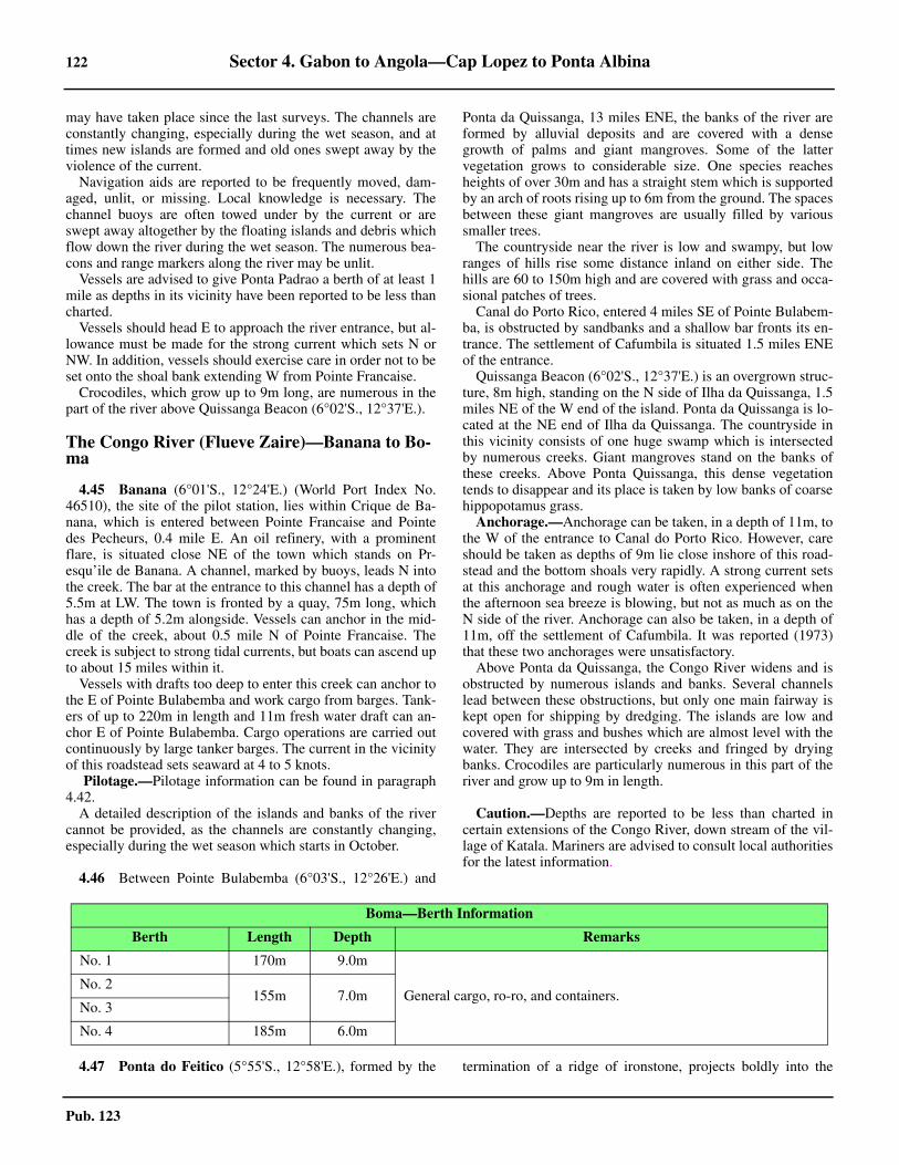
122 Sector 4. Gabon to Angola—Cap Lopez to Ponta Albina
Pub. 123
may have taken place since the last surveys. The channels areconstantly changing, especially during the wet season, and attimes new islands are formed and old ones swept away by theviolence of the current.
Navigation aids are reported to be frequently moved, dam-aged, unlit, or missing. Local knowledge is necessary. Thechannel buoys are often towed under by the current or areswept away altogether by the floating islands and debris whichflow down the river during the wet season. The numerous bea-cons and range markers along the river may be unlit.
Vessels are advised to give Ponta Padrao a berth of at least 1mile as depths in its vicinity have been reported to be less thancharted.
Vessels should head E to approach the river entrance, but al-lowance must be made for the strong current which sets N orNW. In addition, vessels should exercise care in order not to beset onto the shoal bank extending W from Pointe Francaise.
Crocodiles, which grow up to 9m long, are numerous in thepart of the river above Quissanga Beacon (6°02'S., 12°37'E.).
The Congo River (Flueve Zaire)—Banana to Bo-ma
4.45 Banana (6°01'S., 12°24'E.) (World Port Index No.46510), the site of the pilot station, lies within Crique de Ba-nana, which is entered between Pointe Francaise and Pointedes Pecheurs, 0.4 mile E. An oil refinery, with a prominentflare, is situated close NE of the town which stands on Pr-esqu’ile de Banana. A channel, marked by buoys, leads N intothe creek. The bar at the entrance to this channel has a depth of5.5m at LW. The town is fronted by a quay, 75m long, whichhas a depth of 5.2m alongside. Vessels can anchor in the mid-dle of the creek, about 0.5 mile N of Pointe Francaise. Thecreek is subject to strong tidal currents, but boats can ascend upto about 15 miles within it.
Vessels with drafts too deep to enter this creek can anchor tothe E of Pointe Bulabemba and work cargo from barges. Tank-ers of up to 220m in length and 11m fresh water draft can an-chor E of Pointe Bulabemba. Cargo operations are carried outcontinuously by large tanker barges. The current in the vicinityof this roadstead sets seaward at 4 to 5 knots.
Pilotage.—Pilotage information can be found in paragraph4.42.
A detailed description of the islands and banks of the rivercannot be provided, as the channels are constantly changing,especially during the wet season which starts in October.
4.46 Between Pointe Bulabemba (6°03'S., 12°26'E.) and
Ponta da Quissanga, 13 miles ENE, the banks of the river areformed by alluvial deposits and are covered with a densegrowth of palms and giant mangroves. Some of the lattervegetation grows to considerable size. One species reachesheights of over 30m and has a straight stem which is supportedby an arch of roots rising up to 6m from the ground. The spacesbetween these giant mangroves are usually filled by varioussmaller trees.
The countryside near the river is low and swampy, but lowranges of hills rise some distance inland on either side. Thehills are 60 to 150m high and are covered with grass and occa-sional patches of trees.
Canal do Porto Rico, entered 4 miles SE of Pointe Bulabem-ba, is obstructed by sandbanks and a shallow bar fronts its en-trance. The settlement of Cafumbila is situated 1.5 miles ENEof the entrance.
Quissanga Beacon (6°02'S., 12°37'E.) is an overgrown struc-ture, 8m high, standing on the N side of Ilha da Quissanga, 1.5miles NE of the W end of the island. Ponta da Quissanga is lo-cated at the NE end of Ilha da Quissanga. The countryside inthis vicinity consists of one huge swamp which is intersectedby numerous creeks. Giant mangroves stand on the banks ofthese creeks. Above Ponta Quissanga, this dense vegetationtends to disappear and its place is taken by low banks of coarsehippopotamus grass.
Anchorage.—Anchorage can be taken, in a depth of 11m, tothe W of the entrance to Canal do Porto Rico. However, careshould be taken as depths of 9m lie close inshore of this road-stead and the bottom shoals very rapidly. A strong current setsat this anchorage and rough water is often experienced whenthe afternoon sea breeze is blowing, but not as much as on theN side of the river. Anchorage can also be taken, in a depth of11m, off the settlement of Cafumbila. It was reported (1973)that these two anchorages were unsatisfactory.
Above Ponta da Quissanga, the Congo River widens and isobstructed by numerous islands and banks. Several channelslead between these obstructions, but only one main fairway iskept open for shipping by dredging. The islands are low andcovered with grass and bushes which are almost level with thewater. They are intersected by creeks and fringed by dryingbanks. Crocodiles are particularly numerous in this part of theriver and grow up to 9m in length.
Caution.—Depths are reported to be less than charted incertain extensions of the Congo River, down stream of the vil-lage of Katala. Mariners are advised to consult local authoritiesfor the latest information.
4.47 Ponta do Feitico (5°55'S., 12°58'E.), formed by the termination of a ridge of ironstone, projects boldly into the
Boma—Berth Information
Berth Length Depth Remarks
No. 1 170m 9.0m
General cargo, ro-ro, and containers.No. 2
155m 7.0mNo. 3
No. 4 185m 6.0m
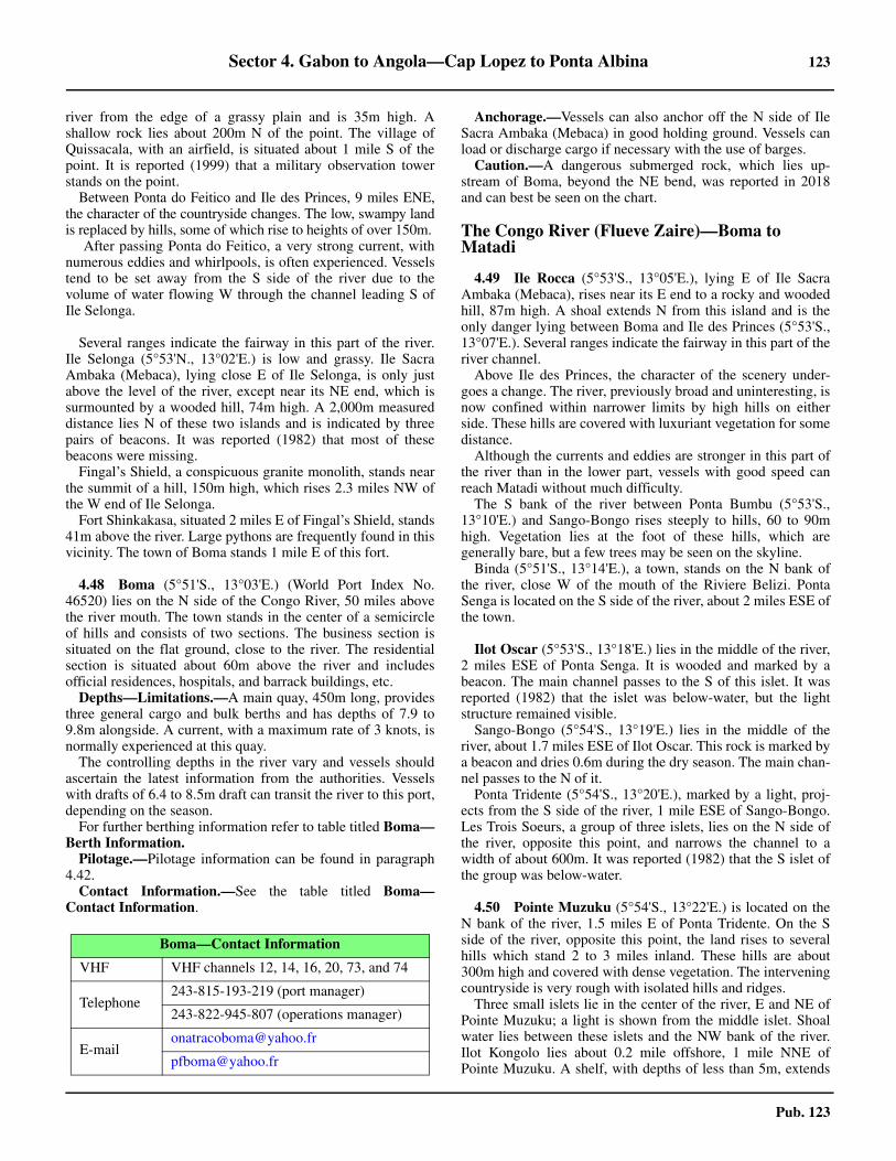
Sector 4. Gabon to Angola—Cap Lopez to Ponta Albina 123
Pub. 123
river from the edge of a grassy plain and is 35m high. Ashallow rock lies about 200m N of the point. The village ofQuissacala, with an airfield, is situated about 1 mile S of thepoint. It is reported (1999) that a military observation towerstands on the point.
Between Ponta do Feitico and Ile des Princes, 9 miles ENE,the character of the countryside changes. The low, swampy landis replaced by hills, some of which rise to heights of over 150m.
After passing Ponta do Feitico, a very strong current, withnumerous eddies and whirlpools, is often experienced. Vesselstend to be set away from the S side of the river due to thevolume of water flowing W through the channel leading S ofIle Selonga.
Several ranges indicate the fairway in this part of the river.Ile Selonga (5°53'N., 13°02'E.) is low and grassy. Ile SacraAmbaka (Mebaca), lying close E of Ile Selonga, is only justabove the level of the river, except near its NE end, which issurmounted by a wooded hill, 74m high. A 2,000m measureddistance lies N of these two islands and is indicated by threepairs of beacons. It was reported (1982) that most of thesebeacons were missing.
Fingal’s Shield, a conspicuous granite monolith, stands nearthe summit of a hill, 150m high, which rises 2.3 miles NW ofthe W end of Ile Selonga.
Fort Shinkakasa, situated 2 miles E of Fingal’s Shield, stands41m above the river. Large pythons are frequently found in thisvicinity. The town of Boma stands 1 mile E of this fort.
4.48 Boma (5°51'S., 13°03'E.) (World Port Index No.46520) lies on the N side of the Congo River, 50 miles abovethe river mouth. The town stands in the center of a semicircleof hills and consists of two sections. The business section issituated on the flat ground, close to the river. The residentialsection is situated about 60m above the river and includesofficial residences, hospitals, and barrack buildings, etc.
Depths—Limitations.—A main quay, 450m long, providesthree general cargo and bulk berths and has depths of 7.9 to9.8m alongside. A current, with a maximum rate of 3 knots, isnormally experienced at this quay.
The controlling depths in the river vary and vessels shouldascertain the latest information from the authorities. Vesselswith drafts of 6.4 to 8.5m draft can transit the river to this port,depending on the season.4.48 For further berthing information refer to table titled Boma—Berth Information.
Pilotage.—Pilotage information can be found in paragraph4.42.4.48 Contact Information.—See the table titled Boma—Contact Information.
Anchorage.—Vessels can also anchor off the N side of IleSacra Ambaka (Mebaca) in good holding ground. Vessels canload or discharge cargo if necessary with the use of barges.
Caution.—A dangerous submerged rock, which lies up-stream of Boma, beyond the NE bend, was reported in 2018and can best be seen on the chart.
The Congo River (Flueve Zaire)—Boma to Matadi
4.49 Ile Rocca (5°53'S., 13°05'E.), lying E of Ile SacraAmbaka (Mebaca), rises near its E end to a rocky and woodedhill, 87m high. A shoal extends N from this island and is theonly danger lying between Boma and Ile des Princes (5°53'S.,13°07'E.). Several ranges indicate the fairway in this part of theriver channel.
Above Ile des Princes, the character of the scenery under-goes a change. The river, previously broad and uninteresting, isnow confined within narrower limits by high hills on eitherside. These hills are covered with luxuriant vegetation for somedistance.
Although the currents and eddies are stronger in this part ofthe river than in the lower part, vessels with good speed canreach Matadi without much difficulty.
The S bank of the river between Ponta Bumbu (5°53'S.,13°10'E.) and Sango-Bongo rises steeply to hills, 60 to 90mhigh. Vegetation lies at the foot of these hills, which aregenerally bare, but a few trees may be seen on the skyline.
Binda (5°51'S., 13°14'E.), a town, stands on the N bank ofthe river, close W of the mouth of the Riviere Belizi. PontaSenga is located on the S side of the river, about 2 miles ESE ofthe town.
Ilot Oscar (5°53'S., 13°18'E.) lies in the middle of the river,2 miles ESE of Ponta Senga. It is wooded and marked by abeacon. The main channel passes to the S of this islet. It wasreported (1982) that the islet was below-water, but the lightstructure remained visible.
Sango-Bongo (5°54'S., 13°19'E.) lies in the middle of theriver, about 1.7 miles ESE of Ilot Oscar. This rock is marked bya beacon and dries 0.6m during the dry season. The main chan-nel passes to the N of it.
Ponta Tridente (5°54'S., 13°20'E.), marked by a light, proj-ects from the S side of the river, 1 mile ESE of Sango-Bongo.Les Trois Soeurs, a group of three islets, lies on the N side ofthe river, opposite this point, and narrows the channel to awidth of about 600m. It was reported (1982) that the S islet ofthe group was below-water.
4.50 Pointe Muzuku (5°54'S., 13°22'E.) is located on theN bank of the river, 1.5 miles E of Ponta Tridente. On the Sside of the river, opposite this point, the land rises to severalhills which stand 2 to 3 miles inland. These hills are about300m high and covered with dense vegetation. The interveningcountryside is very rough with isolated hills and ridges.
Three small islets lie in the center of the river, E and NE ofPointe Muzuku; a light is shown from the middle islet. Shoalwater lies between these islets and the NW bank of the river.Ilot Kongolo lies about 0.2 mile offshore, 1 mile NNE ofPointe Muzuku. A shelf, with depths of less than 5m, extends
Boma—Contact Information
VHF VHF channels 12, 14, 16, 20, 73, and 74
Telephone243-815-193-219 (port manager)
243-822-945-807 (operations manager)
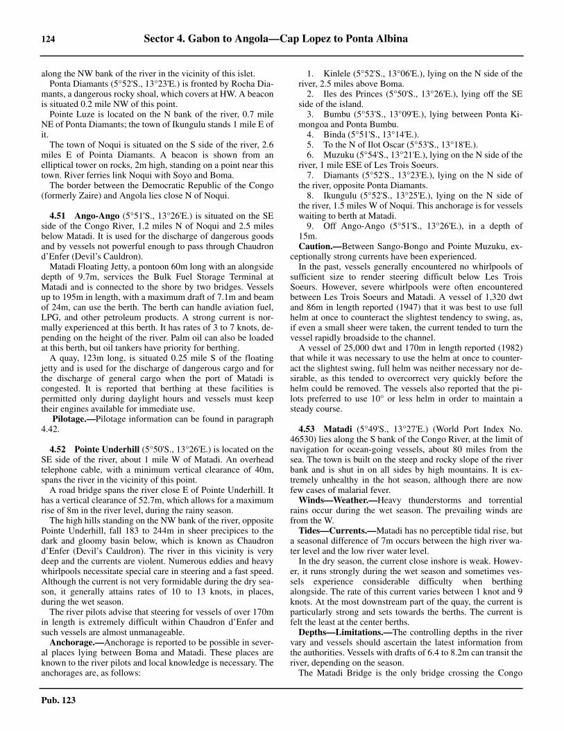
124 Sector 4. Gabon to Angola—Cap Lopez to Ponta Albina
Pub. 123
along the NW bank of the river in the vicinity of this islet.Ponta Diamants (5°52'S., 13°23'E.) is fronted by Rocha Dia-
mants, a dangerous rocky shoal, which covers at HW. A beaconis situated 0.2 mile NW of this point.
Pointe Luze is located on the N bank of the river, 0.7 mileNE of Ponta Diamants; the town of Ikungulu stands 1 mile E ofit.
The town of Noqui is situated on the S side of the river, 2.6miles E of Pointa Diamants. A beacon is shown from anelliptical tower on rocks, 2m high, standing on a point near thistown. River ferries link Noqui with Soyo and Boma.
The border between the Democratic Republic of the Congo(formerly Zaire) and Angola lies close N of Noqui.
4.51 Ango-Ango (5°51'S., 13°26'E.) is situated on the SEside of the Congo River, 1.2 miles N of Noqui and 2.5 milesbelow Matadi. It is used for the discharge of dangerous goodsand by vessels not powerful enough to pass through Chaudrond’Enfer (Devil’s Cauldron).4.51 Matadi Floating Jetty, a pontoon 60m long with an alongsidedepth of 9.7m, services the Bulk Fuel Storage Terminal atMatadi and is connected to the shore by two bridges. Vesselsup to 195m in length, with a maximum draft of 7.1m and beamof 24m, can use the berth. The berth can handle aviation fuel,LPG, and other petroleum products. A strong current is nor-mally experienced at this berth. It has rates of 3 to 7 knots, de-pending on the height of the river. Palm oil can also be loadedat this berth, but oil tankers have priority for berthing.
A quay, 123m long, is situated 0.25 mile S of the floatingjetty and is used for the discharge of dangerous cargo and forthe discharge of general cargo when the port of Matadi iscongested. It is reported that berthing at these facilities ispermitted only during daylight hours and vessels must keeptheir engines available for immediate use.
Pilotage.—Pilotage information can be found in paragraph4.42.
4.52 Pointe Underhill (5°50'S., 13°26'E.) is located on theSE side of the river, about 1 mile W of Matadi. An overheadtelephone cable, with a minimum vertical clearance of 40m,spans the river in the vicinity of this point.
A road bridge spans the river close E of Pointe Underhill. Ithas a vertical clearance of 52.7m, which allows for a maximumrise of 8m in the river level, during the rainy season.
The high hills standing on the NW bank of the river, oppositePointe Underhill, fall 183 to 244m in sheer precipices to thedark and gloomy basin below, which is known as Chaudrond’Enfer (Devil’s Cauldron). The river in this vicinity is verydeep and the currents are violent. Numerous eddies and heavywhirlpools necessitate special care in steering and a fast speed.Although the current is not very formidable during the dry sea-son, it generally attains rates of 10 to 13 knots, in places,during the wet season.
The river pilots advise that steering for vessels of over 170min length is extremely difficult within Chaudron d’Enfer andsuch vessels are almost unmanageable.
Anchorage.—Anchorage is reported to be possible in sever-al places lying between Boma and Matadi. These places areknown to the river pilots and local knowledge is necessary. Theanchorages are, as follows:
1. Kinlele (5°52'S., 13°06'E.), lying on the N side of theriver, 2.5 miles above Boma.
2. Iles des Princes (5°50'S., 13°26'E.), lying off the SEside of the island.
3. Bumbu (5°53'S., 13°09'E.), lying between Ponta Ki-mongoa and Ponta Bumbu.
4. Binda (5°51'S., 13°14'E.).5. To the N of Ilot Oscar (5°53'S., 13°18'E.).6. Muzuku (5°54'S., 13°21'E.), lying on the N side of the
river, 1 mile ESE of Les Trois Soeurs.7. Diamants (5°52'S., 13°23'E.), lying on the N side of
the river, opposite Ponta Diamants.8. Ikungulu (5°52'S., 13°25'E.), lying on the N side of
the river, 1.5 miles W of Noqui. This anchorage is for vesselswaiting to berth at Matadi.
9. Off Ango-Ango (5°51'S., 13°26'E.), in a depth of15m.Caution.—Between Sango-Bongo and Pointe Muzuku, ex-
ceptionally strong currents have been experienced.In the past, vessels generally encountered no whirlpools of
sufficient size to render steering difficult below Les TroisSoeurs. However, severe whirlpools were often encounteredbetween Les Trois Soeurs and Matadi. A vessel of 1,320 dwtand 86m in length reported (1947) that it was best to use fullhelm at once to counteract the slightest tendency to swing, as,if even a small sheer were taken, the current tended to turn thevessel rapidly broadside to the channel.
A vessel of 25,000 dwt and 170m in length reported (1982)that while it was necessary to use the helm at once to counter-act the slightest swing, full helm was neither necessary nor de-sirable, as this tended to overcorrect very quickly before thehelm could be removed. The vessels also reported that the pi-lots preferred to use 10° or less helm in order to maintain asteady course.
4.53 Matadi (5°49'S., 13°27'E.) (World Port Index No.46530) lies along the S bank of the Congo River, at the limit ofnavigation for ocean-going vessels, about 80 miles from thesea. The town is built on the steep and rocky slope of the riverbank and is shut in on all sides by high mountains. It is ex-tremely unhealthy in the hot season, although there are nowfew cases of malarial fever.
Winds—Weather.—Heavy thunderstorms and torrentialrains occur during the wet season. The prevailing winds arefrom the W.
Tides—Currents.—Matadi has no perceptible tidal rise, buta seasonal difference of 7m occurs between the high river wa-ter level and the low river water level.
In the dry season, the current close inshore is weak. Howev-er, it runs strongly during the wet season and sometimes ves-sels experience considerable difficulty when berthingalongside. The rate of this current varies between 1 knot and 9knots. At the most downstream part of the quay, the current isparticularly strong and sets towards the berths. The current isfelt the least at the center berths.
Depths—Limitations.—The controlling depths in the rivervary and vessels should ascertain the latest information fromthe authorities. Vessels with drafts of 6.4 to 8.2m can transit theriver, depending on the season. 4.53 The Matadi Bridge is the only bridge crossing the Congo
Sector 4. Gabon to Angola—Cap Lopez to Ponta Albina 125
Pub. 123
River. It spans N to S, across the narrowest section of thenavigable portion of the river, dividing the two port areas. Dueto the fluctuating water levels and depths of the river, marinersare advised to contact local authorities for accurate informationon height clearance.
The port has 1,610m of total main quayage, which providesten berths. These berths are 143 to 188m long and have depthsof 6 to 10m alongside. Vessels up to 55,809 dwt, 179m inlength, and 10m draft can be accommodated. There arefacilities for general cargo, bulk, container, and ro-ro vessels.4.53 The new Matadi Gateway Terminal (MGT), completed in2016, is situated downriver from the main port facilities,immediately S of the Matadi Bridge. The terminal canfacilitate vessels who cannot proceed beyond the bridge to themain port area.4.53 For further berthing information refer to table titledMatadi—Berth Information.
Pilotage.—Pilotage information can be found in paragraph4.42.4.53 Contact Information.—See the table titled Matadi—Con-tact Information.
Caution.—At the most downstream part of the quay, vesselsmust use care when dropping the anchor to assist in berthing,as deep water lies close alongside. Vessels generally berthstarboard side alongside owing to the current.
The Congo River (Flueve Zaire) to Luanda
4.54 The coast extending S for many miles from a pointlocated 3 miles S of Ponta da Moita Seca Light (6°07'S.,12°16'E.) consists of red cliffs. Inland of these cliffs, atableland runs parallel to the coast in a continuous double line.This tableland is visible in places from offshore, but has nodefinite landmarks which can be identified.
An aeronautical light beacon (Soyo-Quinfruquena) is shownfrom a conspicuous mast standing about 9 miles SSE of Pontada Moita Seca.
The Rio Lombo (6°23'S., 12°26'E.) enters the sea 19 milesSSE of Ponta da Moita Secca.
A small local oil terminal, consisting of a lighted platform, issituated 1.5 miles offshore, about 6.5 miles SSE of the mouthof this river. A submarine pipeline extends NE between the ter-minal and the coast.
Cabeca da Cobra (6°33'S., 12°30'E.), a rounded headlandwith a rocky base, is located 10 miles SE of the mouth of theRio Lombo and is surmounted by a moderately high hill. Cabe-ca da Cobra Light is shown from a tower with a dwelling, 13mhigh, standing on this headland. The village of Lubombe is sit-uated about 1 mile E of the light.
A bank, with depths of less than 5m, extends up to about 2.3miles W from Cabeca da Cobra. Baixo de Dentro, a group ofshallow rocks, lies on this bank, about 0.7 mile W of the head-land. Baixo de Fora, a rocky shoal with a least depth of 4.4m,
lies about 3.5 miles WSW of the headland.Ponta do Quipai, located 8 miles SSE of Cabeca da Cobra,
consists of lofty cliffs which are surmounted by shrubs andoverlooked by a hill with a round, bare summit. A conspicuousclump of mangroves stands within this point and is visiblefrom a considerable distance offshore.
The mouths of the Rio Lukulo and the Rio Sange lie 1.8 and4.5 miles, respectively, SE of Ponta do Quipai.
Ponta do Quinzau (6°54'S., 12°45'E.) is located 18 milesSE of Ponta do Quipai. The coast between is fringed by an un-interrupted sandy beach which is backed by rocky cliffs andsurmounted by bare, rounded hills. The cliffs in the vicinity ofPonta do Quinzau are about 40m high. Ponta do Quinzau Lightis shown from a tower with a dwelling, 15m high, standingabout 0.5 mile N of the point. A prominent tower, 50m high,stands about 4 miles inland, 6.5 miles N of the light.
Caution.—Depths of less than 10m extend up to about 6miles offshore between Ponta da Moita Seca and Nzeto (Am-brizete), 76 miles SSE. Vessels should exercise care when nav-igating in this area and keep in depths of over 15m. Rollersoften form without warning and frequently break in depths ofup to 9m.
An artificial reef area, which may best be seen on the chart,lies centered about 22 miles WSW of Cabeca da Cobra Light.
Oil exploration and production are being carried out alongthis coastal area and vessels are warned that numerous plat-forms, submerged pipelines, drilling rigs, and FSO facilitiesmay be encountered up to 60 miles offshore. Vessels should ex-ercise care when navigating in this vicinity as many of the as-sociated structures and installations are often moved and arenot charted. In addition, numerous well heads lie within the100m curve, but are not considered to be a danger to surfacenavigation.
4.55 Safueiro Oil Field (6°07'S., 12°04'.), with a singleplatform, lies centered 13 miles W of Ponta da Moita Seca.
Essungo Oil Field (6°13'S., 12°10'.), with several wells andplatforms, lies centered 10 miles SW of Ponta da Moita Seca.
Cuntala Oil Field (6°18'S., 12°19'E.), with several wells,lies centered 9 miles NW of the mouth of the Rio Lombo.
Raia Oil Field (6°21'S., 12°18'E.), with several wells andplatforms, lies centered 9 miles WNW of the mouth of the RioLombo.
Estrela Oil Field (6°26'S., 12°21'E.), with several platforms,lies centered 6 miles WSW of the mouth of the Rio Lombo.
Bagre Oil Field (6°26'S., 12°18'E.), with several platforms,lies centered 10 miles WSW of the mouth of the Rio Lombo.
Lombo East Oil Field (6°51'S., 12°24'E.), with several plat-forms, lies centered 22 miles W of Ponta do Quinzau Light.
Sulele Oil Field (6°51'S., 12°26'E.), with several platforms,lies centered 20 miles W of Ponta do Quinzau Light.
Tubarao Oil Field (6°54'S., 12°24'E.), with one platform,lies centered 21miles W of Ponta do Quinzau Light.
Tamboril Oil Field (6°54'S., 12°26'E.), with one platform,lies centered 19 miles W of Ponta do Quinzau Light.
Palanca Oil Field (6°58'S., 12°23'E.), with several plat-forms, lies centered 23 miles WSW of Ponta do Quinzau.
Impala Oil Field (7°00'S., 12°23'E.), with several platforms,lies centered 24 miles WSW of Ponta do Quinzau Light.
Pacassa Oil Field (7°08'S., 12°26'E.), with several platforms
Matadi—Contact Information
VHF VHF channels 12, 14, 16, 20, 73, and 74
Telephone 243-999-905-669 (port manager)
126 Sector 4. Gabon to Angola—Cap Lopez to Ponta Albina
Pub. 123
and wells, lies centered 28 miles SW of Ponta do QuinzauLight.
Xikomba Terminal (6°03'S., 11°01'E.), is reportedly de-commissioned (2011) with no surface infrastructure remaining.
Caution.—Numerous well heads and submarine pipelinesexist within the above fields.
Restricted areas, which may best be seen on the chart, sur-round several of the above fields. Vessels not proceeding to orfrom the facilities are prohibited from entering these areaswithout prior permission.
4.56 PSVM Terminal (6°15'S., 10°44'E.) (World Port In-dex No. 46545), is situated 93 miles W of Ponta da Moita Seca.It consists of a Floating Production Storage Offloading Tanker(PSVM), which is equipped with AIS, and moored in 2,000mof water.
A designated waiting area, with a radius of 5 miles, lies cen-tered 10 miles NW of the FPSO.
Pilotage.—Pilotage is compulsory and available 24 hours.Pilots board in position 6°10.9'S, 10°40.3'E. Mooring takesplace between 0600 and 1500, with unmooring permitted 24hours.
Regulations.—Vessels should send an ETA via e-mail orfacsimile upon commencement of voyage to the terminal, thenat 96 hours, 72 hours, 48 hours, 24 hours, and 4 hours prior toarrival. Further ETA updates should be made when withinrange. An immediate update should be sent if the vessel’s ETAchanges by more than 6 hours from the original ETA or bymore than 1 hour following the 24-hour notification. Upon re-ceipt of the terminal message, vessels should then advise byemail and/or facsimile the following:
1. ETA and intended Notice of Readiness (NOR).2. Cargo requirements (in bbls), cargo stowage plan, and
capacity at 98%.3. Confirmation that vessel’s bow is fully compliant with
SBM recommendations and advise of number, type, size,and SWL of bow stoppers.
4. Oil pollution certificate details.5. Agent, owner, operator, charterer, and their contact in-
formation.6. LR/IMO number, flag and port of registry, and vessel
contact information.7. SDWT, maximum summer draft, gross and net ton-
nage, loa, beam, year built, and Call sign.8. Master’s name as it appears on Bill of Lading.9. Last 10 cargoes.10. SCAC code (if required).11. Arrival and expected departure drafts (fore and aft).12. ISPS security level, name and rank of SSO.13. Confirmation 220 volts is available in pilot cabin.14. Volume of ballast onboard and to be discharged, and
time required.15. Confirmation that oxygen, hydrogen, and mercaptan
meters are available and that cargo tanks will be loaded lessthan 8% oxygen, 5ppm hydrogen, and 0.5ppm mercaptan.
16. Initial/maximum and topping off loading rates using 2x 16” connections.
4.56 Contact Information.—See the table titled PSVM Termi-
nal—Contact Information.
Caution.—A restricted area, with a radius of 5 miles, sur-rounds the FPSO. Vessels are prohibited from entering this ar-ea without prior permission from the terminal and/or a pilot orterminal representative onboard.
4.57 Kizomba A Terminal (6°19'S., 11°03'E.) (World PortIndex No. 46541), is situated about 75 miles WSW of Ponta daMoita Seca in the vicinity of an oil field. It consists of a Float-ing Production Storage and Offloading (FPSO) facility, a drill-ing platform, and a CALM buoy. The FPSO (Kizomba A) ismoored in a depth of 1,180m; the CALM buoy is situated 1mile NNW of it.
A designated waiting area, with a radius of 1.5 miles, liescentered 5 miles NW of the FPSO.
Local thunderstorms, which occur in the vicinity of the ter-minal, are usually preceded by a dense cloud belt and can beaccompanied at times by wind gusts exceeding 50 knots.
Pilotage.—Pilotage is compulsory and available 24 hours.Pilots, who act as mooring masters, can be contacted on VHFchannel 11 and by telephone (1-713-7679285) and board in thetanker waiting area located NW of the FPSO in position8°18'S,10°59'E. Berthing is carried out only from 0600 to 1500 butvessels may depart at any time.
Regulations.—Vessels should send an ETA 72 hours, 48hours, 24 hours, and 4 hours prior to arrival. Vessels shouldthen contact the terminal when within VHF range. Changes tothe ETA of more than 1 hour during the last 24 hours should bereported immediately. Mooring takes place between 0600 and1500. Vessels may depart 24 hours.
A restricted area, with a radius of 4 miles, surrounds theFPSO. Vessels are prohibited from entering this area withoutprior permission from the terminal.4.57 Contact Information.—See the table titled Kizomba ATerminal—Contact Information.
PSVM Terminal—Contact Information
Terminal
VHF VHF channel 9
Telephone 244-222-637-300
Facsimile 244-222-637-386
E-mail [email protected]
FPSO Marine Superintendent
Telephone44-20-300-94806
870-765-083-419
E-mail [email protected]
Kizomba A Terminal—Contact Information
Call sign Kizomba A FSPO
VHF VHF channels 14 and 16
Telephone 1-713-767-3287
Facsimile 1-713-767-9292
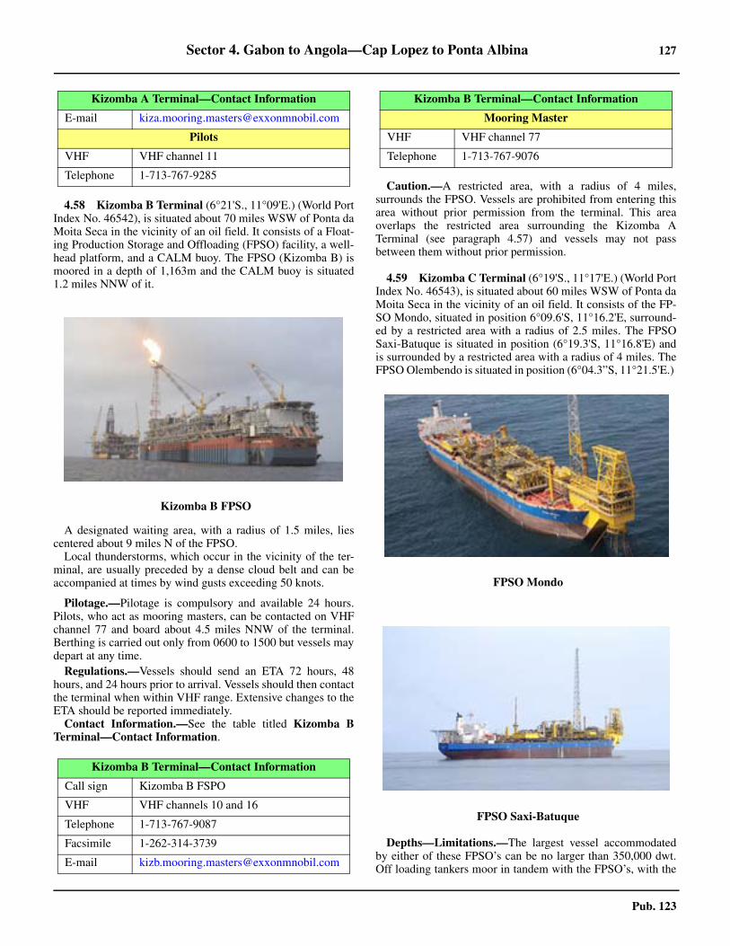
Sector 4. Gabon to Angola—Cap Lopez to Ponta Albina 127
Pub. 123
4.58 Kizomba B Terminal (6°21'S., 11°09'E.) (World PortIndex No. 46542), is situated about 70 miles WSW of Ponta daMoita Seca in the vicinity of an oil field. It consists of a Float-ing Production Storage and Offloading (FPSO) facility, a well-head platform, and a CALM buoy. The FPSO (Kizomba B) ismoored in a depth of 1,163m and the CALM buoy is situated1.2 miles NNW of it.
A designated waiting area, with a radius of 1.5 miles, liescentered about 9 miles N of the FPSO.
Local thunderstorms, which occur in the vicinity of the ter-minal, are usually preceded by a dense cloud belt and can beaccompanied at times by wind gusts exceeding 50 knots.
Pilotage.—Pilotage is compulsory and available 24 hours.Pilots, who act as mooring masters, can be contacted on VHFchannel 77 and board about 4.5 miles NNW of the terminal.Berthing is carried out only from 0600 to 1500 but vessels maydepart at any time.
Regulations.—Vessels should send an ETA 72 hours, 48hours, and 24 hours prior to arrival. Vessels should then contactthe terminal when within VHF range. Extensive changes to theETA should be reported immediately.4.58 Contact Information.—See the table titled Kizomba BTerminal—Contact Information.
Caution.—A restricted area, with a radius of 4 miles,surrounds the FPSO. Vessels are prohibited from entering thisarea without prior permission from the terminal. This areaoverlaps the restricted area surrounding the Kizomba ATerminal (see paragraph 4.57) and vessels may not passbetween them without prior permission.
4.59 Kizomba C Terminal (6°19'S., 11°17'E.) (World PortIndex No. 46543), is situated about 60 miles WSW of Ponta daMoita Seca in the vicinity of an oil field. It consists of the FP-SO Mondo, situated in position 6°09.6'S, 11°16.2'E, surround-ed by a restricted area with a radius of 2.5 miles. The FPSOSaxi-Batuque is situated in position (6°19.3'S, 11°16.8'E) andis surrounded by a restricted area with a radius of 4 miles. TheFPSO Olembendo is situated in position (6°04.3”S, 11°21.5'E.)
Depths—Limitations.—The largest vessel accommodatedby either of these FPSO’s can be no larger than 350,000 dwt.Off loading tankers moor in tandem with the FPSO’s, with the
E-mail [email protected]
Pilots
VHF VHF channel 11
Telephone 1-713-767-9285
4.58Kizomba B FPSO
Kizomba B Terminal—Contact Information
Call sign Kizomba B FSPO
VHF VHF channels 10 and 16
Telephone 1-713-767-9087
Facsimile 1-262-314-3739
E-mail [email protected]
Kizomba A Terminal—Contact Information
Mooring Master
VHF VHF channel 77
Telephone 1-713-767-9076
4.59FPSO Mondo
4.59FPSO Saxi-Batuque
Kizomba B Terminal—Contact Information

128 Sector 4. Gabon to Angola—Cap Lopez to Ponta Albina
Pub. 123
off loading tankers bow to the FPSO’s stern. A floating hosearrangement is utilized for the transfer of cargo.
Pilotage.—Pilotage is compulsory for both facilities. Pilots,who act as mooring masters, can be contacted by VHF chan-nels 11, 16, and 72 and board for the FPSO Mondo in position(6°06'S, 11°16'E,) and for the FPSO Saxi-Batuque in position(6°16'S, 11°14'E.)
Regulations.—Vessels should send an ETA by e-mail or fac-simile upon departure from their previous port, and then 72hours, 48 hours, 24 hours, and 4 hours prior to arrival. An im-mediate update should be sent if the vessel’s ETA changes bymore than 6 hours from the original ETA or by more than 1hour following the 24-hour notification. Vessels should thencontact the terminals when within VHF range. 4.59 Contact Information.—See the table titled Kizomba CTerminal—Contact Information,
4.59 Caution.—An exclusion area of 1,000m exists around eachFPSO. Entry into this area requires permission. In addition, cir-cular restricted areas, which require permission before a vesselis allowed to enter, surround each terminal, as follows:
1. Mondo—Radius of 2.5 miles.2. Saxi—Radius of 4 miles.
A designated waiting area for FPSO Mondo lies centered ap-proximately 11 miles NE of the FPSO. A designated waitingarea for FPSO Saxi-Batuque lies centered approximately 10.5miles NE of the FPSO.
4.60 Lombo East Oil Terminal (6°50'S., 12°22'E.) is situ-
ated about 23 miles WNW of Ponta do Quinzau Light. It has adepth of 36.5m and can handle vessels up to 175,000 dwt.
It is reported (2005) this terminal is no longer used and theSBM has been removed.
4.61 Palanca Terminal (6°57'S., 12°24'E.) (World Port In-dex No. 46547), situated about 22 miles WSW of Ponta doQuinzau Light, consists of several production platforms, anSBM (CALM), and a Floating Production Storage and Off-loading (FPSO) facility. The FPSO (Palanca) is moored to anSBM in a depth of 44m. Tankers are moored bow to bow withthe FPSO and vessels up to 150,000 dwt can be handled. TheSBM (CALM) is moored in a depth of 42m. It is used as anauxiliary loading buoy and can handle vessels up to 300,000dwt.
Pilotage.—Pilotage is compulsory. Pilots, who act as moor-ing masters, can be contacted on VHF channel 16 or 67 andboard in the following positions:
a. 6°55'17.4'S, 12°22'30.0''E.b. 7°04'06.0'S, 12°29'42.0''E.
Regulations.—Berthing is carried out only from 0600 to1500 but vessels may depart at any time.
Vessels should send an ETA 72 hours, 48 hours, and 24hours in advance and then contact the terminal when withinVHF range.4.61 Contact Information.—See the table titled Palanca Termi-nal—Contact Information.
Anchorage.—A designated anchorage area, in depths of 40to 43m and a bottom of sand with good holding ground, liesabout 5 miles NW of the SBM. The swells in the vicinity of theterminal are predominantly from the SSW, with heights of 1.5to 2.5m. They are strongest from May to October and reach amaximum 2 to 3 days before spring tides.4.61 A restricted area surrounds the terminal and may best beseen on the chart. Vessels are prohibited from entering this areawithout prior permission from the terminal.
4.62 CLOV Terminal (7°27'S., 11°34'E.), situated 80miles WSW of Ponta do Quinzau Light in the vicinity on an oilfield, consists of a Floating Production Storage and Offloading(FPSO) vessel and a mooring buoy moored 1 mile from the FP-SO. The FPSO (CLOV) is moored in a depth of 1,200m. 4.62 The buoy can accommodate vessels up to 400,000 dwt; theFPSO can accommodate vessels up to 250,000 dwt.
A designated waiting anchorage area lies centered 5 milesNE of the FPSO.
A restricted area, with a radius of 500m, surrounds the FP-SO. Vessels are prohibited from entering this area without priorpermission from the terminal.4.62 Caution.—Circular restricted areas, known as the Kaombo
Kizomba C Terminal—Contact Information
Mondo
Call sign Mondo Terminal (C6VS9)
VHF VHF channels 16 and 67
Telephone 870-761117524 (INMARSAT)
Facsimile 870-761117526 (INMARSAT)
Saxi
OIM (SBM)
Telephone 1-713-767-9051 (ext 4801)
E-mail [email protected]
OBR (Exxonmobil)
Telephone 1-713-767-9060 (ext 4810)
E-mail [email protected]
SAXI Control Room (CCR)
VHF VHF channel 16 and 73
Telephone 1-713-767-9067
SAXI Radio Room
Telephone 870-761-135-175
Palanca Terminal—Contact Information
VHF VHF channels 16 and 67
E-mail [email protected]
Pilot/Loading Master
E-mail [email protected]

Sector 4. Gabon to Angola—Cap Lopez to Ponta Albina 129
Pub. 123
Field and marked by lighted buoys, have been established inthe Development Area extending NW from the CLOV Termi-nal in the following positions:
a. 7°12.9'S, 11°17.0'E with a radius of 8 miles.b. 7°24.6'S, 11°19.5'E with a radius of 12 miles.
4.62 Vessels are prohibited entering the restricted areas withoutthe permission of the terminal operator. 4.62 A moored storage tanker, the FPSO Kaombo Norte, has beenestablished in position 7°14.2'S, 11°17.1'E. A second tanker,the FSPO Kaombo Sul, has been established nearby, in posi-tion 7°21.9'S, 11°22.5'E.
4.63 The Rio Lucunga (6°57'S., 12°48'E.) flows into thesea 4.5 miles SE of Ponta do Quinzau Light (see paragraph4.54). The mouth of this river is indicated by several clumps oftrees standing close to the beach. A number of prominent whitefactory buildings are situated at Mucula, 0.5 mile SE of themouth.
A bank, with depths of less than 8m, lies about 3 milesoffshore, SW of the river mouth. Enseada de Mucula, a slightindentation, lies S of the mouth of the river. Vessels with localknowledge can approach this indentation and obtain anchoragein a depth of 6m off the factory buildings.
The coast extending up to about 7 miles S from the mouth ofthe Rio Lucunga is bordered by a sandy beach. Between the Send of this beach and the Rio M’bridge, 8 miles S, it consists oflow, rocky cliffs which are intersected by ravines. These ra-vines are of a yellowish color and contrast with the blue tint ofthe sea and the green tint of the inland countryside.
The Rio M’bridge (Rio Mebridege) (7°12'S., 12°51'E.),which is used only by local craft, can easily be recognized byPonta Palmas, its N entrance point. This point is wooded andthe dark hue of the trees contrasts strongly with the yellowishtint of the cliffs on the S bank of the river. The river mouth isfronted by breakers which extend up to 0.3 mile seaward. Theland to the S of the entrance is formed by low cliffs, which aresurmounted in a few places by thick clumps of trees. A rangeof hills stands inland of the river mouth.
Baia de Ambrizete (Baia de N’zeto) (7°14'S., 12°51'E.), aslight indentation, lies between the Rio M’bridge and a bluff,3.5 miles S. This latter bluff rises in a high and almost sheercliff which is covered with herbage. From the S, the bluff ap-pears as a projecting point and is very prominent. Within thebluff stands, a range of hills. The S and highest hill of thisrange has a conspicuous flat top which can be easily recog-nized from a considerable distance.
N’zeto Light (Ambrizete Light) (7°15'S., 12°51'E.) is shownat an elevation of 34m from a prominent tower, 20m high,standing on the bluff. A disused light structure and a smallwhite dwelling are situated close N and close W, respectively,of the light.
4.64 N’zeto (Ambrizete) (7°14'S., 12°51'E.), a small town,stands at the head of the indentation, 1.5 miles S of the mouthof the Rio M’bridge. It is situated on the rising ground, whichstretches toward the bluff, and is fronted by a small breakwater.Two prominent radio masts stand close together in the town.
Depths of less than 5m lie up to about 1 mile offshore be-tween the town and the bluff and vessels should give this area a
wide berth.Anchorage can be taken in a depth of 9m, sand and mud,
about 2.5 miles SW of the mouth of the Rio M’bridge, but onlyvessels with local knowledge should use this roadstead. Thebottom changes to rocks and stones to the S of the anchorageand the depths shoal rapidly. A constant swell is experienced atthe anchorage and rollers are reported to frequently break in adepth of 9m off the town.
Baia de Juma (7°20'S., 12°54'E.), a slight indentation in thecoast, extends SE for 5 miles from the S entrance point of Baiade Ambrizete. The Rio Ambrizete, with a mouth barred bysand, flows into the N part of this indentation, about 3 miles SEof Nzeto. The S part of the indentation is fronted for about 3miles by a sandy beach. Anchorage, with local knowledge, canbe taken in this indentation, but the bottom is very foul andthere is a heavy swell.
The coast extending SSE from Baia de Juma is bold andcliffy with occasional sandy coves. The high white cliffs aresurmounted by trees.
4.65 Gimboa Terminal (7°33'S., 12°10'E.) consists of theFPO (Gimboa).
Regulations.—Vessels should send an ETA by e-mail 7 daysprior to arrival or upon departure of last port. E-mails shouldalso be sent 72 hours, 48 hours, and 24 hours in advance. Theyshould then contact Gimboa Control on VHF channel 12, 3hours prior to arrival, and once again when the vessel is 10miles from the terminal. Changes to the ETA of more than 6hours following the 72-hour or 48-hour notice or changes ofmore than 1 hour during the last 24 hours should be reportedimmediately. 4.65 Vessels should contact Gimboa Control upon clearing theterminal vicinity and again when departing the 10-mile zone. 4.65 Vessels must maintain a continuous listening watch on VHFchannels 12 and 16 during all operations.
Pilotage.—Pilotage is compulsory. Pilots, who act as moor-ing masters, can be contacted on VHF channel 12 or 16 andboard approximately 2 miles N of the terminal. Berthing is car-ried out only during daylight hours but vessels may depart atany time. 4.65 Contact Information.—See the table titled Gimboa Termi-nal—Contact Information.
Gimboa Terminal—Contact Information
Radio Room
Call sign Gimboa Control (C6OS7)
VHF VHF channels 12 and 16
Telephone 390-252-027-500
E-mail [email protected]
MMSI 309817000
Central Control Room
Telephone 870-764-858-385
E-mail [email protected]
Gimboa OIM
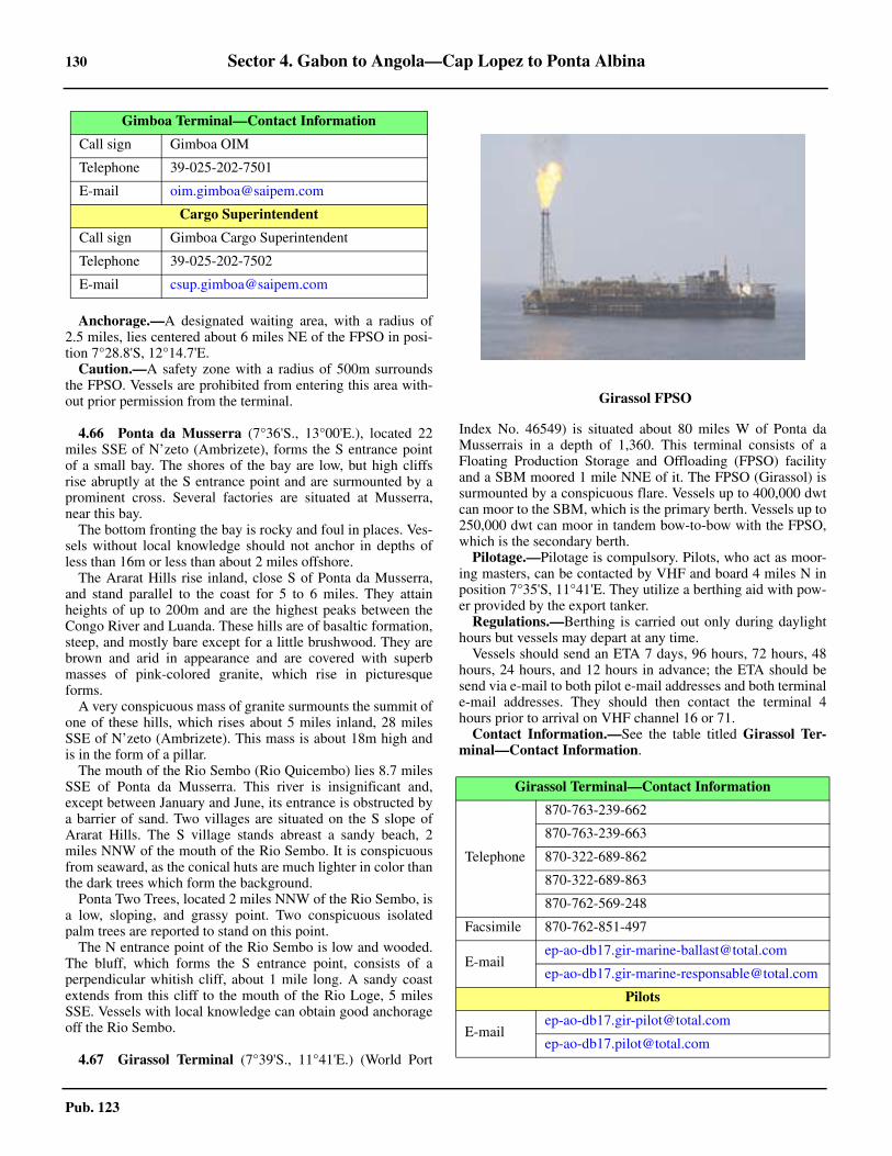
130 Sector 4. Gabon to Angola—Cap Lopez to Ponta Albina
Pub. 123
Anchorage.—A designated waiting area, with a radius of2.5 miles, lies centered about 6 miles NE of the FPSO in posi-tion 7°28.8'S, 12°14.7'E.
Caution.—A safety zone with a radius of 500m surroundsthe FPSO. Vessels are prohibited from entering this area with-out prior permission from the terminal.
4.66 Ponta da Musserra (7°36'S., 13°00'E.), located 22miles SSE of N’zeto (Ambrizete), forms the S entrance pointof a small bay. The shores of the bay are low, but high cliffsrise abruptly at the S entrance point and are surmounted by aprominent cross. Several factories are situated at Musserra,near this bay.
The bottom fronting the bay is rocky and foul in places. Ves-sels without local knowledge should not anchor in depths ofless than 16m or less than about 2 miles offshore.
The Ararat Hills rise inland, close S of Ponta da Musserra,and stand parallel to the coast for 5 to 6 miles. They attainheights of up to 200m and are the highest peaks between theCongo River and Luanda. These hills are of basaltic formation,steep, and mostly bare except for a little brushwood. They arebrown and arid in appearance and are covered with superbmasses of pink-colored granite, which rise in picturesqueforms.
A very conspicuous mass of granite surmounts the summit ofone of these hills, which rises about 5 miles inland, 28 milesSSE of N’zeto (Ambrizete). This mass is about 18m high andis in the form of a pillar.
The mouth of the Rio Sembo (Rio Quicembo) lies 8.7 milesSSE of Ponta da Musserra. This river is insignificant and,except between January and June, its entrance is obstructed bya barrier of sand. Two villages are situated on the S slope ofArarat Hills. The S village stands abreast a sandy beach, 2miles NNW of the mouth of the Rio Sembo. It is conspicuousfrom seaward, as the conical huts are much lighter in color thanthe dark trees which form the background.
Ponta Two Trees, located 2 miles NNW of the Rio Sembo, isa low, sloping, and grassy point. Two conspicuous isolatedpalm trees are reported to stand on this point.
The N entrance point of the Rio Sembo is low and wooded.The bluff, which forms the S entrance point, consists of aperpendicular whitish cliff, about 1 mile long. A sandy coastextends from this cliff to the mouth of the Rio Loge, 5 milesSSE. Vessels with local knowledge can obtain good anchorageoff the Rio Sembo.
4.67 Girassol Terminal (7°39'S., 11°41'E.) (World Port
Index No. 46549) is situated about 80 miles W of Ponta daMusserrais in a depth of 1,360. This terminal consists of aFloating Production Storage and Offloading (FPSO) facilityand a SBM moored 1 mile NNE of it. The FPSO (Girassol) issurmounted by a conspicuous flare. Vessels up to 400,000 dwtcan moor to the SBM, which is the primary berth. Vessels up to250,000 dwt can moor in tandem bow-to-bow with the FPSO,which is the secondary berth.
Pilotage.—Pilotage is compulsory. Pilots, who act as moor-ing masters, can be contacted by VHF and board 4 miles N inposition 7°35'S, 11°41'E. They utilize a berthing aid with pow-er provided by the export tanker.
Regulations.—Berthing is carried out only during daylighthours but vessels may depart at any time.
Vessels should send an ETA 7 days, 96 hours, 72 hours, 48hours, 24 hours, and 12 hours in advance; the ETA should besend via e-mail to both pilot e-mail addresses and both terminale-mail addresses. They should then contact the terminal 4hours prior to arrival on VHF channel 16 or 71.4.67 Contact Information.—See the table titled Girassol Ter-minal—Contact Information.
Call sign Gimboa OIM
Telephone 39-025-202-7501
E-mail [email protected]
Cargo Superintendent
Call sign Gimboa Cargo Superintendent
Telephone 39-025-202-7502
E-mail [email protected]
Gimboa Terminal—Contact Information
4.66Girassol FPSO
Girassol Terminal—Contact Information
Telephone
870-763-239-662
870-763-239-663
870-322-689-862
870-322-689-863
870-762-569-248
Facsimile 870-762-851-497
Pilots
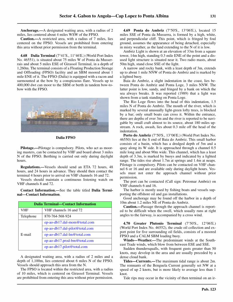
Sector 4. Gabon to Angola—Cap Lopez to Ponta Albina 131
Pub. 123
Anchorage.—A designated waiting area, with a radius of 2miles, lies centered about 4 miles WSW of the FPSO.
Caution.—A restricted area, with a radius of 7 miles, liescentered on the FPSO. Vessels are prohibited from enteringthis area without prior permission from the terminal.
4.68 Dalia Terminal (7°41'S., 11°46'E.) (World Port IndexNo. 46551), is situated about 75 miles W of Ponta da Musser-rais and about 5 miles ESE of Girassol Terminal, in a depth of1,260m. The terminal consists of a Floating Production Storageand Offloading (FPSO) facility and an SBM moored about 1mile ENE of it. The FPSO (Dalia) is equipped with a racon andsurmounted at the bow by a conspicuous flare. Vessels up to400,000 dwt can moor to the SBM or berth in tandem bow-to-bow with the FPSO.
Pilotage.—Pilotage is compulsory. Pilots, who act as moor-ing masters, can be contacted by VHF and board about 3 milesN of the FPSO. Berthing is carried out only during daylighthours.
Regulations.—Vessels should send an ETA 72 hours, 48hours, and 24 hours in advance. They should then contact theterminal 4 hours prior to arrival on VHF channels 16 and 72. 4.68 Vessels should maintain a continuous listening watch onVHF channels 8 and 72.
4.68 Contact Information.—See the table titled Dalia Termi-nal—Contact Information.
A designated waiting area, with a radius of 2 miles and adepth of 1,100m, lies centered about 6 miles N of the FPSO.Vessels should approach this area from the N.
The FPSO is located within the restricted area, with a radiusof 10 miles, which is centered on Girassol Terminal. Vesselsare prohibited from entering this area without prior permission.
4.69 Ponta do Ambriz (7°50'S., 13°06'E.), located 15miles SSE of Ponta da Musserra, is formed by a high, white,and perpendicular cliff. This point, which is fringed by foulground, assumes the appearance of being detached, especiallyin misty weather, as the land extending to the N of it is low.
Ambriz Light is shown at an elevation of 33m from a squaretower, 14m high, standing 0.3 mile ENE of the point and a dis-used light structure is situated near it. Two radio masts, about50m high, stand close SSE of the light.
A narrow and rocky bank, with a least depth of 3m, extendsup to about 1 mile NNW of Ponta do Ambriz and is marked bya lighted buoy.
Baia do Ambriz, a slight indentation in the coast, lies be-tween Ponta do Ambriz and Ponta Loge, 3 miles NNW. Thelatter point is low, sandy, and fringed by a bank on which thesea always breaks. It was reported (1989) that a light wasshown from a tank standing on Ponta Loge.
The Rio Loge flows into the head of this indentation, 1.5miles N of Ponta do Ambriz. The mouth of the river, which ismarked by several unusually light-green lofty trees, is blockedby a bar; only small boats can cross it. Within the entrance,there are depths of over 3m and the river is reported to be navi-gable by small craft almost to its source, about 180 miles up-stream. A rock, awash, lies about 0.3 mile off the head of theindentation.
Porto do Ambriz (7°50'S., 13°06'E.) (World Port Index No.46550) lies at the S end of Baia do Ambriz. This small harborconsists of a basin, which has a dredged depth of 5m and aquay along its W side. It is approached through a channel 0.5mile long and about 90m wide. This channel, which has a leastdepth of 3.3m, is marked by buoys and indicated by a lightedrange. The tides rise about 1.7m at springs and 1.4m at neaps.Pilotage is compulsory. Pilots can be contacted on VHF chan-nel 6 or 16 and are available only during daylight hours. Ves-sels must not enter the approach channel without priorpermission. 4.69 The port can be contacted (Call sign: Petromar Ambriz) onVHF channels 6 and 16.
The harbor is mostly used by fishing boats and vessels sup-porting the offshore oil and gas installations.
Good anchorage may be found off the harbor in a depth of10m about 1.2 miles NE of Ponta do Ambriz.
Caution.—Passage through the approach channel is report-ed to be difficult when the swell, which usually runs at rightangles to the fairway, is accompanied by a cross wind.
4.70 Greater Plutonio Terminal (7°50'S., 12°06'E.)(World Port Index No. 46552), the crude oil collection and ex-port point for five surrounding oil fields, consists of a mooredFPSO and a CALM SBM loading buoy. 4.70 Winds—Weather.—The predominant winds at the South-east Trade winds, which blow from between ESE and SSE. 4.70 Sudden thundersqualls, with frequent gusts greater than 50knots, may develop in the area and are usually preceded by adense cloud bank. 4.70 Tides—Currents.—The maximum tidal range is about 2m.The remnants of the Benguela Current generally set NW at aspeed of up 2 knots, but is more likely to average less than 1knot. 4.70 Tide rips may occur in the vicinity of then terminal on an ir-
4.68Dalia FPSO
Dalia Terminal—Contact Information
VHF VHF channels 16 and 72
Telephone 870-764-568-924
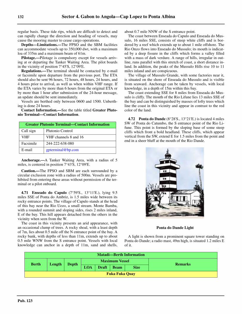
132 Sector 4. Gabon to Angola—Cap Lopez to Ponta Albina
Pub. 123
regular basis. These tide rips, which are difficult to detect andcan rapidly change the direction and heading of vessels, maycause the mooring master to cease cargo operations. 4.70 Depths—Limitations.—The FPSO and the SBM facilitiescan accommodate vessels up to 350,000 dwt, with a maximumloa of 335m and a maximum beam of 61m. 4.70 Pilotage.—Pilotage is compulsory except for vessels arriv-ing at or departing the Tanker Waiting Area. The pilot boardsin the vicinity of position 7°45'S, 12°09'E. 4.70 Regulations.—The terminal should be contacted by e-mailor facsimile upon departure from the previous port. The ETAshould also be sent 96 hours, 72 hours, 48 hours, 24 hours, and4 hours prior to arrival, as well as when within VHF range. Ifthe ETA varies by more than 6 hours from the original ETA orby more than 1 hour after submission of the 24-hour message,an update should be sent immediately. 4.70 Vessels are berthed only between 0600 and 1500. Unberth-ing is done 24 hours. 4.70 Contact Information.—See the table titled Greater Pluto-nio Terminal—Contact Information.
4.70 Anchorage.—A Tanker Waiting Area, with a radius of 5miles, is centered in position 7°43'S, 12°09'E.
4.70 Caution.—The FPSO and SBM are each surrounded by acircular exclusion zone with a radius of 500m. Vessels are pro-hibited from entering these areas without permission of the ter-minal or a pilot onboard.
4.71 Enseado do Capulo (7°59'S., 13°11'E.), lying 9.5miles SSE of Ponta do Ambriz, is 1.5 miles wide between itsrocky entrance points. The village of Capulo stands at the headof this bay near the Rio Uezo, a small stream. Monte Bamba,with a rounded summit and sloping sides, rises 2 miles inland,E of the bay. This hill appears detached from the others in thevicinity when seen from the W.
The coast in this vicinity presents an arid appearance, withan occasional clump of trees. A rocky shoal, with a least depthof 7m, lies about 0.5 mile off the N entrance point of the bay. Arocky bank, with depths of less than 11m, extends up to about0.5 mile WNW from the S entrance point. Vessels with localknowledge can anchor in a depth of 11m, sand and shells,
about 0.7 mile NNW of the S entrance point.The coast between Enseada do Capulo and Enseada do Mus-
sulo, 16 miles SSE, consists of steep white cliffs and is bor-dered by a reef which extends up to about 1 mile offshore. TheRio Onzo flows into Enseado do Mussulo; its mouth is indicat-ed by a deep fissure in the cliffs which forms a valley filledwith a mass of dark verdure. A range of hills, irregular in out-line, runs parallel with this stretch of coast, a short distance in-land. In addition, the peaks of the Mussulo Hills rise 10 to 11miles inland and are conspicuous.
The village of Mussulo Grande, with some factories near it,is situated on the shore of Enseada do Mussulo and is visiblefrom seaward. Anchorage can be taken by vessels, with localknowledge, in a depth of 15m within this bay.
The coast extending SSE for 8 miles from Enseada do Mus-sulo is cliffy. The mouth of the Rio Lifune lies 13 miles SSE ofthe bay and can be distinguished by masses of lofty trees whichline the coast in this vicinity and appear in contrast to the redcolor of the land.
4.72 Ponta do Dande (8°28'S., 13°21'E.) is located 4 milesSW of Ponta do Catumbo, the S entrance point of the Rio Li-fune. This point is formed by the sloping base of some steepcliffs which front a bold headland. These cliffs, which appearvertical from the SW, extend E for 1.5 miles from the point andend in a sheer bluff at the mouth of the Rio Dande.
A light is shown from a prominent square tower standing onPonta do Dande; a radio mast, 49m high, is situated 1.2 miles Eof it.
Greater Plutonio Terminal—Contact Information
Call sign Plutonio Control
VHF VHF channels 8 and 16
Facsimile 244-222-638-080
E-mail [email protected]
4.72Ponta do Dande Light
Matadi—Berth Information
Berth Length DepthMaximum Vessel
RemarksLOA Draft Beam Size
Fuka Fuka Quay
Sector 4. Gabon to Angola—Cap Lopez to Ponta Albina 133
Pub. 123
Baia do Dande lies between Ponta do Catumbo and Ponta doDande. A rocky shoal, with a least depth of 4m, lies about 1.7miles NNE of Ponta do Dande. The coastal bank, with depthsof less than 5m, extends up to about 1 mile offshore at the headand in the N part of the bay. Anchorage can be taken in a depthof 10m about 0.5 mile N of Ponta do Dande Light.4.72 It is reported (2013) the Angolan government intends todevelop a large port complex near Ponta do Dande.
Baia do Bengo is entered between Ponta Spilimberta, located7.2 miles SSE of Ponta do Dande, and Ponta das Lagostas, 11miles SSW. The coast between Ponta do Dande and PontaSpilimberta consists of high, red and white cliffs. The town andfort of Cacuaco are situated on the S shore of the bay. Theystand at the termination of some red and white cliffs, whichcontrast with the low land at the head of the bay.4.72 Ponta das Lagostas (Morro das Lagostas) (8°45'S.,13°18'E.) is formed by a perpendicular cliff of yellowish tintwhich is surmounted by trees. A light is shown from a tower,14m high, standing on this point but it is reported to be partlyhidden by trees. A prominent chimney is situated 1 mile ESEof the light.
A T-shaped jetty is located about 0.8 mile ESE of Ponta dasLagostas.
Caution.—The navigation light shown from Ponta dasLagostas has been reported to be difficult to distinguish fromother lights in the vicinity.
Luanda (8°48'S., 13°15'E.)
World Port Index No. 46560
4.73 The port of Luanda, one of the finest harbors on the Wcoast of Africa, is entered between Ponta das Lagostas andPonta da Ilha, 2.4 miles WSW. The latter point is the NEextremity of Ilha de Luanda (Ilha do Cabo), a low and narrowisland which shelters the seaward side of the port. This island,which is about 3.5 miles long, is connected to the mainland bya causeway at its SW end.
Luanda, the capital of Angola, stands along the S part of theharbor and extends toward the interior on the adjacent plateau.
Winds—Weather.—Winds from the WNW, WSW, and SEusually predominate. Winds occasionally blow from the N, butvery rarely from the NE quadrant. During the day, the windgenerally effects a complete rotation of direction. In the morn-ing, the wind is weak and usually from the S and E quadrants.In the afternoon, it then blows from the N and W, becomingfresh. At nightfall, the wind weakens and blows from the Wand S quadrants.
During the period between December and May, tropical dis-turbances of short duration may occur, although rarely. Thesedisturbances may consist of gusts from NNE and ESE, with ve-locities of up to about 50 knots.
Quay 5 156m
10.0m123m
9.0m
20m 8,254 dwtContainers, breakbulk, and bunkers. Continuous berthing length of 520m.Quay 6 176m 23m 16,966 dwt
Quay 7 188m 117m 19m 7,734 dwt
Kala Kala Quay
Quay 8 149m 10.0m 157m 9.0m 26m 25,028 dwt Coal, grain, containers, breakbulk, and bunkers.Continuous berthing length of 459m.
Quay 9 167m—
168m10.0m
25m 19,413 dwt
Quay 10 143m 189m 28m 46,970 dwt
Matadi Quay
Quay 1 149m6.0m — — — —
Breakbulk, bunkers, and general cargo. Continuous berthing length of 623m.
Quay 2 161m
Quay 3 155m 7.0m 189m6.0m
32m 55,809 dwt
Quay 4 156m 8.0m 117m 19m 7,661 dwt
Minoterie de Matadi (Midema)
Quay 11 60m 9.0m 147m — 23m 13,781 dwt Grain, containers, and bunkers.
Matadi Gateway Terminal (MGT)
1 350m 12.0m 147m — 23m 13,800 dwr Containers, breakbulk, and bunkers.
Matadi—Berth Information
Berth Length DepthMaximum Vessel
RemarksLOA Draft Beam Size
Luanda—Berth Information
Berth Length Depth Remarks
5M Terminal

134 Sector 4. Gabon to Angola—Cap Lopez to Ponta Albina
Pub. 123
Precipitation occurs from September to May in the form ofshowers. March and April are the hottest months and also themonths with the greatest rainfall. These showers are generallypreceded by gusty winds from the E. Thunderstorms occurfrequently in March and April, but are not very frequent duringthe remaining months. During the dry season, no rain occurs,but morning fog may appear. The fog forms particularly duringJune, July, and August, but rarely causes any difficulty.
Tides—Currents.—The tide rises about 1.8m at springs and1.4m at neaps.
In the vicinity of Luanda, the current has been reported to setE, or directly onto the coast, at a rate of 0.7 knot. Although thiscurrent is not constant, it is by no means infrequent.
Off Luanda, the characteristic West African swell is feltthroughout the year, but it is usually strongest from April toSeptember. The interior of the harbor is well-protected andalways calm.
Depths—Limitations.—A shoal bank, with depths of lessthan 10m, extends up to about 0.3 mile seaward from the NWside of Ilha de Luanda. This bank, which is steep-to at its NEend, also extends up to about 0.6 mile NE from the NEextremity of the island. The harbor entrance has depths of 15 to30m.
4.73 Major land reclamation works have recently (2019)expanded the port and waterfront areas of Luanda and Ilha deLuanda. These changes can best be seen on the chart.
The principal commercial pier and wharf are situated in theSW part of the harbor. They provide 2,020m of main quayage,with depths of up to 12m alongside. The port has facilities forgeneral cargo, ro-ro, bulk, tanker, and container vessels. Cargovessels up to 305m in length and 10.4m draft can beaccommodated.4.73 A new facility is located on the E side of the bay, close NE ofthe Container Terminal. It is approached from the NNE via achannel, which contains a turning basin, is marked by buoys,and which has been dredged to a depth of 14.9m. Three berthsare located here, with alongside depths of 10.3m and 5.4m inBerths 2 and 3, respectively.
An offshore oil and gas terminal berth, consisting of severalmooring buoys and a floating platform, is situated in the E partof the harbor. A submarine pipeline extends ESE and connectsthis berth to the shore. Tankers up to 230m in length and 13mdraft can be handled.
A naval installation is situated at the SW side of the harbor. Itis fronted by a wharf, 295m long, which has a depth of 12malongside.
5M Berths 1-3 — 12.0m Containers and bunkers. Continuous berthing length of 560m.
Capossoca Maritime Terminal
Ferry Pier 180m — Fast ferry berth.
Cimangola Terminal
Cement Berth 130m — Aggregates, cement, clinker, coal, and gypsum.
Luanda Passenger Terminal
Lower Pier71m
—Fast ferry and bunkers.
Upper Pier —
Multi-terminals
Berth 3 160m
5.5m Fertilizer, grain, and bunkers.Berths 1-2 350m
Berths 4-5 390m
Sogester Container Terminal
Berths 1-3 360m 10.5m Containers and bunkers.
Unicargas Terminal
Berths 1-3 340m 10.0m Ro-ro/lo-lo, containers, and bunkers. Continuous berthing length of 530m.
Sonils
Sonils Berth — 12.5m Bunkers. Continuous berthing length of 1,250m.
Sonils Sea Island Berth 65m — —
Luanda Refinery
1 — 14.8mClean products, crude, dirty products, and LPG
2 — 9.5m
Luanda—Berth Information
Berth Length Depth Remarks
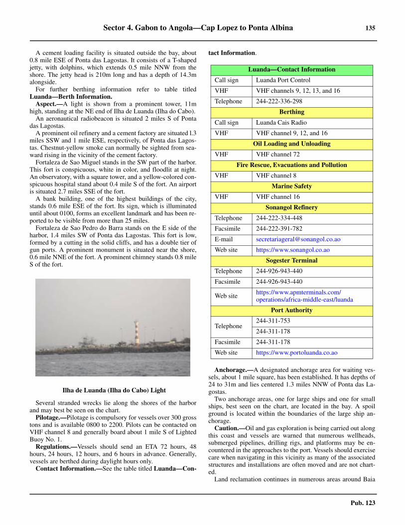
Sector 4. Gabon to Angola—Cap Lopez to Ponta Albina 135
Pub. 123
A cement loading facility is situated outside the bay, about0.8 mile ESE of Ponta das Lagostas. It consists of a T-shapedjetty, with dolphins, which extends 0.5 mile NNW from theshore. The jetty head is 210m long and has a depth of 14.3malongside.4.73 For further berthing information refer to table titledLuanda—Berth Information.
Aspect.—A light is shown from a prominent tower, 11mhigh, standing at the NE end of Ilha de Luanda (Ilha do Cabo).
An aeronautical radiobeacon is situated 2 miles S of Pontadas Lagostas.
A prominent oil refinery and a cement factory are situated l.3miles SSW and 1 mile ESE, respectively, of Ponta das Lagos-tas. Chestnut-yellow smoke can normally be sighted from sea-ward rising in the vicinity of the cement factory.
Fortaleza de Sao Miguel stands in the SW part of the harbor.This fort is conspicuous, white in color, and floodlit at night.An observatory, with a square tower, and a yellow-colored con-spicuous hospital stand about 0.4 mile S of the fort. An airportis situated 2.7 miles SSE of the fort.
A bank building, one of the highest buildings of the city,stands 0.6 mile ESE of the fort. Its sign, which is illuminateduntil about 0100, forms an excellent landmark and has been re-ported to be visible from more than 25 miles.
Fortaleza de Sao Pedro do Barra stands on the E side of theharbor, 1.4 miles SW of Ponta das Lagostas. This fort is low,formed by a cutting in the solid cliffs, and has a double tier ofgun ports. A prominent monument is situated near the shore,0.6 mile NNE of the fort. A prominent chimney stands 0.8 mileS of the fort.
Several stranded wrecks lie along the shores of the harborand may best be seen on the chart.
Pilotage.—Pilotage is compulsory for vessels over 300 grosstons and is available 0800 to 2200. Pilots can be contacted onVHF channel 8 and generally board about 1 mile S of LightedBuoy No. 1.
Regulations.—Vessels should send an ETA 72 hours, 48hours, 24 hours, 12 hours, and 6 hours in advance. Generally,vessels are berthed during daylight hours only.4.73 Contact Information.—See the table titled Luanda—Con-
tact Information.
Anchorage.—A designated anchorage area for waiting ves-sels, about 1 mile square, has been established. It has depths of24 to 31m and lies centered 1.3 miles NNW of Ponta das La-gostas.4.73 Two anchorage areas, one for large ships and one for smallships, best seen on the chart, are located in the bay. A spoilground is located within the boundaries of the large ship an-chorage.
Caution.—Oil and gas exploration is being carried out alongthis coast and vessels are warned that numerous wellheads,submerged pipelines, drilling rigs, and platforms may be en-countered in the approaches to the port. Vessels should exercisecare when navigating in this vicinity as many of the associatedstructures and installations are often moved and are not chart-ed.
Land reclamation continues in numerous areas around Baia
4.73Ilha de Luanda (Ilha do Cabo) Light
Luanda—Contact Information
Call sign Luanda Port Control
VHF VHF channels 9, 12, 13, and 16
Telephone 244-222-336-298
Berthing
Call sign Luanda Cais Radio
VHF VHF channel 9, 12, and 16
Oil Loading and Unloading
VHF VHF channel 72
Fire Rescue, Evacuations and Pollution
VHF VHF channel 8
Marine Safety
VHF VHF channel 16
Sonangol Refinery
Telephone 244-222-334-448
Facsimile 244-222-391-782
E-mail [email protected]
Web site https://www.sonangol.co.ao
Sogester Terminal
Telephone 244-926-943-440
Facsimile 244-926-943-440
Web site https://www.apmterminals.com/operations/africa-middle-east/luanda
Port Authority
Telephone244-311-753
244-311-178
Facsimile 244-311-178
Web site https://www.portoluanda.co.ao

136 Sector 4. Gabon to Angola—Cap Lopez to Ponta Albina
Pub. 123
de Luanda. Mariners are advised to contact local authorities forthe latest information.
A large area of spoil ground sits in the center of the harborbetween Ilha de Luanda (Ilha do Cabo) and the mainland andcan best be seen on the chart.
With high SW winds, the sea breaks over part of Ilha de Lu-anda and drives quantities of sand into the harbor. In addition,quantities of soil are washed down from the heights during therainy season. Both of these actions have resulted in the SW partof the harbor becoming very shallow and drying in places atLW.4.73 It is common for large numbers of vessels to raft up andanchor within the port limits of Baia de Luanda. 4.73 Both prohibited entry and anchorage areas, which may bestbe seen on the chart, lie in several parts of the harbor. The NEprohibited anchorage contains a dangerous wreck, which canbe seen on the chart.
A dangerous wreck, marked by a buoy, lies 0.3 miles ENEfrom the commercial quay.
Luanda to Lobito
4.74 The coast between Ilha de Luanda and Ponta dasPalmeirinhas, 22 miles SW, consists of a low, sandy spit whichencloses an extensive, but mostly shallow lagoon.
Ponta do Mussulo (8°52'S., 13°09'E.), located about 5 milesSW of Luanda, is the S entrance point of Barra da Corimba, themouth of the lagoon. A group of prominent radio masts is situ-ated 3 miles SE of this point. Morro da Cruz rises on the main-land, 6.5 miles SSW of the point. This hill is 54m high andprominent.
Ponta das Palmeirinhas (9°06'S., 13°00'E.) derives itsname from the clump of palm trees standing on it. A light isshown at an elevation of 40m from a prominent square tower,38m high, standing 1.7 miles N of this point.
Enseada do Buraco is entered 4.5 miles NNE of Ponta dasPalmeirinhas. This small bay provides anchorage in a depth of11m about 0.6 mile offshore.
The Rio Cuanza (9°21'S., 13°09'E.) flows into the sea 16miles SE of Ponta das Palmeirinhas. This shallow river is of
considerable importance and its muddy waters discolor the seafor up to about 10 miles offshore. The river mouth lies close Nof a long and sandy spit and is fronted by a bar which iscontinually changing. The sea frequently breaks right acrossthe bar and it is extremely dangerous for boats. However, smallcraft, with drafts of 2.4 to 2.7m, can cross the bar at HW andascend the river for many miles. A smooth sea and localknowledge are necessary.
A conspicuous monument stands on the coast, 2.5 milesNNW of the mouth of the Rio Cuanza. Anchorage can be takenoff the river entrance by vessels with local knowledge. Vesselsare advised to anchor, in depths of 22 to 27m, about 9 milesoffshore, or, in a depth of 16m, about 3 miles offshore.
The land extending inland for 40 miles between the RioCuanza and the Rio Longa, 58 miles SSE, is a national park. Itis reserved for wild animals and has few inhabitants.
The coast between the Rio Cuanza and Cabo Ledo, 20 milesS, is bordered by red cliffs of moderate height.
Caution.—Oil and gas exploration is being carried out alongthis stretch of the coast and vessels are warned that numerouswell heads, submerged pipelines, drilling rigs, and platformsmay be encountered up to about 20 miles offshore. Vesselsshould exercise care when navigating in this vicinity as manyof the associated structures and installations are often movedand are not charted.
4.75 Baia do Suto (Enseada de Suto) (9°38'S., 13°13'E.) isentered between Ponta do Sangano and Cabo Ledo, 7 miles S.A rock, awash, lies about 1.2 miles WNW of Ponta do Sanganoand Baixo do Suto, with a least depth of 5.3m, lies about 2.7miles NNE of Cabo Ledo.
A small and sandy cove lies in the S part of the bay and theRio Suto flows into its head. This river has a good flow in therainy season, but its mouth is often choked with sand. Vesselswith local knowledge may obtain anchorage, sheltered fromSW winds, in a depth of 10m about 0.9 mile NE of Cabo Ledo.However, a strong swell sets around the cape at times and caus-es vessels to roll heavily.
Cabo Ledo (9°41'S., 13°12'E.), a high and black promonto-ry, is rugged and covered with trees. This cape is easily recog-nized from seaward as it is a salient point and presents theappearance of a truncated cone. A light is shown at an eleva-tion of 102m from a stone tower with dwellings, 12m high,standing on the summit of the cape. A prominent radio tower,50m high, stands 7 miles ENE of the light.
4.74Ponta das Palmeirinhas Light
4.75Cabo Ledo Light
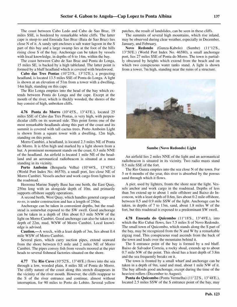
Sector 4. Gabon to Angola—Cap Lopez to Ponta Albina 137
Pub. 123
The coast between Cabo Ledo and Cabo de Sao Braz, 19miles SSE, is bordered by remarkable white cliffs. The lattercape is steep-to and Enseada Sao Braz (Baia de Sao Braz) liesclose N of it. A sandy spit encloses a salt water lagoon in the Spart of this bay and a large swamp lies at the foot of the hillsrising close S of the bay. Anchorage can be taken by vesselswith local knowledge, in depths of 6 to 14m, within the bay.4.75 The coast between Cabo de Sao Braz and Ponta do Longa,15 miles SE, is backed by a high tableland. The latter point isformed by a bluff headland which is covered with brushwood.
Cabo das Tres Pontas (10°23'S., 13°32'E.), a projectingheadland, is located 13.5 miles SSE of Ponta do Longa. A lightis shown at an elevation of 51m from a tower with a dwelling,14m high, standing on this cape.
The Rio Longa empties into the head of the bay which ex-tends between Ponta do Longa and the cape. Except at themouth of the river, which is thickly wooded, the shores of thebay consist of high, unbroken cliffs.
4.76 Ponta do Morro (10°45'S., 13°43'E.), located 25miles SSE of Cabo das Tres Pontas, is very high, with perpen-dicular cliffs on its seaward side. This point forms one of themost remarkable headlands along this part of the coast and itssummit is covered with tall cactus trees. Porto Amboim Lightis shown from a square tower with a dwelling, 12m high,standing on this point.
Morro Cambiri, a headland, is located 2.3 miles NE of Pontado Morro. It is 65m high and marked by a light shown from ahut. A prominent monument stands on the coast, 0.3 mile NNEof the headland. An airfield is located 1 mile NE of the head-land and an aeronautical radiobeacon is situated at a maststanding in its vicinity.
Porto Amboim (Benguela Velha) (10°44'S., 13°45'E.)(World Port Index No. 46570), a small port, lies close NE ofMorro Cambiri. Vessels anchor and work cargo from lighters inthe roadstead.
Heerema Marine Supply Base has one berth, the East Quay,250m long with an alongside depth of 10m, and primarilysupports offshore supply operations.4.76 A second berth, West Quay, which handles general cargo andro-ro, is under construction and has a length of 250m.
Anchorage can be taken in convenient depths, but the road-stead is somewhat exposed to the SW swell. Good anchoragecan be taken in a depth of 18m about 0.3 mile NNW of thelight on Morro Cambiri. Good anchorage can also be taken in adepth of 22m, mud, WNW of Morro Cambiri. Local knowl-edge is advised.
Caution.—A wreck, with a least depth of 3m, lies about 0.4mile WSW of Morro Cambiri.
Several piers, which carry suction pipes, extend seawardfrom the shore between 0.5 mile and 2 miles NE of MorroCambiri. The pipes convey fish from vessels moored at the pierheads to several fishmeal factories situated on the shore.
4.77 The Rio Cuvo (10°52'S., 13°48'E.) flows into the seathrough a low, wooded plain, 8 miles SE of Ponta do Morro.The cliffy nature of the coast along this stretch disappears inthe vicinity of the river mouth. However, the cliffs reappear tothe S of the river entrance and continue, almost withoutinterruption, for 90 miles to Porto do Lobito. Several yellow
patches, the result of landslides, can be seen in these cliffs.The summits of several high mountains, which rise inland,
may be observed during clear weather, especially in December,January, and February.
Novo Redondo (Gunza-Kabolo) (Sumbe) (11°12'S.,13°50'E.) (World Port Index No. 46580), a small anchorageport, lies 27 miles SSE of Ponta do Morro. The town is partial-ly obscured by heights which extend from the beach and onwhich two conspicuous water tanks stand. A light is shownfrom a tower, 7m high, standing near the ruins of a structure.
An airfield lies 2 miles NNE of the light and an aeronauticalradiobeacon is situated in its vicinity. Two radio masts stand0.5 mile SSE of the fort.
The Rio Gunza empties into the sea close N of the town. For5 or 6 months of the year, this river is absorbed by the poroussand through which it flows.
A pier, used by lighters, fronts the shore near the light. Ves-sels anchor and work cargo in the roadstead. Depths of lessthan 5m extend up to about 1 mile offshore and Baixo do In-concon, with a least depth of 0.6m, lies about 0.2 mile offshore,between 0.5 and 0.9 mile SSW of the light. Anchorage can betaken, in depths of 7 to 13m, sand, about 1.8 miles W of thefort, but this roadstead is exposed to a predominant SW swell.
4.78 Enseada do Quicombo (11°18'S., 13°49'E.), intowhich the Rio Cubai flows, lies 7.5 miles S of Novo Redondo.The small town of Quicombo, which stands along the S part ofthe bay, may be recognized from the N and W by a remarkablezigzag road. This conspicuous road ascends from the back ofthe town and leads over the mountains behind it.
The S entrance point of the bay is formed by a red bluff.Baixo de Salvador Correia, a rocky shoal, extends up to about0.7 mile NW of the point. This shoal has a least depth of 3.8mand the sea frequently breaks on it.
The town is fronted by a small wharf and anchorage can betaken in a depth of 9m, sand and mud, about 1 mile NW of it.The bay affords good anchorage, except during the time of theheaviest rollers (December to August).
Ponta do Quicombo (Ponta Vermelha) (11°22'S., 13°48'E.),located 2.5 miles SSW of the S entrance point of the bay, may
4.77Sumbe (Novo Redondo) Light
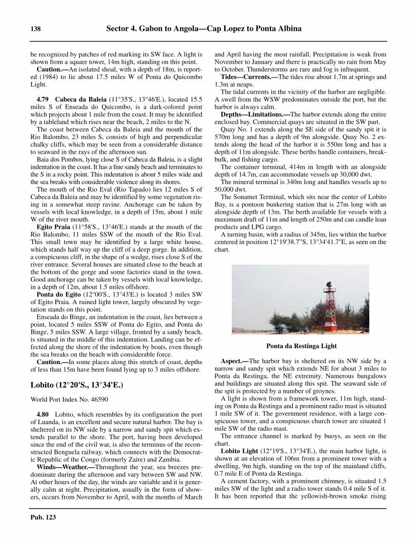
138 Sector 4. Gabon to Angola—Cap Lopez to Ponta Albina
Pub. 123
be recognized by patches of red marking its SW face. A light isshown from a square tower, 14m high, standing on this point.
Caution.—An isolated shoal, with a depth of 18m, is report-ed (1984) to lie about 17.5 miles W of Ponta do QuicomboLight.
4.79 Cabeca da Baleia (11°35'S., 13°46'E.), located 15.5miles S of Enseada do Quicombo, is a dark-colored pointwhich projects about 1 mile from the coast. It may be identifiedby a tableland which rises near the beach, 2 miles to the N.
The coast between Cabeca da Baleia and the mouth of theRio Balombo, 23 miles S, consists of high and perpendicularchalky cliffs, which may be seen from a considerable distanceto seaward in the rays of the afternoon sun.
Baia dos Pombos, lying close S of Cabeca da Baleia, is a slightindentation in the coast. It has a fine sandy beach and terminates tothe S in a rocky point. This indentation is about 5 miles wide andthe sea breaks with considerable violence along its shores.
The mouth of the Rio Eval (Rio Tapado) lies 12 miles S ofCabeca da Baleia and may be identified by some vegetation ris-ing in a somewhat steep ravine. Anchorage can be taken byvessels with local knowledge, in a depth of 15m, about 1 mileW of the river mouth.
Egito Praia (11°58'S., 13°46'E.) stands at the mouth of theRio Balombo, 11 miles SSW of the mouth of the Rio Eval.This small town may be identified by a large white house,which stands half way up the cliff of a deep gorge. In addition,a conspicuous cliff, in the shape of a wedge, rises close S of theriver entrance. Several houses are situated close to the beach atthe bottom of the gorge and some factories stand in the town.Good anchorage can be taken by vessels with local knowledge,in a depth of 12m, about 1.5 miles offshore.
Ponta do Egito (12°00'S., 13°43'E.) is located 3 miles SWof Egito Praia. A ruined light tower, largely obscured by vege-tation stands on this point.
Enseada do Binge, an indentation in the coast, lies between apoint, located 5 miles SSW of Ponta do Egito, and Ponta doBinge, 5 miles SSW. A large village, fronted by a sandy beach,is situated in the middle of this indentation. Landing can be ef-fected along the shore of the indentation by boats, even thoughthe sea breaks on the beach with considerable force.
Caution.—In some places along this stretch of coast, depthsof less than 15m have been found lying up to 3 miles offshore.
Lobito (12°20'S., 13°34'E.)
World Port Index No. 46590
4.80 Lobito, which resembles by its configuration the portof Luanda, is an excellent and secure natural harbor. The bay issheltered on its NW side by a narrow and sandy spit which ex-tends parallel to the shore. The port, having been developedsince the end of the civil war, is also the terminus of the recon-structed Benguela railway, which connects with the Democrat-ic Republic of the Congo (formerly Zaire) and Zambia.
Winds—Weather.—Throughout the year, sea breezes pre-dominate during the afternoon and vary between SW and NW.At other hours of the day, the winds are variable and it is gener-ally calm at night. Precipitation, usually in the form of show-ers, occurs from November to April, with the months of March
and April having the most rainfall. Precipitation is weak fromNovember to January and there is practically no rain from Mayto October. Thunderstorms are rare and fog is infrequent.4.80 Tides—Currents.—The tides rise about 1.7m at springs and1.3m at neaps.
The tidal currents in the vicinity of the harbor are negligible.A swell from the WSW predominates outside the port, but theharbor is always calm.
Depths—Limitations.—The harbor extends along the entireenclosed bay. Commercial quays are situated in the SW part.
Quay No. 1 extends along the SE side of the sandy spit it is570m long and has a depth of 9m alongside. Quay No. 2 ex-tends along the head of the harbor it is 550m long and has adepth of 11m alongside. These berths handle containers, break-bulk, and fishing cargo. 4.80 The container terminal, 414m in length with an alongsidedepth of 14.7m, can accommodate vessels up 30,000 dwt.
The mineral terminal is 340m long and handles vessels up to50,000 dwt. 4.80 The Sonamet Terminal, which sits near the center of LobitoBay, is a pontoon bunkering station that is 27m long with analongside depth of 13m. The berth available for vessels with amaximum draft of 11m and length of 250m and can candle leanproducts and LPG cargo.
A turning basin, with a radius of 345m, lies within the harborcentered in position 12°19'38.7”S, 13°34'41.7''E, as seen on thechart.
Aspect.—The harbor bay is sheltered on its NW side by anarrow and sandy spit which extends NE for about 3 miles toPonta da Restinga, the NE extremity. Numerous bungalowsand buildings are situated along this spit. The seaward side ofthe spit is protected by a number of groynes.
A light is shown from a framework tower, 11m high, stand-ing on Ponta da Restinga and a prominent radio mast is situated1 mile SW of it. The government residence, with a large con-spicuous tower, and a conspicuous church tower are situated 1mile SW of the radio mast.
The entrance channel is marked by buoys, as seen on thechart.
Lobito Light (12°19'S., 13°34'E.), the main harbor light, isshown at an elevation of 106m from a prominent tower with adwelling, 9m high, standing on the top of the mainland cliffs,0.7 mile E of Ponta da Restinga.
A cement factory, with a prominent chimney, is situated 1.5miles SW of the light and a radio tower stands 0.4 mile S of it.It has been reported that the yellowish-brown smoke rising
4.80Ponta da Restinga Light

Sector 4. Gabon to Angola—Cap Lopez to Ponta Albina 139
Pub. 123
from this chimney can be seen from a considerable distance.Several prominent oil tanks stand on a small area of re-
claimed land lying 0.4 mile SW of the cement factory. Severalconspicuous port installations, including silos, stand in the SWpart of the harbor. The head of the harbor is occupied by an ex-tensive bank which dries at LW and gives off an offensive odor.
Pilotage.—Pilotage is compulsory within the harbor en-
trance and is only available during daylight hours. Pilots boardinside the harbor in position 12°19'39.6''S, 13°34'49.8''E. 4.80 Regulations.—The maximum speed permitted in the harboris 8 knots. Vessels intending to maneuverer in the harborshould obtain permission from the Port Authority and have apilot aboard. 4.80 Contact Information.—See the table titled Lobito—Con-tact Information.
Anchorage.—The harbor provides sheltered and calm an-chorage with good holding ground. The designated anchoragearea, which may best be seen on the chart, lies in the middle ofthe harbor. It has depths of 14 to 28m.
Caution.—The sand spit at the NW side of the harbor is re-ported to be extending NE at a rate of about 30m a year. It wasreported (1988) that shoaling extended up to about 200m ESEfrom Ponta da Restinga and vessels should give this point awide berth.4.80 Conspicuous new port terminals are being constructed on the
4.80Ponta da Restinga
4.80Lobito Harbor
4.80Lobito Harbor (South)
4.80Lobito Light
Lobito—Contact Information
Call sign Lobito Port
VHF VHF channels 9 and 16
Telephone
244-272-222-711
244-272-222-712
244-272-222-713
244-272-222-714
244-272-222-715
244-272-222-717
244-272-222-718
Facsimile
244-272-222-717
244-272-222-718
244-272-222-719
E-mail [email protected]
Web site http://www.eplobito.net

140 Sector 4. Gabon to Angola—Cap Lopez to Ponta Albina
Pub. 123
E shore of Lobito Bay and surrounding depths in the vicinitymay be different from what is charted due to constructionactivities.
Anchorage is prohibited within the harbor between the Nside of the designated anchorage area and the sandy spit in or-der to provide free passage for vessels proceeding to the quays.
Several wrecks lie within the harbor and may best be seen onthe chart.
Numerous fishing vessels may be encountered (moored) inthe N part of the designated anchorage area.
A measured distance (1 mile), which may best be seen on thechart, lies on the seaward side of the N part of the sandy spit,and is marked by beacons.
The buoys marking the seaward entrance of the harbor fair-way are often moved and should not be relied upon.
Consult the local authorities for the latest information onport developments as well as changes in depths and aids to nav-igation.
Lobito to Namibe (Mocamedes)
4.81 The coast between Ponta da Restinga and Baia deBenguela, 18 miles SSW, is low and wooded with few land-marks.
The Rio Catumbela (12°27'S., 13°29'E.) flows into the sea10 miles SW of Ponta da Restinga. Its mouth may be identifiedfrom the W by a remarkable niche in the hills, located 4 milesinland, through which the river flows. The town of Catumbelastands close W of this niche. Two hills, each 150m high, rise onthe S bank of the river, about 0.3 mile E of the town and 3.5miles inland. They are both surmounted by old forts, whichconsist of a long building, with a red roof, surrounded by astone wall. When approaching the river, these forts are promi-nent, but they would probably be mistaken for ordinary dwell-ings from farther seaward.
Several factories, with tall chimneys, are situated on the Nbank of the river, 0.5 mile W of the town, but they are mostlyhidden by vegetation.
The river overflows its banks during the rainy season and in-undates a large area, but it is no more than a large stream in thedry season.
Baia de Benguela (12°35'S., 13°24'E.) lies between themouth of the Rio Cavaco, located 8 miles SW of the Rio Ca-tumbela, and Ponta do Sombreiro, 6.3 miles WSW. The shoreof this bay is chiefly composed of a sandy beach. The city ofSao Felipe de Benguela stands in the NE part of the bay on amarshy plain which is almost inundated during the rainy sea-son (March and April). The land situated about 7 miles E of thecity attains an elevation of 450m.
A lighted range is shown from the vicinity of the city and in-dicates the anchorage. The front light is shown from a tower,7m high, standing in front of an old fort; the rear light is shownfrom the N tower, 12m high, of a church. Vessels can anchor ina depth of 13m, mud and sand, on this range and about 1 mileoffshore. Local knowledge is advised as the bay is reported tobe obstructed by numerous fish traps. The roadstead is onlyused by fishing craft and local coasters, as ocean-going vesselsnow proceed to Lobito.
Ponta do Sombreiro (12°35'S., 13°18'E.) is the N extremityof a promontory. Morro do Sombreiro, a very conspicuous hill,
rises close within this point. It is 124m high and has a hat-likeappearance. A light is shown from a column, 7m high, standingon this hill.
Caution.—Between Ponta do Sombreiro and Ponto do Porto(15°47'S., 11°51'E.), 225 miles SSW, great depths are foundclose to the coast and anchorage is rendered almost impossible,except within a few sheltered bays. Vessels are advised tomaintain a good distance from the shore, as the swell sets to-ward the coast.
Caution is necessary along this stretch of coast in order toavoid overestimating the distance from the land due to the lightsandy nature of the low-lying foreshore and the extreme hazi-ness of the atmosphere which generally prevails.
The current along the coast to the NE of Ponta das Salinassets offshore, but between this point and Baia de Equimina, 23miles SSW, the current sets toward the land and caution shouldbe exercised.
4.82 The coast between Ponta do Sombreiro and Ponta dasVacas, 5 miles WSW, is cliffy and forms several snug coveswhere boats and small craft can shelter. A prominent watertower stands 1 mile SW of Ponta das Vacas.
Baia Farta lies between Ponta das Vacas and Ponta de SaoJose, 1.8 miles NW. This latter point is formed by a rounded,sandy tongue. The head of the bay consists of a sandy beach.The village of Baia Farta stands in the SW corner of the bay,near the mouth of a small stream. It is fronted by several smallpiers which are used by fishing craft. Vessels with local knowl-edge can obtain excellent anchorage in a depth of 25m about0.6 mile S of Ponta de Sao Jose and about 0.3 mile offshore.
The coast between Ponta de Sao Jose and Ponta das Salinas,22 miles SW, is steep-to and consists of white, sandy beaches.The shore is difficult to distinguish until very close as it proj-ects far from the hills inland.
Baia Tenda Grande, a slight indentation, lies 2 miles NE ofPonta das Salinas. A prominent water tower stands in the set-tlement, which is situated at the head of this indentation.
4.83 Ponta das Salinas (12°50'S., 12°56'E.) is a low,rounded, and sandy point which extends up to about 6 miles Wof the inland hills. A light is shown from a conspicuous squaretower, 38m high, standing on this point. A dwelling surmountsa sand dune which rises close E of the light.
Ponta Bongue, located 9 miles SSE of Ponta das Salinas, isfringed with rocks; depths of less than 5m lie up to about 0.4mile N and NW of it. A prominent stone beacon, 2m high,stands on this point.
Ponta Norte and Ponta Sul, each surmounted by a beacon,are located 200m and 400m, respectively, E of Ponta Bongue.
Enseada do Cuio is entered close E of Ponta Bongue. Thevillage of Cuio, fronted by a small pier, stands at the head ofthis bay; two range beacons are situated on the SE shore. An-chorage within the bay is considered bad as it is exposed to theSW wind and swell.
The coast between Ponta Bongue and Baia da Equimina, 15miles SW, is steep-to and high. The land is broken at intervalsby ravines which run down to the sea and form small bays.Streams flow through these ravines. Generally, the small baysafford temporary shelter in fine weather, but only for vesselswith local knowledge.
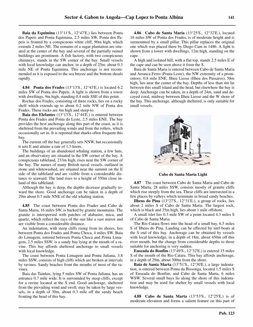
Sector 4. Gabon to Angola—Cap Lopez to Ponta Albina 141
Pub. 123
Baia da Equimina (13°11'S., 12°47'E.) lies between Pontados Papeis and Ponta Equimina, 2.5 miles SW. Ponta dos Pa-peis is fronted by a conspicuous white cliff, 90m high, whichextends 2 miles NE. The remains of a sugar plantation are situ-ated at the center of the bay and several of the partially ruinedbuildings are prominent. A fish factory, with two conspicuouschimneys, stands in the SW corner of the bay. Small vesselswith local knowledge can anchor, in a depth of 25m, about 0.3mile NE of Ponta Equimina. This anchorage is not recom-mended as it is exposed to the sea breeze and the bottom shoalsrapidly.
4.84 Ponta dos Frades (13°13'S., 12°43'E.) is located 6.2miles SW of Ponta dos Papeis. A light is shown from a towerwith dwellings, 9m high, standing 0.4 mile SSE of this point.
Rochas dos Frades, consisting of three rocks, lies on a rockyshelf which extends up to about 0.2 mile NW of Ponta dosFrades. These rocks are 4m high and steep-to.
Baia dos Elefantes (13°13'S., 12°44'E.) is entered betweenPonta dos Frades and Ponta do Leste, 2.5 miles ENE. The bayprovides the best anchorage along this part of the coast, as it issheltered from the prevailing winds and from the rollers, whichoccasionally set in. It is reported that sharks often frequent thisbay.
The current off the bay generally sets NNW, but occasionallyit sets E and attains a rate of 1.5 knots.
The buildings of an abandoned whaling station, a few huts,and an observatory are situated in the SW corner of the bay. Aconspicuous tableland, 233m high, rises near the SW corner ofthe bay. The names of many British naval vessels, outlined instone and whitewashed, are situated near the summit on the Eside of the tableland and are visible from a considerable dis-tance to seaward. The land rises to a height of 350m close in-land of this tableland.
Although the bay is deep, the depths decrease gradually to-ward the shore. Good anchorage can be taken in a depth of29m about 0.7 mile NNE of the old whaling station.
4.85 The coast between Ponta dos Frades and Cabo deSanta Maria, 16 miles SW, is backed by granite mountains. Thegranite is interspersed with patches of alabaster, mica, andquartz, which reflect the rays of the sun like a vast mirror andare visible from a considerable distance.
An indentation, with steep cliffs rising from its shores, liesbetween Ponta dos Frades and Ponta Choca, 4 miles SW. Baiado Limagem, entered between Ponta Choca and Ponta Lima-gem, 2.5 miles SSW, is a sandy bay lying at the mouth of a ra-vine. This bay affords sheltered anchorage to small vesselswith local knowledge.
The coast between Ponta Limagem and Ponta Juliana, 3.8miles SSW, consists of high cliffs which are broken at intervalsby ravines. Sandy beaches front the mouths of most of the ra-vines.
Baia das Tainhas, lying 5 miles SW of Ponta Juliana, has anentrance 0.7 mile wide. It is surrounded by steep cliffs, exceptfor a ravine located at the S end. Good anchorage, shelteredfrom the prevailing wind and swell, may be taken by large ves-sels, in a depth of 30m, about 0.3 mile off the sandy beachfronting the head of this bay.
4.86 Cabo de Santa Maria (13°25'S., 12°32'E.), located16 miles SW of Ponta dos Frades, is of moderate height and issurmounted by a small pillar. This pillar replaces the originalone which was placed there by Diego Cam in 1486. A light isshown from a tower with dwellings, 12m high, standing on thecape.4.86 A high and isolated hill, with a flat top, stands 2.5 miles E ofthe cape and can be seen above it from the S.4.86 Baia de Santa Maria is entered between Cabo de Santa Mariaand Arranca Ferro (Ponta Leste), the NW extremity of a prom-ontory, 0.8 mile ENE. Ilheu Liesse (Ilheu dos Passaros), 58mhigh, lies near the center of the bay. Depths of less than 4m liebetween this small island and the head, but elsewhere the bay isdeep. Anchorage can be taken, in a depth of 24m, sand and de-cayed coral, midway between Ilheu Liesse and the W shore ofthe bay. This anchorage, although sheltered, is only suitable forsmall vessels.
4.87 The coast between Cabo de Santa Maria and Cabo deSanta Marta, 28 miles SSW, consists mostly of granite cliffswhich rise steeply from the sea. These cliffs are intersected in afew places by valleys which terminate in broad sandy beaches.4.87 Ilheus do Pina (13°27'S., 12°31'E.), a group of rocks, liesabout 2 miles S of Cabo de Santa Maria. The largest rock,which is black and 35m high, lies about 1 mile offshore.4.87 A small islet lies 0.3 mile SW of a point located 4.3 miles Sof Cabo de Santa Maria.4.87 The Rio Catara flows into the head of a small bay, 6.5 milesS of Ilheus do Pina. Landing can be effected by surf-boats atthe S end of this bay. Anchorage can be obtained by vesselswith local knowledge, in a depth of 18m, about 450m off thisriver mouth, but the change from considerable depths to thosesuitable for anchoring is very sudden.4.87 Enseada do Bonfim (13°49'S., 12°32'E.) is entered 15 milesS of the mouth of the Rio Catara. This bay affords anchorage,in a depth of 29m, about 300m from the shore. 4.87 Baia de Santa Marta (13°51'S., 12°30'E.), a large indenta-tion, is entered between Ponta da Bissonga, located 1.5 miles Sof Enseada do Bonfim, and Cabo de Santa Marta, 6 milesWSW. Several small bays lie along the shore of this indenta-tion and may be used for shelter by small vessels with localknowledge.
4.88 Cabo de Santa Marta (13°53'S., 12°25'E.) is ofmoderate elevation and forms a salient feature on this part of
4.86Cabo de Santa Maria Light
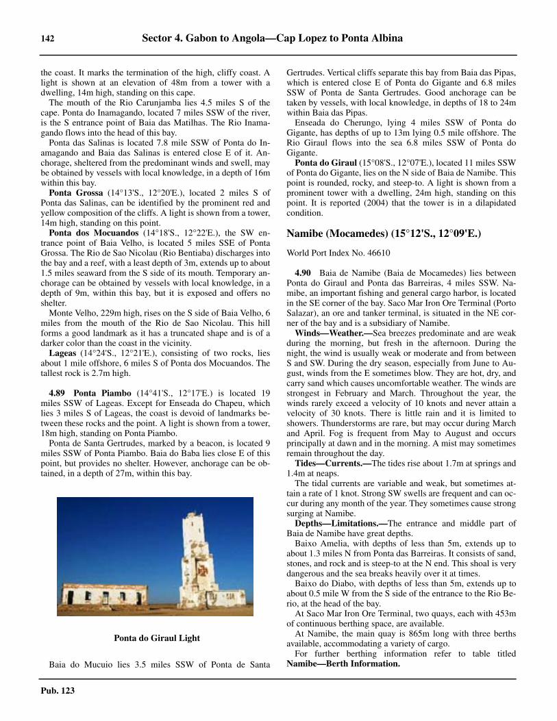
142 Sector 4. Gabon to Angola—Cap Lopez to Ponta Albina
Pub. 123
the coast. It marks the termination of the high, cliffy coast. Alight is shown at an elevation of 48m from a tower with adwelling, 14m high, standing on this cape.
The mouth of the Rio Carunjamba lies 4.5 miles S of thecape. Ponta do Inamagando, located 7 miles SSW of the river,is the S entrance point of Baia das Matilhas. The Rio Inama-gando flows into the head of this bay.
Ponta das Salinas is located 7.8 mile SSW of Ponta do In-amagando and Baia das Salinas is entered close E of it. An-chorage, sheltered from the predominant winds and swell, maybe obtained by vessels with local knowledge, in a depth of 16mwithin this bay.
Ponta Grossa (14°13'S., 12°20'E.), located 2 miles S ofPonta das Salinas, can be identified by the prominent red andyellow composition of the cliffs. A light is shown from a tower,14m high, standing on this point.
Ponta dos Mocuandos (14°18'S., 12°22'E.), the SW en-trance point of Baia Velho, is located 5 miles SSE of PontaGrossa. The Rio de Sao Nicolau (Rio Bentiaba) discharges intothe bay and a reef, with a least depth of 3m, extends up to about1.5 miles seaward from the S side of its mouth. Temporary an-chorage can be obtained by vessels with local knowledge, in adepth of 9m, within this bay, but it is exposed and offers noshelter.
Monte Velho, 229m high, rises on the S side of Baia Velho, 6miles from the mouth of the Rio de Sao Nicolau. This hillforms a good landmark as it has a truncated shape and is of adarker color than the coast in the vicinity.
Lageas (14°24'S., 12°21'E.), consisting of two rocks, liesabout 1 mile offshore, 6 miles S of Ponta dos Mocuandos. Thetallest rock is 2.7m high.
4.89 Ponta Piambo (14°41'S., 12°17'E.) is located 19miles SSW of Lageas. Except for Enseada do Chapeu, whichlies 3 miles S of Lageas, the coast is devoid of landmarks be-tween these rocks and the point. A light is shown from a tower,18m high, standing on Ponta Piambo.
Ponta de Santa Gertrudes, marked by a beacon, is located 9miles SSW of Ponta Piambo. Baia do Baba lies close E of thispoint, but provides no shelter. However, anchorage can be ob-tained, in a depth of 27m, within this bay.
4.89 Baia do Mucuio lies 3.5 miles SSW of Ponta de Santa
Gertrudes. Vertical cliffs separate this bay from Baia das Pipas,which is entered close E of Ponta do Gigante and 6.8 milesSSW of Ponta de Santa Gertrudes. Good anchorage can betaken by vessels, with local knowledge, in depths of 18 to 24mwithin Baia das Pipas.
Enseada do Cherungo, lying 4 miles SSW of Ponta doGigante, has depths of up to 13m lying 0.5 mile offshore. TheRio Giraul flows into the sea 6.8 miles SSW of Ponta doGigante.
Ponta do Giraul (15°08'S., 12°07'E.), located 11 miles SSWof Ponta do Gigante, lies on the N side of Baia de Namibe. Thispoint is rounded, rocky, and steep-to. A light is shown from aprominent tower with a dwelling, 24m high, standing on thispoint. It is reported (2004) that the tower is in a dilapidatedcondition.
Namibe (Mocamedes) (15°12'S., 12°09'E.)
World Port Index No. 46610
4.90 Baia de Namibe (Baia de Mocamedes) lies betweenPonta do Giraul and Ponta das Barreiras, 4 miles SSW. Na-mibe, an important fishing and general cargo harbor, is locatedin the SE corner of the bay. Saco Mar Iron Ore Terminal (PortoSalazar), an ore and tanker terminal, is situated in the NE cor-ner of the bay and is a subsidiary of Namibe.
Winds—Weather.—Sea breezes predominate and are weakduring the morning, but fresh in the afternoon. During thenight, the wind is usually weak or moderate and from betweenS and SW. During the dry season, especially from June to Au-gust, winds from the E sometimes blow. They are hot, dry, andcarry sand which causes uncomfortable weather. The winds arestrongest in February and March. Throughout the year, thewinds rarely exceed a velocity of 10 knots and never attain avelocity of 30 knots. There is little rain and it is limited toshowers. Thunderstorms are rare, but may occur during Marchand April. Fog is frequent from May to August and occursprincipally at dawn and in the morning. A mist may sometimesremain throughout the day.
Tides—Currents.—The tides rise about 1.7m at springs and1.4m at neaps.
The tidal currents are variable and weak, but sometimes at-tain a rate of 1 knot. Strong SW swells are frequent and can oc-cur during any month of the year. They sometimes cause strongsurging at Namibe.
Depths—Limitations.—The entrance and middle part ofBaia de Namibe have great depths.
Baixo Amelia, with depths of less than 5m, extends up toabout 1.3 miles N from Ponta das Barreiras. It consists of sand,stones, and rock and is steep-to at the N end. This shoal is verydangerous and the sea breaks heavily over it at times.
Baixo do Diabo, with depths of less than 5m, extends up toabout 0.5 mile W from the S side of the entrance to the Rio Be-rio, at the head of the bay.
At Saco Mar Iron Ore Terminal, two quays, each with 453mof continuous berthing space, are available.
At Namibe, the main quay is 865m long with three berthsavailable, accommodating a variety of cargo. 4.90 For further berthing information refer to table titledNamibe—Berth Information.
4.89Ponta do Giraul Light
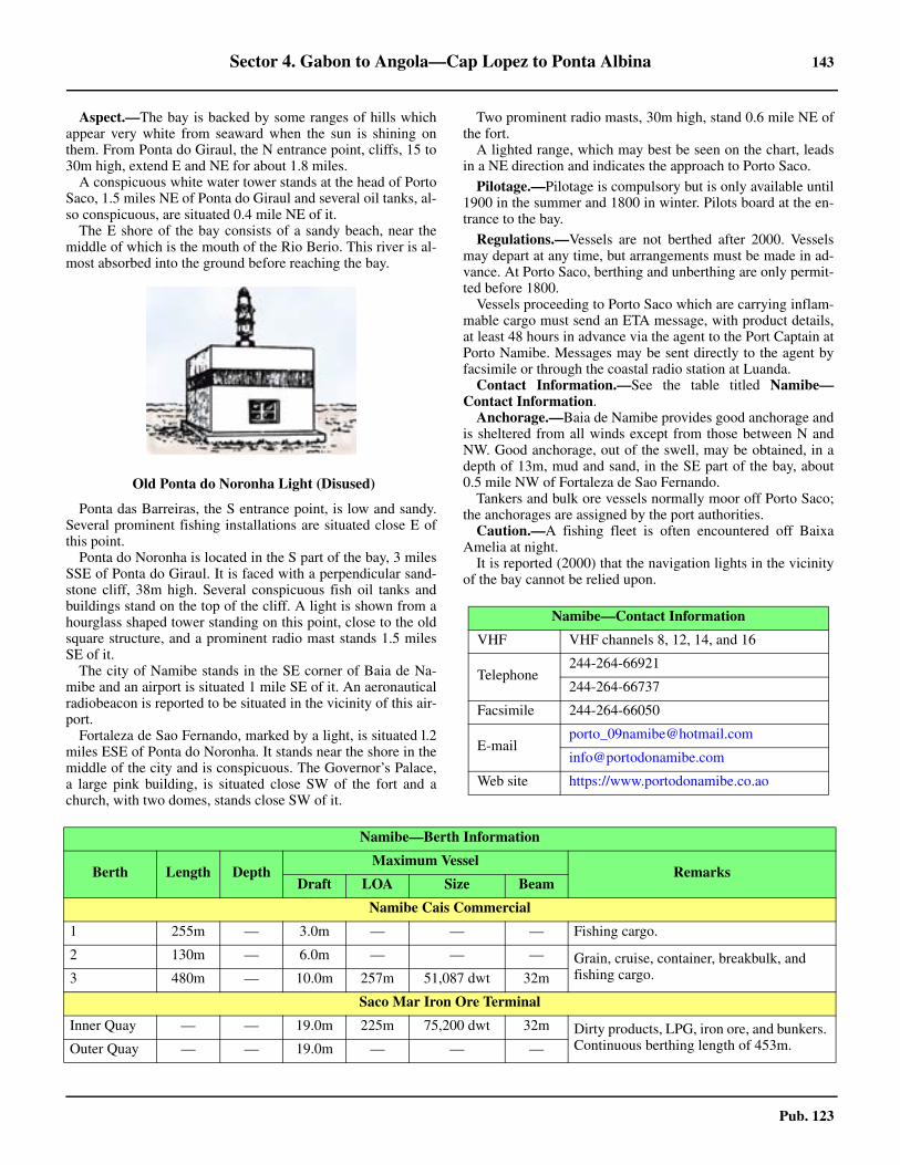
Sector 4. Gabon to Angola—Cap Lopez to Ponta Albina 143
Pub. 123
Aspect.—The bay is backed by some ranges of hills whichappear very white from seaward when the sun is shining onthem. From Ponta do Giraul, the N entrance point, cliffs, 15 to30m high, extend E and NE for about 1.8 miles.
A conspicuous white water tower stands at the head of PortoSaco, 1.5 miles NE of Ponta do Giraul and several oil tanks, al-so conspicuous, are situated 0.4 mile NE of it.
The E shore of the bay consists of a sandy beach, near themiddle of which is the mouth of the Rio Berio. This river is al-most absorbed into the ground before reaching the bay.
Ponta das Barreiras, the S entrance point, is low and sandy.Several prominent fishing installations are situated close E ofthis point.
Ponta do Noronha is located in the S part of the bay, 3 milesSSE of Ponta do Giraul. It is faced with a perpendicular sand-stone cliff, 38m high. Several conspicuous fish oil tanks andbuildings stand on the top of the cliff. A light is shown from ahourglass shaped tower standing on this point, close to the oldsquare structure, and a prominent radio mast stands 1.5 milesSE of it.
The city of Namibe stands in the SE corner of Baia de Na-mibe and an airport is situated 1 mile SE of it. An aeronauticalradiobeacon is reported to be situated in the vicinity of this air-port.
Fortaleza de Sao Fernando, marked by a light, is situated l.2miles ESE of Ponta do Noronha. It stands near the shore in themiddle of the city and is conspicuous. The Governor’s Palace,a large pink building, is situated close SW of the fort and achurch, with two domes, stands close SW of it.
4.90 Two prominent radio masts, 30m high, stand 0.6 mile NE ofthe fort.
A lighted range, which may best be seen on the chart, leadsin a NE direction and indicates the approach to Porto Saco.
Pilotage.—Pilotage is compulsory but is only available until1900 in the summer and 1800 in winter. Pilots board at the en-trance to the bay.
Regulations.—Vessels are not berthed after 2000. Vesselsmay depart at any time, but arrangements must be made in ad-vance. At Porto Saco, berthing and unberthing are only permit-ted before 1800.
Vessels proceeding to Porto Saco which are carrying inflam-mable cargo must send an ETA message, with product details,at least 48 hours in advance via the agent to the Port Captain atPorto Namibe. Messages may be sent directly to the agent byfacsimile or through the coastal radio station at Luanda. 4.90 Contact Information.—See the table titled Namibe—Contact Information.
Anchorage.—Baia de Namibe provides good anchorage andis sheltered from all winds except from those between N andNW. Good anchorage, out of the swell, may be obtained, in adepth of 13m, mud and sand, in the SE part of the bay, about0.5 mile NW of Fortaleza de Sao Fernando.
Tankers and bulk ore vessels normally moor off Porto Saco;the anchorages are assigned by the port authorities.
Caution.—A fishing fleet is often encountered off BaixaAmelia at night.
It is reported (2000) that the navigation lights in the vicinityof the bay cannot be relied upon.
4.90Old Ponta do Noronha Light (Disused)
Namibe—Contact Information
VHF VHF channels 8, 12, 14, and 16
Telephone244-264-66921
244-264-66737
Facsimile 244-264-66050
Web site https://www.portodonamibe.co.ao
Namibe—Berth Information
Berth Length DepthMaximum Vessel
RemarksDraft LOA Size Beam
Namibe Cais Commercial
1 255m — 3.0m — — — Fishing cargo.
2 130m — 6.0m — — — Grain, cruise, container, breakbulk, and fishing cargo.3 480m — 10.0m 257m 51,087 dwt 32m
Saco Mar Iron Ore Terminal
Inner Quay — — 19.0m 225m 75,200 dwt 32m Dirty products, LPG, iron ore, and bunkers. Continuous berthing length of 453m.Outer Quay — — 19.0m — — —
144 Sector 4. Gabon to Angola—Cap Lopez to Ponta Albina
Pub. 123
4.90 It is reported (2013) that the piers and quays in the port are in poor condition.
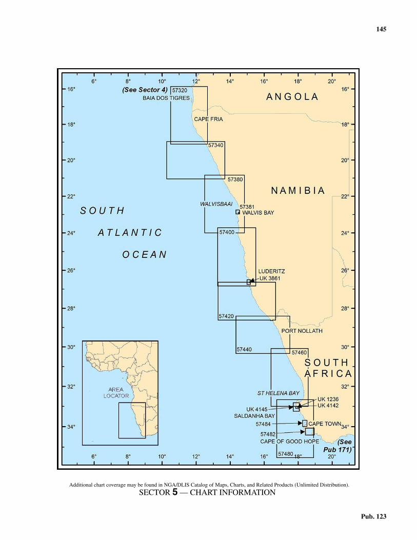
145
Pub. 123
5. Sector 5—Angola, Namibia, and South Africa—Ponta Albina to the Cape of Good Hope
5.0Additional chart coverage may be found in NGA/DLIS Catalog of Maps, Charts, and Related Products (Unlimited Distribution).
SECTOR 5 — CHART INFORMATION
147
Pub. 123
SECTOR 5
ANGOLA, NAMIBIA, AND SOUTH AFRICA—PONTA ALBINA TO THE CAPE OF GOOD HOPE
5.0 Plan.—This sector describes the SW coast of Africa fromPonta Albina to the Cape of Good Hope, and includes the portof Cape Town. The descriptive sequence is from N to S.
General Remarks
5.1 The coast extending from Cabo Negro (15°40'S.,11°56'E.), previously described in paragraph 4.91, to beyondIchabo Island (26°17'S., 14°56'E.), N of Luderitz Bay, is a des-ert region of arid sands. The sandy coastal belt slowly rises to ahigh plateau about 60 to 100 miles from the coast.5.1 The country S of the Orange River (28°38'S., 16°28'E.) con-sists of a series of three terraces, divided by mountain rangesvarying in elevations from 1,200 to 2,438m, and rises graduallyin a series of open sterile plains from the river as far as latitude32°00'S. It gradually declines from N to S. The passages fromone plateau to another are through narrow and difficult gorges.5.1 Caution.—The coast between the Rio Cunene (17°15'S.,11°45'E.) and Walvis Bay (Walvisbaai) (22°57'S., 14°30'E.) isknown as the Skeleton Coast, having been the scene of innu-merable wrecks, not only from the imperfect nature of the sur-veys, but because onshore sets by the current are frequentlyexperienced. A further cause is the prevalence of fog, especial-ly during the winter. Vessels are therefore advised not to ap-proach within 10 miles of the coast, and in fog or thick weatherto keep seaward of the 200m depth curve as far as Cape Cross(21°46'S., 13°57'E.). If proceeding to Walvis Bay, vesselsshould remain seaward of the 50m depth curve until PelicanPoint Light (22°53'S., 14°26'E.) is observed. 5.1 The seamounts lying W of the SW coast of Africa are de-scribed in Sector 6.
Baia dos Tigres
5.2 Baia dos Tigres (16°35'S., 11°46'E.), the most spa-cious bay in Angola, is entered about 38 miles S of Ponta Albi-na. The bay is bounded on its W side by Ilha da Baia dosTigres, formerly known as Peninsula dos Tigres, a low and san-dy spit, the N point of which is Ponta da Marca (16°31'S.,11°43'E.).
The bay, about 18 miles long in a N-S direction, is about 6miles wide at its entrance, narrowing to a width of about 2miles at its head. The S end of the bay is called Saco dosTigres. In 1963, the sea broke through the peninsula at Sacodos Tigres, separating it from the mainland and transforming itinto an island.
Fishing is the primary activity of the island. The small portof Leao (16°36'S., 11°43'E.), on the E side of the island close Sof Enseada das Pedras, is used as a home port by local coastaland fishing vessels.5.2 The bay provides good shelter from the prevailing winds (Wand SW), in spite of the low height of the peninsula, as thedepths and nature of the bottom allow ships to anchor close tothe peninsula.
5.2 Ponta da Marca (16°31'S., 11°43'E.) forms the N extremityof Ilha dos Tigres. Ponta da Marca Light, equipped with a radarreflector, is shown from a prominent conical tower on columns,13m high, standing on the point. It is reported (2013) that thislight may be extinguished. A small group of buildings is situat-ed in the vicinity of the light.5.2 Winds—Weather.—The prevailing wind is from the SW,with less intensity from June to September. Strong W winds,known as “garroas,” sometimes occur, but are usually of shortduration. Strong winds from the E, known as “lestadas,” some-times occur from May to July. Small swells and seas form withfresh winds, due to the large size of the bay and the low altitudeof the peninsula. Rain is practically nil throughout the year.Fog is frequent from May to July, occurring with greater fre-quency at dawn and in the morning, and sometimes persistingall day. 5.2 Depths—Limitations.—Depths of over 50m lie about 0.7mile from Ilha da Baia dos Tigres’s W side, with the 50m depthcurve continuing N of the Ponta da Marca Light (16°32'S.,11°43'E.) up the coast. Depths of over 20m lie about 0.2 mileoff the NE corner of the of the island, gradually shoaling to-ward the mainland, where depths of over 10m parallel the coastat a distance of about 1 mile. A partially-exposed wreck liesclose inland on the NW coast of the island and is reportedlyconspicuous from seaward. Mariners are cautioned against en-tering the bay through the break between the S end of the is-land and the peninsula extending N of the mainland due toshoal water and breakers being predominant within the gap. 5.2 Aspect.—The land on the E side of the bay is predominatelya series of high sand hills which rise abruptly from the coast-line and continue far inland with broken and irregular ridgesdevoid of any vegetation.5.2 The town of Sao Martinho dos Tigres stands on the E side ofthe peninsula, about 5 miles S of Ponta da Marca. Leao Light isshown from a metal tower, 10m high, standing close E of thetown.5.2 A small airport is situated close S of the town. A conspicu-ous church stands in the town; several prominent fish ware-houses can be seen to the N of the town. A number of chimneysand a water tower standing 6 miles and 9.5 miles, respectively,S of Ponta da Marca Light may be seen from seaward.5.2 Pilotage.—Pilots are not available. The port is administratedby the Captain of the Port of Namibe (see paragraph 4.90).5.2 Anchorage.—Anchorage may be obtained in convenientdepths, good holding ground of mud, sand, and ground shells,in any part of Baia dos Tigres. When seeking a sheltered an-chorage, the direction and strength of the wind are factors to beconsidered. Therefore, anchorage should be taken on the Wside of the bay during W winds and on the E side of the bayduring E winds.5.2 Anchorage is recommended in the following positions:
1. Within Enseada das Barracas, in a depth of 29m,about 0.3 mile offshore, with Ponta da Marca Light bearing320°, distant about 0.9 mile.

148 Sector 5. Angola, Namibia, and South Africa—Ponta Albina to the Cape of Good Hope
Pub. 123
2. Within Fundeadouro do Leao, off Sao Martinho dosTigres, in a depth of 20m, with Leao Light bearing 270°, dis-tant about 0.4 mile. This is the anchorage most commonlyused.
3. Within Enseada do Pau, located about 4 miles S ofFundeadouro do Leao, in a depth of 19m, about 0.3 mile off-shore.
4. Within Enseada dos Morrinhos, located 7.5 miles S ofSao Martinho dos Tigres, in a depth of 17m, about 0.4 mileoffshore.
5.2 Directions.—Ihla dos Tigres is difficult to identify from off-shore and extreme caution is necessary when approaching thecoast in the vicinity of the bay due to the frequent mist whichmakes it difficult to judge distances. The first things to be seenare the breakers off the coast.5.2 The bay is approached and entered from N between Ponta daMarca and the mainland, 6 mile E. Vessels approaching fromthe S should stay at least 5 miles W of the island and remain indepths of over 20m before rounding Ponta da Marca to pick upthe approach from the N. From a position located NE of Pontada Marca, the recommended track leads S for 8 miles into thebay, clear of known dangers.5.2 Caution.—A restricted area, within which anchoring andfishing are prohibited, lies in the S part of Baia dos Tigres andmay best be seen on the chart.5.2 A local magnetic anomaly has been reported to exist on the Eside of Baia dos Tigres.
Baia dos Tigres to Rocky Point
5.3 The coast between the S end of Baia dos Tigres andthe mouth of the Rio Cunene, about 25 miles S, consists entire-ly of sand crowned with dark tinted dunes, which are visiblefrom seaward at a distance of 15 or 16 miles. There are noknown off-lying dangers along this coast.5.3 The Kunene River (17°15S.,11°45'E.), known as the RioCunene in Namibia, roughly follows the border betweenAngola to the N and Namibia to the S. The river only reachesthe sea during the rainy season. During the dry season, itsmouth is barred by a bank of sand on which the sea breaksfuriously, especially in its S part. A beacon, with an elevationof 8m, stands near the river mouth.5.3 Foz do Cunene, a village, stands on the N bank of theKunene River, about 2 miles upriver from the mouth. Anairstrip and a meteorological station are situated near thisvillage. A conspicuous water tower is reported to stand about4.5 miles NNE of the river entrance.5.3 The Skeleton Coast extends S from this river entrance (seeparagraph 5.1).5.3 Caution.—The coast between Dune Point (20°02S.,13°57'E.) and Cape Cross (21°46'S., 3°57'E.) may lie up to 2miles further SSW than charted.
5.4 The coast between the Kunene River and Cape Fria,75 miles SSE, is backed by high shifting sand dunes in its Npart and by high land for about 18 miles in its S part. The Hart-mann Mountains, which attain elevations up to 1,100m, riseabout 30 to 40 miles inland and form a prominent landmark inclear weather.
A shoal, with a depth of 5.3m, lies 1.5 miles offshore, about
6 miles SSW of the mouth of the Kunene River; breakers havebeen reported to exist seaward of this shoal.
Bosluis Bay, an indentation, lies 8 miles S of the mouth ofthe Kunene River. For a distance of 26 miles S of Bosluis Bay,foul ground consisting of rocky shoals, some of which havedepths of less than 5m, lies up to 1.2 miles offshore.
A shoal lies about 34 miles S of the mouth of the KuneneRiver and about 2.2 miles offshore. It has a charted depth of9.1m and is marked by breakers, but lesser depths should beanticipated.
5.5 Cape Frio (18°26S.,12°01'E.) is low, sandy, andfringed by rocks. A number of conspicuous black hills rise in-land of it. Depths lying to the NW of the cape are probably lessthan charted as, during a moderate SSW gale with a high sea,breakers were observed in a position located about 2 milesWNW of the cape. Breakers were also reported (1962) to existin a position located about 7 miles WSW of the cape.5.5 A stranded wreck serves as a useful coastal mark and liesclose offshore in position 18°08'S, 11°51'E about 19.5 milesNW of the cape.5.5 False Cape Frio is a slight projection located about 3 milesSSE of Cape Frio and is radar prominent.5.5 Anchorage may be obtained, in fair weather, in depths of 12to 13m, sand and mud, midway between Cape Frio and FalseCape Frio.5.5 The coast between False Cape Frio and Rocky Point, 41miles SE, presents an unbroken line of surf. An extensive bankof shallow water extends from a point located 5 miles SSE ofFalse Cape Frioextending2 miles in the same direction. Theshoals on the bank are about 1 mile wide and have least depthsof 6m on the inner side and 10m on the outer side. They lie upto 3.2 miles offshore. Breakers occasionally occur along theentire length of this bank.
Rocky Point (19°01'S.,12°29'E.) is a conspicuous rocky spitextending about 0.3 mile seaward. A large rounded boulder,whitened by guano, lies at the end of the spit. 5.5 Temporary anchorage can be taken in a depth of 14m about 1mile NW of Rocky Point by vessels with local knowledge.There is no landing place.
5.3Skeleton Coast
Sector 5. Angola, Namibia, and South Africa—Ponta Albina to the Cape of Good Hope 149
Pub. 123
5.5 Caution.—It is reported (2012) that oil and gas exploration,with associated drilling rigs, platforms, wellheads, and storagevessels, is being carried out in the area lying between RockyPoint and Dune Point (20°03'S., 13°03'E.) and up to 80 milesoffshore. Vessels are advised to exercise caution in this area.
Rocky Point to Cape Cross
5.6 The coast from Rocky Point to Cape Cross, 185 milesSSE, is flat, rocky, and backed by shifting sand dunes extend-ing as far as the eye can see. These gradually rising dunes, withoccasional scrub vegetation, continue as far as the eye can see.5.6 The Hoarusib River (19°05'S., 12°34'E.) is located 6 milesSE of Rocky Point and its mouth is reported to be closedduring the dry season. The Sentinel is a prominent land markwhich is a 155m high sandstone cliff that is located 2 milesNNE of the mouth of the Hoarusib River. Another pair ofprominent coastal landmarks is Black Sand Hill (Black SandCastle), rising 4 miles SE of the river mouth, and Little Castle,rising 2 miles further SSE. Their location marks the last blacksand dunes along the coast. 5.6 Two bisecting runways, which can best be seen on the chart,are situated within 0.3 mile of the coast in position 12°37.7'S,19°11.8'E.5.6 A shoal, which only breaks occasionally and has a depth of7.6m, is reported (1979) to lie about 7 miles SSW of BlackSand Hill and 2.2 miles offshore. 5.6 Mowe Point (19°23'S., 12°43'E.), located 16 miles SSE ofBlack Sand Hill, lies at the S end of a slight indentation. A lat-tice tower, 26m high, stands on the point and a few buildingsare situated about 0.6 mile inland of it. The tower, which is aformer light structure, is prominent during good visibility.5.6 Heavy breakers were observed (1971) in a position locatedabout 5 miles NW of Mowe Point and about 2.5 miles offshore.5.6 The mouth of the Hoanib River is generally inconspicuous,but the gap in the sand hills through which it runs can be seenon bearings between 060° and 100°. Breakers have been re-ported to exist about 3 miles SW of the river mouth. A fertilevalley is situated in the vicinity of the gap and is reported toshow up as a prominent patch of green. 5.6 A large rock, awash, lies close SW of the mouth of the Hoan-ib River. Single airstrip runways are situated 1 mile NNW and6 miles SSE, respectively, from the mouth of the Hoanib River.
5.7 Sand Table Hill (19°44'S., 12°55'E.), a low tabularsand dune, is located 24 miles SSE of Mowe Point and 0.5 mileinland. A sharp sand cone and a striped sandy hummock are lo-cated 7 miles NNW and about 2 miles SSE, respectively, ofthis hill. Sand Table Hill is most prominent when viewed fromthe NW, but it cannot easily be identified from more than 5miles offshore.5.7 Terrace Bay (19°59'S., 13°02'E.) lies about 17 miles SSE ofSand Table Hill. A visually and radar conspicuous mine dumpstands 0.5 mile inland of the head of the bay. Lights from afishing resort settlement located near the head of the bay mayat times be seen from seaward.5.7 Dune Point, a slight promontory, is situated about 2.5 milesSSE of Terrace Bay.
Swallow Rocks is a dangerous reef, with a depth of less than2m, lying 4 miles SSE of Dune Point. This reef is about 0.5
mile long in a NW-SE direction and lies 0.8 mile offshore.Shoal water within the 10m curve extends for 1 mile in thesame direction either side of the reef; soundings reveal thatdepths of 8m are found up to 1 mile offshore. The sea usuallybreaks heavily over the whole area. Ships navigating in the vi-cinity are advised to keep well to seaward as soundings outsidethe 10m curve give little indication of danger.
5.8 The coast between Swallow Rocks and Palgrave Pointis radar conspicuous. The Uniab River, lying about 9 miles SEof Swallow Rocks, can be recognized by the moderately highcliffs on either side of its mouth.5.8 Palgrave Point (20°28'S., 13°17'E.), located 15 miles SSEof the Uniab River, is a slight projection, with a line of breakersextending about 0.7 mile NW of it. The point is difficult toidentify visually.5.8 Anchorage can be taken by vessels, with local knowledge, ina depth of 18m, sand and mud, immediately N of PalgravePoint. This anchorage is protected from the rollers to a certainextent and, with a S wind, is considered safe. However, vesselsshould be ready to put to sea in a SW gale. There is no landingplace.5.8 It is reported (1980) that conspicuous stranded wrecks lieabout 2 miles N and 9 miles SSE of Palgrave Point.
5.8 Caution.—A dangerous shoal, with a least depth of 8m, liesabout 3 miles S of Palgrave Point and about 1 mile offshore.The sea usually, but not always, breaks heavily over this shoal.
5.9 Great Table Mountain (20°14'S., 13°31'E.), rockyand prominent, rises to a height of 738m about 20 miles NE ofPalgrave Point. Sugar Loaf Hill, 350m high, stands about 11miles ENE of Palgrave Point and is also prominent.5.9 Toscanini, an abandoned mining settlement, stands 26 milesSSE of Palgrave Point and is radar prominent. 5.9 The mouth of the Huab River, located about 4 miles SSE ofToscanini, is usually dry and the foreshore in the vicinity ismarked by dunes which are sickle-shaped and convex to theprevailing S winds. 5.9 Hogden Hafen (Ambrose Bay) is a small indentation lyingabout 10 miles SSE of the Huab River. Ogden Rocks extendabout 1.5 miles W of the point marking the S side of the bay.They are marked by breakers and should be given a wide berth.5.9 Anchorage may be taken in the bay by vessels with localknowledge. Vessels can anchor in a depth of 6m about 0.5 mileoffshore, with a prominent cone-shaped hillock bearing 056°.This anchorage is exposed and should be used only in goodweather.5.9 The mouth of the Ugab River, which is usually closed, lies 8miles SE of Hogden Hafen and Durissa Bay is located about 5miles SE of it. An extensive salt pan is situated close to theshoreline in this vicinity. Durissa Bay provides no safe anchor-age or landing and heavy surf is experienced along this entiresection of the coast.5.9 Bocock’s Bay, the site of a small fishing and recreational re-sort, lies about 18 miles SE of the mouth of the Ugab River and16 miles NW of Cape Cross. A group of white huts stands atthe head of the bay.
5.10 Cape Cross (21°46'S., 13°57'E.), located 48 milesSSE of Ogden Rocks, is a barren spit which extends about 3
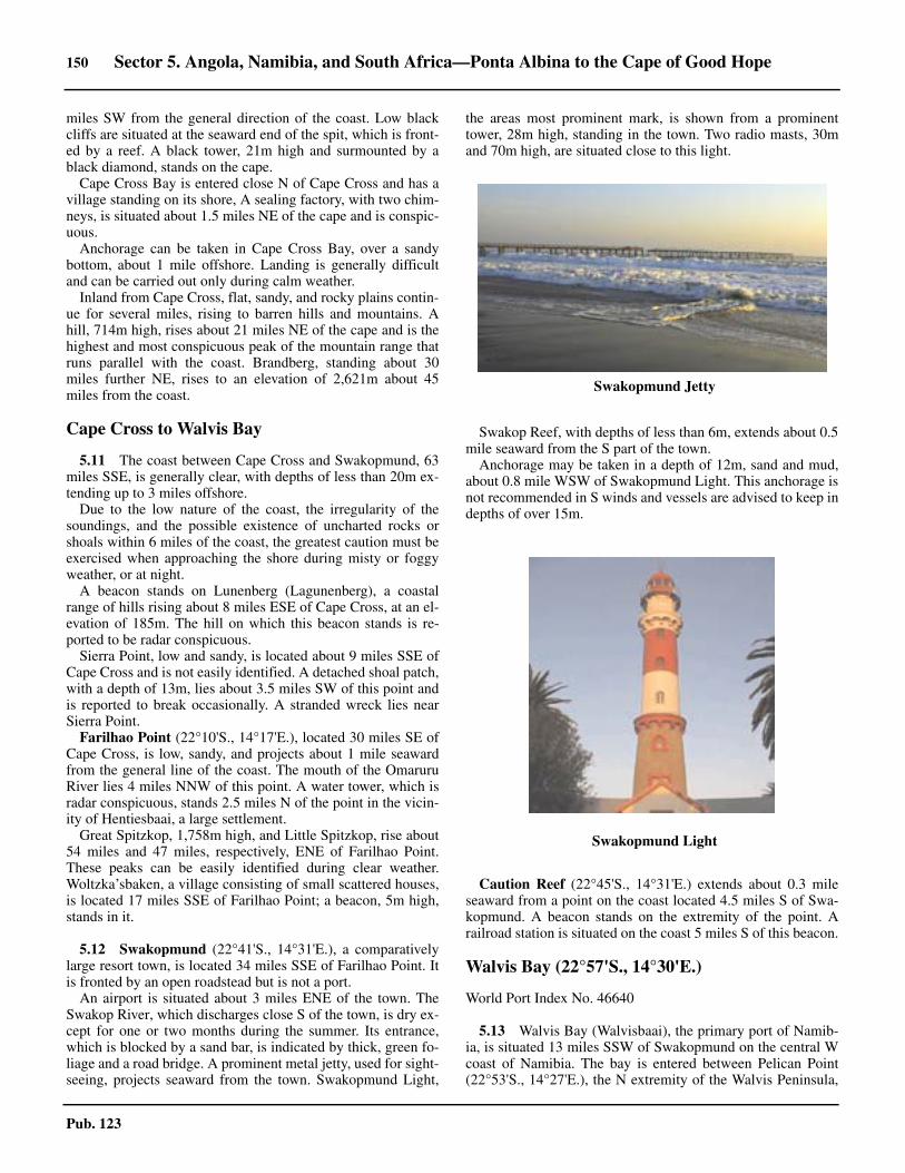
150 Sector 5. Angola, Namibia, and South Africa—Ponta Albina to the Cape of Good Hope
Pub. 123
miles SW from the general direction of the coast. Low blackcliffs are situated at the seaward end of the spit, which is front-ed by a reef. A black tower, 21m high and surmounted by ablack diamond, stands on the cape.5.10 Cape Cross Bay is entered close N of Cape Cross and has avillage standing on its shore, A sealing factory, with two chim-neys, is situated about 1.5 miles NE of the cape and is conspic-uous. 5.10 Anchorage can be taken in Cape Cross Bay, over a sandybottom, about 1 mile offshore. Landing is generally difficultand can be carried out only during calm weather.5.10 Inland from Cape Cross, flat, sandy, and rocky plains contin-ue for several miles, rising to barren hills and mountains. Ahill, 714m high, rises about 21 miles NE of the cape and is thehighest and most conspicuous peak of the mountain range thatruns parallel with the coast. Brandberg, standing about 30miles further NE, rises to an elevation of 2,621m about 45miles from the coast.
Cape Cross to Walvis Bay
5.11 The coast between Cape Cross and Swakopmund, 63miles SSE, is generally clear, with depths of less than 20m ex-tending up to 3 miles offshore.5.11 Due to the low nature of the coast, the irregularity of thesoundings, and the possible existence of uncharted rocks orshoals within 6 miles of the coast, the greatest caution must beexercised when approaching the shore during misty or foggyweather, or at night. 5.11 A beacon stands on Lunenberg (Lagunenberg), a coastalrange of hills rising about 8 miles ESE of Cape Cross, at an el-evation of 185m. The hill on which this beacon stands is re-ported to be radar conspicuous. 5.11 Sierra Point, low and sandy, is located about 9 miles SSE ofCape Cross and is not easily identified. A detached shoal patch,with a depth of 13m, lies about 3.5 miles SW of this point andis reported to break occasionally. A stranded wreck lies nearSierra Point. 5.11 Farilhao Point (22°10'S., 14°17'E.), located 30 miles SE ofCape Cross, is low, sandy, and projects about 1 mile seawardfrom the general line of the coast. The mouth of the OmaruruRiver lies 4 miles NNW of this point. A water tower, which isradar conspicuous, stands 2.5 miles N of the point in the vicin-ity of Hentiesbaai, a large settlement.5.11 Great Spitzkop, 1,758m high, and Little Spitzkop, rise about54 miles and 47 miles, respectively, ENE of Farilhao Point.These peaks can be easily identified during clear weather.Woltzka’sbaken, a village consisting of small scattered houses,is located 17 miles SSE of Farilhao Point; a beacon, 5m high,stands in it.
5.12 Swakopmund (22°41'S., 14°31'E.), a comparativelylarge resort town, is located 34 miles SSE of Farilhao Point. Itis fronted by an open roadstead but is not a port.
An airport is situated about 3 miles ENE of the town. TheSwakop River, which discharges close S of the town, is dry ex-cept for one or two months during the summer. Its entrance,which is blocked by a sand bar, is indicated by thick, green fo-liage and a road bridge. A prominent metal jetty, used for sight-seeing, projects seaward from the town. Swakopmund Light,
the areas most prominent mark, is shown from a prominenttower, 28m high, standing in the town. Two radio masts, 30mand 70m high, are situated close to this light.
5.12 Swakop Reef, with depths of less than 6m, extends about 0.5mile seaward from the S part of the town. 5.12 Anchorage may be taken in a depth of 12m, sand and mud,about 0.8 mile WSW of Swakopmund Light. This anchorage isnot recommended in S winds and vessels are advised to keep indepths of over 15m.
5.12 Caution Reef (22°45'S., 14°31'E.) extends about 0.3 mileseaward from a point on the coast located 4.5 miles S of Swa-kopmund. A beacon stands on the extremity of the point. Arailroad station is situated on the coast 5 miles S of this beacon.
Walvis Bay (22°57'S., 14°30'E.)
World Port Index No. 46640
5.13 Walvis Bay (Walvisbaai), the primary port of Namib-ia, is situated 13 miles SSW of Swakopmund on the central Wcoast of Namibia. The bay is entered between Pelican Point(22°53'S., 14°27'E.), the N extremity of the Walvis Peninsula,
5.12Swakopmund Jetty
5.12Swakopmund Light
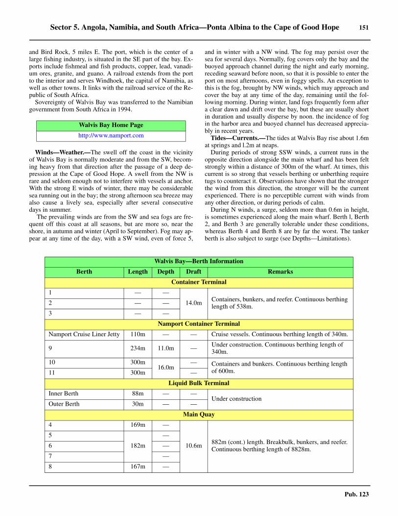
Sector 5. Angola, Namibia, and South Africa—Ponta Albina to the Cape of Good Hope 151
Pub. 123
and Bird Rock, 5 miles E. The port, which is the center of alarge fishing industry, is situated in the SE part of the bay. Ex-ports include fishmeal and fish products, copper, lead, vanadi-um ores, granite, and guano. A railroad extends from the portto the interior and serves Windhoek, the capital of Namibia, aswell as other towns. It links with the railroad service of the Re-public of South Africa.5.13 Sovereignty of Walvis Bay was transferred to the Namibiangovernment from South Africa in 1994.
5.13 Winds—Weather.—The swell off the coast in the vicinityof Walvis Bay is normally moderate and from the SW, becom-ing heavy from that direction after the passage of a deep de-pression at the Cape of Good Hope. A swell from the NW israre and seldom enough not to interfere with vessels at anchor.With the strong E winds of winter, there may be considerablesea running out in the bay; the strong afternoon sea breeze mayalso cause a lively sea, especially after several consecutivedays in summer.5.13 The prevailing winds are from the SW and sea fogs are fre-quent off this coast at all seasons, but are more so, near theshore, in autumn and winter (April to September). Fog may ap-pear at any time of the day, with a SW wind, even of force 5,
and in winter with a NW wind. The fog may persist over thesea for several days. Normally, fog covers only the bay and thebuoyed approach channel during the night and early morning,receding seaward before noon, so that it is possible to enter theport on most afternoons, even in foggy spells. An exception tothis is the fog, brought by NW winds, which may approach andcover the bay at any time of the day, remaining until the fol-lowing morning. During winter, land fogs frequently form aftera clear dawn and drift over the bay, but these are usually shortin duration and usually disperse by noon. the incidence of fogin the harbor area and buoyed channel has decreased apprecia-bly in recent years.5.13 Tides—Currents.—The tides at Walvis Bay rise about 1.6mat springs and l.2m at neaps.5.13 During periods of strong SSW winds, a current runs in theopposite direction alongside the main wharf and has been feltstrongly within a distance of 300m of the wharf. At times, thiscurrent is so strong that vessels berthing or unberthing requiretugs to counteract it. Observations have shown that the strongerthe wind from this direction, the stronger will be the currentexperienced. There is no perceptible current with winds fromany other direction, or during periods of calm.5.13 During N winds, a surge, seldom more than 0.6m in height,is sometimes experienced along the main wharf. Berth l, Berth2, and Berth 3 are generally tolerable under these conditions,whereas Berth 4 and Berth 8 are by far the worst. The tankerberth is also subject to surge (see Depths—Limitations).
Walvis Bay Home Page
http://www.namport.com
Walvis Bay—Berth Information
Berth Length Depth Draft Remarks
Container Terminal
1 — —
14.0m Containers, bunkers, and reefer. Continuous berthing length of 538m.2 — —
3 — —
Namport Container Terminal
Namport Cruise Liner Jetty 110m — — Cruise vessels. Continuous berthing length of 340m.
9 234m 11.0m — Under construction. Continuous berthing length of 340m.
10 300m16.0m
— Containers and bunkers. Continuous berthing length of 600m.11 300m —
Liquid Bulk Terminal
Inner Berth 88m — —Under construction
Outer Berth 30m — —
Main Quay
4 169m —
10.6m 882m (cont.) length. Breakbulk, bunkers, and reefer. Continuous berthing length of 8828m.
5
182m
—
6 —
7 —
8 167m —
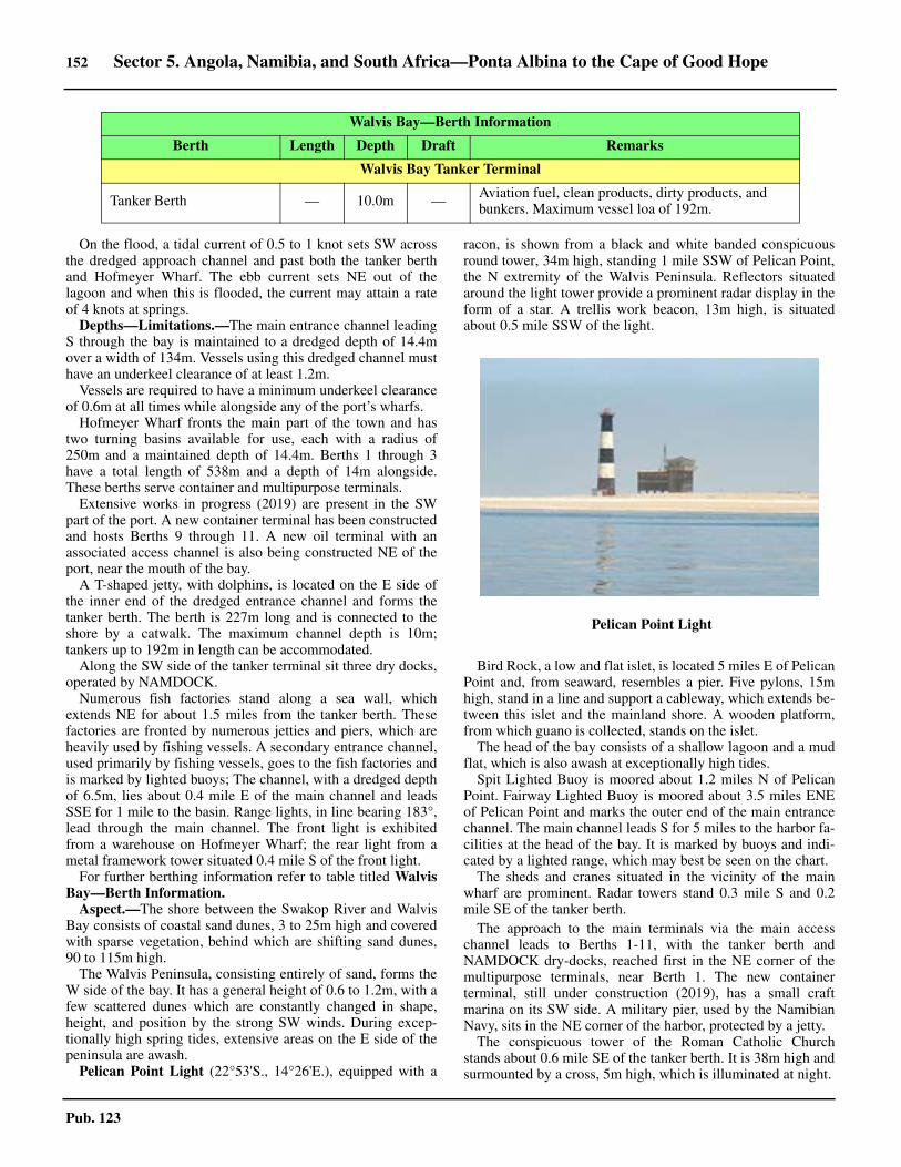
152 Sector 5. Angola, Namibia, and South Africa—Ponta Albina to the Cape of Good Hope
Pub. 123
5.13 On the flood, a tidal current of 0.5 to 1 knot sets SW acrossthe dredged approach channel and past both the tanker berthand Hofmeyer Wharf. The ebb current sets NE out of thelagoon and when this is flooded, the current may attain a rateof 4 knots at springs. 5.13 Depths—Limitations.—The main entrance channel leadingS through the bay is maintained to a dredged depth of 14.4mover a width of 134m. Vessels using this dredged channel musthave an underkeel clearance of at least 1.2m. 5.13 Vessels are required to have a minimum underkeel clearanceof 0.6m at all times while alongside any of the port’s wharfs.5.13 Hofmeyer Wharf fronts the main part of the town and hastwo turning basins available for use, each with a radius of250m and a maintained depth of 14.4m. Berths 1 through 3have a total length of 538m and a depth of 14m alongside.These berths serve container and multipurpose terminals. 5.13 Extensive works in progress (2019) are present in the SWpart of the port. A new container terminal has been constructedand hosts Berths 9 through 11. A new oil terminal with anassociated access channel is also being constructed NE of theport, near the mouth of the bay. 5.13 A T-shaped jetty, with dolphins, is located on the E side ofthe inner end of the dredged entrance channel and forms thetanker berth. The berth is 227m long and is connected to theshore by a catwalk. The maximum channel depth is 10m;tankers up to 192m in length can be accommodated.5.13 Along the SW side of the tanker terminal sit three dry docks,operated by NAMDOCK.5.13 Numerous fish factories stand along a sea wall, whichextends NE for about 1.5 miles from the tanker berth. Thesefactories are fronted by numerous jetties and piers, which areheavily used by fishing vessels. A secondary entrance channel,used primarily by fishing vessels, goes to the fish factories andis marked by lighted buoys; The channel, with a dredged depthof 6.5m, lies about 0.4 mile E of the main channel and leadsSSE for 1 mile to the basin. Range lights, in line bearing 183°,lead through the main channel. The front light is exhibitedfrom a warehouse on Hofmeyer Wharf; the rear light from ametal framework tower situated 0.4 mile S of the front light. 5.13 For further berthing information refer to table titled WalvisBay—Berth Information. 5.13 Aspect.—The shore between the Swakop River and WalvisBay consists of coastal sand dunes, 3 to 25m high and coveredwith sparse vegetation, behind which are shifting sand dunes,90 to 115m high.5.13 The Walvis Peninsula, consisting entirely of sand, forms theW side of the bay. It has a general height of 0.6 to 1.2m, with afew scattered dunes which are constantly changed in shape,height, and position by the strong SW winds. During excep-tionally high spring tides, extensive areas on the E side of thepeninsula are awash.5.13 Pelican Point Light (22°53'S., 14°26'E.), equipped with a
racon, is shown from a black and white banded conspicuousround tower, 34m high, standing 1 mile SSW of Pelican Point,the N extremity of the Walvis Peninsula. Reflectors situatedaround the light tower provide a prominent radar display in theform of a star. A trellis work beacon, 13m high, is situatedabout 0.5 mile SSW of the light.
5.13 Bird Rock, a low and flat islet, is located 5 miles E of PelicanPoint and, from seaward, resembles a pier. Five pylons, 15mhigh, stand in a line and support a cableway, which extends be-tween this islet and the mainland shore. A wooden platform,from which guano is collected, stands on the islet. 5.13 The head of the bay consists of a shallow lagoon and a mudflat, which is also awash at exceptionally high tides. 5.13 Spit Lighted Buoy is moored about 1.2 miles N of PelicanPoint. Fairway Lighted Buoy is moored about 3.5 miles ENEof Pelican Point and marks the outer end of the main entrancechannel. The main channel leads S for 5 miles to the harbor fa-cilities at the head of the bay. It is marked by buoys and indi-cated by a lighted range, which may best be seen on the chart.5.13 The sheds and cranes situated in the vicinity of the mainwharf are prominent. Radar towers stand 0.3 mile S and 0.2mile SE of the tanker berth.5.13 The approach to the main terminals via the main accesschannel leads to Berths 1-11, with the tanker berth andNAMDOCK dry-docks, reached first in the NE corner of themultipurpose terminals, near Berth 1. The new containerterminal, still under construction (2019), has a small craftmarina on its SW side. A military pier, used by the NamibianNavy, sits in the NE corner of the harbor, protected by a jetty.5.13 The conspicuous tower of the Roman Catholic Churchstands about 0.6 mile SE of the tanker berth. It is 38m high andsurmounted by a cross, 5m high, which is illuminated at night.
Walvis Bay Tanker Terminal
Tanker Berth — 10.0m — Aviation fuel, clean products, dirty products, and bunkers. Maximum vessel loa of 192m.
Walvis Bay—Berth Information
Berth Length Depth Draft Remarks
5.13Pelican Point Light
Sector 5. Angola, Namibia, and South Africa—Ponta Albina to the Cape of Good Hope 153
Pub. 123
5.13 Two radio masts, the taller of which has an elevation of 70m,stand about 0.2 mile NE of the church tower. A conspicuouswater tower is situated about 0.7 mile SE of the church tower.5.13 The buildings situated in the town of Swakopmund are con-spicuous, especially when the sun is shining on the roofs, mak-ing them visible in misty weather long before the land issighted.5.13 Pilotage.— Pilotage is compulsory for all vessels, exceptthose which are exempt by law or which have a permit issuedby the Port Captain. Request for pilots can be made by contact-ing the port captain prior to arrival. Walvis Bay Port Controlmaintains a 24-hour VHF radio watch on channel 16 and workson channels 12 and 14.5.13 Pilots board in position (22°50'S, 14°28'E.) 5.13 Regulations.—Inbound vessels should report to Port Con-trol on VHF channel 16 stating their ETA for the NNW ap-proach at position (22°43.0'S, 14°20.0'E) and for the SSWapproach at position (23°05.0'S, 14°20.0'E.) Vessels arrivingafter hours should send ETA abeam Pelican Point Light(22°53'S, 14°30'E) by VHF.5.13 The vessel’s ETA should be sent 72 hours before arrival withupdates sent 24 hours and 12 hours prior to arrival.5.13 Departing vessels must leave the wharf not later than 2145hours.5.13 Contact Information.—See the table titled Walvis Bay—Contact Information.
5.13 Anchorage.—Anchoring within 0.7 mile of the FairwayLighted Buoy is prohibited.5.13 Anchorage may take place in the outer anchorage areaswithin port limits between 0600 and 2200 or at any time in an
emergency. Three designated anchorage areas, the limits ofwhich may best be seen on the chart, have been established.Anchorage Area No. 1 lies with center 1.0 mile E of FairwayLighted Buoy; Anchorage Area No. 2 lies with center 1.8 milesENE of Pelican Point Light. Anchorage Area No. 3 lies withcenter 2.0 miles NNE of Fairway lighted buoy. The holding isreported to be generally good on a mud bottom.5.13 Caution.—A moored storage tanker sits in the S portion ofAnchorage No. 2. A partially exposed wreck was reported(2019) near the SW corner of Anchorage Area No. 2.5.13 It is common within the Walvis Bay anchorages for OffshoreSupply Vessels (OSV) to raft up alongside one another, oftenup to eight or more vessels deep.5.13 Pelican Point is reported to be extending NE and vesselsshould not pass between this point and Spit Lighted Buoy. 5.13 It is reported (1997) that depths in the bay lying outside ofthe dredged channels and areas may be up to 2.5m less thancharted.5.13 The concentration of sulphuretted hydrogen in the vicinity ofPelican Point is at times so strong that brasswork on ships areaffected by it.5.13 Spoil ground (dumping) areas, the limits of which may bestbe seen on the chart, lie centered 3.4 miles NNE and 2.6 milesSE of Pelican Point Light. 5.13 A marine farm area, within which navigation is prohibited,lies centered 2 miles SSE of Pelican Point Light and may bestbe seen on the chart. It fronts the E side of Walvis Peninsulaand extends up to about 1 mile seaward. 5.13 It is reported (2012) that the buoys marking the entrancechannel tend to acquire a whitish appearance due to sea birdactivity. 5.13 Volcanic disturbances have occurred off Walvis Bay. On 1June 1900, an islet of mud and clay, 46m long and 9m wide,was formed by volcanic action off the NE extremity of PelicanPoint. This islet, 4.6m high, was located close off the shore,where depths of 14.6m had previously existed. Steam was ob-served rising from the N side of the islet, and a very strongodor of sulphuretted hydrogen prevailed. On 7 June, the entireislet disappeared and soundings indicated that the originaldepth of 14.6m was restored.5.13 In January 1949, numerous bubbles were observed comingto the surface in Walvis Bay, followed by clouds of mud. Thesedisintegrated and a smell of sulphuretted hydrogen was noted.On 6 March 1951, three small islands appeared above the sur-face of the sea W of Pelican Point. The first island, about 90mlong, appeared shortly before sunset and arose from a bubblingsea. It remained for about one hour and then subsided beneaththe surface. The other two islands appeared farther to seawardand about the same time. They remained until daylight faded,and by morning had disappeared.5.13 Due to the low lying nature of the coast, approaching shipsmust exercise vigilance when approaching Walvis Bay in badweather or at night. The entrance to the bay is difficult to iden-tify from seaward and caution is advised, especially duringthick weather.5.13 It is reported that the first strong radar returns usually ap-pearing on the screen are those of the cranes situated on Hof-meyer Wharf. These returns should not be confused with thestar pattern of the reflectors at Pelican Point Light.5.13 Approaching from the S, the buildings in the town will usu-
Walvis Bay—Contact Information
Call sign Walvis Bay Port Control
VHF VHF channels 9, 11, 12, 13, 14, and 16
Telephone
264-642-082-263
264-642-082-264
264-642-082-265
Facsimile 264-642-082-325
E-mail [email protected]
Port Authority
Telephone
264-64-208-2201
264-64-208-2204
264-64-208-2111 (Switchboard)
Facsimile 264-64-208-2323
Web site https://www.namport.com
Tugs
VHF VHF channel 16
Harbor Master
Telephone 264-64-208-2258
Facsimile 264-64-208-2326

154 Sector 5. Angola, Namibia, and South Africa—Ponta Albina to the Cape of Good Hope
Pub. 123
ally be seen first over the Walvis Peninsula. Approaching fromthe N or NW, vessels are recommended to first sight Swakop-mund (see paragraph 5.12). If the weather is clear the ap-proaching ship will not experience any trouble in entering thebay.
Walvis Bay to Luderitz Bay
5.14 The coast between Walvis Bay (22°57'S., 14°30'E.)and the mouth of the Orange River (26°38'S.,15°09'E.), about375 miles SSE, presents a most uninviting appearance. It con-sists of a long range of sand hills, except between Spencer Bay(25°44'S., 14°50'E.) and Hottentot Bay (26°08'S., 14°57'E.),where there is a range of barren, desolate hills, 150 to 180mhigh, even more forbidding in aspect than the rest of the coast.Most of this coast is designated a restricted area, being in thediamond working area.5.14 A coastal bank, with depths of less than 15m, fronts the Wal-vis Peninsula, about 3 miles SSW of Pelican Point. It extendsabout 0.8 mile seaward and may best be seen on the chart. Ves-sels are advised to remain in depths of over 30m when transit-ing this area.
Sandwich Harbor (23°23'S., 14°27'E.), located 30 miles Sof Pelican Point, is entered through Sandwich Bay. It is no lon-ger a harbor, but rather a lagoon, which is intermittently closedto the sea. This harbor is a proclaimed bird sanctuary, being thehaunt of pelicans and flamingos. Discolored water, very lightin color and extending 2 to 3 miles seaward, has been observedin the vicinity of Sandwich Bay and for a few miles S of it. Theline of demarcation between it and the blue water seaward isusually clear and distinct. Depths lying about 0.2 mile insidethis line were found to be about 25m, sand.5.14 The coast extending between a point on the shore located 10miles S of Sandwich Bay and Conception Bay, 32 miles S, isbacked by shifting sand dunes, 100 to 150m high. Offshore,depths of less than 10m lie in places up to about 1 mile seawardof the coast. This stretch was formerly known as Die LangeWand (The Long Wall).5.14 Local knowledge is required. Anchorage in good weather isavailable approximately 1,540m WSW of D’llheu Point. Land-ing is possible at the point.
5.14 Conception Bay (23°55'S., 14°29'E.) is a slight indentationaffording no shelter. It is used only by small vessels with provi-sions for a diamond-mining settlement situated 9 miles inland.Anchorage may be taken, in depths of 15 to 20m, fine graysand, outside the surf. The anchorage affords no shelter.5.14 A prominent stranded wreck (Eduard Bohlen) lies 4.5 milesSSW of Conception Bay and some distance inland. This wreck,which forms a conspicuous radar target, for many years had theappearance of a ship steaming through the desert.5.14 Caution.—Between Walvis Bay and Conception Bay, thecoastal waters lying S of latitude 23°10'S are inadequately sur-veyed and vessels without local knowledge should use extremecaution when navigating in depths of less than 100m.5.14 Diamond Area No. 2, a coastal strip about 175 miles wide,extends from a point on the shore located 31 miles S of Sand-wich Bay to latitude 26°S. Landing or entry without permis-sion is prohibited in this area.
5.15 North Rocks (24°29'S., 14°37'E.) lie about 34 milesSSE of Conception Bay and close off a sandy point. Black Kop(Swartkop), a hill, rises 5 miles N of the rocks. It is 25m highand dark.
Meob Bay (Mutzel Bay), a small indentation, lies close S ofNorth Rocks. A small settlement and a meteorological stationare situated close S of this bay.5.15 Black Reef (South Rocks) lies 2.5 miles SSW of NorthRocks. A hill, 30m high, and another hill, 25m high, rise closeESE and 2 miles ENE, respectively, of Black Reef.5.15 Detached shoals, with depths of 18.3m and 9.7m, lie about 3miles W and 3.5 miles SSW, respectively, of Black Reef.
Hollandsbird Island (Hollams Bird Island) (24°38'S.,14°32'E.) lies 6 miles offshore, about 7 miles SSW of BlackReef. This small island is 12m high and surrounded by a reef.Depths of less than 20m extend up to about 4 miles N and 6miles SSW of the island. Breakers were reported (1939) to ex-ist in a position lying about 6 miles SSW of the island. A pairof heavylift shear legs, which appear conspicuous from sea-ward, stand on the N side of the island and are used in the re-covery of guano. The surrounding reef is frequented by rightwhales during July and August and is the resort of seals andcormorants.5.15 Temporary anchorage can be obtained, except in strong Nwinds, in a depth of 18m, between 0.5 mile and 1 mile N of theisland.5.15 A detached shoal, with a depth of 25.6m, lies (position ap-proximate) about 5 miles W of Hollandsbird Island.
5.16 An indentation, with a low sandy beach marked bypatches of black rocks, is formed between a point located closeS of Black Reef and some conspicuous white sand patches onthe coast, about 25 miles SSE. This part of the coast is lowerthan the coast S of it and is difficult to distinguish due to theheavy surf and spray which envelop it. The above-mentionedwhite sand patches are very conspicuous in the afternoon whenthe sun shines on them. The entire countryside in the vicinity isformed of sand, with a generally yellowish appearance, but thepatches are quite white and fan-shaped.
A flat-topped black rock (24°57'S., 14°49'E.) lies close offthe coast about 2 miles S of the white sand patches and is con-spicuous.5.14Die Lange Wand (The Long Wall)
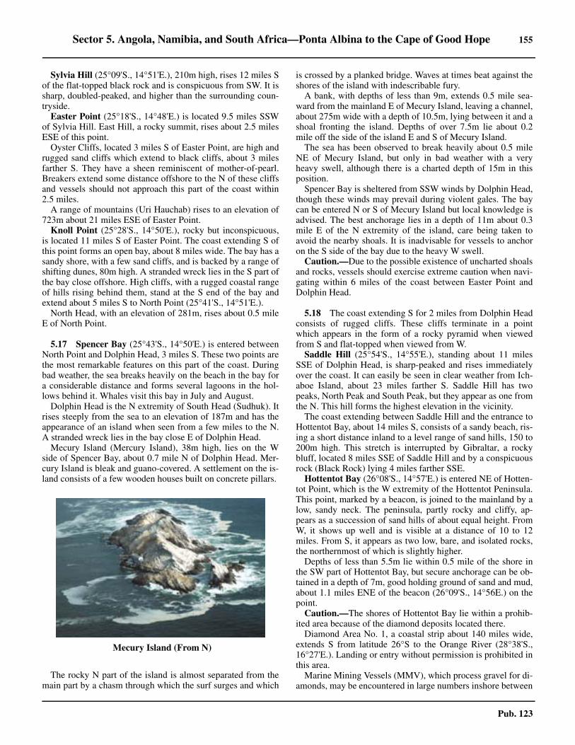
Sector 5. Angola, Namibia, and South Africa—Ponta Albina to the Cape of Good Hope 155
Pub. 123
5.16 Sylvia Hill (25°09'S., 14°51'E.), 210m high, rises 12 miles Sof the flat-topped black rock and is conspicuous from SW. It issharp, doubled-peaked, and higher than the surrounding coun-tryside.5.16 Easter Point (25°18'S., 14°48'E.) is located 9.5 miles SSWof Sylvia Hill. East Hill, a rocky summit, rises about 2.5 milesESE of this point.5.16 Oyster Cliffs, located 3 miles S of Easter Point, are high andrugged sand cliffs which extend to black cliffs, about 3 milesfarther S. They have a sheen reminiscent of mother-of-pearl.Breakers extend some distance offshore to the N of these cliffsand vessels should not approach this part of the coast within2.5 miles.5.16 A range of mountains (Uri Hauchab) rises to an elevation of723m about 21 miles ESE of Easter Point.5.16 Knoll Point (25°28'S., 14°50'E.), rocky but inconspicuous,is located 11 miles S of Easter Point. The coast extending S ofthis point forms an open bay, about 8 miles wide. The bay has asandy shore, with a few sand cliffs, and is backed by a range ofshifting dunes, 80m high. A stranded wreck lies in the S part ofthe bay close offshore. High cliffs, with a rugged coastal rangeof hills rising behind them, stand at the S end of the bay andextend about 5 miles S to North Point (25°41'S., 14°51'E.).5.16 North Head, with an elevation of 281m, rises about 0.5 mileE of North Point.
5.17 Spencer Bay (25°43'S., 14°50'E.) is entered betweenNorth Point and Dolphin Head, 3 miles S. These two points arethe most remarkable features on this part of the coast. Duringbad weather, the sea breaks heavily on the beach in the bay fora considerable distance and forms several lagoons in the hol-lows behind it. Whales visit this bay in July and August.5.17 Dolphin Head is the N extremity of South Head (Sudhuk). Itrises steeply from the sea to an elevation of 187m and has theappearance of an island when seen from a few miles to the N.A stranded wreck lies in the bay close E of Dolphin Head. 5.17 Mecury Island (Mercury Island), 38m high, lies on the Wside of Spencer Bay, about 0.7 mile N of Dolphin Head. Mer-cury Island is bleak and guano-covered. A settlement on the is-land consists of a few wooden houses built on concrete pillars.
5.17 The rocky N part of the island is almost separated from themain part by a chasm through which the surf surges and which
is crossed by a planked bridge. Waves at times beat against theshores of the island with indescribable fury.5.17 A bank, with depths of less than 9m, extends 0.5 mile sea-ward from the mainland E of Mecury Island, leaving a channel,about 275m wide with a depth of 10.5m, lying between it and ashoal fronting the island. Depths of over 7.5m lie about 0.2mile off the side of the island E and S of Mecury Island.5.17 The sea has been observed to break heavily about 0.5 mileNE of Mecury Island, but only in bad weather with a veryheavy swell, although there is a charted depth of 15m in thisposition.5.17 Spencer Bay is sheltered from SSW winds by Dolphin Head,though these winds may prevail during violent gales. The baycan be entered N or S of Mecury Island but local knowledge isadvised. The best anchorage lies in a depth of 11m about 0.3mile E of the N extremity of the island, care being taken toavoid the nearby shoals. It is inadvisable for vessels to anchoron the S side of the bay due to the heavy W swell. 5.17 Caution.—Due to the possible existence of uncharted shoalsand rocks, vessels should exercise extreme caution when navi-gating within 6 miles of the coast between Easter Point andDolphin Head.
5.18 The coast extending S for 2 miles from Dolphin Headconsists of rugged cliffs. These cliffs terminate in a pointwhich appears in the form of a rocky pyramid when viewedfrom S and flat-topped when viewed from W. 5.18 Saddle Hill (25°54'S., 14°55'E.), standing about 11 milesSSE of Dolphin Head, is sharp-peaked and rises immediatelyover the coast. It can easily be seen in clear weather from Ich-aboe Island, about 23 miles farther S. Saddle Hill has twopeaks, North Peak and South Peak, but they appear as one fromthe N. This hill forms the highest elevation in the vicinity.
The coast extending between Saddle Hill and the entrance toHottentot Bay, about 14 miles S, consists of a sandy beach, ris-ing a short distance inland to a level range of sand hills, 150 to200m high. This stretch is interrupted by Gibraltar, a rockybluff, located 8 miles SSE of Saddle Hill and by a conspicuousrock (Black Rock) lying 4 miles farther SSE.5.18 Hottentot Bay (26°08'S., 14°57'E.) is entered NE of Hotten-tot Point, which is the W extremity of the Hottentot Peninsula.This point, marked by a beacon, is joined to the mainland by alow, sandy neck. The peninsula, partly rocky and cliffy, ap-pears as a succession of sand hills of about equal height. FromW, it shows up well and is visible at a distance of 10 to 12miles. From S, it appears as two low, bare, and isolated rocks,the northernmost of which is slightly higher.5.18 Depths of less than 5.5m lie within 0.5 mile of the shore inthe SW part of Hottentot Bay, but secure anchorage can be ob-tained in a depth of 7m, good holding ground of sand and mud,about 1.1 miles ENE of the beacon (26°09'S., 14°56E.) on thepoint.5.18 Caution.—The shores of Hottentot Bay lie within a prohib-ited area because of the diamond deposits located there.5.18 Diamond Area No. 1, a coastal strip about 140 miles wide,extends S from latitude 26°S to the Orange River (28°38'S.,16°27'E.). Landing or entry without permission is prohibited inthis area. 5.18 Marine Mining Vessels (MMV), which process gravel for di-amonds, may be encountered in large numbers inshore between
5.17Mecury Island (From N)
156 Sector 5. Angola, Namibia, and South Africa—Ponta Albina to the Cape of Good Hope
Pub. 123
Hottentot Bay and the Orange River (28°38'S., 16°27'E.).These diamond-mining barges are usually moored to four an-chors, which may or may not be marked by unlit buoys. Ves-sels are advised to stay at least 1,500m away from MMVs.5.18 The anchorage area indicated on the chart has an approxi-mate depth of about 7m but may not suitable for most commer-cial deep-draft vessels. 5.18 A dangerous wreck is reported to lie close N of HottentotPoint and can best be seen on the chart.5.18 Mooring buoys, designated B1, B2, and B3, are reported tobe situated 1.5 miles, 2 miles, and 2.7 miles, respectively, NEof Hottentot Point.
5.19 The coast between Hottentot Point and Danger Point,about 8 miles S, is generally rocky, with occasional sandybeaches. Breakers extend about 0.3 mile offshore in an unbro-ken line. Some of the points are marked by rocks and are pro-longed by submerged reefs which extend a considerabledistance offshore in places. 5.19 Caution.—Combined with the prevalence of fog, coastalnavigation along this stretch of coast can be precarious andships transiting should exercise extreme caution when ap-proaching the coast.5.19 Gallovidia Reefs (26°10'S., 14°56'E.), with several partsawash and others above water, extends about 1.5 miles S froma point located 1.2 miles SSE of Hottentot Point. A rocky isletlies at the S end of this reef. The reef lies nearly in the directtrack leading from Hottentot Bay to Douglas Bay. Therefore,vessels should keep in depths of not less than 30m as the seahas been observed to break heavily in depths of over 14m.5.19 A detached shoal, with a least depth of 10m and on whichthe sea breaks in a heavy swell, lies about 1.5 miles SSW of therocky islet located at the S end of Gallovidia Reef. 5.19 Danger Point (26°16'S., 14°57'E.) is characterized by steepand broken cliffs and fringed by rocks extending 0.6 mile SSWfrom this point to Wreck Point, which is reported to be radarprominent, and then 0.8 mile SSE to another cliffy projection.The sea breaks heavily all along this stretch of coast. JakalBeacon stands near the coast, 0.4 mile S of Wreck Point.
Ichaboe Island (26°17'S., 14°56'E.), lying 0.7 mile SW ofWreck Point, is flat and mainly composed of granite. Its sum-mit, located at the SW end, is 12m high and marked by a polebeacon, which is difficult to distinguish from a distance. A set-tlement, with a jetty and a flagstaff, is situated at the NE side ofthe island. The island is the home of a colony of cormorants.Guano collecting takes place during April and May when allthe birds have departed.5.19 Foul ground and reefs, upon which the sea usually breaks,front the N, W, and S sides of the island. A rocky outcrop,known as Little Ichaboe, lies 0.3 mile off the W side of the is-land.5.19 Anchorage can be obtained in a depth of 10m about 0.2 mileE of the settlement or in a depth of 13m about 0.3 mile ENE ofthe S extremity of the island. These anchorages are consideredto be only fairly good because the holding ground is nothingmore than sandy patches amongst rocks. In the first location,vessels are well-sheltered from the high swell which sets in,but NE of the island the rollers are dangerously heavy. Rollerscome in without giving any previous warning and it is not un-usual for the approaches on either side of the island to break
completely across, leaving comparatively smooth water at theanchorage.
5.20 Douglas Bay (26°18'S., 14°57'E.) is entered betweenWreck Point and Douglas Point, 1.5 miles S. Rocky Point, lo-cated 0.4 mile NE of Douglas Point, divides the S part of thebay into two smaller bays. Kartoffel Bucht, the S bay, providesno shelter but Post Office Bay, the N bay, is protected. Breakersextend up to 0.3 mile N from Douglas Point and front RockyPoint. An isolated shoal, with a least depth of 12.8m, lies about0.7 mile WSW of Douglas Point.5.20 Vessels approaching Douglas Bay can pass either N or S ofIchaboe Island, giving it a berth of at least 0.4 mile. The S pas-sage is preferable as the N passage is narrower and the seabreaks in adverse weather for several miles N of the island. Lo-cal knowledge is advised.5.20 Marshall Rocks, composed of dangerous and extensive reefsmarked by heavy breakers, front the coast 3 miles SSE ofDouglas Point and extend up to 1.5 miles offshore. Breakersextend in a SE direction for about 2.5 miles from the SE end ofMarshall Rocks and a bank, with depths of 13 to 17m, extendsin the same direction for another 2 miles. Staple Rocks lie withthe tallest rock, 9m high, about 1 mile E of the SE end of Mar-shall Rocks.
Kegelberg (26°25'S., 15°06'E.), a conspicuous conical hill,rises 10.5 miles SE of Douglas Point. It is 40m high and con-sists of white quartz. This hill stands 0.5 mile N of the N en-trance point of Boat Bay, at the S end of a low chain of hills.Nearly all of the intervening coast is fringed by breakers.5.20 Boat Bay Rocks, marked by breakers, extend up to about 1mile W of the N entrance point of Boat Bay. The S entrancepoint of this bay is located 2.5 miles SSE of the rocks. It con-sists of a rocky headland, 67m high. Some huts, in ruins, standclose E of the headland. Boat Bay is clear of dangers and an-chorage can be taken in depths of 7 to 11m within its S part,but vessels should proceed to sea when W or N winds threaten.5.20 Dumfudgeon Rocks, two low islets, lie 2.2 miles S of BoatBay and about 0.6 mile offshore. They are inhabited by seals.Dagger Rocks, lying 2.5 miles SSE of Dumfudgeon Rocks, ex-tend up to about 0.2 mile offshore. A shoal patch, with a leastdepth of 18m, lies about 1.5 miles W of Dagger Rocks.5.20 North East Point (26°35'S., 15°09'E.), bold and rocky, is lo-cated 3 miles S of Dagger Rocks. It forms the N entrance pointof Luderitz Bay. North Reef extends about 0.4 mile SW fromthe point and an islet, 2.7m high, lies on its outer part. Flamin-go Island lies 0.4 mile ESE of the point and is connected to themainland by a sandy neck, which dries at LW.
Luderitz Bay (26°39'S., 15°09'E.)
World Port Index No. 46650
5.21 Luderitz Bay is situated between Walvis Bay and themouth of the Orange River. The Port of Luderitz lies in the SEpart of Luderitz Bay. The main exports are canned rock lobstertails and other fish products, as well as seal oils and skins. Theport also serves the offshore diamond and petroleum industries.5.21 The port is approached through Luderitz Bay and entered NEof Angra Point situated between North East Point (26°35'S
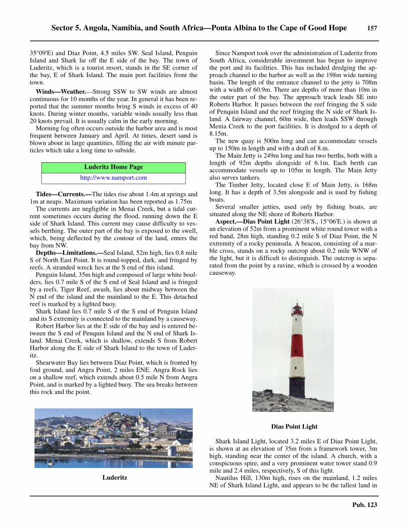
Sector 5. Angola, Namibia, and South Africa—Ponta Albina to the Cape of Good Hope 157
Pub. 123
35°09'E) and Diaz Point, 4.5 miles SW. Seal Island, PenguinIsland and Shark lie off the E side of the bay. The town ofLuderitz, which is a tourist resort, stands in the SE corner ofthe bay, E of Shark Island. The main port facilities front thetown.
5.21 Winds—Weather.—Strong SSW to SW winds are almostcontinuous for 10 months of the year. In general it has been re-ported that the summer months bring S winds in excess of 40knots. During winter months, variable winds usually less than20 knots prevail. It is usually calm in the early morning.5.21 Morning fog often occurs outside the harbor area and is mostfrequent between January and April. At times, desert sand isblown about in large quantities, filling the air with minute par-ticles which take a long time to subside.
5.21 Tides—Currents.—The tides rise about 1.4m at springs and1m at neaps. Maximum variation has been reported as 1.75m5.21 The currents are negligible in Menai Creek, but a tidal cur-rent sometimes occurs during the flood, running down the Eside of Shark Island. This current may cause difficulty to ves-sels berthing. The outer part of the bay is exposed to the swell,which, being deflected by the contour of the land, enters thebay from NW. 5.21 Depths—Limitations.—Seal Island, 52m high, lies 0.8 mileS of North East Point. It is round-topped, dark, and fringed byreefs. A stranded wreck lies at the S end of this island. 5.21 Penguin Island, 35m high and composed of large white boul-ders, lies 0.7 mile S of the S end of Seal Island and is fringedby a reefs. Tiger Reef, awash, lies about midway between theN end of the island and the mainland to the E. This detachedreef is marked by a lighted buoy.5.21 Shark Island lies 0.7 mile S of the S end of Penguin Islandand its S extremity is connected to the mainland by a causeway.5.21 Robert Harbor lies at the E side of the bay and is entered be-tween the S end of Penquin Island and the N end of Shark Is-land. Menai Creek, which is shallow, extends S from RobertHarbor along the E side of Shark Island to the town of Luder-itz. 5.21 Shearwater Bay lies between Diaz Point, which is fronted byfoul ground, and Angra Point, 2 miles ENE. Angra Rock lieson a shallow reef, which extends about 0.5 mile N from AngraPoint, and is marked by a lighted buoy. The sea breaks betweenthis rock and the point.
5.21 Since Namport took over the administration of Luderitz fromSouth Africa, considerable investment has begun to improvethe port and its facilities. This has included dredging the ap-proach channel to the harbor as well as the 198m wide turningbasin. The length of the entrance channel to the jetty is 708mwith a width of 60.9m. There are depths of more than 10m inthe outer part of the bay. The approach track leads SE intoRoberts Harbor. It passes between the reef fringing the S sideof Penquin Island and the reef fringing the N side of Shark Is-land. A fairway channel, 60m wide, then leads SSW throughMenia Creek to the port facilities. It is dredged to a depth of8.15m.5.21 The new quay is 500m long and can accommodate vesselsup to 150m in length and with a draft of 8.m. 5.21 The Main Jetty is 249m long and has two berths, both with alength of 92m depths alongside of 6.1m. Each berth canaccommodate vessels up to 105m in length. The Main Jettyalso serves tankers. 5.21 The Timber Jetty, located close E of Main Jetty, is 168mlong. It has a depth of 3.5m alongside and is used by fishingboats. 5.21 Several smaller jetties, used only by fishing boats, aresituated along the NE shore of Roberts Harbor. 5.21 Aspect.—Dias Point Light (26°38'S., 15°06'E.) is shown atan elevation of 52m from a prominent white round tower with ared band, 28m high, standing 0.2 mile S of Diaz Point, the Nextremity of a rocky peninsula. A beacon, consisting of a mar-ble cross, stands on a rocky outcrop about 0.2 mile WNW ofthe light, but it is difficult to distinguish. The outcrop is sepa-rated from the point by a ravine, which is crossed by a woodencauseway.
5.21 Shark Island Light, located 3.2 miles E of Diaz Point Light,is shown at an elevation of 35m from a framework tower, 3mhigh, standing near the center of the island. A church, with aconspicuous spire, and a very prominent water tower stand 0.9mile and 2.4 miles, respectively, S of this light.5.21 Nautilus Hill, 130m high, rises on the mainland, 1.2 milesNE of Shark Island Light, and appears to be the tallest land in
Luderitz Home Page
http://www.namport.com
5.21Luderitz
5.21Dias Point Light

158 Sector 5. Angola, Namibia, and South Africa—Ponta Albina to the Cape of Good Hope
Pub. 123
the vicinity. A radio mast is situated near the shore 0.2 mileNW of this hill.5.21 A disused whaling station, with several large prominentbuildings and tall chimneys, is situated within a cove in the SEpart of Shearwater Bay.5.21 The approach track leading SE between Penguin Island andShark Island is indicated by a lighted range which may best beseen on the chart. The reefs fringing the S side of Penguin Is-land and the N side of Shark Island are marked by lightedbuoys. The dredged fairway leading SSW through MenaiCreek is marked by lighted buoys. 5.21 Pilotage.—Pilotage is compulsory for vessels of more than40m in length while within the port limits. Vessels under 40min length do not require pilotage if officially exempted. Pilotscan be contacted on VHF channel 12 or 16 and usually boardabout 1 mile N of Angra Point. Pilotage is available between0600 and 2200 LT. During poor weather, pilots board about 0.7mile NE of Angra Point. Vessels should send an ETA and re-quest for pilotage 72 hours and 1 hour in advance.5.21 Regulations.—Berthing generally takes place between 0600and 2200, and at any other time in an emergency or by requestif tide-restricted.5.21 A Port Information Service is maintained at Luderitz Bay.Vessels are requested to establish contact by VHF with theHarbormaster (Luderitz Port Control) not less than 1 hour be-fore arrival. Vessels arriving after hours should report theirETA on VHF channel 16 to the signal station at Dias PointLight.5.21 Vessels moored at the outer anchorage should keep a contin-uous listening watch on VHF channel 16. 5.21 Contact Information.—See the table titled Luderitz—Contact Information.
5.21 Anchorage.—In the past, vessels worked cargo at theanchorage but, due to the construction of the new quay, thispractice now occurs infrequently.5.21 Shearwater Bay provides sheltered anchorage, in depths of 7to 14m, from all but N and NW winds, but vessels must be pre-pared to get underway at short notice due to sudden squalls.5.21 Anchorage according to draft can be taken in the outer partof Luderitz Harbor, which extends S between Angra Point and
Shark Island. The holding ground is good but a heavy NWswell may set in at any time.5.21 Robert Harbor provides fairly good and sheltered anchoragebut the holding ground is poor in places and vessels have beenknown to drag. Vessels may anchor in a depth of 7m, about 0.3mile ESE of the SE end of Penquin Island or, in a depth of 8m,clay, about 0.3 mile NW of the front range light. A consider-able NW swell may be experienced at times at the latter an-chorage.5.21 North Harbor, which is entered N of Seal Island, providesanchorage in a depth of 7m.5.21 Directions.—Luderitz Bay may be entered during daylightwithout difficulty. Dias Point should be rounded at a distanceof at least 0.4 mile. Vessels must pass N of the lighted buoymoored about 0.7 mile N of Angra Point.5.21 At night, when approaching from N, course should be set topass at least 1.5 miles off of North East Point, then alteringcourse to bring Shark Island Light ahead when within the whitesector of the light. Course can then be set for entering RobertHarbor or Luderitz Harbor, as appropriate.5.21 At night, when approaching from S, a distance off the coastof at least 3 miles should be maintained until NE of Dias PointLight. Vessels should keep clear of an area of foul ground W ofHalifax Island and be aware of crayfish trap fishing in the vi-cinity. The course is then altered E to pass N of Angra RockLighted Buoy (26°37S., 15°08'E), keeping in the fixed whitesector of Dias Point Light. The fixed red sector covers the reefand the SE shore of Shearwater Bay. After passing the lightedbuoy, the white sector of Shark Island Light is entered andcourse can be shaped for entering Robert Harbor or LuderitzHarbor.5.21 Caution.—A large foul ground area, containing anchoredfloating ropes and unlighted buoys, lies centered 4 miles WSWof Dias Point Light and may best be seen on the chart.5.21 A marine farm (mussel cultures) lies off the E coast of SealIsland and may best be seen on the chart. Vessels should keepwell clear of the area due to the presence of unlit floating plat-forms and booms.
Luderitz Bay to the Orange River
5.22 The coast extending between Dias Point (26°38'S.,15°06'E.) and Chameis Baai, 81 miles SSE, is indented withmany small bays which are enclosed by rocky headlands. Theinterior is desert country, consisting of sandy valleys withsparse scrub vegetation lying between ranges of sandstone andquartzite hills.5.22 Halifax Island (26°39'S., 15°05'E.), lying 1.2 miles SW ofDias Point, is 23m high. It is separated from the mainland tothe SE by a shallow and narrow channel. A number of huts aresituated on the island and a flagstaff stands on its NE extremity.Halifax Reef, parts of which are above water, extends about 0.5mile NNW from the N side of the island. Halifax Island ap-pears as a range of black hummocks from S and has been re-portedly mistaken for Dias Point.5.22 Caution.— Vessels should keep clear of a foul ground areaWNW of Halifax Island and be aware of crayfish trap fishingin the vicinity. Crayfishing vessels may be encountered within3 miles of the coast to the S of Luderitz Bay. Such vessels maybe anchored or drifting with unlit bottom gear, marker buoys,
Luderitz—Contact Information
Port Control
Call sign Luderitz Port Control
VHF VHF channels 12 and 16
Telephone264-63-200-2007
264-63-200-2008
Port Authority
Telephone 264-632-002-017
Facsimile 264-632-002-028
Web site https://www.namport.com
Pilots
VHF VHF channel 12 and 16
Sector 5. Angola, Namibia, and South Africa—Ponta Albina to the Cape of Good Hope 159
Pub. 123
and recovery lines. Guano Bay, lying close SW of Dias Point, is sheltered from
S and SW winds by Halifax Island and Halifax Reef. 5.22 Anchorage can be taken in a depth of 9m about 0.3 mile NEof the NE end of Halifax Island, but depths decrease rapidlywithin 0.3 mile of the shore of the bay.5.22 Grosse Bucht (26°45'S., 15°06'E.), also known as Big Bay,lies approximately 6 miles S of Halifax Island and has a sandycoastline alternating with rocks. It affords no shelter, except tosmall vessels in a N wind, as the bottom is reported to be foul. 5.22 Albatross Peak, a double-headed peak, rises 2.5 miles E ofGrosse Bucht. It is 176m high, reddish in color, and prominentfrom S.5.22 Wolf Bay, providing no protection, lies 4 miles SSE ofGrosse Bay. North Long Island, low-lying and almost dividedinto two parts, lies 0.5 mile offshore, close S of the entrance toWolf Bay. South Long Island, lying 0.5 mile S of North LongIsland, is situated close off a small point on the coast. Both ofthese islands are occupied by seals.
Zwei Spitz (Zwei Point) (26°52'S., 15°09'E.), located 2miles SE of South Long Island, consists of a prominent table-topped hill. Abenteuer Bay, which is reported to be deep, liesclose S of this point. A submerged reef, which breaks, liesabout 0.4 mile offshore, 1.3 miles S of the point. The cliffs inthis vicinity are composed of cream-colored rock, in contrast tothe prevailing gray granite.
Elizabeth Point (26°55'S., 15°11'E.), low and rocky, is situ-ated 4.5 miles SSE of Zwei Point. This point is fronted by adangerous reef and heavy breakers on its S side. The ruins ofan old mining town, which is situated N of the point, are con-spicuous when viewed from the W. 5.22 Elizabeth Bay is entered S of the reefs fronting ElizaberthPoint. It is backed by a low plain with shifting sand hills, be-hind which the country is hilly.5.22 Zweikuppen (Saddle Mount) (26°56'S., 15°20'E.) rises to anelevation of 358m about 8 miles E of Elizabeth Point and isprominent. Dreizackberg, 468m high, stands 6 miles SE ofZweikuppen. Two peaks, known as The Paps, rise to elevationsof 1,520m and 1,615m behind these hills, and are conspicuousin clear weather.
5.23 Possession Island (27°01'S., 15°12'E.) lies 5 miles Sof Elizabeth Point and rises to an elevation of 27m in its S part.The coasts of the island are rocky. The island can be easilyidentified when approached from either N or S. When seenfrom close S, the island appears as a group of islets because ithas several summits joined by low land.A small settlement,with a pier and a flagstaff, is situated on the E side of the is-land, 0.5 mile from its N extremity.
Two islets lie close off the N end of Possession Island andNorth Reef, marked by breakers, extends about 1 mile NNWfrom the island. Kreuz Shoals consists of two detached groups.One group, with a least depth of 3.1m, and another group, witha least depth of 5.1m, lie about 0.7 mile and 1.4 miles, respec-tively, NE of the N end of the island. Possession Rock, awash,lies 0.7 mile SSE of the N end of the island and about 0.3 mileoffshore.5.23 South Reef, marked by breakers and incompletely surveyed,extends about 1.5 miles S from the S end of Possession Island.Several wrecks lie on this reef and it should be given a wide
berth.5.23 Sheltered anchorage, in smooth water, can be taken by smallvessels within Possession Road at the E side of the island. Ves-sels should anchor, in a depth of 8m, about 0.5 mile NNE of theflagstaff situated at the settlement. However, it is reported thatthe sea bed is covered in kelp in places and does not providegood holding ground.5.23 Possession Road may be approached by passing either N orS of Possession Island. When approaching from the N, vesselsshould give the islets lying off the N end of the island a berth ofat least 1 mile and keep well over toward the mainland shore.The best approach to the anchorage is from the S, giving the Send of Possession Island a berth of at least 2 miles until the Nextremity of the island is open E of the SE end of the island.
5.24 Prinzen Bucht (Prince of Wales Bay) (27°05'S.,15°15'E.), a small indentation in the coast, lies 5 miles SSE ofPossession Island. Foul ground and shallow rocks extend about0.5 mile NNW from the SW entrance point of this bay. An-chorage in depths of 8 to 12m can be obtained by small craftabout 0.3 mile NE of the N edge of the foul ground. 5.24 Albatross Rocks (27°07'S., 15°14'E.) lies about 0.8 mile offthe coast, 5.8 miles SSE of the S end of Possession Island. Itconsists of a ridge of volcanic islets and above-water rocks,about 0.7 mile long. The southernmost and largest islet appearsprominent against the lighter-colored mainland when viewedfrom seaward. Foul ground extends up to about 0.4 mile N and1.5 miles S of these rocks. The foul ground extending S fromthe rocks is marked by breakers. 5.24 Caution.—Albatross Channel, lying between AlbatrossRocks and the mainland, appears to be clear and has a depth of6.7m lying in its N entrance. However, vessels using this chan-nel are advised to exercise great caution.5.24 Jammer Bucht, a small bay, lies 4 miles S of Prinzen Buchtand has a predominantly rocky shore except for a sandy beachat its N end. 5.24 Pomona Island (27°12'S., 15°16'E.), 15m high, lies closeoff the coast, 4.5 miles SSE of Albatross Rocks. A submergedrock lies between the island and the mainland. A flagstaff, abeacon, and some buildings stand on the E side of the islandbut are not prominent from seaward. When seen from the W,the island appears as two low hummocks. Small vessel anchor-age may be obtained off the N end of Pomona Island in depthsof about 10 m, good holding ground.5.24 The mainland extending between Prinzen Bucht and PomonaIsland is backed by a coastal range of hills, 47 to 125m high.From abreast of Pomona Island to Bakers Bay, 31 miles SSE,the coast has a mostly desolate appearance, without the leastsign of vegetation. It is fronted about 0.5 mile offshore by nu-merous islets and reefs. There are no known dangers lyingmore than 1 mile offshore, but vessels are advised to remain atleast 2 miles off the coast.5.24 Tafelberg (27°16'S., 15°23'E.), a prominent mountain, risesto an elevation of 214m about 8 miles SE of Pomona Island.5.24 Black Point (27°19'S., 15°18'E.) is located 8 miles SSE ofPossession Island. A dangerous wreck is reported to lie about1.8 miles W of this point.5.24 Black Rock, 10m high, lies about 5 miles SE of Black Pointand close S of the N cape of Van Reenan Bay. This latter bayaffords no shelter.
160 Sector 5. Angola, Namibia, and South Africa—Ponta Albina to the Cape of Good Hope
Pub. 123
5.25 Bogenfels (Arch Rock) (27°28'S., 15°24'E.), located5 miles SE of Black Rock, is a large rock, 58m high, whichprojects from the coast in the shape of an archway. It is one ofthe most remarkable features on the coast of Namibia. From Wor N, it is not at all distinct, but from the SSW this arch showsup well against the light-colored coast.
Driemaster Bay is entered about 6 miles SSE of Bogenfels.The shore of this bay is foul and breakers extend up to about0.3 mile seaward of it. Small vessels can anchor in a depth of11m in the S part of the bay. 5.25 False Plum Pudding is a rocky projection lying 3 miles SSEof Driemaster Bay. A shallow reef, with extensive foul ground,extends up to about 1 mile offshore close N of this projection.5.25 Plum Pudding Island, 13m high, is located 0.3 mile offshore,2 miles SSE of False Plum Pudding. Black Sophie Rock, 3mhigh, lies 0.4 mile S of this island. Foul ground and breakerssurround both these dangers and extend to the coast.
Bakers Bay (27°40'S., 15°31'E.) is entered between BlackSophie Rock and Sinclair Island, 15m high, lying 1 mile SSE.The latter island is almost joined on its SE to Lion’s Head, aheadland forming the S entrance point of the bay. Miningbuildings and a jetty, all in ruins, are situated in the S part ofthe bay. Depths within the bay decrease from 15 to 7m oversand, the latter depth being found outside the breakers, about0.3 mile offshore. Anchorage, sheltered from S winds, can betaken by small vessels, in a depth of 12m, sand, in the middleof the bay.
Sparrow Hawk Islet, 33m high, lies in the middle of a smallbay located between Lion’s Head and Needle Point, 0.5 mile S.
Durnburg Bay is entered between Vohsenberg, 30m high, lo-cated about 0.5 mile S of Needle Point and Kapp Durnburg, 1.5miles S. This bay appears to be full of breakers and there areseveral rocks and islets in it.5.25 Copper Mount rises to an elevation of 50m about 1 mile E ofKapp Durnburg and is conspicuous from seaward.5.25 Dunkle Wand Point, also known as Dunkle Wand Spitze, islocated 2.5 miles SSE of Kapp Durnburg and is fringed bybreakers. A small islet lies within the bight located on the Nside of this point and has the appearance of a dark wall. A prec-ipice formed of green rock is situated about 2.2 miles SE of thepoint. 5.25 North Rock (Nordfels) is one of a group of rocks lying 0.2mile offshore, 4 miles SE of Dunkle Wand Point. South Rock(Sudfels), another group of rocks, lies close offshore, 2.5 milesfarther SE. Detached shoal patches, with depths of 5.5m and18.3m, lie, about 1.5 miles W and 2 miles SW, respectively, ofSouth Rock.
5.26 Chameis Bucht (27°55'S., 15°40'E.) lies 6 miles SEof South Rock and is entered between Chameis Head and Pan-ther Head, 4 miles SSE. Chameis Reefs, consisting of NorthReef and South Reef, lie in the approach to the bay. NorthReef, which breaks and has a least depth of 8m, lies 1.7 milesSW of Chameis Head. South Reef, which sometimes breaks,has a least depth of 14m lying about 2 miles SSE of NorthReef. Panther Reef, which dries 0.5m and is steep-to, lies 0.7mile N of Panther Huk. Stranded wrecks lie close N of Cham-eis Head and at the SE end of the bay.
Schlangen Mount rises to an elevation of 81m about 1 mile Eof Panther Head and is prominent from seaward.
The coast between Chameis Bucht and the mouth of the Or-ange River, about 63 miles SE, is formed by an almost unbro-ken line of undulating sand with low scrub, in contrast to thecoast farther N. With few exceptions, the coastal hills are lowand inconspicuous. Intense diamond mining is under way inthis area, with mine dumps, mine headgear, and pump housessituated along the coast providing prominent marks for themariner.5.26 Boegoeberge (27°54'S., 15°56'E.), 578m high, rises about14 miles E of Panther Head and is conspicuous. Its summit issurmounted by a radio mast.5.26 Nord-licher-Tafelberg, 67m high; Grosse Tafelberg, 79mhigh; and Tafelberg-Suid, 84m high, stand close to the coast,between 4 and 8 miles SE of Panther Head. 5.26 Kerbe Huk (28°14'S., 16°00'E.), 54m high, is located 25miles SE of Panther Head. This headland is fronted by astranded wreck. A lighted LANBY (28°34'S., 16°07'E.) ismoored about 9 miles offshore, 21 miles S of this headland.5.26 A prominent tower, with an elevation of 16m, stands 5 milesSE of Kerbe Huk; a submarine pipeline extends about 0.8 mileSSW from the shore in its vicinity.5.26 Schakalberg (28°09'S., 16°35'E.), rising to an elevation of624m, stands about 30 miles inland from Kerbe Huk and isprominent from seaward.
Caution.—A detached shoal, with a least depth of 57m, wasreported (1956) to lie about 14 miles SW of Panther Huk(27°56'S., 15°41'E.).5.26 Diamond Area No. 1, a coastal strip about 140 miles wide,extends from the parallel of 26°S to the Orange River(28°38'S., 16°27'E.). Landing or entry without permission isprohibited within this area.5.26 Marine Mining Vessels (MMVs), which process gravel fordiamonds, may be encountered in large numbers near shore be-tween Hottentot Bay and the Orange River (28°38'S.,16°27'E.). These diamond mining barges are usually moored tofour anchors, which may or may not be marked by unlit buoys.Vessels are advised to stay at least 1,500m away from MMVs.
5.27 Oranjemund (28°33'S., 16°26'E.) is situated 28 milesSE of Kerbe Huk. The town is well laid out, with excellentamenities despite the surrounding desert. The inhabitants of thetown are nearly all connected with the diamond-mining indus-
5.26Marine Mining Vessels (MMVs)

Sector 5. Angola, Namibia, and South Africa—Ponta Albina to the Cape of Good Hope 161
Pub. 123
try. A small airfield is situated close SE of the town.5.27 Oranjemund Oil Terminal is no longer in use. The buoys andsubmarine pipeline have been removed. A foul area, not dan-gerous to surface navigation remains.
The Orange River to Port Nolloth
5.28 The Orange River (28°38'S., 16°28'E.) enters the seaabout 6 miles SE of the town of Oranjemund. It is one of thelargest rivers in Africa, crossing nearly the whole of the S partof the continent and flowing W for about 1,000 miles. Themouth of the river is closed during dry periods by a sand bank,nearly 0.7 mile long, which is breached at varying points whenthe river is in flood. The banks on both sides of the river arefertile. A golf course is present near the river mouth on the Wbank. The Earnest Oppenheimer Bridge spans the river 5 milesabove the entrance.
Off the mouth of the river, silt has covered the rock bottomand formed an even gradient out to depths of 100m. Discoloredwater of a light green hue occurs frequently off the mouth andextends up to 50 miles seaward.
Numerous prospecting trenches dug at right angles to thecoast are situated between the Orange River and Cape Colum-bine (32°50'S., 17°51'E.). There are also many fairly-high minedumps and well-lit mine structures. In some places, the coast-line has been pushed out to sea for a considerable distance bydikes; the enclosed area is then pumped out and the sea bed iscleared to the bedrock to recover alluvial diamonds.5.28 The border between Namibia and the Republic of South Af-rica is situated in the vicinity of the Orange River.
Caution.—Crayfishing vessels may be encountered within 3miles of the coast between the Orange River and Cape Colum-bine (32°50'S., 17°51'E.). Such vessels may be anchored ordrifting with unlit bottom gear, marker buoys, and recoverylines.5.28 Marine Mining Vessels (MMVs), which process gravel fordiamonds, may be encountered in large numbers inshore be-tween Hottentot Bay and the Orange River (28°38'S.,16°27'E.). These diamond mining barges are usually moored tofour anchors, which may or may not be marked by unlit buoys.Vessels are advised to stay at least 1,500m away from MMVs.5.28 At times a rapid decrease in the density of the air above thecold sea forms mirages in areas along the coast between theOrange River and Cape Columbine (32°50'S., 17°51'E.). Thesemirages can be distorted and may occasionally produce invert-ed images.5.28 The coast between the Orange River and Port Nolloth, 42miles SSE, is fringed by numerous reefs and dangerous shoalswhich extend up to 3 miles seaward in places. Vessels navigat-ing in this area are advised to remain in depths of 50m or more.
5.29 Alexander Bay (28°40'S., 16°31'E.) lies 3.5 miles SEof the mouth of the Orange River. Alexander Bay Peak rises toa summit of dark rock 1 mile E of the head of the bay. It is122m high and prominent. This bay is used by small local ves-sels engaged in coastal diamond dredging. 5.29 Tripp Shoal, rocky with a least depth of 5.5m, lies about 1mile WSW of the N entrance point of Alexander Bay and usu-ally breaks. 5.29 Anchorage off Alexander Bay is not safe because the coast is
exposed to the prevailing S wind. There is occasionally a S setoff the bay, but it is easily detected by the presence of discol-ored water from the Orange River. 5.29 Kaap Voltas (28°43'S., 16°33'E.), a low and rocky promon-tory, is located 3.5 miles SE of Alexander Bay. The interveningcoast is low, sandy, and desolate.5.29 Peacock Bank, with a least depth of 16.7m, lies about 3.5miles WSW of Kaap Voltas.5.29 Peacock Roadstead lies within a bight, 2.5 miles wide, locat-ed S of Kaap Voltas. The shores of the bight are backed byhills, which are sparsely-covered with low scrub, and by moun-tains farther inland. The shore in the S part of the bight isformed by a sloping, rocky cliff which affords a certain amountof shelter from the prevailing S wind and swell. A long sandybeach is situated N of the cliff. Depths in the roadstead are reg-ular, ranging from 7m close under the cliff to 26m. Vessels mayanchor, in a depth of 20m, dark gray sand, about 0.5 mile offthe cliff.5.29 The bight can easily be recognized by The BoegoebergTwins. Boegoeberg-Noord, 131m high, and Boegoeberg-Suid,161m high, are hills which stand about 1 mile and 2 miles, re-spectively, SE of the S entrance point of the bight, These hillsare conspicuous and rise abruptly from the level ground closewithin the S entrance point. The northernmost hill is surmount-ed by a mining survey beacon; the southernmost hill is sur-mounted by several radio masts.5.29 It is reported (1956) that with the S wind blowing normally,at about force 4 to 5 a few miles from the coast, inside PeacockRoadstead the wind would often reach force 6 to 7, apparentlydue to local katabatic conditions. It has also been stated thatrollers sometimes break as far out as the line joining AlexanderBay and Harrison Cove, an indentation lying in the SE part ofthe bight. However, a survey (1997) did not observe this phe-nomenon.
5.30 Homewood Cove (28°46'S., 16°34'E.) lies close S ofthe S entrance point of Peacock Roadstead. It is nearly circularand about 0.2 mile wide, with receding sides rising to heightsof 18 to 24m. It is used by small craft with local knowledge.Collins Reef, with a least depth of 5.4m and on which the seabreaks, lies about 0.8 mile SSW of the entrance to this cove. 5.30 Wreck Point (28°52'S., 16°36'E.), backed by sand dunes, islocated 7 miles SSE of Homewood Cove. A stranded wrecklies on the beach about 3 miles SE of this point.5.30 Soco Reefs, which break heavily, extend 1.5 miles offshore,about 2 miles SE of Wreck Point.5.30 Holgatrivier, generally dry, empties into the sea 9 miles SEof Wreck Point and its entrance is fronted by a sand bar. Shal-low rocks extend about 0.5 mile SW from the N entrance pointof the river mouth. The river valley is fairly conspicuous whenviewed from the SW. 5.30 A rock, with a least depth of 8.5m and which breaks in aheavy swell, lies about 2 miles offshore, midway between Hol-gatrivier and Jackals Pit, a small cove, located 7 miles SE.Jackals Pit is enclosed by cliffs, 18 to 21m high. 5.30 Cliff Point (29°07'S., 16°49'E.) is located 9.5 miles SE ofthe mouth of Holgatrivier and at the SE end of Jackals Pit. Adetached rocky shoal, with a least depth of 8.5m, lies 2 milesoffshore, about 4.5 miles NW of Cliff Point. Another detachedrocky shoal, with a least depth of 3.4m, lies 1.8 miles offshore,
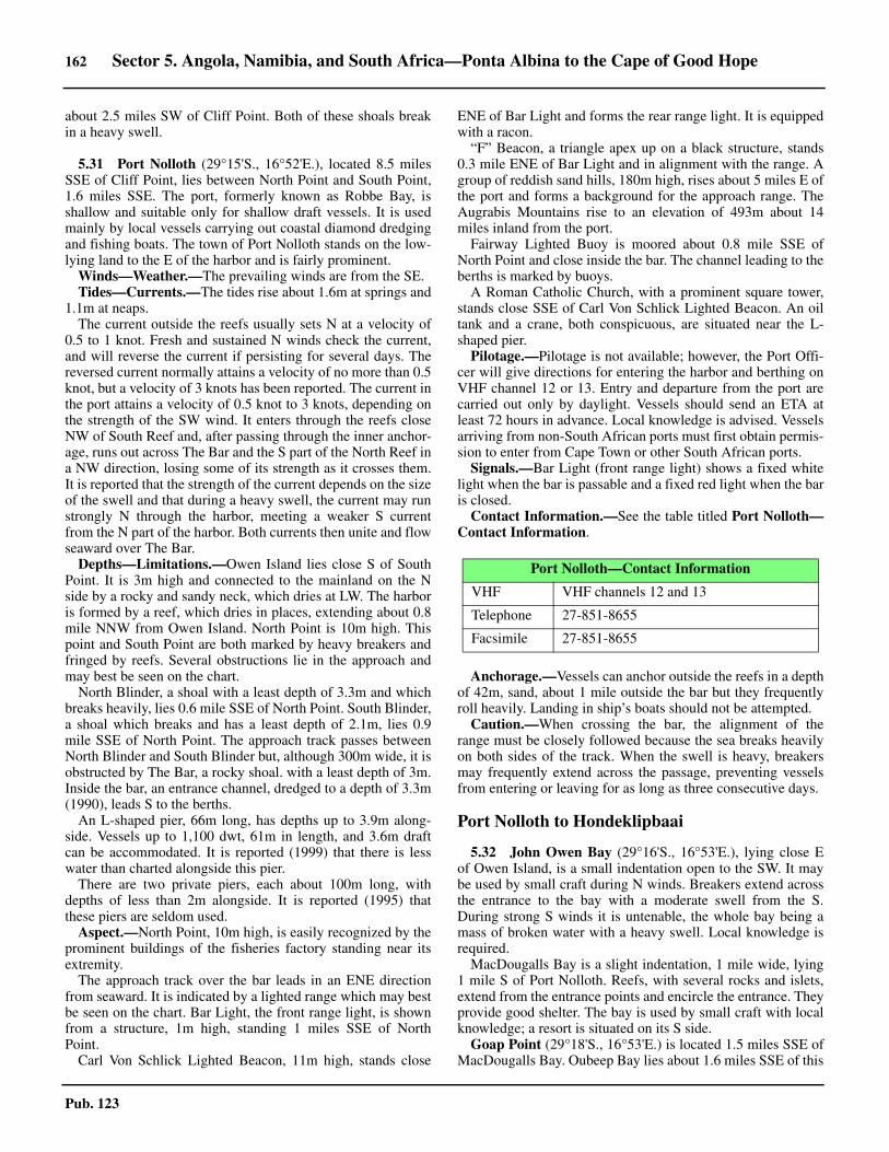
162 Sector 5. Angola, Namibia, and South Africa—Ponta Albina to the Cape of Good Hope
Pub. 123
about 2.5 miles SW of Cliff Point. Both of these shoals breakin a heavy swell.
5.31 Port Nolloth (29°15'S., 16°52'E.), located 8.5 milesSSE of Cliff Point, lies between North Point and South Point,1.6 miles SSE. The port, formerly known as Robbe Bay, isshallow and suitable only for shallow draft vessels. It is usedmainly by local vessels carrying out coastal diamond dredgingand fishing boats. The town of Port Nolloth stands on the low-lying land to the E of the harbor and is fairly prominent. 5.31 Winds—Weather.—The prevailing winds are from the SE.5.31 Tides—Currents.—The tides rise about 1.6m at springs and1.1m at neaps.5.31 The current outside the reefs usually sets N at a velocity of0.5 to 1 knot. Fresh and sustained N winds check the current,and will reverse the current if persisting for several days. Thereversed current normally attains a velocity of no more than 0.5knot, but a velocity of 3 knots has been reported. The current inthe port attains a velocity of 0.5 knot to 3 knots, depending onthe strength of the SW wind. It enters through the reefs closeNW of South Reef and, after passing through the inner anchor-age, runs out across The Bar and the S part of the North Reef ina NW direction, losing some of its strength as it crosses them.It is reported that the strength of the current depends on the sizeof the swell and that during a heavy swell, the current may runstrongly N through the harbor, meeting a weaker S currentfrom the N part of the harbor. Both currents then unite and flowseaward over The Bar.5.31 Depths—Limitations.—Owen Island lies close S of SouthPoint. It is 3m high and connected to the mainland on the Nside by a rocky and sandy neck, which dries at LW. The harboris formed by a reef, which dries in places, extending about 0.8mile NNW from Owen Island. North Point is 10m high. Thispoint and South Point are both marked by heavy breakers andfringed by reefs. Several obstructions lie in the approach andmay best be seen on the chart.5.31 North Blinder, a shoal with a least depth of 3.3m and whichbreaks heavily, lies 0.6 mile SSE of North Point. South Blinder,a shoal which breaks and has a least depth of 2.1m, lies 0.9mile SSE of North Point. The approach track passes betweenNorth Blinder and South Blinder but, although 300m wide, it isobstructed by The Bar, a rocky shoal. with a least depth of 3m.Inside the bar, an entrance channel, dredged to a depth of 3.3m(1990), leads S to the berths. 5.31 An L-shaped pier, 66m long, has depths up to 3.9m along-side. Vessels up to 1,100 dwt, 61m in length, and 3.6m draftcan be accommodated. It is reported (1999) that there is lesswater than charted alongside this pier.5.31 There are two private piers, each about 100m long, withdepths of less than 2m alongside. It is reported (1995) thatthese piers are seldom used.5.31 Aspect.—North Point, 10m high, is easily recognized by theprominent buildings of the fisheries factory standing near itsextremity.5.31 The approach track over the bar leads in an ENE directionfrom seaward. It is indicated by a lighted range which may bestbe seen on the chart. Bar Light, the front range light, is shownfrom a structure, 1m high, standing 1 miles SSE of NorthPoint.5.31 Carl Von Schlick Lighted Beacon, 11m high, stands close
ENE of Bar Light and forms the rear range light. It is equippedwith a racon. 5.31 “F” Beacon, a triangle apex up on a black structure, stands0.3 mile ENE of Bar Light and in alignment with the range. Agroup of reddish sand hills, 180m high, rises about 5 miles E ofthe port and forms a background for the approach range. TheAugrabis Mountains rise to an elevation of 493m about 14miles inland from the port.5.31 Fairway Lighted Buoy is moored about 0.8 mile SSE ofNorth Point and close inside the bar. The channel leading to theberths is marked by buoys. 5.31 A Roman Catholic Church, with a prominent square tower,stands close SSE of Carl Von Schlick Lighted Beacon. An oiltank and a crane, both conspicuous, are situated near the L-shaped pier.5.31 Pilotage.—Pilotage is not available; however, the Port Offi-cer will give directions for entering the harbor and berthing onVHF channel 12 or 13. Entry and departure from the port arecarried out only by daylight. Vessels should send an ETA atleast 72 hours in advance. Local knowledge is advised. Vesselsarriving from non-South African ports must first obtain permis-sion to enter from Cape Town or other South African ports.5.31 Signals.—Bar Light (front range light) shows a fixed whitelight when the bar is passable and a fixed red light when the baris closed.5.31 Contact Information.—See the table titled Port Nolloth—Contact Information.
5.31 Anchorage.—Vessels can anchor outside the reefs in a depthof 42m, sand, about 1 mile outside the bar but they frequentlyroll heavily. Landing in ship’s boats should not be attempted. 5.31 Caution.—When crossing the bar, the alignment of therange must be closely followed because the sea breaks heavilyon both sides of the track. When the swell is heavy, breakersmay frequently extend across the passage, preventing vesselsfrom entering or leaving for as long as three consecutive days.
Port Nolloth to Hondeklipbaai
5.32 John Owen Bay (29°16'S., 16°53'E.), lying close Eof Owen Island, is a small indentation open to the SW. It maybe used by small craft during N winds. Breakers extend acrossthe entrance to the bay with a moderate swell from the S.During strong S winds it is untenable, the whole bay being amass of broken water with a heavy swell. Local knowledge isrequired.
MacDougalls Bay is a slight indentation, 1 mile wide, lying1 mile S of Port Nolloth. Reefs, with several rocks and islets,extend from the entrance points and encircle the entrance. Theyprovide good shelter. The bay is used by small craft with localknowledge; a resort is situated on its S side.5.32 Goap Point (29°18'S., 16°53'E.) is located 1.5 miles SSE ofMacDougalls Bay. Oubeep Bay lies about 1.6 miles SSE of this
Port Nolloth—Contact Information
VHF VHF channels 12 and 13
Telephone 27-851-8655
Facsimile 27-851-8655
Sector 5. Angola, Namibia, and South Africa—Ponta Albina to the Cape of Good Hope 163
Pub. 123
point. It is rock bound and provides no shelter. A conspicuoussand hill, 25m high, rises close S of the bay.
5.32 Penguin Rocks (29°36'S., 17°01'E.), 2m high, lie 0.5 mileoffshore, about 19 miles SSE of Goap Point. A foul and rockyreef, which breaks with a heavy swell, extends up to about 1mile W and 2 miles S of these rocks.5.32 The Buffels River, with a long sandy beach, enters the seaabout 4.7 miles SSE of Penquin Rocks. The coast between isfronted by foul ground which extends up to about 1 mile off-shore.5.32 Wolfberg, 203m high, rises 4 miles NE of Penquin Rocks.This prominent hill has a large cairn of stones surmounting itssummit. Arnot se Kop (Buffelskop), 214m high, rises 3.5 milesE of Penguin Rocks. This hill, which is surmounted by a smalltrigonometrical beacon, is also prominent. The conspicuousheadgear of a diamond mine, with its associated buildings,stands 3.5 miles SSE of Penguin Rocks.5.32 A stranded wreck lies off the mouth of the Buffels River. Thebed of this river is usually dry for a considerable distance in-land. The mining town of Kleinsee, standing 1 mile inland, issituated on the S bank of the river and is prominent from SWand W. The headquarters of De Beer’s Consolidated Mines issituated at Grootmis, which stands on the N bank of the river,farther inland.5.32 The coast between the Buffels River and Hondeklipbaai, 40miles SSE, is bordered by dangerous submerged rocks, someawash, which extend up to 1.5 miles offshore.5.32 Diamond Hole, a small bay fronted by reefs, lies about 2miles SSE of the Buffels River and close S of a low promonto-ry. Rooiklippies, a prominent stretch of reddish rocky ledges, islocated 1 mile S of this bay. 5.32 Gorab se Kop rises 1.5 miles inland and 5.5 miles SSE of themouth of the Buffels River. This prominent hill is 188m high;its summit is surmounted by a beacon. It is the tallest point of aflat range of hills.
5.33 Melkbospunt (29°49'S., 17°05'E.), located 8 milesSSE of the mouth of the Buffels River, is low-lying and fringedwith rock. Numerous white mining dumps stand close inlandof this point. Swartklip lies 6.5 miles SSE of Melkbospunt andclose off an inconspicuous rocky point. This rock is dark-col-ored and 2.5m high.
Naganas Point (Naas Naaspunt) (29°56'S., 17°07'E.), locate7.5 miles SSE of Melkbospunt, can be recognized by a con-spicuous rock lying near its extremity. Stranded wrecks are re-ported to lie about 1 mile, 6.7 miles, and 9.5 miles SSE of thepoint.5.33 Swartkop, 286m high and prominent, stands about 6 milesESE of Naganas Point and is surmounted by a beacon. It is thetallest of the coastal hills in this vicinity.5.33 Skulpfonteinpunt (30°06'S., 17°11'E.) is located 18 milesSSE of Melkbospunt and fringed by dangerous rocks.
Somnaasbaai, lying 4 miles SSE of Skulpfonteinpunt, has asandy beach where landing may be effected on a calm day.Wolfkop, a prominent mine dump, rises 1.2 miles inland, 3.5miles SSE of the bay; it is 72m high and surmounted by a smallbeacon. The mining settlement of Koingnaas stands 3 milesSSE of the bay and is conspicuous because of its white build-ings which have bright green roofs.
5.33 Swartlintjiesrivier (30°16'S., 17°16'E.) lies 3.2 miles S ofKoingnaas. The mouth of the river, which is entirely barred bysand, is fronted by rocks extending up about 0.5 mile seaward.5.33 Caution.—The coastal area between Melkbospunt andSkulpfonteinpunt has not been closely examined and vesselsare cautioned to stay at least 4 miles offshore. During fog orlow visibility and at night, this distance should be increased to10 miles.
Hondeklipbaai
5.34 Hondeklipbaai (30°19'S., 17°16'E.), the site of a for-mer copper mine, is located 6.5 miles SSE of Koingnaas. Thebay receives its name from an isolated block of granite, 5mhigh, called Hondeklip or Dogstone. This prominent stone issituated 0.2 mile inland and 0.4 mile S of the head of the bay. Itstands at an elevation of 21m and is surmounted by a beacon. Aconspicuous radio mast is situated 0.7 mile WSW of the stone.
The bay, which is suitable only for small vessels, is about 0.3mile wide, but its entrance is narrowed to a width of 100m byrocks and foul ground extending from both entrance points. Itis sheltered from all but W winds, which seldom occur. A san-dy beach is located in the S part of the head of the bay.5.34 A jetty, with a large building at its extremity, extends NWfrom the S end of the beach. Private moorings for diamond-dredging vessels and fishing boats are situated within the bay.5.34 Hondeklip Bay Light (30°18'S., 17°16'E.) is shown from aframework tower, 8m high, standing 0.2 mile N of the bay. Adirectional light is shown from a column on a square building,3m high, standing at the head of the bay. The entrance trackleads in an E direction between the offshore dangers within thewhite sector of this light. It is reported (2002) that the edges ofthe white sector are blurred and vessels should endeavor tokeep the light at its brightest. 5.34 Spitfire Reef, with a least depth of 5.5m and on which heavyrollers occasionally break, lies about 0.5 mile WSW of the Sentrance point of the bay. Spitfire Rock, on which the seabreaks, lies about 0.8 mile E of this reef. These dangers shouldbe given a wide berth.5.34 The current off the coast in the vicinity of Hondeklipbaaiusually runs N, but after a prolonged N wind, it sets in the op-posite direction.5.34 Vessels may anchor outside the bay in depths of 10 to 15m,rock bottom with good holding ground, to the W of the direc-tional light sector.
Hondeklipbaai to the Olifants River
5.35 Plaatklippunt (30°20'S., 17°17'E.), located 1 mile Sof Hondeklipbaai, is surmounted by a stone cairn. A strandedwreck lies on a rocky point about 0.8 mile SSE of this point.The coast between Plaatklippunt and Rooiwalbaai, 8 milesSSE, is bordered by rocks and breakers, which extend up toabout 0.5 mile offshore. It provides very few features that canbe distinguished at any distance. The background hills appearas long ridges without any definite summits. 5.35 Rooiwalbaai (30°27'S., 17°21'E.), located 9.5 miles SSE ofHondeklip Bay Light, has a vertical cliff composed of redsandstone, 11m high, at its head. The almost level summit ofthe cliff is surmounted by a sloping bank of white sand of

164 Sector 5. Angola, Namibia, and South Africa—Ponta Albina to the Cape of Good Hope
Pub. 123
about the same height. The red cliff with its white crest is easi-ly identified when seen from WSW. The bay affords no shelter.5.35 Spoeg River, the mouth of which is often closed, empties in-to a sandy bay, about 1 mile wide, about 1.2 miles S of Rooi-walbaai. A group of rocks, which breaks, lies 0.5 mile off the Sentrance point of the bay.5.35 Spugmond (Kanoepkop), 176m high, rises 2.7 miles ENE ofthe mouth of the Spoeg River and is surmounted by a smallbeacon. It is the most prominent of the coastal hills in thevicinity. This hill may be easily recognized by some barebrown patches appearing on its N side.5.35 The coast between the mouth of Spoeg River and OlifantsRiver, 86 miles ESE, provides few features that can be distin-guished at a distance. A range of mountains, rising to eleva-tions exceeding 1,500m, stands about 40 miles inland andparallel to the shore. 5.35 Caution.—Great care should be exercised while navigatingalong this stretch of coast due incomplete surveys.
5.36 Strandfonteinpunt (30°34'S., 17°25'E.) is located 6miles SSE of the mouth of the Spoeg River. A submerged reef,on which the sea breaks heavily, extends about 0.7 mile WSWfrom this point.
Roodewal (Toringkop), 193m high, rises prominently about2.5 miles ENE of Strandfonteinpunt and a conspicuous ruinedsignal tower stands on its summit.
The Twins, two rocks which usually break, lie about 0.7 mileoffshore, 15 miles SSE of Strandfonteinpunt. These rocksshould be given a wide berth.
5.36 Groenriviermond Light (30°50'S., 17°35'E.) is shown froma prominent tower, 17m high, standing 20 miles SSE of Strand-fonteinpunt.5.36 The Groen River lies about 1.2 miles N of GroenriviermondLight. Its mouth is usually closed by sand banks. A buildingstanding 1 mile NNE of the river entrance is reported to beconspicuous from seaward.5.36 Island Point, located 3 miles SSE of Groenriviermond Light,consists of a flat rock lying close off a low sandy point. A con-spicuous stranded wreck lies near the center of the flat rock. Itconsists of engine parts, 5m high, which are covered by guano.A conspicuous boulder stands on a point located about 1 mileN of Island Point.5.36 The Brak River lies 13 miles SSE of Island Point and rocks,which break, extend about 1 mile SW from its mouth. Ruit-ersvlei, a swampy area which floods at HWS, is located at theclosed mouth of the river.
5.36 Toringberg (31°02'S., 18°00'E.), 552m high, rises about 15miles ENE of the entrance to the Brak River and is conspicu-ous. When viewed from the vicinity of the river entrance, it hassteep N and S sides.5.36 The Sout River, which is closed, lies 10.5 miles SSE of theBrak River. A large rock, 4m high, lies close offshore, close Nof the river mouth. An extensive salt mine is situated 15 milesinland of the river mouth. Large mounds of salt may at times beseen over the dunes in this vicinity.5.36 Krakeelklip, 351m high, stands 16 miles ESE of the mouthof the Sout River. This hill forms the best landmark in the vi-cinity.
5.37 Jakkalshok (31°21'S., 17°54'E.), located 7 miles SSEof the mouth of the Sout River, may be recognized by the dere-lict mining machinery situated near the coast. Breakers havebeen observed extending seaward for some distance off thispoint.5.37 Between Jakkalshok and Cliff Point, 18.5 miles SSE, severalconspicuous buildings stand within 2 miles of the coast. 5.37 Cliff Point (31°36'S., 18°07'E.) is a remarkable double pointof rugged formation, on which there are numerous mine work-ings and dumps.5.37 Graafwaterkop (Geelwal Se kop), a rounded hill, stands 1.7miles N of Cliff Point and is conspicuous. It is 130m high andsurmounted by a trigonometrical beacon. 5.37 Elephant Rock (Robeiland), 15m high and radar conspicu-ous, lies about 0.4 mile offshore, 3 miles SSE of Cliff Point.This rock is connected to the coast by a sandy bar, over whichthe sea breaks at LW, and its W extremity is fronted by a reef.5.37 The Olifants River (31°42'S., 18°11'E.), formerly known asElephants River, lies 7 miles SSE of Cliff Point. Its mouth isobstructed by a bar, with a depth of 0.6m, on which the seausually breaks. The village of Papendorp stands 1 mile E of theentrance, on the shore of a lagoon. A conspicuous school build-ing is situated 1.5 miles NE of the river mouth. The town ofVredendel is situated 25 miles inland of the river mouth andthe entire area is exceptionally fertile.
5.38 The coast between the mouth of the Olifants Riverand Cape Deseada, 37 miles SSE, presents a contrast to that ex-tending to the N of the river. It has long, sandy stretches inter-spersed with rocky headlands. In general, the farther S oneproceeds, the coast becomes greener and more cultivated. Thecoastal hills and inland ranges also provide more distinctivelandmarks.5.38 Strandfontein (31°45'S., 18°14'E.), located 4 miles SSE ofthe mouth of the Olifants River, is a resort. This village standsat the S end of a sandy beach and its white buildings are con-spicuous from WNW. A prominent white hotel is situated onhigh ground behind the village. Radio masts stand, at eleva-tions of 226m and 107m, about 8 miles NE and 1.2 miles S, re-spectively, of the village.5.38 Doringbaai Light (31°49'S., 18°14'E.) is shown from a con-spicuous round tower, 24m high, standing 3.5 miles S ofStrandfontein. It is situated on Vaalpunt, the S entrance point ofDoring Bay. This bay is used only by a fleet of small fishingboats with local knowledge. Entry requires local knowledge.
5.38Doringbaai Light
Sector 5. Angola, Namibia, and South Africa—Ponta Albina to the Cape of Good Hope 165
Pub. 123
5.38 Cape Donkin (31°56'S., 18°16'E.), located 7.5 miles S ofDoringbaai Light, forms the S entrance point of Donkins Bay.This bay is used by a fleet of small fishing boats. Anchoragemay be taken off the bay, in depths of 10 to 20m, sand, but thisroadstead is exposed.
5.39 Lambert’s Bay (32°05'S., 18°18'E.) (World Port In-dex No. 46740), located 9 miles S of Cape Donkin, is a fishingcenter and a resort. The town stands in the SE part of the bay,which is 0.5 mile wide. The harbor is used by small coastersand fishing boats.
The bay is backed by scrub-covered sand dunes, 6 to 20mhigh. Bird Island (Penguin Island), 7m high, lies close off theSW entrance point. The bay is open to the NW, but is partiallysheltered from SW winds by Bird Islet. The SW swell, thoughslight outside, frequently enters the bay.
East Breakwater extends 0.2 mile NE from Bird Island. Achannel, dredged to a depth of 3m (1998), leads from the vicin-ity of the head of this breakwater to the Inner Harbor, WestBreakwater and South Breakwater, which connect Bird Islandto the mainland, form the W side of the Inner Harbor. RandomMole extends 0.1 mile N from the mainland, on the E side ofthe dredged channel. Several reefs and rocks lie in the ap-proaches up to about 0.4 mile NW, W, and S of Bird Island.The harbor should be approached from NW and entered fromNE between East Breakwater and Random Mole. Local knowl-edge is advised. 5.39 East Breakwater provides one coaster berth, 60m long, witha depth of 5m alongside. The Inner Harbor, with three quays,provides berths with depths up to 3m for fishing boats.5.39 A light is shown from the head of East Breakwater. A direc-tional light is shown from a structure standing 0.3 mile S ofEast Breakwater Light. It indicates the channel leading S to theInner Harbor.5.39 Conspicuous chimneys stand close SW and 0.2 mile SW, re-spectively, of the directional light. A church, with a conspicu-ous spire, is situated 0.2 mile ESE of the directional light. 5.39 Vessels, with drafts up to 4m, can anchor in a depth of 10mabout 0.2 mile NNW of the head of East Breakwater. This an-chorage is well-sheltered from the prevailing SW swell, butvessels should be prepared to sail instantly because the sea canbecome troublesome with little or no warning, filling the wholebay with breakers. Vessels at anchor should proceed to sea im-mediately when the wind becomes N of W.5.39 Caution.—It is reported (1999) that less water than chartedexists in the dredged approach channel and alongside theberths due to silting.
Lambert’s Bay to Saldanha Bay
5.40 Langvlei (Wadrifsoutpan) (32°13'S., 18°21'E.), ashallow lagoon and bird sanctuary, extends inland for about 3miles from the coast, 7 miles S of Lambert’s Bay. A prominentradio mast, 94m high, stands at the SW end of the lagoon.5.40 Cape Deseada (32°19'S., 18°19'E.), also known as BaboonPoint, is located 14 miles S of Lambert’s Bay, This cape ap-pears bold and cliffy from a distance of about 9 miles, as it ris-es steeply from the sea to a flat-topped of hills, 192m high. Thecape ends in a low sandy point which is not easily seen fromseaward. A prominent radio mast stands, at an elevation of
160m, close within the cape.5.40 An isolated rocky shoal, with a least depth of 14.3m, liesabout 2 miles NNW of the cape and breaks occasionally inheavy weather.5.40 Elandsbaai lies close N of Cape Deseada and is used bysmall craft and fishing boats. A resort village stands at the headof the bay. Verlorevlei, a lagoon, extends inland from the headof the bay for 8 miles but its mouth is usually closed by a sandybar. 5.40 Caution.—Due to the possible existence of uncharted rocksand shoals, vessels should exercise extreme caution when navi-gating within 6 miles of the coast between Lambert’s Bay andCape Deseada.
5.41 Saint Helena Bay (32°30'S., 18°10'E.) lies betweenCape Deseada and Stompneuspunt, 29 miles SW. In the N partof the bay the shore is fairly steep-to, with a depth of 15m lyingwithin 1 mile of the beach. However, in the SE part of the bay,depths of less than 15m lie up to about 5 miles offshore. Thebottom consists mostly of sand and mud, but a great part of theSW side of the bay is fringed with rocks, some of which lieabout 0.5 mile offshore.
North Blinder (Martin Rock) (32°38'S., 17°58'E.), a rockyledge with a least depth of 5.8m, lies 4.5 miles N of Stomp-neuspunt. It rises from depths of 40m and breaks with a heavyswell.
Doctor Reef (32°46'S., 18°06'E.) fronts the S shore of thebay and is centered about 2 miles W of the entrance to theGreat Berg River. It extends up to about 1 mile seaward and haspatches that break at low tide and during rough weather.5.41 A detached shoal patch, with a depth of 4.6m lies in the Spart of the bay, about 4 miles N of the entrance to the GreatBerg River.5.41 Vessels can anchor, with good holding ground, in convenientdepths in Saint Helena Bay. However, in winter, the bay is ex-posed to strong N winds, heavy seas, and a large swell.5.41 About 5 or 6 miles SSE of Cape Deseada, the countrysiderises to abrupt crags and broken ridges of lofty hills, which ex-tend 30 miles in the same direction and terminate in Piketberg,a range of mountains.
Kleintafelberg (32°33'S., 18°28'E.), 369m high, stands 16miles SSE of Cape Deseada and appears to be much closer tothe coast than it actually is. This conspicuous hill is dark with aplateau, but its summit is rather uneven. It rises steeply fromlow land on either side.5.41 Kapteinskloof (32°43'S., 18°35'E.), 1,055m high, is a veryconspicuous and well-defined summit of the Piketberg Range.This peak and range, from 10 miles offshore, appear as if situ-ated close to the coast and must not be mistaken for the higherrange farther inland.5.41 A conspicuous water tower stands at an elevation of 32mnear the village of Dwarskersbos, 23 miles SSW of CapeDeseada. A prominent radio mast, 98m high, is situated 1.2miles inland, about 5 miles NE of this water tower.5.41 Caution.—An area of foul ground, 3 miles long, extends upto about 1.2 miles off the coast, close SW of the village ofDwarskersbos.
5.42 Great Berg River (Groot Bergrivier) (32°46'S.,18°09'E.) lies at the head of Saint Helena Bay, 9 miles ESE of
166 Sector 5. Angola, Namibia, and South Africa—Ponta Albina to the Cape of Good Hope
Pub. 123
Stompneuspunt. The river entrance consists of a cuttingthrough the sand, which is protected by a breakwater on eachside. The towns of Laaiplek and Velddrif stand on the E bankof the river and provide facilities for fishing boats. An exten-sive marina is located close above Laaiplek. 5.42 The channel leading to the wharves at the towns of Laaiplekand Velddrif has been dredged to a depth of 3m, although less-er depths have been reported (1999). The tide rises about 1.7mat springs and 1.2m at neaps. Local knowledge is advised.5.42 Varkvlei Farm, a cluster of white buildings, is situated about3 miles WSW of the entrance to Great Berg River and is con-spicuous from seaward. A prominent water tower stands inLaaiplek.5.42 Lights are shown from structures standing at the heads andinner ends of the breakwaters. A racon is situated at the InnerEast Breakwater Light. A conspicuous radio mast stands closeE of the river entrance.5.42 Sandy Point Harbor (32°45'S., 18°01'E.), located about 3miles SE of Stompneuspunt, lies within Sandy Bay on the SWside of Saint Helena Bay. The harbor is protected by a coastalreef on its S side and by a breakwater, 480m long, extending Efrom Sandy Point on the N side. It is used mostly by fishingvessels and coasters. 5.42 A coaster berth, 74m long, is located on the inshore part ofthe breakwater and has a depth of 6.1m alongside. A pier, witha depth of 4.5m alongside its head, extends 200m E from theshore in the S part of the harbor. There are also numerous per-manent moorings for fishing vessels within the bay.5.42 Several chimneys stand in the vicinity of the harbor and twoconspicuous oil tanks are situated 0.4 mile W of Sandy Point. 5.42 Stompneuspunt (32°42'S., 17°59'E.), fronted by a reef onits NE side, is the NE extremity of a sandy peninsula, whichprojects 1.5 miles from the coast and forms the W side of SanitHelena Bay. A light is shown from a square structure, 8m high,standing on the point.5.42 A dangerous wreck (trawler) lies about 0.6 mile ESE of thelight. Drying reefs front the coast between Sandy Point Harborand the S end of Stompneusbaai, which is entered 1.2 miles SEof Stompneuspunt. This part of the coast is well built over. 5.42 Simpson’s Rock, which dries 0.5m, lies near the middle ofStompneusbaai. A fish factory, with a conspicuous square tow-er, stands at the head of this bay. A lighted range indicates theentrance channel leading into Stompneusbaai, which is used byfishing boats with local knowledge.
5.43 Cape Saint Martin (32°43'S., 17°55'E.), a low andsandy point, is located 3 miles WSW of Stompneuspunt. It isfronted by several dangerous rocks, which lie up to 0.5 mileoffshore. A light is shown from a framework mast, 10m high,standing on this point. A current meter is moored about 12miles W of the light.
Brittania Reef (32°42'S., 17°52'E.), a steep-to reef with aleast depth of 3.3m, lies 3 miles WNW of Cape Saint Martinand the sea breaks on it with a moderate swell. A dangerouswreck lies about 2 miles SE of this reef. 5.43 Groot Paternosterpunt is located 2 miles SW of Cape SaintMartin, A stranded wreck fronts the N side of this point andhas the appearance of a ship at anchor.
Seal Islands (32°44'S., 17°52'E.), the highest being 12mhigh, are a group of four islets located 1.3 miles W of Groot
Paternosterpunt. A reef lies between these islets and the latterpoint. A light, equipped with a racon, is shown from a mastwith a crows nest, 10m high, standing on the outermost islet.5.43 Paternosterbaai (32°46'S., 17°53'E.) lies between Groot Pa-ternosterpunt and Cape Columbine, 5.5 mile SW. The villageof Paternoster, with several conspicuous white houses, standson the S shore of the bay and is an important fishing station. Aprominent chimney is situated at the fish factory. The shore ofthe bay consists of a long sandy beach backed by sand dunesand is fronted by several dangerous rocks.5.43 Jim Crow Rock, which dries 0.6m, lies about 2.2 miles N ofCape Columbine and at the NW end of a rocky ledge on whichthe sea breaks in heavy weather. Vessels entering the bay areadvised to pass N of this rock. Tambourine Rock, 1.6m highand prominent, lies about 0.4 mile offshore, 3 miles S of GrootPaternoster.5.43 Vessels, with local knowledge, can anchor in a depth of 9mabout 0.5 mile NE of the factory chimney. This anchorage iswell-sheltered but should not be used with NW winds or swell.5.43 Kasteelberg rise 3 miles E of the village of Paternoster. Thishill is 184m high and conspicuous.
Caution.—Crayfishing vessels may be encountered within 3miles of the coast between the Cape Columbine and the OrangeRiver (28°38'S., 16°28'E.). Such vessels may be anchored ordrifting with unlit bottom gear, marker buoys, and recoverylines.5.43 Marine Mining Vessels (MMVs), which process gravel fordiamonds, may be encountered in large numbers near shore be-tween Cape Columbine and the Orange River (28°38'S.,16°27'E.). These diamond mining barges are usually moored tofour anchors, which may or may not be marked by unlit buoys.Vessels are advised to stay at least 1,500m away from MMVs.5.43 At times a rapid decrease in the density of the air above thecold sea forms mirages in areas along the coast between CapeColumbine (32°50'S., 17°51'E.) and the Orange River. Thesemirages can be distorted and may occasionally produce invert-ed images.
5.44 Cape Columbine (32°50'S., 17°51'E.), located 5.2miles SSW of Seal Island Light, is surmounted by Castle Rock,a conspicuous boulder. The cape, which is radar prominent, isfronted by rocky reefs, which dry and extend up to about 0.8mile NW of it. A dangerous detached rock, with a least depthof 1.8m, lies about 1.5 miles SW of the cape. 5.44 A light is shown at an elevation of 79m from a conspicuoussquare tower, 15m high, standing 0.5 mile E of the cape.Noordwesbaai, an exposed bay, lies 2 miles S of the light and aconspicuous sand patch is located at its head.5.44 Regulations.—As per IMO regulations, laden tankers mustmaintain a minimum distance of at least 20 miles from CapeColumbine when proceeding N and a minimum distance of atleast 25 miles when proceeding S. Laden tankers sailing onvoyages only between ports in South Africa are exempted fromthis regulation but are expected to maintain a minimum dis-tance of 10 miles from all salient points, subject to weather andsea conditions. For further information, see Pub. 160, SailingDirections (Planning Guide) South Atlantic Ocean and IndianOcean. 5.44 Caution.—The coast between Cape Columbine and NorthHead, 14 mile S, is rugged and indented. It is fronted by nu-

Sector 5. Angola, Namibia, and South Africa—Ponta Albina to the Cape of Good Hope 167
Pub. 123
merous off-lying rocks, many of which rise almost perpendicu-larly from depths of over 40m, making it one of the mostdangerous stretches along the coast of South Africa. Extremecare must therefore be exercised when navigating in this area.At night, or in thick weather, vessels should not attempt to nav-igate in depths of less than 100m, which will be found about 4miles off the coast. Depths less than those charted have beenreported to lie in places up to 30 miles offshore in this area. 5.44 It is reported (1976) that a local magnetic anomaly, with de-viations of up to 5°E, exists between 70 miles and 130 milesNW of Cape Columbine.5.44 Submarines frequently exercise in an area lying W of CapeColumbine, S of 32°S and E of 16°E.
5.45 Duminypunt (32°55'S., 17°51'E.), low and sandy, islocated 5 miles S of Cape Columbine and fronted by severaldangers, which may best be seen on the chart. A reef, withrocks awash, extends about 1.5 miles WSW from this point.Soldiers Reef, awash, lies about 1.4 miles N of the point. Voe-leiland, the W and larger of two islets, lies 0.3 mile offshoreand 1.6 miles NNE of the point.
A conspicuous water tower, with an elevation of 205m,stands on the summit of a hill, 6.5 miles E of Duminypunt.5.45 Hospitalpunt (32°57'S., 17°53'E.), located 3 miles SSE ofDuminypunt, is a low point. Hospital Rock, 7m high, lies at theouter end of a reef which extends about 0.4 mile W from thispoint. Jacobs Reef, on which stands an islet 3m high, extendsabout 1 mile W from Hospitalpunt. Dangerous reefs, someawash, lie within 0.7 mile N and 0.5 mile S of Jacobs Reef. 5.45 Wesbaai lies between Duminypunt and Hospitalpunt. A de-tached reef, awash, lies on a shoal in the S part of this bay,about 1.2 miles NW of Hospitalpunt. A conspicuous whitesand patch, known as Die Witsand, is located near the head ofthe bay, 1.5 mile SE of Duminypunt.5.45 Temporary anchorage, in fair weather, can be taken in depthsof 15 to 18m about 0.8 mile S of Duminypunt. 5.45 Jacobsbaai is entered 0.6 mile S of Hospitalpunt. This smallbay is well-sheltered and used by local fishing boats.
5.45 The Sisters, a group of above-water rocks, extend up toabout 0.5 mile offshore, 2 miles SSW of Hospitalpunt.5.45 Danger Bay lies between Morrisons Point, located 3 miles Sof Hospitalpunt, and Long Point, l.2 miles SSE. The entranceto this bay is reduced to a width of about 0.6 mile by rockyreefs, which extend from both entrance points. The bay, whichis exposed to W winds and swell, should be entered with ex-treme caution.
5.45 Tooth Rock (33°00'S., 17°52'E.), 1m high, lies about 0.9mile WNW of Morrisons Point. A detached shoal patch, with adepth of 6.5m, lies 0.2 mile SW of this rock.5.45 Bay Rock, awash, lies 0.6 mile SW of Morrisons Point andbreaks occasionally. Cap Rock, which dries, lies 1 mile W ofLong Point. An isolated rocky patch, with a least depth of2.4m, lies about 0.5 mile WNW of Long Point.5.45 North Head (33°03'S., 17°55'E.), a low point, is located 1.8miles SE of Long Point. North Head Light is shown from aframework tower, 21m high, standing on this point. 5.45 Schooner Rock, 7.5m high, lies about 0.3 mile SSw of NorthHead Light. It is the outermost and tallest of a group of above-water rocks which front the S side of the point.5.45 Baviaansberg, 72m high, rise 0.5 mile N of North Head. Thisconspicuous hill is surmounted by a radar reflector.5.45 Caution.—A Traffic Separation Scheme (TSS), which maybest be seen on the chart, lies centered in the outer approach toSaldanha Bay, 9 miles W of North Head (see paragraph 5.46). 5.45 Tooth Rock (33°00'S., 17°52'E.) is the target point for a mili-tary missile and gunnery exercise range. For further details, seePub. 160, Sailing Directions (Planning Guide) South AtlanticOcean and Indian Ocean.5.45 Numerous aquaculture areas and marine reserves have beenestablished in the approaches to and within Saldanha Bay, asseen on the chart. Mariners navigating within the aquacultureareas should keep well clear and avoid interfering with anyrafts, buoys, floats, or lines. Entry into the marine reserves areaffected by restrictions and prohibitions. For further details,consult the local authorities.
Saldanha Bay (33°02'S., 17°58'E.)
World Port Index No. 46750
5.46 Saldanha Bay (Saldanhabaai) is entered betweenNorth Head (33°03'S., 17°55'E.) and South Head, 3.7 milesSSE. It is easy to access and is probably one of the safest andfinest natural harbors in southern Africa. The port is mostlyused for exporting ore and is capable of accommodating deep-draft vessels. It is also an extensive fishing and yachting center. 5.46 The town of Saldanha, standing in the NW part of the bay, isa resort. The bay is also the site of the South African MilitaryAcademy and a South African Naval Training Base.
5.46 Winds—Weather.—The climate is temperate. The averagehigh temperature year round is 20°C (68°F) while the averagelow temperature is in the region of 11°C (52°F). Sea water tem-
5.44Cape Columbine Light
Saldanha Bay Home Page
http://www.transnetnationalportsauthority.net
168 Sector 5. Angola, Namibia, and South Africa—Ponta Albina to the Cape of Good Hope
Pub. 123
peratures average 16°C (61°F).5.46 The prevailing winds are from SSW in the summer and theNNE in the winter (see Caution).5.46 Fog occurs generally in the March to August period.5.46 Tides—Currents.—The tides rise about 1.7m at springs and1.3m at neaps. 5.46 The tidal currents appear to set fairly in and out of the en-trance at a rate of 0.2 to 0.5 knot. At a short distance outsidethe bay, the current sets in a N direction at a rate of 0.5 to lknot.5.46 Depths—Limitations.—The Entrance Channel, which maybest be seen on the chart, leads in a NE direction from the TSS(see Regulations) and the pilot boarding area to a positionlocated between Malgas Island and Wasserfall Bank. Thischannel then continues in an ENE direction to a positionlocated SSW of Marcus Island Light. Vessels should thenproceed in a NE direction for about 1 mile to the outer entranceof the Navigation Channel.5.46 The Navigation Channel, which is entered 0.4 mile SE ofMarcus Island Light, leads NNE for about 0.8 mile to a turningcircle located close SSW of the ore loading jetty.5.46 The Entrance Channel, Navigation Channel, and turningcircle have least maintained depths of 23.2m. 5.46 For detailed berthing information refer to table titledSaldanha Bay—Berth Information. 5.46 The main commercial berthing facilities are situated along acauseway which extends about 2 miles SSW from the NE partof Saldahna Bay. They are protected by a crescent-shapedbreakwater, about 1 mile long, which extends from the E sideof the bay.5.46 The Ore Jetty Berths are located at each side of the ore-loading jetty, at the S end of the causeway. They are both 500mlong and can accommodate vessels with drafts of up to 21.2m. 5.46 A multi-buoy mooring (MBM) system, surrounded by acircular restricted area, with a radius of 300m and centered onposition 33°01'58.2''S, 17°59''39.6”E, has been establishedabout 0.7 mile E of the Iron Ore Jetty. A submarine pipelinecarrying liquefied petroleum gas connects the MBM with theshore about 1.5 miles NNE. The MBM and the pipeline aresurrounded by a prohibited area. 5.46 The Multi-Purpose Quay is situated on the W side of the rootof the causeway. This quay is protected by a short breakwaterand is approached through a buoyed channel which is dredgedto a depth of 15m over a width of 130m.5.46 Mossgas Quay, with a depth of 7.9m alongside, is located onthe N shore of the bay, about 0.6 mile W of the root of thecauseway. A channel, with a dredged depth of 6.9m, leads tothis quay, although caution is necessary as a depth of only 5.6mhas been reported (2017) in the charted maintained depth areain the approach to the quay. 5.46 Government Jetty, a wood and concrete structure, projects
NE from the shore about 0.7 mile WNW of Hoedjiespunt. It is343m long and has depths of 5.5 to 7.3m along both sides. Alight, 6m in height, is shown from the head of the jetty. Asurge, particularly along the S side, often makes itimpracticable for vessels to berth at this jetty. The facility ismostly used by fishing vessels. 5.46 The Sea Harvest Factory Quay extends ESE from the root ofGovernment Jetty and has depths of 2 to 6m alongside. The fa-cility is mostly used by fishing vessels. 5.46 Langebaan Lagoon, the SE arm of Saldanha Bay, lies S ofSkaap Island (33°04'S., 18°00'E.) and extends SE for 8 miles.This lagoon is encumbered by sand banks near the entranceand has drying sand banks and salt beds near its head. It is onlyused by small craft with local knowledge.5.46 Aspect.—Malgas Island, 7m high, lies about 0.7 mile ESEof North Head Light (see paragraph 5.45) and is surrounded byshoals and rocks. Needle Rock, 5m high and surrounded byabove-water rocks and reefs, lies 0.2 mile NNE of this island.5.46 Malgaskop, 111m high, lies 1.2 miles ENE of North HeadLight and is conspicuous. A large building stands near the sum-mit of this hill and is situated on its upper E side.5.46 Hoedjiespunt (33°02'S., 17°58'E.) is located 2.8 miles ENEof North Head Light. This point forms the extremity of a nar-row rocky peninsula which extends about 1 mile ESE from theW shore of the bay. Hoedjieskop, 72m high, rises 0.6 mile N ofthe root of the peninsula. This prominent hill is surmounted bya beacon and a remarkable rock pillar.
5.46 The Port Control Center building, which is conspicuous, anda flagstaff stand on the summit of a hill, 37m high, which risesclose W of Hoedjiespunt.5.46 Marcus Island, 9m high, lies 1 mile SSE of Hoedjiespunt andis connected to it by a crescent-shaped breakwater which pro-tects the main port facilities. A light is shown from a frame-work tower standing on the SW end of this island. HospitalRock, 6m high, lies close SE of the light.5.46 The main berthing facilities are situated along a causewaywhich extends about 2 miles SSW from a reclaimed area locat-ed in the NE part of Saldanha Bay. The ore-loading controltower, 35m high, stands near the root of the causeway and isconspicuous. A prominent chimney is situated 0.5 mile N ofthis control tower. The ore-loading jetty, located at the outerend of the causeway, is brilliantly lighted at night.5.46 Seven Blinders, a small group of rocky patches with depthsof less than 2m, lies 1.3 miles NNE of Hoedjiespunt and ismarked by a lighted buoy.5.46 South Head (33°06'S., 17°57'E.), the S entrance point ofSaldanha Bay, is low and rocky. A steep cliffy summit, 113mhigh, rises close behind this point and is prominent. A light isshown from a concrete tower, 23m high, standing on the point.
Saldanha Bay—Berth Information
Berth Length DepthMaximum Vessel
RemarksDraft LOA Size Beam
Bulk Terminal Saldanha
Sector 5. Angola, Namibia, and South Africa—Ponta Albina to the Cape of Good Hope 169
Pub. 123
5.46 Jutten Island, fringed by rocks, lies 1.2 miles N of SouthHead and is 34m high. Its cone-like summit rises toward the Send of the island, which is covered with guano and gleamswhite in the sunshine. A minor passage, about 0.4 mile wide,leads ENE and N into the bay between the S side of this islandand the mainland.5.46 Wasserfall Bank, with a least depth of 14m, lies centeredabout 1 mile NW of Jutten Island. A shoal patch, with a depthof 8.8m, lies about midway between this bank and the island.5.46 Lloyd Bank, with a least depth of 11.5m, lies centered about0.5 mile W of the N end of Jutten Island. During strong windsand heavy SW swells, the sea breaks over Wasserfall Bank,Lloyd Bank, and the entire area lying between these banks andJutten Island.5.46 Elandspunt, located about 2.5 miles NNE of South HeadLight, forms the NW end of the Donkergat Peninsula. It isrocky and comparatively steep-to. A light is shown from aframework tower standing on this point.5.46 Salamanderpunt is located 1 mile ESE of Elandspunt Light.The prominent buildings of a disused whaling station are situ-ated on this point. Three radio masts, 31m high, stand about 0.7mile SSE of the point. 5.46 Postberg, 193m high and conspicuous, rises about 2.5 milesESE of South Head, on the W side of Langebaan Lagoon.Constable Hill, 189m high, rises about 2 miles SE of Postbergand is also conspicuous. The prominent factory building of analuminum phosphate works is situated on the N face of thishill.5.46 Lynch Point is located on the E shore of Saldanha Bay, about2.5 miles NE of Salamanderpunt. This point consists of a rockypromontory surmounted by a sand hill, 40m high, with a trigo-nometric beacon on its summit. An extensive yacht marina liesclose SE of this point.5.46 Lynch Blinder, a detached rocky shoal over which the seanearly always breaks, lies about 1 mile W of Lynch Point and
is marked by a lighted buoy.5.46 For information concerning additional landmarks in the ap-proach to Saldanha Bay, see paragraph 5.45.5.46 The Entrance Channel leading into the bay is indicated bylighted ranges, which may best be seen on the chart. The frontlight structure of the first reach stands 0.3 mile NE of MarcusIsland Light; the rear light structure stands on the head of theore-loading jetty. The front light structure of the second reachstands 0.4 mile SE of Lynch Point; the rear light structure,equipped with a racon, stands 0.4 mile ENE of it.5.46 The Navigation Channel, entered 0.4 mile SE of Marcus Is-land Light, is marked by lighted buoys.5.46 North Lighted Buoy, moored 0.6 mile NNE of Hoedjiespunt;North East Lighted Buoy, moored 1 mile E of the head of theore-loading jetty; and East Lighted Buoy, moored 1.9 miles NEof Elandspunt Light, indicate positions (13m depth curve) toseaward of which ore carriers and tankers should stay when inlight condition.5.46 Pilotage.—Pilotage is compulsory except for those vesselsexempted by law. Pilots can be contacted on VHF channels 10,12, and 16 and board in position (33°06.4’S, 17°49.9'E.) Pilotscan be embarked by helicopter by prior arrangement. 5.46 Regulations.—Inbound vessels must send their ETA 48hours, 24 hours, 12 hours, and 4 hours in advance. The 24-hourmessage should include the following:
1. Cargo required.2. Arrival draft (fore and aft).3. Deballasting time.4. Other vessel details, as requested by the Port Captain.
5.46 Any changes to the ETA after the 24-hour message should bereported as soon as possible.5.46 Vessels should then contact Port Control on VHF channel 16as soon as possible and request berthing instructions 6 hoursprior to the ETA.5.46 Bulk ore carriers with drafts over 14m and loaded tankers are
101 —23.0m 21.0m 340m 320,000 dwt 58m Iron ore.
102 —
Saldanha Multi-Purpose Terminal
201 250m 12.0m 11.5m
200m
—
33m Ro-ro, freight, steel products, and breakbulk.
202
208m 14.0m 13.5m
66,690 dwt
203 63,800 dwt
204 66,650 dwt 36m
Sea Harvest
Factory Quay — 6.5m — — — — 520m (cont.) length.
LPG Terminal
LPG Berth — 13.0m 10.4m 174m — — LPG
Saldanha Crude Oil Terminal
103 — 23.0m 21.5m 333m 300,000 dwt 60m Crude and bunkers
Saldanha Bay—Berth Information
Berth Length DepthMaximum Vessel
RemarksDraft LOA Size Beam
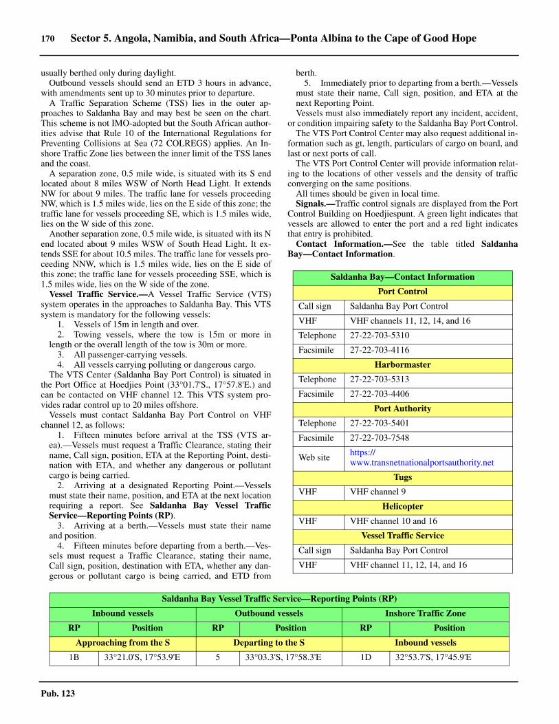
170 Sector 5. Angola, Namibia, and South Africa—Ponta Albina to the Cape of Good Hope
Pub. 123
usually berthed only during daylight. 5.46 Outbound vessels should send an ETD 3 hours in advance,with amendments sent up to 30 minutes prior to departure.5.46 A Traffic Separation Scheme (TSS) lies in the outer ap-proaches to Saldanha Bay and may best be seen on the chart.This scheme is not IMO-adopted but the South African author-ities advise that Rule 10 of the International Regulations forPreventing Collisions at Sea (72 COLREGS) applies. An In-shore Traffic Zone lies between the inner limit of the TSS lanesand the coast. 5.46 A separation zone, 0.5 mile wide, is situated with its S endlocated about 8 miles WSW of North Head Light. It extendsNW for about 9 miles. The traffic lane for vessels proceedingNW, which is 1.5 miles wide, lies on the E side of this zone; thetraffic lane for vessels proceeding SE, which is 1.5 miles wide,lies on the W side of this zone.5.46 Another separation zone, 0.5 mile wide, is situated with its Nend located about 9 miles WSW of South Head Light. It ex-tends SSE for about 10.5 miles. The traffic lane for vessels pro-ceeding NNW, which is 1.5 miles wide, lies on the E side ofthis zone; the traffic lane for vessels proceeding SSE, which is1.5 miles wide, lies on the W side of the zone.5.46 Vessel Traffic Service.—A Vessel Traffic Service (VTS)system operates in the approaches to Saldanha Bay. This VTSsystem is mandatory for the following vessels:
1. Vessels of 15m in length and over.2. Towing vessels, where the tow is 15m or more in
length or the overall length of the tow is 30m or more.3. All passenger-carrying vessels.4. All vessels carrying polluting or dangerous cargo.
5.46 The VTS Center (Saldanha Bay Port Control) is situated inthe Port Office at Hoedjies Point (33°01.7'S., 17°57.8'E.) andcan be contacted on VHF channel 12. This VTS system pro-vides radar control up to 20 miles offshore.5.46 Vessels must contact Saldanha Bay Port Control on VHFchannel 12, as follows:
1. Fifteen minutes before arrival at the TSS (VTS ar-ea).—Vessels must request a Traffic Clearance, stating theirname, Call sign, position, ETA at the Reporting Point, desti-nation with ETA, and whether any dangerous or pollutantcargo is being carried.
2. Arriving at a designated Reporting Point.—Vesselsmust state their name, position, and ETA at the next locationrequiring a report. See Saldanha Bay Vessel TrafficService—Reporting Points (RP).
3. Arriving at a berth.—Vessels must state their nameand position.
4. Fifteen minutes before departing from a berth.—Ves-sels must request a Traffic Clearance, stating their name,Call sign, position, destination with ETA, whether any dan-gerous or pollutant cargo is being carried, and ETD from
berth.5. Immediately prior to departing from a berth.—Vessels
must state their name, Call sign, position, and ETA at thenext Reporting Point.
5.46 Vessels must also immediately report any incident, accident,or condition impairing safety to the Saldanha Bay Port Control.5.46 The VTS Port Control Center may also request additional in-formation such as gt, length, particulars of cargo on board, andlast or next ports of call. 5.46 The VTS Port Control Center will provide information relat-ing to the locations of other vessels and the density of trafficconverging on the same positions.5.46 All times should be given in local time. 5.46 Signals.—Traffic control signals are displayed from the PortControl Building on Hoedjiespunt. A green light indicates thatvessels are allowed to enter the port and a red light indicatesthat entry is prohibited.5.46 Contact Information.—See the table titled SaldanhaBay—Contact Information.
Saldanha Bay—Contact Information
Port Control
Call sign Saldanha Bay Port Control
VHF VHF channels 11, 12, 14, and 16
Telephone 27-22-703-5310
Facsimile 27-22-703-4116
Harbormaster
Telephone 27-22-703-5313
Facsimile 27-22-703-4406
Port Authority
Telephone 27-22-703-5401
Facsimile 27-22-703-7548
Web site https://www.transnetnationalportsauthority.net
Tugs
VHF VHF channel 9
Helicopter
VHF VHF channel 10 and 16
Vessel Traffic Service
Call sign Saldanha Bay Port Control
VHF VHF channel 11, 12, 14, and 16
Saldanha Bay Vessel Traffic Service—Reporting Points (RP)
Inbound vessels Outbound vessels Inshore Traffic Zone
RP Position RP Position RP Position
Approaching from the S Departing to the S Inbound vessels
1B 33°21.0'S, 17°53.9'E 5 33°03.3'S, 17°58.3'E 1D 32°53.7'S, 17°45.9'E
Sector 5. Angola, Namibia, and South Africa—Ponta Albina to the Cape of Good Hope 171
Pub. 123
5.46 Anchorage.—The outer approaches to Saldanha Bay areunsuitable for anchoring and vessels are advised to remainunderway. With permission from the VTS Port Control Center,vessels may anchor in Saint Helena Bay (see paragraph 5.41).This bay provides good holding ground but is exposed tostrong N winds, heavy seas, and a large swell.
5.46 Vessels should contact the VTS Port Control Center for in-formation concerning anchorage berths located within the bayand off the berths.5.46 Directions.—A Traffic Separation Scheme (TSS) is situatedin the outer approach to Saldanha Bay and may best be seen onthe chart (see Regulations). 5.46 Caution.—Due to the numerous offshore dangers lyingalong the coast in this vicinity, vessels approaching SaldanhaBay at night, or in thick weather, should remain in depths ofover 100m until their position has been accurately determined.5.46 An isolated rocky patch, with a depth of 23.5m, lies about 1mile SSW of North Head Light. 5.46 Submarines exercise frequently in the outer approaches toSaldanha Bay and a good lookout should be kept when passingthrough these waters.5.46 Extensive cray fishing is carried out in the approaches toSaldanha Bay. Numerous unlit buoys mark the nets and theirmooring lines.5.46 The harbor is occasionally subjected to severe swell
conditions associated with weather depressions passing theCape of Good Hope from W to E. Conditions within the harborare influenced by both the height and the direction of the swelloutside. Surging can be expected even in the innermost parts ofthe harbor and occasionally vessels are forced to depart. Awave monitoring buoy, which is moored alongside the entrancechannel, relays pertinent data to the Port Control Center.
5.46 A restricted area, within which fishing is prohibited, extendsfrom the vicinity of the root of the causeway to about 3 milesseaward of the bay entrance and may best be seen on the chart. 5.46 Entry is prohibited in the vicinity of Donkergat Peninsula, asseen on the chart.
Saldanha Bay to Cape Town
5.47 The coast extending between Saldanha Bay and CapeTown, 55 miles SE, consists of sandy beaches lying betweenrocky headlands. Few of the bays so formed provide good shel-ter, with the exception of Table Bay. However, this stretch ofcoastline is not so rugged as that extending to the N of Sal-danha Bay. Several off-lying rocks and shoals front the shoreand together with a heavy surf generally make landing difficult.5.47 Tides—Currents.—A current sets S about 4 to 5 miles off-shore between Saldanha Bay and Table Bay during the wintermonths of June, July, and August. This current occasionally
2B 33°10.6'S, 17°49.3'E 4 33°04.1'S, 17°55.5'E 2D 33°02.2'S, 17°50.1'E
3 33°06.7'S, 17°50.1'E 3 33°06.7'S, 17°50.1'E 4 33°04.1'S, 17°55.5'E
4 33°04.1'S, 17°55.5'E 2B 33°11.3'S, 17°47.1'E 5 33°03.3'S, 17°58.3'E
5 33°03.3'S, 17°58.3'E 1B 33°21.7'S, 17°51.6'E 1E 33°20.8'S, 18°01.8'E
2E 33°09.1'S, 17°54.3'E
Approaching from the N Departing to the N Outbound vessels
1A 32°59.1'S, 17°38.2'E 5 33°03.3'S, 17°58.3'E 5 33°03.3'S, 17°58.3'E
2A 33°05.9'S, 17°45.0'E 4 33°04.1'S, 17°55.5'E 4 33°04.1'S, 17°55.5'E
3 33°06.7'S, 17°50.1'E 3 33°06.7'S, 17°50.1'E 1D 32°53.7'S, 17°45.9'E
4 33°04.1'S, 17°55.5'E 2A 33°04.6'S, 17°46.8'E 1E 33°20.8'S, 18°01.8'E
5 33°03.3'S, 17°58.3'E 1A 32°57.8'S, 17°40.1'E
Approaching from the W Departing to the W
1C(N) 33°06.8'S, 17°34.8'E 5 33°03.3'S, 17°58.3'E
1C(M) 33°13.4'S, 17°36.3'E 4 33°04.1'S, 17°55.5'E
1C(S) 33°19.5'S, 17°43.0'E 3 33°06.7'S, 17°50.1'E
2C 33°09.0'S, 17°45.3'E 2C 33°09.0'S, 17°45.3'E
3 33°06.7'S, 17°50.1'E
4 33°04.1'S, 17°55.5'E
5 33°03.3'S, 17°58.3'E
Saldanha Bay Vessel Traffic Service—Reporting Points (RP)
Inbound vessels Outbound vessels Inshore Traffic Zone
RP Position RP Position RP Position
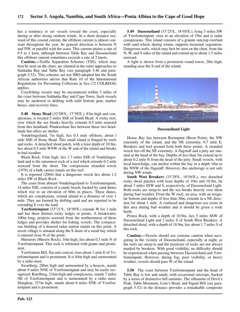
172 Sector 5. Angola, Namibia, and South Africa—Ponta Albina to the Cape of Good Hope
Pub. 123
has a tendency to set vessels toward the coast, especiallyduring or after strong onshore winds. At a short distance sea-ward of this coastal current, the offshore current is almost con-stant throughout the year. Its general direction is between Nand NW, or parallel with the coast. This current attains a rate of0.5 to 1 knot, although between Table Bay and Dasseneilandthis offshore current sometimes exceeds a rate of 2 knots.
Caution.—Traffic Separation Schemes (TSS), which maybest be seen on the chart, are situated in the outer approaches toSaldanha Bay and Table Bay (see paragraph 5.46 and para-graph 5.52). This schemes are not IMO-adopted but the SouthAfrican authorities advise that Rule 10 of the InternationalRegulations for Preventing Collisions at Sea (72 COLREGS)applies.
Crayfishing vessels may be encountered within 3 miles ofthe coast between Saldanha Bay and Cape Town. Such vesselsmay be anchored or drifting with unlit bottom gear, markerbuoys, and recovery lines.
5.48 Stony Head (33°08'S., 17°58'E.), 83m high and con-spicuous, is located 2 miles SSE of South Head. A rocky reef,over which the sea breaks heavily, extends 0.5 mile seawardfrom this headland. Plankiesbaai lies between these two head-lands but offers no shelter.5.48 Vondelingeiland, 7m high, lies 0.5 mile offshore, about lmile SSE of Stony Head. This small island is fringed by reefsand rocks. A detached shoal patch, with a least depth of 10.9m,lies about 0.5 mile WNW of the W end of the island and breaksin bad weather.5.48 Black Rock, 0.6m high, lies 1.7 miles ESE of Vondelingei-land and is the outermost rock of a reef which extends 0.2 mileseaward from the shore. The conspicuous stranded wreck(1978) of a bulk carrier stands on this reef.5.48 It is reported (2004) that a dangerous wreck lies about 1.2miles SW of Black Rock.5.48 The coast from abreast Vondelingeiland to Yzerfonteinpunt,14 miles SSE, consists of a sandy beach, backed by sand duneswhich rise to an elevation of 60m in places. These dunes,which are conspicuous, extend inland to a distance of over 1mile. They are formed by drifting sand and are reported to beextending E over the land.
Yzerfonteinpunt (33°21'S., 18°09'E.) extends W for 1 mileand has three distinct rocky ledges or points. A breakwater,100m long, projects seaward from the northernmost of theseledges and provides shelter for fishing vessels. The conspicu-ous building of a disused radar station stands on this point. Aresort village is situated along the S shore of a small bay whichis entered close N of the point.
Meeurots (Meeuw Rock), 10m high, lies about 0.3 mile N ofYzerfonteinpunt. This rock is whitened with guano and promi-nent.
Yzerfontein Hill, flat and conical, rises about 1 mile E of Yz-erfonteinpunt and is prominent. It is 84m high and surmountedby a radio mast.5.48 Swartberg, 286m high and surmounted by a beacon, standsabout 9 miles NNE of Yzerfonteinpunt and may be easily rec-ognized. Ratelberg, 216m high and conspicuous, stands 7 milesNE of Yzerfonteinpunt and is surmounted by a radio mast.Slangkop, 257m high, stands about 6 miles ENE of Yzerfon-teinpunt and is prominent.
5.49 Dasseneiland (33°25'S., 18°05'E.), lying 5 miles SWof Yzerfonteinpunt, rises to an elevation of 19m and is radarconspicuous. This island consists of a granite outcrop overlaidwith sand which, during winter, supports luxuriant vegetation.Dangerous reefs, which may best be seen on the chart, front theN, W, and S sides of the island and extend up to about 1.5 milesseaward.
A light is shown from a prominent round tower, 28m high,standing near the S end of the island.
5.49 House Bay lies between Boompunt (Boon Point), the NWextremity of the island, and the NE extremity, 0.7 mile E.Breakers and foul ground front both these points. A strandedwreck lies off the NE extremity. A flagstaff and a jetty are situ-ated at the head of the bay. Depths of less than 5m extend up toabout 0.2 mile N from the head of the jetty. Small vessels, withlocal knowledge, can anchor within the bay in a depth 18m tothe NNW of the flagstaff. However, this anchorage is not safeduring NW winds.5.49 South West Breakers (33°29'S., 18°04'E.), two detachedrocky shoal patches with least depths of 10m and 10.9m, lieabout 3 miles SSW and S, respectively, of Dasseneiland Light.Both rocks are steep-to and the sea breaks heavily over themduring bad weather. From the W rock, an area, with an irregu-lar bottom and depths of less than 30m, extends in a NE direc-tion for about 1 mile. A confused and dangerous sea exists inthis area during bad weather and it should be given a wideberth.5.49 Protea Rock, with a depth of 10.9m, lies 5 miles SSW ofDasseneiland Light and 2 miles S of South West Breakers. Adetached shoal, with a depth of 18.9m, lies about 1.7 miles S ofthis rock.
5.49 Caution.—Vessels should use extreme caution when navi-gating in the vicinity of Dasseneiland, especially at night, asthe reefs are steep-to and the positions of rocks are not alwaysmarked by breakers. With good visibility, no difficulty shouldbe experienced when passing between Dasseneiland and Yzer-fonteinpunt. However, during fog, poor visibility, or heavyweather, vessels should pass W of the island.
5.50 The coast between Yzerfonteinpunt and the head ofTable Bay is low and sandy, with occasional outcrops, backedby a series of distinctive hill summits. The silhouette of Devil’sPeak, Table Mountain, Lion’s Head, and Signal Hill (see para-graph 5.52) in the distance provides a remarkable composite
5.49Dasseneiland Light

Sector 5. Angola, Namibia, and South Africa—Ponta Albina to the Cape of Good Hope 173
Pub. 123
backdrop to the harbor of Cape Town.5.50 Rondeberg Breakers, a detached shoal patch, lies about 2miles offshore, 8 miles SE of Yzerfonteinpunt. It has a depth of8.2m and is usually marked by breakers.5.50 Rondeberg rises about 1.7 miles inland, 9 miles SE of Yster-fonteinpunt. This hill is 189m high and prominent.5.50 The mouth of the Modder River lies about 11 miles SE ofYzerfonteinpunt and can be recognized by an extensive sandypatch extending N of it. Black Rocks, two small islets, lie closeoffshore and close SSW of the river mouth.5.50 Bokpunt (33°34'S., 18°19'E.), a low rocky projection, is lo-cated 5 miles S of the mouth of the Modder River. A shallowrock, which usually breaks, lies about 0.5 mile W of this point. 5.50 A range of mountains, standing roughly parallel to the coastand between 6 and 10 miles from it, extends about 20 miles SEfrom abreast Ysterfonteinpunt to Kanonkop (Katzenberg), awell-defined isolated hill. This latter hill is 418m high, conical,and stands 12 miles E of Bokpunt.5.50 Kapokberg, 459m high; Contreberg, 479m high; and Das-senberg, 567m high, are prominent peaks on this mountainrange rising about 10 miles NNE, 10.5 miles NE, and 11 milesENE, respectively, of Bokpunt.5.50 Matroospunt is located 4 miles SE of Bokpunt. This point isfringed by rocks and backed by a prominent ridge, 43m high.
5.50 Koeberg Nuclear Power Station (33°41'S., 18°26'E.), radarconspicuous and prominent, is situated about 5 miles SSE ofMatroospunt. It is fronted by two breakwaters which enclose acooling water basin. Flashing yellow lights are shown from theseaward ends of both breakwaters.
5.50 Melkbospunt (33°44'S., 18°26E.) is located 8 miles SSE ofMatroospunt. The coast between low, sandy, and backed byprominent sand dunes in its central part. Robbesteen lies 0.4mile offshore in the N part of this stretch of coast. This smallseal rookery is composed of several rocky ledges up to 2.5mhigh. Patches of submerged rocks extend 0.6 mile NNW andabout 1 mile SSE from Robbesteen.
The conspicuous buildings of Melkbosstrand, a seaside re-sort village, stand close NE of Melkbosount and a prominentradio tower, 61m high, is situated in their vicinity.5.50 Koeberg (Olifantskop), 376m high, rises 6.2 miles ENE ofMelkbospunt and its summit is conspicuous. Blouberg, a darkhill, stands 2 miles SSE of Melkbospunt. It is rounded, 231mhigh, and prominent. 5.50 Bloubergstrand, a seaside resort and residential area, is located4 miles SSE of Melkbospunt. A large and conspicuous high-rise
apartment building stands in this resort. Voelsteen is the outer-most of three above-water rock clusters which front the N end ofthe resort. Heavy surf exists in this area, except in the calmest ofweather.5.50 Caution.—A prohibited area fronts the coast in the vicinity ofthe Koeberg Nuclear Power Station. It extends about 1 mile sea-ward and may best be seen on the chart. A patch of foul ground,which consists of the remains of a demolished wave observationtower, lies within this area, about 0.5 mile W of the breakwaters.
Several submarine cables, some disused, extends seawardfrom the coast in the vicinity of Melkbospunt and may best beseen on the chart. Anchoring within 1 mile of these cables isprohibited.5.50 An explosives dumping area, with a radius of 5 miles, liescentered about 140 miles W of Bokpunt.
5.51 Robben Island (33°48'S., 18°22'E.), located 4 milesW of Bloubergstrand resort, is low, flat, and fringed by reefs. Itis fairly densely wooded in parts along the E shore. The morebarren W part is covered in vegetation during the winter andwith wild flowers in the spring. The island, formerly used as aprison, is now a museum and national monument. Landing isonly permitted with prior permission.
Robben Island Light is shown at an elevation of 46m from aconspicuous round tower, 18m high, standing on the summit ofMinto Hill, near the S end of the island. 5.51 Murray’s Bay Harbor, located on the NE side of the island, isenclosed by breakwaters. It is shallow and used only by ferries andsmall craft, with local knowledge. A church, with a prominenttower, is situated 0.3 mile NE of Robben Island Light and a con-spicuous flagstaff stands between it and Murray’s Bay Harbor. 5.51 Whale Rock (33°50'S., 18°23E.) lies about 1.3 miles SSE ofRobben Island Light. This detached rocky patch has a depth ofless than 2m and the sea breaks over it in all but the calmestweather. A dangerous wreck lies about 0.3 mile SE of WhaleRock and is marked by a lighted buoy.5.51 Caution.—A prohibited area, with a width of about 1 mile, sur-rounds Robben Island and may best be seen on the chart.
A disused submarine cable, which may best be seen on thechart, extends in an E direction between Robben Island and themainland.
5.50Koeberg Nuclear Power Station
5.51Robben Island Light

174 Sector 5. Angola, Namibia, and South Africa—Ponta Albina to the Cape of Good Hope
Pub. 123
Table Bay
5.52 Table Bay (33°52'S., 18°26'E.) is entered on the Nside between Robben Island and Bloubergstrand resort andfrom the W side between Robben Island and Green Point(33°54'S., 18°24'E.), the N extremity of the Cape Peninsula. Agently curving sandy coast backed by low sand dunes formsthe E side of the bay between Bloubergstrand and the industrialarea of Paardeneiland, 7 miles S. The residential suburbs of Ta-ble View and Milnerton, with many high-rise buildings, are sit-uated along this stretch. Cape Town Docks and the city of CapeTown extend along the SW shore of the bay. 5.52 Milnerton Light (33°53'S., 18°29'E.) is shown at an elevationof 28m from a round tower, 24m high, standing 5 miles SSE ofBloubergstand. Two radio masts, 30m high, stand about 1 mileENE of the light and are prominent. A conspicuous strandedwreck fronts the shore, about 0.7 mile N of the light.5.52 The Diep River enters Table Bay 0.6 mile SSW of MilnertonLight and flows through Milnerton Lagoon. The shore of thebay in this vicinity is fronted in places by foul ground on whichthe sea breaks heavily after NW and N gales.
5.52 Green Point (33°54'S., 18°24'E.), located 4.5 miles WSW ofMilnerton Light, is fronted by foul ground. Green Point Light,also known locally as Mouille Point Light, is shown at an ele-vation of 20m from a tower, 16m high, standing on thepoint.The square light structure is painted in red and white di-agonal bands in order to make it stand out against the predomi-nantly vertical and horizontal lines of the adjacent buildings.However, in spite of this, the light structure is often difficult todistinguish.5.52 The Cape Peninsula, a conspicuous promontory, extends 28
miles S from Green Point Light to the Cape of Good Hope. 5.52 Mouille Point (33°54'S., 18°25'E.) is located 0.7 mile ENEof Green Point. The coast between is fronted by foul ground,on which lies a stranded wreck. The South African MerchantNavy Academy is situated in the vicinity of this point.
5.52 Table Mountain (33°58'S., 18°25E.) stands 3.5 miles S ofGreen Point Light and is extremely conspicuous. Its silhouette,as seen from the N, is probably the best known panoramic viewin South Africa. This mountain, along with Lions Head andSignal Hill, provides an unmistakable background to the build-ings of Cape Town. The N face of the mountain, which is al-most perpendicular, extends for a distance of 1.5 miles. It isinterrupted by Platteklip Gorge, a steep stony ravine, whichseparates the W part of the mountain from the E part. Themountain, which is radar conspicuous, is often illuminated atnight. 5.52 Maclear’s Beacon (33°58'S., 18°26E.), standing at an eleva-tion of 1,088m, is situated on the E part of Table Mountain andon its highest point. An aerial cableway stretches S from a sta-tion located at an elevation of 500m to the conspicuous UpperCable Station, which stands at an elevation of 1,045m on theNW edge of the mountain. 5.52 Lions Head (33°56'S., 18°23E.), located 1.5 miles NNW ofthe Upper Cable Station, has a conspicuous steep conical sum-mit, 670m high. A ridge extends in a NNE direction for 1.2miles from this hill to Signal Hill.5.52 Signal Hill (33°55'S., 18°24E.), also known as the Lions
5.52Table Bay
5.52Milnerton Light
5.52Green Point Light
5.52Table Mountain
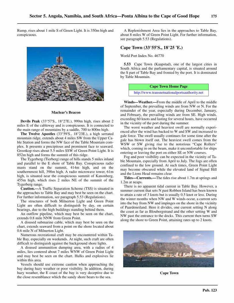
Sector 5. Angola, Namibia, and South Africa—Ponta Albina to the Cape of Good Hope 175
Pub. 123
Rump, rises about 1 mile S of Green Light. It is 350m high andconspicuous.
5.52 Devils Peak (33°57'S., 18°27E.), 999m high, rises about 2miles E of the cableway and is conspicuous. It is connected tothe main range of mountains by a saddle, 700 to 800m high. 5.52 The Twelve Apostles (33°59'S., 18°23E.), a high serratedmountain ridge, extends about 4 miles SW from the Upper Ca-ble Station and forms the NW face of the Table Mountain com-plex. It presents a precipitous and prominent face to seaward.Grootkop rises about 5.5 miles SSW of Green Point Light. It is852m high and forms the summit of this ridge. 5.52 The Tygerberg (Tierberg) range of hills stands 5 miles inlandand parallel to the E shore of Table Bay. Conspicuous radiomasts stand on the summit, 414m high, and on thesouthernmost hill, 398m high. A radio microwave tower, 61mhigh, is situated near the conspicuous summit of Kanonberg,455m high, which rises 2 miles NE of the summit of theTygerberg range.5.52 Caution.—A Traffic Separation Scheme (TSS) is situated inthe approaches to Table Bay and may best be seen on the chart.For further information, see paragraph 5.53 (Regulations).5.52 The structures of both Milnerton Light and Green PointLight are often difficult to distinguish by day, on certainbearings, due to the high buildings standing behind them.5.52 An outflow pipeline, which may best be seen on the chart,extends 0.8 mile NNW from Green Point.5.52 A disused submarine cable, which may best be seen on thechart, extends seaward from a point on the shore located about0.6 mile N of Milnerton Light.5.52 Numerous recreational craft may be encountered within Ta-ble Bay, especially on weekends. At night, such craft are oftendifficult to distinguish against the background shore lights.5.52 A disused ammunition dumping area, with a radius of 4miles, lies centered about 7 miles WNW of Green Point Lightand may best be seen on the chart. Hulks and explosives liewithin this area.5.52 Vessels should use extreme caution when approaching thebay during hazy weather or poor visibility. In addition, duringhazy weather, the E coast of the bay is very deceptive due tothe close resemblance which the sandy shore bears to the sea.
5.52 A Replenishment Area lies in the approaches to Table Bay,about 8 miles W of Green Point Light. For further information,see paragraph 5.53 (Regulations).
Cape Town (33°55'S., 18°25 'E.)
World Port Index No. 46770
5.53 Cape Town (Kaapstad), one of the largest cities inSouth Africa and the parliamentary capital, is situated aroundthe S part of Table Bay and fronted by the port. It is dominatedby Table Mountain.
5.53 Winds—Weather.—From the middle of April to the middleof September, the prevailing winds are from NW or N. For theremainder of the year, especially during December, January,and February, the prevailing winds are from SE. High winds,exceeding 60 knots and lasting for several hours, have occurredin the vicinity of the port during the summer. 5.53 The worst weather and heaviest swell are normally experi-enced after the wind has backed to W and SW and increased togale force. The swell usually continues for some time after thegale has blown itself out. The heaviest swell comes from theWSW or SW giving rise to the notorious “Cape Rollers”which, coming in on the beam, make it uncomfortable for shipsentering or leaving the port on either SE or NW courses.5.53 Fog and poor visibility can be expected in the vicinity of Ta-ble Mountain, especially from April to July. The fogs are oftenconfined to the low ground. At such times, Green Point Lightmay become obscured while the elevated land of Signal Hilland the Lions Head remains clear. 5.53 Tides—Currents.—The tides rise about 1.7m at springs and1.2m at neaps.5.53 There is no apparent tidal current in Table Bay. However, asummer current that sets N past Robben Island has been knownto attain a rate of 3 knots but is usually 0.5 knot or less. Duringthe winter months when NW and W winds occur, a current setsinto the bay from NW and impinges on the shore in the vicinityof Paardeneiland. Here it divides, one current setting N alongthe coast as far as Bloubergstrand and the other setting W andNW past the entrance to the docks. This current then turns SWalong the shore to Green Point, attaining rates up to 2 knots.
5.52Maclear’s Beacon
Cape Town Home Page
http://www.transnetnationalportsauthority.net
5.53Cape Town
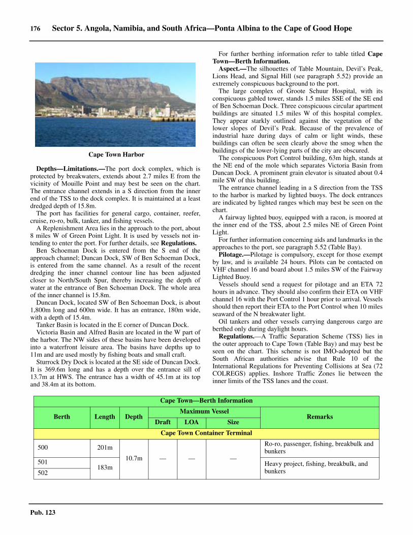
176 Sector 5. Angola, Namibia, and South Africa—Ponta Albina to the Cape of Good Hope
Pub. 123
5.53 Depths—Limitations.—The port dock complex, which isprotected by breakwaters, extends about 2.7 miles E from thevicinity of Mouille Point and may best be seen on the chart.The entrance channel extends in a S direction from the innerend of the TSS to the dock complex. It is maintained at a leastdredged depth of 15.8m. 5.53 The port has facilities for general cargo, container, reefer,cruise, ro-ro, bulk, tanker, and fishing vessels.5.53 A Replenishment Area lies in the approach to the port, about8 miles W of Green Point Light. It is used by vessels not in-tending to enter the port. For further details, see Regulations.5.53 Ben Schoeman Dock is entered from the S end of theapproach channel; Duncan Dock, SW of Ben Schoeman Dock,is entered from the same channel. As a result of the recentdredging the inner channel contour line has been adjustedcloser to North/South Spur, thereby increasing the depth ofwater at the entrance of Ben Schoeman Dock. The whole areaof the inner channel is 15.8m.5.53 Duncan Dock, located SW of Ben Schoeman Dock, is about1,800m long and 600m wide. It has an entrance, 180m wide,with a depth of 15.4m.5.53 Tanker Basin is located in the E corner of Duncan Dock. 5.53 Victoria Basin and Alfred Basin are located in the W part ofthe harbor. The NW sides of these basins have been developedinto a waterfront leisure area. The basins have depths up to11m and are used mostly by fishing boats and small craft.5.53 Sturrock Dry Dock is located at the SE side of Duncan Dock.It is 369.6m long and has a depth over the entrance sill of13.7m at HWS. The entrance has a width of 45.1m at its topand 38.4m at its bottom.
5.53 For further berthing information refer to table titled CapeTown—Berth Information. 5.53 Aspect.—The silhouettes of Table Mountain, Devil’s Peak,Lions Head, and Signal Hill (see paragraph 5.52) provide anextremely conspicuous background to the port.5.53 The large complex of Groote Schuur Hospital, with itsconspicuous gabled tower, stands 1.5 miles SSE of the SE endof Ben Schoeman Dock. Three conspicuous circular apartmentbuildings are situated 1.5 miles W of this hospital complex.They appear starkly outlined against the vegetation of thelower slopes of Devil’s Peak. Because of the prevalence ofindustrial haze during days of calm or light winds, thesebuildings can often be seen clearly above the smog when thebuildings of the lower-lying parts of the city are obscured. 5.53 The conspicuous Port Control building, 63m high, stands atthe NE end of the mole which separates Victoria Basin fromDuncan Dock. A prominent grain elevator is situated about 0.4mile SW of this building.5.53 The entrance channel leading in a S direction from the TSSto the harbor is marked by lighted buoys. The dock entrancesare indicated by lighted ranges which may best be seen on thechart.5.53 A fairway lighted buoy, equipped with a racon, is moored atthe inner end of the TSS, about 2.5 miles NE of Green PointLight.5.53 For further information concerning aids and landmarks in theapproaches to the port, see paragraph 5.52 (Table Bay).5.53 Pilotage.—Pilotage is compulsory, except for those exemptby law, and is available 24 hours. Pilots can be contacted onVHF channel 16 and board about 1.5 miles SW of the FairwayLighted Buoy. 5.53 Vessels should send a request for pilotage and an ETA 72hours in advance. They should also confirm their ETA on VHFchannel 16 with the Port Control 1 hour prior to arrival. Vesselsshould then report their ETA to the Port Control when 10 milesseaward of the N breakwater light.5.53 Oil tankers and other vessels carrying dangerous cargo areberthed only during daylight hours.5.53 Regulations.—A Traffic Separation Scheme (TSS) lies inthe outer approach to Cape Town (Table Bay) and may best beseen on the chart. This scheme is not IMO-adopted but theSouth African authorities advise that Rule 10 of theInternational Regulations for Preventing Collisions at Sea (72COLREGS) applies. Inshore Traffic Zones lie between theinner limits of the TSS lanes and the coast.
5.53Cape Town Harbor
Cape Town—Berth Information
Berth Length DepthMaximum Vessel
RemarksDraft LOA Size
Cape Town Container Terminal
500 201m
10.7m — — —
Ro-ro, passenger, fishing, breakbulk and bunkers
501183m Heavy project, fishing, breakbulk, and
bunkers502
Sector 5. Angola, Namibia, and South Africa—Ponta Albina to the Cape of Good Hope 177
Pub. 123
600 220m — 12.6m 259m 52,513 dwt
Containers, reefer, and bunkers.
601 236m15.5m
14.7m 320m 115,583 dwt
602
305m
14.5m 334m 134,007 dwt
603—
14.6m 336m 128,433 dwt
604 15.0m 336m 132,789 dwt
700 174m
10.0m — — — Heavy project, fishing, bunkers, breakbulk, and reefer.
701250m
702
703 193m
Victoria Basin
Collier Jetty E 209m7.0m
— — — Fishing, ro-ro, and passenger.
Collier Jetty W 197m
East Pier 240m 10.5m
Elbow 162m 9.3m
No. 1 (S Arm) 150m 7.7m
No. 1 Quay 178m 6.3m
No. 2 (S Arm) 150m 7.7m
No. 2 Jetty 195m 10.4m
No. 3 (S Arm)150m 7.7m
No. 4 (S Arm)
No. 6 Quay 178m 7.8m
No. 7 Quay 192m 11.1m
Duncan Dock
A 274m12.0m
— — —
Offshore support.
B 243m
Containers, breakbulk, breakbulk, reefer, and cruise.
C 213m 10.7m
D 185m9.1m
E 225m
F250m 12.2m
G
H 318m 12.8m
J250m
10.7mK Scrap metal, containers, fishing, reefer,
and heavy project.L 246m
M 262m Multipurpose
Landing Wharf 1 287m 14.0m 13.0m 299m 206,291 dwt Clean products, dirty products, and bunkers.
Cape Town—Berth Information
Berth Length DepthMaximum Vessel
RemarksDraft LOA Size
178 Sector 5. Angola, Namibia, and South Africa—Ponta Albina to the Cape of Good Hope
Pub. 123
5.53 A separation zone, 0.5 mile wide, is situated with its S endlocated about 3.5 miles SW of Robben Island Light. It extendsNW for about 13.5 miles. The traffic lane for vesselsproceeding NW, which is 1.5 miles wide, lies on the E side ofthis zone; the traffic lane for vessels proceeding SE, which is1.5 miles wide, lies on the W side.5.53 A second separation zone, 0.5 mile wide, is situated with itsN end located about 4.5 miles W of Green Point Light. Itextends SW for about 8 miles. The traffic lane for vesselsproceeding NE, which is 1.5 miles wide, lies on the E side ofthis zone; the traffic lane for vessels proceeding SW, which is1.5 miles wide, lies on the W side.5.53 A third separation zone, 0.2 mile wide, is situated with its Wend located about 3 miles NW of Green Point Light. It extendsE for about 3.5 miles to the vicinity of the fairway lighted buoy.The traffic lane for vessels proceeding W, which is 1 milewide, lies on the N side of this zone; the traffic lane for vesselsproceeding E, which is 1 mile wide, lies on the S side.5.53 A Replenishment Area lies about 8 miles W of Green PointLight. All vessels replenishing stores at sea in this area mustremain W of the outer limits of the TSS traffic lanes.5.53 A helicopter service is available for tankers and other vesselsnot intending to enter the harbor. This service may be used for
emergency medical cases, mail, and small items of stores.However, usually only vessels which are able to comply withthe special requirements for the operation of helicopters arepermitted to use this service. 5.53 A launch service is available to serve vessels outside the portlimits. This service is restricted to vessels, with drafts of lessthan 12.2m, which do not intend to stop for a period exceeding1 hour. Vessels requiring to stop for a period of more than 1hour must anchor within the port limits.5.53 Arrangements for replenishment should be made through thevessel’s agent. Vessels must report to the VTS Center by VHFwhen 15 miles from the area. 5.53 The IMO has established regulations for laden tankersnavigating off the coast of South Africa. Such vessels mustmaintain minimum distances from pertinent points situatedalong the coast. Exemptions apply to vessels using theReplenishment Area in the approaches to Cape Town (TableBay). For further information, see Pub. 160, Sailing Directions(Planning Guide) South Atlantic Ocean and Indian Ocean.5.53 Vessel Traffic Service.—A Vessel Traffic Service (VTS)system operates in the approaches to Cape Town (Table Bay)and provides radar coverage up to 20 miles offshore.5.53 The VTS system is mandatory for the following vessels:
Landing Wharf 2 274m 12.0m — —
—
—
Landing Wharf 3 287m 14.0m 12.7m 274m Clean products, dirty products, and bunkers.
Landing Wharf 4 274m
12.0m
— —
Heavy project.
Repair Quay 1
— Heavy project and fishing. Continuous berthing length of 485m.Repair Quay 2
Repair Quay 3 10.7m
Repair Quay 4 32m 6.1m Heavy project and fishing.
Eastern Mole
1 260m14.0m
12.8m 299m 206,010 dwt Clean products, dirty products, and bunkers.2 53m 12.9m 291m 175,800 dwt
Chevron Tanker Terminals
1 51m 14.2m 13.6m 250m—
Clean products, crude, dirty products, vegetable oils, and bunkers.
2 54m 13.8m 13.2m 201m Aviation fuel, clean products, dirty products, and bunkers.
Cape Town—Berth Information
Berth Length DepthMaximum Vessel
RemarksDraft LOA Size
Table Bay Vessel Traffic Service—Reporting Points (RP)
Inbound vessels Outbound vessels Inshore Traffic Zone
RP Position RP Position RP Position
Approaching from the S Departing to the S Outbound vessels
1B 34°00.8'S, 18°15.1'E 4 33°53.9'S, 18°26.3'E 1D 34°01.9'S, 18°17.3'E
2B 33°53.9'S, 18°19.8'E 3 33°51.3'S, 18°24.0'E 1C 33°36.8'S, 18°14.4'E
Sector 5. Angola, Namibia, and South Africa—Ponta Albina to the Cape of Good Hope 179
Pub. 123
1. Vessels of 15m in length and over.2. Towing vessels, where the tow is 15m or more in
length or the overall length of the tow is 30m or more.3. All passenger carrying vessels.4. All vessels carrying polluting or dangerous cargo.
5.53 Vessels must contact the VTS center (Cape Town PortControl) on VHF channel 14, as follows:
1. Fifteen minutes before arrival at the TSS (VTSarea).—Vessels must request a Traffic Clearance stating theirname, Call sign, position, ETA at the Reporting Point,destination with ETA, and whether any dangerous orpollutant cargo is being carried.
2. Arriving at the designated Reported Points—Vesselsmust state their name, position, and ETA at the next Report-ing Point.
3. Arriving at a berth.—Vessels must state their nameand position.
4. Fifteen minutes before departing from a berth.—Ves-sels must request a Traffic Clearance stating their name, Callsign, position, destination with ETA, whether any dangerousor pollutant cargo is being carried, and ETD from berth.
5. Immediately prior to departing from a berth.—Vesselsmust state their name, Call sign, position, and ETA at thenext Reporting Point.
5.53 Vessels must also immediately report any incident, accident,or condition impairing safety to Cape Town Port Control. 5.53 All times should be given in local time. 5.53 Additional information concerning draft, gt, length, theparticulars of cargo on board, and last and next ports of callmay be requested by the VTS Control Center.5.53 The VTS Control Center will provide information relating tothe locations of other vessels and the density of trafficconverging on the same position. 5.53 The VTS system is linked to the Saldanha Bay VTS Center,the Maritime Rescue Coordination Center, the Port ControlOffice, the Pilot Offices, and the local Coast Radio Station.5.53 For designated Reporting Point. see the table titled TableBay Vessel Traffic Service—Reporting Points (RP).5.53 Signals.—Traffic signals are shown from the top of the PortControl Building. They consist of three strips of colored lightsand are visible by day and at night. A red strip controls BenSchoeman Dock, a green strip controls Duncan Dock, and anamber strip controls Victoria Basin.5.53 When a vessel is granted permission to enter any dock, the
signal consists of a series of flashes along the appropriate strip.When a vessel is given permission to leave, the signal consistsa fixed light in the appropriate color. These signals may beshown one at a time or in combinations.5.53 When these signals are being shown, vessels are prohibitedfrom entering the entrance channel leading between the docksand the fairway lighted buoy without prior permission. 5.53 A time signal, controlled from the Cape Town Observatory,is fired daily at 1000 UTC (noon) from a gun battery situatedon Signal Hill.5.53 Contact Information.—See the table titled Cape Town—Contact Information. 5.53 Anchorage.—Four designated anchorage areas, situatedwithin Table Bay and may best seen on the chart, are, asfollows:
1. No. 1 Anchorage lies centered 1.5 miles W of GreenPoint Light and has depths of 24 to 45m. It is a general an-chorage which should be used only during the summer.
2. No. 2 Anchorage lies centered 2 miles NW of Milner-ton Light. It is a general anchorage with depths of 12.4 to22m. Vessels using this anchorage must avoid the disusedsubmarine cable which extends seaward from a point on theshore located about 0.6 mile N of the light.
3. No. 3 Anchorage lies centered 1.6 miles WSW ofMilnerton Light. It has depths of 9 to 15m and may only beused by small vessels.
4. No. 4 Anchorage lies centered 3.2 miles ESE of Rob-ben Island Light. It has depths of 12.8 to 22m and may onlybe used by vessels carrying hazardous cargo.
5.53 The holding ground within the anchorages is unreliable inbad weather and vessels at anchor must keep their enginesready for use at short notice.5.53 Directions.—A Traffic Separation Scheme (TSS) is situatedin the approaches to Cape Town (Table Bay) and may best beseen on the chart (see Regulations).
5.53 Caution.—Vessels underway in the approaches should avoidimpeding the passage of other vessels which are embarking ordisembarking pilots or entering or leaving the dock complex.5.53 Vessels underway in the approaches should use caution as, atnight, it may be difficult to distinguish the navigation lights ofother vessels against the background scatter of shore lights.5.53 A restricted area, within which anchoring is prohibited,extends from the vicinity of the fairway lighted buoy to the
3 33°52.5'S, 18°24.0'E 2B 33°52.9'S, 18°17.7'E 2C 33°48.9'S, 18°24.3'E
1A 33°41.4'S, 18°07.8'E 1B 33°59.4'S, 18°13.2'E 4 33°53.9'S, 18°26.3'E
2A 33°50.7'S, 18°17.1'E Departing to the N Inbound vessels
3 33°52.5'S, 18°24.0'E 4 33°53.9'S, 18°26.3'E 1D 34°01.9'S, 18°17.3'E
3 33°51.3'S, 18°24.0'E 1C 33°36.8'S, 18°14.4'E
2A 33°49.4'S, 18°19.0'E 2C 33°48.9'S, 18°24.3'E
1A 33°40.1'S, 18°09.6'E
Table Bay Vessel Traffic Service—Reporting Points (RP)
Inbound vessels Outbound vessels Inshore Traffic Zone
RP Position RP Position RP Position
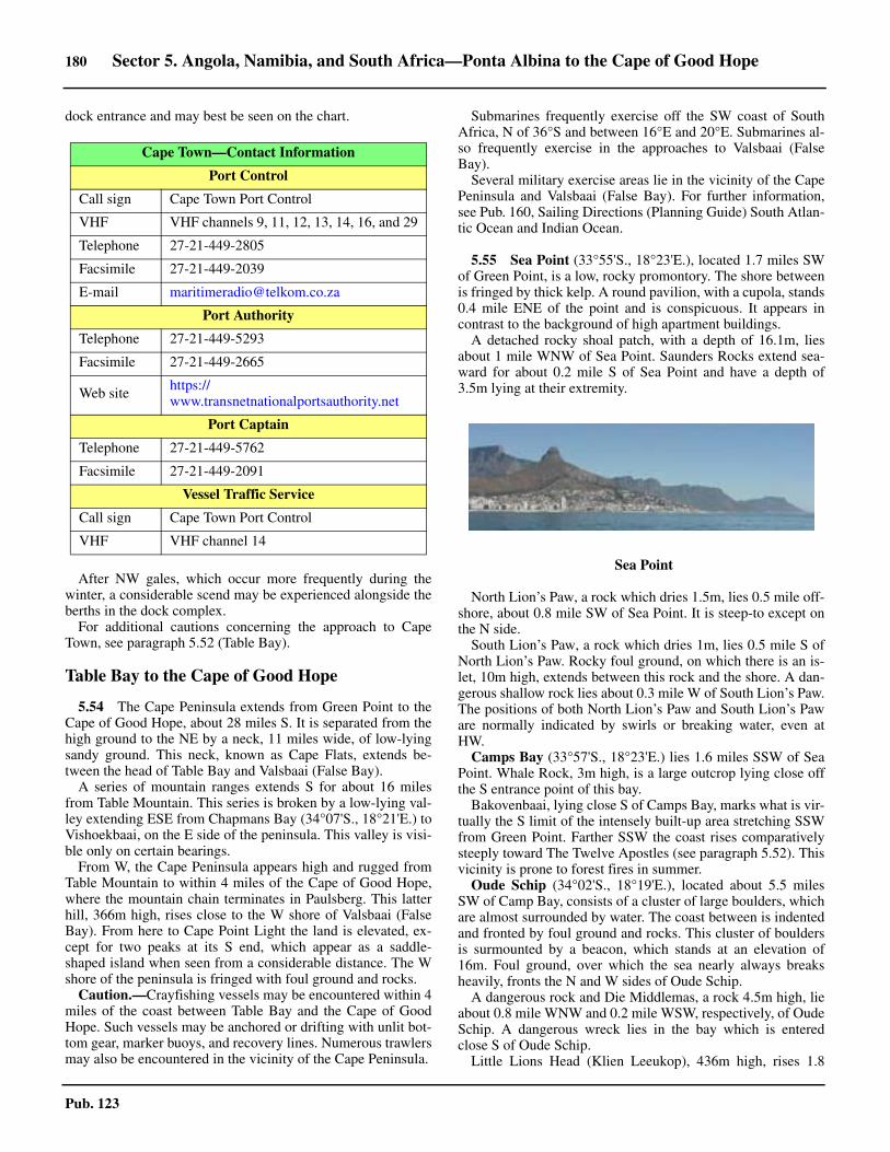
180 Sector 5. Angola, Namibia, and South Africa—Ponta Albina to the Cape of Good Hope
Pub. 123
dock entrance and may best be seen on the chart.
5.53 After NW gales, which occur more frequently during thewinter, a considerable scend may be experienced alongside theberths in the dock complex.5.53 For additional cautions concerning the approach to CapeTown, see paragraph 5.52 (Table Bay).
Table Bay to the Cape of Good Hope
5.54 The Cape Peninsula extends from Green Point to theCape of Good Hope, about 28 miles S. It is separated from thehigh ground to the NE by a neck, 11 miles wide, of low-lyingsandy ground. This neck, known as Cape Flats, extends be-tween the head of Table Bay and Valsbaai (False Bay).5.54 A series of mountain ranges extends S for about 16 milesfrom Table Mountain. This series is broken by a low-lying val-ley extending ESE from Chapmans Bay (34°07'S., 18°21'E.) toVishoekbaai, on the E side of the peninsula. This valley is visi-ble only on certain bearings. 5.54 From W, the Cape Peninsula appears high and rugged fromTable Mountain to within 4 miles of the Cape of Good Hope,where the mountain chain terminates in Paulsberg. This latterhill, 366m high, rises close to the W shore of Valsbaai (FalseBay). From here to Cape Point Light the land is elevated, ex-cept for two peaks at its S end, which appear as a saddle-shaped island when seen from a considerable distance. The Wshore of the peninsula is fringed with foul ground and rocks.
Caution.—Crayfishing vessels may be encountered within 4miles of the coast between Table Bay and the Cape of GoodHope. Such vessels may be anchored or drifting with unlit bot-tom gear, marker buoys, and recovery lines. Numerous trawlersmay also be encountered in the vicinity of the Cape Peninsula.
Submarines frequently exercise off the SW coast of SouthAfrica, N of 36°S and between 16°E and 20°E. Submarines al-so frequently exercise in the approaches to Valsbaai (FalseBay).
Several military exercise areas lie in the vicinity of the CapePeninsula and Valsbaai (False Bay). For further information,see Pub. 160, Sailing Directions (Planning Guide) South Atlan-tic Ocean and Indian Ocean.
5.55 Sea Point (33°55'S., 18°23'E.), located 1.7 miles SWof Green Point, is a low, rocky promontory. The shore betweenis fringed by thick kelp. A round pavilion, with a cupola, stands0.4 mile ENE of the point and is conspicuous. It appears incontrast to the background of high apartment buildings. 5.55 A detached rocky shoal patch, with a depth of 16.1m, liesabout 1 mile WNW of Sea Point. Saunders Rocks extend sea-ward for about 0.2 mile S of Sea Point and have a depth of3.5m lying at their extremity.
5.55 North Lion’s Paw, a rock which dries 1.5m, lies 0.5 mile off-shore, about 0.8 mile SW of Sea Point. It is steep-to except onthe N side.5.55 South Lion’s Paw, a rock which dries 1m, lies 0.5 mile S ofNorth Lion’s Paw. Rocky foul ground, on which there is an is-let, 10m high, extends between this rock and the shore. A dan-gerous shallow rock lies about 0.3 mile W of South Lion’s Paw.The positions of both North Lion’s Paw and South Lion’s Paware normally indicated by swirls or breaking water, even atHW.
Camps Bay (33°57'S., 18°23'E.) lies 1.6 miles SSW of SeaPoint. Whale Rock, 3m high, is a large outcrop lying close offthe S entrance point of this bay. 5.55 Bakovenbaai, lying close S of Camps Bay, marks what is vir-tually the S limit of the intensely built-up area stretching SSWfrom Green Point. Farther SSW the coast rises comparativelysteeply toward The Twelve Apostles (see paragraph 5.52). Thisvicinity is prone to forest fires in summer. 5.55 Oude Schip (34°02'S., 18°19'E.), located about 5.5 milesSW of Camp Bay, consists of a cluster of large boulders, whichare almost surrounded by water. The coast between is indentedand fronted by foul ground and rocks. This cluster of bouldersis surmounted by a beacon, which stands at an elevation of16m. Foul ground, over which the sea nearly always breaksheavily, fronts the N and W sides of Oude Schip.5.55 A dangerous rock and Die Middlemas, a rock 4.5m high, lieabout 0.8 mile WNW and 0.2 mile WSW, respectively, of OudeSchip. A dangerous wreck lies in the bay which is enteredclose S of Oude Schip.5.55 Little Lions Head (Klien Leeukop), 436m high, rises 1.8
Cape Town—Contact Information
Port Control
Call sign Cape Town Port Control
VHF VHF channels 9, 11, 12, 13, 14, 16, and 29
Telephone 27-21-449-2805
Facsimile 27-21-449-2039
E-mail [email protected]
Port Authority
Telephone 27-21-449-5293
Facsimile 27-21-449-2665
Web site https://www.transnetnationalportsauthority.net
Port Captain
Telephone 27-21-449-5762
Facsimile 27-21-449-2091
Vessel Traffic Service
Call sign Cape Town Port Control
VHF VHF channel 14
5.55Sea Point

Sector 5. Angola, Namibia, and South Africa—Ponta Albina to the Cape of Good Hope 181
Pub. 123
miles ENE of Oude Schip and is prominent from seaward.
5.56 Duikerpunt (34°02'S., 18°18'E.), the W extremity ofthe Cape Peninsula, is located 0.7 mile SSW of Oude Schipand consists of a bold headland. This point, which is radar con-spicuous, is fronted by foul ground and several above-waterrocks. A stranded wreck lies close N of the point but is report-ed (2007) to be not easily distinguished.
Karbonkelberg, 652m high, rises 1 mile E of Duikerpunt andis conspicuous from seaward. 5.56 Vulcan Rock, which dries 0.9m and is always marked bybreakers, lies 1.5 miles S of Duikerpunt. Tafelberg, a rockyshoal patch, lies about 0.4 mile SE of Vulcan Rock. It has aleast depth of 7.6m and breaks in heavy weather.5.56 Hangberg (The Sentinel), a remarkable hill, rises close to theshore, about 2 miles SE of Duikerpunt. It is 330m high and ap-pears to overhang when viewed from E. Duiker Island, 3mhigh, lies about 0.6 mile W of Hangberg and is fringed by foulground and kelp. This flat rock is located close off a smallrocky projection and breakers extend SW for about 0.3 milefrom it.
Houtbaai (34°03'S., 18°21'E.), a fishing and pleasure craftcenter, lies 2.5 miles SE of Duikerpunt. This bay is entered be-tween Badtamboer, located close SE of Hangberg, and DieJosie, a rocky point 1.2 miles SE. The coast on each side of theentrance is high and rugged, particularly on the E side, wherehills rise precipitously and are separated by a series of ravines.The mouth of the Houtbaai River, usually dry in summer, liesat the head of the bay, which is low and sandy.
Two wrecks, with a least depth of 9m, lie in the entrance tothe bay, about 0.4 mile ESE of Badtamboer.5.56 York Point, located 0.5 mile NE of Badtamboer, is low-lyingand composed of boulders.
5.56 Constantiaberg (34°03'S., 18°23'E.) rises on the E side ofthe bay, 2 miles NE of Die Josie. This hill is 928m high andconspicuous. A prominent radio mast, 143m high, stands nearthe summit. 5.56 A modern fishing harbor is situated close N of York Point. It isprotected by breakwaters, 370m long. A number of fish factories,lighted at night, stand on the S side of the harbor. A wharf, extend-ing NW from the inner side of the S breakwater, has depths of 2.5to 3.5m alongside and can accommodate trawlers up to 43m in
length. The harbor is a base for tuna and cray fish fleets.5.56 Except during SE squalls, good sheltered anchorage may beobtained within the bay, with excellent holding ground of softsand. Anchorage in the entrance to the harbor should be avoid-ed. Although the bay is open to the SW, strong winds, apartfrom occasional short-lived squalls, seldom occur from thisquarter. However, when SE winds blow, squalls come downvery heavily off the land and an unpleasant short, choppy seaoccurs.
5.57 Chapmans Point (34°05'S., 18°21'E.), located 1 mileSSW of Die Josie, is fronted by a reef on which the sea alwaysbreaks. Ratelklip, a reef, lies close offshore, 0.4 mile S of thepoint and the sea also always breaks heavily over it.
Chapmans Peak, 593m high, rises close E of ChapmansPoint. When viewed from the W, this prominent peak presentstwo summits of dark appearance and of almost equal height. 5.57 Chapmans Bay lies between Chapmans Point and Klein-Slangkoppunt, 2 miles SSW, and provides no safe anchorage.The sandy beach at the head of this bay is backed by swampyground in which there are lagoons and salt pans.
Slangkop Point (34°09'S., 18°19'E.), located 1.6 miles SWof Klein-Slangkoppunt, is low and sandy. The shore between isfronted by foul ground and patches of kelp. The land closewithin this point rises steeply to the summit of Slangkop, aprominent flat-topped hill, 178m high.
Slangkop Light is shown from a prominent round tower, 33mhigh, standing on the point. This light tower stands out againstthe dark background of the hills behind it.
5.57 A wreck, with a depth of 12.8m, lies about 1 mile W of thelight. A wave-measurement buoy is moored about 4 miles SSWof the light and a restricted area, with a radius of 0.5 mile, sur-rounds it.
The coast between Slangkop Light and Die Eiland, 2.5 milesSE, is rocky and much encumbered with off-lying kelp. Die Ei-land is a rocky boulder-strewn point upon which stand thebrick buildings of a lobster factory. A prominent radio mast,85m high, is situated on the point.5.57 Sandkop rises 0.5 mile NNW of Die Eiland. This hill is121m high and conspicuous because of a sand patch on its NWside. A range of hills stands parallel to the bight in the coast ex-tending between Die Eiland and Schuster’s Bay, 2 miles SE.Platberg, 308m high, rises 1.6 miles SE of Die Eiland and is aprominent summit along this range. Scarborough, a prominentvillage, stands close E of Schuster’s Bay. 5.57 A detached shoal patch, with a least depth of 13.4m, liesabout 1 mile WSW of Die Eiland and another detached shoal
5.56Houtbaai
5.57Slangkop Light
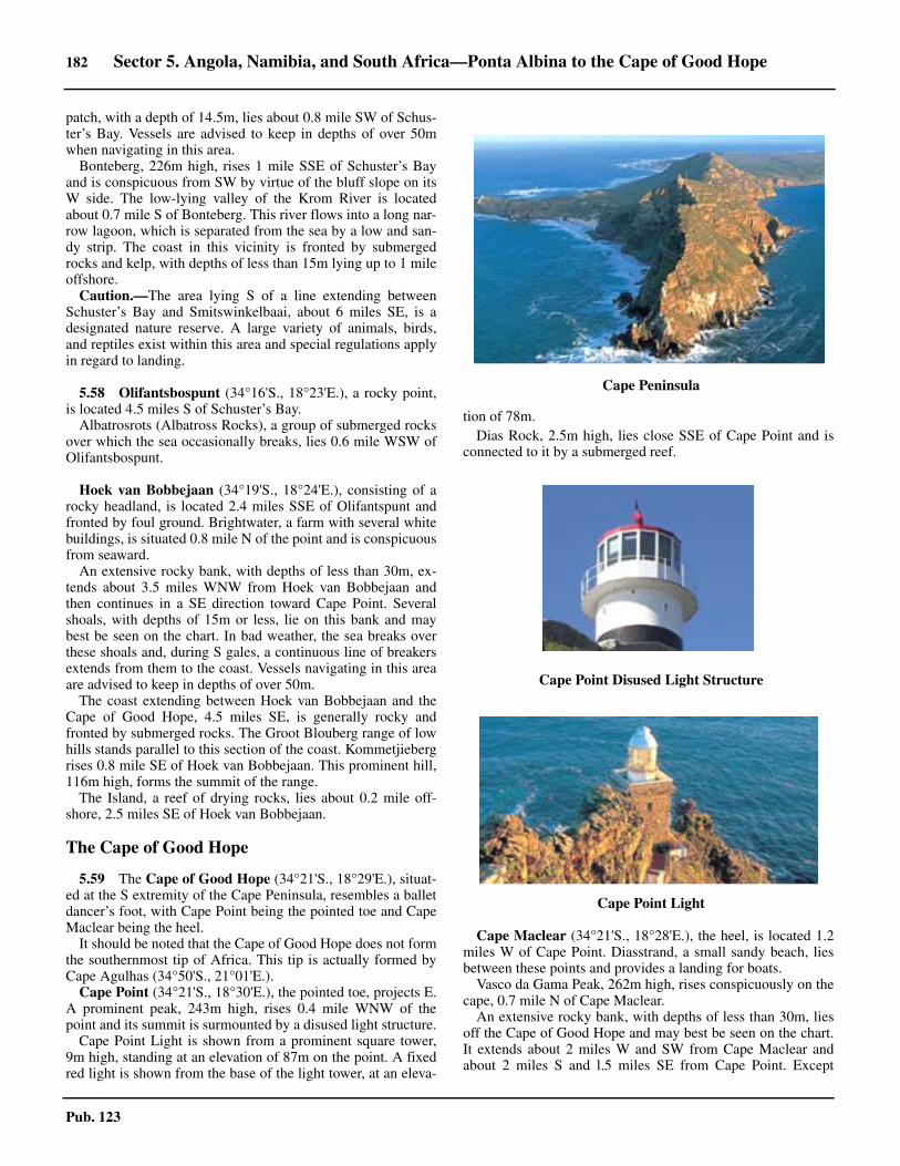
182 Sector 5. Angola, Namibia, and South Africa—Ponta Albina to the Cape of Good Hope
Pub. 123
patch, with a depth of 14.5m, lies about 0.8 mile SW of Schus-ter’s Bay. Vessels are advised to keep in depths of over 50mwhen navigating in this area.5.57 Bonteberg, 226m high, rises 1 mile SSE of Schuster’s Bayand is conspicuous from SW by virtue of the bluff slope on itsW side. The low-lying valley of the Krom River is locatedabout 0.7 mile S of Bonteberg. This river flows into a long nar-row lagoon, which is separated from the sea by a low and san-dy strip. The coast in this vicinity is fronted by submergedrocks and kelp, with depths of less than 15m lying up to 1 mileoffshore.5.57 Caution.—The area lying S of a line extending betweenSchuster’s Bay and Smitswinkelbaai, about 6 miles SE, is adesignated nature reserve. A large variety of animals, birds,and reptiles exist within this area and special regulations applyin regard to landing.
5.58 Olifantsbospunt (34°16'S., 18°23'E.), a rocky point,is located 4.5 miles S of Schuster’s Bay. 5.58 Albatrosrots (Albatross Rocks), a group of submerged rocksover which the sea occasionally breaks, lies 0.6 mile WSW ofOlifantsbospunt.
Hoek van Bobbejaan (34°19'S., 18°24'E.), consisting of arocky headland, is located 2.4 miles SSE of Olifantspunt andfronted by foul ground. Brightwater, a farm with several whitebuildings, is situated 0.8 mile N of the point and is conspicuousfrom seaward.
An extensive rocky bank, with depths of less than 30m, ex-tends about 3.5 miles WNW from Hoek van Bobbejaan andthen continues in a SE direction toward Cape Point. Severalshoals, with depths of 15m or less, lie on this bank and maybest be seen on the chart. In bad weather, the sea breaks overthese shoals and, during S gales, a continuous line of breakersextends from them to the coast. Vessels navigating in this areaare advised to keep in depths of over 50m.5.58 The coast extending between Hoek van Bobbejaan and theCape of Good Hope, 4.5 miles SE, is generally rocky andfronted by submerged rocks. The Groot Blouberg range of lowhills stands parallel to this section of the coast. Kommetjiebergrises 0.8 mile SE of Hoek van Bobbejaan. This prominent hill,116m high, forms the summit of the range.5.58 The Island, a reef of drying rocks, lies about 0.2 mile off-shore, 2.5 miles SE of Hoek van Bobbejaan.
The Cape of Good Hope
5.59 The Cape of Good Hope (34°21'S., 18°29'E.), situat-ed at the S extremity of the Cape Peninsula, resembles a balletdancer’s foot, with Cape Point being the pointed toe and CapeMaclear being the heel.
It should be noted that the Cape of Good Hope does not formthe southernmost tip of Africa. This tip is actually formed byCape Agulhas (34°50'S., 21°01'E.). 5.59 Cape Point (34°21'S., 18°30'E.), the pointed toe, projects E.A prominent peak, 243m high, rises 0.4 mile WNW of thepoint and its summit is surmounted by a disused light structure.5.59 Cape Point Light is shown from a prominent square tower,9m high, standing at an elevation of 87m on the point. A fixedred light is shown from the base of the light tower, at an eleva-
tion of 78m.5.59 Dias Rock, 2.5m high, lies close SSE of Cape Point and isconnected to it by a submerged reef.
5.59 Cape Maclear (34°21'S., 18°28'E.), the heel, is located 1.2miles W of Cape Point. Diasstrand, a small sandy beach, liesbetween these points and provides a landing for boats.5.59 Vasco da Gama Peak, 262m high, rises conspicuously on thecape, 0.7 mile N of Cape Maclear. 5.59 An extensive rocky bank, with depths of less than 30m, liesoff the Cape of Good Hope and may best be seen on the chart.It extends about 2 miles W and SW from Cape Maclear andabout 2 miles S and l.5 miles SE from Cape Point. Except
5.59Cape Peninsula
5.59Cape Point Disused Light Structure
5.59Cape Point Light
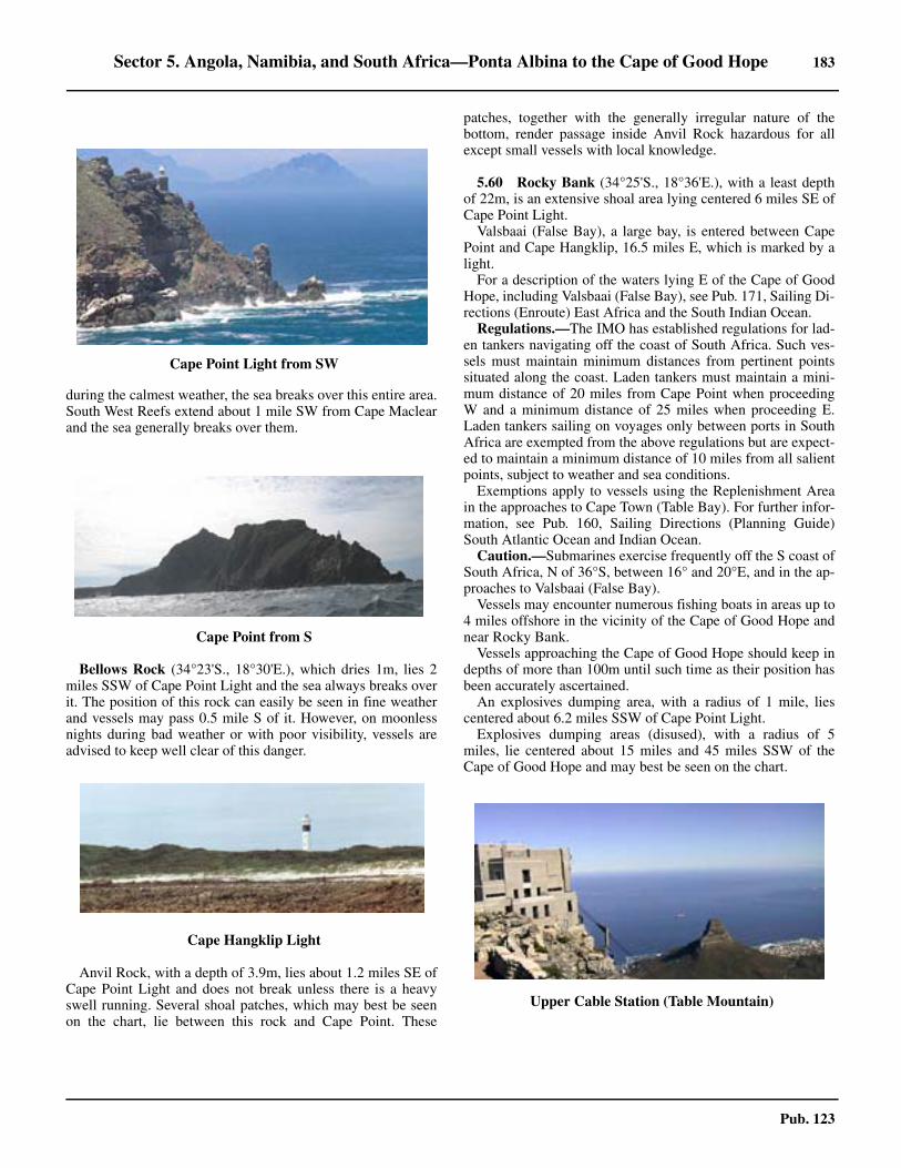
Sector 5. Angola, Namibia, and South Africa—Ponta Albina to the Cape of Good Hope 183
Pub. 123
during the calmest weather, the sea breaks over this entire area.South West Reefs extend about 1 mile SW from Cape Maclearand the sea generally breaks over them.
5.59 Bellows Rock (34°23'S., 18°30'E.), which dries 1m, lies 2miles SSW of Cape Point Light and the sea always breaks overit. The position of this rock can easily be seen in fine weatherand vessels may pass 0.5 mile S of it. However, on moonlessnights during bad weather or with poor visibility, vessels areadvised to keep well clear of this danger.
5.59 Anvil Rock, with a depth of 3.9m, lies about 1.2 miles SE ofCape Point Light and does not break unless there is a heavyswell running. Several shoal patches, which may best be seenon the chart, lie between this rock and Cape Point. These
patches, together with the generally irregular nature of thebottom, render passage inside Anvil Rock hazardous for allexcept small vessels with local knowledge.
5.60 Rocky Bank (34°25'S., 18°36'E.), with a least depthof 22m, is an extensive shoal area lying centered 6 miles SE ofCape Point Light.5.60 Valsbaai (False Bay), a large bay, is entered between CapePoint and Cape Hangklip, 16.5 miles E, which is marked by alight. 5.60 For a description of the waters lying E of the Cape of GoodHope, including Valsbaai (False Bay), see Pub. 171, Sailing Di-rections (Enroute) East Africa and the South Indian Ocean.5.60 Regulations.—The IMO has established regulations for lad-en tankers navigating off the coast of South Africa. Such ves-sels must maintain minimum distances from pertinent pointssituated along the coast. Laden tankers must maintain a mini-mum distance of 20 miles from Cape Point when proceedingW and a minimum distance of 25 miles when proceeding E.Laden tankers sailing on voyages only between ports in SouthAfrica are exempted from the above regulations but are expect-ed to maintain a minimum distance of 10 miles from all salientpoints, subject to weather and sea conditions.5.60 Exemptions apply to vessels using the Replenishment Areain the approaches to Cape Town (Table Bay). For further infor-mation, see Pub. 160, Sailing Directions (Planning Guide)South Atlantic Ocean and Indian Ocean.5.60 Caution.—Submarines exercise frequently off the S coast ofSouth Africa, N of 36°S, between 16° and 20°E, and in the ap-proaches to Valsbaai (False Bay).5.60 Vessels may encounter numerous fishing boats in areas up to4 miles offshore in the vicinity of the Cape of Good Hope andnear Rocky Bank.5.60 Vessels approaching the Cape of Good Hope should keep indepths of more than 100m until such time as their position hasbeen accurately ascertained. 5.60 An explosives dumping area, with a radius of 1 mile, liescentered about 6.2 miles SSW of Cape Point Light.5.60 Explosives dumping areas (disused), with a radius of 5miles, lie centered about 15 miles and 45 miles SSW of theCape of Good Hope and may best be seen on the chart.
5.59Cape Point Light from SW
5.59Cape Point from S
5.59Cape Hangklip Light
5.60Upper Cable Station (Table Mountain)

185
Pub. 123
6. Sector 6—Islands and Seamounts in the South Atlantic Ocean
6.0Additional chart coverage may be found in NGA/DLIS Catalog of Maps, Charts, and Related Products (Unlimited Distribution).
SECTOR 6 — CHART INFORMATION
187
Pub. 123
SECTOR 6
ISLANDS AND SEAMOUNTS IN THE SOUTH ATLANTIC OCEAN
6.0 Plan.—This sector describes Ascension Island, Saint HelenaIsland, the Tristan da Cunha Group, Gough Island, and Bou-vetoya. This sector also describes certain seamounts in the Epart of the South Atlantic Ocean. The descriptive sequence isfrom N to S.
Ascension Island
6.1 Ascension Island (7°56'S., 14°25'W.), being of vol-canic origin, lies about 700 miles NW of Saint Helena Islandand is a communications center. Georgetown, situated in theNW part of the island, is the only settlement and port, and isthe center of administration. The surface of the island is ex-tremely irregular and presents a rugged and uninviting appear-ance when viewed from seaward.6.1 Ascension Island, along with Saint Helena, Tristan daCunha, and Gough Island, form a British Overseas Territory.The Governor of this territory resides on Saint Helena. Anairfield is situated on the island but is used only by militaryplanes. The island is the site of a European Space Agencytracking station.
The Peak (7°57'S., 14°21'W.), forming the summit of GreenMountain, is 859m high and the island’s greatest elevation.6.1 Green Mountain takes its name from the color of the top andis surrounded by numerous other craggy peaks of less eleva-tion, with deep gorges and dark ravines between. There areabout 40 cones of various magnitudes on the island, being ex-tinct craters, from many of which the courses of the lavastreams may be traced to the sea. Rain falls more frequently onthe summit of Green Mountain than on the lower parts of theisland. Mist generally obscures the mountain for some part ofthe 24 hours. The only signs of vegetation on the island are onGreen Mountain, where vegetables are successfully cultivated.Water was formerly obtained from the cement rain catchmentson the mountain and conveyed through pipes to covered tanksin Georgetown. The island is now supplied by desalination fa-cilities and little can be spared for shipping.
Devils Riding School (7°58'S., 14°23'W.), a crater morerugged and remarkable than the rest, is located 2.5 miles WSWof Green Mountain.6.1 Tides—Currents.—The predominant set is W at 0.5 knot.Rollers take the form of either SW or NW rollers and may beexpected about once every two weeks. They can be up to 3m inheight and are strong enough to prevent lighters from mooringalongside the wharf. Locally, the smaller ones are called singlerollers and the larger ones double rollers. When single rollersare running, landing may still be effected, but difficulty is oftenexperienced in getting alongside the steps, and great cautionshould be exercised. The origin of these rollers is attributed tothe swell produced by intense storms thousands of miles awayin the North Atlantic Ocean and the South Atlantic Ocean. 6.1 The depths offshore on the E side of Clarence Bay are suffi-cient to prevent the swell acquiring the character of breakingrollers, except in cases where the undulation arrives from NW
and breaks directly upon the island. The waves are very lowand of such great length that they are not noticeable in deepwater, but on reaching shallow water they become shorter andhigher. Off Clarence Bay, they frequently break on crossing the10m depth curve. Rollers from either direction may occurduring any month of the year, though the frequency of NWrollers is greater during the months of winter in the NorthernHemisphere, and of SW rollers during the months of winter inthe Southern Hemisphere. 6.1 The shoals lying NW of the wharf appear to subdue the NWrollers which arrive at the wharf in the form of an ordinaryswell. It then becomes quite possible to use the landing place,and lighters can be taken in and unloaded as long as the swell isnot very heavy. 6.1 A combination of NW and SW rollers seldom occurs, al-though this combination raises a nasty lumpy sea extremelydangerous to boats. On these occasions, a pyramidal mass ofwater, 3.7 to 4.6m high, may rise in the direct track of boatssteering for the wharf from the roadstead and break about 50mNW of Tartar Rock. Neither SW nor NW rollers break in thevicinity of the anchorage, nor in the vicinity of the mooringbuoys for lighters. Rollers cross these areas in the form of aswell, the effect of which diminishes as the distance offshore isincreased. The swell at the anchorage is not nearly so heavy asthat at the mooring buoys for lighters, and lighters can alwaysbe used by vessels lying at the anchorage, although at the sametime communication with the shore may be impossible.
6.2 West Coast—North Point (7°53'S., 14°23'W.), the Nextremity of Ascension Island, is fronted by foul ground and awreck. Shoal depths of less than 10m lie up to about 0.2 mileNNE of this point and it should be given a wide berth. An islet,surmounted by a cairn 11m high, lies close off the NE side ofthe point.6.2 An unnamed headland, located 0.7 mile W of North Point, isfronted by shoals and foul ground and should also be given awide berth.
English Bay Terminal (7°53'S., 14°23'W.), an offshoretanker berth, lies 0.3 mile W of North Point and consists ofthree mooring buoys. It can accommodate tankers up 183m inlength and 12.2m draft. Special arrangements to berth heremust be made through the Queen’s Harbormaster, AscensionIsland. Vessels should establish initial contact with the Assis-tant Harbor Master on VHF channels 16 or 8 to arrange pilotboarding in Clarence Bay.
A number of oil tanks stand on the shore of the bay about 0.5mile WSW of North Point. A prominent radio mast stands nearthe head of the bay and several others are situated close S ofthe E edge of the bay.
Two beacons, in line bearing 180°, stand on the shore closeW of the oil tanks. Two beacons, in line bearing 090°, stand onthe N part of North Point and form an approach range. Twobeacons, in line bearing 090°, also stand on the S part of thepoint.
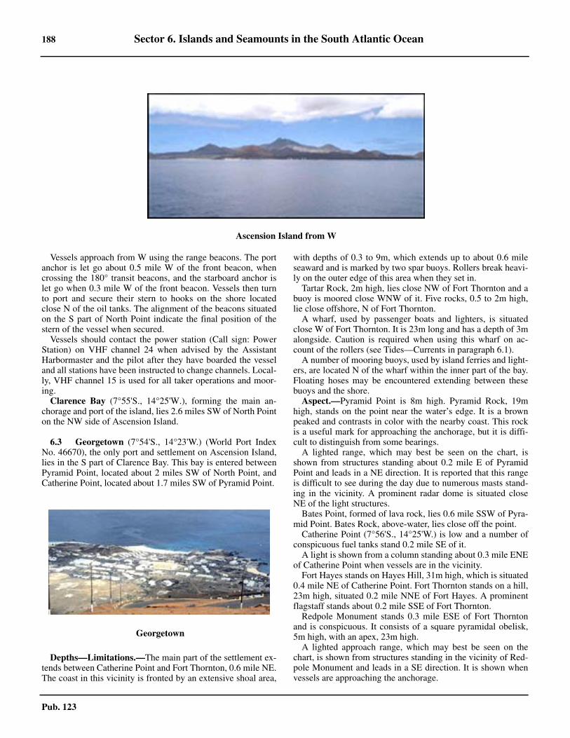
188 Sector 6. Islands and Seamounts in the South Atlantic Ocean
Pub. 123
6.2 Vessels approach from W using the range beacons. The portanchor is let go about 0.5 mile W of the front beacon, whencrossing the 180° transit beacons, and the starboard anchor islet go when 0.3 mile W of the front beacon. Vessels then turnto port and secure their stern to hooks on the shore locatedclose N of the oil tanks. The alignment of the beacons situatedon the S part of North Point indicate the final position of thestern of the vessel when secured.6.2 Vessels should contact the power station (Call sign: PowerStation) on VHF channel 24 when advised by the AssistantHarbormaster and the pilot after they have boarded the vesseland all stations have been instructed to change channels. Local-ly, VHF channel 15 is used for all taker operations and moor-ing.
Clarence Bay (7°55'S., 14°25'W.), forming the main an-chorage and port of the island, lies 2.6 miles SW of North Pointon the NW side of Ascension Island.
6.3 Georgetown (7°54'S., 14°23'W.) (World Port IndexNo. 46670), the only port and settlement on Ascension Island,lies in the S part of Clarence Bay. This bay is entered betweenPyramid Point, located about 2 miles SW of North Point, andCatherine Point, located about 1.7 miles SW of Pyramid Point.
6.3 Depths—Limitations.—The main part of the settlement ex-tends between Catherine Point and Fort Thornton, 0.6 mile NE.The coast in this vicinity is fronted by an extensive shoal area,
with depths of 0.3 to 9m, which extends up to about 0.6 mileseaward and is marked by two spar buoys. Rollers break heavi-ly on the outer edge of this area when they set in.6.3 Tartar Rock, 2m high, lies close NW of Fort Thornton and abuoy is moored close WNW of it. Five rocks, 0.5 to 2m high,lie close offshore, N of Fort Thornton.6.3 A wharf, used by passenger boats and lighters, is situatedclose W of Fort Thornton. It is 23m long and has a depth of 3malongside. Caution is required when using this wharf on ac-count of the rollers (see Tides—Currents in paragraph 6.1).6.3 A number of mooring buoys, used by island ferries and light-ers, are located N of the wharf within the inner part of the bay.Floating hoses may be encountered extending between thesebuoys and the shore.6.3 Aspect.—Pyramid Point is 8m high. Pyramid Rock, 19mhigh, stands on the point near the water’s edge. It is a brownpeaked and contrasts in color with the nearby coast. This rockis a useful mark for approaching the anchorage, but it is diffi-cult to distinguish from some bearings.6.3 A lighted range, which may best be seen on the chart, isshown from structures standing about 0.2 mile E of PyramidPoint and leads in a NE direction. It is reported that this rangeis difficult to see during the day due to numerous masts stand-ing in the vicinity. A prominent radar dome is situated closeNE of the light structures.6.3 Bates Point, formed of lava rock, lies 0.6 mile SSW of Pyra-mid Point. Bates Rock, above-water, lies close off the point. 6.3 Catherine Point (7°56'S., 14°25'W.) is low and a number ofconspicuous fuel tanks stand 0.2 mile SE of it.6.3 A light is shown from a column standing about 0.3 mile ENEof Catherine Point when vessels are in the vicinity.6.3 Fort Hayes stands on Hayes Hill, 31m high, which is situated0.4 mile NE of Catherine Point. Fort Thornton stands on a hill,23m high, situated 0.2 mile NNE of Fort Hayes. A prominentflagstaff stands about 0.2 mile SSE of Fort Thornton.6.3 Redpole Monument stands 0.3 mile ESE of Fort Thorntonand is conspicuous. It consists of a square pyramidal obelisk,5m high, with an apex, 23m high.6.3 A lighted approach range, which may best be seen on thechart, is shown from structures standing in the vicinity of Red-pole Monument and leads in a SE direction. It is shown whenvessels are approaching the anchorage.
6.2Ascension Island from W
6.3Georgetown
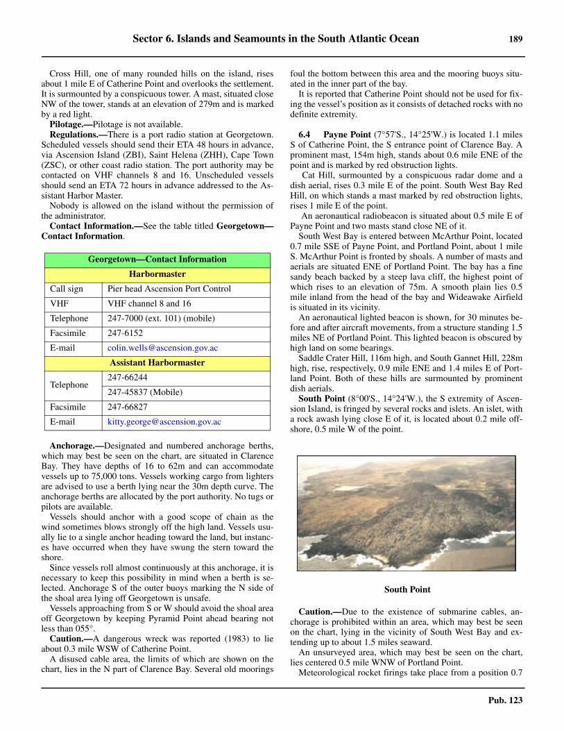
Sector 6. Islands and Seamounts in the South Atlantic Ocean 189
Pub. 123
6.3 Cross Hill, one of many rounded hills on the island, risesabout 1 mile E of Catherine Point and overlooks the settlement.It is surmounted by a conspicuous tower. A mast, situated closeNW of the tower, stands at an elevation of 279m and is markedby a red light.6.3 Pilotage.—Pilotage is not available.6.3 Regulations.—There is a port radio station at Georgetown.Scheduled vessels should send their ETA 48 hours in advance,via Ascension Island (ZBI), Saint Helena (ZHH), Cape Town(ZSC), or other coast radio station. The port authority may becontacted on VHF channels 8 and 16. Unscheduled vesselsshould send an ETA 72 hours in advance addressed to the As-sistant Harbor Master.6.3 Nobody is allowed on the island without the permission ofthe administrator. 6.3 Contact Information.—See the table titled Georgetown—Contact Information.
6.3 Anchorage.—Designated and numbered anchorage berths,which may best be seen on the chart, are situated in ClarenceBay. They have depths of 16 to 62m and can accommodatevessels up to 75,000 tons. Vessels working cargo from lightersare advised to use a berth lying near the 30m depth curve. Theanchorage berths are allocated by the port authority. No tugs orpilots are available.6.3 Vessels should anchor with a good scope of chain as thewind sometimes blows strongly off the high land. Vessels usu-ally lie to a single anchor heading toward the land, but instanc-es have occurred when they have swung the stern toward theshore.6.3 Since vessels roll almost continuously at this anchorage, it isnecessary to keep this possibility in mind when a berth is se-lected. Anchorage S of the outer buoys marking the N side ofthe shoal area lying off Georgetown is unsafe.6.3 Vessels approaching from S or W should avoid the shoal areaoff Georgetown by keeping Pyramid Point ahead bearing notless than 055°. 6.3 Caution.—A dangerous wreck was reported (1983) to lieabout 0.3 mile WSW of Catherine Point.6.3 A disused cable area, the limits of which are shown on thechart, lies in the N part of Clarence Bay. Several old moorings
foul the bottom between this area and the mooring buoys situ-ated in the inner part of the bay.6.3 It is reported that Catherine Point should not be used for fix-ing the vessel’s position as it consists of detached rocks with nodefinite extremity.
6.4 Payne Point (7°57'S., 14°25'W.) is located 1.1 milesS of Catherine Point, the S entrance point of Clarence Bay. Aprominent mast, 154m high, stands about 0.6 mile ENE of thepoint and is marked by red obstruction lights.
Cat Hill, surmounted by a conspicuous radar dome and adish aerial, rises 0.3 mile E of the point. South West Bay RedHill, on which stands a mast marked by red obstruction lights,rises 1 mile E of the point.
An aeronautical radiobeacon is situated about 0.5 mile E ofPayne Point and two masts stand close NE of it.6.4 South West Bay is entered between McArthur Point, located0.7 mile SSE of Payne Point, and Portland Point, about 1 mileS. McArthur Point is fronted by shoals. A number of masts andaerials are situated ENE of Portland Point. The bay has a finesandy beach backed by a steep lava cliff, the highest point ofwhich rises to an elevation of 75m. A smooth plain lies 0.5mile inland from the head of the bay and Wideawake Airfieldis situated in its vicinity.6.4 An aeronautical lighted beacon is shown, for 30 minutes be-fore and after aircraft movements, from a structure standing 1.5miles NE of Portland Point. This lighted beacon is obscured byhigh land on some bearings. 6.4 Saddle Crater Hill, 116m high, and South Gannet Hill, 228mhigh, rise, respectively, 0.9 mile ENE and 1.4 miles E of Port-land Point. Both of these hills are surmounted by prominentdish aerials. 6.4 South Point (8°00'S., 14°24'W.), the S extremity of Ascen-sion Island, is fringed by several rocks and islets. An islet, witha rock awash lying close E of it, is located about 0.2 mile off-shore, 0.5 mile W of the point.
6.4 Caution.—Due to the existence of submarine cables, an-chorage is prohibited within an area, which may best be seenon the chart, lying in the vicinity of South West Bay and ex-tending up to about 1.5 miles seaward.6.4 An unsurveyed area, which may best be seen on the chart,lies centered 0.5 mile WNW of Portland Point.6.4 Meteorological rocket firings take place from a position 0.7
Georgetown—Contact Information
Harbormaster
Call sign Pier head Ascension Port Control
VHF VHF channel 8 and 16
Telephone 247-7000 (ext. 101) (mobile)
Facsimile 247-6152
E-mail [email protected]
Assistant Harbormaster
Telephone247-66244
247-45837 (Mobile)
Facsimile 247-66827
E-mail [email protected]
6.4South Point
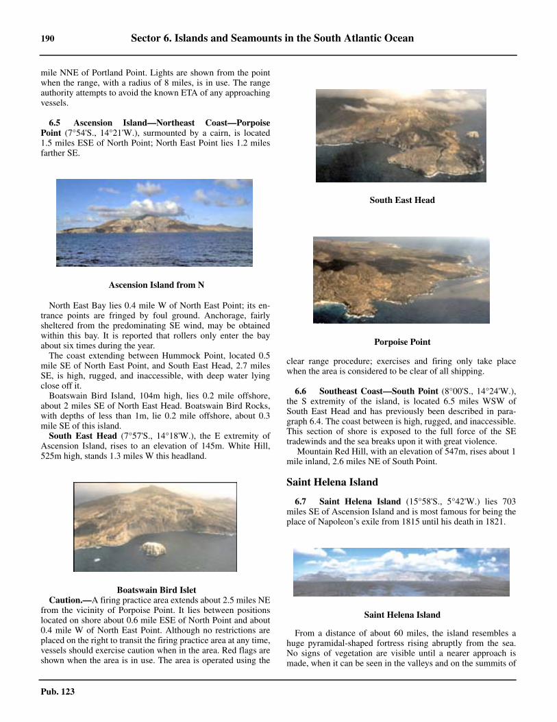
190 Sector 6. Islands and Seamounts in the South Atlantic Ocean
Pub. 123
mile NNE of Portland Point. Lights are shown from the pointwhen the range, with a radius of 8 miles, is in use. The rangeauthority attempts to avoid the known ETA of any approachingvessels.
6.5 Ascension Island—Northeast Coast—PorpoisePoint (7°54'S., 14°21'W.), surmounted by a cairn, is located1.5 miles ESE of North Point; North East Point lies 1.2 milesfarther SE.
North East Bay lies 0.4 mile W of North East Point; its en-trance points are fringed by foul ground. Anchorage, fairlysheltered from the predominating SE wind, may be obtainedwithin this bay. It is reported that rollers only enter the bayabout six times during the year.6.5 The coast extending between Hummock Point, located 0.5mile SE of North East Point, and South East Head, 2.7 milesSE, is high, rugged, and inaccessible, with deep water lyingclose off it.6.5 Boatswain Bird Island, 104m high, lies 0.2 mile offshore,about 2 miles SE of North East Head. Boatswain Bird Rocks,with depths of less than 1m, lie 0.2 mile offshore, about 0.3mile SE of this island.6.5 South East Head (7°57'S., 14°18'W.), the E extremity ofAscension Island, rises to an elevation of 145m. White Hill,525m high, stands 1.3 miles W this headland.
6.5 Caution.—A firing practice area extends about 2.5 miles NEfrom the vicinity of Porpoise Point. It lies between positionslocated on shore about 0.6 mile ESE of North Point and about0.4 mile W of North East Point. Although no restrictions areplaced on the right to transit the firing practice area at any time,vessels should exercise caution when in the area. Red flags areshown when the area is in use. The area is operated using the
clear range procedure; exercises and firing only take placewhen the area is considered to be clear of all shipping.
6.6 Southeast Coast—South Point (8°00'S., 14°24'W.),the S extremity of the island, is located 6.5 miles WSW ofSouth East Head and has previously been described in para-graph 6.4. The coast between is high, rugged, and inaccessible.This section of shore is exposed to the full force of the SEtradewinds and the sea breaks upon it with great violence.
Mountain Red Hill, with an elevation of 547m, rises about 1mile inland, 2.6 miles NE of South Point.
Saint Helena Island
6.7 Saint Helena Island (15°58'S., 5°42'W.) lies 703miles SE of Ascension Island and is most famous for being theplace of Napoleon’s exile from 1815 until his death in 1821.
From a distance of about 60 miles, the island resembles ahuge pyramidal-shaped fortress rising abruptly from the sea.No signs of vegetation are visible until a nearer approach ismade, when it can be seen in the valleys and on the summits of
6.5Ascension Island from N
6.5Boatswain Bird Islet
6.5South East Head
6.5Porpoise Point
6.7Saint Helena Island
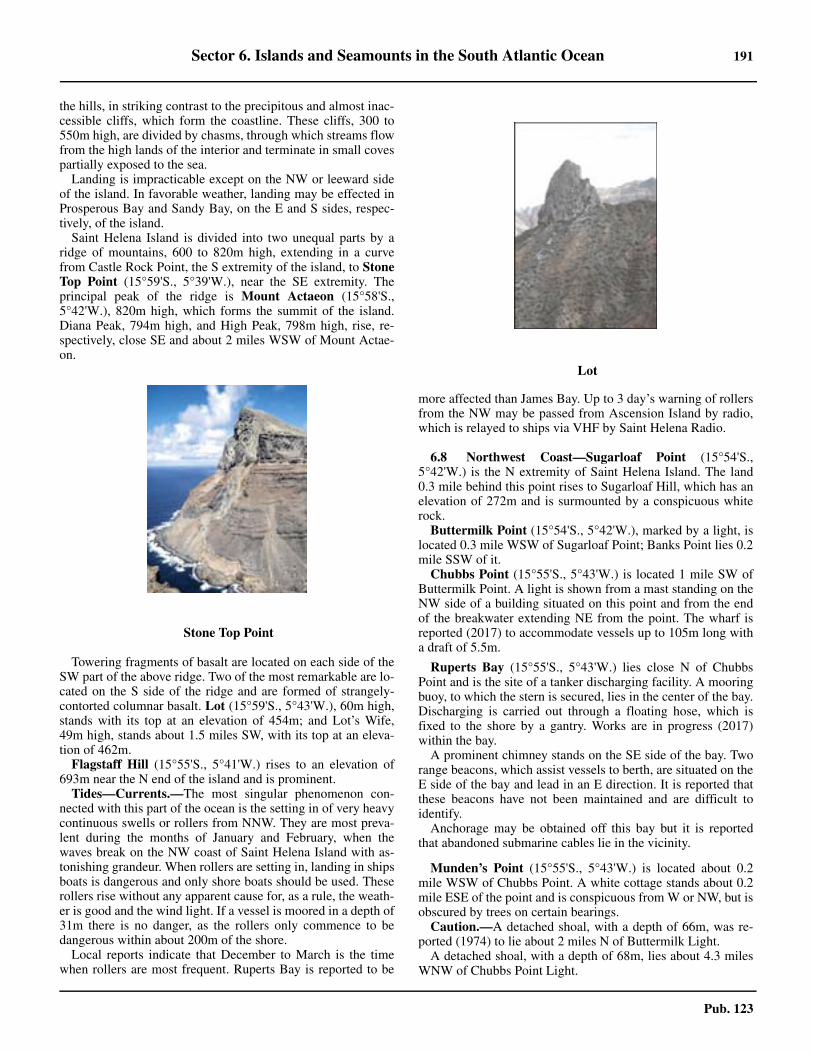
Sector 6. Islands and Seamounts in the South Atlantic Ocean 191
Pub. 123
the hills, in striking contrast to the precipitous and almost inac-cessible cliffs, which form the coastline. These cliffs, 300 to550m high, are divided by chasms, through which streams flowfrom the high lands of the interior and terminate in small covespartially exposed to the sea. 6.7 Landing is impracticable except on the NW or leeward sideof the island. In favorable weather, landing may be effected inProsperous Bay and Sandy Bay, on the E and S sides, respec-tively, of the island.6.7 Saint Helena Island is divided into two unequal parts by aridge of mountains, 600 to 820m high, extending in a curvefrom Castle Rock Point, the S extremity of the island, to StoneTop Point (15°59'S., 5°39'W.), near the SE extremity. Theprincipal peak of the ridge is Mount Actaeon (15°58'S.,5°42'W.), 820m high, which forms the summit of the island.Diana Peak, 794m high, and High Peak, 798m high, rise, re-spectively, close SE and about 2 miles WSW of Mount Actae-on.
Towering fragments of basalt are located on each side of theSW part of the above ridge. Two of the most remarkable are lo-cated on the S side of the ridge and are formed of strangely-contorted columnar basalt. Lot (15°59'S., 5°43'W.), 60m high,stands with its top at an elevation of 454m; and Lot’s Wife,49m high, stands about 1.5 miles SW, with its top at an eleva-tion of 462m.
Flagstaff Hill (15°55'S., 5°41'W.) rises to an elevation of693m near the N end of the island and is prominent.
Tides—Currents.—The most singular phenomenon con-nected with this part of the ocean is the setting in of very heavycontinuous swells or rollers from NNW. They are most preva-lent during the months of January and February, when thewaves break on the NW coast of Saint Helena Island with as-tonishing grandeur. When rollers are setting in, landing in shipsboats is dangerous and only shore boats should be used. Theserollers rise without any apparent cause for, as a rule, the weath-er is good and the wind light. If a vessel is moored in a depth of31m there is no danger, as the rollers only commence to bedangerous within about 200m of the shore.6.7 Local reports indicate that December to March is the timewhen rollers are most frequent. Ruperts Bay is reported to be
more affected than James Bay. Up to 3 day’s warning of rollersfrom the NW may be passed from Ascension Island by radio,which is relayed to ships via VHF by Saint Helena Radio.
6.8 Northwest Coast—Sugarloaf Point (15°54'S.,5°42'W.) is the N extremity of Saint Helena Island. The land0.3 mile behind this point rises to Sugarloaf Hill, which has anelevation of 272m and is surmounted by a conspicuous whiterock.6.8 Buttermilk Point (15°54'S., 5°42'W.), marked by a light, islocated 0.3 mile WSW of Sugarloaf Point; Banks Point lies 0.2mile SSW of it. 6.8 Chubbs Point (15°55'S., 5°43'W.) is located 1 mile SW ofButtermilk Point. A light is shown from a mast standing on theNW side of a building situated on this point and from the endof the breakwater extending NE from the point. The wharf isreported (2017) to accommodate vessels up to 105m long witha draft of 5.5m.
6.8 Ruperts Bay (15°55'S., 5°43'W.) lies close N of ChubbsPoint and is the site of a tanker discharging facility. A mooringbuoy, to which the stern is secured, lies in the center of the bay.Discharging is carried out through a floating hose, which isfixed to the shore by a gantry. Works are in progress (2017)within the bay. 6.8 A prominent chimney stands on the SE side of the bay. Tworange beacons, which assist vessels to berth, are situated on theE side of the bay and lead in an E direction. It is reported thatthese beacons have not been maintained and are difficult toidentify.6.8 Anchorage may be obtained off this bay but it is reportedthat abandoned submarine cables lie in the vicinity.
6.8 Munden’s Point (15°55'S., 5°43'W.) is located about 0.2mile WSW of Chubbs Point. A white cottage stands about 0.2mile ESE of the point and is conspicuous from W or NW, but isobscured by trees on certain bearings. 6.8 Caution.—A detached shoal, with a depth of 66m, was re-ported (1974) to lie about 2 miles N of Buttermilk Light.6.8 A detached shoal, with a depth of 68m, lies about 4.3 milesWNW of Chubbs Point Light.
6.7Stone Top Point
6.7Lot

192 Sector 6. Islands and Seamounts in the South Atlantic Ocean
Pub. 123
6.9 Jamestown (15°55'S., 5°43'W.) (World Port IndexNo. 46690), the capital of Saint Helena Island, is situated at thehead of James Bay. The bay is entered between Munden’sPoint and Ladder Hill Point, 0.4 mile SSW. It provides an an-chorage where cargo is worked from lighters. 6.9 James Bay and Ruperts Bay, previously described in para-graph 6.8, afford the only landing places on the island. Landingin ship’s boats can usually be carried out at the wharf in JamesBay. However, a dangerous swell can become heavy at times,especially during the months of January and February. Duringperiods of heavy swell, it is better to lie off the landing placeand make use of the shore boats to effect landing ashore. 6.9 Deep valleys descend between steep rocky hills to the headsof James Bay and Ruperts Bay. The two valleys are separatedby a ridge rising from Munden’s Point which attains a height of283m. James Valley, descending to James Bay, in which standsthe settlement of Jamestown, is bordered on its SW side by aridge which descends from High Knoll. The summit of theridge is located 1 mile S of James Bay. This ridge extends toLadder Hill, where it terminates abruptly in a stupendous per-pendicular cliff facing the sea. Ruperts Valley, descending toRuperts Bay, is bordered on its NE side by Ruperts Hill, whichattains a height of 411m.
6.9 Winds—Weather.—The SE wind is prevalent in James Val-
ley and Rupert Valley, but where there is high ground the pre-vailing wind is deflected so that a light NE wind blows alongthe NW side of the island. The interaction of this wind and themain SE wind causes a confused sea in the vicinity of RupertsBay and Sugarloaf Point.6.9 Tides—Currents.—The tidal rise at Saint Helena Island is0.9m at MHWS and 0.7m at MHWN. The tidal current inJames Bay is reported to set N during the rising tide and SWduring the falling tide, although a vessel reported (1984) expe-riencing no tidal currents while at anchor.6.9 Depths—Limitations.—A concrete wharf, 91m long, is sit-uated on the NE side of James Bay and has a depth of 2.7malongside its outer end. The wharf is equipped with a crane forthe discharge of lighters; steps at its N end are used by harborlaunches to land passengers. 6.9 A number of lighter and small craft moorings are situatedwithin James Bay.6.9 Dangerous wrecks lie within James Bay about 150m and250m NNE of Ladder Hill Point.6.9 A fish haven, which may best be seen on the chart, lies about0.4 mile W of Ladder Hill Point.
6.9 A large wreck area, with a least depth of 17.8m, lies about0.4 mile NNW of Ladder Hill Point and a foul area, in whichammunition has been dumped, is located close NE of it.6.9 Anchorage can be taken as convenient, in depths of 27 to51m, between 0.2 mile and 0.4 mile offshore, anywhere alongthe coast between Ladder Hill Point and Lemon Valley Bay,1.5 miles SW. However, anchorage off James Bay should notbe taken in depths of less than 30m due to the rollers andground swell (see Anchorage).6.9 Aspect.—A lighted range, which may best be seen on thechart, is shown from beacons standing on Ladder Hill. It leadsin a S direction and indicates the approach into James Bay.6.9 Although these range beacons are clearly visible by day, thevertical difference in height between them reduces their transitaccuracy. Only the lower beacon can be easily identified. Theupper beacon is situated close E of a prominent flagstaff.6.9 An old artillery barracks stands on the summit of LadderHill. The tower of Saint James Church, standing at the head ofJames Bay, is conspicuous. A white monument, conspicuousfrom seaward, is situated on the shore close NW of this church.
6.9Approach to James Bay
6.9 Jamestown Harbor
6.9Approach to Jamestown
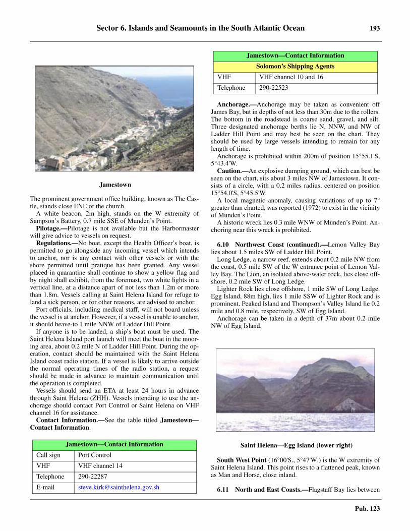
Sector 6. Islands and Seamounts in the South Atlantic Ocean 193
Pub. 123
The prominent government office building, known as The Cas-tle, stands close ENE of the church. 6.9 A white beacon, 2m high, stands on the W extremity ofSampson’s Battery, 0.7 mile SSE of Munden’s Point.6.9 Pilotage.—Pilotage is not available but the Harbormasterwill give advice to vessels on request.6.9 Regulations.—No boat, except the Health Officer’s boat, ispermitted to go alongside any incoming vessel which intendsto anchor, nor is any contact with other vessels or with theshore permitted until pratique has been granted. Any vesselplaced in quarantine shall continue to show a yellow flag andby night shall exhibit, from the foremast, two white lights in avertical line, at a distance apart of not less than 1.2m or morethan 1.8m. Vessels calling at Saint Helena Island for refuge toland a sick person, or for other reasons, are advised to anchor.6.9 Port officials, including medical staff, will not board unlessthe vessel is at anchor. However, if a vessel is unable to anchor,it should heave-to 1 mile NNW of Ladder Hill Point.6.9 If anyone is to be landed, a ship’s boat must be used. TheSaint Helena Island port launch will meet the boat in the moor-ing area, about 0.2 mile N of Ladder Hill Point. During the op-eration, contact should be maintained with the Saint HelenaIsland coast radio station. If a vessel is likely to arrive outsidethe normal operating times of the radio station, a requestshould be made in advance to maintain communication untilthe operation is completed.6.9 Vessels should send an ETA at least 24 hours in advancethrough Saint Helena (ZHH). Vessels intending to use the an-chorage should contact Port Control or Saint Helena on VHFchannel 16 for assistance.6.9 Contact Information.—See the table titled Jamestown—Contact Information.
6.9 Anchorage.—Anchorage may be taken as convenient offJames Bay, but in depths of not less than 30m due to the rollers.The bottom in the roadstead is coarse sand, gravel, and silt.Three designated anchorage berths lie N, NNW, and NW ofLadder Hill Point and may best be seen on the chart. Theyshould be used by large vessels intending to remain for anylength of time. 6.9 Anchorage is prohibited within 200m of position 15°55.1'S,5°43.4'W.6.9 Caution.—An explosive dumping ground, which can best beseen on the chart, sits about 3 miles NW of Jamestown. It con-sists of a circle, with a 0.2 miles radius, centered on position15°54.0'S, 5°45.5'W. 6.9 A local magnetic anomaly, causing variations of up to 7°greater than charted, was reported (1972) to exist in the vicinityof Munden’s Point.6.9 A historic wreck lies 0.3 mile WNW of Munden’s Point. An-choring near this wreck is prohibited.
6.10 Northwest Coast (continued).—Lemon Valley Baylies about 1.5 miles SW of Ladder Hill Point.6.10 Long Ledge, a narrow reef, extends about 0.2 mile NW fromthe coast, 0.5 mile SW of the W entrance point of Lemon Val-ley Bay. The Lion, an isolated above-water rock, lies close off-shore, 0.2 mile SW of Long Ledge.6.10 Lighter Rock lies close offshore, 1 mile SW of Long Ledge.Egg Island, 88m high, lies 1 mile SSW of Lighter Rock and isprominent. Peaked Island and Thompson’s Valley Island lie 0.2mile and 0.8 mile, respectively, SW of Egg Island.6.10 Anchorage can be taken in a depth of 37m about 0.2 mileNW of Egg Island.
6.10 South West Point (16°00'S., 5°47'W.) is the W extremity ofSaint Helena Island. This point rises to a flattened peak, knownas Man and Horse, close inland.
6.11 North and East Coasts.—Flagstaff Bay lies between
6.9Jamestown
Jamestown—Contact Information
Call sign Port Control
VHF VHF channel 14
Telephone 290-22287
E-mail [email protected]
Solomon’s Shipping Agents
VHF VHF channel 10 and 16
Telephone 290-22523
6.10Saint Helena—Egg Island (lower right)
Jamestown—Contact Information
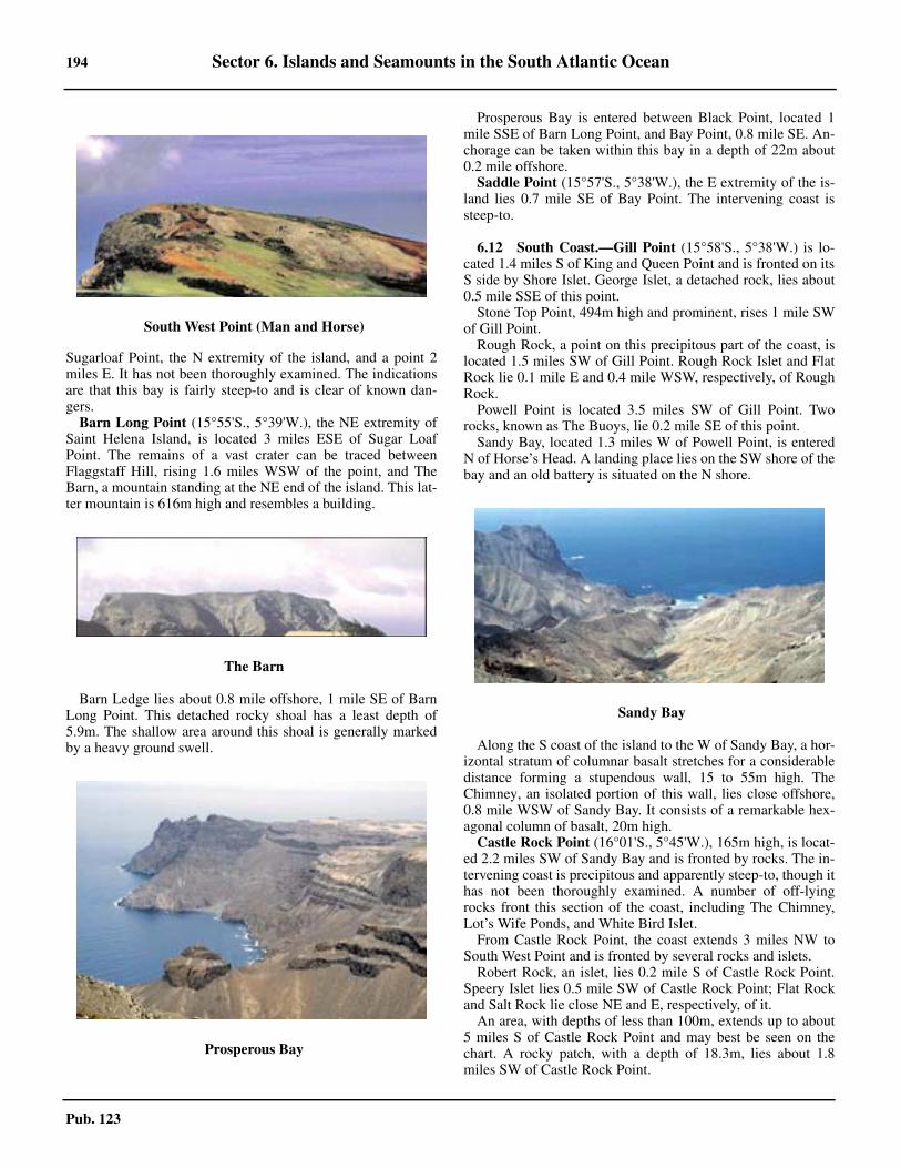
194 Sector 6. Islands and Seamounts in the South Atlantic Ocean
Pub. 123
Sugarloaf Point, the N extremity of the island, and a point 2miles E. It has not been thoroughly examined. The indicationsare that this bay is fairly steep-to and is clear of known dan-gers.
Barn Long Point (15°55'S., 5°39'W.), the NE extremity ofSaint Helena Island, is located 3 miles ESE of Sugar LoafPoint. The remains of a vast crater can be traced betweenFlaggstaff Hill, rising 1.6 miles WSW of the point, and TheBarn, a mountain standing at the NE end of the island. This lat-ter mountain is 616m high and resembles a building.
Barn Ledge lies about 0.8 mile offshore, 1 mile SE of BarnLong Point. This detached rocky shoal has a least depth of5.9m. The shallow area around this shoal is generally markedby a heavy ground swell.
6.11 Prosperous Bay is entered between Black Point, located 1mile SSE of Barn Long Point, and Bay Point, 0.8 mile SE. An-chorage can be taken within this bay in a depth of 22m about0.2 mile offshore. 6.11 Saddle Point (15°57'S., 5°38'W.), the E extremity of the is-land lies 0.7 mile SE of Bay Point. The intervening coast issteep-to.
6.12 South Coast.—Gill Point (15°58'S., 5°38'W.) is lo-cated 1.4 miles S of King and Queen Point and is fronted on itsS side by Shore Islet. George Islet, a detached rock, lies about0.5 mile SSE of this point.
Stone Top Point, 494m high and prominent, rises 1 mile SWof Gill Point.
Rough Rock, a point on this precipitous part of the coast, islocated 1.5 miles SW of Gill Point. Rough Rock Islet and FlatRock lie 0.1 mile E and 0.4 mile WSW, respectively, of RoughRock.
Powell Point is located 3.5 miles SW of Gill Point. Tworocks, known as The Buoys, lie 0.2 mile SE of this point.
Sandy Bay, located 1.3 miles W of Powell Point, is enteredN of Horse’s Head. A landing place lies on the SW shore of thebay and an old battery is situated on the N shore.
Along the S coast of the island to the W of Sandy Bay, a hor-izontal stratum of columnar basalt stretches for a considerabledistance forming a stupendous wall, 15 to 55m high. TheChimney, an isolated portion of this wall, lies close offshore,0.8 mile WSW of Sandy Bay. It consists of a remarkable hex-agonal column of basalt, 20m high.
Castle Rock Point (16°01'S., 5°45'W.), 165m high, is locat-ed 2.2 miles SW of Sandy Bay and is fronted by rocks. The in-tervening coast is precipitous and apparently steep-to, though ithas not been thoroughly examined. A number of off-lyingrocks front this section of the coast, including The Chimney,Lot’s Wife Ponds, and White Bird Islet.6.12 From Castle Rock Point, the coast extends 3 miles NW toSouth West Point and is fronted by several rocks and islets.6.12 Robert Rock, an islet, lies 0.2 mile S of Castle Rock Point.Speery Islet lies 0.5 mile SW of Castle Rock Point; Flat Rockand Salt Rock lie close NE and E, respectively, of it.6.12 An area, with depths of less than 100m, extends up to about5 miles S of Castle Rock Point and may best be seen on thechart. A rocky patch, with a depth of 18.3m, lies about 1.8miles SW of Castle Rock Point.
6.10South West Point (Man and Horse)
6.11The Barn
6.11Prosperous Bay
6.12Sandy Bay

Sector 6. Islands and Seamounts in the South Atlantic Ocean 195
Pub. 123
6.12 Speery Ledge, an isolated reef with reported (1977) depthsof 3 to 7.3m, lies about 1.3 miles S of Castle Rock Point.
Off-lying Seamounts
6.13 Grattan Seamount (9°45'S., 12°45'W.), with a depthof 70m, lies 140 miles SE of Ascension Island and a depth of213m lies 40 miles E of it.6.13 Pillsbury Seamount (0°30'N., 17°00'W.), with a depth of881m, lies 530 miles NNW of Ascension Island.6.13 Cardno Seamount (12°53'S., 6°08'W.), with a depth of77m, lies 180 miles N of Saint Helena Island. A seamount,with a depth of 115m, lies 90 miles NNE of Cardno Seamount.Another seamount, with a depth of 152m, lies 720 miles NE ofCardno Seamount.6.13 Bonaparte Seamount (15°45'S., 6°52'W.), with a depth of105m, lies 70 miles WNW of Saint Helena Island. 6.13 Dampier Seamount (11°09'S., 0°28'W.), with a depth of594m, lies 430 miles NE of Saint Helena Island.6.13 Kutuzov Seamount, with a depth of 410m, lies 155 milesWNW of Saint Helena Island.6.13 An unnamed seamount, with a depth of 515m, lies 170 milesNW of Saint Helena Island and about midway between CardnoSeamount and Kutuzov Seamount.
An unnamed seamount, with a reported depth of 152m, liesin position 3°02'S, 0°45'E, about 960 miles ENE of AscensionIsland.
The Tristan da Cunha Group
6.14 The Tristan da Cunha Group lies 1,320 miles SW ofSaint Helena Island and consists of five islands, as follows:
1. Tristan da Cunha.2. Inaccessible Island.3. Nightingale Island.4. Middle Island.5. Stoltenhoff Island.
Tristan da Cunha (37°06'S., 12°17'W.) is the largest, withInaccessible Island, the second largest, lying 18 miles SW of it.Nightingale Island, Middle Island, and Stoltenhoff Island lieclose together, about 16 miles SSW of Tristan Island and 10miles SE of Inaccessible Island.
The group is of volcanic origin. There was a volcanic erup-
tion on Tristan Island in 1961 and the entire population of theisland was temporarily evacuated to the United Kingdom. Mostislanders returned in 1963.6.14 The current generally sets NE, but other sets are common. Avelocity of 2 knots may be attained.6.14 At Tristan Island, the rollers may occur at all times duringwinds or calm. They are always heavier in calms. Althoughrollers are more frequent during the winter months, the heavi-est rollers occur in December, January, and February, three ofthe finest months, when they sometimes last 3 or 4 days; thisalso applies to Gough Island and the other islands in the South-ern Hemisphere, according to the account of whalers.6.14 Good radar returns have been reported from the Tristan daCunha Group at a distance of 24 miles. Tristan Island may bedetected by radar at about 95 miles, and Nightingale Island andInaccessible Island at about 80 miles.
6.15 Tristan da Cunha (37°06'S., 12°17'W.), about 6miles in diameter, takes the form of a truncated cone, with itssides rising at an angle of about 45° to Queen Mary’s Peak, acentral peak 2,060m high. The sides of the island consist ofwalls of inaccessible cliffs, 300 to 610m high, rising directlyfrom the sea, except on the NW side. On the latter side there is,in front of the cliffs, a comparatively low and grassy slope, 30to 60m high, which terminates in Herald Point, the NW ex-tremity of the island. The sides of the mountain mass as far asthe central dome are covered with brushwood, intermixed withferns and long grass. At elevations above 1,500m, which coin-cides with the normal upper level of the clouds, the mountainconsists of loose stones and volcanic rubble, with occasionalrocks and boulders.
6.15 Winds—Weather.—Wind from a NW direction has beenobserved to eddy around the island and to increase in strengthas it does so, backing to NW again about 2 miles SE of the is-land. According to the islanders, this is a common phenome-non. 6.15 Thunderstorms are rare, but violent storms occur three orfour times a year. Between June and October, the upper part ofThe Peak is often snow-covered, and sleet, snow, and hail areoccasionally experienced at sea level. Mariners are advised toconsult the islanders concerning the weather, as they are re-ported to be able to predict changes within a very short time oftheir taking place when normal signs give no indication of theirapproach.6.15 Depths—Limitations.—The island is surrounded by deepwater except on the N and SW coasts, where shelves extend
6.12Speery Islet
6.15Tristan da Cunha
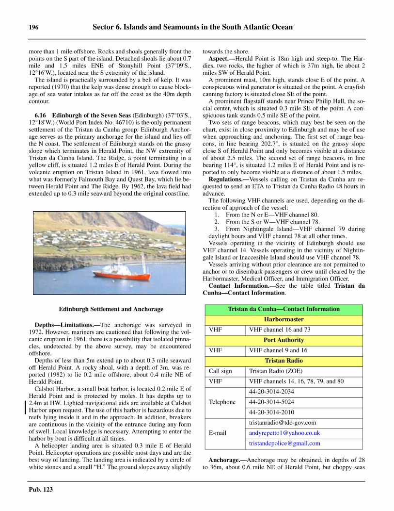
196 Sector 6. Islands and Seamounts in the South Atlantic Ocean
Pub. 123
more than 1 mile offshore. Rocks and shoals generally front thepoints on the S part of the island. Detached shoals lie about 0.7mile and 1.5 miles ENE of Stonyhill Point (37°09'S.,12°16'W.), located near the S extremity of the island. 6.15 The island is practically surrounded by a belt of kelp. It wasreported (1970) that the kelp was dense enough to cause block-age of sea water intakes as far off the coast as the 40m depthcontour.
6.16 Edinburgh of the Seven Seas (Edinburgh) (37°03'S.,12°18'W.) (World Port Index No. 46710) is the only permanentsettlement of the Tristan da Cunha group. Edinburgh Anchor-age serves as the primary anchorage for the island and lies offthe N coast. The settlement of Edinburgh stands on the grassyslope which terminates in Herald Point, the NW extremity ofTristan da Cunha Island. The Ridge, a point terminating in ayellow cliff, is situated 1.2 miles E of Herald Point. During thevolcanic eruption on Tristan Island in 1961, lava flowed intowhat was formerly Falmouth Bay and Quest Bay, which lie be-tween Herald Point and The Ridge. By 1962, the lava field hadextended up to 0.3 mile seaward beyond the original coastline.
6.16 Depths—Limitations.—The anchorage was surveyed in1972. However, mariners are cautioned that following the vol-canic eruption in 1961, there is a possibility that isolated pinna-cles, undetected by the above survey, may be encounteredoffshore.6.16 Depths of less than 5m extend up to about 0.3 mile seawardoff Herald Point. A rocky shoal, with a depth of 3m, was re-ported (1982) to lie 0.2 mile offshore, about 0.4 mile NE ofHerald Point. 6.16 Calshot Harbor, a small boat harbor, is located 0.2 mile E ofHerald Point and is protected by moles. It has depths up to2.4m at HW. Lighted navigational aids are available at CalshotHarbor upon request. The use of this harbor is hazardous due toreefs lying inside it and in the approach. In addition, breakersare continuous in the vicinity of the entrance during any formof swell. Local knowledge is necessary. Attempting to enter theharbor by boat is difficult at all times. 6.16 A helicopter landing area is situated 0.3 mile E of HeraldPoint. Helicopter operations are possible most days and are thebest way of landing. The landing area is indicated by a circle ofwhite stones and a small “H.” The ground slopes away slightly
towards the shore.6.16 Aspect.—Herald Point is 18m high and steep-to. The Har-dies, two rocks, the higher of which is 37m high, lie about 2miles SW of Herald Point.6.16 A prominent mast, 10m high, stands close E of the point. Aconspicuous wind generator is situated on the point. A crayfishcanning factory is situated close SE of the point.6.16 A prominent flagstaff stands near Prince Philip Hall, the so-cial center, which is situated 0.3 mile SE of the point. A con-spicuous tank stands 0.5 mile SE of the point.6.16 Two sets of range beacons, which may best be seen on thechart, exist in close proximity to Edinburgh and may be of usewhen approaching and anchoring. The first set of range bea-cons, in line bearing 202.7°, is situated on the grassy slopeclose S of Herald Point and only becomes visible at a distanceof about 2.5 miles. The second set of range beacons, in linebearing 114°, is situated 1.2 miles E of Herald Point and is re-ported to only become visible at a distance of about 1.5 miles. 6.16 Regulations.—Vessels calling on Tristan da Cunha are re-quested to send an ETA to Tristan da Cunha Radio 48 hours inadvance. 6.16 The following VHF channels are used, depending on the di-rection of approach of the vessel:
1. From the N or E—VHF channel 80.2. From the S or W—VHF channel 78.3. From Nightingale Island—VHF channel 79 during
daylight hours and VHF channel 78 at all other times.6.16 Vessels operating in the vicinity of Edinburgh should useVHF channel 14. Vessels operating in the vicinity of Nightin-gale Island or Inaccesible Island should use VHF channel 78. 6.16 Vessels arriving without prior clearance are not permitted toanchor or to disembark passengers or crew until cleared by theHarbormaster, Medical Officer, and Immigration Officer.6.16 Contact Information.—See the table titled Tristan daCunha—Contact Information.
6.16 Anchorage.—Anchorage may be obtained, in depths of 28to 36m, about 0.6 mile NE of Herald Point, but choppy seas
6.16Edinburgh Settlement and Anchorage Tristan da Cunha—Contact Information
Harbormaster
VHF VHF channel 16 and 73
Port Authority
VHF VHF channel 9 and 16
Tristan Radio
Call sign Tristan Radio (ZOE)
VHF VHF channels 14, 16, 78, 79, and 80
Telephone
44-20-3014-2034
44-20-3014-5024
44-20-3014-2010
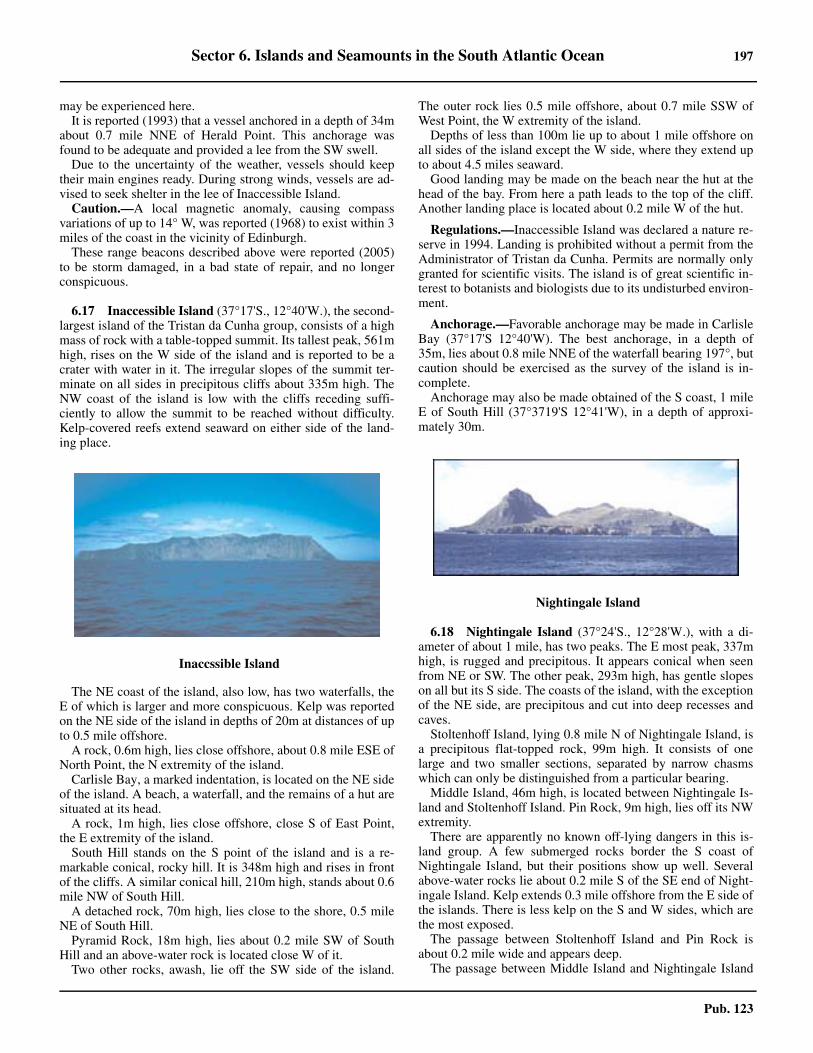
Sector 6. Islands and Seamounts in the South Atlantic Ocean 197
Pub. 123
may be experienced here. 6.16 It is reported (1993) that a vessel anchored in a depth of 34mabout 0.7 mile NNE of Herald Point. This anchorage wasfound to be adequate and provided a lee from the SW swell.6.16 Due to the uncertainty of the weather, vessels should keeptheir main engines ready. During strong winds, vessels are ad-vised to seek shelter in the lee of Inaccessible Island.6.16 Caution.—A local magnetic anomaly, causing compassvariations of up to 14° W, was reported (1968) to exist within 3miles of the coast in the vicinity of Edinburgh. 6.16 These range beacons described above were reported (2005)to be storm damaged, in a bad state of repair, and no longerconspicuous.
6.17 Inaccessible Island (37°17'S., 12°40'W.), the second-largest island of the Tristan da Cunha group, consists of a highmass of rock with a table-topped summit. Its tallest peak, 561mhigh, rises on the W side of the island and is reported to be acrater with water in it. The irregular slopes of the summit ter-minate on all sides in precipitous cliffs about 335m high. TheNW coast of the island is low with the cliffs receding suffi-ciently to allow the summit to be reached without difficulty.Kelp-covered reefs extend seaward on either side of the land-ing place.
6.17 The NE coast of the island, also low, has two waterfalls, theE of which is larger and more conspicuous. Kelp was reportedon the NE side of the island in depths of 20m at distances of upto 0.5 mile offshore.6.17 A rock, 0.6m high, lies close offshore, about 0.8 mile ESE ofNorth Point, the N extremity of the island.6.17 Carlisle Bay, a marked indentation, is located on the NE sideof the island. A beach, a waterfall, and the remains of a hut aresituated at its head.6.17 A rock, 1m high, lies close offshore, close S of East Point,the E extremity of the island.6.17 South Hill stands on the S point of the island and is a re-markable conical, rocky hill. It is 348m high and rises in frontof the cliffs. A similar conical hill, 210m high, stands about 0.6mile NW of South Hill.6.17 A detached rock, 70m high, lies close to the shore, 0.5 mileNE of South Hill.6.17 Pyramid Rock, 18m high, lies about 0.2 mile SW of SouthHill and an above-water rock is located close W of it.6.17 Two other rocks, awash, lie off the SW side of the island.
The outer rock lies 0.5 mile offshore, about 0.7 mile SSW ofWest Point, the W extremity of the island.6.17 Depths of less than 100m lie up to about 1 mile offshore onall sides of the island except the W side, where they extend upto about 4.5 miles seaward.6.17 Good landing may be made on the beach near the hut at thehead of the bay. From here a path leads to the top of the cliff.Another landing place is located about 0.2 mile W of the hut.
6.17 Regulations.—Inaccessible Island was declared a nature re-serve in 1994. Landing is prohibited without a permit from theAdministrator of Tristan da Cunha. Permits are normally onlygranted for scientific visits. The island is of great scientific in-terest to botanists and biologists due to its undisturbed environ-ment.
6.17 Anchorage.—Favorable anchorage may be made in CarlisleBay (37°17'S 12°40'W). The best anchorage, in a depth of35m, lies about 0.8 mile NNE of the waterfall bearing 197°, butcaution should be exercised as the survey of the island is in-complete. 6.17 Anchorage may also be made obtained of the S coast, 1 mileE of South Hill (37°3719'S 12°41'W), in a depth of approxi-mately 30m.
6.18 Nightingale Island (37°24'S., 12°28'W.), with a di-ameter of about 1 mile, has two peaks. The E most peak, 337mhigh, is rugged and precipitous. It appears conical when seenfrom NE or SW. The other peak, 293m high, has gentle slopeson all but its S side. The coasts of the island, with the exceptionof the NE side, are precipitous and cut into deep recesses andcaves.6.18 Stoltenhoff Island, lying 0.8 mile N of Nightingale Island, isa precipitous flat-topped rock, 99m high. It consists of onelarge and two smaller sections, separated by narrow chasmswhich can only be distinguished from a particular bearing. 6.18 Middle Island, 46m high, is located between Nightingale Is-land and Stoltenhoff Island. Pin Rock, 9m high, lies off its NWextremity.6.18 There are apparently no known off-lying dangers in this is-land group. A few submerged rocks border the S coast ofNightingale Island, but their positions show up well. Severalabove-water rocks lie about 0.2 mile S of the SE end of Night-ingale Island. Kelp extends 0.3 mile offshore from the E side ofthe islands. There is less kelp on the S and W sides, which arethe most exposed.6.18 The passage between Stoltenhoff Island and Pin Rock isabout 0.2 mile wide and appears deep. 6.18 The passage between Middle Island and Nightingale Island
6.17Inaccssible Island
6.17Nightingale Island

198 Sector 6. Islands and Seamounts in the South Atlantic Ocean
Pub. 123
is about 275m wide, but it is completely blocked with detachedrocks.6.18 Nightingale Island is visited by the settlers of Tristan Islandseveral times a year for birds, eggs, and guano. Walking on theisland is difficult during the breeding season of the penguinsand Great Shearwaters, except along the old sealers roads andon the plateaus and ridges. Their nests and burrows occupy al-most the entire ground, and tussock grass, 2 to 3m high, over-runs the island. 6.18 The water on Nightingale Island tends to be tainted, possiblydue to the number of birds. Drinkable water can be obtained infour large and several small ponds or bogs on the plateau belowthe lower peak, and also in a small bay lying about 0.3 mile Wof the sealers’ road leading from the NE landing place.6.18 Landing may most easily be effected on the rocks at the NEextremity of Nightingale Island. Caution should be exercisedas a small rock, awash, lies about 50m off the point. A numberof huts stand near the NE landing place and a path leads to thethree ponds on the plateau. The old landing place located onthe SE side of the island is seldom used. 6.18 Depths of less than 100m lie up to about 1 mile offshore onall sides of these islands.
Gough Island
6.19 Gough Island (40°19'S., 9°56'W.), lying 230 milesSSE of Tristan Island, is a dependency of Saint Helena. It is 7miles long, well-wooded, and watered. Except for a meteoro-logical and scientific station, the island is otherwise uninhabit-ed.
Cliffs rise steeply behind narrow boulder beaches aroundmost of the island. The cliffs at North East Point (40°17'S.,9°56'W.), the NE extremity, are 365m high and sheer. Thoseextending between Reef Point, located 2 miles SSE of NorthEast Point, and Haulround Point, about 2.2 miles SSE, are alsosheer, but not very high. In most other parts of the island, vege-tation, chiefly tussock grass, grows on the steep cliffs up which
routes can often be found.6.19 On the W side of the island, the steep cliffs attain a height of460m in places. At the S end of the island, the land is compara-tively low. The interior of the island consists of an undulatingboggy plateau, with an elevation of 600m or more from whichthe summits rise in easy slopes. The highest summits are Edin-burgh Peak, 910m high, and Expedition Peak, 909m high,which stand 2 miles, respectively, SSW and SW of North EastPoint. South Peak, 760m high, rises 2 miles NNW of SouthPoint (40°22'S., 9°53'W.), the S extremity of the island.6.19 In most places, the cliffs around the island rise steeply fromthe sea and numerous waterfalls descend in long cascades.6.19 The sea area in the vicinity of Gough Island has not been ful-ly surveyed, but it is reported that the island may be ap-proached safety up to about 1 mile, except off West Point, theW extremity, and North East Point, where reefs extend up toabout 0.8 mile W and 0.2 mile N, respectively. The reef front-ing West Point is reported to break heavily.6.19 The island is apparently steep-to on all except its E side,where depths of 37m are found lying up to 0.5 mile offshore.Several islets and large rocks lie off the island, but, with the ex-ception of Penguin Islet, they are all located close inshore.6.19 Crawfish are numerous close inshore. Kelp grows aroundmuch of the island.6.19 Winds—Weather.—Scientific expeditions have found that,in the summer, eastward-moving depressions passed mainly tothe S of the island. However, as winter approached, their tracksmoved N. By mid-April, the depressions were passing to the Nof the island, causing many more E winds with consequent de-terioration of landing conditions. The rainfall was heavy andstrong winds and gales were frequent.6.19 Tides—Currents.—Currents are strong at times, but erratic,being mostly wind generated. 6.19 Regulations.—Gough Island and the waters surrounding itwithin 3 miles have been declared a World Heritage Site. Land-ing is prohibited without a permit from the Administrator ofTristan da Cunha. Permits are normally only granted for scien-tific visits. Emergency visits must be reported as soon as prac-ticable to the Administrator and must be as brief is absolutelynecessary in accordance with safety and health requirements.6.19 All visiting vessels, including yachts, must be in possessionof rodent free certification and may be required by the Admin-istrator to call at Tristan da Cunha to clear customs, immigra-tion, and health controls before proceeding to Gough Island.
6.20 Reef Point (40°18'S., 9°54'W.), is located 2 miles SEof North East Point; Hawkins Bay lies 0.7 mile NW of it.
Penquin Islet, 117m high, lies 0.5 mile ENE of Reef Point;an above-water rock is located close SE of it. Channel Rock,7m high, lies between Penguin Islet and Reef Point. Passagebetween this rock and the islet is not advisable, except by boat.6.20 Dell Rocks (not named on the chart), about 5m high, lieclose offshore, 1 mile SSE of Reef Point.6.20 Hawkins Bay (40°18'S., 9°55'W.), lies on the NE side of theisland NW of Reef Point. Good anchorage may be obtained inHawkins Bay, off Deep Glen (not named on chart), in a depthof 22m, sand and stone. 6.20 Milford Bay (40°19'S., 9°54'W.) provides good anchorageoff Capsize Sands (not named on the chart), clear of ReefPoint, in depths of 18 to 27m. Milford Bay is entered between
6.18Middle Island and Stoltenhoff Island
6.19Gough Island

Sector 6. Islands and Seamounts in the South Atlantic Ocean 199
Pub. 123
Reef Point and Dell Rocks. Buttress Rock, 79m high, lies closeoffshore, about 3 miles NW of the outermost Dell Rocks.
Quest Bay (40°20'S., 9°54'W.) lies in the SE part of theisland and is defined by a shallow bight formed between themouth of The Glen to the N and Haulround Point to the SE.Archway Rock, 21m high, lies close SW of Dell Rocks off ofthe mouth of The Glen. The Glen, located at the N end of thebay, gives access to the interior of the island. The Glen Beachconsists of small boulders and shingle. It should be approachedfrom the SE in order to clear a submerged rock lying in thecenter of the cove.6.20 Luff Point is situated 0.3 mile SSE of Haulround Point;Number One, an islet, 73m high, lies close N of it.6.20 The Admiral, an islet, 52m high, lies between Luff Point andSouth East Point, 0.4 mile S. The Commodore, an islet, 56mhigh, lies close NNW of The Admiral. Several other islets androcks lie close off this stretch of coast.
Transvaal Bay (40°21'S., 9°53'W.), a small bay with astream at its head, lies between South East Point and CavernHead, 1 mile SSW. A meteorological and scientific station,manned by South African scientists, is situated close inshoreon the N side of this bay. It consists of several white buildings,prominent from E, and is well-lighted at night. The station is inradio contact with South Africa and can be contacted on VHFchannel 16 (Call sign: Gough Island). 6.20 South West Point is located 1.2 miles WNW of South Point.South West Islet, 104m high, lies 0.2 mile SE of South WestPoint; an above-water rock is located close SE of it. SaddleIslet, 119m high, lies close offshore, 0.8 mile NNW of SouthWest Point.6.20 Gaggins Point is located 2 miles NW of South West Pointand Sea Elephant Bay lies between it and West Point, 3 milesWNW, which is fronted by a reef.6.20 North Point is located 2.5 miles NNE of West Point and 3miles W of North East Point. The coasts in this vicinity arefronted by several rocks and islets. Tristania Rock, 165m high,and Isolda Rock, 91m high, lie close offshore 0.8 mile and 1.9miles, respectively, NNE of West Point. Round Island, 54mhigh, and Lots Wife, 107m high, lie close offshore 0.7 mile and1.3 miles, respectively, E of North Point. An unnamed islet,134m high, lies between Lots Wife and the shore.6.20 Snug Harbor (40°22'S 9°54'W) lies to the NW of South Pointand may be used for anchorage with slight protection from Nwind, in a depth of 27 m. The prevailing SW swell rendersanchorage on this side of the island uncomfortable. 6.20 Anchorage.—There are no sheltered bays, but there are a
number of open roadstead anchorages. Those located off the Eside of the island provide the best shelter from the prevailing Wand SW winds. 6.20 Good anchorage may be obtained in a depth of 22m, sandand stones, off the head of Hawkins Bay. Anchorage may alsobe obtained in depths of 18 to 27m within Milford Bay, offCapsize Sands, the beach extending about 0.4 mile NNW fromButtress Rock. 6.20 Anchorage may be obtained in a depth of 27m within QuestBay about 0.4 mile E of Archway Rock. This anchorage, whichis known as The Glen Anchorage, is normally used with windsbetween W and S. The bottom consists of black volcanic sandand shell with good holding ground. Landing on The GlenBeach is made difficult, and even dangerous, by the surf. At thefoot of Archway Rock, there is a place where experiencedboatmen can carry out a landing in almost any weather. At thecorner of the rock nearest the N end of the beach, there is achimney up which an active man carrying a coil of rope canclimb. At the top of the rock there are a few island trees towhich the line can be secured. In this way, landing on, or de-parture from, the island can be effected in any but the worstweather.
6.20 Anchorage off the W side of the island is not recommended,as it is the weather side and steep-to. The prevailing SW swellrenders anchorage on the W side of the island uncomfortable.6.20 Anchorage can be obtained in a depth of 37m within Trans-vaal Bay during a NW wind. Landing can be made on the NEside of an archway rock, located at the entrance to a cove onthe N side of the bay. Stores may be hoisted by a crane on thecliff, which can safely handle loads up to 0.25 ton. A boat cansecure to an anchor in the rocks.6.20 Anchorage can be obtained in a depth of 27m within SnugHarbor, which provides slight protection from N winds.6.20 Landing can be made in calm weather in a number of placesaround the island. The best position for landing will obviouslydepend upon the wind and swell prevailing at the time. Frommost beaches, access to the interior of the island is very diffi-cult due to the cliffy coastline. Quest Bay offers the best accessto the island’s interior through The Glen.
Off-lying Seamounts and Other Dangers
6.21 The table titled Off-lying Seamounts off the WestCoast of Africa includes those seamounts that are named,those which form a danger to navigation, or those that could as-sist navigation. Many other seamounts are charted and others
6.20Courtesy of Francis Guerraz
6.20Bouvetoya from W
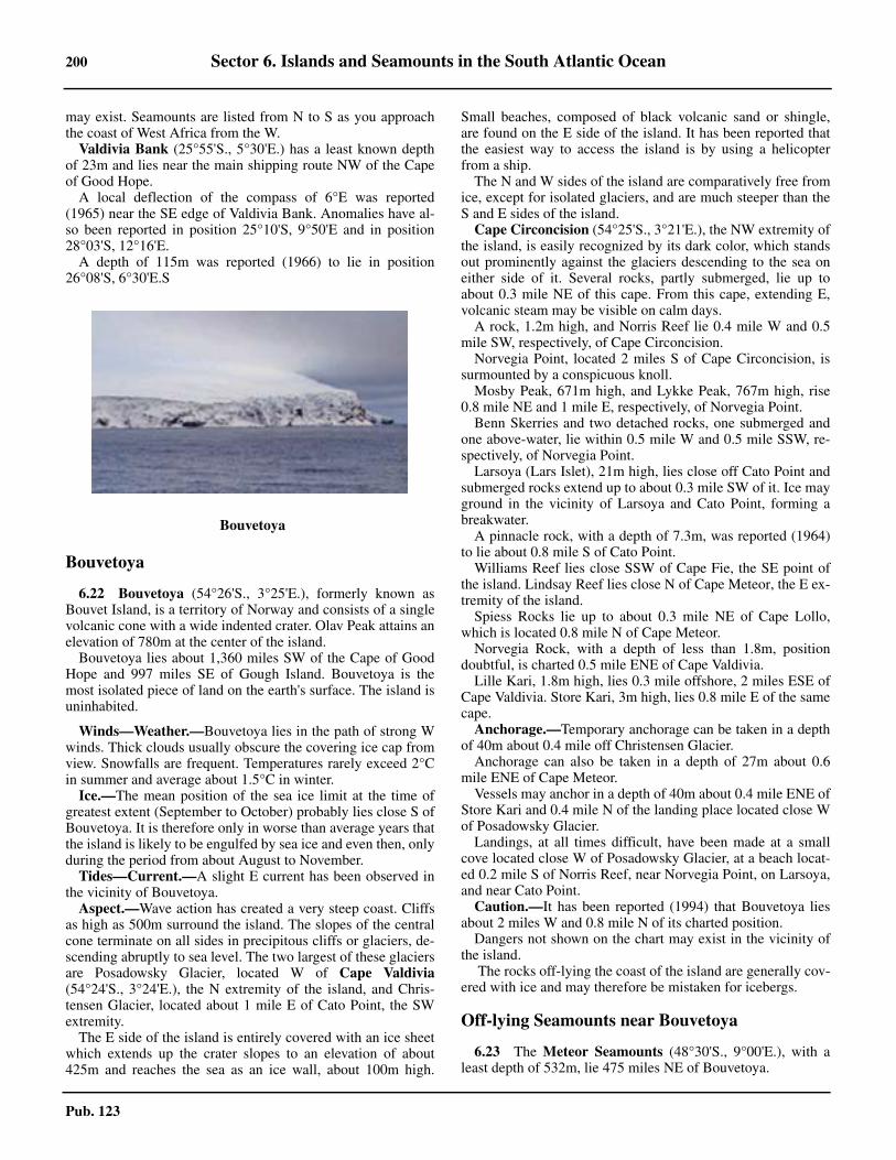
200 Sector 6. Islands and Seamounts in the South Atlantic Ocean
Pub. 123
may exist. Seamounts are listed from N to S as you approachthe coast of West Africa from the W.
Valdivia Bank (25°55'S., 5°30'E.) has a least known depthof 23m and lies near the main shipping route NW of the Capeof Good Hope.6.21 A local deflection of the compass of 6°E was reported(1965) near the SE edge of Valdivia Bank. Anomalies have al-so been reported in position 25°10'S, 9°50'E and in position28°03'S, 12°16'E.6.21 A depth of 115m was reported (1966) to lie in position26°08'S, 6°30'E.S
Bouvetoya
6.22 Bouvetoya (54°26'S., 3°25'E.), formerly known asBouvet Island, is a territory of Norway and consists of a singlevolcanic cone with a wide indented crater. Olav Peak attains anelevation of 780m at the center of the island.
Bouvetoya lies about 1,360 miles SW of the Cape of GoodHope and 997 miles SE of Gough Island. Bouvetoya is themost isolated piece of land on the earth's surface. The island isuninhabited.
6.22 Winds—Weather.—Bouvetoya lies in the path of strong Wwinds. Thick clouds usually obscure the covering ice cap fromview. Snowfalls are frequent. Temperatures rarely exceed 2°Cin summer and average about 1.5°C in winter.6.22 Ice.—The mean position of the sea ice limit at the time ofgreatest extent (September to October) probably lies close S ofBouvetoya. It is therefore only in worse than average years thatthe island is likely to be engulfed by sea ice and even then, onlyduring the period from about August to November.6.22 Tides—Current.—A slight E current has been observed inthe vicinity of Bouvetoya.6.22 Aspect.—Wave action has created a very steep coast. Cliffsas high as 500m surround the island. The slopes of the centralcone terminate on all sides in precipitous cliffs or glaciers, de-scending abruptly to sea level. The two largest of these glaciersare Posadowsky Glacier, located W of Cape Valdivia(54°24'S., 3°24'E.), the N extremity of the island, and Chris-tensen Glacier, located about 1 mile E of Cato Point, the SWextremity.6.22 The E side of the island is entirely covered with an ice sheetwhich extends up the crater slopes to an elevation of about425m and reaches the sea as an ice wall, about 100m high.
Small beaches, composed of black volcanic sand or shingle,are found on the E side of the island. It has been reported thatthe easiest way to access the island is by using a helicopterfrom a ship.6.22 The N and W sides of the island are comparatively free fromice, except for isolated glaciers, and are much steeper than theS and E sides of the island.
Cape Circoncision (54°25'S., 3°21'E.), the NW extremity ofthe island, is easily recognized by its dark color, which standsout prominently against the glaciers descending to the sea oneither side of it. Several rocks, partly submerged, lie up toabout 0.3 mile NE of this cape. From this cape, extending E,volcanic steam may be visible on calm days.6.22 A rock, 1.2m high, and Norris Reef lie 0.4 mile W and 0.5mile SW, respectively, of Cape Circoncision.6.22 Norvegia Point, located 2 miles S of Cape Circoncision, issurmounted by a conspicuous knoll. 6.22 Mosby Peak, 671m high, and Lykke Peak, 767m high, rise0.8 mile NE and 1 mile E, respectively, of Norvegia Point.6.22 Benn Skerries and two detached rocks, one submerged andone above-water, lie within 0.5 mile W and 0.5 mile SSW, re-spectively, of Norvegia Point. 6.22 Larsoya (Lars Islet), 21m high, lies close off Cato Point andsubmerged rocks extend up to about 0.3 mile SW of it. Ice mayground in the vicinity of Larsoya and Cato Point, forming abreakwater.6.22 A pinnacle rock, with a depth of 7.3m, was reported (1964)to lie about 0.8 mile S of Cato Point.6.22 Williams Reef lies close SSW of Cape Fie, the SE point ofthe island. Lindsay Reef lies close N of Cape Meteor, the E ex-tremity of the island. 6.22 Spiess Rocks lie up to about 0.3 mile NE of Cape Lollo,which is located 0.8 mile N of Cape Meteor.6.22 Norvegia Rock, with a depth of less than 1.8m, positiondoubtful, is charted 0.5 mile ENE of Cape Valdivia.6.22 Lille Kari, 1.8m high, lies 0.3 mile offshore, 2 miles ESE ofCape Valdivia. Store Kari, 3m high, lies 0.8 mile E of the samecape. 6.22 Anchorage.—Temporary anchorage can be taken in a depthof 40m about 0.4 mile off Christensen Glacier.6.22 Anchorage can also be taken in a depth of 27m about 0.6mile ENE of Cape Meteor. 6.22 Vessels may anchor in a depth of 40m about 0.4 mile ENE ofStore Kari and 0.4 mile N of the landing place located close Wof Posadowsky Glacier.6.22 Landings, at all times difficult, have been made at a smallcove located close W of Posadowsky Glacier, at a beach locat-ed 0.2 mile S of Norris Reef, near Norvegia Point, on Larsoya,and near Cato Point.6.22 Caution.—It has been reported (1994) that Bouvetoya liesabout 2 miles W and 0.8 mile N of its charted position.6.22 Dangers not shown on the chart may exist in the vicinity ofthe island.6.22 The rocks off-lying the coast of the island are generally cov-ered with ice and may therefore be mistaken for icebergs.
Off-lying Seamounts near Bouvetoya
6.23 The Meteor Seamounts (48°30'S., 9°00'E.), with aleast depth of 532m, lie 475 miles NE of Bouvetoya.
6.21Bouvetoya
Sector 6. Islands and Seamounts in the South Atlantic Ocean 201
Pub. 123
6.23 Spiess Seamount (54°25'S., 0°15'E.), with a least depth of285m, lies 120 miles W of Bouvetoya.6.23 A seamount, with a least depth of 207m, is reported to lieabout 100 miles ENE of Bouvetoya.
6.23 A rock, 46m high, existence doubtful, was reported (1929) tolie in position 56°07'S, 23°39'E, about 720 miles E of Bou-vetoya, and 1,277 miles S of Cape Agulhas.
Off-lying Seamounts—West Coast of Africa
Seamount Location Depth Remarks
Unnamed seamount 3°03'S, 0°44'E 152m —
Unnamed seamount 8°30'S, 17°00'W 256m —
Grattan Seamount 9°43'S, 12°50'W 70m Lies 144 miles SE of Ascension Island Light.
Unnamed seamount 9°45'S, 12°05'W Reported depth of 213m
Another unnamed seamount, with a depth of316m, lies close SSE.
Stvor Seamount 9°55'S, 5°25'W 525m Lies about 367 mile NE of St. Helena IslandLight.
Dampier Seamount 11°09'S, 0°27'W 594m Lies about 425 miles NE of St. Helena IslandLight.
Unnamed seamount 11°40'S, 5°15'W 115m —
Malahit Guyot Seamount 12°50'S, 2°40'W 384m Lies about 264 miles NE of St. Helena IslandLight.
Cardno Tablemount 12°53'S, 6°08'W 77m Lies about 183 miles NNW of St. Helena IslandLight.
Unnamed seamount 13°00'S, 5°40'W 158m —
Kutuzov Seamount 15°11'S, 8°16'W 410m Lies about 160 miles WNW of St. Helena IslandLight.
Bagration Seamount 15°30'S, 6°30'W 1,341m Lies about 52 miles NW of St. Helena IslandLight.
Bonaparte Seamount 15°40'S, 7°00'W 105m Lies about 76 miles WNW of St. Helena IslandLight.
Ewing Seamount 23°15'S, 8°15'E 812m A local magnetic anomaly has been reported inthe vicinity of Ewing Seamount.
Molloy Seamount 27°55'S, 8°50'E 2,317m —
Tripp Seamount 29°37'E, 14°15'E 144mLies 125 miles WSW of the mouth of the OrangeRiver. A similar depth was reported (1985) to lie5 miles further SE.
Vema Seamount 31°41'S, 8°20'E Reported depth of 7.0m
Lies 465 miles WSW of the mouth of the OrangeRiver and constitutes a danger to deep-draftvessels. There is some evidence that the top of theseamount consists of a plateau about 5 miles indiameter, with depths of 45 to 90m, with someshallower peaks. An unconfirmed depth of 7m isreported to lie on the S side of the plateau.
Wust Seamount 34°00'S, 3°30'W 775m
Two reported shoals (2007) lie to the NE and SWof Wust Seamount. The shoal to the NE lies in anarea centered on position 33°00'S, 2°40'W.; theshoal to the SW is in position 34°29'S, 5°00'W.Unconfirmed depths of 218 to 353m lie within110 mile E and ENE of this seamount and maybest be seen on the chart.
Samarin Seamount 34°04'S, 20°08'W 530m —
Engelbrecht Seamount 36°11'S, 14°10'E 2,321m —

202 Sector 6. Islands and Seamounts in the South Atlantic Ocean
Pub. 123
Protea Seamount 36°45'S, 18°15'E 1,406mOne of a number of seamounts located on theAgulhas Ridge which extends between 150 and880 miles SW of Cape Agulhas.
Puma Rock 37°04'S, 12°19'E Awash Various depths from 12m to awash.
Argentina Seamount 37°27'S, 18°05'E 1,797m —
Wyandot Seamount 37°47'S, 15°38'E 1,894m —
Zapiola Seamount 38°10'S, 26°00'W 1,926m —
Erica Seamount 38°12'S, 14°50'E 1,087m —
Schmitt-Ott Seamount 38°27'S, 13°45'E 1,287m —
Crawford Seamount 38°48'S, 10°36'W 463m Lies 95 miles NNW of Gough Island.
R.S.A. Seamount 39°30'S, 6°40'W 176m Lies 160 miles ENE of Gough Island.
Panzarini Seamount 40°00'S, 11°50'E 1,346m —
Richardson Seamount 40°10'S, 14°40'E 1,550m —
Unnamed seamount — 185m Has been reported to lie 160 miles WNW of Gough Island.
Unnamed seamount — 269m Lies 120 miles NW of Gough Island.
McNish Seamount 40°10'S, 11°50'E 128m Lies 70 miles ENE of Gough Island. A reported depth of 90m lies about 20 miles W of it.
Unamed seamount 40°05'S, 9°10'W 90m —
Zenker Seamount 41°05'S, 6°00'W 1,094m Lies 180 miles ESE of Gough Island.
Discovery Seamount 42°05'S, 0°20'E 326m
Other unnamed seamounts, with depths of 326m and 660m, lie 86 and 140 miles, respectively, WSW of Discovery Seamount. Another unnamed seamount, with a depth of 316m, lies 110 miles SW of Discovery Seamount, and a seamount, with a depth of 633m, lies 70 miles W of it.
Off-lying Seamounts—West Coast of Africa
Seamount Location Depth Remarks

Pub. 123
Glossaries 203Glossaries
Afrikaans
AFRIKAANS English
A
aanleplek .................................................................... wharf
B
baai .................................................................................baybaaitjie .......................................................................... covebaggerbank ...................................................... spoil groundbaken ........................................................................ beaconbank ..............................................................................bankberg ....................................................................... mountainberge ...........................................mountain, mountain chainblinder ........................................................submerged rockblou ................................................................................blueboei................................................................................buoyboot ...............................................................................boatbranding ........................................................................ surfbranders .................................................................. breakersbreekwater...........................................................breakwaterbuffel ........................................................................ buffalo
D
deurvaart .................................................................. passagediepte ...........................................................................depthdok ................................................................................dockdooiety ...................................................................neap tidedorp ...........................................................................villagedroog .............................................................................. drydrywend ...................................................................... afloatduiker .................................................................. cormorantduin ..............................................................................dune
E
eb ....................................................................................ebbeiland .......................................................................... islandeilandjie .........................................................................isleteskarp ................................................................. escarpment
F
fontein ....................................................................... spring
G
geel ............................................................................yellowgestrand .................................................................. agroundgety ................................................................................ tide
gevaar.........................................................................dangergolf .............................................................................. wavegroen ...........................................................................green
H
hawe .................................................................. harbor, porthawehoof ......................................................................molehawekom ..................................................................... basinheuwel ............................................................................ hillhindernis ............................................................obstructionhoek ............................................................................cornerhoog ..............................................................................highhoogte ....................................................... height, elevationhout .............................................................................wood
J
jakkals ........................................................................ jackal
K
kaai ........................................................... jetty, quay, wharfkaap............................................................... cape, headlandkabellengte .................................................................. cableklip .............................................................................. stonekloof ............................................................................gorgeknoop ............................................................................knotkoers .......................................................................... coursekompas ................................................................... compasskop ................................................................................. hillkoppie .......................................................................hillockkrans .............................................................................. cliffkus .....................................................................coast, shore
L
laag.................................................................................. lowland ................................................................................ landlandteken ...............................................................landmarkleeu ................................................................................ lionleimerk ............................................................leading mark
M
magneties .............................................................. magneticmalgas ....................................................................... gannetmast............................................................................... mastmeer .............................................................................. lakemeerplek ................................................................ mooring
AFRIKAANS English
Pub. 123
204 Glossaries
merk ............................................................................ markmis .................................................................................. fogmodder ......................................................................... mudmoeras ...................................................................... swampmossel ...................................................................... mussel
N
nek .................................................................................passnewel .............................................................................mistnoord ........................................................................... north
O
olifant ..................................................................... elephantondersee berg ....................................................... seamountonderwater .......................................................... submergedoorspoel ......................................................................awashoos .................................................................................. eastop land ....................................................................... ashore
P
peiling ..................................................................... bearingpiek ...............................................................................peakpier ................................................................................ pierpikkewyn .................................................................penguinpelikaan .....................................................................pelicanpunt ............................................................................. point
R
radiobaken ....................................................... radio beaconreen ................................................................................ rainrivier ............................................................................. riverriviermonding ...........................................................estuaryrob ................................................................................. sealrollers ........................................................................ rollersrooi ................................................................................. redrots .................................................................. boulder, rock
S
sand .............................................................................. sandsandbank ........................................................................ barsee .................................................................................. seaseegras ...........................................................................kelpseekaart ....................................................................... chartseemeer .....................................................................lagoon
AFRIKAANS English
seemyl ...........................................................................mileseewarts .................................................................. offshoreskeep ............................................................................. shipskeepswerf ............................................................dockyardskiereiland ............................................................ peninsulasnelheid .......................................................................speedspringty ...............................................................spring tidestad ....................................................................... city, townstilwater ..............................................................slack waterstormwind ..................................................................... galestrand ................................................................beach, shorestroom ...................................................................... currentsuid .............................................................................. southswart ............................................................................ black
T
tafel .............................................................................. tableteken .............................................................................marktoring ...........................................................................tower
V
vaam ......................................................................... fathomvaarwater ..................................................................fairwayvallei .......................................................................... valleyvls ...................................................................................fishvlakwater ..................................................................... shoalvlei .............................................................................marshvloed ........................................................................... floodvloedbos ...............................................................mangrovevoorgebergte ................................................................ bluffvoorstrand ..............................................................foreshorevuurtoring ............................................................ lighthouse
W
wal ................................................................... embankmentwalvis ......................................................................... whalewerweling ..................................................................... eddywes ............................................................................... westwit ................................................................................whitewolk ............................................................................cloudwrak ............................................................................wreck
Y
yster................................................................................ iron
AFRIKAANS English
Pub. 123
Glossaries 205
Dutch
DUTCH English
A
aan....................................................................... at, near, on
B
baak........................................................................... beaconberg ................................................................ mountain, hillbinnen........................................................................... innerblauwe............................................................................bluebocht............................................................. bay, bend, lightbol ...................................................................................ballboom ...............................................................................treebosch ............................................................................forestboschje .................................................... small wood, brushbreed.............................................................................broadbrug ............................................................................ bridgebuiten ........................................................................... outerbult ...............................................................................hump
D
dam............................................................. dam, breakwaterde, den..............................................................................thediep................................................................................ deepdijk .................................................................................dikedorp ............................................................................villagedraaikalk........................................................................eddydrempel ............................................................................bardric ................................................................................threedrichoek ................................................................... triangledroogte ......................................................................... shoalduin ................................................................ dune, sandhilldwars.............................................................across, athwart
E
eiland........................................................................... island
F
friesche....................................................................... frisian
G
gat............................................................................. channelgeul...............................................................narrow channelgroei .............................................................................greengronden ....................................................................groundsgroot ..............................................................................great
H
haven.......................................................................... harborhelft.................................................................................halfhet .................................................................................... theheuvel...............................................................................hillhoek .................................................................... cape, pointhoofd............................................................................. headhoog ...............................................................................highhout ..................................................................wood, timber
K
kaap............................................................... cape, headlandkake............................................................................... quaykegel.............................................................................. conekil ............................................................................. channelklein ............................................................................. smallklip .................................................................................rockkop ................................................................................ headkreek ............................................................................ creekkromme.................................................................... crookedkust ...............................................................................coast
L
laag, lage......................................................................... lowlang ................................................................................longlicht ................................................................................lightloods ..............................................................................pilotloodswezen .............................................................. pilotage
M
meer ......................................................................inland seamiddel, midden ..........................................................middlemodder ...........................................................................mudmolen ............................................................................. mill
N
nauw ........................................................................ narrowsnieuw ............................................................................. newnoord............................................................................ northnoorder.................................................................... northern
O
oost .................................................................................eastoud ...................................................................................old
DUTCH English

Pub. 123
206 Glossaries
P
peilschaal ............................................................... tide gageplaat.............................................................................. shoalplaatje..................................................................small shoalplat .................................................................................. flatpolder ............................................................ reclaimed landpunt .............................................................................. point
R
rak ............................................................................ channelrechthoekig..........................................................rectangularreddingboot .............................................................. lifeboatrede........................................................................ roadsteadrode, rood .........................................................................redrots ............................................................................... rocksrug ................................................................................ ridgeruitvormig .................................................. diamond-shaped
S
schaar ....................................................................... channelscherm........................................................................ screenschor............................................................................. shoalschutsluis................................................................ lock gateseinen .........................................................................signalssluis ................................................................................locksmal........................................................................... narrowspits, spitse ................................................................pointedspoorweg...................................................................railwaystaart.............................................................. tail (of a bank)stad ................................................................................townsteen ............................................................................. stonesteiger.....................................................................jetty, piersteile ............................................................................. steepstrand.................................................................beach, shorestroom ...........................................................current, stream
DUTCH English
T
toegang........................................................................accesstramweg .................................................................. tramway
U
uit .....................................................................................out
V
vaart ............................................................................. canalvaarwater...................................................................fairwayvalsch ............................................................................ falsevan .....................................................................................ofveerboot ........................................................................ ferryverklikker........................................................ warning lightvlckte ....................................................... flat below surfacevliegtuigen ................................................................ aircraft
W
wad.........................................................drying coastal bankwal ......................................................................banks, wallwatergetijden .................................................... tidal currentwaterweg............................................................... waterwayweg................................................................................. waywerk ..............................................................................workwester....................................................................... westernwit, witte ......................................................................whitewrak ............................................................................ wreck
Z
zand................................................................................sandzee....................................................................................seazeegat ........................................................................ estuaryzuid .............................................................................. southzuider ...................................................................... southernzwart ............................................................................ black
DUTCH English

Pub. 123
Glossaries 207
French
FRENCH English
A
anse ..................................................................... bay, creekarchipel .............................................................. archipelagoarriere port ............................................................ inner portavant port .............................................................outer port
B
baie .........................................................................bay, gulfbalise ........................................................................ beaconbanc .............................................................bank, sandbankbarre .................................................................................barbasse............................................................................. shoalbassin .......................................................................... basinblanc.............................................................................whitebois ..............................................................................woodbouche ........................................................mouth (of river)
C
canal ..............................................................channel, canalcap ................................................................cape, headlandchaloupe .................................................................... launchchalutier ................................................................... trawlerchateau .........................................................................castlechaussee .......................................................................bankchenal ....................................................................... channelclocher .......................................................................steeplecolline.............................................................................. hillcouvent .................................................................... conventcrique .......................................................................... creek
D
digue .........................................................mole, breakwater
E
ecluse ............................................. lock of a canal or basineglise .........................................................................churchest .................................................................................. eastetang............................................................................... lake
F
falaise ............................................................................ clifffaux ............................................................................... falsefleuve ........................................................................... riverfosse ................................................................ ditch, a deep
G
golfe .............................................................................. gulfgoulet ......................................................... narrow entrancegrand(e) ........................................................................great
I
ile ............................................................................... islandilot ................................................................................. islet
J
jetee ...............................................................................jetty
L
lac ................................................................................. lakelagune ....................................................................... lagoon
M
maison .........................................................................housemenhir ................................................... a large raised stonemilieu ........................................................................middlemole ...............................................................................piermont ......................................................................mountainmouillage ............................................................ anchoragemoulin ........................................................................... mill
N
noir .............................................................................. blacknord ............................................................................. north
O
occidentale .............................................................. westernorientale ....................................................................easternouest ..............................................................................west
P
passe ....................................................................... channelpertuis ........................................................opening or straitpetit ............................................................................. smallpic ................................................................................ peakplerre............................................................................ stonepiton ............................................................. mountain peakplateau .........................................................tableland or flatpointe ...........................................................................point
FRENCH English

Pub. 123
208 Glossaries
pont ........................................................................... bridgeport ....................................................................port, harborpresquiile .............................................................. peninsula
Q
quai ....................................................................quay, wharf
R
rade ....................................................................... roadsteadrecif ............................................................................... reefreviere .......................................................................... riverroche or rocher ..............................................................rockrouge ...............................................................................red
FRENCH English
S
sable ..............................................................................sandsommet ....................................................................summitsud ............................................................................... south
T
tour .............................................................................. tower
V
vert .............................................................................. greenville .............................................................................. town
FRENCH English
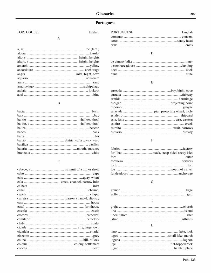
Pub. 123
Glossaries 209
Portuguese
PORTUGUESE English
A
a, as ...................................................................... the (fem.)aldeia .........................................................................hamletalto, s ............................................................ height, heightsaltura, s ......................................................... height, heightsamarclo ......................................................................yellowancordouro .......................................................... anchorageangra .......................................................... inlet, bight, coveaquario ..................................................................aquariumareia .............................................................................. sandarquipelago ........................................................ archipelagoatalaia ...................................................................... lookoutazul ................................................................................blue
B
bacia ............................................................................ basinbaia .................................................................................baybaixio ............................................................ shallow, shoalbaixio, a ......................................................... shallow, shoalbaliza......................................................................... beaconbanco.............................................................................bankbarra ................................................................................barbarrio ............................................district (of a town), wardbasilica .................................................................... basilicabateria .........................................................mouth, entrancebranco, a ......................................................................white
C
cabeco, a ....................................... summit of a hill or shoalcabo .............................................................................. capecais ....................................................................quay, wharfcala .......................................... creek, channel, narrow inletcalheta ...........................................................................inletcanal ........................................................................ channelcapela ........................................................................ chapelcarreira ..........................................narrow channel, slipwaycasa ............................................................................. housecasal ....................................................................farmhousecastelo .........................................................................castlecatedral .................................................................. cathedralcemiterio ............................................................... cemeterychale ........................................................................... chaletcidade .......................................................... city, large towncidadela ..................................................................... citadelcinzento .........................................................................greycolina ................................................................. hill, hillockcolonia .....................................................colony, settlementconcha .......................................................................... cove
comento .................................................................. conventcoroa .................................................................. sandy headcruz ..............................................................................cross
D
de dentro (adj.) .............................................................innerdesembarcadouro ..................................................... landingdoca .............................................................................. dockduna ............................................................................. dune
E
enseada .......................................................bay, bight, coveentrada .....................................................................fairwayermida ..................................................................hermitageespigao ....................................................... projecting pointesporao.......................................................................groyneestacada ................................... pier, projecting wharf, moleestaleiro .................................................................. shipyardeste, leste .......................................................... east, easternesteiro ......................................................................... creekestreito .......................................................... strait, narrowsestuario .................................................................... estuary
F
fabrica .......................................................................factoryfarillhao .................................. stack, steep-sided rocky isletfora ...............................................................................outerfortaleza ................................................................... fortressforte ................................................................................ fortfoz .............................................................. mouth of a riverfundeadouro ........................................................ anchorage
G
grande .......................................................................... largegolfo .............................................................................. gulf
I
greja .......................................................................... churchilha ............................................................................. islandilheu, ilhota ................................................................... isletistmo ........................................................................ isthmus
L
lago ...................................................................... lake, locklagoa ........................................................small lake, marshlaguna ........................................................................ lagoonlaje ............................................................. flat-topped rocklugar ................................................................hamlet, place
PORTUGUESE English
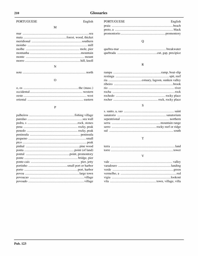
Pub. 123
210 Glossaries
M
mar ..................................................................................seamata .....................................................forest, wood, thicketmeridional ..............................................................southernmoinho .......................................................................... millmolhe .................................................................. mole, piermontanha ...............................................................mountainmonte ........................................................................ mountmorro .................................................................... hill, knoll
N
note .............................................................................. north
O
o, os .................................................................... the (masc.)occidental ................................................................. westernoeste .............................................................................. westoriental ..................................................................... eastern
P
palheiros ........................................................fishing villageparedao ....................................................................sea wallpedra, s ..............................................................rock, stonespena ................................................................... rocky, peakpenedo ............................................................... rocky, peakpeninsula .............................................................. peninsulapequeno ....................................................................... smallpico ............................................................................... peakpinhal ..................................................................pine woodponta ..............................................................point (of land)pontal ......................................................point, promontoryponte .................................................................. bridge, pierponte-cais ............................................................. pier, jettyportinho ................................................small port or harborporto ..................................................................port, harborpovoa ...................................................................large townpovoacao ...................................................................villagepovoado .....................................................................village
PORTUGUESE Englishpraia ............................................................................beachpreto, a ........................................................................ blackpromontorio ....................................................... promontory
Q
quebra-mar ......................................................... breakwaterquebrada .................................................cut, gap, precipice
R
rampa ...........................................................ramp, boat-sliprestinga ..................................................................spit, reefria .........................................estuary, lagoon, sunken valleyribeiro .........................................................................brookrio ................................................................................. riverrocha .............................................................................rockrochedo ............................................................. rocky placerocher ....................................................... rock, rocky place
S
s. santo, a, sao .............................................................. saintsanatorio ............................................................ sanatoriumsepentrional ............................................................ northernserra ............................................................mountain rangeserro ....................................................... rocky reef or ridgesul ............................................................................... south
T
terra ............................................................................... landtorre ............................................................................. tower
V
vale ............................................................................. valleyvaradouro ................................................................. landingverde ........................................................................... greenvermelho, a .....................................................................redvigia .........................................................................lookoutvila ......................................................... town, village, villa
PORTUGUESE English
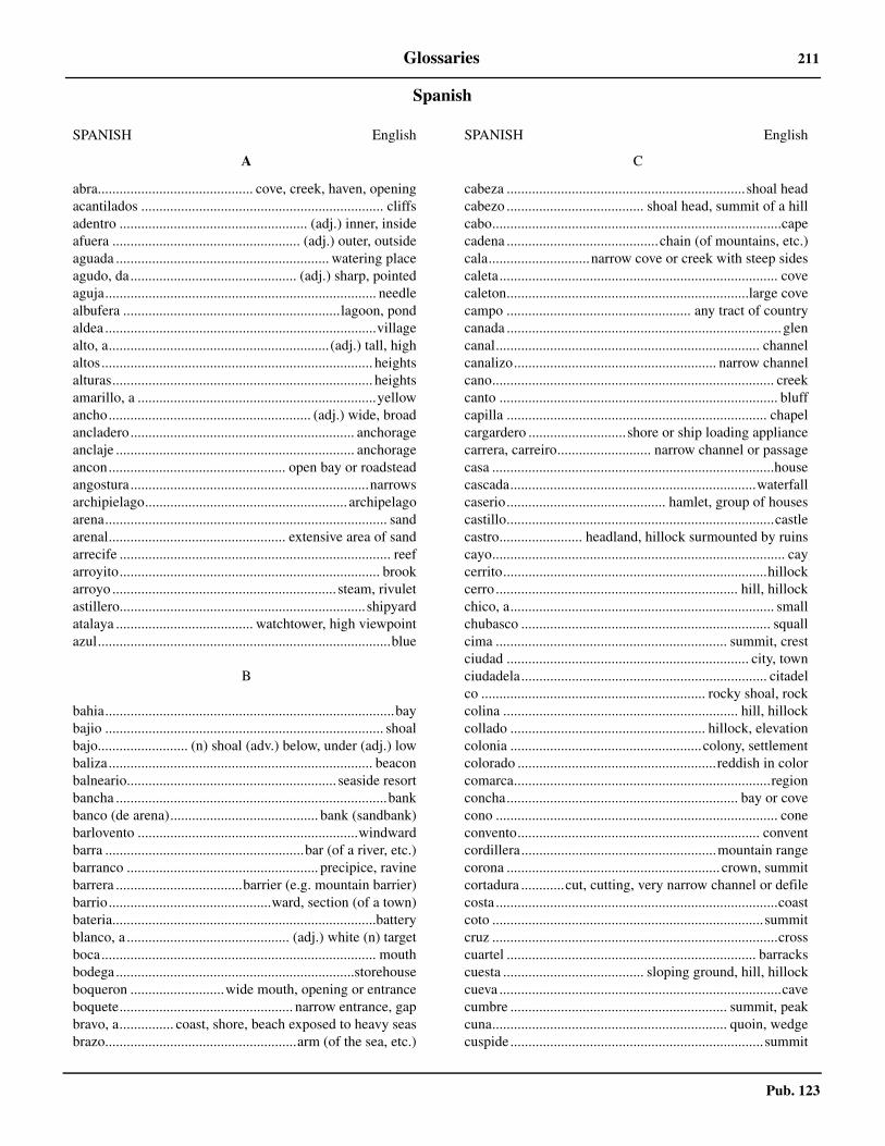
Pub. 123
Glossaries 211
Spanish
SPANISH English
A
abra........................................... cove, creek, haven, openingacantilados ................................................................... cliffsadentro .................................................... (adj.) inner, insideafuera .................................................... (adj.) outer, outsideaguada ........................................................... watering placeagudo, da.............................................. (adj.) sharp, pointedaguja........................................................................... needlealbufera ............................................................lagoon, pondaldea ...........................................................................villagealto, a.............................................................(adj.) tall, highaltos........................................................................... heightsalturas........................................................................ heightsamarillo, a ..................................................................yellowancho........................................................ (adj.) wide, broadancladero.............................................................. anchorageanclaje .................................................................. anchorageancon................................................. open bay or roadsteadangostura..................................................................narrowsarchipielago........................................................ archipelagoarena.............................................................................. sandarenal................................................. extensive area of sandarrecife ........................................................................... reefarroyito........................................................................ brookarroyo .............................................................. steam, rivuletastillero.................................................................... shipyardatalaya ...................................... watchtower, high viewpointazul.................................................................................blue
B
bahia................................................................................baybajio ............................................................................. shoalbajo......................... (n) shoal (adv.) below, under (adj.) lowbaliza......................................................................... beaconbalneario.......................................................... seaside resortbancha ...........................................................................bankbanco (de arena)......................................... bank (sandbank)barlovento .............................................................windwardbarra .......................................................bar (of a river, etc.)barranco ..................................................... precipice, ravinebarrera ...................................barrier (e.g. mountain barrier)barrio.............................................ward, section (of a town)bateria.........................................................................batteryblanco, a ............................................. (adj.) white (n) targetboca............................................................................ mouthbodega..................................................................storehouseboqueron ..........................wide mouth, opening or entranceboquete................................................ narrow entrance, gapbravo, a............... coast, shore, beach exposed to heavy seasbrazo.....................................................arm (of the sea, etc.)
C
cabeza ..................................................................shoal headcabezo ...................................... shoal head, summit of a hillcabo................................................................................capecadena ..........................................chain (of mountains, etc.)cala............................narrow cove or creek with steep sidescaleta............................................................................. covecaleton...................................................................large covecampo ................................................... any tract of countrycanada ............................................................................ glencanal......................................................................... channelcanalizo........................................................ narrow channelcano.............................................................................. creekcanto ............................................................................. bluffcapilla ........................................................................ chapelcargardero ...........................shore or ship loading appliancecarrera, carreiro.......................... narrow channel or passagecasa ..............................................................................housecascada....................................................................waterfallcaserio............................................ hamlet, group of housescastillo..........................................................................castlecastro....................... headland, hillock surmounted by ruinscayo................................................................................. caycerrito.........................................................................hillockcerro ................................................................... hill, hillockchico, a......................................................................... smallchubasco ..................................................................... squallcima ................................................................ summit, crestciudad ................................................................... city, townciudadela.................................................................... citadelco .............................................................. rocky shoal, rockcolina ................................................................. hill, hillockcollado ...................................................... hillock, elevationcolonia .....................................................colony, settlementcolorado .......................................................reddish in colorcomarca.......................................................................regionconcha................................................................ bay or covecono .............................................................................. coneconvento................................................................... conventcordillera......................................................mountain rangecorona ........................................................... crown, summitcortadura ............cut, cutting, very narrow channel or defilecosta ..............................................................................coastcoto ...........................................................................summitcruz ...............................................................................crosscuartel ..................................................................... barrackscuesta ....................................... sloping ground, hill, hillockcueva ..............................................................................cavecumbre ............................................................ summit, peakcuna................................................................. quoin, wedgecuspide ......................................................................summit
SPANISH English

Pub. 123
212 Glossaries
D
darsena ............................................. basin, dock, backwaterdelta...............................................................................deltadepartamento.......................................................departmentdesembarcadero .............................................. landing placedesembocadura............................................mouth of a riverdesierto........................................................................ desertdique...................................mole, dock, embankment, leveedistrito ........................................................................districtdoble...........................................................................doubleduna...............................................................................dune
E
el........................................................definite article (masc.)embocadura................................................................ mouthensenada..........................................................................bayentrada..................................................................... entranceermita ....................................................................hermitageescollera ..............................................breakwater, wavetrapescollo ........................................... shallow rock, reef awashespigon ........................................................... arm of a moleestacion ...................................................................... stationestancia................................................ ranch, country estateeste ................................................................................. eastestero...................................................................creek, inletestrecho ........................................................ straits, narrowsestuario...................................................................... estuaryexterior ........................................................... outer, exterior
F
farallon ...................... stack, steep sharp-pointed rocky isletfaro ....................................................................... lighthousefondeadero ........................................................... anchoragefortaleza ....................................................................fortressfraile ...............................................................................friarfreo ................................................................................straitfreu ....................narrow strait between island and mainlandfronton.............................................................wall-like clifffuerte ...............................................................................fort
G
garganta.............................narrow restricted passage, soundgarita ................................................sentry box, lookout hutgolfo ............................................................................... gulfgran, grande .................................................large, great, biggris .................................................................................greygrupo ........................................................ group (of islands)
H
hacienda ...................................................... farm, plantationherradura ........................................... horseshoe-shaped bay
SPANISH English
I
iglesia......................................................................... churchinsua......................................................... small islet or rockinterior ..........................................................................innerisla............................................................................... islandislete............................................................................... isletislita .......................................................... small island, isletislote ....................................................... barren islet, skerryislotillo or islotito .......................... small barren islet (dim.)istmo ........................................................................ isthmus
L
la, las...................................................definite article (fem.)lago ................................................................................ lakelaguna .............................................................. lagoon, pondlaja .......................................................................... flat rocklargo, a ...........................................................................longlastra .................................................................. rocky ledgelaxe.................................................................................rocklevante........................................................................easternloma .................................................................hillock, knolllomo..............................................................................ridgelos .....................................................definite article (masc.)lugar .................................................................village, placelugarejo ...................................................................... hamletllana ..............................................................................plainllano, a ......................................................... plain, flat (adj.)llanura ...........................................................................plain
M
malecon............................................................... quay, molemar ...................................................................................seamargen ....................................................... shore, river bankmarisma ...................................................................... marshmedano .......................................................... dune, sandhillmedio .........................................................................middlemeridional............................................................... southernmesa or meseta .........................................tableland, plateaumogote ..................................................................hummockmolino............................................................................ millmonasterio ........................................................... monasterymontana .................................................................mountainmonte .........................................................mountain, mountmonte ................................... forest, group or clump of treesmonticulo ......................................................................knollmoreno........................................................................brownmorro ........................... headland, bluff, head of breakwatermuelle .......................................................... pier, jetty, molemuralla .....................a barrier wall of mountains, cliffs, etc.
N
negro, a ........................................................................ black
SPANISH English

Pub. 123
Glossaries 213
norte ............................................................................. northnuevo, a .......................................................................... new
O
obscuro...........................................................................darkoccidental ................................................................. westernoeste .............................................................................. westoriental ...................................................................... easternoriente ............................................................................ eastorilla ....................................... shore, edge, bank (of a river)oscuro.............................................................................dark
P
palacio........................................................................ palacepan de azucar ........................................................sugar loafpantano...........................................................swamp, marshpardo ..............................................................................greyparque.............................................................................parkpasco ......................................................promenade, avenuepasale ....................................................................... passagepaso ................................................................................passpedregal................................................ stony or rocky patchpena................................................................................rockpenasco...............................................................a large rockpeninsula ............................................................... peninsulapenon........................................................... rocky mountainpequeno, a .................................................................... smallpeton................................................................pinnacle rockpicacho ................................................................ sharp peakpico................................................................................ peakpiedra .................................................................. stone, rockplacer............................................................................ shoalplaya............................................................................ beachpoblacion.......................................................................townpoblado.......................................................................villageponiente.................................................................... westernpozo.................................well, deep hole in river or sea bedpresa .................................................................barrage, weirpromontorio .......................................................promontoryprovincia .................................................................provincepuebla.........................................................................villagepueblecito............................................... small town, villagepueblito ......................................................................hamletpueblo............................................................................townpuente......................................................................... bridgepuerto .................................................................port, harborpunta............................................................................. pointpuntal ............................................................... narrow point
Q
quebrada........................................................... ravine, gully
SPANISH English
R
rada ........................................................................roadsteadredondo, a ....................................................................roundregato .............................................................torrent, streamrestinga ...........................................................................reefreventazones ........................................................... breakersria ..........................................sunken valley forming estuaryriachuelo ................................................................... riverletribera.......................................................... shore, river bankrincon.............................inner angle or corner, a small coverio.................................................................................. riverroca ................................................................................rockrocalloso, a.......................................................pebbly, stonyrochel ................................................................. rocky patchrodal .......................shoal, usually rocky and of some extentrojo, a ...............................................................................redrompeolas ........................................................... breakwaterrompientes .............................................................. breakersroquerio.............................................................. rocky shoal
S
salinas ...................................................................... saltpanssan, santo, a................................................................... saintseco ..................................................................................dryseno................................................................... bight, soundseptentrional ........................................................... northernserrania .........................................................mountain ridgesierra ............................................................mountain rangesilla .............................................................................saddlesotavento .................................................................. leewardsucio, a ........................................................................... foulsud, sur......................................................................... southsurgidero .............................................................. anchorage
T
tenedero .....................................holding ground, anchoragetetas........................................................................... nipplesteton ................................................................... large nippletierra............................................................................... landtorre.............................................................................. towertouza .......................rock (usually lying off a larger feature)
V
vado ............................................................................... fordvalle ............................................................................ valleyvaradero ................................................................... slipwayvega................................................................... plain (noun)ventisquero................................................................. glacierverde ............................................................................ greenviejo, a .............................................................................oldvigia ..........................................................................lookout
SPANISH English
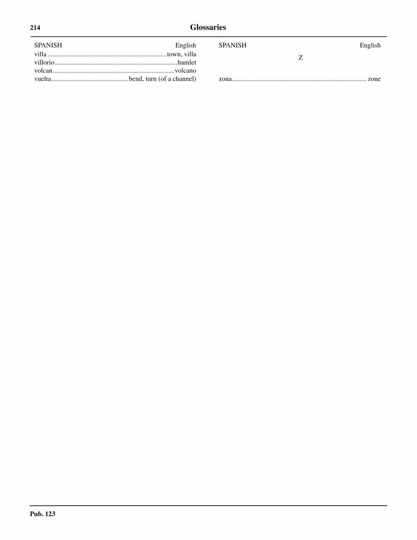
Pub. 123
214 Glossaries
villa ......................................................................town, villavillorio........................................................................hamletvolcan....................................................................... volcanovuelta............................................. bend, turn (of a channel)
SPANISH English
Z
zona............................................................................... zone
SPANISH English
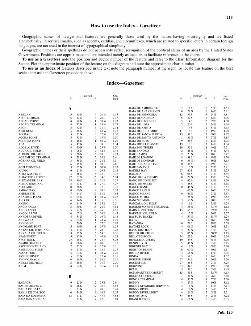
215
Pub. 123
How to use the Index—Gazetteer
Geographic names of navigational features are generally those used by the nation having sovereignty and are listedalphabetically. Diacritical marks, such as accents, cedillas, and circumflexes, which are related to specific letters in certain foreignlanguages, are not used in the interest of typographical simplicity.
Geographic names or their spellings do not necessarily reflect recognition of the political status of an area by the United StatesGovernment. Positions are approximate and are intended merely as locators to facilitate reference to the charts.
To use as a Gazetteer note the position and Sector number of the feature and refer to the Chart Information diagram for theSector. Plot the approximate position of the feature on this diagram and note the approximate chart number.
To use as an Index of features described in the text note the paragraph number at the right. To locate this feature on the bestscale chart use the Gazetteer procedure above.
Index—Gazetteer
Position° ' ° '
Position° ' ° '
Sec.Para
Sec.Para
AABIDJAN 5 15 N 4 01 W 1.13ABO TERMINAL 5 42 N 4 28 E 2.17ABOADI POINT 4 58 N 1 38 W 1.23ABOADI TERMINAL 4 57 N 1 38 W 1.23ABOH 5 32 N 6 31 E 2.14ABREKUM 5 18 N 0 43 W 1.28ACCRA 5 32 N 0 12 W 1.30ACCRA POINT 5 32 N 0 13 W 1.30ACHOWA POINT 4 46 N 1 58 W 1.20ADA 5 47 N 0 38 E 1.34ADOBLO ROCK 4 50 N 1 53 W 1.20ADUA OIL FIELD 4 06 N 7 42 E 3.18AFREMO OIL FIELD 5 26 N 5 10 E 2.23AGBAMI OIL TERMINAL 3 28 N 5 34 E 3.6AGBARA OIL FIELD 3 56 N 6 24 E 3.3AGOUE 6 15 N 1 40 E 2.6AGPI TERMINAL 5 05 N 1 00 W 1.27AJUMO 6 21 N 4 26 E 2.12ALBA GAS FIELD 3 58 N 8 33 E 3.78ALBATROSS ROCKS 27 07 S 15 14 E 5.24ALEXANDER BAY 28 40 S 16 31 E 5.29ALIMA TERMINAL 5 23 S 11 27 E 4.27ALOUMBE 0 26 S 9 17 E 3.70AMBAS BAY 4 00 N 9 10 E 3.33AMBRIZETE 7 14 S 12 51 E 4.64ANASHUN POINT 5 09 N 1 10 W 1.27ANECHO 6 14 N 1 35 E 2.5ANEHO 6 14 N 1 35 E 2.5ANGO-ANGO 5 50 S 13 26 E 4.52ANGO-ANGO 5 51 S 13 26 E 4.51ANGOLA LNG 6 07 S 12 20 E 4.43ANKOBRA RIVER 4 54 N 2 16 W 1.16ANKWANA 5 04 N 1 24 W 1.25ANNOBON 1 26 N 5 37 E 3.95ANOMABU FORT 5 10 N 1 07 W 1.27ANTAN OIL TERMINAL 4 13 N 8 20 E 3.26ANYALA OIL FIELD 3 55 N 5 54 E 2.36APAM POINT 5 17 N 0 44 W 1.28ARCH ROCK 27 28 S 15 24 E 5.25ASABO OIL FIELD 4 06 N 7 48 E 3.18ASCENSION ISLAND 7 57 S 14 22 W 6.1ASOMA OIL FIELD 4 17 N 8 38 E 3.27ASSAY POINT 5 03 N 1 30 W 1.25ASSINIC RIVER 5 07 N 3 17 W 1.15AVON CANYON 6 16 N 3 56 E 2.11AWODI OIL FIELD 5 28 N 5 01 E 2.20AXIM 4 52 N 2 15 W 1.19
BBADAGRI 6 25 N 2 53 E 2.9BAGRE OIL FIELD 6 26 S 12 18 E 4.55BAHIA DE BATA 1 51 N 9 48 E 3.48BAHIA DE CORISCO 0 54 N 9 16 E 3.55BAIA DA EQUIMINA 13 11 S 12 47 E 4.83BAIA DAS AGULHAS 1 37 N 7 22 E 3.89
BAIA DE AMBRIZETE 7 14 S 12 51 E 4.63BAIA DE ANA CHAVES 0 21 N 6 44 E 3.91BAIA DE BENGUELA 12 35 S 13 24 E 4.81BAIA DE CABINDA 5 32 S 12 12 E 4.36BAIA DE CACONGO 5 14 S 12 09 E 4.30BAIA DE JUMA 7 20 S 12 54 E 4.64BAIA DE NZETO 7 14 S 12 51 E 4.63BAIA DE QUICOMBO 11 18 S 13 49 E 4.78BAIA DE SANTA MARTA 13 51 S 12 30 E 4.87BAIA DE SANTO ANTONIO 1 39 N 7 27 E 3.88BAIA DO SUTO 9 38 S 13 13 E 4.75BAIA DOS ELEFANTES 13 13 S 12 44 E 4.84BAIA DOS TIGRES 16 35 S 11 46 E 5.2BAIE BANOKO 2 48 N 9 54 E 3.44BAIE CAMPO 2 23 N 9 48 E 3.47BAIE DE LOANGO 4 38 S 11 49 E 4.20BAIE DE MONDAH 0 35 N 9 36 E 3.63BAIE DU CAP LOPEZ 0 38 S 8 49 E 3.71BAIE PANAVIA 3 10 N 9 52 E 3.41BAKERS BAY 27 40 S 15 31 E 5.25BANANA 6 01 S 12 24 E 4.45BANC DE LA THEMIS 0 27 N 9 15 E 3.66BANC DU CONFLICT 4 42 S 11 45 E 4.20BANC DU MULET 4 28 S 11 33 E 4.18BANCO BANE 0 46 N 9 21 E 3.57BANCO LAURIA 1 05 N 9 16 E 3.55BANCO MBANE 0 46 N 9 21 E 3.57BANCO MITRA 1 25 N 9 19 E 3.52BANCS BIMBIA 3 50 N 9 20 E 3.37BANZALA OIL FIELD 5 11 S 11 55 E 4.28BAOBAB MARINE TERMINAL 4 58 N 4 33 W 1.12BARN LONG POINT 15 55 S 5 39 W 6.11BAROMBI OIL FIELD 4 15 N 8 26 E 3.27BASSUBU ROCKS 4 59 N 1 38 W 1.24BATA 1 52 N 9 46 E 3.50BATANGA 0 21 S 9 18 E 3.69BATOKI ROCK 4 01 N 9 06 E 3.31BAVO OIL FIELD 4 20 N 8 37 E 3.27BELIER OIL FIELD 5 05 N 3 50 W 1.15BELLOWS ROCK 34 23 S 18 30 E 5.59BENGUELA VELHA 10 44 S 13 45 E 4.76BENIN RIVER 5 46 N 5 03 E 2.15BIBUNDI BAY 4 11 N 8 58 E 3.30BIGHT OF BENIN 6 00 N 4 30 E 2.1BIMBIA RIVER 3 58 N 9 17 E 3.35BINDA 5 51 S 13 14 E 4.52BOEGOE BERGE 27 54 S 15 56 E 5.26BOGENFELS 27 28 S 15 24 E 5.25BOKPUNT 33 34 S 18 19 E 5.50BOMA 5 51 S 13 03 E 4.48BONAPARTE SEAMOUNT 15 45 S 6 52 W 6.13BONE DO JOQUERI 1 31 N 7 26 E 3.88BONGA TERMINAL 4 33 N 4 37 E 2.30BONNY 4 27 N 7 10 E 3.12BONNY OFFSHORE TERMINAL 4 11 N 7 14 E 3.11BONNY RIVER 4 18 N 7 04 E 3.5BONNY RIVER LIGHT 4 24 N 7 08 E 3.5BOUVETOYA 54 26 S 3 25 E 6.22BRANCH RIVER 4 16 N 6 04 E 2.35

216 Index—Gazetteer
Pub. 123
Position° ' ° '
Position° ' ° '
Sec.Para
Sec.Para
BRASS 4 19 N 6 14 E 3.2BRASS OIL TERMINAL 4 04 N 6 17 E 3.3BRASS RIVER 4 17 N 6 13 E 3.2BREAKER POINT 5 39 N 0 02 E 1.33BRITTANIA BLINDER 32 42 S 17 52 E 5.43BUMBU 5 53 S 13 09 E 4.52BURUTU 5 21 N 5 30 E 2.26BUTTERMILK POINT 15 54 S 5 42 W 6.8BW ADOLO 4 15 N 10 49 E 4.16
CCABECA DA BALEIA 11 35 S 13 46 E 4.79CABECA DA COBRA 6 33 S 12 30 E 4.54CABINDA 5 32 S 12 12 E 4.36CABINDA TERMINAL 5 26 S 12 05 E 4.33CABO BATA 2 06 N 9 45 E 3.48CABO CAMPO 2 19 N 9 47 E 3.47CABO DAS TRES PONTAS 10 23 S 13 32 E 4.75CABO DE SANTA MARIA 13 25 S 12 32 E 4.86CABO DE SANTA MARTA 13 53 S 12 25 E 4.88CABO DOS PUNTAS 1 41 N 9 36 E 3.51CABO LEDO 9 41 S 13 12 E 4.75CABO SAN JUAN 1 10 N 9 20 E 3.54CALABAR 4 58 N 8 19 E 3.25CALABAR RIVER 4 33 N 8 23 E 3.24CAMEROON MOUNTAIN 4 13 N 9 10 E 3.1CAMEROON RIVER 3 50 N 9 26 E 3.38CAMPS BAY 33 57 S 18 23 E 5.55CANAL D’ASSINIE 5 07 N 3 20 W 1.15CANAL DE SANTO ANTONIO 6 07 S 12 22 E 4.43CAP CAMEROUN 3 54 N 9 28 E 3.37CAP ESTERIAS 0 37 N 9 20 E 3.64CAP LOPEZ 0 37 S 8 43 E 3.72CAP LOPEZ TERMINAL 0 38 S 8 43 E 3.73CAP SANTA CLARA 0 30 N 9 19 E 3.65CAPE CIRCONCISION 54 25 S 3 21 E 6.22CAPE COAST 5 06 N 1 14 W 1.26CAPE COLUMBINE 32 50 S 17 51 E 5.44CAPE CROSS 21 46 S 13 57 E 5.10CAPE DESEADA 32 19 S 18 19 E 5.40CAPE DONKIN 31 56 S 18 16 E 5.38CAPE FORMOSO 4 16 N 6 05 E 3.2CAPE MACLEAR 34 21 S 18 28 E 5.59CAPE NACHTIGAL 3 57 N 9 13 E 3.33CAPE NUN 4 17 N 6 04 E 2.35CAPE OF GOOD HOPE 34 21 S 18 29 E 5.59CAPE PALMAS 4 22 N 7 44 W 1.2CAPE POINT 34 21 S 18 30 E 5.59CAPE SAINT MARTIN 32 43 S 17 55 E 5.43CAPE SAINT PAUL 5 50 N 0 58 E 2.2CAPE THREE POINTS 4 45 N 2 05 W 1.20CAPE TOWN 33 55 S 18 25 E 5.53CAPE VALDIVIA 54 24 S 3 24 E 6.22CAPITAINES LIGHT 0 37 S 8 43 E 3.72CARDNO SEAMOUNT 12 53 S 6 08 W 6.13CASTLE ROCK POINT 16 01 S 5 45 W 6.12CATHERINE POINT 7 56 S 14 25 W 6.3CAUTION REEF 22 45 S 14 31 E 5.12CAVALLA POINT 4 21 N 7 36 W 1.2CAVALLA RIVER 4 22 N 7 32 W 1.3CEIBA TERMINAL 1 24 N 9 13 E 3.53CHAMEISBAAI 27 55 S 15 40 E 5.26CHANOMI CREEK 5 35 N 5 23 E 2.25CHAPMANS POINT 34 05 S 18 21 E 5.57CHUBBS POINT 15 55 S 5 43 W 6.8CLARENCE BAY 7 55 S 14 25 W 6.2CLIFF POINT 29 07 S 16 49 E 5.30CLIFF POINT 31 36 S 18 07 E 5.37CLOV TERMINAL 7 27 S 11 34 E 4.62COGO 1 05 N 9 42 E 3.60CONCEPTION BAY 23 55 S 14 30 E 5.14CONGO RIVER 6 05 S 12 30 E 4.42CONSTANTIABERG 34 03 S 18 23 E 5.56CORISCO BAY 0 54 N 9 16 E 3.55COTONOU 6 21 N 2 26 E 2.7CUNTALA OIL FIELD 6 18 S 12 19 E 4.55
DDABUNDSCHA POINT 4 06 N 8 58 E 3.30DALIA TERMINAL 7 41 S 11 46 E 4.68DAMPA HILL 5 29 N 0 23 W 1.29DAMPIER SEAMOUNT 11 09 S 0 28 W 6.13DANGER POINT 26 16 S 14 57 E 5.19DASSENEILAND 33 25 S 18 05 E 5.49DEBUNDSCHA POINT 4 06 N 8 58 E 3.30DELTA OIL FIELD 5 41 N 5 03 E 2.20DELTA SOUTH OIL FIELD 5 36 N 5 06 E 2.20DEVILS PEAK 33 57 S 18 27 E 5.52DEVILS RIDING SCHOOL 7 58 S 14 23 W 6.1DIAMANTS 5 52 S 13 23 E 4.52DIAZ POINT LIGHT 26 38 S 15 06 E 5.21DIONE 1 23 N 9 28 E 3.52DISCOVERY SEAMOUNT 42 05 S 0 15 E 6.23DJENO 4 55 S 11 56 E 4.23DJENO OFFSHORE TERMINAL 4 56 S 11 54 E 4.23DOCTOR REEF 32 46 S 18 06 E 5.41DODO RIVER 4 53 N 5 29 E 2.28DORINGBAAI LIGHT 31 49 S 18 14 E 5.38DOUALA 4 03 N 9 41 E 3.39DOUGLAS BAY 26 18 S 14 57 E 5.20DUIKERPUNT 34 02 S 18 18 E 5.56DUMINYPUNT 32 55 S 17 51 E 5.45DUSSAFU TERMINALI 4 15 S 10 49 E 4.16
EEA OIL FIELD 4 49 N 5 21 E 2.29EASTER POINT 25 18 S 14 48 E 5.16EBOME MARINE TERMINAL SOUTH 2 44 N 9 51 E 3.46EBOME TERMINAL 2 48 N 9 49 E 3.45EDINBURGH ANCHORAGE 37 03 S 12 18 W 6.16EDOP OIL FIELD 4 09 N 7 58 E 3.21EGINA OIL TERMINAL 3 4 N 6 42 E 3.7EGITO PRAIA 11 58 S 13 46 E 4.79EJISIMANKU HILL 5 20 N 0 41 W 1.28EJULEBE OIL FIELD 5 35 N 5 00 E 2.20EKOUNDOU OIL FIELD 4 18 N 8 25 E 3.27EKPE OIL FIELD 4 06 N 7 35 E 3.18EKU OIL FIELD 4 16 N 8 06 E 3.21ELF GABON OIL TERMINAL 0 38 S 8 43 E 3.73ELIZABETH POINT 26 55 S 15 11 E 5.22ELMINA POINT 5 05 N 1 20 W 1.25EMERAUDE OIL FIELD 5 03 S 11 47 E 4.24ENANG OIL FIELD 4 12 N 7 55 E 3.21ENGLISH BAY TERMINAL 7 53 S 14 23 W 6.2ENSEADA DE SUTO 9 38 S 13 13 E 4.75ENSEADA DO BONFIM 13 49 S 12 32 E 4.87ENSEADA DO QUICOMBO 11 18 S 13 49 E 4.78ENSEADA LANDANA 5 14 S 12 09 E 4.30ENSEADO DO CAPULO 7 59 S 13 11 E 4.71ERHA OIL TERMINAL 5 21 N 4 20 E 2.19ESCRAVOS OIL & GAS TRML 5 30 N 5 00 E 2.18ESCRAVOS RIVER 5 34 N 5 10 E 2.20ESPOIR TERMINAL 5 03 N 4 27 W 1.11ESSUNGO OIL FIELD 6 13 S 12 10 E 4.55ESTRELA OIL FIELD 6 26 S 12 21 E 4.55ESTUAIRE CAMEROUN 3 50 N 9 26 E 3.38ESTUAIRE DU GABON 0 18 N 9 26 E 3.65ETAME TERMINAL 3 45 S 10 31 E 4.14ETIM OIL FIELD 4 09 N 8 03 E 3.21
FFAKO 4 13 N 9 10 E 3.1FARILHAO POINT 22 10 S 14 17 E 5.11FAUSSE POINTE NOIRE 4 53 S 11 54 E 4.22FISHTOWN RIVER 4 24 N 5 50 E 2.33FLAGSTAFF HILL 15 55 S 5 41 W 6.7FORCADOS OIL FIELD 5 23 N 5 18 E 2.23FORCADOS OIL TERMINAL 5 10 N 5 10 E 2.24FORCADOS RIVER 5 23 N 5 16 E 2.23FORT ORANGE LIGHT 4 56 N 1 42 W 1.22FOUCHE POINT 4 23 N 7 01 E 3.4FOXTROT PLATFORM 5 02 N 4 41 W 1.10FRONTON DE CARACAS 3 25 N 8 48 E 3.82FUTILA OIL TERMINAL 5 27 S 12 11 E 4.35
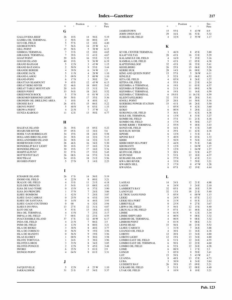
Index—Gazetteer 217
Pub. 123
Position° ' ° '
Position° ' ° '
Sec.Para
Sec.Para
GGALLOVIDIA REEF 26 10 S 14 56 E 5.19GAMBA OIL TERMINAL 2 50 S 10 00 E 4.9GCO OIL FIELD 5 57 S 12 10 E 4.40GEORGETOWN 7 56 S 14 25 W 6.3GILL POINT 15 58 S 5 38 W 6.12GIMBOA TERMINAL 7 33 S 12 10 E 4.65GIRASSOL TERMINAL 7 39 S 11 41 E 4.67GOAP POINT 29 18 S 16 53 E 5.32GOUGH ISLAND 40 19 S 9 56 W 6.19GRAND BASSAM 5 12 N 3 43 W 1.15GRAND BATANGA 2 50 N 9 53 E 3.44GRANDE BEREBI 4 39 N 6 54 W 1.5GRANDE JACK 5 11 N 4 28 W 1.10GRAND-LAHOU 5 09 N 5 00 W 1.10GRAND-POPO 6 17 N 1 50 E 2.6GRATTAN SEAMOUNT 9 45 S 12 45 W 6.13GREAT BERG RIVER 32 46 S 18 09 E 5.42GREAT TABLE MOUNTAIN 20 14 S 13 31 E 5.9GREEN POINT 33 54 S 18 24 E 5.52GREENWICH ROCK 5 37 N 0 01 W 1.31GROENRIVIERMOND LIGHT 30 50 S 17 35 E 5.36GRONDIN OIL DRILLING AREA 1 10 S 8 40 E 4.2GROSSE BAY 26 45 S 15 06 E 5.22GROVE POINT 5 40 N 0 03 E 1.33GROWA POINT 4 21 N 7 37 W 1.2GUNZA-KABOLO 11 12 S 13 50 E 4.77
HHALIFAX ISLAND 26 39 S 15 05 E 5.22HOARUSIB RIVER 19 05 S 12 34 E 5.6HOEK VAN BOBBEJAAN 34 19 S 18 24 E 5.58HOLLAMS BIRD ISLAND 24 38 S 14 32 E 5.15HOLLANDSBIRD ISLAND 24 38 S 14 32 E 5.15HOMEWOOD COVE 28 46 S 16 34 E 5.30HONDEKLIP BAY LIGHT 30 18 S 17 16 E 5.34HONDEKLIPBAAI 30 19 S 17 16 E 5.34HOSPITALPUNT 32 57 S 17 53 E 5.45HOTTENTOT BAY 26 08 S 14 57 E 5.18HOUTBAAI 34 03 S 18 21 E 5.56HUGHES POINT 5 27 N 5 14 E 2.23
IICHABOE ISLAND 26 17 S 14 56 E 5.19IDOHO OIL FIELD 4 22 N 8 00 E 3.21IKALOU OIL FIELD 4 33 S 11 21 E 4.18ILES DES PRINCES 5 54 S 13 08 E 4.52ILHA DE SAO TOME 0 15 N 6 37 E 3.90ILHA DO PRINCIPE 1 37 N 7 24 E 3.86ILHEU BOMBOM 1 42 N 7 24 E 3.87ILHEU DAS CABRAS 0 25 N 6 43 E 3.91ILHEU DE SANTANA 0 14 N 6 46 E 3.93ILHEU GAGO COUTINHO 0 00 6 32 E 3.94ILHEUS DO PINA 13 27 S 12 31 E 4.87ILOT OSCAR 5 53 S 13 18 E 4.52IMA OIL TERMINAL 4 13 N 7 23 E 3.17IMPALA OIL FIELD 7 00 S 12 23 E 4.55INACCESSIBLE ISLAND 37 17 S 12 40 W 6.17INDA OIL FIELD 4 21 N 7 06 E 3.5INIM OIL FIELD 4 12 N 8 00 E 3.21ISLA DE BIOKO 3 30 N 8 40 E 3.77ISLA DE CORISCO 0 56 N 9 19 E 3.56ISLA DE MANDYI 0 56 N 9 19 E 3.56ISLAS ELOBEY 1 00 N 9 30 E 3.58ISLOTE TORTUGA 1 24 S 5 38 E 3.96ISLOTES LOROS 3 33 N 8 34 E 3.85ISLOTES PONGUE 2 12 N 9 45 E 3.48IWORO 6 25 N 3 01 E 2.9IZONGO POINT 4 04 N 9 01 E 3.31
JJACQUEVILLE 5 12 N 4 23 W 1.10JAKKALSHOK 31 21 S 17 54 E 5.37
JAMESTOWN 15 55 S 5 43 W 6.9JOHN OWEN BAY 29 16 S 16 53 E 5.32JUBILEE OIL FIELD 4 32 N 2 55 W 1.17
KK5 OIL CENTER TERMINAL 3 46 N 8 45 E 3.80KAAP VOLTAS 28 43 S 16 33 E 5.29KALAEKULE OIL FIELD 4 16 N 7 19 E 3.16KAMBALA OIL FIELD 5 43 S 12 05 E 4.38KAPTEINSKLOOF 32 43 S 18 35 E 5.41KEGELBERG 26 25 S 15 06 E 5.20KERBE HUK 28 14 S 16 00 E 5.26KING AND QUEEN POINT 15 57 S 5 38 W 6.11KINLELE 5 52 S 13 06 E 4.52KITA OIL FIELD 4 05 N 8 26 E 3.27KITINA OIL FIELD 4 55 S 11 23 E 4.24KIZOMBA A TERMINAL 6 19 S 11 03 E 4.57KIZOMBA B TERMINAL 6 21 S 11 09 E 4.58KIZOMBA C TERMINAL 6 19 S 11 16 E 4.59KIZOMBA C TERMINAL 6 19.0 S 11 16.5 E 4.59KLEINTAFELBERG 32 33 S 18 28 E 5.41KNOLL POINT 25 28 S 14 50 E 5.16KOEBERG POWER STATION 33 41 S 18 26 E 5.50KOGO 1 05 N 9 42 E 3.60KOKO 6 00 N 5 28 E 2.21KOKONGA OIL FIELD 5 36 S 11 42 E 4.38KOLE OIL TERMINAL 4 13 N 8 33 E 3.27KOMBI OIL FIELD 4 37 S 11 21 E 4.18KOMBO OIL FIELD 4 17 N 8 30 E 3.27KOME KRIBI 1 TERMINAL 2 55 N 9 48 E 3.43KONZI OIL FIELD 0 16 S 9 13 E 3.69KOUILOU RIVER 4 29 S 11 42 E 4.18KPEME 6 12 N 1 31 E 2.4KPONE BAY 5 40 N 0 03 E 1.33KRIBI 2 56 N 9 54 E 3.42KRIBI DEEP-SEA PORT 2 44 N 9 51 E 3.46KROMANTI 5 12 N 1 04 W 1.27KROMANTSE 5 12 N 1 04 W 1.27KUITO OIL FIELD 5 28 S 11 32 E 4.27KUPUNDJI 5 53 S 12 18 E 4.37KURAMO ISLAND 6 27 N 3 43 E 2.11KWA IBO RIVER 4 33 N 7 59 E 3.21KWABEN HILL 5 17 N 0 47 W 1.28KWANDA 6 07 S 12 19 E 4.44
LLAGEAS 14 24 S 12 21 E 4.88LAGOS 6 24 N 3 24 E 2.10LAMBERT'S BAY 32 05 S 18 18 E 5.39LANGVLEI 32 13 S 18 21 E 5.40LE TROU SANS FOND 5 05 N 4 00 W 1.13LEKKI 6 24 N 4 07 E 2.12LEKKI SEA PORT 6 21 N 4 01 E 2.12LIBREVILLE 0 23 N 9 27 E 3.67LIBWA OIL FIELD 5 56 S 12 15 E 4.40LIKOUALA OIL FIELD 5 07 S 11 46 E 4.24LIMBE 4 01 N 9 12 E 3.34LIMBE SHIPYARD 4 00 N 9 08 E 3.32LIMBOH OIL TERMINAL 4 00 N 9 08 E 3.32LIMBOH POINT 4 01 N 9 08 E 3.31LIONS HEAD 33 56 S 18 23 E 5.52LLHEU CAROCO 1 31 N 7 26 E 3.88LOANGO OIL FIELD 4 30 S 11 16 E 4.18LOBITO 12 20 S 13 34 E 4.80LOBITO LIGHT 12 19 S 13 34 E 4.80LOMBO EAST OIL FIELD 6 51 S 12 24 E 4.55LOMBO EAST OIL TERMINAL 6 50 S 12 22 E 4.60LOMBO OIL FIELD 6 52 S 12 24 E 4.28LOME 6 08 N 1 17 E 2.3LONGJI 3 05 N 9 59 E 3.41LOT 15 59 S 5 43 W 6.7LUANDA 8 48 S 13 15 E 4.73LUBA 3 30 N 8 34 E 3.84LUDERITZ BAY 26 39 S 15 09 E 5.21LUKAMI OIL FIELD 5 51 S 12 08 E 4.40LYAK OIL FIELD 4 10 N 8 10 E 3.21
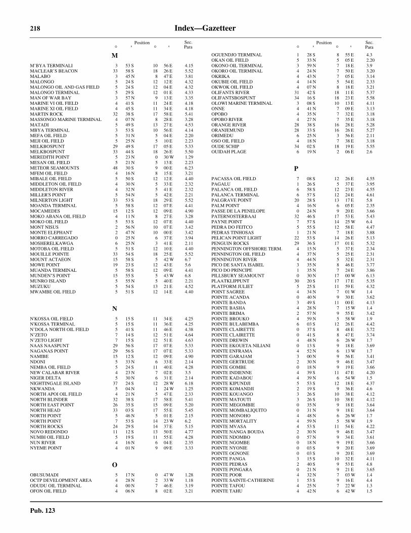
218 Index—Gazetteer
Pub. 123
Position° ' ° '
Position° ' ° '
Sec.Para
Sec.Para
MM’BYA TERMINALI 3 53 S 10 56 E 4.15MACLEAR’S BEACON 33 58 S 18 26 E 5.52MALABO 3 45 N 8 47 E 3.81MALONGO 5 24 S 12 12 E 4.32MALONGO OIL AND GAS FIELD 5 24 S 12 04 E 4.32MALONGO TERMINAL 5 29 S 12 01 E 4.33MAN OF WAR BAY 3 57 N 9 13 E 3.35MARINE VI OIL FIELD 4 41 S 11 24 E 4.18MARINE XI OIL FIELD 4 45 S 11 34 E 4.18MARTIN ROCK 32 38 S 17 58 E 5.41MASSONGO MARINE TERMINAL 4 07 N 8 28 E 3.28MATADI 5 49 S 13 27 E 4.53MBYA TERMINAL 3 53 S 10 56 E 4.14MEFA OIL FIELD 5 31 N 5 04 E 2.20MEJI OIL FIELD 5 25 N 5 10 E 2.23MELKBOSPUNT 29 49 S 17 05 E 5.33MELKBOSPUNT 33 44 S 18 26 E 5.50MEREDITH POINT 5 23 N 0 30 W 1.29MESAN OIL FIELD 5 21 N 5 13 E 2.23METEOR SEAMOUNTS 48 30 S 9 00 E 6.23MFEM OIL FIELD 4 16 N 8 15 E 3.21MIBALE OIL FIELD 5 50 S 12 12 E 4.40MIDDLETON OIL FIELD 4 30 N 5 33 E 2.32MIDDLETON RIVER 4 32 N 5 41 E 2.32MILLER'S POINT 5 54 N 5 42 E 2.21MILNERTON LIGHT 33 53 S 18 29 E 5.52MOANDA TERMINAL 5 58 S 12 07 E 4.41MOCAMEDES 15 12 S 12 09 E 4.90MOKO ABANA OIL FIELD 4 11 N 8 27 E 3.28MOKO OIL FIELD 5 53 S 12 07 E 4.40MONT NISUS 2 56 N 10 07 E 3.42MONTE ELEPHANT 2 47 N 10 00 E 3.42MORRO CARREGADO 0 25 N 6 37 E 3.94MOSHERELKAWGA 6 25 N 3 41 E 2.11MOTOBA OIL FIELD 5 51 S 12 10 E 4.40MOUILLE POINTE 33 54 S 18 25 E 5.52MOUNT ACTAEON 15 58 S 5 42 W 6.7MOWE POINT 19 23 S 12 43 E 5.6MUANDA TERMINAL 5 58 S 12 09 E 4.41MUNDEN"S POINT 15 55 S 5 43 W 6.8MUNRO ISLAND 5 55 N 5 40 E 2.21MUZUKU 5 54 S 13 21 E 4.52MWAMBE OIL FIELD 5 51 S 12 14 E 4.40
NN'KOSSA OIL FIELD 5 15 S 11 34 E 4.25N'KOSSA TERMINAL 5 15 S 11 36 E 4.25N’DOLA NORTH OIL FIELD 5 41 S 11 46 E 4.38N’ZETO 7 14 S 12 51 E 4.64N’ZETO LIGHT 7 15 S 12 51 E 4.63NAAS NAASPUNT 29 56 S 17 07 E 5.33NAGANAS POINT 29 56 S 17 07 E 5.33NAMIBE 15 12 S 12 09 E 4.90NDONI 5 33 N 6 33 E 2.14NEMBA OIL FIELD 5 24 S 11 40 E 4.28NEW CALABAR RIVER 4 23 N 7 02 E 3.5NIGER DELTA 5 30 N 6 31 E 2.14NIGHTINGALE ISLAND 37 24 S 12 28 W 6.18NKWANDA 5 04 N 1 24 W 1.25NORTH APOI OIL FIELD 4 21 N 5 47 E 2.33NORTH BLINDER 32 38 S 17 58 E 5.41NORTH EAST POINT 26 35 S 15 09 E 5.20NORTH HEAD 33 03 S 17 55 E 5.45NORTH POINT 5 46 N 5 01 E 2.15NORTH POINT 7 53 S 14 23 W 6.2NORTH ROCKS 24 29 S 14 37 E 5.15NOVO REDONDO 11 12 S 13 50 E 4.77NUMBI OIL FIELD 5 19 S 11 55 E 4.28NUN RIVER 4 16 N 6 04 E 2.35NYEME POINT 4 01 N 9 09 E 3.33
OOBUSUMADI 5 17 N 0 47 W 1.28OCTP DEVELOPMENT AREA 4 28 N 2 33 W 1.18ODUDU OIL TERMINAL 4 00 N 7 46 E 3.19OFON OIL FIELD 4 06 N 8 02 E 3.21
OGUENDJO TERMINAL 1 28 S 8 55 E 4.3OKAN OIL FIELD 5 33 N 5 05 E 2.20OKONO OIL TERMINAL 3 59 N 7 18 E 3.9OKORO OIL TERMINAL 4 24 N 7 50 E 3.20OKRIKA 4 43 N 7 05 E 3.14OKUBIE OIL FIELD 4 14 N 5 54 E 2.33OKWOK OIL FIELD 4 07 N 8 18 E 3.21OLIFANTS RIVER 31 42 S 18 11 E 5.37OLIFANTSBOSPUNT 34 16 S 18 23 E 5.58OLOWI MARINE TERMINAL 3 08 S 10 13 E 4.11ONNE 4 41 N 7 09 E 3.13OPOBO 4 35 N 7 32 E 3.18OPOBO RIVER 4 27 N 7 35 E 3.18ORANGE RIVER 28 38 S 16 28 E 5.28ORANJEMUND 28 33 S 16 26 E 5.27ORIMEDU 6 25 N 3 56 E 2.11OSO OIL FIELD 4 18 N 7 38 E 3.18OUDE SCHIP 34 02 S 18 19 E 5.55OUIDAH PLAGE 6 19 N 2 06 E 2.6
PPACASSA OIL FIELD 7 08 S 12 26 E 4.55PAGALU 1 26 S 5 37 E 3.95PALANCA OIL FIELD 6 58 S 12 23 E 4.55PALANCA TERMINAL 6 57 S 12 24 E 4.61PALGRAVE POINT 20 28 S 13 17 E 5.8PALM POINT 4 16 N 6 05 E 2.35PASSE DE LA PENELOPE 0 24 N 9 20 E 3.66PATERNOSTERBAAI 32 46 S 17 53 E 5.43PAYNE POINT 7 57 S 14 25 W 6.4PEDRA DO FEITCO 5 55 S 12 58 E 4.47PEDRAS TINHOSAS 1 21 N 7 18 E 3.88PELICAN POINT LIGHT 22 53 S 14 26 E 5.13PENGUIN ROCKS 29 36 S 17 01 E 5.32PENNINGTON OFFSHORE TERM. 4 15 N 5 37 E 2.34PENNINGTON OIL FIELD 4 37 N 5 25 E 2.31PENNINGTON RIVER 4 44 N 5 32 E 2.31PICO DE SANTA ISABEL 3 35 N 8 46 E 3.77PICO DO PRINCIPE 1 35 N 7 24 E 3.86PILLSBURY SEAMOUNT 0 30 N 17 00 W 6.13PLAATKLIPPUNT 30 20 S 17 17 E 5.35PLATFORM JULIET 5 25 S 11 59 E 4.32POINT SAGREE 4 34 N 7 01 W 1.4POINTE ACANDA 0 40 N 9 30 E 3.62POINTE BANDA 3 49 S 11 00 E 4.13POINTE BASHA 4 28 N 7 15 W 1.4POINTE BRIMA 2 57 N 9 55 E 3.42POINTE BROUKO 4 59 N 5 58 W 1.9POINTE BULABEMBA 6 03 S 12 26 E 4.42POINTE CLAIRETTE 0 37 S 8 48 E 3.72POINTE CLAIRETTE 0 41 S 8 47 E 3.74POINTE DREWIN 4 48 N 6 26 W 1.7POINTE EKOUETA NILIANI 0 13 S 9 18 E 3.69POINTE ENFRAMA 4 52 N 6 13 W 1.7POINTE GARAJAM 3 00 N 9 56 E 3.41POINTE GERTRUDE 2 30 N 9 46 E 3.47POINTE GOMBE 0 18 N 9 19 E 3.66POINTE INDIENNE 4 39 S 11 47 E 4.20POINTE KADABOU 4 39 N 6 54 W 1.5POINTE KIPUNDJI 5 53 S 12 18 E 4.37POINTE KOMANDJI 2 19 S 9 36 E 4.6POINTE KOUANGO 3 26 S 10 38 E 4.12POINTE MATOUTI 3 26 S 10 38 E 4.12POINTE MEGOMBIE 0 35 N 9 18 E 3.64POINTE MOMBALIQUITO 0 31 N 9 18 E 3.64POINTE MONOHO 4 48 N 6 26 W 1.7POINTE MORTALITY 4 59 N 5 58 W 1.9POINTE MVASA 4 53 S 11 54 E 4.22POINTE NANGA BOUDA 2 30 N 9 46 E 3.47POINTE NDOMBO 0 57 N 9 34 E 3.61POINTE NGOMBE 0 18 N 9 19 E 3.66POINTE NYONIE 0 03 S 9 20 E 3.69POINTE OGNONE 0 03 S 9 20 E 3.69POINTE PANGA 3 15 S 10 32 E 4.11POINTE PEDRAS 2 40 S 9 53 E 4.8POINTE PONGARA 0 21 N 9 21 E 3.65POINTE POOR 4 32 N 7 03 W 1.4POINTE SAINTE-CATHERINE 1 53 S 9 16 E 4.4POINTE TAFOU 4 25 N 7 22 W 1.3POINTE TAHU 4 42 N 6 42 W 1.5

Index—Gazetteer 219
Pub. 123
Position° ' ° '
Position° ' ° '
Sec.Para
Sec.Para
POINTE TCHITEMBO 4 12 S 11 23 E 4.17POINTE TSHIBOBO 3 51 S 11 01 E 4.13POINTE WEBER 2 25 N 9 49 E 3.47POINTE-NOIRE 4 47 S 11 50 E 4.21POMONA ISLAND 27 12 S 15 16 E 5.24PONTA BANANA 1 42 N 7 26 E 3.87PONTA CACONGO 5 14 S 12 07 E 4.30PONTA DA GARCA 1 38 N 7 28 E 3.88PONTA DA MARCA 16 31 S 11 43 E 5.2PONTA DA MOITA SECA 6 07 S 12 17 E 4.42PONTA DA MUSSERRA 7 36 S 13 00 E 4.66PONTA DAS LAGOSTAS 8 45 S 13 18 E 4.72PONTA DAS PALMEIRINHAS 9 06 S 13 00 E 4.74PONTA DAS SALINAS 12 50 S 12 56 E 4.83PONTA DE LANDANA 5 14 S 12 07 E 4.30PONTA DE MALEMBO 5 20 S 12 10 E 4.31PONTA DE TAFE 5 33 S 12 11 E 4.34PONTA DIOGO VAZ 0 19 N 6 30 E 3.94PONTA DO AMBRIZ 7 50 S 13 06 E 4.69PONTA DO CRUZEIRO 0 25 N 6 40 E 3.91PONTA DO DANDE 8 28 S 13 21 E 4.72PONTA DO EGITO 12 00 S 13 43 E 4.79PONTA DO FOCINHO DE CAO 1 36 N 7 20 E 3.88PONTA DO GIRAUL 15 08 S 12 07 E 4.89PONTA DO GROSSO 1 33 N 7 21 E 3.88PONTA DO IO 0 07 N 6 40 E 3.93PONTA DO MORRO 10 45 S 13 43 E 4.76PONTA DO MUSSULO 8 52 S 13 09 E 4.74PONTA DO PADRAO 6 04 S 12 20 E 4.42PONTA DO PICO NEGRO 1 32 N 7 24 E 3.88PONTA DO QUICOMBO 11 22 S 13 48 E 4.78PONTA DO QUINZAU 6 54 S 12 45 E 4.54PONTA DO SOMBREIRO 12 35 S 13 18 E 4.81PONTA DOS FRADES 13 13 S 12 43 E 4.84PONTA DOS MOCUANDOS 14 18 S 12 22 E 4.88PONTA DOS MOSTEIROS 1 41 N 7 28 E 3.87PONTA FURADA 0 14 N 6 28 E 3.94PONTA GROSSA 14 13 S 12 20 E 4.88PONTA HOMEM DA CAPA 0 01 N 6 31 E 3.94PONTA HORA 1 42 N 7 24 E 3.89PONTA JUNTABUDO 0 07 N 6 40 E 3.93PONTA PADRAO 6 04 S 12 20 E 4.42PONTA PIAMBO 14 41 S 12 17 E 4.89PONTA PRAIAO 0 18 N 6 46 E 3.93PORPOISE POINT 7 54 S 14 21 W 6.5PORT FORCADOS 5 22 N 5 26 E 2.26PORT HARCOURT 4 46 N 7 00 E 3.15PORT NOLLOTH 29 15 S 16 52 E 5.31PORT OVENDO 0 17 N 9 30 E 3.68PORT OWENDO 0 17 N 9 30 E 3.68PORT-BOUET OFFSHORE TERMINAL 5 14 N 3 58 W 1.14PORT-GENTIL 0 43 S 8 48 E 3.75PORTO AMBOIM 10 44 S 13 45 E 4.76PORTO DO AMBRIZ 7 50 S 13 06 E 4.69,
4.70POSSESSION ISLAND 27 01 S 15 12 E 5.23POSTE DE BEREBY 4 34 N 7 01 W 1.4PRAIA DE FUTILA 5 26 S 12 13 E 4.34PRAMPRAM 5 43 N 0 06 E 1.33PRESQU'ILE DE BANANA 6 01 S 12 24 E 4.42PRINCE OF WALES BAY 27 05 S 15 15 E 5.24PRINZEN BUCHT 27 05 S 15 15 E 5.24PSVM TERMINAL 6 15 S 10 44 E 4.56PUERTO IRADIER 1 05 N 9 42 E 3.60PUERTO MACIAS NGUEEMA 1 49 N 9 44 E 3.50PUERTO NUEVO 1 49 N 9 44 E 3.50PUNTA ALVARO 1 27 S 5 37 E 3.98PUNTA ARJELEJOS 3 28 N 8 29 E 3.83PUNTA BARCELONESA 3 28 N 8 32 E 3.83PUNTA CARACAS 3 25 N 8 48 E 3.82PUNTA CORONA 1 06 N 9 23 E 3.55PUNTA DE SAN ANTONIO 1 28 S 5 37 E 3.97PUNTA DEL PALMAR 1 24 S 5 37 E 3.96PUNTA EUROPA 3 47 N 8 43 E 3.78PUNTA EUROPA MARINE TERMINAL 3 47 N 8 43 E 3.79PUNTA EVIANDO 1 54 N 9 48 E 3.49PUNTA HERMOSA 3 46 N 8 54 E 3.82PUNTA ILENDE 1 23 N 9 28 E 3.52PUNTA JISCOY 1 25 S 5 37 E 3.98PUNTA MBODE 1 37 N 9 36 E 3.51PUNTA MBONDA 2 06 N 9 45 E 3.48PUNTA NGABA 1 45 N 9 41 E 3.49
PUNTA OSCURA 3 16 N 8 27 E 3.83PUNTA PLANA TERMINAL 3 46 N 8 43 E 3.80PUNTA SANTIAGO 3 13 N 8 41 E 3.82
QQUA IBOE OFFSHORE TERMINAL 4 14 N 8 02 E 3.22QUEST BAY 40 20 S 9 54 W 6.20
RRAIA OIL FIELD 6 21 S 12 18 E 4.55RAMOS RIVER 5 08 N 5 22 E 2.28RIO BENITO 1 36 N 9 37 E 3.51RIO CATUMBELA 12 27 S 13 29 E 4.81RIO CHILOANGO 5 12 S 12 08 E 4.30RIO CUANZA 9 21 S 13 09 E 4.74RIO CUVO 10 52 S 13 48 E 4.77RIO ETEMBUE 1 17 N 9 26 E 3.52RIO LOMBO 6 23 S 12 26 E 4.54RIO LUCUNGA 6 57 S 12 48 E 4.63RIO M’BRIDGE 7 12 S 12 51 E 4.63RIO MBINI 1 36 N 9 37 E 3.51RIO MEBRIDEGE 7 12 S 12 51 E 4.63RIO MUNI 1 02 N 9 35 E 3.59RIO-DEL-REY 4 30 N 8 45 E 3.29RIVER SAINT NICHOLAS 4 18 N 6 25 E 3.4RIVER SAMBREIRO 4 22 N 6 53 E 3.4RIVER SAN BARTHOLOMEO 4 20 N 6 43 E 3.4RIVER SANTA BARBARA 4 19 N 6 36 E 3.4RIVIERE ASSINIE 5 07 N 3 17 W 1.15RIVIERE CAMPO 2 21 N 9 50 E 3.47RIVIERE CONKOUATI 4 00 S 11 14 E 4.17RIVIERE GABON 0 18 N 9 26 E 3.65RIVIERE LOKOUNDJE 3 13 N 9 56 E 3.41RIVIERE MASSABI 5 02 S 12 01 E 4.22RIVIERE NJONG 3 16 N 9 54 E 3.41RIVIERE NYANGA 2 58 S 10 15 E 4.10RIVIERE SANAGA 3 34 N 9 36 E 3.40ROANI BANK 4 55 N 1 38 W 1.22ROBBEN ISLAND 33 48 S 18 22 E 5.51ROCAS PRIMOS 3 38 N 8 34 E 3.85ROCHER DU LOUP 2 37 N 9 50 E 3.47ROCHER WOLF 2 37 N 9 50 E 3.47ROCKY BANK 34 25 S 18 36 E 5.60ROOIWALBAAI 30 27 S 17 21 E 5.35RUPERTS BAY 15 55 S 5 43 W 6.8
SSADDLE HILL 25 54 S 14 55 E 5.18SADDLE MOUNT 26 56 S 15 20 E 5.22SAFUEIRO OIL FIELD 6 07 S 12 04 E 4.55SAINT HELENA BAY 32 30 S 18 10 E 5.41SAINT HELENA ISLAND 15 58 S 5 42 W 6.7SALDANHA BAY 33 02 S 17 58 E 5.46SALTPOND 5 12 N 1 03 W 1.27SAN ANTONIO 1 24 S 5 37 E 3.96SAND TABLE HILL 19 44 S 12 55 E 5.7SANDWICH HARBOR 23 22 S 14 29 E 5.14SANDY POINT HARBOR 32 45 S 18 01 E 5.42SANHA LPG TERMINAL 5 38 S 11 51 E 4.39SAN-PEDRO 4 44 N 6 37 W 1.6SANTA ISABELLE 3 45 N 8 47 E 3.81SAO TOME 0 21 N 6 44 E 3.92SAPELE 5 54 N 5 41 E 2.22SASSANDRA 4 57 N 6 05 W 1.8SAZAIRE OIL TERMINAL 6 06 S 12 23 E 4.44SCHAKALBERG 28 09 S 16 35 E 5.26SEA EAGLE TERMINAL 4 48 N 5 19 E 2.29SEA POINT 33 55 S 18 23 E 5.55SEAL ISLAND 32 44 S 17 52 E 5.43SEKONDI BAY 4 57 N 1 42 W 1.22SEKONDI NAVAL HRB 4 56 N 1 42 W 1.22SEKONDI POINT 4 56 N 1 42 W 1.22SEME OIL TERMINAL 6 18 N 2 39 E 2.8SENGANA OIL FIELD 4 17 N 5 49 E 2.33SERPENTINA OFFSHORE TERMINAL 3 48 N 8 05 E 3.23SETE PEDRAS 0 02 N 6 38 E 3.93
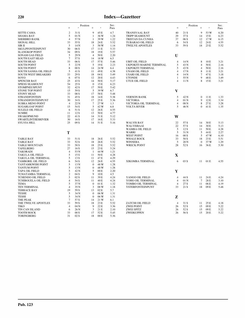
220 Index—Gazetteer
Pub. 123
Position° ' ° '
Position° ' ° '
Sec.Para
Sec.Para
SETTE CAMA 2 31 S 9 45 E 4.7SHAMA BAY 5 01 N 1 36 W 1.24SHERBRO BANK 4 57 N 1 39 W 1.22SIGNAL HILL 33 55 S 18 24 E 5.52SIR II 5 14 N 3 58 W 1.14SKULPFONTEINPUNT 30 06 S 17 11 E 5.33SLANGKOP POINT 34 09 S 18 19 E 5.57SONAM GAS FIELD 5 29 N 4 50 E 2.20SOUTH EAST HEAD 7 57 S 14 18 W 6.5SOUTH HEAD 33 06 S 17 57 E 5.46SOUTH POINT 5 22 N 5 19 E 2.23SOUTH POINT 8 00 S 14 24 W 6.4SOUTH SANHA OIL FIELD 5 41 S 11 49 E 4.38SOUTH WEST BREAKERS 33 29 S 18 04 E 5.49SOYO 6 07 S 12 20 E 4.43SPENCER BAY 25 43 S 14 50 E 5.17SPIESS SEAMOUNT 54 25 S 0 15 E 6.23STOMPNEUSPUNT 32 42 S 17 59 E 5.42STONE TOP POINT 15 59 S 5 39 W 6.7STONY HEAD 33 08 S 17 58 E 5.48STRANDFONTEIN 31 45 S 18 14 E 5.38STRANDFONTEINPUNT 30 34 S 17 25 E 5.36SUBRA MENO POINT 4 22 N 7 27 W 1.3SUGARLOAF POINT 15 54 S 5 42 W 6.8SULELE OIL FIELD 6 51 S 12 26 E 4.55SUMBE 11 12 S 13 50 E 4.77SWAKOPMUND 22 41 S 14 31 E 5.12SWARTLINTJIESRIVIER 30 16 S 17 16 E 5.33SYLVIA HILL 25 09 S 14 51 E 5.16
TTABLE BAY 33 51 S 18 26 E 5.52TABLE BAY 33 52 S 18 26 E 5.52TABLE MOUNTAIN 33 58 S 18 25 E 5.52TAFELBERG 27 16 S 15 23 E 5.24TAKORADI 4 53 N 1 44 W 1.21TAKULA OIL FIELD 5 15 S 11 50 E 4.28TAKULA OIL TERMINAL 5 13 S 11 47 E 4.29TAMBORIL OIL FIELD 6 54 S 12 26 E 4.55TANTAMKWERI POINT 5 13 N 0 48 W 1.28TANTUM POINT 5 13 N 0 48 W 1.28TAPA OIL FIELD 5 42 N 5 00 E 2.20TCHATAMBA TERMINAL 2 04 S 9 10 E 4.5TCHENDO OIL FIELD 5 02 S 11 39 E 4.24TCHIBOUELA OIL FIELD 4 54 S 11 40 E 4.24TEMA 5 37 N 0 01 E 1.32TEN TERMINAL 4 35 N 3 08 W 1.18TERRACE BAY 19 59 S 13 02 E 5.7TESHE 5 34 N 0 06 W 1.31TESHI 5 34 N 0 06 W 1.31THE PEAK 7 57 S 14 21 W 6.1THE TWELVE APOSTLES 33 59 S 18 23 E 5.52TIKO 4 04 N 9 22 E 3.36TIN CAN ISLAND 6 26 N 3 21 E 2.10TOOTH ROCK 33 00 S 17 52 E 5.45TORINGBERG 31 02 S 18 00 E 5.36
TRANSVAAL BAY 40 21 S 9 53 W 6.20TRIPP SEAMOUNT 29 37 S 14 15 E 6.23TRISTAN DA CUNHA 37 06 S 12 17 W 6.15TUBARAO OIL FIELD 6 54 S 12 24 E 4.55TWELVE APOSTLES 33 59 S 18 23 E 5.52
UUBIT OIL FIELD 4 14 N 8 10 E 3.21UKPOKITI MARINE TERMINAL 5 43 N 4 50 E 2.16UKPOKITI TERMINAL 5 43 N 4 50 E 2.16UNAM OIL FIELD 4 17 N 8 11 E 3.21USARI OIL FIELD 4 14 N 7 47 E 3.18UTONDE 1 55 N 9 48 E 3.49UTUE OIL FIELD 4 11 N 8 15 E 3.21
VVERNON BANK 5 42 N 0 11 E 1.33VICTORIA 4 01 N 9 12 E 3.34VICTORIA OIL TERMINAL 4 08 N 8 27 E 3.28VOLTA RIVER 5 46 N 0 41 E 1.35
WWALVIS BAY 22 57 S 14 30 E 5.13WALVISBAAI 22 57 S 14 30 E 5.13WAMBA OIL FIELD 5 12 S 11 50 E 4.28WARRI 5 31 N 5 44 E 2.27WEST POINT 16 00 S 5 47 W 6.10WHALE ROCK 33 50 S 18 23 E 5.51WINNEBA 5 20 N 0 37 W 1.29WRECK POINT 28 52 S 16 36 E 5.30
XXIKOMBA TERMINAL 6 03 S 11 01 E 4.55
YYANGO OIL FIELD 4 44 S 11 24 E 4.24YOHO OIL TERMINAL 4 01 N 7 28 E 3.10YOMBO OIL TERMINAL 4 27 S 11 06 E 4.19YSTERFONTEINPUNT 33 21 S 18 09 E 5.48
ZZATCHI OIL FIELD 4 31 S 11 25 E 4.18ZWEI POINT 26 52 S 15 09 E 5.22ZWEI SPITZ 26 52 S 15 09 E 5.22ZWEIKUPPEN 26 56 S 15 20 E 5.22