PROGRESS ACTIVITY REPORT OF THE SEVENTEENTH ...
304
PROGRESS ACTIVITY REPORT OF THE SEVENTEENTH SESSION OF THE REGIONAL ASSOCIATION II (ASIA) (RA II-17) Parts I and II (unedited and in official WMO languages when available)
-
Upload
khangminh22 -
Category
Documents
-
view
1 -
download
0
Transcript of PROGRESS ACTIVITY REPORT OF THE SEVENTEENTH ...
PROGRESS ACTIVITY REPORT OF THE SEVENTEENTH SESSION OF THE REGIONAL ASSOCIATION II
(ASIA) (RA II-17)
Parts I and II
(unedited and in official WMO languages when available)
WEA
THER
CLI
MATE
WAT
ER World Meteorological Organization
REGIONAL ASSOCIATION II (ASIA)
Seventeenth Session 25 to 26 May 2021, Virtual Session
RA II-17/INF.1(1)
Submitted by: Secretary-General
4.V.2021
INFORMATION ON THE VIRTUAL PLATFORM USED FOR THE SESSION
Online session
The seventeenth session of the Regional Association II (RA II-17) will be held online through a virtual platform (ZOOM), from 25 to 26 May 2021.
The opening of RA II-17 will take place on 25 May 2021 at 0700 UTC (0900 CEST). Detailed information on the session can be found on the main web page of RA II-17.
Online session
Information on the online platform on how to connect to the meeting is available on the “Online Session” tab of the RA II-17 website.
Naming convention
When connecting to the RA II-17 session, all participants should ensure to follow the naming convention as described below. This naming convention allows the Chair to indentify all participants attending the session.
WMO Members within and outside of RA II: Principal Delegate(s), Alternate(s), and Delegate(s)
• Principal Delegate (Principal): Member name/Principal/Surname
• Alternate: Member name/Alternate/Surname
• Delegate: Member name/Delegate/Surname;
President, Vice-Presidents of WMO
• President of WMO: President/WMO
• Vice-Presidents of WMO: 1st VP/WMO; 2nd VP/WMO; 3rd VP/WMO;
Presidents and vice-presidents of regional associations, presidents and vice-presidents of technical commissions, Regional Hydrological Advisers, and Invited Experts
• Presidents of regional associations: P/RA I (II, …, VI) for presidents (acting presidents)
• Vice-presidents of regional associations: VP/RA I (II, …, VI)
• Presidents of technical commissions: P/INFCOM, P/SERCOM
• Co-vice-presidents of technical commissions: VP/INFCOM, VP/SERCOM
• Regional Hydrological Advisers: HA/RA I (II, …, VI)
RA II-17/INF.1(1), p. 2
• Invited Experts: Expert/Surname;
Representatives of International Organizations/Non-Members
• Organization name/Surname
• Non-Member name/Surname;
WMO Secretariat
• Secretariat/Surname.
_________________
WEA
THER
CLI
MATE
WAT
ER World Meteorological Organization
REGIONAL ASSOCIATION II (ASIA)
Seventeenth Session 25 to 26 May 2021, Virtual Session
RA II-17/INF. 1(3)
Submitted by: Secretary-General
4.V.2021
METHODS OF WORK FOR THE ONLINE SESSIONS OF THE REGIONAL ASSOCIATIONS
Methods of work for conducting online sessions of the Regional Associations
1. Legal provisions
The Convention, General Regulations and the Rules of Procedure for Regional Associations shall continue to apply in full, subject to consideration of any online practice that would be exceptionally required to conduct the online session, as identified in the attached table.
2. Registration
2.1 Representatives of Members represented in regional associations, invited observers and representatives of other WMO Members shall notify the Secretary-General of the names of the persons who will participate in the session following the normal practice in accordance with the General Regulations and Rules of Procedure for Regional Associations.
2.2 Online registration will follow normal practice. Additional information is provided on the RA II-17 website.
2.3 Guidance for identification of participants of online sessions is provided in the attached table.
3. Attendance and quorum
3.1 Attendance by members of the regional association, invited observers, and representatives of WMO Members, shall be through a secured access to the videoconference.
3.2 The number of participants, besides the members of the regional association simultaneously connected, may be limited depending on the capacity of the selected videoconference system.
3.3 Online attendance by principal delegates (or their alternates) shall be checked and registered in each meeting of the session to ensure the quorum of the simple majority of Members who are represented in the association.
4. Documents
4.1 Documents for the session will be made available and managed following normal practice through the RA II-17 website.
4.2 To optimize discussions of documents in online sessions, members of the regional association are encouraged to submit comments on documents to [email protected] prior to the session, preferably one week before the opening of the session.
RA II-17/INF. 1(3), p. 2
5. Interventions
5.1 During the online session, principal delegates or their alternates on their behalf shall be provided with the opportunity to take the floor. Individual statements are normally limited to three minutes.
5.2 Any member of the regional association wishing to take the floor should signal their wish to speak or to raise a point of order using the videoconference system, as indicated in RA II-17/INF.1(1).
6. Recording of sessions
Pursuant to Regulation 95(c), audio recordings of plenary meetings shall be made and retained for record-keeping purposes.
7. Decision-making
All decisions of the session should as far as possible be taken by consensus. Should certain matters require substantive debate, the presiding officer may propose the establishment of drafting groups, which will meet separately and report back to the plenary.
For elections of the officers of the regional association, which would normally take place by consensus, if a vote is required, and an e-vote is not possible, the regional association may consider voting by correspondence (in accordance with the provisions of Rule 6.15.4).
8. Committees
All business shall be conducted in plenary except for the Nomination Committee or other committees that may be established, which shall meet separately, through an online platform that will be specified. All matters to be discussed by the committees shall be determined by the plenary.
9. Languages
General Regulation 97 shall continue to apply, whereby interventions made shall be interpreted into the other working languages of the session.
_________

RA II-17/INF. 1(3), p. 3
Explanatory note on online practices in conducting online sessions of a Constituent Body
Procedure Physical session Reference Online session
Delegates registration and credentials
(a) Prior to a session of a constituent body other than the Executive Council, each Member concerned shall communicate to the Secretary-General the names of the persons composing its delegation to that body, indicating which of these shall be regarded as its principal delegate;
(b) Besides this communication, a letter giving these particulars and otherwise conforming with the provisions of the Convention and of these Regulations and signed by, or on behalf of, an appropriate governmental authority of the Member shall be sent to the Secretary-General or handed to the representative at the session and shall be regarded as appropriate credentials for the participation of the individuals named therein in the session;
(c) The same procedure shall apply as regards the credentials of observers representing non-Member countries;
(d) The credentials of observers representing international organizations shall be signed by the competent authority of the organization concerned.
GR 20 Same
Delegates attendance and identification
In addition, online registration takes place through the Event Registration System.
One nameplate per Member regardless of the size of the delegation.
Specific naming convention will be determined by the Secretariat to facilitate the online participation of RA II-17 participants as follows:
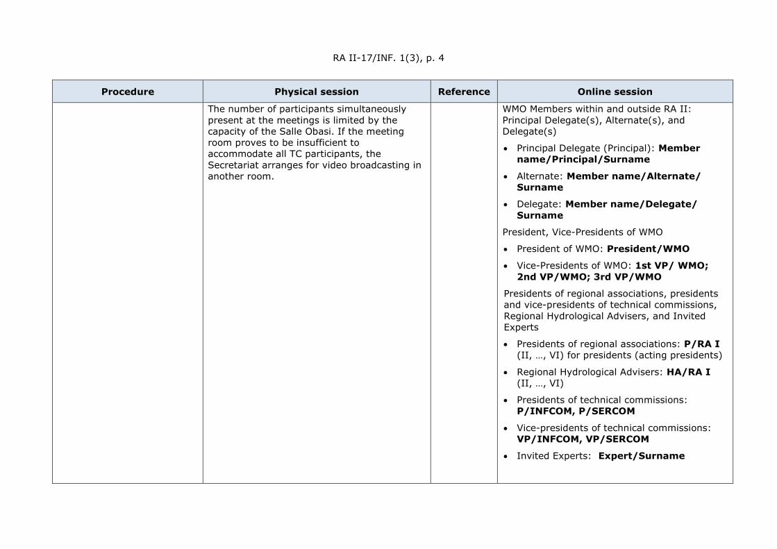
RA II-17/INF. 1(3), p. 4
Procedure Physical session Reference Online session
The number of participants simultaneously present at the meetings is limited by the capacity of the Salle Obasi. If the meeting room proves to be insufficient to accommodate all TC participants, the Secretariat arranges for video broadcasting in another room.
WMO Members within and outside RA II: Principal Delegate(s), Alternate(s), and Delegate(s)
• Principal Delegate (Principal): Member name/Principal/Surname
• Alternate: Member name/Alternate/ Surname
• Delegate: Member name/Delegate/ Surname
President, Vice-Presidents of WMO
• President of WMO: President/WMO
• Vice-Presidents of WMO: 1st VP/ WMO; 2nd VP/WMO; 3rd VP/WMO
Presidents of regional associations, presidents and vice-presidents of technical commissions, Regional Hydrological Advisers, and Invited Experts
• Presidents of regional associations: P/RA I (II, …, VI) for presidents (acting presidents)
• Regional Hydrological Advisers: HA/RA I (II, …, VI)
• Presidents of technical commissions: P/INFCOM, P/SERCOM
• Vice-presidents of technical commissions: VP/INFCOM, VP/SERCOM
• Invited Experts: Expert/Surname
RA II-17/INF. 1(3), p. 5
Procedure Physical session Reference Online session
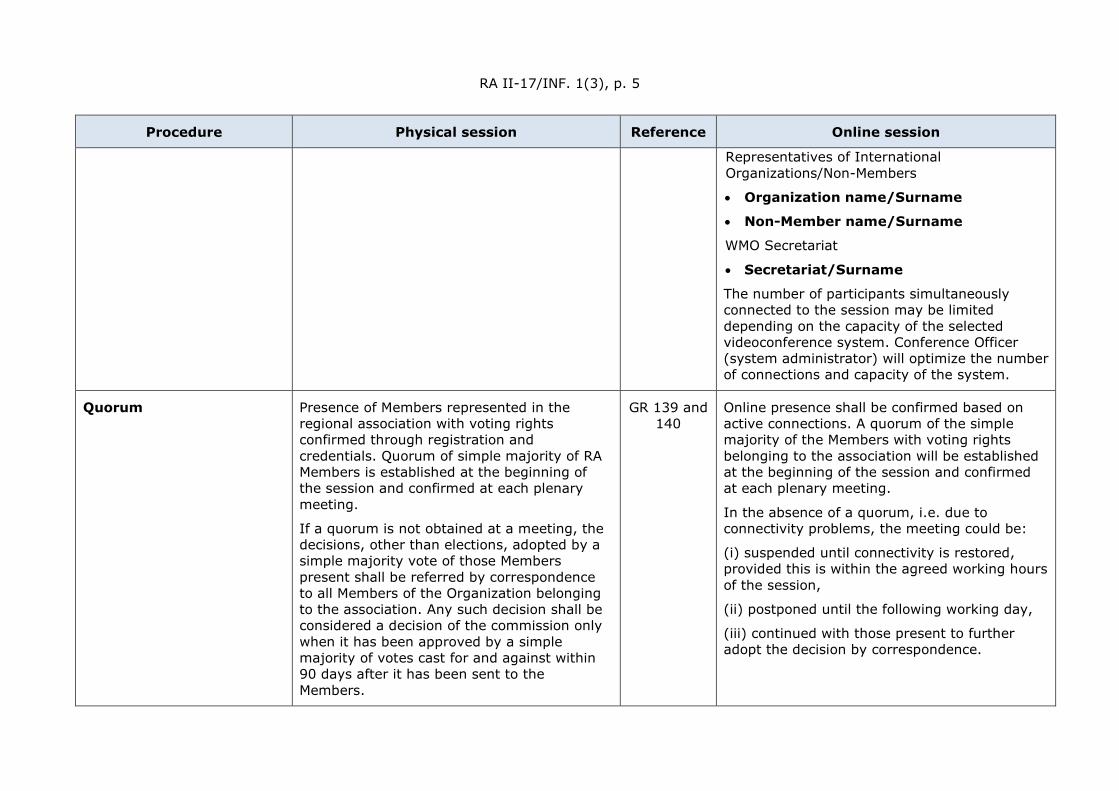
Representatives of International Organizations/Non-Members
• Organization name/Surname
• Non-Member name/Surname
WMO Secretariat
• Secretariat/Surname
The number of participants simultaneously connected to the session may be limited depending on the capacity of the selected videoconference system. Conference Officer (system administrator) will optimize the number of connections and capacity of the system.
Quorum Presence of Members represented in the regional association with voting rights confirmed through registration and credentials. Quorum of simple majority of RA Members is established at the beginning of the session and confirmed at each plenary meeting.
If a quorum is not obtained at a meeting, the decisions, other than elections, adopted by a simple majority vote of those Members present shall be referred by correspondence to all Members of the Organization belonging to the association. Any such decision shall be considered a decision of the commission only when it has been approved by a simple majority of votes cast for and against within 90 days after it has been sent to the Members.
GR 139 and 140
Online presence shall be confirmed based on active connections. A quorum of the simple majority of the Members with voting rights belonging to the association will be established at the beginning of the session and confirmed at each plenary meeting.
In the absence of a quorum, i.e. due to connectivity problems, the meeting could be:
(i) suspended until connectivity is restored, provided this is within the agreed working hours of the session,
(ii) postponed until the following working day,
(iii) continued with those present to further adopt the decision by correspondence.
RA II-17/INF. 1(3), p. 6
Procedure Physical session Reference Online session
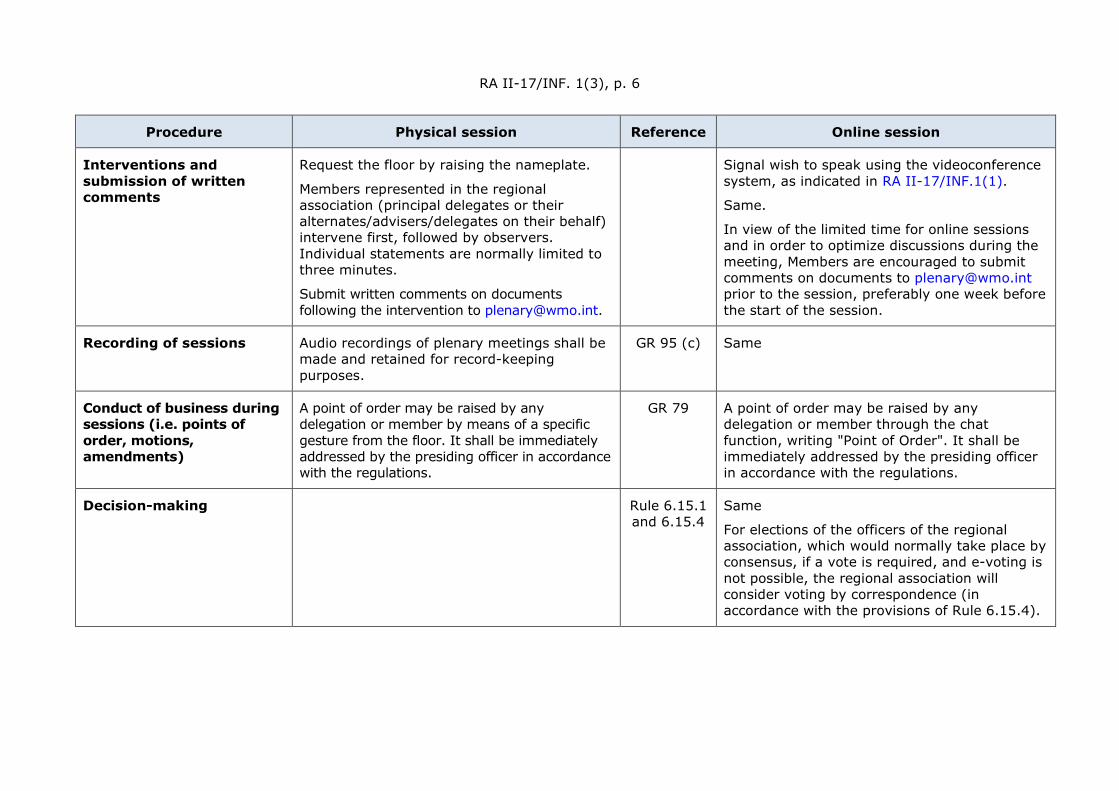
Interventions and submission of written comments
Request the floor by raising the nameplate.
Members represented in the regional association (principal delegates or their alternates/advisers/delegates on their behalf) intervene first, followed by observers. Individual statements are normally limited to three minutes.
Submit written comments on documents following the intervention to [email protected].
Signal wish to speak using the videoconference system, as indicated in RA II-17/INF.1(1).
Same.
In view of the limited time for online sessions and in order to optimize discussions during the meeting, Members are encouraged to submit comments on documents to [email protected] prior to the session, preferably one week before the start of the session.
Recording of sessions Audio recordings of plenary meetings shall be made and retained for record-keeping purposes.
GR 95 (c) Same
Conduct of business during sessions (i.e. points of order, motions, amendments)
A point of order may be raised by any delegation or member by means of a specific gesture from the floor. It shall be immediately addressed by the presiding officer in accordance with the regulations.
GR 79 A point of order may be raised by any delegation or member through the chat function, writing "Point of Order". It shall be immediately addressed by the presiding officer in accordance with the regulations.
Decision-making Rule 6.15.1 and 6.15.4
Same
For elections of the officers of the regional association, which would normally take place by consensus, if a vote is required, and e-voting is not possible, the regional association will consider voting by correspondence (in accordance with the provisions of Rule 6.15.4).
RA II-17/INF. 1(3), p. 7
Procedure Physical session Reference Online session
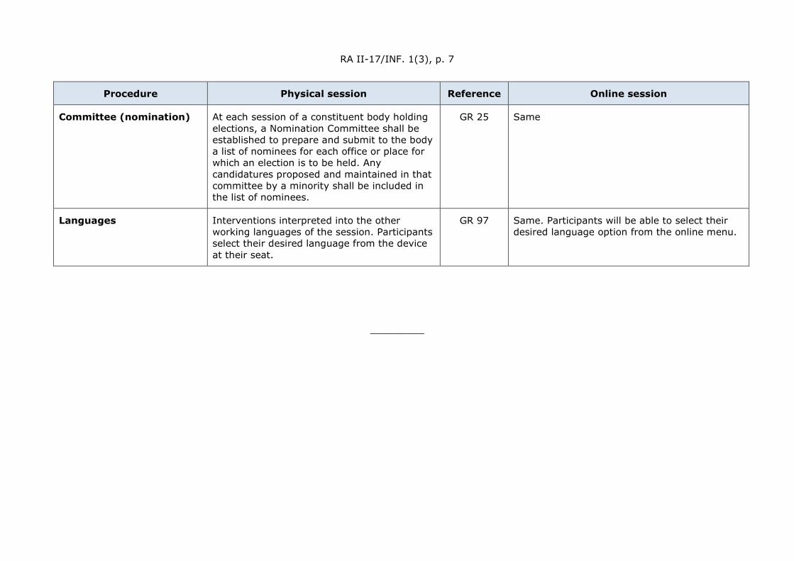
Committee (nomination) At each session of a constituent body holding elections, a Nomination Committee shall be established to prepare and submit to the body a list of nominees for each office or place for which an election is to be held. Any candidatures proposed and maintained in that committee by a minority shall be included in the list of nominees.
GR 25 Same
Languages Interventions interpreted into the other working languages of the session. Participants select their desired language from the device at their seat.
GR 97 Same. Participants will be able to select their desired language option from the online menu.
_________
W
EATH
ER C
LIM
ATE
WAT
ER World Meteorological Organization
REGIONAL ASSOCIATION II (ASIA)
Seventeenth Session 25 to 26 May 2021, Virtual Session
RA II-17/INF. 2.1
Submitted by: President of RA II
26.V.2021
Report by the president of the association, including reports of Working Groups and the Regional Office for Asia and the South-West Pacific (RAP)
1. Activities and Achievements since Regional Association (RA) II-16
1.1 Officers of the Association
In October 2019, Professor Tran Hong Thai, Administrator of the Viet Nam Meteorological and Hydrological Administration and Permanent Representative (PR) of Viet Nam with the World Meteorological Organization (WMO) was elected as the vice-president of RA II via an election by correspondence. He succeeds Mr Rishi Ram Sharma (Nepal), who retired in December 2018.
1.2 Management Group (MG)
During the intersessional period, the Regional Association II Management Group (RA II MG) convened on seven occasions, detailed below:
(1) Sixteenth session of the RA II MG (RA II MG-16), 30 March 2021, online.
The session noted the spirit of the WMO Reform – Next phase and the request for a comprehensive review of the WMO regional concept and approaches to strengthen the role and enhance the effectiveness of regional associations, and agreed to conduct the seventeenth session of RA II (RA II-17) in two phases via videoconference, with Phase 2 held before Extraordinary Congress (Cg-Ext.2021). Accepting the request, the session also decided to establish the Task Team on the Regional Concept (TT-RC), chaired by Dr Sahar Tajbakhsh Mosalman (PR of the Islamic Republic of Iran with WMO) and the Task Team on Review of Regional Partnership and Sub-regional Cooperation (TT-RP), chaired by Dr Mrutyunjay Mohapatra (PR of India with WMO). The current list of TT-RC and TT-RP members is given in Annex I. The session also agreed to develop a pilot report on the State of the Climate in Asia for 2020, and request the Working Group on Climate Service (WGCS) to oversee the production of the pilot report and the further development of the concept that leads to the publication of a regular report on the State of Climate in Asia. The session agreed on the next steps to establish RA II Regional WMO Integrated Global Observing System (WIGOS) Centres (RWCs), encouraging China and Japan to commence joint operations by 1 July 2021, or at their earliest convenience.
(a) Task Team on the Regional Concept (TT-RC)
The Task Team on the Regional Concept (TT-RC) was established during RA II Management Group (MG-16) to draft a recommendation on the new regional working structure and to continue guiding the RA II reform approaches, in line with the broader organizational reform of WMO. The Task Team conducted two meetings, on 19 April 2021 and 28 April 2021 respectively, and agreed on a new working structure for RA II, the terminology and terms of reference of its subsidiary bodies, and the template and general principles of the RA II Operating Plan (2021–2024).

RA II-17/INF. 2.1, p. 2
(b) Task Team on Review of the Regional Partnership and Sub-regional Cooperation (TT-RP)
The TT-RP was established during RA II MG-16 to analyse and map existing intra- and interregional cooperation and collaborations and to develop and update a RA II Partnership Strategy to further enhance regional partnership. The Task Team convened on 26 April 2021 and decided on the outline of the RA II Partnership Strategy and the organization of a Regional High-level Conference (RHLC), a Regional Technical Conference (RECO) including a Regional Hydrological Assembly (RHA), and side events in conjunction with the seventeenth Session of RA II (RA II-17), Phase 2.
(2) 4.1 RA II MG Virtual Discussion Series II, 21 July 2020, online
MG members were updated on RA II membership in the technical commissions and subsidiary bodies. The Group noted that regional representation in both technical commissions remained relatively narrow and reiterated the need for regional balance and better regional representation. The Group was apprised of outcomes of recent meetings of the Technical Coordination Committee (TCC) and the Policy Advisory Committee (PAC), and informed that the consideration of draft documents to be discussed at the Seventy-second Session Executive Council (EC-72) was underway. The need for harmonized taxonomy across the subsidiary bodies of RAs to promote interregional cooperation was highlighted, along with the importance of alignment with the technical commission structures. MG members participated in active discussions regarding the proposed format of future RA sessions and the regional working structure. The Group was also briefed on the financial status of WMO and noted the liquidity issues due to the slowdown in the flow of assessed contributions due to the COVID-19 pandemic along with measures taken such as a temporary hiring freeze on new staff.
4.2 (3) RA II MG Virtual Discussion Series I, 23 April 2020, online
A series of virtual discussions was proposed by the president of RA II to facilitate the sharing of ideas and the prioritization of strategies for upcoming activities such as technical commission sessions. MG was apprised of RA II membership in the two technical commissions and the outcomes of the Joint Selection Committee for Chairs and vice-Chairs of standing committees and study groups in the technical commissions. MG Members shared additional views on the documents for the First Joint Session of the Technical Commissions and Research Board (JS-TC-1). The Group was informed of Congress’ decision for each regional association to hold two sessions in the 2020 financial period, with the first focused on policy and the second focused on thematic issues. The need for regional meetings to attract greater political attention and attendance as well as the involvement of more key partners in the region was also highlighted by the Secretariat.
4.3 (4) Joint Management Group Meeting for Asia and the South-West Pacific, 29 to 31 October 2019, Singapore
MGs of both RAs II and V convened in a joint meeting, reviewing key resolutions from Cg-18 and the Seventy-first Session of the Executive Council (EC-71). MGs were apprised of the substructures of the newly established technical commissions and noted the importance of alignment between the RAs and technical commissions. The meeting reviewed high-priority activities to be implemented within both regions, focusing on capacity development, services and infrastructure. Cross-regional initiatives to support capacity development were also discussed, with the meeting highlighting the importance of publicizing these events through the Secretariat and platforms such as the WMO website to improve outreach. An intervention for Members to participate in the sessions of other regional associations as observers to deepen mutual understanding and enhance cross-regional collaboration was well-received.
RA II-17/INF. 2.1, p. 3
Parallel sessions were held for each regional association, in which progress reports were shared and future priorities discussed.
4.4 (5) Fourteenth Session of the RA II MG (RA II MG-14), 7 June 2019, Geneva, Switzerland
MG reviewed the candidates for Executive Council membership, discussed arrangements, including dates and agenda, for the Joint Management Group Meeting for RA II and RA V.
(6) 4.5 Thirteenth Session of the RA II MG (RA II MG-13), 22 June 2018, Geneva, Switzerland
Regarding the Southeast Asian Regional Climate Centre network (RCC Network), MG agreed that efforts should be made to evolve the network as a joint activity between RA II and V and requested the RA II WGCS to develop an action plan in close consultation with the RA V WGCS and the Secretariat, for the consideration of the RA II and V presidents. MG reviewed and approved the work plans of the RA II Working Groups for 2018-2020. MG welcomed the proposal presented by the Secretariat of a Joint Regional Forum for Directors of National Meteorological and Hydrological Services in RA II and RA V to be held in the fourth quarter of 2019 as well as Singapore’s offer to host the Forum. MG endorsed proposals from China and Japan to establish Regional WIGOS Centres (RWC) in pilot phase for a period of two years.
4.6 (7) Twelfth Session of the RA II MG (RA II MG-12), 10 May 2017, Geneva, Switzerland;
MG welcomed the new members, China and India. MG reported on the key outcomes from RA II-16 and noted the establishment of a new working mechanism, with the MG, four Working Groups and Expert Groups. MG requested that chairpersons submit their nominations of leaders for approval to ensure completeness of the subsidiary bodies. MG further noted that five pilot projects had been approved at RA II-16, including three continued projects and two new projects by China and the Republic of Korea. MG encouraged Members to actively participate in the implementation of the pilot projects and requested the Secretariat to seek nominations of focal points from Members.
2. Other major meetings and actions by the president
(1) During the intersessional period, the president attended and facilitated contributions from RA II to the following meetings:
• Transition Team Session and Meeting of Presidents of Regional Association, 25–29
November 2019, Geneva, Switzerland;
• First Session of TCC, 27–29 April 2020, online;
• First Session of PAC, 11–12 May 2020, online;
• Second Session of TCC, 13, 15 and 16 July 2020, online;
• Second Session of PAC, 17–18 August 2020, online;
• Forty-seventh Session of the WMO/Economic and Social Commissions for Asia and the Pacific (ESCAP) Panel on Tropical Cyclone (PTC-47), 23–26 November 2020, online;
• First Meeting of the EC Taskforce on the Comprehensive Review of the WMO Regional Concept and Approaches, 18–19 January 2021, online;
• First Session of the TCC, 3 March 2021, online;
RA II-17/INF. 2.1, p. 4
• First Funders’ Forum for the Systematic Observations Financing Facility (SOFF), 24 March 2021, online;
• Second Session of TCC, 26–28 April 2021, online;
• First Session of PAC, 3–5 May 2021, online;
• Videoconferences with the Secretary-General of WMO.
(2) The president also communicated the developments in WMO through his regular Newsletters to all Members.
(3) The president requested the consideration of possible coverage extent of the Indian Ocean by optimal position of providers’ new satellites. The China Meteorological Administration (CMA) informed its FengYun (FY-2H) satellite has operational observation covering the Indian Ocean and Arabian Region. CMA confirmed its willingness to further enhance meteorological cooperation with Members in West Asia under the Belt and Road Initiative, in particular regarding the application of FengYun meteorological satellites.
(4) The president also solicited advice from MG members on the recommendations proposed by the second phase of the Indian Ocean Observing System (INDOOS-2) and expressed support for the continuous collaboration between WMO and the Intergovernmental Oceanographic Commission of the United Nations Educational, Scientific and Cultural Organization (UNESCO) (IOC-UNESCO).
3. Working Groups (WGs) and Operating Plan
63.1 Working Group (WG) Chairs’ Meetings
Following the resolutions and decisions adopted at RA II-16, memberships of the RA II subsidiary bodies were finalized. During the intersessional period, the Chairs of the four RA II WGs met on the following dates:
• 12-14 December 2017, Abu Dhabi, United Arab Emirates;
• 4-5 December 2018, Abu Dhabi, United Arab Emirates.
63.2 Working Group on Weather Services (WGWS)
63.2.1 Global Multi-Hazard Alert System for Asia (GMAS-A)
In 2018, the GMAS-A platform, a regional multi-hazard alert system for RA II, comprising a public website and a restricted portal was set up and launched in the second China-Association of Southeast Asian Nations (ASEAN) Meteorological Forum held at Nanning in September 2018. There is a public website built with a global information system (GIS) map to display warnings issued by RA II Members in Common Alerting Protocol (CAP) format. There is also a restricted portal for exclusive use by WMO Members to facilitate warning and forecast preparation. A workshop on Global Multi-hazard Alert System in Asia was held in Haikou, China on 18-19 November 2019. Amid the COVID-19 pandemic, visit and online training were arranged to assist interested Member to install and try out the multilingual CAP warning dissemination system developed by CMA. Up to April 2021, CAP warnings from 11 Mmembers of RA II (viz., Afghanistan; China; Hong Kong, China; India; Kuwait; Macao, China; Mongolia; Myanmar; Oman; Russian Federation; and Thailand) are aggregated and displayed on the GMAS-A public website.
Hong Kong, China continued to provide support to Members through operating the Severe Weather Information Centre (SWIC) and SWIC 2.0 Beta Website, contributing to the development of the Global Multi-hazard Alert System.

RA II-17/INF. 2.1, p. 5
63.2.2 Global Data-Processing and Forecasting System (GDPFS) Centres
There are two World Meteorological Centres (WMCs), Beijing, China and Tokyo, Japan (designation endorsed at EC-69), and also 31 Regional Specialized Meteorological Centres (RSMCs) including two Lead Centres (but excluding the International Civil Aviation Organization (ICAO)-designated Centres).
Japan Meteorological Agency (JMA) was designated as a RSMC for Nowcasting at the 69th session of the Executive Council of the WMO in May 2017, and began its operation in December 2018 establishing the website to supply the National Meteorological and Hydrological Services (NMHSs) in the Asia and Pacific regions with graphical nowcasting products for improving capacity for disaster risk reduction.
The Hong Kong Observatory (HKO) has been providing nowcasting products for the Asian region with the establishment of the RSMC for Nowcasting since 2018. Satellite-based nowcast of significant convection and ice crystal icing covering the East Asia are made available in real-time basis. Research development of new nowcast products using satellite and radar data are underway that they will be launched on the RSMC website in phases.
63.2.3 Significant Meteorological Information AIM 7-1-6 (SIGMET) issuance and coordination
Efforts to provide harmonized SIGMET information to users across various Flight Information Regions continued. The Collaborative SIGMET Issuance (CSI) scheme established by the JMA and six participating Meteorological Watch Offices (MWOs) including Japan, Lao PDR, Myanmar, Philippines, Thailand and Viet Nam started operations in April 2019.
A SIGMET coordination project involving the western and northern parts of South China Sea was initiated in November 2017. The project transitioned to a semi-operational phase in July 2019 and involves six MWOs in China; Hong Kong, China and Viet Nam, with Cambodia joining as an observer in September 2018.
The South and South-eastern Asia (SSEA) SIGMET Coordination project between Indonesia (Jakarta Flight Information Region (FIR)) and Sri Lanka (Colombo FIR) was set up in December 2019 and transitioned to full 24/7 operation from 1 February 2021.
63.2.4 Severe Weather Forecasting Project (SWFP)
The three regional subprojects within RA II of the Severe Weather Forecasting (Demonstration) Project (SWFP) namely SWFP Southeast Asia, SWFP-South Asia and SWFP-Central Asia are currently in Phase II.
The SWFP Southeast Asia (SWFP-SeA) Training workshops were held at Viet Nam and Lao PDR in 2018 and 2019 respectively. The SWFDP-SeA Regional Forecasting Support Centre (RFSC) Training Desk was organized online on 7-9 December 2020 in Viet Nam [Viet Nam]. An online training workshop on Severe Weather and Impact-Based Forecasting and Warning Services was organized on 1-12 February 2021.
The demonstration phase of the SWFP-Central Asia (SWFP-CA) started in January 2017. Workshop on modernization of RSMC Tashkent was held at Tashkent on 2-3 April 2019.
SWFP-South Asia, formerly also known as SWFDP-Bay of Bengal, entered its pilot demonstration phase in June 2019. Meeting of the Regional Sub-programme Management Team (RSMT) of the SWFP-South Asia (SWFP-SA) was held online on 25 May 2020 to review the sub-programme progress.
63.2.5 Pilot Projects

RA II-17/INF. 2.1, p. 6
Five RA II pilot projects were implemented, with brief descriptions below. Progress reports of ongoing RA II projects are given in Annex VI:
(a1) Pilot Project to develop support for national meteorological and hydrological services in numerical weather prediction;
(b2) Pilot Project to Sustain and Enhance the capacity of NMHSs in the Provision of Official Weather Forecasts for Medium-Range;
(c3) Pilot Project to Develop Support for NMHSs in the Collection and Application of Aircraft Meteorological Data Relay Data;
(d4) Pilot Project to Enhance the Capability of Meteorological Disaster Risk Reduction in RA II (Asia); and
(e5) Pilot Project on Impact-based Forecasting.
63.2.6 Trainings and workshops
During the intersessional period, capability-building training and workshops were successfully held for topics including impact-based forecasts, the CAP, ICAO Meteorological Information Exchange Model (IWXXM), tropical cyclone, Monsoon, tsunami, Rain Enhancement, Quality Management System (QMS), cost recovery, meteorological satellite application and severe weather forecasting and delivery of warning services.
The full report from WGWS (unedited) is given in Annex II.
63.3 WGCS
The WGCS convened in December 2018 in Beijing, China. At the meeting, the Group discussed and agreed on the work plan for the next two years up till the next RA II session, focusing on the implementation of the Climate Services Information System (CSIS) at a regional level in RA II.
63.3.1 State of the Climate in Asia
Following the decision at RA II MG-16 to develop a pilot report on the State of the Climate for Asia 2020, the drafting team convened on 15 April 2021 to discuss the concept and content of the pilot report. Following reviews on the methodology, data requirements and the general structure of WMO climate reports, the team discussed and agreed on the concept, content and work plan of the pilot report. The pilot report is expected to be published in autumn 2021.
63.3.2 Regional Climate Outlook Forums (RCOFs)
The five RCOFs namely the Forum on Regional Climate Monitoring, Assessment and Prediction for Regional Association II (FOCRAII), the East Asia winter Climate Outlook Forum (EASCOF), the South Asian Climate Outlook Forum (SASCOF), the ASEAN Climate Outlook Forum (ASEANCOF), and the North Eurasian Climate Outlook Forum (NEACOF) have continued to convene regularly during the intersessional period, issuing consensus outlooks for the respective regions. In addition, the Arab Climate Outlook Forum (ArabCOF) and Gulf Cooperation Council Climate Outlook Forum (GCC-COF), established in 2017 and 2019 respectively, have also continued to be held successfully. In 2020, in view of the COVID-19 pandemic, all RCOFs were held virtually.
63.3.3 Regional Climate Centres (RCCs)
In May 2017, the India Meteorological Department (IMD), Pune was designated as RCC Pune. During the intersessional period, all four RCCs in RA II, namely RCC Beijing, RCC Pune, RCC-
RA II-17/INF. 2.1, p. 7
Tokyo and RCC-Moscow have continued to conduct a variety of activities, including the dissemination of climate data, products and information and the organization of training workshops for capacity development.
63.3.4 Implementation of the Third Pole Regional Climate Centres Network (TPRCC-Network)
The implementation plan for the Third Pole Regional Climate Centres Network (TPRCC-Network) was drafted by the Task Team and reviewed by members of the Executive Council Panel of Experts on Polar and High mountain Observations, Research, and Services (EC-PHORS). The concept was also promoted at the High Mountain Summit held in Geneva in October 2019.
Activities of the Task Team on the TPRCC-Network were temporarily suspended in 2020 due to the COVID-19 pandemic. However, the Task Team is slated to resume their work and finalize the draft implementation plan for the endorsement of the relevant Permanent Representatives.
63.3.5 Monitoring Extreme Weather and Climate Events from Space
The Space-based Weather and Climate Extremes Monitoring (SWCEM) Demonstration Project (SEMDP) in East Asia and Western Pacific Subproject has been conducted from 2018, and three WMO Regional Climate Centres (RCC Beijing, SEARCC-Network, Pacific RCC Network) participated in the demonstration project.
63.3.6 Capacity development activities
During the intersessional period, capability development activities were organized, including training events.
The full report from WGCS (unedited) is given in Annex III.
63.4 Working Group on WMO Integrated Global Observing System and WMO Information System (WG-WIGOS/WIS)
63.4.1 Working Group meetings
During the intersessional period, the Working Group on WMO Integrated Global Observing System and WMO Information System (WG-WIGOS/WIS) held a Joint RA II/RA VI Workshop on WIGOS in Belarus on 12–14 September 2017 and three RA II workshops in China (6–8 November 2018), Japan (6–9 March 2019) and Saudi Arabia (30 April–2 May 2019).
63.4.2 Progress on establishment of RA II Regional WIGOS Centres (RWCs)
At the RA II MG-13 in June 2018, proposals from China and Japan to establish RWCs in pilot mode were endorsed. For more than two years since then, CMA and JMA have successfully delivered mandatory functions through the two designated RWCs.
The RWC Concept detailing the joint operation plan of both RWCs was presented by both CMA and JMA at RA II MG-16. Under the joint operation plan, both RWCs will focus on mandatory functions in a co-responsible approach and will collaborate with each other for optional functions. For the purposes of evaluation and incident management functions, RA II Members will be divided into two groups. The RWCs will take turns to be responsible for each group of Members, with rotation in responsibilities every six (6) months.
Recognizing the successful operations of both RWCs in the pilot phase and the feasibility of the joint operation plan, the RA II MG-16 session encouraged both countries to commence joint operations by 1 July 2021, or at their earliest convenience.
RA II-17/INF. 2.1, p. 8
At the Third Part of the First Session of the Commission for Observation, Infrastructure and Information Systems (INFCOM-1(III)) held on 12–16 April 2021, the President of INFCOM was requested, in collaboration with Regional Associations, to facilitate the audit process on the RWCs in full consideration of the current operation status of pilot RWCs and the needs of Members.
63.4.3 Progress on Regional WIGOS Implementation Plan in RA II (R-WIP-II)
The implementation of R-WIP-II relies mainly on six RA II WIGOS projects. Significant progress was made during the intersessional period by WG-WIGOS/WIS with regards to the Regional WIGOS Implementation Plan.
Among the achievements are the formal designation of the RSMC for Atmospheric Sand and Dust-Storm Forecasting Beijing (RSMC-ASDF Beijing) hosted by CMA in May 2017; the experimental exchange of nationwide composite radar data between Japan, Malaysia and Thailand as an activity of the ESCAP/WMO Typhoon Committee; the establishment of a weather radar network by the Gulf Cooperation Council (GCC) to produce a GCC mosaic picture; the successful conduct of three Asia/Oceania Meteorological Satellite Users’ Conference (AOMSUC); and added support for users of the Himawari (HimawariRequest), FengYun (The Emergency Support Mechanism for International Users of Fengyun Meteorological Satellites in Disaster Prevention and Mitigation (FY ESM)) and Geo-Kompsat-2A (AMI Rapid Scan (ARS) Service) satellites.
An Inter-laboratory comparison (ILC) involving Regional Instrument Centres (RIC) Tsukuba (RA II), RIC Beijing (RA II), RIC Melbourne (RA V), RIC Manila (RA V), RIC Ljubljana (RA VI) and the University of Ljubljana (RA VI) is conducted, with results reported to WMO Secretariat in 2020.
63.4.4 Regional Basic Observing Network (RBON)
The Priority Application Areas and the Selecting Criteria for RBON in RA II were drafted, but no official document has been received from Mmembers to propose their inclusion of additional surface-based observing stations in the pilot RBON as of April 2021.
63.4.5 Aircraft-Based Observing System (ABO)
TT-ABO developed a questionnaire on the current status of ABO in RAII, intending to enhance and expand WMO Aircraft-Based Observing System in the region, especially in the west Asia, including the implementation of Aircraft Meteorological Data Relay (AMDAR) programme at the national level in January 2018.
63.4.6 Status of RA II WIS Implementation Plan (R2-WIS-IP)
The latest update version of the RA II WIS Implementation Plan (V1.2) was drafted in December 2017, which includes updating National Focal Point for WIS Matters and including and Capacity development programme etc.
As of today, seven Global Information System Centres (GISCs) (Beijing, Jeddah, New Delhi, Moscow, Seoul, Tehran and Tokyo) have been approved by Congress, and all of them stated their status “operational”. 26 Data Collection or Production Centres (DCPCs) are endorsed/approved by the Commission for Basic Systems (CBS)/Cg/EC.
Annual survey 2019 was organized to collect actual status of the Regional Meteorological Telecommunication Network (RMTN). As of October 2019, 101 out of 111 circuits are running and exchanging Global/Regional meteorological data to support day-to-day mission. New is, Tokyo established two connections to VietnamViet Nam and Bangladesh.

RA II-17/INF. 2.1, p. 9
The Theme Leader on Data Representation and Metadata (TL-DRM) with its Volunteer expert analysed the status of Table Driven Code Form (TDCF) migration in RA II. Detailed result is available for SYNOP, TEMP, PILOT, CLIMAT and Marine reports.
Percentage of registered observation stations as part of Regional Basic Synoptic Networks (RBSN) which report synoptic observation in Binary Universal Form for the Representation (BUFR) format remains around 80%. The number of upper-air sounding reports in BUFR format remains around 150, which is about 53% of registered stations. 13 Members are reporting CLIMAT data in BUFR format.
All seven GISCs (Beijing, Jeddah, Moscow, New Delhi, Seoul, Teheran, and Tokyo) have started their operation and most of them started metadata management for Centres in the area of responsibility.
63.4.7 Training activities related to WIGOS and WIS
Three WMO RA II WIGOS Workshops and a Joint RA II and RA VI WIGOS Workshop have been held from 2017 to 2021 in China, Japan, Saudi Arabia and Belarus. In addition, about 11 training courses related to WIGOS in RA II have been carried out from 2017 to 2021.
Four GISCs have provided regular training opportunities for their AoR through workshop/onsite/webinar. Some of other GISCs have a plan to hold a workshop.
The full report from WG-WIGOS/WIS is given in Annex IV.
63.5 Working Group on Hydrological Services (WGHS)
63.5.1 Working Group meetings
The 2019 meeting of the Working Group on Hydrological Services (WGHS) was held in Moscow, Russian Federation, from 7 to 9 October 2019. The meeting discussed the priority areas of RA II (2020-2023), in particular priority area 3 on strengthening hydrological services. The meeting proposed three thematic areas, in brief: improve water-related disaster risk reduction at the urban, basin and country levels; support water resources management; and improve management of hydrometric networks and data collection practices at the basin and country levels. The future structure of WGHS in relation to the broader WMO Reform was also discussed and the Group presented on activities conducted in 2019 as well as its work plan.
63.5.2 Hydrological Advisers’ Forums
The First and Second RA II Hydrological Advisers’ Forum were successfully held online on 11 September 2020 and 26 March 2021, respectively. The first forum focused on regional hydrological needs and challenges, while the second forum provided updates from the first forum, pertaining to the nomination of national hydrological advisers, the WMO hydrology online survey, nomination of experts to the WMO Expert Network, the WMO data policy on hydrology, and capacity building. The second forum also shared hydrology-related outcomes from the Second Part of the First Session of the Commission for Weather, Climate, Water and Related Environmental Services and Applications (SERCOM-1(II)).
In discussions relating to the way forward, participants of the second forum raised the need to define regional and sub-regional priorities for hydrology and to seek endorsement for activities on hydrology and water resource management at the Seventeenth Session of the Regional Association II (RA II-17).
63.5.3 Implementation of the Flash Flood Guidance System (FFGS)
At present, five regional projects are being implemented in RA II under the scope of Global FFGS implementation. These are the Myanmar FFGS, the Mekong River Commission FFGS, the South Asia FFGS, the Southeast Asia FFGS and the Central Asia Region FFGS.
RA II-17/INF. 2.1, p. 10
The full report from WGHS (unedited) is given in Annex V.
4. WMO Regional Office for Asia and the South-West Pacific (RAP)
With a view to strengthening regional cooperation and collaboration and facilitating the implementation of WMO’s capacity development initiatives in the region, the Regional Office for Asia and the South-West Pacific (RAP) was relocated to Singapore from the WMO headquarters in Geneva in September 2018. The relocation marked the first time a WMO Regional Office was located in Asia and the South-West Pacific and the second time a Regional Office was relocated from Geneva. RAP is hosted by the Meteorological Service Singapore (MSS).
Since its relocation, RAP has effectively enhanced the capacity of Members by promoting and coordinating the implementation of high-priority WMO programmes and projects. Serving as the nerve centre for WMO’s programs in the region, RAP has also served as an important link between RA II Members and WMO’s regional partners, enhancing collaboration with relevant regional partners and funding agencies.
In 2019, RAP organized the Joint MG Meeting for Asia and the South-West Pacific, promoting interregional cooperation between RA II and RA V. Focusing on the capacity development of NMHSs as well as its leaders, RAP also jointly organized two successful runs of the Leadership and Management Programme (LAMP) for Senior Management of NMHSs of RAs II and V in 2018 and 2019. The well-received programme was sponsored and organized by MSS and the WMO Education and Training Programme (ETRP), and attended by several Heads of NMHSs. The 2020 run of LAMP was postponed in view of the COVID-19 pandemic. RAP has also effectively supported the president, vice-president and subsidiary bodies of the Association in discharging their responsibilities.
The RAP was headed by Dr Chung-Kyu Park up till August 2020, when he retired. He is succeeded by Mr Ben Churchill who currently heads RAP and is supported by four staff, including a seconded expert from MSS. Preparations to recruit two additional technical coordinators focusing on services and infrastructure respectively are underway.
The Representative Office for West Asia, located in Manama, Bahrain, has continued to successfully facilitate the implementation of WMO regional events, working closely with Members in West Asia to provide support and assistance. The title and function of this office has been re-designated to the Interregional Office (RAs I, II and VI) – Arab Region in 2020. The Office has also continued to work closely with regional entities such as the League of Arab States (LAS) and GCC, promoting cooperation at regional levels.
5. Enhanced regional partnerships, with support from the WMO Regional Office for Asia and the South-West Pacific (RAP)
The regional association continued to maintain and enhance partnerships with intergovernmental organizations through the organization of and participation in (co-sponsored) meetings and activities, with efforts supported by RAP based in Singapore. Examples of intergovernmental organizations include the United Nations Economic and Social Commission for Asia and the Pacific United Nations (ESCAP) and for West Asia, the United Nations Economic and Social Commission for Western Asia (ESCWA), UN Office for Disaster Risk Reduction (UNDRR) - Regional Office for Asia and the Pacific, Food and Agriculture Organization (FAO) - Regional Office for Asia and the Pacific, the ASEAN, Regional Integrated Multi-Hazard Early Warning System for Africa and Asia (RIMES), LAS and GCC, etc. A Joint Workshop on Strengthening Multi-Hazard Early Warning Systems and Early Actions in Southeast Asia was held in Bangkok, Thailand on 18–20 February 2020. It was decided to develop a coordinated Southeast Asia-wide framework for enhancing hydrometeorological disaster risk management and capacity development of NMHSs. The framework would be
RA II-17/INF. 2.1, p. 11
developed through a joint effort involving WMO, ASEAN, UNDRR, ESCAP, FAO of the United Nations, RIMES, the World Bank, and other key players. The Memorandum of Understanding (MoU) between ESCAP and WMO was renewed on 21 September 2019, during the UN Secretary-General’s Climate Action Summit in New York, USA. Professor Petteri Taalas, Secretary-General of WMO, also formally expressed WMO’s interest to join the United Nations Asia-Pacific Regional Coordination Mechanism in a letter to ESCAP on 27 April 2020. This was well-received, with ESCAP welcoming WMO’s participation. WMO and ESCAP have continued to focus on implementing collaborative activities under the MoU, highlighting the synergistic benefits derived from the work of both organizations on building resilience to climate and disaster risks and the promotion of impact-based early warning services and systems. RA II Members continued to actively participate in meetings and activities organized by intergovernmental organizations under the umbrella of WMO/ESCAP partnership, and supported by RAP, including the following:
• WMO/ESCAP Panel on Tropical Cyclones (PTC) Sessions: Dr Abdulla Ahmed AL MANDOUS, Chief Executive of the National Centre for Meteorology and Seismology, Permanent Representative of United Arab Emirates with WMO was elected as Chair on the 47th Session held online on 23, 24 and 26 November 2020.
• ESCAP/WMO Typhoon Committee Sessions: Mr Le Cong Thanh, Director General of the National Hydro-Meteorological Services of Viet Nam; Mr YU Yong, Deputy Administrator of the China Meteorological Administration (CMA); Dr Cheng Cho-ming, Director of the Hong Kong Observatory (HKO); and Mr Naoyuki Hasegawa, Director-General of Japan Meteorological Agency (JMA) were elected as Chairpersons on 50th, 51st, 52nd, and 53rd Sessions, respectively.50th Session. [Viet Nam] Dr Cheng Cho-ming, Director of the HKO was elected as Chair for the 52nd Session. Mr Naoyuki Hasegawa, Director-General of JMA, was elected as Chair for the 53rd Session;
• 77th Session of ESCAP, 26–29 April 2021, online: Prof. Petteri Taalas, Secretary-General of WMO, delivered a keynote statement during the session. Mr Ben Churchill, Head of RAP headed the WMO delegation and was accompanied by Regional Officer Jun Yu and Seconded Expert Li-Sha Lim;
• 8th Asia-Pacific Forum on Sustainable Development (APFSD), 23–26 March 2021, hybrid: Mr Ben Churchill, Head of RAP delivered a statement on behalf of WMO;
• 76th Session of ESCAP and 7th Asia-Pacific Forum on Sustainable Development (APFSD), 20–21 May 2020, online.
6. Priorities and challenges of the region
RA II priorities for next four (4) years as identified during the Joint Management Group Meeting for Asia and the South-West Pacific (Singapore, 29–31 October 2019) remain as follows:
(1) Impact-based forecasting and warning services – formulate concrete requirements for availability of data to improve forecast quality; pilot projects for urban services and megacities;
(2) Provision of climate information and services and contribution to the Global Framework for Climate Services (GFCS);
(3) Strengthening of hydrological services – adequate regional mechanisms for coordination with the Hydrological Assembly;
RA II-17/INF. 2.1, p. 12
(4) Regional WIGOS Centres, Global/Regional Basic Observing Network (GBON/RBON) and WIS – data sharing and assimilation;
(5) Enhance capacity in service delivery – more utilization of social media;
(6) Key Performance Indicators (KPIs) for the priority areas;
(7) Training to be considered to serve above priorities.
7. Membership in Technical Commissions
Twenty-two Members out of 35 joined INFCOM and SERCOM, with one Member pending official notification. 796 experts from 18 Members were registered on the Expert Network. Please refer to the session website at https://meetings.wmo.int/RA-II-17/ for detailed analysis.
_________
RA II-17/INF. 2.1, p. 13
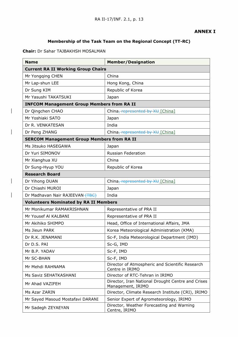
ANNEX I
Membership of the Task Team on the Regional Concept (TT-RC) Chair: Dr Sahar TAJBAKHSH MOSALMAN Name Member/Designation
Current RA II Working Group Chairs
Mr Yongqing CHEN China
Mr Lap-shun LEE Hong Kong, China
Dr Sung KIM Republic of Korea
Mr Yasushi TAKATSUKI Japan
INFCOM Management Group Members from RA II
Dr Qingchen CHAO China, represented by XU [China]
Mr Yoshiaki SATO Japan
Dr R. VENKATESAN India
Dr Peng ZHANG China, represented by XU [China]
SERCOM Management Group Members from RA II
Ms Jitsuko HASEGAWA Japan
Dr Yuri SIMONOV Russian Federation
Mr Xianghua XU China
Dr Sung-Hyup YOU Republic of Korea
Research Board
Dr Yihong DUAN China, represented by XU [China]
Dr Chiashi MUROI Japan
Dr Madhavan Nair RAJEEVAN (TBC) India
Volunteers Nominated by RA II Members
Mr Monikumar RAMAKRISHNAN Representative of PRA II
Mr Yousef Al KALBANI Representative of PRA II
Mr Akihiko SHIMPO Head, Office of International Affairs, JMA
Ms Jieun PARK Korea Meteorological Administration (KMA)
Dr R.K. JENAMANI Sc-F, India Meteorological Department (IMD)
Dr D.S. PAI Sc-G, IMD
Mr B.P. YADAV Sc-F, IMD
Mr SC-BHAN Sc-F, IMD
Mr Mehdi RAHNAMA Director of Atmospheric and Scientific Research Centre in IRIMO
Ms Saviz SEHATKASHANI Director of RTC-Tehran in IRIMO
Mr Ahad VAZIFEH Director, Iran National Drought Centre and Crises Management, IRIMO
Ms Azar ZARIN Director, Climate Research Institute (CRI), IRIMO
Mr Sayed Masoud Mostafavi DARANI Senior Expert of Agrometeorology, IRIMO
Mr Sadegh ZEYAEYAN Director, Weather Forecasting and Warning Centre, IRIMO

RA II-17/INF. 2.1, p. 14
Name Member/Designation
Mr Hesam SAJDEH Technical Expert, IRIMO
Mr Mohammad Nekooamal KERMANI Hydrology Expert, IRIMO
Mr Hussein MASTANEH Climate Expert, IRIMO
Mr Yashar FALAMARZI Hydrology Expert, Climate Research Institute (CRI), IRIMO
Membership of the Task Team on the Review of the Regional Partnership and Sub-
Regional Cooperation (TT-RP) Chair: Dr Mrutyunjay MOHAPATRA Name Member/Designation
Advisers To RA II Management Group Members
Mr Monikumar RAMAKRISHNAN Representative of PRA II
Mr Yousef Al KALBANI Representative of PRA II
Dr Ahad VAZIFEH Iran, Islamic Republic of
Mr Qingliang ZHOU National Meteorological Centre, CMA
Dr S.D. ATTRI Sc-G, India Meteorological Department (IMD)
Dr R.K. GIRI Sc-E, IMD
Dr D.R. PATTANAIK Sc-F, IMD
Mr Kohei MATSUDA Deputy Head, Office of International Affairs, representatives from Regional Centres operated by JMA
Ms Sungwha SON Korea Meteorological Administration (KMA)
Representatives from Regional Centres in RA II
Mr Peiqun ZHANG RCC Beijing, National Climate Centre, CMA
Representatives From RA I/V/VI
TBD
Volunteers Nominated by RA II Members
Mr Eiad KHATEB Saudi Arabia
_________

RA II-17/INF. 2.1, p. 15
ANNEX II
Progress Report of the Working Group on Weather Services (WGWS)
Submitted by Chair: L.S. Lee (Hong Kong, China), unedited
1. Introduction
This report summarizes major activities in association with the expert groups under the Working Group on Weather Services (WGWS), viz Expert Group on Aeronautical Meteorological Services Delivery (EG-AeM), Expert Group on Operational Forecasting (EG-OF) and Expert Group on Public Weather Services Delivery including Disaster Risk Reduction (EG-PWS) since the 16th Session of Regional Association II.
2. Working Group Structure
The Working Group is composed of EG-AeM, EG-OF and EG-PWS. Each EG consists of one coordinator and several leaders.
3. Terms of Reference
The terms of reference of the WGWS are as follows:
(a) To coordinate and support the work of the expert teams in Aeronautical Meteorology in the Region in cooperation with the Commission for Aeronautical Meteorology;
(b) To coordinate all activities related to the Global Data-Processing and Forecasting System (GDPFS), including emergency response activities, and PWS in the Region in cooperation with the Commission for Basic System.
4. Membership
Expert Group on Aeronautical Meteorological Service Delivery (EG-AeM)
EG-AeM Name Member
Coordinator Mr Boon-leung CHOY Hong Kong, China
Leader in QMS and Competency Assessment Implementation and Maintenance
Mr Zhikai ZHANG China
Mr Mostafa IZADFAR Iran
Leader in Meteorological Support to Air Traffic Management and Provision of SIGMETs
Ms Naoko KOMATSU Japan
Mr Abdulaziz M. ALQARAWI Kuwait
Leader in Migration to System Wide Information Management (SWIM) Environment and ICAO Global Air Navigation Plan (GANP)/ASBU Awareness and National Planning
Mr Gamaiak VARELDZHIAN Russian Federation
Ms Yeunsook CHOI Republic of Korea

RA II-17/INF. 2.1, p. 16
Expert Group on Operational Forecasting (EG-OF)
EG-OF Name Member
Coordinators Mr Yuki HONDA Japan
Leader in Operational Forecasting Process and Support Dr Tin Mar HTAY Myanmar
Leader in Emergency Response Activities Mr Masami SAKAMOTO Japan
Expert Group on Public Weather Service Delivery including Disaster Risk Reduction (EG-PWS)
EG-PWS Name Member
Coordinator Mr Lap-shun LEE Hong Kong, China
Leader in socio-economic benefits of meteorological and hydrological services Ms QU Ya China
Leader in all aspects related to formulation, dissemination and assessment of warnings and delivery of warning services, including coordination and collaboration with disaster management agencies and organizations and the media
Mr Hla TUN Myanmar
Leader in education and public outreach related to PWS Ms Mahnaz KHAN Bangladesh
5. Major Activities of EG-AeM
5.1 There is active development in areas exploring new aviation meteorological information and services to support the industry’s expectation of a more efficient and safer air navigation than more mature work like quality management systems. The outcome of the following activities is important in helping the aviation industry in post-COVID-19 recovery. Continuation of these activities in RA II should be supported.
5.2 The cross-Flight Information Region (FIR) border coordination efforts to provide harmonized SIGMET information to users had significant development, especially when coordination among neighbouring Meteorological Watch Offices (MWOs) had become a recommended practice in Amendment 79 to International Civil Aviation Organization (ICAO) Annex 3 starting from November 2020:
• Japan, the Philippines and Viet Nam launched a demonstration project on Collaborative Significant Meteorological Information AIM 7-1-6 (SIGMET) Issuance (CSI) in 2015 with Lao PDR, Myanmar and Thailand joining the project in 2016. The demonstrations were carried out successfully four times from 2016 to 2018. In addition, several training opportunities were provided by the Japan Meteorological Agency (JMA). Acknowledging the maturity of SIGMET coordination procedures, the Mmembers decided to transfer the project into the operational phase from 9 April 2018. Malaysia also participates in CSI as an observer.
RA II-17/INF. 2.1, p. 17
• The WMO SIGMET Coordination Pilot Project in Southeast Asia, starting with MWOs in Indonesia, Malaysia and Singapore back in 2017, became full 24/7 operation since 1 August 2017.
• To support the step-by-step integration of SIGMET coordination activities in the western and northern parts of South China Sea, a trial SIGMET Coordination has been set up among Guangzhou, Hong Kong, Sanya and Hanoi and Hoi Chi Minh (GHSV) MWOs since November 2017. Two more MWOs joined in later on (Kunming in June 2018 and Phnom-Penh in October 2020). Under ICAO Amendment 79 to Annex 3, the GHSV SIGMET Coordination has transitioned to full 24/7 operation from 1 November 2020. There were a total number of 845 coordinated cases from November 2017 to November 2020, with a total number of 296 coordinated SIGMET issuance from January to November 2020.
• The South and South-eastern Asia (SSEA) SIGMET Coordination project between Indonesia (Jakarta FIR) and Sri Lanka (Colombo FIR) was set up in December 2019 and transitioned to full 24/7 operation from 1 February 2021.
• In the Russian Federation the project on MWO coordination is an implementation which aims to provide assistance in issuing compliant SIGMET messages in the Russian Federation and adjacent countries. Currently, eight countries including Armenia, Azerbaijan, Georgia, Kazakhstan, Kyrgyzstan, Russian Federation, Tajikistan and Uzbekistan participate in the Project. An expert team on SIGMET coordination comprises experts from all Members States was established to review progress on the project, activities being undertaken and set the agenda of future activities. In order to promote compliance in issuing SIGMET, efforts were pooled to develop special software – a SIGMET visualization module. To date, the software is used to visualize SIGMET messages issued for FIRs in the Russian Federation and adjacent Members States [China].
5.3 Workshops had been conducted to facilitate Members’ implementation of ICAO Meteorological Information Exchange Model (IWXXM), to align with the mandatory requirement to prepare and exchange a number of meteorological reports in Amendment 79 to ICAO Annex 3 applicable from November 2020:
• The Hong Kong Observatory organized a workshop on “Implementation of the IWXXM for the Exchange of OPMET Data” in collaboration with the Voluntary Cooperation Programme (VCP) of the WMO and ICAO Asia and Pacific Office on 10-12 October 2017. The workshop was attended by more than 50 experts of 22 Members States and Special Administrative Regions[China]. The aim of the workshop is to strengthen participants’ capability to kick start their own implementation project.
• An online workshop on “Implementation of the IWXXM” was conducted by ICAO on 27-29 October 2020. Over 140 experts from 27 Members States and Special Administrative Regions [China] joined the workshop with prime focus on the actual implementation and sharing of experience on issues faced by the participants.
5.4 A number of activities were carried out to explore future aviation meteorological information and services to be provided under the System Wide Information Management (SWIM) environment which is part of the ICAO Global Air Navigation Plan (GANP) and aviation system block upgrade (ASBU):
• The SWIM in Association of Southeast Asian Nations (ASEAN) Demonstration Project was successfully conducted on 12 and 15 November 2019 in Bangkok, Thailand and Singapore respectively to demonstrate the principles of SWIM, show the potential operational benefits of SWIM and to demonstrate a model of SWIM implementation for ASEAN and Asia and Pacific regions. It got a wide participation

RA II-17/INF. 2.1, p. 18
of aviation stakeholders including civil aviation authorities, air navigation service providers, airport operators, airlines and international organizations like ICAO, International Air Transport Association (IATA), etc. Weather was a major contributing component in several demonstration scenarios which highlighted the importance of timely provision of the information in an interoperable format like IWXXM.
• The Aviation Research and Demonstration Project (AvRDP), a joint project under the Commission for Atmospheric Science (CAS) and Commission for Aeronautical Meteorology (CAeM), held an international training workshop on Meteorological-Air Traffic Management (MET-ATM) integration in Hong Kong, China on 8-10 October 2018 and a concluding meeting and seminar on 19-22 August 2019 in South Africa. The focus of the workshop was on enhancement of aviation meteorological information and services in support of the modernization of air traffic management envisioned in the GANP by ICAO for the next 15 years and beyond and was attended by 20 participants from 16 countriesMembers. In the concluding meeting, final reports of 11 airports that joined the demonstration were presented. Limitations, gaps and user needs were identified through the demonstration of translating nowcast information onto Air Traffic Management impact. Further demonstration and application would be pursued by an extended AvRDP project.
6. Major Activities of EG-OF
6.1 General report on Global Data-processing and Forecasting System (GDPFS)
• In RA II, there are two World Meteorological Centres (WMCs), Beijing, China and Tokyo, Japan (designation endorsed at EC-69), and also 31 Regional Specialized Meteorological Centres (RSMCs) including two Lead Centres (but excluding ICAO-designated Centres). The list of WMCs and RSMCs can be found in Part III of the Manual on the GDPFS.
• In RA II, three RSMCs for geographical specialization still retain its status, but are requested to map their functions to one or more of new GDPFS activities.
• Four Members (Hong Kong, China; China; Japan; Republic of Korea) submitted the WMO Technical Progress Report on GDPFS and Numerical Weather Prediction (NWP) Research.
6.2 Severe Weather Forecasting Programme (SWFP)
• The development planning of SWFP regional subprojects in Southeast Asia, South Asia and Central Asia in RA II started in 2010, 2012 and 2014, respectively. There are 21 participating Members in RA II, more than half of RA II Members. These three subprojects in RA II have shown steady progress during recent years.
• The SWFP Southeast Asia (SWFP-SeA) which involves five countries namely: Cambodia, Lao PDR, Philippines, Thailand and Viet Nam (Myanmar is an observer), has been in the demonstration phase since 1 January 2016. The National Meteorological Centre for Hydro-Meteorological Forecasting (NCHMFMC) in Ha Noi, Viet Nam [Viet Nam] acts as a Regional Forecasting Support Centre (RFSC), with the support of RSMC Tokyo (for typhoon forecast support) and RSMC New Delhi (for tropical cyclone forecast support). Contributions were also made by global NWP centres of the China Meteorological Administration (CMA), JMA, Korea Meteorological Administration (KMA), Deutscher Wetterdienst (DWD) and European Centre for Medium-Range Weather Forecasts (ECMWF). Training workshops were held at Viet Nam and Lao PDR in 2018 and 2019 respectively. The SWFDP-SeA RFSC Training Desk was organized online on 7-9 December 2020 in Viet Nam [Viet
RA II-17/INF. 2.1, p. 19
Nam]. An online training workshop on Severe Weather and Impact-Based Forecasting and Warning Services was organized on 1-12 February 2021.
• The SWFP-Central Asia (SWFP-CA) involves five countries namely: Kazakhstan, Kyrgyzstan, Tajikistan, Turkmenistan, and Uzbekistan. RSMC Tashkent serves as the lead Regional Centre. The project website which is in Russian language is currently maintained by the Hydrometeorological Centre of Russia (Roshydromet). The demonstration phase started in January 2017. The contributing global NWP centres include Roshydromet, European Centre for Medium-Range Weather Forecasts (ECMWF), National Centre for Environmental Prediction (NCEP)/National Oceanic and Atmospheric Administration (NOAA), CMA, JMA and KMA. Workshop on modernization of RSMC Tashkent was held at Tashkent on 2-3 April 2019.
• The SWFP-South Asia (SWFP-SA) involves nine countries namely: Bangladesh, Bhutan, India, Maldives, Myanmar, Nepal, Pakistan, Sri Lanka and Thailand. RSMC New Delhi is the lead Regional Centre. IMD, ECMWF, CMA, JMA and KMA contributed as global NWP centres. Meeting of the Regional Sub-programme Management Team (RSMT) was held online on 25 May 2020 to review the sub-programme progress.
6.3 RSMCs for Nowcasting
• JMA was designated as a RSMC for Nowcasting at the 69th session of the Executive Council of the WMO in May 2017, and began its operation in December 2018 establishing the website to supply the National Meteorological and Hydrological Services (NMHSs) in the Asia and Pacific regions with graphical nowcasting products for improving capacity for disaster risk reduction. The website provides two Himawari-8/9 satellite products titled Heavy Rainfall Potential (HPR) and High resolution Cloud Analysis Information (HCAI), respectively.
• The JMA partners with NMHSs to optimize two-way communication, thus supporting their use of nowcasting products in a timely manner. JMA also collaborates closely with NMHSs and related organizations to develop higher-level nowcasting products.
• The Hong Kong Observatory (HKO) has been providing nowcasting products for the Asian region with the establishment of the RSMC for Nowcasting since 2018. Satellite-based nowcast of significant convection and ice crystal icing covering the East Asia are made available in real-time basis. Research development of new nowcast products using satellite and radar data are underway that they will be launched on the RSMC website in phases.
• HKO continues to provide supports on technique development of nowcasting systems for several NHMSs. The community version of SWIRLS (Short-range Warning of Intense Rainstorms in Localized Systems) nowcasting software, or Com-SWIRLS in short, is made available on RSMC website for the registered users from NMHSs. Currently, there are about 150 users from more than 40 NHMSs that have joined the Com-SWIRLS’ community. Several meteorological services in Asian countries, including India, Malaysia, the Philippines, Viet Nam have adopted SWIRLS in real-time nowcasting applications or in support of the research development of nowcasting techniques.
• Under RSMC for Nowcasting, HKO also contributes to various international training activities to promote development and application of radar and satellite nowcast techniques. In-house training workshops have been organized, such as the WMO VCP workshop on 3-6 December 2019, for forecasters and nowcast system developers from overseas countries. HKO has also participated in several WMO SWFP Training Workshops in 2019 and 2020 to deliver lectures on SWIRLS, radar and satellite nowcasting techniques, use and interpretation of NWP / Ensemble
RA II-17/INF. 2.1, p. 20
Prediction Systems (EPS) products in forecasting significant convective or high-impact weather processes, verification methods, as well as development of impact-based weather forecast.
6.4 Training on Tropical Cyclone Forecasting
RSMC Tokyo conducted Attachment Training course on Tropical Cyclone Forecasting every year. Amid the COVID-19 pandemic, the 2021 course was held virtually on 9-11 March 2021 with 44 attendees from the seven Typhoon Committee Members (Hong Kong, China; Macao, China; Malaysia; the Philippines; the Republic of Korea; Singapore and Thailand). The main purpose of the training was to provide a solid understanding of monitoring, analysis and forecasting for tropical cyclones based on RSMC Tokyo products, and to raise awareness of up-to-date public weather services and information design based on the concept of the 10-year Vision to Protect Life and Property from Tropical Cyclones as delineated in the Tokyo Statement from the High-level Dialogues on Tropical Cyclones held in Tokyo, Japan in October 2019. The training course also addressed the promotion of information sharing on recent tropical cyclone activities conducted by contributing services.
6.5 Emergency Response Activity
The RSMCs in the region have continued their efforts to maintain contact information for the registered Mmembers for the Environmental Emergency Response (EER). It is planned to provide Members with a concise guidance for the transition to the new GDPFS manual regarding the EER, because the definitions of the services by the GDPFS centres are updated in the new manual. The Executive Council adopted the revised Manual on the GDPFS, as proposed by CBS Resolution 18 (EC-69) (WMO-No.1196). However, the efforts for the revisions of the details of the manual have been still continuing. Related amendments were discussed at the WMO Congress (Resolution 59 (Cg-18) (WMO-No.1236)), but the nomination processes for the newly developed services such as the non-nuclear Emergency Response Activities (ERA) remained incomplete. As related commentary cannot be provided for the new manual at this early stage, the planned activity will not be conducted until 2021 or later.
7. Major Activities of EG-PWS (Expert Group on Public Weather Services Delivery)
7.1 In 2020 and 2021, owing to COVID pandemic, communications among coordinator and theme leaders of the EG-PWS were mainly through electronic means. Progress of activities of EG-PWS was reported at RA II meetings held in Abu Dhabi on 12-14 December 2017 and 4-5 December 2018, as well as the RA II / RA V joint meeting at Singapore on 29-31 October 2019. Some of the major activities on PWS including DRR carried out in this Region are summarized as follows.
7.2 Hong Kong, China continued to provide support to Members through operating the Severe Weather Information Centre (SWIC) and SWIC 2.0 Beta Website, contributing to the development of the Global Multi-hazard Alert System. Contribution was also made to the preparation of the WMO survey on World Weather Information Service (WWIS) for Members to receive, test and use city forecast data provided by ECMWF to facilitate provision of forecasts on the WWIS platform, thus enhancing the number of cities on the WWIS. The Hong Kong Observatory also supported the mission of its expert to WMO liaison Office in New York city to assist in developing the assistance to the United Nations Operations and Crisis Centre (UNOCC), on 23 July – 3 August 2018, and then a mission to the WMO Secretariat in order to further assist in the development of the concept and possible implementation plan of the WMO Coordination Mechanism on 26 November – 7 December 2018.
7.3 In 2018, the GMAS-A platform, a regional multi-hazard alert system for RA II, comprising a public website and a restricted portal was set up and launched in the second China-ASEAN Meteorological Forum held at Nanning in September 2018. There is a public website built with a global information system (GIS) map to display warnings issued by RA II Members in Common Alerting Protocol (CAP) format. There is also a restricted portal for
RA II-17/INF. 2.1, p. 21
exclusive use by WMO Members to facilitate warning and forecast preparation. A workshop on Global Multi-hazard Alert System (GMAS) in Asia was held in Haikou, China on 18-19 November 2019. Amid the COVID-19 pandemic, visit and online training were arranged to assist interested Member to install and try out the multilingual CAP warning dissemination system developed by CMA. Up to April 2021, CAP warnings from 11 Mmembers of RA II (viz., Afghanistan; China; Hong Kong, China; India; Kuwait; Macao, China; Mongolia; Myanmar; Oman; Russian Federation; and Thailand) are aggregated and displayed on the GMAS-A public website.
7.4 Experts from RA II provided support to PWS and DRR activities of WMO through meetings as members of the Commission for Weather, Climate, Water and Related Environmental Services & Applications (Services Commission or SERCOM), Standing Committee on Disaster Risk Reduction and Public Services (SC-DRR), and Expert Team on General Service Delivery (ET/GSD).
7.5 Focusing on impact-based forecasts, RA II regional workshops were held in Seoul, Republic of Korea on 7-9 November 2017 and 19-21 November 2018. Training Workshop on Severe Weather and Impact-based Forecast and Warning Services was conducted in Colombo, Sri Lanka on 28 November -1 December 2018. There was also training workshop for Panel on Tropical Cyclones (PTC) Members member countries [China] and West Asia countries in March 2020. Funded through the Climate Risk and Early Warning Systems (CREWS) project, an Impact-based Forecast and Warning Services Workshop was organized in Bangkok, Thailand on 21-25 September 2020. Online courses on Viet Nam WMO CREWS-Canada Sub-Project Workshop on Impact-based Forecast and Warning Services and Thailand CREWS-Canada Sub-Project Workshop on Impact-based Forecast and Warning Services were organized on 30 November – 4 December 2020 and 18-22 January 2021 respectively.
7.6 Training workshops on severe weather forecasting and delivery of warning services were held in Vientiane, Lao PDR on 19 February – 1 March 2017; in Ha Noi, Viet Nam on 26-30 March 2018; in Vientiane, Lao PDR on 25 February – 1 March 2019. On CAP, workshops were organized in Hong Kong, China on 30 October – 1 November 2018; and in Saudi Arabia in March 2019.
7.7 The Department of Meteorology and Hydrology (DMH, Myanmar) jointly collaborated with Pacific Disaster Centre (PDC) for the Disaster Monitoring and Response System (DMRS) User Training on 23-24 January 2018 and 9-10 April 2018. Monsoon Forums were held in Nay Pyi Taw, Myanmar and organized by DMH, Myanmar and Regional Multi-hazard Early Warning System (RIMES) funded by United Nations – Social Commissions for Asia and the Pacific (UN-ESCAP) on 31 October 2018, 30 April 2019 and 5 November 2019.
7.8 Abu Dhabi (UAE) held the International Rain Enhancement Forums on 14-17 January 2019, 19-23 January 2020, and 25-26 January 2021. A training workshop in Quality Management Systems (QMS) and Cost Recovery for Arab region, including West Asia countries was held in Morocco on 26-28 November 2018. The third meeting of the Meteorology and Media Awareness Forum was held in Jeddah, Saudi Arabia on 23-24 March 2019. The High-level conference on tsunamis in the Makran region was organized on 1-2 September 2019 to discuss national strategies for tsunami early warning and community for preparedness in the context of near-field tsunamis. The Fifteenth Meteorological Satellite Application Course was held at the Centre of excellence for Satellites Applications in Muscat on 16-20 February 2020. The Committee on Climate and Weather risk information management of League of Arab States conducted its meetings in Cairo in October 2019 and virtually in December 2020.
[The progress reports for pilot projects have been updated and incorporated as a new Annex VI, as suggested by the Chair of WGWS]
RA II-17/INF. 2.1, p. 22
8. Pilot projects for RA II
(a) Pilot Project to develop support for national meteorological and hydrological services (NMHS) in numerical weather prediction
HKO continued to maintain and develop the web-based portal of the “Asian Consortium for NWP Forecasts” (ACNF) where online-resources are provided on (a) the existing NWP products from RA II Members, including, among others, Hong Kong, China and the Republic of Korea; and (b) the source code and documentation of the community NWP models.
The coverage of NWP products on ACNF Website had been extended to include an additional 15 cities in Sri Lanka. CMA, KMA and JMA are gratefully acknowledged for provision of the additional forecast products.
(b) Pilot Project to Sustain and Enhance the Capacity of NMHSs in the Provision of Official Weather Forecasts for Medium-Range
Objectives:
To assist NHMSs in RA II in enhancing their provision of weather forecasts in the medium-range through identifying reliable sources of NWP products, exploring means to post-process NWP products, verify and validate NWP products, and to share experience in the post-processing, verification and validation of NWP products, especially with developing country Members.
Activities since 2017
(i) Global NWP model and EPS products of Korea Meteorological Administration (KMA) have been made available on a dedicated website: http://www.kma.go.kr/ema/nema03/rall/index.jsp for supporting medium-range weather forecast in RA II members. Provision of NWP products for NMHSs in RA II was enhanced that over 300 cities of more than 20 Asian countries are being supported.
(i) Training activities have been organized by KMA and HKO for forecasters and system developers from RA II members or overseas meteorological services:
• KMA hosted several training workshops on various topics including NWP modelling, use and interpretation of NWP products, post-processing techniques and verification of NWP products. A training course on quality control techniques and data assimilation for NWP has been conducted for experts from the Philippines (PAGASA) on observation data quality control, satellite and radar data assimilation, data assimilation method (variational and ensemble), and post-processing with NWP data.
• HKO conducted a couple of training workshops under WMO VCP on using NWP and EPS products, post-processing techniques and guidance in support of short-range to medium-range prediction of high-impact weather. HKO has also participated in several WMO SWFP Training Workshops and Training Desks in 2018-2020 to deliver lectures on use and interpretation, as well as verification techniques of NWP and EPS products in forecasting significant convective or high-impact weather processes from very-short-range to days ahead.
(i) HKO continued to develop post-processing techniques for providing automatic city-specific medium-range weather forecasts. Trial forecast products for
RA II-17/INF. 2.1, p. 23
selected cities in East Asia are made available on HKO’s Earth Weather website: (https://maps.weather.gov.hk/wxviewer/index.html). The automatic forecasts include time-series of temperature, relative humidity, state-of-sky, wind speed and direction that are generated from a consensus of post-processed products of several global NWP models.
Work in progress:
Automatic forecasts for other cities in RA II members and their verification are underway that they could be made available for trial and sharing later in support of members’ provision of official weather forecasts for medium-range and further developments.
Training workshops on the application of NWP models and post-processing methods in medium-range weather forecasts and/or high-impact weather forecasts would be organized, subject to available resources. Training resources on NWP applications and post-processing techniques would be made available on a web-based forum to facilitate knowledge and experience sharing.
(b) Pilot Project to Develop Support for National Meteorological and Hydrological Services in the Collection and Application of Aircraft Meteorological Data Relay Data
Upon approval in the 18th Session of the WMO Congress Resolution 39 (Cg-18) – Establishment of collaboration between the IATA and WMO on the development and operation of the Aircraft Meteorological Data Relay (AMDAR) Programme, further activities of the pilot project would be reviewed pending the outcome of the determination of the development and operation of the regional AMDAR Programme in RA II under WMO-IATA Collaborative AMDAR Programme (WICAP).
(b) Pilot Project to Enhance the Capability of Meteorological Disaster Risk Reduction in Regional Association II (Asia)
The Global Multi-Hazard Alert System for Asia (GMAS-A) platform (https://gmas.asia) was launched in the 2nd China-ASEAN Meteorological Forum held at Nanning in Sep 2018 and is now in operational use. It comprises a public website and a restricted portal. The public website is built with a global information system (GIS) map to display warnings issued by RA II Members in CAP format. An alert hub was also set up to aggregate CAP warnings disseminated by Members. The map of GMAS-A was recently enhanced with tropical cyclone advisories and warnings from RSMCs and NMCs of the region. In the restricted portal which is for exclusive use by WMO Members, model, satellite and advisory products to facilitate warning and forecast preparation are updated regularly. A chatroom function is also available in the restricted portal to allow Member-users to coordinate on trans-boundary weather warnings and other operational topics that may be of common interest. Some advisory products in the restricted portal would be updated in the next couple of months.
A GMAS-A Workshop was held in Haikou, Hainan Province, China from 18 to 19 November 2019 It is jointly organized by WMO Secretariat, China Meteorological Administration (CMA), Hong Kong Observatory (HKO), Thailand Meteorological Department (TMD), and Myanmar Department of Meteorological and Hydrology (MDMH).
(b) Pilot Project on Impact-based Forecasting
The Korea Meteorological Administration (KMA) officially launched heatwave impact-based forecasting (IBF) service from June to September 2019 in order to support effective reduction of heatwave impacts. The KMA provided risk levels in different colours (attention-green, caution-yellow, warning-orange, danger-red), impact information and
RA II-17/INF. 2.1, p. 24
response tips for seven sectors (health, industry, livestock, aquaculture, agriculture, transportation and electric power) once a day at 11:30 a.m., considering the regional characteristics. This information was disseminated to the public on the KMA's website (PC, mobile web). It was also provided to disaster response related agencies through the Meteorological Information Portal Service System for Disaster Prevention, as well as to local governments’ disaster response managers and officials managing the socially vulnerable people through mobile text messages (SMS). In particular, both the desktop and mobile websites offered the impact information by city, county and district. The information was also reported by media channels, such as TV news broadcasts, online weather broadcasts, and newspapers.
In addition, the KMA held talks with related ministries in advance so that the information can be linked to the government's heatwave response system. As a result, the provision of heatwave IBF service was included in the standard manual and the working-level manual for heatwave risk management. The Ministry of Health and Welfare provided text services to the officials in charge of assisting the disadvantaged classes. Moreover, the Ministry of Employment and Labour gave managers of workplaces the heatwave IBF information to prevent workers from getting heat-related illnesses. Local government officials in charge of disaster prevention and managers of the vulnerable groups utilized the information for heatwave response in the field. In particular, the Government of the Korean capital, the Seoul Metropolitan Government, said there were no heatwave-related accidents involving workers this summer by taking advantage of the heatwave IBF for industry.
_________

RA II-17/INF. 2.1, p. 25
ANNEX III
Progress Report ofn the RA II Working Group on Climate Services (WGCS)
Submitted by Yasushi Takatsuki (Japan)
Chair of the Working Group on Climate Services, Tokyo Climate Centre, Japan Meteorological Agency
----- Dildar Hussain Kazmi and Yasushi Takatsuki
Co-coordinators of Expert Group on Climate Services
Kamalesh Kumar Singh Coordinator of Expert Group on Agrometeorology
-----
Unedited
1. Introduction
The WMO Regional Association II (RA II) Working Group on Climate Service (WGCS) was established considering that the RA II should continue to play an important and active role in the implementation of World Meteorological Organization (WMO) regional activities in the field of climate services including agrometeorological services, with particular attention to matters relevant to implementation of the Global Framework for Climate Services (GFCS) in the Region. WGCS will work on climate and agrometeorological issues laid out in the terms of references in close cooperation with WMO's Technical Commissions.
2. Working Group Structure
The Working Group is composed of Expert Groups for Climate Services (EG-CS) and Expert Group for Agrometeorology (EG-AgM). EG-CS consists of two co-coordinators and five leaders. On the other hand, EG-AgM consists of one coordinator and five leaders. In addition, a number of volunteer experts who are expected to assist the tasks of each Expert Group have also been registered. In June 2018, a replacement of the Chair of WGCS was approved by the RA II Managing Group.
3. Terms of Reference
(a) To provide assistance and advice to the president of Regional Association II on all matters pertaining to the regional aspects of the relevant components of the World Climate Programme and the Agricultural Meteorology Programme and, in particular, to implement the country-focused results-based framework and mechanism for WMO contributions to the GFCS in the Region;
(b) To track what is happening in the Region, particularly with regard to country priorities for climate services, priorities and needs of National Meteorological and Hydrological Services (NMHSs), relevant partners’ activities and programmes, and progress in implementation of the country-focused results-based framework and mechanism for WMO contributions to the GFCS;
(c) To cooperate with the Commission for Climatology and the Commission for Agricultural Meteorology and other WMO bodies on activities related to climate

RA II-17/INF. 2.1, p. 26
services and, in particular, to implement the country-focused results-based framework and mechanism for WMO contributions to the GFCS in the Region, specifically:
(i) To align and coordinate the workplans and schedules related to the GFCS of the above-mentioned WMO commissions and bodies;
(ii) To collect and elaborate coordinated requirements for the development of well-targeted and, to the extent possible, integrated GFCS projects, and to ensure coordination of the WMO contribution to those projects;
(iii) To collect and elaborate requirements for the development of information, products and services related to the GFCS across the identified priority sectors and ensure coordination of the WMO contribution to them;
(iv) To ensure the engagement of the Regional Climate Centres (RCCs) in the Region.
(d) To undertake and coordinate activities relating to climate services as listed in the EG-CS and EG-AgM, respectively;
(e) To report, through the Chair of the Working Group on Climate Services, to the president of RA II on an annual basis on activities related to the above terms of reference.
4. Membership of Working Group
Expert Group on Climate Services (EG-CS)
EG-CS Name Member Country [China]
Co-coordinators
Mr Yasushi TAKATSUKI (Mr Kiyotoshi TAKAHASHI until June 2018)
Japan
Dr Dildar Hussain KAZMI Pakistan
Leader in user liaison and applications of climate information and products for climate risk management and adaptation to climate change
Mr Cheolhan BANG Rep. of Korea
Leader in implementation and operation of Regional Climate Centres and Regional Climate Outlook Forums
Mr Yasushi MOCHIZUKI Japan
Leader in implementation of the country-focused results-based framework and mechanism for WMO contributions to the GFCS
Mr Tshencho DORJI Bhutan
Leader in climate monitoring and climate watch Dr WANG Zunya (Ms) China
Leader in climate data management system, data rescue and homogenization Dr Pulak GUHATHAKURTA India

RA II-17/INF. 2.1, p. 27
Expert Group on Agrometeorology (EG-AgM)
EG-AgM Name Member Country [China]
Coordinator Dr Kamalesh Kumar SINGH India
Leader in RA II agrometeorological training needs Ms YANG Feiyun China
Leader in soil moisture monitoring Mr Masoud HAGHIGHAT Iran Leader in drought preparedness and management strategies Mr Azmat Hayat KHAN Pakistan
Leader in seasonal climate forecast applications for agriculture Ms May CHAW Myanmar
Leader in socio-economic impact of agrometeorological information Ms Olga BEREZA Russian Fed.
5. Development of Work Plan
A work plan for the WGCS was developed by coordinators of Expert Group on Climate Services and Expert Group on Agrometeorology, with the help of leaders and the WMO Secretariat. The work plans for the WGCS were submitted to the WMO Secretariat in December 2017 for 2017-2020.
The work plans were developed mainly based on the deliverables outlined in the RA II Strategic Operating Plan, terms of reference of the Expert Groups. The plan consists of: (1) Tasks; (2) Key deliverables; (3) Activities; (4) Timelines and (5) Responsible Leaders/Coordinators.
Tasks for EG-CS and EG-AgM were established in the work plans and each task includes several relevant activities. Leaders of EG-CS and EG-AgM are expected to take a role in the said activities with the support of, and coordination with, co-coordinators. The work plans were reviewed and agreed by the leaders at the WGCS meeting in December 2018 in Beijing. The result of the WGCS meeting is summarized in the attached final report.
6. Expert Group on Climate Services
A report of activities on EG-CS is available in Annex III.1. Its contents are as follows:
(i) Implementation and development of RCCs
(ii) Implementation of Regional Climate Outlook Forums (RCOFs)
(iii) WMO Workshop on Global Review of Regional Climate Outlook Forums
(iv) WMO International Workshop on Global Review of RCC Operations
(v) User interface for climate services
(vi) Operation of web site for Information Sharing on Climate Services
(vii) Capacity development activities for climate services
(viii) Related activities with GFCS implementation in RA II
(ix) Monitoring Extreme Weather and Climate Events from Space
RA II-17/INF. 2.1, p. 28
7. Expert Group on Agrometeorology
A report of activities on EG-AgM is available in Annex III.2. Its contents are as follows:
(i) Activity for the establishment of Agromet Advisory Services
(ii) Capacity development activities
(iii) Monitoring and forecasting of soil moisture
(iv) Drought preparedness and management strategies
(v) Seasonal to interannual climate forecast applications for agriculture
(vi) Socio-economic impact of Agromet information

RA II-17/INF. 2.1, p. 29
Annex III.1
Progress Report ofn the RA II Expert Group on Climate Services (EG-CS)
1. Implementation and development of Regional Climate Centres (RCCs)
Currently four WMO RCCs have been operating in RA II. The Beijing Climate Centre (BCC) of the China Meteorological Administration (CMA) and the Tokyo Climate Centre (TCC) of the Japan Meteorological Agency (JMA) were formally designated as WMO RCCs in 2009, and the North Eurasia Climate Centre (NEACC) coordinated by the Hydrometeorological Centre of Russia (Roshydromet), was also formally designated as the World Meteorological Organization (WMO) RCC in 2013. RCC Pune of the India Meteorological Department (IMD) was also designated in 2017.
These four RCCs are conducting a variety of RCC-related activities, including the dissemination of climate data/products/information and the organization of training workshops for capacity development in accordance with RCC mandatory functions. A portal site regarding RCCs in RA II is available (http://www.rccra2.org/).
In response to Decision 11 (RA II-16) that is endorsement of the proposal to establish a WMO RCC Network for the Third Pole region, a scoping meeting on implementation of the Third Pole RCC Network (TPRCC-Network) was held in Geneva in March 2018 and summarized the concrete outline of TPRCC-Network. The meeting recognized that there is a need for a dedicated RCC arrangement to cater to the unique requirements of the region and proposed that the structure is consisted of three geographical nodes with the functional responsibilities of RCC. The meeting agreed to establish a small Task Team (TT) to steer the development of the implementation plan. In December 2018, TPRCC-Network Implementation planning meeting was held under the leadership of TT in Beijing to facilitate the development of a technical implementation plan, assignment and commitment of roles and responsibilities of contributing entities, including the possible launch of a demonstration phase of the TPRCC-Network in 2019. After the meeting, TT prepared a draft implementation plan (IP) of TPRCC-Network and submitted to Services Task Team of Executive Council Panel of Experts on Polar and High Mountain Observations, Research and Services (EC-PHORS) in March 2019 for review. TT made presentation to disseminate TPRCC-Network at the High Mountain Summit held in Geneva in the end of October 2019. TT activity was suspended during 2020 due to the COVID-19 pandemic, but TT will soon resume their tasks and will finalize the draft IP to require the endorsement of concerned PRs.
It is also noted that Iran and Saudi Arabia have expressed interest in hosting WMO RCCs, but there has been no progress.
2. Implementation of Regional Climate Outlook Forums (RCOFs)
RCOFs is mainly conducted to produce a consensus statement on seasonal forecast for each targeted region. In RA II, following RCOFs are convened regularly;
The Regional Climate Monitoring, Assessment and Prediction for Regional Association II (FOCRA II) coordinated by China since 2005;
The South Asian Climate Outlook Forum (SASCOF) coordinated by India since 2010;
The North Eurasian Climate Outlook Forum (NEACOF; including some RA VI Members) coordinated by NEACC since 2011;
RA II-17/INF. 2.1, p. 30
The East Asia winter Climate Outlook Forum (EASCOF) coordinated by Japan, Mongolia and Republic of Korea (China just participates) since 2013;
ASEAN Climate Outlook Forum (ASEANCOF; including some RA V Members) since 2013.
The Arab Climate Outlook Forum (ArabCOF, including some RA I and RA VI Members) was established in 2017, following the decision of the Executive Office of the Council of Minsters responsible for Meteorology and Climate, under the League of Arab States. The fourth session of ArabCOF and the first session of the Gulf Cooperation Council (GCC) Climate Outlook Forum were held in November 2019 in Saudi Arabia. The fifth and six sessions of ArabCOF as well as the second and third GCC-COF conducted online during 2020.
RCOF is mainly conducted to produce a consensus statement on seasonal forecast for each targeted region. In addition to this purpose, it is emphasized that RCOF is a good opportunity for experts from RA II Members to communicate each other and exchange their knowledge and experiences for climate services.
RCOFs in RA II held between 2017 and 2020 are listed in Attachment I-1. In 2020, due to the worldwide outbreak of the COVID-19 pandemic, all the RCOFs were held online.
3. WMO Workshop on Global Review of Regional Climate Outlook Forums
WMO organized an International Workshop on Global Review of RCOFs in September 2017 in Guayaquil (Ecuador), in order to undertake a comprehensive review of the RCOF process, that is, all aspects of the interpretation, creation and dissemination of regional climate outlooks. Similar meetings were held in 2000 in Pretoria (South Africa) and in 2008 in Arusha (Tanzania).
From RA II, experts of TCC, GPC-Tokyo, GPC-Seoul, NEACC and RCC Pune participated in this workshop and contributed to the discussion based on the experiences in RA II. Conclusions and recommendation at the meeting need to be taken into consideration for improvement of RCOF operation in RA II.
4. WMO International Workshop on Global Review of RCC Operations
WMO organized an International Workshop on Global Review of RCC Operations in November 2018 in Pune, India, in order to identify gaps and requirements, and to propose ways for smooth and future-oriented operations and sustainable development of RCCs.
From RA II, experts of TCC, BCC, NEACC and RCC Pune participated in this workshop and contributed to the discussion based on the experiences in RA II. Conclusions and recommendation at the meeting need to be taken into consideration for improvement of RCC operation in RA II.
5. User interface for climate services
User Interface Platform (UIP) is an important function in the Global Framework for Climate Services (GFCS) implementation. It is recognized to be effective for the exchange of good practices and the sharing of experiences in the application of climate information among NMHSs and thereby promoting user-provider interaction. Some RCOFs including the Forum on Regional Climate Monitoring, Assessment and Prediction for Regional Association II (FOCRAII) and SASCOF have provided such opportunities by inviting experts from user sectors, such as agriculture and health, to the meeting and by listening to their needs for climate information.

RA II-17/INF. 2.1, p. 31
6. Operation of web site for Information Sharing on Climate Services
For the successful implementation of GFCS, sharing good practices and lessons learnt in climate-related activities, especially among Members countries/territories in the similar climatological regions are important to support the improvement of their own climate services, avoid duplication of efforts and minimize the risk of failure. For this purpose, in response to the decision taken at the 16th session of RA II, TCC operates its dedicated website at https://ds.data.jma.go.jp/tcc/RaiiInfoshare/ and updated its contents in August 2017 and December 2019 based on the questionnaire survey.
7. Capacity development activities for climate services
A number of capacity development activities, such as training events and expert visits have been conducted in the region organized by WMO Regional Training Centres, RCCs (BCC, NEACC, RCC Pune and TCC) and some NMHSs. Such events have also been held in conjunction with RCOFs including FOCRAII, SASCOF and NEACOF. Many of these events have been conducted on a practical basis so that trainees could apply what they learnt to their operational climate services soon after returning to home countries. In West Asia, working group on capacity development of Climate services was held in April 2019 in Abu Dhabi, United Arab Emirates.
Capacity development activities (training events) conducted between 2017 and 2020 are listed in Attachment I-2. Due to the COVID-19 pandemic, some training activities were cancelled or postponed to the year 2021 afterward.
8. Related activities for GFCS implementation in RA II
GFCS is a worldwide mechanism which WMO is involved for promoting effective use of climate information at various opportunities. To check its progress, WMO Secretary requested the President of Regional Association to report the status of implementation of GFCS in each Region at joint meetings of PRA-President of Technical Commission (TC).
In May 2017, WMO requested the PRAs to report about status of GFCS activity in their regions based on the WMO survey 2015. The RA II Working Group on Climate Services (WGCS) prepared presentation materials, and the Chair of WGCS made a presentation on behalf of the President. In October 2017 and June 2018, WMO requested to report based on results of climate services checklist survey conducted in cooperation with the President of the RA II in September 2017. The RA II WGCS prepared material for report by the President, and the Chair of WGCS made a presentation on behalf of the President.
In June 2019, the meeting of the Mechanism for WMO contributions to the GFCS was held to review analyses of Member capacities and needs with respect to climate services implementation in each regional association based on checklists, and to discuss issues related to strengthening climate services operationalization, with an initial focus on operationalization of objective seasonal climate forecasts and associated tailored products on sub-regional scales to support country level service delivery in priority sectors common to countries within each sub-region. The RA II WGCS prepared material for report of Member capacities and needs based on results of climate services checklist survey, and the Chair of WGCS made a presentation on behalf of the President.
In addition, various regional activities were conducted, for example, in West Asia, the Committee on Climate and Weather risk information management of League of Arab States conducted its meeting in Cairo, in February and October 2019. The same Committee of League of Arab States conducted virtually its meeting in December 2020; The Permanent Committee of Meteorology and Climatology of Gulf Cooperation Council conducted its meeting In August 2019 in Oman and conducted its meeting in September 2020 virtually.
RA II-17/INF. 2.1, p. 32
9. Monitoring Extreme Weather and Climate Events from Space
The increase in the frequency of extreme weather and climate events and their impact on society is requiring the development and implementation of new tools for monitoring these phenomena using remote sensing techniques. Under the situation, the Space-based Weather and Climate Extremes Monitoring (SWCEM) Demonstration Project (SEMDP) in East Asia and Western Pacific Subproject has been conducted from 2018, and three WMO RCC Beijing, SEARCC-Network, Pacific RCC Network) participated in the demonstration project. The second session of the Steering Group of the demonstration project (SG-SEMDP-EAWP-2) was held from 21 to 23 August 2019 in Tokyo, Japan hosted by the Japan Aerospace Exploration Agency (JAXA) in collaboration with WMO Secretariat. Expert from BCC has attended the meeting and reported the latest progresses, including the further validations of the satellite-derived precipitation data and the development of the operational monitoring module basing on the satellite-derived data.
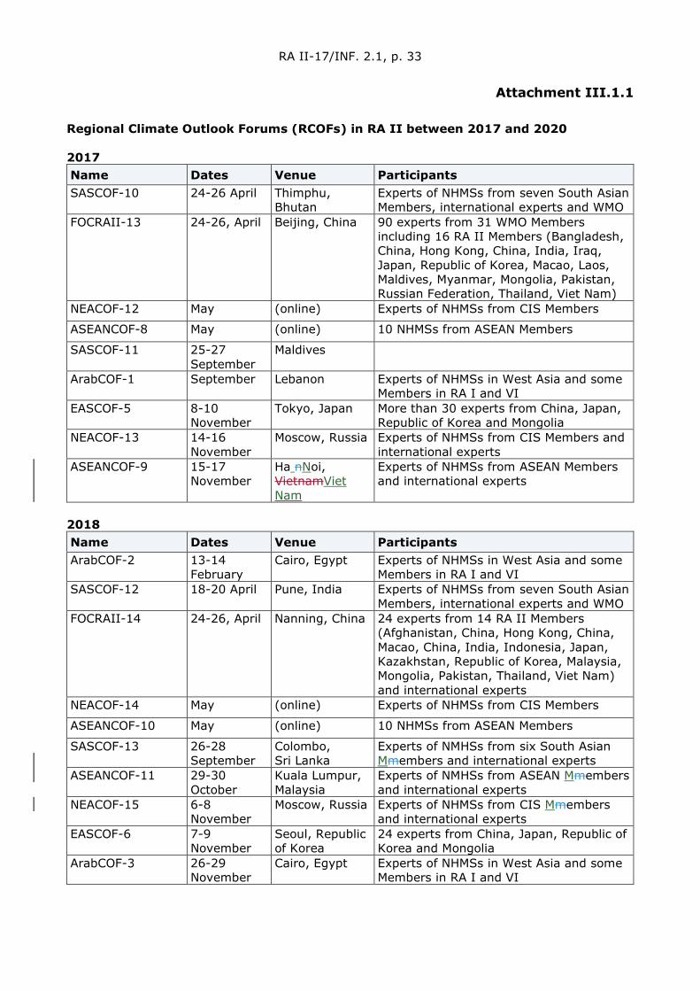
RA II-17/INF. 2.1, p. 33
Attachment III.1.1
Regional Climate Outlook Forums (RCOFs) in RA II between 2017 and 2020 2017 Name Dates Venue Participants SASCOF-10 24-26 April Thimphu,
Bhutan Experts of NHMSs from seven South Asian Members, international experts and WMO
FOCRAII-13 24-26, April Beijing, China 90 experts from 31 WMO Members including 16 RA II Members (Bangladesh, China, Hong Kong, China, India, Iraq, Japan, Republic of Korea, Macao, Laos, Maldives, Myanmar, Mongolia, Pakistan, Russian Federation, Thailand, Viet Nam)
NEACOF-12 May (online) Experts of NHMSs from CIS Members
ASEANCOF-8 May (online) 10 NHMSs from ASEAN Members
SASCOF-11 25-27 September
Maldives
ArabCOF-1 September Lebanon Experts of NHMSs in West Asia and some Members in RA I and VI
EASCOF-5 8-10 November
Tokyo, Japan More than 30 experts from China, Japan, Republic of Korea and Mongolia
NEACOF-13 14-16 November
Moscow, Russia Experts of NHMSs from CIS Members and international experts
ASEANCOF-9 15-17 November
Ha nNoi, VietnamViet Nam
Experts of NHMSs from ASEAN Members and international experts
2018 Name Dates Venue Participants ArabCOF-2 13-14
February Cairo, Egypt Experts of NHMSs in West Asia and some
Members in RA I and VI SASCOF-12 18-20 April Pune, India Experts of NHMSs from seven South Asian
Members, international experts and WMO FOCRAII-14 24-26, April Nanning, China 24 experts from 14 RA II Members
(Afghanistan, China, Hong Kong, China, Macao, China, India, Indonesia, Japan, Kazakhstan, Republic of Korea, Malaysia, Mongolia, Pakistan, Thailand, Viet Nam) and international experts
NEACOF-14 May (online) Experts of NHMSs from CIS Members
ASEANCOF-10 May (online) 10 NHMSs from ASEAN Members
SASCOF-13 26-28 September
Colombo, Sri Lanka
Experts of NMHSs from six South Asian Mmembers and international experts
ASEANCOF-11 29-30 October
Kuala Lumpur, Malaysia
Experts of NMHSs from ASEAN Mmembers and international experts
NEACOF-15 6-8 November
Moscow, Russia Experts of NHMSs from CIS Mmembers and international experts
EASCOF-6 7-9 November
Seoul, Republic of Korea
24 experts from China, Japan, Republic of Korea and Mongolia
ArabCOF-3 26-29 November
Cairo, Egypt Experts of NHMSs in West Asia and some Members in RA I and VI

RA II-17/INF. 2.1, p. 34
2019 Name Dates Venue Participants SASCOF-14 18-19, 21-
23 April Kathmandu, Nepal
Experts of NHMSs from South Asian Members, international experts and WMO
FOCRAII-15 8-10, May Nanning, China Experts from RA II and RA-V Members (China, Hong Kong, China, Macao, China, Indonesia, Japan, Kazakhstan, Russia, Republic of Korea, Democratic People's Republic of Korea, Mongolia, Lao People's Democratic Republic, Thailand, Viet Nam, Singapore), People's Republic of Congo and international experts from USA and UK
ASEANCOF-12 May (online) NHMSs from ASEAN Members
NEACOF-16 3-6 June Moscow, Russia Experts of NHMSs from CIS Members
SASCOF-15 23-25 September
Thiruvantha -puram, India
Experts of NMHSs from eight South Asian Mmembers and international experts
NEACOF-17 mid -November
(online) Experts of NHMSs from CIS Mmembers and international experts
EASCOF-7 5-7 November
Ulaanbaatar, Mongolia
Experts from China, Japan, Republic of Korea and Mongolia
ASEANCOF-13 20-21 November
Bangkok, Thailand
Experts of NMHSs from ASEAN Mmembers and international experts
ArabCOF-4 and GCC-COF-1
28 November
Saudi Arabia Experts of NHMSs in West Asia and some Members in RA I and VI
2020 Name Dates Venue Participants SASCOF-16 & SASCOF-16 Update
20-22 April & 8 June
(online) Experts representing the National Meteorological and Hydrological Services (NMHSs) of nine south Asian countries and from World Meteorological Organization (WMO), WMO Regional Climate Centre (RCC) Pune, Indian Institute of Tropical Meteorology (IITM), Met Office (UKMO), International Research Institute for Climate and Society (IRI), Regional Integrated Multi-hazard Early warning System (RIMES) and Japan Meteorological Agency (JMA)
FOCRAII-16 7 May (online) RCC Pune and IMD (India), TCC (Japan), National Agency for Meteorology and Environmental Monitoring (NAMEM) (Mongolia), KMA (Republic of Korea), NEACC (Russia Federation), TMD (Thailand), MONRE (Viet Nam), HKO (Hong Kong, China) and SMG (Macao, China) from RA II, and BoM (Australia), BMKG (Indonesia), MET Malaysia, PAGASA (Philippines) from RA V
NEACOF-18 19-20 May (online) Experts from Secretariat of the WMO, specialists from Roshydromet, Regional Training Centre of WMO in Roshydromet, National Hydrometeorological Service

RA II-17/INF. 2.1, p. 35
Name Dates Venue Participants (NHMS) of Armenia, Belarus, Kazakhstan, Kyrgyzstan, Moldova, Russia, and Uzbekistan
ASEANCOF-14 21 May (online) Experts from NMHSs in ASEAN region, WMO, RIMES
ArabCOF-5 & GCC-COF-2
3-4 June (Online) Experts of NHMSs in West Asia and some Members in RA I and VI
SASCOF-17 23-24, 28 September
(online) Experts of 9 NMHSs from south Asia and from WMO, WMO RCC Pune, Indian Institute of Tropical Meteorology (IITM), Met Office (UKMO), International Research Institute for Climate and Society (IRI), RIMES
EASCOF-8 5 November (online) Experts from China, Japan, Republic of Korea, Mongolia and Russia
NEACOF-19 17-18 November
(online) WMO Secretariat, experts of the NHMS of Belarus, Kazakhstan, Kyrgyzstan, Moldova, Russia, Tajikistan, Uzbekistan, experts and scientists from the Indian Institute of Tropical Meteorology, the Norwegian Meteorological Service, the German Weather Service
SASCOF-18 23 November
(online) Experts of 9 NMHSs from south Asia and from WMO, WMO RCC Pune, Indian Institute of Tropical Meteorology (IITM), Met Office (UKMO), International Research Institute for Climate and Society (IRI), RIMES
ASEANCOF-15 23, 25 and 27 November
(online) Experts from NMHSs in ASEAN region, WMO, GPC-LRFs, RCCs, ECMWF
ArabCOF-6 & GCC-COF-3
30 November and 2 December
(online) Experts of NHMSs in West Asia and some Members in RA I and VI
Reference ASEANCOF : http://asmc.asean.org/asmc_asean_cof_about/ EASCOF : https://ds.data.jma.go.jp/tcc/tcc/library/EASCOF/ FOCRAII : http://bcc.ncc-cma.net /channel.php?channelId=70 NEACOF : http://neacc.meteoinfo.ru/neacc/north-eurasian-climate-outlook-forum/ SASCOF : http://rcc.imdpune.gov.in/Index.html ArabCOF : http://riccar.org/arabcof /
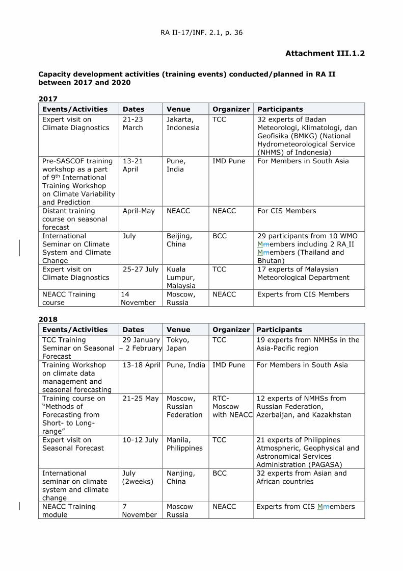
RA II-17/INF. 2.1, p. 36
Attachment III.1.2
Capacity development activities (training events) conducted/planned in RA II between 2017 and 2020 2017 Events/Activities Dates Venue Organizer Participants Expert visit on Climate Diagnostics
21-23 March
Jakarta, Indonesia
TCC 32 experts of Badan Meteorologi, Klimatologi, dan Geofisika (BMKG) (National Hydrometeorological Service (NHMS) of Indonesia)
Pre-SASCOF training workshop as a part of 9th International Training Workshop on Climate Variability and Prediction
13-21 April
Pune, India
IMD Pune For Members in South Asia
Distant training course on seasonal forecast
April-May NEACC NEACC For CIS Members
International Seminar on Climate System and Climate Change
July Beijing, China
BCC 29 participants from 10 WMO Mmembers including 2 RA II Mmembers (Thailand and Bhutan)
Expert visit on Climate Diagnostics
25-27 July Kuala Lumpur, Malaysia
TCC 17 experts of Malaysian Meteorological Department
NEACC Training course
14 November
Moscow, Russia
NEACC Experts from CIS Members
2018 Events/Activities Dates Venue Organizer Participants TCC Training Seminar on Seasonal Forecast
29 January – 2 February
Tokyo, Japan
TCC 19 experts from NMHSs in the Asia-Pacific region
Training Workshop on climate data management and seasonal forecasting
13-18 April Pune, India IMD Pune For Members in South Asia
Training course on “Methods of Forecasting from Short- to Long-range”
21-25 May Moscow, Russian Federation
RTC-Moscow with NEACC
12 experts of NMHSs from Russian Federation, Azerbaijan, and Kazakhstan
Expert visit on Seasonal Forecast
10-12 July Manila, Philippines
TCC 21 experts of Philippines Atmospheric, Geophysical and Astronomical Services Administration (PAGASA)
International seminar on climate system and climate change
July (2weeks)
Nanjing, China
BCC 32 experts from Asian and African countries
NEACC Training module
7 November
Moscow Russia
NEACC Experts from CIS Mmembers

RA II-17/INF. 2.1, p. 37
Events/Activities Dates Venue Organizer Participants TCC Training Seminar on One-month Forecast
12-16 November
Tokyo, Japan
TCC 15 experts from NMHSs in the Asia-Pacific region
2019 Events/Activities Dates Venue Organizer Participants Training Workshop on Foundation-Level Operational Seasonal Prediction for South Asian Region
25-28 February
Bangkok, Thailand
IMD Pune, RIMES
For Members in South Asia
Pre-COF training associated with SASCOF14
18-21 April Kathmandu, Nepal
IMD Pune For Members in South Asia
Training course on “Subseasonal to decadal (S2D) weather and climate predictions ”
27 May-5 June
Moscow Russia
RTC-Moscow with NEACC
Experts of NMHSs from CIS Mmembers
Expert visit on One-month Forecast
10-12 July Ulaanbaatar, Mongolia
TCC 14 experts of National Agency for Meteorology and Environmental Monitoring (NAMEM), Mongolia
16th International seminar on climate system and climate change
15-26 July Kunming, China
BCC, Yunnan Univ. and CMATC
5 experts from USA, UK, New Zealand and Japan, 162 Chinese trainees and 15 trainees from Asian and African countries
Training Seminar on Climate analysis
30-31 July Tokyo, Japan
TCC 5 experts from Badan Meteorologi, Klimatologi, dan Geofisika (BMKG), Indonesia
Distillation workshop for enhancing communication and tailoring seasonal outlooks to specific context and needs of user sector
26-27 September
Thiruvantha-puram, India
IMD Pune For Members in South Asia
TCC Training Seminar on Climate Analysis Information on Extreme Climate Events
25-29 November
Tokyo, Japan
TCC Experts from NMHSs in the Asia-Pacific region
Consulting long-range forecast meeting
28-29 November
Moscow, Russia
NEACC Representatives of NMHS of Tajikistan to discuss issues related to seasonal forecast
2020 Events/Activities Dates Venue Organizer Participants Capacity building course on the basics of Long-term weather forecasting within CAMP4ASB project
January 2020
Almaty, Kazakhstan
NEACC and CAREC
Specialists from the hydrometeorological services of Tajikistan, Turkmenistan and Uzbekistan
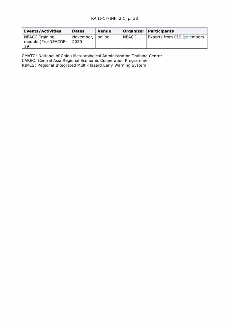
RA II-17/INF. 2.1, p. 38
Events/Activities Dates Venue Organizer Participants NEACC Training module (Pre-NEACOF-19)
November, 2020
online NEACC Experts from CIS Mmembers
CMATC: National of China Meteorological Administration Training Centre CAREC: Central Asia Regional Economic Cooperation Programme RIMES: Regional Integrated Multi-Hazard Early Warning System

RA II-17/INF. 2.1, p. 39
Annex III.2
Progress Report ofn the RA II Expert Group on Agrometeorology (EG-AgM)
1. Activity for the establishment of Agromet Advisory Services
In India, Agromet Advisory Services (AAS) is operational under “Gramin Krishi Mausam Sewa (GKMS)” scheme being implemented by India Meteorological Department (IMD) under the Ministry of Earth Sciences (MoES), Government of India for the benefit of farming community. AAS rendered by IMD is a step to weather-based crop and livestock management strategies and operations dedicated to enhancing crop production and food security besides reducing crop damage and loss due to inclement weather including extreme weather events.
IMD started generating district level medium-range weather forecast for major weather parameters (Rainfall, Temperature, Humidity, Wind and Cloud Cover) since 2008 and agromet advisories are being generated in collaboration with 130 Agromet Field Units (AMFUs) located at State Agricultural Universities, institutes of Indian Council of Agricultural Research (ICAR) and India Institute of Technology (IIT) on every Tuesday and Friday.
For seamless weather observations and forecasting in operational Agromet Advisory Services (AAS), Agrimet Division maintains network of observatories like 224 agromet observatories along with soil moisture observation stations at a limited locations across the country. Facility for real-time uploading of observed data by the observatories has also been created in the Agrimet Division website (https://www.imdagrimet.gov.in/). Based on the data from various observatories, IMD generates various land-based agromet products at various spatial and temporal scales from 2017 onwards. Land-based products like spatial distribution of weather parameters are generated using manually recorded weather observations (Air Temperatures, Soil temperatures, Rainfall, Humidity, Wind and Cloud) using the global information system (GIS) technology at different Temporal scales (daily, weekly, fortnightly, monthly and seasonal). Satellite products like reference evapotranspiration, insolation on daily scale and NDVI, VCI, TCI on weekly scale are also being incorporated and shared with Agromt Field Units (AMFUs) at ground level.
Location specific agromet advisories are disseminated to the farmers through different multi-media channels like Radio (Air) and Door Darshan, private TV and radio channels, newspaper, internet, SMS and Interactive Voice Response Technology (IVR) etc along with private agencies working for the benefit of farming community in the field of agriculture in the country under Public Private Partnership (PPP) mode. Around 43.37 million farmers are receiving the agromet advisories through SMS and benefitted by the service directly. In addition, IMD also provides alerts and warning during disaster support during Disastrous Weather Events along with agromet advisory well in advance to safeguard the farm produce.
To enhance the outreach of agromet advisories to the farmers, more than 5 000 WhatsApp groups have been formed covering ~ 53 000 villages. Information is also shared with farming community through videos uploaded in the YouTube channel (Link: https://www.youtube.com/channel/UCjIcIwtznloxlqa0Xh4j5qQ/videos).
Based on review of progress and response from the users’ community, the scheme is being further downscaled to sub-district / block level from 2018. To cater the services at block level with outreach to village level farmers, Agromet units are being extended at Farm Science Centres in each of 530 additional districts, called District Agromet Units (DAMUs) (total 660 including existing 130 AMFUs). Till March 2021, 196 DAMUs have been established and made functional. Thus the network of 326 units are generating block level weather forecast based agromet advisory in regional languages for 3100 blocks (out of total ~ 7000 blocks in India).
The Ministry of Earth Sciences, Govt. of India launched a mobile application, called “Meghdoot”
RA II-17/INF. 2.1, p. 40
to enable farmers access location, and crop and livestock-specific weather-based agro-advisories in local languages. It provides forecast relating to temperature, rainfall, humidity, and wind speed and direction and advisories to the farmers on how to take care of their crops and livestock. The information is updated twice a week on Tuesdays and Fridays. The app would also provide information in the form of images, maps and pictures to help the farmer to have a clearer picture of what is in store. The users will have to register their name and location so that they can get area specific information. It has been integrated with WhatsApp and Facebook as well to help farmers share advisories among themselves. It will also be integrated with YouTube in future. It has been developed by experts from the India Meteorological Department (IMD) and Indian Institute of Tropical Meteorology and the Indian Council of Agricultural Research. These forecast and advisory are also linked with Apps ‘Kisan Suvidha’ of Ministry of Agriculture & Farmers Welfare; and App ‘UMANG’ of Ministry of Electronics & Information Technology, Governement of India. App ‘Mausam’ developed by India Meteorological Department is used by public and farming community to access observation and forecast for different locations in India.
Thunderstorms and lightning, being the quickly evolving extreme meteorological phenomenon, the exact forecast of these events at a given location is a challenge. Mobile App viz., “DAMINI” which gives alerts on impending lightning activity over the area has been developed and shared with farming community and disaster management functionaries at state and district level engaged in information dissemination.
These apps (Meghdoot, DAMINI, Kisan Suvidha, UMANG, Mausam) can be downloaded from Google Play Store and App Store.
In Thailand, Thai Meteorological Department (TMD) provides specific weather forecasts for agriculture not only by internet, but also by fax and telephone. Most of the information is available only in Thai language. The daily weather forecast of average RH(%), average rainfall in mm, soil temperature (oC) at 0cm, 5cm, 10cm, 20cm, 50cm, 100cm and sunlight (hours) up to 7 days are provided for Agriculture. Information and products provided for agriculture application include Map of meteorological data, calculator estimates of crop water use, 1-day summary of weather for agriculture, 7-day impact assessment forecast of weather on agriculture, Standardized precipitation Index (monthly) and other useful maps for agricultural meteorology. Monthly agrometeorological reports, agrometeorological forecasts for three months and seasonal forecasts are also given on routine basis.
In Kazakhstan, A crop monitoring service based on space imagery was developed by an entrepreneur, and announced on 24th April 2019. The service includes providing images, which the entrepreneur receives from open databases of European and American space agencies, to monitor the crops and pasturelands within the accuracy of 10 meters. The new service will significantly save the cost for crop monitoring and it also replaces physical patrolling on the agricultural fields. The system offers the identification of soil moisture level, nitrogen content and snow cover height as well as harvest yield forecasts.
In Nepal, ICIMOD (International Centre for Integrated Mountain Development) is developing an integrated information platform linking weather and climate data with agriculture practices in the region. The platform provides data analysis support to professionals responsible for developing agro-met advisories for government agencies and farmers. The web-based service on the National agricultural drought watch System developed at ICIMOD under the SERVIR Hindu Kush Himalaya (SERVIR-HKH) Initiative provides information on the in-season drought situation and outlook.
National Agricultural Drought Watch System for South Asia provides baselines on crop type maps and farming practices calendars valid at the district level, and multiple indices – evapotranspiration, precipitation rate, standardized precipitation index, soil moisture, and temperature – for droughts and seasonal weather outlooks at the national and regional levels. These can inform short to medium-term agro-advisories. Users can explore historical time-

RA II-17/INF. 2.1, p. 41
series data on the five indices over 18 years aggregated in decadal, monthly, and quarterly sets. The system will soon roll out three- to six-month forecast abilities.
In Pakistan, National Agromet Centre (NAMC) is an important division of Pakistan Meteorological Department (PMD) which has been setup to relate meteorological services to the most important agriculture sector of the country so as to promote the overall status of farming community. NAMC has thus been extending its services since its establishment. Monthly bulletin presents detailed data information with a thorough discussion resulting from the post-analysis of previous month's agromet data collected mainly from a network of 34 agromet stations throughout Pakistan (working under NAMC, Islamabad) besides meteorological network of PMD. The agromet data being utilized is comprises of detailed tabulation and graphical projection of all the important meteorological and agriculture related elements like air temperatures, soil temperature, rainfall, air humidity, cloud cover, reference crop evapotranspiration (ETo), general weather pattern, crop condition report including phenological report, etc. Besides this, a comprehensive farmers advisory is also included which covers the general forecast for the coming week along with crop-specific as well as animal care suggestions in national language. The decadal bulletins comprises of mainly two portions: post-analysis of previous decade agromet data collected mainly from a network of 34 agromet stations throughout Pakistan (working under NAMC, Islamabad) besides meteorological network of PMD and farmers related weather advisory for the coming decade along with crop-specific as well as animal care suggestions.
In China, the first vegetation ecological meteorological automatic observation applied experiment station in Shaanxi was set up as national fundamental meteorological station and placed into experimental operation. This station is one of the three pilot stations across the country. After it is put into trial operation, it will harness myriad instruments to measure the height of the canopy, employ deep learning approach to calculate vegetation cover, plant density, and enhanced vegetation indicator, in a bid to enable researchers to master the growth condition of vegetation, assess the impacts of meteorological factors on the ecological environment, and roll out ecological environment development prediction.
In Bangladesh: “Agvisely” – an agrometeorological advisory tool was developed and released in October 2019 jointly by the Department of Agricultural Extension (DAE) and the Bangladesh Meteorological Department (BMD). The project worked to establish Agvisely, interactive, map based agrometeorological bulletin and an accompanying mobile phone app that provides numerical weather forecasting model predictions with easy-to-understand crop-specific management advisories. Agvisely was endorsed by the Government of Bangladesh for use as an official advisory tool for farmers, with DAE, BMD and the Bangladesh Wheat and Maize Research Institute (BWMRI) all linking their websites to Agvisely and training their staff in the use of this tool.
In September 2019, with support from United States Agency for International Development (USAID), Washington and endorsement by the USAID Mission in Bangladesh, the Michigan State University’s Borlaug Higher Education for Agricultural Research and Development (BHEARD) made a synergistic investment in the ‘Fighting Fall Army Worm (FAW)’ project that was designed to leverage the Cereal Systems Initiative for South Asia (CSISA)’s established technical staff and network of partners to take an integrated pest management (IPM) approach that can be sustainably implemented by resource-constrained farmers. This synergistic project tackles these issues by generating evidence and developing educational strategies to facilitate FAW IPM training for the public and private sector, while also addressing institutional issues needed for efficient FAW response.
In December 2019, the BWMRI, DAE, and BMD all endorsed the institute use of ‘the Wheat Blast Disease Early Warning System’ (Available at: www.beattheblastews.net) developed by CSISA and the USAID supported Climate Services for Resilient Development (CSRD) in South Asia projects. By February 2020, over 800 DAE field officer extension staff had been trained on use of the system and began receiving alerts by email 5 days in advance if their designated working areas were predicted to be at risk of a wheat blast outbreak. Each extension officer in
RA II-17/INF. 2.1, p. 42
Bangladesh is responsible for between 2 000–5 000 farmers. This underscores the potential to reach farmers with relevant climate information services in the form of wheat blast disease outbreak warnings and advisories now that the government has endorsed use of the early warning system. This model generates wheat blast warnings for Bangladesh only from January 9 through April 4 of each year, as these dates correspond to the periods of the crop calendar during which wheat is most at risk of disease infection.
Advisory for Wheat Rust: Risk Assessment from Surveys and Forecasts in Bangladesh are also issued. Special Agrometeorological Advisories on Rainfall & Flash Flood (for Haor Areas) are also issued.
In Myanmar, Agromet bulletins for three decades of every month are issued comprising of information on departures from normal of precipitation, temperature, humidity and evapo-transpiration, soil moisture condition for states and regions and agro– meteorological information (mean) for next decade.
2. Capacity development activities
In India, capacity building programmes are organized by IMD in an operational perspective for the stakeholders from time to time for implementation of AAS. During 2020, a 6-day training on “Preparation and dissemination of Agromet Advisories at Block level under Gramin Krishi Mausam Seva (GKMS) scheme” have been imparted to 66 Subject Matter Specialists (Agromet) and also to 19 Agromet Observers posted at DAMUs to implement block level AAS. Apart from these, Familiarization Programmes have also been conducted for the 35 Subject Matter Specialists (Agromet) and also to 24 Agromet Observers as a precursor to formal training to initiate block level AAS activities.
All the District Agromet Units in India conduct Farmer Awareness Programme (FAPs) regularly to create awareness among farmers about weather, changing climate, its impact on agriculture, animal husbandry, fishery, forests and management through AAS. During 2020, 44 FAPs were conducted by 14 AMFUs and 1 050 FAPs were conducted by 124 DAMUs across India. These programmes were connected with other ongoing missions of Govt. of India related to sustainable development of soil, water resources, plantation, etc.
Considering the dire need to scale up the available climate smart agriculture practices to enable the farmers in India to adopt climate smart technologies to cope with the impacts of the climate change, the Association of Agro-Meteorologists (AAM) organized a 3 days Virtual National Conference on “Strategic Reorientation for Climate Smart Agriculture (V-AGMET 2021)” during March 17-19, 2021 at Punjab Agricultural University, Ludhiana.
In Bangladesh, National workshop is organized each fiscal year to share the activities and progress of Agrometeorological Information Systems Development Project. National Workshop-2019 was held on June 29, 2019 at Dhaka. Training is arranged by Agrometeorological Information Systems Development project in each fiscal year. Up to June 2019, 1530 officers and 8 400 farmers have been trained under this project. 14 regional workshops are organized by Agrometeorological Information Systems Development Project in each fiscal year.
In China, International Training Course on the “Assessment of Climate Change Impacts on Agriculture with Remote Sensing Technology", was organized between 17-28 June 2019, at the Nanjing University of Information Science and Technology (NUIST), Nanjing Component of the World Meteorological Organization Regional Training Centre (RTC). This course targeted the meteorologists in fields of agriculture, climate change, water resources, environment and other related fields from developing countries; and was designed to avail participants, through theoretical study and practice, knowledge and insights into the basics of the impacts of climate change on agriculture, and the principles and technologies of applying remote sensing technologies to the assessment of these impacts.

RA II-17/INF. 2.1, p. 43
In Japan International Symposium on Agricultural Meteorology was held in Shizuoka between 27-29 March 2019. TCC held the Training Seminar on Climate Analysis Information on Extreme Climate Events from 25 to 29 November 2019 at JMA Headquarters in Tokyo.
In Republic of Korea, Korea Meteorological Administration (KMA) organized an education course on Information and Communications Technologies (ICT) for Meteorological Services at the RCT Korea in Seoul from 14 to 17 April 2019, in which 19 people from 11 NMHSs in Asia and Africa participated.
In Uzbekistan, the regional training for trainers on strengthening agricultural extension services and advisory services for farmers was held in Tashkent on 2nd April 2019. The event was organized by the United Nations Food and Agriculture Organization (FAO) Sub-regional Office for Central Asia in collaboration with the Ministry of Agriculture of Uzbekistan for participants from Azerbaijan, Kyrgyzstan, Tajikistan and Uzbekistan.
Technical Workshop on Locust Watch in Caucasus and Central Asia (CCA) was held in Tashkent, Uzbekistan, between 13 and 15 November 2019.
On 25 June 2019 opening of the “Enhancing the Adaptation and Strengthening the Resilience of Farming to Climate Change Risks in Fergana Valley” project took place. The project is implemented jointly with the Chamber of Commerce and Industry of the Republic of Uzbekistan with the financial support of the “Russia – UNDP Trust Fund for Development”.
In Tajikistan, the strengthened agrometeorological services and early warning systems are needed to provide farmers and rural dwellers with the capacity to prepare for and adapt to climate changes that will impact agricultural production, a two-day workshop was held to advance the scaling up of the country’s pilot agrometeorological system, which is led by the Food and Agriculture Organization (FAO) of the United Nations and funded by the European Union. The event took place from 23 to 24 November 2019 in Khoja Obi Garm, Tajikistan with the participation of the key stakeholders involved in the collection and production of agrometeorological services. These included representatives of Tajikistan’s State Agency of Hydrometeorology, State Agency of Plant Protection and Chemicalization, Committee for Environmental Protection, national Non-Governmental Organization (NGOs) and farmer organizations.
3. Monitoring and forecasting of soil moisture
Monitoring and forecasting of soil moisture are important from operational perspective viewpoint for advising the farmers to schedule irrigation and /or other agronomic operations.
In India, daily soil moisture is being computed by Soil Water Balance (SWB) based on the method of Thornthwaite and Mather (1955) and is presented as spatial soil moisture maps over the country. Based on district level weather forecast for next five days, as input, soil moisture forecast is also carried out. This information is communicated to the AMFUs for incorporation in agromet advisories.
Apart from soil moisture estimation and forecasting, IMD has also initiated to extend the network of recording soil moisture observations through the partnering 130 AMFUs and 200 DAMUs (196 DAMUs have been established so far and remaining are to be established shortly) for gravimetric measurement of soil moisture at varying depths in root zone. Around 24 units have started recoding and communicating the soil moisture data. All such AMFUs/ DAMUs are being equipped with Agro-Automatic Weather Station (Agro-AWS) consisting of soil sensors for moisture and temperature at four depths i.e. 10 cm, 30 cm, 70 cm, 100 cm, to provide the data every 15 minutes interval. The installation is in progress and it is planned to have a benchmark network (720 districts) of soil moisture observation in India for its use for operational agromet service, flood guidance, data assimilation and weather forecasting, drought monitoring, crop yield forecasting, pest & disease forewarning and researchers.
RA II-17/INF. 2.1, p. 44
In Thailand, due to the limitation of soil moisture measurement, the study of 10 day moisture available index of Thailand with Hargraves method has been adopted by using rainfall, temperature, relative humidity, wind speed and sunshine duration data of 54 meteorological stations for 25 year periods (1981-2005). The results of this study have been shown in the form of tables and digital map which perform the 10-day moisture available index on the base map of Thailand in map scale 1:250 000. From the result of moisture available index in Thailand, it showed that when the soil moisture in each area will be sufficient for growing plant, will be adequate for crop water requirement and deficit or excessive amounts. These can be used for making decisions in various agricultural activities.
4. Drought preparedness and management strategies
In India, IMD prepares Aridity Anomaly Index (AAI) maps on weekly basis based on Thornthwaite Water balance technique during southwest monsoon (June-September) and northeast monsoon (October-December). Standardized Precipitation Index (SPI) is also used for monitoring meteorological drought at district level. SPI is generated at various temporal scales (weekly, monthly and season) for application in various sectors. Standardized Precipitation minus Evapotranspiration Index (SPEI) is generated on experimental basis for agricultural drought monitoring.
In Thailand, Assessing the impact of climate with plants is prepared monthly during planting, between June and September by considering the Generalized Monsoon Index (southwest monsoon season). Generalized Monsoon Index (GMI) is the drought index for agriculture that shows the impact on the growing plants.
In Pakistan, drought bulletin is being issued on weekly, monthly, annual base by national drought monitoring centre (NDMC), Islamabad.
In Kazakhstan, Agroclimatic maps characterize the climatic conditions of growth of the main agricultural crops of Kazakhstan and can be used in the planning and management of agriculture. These maps are given for six regions of the country on: Heat supply of the growing season, amount of precipitation of the warm period, dryness of the growing season, moisture availability of the growing season and duration of the growing season.
5. Seasonal to interannual climate forecast applications for agriculture
In India, IMD is generating Extended Range Forecast (ERF) for next two weeks and the same is used in AAS for preparedness during prolonged dry conditions and / or excess rainfall period and during other adverse weather situations. National AAS bulletin based on ERF is generated in collaboration with Central Research Institute for Dryland Agriculture (CRIDA), ICAR, Hyderabad, India on weekly basis and communicated to the stakeholders and State level planners to take strategic decision and for appropriate planning on agriculture well in advance.
IMD provides Seasonal forecast of monsoon rainfall in two stages (i) April and (ii) in beginning of June.
The first stage forecast for the season (monsoon: June – September) rainfall over the country as a whole is issued by IMD in third week of April every year.
Immediately after release of first stage long-range forecast (LRF), a meeting is organized involving various organizations (Ministry of Agriculture and Farmers Welfare, Govt. of India, ICAR Institutes, IMD and other organizations) of the country involved in management of impacts of drought on Agriculture at various level.
The areas likely to be affected by Drought / deficit rainfall situations are identified
RA II-17/INF. 2.1, p. 45
based on forecast issued by IMD and subsequent strategies and action plans are decided in the meeting.
ICAR-CRIDA conducts meeting with Ministry of Agriculture and other agencies of each of the identified States and prepares State specific strategies and contingency plans.
Strategies and contingency plans are further updated after issue of second stage forecast for seasonal and monthly (June and July) rainfall for the country as a whole as well as for four homogeneous regions.
2-3 weeks forecast helps in implementation of contingency actions, if required, to mobilize the requisite resource inputs to village/ farm level.
Since 2020 southwest monsoon, IMD started generating subsequent week forecast after five-day weather forecast for the parameters, rainfall and temperatures to aid AMFUs and DAMUs in devising agromet advisories based on the extended outlook, for the benefit of farming community.
In Thailand, the Thai Meteorological Department (TMD) applied the Latest Releases, Weather and Research Forecast System (WRF) Version 4.1.2 to predicted short-term and long-term weather and climate for the whole country with the initial data from National Centre for Environmental Prediction (NCEP). The seasonal prediction with 18-kilometers spatial resolution processes every day around 6:00 AM for forecasting up to 397 days. The selected data of precipitation, temperature and pressure is updated on the Monday.
6. Socio-economic impact of agromet information
Agromet Advisory Services (AAS) has significant impact on successful cropping and role in taking decision on day-to-day farming practices.
National Centre for Applied Economic Research (NCAER) in 2019 conducted an impact study among the user community for estimating the economic benefits of Agromet Advisory Service under GKMS during April 2018 – March 2019 (3 965 farmers for agricultural crops and 1 365 livestock farmers across 121 districts of 11 states of India). Key findings of impact study are:
Agricultural crops:
98% of surveyed farmers made modifications to at least one of the nine critical practices based on the weather advisories. 31% farmers made modifications on all nine critical practices.
Average annual income of farming households which adopted no modification worked out to be Rs. 1.98 Lakh; Rs. 2.43 Lakh for those who modified 1 to 4 practices; Rs. 2.45 Lakh for those who modified 5 to 8 practices and Rs. 3.02 Lakh for those who adopted all the nine changes.
80% of the farmers receiving information on high resolution weather events reported to have reduced losses.
With an estimated annual income gain of Rs. 12 500 per agricultural household belonging to Below Poverty Line category in the rainfed areas, due to the improvement in weather forecasts, the total income gain is estimated at Rs. 13 331 crore per annum in rainfed districts.
Livestock:

RA II-17/INF. 2.1, p. 46
76% of surveyed farmers (1365) are following advisory all the three practices viz. modification of shed/shelter; vaccination against seasonal disease; and fodder management,
18% of whom are doing so on two practices,
6% of whom are doing so on one practice,
96% farmers reported that weather advisories are improving the practice of vaccination against seasonal disease
The AMFUs under GKMS scheme also conduct the studies on assessment of impact of AAS on farm operations, crop production and income of farming households.
IMD also conducts periodic review meetings with field units to promote tools and techniques to disseminate the advisories to each and every farmer of village. Field units also collect feedback from farmers for improvement of services.
_________

RA II-17/INF. 2.1, p. 47
ANNEX IV
Progress Report ofn the RA II Working Group on WMO Integrated Global Observing System and WMO Information System
(WG-WMO Integrated Global Observing System (WIGOS)/WIS)
Submitted by Chair: Mr CHEN Yongqing (China), unedited
1. Introduction
In the sixteenth session of Regional Association II (RA II-16) which was held in Abu Dhabi, UAE, from 12 to 16 February 2017, the Regional Association II Working Group on WMO Integrated Global Observing System and World Meteorological Organization (WMO) Information System (WG-WIGOS/WIS) was re-established to bear the responsibility of facilitating the accomplishing of missions of WIGOS and WIS.
2. Working Group structure
The Working Group is composed of Expert Group on WIGOS (EG-WIGOS) and Expert Group on WIS (EG-WIS). EG-WIGOS consists of one coordinator and 11 theme leaders, while EG-WIS consists of two coordinators and four theme leaders. In addition, a number of volunteer experts who are expected to assist the tasks of each Expert Team have also been registered.
3. Terms of Reference
(a) To monitor and coordinate the implementation of WIGOS and WIS in the Region; to propose measures for improvements, especially for overcoming gaps, deficiencies and inconsistencies in the implementation of these systems; and to promote active involvement of Members of the Region in the implementation of WIGOS and WIS;
(b) To advise and provide overall technical guidance, assistance and support to the Members of the Region for the implementation of WIGOS and WIS at the regional and national levels;
(c) To promote capacity development and outreach activities to assist Members in the implementation of WIGOS and WIS;
(d) To liaise with the relevant RA II Working Groups on matters related to WIGOS and WIS implementation;
(e) To advise the president of the Association on matters concerning the implementation of WIGOS and WIS in the Region;
(f) To provide the president of the Association with recommendations for presentations under appropriate agenda items in sessions of technical commissions, joint sessions of the presidents of technical commissions and presidents of regional associations, and the Executive Council.

RA II-17/INF. 2.1, p. 48
4. Membership of the Working Group
Expert Group on WIGOS (EG-WIGOS) EG-WIGOS Name Member
Coordinator Mr Yongqing CHEN China
Leader in Monitoring and Reviewing the Implementation of EGOS-IP in RA II Ms Jianxia GUO China
Leader in the web-interface for sharing status of standardization and experience and monitoring synoptic observations in RA II
Mr Chulwoon CHOI Rep. of Korea
Leader in Capacity building in Radar Techniques in the Southeast Asia Mr Koichiro KAKIHARA Japan
Leader in Enhancing the Availability and Quality Management Support for NMHSs in Surface, Climate and Upper-air Observations
Mr Nobuyuki TANAKA; Mr Yoshiaki HIRANO (proposed substitution)
Japan
Leader in Developing a Sand and Dust-Storm Warning Advisory and Assessment System (SDS-WAS) in Asia Node
Mr Qingliang ZHOU China
Mr Hasan ALDASHTI Kuwait
Leader in Developing Support for NMHSs in Satellite Data, Products and Training
Mr Hiroshi KUNIMATSU; Mr Kotaro BESSHO (proposed substitution)
Japan
Mr Dohyeong KIM Rep. of Korea
Leader of Task Team on Regional Basic Observing Network (RBON)
Mr Nadeem FAISAL Pakistan
Ms Lijuan SHI China
Leader of Task Team on Aircraft-Based Observations
Mr Mohammed BABIDHAN Saudi Arabia
Expert Group on WIS (EG-WIS) EG-WIS Name Member
Coordinators Ms Xiang LI China
Mr Kenji TSUNODA Japan
Theme on WIS Infrastructure and Implementation
Leader Mr Sl SINGH India
Volunteer experts
Mr Yoritsung OHNO Japan
Mr Sherub PHUNTSHO Bhutan
Mr Pema SYLDON Bhutan
Mr Peng WANG China
Dr Chi-kin PAN Hong Kong, China
Mr Omar Al OBAIDANR Qatar
Mr SungSoo DO Republic of Korea
Leader Ms Jitsuko HASEGAWA Japan
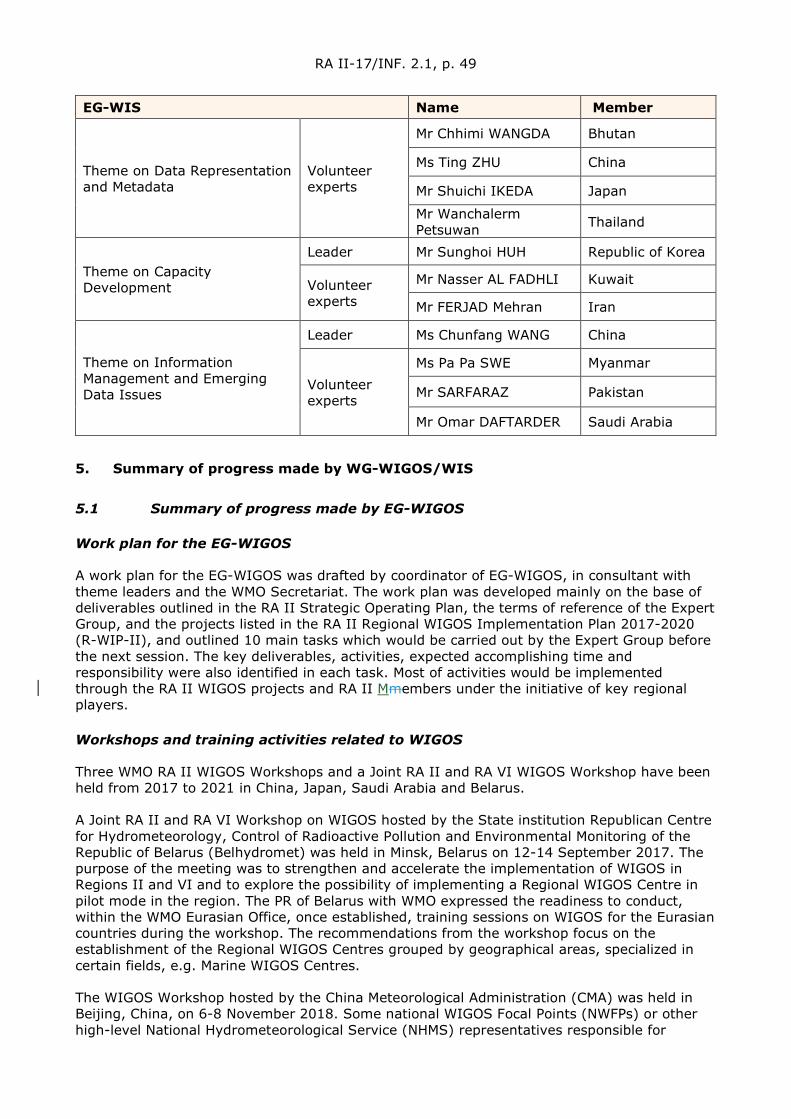
RA II-17/INF. 2.1, p. 49
EG-WIS Name Member
Theme on Data Representation and Metadata
Volunteer experts
Mr Chhimi WANGDA Bhutan
Ms Ting ZHU China
Mr Shuichi IKEDA Japan
Mr Wanchalerm Petsuwan Thailand
Theme on Capacity Development
Leader Mr Sunghoi HUH Republic of Korea
Volunteer experts
Mr Nasser AL FADHLI Kuwait
Mr FERJAD Mehran Iran
Theme on Information Management and Emerging Data Issues
Leader Ms Chunfang WANG China
Volunteer experts
Ms Pa Pa SWE Myanmar
Mr SARFARAZ Pakistan
Mr Omar DAFTARDER Saudi Arabia
5. Summary of progress made by WG-WIGOS/WIS
5.1 Summary of progress made by EG-WIGOS
Work plan for the EG-WIGOS
A work plan for the EG-WIGOS was drafted by coordinator of EG-WIGOS, in consultant with theme leaders and the WMO Secretariat. The work plan was developed mainly on the base of deliverables outlined in the RA II Strategic Operating Plan, the terms of reference of the Expert Group, and the projects listed in the RA II Regional WIGOS Implementation Plan 2017-2020 (R-WIP-II), and outlined 10 main tasks which would be carried out by the Expert Group before the next session. The key deliverables, activities, expected accomplishing time and responsibility were also identified in each task. Most of activities would be implemented through the RA II WIGOS projects and RA II Mmembers under the initiative of key regional players.
Workshops and training activities related to WIGOS
Three WMO RA II WIGOS Workshops and a Joint RA II and RA VI WIGOS Workshop have been held from 2017 to 2021 in China, Japan, Saudi Arabia and Belarus.
A Joint RA II and RA VI Workshop on WIGOS hosted by the State institution Republican Centre for Hydrometeorology, Control of Radioactive Pollution and Environmental Monitoring of the Republic of Belarus (Belhydromet) was held in Minsk, Belarus on 12-14 September 2017. The purpose of the meeting was to strengthen and accelerate the implementation of WIGOS in Regions II and VI and to explore the possibility of implementing a Regional WIGOS Centre in pilot mode in the region. The PR of Belarus with WMO expressed the readiness to conduct, within the WMO Eurasian Office, once established, training sessions on WIGOS for the Eurasian countries during the workshop. The recommendations from the workshop focus on the establishment of the Regional WIGOS Centres grouped by geographical areas, specialized in certain fields, e.g. Marine WIGOS Centres.
The WIGOS Workshop hosted by the China Meteorological Administration (CMA) was held in Beijing, China, on 6-8 November 2018. Some national WIGOS Focal Points (NWFPs) or other high-level National Hydrometeorological Service (NHMS) representatives responsible for

RA II-17/INF. 2.1, p. 50
observing systems from RA II Members attended the workshop. During the workshop, the capabilities of China to operate its proposed RWC in pilot mode were demonstrated. The workshop agreed that coordination between various RA II RWC efforts was needed and the decision on how to share workload should be made after pilot phase. The workshop recommended establishing the RA II coordination body with representation from each of the RWCs and WMO Secretariat. The workshop also recommended including regional coordination of the protection of Radiofrequencies as optional function of RWCs.
The WIGOS Workshop hosted by the Japan Meteorological Agency (JMA) was held in Tokyo, Japan, on 6-9 March 2019. The workshop focused on Regional WIGOS Centres and its services for Members.
The WIGOS Workshop hosted by the Saudi Arabia's General Authority of Meteorology and Environmental Protection (GAMEP) was held in Jeddah, Saudi Arabia, from 30 April to 02 May 2019. West Asia.
In addition, about 11training courses related to WGOS in RA II have been carried out from 2017 to 2021.
An Oscar/Surface training course was held for West Asia in Oman in April 2019.
The Fourteenth EUMETSAT Satellite Application Course hosted by Oman WMO Centre of excellence for training on Meteorological Satellites Applications Studies was held in Muscat, Oman from 24 to 28 February 2019. The fifteenth EUMETSAT Satellite Application Course hosted by Oman at WMO Centre of excellence for training on Meteorological Satellites Applications Studies was physically held in February 2020. The sixteenth course will be held in May 2021 virtually.
A GCC RADAR workshop was held in Abu Dhabi (UAE) from 20 to 22 October 2019.
Seven international training courses on FY satellites application have been held by WMO Regional Training Centre hosted by CMA.
The Committee of observing systems and communication of GCC conducted its meeting on 1 March 2021. The Committee of early warming and disaster reduction conducted its meeting on 4 March 2021.
Activities related to TT-ABO
Survey on the current status of ABO in RA II
Mr Mohammed BABIDHAN (Saudi Arab), the leader of TT-ABO, developed a questionnaire on the current status of ABO in RAII, intending to enhance and expand WMO Aircraft-Based Observing System in the region, especially in the west Asia, including the implementation of the Aircraft Meteorological Data Relay (AMDAR) programme at the national level. In January 2018, the survey was conducted by WMO RAP Secretariat and distributed to all RAII Members.
The WMO/ International Air Transport Association (IATA) Regional Workshop on AMDAR for South-East Asia
The WMO/IATA Regional Workshop on AMDAR (for South-East Asia) was held in Hong Kong, China, from 29-30 May 2018. During the workshop, a joint meeting was held on May 31st by RAII TT-ABO, RAII PP-AMDAR, interested NMHSs and WMO CBS ET-ABO, to discuss current status of national AMDAR programmes, collaboration, implementation and future plans. It was noticed that cost issues and cooperation of national airlines are the most important aspects for NMHSs in AMDAR implementation. It was also agreed that WMO/IATA new working arrangement on the operation of AMDAR can play a crucial role in expansion and enhancement of AMDAR programmes in RAII.
RA II-17/INF. 2.1, p. 51
Activities related to Regional Basic Observing Network (RBON)
The Decision 13 (RA II-16) decided to establish a pilot RBON for RA II, comprised initially of the merging of all Regional Basic Synoptic Networks (RBSN) and Regional Basic Climatological Network (RBCN) stations of RA II and Invited RA II Members to consider proposing inclusion of additional surface-based observing stations in the pilot RBON for RA II, such as weather radars, wind profiler systems, lightning detection systems, data buoys, voluntary observing ships and aircraft. The decision also requested the WG – WIGOS/ WIS to review the candidate RBON stations proposed by Members, taking into account the criteria for the additional selection of surface-based stations/platforms into RBON, together with those defined in the Regional Basic Observing Networks Concept Paper, and to make recommendation to the RA II president for including them in the pilot RBON for RA II.
Ms SHI Lijuan (China), the leader of Task Team on Regional Basic Observing Network (TT-RBON) has drafted priority Application Areas for RBON in RA II and the Selecting Criteria for RBON in RA II.
Unfortunately, no official document has been received from Mmembers to propose their inclusion of additional surface-based observing stations in the pilot RBON as of April 2021. Therefore, it is very difficult for EG-WIGOS to take a further step to review the candidate RBON stations proposed by Members.
In this context, EG-WIGOS recommends that as a first step, RBSN and RBCN be transit in to RBCN by just changing its name from RBSN and RBCN to RBON and hourly observational data be exchanged when it is matured.
Regional WIGOS Centres
The 2018 RA II Management Group meeting endorsed proposals from China and Japan to establish Regional WIGOS Centres (RWCs) in pilot mode in RA II. CMA and JMA have implemented mandatory functions of RWC for more than two years since then.
In addition, the National Centre of Meteorology of Saudi Arabia sent an application letter to the president of RA II in Feb 2, 2019 to apply for hosting a RWC for West Asia. There is also an indication of interest to host a Regional WIGOS Centre also from India.
RA II workshop on Regional RWCs for West Asia, which is held in Jeddah, Saudi Arabia, on 30 April-2 May 2019 recommended RA II MG to establish a RWC coordination mechanism in RA II and the draft Terms of Reference (ToR) for the RA II RWCS coordination mechanism is developed.
In the 8th Session of Inter-Commission Coordination Group on WIGOS, which was held in Geneva, Switzerland from 24 to 26 January 2019, Mr CHEN Yongqing (China), the Chair of WG-WIGOS/WIS, submitted a progress report and future proposal about RWCs in RA II as entrusted by the president of RA II.
In 16th RA II Management Group meeting which was held online on 30 March 2021, China and Japan delivered a joint presentation on the RA II RWCs highlighting the ongoing implementation of mandatory functions by both RWCs as part of the pilot phase and the joint operation plan for RWCs. The session expressed their appreciation to China and Japan for RWC-related activities during the pilot phase and the planned joint RWC operation. The session adopted decision – Next Steps to Establish RA II Regional WIGOS Centres and encouraged China and Japan to commence joint operations by 1 July 2021, or at their earliest convenience.
Achievements from implementation of Regional WIGOS Implementation Plan 2017-2020 in RA II (R-WIP-II)
The implementation of R-WIP-II relies mainly on six RA II WIGOS projects listed in the plan.

RA II-17/INF. 2.1, p. 52
Achievements of each project are summarized by EG-WIGOS as follows, while the detailed information for each project is attached in Annex IV.1.
Project No. I – Monitor and review the Implementation of EGOS – IP in RA II
The EGOS-IP actions were studied, and some indicators of the progress for each action would be proposed. A database of the indices of EGOS-IP actions progress for RA II would be established. A portal for sharing the national progress of EGOS-IP implementation was established. A Task Team for improving the action indicators and reviewing the progress of EGOS-IP in RA II would be proposed.
Project No. II-The web-interface for sharing status of standardization and experience and monitoring synoptic observations in RA II
A system was initially developed by Korea Meteorological Administration (KMA) with a web-interface to show the monitoring result of observations collected from GISC Seoul and to share experience about WIGOS related policies in national level (http://gom.kma.go.kr).
This system can perform gap analysis between Vol C1 from Global Telecommunication System (GTS) and Vol A from OSCAR/Surface to judge which stations are active or inactive.
A kind of survey and board can also be found in this website, so that Mmembers can send their feedback and share experience or example of WIGOS related policies.
Project No. III – Capacity Building in Radar Techniques in the Southeast Asia and West Asia Southeast Asia Weather Radars networks
A coordination group of the project was established.
Nationwide composite radar data has been exchanged experimentally among Japan, Malaysia, and Thailand as an activity of the Economic and Social Commissions for Asia and the Pacific (ESCAP)/WMO Typhoon Committee, and regional composite maps created by the exchanged data have been shared among Typhoon Committee Members through the Numerical Typhoon Prediction website operated by RSMC Tokyo – Typhoon Centre.
A trilateral technical meeting on radar Quality Control (QC) and Quantitative Precipitation Estimation (QPE) was held in Tokyo, Japan, from 12 to 15 December 2017 in attendance with radar experts of Japan, Malaysia and Thailand. A similar meeting supported by the Typhoon Committee and WMO was subsequently held in Tokyo from 22 to 26 October 2018 with representatives from Thailand, Malaysia, Lao PDR and Viet Nam, as well as observers from the United Arab Emirates. A further gathering was held in Tokyo from 13 to 15 Nov 2019 with attendees from Indonesia, Malaysia, Myanmar, the Philippines, Singapore, Thailand and VietnamViet Nam.
National reports on radar system were submitted to the 39th session (Manila, May 2017), the 40th session (Singapore, May 2018) and the 41st session (Singapore, October 2019) of the China-Association of Southeast Asian Nations (ASEAN) Sub-Committee on Meteorology and Geophysics (SCMG) by Indonesia, Malaysia, Myanmar, the Philippines, Singapore, Thailand and Viet Nam.
A WMO/ASEAN Training Workshop on Weather Radar Quality and Standardization was held in Bangkok, Thailand, from 5 to 13 February 2018, hosted by the Thai Meteorological Department with support from JMA. All countries involving with the project attended the workshop, and technical knowledge and perspective of the project was shared among them.
Gulf Cooperation Council (GCC) Weather Radars networks
RA II-17/INF. 2.1, p. 53
A weather radars network is established by Gulf Cooperation Council to produce a GCC mosaic picture. The network includes Kuwait, Eastern KSA, Bahrain, UAE and Oman radars (see GCC weather radars distribution below). The resolution is 1 km bin and the mosaic pictures are updated every 10 minutes.
Project No. IV– Enhance the Availability and Quality Management Support for NMHSs in Surface, Climate and Upper-air Observations
A JMA/WMO Workshop on Quality Management of Surface Observation was held in Tokyo, Japan, from 19 to 23 March 2018, and the Tokyo Action Plan 2018 (TAP2018) was formulated as a result of this workshop.
Technical supports for instrument maintenance and calibration were provided to Fiji, Mauritius, Mozambique, Myanmar, the Philippines, Sri Lanka, Thailand, Vanuatu and Viet Nam by experts from RIC Tsukuba.
An inter-laboratory comparison involving RIC Tsukuba (RA II), RIC Beijing (RA II), RIC Melbourne (RA V), RIC Manila (RA V), RIC Ljubljana (RA VI) and the University of Ljubljana (RA VI) was also conducted, with results reported to WMO in 2020.
Project No. V – Develop a Sand and Dust-Storm Warning Advisory and Assessment System (SDS-WAS) in Asia Node
The Regional Specialized Meteorological Centre for Atmospheric Sand and Dust-Storm Forecasting Beijing (RSMC-ASDF Beijing (RA II)) hosted by CMA was formally approved its designation by EC-69 in the May of 2017, based on the outcomes of SDS-WAS Asian Node activities.
Three categories of operational products are posted on the SDS-WAS in Asia Node Web Portal, which includes numerical forecast, forecast verification and observation products. The forecast verification products of past 24 hours are displayed in the form of overlapping of observed dusty weather phenomena and forecasted surface-layer dust concentrations.
The daily dust forecasts products over Middle and East Asia (35°E-150°E, 15°N-60°N) generated by six numerical dust forecast models and a mean ensemble system is released by RSMC-ASDF Beijing, which include the Chinese Unified Atmospheric Chemistry Environment for Dust (CUACE/Dust) model, Asian Dust and Aerosol Model version 3 (ADAM3) model from Korea, MASINGAR model from Japan, SILAM model from Finland,MACC model from European Centre for Medium-Range Weather Forecasts (ECMWF), and a dust forecast model from National Centre for Environmental Prediction (NCEP).
An international data sharing ftp (ftp.nmc.cn) was established by China Meteorological Administration (CMA) in late 2018, by which Asian regional forecast results of CMA, KMA, JMA, ECMWF, NCEP, and the Finnish Meteorological Institute (FMI’s) dust forecast models and some site observations of PM10 concentration in Mongolia are shared among mMembers every day.
A real-time gridding PM10 concentration estimation product with a horizontal resolution of 5 km over China was established by merging of site PM10 observation and satellite aerosol retrieval data, such as analysis of aerosol optical depth (AOD) and FMF.
The FY-4A/AGRI dust product was assimilated in CUACE/Dust model successfully in 2018, which significantly promoted the accuracy of the model and could be as the validation for forecast results. A remote sensing dust monitoring and evaluation system of FY satellite was developed based on the data of FY-3 and FY-4 satellites and dust monitoring products.
Higher resolution of 0.25° meteorological IC/BC from global NWP model GRAPES have been adopted for CUACE/Dust.
RA II-17/INF. 2.1, p. 54
A multi-model ensemble forecast system for surface concentration of Asian dust has been established since the year of 2018 based on numerical models from CMA, KMA, JMA, FMI, NCEP and ECMWF. As a partial result of ensemble forecast system, the mean ensemble forecast has been shown on the web portal.
The numerical dust forecast model from KMA has updated from Asian Dust Aerosol Model version2 (ADAM2) to ADAM3 in 2020.
A statistical multi-factor prediction model for spring SDS in northern China has been established.
Two Meetings (the 6th and 7th) of the Asian Regional Steering Group of WMO Sandstorm Early Warning Advisory and Assessment System (WMO SDS-WAS RSG for Asia) and the International Dust and Aerosol Workshop were held in Tsukuba, Japan, and Hangzhou, China from 19 to 21 November 2018 and from 11 to 14 Nov. 2019. The 5th meeting of WMO SDS-WAS Steering Committee was held during the 7th Steering Group meeting.
1. To push the Asian-RC, hosted by CMA, to apply for the future RSMC-ASDF representing Asian node, as suggested by all Members.
In June 2008, the 60th session of the Executive Council (EC-LXI) welcomed the initiatives towards the development of SDS-WAS to assist Members to gain better access to services related to sand and dust storms prediction and warning advisories through capacity building and improved operational arrangements. It also welcomed the establishment of the two SDS-WAS regional centres in China and Spain in support of the corresponding SDS-WAS nodes. EC-LXI further requested the Commission for Basic Systems (CBS) to collaborate with the Commission for Atmospheric Sciences (CAS) to develop operational procedures to determine the future role of the centres with the appropriate operational and research capabilities. At the fourteenth session of the Commission for Basic System (CBS-14), March 2009, the Commission requested appropriate experts in CBS to review the draft SDS-WAS Implementation Plan “to clarify the future of the SDS-WAS centres (and nodes) in the context of the WMO Global Data-Processing and Forecasting System (GDPFS) and Regional Specialized Meteorological Centre (RSMC) structures”, and recommended using its RSMC designation process for the establishment of the SDS-WAS centres, to ensure operational sustainability; At CBS-15, September 2012, the Commission noted the results of the work of the ad-hoc joint CAS-CBS Task Team on Sand and Dust Storm Warning Assessment Systems, the Commission agreed that there is a need to incorporate the mandatory functions and criteria for the designation of RSMC-ASDF in the current version of the Manual on the GDPFS, and therefore proposed an amendment to the Manual on the GDPFS.
The Commission was presented with the nomination of the centre in China (Beijing) to act as an RSMC-ADSF for the region consisting of Asia and the Central Pacific at its CBS-16 session and noted that this centre complies with the mandatory functions and recommended its formal designation. The World Meteorological Organization at its EC-69 sessions held in May 2017 endorsed the formal designation of the RSMC-ADSF Beijing.
2. Data Sharing of NRT Output of SDS Model Forecasts from worldwide agencies
CMA has established an international data sharing ftp (ftp.nmc.cn) since late 2018. Asian regional forecast results of CMA, KMA, JMA, ECMWF, NCEP, and FMI’s dust forecast models are shared among Member every day. Members have all permissions for their own folders but only download permission for other Members’ folders. Its capacity will increase to 3 terabytes in 2021. In the future, we welcome more operational numerical dust forecast models and observation data to join this data sharing ftp.
3. Observational Data Sharing
China, Japan, and Republic of Korea have shared their PM10 observation data from the
RA II-17/INF. 2.1, p. 55
stations jointly built with Mongolia via the international data sharing ftp (ftp.nmc.cn) since the end of 2019.
4. SDS models forecasts sharing with RA II Members
CMA has opened data sharing FTP accounts for India, Mongolia, Kazakhstan, and Hong Kong, China, so that they can download the required SDS models forecast data in real time. [China]
Project No. VI – Develop Support for NMHSs in Satellite Data, Products and Training
Twelve Quarterly newsletters have been issued since 2017 to share recent satellite-related information on topics such as imagery data, products and training.
Three Asia/Oceania Meteorological Satellite Users’ Conferences (AOMSUC) were held after RA II-16. AOMSUC-8 was held in Vladivostok, Russia from 16 to 21 October 2017. AOMSUC-9 was held in Bogor and Jakarta, Indonesia from 6-11 October 2018. AOMSUC-10 was held in Melbourne, Australia from 2-7 December 2019. A two-day training event was carried out during each conference. AOMSUC-11 and user-focused training event was postponed by international condition (COVID-19 and so on).
A new international service named “HimawariRequest” was launched by JMA in January 2018, in collaboration with the Australian Bureau of Meteorology, which allows NMHS users in Himawari8/9 coverage area to request Target Area observation covering a 1,000km x 1,000km area every 2.5 minutes. HimawariRequest is attended by 22 Registrations and 17 users as of April 2021.
The Emergency Support Mechanism for International Users of Fengyun Meteorological Satellites in Disaster Prevention and Mitigation (FY ESM) was announced by CMA in April 2018 to serve the countries along the Belt and Road in a timely and effective manner, by which frequent and targeted observations with rapid scan per 5-6 minutes over areas affected by an extreme meteorological event such as typhoon, heavy rain, severe convection, forest or grassland fire and sand storm, etc. will be made by on-duty FY satellites. 29 countries/territoriesMembers have registered as FY ESM users as of April 2021. More than 30 international users could acquire FY satellites data via direct data transmission channels and over 115 countries/territoriesMembers have registered for internet access to FY Satellites data. In addressing Super Typhoon Yutu and Typhoon Mangkut, Hurricane IDAI, as well as Tropical Cyclone Amphan, etc., timely emergency service support was provided to VietnamViet Nam, the Philippines, Mozambique and Bangladesh via FY ESM and other emergency response service mechanisms.
The Geo-Kompsat-2A (GK2A) AMI Rapid Scan (ARS) Service is provided by KMA, through which the imageries of the targeted area (1,000 km × 1,000 km area and every two minutes interval) are provided in real-time at the National Meteorological Satellite Centre (NMSC) homepage upon RA II and RA V registered users’ request via a dedicated website.
A survey on the Use of Satellite Data 2018 among RA II and RA V Mmembers was conducted. The survey has collected up-to-date information on the use of satellite data for meteorological, climate, water and other environmental applications in WMO RA II and RA V and the result was available at WMO website.
5.2 Summary of progress made by EG-WIS
Status of RA II WIS Implementation Plan (R2-WIS-IP)
The first version of RA II WIS Implementation Plan (v1.0) was developed by RA II Expert Group on WIS (RAII EG-WIS) and the President of RA II approved the plan in December 2013. The revised version (v1.1) with the amendments on the implementation status for RMTN and

RA II-17/INF. 2.1, p. 56
WIS centres was reviewed and agreed by the Sixteenth Session of RA II (RA II-16) in February 2017.
The latest update version of the plan (V1.2) was drafted in December 2017, which includes updating National Focal Point for WIS Matters and including and capacity development programme etc. and the draft is attached in Appendix-A of this report.
Implementation status of WIS Centres
WIS has been moved to OPERARION stage in January 2012. As of today, seven GISCs (Beijing, Jeddah, New Delhi, Moscow, Seoul, Tehran and Tokyo) have been approved by Cg, and all of them stated their status “operational”. 26 DCPCs are endorsed/approved by CBS/Cg/EC, and 3 DCPCs designated by the RA II Members haven’t been submitted to ET-CAC.
GISC-GISC backup
GISC Beijing and Tokyo have the service in operation, GISC Moscow started backup operation with RA VI GISCs, GISC New Delhi and Seoul have the service being developed, GISC Tehran have the service being arranged with other GISC(s), and GISC Jeddah is planning to make a backup.
WIS Monitoring
GISC Watch starts from May 2018. The WIS Common Dashboard (WCD), which were developed and operated by GISC Tokyo and GISC Beijing, provide a convenient summary to support the activity.
WCD Beijing: http://mon.wis.cma.cn/WCD/ WCD Tokyo: https://www.wis-jma.go.jp/wcd/v1/top.html
All the GISCs in RA II participate GISC Watch. GISC Beijing, Moscow, Seoul and Tokyo are issuing their operational status in JSON format every day and their statuses are available through the WCDs.
RMTN status
The Theme Leader on WIS Infrastructure and Implementation (TL-II) organized annual survey 2019 to collect actual status of the Regional Meteorological Telecommunication Network (RMTN). As of October 2019, 101 out of 111 circuits are running and exchanging Global/Regional meteorological data to support day-to-day mission. New is, Tokyo established two connections to VietnamViet Nam and Bangladesh.
Infrastructure
The number of operational Internet connection in RA II has been increasing year by year since 2000. Today nearly 40% circuits are operated over the Internet. Generally, the Internet is useful and creeper than traditional dedicated circuit, but Cyber Security Incident management will be carefully considered. There are two isolated NMCs from the RMTN. To facilitate meteorological data exchange, need assistance to the MNCs.
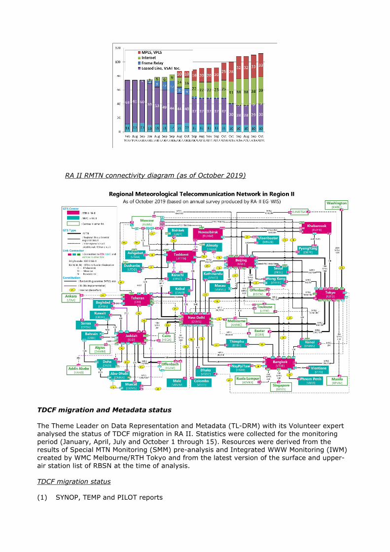
RA II RMTN connectivity diagram (as of October 2019)
TDCF migration and Metadata status
The Theme Leader on Data Representation and Metadata (TL-DRM) with its Volunteer expert analysed the status of TDCF migration in RA II. Statistics were collected for the monitoring period (January, April, July and October 1 through 15). Resources were derived from the results of Special MTN Monitoring (SMM) pre-analysis and Integrated WWW Monitoring (IWM) created by WMC Melbourne/RTH Tokyo and from the latest version of the surface and upper-air station list of RBSN at the time of analysis.
TDCF migration status
(1) SYNOP, TEMP and PILOT reports
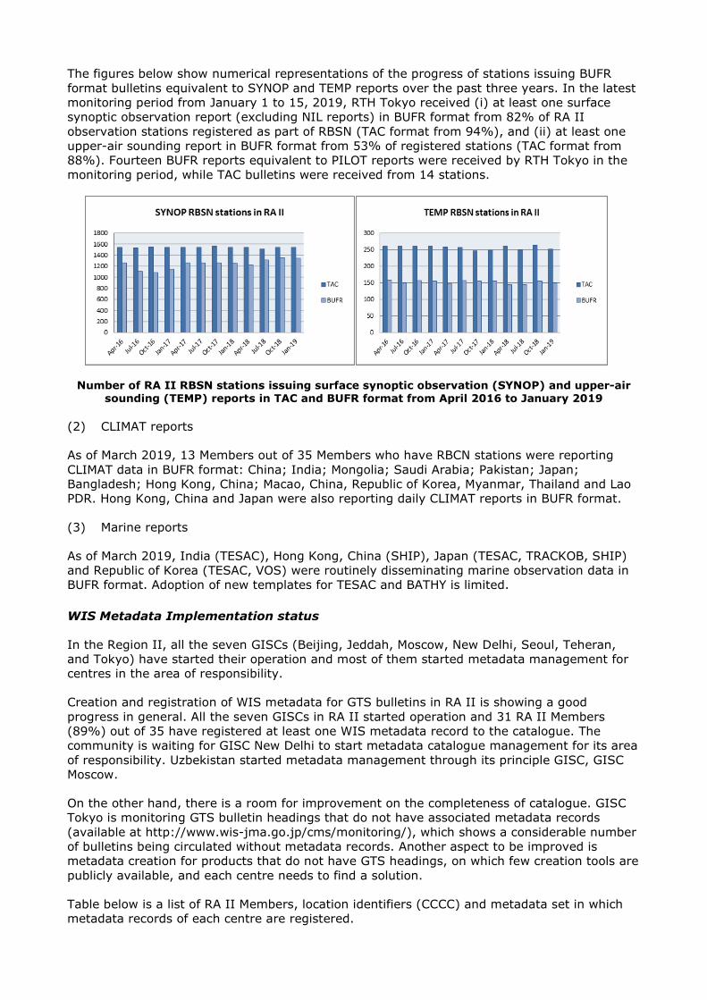
The figures below show numerical representations of the progress of stations issuing BUFR format bulletins equivalent to SYNOP and TEMP reports over the past three years. In the latest monitoring period from January 1 to 15, 2019, RTH Tokyo received (i) at least one surface synoptic observation report (excluding NIL reports) in BUFR format from 82% of RA II observation stations registered as part of RBSN (TAC format from 94%), and (ii) at least one upper-air sounding report in BUFR format from 53% of registered stations (TAC format from 88%). Fourteen BUFR reports equivalent to PILOT reports were received by RTH Tokyo in the monitoring period, while TAC bulletins were received from 14 stations.
Number of RA II RBSN stations issuing surface synoptic observation (SYNOP) and upper-air sounding (TEMP) reports in TAC and BUFR format from April 2016 to January 2019
(2) CLIMAT reports
As of March 2019, 13 Members out of 35 Members who have RBCN stations were reporting CLIMAT data in BUFR format: China; India; Mongolia; Saudi Arabia; Pakistan; Japan; Bangladesh; Hong Kong, China; Macao, China, Republic of Korea, Myanmar, Thailand and Lao PDR. Hong Kong, China and Japan were also reporting daily CLIMAT reports in BUFR format.
(3) Marine reports
As of March 2019, India (TESAC), Hong Kong, China (SHIP), Japan (TESAC, TRACKOB, SHIP) and Republic of Korea (TESAC, VOS) were routinely disseminating marine observation data in BUFR format. Adoption of new templates for TESAC and BATHY is limited.
WIS Metadata Implementation status
In the Region II, all the seven GISCs (Beijing, Jeddah, Moscow, New Delhi, Seoul, Teheran, and Tokyo) have started their operation and most of them started metadata management for centres in the area of responsibility.
Creation and registration of WIS metadata for GTS bulletins in RA II is showing a good progress in general. All the seven GISCs in RA II started operation and 31 RA II Members (89%) out of 35 have registered at least one WIS metadata record to the catalogue. The community is waiting for GISC New Delhi to start metadata catalogue management for its area of responsibility. Uzbekistan started metadata management through its principle GISC, GISC Moscow.
On the other hand, there is a room for improvement on the completeness of catalogue. GISC Tokyo is monitoring GTS bulletin headings that do not have associated metadata records (available at http://www.wis-jma.go.jp/cms/monitoring/), which shows a considerable number of bulletins being circulated without metadata records. Another aspect to be improved is metadata creation for products that do not have GTS headings, on which few creation tools are publicly available, and each centre needs to find a solution.
Table below is a list of RA II Members, location identifiers (CCCC) and metadata set in which metadata records of each centre are registered.
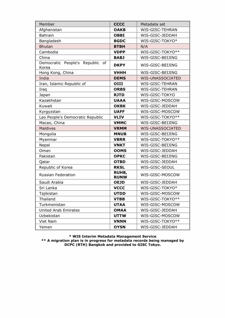
Member CCCC Metadata set Afghanistan OAKB WIS-GISC-TEHRAN Bahrain OBBI WIS-GISC-JEDDAH Bangladesh BGDC WIS-GISC-TOKYO* Bhutan BTBH N/A Cambodia VDPP WIS-GISC-TOKYO** China BABJ WIS-GISC-BEIJING Democratic People's Republic of Korea DKPY WIS-GISC-BEIJING
Hong Kong, China VHHH WIS-GISC-BEIJING India DEMS WIS-UNASSOCIATED Iran, Islamic Republic of OIII WIS-GISC-TEHRAN Iraq ORBS WIS-GISC-TEHRAN Japan RJTD WIS-GISC-TOKYO Kazakhstan UAAA WIS-GISC-MOSCOW Kuwait OKBK WIS-GISC-JEDDAH Kyrgyzstan UAFF WIS-GISC-MOSCOW Lao People's Democratic Republic VLIV WIS-GISC-TOKYO** Macao, China VMMC WIS-GISC-BEIJING Maldives VRMM WIS-UNASSOCIATED Mongolia MNUB WIS-GISC-BEIJING Myanmar VBRR WIS-GISC-TOKYO** Nepal VNKT WIS-GISC-BEIJING Oman OOMS WIS-GISC-JEDDAH Pakistan OPKC WIS-GISC-BEIJING Qatar OTBD WIS-GISC-JEDDAH Republic of Korea RKSL WIS-GISC-SEOUL
Russian Federation RUHB, RUNW WIS-GISC-MOSCOW
Saudi Arabia OEJD WIS-GISC-JEDDAH Sri Lanka VCCC WIS-GISC-TOKYO* Tajikistan UTDD WIS-GISC-MOSCOW Thailand VTBB WIS-GISC-TOKYO** Turkmenistan UTAA WIS-GISC-MOSCOW United Arab Emirates OMAA WIS-GISC-JEDDAH Uzbekistan UTTW WIS-GISC-MOSCOW Viet Nam VNNN WIS-GISC-TOKYO** Yemen OYSN WIS-GISC-JEDDAH
* WIS Interim Metadata Management Service
** A migration plan is in progress for metadata records being managed by DCPC (RTH) Bangkok and provided to GISC Tokyo.
Information Management
Practices in RA II
CMA
CMA’s Cloud-based data management and sharing system, which is named Tianqing, became operational in 2020. It has one national node and 31 provincial nodes. National node stores all data and deploys all business. Provincial nodes deploy local business and store their required data. CMA uses MQ technology to collect meteorological observation data in seconds.
JMA
JMA launched the HimawariCloud service on 8 April 2015 with the distribution of Himawari-8 in-orbit-test imagery. NMHSs in the Himawari-8/9 coverage area can access HimawariCloud and retrieve data using an HTTP 1.1 client such as a Web browser or Wget. JMA is working to implement L2 connection and HpFP (High performance and Flexible Protocol) in addition to the current HTTP(S). HpFp enables high throughput even with high latency and packet loss.
KMA
GK2A satellite has operated since July 25, 2019. In order to provide the GK2A data to users, KMA has implemented the GK2A data service via several ways such as real-time FTP, open API, WMO WIS DCPC and web-based download.
Future Plan
Consider the influence of technology such as big data, machine learning, cloud, high performance computing and influence of social and demographic environment. Better understand and address the challenges and opportunities posed by emerging data issue. Monitor and survey existing information management practices of RA II WMO Mmembers. Get contact with experts from RA II Mmembers, especially members in developing countries to identify issues that Mmembers are facing with IM. Encourage and facilitate the implementation of Information Management and Emerging Data Issues according to WMO regulations, guidance and best practices used by Mmembers [China].
WIS capacity development
Training and Capacity Development is key element of WIS implementation to provide reliable and sustainable information sharing service to all WMO programs and related activities.
Related Activities from GISCs for Capacity Development in RAII
According to annual report (2018-2019) from GISCs, Four GISCs have provided regular training opportunities for their AoR through workshop/onsite/webinar. Some of other GISCs have a plan to hold a workshop.
GISC Beijing
GISC Beijing has provided on-site training on CMACast and WIS services to four WIS users Mongolia (August 2018, and September 2019), Maldives (April, 2019), Tajikistan (May 2019), and VietnamViet Nam (July 2019). And, one invited training activity was hosted for Bangladesh in Beijing in May 2018.
GISC Moscow
Roshydromet gives a sharper focus on holding webinars to provide an operational framework for enhancing interactions between the parties concerned. For example, a webinar scheduled for November 2019 will explore areas of common interest, share information and experience and address the issues of primary responsibilities between GISC Moscow and National Centre (NC)/DCPCs in its area of responsibility to enable WIS monitoring.
GISC New Delhi
GISC New Delhi has a plan to conduct training for NCs under its AoR and local officials during 2019.
GISC Seoul
GISC Seoul has performed WIS capacity building activity in annul ICT training course for WMO Mmembers in RTC-KoreaSeoul. Training materials cover WIS Overview, WIS functionality, WIS metadata, Operational guide and TDCF migration, WIS2.0 implementation plan.
The Training Courses on ICT for Meteorological Services was held in RTC- KOREA (Seoul), April 17-18, 2019. 19 staffs from 11 countries Members participated the training. The Training for operator of DCPC LC/LRFMME was held in June 26-27, 2019. The ICT and NWP training programme for Viet Nam was held in August 16, 2019.
GISC Tokyo
The 1st WIS workshop was held in 2010. Since then GISC Tokyo has taken place the workshops for capacity building every two years. In May 2019, the 5th WIS workshop was held at the headquarters of the JMA, Tokyo. Twelve participants were invited from Cambodia, Lao Republic, Myanmar, the Philippines, Thailand and VietnamViet Nam, and three lecturers were invited from Australia, China and Germany.
The main topic of this workshop was the WIS 2.0 implementation approach, which was approved by the eighteenth World Meteorological Congress (Cg-18), and the GISC Tokyo Cloud Pilot Project. The WIS 2.0 is a game changer for the telecommunications among WMO Mmembers, and we need to take actions. The GISC Tokyo Cloud Pilot Project aims to help GISC Tokyo’s AoR members, and also to facilitate the migration of WIS 2.0. Taking an opportunity of this workshop, GISC Tokyo addressed AoR members to join Tokyo’s Pilot Project.
GISC Tokyo provided training materials, which were handed in at the past workshops (2014 and 2016), in line with the request from TT-GISC-2018. The materials of the WIS workshop in Tokyo this year will be available soon from TT-GISC Training Aids [https://wis.wmo.int/page=TrainingAids].
GISC Tokyo has also continued to hold an on-site technical meeting at each Member country [China]. In April 2018, GISC Tokyo visited Lao PDR and VietnamViet Nam to discuss about metadata quality issues and establishment Area Meteorological Data Communications Networks (AMDCN) network. GISC Tokyo will have opportunities to hold on-site technical meeting in couple of countries Members every year.
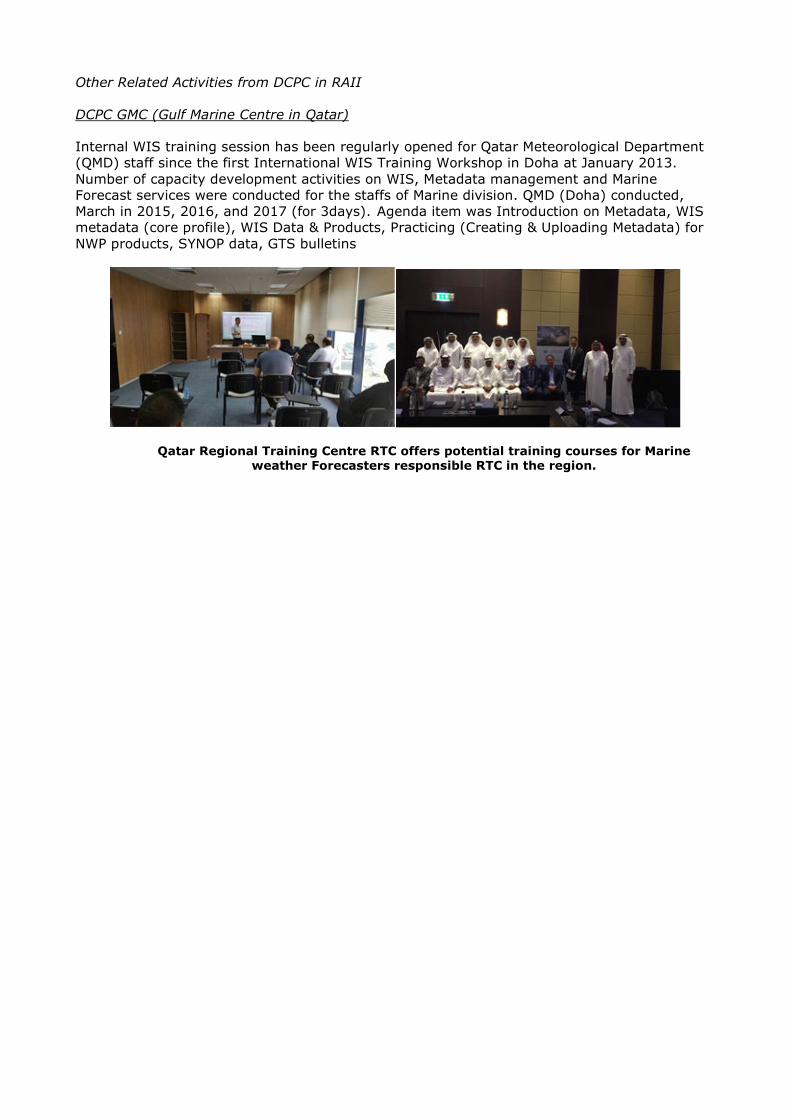
Other Related Activities from DCPC in RAII
DCPC GMC (Gulf Marine Centre in Qatar)
Internal WIS training session has been regularly opened for Qatar Meteorological Department (QMD) staff since the first International WIS Training Workshop in Doha at January 2013. Number of capacity development activities on WIS, Metadata management and Marine Forecast services were conducted for the staffs of Marine division. QMD (Doha) conducted, March in 2015, 2016, and 2017 (for 3days). Agenda item was Introduction on Metadata, WIS metadata (core profile), WIS Data & Products, Practicing (Creating & Uploading Metadata) for NWP products, SYNOP data, GTS bulletins
Qatar Regional Training Centre RTC offers potential training courses for Marine weather Forecasters responsible RTC in the region.
Annex IV.1
Overview of Implementation of Six Projects Listed in Regional WIGOS Implementation Plan 2017-2020 in RA II (R-WIP-II)
The implementation of R-WIP-II relies mainly on six RA II WIGOS projects listed in the R-WIP-II. The implementation of these six projects is summarized as follows:
Project No. I – Monitor and review the Implementation of EGOS – IP in RA II
The 115 actions in EGOS-IP (WMO Technical Report No.2013-4) were reviewed and analysed. In order to facilitate the statistical analysis of the implementation progress, 51 actions that need to be reported by Members member states [China] were selected, and a questionnaire webpage was designed. However, due to various reasons, the international use of web pages has not yet been realized. MOC plans to share the questionnaire by the portal of the World Meteorological Centre-Beijing, and will also send the questionnaire via email to the relevant Member country [China] contacts in the near future and summarize and evaluate the implementation progress of RA II up to 2020 based on the feedback.
1. Monitor the progress of RA II Members on the implementation of EGOS-IP
In 2017, RA II-16 adopted the resolution 4.3 to establish Regional WIGOS Centres (RWCs) in RA II in pilot phase, noted interest of China and Japan for hosting a WMO Regional WIGOS Centre in RA II, and urged Members to familiarize themselves with the RWC guidance and actively participate in the implementation of RWCs in RA II; The RA II Management Group endorsed proposals from CMA and JMA to establish RWCs in pilot mode in RA II at its meeting in June 2018.
At present, RWC-Beijing has completed the mandatory and optional functions required by the RWC concept document according to the Resolution 30 of 68th session of the Executive Council, and RWC-Beijing has completed a lot of fruitful results during the pilot operation. Including the data quality monitoring reports, incident management with Members, and a series of communication and training, which provided technical services for the RA II Members and strengthened exchanges and cooperation among Members.
2. Analyse gaps in the regional observing network, and prioritize actions listed in EGOS-IP
(1) The evaluation of the horizontal resolution of the meteorological station network over Region II based on GTS data
Based on the GTS international exchange data (including surface, sounding, AMDAR, ocean observation, etc.), the horizontal resolution of the meteorological observing station network over Region II is evaluated. The average horizontal station spacing of temperature, specific humidity and wind observation is calculated in the 2°×2° latitude and longitude grid and is compared with the threshold, breakthrough and target indicators respectively in the near-surface layer, lower troposphere, and upper troposphere required by OSCAR. In the global numerical forecasting field, the threshold, breakthrough, and target indicators of the observation stations horizontal resolution over near-surface layer are 250 km, 50 km, and 15 km, respectively. And in the lower troposphere and the upper troposphere layers both are 500 km, 100 km and 15 km. Then the horizontal resolution color maps of the observation station network are drawn, in which those that have not reached the threshold are indicated in red, those that have reached the threshold and are less than the breakthrough are indicated in yellow, those that have reached the breakthrough and are less than the target are indicated in green, and those that have reached the target are indicated in blue.
The distributions of the horizontal resolution station spacing of temperature, specific humidity and wind are similar. In the near-surface layer, most regions in RA II have reached the global numerical forecast threshold requirements, and the Southeast Asian coast can reach the breakthrough index, with only a few grid points (the southeast coast of China, the west coast
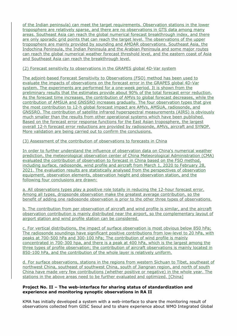
of the Indian peninsula) can meet the target requirements. Observation stations in the lower troposphere are relatively sparse, and there are no observations in GTS data among many areas. Southeast Asia can reach the global numerical forecast breakthrough index, and there are only sporadic grid points that can reach the target level. The observations of the upper troposphere are mainly provided by sounding and AMDAR observations. Southeast Asia, the Indochina Peninsula, the Indian Peninsula and the Arabian Peninsula and some major routes can reach the global numerical weather forecast threshold level, and the eastern coast of Asia and Southeast Asia can reach the breakthrough level.
(2) Forecast sensitivity to observations in the GRAPES global 4D-Var system
The adjoint-based Forecast Sensitivity to Observations (FSO) method has been used to evaluate the impacts of observations on the forecast error in the GRAPES global 4D-Var system. The experiments are performed for a one-week period. It is shown from the preliminary results that the estimates provide about 90% of the total forecast error reduction. As the forecast time increases, the contribution of AMVs to global forecast decreases, while the contribution of AMSUA and GNSSRO increases gradually. The four observation types that give the most contribution to 12-h global forecast impact are AMVs, AMSUA, radiosonde, and GNSSRO. The contribution of satellite infrared hyperspectral measurements (AIRS) is obviously much smaller than the results from other operational systems which have been published. Based on the forecast error response functions for the East Asian troposphere, the largest overall 12-h forecast error reductions are provided by radiosonde, AMVs, aircraft and SYNOP. More validation are being carried out to confirm the conclusions.
(3) Assessment of the contribution of observations to forecasts in China
In order to further understand the influence of observation data on China's numerical weather prediction, the meteorological observation center of China Meteorological Administration (CMA) evaluated the contribution of observation to forecast in China based on the FSO method, including surface, radiosonde, wind profile and aircraft from March 1, 2020 to February 28, 2021. The evaluation results are statistically analysed from the perspectives of observation equipment, observation elements, observation height and observation station, and the following four conclusions are drawn:
a. All observations types play a positive role totally in reducing the 12-hour forecast error. Among all types, dropsonde observation make the greatest average contribution, so the benefit of adding one radiosonde observation is prior to the other three types of observations.
b. The contribution from per observation of aircraft and wind profile is similar, and the aircraft observation contribution is mainly distributed near the airport, so the complementary layout of airport station and wind profile station can be considered.
c. For vertical distributions, the impact of surface observation is most obvious below 850 hPa; The radiosonde soundings have significant positive contributions from low-level to 20 hPa, with peaks at 700-500 hPa and 300-100 hPa; The contribution of wind profile is mainly concentrated in 700-300 hpa, and there is a peak at 400 hPa, which is the largest among the three types of profile observation; the contribution of aircraft observations is mainly located in 850-100 hPa, and the contribution of the whole layer is relatively uniform.
d. For surface observations, stations in the regions from western Sichuan to Tibet, southeast of northwest China, southeast of southwest China, south of Jiangnan region, and north of south China have made very few contributions (whether positive or negative) in the whole year. The stations in the above areas need to be further evaluated and optimized. [China]
Project No. II – The web-interface for sharing status of standardization and experience and monitoring synoptic observations in RA II
KMA has initially developed a system with a web-interface to share the monitoring result of observations collected from GISC Seoul and to share experience about WMO Integrated Global
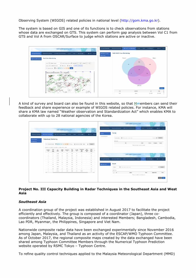
Observing System (WIGOS) related policies in national level (http://gom.kma.go.kr).
The system is based on GIS and one of its functions is to check observations from stations whose data are exchanged on GTS. This system can perform gap analysis between Vol C1 from GTS and Vol A from OSCAR/Surface to judge which stations are active or inactive.
A kind of survey and board can also be found in this website, so that Mmembers can send their feedback and share experience or example of WIGOS related policies. For instance, KMA will share a KMA law named “Weather observation and Standardization Act” which enables KMA to collaborate with up to 28 national agencies of the Korea.
Project No. III Capacity Building in Radar Techniques in the Southeast Asia and West Asia
Southeast Asia
A coordination group of the project was established in August 2017 to facilitate the project efficiently and effectively. The group is composed of a coordinator (Japan), three co-coordinators (Thailand, Malaysia, Indonesia) and interested Members; Bangladesh, Cambodia, Lao PDR, Myanmar, the Philippines, Singapore and Viet Nam.
Nationwide composite radar data have been exchanged experimentally since November 2016 among Japan, Malaysia, and Thailand as an activity of the ESCAP/WMO Typhoon Committee. As of October 2017, the regional composite maps created by the data exchanged have been shared among Typhoon Committee Members through the Numerical Typhoon Prediction website operated by RSMC Tokyo – Typhoon Centre.
To refine quality control techniques applied to the Malaysia Meteorological Department (MMD)
and the Thai Meteorological Department (TMD), a trilateral technical meeting on radar Quality Control (QC) and Quantitative Precipitation Estimation (QPE) was held in Tokyo, Japan, from 12 to 15 Dec 2017 as an activity of the Typhoon Committee. Participants shared the knowledge on quality management and application techniques of radars, and discussed how to expand experimental radar composite data exchange in the Southeast Asia. A similar meeting supported by the Typhoon Committee and WMO was subsequently held in Tokyo from 22 to 26 Oct 2018 with representatives from TMD, MMD, the Department of Meteorology and Hydrology (DMH) of Lao PDR and the Viet Nam Meteorological Hydrological Administration (VNMHA), as well as expert observers from the United Arab Emirates' National Centre of Meteorology (NCM). A further gathering was held in Tokyo from 13 to 15 Nov 2019 with attendees from the Meteorological, Climatological, and Geophysical Agency of the Republic of Indonesia (BMKG), MMD, the Department of Meteorology and Hydrology of the Republic of the Union of Myanmar (DMH), the Philippines Atmospheric, Geophysical and Astronomical Services Administration (PAGASA), the Meteorological Service Singapore (MSS), TMD and VNMHA. As a result of these meetings, JMA compiled sample radar composite imagery using data sets provided by the relevant countries.
2018 meeting summary is available at: https://www.jma.go.jp/jma/en/photogallery/meeting2018/Report_radarmeeting2018.pdf
2019 meeting summary is available at: https://www.jma.go.jp/jma/en/photogallery/meeting2019/Report_radarmeeting2019.pdf
National reports on radar system were submitted to the 39th session (Manila, May 2017), the 40th session (Singapore, May 2018) and 41st session (Singapore, October 2019) of the ASEAN Sub-Committee on Meteorology and Geophysics (SCMG) by Indonesia, Malaysia, Myanmar, the Philippines, Singapore, Thailand and Viet Nam.
WMO and ASEAN jointly held the WMO/ASEAN Training Workshop on Weather Radar Quality and Standardization in Bangkok, Thailand, from 5 to 13 February 2018, hosted by TMD with full support from JMA. The workshop focused on capacity development of ASEAN Member States and Bangladesh on the technical aspect of radar maintenance, applications, data exchange and format. During the eight-day workshop, attendees learnt all about weather radar via theoretical and practical sessions, and also discussed ways to improve QC and expand the regional radar network in the Southeast Asia. The final report of the workshop is available at: https://www.wmo.int/pages/prog/dra/rap/documents/Finalreport-WMO_ASEAN_Training_Workshop_on_Weather_Radar.pdf
Gulf Cooperation Council (GCC) Weather Radars networks
A weather radars network is established by Gulf Cooperation Council to produce a GCC mosaic pictures. The network includes radars from Kuwait, Eastern KSA, Bahrain, UAE and Oman (see GCC weather radars distribution below). The resolution is 1 km bin and the mosaic pictures are updated every 10 minutes.

GCC radars data are received as polar volumes and converted from their native data format to
MDV (NCAR – Meteorological Data Volume) as Constant Altitude Plan Position Indicator (CAPPI) data. Data owners are responsible for data quality control. Below is an example of
GCC Radar reflectivity

The real-time updates of the GCC Weather Radars networks pictures can be found by linking to
http://www.ncm.ae/en#!/Radar_GCC_GCC/26.
Project No. IV – Enhance the Availability and Quality Management Support for NMHSs in Surface, Climate and Upper-air Observations
The JMA/WMO Workshop on Quality Management of Surface Observation was held in Tokyo and Tsukuba, Japan, from 19 to 23 March 2018. This workshop took place following the JMA/WMO Workshop on Quality Management in Surface, Climate and Upper-air Observations in RA II (Japan, July 2010), and the JMA/WMO Training Workshop on Calibration and Maintenance of Meteorological Instruments in RA II (Japan, Feb 2013). This workshop was based on the results of the quality management survey (2016 – 2017), and focused on quality management on surface precipitation observation. The workshop was attended by 28 experts from 10 NMHSs in RA II, RIC Beijing (China), RIC Manila (the Philippines), the WMO/CIMO Lead Centre on Precipitation Intensity (University of Genoa, Italy), WMO and JMA. Discussion during this workshop resulted in the proposal of the Tokyo Action Plan 2018 (TAP2018). For the next decade, the improvement of availability and quality management of NMHSs in RA II will be considered pursuant to TAP2018.
To achieve one of the expected key results (provision of technical support for instrument maintenance and calibration by experts from RICs), experts of JMA/RIC Tsukuba visited the Bangladesh Meteorological Department (BMD) and provided practical on-the-job training on meteorological instrument aiming at establishing the operational calibration system using meteorological standards (barometer and thermometer) and calibration equipment was donated in the framework of the Japan International Cooperation Agency (JICA) technical cooperation project in 2013. Following the success of the project conducted with BMD, similar initiatives were run with NMHSs in Fiji, Mauritius, Mozambique, Myanmar, the Philippines, Sri Lanka and VietnamViet Nam between 2015 and 2020.
An Inter-laboratory comparison (ILC) involving RIC Tsukuba (RA II), RIC Beijing (RA II), RIC Melbourne (RA V), RIC Manila (RA V), RIC Ljubljana (RA VI) and the University of Ljubljana (RA VI)) was conducted from 2018 to 2019. This ILC focusing on temperature, humidity and

pressure is the first inter-comparison in RA II and it is expected to confirm the calibration capability of RICs in different regions and increase the reliability of their observation data. The ILC involves a protocol similar to that of an ILC conducted in RA VI in 2015 – 2016, with the same transfer devices as those of the preceding ILC. The summary submitted to WMO in 2020 will be published as an Instruments and Observing Methods (IOM) report in 2021.
Through the project period, quality of land surface observations in RA II Members was regularly monitored by RSMC Tokyo, by analysing the differences between the surface observations and the nearest first-guess fields of 6-hour forecast of JMA’s global numerical model. The monitoring results are also shared by Members on the website.
Tokyo Action Plan 2018 adopted at the JMA/WMO Workshop on Quality Management of
Surface Observation (Tokyo and Tsukuba, Japan, March 2018)
Project No. V – Develop a Sand and Dust-Storm Warning Advisory and Assessment System (SDS-WAS) in Asia Node
In May 2007, the 14th Congress of the WMO approved the launching of the SDS-WAS project with the mission to enhance the ability of Members countries [China] to deliver timely and quality sand and dust-storm forecasts, observations and information to users through an international partnership of research and operational communities. Since 2011, WMO has been encouraging CAS and CBS’s joint efforts to specify an optimal concept of transferring research on numerical dust forecasting to operational activity (Cg-16), and achieve rapid transition from research to operational forecasting (EC-61). In the May of 2017, EC-69 approved the formal designation of Regional Specialized Meteorological Centre (RSMC) for Atmospheric Sand and Dust-Storm Forecasting (ASDF)— RSMC-ASDF Beijing (RA II) hosted by CMA. So, the SDS-WAS is a good example among WMO projects transferring from research to operations.
Operational products
Three kinds of operational products are posted on the SDS-WAS in Asia Node Web Portal,
which includes numerical forecast, forecast verification and observation products.
At present, RSMC-ASDF Beijing releases daily dust forecasts products over Middle and East Asia (35°E-150°E, 15°N-60°N) generated by six numerical dust forecast models and a mean ensemble system, which include CUACE/Dust model from China, ADAM3 model from Korea, MASINGAR model from Japan, SILAM model from Finland,MACC model from ECMWF, and a dust forecast model from NCEP. Except for JMA’s model, the starting times of all other models and ensemble forecast are 00:00 (UTC). Products of the numerical dust forecast models involved in the WMO Information System (WIS) are as follows:
1) Dust load (kg m-2);
2) Dust concentration at the surface (μg m-3);
3) Dust optical depth at 550 nm (-);
4) 3-hour accumulated dry deposition (kg m-2);
5) 3-hour accumulated wet deposition (kg m-2).
The forecast verification products of past 24 hours are displayed in the form of overlapping of observed dusty weather phenomena and forecasted surface-layer dust concentrations. Dust related observation products are FY4A-Infrared Difference Dust Index (IDDI), visibility and dusty weather phenomena.
Capacity building
Data Sharing ftp
CMA has established an international data sharing ftp (ftp.nmc.cn) since late 2018, where Mmembers could exchange observations and numerical forecast data with each other. Asian regional forecast results of CMA, KMA, JMA, ECMWF, NCEP, and FMI’s dust forecast models and some site observations of PM10 concentration in Mongolia are shared among Members member countries every day. Members have all permissions for their own folders but only download permission for others countries’ folders [China]. Its capacity will increase to three terabytes in 2021. Until now, daily data files of all numerical models and ensemble forecast on the portal since January 1, 2018 have been uploaded. Further historical forecast data could be requested via [email protected]. In the future, CMA welcomes more operational numerical dust forecast models and observation data to join this data sharing ftp.
New version of web portal
The construction of the new portal site started in 2017. The main changes were the unification of the forecast and verification products, the improvement of the overall aesthetics of the website, and the enrichment of satellite observation products. The new version has been discussed on the 6th Meeting of WMO SDS-WAS RSG for Asia in 2018, and launched in 2019.
SDS monitoring
1) Gridding PM10 concentration: A real-time gridding PM10 concentration estimation product with a horizontal
resolution of 5 km over China was established by merging of site PM10 observation and satellite aerosol retrieval data, such as AOD and FMF.
2) Satellite monitoring: FY-4A/AGRI has more spectral bands (increased from 5 in FY-2 to 14), which will
greatly improve object detection (e.g., dust, cloud, aerosol, snow, fire and water bodies) and quantitative retrievals. FY-4A/AGRI will also enhance dynamic monitoring. FY-4A/AGRI’s regional observation mode can provide a regional scan
each minute. The FY-4A/AGRI dust product can provide dust mask and IDDI which is a semi-quantitative parameter for dust loading each hour for full disk and 15 minutes for a regional scan. In 2018, the FY-4A/AGRI dust product was assimilated in CUACE/Dust model successfully, which significantly promoted the accuracy of the model and could be as the validation for forecast results.
Based on the data of FY-3 and FY-4 satellites and dust monitoring products, a remote sensing dust monitoring and evaluation system of FY satellite was developed. It is a software system integrating satellite data acquisition, product display and statistical analysis, which can automatically process and manage data, and provide convenient and quick tools for various analysis and display. The system includes the functions of basic data source acquisition, data projection and cutting, generation of dust colour enhanced products, statistical analysis and data interaction. In the absence of human intervention, the system server automatically performs task operations. In the case of human-computer interaction, the client of the system displays the dust disaster products, and can make statistical analysis on the area and frequency of dust disaster.
SDS forecast
(1) Numerical forecast Due to the improvement of the computing system in CMA from IBM to Pier, CUACE/dust model has also been moved to this new system with the new editing and compiling software. Higher resolution of 0.25° meteorological IC/BC from global NWP model GRAPES have been adopted for CUACE/Dust.
Based on the observed meteorological SDS phenomena, especially the severe SDSs and normal SDSs that are probably mainly formed directly by local emissions, the erodibility of the Asian source has been updated. The percentage of the erosion area in the two deserts Kyzyl-Kum, and Karakum were reduced based on the surface observations. The erodibility of much of this region decreased to less than 70%, which is much lower than the original value of 100%. And the erosion percentage of the Aralkum Desert and the erosion area around Balkash Lake has decreased.
The numerical dust forecast model from KMA has updated from Asian Dust Aerosol Model version2 (ADAM2) to ADAM3 in 2020. ADAM3 was developed by incorporating the Asian dust emission algorithm into the Community Multiscale Air Quality model version 4.7.1. The meteorological fields used to drive ADAM3 simulations are obtained from the Global Data Assimilation Prediction System (GDAPS) which is the current global forecasting model used at KMA. Reduction index of Asian dust emission depending on precedent precipitation was applied to the dust emission algorithm in ADAM3 (ADAM3_RAIN) to improve over-estimation of Asian dust from ADAM3 in 2020.
(2) Multi-model ensemble forecast Multi-model ensemble forecast system for surface concentration of Asian dust has been established since 2018 based on numerical models from CMA, KMA, JMA, FMI, NCEP and ECMWF. As a partial result of ensemble forecast system, the mean ensemble forecast has been shown on the portal site.
(3) Seasonal scale SDS forecast
A statistical multi-factor prediction model for spring SDS in northern China has been established. The model, which is taking into account of the influence of sea-surface temperature (SST) and sea-ice concentration (SIC) on spring atmospheric circulation over Eurasia and influence of rainfall on underlying conditions in dust-storm source region for northern China, is very skilful especially for North China and Northwest China. Besides, by using Empirical Orthogonal Functions (EOF) iteration scheme, a dynamical downscaling model for monthly SDS frequency forecast in northern China has been set up also, which is based on the outputs either of the Atmospheric General Circulation Model of Beijing Climate Centre (BCC_AGCM) or of the NCEP coupled forecast system

model version 2 (CFSv2). The seasonal and S2S SDS models are both applied in the operational forecasting in the National Climate Centre of China.
International activities
The 9th International Workshop on Sand / Dust-storm and Associated Dustfall was held in Tenerife, Spain, from 22 to 24 May 2018. Three experts from RSMC-ASDF Beijing participated in the meeting and exchanged the latest research results with experts from 37 Members countries [China].
The 4th meeting of WMO SDS-WAS Steering Committee was held in Laguna, Canary Islands, Spain, from 25 to 26 May 2018. Zhang Xiaoye form CAMS, CMA was elected as new Chair of the Steering Committee of SDS-WAS.
The 6th Meeting of the Asian Regional Steering Group of WMO Sandstorm Early Warning Advisory and Assessment System (WMO SDS-WAS RSG for Asia) and the International Dust and Aerosol Workshop were held in Tsukuba, Japan, from 19 to 21 November 2018. Experts from RSMC-ASDF reported their latest progress in ground and satellite monitoring, numerical model improvement, ensemble forecasting and website construction.
The 5th meeting of WMO SDS-WAS Steering Committee was held in Hangzhou, China, from 11 to 14 Nov. 2019.
The 7th Meeting of the Asian Regional Steering Group of WMO Sandstorm Early Warning Advisory and Assessment System (WMO SDS-WAS RSG for Asia) and the 3rd International Dust and Aerosol Workshop were held in Hangzhou China, from 11 to 14 November 2019. The meeting agreed that Members member states [China] need to strengthen cooperation in scientific research and business, and focus on data assimilation and sharing, dust monitoring, model performance evaluation, regional centres website construction, dust training and technical exchanges with other regional operational centres.
Project No. VI – Develop Support for NMHSs in Satellite Data, Products and Training
Issuance of newsletters to RA II and RA V Members
Quarterly newsletters have been issued to share recent satellite-related information on topics such as imagery data, products and training. The newsletters listed below contained brief reports on relevant meetings, product development report, news on RSMC Tokyo for Nowcasting, Transition plans for Himawari data dissemination and distribution services in the Vol. 10/No.3 2019, and Geo-KOMPSAT-2A Rapid Scan Observation for Monitoring Natural Disasters over Asia/Oceania in Vol. 11/No.1 2020.
Vol. 8/No. 1, March 2017 Vol. 8/No. 2, June 2017 Vol. 8/No. 3, October 2017 Vol. 8/No. 4, December 2017 Vol. 9/No. 1, March 2018 Vol. 9/No. 2, June 2018 Vol. 9/No. 3, November 2018 Vol. 9/No. 4, December 2018 Vol. 10/No. 1, March 2019 Vol. 10/No. 2, August 2019 Vol. 10/No. 3, November 2019 Vol. 11/No. 1, June 2020
All the newsletters in the past are available at: http://www.jma.go.jp/jma/jma-eng/satellite/ra2wigosproject/ra2wigosproject-intro_en_jma.html

8th Asia/Oceania Meteorological Satellite Users’ Conference and training event
AOMSUC-8 was held in Vladivostok, Russia from 16 to 21 October 2017. AOMSUC-8 was hosted and sponsored by Roshydromet and Roscosmos of the Russian Federation, and was co-sponsored by CMA, JMA, KMA, BMKG, the Australian Bureau of Meteorology (AuBOM), the India Meteorological Department (IMD) and the India Space Research Organization (ISRO) of India, WMO, and the Group on Earth Observations (GEO). The two-day training event was also held with participants from Region II and V.
In addition, the fifth Meeting of the Coordinating Group of the WMO Regional Association II (Asia) WIGOS Project to Develop Support for National Meteorological and Hydrological Services (NMHSs) in Satellite Data, Products and Training was held on the Campus of Far Eastern Federal University (FEFU) on Russky Island, Vladivostok, Russia on 21 October 2017 in conjunction with the AOMSUC-8. The progress of the WIGOS Project was reviewed and the future plan of the Project was discussed in the meeting by the project participants from RA II and RA V.
9th Asia/Oceania Meteorological Satellite Users’ Conference and training event
AOMSUC-9 was held in Bogor and Jakarta, Indonesia from 6 to 11 October 2018. The conference was hosted and sponsored by t BMKG, and was co-sponsored through with on-site participation by CMA, JMA, KMA, the Roshydromet and Roscosmos of the Russian Federation, AuBoM, and WMO. The two-day training event was carried out at the BMKG training facility in Bogor, Indonesia that brought together participants from WMO Regions II and V, including lecturers and attendees. Forty-five people from 30 Members countries participated in the training event. The next three days of AOMSUC-9 were the Conference portion consisting of 62 oral and 57 poster presentations and was attended by over 234 people from 44 Members countries [China]. The final day of the AOMSUC-9 was a smaller, focused meeting that was attended by 45 people from across WMO Regions II and V. A Joint Meeting of RA II WIGOS Project and RA V Task Team on Satellite Utilization (TT-SU) for RA II and RA V NMHSs were also held during the Conference.
10th Asia/Oceania Meteorological Satellite Users’ Conference and training event
AOMSUC-10 was held in Melbourne, Australia from 2-7 December 2019. AOMSUC-10 was hosted and sponsored by AuBOM, and was co-sponsored by the CMA, JMA, KMA, BMKG, Roshydromet and Roscosmos of the Russian Federation, IMD, ISRO, WMO, and GEO.
An AOMSUC-10 Training Event was conducted on the Royal Melbourne Institute of Technology (RMIT) University Campus, Melbourne Victoria 2-3 December 2019. There were 45 attendees as well as presenters from 26 Members countries [China] throughout the Asia-Oceania region and also including some attendees from the USA and Europe. A number of ground-breaking initiatives were attempted for this AOMSUC-10. Firstly, the two days were divided into a predominantly interactive teaching session on the Monday utilizing the Socrative cloud-based learner response system. Audience interaction was further enhanced by panel and group discussions conducted during Tuesday morning's sessions. The Training Event also hosted a Regional Focus Group meeting as conducted by the Australian VLab Centre of Excellence.
HimawariRequest Service
In January 2018, JMA launched a new international service “HimawariRequest”, in collaboration with AuBOM. The service allows NMHS users in Himawari8/9 coverage area to request Target Area observation covering a 1,000km x 1,000km area every 2.5 minutes. Target Area observation supports JMA’s national/international services including the RSMC Tokyo – Typhoon Centre and the Tokyo VAAC. In response to a recommendation made at the 2015 Joint RA II/RA V Workshop on WIGOS for Disaster Risk Reduction, JMA developed the service through the RA Il WIGOS Project to Develop Support for NMHSs in Satellite Data, Products and Training. The status (as of April 2021) of HimawariRequest is attended by 22 Registrations (the Solomon Islands, Myanmar, Australia, Hong Kong, China, Bangladesh, New Zealand,

Malaysia, Samoa, Nepal, Fiji, Russian Federation, New Caledonia, Bhutan, Singapore, Indonesia, Macau of China, the Philippines, India, Vanuatu, United States of America and VietnamViet Nam) and 17 users (the Solomon Islands, Australia, Hong Kong, China, New Zealand, Malaysia, Nepal, Fiji, Thailand, Russia, New Caledonia, Bhutan, Singapore, Indonesia, Macau of China, the Philippines, India and United States of America). JMA expects the HimawariRequest service to support disaster risk reduction activities in the Asia-Oceania region.
The Emergency Support Mechanism of FENGYUN Satellite (FY ESM)
CMA announced the Emergency Support Mechanism for International Users of Fengyun Meteorological Satellites in Disaster Prevention and Mitigation (FY ESM) on April 24, 2018 to serve the Members countries along the Belt and Road in a timely and effective manner. These Members countries may raise a request for the activation of the mechanism before, during and after an extreme meteorological event such as typhoon, heavy rain, severe convection, forest or grassland fire and sandstorm, etc., through their respective Permanent Representatives with WMO or their designated focal points. Once the request is approved, CMA will command the on-duty FY satellites for frequent and targeted observations with rapid scan per 5-6 minutes over affected areas. The images and products will be transmitted to the requesting applicant through CMACast, internet portal of CMA National Satellite Meteorological Centre, FTP and direct satellite broadcast reception. 29 Members countries/territories have registered as FY ESM users as of April 2021 (Laos, Myanmar, Iran, Maldives, Thailand, the Philippines, Malaysia, Uzbekistan, Nepal, Oman, Armenia, Kyrgyzstan, Sri Lanka, Portugal, Algeria, Tunisia, Mongolia, New Zealand, Mozambique, Lesotho, Nigeria, Ethiopia, Guinea, Benin, Mauritius, Ghana, Malawi, the Solomon Islands, Vanuatu). More than 30 international users could acquire FY satellites data via direct data transmission channels and over 115 Members countries/territories have registered for internet access to FY Satellites data. In addressing Super Typhoon Yutu and Typhoon Mangkut, Hurricane IDAI, as well as Tropical Cyclone Amphan, etc., timely emergency service support was provided to VietnamViet Nam, the Philippines, Mozambique and Bangladesh via FY ESM and other emergency response service mechanisms. Seven international training courses on FY satellites application have been held by CMA, attended by over 500 participants from more than 60 Members countries/territories [China]. With its FY Satellites International Service Plan as well as WMO World Meteorological Centre-Beijing and other specialized regional Centres, CMA looks forward to making due contribution to the regional and global disaster prevention and mitigation as well as climate change response activities.
Geo-Kompsat-2A (GK2A) AMI Rapid Scan (ARS) Service
The rapid scan capabilities of the new generation geostationary satellites Geo-KOMPSAT-2A by KMA, Himawari-8/9 by JMA and FY-4A by CMA provide critical support to the user community for the monitoring and short-term prediction of typhoons and rapidly developing mesoscale complex systems. The ability of the users to be able to request dedicated services, addressing their specific needs, significantly increases the benefits of these satellites and will provide a cornerstone for Members in the Asia-Pacific countries for their national services [China].
For the GK2A target observation, first, the hourly predicted locations (i.e., centred lat. and long.) of the targeted area (1,000 km × 1,000 km area and every two minutes interval) need to be delivered at 07:00 UTC of the day before targeted observation day. Then, to execute the target observation as requested on the day. Target observation imageries are provided in real-time at the NMSC homepage.
Users should request the service via a dedicated website using the registered email address with information on the observation centre and the desired start/end times to trigger subsequent procedures. The relevant URL will be provided once registration is complete. Users in RA II and RA V can request the service from KMA using a dedicated webpage (http://datasvc.nmsc.kma.go.kr/datasvc/html/special/specialReqMain.do ).

RA II and RA V joint Survey on the Use of Satellite Data 2018
The RA II and RA V joint Survey on the Use of Satellite Data 2018 was conducted by the Coordinating Group of the RA II WIGOS Project to Develop Support for NMHSs in Satellite Data, Products and Training and the RA V Task Team on Satellite Utilization. Its objective was to collect up-to-date information on the use of satellite data for meteorological, climate, water and other environmental applications in WMO RA II and RA V.
WMO issued the survey questionnaire on 3rd December with a return deadline of 31st January, and 32 Members countries/regions [China] submitted responses. The questionnaire consisted of Section 1: Access to Satellite Data and Products, Section 2: Use and Applications of Satellite Data and Products, Section 3: Education and Training, and Section 4: Satellite Data/Product Inventory. RA II Project co-coordinators and the RA V TT-SU Lead developed the content via several teleconference discussions based on the results of prior WMO, RA II, RA III-IV and AOMSUC surveys. An initial inventory of satellite data/products available (provided by JMA and KMA) in RA II and RA V was compiled in accordance with CBS-15/Doc. 4.2(1), and the inventory was incorporated into the survey.
The final report can be downloaded from WMO website. (https://library.wmo.int/index.php?lvl=notice_display&id=21723 )
The key results are as below.
• Himawari-8/9 data are used in these regions more than data from other satellites.
• GEO satellite data are mostly used for imagery application, nowcasting and forecast verification.
• Many respondents plan to use FY-4B and -4C data.
• Most institutions access satellite data online, but broadcast facilities are also used in Members countries [China] with slow and unstable Internet connections.
• The survey outcomes especially from Q4-b are expected to provide satellite-derived-product developers with ideas for future development.
• A 10-minute observation frequency is sufficient for effective monitoring of extreme weather events.
• Natural Colour RGB, Day Convective Storm RGB, True Colour RGB and other data support work practices significantly.
• The top three hazards in the RA II/V areas are lightning, flash floods and tropical cyclones. New generation GEO data have improved forecasting ability to detect and monitor such events.
• More training, faster/more reliable communications, and enhanced data and processing tools would be of value.
• FengYun general-purpose polar-orbiting satellite products are well known and widely used.
• Sea-surface wind data are used by more than half of all NMHSs.
• GSMaP products are the most popular among precipitation-related output in these regions.
• Most NMHSs require training in climate, public weather services, aviation services and a variety of other areas. Face-to-face training is considered highly important.
• Many users require 10-minute multi-band data and products both online and via the
satellite broadcast system.
Required Action Items from Country Member Reports of RA II / RA V
The required action items from Member country [China] report of RA II / RA V from the 3rd RA II WIGOS meeting (Japan, 2015) to the 1st joint meeting RA II and RA V (Indonesia, 2018) are listed as follows.
(1) 3rd RA II WIGOS Report (Tokyo, Japan, Nov 2015)
- Synthesis and Future Project Work Plan
• Approved the establishment of the Joint RA II/RA V WIGOS Satellite data project in collaboration with this WMO RA II WIGOS Project and the RA V Task Team on Satellite Utilization
• JMA presented a draft plan for collaborative development to improve access to Rapid Scan observation data from Himawari-8 in RA II/RA-V in order to support response to the second goal of above-said joint RA II/RA V WIGOS Satellite data project
(2) 4th RA II WIGOS Report (Songdo, Republic of Korea, Oct 2016)
- Synthesis and Future Project Work Plan
• Approved the establishment of the Joint RA II/RA V WIGOS Satellite data project in collaboration with this WMO RA II WIGOS Project and the RA V Task Team on Satellite Utilization
• JMA presented a draft plan for collaborative development to improve access to Rapid Scan observation data from Himawari-8 in RA II/RA-V in order to support response to the second goal of above-said joint RA II/RA V WIGOS Satellite data project
- RA II / RA V Member Country Reports
• The major part of Member country [China] report consists of:
1) Major historical meteorological disaster events, 2) Top hazardous weather of concern, and 3) Satellite data collection and processing capability,
(3) 5th RA II WIGOS Report (Vladivostok, Russian Federation, Oct 2017)
- RA II / RA V Member Country Reports
• The major part of Member country [China] report consists of
1) Satellite data used to address regional challenges, 2) Collection, processing and utilization of satellite date, and 3) Challenges in satellite data utilization.
- Results from the WMO 2016 Survey
• An overview of the WMO 2016 Survey on the Use of Satellite Data. WMO conducts a global user survey on satellite data every four years. Developed by WMO CBS IPET-SUP, the survey consisted of an online questionnaire covering access to and use of GEO/LEO satellite data, satellite applications and training. Replies from the 16 RA II Member respondents indicated:
1) A need for processing/visualization software and related training (GEO
and LEO), 2) A largely successful transition to Himawari-8 data usage, and 3) Progress of preparations for FY-3D/E by many Members.
- Development of the Protocol for Himawari-8/-9 Request-driven Rapid Scan in RA II and RA V
• JMA summarized a draft protocol (v0.4, October 2017) for Himawari-8/9 request-driven rapid scanning in RA II and RA V. Himawari-8/9 are capable of regional monitoring, referred to as Target Area Observation, covering selected areas of 1,000 x 1,000 km every 2.5 minutes
(4) RA II / RA V Joint Meeting (Jakarta, Indonesia, Oct 2018)
- Review of Member Country Reports from RA II / RA V
• BMKG reported for the AOMSUC-9 Member Country [China] Report.
• The AOMSUC-9 Local Organizing Committee received 21 Member Country Reports from 32 invited Members countries member [China] of WMO RA II (Asia) and RA V (South-west Pacific).
• The content of the Member country [China] report mainly covers:
1) Collection, processing and utilization of satellite data, 2) Satellite-based product has been used, 3) Regional challenge, and 4) Training and infrastructure needs.
_________
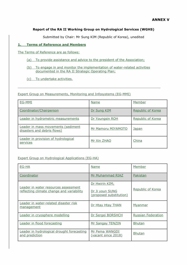
ANNEX V
Report of the RA II Working Group on Hydrological Services (WGHS)
Submitted by Chair: Mr Sung KIM (Republic of Korea), unedited
1. Terms of Reference and Members
The Terms of Reference are as follows:
(a) To provide assistance and advice to the president of the Association;
(b) To engage in and monitor the implementation of water-related activities documented in the RA II Strategic Operating Plan;
(c) To undertake activities.
Expert Group on Measurements, Monitoring and Infosystems (EG-MMI)
EG-MMI Name Member
Coordinator/Chairperson Dr Sung KIM Republic of Korea
Leader in hydrometric measurements Dr Youngsin ROH Republic of Korea
Leader in mass movements (sediment disasters and debris flows) Mr Mamoru MIYAMOTO Japan
Leader in provision of hydrological services Mr Xin ZHAO China
Expert Group on Hydrological Applications (EG-HA)
EG-HA Name Member
Coordinator Mr Muhammad RIAZ Pakistan
Leader in water resources assessment reflecting climate change and variability
Dr Hwirin KIM;
Dr Ji youn SUNG (proposed substitution)
Republic of Korea
Leader in water-related disaster risk management Dr Htay Htay THAN Myanmar
Leader in cryosphere modelling Dr Sergei BORSHCH Russian Federation
Leader in flood forecasting Mr Sangay TENZIN Bhutan
Leader in hydrological drought forecasting and prediction
Mr Pema WANGDI (vacant since 2018) Bhutan
The Leader in mass movements, Mr Mamoru Miyamoto, joined since 2019. The Leader in hydrological drought forecasting and prediction, Mr Pema Wangdi, quit the activities in 2018 and has been vacant. The Leader in water resources assessment reflecting climate change and variability, Dr Hwirin Kim, has been replaced by Dr Ji youn Sung in 2019.
2. Annual meetings
At the kind invitation of the Government of the Republic of Korea, the first WGHS meeting was held in Seoul, Republic of Korea, from 17 to 19 October 2017. The meeting was attended by eight members of the WGHS. The meeting was also attended by ten observers from the Republic of Korea, one staff of the WMO Secretariat.
To undertake activities, work plans for each of the Leaders were presented and discussed. Dr Sung Kim also presented on decisions and recommendations of RA II (Asia) as a result of its Sixteenth Session that was held in February 2017 of relevance to the RA II WGHS. Dr Sung Kim noted that there were three items represented in decisions of the session (RA II-16 Decision 5.4) on Dynamic Water resources Assessment Tool (DWAT), Guidelines for Verification of Hydrological Forecasts, and the software tool for implementing the index velocity methodology. Details of the presentations and work plans can be found in the meeting report (https://www.wmo.int/pages/prog/hwrp/RA2/RAII-WGHS-I-Seoul2017.php)
At the kind invitation of the Government of Bhutan, the second WGHS meeting was held in Thimphu, Bhutan from 26 to 28 November 2018. The meeting was attended by six members of the WGHS. The meeting was also attended by five observers from the Republic of Korea and eleven observers from Bhutan, and two staffs of the WMO Secretariat.
During the second meeting, the work plans of Members were reviewed and finalized. It should be noted that although Mr Xin Zhao, Leader in the provision of hydrological services, was not in attendance, his revised work plan was adjusted using email during the meeting. Details of the presentations and work plans can be found in the meeting report (https://www.wmo.int/pages/prog/hwrp/RA2/RAII-WGHS-Bhutan2018.php).
At the kind invitation of the Government of Russian Federation, the third WGHS meeting was held in Moscow, Russian Federation from 7 to 9 October 2019. The meeting was attended by six members of the WGHS. The meeting was also attended by six observers from the Republic of Korea, one observer from Kazakhstan, one private consultant from Canada, two observers from Russian Federation, and two staffs of the WMO Secretariat.
During the third meeting, the work plans of Members were reviewed and updated. The work plans of the absentees (Mr Riaz and Mr Tenzin) have not been updated. Details of the presentations and work plans can be found in the meeting report attached with this report.
The fourth WGHS meeting was tentatively set in the week of 5 to 9 October 2020 (including the back-to-back workshops) in Nay Pyi Taw, Myanmar. However, the meeting was postponed and cancelled because of spreading of COV-19.
3. Workshops
To facilitate global application of Dynamic Water Resources Assessment Tool, which has been developed since 2013 through collaborated activities of RA II WGHS and Commission for Hydrology, global workshops have been held.
At the kind invitation of the Government of Bhutan, and with the financial contribution of the Republic of Korea, the 1st Global Workshop on the Dynamic Water resources Assessment Tool (DWAT) was held in Thimphu, Bhutan from 26 to 28 November 2018.
During the 1st DWAT Workshop, assessment of the DWAT results was performed by the six regional experts from five regions. The objective of this session was to have them share their opinions, critically and objectively, about DWAT, their experiences gained through its application, and its potential usefulness. Details of the workshop can be found in the first

DWAT workshop report (https://www.floodmanagement.info/wp-content/uploads/6-Final_Report_1st_DWAT_workshop.pdf)
At the kind invitation of the Ministry of Environment, Republic of Korea, and with the financial support of the Republic of Korea, the 2nd Global Workshop on the Dynamic Water resources Assessment Tool (DWAT) was held in Seoul, Republic of Korea, from 7 to 9 May 2019.
Prior to the 2nd DWAT Workshop, the experts were provided the DWAT software. The DWAT User’s Manual v1.1 was distributed at the opening of the workshop. The objective was to have the experts test the modified DWAT on their local basins, as well as also assessing model performance by comparing output with observed data. This would also allow an opportunity for experts to assess modifications that had been made to the software since the 1st Global Workshop. Details of the workshop can be found in the report (https://ane4bf-datap1.s3-eu-west-1.amazonaws.com/wmocms/s3fs-public/ckeditor/files/Report_2nd_DWAT_workshop_final.pdf?SS3MO_7q0NuKim1bwzOI4RtNQlGe3lT7). The program and manual can be downloaded from the DWAT website (https://public.wmo.int/en/water/dynamic-water-resources-assessment-tool).
The 3rd DWAT Workshop was originally planned in 2020 in Myanmar and rescheduled in consideration of COV-19 spreading. The 3rd DWAT Workshop has been planned as a three-day workshop in April, May and June in 2021, three times through internet. About thirty experts are participating globally.
4. Results of activities
4.1 Chairperson and Coordinator Expert Group on Measurements, Monitoring and Infosystems (EG-MMI)
Dr Sung KIM, as the Chairperson and Coordinator EG-MMI, held annual WGHS meetings and established work plans, reviewed and updated with Members. He attended the RA II Chairs Meetings and reported WGHS activities in 2017, 2018, and 2019. He also reviewed and adjusted the RA II Operating Plan 2016-2019 to match with the work plan. Dr Kim managed to introduce a new priority area (i.e. priority area 3 – Strengthening hydrological services).
As the RA II Regional Hydrological Advisor, Dr Sung Kim has attended WMO EC Meetings to assist the RA II president. He also has attended WMO hydrological meetings to represent RA II such as Global Conference on “Prosperity through Hydrological Services”, Geneva, 7-9 May 2018, the Technical Conference “Future Hydrological Priorities and Arrangements”, 11-13 February 2019, Geneva, and CHy Extraordinary session, 13-14 February 2019, Geneva. He participated the discussions on the grand water challenges for WMO and ways to integrate hydrological and water management activities in the proposed new WMO structure.
Dr Sung Kim was also invited to attend the WMO Hydrological Assembly to facilitate global application of Dynamic Water Resources Assessment Tool, which has been developed since 2013 through collaborated activities of RA II WGHS and Commission for Hydrology, global workshops have been held.
4.2 Hydrometric measurements
The conducted activities for the period (2017~2020) are (1) the provision of guidelines for the application of real-time measurement systems (focused on IVM and IRDIMS) and the development of new measuring techniques. The guidelines for measurement systems such as IRDIMS are being written in English, including installing, operating of the system, and user guide of software tools (EDPad and MCDPad) for data process.
In developing new measuring techniques to be applied to the IRDIMS, a testbed for applicability analysis on new measuring techniques was constructed and operated. To develop a measuring technique for the use of surface velocity as a real-time measurement system, SIV (Surface Image Velocimetry) and radar surface velocimetry were applied to measure discharge

in the test bed. A technical report on the test bed results was completed in Korean and it will be translated in English.
Secondly, for (2) improvement of sediment measuring technique, the method to estimate the concentration of suspended sediment (SSC) using a signal intensity of H-ADCP was applied to 5 IRDIMS stations. The method uses the relationship between Acoustic Back Scatters (ABS) data from the signal intensity of H-ADCP with SSC, and in this activity we developed software to estimate the relation of SSC and ABS.
Lastly, in the activity for (3) improvement and development of systematic procedure for the use of rating curves, there are two sub-activities, providing specific guidelines for developing rating curves and developing of software tools. The guidelines were for all procedures on developing rating curves, including methods of discharge measurements and instruments and QC with various case studies introduced and shared in Korean and it will be translated in English.
4.3 Mass Movements (sediment disasters and debris flow)
To enhance the understanding of sediment disaster risk in Asia, historical damage due to landslides and debris flows has been investigated mainly using EM-DAT aggregated on a country-by-country basis. Meanwhile, past affected cases related to sediment disasters resulting from mass movements in some Members are being collected and accumulated through the network of UNESCO-IHP RSC. The expert will analyze these and will compile in a technical report potential lessons learnt in management of sediment disasters in Asia. The report will also include a case study from Japan on its sediment disaster management activities including infrastructure development (structural measures to prevent losses), monitoring, hazard and risk mapping, early warning, and legislation. The report will as well include a case study from Indonesia on the timely evacuation of citizens from a debris flood caused by the overtopping and collapse of a landslide-formed dam on Ambon Island.
Generally, shallow landslides due to heavy rainfall are governed by the surface topography and physical and hydrological parameters of the surface soil layer. However, the spatial distribution of those parameters is non-homogeneous, which makes landslide and debris-flow forecasting extremely complicated. A method for identifying a critical rainfall condition that will possibly lead to the occurrence of landslides and debris flows has been developed. It uses records of past disasters and numerical simulations, as a tool to assess and predict the potential sediment disaster risk. The method characterizes a relationship between rainfall intensity and cumulative rainfall together with the curves of a certain number of shallow landslide meshes according to combination of historical landslide data and numerical simulation results. The critical levels of the curves to establish the potential of landslide occurrence can be estimated using past disaster records. Finally, the method will compare the snake lines of historical rainfall events (accumulated rainfall versus rainfall intensity) with those critical rainfall conditions that led to sediment disasters.
A technical report will be prepared that outlines for practical use how to apply this technique, including the necessary input data and simulation procedures to establish landslides and debris flow risk. Examples will be provided as part of the report. Thus far, past damage data have been collected and analysed based on the Emergency Events Database (EM-DAT). A report is being drafted and will be available. As well, an initial effort has been undertaken to develop simulation models on sediment disasters (including occurrence of landslides, run-out processes and flood flow). A report documenting this assessment methodology will be prepared.
4.4 Provision of Hydrological Services
In order to promote knowledge and understanding on their hydrological services, it is quite important to compare their similarities and differences with respect to their system, theory, practices and procedures on hydrological measurements, management system, information provision and hydrological services among typical WMO Members (such as developed vs.
developing, western vs. eastern, big vs. small), especially those in RA II (Asia) under the framework of Working Group on Hydrological Services (WGHS).
In 2018, a pilot program of comparative study -“Comparative study in hydrological measurement, management and information provision and hydrological services between the Republic of Korea and China”has been conducted to promote knowledge and understanding of the system, theory, practices and procedures between the Republic of Korea and China on their hydrological measurements, management system, information provision and hydrological services.
The following actions are expected to be completed in 2019 and 2020:
(1) Collecting from Members within WMO RA II (Asia) related materials and information on: systems, theories, practices and procedures on hydrological measurements; data management system; information provision; and the provision of hydrological services in 2019;
(2) Complete the comparative studies on: systems, theories, practices and procedures on hydrological measurements; data management system; information provision; and the provision of hydrological services among RA II (Asia) Members. Numbers of Members depends on the status of data collection) by 2020;
(3) Complete comparative studies on: systems, theories, practices and procedures on hydrological measurements; data management system; information provision; and the provision of hydrological services among RA II (Asia) Members and some developed Members (such as U.S.A., etc.) by 2020.
4.5 Coordinator Expert Group on Hydrological Applications
The work plan has been developed in 2017, and since then no activities has been reported.
4.6 Water Resources Assessment
The deliverable 'Improvement of water resources assessment techniques to assist decision making in water resources management' includes two activities, namely: (1) develop water resources assessment techniques (the Dynamic Water resources Assessment Tool - DWAT) and (2) provide guidance materials for DWAT.
The DWAT version 1.0 has been developed in 2018. This is an upgrade of the beta version developed in December 2017, reflecting some of the opinions of the Members. The DWAT version 1.0 includes development of a snowmelt function, pre-processed GIS, paddy representation, and a calibration function. The snowmelt function was strongly requested by the RA II vice-chair during RA II-16 for inclusion in future DWAT functionality.
The DWAT version 1.1 has been developed in 2019, reflecting Hargreaves eq. for potential evapotranspiration. As many Members may not have climate data such as solar radiation, humidity, wind speed and etc. to calculate potential evapotranspiration, an alternative approach was needed. Hargreaves method was included as it can be used to calculate potential evapotranspiration using only temperature data.
The deliverable 'Globally implemented DWAT to assist decision making in water resources management' includes: (1) a request to CHy to review and test DWAT; (2) the implementation of DWAT in select RA I, II, III, IV, V, VI basins; (3) the development of training material to allow broad implementation of DWAT; and (4) the organization of one small global DWAT workshop for members of RA II WGHS including CHy Advisory Working Group (AWG).

As per the request of RA II-16, the DWAT has been peer-reviewed by a panel of experts nominated by WMO Commission for Hydrology. The three panel members, who were from different WMO regions, have applied the model to their basins, which reflect different hydrological, geophysical and climatic conditions. The panel members participated in two Global workshops to discuss improvements and formulate recommendations.
The first and second Global DWAT Workshops were organized in 2018, 2019 by the kind invitations of Government of Bhutan and Russian Federation, respectively, and the third Workshop through the internet in 2021 with the financial supports by the Han River Flood Control Office (HRFCO) of the Ministry of Environment and KICT, Republic of Korea, and WMO. The intent of the Workshops was to make DWAT more widely known and to allow its use by a small group of experts from different Members. Experts from each WMO Region and a selection of the CHy AWG were invited to participate in the event. Participants were requested to apply the model with their own data and to provide the data and their results to the model developers in advance of the workshop.
The DWAT International Symposium was held in Republic of Korea on 10 May 2019. Through this symposium, DWAT has been more widely applied and tested with practical applications undertaken in WMO Members such as Uganda, Bhutan, Argentina, Jamaica, New Zealand and Russian Federation. DWAT is available through the WMO website (https://public.wmo.int/en/water/dynamic-water-resources-assessment-tool). The WMO website includes information on DWAT functionalities and products, and users can download the DWAT software, its user manual, other training materials and case studies originating from the 1st and 2nd Global DWAT Workshops.
4.7 Water-related Disaster Risk Management
This work plan is being developed for Water-related Disaster Risk Management in order to improve National and Regional Flood Forecasting and Warning capabilities for disaster risk management. The key objective of the work plan is to move from flood forecasts and warnings to an impact-based flood forecast and warning service. The work plan deliverables consists of: (a) enhancement of use of national and regional hydrological forecasting for water-related disaster management (Hydrological extremes of floods); and (b) the improvement of the availability of risk-based information upon which to base risk-based riverine flood forecasting and flood management activities.
The training workshop on Synergized Standard Operating Procedures (SSOPs) for Coastal Multi Hazards Early Warning System was held in 2018. During the workshop, consideration was given to updating SSOPs and providing guidance for improving policy and institutional arrangements at national, districts, and community levels.
The project on Building Disaster Monitoring and Early Warning Capacity has been implemented within the Government of Myanmar by leveraging the ASEAN Coordinating Centre for Humanitarian Assistance on Disaster Management- AHA Centre’s DMRS System. The goals of the project were to improve risk assessment, provision of early-warning, and disaster management decision making outcomes by enhancing capacity within Myanmar’s disaster management community. The web page for the Disaster Management and Response System (DMRS) is https://dmrs.ahacentre.org/dmrs/.
The Department of Meteorology and Hydrology of Myanmar has developed flood hazard maps for the cities of Bago, Kalay and Mawlaik. These flood hazard maps were distributed to water disaster related organizations and disaster management committee.
4.8 Cryosphere Modelling
The background material, documents and investigations about the modelling of snow cover formation and melting were gathered. It was shown that water that accumulates in snow cover constitute a significant part of runoff in many flat and mountain regions of Asia. There are

numerous experimental and theoretical studies devoted to the study of physical processes related to the thickness of snow.
The literature on ice cover formation and melt was collected, studied and analyzed. The experience of Russian and international researchers has shown that hydrologists are currently calculating and predicting various characteristics of the ice regime of rivers, lakes and reservoirs such as thickness, ice strength, freezing and open water periods of rivers and reservoirs, etc. Calculations and short-term forecasts of the characteristics of the river ice are based on an approximate solution of the system of equations of heat and water balance, movement and continuity.
The characteristics of the soil when initially being frozen determines the amount of melt water that can infiltrate the frozen soil. In fact, the ability to infiltrate frozen soil depends on the number of ice crystals per unit volume of soil. However, this characteristic cannot be measured. Therefore, in the calculations and forecasts of spring river discharge, the depth of freezing of the soil and soil moisture are used as an indicator of the magnitude of losses of melt runoff.
The preparation of the report entitled “The influence of cryosphere processes on the formation of river discharge and groundwater levels in Asia” has begun.
4.9 Flood Forecasting
A number of National Meteorological and Hydrological Services already have experiences in developing and applying recommended practices in flood forecasting. Such services engage both hydrologists and meteorologists in the process. There is also sharing of meteorological and hydrological data and model outputs. However, many flood forecasting systems have separate hydrological and meteorological models, and there is a need to couple the numerical weather forecasts both temporally and spatially to meet the needs of hydrological models that are producing the flood forecasts. Thus, having a recommendation on use of numerical weather forecast and documenting the approaches to ascertain the deterministic error of ensemble outputs of numerical weather prediction will be helpful.
The Flash Flood Guidance System (FFGS) has been developed by the Hydrologic Research Center in San Diego (USA), and it is being implemented with the assistance of the USAID/OFDA, NOAA NWS and WMO. The System is now being used by several Members. The SAsiaFFG application is underway. It would be beneficial to prepare, document and disseminate verification results for the SAsiaFFG System with assistance of some of the participating Members’ experts. As well, as part of this effort, feedback on use of systems by forecasters will be obtained.
4.10 Hydrological Drought Forecasting and Prediction
The work plan is being developed for the hydrological drought forecasting and prediction in order to improve National and Regional Drought Forecasting and Prediction capabilities for disaster risk management. The very objective of the deliverable is to provide runoff outlooks every 3 months using 10-day time steps for all the key basins in Bhutan and providing them to major water users.
No update to the work plan since 2018 because of the leader vacancy.
5. Recommendations
In order to achieve the planned results during the period, the composition of the members is of paramount importance. Next time, it is necessary to recommend a member with expertise and responsibility through the Hydrological Adviser of each Member.
Since Dynamic Water resources Assessment Tool (DWAT) developed through RA II WGHS activities is currently being successfully distributed globally through the WMO Homepage, continuous interest and support are required at the level of RA II.

As flood, drought, and transboundary water management problems in RA II are the most serious among all RAs, to strengthen hydrological activities in future RA II programs is strongly recommended. [RHA]

ANNEX VI
Annex VI.1
Progress Report on Pilot Project to Develop Support for National Meteorological and Hydrological Services in Numerical Weather Prediction
Republic of Korea; Hong Kong, China, unedited
1. Objectives
Assist Members in accessing, developing and using NWP. Sharing of experience and expertise in NWP product development, modelling and data assimilation. Support on post-processing of NWP products including ensemble prediction system.
2. Activities since 2017
An online NWP workshop under WMO VCP was organised on 8-11 December 2020 on NWP Model Product Development for High Impact Weather Forecasting. Lectured in the SWFP-SeA online training workshop on Severe Weather and Impact Based Forecasting and Warning Services on 1-12 February 2021. Continued to maintain and further develop the web portal of the “Asian Consortium for NWP Forecast” (ACNF) through the provision of:
(a) Real-time NWP prognostic charts from Hong Kong, China; Republic of Korea; Japan and China;
(b) Links to real-time NWP product data from DWD, NCEP in addition to the
countries/regionsMembers in (a) above; (c) Source code and documentation of the community NWP models contributed by
China and Japan; (d) Training materials of workshops, including video recordings; and (e) Sample computer programmes and computation environments.
3. Work in progress
(a) An enhanced web page showing NWP model prognostic charts from different NWP centres was being developed in support of SWFP-SeA project. The web page will have a common look and feel for all the forecast elements including their combinations, drawing style and colour scheme for easier comparison by users; and
(b) Source code of the web tool above was being made available for free to NMHS on
request under WMO CBS software registry. More NWP tools and/or sample scripts would be released in future in a coordinated fashion.
4. ACNF web portal
https://acnf.weather.gov.hk
Annex VI.2
Progress Report on Pilot Project to Sustain and Enhance the Capacity of National Meteorological and Hydrological Services (NMHSs) in the Provision of Official
Medium-Range Weather Forecasts
Hong Kong, China; Republic of Korea, unedited
1. Objectives
To assist NHMSs in RA II in enhancing their provision of weather forecasts in the medium range through identifying reliable sources of NWP products, exploring means to post-process NWP products, verify and validate NWP products, and to share experience in the post-processing, verification and validation of NWP products, especially with developing Members.
2. Activities since 2017
Global NWP model and EPS products of Korea Meteorological Administration (KMA) have been made available on a dedicated website: http://www.kma.go.kr/ema/nema03/rall/index.jsp for supporting medium range weather forecast in RA II Members. Provision of NWP products for NMHSs in RA II was enhanced that over 300 cities of more than 20 Asian countries are being supported. Training activities have been organized by KMA and Hong Kong Observatory (HKO) for forecasters and system developers from RA II Members or overseas meteorological services:
(a) KMA hosted several training workshops on various topics including NWP modelling, use and interpretation of NWP products, post-processing techniques and verification of NWP products. A training course on quality control techniques and data assimilation for NWP has been conducted for experts from the Philippines (PAGASA) on observation data quality control, satellite and radar data assimilation, data assimilation method (variational and ensemble), and post-processing with NWP data.
(b) HKO conducted a couple of training workshops under WMO VCP on using NWP and
EPS products, post-processing techniques and guidance in support of short-range to medium-range prediction of high-impact weather. HKO has also participated in several WMO SWFP Training Workshops and Training Desks in 2018-2020 to deliver lectures on use and interpretation, as well as verification techniques of NWP and EPS products in forecasting significant convective or high-impact weather processes from very-short-range to days ahead.
HKO continued to develop post-processing techniques for providing automatic city-specific medium-range weather forecasts. Trial forecast products for selected cities in East Asia are made available on HKO’s Earth Weather website (https://maps.weather.gov.hk/wxviewer/index.html). The automatic forecasts include time series of temperature, relative humidity, state-of-sky, wind speed and direction that are generated from a consensus of post-processed products of several global NWP models.

3. Work in progress
Automatic forecasts for other cities in RA II Members and their verification are underway that they could be made available for trial and sharing later in support of Members’ provision of official weather forecasts for medium range and further developments.
Training workshops on the application of NWP models and post-processing methods in medium range weather forecasts and/or high-impact weather forecasts would be organized, subject to available resources. Training resources on NWP applications and post-processing techniques would be made available on a web-based forum to facilitate knowledge and experience sharing.

Annex VI.3
Progress Report on Project to Develop Support for National Meteorological and Hydrological Services in the Collection and Application of Aircraft Meteorological
Data Relay (AMDAR) Data
1. To continue the pilot project to develop support for NMHSs in the collection and application of AMDAR data with the following terms of reference
National Meteorological Information Center (NMIC) of China Meteorological Administration is responsible for data collection, distribution, processing, storage and sharing services. At present, the AMDAR data received by the National Meteorological Information Center in real time include the Global Telecommunication System (GTS) and Inter ministerial exchange system. The received data format includes TAC and BUFR. In the past, China AMDAR data shared by CMA through GTS was in the format of TAC. Since March 31, 2021, the format of AMDAR data provided by CMA to GTS has been switched from TAC to BUFR, realizing the improvement of data accuracy.
Through the big data cloud platform "Tianqing" 1.0, the National Meteorological Information Center provides the global AMDAR data sharing service of "cloud + end" mode, and the number of visits per day has reached 1000-2500. [China]

Annex VI.4
Progress Report on Pilot Project to Enhance Meteorological Disaster Risk Reduction Capability in RA II
1. To develop an effective work plan, taking into account the relevant existing activities in RA II
On March 15, 2017, experts from the Public Meteorological Service Center (PMSC) of CMA and HKO participated in the first meeting of the Advisory Group and Technical Team meeting on the implementation of the WMO Global Meteo-Alarm System (GMAS). In the meeting, a consensus was reached with a recommendation of launching the GMAS-A construction plan as soon as possible.
On 21April 2017, CMA held a special video seminar on GMAS-A development. It was determined that a special working group composing of members from PMSC and other organizations in CMA such as the National Meteorological Center, National Meteorological Information Center, etc. would be established to be responsible for connecting the National Early Warning Release System (NEWRES) with the GMAS-A. All parties clarified the lead organization and leader of the coordination group, established a technical working group, and set phased goals as well as specific implementation plans.
CMA and HKO then established a special working group and organized several video conferences to conduct in-depth exchanges, communications and discussions on GMAS-A platform prototypes, basic functions, geographic data, docking methods, protocol formats and release strategies, etc. As a result, technical solutions such as early warning selectors and display strategies were clarified. In addition, it was proposed to first engage countries in Southeast Asia with a view to speeding up the development of CAP warnings by Members for inclusion in GMAS-A.
2. To establish a regional meteo-alarm system, based on the implementation of CAP and the experience of the Hong Kong Observatory (HKO) in hosting the WWIS and SWIC websites of WMO
Leveraging CMA’s advantages in integrating resources to promote the GMAS-A project jointly undertaken with HKO, and also HKO’s experience in hosting the WWIS and SWIC, the GMAS-A displays warning information in standardized format issued by RA II Members on a platform in both local and English languages by using CMA’s technology in developing the NEWRES and adopting the CAP standard.
In 2018, a consensus was reached in the GMAS Expert Group meeting with a suggestion of promoting the integration of GMAS-A and the construction of the World Meteorological Centre (WMC), Beijing.
In September 2018, a website for GMAS-A (https://gmas.asia) developed and hosted by HKO was launched in the 2nd China-ASEAN Meteorological Cooperation Forum. The website for GMAS-A consists of a public facing component (extranet) and a restricted portal. The extranet is built with a GIS map to display warnings issued by RA II Members in CAP format. An alert hub was also set up in the backend to aggregate CAP warnings disseminated by WMO Members. The map on the website for GMAS-A was also enhanced with tropical cyclone advisories and warnings from RSMCs and NMCs of the region in 2019. In the restricted portal which is for exclusive use by WMO Members, model, satellite and advisory products provided by WMC, Beijing to facilitate warning and forecast preparations are also updated regularly. A chatroom function is also made available in the restricted portal to allow member-users to coordinate on trans-boundary weather events with significant impacts and other operational topics that may be of common interest.
3. To promote experience sharing among NMHSs in RA II in disaster risk reduction
through forums, workshops and training and other relevant activities
In November 2017, the Working Group introduced and promoted the idea of constructing GMAS-A in the China-ASEAN Meteorological Disaster Prevention Symposium with positive responses received from the delegates. Meanwhile, a questionnaire to survey on the existing status of early warning release by RA II Members and the need on sharing meteorological risk advisory products were jointly issued by CMA and HKO with a view to collecting requirements as the basis for constructing the system. At the same time, the development of an English publishing framework system was organized by CMA.
In September 2018, the Working Group introduced the progress of GMAS-A construction and provided credentials for participating Members to access the restricted portal of the website for GMAS-A at the 2nd China-ASEAN Meteorological Cooperation Forum. The restricted portal was accessed regularly by certain Member.
In November 2019, a workshop on GMAS-A was jointly held by CMA, WMO, HKO, Thailand Meteorological Department, and Department of Meteorology and Hydrology of Myanmar in Haikou, China. After discussing the decision of the 18th World Meteorological Congress on the Global Multi-Hazard Alert System (GMAS), the meeting arrived at a consensus on the construction of GMAS-A. Recommendations were also made in the meeting. In addition, the meeting discussed the docking of multi-hazard early warning information with GMAS-A in various Members and formed a construction plan as well as a long-term contact and cooperation model.
4. To organize training courses on subjects related to this pilot project
In the past few years PMSC of CMA continued to organize experts and working group members from CMA and HKO to conduct discussions in various project phases through on-site meetings, video conferences and WeChat working groups to facilitate the development of the pilot project smoothly and orderly. Besides, CMA and HKO experts visited Geneva several times to participate in WMO-GMAS Expert Group meetings.
On 12 September 2018, PMSC of CMA made a detailed report on the progress of GMAS-A construction, technical solutions for system docking as well as product development and construction, etc. at the Technical Exchange Meeting in China-ASEAN Meteorological Cooperation Forum held in Nanning, China. A GMAS-A promotional video was also planned and produced. CMA and Ministry of Natural Resources and Environment of Viet Nam reached a consensus that two will deepen exchanges and cooperation on GMAS-A construction and other fields at the twelfth meeting of the China-Viet Nam Meteorological Technology Cooperation Joint Working Group held at the same time.
Amid the difficult situation in 2020, visit and online training were arranged to assist interested Members to install and try out the multilingual early warning release system.
5. To provide the assistance to relevant members in RA II to improve their operational capability in meteorological disaster risk reduction
In 2018, PMSC of CMA focused on building a multilingual Asian regional early warning release system. At present, the English version of the system has been developed. The release process of early warning information and the opening of four information dissemination channels including websites, WeChat, Weibo, FTP, etc. are realized. In addition, one-click multi-channel release of early warning can also be realized. In July 2019, PMSC of CMA visited Hanoi for system installations and trials.
In November 2019, the GMAS-A Project Working Group introduced the construction and operation of GMAS-A and NEWRES to the participants at the Asian regional disaster early

warning capacity improvement seminar; experts from the WMC, Beijing introduced advisory products available on GMAS-A restricted website; experts from the United States of America introduced the use of the CAP; experts from Thailand, Myanmar, Indonesia, Philippines, Viet Nam and other Members, exchanged views on construction of their early warning systems, release of early warnings, as well as intentions to participate in the GMAS-A. After the meeting, delegates of each participating Member reached a consensus on advancing the future development of GMAS-A.
In the meeting, CMA Deputy Administrator Yu Yong issued a trial certificate of multilingual early warning information release system to participants from 12 Members (Thailand, Myanmar, Viet Nam, Philippines, Japan, Republic of Korea, Mongolia, Indonesia, Sri Lanka, Kazakhstan, Uzbekistan, and Tanzania). The system was also demonstrated and show-cased in the meeting. As a result, the system application result was affirmed.
In January 2020, PMSC of CMA delegation visited the Department of Hydrology and Meteorology (DHM) of Nepal, reaching a consensus that they would first deploy and use the multilingual early warning release system on a trial basis, and agreed to provide the CAP alerts prepared by the early warning release system to GMAS-A. Since May 2020, communication and discussion meetings with the contact person of DHM were made mostly through emails and video conferences. In addition, the English version of the user operation manual of the system was compiled for Nepal for system operation and trial use.
In June 2020, the president of WMO RA II affirmed the achievements of GMAS-A and sent a letter to urge all Members of RA II to increase participation by taking a number of further actions. In August, Thailand joined the GMAS-A Working Group and assigned a contact person to jointly promote the construction of GMAS-A.
6. To monitor the progress of the project and assess the effectiveness of the project
Up to April 2021, construction of the GMAS-A framework has been basically completed. Real-time warning information issued by 11 RA II Members including Afghanistan; China; Hong Kong, China; India; Kuwait; Macao, China; Mongolia; Myanmar; Oman; Russian Federation and Thailand in CAP format can be displayed on the GMAS-A extranet for access by the general public. CAP alerts are also aggregated in the Alert Hub in the backend of the system. As a result, visitors can obtain real-time warnings of the above-mentioned regions. In addition, Members can also view the forecast and monitoring service products of the WMC-Beijing through the restricted portal of the website for GMAS-A.[China]
Annex VI.5
Progress Report on Pilot Project on Impact-based Forecasting
Republic of Korea, unedited
The Korea Meteorological Administration (KMA) officially launched heatwave impact-based forecasting (IBF) service from June to September 2019 in order to support effective reduction of heatwave impacts. The KMA provided risk levels in different colours (attention-green, caution-yellow, warning-orange, danger-red), impact information and response tips for seven sectors (health, industry, livestock, aquaculture, agriculture, transportation and electric power) once a day at 11:30 a.m., considering the regional characteristics. This information was disseminated to the public on the KMA's website (PC, mobile web). It was also provided to disaster response related agencies through the Meteorological Information Portal Service System for Disaster Prevention, as well as to local governments’ disaster response managers and officials managing the socially vulnerable people through mobile text messages (SMS). In particular, both the desktop and mobile websites offered the impact information by city, county and district. The information was also reported by media channels, such as TV news broadcasts, online weather broadcasts, and newspapers.
In addition, the KMA held talks with related ministries in advance so that the information can be linked to the government's heatwave response system. As a result, the provision of heatwave IBF service was included in the standard manual and the working-level manual for heatwave risk management. The Ministry of Health and Welfare provided text services to the officials in charge of assisting the disadvantaged classes. Moreover, the Ministry of Employment and Labour gave managers of workplaces the heatwave IBF information to prevent workers from getting heat-related illnesses. Local government officials in charge of disaster prevention and managers of the vulnerable groups utilized the information for heatwave response in the field. In particular, the Government of the Korean capital, the Seoul Metropolitan Government, said there were no heatwave-related accidents involving workers this summer by taking advantage of the heatwave IBF for industry.
_________
1. Introduction
1.1 At the kind invitation of the Government of Russian Federation, the meeting of the Working Group on Hydrological Services (WGHS) of the World Meteorological Organization (WMO) Regional Association II (RA II – Asia) was held in Moscow, Russian Federation from 7 to 9 October 2019.
1.2 The meeting was opened at 9:00 on Monday 7 October 2019 at the Izmailovo Delta Hotel, Smolensk three meeting room.
1.3 Dr Roman Vilfand, Scientific Director of Hydrometeorological Centre of Russia (RosHydromet, Russian Federation), welcomed participants to Moscow on behalf of the Acting Chief of RosHydromet. RosHydromet is a joint service, where meteorology and hydrology are interrelated. He noted that meteorologists are using more unified models, whereas hydrologist have a more holistic approach based on basin characteristics. Hence, dialogue is of the utmost importance between the two communities. Despite the cold weather, he wished a warm working environment for the meeting, and hoped the participants will enjoy the visit to RosHydromet headquarters and other visits included in the cultural programme organized on the side of the meeting.
1.4 Mr Nansoo Kim, from Ministry of Environment, Republic of Korea, welcomed participants on behalf of the Minister of Environment (ME), Republic of Korea. Flood and drought issues, in addition to water resources management, remain high on the agenda of ME Republic of Korea. He reminded the Working Group (WG) of the close cooperation that exists between ME and WMO in providing technical assistance and sharing information with particular focus on RA II.
1.5 Dr Hwirin Kim, WMO Secretariat, thanked RosHydromet, for hosting the 2019 meeting of the RA II WGHS, and the Government of Republic of Korea for its continuous support and efforts in advancing the work plan of the RA II WGHS. Dr Kim reminded the meeting that the RA II WGHS is very active in various themes related to hydrology. In the new WMO Constituent Bodies Reform, RAs are required to play major roles in the advancement of the hydrological agenda. As such, RA II WGHS already represents a valid example of leading the hydrological agenda. Dr Kim also welcomed Dr Mamoru Miyamoto from Japan as new member of the Working Group, and the participation as observer of Ms Damira Sabenova from Kazakhstan. Finally, Dr Kim welcomed everyone to the meeting on behalf of the Secretary-General of WMO, Prof. Petteri Taalas.
1.6 Dr Sung Kim, Chair of the RA II WGHS, welcomed all participants and thanked them for their efforts and in joining the meeting.
2. Adoption of the agenda and organization of work
2.1 The meeting was attended by six members of the WGHS, which were from four countries of RA II. Four members of the WGHS sent their apologies for not being able to attend the meeting. The meeting was also attended by six observers from the Republic of Korea, one representative from Kazakhstan, one invited expert from Canada, one WMO Commission for Hydrology (CHy) Advisory Working Group (AWG) Member and two staff of the WMO Secretariat.
2.2 The list of participants is given in Annex V.1 of this report. Mr Giacomo Teruggi acted as Secretary for the meeting and Dr Sung Kim, Visiting Senior Research Fellow, Korea Institute of Civil Engineering and Building Technology (KICT), chaired the meeting of the RA II WGHS.
2.3 Dr Sung Kim briefly described the agenda, and the RA II WGHS discussed it and
adopted it with minor revisions. The agenda is provided in Annex V.2.
3. Presentations
3.1 The Chair, Dr Kim, presented the documents he circulated to participants shortly before the meeting, emphasizing the decisions and recommendations on hydrology of the 18th session of the World Meteorological Congress (Cg-18). Dr Kim also briefed the meeting on which thematic leader would provide updates over the next days on the latest advances on their work plan.
3.2 Dr Yuri Simonov presented on the activities of RosHydromet in the area of flood forecasting on the example of floods in the Lower and Middle Amur basin in July-September 2019. The Amur basin (shared between Russian Federation, China and Mongolia) experienced the largest flood on record in 2013, it was generated by snowmelt and monsoon-influenced extreme rainfall. Following that flood event, RosHydromet was requested to develop an End-to-End Early Warning System (E2E EWS) to forecast future conditions, which led to the creation of the decision support system platform “Geographical Information System Amur” (GIS Amur). Four numerical prediction models are used in the platform (three from Russia, one from Japan). The platform also offers the functionality to produce a daily inflow estimate to the reservoir in the basin, as well as a 1 to 5 day forecasts, helping reservoir and flood management. The structure of the GIS Amur (which took two years to develop) was also presented. Possibility of inclusion of the GIS Amur in the CHy Inventory of Platforms and Models for E2E EWS for floods was discussed. However, it has to be noted that the platform is not yet “user friendly” for third parties, hence more work would be needed to make it available.
3.3 Dr Ji Youn Sung provided a presentation outlining the hydrological activities in the Republic of Korea. Mainly dealing with Water Resources Management (WRP) for different usages and purposes, it combines monitoring of water resources with a survey on usage.
3.4 Dr Hwirin Kim presented on the WMO Constituent Bodies Reform, and its main implications for the hydrological community. The structure of WMO following the resolutions of Cg-18 was explained to the participants. Participants were also reminded about Annex 1 to Resolution 24 (Cg-18) containing the definition of Operational Hydrology; and Annex 2 (Res. 24 Cg-18), about the creation of a Hydrological Assembly as an open Committee of Congress, and its composition. Lastly, the eight ambitions for operational hydrology (endorsed by Resolution 25 (Cg-18)) were presented to the participants.
3.5 The Chair, Dr Sung Kim, started then a discussion on priority areas of RA II in 2020 to 2023, proposed at the RA II Working Group Chairs meeting held on 4-5 December 2018. During that meeting, Dr Kim managed to introduce a new priority area (i.e. priority area 3 – Strengthening hydrological services). He noted that there will be five priority areas. He further noted other areas were also linked to hydrology, namely: priority area 1 (Multi-hazard Early Warning Systems – MHEWS) should link with priority area 3 on flood forecasting, hydrological drought prediction and mass movements (landslides) components; priority area 4 should link with priority area 3 on data quality related to hydrology, as well as with priority area 2 on Global Framework for Climate Services (GFCS). Dr Sung Kim requested participants to provide input in order to improve the text of priority area 3, to be presented at the RA II Singapore meeting, scheduled on 29-31 October 2019. The WGHS felt it was important that the proposed thematic area on hydrology be in line with the eight ambitions of hydrology (referring to Resolution 25 (Cg-18)).
3.6 Hence, the RA II WGHS, noting the eight ambitions, proposed the following three thematic areas for priority area 3 on Strengthening hydrological services:
(a) Improve water-related disaster risk reduction at the urban, basin and country level
by identifying and implementing recommended practices and procedures for more accurate hydrological forecasting, including floods, droughts and mass movements, reflecting cryosphere processes, with sufficient lead time, especially for riverine and flash flood hazards, for better preparedness and response to extreme hydrological conditions making use of hydrometeorological observations and advances in numerical weather predictions (NWP), including climatological prediction, and hydrological process modelling.
(b) Support water resources management by implementing at the basin and country level water resources assessment practices and procedures, to support inter alia food security and sustainable development, to have clear and accurate indications of existing and future availability and quality of water resources for water planning and management purposes.
(c) Improve management of hydrometric networks and data collection practices at the basin and country level by developing and implementing recommended practices and procedures on hydrometric operations including Quality Management Systems (QMS) and Quality Assurance and Control practices for hydrometric data to support water management decision-making.
3.7 A discussion on the future structure of the RA II Working Group on Hydrological Services was also held. All participants underlined the need to keep the existing RA II Working Group for Hydrological Services. The RA II WGHS has proved to be one of the most effective Regional Working Groups in relation to Hydrology, thanks also to the contribution of Republic of Korea, regularly covering costs for its annual meetings. However, should the Regional Working Groups be streamlined to more closely match with the structure of the new Constituent Bodies (e.g. the Commission for Observation, Infrastructure and Information Systems (INFCOM) and the Commission for Weather, Climate, Water and Related Environmental Services & Applications (SERCOM), Research Board), the need to have an independent Regional body discussing and working on hydrological issues for the benefit of RA II Members would have to be addressed. In this eventuality, a possible solution could be to embed into RA sessions a Regional Hydrological Assembly, attended by RA II Hydrological Advisers. Subsequent to the RA session and the Regional Hydrological Assembly, the creation of a Regional Hydrological Coordination Panel could ensure a cross-thematic coverage of hydrology among the different regional priority areas, and at the same time could act as the RA II voice to the Hydrological Coordination Panel. The RA II WGHS also emphasized the need to increase the liaison with Hydrological Advisers in RA II. In this regard, the planned workshop for Hydrological Advisers for West Asia region was strongly supported by the RA II WGHS, and it was felt that this concept should be expanded to include all RA II Members.
3.8 Dr Sung Kim also provided a presentation on progress made on his work plan, which is provided in chapter 4 of this report (please refer to the WMO website for his presentation). He gave particular attention to the two global workshops on the Dynamic Water resources Assessment Tool (DWAT), and to its official launch in Republic of Korea during an International Symposium. DWAT is now accessible to all WMO Members through the related WMO webpage.
3.9 Dr Eunjeung Shim presented on her attendance to the Mekong Water Data Expert meeting in Washington DC, United States (in April 2019) and to the WMO Country Support Initiative (CSI) meeting in Vienna, Austria (in September 2019). The first meeting focused on best practices about data sharing but did not include any mention of the WMO Hydrological Observing System (WHOS). Dr Shim presented on Republic of Korea experiences in technological solutions for data sharing. Political considerations related to data exchange were also raised at the meeting. Regarding the WMO CSI Workshop, Dr Shim briefed the participants on the outcomes of the Vienna meeting. The structure of CSI, the roles and responsibilities
of the CSI Secretariat, and the delivery process with partners were presented in Vienna. The Vienna meeting also discussed the contractual arrangement to engage partners under the CSI.
3.10 Dr Roh presented on the development of new measuring techniques in hydrometry. His presentation is provided on WMO website, and his progress report is under section 4.3. A lot of the work presented by Dr Roh should be reviewed by the appropriate WMO Constituent Body. As well, it was felt that integration of these advances (once reviewed) into the Meteorological, Climatological and Hydrological Database Management System (MCH) would benefit the broader hydrological community. Dr Roh shared at the meeting with WMO Secretariat the related report. Once WMO transition has been completed, the Secretariat will follow up to ensure proper review of the material by the appropriate Constituent Body. A demonstration of the CalPAD 2.1 was also given by Dr Shim and Mr Kisung Lee. It was proposed that a workshop on advances in hydrometry be held back-to-back with the next RA II WGHS meeting, in parallel to the DWAT Workshop (see paragraph 3.11 below).
3.11 Dr Mamoru Miyamoto presented on the progress made on the thematic area of Mass Movement. A draft report of the assessment method is planned to be available by end of 2020.
3.12 On behalf of Mr Xin Zhao, the Chair, Dr Sung Kim, presented the work plan advances on provision of hydrological services, mainly reflecting on a comparative study in hydrological measurement, management and services between China and the USA. The Chair of the WGHS suggested that he consider adjusting his work plan by focusing on the RA II comparative study of procedures used for making hydrological measurements, hydrological programme structure, data management procedures, and service delivery.
3.13 Dr Ji Youn Sung briefed the meeting on the advances in her work plan. The updates as well as the work plan are attached to this report. She also introduced efforts that have been undertaken on developing the DWAT, which provides a local basin water resources assessment for policy development and planning purposes. It was proposed that a workshop be held back-to-back with the next RA II WGHS meeting. The workshop would be designed to expand DWAT application to include Southeast Asian countries (Myanmar, potentially Thailand, Lao PDR, Cambodia and Vietnam).
3.14 Ms Htay Htay Than presented the advances in her workplan. Her report is available under section 4.8.4
3.15 Dr Borsch presented on the advances made on the Cryosphere modelling topic. The updated work plan is attached to the report, and a Power Point presentation was given to the RA II WGHS and is also available on WMO website.
3.16 Finally, a presentation by Ms Damira Sabenova introduced the activities of the National Hydrometeorological Service. Of Republic Kazakhstan (Kazhydromet) in flood forecasting. The Chair welcomed Ms Damira Sabenova to the meeting of the RA II WGHS.
3.17 No report was submitted on the theme of hydrological drought forecasting and prediction, as the position is vacant. No report was submitted on the theme of Flood Forecasting, as the Theme Leader could not attend the meeting. As well, the report of Mr Muhammad Riaz was not available.
4. Development of the work programme
4.1 The submitted work plans of members were reviewed and finalized during the meeting. It should be noted that although Mr Xin Zhao, Leader in the provision of hydrological services, was not in attendance, his revised work plan is contained
herein. It has been reviewed by the RA II WGHS. Furthermore, please note that the work plans of all appointed members appear in this chapter. The work plans of Mr Riaz and Mr Tenzin have not been updated. Each work plan is introduced by a related section that outlines the efforts that will be undertaken during the intersessional period and the completed section on the progress made, when made available by the responsible member. Please note as well that additional efforts are still needed to identify an expert to lead the thematic area of Drought Forecasting and Prediction. Once the individual has been appointed, his/her work plan will be more fully developed/updated and made available on the WMO website pertaining to this meeting.
4.2 Chair and Coordinator Expert Group on Measurements, Monitoring and Infosystems (EG-MMI)
4.2.1 Dr Sung KIM, as the Chair and Coordinator EG-MMI, established work plans with Members. He attended the RA II Chairs Meeting, 12-14 December 2017, Abu Dahbi, and reported WGHS activities with work plans. During the meeting, he reviewed and adjusted the RA II Operating Plan 2016-2019 to match with the work plan. By the end of 2017, he submitted the WGHS activity report to the RA II president.
4.2.2 With hosting by National Centre for Hydrology and Meteorology (NCHM), Royal Government of Bhutan and supporting by WMO, he hold the 2018 WGHS session, 26-28 November, Thimphu, Bhutan. Five theme leaders and 15 observers participated the session and reported their activities.
4.2.3 In addition, the 1st Global Workshop on DWAT (28-30 November, Thimphu, Bhutan) was held. Six experts from each of WMO regions were nominated by CHy and invited by WMO and Rep. of Korea. Five experts (except from RA I) reviewed/applied DWAT with their own country data before the workshop and discussed about results and usability during the workshop. They made recommendations to improve DWAT for possible global distribution, and the developers improved after the workshop.
4.2.4 The second Global Workshop and Global Launching on DWAT (7-9 May, Seoul) was held by the support of Rep. of Korea. Experts from WMO regions presented application results with their own country data and the WMO website for global distribution of DWAT was opened during the session.
4.2.5 As the RA II Regional Hydrological Adviser, in 2018, Dr Sung Kim attended WMO Global Conference on “Prosperity through Hydrological Services”, Geneva, 7-9 May 2018. During the Conference, he expressed that the efficient hydrological services is the key for sustainability of water resources and reduction of the risks posed by water-related disasters. He also attended the Seventieth Session of the Executive Council (EC-70), the RA II Management Group (MG) meeting and the Regional Hydrological Advisers’ meeting with the CHy president in Geneva, Switzerland, 20-29 June 2018. During the meeting, he has also assisted the RA II president and has collected information for preparation of the RA II hydrological activities. He also attended the second session of the CHy Advisory Working in Geneva, Switzerland, 8-12 October 2018. During the session, he expressed the difficulties of regional hydrological activities.
4.2.6 In 2019, Dr Sung Kim was invited to attend the Technical Conference “Future Hydrological Priorities and Arrangements”, 11-13 February 2019 in Geneva, Switzerland and CHy Extraordinary session, 13-14 February 2019 in Geneva, Switzerland. He participated the discussions on the grand water challenges for WMO and ways to integrate hydrological and water management activities in the proposed new WMO structure.
4.2.7 Dr Sung Kim was also invited to attend the WMO Hydrological Assembly, 6 to 8 June 2019 in Geneva, Switzerland and discussed with RA II participants to

nominate the new president and vice-president for the WMO Hydrological Assembly. After the discussion, no nomination was made from RA II. He also attended the WMO 18th Congress and participated discussion for the new structure for hydrological activities in WMO. In addition, He attended RA II MG Meeting and requested to nominate theme leaders to fill the vacant positions.
4.2.8 Dr Sung Kim also requested a collaboration with the United Nations Educational, Scientific and Cultural Organization (UNESCO)- International Hydrological Programme (IHP) for the WGHS’s survey of hydrological services in Asia during the Asia-Pacific (A-P) Regional Steering Council (RSC) Meeting, 3-5 November 2018, Shanghai, China. The participants recognized the needs of collaboration and agreed to distribute the survey forms to the IHP A-P Members. Mr Kim will receive the list of Chairs of IHP A-P Members from the IHP regional office in Jakarta, Malaysia and establish a new list by consideration of the list of RA II NHAs. The developed questionnaire for the National Meteorological and Hydrological Services (NMHSs) will be distributed by email and the results will be reviewed.
4.2.9 Mr Mamoru Miyamoto (ICHARM, Japan) was nominated and approved by the RA II president as the theme leader for mass movements (sediment disasters and debris flows) in April 2019. Mr Mamoru Miyamoto submitted his workplan in May 2019. As Dr Hwirin Kim (theme leader for water resources assessment and climate variability) moved to WMO Secretariat in August 2019, Dr Ji Youn Sung (HRFFC, Rep. of Korea) was nominated as the new theme leader in September 2019. Nomination process for the new theme leader for drought is underway.
4.2.10 The Expert Group on Measurements, Monitoring and Infosystems (EG-MMI) is comprised of four members including three thematic leads. The coordinator and thematic area of each member is listed below:
1. Coordinator EG-MMI 2. Leader for hydrometric measurements 3. Leader for mass movements (sediment disasters and debris flows) 4. Leader for the provision of hydrological services
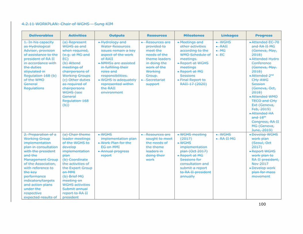
100
4.2.11 WORKPLAN: Chair of WGHS – Sung KIM
Deliverables Activities Outputs Resources Milestones Linkages Progress
1. In his capacity as Hydrological Adviser, provision of assistance to the president of RA II in accordance with the duties stipulated in Regulation 168 (b) of the WMO General Regulations
(a) Represent WGHS as and when required, (e.g. at MG and EC) (b) Attend meetings of chairpersons of Working Groups (c) Other duties as required of chairpersons WGHS (see General Regulation 168 (b))
• Hydrology and Water Resources issues remain a key aspect of the work of RAII
• NMHSs are assisted in fulfilling their roles and responsibilities.
• WGHS is adequately represented within the RAII environment
• Resources are provided to meet the needs of the theme leaders in doing the work of the Working Group.
• Secretariat support
• Meetings and other activities according to the WMO Schedule of meetings.
• Report at WGHS meetings
• Report at MG Sessions
• Final Report to RAII-17 (2020)
• WGHS • RAII • MG • EC
• Attended EC-70 and RA II MG (Geneva, May, 2018)
• Attended Hydro Conference (Geneva, May. 2018)
• Attended 2nd
CHy AWG Session (Geneva, Oct, 2018)
• Attended WMO TECO and CHy Ext (Geneva, Feb, 2019)
• Attended HA and 18th Congress, RA II MG (Geneva, June, 2019)
2. Preparation of a Working Group implementation plan in consultation with the president and the Management Group of the Association, with reference to the key performance indicators/targets and action plans under the respective expected results of
(a) Chair theme leader meetings of the WGHS to develop implementation plan (b) Coordinate the activities of the Expert Group on MMI (b) Brief MG meeting on WGHS activities Submit annual report to RA II president
• WGHS implementation plan
• Work Plan for the EG on MMI
• Annual progress report
• Resources are sought to meet the needs of the theme leaders in doing their work
• WGHS meeting (2017)
• WGHS implementation plan (Oct 2017)
• Report at MG Sessions for consultation and submit a report to RA II president annually
• WGHS • RA II MG
• Develop WGHS work plan (Seoul, Oct 2017)
• Report WGHS work plan to RA II president, Nov 2017
• Develop work plan for mass movement
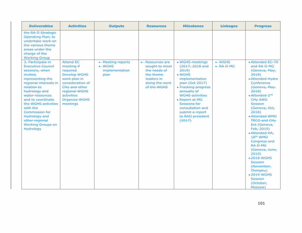
101
Deliverables Activities Outputs Resources Milestones Linkages Progress
the RA II Strategic Operating Plan, to undertake work on the various theme areas under the charge of the Working Group 3. Participate in Executive Council sessions, when invited, representing the regional interests in relation to hydrology and water resources and to coordinate the WGHS activities with the Commission for Hydrology and other regional Working Groups on Hydrology
Attend EC meeting if required Develop WGHS work plan in consideration of CHy and other regional WGHS activities Organize WGHS meetings
• Meeting reports • WGHS
implementation plan
• Resources are sought to meet the needs of the theme leaders in doing the work of the WGHS
• WGHS meetings (2017, 2018 and 2019)
• WGHS implementation plan (Oct 2017)
• Tracking progress annually of WGHS activities
• Report at MG Sessions for consultation and submit a report to RAII president (2017)
• WGHS • RA II MG
• Attended EC-70 and RA II MG (Geneva, May, 2018)
• Attended Hydro Conference (Geneva, May. 2018)
• Attended 2nd
CHy AWG Session (Geneva, Oct, 2018)
• Attended WMO TECO and CHy Ext (Geneva, Feb, 2019)
• Attended HA, 18th WMO Congress and RA II MG (Geneva, June, 2019)
• 2018 WGHS Session (November, Thimphu)
• 2019 WGHS Session (October, Moscow)

102
Deliverables Activities Outputs Resources Milestones Linkages Progress
4. Preparation and submitting to the president of the Association an annual report by 31 December every year and a final report in time for presentation to the sixteenth session of the Association, both copied to the WMO Secretariat
Develop WGHS activity report with input from Coordinator EG-HA and thematic leaders
• WGHS activity reports
• Resources are sought to meet the needs of the WGHS theme leaders
• Submit annual reports to RAII president and WMO Secretariat (Dec 2017, Dec 2018, Dec 2019)
• Submit final report to RA II president and WMO Secretariat (Dec 2020)
• WGHS • RAII MG • WMO
• Submit Annual Report (Dec 2017, 2018)
5. Promote long-term operation of hydrological observation stations suitable for climate change and variability studies
Encourage Members to maintain stations having long hydrological records for climate studies
• Letter to National Hydrological Advisers
• Recommendations on improvements to the RA II Survey regarding NHSs including hydrological stations
• RA II Survey Report on obs.
• List of RA II National Hydrological Advisers
• Report to RA II president (2018)
• WGHS • RA II • WMO
• Requested List of NHAs and received (Dec 2017)
• Requested collaboration with UNESCO-IHP A-P RSC (Nov, 2018)
6. Improved knowledge of the status and structure of NHSs in RA II
(a) Design and conduct survey by email of NHS’ activities and status – hydrological observations – WRA and management activities - forecasting
• Survey report for hydrological services in RA II
• Hydrological survey questionnaire developed by WMO Secretariat
• List of RA II National Hydrological Advisers
• Report work plan to RA II president (2017)
• Develop survey questionnaire and send (2018)
• Analyse survey results and complete report (2018)
• Submit report to RA II President and Pres. CHy (2018)
• WGHS • RA II
Members • WMO
• Received WMO questionnaire (2017)
• Requested and received List of NHAs (2017)
• Requested collaboration with UNESCO-IHP A-P RSC (Nov, 2018)
7. Development and active use of an online RA II
(a) Design and development of RA II Virtual
• Operation of RA II Virtual Hydrology Forum
• CHy Virtual Hydrology Forum
• Design and develop the RA II
• WGHS • RA II
Members
• Requested and received List of NHAs (2017)

103
Deliverables Activities Outputs Resources Milestones Linkages Progress
Virtual Hydrology Forum designed to facilitate broad engagement of experts throughout the Region in its activities and to help advance collaboration on its activities.
Hydrology Forum on the WMO Homepage (b) Invite PRs of Members that do not have designated NHAs to do so (c) invite the RA II WGHS members, RA II National Hydrological Advisers and hydrological experts in RA II to participate in the Forum (d) Facilitate the use of the RA II Virtual Hydrology Forum by email
• Increased number of Members having designated NHAs in RA II
• Increased capacity building on hydrological issues of importance to RA II Members
• WGHS members
• RA II National Hydrological Advisers
• RA II Hydrological Experts
Virtual Hydrology Forum (2018)
• Invite and use of the RA II Virtual Hydrology Forum (2019)
• Facilitate and access the use of the Forum (2020)
• RA II Hydrological Experts
• WMO
• Requested collaboration with UNESCO-IHP A-P RSC (Nov 2018)

RA II-17/INF. 2.1, p. 104
104
4.3 Hydrometric measurements
4.3.1 In order to improve the accuracy of field measurements, it is necessary to review and research relevant techniques. It is also very important to use appropriate instrumentation and analytical techniques for specific flow conditions. The main objective of the activity is to provide a technical report or guidelines document, based on case studies for various conditions, comprising three parts: hydrological observation techniques; real-time discharge measurements (Integrated Real-time Discharge Measurement System (IRDIMS)); and sediment measurement and development of rating curves.
4.3.2 The plan for the period (2017~2020) was prepared as an extension of activities that have been conducted during the last period. Firstly, related to real-time measurement system, the activities will be conducted pertaining to (1) the provision of guidelines for application of real-time measurement system (focused on In-situ Ion Velocity Meter (IVM) and IRDIMS) and the development of new measuring techniques. The guidelines will be specific and will give details as a user guide from installation to operation for measurement systems using IVM, such as IRDIMS. It will also be helpful in standardizing the use of IVM by having documented systematic procedures using relevant software tools. A technical report for IRDIMS was finished 2017, and it contains some cases of installation and discharge calculation for various flow conditions. Based on these cases, a more specific guideline document on installation is being prepared.
4.3.3 In developing new measuring techniques to be applied to the IVM and IRDIMS, other measuring equipment, such as surface velocimetry, will be applied to measure the index velocity. It is necessary to undertake an applicability analysis on new equipment and develop new measuring techniques to be applied with the IVM. Since the last meeting, a test bed was constructed and operated at the streamflow gauging station (Nakdong River in Korea), with a surface velocity meter using radar being installed. In order to estimate the mean velocity, the relationship between mean- and surface velocity was analysed for various conditions.
4.3.4 In 2019 in addition to the test bed, an analysis was conducted to examine the relationship between surface and mean velocity at various stations. Conversion coefficient k that indicate the relation between surface and mean velocity was analysed using surface velocity measured manually and mean velocity from H-Q rating curve at eight water gage stations. Also, index relation between surface and mean velocity was developed, which can be used for real-time discharge calculation. A technical report on the results of the analysis is being prepared.
4.3.5 Secondly, the activity for (2) improvement of sediment measuring technique will develop the method to estimate concentration of suspended sediment (SSC) using Acoustic Doppler velocity meters (ADVM). The signal intensity (SI) of the ADVMs vary with concentration of suspended sediment. Using the ADVM, concentration of suspended sediment can be approximated. In the Republic of Korea, suspended sediment has been measured every year using manual methods at the main hydrometric gauging station, and there are some IRDIMS stations using ADVM among them. The purpose of this activity is to develop techniques to estimate the concentration of suspended sediment through analysis of the variation of SI of the
RA II-17/INF. 2.1, p. 105
105
ADVM with concentration of suspended sediment (SSC) using data from the IRDIMS stations.
4.3.6 In Korea, as of 2019, a total of 61 IRDIMS stations using ADVM are operating; and SSCs were measured manually at 20 of these stations. These 20 stations have different conditions of ADVM such as frequency, position, range of measurement etc. Therefore, using measured SSC and acoustic data from IRDIMS stations, relations between SSC and signal data from ADVM were developed in 2019 for various conditions. We will examine proper installation and configuration for ADVMs used to estimate SSCs through correlation of the sediment index for various conditions.
4.3.7 Lastly, in the activity for (3) improvement and development of systematic procedure for use of rating curve, there are two sub-activities, providing specific guidelines on the development of rating curves and development of software tools. The specific guidelines will be for all procedures on developing rating curve, which will include discharge measurements using all kinds of instruments such as the Price type mechanical meter, ADVM, ADCP, float rod, and surface velocimetry. It will also include material on maintenance and management of the measuring instruments, data-processing and QC, and development and assessment of rating curves for various conditions. These guidelines will be specific and will provide a detailed user guide for practical field work. In regard to development of rating curves, the second sub-activity is to develop relevant software for all procedures. This will provide software tools to calculate discharge for each measuring instrument and develop and evaluate rating curves, which will be connected with guidelines developed by the first sub-activity. Thus far, most of the software tools have been developed, and one of them and its user guide have been modified to create an English version.
4.3.8 During the 2019 RA II WGHS meeting, the possibility of holding a workshop in 2020/21 for RA II members was discussed. The workshop would introduce the CalPAD 2.1 software and provide examples of its use to members. CalPAD 2.1 is a software that can calculate discharge from field measurements using point velocity meters such as Price type mechanical current meter and the ADVM. CalPAD 2.1 and its “quick user guide” are now ready for sharing with other members.
4.3.9 In addition, software tools (EDPad, MCDPad) have been designed to develop index ratings as part of the last session’s activities, which are ready to be provided to other members. Furthermore, we expect these software tools to be widely used for procedures related to real-time discharge measurements. So, a new deliverable in the work plan has been added. It is entitled “global application of software tools and methods for measuring discharge”. In this deliverable, an activity is the “assessment of applicability of software tools”, including methods for measuring discharge having backwater and tidal influences. These will be provided to CHy and RA II WGHS members in order to review and test the software tools. Based on these reviews, the software tools will be improved or supplemented to enhance them.

RA II-17/INF. 2.1, p. 106
106
4.3.10 WORKPLAN: Hydrometric Measurements – Youngsin ROH
Deliverables Activity Outputs Resources Milestones Linkages Progress
1. Improvement in hydrometric measurements in both quality and accuracy
a) Providing guidelines for application of real-time measurement system and development of new measuring techniques • Providing guidelines for application
of IVM and IRDIMS • Development of new measuring
techniques to be applied to the IVM and IRDIMS
• Guidelines related to IRDIMS
- Installation and operations
- Maintenance - Development of
index ratings • Technical report on
new applications of IRDIMS
- New application using surface velocimetry
- Case studies using test bed
Republic of Korea (ROK)
• Guidelines by Dec 2020
• Construction of test bed by Dec 2017
• Technical Report by Dec 2019
CHy ROK
• Writing guideline of installation and discharge calculation
• Operating test bed for surface velocity meter
• Analysing data to calculate discharge using surface velocity for various conditions (8 stations)
b) Improvement of sediment measuring techniques • Development method to estimate
SSC using ADVM
• Technical report on estimation of SSC using ADVM
Republic of Korea (ROK)
• Technical report Dec 2020
CHy ROK
• Case study from existing sample data
• Sampling of SSC at 20 IRDIMS stations
c) Improvement and development of systematic procedures for use of rating curve • Providing specific guidelines for
development of rating curves (for all procedures)
• Development of software tools to calculate discharge (including post-processing and data QC) and develop rating curves
• Guidelines on development of rating curves (from field measurement to assessment of rating curves)
• Software tools - Discharge
calculation for all kinds of instruments
- Development of rating curves
Republic of Korea(ROK)
• Guidelines Dec 2018~
Dec 2020
• Software tools Dec 2018~ Dec 2020
• Workshop on CalPAD 2.1 (2020/21)
CHy ROK
• Korean Guidelines have been finished and are in translation to English
• Development of CalPAD 2.1 and its manual is being writing
• Workshop on CalPAD 2.1

RA II-17/INF. 2.1, p. 107
107
Deliverables Activity Outputs Resources Milestones Linkages Progress
2. Global application of software tools and methods for measuring discharge
(a) Assessment of applicability of software tools • Request CHy to review and test
software tools • Request RA II members to test
software tools and report to WGHS Chair
• Improvement of software by considering results of the testing
Software tools and methods for measuring discharge including backwater and tidal influence
• Republic of Korea (ROK)
• CHy AWG • RA II
Members
• Request test and review by Dec 2018
• Development of Ver 2.0 Dec 2019
• Development of Final ver. Dec 2020
CHy RA II
• (Development of Ver. 1.0 has been completed in 2016)
• Upgrading to Ver. 2.0 (debugging problem of lower version)
RA II-17/INF. 2.1, p. 108
108
4.4 Mass Movements (sediment disasters and debris-flow)
4.4.1 To enhance the understanding of sediment disaster risk in Asia, historical damage due to landslides and debris flows has been investigated mainly using Emergency Events Database (EM-DAT) aggregated on a country-by-country basis. Meanwhile, past affected cases related to sediment disasters resulting from mass movements in some countries are being collected and accumulated through the network of UNESCO-IHP RSC. The expert will analyse these and will compile in a technical report potential lessons learnt in management of sediment disasters in Asia. The report will also include a case study from Japan on its sediment disaster management activities including infrastructure development (structural measures to prevent losses), monitoring, hazard and risk mapping, early warning, and legislation. The report will as well include a case study from Indonesia on the timely evacuation of citizens from a debris flood caused by the overtopping and collapse of a landslide-formed dam on Ambon Island.
4.4.2 Generally, shallow landslides due to heavy rainfall are governed by the surface topography and physical and hydrological parameters of the surface soil layer. However, the spatial distribution of those parameters is non-homogeneous, which makes landslide and debris-flow forecasting extremely complicated. A method for identifying a critical rainfall condition that will possibly lead to the occurrence of landslides and debris flows has been developed. It uses records of past disasters and numerical simulations, as a tool to assess and predict the potential sediment disaster risk. The method characterizes a relationship between rainfall intensity and cumulative rainfall together with the curves of a certain number of shallow landslide meshes according to combination of historical landslide data and numerical simulation results. The critical levels of the curves to establish the potential of landslide occurrence can be estimated using past disaster records. Finally, the method will compare the snake lines of historical rainfall events (accumulated rainfall versus rainfall intensity) with those critical rainfall conditions that led to sediment disasters.
4.4.3 A technical report will be prepared that outlines for practical use how to apply this technique, including the necessary input data and simulation procedures to establish landslides and debris-flow risk. Examples will be provided as part of the report. Thus far, past damage data have been collected and analysed based on the EM-DAT. A report is being drafted and should be available by December 2020. As well, an initial effort has been undertaken to develop simulation models on sediment disasters (including occurrence of landslides, run-out processes and flood flow). A report documenting this assessment methodology will be prepared by December 2020.
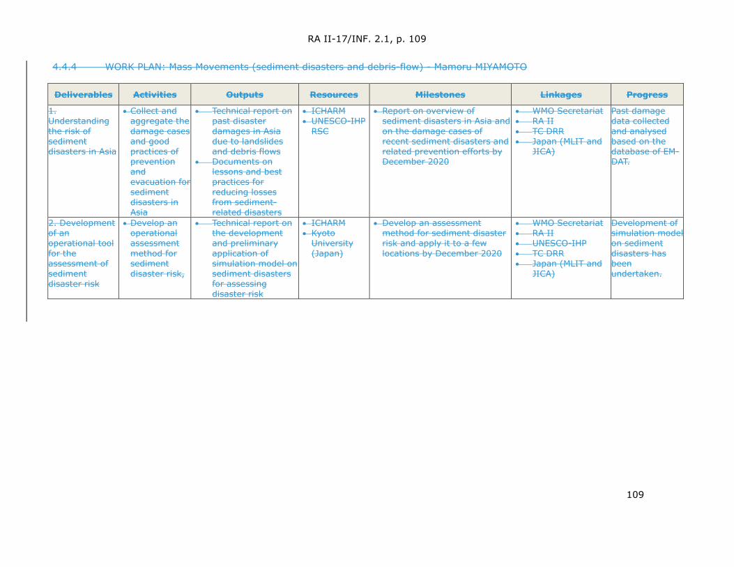
RA II-17/INF. 2.1, p. 109
109
4.4.4 WORK PLAN: Mass Movements (sediment disasters and debris-flow) - Mamoru MIYAMOTO
Deliverables Activities Outputs Resources Milestones Linkages Progress
1. Understanding the risk of sediment disasters in Asia
• Collect and aggregate the damage cases and good practices of prevention and evacuation for sediment disasters in Asia
• Technical report on past disaster damages in Asia due to landslides and debris flows
• Documents on lessons and best practices for reducing losses from sediment-related disasters
• ICHARM • UNESCO-IHP
RSC
• Report on overview of sediment disasters in Asia and on the damage cases of recent sediment disasters and related prevention efforts by December 2020
• WMO Secretariat • RA II • TC DRR • Japan (MLIT and
JICA)
Past damage data collected and analysed based on the database of EM-DAT.
2. Development of an operational tool for the assessment of sediment disaster risk
• Develop an operational assessment method for sediment disaster risk,
• Technical report on the development and preliminary application of simulation model on sediment disasters for assessing disaster risk
• ICHARM • Kyoto
University (Japan)
• Develop an assessment method for sediment disaster risk and apply it to a few locations by December 2020
• WMO Secretariat • RA II • UNESCO-IHP • TC DRR • Japan (MLIT and
JICA)
Development of simulation model on sediment disasters has been undertaken.
RA II-17/INF. 2.1, p. 110
110
4.5 Provision of Hydrological Services
4.5.1 In order to promote knowledge and understanding on their hydrological services, it is quite important to compare their similarities and differences with respect to their system, theory, practices and procedures on hydrological measurements, management system, information provision and hydrological services among typical WMO member countries (such as developed countries vs. developing countries, western countries vs. eastern countries, big countries vs. small countries), especially those in RA II (Asia) under the framework of Working Group on Hydrological Services (WGHS).
4.5.2 During past year in 2018, a pilot programme of comparative study – “Comparative study in hydrological measurement, management and information provision and hydrological services between the Republic of Korea and China” has been conducted to promote knowledge and understanding of the system, theory, practices and procedures between the Republic of Korea and China on their hydrological measurements, management system, information provision and hydrological services. The study compared many aspects including hydrological station network densities and design, hydrometric data and information management, hydrometric technology, and hydrological data and information service provision between the Republic of Korea and China. It revealed that the history of hydrology and its development over time in both countries was quite similar. However, their differences in respective natural environments and social circumstances, have led to different development and use of different data and information management systems, hydrometric techniques (practices and procedures), and provision of services of. Some of the practices and experiences in the sector of hydrology in these two countries may provide useful references for each other as well as the broader community.
4.5.3 The following actions are expected to be completed in 2019 and 2020:
1. Collecting from member countries within WMO RA II (Asia) related materials and information on: systems, theories, practices and procedures on hydrological measurements; data management system; information provision; and the provision of hydrological services in 2019,
2. Complete the comparative studies on: systems, theories, practices and procedures on hydrological measurements; data management system; information provision; and the provision of hydrological services among RA II (Asia) member countries (Numbers of countries depends on the status of data collection) by 2020,
3. Complete comparative studies on: systems, theories, practices and procedures on hydrological measurements; data management system; information provision; and the provision of hydrological services among RA II (Asia) member countries and some typical developed western countries (such as USA, etc.) by 2020.
4.5.4 Since 2019, objectives are focused on hydrological comparative research (mainly on measurement, forecasting, service and system), among China, other RA II countries and the United States of America (USA). In 2019, among the countries, the USA was chosen for comparative purposes. Because of its advanced status and large territory, its hydrological system, working mode, technical methods and hydrological services are very different than those of RA II countries. Inclusion of the USA in the analysis adds interest to the results.
RA II-17/INF. 2.1, p. 111
111
4.5.5 In 2019, the “Comparative study of hydrology between USA and China” has been conducted, and a draft report has been submitted to the Chair of RA II WGHS. This report includes information on technical standards, organizational structures, budgets, composition of personnel of the hydrological services of USA and China.
4.5.6 In 2020, the scope of research will be extended to the comparative study of forecasting services among RA II countries and the USA. A final report will be submitted as scheduled in the work plan before the next RA II WGHS meeting, to be held in 2020.
4.5.7 The collection of information (measurements, forecasting and provision of services) from RA II countries is currently insufficient, as there is very little information is publicly available. Therefore, additional effort will be undertaken to contact representatives of RA II member countries to obtain the above information via email ([email protected]). This additional effort is indispensable if the outcomes of this effort are to be achieved.
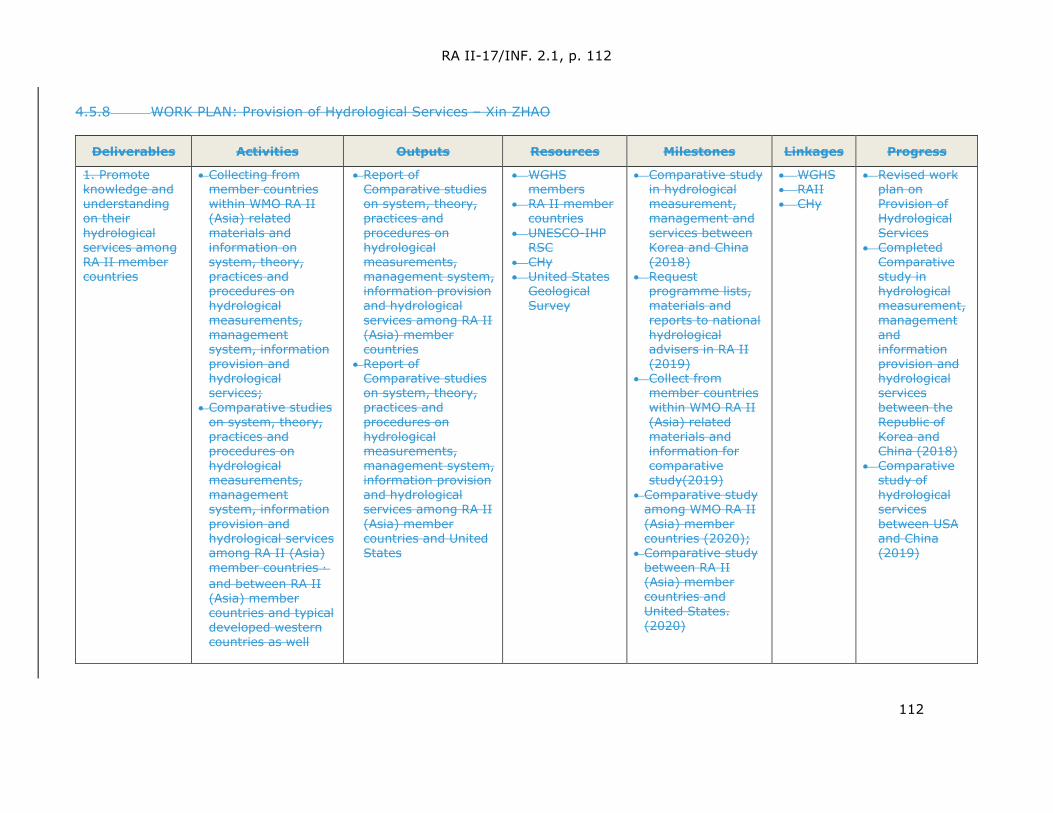
RA II-17/INF. 2.1, p. 112
112
4.5.8 WORK PLAN: Provision of Hydrological Services – Xin ZHAO
Deliverables Activities Outputs Resources Milestones Linkages Progress
1. Promote knowledge and understanding on their hydrological services among RA II member countries
• Collecting from member countries within WMO RA II (Asia) related materials and information on system, theory, practices and procedures on hydrological measurements, management system, information provision and hydrological services;
• Comparative studies on system, theory, practices and procedures on hydrological measurements, management system, information provision and hydrological services among RA II (Asia) member countries,and between RA II (Asia) member countries and typical developed western countries as well
• Report of Comparative studies on system, theory, practices and procedures on hydrological measurements, management system, information provision and hydrological services among RA II (Asia) member countries
• Report of Comparative studies on system, theory, practices and procedures on hydrological measurements, management system, information provision and hydrological services among RA II (Asia) member countries and United States
• WGHS members
• RA II member countries
• UNESCO-IHP RSC
• CHy • United States
Geological Survey
• Comparative study in hydrological measurement, management and services between Korea and China (2018)
• Request programme lists, materials and reports to national hydrological advisers in RA II (2019)
• Collect from member countries within WMO RA II (Asia) related materials and information for comparative study(2019)
• Comparative study among WMO RA II (Asia) member countries (2020);
• Comparative study between RA II (Asia) member countries and United States. (2020)
• WGHS • RAII • CHy
• Revised work plan on Provision of Hydrological Services
• Completed Comparative study in hydrological measurement, management and information provision and hydrological services between the Republic of Korea and China (2018)
• Comparative study of hydrological services between USA and China (2019)
RA II-17/INF. 2.1, p. 113
113
4.6 Coordinator Expert Group on Hydrological Applications
4.6.1 The Expert Group on Hydrological Applications (EG-HA) is comprised of six members including five thematic leads. The coordinator and thematic area of each member is listed below:
1. Coordinator EG-HA, 2. Leader for water resources assessment reflecting climate change and variability, 3. Leader for water-related disaster risk management, 4. Leader for cryosphere modelling, 5. Leader for flood forecasting, 6. Leader for hydrological drought forecasting and prediction.
4.6.2 The coordinator should coordinate closely with each theme leader as mentioned above regarding their progress on their very important respective assignments and activities, to complete the tasks and to assess if work plans need adjusting. The coordinator should also prepare the annual report for submission to the Chair of the WGHS.
4.6.3 The coordinator EG-HA should also develop recommendations on the best use of hydrological forecasts to support and facilitate flood management by disaster management authorities and flood fighting agencies. These recommendations would also be potentially useful for planning purposes.

RA II-17/INF. 2.1, p. 114
114
4.6.4 WORK PLAN: Coordinator – Expert Group on Hydrological Applications – Muhammad RIAZ
Deliverable Activities Output Resources Milestones Linkages Progress
1. Assist the Chair in accomplishing his tasks
(a) Tasks as assigned by the Chair
Various tasks achieved
Chair EG-HA
TBD TBD TBD
2. Preparation of the annual report of EG-HA and submitting it to the Chair .
(b) Regularly contacting the theme leaders to assess progress in their assignments and activities (c) Ensuring that the thematic work plans as submitted by the EG-HA are well coordinated and aligned with overall RA II and CHy AWG (d) Preparing input to WGHS annual reports
Input to the Annual Report
Chair EG-HA
Input to annual reports November 2017, 2018 and 2019 Input to final report of the WGHS for RA II-17 by July 2020
TBD
3. Development of recs on the best use of hydrological forecasts to support flood management decision-making
• Review practices of water resource management agencies for averting losses from flooding and their use of flood forecasts
• Interview flood management practitioners and decision makers to ascertain needs for flood forecasts to gain insights on their best use
• Draft report on best practices making recs
Draft recommendations on the best use of hydrological forecasts to facilitate wise flood management practices
Flood Management Experts, Flood Forecasters and decision makers
• Literature review by June 2018
• Interviews of small number of flood management practitioners by August 2018
• Interviews of small number of decision makers by October 2018
• Prepare draft report on recs by Feb 2019
• Finalize report by May 2019
TBD
RA II-17/INF. 2.1, p. 115
115
Deliverable Activities Output Resources Milestones Linkages Progress
4. Provision of assistance from the WGHS to RA II Pilot Project on Cryosphere
• Contacting RA II Pilot Project lead through PR of Pakistan to offer assistance
• Developing separate Pilot Project work plan of the WGHS drawing on members of WGHS to advance project goals with Chair WGHS
• Coordinating and tracking of WGHS input to Pilot Project with Chair
Work plan of the WGHS on Pilot Project to assist it in attaining its goals WGHS input to Pilot Project, based on work plan developed
WGHS members, OPACHE, NMHSs experts, University Professors, IAHS
TBD based on work plan developed
TBD
RA II-17/INF. 2.1, p. 116
4.7 Water Resources Assessment
4.7.1 The deliverable 'Improvement of water resources assessment techniques to assist decision-making in water resources management' includes two activities, namely: (1) develop water resources assessment techniques (the Dynamic Water resources Assessment Tool – DWAT) and (2) provide guidance materials for DWAT.
4.7.2 The DWAT had been originally conceived to assist long-term planning and policy assessment and development. Its application can allow assessment of land use changes within the basin over time, the impacts on water availability under differing consumptive use scenarios, and the impact on availability due to climate change through the application of scenarios. DWAT is intended to help users, particularly policy specialists and water resource managers to identify current and future water management challenges and compare these with the current and past states of water resources availability. This tool also can improve understanding of the impacts of past and present water management practices on water resources and better understand interactions between climate, water and landscape. Its use can contribute to water reform by providing nationally and regionally consistent water resources information and data, such as, surface water, groundwater, urban and agricultural water supply and use. Moreover, it can inform government policy formulation and the development of broad scale strategic plans and decision-making. DWAT also has been adapted to allow for short to medium-term use to facilitate local decision-making on use of available water resources. The development of DWAT has being undertaken in the Han River Flood Control Office, Ministry of Environment, Republic of Korea, with technical support on Water Resources Assessment being given by the Korea Institute of Civil Engineering and Building Technology.
4.7.3 The DWAT version 1.0 has been developed in 2018. This is an upgrade of the beta version developed in December 2017, reflecting some of the opinions of the member countries. The DWAT version 1.0 includes development of a snowmelt function, pre-processed GIS, paddy representation, and a calibration function. The snowmelt function was strongly requested by the RA II Vice-Chair during RA II-16 for inclusion in future DWAT functionality. Hydrological models like DWAT require land use and soil data to determine the area and the hydrological parameters of each land-soil category simulated within each sub-catchment. Having the capability to pre-process data using GIS allows users to load land use and soil themes into the current project and determine the land use/soil class combinations and distributions for the delineated catchments. As there are many rice paddies dominated areas in RA II, paddy representation within the model was felt to be necessary. DWAT version 1.0 also incorporates a calibration routine to increase accuracy of model results and to facilitate more rapid parameter optimization.
4.7.4 The DWAT version 1.1 has been developed in 2019, reflecting Hargreaves eq. for potential evapotranspiration. As many countries may not have climate data such as solar radiation, humidity, wind speed and etc. to calculate potential evapotranspiration, an alternative approach was needed. Hargreaves method was included as it can be used to calculate potential evapotranspiration using only temperature data.
4.7.5 The deliverable 'Globally implemented DWAT to assist decision-making in water resources management' includes: (1) a request to CHy to review and test DWAT; (2) the implementation of DWAT in select RA I, II, III, IV, V, VI basins; (3) the development of training material to allow broad implementation of DWAT; and (4) the
RA II-17/INF. 2.1, p. 117
organization of one small global DWAT workshop for members of RA II WGHS including CHy AWG.
4.7.6 As per the request of RA II-16, the DWAT has been peer-reviewed by a panel of experts nominated by WMO Commission for Hydrology. The three panel members, who were from different WMO regions, have applied the model to their basins, which reflect different hydrological, geophysical and climatic conditions. The panel members participated in two Global workshops to discuss improvements and formulate recommendations.
4.7.7 The 1st Global DWAT Workshop was organized by the Han River Flood Control Office (HRFCO) of the Ministry of Environment and KICT, Republic of Korea, and WMO. It was hosted at the kind invitation of the Government of Bhutan in Thimphu from 28 to 30 November 2018. The second Global DWAT Workshop was held in Republic of Korea from 7 to 9 May 2019. The intent of the second Workshop was to make DWAT more widely known and to allow its use by a small group of experts from different countries. Experts from each WMO Region and a selection of the CHy Advisory Working Group (AWG) were invited to participate in the event. Participants were requested to apply the model with their own data and to provide the data and their results to the model developers in advance of the workshop.
4.7.8 The DWAT International Symposium was held in Republic of Korea on 10 May 2019. Through this symposium, DWAT has been more widely applied and tested with practical applications undertaken in WMO member states such as Uganda, Bhutan, Argentina, Jamaica, New Zealand and Russian Federation. DWAT is the first programme developed by the water resources sector in Korea to be made available through the WMO website (https://public.wmo.int/en/water/dynamic-water-resources-assessment-tool). The WMO website includes information on DWAT functionalities and products, and users can download the DWAT software, its user manual, other training materials and case studies originating from the first and second Global DWAT Workshops.
4.7.9 The draft DWAT 1.0 manual was finalized in September 2018 and provided to CHy for its peer-review. Following the review by CHy, revisions were made to the software and the manual. Revisions to the user manual, including video tutorials for DWAT 1.1, are planned to be finalized by December 2019.
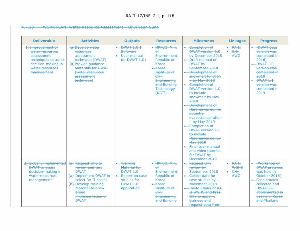
RA II-17/INF. 2.1, p. 118
4.7.10 WORK PLAN: Water Resource Assessment – Dr Ji Youn Sung
Deliverable Activities Outputs Resources Milestones Linkages Progress
1. Improvement of water resources assessment techniques to assist decision-making in water resources management
(a) Develop water resources assessment technique (DWAT)
(a) Provide guidance materials for DWAT (water resources assessment technique)
• DWAT 1.0 1 Software
• User manual for DWAT 1.01
• HRFCO, Min. of Environment, Republic of Korea
• Korea Institute of Civil Engineering and Building Technology (KICT)
• Completion of DWAT version 1.0 by December 2018
• Draft manual of DWAT by September 2018
• Development of snowmelt function – by May 2018
• Completion of DWAT version 1.0 to include snowmelt by May 2018
• Development of Hargreaves eq. for potential evapotranspiration – by May 2019
• Completion of DWAT version 1.1 to include Hargreaves eq. by May 2019
• Final user manual and video tutorials for DWAT by December 2019
• RA II • CHy
AWG
• (DWAT beta version was completed in 2016)
• DWAT 1.0 version was completed in 2018
• DWAT 1.1 version was completed in 2019
2. Globally implemented DWAT to assist decision-making in water resources management
(a) Request CHy to review and test DWAT
(a) Implement DWAT in select RA II basins
(b) Develop training material to allow broad implementation of DWAT
• Training Material for DWAT 1.0
• Report on case studies for DWAT 1.0 application
• HRFCO, Min. of Environment, Republic of Korea
• Korea Institute of Civil Engineering and Building
• Request CHy review by September 2018
• Collect data for case studies by November 2018
• Invite Chairs of RA II WGHS and Pres. CHy to appoint trainees and request data from
• RA II WGHS
• CHy AWG
• (Workshop on DWAT progress was held in October 2016)
• Case studies collected and DWAT 1.0 implemented in basins in Korea and Thailand
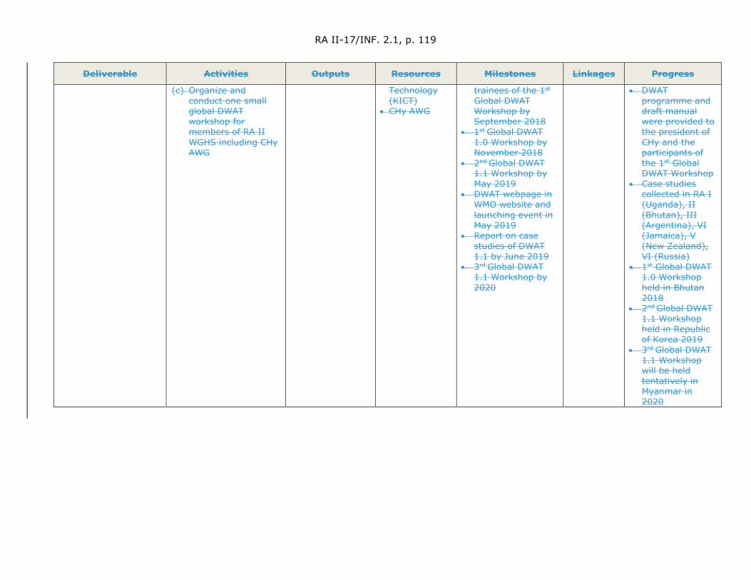
RA II-17/INF. 2.1, p. 119
Deliverable Activities Outputs Resources Milestones Linkages Progress
(c) Organize and conduct one small global DWAT workshop for members of RA II WGHS including CHy AWG
Technology (KICT)
• CHy AWG
trainees of the 1st
Global DWAT Workshop by September 2018
• 1st Global DWAT 1.0 Workshop by November 2018
• 2nd Global DWAT 1.1 Workshop by May 2019
• DWAT webpage in WMO website and launching event in May 2019
• Report on case studies of DWAT 1.1 by June 2019
• 3rd Global DWAT 1.1 Workshop by 2020
• DWAT programme and draft manual were provided to the president of CHy and the participants of the 1st Global DWAT Workshop
• Case studies collected in RA I (Uganda), II (Bhutan), III (Argentina), VI (Jamaica), V (New Zealand), VI (Russia)
• 1st Global DWAT 1.0 Workshop held in Bhutan 2018
• 2nd Global DWAT 1.1 Workshop held in Republic of Korea 2019
• 3rd Global DWAT 1.1 Workshop will be held tentatively in Myanmar in 2020

RA II-17/INF. 2.1, p. 120
4.8 Water-related Disaster Risk Management
4.8.1 Improving the understanding of the potential impacts of severe hydrometeorological events poses a challenge to National Multi Hazards Early Warning Centres and their partner agencies. This work plan is being developed for Water-related Disaster Risk Management in order to improve National and Regional Flood Forecasting and Warning capabilities for disaster risk management. The key objective of the work plan is to move from flood forecasts and warnings to an impact-based flood forecast and warning service. The work plan deliverables consists of: (a) enhancement of use of national and regional hydrological forecasting for water-related disaster management (Hydrological extremes of floods); and (b) the improvement of the availability of risk-based information upon which to base risk-based riverine flood forecasting and flood management activities. During the period from November 2018 to October 2019, the following activities have been conducted.
4.8.2 A number of meetings and workshops have been conducted at the national as well as local levels to enhance the understanding of institutions that use forecast products, including their limitations and uncertainties. This has led to a better understanding by Myanmar’s Department of Meteorology and Hydrology of users’ informational requirements.
4.8.3 The training workshop on Synergized Standard Operating Procedures (SSOPs) for Coastal Multi Hazards Early Warning System was held in 1st and 2nd November 2018, organized by the Department of Meteorology and Hydrology, Ministry of Transport and Communications of Myanmar, the WMO and the United Nations Economic and Social Commission Asia-Pacific (UNESCAP). During the workshop, consideration was given to updating SSOPs and providing guidance for improving policy and institutional arrangements at national, districts, and community levels. This was made possible through the definition of integrated, effective standard operating procedures for multi-hazards early warning systems.
4.8.4 The 22nd Monsoon Forum was held on 30 April 2019, jointly sponsored and organized by Regional Integrated Multi-Hazard Early Warning System (RIMES) and the Myanmar Department of Meteorology and Hydrology (DMH). The Forum has been held on a regular basis twice per year since 2007. During the Forum, DMH and stakeholder sectors discussed the need to develop forecast-informed planning and decision-making, for a better management of resources and disaster risk. This would be based on enhancing forecast generation and their communication, and their subsequent application.to developing informed plans for decision-making (sectoral impact forecasting and response options development). This would be applicable for the next season through the seamless integration of multi-hazard, multi-timescales information.
4.8.5 The “Final Stakeholder Workshop for Disaster Monitoring and Response System (DMRS)” was held on 9 August 2019 at Hotel Royal ACE, Nay Pyi Taw, organized by DMH, Ministry of Transport and Communications, United States Agency for International Development (USAID) and Pacific Disaster Centre (PDC). The objective of the Final Stakeholder Workshop for DMRS was to share the hazard and related information from relevant department/organizations, allowing them to more effectively take the necessary actions using the DMRS system.
4.8.6 The project on Building Disaster Monitoring and Early Warning Capacity has been implemented within the Government of Myanmar by leveraging the ASEAN Coordinating Centre for Humanitarian Assistance on Disaster Management – AHA
RA II-17/INF. 2.1, p. 121
Centre’s DMRS System. The goals of the project were to improve risk assessment, provision of early warning, and disaster management decision-making outcomes by enhancing capacity within Myanmar’s disaster management community. The web page for the DMRS is https://dmrs.ahacentre.org/dmrs/.
4.8.7 Under the project on “strengthening climate and disaster resilience in Myanmar”, DMH has developed during 2018-2019 four different types of hazard or modelling approaches. These include fluvial flood hazard (at the national scale), fluvial flood hazard (for the Ayeyarwady delta), cyclone storm surge hazard and cyclone wind hazard.
4.8.8 The Department of Meteorology and Hydrology of Myanmar has developed flood hazard maps for the cities of Bago, Kalay and Mawlaik. These flood hazard maps were distributed to water disaster related organizations and disaster management committees.

RA II-17/INF. 2.1, p. 122
4.8.9 WORK PLAN: Water-related Disaster Risk Management – Htay Htay THAN
Deliverable Activities Outputs Resources Milestones Linkages Progress
1. Enhancement of use of national and regional hydrological forecasting for water-related disaster management (Hydrological extremes of floods)
(a) Organize workshops and meetings involving national and local level to enhance the understanding of user institutions of forecast products, including their limitations and uncertainties; and better appreciation by DMH of users’ information requirements.
(b) Installation of
Automated Weather Observing System (AWOS) and AWLS
(c) Development of
flood hazard maps (d) Developing website
for Disaster Management and Response System
(a-1) Enhanced understanding by forecast user institutions of forecast products, including their limitations and uncertainties
(a-1) Documentation on gaps,
obstacles, challenges and requirements for natural disaster for local and national
(b) More accurate flood forecasting (c) Understand the flood hazard area
for disaster risk reduction (d) Develop web page
https://dmrs.ahacentre.org/dmrs/
• RIMES • National
DMA • DMH • RIMES • National
DMA • DMH • KMA • DMH • Deltares • DMH
• USAID,
PDC • DDM • DMH
• Report of meeting and workshop
• Report from water-related departments
• Project report
• WGHS • RAII
• Organizing meetings and workshops for user institutions from national and local level
• Installation of 40 AWOS stations and 10 AWLS
• Planning of 56 AWS and 34 AWLS
• Flood Hazard Maps for Bago, Kalay and Mawlaik, Flood inundation map for Ayeyarwady Delta
• Sharing the hazard and related information from relevant department/ organizations working for disaster managements and to take necessary action in time using the DMRS system effectively
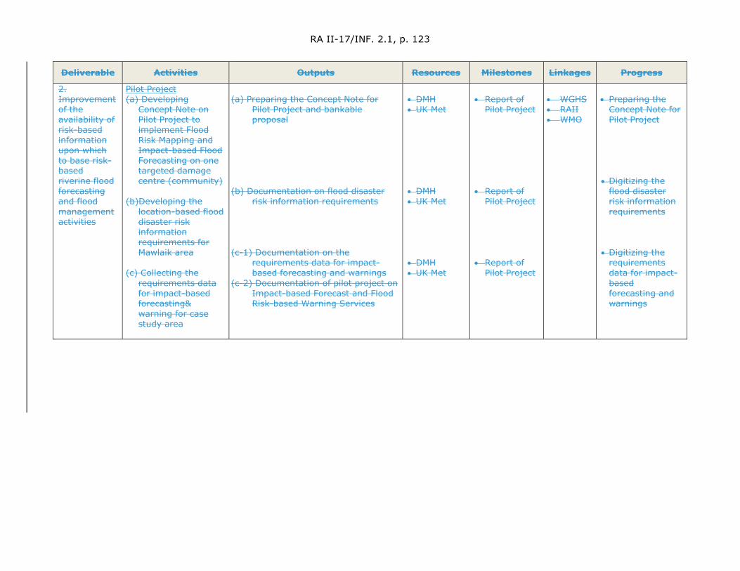
RA II-17/INF. 2.1, p. 123
Deliverable Activities Outputs Resources Milestones Linkages Progress
2. Improvement of the availability of risk-based information upon which to base risk-based riverine flood forecasting and flood management activities
Pilot Project (a) Developing
Concept Note on Pilot Project to implement Flood Risk Mapping and Impact-based Flood Forecasting on one targeted damage centre (community)
(b)Developing the
location-based flood disaster risk information requirements for Mawlaik area
(c) Collecting the
requirements data for impact-based forecasting& warning for case study area
(a) Preparing the Concept Note for
Pilot Project and bankable proposal
(b) Documentation on flood disaster
risk information requirements (c-1) Documentation on the
requirements data for impact-based forecasting and warnings
(c-2) Documentation of pilot project on Impact-based Forecast and Flood Risk-based Warning Services
• DMH • UK Met
• DMH • UK Met • DMH • UK Met
• Report of
Pilot Project • Report of
Pilot Project
• Report of Pilot Project
• WGHS • RAII • WMO
• Preparing the
Concept Note for Pilot Project
• Digitizing the
flood disaster risk information requirements
• Digitizing the
requirements data for impact-based forecasting and warnings
RA II-17/INF. 2.1, p. 124
4.9 Cryosphere Modelling
4.9.1 The background material, documents and investigations about the modelling of snow cover formation and melting were gathered. It was shown that water that accumulates in snow cover constitute a significant part of runoff in many flat and mountain regions of Asia. There are numerous experimental and theoretical studies devoted to the study of physical processes related to the thickness of snow. Therefore, in Russia, the study of the features and physical processes governing snow cover formation in river basins is conducted using water balance stations1 and snow evaporation posts2. The accumulated long-term observational data made it possible to switch from empirical formulas used in the calculation of snow accumulation and snowmelt to physical models of snow cover formation and melt. Now these physical “snow models” form one new type of hydrological process models. In our work, the literature review on calculations and modelling processes related to snow cover were collected and analysed. These included:
(a) Empirical formula, based on correlation between the snow depth and snow water equivalence with the amount of precipitation, air temperature and wind speed and other influential factors;
(b) Physical and mathematical models of snow cover formation and melt, where the changes in the thickness and density of the snow cover from the beginning of its formation to the end of snowmelt are calculated taking into account the arrival of solid and liquid precipitation, phase transitions in the snow pack, retention of melt water, and snow compaction (metamorphosis) under the influence of their own mass, determined using differential equations based on meteorological observations.
(c) Dynamic-stochastic models, which include a snow model (as a rule this model is physical or empirical) and a Stochastic Weather Generator – the name of the stochastic model WGEN (Weather Generator) developed by C. Richardson [Richardson C.W. Stochastic simulation of daily precipitation, temperature and solar radiation // Water Resources Research. 1981. № 17. P. 182–190], which describes the time-series of several average daily meteorological quantities.
(d) Satellite-based snow cover calculation methods. In recent years, these methods have begun to be widely used in operational hydrological practice in mountainous river basins, primarily for assessing the snow cover extent. For example, in Switzerland, an objective analysis of snow cover is based on the use of information from the Meteosat-8 geostationary satellite with an integrated SEVIRI instrument operating in the visible and infrared ranges. Information is processed with an interval of 15 minutes, which allows the separation of the clouds and their shadows from the underlying surface. Such an analysis based on observed data has an accuracy of up to 95%. From European countries, Finland’s experience in creating such projects should be highlighted. An example is the GlobSnow project. The project provides users with information on the extent of snow cover in the Northern Hemisphere, data on its height and available water supply in it.
1 Water balance station. A specialized hydrometeorological station conducting observations on the
components of the water balance of the experimental sections of the land surface and river catchments. 2 Snow Evaporation Posts. Experimental ground-based observation stations designed for field studies
of processes occurring in the thickness of the snow cover and on its surface. The observation program also provides for a full range of meteorological observations.
RA II-17/INF. 2.1, p. 125
Most meteorological centres use satellite products, which are freely available on the websites of the National Oceanic and Atmospheric Administration (NOAA) and its divisions. For example, satellite products IMS (Interactive Multisensor Snow and Ice Mapping System) are available for free download, compiled by NESDIS (National Environmental Satellite Data and Information Service) NOAA. These products contain information on the coverage of snow and ice of the territory, with a resolution of 24 and 4 km (from December 2014 there is a product with a resolution of 1 km), as well as a NOAA composite product with a resolution of 4 km, generated daily and automatically containing information on snow and ice coverage of the Northern and Southern Hemispheres. In Russia, methods for estimating the area covered by snow using satellite data are also widely used. Such technology was developed and operated in a routine mode at the Roshydromet Scientific and Research Centre for Space Hydrometeorology.
(e) Methods based on joint modelling of meteorological and snow cover processes.
4.9.2 The literature on ice cover formation and melt was collected, studied and analysed. The experience of Russian and international researchers has shown that hydrologists are currently calculating and predicting various characteristics of the ice regime of rivers, lakes and reservoirs such as thickness, ice strength, freezing and open water periods of rivers and reservoirs, etc. Calculations and short-term forecasts of the characteristics of the river ice are based on an approximate solution of the system of equations of heat and water balance, movement and continuity. It has been established that river ice conditions have a significant effect on discharge. During this period, the surface of the river flow may be ice covered, which creates additional resistance. As a result, there is a decrease of discharge for the same cross-sectional area. To obtain the real values of water discharge in the initial period of river freezing, some correction factors are used. These can be calculated from archived data. The problem is that the coefficient varies and depends on many factors that cannot be fully taken into account. In some cases, the calculated thickness of ice or its strength can be used as an indirect characteristic of the magnitude of discharge reduction.
4.9.3 The characteristics of the soil when initially being frozen determines the amount of melt water that can infiltrate the frozen soil. In fact, the ability to infiltrate frozen soil depends on the number of ice crystals per unit volume of soil. However, this characteristic cannot be measured. Therefore, in the calculations and forecasts of spring river discharge, the depth of freezing of the soil and soil moisture are used as an indicator of the magnitude of losses of melt runoff. Currently, the depth of soil freezing is calculated both using simple correlation equations connecting the freezing of the soil with meteorological factors, and using mathematical models that describe the processes of heat and moisture migration in the soil layer. Modelling of the soil infiltration process includes:
(a) Freezing of the soil under the snow cover, accompanied by migratory water inflow from the melt zone and lasting practically from the moment of the onset of negative temperatures to the disappearance of the snow cover.
(b) The pre-spring period, a characteristic feature of which is a relatively small change in the depth of freezing and the formed snow cover immediately before snowmelt.
(c) Spring snowmelt and absorption of meltwater into the soil.

RA II-17/INF. 2.1, p. 126
(d) Thawing of the soil after the melting of the snow cover.
(e) Winter thaws.
Each of the noted characteristic periods of the formation of the hydrothermal regime of the soil determines the content of the corresponding particular model, and their totality represents a complete set of models for the formation of soil water in the winter-spring period.
4.9.4 The preparation of the report entitled “The influence of cryosphere processes on the formation of river discharge and groundwater levels in Asia” has begun.

RA II-17/INF. 2.1, p. 127
4.9.5 WORK PLAN: Cryosphere modelling – Sergei BORSHCH
Deliverable Activities Outputs Resources Milestones Linkages Progress
1. Improvements to the mathematical representation of cryospheric processes in operational hydrological forecasting models (excluding GLOFs)
Reviewing suitability of and make recommendation on best practices for mathematical modelling of the cryosphere excluding GLOFS
Developing guidance material on (a) with an emphasis on their contributions to streamflow discharge and groundwater
Reviewing suitability of and make recommendation on best practices for mathematical modelling of the cryosphere with emphasis on glacier morphology
Technical report on review of the “Experiences on modelling of snowpack, depth of freezing soil and permafrost in operational hydrological modelling to produce streamflow discharge and ground water contributions”
Training Material on modelling of cryosphere components within hydrological modelling with an emphasis on their contributions to river discharge and groundwater levels
AWG Members,
HMC of Russia,
SHI (Russian State Hydrological Institute)
AARI (Russian State Research Centre "Arctic and Antarctic Research Institute"),
YAHMS (Yakutsk Administration of the Hydrometeorological Service)
FESRHMI (Far East Scientific Research Hydrometeorological Institute),
WSRHMI (West-Siberia Scientific Research Hydrometeorological Institute),
NMHSs with expertise in snowpack
Gathering of background material, documents and investigations about the modelling of freezing and thawing processes of soil in operational hydrological modelling of river discharge (March 2019).
Technical report on “The influence of cryospheric processes (including modelling) on the formation of river discharge and groundwater levels in Asia
Draft Report (May 2019)
Final Report (August 2019)
(f) Training material on best practices for modelling cryospheric influences on river discharge and groundwater levels.
OPACHE’s
Arctic-HYCOS
Polar RCCs
WIGOS
Executive Council Panel of Experts on Polar Observations, Research and Services (EC-PORS)
(a) The background material, documents and investigations about the modelling of snow cover formation and destruction were gathered
(b) The background material, documents and investigations about the modelling of ice cover formation and destruction were collected.
(c) The background material, documents and investigations about the modelling of freezing and thawing processes of soil in operational hydrological modelling of river discharge were gathering (d) The preparation of draft Technical Report on “The influence of cryospheric processes (including modelling) on the formation of river discharge and groundwater levels in Asia are in progress. The English version of
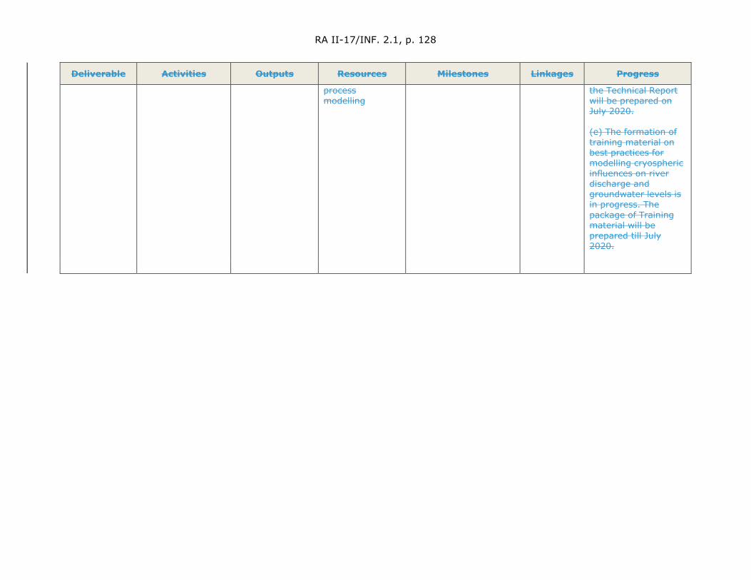
RA II-17/INF. 2.1, p. 128
Deliverable Activities Outputs Resources Milestones Linkages Progress
process modelling
the Technical Report will be prepared on July 2020. (e) The formation of training material on best practices for modelling cryospheric influences on river discharge and groundwater levels is in progress. The package of Training material will be prepared till July 2020.
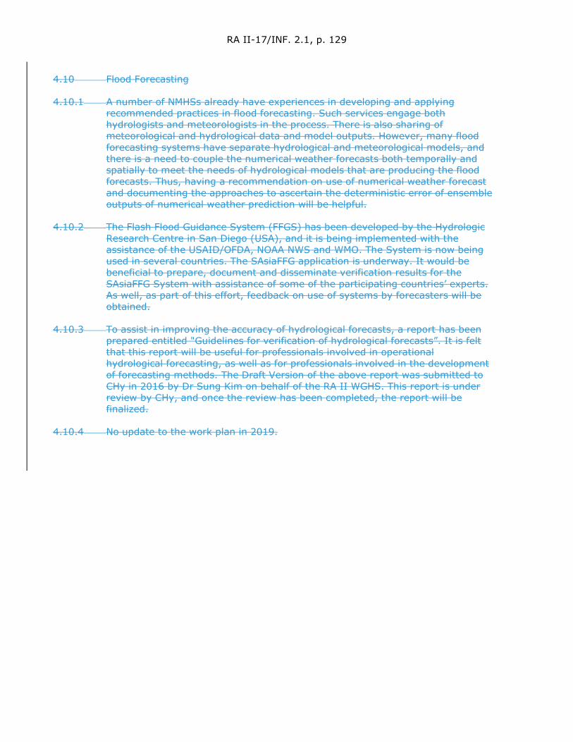
RA II-17/INF. 2.1, p. 129
4.10 Flood Forecasting
4.10.1 A number of NMHSs already have experiences in developing and applying recommended practices in flood forecasting. Such services engage both hydrologists and meteorologists in the process. There is also sharing of meteorological and hydrological data and model outputs. However, many flood forecasting systems have separate hydrological and meteorological models, and there is a need to couple the numerical weather forecasts both temporally and spatially to meet the needs of hydrological models that are producing the flood forecasts. Thus, having a recommendation on use of numerical weather forecast and documenting the approaches to ascertain the deterministic error of ensemble outputs of numerical weather prediction will be helpful.
4.10.2 The Flash Flood Guidance System (FFGS) has been developed by the Hydrologic Research Centre in San Diego (USA), and it is being implemented with the assistance of the USAID/OFDA, NOAA NWS and WMO. The System is now being used in several countries. The SAsiaFFG application is underway. It would be beneficial to prepare, document and disseminate verification results for the SAsiaFFG System with assistance of some of the participating countries’ experts. As well, as part of this effort, feedback on use of systems by forecasters will be obtained.
4.10.3 To assist in improving the accuracy of hydrological forecasts, a report has been prepared entitled "Guidelines for verification of hydrological forecasts”. It is felt that this report will be useful for professionals involved in operational hydrological forecasting, as well as for professionals involved in the development of forecasting methods. The Draft Version of the above report was submitted to CHy in 2016 by Dr Sung Kim on behalf of the RA II WGHS. This report is under review by CHy, and once the review has been completed, the report will be finalized.
4.10.4 No update to the work plan in 2019.

RA II-17/INF. 2.1, p. 130
4.10.5 WORK PLAN: Flood Forecasting – Sangay TENZIN
Deliverables Activity Outputs Resources Milestones Linkages Progress
1. Improvement in hydrological warnings capability through enhanced and effective cooperation with other NMHSs (2.1.1)
(a) Preparing recommendations on the use of numerical weather prediction outputs in flood forecasting (b) Documenting approaches to ascertain the deterministic error of each ensemble element of a NWP output, for example over the previous 30 day period, using this deterministic signal to provide a weighting on the confidence of the forecasted ensemble elements (c) Preparing training material on (b) for NHSs
(a) Guidance on the use of NWP outputs for use in flood forecasting systems
(b) Technical report on the approaches to establishing the deterministic error in NWP outputs and how they should best be used in establishing hydrological forecasts with enhanced accuracy.
NCHM, Bhutan, IMD, RIMES, Scientific papers, HMC of Russian Federation
(a.1) Gathering of background material and documents on the use of NWP output in FFS and associated activities – January 2018 (a.2) Preparation of Draft Guidance material - August 2018 (a.3) Final document on Guidance - October 2018 (b.1) Gathering of materials on NWP error and EHP - January 2018 (b.2) Preparation of Draft Report on recommended procedures – March 2019 (b.3) Final Report on approaches - Sept 2019 (b.4) A draft document on basin scale NWP Rainfall/Temp bias correction by April 2018
OPACHE’s FFI-AG CHy AWG member with expertise in ensemble hydrological prediction (EHP)
Background doc on use of NWP gathered RIMES WRF output and NCHM WRF out in use for pilot Basin FFS in Bhutan. Basin Scale Bias correction for RIMES WRF and BCHM WRF prepared and on test. (seasonal)
2. Issuance of flood, flash and urban warnings and constantly improving upon them (2.2.1)
(a) Documenting verification results for the SAsiaFFG System with some of the participating countries’ experts and obtaining feedback on use of systems by forecasters
(a.1) Report documenting verification results. (a.2) Report documenting experiences, including recommendations on approaching
(a) Hydrologists and meteorologists of the SAsia countries on use of the FFGS in operative hydrological practice.
(a.1) Background material and documents on the FFGS used in South Asian countries and associated activities – April 2019 (a.2) Preparation of Draft Reports on verification results and feedback of forecasters on FFGS– June 2019
(a) NMHSs Hydrological Research Centre in San Diego (USA), WMO
Three Case studies of Flash Food in Bhutan presented in Delhi, in JUNE 2018 by NCHM. • A Draft
report on experience
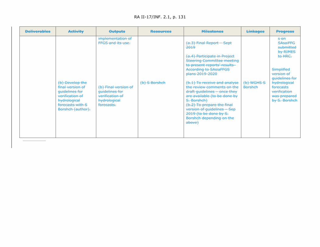
RA II-17/INF. 2.1, p. 131
Deliverables Activity Outputs Resources Milestones Linkages Progress
(b) Develop the final version of guidelines for verification of hydrological forecasts with S Borshch (author).
implementation of FFGS and its use. (b) Final version of guidelines for verification of hydrological forecasts.
(b) S Borshch
(a.3) Final Report – Sept 2019 (a.4) Participate in Project Steering Committee meeting to present reports’ results– According to SAsiaFFGS plans 2019-2020 (b.1) To receive and analyse the review comments on the draft guidelines – once they are available (to be done by S. Borshch) (b.2) To prepare the final version of guidelines – Sep 2019 (to be done by S. Borshch depending on the above)
(b) WGHS S Borshch
s on SAsaiFFG submitted by RIMES to HRC.
Simplified version of guidelines for hydrological forecasts verification was prepared by S. Borshch

RA II-17/INF. 2.1, p. 132
4.11 Hydrological Drought Forecasting and Prediction
4.11.1 The work plan is being developed for the hydrological drought forecasting and prediction in order to improve National and Regional Drought Forecasting and Prediction capabilities for disaster risk management. The very objective of the deliverable is to provide runoff outlooks every 3 months using 10-day time steps for all the key basins in Bhutan and providing them to major water users.
4.11.2 This deliverable will be undertaken for the dry season. The first step is the development of the hydrological methodology. This includes determining seasonal and 10-day moving precipitation depths for the key basins using basin average Precipitation, determining seasonal and 10-day moving runoff using the river flow data for the key basins. Once these data have been created, efforts will then be dedicated to developing Precipitation-Runoff seasonal and 10-day relationships. Assessment of the uncertainty of the relationships will be conducted. Additional analysis will be decided once the outcomes from this effort has been assessed.
4.11.3 Using the seasonal precipitation forecast, the runoff for key basins will be computed for the dry season, provided there are satisfactory outcomes from the analysis performed in section 3.6.2.
4.11.4 Analysis will be undertaken to investigate the applicability of a recession curve approach for forecasting discharges. The use of various drought indices will also be explored for dry season streamflow.
4.11.5 Finally, an evaluation of the hydrological seasonal outlooks will be undertaken by analysing statistically the differences resulting from use of the outlooks versus no outlook scenarios through workshop/meeting and comments. Feedback for improvement of the deliverable will be collected from users.
4.11.6 No update to the work plan in 2019.
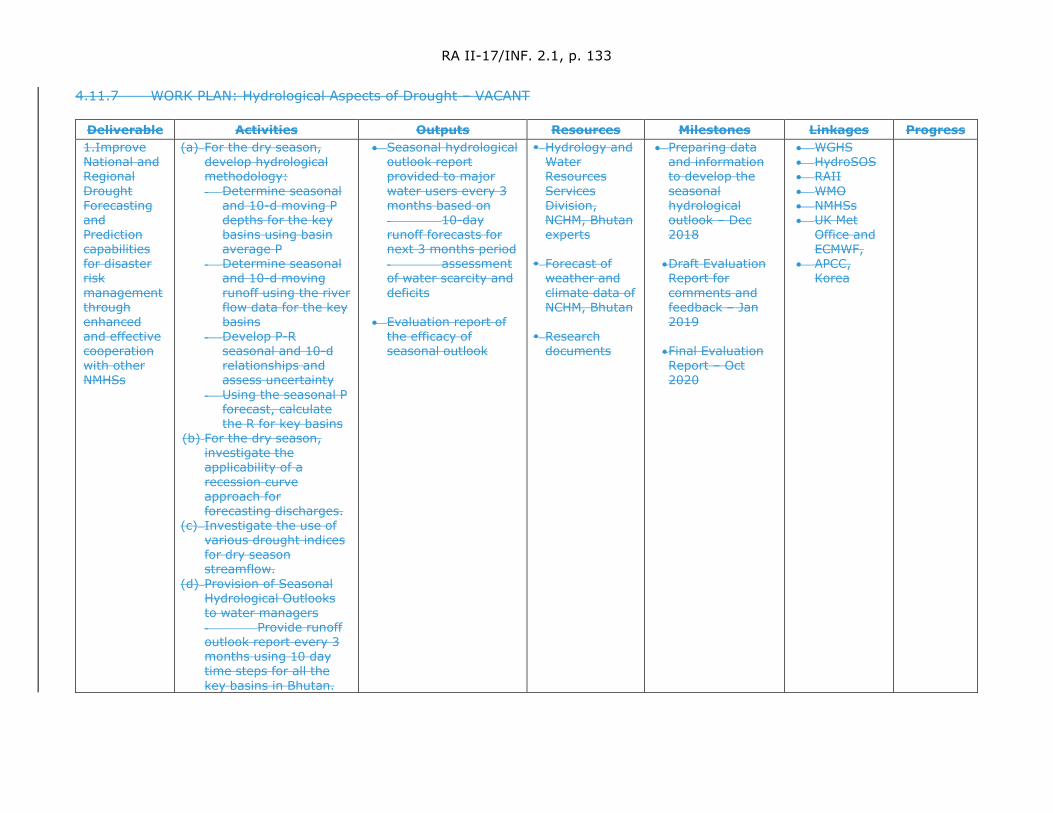
RA II-17/INF. 2.1, p. 133
4.11.7 WORK PLAN: Hydrological Aspects of Drought – VACANT
Deliverable Activities Outputs Resources Milestones Linkages Progress 1.Improve National and Regional Drought Forecasting and Prediction capabilities for disaster risk management through enhanced and effective cooperation with other NMHSs
(a) For the dry season, develop hydrological methodology: - Determine seasonal
and 10-d moving P depths for the key basins using basin average P
- Determine seasonal and 10-d moving runoff using the river flow data for the key basins
- Develop P-R seasonal and 10-d relationships and assess uncertainty
- Using the seasonal P forecast, calculate the R for key basins
(b) For the dry season, investigate the applicability of a recession curve approach for forecasting discharges.
(c) Investigate the use of various drought indices for dry season streamflow.
(d) Provision of Seasonal Hydrological Outlooks to water managers - Provide runoff outlook report every 3 months using 10 day time steps for all the key basins in Bhutan.
• Seasonal hydrological outlook report provided to major water users every 3 months based on - 10-day runoff forecasts for next 3 months period - assessment of water scarcity and deficits
• Evaluation report of
the efficacy of seasonal outlook
Hydrology and Water Resources Services Division, NCHM, Bhutan experts
Forecast of
weather and climate data of NCHM, Bhutan
Research
documents
• Preparing data and information to develop the seasonal hydrological outlook – Dec 2018
• Draft Evaluation Report for comments and feedback – Jan 2019
• Final Evaluation Report – Oct 2020
• WGHS • HydroSOS • RAII • WMO • NMHSs • UK Met
Office and ECMWF,
• APCC, Korea
RA II-17/INF. 2.1, p. 134
Deliverable Activities Outputs Resources Milestones Linkages Progress (e) Evaluate
Hydrological Seasonal Outlooks - Analyse
statistically the differences resulting from use of the outlooks versus no outlook scenarios through the workshop/meeting, comments, feedback for improvement
RA II-17/INF. 2.1, p. 135
5. Adoption of the report
5.1 Participants agreed that the draft final report would be circulated to participants and to Mr Riaz and Mr Tenzin for review with a two week period for provision of revisions. Once their views have been incorporated, the report would be updated and placed on the RA II WGHS website. It was agreed that the final endorsement of the report should be sought from the Chair of the Working Group before finalizing it and seeking approval of the President of RA II for its publication.
6. Next meeting
6.1 The date for the next meeting of the RA II Working Group on Hydrological Services was tentatively set as being in the week of 5 to 9 October 2020 (including the back-to-back workshops). Ms Htay Htay Than indicated the possibility that Myanmar may wish to host this next meeting of the RA II WGHS in Nay Pyi Taw, Myanmar. She indicated that she would discuss this with colleagues and anticipates that a decision would be made by the end of 2019, at which time she would advise the Chair of the RA II WGHS on the possibility of Myanmar on hosting this event. The Chair noted with appreciation the kind offer of the expert from Myanmar to potentially host the next meeting and will await her confirmation of her kind offer.
7. Closure of the meeting
7.1 The Chair, Dr Sung Kim, thanked the participants and the WMO Secretariat for their contributions and professionalism that made the meeting a success. He also thanked experts for their hard work and indicated his pleasure with the work that has been achieved since the last meeting.
7.2 Dr Kim expressed his gratitude on behalf of WMO and the participants of the meeting to RosHydromet, Russian Federation, for the provision of the excellent meeting facilities and for the gracious hosting of the event. He also thanked the Ministry of Environment, Republic of Korea, for it having provided financial assistance for the event. He also thanked Mr Alexander Snytko, Director of the Hydrometeorological Centre of Russia, Dr Sergei Borshch and Dr Yuri Simonov and the staff of the Hydrometeorological Centre of Russia, in supporting the effective organization of the meeting and for their efforts and assistance to all participants. In closing, he underscored the importance of fulfilling the work plans as outlined prior to the next session of RA II to be held in the 4th quarter of 2020, not only for the benefit of National Hydrological Services in RA II, but for all Regions.
7.3 Participants thanked everyone for the excellent, productive meeting.
7.4 The meeting closed at 12:45 on the 9th of October 2019.
RA II-17/INF. 2.1, p. 136
ANNEX V.1
LIST OF PARTICIPANTS – RA II (ASIA) WORKING GROUP ON HYDROLOGICAL SERVICES (WGHS)
(Moscow, Russian Federation, 7-9 October 2019)
Working Group on Hydrological Services (WGHS):
Chair and Coordinator Expert Group on Measurements, Monitoring and Infosystems (EG-MMI)
Dr Sung KIM Visiting Senior Research Fellow Korea Institute of Civil Engineering and Building Technology (KICT) 283 Goyangdae-ro, Iisanseo-gu, Goyang-si, Gyeonggi-do10223 Republic of Korea Tel: +82 10 735 90602 Fax: +82 31 910 0251 Email: [email protected]
Leader in Hydrometric Measurements
Dr Youngsin ROH General Manager Dept. of Hydrological Survey Korea Institute of Hydrological Survey Office building, KINTEX, 407 Hallyuworld-ro, Ilsanseo-gu, Goyang-si, Gyeonggi-do Goyang Republic of Korea Tel: +82 31 929 0823 Fax: +82 31 929 0890 Email: [email protected]
Leader in Mass Movements (sediment disasters and debris flows)
Dr Mamoru MIYAMOTO Researcher/Associate Professor National Graduate Institute for Policy Studies (GRIPS) Executive Manager of IFI Secretariat International Centre for Water Hazard and Risk Management under the auspices of UNESCO (ICHARM) Public Works Research Institute 1-6, Minamihara, Tsukuba, Ibaraki, 305-8516, Japan Tel: +81298796779 Fax: +81298796709 Email: [email protected]
RA II-17/INF. 2.1, p. 137
Leader in Provision of Hydrological Services (ABSENT)
Mr Xin ZHAO Deputy Chief Monitoring Section, Bureau of Hydrology Changjiang Water Resources Commission, Ministry of Water Resources Bureau of Hydrology, No.1863, Jiefang Avenue, Wuhan, 430010, China Tel: +86 27 82927569 Mobile: +86 13986061133 Fax: +86 27 82829672 Email: [email protected]
Coordinator Expert Group on Hydrological Applications (EG-HA) (ABSENT)
Mr Muhammad RIAZ Chief Meteorologist Pakistan Meteorological Department Flood Forecasting Division 46-Jail Road LAHORE-54000 Pakistan Tel: +92 42 99 200 208 Mobile: +92 300 802 62 86 Fax: +92 42 99 200 209 Email:[email protected]
Leader in Water Resources Assessment (APPROVAL IN PROGRESS)
Dr Ji Youn SUNG Han River Flood Control Office Ministry of Environment Dongjakdaero 328 Seocho-Gu SEOUL 06501 Republic of Korea Tel: + 82 2 590 9983 Mobile: +82 10 5230 0628 Fax: +82 2 590 9989 Email: [email protected]
Leader in Water-related Disaster Risk Management
Ms Htay Htay THAN Director Department of Meteorology and Hydrology Ministry of Transport and Communications Nay Pyi Taw Myanmar Tel: +95 67 341 15 28 Mobile. +95 92 509 54 638 Fax: +95 67 341 15 23 Email: [email protected]

RA II-17/INF. 2.1, p. 138
Leader in Cryosphere Modelling
(HOST)
Dr Sergei BORSHCH Hydrological Centre of Russia Bolshoy Predtechensky Per., 11-13 MOSCOW 123242 Russian Federation Tel: +7 499 795 21 84 Fax: +7 499 252 32 49 Mobile +7 916 328 5352 Email: [email protected] Email: [email protected]
Leader in Flood Forecasting (ABSENT)
Mr Sangay TENZIN Chief, Hydrology and Water Resource Services Division National Centre for Hydrology and Meteorology (NCHM) Royal Government of Bhutan P.O. Box: 207 Thimphu Bhutan Tel: +975 2 322 794 Mobile: +975 177 117 53 Fax: +975 2 323 117 Email: [email protected] [email protected]
Leader in Hydrological Drought Forecasting and Prediction
VACANT
Observers Dr Hyeonjun KIM Senior Research Fellow Department of Land, Water and Environment Research, Korea Institute of Civil Engineering and Building Technology (KICT) 283 Goyangdae-ro, Iisanseo-gu Goyang-si, Gyeanggi-do 10223 Republic of Korea Tel: +82 31 910 0266 Mobile: +82 31 910 0757 Email: [email protected]
Dr Cheolhee JANG Senior Researcher Department of Land, Water and Environment Research, Korea Institute of Civil Engineering and Building Technology (KICT) 283 Goyangdae-ro, Iisanseo-gu Goyang-si, Gyeanggi-do 10223 Republic of Korea
RA II-17/INF. 2.1, p. 139
Tel: +82 31 910 0745 Email: [email protected]
Dr Deokhwan KIM Researcher Department of Land, Water and Environment Research, Korea Institute of Civil Engineering and Building Technology (KICT) 283 Goyangdae-ro, Iisanseo-gu Goyang-si, Gyeanggi-do 10223 Republic of Korea Tel: +82 31 910 0761 Email: [email protected]
Dr EunJeung SHIM Senior Researcher Data Quality Management Department Korea Institute of Hydrological Survey Office Building, KINTEX 407 Hallyuworld-ro, Ilsaneso-gu, Goyang-si, Geyeonggi-do, Goyang, Republic of Korea, (411-766) Tel: +82 31 929 0942 Mobile: +82 10 9290 7901 Email: [email protected]
Mr Kisung LEE Team Manager/Principal Researcher Policy Planning Department, Korea Institute of Hydrological Survey Office Building, KINTEX 407 Hallyuworld-ro, Ilsaneso-gu, Goyang-si, Geyeonggi-do, Goyang, Republic of Korea Tel: +82 31 929 0906 Mobile: +82 10 4041 2850 Email: [email protected]
Mr Nansoo KIM Water Resources Management Division Ministry of Environment #11, Doum-ro 6, Sejong Special Self-Governing City, 30103, Republic of Korea Tel: +82 44 201 7653 Telefax: +82 44 201 7650 Mobile: +82 10 2315 8029 Email: [email protected]

RA II-17/INF. 2.1, p. 140
Ms Damira SABENOVA Leading Engineer, Hydrological Forecast Department, Kazhydromet 11/1 Mangilik El street, Nur Sultan, Republic of Kazakhstan Tel: Mobile: Email: [email protected]
Dr Paul Pilon Private consultant, 992 Miss Ottawa Street Ottawa, ON K1J 7B1 Canada Tel: +1 613 800 4011 Email: [email protected]
Dr Yuri Simonov Head, department of hydrological forecasts Hydrometeorological Centre of Russia 11/13 B.Predtechensky per., Moscow Tel.: +7-499-252-3249 Mobile: +7-916-828-6404 Email: [email protected]
Prof. Andrei V. Khristoforov Chief Scientist Hydrological Centre of Russia Bolshoy Predtechensky Per., 11-13 MOSCOW 123242 Russian Federation Tel: +7 499 252 32 49 Email: [email protected]
World Meteorological Organization (WMO)
Dr Hwirin KIM Chief, Hydrological Forecasting and Water Resources Division Climate and Water Department 7 bis avenue de la Paix CH – 1211 GENEVA 2 Tel: +41 22 730 8358 Fax: +41 22 730 80 43 Email: [email protected]

RA II-17/INF. 2.1, p. 141
Mr Giacomo TERUGGI Scientific Officer, Hydrological Forecasting and Water Resources Division Same address as above Tel: +41 22 730 8354 Email: [email protected]
RA II-17/INF. 2.1, p. 142
ANNEX V.2
Provisional agenda of the 2019 Session of Hydrological Services Working Group WMO regional association II (RA II – Asia)
October 6, 2019 – arrival of foreign participants to the session in Moscow and check-in at the Izmailovo Delta Hotel (individually)
October 7, 2019 – first day (full-time session)
08:30 – 09:00 Registration of participants and guests of the session at the Izmailovo Delta Hotel (Conference Hall “Smolensk”)
Morning meeting 09:00 – 10:45
Moderator:
Dr Yuri Simonov, Roshydromet
1. Opening of the session and greetings by Roshydromet (Russian Federation), representatives of the Ministry of Environment of the Republic of Korea, and WMO Secretariat 2. Presentation of the session participants and adoption of the agenda (Dr Sung KIM, Chair WGHS RA II) 3. Presentation on the activities of Roshydromet in the area of flood forecasting on the example of floods in the Lower and Middle Amur basin in July – September 2019 (Dr Yuri Simonov) 4. Presentation on hydrological activities in the Republic of Korea (Dr Ji Youn SUNG) 5. Presentation on hydrological activities of Kazhydromet (Ms Damira Sabenova) 6. Report on the decisions and recommendations of RA II, the Extraordinary Session of CHy (February 2019), the Hydrological Assembly (June 2019), the World Meteorological Congress (June 2019), the 71st session of the WMO Executive Committee (June 2019) (Dr Hwirin Kim)
10:45 – 11:15 Coffee break
Morning meeting 11:15 – 13:00
Moderator:
Dr Sung KIM, Chair WGHS RA
II
7. Discussion of the future activities of the Working Group on Hydrological Services of the WMO Regional Association II (WGHS) in the light of decisions adopted at the World Meteorological Congress (June 2019), 71st session of the WMO Executive Committee (June 2019) 8. Report on the work done and updating the work plan 8.1. Report of the Chair and Coordinator of the Group of Experts on Measurement, Monitoring and Information Systems (EG-MMI) (Dr Sung KIM) 8.2. Report of the Coordinator of the Group of Experts on Hydrological Applications (EG-HA) (Mr Muhammad Riaz)
13:00 – 14:30 Lunch break
Afternoon meeting
14:30 – 15:45
8.3. Hydrometric measurements (Dr Youngsin ROH)
RA II-17/INF. 2.1, p. 143
6.4. Mass displacements (natural disasters associated with landslides and mudflows) (Dr Myamoto Mamoru)
15:45 – 16:15 Coffee break
Afternoon meeting
16:15 – 17:45
Presentations and progress reports and, if necessary, updating expert work plans (actions, results, steps, and progress) in the following thematic areas (continued): 8.5. The provision of hydrological services (Mr Xin Zhao) 8.6. Water resources assessment reflecting climate change and variability (Dr Ji Youn SUNG)
October 8, 2019 – the second day of the session
Morning meeting 09:00 – 10:45
Presentations and progress reports and, if necessary, updating expert work plans (actions, results, steps, and progress) in the following thematic areas (continued): 8.7. Water-related disaster risk management (Ms Htay Htay Tan) 8.8. Cryospheric modelling (Dr Sergey Borshch)
10:45 – 11:15 Coffee break
Morning meeting 11:15 – 13:00
Presentations and progress reports and, if necessary, updating expert work plans (actions, results, steps, and progress) in the following thematic areas (continued): 8.9. Flood forecasting (Mr Bikash Pradhan) 8.10. Hydrological and drought forecasting (Dr Tao Yang)
13:00 – 14:30 Lunch break
Field Trip 14:30 – 17:45
Moscow tour (time and programme of the tour will be specified later)
Reception by Roshydromet (upon arrival from the city tour)
October 9, 2019 – the third day of the session
Morning meeting 09:00 – 12:00
9. Consideration, editing, approval, and adoption of the session report 10. Closure of the session
12:00 – 14:00 Lunch break
14:00 – 17:00 Visit of institutions of Roshydromet: Hydrometcentre of Russia, State Research Centre “Planeta”, and Main computer centre of Roshydromet
October
09 – 10, 2019 Departure of participants (individually)
WEA
THER
CLI
MATE
WAT
ER World Meteorological Organization
REGIONAL ASSOCIATION II (ASIA)
Seventeenth Session 25 to 26 May 2021, Virtual Session
RA II-17/INF. 4(1)
Submitted by: Secretary-General
5.V.2021
Report of Chair of Capacity Development Panel to EC-72
Introduction
The first activity following EC-71 was the constitution of the membership of the Capacity Development Panel (CDP) which was established by Resolution 7 (EC-71). After a rigorous screening of nominations taking into account inter alia, gender, expertise and geographic distribution, on the recommendation of the Secretary-General and in consultation with the Third Vice-President of WMO, the constitution of the Panel was approved by the President of WMO on behalf of the EC.
The members of the Panel are as follows:
Ms Winifred JORDAAN (South Africa) and Ms Raholijao NIRIVOLOLONA (Madagascar); Dr Somenath DUTTA (India); and Mr Zhiqiang WANG (adviser by Ms Meihua WANG) (China); Ms Carla GULIZIA (Argentina); Mr David FARRELL (British Caribbean Territories) and Mr John OGREN (USA); Ms Dwikorita KARNAWATI (Indonesia); Ms Karen McCOURT (UK) and Ms Anna TIMOFEEVA (Russian Federation); Representative of the Presidents of WMO RAs: Mr Evan THOMPSON (Jamaica); and Representative of WMO RTCs: Prof Peter ODJUGO (Nigeria).
The second activity was a meeting of the Panel, which was chaired by Mr John Ogren because of the unavailability of the Chair, Dr Agnes KIJAZI, the Third Vice-President of WMO. In this connection, it is no longer a novelty to note that COVID-19 pandemic has changed our ways of doing business and the Panel’s work was not an exception. As a result of this situation, in running the second activity, the Panel had to take an innovative approach in order to ensure that the planned activity was effectively delivered. Consequently, the meeting was scheduled for 26 and 27 August 2020 through videoconferencing and a blended approach to the meeting was taken, namely, all members of the Panel were invited to make written contributions on every item on the agenda ahead of the session. The contributions were posted on a Moodle site, which was administered by the Secretariat. Members of the Panel have also reviewed and made further inputs to a synthesis document. With this background on the work already done, the Panel was already well placed to come up with tangible outcomes from its deliberations in the meeting.
Issues discussed at the First Meeting
The meeting deliberated on the following: (a) Election of Vice-Chair and Rapporteur; (b) Discussions on Rules of Procedure (RoP); (c) Approaches to collaboration between the Capacity Development Panel and Constituent Bodies; (d) Brainstorming on various matters relating to capacity development of WMO Members; (e) Establishment of Expert Teams; and (f) Consideration of timelines for delivery of the work programme of the Expert Teams to the Panel, and preparation for the Executive Council.
Following extensive deliberations both via asynchronous discussions through the Moodle platform and synchronous meeting via videoconference, the Panel was able to achieve the objectives of the meeting as set through its agenda by; familiarizing itself with the RoP, brainstorming on various issues that could assist in delivering its mandate, establishing four Expert Teams (ET) and one Task Team (TT) to assist in the delivery of specific tasks given to the Panel by EC, and agreeing on a framework for its work programme in the near future. The outcomes of the first meeting are further enumerated below.
RA II-17/INF. 4(1), p. 2
Outcomes of the First Meeting
The first meeting was very successful in the sense that it allowed members of the Panel to familiarize with one another, agree on modality of work, set approaches and timelines for delivering its mandate. Whereas details of details of deliberations are contained in the full report of the meeting, it is pertinent to bring the following highlights of recommendations to the Executive Council attention:
(1) Election of Mr John Ogren as Vice-Chair and Dr Somenath Dutta as Rapporteur with immediate effect;
(2) The Panel to be guided by the RoP approved by TCC-1 in developing its work;
(3) The Panel agreed to review its approaches to work from time to time, especially with respect to the operations of its Expert Teams and Task Teams. Requests for amending the RoP should be submitted to EC through the TCC;
(4) In view of the cross-cutting nature of capacity development and the consequent need for seamless and effective coordination across the organization to implement the desired Earth system approach, CDP recommended to the EC the expansion of its membership by including the following: (a) one representative of the Hydrological Coordination Panel (HCP), (b) one representative of the Infrastructure Commission (INFCOM), (c) one representative of the Services Commission (SERCOM), (d) one representative of the Research Board (RB), and (e) one representative of the WMO-IOC Joint Collaborative Board (JCB);
(5) The need to ensure that up-to-date information on activities of constituent bodies are made available to the Panel on a regular basis, through formal reports of their meetings;
(6) The need to ensure that there is regular update on Secretariat policy and programme activities prior to each meeting;
(7) The need to take into account decisions and actions of constituent bodies as they relate to capacity development;
(8) Expert Teams were advised to review suggested list of invited experts and make recommendations to the Chair for any possible changes;
(9) All Expert Teams and the Task Team to set timetable for their work with the target of getting outputs in good time for deliberations ahead of next meeting of the Panel;
(10) Expert Teams to interact continuously with the WMO Secretariat during their assignments.
Recommendations to EC-72
Most of the recommendations from the first meeting of the Panel concern the work of the Panel from which among others the Panel requested the EC for an expansion of memberships of CDP with including of the following, more so because of the cross-cutting nature of capacity development and hence the need for seamless and effective coordination across the organization: (a) one representative of the Hydrological Coordination Panel (HCP), (b) one representative of the Infrastructure Commission (INFCOM), (c) one representative of the Services Commission (SERCOM), (d) one representative of the Research Board (RB), and (e) one representative of the WMO-IOC Joint Collaborative Board (JCB).
RA II-17/INF. 4(1), p. 3
The above recommendation was approved by EC-72, including recommendations for revision of the WMO Capacity Development Strategy”1. The report of the second meeting is being prepared for consideration by EC-73, as part of its decision documents.
__________________
1 Please note that the recommendation was approved by the EC-72 and mentioned that five new
members of the CDP have been nominated. Complete and up-to-date list of members of the CDP is available here and the full report of the CDP-1 is available here.

WEA
THER
CLI
MATE
WAT
ER World Meteorological Organization
REGIONAL ASSOCIATION II (ASIA)
Seventeenth Session 25 to 26 May 2021, Virtual Session
RA II-17/INF. 4(2)
Submitted by: Chair
25.V.2021
UPDATE ON CAPACITY DEVELOPMENT PROJECTS IN RA II
Capacity development projects and activities in RA II
The World Meteorological Organization (WMO) implements a portfolio of extra-budgetary funded projects and activities amounting to over CHF 20.97 million worth of investment in weather, water and climate services in support of WMO Members in the Regional Association II (RA II).
Projects’ alignment with WMO Long-term Goals
(1) Investment in projects under implementation are aligned with WMO Long-term goals as follows:
(a) 60%: LTG 1 — Better serve societal needs;
(b) 5%: LTG 2 — Enhance Earth system observations and predictions;
(c) 0%: LTG 3 — Advance targeted research;
(d) 34%: LTG 4 — Close the capacity gap on weather, climate and hydrological services;
(e) 1%: LTG 5 — Strategic realignment of WMO structure and programmes.
(2) The graph below provides a breakdown of the RA II project portfolio’s alignment with WMO’s Strategic Objectives.
RA II-17/INF. 4(2), p. 2
Overview of RA II projects and activities
(1) Environment and Climate Change Canada (ECCC) has allocated CAD 10 million in 2016 to the project entitled “Building Resilience to High Impact Hydro-meteorological Events through Strengthening Multi-Hazard Early Warning Systems in Small Island Developing States (SIDS) and Southeast Asia”. Running until March 2022, the multi-country project will strengthen weather-, climate- and water-related impact-based decision support services and therefore help protect lives and property in three regions, Southeast Asia (CAD 4.4 million), the Caribbean (CAD 2 million), and the Pacific (CAD 3.6 million). The projects' objective is to strengthen the capacity of national meteorological and hydrological services to provide accurate and timely forecasts which include effective, risk-informed multi-hazard early warning services. This will be achieved through sponsoring WMO flagship activities in the project regions, such as the Severe Weather Forecasting Programme (SWFP) and the Flash Flood Guidance System (FFGS) in support of wider WMO strategic objectives on disaster risk reduction and service delivery.
(2) WMO is supporting the Kingdom of Saudi Arabia through a three-phased approach to provide strategic and technical expertise for the modernization of the National Center for Meteorology (NCM) and the implementation of capacity development activities for NCM and WMO Members supported by the Saudi Arabia Trust Fund at WMO. NCM will be provided with a comprehensive and integrated plan to address their gaps and needs, guided by WMO Guidelines and leveraging on the wider WMO community to secure expert services. The Kingdom of Saudi Arabia has initially committed CHF 1.6 million but could support up to CHF 4 million for the modernization project. The expected outcomes involve: (i) the assessment and review of the proposed business and operating plan for NCM; (ii) development of an implementation plan with a comprehensive and integrated approach to address NCM gaps and needs, guided by WMO guidelines and leveraging on the wider WMO community to secure expert services; and (iii) implementation of the identified activities from the modernization plan for NCM.
(3) In Bhutan, WMO is leading the implementation of a project entitled “Developing capacities for Effective Climate Services in Bhutan” which is being financially supported by the Korea Meteorological Administration (KMA). The main objective of this project is to strengthen the existing climate services in the country and address current gaps and challenges through the deployment of a customized Climate Services Toolkit (CST). This will enable the National Center for Hydrology and Meteorology (NCHM), Bhutan to improve efficiency and raise the capacity for the production, communication and application of climate information products. This will further support the decision-making process in climate sensitive sectors such as agriculture and food security, disaster risk reduction, energy, health and water. WMO and NCHM is working closely with the Regional Integrated Multi-Hazard Early Warning Systems for Africa and Asia (RIMES) in carrying out the project activities within the country. The total project value is around CHF 128 000.
(4) Through the Korea Trust Fund for Strengthening Global Weather, Water and Climate Services, WMO is implementing the two projects for RA II Members, namely (i) Climate Data Rescue in Uzbekistan, Phase 2: Digitization, and (ii) Modernization of the Aviation Meteorological Services of Mongolia.
(a) The project “Climate Data Rescue in Uzbekistan Phase 2: Digitization” is for the digitization of the imaged climatological and hydrological data sets, the implementation of a modern Climate Data Management System (CDMS), and the migration of rescued data and existing electronic data holdings into the CDMS. The Centre of Hydro Meteorological Service under the Cabinet of Ministers of Uzbekistan (Uzhydromet) is in charge of the digitization of monthly meteorological variables for 87 synoptic stations from the end of 19th century, and the monthly summary hydrological variables from 1960 based on the achievement of the project Phase 1:
RA II-17/INF. 4(2), p. 3
“Climate Data Rescue in Uzbekistan (2015–2018)”. And the International Environmental Data Rescue Organization (IEDRO) will support the QA/QC of the meteorological data management. The project is financially supported by KMA and the total budget is around USD 418 000.
(b) The project “Modernization of the Aviation Meteorological Services of Mongolia” is expected to enhance the capabilities of the National Agency for Meteorology and Environmental Monitoring of Mongolia (NAMEM) in aviation meteorological services. Through the preliminary survey in 2019, it was identified that the project will mainly focus on installing the backup Automated Weather Observing System (AWOS) at the newly opening Ulaanbaatar International Airport with its total budget of around USD 400 000.
(5) The International Climate Initiative (IKI) of the German Federal Ministry for the Environment, Nature Conservation and Nuclear Safety (BMU) has contributed EUR 8 million (2018–2022) to WMO for the implementation of a project titled “Applying seasonal climate forecasting and innovative insurance solutions to climate risk management in the agriculture sector in Southeast Asia (DE-RISK SE ASIA)” which targets Cambodia, Lao PDR, Myanmar and Viet Nam. The project is being implemented by WMO, the International Center for Tropical Agriculture in Hanoi, Vietnam (CIAT), and the University of Southern Queensland, Australia. The project partners work with several national organizations in each Member country [China] including the four NMHSs. The project aims to develop resilient climate risk management systems, best practices and insurance products that will shield smallholder farmers and businesses engaged across the agricultural value chain from physical and financial disaster associated with climate change. It will assist relevant governments in developing national/regional adaptation and risk management strategies. The core project goals will be achieved through the following planned measures: (i) Identifying suitable seasonal forecast systems (based on WMO Global Producing centres) that possess both accuracy and reliability and suitability for critical farmer/user decisions in the region; (ii) Developing and producing participatory workshops and socioeconomic surveys to co-explore key climate change risks, adaptation challenges, enabling factors and barriers; (iii) Directing targeting of seasonal climate forecasting to agricultural management decisions per sector to assist with incremental climate change adaptation; (iv) Developing financial risk management tools, including practical more innovative insurance products that are cognisant of history of climate variability in the region; and (v) Developing knowledge-driven national and regional adaptation and risk management strategies and suitable incentive driven programmes and measures.
(6) WMO and World Bank Group (WBG) have signed a partnership, called "Hydromet Alliance", supporting Members countries [China] and the World Bank Project Teams for their project implementation. WMO is supporting Hydromet services of Kazakhstan, Kyrgyz Republic, Tajikistan, Turkmenistan and Uzbekistan through the following projects and providing them with our technical expertise:
(a) Central Asia Hydrometeorology Modernization Project (CAHMP, P120788)
(b) Climate Adaptation and Mitigation Program for the Aral Sea Basin (CAMP4ASB, P151363)
(b) Strengthening Early Warning of Mountain Hazards in Central Asia (SEWMH, P158373), with financing from the Central Asia Water and Energy Program (CAWEP)
Under these efforts, the project Central Asia-Afghanistan Flood Early Warning System (CAFEWS) has been approved and will begin implementation in the summer this year. This initiative will draw resources from the above-mentioned projects, FFGS and CREWS-
Formatted: Font: Italic
Formatted: Font: Italic

RA II-17/INF. 4(2), p. 4
Afghanistan. It will support the delivery and installation of a forecaster workstation, upgrade of the current Central Asia Region FFGS (CARFFGS), integration of Afghanistan into CARFFGS, develop snow-monitoring as well as river flow and landslide components, provide capacity building for FFGS and integrate ICON-in-the-Cloud as a new numerical weather prediction (NWP) model available for the region. The target basins of the project are the Amu Darya and Syr Darya, covering a total area of more than 930 000km2 across Central Asia and home to more than 100 million people. Additionally, with field support from Global Water Partnership (GWP), WMO will be assisting Turkmenhydromet in identifying its needs and in developing a vision for mid-term development along with the communication of its organizational goals for the next five years by means of a National Strategic Financial Plan. The project is expected to contribute to the national planning and decision-making process in order to cover its development needs for the provision of timely and accurate weather, water and climate services for Hydromet disaster preparedness.
(7) Since July 2019 WMO implements a project in Afghanistan, funded by Climate Risk Early Warning System-(CREWS)-Initiative, focusing on enhancing the operational hydrology, meteorology and climatology for better delivering hydromet services to Afghanistan’s institutions and stakeholders. USD 3.6 million have been allocated for this purpose. The project is divided into three main components: (i) enhancing service delivery systems for early warning and hydromet services; (ii) institutional strengthening and capacity building; and (iii) strengthening data management and forecasting capabilities. Advances have been made in producing a Drought Early Warning Decision Support Tool (AF-DEWS), drafting of MoUs between partner institutions, and implementation of a state-of-the-practice NWP model. Moreover, synergies have been created with projects in Central Asia as well as with FFGS, which is being currently operationally used in the country. The latest CREWS-Afghanistan status report is available here.
(8) CARITAS-Switzerland became an APFM Support Base partner, which will allow WMO to support CARITAS for the implementation of “Weather, Water and Climate Services for increasing resilience and well-being of rural communities in Tajikistan”. Initial phase of the project has been concluded successfully, and a new proposal has been submitted to Swiss Agency for Development and Cooperation (SDC) for a pilot project in Laksh Province of Tajikistan. The project will support needs and priorities of WMO Members state [China] and is aligned with LTG 1(Better serve societal needs) mainly on the strategic objectives 1.3.1 and 1.3.2 and LTG 4 (Close the capacity gap on weather, climate and hydrological services). The project details are available here.
(9) WMO is also supporting United Nations Environment Programme (UNEP), United Nations Development Programme (UNDP), WBG and the European Union (EU) Tajik Afghan Cooperation on Hydrological Information and Flood Risk Management. Details are available here.
(10) WMO and WBG have created a new concept for responding transboundary hydrological service needs of the Central Asian Countries (Kazakhstan, Kyrgyz Republic, Tajikistan, Turkmenistan and Uzbekistan) and Afghanistan. The project is funded both by WBG Central Asia Hydrometeorology Modernization Project Component-A (Regional) and CREWS-Afghanistan Project (WMO and WBG) to establish Flow Forecasting and Landslide Warning and Advisory System on Amu Darya and Syr Darya Basin (CAFEWS). The project period is 2021–2024.
(11) WMO has provided project design support to National Hydromet Service of Azerbaijan and UNEP for the development of a Green Climate Fund (GCF) project proposal; efforts are ongoing at Project Preparation Facility (PPF) level. Details of the proposal are available here.

RA II-17/INF. 4(2), p. 5
(12) WMO has provided project design support to Afghanistan Meteorology Department and UNEP for the development of a GCF project proposal; efforts are ongoing and the proposal which has been submitted to the GCF got the initial approval and is under second review at the moment.
(13) WMO has signed an agreement with the Government of the Republic of the Union of Myanmar for technical assistance for the modernization of the Myanmar Department of Meteorology and Hydrology (DMH) on 1 October 2019. This technical assistance is in line with WMO/World Bank framework agreement for the support of Members countries [China] capacity development. The aim of the technical assistance provided by WMO to DMH is to (i) assist DMH develop and implement improved tools, products and services, standard operating procedures, automated processes, and quality management systems; and (ii) build the capacity of DMH staff to operate and maintain the overall system. Due to the Covid-19 pandemic situation and current political issues, the agreement has been extended for a third time, to be completed in December 2021. Despite the challenges faced, a significant number of remote training sessions have been successfully conducted. However, some of the trainings that depended on the installation of a data centre will not be performed due to a payment freeze by the WB. The project team is currently seeking alternative solutions to deliver those trainings on time.
(14) The FFGS with global coverage (Resolution 21, Cg-XV) mitigates the impacts of flash floods and enhances early warning capabilities of the NMHSs, currently covers sixty-seven (67) Members countries [China] and more than three billion people around the world saving lives and decreasing economic losses. FFGS is a forecaster’s tool designed to provide accessible observed and forecasted data, supported by extensive hydrometeorology, Information Technology (IT) and Radar Hydrology training programmes that aims to support forecasters at regional and national levels in their effort to provide effective warnings on the occurrence of flash floods. It has been jointly developed by WMO and the Hydrologic Research Center (HRC), with the support of the National Oceanic and Atmospheric Administration (NOAA) and the United States Agency for International Development/ Bureau for Humanitarian Assistance (USAID/BHA).
The following regional FFGS projects are implemented, under implementation or under consideration in RA II:
(a) Southeast Asia FFGS (SeAFFGS) (under implementation): Cambodia, Lao PDR, Thailand, and Viet Nam;
(b) South Asia FFGS (SAsiaFFGS) (operational): Bangladesh, Bhutan, Nepal, Sri Lanka, and India;
(c) Central Asia Region FFGS (CARFFGS) (operational): Kazakhstan, Kyrgyzstan, Tajikistan, Turkmenistan, and Uzbekistan;
(d) Myanmar Stand-Alone FFGS (operational): Myanmar;
(e) Pakistan and Afghanistan Regional FFGS (operational): Afghanistan and Pakistan.
Formatted: Font: Italic
Formatted: Font: Italic
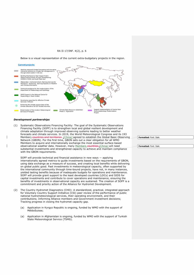
RA II-17/INF. 4(2), p. 6
Below is a visual representation of the current extra-budgetary projects in the region.
Development partnerships
(1) Systematic Observations Financing Facility: The goal of the Systematic Observations Financing Facility (SOFF) is to strengthen local and global resilient development and climate adaptation through improved observing systems leading to better weather forecasts and climate services. In 2019, the World Meteorological Congress and its 193 Members countries and territories [China] agreed to establish the Global Basic Observing Network (GBON). For the first time, GBON sets out a clear obligation for all WMO Members to acquire and internationally exchange the most essential surface-based observational weather data. However, many Members countries [China] will need substantial investments and strengthened capacity to achieve and maintain compliance with the GBON requirements.
SOFF will provide technical and financial assistance in new ways — applying internationally agreed metrics to guide investments based on the requirements of GBON, using data exchange as a measure of success, and creating local benefits while delivering on global public good. Past investments in meteorological capacity, often supported by the international community through time-bound projects, have not, in many instances, yielded lasting benefits because of inadequate budgets for operations and maintenance. SOFF will provide grant support to the least developed countries (LDCs) and SIDS for capital investments and contribute to cover operations and maintenance, ensuring the benefits of investments in observational capacity are sustained. The creation of SOFF is a commitment and priority action of the Alliance for Hydromet Development.
(2) The Country Hydromet Diagnostics (CHD): A standardized, practical, integrated approach for Voluntary Country Support Initiative (CSI) peer review of the performance of public national hydrometeorological services, their operating environment, and their contributions; Informing Alliance members and Government investment decisions; Tracking progress in closing the hydromet capacity gap.
(a) Application in Kyrgyz Republic is ongoing, funded by WMO with the support of MétéoSuisse;
(a) Application in Afghanistan is ongoing, funded by WMO with the support of Turkish State Meteorological Service (TSMS).
Formatted: Font: Italic
Formatted: Font: Italic

RA II-17/INF. 4(2), p. 7
(3) The Alliance for Hydromet Development: The Alliance aims to unite efforts to close the capacity gap on high-quality weather forecasts, early warning systems, and climate information as the foundation for resilient and sustainable development. The Alliance brings together major climate and development finance partners — 13 members including the largest funders of hydromet development. A high-level commitment from CEOs and agency heads signed the declaration and launched the Alliance during COP25 held in Madrid. The creation of the SOFF is a commitment of the Alliance.
(4) Alliance Hydromet Gap Report: It is aimed at tracking progress and establishing a baseline for the Alliance commitments, capture lessons learned and guide investments and identify high impact Alliance priority actions. The first Alliance Hydromet Gap Report is expected to be launched in July 2021 at the United Nations High-level Political Forum.
Other programmes addressing the capacity gap on weather, water, climate and related environmental services
(1) State of Climate Services report: a multi-agency report, coordinated by WMO, on the state of climate services for assessing adaptation needs in climate-sensitive socioeconomic sectors. The 2020 State of Climate Services Report, prepared by WMO and 17 partner organizations and initiatives, highlights progress made in early warning systems’ (EWS) implementation globally and identifies where and how governments can invest in effective EWS to strengthen the resilience of Members countries [China] to multiple weather, climate and water-related hazards. Partners value it as an important synthesis of the evidence on where, and what kind of investments are needed. Partners include: Agence Française de Développement (AFD); Adaptation Fund (AF); Climate Policy Initiative (CPI); Climate Risk and Early Warning Systems initiative (CREWS); Food and Agriculture Organization of the United Nations (FAO); Group on Earth Observations (GEO); Green Climate Fund (GCF); Global Environment Facility (GEF); International Federation of Red Cross and Red Crescent Societies (IFRC); Risk-informed Early Action Partnership (REAP); United Nations Office for Disaster Risk Reduction (UNDRR); United Nations Development Programme (UNDP); World Bank Group and its Global Facility for Disaster Reduction and Recovery (GFDRR); World Food Programme (WFP); the World Health Organization — WHO/WMO Climate and Health Office, and WMO.
(2) Checklist for Climate Services Implementation: WMO Members assess their capacity for providing climate services and documenting associated socioeconomic outcomes and benefits through a checklist that addresses functional capacities across the climate services value chain. Functional capacities assessed by the checklist are organized into six groups: Governance, Basic Systems, the User Interface, Capacity Development, Provision and Application of Climate Services, and Monitoring and Evaluation of socioeconomic benefits. Many of these functional capacities constitute “basic”, “essential”, “full” or “advanced” functionalities. The Checklist for Climate Services data provides a basis for assessing Member country [China] capacities and needs in each component of the climate services value chain, and for categorizing the overall level of service provided by the Member according to WMO criteria. It provides essential information to inform project proposal development, baseline assessments, and monitoring and evaluation for projects and WMO KPIs.
(3) WMO Hydrology Survey to collect information on governmental and non-governmental organizations that are responsible for operational hydrology within Members countries [China], their capabilities, structure, hydrological networks, data management and hydrological forecasting characteristics. The collected information is extremely valuable in the identification of capacity gaps at the national level, supporting regional priority activities, and informing the investment decisions of stakeholders involved, including development partners.
Formatted: Font: Italic
Formatted: Font: Italic
Formatted: Font: Italic
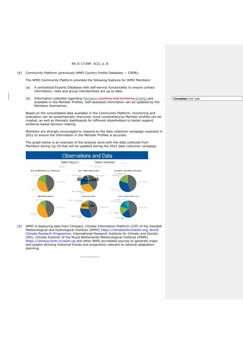
RA II-17/INF. 4(2), p. 8
(4) Community Platform (previously WMO Country Profile Database — CPDB):
The WMO Community Platform provides the following features for WMO Members:
(a) A centralized Experts Database with self-service functionality to ensure contact information, roles and group memberships are up to date.
(b) Information collected regarding Members countries and territories [China] are available in the Member Profiles. Self-assessed information can be updated by the Members themselves.
Based on the consolidated data available in the Community Platform, monitoring and evaluation can be systematically improved, more comprehensive Member profiles can be created, as well as thematic dashboards for different stakeholders to better support evidence-based decision-making.
Members are strongly encouraged to respond to the data collection campaign expected in 2021 to ensure the information in the Member Profiles is accurate.
The graph below is an example of the analysis done with the data collected from Members during Cg-18 that will be updated during the 2021 data collection campaign.
(5) WMO is deploying data from Climpact, Climate Information Platform (CIP) of the Swedish Meteorological and Hydrological Institute (SMHI) https://climateinformation.org, World Climate Research Programme, International Research Institute for Climate and Society (IRI), Climate Explorer of the Royal Netherlands Meteorological Institute (KNMI) https://climexp.knmi.nl/start.cgi and other WMO accredited sources to generate maps and graphs showing historical trends and projections relevant to national adaptation planning.
__________
Formatted: Font: Italic

ПО
ГОД
А К
ЛИ
МАТ
ВО
ДА Всемирная метеорологическая организация
РЕГИОНАЛЬНАЯ АССОЦИАЦИЯ II (АЗИЯ)
Семнадцатая сессия 25−26 мая 2021 г., виртуальная сессия
RA II-17/INF. 4(2)
Представлен: председателем
25.V.2021 г.
ОБНОВЛЕННАЯ ИНФОРМАЦИЯ О ПРОЕКТАХ ПО РАЗВИТИЮ ПОТЕНЦИАЛА В РА II
Проекты и мероприятия по развитию потенциала в РА II
Всемирная метеорологическая организация (ВМО) реализует портфель финансируемых из внебюджетных источников проектов и мероприятий на сумму более 20,97 миллиона швейцарских франков, инвестируемых в метеорологическое, гидрологическое и климатическое обслуживание в поддержку Членов ВМО в Региональной ассоциации II (РА II).
Соответствие проектов долгосрочным целям ВМО
1) Инвестиции в осуществляемые проекты соотносятся с долгосрочными целями ВМО следующим образом:
a) 60 %: долгосрочная цель 1 — более эффективное удовлетворение общественных потребностей;
b) 5 %: долгосрочная цель 2 — расширение наблюдений и прогнозов системы Земля;
c) 0 %: долгосрочная цель 3 — содействие проведению целевых исследований;
d) 34 %: долгосрочная цель 4 — ликвидация пробелов в области метеорологического, климатического и гидрологического обслуживания;
e) 5 %: долгосрочная цель 5 — стратегическая перестройка структуры и программ ВМО.
2) На графике ниже представлено соответствие портфеля проектов РА II стратегическим целям ВМО.

RA II-17/INF. 4(2), с. 2
Обзор проектов и мероприятий РА II
1) В 2016 году Министерство охраны окружающей среды Канады (МООСК) выделило 10 миллионов канадских долларов на проект под названием «Повышение устойчивости к гидрометеорологическим явлениям со значительными воздействиями путем повышения эффективности систем заблаговременных предупреждений о многих опасных явлениях в малых островных развивающихся государствах (МОСРГ) и Юго-Восточной Азии». Этот многострановый проект, который рассчитан на период до марта 2022 года, повысит эффективность основанного на воздействии обслуживания, связанного с погодой, климатом и водой, в поддержку принятия решений и, следовательно, будет способствовать защите жизни людей и имущества в трех регионах: Юго-Восточной Азии (4,4 миллиона канадских долларов), Карибском бассейне (2 миллиона канадских долларов) и Тихоокеанском регионе (3,6 миллиона канадских долларов). Целью проектов является укрепление потенциала национальных метеорологических и гидрологических служб для предоставления точных и своевременных прогнозов, включающих эффективные и учитывающие риски службы заблаговременных предупреждений о многих опасных явлениях. Это будет достигнуто путем спонсирования таких флагманских мероприятий ВМО в регионах, где осуществляются проекты, как Программа прогнозирования суровой погоды (ППСП) и Система оценки риска возникновения быстроразвивающихся паводков (СОРВБП), в поддержку более широких стратегических целей ВМО по снижению риска бедствий и предоставлению обслуживания.
2) ВМО оказывает поддержку Королевству Саудовская Аравия в рамках трехэтапного подхода с целью предоставления стратегических и технических экспертных знаний для модернизации Национального метеорологического центра (НМЦ) и осуществления мероприятий по развитию потенциала для НМЦ и Членов ВМО, которым оказывается поддержка по линии Целевого фонда Саудовской Аравии при ВМО. НМЦ будет предоставлен всеобъемлющий и комплексный план по устранению его пробелов и удовлетворению потребностей на основе Руководящих принципов ВМО и с опорой на более широкое сообщество ВМО для обеспечения экспертного
RA II-17/INF. 4(2), с. 3
обслуживания. Королевство Саудовская Аравия первоначально обязалось выделить 1,6 миллиона швейцарских франков, но смогло поддержать проект модернизации на сумму до 4 миллионов швейцарских франков. К ожидаемым результатам относится следующее: i) оценка и анализ предлагаемого бизнес-плана и оперативного плана для НМЦ; ii) разработка плана осуществления на основе всеобъемлющего и комплексного подхода к устранению пробелов и удовлетворению потребностей НМЦ на основе руководящих принципов ВМО и с опорой на более широкое сообщество ВМО для предоставления экспертного обслуживания; и iii) осуществление определенных мероприятий из плана модернизации для НМЦ.
3) В Бутане ВМО руководит осуществлением проекта под названием «Развитие потенциала для эффективного климатического обслуживания в Бутане», который финансируется Корейской метеорологической администрацией (КМА). Основная цель данного проекта заключается в укреплении действующих климатических служб в стране и устранении существующих пробелов и трудностей путем внедрения специализированного Инструментария по климатическому обслуживанию (ИКО). Это позволит Национальному гидрологическому и метеорологическому центру (НГМЦ) Бутана повысить эффективность и увеличить потенциал для выпуска, передачи и применения климатических информационных продуктов. Это будет дополнительно способствовать процессу принятия решений в таких чувствительных к климату секторах, как сельское хозяйство и продовольственная безопасность, снижение риска бедствий, энергетика, здравоохранение и водоснабжение. ВМО и НГМЦ тесно сотрудничают с Региональными комплексными системами заблаговременного предупреждения о многих опасных явлениях для Африки и Азии (РИМЕС) при осуществлении проектных мероприятий в стране. Общая стоимость проекта составляет около 128 000 швейцарских франков.
4) Через Корейский целевой фонд для укрепления глобального метеорологического, гидрологического и климатического обслуживания ВМО осуществляет два проекта для Членов РА II, а именно i) Спасение климатических данных в Узбекистане, фаза 2: оцифровка, и ii) Модернизация метеорологического обслуживания авиации Монголии.
a) Проект «Спасение климатических данных в Узбекистане, фаза 2: оцифровка» предназначен для оцифровки наборов климатологических и гидрологических данных в виде изображений, внедрения современной Системы управления климатическими данными (СУКД) и переноса спасенных данных и существующих электронных хранилищ данных в СУКД. Центр гидрометеорологического обслуживания при Кабинете министров Узбекистана (Узгидромет) отвечает за оцифровку месячных метеорологических переменных для 87 синоптических станций с конца XIX века и месячных сводных гидрологических переменных с 1960 года на основе достижений фазы 1 проекта: «Спасение климатических данных в Узбекистане (2015−2018 годы)». А Международная организация по спасению данных об окружающей среде (ИЕДРО) будет обеспечивать поддержку ОК/КК управления метеорологическими данными. Финансовую поддержку проекту оказывает КМА, а общий бюджет составляет около 418 000 долларов США.
b) Проект «Модернизация метеорологического обслуживания авиации Монголии» призван расширить возможности Национального агентства по метеорологии и мониторингу окружающей среды Монголии (НАММОС) в области метеорологического обслуживания авиации В 2019 году в ходе предварительного исследования было определено, что этот проект в основном будет направлен на установку резервной автоматизированной метеорологической системы наблюдения (АМСН) в новом открывающемся международном аэропорту Улан-Батора, а его общий бюджет составит около 400 000 долларов США.
RA II-17/INF. 4(2), с. 4
5) Международная инициатива по климату (МИК) Федерального министерства по делам окружающей среды, охраны природы и безопасности ядерных реакторов Германии (ВМУ) предоставила ВМО 8 миллионов евро (за 2018−2022 годы) на реализацию проекта под названием «Применение сезонного прогнозирования климата и инновационных страховых решений для управления климатическими рисками в сельскохозяйственном секторе в Юго-Восточной Азии (ДЕ-РИСК ЮВА)», нацеленного на Вьетнам, Камбоджу, Лаосскую НДР и Мьянму. Проект осуществляется ВМО, Международным центром по тропическому сельскому хозяйству в Ханое, Вьетнам (КИАТ), и Университетом Южного Квинсленда, Австралия. Партнеры проекта работают с несколькими национальными организациями в каждомй из странеЧленов [Китай], включая четыре НМГС. Проект направлен на разработку устойчивых систем управления климатическими рисками, передовой практики и страховых продуктов, которые защитят мелкие фермерские хозяйства и предприятия, участвующие в сельскохозяйственной цепочке создания ценности, от физических и финансовых бедствий, связанных с изменением климата. Он поможет соответствующим правительствам при разработке национальных/региональных стратегий адаптации и управления рисками. Основные цели проекта будут достигаться посредством следующих запланированных мероприятий: i) определение подходящих систем сезонного прогнозирования (по данным глобальных центров подготовки прогнозов ВМО), которые обеспечивают как точность и надежность, так и пригодность для принятия важнейших решений фермерами/пользователями в регионе; ii) разработка и проведение семинаров и социально-экономических исследований на основе широкого участия для совместного изучения основных рисков изменения климата, проблем, связанных с адаптацией, благоприятных факторов и препятствий; iii) нацеливание сезонного прогнозирования климата на принятие управленческих решений по каждому сектору сельского хозяйства для оказания содействия в постепенной адаптации к изменению климата; iv) разработка инструментов управления финансовыми рисками, и в том числе практических более инновационных страховых продуктов, учитывающих историю изменчивости климата в регионе; и v) разработка основанных на знаниях национальных и региональных стратегий адаптации и управления рисками и соответствующих программ и мер, основанных на стимулах.
6) ВМО и Группа Всемирного банка (ГВБ) подписали соглашение о партнерстве под названием «Альянс для развития в области гидрометеорологии», которое оказывает поддержку странам Членам [Китай] и проектным группам Всемирного банка в деле осуществления их проектов. ВМО оказывает поддержку гидрометеорологическим службам Казахстана, Кыргызской Республики, Таджикистана, Туркменистана и Узбекистана в рамках следующих проектов и предоставляет им наши технические знания:
a) Проект по модернизации гидрометеорологического обслуживания в Центральной Азии (ПМГОЦА, P120788)
b) Программа по адаптации к изменению климата и смягчению его воздействия для бассейна Аральского моря (ПАКВБАМ, P151363)
c) Укрепление заблаговременного предупреждения о горных опасных явлениях в Центральной Азии (SEWMH, P158373) при финансировании со стороны Программы по водным ресурсам и энергетике Центральной Азии (ПВРЭЦА)
В рамках этих усилий был утвержден проект «Система заблаговременного предупреждения о паводках в Центральной Азии и Афганистане» (СЗППЦАА), осуществление которого начнется летом этого года. Для этой инициативы будут использоваться ресурсы вышеупомянутых проектов, СОРВБП и КРСЗП-Афганистан. В ее рамках будет оказываться поддержка поставке и установке рабочего места синоптика, проведена модернизация существующей СОРВБП региона Центральной
Formatted: Font: Italic, Russian
Formatted: Font: Italic
Formatted: Font: Italic, Russian
Field Code Changed
Field Code Changed
Field Code Changed
RA II-17/INF. 4(2), с. 5
Азии (СОРВБПЦА), обеспечено включение Афганистана в СОРВБПЦА, разработаны компоненты мониторинга снежного покрова, а также речного стока и оползней, обеспечено наращивание потенциала для СОРВБП и интеграция «ICON-in-the-Cloud» («Икосаэдрическая негидростатическая модель в облаке») в качестве новой модели численного прогнозирования погоды (ЧПП), доступной для этого региона. Целевыми бассейнами проекта выступают бассейны рек Амударья и Сырдарья общей площадью более 930 000 км2 в Центральной Азии, где проживают более 100 миллионов человек. Кроме того, при полевой поддержке Глобального водного партнерства (ГВП) ВМО будет оказывать помощь Туркменгидромету в определении его потребностей и разработке перспективы среднесрочного развития наряду с информированием о его организационных целях на следующие пять лет посредством Национального стратегического финансового плана. Ожидается, что этот проект внесет вклад в процесс планирования и принятия решений на национальном уровне в целях удовлетворения потребностей в развитии потенциала для предоставления своевременного и точного метеорологического, гидрологического и климатического обслуживания для обеспечения готовности Гидромета к стихийным бедствиям.
7) С июля 2019 года ВМО реализует проект в Афганистане, финансируемый инициативой «Климатические риски и система заблаговременных предупреждений» (КРСЗП), направленный на укрепление оперативной гидрологии, метеорологии и климатологии для более эффективного предоставления гидрометеорологического обслуживания учреждениям и заинтересованным сторонам Афганистана. На эти цели было выделено 3,6 миллиона долларов США. Проект разделен на три основных компонента: i) укрепление систем предоставления обслуживания для служб заблаговременного предупреждения и гидрометеорологического обслуживания; ii) институциональное укрепление и наращивание потенциала; и iii) укрепление возможностей в области управления данными и прогнозирования. Были достигнут прогресс в деле разработки инструмента поддержки принятия решений за счет раннего предупреждения об опасности засухи (АФ-СЗПЗ), составления проектов меморандумов о взаимопонимании между партнерскими учреждениями и внедрения современной модели ЧПП. Кроме того, были созданы синергические связи с проектами в Центральной Азии, а также с СОРВБП, которая используется в настоящее время в стране в оперативном режиме. С последним докладом о положении дел с КРСЗП-Афганистан можно ознакомиться здесь.
8) КАРИТАС-Швейцария стала основным партнером поддержки АПУП, что позволит ВМО оказывать поддержку КАРИТАС в интересах осуществления проекта «Метеорологическое, гидрологическое и климатическое обслуживание для повышения устойчивости и благосостояния сельских общин в Таджикистане». Начальная фаза проекта была успешно завершена, и Швейцарскому управлению по развитию и сотрудничеству (ШУРС) было представлено новое предложение по пилотному проекту в районе Лахш в Таджикистане. Проект будет оказывать поддержку потребностям и приоритетам государств — чЧленов [Китай] ВМО и отвечает долгосрочной цели 1 (более эффективное удовлетворение общественных потребностей), в основном по стратегическим целям 1.3.1 и 1.3.2, и долгосрочной цели 4 (ликвидация пробелов в области метеорологического, климатического и гидрологического обслуживания). С подробными сведениями о проекте можно ознакомиться здесь.
9) ВМО также оказывает поддержку Программе Организации Объединенных Наций по окружающей среде (ЮНЕП), Программе развития Организации Объединенных Наций (ПРООН), ГВБ и Европейскому Союзу (ЕС) и Таджикско-Афганскому сотрудничеству по гидрологической информации и управлению рисками паводков. С более подробной информацией можно ознакомиться здесь.
10) ВМО и ГВБ создали новую концепцию для реагирования на потребности в области трансграничного гидрологического обслуживания стран Центральной Азии
Field Code Changed
Field Code Changed
Field Code Changed
Field Code Changed
Field Code Changed
Field Code Changed
Field Code Changed
RA II-17/INF. 4(2), с. 6
(Казахстан, Кыргызская Республика, Таджикистан, Туркменистан и Узбекистан) и Афганистана. Проект финансируется как по линии компонента-А (региональный) проекта ГВБ по модернизации гидрометеорологии в Центральной Азии, так и проекта КРСЗП-Афганистан (ВМО и ГВБ) в целях создания Консультативной системы прогнозирования стока и предупреждения об оползнях в бассейне Амударьи и Сырдарьи (СЗППЦАА). Осуществление проекта запланировано на период 2021−2024 годов.
11) ВМО оказывает поддержку в области разработки проектов для Национальной гидрометеорологической службы Азербайджана и ЮНЕП с целью разработки проектного предложения Зеленого климатического фонда (ЗКФ); усилия предпринимаются на уровне механизма подготовки проектов (МПП). С подробной информацией о предложении можно ознакомиться здесь.
12) ВМО оказывает поддержку в области структуры проектов для Департамента метеорологии Афганистана и ЮНЕП с целью разработки проектного предложения ЗКФ; в настоящее время предпринимаются усилия, и представленное в ЗКФ предложение было первоначально одобрено и сейчас находится на втором рассмотрении.
13) ВМО подписала соглашение с правительством Республики Союз Мьянма о предоставлении технической помощи для модернизации Департамента метеорологии и гидрологии Мьянмы (ДМГ) с 1 октября 2019 года. Эта техническая помощь предоставляется по линии рамочного соглашения ВМО и Всемирного банка по оказанию поддержки развитию потенциала стран-чЧленов [Китай]. Техническая помощь предоставляется ВМО ДМГ с целью: i) оказания содействия ДМГ в деле разработки и внедрения усовершенствованных инструментов, продуктов и обслуживания, стандартных оперативных процедур, автоматизированных процессов и систем управления качеством; и ii) наращивания потенциала сотрудников ДМГ в области эксплуатации и обслуживания системы в целом. Ввиду ситуации, связанной с пандемией коронавирусного заболевания (COVID-19), и текущих политических вопросов соглашение было продлено в третий раз и должно быть завершено в декабре 2021 года. Несмотря на возникшие трудности, было успешно проведено значительное количество дистанционных мероприятий по подготовке кадров. Однако ряд учебных мероприятий, которые зависели от установки центра хранения и обработки данных, не будут проведены по причине замораживания платежей со стороны ВБ. В настоящее время команда проекта ищет альтернативные решения для своевременного проведения этих мероприятий.
14) СОРВБП с глобальным охватом (резолюция 21, Кг-XV) смягчает последствия быстроразвивающихся паводков и расширяет возможности НМГС для заблаговременного предупреждения и охватывает сейчас шестьдесят семь (67) стран Членов [Китай] и более трех миллиардов человек во всем мире, спасая жизни и снижая экономические потери. СОРВБП — это инструмент прогнозиста, предназначенный для обеспечения доступных данных наблюдений и данных прогнозирования, подкрепленный обширными программами подготовки кадров в области гидрометеорологии, информационных технологий (ИТ) и радарной гидрологии, который нацелен на оказание поддержки прогнозистам на региональном и национальном уровнях в их усилиях по выпуску эффективных предупреждений о возникновении быстроразвивающихся паводков. Она была совместно разработана ВМО и Гидрологическим научно-исследовательским центром (ГНИЦ) при поддержке Национального управления по исследованию океанов и атмосферы (НУОА) и Агентства Соединенных Штатов Америки по международному развитию/Управлением по гуманитарной помощи (ЮСАИД/УГП).
Field Code Changed
Field Code Changed

RA II-17/INF. 4(2), с. 7
В РА II реализованы, находятся на этапе осуществления или на рассмотрении следующие региональные проекты СОРВБП:
a) СОРВБП Юго-Восточной Азии (СОРВБП-ЮВА) (в процессе осуществления): Вьетнам, Камбоджа, Лаосская НДР и Таиланд;
b) СОРВБП Южной Азии (СОРВБП-ЮАзия) (оперативный этап): Бангладеш, Бутан, Индия, Непал и Шри-Ланка;
c) СОРВБП в регионе Центральной Азии (СОРВБП-ЦА) (оперативный этап): Казахстан, Кыргызстан, Таджикистан, Туркменистан и Узбекистан;
d) автономная СОРВБП Мьянмы (оперативный этап): Мьянма;
e) региональная СОРВБП для Пакистана и Афганистана (оперативный этап): Афганистан и Пакистан.
Ниже дается визуальное представление текущих внебюджетных проектов в регионе.
Партнерские отношения в области развития
1) Фонд финансирования систематических наблюдений: цель Фонда финансирования систематических наблюдений (ФФСН) — укрепление устойчивости на местном и глобальном уровнях и адаптация к изменению климата путем совершенствования систем наблюдений, обеспечивающих более качественные прогнозы погоды и климатическое обслуживание. В 2019 году Всемирный метеорологический конгресс и его 193 страны и территорииЧлена [Китай], являющиеся Членами ВМО, договорились о создании Глобальной опорной сети наблюдений (ГОСН). Впервые ГОСН устанавливает четкое обязательство для всех Членов ВМО по получению и международному обмену наиболее важными данными наблюдений за погодой на поверхности. Вместе с тем многим странам Членам [Китай] потребуются значительные инвестиции и укрепление потенциала для обеспечения и поддержания соответствия требованиям ГОСН.
ФФСН будет по-новому оказывать техническую и финансовую помощь: применяя согласованные на международном уровне метрики для управления инвестициями на основе требований ГОСН, используя обмен данными в качестве меры успеха и
Field Code Changed
Field Code Changed
Field Code Changed
Field Code Changed

RA II-17/INF. 4(2), с. 8
создавая местные преимущества при обеспечении глобального общественного блага. Прошлые инвестиции в метеорологический потенциал, которые нередко осуществлялись при поддержке международного сообщества на основе проектов с определенными сроками, во многих случаях не принесли долгосрочных выгод из-за недостаточных бюджетов на эксплуатацию и техническое обслуживание. ФФСН обеспечит поддержку в виде субсидий наименее развитым странам (НРС) и МОСРГ для капитальных инвестиций и внесет вклад в покрытие расходов на эксплуатацию и техническое обслуживание, обеспечивая устойчивость выгод от инвестиций в потенциал в области наблюдений. Создание ФФСН является обязательством и приоритетной мерой Альянса для развития в области гидрометеорологии.
2) Инструмент гидрометеорологической диагностики по странам (ИГДС): стандартизированный, практический, комплексный подход в рамках Инициативы по добровольной поддержке стран (ИПС) для коллегиальной оценки эффективности деятельности государственных национальных гидрометеорологических служб, условий их работы и их вклада; для информирования членов Альянса и обоснования государственных инвестиционных решений; для отслеживания прогресса в деле устранения пробела в гидрометеорологическом потенциале.
a) В настоящее время применяется в Кыргызской Республике при финансировании со стороны ВМО при поддержке МетеоСвисс;
b) в настоящее время применяется в Афганистане при финансировании со стороны ВМО при поддержке Государственной метеорологической службы Турции (ГМСТ).
3) Альянс для развития в области гидрометеорологии: Альянс стремится объединить усилия по устранению пробелов в потенциале высококачественных прогнозов погоды, систем раннего предупреждения и климатической информации как основы для устойчивого и стабильного развития. Альянс объединяет основных партнеров по финансированию в области климата и развития — 13 членов, включая крупнейших спонсоров гидрометеорологического развития. Высокий уровень приверженности со стороны руководителей высшего звена и глав учреждений, подписавших декларацию и давших старт Альянсу во время КС 25, состоявшейся в Мадриде. Создание ФФСН является обязательством Альянса.
4) Доклад о пробелах Альянса по гидрометеорологии: направлен на отслеживание прогресса и определение отправной точки для выполнения обязательств Альянса, фиксации извлеченных уроков и руководства инвестициями, а также определения приоритетных мер Альянса с высоким уровнем воздействия. Ожидается, что первый доклад о пробелах Альянса по гидрометеорологии будет выпущен в июле 2021 года на Политическом форуме высокого уровня Организации Объединенных Наций.
Другие программы, направленные на устранение пробелов в потенциале метеорологического, гидрологического, климатического и связанного с окружающей средой обслуживания
1) Доклад о состоянии климатического обслуживания: межучрежденческий доклад, координируемый ВМО, о состоянии климатического обслуживания для оценки потребностей в области адаптации в чувствительных к климату социально-экономических секторах. Доклад о состоянии климатического обслуживания за 2020 год, подготовленный ВМО и 17 партнерскими организациями и инициативами, освещает прогресс, достигнутый в области внедрения систем раннего предупреждения (СРП) во всем мире, и определяет, где и как правительства могут инвестировать в эффективные СРП для повышения устойчивости стран Членов [Китай] перед лицом многочисленных опасных явлений, связанных с погодой, климатом и водой. Он высоко оценивается партнерами, поскольку в нем обобщены важные фактические данные о

RA II-17/INF. 4(2), с. 9
том, где и какие инвестиции необходимы. В число партнеров входят следующие структуры: Французское агентство по развитию (АФД); Адаптационный фонд (АФ); Инициатива в области климатической политики (ИКП); Инициатива «Климатические риски и система заблаговременных предупреждений» (КРСЗП); Продовольственная и сельскохозяйственная организация Объединенных Наций (ФАО); Группа по наблюдениям за Землей (ГЕО); Зеленый климатический фонд (ЗКФ); Глобальный экологический фонд (ГЭФ); Международная федерация обществ Красного Креста и Красного Полумесяца (МФКК); Партнерство в области раннего реагирования на основе информации о рисках (ПРРР); Управление Организации Объединенных Наций по снижению риска бедствий (УСРБ ООН); Программа развития Организации Объединенных Наций (ПРООН); Группа Всемирного банка и ее Глобальный фонд уменьшения опасности бедствий и восстановления (ГФУОБВ); Всемирная продовольственная программа (ВПП); Совместное бюро Всемирной организации здравоохранения — ВОЗ/ВМО по климату и здоровью и ВМО.
2) Памятка для осуществления климатического обслуживания: Члены ВМО оценивают свой потенциал в области предоставления климатического обслуживания и документирования связанных с этим социально-экономических результатов и выгод с помощью памятки, в которой рассматриваются функциональные возможности по всей цепочке формирования ценности климатического обслуживания. Функциональные возможности, оцениваемые по памятке, разбиты на шесть групп: управление, основные системы, взаимодействие с пользователями, развитие потенциала, предоставление и применение климатического обслуживания, а также мониторинг и оценка социально-экономических выгод. Многие из этих функциональных возможностей представляют собой «базовые», «основные», «полные» или «расширенные» функциональные возможности. Данные Памятки для осуществления климатического обслуживания служат основой для оценки возможностей и потребностей страны Членов [Китай] в каждом компоненте цепочки формирования ценности климатического обслуживания, а также для классификации общего уровня обслуживания, предоставляемого Членом в соответствии с критериями ВМО. В ней содержится важная информация для обоснования разработки проектных предложений, оценок исходных условий, а также мониторинга и оценки проектов и КПЭ ВМО.
3) Опрос по гидрологии ВМО для получения информации о правительственных и неправительственных организациях, ответственных за оперативную гидрологию в странахЧленах [Китай], их возможностях, структуре, гидрологических сетях, управлении данными и характеристиках гидрологического прогнозирования. Собранная информация представляет огромную ценность с точки зрения выявления пробелов в области потенциала на национальном уровне, оказания поддержки региональным приоритетным видам деятельности и формирования информационной основы для решений об инвестициях заинтересованных сторон, включая партнеров в области развития.
4) Платформа сообщества (ранее База профильных данных ВМО по странам — БПДС):
Платформа сообщества ВМО предоставляет следующие возможности для Членов ВМО:
a) централизованная база данных экспертов с функциональностью самообслуживания для обеспечения актуальности контактной информации, функций и членского состава групп.
b) собранная о странах и территорияхЧленах [Китай] информация доступна в Профилях Членов. Члены могут самостоятельно обновлять информацию о самооценке.
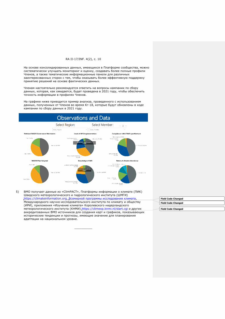
RA II-17/INF. 4(2), с. 10
На основе консолидированных данных, имеющихся в Платформе сообщества, можно систематически улучшать мониторинг и оценку, создавать более полные профили Членов, а также тематические информационные панели для различных заинтересованных сторон с тем, чтобы оказывать более эффективную поддержку принятию решений на основе фактических данных.
Членам настоятельно рекомендуется ответить на вопросы кампании по сбору данных, которая, как ожидается, будет проведена в 2021 году, чтобы обеспечить точность информации в профилях Членов.
На графике ниже приводится пример анализа, проведенного с использованием данных, полученных от Членов во время Кг-18, которые будут обновлены в ходе кампании по сбору данных в 2021 году.
5) ВМО получает данные из «ClimPACT», Платформы информации о климате (ПИК) Шведского метеорологического и гидрологического института (ШМГИ) https://climateinformation.org, Всемирной программы исследования климата, Международного научно-исследовательского института по климату и обществу (ИРИ), приложения «Изучение климата» Королевского нидерландского метеорологического института (КНМИ) https://climexp.knmi.nl/start.cgi и других аккредитованных ВМО источников для создания карт и графиков, показывающих исторические тенденции и прогнозы, имеющие значение для планирования адаптации на национальном уровне.
__________
Field Code Changed
Field Code Changed
Field Code Changed

天气
气候
水
世界气象组织
第二区域协会(亚洲)
第十七次届会 2021 年 5 月 25 至 26 日,虚拟届会
RA II-17/INF. 4(2)
提交者:
会议主席
2021.5.25
二区协能力发展项目的最新情况
二区协的能力发展项目和活动
世界气象组织(WMO)实施了一揽子预算外资金资助的项目和活动,在天气、水和气候服务方面的投资价值
超过 2097 万瑞士法郎,以支持第二区域协会(RA II)的 WMO 会员。
项目与 WMO 长期目标保持一致
(1) 正在实施的项目的投资与 WMO 的长期目标保持一致,具体如下所示:
(a) 60%: LTG 1 – 更好地服务于社会需求;
(b) 5%: LTG 2 - 加强地球系统观测和预测;
(c) 0%: LTG 3 - 推进有针对性的研究;
(d) 34%: LTG 4 - 弥补在天气、气候、水文及相关环境服务方面的能力差距;
(e) 1%: LTG 5 – WMO 结构和计划的战略重组。
(2) 下图提供了二区协一揽子项目与 WMO 战略目标的匹配情况。

RA II-17/INF. 4(2), p. 2
二区协项目和活动概述
(1) 2016 年,加拿大环境与气候变化部(ECC)向“通过加强小岛屿发展中国家(SIDS)和东南亚的多灾
种早期预警系统,建立对高影响水文气象事件的复原力”项目拨款 1000 万加元。 这个多国项目一直持
续到 2022 年 3 月,将加强与天气、气候和水有关的基于影响的决策支持服务,从而帮助保护三个地区
的生命和财产,即东南亚(440 万加元)、加勒比(200 万加元)和太平洋(360 万加元)。该项目
的目标是加强国家气象和水文服务的能力,以提供准确和及时的预报,其中包括有效的、有风险依据的
的多灾种早期预警服务。这将通过在项目地区赞助开展 WMO 旗舰活动来实现,如灾害性天气预报计划
(SWFP)和骤洪指导系统(FFGS),以支持更广泛的减少灾害风险和提供服务方面的 WMO 战略目
标。
(2) 借助设在 WMO 的沙特阿拉伯信托基金支持,WMO 采用三阶段的方法支持沙特阿拉伯王国,为国家气
象中心(NCM)的现代化以及为 NCM 和 WMO 会员实施能力发展活动提供战略和技术专长。以 WMO的指导方针为指导,将向 NCM 提供一个全面的和综合性计划,以解决其差距和需求,并利用更广泛的
WMO 社区来确保专家服务。沙特阿拉伯王国已初步承诺提供 160 万瑞士法郎,但可以为现代化项目提
供高达 400 万瑞士法郎的支持。预期成果包括:(1) 评估和审查 NCM 拟议的业务和运行计划;
(2)以 WMO 指导方针为指导,制定一个实施计划,利用全面的综合性方法解决 NCM 的差距和需
求,并利用更广泛的 WMO 来确保专家服务;(3)实施 NCM 现代化计划中确定的活动。
(3) 在不丹,WMO 正在领导实施一个名为“发展不丹有效气候服务的能力”的项目,该项目由韩国气象厅
(KMA)提供资金支持。这个项目的主要目标是加强该国现有的气候服务,并通过部署一个定制的气候
服务工具包(CST)来解决当前的差距和挑战。这将使不丹国家水文气象中心(NCHM)能够提高制
作、传播和应用气候信息产品的效率和能力。这将进一步支持气候敏感部门的决策过程,如农业和粮食
安全、减少灾害风险、能源、卫生和水等部门。WMO 和 NCHM 正在与非洲和亚洲区域综合多种灾害
预警系统(RIMES)紧密合作,在该国开展项目活动。项目总价值约为 12.8 万瑞士法郎。
(4) 通过韩国加强全球天气、水和气候服务信托基金,WMO 正在为二区协成员实施两个项目,即(1)乌
兹别克斯坦的气候数据救援,第二阶段:数字化,和(2)蒙古航空气象服务现代化。
(a) “乌兹别克斯坦气候数据抢救第二阶段:数字化”项目是为了将成像的气候学和水文学数据集数字
化,实施现代的气候数据管理系统(CDMS),并将抢救的数据和现有的电子数据储存迁移到
CDMS 中。乌兹别克斯坦部长内阁下属的水文气象服务中心(Uzhydromet)负责对 87 个天气
站 19 世纪末的月度气象变量进行数字化,并根据项目第一阶段的成果:“乌兹别克斯坦气候数据
救援(2015-2018)”,对 1960 年以来的月度水文变量进行汇总。而国际环境数据救援组织
(IEDRO)将支持气象数据管理的质量保证/质量控制。该项目由 KMA 提供财政支持,总预算约
为 41.8 万美元。
(b) “蒙古航空气象服务现代化”项目预计将提高蒙古国家气象环境监测局(NAMEM)在航空气象服
务方面的能力。 通过 2019 年的初步调查,确定该项目将主要关注在新开业的乌兰巴托国际机场
安装备用自动气象观测系统(AWOS),其总预算约为 40 万美元。
(5) 德国联邦环境、自然保护和核安全部(BMU)的国际气候倡议(IKI)向 WMO 捐款 800 万欧元
(2018-2022 年),用于实施“将季节性气候预报和创新保险解决方案应用于东南亚农业部门的气候风
险管理(DE-RISK SE ASIA)”项目,该项目针对柬埔寨、老挝人民民主共和国、缅甸和越南。该项目
由 WMO、位于越南河内的国际热带农业中心(CIAT)和澳大利亚南昆士兰大学实施。项目合作伙伴与
每个会员国家[中国]的若干国家组织合作,包括四个 NMHS。该项目旨在开发有弹性的气候风险管理系
统、最佳做法和保险产品,以保护小农户和参与农业价值链的企业免受与气候变化有关的物质和金融灾
难。它将协助相关政府制定国家/区域适应和风险管理战略。项目的核心目标将通过以下计划措施实
现:(1)确定合适的季节性预报系统(以 WMO 全球制作中心为基础),这些系统既具有准确性和可
靠性,又适合该地区重要的农民/用户决策;(2)开发和制作参与性研讨会和社会经济调查,共同探讨
关键的气候变化风险、适应挑战、有利因素和障碍;(3)将季节性气候预报的目标对准每个部门的农
业管理决策,以协助逐步适应气候变化;(4)开发金融风险管理工具,包括认识到该地区气候变率历
史的实用的、更具创新性的保险产品;(5)开发知识驱动型国家和区域适应和风险管理战略以及以激
励措施为动力的适当计划和措施。
Formatted: Font: Italic

RA II-17/INF. 4(2), p. 3
(6) WMO 和世界银行集团(WBG)已经签订了伙伴关系,称为 "水文联盟",以支持会员各国[中国]和世
界银行项目组的项目实施。WMO 正在通过以下项目支持哈萨克斯坦、吉尔吉斯共和国、塔吉克斯坦、
土库曼斯坦和乌兹别克斯坦的水文气象服务,并向他们提供技术专长:
(a) 中亚水文气象现代化项目(CAHMP, P120788)
(b) 咸海流域气候适应和减缓项目(CAMP4ASB, P151363)
(b) 加强中亚山区灾害预警(SEWMH,P158373),由中亚水和能源计划(CAWEP)资助
经过努力,中亚-阿富汗洪水早期预警系统(CAFEWS)项目已被批准,并将于今年夏天开始实施。这
一倡议将从上述项目、FFGS 和 CREWS-阿富汗等项目中汲取资源。它将支持交付和安装一个预报员工
作站,升级目前的中亚地区 FFGS(CARFFGS),将阿富汗纳入 CARFFGS,开发雪情监测以及河流
流量和滑坡组成部分,为 FFGS 提供能力建设,并将 ICON-in-the-Cloud 作为一个新的数值天气预报
(NWP)模式,供该地区使用。该项目的目标流域是阿姆达里亚河和锡尔达里亚河流域,这里总面积超
过 93 万平方公里,流经整个中亚地区,有 1 亿多人居住于此。此外,在全球水伙伴关系(GWP)的实
地支持下,WMO 将协助土库曼斯坦水文气象局确定其需求,制定中期发展愿景,并通过国家战略财务
计划确定其未来五年的组织目标。该项目预计将有助于国家规划和决策过程,以满足其发展需要,为水
文气象防灾提供及时和准确的天气、水和气候服务。
(7) 自 2019 年 7 月以来,WMO 实施了一个阿富汗项目,由气候风险早期预警系统提供资金-(CREWS)-该倡议的重点是加强水文、气象和气候业务,以便更好地向阿富汗的机构和利益相关方提供水文学服
务。已为此拨款 360 万美元。该项目分为三个主要部分:(1)加强早期预警和水文监测服务的服务提
供系统;(2)机构强化和能力建设;(3)加强数据管理和预报能力。在开发干旱早期预警决策支持工
具(AF-DEWS)、起草伙伴机构之间的谅解备忘录(MoU)以及实施最先进的 NWP 方面取得了进
展。此外,还与中亚的项目以及 FFGS 产生了协同作用,FFGS 目前已在该国投入使用。最新的
CREWS-阿富汗现状报告可点击此处查阅。
(8) CARITAS-瑞士成为 APFM 支持基地合作伙伴,这将使 WMO 能够支持 CARITAS 实施“天气、水和气
候服务以提高塔吉克斯坦农村社区的复原力和福利”。项目的初始阶段已经成功结束,并向瑞士发展与
合作署(SDC)提交了在塔吉克斯坦拉克什省开展试点项目的新建议。该项目将支持 WMO 会员国[中国]的需求和优先重点,并与 LTG 1(更好地服务于社会需求)主要战略目标 1.3.1 和 1.3.2 以及 LTG 4(缩小天气、气候和水文服务的能力差距)保持一致。该项目的细节可在此处查阅。
(9) 世界气象组织还支持联合国环境规划署(UNEP)、联合国开发计划署(UNDP)、世界银行集团
(WBG)和欧洲联盟(EU)塔吉克阿富汗水文信息和洪水风险管理的合作。详细内容可在此处查阅。
(10) WMO 和 WBG 为满足中亚国家(哈萨克斯坦、吉尔吉斯共和国、塔吉克斯坦、土库曼斯坦和乌兹别克
斯坦)和阿富汗的跨境水文服务需求提出了一个新的概念。该项目由 WBG 中亚水文气象现代化项目 A部分(区域)和 CREWS-阿富汗项目(WMO 和 WBG)资助,旨在建立阿姆达里亚河和锡尔达里亚河
流域的流量预报和滑坡预警及咨询系统(CAFEWS)。该项目实施期为 2021-2024 年。
(11) WMO 向阿塞拜疆国家水文气象局和 UNEP 提供了项目设计支持,以制定绿色气候基金(GCF)项目提
案;项目准备设施(PPF)级别的工作正在进行中。该提案的细节可在此处查阅。
(12) 世界气象组织向阿富汗气象局和 UNEP 提供了项目设计支持,以制定 GCF 项目建议;目前正在开展工
作,已经提交给 GCF 的建议得到了初步批准,目前正在进行第二次审查。
(13) 2019 年 10 月 1 日,WMO 与缅甸联邦共和国政府签署了一项协议,为缅甸气象水文局(DMH)的现
代化建设提供技术援助。这项技术援助符合 WMO/世界银行支持会员国[中国]能力发展的框架协议。
WMO 向 DMH 提供技术援助的目的是(1)协助 DMH 开发和实施改进的工具、产品和服务、标准操作
程序、自动化流程和质量管理系统;(2)建设 DMH 工作人员操作和维护整个系统的能力。由于
Covid-19 大流行的情况和目前的政治问题,该协议已被第三次延长,将于 2021 年 12 月完成。尽管
Formatted: Font: Italic
Formatted: Font: Italic
Formatted: Font: Italic

RA II-17/INF. 4(2), p. 4
面临着各种挑战,但大量的远程培训已经成功进行。然而,由于世界银行冻结了付款,因此某些依赖于
数据中心安装的培训将无法执行。项目组目前正在寻求其他解决方案,以按时提供这些培训。
(14) 覆盖全球的 FFGS(决议 21,Cg-15)减轻了骤洪的影响,提高了 NMHS 的早期预警能力,目前覆盖
了全世界六十七(67)个会员国家[中国]和超过三十亿人,挽救了生命并减少了经济损失。FFGS 是一
个面向预报员的工具,旨在提供可获得的观测和预报数据,并由广泛的水文气象学、信息技术(IT)和
雷达水文学培训计划支持,目的是支持区域和国家层面的预报员提供关于骤洪发生的有效预警。在美国
国家海洋和大气管理局(NOAA)和美国国际开发署/人道主义援助局(USAID/BHA)的支持下,
WMO 和水文研究中心(HRC)联合开发了该系统。
区协已经完成、正在实施或正在考虑实施以下区域 FFGS 项目:
(a) 东南亚 FFGS (SeAFFGS) (正在实施):柬埔寨、老挝、泰国和越南;
(b) 南亚 FFGS (SAsiaFFGS) (运行中):孟加拉国、不丹、尼泊尔、斯里兰卡和印度;
(c) 中亚地区 FFGS (CARFFGS)(运行中):哈萨克斯坦、吉尔吉斯斯坦、塔吉克斯坦、土库曼斯
坦和乌兹别克斯坦;
(d) 缅甸独立 FFGS(运行中):缅甸;
(e) 巴基斯坦和阿富汗区域 FFGS(运行中):巴基斯坦和阿富汗。
以下是该地区目前的预算外项目的可视化表示形式。
发展伙伴关系
(1) 系统观测融资机制:系统观测融资机制(SOFF)的目标是通过改善观测系统,促进提供更好的天气预
报和气候服务,从而加强地方和全球的复原力发展和气候适应。2019 年,世界气象大会及其 193 个会
员国和地区[中国]同意建立全球基本观测网(GBON)。GBON 首次明确规定所有 WMO 会员有义务获
取并国际交换最基本的地表观测天气数据。然而,许多会员国家[中国]将需要大量投资和加强能力,以
实现和保持对 GBON 要求的遵守。
SOFF 将以新的方式提供技术和财政援助 — 根据 GBON 的要求,运用国际商定的衡量标准来指导投
资,以数据交换作为成功的衡量标准,并在实现全球公益的同时创造地方效益。过去对气象能力的投
资,通常由国际社会通过有时间限制的项目来支持,但在许多情况下,由于运行和维护的预算不足,并
Formatted: Font: Italic
Formatted: Font: Italic
Formatted: Font: Italic
RA II-17/INF. 4(2), p. 5
未产生持久的效益。SOFF 将为最不发达国家(LDC)和小岛屿发展中国家(SIDS)的资本投资提供
赠款支持,并帮助支付运行和维护费用,以确保观测能力投资的效益得以持续。创建 SOFF 是水文气象
发展联盟的一项承诺和优先行动。
(2) 国家水文气象诊断(CHD):一个标准化的、实用的、综合的方法,用于自愿性国家支持计划(CSI)对公共国家水文气象服务的表现、其运行环境及其贡献的同行审查;为联盟成员和政府的投资决策提供
信息;跟踪缩小水文气象能力差距的进展。
(a) 由 WMO 资助,在瑞士气象局的支持下,在吉尔吉斯共和国的应用正在进行;
(a) 由 WMO 资助,在土耳其国家气象局(TSMS)的支持下,在阿富汗的应用正在进行。
(3) 水文气象发展联盟:该联盟旨在联合各方力量,缩小高质量天气预报、早期预警系统和气候信息方面的
能力差距,以此作为复原力和可持续发展的基础。该联盟汇集了主要的气候和发展融资伙伴 — 13 个成
员,包括水文气象发展的最大资助者。在马德里举行的 COP25 大会上,首席执行官和机构负责人的高
级别承诺签署了宣言并启动了联盟。创建 SOFF 是该联盟的一项承诺。
(4) 联盟水文气象差距报告:该报告旨在跟踪进展情况,为联盟的承诺建立一个基线,总结经验教训,指导
投资,并确定联盟的高影响优先行动。预计第一份联盟水文气象差距报告将于 2021 年 7 月在联合国高
级别政治论坛上发布。
解决天气、水、气候和相关环境服务方面能力差距的其他计划
(1) 气候服务状况报告:由 WMO 协调编写的多机构气候服务状况报告,内容为评估气候敏感的社会经济部门
的适应需求。《2020 年气候服务状况报告》由 WMO 和 17 个伙伴组织和倡议组织编写,重点介绍了全
球早期预警系统(EWS)实施方面取得的进展,并确定了政府可以在哪些方面以及如何投资于有效的
EWS,以加强各会员国[中国]对多种天气、气候和水相关灾害的复原力。合作伙伴认为这份报告综合提
供了有关哪里需要投资以及需要何种投资的证据。合作伙伴包括:法国开发署(AFD)、适应基金
(AF)、气候政策倡议(CPI)、气候风险和早期预警系统倡议(CREWS)、联合国粮食及农业组织
(FAO)、地球观测组织(GEO)、绿色气候基金(GCF)、全球环境基金(GEF)、红十字会和红新
月会国际联合会(IFRC)、风险知情的早期行动伙伴关系(REAP)、联合国减少灾害风险办公室
(UNDRR)、联合国开发计划署(UNDP)、世界银行集团及其全球减灾和恢复基金(GFDRR)、世界
粮食计划署(WFP)、世界卫生组织 — WHO/WMO 气候和卫生健康办公室,以及 WMO。
(2) 气候服务实施清单:WMO 会员利用一份涉及整个气候服务价值链功能能力的清单,评估其提供气候服务
和记录相关社会经济成果和效益的能力。清单所评估的功能能力分为六类:治理、基本系统、用户界面、
能力发展、气候服务的提供和应用,以及社会经济效益的监测和评估。其中许多功能能力构成“基本”、“ 必要”、“ 全面”或“高级”功能。气候服务数据清单可作为基础,据此评估会员国家[中国]在气候服务价
值链的每个组成部分的能力和需求,以及根据 WMO 标准对会员提供的总体服务水平进行分类。它提供了
重要的信息,为项目建议的制定、基线评估以及项目和 WMO 关键绩效指标的监测和评估提供信息。
(3) WMO 水文调查收集了各会员国[中国]负责业务水文的政府和非政府组织的信息,包括其能力、结构、
水文网络、数据管理和水文预报特点等。收集到的信息对于确定国家层面的能力差距、支持区域优先活
动以及为包括发展伙伴在内的相关利益方的投资决策提供信息都是极为宝贵的。
(4) 社区平台(原 WMO 国家概况数据库 - CPDB):
WMO 社区平台为 WMO 会员提供以下功能:
(a) 具有自助服务功能的集中式专家数据库,以确保联系信息、作用和小组成员资格等信息都是最新
的。
(b) 收集到的有关会员国家和地区[中国]的信息可在会员资料中找到。自我评估信息可由会员自己更
新。
Formatted: Font: Italic
Formatted: Font: Italic
Formatted: Font: Italic
Formatted: Font: Italic
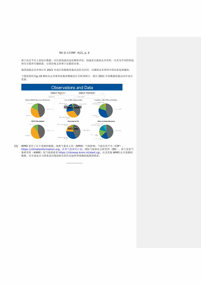
RA II-17/INF. 4(2), p. 6
基于社区平台上的综合数据,可以系统地改进监测和评估,创建更全面的会员资料,以及为不同的利益
相关方提供专题版面,以更好地支持基于证据的决策。
强烈鼓励会员对预计在 2021 年进行的数据收集活动作出回应,以确保会员资料中的信息是准确的。
下图是利用 Cg-18 期间从会员那里收集的数据进行分析的例子,将在 2021 年的数据收集活动中进行
更新。
(5) WMO 采用了以下来源的数据:瑞典气象水文局(SMHI)气候影响、气候信息平台(CIP)、
https://climateinformation.org、世界气候研究计划、国际气候和社会研究所(IRI)、荷兰皇家气
象研究所(KNMI)的气候探索者 https://climexp.knmi.nl/start.cgi、以及其他 WMO 认可来源的
数据,以生成显示与国家适应规划相关的历史趋势和预测的地图和图表。
__________
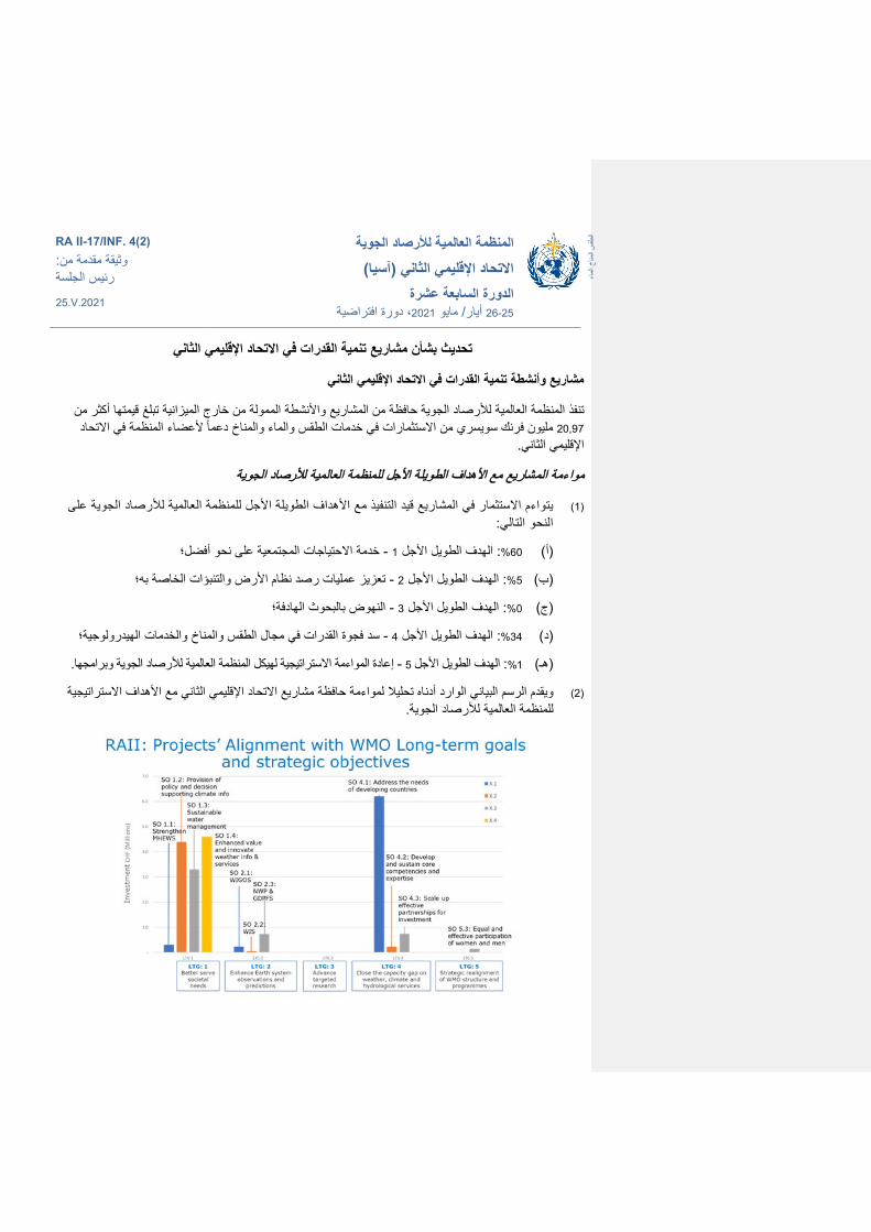
ماء ال
اخلمن
س اطق
ال
المنظمة العالمیة لألرصاد الجویة
االتحاد اإلقلیمي الثاني (آسیا) السابعة عشرة الدورة
دورة افتراضیة ،2021 مایو /أیار 26-25
RA II-17/INF. 4(2) وثیقة مقدمة من: رئیس الجلسة25.V.2021
االتحاد اإلقلیمي الثاني مشاریع تنمیة القدرات في بشأن تحدیث
االتحاد اإلقلیمي الثاني مشاریع وأنشطة تنمیة القدرات في
تنفذ المنظمة العالمیة لألرصاد الجویة حافظة من المشاریع واألنشطة الممولة من خارج المیزانیة تبلغ قیمتھا أكثر من والماءت في خدمات الطقس ملیون فرنك سویسري من االستثمارا 20,97 االتحاد ألعضاء المنظمة في والمناخ دعما
اإلقلیمي الثاني.
مواءمة المشاریع مع األھداف الطویلة األجل للمنظمة العالمیة لألرصاد الجویة
لألرصاد الجویة على االستثمار في المشاریع قید التنفیذ مع األھداف الطویلة األجل للمنظمة العالمیة واءم یت (1) النحو التالي:
؛على نحو أفضل الحتیاجات المجتمعیةاخدمة - 1 الھدف الطویل األجل :60% (أ)
؛الخاصة بھ تعزیز عملیات رصد نظام األرض والتنبؤات - 2 الھدف الطویل األجل :5% (ب)
؛الھادفةالبحوث النھوض ب - 3 الھدف الطویل األجل :0% (ج)
؛الطقس والمناخ والخدمات الھیدرولوجیةفي مجال سد فجوة القدرات - 4 الھدف الطویل األجل :34% (د)
. لھیكل المنظمة العالمیة لألرصاد الجویة وبرامجھا ة االستراتیجی المواءمة إعادة - 5 الھدف الطویل األجل : 1% (ھـ)
مع األھداف االستراتیجیة االتحاد اإلقلیمي الثاني أدناه تحلیال لمواءمة حافظة مشاریع الوارد ویقدم الرسم البیاني (2) .للمنظمة العالمیة لألرصاد الجویة
RA II-17/INF. 4(2), p. 2
االتحاد اإلقلیمي الثاني نظرة عامة على مشاریع وأنشطة
للمشروع المعنون 2016 كندي في عام دوالر مالیین 10 (ECCC) خصصت وزارة البیئة وتغیر المناخ الكندیة (1)التأثیر من خالل تعزیز نظم اإلنذار المبكر الشدیدة الھیدرولوجیة الصمود في مواجھة الظواھر بناء القدرة على ”
، 2022 مارسآذار/ وحتى .“وجنوب شرق آسیا (SIDS)في الدول الجزریة الصغیرة النامیة بأخطار متعددة متعدد البلدان خدمات دعم اتخاذ القرار القائمة على الطقس والمناخ والمیاه، وبالتالي المساعدة السیعزز المشروع
ن دوالر كندي)، ومنطقة ییمال 4,4( رواح والممتلكات في ثالث مناطق، ھي جنوب شرق آسیافي حمایة األویتمثل ھدف ن دوالر كندي).ییمال 3,6( )، والمحیط الھادئةكندیال اتدوالران من الملیون( البحر الكاریبي
والھیدرولوجیا على توفیر تنبؤات دقیقة وفي الوقت الوطنیة لألرصاد الجویة المرافق المشاریع في تعزیز قدرة وسیتحقق ذلك من خالل رعایة متعددة.بأخطار ،المخاطرومستنیرة بفعالة ،المناسب تشمل خدمات إنذار مبكر
األنشطة الرئیسیة للمنظمة العالمیة لألرصاد الجویة في مناطق المشروع، مثل برنامج التنبؤ بالطقس القاسي (SWFP) التوجیھ بشأن الفیضانات المفاجئة ونظام(FFGS) دعما لألھداف االستراتیجیة األوسع للمنظمة العالمیة
.لألرصاد الجویة بشأن الحد من مخاطر الكوارث وتقدیم الخدمات
لتوفیر الخبرة تدعم المنظمة العالمیة لألرصاد الجویة المملكة العربیة السعودیة من خالل نھج ثالثي المراحل (2) القدرات ألعضاءتنمیة وتنفیذ أنشطة (NCM)لتحدیث المركز الوطني لألرصاد الجویة الفنیة االستراتیجیة و
بدعم من الصندوق االستئماني للمملكة العربیة السعودیة في المنظمة العالمیة لألرصاد WMO والمنظمة المركزبالمبادئ التوجیھیة ا بخطة شاملة ومتكاملة لمعالجة ثغراتھ واحتیاجاتھ، مسترشدالمركز وسیتم تزوید الجویة.
المنظمة العالمیة لألرصاد الجویة األوسع لتأمین خدمات أوساط من مستفیدا للمنظمة العالمیة لألرصاد الجویة وولكن مع قدرتھا على ملیون فرنك سویسري، 1,6 وقد خصصت المملكة العربیة السعودیة في البدایة الخبراء.
تقییم ’1‘: وتشمل النتائج المتوقعة ما یلي مالیین فرنك سویسري لمشروع التحدیث. 4 دعم یصل إلىتقدیم نھج شامل ومتكامل ذات وضع خطة تنفیذ ’2‘؛ (NCM) لمركزواستعراض خطة العمل والتشغیل المقترحة ل
بالمبادئ التوجیھیة للمنظمة العالمیة مع االسترشاد ، (NCM)بالمركز لمعالجة الثغرات واالحتیاجات المتعلقة المنظمة العالمیة لألرصاد الجویة األوسع نطاقا لتأمین خدمات الخبراء؛أوساط لألرصاد الجویة واالستفادة من
.المركزتحدیث تنفیذ األنشطة المحددة من خطة ’3‘
القدرات على توفیر خدمات نمیةوفي بوتان، تقود المنظمة العالمیة لألرصاد الجویة تنفیذ مشروع بعنوان "ت (3) (KMA)مناخیة فعالة في بوتان" تدعمھ إدارة األرصاد الجویة الكوریة ویتمثل الھدف الرئیسي لھذا .مالیا
المشروع في تعزیز الخدمات المناخیة القائمة في البلد ومعالجة الثغرات والتحدیات الحالیة من خالل نشر ن المركز الوطني للھیدرولوجیا سیمك ذلك و .(CST)مصممة خصیصا مجموعة أدوات للخدمات المناخیة
ن الكفاءة ورفع القدرة على إنتاج منتجات المعلومات المناخیة من تحسی (NCHM)واألرصاد الجویة في بوتان وھذا من شأنھ أن یدعم عملیة صنع القرار في القطاعات الحساسة للمناخ مثل الزراعة وتطبیقھا. اإلبالغ بھاو
وتعمل المنظمة العالمیة لألرصاد والمیاه. ،والصحة ،والطاقة ،والحد من مخاطر الكوارث ،واألمن الغذائيبشكل وثیق مع النظم اإلقلیمیة المتكاملة (NCHM)ألرصاد الجویة والمركز الوطني للھیدرولوجیا واالجویة
تبلغ القیمة اإلجمالیة و لإلنذار المبكر باألخطار المتعددة ألفریقیا وآسیا في تنفیذ أنشطة المشروع داخل البلد. .فرنك سویسري 000 128 للمشروع حوالي
ومن خالل الصندوق االستئماني الكوري لتعزیز خدمات الطقس والمیاه والمناخ العالمیة، تنفذ المنظمة العالمیة (4) :2 إنقاذ البیانات المناخیة في أوزبكستان، المرحلة ’1‘ ھما: الثاني،االتحاد لألرصاد الجویة مشروعین ألعضاء
.لطیران في منغولیاتحدیث خدمات األرصاد الجویة ل ’2‘الرقمنة، و
مجموعات البیانات قمنةرالرقمنة" ھو ل :2 المرحلة ،إنقاذ البیانات المناخیة في أوزبكستان”مشروع و (أ)وترحیل البیانات ،(CDMS)المناخیة والھیدرولوجیة المصورة، وتنفیذ نظام حدیث إلدارة البیانات المناخیة
یتولى مركز األرصاد و .المناخیة ة في نظام إدارة البیاناتالقائمالتي تم إنقاذھا والبیانات اإللكترونیة
RA II-17/INF. 4(2), p. 3
مسؤولیة رقمنة متغیرات األرصاد (Uzhydromet)راء أوزبكستان الجویة المائیة التابع لمجلس وزمن نھایة القرن التاسع عشر، والمتغیرات الھیدرولوجیة سینوبتیكیة محطة 87 من أجلالشھریة الجویة
إنقاذ البیانات المناخیة ”: على أساس إنجاز المرحلة األولى من المشروع 1960 الموجزة الشھریة من عام إدارة بیانات (IEDRO)وستدعم المنظمة الدولیة إلنقاذ البیانات البیئیة .“(2015-2018)في أوزبكستان
تھبلغ میزانیوت (KMA)إدارة األرصاد الجویة الكوریة دعم المشروع مالیا من قبلوی األرصاد الجویة. .دوالر أمریكي 000 418 اإلجمالیة حوالي
ومن المتوقع أن یعزز مشروع "تحدیث خدمات األرصاد الجویة للطیران في منغولیا" قدرات الوكالة (ب)في مجال خدمات األرصاد الجویة (NAMEM)منغولیا في ةالبیئیوالمراقبة الوطنیة لألرصاد الجویة
، تم تحدید أن المشروع سیركز بشكل رئیسي على 2019 من خالل المسح األولي في عام و للطیران.في مطار أوالنباتار الدولي الذي افتتح حدیثا (AWOS)الطقس اآللي االحتیاطي لرصد نظام الإقامة
.دوالر أمریكي 000 400 حواليالبالغة بمیزانیتھ اإلجمالیة
الحفاظ على ، والتي تحمل عنوان ”التابعة للوزارة االتحادیة األلمانیة للبیئة (IKI)ساھمت المبادرة الدولیة للمناخ (5)من أجل للمنظمة العالمیة لألرصاد الجویة (2018-2022)مالیین یورو 8 بمبلغ (BMU)“ الطبیعة والسالمة النوویة
ؤ المناخي الموسمي وحلول التأمین المبتكرة إلدارة المخاطر المناخیة في تطبیق التنب”تنفیذ مشروع بعنوان ، الو الدیمقراطیة الشعبیة جمھوریةالذي یستھدف “)DE-RISK SE ASIA( القطاع الزراعي في جنوب شرق آسیا
وتنفذ المشروع المنظمة العالمیة لألرصاد الجویة، والمركز الدولي للزراعة ومیانمار.كمبودیا، و ،وفییت نامویعمل شركاء المشروع مع عدة ، وجامعة جنوب كوینزالند، أسترالیا.(CIAT) المداریة في ھانوي، فییت نام
والھیدرولوجیا لألرصاد الجویة ، بما في ذلك المرافق الوطنیة [الصین]عضو بلدمنظمات وطنیة في كل (NMHSs) مخاطر المناخیة، وأفضل الممارسات للمرنة لإلدارة الظم ن وضع ویھدف المشروع إلى .األربعة
ومنتجات التأمین التي من شأنھا حمایة صغار المزارعین والشركات العاملة عبر سلسلة القیمة الزراعیة من وسیساعد الحكومات المعنیة على وضع استراتیجیات وطنیة/ بتغیر المناخ. والمالیة المرتبطةالفیزیائیة الكوارث
: أھداف المشروع األساسیة من خالل التدابیر المخطط لھا التالیةوسوف تتحقق إقلیمیة للتكیف وإدارة المخاطر.ة العالمیة لألرصاد الجویة) تحدید نظم تنبؤ موسمي مناسبة (تستند إلى مراكز اإلنتاج العالمیة التابعة للمنظم ’1‘
’2‘؛ اإلقلیمقرارات المزارعین/المستعملین الحرجة في من أجل تتمتع بالدقة والموثوقیة والمالءمة على السواء لمخاطر المشترك لستكشاف االإعداد وإنتاج حلقات عمل واستقصاءات اجتماعیة واقتصادیة تشاركیة من أجل
توجیھ إرشاد عملیة ’3‘ وتحدیات التكیف، والعوامل التمكینیة، والحواجز؛ تغیر المناخ،المتعلقة بالرئیسیة التنبؤات المناخیة الموسمیة إلى قرارات اإلدارة الزراعیة لكل قطاع للمساعدة في التكیف التدریجي مع تغیر
أكثر ابتكارا تدرك تاریخ استحداث أدوات إلدارة المخاطر المالیة، بما في ذلك منتجات تأمین عملیة ’4‘ المناخ؛استراتیجیات وطنیة وإقلیمیة للتكیف وإدارة المخاطر تعتمد على المعرفة، وضع ’5‘و ؛اإلقلیم المناخ في یةتقلب
.وبرامج وتدابیر مناسبة مدفوعة بالحوافز
ألرصاد الجویة المائیة“ اتحالف ”وقعت المنظمة العالمیة لألرصاد الجویة ومجموعة البنك الدولي شراكة تسمى (6)وتدعم وأفرقة مشاریع البنك الدولي لتنفیذ مشاریعھا. [الصین]األعضاء البلدان تدعم )الھیدرومیت(تحالف
والجمھوریة في أوزبكستان وتركمانستان األرصاد الجویة المائیة المنظمة العالمیة لألرصاد الجویة خدمات یة:الفنوطاجیكستان وكازاخستان من خالل المشاریع التالیة وتزویدھا بخبرتنا القرغیزیة
(CAHMP, P120788) مشروع تحدیث األرصاد الجویة المائیة في آسیا الوسطى (أ)
(CAMP4ASB, P151363) برنامج التكیف مع المناخ والتخفیف من آثاره لحوض بحر آرال (ب)
، بتمویل من برنامج آسیا (SEWMH, P158373) ر الجبال في آسیا الوسطىأخطامبكر بتعزیز اإلنذار ال (ج) (CAWEP) الوسطى للمیاه والطاقة
Formatted: Font: Italic

RA II-17/INF. 4(2), p. 4
وفي إطار ھذه الجھود، تمت الموافقة على مشروع نظام اإلنذار المبكر بالفیضانات في آسیا الوسطى وأفغانستان (CAFEWS) .أعاله، روعین المذكورین وستستمد ھذه المبادرة الموارد من المش وسیبدأ تنفیذه في صیف ھذا العام
وسیدعم تسلیم وتركیب محطة .CREWS-Afghanistanو (FFGS)نظام التوجیھ بشأن الفیضانات المفاجئة ما وھلتوجیھ نظام ا الحالي لمنطقة آسیا الوسطى، وإدماج أفغانستان في FFGS عمل للتنبؤات الجویة، وتحدیث نظام
الثلوج وكذلك تدفق األنھار مراقبة ، وتطویر (CARFFGS) بشأن الفیضانات المفاجئة في منطقة آسیا الوسطى ودمج (FFGS)لنظام التوجیھ بشأن الفیضانات المفاجئة ومكونات االنھیارات األرضیة، وتوفیر بناء القدرات
ICON-in-the-Cloud بالطقس العددي كنموذج رقمي جدید للتنبؤ(NWP) انالمستھدفوالحوضان .لإلقلیم متاح في جمیع مربع كیلومتر 000 930 مساحة إجمالیة تزید علىاللذان یغطیان أمو داریا وسیر داریا، ھما للمشروع
ك، وبمساعدة میدانیة من الشراكة وإضافة إلى ذل ملیون شخص. 100 أكثر منویقطنھا أنحاء آسیا الوسطى في تحدید إدارة األرصاد الجویة المائیة التركمانیة العالمیة للمیاه، ستساعد المنظمة العالمیة لألرصاد الجویة
إلى جانب اإلبالغ عن أھدافھا التنظیمیة للسنوات الخمس المتوسطة األجل احتیاجاتھا وفي وضع رؤیة للتنمیة ویتوقع أن یسھم المشروع في عملیة التخطیط وصنع القرار خطة مالیة استراتیجیة وطنیة.المقبلة عن طریق
والدقیقة المناسبة التوقیت الوطنیة من أجل تغطیة احتیاجاتھ اإلنمائیة لتوفیر خدمات الطقس والمیاه والمناخ .للتأھب للكوارث المائیة
مشروعا في أفغانستان، بتمویل من مبادرة نظام تنفذ المنظمة العالمیة لألرصاد الجویة، 2019 ویولی تموز/منذ (7)التشغیلیة واألرصاد الجویة ، مع التركیز على تعزیز الھیدرولوجیا(CREWS) اإلنذار المبكر بمخاطر المناخ
بشكل أفضل للمؤسسات وأصحاب المصلحة في األرصاد الجویة المائیة وعلم المناخ من أجل تقدیم خدمات وینقسم المشروع إلى ثالثة عناصر .أمریكي ن دوالرییمال 3,6 وقد خصص لھذا الغرض مبلغ أفغانستان.
’2‘ئیة؛ خدمات األرصاد الجویة الماخدمات اإلنذار المبكر ومن أجل تعزیز نظم تقدیم الخدمات ’1‘: رئیسیة ھيوقد أحرز تقدم في إنتاج أداة لدعم تعزیز قدرات إدارة البیانات والتنبؤ بھا. ’3‘؛ تالمؤسسي وبناء القدراتعزیز ال
اإلنذار المبكر بالجفاف، وصیاغة مذكرة تفاھم بین المؤسسات الشریكة، وتنفیذ نموذج حالة الممارسة قرارات تآزر مع مشاریع في آسیا الوسطى وكذلك معأوجھ وعالوة على ذلك، تم إنشاء .التنبؤ العددي بالطقسفي مجال
ی ي ذ، ال(FFGS) نظام التوجیھ بشأن الفیضانات المفاجئة تشغیلی ستخدم حالیا نظام حالة عن آخر تقریر و في البلد. ا .ھناأفغانستان متاح في (CREWS)اإلنذار المبكر بمخاطر المناخ
سیتیح ، مما (APFM)المشترك بشأن إدارة الفیضانات برنامج الفي قاعدة دعم شریكا سویسرا -أصبحت كاریتاس (8)"خدمات الطقس والمیاه والمناخ لزیادة قدرة المجتمعات كاریتاس لتنفیذللمنظمة العالمیة لألرصاد الجویة دعم
وقد اختتمت المرحلة األولیة من المشروع بنجاح، وقدم اقتراح الریفیة في طاجیكستان على الصمود ورفاھھا". من أجل مشروع تجریبي في مقاطعة الكش في طاجیكستان. (SDC)جدید إلى الوكالة السویسریة للتنمیة والتعاون
الطویل المنظمة ویتماشى مع الھدف [الصین]أعضاء فی عضو ةدولوسیدعم المشروع احتیاجات وأولویات ،1.3.2و 1.3.1 بشأن الھدفین االستراتیجیینأساسا ،)على نحو أفضل الحتیاجات المجتمعیةاخدمة ( 1األجل
تفاصیل و .)سد فجوة القدرات في مجال الطقس والمناخ والخدمات الھیدرولوجیة( 4 الھدف الطویل األجلو .ھناة احالمشروع مت
وبرنامج األمم المتحدة (UNEP)تدعم المنظمة العالمیة لألرصاد الجویة أیضا برنامج األمم المتحدة للبیئة (9)لتعاون األفغاني الطاجیكي بشأن ل (EU)واالتحاد األوروبي (WBG)ة البنك الدولي جموعوم (UNDP)اإلنمائي
.ھناصیل التفاوتتاح المعلومات الھیدرولوجیة وإدارة مخاطر الفیضانات.
ة البنك الدولي مفھوما جدیدا لالستجابة الحتیاجات بلدان آسیا جموعموضعت المنظمة العالمیة لألرصاد الجویة و (10) وطاجیكستان والجمھوریة القرغیزیة الوسطى من الخدمات الھیدرولوجیة العابرة للحدود (أوزبكستان وتركمانستان
في آسیا الوسطى األرصاد الجویة المائیة كل من مشروع تحدیث یمولھ والمشروع ).وأفغانستان وكازاخستان - (CREWS)نظم اإلنذار المبكر بمخاطر المناخ ن ألف (اإلقلیمي) ومشروع المكو ،ة البنك الدوليلمجموعالتابع
RA II-17/INF. 4(2), p. 5
ة البنك الدولي) إلنشاء نظام للتنبؤ بالتدفق واإلنذار مجموعأفغانستان (المنظمة العالمیة لألرصاد الجویة و .2021-2024 فترة المشروع ھي و أمو داریا وحوض سیر داریا.حوض رضیة واالستشارة بشأن باالنھیارات األ
المرفق الوطني لألرصاد الجویة تصمیم المشاریع إلى في مجال قدمت المنظمة العالمیة لألرصاد الجویة الدعم (11)الجھود تستمر و مشروع صندوق مناخ أخضر؛في أذربیجان وبرنامج األمم المتحدة للبیئة لوضع مقترح المائیة
.ھناویمكن االطالع على تفاصیل االقتراح .(PPF) على مستوى مرفق إعداد المشاریع
تصمیم المشاریع إلى إدارة األرصاد الجویة في في مجال الدعم قدمت المنظمة العالمیة لألرصاد الجویة (12)وال تزال الجھود ؛(GCF)ر ضصندوق مناخ أخأفغانستان وبرنامج األمم المتحدة للبیئة لوضع مقترح لمشروع
بالموافقة األولیة وھو قید االستعراض الثاني الصندوق األخضر للمناخ ى جاریة، وقد حظي االقتراح الذي قدم إل .في الوقت الراھن
وقعت المنظمة العالمیة لألرصاد الجویة اتفاق (13) یة لتحدیث لفنمع حكومة جمھوریة اتحاد میانمار لتقدیم المساعدة ا اوتتماشى ھذه .2019 أكتوبر تشرین األول/ 1 في میانمار في (DMH)إدارة األرصاد الجویة والھیدرولوجیا
المساعدة التقنیة مع االتفاق اإلطاري بین المنظمة العالمیة لألرصاد الجویة والبنك الدولي لدعم تنمیة قدرات األرصاد الجویة إلى إدارة WMO المساعدة التقنیة التي تقدمھا المنظمةوالھدف من .[الصین] األعضاءالبلدان
وتنفیذ أدوات ومنتجات وخدمات محسنة استحداث دارة على تلك اإلمساعدة ’1‘ھو (DMH)والھیدرولوجیا الجویة األرصادبناء قدرات موظفي إدارة ’2‘وإجراءات تشغیل موحدة وعملیات آلیة ونظم إلدارة الجودة؛
ائلوالمس 19-كوفید لحالة جائحة ا ونظر .على تشغیل النظام العام وصیانتھ (DMH)والھیدرولوجیا في میانمار وعلى الرغم من .2021 دیسمبر السیاسیة الراھنة، تم تمدید االتفاق للمرة الثالثة، على أن یكتمل في كانون األول/
ومع ذلك، فإن بعض واجھ، فقد تم بنجاح تنظیم عدد كبیر من الدورات التدریبیة عن بعد.التحدیات التي ت ویسعى فریق البنك الدولي.من دفع التم بسبب تجمید مركز بیانات لن تإقامة التدریبات التي اعتمدت على
.إلى إیجاد حل بدیل لتقدیم تلك التدریبات في الوقت المحدد المشروع حالیا
على التخفیف من آثار )(Cg-XV) 21القرار ( عالمیةالتغطیة نظام التوجیھ بشأن الفیضانات المفاجئة ذو الیعمل (14) دى المرافق الوطنیة لألرصاد الجویة والھیدرولوجیاویعزز قدرات اإلنذار المبكر ل ،الفیضانات المفاجئة
)NMHSs( شخص في جمیع أنحاء بالیین وأكثر من ثالثة [الصین]عضوا بلدا (67)سبعة وستین ، ویغطي حالیاأداة للتنبؤ تھدف إلى توفیر بیانات یمكن الوصول وھ والنظام العالم إلنقاذ األرواح وتقلیل الخسائر االقتصادیة.
إلیھا ومتوقعة، مدعومة ببرامج تدریبیة واسعة النطاق في مجال األرصاد الجویة المائیة وتكنولوجیا المعلومات (IT) تھدف إلى دعم المتنبئین على المستویین اإلقلیمي والوطني في جھودھم لتقدیم یةاداررالھیدرولوجیا الو
ھ المنظمة العالمیة لألرصاد الجویة ومركز وضعت في تشاركوقد تحذیرات فعالة بشأن حدوث فیضانات مفاجئة.ووكالة (NOAA) ، بدعم من اإلدارة الوطنیة لدراسة المحیطات والغالف الجوي(HRC) البحوث الھیدرولوجیة
.للوالیات المتحدة ینمكتب المساعدة اإلنسانیة التابع التنمیة الدولیة/
يقید التنفیذ أو قید النظر فإما تنفذ أو اإلقلیمیة التالیة (FFGS) التوجیھ بشأن الفیضانات المفاجئة نظام مشاریعو :االتحاد اإلقلیمي الثاني
جمھوریة تایلند، و: )قید التنفیذ( (SeAFFGS) جنوب شرق آسیا نظام التوجیھ بشأن الفیضانات المفاجئة في (أ) ؛، وكمبودیا، وفییت نام الو الدیمقراطیة الشعبیة
وسري ،وبوتان ،: بنغالدیش)یعمل( (SAsiaFFGS) جنوب آسیانظام التوجیھ بشأن الفیضانات المفاجئة في (ب) ؛والھند ،ونیبالالنكا،
، أوزبكستان: )یعمل( (CARFFGS) نطقة آسیا الوسطىمنظام التوجیھ بشأن الفیضانات المفاجئة في (ج) ؛كازاخستانو ،وقیرغیزستان ،وطاجیكستان ،وتركمانستان
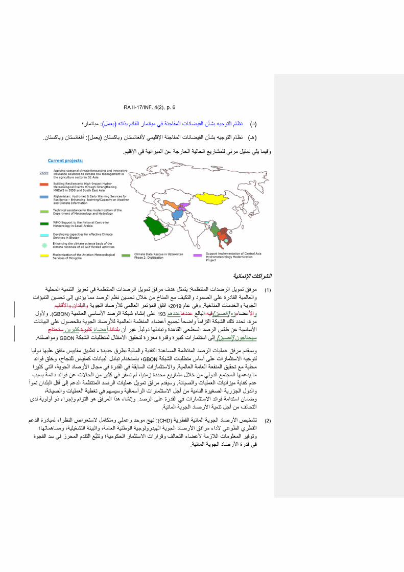
RA II-17/INF. 4(2), p. 6
؛: میانمار)یعملقائم بذاتھ (ال یانمارمنظام التوجیھ بشأن الفیضانات المفاجئة في (د)
.أفغانستان وباكستان: )یعمل( وباكستان فغانستاناإلقلیمي ألنظام التوجیھ بشأن الفیضانات المفاجئة (ھـ)
.اإلقلیم المیزانیة في ة عنخارجالوفیما یلي تمثیل مرئي للمشاریع الحالیة
اإلنمائیة الشراكات
في تعزیز التنمیة المحلیة المنتظمة: یتمثل ھدف مرفق تمویل الرصدات ة المنتظممرفق تمویل الرصدات (1)والتكیف مع المناخ من خالل تحسین نظم الرصد مما یؤدي إلى تحسین التنبؤات القادرة على الصمود والعالمیة
والبلدان واألقالیم ، اتفق المؤتمر العالمي لألرصاد الجویة 2019 في عام و الجویة والخدمات المناخیة.وألول .)GBON(العالمیة الرصد األساسي على إنشاء شبكة 193 عددھم عددھاالبالغ فیھ [الصین] ؤه ءعضااألو
التزامتلك الشبكة حدد تمرة، واضح ا لجمیع أعضاء المنظمة العالمیة لألرصاد الجویة بالحصول على البیانات ا القاعدة األساسیة عن طقس الرصد السطحي ستحتاج ینكثیركثیرة أعضاء بلدانا غیر أن .وتبادلھا دولیا
.مواصلتھو GBON شبكةة معززة لتحقیق االمتثال لمتطلبات الدرإلى استثمارات كبیرة وق [الصین] سیحتاجون
تطبیق مقاییس متفق علیھا دولیا -المساعدة التقنیة والمالیة بطرق جدیدة مرفق عملیات الرصد المنتظمة وسیقدم ، باستخدام تبادل البیانات كمقیاس للنجاح، وخلق فوائد GBON الشبكة لتوجیھ االستثمارات على أساس متطلبات
مجال األرصاد الجویة، التي كثیرا القدرة في االستثمارات السابقة في و عالمیة.محلیة مع تحقیق المنفعة العامة الفي كثیر من الحاالت عن فوائد دائمة بسبب لم تسفر ما یدعمھا المجتمع الدولي من خالل مشاریع محددة زمنیا،
دعم إلى أقل البلدان نموا المرفق تمویل عملیات الرصد المنتظمة وسیقدم عدم كفایة میزانیات العملیات والصیانة.الستثمارات الرأسمالیة وسیسھم في تغطیة العملیات والصیانة، من أجل اوالدول الجزریة الصغیرة النامیة
ة لدى أولویإجراء ذو ھو التزام وھذا المرفق وإنشاء وضمان استدامة فوائد االستثمارات في القدرة على الرصد. .المائیةویة األرصاد الجالتحالف من أجل تنمیة
: نھج موحد وعملي ومتكامل الستعراض النظراء لمبادرة الدعم (CHD)ة القطریاألرصاد الجویة المائیة تشخیص (2) الھیدرولوجیة الوطنیة العامة، والبیئة التشغیلیة، ومساھماتھا؛مرافق األرصاد الجویة القطري الطوعي ألداء
ع التقدم المحرز في سد الفجوة تتب و عضاء التحالف وقرارات االستثمار الحكومیة؛وتوفیر المعلومات الالزمة أل .ةاألرصاد الجویة المائیفي قدرة
RA II-17/INF. 4(2), p. 7
ھیئة بدعم منومنظمة العالمیة لألرصاد الجویة بتمویل من ال یة،قیرغیزالجمھوریة الفي التطبیق یجري (أ) ؛(MétéoSwiss)األرصاد الجویة السویسریة
األرصاد مرفق بدعم من وبتمویل من المنظمة العالمیة لألرصاد الجویة ،في أفغانستانالتطبیق یجري (ب) .الجویة الحكومي التركي
في سد فجوة القدرات الرامیة إلى یھدف إلى توحید الجھود وھو : األرصاد الجویة المائیةالتحالف من أجل تنمیة (3)القادرة على عالیة الجودة، ونظم اإلنذار المبكر، والمعلومات المناخیة كأساس للتنمیة الالتنبؤات الجویة مجال
من بینھم أكبر ممولي عضوا 13 -ویجمع التحالف بین كبار شركاء تمویل المناخ والتنمیة والمستدامة.الصمود التزامالذي یمثل ووقع على اإلعالن المائیة.األرصاد الجویة تنمیة ن ورؤساء والمستوى الرؤساء التنفیذی رفیع ا
مرفق وإنشاء الوكاالت وأطلق التحالف خالل الدورة الخامسة والعشرین لمؤتمر األطراف المعقودة في مدرید. .ھو التزام من جانب التحالفتمویل عملیات الرصد المنتظمة
لى تتبع التقدم المحرز ووضع خط أساس یھدف إوھو : األرصاد الجویة المائیةفجوة التحالف عن تقریر (4)اللتزامات التحالف، والتقاط الدروس المستفادة وتوجیھ االستثمارات وتحدید اإلجراءات ذات األولویة للتحالف
في المنتدى السیاسي الرفیع المستوى التابع 2021 ویولی في تموز/یطلق ومن المتوقع أن ذات التأثیر الكبیر. .المائیةاألرصاد الجویة لألمم المتحدة أول تقریر للتحالف عن فجوة
والمناخ والخدمات البیئیة ذات الصلة ءوالماتعالج فجوة القدرات في مجاالت الطقس التي خرى األبرامج ال
متعدد الوكاالت، تنسقھ المنظمة العالمیة لألرصاد الجویة، عن حالة : تقریر تقریر حالة الخدمات المناخیة (1)ویسلط تقریر الخدمات المناخیة لتقییم احتیاجات التكیف في القطاعات االجتماعیة واالقتصادیة الحساسة للمناخ.
مبادرات الولمنظمات من ا 17، الذي أعدتھ المنظمة العالمیة لألرصاد الجویة و2020 حالة الخدمات المناخیة لعام على الصعید العالمي، ویحدد أین (EWS)شریكة، الضوء على التقدم المحرز في تنفیذ نظم اإلنذار المبكر ال
على [الصین]األعضاء البلدان وكیف یمكن للحكومات أن تستثمر في نظم اإلنذار المبكر الفعالة لتعزیز قدرة بوصفھ التقریر ویقدر الشركاء ذلك المرتبطة بالطقس والمناخ والمیاه.المتعددة الصمود في مواجھة األخطار
: ومن بین الشركاء .یة تلك االستثماراتاالستثمارات ونوعإلى تولیفة ھامة لألدلة المتعلقة باألماكن التي تحتاج ؛ ومبادرة مخاطر المناخ (CPI)؛ ومبادرة السیاسة المناخیة (AF) صندوق التكیفو (AFD) الفرنسیة؛التنمیة وكالة
اتوالفریق المعني برصد ؛(FAO)؛ ومنظمة األغذیة والزراعة لألمم المتحدة (CREWS)ونظم اإلنذار المبكر االتحاد الدولي لجمعیات ؛ و(GEF) مرفق البیئة العالمیةو ؛(GCF) الصندوق األخضر للمناخو ؛(GEO) األرض
ومكتب األمم ؛ (REAP)؛ وشراكة العمل المبكر المستنیر بالمخاطر (IFRC) الصلیب األحمر والھالل األحمرمجموعة البنك الدولي ؛ و(UNDP)اإلنمائي األمم المتحدة وبرنامج ؛(UNDRR) المتحدة للحد من الكوارث
مكتب المناخ و ؛(WFP) وبرنامج األغذیة العالمي ؛(GFDRR) العالمي للحد من الكوارث واإلنعاش منھا اومرفقھ .(WMO) والمنظمة العالمیة لألرصاد الجویة (WHO) العالمیةالصحة والصحة التابع لمنظمة
قدرتھم على تقدیم الخدمات المناخیة (WMO)م أعضاء المنظمة : یقی قائمة مرجعیة لتنفیذ الخدمات المناخیة (2)االجتماعیة واالقتصادیة المرتبطة بھا من خالل قائمة مرجعیة تتناول القدرات الوظیفیة وتوثیق النتائج والفوائد
: وینقسم تقییم القدرات الوظیفیة في القائمة المرجعیة إلى ست مجموعات ھي عبر سلسلة قیمة الخدمات المناخیة.الخدمات المناخیة وتطبیقھا، ورصد ، والنظم األساسیة، وواجھة المستعملین، وتنمیة القدرات، وتوفیر الحوكمة
“یة”جوھرأو “أساسیة”ویشكل العدید من ھذه القدرات الوظیفیة وظائف االقتصادیة. -وتقییم الفوائد االجتماعیة .“متقدمة”أو “كاملة”أو [الصین]األعضاء قدراتاللتقییم وتوفر قائمة بیانات الخدمات المناخیة أساسافي كل عنصر من عناصر سلسلة قیمة الخدمات المناخیة، ولتصنیف المستوى العام القطریة ھم حتیاجاتاالو
وھو یوفر معلومات أساسیة إلثراء للخدمة التي یقدمھا العضو وفقا لمعاییر المنظمة العالمیة لألرصاد الجویة.اء الرئیسیة عملیة وضع مقترحات المشاریع، وتقییمات خطوط األساس، ورصد وتقییم المشاریع ومؤشرات األد
.WMO للمنظمة

RA II-17/INF. 4(2), p. 8
لجمع معلومات عن المنظمات الحكومیة وغیر الحكومیة المسؤولة عن لھیدرولوجیال (WMO)المنظمة مسح (3)، وقدراتھا وھیكلھا وشبكاتھا الھیدرولوجیة وخصائصھا في [الصین]األعضاء البلدانالھیدرولوجیا التشغیلیة داخل
والمعلومات التي جمعت قیمة للغایة في تحدید الثغرات في القدرات على والتنبؤ الھیدرولوجي.إدارة البیانات الصعید الوطني، ودعم األنشطة ذات األولویة اإلقلیمیة، وإثراء القرارات االستثماریة ألصحاب المصلحة
.المعنیین، بمن فیھم الشركاء في التنمیة
التفاعلیة منصة ال (4) :)CPDB -للمنظمة العالمیة لألرصاد الجویة ةالقطری اتاعدة بیانات الملفق (سابقا
السمات التالیة ألعضاء المنظمة: (WMO)التفاعلیة للمنظمة منصة وفر ت
وظائف الخدمة الذاتیة لضمان تحدیث معلومات االتصال واألدوار ذات قاعدة بیانات مركزیة للخبراء (أ) .المجموعةوعضویة
فرة في ملفات تعریف امتو [الصین]باألعضاء بالبلدان واألقالیمالمعلومات التي یتم جمعھا فیما یتعلق (ب) .مونھا بأنفسھم ویمكن لألعضاء أنفسھم تحدیث المعلومات التي یقی األعضاء.
والتقییم بصورة منھجیة، كما المراقبة ، یمكن تحسین المنصة التفاعلیةإلى البیانات الموحدة المتاحة في واستنادا عن لوحات معلومات مواضیعیة لمختلف أصحاب ، فضال لألعضاء یمكن إنشاء ملفات تعریف أكثر شموال
.المصلحة من أجل دعم عملیة صنع القرار القائمة على األدلة على نحو أفضل
لضمان دقة جودة المعلومات 2021 ع األعضاء بشدة على االستجابة لحملة جمع البیانات المتوقعة في عام ویشج .الواردة في ملفات تعریف األعضاء
أدناه مثال على التحلیل الذي تم إجراؤه مع البیانات التي تم جمعھا من األعضاء خاللالوارد الرسم البیاني و .2021 التي سیتم تحدیثھا خالل حملة جمع البیانات لعام المؤتمر الثامن عشر و

RA II-17/INF. 4(2), p. 9
للمعھد التابعة (CIP)، ومنصة المعلومات المناخیة Climpactتنشر المنظمة العالمیة لألرصاد الجویة بیانات من (5) https://climateinformation.org, World Climate Research ،(SMHI) اد الجویة والھیدرولوجیاـالسویدي لألرص
Programme ،والمعھد الدولي للبحوث المناخیة والمجتمعیة (IRI)، ومستكشف المناخ التابع للمعھد الملكيوغیرھا من المصادر المعتمدة من https://climexp.knmi.nl/start.cgi ،(KNMI) الھولندي لألرصاد الجویة
ن االتجاھات واإلسقاطات التاریخیة ذات الصلة ی المنظمة العالمیة لألرصاد الجویة لتولید خرائط ورسوم بیانیة تب .بالتخطیط الوطني للتكیف
ــــــــــــــــــــــــــ
والبیانات عملیات الرصد
WEA
THER
CLI
MATE
WAT
ER World Meteorological Organization
REGIONAL ASSOCIATION II (ASIA)
Seventeenth Session (Second Part) 27 to 30 September 2021, Virtual Session
RA II-17(II)/INF. 1(1)
Submitted by: Secretary-General
27.VIII.2021
INFORMATION ON THE VIRTUAL PLATFORM AND NAMING CONVENTION
The second phase of the seventeenth session of the Regional Association II (RA I-17 (II)) will be held virtually through Zoom, from 27 to 30 September 2021.
The opening of RA II-17 (II) will take place on Monday, 27 September 2021 at 0700 UTC. Detailed information on the session can be found on the main web page of RA II-17.
Virtual session
Information on the online platform used and how to connect to the meeting is available on the Online session tab of the RA II-17 website.
Naming convention
WMO Members: Principal Delegate (PD), Alternate (ALT), and Delegate (DEL)
• Principal Delegate (Principal): Member name/PD/Surname
• Alternate: Member name/ALT/Surname
• Delegate: Member name/DEL/Surname
President, Vice-Presidents of WMO
• President of WMO: P/WMO
• Vice-Presidents of WMO: 1st VP/WMO; 2nd VP/WMO; 3rd VP/WMO
Presidents and vice-presidents of Regional Associations, Regional Hydrological Advisers, presidents and vice-presidents of Technical Commissions, Chairs of WMO bodies, and Invited Experts
• Presidents of regional associations: P/RA I (II, …, VI) for presidents
(acting presidents)
• Vice-presidents of regional associations VP/RA (II, …, VI)
• Regional Hydrological Advisers: HA/RAI (II, …, VI)
• Presidents of technical commissions: P/INFCOM, P/SERCOM
RA II-17(II)/INF. 1(1), p. 2
• Co-vice-presidents of technical commissions: VP/INFCOM/Surname,
VP/SERCOM/Surname
• Chair, body acronym: (C/HCP)
• Invited Experts: Expert/Surname
Representatives of International Organizations/Non-Members
• Organization name/Surname
• Non-Member name/Surname
Secretariat
• Secretariat/Surname
________________
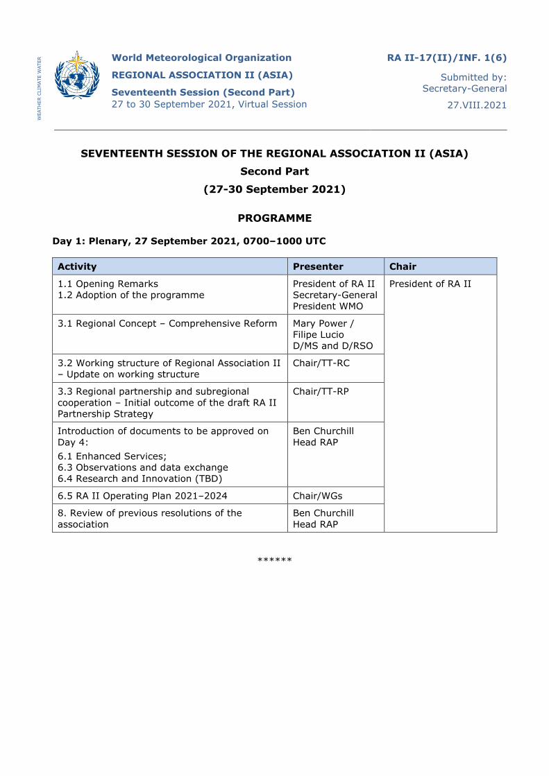
WEA
THER
CLI
MATE
WAT
ER World Meteorological Organization
REGIONAL ASSOCIATION II (ASIA)
Seventeenth Session (Second Part) 27 to 30 September 2021, Virtual Session
RA II-17(II)/INF. 1(6)
Submitted by: Secretary-General
27.VIII.2021
SEVENTEENTH SESSION OF THE REGIONAL ASSOCIATION II (ASIA)
Second Part
(27-30 September 2021)
PROGRAMME
Day 1: Plenary, 27 September 2021, 0700–1000 UTC
Activity Presenter Chair
1.1 Opening Remarks 1.2 Adoption of the programme
President of RA II Secretary-General President WMO
President of RA II
3.1 Regional Concept – Comprehensive Reform Mary Power / Filipe Lucio D/MS and D/RSO
3.2 Working structure of Regional Association II – Update on working structure
Chair/TT-RC
3.3 Regional partnership and subregional cooperation – Initial outcome of the draft RA II Partnership Strategy
Chair/TT-RP
Introduction of documents to be approved on Day 4: 6.1 Enhanced Services; 6.3 Observations and data exchange 6.4 Research and Innovation (TBD)
Ben Churchill Head RAP
6.5 RA II Operating Plan 2021–2024 Chair/WGs
8. Review of previous resolutions of the association
Ben Churchill Head RAP
******
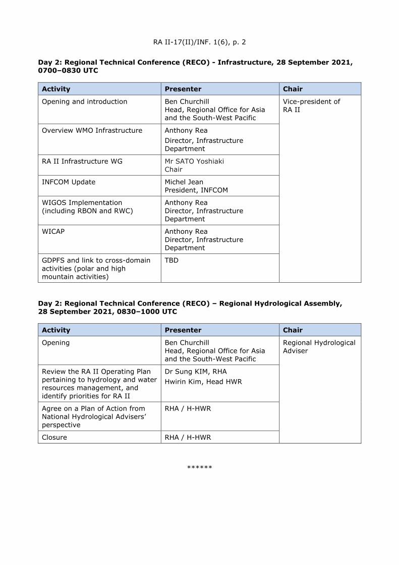
RA II-17(II)/INF. 1(6), p. 2
Day 2: Regional Technical Conference (RECO) - Infrastructure, 28 September 2021, 0700–0830 UTC
Activity Presenter Chair
Opening and introduction Ben Churchill Head, Regional Office for Asia and the South-West Pacific
Vice-president of RA II
Overview WMO Infrastructure Anthony Rea Director, Infrastructure Department
RA II Infrastructure WG Mr SATO Yoshiaki Chair
INFCOM Update Michel Jean President, INFCOM
WIGOS Implementation (including RBON and RWC)
Anthony Rea Director, Infrastructure Department
WICAP Anthony Rea Director, Infrastructure Department
GDPFS and link to cross-domain activities (polar and high mountain activities)
TBD
Day 2: Regional Technical Conference (RECO) – Regional Hydrological Assembly, 28 September 2021, 0830–1000 UTC
Activity Presenter Chair
Opening Ben Churchill Head, Regional Office for Asia and the South-West Pacific
Regional Hydrological Adviser
Review the RA II Operating Plan pertaining to hydrology and water resources management, and identify priorities for RA II
Dr Sung KIM, RHA Hwirin Kim, Head HWR
Agree on a Plan of Action from National Hydrological Advisers’ perspective
RHA / H-HWR
Closure RHA / H-HWR
******
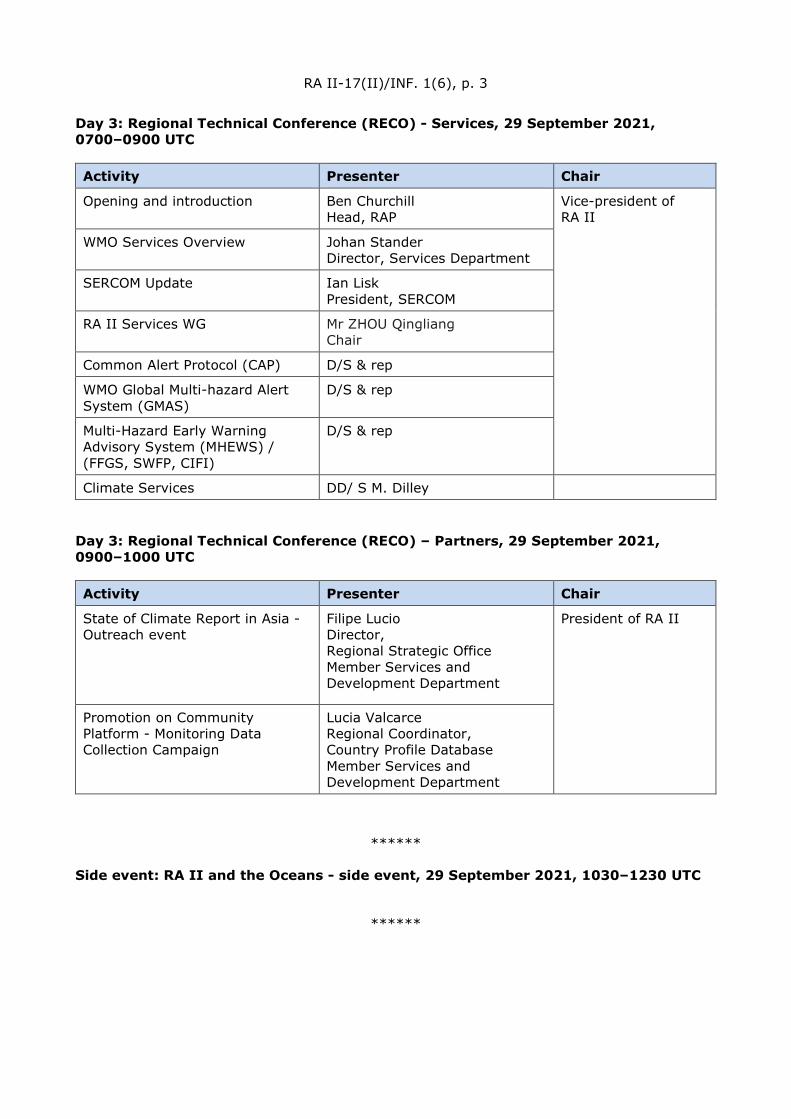
RA II-17(II)/INF. 1(6), p. 3
Day 3: Regional Technical Conference (RECO) - Services, 29 September 2021, 0700–0900 UTC
Activity Presenter Chair
Opening and introduction Ben Churchill Head, RAP
Vice-president of RA II
WMO Services Overview Johan Stander Director, Services Department
SERCOM Update Ian Lisk President, SERCOM
RA II Services WG Mr ZHOU Qingliang Chair
Common Alert Protocol (CAP) D/S & rep
WMO Global Multi-hazard Alert System (GMAS)
D/S & rep
Multi-Hazard Early Warning Advisory System (MHEWS) / (FFGS, SWFP, CIFI)
D/S & rep
Climate Services DD/ S M. Dilley
Day 3: Regional Technical Conference (RECO) – Partners, 29 September 2021, 0900–1000 UTC
Activity Presenter Chair
State of Climate Report in Asia - Outreach event
Filipe Lucio Director, Regional Strategic Office Member Services and Development Department
President of RA II
Promotion on Community Platform - Monitoring Data Collection Campaign
Lucia Valcarce Regional Coordinator, Country Profile Database Member Services and Development Department
******
Side event: RA II and the Oceans - side event, 29 September 2021, 1030–1230 UTC
******

RA II-17(II)/INF. 1(6), p. 4
Day 4: Plenary, 30 September 2021, 0700–1000 UTC
Activity Presenter Chair
Approval of documents: 6.1 Enhanced Services; 6.3 Observations and data exchange 6.4 Research and Innovation 6.5 RA II Operating Plan 2021–2024 8. Review of previous resolutions of the association
Ben Churchill Head, Regional Office for Asia and the South-West Pacific
President of RA II
9. Any other business – dates for next session
H/RAP
10. Closure of the session Mary Power Director, Member Services and Development Department Secretary-General / Representative President of RA II
___________
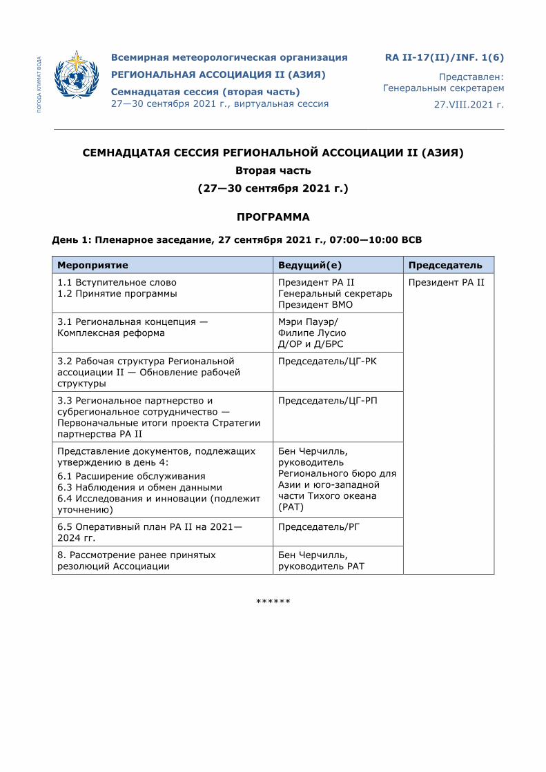
ПО
ГОД
А К
ЛИ
МАТ
ВО
ДА Всемирная метеорологическая организация
РЕГИОНАЛЬНАЯ АССОЦИАЦИЯ II (АЗИЯ)
Семнадцатая сессия (вторая часть) 27—30 сентября 2021 г., виртуальная сессия
RA II-17(II)/INF. 1(6)
Представлен: Генеральным секретарем
27.VIII.2021 г.
СЕМНАДЦАТАЯ СЕССИЯ РЕГИОНАЛЬНОЙ АССОЦИАЦИИ II (АЗИЯ)
Вторая часть
(27—30 сентября 2021 г.)
ПРОГРАММА
День 1: Пленарное заседание, 27 сентября 2021 г., 07:00—10:00 ВСВ
Мероприятие Ведущий(е) Председатель
1.1 Вступительное слово 1.2 Принятие программы
Президент РА II Генеральный секретарь Президент ВМО
Президент РА II
3.1 Региональная концепция — Комплексная реформа
Мэри Пауэр/ Филипе Лусио Д/ОР и Д/БРС
3.2 Рабочая структура Региональной ассоциации II — Обновление рабочей структуры
Председатель/ЦГ-РК
3.3 Региональное партнерство и субрегиональное сотрудничество — Первоначальные итоги проекта Стратегии партнерства РА II
Председатель/ЦГ-РП
Представление документов, подлежащих утверждению в день 4: 6.1 Расширение обслуживания 6.3 Наблюдения и обмен данными 6.4 Исследования и инновации (подлежит уточнению)
Бен Черчилль, руководитель Регионального бюро для Азии и юго-западной части Тихого океана (РАТ)
6.5 Оперативный план РА II на 2021—2024 гг.
Председатель/РГ
8. Рассмотрение ранее принятых резолюций Ассоциации
Бен Черчилль, руководитель РАТ
******
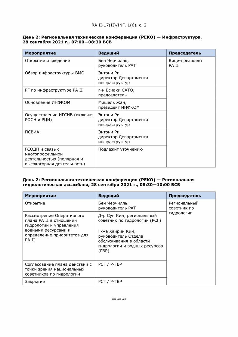
RA II-17(II)/INF. 1(6), c. 2
День 2: Региональная техническая конференция (РЕКО) — Инфраструктура, 28 сентября 2021 г., 07:00—08:30 ВСВ
Мероприятие Ведущий Председатель
Открытие и введение Бен Черчилль, руководитель РАТ
Вице-президент РА II
Обзор инфраструктуры ВМО Энтони Ри, директор Департамента инфраструктур
РГ по инфраструктуре РА II г-н Ёсиаки САТО, председатель
Обновление ИНФКОМ Мишель Жан, президент ИНФКОМ
Осуществление ИГСНВ (включая РОСН и РЦИ)
Энтони Ри, директор Департамента инфраструктур
ПСВИА Энтони Ри, директор Департамента инфраструктур
ГСОДП и связь с многопрофильной деятельностью (полярная и высокогорная деятельность)
Подлежит уточнению
День 2: Региональная техническая конференция (РЕКО) — Региональная гидрологическая ассамблея, 28 сентября 2021 г., 08:30—10:00 ВСВ
Мероприятие Ведущий Председатель
Открытие Бен Черчилль, руководитель РАТ
Региональный советник по гидрологии Рассмотрение Оперативного
плана РА II в отношении гидрологии и управления водными ресурсами и определение приоритетов для РА II
Д-р Сун Ким, региональный советник по гидрологии (РСГ) Г-жа Хвирин Ким, руководитель Отдела обслуживания в области гидрологии и водных ресурсов (ГВР)
Согласование плана действий с точки зрения национальных советников по гидрологии
РСГ / Р-ГВР
Закрытие РСГ / Р-ГВР
******
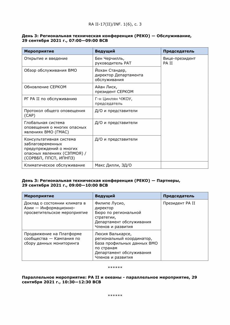
RA II-17(II)/INF. 1(6), c. 3
День 3: Региональная техническая конференция (РЕКО) — Обслуживание, 29 сентября 2021 г., 07:00—09:00 ВСВ
Мероприятие Ведущий Председатель
Открытие и введение Бен Черчилль, руководитель РАТ
Вице-президент РА II
Обзор обслуживания ВМО Йохан Стандер, директор Департамента обслуживания
Обновление СЕРКОМ Айан Лиск, президент СЕРКОМ
РГ РА II по обслуживанию Г-н Цинлян ЧЖОУ, председатель
Протокол общего оповещения (CAP)
Д/О и представители
Глобальная система оповещения о многих опасных явлениях ВМО (ГМАС)
Д/О и представители
Консультативная система заблаговременных предупреждений о многих опасных явлениях (СЗПМОЯ) / (СОРВБП, ППСП, ИПНПЗ)
Д/О и представители
Климатическое обслуживание Макс Дилли, ЗД/О
День 3: Региональная техническая конференция (РЕКО) — Партнеры, 29 сентября 2021 г., 09:00—10:00 ВСВ
Мероприятие Ведущий Председатель
Доклад о состоянии климата в Азии — Информационно-просветительское мероприятие
Филипе Лусио, директор Бюро по региональной стратегии, Департамент обслуживания Членов и развития
Президент РА II
Продвижение на Платформе сообщества — Кампания по сбору данных мониторинга
Люсия Валькарсе, региональный координатор, База профильных данных ВМО по странам Департамент обслуживания Членов и развития
******
Параллельное мероприятие: РА II и океаны - параллельное мероприятие, 29 сентября 2021 г., 10:30—12:30 ВСВ
******
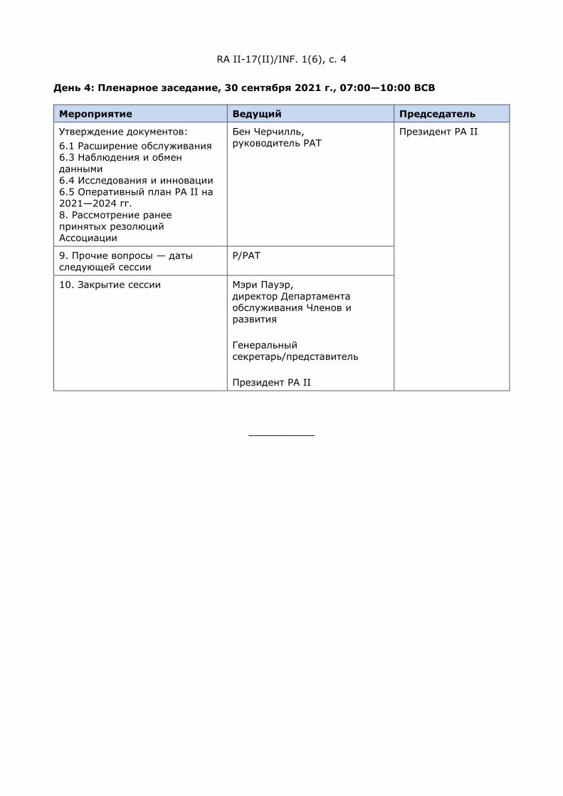
RA II-17(II)/INF. 1(6), c. 4
День 4: Пленарное заседание, 30 сентября 2021 г., 07:00—10:00 ВСВ
Мероприятие Ведущий Председатель
Утверждение документов: 6.1 Расширение обслуживания 6.3 Наблюдения и обмен данными 6.4 Исследования и инновации 6.5 Оперативный план РА II на 2021—2024 гг. 8. Рассмотрение ранее принятых резолюций Ассоциации
Бен Черчилль, руководитель РАТ
Президент РА II
9. Прочие вопросы — даты следующей сессии
Р/РАТ
10. Закрытие сессии Мэри Пауэр, директор Департамента обслуживания Членов и развития Генеральный секретарь/представитель Президент РА II
___________

天气
气候
水
世界气象组织
第二区域协会(亚洲)
第十七次届会(第二部分) 2021 年 9 月 27 至 30 日,虚拟届会
RA II-17(II)/INF. 1(6)
提交者:
秘书长
2021.8.27
第二区域协会(亚洲)第十七次届会
第二部分
(2021 年 9 月 27-30 日)
每日计划
第 1 天:全体会议,2021 年 9 月 27 日,0700-1000(协调世界时)
活动 主讲人 会议主席
1.1 开幕辞 1.2 批准每日计划
二区协主席
秘书长
WMO 主席
二区协主席
3.1 区域概念--全面改革 Mary Power/ Filipe Lucio D/MS 和 D/RSO
3.2 第二区域协会的工作结构--工作结构的更新 TT-RC组长
3.3 区域伙伴关系和次区域合作--二区协伙伴关系战略
草案的初步成果 TT-RP组长
介绍第 4 天需审批的文件:
6.1 加强服务;
6.3 观测和数据交换
6.4 研究和创新(待定)
RAP负责人 Ben Churchill
6.5 二区协 2021–2024 年运行计划 各工作组组长
8. 审议区协的以往决议 RAP负责人 Ben Churchill
******
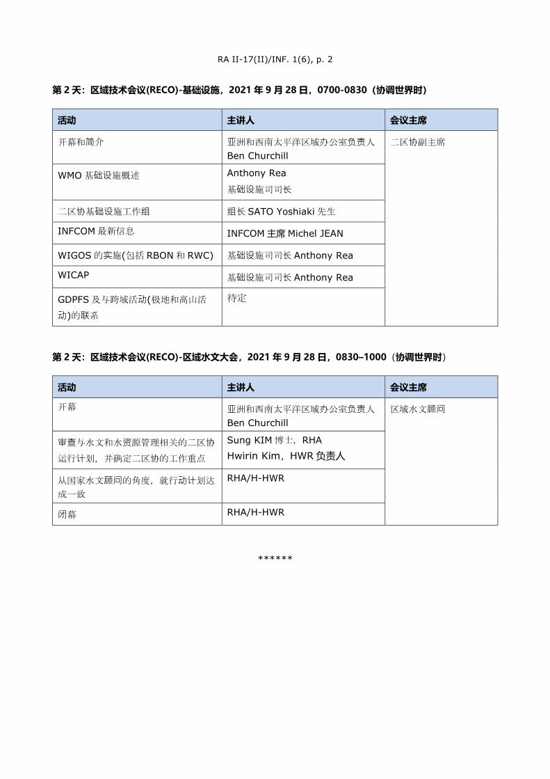
RA II-17(II)/INF. 1(6), p. 2
第 2 天:区域技术会议(RECO)-基础设施,2021 年 9 月 28 日,0700-0830(协调世界时)
活动 主讲人 会议主席
开幕和简介 亚洲和西南太平洋区域办公室负责人
Ben Churchill 二区协副主席
WMO 基础设施概述 Anthony Rea
基础设施司司长
二区协基础设施工作组 组长 SATO Yoshiaki 先生
INFCOM 最新信息 INFCOM 主席 Michel JEAN
WIGOS 的实施(包括 RBON 和 RWC) 基础设施司司长 Anthony Rea
WICAP 基础设施司司长 Anthony Rea
GDPFS 及与跨域活动(极地和高山活
动)的联系
待定
第 2 天:区域技术会议(RECO)-区域水文大会,2021 年 9 月 28 日,0830–1000(协调世界时)
活动 主讲人 会议主席
开幕 亚洲和西南太平洋区域办公室负责人
Ben Churchill 区域水文顾问
审查与水文和水资源管理相关的二区协
运行计划,并确定二区协的工作重点
Sung KIM 博士,RHA
Hwirin Kim,HWR 负责人
从国家水文顾问的角度,就行动计划达
成一致
RHA/H-HWR
闭幕 RHA/H-HWR
******

RA II-17(II)/INF. 1(6), p. 3
第 3 天:区域技术会议(RECO)-服务,2021 年 9 月 29 日,0700-0900(协调世界时)
活动 主讲人 会议主席
开幕和简介 RAP负责人
Ben Churchill
二区协副主席
WMO 服务概述 服务司司长
Johan Stander
SERCOM 最新信息 SERCOM 主席 Ian Lisk
二区协服务工作组 组长 周庆亮先生
通用预警规程(CAP) D/S 及代表
WMO 全球多灾种警报系统(GMAS) D/S 及代表
多灾种预警咨询系统(MHEWS)/(FFGS、SWFP、CIFI)
D/S 及代表
气候服务 DD/S M.Dilley
第 3 天:区域技术会议(RECO)-合作伙伴,2021 年 9 月 29 日,0900–1000(协调世界时)
活动 主讲人 会议主席
亚洲气候状况报告-宣传活动 Filipe Lucio 会员服务与发展司区域战略办公室
主任
二区协主席
全系统平台推广-监测数据收集活动 会员服务与发展司国家概况数据库区域协调员 Lucia Valcarce
******
会外活动:二区协与海洋 - 会外活动,2021 年 9 月 29 日,1030-1230(协调世界时)
******
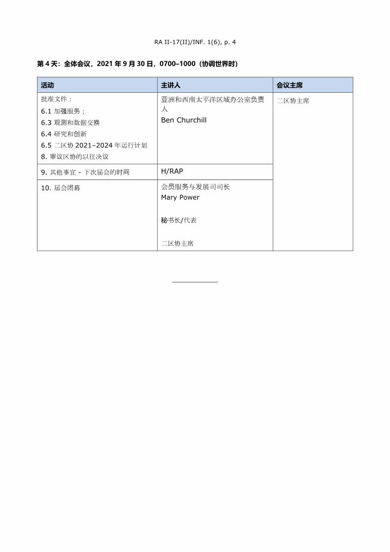
RA II-17(II)/INF. 1(6), p. 4
第 4 天:全体会议,2021 年 9 月 30 日,0700–1000(协调世界时)
活动 主讲人 会议主席
批准文件:
6.1 加强服务;
6.3 观测和数据交换
6.4 研究和创新
6.5 二区协 2021–2024 年运行计划
8. 审议区协的以往决议
亚洲和西南太平洋区域办公室负责人 Ben Churchill
二区协主席
9. 其他事宜 - 下次届会的时间 H/RAP
10. 届会闭幕 会员服务与发展司司长 Mary Power
秘书长/代表
二区协主席
___________

)آسیا( الثانيلالتحاد اإلقلیمي السابعة عشرةالدورة الثاني الجزء
)2021 سبتمبر /أیلول 30-27(
البرنامج
بالتوقیت العالمي المنسق 0700-1000 – 2021 سبتمبر /وللأی 27 –الیوم األول: الجلسة العامة
******
ماء ال
اخلمن
س اطق
ال
المنظمة العالمیة لألرصاد الجویة
االتحاد اإلقلیمي الثاني (آسیا) (الجزء الثاني) السابعة عشرةالدورة
، دورة افتراضیة2021 سبتمبر /أیلول 27-30
RA II-17 (II)/INF. 1(6) وثیقة مقدمة من: األمین العام27.VIII.2021
الرئیس مقدم العرض النشاط مالحظات استھاللیة 1.1 إقرار البرنامج 1.2
الثانيرئیس االتحاد اإلقلیمي األمین العام
(WMO)رئیس المنظمة
رئیس االتحاد اإلقلیمي الثاني
Mary Power اإلصالح الشامل –المفھوم اإلقلیمي 3.1مات األعضاء والتنمیة إدارة خدمدیرة
)MS( Filipe Lucio
مدیر المكتب االستراتیجي اإلقلیمي (RSO)
–الثاني االتحاد اإلقلیمي ھیكل عمل 3.2 تحدیث ھیكل العمل
فرقة العمل المعنیة بالمفھوم رئیس (TT-RC)اإلقلیمي
ة والتعاون دون اإلقلیمیالشراكات 3.3النتائج األولیة لمشروع – اإلقلیمي
الثانيالتحاد اإلقلیمي لاستراتیجیة الشراكات
فرقة العمل المعنیة بالشراكات رئیس (TT-RP)اإلقلیمیة والتعاون دون اإلقلیمي
للموافقة علیھا في الیوم الرابعوثائق التقدیم :من الدورة
تحسین الخدمات؛ 6.1 تبادل الرصدات والبیانات؛ 6.3 البحث واالبتكار (یحدد فیما بعد) 6.4
Ben Churchill رئیس المكتب اإلقلیمي آلسیا وجنوب
(RAP)غرب المحیط الھادئ
الثانيالتحاد اإلقلیمي لالخطة التشغیلیة 6.5 2021-2024للفترة
رئیس الفریق العامل
Ben Churchill استعراض القرارات السابقة لالتحاد 8رئیس المكتب اإلقلیمي آلسیا وجنوب
(RAP) غرب المحیط الھادئ
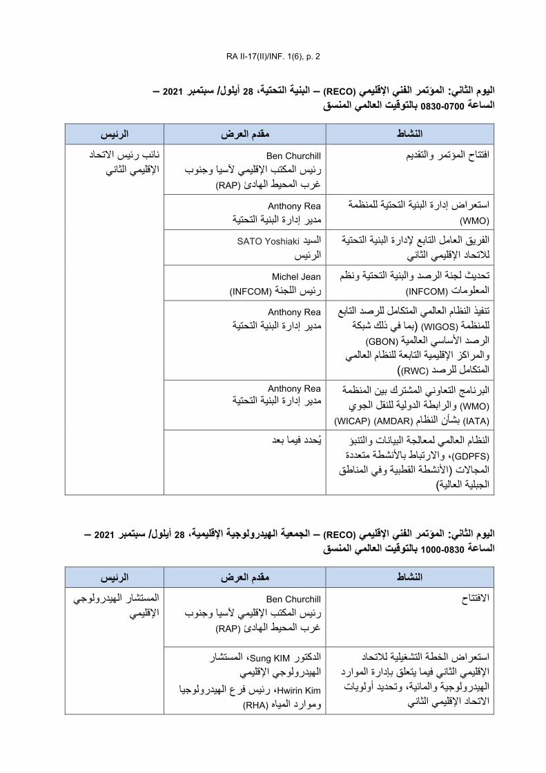
RA II-17(II)/INF. 1(6), p. 2
– 2021 سبتمبر /أیلول 28 البنیة التحتیة، – (RECO)اإلقلیمي الفني المؤتمرالیوم الثاني: بالتوقیت العالمي المنسق 0700-0830الساعة
– 2021 سبتمبر /أیلول 28، الجمعیة الھیدرولوجیة اإلقلیمیة – (RECO)اإلقلیمي الفني المؤتمرالیوم الثاني: بالتوقیت العالمي المنسق 0830-1000الساعة
الرئیس مقدم العرض النشاط Ben Churchill االفتتاح
رئیس المكتب اإلقلیمي آلسیا وجنوب (RAP)غرب المحیط الھادئ
المستشار الھیدرولوجي اإلقلیمي
التحاد لالخطة التشغیلیة استعراض الثاني فیما یتعلق بإدارة الموارد اإلقلیمي
الھیدرولوجیة والمائیة، وتحدید أولویات الثانياالتحاد اإلقلیمي
المستشار ، Sung KIMالدكتور الھیدرولوجي اإلقلیمي
Hwirin Kim رئیس فرع الھیدرولوجیا ، (RHA)وموارد المیاه
الرئیس مقدم العرض النشاط Ben Churchill افتتاح المؤتمر والتقدیم
رئیس المكتب اإلقلیمي آلسیا وجنوب (RAP)غرب المحیط الھادئ
رئیس االتحاد نائب الثانياإلقلیمي
لمنظمة استعراض إدارة البنیة التحتیة ل(WMO)
Anthony Rea البنیة التحتیةمدیر إدارة
الفریق العامل التابع إلدارة البنیة التحتیة الثانيالتحاد اإلقلیمي ل
Yoshiaki SATOالسید الرئیس
الرصد والبنیة التحتیة ونظم تحدیث لجنة (INFCOM)المعلومات
Michel Jean (INFCOM)رئیس اللجنة
تنفیذ النظام العالمي المتكامل للرصد التابع (بما في ذلك شبكة (WIGOS)للمنظمة
(GBON)الرصد األساسي العالمیة للنظام العالمي والمراكز اإلقلیمیة التابعة
)(RWC) المتكامل للرصد
Anthony Rea مدیر إدارة البنیة التحتیة
ة البرنامج التعاوني المشترك بین المنظم(WMO) جوي والرابطة الدولیة للنقل ال(IATA) بشأن النظام (AMDAR) (WICAP)
Anthony Rea مدیر إدارة البنیة التحتیة
النظام العالمي لمعالجة البیانات والتنبؤ (GDPFS)اط باألنشطة متعددة تبر، واال
القطبیة وفي المناطق المجاالت (األنشطة )الجبلیة العالیة
بعدیحدد فیما
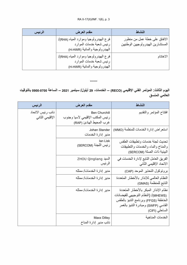
RA II-17(II)/INF. 1(6), p. 3
الرئیس مقدم العرض النشاطاالتفاق على خطة عمل من منظور
الھیدرولوجیین الوطنیینالمستشارین /(RHA)فرع الھیدرولوجیا وموارد المیاه
رئیس شعبة خدمات الموارد (H-HWR)الھیدرولوجیة والمائیة
/(RHA)فرع الھیدرولوجیا وموارد المیاه االختتامرئیس شعبة خدمات الموارد
(H-HWR)الھیدرولوجیة والمائیة
******
بالتوقیت 0700-0900الساعة – 2021 سبتمبر /أیلول 29، الخدمات – (RECO)اإلقلیمي الفني المؤتمرالیوم الثالث: العالمي المنسق
الرئیس مقدم العرض النشاط Ben Churchill افتتاح المؤتمر والتقدیم
رئیس المكتب اإلقلیمي آلسیا وجنوب (RAP)غرب المحیط الھادئ
رئیس االتحاد نائب الثانياإلقلیمي
Johan Stander (WMO)لمنظمة استعراض إدارة الخدمات ل مدیر إدارة الخدمات
لجنة خدمات وتطبیقات الطقس تحدیثوالمناخ والماء والخدمات والتطبیقات
(SERCOM)البیئیة ذات الصلة
Ian Lisk (SERCOM)رئیس اللجنة
في الفریق العامل التابع إلدارة الخدمات الثانياالتحاد اإلقلیمي
Qingliang ZHOUالسید الرئیس
مدیر إدارة الخدمات/ ممثلھ (CAP)بروتوكول التحذیر الموحد
باألخطار المتعددة النظام العالمي لإلنذار (GMAS)التابع للمنظمة
مدیر إدارة الخدمات/ ممثلھ
نظام اإلنذار المبكر باألخطار المتعددة (MHEWS) / النظام التوجیھي للفیضانات)
بالطقس وبرنامج التنبؤ )FFGS(الخاطفة ومبادرة التنبؤ بالغمر )SWFP( القاسي
)CIFI(الساحلي
مدیر إدارة الخدمات/ ممثلھ
Maxx Dilley لخدمات المناخیةا المناخ إدارة نائب مدیر
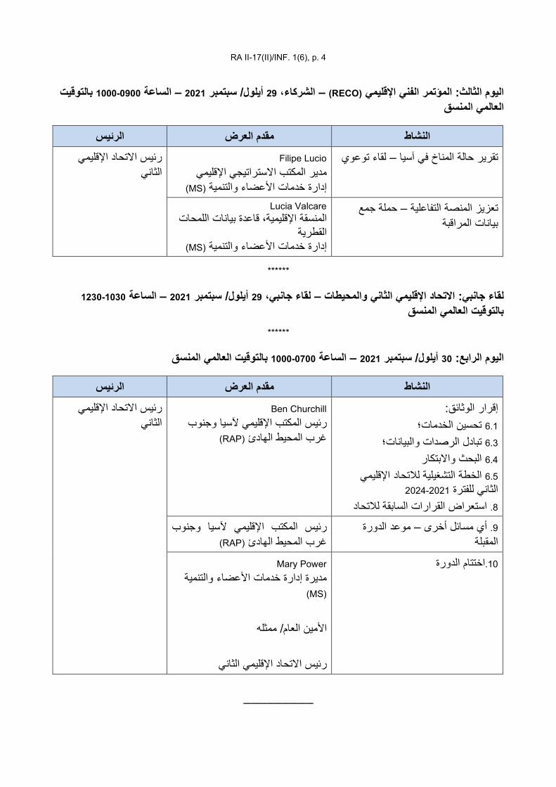
RA II-17(II)/INF. 1(6), p. 4
بالتوقیت 0900-1000الساعة – 2021 سبتمبر /أیلول 29، الشركاء – (RECO)اإلقلیمي الفني المؤتمرالیوم الثالث: العالمي المنسق
******
1030-1230الساعة – 2021 سبتمبر /أیلول 29لقاء جانبي، –والمحیطات الثانياالتحاد اإلقلیمي لقاء جانبي: بالتوقیت العالمي المنسق
******
بالتوقیت العالمي المنسق 0700-1000الساعة – 2021 سبتمبر /أیلول 30: الرابعالیوم
ــــــــــــــــــــــــــــــــــــ
الرئیس مقدم العرض النشاط Filipe Lucio لقاء توعوي –تقریر حالة المناخ في آسیا
مدیر المكتب االستراتیجي اإلقلیمي )MS(إدارة خدمات األعضاء والتنمیة
رئیس االتحاد اإلقلیمي الثاني
حملة جمع –تعزیز المنصة التفاعلیة بیانات المراقبة
Lucia Valcare المنسقة اإلقلیمیة، قاعدة بیانات اللمحات
القطریة )MS(إدارة خدمات األعضاء والتنمیة
الرئیس مقدم العرض النشاط إقرار الوثائق:
تحسین الخدمات؛ 6.1 تبادل الرصدات والبیانات؛ 6.3 البحث واالبتكار 6.4التحاد اإلقلیمي لالخطة التشغیلیة 6.5
2021-2024للفترة الثاني استعراض القرارات السابقة لالتحاد 8.
Ben Churchill رئیس المكتب اإلقلیمي آلسیا وجنوب
(RAP)غرب المحیط الھادئ
رئیس االتحاد اإلقلیمي الثاني
موعد الدورة –أي مسائل أخرى 9. المقبلة
رئیس المكتب اإلقلیمي آلسیا وجنوب (RAP)غرب المحیط الھادئ
Mary Power اختتام الدورة.10إدارة خدمات األعضاء والتنمیة مدیرة (MS)
األمین العام/ ممثلھ
الثانيرئیس االتحاد اإلقلیمي

WEA
THER
CLI
MATE
WAT
ER World Meteorological Organization
REGIONAL ASSOCIATION II (ASIA)
Seventeenth Session (Second Part) 27 to 30 September 2021, Virtual Session
RA II-17(II)/INF. 3.2
Submitted by: Chair of TT-RC
20.IX.2021
UPDATE ON WORKING STRUCTURE
Substructure of Working Groups
The Seventeenth Session of RA II, Phase 1 authorized the president of RA II, supported by the Management Group to review and approve the proposals submitted by the Chairs of Working Groups on the substructure of Working Groups, including Terms of Reference, suggested composition and expected deliverables to implement agreed activities, at the regional and subregional levels and to address the priorities of the region and capacity development of Members, keeping active interaction with relevant groups in the Technical Commissions, Research Board and other regions.
(1) Under RA II Working Group on Observation, Infrastructure and Information Systems (Working Group (WG) Infrastructure), the Expert Teams (ETs) to carry out the RA II Operating Plan (2021–2024):
(a) Expert Team on Regional WMO Integrated Global Observing System (WIGOS) Implementation
(i) Coordinate the RA II WIGOS projects, “Develop phased Global Basic Observing Network (GBON) implementation plan”; Demonstration Project “Promote long-term observing stations”; “Capacity Building in Radar Techniques in Southeast Asia”;
(ii) Support WG Infrastructure with regards to activities pertaining to Observation and Infrastructure systems;
(iii) Promote information sharing on the WIGOS Projects and their outcomes in the region;
(iv) Coordinate the activities of RA II Regional WIGOS Centres (RWC), and to advice on their operations and possible improvements and priorities ;
(v) Collaborate with Standing Committee on Earth Observing Systems and Monitoring Networks (SC-ON) of the Commission for Observation, Infrastructure and Information Systems (INFCOM);
(vi) Identify critical gaps and needs for improvement in RA II Members' capacities, particularly of the developing and least developed countries (LDCs) to implement WIGOS projects and related activities;
(vii) Facilitate exchange of knowledge and technology among RA II Members;
(viii) Assist the RA II WG Infrastructure to undertake the activities required in support of the implementation of the Regional Basic Observing Network (RBON) in the region (see draft Decision 6.3/2 (RA II-17(II)) - Observations and Data exchange in support of polar and high-mountain activities ).

RA II-17(II)/INF. 3.2, p. 2
(b) Expert Team on WMO Information System (WIS)
(i) Lead the RA II Implementation Project “Implement WIS 2.0”; Demonstration Project “Address WMO Data Policy and emerging data issues”;
(ii) Support WG Infrastructure with regards to activities pertaining to Information Systems and Data Policy;
(iii) Promote information sharing on the WIS 2.0 Demonstration Projects and their outcomes in the region;
(iv) Monitor and report the progress on WIS implementation and operation in the region with a focus on LDCs, and advise on possible improvements and priorities in relation to WIS 2.0;
(v) Develop skills assessments and training plans to support Members' adoption of WIS 2.0 with Regional Training Centres in the region;
(v) Collaborate with the Standing Committee on Information Management and Technology (SC-IMT);
(VI) Promote the use of modern data models, systems and technologies to manage, store, share and utilize past, present and future weather, water, climate and environmental data.
(c) Expert Team on Seamless Global Data-processing and Forecasting System (GDPFS)
(i) Lead the RA II Implementation Project “Accommodate S/GDPFS”;
(ii) Support WG Infrastructure with regards to activities pertaining to Data-processing and Forecasting Systems;
(iii) Promote production and use of standardized analysis and model forecast fields in a wider community;
(iv) Lead coordination with WIGOS, WIS 2.0 activities, promote vision of WMO S/GDPFS at regional level;
(vi) Monitor and report on the progress of GDPFS implementation and operation in the region with a focus on LDCs, and advise on possible improvements and priorities with regard to the S/GDPFS;
(vii) Collaborate with Standing Committee on Data Processing for Applied Earth System Modelling and Prediction (SC-ESMP) of INFCOM.
(d) Expert Team on Hydrometry
(i) Lead the RA II Demonstration Project “Reinforcing Member's capacity in hydrometry and sediment transport”;
(ii) Facilitate the improvement in hydrometric measurements in both quality and accuracy, based on SC-MINT developments;
(iii) Facilitate Regional/Global application of software tools and methods for measuring discharge;
RA II-17(II)/INF. 3.2, p. 3
(iv) Facilitate the Application of the WMO Hydrological Observing System (WHOS), in coordination with the Expert Team on WIS;
(v) Participate in RA II Hydrological Advisers’ Forum, Regional Hydrological Assembly and other meetings, as requested by the Chair of Coordination Panel on Hydrological and Regional Hydrological Adviser.
(e) Expert Team on Ocean Observations
(i) Lead the RA II Implementation Project “Improve ocean observations”;
(ii) Collaborate with the Expert Teams on Regional WMO Integrated Global Observing System and on WIS, and with the Standing Committee on Observing Systems and Monitoring Networks of INFCOM.
(f) Expert Team on WMO-IATA Collaborative AMDAR Programme (WICAP)
(i) Lead and coordinate the RA II Implementation Project “Develop regional Aircraft Meteorological Data Relay (AMDAR) programmes” under WICAP”, and develop and maintain regional developmental and operational plans for the Project;
(ii) Develop and maintain regional requirements for Aircraft-Based Observations (ABO) and AMDAR data as a contribution to the RBON and the GBON;
(iii) In collaboration with RA II Members and based on requirements for ABO and AMDAR data, develop and maintain ABO and AMDAR Regional Implementation Plan for aircraft-based observations as a component of the Regional WIGOS Implementation Plan (R-WIP) and assist RA Members in its implementation;
(iv) Collaborate with the WMO Joint Expert Team on Aircraft-Based Observing Systems (JET-ABO), the WICAP Governing Board, the International Air Transport Association (IATA), regional airlines and national civil aviation authorities on the establishment, in the development and monitoring of programmes to deliver ABO and AMDAR data on the WMO GTS;
(v) Assist in the establishment and the monitoring of operations of the regional centre that will be designated for ABO and AMDAR data-processing and quality monitoring systems for ABO and the Region II AMDAR Programme under WICAP;
(vi) Undertake and assist in technical training, workshops, promotion and outreach on ABO and AMDAR, targeting both Regional Members and the Aviation Transport Industry;
(g) Expert Team on Regional Instrument Centres (RIC)
(i) Lead the RA II Implementation Project “Improve services of RIC”;
(ii) Collaborate with Standing Committee on Measurements, Instrumentation and Traceability (SC-MINT) of INFCOM.
(h) Expert Team on Radio Frequency
(i) Lead the RA II Demonstration Project “Coordinate on Radio Frequency Coordination (RFC)” as defined in the RA II Operating Plan (RA II-17(II)/INF. 6.5);

RA II-17(II)/INF. 3.2, p. 4
(ii) Liaise with SC-ON ET-RFC and other INFCOM Expert teams on radio frequency matters with specific relevance to RA II;
(iii) Support the SC-ON ET-RFC activities regarding WMO Members regarding matters with regional perspectives;
(iv) Collaborate with satellite expert teams in other Regions;
(I) Expert Team on Satellite Observations and Applications
(i) Liaise with coordinator of satellite matters of INFCOM and INFCOM Expert teams, in particular SC-ON ET-SSU;
(ii) Lead the RA II Implementation Project “Improve satellite observations and applications” as defined in the RA II Operating Plan (RA II-17(II)/INF. 6.5);
(iii) Maintain regional requirements for satellite data and products;
(iv) Develop and execute regional training plans for the use of satellite data and products with WMO-CGMS Virtual Laboratory for Education and Training in Satellite Meteorology (VLab) and WMO regional Training Centres (RTCs);
(v) Consider developing software/tools and methods for application of satellite observations in operational forecasting;
(vi) Support the SC-ON ET-SSU activities regarding WMO Members regarding matters with regional perspectives;
(vii) Collaborate with satellite expert teams in other Regions;
(2) Under RA II Working Group on Weather, Climate, Water and Related Environmental Services and Applications (WG Services), the Expert Teams (ETs) to carry out the RA II Operating Plan (2021–2024):
(a) Expert Team on Disaster Risk Reduction (DRR)
(i) Lead the RA II Implementation Projects “Strengthen Multi-Hazard Early Warning Services: Global Multi-hazard Alert System (GMAS)-A”, “Promote Impact-based Forecast and Warning Services”; Demonstration Project “Promote WMO Cataloguing of Hazardous Events (WMO-CHE)”;
(ii) Support WG Services identifying regional requirements and needs on DRR and Public Weather Service (PWS);
(iii) Assistance to Members in enhancing their service delivery capabilities and enabling effective implementation and compliance, including in particular the Common Alerting Protocol (CAP) implementation, through the development of cooperative and supportive frameworks such as GMAS and the WMO Coordination Mechanism (WCM) to better support humanitarian actions;
(iv) Contribute to the science-infrastructure-service value chain by integration of innovation and progress made by science, including social science, and application of frontier technologies into enhanced service design and delivery on one hand while also identifying and gathering user requirements possibly needing targeted research and infrastructure development;
RA II-17(II)/INF. 3.2, p. 5
(v) Collaborate with Standing Committee on Services for DRR and Public Services, Study Group on Services for Energy of the Commission for Weather, Climate, Water and Related Environmental Services & Applications (SERCOM).
(b) Expert Team on Climate Services
(i) Lead the RA II Implementation Project “Promote Climate Services implementation”;
(ii) Support WG Services with regards to activities pertaining to Global Framework for Climate Services (GFCS) at the national scale, especially Climate Service Information System (CSIS) and User Interface Platform;
(iii) Promote access to and use of data and products disseminated by international data and analysis centres, Global Producing Centres for Long-range Forecasts, Regional Climate Centres (RCCs) and Regional Climate Outlook Forums (RCOFs)/RCFs in climate services at the national level;
(iv) Seek cooperation with relevant regional bodies and organizations on issues related to implementation of user-targeted climate services for key sectors (for example, agriculture, water resources, health and energy), including fostering and promoting best practices in establishing national frameworks for climate services and in implementing National Climate Outlook Forums and National Climate Forums;
(v) Identify the optimal means of meeting regional and national needs for climate information, products and services for climate risk management and adaptation and climate policy support;
(vi) Promote regionally coordinated capacity development activities in support of climate services; Share knowledge and information on implementation of national climate services across Members in RA II;
(vii) Collaborate with Standing Committee on Climate Services of SERCOM.
(c) Expert Team on Hydrological Services
(i) Lead the RA II Implementation and demonstration Projects related to hydrology included in the RA II OP;
(ii) Promote knowledge and understanding on their hydrological services among RA II Members;
(iii) Develop recommendations on the best use of hydrological forecasts to support flood management decision making;
(iv) Enhance the use of national and regional hydrological forecasting for water-related disaster management (Hydrological extremes of floods);
(v) Improve the availability of risk-based information upon which to base risk-based riverine flood forecasting and flood management activities;
(vi) Improve the mathematical representation of cryosphere processes in operational hydrological forecasting models (excluding GLOFs);
RA II-17(II)/INF. 3.2, p. 6
(vii) Improve the hydrological warnings capability through enhanced and effective cooperation with other National Meteorological and Hydrological Services (NMHSs);
(vii) Facilitate the issuance of flood, flash and urban warnings and constantly improving upon them (connecting to GMAS and considering the application of the Common Alerting Protocol (CAP)) to assistance to Members in improving Flash Flood Guidance System (FFGS);
(ix) Improve the National and Regional Drought Forecasting and Prediction capabilities for disaster risk management through enhanced and effective cooperation with other NMHSs;
(x) Participate in RA II Hydrological Advisers’ Forum, Regional Hydrological Assembly and other meetings, as requested by the Chair of Coordination Panel on Hydrological and Water Resources and Regional Hydrological Adviser;
(xi) Collaborate with Standing Committee on Hydrological Services of SERCOM.
(d) Expert Team on Marine Services
(i) Lead the RA II Implementation Project “Strengthen Marine and Coastal Services” in cooperation with Expert Team on DRR;
(ii) Support WG Services identifying regional requirements and needs on Marine Services;
(iii) Implement the techniques and practices according to the relevant standards and regulations of WMO, guides and manuals;
(iv) Carry out the scientific and technical programme activities and projects related to marine and oceanography in RA II;
(v) Support the development of common marine meteorological, oceanographic and coastal service delivery;
(vi) Cooperate with relevant bodies to enhance provision of the data, information, products and services in order to promote the WIGOS and WMO Information System (WIS) demonstration pilots;
(vii) Coordinate to ensure Member to involve and contribute to the met-ocean requirements and benefit from all products and services;
(viii) Collaborate with Standing Committee on Marine Meteorological and Oceanographic Services (SC-MMO) of SERCOM.
(e) Expert Team on Agriculture Services
(i) Lead the RA II Implementation Project “Improve Agricultural Meteorological Services”;
(ii) Support WG Services identifying regional requirements and needs on Agriculture Services;
(iii) Collaborate with Standing Committee on Services for Agriculture of SERCOM.

RA II-17(II)/INF. 3.2, p. 7
(f) Expert Team on Services for Aviation (ET-AVI)
(i) Lead the RA II Implementation Project “Improve meteorological services for aviation”;
(ii) Support WG Services in the identification of meteorological capabilities at a national, subregional and/or regional level to fulfil the needs on aviation users;
(iii) Promote and facilitate the sharing of experience and good practices, uptake and exchange of scientific and technological advancement to meet evolving user requirements for high-quality, borderless, harmonized and cost-effective aeronautical meteorological information and services;
(iv) Promote, in cooperation with the International Civil Aviation Organization (ICAO), regional bodies and Members, efficient and effective governance of aeronautical meteorological service provision through the development and/or enhancement of appropriate cost-recovery mechanisms (including for regional and subregional service provision), information and data exchange policies and good practices;
(v) Develop training material and other educational/learning outreach to assist Members in the implementation of quality management systems and compliance with the competency and qualification requirements of personnel providing meteorological service for international air navigation, with an emphasis on developing and LDCs;
(vi) Collaborate with the Standing Committee on Services for Aviation of SERCOM to preserve continuity of priorities between the regional and global levels.
(g) Expert Team on Urban Services
(i) Lead the RA II Demonstration Project “Advance Integrated Urban Services”;
(ii) Support WG Services identifying regional requirements and needs on Urban meteorology Services;
(iii) Develop the Implementation Plan for the Integrated Urban Services at regional level;
(iv) Facilitate the linkage with Hydrology and DRR groups for Urban Flood alerts.
(vi) Collaborate with Study Group on Integrated Urban Services of SERCOM.
(3) Under the Joint leadership of RA II Working Group on Observation, Infrastructure and Information Systems (WG Infrastructure) and Working Group on Weather, Climate, Water and Related Environmental Services and Applications (WG Services), the Joint Expert Teams (JETs) to carry out the RA II Operating Plan (2021–2024):
(a) Joint Expert Team on Third Pole Regional Climate Centre (TPRCC)
(i) Lead the RA II Joint Demonstration Project “Promote polar and high-mountain activities”.

RA II-17(II)/INF. 3.2, p. 8
(b) Joint Expert Team on Environmental Observations and Services
(i) Lead the RA II Joint Demonstration Project “Improve observations and services for environmental needs, including air quality, and sand and dust storms” and “Improve drought observations and services” and Pilot Project “Global Air Quality Forecasting Information System (GAFIS) Asia Pilot”;
(ii) Seek cooperation with relevant regional bodies and organizations on related environmental issues. Encourage more Members to join GAFIS Asia Pilot and Implementation Project “Strengthen Sand and Dust Storms services”, and improve regional and national atmospheric chemical capabilities on monitoring, modelling, forecasting, analysis and services;
(iii) Coordinate with the WMO Global Atmospheric Watch Programme, in cooperation with WMO Research Board, Infrastructure Commission, Services Commission, NMHSs, as well as international organizations such as the United Nations Environment Programme (UNEP) and the World Health Organization (WHO), international research bodies, partners and other stakeholders;
(iv) Facilitate close cooperation for the implementation among operational service providers, semi-operational, and research efforts;
(v) Engage with the user community, carry out a regional/national survey to identify and understand the requirement for the areas and regions with a lack of adequate air quality/sand and dust storms services;
(vi) Promote the development of the observational infrastructure for atmospheric chemical observations, explore the data sharing mechanism in required data format, and build close cooperation network in the Region;
(vii) Organize workshop or online webinars to identify gaps, share data/information resources, exchange ongoing research findings, and additional needs for operational services and data requirements;
(viii) Promote and support the related education and training to increase the capacity development at all levels (e.g. urban level, national level, and regional level);
(ix) Collaborate with Study Group on Integrated Health Services of SERCOM.
(4) Composition
(i) A leader for each of the Expert Team and Joint Expert Team designated by RA II Management Group;
(ii) Core members of ETs/JETs designated by RA II Management Group;
(iii) Associate members nominated by RA II Members;
(iv) Relevant experts from RA II Members involved in INFCOM and SERCOM will be invited to be advisers or consultants.
(5) Modalities of work
(i) Regular correspondence including email exchanges and other appropriate tools/mediums used for online interactions;
RA II-17(II)/INF. 3.2, p. 9
(ii) Regular online meeting with the WG/CP Chairs and Vice-chairs to discuss the progress, targets and activities undertaken;
(iii) Maintain an online workspace and repository for sharing of all relevant documents and information;
(iv) Develop annual working plans with deliverables, and submit annual reports to the Chair of WGs and Coordination Panel/s, or as requested.
[RA II Management Group will review and approve the substructure of Working Groups and designate ET members, according to the RA II-17/Doc. 3.2]
___________________
WEA
THER
CLI
MATE
WAT
ER World Meteorological Organization
REGIONAL ASSOCIATION II (ASIA)
Seventeenth Session (Second Part) 27 to 30 September 2021, Virtual Session
RA II-17(II)/INF. 3.3
Submitted by: Chair, RA II TT-RP
13.IX.2021
INITIAL OUTCOME OF THE DRAFT RA II PARTNERSHIP STRATEGY
Regional Association II (RA II) Partnership Strategy – Draft 1 (September 2021)
FOREWORD
(to be developed by C/TT-RP)
ACKNOWLEDGEMENTS
(to be developed)
1. INTRODUCTION
(to be further developed by C/TT-RP)
The World Meteorological Organization (WMO) Regional Association II (Asia) (RA II), at its Seventeenth Session (25–26 May 2021) decided to develop and regularly update a RA II Partnership Strategy.
The RA II Partnership Strategy aims to improve synergy, coherence and efficiency at national, sub-regional, regional and inter-regional levels to enhance political advocacy and support and engender strategic partnerships for capacity development requirements of RA II Members on Weather, Climate, Water and related Environmental services.
It aims to align the activities of WMO and the National Meteorological and Hydrological Services (NMHSs) of Members to support the attainment of key political and development agendas. The strategy will be guided by WMO’s Earth Systems Approach and regional goals under the United Nations Sustainable Development Goals (UN SDGs), the Paris Agreement and the Sendai Framework.
2. MAPPING OF RA II PARTNERSHIPS AND OPPORTUNITIES
2.1. Memorandums of Understanding (MoUs) and Agreements
Cat. Partner Description Effective Until
UN/International Organizations/Group Members
1.1 UN MoU between WMO and the United Nations Economic and Social Commission for Asia and the Pacific (ESCAP) 2024
1.2 IO MoU between WMO and the Association of Southeast Asian Nations (ASEAN) -
1.3 IO
MoU between WMO and the Regional Integrated Multi-Hazard Early Warning System for Africa and Asia (RIMES) concerning Cooperation on Capacity Building for Preparedness, Mitigation and Early Warning of Natural Disasters
-
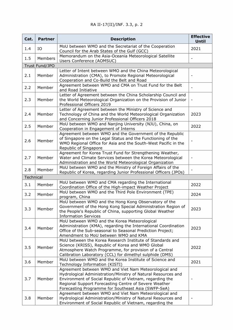
RA II-17(II)/INF. 3.3, p. 2
Cat. Partner Description Effective Until
1.4 IO MoU between WMO and the Secretariat of the Cooperation Council for the Arab States of the Gulf (GCC) 2021
1.5 Members Memorandum on the Asia-Oceania Meteorological Satellite Users Conference (AOMSUC) -
Trust Fund/JPO
2.1 Member Letter of Intent between WMO and the China Meteorological Administration (CMA), to Promote Regional Meteorological Cooperation and Co-Build the Belt and Road
-
2.2 Member Agreement between WMO and CMA on Trust Fund for the Belt and Road Initiative -
2.3 Member Letter of Agreement between the China Scholarship Council and the World Meteorological Organization on the Provision of Junior Professional Officers 2019
-
2.4 Member Letter of Agreement between the Ministry of Science and Technology of China and the World Meteorological Organization and Concerning Junior Professional Officers 2018
2023
2.5 Member MoU between WMO and Nanjing University (NJU), China, on Cooperation in Engagement of Interns 2022
2.6 Member
Agreement between WMO and the Government of the Republic of Singapore on the Legal Status and the Functioning of the WMO Regional Office for Asia and the South-West Pacific in the Republic of Singapore
-
2.7 Member Agreement for Korea Trust Fund for Strengthening Weather, Water and Climate Services between the Korea Meteorological Administration and the World Meteorological Organization
-
2.8 Member MoU between WMO and the Ministry of Foreign Affairs of the Republic of Korea, regarding Junior Professional Officers (JPOs) -
Technical
3.1 Member MoU between WMO and CMA regarding the International Coordination Office of the High-impact Weather Project 2022
3.2 Member MoU between WMO and the Third Pole Environment (TPE) program, China 2024
3.3 Member
MoU between WMO and the Hong Kong Observatory of the Government of the Hong Kong Special Administration Region of the People's Republic of China, supporting Global Weather Information Services
2023
3.4 Member
MoU between WMO and the Korea Meteorological Administration (KMA), regarding the International Coordination Office of the Sub-seasonal to Seasonal Prediction Project; Amendment to MoU between WMO and KMA
2023
3.5 Member
MoU between the Korea Research Institute of Standards and Science (KRISS), Republic of Korea and WMO Global Atmosphere Watch Programme, for provision of a Central Calibration Laboratory (CCL) for dimethyl sulphide (DMS)
2022
3.6 Member MoU between WMO and the Korea Institute of Science and Technology Information (KISTI) 2021
3.7 Member
Agreement between WMO and Viet Nam Meteorological and Hydrological Administration/Ministry of Natural Resources and Environment of Social Republic of Vietnam, regarding the Regional Support Forecasting Centre of Severe Weather Forecasting Programme for Southeast Asia (SWFP-SeA)
-
3.8 Member Agreement between WMO and Viet Nam Meteorological and Hydrological Administration/Ministry of Natural Resources and Environment of Social Republic of Vietnam, regarding the
-

RA II-17(II)/INF. 3.3, p. 3
Cat. Partner Description Effective Until
Regional Support Forecasting Centre of Flash Flood Guidance System for Southeast Asia (SeAFFGS)
Education and Training
4.1 Member
MoU between WMO and the Ministry of Education of the People's Republic of China (MOE) regarding the Establishment of Joint Scholarship for Training Students from WMO Members Studying in the People’s Republic of China
2022
4.2 Member MoU between WMO and the Nanjing University of Information Science and Technology (NUIST), China, in the area of WMO-NUIST Fellowships Education Programme
-
4.3 Member MoU between WMO and the Hohai University, China, in the area of WMO-Hohai Fellowships Education Programme
4.4 Member MoU between WMO and the Disaster Prevention Research Institute, Kyoto University (DPRI-KU), Fellowship Program 2021
4.5 Member MoU between WMO and KMA, for Hosting of the WMO Regional Training Centre 2024
4.6 Member MoU between WMO and the Ewha Womans University (EWU), Republic of Korea 2024
4.7 Member Agreement between WMO and the Government of Qatar concerning the recognition of the Qatar Aeronautical College as a WMO Regional Training Centre
-
4.8 Member
MoU between WMO and the National Environment Agency of Singapore (NEA), regarding the Conduct of an Annual Leadership and Management Programme for Senior Management of NMHSs of WMO Regional Associations II & V
2023
2.2. Partner organizations and stakeholders
Name Description RA II Members’ Involvement
UN Economic and Social Commission for Asia and the Pacific (UNESCAP)
Regional intergovernmental platform focusing on delivering the 2030 Agenda for Sustainable Development. Promotes cooperation to achieve inclusive and sustainable development in Asia and the Pacific. There are four sub-regional offices that work with RA II Members.
Full members include 25 RA II Members: Afghanistan, Bangladesh, Bhutan, Cambodia, China, Democratic People’s Republic of Korea, India, Islamic Republic of Iran, Japan, Kazakhstan, Kyrgyzstan, Lao PDR, Maldives, Mongolia, Myanmar, Nepal, Pakistan, Republic of Korea, Russian Federation, Sri Lanka, Tajikistan, Thailand, Turkmenistan, Uzbekistan, Viet Nam. Associate members from RA II: Hong Kong, China and Macao, China.
UNDRR Regional Office for Asia and the Pacific (UNDRR ROAP)
UNDRR Regional Office and the focal point for disaster risk reduction efforts across Asia and the Pacific. The regional Office for Asia and the Pacific (ROAP) manages or engages several platforms and programs supporting DRR efforts.
Covers 18 RA II Members: Afghanistan, Bangladesh, Bhutan, Cambodia, Democratic People’s Republic of Korea, India, Islamic Republic of Iran, Japan, Maldives, Mongolia, Myanmar, Nepal, Pakistan, Republic of Korea, Sri Lanka, Thailand, Turkmenistan, Viet Nam.
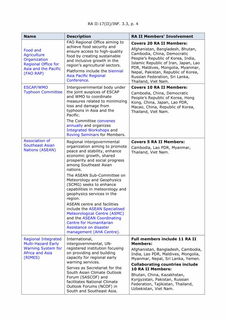
RA II-17(II)/INF. 3.3, p. 4
Name Description RA II Members’ Involvement
Food and Agriculture Organization Regional Office for Asia and the Pacific (FAO RAP)
FAO Regional Office aiming to achieve food security and ensure access to high-quality food by creating sustainable and inclusive growth in the region’s agricultural sectors. Platforms include the biennial Asia Pacific Regional Conference.
Covers 20 RA II Members: Afghanistan, Bangladesh, Bhutan, Cambodia, China, Democratic People’s Republic of Korea, India, Islamic Republic of Iran, Japan, Lao PDR, Maldives, Mongolia, Myanmar, Nepal, Pakistan, Republic of Korea, Russian Federation, Sri Lanka, Thailand, Viet Nam.
ESCAP/WMO Typhoon Committee
Intergovernmental body under the joint auspices of ESCAP and WMO to coordinate measures related to minimizing loss and damage from typhoons in Asia and the Pacific. The Committee convenes annually and organizes Integrated Workshops and Roving Seminars for Members.
Covers 10 RA II Members: Cambodia, China, Democratic People’s Republic of Korea, Hong Kong, China, Japan, Lao PDR, Macao, China, Republic of Korea, Thailand, Viet Nam.
Association of Southeast Asian Nations (ASEAN)
Regional intergovernmental organization aiming to promote peace and stability, enhance economic growth, shared prosperity and social progress among Southeast Asian nations. The ASEAN Sub-Committee on Meteorology and Geophysics (SCMG) seeks to enhance capabilities in meteorology and geophysics services in the region. ASEAN centre and facilities include the ASEAN Specialised Meteorological Centre (ASMC) and the ASEAN Coordinating Centre for Humanitarian Assistance on disaster management (AHA Centre).
Covers 5 RA II Members: Cambodia, Lao PDR, Myanmar, Thailand, Viet Nam.
Regional Integrated Multi-Hazard Early Warning System for Africa and Asia (RIMES)
International, intergovernmental, UN-registered institution focusing on providing and building capacity for regional early warning services. Serves as Secretariat for the South Asian Climate Outlook Forum (SASCOF) and facilitates National Climate Outlook Forums (NCOF) in South and Southeast Asia.
Full members include 11 RA II Members: Afghanistan, Bangladesh, Cambodia, India, Lao PDR, Maldives, Mongolia, Myanmar, Nepal, Sri Lanka, Yemen. Collaborating countries include 10 RA II Members: Bhutan, China, Kazakhstan, Kyrgyzstan, Pakistan, Russian Federation, Tajikistan, Thailand, Uzbekistan, Viet Nam.

RA II-17(II)/INF. 3.3, p. 5
Name Description RA II Members’ Involvement Organizes the RIMES Minister’s Conference to facilitate the development, endorsement and implementation of the RIMES Master Plans. *4th RIMES Minister’s Conference to be held in 2022 in Sri Lanka.
International Federation of Red Cross and Red Crescent Societies Asia Pacific (IFRC AP)
Regional office of international humanitarian network, providing coordination, financial and technical support for disaster operations and longer-term development programmes.
Covers 18 RA II Members: Afghanistan, Bangladesh, Bhutan, Cambodia, China, Democratic People’s Republic of Korea, India, Japan, Lao PDR, Maldives, Mongolia, Myanmar, Nepal, Pakistan, Republic of Korea, Sri Lanka, Thailand, Viet Nam.
Secretariat of League of Arab States (LAS)
Regional intergovernmental organization of Arab States in Middle East and North Africa focused on strengthening cooperation between Members and coordinating collaborative activities.
LAS includes 8 RA II Members: Bahrain, Iraq, Kuwait, Oman, Qatar, Saudi Arabia, United Arab Emirates, Yemen.
Cooperation Council for the Arab States of the Gulf (GCC)
Regional intergovernmental political and economic union between Arab States of the Gulf.
Comprises 6 RA II Members: Bahrain, Kuwait, Oman, Qatar, Saudi Arabia, United Arab Emirates.
UN Economic and Social Commission for West Asia (UN-ESCWA)
Regional Commission promoting economic and social development of West Asia through regional cooperation and integration.
Covers 8 RA II Members: Bahrain, Iraq, Kuwait, Oman, Qatar, Saudi Arabia, United Arab Emirates Yemen.
UNDRR Regional Office for Arab States (UNDRR ROAS)
UNDRR Regional Office focused on supporting Arab States and communities in building resilience to disasters.
Covers 7 RA II Members: Iraq, Kuwait, Oman, Qatar, Saudi Arabia, United Arab Emirates, Yemen.
The International Centre for Integrated Mountain Development (ICIMOD)
Intergovernmental knowledge and learning centre aiming to improve the lives and livelihoods of people of the Hindu Kush Himalaya and protect mountain environments and culture. Engagement platforms include Regional Programmes with various foci.
Covers 8 RA II Members: Afghanistan, Bangladesh, Bhutan, China, India, Myanmar, Nepal, Pakistan.
Asian Disaster Reduction Center (ADRC)
Centre that aims to enhance disaster resilience of member countries, build safe
Covers 23 RA II Members: Bangladesh, Bhutan, Cambodia, China, India, Islamic Republic of Iran, Japan, Kazakhstan,

RA II-17(II)/INF. 3.3, p. 6
Name Description RA II Members’ Involvement communities and promote sustainable development.
Kyrgyzstan, Lao PDR, Maldives, Mongolia, Myanmar; Nepal, Pakistan, Republic of Korea, Russian Federation, Sri Lanka, Tajikistan, Thailand, Uzbekistan, Viet Nam, Yemen.
Asia-Pacific Space Cooperation Organization (APSCO)
Intergovernmental organization that promotes and strengthens development of collaborative space programmes among its Member States.
Covers 6 RA II Members: Bangladesh, China, Islamic Republic of Iran, Mongolia, Pakistan, Thailand.
Asia-Oceania Meteorological Satellite Users Conference (AOMSUC)
Annual conference for facilitating dialogue and improved collaboration among space agencies and user communities of the Asia-Oceania region, and for enhancing the use of satellites for weather, climate and disaster mitigation services.
Signatories of the 2016 MoU include 5 RA II Members: China; India, Japan, Russian Federation, Republic of Korea. Previous runs held in: China (2010, 2014), Japan (2011, 2015), Republic of Korea (2012, 2016), Australia (2013, 2019), Russian Federation (2017), Indonesia (2018). *AOMSUC-11 to be held in 4Q2021 in Beijing, China
Korea International Cooperation Agency (KOICA)
Government agency that manages the Republic of Korea’s official development assistance.
Core partners include 10 RA II Members: Bangladesh, Cambodia, Lao PDR, Mongolia, Myanmar, Nepal, Pakistan, Sri Lanka, Uzbekistan, Viet Nam.
Nanjing University of Information Science and Technology (NUIST)
University in China with focus in meteorology, hosts the WMO Regional Training Centre, Nanjing.
2.3. Regional Centres
Centre type
Host Member Centre name Centre description
GDPFS - The World Meteorological Centres WMC China WMC Beijing GDPFS - World Meteorological Centre
WMC Russian Federation WMC Moscow GDPFS - World Meteorological Centre
WMC Japan WMC Tokyo GDPFS - World Meteorological Centre
GDPFS - The Regional Specialized Meteorological Centres with geographical specialization RSMC India RSMC New Delhi GDPFS - Regional Specialized
Meteorological Centre with geographical specialization
RSMC Saudi Arabia RSMC Jeddah RSMC Uzbekistan RSMC Tashkent GDPFS - General purpose activities RSMC China RSMC Beijing
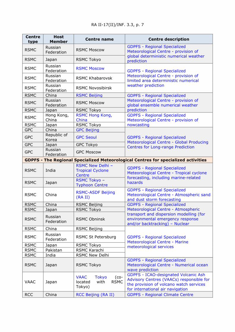
RA II-17(II)/INF. 3.3, p. 7
Centre type
Host Member Centre name Centre description
RSMC Russian Federation RSMC Moscow
GDPFS - Regional Specialized Meteorological Centre - provision of global deterministic numerical weather prediction
RSMC Japan RSMC Tokyo
RSMC Russian Federation RSMC Moscow GDPFS - Regional Specialized
Meteorological Centre - provision of limited area deterministic numerical weather prediction
RSMC Russian Federation RSMC Khabarovsk
RSMC Russian Federation RSMC Novosibirsk
RSMC China RSMC Beijing GDPFS - Regional Specialized Meteorological Centre - provision of global ensemble numerical weather prediction
RSMC Russian Federation RSMC Moscow
RSMC Japan RSMC Tokyo
RSMC Hong Kong, China
RSMC Hong Kong, China
GDPFS - Regional Specialized Meteorological Centre - provision of nowcasting RSMC Japan RSMC Tokyo
GPC China GPC Beijing
GDPFS - Regional Specialized Meteorological Centre - Global Producing Centres for Long-range Prediction
GPC Republic of Korea GPC Seoul
GPC Japan GPC Tokyo
GPC Russian Federation GPC Moscow
GDPFS - The Regional Specialized Meteorological Centres for specialized activities
RSMC India RSMC New Delhi – Tropical Cyclone Centre
GDPFS - Regional Specialized Meteorological Centre - Tropical cyclone forecasting, including marine-related hazards RSMC Japan RSMC Tokyo –
Typhoon Centre
RSMC China RSMC-ASDF Beijing (RA II)
GDPFS - Regional Specialized Meteorological Centre - Atmospheric sand and dust storm forecasting
RSMC China RSMC Beijing GDPFS - Regional Specialized Meteorological Centre - Atmospheric transport and dispersion modelling (for environmental emergency response and/or backtracking) – Nuclear
RSMC Japan RSMC Tokyo
RSMC Russian Federation RSMC Obninsk
RSMC China RSMC Beijing
GDPFS - Regional Specialized Meteorological Centre - Marine meteorological services
RSMC Russian Federation RSMC St Petersburg
RSMC Japan RSMC Tokyo RSMC Pakistan RSMC Karachi RSMC India RSMC New Delhi
RSMC Japan RSMC Tokyo GDPFS - Regional Specialized Meteorological Centre - Numerical ocean wave prediction
VAAC Japan VAAC Tokyo (co-located with RSMC Tokyo)
GDPFS - ICAO-designated Volcanic Ash Advisory Centres (VAACs) responsible for the provision of volcano watch services for international air navigation
RCC China RCC Beijing (RA II) GDPFS - Regional Climate Centre
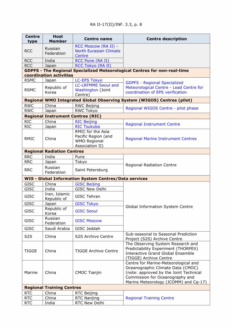
RA II-17(II)/INF. 3.3, p. 8
Centre type
Host Member Centre name Centre description
RCC Russian Federation
RCC Moscow (RA II) - North Eurasian Climate Centre
RCC India RCC Pune (RA II)
RCC Japan RCC Tokyo (RA II)
GDPFS - The Regional Specialized Meteorological Centres for non-real-time coordination activities RSMC Japan LC-EPS Tokyo GDPFS - Regional Specialized
Meteorological Centre - Lead Centre for coordination of EPS verification
RSMC Republic of Korea
LC-LRFMME Seoul and Washington (Joint Centre)
Regional WMO Integrated Global Observing System (WIGOS) Centres (pilot) RWC China RWC Beijing Regional WIGOS Centre - pilot phase RWC Japan RWC Tokyo Regional Instrument Centres (RIC) RIC China RIC Beijing Regional Instrument Centre RIC Japan RIC Tsukuba
RMIC China
RMIC for the Asia Pacific Region (and WMO Regional Association II)
Regional Marine Instrument Centres
Regional Radiation Centres RRC India Pune
Regional Radiation Centre RRC Japan Tokyo
RRC Russian Federation Saint Petersburg
WIS - Global Information System Centres/Data services GISC China GISC Beijing
Global Information System Centre
GISC India GISC New Delhi
GISC Iran, Islamic Republic of GISC Tehran
GISC Japan GISC Tokyo
GISC Republic of Korea GISC Seoul
GISC Russian Federation GISC Moscow
GISC Saudi Arabia GISC Jeddah
S2S China S2S Archive Centre Sub-seasonal to Seasonal Prediction Project (S2S) Archive Centre
TIGGE China TIGGE Archive Centre
The Observing System Research and Predictability Experiment (THORPEX) Interactive Grand Global Ensemble (TIGGE) Archive Centre
Marine China CMOC Tianjin
Centre for Marine-Meteorological and Oceanographic Climate Data (CMOC) (note: approved by the Joint Technical Commission for Oceanography and Marine Meteorology (JCOMM) and Cg-17)
Regional Training Centres RTC China RTC Beijing
Regional Training Centre RTC China RTC Nanjing RTC India RTC New Delhi
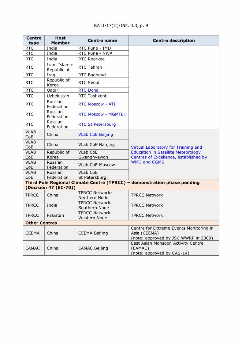
RA II-17(II)/INF. 3.3, p. 9
Centre type
Host Member Centre name Centre description
RTC India RTC Pune - IMD RTC India RTC Pune - NWA RTC India RTC Roorkee
RTC Iran, Islamic Republic of RTC Tehran
RTC Iraq RTC Baghdad
RTC Republic of Korea RTC Seoul
RTC Qatar RTC Doha
RTC Uzbekistan RTC Tashkent
RTC Russian Federation RTC Moscow - ATI
RTC Russian Federation RTC Moscow - MGMTEH
RTC Russian Federation RTC St Petersburg
VLAB CoE China VLab CoE Beijing
Virtual Laboratory for Training and Education in Satellite Meteorology Centres of Excellence, established by WMO and CGMS
VLAB CoE China VLab CoE Nanjing
VLAB CoE
Republic of Korea
VLab CoE Gwanghyewon
VLAB CoE
Russian Federation VLab CoE Moscow
VLAB CoE
Russian Federation
VLab CoE St Petersburg
Third Pole Regional Climate Centre (TPRCC) – demonstration phase pending (Decision 47 (EC-70))
TPRCC China TPRCC Network-Northern Node TPRCC Network
TPRCC India TPRCC Network-Southern Node TPRCC Network
TPRCC Pakistan TPRCC Network-Western Node TPRCC Network
Other Centres
CEEMA China CEEMA Beijing Centre for Extreme Events Monitoring in Asia (CEEMA) (note: approved by JSC WWRP in 2009)
EAMAC China EAMAC Beijing East Asian Monsoon Activity Centre (EAMAC) (note: approved by CAS-14)
RA II-17(II)/INF. 3.3, p. 10
2.4. Fellowship and training support in human resource capacity development in RA II
2.4.1 Short-term training programmes provided to RA II experts between 2018 and the first half of 2021
Since the sixteenth session of Regional Association II (RA II) in 2017 and through the first half of 2021, a number of activities have been carried out by the World Meteorological Organization (WMO) and jointly with RA II Members. This resulted in XXX experts from XX Members having participated in training activities (XX females and XX males). [numbers will be inserted]
2.4.2 Leadership and Management Programme Activities
The Secretary-General has tasked the Secretariat to give priority to Decision 49 (EC-70) – Governance of education and training (2018), which requested the Secretary-General to strengthen the Organization’s support to fellowships and continuing education and to capacity development overall, so as to provide a strong basis for strengthening the capacity of Members and in particular to focus also on leadership and management skills as well as technical skills. Recognizing that the development of leadership and management skills of senior officials of NMHSs will go a long way in enhancing the overall capacity of Members, the Secretary-General has been giving rapt attention to this decision and is committed to supporting such activities.
2.4.2.1 Leadership and Management Programme for Senior Management of NMHSs of RA II and RA V
In support of this WMO training and education priority, the Leadership and Management Programme for Senior Management of NMHSs is an annual programme jointly organized by WMO and the Meteorological Service Singapore (MSS). The programme aims to develop critical management skills in the leadership of NMHSs, with priority given to RA II and RA V Members, and developing and least developed Members from other RAs.
MSS partnered with WMO to deliver the inaugural run of the Programme in September 2018, under MSS’ sponsorship. The Programme was well attended by 20 Members from RAs II and V, including the Permanent Representatives of several Members. Senior management from the NMHSs of the following 15 RA II Members were present: Bhutan, Islamic Republic of Iran Kazakhstan, Kyrgyzstan, Lao PDR, Maldives, Mongolia, Myanmar, Nepal, Oman, Saudi Arabia,; Sri Lanka, Thailand, Uzbekistan, Viet Nam.
The second run was co-sponsored by WMO and MSS and held in Singapore in August 2019. Senior management from 19 NMHSs of RA II and V Members were present. From RA II, the following nine Members were in attendance: Bangladesh, China, Islamic Republic of Iran, Iraq, Japan, Nepal, Pakistan, Thailand, Viet Nam.
The third run of the leadership and management programme series was planned for 2020. However, because of the COVID-19 pandemic, it was postponed to 2021.The programme was again jointly organized by MSS and WMO over a two-week period from 3–6 and from 10-13 August 2021. As the COVID-19 travel restrictions continued, the programme was conducted virtually and targeted the senior management (Permanent Representatives, Director-Generals, Directors or equivalent) of the NMHSs and aimed to develop critical management skills in the leadership of NMHSs, with priority given to Members of RA II (Asia) and RA V (South-West Pacific), and developing and least developed Members from other regional associations. The programme was highly engaging, with a strong focus on experience sharing.
RA II-17(II)/INF. 3.3, p. 11
2.4.2.2 International workshop for senior management of NMHSs
In 2021, RTC-Beijing (China) is going to launch an international workshop for senior management of NMHSs, online, which aims to enhance the knowledge of management and leadership in the NMHS and of WMO global strategy, global meteorological governance, global climate change, meteorological service and emergency management, and eventually to improve the decision-making.
This workshop is expected to be held from 25 to 29 October 2021. The senior officials and specialists engaged in meteorological and hydrological management or that of other equivalent services of RA II Members are welcomed to apply.
2.4.3 Training Package for Strengthening the Delivery of Global and Regional Climate Services supported by the Trust Fund of Korean Meteorological Administration
The Education and Training (ETR) Office is collaborating with the Services Department on the development of a training package for “Strengthening the Delivery of Global and Regional Climate Services”, which includes: (i) a Climpact online module; (ii) webinars; (iii) a training syllabus for face-to-face and virtual training; (iv) regional toolkits; and (v) workshops. This project is being supported by the Korean Meteorological Administration, through a trust fund.
The first webinar, entitled “Integrating Climate Risk Information into Climate Action”, took place on 2 June 2021 with an audience that passed 200 attendees. The event gathered great interest from RA II Members. The second webinar “Supporting Local Climate Action Through Climate Indices” was offered on 7 July 2021.
2.4.4 WMO fellowship programme
2.4.4.1 WMO Fellowships Programme in 2017–2020
WMO Fellowships Programme aims to support the education and training of qualified and suitable candidates, particularly from least developed and developing countries and Small Island Developing States. WMO may award both short-term (more than one month and less than six months) and long-term (6 months or longer) fellowships in alignment with the priorities of WMO and its education and training Programme.
In the past four years, on average, the global annual requests are about 200 out of which about 30% are awarded.
From a global view, RA II stands second both in the number of requests and awards. The annual average of requests is around 130, the awarded rate is also about 30%.
Female requests and awards are lower than male counterpart in all Regions including RA II. In the past four years, female applicants constitute about 41% of the requests in RA II with a higher awards rate of 48% thanks to WMO fellowships’ gender policy effort.
2.4.4.2 RA II Fellowships by host Members
The request and award numbers and rates partially related to WMO’s agreements with fellowship partners, of which RA II has the most favourable host Member’s agreements, therefore RA II also benefits the most from the agreements with geographical proximity.
China is the most requested and awarded fellows’ host Member in RA II, the studies range from BSc, MSc and PhD. RA II fellows not only study in Japan and Republic of Korea in the region but also in other regions such in Russian Federation, United Kingdom, Netherlands, Germany and Egypt.
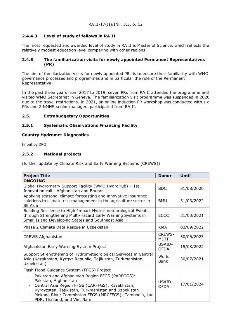
RA II-17(II)/INF. 3.3, p. 12
2.4.4.3 Level of study of fellows in RA II
The most requested and awarded level of study in RA II is Master of Science, which reflects the relatively modest education level comparing with other regions.
2.4.5 The familiarization visits for newly appointed Permanent Representatives (PR)
The aim of familiarization visits for newly appointed PRs is to ensure their familiarity with WMO governance processes and programmes and in particular the role of the Permanent Representative.
In the past three years from 2017 to 2019, seven PRs from RA II attended the programme and visited WMO Secretariat in Geneva. The familiarization visit programme was suspended in 2020 due to the travel restrictions. In 2021, an online induction PR workshop was conducted with six PRs and 2 NMHS senior managers participated from RA II.
2.5. Extrabudgetary Opportunities
2.5.1 Systematic Observations Financing Facility
Country Hydromet Diagnostics
(input by DPO)
2.5.2 National projects
(further update by Climate Risk and Early Warning Systems (CREWS))
Project Title Donor Until ONGOING Global Hydrometry Support Facility (WMO HydroHub) – 1st Innovation call - Afghanistan and Bhutan SDC 31/08/2020
Applying seasonal climate forecasting and innovative insurance solutions to climate risk management in the agriculture sector in SE Asia
BMU 31/03/2022
Building Resilience to High-Impact Hydro-meteorological Events through Strengthening Multi-Hazard Early Warning Systems in Small Island Developing States and Southeast Asia
ECCC 31/03/2021
Phase 2 Climate Data Rescue in Uzbekistan KMA 03/09/2022
CREWS Afghanistan CREWS-MDTF 30/06/2023
Afghanistan Early Warning System Project USAID-OFDA 15/08/2022
Support Strengthening of Hydrometeorological Services in Central Asia (Kazakhstan, Kyrgyz Republic, Tajikistan, Turkmenistan, Uzbekistan)
World Bank 30/07/2021
Flash Flood Guidance System (FFGS) Project - Pakistan and Afghanistan Region FFGS (PARFGGS):
Pakistan, Afghanistan - Central Asia Region FFGS (CARFFGS): Kazakhstan,
Kyrgyzstan, Tajikistan, Turkmenistan and Uzbekistan - Mekong River Commission FFGS (MRCFFGS): Cambodia, Lao
PDR, Thailand, and Viet Nam
USAID-OFDA 17/01/2024
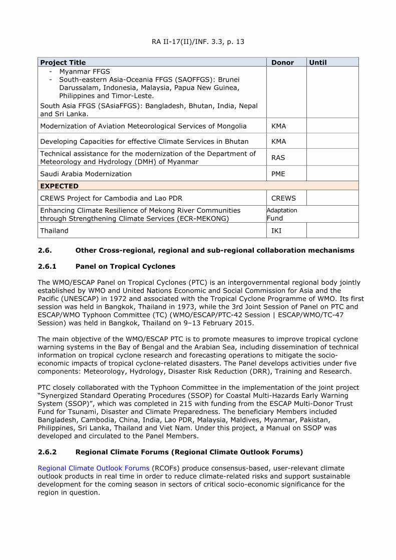
RA II-17(II)/INF. 3.3, p. 13
Project Title Donor Until - Myanmar FFGS - South-eastern Asia-Oceania FFGS (SAOFFGS): Brunei
Darussalam, Indonesia, Malaysia, Papua New Guinea, Philippines and Timor-Leste.
South Asia FFGS (SAsiaFFGS): Bangladesh, Bhutan, India, Nepal and Sri Lanka.
Modernization of Aviation Meteorological Services of Mongolia KMA
Developing Capacities for effective Climate Services in Bhutan KMA
Technical assistance for the modernization of the Department of Meteorology and Hydrology (DMH) of Myanmar RAS
Saudi Arabia Modernization PME
EXPECTED
CREWS Project for Cambodia and Lao PDR CREWS
Enhancing Climate Resilience of Mekong River Communities through Strengthening Climate Services (ECR-MEKONG)
Adaptation Fund
Thailand IKI
2.6. Other Cross-regional, regional and sub-regional collaboration mechanisms
2.6.1 Panel on Tropical Cyclones
The WMO/ESCAP Panel on Tropical Cyclones (PTC) is an intergovernmental regional body jointly established by WMO and United Nations Economic and Social Commission for Asia and the Pacific (UNESCAP) in 1972 and associated with the Tropical Cyclone Programme of WMO. Its first session was held in Bangkok, Thailand in 1973, while the 3rd Joint Session of Panel on PTC and ESCAP/WMO Typhoon Committee (TC) (WMO/ESCAP/PTC-42 Session | ESCAP/WMO/TC-47 Session) was held in Bangkok, Thailand on 9–13 February 2015.
The main objective of the WMO/ESCAP PTC is to promote measures to improve tropical cyclone warning systems in the Bay of Bengal and the Arabian Sea, including dissemination of technical information on tropical cyclone research and forecasting operations to mitigate the socio-economic impacts of tropical cyclone-related disasters. The Panel develops activities under five components: Meteorology, Hydrology, Disaster Risk Reduction (DRR), Training and Research.
PTC closely collaborated with the Typhoon Committee in the implementation of the joint project “Synergized Standard Operating Procedures (SSOP) for Coastal Multi-Hazards Early Warning System (SSOP)”, which was completed in 215 with funding from the ESCAP Multi-Donor Trust Fund for Tsunami, Disaster and Climate Preparedness. The beneficiary Members included Bangladesh, Cambodia, China, India, Lao PDR, Malaysia, Maldives, Myanmar, Pakistan, Philippines, Sri Lanka, Thailand and Viet Nam. Under this project, a Manual on SSOP was developed and circulated to the Panel Members.
2.6.2 Regional Climate Forums (Regional Climate Outlook Forums)
Regional Climate Outlook Forums (RCOFs) produce consensus-based, user-relevant climate outlook products in real time in order to reduce climate-related risks and support sustainable development for the coming season in sectors of critical socio-economic significance for the region in question.
RA II-17(II)/INF. 3.3, p. 14
In the late 1990s the WMO, NMHSs, regional institutions and other international organizations initiated an innovative process known as RCOFs (herein referred to as Forums). These forums bring together national, regional and international climate experts, on an operational basis, to produce regional climate outlooks based on input — climate predictions — from all participants. By bringing together Members with common climatological characteristics, the Forums ensure consistency in the access to, and interpretation of, climate information. Through interaction with users in the key economic sectors of each region, extension agencies and policymakers, the Forums assess the likely implications of the outlooks on the most pertinent socio-economic sectors in the given region and explore the ways these outlooks could be used by them.
2.6.2.1 East Asia winter Climate Outlook Forum (EASCOF)
In 2000, CMA, Japan Meteorological Agency (JMA) and KMA set-up the Joint Meeting for Seasonal Prediction of the East Asian Winter Monsoon to bring together experts on long range weather forecast from the East Asian Members. Later, the National Agency for Meteorology and Environment Monitoring (NAMEM) of Mongolia joined the group. The meeting evolved to become EASCOF, formally recognized in 2012 by WMO Regional Association II. The Forum produces summary seasonal predictions and outlooks for the coming winter monsoon for the four Members.
2.6.2.2 Forum on Regional Climate Monitoring, Assessment and Prediction for Regional Association II (FOCRAII)
The Forum on Regional Climate Monitoring, Assessment and Prediction for Regional Association II (FOCRAII) covers all the Members in Asia, most being Members of WMO Regional Association II. FOCRAII activities are coordinated by the Beijing Climate Centre (BCC) of CMA.
2.6.2.3 South Asian Climate Outlook Forum (SASCOF)
The South Asian Climate Outlook Forum (SASCOF) was established in 2009 and is coordinated by the India Meteorological Department (IMD). It covers Afghanistan, Bangladesh, Bhutan, India, Maldives, Myanmar, Nepal, Pakistan and Sri Lanka; each Member hosts the Forum on rotation.
2.6.2.4 Association of Southeast Asian Nations Climate Outlook Forum (ASEANCOF)
ASEANCOF, coordinated by the Centre for Climate Research Singapore (CCRS) since its launch in 2013, is now hosted on rotation by each participating country: Brunei, Indonesia, Laos, Malaysia, Myanmar, Philippines, Singapore, Thailand and Vietnam. Representatives from the WMO Global Producing Centres of Long Range Forecasts (GPCs), namely the BCC, the European Centre for Medium-Range Weather Forecasting (ECMWF), JMA, UK Met Office (UKMO) and WMO Lead Centre for Long Range Forecast Multi-Model Ensemble as well as the Asia-Pacific Economic Cooperation (APEC) Climate Centre (APCC) also attend ASEANCOF meetings.
2.6.2.5 North Eurasian Climate Outlook Forum (NEACOF)
The North Eurasia Climate Outlook Forum (NEACOF) has provided since 2011 consensus-based seasonal climate information to support sustainable development efforts in the Commonwealth Independent States (CIS) region: Armenia, Azerbaijan, Belarus, Kazakhstan, Kyrgyzstan, Moldova, Russian Federation, Tajikistan, Turkmenistan, Ukraine, and Uzbekistan. It is coordinated by the North Eurasia Climate Centre (NEACC).
RA II-17(II)/INF. 3.3, p. 15
2.6.3 RA II Hydrological Advisers’ Forum
The RA II Hydrological Advisers’ Forum was designed to provide a regional platform for National Hydrological Advisers to update progress made on operational hydrology and discuss cooperation opportunities at sub-regional and regional level. The First and Second Forums were held in September 2020 and March 2021, virtually.
2.6.4 China-ASEAN Meteorological Forums (CAMF)
China-ASEAN Meteorological Forums co-sponsored by CMA and the People’s Government of Guangxi Zhuang Autonomous Region of China were held in 2016 and 2018. Themed with monitoring regional disasters and information sharing, the forums aim to share the experiences and achievements in disaster prevention and reduction which establishes a mechanism for join monitoring and defence against meteorological disasters. It also aims at promoting technical interaction in meteorological operations and enhancing cooperation on regional disaster preparedness and disaster risk management. During the 1st China ASEAN Meteorological Forum in 2016, the Nanning Initiative on China-ASEAN Cooperation in Meteorology was adopted, laying the foundation for long-term meteorological cooperation between China and ASEAN countries.
2.6.5 International Workshop of Meteorological Science and Technology in Central Asia (IWMSTC)
Since 2015, 5 International Workshops of Meteorological Science and Technology in Central Asia were held by Xinjiang Provincial Meteorological Services of CMA. The objective of the workshop is to strengthen meteorological sci-tech cooperation with Central Asian countries and promote research in regional climate change as well as meteorological disaster prevention. The Urumqi Initiative in Disaster Prevention and Reduction and Addressing Climate Change in Central Asia was established during the 1st International Workshop. The 6th International Workshop of Meteorological Science and Technology in Central Asia will be held in November 2021.
2.6.6 Northeast Asia Forum on Meteorological Science and Technology (NAFMCT)
To strengthen the multilateral dialogue and regional cooperation to cope with global climate change and provide support for economic development and people's well-beings, Liaoning Provincial Meteorological Service of CMA will host the Northeast Asia Forum on Meteorological Science and Technology (online) in 2021 (TBD). The forum aims to promote the communication and cooperation in meteorological science and technology among Northeast Asian Members for a stronger resilience in disaster prevention and mitigation and climate change response, deliver better services and provide support for disaster management, food security, ecological and environmental protection and sustainable development in Northeast Asia.
2.7. Other opportunities, including engagement of the private sector and academia
2.7.1 Public-Private Engagement (PPE)
The 17th session of RA II has decided (through Decision 5.2) that the president of RA II and the Management Group should give due consideration to Guidelines for PPE in planning relevant regional activities and to encourage the RA II Members to use it in establishing collaboration and partnership at national level across the public, private, academic and civil society sectors. It has also decided to consider organizing a Regional Forum on PPE linked to the Open Consultative Platform (OCP) launched by WMO during the 18th Congress in 2019. At the same time, the OCP, through developing white papers focused on a variety of themes, provides WMO Members in all regions with analysis and views on grand challenges, including key issues in engaging stakeholders. At the regional and national levels, there also exist organizations or mechanisms, although their numbers are still very limited at current stage, working to promote NMHSs’ engagement with the private sector in weather and climate domain. In a WMO Questionnaire

RA II-17(II)/INF. 3.3, p. 16
survey conducted in 2018 on the status of PPE, 53% of the respondent RA II Members answered that there is a law (e.g., Meteorological Act or similar) that covers all aspects of activities and services, while 20% answered that there is neither law nor regulations dealing with the subject (= legislation and/or regulations that determines the roles and relationships of public and private sectors with regard to the provision of Meteorological/Climate/Hydrological information services).
2.7.1.1 WMO policy and guiding instruments for PPE
WMO has currently the following policy and guiding instruments focused on PPE applying to WMO Members in all regions, namely the Geneva Declaration 2019: Building Community for Weather, Climate and Water Action, and the Guidelines for Public-private Engagement (WMO-No. 1258). The Declaration is a high-level policy act adopted by the 18th World Meteorological Congress and sets the directions for Members to embrace a new paradigm of partnership engaging stakeholders from all sectors in order to respond collectively and effectively to global risks related to weather, climate change, water scarcity and other environmental hazards. The Guidelines provides more specific guidance for actions at national, regional and global levels pursuing cooperation with non-state entities.
2.7.1.2 WMO OCP: Partnership and Innovation for the Next Generation of Weather and Climate Intelligence
The OCP launched by WMO during the 18th Congress in 2019 is the main framework of WMO for collaboratively addressing the grand challenges before the weather enterprise in an open, constructive and participatory way. The OCP High-Level sessions (OCP-HL) provide a mechanism for continual dialogues among public, private and academic sectors to enable all stakeholders stay abreast of issues and opportunities facing the global weather and climate enterprise. There are other forms of collaborative actions of the stakeholders under OCP, including regular innovation webinars and the development of collaborative White Papers (WPs) addressing the thematic areas identified by the OCP-HL.1
2.7.1.3 WMO OCP White Paper #1 – Future of weather and climate forecasting (OCP WP#1)
The OCP WP#1 published on 1 April 2021 is an output of the WMO OCP. It is a joint effort of 30 leading experts from the research, operations and education fields. It analyses the challenges and opportunities to the future weather and climate forecast brought about by the advancement of science and technology as well as a swiftly changing landscape of stakeholders with evolving capabilities and roles. The WP examines three overarching components of the innovation cycle: infrastructure, research and development, and operation. It makes the case that in many ways the PPE will accelerate the desired bridging of the capacity gap in weather and climate service needed for developing countries. The WP has two main purposes of use. The first is to provide a basis for informed decision-making by enterprise stakeholders in planning their activities and investment in numerical prediction, and operational forecasting during the next decade, often referred to as the decade of digital transformation. The second is to help decision makers, researchers and end-users in the rapidly changing landscape of the weather and climate enterprise with the compelling views, knowledge and expertise of a group of prominent scientists and practitioners from the public, private and academic sectors.
1 The first High-Level Round Table for the Launch of the OCP (OCP-HL-1) identified five thematic areas as
grand challenges to be addressed collectively by a global weather and climate enterprise engaging public, private and academic sectors: (1) data and more (shared) data; (2) forecasting and forecasters; (3) demand and supply of services which drive decision-making; (4) capacity gaps, and; (5) roles, responsibilities and partnerships for common actions.

RA II-17(II)/INF. 3.3, p. 17
2.7.1.4 MO OCP White Paper #2 (OCP WP#2): Evolving Roles and Responsibilities – Future of NMHSs (Vison 2030+)
The OCP WP#2 was kicked off in August 2021 and is in the process of drafting. The WP will be a collective work by a drafting team composed of 29 contributing authors and around 10 reviewers led by the lead editor, Prof. Gerhard Adrian, the President of WMO. The WP will address the issues and challenges under the overarching question “How do you see the NMHS in 2030?”. It will inform the important decisions on the future of the NMHS at national level with potential scenarios and ideas for possible governance choices to mitigate the negative impacts. The WP is anticipated to be ready for publishing in the spring of year 2022 and will provide NMHSs with recommendations as to how they can meet the challenges and mitigate potential disruptive factors, at the same time, engaging better with the stakeholders from all sectors for better serving the society.
2.7.1.5 WMO working arrangement with the Association of Hydro-Meteorological Equipment Industry (HMEI)
HMEI is an international non-governmental organization for weather industry. It promotes the views of the private industry providers of products and services in the meteorological, hydrological, environmental and related fields. The Association is fully accredited to the WMO and other UN organizations and actively facilitates interaction and communication between its members and a broad range of international and national organizations, both governmental and private, for the mutual benefit of all parties. HMEI has currently over 140 members which are based or have business in all regions of WMO.
The Working Arrangement between WMO and the Association of the Hydro-Meteorological Equipment Industry (HMEI) was approved on behalf of the WMO by the Executive Council at its seventieth session in June 2018 (EC-70) and on behalf of the HMEI by its Chair on the basis of HMEI Council decision on 9 May 2018. The working Arrangements covers cooperation in promotion and development of effective partnerships between the public and private sector, with support from academia, aimed at enhanced sustainability, quality and efficiency of data, information and services provided at national, regional and global levels.
2.7.1.6 Weather business or industry associations or other public-private cooperation mechanisms at national and regional levels in RA II
(1) WXBC in Japan: The Weather Business Consortium was established in Tokyo on 7 March 2017 by public, private and academic sector operators including current and potential meteorological data users in Japan. JMA functions as the consortium’s Secretariat via the Office of Public-Private-Academic Collaboration. The purpose of WXBC is to drive commerce involving intensive usage of meteorological data in technologies such as the Internet of Things (IoT) and Artificial Intelligence (AI) via extensive joint efforts in the public, private and academic sectors, thereby enhancing socio-economic productivity in Japan. The expectation is that the WXBC will boost weather-for-business activities in Japan and enable the advanced use of weather data and products in the business. The number of the WXBC’s members is more than 1 000. The consortium represents an important platform for sharing knowledge and experience and for the promotion of mutual understanding through ongoing dialogue. (website: https://www.wxbc.jp/)
(2) CMSA in China: China Meteorological Service Association (CMSA), established in May 2015, is the first nation-wide industrial, and non-profit organization representing meteorological service providers in China. The CMSA is aimed at building a communication platform between the government, academic groups, and enterprises, boosting the prosperity of the industry, and enhancing the role and influence of meteorological services in the overall economic and social development pattern. The CMSA’s primary purpose is to represent the views and concerns of the industry and the Associations’ members, safeguard the legitimate rights and interests of the enterprises, and promote industry self-regulation and compliance to standards. As of the end of

RA II-17(II)/INF. 3.3, p. 18
2019, CMSA has already registered 586 members from public, private and academic sectors. (website: www.chinamsa.org)
(3) KMI in Korea: Korea Meteorological Institute (KMI) was established in 2017 as a public body by Korean Meteorological Administration to support and foster the weather industry thereby contributing to the development of economy in Korea. Its functions include 1) survey, and analyse the weather Industry market & utilization of collected information; 2) Plan, evaluate and manage R&D project for promotion of weather Industry; 3) Support establishment & management of weather business and collect, manage related information in this respect; 4) Consigned project from government regarding installation, management of the weather observation equipment, facility; 5) Operate, manage public weather consulting facility; 6) Business related to promotion of the weather Industry prescribed by the Presidential Decree. One major event regarding the PPE in Korea is the annual “Korea Climate and Meteorological Industry Exhibition” organized by KMA and KMI. This began in 2016 with the participation of 57 organizations (company, institutes, etc.) and has grown to the size of 108 organizations’ participation in 2019. (website: https://www.kmiti.or.kr)
3. CHALLENGES AND OPPORTUNITIES
3.1. RA II priorities for 2020–2023 identified by the Joint Management Group Meeting for Asia and the South-West Pacific (Singapore, 29 to 31 October 2019):
(1) Impact-based forecasting and warning services - formulate concrete requirements for availability of data to improve forecast quality; pilot projects for urban services and mega cities;
(2) Provision of climate information and services and contribution to the Global Framework on Climate Services (GFCS);
(3) Strengthening of hydrological services - adequate regional mechanism for the coordination with the Hydrological Assembly;
(4) Regional WIGOS centres, GBON/RBON and WIS - data sharing and assimilation;
(5) Enhance capacity in service delivery - more utilization of social media;
(6) Key Performance Indicators (KPIs) for the priority areas;
(7) Training to be considered to serve above priorities.
3.2. Survey result in 2019
The RA II Members were surveyed in order to identify and monitor the challenges and priorities of NMHSs. The data obtained from the Survey helped prepare baseline information and background material, including the identification of regional and sub-regional priorities, in order to inform and support evidence-based strategic planning discussions. The Survey was conducted online during the period November 2018–January 2019. Thirty-two out of 35 possible responses were received.
3.2.1 Overall challenges
Members were asked to identify the most pressing challenges from a list of 16 predefined categories by rating the extent of the challenge on a 5-point scale (1 = no challenge; 2 = slight challenge; 3 = moderate challenge; 4 = moderate/serious challenge; 5 = serious challenge).
The main challenges identified were:
(1) Lack of qualified personnel in some areas
RA II-17(II)/INF. 3.3, p. 19
(2) Adequacy of Numerical Weather Prediction (NWP) modelling capacity
(3) Introduction and/or maintenance of QMS
(4) Anticipated budget cuts
(5) Adequacy of agriculture services
(-) Adequacy of hydrology services
3.2.2 Challenges by sub-regions
An analysis for the five sub-regions (Central Asia, East Asia, South-East Asia, South Asia and West Asia) and for the least developed countries was also made to identify main challenges specific to the sub-regions and to the least developed countries.
3.2.3 Central Asia:
(1) Lack of qualified personnel in some areas
(2) Adequacy of early warning systems (EWS) and services for DRR
(-) Adequacy of the existing observing systems
(3) Introduction and/or maintenance of QMS (-) Adequacy of NWP modelling capacity
(-) Adequacy of NWP modelling capacity
3.2.4 East Asia:
(1) Adequacy of NWP modelling capacity
(2) Adequacy of climate services
(3) Adequacy of EWS and services for DRR
(-) Visibility towards decision makers
(-) Adequacy of hydrology services
3.2.5 South-East Asia:
(1) Introduction and/or maintenance of QMS
(2) Anticipated budget cuts
(-) Lack of qualified personnel in some areas
(3) Adequacy of marine services
3.2.6 South Asia:
(1) Adequacy of agriculture services
(2) Adequacy of hydrology services
(-) Lack of qualified personnel in some areas
(-) Introduction and/or maintenance of QMS
3.2.7 West Asia:
(1) Adequacy of marine services
(2) Adequacy of climate services
(-) Adequacy of hydrology services

RA II-17(II)/INF. 3.3, p. 20
(3) Lack of qualified personnel in some areas
3.2.8 Least developed countries:
(1) Anticipated budget cuts
(-) Introduction and/or maintenance of QMS
(-) Adequacy of agriculture services
(2) Lack of qualified personnel in some areas
4. CONCLUSIONS
(to be developed by C/TT-RP)
REFERENCES
(to be included)
[Comment: The RA II TT-RP will lead the further development of this draft.]
__________

WEA
THER
CLI
MATE
WAT
ER World Meteorological Organization
REGIONAL ASSOCIATION II (ASIA)
Seventeenth Session (Second Part) 27 to 30 September 2021, Virtual Session
RA II-17(II)/INF. 6.3
Submitted by: Secretary-General
27.IX.2021
OBSERVATIONS AND DATA EXCHANGE
This document includes the following parts:
• Observations and Data exchange in support of polar and high mountain activities
• Regional WIGOS Centres Audit Reports

RA II-17(II)/INF. 6.3, p. 2
Observations and Data exchange in support of polar and high mountain activities
Third Pole Regional Climate Centre Network (TPRCC-Network) Implementation Plan
(in support of draft Resolution 6.3/2 (RA II-17(II))
Overview
Noting the recommendations of the Regional Consultation on Climate Services for the Third Pole Region (Jaipur, India, from 9 to 11 March 2016) on establishing a Regional Climate Centre Network (RCC-Network) and a Regional Climate Outlook Forum (RCOF) focused on the special needs of the Third Pole Region, the World Meteorological Organization (WMO) Regional Association II, at its sixteenth session (RA II-16) in 2017, endorsed the proposal to establish a WMO RCC-Network for the Third Pole Region (Decision 11 (RA II-16)). The WMO Executive Council (EC), at its sixty-ninth Session in 2017 (EC-69), requested the EC Panel of experts on Polar and High mountain Observations, Research and Services (EC-PHORS) to develop and propose, in consultation with appropriate partners, a roadmap to implement the Third Pole RCC-Network learning from the lessons of developing the Arctic Polar Regional Climate Centre (PRCC)-Network (Decision 46 (EC-69)). The EC-70, through its Decision 47 (EC-70), endorsed the structure of the Third Pole RCC-Network (TPRCC-Network) based on geographical distribution of responsibilities with three nodes, namely Northern Node led by China, Southern Node led by India and Western Node led by Pakistan, with China as the overall coordinating node, and invited the President of Regional Association II to facilitate the development of a detailed implementation plan under the guidance of EC-PHORS, the Commission for Climatology (CCl) and the Commission for Basic Systems (CBS) and commencement of a demonstration phase.
NOTE: This document reflects the current Implementation Plan of the Third Pole Regional Climate Centre Network (TPRCC-Network) as developed by the TPRCC-Network Task Team, established in 2018. This document is work in progress and will be updated as additional actions are identified as necessary to support the implementation of the goals as approved by the WMO EC and the Regional Association II. The current version of the IP is version 1.2, as updated on 14 September 2021.
This Implementation Plan supports the decision of Members to enhance the access to the available cryosphere and ancillary observations and data, in-situ and remotely sensed, to facilitate the implementation of the TPRCC-Network functions, as outlined in this Plan.
RA II-17(II)/INF. 6.3, p. 3
Table of Contents
Overview 2
1. Introduction 4 2. Pre-Implementation 5
2.1 Concept 5 2.2 Scoping and Planning 5
3. Overview of the TPRCC-Network 6 3.1 Potential contributing Members 6 3.2 Structure 6 3.3 Domain 7 3.4 Partners and technical assets/contributors 7
3.4.1 Global Cryosphere Watch (GCW) 8
3.4.2 Third Pole Environment (TPE) 9
3.4.3 International Centre for Integrated Mountain Development (ICIMOD) 10
3.4.4 The Global Energy and Water Exchanges (GEWEX) project 11
4. Next step plan 12 5. Addressing gaps and challenges 13 Annex A: The TPRCC-Network: Services and Providers 14 The Southern Node 28 The Western Node 44
Version Number
Date Updates coordinated by
Content of updates
1.1 01.07.2021 Pengling Wang/ Lijuan Ma
Version circulated for the virtual meeting 30.06–01.07.2021
1.2 14.09.2021 Lijuan Ma Incorporated input from ICIMOD and next steps; document submitted as INF 6.3 for RA II-17 (II), 27–30 Sept 2021
Incorporated clarification on the demonstration phase, section 4.
RA II-17(II)/INF. 6.3, p. 4
1. INTRODUCTION
Regional Climate Centres (RCCs) are Centres of Excellence that assist WMO Members in a given region to deliver better climate services and products including regional long-range forecasts, climate monitoring and climate data services, and to strengthen their capacity to meet national climate information needs. The primary ‘clients’ of an RCC are National Meteorological and Hydrological Services (NMHSs) and other RCCs in a region and in neighbouring areas. The RCC responsibilities should be regional by nature and not duplicate or replace services provided by NMHSs. RCCs serve the regional level of a three-level (climate-related) infrastructure: Global Producing Centres (GPCs), global level, RCCs, regional level, NMHSs, national level.
The RCC-related amendments to the WMO Manual on the Global Data Processing and Forecasting System (GDPFS), as adopted by CBS-XIV, provide the reference documentation. According to the Manual on the GDPFS, “a group of centres performing climate-related activities that collectively fulfil all the required functions of an RCC may be designated by WMO as a “WMO Regional Climate Centre Network”. Each centre in a designated WMO RCC-Network will be referred to as a ‘node’. A node will perform, for the region or subregion defined by the Regional Association, one or several of the mandatory RCC activities”. Each of the nodes should have a lead organization and the RCC-Network as a whole requires a ‘point of contact’.
Noting the recommendations of the Regional Consultation on Climate Services for the Third Pole Region (Jaipur, India, from 9 to 11 March 2016) on establishing a Regional Climate Centre Network (RCC-Network) and a RCOF focused on the special needs of the Third Pole Region, WMO Regional Association II, at its sixteenth session (RA II-16) in 2017, endorsed the proposal to establish a WMO RCC-Network for the Third Pole Region (Decision 11 (RA II-16)). The WMO EC, at its sixty-ninth Session in 2017 (EC-69), requested the EC Panel of experts on Polar and High mountain Observations, Research and Services (EC-PHORS) to develop and propose, in consultation with appropriate partners, a roadmap to implement the Third Pole RCC-Network learning from the lessons of developing the Arctic Polar Regional Climate Centre (PRCC)-Network (Decision 46 (EC-69)). The EC-70, through its Decision 47 (EC-70), endorsed the structure of the Third Pole RCC-Network (TPRCC-Network) based on geographical distribution of responsibilities with three nodes, namely Northern Node led by China, Southern Node led by India and Western Node led by Pakistan, with China as the overall coordinating node, and invited the President of Regional Association II to facilitate the development of a detailed implementation plan under the guidance of EC-PHORS, CCl and CBS and commencement of a demonstration phase.
RA II-17(II)/INF. 6.3, p. 5
2. PRE-IMPLEMENTATION
2.1 Concept
In responding to RA II Decision 11 (RA II-16), draft concept paper of a Polar RCC (PRCC) on Asian High Mountain Region (AHM-RCC) was developed by China and submitted to the Executive Council Panel of Experts on Polar and High Mountain observations, Research, and Services (EC-PHORS) Services Task Team (STT) in March of 2017, which was thus discussed in the seventh session of EC-PHORS (EC-PHORS-7) in Ushuaia, Argentina. After revision according to the feedback from EC-PHORS-7, a concept paper of AHM-RCC was officially submitted to WMO through the office of the Permanent Representative (PR) of China in May of 2017. The president of RA II, Dr Abdulla Al Mandous, in August of 2017, officially announced his full support for the AHM-RCC. In the concept paper, the domain of the Asia High Mountains Region (AHMR) was defined as a high mountain area, which is characterized by the presence of the cryosphere, as a prominent feature of the environment, being centred on the Qinghai-Tibetan Plateau (QTP), and it includes not only the QTP characterized by the cryosphere, but also the surrounding regions affected by climate change and resources of cryosphere over the QTP. Also, the threats being exposed to AHMR and urgent needs were described, and the capacity of delivering services so as to meet requirements was analysed. Accordingly, missions and functions of the AHM-RCC were proposed in the concept paper. Following the formal submission of the concept paper, WMO organized a series of consultations, within the framework of WMO, including an international consultations organized as part of the WMO side event on the WMO High Mountain Summit during the Third Pole Science Summit in July of 2017 (Kunming, China), an informal workshop attended by the WMO Assistant Secretary-General, the Chair of WMO Global Cryosphere Watch (GCW) program, and chief of WMO Observing System Division in August of 2017, an in-depth discussion with GCW experts during its fifth Steering Group meeting in January of 2018, and a remote coordination meeting with WMO Secretariat in February of 2018. To be in tune with the concept of WMO Polar RCC and the official approval document of WMO, China accepted to revise the name to the Third Pole RCC, although the actual geographical scope of this centre would provide services to will remain the same. The QTP and its surrounding mountains are referred by scientists as the Third Pole1. It covers an area over 5 million km, stretching from the Pamir and Hindu Kush in the west to the Hengduan Mountains in the east, from the Kunlun and Qilian mountains in the north to the Himalayas in the south2.
2.2 Scoping and Planning
Built on series of consultations, in February-March 2018, a survey was conducted amongst Members within the domain of TPRCC on the requirements and capabilities for RCC Services for the Third Pole Region. Results showed a clear indication by Members of interest in contributing to the TPRCC operation, either as a node lead or as a consortium member. In quick succession, there followed a Scoping Meeting on the TPRCC-Network Implementation (27–28 March, 2018, Geneva, Switzerland); provision by Members in October-November 2018 of detailed information on potential contributions to the operations of the envisaged TPRCC-Network by specifying products and services relevant to RCC mandatory functions, as well as specific
1 Qiu, J., 2008. The Third Pole. Nature 454, 393–396. 2 Yao, T., et al. 2012. Third Pole Environment (TPE). Environmental Development 3: 52–64
RA II-17(II)/INF. 6.3, p. 6
inputs beyond mandatory functions relevant to the Third Pole region; and the TPRCC-Network Implementation Planning Meeting (13–14 December 2018, Beijing, China). The Scoping Meeting on the TPRCC-Network Implementation discussed in-depth the potential structure of the future TPRCC-Network and brainstormed on important TPRCC-Network products and services beyond WMO RCC mandatory functions, taking into account specific requirements on cryosphere aspects. Presentations from Bhutan, China, India, Mongolia, Myanmar, Nepal and Pakistan on their national needs and capabilities relevant to TPRCC-Network informed the discussion. The meeting recognized that, while there are already designated WMO RCCs serving the region (e.g., RCC-Beijing, RCC-Tokyo, RCC-Pune), they do not adequately address the special needs across/over the Third Pole region, and that there is a need for a dedicated RCC arrangement to cater to the unique requirements of the large region. At the Implementation Planning meeting, experts agreed upon key aspects in developing the Implementation Plan of the TPRCC-Network, which is the basis of this document, and set up a plan for activities that will ensure the endorsement of the President of RA II by end of 2019, so as to launch a demonstration phase, and consequently achieve formal designation by WMO in about two years as planned.
3. OVERVIEW OF THE TPRCC-NETWORK
3.1 Potential contributing Members
The following WMO Members have expressed interest to contribute to the activities of the TPRCC-Network: Afghanistan, Bangladesh, Bhutan, China, India, Mongolia, Myanmar, Nepal, Pakistan, Tajikistan, and Uzbekistan.
3.2 Structure
Based on the outcomes of the discussions and the needs, capabilities and interests expressed in the Scope Meeting on TPRCC-Network Implementation, the participants agreed that a suitable RCC-Network with geographical distribution of responsibilities to perform RCC functions, similar to that adopted for the Arctic RCC-Network, will provide a more sustainable operational arrangement. The meeting then considered the interests of Members to contribute/host RCC arrangements, and agreed on a provisional structure of the TPRCC-Network, which was approved by EC-70 in June of 2018 (Decision 47 (EC-70), as below. The approved TPRCC-Network consists of three geographical nodes, as shown below, with China as the overall coordinating node. Each node of the TPRCC-Network is composed of the node lead and the consortia Members, hosted by respective institutions, as shown in Annexes to this plan.
Northern node: China (lead) Bhutan, Mongolia, Nepal, Pakistan (consortia member)
Southern node India (lead) Bangladesh, Bhutan, Myanmar, Nepal (consortia member)
Western node Pakistan (lead) Afghanistan, China, Tajikistan, Uzbekistan (consortia member)

RA II-17(II)/INF. 6.3, p. 7
A Task Team was hence proposed to be set up for leading the formulation of the implementation plan, which is composed of focal points of node leads and partners/contributors, with a representative from China as an overall coordinator of the network. This plan was developed by the TPRCC-Network Task Team, building on the skeleton of the Arctic RCC-Network Implementation Plan, by integrating concept of the previous submitted AHM-RCC and the survey responses received from China, India, and Pakistan. Known gaps and challenges that need to be addressed during the demonstration phase are identified in section 5 below. Further contributions from more partners will be encouraged and welcomed at a later stage. The Task Team for the development and implementation of the TPRCC-Network was formed consisted of the Focal Points of each of the Node Lead and an overall Coordinator of TPRCC-Network at initial stage represented by China. Furthermore, the Task Team will include representatives from the network partners. The team will be responsible for the TPRCC-Network operation and timely provision of services and products. Geographically, each node will develop all functions within its own domain. But during the Implementation Planning meeting, node leads also agreed on thematic responsibilities for mandatory functions for the entire region of the TPRCC-Network, as below. Cross-node Long-Range Forecasts (LRF) services:
Pakistan will lead the production of LRF. The LRF product(s) will cover the whole domain of the TPRCC-Network, on a large scale, with appropriate projection. Each Node will be responsible to downscale and provide more tailored products for their subregions.
Cross-node Climate Monitoring:
China (National Climate Centre (NCC)/CMA) will coordinate the development of all Mandatory Climate Monitoring products covering the whole domain of the TPRCC-Network.
Cross-node provision of operational data services:
India will host operational data services for the TPRCC-Network domain. The TPRCC-Network will prepare a single portal website for the services. China will lead the development of the website with support from other node leads. The above-mentioned cross-node services need to be refined further.
3.3 Domain
As described in section 2.1, the TPRCC-Network shall provide services to an area centred on the QTP and extended, Pamir and the Hindukush in the west to the Hengduan Mountains in the east. The rate of warming in this region is considerably higher than the world average, which indicates an increased susceptibility to climate change of the cryosphere over the QTP and surrounding mountains. Considering the complexity of mountain areas and diversity of requirements by Members, subdomains will be developed to deliver better services.
3.4 Partners and technical assets/contributors
In terms of TPRCC-Network relevant climate data, products and services, prediction capabilities, science guidance on the mandatory and highly recommended functions, etc., potential contributors and partners will include (but are not limited to):
(1) The GCW program;
(2) Third Pole Environment (TPE) program;

RA II-17(II)/INF. 6.3, p. 8
(3) International Centre for Integrated Mountain Development (ICIMOD);
(4) The Global Energy and Water Exchanges (GEWEX) project.
3.4.1 Global Cryosphere Watch (GCW)
In renewed mandate of GCW, as approved at EC-73, Resolution 18 (EC-73) – Transition and pre-operational plan of GCW, the activities in support to the development and implementation of the TPRCC-Network, have been specifically identified as a priority, as the accelerated changes in the cryosphere have profound impacts on mountain environments. To meet special service requirements on cryosphere changes, in the context of climate change, cryosphere observational data within the domain of the TPRCC-Network, on snow, glacier, permafrost, seasonally frozen ground, and lake and river ice observations from meteorological stations supervised by NMHSs as well as other organizations within the geographical scope of TPRCC-Network, are necessary. For snow, it is desired to be used for validating satellite retrieval products or developing merging snow monitoring products, especially snow depth or snow water equivalent, which is valuable for the data assimilation system. For glaciers, it is desired for developing glacier mass balance curves in different climate zones, which reflect the response of different glaciers to climate change. For permafrost, it is desired for monitoring the changes/variations of the active layer thickness and ground temperature in key permafrost zone of Asian High Mountain regions, e.g. along highway or railway. The TPRCC-Network Implementation Plan meeting, on 13–14 December 2018, which took place in Beijing (China), invited GCW to contribute to the implementation and operations of the TPRCC-Network, by:
(a) GCW experts to review the draft implementation plan of the TPRCC-Network, on request;
(b) Sharing of data from CryoNet stations and by providing guidance in developing cryospheric products.
Furthermore, the Task Team asked WMO Secretariat to facilitate the engagement of the focal points of consortium members with GCW, on the expansion/contribution of CryoNet station/cluster/contributing stations, such that more data from stations of third party operators (e.g. research networks) could be integrated into products to be delivered by the TPRCC-Network. Based on these requirements, the GCW contribution to the implementation and operations of the TPRCC-Network would include:
• Facilitate the registration of cryospheric and ancillary observations in the OSCAR/Surface database, in support of the data discovery supporting the TPRCC-Network functions;
• Through the GCW Data Portal, facilitate the access to additional sources of data in a standardized format, including in-situ, remotely sensed, and space-based, and in conjunction with other TPRCC-Network partners and consortia Members;
• Extending the snow trackers to the Third Pole by involving one or more experts of the TPRCC-Network, in the GCW Snow Watch team.
• Assessing the impact of snow observations over the Third Pole region for Numerical Weather Prediction (NWP).
• Support additional data exchange on Global Telecommunication System (GTS) and facilitate the development of monitoring tools for relevant observations available for NWP (as exchanged via GTS).
• Providing guidance on developing snow related products, which could take place in
RA II-17(II)/INF. 6.3, p. 9
the form of participating in workshops, reviewing proposed methodologies, and providing inputs to specific documents, based on specific tasks/requests underway of the TPRCC-Network.
• Facilitating the sharing of experiences in implementing the Arctic RCC-Network, in the form of, e.g., giving talks at meetings, if needed.
Additionally, other current activities of GCW have potentials to contribute to the implementation of TPRCC. Among these, are:
- Disseminate observing best practices developed and published by GCW for TPRCC-relevant cryosphere observations (snow, glacier, permafrost, seasonally frozen ground, etc.)– for use by station operators within the geographical domain of TPRCC. Publication in Guide to Instruments and Methods of Observation (WMO-No. 8), Volume II, Measurement of Cryospheric Variables, under way.
- Making available data representation templates for observed cryosphere variables, relevant WMO Integrated Global Observing System (WIGOS) and WMO Information System (WIS) metadata standards, and data interoperability methods and tools to enable access to data provided from stations operated by providers other than NMHSs (e.g. research organizations), for machine-to-machine access.
- Promoting cryosphere data policies, which would enable the free and open access to the available data, as obtained from observing programmes of diverse stakeholders, linked to the WMO Unified Data Policy.
To increase the availability of cryosphere data via the GCW Data Portal, GCW invites the consortium members to advocate with their national partner organizations to register their cryosphere observing stations as part of the GCW observing network, to ensure access to the GCW Data Portal functions, and to adopt the GCW recommended observing and reporting practices. The collaboration of the TPRCC-Network is expected to contribute to the GCW framework of WMO, and GCW invites the consortium member to provide inputs regarding their observational needs. The engagement between GCW and TPRCC-Network Task Team (TT) will be facilitated on the GCW side through the GCW Polar RCC Focal Point and will ensure the engagement of the relevant Expert Teams. The entries of contributions suppose be updated and revised according to the progress of follow-up work and actual needs. The Standing Committee on Earth System Modelling and Prediction (SC-ESMP) at its first meeting in March 2021 ,noted the potential that the Third Pole RCCs network, under implementation, may meet one of the goals pursued by the S/GDPFS: geographical application, and that a pilot project may be considered in this sense.
3.4.2 Third Pole Environment (TPE)
The Third Pole Environment (TPE) is an international program for the interdisciplinary study of the relationships among water, ice, air, ecology and humankind in the Third Pole region and beyond. This program has been endorsed by the United Nations Educational, Scientific and Cultural Organization (UNESCO) as its flagship program and is in close partnership with the United Nations Environment Programme (UNEP) and WMO. The TPE program has achieved outstanding accomplishments over the past decade on integrated observation networks, multi-source datasets, modelling, international scientific collaboration and decision support services for sustainable development in the Asian High Mountain region centred on the Tibetan Plateau.
RA II-17(II)/INF. 6.3, p. 10
In terms of TPE contribution to the implementation and operations of the TPRCC-Network, it has been identified as follows:
(a) TPE will support in transitioning research advances to operational capabilities and should serve as an excellent resource for technical innovations in research methods and tools to support of common goals with the TPRCC-Network.
(b) The development of TPRCC-Network would benefit from the outcomes of TPE on improved observations, Third Pole Environment Data set, numerical modelling including high resolution regional models, to efficiently realize the mandatory and highly recommended functions required for RCC in the Asian High Mountain regions.
(c) Improved scientific knowledge on climate-water-environment-human systems in the Third Pole region will ensure or provide better climate and cryosphere related services and enhanced environmental risk management to support regional sustainable development.
(d) TPE experts would contribute to the development and implementation plan of the TPRCC-Network on request. TPE program will also engage TPRCC-Network to relevant TPE research projects and activities.
3.4.3 International Centre for Integrated Mountain Development (ICIMOD)
The International Centre for Integrated Mountain Development (ICIMOD) is an intergovernmental knowledge and learning centre that develops and shares research, information, and innovations to empower people in the eight regional member countries of the Hindu Kush Himalayan (HKH) – Afghanistan, Bangladesh, Bhutan, China, India, Myanmar, Nepal, and Pakistan. It serves the region through information and knowledge generation and sharing to find innovative solutions to critical mountain problems. It bridges science with policies and on-the-ground practices. It provides a regional platform where experts, planners, policy makers, and practitioners can exchange ideas and perspectives towards the achievement of sustainable mountain development. It facilitates knowledge exchange across the region, help customize international knowledge and tailor it to the region’s needs and bring regional issues to the global stage. ICIMOD works along with partners to develop and test new approaches to address change and build resilience, and base this on reliable and well-documented analyses. It feels most successful when innovations are scaled out beyond the programme boundaries. Large data gaps exist in the region and filling these gaps is a core part of our mission. ICIMOD has been most successful when communities, government agencies, practitioners, and scientists use the data and information generated and this is widely shared. It believes that greater human and institutional capacity is needed to upscale positive change in the region and work to enhance capabilities across our areas of expertise. It plays a key role in enhancing the interface between science-based evidence and policy and practice and seek to positively influence policies and practices across the HKH. ICIMOD’s contribution to the implementation and operations of the TPRCC-Network has been identified as follows:
(a) A regular bulletin on drought monitoring and 3 monthly lead outlook of probable drought condition with possible impact is issued each month.
(b) Several products on climate projections are available for Regional Management Committees (RMCs) including climate change scenarios on different Regional Climate Predictions (RCPs), decadal changes in weather parameters, extreme indices and application.

RA II-17(II)/INF. 6.3, p. 11
(c) Community based Flood Early Warning Systems (CBFEWS) is developed for glaciated basins prone to GLOF events. This is community based flood Early Warning System (EWS) operational with a satisfactory performance.
(d) Climate services for mountain ecosystem restoration urging comparative advantage of users and non-users.
(e) Knowledge base of the Cryosphere of the HKH region through its programme on Cryosphere monitoring
(f) ICIMOD follows open data policy. Its Regional Database System archives a range of data sets such as past and future climate, Earth Observation, Geospatial information for the HKH region.
(g) Based on the needs and priorities of the countries ICIMOD will strengthen capacities at various levels for delivery and uptake of climate services.
(h) Value-added user-friendly products may be developed for easy understanding, communication and integration with various application models.
3.4.4 The Global Energy and Water Exchanges (GEWEX) project
(to be updated)
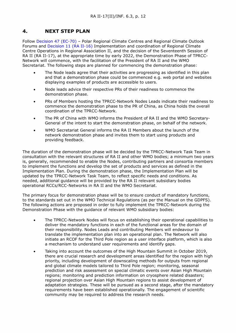
RA II-17(II)/INF. 6.3, p. 12
4. NEXT STEP PLAN Follow Decision 47 (EC-70) – Polar Regional Climate Centres and Regional Climate Outlook Forums and Decision 11 (RA II-16) Implementation and coordination of Regional Climate Centre Operations in Regional Association II, and the decision of the Seventeenth Session of RA II (RA II-17), at the appropriate time by early 2022, the Demonstration Phase of TPRCC-Network will commence, with the facilitation of the President of RA II and the WMO Secretariat. The following steps are planned for commencing the demonstration phase:
• The Node leads agree that their activities are progressing as identified in this plan and that a demonstration phase could be commenced e.g. web portal and websites displaying examples of products are accessible to users.
• Node leads advice their respective PRs of their readiness to commence the demonstration phase.
• PRs of Members hosting the TPRCC-Network Nodes Leads indicate their readiness to commence the demonstration phase to the PR of China, as China holds the overall coordination of the TPRCC-Network.
• The PR of China with WMO informs the President of RA II and the WMO Secretary-General of the intent to start the demonstration phase, on behalf of the network.
• WMO Secretariat General informs the RA II Members about the launch of the network demonstration phase and invites them to start using products and providing feedback.
The duration of the demonstration phase will be decided by the TPRCC-Network Task Team in consultation with the relevant structures of RA II and other WMO bodies; a minimum two years is, generally, recommended to enable the Nodes, contributing partners and consortia members to implement the functions and develop the set of products and services as defined in the Implementation Plan. During the demonstration phase, the Implementation Plan will be updated by the TPRCC-Network Task Team, to reflect specific needs and conditions. As needed, additional guidance will be provided by the RA II relevant subsidiary bodies operational RCCs/RCC-Networks in RA II and the WMO Secretariat. The primary focus for demonstration phase will be to ensure conduct of mandatory functions, to the standards set out in the WMO Technical Regulations (as per the Manual on the GDPFS). The following actions are proposed in order to fully implement the TPRCC-Network during the Demonstration Phase with the guidance of relevant WMO subsidiary bodies:
• The TPRCC-Network Nodes will focus on establishing their operational capabilities to deliver the mandatory functions in each of the functional areas for the domain of their responsibility. Nodes Leads and contributing Members will endeavour to translate the implementation plan into an operational plan. The Network will also initiate an RCOF for the Third Pole region as a user interface platform, which is also a mechanism to understand user requirements and identify gaps.
• Taking into account the outcomes of the High Mountain Summit in October 2019, there are crucial research and development areas identified for the region with high priority, including development of downscaling methods for outputs from regional and global climate models tailored to Third Pole region; monitoring, seasonal prediction and risk assessment on special climatic events over Asian High Mountain regions; monitoring and prediction information on cryosphere related disasters; regional projection over Asian High Mountain regions to assist development of adaptation strategies. These will be pursued as a second stage, after the mandatory requirements have been established operationally. The engagement of scientific community may be required to address the research needs.

RA II-17(II)/INF. 6.3, p. 13
This implementation plan in conjunction with the RCC-related amendments to the Manual on the GDPFS provides a basis for the TPRCC-Network operation in mutual collaboration. Continuous improvement of services in the future will enable the TPRCC-Network to fully meet the Members’ needs in RCC-related products. All the above preparatory efforts being in place, actions will be taken to apply for formal WMO designation of TPRCC-Network. Further details on the process for designation of an RCC or RCC-Network are described in the document ‘How to establish and run a WMO Regional Climate Centre (RCC)’ (WMO/TD-No. 1534).
5. ADDRESSING GAPS AND CHALLENGES High priority issues to be addressed during the Demonstration Phase include the following, related to the structure, governance and coordination of the Network, and to the full implementation of the mandatory functions:
• Consistency in methods and procedures for cross-Node operational products to be determined. While there are many climate monitoring and LRF products available at national levels, no process has yet been established to determine common methodologies (including algorithms, models, normal, formats, projections, etc.) that will help merge national and subregional products into seamless operational products to cover the entire Third Pole region.
• Improvement of accuracy, spatial resolution and applicability of operational products and climate-related information, based on limited observation and research in the Third Pole region, especially in high mountainous areas, with highly complex terrain.
• Establishment of efficient interaction mechanism between developers and users. China will host the web portal for the Network which will provide access to the website of each of the Nodes. The development and improvements of the web portal as well as individual websites of Nodes will be responsibility of all Nodes and with contribution from consortium members, to ensure timely and efficient delivery of TPRCC-Network climate services.
Establishing and operating the TPRCC-Network will be largely based on existing human and financial resources, but there will be new tools, training activities, and other activities that will require additional resources. It is greatly appreciated that the Nodes leads, technical partners/contributors, and contributing WMO Members are committed to this initiative and will collaborate closely to ensure the TPRCC-Network viable and sustained for the future. The participating WMO Members are encouraged to consider the Implementation Plan as a living document and to set up within it the tasks and milestones for addressing current and future high priority requirements.
RA II-17(II)/INF. 6.3, p. 14
ANNEX A: THE TPRCC-NETWORK: SERVICES AND PROVIDERS Dr Lijuan Ma, China Meteorological Administration, overall Coordinator of TPRCC-Network
The Northern Node 1. Lead Institution
Leading Institution Focal Point (s)
National Climate Centre (NCC)
China Meteorological Administration
46, Zhongguancun Nandajie, BEIJING, 100081, China
Dr Pengling Wang
Phone: +86 10 58994216
Fax: +86 10 62176804
Email: [email protected]
2. Consortium Members
Consortium members Focal Point (s)
Bhutan
Information and Research Institute of Meteorology, Hydrology and Environment,
National Agency for Meteorology and Environmental Monitoring of Mongolia
Chingeltei district, Juulchiny street-5, BagaToiruu-3, Ulaanbaatar 15160, Mongolia
Mr Purevdagva Khalzan
Phone: +976 11 329406,
Fax: +996 11 326611,
Email: [email protected]
Nepal
Pakistan Meteorological Department
H-8/2, Pitras Bukhari Road
Islamabad, Pakistan
Dr Shahzad Sultan
Phone: +92 51 9250367,
Fax: +9251 9250368,
Email: [email protected]
RA II-17(II)/INF. 6.3, p. 15
3. Long-Range Forecasting
Attachment 1: Service provision overview: Long-Range Forecasting
Function/Activity/Criteria Product/Service
Producer Areal
coverage Time of issuance
Means of service
provision Remarks
Interpret and assess Third Pole region-related LRF products from Global Producing Centres of LRF (GPC-LRFs), distribute relevant Information to TPRCC users; and provide feedback to
Graphs and maps of model performance (Temperature and Precipitation)
NCC/CMA Third Pole domain (25°–50°N; 65°–105°E)
When GPC models are updated
Web Portal In accordance with the requirements of WMO’s Standardized Verification System (GDPFS/SVS) for LRF
Generate regional and subregional tailored products, relevant to TPRCC User needs, including seasonal outlooks
Seasonal outlook
NCC/CMA Third Pole region and subregions
End of month
Web Portal
RA II-17(II)/INF. 6.3, p. 16
Function/Activity/Criteria Product/Service
Producer Areal coverage
Time of issuance
Means of service
provision Remarks
Generate a consensus statement on regional or subregional forecasts
Bulletin and Teleconference or consulting meeting
NCC; CAMS/CMA
Members of TPRCC-Network
Telecon-ference or consulting meeting twice a year (TBC)
Web Portal In conjunction with FOCRAII (TBC)
Perform verification of TPRCC quantitative LRF products, including the exchange of basic forecasts and hindcast data
Verification datasets NCC/CMA Third Pole region
On request Web Portal For Members of TPRCC-Network,
password protected
Provide online access to TPRCC products/services to TPRCC Users
Web Portal NCC/CMA Third Pole region
Assess use of TPRCC products and services through feedback from TPRCC Users
Summary report NCC/CMA Third Pole domain Annual Web Portal Input via Website, workshops

RA II-17(II)/INF. 6.3, p. 17
Attachment 2: Short product/service description: Long-Range Forecasting
Data set/Product/ Service Methodology, spatial/temporal resolution, quality indicators, validation etc.
Graphs and maps of model performance in terms of standard skill metrics (LRF)
Methodology: Evaluation of model performance using WMO SVS specifications. A selection of GPC models will be used based on regional skill assessments. Spatial resolution: 1° x 1° Temporal resolution: 12 monthly (+1 month lead time) and 10 overlapping 3-month seasons Quality indicators/Validation: SVS scores
Maps of model long-range predictions (include textual and graphical information)
Methodology: Post processing of monthly (+1 month lead time) and 3-month seasonal forecasts from selected GPC models. Variables include precipitation and surface air temperature. Beyond tercile and standard anomaly forecasts of these variables, products will include a probabilistic threshold forecast for different percentiles thresholds of temperature and precipitation variables. Includes a brief narrative of the outlook and a review of the outlook of the previous month. Spatial resolution: 1° x 1° Temporal resolution: 12 monthly (+1 lead time) and 10 3-month overlapping seasons Quality indicators/Validation: On-time delivery and review of previous month’s outlook
Quarterly bulletins which include: (1) analysing and interpreting GPCs model predictions, (2) qualitative review of recent outlooks/bulletins
Methodology: Qualitative compilation of temperature and precipitation seasonal forecasts from the GPC model predictions including review of the forecast in the previous bulletin. Spatial resolution: Third Pole region Temporal resolution: Every 3 months of standard seasons (DJF, MAM, JJA and SON) Quality indicators/Validation: On-time delivery and review of previous season’s outlook
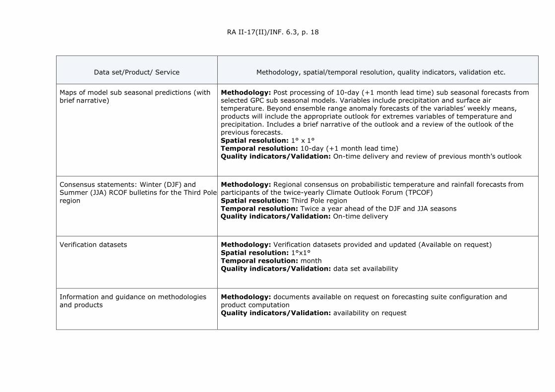
RA II-17(II)/INF. 6.3, p. 18
Data set/Product/ Service Methodology, spatial/temporal resolution, quality indicators, validation etc.
Maps of model sub seasonal predictions (with brief narrative)
Methodology: Post processing of 10-day (+1 month lead time) sub seasonal forecasts from selected GPC sub seasonal models. Variables include precipitation and surface air temperature. Beyond ensemble range anomaly forecasts of the variables’ weekly means, products will include the appropriate outlook for extremes variables of temperature and precipitation. Includes a brief narrative of the outlook and a review of the outlook of the previous forecasts. Spatial resolution: 1° x 1° Temporal resolution: 10-day (+1 month lead time) Quality indicators/Validation: On-time delivery and review of previous month’s outlook
Consensus statements: Winter (DJF) and Summer (JJA) RCOF bulletins for the Third Pole region
Methodology: Regional consensus on probabilistic temperature and rainfall forecasts from participants of the twice-yearly Climate Outlook Forum (TPCOF) Spatial resolution: Third Pole region Temporal resolution: Twice a year ahead of the DJF and JJA seasons Quality indicators/Validation: On-time delivery
Verification datasets Methodology: Verification datasets provided and updated (Available on request) Spatial resolution: 1°x1° Temporal resolution: month Quality indicators/Validation: data set availability
Information and guidance on methodologies and products
Methodology: documents available on request on forecasting suite configuration and product computation Quality indicators/Validation: availability on request
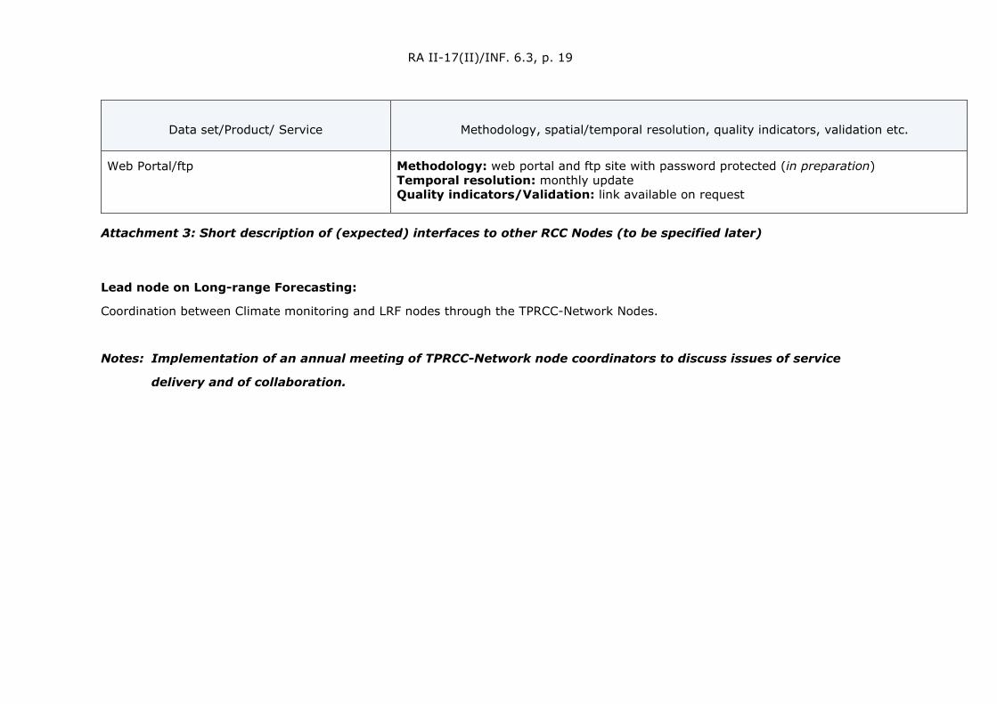
RA II-17(II)/INF. 6.3, p. 19
Data set/Product/ Service Methodology, spatial/temporal resolution, quality indicators, validation etc.
Web Portal/ftp Methodology: web portal and ftp site with password protected (in preparation) Temporal resolution: monthly update Quality indicators/Validation: link available on request
Attachment 3: Short description of (expected) interfaces to other RCC Nodes (to be specified later)
Lead node on Long-range Forecasting:
Coordination between Climate monitoring and LRF nodes through the TPRCC-Network Nodes.
Notes: Implementation of an annual meeting of TPRCC-Network node coordinators to discuss issues of service
delivery and of collaboration.

RA II-17(II)/INF. 6.3, p. 20
4. Climate Monitoring
Attachment 1: Service provision overview: Climate Monitoring
Function/Activity/Criteria Product/Service
Producer Areal coverage
Time of issuance
Means of service provision Remarks
Perform climate diagnostics including analysis of climate variability and extremes, at regional and subregional scales
1. Annual Bulletin on the Climate in the Third Pole region 2. Monthly maps of maximum/mean/minimum Temperature, Precipitation 3. Monthly anomaly of Temperature and Precipitation 4. Maps and graphs of Temperature, Precipitation extreme indices based on station/gridded data
1.NCC(host);CAMS;NSMC/CMA,ITPCAS; NIEER/ CAS, BNU
2. NCC/CMA
3. NCC/CMA
4. NCC/CMA
Third Pole domain (25°–50°N; 65°–105°E)
1. End of June of next year
2. Second week of the month for previous
3. Second week of the month for previous
4. Once per month and ad hoc on demand (extreme events)
1. Web Portal/ Print version;
2. Web Portal
3. Web Portal
4. Web Portal

RA II-17(II)/INF. 6.3, p. 21
Function/Activity/Criteria Product/Service
Producer Areal coverage
Time of issuance
Means of service provision Remarks
Establish an historical reference climatology for the region and subregions
Reference climatology for maximum/mean/minimum Temperature, Precipitation and other ECVs
NCC /CMA Third Pole region and subregions
Web Portal GCW would provide guidance on developing snow related products
Implement a Regional Climate Watch
Climate advisories and information
NCC; CAMS; NSMC/CMA, ITPCAS; NIEER/ CAS, BNU
Third Pole region
Whenever required,
Web Portal Operational work done by NCC supporting the activities in issuing Climate Watches, based on monthly diagnostic, anomaly maps, climate extremes indices and LRF
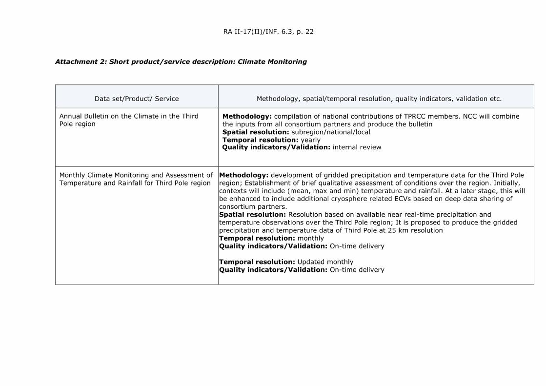
RA II-17(II)/INF. 6.3, p. 22
Attachment 2: Short product/service description: Climate Monitoring
Data set/Product/ Service Methodology, spatial/temporal resolution, quality indicators, validation etc.
Annual Bulletin on the Climate in the Third Pole region
Methodology: compilation of national contributions of TPRCC members. NCC will combine the inputs from all consortium partners and produce the bulletin Spatial resolution: subregion/national/local Temporal resolution: yearly Quality indicators/Validation: internal review
Monthly Climate Monitoring and Assessment of Temperature and Rainfall for Third Pole region
Methodology: development of gridded precipitation and temperature data for the Third Pole region; Establishment of brief qualitative assessment of conditions over the region. Initially, contexts will include (mean, max and min) temperature and rainfall. At a later stage, this will be enhanced to include additional cryosphere related ECVs based on deep data sharing of consortium partners. Spatial resolution: Resolution based on available near real-time precipitation and temperature observations over the Third Pole region; It is proposed to produce the gridded precipitation and temperature data of Third Pole at 25 km resolution Temporal resolution: monthly Quality indicators/Validation: On-time delivery Temporal resolution: Updated monthly Quality indicators/Validation: On-time delivery
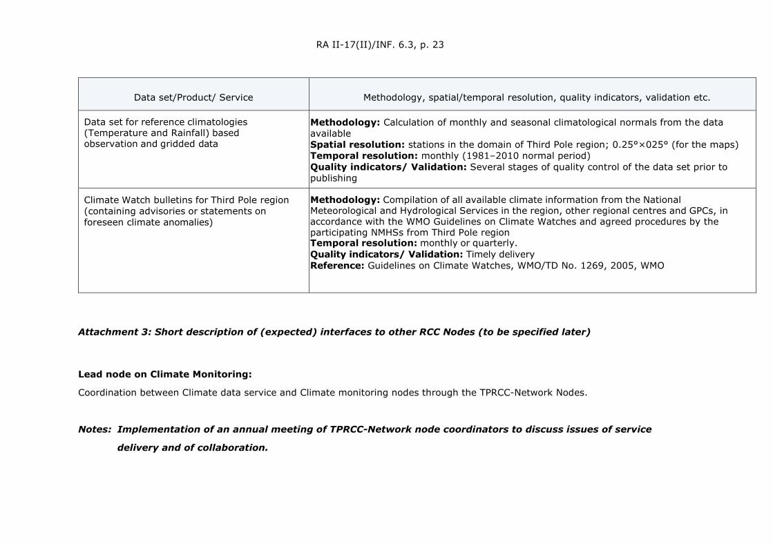
RA II-17(II)/INF. 6.3, p. 23
Data set/Product/ Service Methodology, spatial/temporal resolution, quality indicators, validation etc.
Data set for reference climatologies (Temperature and Rainfall) based observation and gridded data
Methodology: Calculation of monthly and seasonal climatological normals from the data available Spatial resolution: stations in the domain of Third Pole region; 0.25°×025° (for the maps) Temporal resolution: monthly (1981–2010 normal period) Quality indicators/ Validation: Several stages of quality control of the data set prior to publishing
Climate Watch bulletins for Third Pole region (containing advisories or statements on foreseen climate anomalies)
Methodology: Compilation of all available climate information from the National Meteorological and Hydrological Services in the region, other regional centres and GPCs, in accordance with the WMO Guidelines on Climate Watches and agreed procedures by the participating NMHSs from Third Pole region Temporal resolution: monthly or quarterly. Quality indicators/ Validation: Timely delivery Reference: Guidelines on Climate Watches, WMO/TD No. 1269, 2005, WMO
Attachment 3: Short description of (expected) interfaces to other RCC Nodes (to be specified later)
Lead node on Climate Monitoring:
Coordination between Climate data service and Climate monitoring nodes through the TPRCC-Network Nodes.
Notes: Implementation of an annual meeting of TPRCC-Network node coordinators to discuss issues of service
delivery and of collaboration.

RA II-17(II)/INF. 6.3, p. 24
5. Operational Data Services
Attachment 1: Service provision overview: Operational Data Services
Function/Activity/Criteria Product/Service
Producer Areal coverage
Time of issuance
Means of service provision Remarks
Develop quality controlled regional climate datasets, gridded where applicable
Guidance on QC-procedures and homogenization of climate datasets
NCC/CMA Third Pole domain (25°–50°N; 65°–105°E)
After data portal available
Web Portal Seminars, software, documentation (on request) Majority of data is obtained through: - GTS - Other sources: GCW, GHCND, and data from TPRCC members
Provide climate database and archiving services, at the request of NMHSs
Safe, recoverable storage of all TPRCC-Network-related datasets
NCC/CMA Third Pole region
After data portal available
Web Portal
Collection the data of the integrated observing network and their quality assessment
Ground-based data: snow depth and pressure, depth of frozen soil, soil moisture and temperature, radiation, weather phenomenon
NCC/CMA Third Pole region
After data portal available
Web Portal

RA II-17(II)/INF. 6.3, p. 25
Attachment 2: Short product/service description: Operational Data Services
Data set/Product/ Service Methodology, spatial/temporal resolution, quality indicators, validation etc.
Time series graphs and maps of daily data and derived indices for extreme events
Methodology: Time series plots and maps of climate parameters and their derived indices, based on the ETCCDI index
Spatial resolution: Point based observation
Temporal resolution: daily, monthly, seasonal, annual.
Quality indicators/ Validation: Quality control mechanism is available for all parameters. Newly inserted data will be quality controlled before made available to user
Daily gridded data (to be developed; Temperature and Rainfall)
Methodology: Spatial interpolation of in-situ observations
Spatial resolution: 0.25°x 0.25°
Temporal resolution: daily
Quality indicators/ Validation: Validation using cross-validation type of metric
Attachment 3: Short description of (expected) interfaces to other RCC Nodes (to be specified later)
Assessment products based on RCC on data to be disseminated via RCC on monitoring
Provision of datasets from RCC on data to RCC on LRF for model validation and calibration
Notes: Implementation of an annual meeting of TPRCC-Network node coordinators to discuss issues of service
delivery and of collaboration.
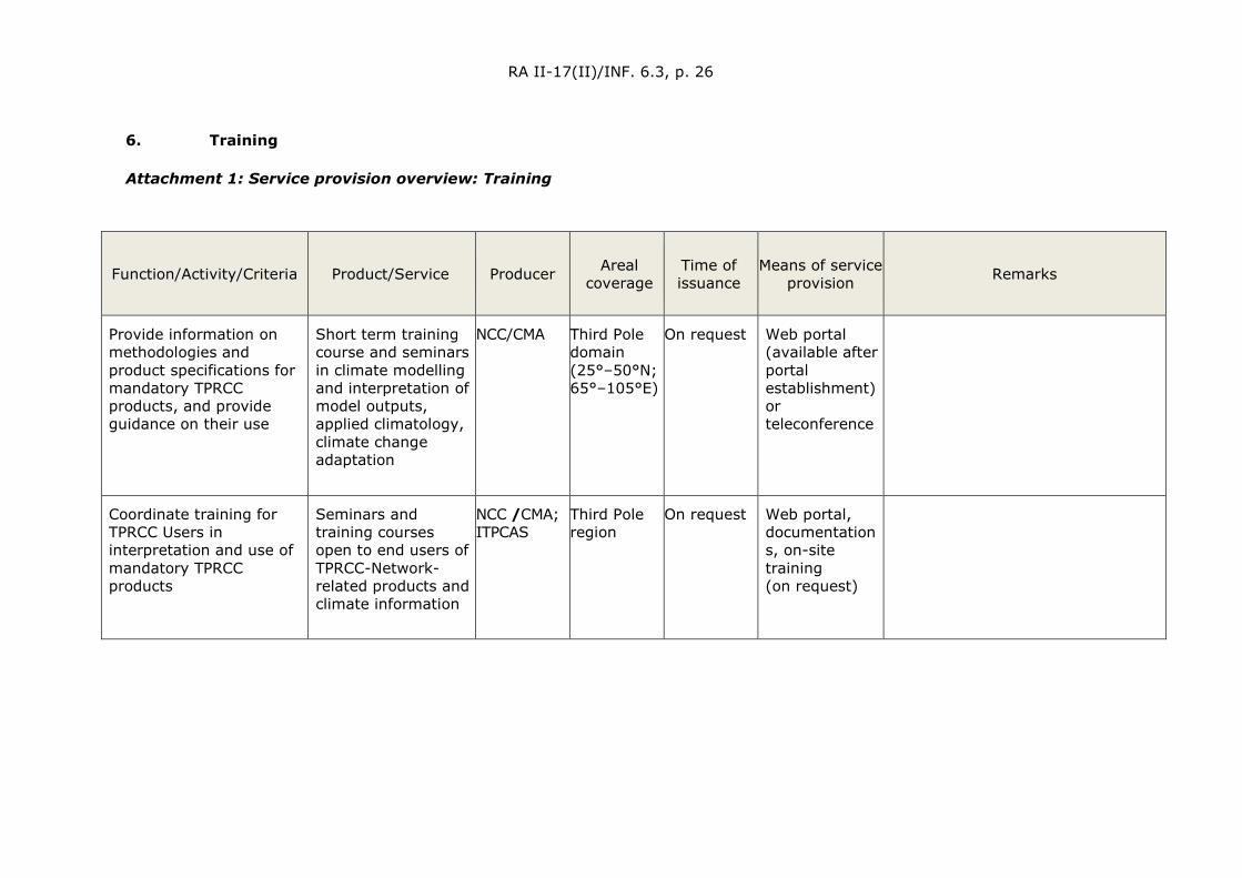
RA II-17(II)/INF. 6.3, p. 26
6. Training
Attachment 1: Service provision overview: Training
Function/Activity/Criteria Product/Service
Producer Areal coverage
Time of issuance
Means of service provision Remarks
Provide information on methodologies and product specifications for mandatory TPRCC products, and provide guidance on their use
Short term training course and seminars in climate modelling and interpretation of model outputs, applied climatology, climate change adaptation
NCC/CMA Third Pole domain (25°–50°N; 65°–105°E)
On request Web portal (available after portal establishment) or teleconference
Coordinate training for TPRCC Users in interpretation and use of mandatory TPRCC products
Seminars and training courses open to end users of TPRCC-Network-related products and climate information
NCC /CMA; ITPCAS
Third Pole region
On request Web portal, documentations, on-site training (on request)
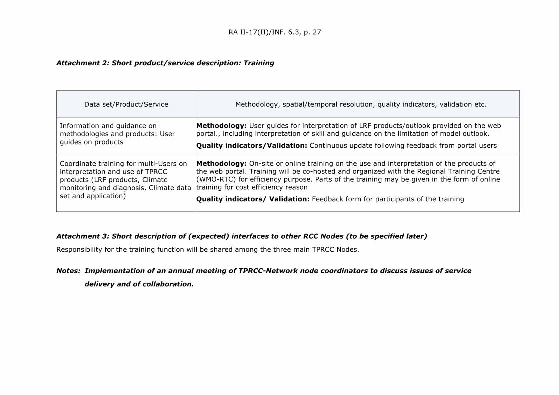
RA II-17(II)/INF. 6.3, p. 27
Attachment 2: Short product/service description: Training
Data set/Product/Service Methodology, spatial/temporal resolution, quality indicators, validation etc.
Information and guidance on methodologies and products: User guides on products
Methodology: User guides for interpretation of LRF products/outlook provided on the web portal., including interpretation of skill and guidance on the limitation of model outlook.
Quality indicators/Validation: Continuous update following feedback from portal users
Coordinate training for multi-Users on interpretation and use of TPRCC products (LRF products, Climate monitoring and diagnosis, Climate data set and application)
Methodology: On-site or online training on the use and interpretation of the products of the web portal. Training will be co-hosted and organized with the Regional Training Centre (WMO-RTC) for efficiency purpose. Parts of the training may be given in the form of online training for cost efficiency reason
Quality indicators/ Validation: Feedback form for participants of the training
Attachment 3: Short description of (expected) interfaces to other RCC Nodes (to be specified later)
Responsibility for the training function will be shared among the three main TPRCC Nodes.
Notes: Implementation of an annual meeting of TPRCC-Network node coordinators to discuss issues of service
delivery and of collaboration.

RA II-17(II)/INF. 6.3, p. 28
THE SOUTHERN NODE
1. Lead Institution
Leading Institution Focal Point (s)
India Meteorological Department
Mausam Bhawan, Lodhi Road, New Delhi – 110003, India
Dr Vijay Kumar Soni, Scientist-E
Phone: +91 11 43824440,
Fax: +91 11 24615371
Email: [email protected], [email protected]
2. Consortium Members
Consortium members Focal Point (s)
Bhutan
Bangladesh
Department of Meteorological and Hydrology, Ministry of Transport and Communications, Myanmar
Mr Hla Tun
Phone: +959 250954642
Fax: +95 673 411449
Email: [email protected]
Nepal
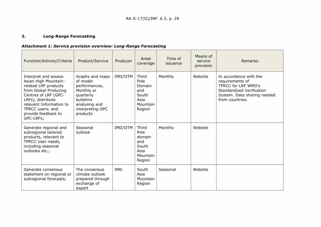
RA II-17(II)/INF. 6.3, p. 29
3. Long-Range Forecasting
Attachment 1: Service provision overview: Long-Range Forecasting
Function/Activity/Criteria Product/Service Producer Areal coverage
Time of issuance
Means of service
provision Remarks
Interpret and assess Asian High Mountain-related LRF products from Global Producing Centres of LRF (GPC-LRFs), distribute relevant Information to TPRCC users; and provide feedback to GPC-LRFs;
Graphs and maps of model performances, Monthly or quarterly bulletins analysing and interpreting GPC products
IMD/IITM Third Pole Domain and South Asia Mountain Region
Monthly Website In accordance with the requirements of TPRCC for LRF WMO’s Standardized Verification System. Data sharing needed from countries.
Generate regional and subregional tailored products, relevant to TPRCC User needs, including seasonal outlooks etc.;
Seasonal outlook
IMD/IITM Third Pole domain and South Asia Mountain Region
Monthly Website
Generate consensus statement on regional or subregional forecasts;
The consensus climate outlook prepared through exchange of expert
IMD South Asia Mountain Region
Seasonal Website

RA II-17(II)/INF. 6.3, p. 30
Function/Activity/Criteria Product/Service Producer Areal coverage
Time of issuance
Means of service
provision Remarks
assessment among a team of experts from southern TP node countries via teleconference, meeting, etc.
Performance verification of TPRCC quantitative LRF products, including the exchange of basic forecasts and hindcast data;
Verification data set
IMD South Asia Mountain Region
Monthly/Annual Web Portal /ftp
Provide online access to TPRCC products/services to TPRCC Users;
Website IMD South Asia Mountain Region
Regular Website
Assess use of TPRCC products and services through feedback from TPRCC Users
Summary report IMD South Asia Mountain Region
Annual Web Portal
Input via Website, workshops
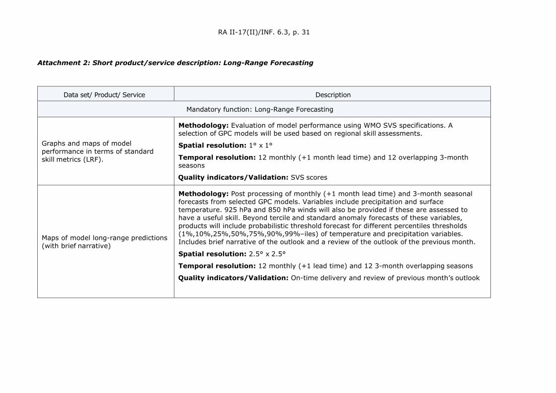
RA II-17(II)/INF. 6.3, p. 31
Attachment 2: Short product/service description: Long-Range Forecasting
Data set/ Product/ Service Description
Mandatory function: Long-Range Forecasting
Graphs and maps of model performance in terms of standard skill metrics (LRF).
Methodology: Evaluation of model performance using WMO SVS specifications. A selection of GPC models will be used based on regional skill assessments.
Spatial resolution: 1° x 1°
Temporal resolution: 12 monthly (+1 month lead time) and 12 overlapping 3-month seasons
Quality indicators/Validation: SVS scores
Maps of model long-range predictions (with brief narrative)
Methodology: Post processing of monthly (+1 month lead time) and 3-month seasonal forecasts from selected GPC models. Variables include precipitation and surface temperature. 925 hPa and 850 hPa winds will also be provided if these are assessed to have a useful skill. Beyond tercile and standard anomaly forecasts of these variables, products will include probabilistic threshold forecast for different percentiles thresholds (1%,10%,25%,50%,75%,90%,99%–iles) of temperature and precipitation variables. Includes brief narrative of the outlook and a review of the outlook of the previous month.
Spatial resolution: 2.5° x 2.5°
Temporal resolution: 12 monthly (+1 lead time) and 12 3-month overlapping seasons
Quality indicators/Validation: On-time delivery and review of previous month’s outlook

RA II-17(II)/INF. 6.3, p. 32
Data set/ Product/ Service Description
Mandatory function: Long-Range Forecasting
Quarterly bulletins which include: (1) analysing and interpreting GPCs model predictions, (2) assessment and outlook for ENSO and IOD, and (3) qualitative review of recent outlooks/bulletins
Methodology: Qualitative compilation of temperature, precipitation and possibly wind (925 hPa and 850 hPa) seasonal forecasts from the GPC model predictions including assessment of processes that affect the region (e.g. ENSO and IOD). Includes a review of the forecast in the previous bulletin.
Spatial resolution: Southeast Asia region
Temporal resolution: Every 3 months of standard seasons (DJF, MAM, JJA and SON)
Quality indicators/Validation: On-time delivery and review of previous season’s outlook
Outlook for number of tropical cyclone in the season ahead (6-months) and preferred tracks based on climatology.
Methodology: Analog method based on the historical record.
Temporal resolution: Monthly for 6-months ahead.
Quality indicators/Validation: Statistical evaluation of forecast tropical cyclone frequency.
In the longer term the use of dynamical models for forecast frequency and tracks will be investigated.
Graphs and maps of model performance in terms of standard skill metrics (sub-seasonal).
Methodology: Evaluation of model performance using WMO SVS specifications. A selection of GPC sub-seasonal models will be used based on regional skill assessments.
Spatial resolution: Model-dependent resolution as available in archive
Temporal resolution: Weekly (+1, +2, +3, +4 lead time), at least fortnightly
Quality indicators/Validation: SVS scores
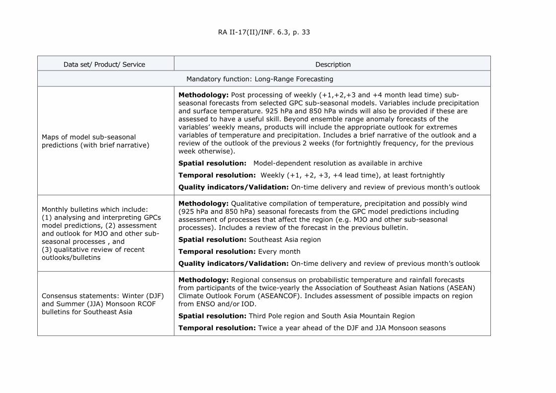
RA II-17(II)/INF. 6.3, p. 33
Data set/ Product/ Service Description
Mandatory function: Long-Range Forecasting
Maps of model sub-seasonal predictions (with brief narrative)
Methodology: Post processing of weekly (+1,+2,+3 and +4 month lead time) sub-seasonal forecasts from selected GPC sub-seasonal models. Variables include precipitation and surface temperature. 925 hPa and 850 hPa winds will also be provided if these are assessed to have a useful skill. Beyond ensemble range anomaly forecasts of the variables’ weekly means, products will include the appropriate outlook for extremes variables of temperature and precipitation. Includes a brief narrative of the outlook and a review of the outlook of the previous 2 weeks (for fortnightly frequency, for the previous week otherwise).
Spatial resolution: Model-dependent resolution as available in archive
Temporal resolution: Weekly (+1, +2, +3, +4 lead time), at least fortnightly
Quality indicators/Validation: On-time delivery and review of previous month’s outlook
Monthly bulletins which include: (1) analysing and interpreting GPCs model predictions, (2) assessment and outlook for MJO and other sub-seasonal processes , and (3) qualitative review of recent outlooks/bulletins
Methodology: Qualitative compilation of temperature, precipitation and possibly wind (925 hPa and 850 hPa) seasonal forecasts from the GPC model predictions including assessment of processes that affect the region (e.g. MJO and other sub-seasonal processes). Includes a review of the forecast in the previous bulletin.
Spatial resolution: Southeast Asia region
Temporal resolution: Every month
Quality indicators/Validation: On-time delivery and review of previous month’s outlook
Consensus statements: Winter (DJF) and Summer (JJA) Monsoon RCOF bulletins for Southeast Asia
Methodology: Regional consensus on probabilistic temperature and rainfall forecasts from participants of the twice-yearly the Association of Southeast Asian Nations (ASEAN) Climate Outlook Forum (ASEANCOF). Includes assessment of possible impacts on region from ENSO and/or IOD.
Spatial resolution: Third Pole region and South Asia Mountain Region
Temporal resolution: Twice a year ahead of the DJF and JJA Monsoon seasons
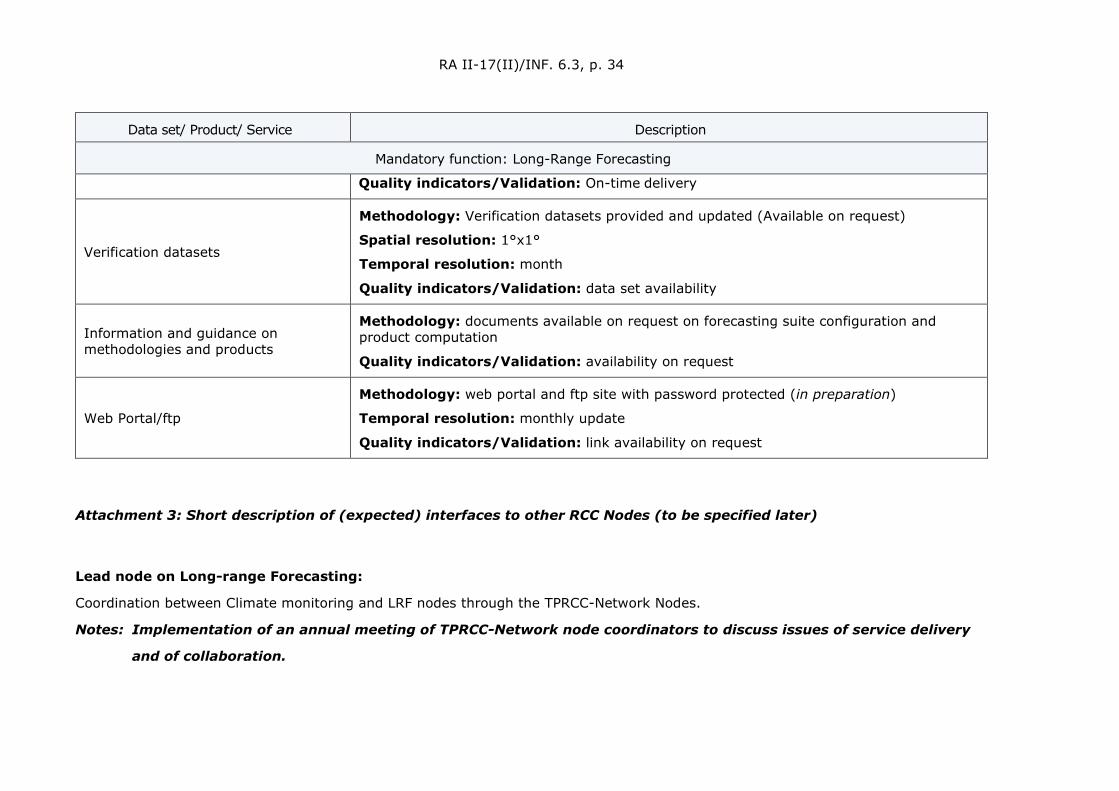
RA II-17(II)/INF. 6.3, p. 34
Data set/ Product/ Service Description
Mandatory function: Long-Range Forecasting
Quality indicators/Validation: On-time delivery
Verification datasets
Methodology: Verification datasets provided and updated (Available on request)
Spatial resolution: 1°x1°
Temporal resolution: month
Quality indicators/Validation: data set availability
Information and guidance on methodologies and products
Methodology: documents available on request on forecasting suite configuration and product computation
Quality indicators/Validation: availability on request
Web Portal/ftp
Methodology: web portal and ftp site with password protected (in preparation)
Temporal resolution: monthly update
Quality indicators/Validation: link availability on request
Attachment 3: Short description of (expected) interfaces to other RCC Nodes (to be specified later)
Lead node on Long-range Forecasting:
Coordination between Climate monitoring and LRF nodes through the TPRCC-Network Nodes.
Notes: Implementation of an annual meeting of TPRCC-Network node coordinators to discuss issues of service delivery
and of collaboration.
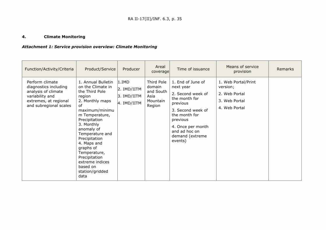
RA II-17(II)/INF. 6.3, p. 35
4. Climate Monitoring
Attachment 1: Service provision overview: Climate Monitoring
Function/Activity/Criteria Product/Service
Producer Areal coverage
Time of issuance Means of service provision Remarks
Perform climate diagnostics including analysis of climate variability and extremes, at regional and subregional scales
1. Annual Bulletin on the Climate in the Third Pole region 2. Monthly maps of maximum/minimum Temperature, Precipitation 3. Monthly anomaly of Temperature and Precipitation 4. Maps and graphs of Temperature, Precipitation extreme indices based on station/gridded data
1.IMD
2. IMD/IITM
3. IMD/IITM
4. IMD/IITM
Third Pole domain and South Asia Mountain Region
1. End of June of next year
2. Second week of the month for previous
3. Second week of the month for previous
4. Once per month and ad hoc on demand (extreme events)
1. Web Portal/Print version;
2. Web Portal
3. Web Portal
4. Web Portal
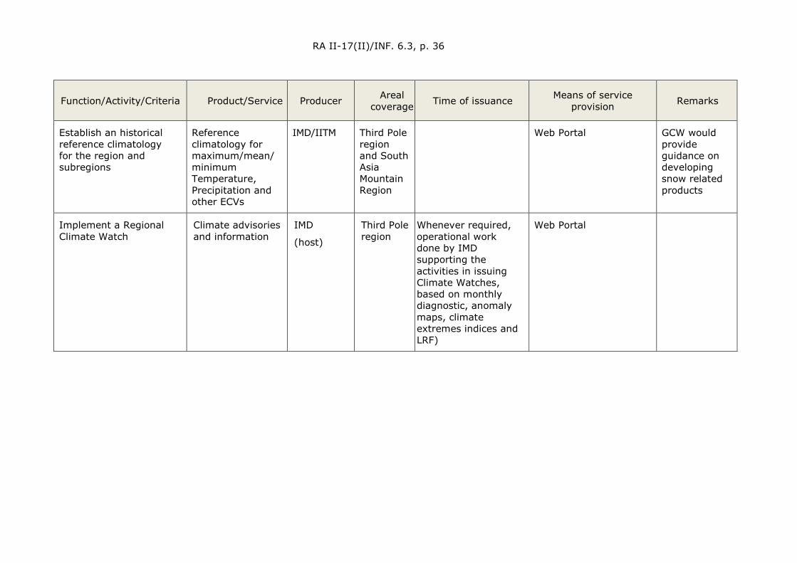
RA II-17(II)/INF. 6.3, p. 36
Function/Activity/Criteria Product/Service
Producer Areal coverage
Time of issuance Means of service provision Remarks
Establish an historical reference climatology for the region and subregions
Reference climatology for maximum/mean/minimum Temperature, Precipitation and other ECVs
IMD/IITM Third Pole region and South Asia Mountain Region
Web Portal GCW would provide guidance on developing snow related products
Implement a Regional Climate Watch
Climate advisories and information
IMD
(host)
Third Pole region
Whenever required, operational work done by IMD supporting the activities in issuing Climate Watches, based on monthly diagnostic, anomaly maps, climate extremes indices and LRF)
Web Portal

RA II-17(II)/INF. 6.3, p. 37
Attachment 2: Short product/service description: Climate Monitoring
Data set/Product/Service Methodology, spatial/temporal resolution, quality indicators, validation etc.
Annual Bulletin on the Climate in the Third Pole region
Methodology: compilation of national contributions of TPRCC members. IMD will combine the inputs from all consortium partners from subregion and produce the bulletin
Spatial resolution: subregion/national/local
Temporal resolution: yearly
Quality indicators/Validation: internal review
Monthly Climate Monitoring and Assessment of Temperature and Rainfall for Third Pole region
Methodology: development of gridded precipitation and temperature data for the Third Pole region; Establishment of brief qualitative assessment of conditions over the region. Initially, contexts will include (mean, max and min) temperature and rainfall. At a later stage, this will be enhanced to include additional cryosphere related ECVs based on deep data sharing of consortium partners.
Spatial resolution: Resolution based on available near real-time precipitation and temperature observations over the Third Pole region; It is proposed to produce the gridded precipitation and temperature data of Third Pole at 25 km resolution
Temporal resolution: monthly
Quality indicators/Validation: On-time delivery
Temporal resolution: Updated monthly
Quality indicators/Validation: On-time delivery

RA II-17(II)/INF. 6.3, p. 38
Data set/Product/Service Methodology, spatial/temporal resolution, quality indicators, validation etc.
Data set for reference climatologies (Temperature and Rainfall) based observation and gridded data
Methodology: Calculation of monthly and seasonal climatological normals from the data available
Spatial resolution: stations in the domain of Third Pole region; 0.25°×0.25° (for the maps)
Temporal resolution: monthly (1981–2010 normal period)
Quality indicators/ Validation: Several stages of quality control of the data set prior to publishing
Climate Watch bulletins for Third Pole region (containing advisories or statements on foreseen climate anomalies)
Methodology: Compilation of all available climate information from the National Meteorological and Hydrological Services in the region, other regional centres and GPCs, in accordance with the WMO Guidelines on Climate Watches and agreed procedures by the participating NMHSs from Third Pole region
Temporal resolution: monthly or quarterly.
Quality indicators/ Validation: Timely delivery
Reference: Guidelines on Climate Watches, WMO/TD No. 1269, 2005, WMO
Attachment 3: Short description of (expected) interfaces to other RCC Nodes (to be specified later)
Lead node on Climate Monitoring:
Coordination between Climate data service and Climate monitoring nodes through the TPRCC-Network Nodes.
Notes: Implementation of an annual meeting of TPRCC-Network node coordinators to discuss issues of service delivery
and of collaboration.
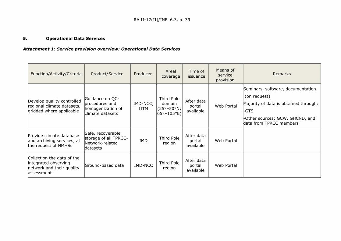
RA II-17(II)/INF. 6.3, p. 39
5. Operational Data Services
Attachment 1: Service provision overview: Operational Data Services
Function/Activity/Criteria Product/Service
Producer Areal coverage
Time of issuance
Means of service
provision Remarks
Develop quality controlled regional climate datasets, gridded where applicable
Guidance on QC-procedures and homogenization of climate datasets
IMD-NCC, IITM
Third Pole domain
(25°–50°N; 65°–105°E)
After data portal
available Web Portal
Seminars, software, documentation
(on request)
Majority of data is obtained through:
-GTS
-Other sources: GCW, GHCND, and data from TPRCC members
Provide climate database and archiving services, at the request of NMHSs
Safe, recoverable storage of all TPRCC-Network-related datasets
IMD Third Pole region
After data portal
available Web Portal
Collection the data of the integrated observing network and their quality assessment
Ground-based data IMD-NCC Third Pole region
After data portal
available Web Portal
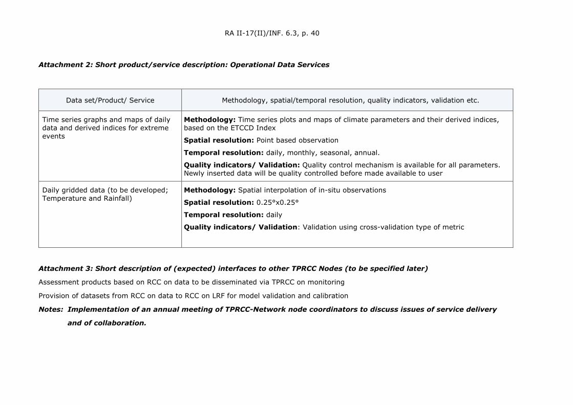
RA II-17(II)/INF. 6.3, p. 40
Attachment 2: Short product/service description: Operational Data Services
Data set/Product/ Service Methodology, spatial/temporal resolution, quality indicators, validation etc.
Time series graphs and maps of daily data and derived indices for extreme events
Methodology: Time series plots and maps of climate parameters and their derived indices, based on the ETCCD Index
Spatial resolution: Point based observation
Temporal resolution: daily, monthly, seasonal, annual.
Quality indicators/ Validation: Quality control mechanism is available for all parameters. Newly inserted data will be quality controlled before made available to user
Daily gridded data (to be developed; Temperature and Rainfall)
Methodology: Spatial interpolation of in-situ observations
Spatial resolution: 0.25°x0.25°
Temporal resolution: daily
Quality indicators/ Validation: Validation using cross-validation type of metric
Attachment 3: Short description of (expected) interfaces to other TPRCC Nodes (to be specified later)
Assessment products based on RCC on data to be disseminated via TPRCC on monitoring
Provision of datasets from RCC on data to RCC on LRF for model validation and calibration
Notes: Implementation of an annual meeting of TPRCC-Network node coordinators to discuss issues of service delivery
and of collaboration.
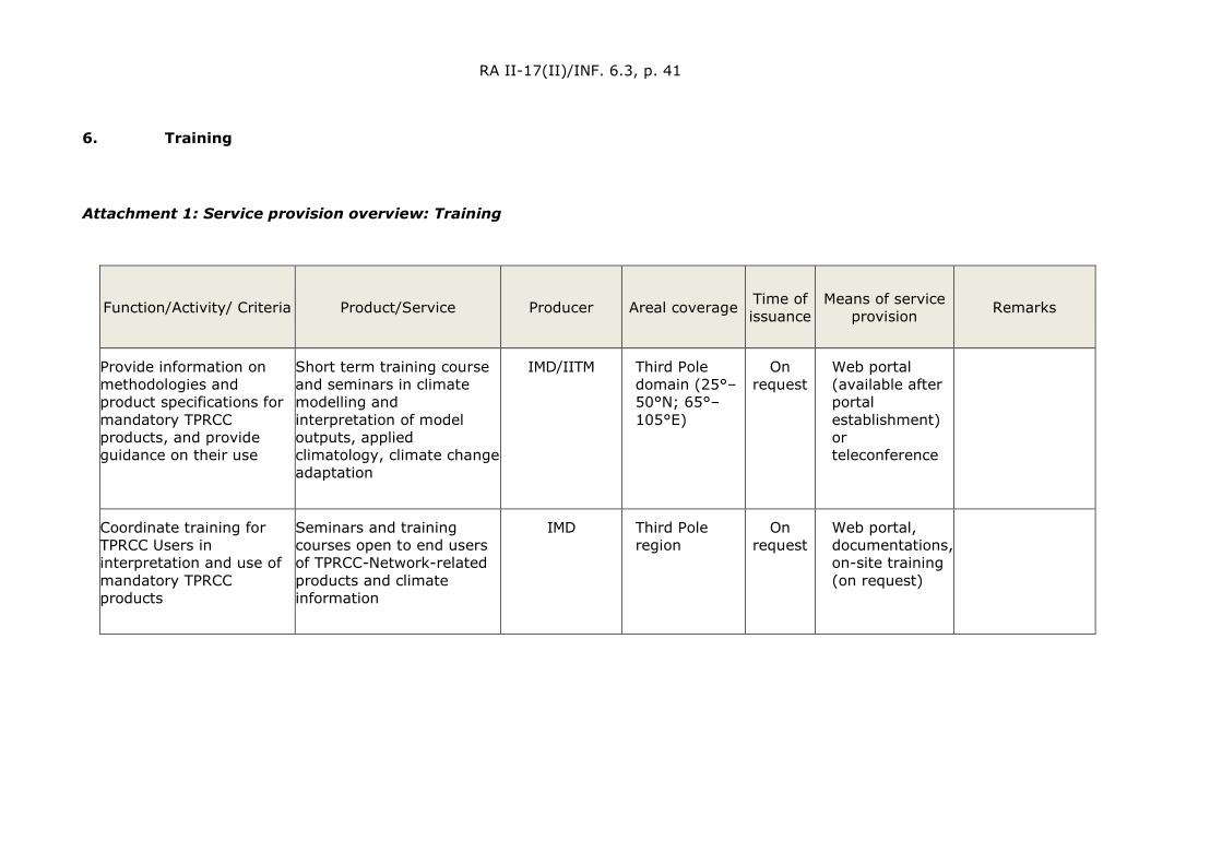
RA II-17(II)/INF. 6.3, p. 41
6. Training
Attachment 1: Service provision overview: Training
Function/Activity/ Criteria Product/Service Producer Areal coverage Time of issuance
Means of service provision Remarks
Provide information on methodologies and product specifications for mandatory TPRCC products, and provide guidance on their use
Short term training course and seminars in climate modelling and interpretation of model outputs, applied climatology, climate change adaptation
IMD/IITM Third Pole domain (25°–50°N; 65°–105°E)
On request
Web portal (available after portal establishment) or teleconference
Coordinate training for TPRCC Users in interpretation and use of mandatory TPRCC products
Seminars and training courses open to end users of TPRCC-Network-related products and climate information
IMD Third Pole region
On request
Web portal, documentations, on-site training (on request)

RA II-17(II)/INF. 6.3, p. 42
Attachment 2: Short product/service description: Training
Data set/Product/Service Methodology, spatial/temporal resolution, quality indicators, validation etc.
Information and guidance on methodologies and products: User guides on products
Methodology: User guides for interpretation of LRF products/outlook provided on the web portal, including interpretation of skill and guidance on the limitation of model outlook.
Quality indicators/Validation: Continuous update following feedback from portal users
Coordinate training for multi-Users on interpretation and use of TPRCC products (LRF products, Climate monitoring and diagnosis, Climate data set and application)
Methodology: On-site or online training on the use and interpretation of the products of the web portal. Training will be co-hosted and organized with the Regional Training Centre (WMO-RTC) for efficiency purpose. Parts of the training may be given in the form of online training for cost efficiency reason
Quality indicators/Validation: Feedback form for participants of the training
Attachment 3: Short description of (expected) interfaces to other RCC Nodes (to be specified later)
Responsibility for the training function will be shared among the three main TPRCC Nodes.
Notes: Implementation of an annual meeting of TPRCC-Network node coordinators to discuss issues of service delivery
and of collaboration.
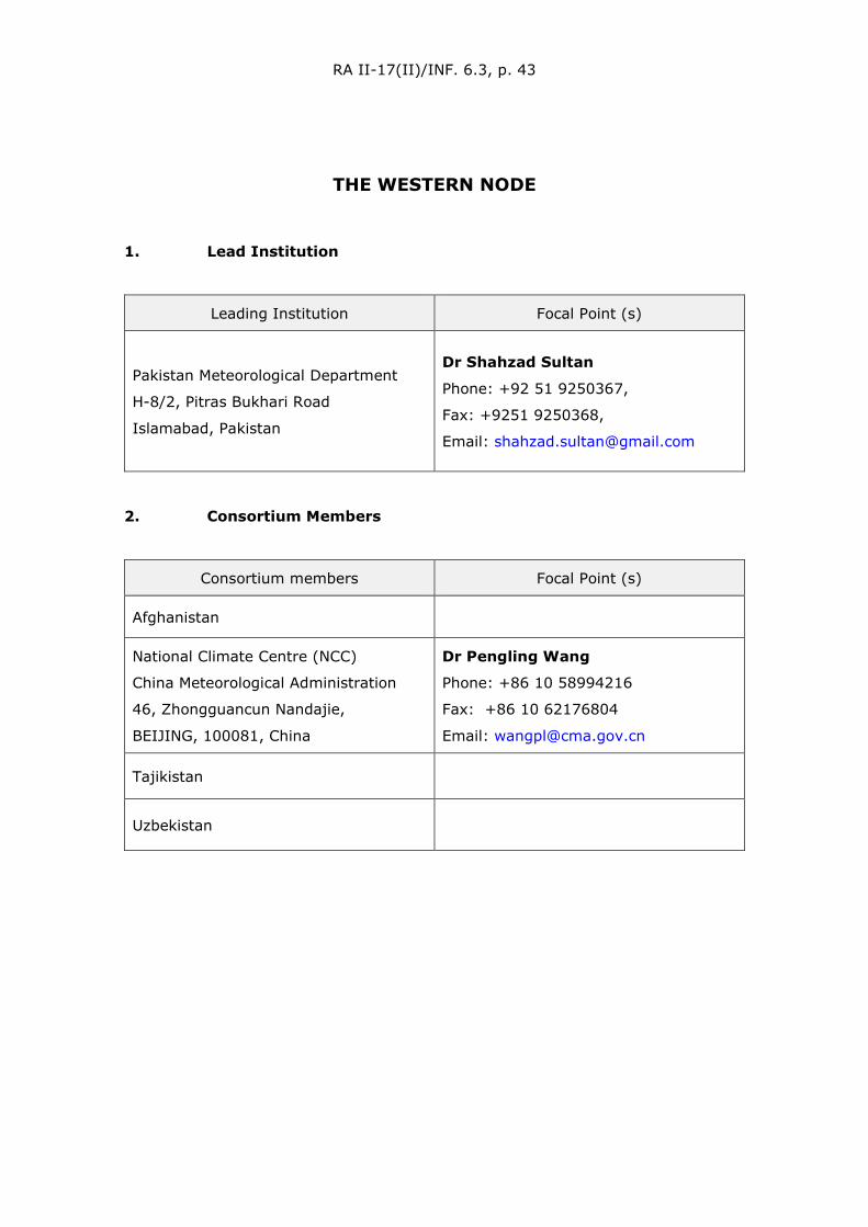
RA II-17(II)/INF. 6.3, p. 43
THE WESTERN NODE
1. Lead Institution
Leading Institution Focal Point (s)
Pakistan Meteorological Department
H-8/2, Pitras Bukhari Road
Islamabad, Pakistan
Dr Shahzad Sultan
Phone: +92 51 9250367,
Fax: +9251 9250368,
Email: [email protected]
2. Consortium Members
Consortium members Focal Point (s)
Afghanistan
National Climate Centre (NCC)
China Meteorological Administration
46, Zhongguancun Nandajie,
BEIJING, 100081, China
Dr Pengling Wang
Phone: +86 10 58994216
Fax: +86 10 62176804
Email: [email protected]
Tajikistan
Uzbekistan

RA II-17(II)/INF. 6.3, p. 44
3. Long-Range Forecasting
Attachment 1: Service provision overview: Long-Range Forecasting
Function/Activity/ Criteria Product/Service
Producer Areal coverage
Time of issuance
Means of service provision Remarks
Interpret and assess Asian High Mountain-related LRF products from Global Producing Centres of LRF (GPC-LRFs), distribute relevant Information to TPRCC users; and provide feedback to GPC-LRFs
PMD is producing Bias Adjusted Seasonal Forecast (1-monthly and 3-monthly) of temperature and precipitation for Pakistan. Using BCC_CSM1.1 model.
Beijing Climate Centre (BCC) and others
Global Monthly http://bcc.ncc-cma.net/channel/index/106/0
Node members cooperation for statistical/dynamical downscaling of the products for improved seasonal outlooks over the Western TP Node region.
9-Month Forecasts: Time Series & Monthly Means data can be used for seasonal outlooks.
Climate Prediction Centre (CPC), NOAA
Global Daily, Monthly
https://www.ncei.noaa.gov/products/weather-climate-models/climate-forecast-system#CFSv2%20Operational%20Forecasts
Presently it is limited to Pakistan only, however it may be extended to other consortium members, in future.

RA II-17(II)/INF. 6.3, p. 45
Function/Activity/ Criteria Product/Service
Producer Areal coverage
Time of issuance
Means of service provision Remarks
Generate regional and subregional tailored products, relevant to TPRCC User needs, including seasonal outlooks etc.
Probabilistic Seasonal and Monthly Outlook for Pakistan
PMD Pakistan Monthly
http://nwfc.pmd.gov.pk/MON&TC/Monsoon/Seasonal-Outlook.html
Presently it is limited to Pakistan only, however it may be extended to other consortium members, in the future.
Performance verification of TPRCC quantitative LRF products, including the exchange of basic forecasts and hindcast data;
Verification datasets are not developed presently, however, they may be developed for consortium countries.
Members may produce this report, individually, or a mechanism may be set up at PMD to generate these reports for consortium members collectively.
Western TP Node Yearly Website/Report
Discussion and Meeting among consortium member is required
Provide online access to TPRCC products/services to TPRCC Users;
Limited online Data/Information Portal is built by PMD.
PMD Western TP Node
Monthly/Yearly
Website/Report The experimental website has been launched for western node
http://ffd.pmd.gov.pk/cp/rain_test/tprccn-pak.html

RA II-17(II)/INF. 6.3, p. 46
Function/Activity/ Criteria Product/Service
Producer Areal coverage
Time of issuance
Means of service provision Remarks
Assess use of TPRCC products and services through feedback from TPRCC Users
Report on Analysis of Users Feedback.
Members are required to produce this report.
Western TP Node Annual
Website/Report Such reports are only possible if consortia focal points are in the TPRCC loop, and demonstration phase is in place.
4. Climate Monitoring
Attachment 1: Service provision overview: Climate Monitoring
Function/Activity/Criteria Product/Service Producer Areal coverage Time of issuance Means of service
provision Remarks
Perform climate diagnostics including analysis of climate variability and extremes, at regional and subregional scales
Report on Climate Diagnostic Bulletin presenting Regional scale climate extreme
PMD Pakistan Annual Website
Discussion and meeting among consortium member are required

RA II-17(II)/INF. 6.3, p. 47
Function/Activity/Criteria Product/Service Producer Areal coverage Time of issuance Means of service
provision Remarks
Establish a historical reference climatology for the region and subregions
Climate Normals e.g., 1981–2010 PMD Pakistan 10 years Website
Discussion and meeting among consortium member are required
Implement a Regional Climate Watch Climate advisories Members Western
TP Node whenever required Website
Discussion and meeting among consortium member are required
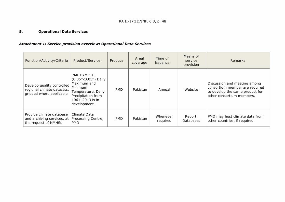
RA II-17(II)/INF. 6.3, p. 48
5. Operational Data Services
Attachment 1: Service provision overview: Operational Data Services
Function/Activity/Criteria Product/Service
Producer Areal coverage
Time of issuance
Means of service
provision Remarks
Develop quality controlled regional climate datasets, gridded where applicable
PAK-HYM-1.0, (0.05°x0.05°) Daily Maximum and Minimum Temperature, Daily Precipitation from 1961–2013 is in development.
PMD Pakistan Annual Website
Discussion and meeting among consortium member are required to develop the same product for other consortium members.
Provide climate database and archiving services, at the request of NMHSs
Climate Data Processing Centre, PMD
PMD Pakistan Whenever required
Report, Databases
PMD may host climate data from other countries, if required.
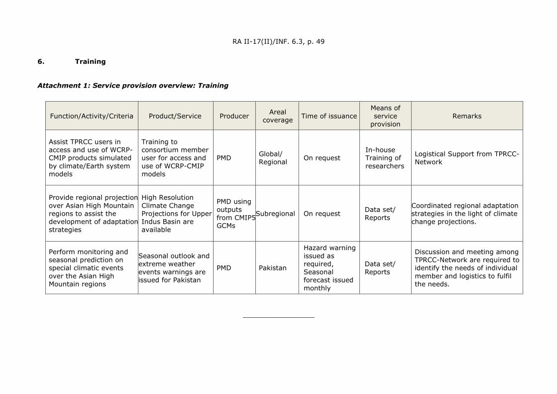
RA II-17(II)/INF. 6.3, p. 49
6. Training
Attachment 1: Service provision overview: Training
_________________
Function/Activity/Criteria Product/Service
Producer Areal coverage
Time of issuance Means of service
provision Remarks
Assist TPRCC users in access and use of WCRP-CMIP products simulated by climate/Earth system models
Training to consortium member user for access and use of WCRP-CMIP models
PMD Global/ Regional On request
In-house Training of researchers
Logistical Support from TPRCC-Network
Provide regional projection over Asian High Mountain regions to assist the development of adaptation strategies
High Resolution Climate Change Projections for Upper Indus Basin are available
PMD using outputs from CMIP5 GCMs
Subregional On request Data set/ Reports
Coordinated regional adaptation strategies in the light of climate change projections.
Perform monitoring and seasonal prediction on special climatic events over the Asian High Mountain regions
Seasonal outlook and extreme weather events warnings are issued for Pakistan
PMD Pakistan
Hazard warning issued as required, Seasonal forecast issued monthly
Data set/ Reports
Discussion and meeting among TPRCC-Network are required to identify the needs of individual member and logistics to fulfil the needs.

RA II-17(II)/INF. 6.3, p. 50
REGIONAL WIGOS CENTRES AUDIT REPORTS
The audit reports of the RA II Regional WMO Integrated Global Observing System (WIGOS) Centres (RWCs) prepared by the Commission for Observation, Infrastructure and Information Systems (INFCOM) ad hoc evaluation team are reproduced as annex-1 (RWC Beijing, China) and annex-2 (RWC Tokyo, Japan) to this INF. Only the non-confidential parts are included, while the confidential parts will be shared with the respective RWCs.
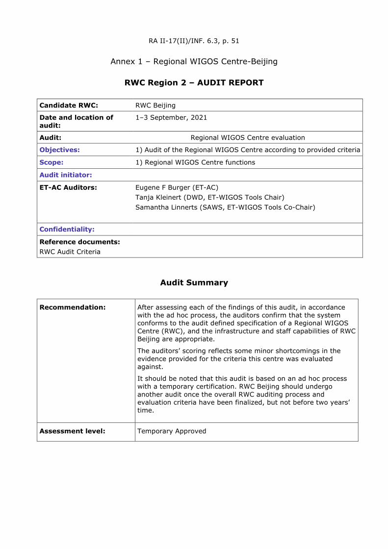
RA II-17(II)/INF. 6.3, p. 51
Annex 1 – Regional WIGOS Centre-Beijing
RWC Region 2 – AUDIT REPORT
Candidate RWC: RWC Beijing
Date and location of audit:
1–3 September, 2021
Audit: Regional WIGOS Centre evaluation
Objectives: 1) Audit of the Regional WIGOS Centre according to provided criteria
Scope: 1) Regional WIGOS Centre functions
Audit initiator:
ET-AC Auditors: Eugene F Burger (ET-AC) Tanja Kleinert (DWD, ET-WIGOS Tools Chair) Samantha Linnerts (SAWS, ET-WIGOS Tools Co-Chair)
Confidentiality:
Reference documents: RWC Audit Criteria
Audit Summary
Recommendation: After assessing each of the findings of this audit, in accordance with the ad hoc process, the auditors confirm that the system conforms to the audit defined specification of a Regional WIGOS Centre (RWC), and the infrastructure and staff capabilities of RWC Beijing are appropriate.
The auditors’ scoring reflects some minor shortcomings in the evidence provided for the criteria this centre was evaluated against.
It should be noted that this audit is based on an ad hoc process with a temporary certification. RWC Beijing should undergo another audit once the overall RWC auditing process and evaluation criteria have been finalized, but not before two years’ time.
Assessment level: Temporary Approved
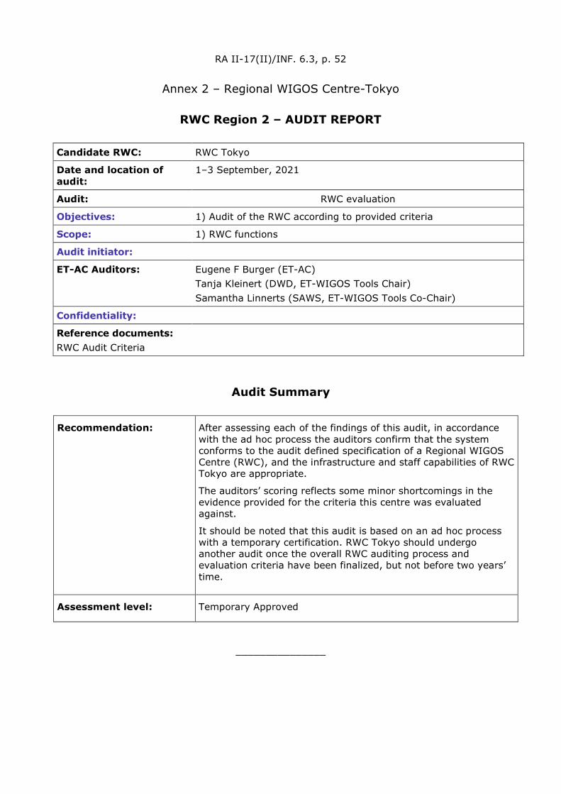
RA II-17(II)/INF. 6.3, p. 52
Annex 2 – Regional WIGOS Centre-Tokyo
RWC Region 2 – AUDIT REPORT
Candidate RWC: RWC Tokyo
Date and location of audit:
1–3 September, 2021
Audit: RWC evaluation
Objectives: 1) Audit of the RWC according to provided criteria
Scope: 1) RWC functions
Audit initiator:
ET-AC Auditors: Eugene F Burger (ET-AC) Tanja Kleinert (DWD, ET-WIGOS Tools Chair) Samantha Linnerts (SAWS, ET-WIGOS Tools Co-Chair)
Confidentiality:
Reference documents: RWC Audit Criteria
Audit Summary
Recommendation: After assessing each of the findings of this audit, in accordance with the ad hoc process the auditors confirm that the system conforms to the audit defined specification of a Regional WIGOS Centre (RWC), and the infrastructure and staff capabilities of RWC Tokyo are appropriate.
The auditors’ scoring reflects some minor shortcomings in the evidence provided for the criteria this centre was evaluated against.
It should be noted that this audit is based on an ad hoc process with a temporary certification. RWC Tokyo should undergo another audit once the overall RWC auditing process and evaluation criteria have been finalized, but not before two years’ time.
Assessment level: Temporary Approved
_______________
WEA
THER
CLI
MATE
WAT
ER World Meteorological Organization
REGIONAL ASSOCIATION II (ASIA)
Seventeenth Session (Second Part) 27 to 30 September 2021, Virtual Session
RA II-17(II)/INF. 6.5
Submitted by: Secretary-General
17.IX.2021
RA II OPERATING PLAN 2021–2024
• This RA II Operating Plan has considered the WMO Strategic Plan and regional priorities, and identifies the tasks requested by the Eighteenth World Meteorological Congress (Cg-18), the seventy-second session of the Executive Council (EC-72) and the seventy-third session of the Executive Council (EC-73) to the regional associations.
• It will be a living document, be updated from time to time by RA II WG/CP and approved by RA II Management Group.
• It will seek synergy with the WMO Operating Plan, with the interaction with INFCOM, SERCOM and the Research Board.
• It forms the principle basis for establishing the relevant Expert Teams under WGs.
• Terminologies used will be further discussed and improved.
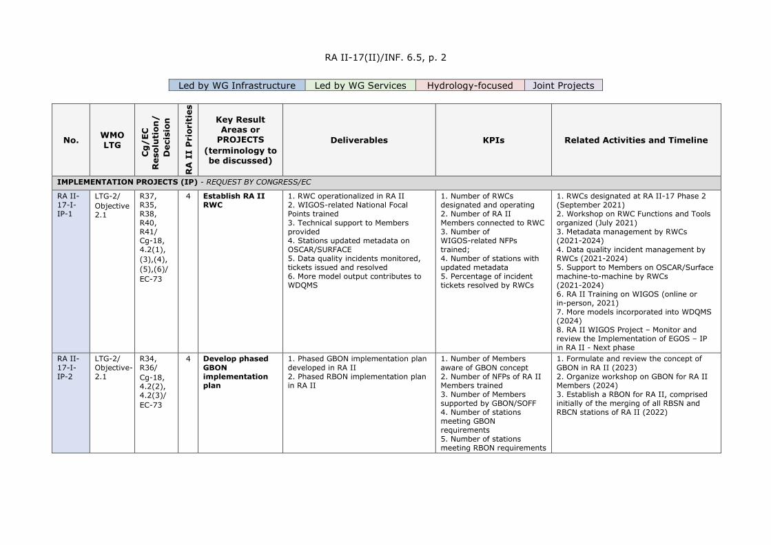
RA II-17(II)/INF. 6.5, p. 2
Led by WG Infrastructure Led by WG Services Hydrology-focused Joint Projects
No. WMO LTG
Cg
/EC
R
esol
uti
on/
D
ecis
ion
RA
II
Pri
orit
ies
Key Result Areas or
PROJECTS (terminology to be discussed)
Deliverables KPIs Related Activities and Timeline
IMPLEMENTATION PROJECTS (IP) - REQUEST BY CONGRESS/EC
RA II-17-I-IP-1
LTG-2/ Objective 2.1
R37, R35, R38, R40, R41/ Cg-18, 4.2(1), (3),(4), (5),(6)/ EC-73
4 Establish RA II RWC
1. RWC operationalized in RA II 2. WIGOS-related National Focal Points trained 3. Technical support to Members provided 4. Stations updated metadata on OSCAR/SURFACE 5. Data quality incidents monitored, tickets issued and resolved 6. More model output contributes to WDQMS
1. Number of RWCs designated and operating 2. Number of RA II Members connected to RWC 3. Number of WIGOS-related NFPs trained; 4. Number of stations with updated metadata 5. Percentage of incident tickets resolved by RWCs
1. RWCs designated at RA II-17 Phase 2 (September 2021) 2. Workshop on RWC Functions and Tools organized (July 2021) 3. Metadata management by RWCs (2021-2024) 4. Data quality incident management by RWCs (2021-2024) 5. Support to Members on OSCAR/Surface machine-to-machine by RWCs (2021-2024) 6. RA II Training on WIGOS (online or in-person, 2021) 7. More models incorporated into WDQMS (2024) 8. RA II WIGOS Project – Monitor and review the Implementation of EGOS – IP in RA II - Next phase
RA II-17-I-IP-2
LTG-2/ Objective-2.1
R34, R36/ Cg-18, 4.2(2), 4.2(3)/ EC-73
4 Develop phased GBON implementation plan
1. Phased GBON implementation plan developed in RA II 2. Phased RBON implementation plan in RA II
1. Number of Members aware of GBON concept 2. Number of NFPs of RA II Members trained 3. Number of Members supported by GBON/SOFF 4. Number of stations meeting GBON requirements 5. Number of stations meeting RBON requirements
1. Formulate and review the concept of GBON in RA II (2023) 2. Organize workshop on GBON for RA II Members (2024) 3. Establish a RBON for RA II, comprised initially of the merging of all RBSN and RBCN stations of RA II (2022)
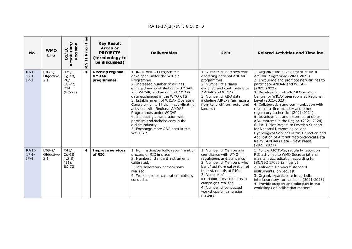
RA II-17(II)/INF. 6.5, p. 3
No. WMO LTG
Cg
/EC
R
esol
uti
on/
D
ecis
ion
RA
II
Pri
orit
ies
Key Result Areas or
PROJECTS (terminology to be discussed)
Deliverables KPIs Related Activities and Timeline
RA II-17-I-IP-3
LTG-2/ Objective-2.1
R39/ Cg-18, R8/ EC-72, R14 (EC-73)
4 Develop regional AMDAR programmes
1. RA II AMDAR Programme developed under the WICAP Programme 2. Increased number of airlines engaged and contributing to AMDAR and WICAP, and amount of AMDAR data exchanged in the WMO GTS 3. Establishment of WICAP Operating Centre which will help in coordinating activities with Regional AMDAR Programmes under WICAP 4. Increasing collaboration with partners and stakeholders in the airline industry 5. Exchange more ABO data in the WMO GTS
1. Number of Members with operating national AMDAR programmes 2. Number of airlines engaged and contributing to AMDAR and WICAP 3. Number of ABO data, including AIREPs (air reports from take-off, en-route, and landing)
1. Organize the development of RA II AMDAR Programme (2021-2023) 2. Encourage and promote new airlines to participate AMDAR and WICAP (2021-2023) 3. Development of WICAP Operating Centre for WICAP operations at Regional Level (2021-2023) 4. Collaboration and communication with regional airline industry and other regulatory authorities (2021-2024) 5. Development and extension of other ABO systems in the Region (2021-2024) 6. RA II Pilot Project to Develop Support for National Meteorological and Hydrological Services in the Collection and Application of Aircraft Meteorological Data Relay (AMDAR) Data - Next Phase (2021-2023)
RA II-17-I-IP-4
LTG-2/ Objective-2.1
R43/ Cg-18 4.2(8), (11)/ EC-73
4 Improve services of RIC
1. Nomination/periodic reconfirmation process of RIC in place 2. Members’ standard instruments calibrated; 3. Interlaboratory comparisons realized 4. Workshops on calibration matters conducted
1. Number of Members in compliance with WMO regulations and standards 2. Number of Members who benefited from calibration of their standards at RICs 3. Number of interlaboratory comparison campaigns realized 4. Number of conducted workshops on calibration matters
1. Follow RIC ToRs, regularly report on RIC activities to WMO Secretariat and maintain accreditation according to ISO/IEC 17025 (annually) 2. Calibrate Members’ standard instruments, on request 3. Organize/participate in periodic interlaboratory comparisons (2021-2023) 4. Provide support and take part in the workshops on calibration matters

RA II-17(II)/INF. 6.5, p. 4
No. WMO LTG
Cg
/EC
R
esol
uti
on/
D
ecis
ion
RA
II
Pri
orit
ies
Key Result Areas or
PROJECTS (terminology to be discussed)
Deliverables KPIs Related Activities and Timeline
RA II-17-I-IP-5
LTG-2/ Objective-2.1
R44, R45, R46, R47/ Cg-18, 4.2(16)/ EC-73
4 Improve ocean observations
1. Promote marine meteorological and related oceanographic observational programmes at the regional level
1. Number of Members who complete the questionnaire 2. Number of NFPs of RA II Members trained
1. Questionnaire on Members' capability and needs for ocean observations (2022), based on existing results, if available, with the support of WMO Cross-cutting Coordinator for Ocean 2. Organize training in response to Members' Ocean observation requirements (2023)
RA II-17-I-IP-6
LTG-2/ Objective-2.1
R51, R52, R53, R54/ Cg-18
4 Improve satellite observations and applications
1. Satellite observations and applications promoted at regional level 2. AOMSUC further promoted 3. VLab Strategy 2020-2024 implemented by hosting VLab activities 4. SWCEM implemented in East Asia 5. Assists NMHSs in RA II to make better use of satellite-related information
1. Number of Members accessing adequate satellite data 2. Number of training events 3. Number of available VLab training materials 4. Number of satellite services supporting Members
1. AOMSUC-11 hosted by China in October 2021 (Virtual), together with a VLab training, and a RA II/V coordination meeting 2. AOMSUC-12 in 2022 hosted by Japan 3. RA II WIGOS Project – Develop Support for NMHSs in Satellite Data, Products and Training - Next Phase
RA II-17-I-IP-7
LTG-2/ Objective-2.2
R57/ Cg-18, 4.2(18)/EC-73
4 Implement WIS 2.0
1. WIS 2.0 implemented at regional level 2. Improvement on WIS operation at regional level
1. Number of Members participating in the WIS 2.0 Demonstration projects 2. Number of Members who start WIS 2.0 operation
1. Demonstration projects (2020-2022) 2. Experimental data exchange (2021) 3. Architecture testing and validation (2022) 4. Transition (2023) 5. RA II WIGOS Project No. II – The web-interface for sharing status of standardization and experience and monitoring synoptic observations in RA II - Next Phase
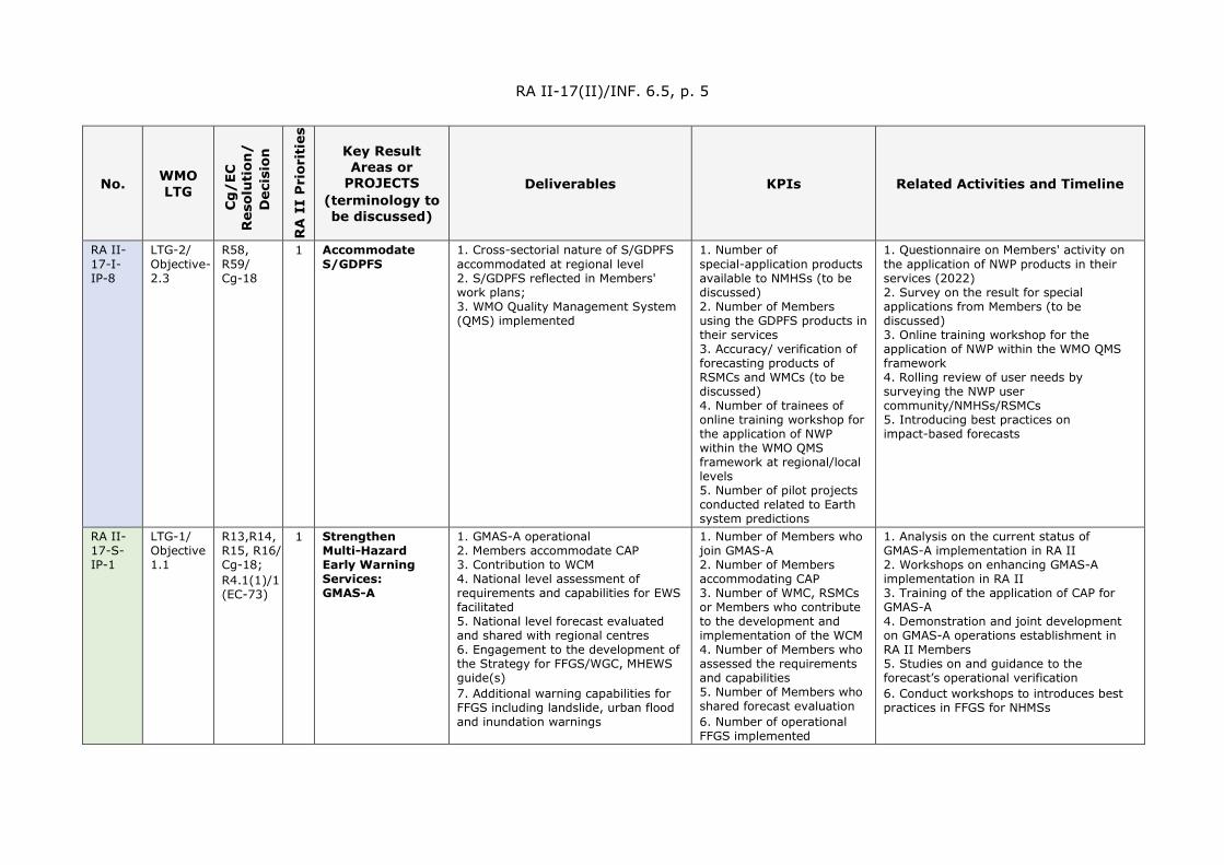
RA II-17(II)/INF. 6.5, p. 5
No. WMO LTG
Cg
/EC
R
esol
uti
on/
D
ecis
ion
RA
II
Pri
orit
ies
Key Result Areas or
PROJECTS (terminology to be discussed)
Deliverables KPIs Related Activities and Timeline
RA II-17-I-IP-8
LTG-2/ Objective-2.3
R58, R59/ Cg-18
1 Accommodate S/GDPFS
1. Cross-sectorial nature of S/GDPFS accommodated at regional level 2. S/GDPFS reflected in Members' work plans; 3. WMO Quality Management System (QMS) implemented
1. Number of special-application products available to NMHSs (to be discussed) 2. Number of Members using the GDPFS products in their services 3. Accuracy/ verification of forecasting products of RSMCs and WMCs (to be discussed) 4. Number of trainees of online training workshop for the application of NWP within the WMO QMS framework at regional/local levels 5. Number of pilot projects conducted related to Earth system predictions
1. Questionnaire on Members' activity on the application of NWP products in their services (2022) 2. Survey on the result for special applications from Members (to be discussed) 3. Online training workshop for the application of NWP within the WMO QMS framework 4. Rolling review of user needs by surveying the NWP user community/NMHSs/RSMCs 5. Introducing best practices on impact-based forecasts
RA II-17-S-IP-1
LTG-1/ Objective 1.1
R13,R14, R15, R16/ Cg-18; R4.1(1)/1 (EC-73)
1 Strengthen Multi-Hazard Early Warning Services: GMAS-A
1. GMAS-A operational 2. Members accommodate CAP 3. Contribution to WCM 4. National level assessment of requirements and capabilities for EWS facilitated 5. National level forecast evaluated and shared with regional centres 6. Engagement to the development of the Strategy for FFGS/WGC, MHEWS guide(s) 7. Additional warning capabilities for FFGS including landslide, urban flood and inundation warnings
1. Number of Members who join GMAS-A 2. Number of Members accommodating CAP 3. Number of WMC, RSMCs or Members who contribute to the development and implementation of the WCM 4. Number of Members who assessed the requirements and capabilities 5. Number of Members who shared forecast evaluation 6. Number of operational FFGS implemented
1. Analysis on the current status of GMAS-A implementation in RA II 2. Workshops on enhancing GMAS-A implementation in RA II 3. Training of the application of CAP for GMAS-A 4. Demonstration and joint development on GMAS-A operations establishment in RA II Members 5. Studies on and guidance to the forecast’s operational verification 6. Conduct workshops to introduces best practices in FFGS for NHMSs

RA II-17(II)/INF. 6.5, p. 6
No. WMO LTG
Cg
/EC
R
esol
uti
on/
D
ecis
ion
RA
II
Pri
orit
ies
Key Result Areas or
PROJECTS (terminology to be discussed)
Deliverables KPIs Related Activities and Timeline
RA II-17-S-IP-2
LTG-1/ Objective 1.1
R26/ Cg-18
1 Promote Impact-based Forecast and Warning Services
1. Feasibility report on the promotion of impact-based multi-hazard EWS 2. Releasing Members’ annual report on top 10 extreme weather events
1. Number of Members that use impact-based EWS, and with an established DRR governance mechanism 2. Number of Members who release the annual report on top 10 extreme weather events actives
1. Research on the status of EWS operating in Members including the types of hazards they cover 2. Research on the availability of exposure and vulnerability models on perils such as floods, windstorms, landslides and earthquakes 3. Study on the emergency post-event needs assessment for target perils according to their impact size as well as needs of relevant organizations 4. Research on the requirement and specification of a web-based service for communicating 5. Annual RA II extreme weather forum 6. Share the experiences on Impact-based Forecast and Warning Services/Forecast-based Financing (FbF) 7. Conduct workshops to introduce best practices in Impact-based Forecast and Warning Services
RA II-17-S-IP-3
LTG-1/ Objective 1.4
R18/ Cg-18
2 Improve Agricultural Meteorological Services
1. Decision-making support to farmers enhanced and management of agricultural related risks improved 2. National Agromet Decision Support System developed 3. Knowledge-sharing interface between forecasters/scientists, extension services and the agricultural decision-makers promoted 4. Agrometeorological information needs of the vulnerable communities identified
1. Number of trainees 2. Number of Members who respond to the survey 3. Number of Members who provide basic/advanced agricultural services 4. Number of Members with a knowledge-sharing interface
1. Training on improvement of Agricultural Meteorological services using latest remote sensing tools 2. Survey of the existing Agricultural Meteorological services in RA II 3. Documentation of the agrometeorological information needs of vulnerable communities in the member countries 4. Implementation of the GFCS User Interface Platform through collaboration with international organizations such as FAO, WFP, IFAD and others

RA II-17(II)/INF. 6.5, p. 7
No. WMO LTG
Cg
/EC
R
esol
uti
on/
D
ecis
ion
RA
II
Pri
orit
ies
Key Result Areas or
PROJECTS (terminology to be discussed)
Deliverables KPIs Related Activities and Timeline
RA II-17-S-IP-4
LTG-1/ Objective 1.4
R27, R28/ Cg-18
1 Improve meteorological services for aviation
1. Bilateral or multilateral arrangements for the issuance of harmonized SIGMET by meteorological watch offices (MWO) 2. Properly implemented quality management system (QMS) for the provision of aeronautical meteorological services 3. Competency and qualification frameworks appropriately implemented for aeronautical meteorological personnel.
1. Number of Members undertaking harmonized SIGMET coordination activities 2. Number of Members with QMS properly implemented 3. Number of Members with competency and qualification frameworks appropriately implemented
1. Gap analysis survey of Members on the establishment of bilateral/multilateral harmonized SIGMET coordination activities, the implementation of QMS and the implementation of competency and qualification frameworks [2021 and 2022] 2. Training workshops (or similar), targeting those Members most in need, to build capacity in the issuance of harmonized SIGMET, the implementation of QMS, and the implementation of competency and qualification frameworks [2023 and 2024]
RA II-17-S-IP-5
LTG-1/ Objective 1.4
R29, R30, R31/ Cg-18, R4/ EC-72
1 Strengthen Marine and Coastal Services
1. Capabilities of Members in producing storm surge and ocean wave warnings strengthened 2. Platform/mechanism for Members to conduct joint consultation on the impact of storm surge and ocean wave when a typhoon occurs established 3. Improve TC track and intensity for AP regions. 4. Develop real-time flood forecasting system due to storm surge for coastal areas 5. Integrates the IBF of TC forecasts/warnings for marine and coastal services
1. Number of Members with established storm surge and ocean wave forecasting systems 2. Number of Members who join the consultation platform 3. Number of marine data assimilation system operated 4. Number of Marine and Coastal Forecast System established
1. Workshop on storm surge prediction 2. Training course on storm surge application 3. Share experiences on Improvement of TC track and intensity by Assimilating the con/non-convolutional data for NWP 4. Conduct workshops to introduce Assimilating the con/non-convolutional data for NWP to improve TC warning and storm surges
RA II-17-S-IP-6
LTG-1/ Objective 1.3
R25/ Cg-18
3 Improve Hydrological Forecasting
1. Report of comparative studies on system, theory, practices and procedures on hydrological measurements, management system, information provision and hydrological services for RA II Members
1. Report KPI published 2. Number of surveyed Members 3. Trained hydrologists on flood hazard mapping by using SOBEK, HEC-RAS and satellite-based rainfall
1. To promote knowledge and understanding on the capabilities to provide hydrological services among RA II Members, a survey/series of interviews will be organized to assess RA II Members current capabilities and needs 2. To improve the availability of risk-based information upon which to base risk-based
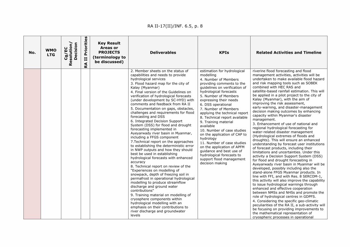
RA II-17(II)/INF. 6.5, p. 8
No. WMO LTG
Cg
/EC
R
esol
uti
on/
D
ecis
ion
RA
II
Pri
orit
ies
Key Result Areas or
PROJECTS (terminology to be discussed)
Deliverables KPIs Related Activities and Timeline
2. Member sheets on the status of capabilities and needs to provide hydrological services 3. Flood hazard map for the city of Kalay (Myanmar) 4. Final version of the Guidelines on verification of hydrological forecasts (under development by SC-HYD) with comments and feedback from RA II 5. Documentation on gaps, obstacles, challenges and requirements for flood forecasting and DSS 6. Integrated Decision Support System (DSS) for flood and drought forecasting implemented in Ayeyarwady river basin in Myanmar, including a FFGS component 7.Technical report on the approaches to establishing the deterministic error in NWP outputs and how they should best be used in establishing hydrological forecasts with enhanced accuracy 8. Technical report on review of the "Experiences on modelling of snowpack, depth of freezing soil in permafrost in operational hydrological modelling to produce streamflow discharge and ground water contributions" 9. Training material on modelling of cryosphere components within hydrological modelling with an emphasis on their contributions to river discharge and groundwater levels
estimation for hydrological modelling 4. Number of Members providing comments to the guidelines on verification of hydrological forecasts 5. Number of Members expressing their needs 6. DSS operational 7. Number of Members applying the technical report 8. Technical report available 9. Training material available 10. Number of case studies on the application of CAP to hydrology 11. Number of case studies on the application of APFM guidance and best use of hydrological forecasts to support flood management decision making
riverine flood forecasting and flood management activities, activities will be undertaken to make available flood hazard and risk mapping tools such as SOBEK combined with HEC RAS and satellite-based rainfall estimation. This will be applied in a pilot project to the city of Kalay (Myanmar), with the aim of improving the risk assessment, early-warning, and disaster-management decision making outcomes by enhancing capacity within Myanmar's disaster management. 3. Enhancement of use of national and regional hydrological forecasting for water-related disaster management (Hydrological extremes of floods and droughts). This will ensure an enhanced understanding by forecast user institutions of forecast products, including their limitations and uncertainties. Under this activity a Decision Support System (DSS) for flood and drought forecasting in Ayeyarwady river basin in Myanmar will be developed, possibly including also the stand-alone FFGS Myanmar products. In line with FFI, and with Res. 8 SERCOM-1, this activity will also improve the capability to issue hydrological warnings through enhanced and effective cooperation between NMSs and NHSs and promote the role of hydrological centres in GDPFS. 4. Considering the specific geo-climatic peculiarities of the RA II, a sub-activity will be focusing on providing improvements to the mathematical representation of cryospheric processes in operational

RA II-17(II)/INF. 6.5, p. 9
No. WMO LTG
Cg
/EC
R
esol
uti
on/
D
ecis
ion
RA
II
Pri
orit
ies
Key Result Areas or
PROJECTS (terminology to be discussed)
Deliverables KPIs Related Activities and Timeline
10. Case studies on the application of CAP to hydrological hazards. (collaboration with RA II-17-S-IP-1) 11. Case studies on the application of APFM guidance on dissemination of alerts and flood management practices, including best use of hydrological forecasts to support flood management decision making.
hydrological forecasting models (excluding GLOFs). 5. To make sure that hydrological warnings are disseminated and acted upon in an appropriate way, this activity will consider the application of the CAP to hydrological hazards, providing case studies of CAP application for hydrology in RA II, and will further elaborate on the linkage between flood forecasting, issuance of flood alerts (riverine, flash and urban) and appropriate response actions, building on guidance material available through the APFM.
RA II-17-S-IP-7
LTG-1/ Objective 1.3
R25/ Cg-18
3 Improve Capabilities on Water Resources Assessment
1. DWAT 1.3 Software. 2. User Manual for DWAT 1.3 3. Training Material for DWAT 1.3 4. DWAT Workshop. 5. Report on case studies for DWAT 1.3 application 6. Seasonal hydrological outlook report provided to major water users every 3 months 7. Evaluation report of the efficacy of seasonal outlook
1. Number of Members using DWAT 2. Number of DWAT workshops held. 3. Number of HydroSOS pilots initiated
1. Improvement of water resources assessment techniques and globally implement Dynamic Water Resources Assessment Tool (DWAT) to assist decision making in water resources management 2. HydroSOS pilot implementation: to improve National and Regional Drought Forecasting and Prediction capabilities for disaster risk management through enhanced and effective cooperation with other NMHSs

RA II-17(II)/INF. 6.5, p. 10
No. WMO LTG
Cg
/EC
R
esol
uti
on/
D
ecis
ion
RA
II
Pri
orit
ies
Key Result Areas or
PROJECTS (terminology to be discussed)
Deliverables KPIs Related Activities and Timeline
RA II-17-S-IP-8
LTG-1/ Objective 1.2
R20, R21, R22/ Cg-18, D9/ EC-72, R64 (Cg-17), R6 (EC-67), D16 (EC-68), D9 (EC-72)
2 Promote Climate Services implementation
1. Overview of the checklist provided by Members 2. Areas where support is needed identified 3. Report on the State of the Climate in Asia published 4. Regional Climate Forum (RCF) organized and Services of Regional Climate Centres (RCCs) improved 5. Members implement GFCS
1. Number of Members who complete Checklist for Climate Services Implementation 2. Number of issues of Report on the State of the Climate in Asia 3. Number of special-application products available to NMHSs 4. Number of Regional Climate Forums (RCFs) 5. Number of Members with basic/advanced climate services 6. Number of Regional Climate Centres (RCCs) that issue Objective Seasonal Forecasts
1. To hold a Regional Workshop on the checklist (2021) 2. To share needs and requirements of Members with RCCs and update the webpage “Information Sharing on Climate Services in WMO RA II” (2021) 3. To facilitate the production of the pilot report on State of the Climate in Asia (2021) 4. Further development of the concept leading to the publication of a regular report on the State of the Climate in Asia (2022) 5. To evaluate the forecast skill of objective seasonal forecasts, based on multi-model ensembles from dynamical climate models at sub-regional scale and users' need for the forecasts and capability of NHMSs and/or RCFs to operationalize it (2021-2023) 6. Adoption of objective seasonal predictions into RCOF processes on a trial basis (2024)
DEMONSTRATION PROJECTS (DP) - CAPACITY DEVELOPMENT RA II-17-I-DP-1
LTG-2/ Objective-2.1
R23/ Cg-18, R7/ EC-72
4 Promote long-term observing stations
1. Recognition of Long-term Observing Stations (including Hydrological Stations) supported at regional level 2. Long-term Observing Stations promoted at highest national governmental levels 3. Observations from Long-term Observing Stations available for scientific research and education 4. Metadata of the Long-term Observing Stations reviewed and updated
1. Number of Long-term Observing Stations (including Hydrological Stations), with metadata reviewed and updated 2. Number of Long-term Observing Stations with information presented and outreach conducted
1. Review and update metadata (2021-2024) 2. Collect and sort out detailed information and produce presentation materials (2023) 3. Support the promotion of Long-term Observing Stations (including Hydrological Stations) (2021-2024)
RA II-17(II)/INF. 6.5, p. 11
No. WMO LTG
Cg
/EC
R
esol
uti
on/
D
ecis
ion
RA
II
Pri
orit
ies
Key Result Areas or
PROJECTS (terminology to be discussed)
Deliverables KPIs Related Activities and Timeline
5. Long-term Observing Stations information presentation and outreach
RA II-17-I-DP-2
LTG-2/ Objective-2.1
R42/ Cg-18, EC-70
4 Coordinate on RFC
1. Regional contributions of meteorological experts with the work of relevant regional telecommunication organizations and with ITU-R, especially ITU-R Study Groups 5 and 7 on Terrestrial (including radiolocation) and Science Services coordinated 2. A focal point on RFC matters designated
1. Number of Members engaged with RFC matters 2. Preserve radio-frequency bands for the operation of meteorological and research in the field of remote sensing (How to measure this to be discussed) 3. Designation of regional focal point on RFC matters
1. Organize training workshops on a regional basis 2. To ensure the availability and protection of suitable radio-frequency bands required for meteorological and related environmental operations 3. Participate actively in the national, regional and international activities on relevant radiocommunication regulatory issues 4. To facilitate the coordination between National Meteorological and Hydrological Services and their national radiocommunication administrations 5. Use of latest commercial tech in communications like 5G and evaluate its impact
RA II-17-I-DP-3
LTG-2/ Objective-2.2
R55, R56/ Cg-18, D7/ EC-72, 3.4(1)/ EC-73
4 Address WMO Data Policy and emerging data issues
1. WMO Data Policy for international exchange of Earth system data promoted within RA II 2. Regional perspective and expertise provided
1. Number of Members following the WMO data policy
1. Survey regarding WMO data policy and emerging data issues (2022) 2. Contribute to the draft technical regulations to be submitted to WMO Congress in 2023
RA II-17-I-DP-4
LTG-2/ Objective-2.1
R37/ Cg-18 4.2(1)/ EC-73
4 Capacity Building in Radar Techniques in Southeast Asia - Next Phase
1. Improvement of data quality of existing radars 2. Development and expansion of national radar networks 3. Near real-time international exchange of radar data
1. Number of Members participating in the technical meetings 2. Number of Members developing radar-related techniques under the project 3. Number of Members joining the experimental radar data exchange
1. Organize technical meetings in collaboration with ESCAP/WMO Typhoon Committee and/or ASEAN (2021-2024)

RA II-17(II)/INF. 6.5, p. 12
No. WMO LTG
Cg
/EC
R
esol
uti
on/
D
ecis
ion
RA
II
Pri
orit
ies
Key Result Areas or
PROJECTS (terminology to be discussed)
Deliverables KPIs Related Activities and Timeline
RA II-17-I-DP-5
LTG-2/ Objective-2.2
R25/ Cg-18
3 Reinforcing Members’ capacities in hydrometry and sediment transport
1. Recommendations on improvements to the RA II Survey regarding NHSs including hydrological stations 2. Training courses including online content for development of rating curves (from field measurement to assessment of rating) 3. Software tools and methods for measuring discharge including backwater and tidal influence 4. Implementation of WMO Hydrological Observing System (WHOS)
1. Number of training courses on development of rating curves 2. Number of Members using software tools for measuring discharge that covers backwater and tidal influence 3. Number of Members that have implemented the WMO Hydrological Observing System (WHOS)
1. Improvement in hydrometric measurements in both quality and accuracy 2. Global application of software tools and methods; 3. Improve hydrological data operations and management in RA II.
RA II-17-S-DP-1
LTG-1/ Objective 1.1
R12/ Cg-18
1 Promote WMO Cataloguing of Hazardous Events (WMO-CHE)
1. Identification of existing and CHE databases 2. WMO-CHE promoted
1. Number of Members that engaged in WMO-CHE
1. Study on the status of WMO CHE 2. Study on the availability of CHE data over the region 3. Study on the requirement and specification of WMO CHE over the region 4. Organize a workshop and other capacity building activities.
RA II-17-S-DP-2
LTG-1/ Objective 1.4
R32/ Cg-18
1 Advance Integrated Urban Services
1. Integrated Urban Services enhanced 2. Analytical report on stakeholder mapping and roadmap on stakeholder engagement
1. Number of Members addressing the requirement of Integrated Urban Services
1. Identifying IUS Demonstration cities 2. Stakeholder mapping and roadmap on stakeholder engagement 3. Development of the Implementation Plan for Integrated Urban Services 4. Document on approaches to very high-resolution forecasting, predictions, and warning systems
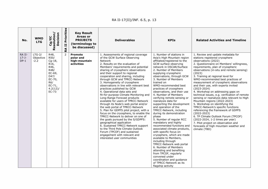
RA II-17(II)/INF. 6.5, p. 13
No. WMO LTG
Cg
/EC
R
esol
uti
on/
D
ecis
ion
RA
II
Pri
orit
ies
Key Result Areas or
PROJECTS (terminology to be discussed)
Deliverables KPIs Related Activities and Timeline
RA II-17-J-DP-1
LTG-2/ Objective -2.2
R48, R50/ Cg-18, R16, R46, R48/ EC-69, D47/ EC-70, R6/ EC-71, 4.2(12)/ EC-73
2 Promote polar and high-mountain activities
1. Assessments of regional coverage of the GCW Surface Observing Network 2. Results on the evaluation of Members’ requirements and potential sharing of cryospheric observations and their support to regional cooperation and sharing, including through GCW and TPRCC-Network 3. Homogeneity of cryosphere observations in line with relevant best practices published by GCW 4. Operational data sets and fit-for-purpose Climate Monitoring and Long-Range Forecast products available for users of TPRCC-Network through its Node’s web portal and/or the web portal of TPRCC-Network 5. Plan for GDPFS pilot project, with a focus on the cryosphere, to enable the TPRCC-Network to deliver on one of the goals pursued by the S/GDPFS: geographical application 6. Sustained TPRCC-Network support to the Third Pole Climate Outlook Forum (TPCOF) and sustained engagement with relevant and interested user communities
1. Number of stations in Asia’s High Mountain region affiliated/registered to the GCW surface observing network in OSCAR/Surface 2. Number of Members supplying cryospheric observations, through GCW 3. Number of Members trained on WMO-recommended best practices of cryosphere observations, and their use 4. Number of Members verifying remote sensing or reanalysis data for supporting the development and operation of the TPRCC-Network, including during its demonstration phase 5. Number of regular RCC mandatory and highly recommended functions and associated climate products, with specific focus on cryosphere, which are made available to Members, including through TPRCC-Network web portal 6. Number of Members attending and benefiting from TPCOF, regularly convened under coordination and guidance of TPRCC-Network as its flagship activity
1. Review and update metadata for stations registered cryosphere observations (2022) 2. Questionnaire on Members' willingness, requirements, plan of cryospheric observations (in-situ and remote sensing) (2023) 3. Training at regional level for WMO-recommended best practices of measurement of cryospheric observations and their use, with experts invited (2023-2024) 4. Workshop on addressing gaps on technical issues, e.g. verification of remote sensing or reanalysis data relevant to High Mountain regions (2022-2023) 5. Workshop on identifying the TPRCC-Network’s specific functions referencing the framework of GDPFS (2022-2023) 6. TP Climate Outlook Forum (TPCOF) (2022-2024, 1-2 times per year) 7. Pilot project on observation and forecasts of high mountain weather and climate (TBD)

RA II-17(II)/INF. 6.5, p. 14
No. WMO LTG
Cg
/EC
R
esol
uti
on/
D
ecis
ion
RA
II
Pri
orit
ies
Key Result Areas or
PROJECTS (terminology to be discussed)
Deliverables KPIs Related Activities and Timeline
RA II-17-J-DP-2
LTG-1/ Objective -1.3
R19, R33,R61/Cg-18, 4.1(6)/ EC-73
1 Improve observations and services for environmental needs, including air quality, and sand and dust storms
1. Increased number of Members that issue air quality products/services 2. Improved air quality forecasts 3. Improved SDS Observation and Forecasts (Quantity & Quality) 4. Improved application of existing observational data in air quality and SDS services (in-situ and remote sensing); 5. Report on (1) SDS EWSs challenges and practices; (2) SDS databases; (3) Methodologies 6. Members’ capacity developed
1. Number of Members monitoring air quality, including SDS 2. Number of Members providing air quality services, including SDS 3. Number of air quality and SDS observation stations added to the existing network (Oscar/Surface GAW) 4. Number of Members issuing SDS impact-based EWS
1. Training workshops for air quality observations, analysis and forecast 2. Introducing best practices in air quality and SDS monitoring and forecasts 3. Study on status of SDS EWS, availability of SDS data and needs assessment 4. Pilot project on establishment of a regional air quality station network and air-quality forecast (TBD)
RA II-17-J-DP-3
LTG-1/ Objective -1.3
R17/ Cg-18, 4.1(2)/ EC-73
2 Improve drought observations and services
1. Improved drought monitoring 2. Enhanced drought warning services 3. Increased application of available remotely sensed data in drought-monitoring systems 4. Integration of weather, water and climate data in drought-monitoring and early warning systems 5. Drought indices (such as SPI) for drought-monitoring and early warning systems applied 6. Sectors pertaining to drought (agriculture, hydrology etc.) engaged 7. Enhanced Cooperation with other UN bodies (FAO, GWP) in implementation of WMO Drought Monitoring and Warning Guidelines
1. Number of Members introducing drought indices such as Standardized Precipitation Index (SPI) into drought-monitoring and early warning systems 2. Number of Members with partnership frameworks for cooperation between meteorology-hydrology and other relevant institutions.
1. Training workshops for drought-monitoring and early warning systems (2021-2023) 2. Introducing best practices in drought-monitoring and early warning systems (2021-2022) 3. Conducting surveys among Members on their existing cooperation frameworks in weather, water and agriculture sectors (2021-2022)

RA II-17(II)/INF. 6.5, p. 15
No. WMO LTG
Cg
/EC
R
esol
uti
on/
D
ecis
ion
RA
II
Pri
orit
ies
Key Result Areas or
PROJECTS (terminology to be discussed)
Deliverables KPIs Related Activities and Timeline
PILOT PROJECTS (PP) - INNOVATION AND TRY-OUTS RA II-17-S-PP-1
LTG-3/ Objective 3.2
R33/ Cg-18
1 Global Air Quality Forecasting Information System (GAFIS) Asia Pilot
1. Establishment of GAFIS Asian Node 2. Enhancement of Air Quality Forecasting of RA II Members
1. Number of Members who join GAFIS Asia Pilot 2. Number of Members who contribute to model inter-comparison and evaluation
1. Construct GAFIS Asia Pilot Node 2. Organize model evaluation and inter-comparison studies within Members 3. Develop Air Quality Forecasting Information for RA II
RA II-17-J-PP-1
LTG-1/ Objective 1.4
R32, 80/ Cg-18, R11/ EC-72, D2/ EC-71
1 Public-Private Engagement for Smart Meteorological Services in Mega-Cities
1. A sustainable model of meteorological data acquisition and sharing with wide participation established 2. An agreed set of urban safety development indicators established, to develop the impact-based disaster risk early warning service 3. Targeted early warning and communication technologies developed, to provide user-interactive and demand-driven early warning information for decision makers 4. Urban climate impact assessment carried out; 5. Risk-based storm surge forecast service developed 6. Flood service optimized 7. Scalable practices and mechanisms related to effective PPE model developed
1. Number of Members with partnership framework for Smart meteorological Services in Mega cities
1. Set up a complete project organizational system to provide guidance and coordinate implementation including international advisory committee, project coordination group and working group (2021) 2. Establish an open mechanism for multi-stakeholders and encourage high-tech enterprises and academic institutions in the region to participate (2022-2023) 3. Organize a project scoping meeting (2021) 4. Organize an international workshop (2023)
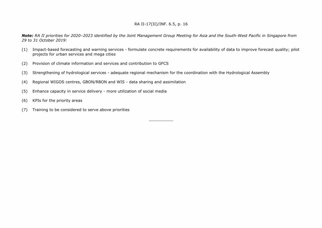
RA II-17(II)/INF. 6.5, p. 16
Note: RA II priorities for 2020–2023 identified by the Joint Management Group Meeting for Asia and the South-West Pacific in Singapore from 29 to 31 October 2019:
(1) Impact-based forecasting and warning services - formulate concrete requirements for availability of data to improve forecast quality; pilot projects for urban services and mega cities
(2) Provision of climate information and services and contribution to GFCS
(3) Strengthening of hydrological services - adequate regional mechanism for the coordination with the Hydrological Assembly
(4) Regional WIGOS centres, GBON/RBON and WIS - data sharing and assimilation
(5) Enhance capacity in service delivery - more utilization of social media
(6) KPIs for the priority areas
(7) Training to be considered to serve above priorities
__________