Power and representation in the Portuguese colonial space: the Praça do Império during the Estado...
12
Power and representation in the Portuguese colonial space: the Praça do Império during the Estado Novo EURAU’12 ABSTRACT. This paper sets out to identify the urban structures that represented the political power of the Estado Novo authoritarian regime through an analysis of the Praças do Império (Imperial Squares) created in the cities and towns of the Portuguese African colonies from the beginning of the Second World War onwards. One of the generic arguments for the realisation of these structures was the upgrading of the built environment in African cities, bringing them, in terms of degree of urbanity, in line with cities and towns in the Metropole. A number of study cases in Guinea Bissau and Angola are analysed using the “classic” perspective of the rule and the model defined by Françoise Choay in 1980. The adoption of Choay’s classification is used to introduce a stable standard of interpretative analysis. Generally speaking, these squares retained their importance in terms of the organisation and life of the contemporary African cities and one can affirm that their “representative” qualities have been boosted in a new historic and political context in the post-independence period. KEYWORDS. Portuguese colonial architecture, Guinean architecture, Angolan architecture, colonial urbanism, Estado Novo Ana Vaz Milheiro ISCTE - Instituto Universitário de Lisboa DA, Universidade Autónoma de Lisboa Dinâmia-CET Rua dos Douradores, 29 – 2º andar – 1100-203 Lisboa _ Portugal [email protected] +351 966208523titution
Transcript of Power and representation in the Portuguese colonial space: the Praça do Império during the Estado...
Power and representation in the Portuguese colonial space: the Praça do Império during the Estado Novo EURAU’12
ABSTRACT. This paper sets out to identify the urban structures that represented the political power of the Estado Novo authoritarian regime through an analysis of the Praças do Império (Imperial Squares) created in the cities and towns of the Portuguese African colonies from the beginning of the Second World War onwards. One of the generic arguments for the realisation of these structures was the upgrading of the built environment in African cities, bringing them, in terms of degree of urbanity, in line with cities and towns in the Metropole. A number of study cases in Guinea Bissau and Angola are analysed using the “classic” perspective of the rule and the model defined by Françoise Choay in 1980. The adoption of Choay’s classification is used to introduce a stable standard of interpretative analysis. Generally speaking, these squares retained their importance in terms of the organisation and life of the contemporary African cities and one can affirm that their “representative” qualities have been boosted in a new historic and political context in the post-independence period.
KEYWORDS. Portuguese colonial architecture, Guinean architecture, Angolan architecture, colonial urbanism, Estado Novo
Ana Vaz Milheiro
ISCTE - Instituto Universitário de Lisboa DA, Universidade Autónoma de Lisboa Dinâmia-CET Rua dos Douradores, 29 – 2º andar – 1100-203 Lisboa _ Portugal [email protected] +351 966208523titution
1. Background
The urban planning practice during the Estado Novo regime reached a high point in the period following the Second World War, continuing for more or less one decade (LOBO, 1995. 145-216). This phase of intense urban planning in the Metropole was matched with parallel activity in terms of the development of new plans for the Portuguese colonies. It also coincides with the launch of the Colonial Planning Office (GUC), which was set up by Marcelo Caetano in late 19441 precisely to optimise the Portuguese efforts in the field of colonial urbanism and tropical architecture, creating qualified technical teams of architects, engineers and specialists in tropical medicine and climatology2. João António Aguiar, a leading designer of urban plans for a number of cities in Portugal, emerged as the second most important figure in the office, after the mining engineer, Rogério Cavaca, the office’s first director.
Aguiar’s authorship has been fully established for a number of colonial urban plans between 1946 and 1954. Amongst those of interest, in the context of his paper, are Luanda (1952) and Huambo (then known as Nova Lisboa, before 1952). For Portuguese Guinea he also drew up the plans for Canchungo (then Teixeira Pinto, 1951) and Bubaque (1952); the plan for Bissau was also probably his work. His association with most of the plans produced by the GUC makes him the leading ideologist of the urbanistic culture implemented.
The plans produced by the GUC adopted rationalist principles that were reflected in the sectoral distribution of the diverse urban functions, together with a predilection for the radial and axial compositions of the western planning tradition. The low density of the residential areas has led to these plans being associated with the Garden City tradition. An urbanism that was more receptive to the City Beautiful movement’s ideals was superimposed on the principles proposed by Ebenezer Howard; those ideals were already present in the colonial town planning during the first Portuguese republic (1910-1926). This juxtaposition of design approaches squared fully with the representational objectives for the cities that underwent interventions during the Estado Novo regime (1933-1974). It was also in the context of these plans that the layouts for the praças do império were strengthened, the original conception of which can be traced back to Lisbon’s 18th-century Praça do Comércio.
The planning for some colonial cities was therefore already carried out prior to the work of the GUC architects, these plans representing the first designs of the modern Portuguese-African city. The knowledge we have today points to a reading that places the First Republic at the generating centre of modern Portuguese colonial urbanism. Unrealised plans by Carlos Rebelo de Andrade, which were very close to the ideals of the City Beautiful, such as that for Beira in Mozambique published in 1932 in Arquitectura magazine, would suggest exactly that possibility3. In Guinea, the town of Bolama seems to have been the object of an urban design proposal inspired by the same principles around the same time. One can included in this context the plan in the Bissau City Council archives (but which was probably for Bolama, the colony’s then capital) attributed to the mining engineer José Guedes Quinhones, which is not dated and was never implemented and probably was drawn up during the 1920s4. In that plan, monumental avenues proceeding from radial points seem to anticipate the conception of Avenida da República in Bissau. The same engineer was also responsible for the implemented design of the new city of Bissau (1919), where the plan also features a major road axis, a feature that was later to constitute the matrix for urban development in other Guinean cities.
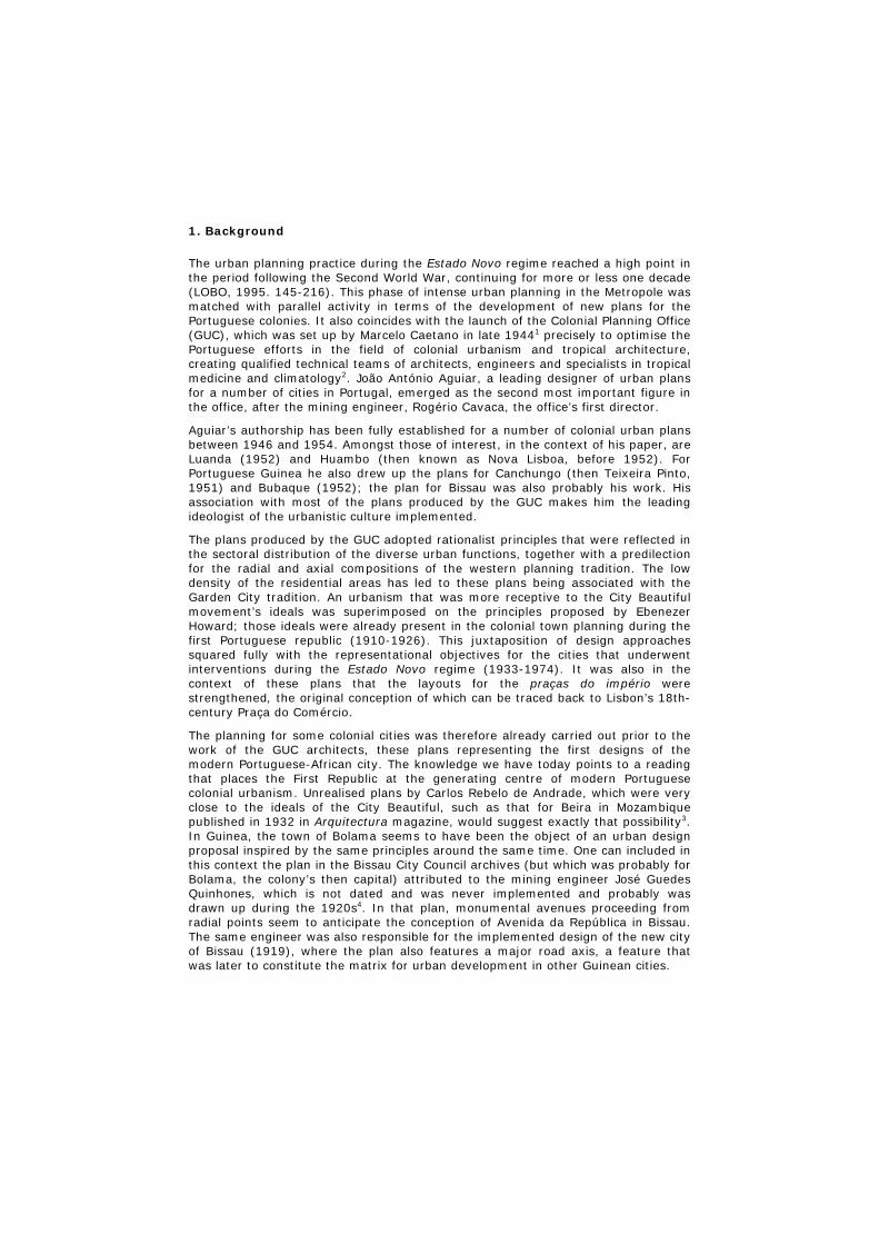
2. The Rule: Bissau and other Guinean cities
The idea of application of a rule – loosely applying the ideas of Françoise Choay – was based on the existence of a number of operative urban principles capable of generating a unitary structure, without necessarily having to apply a closed design (particularly in terms of the volumetry of the built structures). The approach was one of operating pragmatically, as opposed to a proposal that was idealist and, for that reason, having a utopian foundation that the idea of model assumes. The concept served for the execution of a number of urban interventions in what is now Guinea-Bissau around 1946 as part of the commemorations marking the 5th centennial of the arrival of the Portuguese in the region. The main thoroughfare in Bissau – the former Avenida da República, now Avenida Amílcar Cabral – functioned as a template that was later replicated in smaller-sized Guinean urban agglomerations. The realisation of this application was based on five cities located to the north and north-east of Bissau: Bafatá, Cacheu, Canchungo, Mansoa and Gabu5.
Fig. 1
The planning of contemporary Bissau most likely began after the military events that led to the establishment of Portuguese presence in the territory (PÉLISSIER, 2 vol. 2001. p. 123 ff.). Guedes Quinhones’ plan of 1919, which was carried out under the remit of the Department of Development – Land Surveying Directorate, not only marked the beginning of the process of monumentalisation of the urban space but also represented its expansion beyond the original perimeter of Praça de São José square in Bissau. The central avenue at the time was Avenida 31 de Janeiro and the city limits were marked by a “radial avenue” that defined the boundary to the “suburbs”. One can identify plots for the power and water supply facilities, the government buildings, the new hospital and the Banco Nacional Ultramarino – programmes that were indispensable for the functioning of the new
city. These formed the first basic group of facilities (to which the primary school was added around 1922) implemented under the First Republic that the Estado Novo was later to extend to others.
In 1941 the city was made the provincial capital. A new plan from 1942 has been attributed to the engineer Eduardo José de Pereira da Silva, head of the Guinean Central Geographic and Cartographic Services Department. Around 1945, the GUC began work that led to the development of the first master plan for the city, which was the responsibility of this Lisbon-based office. The Master Urbanisation Plan was approved on 12 June 1948 under the governorship of Manuel Sarmento Rodrigues. It proposed the laying out of two new avenues parallel to Avenida da República, also perpendicular to the banks of the River Geba. Both avenues were also to end in roundabouts flanked by public buildings. The urban grid was to be organised in square blocks based on the direction imposed by the planned set of three avenues, which were designed as boulevards with a central tree-lined island along the whole length. In the expansion area, the blocks increased in terms of surface area, complying with a demand from Sarmento Rodrigues. The location of the new and old facilities the city was equipped with are indicated on the plan: the cemetery, hospital, stadium, industrial zone, residential neighbourhoods and business and shopping zones. Very specific buildings were also marked: government buildings, the Commercial Association (which was later moved to another plot), the cathedral, the town hall and the new market (the latter two were not built), the power plant and the museum. The tendency to locate the most important facilities in the proximity of Avenida da República was accentuated, confirming its vocation as a representational structure.
The city was to retain the structure drawn by Quinhones in 1919. The Praça do Império (now Praça dos Heróis Nacionais), in which Avendia da República ended, was located on the higher plain of the city – making use of the higher elevation – providing the government buildings with all-seeing location (the built version was designed by João Aguiar and Galhardo Zilhão/GUC, 1945). As the plan of 1948 suggests, the main buildings representing the political, economic and religious powers were located along the square and the main avenue. The museum and study centre were built on the originally reserved plot on Praça do Império. The Guinea Commercial, Industrial and Agricultural Association, the current headquarters of the PAIGC (Jorge Chaves, 1949-1952), was moved from the Avenida to the square. The TAP offices (José Pinto da Cunha) were added to this noteworthy group in the 1970s. Along the avenue were located the cathedral (renovation project by João Simões/GUC, 1945/Vasco Regaleira, 1942), the head post office and telegraphs building (Lucínio Cruz, GUU, 1955-1955) and the courthouse (1941?).
The Estado Novo strategy included reinforcing the general configuration of the republican city and its representative aspects, upgrading the design of the public, administrative and religious buildings and implementing an iconographic programme of celebration of the colonial presence through integration of public art and statuary in pivotal locations (the monument to Nuno Tristão at the beginning of the avenue, for example). Thus, an historic/monumental context was thus completed that was already present, in part, through the existence of the São José de Amura fort (designed by Manuel de Vinhais Sarmento, 1766; restored by Luís Benavente as part of the Estado Novo’s historic colonial monument renovation policy after 1958) and the original urban nucleus from the city’s founding period (Old Bissau, which some preliminary reports recommended demolishing, given the precarious sanitary conditions in the quarters in the late 1940s).
The option for low density construction was also reflected in the definition of the “indigenous neighbourhoods”, known as “people’s neighbourhoods” from 1959
onwards, which occupied the margins of the formal city. The Urbanisation Plan for People’s Neighbourhoods (1959) by Mário de Oliveira marked a change in the urban and architectural approach taken by the architects of the then recently formed Department of Urbanism and Housing Services at the DGOPC/MU. Oliveira’s plan proposed self-building (with technical assistance and based on qualified designs) and a return to a Garden City-inspired layout, organising native settlements on the basis of more organic and less geometric plans, such as those for the Santa Luzia (1948) and Ajuda neighbourhoods.
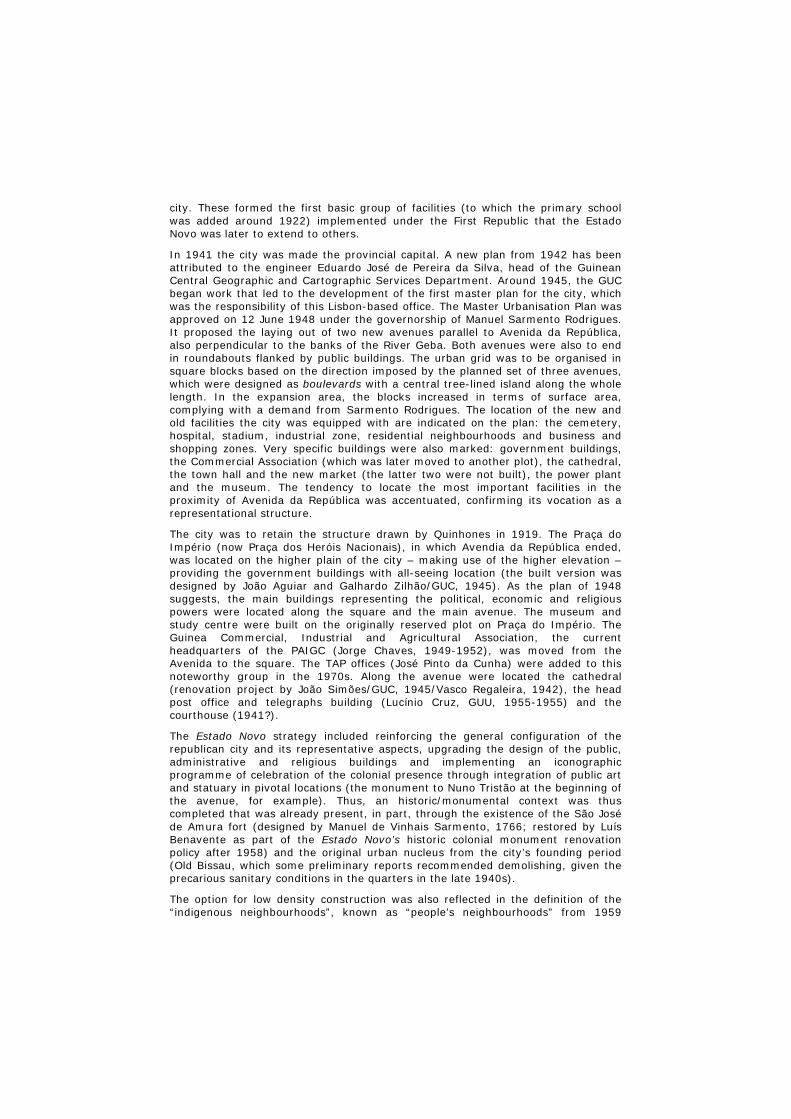
It was during Sarmento Rodrigues’ governorship that the commemorations of the 5th centennial took place. The date was marked by a series of urban interventions in settlements such as Varela, Cacheu, Canchungo (then Teixeira Pinto), Mansoa, Farim, Bafatá and Gabu (then Nova Lamego). They followed a territorial vision that placed Bissau at the centre of a road network in a region characterised by a complex hydrographic basin. The plans introduced were based on a plaza (almost always circular in plan) that was the conclusion of a tree-lined avenue that featured a central island and street lighting. The idea was to create an “urban scenography” that was based on the ground design, regardless of the architecture, which was relegated to a secondary role.
Fig. 2
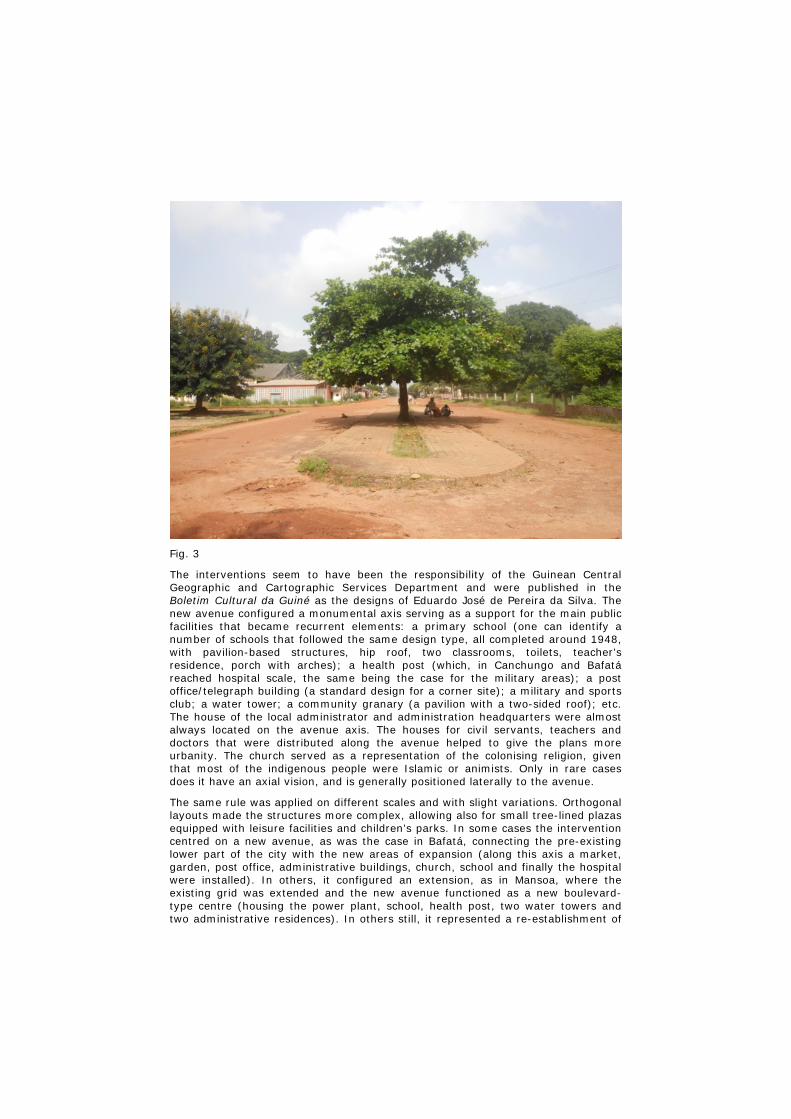
Fig. 3
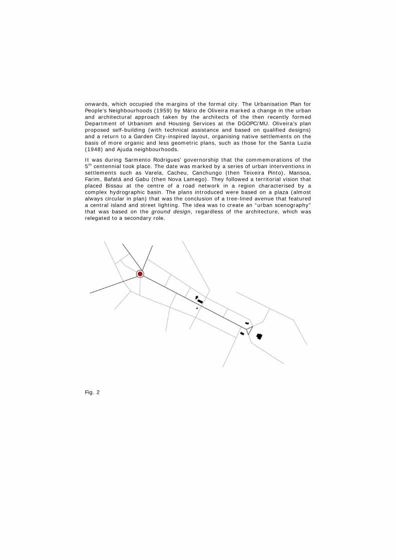
The interventions seem to have been the responsibility of the Guinean Central Geographic and Cartographic Services Department and were published in the Boletim Cultural da Guiné as the designs of Eduardo José de Pereira da Silva. The new avenue configured a monumental axis serving as a support for the main public facilities that became recurrent elements: a primary school (one can identify a number of schools that followed the same design type, all completed around 1948, with pavilion-based structures, hip roof, two classrooms, toilets, teacher’s residence, porch with arches); a health post (which, in Canchungo and Bafatá reached hospital scale, the same being the case for the military areas); a post office/telegraph building (a standard design for a corner site); a military and sports club; a water tower; a community granary (a pavilion with a two-sided roof); etc. The house of the local administrator and administration headquarters were almost always located on the avenue axis. The houses for civil servants, teachers and doctors that were distributed along the avenue helped to give the plans more urbanity. The church served as a representation of the colonising religion, given that most of the indigenous people were Islamic or animists. Only in rare cases does it have an axial vision, and is generally positioned laterally to the avenue.
The same rule was applied on different scales and with slight variations. Orthogonal layouts made the structures more complex, allowing also for small tree-lined plazas equipped with leisure facilities and children’s parks. In some cases the intervention centred on a new avenue, as was the case in Bafatá, connecting the pre-existing lower part of the city with the new areas of expansion (along this axis a market, garden, post office, administrative buildings, church, school and finally the hospital were installed). In others, it configured an extension, as in Mansoa, where the existing grid was extended and the new avenue functioned as a new boulevard-type centre (housing the power plant, school, health post, two water towers and two administrative residences). In others still, it represented a re-establishment of
the settlement, with a change in the place name to a Metropole-inspired name: such as Gabu becoming Nova Lamego and Canchungo being renamed Teixeira Pinto. Thus Portuguese Guinea witnessed the dissemination of a development model based on an urban model, whose structure remained waiting to be occupied.
3. The model: the Praça do Império in Angola
In order to illustrate the idea of the model, as advanced by Choay, as an expression of a utopia based on its paradigmatic dimension, one can take a number of Angolan squares or plazas likewise laid out in the second half of the 1940s. In São Paulo de Luanda, which was founded in the 16th century, the Estado Novo interventions were concentrated in the areas of expansion in the 20th century. The former Largo Diogo Cão, now known as Largo 17 de Setembro, included in the Urbanisation Plan for the City of Luanda Waterfront by Etienne de Gröer and David Moreira da Silva in 1943 as a Praça do Império, served as an initial reference for recourse to the model. The document itself suggests that the buildings on the plaza followed the hierarchical logic of the classical composition. Architecture and the ground design were defined as a closed unit, aiming at the conception of an ideal. The reference was monumental Lisbon, in particular the idea of the praça de representação (representative plaza) inscribed in the 18th-century Pombaline plan with the execution of the Praça do Comércio. An identical model was taken up in other Angolan cities in the same period, which are dealt with here for comparative purposes, such as Lobito and Huambo, then known as Nova Lisboa.
Fig. 4
The praças do império laid out in Angolan territory that are introduced here as study cases present, as a singular aspect, the fact that their layout is associated with a specific architectural design, allowing them to be approached from the model
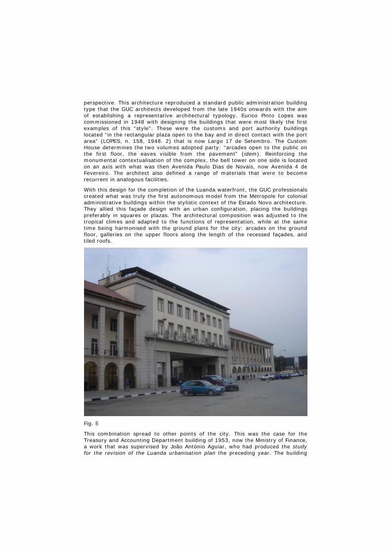
perspective. This architecture reproduced a standard public administration building type that the GUC architects developed from the late 1940s onwards with the aim of establishing a representative architectural typology. Eurico Pinto Lopes was commissioned in 1948 with designing the buildings that were most likely the first examples of this “style”. These were the customs and port authority buildings located “in the rectangular plaza open to the bay and in direct contact with the port area” (LOPES, n. 158, 1948. 2) that is now Largo 17 de Setembro. The Custom House determines the two volumes adopted party: “arcades open to the public on the first floor, the eaves visible from the pavement” (idem). Reinforcing the monumental contextualisation of the complex, the bell tower on one side is located on an axis with what was then Avenida Paulo Dias de Novais, now Avenida 4 de Fevereiro. The architect also defined a range of materials that were to become recurrent in analogous facilities.
With this design for the completion of the Luanda waterfront, the GUC professionals created what was truly the first autonomous model from the Metropole for colonial administrative buildings within the stylistic context of the Estado Novo architecture. They allied this façade design with an urban configuration, placing the buildings preferably in squares or plazas. The architectural composition was adjusted to the tropical climes and adapted to the functions of representation, while at the same time being harmonised with the ground plans for the city: arcades on the ground floor, galleries on the upper floors along the length of the recessed façades, and tiled roofs.
Fig. 5
This combination spread to other points of the city. This was the case for the Treasury and Accounting Department building of 1953, now the Ministry of Finance, a work that was supervised by João António Aguiar, who had produced the study for the revision of the Luanda urbanisation plan the preceding year. The building
benefits from its vantage-point location on Largo da Mutamba. Architecturally speaking, it is a further development of a previous version attributed to the architect António Ribeiro Martins from the Colony of Angola’s Department of Public Works, who designed it in close collaboration with Aguiar (FONTE, 2007. 520). The built structure, however, represents a simplification of the historicist idiom that does without “pointless decorative details” (AGUIAR, n. 385, 1953. 3). This option for figurative austerity became something of a hallmark of the GUC’s administrative buildings.
An identical architectural/urbanistic configuration became widespread in much of the Angolan territory. The relationship between Lobito City Hall (Lucínio Curz/GUC, 1948; extension by Francisco Castro Rodrigues, 1953) and the former Paços do Concelho square in front of it is an exemplary one. The city underwent an urban plan developed by the GUU which was later corrected by the city architect, Francisco Castro Rodrigues. The square is open to the sea, repeating the regular U-plan of the Lisbon and Luanda models. It is finished off by Portas de Mar detail on the sea side – for which the landscape work and paving design was also by Castro Rodrigues – which is a reference to the Cais das Colunas at Praça do Comércio in Lisbon. The façades of the City Hall building also follow the tropicalist design principles established before.
In Huambo (then Nova Lisboa) too, what is now Praça Agostinho Neto (formerly Praça Manuel Arriaga) is flanked by buildings with a similar stylistic treatment, where the monumental and scenographic capacity is also deliberately explored. This was a “new” city. Its foundation, using the name Huambo (the name Nova Lisboa was introduced in 1928) dates back to the governorship of José Norton de Matos (1912-1915), who wished to make it the provincial capital. Its radial structure, which had in its praça do império, which is what the former Praça Manuel Arriaga evoked, its main generating hub, predates the urbanistic output of the GUC/GUU. The general urbanisation plan for Nova Lisboa that João Aguiar published in his book, L’Habitation dans les pays tropicaux (1952), intensified that expansion dynamic as well as the spirit of zoning and the monumental character that had been inscribed on the city since the preliminary study by the military engineer Carlos Roma Machado, 1910-1912, which was expanded four years later by the proposals of the architect José Cabral da Costa e Silva (FONTE, 2007. 249).
4. Final Considerations
The Estado Novo respected and reinforced the urban matrix in the colonial plans during the First Republic. Its strategy was based on an effort towards infrastructuring the colonial territories that was reflected in the progressive urbanisation of the physical environment of the African city. In this context, the Praça do Império was an urbanistic efabulation that extended to the Portuguese African colonies. And while the Guinean cities that underwent interventions to mark the 5th centennial of Portuguese presence reproduced a relatively rigid structure while permitting varied architectural expression, thus configuring a rule, the squares or plazas in Angola were designed as planimetric and volumetric units, indicating model-oriented principles. In the former case, the urbanism created a strong structure open to diverse architectural occupation. The built structures seem out of line with the urban scale, making these cities expectant places. In the latter, the joint performance of the architecture and the urban space gave rise to a unitary standard that promoted an idea of greater built stability, whose patrimonial value was rendered more obvious.
Notes
1 Cf. DECREE no. 173 Ministry of the Colonies, which created the Colonial Planning Office (GUC), based in Lisbon, and defined its remit. Diário do Govêrno, 1st Series, No. 269, 6 December 1944, p. 1167-1168. 2 The office later took on the name Overseas Planning Office (GUU, 1951-1957) and Department of Urbanism and Housing Services of the Directorate-General of Public Works and Communications at the Overseas Ministry (DSUH_DGOPC, 1958-1974). 3 [Andrade, Carlos Rebelo de], “Alargamento e embelesamento da cidade da Beira”, Arquitectura, revista de arte e construção, no. 24, April 1932, p. 134-135. 4 The document is a copy containing the following hand-written text: “This plan was given to me in Portugal by Eng. Quinhones, its author. I am donating it to Banco Nacional da Guiné Bissau, in my view the only entity that does everything it can for Guinea. Bissau, 18-IV-1979, Artur Augusto da Silva”. 5 The cities of Bolama, Catió, Fulacunda, Bigajós, São Domingos and Farim and their environs also underwent interventions ([ATM], 1946. 165-170).
Legends
Fig. 1 New City of Bissau, demarcated and designed by Chief Engineer José Guedes Quinhones, Portuguese Guinea, Department of Development, Directorate of Land Surveying, 1919 [Arquivo Histórico Ultramarino, cota: CEHCAP27C020], on a Google Earth image. Montage: Filipa Fiúza, 2012/ PTDC/AURAQI/104964/2008
Fig. 2 Canchungo (formerly Teixeira Pinto) Plan of the main avenue, c. 1946-1951. Redrawn by Débora Félix and Bruno Macedo Ferreira, 2012/ PTDC/AURAQI/104964/2008
Fig. 3 Canchungo (formerly Teixeira Pinto), main avenue. Photo: Ana Vaz Milheiro, 2011
Fig. 4 Largo 17 de Setembro and Largo da Mutamba, Luanda. Redrawn by Débora Félix and Bruno Macedo Ferreira, 2012/ PTDC/AURAQI/104964/2008
Fig. 5 Luanda port facilities, Eurico Pinto Lopes/GUC, 1948. Photo: Ana Vaz Milheiro, 2009
Bibliography
Monographs and articles:
[ATM], Crónica do Centenário, in Boletim Cultural da Guiné Portuguesa, Bissau, Centro de Estudos da Guiné Portuguesa, nº1-4, Vol. I, 1946, p. 149-178
CHOAY, Françoise, A regra e o modelo. Lisbon, Caleidoscópio [1980], 2007
CORREIA, A.A. Peixoto, Crónica da Colónia – Urbanização das Povoações do Interior, in Boletim Cultural da Guiné Portuguesa, Bissau, Centro de Estudos da Guiné Portuguesa, nº10, Vol. III, 1948, p. 464-514
FERNANDES, José Manuel, Geração Africana – Arquitectura e Cidades em Angola e Moçambique, 1925-1975. Lisbon, Livros Horizonte, 2002
FONTE, Maria Manuela Afonso de, Urbanismo e Arquitectura em Angola – de Norton de Matos à Revolução. Lisbon, Faculdade de Arquitectura da Universidade Técnica de Lisboa, Tese de Doutoramento em Planeamento Urbanístico, 2007
LOBO, Margarida Souza, Planos de Urbanização, a época de Duarte Pacheco. Porto, Edições FAUP, 1995
MACHADO, Carlos Roma, Início e fundação da cidade do Huambo, in Boletim da Agência Geral das Colónias, Ano II, n.º 7, Janeiro 1926, p. 30-59
MILHEIRO, Ana Vaz, Fazer Escola: a arquitectura pública do Gabinete de Urbanização Colonial para Luanda in PRADO, Roberto Goycoolea; MARTÍ, Paz Núnez, La Modernidad ignorada – arquitectura moderna em Luanda. Angola, Madrid, Universidad Alcala, 2011, p. 98-131
OLIVEIRA, Mário de, Urbanismo no Ultramar. Lisbon, Agência Geral do Ultramar, 1962
PÉLISSIER, René, História da Guiné – Portugueses e Africanos na Senegâmbia, 1841-1936. 2 vol., Lisbon, Editorial Estampa, 2001
Documents:
GRÖER, Etienne; SILVA, David Moreira da, Plano de Urbanização da Parte Marginal da Cidade de Luanda, 1943 [IPAD, 15909].
LOPES, Eurico, 09/05/1948, Alfândega de Luanda, trabalho n. 158, Gabinete de Urbanização Colonial [4/2628/1, Arquivo Histórico Ultramarino].
LOPES, Eurico Pinto, Memória Descritiva e Justificativa, 11/06/1948, Administração do Porto de Luanda, trabalho n. 162, Gabinete de Urbanização Colonial [4/2628; 9/1142/1; 9/1189/2; 9/1176/2; 97/DGOPC/DSUH; 121/DGOPC/DSUH, Arquivo Histórico Ultramarino].
OLIVEIRA, Mário de, Urbanização dos Bairros Populares de Bissau, Lisboa: DGOPC – Secção de Serviços Urbanismo e Habitação, trab. 603, 1959, 10/1959. Cota IPAD: [PT/IPAD/MU/DGOPC/DSUH/2073/08299].
Plans drawn by Débora Félix and Bruno Macedo Ferreira, PTDC/AURAQI/104964/2008
Ana Vaz Milheiro was born in Lisbon in 1968. She holds a BA (1991) and Master (1998) in Architecture from the Faculty of Architecture at the Technical University of Lisbon (Faculdade de Arquitectura da Universidade Técnica de Lisboa). PhD by the Faculty of Architecture and Urbanism of the University of São Paulo (Faculdade de Arquitectura e Urbanismo da Universidade de São Paulo, 2004).
Author of A Construção do Brasil – Relações com a Cultura Arquitectónica Portuguesa (Building the Brazil – Relations with the Portuguese Architectonic Culture, Porto: FAUP Publications, 2005) and A Minha Casa é um Avião (My House is an aeroplane, Lisboa: Relógio d’Água, 2007). Is preparing the book Nos Trópicos sem Le Corbusier – Arquitectura luso-africana no Estado Novo (In the Tropics without Le Corbusier – Portuguese-African architecture during the Estado Novo, Lisboa: Relógio d’Água, 2012). Jury of the Secil Architecture Awards (2002 and 2008), AICA Portuguese Section (2003, 2004 and 2010) and Arquinfad - Associació of Interdisciplinary Disseny de l'Espai del Fomentde les Arts Decoratives in 2006. Writes architectural critics in the newspaper Público since 1995. Has published articles in Portugal, Spain and Brazil, Italy and England. Deputy Director of the JA-

Jornal Arquitectos (JA-Journal Architects, from the Portuguese Architects Association, 2000-2004 and 2009-2012).
Teaches History of Portuguese Architecture and Theory of Contemporary Architecture at ISCTE - Lisbon University Institute, and at the Architecture Department at Universidade Autónoma de Lisboa. Researcher from the Dinâmia-CET. Head Researcher for the project "The offices of Colonial Urbanization: Architectural Culture and Practice", supported by the Foundation for Science and Technology, ref. PTDC/AUR-AQI/104964/2008.