Post-Nipissing Origin of a Backdune Complex Along the Southeastern Shore of Lake Michigan
12
233 Physical Geography, 2002, 23, 3, pp. 233-244. Copyright © 2002 by V. H. Winston & Son, Inc. All rights reserved. POST-NIPISSING ORIGIN OF A BACKDUNE COMPLEX ALONG THE SOUTHEASTERN SHORE OF LAKE MICHIGAN Edward C. Hansen Department of Geological and Environmental Sciences Hope College Holland, Michigan 49422 Alan F. Arbogast Department of Geography 315 Natural Science Michigan State University East Lansing, Michigan 48824-1115 Susan C. Packman Institute of Geography and Earth Sciences University of Wales Aberystwyth SY23 3DB United Kingdom Ben Hansen Department of Geological and Environmental Sciences Hope College Holland, Michigan 49422 Abstract: Relatively low (<25 m) parabolic dunes and dune ridges occur inland of mas- sive parabolic dunes in many dune complexes along the southeastern shore of Lake Mich- igan. The major study of these backdunes (Tagues, 1946) concluded, based on field criteria, that they were older than the massive parabolic dunes and originate at the Calu- met and Algonquin stages of ancestral Lake Michigan (~14–10 ka). Younger ages are indi- cated by this study in which Optically Stimulated Luminescense (OSL) ages were obtained from the crest of three backdunes southwest of Holland, Michigan. All ages are within statistical error of each other and indicate dune stabilization at ~4 ka. Similarities in sur- face soil development throughout the backdunes support the conclusion that they all sta- bilized at about the same time. Radiocarbon ages from paleosols indicate that the massive parabolic dunes were active at 4 ka and that this activity persisted after the back dunes had stabilized. In the Holland area, dune growth and migration occurred in a broad zone, including both back and massive parabolic dunes, immediately after the rise to and drop from Nipissing II high lake levels but became confined to a narrower zone closer to shore after ~4 ka. [Key words: backdunes, Lake Michigan, OSL, Nipissing.]
-
Upload
michiganstate -
Category
Documents
-
view
0 -
download
0
Transcript of Post-Nipissing Origin of a Backdune Complex Along the Southeastern Shore of Lake Michigan

POST-NIPISSING ORIGIN OF A BACKDUNE COMPLEX ALONG THE SOUTHEASTERN SHORE OF LAKE MICHIGAN
Edward C. HansenDepartment of Geological and Environmental Sciences
Hope CollegeHolland, Michigan 49422
Alan F. ArbogastDepartment of Geography
315 Natural ScienceMichigan State University
East Lansing, Michigan 48824-1115
Susan C. PackmanInstitute of Geography and Earth Sciences
University of WalesAberystwyth SY23 3DB
United Kingdom
Ben HansenDepartment of Geological and Environmental Sciences
Hope CollegeHolland, Michigan 49422
Abstract: Relatively low (<25 m) parabolic dunes and dune ridges occur inland of mas-sive parabolic dunes in many dune complexes along the southeastern shore of Lake Mich-igan. The major study of these backdunes (Tagues, 1946) concluded, based on field criteria, that they were older than the massive parabolic dunes and originate at the Calu-met and Algonquin stages of ancestral Lake Michigan (~14–10 ka). Younger ages are indi-cated by this study in which Optically Stimulated Luminescense (OSL) ages were obtained from the crest of three backdunes southwest of Holland, Michigan. All ages are within statistical error of each other and indicate dune stabilization at ~4 ka. Similarities in sur-face soil development throughout the backdunes support the conclusion that they all sta-bilized at about the same time. Radiocarbon ages from paleosols indicate that the massive parabolic dunes were active at 4 ka and that this activity persisted after the back dunes had stabilized. In the Holland area, dune growth and migration occurred in a broad zone, including both back and massive parabolic dunes, immediately after the rise to and drop from Nipissing II high lake levels but became confined to a narrower zone closer to shore after ~4 ka. [Key words: backdunes, Lake Michigan, OSL, Nipissing.]
233
Physical Geography, 2002, 23, 3, pp. 233-244.Copyright © 2002 by V. H. Winston & Son, Inc. All rights reserved.

234 HANSEN ET AL.
INTRODUCTION
Sand dunes along the eastern shore of Lake Michigan are among the largest com-plexes of freshwater coastal dunes in the world (Fig. 1; Peterson and Dersch, 1981). These dunes are a highly valued recreational, aesthetic, economic, and ecological resource in the state of Michigan. Therefore, much emphasis has been put on their preservation (Michigan Legislature, 1976, 1994). Scientific studies of these dunes have played an important role in the development of the theory of ecological suc-cession (Cowles, 1899) and our modern understanding regarding the influence of vegetation on dune stability (Olson, 1958a). These dunes may also offer important insights into the general evolution of coastal dunes (Bauer and Sherman, 1999) and past climates of the region (Lichter, 1995). There are three basic components to the coastal dune complex:
(1) Foredunes are relatively low dunes (<10 m high) which occur within a few meters to tens of meters from the shore (Tague, 1946). These dunes are ephemeral features which form during periods of low lake level, as wind blows across broad beaches moving and depositing sand along the inland edge of the beach (Olson, 1958b; Lichter, 1995). They are destroyed by wave
Fig. 1. Location and extent of coastal dunes around Michigan’s lower peninsula (black). Source: Arbogast and Loope (1999), who modified it from Santer (1993) and Farrand and Bell (1982).

BACKDUNES NEAR LAKE MICHIGAN 235
erosion during periods of high lake level with the entire cycle typically taking several decades to complete.
(2) Massive parabolic dunes occur inland from the foredunes and com-monly attain heights of more than 60 m above lake level. These dunes have been called many names, including secondary where blowouts occur (Scott, 1942), cliffed where they are undercut by waves (Olson, 1958b), high where the relief is great (Dorr and Eschman, 1970), perched where they mantle high bluffs (Loope et al., 1995; Arbogast and Loope, 1999), and barrier because they form a distinct boundary to the shore (Buckler, 1979). In the older litera-ture, the formation of this suite of dunes was generally placed during the Nipissing high stand of ancestral Lake Michigan (e.g., Tague, 1946; Dorr and Eschman, 1970). Recently there has been a revival of interest in the history of these dunes by radiocarbon dating the numerous paleosols contained within them (Arbogast and Loope, 1999; Arbogast et al., 2001, 2002; Van Oort et al., 2001). In contrast to the older studies (e.g., Tague, 1946; Dorr and Eschman, 1970), emerging results indicate that the massive parabolic dunes have had an active Post-Nipissing history of growth and migration (Arbogast and Loope, 1999; Arbogast et al., 2001, 2002; Van Oort et al., 2001).
(3) Backdunes are relatively low (relief of less than 25 m) parabolic dunes and sinuous dune ridges that occur inland of the massive parabolic dunes (Buckler, 1979).
Although much has been recently learned about the massive parabolic dunes (Arbogast and Loope, 1999; Arbogast et al., 2001, 2002; Van Oort et al., 2001), the origin and age of the backdunes has not been studied and therefore remain unclear. It is frequently assumed that they are older than the massive parabolic dunes because of their interior location. In one of the few studies to include the back-dunes, Tague (1946) used various field criteria (relative position and size, relation-ship to old shorelines, elevation of the base of the dune, the extent of development of dune soils) to assign ages to the backdunes along the Grand Marais Embayment, south of Saint Joseph, Michigan (Fig. 1). He concluded that most of these dunes formed during or shortly after a pair of glacial lake stages in ancestral Lake Michi-gan, specifically the Calumet and Lake Algonquin stages. In this model, the back-dune complex is a composite of features that formed during deglaciation between ~14,000 and 10,000 yrs. B.P. If this is the case, the coastal dune complex may con-tain a record of climatic conditions, especially wind direction and velocity, extend-ing over most of the history of Lake Michigan. However, this model has never been tested by absolute age determinations of backdune features. Such a test was the pri-mary goal of this study.
GEOMORPHOLOGY OF THE STUDY AREA
The study locality is along the coast of Lake Michigan in northern Allegan County, approximately 10 km southwest of the city of Holland, Michigan (Fig. 1), and 60 km north of the backdune study by Tague (1946). The massive parabolic

236 HANSEN ET AL.
Fig. 2. Study area showing the form and location of massive par-abolic and back dunes. The map was compiled from a combination of aerial photographs, field observations and the 1981, Saugatuck Quadrangle, 7.5 minute, USGS topographic map. No attempt has been made to show either the foredunes along the beach or the shadow dunes at the mouths of many of the massive parabolic dunes. Areas from which samples were collected for OSL analyses are marked with asterisks. Shaded boxes give the areas from which Arbogast et al. (2002) collected samples for radiocarbon analyses.

BACKDUNES NEAR LAKE MICHIGAN 237
dunes at this locality overlap to form a nearly continuous coastal ridge with a relief of up to 70 m (Fig. 2). Domical shadow dunes (Buckler, 1979) block the openings of many of the parabolic dunes. The foredunes in this area were absent in the mid 1990s when lake levels were high but have begun to form in the last few years as lake levels have dropped. Backdunes in this area extend up to 1 km inland. The highest of the backdunes has a relief of 25 m; however, most dunes are between 10 m and 20 m high. On their eastern edge these dunes encroach upon a lake plain (Puzio et al., 1983) which is ~12 m above current lake levels. The most common dune forms are sinuous ridges, although parabolic dunes are also common (Fig. 2). In both form, elevation, and relative position the backdunes near Holland are simi-lar to the "Calumet and Algonquin" dunes in the Grand Marais Embayment described by Tague (1946). Except where they have been disturbed for agriculture or residential development the backdunes are forested with an association of beech (Fagus grandifolia), sugar maple (Acer saccharum) and oak (Quercus) that closely resembles the climax community for this area.
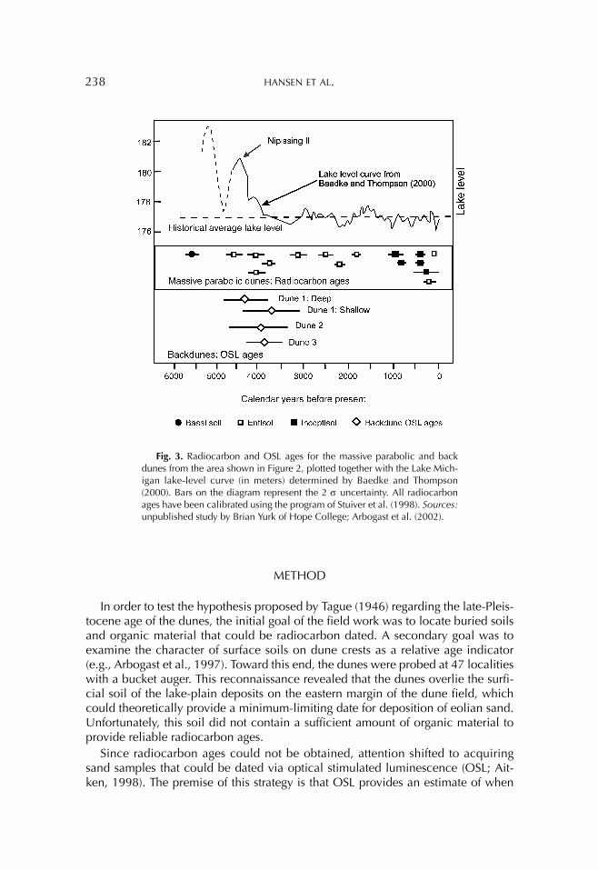
Exceptionally good exposures of dune paleosols occur along the lake front and allowed Arbogast et al. (2002) to reconstruct the geomorphic history of the massive parabolic dunes in the study area through radiocarbon dating (Fig. 3). The basal paleosol is developed on a lake plain and was buried at 5600 cal. yr. B.P., well before the Nipissing II peak in lake levels (Fig. 3). However, radiocarbon ages on higher paleosols indicate that the main phase of dune building did not begin until 4800 cal. yr. B.P., which is roughly coincident with the Nipissing II peak. Subse-quently, a long period of episodic dune growth occurred, which is marked by sev-eral buried Entisols (A/C horizonation) that indicate relatively brief intervals of stability. The positions of these soils suggest that throughout this period there was a progressive increase in relief until the dunes essentially reached their present height. Throughout the massive parabolic complex the deposits of this lower Entisol sequence are capped by a paleo-Inceptisol (A/Bs/C horizonation) that indicates a relatively long period of stability occurred in the dunes following the growth spurt.
Radiocarbon ages on the highest Entisols beneath the Inceptisol suggest that this period of stability may have begun as early as 3000 cal. yr. B.P. in some parts of the complex and as late as 1800 cal. yr. B.P. in others. In many places the Inceptisol was buried during a period of renewed dune growth and migration, which began within the last 1000 years. Through much of their history the massive parabolic dunes have been migrating inland at the same time as they grew vertically. A sequence of paleosols in the interior of one of the massive parabolic dunes (GMB in Fig. 2) indi-cates that over the last 2500 years the nose of the dune has migrated roughly 400 m inland (Brian Yurk, summer research student, Hope College, pers. comm., June 12, 2002). Given this extensive migration the massive dunes have overridden and bur-ied portions of the backdunes in many places (Fig. 2). Although this geomorphic relationship supports the hypothesis that the backdunes are older than the more lakeward massive dunes, it does not provide an absolute chronology for their devel-opment.
238 HANSEN ET AL.
METHOD
In order to test the hypothesis proposed by Tague (1946) regarding the late-Pleis-tocene age of the dunes, the initial goal of the field work was to locate buried soils and organic material that could be radiocarbon dated. A secondary goal was to examine the character of surface soils on dune crests as a relative age indicator (e.g., Arbogast et al., 1997). Toward this end, the dunes were probed at 47 localities with a bucket auger. This reconnaissance revealed that the dunes overlie the surfi-cial soil of the lake-plain deposits on the eastern margin of the dune field, which could theoretically provide a minimum-limiting date for deposition of eolian sand. Unfortunately, this soil did not contain a sufficient amount of organic material to provide reliable radiocarbon ages.
Since radiocarbon ages could not be obtained, attention shifted to acquiring sand samples that could be dated via optical stimulated luminescence (OSL; Ait-ken, 1998). The premise of this strategy is that OSL provides an estimate of when
Fig. 3. Radiocarbon and OSL ages for the massive parabolic and back dunes from the area shown in Figure 2, plotted together with the Lake Mich-igan lake-level curve (in meters) determined by Baedke and Thompson (2000). Bars on the diagram represent the 2 σ uncertainty. All radiocarbon ages have been calibrated using the program of Stuiver et al. (1998). Sources:unpublished study by Brian Yurk of Hope College; Arbogast et al. (2002).

BACKDUNES NEAR LAKE MICHIGAN 239
sand grains were last exposed to light; that is, when those eolian sands were last deposited in the dune. In this context, four OSL ages were acquired from three widely spaced sites (Fig. 2). Separate samples were also obtained from these sites to determine the environmental dose rate. Two samples were obtained from Site 1, with one at a depth of 6 m (to test the age of the deepest deposits) and the other at 1.5 m (to test when the dune stabilized). At the remaining two sites, samples were collected from a depth of 1.5 m. As at Site 1, the upper samples from Sites 2 and 3 provide estimates for dune stabilization. Once the samples were collected, they were sent to the Luminescence Laboratory in Aberystwyth, Wales for processing and age determination.
Preparation of the sand samples for luminescence dating occurred in the labora-tory under subdued red lighting. In order to remove carbonates and organic matter, the samples were treated with hydrocholoric acid (10%vol/vol) and hydrogen per-oxide (6%), respectively. The samples were dry sieved so that the desired grain-size fraction (180–211 æm or 212–249 æm) could be isolated. Subsequently, minerals were separated with heavy liquids (sodium polytungstate) of two densities, 2.63 g cm-3 and 2.70 g cm-3, which removed as many feldspar grains and heavy minerals as possible. Once this separation was accomplished, the mineral fraction of density >2.63 g cm-3 and <2.70 g cm-3 was immersed in 40% hydrofluoric acid (HF) for 60 minutes and was then washed with concentrated hydrochloric acid to remove any fluorides. The etched material was then resieved to extract the >180 æm or >212 æm sand fraction so feldspar contamination was minimized and quartz grains could be isolated for luminescence dating.
The sand samples were dated with the single-aliquot regenerative dose (SAR; Murray and Wintle, 2000) method. This technique uses a test dose to monitor fluc-tuations in luminescence sensitivity, and has provided OSL ages that closely corre-late with calibrated radiocarbon ages for the past 5000 yrs (Murray and Clemmensen, 2001). The quartz grains were attached to 1 cm aluminum discs using a silicone oil spray, which provided each disc with ~1500 grains that collec-tively weighed ~9 mg. The equivalent dose (De) was determined on 24 separate ali-quots for each sample; preheat temperatures ranged from 160–300°C and were held for 10 s. The resulting OSL signals were taken on an automated Ris∅ TL/OSL Reader. Irradiations were performed using the integral 90Sr-9OY beta source. Blue light-emitting diodes (peak emission 470±nm) provided the stimulation while the aliquots were held at 125°C. Resulting signals were detected with an EMI 9635Q photomultiplier tube. In order to exclude the emission of the diodes and to pass the 365 nm OSL peak emission, UV filters (Hoya U-340) were used on the detection system.
Calculation of the environmental dose rate was achieved using thick-source alpha counting on a Daybreak 582 Alpha Counter and beta counting on a Ris GM-25-5 multichannel beta counter. Water content was also measured on these samples, which ranged from 2–4% (wt. of water/wt. of dry sediment). For the calcu-lation of the attenuation in the environmental dose rate, a water content of 5+5% was chosen for all samples. The data for the dose rate and the Des are presented in Table 1.

240 HANSEN ET AL.
Tabl
e 1.
—O
SL D
ata
Sam
ple
loca
lity
Sam
ple
dept
h (m
)α
cou
nt r
ate
(cou
nts/
ks-c
m2 )
K (%
)U
(ppm
)TH
(ppm
)
ßdo
se r
ate
(Gy/
k.y.
)
λdo
se r
ate
(Gy/
k.y.
)
Cos
mic
-ray
dose
rat
e(G
y/k.
y.)
Tota
ldo
se r
ate
(Gy/
k.y.
)D
(Gy)
OSL
age
(Ka)
Dun
e 1
1.5±
0.2
.133
±.0
021.
04±
0.04
0.67
±0.
061.
51±
0.20
.83±
.05
0.38
±0.
020.
17±
0.02
1.39
±0.
065.
16±
0.87
3.72
±0.
65
Dun
e 1
6.0±
0.5
.130
±.0
031.
06±
0.03
0.62
±0.
061.
59±
0.20
.86±
.06
0.39
±0.
020.
10±
0.03
1.35
±0.
075.
88±
0.72
4.34
±0.
57
Dun
e 2
1.5±
0.2
.120
±.0
020.
91±
0.03
0.56
±0.
061.
53±
0.20
.88±
.02
0.34
±0.
020.
17±
0.02
1.25
±0.
064.
99±
0.83
4.99
±0.
83
Dun
e 3
1.5±
0.2
.090
±.0
021.
08±
0.03
0.44
±0.
041.
06±
0.14
.82±
.05
0.35
±0.
020.
17±
0.02
1.35
±0.
065.
21±
0.59
3.87
±0.
47

BACKDUNES NEAR LAKE MICHIGAN 241
RESULTS
Results from this study provide a basic chronology for the development of the backdune complex near Holland, Michigan. Examination of the surface soils on dune crests indicates that they are qualitatively similar and are generally consistent with the Oakville series that is mapped in this part of Allegan County. Texture is fine sand. These soils have a dark (10YR 4/2) A horizon (10YR 4/2) that ranges from 0–~8 cm thick. This horizon overlies a dark yellowish brown (10YR 4/4) BE horizon that is also ~8 cm thick. Underlying the BE horizon is an ~90-cm thick B horizon that grades downward in color from strong brown (7.5YR 5/8) to light yellowish brown (10YR 6/4). The C horizon is also light yellowish brown (7.5YR 5/8). Given the overall similarity in soil texture and apparent development, it appears that all of the backdunes stabilized at about the same time.
OSL ages provide estimates for the last deposition of eolian sand in the back-dunes. The basal sample from Dune 1 provided an OSL age of ~4.3 ± 0.6 ka (Aber-39/2). The upper samples from Dunes 1, 2, and 3 yielded OSL ages of 3.7 ± 0.6 (Aber-39/1), 4.0 ± 0.7 (Aber-39/3), and 3.9 ± 0.5 (Aber-39/4), respectively. All of these ages lie within statistical error of each other, which suggests that eolian sands in the backdunes accumulated more or less in one depositional pulse. The conclusion that the sands were deposited at essentially one interval is supported by the similarity in surface soils that exists in dune crests in the study area.
DISCUSSION
OSL ages on dune sands give the time elapsed since the deposits were last bur-ied. In this case that age should roughly correspond to the time at which the surface of the dunes became stable, presumably because of the growth of vegetation. With respect to the backdunes at Holland, it appears that sand last accumulated ~4 ka. The comparison of this age, radiocarbon ages derived from the massive parabolic dunes that are lakeward (Arbogast et al., 2002), and prehistoric lake level fluctua-tions (Baedke and Thompson, 2000) can be seen in Figure 3.
According to this comparison, it appears that eolian sand last accumulated in the backdunes after the Nipissing high stand and at the same time that the more lake-ward and massive dunes began to grow, suggesting that the entire system was responding in a singular fashion. Both dune complexes were active during and shortly after a relatively rapid, 4 m drop in lake levels from the Nipissing II high stand. This rapid drop in lake levels may have led to the subaerial exposure of large amounts of sand on the beach and nearshore lake floor that was then transported inland by winds blowing off the lake and deposited in a relatively broad zone near the shore. In this scenario, dune building occurred in a manner consistent with the foredune model (Olson, 1958a). Alternatively, large amounts of sand may have been released by the erosion of dune faces by the encroaching lake as the water rose to Nipissing II levels. This sand may have been blown inland and deposited in a broad sheet which was reworked by winds for several hundred years before the dunes were finally stabilized. If this scenario occurred, it is consistent with the

242 HANSEN ET AL.
perched dune model, which has recently been documented on Lake Michigan shore by Loope and Arbogast (2000).
The OSL ages suggest that the backdunes stabilized sometime between ~4 and 3.5 ka. This period correlates with the timing of two significant environmental vari-ables—one regional and another local—that may have promoted stabilization of the backdunes. On a regional level, the onset of backdune stabilization occurred at the beginning of the slightly cooler, wetter period, which followed the mid-Holocene Altithermal period (e.g., Baker et al., 2000). It is possible that this climate change promoted the establishment of vegetation on the dunes, which, in turn, caused their stabilization.
Although regional climate changes may have assisted in the stabilization of the backdunes, it is likely that changes in the local topography, and their effects on winds and sand supply, played an even more important role. The stabilization of the backdunes occurred during a period of rapid growth among the dunes closer to shore. The geometry of the paleosol exposures in the massive parabolic dunes indi-cates that as they grew larger they also began to coalesce to form a semi-continuous coastal ridge (Arbogast et al., 2002). This growing ridge probably acted as a barrier that sheltered the backdunes from the strong winds blowing off the lake. Perhaps most importantly, the massive dunes acted as a sand trap that prevented the move-ment of new sand into the backdune complex as they grew. Given no additional supply of sand, vegetation likely anchored the backdunes quickly. Older models (Dorr and Eschman, 1970) attributed periods of dune growth along the Great Lakes to an increase in sand supply due to decreases in lake levels. More recently it has been suggested that dune growth is also linked to high lake levels as waves under-cut coastal bluffs, causing them to slump and thus exposing the sand which can subsequently be moved up the dune face.
In addition to refining the history of coastal dune development near Holland, this study potentially clarifies the evolution of backdunes along the southeastern shore of Lake Michigan. The backdunes near Holland are similar in shape, size, elevation, extent of soil development and position to the dunes in the Grand Marais Embay-ment, to which Tague (1946) assigned a Calumet and Algonquin (~14,000–10,000 yrs B.P.) age. Results from this study clearly indicate that the backdunes near Hol-land are much younger than the age assigned to dunes in the Grand Marais Embay-ment (Tague, 1946). This suggests that the field criteria once used to assign ages to dunes along the Lake Michigan shoreline are unreliable and that the backdune complexes may, in general, be much younger than previously thought. This in turn means that the backdune landscape is unlikely to contain clues on the nearshore environment during the early history of Lake Michigan.
CONCLUSION
The coastal dune complex southwest of Holland is fairly typical of the coastal dunes along the southeastern shore of Lake Michigan, consisting of massive para-bolic dunes along the shore and smaller backdunes up to 1 km inland. Previous studies have focused on the massive parabolic dunes and indicate that they have grown episodically since the Nipissing II lake stage. The backdunes, in contrast, are

BACKDUNES NEAR LAKE MICHIGAN 243
poorly understood and generally assumed to be landforms that evolved during pro-glacial lake stages Calumet and Algonquin in ancestral Lake Michigan.
This study tested the age hypothesis of the backdunes and their relationship with the massive parabolic dunes through OSL dating and comparison of surface soils on dune crests. Results suggest that the backdunes formed ~4 ka and that all of the dunes stabilized at approximately the same time. Therefore, our study suggests a general model for the history of the dunes in this area. Extensive dune growth in a relatively broad zone along the shore began as a response to the rapid rise and fall of lake levels during Nipissing II. The most active dune growth occurred closest to the shore. As they grew, the nearshore dunes became a barrier which inhibited eolian transportation and deposition farther inland, eventually leading to the stabi-lization of the backdunes. Eolian transport and deposition closer to shore caused the massive parabolic dunes to continue to grow and migrate inland, encroaching on the backdunes.
REFERENCES
Aitken, M. J. (1998) An Introduction to Optical Dating. Oxford, UK: Oxford Univer-sity Press.
Arbogast, A. F., Hansen, E. C., and Loope, W. L. (2001) Geomorphic evolution of the coastal dune landscape along the southeastern shore of Lake Michigan. Abstracts with Programs, Geological Society of America Annual Meeting, Vol. 33, 437.
Arbogast, A. F., Hansen, E. C., and Van Oort, M. D. (2002) Reconstructing the geo-morphic evolution of large coastal dunes along the southeastern shore of Lake Michigan. Geomorphology, Vol. 46, 241–255.
Arbogast, A. F. and Loope, W. L. (1999) Maximum-limiting ages of Lake Michigan coastal dunes: Their correlation with Holocene lake level history. Journal of Great Lakes Research, Vol. 25, 372–382.
Arbogast, A. F., Scull, P., Schaetzl, R. J., Harrison, J., Jameson, T. P., and Crozier, S. (1997) Concurrent stabilization of some interior dune fields in Michigan. Physi-cal Geography, Vol. 18, 63–79.
Baedke, S. J. and Thompson, T. A. (2000) A 4,700-year record of lake level and isostasy for Lake Michigan. Journal of Great Lakes Research, Vol. 26, 416–426.
Baker, R. G., Fredlund, G. G., Mandel, R. D., and Bettis, E. A., III. (2000) Holocene environments of the central Great Plains: Multi-proxy evidence from alluvial sequences, southeastern Nebraska. Quaternary International, Vol. 67, 75–88.
Bauer, B. O. and Sherman, D. J. (1999) Coastal dune dynamics: Problems and pros-pects. In A. S. Goudie, I. Livingstone, and S. Stokes, eds., Aeolian Environments, Sediments and Landforms. New York, NY: Wiley, 71–104.
Buckler, W. R. (1979) Dune Type Inventory and Barrier Dune Classification Study of Michigan's Lake Michigan Shore. Lansing, MI: Michigan Department of Natural Resources, Geological Survey Division Investigation 23.
Cowles, H. C. (1899) The ecological relations of the vegetation of the sand dunes of Lake Michigan. Botanical Gazette, Vol. 27, 95–117.

244 HANSEN ET AL.
Dorr, J. A. and Eschman, D. F. (1970) Geology of Michigan. Ann Arbor, MI: Univer-sity of Michigan Press.
Farrand, W. R. and Bell, D. L. (1982) Quaternary Geology (map) of Southern Mich-igan With Surface Water Drainage Divides, 1:500,000 Scale. Ann Arbor, MI: University of Michigan, Department of Geological Sciences.
Lichter, J. (1995) Lake Michigan beach-ridge and dune development, lake level and variability in regional water balance. Quaternary Research, Vol. 44, 181–189.
Loope, W. L. and Arbogast, A. F. (2000) Dominance of a ~150-year cycle of sand-supply change in Late Holocene dune-building along the eastern shore of Lake Michigan. Quaternary Research, Vol. 54, 414–422.
Loope, W. L., Snyder, F. S., and Anderton, J. B. (1995). Tentative Correlation of Lake Level, Soil Burial and Vegetation Cover in Perched Dune Fields of the Upper Great Lakes: A Preliminary Report. Unpublished Report prepared for the National Park Service (1443PX632092115), Omaha, NE.
Murray, A. S. and Clemmensen, L. (2001) Luminescence dating of Holocene Aeo-lian sand movement, Thy, Denmark. Quaternary Science Reviews, Vol. 20, 751–754.
Murray, A. S. and Wintle, A. G. (2000) Luminescence dating of quartz using an improved single aliquot regenerative-dose protocol. Radiation Measurements, Vol. 32, 57–73.
Michigan Legislature. (1976) Sand Dune Protection and Management Act: Act No. 222, Public Acts of 1976, Lansing, MI.
Michigan Legislature. (1994) Natural Resources and Environmental Protection Act, Parts 353 and 637: Act No. 451, Public Acts of 1994, Lansing, MI.
Olson, J. S. (1958a) Lake Michigan dune development 2: Plants as agents and tools in geomorphology. Journal of Geology, Vol. 66, 343–351.
Olson, J. S. (1958b) Lake Michigan dune development 3. Lake-level, beach and dune oscillations. Journal of Geology, Vol. 66, 473–483.
Puzio, M. C., Larson, G. J., Rieck, R. L., Forstat, D. W. and Sorensen, H. O. (1983) [Selected Geologic Maps of Allegan County, Michigan]. Lansing, MI: State of Michigan, Department of Natural Resources, Geological Survey Division.
Peterson, J. M. and Dersch, E. (1981) A Guide to Sand Dune and Coastal Ecosystem Functional Relationships. Extension Bulletin E-1529, MICHU-SG-81-501.
Santer, R. A. (1993) Geography of Michigan and the Great Lakes Basin. Dubuque, IA: Kendall/Hunt Publishing.
Scott, I. D. (1942) The dunes of Lake Michigan and correlated problems. Annual Report of the Michigan Academy of Science Arts and Letters, Vol. 44, 53–61.
Stuiver, M., Reimer, P. J., Fard, E., Beck, J. W., Burr, G. S., Hughen, K. A., Kromer, B., McCormac, F. G., Plight, J. V. D., and Spurk, M. (1998) INTCAL98 Radiocar-bon age calibration 24,000–0 cal Yr B.P. Radiocarbon, Vol. 40, 104–183.
Tague, G. C. (1946) The post-glacial geology of Grand Marais Embayment, Berrien County, Michigan. Michigan Department of Conservation Publication 45, Geo-logical Series 38, 1–82.
Van Oort, M. D., Arbogast, A. F., Hansen, E. C., and Hansen, B. (2001) Geomorpho-logical history of massive parabolic dunes, Van Buren State Park, Van Buren County, Michigan. Michigan Academician, Vol. 33, 175–188.