Central places and modality environments: An historical architecture of urban places
Upload
khangminh22Category
view
1download
0
Places For EveryoneJoint Development Plan Document – Bolton, Bury, Manchester, Oldham, Rochdale, Salford, Tameside, Trafford, Wigan
Publication Stage
August 2021


ANDY BURNHAM PAUL DENNETT
Mayor of Greater Manchester GM Portfolio Lead Housing, Homelessness and Infrastructure
GMCONSULT.ORG1
Places for Everyone

6Introduction1.
9Places forEveryone:Publication Plan
16Relationship withDistrict LocalPlans
17
Process forProducing thePlaces forEveryone Plan
18How to GetInvolved
21Context2.
25Core GrowthArea
25InternationalConnections
27A Top Global City28HS2
29The NorthernPowerhouse
31Inclusive Growth
35Vision3.
38StrategicObjectives
43Strategy4.44Inclusive Growth46Spatial Strategy
48Core GrowthArea
56Inner AreaRegeneration
58BoostingNorthernCompetitiveness
65SustainingSouthernCompetitiveness
73Main TownCentres
75Strategic GreenInfrastructure
76
A Sustainableand IntegratedTransportNetwork
80
Sustainableand ResilientPlaces
5.
81SustainableDevelopment
82AddressingClimate Change
90Resilience
92Flood Risk andthe WaterEnvironment
94Clean Air
99ResourceEfficiency
103Places forJobs
6.
104
SupportingLong-TermEconomicGrowth
110EmploymentSites andPremises
2GMCONSULT.ORG
Places for Everyone

111OfficeDevelopment
115Industry andWarehousing
124Places forHomes
7.
125Housing Need
126Housing LandSupply
130Distribution ofNew Housing
130Phasing of NewHousing
133Affordability ofNew Housing
134Type, Size andDesign of NewHousing
137HousingDensities
141GreenerPlaces
8.
142ValuingImportantLandscapes
144Our GreenInfrastructureNetwork
161Biodiversity andGeodiversity
164The Green Belt
167SafeguardedLand
171Places forPeople
9.
172PromotingInclusion
173SustainablePlaces
176Heritage178Culture
179Retail andLeisure
181Education, Skillsand Knowledge
183Health
185Sport andRecreation
190ConnectedPlaces
10.
191An IntegratedNetwork
201Public Transport205Our Streets
210
TransportRequirements ofNewDevelopment
216Allocations11.
222Cross-BoundaryStrategicAllocations
254StrategicAllocations inBolton
259StrategicAllocations inBury
GMCONSULT.ORG3
Places for Everyone

272StrategicAllocations inManchester
275StrategicAllocations inOldham
305StrategicAllocations inRochdale
324StrategicAllocations inSalford
338StrategicAllocations inTameside
354StrategicAllocations inTrafford
368StrategicAllocations inWigan
382Delivering thePlan
12.
383Implementation
385InfrastructureStrategy
386Delivering NewInfrastructure
389Monitoring
Appendices
398
ReplacedDistrict LocalPlan Policies
A.
399ReplacedDistrict LocalPlan Policies
408
Additions tothe GreenBelt
B.
409All Additions tothe Green Belt
413Additions to theGreen Belt inBolton
415Additions to theGreen Belt inBury
429Additions to theGreen Belt inOldham
430Additions to theGreen Belt inRochdale
438Additions to theGreen Belt inSalford
443Additions to theGreen Belt inTameside
455Additions to theGreen Belt inTrafford
456Additions to theGreen Belt inWigan
464
Places forEveryonePolicies Map
C.
465Places forEveryonePolicies Map
4GMCONSULT.ORG
Places for Everyone

GMCONSULT.ORG5
Places for Everyone


1.1 In January 2019 Greater Manchester set out bold plans to give people, communities andbusinesses hope and confidence for the future. They described how a pioneering GreaterManchester was ‘open for business’ globally, how we would thrive and prosper into thefuture, how we would support everyone to reach their full potential, and how we would ensurethat nobody was left behind - the Future of GM.
1.2 Collectively our plans are focused on delivering the ambitions in the Greater ManchesterStrategy: a good start in life for everyone; good opportunities for our young people to equipthem for life; good work and the best jobs in a valuable, productive, zero carbon economy;safe, secure housing in inclusive and diverse communities; a good cultural and leisure offerfor everyone; a green city-region; good health and support for people to live fulfilling lives,with quality care for those who need it; to be a good place to grow older and to be a placewhere everyone is connected – socially, digitally and by a clean, integrated and accessibletransport system.
1.3 Those plans have been put into action, delivering:
Significant falls in homelessness An increase in new homes;An economic plan for the city region, agreed with Government in a Local IndustrialStrategy, delivering growth in GM’s world-leading sectors, and tacking low pay andinsecure work through our Good Employment Charter;The delivery of a new Metrolink line, and Opportunity Pass giving young people freebus travel;Help for many people to get back into employment through our Working Well programmesof support;Improvements to connectivity including through promotion of active travel and theextension of full fibre;Programmes to support increased levels of school readiness.
1.4 Since we set out that vision and plans for the Future of GM, Covid-19 has had anunprecedented health and economic impact on the city region as a whole. It has affectedevery person and every business in every part of our boroughs, however the impact hasbeen unequal and unfair, starkly highlighting and deepening the inequalities we know haveexisted for many years and which we were beginning to change. There is now a substantivebody of evidence proving that more deprived areas and our ethnic minority communities areexperiencing higher mortality rates from Covid than other areas and communities.
1.5 The health impacts are ongoing, however the impacts on the economy are only just beginningto be understood. Many more people in our boroughs are now experiencing unemployment,businesses have closed or reduced staff numbers, with far more redundancies and businessclosures anticipated.
1.6 Covid 19 has had a major impact on the way people live and work over the shorter term witha high degree of uncertainty over its impact in the long term. In response the Governmenthas been very clear that we need to positively plan for recovery.The Government first made
GMCONSULT.ORG7
Places for Everyone

commitments to supporting economic recovery in mid-2020, for example with the PrimeMinister's Build, Build, Build announcement at the end of June 2020 setting a context forEngland as we recover from Covid-19.
1.7 Additionally, the Chancellor’s Statement at the beginning of July sought to kick-start the UK’seconomic recovery. A three point Plan for Jobs was unveiled to support, protect and createjobs, with total fiscal support amounting to £30 billion. Since then the Government has madea number of further announcements, committing to supporting the recovery of the economypost-pandemic, including within the Covid-19 Response - Spring 2021 and the March 2021Budget.
1.8 Whilst the arrival of Covid 19 was not anticipated and its impact is very significant, ourapproach needs to be flexible to address unpredictable challenges that will arise over thecourse of any long-term strategy. The Greater Manchester Independent Prosperity Review:One Year On report acknowledges that there is a high degree of uncertainty about the speedand pace of the economic recovery from Covid 19, let alone what the final impact will be,however the chair of the panel, Professor Diane Coyle concludes: “All of us agree withProfessor Ed Glaeser’s crucial observation that now is not the time to lose confidence in thedriving role that major city-regions have always played in improving collective prosperity andin leading national recovery from major traumas.”
1.9 The emergence of a global pandemic in March 2020 rightly resulted in the Greater Manchesterauthorities pausing the production of the then joint development plan, the GMSF 2020, tounderstand what, if any, actions should be taken in relation to the level of development beingproposed. An initial assessment of the potential impacts of Covid-19 on the economy,including the housing market, was carried out prior to the draft GMSF 2020 being consideredby the Greater Manchester authorities. At that time it was considered there was insufficientevidence (either at a national or local level) to change the assumptions behind our growthtargets. An update to that initial assessment has since been carried out to inform theproduction of this Plan and although slightly over a year has passed since the pandemicemerged, the update concluded that there remains insufficient evidence to amend theassumptions behind the growth targets underpinning the Places for Everyone Plan.
1.10 Whilst it is recognised that the country is still in a state of flux, it is very clear that to delaythe production of a strategic plan of this nature further could have a negative effect on theproper planning of the nine boroughs and therefore their recovery. Instead it is consideredappropriate to proceed as a plan of the nine boroughs, excluding Stockport, but to use theprocess of plan review to monitor the situation and if necessary to undertake a formal reviewoutside of statutory review timetable.
1.11 It is vital that we have bold plans, shaping a better future for our communities – building backbetter - rather than a future being shaped by others, building back the same. Covid hasexposed economic and societal issues to address, and the need for a new approach withpeople at its heart, which embraces diversity, tackles inequalities, builds resilience andrebuilds productivity.
8GMCONSULT.ORG
Places for Everyone

A renewed vision
1.12 In these extremely challenging times, the need for bold ambitious plans for good qualityemployment are critical. We are striving to define our new ‘normal’ however we know thatwe need to continue to invest in our city and town centres to drive our recovery. We needto continue to develop our Research and Development capabilities underpinned by ourexcellent academic institutions as well as investing in strengthening existing, and creatingnew, employment locations so that we are all able to contribute to, and benefit from, growthas part of a thriving Northern Powerhouse.
1.13 Jobs are not enough however if our residents lack the skills to take advantage of theopportunities. It is essential we create the conditions for everyone to reach their full potential.We need to both develop a skills offering that meets the needs of employers to supportgrowing innovative businesses as well as support companies and individuals who need towork differently/in different sectors as a result of Covid. Of course, we need to underpin allof this this with quality education, work and skills provision across the Plan area: usingscience and digital to engage people at a young age; developing a clear light of sight toopportunities; guaranteeing opportunities for all young People; and support those furthestfrom the labour market back into work.
1.14 Our vision is to have capitalised on the opportunities highlighted by the recent pandemic,for example the increase in cycling and walking and the acceleration in flexible working, andharnessed this to cement real benefits for our towns and cities.This offers a real opportunityto support the transition of our centres as they experience the continued (and possiblyaccelerated) decline in their traditional retail role. Our boroughs need to be places wherewe can meet the housing needs of our residents, where all of our people can access theservices they require through high quality digital communications. And one of the biggestlessons of the pandemic is the importance of good quality greenspace close to where peoplelive. This is particularly important in our densely populated and deprived neighbourhoods.Urban greenspace is under pressure and needs to be protected and enhanced whereverpossible. The proposals for the first city centre park at Mayfield is leading the way.
1.15 Our ambitions to be carbon neutral by 2038 have never been more necessary – we needto support the creation of resilient, liveable places where walking and cycling are the obviouschoice for shorter journeys, where facilities and services are accessible and close at handand where the past dependency on the car is superseded by a reliable and responsivepublic transport system.
1.16 The Places for Everyone: Publication Plan is our spatial plan to underpin our recovery.
Places for Everyone: Publication Plan
1.17 Up until December 2020 a joint development plan document of the ten Greater Manchesterlocal authorities was being prepared, Greater Manchester’s Plan for Jobs, Homes & theEnvironment (known as the “GMSF”). However, the decision at Stockport Council’s meetingon 3 December to not submit the GMSF 2020 to the Secretary of State for independent
GMCONSULT.ORG9
Places for Everyone

examination following the consultation period, and the subsequent resolution at its Cabinetmeeting on 4 December not to publish the GMSF 2020 for consultation, in effect signalledthe end of the GMSF as a joint plan of the ten.
1.18 S.28(6)-(9) of the Planning and Compulsory Purchase Act 2004 and regulation 32 of theTown and Country Planning Local Plan Regulations apply where one authority withdrawsfrom an agreement to prepare a joint DPD. Together they enable a joint plan to continue toprogress in the event of one of the authorities withdrawing, provided that the plan has“substantially the same effect” on the remaining authorities as the original joint plan.
1.19 Consequently, at its meeting on the 11th December 2020, members of the AGMA ExecutiveCommittee asked officers to report back on the implications and process of producing a jointDPD of the nine remaining Greater Manchester (GM) districts (Bolton, Bury, Manchester,Oldham, Rochdale, Salford, Tameside, Trafford and Wigan). After that meeting, in Februaryand March 2021, each of the nine districts agreed to establish a Joint Committee responsiblefor the preparation of a joint Development Plan Document.
1.20 Producing such a plan would enable the nine districts to continue to:
progress the strategic policies in GMSF 2020, for example net zero carbon development,affordable housing and space and accessibility standards for new housingmaximise the use of sustainable urban/brownfield land and limit the need for Green Beltto accommodate the development needs of the ninealign with wider Greater Manchester strategies for transport and other infrastructureinvestmentutilise the evidence base already commissioned and completed, minimising the cost ofproducing further evidencespread the cost jointly of the independent examination
1.21 The text of the GMSF2020 has been revised following the withdrawal of Stockport. Therevisions to the PfE2021 (as compared to GMSF 2020) fall into 5 broad categories:
i. As a direct result of the withdrawal of Stockport Council from GMSFii. As a direct result of changes to government policy since October 2020iii. As a direct result of new evidence/information being made available since October 2020iv. Clarification of policy wordingv. Minor typographical changes
1.22 The impact of the five different categories of changes above, together with that of theircumulative impact was considered and it was determined that the PfE 2021 would result ina plan which has a substantially the same effect on the participating nine districts as GMSF2020. In this context, it is important to note that, “substantially the same effect” does notmean “the same effect”. It allows for flexibility to address the fact that the plan now coversa different geographical area, with consequently different levels of needs and resultingchanges to allocations.
10GMCONSULT.ORG
Places for Everyone
1.23 The changes made between GMSF 2020 and PfE 2021 are not insignificant in numericalterms, indeed all sections of the plan have seen some form of change. However, indetermining the cumulative impact of these multiple changes, it is important to consider whatimpact they have had on the overall Vision, Objectives and Spatial Strategy of PfE 2021compared to GMSF 2020, particularly for the decision maker in implementation terms.
1.24 The conclusion of the above assessment was that the resultant impact of the changes onthe overall strategy of the joint plan and its effect on the remaining nine districts is limited.On this basis, it has been concluded that the PfE2021 has substantially the same effect onthe nine boroughs as the GMSF 2020.
1.25 The Places for Everyone Plan (PfE 2021) provides an important opportunity to create theconditions for inclusive economic growth, provide opportunities for provision of much neededhomes and protect and enhance the natural environment. The Plan is not being preparedin isolation. It is supported by the Transport 2040 Delivery Plan, which will outline theinterventions required to achieve the transport vision for the city region and is one of a suiteof strategic documents setting out how Greater Manchester can achieve the ambition setout in the Greater Manchester Strategy. It sits alongside the Local Industrial Strategy, HousingStrategy, 5 Year Environment Plan, Digital and Cultural Strategies.
1.26 This is our plan for sustainable growth in the nine boroughs, it:
sets out how they should develop up to the year 2037;identifies the amount of new development that will come forward in terms of housing,offices, and industry and warehousing, and the main areas in which this will be focused;identifies the important environmental assets which will be protected and enhanced;allocates sites for employment and housing outside of the urban area;supports the delivery of key infrastructure, such as transport and utilities;defines a new Green Belt boundary for the nine boroughs.
1.27 The Places for Everyone Plan reinforces our ambition to bring forward brownfield land, itreduces the net loss of Green Belt further from previous versions of the GMSF by reducingthe number of sites being allocated, identifying a Broad Location and provides strongerprotection for our important environmental assets. It enables us to meet our Local HousingNeed, supports increased provision of affordable housing, promotes our new approach totown centres, supports wider strategies around clean air, walking and cycling and underpinsthe ambition to be a carbon neutral city-region by 2038.
Spatial Strategy
1.28 The Places for Everyone spatial strategy seeks to deliver sustainable, inclusive growth. Ithas 4 key spatial elements:
Significant growth in jobs and housing at the core – continuing development in that partof the ‘core growth area’ encompassing the city centre and beyond to the Etihad in the
GMCONSULT.ORG11
Places for Everyone

east, through to the Quays, Trafford Park and Port Salford in the west. The majority ofcommercial employment growth is proposed in this area;Inner Area Regeneration of those parts of Manchester, Salford and Trafford surroundingthe Core Growth Area. Together with the Core Growth Area, around 50% of overallhousing supply is found here;Boosting the competitiveness of the northern districts – addressing the disparities bythe provision of significant new employment opportunities and supporting infrastructureand a commitment that collectively the northern districts meet their own local housingneed;Sustaining the competitiveness of the southern districts – supporting key economicdrivers, for example around Wythenshawe hospital and the Airport and realising theopportunities offered by national infrastructure investment, e.g. HS2, whilst recognisingthe important green infrastructure assets in the area.
Good jobs
1.29 In extremely challenging times, the need for bold ambitious plans for good quality employmentare critical. We are striving to define our new ‘normal’ however we know that we need tocontinue to invest in our city and town centres to drive our recovery. We need to continueto develop our Research and Development capabilities underpinned by our excellent academicinstitutions as well as investing in strengthening existing, and creating new, employmentlocations so that we are all able to contribute to, and benefit from, growth as part of a thrivingNorthern Powerhouse.
1.30 Opportunities for ‘re-shoring’, that is bringing manufacturing activity back to the UK, and theincreasing demand for logistics and warehousing, could lead to opportunities to provide goodemployment opportunities across the Plan area. Meeting market demand for sites andinfrastructure is essential however as all places in the UK will be seeking to capture growthto offset the impact of the economic downturn and the loss of jobs in our current growthsectors.
1.31 Greater Manchester has developed a Local Industrial Strategy, agreed with Government which sets out how the city region will build on its unique strengths and opportunities andcapitalise on the creativity of its people to create a digital-enabled, green city region. Thisplan seeks to support Greater Manchester’s economic ambitions by providing land to meetthe widest range of employment opportunities helping to ensure that Greater Manchesterremains as competitive as possible in uncertain times.
1.32 The majority of new jobs will be in the City Centre and wider Core Growth Area stretchingfrom Port Salford in the west to the Etihad campus in the east as well as around ManchesterAirport. This area encompasses established employment areas such as Trafford Park,locations such as MediaCity which has seen strong growth over more recent times and ourUniversities which are driving growth in world leading research and development.
12GMCONSULT.ORG
Places for Everyone

1.33 Our ambition is to deliver more inclusive growth to benefit all our boroughs.We are currentlynot fully realising the possibilities of our key assets, for example the outstanding researchbase has much greater potential to support business activity and growth across theconurbation. Further improvements in transport connections and skills development arerequired to ensure that everyone can contribute to and share in the benefits of economicactivity, helping to deliver genuinely inclusive growth.
1.34 Through this plan we are looking to create more favourable conditions for growth by providingsites for advanced manufacturing, digital and tech jobs in areas where the urban land supplycannot support the scale or quality of development required. In response to commentsreceived both in 2016 and further in 2019, the amount of employment land identified in thePfE Plan area, up to 2037 has been significantly reduced since the 2016 GMSF (by approx.40%) to keep the release of Green Belt to a minimum and in order that the level ofemployment growth broadly correlates with our new housing requirement for GreaterManchester. Several of the sites are large in scale and will be partially delivered beyond2037. We have also identified a potential growth area in north east Oldham as a BroadLocation rather than an allocation to provide flexibility for the future.
Good homes
1.35 The Greater Manchester Housing Strategy sets out our vision for new homes and seeks toensure that we consistently deliver the right homes in the right places, providing the numberand mix of new homes for our future needs.
1.36 A key objective of the Places for Everyone Plan is to meet our Local Housing Need – usingthe Government’s standard methodology this equates to almost 165,000 homes over theplan period (2021-2037). Government has been very clear that deviation from the standardmethodology can only be justified in ‘exceptional circumstances’. No exceptionalcircumstances have been identified to justify deviation from the standard methodology inthis Plan.
1.37 By working together we have been able to direct development to the most sustainable areas– primarily the city and town centres – and enable most efficient use of our brownfield landsupply.
1.38 The plan sets out an ambition for the boroughs to enable delivery of their share of GreaterManchester's 50,000 additional affordable homes over the plan period as well as arequirement for all homes to meet the nationally described space standards and the‘accessible and adaptable’ standard as set out in Part M of the Building regulations.
Good places
1.39 This Plan sets out our aspirations for our neighbourhoods –inclusive, well designed, resilient,safe and well served by local services. Connection to high quality and well managed greeninfrastructure is key – we are seeking to protect our most valuable green spaces and improvethem by delivering a net gain in biodiversity assets. We are piloting the development of aLocal Nature Recovery Network Strategy with Natural England.
GMCONSULT.ORG13
Places for Everyone

1.40 As part of this work we have identified our most important ‘Green Infrastructure’ – for exampleour parks, open spaces, trees, woodlands, rivers and canals which provide multiple benefitsand make a huge contribution to quality of life, promote good mental and physical healthand supports economic growth. Our strategic Green Infrastructure network is extensive.Around 60% is within the Green Belt and therefore is afforded significant policy protection.The remaining 40% does not meet the tests of Green Belt but it is very important for thecontinued wellbeing of our boroughs.
Brownfield preference
1.41 As part of this consultation we are being as transparent as possible about the land we haveidentified within the urban area. The land supply position for the nine districts is publishedalongside this consultation. Districts have looked to maximise the contribution of brownfieldland by applying higher densities in the most accessible locations, reviewing the employmentland supply and seeking to identify more opportunities in our town centres. By workingtogether the nine districts have been able to maximise the supply of the brownfield land atthe core of the conurbation and limit the need extent of Green Belt release.
1.42 The majority of development between 2021 and 2037 (the "plan period") will be on landwithin the urban area, most of which is brownfield land. Within the plan period around 90%of housing, 99% of offices and 47% of industrial and warehousing development is within theurban area.
1.43 National planning policy does not support an explicit ‘brownfield first’ approach, as LocalAuthorities are required to be able to provide a 5 year supply of housing sites which areavailable and deliverable. If we cannot demonstrate that our brownfield land is available andthen we are required to identify other land which is – this may be Protected Open Land orGreen Belt.
1.44 We are however adopting a ‘brownfield preference’ policy – we will do all that we can tomake sure that our brownfield sites come forward in the early part of the plan period howeverto do this we need to continue to press Government for support to remediate contaminatedland, to provide funding for infrastructure and to support alternative models of housingdelivery.
1.45 Our Strategic Viability Study identifies challenges with a significant proportion of our landsupply and this is acknowledged within the plan by the provision of a land supply ‘buffer’.The recently announced Brownfield Land Fund is targeted at Combined Authorities andbegins to help to address viability issues across the conurbation, but it is not enough. Weare bidding for more funding but further discussions with Government are critical to enablethe full potential of our brownfield land supply to be realised.
1.46 The plan supports the continuing renewal of our town centres, with an increase in the supplyof land identified for housing. Our strategic approach to town centres is complemented byinitiatives co-ordinated by the GMCA. Government has also recognised the need to strengthenthe role of town centres and several of our towns have been successful in accessing fundingthrough the Future High Street Fund and Towns Fund.
14GMCONSULT.ORG
Places for Everyone

Green Belt
1.47 Given the lack of sufficient land to ensure that our overall housing and employment needscan be met, it is considered that there is a strategic exceptional circumstances case to bemade to release Green Belt for development. However, this release has been kept to theminimum and has been done in locations which will help to meet our overall vision andobjectives. The strategic case and the detailed case for each strategic allocation is set outin the ‘The Green Belt Topic Paper’.
1.48 The release of Green Belt has not been proposed lightly and evidence has been preparedto demonstrate how the harm that this could cause to the remaining Green Belt land can bemitigated, including identifying opportunities to improve and enhance green infrastructurewithin the remaining Green Belt land. We are also proposing to add new Green Belt wherewe have identified land that meets the purposes of Green Belt. These proposals have beenincorporated into the Places for Everyone Plan as part of the overall proposals.
Net loss
1.49 The net loss of Green Belt has been reduced by nearly 60% since 2016 through:
reducing the number of proposed sitesreducing the loss of Green Belt within sites proposing ‘new’ Green Belt additions
1.50 The net amount of Green Belt land proposed for release is 1,754 hectares – in relation tothe nine districts preparing this Plan, this means a 3.3% reduction in the size of the GreenBelt compared to an 8.1% reduction in 2016.
1.51 The nine boroughs cover some 115,084 hectares, almost half (46.7%) is designated asGreen Belt. The proposals in the Places for Everyone: Publication Plan 2021 would resultin Green Belt covering just over 45% of the nine districts.
Becoming Carbon Neutral by 2038
1.52 This Plan sets out proposals to support the Greater Manchester ambition to be a carbonneutral city-region by 2038. A key element of this is to require all new development to benet zero carbon by 2028 at the latest – we do not want to build homes and workplaces whichrequire retrofitting in the future and we have set an ambitious target, backed up by ourevidence to achieve this as soon possible. Our commitment to keep fossil fuels in the groundremains, at this time therefore we will not support fracking.
GMCONSULT.ORG15
Places for Everyone

Infrastructure required to support scale and pattern of growth
1.53 Many of the responses raised the issue of the impact of new development on existinginfrastructure. As the majority of new development will be in the urban area, the capacity ofthe existing infrastructure is particularly important. We have looked at the major challengesthat we consider our existing infrastructure networks will have to respond to and haveproduced an Infrastructure Framework setting this out.
1.54 Since the 2019 GMSF consultation we have undertaken significant work on our transportevidence base, both in relation to the urban area and the strategic allocations. A refreshedGreater Manchester Transport Strategy 2040, Our Five Year Transport Delivery Plan(2020-2025) and Local Implementation Plans are published alongside this Plan. Our TransportDelivery Plan sets out all the transport projects we hope to achieve in the next five years toensure that the planned new housing and employment can be sustainably integrated intoGreater Manchester’s existing transport infrastructure as far as possible. We have anunparalleled track record in delivery of transport projects, and a large number of projectsare identified for delivery in the next five years, including Metrolink capacity improvementsthrough the introduction of 27 new trams; better rail infrastructure including on the Castlefieldcorridor, Transpennine Route Upgrade to Leeds and ‘Access for All’ station improvements;bus network and town centre improvements; new walking and cycling infrastructure acrossall ten districts; expanding the city-region’s electric vehicle charging network; and developmentof the Clean Air Plan.
1.55 Our Transport Delivery Plan also sets out how we plan to deliver our longer-term aspirationsfor an integrated transport network that supports future growth. It includes, amongst otherthings, plans for improved orbital public transport links, capacity enhancements to the railand metrolink networks, clean air measures, transformative investment in walking and cycling,and reform of the bus market and rail franchising. All of these will contribute to our carbonreduction goals and delivery of our transport vision.
1.56 The detailed policies for site allocations and the thematic policies for new development,together, set out the necessary infrastructure requirements and sites will not come forwardunless it can be demonstrated this will be provided. Proposals for new Metrolink stops,improved walking and cycling connections, and new or improved public transport services,all form part of the package for the allocations – which, when combined with the investmentproposals flagged in Our Transport Delivery Plan, will enable a significant change in thesustainability of the transport network.
Relationship with District Local Plans
1.57 The Places for Everyone Plan is the strategic spatial plan for our nine boroughs and assuch sets out our planning policy framework. All policies within the plan are "strategic policies".It is being prepared as a Joint Development Plan Document of the nine local planningauthorities. It is a strategic plan and does not cover everything that a district local plan would.
16GMCONSULT.ORG
Places for Everyone

Districts will continue to produce their own Local Plans setting out more detailed policiesreflecting local circumstances. Appendix A sets out the policies in the relevant GM districtlocal plans which will be replaced by the Places for Everyone Plan.
1.58 Once the Places for Everyone Plan is adopted it will form part of the relevant authority’sdevelopment plan.The evidence that underpins the Places for Everyone Plan will also informdistrict level plans.
Process for Producing the Places for Everyone Plan
1.59 The Places for Everyone Plan began life as a joint Development Plan Document of the tenGreater Manchester districts. Following a recommendation from AGMA Executive Board inNovember 2014, the 10 Local Planning Authorities in Greater Manchester (Bolton, Bury,Manchester, Oldham, Rochdale, Salford, Stockport, Tameside, Trafford and Wigan) agreedto prepare a joint Development Plan Document to set out the approach to housing andemployment land across Greater Manchester for the next 20 years.
1.60 Four consultations have taken place in relation to the GMSF. The first, in November 2014was on the scope of the plan and our initial evidence base, the second in November 2015,was on the vision, strategy and strategic growth options, and the third, on a Draft Plan inOctober 2016.
1.61 The fourth and most recent consultation on The Greater Manchester Plan for Homes, Jobsand the Environment: the Greater Manchester Spatial Framework Revised Draft 2019 (GMSF2019) took place in 2019. It received over 17,000 responses. The responses receivedinformed the production of GMSF 2020. The withdrawal of Stockport Council in December2020 prevented GMSF 2020 proceeding to Regulation 19 Publication stage and insteadwork was undertaken to prepare PfE 2021.
1.62 Where a local planning authority withdraws from a joint plan and that plan continues to havesubstantially the same effect as the original joint plan on the remaining authorities, s28(7)of the Planning and Compulsory Purchase Act 2004 provides that any step taken in relationto the plan must be treated as a step taken by the remaining authorities for the purposes ofthe joint plan. On this basis, it is proposed to proceed directly to Publication stage underRegulation 19 of the Town and Country Planning (Local Planning) England Regulations2012.
1.63 At this stage, whilst anyone can make a representation on any point, only those pertainingto ‘soundness’ will be taken into account by the Inspector(s). The term 'sound' is used todescribe a Local Plan that has been prepared in accordance with what Government expectsof local planning authorities. These expectations are set out in paragraph 35 of the NationalPlanning Policy Framework:
"Positively prepared - the plan should be prepared based on a strategy which seeks tomeet objectively assessed development and infrastructure requirements, includingunmet requirements from neighbouring authorities where it is reasonable to do so andconsistent with achieving sustainable development". This means that the nine councils
GMCONSULT.ORG17
Places for Everyone

must produce a plan which promotes economic growth and makes provision forthe homes, employment and infrastructure which it determines is needed."Justified - the plan should be an appropriate strategy, when considered against thereasonable alternatives, based on proportionate evidence". This means that the ninecouncils must have considered other policies and determined its approach basedupon the most up to date and robust evidence including population figures,economic forecasts, Strategic Housing Market Assessment, land availability etc."Effective - the plan should be deliverable over its period and based on effective jointworking on cross-boundary strategic priorities". This means that the nine councilsmust be confident that the policies within the Plan can be achieved within thePlan period (2021 to 2037).The nine councils must also work with neighbouringauthorities such as Stockport, Rossendale, Cheshire East, Warrington andDerbyshire."Consistent with national policy - the plan should enable the delivery of sustainabledevelopment in accordance with the policies within the National Planning PolicyFramework". The National Planning Policy Framework sets out the Government'spolicies for planning in England. Policies within the Places for Everyone Planmust not conflict with these policies.
Submissions will also be considered by the Inspectors appointed to carry out the independentExamination in Public, concerning legal compliance issues, for example the Integrated Assessment,the Habitats Assessment Regulation and the Duty to Co-operate.
1.64 At the end of the consultation period, the draft joint DPD and all representations receivedare then sent to the Secretary of State (the “Submission stage”) pursuant to Reg. 22 of theLocal Planning Regulations. Submission is likely to happen in summer 2021. The Secretaryof State will pass these on to the Planning Inspectorate who will arrange an Examinationinto the plan.
How to Get Involved
1.65 The consultation will run for 8 weeks, beginning in August 2021.
1.66 The consultation portal gmconsult.org will become live at the beginning of the consultation.
1.67 All responses will be forwarded electronically for consideration at the Examination in Public(EiP). The easiest way to respond is online. This is easy to do via our online portal.You canaccess the online consultation at gmconsult.org. once the consultation has formally begun.This will help all of us to stay safer both in terms of responding but also when staff arehandling the responses. However, we know that some people will not be able to respondvia the portal. Therefore, details of how to respond by email or post will be madeavailable. Please note that personal details of those making representations, including nameand contact information must be published and shared with the Programme Officer andPlanning Inspectorate for those that wish their representations to be considered through the
18GMCONSULT.ORG
Places for Everyone

Examination in Public process. A full privacy notice is available, explaining how your datawill be shared. It is strongly advised that this is read before submitting any representationto this Plan.
1.68 If you have any questions about the process, how to access the documents or how to respondwhen the consultation opens, you can [email protected] or leave a message on the followingnumber 0161 778 7006 and someone will get back to you.
GMCONSULT.ORG19
Places for Everyone

GMCONSULT.ORG20
Places for Everyone


Our Plan Area
2.1 As part of Greater Manchester we have a long and proud history. Greater Manchesterbecame the world’s first industrial city, when its position as the global hub for textilemanufacturing led to rapid urbanisation and numerous technological innovations, includingthe world’s first steam passenger railway. It has also been at the forefront of hugely influentialsocial and political movements, being the birthplace of both the modern cooperative movementand the suffragettes, as well as leading the campaign to repeal the Corn Laws in thenineteenth century which ushered in the start of the modern global economy. England's firstcivic university, the University of Manchester, was established in the city-region and the areais now home to four universities that play a leading role in social and economic progress.
2.2 Today, Greater Manchester is a vibrant, dynamic and diverse city-region, which continuesto play an important role in the economic and social fabric of the country and the wider world.
2.3 Our Plan area covers nine of the ten Greater Manchester local authority areas: of Bolton,Bury, Manchester, Oldham, Rochdale, Salford, Tameside, Trafford and Wigan. It is locatedat the heart of the UK, with easy access to all its constituent nations and is only a shortdistance from other major cities such as Leeds and Liverpool. Manchester Airport is the UK'sthird largest airport, London is only two hours away by rail, and there are also direct railconnections to other major cities of the North of England. Greater Manchester has goodmotorway infrastructure providing links across the country.
22GMCONSULT.ORG
Places for Everyone

Figure 2.1 The Places for Everyone Plan boundary within the Greater Manchester context
2.4 Greater Manchester is home to around 2.8 million people, and has seen an increase ofalmost 200,000 residents in the last decade alone(1). The population of the nine districts inPfE 2021 is approximately 2.5 million, having grown by almost 185,000 in a decade. Thepopulation of Greater Manchester is forecast to have grown by around another 190,000people by 2037 (of which just over 170,000 will be within the nine districts making up thePfE Plan area). This growth, in turn, will contribute to a significant increase in households.69% of the population growth is expected to be in those aged 65 and over, and approximately40% of the growth will be amongst those aged 75 and over. Growth in the working agepopulation (18-64) will be lower (approximately 40% of the total growth), but still significantat around 75,000. This concentration of growth is likely to continue in the future, withManchester, Salford and Rochdale forecast to account for around 47% of GreaterManchester's population growth over the period up to 2037 or just over 50% of the populationgrowth in the PfE Plan area.
1 ONS 2019-midyear estimates Population estimates for the UK, England and Wales, Scotland and Northern Ireland - Office for National Statistics(ons.gov.uk)
GMCONSULT.ORG23
Places for Everyone

2.5 Greater Manchester is one of the most economically diverse conurbations in the UK.(2) It isthe main driver of the Northern economy, generating nearly 40% of total output (GVA) in theNorth West and almost 20% across the North of England, of which the districts in the PfEPlan area contribute nearly 90%.
2.6 Around 1.5 million jobs are provided within Greater Manchester (with just under 1.4 millionwithin the PfE Plan area), with considerable growth over the last few decades in servicesector employment such as professional services and administration. There has been aconsiderable reduction in manufacturing jobs, but this sector continues to be one of the mostproductive in Greater Manchester. The baseline economic forecast foresees an increase ofaround 100,000 jobs by 2037 (of which approximately 90% is forecast to be within the PfEPlan area). Similar changes in the sectoral mix to the recent past are forecast, although amore ambitious accelerated growth scenario estimates an increase of just over 170,000 jobsacross Greater Manchester. Employment opportunities are unevenly dispersed acrossGreater Manchester, with by far the most significant concentration currently being in the CityCentre and adjoining areas such as Salford Quays, which collectively account for around20% of all jobs. Baseline economic trends(3) suggest the majority of the employment growthwould be in Salford, Manchester and Trafford. The remaining districts would see onlymodest change in employment in the period 2020-37, with some districts (Oldham, Rochdale,Tameside and Wigan) seeing small decreases in total employment in this period.
2.7 There are two significant challenges which will impact our districts over the coming years:the exit of the UK from the European Union and the Covid-19 pandemic.There are significantuncertainties over future trade and customs arrangements, the level and type of internationalmigration, future exchange rate movements and the impacts that all of this could have forbusiness investment, job creation and labour supply as a result of the UK exit from theEuropean Union.
2.8 As set out in the Independent Prosperity Review, ’One Year On’ report, the COVID-19pandemic has significantly added to the uncertainty: “At the time of writing, there remains ahigh degree of uncertainty about the speed and pace of the economic recovery fromCOVID-19, let alone what the final impact will be. There have been a succession ofassessments of the likely impact of COVID-19 on the UK economy by a range of privateforecasting consultancy, research firms and think tanks such as the Institute for Fiscal Studies(IFS) and National Institute of Economic and Social Research (NIESR), and by the Bank ofEngland and by the Office of Budget Responsibility (OBR). All those attempting anyassessment of likely economic effects emphasise the extraordinary level of uncertainty atpresent. The normal forecasting tools and models are not well designed to assess a shocklike COVID-19. This stems from the fact that this is a health-driven economic shock whichis unlike previous economic shocks (such as the 2008 Great Financial Crisis) so we cannotsimply apply the lessons from previous recessions.The OBR summarises these uncertaintiesas being:
The course of the pandemic and the development of effective vaccines and treatments
2 ONS (2016) Krugman Specialisation Index3 GMFM 2018
24GMCONSULT.ORG
Places for Everyone

The speed and consistency with which the government can lift public health restrictions(ie “lockdown” measures) The response of individuals and businesses as it does so (in terms of consumerconfidence etc), and The effectiveness of the policy measures put in place to protect viable businesses,foster new opportunities and sustain employment.”
2.9 However, Professor Diane Coyle, Chair of the Independent Prosperity Review Panelconcludes; “All of us agree with Professor Ed Glaeser’s crucial observation that now is notthe time to lose confidence in the driving role that major city-regions have always played inimproving collective prosperity and in leading national recovery from major traumas."
Core Growth Area
2.10 This covers the City Centre and the Quays and extends eastwards to include Central Parkand the Etihad campus, and westwards through Trafford Park which is one of Europe’slargest industrial estates. This area provides a huge scale and diversity of economicopportunity, which is accessible from across the Plan area and beyond.
2.11 The Core Growth Area offers the conditions to boost the role of Greater Manchester as aGlobal City. It is the home of many global businesses and continues to attract high profilecompanies seeking to invest. Conditions for growth are in place, with high rates of productivity,innovation and global competitiveness. The Core Growth Area offers businesses, residentsand visitors access to a highly skilled population, a wide range of premises andaccommodation, digital infrastructure, excellent accessibility, a high quality environment,cultural and retail opportunities.
2.12 The growth potential of the Core Growth Area will continue through higher densitydevelopment, building in opportunity areas, The Oxford Road Corridor, the existing officesectors, HS2 station proposals and improving the connections to other areas of GreaterManchester, which will all assist growth within our boroughs. However, it will be particularlyimportant that it has outstanding local and global connections supporting its wider reach.
2.13 The universities and the knowledge economy are other important assets for us, with a highconcentration of students, research activity and scientific institutions.This activity is primarilyfocused within the City Centre, with The Oxford Road Corridor being an internationallyimportant location in this regard. Our strong cultural identity is another distinguishing factor,with a global reputation for sports and the arts. Once again, the greatest concentration iswithin and around the Core Growth Area, but importantly it is also seen across the rest ofour boroughs with a diverse range of identities and activities.
International Connections
2.14 Manchester Airport is the third busiest passenger airport in the UK, and the largest outsideLondon, handling c. 28 million passengers in 2019 and adding £1.4bn GVA to the regionaleconomy and supporting c. 25,000 jobs on-site. It is the only airport in the country other thanHeathrow to have two full length runways, but with the key advantage of having significant
GMCONSULT.ORG25
Places for Everyone

spare capacity, and the potential to grow to some 55 million passengers a year. Uniqueamong non-London airports, it has the infrastructure, connectivity and scale to sustain agrowing network of medium and long-haul routes. This enables northern Britain to benefitfrom a major international air gateway for both business and leisure traffic, passengers andfreight. This is a vitally important role not just for us but also for a much wider area acrossthe North and Midlands, enabling businesses and residents to access opportunities acrossthe globe and providing a key access point for international visitors to the UK. The airportis a key factor in realising the wider growth agenda for the North and unlocking the economicpotential of cities and regions within its catchment area with approximately 22 million peopleliving within two hours of it. More locally, the emerging Airport City development (part of theGreater Manchester Enterprise Zone) is creating a major new economic asset, attractingglobal occupiers and investment attracted by the unrivalled connectivity.
2.15 Excellent international freight connections will also support our global role, enabling thelarge-scale import and export of goods and components.The Manchester Ship Canal providesa direct shipping route from Greater Manchester to the Port of Liverpool, where post-Panamaxfacilities can accommodate the largest container vessels from around the world. Port Salfordwill provide an integrated tri-modal facility on the ship canal, with excellent rail and roadlinks, enabling the benefits of easy port access. This will be complemented by maintainingand enhancing freight connections to other major ports by rail and motorway, including theHumber ports, Felixstowe, London Gateway and Southampton.
2.16 This Plan seeks to enhance and take advantage of these outstanding internationalconnections, supporting our long-term growth and the ability of residents to share in itsbenefits. We are therefore ideally placed to help drive growth in the North of England, andhelp provide a balance to the strength of London and the South East. However, this will notonly require an appropriate scale and distribution of development and infrastructure investmentwithin our boroughs, but also major improvements in transport connections to other parts ofthe North, including Northern Powerhouse Rail and motorway network enhancements.
26GMCONSULT.ORG
Places for Everyone

Figure 2.2 A Global City
A Top Global City
2.17 By the end of the Plan period, Greater Manchester aims to be a top global city.(4) To do thisit will require a range of attributes, including a strong economy, skilled residents, a highquality of place and the environment, and a diverse portfolio of investment and developmentopportunities. Through this plan we can play a vital role in delivering Greater Manchester'sambition of becoming a top global city.
2.18 Having a stronger international outlook will be an essential aspect of this. As part of GreaterManchester we will be a key gateway into and out of the UK, trading across the world. It willbe capable of competing internationally for investors, visitors, businesses, skilled workers,academic talent and students. At the same time, ensuring that the resident population cantake advantage of the associated opportunities will be a high priority. Supporting growth inhigh value activity in sectors and on assets that are, or have the potential to be, world-leadingand globally distinctive is a key part of Greater Manchester's Local Industrial Strategy.
4 GMCA, The Manchester Growth Company and Greater Manchester Local Enterprise Partnership (2017) The Greater ManchesterInternationalisation Strategy 2017-2020 GMCA, Our People, Our Place: Greater Manchester Strategy (2017)
GMCONSULT.ORG27
Places for Everyone

2.19 If Greater Manchester can realise its ambition to be a top global city then this would put theUK in the enviable position of having two global cities within 200 miles of each other. Londonis already established as one of the most successful cities in the world, often appearing inthe top two in international indices along with New York. Both Greater Manchester andLondon acting as global cities could be hugely beneficial for the national economy, providingan outstanding scale, diversity and quality of activity. Maximising connections between thetwo will be vital to realising this potential, offering additional agglomeration economies.
2.20 At the same time, it will be important to maintain the distinctiveness and independence ofGreater Manchester and avoid it being seen as a satellite of London. Greater Manchesterwill be a different type of global city to London, smaller and more affordable, retaining itsinnovative character and with a strong emphasis on inclusion and quality of place. The factthat it can offer a more cost-effective option to London in a high quality environment,complementing the capital and regional cities, will help it to attract investment that wouldotherwise not come to the UK.
2.21 Greater Manchester has agreed a Local Industrial Strategy with Government. The LocalIndustrial Strategy has two key objectives:
Supporting our globally competitive strengths - Building on our globally competitiveresearch strengths and emerging industrial opportunities, enabling us to pioneer emergingsectors, create significant global competence and add value to our local economy asnew sectors grow and flourish.Strengthening the foundations of our economy - Strengthening our people,infrastructure, business environment, innovation ecosystems and places, enabling allsectors and all places in Greater Manchester to be productive and prosperous.
2.22 We need to grasp global opportunities emerging from changes to world markets and developindustries of the future, while also ensuring competitiveness and job quality in our highemployment, low productivity sectors.
HS2
2.23 Greater Manchester currently benefits from good links to London, with a number of directrail routes taking around two hours. The proposed HS2 high-speed rail connections willreduce journey times to London to 67 minutes from the City Centre and just over an hourfrom Manchester Airport.They would also bring the major regional city of Birmingham within41 minutes by train. These enhanced connections will help to deliver a more integratednational economy, opening up much greater business opportunities to support UK growth.The timely delivery of HS2 will have major benefits for the Country as a whole as well as forGreater Manchester. The benefits of HS2 are multiplied when combined with NorthernPowerhouse Rail (NPR) and other committed investments in our rail networks. To capitaliseon the opportunity, Greater Manchester is proposing a series of complementary investmentsto bring maximum benefits from high speed rail to residents. The Greater Manchester HS2and Northern Powerhouse Rail Growth Strategy – The Stops Are Just The Start sets outour proposals for local infrastructure investment to support the HS2 and NPR facilities which
28GMCONSULT.ORG
Places for Everyone

will embed them within our wider strategic plans, ensuring that people are well connectedto the new homes and job opportunities that these investments offer and delivering the righttraining and skills to empower the next generation to continue to make our city-regionsuccessful.
The Northern Powerhouse
2.24 The concept of the Northern Powerhouse is central to the overall strategy for delivering moreeven and inclusive growth across the UK, counterbalancing the dominance of London andthe South East. The Government has described the Northern Powerhouse as “a vision forjoining up the North’s great towns, cities and counties, pooling their strengths, and tacklingmajor barriers to productivity to unleash the full economic potential of the North”.(5)
2.25 The strength and strategic location of Greater Manchester puts it in an ideal place to act asthe primary driver for the Northern Powerhouse. Equally, Greater Manchester would benefitsignificantly from nearby locations in the North being more economically prosperous, as thiswould provide access to a wider range and diversity of businesses opportunities and to aneven larger pool of skilled labour. Hence it will be important to deliver relatively high levelsof growth across the Plan area for the wider benefit of the North.
5 HM Government (November 2016) Northern Powerhouse strategy
GMCONSULT.ORG29
Places for Everyone

Figure 2.3 Geography of jobs across the Northern Powerhouse (source: Centre for Cities (June 2015) NorthernPowerhouse factsheet: Key figures on the city regions in the Northern Powerhouse, p.5)
2.26 Improving connections between Greater Manchester and other parts of the North, and toother areas such as the Midlands, will be central to delivering the vision for the NorthernPowerhouse. Transport for the North published their Strategic Transport Plan in February2019. The Plan seeks to enable the North to achieve its full potential and is an opportunityto address decades of under investment and provide a legacy for future generations. Thefundamental challenge for the North’s economy is to improve the economic interactionbetween the key economic assets and clusters of the North to improve the sharing ofknowledge, supply chains, resources, and innovation to drive agglomeration benefits andproductivity. The major northern cities of Liverpool, Leeds and Sheffield are within 40 milesof Greater Manchester, as are other significant settlements such as Bradford, Preston,Warrington, Chester and Stoke-on-Trent. At present connectivity between the North’s townsand cities, and beyond, restricts growth and opportunities. Commuting between Manchesterand Leeds is 40% lower than expected when compared to city pairs that are similar distances
30GMCONSULT.ORG
Places for Everyone

apart in the UK. Better transport connectivity increases the physical proximity of firms, workersand consumers and concentrates economic activity in clusters. Improving transportconnections between the North’s cities, towns, economic centres, infrastructure and assetsallows for greater opportunities for employment, collaboration and knowledge sharing.Importantly, it would also enable other parts of the North to take advantage of GreaterManchester’s key assets and its role as a key international gateway and emerging top globalcity, connecting more people to Manchester Airport and the proposed HS2 services toLondon.
2.27 The Northern Powerhouse Rail proposals will dramatically improve journey times to 30minutes or less from the City Centre and Manchester Airport to Liverpool, Leeds and Sheffield,through a combination of new and improved lines. This will bring these surrounding majorcities within an easy commuting time of Greater Manchester. The M62 motorway is alreadyan important east-west spine within the North, connecting Greater Manchester with Leedsand Liverpool, and further east through to Hull and the Humber ports. The ongoing NorthWest Quadrant Study will identify how capacity, journey times and reliability can be improvedon the M62/M60 around Greater Manchester, further aiding the integration with Leeds andLiverpool. The proposed Trans Pennine Tunnel has the potential to deliver similar benefitsfor road transport between Greater Manchester and Sheffield. In the southern part of GreaterManchester, the study at the Airport around the M56 and the proposed study of the M60corridor in the south-east will also be key.These transport schemes will play a very importantrole in realising the potential of our boroughs, Greater Manchester, as a whole, and the widerNorth.
2.28 As part of Greater Manchester, we are therefore ideally placed to drive growth in the Northof England, and help provide a balance to the strength of London and the South East.However, this will not only require an appropriate scale and distribution of development andinfrastructure investment within our boroughs, but also major improvements in transportconnections to other parts of the North, including Northern Powerhouse Rail and motorwaynetwork enhancements.
Inclusive Growth
2.29 Over recent years, growth across the Plan area has been concentrated in the three localauthority areas of Manchester, Salford and Trafford. For example, over the period 2001-2016,they accounted for two-thirds of the growth in population, employment and economic activity(measured by GVA) in Greater Manchester.(6) Population increased by around 20% acrossManchester, Salford and Trafford over that period compared to just over 6% across theremaining six districts (combined) of the PfE Plan area, although this contrasts with thepreceding half century when Manchester and Salford lost well over one-third of theirpopulation.(7) This concentration of growth is likely to continue in the future, with Manchester,Salford and Trafford forecast to account for 45% of population growth over the period
6 ONS mid-year population estimates, and Greater Manchester Forecasting Model 20187 GB Historical GIS / University of Portsmouth, Bolton District through time | Population Statistics | Total Population, A Vision of Britain through
Time, 1951-2001
GMCONSULT.ORG31
Places for Everyone
2020-2037, around 60% of GVA growth, and 90% of the increase in employment.(8) Thiswould consolidate the concentration of growth in the central and southern areas of GreaterManchester.
2.30 Picture 2.2 '2019 Index of Multiple Deprivation', produced by the Government, with thedarkest colours showing the most deprived areas. It indicates high levels of deprivationacross many parts of the Plan area, including those areas that have seen a concentrationof growth over recent years and in parts of otherwise affluent boroughs.There is a particularlyhigh concentration of deprivation in the central areas, with Manchester the second mostdeprived local authority area in England on two measures.(9)
Picture 2.2 2019 Index of Multiple Deprivation
8 ONS 2018-based sub-national population projections, and Greater Manchester Forecasting Model 20189 Measured by the ‘rank of ranks’, where each local authority is ranked for each of the seven domains of the index, and then an average rank is
produced
32GMCONSULT.ORG
Places for Everyone

2.31 An analysis by the Office for National Statistics of over 100 towns and cities in England andWales identified Oldham, Salford and Rochdale amongst some of the most deprived areasin the country.(10) When a broad range of socio-economic measures are considered, suchas levels of economic activity, qualifications, occupation, household incomes, house prices,poor health, population change and housing development, in overall terms the northernareas of Greater Manchester excluding Bury (Wigan, Bolton, Rochdale, Oldham andTameside) perform significantly worse overall than the southern areas.
2.32 Although both the central areas and the northern parts of Greater Manchester suffer fromhigh levels of deprivation, there are differences between them in terms of how this manifestsand the development pressures that they face. The inner areas surrounding the City Centreand the Quays have seen much higher levels of recent population growth, being a key focusfor inward international migration. Just 22 wards in that area (out of a total of 215 wards inGreater Manchester) accounted for two-thirds of the increase in residents aged under 18 inGreater Manchester over the period 2002-2016, and the area saw an increase of one-thirdin those aged 30-44 whereas the sub-region as a whole had a reduction in that age group.The number of people aged 65 and over declined in this inner area, whereas the six northerndistricts had a one-quarter increase.(11)
Key challenges for the Places for Everyone Plan
2.33 In light of these issues, the PfE Plan will need to:
Deliver high levels of economic growth to support the prosperity of Greater Manchester,whilst ensuring that all parts of our boroughs and all our residents share in the benefits;Deliver the highest possible quality of life for all our residents, and address existingproblems such as health disparities and air quality that currently detract from it.
10 Office for National Statistics (March 2016) Towns and cities analysis, England and Wales, March 2016, p.18 – based on the proportion of lowersuper output areas in the most deprived 20% in England and Wales, using the 2015 Index of Multiple Deprivation
11 ONS: Ward-level population estimates (Experimental Statistics) 2002-2016 (released October2017).
GMCONSULT.ORG33
Places for Everyone

GMCONSULT.ORG34
Places for Everyone


3.1 The vision for Greater Manchester is set out in the Greater Manchester Strategy:
Our vision is to make Greater Manchester one of the best places in the world to grow up,get on and grow old:
A place where all children are given the best start in life and young people grow up inspiredto exceed expectations.A place where people are proud to live, with a decent home, a fulfilling job, and stress-freejourneys the norm. But if you need a helping hand you’ll get it.A place of ideas and invention, with a modern and productive economy that draws ininvestment, visitors and talent.A place where people live healthy lives and older people are valued.A place at the forefront of action on climate change with clean air and a flourishing naturalenvironment.A place where all voices are heard and where, working together, we can shape our future.
3.2 Through this Plan we are committed to supporting the achievement of this vision in ourboroughs. However, this Plan is one of many ways in which the vision will be delivered, andmany of the necessary actions will lie outside the scope of the Plan.
3.3 Figure 3.1 'Key Diagram' illustrates the Plan's spatial strategy, showing the locations thatwill be the main focus for development up to 2037.
36GMCONSULT.ORG
Places for Everyone

MANCHESTER SHIP
CAN
AL
M6
2
M60
M60
M61
M61
M58
M6
M6
M6
M62
M56
M67
M56
M60
M66
M62
CH
OR
LE
Y
ST
HE
LE
NS
WIL
MS
LO
W
WA
RR
ING
TO
N
Cu
lch
eth
Lym
m
Bil
lin
ge
Ha
ydo
ck
Ad
lin
gto
n
Ske
lme
rsd
ale
New
ton
-le
-W
illo
ws
RU
NC
OR
N
WID
NE
S
Ha
nd
fort
h
Wig
an
Bol
ton
Roc
hdal
e
Ash
ton-
und
er-L
yne
Bur
y
Old
ham
Alt
rinc
ham
Sal
ford
Man
ches
ter
BO
LTO
N
RO
CH
DA
LE
TAM
ES
IDE
SA
LFO
RD
HA
LTO
N
LAN
CA
SH
IRE
LAN
CA
SH
IRE
CH
ES
HIR
EE
AS
T
WE
ST
YOR
KS
HIR
E
DE
RB
YS
HIR
E
WA
RR
ING
TON
BLA
CK
BU
RN
WIT
H D
AR
WE
N
ME
RS
EY
SID
E
MA
NC
HE
ST
ER
WIG
AN
TR
AF
FOR
D
BU
RY
OL
DH
AM
Link
s to
Por
t of
Live
rpoo
l
to S
heffi
eld
To L
eed
s
to L
iver
poo
l
Man
ches
terA
irp
ort
Glo
bal
Lin
ksC
onta
ins
OS
dat
a ©
Cro
wn
copy
right
and
dat
abas
e rig
ht 2
020
Man
ches
ter
Airp
ort
M60
2
Cor
e G
row
th
Inne
r Are
a R
egen
erat
ion
KE
Y
Mai
ntai
n S
outh
ern
Com
petit
iven
ess
Boo
st N
orth
ern
Com
petit
iven
ess
Prin
cipa
l Tow
n C
entr
e
Pro
pose
d G
reen
Bel
t
Str
ateg
ic A
lloca
tion
Str
ateg
ic L
ocat
ion
Bro
ad L
ocat
ion
Pot
entia
l Rap
id T
rans
it (b
us/m
etro
/tra
m-t
rain
)
HS
2
Exis
ting
Rap
id T
rans
it (b
us/m
etro
/tra
m-t
rain
)
Exis
ting
Mot
orw
ay
KE
Y D
IAG
RA
M
Fig
ure
3.1
Key
Dia
gram
GMCONSULT.ORG37
Places for Everyone

Strategic Objectives
Objective 1
Meet our housing need.
We will:
Increase net additional dwellings;Increase the number of affordable homes;Provide a diverse mix of housing.
Objective 2
Create neighbourhoods of choice.
We will:
Prioritise the use of brownfield land;Focus new homes in the Core Growth Area and the town centres;Focus new homes within 800m of public transport hubs;Ensure that there is no increase in the number of homes and premises at a high risk offlooding;Prioritise sustainable modes of transport to reduce the impact of vehicles on communities.
Objective 3
Playing our part in ensuring a thriving and productive economy in all parts of GreaterManchester.
We will:
Ensure there is adequate development land to meet our employment needs;Prioritise the use of brownfield land;Ensure there is a diverse range of employment sites and premises;Facilitate the development of high value clusters in prime sectors such as:
Advanced manufacturing;Business, financial and professional services;Creative and digital;
38GMCONSULT.ORG
Places for Everyone

Health innovation;Logistics.
Objective 4
Maximise the potential arising from our national and international assets.
We will:
Focus development in the Core Growth Area, Manchester Airport and key economiclocations;Improve visitor facilities in the City Centre, Quays and Manchester Airport and ourinternational and national sporting assets;Enhance our cultural, heritage and educational assets;Improve sustainable transport and active travel access to these locations;Improve access for local people to jobs in these locations;Ensure infrastructure provision supports growth in these locations;Increase graduates staying in Greater Manchester.
Objective 5
Reduce inequalities and improve prosperity.
We will:
Ensure people in all of our neighbourhoods have access to skills training and employmentopportunities;Prioritise development in well-connected locations;Deliver an inclusive and accessible transport network;Strengthen the competitiveness of north Greater Manchester;Reduce the number of our wards in the 10% most deprived nationally.
Objective 6
Promote the sustainable movement of people, goods and information.
We will:
GMCONSULT.ORG39
Places for Everyone

Enhance our existing transport network;Focus new development within 800m of sustainable transport hubs;Ensure new development is designed to encourage and enable active and sustainabletravel;Expand our transport network to facilitate new areas of sustainable and inclusive growth;Capitalise on national and regional investment in transport infrastructure;Improve opportunities for sustainable freight;Ensure new development provides opportunities for affordable, high quality digitalinfrastructure.
Objective 7
Playing our part in ensuring that Greater Manchester is a more resilient and carbon neutralcity-region.
We will:
Promote carbon neutrality of new development by 2028;Promote sustainable patterns of development that minimise the need to travel and contributeto cleaner air;Locate and design development to reduce car dependency;Facilitate provision of infrastructure for cleaner vehicles;Improve energy efficiency and the generation of renewable and low carbon energy.
Objective 8
Improve the quality of our natural environment and access to green spaces.
We will:
Enhance special landscapes, green infrastructure, biodiversity and geodiversity;Improve access to the natural environment and green spaces including parks;Promote the role of green space in climate resilience and reducing flood risk.
Objective 9
Ensure access to physical and social infrastructure.
We will:
40GMCONSULT.ORG
Places for Everyone

Ensure that our communities and businesses are supported by infrastructure;Improve the capacity and network coverage of digital, energy, telecoms, transport and waterin key growth locations;Ensure new development is properly served by physical and social infrastructure includingschools, health, social care, sports and recreation facilities.
Objective 10
Promote the health and wellbeing of communities.
We will:
Ensure new development is properly served by health care services that meet the needsof communities;Improve access to healthy food options for all communities;Reduce the health impacts of air pollution through accessibility of sustainable travel suchas public transport, cycling and walking;Maximise the health benefits of access to the natural environment and green spaces;
Coordinate with and support the delivery of local and Greater Manchester wide healthstrategies.
GMCONSULT.ORG41
Places for Everyone

GMCONSULT.ORG42
Places for Everyone


Inclusive Growth
4.1 The central theme of our spatial strategy is to deliver inclusive growth across the city region,with everyone sharing in the benefits of rising prosperity. There are three main aspects tothis:
Making the most of the key locations and assets best-placed to support economicgrowth;Creating more favourable conditions for growth by providing high quality investmentopportunities that help to address disparities; andCreating places which will be more resilient to climate change.
Making the Most of Key Locations and Assets
4.2 As globalisation continues and the pace of technological change accelerates, there will beincreasing competition between cities for investment, jobs and skilled people. If GreaterManchester is to flourish in the long run then it will need to make the most of its key assetsand advantages, which can differentiate it from other places.The growth potential of a smallnumber of locations that can boost international competitiveness will need to be maximisedin order to support the prosperity of Greater Manchester as a whole.
4.3 Key locations and assets include:
The huge agglomeration of economic activity at the centre of Greater Manchester,focused on the City Centre and the Quays but also extending westwards through TraffordPark and eastwards to Central Park and the Etihad campus, which provides an enormousnumber and range of jobs;Manchester Airport, which is the largest airport in the country outside London and theSouth East, and offers routes across the world;Connections to the post-Panamax facilities at the Port of Liverpool, via the ManchesterShip Canal, rail and motorways, enabling access to global shipping routes and thelargest vessels;The universities and the knowledge economy, with a high concentration of students,research activity and scientific institutions.The Oxford Road Corridor is an internationallyimportant location in this regard, whilst the University of Salford and the Crescent areahave huge potential for further investment;The strong cultural identity of Greater Manchester and its constituent cities and towns,with a global reputation for sports and the arts; andThe strong network of green and blue infrastructure including river valleys, lowlandsuplands and woodlands.
4.4 The strength of these locations and assets will be further enhanced by significant investmentin both national and sub-regional important public transport schemes.
44GMCONSULT.ORG
Places for Everyone

Addressing Disparities
4.5 Over recent years, growth has been concentrated in the three local authority areas ofManchester, Salford and Trafford, and this is forecast to continue in the future. The potentialfor an uneven pattern of growth is reinforced by the fact that the key assets and locationsdiscussed above are focused very much in the central parts of Greater Manchester, withthe airport on the southern edge of the sub-region and the potential associated with the Portof Liverpool towards the west.
4.6 When a broad range of socio-economic measures are considered, such as levels of economicactivity, qualifications, occupation, household incomes, house prices, poor health, populationchange and levels of housing development, the northern areas of Greater Manchester withthe exception of Bury (i.e. Wigan, Bolton, Rochdale, Oldham and Tameside) performsignificantly worse than the southern areas.The low forecast growth rates for these northernareas risks reinforcing rather than tackling those problems.
4.7 However, despite the economic success of the City Centre, the largest concentration ofsevere deprivation is in the central areas that surround it. In contrast with the northern areas,these deprived central parts face very high development pressures, and have been theprimary focus for inward international migration to Greater Manchester in recent years.
Efficient Use of Land Resources
4.8 A key role of this Plan is to manage the conflicting demands on our finite land resources.The need for new housing, employment, facilities and infrastructure has to be accommodated,whilst at the same time protecting the environment, urban green spaces, the countrysideand the identity of different places.
4.9 The rate of expansion experienced over the last 150 years cannot be continued indefinitely.In order to minimise future outward growth of the built-up area, it will be important to ensurethat land resources are used efficiently and effectively, and this is a key principle behind thespatial strategy set out in this document.
4.10 An essential aspect of the efficient and effective use of land will be to prioritise the reuse ofpreviously-developed (brownfield) land when meeting development needs. This will help toaddress dereliction and bring investment into existing urban areas, supporting theirregeneration and enhancement. Abnormal costs such as those associated with addressingland contamination can have a negative impact on the viability of developing brownfieldsites, and so securing funding to support remediation will be a priority.
4.11 Development will need to be undertaken at an appropriate density and with suitable provisionfor green infrastructure. Securing higher densities in the most accessible locations will helpto maximise the ability of people to travel by walking, cycling and public transport, and reducereliance on the car.
GMCONSULT.ORG45
Places for Everyone

4.12 Maximising the reuse of previously-developed land and delivering higher densities in themost accessible locations will together help to reduce the total amount of land required fornew buildings and hence minimise the need for development of greenfield sites.
4.13 This focus on utilising previously-developed land and increasing densities in accessibleplaces further reinforces the importance of delivering high levels of growth in the Core GrowthArea, as locations such as the City Centre and the Quays are already characterised by highdensity development and have the greatest potential to be well-connected by public transportto residents across Greater Manchester. The town centres across the plan area will also bewell-placed in this regard.
4.14 However, even with increasing densities and the reuse of brownfield land, the scale anddistribution of development required to meet our needs has necessitated the need for selectiveremoval of Green Belt and the use of other land previously safeguarded from development.
Opportunities and Challenges
4.15 Different parts of Greater Manchester can therefore be seen to be facing different challenges.In broad terms:
The central areas have a combination of a high concentration of key growth assets withlarge levels of past and forecast growth, but considerable deprivation;The southern area also has significant forecast growth, but with typically higher levelsof prosperity, as for example shown by average household incomes and house prices,lower levels of deprivation (though there are still some concentrations), and the keyeconomic asset of Manchester Airport; andThe northern areas typically have lower recent and forecast growth, extensive areas ofdeprivation and, although there are some important infrastructure assets such as theM62 motorway and significant levels of manufacturing activity, the growth opportunitiesare currently more limited than in the rest of Greater Manchester.
4.16 Our spatial strategy responds to this variation, whilst also recognising both the commonalitiesbetween places and the diversity within each of them.This is essential to delivering inclusivegrowth that secures greater prosperity and quality of life for everyone in the city region.
Spatial Strategy
4.17 The overall spatial strategy of the Plan seeks to take advantage of the opportunities fordelivering high levels of economic growth, whilst addressing the challenges for securinggenuinely inclusive growth and prosperity.
4.18 Making the most of the key assets at the core of the conurbation is central to the approach,as this will be essential to maximising the competitiveness of Greater Manchester and drivingeconomic growth across the city region. Securing major investment in the surrounding innerareas will be important to addressing the extensive deprivation in those neighbourhoods,as well as supporting the successful functioning of the core areas.
46GMCONSULT.ORG
Places for Everyone

4.19 If the forecast patterns of growth continue unchecked, reinforcing past trends, then GreaterManchester will become increasingly southward focused, with greater disparities betweenits northern and southern areas. This is not considered to be consistent with deliveringinclusive growth, and would adversely impact on the long-term prospects for GreaterManchester. Hence, the Plan seeks to boost significantly the competitiveness of the northernparts of Greater Manchester, whilst ensuring that the southern area continues to make aconsiderable contribution to growth by making the most of its key assets.
4.20 This approach is summarised in Figure 4.1 'Spatial Strategy' and explained in more detailin the rest of this chapter.
SPATIAL STRATEGY
BOOST NORTHERN COMPETITIVENESS
SUSTAIN SOUTHERN
COREGROWTH
INNER AREA
R
EGENERATION
COMPETITIVENESS
Figure 4.1 Spatial Strategy
4.21 The areas identified in the above diagram do not have firm boundaries.There is some overlapbetween them, and they are likely to evolve over time. However, in broad terms they can bedescribed as follows:
Core Growth Area: central Manchester, south-east Salford, and north TraffordInner Area Regeneration: surrounding inner parts of Manchester, Salford and Trafford
GMCONSULT.ORG47
Places for Everyone
Boost Northern Competitiveness: Bolton, Bury, Oldham, Rochdale, Tameside, Wigan,and west SalfordSustain Southern Competitiveness: Most of Trafford and south Manchester but alsoStockport, who will play a vital role in this through its own Local Plan.
4.22 The rapid transit routes and strategic green infrastructure, which are also an important partof the spatial strategy, extend through all of these areas. The main town centres are locatedwithin the northern and southern areas.
Core Growth Area
4.23 The huge agglomeration of economic activity at the centre of Greater Manchester is perhapsthe city region’s greatest strength. At the heart of this is the City Centre, which is the mostsignificant economic location and largest office market in the country outside London.Immediately to its south-west is the Quays, which provides an internationally significantcluster of digital and creative uses. The wider central economic area extends beyond theCity Centre and the Quays, eastwards to include Central Park and the Etihad campus, andwestwards through Trafford Park, which is one of Europe’s largest industrial estates, to PortSalford.This area provides a huge scale and diversity of economic and residential opportunity,which is accessible from across Greater Manchester and beyond.
48GMCONSULT.ORG
Places for Everyone

M60
M62
M602
M60
MANCHESTER SHIP CANAL
CORE GROWTH AREA
ETIHAD CAMPUS
OLD TRAFFORD
TRAFFORD CENTRE
TRAFFORD PARK
CITYCENTRE
THEQUAYS
PORTSALFORD
CENTRAL PARK
Figure 4.2 Core Growth Area
4.24 A strong focus of growth in the Core Growth Area, particularly the City Centre and the Quays,is fundamental to our overall strategy. This is the area with the largest concentration of keyassets, and which has seen the highest level of market interest over a prolonged period oftime. It provides the greatest growth potential and best opportunity to increase the internationalcompetitiveness of the city region. It offers a significant opportunity to create jobs for existinglocal communities, particularly those from the more deprived communities, thereby reducingpoverty and delivering inclusive growth. Despite the challenges currently facing the nationas a result of the health crisis resulting from the Coronavirus pandemic, delivering high levelsof employment growth in this area will be crucial to maximising the accessibility of jobs toresidents across Greater Manchester in a sustainable way. This continuing agglomerationof activity will provide the scale, quality and profile of activity necessary for GreaterManchester to become a top global city.
4.25 There is also an opportunity to continue to grow significantly the residential role of this corearea, including a broader range of dwelling types and an increase in the supply of affordablehousing. Securing large numbers of new homes in this part of the sub-region will enablemore people to live near to a variety of employment, business and leisure opportunities, and
GMCONSULT.ORG49
Places for Everyone

reduce pressure on greenfield and Green Belt land elsewhere in Greater Manchester.However, it will be important to ensure that this complements rather than displaces theeconomic functions.
4.26 Development within the City Centre and the Quays will typically be delivered at high densities,reflecting the accessibility and prominence of those locations. There will remain extensiveareas of lower density employment development such as within Trafford Park and at PortSalford, providing a diverse range of employment and business opportunities. Separatepolicies are set out below for the City Centre, the Quays, and Port Salford.
Policy JP-Strat 1
Core Growth Area
The economic role of the Core Growth Area will be protected and enhanced, with sustainabledevelopment supporting major growth in the number of jobs provided across the area providingopportunities to create jobs for local communities.
Complementary to, but not at the expense of, its economic function it will see a significantincrease in the number and range of homes in areas with good connections to employment,training and education facilities. These homes will be supported by necessary green spacesand social infrastructure and will be of an appropriate design. In total sufficient land has beenidentified in the Core Growth Area for almost 98,000 new homes.
Infrastructure provision will support the growth and continued capacity of the Core Growth Areahaving particular regard to the Greater Manchester Transport Strategy 2040 refresh andaccompanying Delivery Plans.
City Centre
4.27 The City Centre lies at the heart of Greater Manchester, straddling the boundary betweenManchester and Salford. It is mainly contained within the Inner Relief Road but also extendsbeyond, including along Oxford Road to the south and along Chapel Street and the Crescentto the west.
4.28 The City Centre plays a key role in Greater Manchester's economy, and that of the North ofEngland more generally, providing around 10% of all jobs in the sub-region. It offers a largerange of employment, shopping, leisure and tourism opportunities, attracting significantnumbers of visitors to Greater Manchester. It also has a high concentration ofknowledge-based activities, with three universities, several major research centres, and alarge supply of graduates, as well as a valuable historic environment with numerous heritageassets. The completion of major transport infrastructure schemes towards the end of thePlan period, such as HS2 and Northern Powerhouse Rail, will dramatically reduce journeytimes to London, Birmingham and major cities in the North, further enhancing the
50GMCONSULT.ORG
Places for Everyone

attractiveness and potential of the City Centre. Improved connectivity between the CityCentre and adjacent areas, such as between The Quays and Salford Crescent, will supportgrowth across the City Centre, as well as in edge-of-centre locations that benefit from thisimproved connectivity and become increasingly suitable for higher density and the expansionof further knowledge based clusters of development.
4.29 Although there is already a very high level of activity within the City Centre, the area hassignificant development potential and will be the largest source of new jobs and homes inGreater Manchester over the next few decades.The City Centre offers significant opportunityto maximise the use of previously developed land. It will enable the delivery of a range oftypes of homes so that people can live close to a major source of jobs, education andamenities, reducing the need to travel. This will make it essential that major improvementsin public transport continue to be provided, ensuring that residents from across GreaterManchester and beyond can easily access the opportunities within the City Centre withoutincreasing congestion, and enabling employers to take advantage of the large and diverselabour market.
Policy JP-Strat 2
City Centre
The role of the City Centre as the most significant economic location in the country outsideLondon will be strengthened considerably. The City Centre will continue to provide the primaryfocus for business, retail, leisure, culture and tourism activity in Greater Manchester, but theincreasingly important residential role of the City Centre will be expanded considerably by arange of high density new homes, supported by necessary infrastructure. Development willenable people to take advantage of the access to education and training and the extensivepublic transport offer, reducing the need to travel to work whilst supporting economic growthand reducing levels of poverty.
It will be a priority for investment in development and infrastructure. This will include addressingcurrent network capacity issues in the City Centre which will enable the future expansion of therapid transit public transport network across Greater Manchester. Improvements in the publicrealm, walking and cycling facilities, and green infrastructure will help to enhance the localcharacter and environmental quality of the City Centre so that it can rival city centres across theglobe, enabling it to compete effectively at the international level for investment, businesses,skilled workers, residents and tourists. A broad range of commercial accommodation will bedelivered, helping the City Centre to capture growth across key economic sectors.
The new functions within the City Centre will be delivered in a way that complement, rather thandisplace the area’s non-residential functions and will seek to protect and enhance the city centre’shistoric environment and assets.
GMCONSULT.ORG51
Places for Everyone

Over the period 2020-2037, land to accommodate around 2,200,000 sqm of office floorspace,around 56,000 new dwellings and minimal industry and warehousing (just over 35,000 sqm)has been identified within the City Centre.
CITY CENTRE
MANCHESTER SHIP CANAL
RIVER IRWELL
HS267 MIN TO LONDON
SALFORD CRESCENT
SALFORD CENTRAL
MANCHESTERVICTORIA
DEANSGATEMANCHESTEROXFORD ROAD
MANCHESTERPICCADILLY
THE MEADOW
WHITWORTHPARK
THE O
XFORD RO
AD CORRIDO
R
The Quays
UNIVERSITY OF SALFORD
PEELPARK
Retail Core
Figure 4.3 City Centre
The Quays
4.30 The Quays is located just to the south-west of the City Centre, in Salford and Trafford,focused around the Manchester Ship Canal and a series of bays and basins.
4.31 Since the 1980s, the Quays has gradually been transformed from a derelict docklands intoa vibrant mixed-use area with well-established tourism, employment, retail and residentialfunctions taking advantage of the high quality environment and waterside setting. Thedevelopment of MediaCityUK over the last decade has helped to establish an internationallysignificant cluster of digital and media uses, including the BBC and ITV, but the area alsohas a wider business function and is one of the primary office locations in Greater Manchester.
52GMCONSULT.ORG
Places for Everyone

The Salford side of the Quays benefits from several Metrolink stops and the Trafford sidenow also benefits from the recent expansion of the Metrolink network through the completionof the new £350m Trafford Park Line in 2020.
4.32 Although the Quays has seen very significant levels of investment in recent years, there isstill enormous development potential within the area across all of its functions, includingmajor expansion of the digital/creative cluster and significant residential opportunities. Itoffers significant opportunity to maximise the use of previously developed land by deliveringlarge scale residential development close to a major source of jobs, education supportedby the necessary infrastructure and amenities. Substantial improvements in transportinfrastructure, particularly public transport, will be required if the Quays is to realise its fullpotential and residents across Greater Manchester are to take maximum advantage of itssuccess. It will also be important to improve the connections between the Quays and theCity Centre, as this would further strengthen the success of both strategic locations, providingan enormous concentration of integrated activity and maximising their agglomeration benefits.
Policy JP-Strat 3
The Quays
The Quays will continue to develop as an economic location of national significance, characterisedby a wide mix of uses. Its business, housing, leisure and tourism roles will all be significantlyexpanded, in a mutually supportive way, reinforcing the area’s interest, vibrancy and uniqueidentity to reduce levels of unemployment and poverty in our communities.The high environmentalquality of the Quays (including its public realm, green infrastructure, wildlife sites and heritageassets) will be protected and enhanced as its essential distinguishing features, and excellent,distinctive design will continue to be a priority.
Over the period 2020-2037, land to accommodate around 192,000 sqm of office floorspace,around 12,500 new dwellings and minimal industry and warehousing (around 6,000 sqm) hasbeen identified within the Quays. The new homes will be a range of high density homes, closeto major sources of jobs and education, supported by the necessary infrastructure andamenities. Major improvements in accessibility by public transport, cycling and walking will besought, including much better links to key rail stations and greater connectivity with the CityCentre.
GMCONSULT.ORG53
Places for Everyone

THE QUAYS
IMPROVED LINKS TO CITY CENTRE AND RAIL STATIONS
MANCHESTER SHIP CANAL
ECCLES METROLINK
TRAFFORD PARK METROLINK
OLD TRAFFORD
IMPERIALWAR MUSUEM
NORTH
THE LOWRY
BRIDGEWATER CANAL
TraffordPark
MediaCityUK
POTENTIALMETROLINK EXTENSIONTO SALFORD CRESCENT
POTENTIAL METRO/TRAM-TRAIN
Figure 4.4 The Quays
Port Salford
4.33 Port Salford is currently under construction and will be the UK’s first tri-modal inland waterwayport. It is located on the Manchester Ship Canal, which is a unique 36-mile long seawayextending from the heart of Greater Manchester westwards to the Mersey Estuary, however,this location offers significant opportunity for further economic growth. Supported bysustainable transport it will ensure the economic growth at this location is accessible to awide range of residents and will reduce levels of poverty in Greater Manchester, particularlyin the surrounding “inner areas”.
4.34 New canal berths at Port Salford will enable direct shipping services to the Port of Liverpool,where post-Panamax facilities can accommodate the world’s largest vessels, providingaccess to global markets and suppliers. A new rail spur from the main Manchester-Liverpoolline into the heart of the Port Salford site and alongside the canal, together with the provisionof a major container terminal, will enable easy movement of goods between water, rail androad.
54GMCONSULT.ORG
Places for Everyone

4.35 The first warehouse has been constructed and occupied, and the first phases in a series ofmajor highway works have been completed including a new lifting bridge across theManchester Ship Canal. A further three large-scale buildings to the south of the A57 haveplanning permission, and this plan takes land out of the Green Belt to the north of the A57to enable a major expansion of the scheme. Port Salford as a whole could provide around500,000 sqm of high quality floorspace within an integrated facility by the end of the Planperiod.
4.36 The tri-modal facilities at Port Salford have the potential to deliver major benefits for GreaterManchester, not only supporting a larger and more sustainable logistics sector but alsoenabling the more efficient and cost-effective movement of components and products formanufacturers.
4.37 A key strength of Port Salford is its location near to the junction of the M60, M62 and M602motorways. It is likely that major enhancements to the motorway network around Port Salfordwill be required, both to support the scheme and address wider congestion issues. Theongoing Manchester North West Quadrant Study is investigating the options for broadermotorway network improvements, and it will be important to coordinate the development ofPort Salford with any emerging proposals.
Policy JP-Strat 4
Port Salford
Port Salford will be developed as an integrated tri-modal facility, with on-site canal berths, railspur and container terminal as essential elements of the scheme.
The overall facility will provide around 500,000 sqm of employment floorspace. This will includean extension of the permitted scheme onto land to the north and west of Barton Aerodrome, asallocated under Policy JP Allocation 29 'Port Salford Extension'.
The development of Port Salford must ensure that necessary transport infrastructure is delivered,including highway improvements to accommodate the likely scale of traffic generation, in a waythat is compatible with proposals for the enhancement of the wider motorway network and theprovision of appropriate sustainable travel opportunities to meet the needs of the employeesaccessing the site.
GMCONSULT.ORG55
Places for Everyone
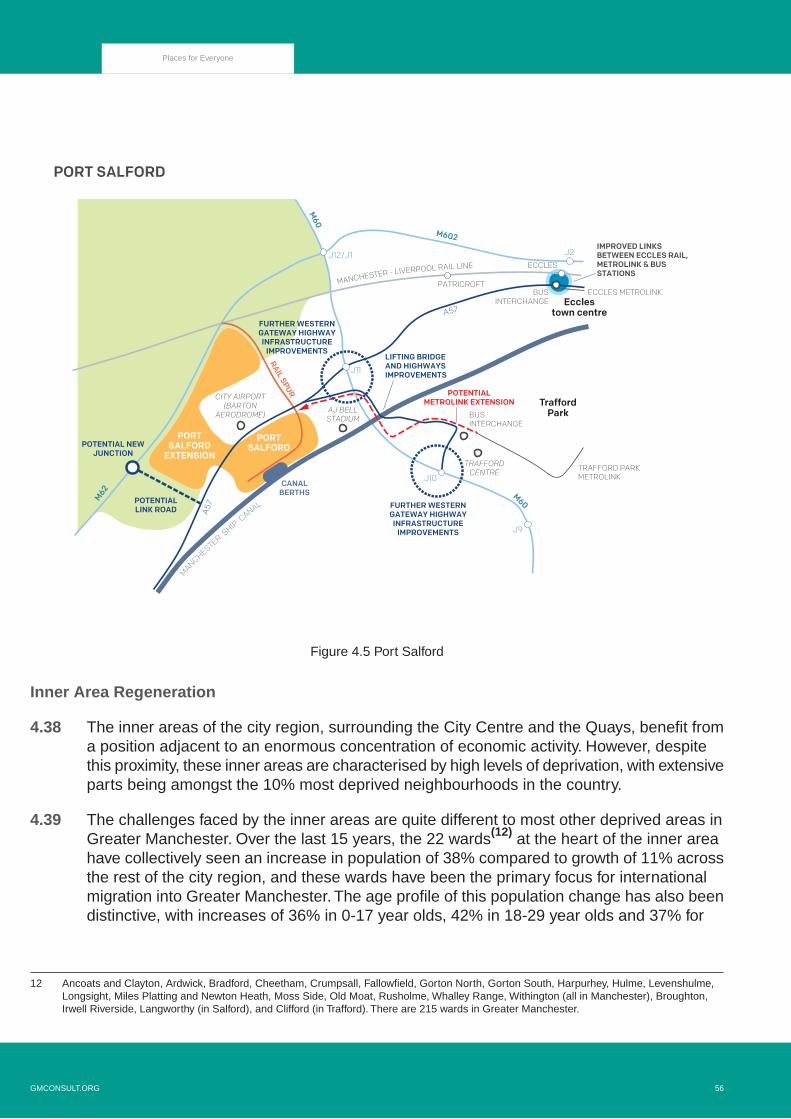
CANALBERTHS
PORT SALFORD
M602
M62
M60
M60
MANCHESTER SHIP C
ANAL
A57
A57
MANCHESTER - LIVERPOOL RAIL LINE
LIFTING BRIDGE AND HIGHWAYSIMPROVEMENTS
FURTHER WESTERNGATEWAY HIGHWAYINFRASTRUCTURE
IMPROVEMENTS
FURTHER WESTERNGATEWAY HIGHWAYINFRASTRUCTURE
IMPROVEMENTS
RAIL SPUR
J12/J1 J2
J11
J10
J9
PORTSALFORD
PORTSALFORD
EXTENSION
TraffordPark
POTENTIALMETROLINK EXTENSION
CITY AIRPORT (BARTON
AERODROME)
TRAFFORDCENTRE
AJ BELLSTADIUM
ECCLES
PATRICROFT
BUSINTERCHANGE
BUSINTERCHANGE
ECCLES METROLINK
TRAFFORD PARK METROLINK
POTENTIAL NEWJUNCTION
POTENTIAL LINK ROAD
IMPROVED LINKS BETWEEN ECCLES RAIL, METROLINK & BUS STATIONS
Ecclestown centre
Figure 4.5 Port Salford
Inner Area Regeneration
4.38 The inner areas of the city region, surrounding the City Centre and the Quays, benefit froma position adjacent to an enormous concentration of economic activity. However, despitethis proximity, these inner areas are characterised by high levels of deprivation, with extensiveparts being amongst the 10% most deprived neighbourhoods in the country.
4.39 The challenges faced by the inner areas are quite different to most other deprived areas inGreater Manchester. Over the last 15 years, the 22 wards(12) at the heart of the inner areahave collectively seen an increase in population of 38% compared to growth of 11% acrossthe rest of the city region, and these wards have been the primary focus for internationalmigration into Greater Manchester. The age profile of this population change has also beendistinctive, with increases of 36% in 0-17 year olds, 42% in 18-29 year olds and 37% for
12 Ancoats and Clayton, Ardwick, Bradford, Cheetham, Crumpsall, Fallowfield, Gorton North, Gorton South, Harpurhey, Hulme, Levenshulme,Longsight, Miles Platting and Newton Heath, Moss Side, Old Moat, Rusholme, Whalley Range, Withington (all in Manchester), Broughton,Irwell Riverside, Langworthy (in Salford), and Clifford (in Trafford). There are 215 wards in Greater Manchester.
56GMCONSULT.ORG
Places for Everyone

30-44 year olds, compared to figures of 3%, 15% and -7% respectively for the rest of GreaterManchester. In contrast, the area saw a reduction in residents aged 65 and over, whereasthe rest of the city region had an increase of more than one-fifth.(13)
4.40 The high growth in population has led to significant development pressures, not just in termsof new build developments but also more intensified use of existing properties such asconversions to houses in multiple occupation (HMOs). The proposed scale of job growth inthe Core Growth Area, and the excellent location of the inner areas in relation to them, makeit likely that there will continue to be significant pressures from population growth within thispart of Greater Manchester.
4.41 Increasing housing provision in the inner areas would enable more people to access easilythe opportunities of the Core Growth Area by walking, cycling and public transport andthereby reducing the need to travel. Maintaining a good supply of affordable housing will beespecially important, helping to reduce travel costs for those on lower incomes who needaccess to the Core Growth Area for employment and services.
4.42 The high levels of deprivation highlight the need for sustained neighbourhood regeneration,with investment in improving the quality of existing housing (including its energy efficiencyand access to amenity space) as well as providing a good mix of new homes. Although thereis a need for significant levels of development to meet demand and to maximise the use ofbrownfield land, it will be essential that the network of open spaces and other greeninfrastructure is improved, contributing to the long-term attractiveness of theseneighbourhoods. Raising the quality of these places will depend on tackling issues such astraffic congestion and air quality, which are typically more severe than in many other partsof the city region. There are also quite significant areas of flood risk.
Policy JP-Strat 5
Inner Areas
The continued regeneration of the inner areas will be promoted and will be linked to reducinglevels of deprivation and poverty and supporting the improved health and wellbeing of thecommunities. High levels of well-designed new development will be accommodated in this highlyaccessible and sustainable location, prioritising the use of previously developed land.
New development will be of high quality, predominantly, residential (in a mix of size, type andtenure). It will be supported by necessary infrastructure, including high quality open space andimproved access to the wider green infrastructure network, together with improved transportand social infrastructure.
13 ONS ward-based mid-year population estimates (experimental) 2002-2017 - seewww.ons.gov.uk/peoplepopulationandcommunity/populationandmigration/populationestimates/datasets/wardlevelmidyearpopulationestimatesexperimental.
GMCONSULT.ORG57
Places for Everyone

Where a mix of uses is being proposed it will seek to protect the amenity of existing and newresidents and it will seek to protect and enhance the location’s historic and natural environmentand assets.
New development will be integrated with existing communities, enhancing the quality of placesand their local character, including through good quality design, enhanced green infrastructure(and access to it) and improvements in air quality.
Over the period 2020-2037, land to accommodate around 270,000 sq m of office, around 132,000sq m of industry and warehousing and around 30,000 new dwellings has been identified withinthe inner areas.
Boosting Northern Competitiveness
4.43 Over recent years, the northern areas of Greater Manchester have seen relatively low levelsof growth overall compared to other parts of the city region, and this is forecast to continue.These northern areas have many strengths, such as their distinctive landscapes, proudcommunities, a strong manufacturing base and the opportunity for links to areas of economicprosperity beyond Greater Manchester, but their potential is not currently being fully realised.If current trends continue then disparities between the northern and southern areas willincrease, and this will be harmful not only to the prospects for the north but also to those ofGreater Manchester.
4.44 The northern areas are diverse, but there are considerable areas of deprivation within mostdistricts. Deprivation is particularly extensive across the north-east, with relatively high levelsthrough much of Rochdale, Oldham, and Tameside, extending into north Manchester. Thisnorth-eastern area is characterised by relatively low incomes, low house prices, lowqualifications, low economic activity, low proportions in higher managerial/professionaloccupations, and poor average health. There are also significant pockets of deprivationelsewhere in the northern areas, particularly around the main town centres, which sharesimilar problems to the north-east. However, there are also more prosperous areas acrossthe north, especially in suburban and rural areas towards the edges of each district, with thedistrict of Bury sharing many of the attributes of the wealthier southern areas of GreaterManchester.
4.45 Some significant interventions will be required to address the extensive deprivation and therelatively low levels of growth, economic activity and prosperity. Investment will be requiredacross the northern areas, with the provision of a good supply of high quality developmentsites and major transport improvements across all districts to support greater competitiveness.However, it will be vital that this is done in a sensitive way that protects the character andidentity of the north, and the quality of key landscapes such as the uplands and river valleys.
58GMCONSULT.ORG
Places for Everyone

4.46 Two locations have been identified as being especially important, having the potential todeliver significant benefits over a wider area and make a major contribution to raising thecompetitiveness of the northern areas as a whole: the north-east growth corridor; and theWigan-Bolton growth corridor. These are discussed in more detail below.
4.47 Investment in the town centres of the northern districts will be vital, particularly the maintown centres of Ashton-under-Lyne, Bolton, Bury, Oldham, Rochdale and Wigan. There isa need to increase the density of high quality public transport routes to match that found inthe southern areas. Improving connections between places in the north, and to key economiclocations such as those within the Core Growth Area and Manchester Airport, would helpto deliver a more integrated Greater Manchester economy where everyone can benefit fullyfrom growth.
4.48 It will be important to increase the attractiveness of the northern areas to a wider range ofpeople. In particular, there is the potential to increase the number of higher income householdswho choose to live in the north. The influx of more entrepreneurs and skilled workers couldhelp to increase business creation and support local economic activity, as well as reducingpressures in the southern areas which currently have high levels of demand. This Planallocates a small number of sites in the northern areas specifically to increase attractivenessof the northern areas to highly paid, highly skilled workers, including at such sites as ChewBrook Vale (Robert Fletchers) in Oldham (Policy JP Allocation 15 'Chew Brook Vale (RobertFletchers)'), Bamford/Norden in Rochdale (Policy JP Allocation 19 'Bamford / Norden') andEast of Boothstown in Salford (Policy JP Allocation 27 'East of Boothstown') although manyother sites have the potential to attract skilled workers and hence boost the competitivenessof the north.
Policy JP-Strat 6
Northern Areas
A significant increase in the competitiveness of the northern areas will be sought. There will bea strong focus on prioritising the re-use of brownfield land through urban regeneration, enhancingthe role of the town centres and increasing the mix, type, quality and range of residential offer.This will be complemented by improvements to transport connectivity and the selective releaseof Green Belt and previously safeguarded land in key locations that will help to boost economicopportunities and diversify housing provision (GM-Strat 7 and GM-Strat 8). Improving transportconnections and accessibility by public transport, cycling and walking will be a priority to ensureaccess to key employment opportunities. In supporting the principles of inclusive growth, thesignificant increases in economic growth in this location will help to reduce deprivation.
Development in this location will be of good quality and design, supported by the necessaryinfrastructure and amenities including improved access to green spaces.
GMCONSULT.ORG59
Places for Everyone

Development in this location, particularly that on land which is being proposed to be releasedfrom the Green Belt, will seek to identify opportunities to protect and enhance the natural andhistoric environments to improve the local character.
North-East Growth Corridor
4.49 The most significant proposed intervention in the northern areas is focused on the M62corridor from Junction 18 (the confluence with the M60 and M66) to Junction 21 (Milnrow),extending across parts of Bury, Rochdale and Oldham (GM-Strat 7).The scale of this initiativeis considered necessary in order to transform perceptions of, and opportunities within, thenorth of Greater Manchester. There are two major sites where land is removed from theGreen Belt through this Plan, as well as a significant development on land outside the GreenBelt through the completion of the Kingsway Business Park. Developments in this locationare not reliant on each other. The Northern Gateway site is of a transformative scale in itsown right, but collectively they have the potential to significantly change the economic growthpotential of the wider area.
4.50 This location has been selected for large-scale intervention for three main reasons. Firstly,this part of its corridor already has well-known established employment locations such asHeywood, Pilsworth, Stakehill and Kingsway Business Park. Additionally, the M62 is a keypiece of transport infrastructure connecting Greater Manchester with the major cities ofLiverpool and Leeds, and beyond. As such, it has the scale, connectivity and profile requiredto attract a broad range of high quality occupiers and major inward investment. This will notonly provide a better range of good quality jobs but will also offer opportunities for premisesfor new and growing sectors for example advanced manufacturing. Secondly, the corridoris close to a substantial residential population, many of whom live in deprived wards withpoor connectivity to employment opportunities.Whilst Stakehill Industrial Estate has a strongreputation as an employment location and has excellent access to the motorway network,only the western edge of the site is currently served by good public transport links. In otherdirections, particularly to and from the Oldham borough, it requires improvement. Newinvestment in this location, in particular that which delivers improved public transport, couldtherefore make a major contribution to regeneration and addressing inequalities, whilst alsooffering employers easy access to a very large labour market.Thirdly, it includes opportunitiesfor large-scale development which together will have the critical mass to enable majorinvestment in infrastructure and attract high quality businesses, jobs and housing. Collectively,these factors will ensure that the area has the ability to make a major contribution to theoverall, inclusive growth of Greater Manchester, as well as specifically helping to improvethe performance of the northern areas of the city region.
4.51 Works to improve the capacity of Simister Island (the junction of the M62, M60 and M66motorways) are already planned, but additional investment in the motorway network will berequired to support the scale of development proposed within the North-East Growth Corridor,
60GMCONSULT.ORG
Places for Everyone

including improvements to Junction 3 of the M66. The area may also be the subject ofproposals to improve the performance of the whole length of the M62/M60 through GreaterManchester.
4.52 Major public transport improvements will be required to ensure that surrounding communitiescan take advantage of the new jobs, and new residents can access key locations such asthe City Centre, nearby main town centres and key employment locations. This provides anopportunity to deliver a more extensive and integrated public transport network in thenorth-east of Greater Manchester, connecting existing communities that are currently poorlyserved. Improvements to the Calder Valley Line have received commitments to be deliveredand the North-East Growth Corridor will also benefit from additional local bus services aswell as proposed Bus Rapid Transit to serve the new developments. Work is also on-goinginto the future development of Bus Rapid Transit connections from the North-East GrowthCorridor and surrounding towns to the City Centre.
4.53 In addition to the transport investments needed to directly support the level of developmentproposed, consideration is being given to delivering infrastructure that will benefit the widerarea, including options for tram-train operation along the route of the East Lancashire Railline, alongside the Heritage Railway and options for a Metrolink or Bus Rapid Transit extensionto Middleton.
Policy JP-Strat 7
North-East Growth Corridor
Lying within the area and policy framework covered by JP-Strat 6, the North-East Growth Corridorwhich extends eastwards from Junction 18 of the M62 will deliver a nationally-significant areaof economic activity and growth which will be supported by a significant increase in the residentialoffer in this location, including in terms of type, quality and mix, thereby delivering truly inclusivegrowth over the lifetime of the Plan.
Over the period 2020-2037, land to accommodate almost 1 million sqm of new employmentfloorspace and around 19,000 new dwellings has been identified within the whole GrowthCorridor.
Specifically this Plan allocates two major sites within the area, and makes associated changesto the Green Belt boundaries, to support this growth:
Policy JP Allocation 1.1 'Heywood / Pilsworth (Northern Gateway)'Policy JP Allocation 1.2 'Simister and Bowlee (Northern Gateway)'Policy JP Allocation 2 'Stakehill'
In addition to these two allocations, there is considered to be a potential opportunity for furtherexpansion of the economic and residential offer in the eastern most part of this key gatewaylocation. As such the Key Diagram identifies the High Crompton Broad Location. The land will
GMCONSULT.ORG61
Places for Everyone

remain in the Green Belt until such time that a review of this Plan and / or the Oldham LocalPlan can demonstrate that it is necessary. The opportunity presented by the High CromptonBroad Location would serve to meet future employment and housing needs and demand ofbusinesses and local communities in this part of the conurbation well beyond the end of thePlan period. Well designed, sustainable development at this Broad Location would diversifyfurther the employment and housing offer in Oldham by ensuring truly inclusive growth couldbe achieved which would help to reduce further the levels of deprivation and poverty.
The development of the area must ensure that necessary infrastructure is delivered toaccommodate the likely scale of development.
M66
M62
M60
M60
M62
A627(M)
A627(M)
NORTH EAST GROWTH CORRIDOR
BURY METRO
LINK
OLD
HAM
- R
OC
HD
ALE
ME
TRO
LIN
K
CASTLETON
ROCHDALE
MILLS HILL
NORTHERNGATEWAY
STA
KE
HILL
HEATONPARKCITY
FORESTPARK
CALDER VALLEYRAIL LINE
NEWJUNCTION
J2
J3
J18 IMPROVEMENTS
J20
J21
J19
J20
J17
PILSWORTHINDUSTRIALESTATE
HEYWOOD DISTRIBUTION PARK
STAKEHILLINDUSTRIAL
ESTATE
KINGSWAYBUSINESSPARK
CAPACITY IMPROVEMENTS
J19
POTENTIAL METRO/TRAM-TRAIN
POTENTIALNEW STATION
POTENTIAL METROLINKEXTENSION TO MIDDLETON
POTENTIAL BUS RAPID TRANSITNETWORK
HIGH CROMPTONBROAD LOCATION
Burytown centre
Rochdaletown centre
Oldhamtown centre
Middletontown centre
Picture 4.2 North-East Growth Corridor
Wigan-Bolton Growth Corridor
4.54 The Wigan-Bolton Growth Corridor is located in the north-west of Greater Manchester, andcomplements the North-East Growth Corridor ensuring that there are significant investmentopportunities across the northern areas, helping to boost the competitiveness of all parts of
62GMCONSULT.ORG
Places for Everyone

the north and delivering inclusive growth. The Wigan-Bolton Growth Corridor proposals aresmaller in scale than the North-East Growth Corridor, but are nevertheless important insupporting long-term economic prosperity. The M6 logistics hub in Wigan (extending intoWarrington, St Helens and West Lancashire) provides a major cluster of warehousing anddistribution activity with easy access to the Port of Liverpool via the M58.
4.55 This growth corridor is focused around improved transport links. These include new roadsand a Wigan to Bolton Quality Bus corridor and, the more intense use of the Wigan – Atherton– Manchester and the Wigan – Bolton – Manchester rail lines. New road infrastructure willimprove east-west connectivity between Junction 26 of the M6 (which is also the junctionfor the M58 motorway that provides a direct connection to the Port of Liverpool) and Junction5 of the M61. This transport infrastructure will significantly improve highway connections inthe north-west of Greater Manchester, and better integrate the strong logistics functionsalong the M6 and M61 into the wider city region, as well as helping to address local congestionissues. The increased use of the existing rail lines could include conversion to tram-trainuse on the Atherton line and electrification on the Bolton line. This would increase capacityand, along the Atherton line has the potential to increase the number of stations. The raillines and new road infrastructure extend through and near a series of deprivedneighbourhoods across central Wigan and into south Bolton and will greatly improve accessto employment opportunities, and hence will have a major regenerative role and reducelevels of deprivation.
4.56 There are numerous development sites already identified along this corridor, including somemajor brownfield sites such as those to the north of Leigh, south of Hindley and at WestwoodPark. However, in order to maximise the contribution of this corridor to boosting thecompetitiveness of the northern areas, support the economic prospects of Wigan and Bolton,and maximise the benefits of new transport infrastructure, there is also selective release ofland from the Green Belt for employment and housing development.
4.57 There are two significant assets at the eastern end of this growth corridor. Hulton Park isthe proposed site for a Ryder Cup golf course and the Royal Bolton Hospital is a significantemployer and the site of the Bolton College of Medical Sciences. The development of landat the hospital will enable its evolution and provide additional opportunities, including newhealth technology related activities, which would benefit from this location, alongside newhousing development.The corridor also benefits from its proximity to other important assets.Wigan Town centre lies just to the north, which provides direct rail access to London, withthe current journey times of 2 hours set to reduce substantially with the arrival of HS2 services.The lowland wetland and mosslands are just to the south, forming part of the strategic greeninfrastructure network.
GMCONSULT.ORG63
Places for Everyone

Policy JP-Strat 8
Wigan-Bolton Growth Corridor
Lying within the area and policy framework covered by JP-Strat 6, the Wigan – Bolton GrowthCorridor will deliver a regionally-significant area of economic and residential development.
New highway infrastructure will connect Junction 26 of the M6 and Junction 5 of the M61 includingpublic transport provision. Measures to improve the provision of bus services and to increasethe use of rail lines will be implemented, potentially including a Wigan to Bolton Quality BusTransit corridor, conversion of the Atherton line to allow for metro/tram-train services, and theelectrification of the Bolton to Wigan line.
Over the period 2020-2037, land to accommodate just over 1milion sqm of new employmentfloorspace and approximately 13,000 new dwellings has been identified within the area.
The majority of this new development will be on previously-developed land, within the urbanarea. However, in order to meet the overall spatial strategy, this Plan allocates the followingsites within the area, and makes associated changes to the Green Belt, to further support thesuccess of the growth corridor:
Policy JP Allocation 4 'Bewshill Farm'
Policy JP Allocation 5 'Chequerbent North'
Policy JP Allocation 6 'West of Wingates / M61 Junction 6'Policy JP Allocation 34 'M6 Junction 25'Policy JP Allocation 37 'West of Gibfield'
In addition, the following will also be supported:
The restoration of Hulton Park, and the provision of a Ryder Cup standard golf course andassociated leisure and tourism facilitiesThe development of land at Royal Bolton Hospital, including a health village.
64GMCONSULT.ORG
Places for Everyone

WIGAN-BOLTON GROWTH CORRIDOR
M6
ATHERTON RAIL LINE
M58
M61
HULTONPARK
WEST OF GIBFIELD
WEST OF WINGATES
JUNCTION 25
CHEQUERBENTNORTH
LINK ROAD
LINK ROAD
J6
J5
J4 BEWSHILL FARM
J26
J25
POTENTIAL METRO/TRAM-TRAIN
POTENTIALSTATION
POTENTIALSTATION
POTENTIALSTATION
Boltontown centre
Wigantown centre
Leightown centre
Figure 4.6 Wigan-Bolton Growth Corridor
Sustaining Southern Competitiveness
4.58 The southern areas of Greater Manchester are typically characterised by high levels ofdemand and forecast growth, and include some of the city region’s most popularneighbourhoods. Large parts of the south, extending into north Cheshire, have high houseprices and relatively high household incomes, but also significant issues of affordability.Nevertheless, there are pockets of deprivation across the southern areas, and hencesignificant disparities between communities.
4.59 Some areas of the south have good rapid transit connections to the City Centre, howeverthere are opportunities to improve connectivity.The area also benefits from the internationalconnections of Manchester Airport. Following the development and completion of HS2 andNorthern Powerhouse Rail, parts of Greater Manchester, including the City Centre andManchester Airport will be amongst the best-connected locations in the country, and thesouthern areas will be well-located to take advantage of this.
GMCONSULT.ORG65
Places for Everyone

4.60 The landscape of the southern areas contrast with the upland landscape of the northernparts of Greater Manchester. The southern areas contain important strategic greeninfrastructure assets, including major river valleys such as the Mersey and Bollin and someextensive areas of woodland.
4.61 Our overall spatial strategy seeks to spread prosperity to all parts of the city region. However,this must be balanced with the need to ensure that the competitiveness of the southernareas is sustained, and the potential of key assets such as the main town centres andManchester Airport is realised. It is essential that this is done in a sensitive way that protectsthe character and quality of key landscapes which will also help to deliver broadersustainability objectives.
4.62 A significant amount of investment in both development and new and improved transportinfrastructure will be focused around two of Manchester’s key assets, Manchester Airportand Wythenshawe Hospital. This will include the selective release of Green Belt for newemployment and housing around the airport, including the Davenport Green area aroundthe proposed HS2 station and beyond to the hospital and southern edge of Timperley.Development in this location will need to be cognisant of and complementary to the aspirationsof existing businesses in the locality.
4.63 An additional location in this area which has been identified as being especially importantto Greater Manchester, is the proposed development focused around the former chemicalscomplex at Carrington in Trafford, which will enable a significant amount of contaminatedland to be restored. It will make a significant contribution to the area’s new housing andeconomic growth as well as supporting the regeneration of neighbouring Partington andSale West. Separate policies on the Manchester Airport area and New Carrington are setout below.
4.64 Our southern areas benefit from their proximity to prosperous locations, such as CheshireEast and Warrington, and taking opportunities to increase further the economic and functionalconnections between these areas supports their mutual success. Given the proximity ofdevelopment outside the Greater Manchester boundary, to the south, to the need to workwith our partners to coordinate major development close to the boundaries of GreaterManchester, particularly in terms of transport implications.
4.65 Although policies in this plan do not apply to land within Stockport, it is necessary toacknowledge and welcome the role Stockport will play in sustaining the southern areas,including delivering sustainable communities at its heart. Stockport Council has signalledits intentions in this regard, with the creation of the first Mayoral Development Corporation(MDC) which will help to improve the residential, retail, leisure, office and industrial offer inand around the Town Centre. In delivering a new community of up to 3,500 homes andapproaching 100,000 sqm of commercial space over the next 15-20 years, it is clear the rolethat this MDC will play in sustaining the competitiveness of the southern area.
66GMCONSULT.ORG
Places for Everyone

Policy JP-Strat 9
Southern Areas
The economic competitiveness, distinctive local neighbourhood character and environmentalattractiveness of the southern areas will be protected and enhanced. There will be a strongemphasis on prioritising the re-use of brownfield land and promoting the roles of the areas’ towncentres and its other key assets, including education and training facilities enabling people togain access to employment opportunities.There will be an increase in the mix, type, quality andrange of residential offer and a strengthening of its economic role. This will be complementedby improvements to transport connectivity, local character and the selective release of GreenBelt in key locations.
The economic potential of, and benefits of investment in Altrincham, Trafford's Main Town Centreand Manchester Airport, along with associated transport infrastructure will be maximised.Therewill be an emphasis on improving transport connections and accessibility by public transport,cycling and walking, ensuring access to key employment opportunities in this area. Developmentin these areas will contribute to reducing poverty and will be inclusive.
Development in these locations will be of good quality and design, supported by the necessaryinfrastructure and amenities and will seek to identify opportunities to protect and enhance thenatural and historic environments and to improve the local character.
Manchester Airport
4.66 Manchester Airport is the third busiest passenger airport in the UK, and the largest outsideLondon, handling c. 28 million passengers in 2019 and adding £1.4bn GVA to the regionaleconomy and supporting c. 25,000 jobs on-site. It is the only airport in the country other thanHeathrow to have two full length runways, but with the key advantage of having significantspare capacity, and the potential to grow to some 55 million passengers a year. Uniqueamong non-London airports, it has the infrastructure, connectivity and scale to sustain agrowing network of medium and long-haul routes. This enables Northern Britain to benefitfrom a major international air gateway for both business and leisure traffic, passengers andfreight. This is a vitally important role not just for Greater Manchester but also for a muchwider area across the North and Midlands, enabling businesses and residents to accessopportunities across the globe and providing a key access point for international visitors tothe UK. The airport is a key factor in realising the wider growth agenda for the North andunlocking the economic potential of cities and regions within its catchment area. More locally,the emerging Airport City development (part of the Greater Manchester Enterprise Zone) iscreating a major new economic asset for Greater Manchester, attracting global occupiersand investment attracted by the unrivalled connectivity.
GMCONSULT.ORG67
Places for Everyone
4.67 A major (£1bn) investment programme is underway to transform the airport and improve itsfacilities to create a much improved customer experience and meet the changing needs ofpassengers and airlines. Its expanding route network and growth are supported by theGovernment's policy(14) to make best use of the UK's runway capacity and maintain the UK'sinternational connectivity and place in the global market. This could also help to reducepressure on congested airports in London and the South East. Growth and an expandingroute network could see throughput growing to make best use of its existing runways andhandle around 55 million passengers per annum. In 2020 Manchester Airport Group (MAG)published a new Corporate Social Responsibility (CSR) Strategy.(15) In producing the CSR,MAG recognises that aviation will be one of the hardest industries to decarbonise and assuch their new Strategy sets out a commitment to achieving “net zero carbon” emissionsfrom their airport operations by 2038, ahead of the 2050 national target. The CSR has beendeveloped at this important time, with growing awareness of the need to tackle both globaland local challenges. The CSR sets out MAG’s ambitious commitments which will guide thesustainable development of the airport. It sets out ways MAG will achieve zero carbon status;how MAG will create quality employment opportunities for all and; how MAG will engagewith communities.
4.68 To maximise the contribution of the airport to the wider growth agenda, it needs to bewell-connected to the key towns and cities that it serves. High quality reliable and speedyjourneys are crucial to spreading the economic stimulus that it creates and encouraging thegrowth in long haul services. This requires further investment in the North's strategic roadand rail corridors, as part of a wider strategy to better connect the region's key gatewaysand economic centres. The M56 J6 to J8 smart motorway scheme will serve to maximisethe benefits of recent/ongoing investment in the A556 and M6 J19 improvements. HighwaysEngland have also commenced a South Manchester Highways and Transport Study whichis exploring options for improvements to transport links to mitigate the impact on the M56of proposed growth in this location. The provision of a new HS2 station with journey timesto London of just over an hour, and the planned Northern Powerhouse rail network willsignificantly improve the airport's connectivity, reduce journey times and make theairport area one of the best-connected locations in the country. Journeys to the Airport willalso be enhanced by the completion of the Metrolink Western Leg and proposed Bus RapidTransit service(s) along new spine roads linking development in Timperley Wedge andMedipark into the existing urban areas of Altrincham and Wythenshawe. This improvedconnectivity, along with improved links and services across Greater Manchester, will notonly be vital to increasing the proportion of passengers and staff who access the airport bypublic transport, but will also support wider business opportunities and investment, attractinbound visitors and help to spread the employment opportunities at the airport to communitiesacross the conurbation reducing inequalities and poverty.
4.69 Guided by Manchester City Council's local plan, Manchester Airport's SustainableDevelopment Strategy and long-term Airport master plans, the airport therefore provides amajor opportunity to boost the competitiveness and prosperity of Greater Manchester, and
14 Beyond the Horizon. Making best use of existing runways. DfT June 2018 -see www.gov.uk/government/publications/aviation-strategy-making-best-use-of-existing-runways
15 https://www.magairports.com/responsible-business/our-responsibility-plans/
68GMCONSULT.ORG
Places for Everyone

the wider UK, and support higher levels of economic growth. Although Aerodromesafeguarding to protect the safe operation of the airport and the noise footprint associatedwith aircraft noise place restrictions on the acceptable type of development in certain areas,there is considerable potential to increase the scale of economic activity and housing nearto the airport and the proposed HS2 station, enabling more residents and businesses to takeadvantage of the outstanding connectivity in an area of high market demand.
Policy JP-Strat 10
Manchester Airport
Lying within the area and policy framework covered by JP-Strat 9 this policy seeks to maximisethe benefits of the continued operation and sustainable growth of Manchester Airport and itssurrounding locality. Development which is in line with:
Government policyManchester's Local plan policies andManchester Airport Group's Corporate Social Responsibility Strategy
will be supported delivering a sustainable world class airport which will help to address issuesraised by climate change. With high quality services and facilities it will be the UK’s principalinternational gateway outside London.The airport and its surrounding locality will make a majorcontribution to the competitiveness of the North, Midlands and Wales by supporting inwardinvestment, international trade and tourism, high quality new homes and supporting our economicand social regeneration. It will be central to raising our global profile and economic performance.
The accessibility and connectivity of the area will be greatly enhanced, including through:
A. The development of a new HS2 station immediately to the west of the airport;
B. Northern Powerhouse Rail connections to other city regions;
C. The construction of the Western Leg extension of Metrolink via the proposed HS2 station,connecting through Davenport Green back to the existing line near Wythenshawe Hospital;
D. Improved local public transport services and connections such as Bus Rapid Transit linksby a new spine road through the Timperley Wedge allocation towards Altrincham;
E. Improved local public transport services and connections, including to Stockport and CheshireEast areas;
F. The provision of a network of cycling and walking routes.
The benefits of the exceptional connections will be maximised, including by:
GMCONSULT.ORG69
Places for Everyone

1. Completing the development of Airport City immediately around the airport, which will providea total of around 500,000 sqm of office, logistics, hotel and advanced manufacturing space;
2. Continuing to develop Medipark and Roundthorn Industrial Estate as a health and biotechcluster, taking advantage of the research strengths of the adjacent Wythenshawe Hospitaland the wider Manchester University NHS Foundation Trust;
3. Delivering approximately 60,000 sqm of office floorspace around the new HS2 station;
4. Providing a minimum of 1,700 new homes to the west of the M56 at Timperley Wedge, upto 2037;
5. Providing sufficient development opportunities to take full advantage of the introduction ofHS2 and NPR into this location.
This Plan allocates three sites near the airport, and makes associated changes to the GreenBelt boundaries, to support these developments:
Policy JP Allocation 3.1 'Medipark'Policy JP Allocation 3.2 'Timperley Wedge'Policy JP Allocation 10 'Global Logistics'
70GMCONSULT.ORG
Places for Everyone

M56
M60
MANCHESTERAIRPORT
ROUNDTHORN & MEDIPARK
H
TIMPERLEY WEDGE ALLOCATION
TO LONDON
AIRPORTCITY SOUTH
ALLOCATION
AIRPORT
RAIL STATION
HS2 STATION
METROLINK
TO THECITY CENTRE
J8 J7J6
J5
J4
J3 J2
J1
POTENTIAL METRO/TRAM-TRAIN
HIGHWAYIMPROVEMENTS
J5-J6
M56 J6–J8SMART MOTORWAY
METROLINK EXTENSIONTO DAVENPORT GREEN
METROLINKEXTENSION TO T2
POTENTIAL BUS RAPID TRANSIT
POTENTIAL BUS RAPID TRANSIT
Figure 4.7 Manchester Airport
New Carrington
4.70 New Carrington provides a significant opportunity in this part of Greater Manchester to delivera transformational mixed use development. This location in the western part of Traffordenables the redevelopment of the extensive former Shell Carrington industrial estate, supportthe regeneration of neighbouring Partington and Sale West. It will deliver the scale and mixof development and associated infrastructure necessary to ensure the development issustainable and delivers inclusive growth. The release of some Green Belt land is requiredto achieve these objectives.
GMCONSULT.ORG71
Places for Everyone

4.71 The inclusion of a large amount of employment development and local facilities, as well asa diverse range of housing, will enable New Carrington to function as a sustainableneighbourhood within Greater Manchester rather than an isolated community. However, itwill be important to ensure that it is fully integrated into the existing Partington and Sale Westareas, so that its regenerative potential is maximised and existing and new communities arenot separated.
4.72 The area is currently served relatively poorly by public transport, and significant investmentwill be required to ensure that residents and workers in the area can travel sustainably. Theformer railway line that runs through the site has considerable potential in this regard, offeringthe opportunity to deliver a sustainable transport corridor through the site to Timperley /Altrincham in the east and also extending through to Irlam / Cadishead in Salford to enablebetter movement across the Manchester Ship Canal. Major improvements in highway accesswill also be required, including the proposed Carrington Relief Road as well as upgrades tothe Carrington Spur and Junction 8 of the M60 which connect into the development area.
4.73 New development in this location will adopt sustainable principles, maximising opportunitiesto mitigate environmental impacts and deliver inclusive growth for the benefit of localcommunities. Development in this location will extend beyond the end of the Plan period.
Policy JP-Strat 11
New Carrington
Lying within the area and policy framework covered by JP-Strat 9 this policy seeks to deliver asignificant mixed use development. Over the period 2020-2037 land to accommodate around4,300 dwellings and 350,000 sqm of employment floorspace has been identified and will bedelivered together with a new local centre.
New development will be fully integrated with the existing communities of Carrington, Partingtonand Sale West, enhancing the quality of places and their local character, including through goodquality design, enhanced green infrastructure (and access to it) ensuring that maximumregeneration benefits are secured.
Major investment in active travel, public transport and highway infrastructure, such as theCarrington Relief Road, improvements to Junction 8 of the M60 and public transport corridorswill be delivered to support the development of New Carrington, ensuring it is well-connectedto the rest of Greater Manchester.
Policy JP Allocation 33 'New Carrington'allocates the development site and provides moredetailed requirements for its implementation.
72GMCONSULT.ORG
Places for Everyone

J7
J8
CARRINGTONSPUR
M62
M6
MANCHESTER SHIP C
ANAL
RAIL LINE
NEW CARRINGTON
M60
JUNCTION IMPROVEMENTS
CARRINGTON RELIEF ROAD
M
ETR
OLI
NK
SALE WESTBUS CORRIDOR
Partington
NEWCARRINGTON
URMSTON
CHASSENROAD
FLIXTON
IRLAM
POTENTIAL MULTI-MODALCORRIDOR
POTENTIAL METRO/TRAM-TRAIN
Altrinchamtown centre
Figure 4.8 New Carrington
Main Town Centres
4.74 We have seven main town centres: Altrincham, Ashton-under-Lyne, Bolton, Bury, Oldham,Rochdale and Wigan. They are immensely important to their host districts, and GreaterManchester as a whole, as a source of local identity and pride, the prime location for shopsand services, and a major supply of employment and leisure opportunities. They arecomplemented by a diverse collection of smaller town centres and local centres across thenine districts.
4.75 The main town centres are amongst the most accessible locations by public transport, walkingand cycling. Each centre benefits from relatively large catchment populations, which makesthem suitable locations for a range of office, retail, leisure and tourism development, buttheir role in acting as a location for residential use is increasing. It also means that theyfunction as important transport gateways to the wider Greater Manchester area and beyondbut services to the City Centre are generally better than between the town centres.
GMCONSULT.ORG73
Places for Everyone

4.76 Changes in the retail market and the way that both public and private services are deliveredhave placed pressures on town centres, for example resulting in the closure of some shopsincluding historic ‘anchor’ stores. The main town centres will need to adapt and respond tochanging circumstances if they are to continue to flourish and successfully meet the needsof surrounding communities.The long-standing retail, leisure, cultural and community functionswill remain central, but the way they are provided is likely to evolve. Businesses, serviceproviders, community groups and other actors working together in partnership can enhanceboth the local economy and the popularity of centres. The Mayor's Town Centre Challengeis positively promoting our town centres' evolution.
4.77 Expanding the resident population of the main town centres will become increasinglyimportant, helping to generate the necessary footfall and vibrancy to sustain facilities andenhance the attractiveness of the centres. Increasing the numbers of residents in towncentres will also enable more people to take advantage of their transport connections andfor brownfield land to be prioritised in development. This residential market is quite poorlydeveloped in most of the centres at present, but the potential in each is significant.The maintown centres offer the opportunity to provide a more affordable alternative to the City Centreand the Quays, both for businesses to locate and skilled workers to live, whilst providingexcellent access to services and facilities. The public transport corridors into the main towncentres will also have an important function, especially as a location for new housing, furtherincreasing the number of people with easy access to town centre facilities by sustainablemodes of transport.
Policy JP-Strat 12
Main Town Centres
The role of the main town centres as local economic drivers will continue to be developed,providing the primary focus for office, retail, leisure and cultural activity for their surroundingareas. Development here will offer a significant opportunity to reduce levels of poverty anddeliver inclusive growth.
Opportunities to further increase the population catchments of these centres will be taken,including significantly increasing the resident population of the main town centres by providinga mix of type and size of dwellings supported by the necessary infrastructure and amenitiesincluding new and improved public spaces and green infrastructure. This will be achievedalongside, rather than displacing, the range of non-residential uses in the centres. Housinggrowth along the key public transport corridors into the main town centres will also be promoted,further increasing the population catchments of those centres.
The role of the main town centres as major public transport hubs will be developed and supportedby a network of active travel routes, enabling residents to have improved access to opportunitiesacross Greater Manchester as well as within the centres themselves.
74GMCONSULT.ORG
Places for Everyone

Development will be carefully managed to ensure that the local distinctiveness of each maintown centre is retained and enhanced. Opportunities will also be taken to protect and enhancenatural and historic assets in the town centres.
A new town centre is proposed for designation at Salford Quays in the Publication Draft SalfordLocal Plan: Development Management Policies and Designations. Should that designationbecome part of Salford's Adopted Local Plan, development in that location will be subject to thispolicy.
Strategic Green Infrastructure
4.78 Green infrastructure (the network of green and blue spaces and features) provides a rangeof vital environmental services, contributing to quality of life, supporting economic growth,and promoting good health by enabling recreation and active travel. It is an essentialcomponent of attractive and liveable places, and hence its importance must not beunderestimated. More details on the approach to green infrastructure are set out in a laterchapter titled ‘Greener Places' (8 'Greener Places').
4.79 Protecting and enhancing the green infrastructure network throughout Greater Manchester(including its accessibility) is central to the overall vision for the city region, but there are asmall number of green infrastructure assets that are of particular significance and henceneed to be seen as an integral element of this Plan. They make a major contribution to thecharacter of different parts of Greater Manchester, are key components of the wider networkof habitats, and often fulfil other important functions such as managing flood risk, providingrecreation opportunities and sequestering carbon.
Policy JP-Strat 13
Strategic Green Infrastructure
The following strategic green infrastructure assets will be protected and enhanced as key features:
1. River valleys and waterways (see Policy JP-G 3 'River Valleys and Waterways')2. Lowland wetlands and mosslands (see Policy JP-G 4 'Lowland Wetlands and Mosslands')3. Uplands (see Policy JP-G 5 'Uplands')4. Trees and woodland (see Policy JP-G 7 'Trees and Woodland').
The protection and enhancement of these key strategic green infrastructure assets iscomplemented by a suite of policies to protect and enhance our network of green infrastructure,including protecting and enhancing sites of ecological value. This will enable our residents toaccess and maximise the benefits of green infrastructure on their health and wellbeing.
GMCONSULT.ORG75
Places for Everyone

A Sustainable and Integrated Transport Network
4.80 The strength and future success of Greater Manchester as a whole and the strategicallyimportant locations identified in this Plan will depend partly on the quality of public transportconnections. Such links are vital for enabling businesses to take advantage of the city region’shuge labour market and skills base, and for residents from all parts of Greater Manchester,and particularly those living in deprived neighbourhoods, to access the large number of jobs,leisure opportunities, social infrastructure (such as education and health care) and otherfacilities, as this will help to reduce levels of poverty.
4.81 Improved public transport between Greater Manchester and other cities will help reducelong-distance car use, support business, and open-up a wider range of employment andleisure opportunities for residents. Proposals for HS2 and Northern Powerhouse Rail willconsolidate the position of Greater Manchester as one of the most connected areas in theUK and will support existing businesses, inward investment and job creation. Together theywill provide high speed rail connections to London via Birmingham and faster direct routesto Leeds, Sheffield and Liverpool.
4.82 Within Greater Manchester rapid transit routes, such as rail, Metrolink and Bus Rapid Transit,are especially important, as they provide the type of frequent, fast, high quality services thatare a particularly attractive alternative to the car. Greater Manchester is already relativelywell-served by rapid transit networks, but there is considerable scope for further expansionand enhancement including the development of orbital links. The focus of such routes istypically the City Centre - which is why there is an urgent need to increase the capacity ofthe network in the central area - but there are also important links between other centresand key social infrastructure facilities.
4.83 The significance of these rapid transit routes, and the costs involved in constructing andoperating them, make it essential that their benefits are maximised. Delivering a significantincrease in the number of residents that have easy access to such routes is therefore acentral priority for this Plan, including optimising development densities and improving thenetwork of cycling and walking routes within the urban area to enable as many people aspossible to live close and/or to have easy access to sustainable travel options, therebyreducing the need to travel by car.
4.84 Almost 76% of public transport trips in Greater Manchester are by bus across a very broadnetwork of services, which means there is also a strong imperative to improve and strengthenour bus network for existing passengers and to encourage new users. Greater Manchesteris currently assessing options for integrated ticketing, reform of the bus market and wholeroute upgrades, which have the potential to bring significant benefits to the network.
4.85 Currently around half of the trips made by our residents are less than 2km in length withover 40% of these trips being made by car. There is therefore great potential for increasingcycling and walking across the Plan area, which will be fundamental in achieving the city
76GMCONSULT.ORG
Places for Everyone

region’s overall transport vision. High-quality new and improved walking and cycling routesand infrastructure will be needed, and the barriers that currently discourage people fromwalking and cycling will need to be removed. The Greater Manchester Cycling and WalkingInvestment Plan “Change a Region to Change a Nation” sets out our ambition to becomethe first city-region in the UK to have a fully joined up walking and cycling network.
Policy JP-Strat 14
A Sustainable and Integrated Transport Network
The transport network will be improved so that half of all daily trips can be made by publictransport, cycling and walking, especially those shorter journeys around neighbourhoods.
An ambitious programme of investment in our transport network will be crucial to ensure muchgreater access for people across the Plan area to high quality, high frequency, easy-to use,public transport services, and benefit from healthy and active streets. The local programme ofinvestment needs to be complemented by significant national and regional projects such as HS2and Northern Powerhouse Rail to ensure that connectivity is significantly improved to keylocations outside of the conurbation, such as London, Liverpool, Leeds, Sheffield and Birmingham.Collectively this will ensure that our residents will have access to economic opportunities.
The creation of a much larger, integrated, rapid transit network – incorporating bus, Metrolink,tram/train and rail services – will be supported by policies that focus new development in locationsclose to existing and proposed public transport connections. And initiatives such as integratedsmart ticketing, reform of the bus market, rail refranchising and increasing capacity at city centrebottlenecks will ensure all new routes function effectively as part of the overall network.
Higher densities will typically be appropriate in locations with good access to rapid transitconnections.
New development will have a significant role in delivering our future sustainable and integratedtransport network in order to reduce car dependency and increase levels of walking, cycling andpublic transport.
GMCONSULT.ORG77
Places for Everyone

GMCONSULT.ORG78
Places for Everyone


Sustainable Development
5.1 The purpose of the planning system as set out in legislation and the National Planning PolicyFramework (2019) is to contribute to the achievement of sustainable development and tomaintain a presumption in favour of such development as part of plan making and decisiontaking. At a very high level, the objective of sustainable development can be summarisedas meeting the needs of the present without compromising the ability of future generationsto meet their own needs.
5.2 Achieving sustainable development means that the planning system has three overarchingobjectives, which are interdependent and need to be pursued in mutually supportive ways(so that opportunities can be taken to secure net gains across each of the different objectives).
5.3 This idea of delivering economic, social and environmental benefits together, in a mutuallyreinforcing way rather than sacrificing some objectives to deliver others is at the heart ofachieving the United Nations Sustainable Development Goals(16) and central to this Planand will contribute to Greater Manchester tackling climate change.
5.4 This Plan can contribute to achieving many of these objectives, as well as supporting theoverarching goal of sustainable development. This is reflected in the overall strategy, theproposed scale and location of development, and the individual policies and allocations. Itincludes protecting and enhancing key environmental resources, following the waste hierarchy,reducing waste generation, using sustainable construction techniques, combating andadapting to climate change, reducing carbon emissions to meet Greater Manchester's 2038carbon neutrality target date, supporting high levels of economic growth in a way that canbenefit all residents, and delivering sustainable patterns of development that minimise theneed to travel and reliance on the car.
Policy JP-S 1
Sustainable Development
To help tackle climate change, development should aim to maximise its economic, social andenvironmental benefits simultaneously, minimise its adverse impacts, utilise sustainableconstruction techniques and actively seek opportunities to secure net gains across each of thedifferent objectives.
Preference will be given to using previously-developed (brownfield) land and vacant buildingsto meet development needs.
In bringing forward previously developed sites for development, particular attention will be paidto tackling land contamination and stability issues, ensuring that appropriate mitigation andremediation is implemented to enable sites to be brought back into use effectively.
16 https://www.un.org/sustainabledevelopment/sustainable-development-goals/
GMCONSULT.ORG81
Places for Everyone

Addressing Climate Change
5.5 Greater Manchester's Vision is to be at the forefront of action on climate change and to makeits fair contribution to international commitments(17) by becoming a carbon neutral city regionby 2038. In acknowledgment of climate change, by 2020, all 10 districts and the GreaterManchester Combined Authority have declared a climate emergency. To support this visiona 5 Year Environment Plan(18)was launched in 2019 to identify the urgent actions that areneeded to ensure Greater Manchester can follow the required pathway for carbon neutrality.
5.6 To meet our carbon commitments we will need to:
Be carbon neutral by 2038 Hold cumulative carbon dioxide emissions to within our carbon budgetInitiate a programme of mitigation to reduce emissions including by:
Significantly upscaling solar photovoltaic energy;Reducing heat demand in homes;Moving away from carbon intensive gas as the primary source of heat;Reducing heating and cooling demand for public and commercial buildings;Increasing biofuel use;Enable sustainable choices for travel and decarbonise transport;Significantly upscaling building retrofit; andIncrease the delivery of nature based solutions and biodiversity net gain.
5.7 In supporting our ambitions, climate change is a key theme running throughout the plan,rather than being reduced to a single policy, and it is only through this combination of actionsthat it can be properly addressed. In particular we set out:
Methods to de-carbonise the city region through new and existing development, effectiveland management and through the provision of infrastructure and new technologies PolicyJP-S 2 'Carbon and Energy';The delivery of renewable and low carbon energy schemes Policy JP-S 3 'Heat andEnergy Networks';Measures that will be taken to future proof the city region to mitigate environmentalchallenges, including climate change Policy JP-S 4 'Resilience';Water based measures to adapt and reduce the impacts of climate change Policy JP-S5 'Flood Risk and the Water Environment'; andMeasures to help achieve a circular and zero-waste economy Policy JP-S 7 'ResourceEfficiency'.
17 A Greater Manchester carbon budget compliant with the Paris Agreement was developed by Tyndall (2019) -https://www.research.manchester.ac.uk/portal/files/83000155/Tyndall_Quantifying_Paris_for_Manchester_Report_FINAL_PUBLISHED_rev1.pdf
18 https://greatermanchester-ca.gov.uk/media/1986/5-year-plan-branded_3.pdf
82GMCONSULT.ORG
Places for Everyone

Carbon and Energy
5.8 The vast majority of the existing homes in Greater Manchester will still be in existence in2050. Existing domestic buildings contribute 33% of Greater Manchester’s carbon dioxideemissions whilst existing non-domestic buildings contribute 35%.(19) Retrofitting the existingbuilding stock therefore presents a significant opportunity to help meet the 2038 carbonneutrality target. This can also contribute to the reduction of fuel poverty when targetedappropriately.
5.9 Without any mitigation, new development is estimated to result in around a 3% increase inenergy demand.(20) However, new development also enables carbon reduction through thedelivery of sustainable patterns of growth(21), which can support new public transportinvestment, the establishment of new energy centres and decentralised heat infrastructure,and nature based solutions to sequester carbon, which also provide multi-benefits, as wellas opportunities to deliver high standards of energy efficiency through good design. Cleangrowth is essential to meet future emission targets and to avoid costly retrofit programmesat a later date. Making this happen will require a co-ordinated approach towards carbonreductions through new and existing buildings and strategic energy infrastructure.
5.10 Meeting the 2038 carbon neutrality target will require a radical transformation across a rangeof sectors to drive carbon reduction. Within this, new development will have a critical role toplay and all new homes and commercial/industrial buildings will need to achieve net zerocarbon by 2028. The definition of net zero carbon development has been established by theUK Green Building Council.(22) It is expected that development in the Plan area will apply anet zero carbon approach to operational emissions up until 2028, thereafter emissions inconstruction should be considered. Minimum carbon reduction targets will be set in line withthe Future Homes Standard of 80% or until such a time this is superseded.
5.11 To provide further confidence in decision making, supporting research(23) was commissionedto outline how the pathway to 2028 can be achieved for ‘net zero in operation’(24) by settingout critical milestones and measures that would be expected when following the energy‘hierarchy’ and adopting a fabric first approach. For overall carbon reduction targets it wasrecommended that these follow the trajectory as advised within the Future Homes Standardof 31% (2020) and 80% (2025).
5.12 As the electricity grid becomes more decarbonised the ability of renewable energy to offsetcarbon emissions minimises. However the contribution of such technologies to energydemand reduction and running costs become significant as services move to all electricsolutions.The research has shown that in a low carbon context, the use of heat pumps alone
19 Energy Systems Catapult (2016), Greater Manchester Spatial EnergyPlan: https://www.greatermanchester-ca.gov.uk/media/1363/spatial_energy_plan_exec_summary.pdf
20 Energy Systems Catapult (2016), Greater Manchester Spatial EnergyPlan: https://es.catapult.org.uk/publications/greater-manchester-spatial-energy-plan-full-report
21 https://www.rtpi.org.uk/research/2018/may/settlement-patterns-urban-form-and-sustainability/22 https://www.ukgbc.org/ukgbc-work/net-zero-carbon-buildings-a-framework-definition/23 Currie and Brown/Centre for Sustainable Energy (2020), GMCA Energy and Carbon Implementation Study24 https://www.ukgbc.org/ukgbc-work/net-zero-carbon-buildings-a-framework-definition/
GMCONSULT.ORG83
Places for Everyone

could lead to higher runner costs (as they consume energy, not generate), increasing thepotential for more households being in fuel poverty, production of waste heat and an increasedrisk of creating local network capacity issues.
5.13 For Greater Manchester to meet its carbon neutrality commitments there has to be anincrease in renewable energy generation. Community initiatives are likely to play anincreasingly important role in the uptake of renewable energy and should be encouragedas a way of providing positive local benefits to wider society. The advantages of increasingrenewable and low carbon energy capacity will need to be balanced against any potentialimpacts such as on residential amenity, local environment and landscape character, sitesof conservation and heritage value, telecommunications and aviation equipment and airquality.
5.14 Based on the evidence which has informed the 5 Year Environment Plan and achieving netzero carbon in new development, this has shown that there will need to be a significantincrease in photovoltaic technology. Therefore in Greater Manchester the following targetswill be sought in relation to reducing energy demand and onsite renewable energy generation.
Renewable EnergyGeneration Targets
Hot Water EnergyDemand(26)
Space HeatDemand(25)
*Photovoltaicinstallation: 20%ground floorspace
20% energy demandreduction (compared toPart L 2013)
Houses (30kWh/m2)
Flats (25kWh/m2)
2021 - 2025
*Photovoltaicinstallation: 40%ground floorspace
^20% energy demandreduction (compared toPart L 2020)
Houses (20kWh/m2)
Flats (15kWh/m2)
2025 - onwards
*Ground floorspace used as a proxy for available roof area.
^will need to be reviewed with Future Homes Standard 2025 to determine if savings alreadyembedded.
Table 5.1 Targets For Reducing Energy Demand and Onsite Renewable Energy Generation
26 Reduction in expected DHW grid energy demand compared to the Part L concurrent notional building. Takes into account the efficiency ofthe domestic hot water generating system, on-site energy generation and direct use, and any other passive hot water energy recovery systemsinstalled.
25 As calculated within SAP2012, Space Heating Requirement (Box98 or equivalent at later SAP versions). It does not take into account theefficiency of the space heating system. It is based on a fabric first approach (insulation and airtightness)
84GMCONSULT.ORG
Places for Everyone

5.15 Unregulated emissions (e.g. those associated with plug loads/appliances) are expected tobe assessed as part of the requirement to meet ‘net zero carbon’ in operation from 2025onwards.The only way that this can be deliverable will be through the use of on site electricitygeneration or through carbon offsetting (‘allowable solutions’) as occupants lifestyle choicesare not pre-determined by energy efficiency measures associated with construction standards.
5.16 By following the energy hierarchy, new development will need to achieve net zero carbonthrough the maximisation of on-site measures first. However, in circumstances where adevelopment has demonstrated that the hierarchy has been followed and there are noreasonable alternatives to meet the minimum carbon reductions, then payment to offsetremaining emissions will also be required. Such payments should be expected to fund othercarbon saving programmes within Greater Manchester to help meet the 5 Year EnvironmentPlan targets (such as energy efficiency retrofit and renewable energy installations). TheMayor of Greater Manchester is developing an Environment Fund, which will provide amechanism for carbon offset payments to be made. Districts may also develop alternativeapproaches within Local Plans.
5.17 When considering a whole life approach for any new building, embodied emissions fromconstruction can account for up to half of the carbon impacts associated with its lifecycle.(27) Inaddition, other emissions can be attributed to the end of life stages such as demolition, repairor refurbishment.
5.18 It is also important that post occupancy evaluation is considered as part of a monitoringprogramme to ensure buildings function as they are designed and mitigation measures canbe identified to address any performance gap (where a buildings modelled energy and carbonperformance does not equate to actual in-use operation). Various industry initiatives(28) arealso beginning to address this issue so that this can be minimised as part early as part ofthe design and build process. Supplementary planning guidance can also help developersand planning officers to identify the level of information required to meet these requirementsas well as wider policy implementation.
5.19 Greater Manchester seeks to promote investment in new zero-carbon technologies, to reducethe reliance on carbon based fuels to accelerate the speed at which such new technologiesbecome financially viable and/or technically feasible.Work undertaken by the Tyndall ClimateChange Research Centre(29) has shown that the continued extraction of fossil fuels will notbe compliant with a carbon emissions reduction pathway that is aligned with internationalcommitments within the ‘Paris Agreement’. It is therefore considered prudent to not exploitnew sources of hydrocarbons and keep fossil fuels in the ground so at this point in time wewill not support hydraulic fracturing (fracking).
27 https://www.rics.org/uk/upholding-professional-standards/sector-standards/building-surveying/whole-life-carbon-assessment-for-the-built-environment/28 Such as BSRIA Soft Landings Framework, Better Buildings Partnership Design for Performance initiative and the Governments Soft Landings
(GSL)29 Report to inform Greater Manchester Spatial Framework – Carbon and Energy Policy, Tyndall (2019)
GMCONSULT.ORG85
Places for Everyone

Policy JP-S 2
Carbon and Energy
The aim of delivering a carbon neutral Greater Manchester no later than 2038, with a dramaticreduction in greenhouse gas emissions, will be supported through a range of measures including:
1. Promoting the retrofitting of existing buildings with measures to improve energy efficiencyand generate renewable and low carbon energy, heating and cooling;
2. Promoting the use of life cycle cost and carbon assessment tools to ensure the long termimpacts from development can be captured;
3. Taking a positive approach to renewable and low carbon energy schemes, particularlyschemes that are led by, or meet the needs of local communities;
4. Keeping fossil fuels in the ground;5. Planning for a balanced and smart electricity grid by identifying geographical locations which
could support energy assets(30);6. Increasing the range of nature based solutions including carbon sequestration through the
restoration of peat-based habitats, woodland management, tree-planting and natural floodmanagement techniques;
7. Development of Local Area Energy plans to develop cost effective pathways to achievecarbon targets;
8. An expectation that new development will:
a. Be net zero(31) carbon from 2028 by following the energy hierarchy (with any residualcarbon emissions offset), which in order of importance seeks to:
i. Minimise energy demand;ii. Maximise energy efficiency;iii. Utilise renewable energy;iv. Utilise low carbon energy; andv. Utilise other energy sources.
With an interim requirement that all new dwellings should seek a minimum 19% carbonreduction against Part L of the 2013 Building Regulations.(32)
b. Incorporate adequate electric vehicle charging points to future proof for the likelylong-term demand, taking account of the potential maximum energy demand for thesite;
30 Such assets could be heating / cooling networks, electricity generation or storage infrastructure or a mixed hybrid approach subject to localdemand and connectivity
31 Applied to operational net zero carbon up to 2028 and considered for net zero ‘in construction’ from 2028 onwards in line with the UK GBCFramework (https://www.ukgbc.org/ukgbc-work/net-zero-carbon-buildings-a-framework-definition/) Minimum carbon reduction target expectedto be in line with 2025 Future Homes Standard of 80%.
32 Or until such time that this level is superseded by changes to national building regulations
86GMCONSULT.ORG
Places for Everyone

c. Where practicable, prioritise connection to a renewable energy/heating/cooling networkin the first instance or a low carbon energy/heating/cooling network that is adaptableto non-fossil fuels at a later date;
d. Achieve energy demand reductions for residential development in terms of space heatdemand; hot water energy demand and the delivery of on-site renewable energygeneration.
For renewable energy generation priority should be given to PV installation where technicallyfeasible, alternative technologies will be appropriate where the equivalent generation isevidenced.
e. For non-residential developments, achieve at least BREEAM excellent standard (orequivalent) for the ‘Ene 01 – reduction of energy use and carbon emissions’ categoryrising to ‘BREEAM outstanding’ equivalent for ENE 01 from 2028.
f. Include a detailed energy statement to demonstrate via site relevant evidence how thedevelopment has sought to maximize reductions in carbon emissions in line with relevantpolicy targets, including the minimisation of overheating risks and appropriate measuresfor post occupancy evaluation.Whole life cycle emissions should be considered wherepossible.
District Local Plans may set out specific carbon emission reduction targets, particularly if carbonneutral targets have been set sooner than 2038, or promote other measures through whichenergy efficiency of buildings and renewable energy generation can be achieved.
Heat and Energy Networks
5.20 Around two-thirds of Greater Manchester’s carbon emissions come from domestic andcommercial buildings. Government analysis(33) identifies heat/energy networks as acost-effective solution to this issue within areas of high heat density, with modelling suggestingthat heat networks could be an important part of the least-cost mix of technologies neededto achieve UK-wide decarbonisation targets by 2050.
5.21 Heat and energy networks have the potential to achieve significant emissions reductionsand have significant potential for promoting regional growth in the Low Carbon sector.(34) Theshift to a low carbon economy creates the emergence of new sectors and technologies,which in turn requires new occupations, skills and expertise to be developed in the labourmarket.This Plan seeks to ensure that its residents will be ready for these new opportunities.
33 See https://www.gov.uk/government/publications/the-future-of-heating-a-strategic-framework-for-low-carbon-heatandhttps://www.gov.uk/government/publications/the-future-of-heating-meeting-the-challenge
34 See http://enworks.com/resources/ESTA%20Wedges%20Approach%20in%20Greater%20Manchester%20Final.pdf
GMCONSULT.ORG87
Places for Everyone
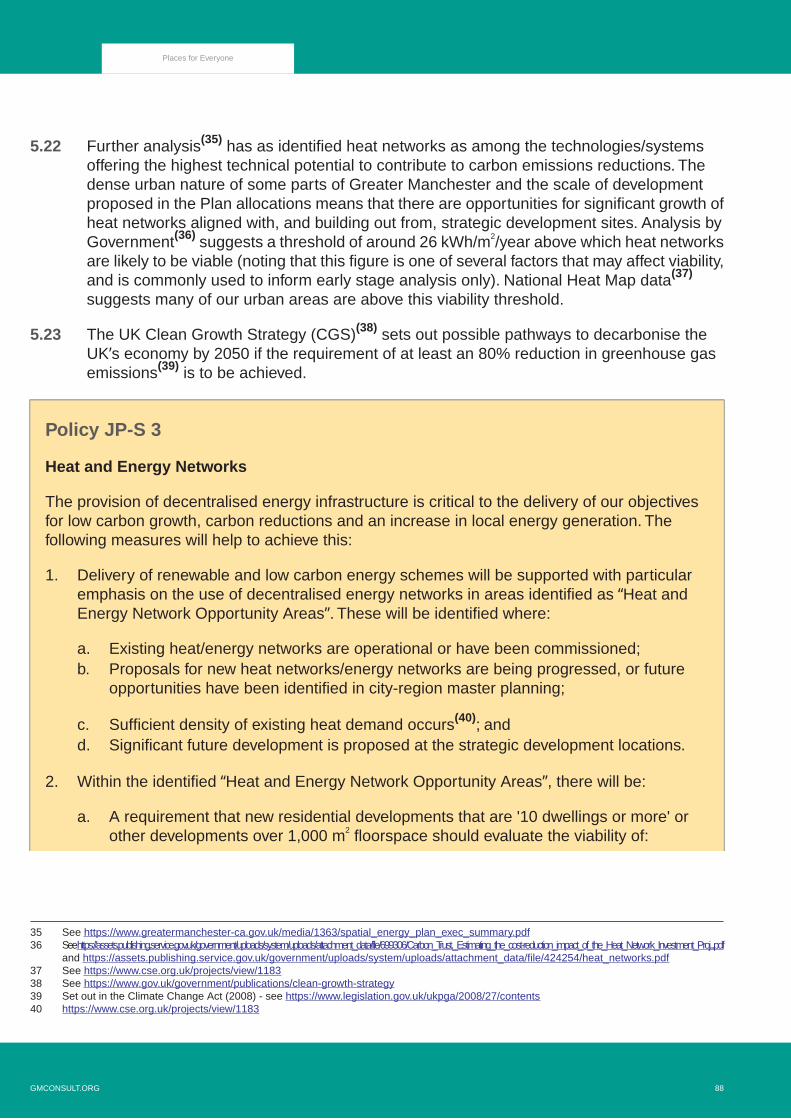
5.22 Further analysis(35) has as identified heat networks as among the technologies/systemsoffering the highest technical potential to contribute to carbon emissions reductions. Thedense urban nature of some parts of Greater Manchester and the scale of developmentproposed in the Plan allocations means that there are opportunities for significant growth ofheat networks aligned with, and building out from, strategic development sites. Analysis byGovernment(36) suggests a threshold of around 26 kWh/m2/year above which heat networksare likely to be viable (noting that this figure is one of several factors that may affect viability,and is commonly used to inform early stage analysis only). National Heat Map data(37)
suggests many of our urban areas are above this viability threshold.
5.23 The UK Clean Growth Strategy (CGS)(38) sets out possible pathways to decarbonise theUK’s economy by 2050 if the requirement of at least an 80% reduction in greenhouse gasemissions(39) is to be achieved.
Policy JP-S 3
Heat and Energy Networks
The provision of decentralised energy infrastructure is critical to the delivery of our objectivesfor low carbon growth, carbon reductions and an increase in local energy generation. Thefollowing measures will help to achieve this:
1. Delivery of renewable and low carbon energy schemes will be supported with particularemphasis on the use of decentralised energy networks in areas identified as “Heat andEnergy Network Opportunity Areas”. These will be identified where:
a. Existing heat/energy networks are operational or have been commissioned;b. Proposals for new heat networks/energy networks are being progressed, or future
opportunities have been identified in city-region master planning;
c. Sufficient density of existing heat demand occurs(40); andd. Significant future development is proposed at the strategic development locations.
2. Within the identified “Heat and Energy Network Opportunity Areas”, there will be:
a. A requirement that new residential developments that are '10 dwellings or more' orother developments over 1,000 m2 floorspace should evaluate the viability of:
35 See https://www.greatermanchester-ca.gov.uk/media/1363/spatial_energy_plan_exec_summary.pdf36 See https://assets.publishing.service.gov.uk/government/uploads/system/uploads/attachment_data/file/699306/Carbon_Trust._Estimating_the_cost-reduction_impact_of_the_Heat_Network_Investment_Proj...pdf
and https://assets.publishing.service.gov.uk/government/uploads/system/uploads/attachment_data/file/424254/heat_networks.pdf37 See https://www.cse.org.uk/projects/view/118338 See https://www.gov.uk/government/publications/clean-growth-strategy39 Set out in the Climate Change Act (2008) - see https://www.legislation.gov.uk/ukpga/2008/27/contents40 https://www.cse.org.uk/projects/view/1183
88GMCONSULT.ORG
Places for Everyone

Connecting to an existing or planned heat/energy network (where such a networkhas been identified within the Heat Network Opportunity Areas); and/or
i.
ii. Installing a site-wide or communal heat/energy network solution.
b. A requirement, where unviable to connect to an existing network or install a site-wideor communal heat/energy network, for new development to incorporate appropriatecapability to enable future connection (e.g. adequate space in plant-room for plate heatexchangers, capped-off flow/return connections);
c. A ‘presumption in favour(41) of network connection’ where new residential developmentsover 10 dwellings and other developments over 1,000 sq m floorspace are within 500mof an existing heat network, or where a network is being delivered;
d. An expectation that new industrial development will demonstrate that opportunities forusing waste heat locally have been fully examined, and included in proposals unlessproven to not be viable;
e. An expectation that where publicly-owned buildings and assets adjoin new majordevelopment sites, opportunities for these buildings and assets to connect to site-wideproposals will be considered; and
f. An expectation that any site-wide networks will be designed so as to enable futureexpansion to adjoining buildings or assets as appropriate.
3. In support of the above, all decentralised heat/energy network viability assessments arerequired to demonstrate consideration and analysis of:
a. Identification of existing and proposed heat/energy loads;b. Identification of heat/energy supply sources;c. Identification of opportunities to utilise renewable and low carbon energy sources;d. Identification of opportunities to utilise waste and secondary heat sources;e. Impact of proposals and technology choices on local air quality;f. Design according to national best practice in relation to efficient heat network design
(e.g. CIBSE CP1 Heat Networks: Code of Practice for the UK(42), or equivalent); andg. Adopting appropriate consumer protection standards (e.g. HeatTrust(43), or equivalent).
41 Department for Communities and Local Government, National Planning Policy Framework, DCLG (2012), Paragraph 1142 https://www.theade.co.uk/assets/docs/resources/Code_of_Practice_for_Heat_Networks_-_A_guide_for_owners_and_developers.pdf43 http://www.heattrust.org/index.php
GMCONSULT.ORG89
Places for Everyone

Figure 5.1 Heat and energy network opportunities
Resilience
5.24 Greater Manchester aims to be one of the most resilient places in the world.
5.25 A key part of achieving sustainable development is ensuring resilience, making sure thatour places maintain capacity to function, so that the people living and working here surviveand thrive no matter what stresses or shocks they encounter. A significant challenge withinthis is the ability to respond to future impacts from climate change.
5.26 Greater Manchester is part of the Rockefeller Foundation’s 100 Resilient Cities programme(100RC)(44), which aims to help cities become more resilient to potential challenges. GreaterManchester has produced a Resilience Strategy as part of this programme.The ten districtshave also signed up to the United Nations’ Making Cities Resilient Campaign, which aimsto reduce disaster risk.
44 See https://www.rockefellerfoundation.org/100-resilient-cities/
90GMCONSULT.ORG
Places for Everyone

5.27 The need to plan to reduce chronic stresses as well as minimise the impact of acute shocksmeans that planning for resilience has to be all-embracing, and so many elements of thisplan have a role to play.
5.28 The Greater Manchester Community Risk Register(45) and work under the 100RC programmeidentify that river and surface water flooding, hazardous materials accidents, terrorism, anddisease outbreaks are some of the most significant resilience challenges faced. The way inwhich Greater Manchester develops will have a significant impact on future levels of riskand vulnerability, and the ability of people and places to recover from acute shocks.
Policy JP-S 4
Resilience
Development will be managed so as to increase considerably the capacity of its citizens,communities, businesses and infrastructure to survive, adapt and grow in the face of physical,social, economic and environmental challenges, including climate change. Key measures willinclude:
1. Ensuring that developments make appropriate provision for response and evacuation inthe case of an emergency or disaster;
2. Supporting the retrofitting of existing buildings, infrastructure and places to enhance theirresilience;
3. Locating critical infrastructure and vulnerable uses away from locations at a high risk ofacute shocks;
4. Providing adaptable buildings and places that can easily respond to changing needs, futureclimate impacts and new technologies;
5. Designing out opportunities for crime, anti-social behaviour and terrorism;
6. Designing indoor and outdoor environments to provide a reduction and respite from moreextreme temperatures and winds associated with climate change and greater urbanisation;
7. Increasing the size, spread, quality and interconnectedness of the green infrastructurenetwork, enabling the city region, its citizens and wildlife to adapt to changing conditions;
8. Taking an integrated catchment-based approach to managing flood risk;
9. Maintaining a very high level of economic diversity across Greater Manchester;
10. Contributing to the delivery of at least 50,000 additional affordable homes up to 2037;
45 See https://www.gmemergencyplanning.org.uk/risks/how-we-assess-risk/community-risk-register/
GMCONSULT.ORG91
Places for Everyone

11. Promoting significant enhancements in education, skills and knowledge;
12. Supporting healthier lifestyles and minimising potential negative impacts on health includingair pollution; and
13. Carefully controlling the location of hazardous installations and new development that couldbe adversely affected by them.
Flood Risk and the Water Environment
5.29 Water is a precious resource that is essential for life. As well as meeting human needs fordrinking, washing and cooking, it is also vital for the health of the natural environment,supports agriculture and fisheries, provides a resource for many businesses, and offersopportunities for transport and recreation. However, there are many pressures on the waterenvironment that adversely impact on its ability to fulfil these functions.
5.30 Greater Manchester is located within a complex hydrological network that extends intosurrounding districts and beyond. This means that individual areas cannot be viewed inisolation, as rainfall and activities in one place can have significant impacts on the waterenvironment in other locations. The Irwell and Mersey catchments dominate GreaterManchester, covering around 78% of its total area, with the River Douglas and Glaze Brookbeing the other fluvial catchments. All catchments except the River Douglas drain into theManchester Ship canal, which therefore has a very important drainage and flood managementfunction.
5.31 Approximately 60,500 properties in the Plan area have a 0.1% chance of flooding from riversin any one year.(46) 36% of these properties are located in Salford, 22% in Manchester and12% in Wigan, with the remainder distributed fairly evenly across the other districts. Thesehigh risk areas include some of the most deprived communities as well as some of the mosteconomically important locations and can be subject to a combination of risk sources (e.g.river, surface water and sewer flooding) which can impact separately and together.
5.32 Approximately 146,000 properties have a 0.1% chance of flooding from surface water in anyone year in the Plan area.(47) There are also areas in which groundwater flooding can poserisks and where extensive canal and reservoir infrastructure generates flood risks, associatedwith potential overtopping and embankment breaches.
5.33 Climate change is expected to significantly increase peak river flows and surface waterrun-off as a result of more intense rain events, potentially placing many more properties atrisk in the future unless flood defences, drainage and run-off management are improved. A
46 Figures based on NAFRA Risk of Flooding from Rivers and Sea (March 2018) and National Receptor Database 2014.47 Figures based on National Receptor Database 2014 and NWSW Property Count Database (based on NRD 2011)
92GMCONSULT.ORG
Places for Everyone
coordinated catchment-wide approach to all types of flood risk will be required to addressthese challenges and minimise potential harm to people and property, including actionsupstream of Greater Manchester.
5.34 The location of new development in this Plan has been informed by the application ofSequential Test and Exception Test, as required by national planning policy. The aim of thetests are to steer new development towards areas with the lowest risk of flooding first beforeconsidering higher risk locations. If it is not possible for development to be located in zoneswith a lower risk of flooding, new development must provide wider benefits to the communityand can be made safe from flooding for its lifetime.
5.35 The North West River Basin Management Plan provides a framework for protecting andenhancing the benefits provided by the water environment across Greater Manchester andbeyond. It sets out legally binding objectives for the quality of water bodies, with the defaultbeing that they should be classified as ‘good’ overall based on their ecological status orpotential and their chemical status. Very few water bodies in Greater Management currentlyreach the required standard.(48)
5.36 Addressing this will require a wide range of measures, including naturalisation ofwatercourses, reductions in storm overflow sewage discharges, better land management,and improved management of surface water. Some of these actions will also assist inmanaging flood risk. For example, the use of natural flood management measures that workwith natural processes can provide multiple benefits for people and wildlife, helping to restorehabitats, improve water quality and reduce soil erosion, as well as lowering peak flows andflash flooding. Sustainable Drainage System (SuDS) schemes can provide appropriatesolutions to addressing both flood risk and water quality issues and are mandatory for majordevelopment unless clear evidence indicates that they would be inappropriate.
5.37 In addition to the general need to improve water quality, the Environment Agency has definedsource protection zones for groundwater sources such as wells, boreholes and springs usedfor public drinking water supply.(49) The control of potentially contaminating activities isparticularly important in these locations.
5.38 Climate change and population and economic growth can put increasing pressure on theavailable potable water supply for homes and businesses. It is important that water isconserved and efficiently used as much as possible to help build resilience to periods ofdrought; avoid over abstraction; reduce carbon emissions from water treatment and disposal;and protect river and wetland habitats from degradation.
48 See www.gov.uk/government/publications/north-west-river-basin-district-river-basin-management-plan49 See https://mappinggm.org.uk/gmodin/?lyrs=ea_source_protection_zones#open_street_map/11/53.5069/-2.3201
GMCONSULT.ORG93
Places for Everyone

Policy JP-S 5
Flood Risk and the Water Environment
An integrated catchment based approach will be taken to protect the quantity and quality ofwater bodies and managing flood risk, by:
1. Returning rivers to a more natural state, where practicable, in line with the North West RiverBasin Management Plan;
2. Working with natural processes and adopting a natural flood management approach to slowthe speed of water drainage and intercept water pollutants;
3. Locating and designing development so as to minimise the impacts of current and futureflood risk, including retrofitting or relocating existing developments, infrastructure and placesto increase resilience to flooding;
4. Expecting developments to manage surface water runoff through sustainable drainagesystems and as close to source as possible (unless demonstrably inappropriate) so as tonot exceed greenfield run-off rates or alternative rates specified in district local plans, suchas those identified for areas with critical drainage issues.
5. Ensuring that sustainable drainage systems:
i. Are designed to provide multifunctional benefits wherever possible, including for waterquality, nature conservation and recreation;
ii. Avoid adverse impacts on water quality and any possibility of discharging hazardoussubstances to ground;
iii. Are delivered in a holistic and integrated manner, including on larger sites split intodifferent phases; and
iv. Are managed and maintained appropriately to ensure their proper functioning over thelifetime of the development.
6. Securing the remediation of contaminated land and the careful design of developments tominimise the potential for urban diffuse pollution to affect the water environment;
7. Securing further investment in wastewater treatment to reduce the frequency of intermittentdischarges of storm sewage; and
8. Conserving water and maximising water efficiency in new development.
Clean Air
5.39 Air pollution has a significant effect on public health, and poor air quality is the largestenvironment risk to human health in the UK. Epidemiological studies have shown thatlong-term exposure to air pollution (over years or lifetimes) reduces life expectancy, mainlydue to cardiovascular and respiratory diseases and lung cancer. Short-term exposure (overhours or days) to elevated levels of air pollution can also cause a range of health impacts,including effects on lung function, exacerbation of asthma, increases in respiratory and
94GMCONSULT.ORG
Places for Everyone

cardiovascular hospital admissions and mortality.(50) The youngest, older people and thosewith existing health conditions are most likely to be affected by exposure to air pollution.Theexacerbation of respiratory conditions is particularly relevant in consideration of the COVID-19pandemic.
5.40 Without action, it has been estimated that the health and social care costs of air pollution inEngland could reach £5.3 billion by 2035, primarily due to fine particulates(51) (PM2.5).
(52) InGreater Manchester alone, exposure to fine particulates at current levels is estimated tocontribute to around 1,200 deaths per annum.(53) In addition to the direct human impacts,air pollution also harms the natural environment, adversely impacting on biodiversity, cropyields and the quality of water bodies. As cities compete to attract skilled workers, clean airmay become an increasingly important differentiating factor.
5.41 Air pollution can also have significant impact on ecology.Therefore there are not only benefitsto the population of improving air quality but there will also be positive ecological effects ofthis action.
5.42 A range of different types of pollutant negatively impact on air quality, including nitrogenoxides (NOx), small and fine particulate matter (PM10and PM2.5), sulphur dioxide (SO2), volatileorganic compounds (NMVOCs) and ammonia (NH3). Figure 5.2 'Change in emissions of airpollutants since 1970 (since 1980 for ammonia)' shows how emissions of most of these airpollutants have declined considerably at the national level over the last few decades.
50 Public Health England (2018). Health Matters: Air Pollution. Available:https://www.gov.uk/government/publications/health-matters-air-pollution/health-matters-air-pollution
51 particles small enough to be inhaled into the deepest parts of the lung52 www.gov.uk/government/news/new-tool-calculates-nhs-and-social-care-costs-of-air-pollution53 Derived from Public Health Outcome Framework indicator 3.01 (2016 data) (on Fingertips) (2018),
https://fingertips.phe.org.uk/profile/public-health-outcomes-framework
GMCONSULT.ORG95
Places for Everyone

Figure 5.2 Change in emissions of air pollutants since 1970 (since 1980 for ammonia)
5.43 Nevertheless, air quality targets are not consistently being met in some locations. Parts ofthe Plan area have been designated as an Air Quality Management Area (AQMA), basedon modelled levels of nitrogen dioxide (NO2). The largest concentration of poor air quality isaround the City Centre, which is also a nationally important economic centre and the proposedlocation for a considerable proportion of the new housing and office floorspace proposed inthis Plan.
5.44 Greater Manchester has also signed up to achieve WHO ‘BreatheLife City’ status by 2030,which means achieving WHO targets for PM (PM2.5 must not exceed 10 μg/m3 annualmean) and other air pollutants by this date. Regardless of targets, there is no clear evidenceof a safe level of exposure below which there is no risk of adverse health effects. As such,policy ambitions should always be to reduce air pollution to as low as possible as furtherreduction of PM or NO2 concentrations below air quality targets/standards are likely to bringadditional health benefits.
5.45 Within Greater Manchester, transport is the major source of air pollution, with roads accountingfor 65% of nitrogen oxides (NOx) , 79% of larger particulates (PM10) and 31% of carbondioxide emissions across the city region.(54) Wood burning stoves and coal fires accountsfor 43% of fine particulates (PM2.5) and was the single largest contributor in in the UK for
54 GMCA and TfGM (December 2016) Greater Manchester Low-Emission Strategy, p.9.
96GMCONSULT.ORG
Places for Everyone

2019. New legislation has been introduced on the 1st May 2021 to phase out the sales ofcoal and wet wood, also to regulate the quality of the stoves sold. Processes involvingcombustion, such as power stations, biomass and incineration, also contribute to air pollution,as do some industrial activities and agriculture practices.
5.46 The AQMA and associated Greater Manchester Air Quality Action Plan (AQAP) 2016-2021(approved by the GMCA in 2016) set out measures to help reduce air pollution caused byNOx while supporting the sustainable economic growth of the region. Since the AQAP wasintroduced Government has directed GM authorities to take urgent action to address aspecific air pollution problem: roadside concentrations of NO2 that exceed legal Limit Values.
Picture 5.2 Air Quality Management Area based on 35μg/m3 (2021)
5.47 Government estimates road transport contributes approximately 80% of NOx concentrationsat roadside, with diesel vehicles the largest source in these local areas of greatestconcern.(55)Government has directed Greater Manchester authorities to produce a CleanAir Plan to tackle roadside nitrogen dioxide (NO2)concentrations and bring them within LimitValues in the shortest possible time.
55 (Defra and DfT (2017) ‘UK Plan for tackling roadside nitrogen dioxide concentrations. Detailed Plan, July 2017’, London: Defra, pp: 5)
GMCONSULT.ORG97
Places for Everyone

5.48 Greater Manchester Authorities have been working collaboratively to produce a Clean AirPlan, that will bring about compliance with the legal limit for NO2 in the shortest possibletime and in any case by 2024. The proposal to introduce a Clean Air Zone class C that willcover the whole of GM (500sq miles), where the most polluting commercial vehicles will becharged to move within and through the zone, was subject to public consultation in theautumn of 2020. The final plan is to be put before JAQU (Joint Air Quality Unit – Defra &DfT) for approval in the early summer 2021, with a view for implementation in spring 2022.
5.49 It is clear that a wide range of actions will be required to improve air quality to appropriatelevels, in addition to the CAZ, and support objectives relating to climate change, GreaterManchester's 2038 carbon neutrality target, population health and quality places. Many ofthese actions are beyond the scope of this plan, but the primary focus will need to be ontransport given its primary contribution to air pollution. Hence, regard should also be had totransport-related policies elsewhere in this plan and in the Greater Manchester TransportStrategy 2040 refresh and Our Five Year Transport Delivery Plan. The most significant rolewhich this Plan will play in this respect is to locate development in the most sustainablelocations which reduce the need for car travel, for example by maximising residential densitiesaround transport hubs.
5.50 Ideally, a higher proportion of general employment sites would be capable of being servedby rail and/or water, but only a few such sites are available and hence within GreaterManchester there will need to be a stronger emphasis on the use of low-emission goodsvehicles. Short-term high-pollution episodes can affect health as well as long-term exposureto lower levels(56), so it will be important to tackle both peaks and average levels of airpollution under relevant actions.
5.51 The cumulative air quality impacts of the proposed scale and distribution of development inthis plan on nationally designated nature conservation sites have been considered througha separate Habitats Regulations Assessment.
Policy JP-S 6
Clean Air
A comprehensive range of measures will be taken to support improvements in air quality, focusingparticularly on locations where people live, where children learn and play, where there areimpacts on the green infrastructure network and where air quality targets are not being met,including:
1. Locating and designing development, and focusing transport investment, so as to reducereliance on forms of transport that generate air pollution;
56 Defra (2018) Clean Air Strategy 2018, p.4. See https://consult.defra.gov.uk/environmental-quality/clean-air-strategy-consultation/
98GMCONSULT.ORG
Places for Everyone

2. Determining planning applications in accordance with the most recent development andplanning control guidance published jointly by the Institute of Air Quality Management (IAQM)and Environmental Protection UK (EPUK), and the most recent IAQM Guidance on theAssessment of Dust from Demolition and Construction, or relevant successor guidance,including the requirement for developers to submit construction management plans asappropriate;
3. Requiring applications for developments that could have an adverse impact on air qualityto submit relevant air pollution data and, if approved, to make appropriate provision forfuture monitoring of air pollution;
4. Restricting and carefully regulating developments that would generate significant pointsource pollution such as some types of industrial activity and energy generation;
5. Significantly expanding the network of electric vehicle charging points, both for public andprivate use, including as part of new developments;
6. Implementing the charging Clean Air Zone within the Plan area, as directed by Governmentand associated measures;
7. Facilitating the more sustainable distribution of goods within the urban area, includingthrough accommodating urban consolidation centres and urban distribution centres thatuse ultra-low-emission vehicles, and local delivery facilities to reduce repeat deliveryattempts;
8. Designing streets to avoid trapping air pollution at ground level, including through theappropriate location and scale of buildings and trees;
9. Controlling traffic and parking within and around schools and early years sites;10. Promoting actions that help remove pollutants from the air, such as enhancing the green
infrastructure network and using innovative building materials that capture air pollutants; and11. Development should be located in areas that maximise the use of sustainable travel modes
and be designed to minimise exposure to high levels of air pollution, particularly for vulnerableusers.
Resource Efficiency
Minerals
5.52 The Greater Manchester Joint Minerals Plan was adopted in April 2013(57) and includes aset of policies which assist in the consideration of minerals planning applications, safeguardsminerals resources which are likely to be required in the future and identifies areas withinwhich new or expanded minerals extraction is likely to be suitable. Annual monitoring ofminerals extraction and changes in likely future needs will inform whether and when anupdate of the joint minerals plan is required, including as a result of the growth in developmentset out in this plan.
57 See https://www.greatermanchester-ca.gov.uk/media/1995/the_minerals_plan_april_2013_final.pdf
GMCONSULT.ORG99
Places for Everyone

Waste
5.53 The Government's new strategy on waste and resources in England(58) focuses on thecreation of a circular economy in which waste is treated as a resource to be kept in use foras long as possible, extracting maximum value from it before being recovered and regeneratedto form new products and materials. The aim of a circular economy is not only to reducewaste but to create a society in which waste is seen as a resource to be used again andagain in order to reduce the environmental impacts of production and consumption.
5.54 As part of its ambition to be one of the leading green city regions in Europe, GreaterManchester will produce a Zero Waste Strategy. The objectives of the strategy will be crosscutting covering a number of key policy areas including planning. It will set out how we willmove towards a circular and zero-waste economy in which we no longer see waste assomething to dispose of but as a resource to be used in a different way. The move towardsa circular economy will significantly reduce the amount of waste produced in GreaterManchester which in turn will enable delivery of higher recycling across all waste sectors,put more resources back into the economy and reduce our carbon footprint. Utilisingsustainable design and construction techniques at all stages of a development's life cyclecan help deliver this ambition.
5.55 A resource efficient society is key to people and businesses recognising that how we behaveand how we live has a direct impact on the environment around us.The “Plastic-Free GreaterManchester” campaign is a bid to eliminate single use plastics across the region and to movetowards renewable alternatives. So far 558 leading businesses and organisations in GreaterManchester have signed up to the campaign to be plastic free. This is the first key step inmoving towards a resource efficient region and will be the spearhead for future initiativesincluding tackling food waste.
5.56 The Greater Manchester Joint Waste Development Plan was adopted in April 2012.(59) Thisincludes a set of policies which assist in the consideration of waste planning applicationsand identifies suitable locations for potential new waste management facilities. Annualmonitoring of waste facility capacity and changes in likely future needs will inform whetherand when an update of the joint waste plan is required, including as a result of the growthin development set out in this plan.
Policy JP-S 7
Resource Efficiency
The achievement of a circular economy and a zero-waste economy will play a key role in meetingGreater Manchester’s ambition of becoming a leading green city region by 2038. The followingmeasures will help achieve this:
58 See https://www.gov.uk/government/publications/resources-and-waste-strategy-for-england59 See www.gmwastedpd.co.uk/doclib.html#Adopted_Waste_Plan_Documents
100GMCONSULT.ORG
Places for Everyone

1. Development and implementation of the Resource Strategy for Greater Manchester whichpromotes overall reduction in the level of waste produced and supports resource efficiencywithin the Plan area in order to gain the maximum value from the things we produce;
2. Ensuring the design of all new development incorporates storage space to facilitate efficientrecycling and where appropriate, processing of waste on site;
3. Recognition of the role of existing infrastructure in managing our waste and protecting suchfacilities to ensure adequate waste management capacity is maintained; and
4. Using sustainable design and construction techniques to reduce carbon emissions, adaptand future proof to the impact of climate change, reduce and recycle waste and minimisewater use.
GMCONSULT.ORG101
Places for Everyone

GMCONSULT.ORG102
Places for Everyone


Supporting Long-Term Economic Growth
6.1 Economic growth is central to the overall strategy for Greater Manchester. It will be essentialto raising incomes, improving health and quality of life, and providing the finances to deliverbetter infrastructure, services and facilities.
6.2 Greater Manchester has developed a Local Industrial Strategy (60) which sets out how thecity region will build on its unique strengths and opportunities and capitalise on the creativityof its people to create a digital-enabled, green city region.
6.3 The Local Industrial Strategy has two key objectives:
Supporting our globally competitive strengths. Building on our globally competitiveresearch strengths and industrial opportunities in health innovation and advancedmaterials(61) and capitalising on the creativity and collaborative culture of our people,our digital and technology asset base and our emerging capabilities in green industries- will be essential if the city region is to continue to attract investment and create newbusinesses and jobs for the future.Through this we will be pioneering emerging sectors,creating significant global competence and additional value for our local economy asthese new sectors grow and flourish.Strengthening the foundations of our economy. Despite having concentrations ofglobally competitive, highly productive businesses, Greater Manchester's overallproductivity is around 10% lower than the national average.(62) Tackling this is importantbecause it holds back people’s earning potential and makes our economy morevulnerable to economic shocks. Strengthening our people, infrastructure, businessenvironment, innovation ecosystems and places will be important to enable all sectorsand all places in Greater Manchester to be productive and prosperous. We need tograsp global opportunities emerging from changes to world markets and developindustries of the future, while also ensuring competitiveness and job quality in our highemployment, low productivity sectors.
6.4 Two of Greater Manchester’s key economic strengths are its size and diversity. GreaterManchester accounts for one-fifth of the population(63), jobs(64) and economic output in theNorth of England, and its economy is bigger than that of Wales and Northern Ireland. It isone of the most diverse economic areas in the UK(65) and is second only to London forattracting Foreign Direct Investment.(66) This helps to provide a broad range of opportunitiesfor businesses and varied jobs for residents. It also means that it is well-placed to takeadvantage of new economic possibilities and should be more resilient to change. Theinter-dependencies between our economic sectors mean that growth in one can support jobcreation in others.
60 Greater Manchester Local Industrial Strategy June 2019 https://www.greatermanchester-ca.gov.uk/media/2132/gm-local-industrial-strategy-web.pdf61 Greater Manchester and Cheshire East Science and Innovation Audit, November 201662 GMCA: Deep Dives Phase 2: Productivity in Greater Manchester, February 201763 ONS: Population Estimates 2017, accessed via nomis November 201864 ONS: Business Register and Employment Survey, accessed via nomis November 201865 ONS Krugman Index see www.ons.gov.uk/employmentandlabourmarket/peopleinwork/employmentandemployeetypes
/adhocs/006229industrialspecialisationinmajortownsandcitieskrugmanindexdataandtool66 https://www.ey.com/en_gl/attractiveness
104GMCONSULT.ORG
Places for Everyone

6.5 Greater Manchester has a growing share of graduate level qualified residents, which, alongwith people skilled in technical occupations, skilled trades and service industries, forms partof a large and varied skills base.
6.6 Greater Manchester's transport network provides good connections to other major cityregions, with further major improvements planned such as HS2 and Northern PowerhouseRail, making it an attractive place to invest and providing close functional links to otherareas.(67) Manchester Airport is the country’s largest and best-connected airport outsideLondon and the South East and the Manchester Ship Canal provides direct shippingconnections to the post-panamax facilities at the Port of Liverpool. Piccadilly rail station isboth a gateway and commercial centre but also has the potential to be the ‘Hub of the North’serving the whole of the northern economy. Together, these assets enable GreaterManchester to act as an international gateway for the North and the UK, providing accessto global markets and supply chains.
6.7 Despite these strengths, for two decades, Greater Manchester’s productivity has consistentlyremained at 90% of the UK level and in recent years the balance of employment has shiftedtowards lower productivity sectors and activities, as has been the case for the UK as a whole.The share of low productivity sectors in GM – those with lower than £30,000 GVA per worker,at 2013 prices – increased from 37.7% in 2005 to 41.8% in 2015. Wages have fallen by6.6% in real terms between 2006 and 2016: the average worker in Greater Manchester stillearns 81p an hour less in real terms than in 2006. The gross median annual wage for fulltime workers living in Greater Manchester was £26,800 in 2018, compared to £29,570 inthe UK as a whole; and the gap in wages between GM and the national average has widenedover the decade.This reflects the uneven economic geography of the UK and the dominanceof London and the South East.
6.8 There are also significant economic disparities within our plan area, and baseline forecastssuggest that these could increase without intervention. For example, Manchester is forecast74,600 additional jobs between 2018-38 with the central and southern districts forecast toadd a further 60,000 jobs of which almost 47,000 are forecast to be in Salford andTrafford. Collectively they have the highest concentration of key assets and major growthareas in the sub-region. In contrast, the rest of Greater Manchester is only forecast tocollectively add 10,800 net jobs with some districts (Oldham and Tameside) seeing a smalldecrease in total employment. Full-time jobs in the central and southern areas on averagepay significantly more than full-time roles in the other districts(68) which in turn also impactscommuting patterns and transport infrastructure congestion.
6.9 These problems have also been exacerbated by the adverse impacts of austerity andeconomic shocks, such as Brexit and Covid-19, on growth and reform. Furthermore, like inother places, employment and output growth since the recession have been characterisedby low productivity growth and increasing share of jobs in lower value sectors with
67 See Greater Manchester's HS2 and Northern Powerhouse Rail Growth Strategy: "The Stops Are Just The Start" athttps://www.tfgm.com/press-release/hs2-npr-growth-strategy
68 ONS: Annual Survey of Hours and Earnings 2018, accessed via nomis November 2018
GMCONSULT.ORG105
Places for Everyone

comparatively low paid, less secure employment.(69) We are also not fully realising thepossibilities of its key assets, for example the outstanding research base has much greaterpotential to support business activity and growth. Further improvements in transportconnections and skills development are required to ensure that everyone can contribute toand share in the benefits of economic activity, helping to deliver genuinely inclusive growth.
6.10 The Northern Powerhouse Independent Economic Review(70) identified that throughimprovements in skills, innovation, and connectivity the North has the potential to create by2050 an additional £97 billion of GVA (a measure of total economic output and income) and850,000 extra jobs under a transformational scenario, compared to the ‘business as usual’scenario. As part of Greater Manchester we are well-placed to play a leading role in deliveringthis additional growth, given its central location within the North of England and concentrationof key growth assets.
6.11 We have the opportunity to increase the future prosperity of local residents through makinga full contribution to rebalancing the national economy, helping to deliver a more successfulNorth of England and UK. Hence, this plan supports high levels of economic growth andseeks to put in place the measures that will enable such growth to continue in the evenlonger-term. Economic growth provides a good opportunity for local residents to gainincreased access to new jobs and training, which will help to reduce unemployment ratesand economic inequalities and boost skill levels and personal fulfilment. Local job growth istherefore supported through seeking agreement with employers and developers to enterinto local labour and training agreements, where appropriate. The key challenge will be toensure that such growth benefits everyone and all of our places, and happens in a sustainableway that respects the environment and local communities. Growth today must not come atthe expense of the ability to deliver sustained prosperity and quality of life.
6.12 However, delivering these high levels of growth, in terms of jobs and GVA, will becomeincreasingly challenging. Beyond the slowdown in productivity growth seen across the UKeconomy, and increasing international competition for trade and capital, our economy alsofaces the challenges of accommodating rapid technological change, political risks andeconomic shocks – such as Brexit and Covid-19. The emergence of a global pandemic inMarch 2020 rightly resulted in the need to understand what, if any, actions should be takenin relation to the level of economic growth being proposed. Following an initial assessmentof the potential impacts of Covid-19 on the economy in 2020, a further assessment wascarried out to inform this plan. Both studies suggest that there is insufficient evidence (eitherat a national or local level) to change the assumptions behind our growth targets.
6.13 Whilst it is recognised that the country is in a state of flux, it is very clear that to delay theproduction of the plan further could have a negative effect on the proper planning of theboroughs and therefore its recovery. Instead it is considered appropriate to proceed, but touse the process of plan review to monitor the situation and if necessary to undertake a formalreview outside of statutory review timetable.
69 GMCA - GM Labour Market and Skills Review 2017/1870 SQW and CE (24 June 2016) The Northern Powerhouse Independent Economic Review: Final Executive Summary Report, p.16
106GMCONSULT.ORG
Places for Everyone

6.14 We will need to continue to invest in the sites and critical infrastructure that will make ourboroughs even more attractive places for businesses to invest, bringing high-value, well paidjobs, to our area, and supporting the continued progress towards a low-carbon economy.
6.15 This Plan promotes prosperity for all residents and places in a sustainable way in a widevariety of ways, some of which are set out in this chapter but many of which will be deliveredthrough other parts of the plan. Such measures include:
Delivering sustainable places that can meet the needs of all sections of communities,both now and in the futureAchieving the high quality, inclusive design of places and developmentsProviding excellent transport networks that help all people to access employmentopportunities across our boroughs, particularly by walking, cycling and public transportEncouraging the efficient reuse of previously-developed land and buildings as part ofthe coordinated regeneration of urban areas, particularly those with high levels ofdeprivationAn expectation that all development will be net zero carbon by 2028Significantly increasing the supply of new housing that helps to meet the wide varietyof needs across our boroughs at a price people can affordEnhancing the supply of employment opportunities at a variety of skill levels throughoutour boroughs to achieve more inclusive growthSupporting improvements in education and research facilitiesEnabling all residents to lead healthier lives in safer places with good access to facilitiesthat support health and well being including good quality open space and greeninfrastructureSeeking a net enhancement to biodiversity across our boroughs
Policy JP-J 1
Supporting Long-Term Economic Growth
A thriving, inclusive and productive economy will be sought in all our boroughs. There will bean emphasis on:
A. Maintaining a very high level of economic diversity across our boroughs
B. Facilitating the development of high value clusters in prime sectors such as:
i. Advanced manufacturing;
ii. Digital and cyber;
iii. Health innovation, including life sciences;
iv. Low carbon goods and services;
GMCONSULT.ORG107
Places for Everyone

v. Business, financial and professional services;
vi. Logistics.
C. Making the most of major assets of the sub-region, such as:
i. The high concentration and range of research assets
ii. The large pool of graduates
iii. Highly productive businesses in every sector of our economy
iv. Existing transport infrastructure such as Manchester Airport, Manchester Ship Canal,public transport networks and the motorway network
v. Major proposed transport improvements such as HS2 and Northern Powerhouse Rail
D. Grasping the economic opportunities from the global transition to a low carbon economy
E. Providing the high-quality, sustainable living environments that will help to attract and retainskilled workers
F. Supporting local job growth, by seeking agreement with employers and developers, includinghousebuilders, to enter into local labour and training agreements through planning obligationsand other mechanisms where appropriate.
G. Maximising the potential of the key growth locations whilst also securing investment thatraises the competitiveness of our northern boroughs to deliver inclusive growth across thesub-region by ensuring that employment growth opportunities are well connected andaccessible to all residents. Key locations that will help to maximise economic growth in aninclusive way include:
i. The expanding City Centre, which will be further strengthened as the most significanteconomic location in the UK outside London, providing a high concentration of jobsthat are highly accessible from across Greater Manchester and beyond.The city centreincludes the Oxford Road corridor which will continue to develop as a world-classinnovation hub with a very high concentration of research activity and enhancedbusiness connections
ii. The Quays, delivering sustained growth as a major business location including aninternationally important digital and creative cluster
iii. The wider area of economic activity at the heart of Greater Manchester, stretching fromthe Etihad Campus in the east, through the City Centre and The Quays, to TraffordPark and the Trafford Centre, providing an enormous and extremely diverse range of
108GMCONSULT.ORG
Places for Everyone

businesses and jobs (currently accounting for around one-quarter of employment inGreater Manchester, with this proportion expected to grow), and with key clusters ofgrowth sectors
iv. Manchester Airport Enterprise Zone, with the expansion of the airport as the UK’sprimary international gateway outside London and the South East providing easybusiness connectivity across the world, and increased employment activity around theairport, Wythenshawe Hospital/Medipark, and the proposed HS2 station
v. The seven main town centres (Altrincham, Ashton-under-Lyne, Bolton, Bury, Oldham,Rochdale and Wigan), providing a stronger focus for local economic activity, andexploiting important advantages such as the direct mainline rail links to London fromStockport and Wigan, HS2 and the university in Bolton
vi. Port Salford, providing sustainable freight connections by water and rail and acting asan international gateway via facilities at the Port of Liverpool that are capable ofaccommodating ships larger than those which can be accommodated by the PanamaCanal - "Post-Panamax"
vii. Northern Gateway, with a massive expansion of the existing employment areas forminga major facility similar in size to Trafford Park, helping to deliver a better distribution ofgrowth across Greater Manchester and boosting the economy of the northern part ofthe city-region
viii. M6 logistics hub in Wigan, extending into Warrington, St Helens and West Lancashire,providing a major cluster of warehousing and distribution activity along the M6 corridorwith easy access to the Port of Liverpool via the M58
GMCONSULT.ORG109
Places for Everyone

WIGAN & BOLTON
GROWTH CORRIDOR
STRATEGIC LOCATIONS
STRATEGIC LOCATIONS - TOWN CENTRES
CORE GROWTH AREA
STRATEGIC LOCATIONS
PORT SALFORD
THE QUAYS
MANCHESTERAIRPORT
NORTH EAST
GROWTH CORRIDOR
CITYCENTRE
Wigantown centre
Boltontown centre
Burytown centre
Rochdaletown centre
Oldhamtown centre
Ashton-under-Lynetown centre
Altrinchamtown centre
Figure 6.1 Strategic Locations
Employment Sites and Premises
6.16 It will be important to ensure that there is an excellent supply of employment sites andpremises across the Plan area, with sufficient variety in terms of quality, cost and locationto maximise the ability to attract and retain jobs and investment.This will help to deliver highlevels of economic growth and tackle inequalities by improving access to employmentopportunities for existing and new residents.
6.17 If economic growth is to be sustainable in the long-term then it will be necessary for thesupply of employment sites and premises to adapt to changing circumstances, technologicaladvancements, and new working practices. The need to be able to compete for investmentis constantly increasing and will become even more imperative after Brexit. A lot of businessesare currently doing fantastic things from poor premises, and there is the potential to improveproductivity and support growth with modern buildings in better locations. However, there
110GMCONSULT.ORG
Places for Everyone

will continue to be demand for cheaper accommodation from start-ups and businessesworking on tight margins. A good combination of existing and new sites and premises willtherefore be required.
Policy JP-J 2
Employment Sites and Premises
A diverse range of employment sites and accessible premises, both new and second-hand, willbe made available across the Plan area in terms of location, scale, type and cost. This will offeropportunities for all kinds and sizes of businesses, including start-ups, firms seeking to expand,and large-scale inward investment, which will help to tackle inequalities.
A strong portfolio of prime investment opportunities for new floorspace will be brought forwardin the key locations identified in Policy JP-J 1 'Supporting Long-Term Economic Growth' and incomplementary locations, with many being particularly suitable for prime growth sectors andspecialisms. This includes the selective removal of land from the Green Belt and other landpreviously safeguarded for development to provide the quality of well-connected employmentland supply necessary to deliver the required scale of long-term economic growth, as set outin Policy JP-J 3 'Office Development' and Policy JP-J 4 'Industry and WarehousingDevelopment'. We will work with Government and other stakeholders to increase the deliveryof previously-developed sites for employment use, and hence minimise the need for any furtherGreen Belt release.
Existing employment areas that are important to maintaining a strong and diverse supply of sitesand premises in our boroughs will be protected from redevelopment to other uses, nurtured toensure they remain competitive and their accessibility improved where necessary. This willinclude local employment areas as well as strategic locations such as the Tame Valley and thecore of Trafford Park, and associated transport infrastructure such as the Trafford Park FreightTerminal.
Office Development
6.18 Greater Manchester is generally acknowledged as having one of the strongest office marketsin the country. The scale and quality of the offer is vital to supporting strong and productivesectors such as digital/creative, and business, financial and professional services.
6.19 The City Centre is the pre-eminent office location outside London. It will be important tomaintain this position, and improve accessibility to the associated job opportunities, for thewider benefit of Greater Manchester, thereby helping to reduce inequalities, deprivation andpoverty. The large number of sites available for office development within the City Centre,many of which are close to major public transport facilities and with the prospect of further
GMCONSULT.ORG111
Places for Everyone

improvements through HS2 and Northern Powerhouse Rail (NPR), provides an unrivalledcombination of location, scale, quality of development opportunity and access to a large poolof skilled labour.
6.20 The other two primary office markets within Greater Manchester are The Quays and SouthManchester, with the latter including the area around Manchester Airport as well as townand district centres in Trafford.These provide a complementary offer to the City Centre, withtheir own distinctive characteristics that are attractive to occupiers, and have significantpotential for further growth. Securing office growth in other parts of the Plan area, particularlythe northern areas, will also be an important component of delivering inclusive growth andreducing deprivation and poverty in these areas. This will be focused primarily in the towncentres, as these are the most accessible locations to surrounding residential areas, andincreasing office-based activity is a key component of the overall strategy for delivering morevibrant and economically prosperous town centres.
6.21 Modelling based on past economic trends suggests that the supply of new office floorspaceneeds at least to match average development rates over recent years. To ensure thecontinued growth of our key sectors is not constrained by a shortage of supply of newfloorspace it is important to maintain a strong supply in key locations such as the City Centreand The Quays.
6.22 Existing office floorspace will continue to have an essential role in meeting the needs of ourbusinesses, often providing a lower cost alternative to new premises, especially for start-upsand smaller businesses. The conversion of offices to housing can be an important sourceof supply of new homes, but this must not be allowed to compromise our economic growthand diversity, and consequently there may need to be restrictions on the loss of officefloorspace particularly in key locations.
Policy JP-J 3
Office Development
At least 1,900,000 sqm of accessible new office floorspace will be provided in the Plan areaover the period 2021-2037, with a focus on:
1. The City Centre, accounting for more than half of all new office floorspace in the sub-regionand taking advantage of existing and proposed public transport connectivity, including theproposed new HS2 and Northern Powerhouse Rail links which will further enhance itsposition as the premier office location outside London
2. The Quays, significantly expanding this distinctive office location and the continued growthof the nationally significant MediaCityUK
112GMCONSULT.ORG
Places for Everyone

3. Manchester Airport Enterprise Zone and its environs, taking advantage of the extensiveinternational connections, public transport accessibility, and proposed HS2 and NorthernPowerhouse Rail links
4. Town centres, offering a strong local profile and lower cost options with excellent publictransport connections and access to services, with opportunities being sought to significantlyincrease the supply of new office floorspace beyond that currently identified especially inthe northern parts of Greater Manchester.
The refurbishment of existing office accommodation will be encouraged including improvingstandards of accessibility.
Individual districts through Local Plans or other mechanism(s) may restrict the changes of useof existing office space to non-employment uses such as housing where this could compromisethe continued supply of a diverse range of office floorspace.
6.23 A wide range of office development opportunities have been identified by districts throughtheir strategic employment land availability assessments, capable of accommodating justover 3,275,000 sqm of floorspace. This will help to ensure that there is a diverse range ofopportunities, providing choice and flexibility in the market. The vast majority of these arein the key locations identified in Policy JP-J 3 'Office Development' and are onpreviously-developed land.
GMCONSULT.ORG113
Places for Everyone

Figure 6.2 Existing supply of office sites identified in strategic employment land availability assessments 2020-2037
6.24 Although this supply is sufficient in numerical terms to meet the minimum office floorspacerequirement up to 2037, it is considered that the very limited release of some existing GreenBelt land within the Manchester Airport Enterprise Zone key location is required to maximisethe competitive advantages of Greater Manchester.
6.25 Table 6.1 'Office land supply 2020-2037' summarises the sources of office land supply upto 2037.
114GMCONSULT.ORG
Places for Everyone

Total2021-37
EstimatedCompletions
2020-21
Total2020-2037
Places forEveryone
Allocations2020-2037
(sqmfloorspace)(71)
Existing supply 2020-2037 (sqmfloorspace)
District MixedGreenfieldBrownfield
90,579-3,36493,943010,5123,44779,984Bolton39,686-51940,2060028,48511,721Bury
2,233,914-116,0612,349,97521,500 0102,5142,225,961Manchester61,619-9,20770,826011,554059,272Oldham95,036-4,67699,7110081,24918,462Rochdale
337,576-11,035348,611000348,611Salford25,902-53026,43200026,432Tameside
257,101-1,327258,4280015,000243,428Trafford9,34909,34907,2942,0550Wigan
3,150,763-146,7183,297,48121,50029,360232,7503,013,871Places forEveryone
Table 6.1 Office land supply 2020-2037
Industry and Warehousing
6.26 Industrial and warehousing accommodation is essential to a wide range of businesses acrossmany economic sectors. It is particularly important to the key sectors of advanced manufacturing and logistics, but is also crucial to supporting other parts of the economy andits continued provision will help to reduce inequalities.
6.27 Although there have been continued reductions in the numbers employed in manufacturingover many decades, it continues to be a very important sector for Greater Manchester,delivering high levels of productivity and income. Advanced manufacturing is a particularstrength, supported by the city-region’s high concentration of research assets. GreaterManchester is recognised as an internationally important test-bed for new products andservices, renowned for its ability to drive adoption of approved innovations at pace and scale.Enabling the success of this sector will be important for the wider prosperity of the North ofEngland.
6.28 Logistics is a sector that is becoming increasingly central to the economy, enabling theefficient functioning of other sectors such as manufacturing and retail, and supporting changesin consumer behaviour. Greater Manchester’s central position in the North of England, itslarge business and customer market and its excellent international freight connections viaManchester Airport, the Manchester Ship Canal and the nearby Port of Liverpool, as wellas its motorway network, notably the M6, together provide opportunities to significantly
71 Excluding floorspace identified in baseline supply
GMCONSULT.ORG115
Places for Everyone

increase logistics activity within the sub-region. This not only has the potential to promotehigher levels of economic growth, but also to support environmental objectives by reducingthe number of HGV journeys from the ports and distribution parks across England.
6.29 There is already a varied range of industrial and warehousing locations, ranging from majorareas with strong brand recognition such as Trafford Park to numerous smaller employmentareas that are an important source of local employment and business opportunities. However,our long-term economic success will partly depend on the ability to continually renew andenhance the supply of accessible industrial and warehousing premises, responding tochanging business practices and demands. Rising levels of automation and digitisation,increased customisation, greater integration of product services, and demands for morefunctionally and energy efficient premises are all leading to the need to increase the supplyof new high quality floorspace, often with larger floorplates. At the same time, there willcontinue to be a demand for smaller and/or cheaper accommodation to support localbusinesses and start-ups that may often be working on narrow margins but make an importantcontribution to our economy. All of this points to the need for a diverse portfolio of sites andpremises, both retaining existing premises and providing new ones of varying size andlocation. Promoting and supporting access to the sites and premises by sustainable modesof transport will help to ensure that they will be accessible from both our existing and newcommunities.
6.30 There is evidence that past industrial and warehousing completions have been constrainedby a lack of suitable sites within Greater Manchester, resulting in the city-region being unableto compete for some major occupiers. When combined with the need to secure a significantincrease in the quality of accommodation available to respond to evolving businessrequirements and increasing global competition, this means that a considerable uplift onpast development rates is needed.
Policy JP-J 4
Industry and Warehousing Development
At least 3,330,000 sqm of new, accessible, industrial and warehousing floorspace will be providedin the Plan area over the period 2021-2037.
To achieve this, a high level of choice and flexibility will be provided in the supply of sites fornew industrial and warehousing floorspace, with a focus on:
1. Offering a range of opportunities
116GMCONSULT.ORG
Places for Everyone

2. Making the most of the key locations identified in Policy JP-J 1 'Supporting Long-TermEconomic Growth'
3. Significantly increasing the supply of high quality sites across the northern parts of GreaterManchester to help increase the competitiveness of that area, including a major strategicopportunity at Northern Gateway
Individual sites providing more than 100,000 sqm of industrial and warehousing floorspaceshould, where there is likely to be demand and it is appropriate to the location, incorporate:
A. Opportunities for manufacturing businesses, particularly advanced manufacturing;B. Units capable of accommodating small and medium sized enterprises;C. Overnight parking for heavy goods vehicles; andD. Promote and support access by sustainable modes of transport
6.31 The need to provide the level of industrial and warehousing land within the Plan reflects theneed for Greater Manchester to compete internationally for investment and provide sufficientchoice and flexibility to respond to the varied needs of different businesses. This will helpGreater Manchester to maximise its ability to attract and retain businesses and hence supportits long-term economic growth prospects and the availability of local jobs. The new sites willbe important in enabling the relocation and expansion of existing businesses, which will freeup some poorer quality current employment sites for redevelopment for uses such as housing,as well as attracting new investment into the sub-region. The large amount of flexibility inthe supply is also necessary because some existing employment areas may be utilised foremployment-generating uses other than industrial and warehousing floorspace, which, whilstmaking an important contribution to economic growth, may mean they are no longer availablefor industry and/or warehousing purposes.
6.32 A range of industry and warehousing development opportunities have been identified bydistricts through their strategic employment land availability assessments, capable ofaccommodating just over 1,900,000 sqm of floorspace.
GMCONSULT.ORG117
Places for Everyone
Figure 6.3 Existing supply of industry and warehousing sites identified in strategic employment land availabilityassessments 2020-2037
6.33 The existing supply of potential industrial and warehousing sites identified in the districts'strategic employment land availability assessments are insufficient to meet the overallidentified need. Many of the sites they contain are also likely to be attractive primarily to arelatively local market and/or smaller businesses, due to their location, size and surroundings.Consequently, if Greater Manchester is to meet its future development requirements andincrease the supply of high quality sites that can compete regionally, nationally and eveninternationally for investment, including from businesses requiring large modern premises,then there is a need to identify additional sites across the city-region.The only realistic optionfor doing so is to remove some land from the Green Belt.
6.34 Table 6.2 'Industry and warehousing land supply 2020-2037' summarises the sources ofindustry and warehousing land supply up to 2037. Although all of the sites could potentiallybe developed in full during the plan period. In practice, the high level of land supply, the sizeof some individual sites and infrastructure requirements mean that some of the Green Beltsites may come forward in part after 2037. This will help to ensure that there is a diverse
118GMCONSULT.ORG
Places for Everyone

range of opportunities, providing choice and flexibility in the market. Additionally given thescale of some of the opportunities, almost a further 480,000 sqm has been identified whichis likely to be delivered after 2037.
GMCONSULT.ORG119
Places for Everyone

Tota
l20
21-3
7
Est
imat
edC
om
ple
tio
ns
2021
-21
Tota
l20
20-2
037
Pla
ces
for
Eve
ryo
ne
Allo
cati
on
s20
20-2
037
(sq
mfl
oo
rsp
ace)
(72)
Exi
stin
g s
up
ply
202
0-20
37 (
sqm
flo
ors
pac
e)
Dis
tric
tM
ixed
Gre
enfi
eld
Bro
wn
fiel
d
754,
208
-8,2
7476
2,48
248
6,00
08,
653
15,6
7325
2,15
6B
olto
n
500,
481
-750
501,
231
491,
000
06,
500
3,73
1B
ury
92,6
41-1
0,10
710
2,74
925
,000
064
,004
13,7
45M
anch
este
r
251,
143
-17,
098
268,
241
136,
720
65,2
520
66,2
69O
ldha
m
574,
916
-21,
085
596,
001
244,
000
020
3,31
114
8,69
0R
ochd
ale
517,
513
-6,4
1452
3,92
732
0,00
00
32,3
9617
1,53
1S
alfo
rd
271,
812
-4,6
5927
6,47
116
0,00
01,
716
62,4
1552
,340
Tam
esid
e
506,
989
-29,
220
536,
209
92,1
6046
,450
039
7,59
9Tr
affo
rd
490,
685
-4,5
6349
5,24
720
0,00
022
,512
207,
143
65,5
92W
igan
3,96
0,38
9-1
02,1
694,
062,
558
2,15
4,88
014
4,58
359
1,44
21,
171,
653
Pla
ces
for
Eve
ryon
eTo
tal
1.T
he fl
oors
pace
aris
ing
at P
olic
y JP
Allo
catio
n 1.
1 'H
eyw
ood
/ Pils
wor
th (
Nor
ther
n G
atew
ay)',
has
bee
nsp
lit b
etw
een
Bur
y an
d R
ochd
ale
base
d on
illu
stra
tive
plan
s an
d m
ay b
e su
bjec
t to
chan
ge fo
llow
ing
com
preh
ensi
ve m
aste
rpla
nnin
g.
72E
xclu
ding
floo
rspa
ce id
entif
ied
in b
asel
ine
supp
ly
120GMCONSULT.ORG
Places for Everyone

Tota
l20
21-3
7
Est
imat
edC
om
ple
tio
ns
2021
-21
Tota
l20
20-2
037
Pla
ces
for
Eve
ryo
ne
Allo
cati
on
s20
20-2
037
(sq
mfl
oo
rsp
ace)
(72)
Exi
stin
g s
up
ply
202
0-20
37 (
sqm
flo
ors
pac
e)
Dis
tric
tM
ixed
Gre
enfi
eld
Bro
wn
fiel
d
2.T
he fl
oors
pace
aris
ing
at P
olic
y JP
Allo
catio
n 2
'Sta
kehi
ll', h
as b
een
split
bet
wee
n O
ldha
m a
nd R
ochd
ale
base
d on
illu
stra
tive
plan
s an
d m
ay b
e su
bjec
t to
chan
ge fo
llow
ing
com
preh
ensi
ve m
aste
rpla
nnin
g.
Tabl
e 6.
2 In
dust
ry a
nd w
areh
ousi
ng la
nd s
uppl
y 20
20-2
037
72E
xclu
ding
floo
rspa
ce id
entif
ied
in b
asel
ine
supp
ly
GMCONSULT.ORG121
Places for Everyone

6.35 New industrial and warehousing development has an important role to play in addressingthe economic disparities across Greater Manchester, and in particular to boost thecompetitiveness of northern areas. It can help to deliver more balanced growth across thesub-region and tackle deprivation. Consequently, the release of Green Belt for employmentuse is focused primarily in the northern parts of Greater Manchester, with a string of highquality opportunities of varying sizes focused particularly around the key motorway corridors.Overall, this will result in around two-thirds of the supply being in the districts of Wigan,Bolton, Bury, Rochdale, Oldham and Tameside, whereas just over one-half of the supply inland availability assessments is in those six districts. The strategic location of NorthernGateway will alone account for about one-fifth of the Greater Manchester supply.
6.36 It will still be important to ensure that there is a good supply of industrial and warehousingin other parts of Greater Manchester, and so there is also some Green Belt release in thecentral and southern areas. The Green Belt sites have been selected in order to make themost of key assets and locations, with a focus on realising the potential of transportinfrastructure such as the motorway network, the Manchester Ship Canal and ManchesterAirport.The lowest level of new supply is in Tameside, where there will be a greater relianceon existing sites and premises, such as in the Tame Valley, which will need to be protectedaccordingly.
122GMCONSULT.ORG
Places for Everyone

GMCONSULT.ORG123
Places for Everyone


7.1 We have a diverse range of housing and residential neighbourhoods, capable ofaccommodating a wide variety of needs. We have seen high levels of new housingconstructed in recent years, particularly with the growth in high-density apartments in theCity Centre and The Quays, drawing in people and investment from across the world. At thesame time, our suburban locations have remained popular with residents and developersalike, providing homes for people of all ages.
7.2 Despite these positive characteristics, we are facing a housing crisis. It is adversely affectedby the broken housing market that afflicts the country as a whole. The increase in roughsleeping over recent years has been the most visible manifestation of this, but lying behindit is a much more extensive problem of many people being unable to access suitable housingat an affordable price and with certainty of tenure. Over 70,000(73) people are on our localauthority housing waiting lists with almost 27,000 "reasonable preference". A lack ofappropriate housing options prevents some people from forming their own households,particularly younger adults, whilst those who can may have to cope with substandard orexpensive accommodation. These problems are not universal, with the majority of peoplehaving access to good housing, but they are far too widespread in a modern city such asGreater Manchester and must be addressed. This Plan is one of the tools that we have toaddress these issues.
7.3 We consider a decent home as a fundamental human right, but too often the housing marketis not delivering this. Its ability to do so has been further compromised over the last fewyears by an increasing tendency for new dwellings to be seen as investments rather thanhomes, further raising the financial pressures on households. Private sector housingundoubtedly has a vital role to play in meeting housing needs, but the challenges can onlybe truly met through a more diverse range of new provision including a major boost in thesupply of affordable housing.
Housing Need
7.4 As expected by NPPF, the housing need set out in this plan has been derived using thestandard methodology provided in the NPPG for calculating the Local Housing Need (LHN).The calculation of housing need makes an adjustment to take account of affordability. Ifinsufficient new homes are provided to meet this need, then there is a risk that affordabilitylevels will worsen and people will not have access to suitable accommodation that meetstheir needs. The construction of new housing is also an important part of the economy,providing large numbers of jobs and often securing the redevelopment of derelict andunderused sites.
7.5 The economic opportunities and quality of life that Greater Manchester can offer make it anattractive place for people to move to. This not only includes younger adults drawn by theuniversities, graduate jobs and lifestyle offer but also families attracted by the long-termprospects for their children, and older people wanting to take advantage of the wide rangeof cultural and leisure facilities.
73 Source: Local Authority Housing Statistics Data Return 2019/20
GMCONSULT.ORG125
Places for Everyone

7.6 The emergence of a global pandemic in March 2020 caused by the Covid-19 virus rightlyresulted in the need to understand what, if any, action should be taken in relation to the levelof housing growth being proposed. Following an initial assessment of the potential impactsof Covid-19 on the housing market, in 2020, a further assessment was carried out to informthis plan. Both studies suggest that it became clear that there is insufficient evidence (eitherat a national or local level) to suggest that we should not be seeking to meet our overallhousing need (as calculated by the standard LHN methodology) as a result of Covid-19.That said it is considered that a cautious approach to predicting delivery rates should befollowed in the early years of the plan.
7.7 Therefore, whilst it is recognised that the country was in a state of flux, it is very clear thatto delay the production of the plan further could have a negative effect on the proper planningof the conurbation and therefore its recovery. Instead it is considered appropriate to proceedon the basis that we should seek to meet our LHN up to 2037 but to use the process of localplan review to monitor the situation and if necessary to undertake a formal review outsideof the statutory timetable.
Housing Land Supply
7.8 There is a strong focus in this Plan on directing new housing towards previously-developedsites within the existing urban area. This will help to address existing dereliction and poorlyused sites, as well as reducing the need to release greenfield and Green Belt land fordevelopment. Previously-developed sites are often in relatively sustainable locations, closeto facilities and served by existing infrastructure, and hence their reuse for housing cansupport wider objectives. Policy JP-H 4 'Density of New Housing' will ensure that the mostis made of such sites, particularly in more accessible locations, further reducing the needfor additional land release.
7.9 A large number of previously-developed sites suitable for housing have been identified bydistricts in their Brownfield Registers, Strategic Housing Land Availability Assessments andLocal Plans. Not all previously-developed sites will be appropriate for housing development,as there will be a continued need to accommodate other uses such as employment. Thelarge amount of land identified in the Plan for new industrial and warehousing developmentmay free up some existing employment sites and areas including where there are issues ofviability and/or market demand for residential redevelopment in addition to those alreadyidentified, but this potential supply is too uncertain to be assumed to make a significantcontribution to new housing during the plan period.
126GMCONSULT.ORG
Places for Everyone

Figure 7.1 Existing supply of sites identified in strategic housing land availability assessments 2020-2037
7.10 A further source of housing land supply will be small sites, which are typically not identifiedcomprehensively in brownfield registers and strategic housing land availability assessments.It has been assumed that the supply of new dwellings on small sites will continue at thesame rate in each district as has been seen over the last five years.
7.11 It will be important to make the most of the existing housing stock.The proportion of dwellingsthat are vacant has halved since 2008 and is now slightly below the Englandaverage.(74) Efforts will be made to further reduce long-term vacancies, including by seekingGovernment funding and working with property owners, but any significant further reductionin vacancies could begin to make it more difficult for people to move home. Consequently,it has not been assumed that a reduction in vacancies will help to meet the overall housingrequirement. In any event, Government guidance is clear that empty properties brought backinto use can only be counted as contributing to housing supply and completions if they havenot already been counted as part of the existing stock.
74 Source based on ONS live tables 125 and 615
GMCONSULT.ORG127
Places for Everyone
7.12 Table 7.1 illustrates that, in numerical terms, the existing supply of potential housing sitesidentified in the districts' strategic housing land availability assessments and small sites isadequate to meet the overall identified need. However, meeting the numerical needs alone,is not enough. We must be able to demonstrate that its land supply has sufficient flexibilitywithin it to demonstrate that it represents a deliverable, viable and robust land supply andwill deliver a balanced and inclusive growth, thereby achieving the overall spatial strategy.In light of this and the need to ensure the Green Belt boundary can endure beyond the planperiod it has been necessary to identify additional new sites across the city-region, over andabove those in the existing land supply. Having considered a number of spatial options, ithas been concluded that it in order to achieve this, it has been necessary to remove someland from the Green Belt and to allocate this land within this Plan for residential development.
128GMCONSULT.ORG
Places for Everyone

7.13
T
he ta
ble
belo
w s
umm
aris
es th
e so
urce
s of
hou
sing
land
sup
ply
up to
203
7.
Est
imat
edL
and
Su
pp
ly20
21-2
037
Est
imat
edC
om
ple
tio
ns
2020
-21(7
7)
Tota
l20
20-3
7P
lace
s fo
rE
very
on
eA
lloca
tio
ns(7
6)
Allo
wan
ces(7
5)S
trat
egic
Ho
usi
ng
Lan
d A
vaila
bili
tyA
sses
smen
tD
istr
ict
Mix
bro
wn
fiel
dla
nd
an
dg
reen
fiel
dla
nd
Gre
enfi
eld
lan
dB
row
nfi
eld
lan
d
14,6
72-5
0415
,176
02,
021
02,
469
10,6
86B
olto
n
8,61
6-1
878,
803
4,70
026
136
242
43,
056
Bur
y
59,5
76-2
,951
62,5
510
805
9,67
62,
591
49,4
55M
anch
este
r
12,8
01-3
3013
,131
2,17
655
71,
410
1,27
67,
712
Old
ham
11,4
34-5
6912
,003
4,00
6-7
8342
62,
836
5,51
8R
ochd
ale
36,0
23-1
,680
37,7
031,
500
1,95
91,
473
2,13
730
,634
Sal
ford
8,20
0-2
818,
481
1,55
857
657
575
55,
017
Tam
esid
e
20,6
98-5
9121
,289
4,82
777
782
42,
568
12,2
93Tr
affo
rd
18,7
32-8
6419
,596
1,60
075
668
6,40
310
,769
Wig
an
190,
752
-7,9
5719
8,73
320
,367
6,92
914
,814
21,4
5913
5,14
0P
lace
s fo
rE
very
one
Tabl
e 7.
1 S
ourc
es o
f hou
sing
land
sup
ply
2020
-203
7
77E
stim
ated
com
plet
ions
202
0-20
21 h
ave
been
ded
ucte
d fr
om th
e to
tal s
uppl
y ba
sed
on th
e ta
rget
for
2020
-202
1 as
pre
sent
ed in
the
GM
SF
Oct
ober
202
076
Exc
ludi
ng h
omes
iden
tifie
d in
exi
stin
g la
nd s
uppl
y75
Allo
wan
ces
are
a co
mbi
natio
n of
sm
all s
ites
win
dfal
l allo
wan
ces
and
dem
oliti
ons/
clea
ranc
es fo
r fo
ur o
f the
dis
tric
ts (
Bol
ton,
Man
ches
ter,
Old
ham
and
Roc
hdal
e).
Roc
hdal
e ha
s a
nega
tive
allo
wan
ce fi
gure
bec
ause
the
num
ber
of d
wel
lings
exp
ecte
d to
be
lost
to d
emol
ition
/cle
aran
ces
is e
xpec
ted
to o
utnu
mbe
r th
e nu
mbe
r of
new
dw
ellin
gs e
xpec
ted
to b
e bu
ilton
sm
all s
ites.
GMCONSULT.ORG129
Places for Everyone

Distribution of New Housing
7.14 The population of the PfE plan area is projected to increase in population by 158,194 (6.2%)from 2021 to 2037. The highest levels of population growth across Greater Manchester areprojected to be in the two cities Manchester (32,700 increase in residents) and Salford(31,000). The next largest increases are projected to be in Rochdale (19,100) and Oldham(16,700). In contrast the projected population growth in the other northern districts acrossthe conurbation is lower. Overall though, projected demographic changes across GreaterManchester still broadly mirror recent economic forecast changes. If these trends continueunchecked then inequalities across Greater Manchester could widen further, with prosperityincreasingly focused in the centre and the south of the conurbation. Northern areas lackingthe scale and quality of housing investment to support their regeneration fully enough forthem to make a greater contribution to the economic success of Greater Manchester.
7.15 In order to help address these issues, higher levels of housing growth will be focused in thecentral and northern districts of Greater Manchester. Manchester and Salford will continueto be an appropriate location for the highest levels of new housing due to their central location,good public transport connections, proximity to the main concentrations of employment andleisure opportunities, and ability to deliver very high density developments. Supporting higherlevels of new housing in the northern districts will assist in achieving a more balanced patternof growth across Greater Manchester and a better distribution of skilled workers to supportlocal economies, helping to reduce disparities. The proposed distribution of housingdevelopment also reflects the availability of suitable sites in each of the districts.
Phasing of New Housing
7.16 The average annual housing requirement of 10,305 net additional dwellings per annum wasachieved in 2018/19 for the first time since the peak of the housing market in 2006/07,2007/08, and this achievement also continued in 2019/20 with 12,443 net completions. Ithas therefore been demonstrated that this level of residential development can be achieved.However, it is also true to say that following shocks like the financial crisis of 2008,completions can see significant drops. Therefore we need to identify a phasing trajectorywhich it considers is realistic and which will result in housing being delivered as plannedover the life of the plan. Until March 2020 there would have been little reason to suspectthat recent delivery trends would not continue, however in March 2020 there was a majorhealth induced economic event, caused by the Covid-19 pandemic. Although this pandemiccaused an initial shock to the construction industry, which might have an impact on deliveryrates in the early years of the plan, there is no robust evidence to suggest that it could havesuch long term impacts to warrant reducing the overall housing land target from that derivedfrom the standard methodology. Instead, this plan recognises the uncertainty that thepandemic may have on the housing sector in the short-term by ensuring that there is asignificant buffer on the housing land supply to meet the proposed phasing. This will enablesufficient flexibility, which in turn gives confidence in the delivery rates in the early years ofthe plan period.
130GMCONSULT.ORG
Places for Everyone

7.17 Ensuring sufficient flexibility in the supply in the first years of the plan will not be sufficienton its own to ensure housing delivery happens as planned. A significant proportion of theland supply in the early years of the plan is made up from sites within the urban area, themajority of which are on previously developed land. Many of these sites therefore facechallenges which will need assistance to kick-start their delivery. As part of GreaterManchester we have been lobbying central Government for many years to secure fundingto enable it to achieve the common goal of delivering as many homes on brownfield land aspossible and keeping to a minimum the need to release Green Belt land. A number of keyschemes within Greater Manchester have successfully been awarded funding through theHousing Infrastructure Fund and Greater Manchester has also recently been awarded fundingthrough the Brownfield Housing Fund. This type of funding, together with proactive work inrelation to housing delivery by each of the local planning authorities will help to ensure thatdelivery will keep apace as anticipated in this Plan.
7.18 It is not the impact of Covid-19 alone that means that we need to be realistic in terms ofdelivery rates over the early years of the plan period.The masterplanning and infrastructureinvestments required to support the development of some sites, including many of theallocations in the Plan, means that they may only produce large numbers of new dwellingsin the latter phases of the plan period. In some parts of the conurbation it will be necessaryto develop new markets for housing, which is vital to delivering the overall strategy for GreaterManchester but may take some time to achieve.
7.19 Taking all of these factors into account, it is anticipated that there will be around 8,732 housingcompletions on average up until March 2025, increasing to an average of around 10,305net additional dwellings per annum up to March 2030 and accelerating to around 11,200 perannum up to March 2037. This trajectory is shown below. Whilst the trajectory in this planis considered to be realistic, given the relatively unknown impacts of Covid-19 at this pointin time, it is possible that delivery could in fact be different to that currently anticipated.Therefore, in such an eventuality the surplus or shortfall will be distributed over the remainingyears of the plan. In this way, any over delivery within a local planning authority area will notresult in that authority being adversely affected when it comes to calculating their five-yearhousing land supply.
7.20 The work of each of the local planning authorities in terms of housing delivery will be key toensuring that these step changes in delivery rates are achieved and these will be reviewedregularly as part of the housing delivery test process.
Policy JP-H 1
Scale, Distribution and Phasing of New Housing Development
A minimum of 164,880 net additional dwellings will be delivered over the period 2021-37, or anannual average of around 10,305.
GMCONSULT.ORG131
Places for Everyone

Table 7.1, defines the land supply, demonstrating that brownfield land will be the predominantsource of land over the plan period.
The new homes will be of good quality and design, adaptable, supported by the necessaryinfrastructure and amenities and their distribution (as set out in Table 7.2) will support the Plan'soverall strategy which enables people to reduce the need to travel when taking advantage ofour key assets.
The phasing of development is set out in Table 7.2. Each local authority will monitor deliveryrates within their area and will take action as necessary to ensure that delivery rates aremaintained as anticipated in this plan. If this regular monitoring reveals significant deviation fromthe phasing in this plan, the factors resulting in these changes will be determined andconsideration will be given to what action would be appropriate, including developmentmanagement action and review of the policies in this plan. Any shortfall or surplus will bedistributed over the remainder of the full plan period when calculating five-year supply.This workwould feed into the regular reviews of this plan, although individual authorities may wish to takespecific local action outside the formal review process to ensure that they can maintain deliveryrates.
Total2021-2037
2030-2037(annual)
2025-2030(annual)
2021-2025(annual)
Annualaverage2021-2037
District
12,589930787536787Bolton
7,228596452199452Bury
56,5283,5333,5333,5333,533Manchester
10,884868680352680Oldham
9,858622616606616Rochdale
26,5281,6581,6581,6581,658Salford
7,758591485299485Tameside
17,9541,4041,1226291,112Trafford
15,5541,002972920972Wigan
164,88111,20410,3058,73210,305Places forEveryone
Table 7.2 Distribution and Phasing of new dwellings 2021-2037
132GMCONSULT.ORG
Places for Everyone

Affordability of New Housing
7.21 A key challenge and priority for Greater Manchester is to ensure that new housing comesforward at a price that potential occupiers can afford. Overall, Greater Manchester is arelatively affordable place to live on average compared to some other parts of the UK,particularly London and the South. This is an important aspect of the competitiveness ofGreater Manchester that will need to be maintained if high levels of economic growth are tobe delivered, and all residents are to share in its benefits.
7.22 However, affordability has been worsening in recent years, and there are a significant numberof households who are unable to find suitable homes at an affordable cost. The cost ofhousing is a challenge to different cohorts within the housing system - including those needingaccess to social rent or trying to maintain a tenancy as welfare rules are squeezed; privaterenters sharing; those saving as prospective First Time Buyers looking for routes into homeownership; people in unstable employment in any tenure; older owner-occupiers without theresources to maintain a decaying property, or people living in overcrowded properties becausethey cannot afford or access a home large enough to meet their needs. As a result, somepeople are living in inadequate accommodation and/or spending an unacceptably largeproportion of their income on housing, which in turn increases levels of poverty. The officialdefinition of affordable housing does not adequately address the diverse range of need withinour boroughs, nor does it reflect the impact of welfare reform and other factors on households’ability to meet their housing costs.Through its housing strategy, Greater Manchester(78) setsout its approach to tackle the housing crisis, to ensure our housing solutions address theneeds and aspirations of current and future citizens. Importantly our housing crisis will notbe fixed by the planning system alone, although it will play a key role in this work.
7.23 There are around 72,000 households on the local authority registers, with over 26,000 ofthese identified as being in reasonable preference for housing.(79) It is estimated that around38% of newly forming households are unable to afford to buy or rent a home at lower quartileprices.(80) New build is just one of the ways to meet this need.
7.24 Consequently, increasing the delivery of affordable housing across the Plan area is a veryhigh priority, and it will be essential that new residential developments play a full role insupporting this.There are a variety of ways of delivering affordable housing and the emphasisin some parts of our area may be on increasing the supply of social rented and affordablerented properties, reflecting the low incomes of many households in need. In other parts,alternative types of affordable housing may also be suitable, such as shared ownership,affordable market rent, and discount market sales.
7.25 In doing this it will be important to ensure that a diverse mix of values and tenures of newhousing comes forward so that all households can meet their needs and aspirations, helpingto ensure that Greater Manchester can attract and retain skilled workers, bring more moneyinto local economies and deliver more mixed and inclusive communities.
78 https://www.greatermanchester-ca.gov.uk/media/2257/gm-housing-strategy-2019-2024.pdf79 ‘reasonable preference’ is defined in the 1996 Housing Act (Part 6)80 The lower quartile is the point at which one-quarter of properties are cheaper to buy/rent, and three-quarters are more expensive, representing
a typical entry point property for new households prices.
GMCONSULT.ORG133
Places for Everyone

Policy JP-H 2
Affordability of New Housing
Substantial improvements will be sought in the ability of people to access housing at a pricethey can afford, including through:
1. Significantly increasing the supply of new housing, in accordance with Policy JP-H 1 'Scale,Distribution and Phasing of New Housing Development', thereby reducing the potential fora shortfall to lead to large house price and rent increases
2. Aiming to deliver our share of at least 50,000 additional affordable homes across GreaterManchester up to 2037, with at least 60% being for social rent or affordable rent(81)
3. Support provision of affordable housing, either on- or off-site, as part of new developments(avoiding where possible clusters of tenure to deliver mixed communities), with locallyappropriate requirements being set by each local authority
4. Working with Government to maximise the amount of public funding being directed towardsthe provision of new affordable housing
5. Increasing the supply of low-cost market housing, to complement the provision of affordablehomes and diversify options for low income households.
Type, Size and Design of New Housing
7.26 Increasing the supply of affordable homes is an essential component of the overall strategy,but it will be important to ensure that a diverse mix of values and tenures of new housingcomes forward so that all households can meet their needs and aspirations.
7.27 Greater Manchester is in competition with cities across the world to attract and retain theskilled workers that will be critical to delivering high and sustained levels of economic growth.It already has some particularly attractive residential neighbourhoods, several of which cancommand very high house prices, both within the high-density areas of the City Centre andThe Quays, and in some of the lower density suburbs. Many of the higher value suburbanneighbourhoods are located in the south of the conurbation, forming part of a much largerhigh-value area extending into north Cheshire, although there are smaller and more dispersedprosperous housing areas elsewhere in the sub-region.
7.28 A key aim of this Plan is to boost the supply of well designed, adaptable new homes withappropriate access to private space. In some areas this will help to diversify local housingmarkets that are often dominated by low-cost housing, bring more money into localeconomies, and deliver more mixed and inclusive communities. It will also help to increasethe options for skilled workers looking to move into or within our area. Focusing a significant
81 A definition of the different forms of affordable housing is given in Annex 2: Glossary (page 64) of the NPPF - seehttps://www.gov.uk/government/publications/national-planning-policy-framework--2
134GMCONSULT.ORG
Places for Everyone

proportion of housing growth in the northern areas will assist in this, supported by selectivelyreleasing Green Belt sites to deliver a diverse mix of values and tenures that includesaffordable homes as well as some higher value housing, (relative to prevailing values in thelocal area), within a high quality environment. This will help to achieve a better spread ofhigher value housing and prosperity across the plan area, whilst also delivering greaterdiversity within individual areas.
7.29 A diverse range of housing will be required to meet our population and household growth. Justover 70% of the population increase 2021-2037 is projected to be in those aged 65 and over.In contrast the population of those aged under 18 is projected to decrease by more than12,000.(82) Indeed, those aged 65 and over are projected to account for large proportionsof the growth in each district and ranging from 34% of the growth in Salford to 145% in Wiganand 166% in Bolton (and those under 65 in Bolton decreasing by 5,000 and those under 65in Wigan decreasing by 6,100).
7.30 A key part of the overall strategy is to maximise the amount of development on brownfieldsites in the most accessible locations, and minimise the loss of greenfield and Green Beltland as far as possible. In order to deliver the necessary densities, an increasing proportionof new dwellings will be in the form of apartments and town houses, continuing recent trends.
7.31 Smaller households are forecast to account for over half of the growth in households.(83) Itis anticipated that this will further strengthen the demand in apartments, particularly givencost pressures and the increased reliance on private rented accommodation. However, somesingle and couple households will want or need to live in larger dwellings, for example tofacilitate home-working or accommodate visiting relatives. There is scope to increase thenumber of families living in apartments, especially if higher density neighbourhoods can bemade more inclusive for all age groups. The land supply that has been identified respondsto these needs as demonstrated by the table below.
% Apartments 2020 - 2037% Houses 2020 - 2037District
4060Bolton
2278Bury
8416Manchester
3565Oldham
1783Rochdale
8119Salford
4060Tameside
82 ONS 2018-based subnational population projections83 ONS Household Projections
GMCONSULT.ORG135
Places for Everyone

% Apartments 2020 - 2037% Houses 2020 - 2037District
6436Trafford
1189Wigan
5941Places for Everyone
Table 7.3 Residential Land Supply - Split of Houses and Apartments
7.32 The ageing population will necessitate a renewed emphasis on ensuring that a diverse rangeof housing is available to meet the needs of older people and households. This will requirenew dwellings to be more adaptable, and designed with potential care needs in mind, sothat older people can remain in their homes if they wish as their circumstances change.There also need to be much better options for those who would like to move, perhaps to adwelling of a more appropriate size in a location that enables them to easily access localservices and facilities, and this could help to release some existing houses for families withdependent children.
7.33 The UK has the smallest average new-build dwellings in Europe(84) and cost considerationsfor both developers and households are placing further downward pressure on dwelling size.This potentially creates a number of problems, resulting in less adaptable dwellings that areunable to respond to the changing needs of households, poor health resulting from crampedconditions and overcrowding, and overall a lower quality of life. The lack of space can alsoinhibit home-working, which will be increasingly important in helping to minimise the needto travel and enabling us to take advantage of digital-based business opportunities. It istherefore essential that new housing achieves minimum standards that will help to ensurethat it is able to meet identified needs and contributes to rather than detracts from the relativeattractiveness of Greater Manchester as a place to live.The provision of appropriate outdoorprivate amenity space will also be vital in delivering high quality homes that support goodhealth.
Policy JP-H 3
Type, Size and Design of New Housing
Development across the plan area should seek to incorporate a range of dwelling types andsizes including for self-build and community led building projects to meet local needs and delivermore inclusive neighbourhoods. Where appropriate, this should include incorporating specialisthousing for older households and vulnerable people.
84 Malcolm Morgan and Heather Cruickshank (2014) Quantifying the extent of space shortages: English dwellings, Building Research & InformationVol. 42, Issue 6, 2014
136GMCONSULT.ORG
Places for Everyone

The precise mix of dwelling types and sizes will be determined through district local plans,masterplans and other guidance, in order to reflect local circumstances and deliver an appropriatemix of dwellings across the plan area as a whole.
Housing provision to accommodate specific groups, such as students and travelling people, willbe addressed through district local plans.
All new dwellings must:
1. Comply with the nationally described space standards; and2. Be built to the ‘accessible and adaptable’ standard in Part M4(2) of the Building Regulations,
unless specific site conditions make this impracticable.
Innovation in housing development will be supported where it is consistent with the principlesof good design and contributes to local distinctiveness, including the use of modern methodsof manufacturing that can help to improve the speed of delivery and increase building standards.
Housing Densities
7.34 Increasing the average density of new housing developments in the most accessible locationsis an important part of our overall strategy, providing a number of benefits. It will reduce theamount of land that needs to be used for development, thereby assisting the protection ofgreenfield and Green Belt land. It will help to minimise the need to travel, enabling morepeople to live close to shops and services, and increasing the local population necessaryto support local facilities and support regeneration. It will also maximise the number of peopleliving in the most accessible places, helping to increase the proportion of trips made bywalking, cycling and public transport, and reducing the demand for car-based travel. Theapproach to housing densities directly supports the objectives of the Mayor's Town CentreChallenge.
Policy JP-H 4
Density of New Housing
New housing development should be delivered at a density appropriate to the location, reflectingthe relative accessibility of the site by walking, cycling and public transport, in accordance withthe minimum densities set out below.
GMCONSULT.ORG137
Places for Everyone

Minimum net residential density(dwellings per hectare)
Location(use highest densitythat applies when asite falls within morethan one location)
Within 800 metresWithin 400 metresWithin the location
Designated centres:
70120200City Centre
5070120Designated towncentres
355070Other designatedcentres
Public transport stops:
120200N/AMain rail stations andMetrolink stops in theCity Centre
70120N/A
Other rail stations andMetrolink stops inlarge designatedcentres
5070N/A
Other rail stations witha frequent service andall other Metrolinkstops
3550N/ALeigh Guided Buswaystops
353550Areas within GMAL 6and above or itsequivalent
All other locations: minimum net residential density of 35 dwellings per hectare
Lower densities may be acceptable where they can be clearly justified by:
138GMCONSULT.ORG
Places for Everyone

1. Local housing market issues, such as a demonstrable need for a particular type of housingthat cannot be delivered at a higher density; or
2. Site-specific issues, such as the design context and any potential impact on the widerlandscape or townscape including heritage assets and green infrastructure
And where it would not compromise the overall delivery of new homes in the district.
In order to achieve an appropriate mix of housing across the plan area, the densities aboveshould typically be delivered as follows:
A. 35-70 dwellings per hectare: primarily houses
B. 70-120 dwellings per hectare: mix of houses and apartments
C. 120+ dwellings per hectare: primarily apartments, incorporating houses and/or ground-floorduplexes where practicable
Definitions and interpretation
Where more than one density applies to the same part of the site, the highest density shouldbe used. Different densities may apply to different parts of a site.Distances should be measured from the boundary of the designated centre or GMALarea.(85) All distances are measured in a straight line.The designated centres are as defined in district local plans.
85 GMAL is an abbreviation of Greater Manchester Accessibility Layer, which measures the accessibility of locations across Greater Manchesterby walking and public transport. Areas are scored on a scale of 1-8, with 8 being the most accessible. GMAL scores are published onlineat data.gov.uk.
GMCONSULT.ORG139
Places for Everyone

GMCONSULT.ORG140
Places for Everyone


8.1 Our many and varied green spaces and features are used in many different ways and affordedmany different values by the people who live, work in or visit the city-region. The GMCA iscommitted to the Government’s approach as set out in the 25 Year Environment Plan(25YEP)(86) to deliver a better natural environment for people and wildlife and ensuring thatit is accessible for everyone to connect to and benefit from.
8.2 This Plan supports the important role of our natural assets by:
Valuing the special qualities and key sensitivities of our landscapes (recognisingimportance of an area’s appearance to the sense of place held by those who live in orvisit it);Seeking to protect and enhance green and blue infrastructure (the wider network ofgreen (and blue) features which make a huge contribution to quality of life, promotegood mental and physical health, create liveable places and support economic growth);Seeking an overall enhancement of biodiversity and geodiversity (the living organismsand ground beneath our feet which underpin the value of the natural environment andits ability to provide a wide range of important benefits, including supporting humanhealth and quality of life);Seeking to maintain a Green Belt (which plays an important role in restricting unplanneddevelopment in a conurbation with a complex urban form, ensuring that its cities, townsand smaller settlements retain their identity).
Valuing Important Landscapes
8.3 A Greater Manchester Landscape Character and Sensitivity Assessment (GMLCSA) hasbeen prepared for Greater Manchester.(87) This assesses the quality and sensitivity ofdifferent landscapes and considers cross-boundary relationships (including with the PeakDistrict National Park).
8.4 The GMLCSA identifies 10 different landscape character types which make up GreaterManchester's predominantly unbuilt areas and sets out evidence of their characteristics andsensitivities:
Broad Urban Fringe Valleys;Historic Parks and Wooded Estate Farmland;Incised Urban Fringe Valleys;Mosslands and Lowland Farmland;Pennine Foothills (West-South Pennines);Pennine Foothills (Dark Peak);Reclaimed Land / Wetlands;Unenclosed Uplands and Fringes (West-South Pennines);Unenclosed Uplands and Fringes (Dark Peak); andUrban Fringe Farmland
86 www.gov.uk/government/publications/25-year-environment-plan87 https://www.greatermanchester-ca.gov.uk/placesforeveryone
142GMCONSULT.ORG
Places for Everyone

8.5 The sensitivities of our landscapes vary according to the issues and pressures they faceand can be significantly influenced by the green infrastructure features they contain (seeOur Green Infrastructure Network).
Policy JP-G 1
Valuing Important Landscapes
Development should reflect and respond to the special qualities and sensitivities of the keylandscape characteristics of its location, including having regard to:
Topography, geology and drainage;Land use and field patterns;Semi-natural habitats and woodland cover;Archaeology and cultural heritage;Settlement, road pattern and rights of way; andViews and perceptual qualities.
Transitional areas around new development and the interface of new development with thesurrounding countryside/landscape are also of particular importance, requiring well-consideredand sensitive treatment. In particular, opportunities to improve the intactness and condition ofthe landscape should be taken, especially in conjunction with seeking a net enhancement ofbiodiversity/geodiversity resources under Policy JP-G 9 'A Net Enhancement of Biodiversity andGeodiversity'.
In implementing this strategic policy regard will be had to the Greater Manchester LandscapeCharacter and Sensitivity Assessment (GMLCSA), in particular its guidance on future developmentand landscape management/enhancement within areas covered by each landscape charactertype.
GMCONSULT.ORG143
Places for Everyone

Figure 8.1 Landscape Character Types
Our Green Infrastructure Network
8.6 Green infrastructure(88) is a natural capital asset that provides multiple benefits, at a rangeof scales. For communities, these benefits can include enhanced wellbeing, outdoor recreationand access, enhanced biodiversity and landscapes, food and energy production, urbancooling, and the management of flood risk. These benefits are also known as ecosystemservices.
8.7 Our green infrastructure network is enormously diverse, both in terms of its character andfunctions. Each type of green infrastructure is important in its own right, adding to thedistinctiveness of the local area and Greater Manchester as a whole. However, it is thecombination of and interrelationships between them that is particularly significant.
8.8 Ensuring that there is a high quality network of green infrastructure is therefore vital to ourlong-term success, sustainability and resilience. Such a network should be:
88 See: https://www.gov.uk/guidance/natural-environment
144GMCONSULT.ORG
Places for Everyone

Extensive, maximising the size and spread of green infrastructure in a way that iscompatible with meeting development requirements, with a particular need to increasethe quantity of green infrastructure in the denser urban areas;Integrated, maximising connections between the different components including intoareas surrounding Greater Manchester and, importantly, into and through newdevelopment;Multifunctional, providing multiple eco-system services whilst not detracting fromimportant primary functions;High quality, ensuring it is able to perform successfully its various functions; andAccessible, enabling residents from across Greater Manchester and other visitors toappreciate its benefits in a way that does not lead to its degradation.
8.9 However, green infrastructure assets can come under pressure due to continued growth inthe population, economic activity and number of visitors, as well as from higher temperaturesand more extreme weather events which will result from climate change. Our challenge isto find a way of accommodating the necessary scale of development to deliver inclusivegrowth and prosperity, whilst delivering overall improvements to the green infrastructurenetwork.
8.10 Our existing valued landscapes and protected sites and areas constitute our best (priority)areas for green infrastructure and these sites and areas provide many social and economicbenefits. But we also have to look beyond these areas and take action to extend and linkthese sites to form a Nature Recovery Network (NRN) for Greater Manchester.
8.11 On 14 August 2020, Greater Manchester was selected by the government to help kick-startnature recovery on a countrywide scale. The pilots will enable local authorities to set outtheir local priorities for restoring and linking up habitats so species can thrive, and agree thebest places to help nature recover, plant trees, restore peatland, mitigate flood and fire risk,and create green spaces for local people to enjoy. GMCA is piloting and developing a LocalNature Recovery Strategy (LNRS), these will become mandatory and a statutory documentunder the Environment Bill and will identify priority actions for biodiversity and nature recoveryacross Greater Manchester, including the development of a NRN.
8.12 The map of biodiversity strategic priorities and opportunities which will underpin the GreaterManchester LNRS and the NRN will be developed as a first iteration, prior to engaging widerstakeholders in its further development. This has been provided for inclusion within thisPlan at this stage as part of the national pilot and will inform the process to be undertakenin developing LNRSs and LNRs across the country and as such is following a steppedprocess and timeline designed by Defra.
8.13 The map will provide for each habitat type an overview of priority activities required to supportnature recovery across the whole of Greater Manchester and beyond the administrativeboundary. It will include all areas, including urban areas, to identify key activities for habitatand green infrastructure creation and restoration needs for wildlife and the benefits they canprovide for people through Natural Capital benefits. As part of the development process fora LNRS, GMCA, working with Natural England, GMEU and wider Natural Capital Group
GMCONSULT.ORG145
Places for Everyone

partners, will be engaging wider stakeholders, sectors and interest groups in the developmentof the Strategy, the identification of priorities and the mechanisms for delivering these priorityactions.
8.14 The Environment Bill being considered by Parliament goes even further – requiring all areasin England to establish LNRSs. This will help bring a broad range of groups together – fromfarmers to businesses to local communities – to deliver priorities for nature recovery at alocal and national level.The pilots will also help kick-start the creation of over a million acresof habitats for wildlife.
8.15 As the overall green infrastructure network evolves, it will be identified in the most relevantinformation source, including green infrastructure plans, LNRSs and MappingGM.
Policy JP-G 2
Green Infrastructure Network
A strategic approach will be taken to the protection, management and enhancement of our GreenInfrastructure in order to protect and enhance the ecosystem services which the Figure 8.2 'GreenInfrastructure Network' provides, including flood management, climate change mitigation andadaptation. Alongside this primary function an enhanced Green Infrastructure network will supportwider public health benefits, including promotion of active travel, food growing and recreationalopportunities.
The protection, management and enhancement of Green Infrastructure will contribute to thedevelopment of a Nature Recovery Network for Greater Manchester.
The following opportunity areas (as broadly illustrated on Figure 8.3 'Green InfrastructureOpportunity Areas') are identified as having particular potential for delivering improvements toour Green Infrastructure Network:
a. Great Manchester Wetlands Nature Improvement Area (Salford and Wigan with connectionsto Warrington);
b. Croal-Irwell Valley (Bolton, Bury, Manchester and Salford with connections toBlackburn-with-Darwen and Rossendale);
c. South Pennine Moors (Oldham, Rochdale and Tameside with connections to Calderdale,Kirklees and High Peak);
d. West Pennine Moors (Bolton and Bury with connections to Blackburn-with-Darwen andChorley);
e. Mersey Valley (Manchester and Trafford with connections to Stockport, High Peak andCheshire East);
146GMCONSULT.ORG
Places for Everyone

f. Red Moss and Middle Brook Valley (Bolton);
g. Hulton Park (Bolton);
h. Cutacre Country Park (Bolton, Salford and Wigan);
i. Lower Medlock Valley (Manchester);
j. Moston Brook Corridor (Manchester and Oldham);
k. Roch Valley (Rochdale);
l. Hollingworth Lake and Surrounds (Rochdale); and
m. Carrington (Trafford)
Development within and around the Green Infrastructure Network should be consistent withdelivering major green infrastructure improvements within them and should contribute toimprovements. Where Green Infrastructure Opportunity Areas overlap or are in close proximityto development allocations proposed in this plan appropriate measures to achieve this havebeen included. Further opportunities for delivering strategic green infrastructure enhancementsand additional opportunities will be identified in the appropriate source(s) over time as the overallgreen infrastructure network evolves.
Wherever practicable, opportunities to integrate new and existing green infrastructure into newdevelopment will be taken to protect, enhance and expand the green infrastructure network inaccordance with the above priorities. Where new or improved green infrastructure is deliveredas part of a development, the developer should make appropriate provision for its long termmanagement and maintenance.
GMCONSULT.ORG147
Places for Everyone

Figure 8.2 Green Infrastructure Network
148GMCONSULT.ORG
Places for Everyone

WIGAN
BOLTON
BURY
ROCHDALE
OLDHAM
ASHTON-UNDER-LYNESALFORD
MANCHESTER
ALTRINCHAM
Green Infrastructure Opportunity Areas
Figure 8.3 Green Infrastructure Opportunity Areas
A
BC
D
E
E
F
GH
I
J
KL
M
Contains OS data © Crown copyright and database right 2020
Figure 8.3 Green Infrastructure Opportunity Areas
Key Elements of the Green Infrastructure Network
8.16 Our Green Infrastructure Network is enormously diverse, both in terms of the type andcharacter of features and the various functions that they perform. At a broad level, the prioritygreen infrastructure can be split into different character areas, although these are notcompletely discrete and there is some overlap between them:
River valleys and waterwaysLowland wetlands and mosslandsUplandsUrban green spaces
8.17 Trees and woodland are further vital elements of the green infrastructure network, permeatingthrough these broad areas and often appearing as key features within them.
GMCONSULT.ORG149
Places for Everyone

8.18 Each type of green infrastructure is important in its own right, adding to the distinctivenessof the local area and Greater Manchester as a whole. However, it is the combination of, andinterrelationships between, them that is particularly significant. Views between the variouselements are a key part of the character of the area, and collectively they enable themovement of species throughout the sub-region and beyond. Although this categorisationhelps to understand the overall network, it should also be recognised that there areconsiderable differences within as well as between them. These broad areas arecomplemented by other green infrastructure features especially within urban areas, such asgardens, ponds, green roofs and verges.
River Valleys and Waterways
8.19 There are over 2400 km(89) of river valleys within Greater Manchester, in addition to over150 km of canals, which form a central component of the landscape, making a majorcontribution to biodiversity, geodiversity, wider green infrastructure, local identity, the senseof place and heritage.
8.20 In urban centres they have a significant role for generating and sustaining economic growthas well as providing a unique opportunity to contribute to the quality of the local naturalenvironment.They also provide critical ecosystem services in reducing the urban heat islandeffect and mitigating air pollution, particularly when reinforced by planting.
8.21 River valleys and canals are vital components of the wider network of habitats, transportroutes and recreation/tourism opportunities, and their long term management is essentialto provide benefits to flood risk, water quality, climate change adaptation, wildlife and creatingattractive healthy environments for people to live. They provide important corridors ofsemi-natural habitats and natural green space, with open grassland, woodland and wetland,linking urban centres with open countryside and connecting other strategically importantareas such as the uplands and lowlands. As such, river valleys and canals will form animportant part of our Nature Recovery Network.
8.22 Our river valleys are a complex network and cover a number of catchments including theMersey, Irwell, Roch, Tame and Bollin. These flow from the Pennine moors to the East andNorth, and the Peak District to the South-East, across the conurbation and into the lower-lyingareas of the South and West.The Douglas also covers the West of Greater Manchester andflows North into the Ribble Estuary (Lancashire).
8.23 New development must be designed to ensure river corridors and their associated habitatsare integrated within development and enhanced wherever possible, ensuring they aremanaged sustainably in the long term and opportunities to address Water FrameworkDirective failures are considered. This in turn will provide high quality and attractiveenvironments, achieve additional economic benefits (through multifunctional ecosystemservices and land value capture) whilst ensuring there is increased resilience to future climatechange pressures and an overall improvement in biodiversity.
89 Source: Environment Agency
150GMCONSULT.ORG
Places for Everyone

8.24 The North West River Basin Management Plan(90), required under the Water FrameworkDirective(91), and implemented through UK legislation (92), provides the statutory frameworkfor protecting and enhancing the benefits provided by the water environment. CatchmentPartnerships are also responsible for preparing catchment plans to help achieve a coordinatedapproach to Water Framework Directive delivery and embedding the catchment basedapproach.
Figure 8.4 Greater Manchester's river and canal networks
8.25 Greater Manchester Combined Authority is also a key partner on the EU Life IntegratedProject known as ‘Natural Course’.(93) This covers the North West River Basin ManagementCatchment, and has a primary focus on the Irwell Catchment. Natural Course is seeking todevelop a collaborative approach to integrated water management and the enhancementof the many benefits that our rivers provide. A key objective of Natural Course is to identifyand innovative and cost effective solutions to a range of water management issues and
90 https://www.gov.uk/government/collections/river-basin-management-plans-201591 http://ec.europa.eu/environment/water/water-framework/index_en.html92 https://www.legislation.gov.uk/uksi/2017/407/contents/made93 http://naturalcourse.co.uk/
GMCONSULT.ORG151
Places for Everyone

where possible use a natural capital approach to help deliver multiple objectives. A recentstudy of the ecosystem benefits from the natural environment alongside the Irwell’s rivershas an existing natural capital value of £418 million per year.(94) This Plan has an importantrole as part of this to ensure that any future development has a positive impact on the waterenvironment and these ecosystem services are enhanced where possible.
Policy JP-G 3
River Valleys and Waterways
River valleys and waterways will be protected and improved as central components of our GreenInfrastructure Network and a vital part of a Nature Recovery Network, making a major contributionto local identity, quality of life and the natural environment.
In making planning decisions and carrying out other associated activities, we will seek to deliverthe following priorities:
1. Retain the remaining open character of the river valleys, avoiding their fragmentation andprominent development on valley edges;
2. Promote public enjoyment of the river valleys, including as key features connecting urbanareas to the countryside, providing opportunities for active travel, and enhance their highrecreational value as green fingers through densely populated areas;
3. Protect and enhance the mosaic of semi-natural habitats, including: riparian (waterside),clough, broadleaved and ancient woodland; wet and semi-natural grassland; meadow; andlakes and ponds;
4. Retain existing pockets of relatively tranquillity and seclusion, especially within the moretightly enclosed and wooded valleys;
5. Reduce flood risk, through Natural Flood Management (NFM), including careful landmanagement and a catchment-wide approach;
6. Improve water quality, including through land decontamination and the management ofdiffuse pollution from industry and agriculture;
7. Return rivers to a more natural state where practicable, including through deculverting andthe re-naturalisation of river banks and flood plains;
8. Increase the use of canals and watercourses for active travel, with improved and extendedrights of way alongside the water providing walking and cycling routes for both recreationand commuting, thereby increasing access to natural green space; and
94 TEP/Vivid Economics Irwell Ecosystem Services Opportunity Mapping (2018) - seehttps://naturalcourse.co.uk/2018/04/23/irwell-management-catchment-natural-capital-account-and-ecosystem-services-opportunities-mapping/
152GMCONSULT.ORG
Places for Everyone

9. Ensure that development relates positively to nearby rivers and other waterways, takingadvantage of opportunities to integrate green infrastructure through:
a. High quality frontages to the water; and
b. Public realm alongside the water for both recreation use and maintenance access.
Lowland Wetlands and Mosslands
8.26 Lowland wetlands and mosslands cover substantial areas within Wigan, west Salford andsouth-west Trafford, where they form part of the Great Manchester Wetlands NatureImprovement Area which extends into Warrington and measures around 40,000 hectaresin total. There are also smaller lowland wetland and mossland areas in other parts of thesub-region, including Clifton Moss in Salford, Red Moss in Bolton, Unsworth Moss in Bury,and Ashton Moss in Tameside. All of these areas have significant green infrastructurefunctionality, and are significant in terms of their biodiversity and geodiversity resources.
8.27 The area includes a range of internationally, nationally and locally designated natureconservation sites and is covered by the Great Manchester Wetlands Nature ImprovementArea which aims to create an essential network of wildlife corridors, linking biodiversity acrossthe landscape and allowing wetland habitats to thrive and survive.(95) The area will form animportant part of the Nature Recovery Network for Greater Manchester. Although it has arich variety of habitats, existing conservation sites are often poorly connected, and there arelarge parts of the area where the landscape is degraded. Habitat enhancement andreinstatement could deliver considerable ecological benefits, as well as providing a large-scalerecreation resource that could make a significant contribution to the health and quality of lifeof residents. Landscape enhancements would also support other objectives such as improvingwater quality, mitigating flood risk and reducing soil erosion.
8.28 The mosslands were originally typified by lowland raised bog, which supports a unique rangeof wildlife. Peat cutting and agriculture have left only small areas of undamaged peat deposits,and lowland raised bog is now one of Western Europe’s rarest and most threatened habitats.Several restoration projects are underway within the Plan area, which will not only havemajor nature conservation benefits, but could also make a considerable contribution tocarbon targets, reducing a significant source of emissions and locking in additional carbon.Within Wigan in particular, extensive valuable wetland habitats have formed on many formerindustrial sites where undermining has resulted in the formation of subsidence flashes andponds. A mixture of pasture and arable cultivation is found in farmed areas surrounding thewetlands and active mossland, taking advantage of the productive peaty soils.
95 https://www.lancswt.org.uk/greatmanchesterwetlands
GMCONSULT.ORG153
Places for Everyone

8.29 The restored industrial landscapes of the wetlands, such as the flashes in Wigan, providean important recreational resource. There is also a network of public footpaths andlong-distance walking and cycling routes, but access to large parts of the landscape is verylimited.The Heritage Lottery funded Carbon Landscape project, which also extends throughWarrington to incorporate the Mersey Wetlands Corridor, is seeking to reconnect people tothe landscapes and raise awareness within local communities of these amazing wild oaseson their doorstep, including through a Carbon Trail that will link them together.(96)
8.30 The importance of the habitats and wider landscape means that there is a strong emphasisin the Plan on their retention and improvement, and the majority of these areas will see littleor no development. Some sections of undeveloped mossland, however, are consideredappropriate for future development as they are well-located to make a notable contributionto delivering more balanced and inclusive growth. Such areas will only be developed wherethey are shown to be of limited ecological value and the development can be deliveredwithout compromising the green infrastructure role of the wider area.
Policy JP-G 4
Lowland Wetlands and Mosslands
The distinctive flat, open landscape and network of habitats of ecologically valuable lowlandwetlands and mosslands will be protected, enhanced and restored, with a strong emphasis onreconnecting local communities to the natural and historic environments.
In making planning decisions and carrying out other associated activities, we will seek to deliverthe following priorities:
1. Maintain and enhance the extensive and varied mosaic of semi-natural habitats includingbrooks, ditches, open water bodies, bog, fen, swamp, flashes, ponds, wet and broadleavedwoodland, and grassland;
2. Manage and restore the remnant pockets of lowland raised bog, including through restorationfrom farmland, significantly expanding and connecting the areas of active bog to contributeto important functions such as flood risk management and carbon sequestration;
3. Positively manage land adjacent to lowland raised bog and other sensitive wetland habitatsin a complementary and coordinated manner, ensuring that their hydrology is not adverselyaffected and the water table is restored;
4. Increase features that act as stepping stones for wildlife moving through the area, such asfield ponds, hedgerows and trees, and minimise barriers to movement;
5. Removal of derelict structures and the remediation of land where it is beneficial to greeninfrastructure provision and there is no historic value in their retention; and
96 https://carbonlandscape.org.uk/
154GMCONSULT.ORG
Places for Everyone

6. Expand public access across the area considerably, including through the creation of newcircular routes, and enhance recreation and active travel opportunities.
Uplands
8.31 Greater Manchester's uplands extend around the northern and eastern edges of theconurbation, through Bolton, Bury, Rochdale, Oldham, Tameside and Stockport. The areaincludes parts of the West and Southern Pennines and the Dark Peak, and sits within amuch larger moorland landscape stretching eastwards into the Peak District National Parkand northwards into Lancashire. As a result, cross-boundary working with neighbouring localauthorities including Stockport as well as those outside of Greater Manchester is requiredto address the issues affecting the uplands.
8.32 The uplands and features within them are widely visible from across Greater Manchester,providing a strong sense of place and orientation. The intense rural character and sense ofisolation of the uplands, particularly on the unenclosed moorland, contrasts with the extensiveurban area below, of which there are spectacular panoramic views. This is complementedby the industrial architecture and archaeology throughout the uplands, including mill ponds,narrow winding lanes, disused quarries and coal-mining relics. Gritstone is a distinctiveunifying feature of the dry stone walls and limited built development.
8.33 The importance of the mosaic of moorland habitats is reflected in a range of international,national and local designations, including parts of the large South Pennine Moors SpecialArea of Conservation and Special Protection Area.These habitats support important breedingbird populations. The peat soils of the uplands store significant volumes of carbon, butextensive areas are degraded. Habitat restoration, particularly of blanket bog, but also otherwetland habitats and woodland, will be important for addressing multiple green infrastructurepriorities such as sequestering carbon from the atmosphere, minimising flood risk, reducingsoil erosion, improving water quality, combating the heat island effect of Greater Manchesterand enhancing biodiversity. However, such restoration may have future land use implications,for example by requiring the re-wetting of moorland and/or the blocking of drainage ditches.
8.34 The uplands provide a sense of inspiration and escapism, offering important opportunitiesfor outdoor recreation which can make a considerable contribution to health and wellbeing.There are large areas of Open Access Land, several long-distance trails, and reservoirs thatform popular visitor destinations. Enabling more people to enjoy the distinctive character ofthe uplands will help to increase the attractiveness of Greater Manchester as a place to liveand visit, and generate local economic benefits, but this will need to be balanced with thepressures that increased access brings.
8.35 The distinctive character, sensitivity and visual prominence of the uplands mean that anydevelopment will need to be of a small scale and carefully located and designed.Consequently, it has been assumed that very little development will take place within the
GMCONSULT.ORG155
Places for Everyone

area, and the uplands will make a negligible contribution to future housing and employmentland supply during the plan period. In particular, no land is proposed to be removed fromthe Green Belt for development within the uplands.
Policy JP-G 5
Uplands
Our upland areas contain important component parts of the green infrastructure network, includingsignificant areas of blanket bog priority habitat, Sites of Biological Importance (SBIs), Sites ofSpecial Scientific Interest (SSSIs), Special Areas of Conservation (SACs), Special ProtectionAreas (SPAs), woodlands and habitats vulnerable to climate change. In making planning decisionsand carrying out other associated activities, we will seek to:
1. Integrate any new development into the landscape by utilising existing tree/woodland coverand dips in the landform, and adopting the unifying gritstone vernacular where possible;
2. Enhance the full range of upland habitats as part of an ecologically connected network,including heather moorland, blanket bog, meadows, acid grassland, native woods, andhealthy watercourses;
3. Significantly extend the area of active blanket bog, both through the protection of existingsites and the positive restoration of degraded areas to contribute to important functionssuch as flood risk management and carbon sequestration;
4. Protect and naturally regenerate clough woodland, providing a natural connection betweenthe uplands, foothills and lowlands;
5. Increase the role of the area in water storage, flood risk management (through NaturalFlood Management) and water quality improvements, as part of a catchment-basedapproach; and
6. Enable more people to enjoy the distinctive character of the uplands in sustainable wayswhich balance the pressures that increased access brings with the physical and mentalhealth benefits that this landscape offers.
Urban Green Space
8.36 Whilst our extensive areas of open countryside are enormously important, the conurbation'surban green spaces are of greater significance to many residents on a day-to-day basis andare the areas with which they have greatest contact.These places have most value to peopleat a local level. Whilst always functioning as green infrastructure, urban green spaces arenot always natural, often containing formal or informal recreational facilities such asplaygrounds and sports pitches. These are covered in more detail in Policy JP-P 7 'Sportand Recreation'.
156GMCONSULT.ORG
Places for Everyone

8.37 Urban green infrastructure includes parks, playing fields and other sports and recreationfacilities, but they also include nature reserves, woodlands, allotments, cemeteries, formerrail corridors, and other undeveloped land. Urban green spaces can therefore have widelydiffering characteristics and values placed upon them. In addition to these valuable greenspaces, other types of green infrastructure are also found within the urban area, such asresidential gardens, street trees and green roofs.
8.38 Urban green spaces are essential to the liveability of urban areas, making a vital contributionto mental and physical health, and more generally to the overall quality of life.They can offera moment of tranquillity within a busy area, and provide people with opportunities forrecreation, social interaction, and to connect with nature.They often form part of the networkof green transport routes, supporting more walking and cycling and less car use.
8.39 Significantly, they will become increasingly important as a result of climate change, helpingto cool overheating urban areas, manage flood risk and enable wildlife to adapt. Otherimportant environmental functions include the ability to mitigate air pollution and help managewater quality. They can be particularly vital for children, providing places to play andopportunities for outdoor learning.They can also help bring communities together, providingplaces for events and opportunities for community food-growing projects. Urban green spaceis therefore essential for environmental and social wellbeing, but it also makes a majorcontribution to economic growth and securing investment. Urban green infrastructure willform a vital part of a Nature Recovery Network for Greater Manchester.
8.40 Urban green spaces are often a key part of the character and history of the local area. Someare important heritage assets in their own right, recognised by national or local designations,or provide the setting for them. They are a central element in understanding the story of aplace, and several have wider historical and social significance.
8.41 The national Monitor of Engagement with the Natural Environment survey suggests thattwo-thirds of all visits to the natural environment in England are within 2 miles of home, andtwo-fifths are within 1 mile.(97) Access to these smaller green spaces at short distances istherefore important to deliver the health, wellbeing and other benefits that result from visitingthe natural environment. However, less than half of Greater Manchester residents currentlylive within 300 metres of an accessible natural green space of at least 2 hectares in area.The places of greatest deficiency tend to be the more densely developed urban areas. Partof the overall strategy is to make best use of previously-developed land in order to reducethe need for developing greenfield (not previously-developed) sites but this can only resultin quality places if it is accompanied by considerable improvements in the accessibility,quality and functionality of green space, particularly in higher density urban locations.
97 March 2015 to February 2016 -www.gov.uk/government/collections/monitor-of-engagement-with-the-natural-environment-survey-purpose-and-results
GMCONSULT.ORG157
Places for Everyone

Policy JP-G 6
Urban Green Space
To ensure there is an appropriate scale, type, quality and distribution of accessible urban greenspace that can support a high quality of life and other important green infrastructure functions:
existing urban green space will be protected and enhanced in balance with otherconsiderations; andwe will work with developers and other stakeholders to deliver new high quality urban greenspaces which meet accessibility standards.
Development should be designed to support the positive use of nearby green spaces, such asby offering a high quality setting, providing natural surveillance, and facilitating easy access bywalking and cycling.
Trees and Woodland
8.42 Trees and woodland are extremely important components of our Green Infrastructure Network,fulfilling a very wide range of functions including sequestering and storing carbon, enhancingbiodiversity, providing access to nature, managing water, air, soil and noise pollution, reducingflood risk, stabilising land, reducing soil erosion, strengthening landscape character, andproviding shade and cooling to combat high temperatures. For example, woodlands canslow the flow of water, increase infiltration, stabilise river beds and banks, and interceptpollutants, all of which will help to achieve North West River Basin Management Planobjectives. Trees in the urban environment can soften otherwise harsh environments, filterwind and humanise the scale of tall buildings, creating pleasant public spaces at street level.Trees also play a major role within the urban environment, softening otherwise harshenvironments, filtering wind and providing contrast to the scale of tall buildings, creatingpleasant public spaces at street level.
8.43 Our woodlands vary in character, from upland oak woods to wet woodland, and from ancientbroadleaved woodland to plantation and young woodland. Many of our important woodlandshave been designated for their nature conservation interest. Trees and woodland are oftenimportant features within areas of priority green infrastructure (see Policy JP-G 2 'GreenInfrastructure Network') and within the other key parts of the green infrastructure networkspecifically identified within the GMSF (see Policy JP-G 3 'River Valleys and Waterways', Policy JP-G 4 'Lowland Wetlands and Mosslands' and Policy JP-G 5 'Uplands').
8.44 Impressive efforts have been made over the past three decades to increase tree cover andthe results of this are starting to take effect(98) and these efforts are now being broughttogether under the Greater Manchester Tree and Woodland Strategy, being prepared on
98 http://www.cityoftrees.org.uk/timeline
158GMCONSULT.ORG
Places for Everyone

behalf of Greater Manchester by the City of Trees initiative(99), with the intention of beingformally adopted as guidance which can inform planning decisions. Maturing woodlandsprovide significant areas of Greater Manchester with a character that now appears greenerand much less grey than in the past, but there is considerable scope to secure furtherimprovements across a much wider area. Currently around 15.7% of Greater Manchesteris beneath tree canopy.(100) The City of Trees initiative identifies a target to plant one treefor every resident in Greater Manchester with the aspiration of raising Greater Manchester'slevel of tree cover to at least the national average and this would have major environmental,social and economic benefits that would support implementation of this Plan. It would alsocontribute to the broader Northern Forest project stretching from Liverpool to Hull, whichaims to address the North’s low level of woodland cover and support an increase in tourismby planting 50 million trees over the next 25 years.
8.45 Whilst new planting will be essential, it will also be important to protect and enhance existingtrees and woodland, especially within or close to urban areas where they make a majorcontribution to quality of life. Expanding and connecting areas of woodland would help tomake them more resilient to external threats such as climate change and will be essentialin the development of a Nature Recovery Network.
8.46 The following policy incorporates the Woodland Trust’s woodland access standards whichprovide a target for improving public access to woodland. There will be some parts of ourarea where fully achieving the standards will not be possible, for example due to existingland uses or the presence of other priority habitats, but the standards provide a relevantguide and aim.
Policy JP-G 7
Trees and Woodland
In making planning decisions and carrying out other associated activities, we will work to deliverthe aims and objectives of the Greater Manchester Tree and Woodland Strategy, aiming tosignificantly increase tree cover, protect and enhance woodland, and connect people to thetrees and woodland around them, including by:
1. Protecting and expanding the mosaic of woodland habitats, linking fragmented areas ofwoodland, in particular wooded cloughs and pockets of ancient and riverside (riparian)woodland;
2. Encourage habitat diversity through conserving and managing existing woodland and treesthat are of heritage, cultural and/or aesthetic value, including ancient woodland and veterantrees;
99 (http://www.cityoftrees.org.uk/)100 See www.cityoftrees.org.uk/news/largest-i-tree-eco-survey-uk-highlights-%C2%A333million-annual-value-greater-manchester%E2%80%99s-trees
GMCONSULT.ORG159
Places for Everyone

3. Aiming to plant a tree for every resident in the plan area over the next 25 years as part ofthe City of Trees initiative;
4. Targeting tree-planting at the areas of greatest need where the green infrastructure benefitscan be maximised, whilst avoiding the loss of, or harm to, other priority habitats, includingencouraging woodland planting schemes on areas of low grade agricultural land and landin need of remediation;
5. Establishing a new City Forest Park in Salford, Bolton and Bury, which will provide a vasturban forest close to the City Centre;
6. Considerably increasing the provision of street trees within urban areas;
7. Promoting the provision of community orchards to increase fruit consumption;
8. Promoting the opportunity for woodland conservation to raise awareness for the sustainableuse of timber;
9. Securing a diversification of broadleaved species, in order to increase biodiversity anddisease resilience;
10. Improving public access to woodland and trees particularly by sustainable travel models tocapture the health and wellbeing benefits whilst managing the associated pressures;
11. Encouraging the positive management of woodland to bring it into a more productive state,improve habitat diversity, and more effectively contribute to important green infrastructurefunctions such as flood risk management, urban cooling and carbon storage/sequestration;
12. Where development would result in the loss of existing trees, requiring replacement on thebasis of two new trees for each tree lost, with a preference for on-site provision; and
13. Protecting trees and woodland during the construction phase of development.
Standards for Greener Places
8.47 The use of defined standards can help to ensure that there is sufficient quantity and qualityof green infrastructure to meet the needs of residents and to deliver the overall greeninfrastructure network described in Policy JP-G 2 'Green Infrastructure Network'. A varietyof standards have been developed by different organisations.We are committed to developingour own standards and in doing so will have regard to whichever of these are most relevantand will provide appropriate supporting guidance as they develop.
160GMCONSULT.ORG
Places for Everyone

Policy JP-G 8
Standards for Greener Places
We will develop standards in relation to:
Access to natural green space, which seek to maximise the overall proportion of peoplein our boroughs who have access to natural green space. The Accessible NaturalGreenspace Standards (ANGSt) published by Natural England will provide the principalstarting point as their focus on ensuring good accessibility to different sizes of green spacefor all residents make them an appropriate approach at a sub-regional level. More detailedstandards regarding specific habitats, designations, quality or functions of green space maybe set out in district local plans, taking account of local circumstances and opportunities.
A “Green Factor", which sets out the level of on-site green infrastructure that newdevelopments are expected to provide so as to meet their occupants' needs and contributeto the extent and interconnectedness of the wider network. The Green Factor will providea baseline expectation based on the proportion of the site that is covered by different typesof green infrastructure features.
Development has a major role in helping to achieve such standards, both through on-site provisionof green infrastructure and the creation or improvement of off-site green infrastructure. The siteallocations in this Plan provide opportunities to incorporate major areas of new accessible greeninfrastructure, delivering overall net gains in green infrastructure value to the benefit of localcommunities even if the quantity in that particular location may reduce.The way in which existingbuilt areas have developed over time means that it will not be realistically possible to meet allof the standards in all parts of the plan area but they are an important aspiration to work towardswherever possible.
Biodiversity and Geodiversity
8.48 Biodiversity (the variety of living organisms) and geodiversity (the range of rocks, minerals,fossils, soils and landforms) underpin the value of the natural environment and its ability toprovide a wide range of important benefits, including supporting human health and qualityof life. Achieving a major net enhancement of biodiversity value and improving access tonature are key priorities for this Plan and central components of the wider approach to greeninfrastructure and the natural environment.
8.49 The Plan area contains a wide range of important sites designated for their high natureconservation value, including the internationally designated South Pennine Moors, RochdaleCanal and the Manchester Mosses, 22 nationally designated Sites of Special ScientificInterest, and approximately 470 locally designated Sites of Biological Importance andRegionally Important Geological Sites.
GMCONSULT.ORG161
Places for Everyone
8.50 The effective conservation of biodiversity will require more than simply the protection ofexisting designated sites and priority habitats, particularly given the scale of developmentproposed in this Plan. A wider strategy for Nature Recovery is needed, including habitatrestoration and creation, and the transformation of broad landscape areas into a diverseNature Recovery Network.
8.51 A large area in the west of the sub-region extending into Warrington has been designatedas the Great Manchester Wetlands Nature Improvement Area (NIA).This area is dominatedby the lowland wetlands (see Policy JP-G 4 'Lowland Wetlands and Mosslands'), and seeksto take a landscape-scale approach to ecological enhancement. The NIA will be integratedinto a wider Nature Recovery Network for Greater Manchester.
8.52 If our overall aims of a major net enhancement of biodiversity value and improved accessto nature are to be achieved then all new development will have to play its part, eachdelivering a net gain in biodiversity. This could involve the protection and improvement ofexisting habitats, the creation of new ones, and/or the strengthening of connections betweenthem. Recognised metrics will be applied to new development proposals to calculate anddemonstrate a measurable net gain in biodiversity of no less than 10%.
Figure 8.5 Designated wildlife sites in Greater Manchester
162GMCONSULT.ORG
Places for Everyone

8.53 Agricultural land is also of significance in the safeguarding of soil resources, with 'best andmost versatile' land(101) safeguarded because of its long-term potential for delivering bothfood and non-food crops. Soils in Greater Manchester are, however, significant for morethan their agricultural value with extensive uplands and lowland areas characterised by deeppeaty soils, which have a high environmental value and are identified as a priority in theGovernment’s 25-year environment plan.(102) Over half of the UK’s soil carbon store iscontained in peat soils.(103) Development will ordinarily be directed away from valuable soilsand the Plan's strong preference for brownfield development will assist in this. However,given the overall scale of development that needs to be accommodated, a limited amountof development on high grade agricultural land is necessary as it is critical to the delivery ofwider development proposals.
Policy JP-G 9
A Net Enhancement of Biodiversity and Geodiversity
Across the plan as a whole, a net enhancement of biodiversity resources will be sought, includingby:
1. Increasing the quality, quantity, extent and diversity of habitats, particularly priority habitatsidentified in national or local biodiversity action plans and those that support priority species;
2. Improving connections between habitats, to protect and enhance the provision of corridors,ecological networks (including Nature Recovery Networks) and stepping stones that enablethe movement of species, especially as the climate changes;
3. Enhancing the management of existing habitats, including through habitat restoration,avoiding habitat fragmentation and combating invasive species;
4. Protecting sites designated for their nature conservation and/or geological importance, withthe highest level of protection given to international and then national designations inaccordance with legislation and national policy;
5. Facilitating greater access to nature, particularly within urban areas;
6. Supporting the development and implementation of the Great Manchester Wetlands NatureRecovery Network; and
7. Safeguarding, restoring and sustainably managing our most valuable soil resources, tacklingsoil degradation/erosion and recovering soil fertility, particularly to ensure protection ofpeat-based soils and safeguard 'best and most versatile' agricultural land.
101 Grades 1, 2 and 3a within the Agricultural Land Classification, see http://publications.naturalengland.org.uk/publication/35012102 HM Government (2018) A Green Future: Our 25 Year Plan to Improve the Environment, see
https://www.gov.uk/government/publications/25-year-environment-plan103 Defra (2009) Safeguarding our Soils: A Strategy for England, paragraph 12, see
https://www.gov.uk/government/publications/safeguarding-our-soils-a-strategy-for-england
GMCONSULT.ORG163
Places for Everyone

Development will be expected to:
a. Follow the mitigation hierarchy of:
i. Avoiding harm to biodiversity, particularly where it is irreplaceable, and includingconsideration of alternative sites where appropriate, then
ii. Mitigating (within the local area) any harm to biodiversity, then
iii. Compensating (within the local area) for any remaining harm to biodiversity
b. Avoid fragmenting or severing connectivity between habitats;
c. Achieve a net gain in biodiversity
d. Make appropriate provision for long-term management of habitats and geological featuresconnected to the development; and
e. Provide robust evidence in accordance with relevant government and other guidance,including field surveys wherever development of 'best and most versatile' agricultural landis proposed or to establish the status of the land within the Agricultural Land Classificationsystem.
Whilst off-site habitat enhancement and creation required as part of the mitigation hierarchy (orto achieve a measurable net gain in biodiversity of no less than 10%) should be local to the siteregard should be had to supporting strategic biodiversity priorities and initiatives.
The Green Belt
8.54 Our Green Belt was originally designated in full in 1984 as part of the Greater ManchesterGreen Belt. It has since seen a series of minor amendments through individual district plans,currently it totals 53,753 hectares in size, equating to approximately 46.7% of the total landarea covered by this Plan.The scale of development that needs to be accommodated withinthe Plan area up to 2037 means that some changes to the Green Belt boundaries arenecessary, but these have been minimised as far as possible, having regard in particular tothe need to promote sustainable patterns of development. This will result in a net reductionin the Plan area's designated Green Belt of 1,754 hectares (3.3%), ensuring thatapproximately 45.2% of the Plan area will still be Green Belt.
8.55 The Green Belt makes up a considerable proportion of land in the Plan area, and it is thereforevital that its various parts play a beneficial role that supports the environmental, social andeconomic wellbeing of the city-region’s residents. We will plan, in particular, for theenhancement of its green infrastructure functions, such as improved public access andhabitat restoration, helping to deliver environmental and social benefits for our residents and
164GMCONSULT.ORG
Places for Everyone

providing the high quality green spaces that will support economic growth. In particular itassists in protecting and enabling the positive use and enhancement of land which hasessential natural environment and green infrastructure functions supported by other policiesin the Plan, such as:
Landscape, see Policy JP-G 1 'Valuing Important Landscapes';
Recreation, see Policy JP-P 7 'Sport and Recreation';
Biodiversity and Geodiversity, see Policy JP-G 9 'A Net Enhancement of Biodiversityand Geodiversity'; and
Sustainable flood management, see Policy JP-S 5 'Flood Risk and the WaterEnvironment'.
8.56 The Green Belt also plays an important role in restricting unplanned development in acity-region with a complex urban form, ensuring that its cities, towns and smaller settlementsretain their identity.
8.57 To deliver the inclusive and prosperous future outlined in the Greater Manchester Strategy,we have sought to maximise the use land outside of the Green Belt, giving the highest priorityto brownfield land. Development of suitable brownfield sites and optimising the density ofdevelopment are key drivers for the overall strategy, leading to a significant focus on theexisting urban area.
8.58 The majority of the development required to deliver the Plan's spatial strategy will be withinthe existing urban area. This approach alone is not, however, sufficient to meet our fulldevelopment needs.
8.59 Discussions have taken place with neighbouring local authorities to determine whether itwould be appropriate for them to meet some of our development needs, but it has beenagreed that this would not be appropriate as it would require them to release parts of theirown Green Belt and would be likely to lead to less sustainable commuting patterns. In orderto address this shortfall, a process of site selection was undertaken, to identify sites. It firstgave consideration to previously-developed land and/or that well-served by public transport.Following that it identified sufficient sites to meet the identified needs in this plan which fittedour overall Vision, Strategic Objectives and the sustainability principles of the plan.
8.60 The need to deliver the positive long-term outcomes of the Greater Manchester Strategy isconsidered to amount to exceptional circumstances which justify altering the boundaries ofthe Green Belt. Therefore in some locations land previously in the Green Belt has had thatdesignation removed to enable development to take place as detailed in the allocations inChapter 11 'Allocations', additionally these areas are identified on the Policies Map.
GMCONSULT.ORG165
Places for Everyone

8.61 In other locations land which was not previously in the Green Belt has now been designatedas such because it is assessed to meet one or more of the five purposes, for example toprevent settlements merging, and necessary to keep it permanently open. The locations ofproposed additions to the Green Belt are detailed in Appendix B 'Additions to the GreenBelt'. These areas form part of the designated Green Belt as defined on the Policies Map inAppendix C 'Places for Everyone Policies Map'.
8.62 In amending the Green Belt boundary, through the allocations in this Plan, opportunitieshave been identified to improve/enhance Green Infrastructure within the land to remain withinthe Green Belt. Additionally opportunities have been identified to mitigate harm to the retainedGreen Belt caused by these amendments.
Policy JP-G 10
The Green Belt
The Green Belt as defined on the Policies Map will be afforded strong protection in accordancewith the National Planning Policy Framework.The Green Belt as shown in Figure 8.6 'The GreenBelt 2021' will continue to be managed positively to serve the five purposes set out in nationalpolicy:
to check the unrestricted sprawl of large built-up areas;
to prevent neighbouring towns merging into one another;
to assist in safeguarding the countryside from encroachment;
to preserve the setting and special character of historic towns; and
to assist in urban regeneration, by encouraging the recycling of derelict and other urbanland.
Positive and beneficial use of the Green Belt will be supported where this this can be achievedwithout harm to its openness, permanence or ability to serve its five purposes. In particular, theenhancement of its green infrastructure functions will be encouraged, such as improved publicaccess and habitat restoration, helping to deliver environmental and social benefits for ourresidents and providing the high quality green spaces that will support economic growth.
Within the allocations identified on the Policies Map, Green Belt policies will be strictly appliedto the development areas removed from the Green Belt by this plan except in the case of planningapplications complying with the relevant allocations policies (see 11 'Allocations').
166GMCONSULT.ORG
Places for Everyone

Figure 8.6 The Green Belt 2021
Safeguarded Land
8.63 National policy states that Green Belt boundaries in development plans should be alteredonly exceptionally and should not normally be needed to be altered at the end of the planperiod. National guidance details that safeguarded land can be identified in order to meetlong term development needs stretching well beyond the plan period.
8.64 Safeguarded Land helps to protect the Green Belt by providing a reserve of land to meetdevelopment needs in the longer term without having to encroach on Green Belt. It is landthat sits between a settlement edge and the Green Belt that could be identified in adevelopment plan to meet future development needs if required. Identifying land in this waymeans that Green Belt boundaries do not need to be altered every time a development planis reviewed and therefore enables Green Belt boundaries to endure into the future.
GMCONSULT.ORG167
Places for Everyone

8.65 The Plan allocates a number of sites for development, both for new homes and employment.A number of these sites have capacity for development beyond the plan period, thereforehelping to ensure that the Green Belt boundaries in this Plan endure into the future.
8.66 To supplement the capacity in these sites, the plan also identifies a small number of sitesas safeguarded land. This land will help to meet longer term development needs whichcannot be met within the urban areas or on previously developed land and will furthersafeguard the Green Belt boundaries identified in this plan.
8.67 It is important that protected open land is not released for development unless the need todo so can be justified, that the site is in a sustainable location, taking account of the SpatialStrategy, for the intended use and that it does not harm important landscapes, green featuresor local residential amenity.
Policy JP-G 11
Safeguarded Land
The following area of open land, outside the urban area and not in the Green Belt, is identifiedon the Policies Map and protected from development:
Land adjacent to the proposed HS2 Manchester Airport Station
Development on this land will only be permitted where it would:
Be acceptable were it in the Green Belt; and
Not prejudice the future use of the land.
Safeguarded Land will only be released for development where the following apply:
There is evidence that the development is needed and that 'urban' brownfield and greenfieldsites are not available to meet those needs;The proposed development is sustainable and is in accordance with the overall SpatialStrategy;The proposed development is supported by a comprehensive scheme for its delivery,including the provision of necessary infrastructure and measures to positively mitigateenvironmental impacts; andThe proposed development is supported by an appraisal of the landscape and visual impactsand incorporates appropriate positive mitigation.
Where the release of safeguarded land can be justified, this will be done through a review ofthis Plan or through the preparation of a local planning authority's local plan.
168GMCONSULT.ORG
Places for Everyone

GMCONSULT.ORG169
Places for Everyone


Promoting Inclusion
9.1 Delivering a more inclusive Greater Manchester is at the heart of everything that the GreaterManchester Strategy is trying to achieve. The ultimate measure of the plan’s success willbe whether it has helped to enhance the lives of all residents within our plan area. The lastfew decades have seen increasing inequalities across the country. Although GreaterManchester has an excellent range of employment, housing and leisure opportunities, theability of people to access them can vary considerably. Some neighbourhoods have notshared in the benefits of recent economic growth and there are places in Greater Manchesterwhere a significant proportion of the population suffer from deprivation with low levels ofeducational attainment, poor health and life expectancy. Many people are unable to find asuitable home at a cost they can afford.
9.2 This Plan has an important role in helping to address these inequalities and disadvantages.A key aim must be to enable the full potential of every person and every place to be realised,with them being able to both contribute to, and benefit from, the successes of GreaterManchester.The positive impacts of development and investment must be spread as widelyas possible. It will also be important to respond to the diverse needs and identities of differentpeople and communities, with everyone being able to flourish wherever they live. Residentsshould be able to actively contribute to decisions about places that will affect them, increasingempowerment and a feeling of ownership about the way in which Greater Manchesterevolves.
9.3 Supporting these social improvements is clearly of fundamental importance in its own right,but will also help to deliver more sustained economic growth in the long-term. Deliveringthem will require a collaborative approach between the GMCA, local authorities, residents,developers and other organisations.
9.4 This Plan promotes greater inclusion in a wide variety of ways, some of which are set outin this chapter but many of which will be delivered through other parts of the plan. Suchmeasures include:
Delivering sustainable places that can meet the needs of all sections of communities,both now and in the future
Achieving the high quality, inclusive design of places and developments
Encouraging the efficient reuse of previously-developed land and buildings as part ofthe coordinated regeneration of urban areas, particularly those with high levels ofdeprivation
Significantly increasing the supply of new housing that helps to meet the wide varietyof needs at a price people can afford
Enhancing the supply of employment opportunities at a variety of skill levels to achievemore inclusive growth
172GMCONSULT.ORG
Places for Everyone

Supporting improvements in education and research facilities
Enabling all residents to lead healthier lives in safer places with good access to facilitiesthat support health and well being
Providing excellent transport networks that help people to access opportunities acrossGreater Manchester, particularly by walking, cycling and public transport
Increasing the range and accessibility of cultural, leisure and sporting opportunities
Improving access for all neighbourhoods to green space and nature
Supporting greater inclusion through the design and implementation of individualdevelopment proposals
Sustainable Places
9.5 Greater Manchester consists of a varied network of places, both urban and rural, many withstrong and proud identities. If this Plan is to have a positive impact, then a key aim must beto raise the quality of all places in a way that is sustainable in the long-term. This will helpto enhance wellbeing for residents, as well as making Greater Manchester more attractiveto potential visitors and investors.
9.6 Every place in Greater Manchester is unique, having carved out its own specific role withinthe sub-region. The mix of uses, types of business and demographic profile of residentsvaries from place to place.This diversity is a major strength of Greater Manchester, allowingpeople to find the type of location that they require or desire.
9.7 The Greater Manchester Strategy sets out the ambition that all parts of Greater Manchesterwill be neighbourhoods of choice, with good quality affordable homes in safe and attractivecommunities, well served by public transport, so that the people that live in them areconnected to jobs and opportunity and have access to excellent local amenities, greenspaces and a high quality cultural and leisure offer. One of its ten priorities is for GreaterManchester to be an age-friendly city region. If Greater Manchester is to be genuinelyinclusive then each of its places must be open to everyone, providing the type of area wherepeople can start well, live well and age well. This will enable people to remain within or neartheir favoured neighbourhood, close to family and friends, as their requirements change.
9.8 High levels of development are proposed over the plan period, and much of this will beaccommodated within places that already have a strong identity. A key challenge will be toensure that this development is fully integrated into that place, making a positive contributionrather than detracting from its coherence and character. All places will need to evolve andadapt to changes in society and technology, but it will be important that this supportsimprovements in their overall quality. Local distinctiveness and identity will need to beenhanced, avoiding the pitfalls of expansion seen in many other cities that have become a
GMCONSULT.ORG173
Places for Everyone

continuous urban area where one place is hard to distinguish from another. The uniquecharacter of its constituent towns and neighbourhoods is a key strength of Greater Manchesterthat must be retained.
9.9 If quality of life is to be enhanced then it will be vital to maximise the opportunities that ourplaces offer and limit the constraints that they place on how people live. All neighbourhoodsmust be designed to enable residents to live healthier, happier and more fulfilling lives, withthe barriers to doing so minimised as far as possible. This must include recognising andresponding to the difficulties that people may face due to age, disability, illness or financialcircumstances. Achieving all of this will help to ensure that all places are characterised byempowered and informed residents, workers and visitors, with a sense of ownership andhigh levels of societal participation and social interaction.
9.10 High quality design will be fundamental to achieving all of this, helping to ensure that GreaterManchester can deliver the attractive places that will enable it to compete successfully withother major cities across the world. Good design need not result in additional costs, andindeed can lead to significant savings in the long-term, both for occupiers and society moregenerally. It can also help to increase the acceptability of development to existing residents,and enhance the reputation of the developer. Relatively small design changes can make aconsiderable difference to the overall quality of a development, and the contribution that itmakes to the success of a place. A high level of care is therefore required from developersthroughout the design process. All development should achieve a high design quality,consistent with the ten characteristics set out in the National Design Guide.(104)
Policy JP-P 1
Sustainable Places
We aim to become one of the most liveable city regions in the world, consisting of a series ofbeautiful, healthy and varied places, each having the following key attributes that all development,wherever appropriate, should be consistent with:
1. Distinctive, with a clear identity that:
A. Responds to the natural environment, landscape features, historic environment andlocal history and culture;
B. Enables a clear understanding of how the place has developed; and
C. Respects and acknowledges the character and identify of the locality in terms of design,siting, size, scale and materials used
104 Ministry of Housing Communities & Local Government (2019) National Design Guide
174GMCONSULT.ORG
Places for Everyone

2. Visually stimulating, creating interesting and imaginative environments which raise thehuman spirit through the use of green space, public art and quality design
3. Socially inclusive:
A. Responding to the needs of all parts of society
B. Enabling everyone to participate equally and independently
C. Providing opportunities for social contact and support; and
D. Promoting a sense of community
4. Resilient, capable of dealing with major environmental and economic events
5. Adaptable, able to respond easily to varied and changing needs and technologies
6. Durable, being built to last and using robust materials that reflect local character, weatherwell and are easily maintained
7. Resource-efficient with:
A. A low carbon footprint;
B. Efficient use of land;
C. Minimised use of new materials;
D. High levels of recycling
8. Safe, including by designing out crime and terrorism, and reducing opportunities foranti-social behaviour
9. Supported by critical infrastructure, such as energy, water and drainage and green spaces
10. Functional and convenient, enabling people and uses to act efficiently with minimal effort,and responding to needs relating to servicing, recycling facilities, refuse collection andstorage
11. Incorporating accessibility design standards within all spaces with support for tacklinginequality and poverty to form part of creating sustainable places
12. Legible, being easy to understand and navigate, with the protection and enhancement ofkey views and new development well-integrated into the place
GMCONSULT.ORG175
Places for Everyone

13. Easy to move around for those of all mobility levels, particularly by walking and cycling, withenjoyable routes free from obstacles and disorienting stimuli, and with places to rest
14. Well-connected to other places, particularly by public transport and digital infrastructureenabling everyone to take advantage of the employment, cultural and leisure opportunitiesacross Greater Manchester and beyond
15. Comfortable and inviting, with indoor and outdoor environments:
A. Offering a high level of amenity that minimises exposure to pollution; andB. Addressing microclimate issues such as sunlight, indoor air quality, overheating, shade,
wind and shelter
16. Incorporating high quality and well managed green infrastructure and quality public realm,with:
A. Opportunities for recreation and outdoor play for children, and interaction between thegenerations;
B. Public and private spaces clearly distinguished;C. Development clearly defining, and promoting activity within, public spacesD. High quality landscaping with schemes
17. Well-served by local shops, services and amenities, including education and health facilities
Heritage
9.11 Greater Manchester has a uniquely diverse cultural heritage represented by its rich andextensive historic and built environment including designated and non-designated heritageassets. Its development has evolved over a period of more than 5000 years, graduallychanging from a heavily wooded landscape populated by hunter gatherers and upland campsites, to become an overwhelmingly cleared rural landscape dotted with farmsteads. Manytowns and villages of Greater Manchester can trace their origin to Saxon or Viking settlerplace names, often reflecting distinctive landscape features or farmsteads.Today’s principaltowns established market and borough status from the 13th century but it was the impactof the industrial revolution of the late 18th and 19th centuries that would transform thecharacter, appearance and economic fortunes of Greater Manchester. This growth wasbased on the textile industry, particularly cotton, and facilitated by natural resources suchas water and coal, technological advancement, plentiful labour and improved communicationslinking it to a national and global market. All of this has left a huge imprint on the landscapeand contributes to our local identity and sense of place.There is a great opportunity to retainand find uses for the best of this heritage and ensure the unique urban and industrial characterof Greater Manchester continues to play a part in its future growth and development.
176GMCONSULT.ORG
Places for Everyone

9.12 The conservation and enhancement of the historic environment will start with the preparationand implementation of up-to-date evidence of the historic environment will be used to helpshape and inform the implementation of planning policies at a strategic and local plan level.Key sources of information include the National Heritage List for England, the GreaterManchester Historic Environment Record, Places for Everyone Heritage Topic Paper, nationaland local Heritage at Risk surveys, the Greater Manchester Historic LandscapeCharacterisation project, the Greater Manchester Textile Mills Survey, conservation areaappraisals and management plans and site specific assessments.
Policy JP-P 2
Heritage
Through this Plan we will proactively manage and work with partners to positively conserve,sustain and enhance its historic environment and heritage assets and their settings. Opportunitieswill be pursued to aid the promotion, enjoyment, understanding and interpretation of heritageassets, as a means of maximising wider public benefits and reinforcing Greater Manchester'sdistinct identity and sense of place.
Local Plans will set out the key elements which contribute to the district's identity, character anddistinctiveness and which should be the priority for safeguarding and enhancing in the future, anddemonstrate a clear understanding of the historic environment and the heritage values of sites,buildings or areas and their relationship with their surroundings.This knowledge should be usedto inform the positive integration of our heritage by:
1. Setting out a clear vision that recognises and embeds the role of heritage in place-making;
2. Utilising the heritage significance of a site or area in the planning and design process,providing opportunities for interpretation and local engagement;
3. Integrating the conservation and enhancement of heritage assets and their settings, withcreative contextual architectural responses that contribute to their significance and senseof place;
4. Delivering positive benefits that sustain and enhance the historic environment, as well ascontributing to the economic viability, accessibility and environmental quality of a place,and to social wellbeing; and
5. Exploring opportunities to reduce greenhouse gas emissions that restoration of historicbuildings offer.
Particular consideration will be given to ensure that the significance of key elements of thehistoric environment which contribute to Greater Manchester's distinctive identity and sense ofplace are protected from harm. These include historic town centres, places of worship, historic
GMCONSULT.ORG177
Places for Everyone

transport routes including the canal network, industrial buildings and structures including textilemills, farmsteads and other sites, buildings and areas of identified archaeological, architectural,artistic and historic value.
Development proposals affecting a designated heritage asset (or an archaeological site ofnational importance) and a conservation area should conserve those elements which contributeto its significance including those identified in any conservation area appraisal as making apositive contribution to the area. Harm to such elements will only be permitted where this isclearly justified and outweighed by the public benefits of the proposal.
Development proposals should identify assets of archaeological interest and use this informationto avoid harm or minimise it through design and appropriate mitigation. Where applicable,development should make provision for the protection of significant archaeological assets andlandscapes.The protection of undesignated heritage assets of archaeological interest equivalentto a scheduled monument should be given equivalent weight to designated heritage assets.
Where heritage assets have been identified as being at risk, Local Plans should identify specificopportunities for them to contribute to regeneration and place-making, and they should set outstrategies for their repair and re-use.
Proposals should be informed, as necessary, by the findings and recommendations of theappropriate heritage assessment(s) in the development plan evidence base and/or any updatedheritage assessment submitted as part of the planning application process.
Culture
9.13 The industrial revolution provided fertile conditions for the creation of Greater Manchesteras the birthplace of revolutionary ideas that have had profound impact on lives all aroundthe world.The Co-operative movement was founded in Rochdale, the Suffragette Movementwas born in Manchester and Salford Museum and Art Gallery was the UK’s first free publiclibrary and museum. The Greater Manchester Culture Strategy highlights the importance ofa diverse mix of creative and independent businesses to the vibrancy, prosperity anddistinctiveness of our places. We are rightly proud of our rich cultural heritage and thrivingcultural sector, from grass-roots community and heritage groups to internationally significantcultural organisations and cutting edge digital festivals. Greater Manchester has a diverseand distinctive offer which preserve and tell our stories, to ensure that Greater Manchesterremains exciting, forward thinking and relevant.
9.14 In Greater Manchester alone, the Visitor Economy is worth £2.6bn GVA per year and supports105,000 jobs and the Creative Industries are worth £4.4bn GVA per year and support 78,500jobs. These sectors also play a vital role in our international reputation and contribute to theoverall wellbeing of communities and the quality of life of our residents. Our city region ishome to a diverse range of venues and organisations who bring life to our high streets andtown and city centres and attract visitors from all around the world.
178GMCONSULT.ORG
Places for Everyone

9.15 The continued enhancement of cultural opportunities is central to place-making acrossGreater Manchester. The importance of culture will need to be reflected in the way in whichour cities, towns and neighbourhoods develop, with individual developments contributingtowards this.
9.16 Many of Greater Manchester’s cultural assets are located in mixed use areas with sensitiveuses in close proximity, including existing and proposed residential development.The ‘agentof change’ principle will be crucial to the ongoing viability of some of our cultural assets andwill help to ensure that mixed-use areas function successfully.
Policy JP-P 3
Cultural Facilities
Through this Plan we will proactively develop and support cultural businesses and attractionsin our cities and towns through a range of measures including:
1. Protecting existing heritage, cultural and community venues, facilities and uses;2. Supporting the development of new cultural venues in town centres and places with good
public transport connectivity;3. Promoting new, or enhanced existing, locally-distinct clusters of cultural facilities, especially
where they can provide an anchor for local regeneration and town centre renewal;4. Identifying protecting and enhancing strategic clusters of cultural attractions;5. Considering the use of vacant properties and land for pop-ups or meanwhile uses for cultural
and creative activities during the day and at night-time to stimulate vibrancy and viabilityand promote diversity in town centres;
6. Maximising opportunities for redundant heritage assets and the role they can play ineconomic and social well-being;
7. Considering the designation of ‘Creative Improvement Districts’ where there is evidencethat the designation will enhance the local economy and provide facilities and workspacefor the creative industries; and
8. Supporting a mix of uses which derive mutual benefits from, and do not compromise, thecreative industries and cultural facilities in the Creative Improvement District in line with theAgent of Change principle. If development would potentially result in conflict between acultural activity and another use, especially in terms of noise, then the developmentresponsible for the change must secure the implementation of appropriate mitigation beforeit is completed.
Retail and Leisure
9.17 Varied and high-quality retail, leisure and cultural facilities are vital to providing the qualityof life that will help to attract people to live in Greater Manchester and in contributing toinclusive places. Such facilities are also a key part of the overall tourism function of Greater
GMCONSULT.ORG179
Places for Everyone

Manchester, drawing visitors to the area. A diverse range of town centres and local centresof varying sizes and character provide more local facilities, with some having quite extensivecatchments extending into surrounding districts whilst others serve a very local market butare nevertheless essential for residents.
9.18 Our town centres are at the heart of our communities. They are some of our most wellconnected places and have been a focus for walking, cycling and public transport investmentover many years. But they are facing serious challenges. The growth of internet shoppingand large out-of-town retailers has squeezed many town centres. The UK has the highestlevel of internet shopping in the world(105), with 18.0% of all retail sales now taking placeonline.(106) There has been a 19.9% growth in online retailing in just 12 months.(107) Theimplications of the Covid 19 pandemic may accelerate these trends.
9.19 We must help our town centres adapt to changing markets, and build on their strengths. Inthis context, despite the significant increase in the resident, working and visiting populationsset out in this plan, it is anticipated that most of the demand for new retail and leisurefloorspace can be accommodated within existing centres.
9.20 In accordance with national planning policy, it is appropriate for retail and leisure facilitiesto be directed towards designated centres wherever possible. This will help to maintain thevitality and viability of those centres, and their continued ability to meet the needs of residents.Although they are significant in terms of their size and function, the Trafford Centre andMiddlebrook Retail and Leisure Park are not designated centres and will continue to betreated as out-of-centre locations.
Policy JP-P 4
New Retail and Leisure Uses in Town Centres
The existing hierarchy of centres for retail and leisure uses will be maintained and enhanced.The upper levels of the hierarchy of centres are:
A. City Centre (within Manchester and Salford)
B. Main town centres:
1. Altrincham (Trafford)
2. Ashton-under-Lyne (Tameside)
3. Bolton (Bolton)
4. Bury (Bury)
105 https://www.invespcro.com/blog/global-online-retail-spending-statistics-and-trends/106 Office for National Statistics (June 2018) Retail sales, Great Britain: May 2018107 Office for National Statistics (June 2018) Retail sales, Great Britain: May 2018
180GMCONSULT.ORG
Places for Everyone

5. Oldham (Oldham)
6. Rochdale (Rochdale)
7. Wigan (Wigan)
A new town centre is proposed for designation at Salford Quays in the Publication Draft SalfordLocal Plan: Development Management Policies and Designations. Should this designationbecome part of the Salford Local Plan, Salford Quays will be classed as a Main Town Centrefor the purposes of this policy.
9.21 The boundaries of the centres and detail of other centres at lower levels of the hierarchy aredefined in district local plans. Appropriate large-scale retail and leisure development will beaccommodated within the centres in the upper levels of the hierarchy. The need for theexpansion of any existing centres, or the provision of new centres, will be identified in districtlocal plans.
Education, Skills and Knowledge
9.22 Economic growth and the success of cities are increasingly reliant on the creation andapplication of knowledge. It is the places with an excellent supply and broad range of skillsthat will be best-placed to attract investment and jobs, and which will be most able to copewith the long-term challenges of growing automation and globalisation and thereby reducelevels of deprivation.
9.23 Knowledge is a fundamental component of personal freedom and social inclusion, enablingpeople to take advantage of opportunities and expanding the choices available to them.Theaim of ensuring that everyone can contribute to, and benefit from, economic growth can onlybe achieved if residents have the necessary skills. As technological advances accelerate,learning throughout life will become even more important.
9.24 Greater Manchester has a proud history of being a forward-thinking city region, having beenat the global forefront of technological and transport innovations during the industrialrevolution, leading the development of computing through the work of Alan Turing, and morerecently discovering and identifying multiple applications for the ground-breakingtwo-dimensional material graphene. This work continues, but many residents find it difficultto access the opportunities available within Greater Manchester due to poor levels ofeducational attainment and skills training. Widening access to knowledge for all residentsis therefore vital and will need to respond to the training needs associated with newtechnological advances.
9.25 The huge extent of university activity is one of the greatest strengths of Greater Manchester,helping to differentiate it from many of its international competitors. With over 100,000students attending its universities, Greater Manchester has one of the largest concentrations
GMCONSULT.ORG181
Places for Everyone

of students in Europe, and an enormous supply of new graduates across a wide range ofsubjects each year who can help to drive future economic growth.The largest concentrationof research activity is within Corridor Manchester in the City Centre, which has the largestsingle-site clinical-academic campus in Europe. The universities will be a vital componentof developing Greater Manchester as a globally important city region.
9.26 Until 2010, Greater Manchester was seeing a reduction in the number of school-age children,but since then the number has grown and a 7% increase in those aged 5-14 is projectedover the period up to 2037. The spatial pattern of this recent growth has been very mixed,with much of the increase focused in the inner parts of the conurbation surrounding the CityCentre. The future pattern of change will be influenced by the type and location of newhousing as well as the relative attractiveness of existing neighbourhoods to families withchildren. Ensuring that there are sufficient school places in the right locations and at theright times to meet the needs of existing and new residents will be a key challenge andpriority.
9.27 Other policies in this Plan contribute to the development and application of the sub-region’sknowledge base, including by:
Increasing the supply of high quality housing in a more diverse range of locations toattract and retain greater numbers of skilled worker
Improving transport links to locations across the North of England in order to maximisethe ability to draw on skills from outside Greater Manchester
Providing a wide range of sites and premises capable of attracting knowledge-intensivebusinesses
Promoting training opportunities through new developments
Facilitating the delivery of high quality digital and other infrastructure, thereby enablingresidents and businesses to access knowledge and opportunities
Policy JP-P 5
Education, Skills and Knowledge
Significant enhancements in education, skills and knowledge to benefit existing and new residentswill be promoted, including by:
1. Enabling the delivery of new and improved accessible facilities for all ages, such as earlyyears, schools, further and higher education, and adult training to ensure our workforce isready to benefit from new employment opportunities;
182GMCONSULT.ORG
Places for Everyone

2. Ensuring the delivery of sufficient school places to respond to the demands from newhousing, such as through:
a. Working with education providers to forecast likely changes in the demand for schoolplaces; and
b. Where appropriate, requiring housing developments to make a financial contributionto the provision of additional school places and/or set aside land for a new school,proportionate to the additional demand that they would generate;
3. Supporting the continued growth and success of the university sector, such as through:
a. Enhancing the existing campuses and developing new ones;b. Strengthening the world-leading research capabilities and promoting opportunities for
business spin-offs; andc. Continuing to help develop Greater Manchester as the UK’s best destination for students
Health
9.28 Good health is one of the key determinants of quality of life. As well as being of greatimportance in its own right, it also has a significant impact on the ability of people to enjoythe immense range of opportunities across Greater Manchester and to make a positiveeconomic contribution.
9.29 Healthy life expectancy in Greater Manchester is currently three to four years below thenational average for men and women.There are considerable inequalities of health outcomeswithin Greater Manchester, with average life expectancy in the least deprived areas beingmore than a decade longer than in the most deprived areas.The high prevalence of long-termconditions, such as cardiovascular and respiratory disease, means that Greater Manchesterresidents can expect to experience poor health at a younger age than in other parts of thecountry. Obesity, smoking and alcohol are all significant issues. An increase in the proportionof older people will be expected to exacerbate health pressures, although this is less of anissue than in many other parts of the UK.
9.30 In April 2016, Greater Manchester became the first region in the country to take control ofits combined health and social care budgets, a sum of more than £6 billion. Additionally, in2017 Greater Manchester took on public health responsibilities alongside the ten localauthorities.(108) The Health and Social Care Act 2012 has given local authorities a coreresponsibility for public health, joining up local health policy with all other areas of work. Aspart of this, a key aim is to better integrate health and social care services including widercommunity health services.
108 The Greater Manchester Combined Authority (Public Health Functions) Order 2017
GMCONSULT.ORG183
Places for Everyone

9.31 Greater Manchester has a wide range of attributes and enormous potential, but its long-termprospects will be contingent on delivering major improvements in public health. It cannot beconsidered a success unless existing health inequalities are addressed. The GreaterManchester Population Health Plan (2017-21) sets out Greater Manchester Health andSocial Care Partnerships approach to delivering a radical upgrade in population health acrossthe city region.
9.32 This will require a diverse range of coordinated measures, many of which lie outside thescope of this plan, but it will be vital that the positive contribution of this Plan is maximisedas far as possible. As a result, the overall strategy and many of the policies and proposalsin other parts of the plan will support improvements in health and wellbeing, and reductionsin health inequalities, such as by:
Promoting a successful economy for Greater Manchester, where everyone is able toshare in the benefits of growth, given that household income is a key determinant ofgood health
Increasing the supply of high quality and affordable homes that meet minimum size andaccessibility standards, helping to ensure that everyone has a decent place to live
Enabling people to adopt healthier lifestyles, including through the development of ahigh quality green infrastructure network throughout Greater Manchester, encouragingthe provision of a wide range of recreation and sports facilities, including food growingopportunities, and supporting an increase in the proportion of trips that are made bywalking and cycling
Reducing the risks to human health, including through taking an integratedcatchment-based approach to addressing flood risk, reducing levels of air pollution,providing cooling and shading to combat high temperatures, promoting high levels offire safety, and designing places to minimise opportunities for crime, terrorism andanti-social behaviour
9.33 The submission of Health Impact Assessments for development proposals will help ensurethat the effects of development on both health and wellbeing are considered and respondedto during the planning process. Health Impact Assessments should aim to enhance thepotential positive aspects of a proposal while avoiding or minimising any negative impacts,with particular emphasis on disadvantaged sections of communities that may be affected.It is expected that Health Impact Assessments are undertaken in support of all developmentswhich require an Environmental Impact Assessment, and other proposals which, due to theirlocation, nature or proximity to sensitive receptors, are likely to have a notable impact onhealth and wellbeing.
184GMCONSULT.ORG
Places for Everyone

Policy JP-P 6
Health
To help tackle health inequality new development will be required, as far as practicable, to:
A. Maximise its positive contribution to health and wellbeing, whilst avoiding any potentialnegative impacts of new development;
B. Support healthy lifestyles, including through the use of active design principles makingphysical activity an easy, practical and attractive choice; and
C. Be supported by a Health Impact Assessment for all developments which require anEnvironmental Impact Assessment, and other proposals where the local planning authorityconsiders it appropriate.
Improvements in health facilities will be supported, responding to the changing needs anddemands of both existing and new residents, including through:
1. Requiring, where appropriate, the provision of new or improved health facilities as part ofnew developments that would significantly increase demand;
2. Enabling the continued enhancement and successful operation of our hospitals; and3. Facilitating greater integration of health and social care, and the provision of integrated
wellness hubs, including the co-location of health, community and wellness services.
Sport and Recreation
9.34 Our goal is to positively change the lives of people across Greater Manchester throughphysical activity and sports. Greater Manchester has an international reputation for sportingexcellence. Manchester’s global name recognition is perhaps seen most prominently interms of its two major football clubs, Manchester United and Manchester City, but the sportingsignificance of Greater Manchester is far broader than this, being the home of numerousprofessional clubs, the hugely successful British Cycling, and the National Football Museum,and it has hosted a wide range of international sporting events from the 2002 CommonwealthGames to the Rugby League World Cup Final.
9.35 Sports participation in Greater Manchester is slightly lower than the national average. 72.9%of adults in Greater Manchester (16+) were ‘active’ or fairly ‘active’ as of May 2018. Thisrepresents an increase of 0.5 percentage points compared to May 2017 but is 1.9 percentagepoints below the England average. Nationally, there is a major problem of inactivity amongstyounger people, with only 32% of 5-15 year olds being defined as active, and just 9% of 2-4year olds.(109)
109 Health Survey for England, 2015
GMCONSULT.ORG185
Places for Everyone

9.36 The Greater Manchester Strategy highlights that an active life can reduce anxiety, lift mood,reduce stress, promote clearer thinking and a greater sense of calm, increase self-esteem,and reduce the risk of depression. More generally, sport and recreation can be a majorcontributor to quality of life, and hence access to such opportunities is an important elementof social inclusion.
9.37 Through the Greater Manchester moving programme we are helping people of all ages tobe more active and to live well.The availability of sport and recreation opportunities is stronglylinked to the provision of green infrastructure and urban green space. However, the gooddesign of places more generally can enable recreation to be integrated more easily intoeveryday life, particularly for children. One of the ambitions of the Greater ManchesterStrategy is that the sub-region will be at the leading edge of providing our children withexcellent places to play, develop and learn.(110) Play is essential to children’s development,enabling them to learn, socialise, gain independence and make sense of the world, and haslong-term benefits for health through to old age.
9.38 Ensuring the continued availability of and easy access to a high quality range of sport andrecreation facilities, meeting accessibility standards, would therefore help to achieve keyobjectives such as improving the health of residents, and making Greater Manchester amore attractive place to live and visit. The appropriate level of provision will often dependon local circumstances such as the type and scale of demand, and the availability of suitableland. Consequently, standards for access to some recreation facilities such as parks, sportspitches and allotments will be set by individual local authorities and set out in Local Plans.
9.39 An important component for the overall strategy for green infrastructure, and to key locationssuch as the uplands, lowland wetlands, and river valleys and canals, is to improve publicaccess to good recreational opportunities, including food growing opportunities, in a mannercompatible with other green infrastructure functions. This will help to reconnect people tonature as well as improving health and wellbeing.
Policy JP-P 7
Sport and Recreation
A network of high quality and accessible sports and recreation facilities will be protected andenhanced, supporting greater levels of activity for all ages, including by:
1. Creating a public realm that provides frequent opportunities for play and that all ages canenjoy together
2. Developing a common standard for the provision of designated play areas to meet theneeds of the population
110 Greater Manchester Combined Authority (October 2017) Our people our place: The Greater Manchester Strategy, p.21
186GMCONSULT.ORG
Places for Everyone

3. Where appropriate setting out more comprehensive and detailed recreation standards indistrict local plans, having regard to existing and future needs
4. Requiring new development to support the achievement of strategic and local plan standardsby providing new and/or improving existing facilities commensurate with the demand theywould generate, ensuring that they meet accessibility standards
5. Locating and designing recreation facilities in relation to housing so as to ensure that theyare accessible but also minimise the potential for complaints due to disturbance to residentialamenity from recreational activity
6. Protecting and enhancing the public rights of way network, including to:
a. Provide safe and attractive routes to sports and recreation facilities
b. Improve access to, and connections between different parts of, the green infrastructurenetwork across Greater Manchester and beyond
c. Expand the network of strategic recreation routes offering longer distance opportunitiesfor walking, cycling and horse-riding
d. Provide everyday options for green travel
7. Encouraging the incorporation of sports facilities in all education settings, made availablefor community use where possible, ensuring that they meet accessibility standards.
8. Enabling the continued development of major sports facilities and events, which can furtherenhance Greater Manchester’s international sporting reputation.
GMCONSULT.ORG187
Places for Everyone

GMCONSULT.ORG188
Places for Everyone


An Integrated Network
10.1 One of the Greater Manchester Strategy’s ten priorities is to deliver an integrated networkwith world-class connectivity that keeps Greater Manchester moving and that drives prosperitywhilst protecting the environment, improving air quality and transitioning to a zero carbonfuture.
10.2 Good connections permeate all aspects of life in the Plan area. Businesses need to connectwith skilled workers, suppliers and markets. Residents need to be connected with jobs,products, services and their friends, families and communities. Tourists need to be able toreach our city-region from all around the world and to be able to visit our attractions. Strong,integrated connections are therefore needed at all levels: neighbourhood, city-wide, regionally,nationally and internationally.
10.3 Historically, connectivity has been primarily about transport, but increasingly digitalconnectivity is fundamental to our lives, enabling us to connect with people irrespective oflocation, and to access an unparalleled range of learning, employment and retail opportunities.
10.4 As part of Greater Manchester, our boroughs are already highly connected places. At theinternational level, Manchester Airport offers direct flights to over 200 destinations worldwide,and the Manchester Ship Canal and M58/M62 provide freight connections to the deep-waterfacilities at the Port of Liverpool. Nationally, London is just two hours away by train (withjourney times set to improve following the introduction of High Speed 2) and GreaterManchester is at the heart of the national motorway network. More locally, Greater Manchesterhas extensive local rail connections complemented by Metrolink, the largest light rail network- in terms of route KMs - in the UK, which is continuing to be expanded.(111)
10.5 However, there are significant barriers as well. As with the rest of the UK, GreaterManchester’s high-speed broadband coverage has fallen behind international competitors:only 4% of Greater Manchester has full fibre to the premises (FFTP) connectivity.(112) Trafficcongestion affects many key highways and, in 'A Congestion Deal for Greater Manchester',it is estimated to cost city-region businesses £1.3bn each year.(113)
10.6 Public transport suffers from a lack of capacity on key routes and with poor reliability. Althoughmany parts of the Plan area have good public transport, there remain areas that are poorlyserved and others that are not connected at all. Despite a few exemplar schemes, the qualityand extent of cycling infrastructure is limited, which means relatively few people choose totravel by bike.
10.7 In July 2019 the Greater Manchester Combined Authority (GMCA) declared a climateemergency. As part of this declaration, GMCA noted the findings of the International Panelon Climate Change (IPCC) report “Global warming of 1.50C”, in particular:
111 Department for Transport (2018) Statistical data set: Light rail and tram statistics - LRT0203112 Greater Manchester Combined Authority (2018) The Greater Manchester Digital Strategy 2018-2020, paragraph 7.1113 Mayor of Greater Manchester, GMCA and Transport for Greater Manchester (March 2018) A Congestion Deal for Greater Manchester, p.3
GMCONSULT.ORG191
Places for Everyone

That human activities are estimated to have already caused approximately 1.00C ofglobal warming.That if we continue at the current rate, we are likely to surpass the Paris Agreementtarget of 1.50C as early as 2030; andThat at the current level of commitments, the world is on course for 30C of warming withirreversible and catastrophic consequences for humans and the natural world.
10.8 Achieving Greater Manchester’s carbon targets will require substantial reductions in carbonemissions from transport which this Plan supports. The Greater Manchester Strategy setsout a future for Greater Manchester as a place where people live healthy lives, and a placethat is at the forefront of action on climate change. Building on this, the 5-year EnvironmentPlan for Greater Manchester sets an ambitious target to be carbon neutral by 2038. Althoughthese targets are in the future, action must be taken now if we are to make them a reality,and significant reductions in carbon emissions from transport are vital in achieving theseambitions.
10.9 Whilst other sectors have achieved significant carbon reductions, surface transport emissions(i.e. not including aviation) have barely fallen in the UK. In 2017, transport emissions hadreduced by just 3% on 1990 levels (road transport emissions have in fact increased 6%). In2017, transport overtook energy as the sector emitting the largest amount of CO2. Overall,transport now accounts for 27% of UK greenhouse gas emissions, with the vast majorityderiving from petrol- or diesel-fuelled road transport. We know, from 2018 UK GreenhouseGas Emissions Final Figures, that Greater Manchester’s CO2 emissions have broadlyreflected the national trend described above.(114)
10.10 The GM 5-year Environment Plan sets out five specific decarbonisation priorities for transportthat will contribute most significantly to reducing carbon emissions and which align with theGreater Manchester Transport Strategy 2040 refresh. These are:
Increasing use of public transport and active travel modes;Phasing out fossil-fuelled private vehicles and replacing with zero emission alternatives;Tackling the most polluting vehicles on our roads;Establishing a zero-emission bus fleet; and Decarbonising road freight and shifting more freight movement to rail and water.
10.11 Resilience is another key issue across the transport network.The network frequently suffersdisproportionately from relatively small failures, such as when a delayed train causesdisruption across the rail network, or when a single traffic accident causes congestion acrossthe city-region’s motorways. The long-term threat from climate change on transportinfrastructure is also an issue, with extreme temperatures causing maintenance problemsand other extreme weather – such as flooding, ice and snow – causing major disruption anddangerous travel conditions.
114 BEIS, 2018 UK Greenhouse Gas Emissions, Final Figures p.12, p.14
192GMCONSULT.ORG
Places for Everyone

10.12 Traffic is a major contributor to poor air quality. It is estimated that approximately 5% ofdeaths each year in Greater Manchester are attributable to particulate air pollution, equatingto approximately 1,200 early deaths each year due to illnesses linked to air pollution.(115) Poorair quality can have long term health impacts on all and immediate effects on the mostvulnerable in our society; the youngest, the oldest, those living in areas of deprivation andthose with existing respiratory or cardiovascular disease are the most likely to developsymptoms due to exposure to air pollution. Air pollution also makes our towns and cities lesspleasant places to live. The Greater Manchester Low Emissions Strategy states that roadtransport contributes to over 65% of emissions of nitrogen oxides and 79% of fine particulatesat the roadside in the city-region(116), severely reducing air quality around many major roads.
10.13 In 2016 the 10 GM authorities declared a single Air Quality Management Area, based on aprecautionary level of 35µg/m3 rather than the legal limit of 40µg/m3.
10.14 The 10 GM authorities are currently developing a Clean Air Plan, to accelerate compliancewith the legal limit for Nitrogen dioxide and to protect and promote the health of its populationand the environment. This will see the introduction of a Clean Air Zone covering the wholeof the GM conurbation, to tackle the most polluting vehicles on the road network, alongsidefurther supporting measures.
115 Public Health England, Public Health Outcome Framework, 2016116 Greater Manchester Combined Authority and Transport for Greater Manchester (December 2016) Greater Manchester Low-Emission Strategy,
page 9, 2014 EMIGMA data.
GMCONSULT.ORG193
Places for Everyone

Picture 10.2 Exposure to Environmental Noise Major Roads DEFRA 2017
10.15 The areas with the highest levels of noise pollution are heavily concentrated around transportinfrastructure, particularly the motorway network. The amount of noise created is affectedby speed, type of vehicle, in addition to tyre and road composition.
10.16 Although road casualties in Greater Manchester have reduced by around 75% in the past20 years, DSD Report 1911: 'Reported Road Casualty Statistics Greater Manchester' showsthat there are still over 650 people killed or seriously injured on the city-region’s roads eachyear, half of them pedestrians or cyclists.(117)
10.17 Analysis by Transport for Greater Manchester, in 'A Congestion Deal for Greater Manchester',suggests that population growth could lead to over 800,000 extra residential trips each dayon Greater Manchester’s transport networks(118), and there will be an increase in trips intoGreater Manchester from growth in neighbouring areas.
117 Transport for Greater Manchester (2017) DSD Report 1911: Reported Road Casualty Statistics Greater Manchester 2016: District Tabulations118 Mayor of Greater Manchester, GMCA and Transport for Greater Manchester (March 2018) A Congestion Deal for Greater Manchester, p.2
194GMCONSULT.ORG
Places for Everyone

10.18 In recent years, there has been a significant reduction in inbound car trips to the city centrein the morning peak, from 32,000 in 2002 to 22,600 in 2019(119), reflecting, among otherfactors: the rapid expansion of the Metrolink system, a doubling of rail patronage, the successof the LSM Busway, and reductions in capacity on radial routes to provide additional bus,cycle and pedestrian priority.
10.19 The GM Travel Diary Survey (GM TRADS (2017-2019)) shows that, in the Plan area, around32% of households do not own or have access to a car. However, the proportion ofhouseholds with two or more cars is now at its highest ever at 23.7%. Car use is highest inTameside (71%) and lowest in Manchester (38%), as a percentage of all journeys (as eitherdriver or passenger).(120)
10.20 There is evidence that younger adults (17-29 year olds) are driving less now than in theearly 1990s, with this change being driven by factors such as increased city centre living,cultural changes, lower employment rates, less disposable income and a decline in homeownership. One report that suggests a return to previous levels of car use is not expectedis entitled 'Young People's Travel - What's Changed and Why? Review and Analysis'.(121)
This may be accentuated in the future by an increasing ‘sharing economy’, as seen ininitiatives such as car clubs, ridesharing, and bike hire schemes.
119 Transport for Greater Manchester(2020) Highways Forecasting and Analytical Services: SRAD Report 2024 Transport Statistics Manchester2018-19 – Table 23 Car and Non-Car Trips into Manchester Key Centre 07:30-09:30
120 Transport for Greater Manchester, TRADS (2015-2017), not published121 Centre for Transport and Society (UWE, Bristol) and Transport Studies Unit (University of Oxford) (January 2018) Young People’s Travel –
What’s Changed and Why? Review and Analysis
GMCONSULT.ORG195
Places for Everyone

Picture 10.3 National Travel Survey 2018, Table NTS0205
10.21 In contrast, the rapid rise in digital demand seems likely to continue, with more servicesbeing delivered digitally and ever-increasing data transfers requiring faster, higher-capacitybroadband and mobile connections. As the Plan area becomes ‘smarter’ – utilising data todeliver services more swiftly and efficiently and adopting innovation such as connected andautonomous vehicles, artificial intelligence and the Internet of Things (where an increasingrange of everyday devices are connected, monitored and operated via the internet) – travelpatterns will change and digital will increase in importance. As stated in Our People, OurPlace: The Greater Manchester Strategy, it is ultimately our ambition for the city-region tobe the UK’s leading digital city and one of Europe’s top five.(122)
10.22 Our challenge is therefore to provide outstanding connectivity that supports low carboneconomic growth and greater levels of social inclusion. It must also accommodate the forecastincrease in demand for travel, while minimising the adverse environmental and quality oflife impacts.
122 Greater Manchester Combined Authority (October 2017) Our people our place: The Greater Manchester Strategy, paragraphs 2.2, 7.1, and7.13
196GMCONSULT.ORG
Places for Everyone

10.23 A fundamental aspect of this will be minimising the need to travel, which will help reducethe pressure on transport systems. This will be achieved by creating local neighbourhoodswhere people can live, work and access services and shops, alongside behavioural change,such as mode shift, flexible and home working.
10.24 A massive change in people’s travel behaviour is needed so that walking and cycling becomethe natural choice for short journeys and public transport for longer trips. This will help tosupport more active lifestyles, which in turn will promote good health. It will also addresssome of the negative impacts of a high-level of car use, such as traffic congestion, airpollution, greenhouse gas emissions, noise pollution and poorer quality places.
Picture 10.4 Change in daily trips, now-2040
GMCONSULT.ORG197
Places for Everyone

10.25 The vision for 2040 is for half of all daily trips in Greater Manchester to be made by publictransport, cycling and walking.This will mean a million more trips each day using sustainableand active modes of travel. Our analysis suggests that achieving this will enable us to deliverour economic growth ambitions without increasing overall motor-vehicle traffic in GreaterManchester.
10.26 The Greater Manchester Transport Strategy 2040 refresh(123) outlines how significantinvestment in sustainable modes of transport will be essential to achieving this vision. TheStrategy is supported by Our Five Year Transport Delivery Plan(124) that sets out theimmediate and longer term programme for transport interventions needed to supportsustainable growth. Our Five Year Transport Delivery Plan will also be used to incorporatethe strategic transport interventions needed for the PfE allocations into Greater Manchester’swider programme and funding requirements. Our Five Year Transport Delivery Plan is theframework for transport investment, across Greater Manchester, required to support growththroughout the Plan period and as such should be read alongside this chapter.
10.27 We will continue to invest in a wide range of initiatives intended to ensure that the transportsystem as a whole works more effectively, to reduce carbon and create cleaner air as wellas to eliminate barriers to travel and proactively respond to changing transport innovations,including:
The Clean Air Plan, a package of interventions that are reasonably expected to reduceNO2 concentrations to legal levels and have wider air quality benefits;Carbon Reduction measures that support the 5 Year Environment Plan and the long-termenvironmental ambition for carbon neutrality by 2038;The roll-out and mainstreaming of innovation and future mobility technologies;Further phases of Greater Manchester’s smart ticketing initiative;Targeted behaviour change activities through established programmes; andSafety and security measures and programmes to make the transport network safe andsecure for all users.
10.28 Central Government funding and support from developers, will be essential for the deliveryof some of these transport interventions. New developments will also help generate thedemand for transport services that will make new investment viable.
Policy JP-C 1
An Integrated Network
In order to help deliver an accessible, low carbon Greater Manchester with world-classconnectivity, we will support a range of measures, including:
123 GMCA (2017) Greater Manchester Transport Strategy 2040124 Visit http://www.tfgm.com/2040 for the latest version of the Greater Manchester Transport Strategy 2040 Delivery Plan
198GMCONSULT.ORG
Places for Everyone

1. Delivering a pattern of development that minimises both the need to travel and the distancetravelled by unsustainable modes to jobs, housing and other key services, includinghealthcare, education, retail, recreation and leisure facilities, green space and greeninfrastructure;
2. Enabling the provision of high quality digital infrastructure;3. Locating and designing development, to deliver a significant increase in the proportion of
trips that can be made by walking, cycling and public transport;4. Transforming transport infrastructure and services by securing investment in new and
improved transport infrastructure and services that will:
promote social inclusion, support economic growth, reduce carbon emissions andprotect our environment and air quality;meets customers’ needs by being integrated, reliable, resilient, safe and secure,well-maintained, environmentally responsible, attractive and healthy; andprovide access to jobs and other key services, including healthcare, education, retail,recreation and leisure facilities, greenspace and green infrastructure.
5. Ensuring that development and transport investment fully considers the needs of all peopleand those modes which make most efficient and sustainable use of limited road space, byfollowing the Global Street Design Guide(125) hierarchy (highest priority first):
a. Pedestrians (and people using mobility aids);b. Cyclists, powered two-wheelers, and public transport users;c. People doing business or providing services (such as taxis/private hire, deliveries or
waste collection)d. People in personal motorised vehicles
6. Developing local transport industry skills and education to ensure the right skills are availableinto the future.
Digital Connectivity
10.29 Digital connections are increasingly important to every aspect of our lives, from socialisingand shopping to learning, business and accessing essential services. They enable us toconnect to people on the other side of the world as easily as on the same street. As theseconnections open up a range of opportunities it is important everyone can access them sothat they can fully participate in society and our economy.
10.30 Any truly global city will need to have widespread, affordable, reliable, secure andfuture-proofed digital infrastructure that provides a competitive edge for businesses andsupports high-levels of social inclusion.This will be essential to capitalise on new innovations,
125 https://nacto.org/global-street-design-guide-gsdg/
GMCONSULT.ORG199
Places for Everyone

such as artificial intelligence, the Internet of Things and connected and autonomous vehicles.Big data will also enable the city-region to be managed more effectively. By facilitating morehome-working, good digital infrastructure can also help reduce the need for travel andtherefore help reduce carbon emissions, traffic congestion and air pollution.
10.31 Digital connections will be imperative to the design, development and delivery of futureservices in the context of an expanding global city. Such services may include heat, energy,utilities and mobility.
10.32 In order to achieve its ambition to be the UK's leading digital city and in the top five inEurope(126) it is fundamental for all parts of the city-region to have access to world-classdigital connections at an affordable price.The Plan area already has a vibrant digital economy,with particular strengths in high-value sectors such as the creative industries, healthinnovation, and advanced manufacturing and materials. However, the area suffers fromsimilar problems to many other parts of the country in terms of limited roll-out of full fibrebroadband, uneven access to affordable digital connections, and limited access to mobilenetworks, especially in rural areas.The Plan area is covered by Greater Manchester's currentstrategy for becoming a Digital city-region as set out in the Greater Manchester DigitalStrategy 2018-2020.
10.33 Improving digital infrastructure and ensuring that new development is connected to it istherefore a high priority. The development industry has a significant role in enabling thispriority, as well as benefiting from it. It will be important to accelerate the delivery of full fibregigabit-capable networks and to be at the forefront of the roll-out of next generation mobiletechnology. Recent decades have shown the speed with which digital technology evolves,with a new generation of mobile technology being introduced around every ten years. Thedigital infrastructure will therefore need to adapt and evolve throughout the Plan period.
Policy JP-C 2
Digital Connectivity
We support the provision of affordable, high quality, digital infrastructure. Developers are expectedto work and share costs with telecoms operators as appropriate to maximise coverage andenable consumers to make informed choices. It is expected that internet connections will workimmediately when residents move into new properties.
In making decisions we will support a range of measures, including:
1. Enabling the roll-out of latest generation mobile technology and full fibre to the premisesconnectivity, in a way that maximises coverage whilst protecting townscape quality andensuring an ability to respond to updated/changing technology;
126 Greater Manchester Combined Authority (October 2017) Our people our place: The Greater Manchester Strategy, paragraph 7.13
200GMCONSULT.ORG
Places for Everyone

2. Requiring all new development to have full fibre to premises connections, unless technicallyinfeasible, and to incorporate multiple-ducting compliant with telecoms standards, to facilitatefuture-proof gigabit-capable network connections; and
3. Facilitating the provision of free, secure, high speed public wi-fi connections, particularly inthe most frequented areas.
Public Transport
10.34 If Greater Manchester’s overall vision is to be achieved then there will have to be an increasein the use of public transport, particularly for medium and longer-distance trips.
10.35 One of the main factors supporting a growth in public transport services and usage ispopulation density. The more people that live in an area the greater the potential for morefrequent, affordable and accessible public transport. As such, the policies elsewhere in thePlan encourage concentrated regeneration and development that have the potential toincrease the attraction and availability of public transport.
10.36 It will be vital to deliver a comprehensive and integrated public transport network, whichenables people to change between different services and make a much wider range of tripsthan just those to and from Manchester city centre.This will be important if the public transportsystem is to respond to the needs and complexities of people’s travel demands and providea genuine alternative to the car. It will also be vital that the public transport network is fullyintegrated with the walking and cycling network, so that people can easily access it withoutdriving.
10.37 The public transport network plays a vital role in tacking congestion and providing accessto work, leisure and other destinations. Increasing usage of public transport is key to achievingour right mix objectives of zero net growth in motor vehicle traffic. An ambitious programmeof investment to improve and extend the reach of public transport is set out in Our Five YearTransport Delivery Plan. This includes interventions that are committed for delivery in thenext five years, and interventions that currently require further development in the next fiveyears and beyond.
10.38 We aim to invest in the bus and highway network to reverse the decline in bus patronageand increase bus use by measures including:
Development of Quality Bus Transit Corridors through whole-route upgrades of key busroutes and Bus Corridor Upgrades focused on delivering improvements to bus journeytime and reliability;Development of Bus Rapid Transit (BRT) links for longer and middle-distance journeys;New multi-modal interchanges;Development of new bus services; and Enhancement of our Ring and Ride offer.
GMCONSULT.ORG201
Places for Everyone

10.39 We plan to build on the success of Metrolink through measures to improve reliability, capacityand customer experience including:
New stops / travel hubs on the Metrolink network;New Metrolink connections, including exploring the feasibility of Tram-Train;Renewing the Metrolink fleet assets providing more trams and expanding TramManagement Systems to increase capacity and resilience; andA City Centre Metro Tunnel.
10.40 Working with rail industry partners, we plan to deliver a number of key priorities and continuework on long term, large scale projects that will improve the reliability, capacity and customerexperience of rail travel, including:
Central Manchester / Castlefield Corridor capacity expansion;A programme of rail improvements on key rail corridors including further electrificationto address capacity issues and reduce the carbon footprint and air quality impact of railoperations;Station enhancements including access for all and platform lengthening;New stations; andHS2 / NPR (Northern Powerhouse Rail) including growth strategies at Piccadilly, theAirport and Wigan.
10.41 Additionally, we will work with our rail partners to help to ensure that sufficient stabling anddepot facilities are available to improve network resilience.
10.42 Improved access to Metrolink, Bus Rapid Transit stops and Rail stations through the provisionof Travel Hubs that expand the catchment of rapid transit (by facilitating the “first and lastmile” of a trip) and Park and Ride facilities, may also be required to enable those more distantfrom public transport to access the network. Shared services (such as car clubs and bikehire), demand-responsive services such as Local Link and taxis, and electrification of bothprivate and shared vehicles with appropriate Ultra Low Emission Vehicle (ULEV) charginginfrastructure, are also likely to play an important role.
10.43 This will all require an enormous amount of additional investment in infrastructure andservices, and in supporting initiatives such as integrated smart ticketing, reform of the busmarket and rail refranchising. Careful prioritisation of investment will be needed to ensurethat maximum benefit is delivered from the available public and private funding. Even witha major increase in investment, there will still be some locations that are not particularlywell-served by public transport. It will be important to ensure that options are available thatenable people to make the trips that they need to without, owning or having access to a car.
10.44 The complexity of the public transport network, coupled with the scale of investment needed,means that it is not possible at this stage to identify all the interventions needed. Furtherwork will be required throughout the Plan period to identify and deliver new routes and
202GMCONSULT.ORG
Places for Everyone

services that function effectively as part of the overall network.The new routes and serviceswill be influenced by development and, as they are delivered, they will influence newdevelopment in turn.
10.45 The scale and lead-in times for the more significant public transport infrastructure, such asa potential city centre tunnel, will mean that construction may only begin towards the end ofthe plan period and completion may be beyond 2037.
High Speed Rail 2 (HS2) and Northern Powerhouse Rail (NPR)
10.46 Improved public transport between Greater Manchester and other cities will help reducelong-distance car use, support business, and open-up a wider range of employment andleisure opportunities for residents. Delivery of HS2 and Northern Powerhouse Rail will putManchester Piccadilly, Manchester Airport and Wigan at the heart of a new high-quality railnetwork with high-speed connections to London and Birmingham, and faster direct routesto Leeds, Sheffield and Liverpool. Additionally, although not in the Plan area, the HS2connection to, and solving capacity issues for local services moving through, the Stockportarea, will be important for residents in the PfE Plan area.
10.47 The first northern phase of HS2 will create a high-speed line to Crewe and allow classiccompatible services to run to Stockport and Manchester Piccadilly.
10.48 New High Speed 2 (HS2) railway lines are planned to be operational within the City Regionby 2033. As currently proposed, there will be two HS2 lines running through the City Region,having split in two just south of the conurbation. One leg travels to a transformed ManchesterPiccadilly station via a new station to the west of Manchester Airport; the second leg runsthrough western Trafford to join the West-Coast Mainline south of Wigan with Wigan NorthWestern also being served by HS2.
10.49 HS2 is one of the most significant transport infrastructure projects in the UK over recentdecades and will bring significant benefits to the city region, particularly when coupled withthe introduction of Northern Powerhouse Rail (NPR). Together they will provide high speedrail connections to London via Birmingham and between the cities of the north.
10.50 Proposals for HS2 and NPR will consolidate the position of Greater Manchester as one ofthe most connected areas in the UK and will support existing businesses, inward investmentand job creation. We support the economic benefits of HS2, but we will seek to ensure thatany negative impacts on our communities and natural environment are kept to a minimum.
10.51 On 6 June 2019 Secretary of State issued revised safeguarding directions for HS2 Phase2b Western Leg (Crewe to Manchester) and Eastern Leg (West Midlands to Leeds), withconnections onto the existing network which replace all previous versions. AdditionalSafeguarding Directions were issued 15 April 2020 independently of the June 2019 Directions,which continue to apply. Safeguarding Directions require local planning authorities to consultHS2 Ltd on all relevant planning applications within the safeguarded area as set out in theDirections in order that the proposals can be assessed for any conflict with plans for the
GMCONSULT.ORG203
Places for Everyone

railway. The aim of safeguarding is not therefore necessarily to prevent development on theland that may be needed to build and operate the railway, but to ensure that no conflict iscreated.
10.52 It should be noted that Government has made it clear that Safeguarding Directions(127)willbe kept under review and updated as the project evolves and as the level of engineeringdetail facilitates a greater understanding of the actual land required.
Policy JP-C 3
Public Transport
Major improvements to the public transport network are at various stages of development andan ambitious programme for delivering public transport interventions is set out within Our FiveYear Transport Delivery Plan. In order to help deliver major improvements to public transport,we will support a range of measures, including:
1. Enhanced connections to other major cities, delivering a hub of high-speed rail connectionto London and Northern Powerhouse Rail;
2. Increased capacity at the bottlenecks in Manchester city centre on both light and heavy railnetworks to enable improvements to reliability, resilience and capacity across the whole ofGreater Manchester;
3. Improved public transport routes and services to the City Centre and wider Core GrowthArea;
4. Improved public transport routes and services to Manchester Airport;
5. Better integration of services and between public transport modes and enhanced connectionsbetween other town centres, key locations, major allocations and public transportinterchanges, and the upgrading of key sections of the strategic public transport network;
6. More and higher quality public transport stations and interchanges with suitable capacityand better integration of different public transport modes and services;
7. Improved access to rapid transit routes including first/last mile solutions.
10.53 Further information on the strategic approach to public transport is set out in the GreaterManchester Transport Strategy 2040 refresh and Our Five Year Transport Delivery Planprovides further detail on the public transport interventions currently proposed.
127 https://www.gov.uk/government/collections/safeguarding-information-and-maps-for-hs2
204GMCONSULT.ORG
Places for Everyone
Our Streets
The Strategic Road Network
10.54 Greater Manchester benefits from a strategic location on the national motorway network,but some stretches of the city-region’s motorways and trunk roads (known as the StrategicRoad Network) are among the most congested and unreliable in the country. Major investmentis already coming forward through the Highways England Roads Investment Strategy (RIS)to address some of these issues, for example through progression of the Smart Motorwayprogramme for the M56, M62 and M6 and the Simister Island interchange improvements.
10.55 We continue to work in partnership with Department for Transport, Highways England andTransport for the North to address other SRN issues through major studies such as theManchester M60 North West Quadrant Study, which is looking at the operation of the M60between Junctions 8 and 18, and the Trans-Pennine Tunnel Study, which is exploring optionsto improve highway connectivity between the Greater Manchester and Sheffield City Regions.The recommendations of these and other studies could have major implications, both interms of improving connectivity and network reliability and the physical impacts of newinfrastructure. In the southern part of Greater Manchester, the study at the Airport aroundthe M56 and the proposed study of the M60 corridor in the south-east will also be key.However, the scale and lead-in time for some of the infrastructure proposals and the five-yearplanning/investment periods for RIS may mean that they are only completed towards theend of the Plan period or beyond.
Streets for All
10.56 Streets for All is Greater Manchester’s integrated approach to taking decisions about allstreets in our city-region in a way that helps to balance the complex demands of everyonewho uses, lives and works alongside our streets. The significant economic and populationgrowth in Greater Manchester, over the past 20 years, has also led to rapid growth in demandfor travel and traffic across the conurbation. In parallel, the city-region has also seen a growthin communities living in and around our urban centres and the City Centre. This has led toa range of pressures on streets, in local neighbourhoods, town and city centres and on majorcorridors, such as excess traffic, parked vehicles and local air pollution.
10.57 Streets for All provides a new way of managing streets to help achieve the ambition for 50%of all journeys in Greater Manchester to be made by walking, cycling and public transportby 2040.
10.58 Central to this is enabling people to switch more of the short journeys – that are currentlymade by car – to walking or cycling. Half of all journeys will continue to be made by car andwe will continue to support those journeys, but if we want more people to spend more timeon streets, travelling sustainably, we need a people-centred approach to the decisions wemake about how streets are designed and managed. This will be essential for delivering ahigh quality of life, meeting environmental objectives, supporting social inclusion, and enablingus to compete with cities across the world for residents, skilled workers and tourists.
GMCONSULT.ORG205
Places for Everyone

10.59 Recognising that streets vary greatly is at the heart of the Streets for All approach. Eachstreet is unique, and many of them change in character throughout the day, across the weekand along their length. Streets for All entails nurturing the distinct character of each street,based on a good understanding of what both local communities and people travelling wantfrom different streets.
10.60 There will remain some places where streets act as vital social spaces, supporting communitycohesion and local businesses, while others function mainly as routes for the movement ofgoods and people. Understanding this balance between functions will enable us to addressa range of issues including:
Poor air quality and high carbon emissions from road transport;Congestion caused by increased use of private vehicles;Low levels of physical activity as people make fewer journeys on foot or by bike;Too many road traffic injuries and deaths;Communities divided by major roads;Declining use of buses;Fewer children playing in our streets;Increased isolation, particularly for older or mobility impaired people, and those withoutaccess to a car; andLimited community cohesion and social interaction influenced by poor quality of placeand hostile environments.
10.61 Streets for All allows all these issues to be addressed through a single, coherent approach.Whilst the emphasis will be on sustainable travel, there will still be a need for targetedimprovements to the highway network so that people and goods can move around thecity-region efficiently. It will, however, be essential that any highways investment is part ofa comprehensive multi-modal strategy that supports the overall aim of increasing walking,cycling and public transport, to avoid generating a higher proportion of car journeys.
10.62 There is great potential to increase walking, cycling and public transport to and from the citycentre, in our town centres and in local neighbourhoods. The ambition is to better supportthese types of journeys through a combination of good urban planning and making streetssafer and more welcoming. This means:
People will benefit from an attractive and inclusive walking environment;Streets will provide a safe and connected cycling experience;Goods will reach their destinations on time, with minimal impact on local communities;Streets will facilitate a reliable, integrated and accessible public transport network;Streets will feel like welcoming and healthy places to spend time;They will enable us to harness future mobility innovations; andOn our streets, we will make best use of existing assets.
206GMCONSULT.ORG
Places for Everyone

Policy JP-C 4
Streets for All
Streets will be designed and managed to make a significant positive contribution to the qualityof place and support high levels of walking, cycling and public transport.Targeted improvementsto the highway network will be supported through studies and scheme development, where theycomplement the aim of securing a significant increase in the proportion of trips made by walking,cycling and public transport (as set out in Policy JP-C 5 'Walking and Cycling'and Policy JP-C3 'Public Transport').
We will work with Department of Transport, Highways England, Transport for the North andTfGM to ensure:
1. The design and management of streets will follow a Street for All approach, including by:
a. Understanding the ‘movement and place function’ of streets as the starting point forimprovement;
b. Ensuring that streets are welcoming for all, and respond to the needs of those withreduced mobility;
c. Delivering new and improved walking and cycling routes as part of the delivery of the“Bee Network”;
d. Maximising the ability of pedestrians and cyclists to navigate easily, safely and withoutdelay, and minimising barriers and obstacles to their movement;
e. Providing frequent opportunities for people to rest, linger and socialise, and for childrento play, particularly in streets with a high ‘place function’;
f. Setting aside space for cycle parking (including for bike-sharing schemes whereappropriate), high-quality public transport waiting areas, and other facilities that willsupport sustainable modes of travel;
g. Incorporating increased levels of greenery including trees where possible;h. Offering shelter from wind and rain, and shade from the sun;i. Delivering priority for public transport and facilities for public transport users;j. Providing appropriate places and routes for servicing, deliveries and ‘drop-off’;k. Mitigating the impacts of air and noise pollution and carbon emissions from road
transport;l. Ensuring the efficient movement of people and goods on streets with a high ‘movement
function’ and;m. Harnessing new mobility innovations such as traffic signals technology and ULEV
charging infrastructure.
2. Improvements to the highways network are part of a multi-modal strategy to increase publictransport, cycling and walking and improve access for all;
3. Any new infrastructure minimises the negative effects of vehicle traffic; and4. New infrastructure includes provision for utilities and digital infrastructure where required.
GMCONSULT.ORG207
Places for Everyone

10.63 Further information on Street for All and the strategic approach to highway infrastructureimprovements is set out in the Greater Manchester Transport Strategy 2040 refresh andOur Five Year Transport Delivery Plan provides further detail on the highway infrastructureinterventions currently proposed.
Walking and Cycling
10.64 Currently around half of the trips made by our residents are less than 2km in length with40% of these trips being made by car.There is therefore great potential for increasing cyclingand walking in the Plan area which will be fundamental in achieving the city region’s overalltransport vision.
10.65 Both walking and cycling have minimal costs and are open to people of all ages. Soencouraging more people to walk and cycle will support greater social inclusion andindependence. The increased physical exercise they bring, particularly in comparison todriving, will also help benefit peoples' health and wellbeing. By encouraging fewer peopleto drive for shorter journeys we will help reduce carbon emissions, congestion, air and noisepollution and the other negative impacts of vehicle traffic.
10.66 If walking and cycling are to become the natural choice for shorter journeys, then a dramaticimprovement in the quality and extent of our walking and cycling infrastructure will be required.New and improved routes will be needed, and the barriers that currently discourage peoplefrom walking and cycling will need to be removed. High-quality walking and cyclinginfrastructure will also be vital in increasing the use of public transport, and so will need tobe integrated with the public transport network.
10.67 Central to all of this will be the delivery of the Greater Manchester Cycling and WalkingInfrastructure Proposal (Bee Network), which is a vision for Greater Manchester to becomethe first city-region in the UK to have a fully joined up walking and cycling network.(128) GreaterManchester’s Cycling and Walking Investment Plan (Change a Region to Change a Nation)sets out our ambition to connect every neighbourhood and community in Greater Manchester,covering over 1,800 miles of route. The network will have a single identity across GreaterManchester, using the symbol of the worker bee, which will represent a promise of routequality: that all such routes will be easily useable by a competent 12 year old on a bike, orby a parent pushing a double buggy. A broad range of improvements will be required, varyingfrom route to route, including easy crossing points of major roads, innovative junction designs,‘active’ neighbourhoods with through motor traffic removed, and the creation of fullysegregated cycleways on major corridors.
128 Mayor of Greater Manchester, Greater Manchester Combined Authority and Transport for Greater Manchester (2018) Greater Manchester’scycling and walking infrastructure proposal
208GMCONSULT.ORG
Places for Everyone
Policy JP-C 5
Walking and Cycling
In order to help deliver a higher proportion of journeys made by walking and cycling, we willsupport a range of measures, including:
1. Creating safe, attractive and integrated walking and cycling infrastructure, connecting everyneighbourhood and community using national and locally adopted design guidance;
2. Ensuring routes are direct, easily navigable and integrated with the street and public transportnetwork;
3. Creating active neighbourhoods and street networks which are more permeable to walkingand cycling than to the private car, creating an active incentive to walk and cycle;
4. Creating, where needed, dedicated separate space for people walking and cycling, withpedestrians and cyclists given priority at junctions and crossings which form part of the BeeNetwork;
5. Increasing the capacity and quality of walking and cycling infrastructure in locations wheresignificant growth in the number of short journeys is anticipated, and where quality of placeimprovements are proposed;
6. Utilising and enhancing green infrastructure, including canals, parks and recreation grounds,to create opportunities for walking and cycling; and
7. Ensuring that new developments are planned and constructed with walking and cycling asthe primary means of local access, and fully integrated into the existing walking and cyclinginfrastructure in accordance with JP-C7.
10.68 Further information on the strategic approach to walking and cycling is set out in the GreaterManchester Transport Strategy 2040 refresh. Our Five Year Transport Delivery Plan andGreater Manchester’s Walking and Cycling Investment Plan (Change a Region to Changea Nation) provide further detail on the walking and cycling interventions currently proposed.
Freight and Logistics
10.69 Freight is essential for both our economy and productivity. It supports a broad range ofsectors, including manufacturing, retail and waste management. Logistics is also an importantsector in its own right, with significant growth potential within the Plan area. The PfE Planidentifies a strong portfolio of employment sites, many of which will be suitable for logistics,including regional and national distribution centres. Logistics is also becoming even moreimportant to everyday life, with the increase in internet shopping and demands for same ornext day deliveries.
10.70 Ideally, more freight should be moved by rail and water, particularly over longer distances,to reduce highway congestion, greenhouse gas emissions and air pollution. The Plan areabenefits from having a large rail freight terminal at Trafford Park, which provides daily servicesto/from the major ports of Felixstowe, Southampton and London Gateway. Sustainable freight
GMCONSULT.ORG209
Places for Everyone

will be further enhanced by the completion of Port Salford, which will provide rail connectionsvia the main Manchester-Liverpool line, shipping links along the Manchester Ship Canal tothe deep-water facilities at the Port of Liverpool, and a new on-site container terminal. It willbe important to make the most of these facilities as additional opportunities for new rail andwater-served sites elsewhere in the Plan area are limited.
10.71 Many logistics sites in the Plan area will be reliant on road-based freight, taking advantageof the strategic location within the national motorway network.This reinforces the importanceof delivering the strategic highway improvements identified above.The Plan area also benefitsfrom outstanding air freight connections at Manchester Airport and its World Freight Terminal.
10.72 The growth in on-line retailing and ‘just in time’ approaches to manufacturing and otherbusinesses is increasing the number of smaller scale deliveries, contributing to congestionand pollution particularly in urban areas. Higher population and employment densities inlocations such as the city centre will exacerbate these pressures. It will therefore be importantto manage such deliveries in a way that minimises their adverse impacts, such as throughcentres where deliveries can be consolidated, the use of low- and zero-emission vehiclesincluding electric vehicles, cargo bikes and E-cargo bikes, changing procurement practices,and avoiding the need for repeat delivery attempts.This could require shared facilities wheredifferent operators can consolidate their deliveries.
Policy JP-C 6
Freight and Logistics
We will support the more efficient and sustainable movement of freight, including by:
1. Protecting existing rail- and water-served sites and associated infrastructure.2. Completing the tri-modal Port Salford, including a rail spur from the Manchester-Liverpool
line, canal berths on the Manchester Ship Canal, and a container terminal.3. Accommodating the expansion of air freight activities at Manchester Airport.4. Enabling the provision of consolidated distribution centres and the use of low- and
zero-emission vehicles including electric vehicles, cargo bikes and E-cargo bikes for localand last mile deliveries.
5. Ensuring that new development makes appropriate provision for deliveries and servicingin terms of road safety, traffic congestion and environmental impacts, in accordance withPolicy JP-C7.
Transport Requirements of New Development
10.73 The location, design and density of development is fundamental, as it influences how farpeople need to travel and their ability to make these journeys by sustainable modes as wellas equality of opportunity for all. Good access to local facilities and amenities is critical to
210GMCONSULT.ORG
Places for Everyone

encouraging sustainable journeys by providing opportunities to work, learn, shop, play andsocialise locally. To be sustainable, developments need to be located close to existingfacilities or be mixed use developments that provide community facilities such as schools,healthcare centres, shops, parks and play areas. Higher density developments help to makethe provision of these community facilities and public transport economically viable.
10.74 The design of new development will be critical in encouraging more people to walk, cycleand use public transport. It will also help minimise the negative effects of car dependency,such as traffic congestion, greenhouse gas emissions, air and noise pollution and poorerquality places. Given the importance of these issues, and the related objectives in improvinghealth and quality of life, it is critical that we get this right.
10.75 Increased traffic is often one of the biggest concerns for existing residents when faced withnew development, however there is potential for growth to provide new opportunities forimproved public transport, cycling and walking that can benefit both new and existingcommunities.
10.76 Although the focus is on increasing walking, cycling and public transport, it must be recognisedthat there is a need to accommodate other forms of transport. New development will bedesigned to make these journeys as sustainably as possible, for example by supporting theuse of low- or zero-emission vehicles by providing the appropriate ULEV charginginfrastructure for both private and shared vehicles. Improvements to the public transportnetwork are planned, but it will be impossible to provide every area with good public transportaccess at all times. Flexible on-demand and shared services such as car clubs, Local Linkand taxis, will have an important role to play in filling the gaps in public transport routes andservices, and so it will be important that new developments are designed to accommodatethem where appropriate.
Policy JP-C 7
Transport Requirements of New Development
Planning applications will be accompanied by a Transport Assessment/Transport Statementand Travel Plan where appropriate. We will require new development to be located and designedto enable and encourage walking, cycling and public transport use, to reduce the negative effectsof car dependency, and help deliver high quality, attractive, liveable and sustainable environments.
We will do this by:
Connectivity and Permeability
1. Prioritising safe and convenient access to the site and buildings for all users in accordancewith the user hierarchy in Policy JP-C 1 'An Integrated Network', including;
Prioritising new and enhanced walking, cycling and public transport routes and stops,through and around the site. These routes should:
GMCONSULT.ORG211
Places for Everyone

be direct, safe and convenient;connect to nearby facilities, employment areas, public transport stops; andimprove the coverage, quality and integration of the wider walking and cyclinginfrastructure and public transport provision;
Ensuring that new developments are planned and constructed with walking and cyclingas the primary means of local access, and fully integrated into the existing walking andcycling infrastructureEnsuring that new development is connected visually and physically; within the siteand to the surrounding built environment;
2. Ensure appropriate connectivity to the existing highway network.
Design
3. Reducing the need to travel by ensuring that community facilities, services and amenitiesare provided within the site or within walking distance of new development;
4. Incorporating highway design at a human scale using street-based prescriptions such asthose within Manual for Streets and/or any locally adopted design guidance, to ensure thathighways do not dominate the development;
Public Transport
5. Ensuring (through funding improvements where appropriate) that the nearest public transportstops (both within and adjacent to the development site) are attractive to users in terms ofseating, shelters, information and easy step-free access;
6. Subsidising new or amended public transport services where the development wouldotherwise have inadequate public transport access;
Parking Infrastructure
7. Complying with any parking standards set out in local plans including making adequateparking provision for disabled car drivers and passengers;
8. Ensuring that car parking provision is well integrated and unobtrusive, so it supports thestreet scene; and where appropriate parking provision is flexible and can be adapted overtime to reflect demand.
9. Incorporating enough secure and covered cycle parking to meet long-term demand fromoccupiers and visitors in a convenient location that helps to maximise its use, and forworkplaces, where appropriate providing:
i. Showers, changing facilities and lockers for cyclists and walkersii. Pool or hire bikes for use by occupiersiii. Information in advance about facilities to visitors.
10. Promoting alternatives to car ownership, such as the use of ULEV car clubs rather than theprovision of private car parking spaces;
212GMCONSULT.ORG
Places for Everyone

11. Promoting the increased provision of ULEV charging infrastructure including meeting anystandards set by local plans.
Access and Servicing
12. Providing designated pick-up/drop-off points for taxis and other demand-responsive transportservices where appropriate, taking into account the potential increase in demand if carownership falls;
13. Making appropriate provision for deliveries and servicing (including requiring Delivery andServicing Plans for appropriate developments), in a way that:
meets road safety requirements,reduces transport emissions and other environmental impacts,reduces traffic congestion, the number of vehicle movements and the need for repeatdeliveries;
Construction Management
14. Ensuring Construction Management Plans are produced for developments, whereappropriate, to mitigate construction logistics and environmental impacts including air qualityand noise on the surrounding area and encourage sustainable deliveries.
District Local Plans may set out mechanisms through which new development will be requiredto make a proportionate financial contribution to the delivery of new transport infrastructureand/or services, necessary to support its successful functioning in accordance with relevantnational policy, guidance and regulations.
GMCONSULT.ORG213
Places for Everyone

GMCONSULT.ORG214
Places for Everyone


11.1 To deliver the inclusive and prosperous future outlined in the Greater Manchester Strategy,we have sought to maximise the use of land outside of the Green Belt, giving the highestpriority to brownfield land.
11.2 The majority of the development required to deliver this Plan’s spatial strategy will be withinthe existing urban area. Figure 11.1 'Existing land identified for office, industrial/warehousingand housing development 2020'shows the existing land identified for office, industrial andhousing development through our land availability assessments. This land supply includesthe identification of suitable brownfield sites and where appropriate the optimisation of densityratios, in line with the overall strategy. As appropriate, district Local Plans will allocate sitesfrom this supply.
Figure 11.1 Existing land identified for office, industrial/warehousing and housing development 2020
11.3 As set out in both 6 'Places for Jobs' and 7 'Places for Homes', insufficient land has beenidentified within these assessments to meet our development needs.
GMCONSULT.ORG217
Places for Everyone

11.4 Discussions have taken place with neighbouring local authorities to determine whether itwould be appropriate for them to meet some of our development needs, but it has beenagreed that this would not be appropriate as it would require them to release parts of theirown Green Belt and would be likely to lead to less sustainable commuting patterns.
11.5 Some additional development sites, outside the urban area, are therefore required to deliverour inclusive growth needs. The role of this Plan is to identify these sites, provide the policycontext for their development and make the associated changes to the Green Belt. Combinedwith the existing land supply these sites will enable us to meet our overall objectives.
11.6 The sites identified reflect the overall spatial approach set out in 4 'Strategy' with the aim ofmaking the most of existing locations and assets whilst providing opportunities across thePlan area that help address current disparities. The identification of the sites within thissection will help to achieve the sustained economic growth in the Core and our southernparts of the conurbation whilst significantly boosting the economic competitiveness of thenorthern districts in Greater Manchester. This is not only linked to the provision of new jobsand opportunities but also the choice and quality of housing, the infrastructure required tosupport the new development and the delivery of high quality places.
11.7 The strategic employment allocations have been selected based on their location and theopportunity they provide to address some of the economic disparities evident within theconurbation. Some of these sites straddle local authority boundaries and are of a scale thatare nationally and, in some cases, globally significant in terms of attracting new businessesand investment.
11.8 The strategic housing allocations provide an opportunity to widen housing choice withindistricts. This will include the provision of affordable housing as well as larger and highervalue homes in those areas which there is currently a lack of such housing. This will createa more inclusive housing offer across our boroughs and improve the overall housing offerwithin individual districts and improve their ability to attract and retain residents.
11.9 To ensure that these strategic allocations deliver scale and quality of development requiredthe use of masterplans, where appropriate, will be an important component in ensuring acomprehensive approach to development which is aligned with the delivery of associatedinfrastructure. This approach will help to deliver high quality, sustainable places whichmaximises the benefits of the land release for development.
11.10 If successful places are to be created then it will be vital that developments deliver theinfrastructure and facilities necessary to support them. The specific type and scale ofinfrastructure required to support this new development is set out within the policies. Thisincludes infrastructure relating to accessibility, public transport, social infrastructure (suchas schools, health and community facilities) and green infrastructure (including open spacesand biodiversity resources). More general requirements that would be applied to alldevelopment are set out in the broader thematic policies set out in earlier sections of theplan.
218GMCONSULT.ORG
Places for Everyone

11.11 Where this plan releases sites from the Green Belt, as set out in 'The Green Belt', GreenBelt policies will be strictly applied except in the case of planning applications complyingwith the relevant allocation policies in this section.
11.12 Picture 11.2 'Places for Everyone Allocations 2021' shows all the sites allocated within thisPlan. These are defined on the Policies Map and a detailed policy framework for eachallocation is set out in this Chapter.
Picture 11.2 Places for Everyone Allocations 2021
2021 Policy NamePlaces for Everyone 2021Policy Number
District
Northern Gateway Heywood /Pilsworth
JPA1.1Cross Boundary
Northern Gateway Simister andBowlee
JPA1.2Cross Boundary
GMCONSULT.ORG219
Places for Everyone

2021 Policy NamePlaces for Everyone 2021Policy Number
District
StakehillJPA2Cross Boundary
MediparkJPA3.1Cross Boundary
Timperley WedgeJPA3.2Cross Boundary
Bewshill FarmJPA4Bolton
Chequerbent NorthJPA5Bolton
West of WingatesJPA6Bolton
Elton ReservoirJPA7Bury
SeedfieldJPA8Bury
WalshawJPA9Bury
Global LogisticsJPA10Manchester
N.B. Number no longer in useJPA11Manchester
Beal ValleyJPA12Oldham
Bottom Field Farm(Woodhouses)
JPA13Oldham
Broadbent MossJPA14Oldham
Chew Brook Vale (RobertFletchers)
JPA15Oldham
CowlishawJPA16Oldham
Land south of Coal Pit Lane(Ashton Road)
JPA17Oldham
South of Rosary RoadJPA18Oldham
Bamford and NordenJPA19Rochdale
Castleton SidingsJPA20Rochdale
Crimble MillJPA21Rochdale
Land north of Smithy BridgeJPA22Rochdale
220GMCONSULT.ORG
Places for Everyone

2021 Policy NamePlaces for Everyone 2021Policy Number
District
Newhey QuarryJPA23Rochdale
Roch ValleyJPA24Rochdale
Trows FarmJPA25Rochdale
Land at Hazelhurst FarmJPA26Salford
East of BoothstownJPA27Salford
North of Irlam StationJPA28Salford
Port Salford ExtensionJPA29Salford
Ashton Moss WestJPA30Tameside
Godley Green Garden VillageJPA31Tameside
South of HydeJPA32Tameside
New CarringtonJPA33Trafford
M6 Junction 25JPA34Wigan
North of Mosley CommonJPA35Wigan
Pocket NookJPA36Wigan
West of GibfieldJPA37Wigan
Table 11.1 List of Places for Everyone Allocations
GMCONSULT.ORG221
Places for Everyone

Cross-Boundary Strategic Allocations
Northern Gateway
Picture 11.3 JPA 1 Northern Gateway
The Northern Gateway is an extensive area located around Junction 18 of the M60 motorwayextending east to Junction 19 of the M62 and north to Junction 3 of the M66. It comprises two keysites within the wider North-East Growth Corridor:
Heywood / Pilsworth (Bury and Rochdale) (see Policy JP Allocation 1.1 'Heywood /Pilsworth (Northern Gateway)'); andSimister and Bowlee (Bury and Rochdale) (see Policy JP Allocation 1.2 'Simister andBowlee (Northern Gateway)')
11.13 The Northern Gateway straddles the districts of Bury and Rochdale and is positioned at astrategically important intersection around the M60, M62 and M66 motorways. As such, itrepresents a highly accessible opportunity for growth in Greater Manchester with widerbenefits on a regional and national level. The central theme of the spatial strategy for the
222GMCONSULT.ORG
Places for Everyone

joint plan is to deliver inclusive growth across the city region complemented by a key aim toboost the competitiveness of the northern parts of Greater Manchester.The Northern Gatewayis one of the key locations that will help to deliver these fundamental objectives.
11.14 This strategic allocation will enable the delivery of a large, nationally-significant employmentopportunity to attract high quality business and investment, with a complementary housingoffer on the M62 corridor, where there is strong evidence of market demand.
11.15 The allocation at Heywood/Pilsworth provides an opportunity for a substantial and highquality employment-led development. The scale and location of this allocation will help torebalance the Greater Manchester economy, ensure the joint plan plays its part in drivinggrowth within the north of England and enable Greater Manchester to be competitive bothnationally and internationally.
11.16 This will be supported by new communities as part of the Heywood/Pilsworth allocation aswell as at Simister/Bowlee which have transformational potential in enabling new housing,community facilities and new transport infrastructure to come forward in what is currently anarea with significant pockets of high deprivation, low skills and worklessness.
11.17 To be successful and sustainable, the employment and housing opportunities need to beaccessible by a range of transport modes and be linked directly to existing and newcommunities in the surrounding area via new recreational routes and corridors of greeninfrastructure which in turn provide an attractive setting for development. Outside of themotorway network, much of the area proposed for development is currently served by aninadequate transport network and this will require substantial investment to improveconnectivity, potentially including investment in rapid transit. The prospective residents willrequire new community facilities and these will be provided in accessible locations withinwalking distance of homes.
11.18 The opportunities at Heywood/Pilsworth and Simister/Bowlee will need to incorporateextensive supporting infrastructure. The full delivery of the allocation at Heywood/Pilsworthis likely to extend beyond the plan period.
GMCONSULT.ORG223
Places for Everyone

Policy JP Allocation 1.1
Heywood / Pilsworth (Northern Gateway)
Picture 11.4 JPA 1.1 Heywood / Pilsworth (Northern Gateway)
Any proposals for this allocation must be in accordance with a comprehensive masterplan relatingto the area to come forward in the plan period that has been previously approved by the LPA(s).It shall include a clear phasing strategy as part of an integrated approach to the delivery ofinfrastructure to support the scale of the whole development in line with Policy JP-D1 'Infrastructure Implementation'. This should include the delivery of highways infrastructure,surface water drainage, grey infrastructure including utilities provision, green and blueinfrastructure, broadband and electric vehicle charging points, recreation provision and socialinfrastructure and ensure coordination between phases of development.
Development at this allocation will be required to:
1. Be of sufficient scale and quality to enable a significant rebalance in economic growth withinthe sub-region by boosting the competitiveness of the north of the conurbation and should;
i. Deliver a total of around 1,200,000 sqm of industrial and warehousing space (witharound 700,000 sqm being delivered within the plan period). This should comprise a
224GMCONSULT.ORG
Places for Everyone

mix of high quality employment premises in an attractive business park setting in orderto appeal to a wide range of business sectors including the development of an AdvancedManufacturing Park;
ii. Deliver around 1,000 additional homes along with a new primary school in the easternpart of the allocation to support the early delivery of the infrastructure and provide abuffer between existing housing and the new employment development;
iii. Deliver around 200 new homes, which includes an appropriate mix of house types andsizes and the provision of plots for custom and self-build housing, in the west of theallocation off Castle Road ensuring that an appropriate buffer is incorporated to separatethis part of the allocation from the wider employment area and that appropriate highwaysmeasures are in place to prevent the use of residential roads by traffic associated withthe wider employment area; and
iv. An appropriate range of supporting and ancillary services and facilities.
2. Make provision for significant new and improved highways infrastructure to enable theproposed level of development to be accommodated, including:
i. Improvements to Junction 3 of the M66;ii. Improved links between Junction 3 of the M66 and Junction 19 of the M62;iii. Other off-site highway works where these are necessary to ensure acceptable traffic
movement, including a contribution towards the mitigation proposed at Croft Lane,Hollins Lane/Hollins Brow
3. Support the delivery of improved public transport infrastructure through the site allocation(including Bus Rapid Transit corridors) and close to the allocation (including potentialtram-train on the East Lancashire rail line between Bury and Rochdale) to enhancesustainable connectivity to the wider sub-region and adjoining districts and neighbourhoods;
4. Deliver a network of safe and convenient cycling and walking routes through the allocationdesigned to national and GM standards of design and construction and local planningrequirements;
5. Make provision for affordable housing in accordance with local planning policy requirements;6. Provide financial contributions for offsite additional primary and secondary school provision
to meet needs generated by the development;7. Make provision for other necessary infrastructure such as utilities, broadband and electric
vehicle charging points in accordance with relevant joint plan or local planning policies;8. Ensure the design and layout allows for effective integration with surrounding communities,
including active travel links and connections to local services, employment opportunitiesand over the M62 to proposed new development at Simister/Bowlee (JPA1.2);
9. Retain, enhance and replace existing recreation facilities, where required, and make provisionfor new recreation facilities to meet the needs of the prospective residents in accordancewith local planning policy requirements;
10. Make provision for new, high quality, publicly accessible multi-functional green and blueinfrastructure to provide health benefits to workers and residents as well as creating avisually attractive environment and providing linkages to the site's wider drainage strategy
GMCONSULT.ORG225
Places for Everyone
in accordance with Policy JP-G 2 'Green Infrastructure Network' and Policy JP-G 8 'Standardsfor Greener Places'.This should include the integration and enhancement of existing featuressuch as Hollins Brook/Brightly Brook SBI and Whittle Brook;
11. Minimise impacts on and provide net gains for biodiversity assets within the allocation inaccordance with Policy JP-G 9 'A Net Enhancement of Biodiversity and Geodiversity';
12. Ensure that any development is safe from and mitigates for potential flood risk from allsources including Whittle Brook, Castle Brook and Brightley Brook and does not increasethe flood risk elsewhere. The delivery of the allocation should be guided by an appropriateflood risk and drainage strategy which ensures co-ordination between phases ofdevelopment;
13. Ensure that sustainable drainage systems are fully incorporated into the development tomanage surface water and control the rate of surface water run-off, discharging in accordancewith the hierarchy of drainage options. Where possible, natural SuDS techniques shouldbe utilised, prioritising the use of ponds, swales and other infrastructure which mimic naturaldrainage and be designed as multi-functional green infrastructure connecting to the widergreen and blue infrastructure network in accordance with Policy JP-S 5 'Flood Risk and theWater Environment'and nationally recognised SuDS design standards. Proposals todischarge to the public sewer will need to submit clear evidence demonstrating whyalternative options are not available;
14. Make appropriate provision for the long term management and maintenance of areas ofgreen infrastructure, biodiversity features and other areas of open space and sustainabledrainage features;
15. Carry out a project specific Habitats Regulation Assessment for planning applications of1,000 sqm / 50 dwellings or more;
16. Provide an appropriate buffer between the development and the motorway/local road networkwhere required to serve multiple functions including air quality, noise, visual mitigation andhigh quality landscaping;
17. Protect and, where appropriate, enhance heritage assets and their setting within theallocation, including the Grade II Listed buildings Brick Farmhouse and Lower WhittleFarmhouse and the wider historic character of the surrounding setting in accordance withthe findings and recommendations of the assessment of heritage assets that forms part ofthe Plan’s evidence base and any updated assessment submitted as part of the planningapplication process; and
18. Carry out a detailed assessment and evaluation of known and potential archaeological sitesincluding Meadow Croft Farm, historic landscape features and built heritage assets, toestablish specific requirements for the protection and enhancement of significant heritageassets.
11.19 This allocation has been identified as a large, nationally significant location for newemployment-led development within the Northern Gateway opportunity area between Buryand Rochdale. The scale of the opportunity will help to deliver a significant jobs boost towider northern and eastern parts of the conurbation, increasing the economic output from
226GMCONSULT.ORG
Places for Everyone

this area and helping to rebalance the Greater Manchester economy. It also includes thepotential to deliver a significant amount of new housing as well as an appropriate range ofsupporting and ancillary services and facilities.
11.20 Planning permission has been granted for a scheme to deliver around 135,000 sqm ofemployment floorspace, 1,000 homes and a new primary school on the eastern part of theallocation at South Heywood and this land is included in the allocation for removal from theGreen Belt. As well as delivering an early phase of the employment development this proposalwill help to create a more mixed-use urban extension. The new school will not only providespace to accommodate children from the new development but will also help tackle a shortageof local school places. The residential development along with secured public funding is akey element to delivering improved linkages from Junction 19 of the M62. The employmentfloorspace and homes covered by this planning application are included in the currentbaseline supply.
11.21 Although the allocation has the capacity to deliver a total of around 1,200,000 sqm of newemployment floorspace, it is anticipated that around 700,000 sqm of this will be deliveredwithin the plan period (in addition to the 135,000 sqm that has an extant planning permissionat South Heywood). Nevertheless, it is considered necessary to release the site in full at thisstage given that the scale of the proposed development means that it will need to besupported by significant strategic infrastructure and this level of investment needs the certaintythat the remaining development and associated economic benefits will still be able to comeforward beyond the plan period.
11.22 This allocation benefits from being in close proximity to existing regionally renownedemployment sites at Heywood Distribution Park and Pilsworth and the development of thissite will complement other opportunities in the Northern Gateway as well as other key sitesin the north of the sub-region such as Logistics North.
11.23 Whilst the location of this allocation along the key M62 corridor will be particularly attractiveto the logistics sector, it is important that it provides high quality business premises for arange of other sectors including advanced manufacturing and higher value, knowledge-basedbusinesses. This variety will not only provide a better range of good quality jobs but has thepotential to provide premises for new and growing sectors, thus diversifying both the localand sub-regional economy.
11.24 The size of the proposal would also support the provision of an appropriate range ofsupporting services and facilities, such as a new local centre, hotel, leisure and conferencefacilities. However, it is important that these are of a scale that is appropriate to the mainemployment use of the allocation.
11.25 The delivery of such an allocation will require significant investment in infrastructure if it isto be successful and sustainable.The allocation clearly has excellent access to the motorwaynetwork but will benefit from improved linkages between Junction 19 of the M62 and Junction3 of the M66. The local authorities will continue to explore opportunities for a new junctionat Birch which could provide additional accessibility and be of benefit to the allocation in the
GMCONSULT.ORG227
Places for Everyone

longer term. Furthermore, in conjunction with the development of the allocation, there willbe an expectation that opportunities are fully explored to deliver a rail freight spur exploitingthe existing heavy rail connections from the East Lancashire Railway line which adjoins theallocation to the north and Calder Valley line to the east.
11.26 The allocation will also need to be served by a wide range of public transport and significantinterventions will be required in order to promote sustainable travel and make the allocationmore accessible to the local labour pool. This could potentially include rapid transit linkingthe expanded Heywood employment area with surrounding neighbourhoods and key locationshelping to maximise the public transport accessibility of the employment opportunities andto better integrate existing and new communities with the rest of Greater Manchester. Thepotential tram-train on the East Lancashire rail line between Bury and Rochdale should beexplored and the allocation will also need to be supported by safe and attractive walkingand cycling routes to promote healthier and more sustainable journeys to work.
11.27 It should be noted that the existing Birch Industrial Estate is located within the allocation.This is a successful estate that has benefited from recent investment and would be retainedas part of any development. This allocation will also share the benefits of the improvedaccessibility of the area.
11.28 The area also includes an existing golf club and school playing field. Whilst the intention isfor these to be retained, they could potentially be incorporated into the wider developmentif they were to subsequently become available.
11.29 In addition to the 1,000 homes with planning permission at South Heywood, the allocationis also considered to have the potential to accommodate around 200 further dwellings onland accessed via Castle Road in Unsworth. However, it is important that an appropriatebuffer is incorporated into the development to create separation from the wider employmentdevelopment and that appropriate highways measures are in place to prevent theinappropriate use of residential roads by vehicular traffic associated with the wideremployment area.
11.30 Any housing development within the allocation will be required to make provision for affordablehousing and recreation to meet the needs of the prospective residents in line with Local Planpolicy requirements.
11.31 The land is relatively undulating and the contours offer opportunities to create an attractiveand interesting setting for the development as well as providing some natural screening.This should be complimented by the creation of a good quality green and blue infrastructurenetwork which will provide publicly accessible open spaces to provide recreationalopportunities to workers and residents in the wider area. Such a network should seek tomaximise the value of existing features and areas of nature conservation value. There aresome existing recreation facilities, ponds, reservoirs and brooks within and adjacent to theallocation and any development should seek to retain and enhance such features, whereappropriate. Other opportunities for new blue infrastructure may exist to further enhance
228GMCONSULT.ORG
Places for Everyone

visual amenity, provide SUDS and widen local biodiversity. A management plan will berequired to demonstrate how the retention and improvement of green and blue infrastructureand nature conservation assets will continue to be managed.
11.32 Delivery of the allocation should be guided by an appropriate flood risk and drainage strategywhich ensures co-ordination between phases of development. Measures such as rainwaterrecycling, green roofs, water butts and permeable driveway surfaces should be consideredto mitigate the impact of potential flood risk both within and beyond the site boundaries. Asa green and blue infrastructure network will provide more sustainable options to dischargesurface water, only foul flows should connect with the public sewer.
11.33 Traffic to and from the site is likely to include travel on the M62 which passes close todesignated European sites and, as such, a project specific Habitats Regulation Assessmentwill be required for planning applications involving 1,000 or more sqm or 50 or more residentialunits.
11.34 Given that the site is located adjacent to the M62 and M66 motorways, there will be a needto incorporate a buffer between the allocation and the motorway to serve multiple functionsincluding air and noise mitigation and high quality landscaping. Mitigation through treeplanting could be undertaken in conjunction with proposals for the Northern Forest.
11.35 There are two Grade II Listed buildings within the allocation boundary and known significantarchaeological sites, notably at Meadow Croft Fold. In addition, there are a number ofpotentially significant archaeological sites, locally listed buildings and structures throughoutand adjacent to the allocation. Any development would need to consider the impact on theirsetting through the completion of a Heritage Impact Statement. There will be a need toundertake detailed archaeological work including field walking and evaluation trenching,leading to further investigations and recording and, if necessary, preserving features in situ.
GMCONSULT.ORG229
Places for Everyone

Policy JP Allocation 1.2
Simister and Bowlee (Northern Gateway)
Picture 11.5 JPA 1.2 Simister and Bowlee (Northern Gateway)
Any proposals for this allocation must be in accordance with a comprehensive masterplan thathas been previously approved by the LPA(s). It shall include a clear phasing strategy as part ofan integrated approach to the delivery of infrastructure to support the scale of the wholedevelopment in line with Policy JP-D 1 'Infrastructure Implementation'. This should include thedelivery of highways infrastructure, surface water drainage, grey infrastructure including utilitiesprovision, green and blue infrastructure, broadband, electric vehicle charging points, recreationprovision and social infrastructure and ensure coordination between phases of development.
Development at this allocation will be required to:
1. Deliver a broad mix of around 1,550 homes to diversify the type of accommodation acrossthe Simister, Bowlee and Birch and Langley areas. This should include an appropriate mixof house types and sizes, accommodation for older people, plots for custom and self-buildand a mix of housing densities with higher densities in areas of good accessibility andpotential for improved public transport connectivity and lower densities adjacent to existingvillages where development will require sensitive design to respond to its context;
230GMCONSULT.ORG
Places for Everyone

2. Facilitate the required supporting transport services and infrastructure including:
i. An upgrade of the local highways network ii. Traffic restrictions on Simister Lane to prevent this route from being a form of
access/egress to and from the allocation;iii. Improved public transport provision through the allocation (including Bus Rapid
Transit corridors) and close to the allocation (including potential Bus Rapid Transitor Metrolink extension to Middleton) in order to serve the development; and
iv. Other off-site highway works where these are necessary to ensure acceptabletraffic movement.
3. Deliver a network of safe and convenient cycling and walking routes through the allocationdesigned in accordance with national and GM standards of design and construction andlocal planning policy requirements;
4. Make provision for affordable housing in accordance with local planning policy requirements;5. Make provision for a new two form entry primary school;6. Make financial contribution towards off-site secondary school provision to meet the needs
generated by development;7. Make provision for a new local centre in an accessible location which includes a range of
appropriate retail, health and community facilities and ensure it is integrated with existingcommunities;
8. Make provision for other necessary infrastructure such as utilities, broadband and electriccharging points in accordance with relevant joint plan or local planning policies;
9. Ensure the design and layout allows for effective integration with surrounding communities,including active travel inks and connections to local services and the new areas ofemployment at Heywood/Pilsworth (JPA1.1);
10. Retain, enhance and replace existing recreation facilities where required and make provisionfor new recreation facilities to meet the needs of the prospective residents in accordancewith local planning policy requirements;
11. Make provision for new, high quality, publicly accessible, multi-functional green and blueinfrastructure within the allocation to provide health benefits to residents as well as creatinga visually attractive environment and providing linkages to the sites wider drainage strategyin accordance with Policy JP-G 2 'Green Infrastructure Network' and Policy JP-G 8 'Standardsfor Greener Places'.This should include enhancement of existing watercourses throughoutthe allocation;
12. Minimise impacts on and provide net gains for biodiversity assets within the allocation,including the Bradley Hall Farm SBI, in accordance withPolicy JP-G 9 'A Net Enhancementof Biodiversity and Geodiversity';
13. Ensure that any development is safe from and mitigates for potential flood risk from allsources including Whittle Brook, Castle Brook and Brightley Brook and does not increasethe flood risk elsewhere. The delivery of the allocation should be guided by an appropriateflood risk and drainage strategy which ensures co-ordination between phases ofdevelopment;
GMCONSULT.ORG231
Places for Everyone

14. Ensure that sustainable drainage systems are fully incorporated into the development tomanage surface water and control the rate of surface water run-off, discharging in accordancewith the hierarchy of drainage options. Where possible, natural SuDS techniques shouldbe utilised, prioritising the use of ponds, swales and other infrastructure which mimic naturaldrainage and be designed as multi-functional green infrastructure connecting to the widergreen and blue infrastructure network in accordance with Policy JP-S 5 'Flood Risk and theWater Environment'and nationally recognised SuDS design standards. Proposals todischarge to the public sewer will need to submit clear evidence demonstrating whyalternative options are not available;
15. Make appropriate provision for the long term management and maintenance of areas ofgreen infrastructure, biodiversity features, other areas of open space and sustainabledrainage features;
16. Carry out a project specific Habitats Regulation Assessment for planning applications of1,000 sqm / 50 dwellings or more;
17. Incorporate appropriate noise and air quality mitigation measures and high qualitylandscaping along the M60 motorway corridors and local road network if required withinthe allocation;
18. Incorporate necessary remediation measures in areas affected by contamination andpreviously worked for landfill purposes;
19. Protect and enhance the heritage and archaeological assets within the vicinity of theallocation and their setting in accordance with the findings and recommendations of theassessment of heritage assets that forms part of the Plan’s evidence base and any updatedassessment submitted as part of the planning application process.
11.36 The delivery of this urban extension has transformational potential in enabling new housingdevelopment of 1,550 units, community facilities and new transport infrastructure to comeforward in what is currently an area that contains significant pockets of high deprivation. Anyhousing development within the allocation will be required to make provision for recreationand affordable housing to meet the needs of the prospective residents in line with Local Planpolicy requirements, across a range of housing types, sizes and tenures.
11.37 The delivery of such a major opportunity will require significant investment in infrastructureif it is to be successful and sustainable. In particular, the allocation will need to benefit froma wide range of public transport improvements in order to promote sustainable travel andimprove linkages to new employment opportunities at JPA1.1 Heywood/Pilsworth.This couldpotentially include Bus Rapid Transit linking Manchester City Centre to the Northern Gatewayallocation. The allocation may also benefit from a potential Bus Rapid Transit or Metrolinkextension to Middleton. Higher density development close to these corridors will help supportthe viability of new services. These public transport improvements will also need to besupported by safe and attractive walking and cycling routes to promote healthier and moresustainable shorter journeys to work.
232GMCONSULT.ORG
Places for Everyone

11.38 The development of a large-scale community such as this will require new facilities forresidents such as shops, health facilities, community facilities and recreational areas.Thesewill be provided in accessible locations within walking distance of homes. In addition, demandon school places will also increase and therefore investment in new facilities for primary andsecondary education will be required.
11.39 The semi-rural nature of this part of Greater Manchester and the character and setting ofsmall villages such as Simister and Bowlee will be respected and will inform the layout,density and built form of development in these locations. Areas of open land and greeninfrastructure will be incorporated to maintain the identities of these places, including theretention of historic field boundaries, routeways and woodlands where practical. The allocationalso includes existing areas of biodiversity value, notably the streams and flushes at BradleyHall Farm which form a Site of Biological Importance in the eastern part of the allocation.This SBI and other areas of identified biodiversity value should be taken fully into accountin the masterplanning of the site.
11.40 Delivery of the allocation should be guided by an appropriate flood risk and drainage strategywhich ensures co-ordination between phases of development. Measures such as rainwaterrecycling, green roofs, water butts and permeable driveway surfaces should be consideredto mitigate the impact of potential flood risk both within and beyond the site boundaries. Asa green and blue infrastructure network will provide more sustainable options dischargesurface water, only foul flows should connect with the public sewer.
11.41 Traffic to and from the site is likely to include travel on the M62 which passes close todesignated European sites and, as such, a project specific Habitats Regulation Assessmentwill be required for planning applications involving 1,000 or more sqm or 50 or more residentialunits.
11.42 Given that the site is located adjacent to the M62 motorway, there may be a need toincorporate a buffer between the allocation and the motorway to serve multiple functionsincluding air and noise mitigation and high quality landscaping. Mitigation through treeplanting could be undertaken in conjunction with proposals for the Northern Forest.
11.43 There are a number of assets of historical significance in proximity to the allocation, andwhilst outside the allocation boundary, any development would need to consider the impacton their setting through the completion of a Heritage Impact Assessment.
GMCONSULT.ORG233
Places for Everyone

Stakehill
Policy JP Allocation 2
Stakehill
Picture 11.6 JPA 2 Stakehill
Development at this site will be required to:
1. Deliver around 150,000 sqm of high quality, adaptable, employment floorspace within a‘green’ employment park setting, with a focus on suitable provision for advancedmanufacturing and other key growth sectors, taking advantage of its accessible locationand proximity to Junction 20 of the M62, and complementing the other opportunities withinthe North-East Growth Corridor;
2. Provide around 1,680 high quality homes, including larger, higher value properties, to supportthe new jobs created within the North-East Growth Corridor and create a sustainable andhigh quality extension to the urban area;
3. Achieve excellent design and sustainability through masterplanning and the use of designcodes for the whole site to ensure comprehensive development.The scale of the residentialdevelopment on the northern part of the allocation provides an opportunity to adopt a 'gardenvillage' approach to create a locally distinctive residential offer;
234GMCONSULT.ORG
Places for Everyone

4. Ensure that the design of the scheme preserves or enhances the setting of the listed StJohn's Church and war memorial in line with the findings and recommendations of theHistoric Environment Assessment (2020) in the Plan’s evidence base and any updatedassessment submitted as part of the planning application process;
5. Protect and enhance archaeological features and where appropriate carry out archaeologicalevaluation in the form of geophysics, field walking and trial trenching for areas specified inthe Stakehill Historic Environment Assessment 2020 to understand where especiallysignificant archaeology must be preserved in situ;
6. Have regard to views from Tandle Hill Country Park in terms of the design, landscapingand boundary treatment in order to minimise the visual impact as much as possible;
7. Retain a strategic area of Green Belt between the A627(M) spur and Thornham Lane tomaintain separation between the urban areas of Rochdale and Middleton;
8. Support the delivery of improved public transport to and within the area to promote moresustainable travel and improve linkages to the employment opportunities from surroundingresidential areas;
9. Contribute to the proposed new railway station at Slattocks which is currently beinginvestigated by TfGM and ensure that new development is designed in a way to maximisethe benefits of the new rail station through the creation of high quality walking and cyclingroutes;
10. Provide good quality walking and cycling routes to connect to new and existing residentialareas and local transport hubs in order to encourage sustainable short journeys to workand promote healthier lifestyles;
11. Provide appropriate access to electric vehicle charging infrastructure and cycle storage;12. Provide financial contributions to mitigate impacts on the highway network identified through
a transport assessment;13. Improve access arrangements in and around Stakehill Industrial Estate to assist in the
separation of residential and employment traffic as much as possible and to make appropriateprovision for lorry parking;
14. Ensure that the existing settlements and pockets of housing are taken fully into accountthrough the masterplanning of the area;
15. Deliver high quality landscaping and green and blue infrastructure within the site both toenhance the attractiveness of the scheme and provide opportunities for recreation to bothresidents and people working in the area. This should include good quality boundarytreatment, particularly on the boundary separating the development area and land to beretained as Green Belt to the south to provide an attractive defensible Green Belt boundary;
16. Retain and where possible enhance areas of biodiversity within the area, notably theRochdale Canal Site of Special Scientific Interest, along with the existing brooks and pondswithin the site;
17. Carry out a project specific Habitats Regulation Assessment for planning applications of1,000 sqm / 50 dwellings or more;
18. Contribute and make provision for additional primary and secondary school places to servethe development. This will include provision of land and financial contributions to deliverthe expansion of Thornham St John's Primary School located within the allocation;
GMCONSULT.ORG235
Places for Everyone
19. Given the scale of the new housing provision it will be necessary for the proposal to deliversocial infrastructure to ensure that the needs of new and existing communities are properlymet; and
20. Incorporate appropriate noise and air quality mitigation taking account of the M62 andA627(M) motorway corridors.
11.44 Stakehill provides a significant opportunity for both Oldham and Rochdale to contribute tothe future economic growth of Greater Manchester, capitalising on its proximity andconnectivity to the motorway and rail network. It has the potential to provide a significantcontribution to the sub-regional requirement for employment floorspace within key growthsectors and attract additional investment and economic activity to the area.The scheme willalso generate a range of benefits for the local and wider economy. It would involve the lossof Green Belt, however, it offers an excellent location, as part of the North-East GrowthCorridor and Northern Powerhouse with connections through to Liverpool and Leeds. Thelevel of housing provided will contribute towards the delivery of our housing need, diversifyingour housing stock and supporting the proposed employment opportunities across theNorth-East Growth Corridor and elsewhere.
11.45 The location of the housing and employment development within the allocation takes accountof existing land uses and the potential to separate out residential and industrial traffic. Theresidential development will be focused to the north of Thornham Lane and to the south ofthe A627(M) spur. The employment development will be located to the south and east ofthe existing industrial estate.
11.46 Stakehill Industrial Estate has a strong reputation as an employment location and hasexcellent access to the motorway network. Public transport on the western edge of the siteis good but public transport access, particularly from Oldham borough, requiresimprovement. This existing successful business park can provide a focus for a significantlyexpanded employment offer in this area which will complement the other opportunity areaswithin the North-East Growth Corridor gateway providing different types of premises andappeal to a wide range of uses and sectors.
11.47 As well as the expansion of the employment offer, an opportunity exists to deliver a significantamount of housing that will both support the new employment development and boost thesupply of housing in this part of the sub-region. The site lies between the successful andattractive neighbourhoods of Chadderton and Slattocks. This area is characterised bygenerally good accessibility, a number of popular schools and proximity to a range of retailfacilities and other services.
11.48 There will need to be significant public transport improvement to and within the site as awhole.The site lies between Castleton and Mills Hill railway stations, and walking and cyclingconnections to these two stations should be improved as part of the development. While theedges of the site nearest to these stations are potentially within walking distance it is unlikelythat such trips will be made without additional supporting bus services that link these modesof transport. A new southerly link to Mills Hill station could form part of any expansion of the
236GMCONSULT.ORG
Places for Everyone

industrial estate. The scale of development proposed does offer the opportunity to deliversignificant public transport improvements that will improve sustainable travel options to bothexisting and future residents and workers within the site.This includes the potential to delivera new rail station at Slattocks on the Calder Valley line along with an associated Park & Ridefacility. This opportunity is currently being investigated further by TfGM and a contributionfrom the proposed development would assist in the delivery of this new station. Investmentin public transport infrastructure or services will also be needed to provide access to thesites employment opportunities for Oldham residents, which needs to be investigated furtherby TfGM. Investment in public transport and associated infrastructure should becomplemented by a high quality pedestrian and cycling network that links the newdevelopment to surrounding neighbourhoods and key services/facilities.
11.49 The development would involve the loss of an area of Green Belt but an area of Green Beltis to be retained between the A627(M) spur and Thornham Lane to provide some separationbetween the urban areas of Rochdale and Middleton. Whilst the development does notencroach into the areas around Tandle Hill Country Park, the relative proximity of somedevelopment to the park means it is vital that development provides high quality landscapingand open spaces to create an attractive environment and increase opportunities for linksbetween the site for both informal and formal recreation. The impact of the development onviews from Tandle Hill Country Park should be given particular consideration. As well aslandscaping, any development should demonstrate how the design and materials used withinthe development can help mitigate against any visual impact. The site does include areasof biodiversity in the form of Sites of Biological Importance, ponds and brooks. These andother nature conservation features should be retained and, where possible, enhanced.
11.50 A proportion of the site to the south is also to be retained as Green Belt, providing anopportunity to significantly enhance the biodiversity value of the site and for the incorporationof sustainable drainage systems integrated as part of the multi-functional green infrastructurenetwork reflecting its ‘green’ employment park setting.
11.51 As the development site forms part of the setting of the Church of St John, a Grade II listedbuilding, the masterplan must seek to retain key views to and from the designated heritage,specifically those from the footpath on Church Avenue. The masterplan will also considerthese sensitivities in terms of design, density and provision of green space to preserve thetranquillity of the Church. Similarly, where practical, historic field boundaries as highlightedby the Historic Environment Assessment 2020 should be retained and incorporated in to themasterplan to help retain the rural character of the site. These areas and assets identifiedby the Stakehill Historic Environment Assessment 2020 will require a programme ofarchaeological investigation. These sites will be considered through the detailedmasterplanning of this site and any subsequent planning application.
11.52 It is considered that by 2040 these developments may lead to traffic increases on the M62motorway because of their size and relative proximity to the motorway. The M62 passesclose to designated National and European sites known to be susceptible to traffic pollution,
GMCONSULT.ORG237
Places for Everyone

particularly nitrate deposition. As such, a project specific Habitats Regulation Assessmentwill be required for planning applications involving 1,000 or more sqm or 50 or more residentialunits.
11.53 The wider opportunity area is adjacent to and includes areas existing development. Anyproposed scheme should have full regard to these areas and consider them through thedetailed masterplanning of the area.
11.54 The scale of residential development means that significant community, leisure andrecreational infrastructure will have to be provided as part of a comprehensive scheme. Thiswill include the provision of additional school places as well as flexible community and medicalfacilities, facilities for sport and recreation and possibly a small local centre.
11.55 In terms of primary school provision, St John’s CE Thornham Primary School is locatedwithin the site on the northern side of Thornham Lane. There is an opportunity to expandthis small, village school to assist in meeting demand for primary school places generatedfrom the proposed development and provide a highly accessible school for new residents.
238GMCONSULT.ORG
Places for Everyone

Medipark/Timperley Wedge
Picture 11.7 JPA 3 Medipark/Timperley Wedge
11.56 Development of this area will take advantage of its well-connected location to create a newliving and working experience providing new homes, jobs and training opportunities to thebenefit of both new and surrounding communities through two allocations:
Medipark (See Policy JP Allocation 3.1 'Medipark')Timperley Wedge (See Policy JP Allocation 3.2 'Timperley Wedge')
11.57 Together, Medipark and Timperley Wedge is one of the very best opportunities for a strategiclocation in the UK, offering outstanding potential to help the City Region to achieve itsambition. The allocation is already a well-connected location adjoining Manchester Airportand the M56 Motorway, on the edge of one of the UK’s major growing and thriving cities,and close to the countryside of Cheshire.
11.58 In the future the Location will also benefit from HS2 which is one of the most significanttransport infrastructure projects in the UK over recent decades and together with NorthernPowerhouse Rail (NPR) will provide high speed rail connections to London via Birmingham
GMCONSULT.ORG239
Places for Everyone

and between the cities of the north. The economic benefits of HS2 and NPR will supportexisting businesses, inward investment and job creation and the advantages this gives tonew development in this location are hugely significant.
11.59 Strategically situated between Manchester University NHS Foundation Trust, WythenshaweHospital, Manchester Airport and Airport City, these allocations form part of the ManchesterAirport Strategic Location (Policy JP-Strat 10 'Manchester Airport').The significance of theselocations collectively, as regards delivering in an integrated manner development whichmeets the Joint Plan area's needs, is considerable.The Global Logistics (Policy JP Allocation10 'Global Logistics') allocation for B2/B8 will meet a different but complementary need toMedipark with more specialist knowledge based business and the Timperley Wedge willserve with the B1 Employment.
11.60 Significant transport improvements are required and will need to be subject to further moredetailed traffic assessment and masterplanning for each of the allocations.
11.61 There is significant potential to provide strong green infrastructure connections between thetwo allocations, especially along new walking and cycling routes and across and along inparticular Fairywell Brook both north into Manchester and south towards Manchester Airportand into the wider countryside south of Timperley Wedge into Cheshire and north alongTimperley Brook towards Altrincham.
240GMCONSULT.ORG
Places for Everyone

Policy JP Allocation 3.1
Medipark
Picture 11.8 JPA 3.1 Medipark
Development on this site will be required to:
1. Deliver about 86,000 sqm B1-focused floorspace;2. Development should be configured to take advantage of transport infrastructure in the area
including the need to accommodate and contribute to the delivery of the proposed MetrolinkManchester Airport Line Western Leg extension;
3. Deliver a new spine road through the site with connections to the existing road network;4. Facilitate improvements to the surrounding Strategic, Primary and Local Road Networks,
including entry / egress and links to the strategic highway network, to enable safe accessto and from the area;
5. Improve access to the site by providing links to local cycling and walking networks whereappropriate;
6. Complement the wider Roundthorn Medipark development and the development proposedin Timperley Wedge;
7. Ensure development within the site should not impact the listed buildings of Newall Greenor the adjacent playing field;
GMCONSULT.ORG241
Places for Everyone

8. Incorporate suitable site mitigation to account for the historic landscape features within thesite; and
9. Reflect the sequential approach to flood risk management, focusing more sensitivedevelopment furthest from Fairywell Brook. High quality natural landscaping, including theprovision of native species, should be delivered adjoining the brook to help mitigate floodrisk and promote biodiversity and green infrastructure.
11.62 The opportunity that this area offers because of its proximity to Manchester University NHSFoundation Trust (Wythenshawe Hospital) and the wider Roundthorn Medipark EnterpriseZone development is significant. By attracting investment from knowledge-based industriesto a high quality development, this area can provide a major boost to the economy of thecity and the wider region. This is a singular location close to a major hospital and withimprovements to local transport infrastructure, including Metrolink, it can play its full part inmaximising future economic growth.The proposed arrival of HS2, including the airport stationa short distance to the south, will provide a further stimulus to economic activity in this area.
11.63 The area’s location within open countryside and adjoining Fairywell Brook means that a highquality and forward-looking design will be needed. Future flood risk management from thebrook should be considered from the outset to minimise risk to the new development, aswell as affording opportunities to improve amenity and biodiversity, helping to conserve andenhance elements of the natural environment. Attractive green corridors through thedevelopment will encourage active travel through the site, as well as creating a positiveenvironment for wildlife. Moreover, development can be planned to provide mitigation thattakes account of the site’s historic landscape elements.
242GMCONSULT.ORG
Places for Everyone

Policy JP Allocation 3.2
Timperley Wedge
Picture 11.9 JPA 3.2 Timperley Wedge
GMCONSULT.ORG243
Places for Everyone

Picture 11.10 Timperley Wedge Allocation Policy Plan
Development of the site will be required to:
244GMCONSULT.ORG
Places for Everyone

1. Be in accordance with a masterplan or SPD agreed by the Local Planning Authority toensure the site is planned and delivered in a coordinated and comprehensive manner;
Residential Development
2. Deliver around 2,500 homes of which 1,700 will be in the plan period as set out in theAllocation Policy Plan;
3. Deliver high quality residential units which are accessible, integrated with the existingcommunity and well designed to create a genuine sense of place;
4. Deliver a range of house types, sizes, layouts and tenures through a place-led approach;5. Deliver residential development at an average density of 35 dph in the northern part of the
allocation area, reflecting the existing urban area. Higher density development at an averageof 70 dph will be appropriate close to the new local centre, Davenport Green Metrolink stopand the HS2 / NPR Manchester Airport station;
6. Provide a minimum of 45% affordable housing throughout the site;7. Make specific provision for self-build custom build plots, subject to local demand as set out
in the Council's self-build register;
Employment Development
8. Deliver around 60,000 sqm B1 office employment land within a mixed employment residentialarea set out in the Allocation Policy Plan; of which 15,000 sqm will be in the Plan period;
9. Create legible streets and space within the employment area with attractive buildings thatrespond positively to the landscape and provide accessible linkages to residential areasand the local centre;
10. Create employment and training opportunities for local people, in particular through theconstruction phase, to be set out in a Local Labour Agreement in accordance with LocalPlan policies;
Delivery and Phasing
11. Co-ordinate the phasing of development with the delivery of infrastructure on the site,ensuring sustainable growth at this location;
12. Make a proportionate contribution, by means of an equalisation mechanism, to infrastructuredelivery. Detailed requirements will be set out in the masterplan/SPD;
Transport Integration and Accessibility
13. Deliver accessible streets which prioritise cycling, walking and public transport over theprivate car;
14. Deliver a network of new safe cycling and walking routes through the allocation, includingenhancements of Brooks Drive and creating new/enhancing existing Public Rights of Way;
15. Accommodate and contribute to the delivery of the Manchester Airport Metrolink LineWestern Leg extension including Metrolink stop(s);
GMCONSULT.ORG245
Places for Everyone

16. Deliver a new spine road through the site with connections to the existing road network andlocal access to development sites, incorporating separate pedestrian and cycling spaceand provision for future bus rapid transit to improve east west connections betweenAltrincham and Manchester Airport;
17. Make the necessary improvements to the Strategic, Primary and Local Road Networks toenable the proposed level of development and mitigate the impact of increased vehiclenumbers, including:
i. Road Widening at Dobbinetts Lane ii. Junction improvement to Thorley Lane/Runger Lane iii. New roundabout junction at Thorley Lane/Green Lane/Clay Lane iv. Contributions to improvements at M56 Junction 3 and Terminal 2 roundabout
Community Facilities
18. Provide a new local centre with convenience shopping facilities as a hub for local servicesin the region of 3,000 sqm of retail floorspace close to the Davenport Green stop of theMetrolink Western Leg extension;
19. Provide additional primary school places, including a new primary school and contribute tothe provision of secondary school places;
20. Provide and contribute to new health facilities to support the new community;
Green Belt
21. Create defensible Green Belt boundaries utilising, where appropriate, existing landscapefeatures;
22. Mitigate any impact on and improve the environmental quality and accessibility of remainingGreen Belt land;
Green Infrastructure
23. Provide a significant area of enhanced and accessible green infrastructure (including newpublic rights of way) within a rural park to remain in the Green Belt identified on the AllocationPolicy Plan, ensuring protection of heritage assets in this area;
24. Create wildlife corridors and stepping stone habitats within the development areas to supportnature recovery networks, provide ecosystem services and accessible green infrastructureincluding green links:
i. From Clay Lane through to Brooks Drive and Fairywell Brook ii. Through Davenport Green Ponds SBI to Medipark
25. Provide a range of types and sizes of open space within the allocation boundary inaccordance with the Council's open space standards, including local parks and gardens;natural and semi-natural greenspace, equipped and informal play areas; outdoor sportspitches and allotment plots, ensuring arrangements for their long term maintenance;
246GMCONSULT.ORG
Places for Everyone

26. Protect Manor Farm identified in the Allocation Policy Plan and promote its use for futuresports provision including, where appropriate, new access and car parking;
27. Promote improvements to leisure facilities at Hale Country Club;
Natural Environment
28. Protect and enhance natural environment assets within the site and surrounding area,including SBIs, woodland and hedgerows;
29. Deliver a clear and measurable net gain in biodiversity, including provision for long-termmanagement of habitats and geological features which may include SUDs systems of highbiodiversity value created as part of the overall flood risk and drainage strategy;
30. Protect and enhance the habitats and corridors along Fairywell Brook and Timperley Brookto improve the existing water quality and seek to achieve 'good' status as required underthe North West River Basin management plan (2019);
Landscape
31. Retain important landscape views and landscape features such as ponds, woodland andhedgerows and use these features to develop a distinct sense of place;
32. Provide appropriate landscape buffers across the site, including a substantial landscapebuffer along the Green Belt boundary to mitigate the impact on the rural landscape to thesouth west of the allocation area;
Design
33. Ensure new development is place-led, creative and contextual in its response, respectingthe local character and positive local design features of the area;
34. Be in accordance with the Council's adopted Design Guide embracing strategic designprinciples, including creating connected communities, redefining streets, delivering inclusivecharacterful design and responding to heritage;
35. Respect the urban/rural fringe setting in the design of the development, in terms of its height,scale and siting and demonstrate high standards of urban design;
Historic Environment
36. Conserve and enhance the historic environment in line with the findings andrecommendations of the Historic Environment Assessment (2020) in the Plan’s evidencebase and any updated HIA submitted as part of the planning application process;
37. Protect and enhance archaeological features and, where appropriate, carry outarchaeological evaluation in the form of geophysics, field walking and trail trenching forareas specified in the Timperley Wedge Heritage Assessment 2020 to understand whereespecially significant archaeology must be preserved in situ;
Utilities, Environmental Protection and Climate Change
GMCONSULT.ORG247
Places for Everyone

38. Mitigate the impacts of climate change and utilise the most energy and water efficienttechnologies to achieve zero carbon by 2028;
39. Explore and deliver the most appropriate solutions to providing decentralised low carbonheat and energy as part of new residential and employment development. This will includeexploring the potential for the development of district heat, cooling and energy networks,energy centres, the implementation of renewable and low carbon heat and energytechnologies in design and the co-location of potential heat and energy customers andsuppliers;
40. Ensure new development maximizes on-site renewable energy measures in line with theenergy hierarchy, for example, via solar PV and other low carbon technologies, linked tothe provision of and supply to electric vehicle charging infrastructure;
41. Make provision for other necessary infrastructure such as utilities, full fibre broadband andelectric vehicle charging points in accordance with relevant Places for Everyone or LocalPlan policies;
42. Mitigate flood risk and surface water management issues including provision of SUDSthrough the design and layout of development in accordance with a flood risk, foul andsurface water management strategy. The allocation-wide drainage strategy should beprepared after having fully assessed site topography, flood risk, existing water features andnaturally occurring flow paths to identify where water will naturally accumulate.The strategywill demonstrate how each phase interacts with other phases of development and furtherdetail will be set out in the Masterplan / SPD;
43. Incorporate on-site measures to deal with surface water and control the rate of surfacewater run off. Planning applications will be expected to apply the full surface hierarchy andensure water is managed close to where it falls by mimicking the natural drainage solution;
44. Demonstrate that development proposals will not adversely affect existing water supplyinfrastructure that passes through the site. This will include consideration of any changesin ground levels and management of the construction process;
45. Seek to actively reduce the impact of potential flood risk both within and beyond the site;46. Incorporate appropriate noise and air quality mitigation, such as woodland buffers, particularly
along the M56 motorway, the Metrolink and HS2/NPR corridor in line with Environmental(Noise) Regulations;
Safeguarded Land - HS2 Growth Area
47. The land identified to the south and west of the HS2 Airport station as shown on theAllocation Policy Plan, although removed from the Green Belt, is not allocated fordevelopment at the present time;
48. The land is safeguarded in accordance with Policy JP-G 11 'Safeguarded Land';49. Any future allocation is subject to an assessment that the land directly contributes to the
Greater Manchester HS2 / NPR Growth Strategy and it should only be developed aftercompletion of development set out in the Timperley Wedge masterplan/SPD and followingthe delivery of HS2 Airport station; and
50. Should a HS2 Airport station not be developed, the land will return to Green Belt followinga future Plan review.
248GMCONSULT.ORG
Places for Everyone

11.64 Development of the site will require a coordinated approach between all landowners anddevelopers and Trafford Council is committed to working with stakeholders to bring forwarda detailed Masterplan / SPD which provides a framework for the sustainable delivery of anew community at Timperley Wedge.
Residential development
11.65 The Timperley Wedge allocation will deliver around 1,700 homes in the plan period andaround 2,500 in total. In the northern areas of the allocation site, development will delivermedium density housing to be in keeping with the existing character of the area. Lowerdensity is not considered to be appropriate as this would not be an efficient use of land.Higher density housing, including apartments, will be appropriate close to the local centre,within the mixed housing and employment area to the south east of the allocation betweenthe Local Centre and the HS2/NPR Airport Station. The density of areas closest to GreenBelt and areas of ecological or historic importance may need to be lower subject to detaileddesign.
11.66 The site is expected to deliver affordable housing across all parts of the site at a minimumof 45% in line with the requirements identified in the Housing Needs Assessment 2019.Thesite offers an opportunity to deliver affordable housing on a greenfield site and make animportant contribution to addressing the acute affordable housing need in Trafford.
11.67 There are a number of existing pockets of residential development across the site some ofwhich contain locally distinctive design features. New development should therefore bedesigned so that it is sensitively integrated into these areas.
Employment development
11.68 Employment development will deliver around 15,000 sqm in the plan period and 60,000sqm in total. This will be located in the south eastern area of the site at Davenport Greenas a mixed use area with some higher density residential units. It will support the expansionof Manchester Airport and Manchester University NHS Foundation Trust, WythenshaweHospital. This land is already allocated for high quality office use.
11.69 The area is close to areas of deprivation, including Wythenshawe in Manchester andBroomwood in Trafford and it will also be accessible by bus and tram to other areas ofdeprivation in Trafford. Targets for the training and employment of local people could,therefore, be agreed between the developers, the local colleges and the Local Authority toensure a realistic number of local people benefit from training and new jobs as a result ofthe development.
Delivery and phasing
11.70 Approximately 800 new residential units and 45,000 sqm of employment land have beenphased for delivery beyond the plan period as the development is proposed on land locatedwithin the HS2 construction boundary and therefore will be unavailable for a temporary periodwhilst the HS2 route, Airport Station and southern tunnel portal are under construction. It is
GMCONSULT.ORG249
Places for Everyone

therefore anticipated that this area will come forward following the completion of HS2 AirportStation and the build-out is very likely to extend beyond the Places for Everyone plan period.The timescales for development in this area are, in part, dependent on the HS2 timescales.The area of land required for construction may therefore be altered if changes are made tothe overall HS2 construction programme. However delivery of development is not dependenton HS2/NPR and in the unlikely event a rail scheme did not come forward, an alternativeoption for delivery of development in this area has been considered and is achievable.
11.71 All areas of development will be expected to make a proportionate contribution to necessaryinfrastructure, including transport, social and green infrastructure. Further details on supportinginfrastructure requirements will be set out in the masterplan or SPD together with informationon trigger points for when infrastructure such as road and junction improvements, a newschool and the spine road will be required to be linked to the development trajectory.
Transport integration and accessibility
11.72 The delivery of new and improved public transport and active travel infrastructure is integralto the success of the Timperley Wedge allocation enabling modal shift from car travel tosustainable travel modes. The Western Leg Metrolink extension will provide links toManchester Airport, as well as to employment areas in Trafford Park and other mainemployment areas in the borough and GM. This will benefit both existing and new residentsproviding improved access to jobs and services. A proportionate contribution towards theMetrolink extension infrastructure is, therefore, appropriate and will need to be agreed withTfGM.
11.73 The road network currently consists of country lanes which are unable to support the proposeddevelopment but will be enhanced to promote them as cycling and walking routes promotinghealthier lifestyles. These, together with new routes, will provide links through the allocationand to Medipark, Hale Barns, Timperley and beyond. A new spine road will provide safecapacity for car use and link to the surrounding road network.The route identified is indicativeat this stage and further work on the most appropriate alignment will be required as part offuture masterplanning / planning applications. It is envisaged the spine road will be deliveredincrementally by the development as and when it requires access from it. The spine roadwill have a safe route for walking, cycling and bus rapid transit and will contribute to improvingeast/west connectivity between Altrincham and the Airport, as well as the wider southernGreater Manchester area. The Timperley Wedge/Medipark Transport Locality Assessmenthas determined the key necessary transport interventions and supporting interventionsneeded to mitigate the impact of the development. These include interventions specific toeach allocation but also shared interventions between the allocations.
11.74 An appropriate proportioning of contributions between the allocations and individualdevelopment plots together with more local interventions will need to be determined byfurther masterplanning, detailed design and a Transport Assessment.
Community Facilities
250GMCONSULT.ORG
Places for Everyone

11.75 A new local centre close to the proposed Metrolink stop will be a hub for communityinfrastructure and will service the needs of the community. The site will be an attractivelocation for families, and it is anticipated that this will generate the need for a new primaryschool located close to the local centre. Secondary schools within the area can accommodatethe new pupils but will require a contribution per pupil place. Small high street shops andcommunity facilities including health facilities and a local supermarket would also beappropriate within the local centre.
Green Belt
11.76 The development will involve the removal of some land from the Green Belt, however, aconsiderable area of Green Belt within the allocation boundary will remain. This area ofretained Green Belt will maintain the separation of Timperley and Hale, and will be enhancedto improve green infrastructure functionality, creating new accessible recreation areasparticularly along the Timperley Brook and the large SBI areas.
11.77 Opportunities exist to enhance areas of SBI, existing woodland and hedgerows throughoutthe allocation. The incorporation of ‘old’ (19th century or earlier origins) hedgerows withindevelopment areas will help to enhance the sense of place of the local landscape. Thesewill also contribute to the green setting of development.
Green Infrastructure
11.78 Where green spaces remain in the part of the allocation area that is to be removed from theGreen Belt, there is a need to provide the highest level of protection in line with policies inTrafford’s Local Plan.
11.79 The allocation contains Bowdon Rugby Club along Clay Lane. As part of the developmentproposals, it may be appropriate to look at opportunities to relocate the facilities within thewider allocation area. Such proposals will be considered as part of future detailedmasterplanning work.
11.80 Manor Farm sports fields along Ridgeway Road are an existing valued community resourceand will be protected in line with policies in Trafford’s Local Plan. The facilities have thepotential to be enhanced and more widely used with a new access created from Clay Lane.
11.81 Hale Country Club is looking to make improvements to its leisure facilities creating jobopportunities and providing a higher quality of leisure experience for local communities.
Natural Environment
11.82 The development will need to have regard to existing ecological features and should seekto enhance these as part of the development.This includes the habitats and green corridorsalong Fairywell Brook and Timperley Brook.
Landscape
GMCONSULT.ORG251
Places for Everyone

11.83 An area of open land will remain alongside the allocation and development will therefore berequired to consider the landscape setting and enhance the transition between the urbanedge and the open countryside having regard to views / vistas into and out of the site.
Design
11.84 Development will need to set a new high quality design standard for this area and shoulddraw upon the guidance in the Council’s adopted Design Guide. Specific parameters for thedevelopment of the site will be set out in the Masterplan / SPD.
Historic Environment
11.85 The Timperley Wedge Historic Environment Assessment 2020 considered the characterisationof the land in respect to the known archaeological, built heritage and historic landscapewithin the allocation. It assessed the potential for the development to affect designated andnon-designated heritage assets, their settings and important views, and this has been takeninto account in considering appropriate quantums of development for the site. The area ofhighest archaeological potential is within the south-western portion of the site. Although thisparticular area remains in the Green Belt there is potential for enhancement as part ofdevelopment proposals.
11.86 Areas of particular sensitivity are the Deer Park and listed structures including DavenportGreen Farmhouse, Hall and Barn.The Assessment makes recommendations for mitigation,and identifies opportunities for enhancement. Further archaeological investigation and aHeritage Impact Assessment will be required as part of future planning applications tounderstand the heritage significance of these areas. A suitable mitigation strategy shouldbe developed which also identifies opportunities to enhance the heritage assets.
Utilities, environmental protection and climate change
11.87 Opportunities will be explored to maximise the potential of the Timperley Brook and FairywellBrook in terms of urban flood management.The Brooks currently have a rating of ‘moderate’under the North West River Basin Management Plan (2019), the development should seekopportunities to improve this to ‘good’.
11.88 A high quality, coordinated drainage strategy will be required which is integrated with thegreen and blue environment and which is a key component of the new high quality designstandard for this area.
11.89 Landowners and developers will be expected to work together in the interest of sustainabledrainage.Where necessary, the strategy must be updated and agreed with the local planningauthority to reflect any changing circumstances between each phase of development.
11.90 The incorporation of a swale adjacent to the spine road has the potential to reduce surfacewater runoff.
252GMCONSULT.ORG
Places for Everyone

11.91 Downstream from this allocation there is an area with an existing risk of flooding and as suchthe development of this site has the potential to take a strategic approach to flood riskmanagement and provide additional opportunities for upstream storage. Further investigationis needed into this as open areas of water in this location are a risk for bird strike due to theclose proximity of Manchester Airport.
11.92 Noise mitigation such as fencing and bunds will ensure areas like the M56, Metrolink lineand HS2 are not seen to be bad neighbours to development.
Safeguarded Land - HS2 Growth Area
11.93 The Greater Manchester HS2/NPR Growth Strategy identifies the opportunities of thisstrategically important and well-connected location adjacent to the HS2 Airport station. Theexceptional circumstances for taking this land out of the Green Belt are directly related tothe potential this land has to capitalise directly on the economic benefit brought by HS2. Thesouth eastern area of the allocation, adjacent to the HS2 station, has therefore been removedfrom the Green Belt to support the delivery of the wider Greater Manchester HS2 GrowthStrategy ambitions.
11.94 In the longer term this area may also benefit from Northern Powerhouse Rail (NPR) (or anequivalent project) which will deliver fast east west rail connections across the north, furtherenhancing public transport connections to the station.
11.95 The area around the Manchester Airport HS2 Station has been removed from the GreenBelt, but will only be considered a sustainable location after delivery of HS2 Airport Station.It is likely much of this land will be utilised to support HS2 during construction but after thedelivery of HS2, land adjacent to the station could be available for potential housing andemployment development that will benefit from this sustainable, well connected location.
11.96 As part of the delivery of HS2 a substantial landscaped screen / buffer will form a boundaryto this land and housing on Brooks Drive and will form the new Green Belt boundary.
GMCONSULT.ORG253
Places for Everyone

Str
ateg
ic A
lloca
tio
ns
in B
olt
on
Pic
ture
11.
11 B
olto
n D
istr
ict O
verv
iew
254GMCONSULT.ORG
Places for Everyone

Bewshill Farm
Policy JP Allocation 4
Bewshill Farm
Picture 11.12 JPA 4 Bewshill
Development at this site will be required to:
1. Provide a location for around 21,000 sqm of industrial and warehousing floorspace tocompliment the adjacent development at Logistics North;
2. Take access from the Logistics North site;3. Contribute to the existing Logistics North local link demand responsive transport service;
and4. Provide high quality landscaping especially along its prominent frontage with the A6
11.97 The Logistics site at Over Hulton is currently experiencing considerable pressure fordevelopment and it is expected that it will be completely committed by the early 2020s. Thissite provides the opportunity for a modest extension to Logistics North. Development wouldbe for industrial and warehousing uses to reflect the uses at Logistics North.
GMCONSULT.ORG255
Places for Everyone

Chequerbent North
Policy JP Allocation 5
Chequerbent North
Picture 11.13 JPA 5 Chequerbent North
Development at this site will be required to:
1. Provide a location for around 25,000 sqm of industrial and warehousing floorspace in theWigan to Bolton Growth Corridor;
2. Be accessed from the A6, with a potential access via Snydale Way, subject to detailedhighway design considerations;
3. Provide good quality access to the site by motor vehicle, public transport, walking andcycling;
4. Provide financial contribution to mitigate impacts on the Local Road Network includingimprovements to Chequerbent roundabout or other improvements identified through atransport assessment;
5. Require high quality landscaping particularly to the west along Snydale Way and to thenorth along the M61; trees and hedgerows along the eastern boundary should be retainedfor screening
256GMCONSULT.ORG
Places for Everyone

11.98 The Wigan to Bolton growth corridor is an excellent location for logistics and industrial uses.Strong demand for employment uses in the M61 corridor is evidenced by the success ofother developments, including Logistics North.
11.99 There are no obstacles to the construction of the site and it could come forward within 5years, subject to release from the Green Belt. Other developments in the vicinity may changethe layout of the Chequerbent roundabout before the development of this site, and therequirements of this site to contribute to improving the roundabout will be considered at thetime of any planning application.
West of Wingates / M61 Junction 6
Policy JP Allocation 6
West of Wingates / M61 Junction 6
Picture 11.14 JPA 6 West of Wingates / M61 Junction 6
Development at this site will be required to:
GMCONSULT.ORG257
Places for Everyone
1. Provide a location for around 440,000 sqm of employment floorspace, consisting of a mixof large scale warehousing and advanced manufacturing;
2. Be in accordance with an agreed comprehensive masterplan that shows phasing within thesite, and which areas should or should not be developed;
3. Ensure that good quality road access is provided, allowing a link from the A6 toWesthoughton;
4. Take advantage of the site's location near Junction 6 of the M61, whilst making sure that ithas no significantly adverse affect on the motorway or other surrounding roads;
5. Provide financial contributions to the enhancement of the highway network, public transportand demand responsive services, cycling and walking or other improvements identifiedthrough a transport assessment;
6. Ensure that the siting and scale of buildings minimises the impact on long range views andthat a high quality scheme of landscaping is implemented to minimise the prominence ofthe development and its impact upon the surrounding landscape;
7. Protect the Site of Biological Importance at Four Gates from development and incorporatevery high levels of landscaping, including the retention of existing woodland, hedgerowsand ponds where practicable, so as to minimise the visual impact on the wider landscapeand mitigate against its environmental impacts;
8. Take into account the effects of air and noise pollution from the major highways in andaround the site;
9. Ensure that there is no undue adverse impact of light, air and noise pollution from thedevelopment and its associated operations; and
10. Ensure that the integrity of the extensive network of existing rights of way network isprotected.
11.100 The Wigan to Bolton growth corridor is an excellent location for logistics and industrial uses.Strong demand for employment uses in the M61 corridor is evidenced by the success ofother developments, including Logistics North.
11.101 The Logistics North site at Over Hulton is currently experiencing considerable pressure fordevelopment, and it is expected that it will be completely committed by the early 2020s.
11.102 Developing the land to the west of Wingates would allow a continuing supply of land forwarehousing and distribution in the M61 corridor and a significant contribution to the economyof Bolton and the northern part of Greater Manchester. The size of the site and its locationmake it particularly appropriate for large scale distribution uses.
11.103 Development would require a new road across the site and to the north to link with junction6 of the M61. The development should allow for a road to be continued south throughBowlands Hey providing both a link from the site to the residential areas of Westhoughtonand a western bypass for Westhoughton. There would be the opportunity to provide busroutes to link to nearby stations at Westhoughton and Horwich Parkway. This would allowimproved access for local residents to new employment opportunities on this site, and existingemployment areas such as Middlebrook and Lostock.
258GMCONSULT.ORG
Places for Everyone

Strategic Allocations in Bury
Picture 11.15 Bury District Overview
GMCONSULT.ORG259
Places for Everyone

Elton Reservoir
Policy JP Allocation 7
Elton Reservoir
Picture 11.16 JPA 7 Elton Reservoir
Any proposals for this allocation must be in accordance with a comprehensive masterplan thathas been previously approved by the LPA. It shall include a clear phasing strategy as part ofan integrated approach to the delivery of infrastructure to support the scale of the wholedevelopment in line with Policy JP-D 1 'Infrastructure Implementation'. This should include thedelivery of highways infrastructure, surface water drainage, grey infrastructure including utilitiesprovision, green and blue infrastructure, broadband, electric vehicle charging points, recreationprovision and social infrastructure and ensure coordination between phases of development.
Development within this allocation will be required to:
1. Deliver a broad mix of around 3,500 homes to diversify the type of accommodation in theBury and Radcliffe areas. This includes an appropriate mix of house types and sizes,accommodation for older people, plots for custom and self-build and higher densities ofdevelopment in areas with good accessibility and with potential for improved public transport
260GMCONSULT.ORG
Places for Everyone

connectivity, particularly in the southern areas of the allocation. It is expected that around1,900 of these homes will be delivered during the plan period;
2. Make provision for key enabling infrastructure including:
i. A north-south strategic spine road connecting Bury and Bolton Road (A58) to BuryRoad, Radcliffe that is designed to be suitable for buses, would not adversely impacton the operation of Metrolink services, incorporates provision for active travel and isin line with local design standards;
ii. A strategic connection from the spine road to Spring Lane, Radcliffe via the formerConey Green High School site that is designed to be suitable for buses, incorporatesprovision for active travel and is in line with local design standards;
iii. Other off-site highway works where these are necessary to ensure acceptable trafficmovement, including works in and around Radcliffe town centre; and
iv. Appropriate structural upgrades to Elton Reservoir, where required.
Residential development within the allocation will be limited until the above infrastructure(or key elements of it) is implemented as necessary mitigation;
3. Make provision for major investment in public transport infrastructure to enable moresustainable transport choices, including a requirement for a new Metrolink stop andassociated park and ride facilities in the Warth area;
4. Deliver a network of safe cycling and walking routes through the allocation linkingneighbourhoods with key destinations, designed and constructed in accordance with nationaland GM standards and local planning policies;
5. Make provision for affordable housing in accordance with local planning policy requirements,equivalent to at least 25% of the dwellings on the site and across a range of housing typesand sizes (with an affordable housing tenure split of 60% social or affordable rented and40% affordable home ownership);
6. Make provision for two new two form entry primary schools to meet the needs of theprospective school-aged residents;
7. Make provision for a new secondary school to meet the needs of the prospective school-agedresidents;
8. Make provision for new local centres in accessible locations which include a range ofappropriate retail, health and community facilities and ensure they are integrated withexisting communities;
9. Make provision for other necessary infrastructure such as utilities, broadband and electricvehicle charging points in accordance with relevant joint plan or local planning policies;
10. Ensure the design and layout allows for effective integration with surrounding communities,including active travel links and connections to Inner Radcliffe, Radcliffe Town Centre,Radcliffe Metrolink Station, local schools and Bury town centre;
11. Make provision for recreational facilities to meet the needs of the prospective residents inaccordance with local planning policy requirements;
12. Provide a significant green corridor which remains within the Green Belt and provides astrategic amount of new, high quality and publicly accessible open space/parkland coupledwith a network of multi-functional green and blue infrastructure within the allocation to
GMCONSULT.ORG261
Places for Everyone

provide health benefits to residents as well as creating a visually attractive environment andproviding linkages to the sites wider drainage strategy in accordance with Policy JP-G2 'Green Infrastructure Network' and Policy JP-G 8 'Standards for Greener Places'. Thisshould include the enhancement and the integration of the existing assets at Elton andWithins Reservoirs and the Manchester, Bolton and Bury Canal to create an extensiverecreation, tourism and leisure asset;
13. Minimise impact on and provide net gains for biodiversity assets within the allocation inaccordance with Policy JP-G 9 'A Net Enhancement of Biodiversity and Geodiversity';
14. Ensure the allocation is safe from and mitigates for potential flood risk from all sourcesincluding the River Irwell, Elton and Withins Reservoir and surface water and does notincrease the flood risk elsewhere. The delivery of the allocation should be guided by anappropriate flood risk and drainage strategy which ensures co-ordination between phasesof development;
15. Ensure that sustainable drainage systems are fully incorporated into the development tomanage surface water and control the rate of surface water run-off, discharging in accordancewith the hierarchy of drainage options. Where possible, natural SuDS techniques shouldbe utilised, prioritising the use of ponds, swales and other infrastructure which mimic naturaldrainage and be designed as multi-functional green infrastructure connecting to the widergreen and blue infrastructure network in accordance with Policy JP-S 5 'Flood Risk and theWater Environment' and nationally recognised SuDS design standards. Proposals todischarge to the public sewer will need to submit clear evidence demonstrating whyalternative options are not available;
16. Make appropriate provision for the long-term management and maintenance of areas ofgreen infrastructure, biodiversity features, other areas of open space/parkland andsustainable drainage features; and
17. Protect and, where appropriate, enhance heritage and archaeological assets and theirsetting, including the Old Hall Farmhouse Grade II listed building and wider historic characterof the surrounding area, in accordance with the findings and recommendations of theassessment of heritage assets that forms part of the Plan’s evidence base and any updatedassessment submitted as part of the planning application process.
11.104 The area around Elton Reservoir is of strategic significance, not only for Bury, but also inthe Greater Manchester context given that it will bring forward one of the joint plan's largestcontributions to future housing supply and provide a diverse mix of house types and affordablehousing provision for the Bury and Radcliffe areas.
11.105 The allocation is almost entirely surrounded by the existing urban area and is well-connectedto existing infrastructure although the delivery of around 3,500 new homes will require theprovision of significant levels of new and improved highways, public transport and othersupporting infrastructure. Although the allocation has the capacity to deliver a total of around3,500 new homes, it is anticipated that around 1,900 of these will be delivered within theplan period. Nevertheless, it is considered necessary to release the site in full at this stage
262GMCONSULT.ORG
Places for Everyone

given that the scale of the proposed development means that it will need to be supportedby significant strategic infrastructure and this level of investment needs the certainty thatthe remaining development will still be able to come forward beyond the plan period.
11.106 Fundamental to the delivery of residential development in this area will be the provision ofmajor highways infrastructure.This will include the need to incorporate a strategic north-southspine road through the allocation connecting Bury and Bolton Road (A58) to Bury Road,Radcliffe. This will provide an essential alternative to Bury Bridge for traffic travelling southtowards Manchester from the west Bury area. The new road must not adversely impact onthe operation of Metrolink services. Furthermore, in order to improve linkages to and assistin the physical and social regeneration of inner Radcliffe and Radcliffe town centre, there isa need to provide a significant spur road connecting the allocation to Spring Lane via theformer Coney Green High School site. The new highways infrastructure must be in placebefore significant amounts of housing are developed and this should be reflected in thePhasing Strategy.
11.107 Proposals for development of the allocation will be required to fully assess the impacts ontraffic generation on existing highways and, where necessary, to incorporate or facilitate thedelivery of the required improvements to other roads and junctions.
11.108 The Bury to Manchester Metrolink line runs along the eastern edge of this area and, in orderto reduce reliance on the car, development within the allocation will be required to incorporatethe provision of a new Metrolink stop and any associated park and ride facilities in the Wartharea. Direct walking and cycling connections to the Metrolink stop will also be necessary.
11.109 New development and investment in this area will need to be fully integrated into the existingurban fabric and with surrounding neighbourhoods and communities. In doing so, anydevelopment will need to facilitate new pedestrian and cycle links through the developmentand into surrounding areas. This will include strong linkages to Inner Radcliffe and Radcliffetown centre, Radcliffe Metrolink and local schools which, in addition to the spur road, willfurther help in supporting on-going physical and social regeneration efforts in this area.
11.110 Development of this scale will significantly increase demands for education provision and,as a result, the development will need to include the provision of new facilities for primaryand secondary education. It will also generate a need to make provision for appropriate localcentres that are more accessible to and meet the day-to-day needs of surroundingcommunities.
11.111 A significant amount of the allocation is to remain as Green Belt.This provides the opportunityto significantly enhance the green infrastructure and biodiversity value of the allocation,enhance and incorporate existing assets such as the priority habitats and the water featuresof Elton and Withins Reservoirs and the Manchester and Bolton and Bury Canal and improveaccess to open space for the local community. The development will need to have regardto existing features of ecological and wildlife interest by minimising impacts on and providingnet gains for biodiversity.
GMCONSULT.ORG263
Places for Everyone

11.112 Delivery of the allocation should be guided by an appropriate flood risk and drainage strategywhich ensures co-ordination between phases of development. Measures such as rainwaterrecycling, green roofs, water butts and permeable driveway surfaces should be consideredto mitigate the impact of potential flood risk both within and beyond the site boundaries. Asa green and blue infrastructure network will provide more sustainable options dischargesurface water, only foul flows should connect with the public sewer.
11.113 Structural upgrades may be required to Elton Reservoir to reflect any changes to thecategorisation of the reservoir as a result of new residential development being locateddownstream.
11.114 There is one Grade II Listed building within the allocation – Old Hall Farmhouse and thereare a number of locally listed buildings and structures throughout the allocation. Anydevelopment will be required to respect the setting of the Farmhouse and capitalise onopportunities to draw on the contribution that the Farmhouse makes to the character of thearea. The completion of a Heritage Impact Assessment will be required.
264GMCONSULT.ORG
Places for Everyone

Seedfield
Policy JP Allocation 8
Seedfield
Picture 11.17 JPA 8 Seedfield
Development in this allocation will be required to:
1. Deliver a broad mix of around 140 homes to diversify the type of accommodation in theSeedfield area;
2. Make necessary improvements to local highway infrastructure to facilitate appropriate accessto the allocation and incorporate enhancements to public transport, pedestrian and cycleroutes in the area;
3. Make provision for affordable housing in accordance with local planning policy requirements,equivalent to at least 25% of the dwellings on the site and across a range of housing typesand sizes (with an affordable housing tenure split of around 60% social or affordable rentedand 40% affordable home ownership);
4. Make provision for other necessary infrastructure such as utilities, broadband and electricvehicle charging points in accordance with relevant joint plan or local planning policies;
GMCONSULT.ORG265
Places for Everyone
5. Ensure the design and layout allows for effective integration with surrounding communities,including active travel links to Burrs Country Park and employment opportunities in BuryTown Centre;
6. Retain and enhance and/or replace existing recreation facilities and make provision for newrecreation facilities to meet the needs of the prospective residents in accordance with localplanning policy requirements;
7. Retain and enhance the wildlife corridor and green infrastructure elements to the west andsouth of the allocation and introduce appropriate mitigation measures to provide healthbenefits to residents as well as creating a visually attractive environment in accordancewith Policy JP-G 2 'Green Infrastructure Network' and Policy JP-G 8 'Standards for GreenerPlaces';
8. Minimise impacts on and provide net gains for biodiversity assets within the allocation inaccordance with Policy JP-G 9 'A Net Enhancement of Biodiversity and Geodiversity';
9. Ensure the allocation is safe from and mitigates for, potential flood risk from all sourcesincluding surface water, sewer flooding and groundwater. The delivery of the allocationshould be guided by an appropriate flood risk and drainage strategy which ensuresco-ordination between phases of development;
10. Ensure that sustainable drainage systems are fully incorporated into the development tomanage surface water and control the rate of surface water run-off, discharging in accordancewith the hierarchy of drainage options. Where possible, natural SuDS techniques shouldbe utilised, prioritising the use of ponds, swales and other infrastructure which mimic naturaldrainage and be designed as multi-functional green infrastructure connecting to the widergreen and blue infrastructure network in accordance with Policy JP-S 5 'Flood Risk and theWater Environment' and nationally recognised SuDS design standards. Proposals todischarge to the public sewer will need to submit clear evidence demonstrating whyalternative options are not available; and
11. Make appropriate provision for the long term management and maintenance of areas ofgreen infrastructure, biodiversity features and sustainable drainage features.
11.115 The allocation is well-connected to the existing urban area and is less than 2 kilometres fromBury town centre. It provides an opportunity to deliver a diverse mix of house types andaffordable housing provision for the Seedfield area.
11.116 Around 50% of the allocation is previously-developed and a large part of the remaining landis used as playing fields. In addition to making provision for the recreational needs of theprospective residents of the new development, there will also be a requirement to providereplacement sports pitch provision to off-set the loss of the existing playing fields within theallocation. It is important that the replacement provision should be accessible, be of anequivalent or better quantity and quality and laid out and usable prior to the commencementof any development on the Seedfield allocation.
11.117 The attractive setting of the development will be further strengthened by the provision ofimproved east/west pedestrian and cycle linkages, particularly to and from the expandingleisure attractions at Burrs Country Park.
266GMCONSULT.ORG
Places for Everyone

11.118 Delivery of the allocation should be guided by an appropriate flood risk and drainage strategy.Measures such as rainwater recycling, green roofs, water butts and permeable drivewaysurfaces should be considered to mitigate the impact of potential flood risk both within andbeyond the site boundaries. As a green and blue infrastructure network will provide moresustainable options discharge surface water, only foul flows should connect with the publicsewer.
GMCONSULT.ORG267
Places for Everyone
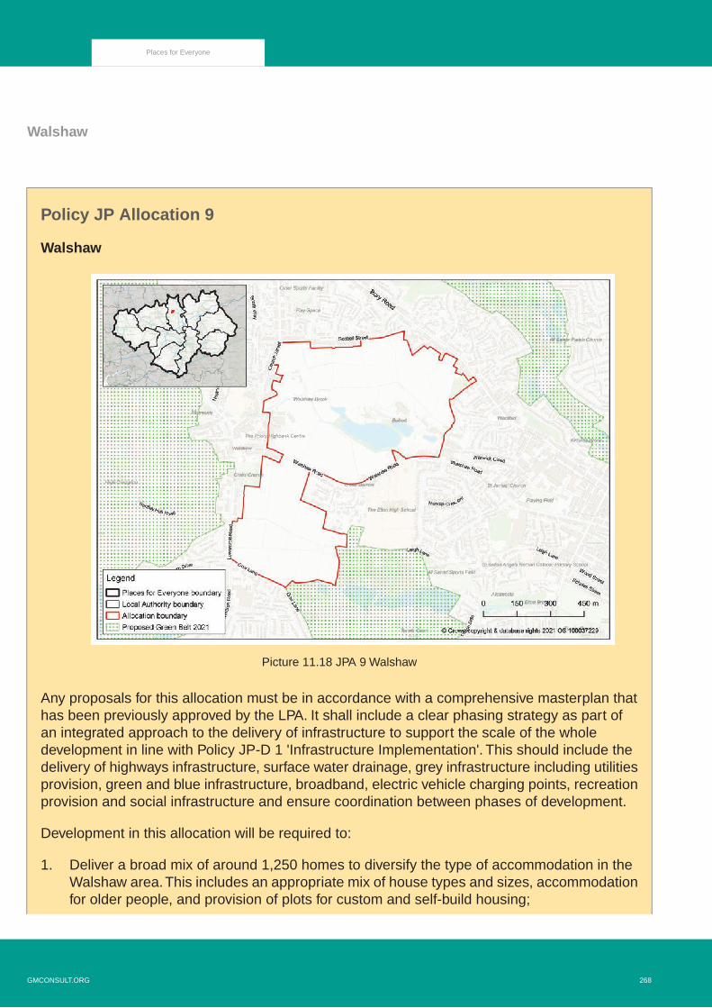
Walshaw
Policy JP Allocation 9
Walshaw
Picture 11.18 JPA 9 Walshaw
Any proposals for this allocation must be in accordance with a comprehensive masterplan thathas been previously approved by the LPA. It shall include a clear phasing strategy as part ofan integrated approach to the delivery of infrastructure to support the scale of the wholedevelopment in line with Policy JP-D 1 'Infrastructure Implementation'. This should include thedelivery of highways infrastructure, surface water drainage, grey infrastructure including utilitiesprovision, green and blue infrastructure, broadband, electric vehicle charging points, recreationprovision and social infrastructure and ensure coordination between phases of development.
Development in this allocation will be required to:
1. Deliver a broad mix of around 1,250 homes to diversify the type of accommodation in theWalshaw area.This includes an appropriate mix of house types and sizes, accommodationfor older people, and provision of plots for custom and self-build housing;
268GMCONSULT.ORG
Places for Everyone

2. Make provision for significant new and improved highways infrastructure to enable theproposed level of development to be accommodated, including:
i. The provision of a new strategic through road to enable an alternative to Church Street,Bank Street and High Street that is designed to be suitable for buses and incorporatesactive travel and is in line with local design standards;
ii. Off-site highway works where these are necessary to ensure acceptable trafficmovement from the allocation, including appropriate linkages to the Elton ReservoirLink Road;
3. Make provision for major investment in public transport in order to encourage moresustainable transport choices (including potential upgrade of existing bus services or a newbus service linking Tottington - Walshaw - Elton - proposed new Metrolink stop at Warth -Bury/Radcliffe);
4. Deliver a network of safe cycling and walking routes through the allocation linkingneighbourhoods with key destinations, incorporating Leigh Lane and Dow Lane and inaccordance with national and GM standards of design and construction and local planningpolicy requirements;
5. Make provision for affordable housing in accordance with local planning policy requirements,equivalent to at least 25% of the dwellings proposed on the site and across a range ofhousing types and sizes (with an affordable housing tenure split of 60% social or affordablerented and 40% affordable home ownership);
6. Make provision for a new one-form entry primary school within the allocation to accommodateadditional demand on school places;
7. Make a financial contribution towards off-site secondary school provision to meet the needsgenerated by the development;
8. Make provision for a new local centre in an accessible location which includes a range ofappropriate retail, health and community facilities and ensure that it is integrated withinexisting communities;
9. Make provision for other necessary infrastructure such as utilities, broadband and electricvehicle charging points in accordance with relevant joint plan or local planning policies;
10. Ensure the design and layout allows for effective integration with surrounding communities,including active travel links and connections to the recreation areas at Dow Lane, EltonVale, Whitehead Lodges as well as Walshaw Village and Bury Town Centre;
11. Make provision for new, high quality, publicly accessible, multifunctional green and blueinfrastructure within the allocation to provide health benefits to residents to create a visuallyattractive environment and provide linkages to the sites wider drainage strategy inaccordance with Policy JP-G 2 'Green Infrastructure Network' and Policy JP-G 8 'Standardsfor Greener Places'. This should include the integration and enhancement of the existinggreen infrastructure corridors and assets at Walshaw and Elton Brooks;
12. Minimise impacts on and provide net gains for biodiversity assets within the allocation inaccordance with Policy JP-G 9 'A Net Enhancement of Biodiversity and Geodiversity'; It isexpected that the biodiversity gain provision will be focused on the Walshaw and Elton
GMCONSULT.ORG269
Places for Everyone

Brook corridors and integrated with other green infrastructure functions such as recreationand surface water management;
13. Ensure the allocation is safe from and mitigates for potential flood risk from all sourcesincluding surface water, sewer flooding and groundwater. The delivery of the allocationshould be guided by an appropriate flood risk and drainage strategy which ensuresco-ordination between phases of development;
14. Ensure that sustainable drainage systems are fully incorporated into the development tomanage surface water and control the rate of surface water run-off, discharging in accordancewith the hierarchy of drainage options. Where possible, natural SuDS techniques shouldbe utilised, prioritising the use of ponds, swales and other infrastructure which mimic naturaldrainage and be designed as multi-functional green infrastructure connecting to the widergreen and blue infrastructure network in accordance with Policy JP-S 5 'Flood Risk and theWater Environment'and nationally recognised SuDS design standards. Proposals todischarge to the public sewer will need to submit clear evidence demonstrating whyalternative options are not available;
15. Make appropriate provision for the long-term management and maintenance of areas ofgreen infrastructure, biodiversity features, other areas of open space and sustainabledrainage features; and
16. Protect and, where appropriate, enhance heritage assets and their setting, including theChrist Church Grade II* listed building, in accordance with the findings and recommendationsof the assessment of heritage assets that forms part of the Plan’s evidence base and anyupdated assessment submitted as part of the planning application process.
11.119 This is an extensive area of land occupying a sustainable and well-connected location setentirely within the existing urban area. The land is loosely bounded by the urban areas ofTottington to the north, Woolfold and Elton to the east Lowercroft to the south and Walshawto the west.
11.120 The allocation has the potential to deliver around 1,250 houses, providing a diverse mix ofhouse types and affordable housing provision for the local area.
11.121 This number of new homes will require significant improvements to the local highway networkto accommodate increased traffic generation. This will require the provision of a new routethrough the allocation that provides an alternative to the use of the existing highway networkthrough Walshaw and may require a contribution to the proposed strategic route throughthe Elton Reservoir allocation which will also allow traffic from the Walshaw area to travelsouth without needing to travel through Bury town centre. The development will need tofacilitate improvements to public transport into and around the allocation in order to allowfor more sustainable transport choices.
11.122 The scale of the development will create additional demands for education and the provisionof a new one form entry primary school and contributions to off-site secondary school provisionwill be required in order to accommodate needs that cannot be met through existing facilities.
270GMCONSULT.ORG
Places for Everyone

11.123 The development will generate the need to make provision for a new accessible local centreproviding facilities such as shops, health facilities and community facilities.
11.124 Existing sport and recreational facilities at Dow Lane and Elton Vale Sports Club are situatedto the south of the allocation and the development should incorporate a green corridor toprovide access from the allocation to these existing recreational assets.
11.125 The development will need to have regard to any existing ecological and wildlife featuresincluding Walshaw and Elton Brooks which run through the northern and southern parts ofthe allocation by minimising impacts on and providing net gains for biodiversity. The brooksshould provide the focal point for the creation of a good quality green infrastructure networkproviding publicly accessible open spaces and recreational opportunities for residents in thearea. Such a network should seek to maximise the value of existing features and areas ofnature conservation value and offer opportunities for active travel, particularly betweenhomes, schools, shops, places of work and recreation. Connectivity from west to east isalready well established although there is potential for improved pedestrian and cycle routeslinking Tottington in the north to Elton and Starling in the south.There are existing reservoirswithin the allocation and other opportunities for blue infrastructure may exist to enhancevisual amenity, provide sustainable drainage and widen local biodiversity.
11.126 To reduce the risk of flooding, the development should minimise the risk associated withinadequate sewer capacity and minimise and control the rate of surface water run-off throughan appropriate drainage strategy and, where possible, safeguard land within the allocationfor flood storage. Measures such as rainwater recycling, green roofs, water butts andpermeable driveway surfaces should be considered to mitigate the impact of potential floodrisk both within and beyond the site boundaries. As a green and blue infrastructure networkwill provide more sustainable options discharge surface water, only foul flows should connectwith the public sewer.
11.127 Christ Church in Walshaw is a Grade II* Listed Building sitting adjacent to the allocation.Any development will, therefore, be required to respect the setting of the church and capitaliseon opportunities to draw on the contribution that the church makes to the character of thearea. The completion of a Heritage Impact Assessment will be required.
GMCONSULT.ORG271
Places for Everyone

Strategic Allocations in Manchester
Picture 11.19 Manchester District Overview
272GMCONSULT.ORG
Places for Everyone

Global Logistics
Policy JP Allocation 10
Global Logistics
Picture 11.20 JPA 10 Global Logistics
Development at this site will be required to:
1. Support growth of the airport to 2030 and compliment the development of the wider GlobalLogistics;
2. Deliver around 25,000 sqm B2/B8 employment. Suitable uses for the site will be cargofacilities but could also include airport operational facilities where it would have no greateradverse impact than would occur for cargo facilities;
3. Minimise any adverse impact on national and locally designated assets of conservation,ecological and landscape value. In particular, development should avoid the Cotterill CloughSSSI, nearby SBIs and ancient woodland, and any existing landscape mitigation affectedby development must be appropriately re-provided. Where it is not possible to avoid harm,mitigation measures to compensate for any adverse impact will be necessary and shouldbe agreed with the Council, informed by an up to date environmental assessment. Suitable
GMCONSULT.ORG273
Places for Everyone

buffers should be maintained between development and biodiversity assets with potentialenhancement and provision for green infrastructure;
4. Improve access to training and job opportunities, particularly for people in Wythenshawe;5. Include surface access and car parking arrangements which encourage the use of public
transport, walking and cycling, and satisfactorily manage impacts on the highway network(including addressing requirements around Public Rights of Way);
6. Make necessary improvements to local highway infrastructure to mitigate for the impact ofthe development, facilitate appropriate access to the site and incorporate enhancementsto public transport, direct and high quality pedestrian and cycle routes in the area; and
7. Include measures to promote sustainable travel including production of a Travel Plan.TravelPlans could include measures such as public transport vouchers and access to car clubs.
11.128 The opportunity that Manchester Airport and the associated Enterprise Zone provides forthe growth of the wider economy is significant. By attracting investment from globally mobileindustries to an exemplar development at Global Logistics, significant economic growth forthe north of England can be captured.This is a singular location close to a major internationalairport, and with improvements to local transport infrastructure, it can play its full part inmaximising future economic growth. The area’s location within open countryside, adjoining,and including part of a Site of Biological Interest (SBI), and adjoining a SSSI, demands ahigh quality and sensitive design, which will complement, conserve and enhance the naturalenvironment. Proposals within the site will need to take account of the existing landscapebuffer provided as part of the existing World Logistics Hub.
274GMCONSULT.ORG
Places for Everyone

Str
ateg
ic A
lloca
tio
ns
in O
ldh
am
Pic
ture
11.
21 O
ldha
m D
istr
ict O
verv
iew
GMCONSULT.ORG275
Places for Everyone

Beal Valley
Policy JP Allocation 12
Beal Valley
Picture 11.22 JPA 12 Beal Valley
Development on this site will be required to:
1. Be in accordance with a comprehensive masterplan and design code as agreed by the localplanning authority;
2. Deliver around 480 homes, providing a range of dwelling types and sizes to deliver inclusiveneighbourhoods and meet local needs, including the delivery of high-quality family housing;
3. Provide for affordable homes in line with local planning policy requirements;4. Provide for appropriate access points to and from the site in liaison with the local highway
authority, linking to a new internal spine road that will connect the site to the BroadbentMoss allocation to the south, and be delivered as part of the comprehensive developmentof both sites;
5. Safeguard a route from the proposed spine road through the northern part of the site, aspart of any development, to offer the potential to link the site to Shaw Town Centre andfurther improve connectivity to the local area and beyond;
276GMCONSULT.ORG
Places for Everyone

6. Take account of and deliver any other highway improvements, that may be needed tominimise the impact of associated traffic on the local highway network and improveaccessibility to the surrounding area, including off-site highway improvements, high-qualitywalking and cycling infrastructure and public transport facilities;
7. Contribute to the delivery of the new Metrolink stop and new park and ride facility as partof the neighbouring Broadbent Moss allocation, which in part will help to serve and improvethe accessibility and connectivity of both allocations;
8. Enhance pedestrian and cycling links to and from the site to the Shaw Metrolink stop, thenew Metrolink stop proposed as part of the Broadbent Moss strategic allocation, the busnetwork and surrounding area, to encourage sustainable modes of travel and maximise thesites accessibility, developing on the existing recreation routes and public rights of waynetwork. This should be delivered as part of a multi-functional green infrastructure network(incorporating the retention and enhancement of existing public rights of way), withhigh-quality landscaping within the site and around the main development areas, to minimisethe visual impact on the wider landscape, mitigate its environmental impacts, enhancelinkages with the neighbouring communities and countryside and provide opportunities forleisure and recreation;
9. Have regard to the recommendations of the Greater Manchester Landscape Character andSensitivity Assessment for the Pennines Foothills South / West Pennines;
10. Have regard to the findings of the Stage 2 Greater Manchester Green Belt Study, includingmitigation measures to mitigate harm to the Green Belt;
11. Ensure the protection from development of a large green wedge, between the maindevelopment area and the Metrolink line to the east and its enhancement as part of themulti-functional green infrastructure network, and contribute towards green infrastructureenhancement opportunities in the surrounding Green Belt as identified in the Identificationof Opportunities to Enhance the Beneficial Use of the Green Belt assessment;
12. Retain and enhance the hierarchy of biodiversity within the site, notably the existing ShawsideSBI, including areas of priority habitats and the Twingates local nature reserve, followingthe mitigation hierarchy and deliver a meaningful and measurable net gain in biodiversity,integrating them as part of multi-functional green infrastructure network which should ensurethe requirements of wading bird populations are met;
13. Provide further surveys on phase 1 habitats, amphibians, badgers, water voles and bats toinform any planning application. Regard should be also had to the river course andbroadleaved woodland;
14. Protect and enhance the habitats and corridor along the River Beal to improve the existingwater quality and seek to achieve ‘good status’ as proposed under the EU Water FrameworkDirective;
15. Provide for new and/or the improvement of existing open space, sport and recreation facilitiescommensurate with the demand generated in line with local planning policy requirements.This includes the expansion of, and improvement to existing, facilities at Heyside CricketClub;
16. Contribute to additional school places to meet the increased demand that will be placed onexisting primary and secondary school provision within the area, either through an expansion
GMCONSULT.ORG277
Places for Everyone

of existing facilities or through the provision of new school facilities in liaison with the localeducation authority;
17. Contribute to appropriate health and community facilities to meet the increased demandthat will be placed on existing provision;
18. Be informed by the findings and recommendations of the Historic Environment Assessment(2020) in the Plan's evidence base and any updated Heritage Impact Assessment submittedas part of the planning application process. An up-to-date archaeological desk-basedassessment to determine if any future evaluation and mitigation will be needed;
19. Be informed by an appropriate flood risk assessment feeding into a comprehensive drainagestrategy for the whole site, which includes a full investigation of the surface water hierarchy.The strategy should include details of full surface water management throughout the siteas part of the proposed green and blue infrastructure. Development should deliver anyappropriate recommendations, including mitigation measures and the incorporation ofsustainable drainage systems, integrated as part of the multi-functional green infrastructurenetwork and delivered in line with the GM Level 1 Strategic Flood Risk Assessment (SFRA)advice. Opportunities to use natural flood management and highway SUD’s features shouldbe explored;
20. Include provision for a wetland catchment area, in liaison with the Environment Agency,the Lead Local Flood Authority and Greater Manchester Ecology Unit, to the south east ofthe site within the Flood Zone 3 area, to provide net gains in flood storage for the widercatchment and / or actively reduce flood risk impacts downstream through additional storage,integrating it with the wider multi-functional green infrastructure network and incorporatingsustainable drainage infrastructure;
21. Have regard to the Groundwater Source Protection Zone in the design of the developmentto ensure there are no adverse impacts to groundwater resources or groundwater qualityand to ensure compliance with the Environment Agency's approach to groundwater protectionand any relevant position statements; and
22. Incorporate necessary remediation measures in areas affected by contamination andpreviously worked for landfill purposes.
11.129 The site is currently designated as Other Protected Open Land (OPOL) and Green Belt inthe Oldham Local Plan. There are also two brownfield sites in the northern part of theallocation; these are included within the red line to ensure they form part of the comprehensivedevelopment of the site.They are not included in the residential capacity set out in the policy,as they are already identified as part of the potential housing land supply, as set out inOldham’s current Strategic Housing Land Availability Assessment (SHLAA).
11.130 Whilst a significant proportion of Oldham’s housing land will come from the urban areathrough maximising the use of brownfield land, it is considered that the site will help todiversify the existing housing stock in the area and boroughwide. The site has the potentialto meet local housing need in the immediate vicinity and across the borough and contributeto, and enhance, the housing mix within the area through adding to the type and range ofhousing available.
278GMCONSULT.ORG
Places for Everyone
11.131 Affordable housing will be provided as part of any development of the site, including a rangeof tenures, house sizes and types, in order to meet the needs of residents as appropriate.Affordable housing will be delivered in line with local planning policy. A Housing Strategyand Local Housing Needs Assessment has been prepared by Oldham Council which willinform the Local Plan affordable housing policy.
11.132 The site is in a sustainable and accessible location, on the edge of a large area of open landand in a strong housing market which offers the potential to provide a range of high-qualityhousing in an attractive setting. It is located near to existing residential communities, includingShaw Town Centre, and has the potential for greater connectivity through the proposed newMetrolink stop, which would serve both this site and the Broadbent Moss site, providingincreased access to Rochdale Town Centre, Oldham Town Centre, Manchester City Centreand beyond.
11.133 The main points of access will be from Meek Street or Moss Lane to the south (as part ofthe Broadbent Moss allocation), and Oldham Road to the north of New Bank House. Thesewill link to the proposed spine road running through the site, providing the opportunity toimprove connectivity of the site to Shaw Town Centre, Broadbent Moss to the south and tothe wider area. Cop Road/Bullcote Lane (east of the spine road) will join where the twointersect and the remaining section of Bullcote Lane, (west of the spine road), will bedowngraded accordingly, providing an emergency access, access to existing properties andbusinesses, and for pedestrian and cyclists. The route of the section in the northern part ofthe site is to be safeguarded and offers the opportunity to address traffic and congestionissues within Shaw Town Centre, whilst enhancing accessibility and connectivity.
11.134 It is important to ensure that any development proposed does not place undue pressure onexisting social infrastructure and that any development takes account of the increaseddemand it may place on existing provision. As such, any development would need to provide:
a. new and/or improvement of existing open space, sport and recreation facilities;b. additional school places through the expansion of existing facilities or provision of new
school facilities; and c. provide for appropriate health and community facilities.
11.135 These would need to be provided in line with local planning policy requirements and in liaisonwith the local authority.
11.136 The site is split into two halves – the developable area to the west, close to the existingurban area, and the green wedge to the east, reflecting the topographical constraints of thesite. The policy protects this green wedge from development, and provides an opportunityto significantly enhance the green infrastructure and biodiversity value of the site, enhancingthe existing assets (Shawside SBI and Twingates local nature reserve) and othernon-designated ecology, as well as improving access to the open countryside for the localcommunity.
GMCONSULT.ORG279
Places for Everyone

11.137 The Beal Valley and Broadbent Moss allocations provide opportunities to secure net gainsfor nature. For these sites, net gains can be applied to Green Infrastructure, DeciduousWoodland, Lowland Fen and Protected Species. The development of the two allocationsshould include partnership work with appropriate bodies, to ensure that they contributetowards a wider ecological network approach.
11.138 The allocations provide an opportunity to demonstrate an exemplar development, usinggreen infrastructure that can be designed in a way to support local biodiversity, and strengthencoherent ecological networks beyond the site boundary.There is an opportunity to use SUDs,following the existing site hydrology, to create a network of wetlands that incorporate andenhance the existing fen, pond and watercourses within the site.
11.139 Deciduous Woodland is located north of the site, to the east of Shaw Side. DeciduousWoodland is a Priority Habitat, listed under Section 41 the NERC Act 2006. Lowland FenPriority Habitat is located outside the site boundary, buffering the western edge of the site.
11.140 Development should have regard to the ecosystem services opportunity mapping, in theimprovement and enhancement of Green Infrastructure.
11.141 Development should conserve heritage assets and their setting in accordance with thefindings and recommendations of the Historic Environment Assessment (2020). The siteincludes Duke Mill, an undesignated heritage asset. Development proposals should haveregard to the findings and recommendations of the Oldham Mills Strategy.
11.142 A flood risk assessment will be required to inform any development. A comprehensivedrainage strategy for the whole site should be prepared as part of the more detailedmasterplanning stage, to ensure that undue pressure and burden is not placed on existingutilities infrastructure through piecemeal and uncoordinated development. Regard shouldbe had to the GM SFRA SUDs guidance. Proposals should apply greenfield run off ratesand be supported by a maintenance plan.
11.143 The area in the south eastern corner, which falls within Flood Zone 3, also offers anopportunity, working with the Environment Agency and Lead Local Flood Authority, to developa wetland catchment area. As well as being an attractive feature of the site, this will allowthe site to take a strategic approach to flood risk management, and provide additionalopportunities for upstream flood storage.
280GMCONSULT.ORG
Places for Everyone

Bottom Field Farm (Woodhouses)
Policy JP Allocation 13
Bottom Field Farm (Woodhouses)
Picture 11.23 JPA 13 Bottom Field Farm (Woodhouses)
Development of this site will be required to:
1. Deliver around 30 homes, providing a range of dwelling types and sizes to deliver inclusiveneighbourhoods and meet local needs, including a mix of high-quality family housing;
2. Provide affordable homes in line with local planning policy requirements;3. Provide for appropriate access to and from the site in liaison with the local highway authority
and take account of and deliver any other improvements that may be needed to minimisethe impact of associated traffic on the surrounding areas and roads, including off-sitehighways improvements, high-quality walking and cycling infrastructure and public transportfacilities such as waiting facilities at bus stops near the site;
4. Deliver multi-functional green infrastructure and high-quality landscaping within the site andaround the main development areas to minimise the visual impact on the wider landscape,mitigate its environmental impacts, and enhance linkages with the neighbouring communitiesand countryside and provide opportunities for leisure and recreation;
GMCONSULT.ORG281
Places for Everyone

5. Have regard to the recommendations of the Greater Manchester Landscape Character andSensitivity Assessment for the Incised Urban Fringe Valleys;
6. Retain and enhance the hierarchy of biodiversity within the site, following the mitigationhierarchy and deliver a meaningful and measurable net gain in biodiversity, integrating themas part of a multi-functional green infrastructure network with the wider environment;
7. Provide further surveys on amphibians, birds, bats and extended phase 1 habitat surveysto inform planning applications;
8. Retain and enhance existing Public Rights of Way running through the site, integrating themas part of the multi-functional green infrastructure network to encourage active travel andimprove connections and access to adjoining communities and countryside;
9. Provide for new and/or the improvement of existing open space, sport and recreationfacilities, commensurate with the demand generated and local surpluses and deficiencies,in line with local planning policy requirements;
10. Have regard to the findings of the Stage 2 Greater Manchester Green Belt Study, includingmitigation measures to mitigate harm to the Green Belt;
11. Contribute towards green infrastructure enhancement opportunities in the surroundingGreen Belt as identified in the Identification of Opportunities to Enhance the Beneficial Useof the Green Belt assessment;
12. Contribute to additional school places to meet the increased demand that will be placed onexisting primary and secondary school provision within the area, either through an expansionof existing facilities or through the provision of new school facilities in liaison with the localeducation authority;
13. Contribute to appropriate health and community facilities to meet the increased demandthat will be placed on existing provision;
14. Conserve and enhance heritage assets and their setting in accordance with the findingsand recommendations of the Historic Environment Assessment (2020). An up-to-dateHeritage Impact Assessment will be required for any planning applications. Developmentshould be in keeping with the local character of Woodhouses in terms of materials, designand landscaping;
15. Take into consideration the findings of the Greater Manchester Historic EnvironmentAssessment Screening Exercise, and provide an up-to-date archaeological desk-basedassessment to determine if any future evaluation and mitigation will be needed; and
16. Be informed by an appropriate flood risk assessment and a comprehensive drainage strategywhich includes a full investigation of the surface water hierarchy.The strategy should includedetails of full surface water management throughout the site as part of the proposed greenand blue infrastructure. Development should deliver any appropriate recommendations,including mitigation measures and the incorporation of sustainable drainage systems aspart of the multi-functional green infrastructure network and be in line with the GM Level 1Strategic Flood Risk Assessment (SFRA) advice. Opportunities to use natural floodmanagement and highway SUDs features should be explored.
282GMCONSULT.ORG
Places for Everyone

11.144 The site is currently designated as Green Belt in the Oldham Local Plan. However, the siteis brownfield land in the Green Belt.Whilst a significant proportion of Oldham’s housing landwill come from the urban area through maximising the use of brownfield land, it is consideredthat the site will help to diversify the existing housing stock in the area and boroughwide.The site has the potential to contribute to meeting local housing need in the immediate vicinityand across the borough and contribute to and enhance the housing mix within the area,adding to the type and range of housing available.The location of the site, in a strong housingmarket, provides the potential for a range of high-quality housing in an attractive andaccessible location.
11.145 Affordable housing will be provided as part of any development of the site, including a rangeof tenures, house sizes and types, in order to meet the needs of residents as appropriate.Affordable housing will be delivered in line with local planning policy requirements. A HousingStrategy and Local Housing Needs Assessment has been prepared by Oldham Councilwhich will inform the Local Plan affordable housing policy.
11.146 The site may have ecological value that would need to be mitigated and integrated into thedevelopment as part of a complementary multi-functional green infrastructure.
11.147 It is important to ensure that any development proposed does not place undue pressure onexisting social infrastructure and that any development takes account of the increaseddemand it may place on existing provision. Any development would need to provide:
a. new and/or improvement of existing open space, sport and recreation facilities;b. additional school places through the expansion of existing facilities or provision of new
school facilities; andc. provide for appropriate health and community facilities.
11.148 These would need to be provided in line with local planning policy requirements and in liaisonwith the local authority.
11.149 Development should have regard to the ecosystem services opportunity mapping, in theimprovement and enhancement of Green Infrastructure.
11.150 Woodhouses Conservation Area is in close proximity to the site and, whilst outside theboundary, any development would need to consider the impact on its setting through thecompletion of a further Heritage Impact Assessment.
11.151 A flood risk assessment will be required to inform any development and a comprehensivedrainage strategy for the site as a whole should be prepared as part of the more detailedmasterplanning stage, in line with the Greater Manchester Strategic Flood Risk Assessment(SFRA) SUDs guidance, to ensure that undue pressure and burden is not placed on existingutilities infrastructure through piecemeal and uncoordinated development. Proposals shouldbe supported by a maintenance plan.
GMCONSULT.ORG283
Places for Everyone

Broadbent Moss
Policy JP Allocation 14
Broadbent Moss
Picture 11.24 JPA 14 Broadbent Moss
Development on this site will be required to:
1. Be in accordance with a comprehensive masterplan and Design Code agreed by the localplanning authority;
2. Deliver around 1,450 homes providing a range of dwelling types and sizes to deliver inclusiveneighbourhoods and meet local needs, including a mix of high-quality family housing. It isestimated that around 500 of these homes will be delivered post 2037;
3. Provide for affordable homes in line with local planning policy requirements;4. Deliver around 21,000 sqm employment floorspace extending the existing employment
opportunities at Higginshaw Business Employment Area;5. Provide for appropriate access points to and from the site in liaison with the local highway
authority. The main points of access to the site will be via Vulcan Street and the newconnections to Shaw and Oldham via the Beal Valley allocation, linking to a new internalspine road that will be delivered as part of the comprehensive development of the site. The
284GMCONSULT.ORG
Places for Everyone

spine road will provide a link to the residential area to the east of the Metrolink line, throughdelivering an appropriate crossing;
6. Take account of and deliver any other highway improvements that may be needed tominimise the impact of associated traffic on the local highway network and improveaccessibility to the surrounding area, including off-site highway improvements, high-qualitywalking and cycling infrastructure and public transport facilities;
7. Contribute towards the delivery of a new Metrolink stop and park and ride facility, alongwith the Beal Valley allocation, which in part will help to serve both allocations and improvetheir accessibility and connectivity;
8. Make provision for a local centre adjacent to the new Metrolink stop and new park and ridefacility on the north western part of the site incorporating higher density apartments;
9. Enhance pedestrian and cycling links to and from the site to the new Metrolink stop, theBeal Valley strategic allocation, bus network and surrounding area, to encourage sustainablemodes of travel and maximise the sites accessibility. This should be delivered as part of amulti-functional green infrastructure network (incorporating the retention and enhancementof existing public rights of way) and high-quality landscaping within the site and around themain development areas to minimise the visual impact on the wider landscape, mitigate itsenvironmental impacts, enhance linkages with the neighbouring communities and countrysideand provide opportunities for leisure and recreation;
10. Have regard to the recommendations of the Greater Manchester Landscape Character andSensitivity Assessment for the Pennines Foothills South / West Pennines. A LandscapeAppraisal is required to inform any planning application;
11. Have regard to the findings of the Stage 2 Greater Manchester Green Belt Study, includingmitigation measures to mitigate harm to the Green Belt. Development will be required tocreate a new defensible Green Belt boundary around the development parcels identifiedto the east of the Metrolink line;
12. Contribute towards green infrastructure enhancement opportunities in the surroundingGreen Belt, as identified in the Identification of Opportunities to Enhance the BeneficialUse of the Green Belt assessment;
13. Retain and enhance areas of biodiversity within the site, most notably the priority habitats,following the mitigation hierarchy and deliver a meaningful and measurable net gain inbiodiversity, integrating them as part of a multi-functional green-infrastructure network withthe wider environment;
14. Have regard to the recommendations of the Habitat Regulations Assessment and providefurther surveys on phase 1 habitats, badgers, amphibians (including great crested newts)and bat surveys to inform any planning application;
15. Protect and enhance the habitats and corridor along the River Beal to improve the existingwater quality and seek to achieve ‘good status’ as proposed under the EU Water FrameworkDirective;
16. Provide for new and/or the improvement of existing open space, sport and recreation facilitiescommensurate with the demand generated and local surpluses and deficiencies, in linewith local planning policy requirements;
17. Contribute to additional school places to meet the increased demand that will be placed onexisting primary and secondary school provision within the area, either through an expansion
GMCONSULT.ORG285
Places for Everyone

of existing facilities or through the provision of new school facilities in liaison with the localeducation authority;
18. Contribute to appropriate health and community facilities to meet the increased demandthat will be placed on existing provision;
19. Be informed by the findings and recommendations of the Historic Environment Assessment(2020) in the Plan's evidence base and any updated Heritage Impact Assessment submittedas part of the planning application process. An up-to-date archaeological desk-basedassessment to determine if any future evaluation and mitigation will be needed;
20. Be informed by an appropriate flood risk assessment and a comprehensive drainage strategy,which includes a full investigation of the surface water hierarchy.The strategy should includedetails of full surface water management throughout the site as part of the proposed greenand blue infrastructure. Development must avoid Flood Zone 3b, and deliver any appropriaterecommendations, including those within the Strategic Flood Risk Assessment (SFRA)Level 2 Site Assessment Summary, ensuring development is safe and does not increaseflood risk elsewhere. Natural sustainable drainage systems should be, integrated as partof the multi-functional green infrastructure network and delivered in line with the GM Level1 SFRA advice. Opportunities to use natural flood management and highway SUD’s featuresshould be explored;
21. Include provision for a wetland catchment area, in liaison with the Environment Agency,Lead Local Flood Authority and Greater Manchester Ecology Unity, in the northern centralpart of the site to the south of Cop Road within the Flood Zone 3 area, to provide net gainsin flood storage for the wider catchment and / or actively reduce flood risk impactsdownstream through additional storage, integrating it with the wider multi-functional greeninfrastructure network and incorporating SUDs;
22. Have regard to the Groundwater Source Protection Zone in the design of the development,to ensure that there are no adverse impacts to groundwater resources or groundwaterquality, and to ensure compliance with the Environment Agency approach to groundwaterprotection and any relevant position statements. A detailed hydrological assessment shouldsupport any planning application within this zone;
23. Incorporate necessary remediation measures in areas affected by contamination andpreviously worked for landfill purposes; and
24. Incorporate noise and air quality mitigation to protect the amenity of any new and existingoccupiers (both residential and employment), where new residential development adjoinsHigginshaw Business Employment Area and the proposed extension.
11.152 The site is currently designated as Land Reserved for Future Development (LRFD), OtherProtected Open Land (OPOL) and Green Belt in the Oldham Local Plan. Land at HebronStreet (with planning permission for 77 homes) is included in the red line boundary to ensureit forms part of the comprehensive development. It is not included in the residential capacityset out in the policy as it has already been identified as part of the potential housing landsupply, as set out in Oldham’s current Strategic Housing Land Availability Assessment(SHLAA). It is therefore anticipated that around 874 homes will be delivered during the planperiod.The scale of development proposed means that a proportion of the site capacity mayfall outside the plan period.
286GMCONSULT.ORG
Places for Everyone

11.153 Whilst a significant proportion of Oldham’s housing land will come from the urban areathrough maximising the use of brownfield land, it is considered that the site will help todiversify the existing housing stock in the area and boroughwide. The site has the potentialto meet local housing need in the immediate vicinity and across the borough and contributeto and enhance the housing mix within the area through adding to the type and range ofhousing available.
11.154 Affordable housing will be provided as part of any development of the site, including a rangeof tenures, house sizes and types, in order to meet the needs of residents as appropriate.Affordable housing will be delivered in line with local planning policy. A Housing Strategyand Local Housing Needs Assessment has been prepared by Oldham Council which willinform the Local Plan affordable housing policy.
11.155 Development of the site will also provide the opportunity to enhance and extend the existingemployment offer at Higginshaw BEA and across the borough, which would otherwise havelimited opportunity to emerge elsewhere due to the built-up nature of the borough.
11.156 The site is in a sustainable and accessible location, on the edge of a large area of openland. It is located near to existing neighbouring residential communities and has the potentialfor greater connectivity through the proposed new Metrolink stop, which would serve boththis and the Beal Valley site, providing increased access to Rochdale Town Centre, OldhamTown Centre, Manchester City Centre and beyond.
11.157 The proposed spine road through the site provides the opportunity to improve connectivityto Shaw Town Centre, Beal Valley to the north and the wider area. Improvements to thehighway network, including Bullcote Lane, Cop Road and the new access points proposed,will help to improve connectivity to the wider area, in particular Sholver.
11.158 The main points of access to the site will be from Meek Street or Moss Lane to the west andVulcan Street to the east. These will link to the proposed spine road running through thesite, providing the opportunity to improve connectivity of the site to the Beal Valley allocationto the north, and to the wider area. Cop Road/Bullcote Lane (east of the spine road) will joinwhere the two intersect, and the remaining section of Bullcote Lane, (west of the spine road),will be downgraded accordingly, providing an emergency access, access to existing propertiesand businesses and for pedestrian and cyclists. South of Cop Road, the new link will continuethrough the Broadbent Moss allocation, to form an east-west connection with Vulcan St overthe existing Metrolink line. At least one crossing point over the Metrolink line will be requiredto connect the eastern and western parts of the site.
11.159 It is important to ensure that any development proposed does not place undue pressure onexisting social infrastructure and that any development takes account of the increaseddemand it may place on existing provision. As such, any development would need to provide:
a. new and/or improvement of existing open space, sport and recreation facilities;
GMCONSULT.ORG287
Places for Everyone

b. additional school places through the expansion of existing facilities or provision of newschool facilities; and
c. provide for appropriate health and community facilities.
11.160 These would need to be provided in line with local planning policy requirements and in liaisonwith the local authority.
11.161 A large proportion of the site is proposed to remain undeveloped and will be retained asGreen Belt, providing an opportunity to significantly enhance the green infrastructure andbiodiversity value of the site, enhancing the existing assets (such as the priority habitats)and improving access to the open countryside for the local community.
11.162 The Beal Valley and Broadbent Moss strategic allocations provide opportunities to securenet gains for nature and local communities. For these site allocations net gains can be appliedto Green Infrastructure, Deciduous Woodland, Lowland Fen and Protected Species. Thedevelopment of the two site allocations should include elements of partnership work withappropriate bodies, to ensure they contribute towards a wider ecological network approach.
11.163 The site allocations provide an opportunity to demonstrate an exemplar development usinggreen infrastructure, that can be designed in such a way that it can support local biodiversityand strengthen coherent ecological networks beyond the site boundary, creating a resilientlandscape through a network of connected sites.There is an opportunity to use SustainableUrban Drainage (SUDs) systems following the existing site hydrology, to create a networkof wetlands that enhance and incorporate the existing fen, pond and watercourses withinthe site that is subject to hydrological investigations.
11.164 Deciduous Woodland is located north of the site east of Shaw Side. Deciduous Woodlandis a Priority Habitat listed under Section 41 the Natural Environmental and Rural Communities(NERC) Act 2006.
11.165 Lowland Fen Priority Habitat is located outside of the site boundary, buffering the westernedge of the site.
11.166 Development should have regard to the ecosystem services opportunity mapping, in theimprovement and enhancement of Green Infrastructure.
11.167 Development should conserve heritage assets and their settings through a Heritage ImpactAssessment and having regard to the findings and recommendations of the HistoricEnvironment Assessment (2020).
11.168 A flood risk assessment will be required to inform any development. A comprehensivedrainage strategy for the whole site should be prepared as part of the more detailedmasterplanning stage, to ensure that undue pressure and burden is not placed on existingutilities infrastructure through piecemeal and uncoordinated development. Proposals shouldapply greenfield run off rates and be supported by a maintenance plan. Regard should behad to the GM SFRA SUDs guidance. The area in the northern central part of the site, andwhich falls within Flood Zone 3, also offers an opportunity, working with the Environment
288GMCONSULT.ORG
Places for Everyone

Agency and Local Lead Flood Authority, to develop a wetland catchment area which, aswell as being an attractive feature of the site, will allow a strategic approach to flood riskmanagement and provide additional opportunities for upstream flood storage.
11.169 Part of the allocation is in within a Source Protection Zone. Any planning applications withinthis zone are expected to be supported by a detailed hydrological assessment. This willneed to consider the vulnerability of the land and to propose suitable mitigation measureswhich will be employed to reduce the risk of pollution of groundwater.
Chew Brook Vale (Robert Fletchers)
Policy JP Allocation 15
Chew Brook Vale (Robert Fletchers)
Picture 11.25 JPA 15 Chew Brook Vale (Robert Fletchers)
Development at this site will be required to:
1. Be in accordance with a comprehensive masterplan and Design Code agreed by the localauthority;
GMCONSULT.ORG289
Places for Everyone
2. Provide a range of commercial, leisure and retail facilities of up to 6,000 sqm, as part of amix of uses, to support tourism and leisure facilities, connected to its gateway location tothe Peak District National Park and capitalising on its proximity to Dove Stone Reservoir;
3. Deliver around 90 homes with a mix of low-density family and executive homes andaffordable homes of 2 and 3 bedrooms, in line with local planning policy requirements;
4. Provide an improved access off the A669 / A635 and improve the existing access road upto the mill complex, including the river crossing over Chew Brook, up to adoptable standards;
5. Take account of and deliver other highway improvements that may be needed to minimisethe impact of associated traffic on the local highway network and improve access to thesurrounding area, including off-site highway improvements, high-quality walking and cyclingand public transport facilities, including opportunities for bus service provision into the site;
6. Be informed by, and deliver the recommendations of, an appropriate visitor managementplan to ensure that there is no adverse impact on Dove Stone Reservoir, the Peak DistrictNational Park and designated conservation areas. Development must have regard to theduty to care for the Peak District National Park under Section 62(2) of the Environment Act1995;
7. Incorporate multi-functional green and blue infrastructure and high levels of landscaping tominimise the visual impact on the wider landscape, mitigate its environmental impacts, andenhance linkages with the neighbouring communities and countryside. This should includefootpath networks and recreation routes that incorporate existing trees and habitat areas,providing a range of formal and informal recreational open space and access to existingpublic footpath networks and woodland areas surrounding the site;
8. Be designed to minimise the landscape impact having regard to the findings andrecommendations of the Greater Manchester Landscape Character and SensitivityAssessment for the Open Moorlands and Enclosed Upland Fringes (Dark Peak);
9. Retain and enhance biodiversity within and adjoining the site, notably the areas of priorityhabitats, following the mitigation hierarchy and deliver a meaningful and measurable netgain in biodiversity, integrating them as part of the multi-functional green infrastructurenetwork with the wider environment;
10. Provide further surveys on extended phase 1 habitats, bats and birds to inform any planningapplication;
11. Ensure that development does not have an adverse impact on the integrity of the nearbySpecial Protection Area (SPA) and Special Area of Conservation (SAC). Therecommendations from the Habitat Regulations Assessment must be considered;
12. Be designed to relate positively to Chew Brook and other watercourses running throughthe site, integrating them as part of a multi-functional green infrastructure network, creatinga green route along the river / brook, ensuring that development is set back to allowecological movement;
13. Provide for opportunities to protect and enhance the habitats and corridor along Chew Brookto improve the existing water quality and seek to achieve 'good' status as proposed underthe EU Water Framework Directive;
14. Have regard to the findings of the Stage 2 Greater Manchester Green Belt Study, includingmitigation measures to mitigate harm to the Green Belt;
290GMCONSULT.ORG
Places for Everyone

15. Contribute towards green infrastructure enhancement opportunities in the surroundingGreen Belt as identified in the Identification of Opportunities to Enhance the Beneficial Useof the Green Belt assessment;
16. Provide for new and/or the improvement of existing open space, sport and recreation facilitiescommensurate with the demand generated in line with local planning policy requirements,and local surpluses and deficiencies;
17. Contribute to additional school places to meet the increased demand that will be placed onexisting primary and secondary school provision within the area, either through an expansionof existing facilities or through the provision of new school facilities in liaison with the localeducation authority;
18. Contribute to appropriate health and community facilities to meet the increased demandthat will be placed on existing provision in liaison with the local authority and Public Health;
19. Be informed by the findings and recommendations of the Historic Environment Assessment(2020) and addendum (2021) in the Plan's evidence base and any updated Heritage ImpactAssessment submitted as part of the planning application process. An up-to-datearchaeological desk-based assessment to determine if any future evaluation and mitigationwill be needed;
20. Ensure high quality design that is environmentally and sustainably driven, including greyharvesting and recycling, maximising energy efficiency through good building design andfuel-efficient technology, a reduction of car usage and household recycling facilities; and
21. Be informed by an appropriate flood risk assessment, which takes account of anyrecommendations from the Level 2 Strategic Flood Risk Assessment Site Summary Report,and a comprehensive drainage strategy which includes a full investigation of the surfacewater hierarchy. The strategy should include details of full surface water managementthroughout the site as part of the proposed green and blue infrastructure. Developmentmust avoid Flood Zone 3b and deliver any appropriate recommendations, including mitigationmeasures, ensuring development is safe over its lifetime and does not increase flood riskelsewhere. Natural sustainable drainage systems should be integrated to control the rateof surface water run-off. Proposals should be integrated as part of the multi-functional greeninfrastructure network and opportunities to use natural flood management and highwaySUDs features should be explored.
11.170 The site comprises the redundant Robert Fletchers mill complex, which is brownfield land.Given the previous use of the Robert Fletchers site as a paper mill, and its subsequentdereliction, it is considered that the need for remediation will be high contributing to higherviability costs in preparing the site for development.
11.171 The site is in a gateway location into the Peak District National Park and presents a strategicand unique opportunity for Oldham and Greater Manchester to achieve complementarytourism and leisure development to enhance the sub-region’s visitor and destination offer.The development of the site for leisure and tourism uses will also capture leisure spend inthe local economy due to its proximity to the RSPB reserve, Dove Stone Reservoir and the
GMCONSULT.ORG291
Places for Everyone

Saddleworth villages, and create employment opportunities. The tourism and leisure offershould capitalise on, and complement, its location in a way that is sensitive to its uniquesetting.
11.172 The site provides the potential to provide a range of high-quality family and executive homesin an attractive and desirable rural location. It also provides an opportunity to enhanceOldham’s housing offer and contribute to meeting Oldham’s housing need. Due to the sceniclocation of the site, it should be an attractive location for larger and bespoke housing, providinga distinctive offer to the borough’s housing market.There is however also a need for affordablehomes across the Saddleworth villages as many residents who wish to remain living withinthe area cannot currently afford to do so.
11.173 Affordable housing will be provided as part of any development of the site, including a rangeof tenures, house sizes and types, in order to meet the needs of residents as appropriate.Affordable housing will be delivered in line with local planning policy requirements. A HousingStrategy and Local Housing Needs Assessment has been prepared by Oldham Councilwhich will inform the Local Plan affordable housing policy.
11.174 Existing access to the site will need to be improved as part of any development, which mayinclude its relocation. This includes the current road from the site, the existing river crossingover Chew Brook from the site to the access road and the access arrangements onto theA669 / A635. Any proposals will need to be agreed by the local highway authority and toadoptable standards.
11.175 The policy seeks multi-functional green and blue infrastructure and high levels of landscapingas part of the comprehensive development of the site. This includes the retention andenhancement of existing public rights of way and recreation routes to improve linkages toand from the site to Dove Stone Reservoir, Peak District National Park and the widercountryside.
11.176 Development should have regard to the ecosystem services opportunity mapping, in theimprovement and enhancement of Green Infrastructure.
11.177 Development must follow the legal and policy requirements of protecting irreplaceablehabitats and the mitigation hierarchy of doing everything possible to avoid and then minimisethe impact on biodiversity, and only then after taking all measures compensate for lossesthat cannot be avoided. Meaningful biodiversity net gain is then applied on top of thisapproach.
11.178 It is important to ensure that any development proposed does not place undue pressure onexisting social infrastructure and that any development takes account of the increaseddemand it may place on existing provision. As such any development would need to provide:
a. new and/or improvement of existing open space, sport and recreation facilities;b. additional school places through the expansion of existing facilities or provision of new
school facilities; and c. provide for appropriate health and community facilities.
292GMCONSULT.ORG
Places for Everyone
11.179 These would need to be provided in line with local planning policy requirements and in liaisonwith the local authority.
11.180 Heritage assets play an important role in the area’s local historical and cultural identity anddistinctiveness. There are undesignated assets throughout the site and a number of otherheritage assets within close proximity, including Hey Top Conservation Area and GreenfieldHouse and New Barn Grade II Listed Buildings which lie outside of the strategic allocationboundary. Any development would need to consider the impact on their setting, through thecompletion of a further Heritage Impact Assessment and having regard to the HistoricEnvironment Assessment (2020) and addendum (2021). Any development proposals shouldalso have regard to the findings and recommendations of the Oldham Mill Strategy. Finallyreflecting the sites unique location, the Design Code should ensure new development is inkeeping with the surrounding character of the area through the use of local materials anddesign.
11.181 The Greater Manchester Level 2 Strategic Flood Risk Assessment considers the flood riskto the site and provides recommendations that will need to be considered to meet therequirements of the Exception Test. As such, any development would need to follow thesequential approach on site and a flood risk assessment would be required to inform anydevelopment, including the recommendations from the Level 2 report. A comprehensivedrainage strategy, including a maintenance plan, for the whole site would be required aspart of the more detailed masterplanning stage to ensure that undue pressure and burdenis not placed on existing utilities infrastructure through piecemeal and uncoordinateddevelopment. Regard should be had to the SUDS guidance set out in the Greater ManchesterLevel 1 Strategic Flood Risk Assessment and other National Standards (such as CIRIA,Water UK Design and Construction Guidance).
GMCONSULT.ORG293
Places for Everyone

Cowlishaw
Policy JP Allocation 16
Cowlishaw
Picture 11.26 JPA 16 Cowlishaw
Development at this site will be required to:
1. Be in accordance with a comprehensive masterplan and Design Code agreed by the localplanning authority;
2. Deliver around 460 homes, providing a range of dwelling types and sizes so as to delivermore inclusive neighbourhoods and meet local needs, including the delivery of a mix ofhigh-quality family housing;
3. Provide for affordable homes in line with local requirements set out in local planning policyrequirements;
4. Provide for appropriate access points to and from the site in liaison with the local highwayauthority.The main points of access to the site will be Cocker Mill Lane to the southern partof the site, with an emergency/controlled secondary access to Cowlishaw, Kings Road tothe central part of the site that lies to the north of Cowlishaw Farm and Denbigh Drive, withaccess limited to the small parcel at the north only;
294GMCONSULT.ORG
Places for Everyone

5. Take account of and deliver any other highway improvements that may be needed tominimise the impact of associated traffic on the local highway network and improveaccessibility to the surrounding area, including off-site highways improvements, high-qualitywalking and cycling infrastructure and public transport facilities;
6. Deliver multi-functional green infrastructure (incorporating the retention and enhancementof existing public rights of way) and high-quality landscaping within the site and around themain development areas. This is to minimise the visual impact on the wider landscape,mitigate its environmental impacts, and enhance linkages with the neighbouring communitiesand countryside and provide opportunities for leisure and recreation.
7. Have regard to the recommendations of the Greater Manchester Landscape Character andSensitivity Assessment for the Pennines Foothills South / West Pennines;
8. Retain and enhance the hierarchy of biodiversity within the site, notably the existingCowlishaw Ponds SBI and the area of priority habitat to the south of Crompton PrimarySchool, following the mitigation hierarchy and deliver a meaningful and measurable netgain in biodiversity, integrating them as part of the multi-functional green infrastructurenetwork with the wider environment;
9. Provide further surveys on amphibians (including great crested newts), extended phase 1habitat, breeding birds, badgers and bats to inform any planning application;
10. Provide for new and/or the improvement of existing open space, sport and recreationfacilities, commensurate with the demand generated and local surpluses and deficiencies,in line with local planning policy requirements. This includes the retention or relocation, ifrequired, and improvement of the existing play area off Kings Road, within the site;
11. Contribute to additional school places to meet the increased demand that will be placed onexisting primary and secondary school provision within the area, either through an expansionof existing facilities or through the provision of new school facilities in liaison with the localeducation authority;
12. Contribute to appropriate health and community facilities to meet the increased demandthat will be placed on existing provision;
13. Be informed by the findings and recommendations of the Historic Environment Assessment(2020) in the Plan's evidence base and any updated Heritage Impact Assessment submittedas part of the planning application process. An up-to-date archaeological desk-basedassessment to determine if any future evaluation and mitigation will be needed; and
14. Be informed by an appropriate flood risk assessment and a comprehensive drainage strategywhich includes a full investigation of the surface water hierarchy.The strategy should includedetails of full surface water management throughout the site as part of the proposed greenand blue infrastructure. Development should deliver any appropriate recommendations,including mitigation measures and the incorporation of sustainable drainage systemsintegrated as part of the multi-functional green infrastructure network, and be in line withthe GM Level 1 Strategic Flood Risk Assessment (SFRA) advice. Opportunities to usenatural flood management and highway SUDs features should be explored.
11.182 The site is currently designated as Other Protected Open Land (OPOL) in the Oldham LocalPlan.Whilst a significant proportion of Oldham’s housing land will come from the urban areathrough maximising the use of brownfield land, it is considered that the site will help to
GMCONSULT.ORG295
Places for Everyone
diversify the existing housing stock in the area and boroughwide. The site has the potentialto meet local housing need in the immediate vicinity and across the borough and contributeto and enhance the housing mix within the area through adding to the type and range ofhousing available.
11.183 Affordable housing will be provided as part of any development of the site, including a rangeof tenures, house sizes and types, in order to meet the needs of residents as appropriate.Affordable housing will be delivered in line with local planning policy. A Housing Strategyand Local Housing Needs Assessment has been prepared by Oldham Council which willinform the Local Plan affordable housing policy.
11.184 The site is in a sustainable and accessible location, on the edge of a large area of open landand in a successful and attractive neighbourhood, and connected to neighbouring communitiesin Low Crompton, Cowlishaw, Royton and nearby town centres, including Shaw, where thereis a Metrolink stop. Any development would be required to enhance links to and from thesite to the bus network, to encourage sustainable modes of travel and maximise the site’saccessibility, developing the existing recreation routes and Public Right of Way network.
11.185 The development will need to provide for suitable access to the site, in liaison with the localhighway authority. As stated in the policy the main access points to the site will be CockerMill Lane (supported by an emergency/controlled secondary access to Cowlishaw), KingsRoad and Denbigh Drive. The access at Denbigh Drive is constrained and will be limited toprovide access to the small parcel in the northern section of the site only.
11.186 Cowlishaw Ponds SBI is made up of three pond areas and there is an additional priorityhabitat to the south of Crompton Primary School. Any development will need to retain andenhance these, incorporating them as a key feature within the green infrastructure networkand landscaping proposals for the site.
11.187 Biodiversity net gain could be applied to Green Infrastructure, deciduous woodland, lowlandfen and protected species.
11.188 Development should have regard to the ecosystem services opportunity mapping, in theimprovement and enhancement of Green Infrastructure.
11.189 It is important to ensure that any development proposed does not place undue pressure onexisting social infrastructure and takes account of the increased demand it may place onexisting provision. As such, any development would need to provide:
a. new and/or improvement of existing open space, sport and recreation facilities;b. additional school places through the expansion of existing facilities or provision of new
school facilities; and c. provide for appropriate health and community facilities.
11.190 These would need to be provided in line with local planning policy requirements and in liaisonwith the local authority.
296GMCONSULT.ORG
Places for Everyone

11.191 There are heritage assets in the surrounding area. Any development would need to considerthe impact on their setting, through the completion of a further Heritage Impact Assessmentand having regard to the Historic Environment Assessment (2020).
11.192 A flood risk assessment will be required to inform development. A comprehensive drainagestrategy for the whole site should be prepared as part of the more detailed masterplanningstage, to ensure that undue pressure and burden is not placed on existing utilitiesinfrastructure through piecemeal and uncoordinated development. Regard should be hadto the GM SFRA SUDs guidance. Proposals should apply greenfield run off rates, besupported by a maintenance plan and the use of highway SUD’s features.
Land South of Coal Pit Lane (Ashton Road)
Policy JP Allocation 17
Land South of Coal Pit Lane (Ashton Road)
Picture 11.27 JPA 17 Land South of Coal Pit Lane (Ashton Road)
Development on this site will be required to:
1. Be in accordance with a comprehensive masterplan and design code agreed by the localplanning authority;
GMCONSULT.ORG297
Places for Everyone

2. Deliver around 175 homes, providing a range of dwelling types and sizes to deliver moreinclusive neighbourhoods and meet local needs, including the delivery of high-quality familyhousing;
3. Provide for affordable homes, in line with local planning policy requirements;4. Provide for appropriate access points to and from the site in liaison with the local highway
authority. As part of this, provision should be made to safeguard a route from the northwestern edge of the site through to Coal Pit Lane, linked to the internal infrastructure of thesite;
5. Take account of and deliver any other highway improvements that may be needed tominimise the impact of associated traffic on the surrounding areas and roads, includingoff-site highways improvements, high-quality walking and cycling infrastructure and publictransport facilities such as waiting facilities at bus stops near the site;
6. Deliver multi-functional green infrastructure (incorporating the retention and enhancementof existing public rights of way) and high-quality landscaping within the site so as to minimisethe visual impact on the wider landscape, mitigate its environmental impacts, enhancelinkages with the neighbouring communities and countryside and provide opportunities forleisure and recreation;
7. Have regard to the recommendations of the Greater Manchester Landscape Character andSensitivity Assessment for the Incised Urban Fringe Valleys;
8. Retain and enhance the hierarchy of biodiversity within the site, notably areas of priorityhabitats, following the mitigation hierarchy and deliver a meaningful and measurable netgain in biodiversity, integrating them as part of the multi-functional green infrastructurenetwork;
9. Provide further surveys on amphibians, extended phase 1 habitats, badgers and bats toinform any planning application;
10. Provide for new and/or the improvement of existing open space, sport and recreation facilitiescommensurate with the demand generated and local surpluses and deficiencies, in linewith local planning policy requirements;
11. Have regard to the findings of the Stage 2 Greater Manchester Green Belt Study, includingmitigation measures to mitigate harm to the Green Belt;
12. Contribute towards green infrastructure enhancement opportunities in the surroundingGreen Belt, as identified in the Identification of Opportunities to Enhance the Beneficial Useof the Green Belt assessment;
13. Contribute to additional school places to meet the increased demand that will be placed onexisting primary and secondary school provision within the area, either through expansionof existing facilities or through the provision of new school facilities, in liaison with the localeducation authority;
14. Contribute to appropriate health and community facilities to meet the increased demandthat will be placed on existing provision;
15. Conserve and enhance heritage assets and their setting in accordance with the findingsand recommendations of the Historic Environment Assessment (2020) and addendum(2021). An up-to-date Heritage Impact Assessment will be required for any planningapplications;
298GMCONSULT.ORG
Places for Everyone

16. Take into consideration the findings of the Greater Manchester Historic EnvironmentAssessment Screening Exercise, and provide an up-to-date archaeological desk-basedassessment to determine if any future evaluation and mitigation will be needed;
17. Be informed by an appropriate flood risk assessment and a comprehensive drainage strategy,which includes a full investigation of the surface water hierarchy.The strategy should includedetails of full surface water management throughout the site as part of the proposed greenand blue infrastructure. Development should deliver any appropriate recommendations,including mitigation measures and the incorporation of sustainable drainage systems aspart of the multi-functional green infrastructure network, and be in line with the GM Level 1Strategic Flood Risk Assessment (SFRA) advice. Opportunities to use natural floodmanagement and highway SUDs features should be explored; and
18. Incorporate necessary remediation measures in areas which are affected by contaminationand have been previously worked for landfill purposes.
11.193 The site is currently designated Green Belt. The red line boundary incorporates the existingsaved Oldham UDP allocation at Danisher Lane, to ensure it forms part of the comprehensivedevelopment of the site.The saved UDP allocation is not included in the residential capacityset out in the policy, as it has already been identified as part of Oldham’s base line housingland supply. Whilst a significant proportion of Oldham’s housing land will come from theurban area through maximising the use of brownfield land, it is considered that this site willhelp to diversify the existing housing stock in the area and the borough as a whole. The sitehas the potential to meet local housing need in the immediate vicinity and across the borough,and contribute to and enhance the housing mix within the area, through adding to the typeand range of housing available.
11.194 Affordable housing will be provided as part of any development of the site, including a rangeof tenures, house sizes and types, in order to meet the needs of residents as appropriate.Affordable housing will be delivered in line with local planning policy. A Housing Strategyand Local Housing Needs Assessment has been prepared by Oldham Council which willinform the Local Plan affordable housing policy.
11.195 The site is well positioned in a sustainable and accessible location and has good connectivityto the wider strategic highway network. The site has good access to public transport and arange of local services, with access to a number of bus routes along Ashton Road betweenTameside and Oldham.TfGM have also identified the A627/A671 corridor between Rochdale– Oldham – Ashton within the first tranche of the ‘Streets for All’ corridor studies to improveconnectivity on Greater Manchester’s Key Route Network. These corridors have beenidentified on the basis of their potential to support a range of GM agendas, around deliveringmodal shift (particularly to public transport, walking and cycling), improving air quality andregenerating local centres. Any development would therefore be required to enhance linksto and from the site to the bus network, to encourage sustainable modes of travel andmaximise the site's accessibility, developing the existing recreation routes and Public Rightof Way network.
GMCONSULT.ORG299
Places for Everyone

11.196 The development will need to provide for suitable access to the site, in liaison with the localhighway authority. Potential access points to the site may be from Coal Pit Lane and AshtonRoad. As part of bringing this site forward consideration should be given as to how movementand connectivity along Coal Pit Lane can be enhanced to improve highway safety, for vehicles,pedestrians and cyclists. As such, provision should be made to safeguard a route from thenorth western edge of the site through to Coal Pit Lane, with appropriate links through thesite to an appropriate access onto Ashton Road.
11.197 It is important to ensure that any development proposed does not place undue pressure onexisting social infrastructure and that any development takes account of the increaseddemand it may place on existing provision. As such any development would need to provide:
a. new and/or improvement of existing open space, sport and recreation facilities;b. additional school places through the expansion of existing facilities or provision of new
school facilities; andc. provide for appropriate health and community facilities.
11.198 These would need to be provided in line with local planning policy requirements and in liaisonwith the local authority.
11.199 The allocation provides opportunities to secure net gains for nature. This should be appliedto green infrastructure and priority habitats.
11.200 Development should have regard to the ecosystem services opportunity mapping, in theimprovement and enhancement of Green Infrastructure.
11.201 There are also heritage assets close to the proposed strategic allocation. Any developmentwould need to consider the impact on their setting, through the completion of a furtherHeritage Impact Assessment.
11.202 A flood risk assessment will be required to inform any development. A comprehensivedrainage strategy should be prepared, for the site as a whole, as part of the more detailedmasterplanning stage, to ensure that undue pressure and burden is not placed on existingutilities infrastructure through piecemeal and uncoordinated development. Regard shouldbe had to the GM SFRA SUDs guidance. Proposals should apply greenfield run off ratesand be supported by a maintenance plan.
11.203 There are a number of historic landfill sites within the allocation. Necessary remediationmeasures in areas affected by contamination and previously worked for landfill purposesshould be undertaken.
300GMCONSULT.ORG
Places for Everyone

South of Rosary Road
Policy JP Allocation 18
South of Rosary Road
Picture 11.28 JPA 18 South of Rosary Road
Development at this site will be required to:
1. Deliver around 60 homes, providing a range of dwelling types and sizes to deliver moreinclusive neighbourhoods and meet local needs, including the delivery of high-quality familyhousing;
2. Provide for appropriate access points to and from the site in liaison with the local highwayauthority.The main point of access to the site will be through the neighbouring former Centrefor Professional Development site and onto Rosary Road, with the potential for a secondaryemergency only access from St Cuthbert’s Fold;
3. Take account of and deliver any other highway improvements that may be needed tominimise the impact of associated traffic on the local highway network and improveaccessibility to the surrounding areas, including off-site highway improvements, high-qualitywalking and cycling infrastructure and public transport facilities;
GMCONSULT.ORG301
Places for Everyone

4. Deliver multi-functional green infrastructure (incorporating the retention and enhancementof existing public rights of way) and high quality landscaping within the site so as to minimisethe visual impact on the wider landscape, mitigate its environmental impacts, and enhancelinkages with the neighbouring communities and countryside and provide opportunities forleisure and recreation;
5. Have regard to the recommendations of the Greater Manchester Landscape Character andSensitivity Assessment for the Incised Urban Fringe Valleys;
6. Retain and enhance the hierarchy of biodiversity within the site, notably Bankfield CloughSBI and the area of priority habitat, following the mitigation hierarchy and deliver a meaningfuland measurable net gain in biodiversity, integrating the delivery of functional ecologicalnetworks into multi-functional green infrastructure to enable free movement of species ofprincipal importance. Planning proposals should incorporate a suitable buffer betweendevelopment plots and the SBI to protect its important features;
7. Provide further surveys on extended phase 1 habitats and bats, to inform any planningapplication;
8. Have regard to the findings of the Stage 2 Greater Manchester Green Belt Study, includingmitigation measures to mitigate harm to the Green Belt;
9. Contribute towards green infrastructure enhancement opportunities in the surroundingGreen Belt as identified in the Identification of Opportunities to Enhance the Beneficial Useof the Green Belt assessment;
10. Provide for new and/or the improvement of existing open space, sport and recreation facilitiescommensurate with the demand generated and local surpluses and deficiencies, in linewith local planning policy requirements;
11. Contribute to additional school places to meet the increased demand that will be placed onexisting primary and secondary school provision within the area, either through an expansionof existing facilities or through the provision of new school facilities in liaison with the localeducation authority;
12. Contribute to appropriate health and community facilities to meet the increased demandthat will be placed on existing provision;
13. Conserve and enhance heritage assets and their setting in accordance with the findingsand recommendations of the Historic Environment Assessment (2020). An up-to-dateHeritage Impact Assessment will be required for any planning applications. Enhancementsbetween the development and Bank Top Farmhouse (Grade II) should include additionaltree planting and native hedgerows to improve the interface between the farmhouse andany new development;
14. Be informed by an appropriate flood risk assessment and a comprehensive drainage strategywhich includes a full investigation of the surface water hierarchy.The strategy should includedetails of full surface water management throughout the site as part of the proposed greenand blue infrastructure. Development should deliver any appropriate recommendations,including mitigation measures and the incorporation of sustainable drainage systems aspart of the multi-functional green infrastructure network and be in line with the GM Level 1Strategic Flood Risk Assessment (SFRA) advice. Opportunities to use natural floodmanagement and highway SUDs features should be explored; and
15. Ensure that appropriate access is maintained for United Utilities to their on-site infrastructure.
302GMCONSULT.ORG
Places for Everyone

11.204 The land south of Rosary Road is within the Green Belt. Whilst a significant proportion ofOldham’s housing land will come from the urban area through maximising the use ofbrownfield land, it is considered that the site will help to diversify the existing housing stockin the area and boroughwide. The site has the potential to meet local housing need in theimmediate vicinity and across the borough and contribute to and enhance the housing mixwithin the surrounding area through adding to the type and range of housing available,informed by Oldham Council's Housing Strategy and Local Housing Needs Assessment.
11.205 The site is well positioned in a sustainable and accessible location that has good connectivityto the wider highway network. The site has good access to public transport and a range oflocal services with access to bus routes along Ashton Road between Tameside and Oldham.TfGM have also identified the A627/A671 corridor between Rochdale – Oldham – Ashtonwithin the first tranche of the ‘Streets for All’ corridor studies to improve connectivity onGreater Manchester’s Key Route Network.These corridors have been identified due to theirpotential to support a range of GM agendas, around delivering modal shift (particularly topublic transport, walking and cycling), improving air quality and regenerating local centres.Any development would therefore be required to enhance links to and from the site to thebus network, to encourage sustainable modes of travels and maximise the sites accessibility,developing on the existing recreation routes and Public Right of Way network.
11.206 The development will need to provide for suitable access to the site, in liaison with the localhighway authority. The main point of access to the site is through the neighbouring formerCentre of Professional Development site, which along with the former Marland Fold School,is identified as a potential housing site in Oldham’s current Strategic Housing Land AvailabilityAssessment. Integration of the allocation with the neighbouring development sites willtherefore be important. Any development will also be required to minimise and mitigate theimpact of associated traffic on the local highway network, including the neighbouring FittonHill housing estate.
11.207 It is important to ensure that any development proposed does not place undue pressure onexisting social infrastructure and that any development takes account of the increaseddemand it may place on existing provision. Any development would need to provide:
a. new and/or improvement of existing open space, sport and recreation facilities;b. additional school places through the expansion of existing facilities or provision of new
school facilities; and c. provide for appropriate health and community facilities.
11.208 These would need to be provided in line with local planning policy requirements and in liaisonwith the local authority.
11.209 Bankfield Clough SBI and an area of priority habitat fall within the site along the easternboundary. This area should form part of the wider landscaping and green infrastructurenetwork for the site and be retained and enhanced as part of the biodiversity hierarchy withinthe site.
GMCONSULT.ORG303
Places for Everyone

11.210 Development should have regard to the ecosystem services opportunity mapping, in theimprovement and enhancement of Green Infrastructure.
11.211 There are assets of historical significance close to the site, including Bank Top Farmhouse.Whilst outside the boundary any development proposal would need to consider the impacton their setting, through the completion of a Heritage Impact Assessment. Furthermore, itis considered that additional tree planting and native hedgerows would help to enhance theinterface between the existing farmhouse and any development, as well as the green wedgethat will sit in between.
11.212 A flood risk assessment will be required. A comprehensive drainage strategy for the wholesite should be prepared as part of the more detailed masterplanning stage, to ensure thatundue pressure and burden is not placed on existing utilities infrastructure through piecemealand uncoordinated development. Regard should be had to the GM Strategic Flood RiskAssessment (SFRA) SUDs guidance. Proposals should apply greenfield run off rates, besupported by a maintenance plan and make use of highway SUD’s features.
304GMCONSULT.ORG
Places for Everyone

Str
ateg
ic A
lloca
tio
ns
in R
och
dal
e
Pic
ture
11.
29 R
ochd
ale
Dis
tric
t Ove
rvie
w
GMCONSULT.ORG305
Places for Everyone

Bamford / Norden
Policy JP Allocation 19
Bamford / Norden
Picture 11.30 JPA 19 Bamford / Norden
Development at this site will be required to:
1. Deliver around 450 new homes predominantly in the western and southern parts of the site,with a focus on larger, higher value family housing to balance out the current offer withinthe borough and reflect the grain and density of the surrounding residential areas;
2. Retain and significantly enhance the existing recreational facilities as part of an integratedgreen and blue infrastructure network on the site. The improvement of the facilities willcreate a high quality recreational and sports ‘hub’ serving the local area and the boroughas a whole;
3. Achieve excellent design and sustainability through masterplanning and the use of designcodes for the whole site to ensure comprehensive development;
4. Define the archaeological potential of the development site through the completion ofarchaeological evaluation in the form of geophysics, field walking and trial trenching forareas specified in the Bamford/Norden Historic Environment Assessment 2020. The
306GMCONSULT.ORG
Places for Everyone

masterplan must detail where significant archaeology must be preserved in situ anddemonstrate how the development has responded sympathetically to this;
5. Provide access to the site from suitable points along Norden Road;6. Provide financial contributions to mitigate impacts on the highway network identified through
a transport assessment;7. Contribute to the potential extension of the proposed bus rapid transit services between
Heywood and Manchester;8. Provide appropriate access to electric vehicle charging infrastructure and cycle storage;9. Take account of any visual impact from Ashworth Valley to the west given the high landscape
and recreational value of that area and ensure there are high quality links/routes to thewider countryside;
10. Ensure that the design of the scheme preserves or enhances the setting of the listed BamfordUnited Reform Church immediately to the south of the site. Proposals should be informedby the findings and recommendations of the Historic Environment Assessment (2020) inthe Plan’s evidence base and any updated assessment submitted as part of the planningapplication process;
11. Provide contributions to ensure that there are sufficient school places to accommodate thenew housing either through an expansion of existing schools or the provision of new schoolfacilities; and
12. Retain and enhance public rights of way across and around the site.
11.213 Norden and Bamford are well-established residential areas to the west of Rochdale towncentre and there is a strong market demand for housing within the area. It is one of the mostsignificant areas of larger, higher value housing within the sub-region and is considered tobe a desirable and aspirational place to live.This development offers an excellent opportunityto expand on this area to deliver a type of housing which is in short supply across the boroughand the conurbation as a whole. The provision of such housing is important to ensure thata good range of housing is available across the plan area to support economic growth.
11.214 The area does contain a number of sporting recreational facilities in the form of playingpitches, a cricket ground and tennis courts. The Council’s 2018 Playing Pitch Strategyidentified the playing pitches as a key club site supporting clubs with a large number of juniorteams. Any proposal should seek to ensure that these pitches and the other sporting facilitiesare retained and significantly enhanced as part of a high quality, integrated development.The improvements to the playing pitches should include, but not be limited to, the following:
Underground pitch drainage;A replacement pavilion incorporating necessary changing facilities and communityspace; and The provision of a 'red path' around the pitches to accommodate a range of walkingand running activities.
GMCONSULT.ORG307
Places for Everyone

11.215 There is a proposal, linked to the development at Northern Gateway, to provide a bus rapidtransit service linking Heywood and Manchester city centre. There is potential to extendsome of these services to Norden which could serve this development and the wider westernpart of the town.This proposal should provide a financial contribution to support the deliveryof this route extension.
11.216 There is an opportunity to deliver improvements to the local highway network in the area toimprove the flow of traffic and ensure that the proposed development does not have anadverse impact on local roads. The development will be expected to contribute to identifiedmitigations.
11.217 The site is also relatively close to Ashworth Valley to the west. This river valley is of highlandscape value and provides some attractive recreational routes. It is important that anydevelopment does not have a negative impact on this natural asset and where practicalhistoric field boundaries as identified in the Bamford/Norden Heritage Assessment shouldbe retained and incorporated in to the masterplan. Similarly, the existing footpath networkshould also be maintained.This could be addressed through a high quality boundary treatmenton the western edge of the opportunity area. To ensure any development does not impactupon the setting of the Bamford United Reform Church, a Grade II listed building, the treeline along Jowkin Lane should be retained to provide screening.
11.218 As with a lot of areas within the borough there is limited capacity in relation to primary schoolplaces.Therefore any proposal would need to address this through a contribution to expandexisting schools in the area.
11.219 The layout of development will also need to take account of the location of electricity pylonsthat cross the site. This could be linked to a high quality network of green infrastructure andlandscaping within the scheme.
308GMCONSULT.ORG
Places for Everyone

Castleton Sidings
Policy JP Allocation 20
Castleton Sidings
Picture 11.31 JPA 20 Castleton Sidings
Development at this site will be required to:
1. Deliver around 125 high quality homes including higher value family housing;2. Built development will be limited to the eastern half of the site to minimise encroachment
of built development into the Green Belt with the western part of the site being redevelopedas an area of open space or nature conservation area and retained within the Green Belt;
3. The north east of the site will accommodate a temporary rail halt and associated parkingto facilitate the extension of the East Lancashire Railway (ELR) from Heywood to Castleton,and potentially a tram-train trial project if progressed in this location;
4. Achieve excellent design and sustainability through masterplanning and the use of designcodes for the whole site to ensure comprehensive development;
5. Provision should be made within the scheme for appropriate access by Network Rail andELR to undertake any maintenance and improvements relating to the extended ELR whenrequired;
GMCONSULT.ORG309
Places for Everyone
6. Address the risk of surface water flooding that affects part of the site through an appropriatesustainable drainage strategy (SuDS);
7. Provide good quality pedestrian and cycling routes through the site to facilitate safe andconvenient links to the centre of Castleton and the Castleton Bee Network scheme, thenearby railway station, and westwards to employment locations around Heywood;
8. Provide appropriate access to electric vehicle charging infrastructure and cycle storage;9. Provide financial contributions to mitigate impacts on the highway network identified through
a transport assessment;10. Carry out a project specific Habitats Regulation Assessment for planning applications of 50
dwellings or more;11. Incorporate high quality landscaping, multi-functional green and blue infrastructure and
acoustic attenuation to mitigate the potential visual and noise impact on the railway side ofthe land and provide appropriate boundary treatment in relation to the retained Green Belt;and
12. Provide contributions to ensure that there are sufficient school places to accommodate thenew housing either through an expansion of existing schools or the provision of new schoolfacilities.
11.220 The site offers the opportunity to deliver high quality housing on previously-developed landin a sustainable and accessible location. The western part of the site is within the GreenBelt but the eastern part of the site closest to Castleton is within the urban area and isavailable and deliverable. Overall the site is well placed to utilise existing community facilitiesand social infrastructure.
11.221 The development of the site is important to facilitate the extension of the East LancashireRailway (ELR) from Heywood to Castleton. The delivery of this extension is identified in theELR 2020 Development Strategy and will assist in the wider regeneration of Castleton localcentre. It also offers further potential connectivity given that it provides a convenient linkbetween the heritage line to mainline passenger services at Castleton station.The first stageof this requires a temporary halt and parking in the north east part of the site. The halt willonly be required until the legal procedures to extend the line under the Manchester RoadBridge to provide a connection with the Calder Valley main line are in place. Once the haltis not required the land will revert to a residential allocation. In the longer term, there couldalso be potential for a tram-train trial project between Rochdale, Castleton and Heywood.The feasibility of tram-train technology in Greater Manchester is currently being studied byTfGM.
11.222 Given the shape of the site it is not appropriate that all of it is developed as this would havea significant impact on the Green Belt between Castleton and Heywood.The redevelopmentof the site as a whole does offer the opportunity to create a high quality area of open spaceor an area for nature conservation on the western part of the site. In addition to this, theproximity of the site to the railway line means that any proposal will need to incorporate agood quality, sensitive and well-designed acoustic attenuation and landscape buffer tomitigate against visual and noise impacts and improve amenity for new residents.
310GMCONSULT.ORG
Places for Everyone

Furthermore, given the proximity of the site to the adjacent Heritage Assets, specifically: StMartins Church, Castleton South Conservation Area, Lock 52, Towpath Bridge and theUnited Reform Church, new development will respond positively to preserve and enhancetheir setting, retain key views to and from the assets and ensure the new development avoidsbeing overly dominant.
11.223 A designated National and European site is located close to the site. Therefore any impactfrom the new development and any associated traffic generated will need to be taken intoaccount. As such, a project specific Habitats Regulation Assessment will be required forplanning applications involving 50 or more residential units.
11.224 The operational needs of the mainline railway line, ELR extension and a potential tram-traintrial project will also need to be taken fully into account in the design and layout of anyscheme. In particular this would require appropriate access to be facilitated through anydetailed proposal on the site.
Crimble Mill
Policy JP Allocation 21
Crimble Mill
Picture 11.32 JPA 21 Crimble Mill
GMCONSULT.ORG311
Places for Everyone

Development at this site will be required to:
1. Deliver around 250 new homes, including higher value family housing, within an attractiveriverside setting, including the provision of new homes within the converted Grade II* ListedCrimble Mill;
2. Protect and enhance the character and significance of the mill complex in order to securethe long term future of these nationally significant Listed Buildings.This will include detailedmasterplanning to be informed by the Crimble Mill Historic Environment Assessment 2020;
3. Define the archaeological potential of the development site to the south of the mill complexand river through the completion of archaeological evaluation in the form of geophysics,field walking and trial trenching for areas specified in the Historic Environment Assessment(2020). The masterplan must detail where significant archaeology will be preserved in situ;
4. Achieve excellent design and sustainability through masterplanning and the use of designcodes for the whole site to ensure comprehensive development;
5. The detailed layout of any scheme should respect the setting of the Listed mill complex andhave regard to the adjacent Queens Park, the River Roch and the wider river valley setting,including the incorporation of high quality green and blue infrastructure;
6. Provide appropriate access on to the A58 to the south of the site along with secondaryaccess onto Mutual Street;
7. Provide financial contributions to mitigate impacts on the highway network identified througha transport assessment;
8. Any proposal needs to take into account the risk of flooding, particularly in respect of thoseparts of the site that are identified as being within Flood Zone 3.This includes ensuring thatthe mill building can be accessed from the north;
9. Retain and enhance existing rights of way and general access through and around the site.This should include:
1. New and improved access to the adjacent Queens Park;2. Enhancing walking and cycling routes to encourage sustainable access to Heywood
town centre; and 3. Creation of a route adjacent to the River Roch to support the wider Roch Valley Way
10. Provide appropriate access to electric vehicle charging infrastructure and cycle storage;and
11. Any proposal should provide some land adjacent to the existing school to the south of thesite, to allow for the expansion of the school to accommodate the additional demand forplaces. Financial contributions will also be required to ensure provision of primary andsecondary schools places to serve the development.
11.225 The proposal provides an opportunity to deliver a sustainable urban extension to the northeast of Heywood whilst safeguarding and preserving a heritage asset. The sustainableattributes of the site would be enhanced by the creation of new and improved pedestrianand cycle access. The site is adjacent to Queens Park, an award winning Victorian parkwhich includes a range of recreation and leisure facilities. Any proposal should create high
312GMCONSULT.ORG
Places for Everyone

quality physical and visual links to the park. The site also has the potential to deliverconvenient access to Heywood town centre to the south west of the site as well asdestinations further afield via the Roch Valley Way.
11.226 The site will deliver high quality homes in an attractive location which will also secure thefuture of a Grade II* Listed Building. Crimble Mill dates back to the mid-18th Century as afulling mill. It is a rare surviving example of a textile mill that illustrates the transition fromwater to steam power on a rural site. It is likely to be the last, large-scale water poweredrural mill to survive in Greater Manchester. The property is on Historic England’s Heritageat Risk Register at Category A (Immediate risk of further rapid deterioration or loss of fabric:no solution agreed).The condition is recorded as “Very Bad”. Building condition and recordingsurveys must be agreed and completed to document the premises prior to any developmentor demolition taking place.
11.227 The proposal will be required to demonstrate how it would support the retention andenhancement of the mill complex. This would need to be agreed by the local planningauthority prior to commencement of any development with a clear timetable secured via alegal agreement or planning condition as part of any planning permission. The expectationwould be that this would be the first phase of any development given the condition of thelisted mill building. The design and layout of any scheme should respond to its rural settingand location adjacent to the River Roch and have full regard to the Listed mill and itssemi-rural surroundings. Key views to and from the listed mill complex from the developmentsite, historic field boundaries and areas of woodland which contribute to the rural characterof the site should also be retained. Where opportunities for interpretation are present theseshould be included in the masterplan.
11.228 Parts of the site adjacent to the River Roch are at risk from flooding and this includes partof the mill complex itself. Any proposal would need to demonstrate how it has addressedthe issue of flooding within the scheme. Any proposed mitigation would need to considerthe effects of the development downstream from the site. The development will also needto ensure that the mill site can be accessed from the north via Crimble Lane and onto Buryand Rochdale Old Road.
11.229 The site is adjacent to All Souls C of E Primary School.The development will place significantdemand on school places within the area and local schools are already at or near to capacity.Any proposal should therefore provide some land adjacent to the school to allow for futureexpansion including associated outdoor playing space. This would provide new places in alocation convenient for the residents of the new development.
GMCONSULT.ORG313
Places for Everyone

Land North of Smithy Bridge
Policy JP Allocation 22
Land North of Smithy Bridge
Picture 11.33 JPA 22 Land North of Smithy Bridge
Development at this site will be required to:
1. Deliver around 300 new homes, including higher value family housing, to meet needs withinthe local area and to attract and retain higher income households, taking advantage of itsattractive setting next to Hollingworth Lake and the Rochdale Canal;
2. Achieve excellent design and sustainability through masterplanning and the use of designcodes for the whole site to ensure comprehensive development;
3. Deliver a landscape-led development which maximises its Pennine fringe setting and takesaccount of views from and into the site, including the incorporation of high quality greenand blue infrastructure;
4. Incorporate a design and layout which complements the existing housing to the west of thesite and the proposed new housing on the former Akzo Nobel site to the north;
314GMCONSULT.ORG
Places for Everyone

5. Create high quality, safe and convenient walking and cycling routes through the site providingimproved linkages to key local destinations including Littleborough Town Centre, HollingworthLake, Rochdale Canal and the two railway stations – Smithy Bridge and Littleborough;
6. Define the archaeological potential of the development site through the completion ofarchaeological evaluation in the form of geophysics, field walking and trial trenching forareas specified in the Land North of Smithy Bridge Historic Environment Assessment 2020.The masterplan must detail where significant archaeology must be preserved in situ anddemonstrate how the development has responded sympathetically to this;
7. Provide appropriate access to electric vehicle charging infrastructure and cycle storage;8. Provide financial contributions to mitigate impacts on the highway network identified through
a transport assessment;9. Carry out a project specific Habitats Regulation Assessment for planning applications of 50
dwellings or more;10. Facilitate the delivery of a new primary school and associated outdoor playing space at the
southern end of the site and contribute to additional primary and secondary places to meetdemand arising from the new development; and
11. Deliver the provision of replacement visitor car parking to replace the existing spaces loston the car park at the southern end of the site.
11.230 This site provides an excellent opportunity to deliver a high quality housing scheme andassociated facilities which maximises the potential of this sustainable location. Any proposalshould take advantage of its setting close to Hollingworth Lake and build on the existing andproposed residential offer within the area.
11.231 The site is within walking distance of both Littleborough and Smithy Bridge rail stations andadjacent to Smithy Bridge which is an attractive and popular residential area which alsoincludes Hollingworth Lake Country Park. The site is also relatively close to Littleboroughtown centre which contains a range of local services and facilities. Access between thesedestinations can be significantly improved through the creation of new routes within thisdevelopment and the adjoining housing site to the north.
11.232 Designated National and European sites are located immediately adjacent to the site andin the wider landscape area. Therefore any impact from the new development and anyassociated traffic generated will need to be taken into account. As such, a project specificHabitats Regulation Assessment will be required for planning applications involving 50 ormore residential units.
11.233 The Land North of Smithy Bridge Historic Environment Assessment 2020 identifies heritageassets which may be impacted upon through the development of this site. The masterplanmust seek to protect and enhance such assets where possible, otherwise their harm mustbe robustly justified and mitigated.
GMCONSULT.ORG315
Places for Everyone

11.234 There is a local issue in terms of primary school places and this can only be resolved throughthe provision of a new school. This area provides an excellent location for a new facilitygiven that it lies between Littleborough and Smithy Bridge and therefore can serve bothareas sustainably. It also provides an attractive location for a school which can provideaccess to open areas and activities, thus promoting healthy lifestyles.
11.235 The southern end of the site is currently occupied by a car park which accommodates visitorsto the lake. This will need to be replaced by an equivalent facility in order that the parkingneeds of visitors to the lake are met and to avoid displacing car parking on to nearby roadsand streets. The delivery of appropriate parking will need to be linked to the overall deliveryof the wider proposal.
Newhey Quarry
Policy JP Allocation 23
Newhey Quarry
Picture 11.34 JPA 23 Newhey Quarry
Development at this site will be required to:
1. Deliver around 250 new homes, including higher value family housing;
316GMCONSULT.ORG
Places for Everyone

2. Deliver a mix of housing density, with the potential for higher density development in thesouth west part of the site closest to the village centre and the Metrolink stop.The northernand eastern parts of the site could include larger, higher value housing to diversify housingchoice in the local area;
3. Achieve excellent design and sustainability through masterplanning and the use of designcodes for the whole site to ensure comprehensive development;
4. Create a unique, high quality development including attractive and interesting open spacesand landscaping by carrying out any necessary re-profiling of the quarry face, incorporatingwater features and safeguarding and enhancing biodiversity;
5. Ensure that the re-profiled quarry face, which is to be retained in the Green Belt, takes theopportunity to incorporate biodiversity and attractive visual features to enhance the qualityof the development;
6. Ensure that the design of the scheme preserves and enhances the setting of the listed StThomas Church immediately to the west of the site, provides a buffer zone to the east ofBradley Farmhouse and avoids the use of Bradley Lane for vehicular access;
7. Provide publicly available car parking to serve the Metrolink stop in Newhey and the residentson Huddersfield Road to alleviate on street parking issues;
8. Retain and enhance existing rights of way and create a network of safe and attractivepedestrian and cycling routes linking the development to the centre of Newhey, the nearbyMetrolink stop and the existing cycle / walking network;
9. Provide appropriate access to electric vehicle charging infrastructure and cycle storage;10. Provide financial contributions to mitigate impacts on the highway network identified through
a transport assessment;11. Provide safe and appropriate access onto Huddersfield Road; and12. Provide contributions to ensure that there are sufficient school places to accommodate the
new housing either through an expansion of existing schools or the provision of new schoolfacilities.
11.236 Newhey Quarry has been disused for a number of years but does have existing permissionfor mineral extraction. This allocation provides an opportunity to deliver a high qualitydevelopment incorporating a range of house types in an attractive and spectacular setting.The setting of this site will be the key driver in terms of any detailed designs and layout forthe site. Given the opportunity that exists to create something exceptional, a ‘traditional’suburban housing development would not be considered acceptable for this site.
11.237 The site is in a sustainable location with easy access to the centre of Newhey and theMetrolink stop. Presently the Metrolink stop at Newhey is well used and has no dedicatedparking.The development of this site will be required to deliver publicly available car parking.The size, location and design of any parking would need to be agreed between the Council,TfGM and the developer. In addition to parking to serve the Metrolink stop, the developmentshould also provide parking for residents on Huddersfield Road. This would be to deal withexisting issues as well as taking account of any impact accessing the development mayhave on existing on-street parking e.g. to ensure necessary visibility along HuddersfieldRoad.
GMCONSULT.ORG317
Places for Everyone

11.238 Given the location of the site and the nature of the surrounding area, it will be important forany layout to incorporate a high quality green and blue infrastructure network and attractiveopen spaces and maximise opportunities presented by the quarry face, even where re-profilingof the quarry face is necessary. This should reflect and utilise the features within the site tocreate attractive and usable spaces for new and existing residents. The re-profiled quarryface is to be retained within the Green Belt along with the south east corner of the site.Theseretained areas of Green Belt provide opportunities for enhancement of retained Green Beltin accordance with NPPF as well as providing opportunities to safeguard habitats and deliverbiodiversity net gain within the site. Although the site is generally well screened from anumber of points, the impact on the wider landscape should be taken fully into account interms of the choice of materials and landscaping.
Roch Valley
Policy JP Allocation 24
Roch Valley
Picture 11.35 JPA 24 Roch Valley
Development at this site will be required to:
318GMCONSULT.ORG
Places for Everyone

1. Deliver around 200 homes, including higher value family homes, on the northern half of thesite adjacent to existing residential areas to be accessed primarily from Smithy Bridge Roadto the east;
2. Achieve excellent design and sustainability through masterplanning and the use of designcodes for the whole site to ensure comprehensive development;
3. Safeguard the land between the developed part of the site and the River Roch to contributeto measures that deliver flood alleviation benefits for the River Roch catchment betweenLittleborough and Rochdale town centre.This should be accompanied by appropriate watermanagement in the site itself, including sustainable drainage infrastructure (SuDS);
4. Have regard to the river valley setting in terms of the design and layout, particularly inrelation to the materials uses, the incorporation of green and blue infrastructure and thelandscaping along the boundary of the site;
5. Protect and enhance archaeological features and where appropriate carry out archaeologicalevaluation for areas specified in the Roch Valley Historic Environment Assessment 2020to understand where especially significant archaeology must be preserved in situ. Proposalsshould be informed by the findings and recommendations of the Historic EnvironmentAssessment (2020) in the Plan’s evidence base and any updated assessment submittedas part of the planning application;
6. Maintain and enhance pedestrian and cycle routes through the valley both to promote activelifestyles and provide sustainable routes to local centres, services and public transport,notably Smithy Bridge railway station to the south and the bus corridor on the A58 to thenorth;
7. Provide appropriate access to electric vehicle charging infrastructure and cycle storage;8. Provide financial contributions to mitigate impacts on the highway network identified through
a transport assessment;9. The layout of the scheme should be designed in a way to deliver the eastern section of a
proposed residential relief road between Smithy Bridge Road and Albert Royds Street.This proposed new road will need to incorporate attractive, high quality pedestrian and cycleroutes; and
10. Provide contributions to ensure that there are sufficient school places to accommodate thenew housing either through an expansion of existing schools or the provision of new schoolfacilities.
11.239 This site is located within the wider Roch Valley between Rochdale and Littleborough whichis outside the current defined urban area but is not within the Green Belt, being currentlydesignated as Protected Open Land. This land is adjacent to well established areas ofhousing and is within an attractive setting. Some development has recently gained planningpermission and the opportunity exists for more, relatively small scale, proposals which respectthe river valley location and setting.
11.240 The Roch Valley Historic Environment Assessment identified the sensitivities that need tobe taken in to account in relation to the masterplan and any subsequent planning applicationsfor this site.
GMCONSULT.ORG319
Places for Everyone

11.241 The area has good access to the A58 bus corridor and there are local services and facilitiesalong this route. The development will need to provide good walking and cycling routes tothe Calder Valley Railway line station at Smithy Bridge which offers good access to the citycentre and other areas.
11.242 Although none of the land proposed for development would be at risk from flooding the landto the north of the River Roch has been identified by the Environment Agency and the Councilas a location where flood water storage capacity should be safeguarded to enhance measuresthat deliver flood alleviation benefits for the River Roch catchment between Littleboroughand Rochdale town centre. Any development should take account of this proposal and,where possible, include measures that will contribute to the ability of this location to mitigateagainst flood risk in the wider Roch Valley.
11.243 The river valley setting of the site means that the impact of any development must be takeninto account in terms of any design and layout. There are some long distance views into thesite from across the valley and therefore it is important that the impact of any scheme isminimised as much as possible through the use of appropriate materials and high qualitylandscaping.
11.244 There are proposals to deliver a residential relief road linking Smithy Bridge Road and AlbertRoyds Street. This route would improve traffic flow on the local route network and reducecongestion at a number of junctions in the area. This site provides an opportunity to deliverthe eastern section of this road as part of a high quality residential layout. Any new road willinclude attractive, high quality pedestrian and cycle routes to promote sustainable modesof transport from, to and through the site.
320GMCONSULT.ORG
Places for Everyone

Trows Farm
Policy JP Allocation 25
Trows Farm
Picture 11.36 JPA 25 Trows Farm
Development at this site will be required to:
1. Deliver around 550 new homes incorporating a good mix of house types including highervalue family housing;
2. Achieve excellent design and sustainability through masterplanning and the use of designcodes for the whole site to ensure comprehensive development;
3. Provide access to the site primarily via Cowm Top Lane to the north;4. Provide safe and attractive walking and cycling routes to the local centre of Castleton and
the railway station;5. Provide appropriate access to electric vehicle charging infrastructure and cycle storage;6. Use the topography and contours within the site to deliver a well-designed scheme which
incorporates good quality green and blue infrastructure having regard to existing biodiversityand greenspace corridors;
GMCONSULT.ORG321
Places for Everyone

7. Carry out a project specific Habitats Regulation Assessment for planning applications of 50dwellings or more;
8. Define the archaeological potential of the development site through the completionof archaeological evaluation in the form of geophysics, field walking and trial trenching forareas specified in the Trows Farm Historic Environment Assessment 2020.The masterplanmust detail where significant archaeology must be preserved in situ and demonstrate howthe development has responded sympathetically to this;
9. Ensure that development provides a positive visual impact given its prominent positionadjacent to the M62 and A627(M) motorways;
10. Provide financial contributions to mitigate impacts on the highway network identified througha transport assessment;
11. Incorporate appropriate noise and air quality mitigation along the M62 and A627(M) motorwaycorridors; and
12. Provide contributions to ensure that there are sufficient school places to accommodate thenew housing either through an expansion of existing schools or the provision of new schoolfacilities.
11.245 The site is available and deliverable for residential development and provides an excellentopportunity to widen housing choice in a sustainable location. The wider area aroundCastleton has a number of existing housing opportunities and this site complements theseand offers the potential to regenerate Castleton in the longer term. Castleton offers a numberof local services and has excellent transport links.
11.246 Rail journeys into the city centre from Castleton station take only fifteen minutes and this iscomplemented by a quality bus corridor along Manchester Road. High-quality walking andcycling connections to Castleton station and Manchester Road should therefore be providedas part of the development. The site also has good access to the motorway network.
11.247 The topography of the site does not affect its deliverability and provides an opportunity todeliver a visually interesting scheme using the topography within the site. Where possible,the masterplan should incorporate the retention of historic field boundaries as highlightedin the Trows Farm Historic Environment Assessment 2020. This will help retain the ruralcharacter of the site and will contribute to the green infrastructure offer within the site.
11.248 There is new employment development to the north of the site at Crown Business Park butthe site is large enough to achieve adequate separation between the two uses.
11.249 It is considered that by 2040 this development may lead to traffic increases on the M62motorway because of its size and relative proximity to the motorway. The M62 passes closeto designated National and European sites known to be susceptible to traffic pollution,particularly nitrate deposition. As such, a project specific Habitats Regulation Assessmentwill be required for planning applications involving 50 or more residential units.
322GMCONSULT.ORG
Places for Everyone

11.250 There is a local issue in terms of primary school places and this can only be resolved throughthe provision of a new school in the area. Therefore this development will be expected tocontribute to the provision of a new school to ensure that the demand for new school placescreated by the development can be met.
GMCONSULT.ORG323
Places for Everyone

Str
ateg
ic A
lloca
tio
ns
in S
alfo
rd
Pic
ture
11.
37 S
alfo
rd D
istr
ict O
verv
iew
324GMCONSULT.ORG
Places for Everyone

Land at Hazelhurst Farm
Policy JP Allocation 26
Land at Hazelhurst Farm
Picture 11.38 JPA 26 Land at Hazelhurst Farm
Land at Hazelhurst to the east of the M60 and south of the A580 East Lancashire Road will bedeveloped for around 400 dwellings.
Development of this site will be required to:
1. Be in accordance with a masterplan/framework or Supplementary Planning Document(SPD) that has been developed in consultation with the local community and otherstakeholders, and is considered acceptable by the city council, or in the case of an SPDadopted by the city council;
2. Provide an affordable housing scheme equivalent to at least 50% of the dwellings on thesite (with an indicative affordable housing tenure split of 37.5% social rented, 37.5%affordable rented and 25% shared ownership), with some of this directed towards off-siteprovision;
GMCONSULT.ORG325
Places for Everyone

3. Be designed to encourage the use of nearby public transport services, in particular theLeigh-Salford-Manchester bus rapid transit service, with high quality pedestrian and cyclingroutes and off-site pedestrian crossings that connect all parts of the site to nearby bus stops;
4. Incorporate attractive public rights of way through the site which connect into the widerpedestrian and cycling network providing access to local facilities;
5. Ensure that vehicular access to the site does not have an unacceptable impact on thequality of existing residential areas;
6. Protect the quality of watercourses through and around the site;7. Respond to the site’s location, characteristics and surroundings to take opportunities to
incorporate green infrastructure that can most effectively benefit the site and the wider area;8. Protect and enhance the Worsley Woods Site of Biological Importance to the west of the
site;9. Retain mature woodland, hedgerows, swamp and water bodies as important landscape
features within the site, supporting an overall increase in its nature conservation value;10. Support the objectives for the Great Manchester Wetlands Nature Improvement Area and
avoid harm to protected species;11. Incorporate sustainable drainage systems to mitigate the surface water flooding on the site,
while ensuring that there is no adverse impact on the potential for flooding off-site;12. Provide a buffer for the overhead power lines that run across the site, in accordance with
National Grid requirements;13. Provide mitigation to address noise pollution from nearby roads;14. Include new allotment plots to meet the local standard unless suitable alternative provision
can be made in the local area; and15. Set aside land to accommodate additional primary school provision, unless it can be
demonstrated that sufficient additional school places will be provided off-site within the localarea to meet the likely demand generated by the new housing.
11.251 The site benefits from close proximity to stops for the Leigh-Salford-Manchester busrapid transit service, providing good public transport access to the employment and leisureopportunities in the City Centre. It is important to the sustainable development of the sitethat it is designed to maximise the use of those services, and this is likely to require someoff-site improvements to pedestrian routes to the stops as well as influencing the on-sitelayout. The landscape features within and around the site are important to the character ofthe wider area, and their retention will help to differentiate its development and ensure ahigh quality residential environment.The woods to the west of the site are already designatedfor their nature conservation importance, and the development should secure furtherimprovements. A desk-based assessment of the site’s archaeological interest will be required.
326GMCONSULT.ORG
Places for Everyone
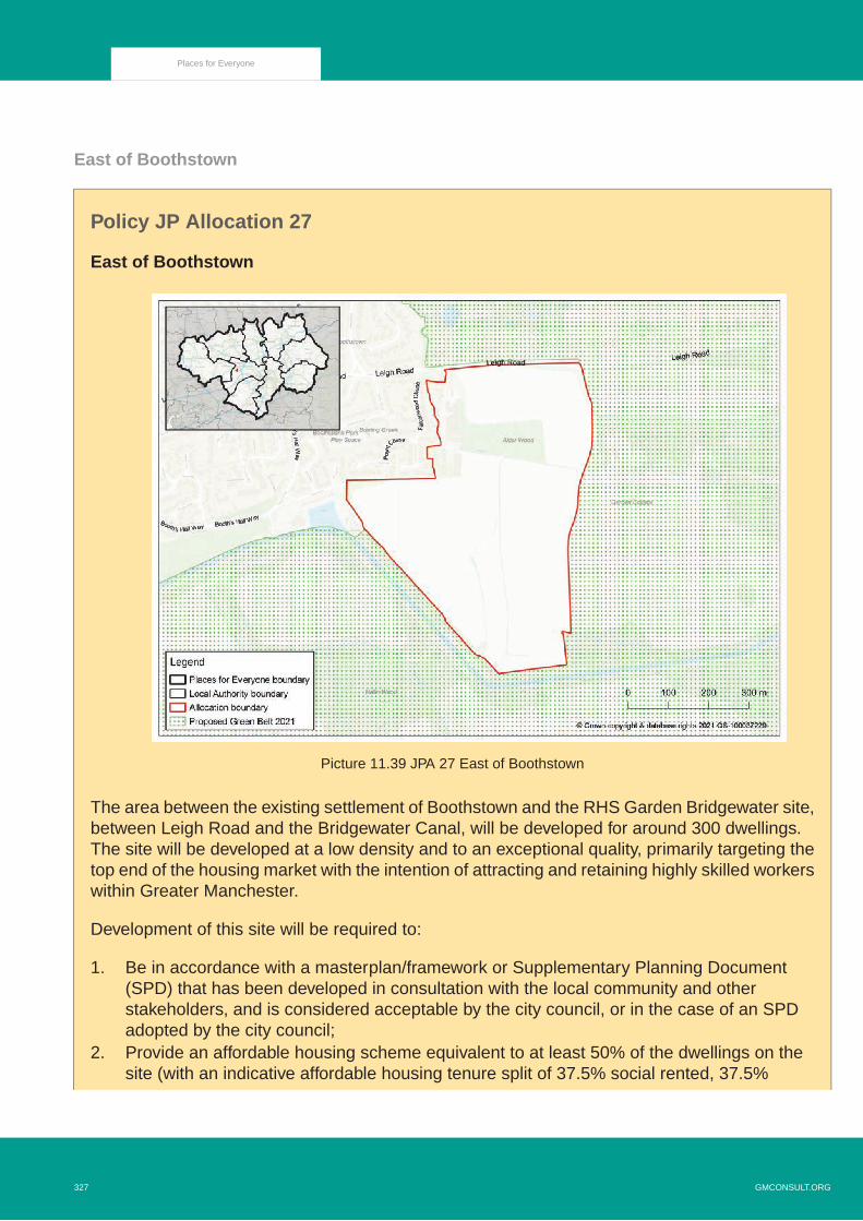
East of Boothstown
Policy JP Allocation 27
East of Boothstown
Picture 11.39 JPA 27 East of Boothstown
The area between the existing settlement of Boothstown and the RHS Garden Bridgewater site,between Leigh Road and the Bridgewater Canal, will be developed for around 300 dwellings.The site will be developed at a low density and to an exceptional quality, primarily targeting thetop end of the housing market with the intention of attracting and retaining highly skilled workerswithin Greater Manchester.
Development of this site will be required to:
1. Be in accordance with a masterplan/framework or Supplementary Planning Document(SPD) that has been developed in consultation with the local community and otherstakeholders, and is considered acceptable by the city council, or in the case of an SPDadopted by the city council;
2. Provide an affordable housing scheme equivalent to at least 50% of the dwellings on thesite (with an indicative affordable housing tenure split of 37.5% social rented, 37.5%
GMCONSULT.ORG327
Places for Everyone

affordable rented and 25% shared ownership), with some of this directed towards off-siteprovision;
3. Retain Alder Wood and the other areas of mature deciduous woodland and protected trees;4. Take opportunities to enhance the ecological value of Shaw Brook, including naturalising
where practicable and retaining significant open land around it, and utilise the brook as acentral landscape feature running through the site;
5. Incorporate a landscaped buffer along the eastern boundary of the site facing RHS GardenBridgewater;
6. Provide a detailed drainage and flood risk management strategy which addresses theoutcomes of the Strategic Flood Risk Assessment, ensuring that development does notincrease flood risk elsewhere;
7. Incorporate high quality sustainable drainage systems as part of the green infrastructurefor the site and accommodate sufficient space for any necessary flood storage, particularlyin the south of the site;
8. Protect the quality of watercourses through and around the site;9. Support the objectives for the Great Manchester Wetlands Nature Improvement Area and
avoid harm to protected species;10. Ensure good quality access by walking and cycling for all residents to services and facilities
in Boothstown and the local area, bus services on the surrounding road network, theBridgewater Canal and Chat Moss to the south, including through the provision of a highquality network of pedestrian and cycle routes throughout the site; off-site pedestriancrossings and a footpath adjacent to the site on the south side of Leigh Road;
11. Secure further improvements to the path on the north side of the Bridgewater Canal toprovide a high quality walking and cycling route to RHS Garden Bridgewater, Worsley Villageand Boothsbank Park;
12. Include a new neighbourhood equipped area of play;13. Retain or replace existing playing fields;14. Include new allotment plots to meet the local standard unless suitable alternative provision
can be made in the local area;15. Provide an easement for the significant utilities infrastructure running through and near the
site;16. Take its primary access from Occupation Road;17. Incorporate mitigation to address noise pollution from nearby roads;18. Conserve and enhance the setting of nearby heritage assets and, informed by the findings
and recommendations of the Heritage Assessment (2019) in the Plan's evidence base andany Heritage Impact Assessment submitted as part of the planning application process;and
19. Employ methods throughout the construction process that will ensure the potential forarchaeology is investigated and any finds safeguarded and properly recorded.
11.252 This site to the east of Boothstown offers one of a small number of opportunities withinGreater Manchester to deliver very high value housing in an extremely attractive environment,benefiting not only from an established premium housing market but also a location
328GMCONSULT.ORG
Places for Everyone

immediately next to the new RHS Garden Bridgewater which is due to open in 2021. It isessential that the development of the site fully maximises the opportunities presented bythis location, and delivers the highest quality living environment. A lower density ofdevelopment than would normally be required under Policy JP-H 4 'Density of New Housing'will be acceptable on this site.
11.253 Water vole and bird surveys will be required prior to any development, as will a desk-basedarchaeological assessment of the whole site and an historic building assessment ofBoothsbank Farm. The priority for any off-site nature conservation enhancements requiredto deliver a minimum 10% net gain in biodiversity from the development of the site is likelyto be the restoration of lowland raised bog and complementary habitats in Chat Moss to thesouth.
North of Irlam Station
Policy JP Allocation 28
North of Irlam Station
Picture 11.40 JPA 28 North of Irlam Station
GMCONSULT.ORG329
Places for Everyone

Land North of Irlam Station, between New Moss Road and Astley Road, will be developed toprovide a high quality extension to the Irlam and Cadishead neighbourhood focused aroundIrlam Station.The site has capacity for around 800 dwellings and associated social and communityuses.
Development of this site will be required to:
1. Be in accordance with a masterplan/framework or Supplementary Planning Document(SPD) that has been developed in consultation with the local community and otherstakeholders, and is considered acceptable by the city council, or in the case of an SPDadopted by the city council. Central to the masterplan shall be the consideration ofopportunities to restore habitats, strengthen ecological networks, and manage the carbonand hydrological implications of development, having regard to the presence of peat on thissite;
2. Be supported by a robust delivery strategy, which is prepared in partnership with keystakeholders and secures the effective delivery of the full masterplan, including transport,green and social infrastructure, affordable housing and planning obligation contributions;
3. Be provided in the form of houses with densities increasing towards the most accessibleparts of the site around Irlam Station, and include accommodation specifically targeted atolder people;
4. Provide an affordable housing scheme equivalent to at least 25% of the dwellings, andsubstantially more if other funding becomes available to allow for this (with an indicativeaffordable housing tenure split of 37.5% social rented, 37.5% affordable rented and 25%shared ownership);
5. Minimise the loss of the carbon storage function of the peat and undertake a hydrologicalassessment in order to avoid any adverse impacts on the hydrology of Chat Moss, whilstensuring that there is no potential for future problems of land stability or subsidence;
6. Incorporate a high quality network of public routes through the site, connected into the widerpedestrian and cycling network that provides access to local facilities, public transportservices, New Moss Wood and Chat Moss;
7. Minimise impact on local highways and provide contributions to support the improvementof affected local junctions;
8. Include a new direct pedestrian and cycle route to Irlam Station from the west and enhancecycle parking and car parking facilities at the station;
9. Ensure that vehicular access to the site does not have an unacceptable impact on thequality of existing residential areas;
10. Integrate high levels of green infrastructure throughout the site, including retaining landscapefeatures such as mature trees and hedgerows, so as to minimise the visual impact on thewider landscape, achieve a minimum 10% net gain in biodiversity, mitigate the environmentalimpacts of development and provide an attractive backdrop to walking and cycling routes;
11. Support the objectives for the Great Manchester Wetlands Nature Improvement Area andavoid harm to protected species;
330GMCONSULT.ORG
Places for Everyone

12. Be supported by breeding and winter bird surveys to understand and minimise any adverseimpact on bird species in this area. Surveys of potential compensation areas should alsobe undertaken to demonstrate that displacement into the wider landscape is possible;
13. Be supported by a project specific Habitats Regulations Assessment for any planningapplications involving 50 or more dwellings;
14. Incorporate measures to mimic natural drainage through the use of green sustainable urbandrainage to control the rate of surface water run-off;
15. Protect the quality of watercourses through and around the site;16. Include a new neighbourhood park incorporating an equipped area for play;17. Include new allotment plots to meet the local standard;18. Incorporate appropriate mitigation including tree planting to address issues of noise
generated by the M62 motorway and the rail line;19. Set aside land to provide additional school provision, unless it can be demonstrated that
sufficient additional school places will be provided off-site within the local area to meet thelikely demand generated by the new housing; and
20. Employ methods throughout the construction process that will ensure the potential forarchaeology is investigated and any finds safeguarded and properly recorded.
11.254 The site has been identified as being appropriate for development due to its location nextto Irlam rail station, with services that provide easy access to the huge range of employmentand leisure opportunities in the City Centre and Trafford Park. It also benefits from NorthbankIndustrial Park just to the south and bus routes to Port Salford and Eccles to the east.
11.255 Higher density houses will be appropriate in the most accessible parts of the site immediatelyaround Irlam Station, in accordance with Policy JP-H 4 'Density of New Housing', helpingto maximise the number of people within easy walking distance of the station.
11.256 The additional population will help to support existing shops and services in Irlam andCadishead, such as the nearby Lower Irlam and Cadishead local centres, but the site couldpotentially accommodate small scale facilities to serve local needs if identified as appropriatethrough the masterplanning process. It is anticipated that the site’s location and the dwellingtypes provided will be attractive to families with a resulting demand for additional schoolplaces which may, at least in part, need to be accommodated within the site.
11.257 The site is currently in multiple ownerships, and will deliver a range of complementary usesalongside residential (such as education, public open space and green infrastructure) andwill require infrastructure enhancements. To ensure the allocation is deliverable, it will beessential that a delivery strategy manages different interests effectively and equitably tosecure delivery of the overall masterplan. This is to avoid a situation in which initial phasesdo not make adequate provision to support subsequent phases, and in particular thecommunity uses these will include.
GMCONSULT.ORG331
Places for Everyone

11.258 It will be important that the design and layout of the site effectively integrates developmentinto the existing area and promotes community cohesion. In particular, publicly accessiblerecreation space, facilities, and routes through the site onto Chat Moss should be positionedso as to be accessible to both new and existing residents.
11.259 Most of the site has significant depths of peat across it, meaning that there will be high costsassociated with development on it. The peat on the site has been degraded due to decadesof drainage and agricultural activity. Nevertheless, it still performs an important carbonstorage function, and should be retained wherever possible. However, this will have to bebalanced against the need to ensure that there is no risk of subsidence for development onthe site or for surrounding infrastructure such as the M62 motorway. The priority for anyoff-site nature conservation enhancements required to deliver a minimum 10% net gain inbiodiversity from the development of the site is likely to be the enhancement of New MossWood, and the restoration of lowland raised bog and complementary habitats in Chat Mossto the north. Much of the site is grade 1 agricultural land, but the benefits of deliveringadditional housing in this accessible location are considered to outweigh the loss of theland’s farming potential. Wider ecological surveys, including water vole, brown hare andbirds, will be required prior to any development.
11.260 For any planning applications within the boundary of the allocation involving 50 or moredwellings, a project specific Habitats Regulations Assessment will be required given thatsuch developments may lead to traffic increases on the M62 motorway because of their sizeand relative proximity to the motorway.The M62 passes close to designated European sitesknown to be susceptible to traffic pollution, particularly nitrate deposition.
11.261 The depths of peat heighten the potential for archaeological finds. There will be a need toundertake a detailed archaeological desk-based assessment, including aerial photographanalysis, field walking, historic building assessment, and coring/evaluation trenching of thepeatlands, leading to further investigations and recording in advance of and during theconstruction process.
332GMCONSULT.ORG
Places for Everyone

Port Salford Extension
Policy JP Allocation 29
Port Salford Extension
Picture 11.41 JPA 29 Port Salford Extension
A major expansion of Port Salford accommodating around 320,000 sqm of employment floorspacewill be delivered to the north and west of Barton Aerodrome, taking advantage of the new portfacilities, rail link and highway improvements that will have been completed as part of the earlyphases of Port Salford. This will provide one of the most well-connected and market-attractiveindustrial and warehousing locations in the country, with a strong focus on logistics activitiesbut also incorporating high quality manufacturing floorspace.
Development of this site will be required to:
1. Be in accordance with a masterplan/framework or Supplementary Planning Document(SPD) that has been developed in consultation with the local community and otherstakeholders, and is considered acceptable by the city council, or in the case of an SPDadopted by the city council;
GMCONSULT.ORG333
Places for Everyone

2. Involve high levels of community engagement, including through regular liaison meetingsconvened by the landowner and/or developers;
3. Not be commenced until the rail link, highway improvements, canal berths and containerterminal associated with the permitted Port Salford scheme to the south of the A57 havebeen completed and are operational and there is a clear commitment to the ongoingmaintenance and full operation of this transport infrastructure;
4. Be designed to form part of an integrated facility with the Port Salford site to the south ofthe A57 and associated infrastructure, encouraging and enabling all occupiers to utilise therail and water connections for freight movement;
5. Deliver necessary highway improvements of a strategic and local nature to cater for theadditional traffic created by the expansion of Port Salford in a way that is compatible withany proposals for the enhancement of the wider motorway network and ensures the safeand efficient operation of the local road network;
6. Incorporate suitable HGV parking provision to cater for the area’s anticipated use, includingas appropriate stop over provision, and amenity facilities to serve the needs of HGV drivers;
7. Provide high quality walking and cycling routes from across the site to the bus stops on theA57 and the wider pedestrian and cycling network including Port Salford Greenway;
8. Maximise links to existing public transport services and support new routes and enhancedservices as appropriate, including accommodating a potential extension of the Trafford ParkMetrolink line to serve Port Salford;
9. Protect the full functioning and operational safety of Barton Aerodrome;
10. Conserve and where appropriate enhance, the significance of surrounding designated andnon-designated heritage assets, including by:
i. Designing and landscaping the development to minimise any adverse impacts on thesetting of Barton Aerodrome and the listed buildings within it;
ii. Where harm to Barton Aerodrome and any heritage asset within it is justified,opportunities shall be sought to better reveal the significance of the heritage asset,securing repairs to them, improving public access to them and/or providing publiclyaccessible information about them; and
iii. Being informed by the findings and recommendations of the Heritage Assessment(2019) in the Plan’s evidence base and any Heritage Impact Assessment submittedas part of the planning application process.
334GMCONSULT.ORG
Places for Everyone

11. Justify and provide full compensation for the loss of the golf course in accordance withparagraph 97 of the NPPF (February 2019) or any subsequent revision of national planningpolicy;
12. Incorporate high levels of landscaping, including the retention or replacement of existingwoodland, hedgerows and ponds where practicable, so as to minimise the visual impacton the wider landscape (including on the remaining Green Belt separating the site fromIrlam), achieve a minimum 10% net gain in biodiversity and mitigate the environmentalimpacts of development including noise;
13. Support the objectives for the Great Manchester Wetlands Nature Improvement Area andavoid harm to protected species;
14. Be supported by breeding and winter bird surveys to understand and minimise any adverseimpact on bird species in this area. Surveys of potential compensation areas should alsobe undertaken to demonstrate that displacement is possible into the wider landscape;
15. Protect and enhance surrounding habitats, including the Foxhill Glen Site of BiologicalImportance;
16. Be supported by a project specific Habitats Regulation Assessment for any planningapplications involving a floorspace of 1,000 sqm and above;
17. Mitigate the risk of surface water and groundwater flood risk, incorporating green sustainabledrainage systems as part of the landscaping of the site;
18. Minimise the loss of the carbon storage function of the peat and avoid any adverse impactson the hydrology of surrounding areas of peat/mossland, whilst ensuring that there is nopotential for future problems of land stability or subsidence;
19. Protect the quality of watercourses through and around the site;
20. Protect the amenity of remaining residential properties within or on the edge of the allocation,including through the provision of appropriate landscaped buffers;
21. Provide an appropriate buffer to the Barton Moss Secure Care Centre on Barton MossRoad, to protect the privacy and amenity of residents and staff;
22. Implement an agreed strategy for dealing with its local air quality impacts;
23. Give positive consideration to the incorporation of renewable and low carbon energyinfrastructure, including the potential for solar panels on buildings; and
24. Employ methods throughout the construction process that will ensure the potential forarchaeology is investigated and any finds safeguarded and properly recorded.
GMCONSULT.ORG335
Places for Everyone

11.262 The combination of excellent water, rail and road access, including direct shipping links tothe post-panamax facility at the Port of Liverpool, will make Port Salford one of the mostattractive locations in the country for industrial and warehousing development. An initialphase of development to the south of the A57 will provide around 150,000 sqm of primarilywarehousing floorspace in total. Enabling its expansion to the north of the A57 to providean additional 320,000 sqm of floorspace will help to significantly boost the competitivenessof Greater Manchester, offering the type of site that can compete with locations internationallyfor investment. The transport connections mean that the location is particularly attractive forlogistics activities, but high quality manufacturing could also be provided in order to diversifythe employment and investment opportunities in this part of Greater Manchester. Much ofthe site is grade 1 agricultural land, but the unique economic opportunity provided by thelocation is considered to outweigh the loss of the land’s farming potential.
11.263 One of the key attributes of Port Salford is its potential to remove freight from roads andmove it more sustainably by rail and water, and it will be vital that any development of thesite takes advantage of this by utilising the infrastructure delivered as part of the permittedscheme. Nevertheless, the expansion of Port Salford will generate significant additionaltraffic and highway improvements to cater for these demands should be delivered as partof the site’s development. The ongoing North West Quadrant Study, commissioned byHighways England, is investigating the options for broader motorway network improvementsin this area, and it will be important to coordinate the development of Port Salford with anyresulting proposals.
11.264 The retention of the Green Belt to the west and east of the site will help to prevent thecoalescence of Irlam and Eccles. It will be important to make positive use of this Green Belt,including by expanding the facilities at Brookhouse Playing Fields to the east, and there maybe opportunities to retain/reconfigure the former golf course to the west of the site. Evenwith the retention of part of the Green Belt, the scale of the development is likely to have asignificant visual impact, and it will be very important for it to be integrated into the landscapeas far as possible, particularly through the provision of high quality green infrastructure.
11.265 Barton Aerodrome (City Airport and Heliport) to the south of the site is an important facilityfor Greater Manchester, as well as being a significant heritage asset. The expansion of PortSalford will need to be designed so that it does not adversely impact on its successfulfunctioning, taking into account any safeguarding requirements for flight paths, and ensurethat any harm to the setting of the heritage assets is minimised. In particular, carefulconsideration will need to be given to the siting and orientation of units, the choice and colourof materials, and the landscaping scheme adopted.
11.266 The priority for any off-site nature conservation enhancements required to deliver a minimum10% net gain in biodiversity from the development of the site is likely to include theenhancement of Foxhill Glen Site of Biological Importance, ecological enhancements toremaining areas of Green Belt to the site’s south western and north eastern boundaries andthe restoration of lowland raised bog and complementary habitats in Chat Moss to the north.Wider ecological surveys, including water vole, brown hare, great crested newts and birds,
336GMCONSULT.ORG
Places for Everyone

will be required prior to any development. For any planning applications within the boundaryof the allocation involving a floorspace of over 1,000 sqm, a project specific HabitatsRegulations Assessment will be required given that such developments may lead to trafficincreases on the M62 motorway because of their size and relative proximity to the motorway.The M62 passes close to designated European sites known to be susceptible to trafficpollution, particularly nitrate deposition.
11.267 The depths of peat heighten the potential for archaeological finds. There will be a need toundertake a detailed archaeological desk-based assessment, including aerial photographanalysis, field walking, historic building assessment, and coring/evaluation trenching of thepeatlands, leading to further investigations and recording in advance of and during theconstruction process.
GMCONSULT.ORG337
Places for Everyone
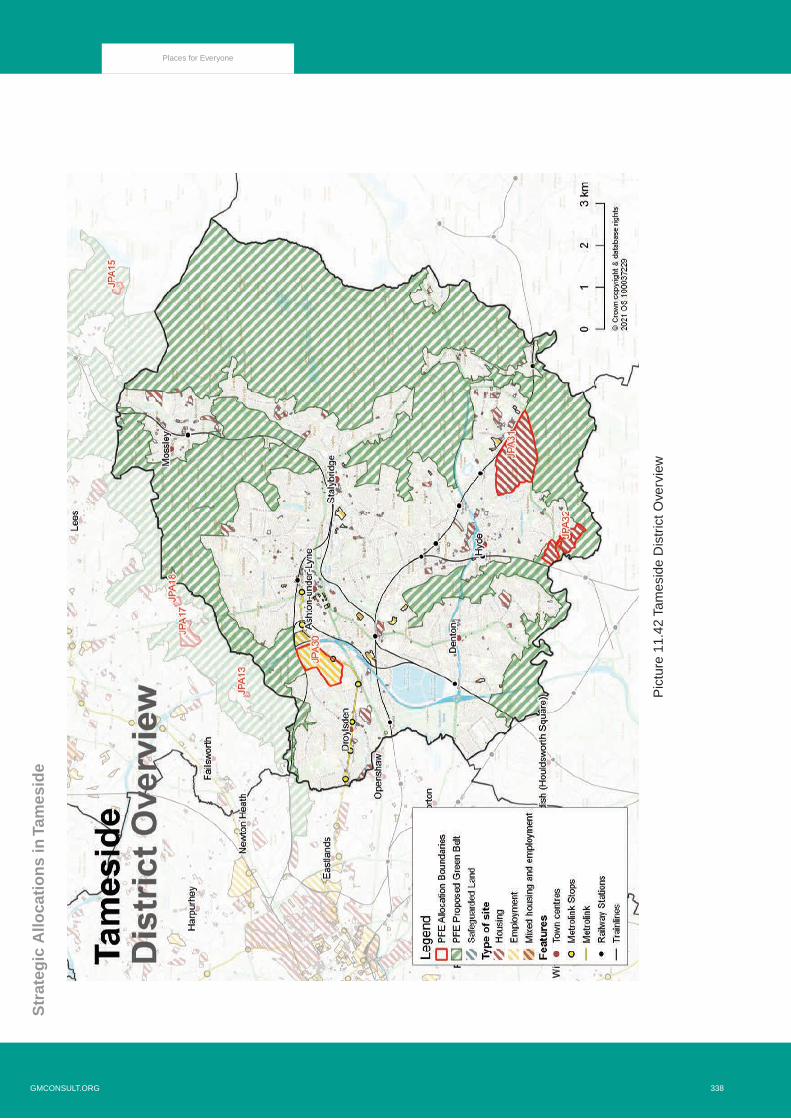
Str
ateg
ic A
lloca
tio
ns
in T
ames
ide
Pic
ture
11.
42 T
ames
ide
Dis
tric
t Ove
rvie
w
338GMCONSULT.ORG
Places for Everyone

Ashton Moss West
Policy JP Allocation 30
Ashton Moss West
Picture 11.43 JPA 30 Ashton Moss West
Development of this site will be required to:
1. Deliver around 160,000 square metres of employment floorspace, primarily within the E(g)(ii)- Research and Development, E(g)(iii) - Light and Industrial and B2 - General Industrial useclasses;
2. Be in accordance with a comprehensive masterplan, phasing strategy and design codeapproved by the Local Planning Authority for the whole site, developed through engagementwith the local community, Council and other appropriate stakeholders;
3. Be informed by a detailed earthworks and remediation strategy;
4. Be informed by an assessment of archaeology;
GMCONSULT.ORG339
Places for Everyone

5. Take an integrated and co-ordinated approach to infrastructure to support the scale of thewhole development;
6. Ensure that architecture is innovative and creative, while respecting and integrating intothe surrounding landscape, creating a high quality and contemporary employment location;
7. Ensure the character of, and interface between, new and existing development, includingthe setting of neighbouring heritage assets and surrounding residential dwellings andgardens, are sensitively designed and acknowledged by development proposals;
8. Provide developer contributions towards transport and other infrastructure as deemedappropriate;
9. Ensure employment, education and training opportunities are available for residents withinthe local area both through construction phases and upon completion;
10. Provide access into the site from the A6140 Lord Sheldon Way;
11. Ensure highways are designed to accommodate access to the rail line to the northernboundary and land is set aside in that location to potentially accommodate provision for afuture rail station;
12. Ensure proposals create a safe, walkable and green development;
13. Ensure active travel is promoted to be the most attractive form of local transport through aclear network and hierarchy of legible and attractive streets, footpaths and cycle ways;
14. Protect and enhance key landscape and ecological features, including trees, watercoursesand ponds;
15. Deliver a high quality public realm that incorporates street tree planting;
16. Incorporate and enhance as attractive and desirable routes existing public rights of wayand the active travel route along the site's western edge;
17. Be designed to enhance connectivity to existing communities in the locality alongside keyassets such as: schools, cycle and walking routes, public transport services and Daisy NookCountry Park; and
18. Set aside land for a range of public open spaces, such as: natural space and amenity space,in accordance with the Council's most up to date Open Space Review.
11.268 Having previously been identified as part of a potential World EXPO site, Ashton Moss Westrepresents a major opportunity for Tameside and the east of Greater Manchester to deliverapproximately 160,000 square metres of high quality employment floorspace. This should
340GMCONSULT.ORG
Places for Everyone

primarily fall within the E(g)(ii) - Research and Development, E(g)(iii) - Light and Industrialand B2 - General Industrial use classes and be aimed at delivering facilities suitable foridentified areas of economic strength and key growth sectors within Tameside and GreaterManchester: life sciences; health technologies, advanced manufacturing and materialsscience/fabrication.
11.269 The site’s urban fringe setting with proximity to existing employment, leisure and retailopportunities, excellent transport connections with close proximity to rail, Metrolink andmotorway, as well as a dark fibre network and surrounding green and blue infrastructure setthe framework for a unique opportunity and logical sustainable extension to the existingAshton Moss employment area.
11.270 Additionally, Tameside’s existing manufacturing and engineering base is currently constrainedby the supply of sites available, curtailing potential growth and stifling regeneration and churnwithin the borough’s industrial spaces. The site is therefore critical to provide expansionopportunities for existing businesses operational within Tameside as well as providing thefacilities required to compete for inward investment.
11.271 To deliver a high quality development it will be important to have a clear and comprehensivemasterplan, phasing strategy and design code; which should carefully consider matters ofcharacter, including orientation, materials and soft landscaping in respect of the setting ofneighbouring heritage assets(129) and surrounding residential properties.
11.272 This should be accompanied by an integrated approach to delivering infrastructure, includingfor example: a site wide drainage strategy, green, blue and grey infrastructure (includingutilities provision), high speed broadband connectivity through fibre to the premises andelectric vehicle charging infrastructure, either by providing charging points or through installingappropriate ducting to allow for future provision.
11.273 A site wide drainage strategy will need to incorporate sustainable drainage systems with theaim of achieving greenfield run-off rates as a means of combating surface water flood riskand contributing towards climate change resilience. Furthermore, the site overlaps with thecurrent Air Quality Management Area along the M60 corridor to the east and Lord SheldonWay to the south will need to be considered in the masterplanning process. This could takethe form of appropriate buffering as part of the green infrastructure network across the site.
11.274 One of the principle challenges to developing Ashton Moss West is the volume of placedmaterial, alongside other geotechnical considerations. Contamination testing, gas monitoring,and ground investigation and analysis will therefore be required to produce an earthworksassessment and remediation strategy prior to development taking place.
11.275 A programme of archaeological assessment should also inform the masterplanning approachto the site, allowing for archaeological evaluation to determine the extent and condition ofpotential remains. This will help to establish where significant archaeology should be
129 Historic Environment Assessment, GMSF Land Allocations, Tameside, Ashton Moss West, University of Salford
GMCONSULT.ORG341
Places for Everyone

preserved in situ through sympathetic planning or where the archaeology can be removed,but first of all recorded, and opportunities that may exist to create public interpretationinformation relating to the sites historical past.
11.276 Architectural design solutions should deliver an innovative and creative development thatis also resilient to climate change, using, where possible, zero-carbon development andenergy-positive technology (i.e. producing more energy than is consumed), thus creating ahigh quality and contemporary employment development that also benefits from access toa range of sustainable modes of transport.
11.277 Development of the site has the potential to create a range of educational, training andemployment opportunities for local residents during the construction phases and uponcompletion. Given the proximity of this site to areas of high deprivation in Ashton-under-Lyne,Droylsden and east Manchester the proposed development will help to bring about long termbenefits to these communities by providing locally accessible employment.
11.278 To enhance and optimise the excellent transport connectivity of the site further, there is thepotential opportunity to deliver a new rail station on the Manchester to Leeds line that willservice the employment allocation and the Droylsden and Audenshaw areas. Provisionshould therefore be included in the site’s masterplan for the safeguarding of land along thenorthern boundary of the allocation to accommodate a potential new rail station, access andcar parking.
11.279 It is important that existing landscape and ecological features alongside other greeninfrastructure, habitats and assets of biological importance are protected, managed andenhanced as part of the comprehensive masterplan of the site, taking into account guidancein the Landscape Character Assessment.(130)
11.280 The development will seek to minimise the number of trips made by private car to and fromthe site by connecting with adjacent residential areas, employment locations, leisure usesand centres, via a network of safe walking and cycling routes and public open spaces. Priorityshould be given to cycle and pedestrian routes that provide direct access to the existing andproposed cycle and pedestrian network, together with opportunities for linking access topublic transport.
11.281 The existing active travel route to the site’s western edge should be retained and enhancedand could form part of a landscape buffer to existing residential properties. In addition,consideration should be given to a number of existing informal routes and public rights ofway to the site’s northern edge that could also benefit from improved connectivity andenhancement, including access to Metrolink.
130 Greater Manchester LandscapeCharacter Assessment https://www.greatermanchester-ca.gov.uk/media/1727/greater-manchester-landscape-character-and-sensitivity-report.pdf
342GMCONSULT.ORG
Places for Everyone

11.282 While the site is in a sustainable and accessible location, being well served by public transportand with convenient access to junction 23 of the M60, new vehicular access will be requiredinto the site off the A6140 Lord Sheldon Way, integrating with the existing and proposedpedestrian and cycle network.
11.283 Alongside the intention that the development will ensure active travel becomes the mostattractive form of local transport, it will also contribute towards active and healthy communitiesthrough on site open space provision, in accordance with the Council’s most up to date OpenSpace Review, and through the provision of safe and accessible connections to neighbouringpublic open spaces, including Daisy Nook Country Park.
Godley Green Garden Village
Policy JP Allocation 31
Godley Green Garden Village
Picture 11.44 JPA 31 Godley Green Garden Village
Development of this site will be required to:
1. Construct around 2,350 new homes;
GMCONSULT.ORG343
Places for Everyone

2. Deliver homes across a range of types and tenures in accordance with the Council's mostup to date Housing Needs Assessment;
3. Ensure Garden City principles are enshrined throughout;
4. Be in accordance with a comprehensive masterplan, phasing strategy and design codeapproved by the Local Planning Authority for the whole site, developed through engagementwith the local community, Council and other appropriate stakeholders;
5. Be informed by an assessment of archaeology;
6. Take an integrated and co-ordinated approach to infrastructure to support the scale of thewhole development;
7. Ensure that architecture is innovative and creative, while respecting and integrating intothe surrounding landscape, creating aspirational and desirable communities in which tolive;
8. Ensure the character of, and interface between, new and existing development includingthe setting of heritage assets and dwellings and gardens, particularly those within the site,are sensitively designed and acknowledged by development proposals;
9. Establish two connected villages, each with their own distinct identity and served by a localhub offering flexible workspace opportunities and a range of community, retail, cultural andleisure uses, separated by Godley Brook as a central landscape feature;
10. Deliver higher density residential development around Hattersley train station and the villagehubs;
11. Provide developer contributions towards education, health, transport and other infrastructureas deemed appropriate;
12. Ensure employment, education and training opportunities are available for residents withinthe local area, both through construction phases and upon completion;
13. Set aside land to accommodate additional education provision, unless it can be demonstratedthat sufficient additional school places will be accommodated off site within the local areato meet the likely demand generated;
14. Provide access into the site from the A560 Mottram Old Road including improved cyclingand pedestrian facilities along the site's frontage;
15. Ensure highways are designed to accommodate bus routing and provision of services aresought within the early phases of development;
344GMCONSULT.ORG
Places for Everyone

16. Provide, in the early phase of development, a pedestrian, cycle, equine (multi-user andaccessible to all) bridge connecting to Hattersley and be designed and located to encourageuse of public transport services at Hattersley train station;
17. Ensure neighbourhoods are green, walkable and safe places;
18. Ensure active travel is promoted through a clear network and hierarchy of legible andattractive streets, footpaths and cycle ways;
19. Incorporate and enhance as attractive and desirable routes, existing public rights of wayand the Trans Pennine Trail;
20. Be designed to enhance connectivity to existing communities in the locality, alongside keyassets such as Hyde town centre, schools, cycle and walking routes, public transport servicesand Werneth Low Country Park;
21. Protect and enhance the designated Sites of Biological Importance of Werneth Brook andBrookfold Wood;
22. Protect and enhance key landscape and ecological features, including protected trees andwoodlands, areas of Ancient Woodland, other mature trees, hedgerows, cloughs,watercourses and ponds;
23. Deliver a high quality public realm that incorporates street tree planting; and
24. Set aside land for a range of public open spaces, such as: parks and gardens, naturalspace, amenity space, play provision and allotments, in accordance with the Council’s mostup to date Open Space Review.
11.284 Godley Green presents a significant opportunity to realise the ambitious vision of deliveringa new large-scale settlement of around 2,350 new homes in the south of the borough,adjacent to the residential neighbourhoods of Godley and Hattersley. The site’s semi-ruralsetting, together with an existing network of green and blue infrastructure set the frameworkfor an attractive, high quality and accessible settlement that will be enshrined in Garden Cityprinciples(131) and is a logical sustainable extension to the existing urban area.
11.285 The site is in close proximity to both rail and motorway connections, with Hattersley trainstation located adjacent and Godley train station to the north. There is potential to enhancethe existing sustainable travel opportunities, through the provision of tram-train servicesalong the Glossop line and new bridge access to Hattersley is required, connecting to thesurrounding community. The ongoing regeneration in Hattersley will be reinforced by thedevelopment at Godley Green, providing positive outcomes and opportunities in an area ofdeprivation.
131 https://www.tcpa.org.uk/understanding-garden-villages
GMCONSULT.ORG345
Places for Everyone

11.286 The new homes will assist in meeting the full range of housing needs and aspirations througha diversity of housing opportunities. There is potential to deliver innovative and creativedevelopment that is energy efficient and resilient to climate change using, where possible,zero-carbon and energy-positive technology (i.e. producing more energy than is consumed).
11.287 Older persons housing and plots for custom and self-build will also feature as importantelements of the housing mix in the Garden Village and some should be affordable to thoseon lower and middle incomes seeking this type of opportunity.
11.288 To deliver a high quality development it will be essential to have a clear and comprehensivemasterplan, phasing strategy and design code, which should carefully consider matters ofcharacter, appearance and setting, including for example: orientation, materials, buildingheights, densities, boundary treatments, soft landscaping and enhanced screening. Suchconsiderations will be particularly important in respect to historic buildings of local significanceand existing residential properties.
11.289 This should be accompanied by an integrated approach to delivering infrastructure. Thisshould include for example: a site wide drainage strategy, green, blue and grey infrastructure(including utilities provision), high speed broadband connectivity through fibre to the premisesand electric vehicle charging infrastructure, either by providing charging points or throughinstalling appropriate ducting to allow for future provision.
11.290 In addition, the site wide drainage strategy will need to incorporate sustainable drainagesystems with the aim of achieving greenfield run-off rates as a means of combatting surfacewater flood risk and contributing towards climate change resilience.
11.291 The Historic Environment Assessment(132) has identified a number of non-designated builtheritage assets within the site as having a degree of local heritage significance. In recognitionof this, built heritage in the form of historic routes, field boundaries, hedgerows, farmsteads,the agricultural hamlet at Greenside and villas within their existing residential plots alongGreen Lane should be retained where possible and could be incorporated into the masterplanto help create a sense of place and link with the site’s past.
11.292 A programme of archaeological assessment should inform the masterplanning approach tothe site, allowing for archaeological evaluation to determine the extent and condition ofpotential remains, in particular around Greenside, east of Brookfold Wood, Green Lane andnorth of Brookfold. This will help to establish where significant archaeology should bepreserved in situ through sympathetic planning or where the archaeology can be removedbut first of all recorded. There may also be the opportunity to involve the community in suchactivities through excavation projects, for example at Dove House Farm.
132 Historic Environment Assessment, GMSF Land Allocations, Tameside, Godley Green, University of Salford
346GMCONSULT.ORG
Places for Everyone

11.293 Building for a Healthy Life(133), as the Government endorsed industry standard forwell-designed homes and neighbourhoods, should be used alongside Garden City principlesto guide the masterplanning and development of Godley Green as an attractive, functionaland sustainable settlement with the aim of achieving Building for a Healthy Life commendation.
11.294 Due to the site’s semi-rural location, topography and landscape character; architectural andlandscape design solutions must be innovative and creative; taking into account guidancein the Landscape Character Assessment.(134) This could include integration into thesurrounding landscape, particularly along development edges, and the interface betweennew and existing development along Green Lane and the historic hamlet of Greenside onMottram Old Road, particularly where the rural landscape and views contribute to thesignificance of farmsteads and where buffer zones could retain a sense of openness.
11.295 Godley Brook as a key landscape feature, which runs south-north through the centre of thesite, will effectively divide Godley Green into two smaller villages, each served by a localhub offering a range of community and retail facilities in which residents can meet most oftheir day-to-day needs, although it is not envisaged that convenience retail floor space shouldexceed 500 sqm gross external area within each local hub.
11.296 As part of the hubs, there may be potential to develop a hotel or elderly care facilities whichwould take advantage of the co-location with the proposed retail and community facilitiesand in particular the proximity to Hattersley train station.
11.297 Flexible workspace could be delivered within the site close to Hattersley train station, providingemployment opportunities for residents. With the proximity of two railway stations, publictransport, motorway connectivity and active travel network, it is envisaged that a wide rangeof employment opportunities located around Hyde, Tameside and across the city region willbe accessible to Garden Village residents.
11.298 Although the site is within a sustainable and accessible location, new access and linkagesinto the site off the A560 Mottram Old Road together with the existing and proposed pedestrianand cycle network will be necessary. Fibre to the premises will also enable opportunities forhome working as a sustainable alternative to traditional commuting.
11.299 It is also important that landscape, habitat and ecological features such as: Werneth Brookand Brookfold Wood Sites of Biological Importance (Ancient Woodland); protected trees andwoodlands, hedgerows; together with the array of ponds and watercourses and other greeninfrastructure, are protected and managed as part of the comprehensive masterplan of thesite to maintain and enhance their conservation status and prevent habitat fragmentation.
133 Building for a Healthy Life - A Design Toolkit for neighbourhoods, streets, homes and publicspaces https://www.udg.org.uk/publications/othermanuals/building-healthy-life
134 Greater Manchester Landscape CharacterAssessment https://www.greatermanchester-ca.gov.uk/media/1727/greater-manchester-landscape-character-and-sensitivity-report.pdf
GMCONSULT.ORG347
Places for Everyone

11.300 Open space and recreation areas comprise an essential element of both Garden City andBuilding for a Healthy Life principles, contributing to the creation of healthy and activecommunities. Sport England’s Active Design(135) and other age friendly designprinciples(136) should be incorporated as far as possible in the masterplanning of the site toencourage active lifestyle behaviour and play at all ages.
South of Hyde
Policy JP Allocation 32
South of Hyde
Picture 11.45 JPA 32 South of Hyde
Development of this site will be required to:
1. Construct around 440 new homes;
2. Deliver homes across a range of types and tenures in accordance with the Council’s mostup to date Housing Needs Assessment;
135 Sport England – Active Design https://www.sportengland.org/how-we-can-help/facilities-and-planning/design-and-cost-guidance/active-design136 For example the WHO’s Age-friendly Cities Framework https://extranet.who.int/agefriendlyworld/age-friendly-cities-framework/
348GMCONSULT.ORG
Places for Everyone

3. Ensure Garden City principles are enshrined throughout;
4. Be in accordance with a comprehensive masterplan, phasing strategy and design codeapproved by the Local Planning Authority for the whole site, developed through engagementwith the local community, Council and other appropriate stakeholders;
5. Take an integrated and co-ordinated approach to infrastructure to support the scale of thewhole development;
6. Ensure that architecture is innovative and creative, while respecting and integrating intothe surrounding landscape, creating aspirational and desirable communities in which tolive;
7. Ensure the character of, and interface between, new and existing development includingthe setting of heritage assets and dwellings and gardens, particularly those within the siteare sensitively designed and acknowledged by development proposals;
8. Ensure that development edges successfully integrate into the adjoining landscape;
9. Deliver lower density residential development as the site elevation increases toward itseastern most extent at Lord Derby Road;
10. Sustain and enhance both designated and non-designated heritage assets and their settingsincluding the Grade II* listed Apethorn Farmhouse and Grade II Pole Bank Hall;
11. Proposals should be informed by the findings and recommendations of the HistoricEnvironment Assessment (2020) in the Plan’s evidence base and any updated HistoricImpact Assessment(s) submitted as part of the planning application process;
12. Deliver the sensitive restoration and long term future use of the Grade II* listed ApethornFarmhouse and complex within an early phase of development together with its removalfrom the Heritage at Risk Register;
13. Provide developer contributions towards education, health, transport and other infrastructureas deemed appropriate;
14. Ensure employment, education and training opportunities are available for residents withinthe local area through the construction phases;
15. Provide access to each east and west parcel from the A560 Stockport Road;
16. Ensure neighbourhoods are green, walkable and safe places;
17. Ensure active travel is promoted to be the most attractive form of local transport through aclear network and hierarchy of legible and attractive streets, footpaths and cycle ways;
GMCONSULT.ORG349
Places for Everyone

18. Incorporate and enhance as attractive and desirable routes, existing public rights of way,including the Cown Edge Way;
19. Be designed to enhance connectivity to existing communities in the locality, alongside keyassets such as Hyde town centre, schools, cycle and walking routes, public transportservices, the Peak Forrest Canal, Trans Pennine Trail and Werneth Low Country Park;
20. Protect and enhance the designated Pole Bank Site of Biological Importance;
21. Protect and enhance key landscape and ecological features including protected trees andwoodlands, areas of Ancient Woodland, other mature trees, hedgerows, cloughs,watercourses and ponds;
22. Deliver a high quality public realm that incorporates street tree planting; and
23. Set aside land for a range of public open spaces such as; natural space, amenity space,play provision and allotments in accordance with the Council’s most up to date Open SpaceReview.
11.301 The two parcels that make up the south of Hyde allocation represent an opportunity to deliverhousing in advance of the larger more complex sites contained in Places for Everyone dueto their smaller scale.The sites’ semi-rural setting, opportunity to secure the future of a gradeII* listed building together with an existing network of green infrastructure, set the frameworkfor an attractive, high quality and accessible neighbourhood that enshrines Garden Cityprinciples and is a logical, sustainable, extension to the suburb of Gee Cross.
11.302 Apethorn Fold is a small group of historic agricultural buildings, straddling Apethorn Laneto the north of the allocation. The Grade II* listed Apethorn Farmhouse is considered to bea rare surviving example in Tameside of a medieval cruck framed open hall house, whichonce comprised domestic accommodation to the north and shippon used to house animalsto the south, separated by a cross passage. The farmhouse which dates back to the C.15and altered during the C.17-C.19 owes its survival in part to its timber truss construction.(137)
The farmhouse is currently unoccupied and has been identified on Historic England’s Heritageat Risk Register, where its current condition has been recorded as very bad.
11.303 Development of the site is therefore expected to secure the restoration and long term futurereuse of the Apethorn Farmhouse and complex. A Heritage Impact Assessment will berequired to support the masterplanning of the site and any subsequent planning applications,demonstrating how the proposal will support the retention, enhancement and long term futureuse of Apethorn Farmhouse and complex and ensure the proposed new development hasa positive impact on the heritage asset’s conservation and setting.
137 Historic Environment Assessment, GMSF Land Allocations, Tameside, South of Hyde, University of Salford
350GMCONSULT.ORG
Places for Everyone

11.304 It is expected that full restoration of the farm complex, including those features which areconsidered to be curtilage listed, will commence in the early phase of development and thisbe set out in the masterplan and phasing strategy. It is noted that this should include thecurtilage listed building to the north side of Apethorn Lane which will remain within the GreenBelt. In doing so, condition surveys, an archaeological presence on site and watching briefare all likely to be needed.
11.305 The new homes will assist in meeting the full range of housing needs and aspirations througha diversity of housing opportunities. There is potential to deliver innovative and creativedevelopment that is energy efficient and resilient to climate change using, where possible,zero-carbon and energy-positive technology (i.e. producing more energy than is consumed).
11.306 Older persons housing and plots for custom and self-build could also feature as elementsof the housing mix and some should be affordable to those on lower and middle incomesseeking this type of opportunity.
11.307 To deliver a high quality development it will be important to have a clear and comprehensivemasterplan, phasing strategy and design code, which should carefully consider matters ofcharacter, appearance and setting.This includes for example: orientation, materials, buildingheights, densities, boundary treatments, soft landscaping and enhanced screening. Suchconsiderations will be particularly important in respect to heritage assets and existingresidential properties.
11.308 This masterplanning should be accompanied by an integrated approach to deliveringinfrastructure. This should include for example: a site wide drainage strategy, green, blueand grey infrastructure (including utilities provision), high speed broadband connectivitythrough fibre to the premises and electric vehicle charging infrastructure, either by providingcharging points or through installing appropriate ducting to allow for future provision.
11.309 Taking into account the findings of the most recent strategic flood risk assessment, the sitewide drainage strategy will need to incorporate sustainable drainage systems with the aimof achieving greenfield run-off rates as a means of combatting surface water flood risk andcontributing towards climate change resilience.
11.310 A number of buildings and features have been identified within the site as having heritagesignificance. In recognition of this, built heritage, in the form of heritage assets, historicroutes, field boundaries, hedgerows and woodland should be retained where possible andcould be incorporated into the masterplan to help create a sense of place and link with thesite’s past.
11.311 A programme of archaeological assessments should inform the masterplanning approach,allowing for archaeological evaluation to determine the extent and condition of potentialremains particularly around heritage assets. This will help to establish where significantarchaeology should be preserved in situ through sympathetic planning or where it can beremoved but first of all recorded.
GMCONSULT.ORG351
Places for Everyone
11.312 Due to the sites’ semi-rural location, topography and landscape character; architectural andlandscape design solutions must be innovative and creative; taking into account guidancein the Landscape Character Assessment.(138) This could include: integrating into thesurrounding landscape, particularly along development edges, at the interface between newand existing development and as the site ascends in elevation toward Lord Derby Road.This is also particularly relevant where the rural landscape and views contribute to thesignificance of heritage assets and where buffer zones could retain a sense of openness.
11.313 Building for a Healthy Life(139) as the Government endorsed industry standard forwell-designed homes and neighbourhoods should be used to guide the masterplanning anddevelopment, alongside Garden City principles, as an attractive, functional and sustainablesettlement with the aim of achieving Building for a Healthy Life commendation.
11.314 Neighbourhoods will be linked via safe walking and cycling routes and public open spaces,all of which will respect and integrate into the surrounding landscape. Cycle and pedestrianroutes within the development area should provide direct connection to the existing andproposed cycle and pedestrian network, Woodley Railway Station and Hyde town centrewhere possible.
11.315 Development of this site has the potential to create education, training and employmentopportunities during the construction phase for local residents, thus bringing about benefitsto these communities by providing locally accessible employment.
11.316 Although the site is in a sustainable and accessible location, being well served by a highfrequency bus service between Ashton-under-Lyne and Stockport, with convenient accessto the Marple rail line at Woodley and the highway network; new access and linkages intothe site off the A560 Stockport Road together with the existing and proposed pedestrian andcycle network will be necessary.
11.317 The GM Rail Prospectus articulates the future vision for rail with longer trains and morefrequent services, and TfGM has committed in Our Five Year Transport Delivery Plan toexplore the options for delivering a Metro/tram-train service on the Marple line with thepotential to deliver greatly increased capacity and connectivity. Therefore, enhancingpedestrian and cycle connectivity between the site and the nearby Woodley station will becritical in improving a move away from private car use.
11.318 It is also important that landscape, habitat and ecological features such as: Pole Bank Siteof Biological Importance (Ancient Woodland); protected trees and woodlands; hedgerows;together with the array of watercourses and other green infrastructure are protected andmanaged as part of the comprehensive masterplan of the sites to maintain and enhancetheir conservation status and prevent habitat fragmentation.
138 Greater Manchester Landscape CharacterAssessment https://www.greatermanchester-ca.gov.uk/media/1727/greater-manchester-landscape-character-and-sensitivity-report.pdf
139 Building for a Healthy Life - A Design Toolkit for neighbourhoods, streets, homes and publicspaces https://www.udg.org.uk/publications/othermanuals/building-healthy-life
352GMCONSULT.ORG
Places for Everyone

11.319 Open space and recreation areas comprise an essential element of both Garden City andBuilding for a Healthy Life principles, contributing to the creation of healthy and activecommunities. Sport England’s Active Design(140) and age friendly design principles(141) shouldbe incorporated as far as possible in the masterplanning of the site to encourage activelifestyle behaviour and play at all ages.
140 Sport England – Active Design https://www.sportengland.org/how-we-can-help/facilities-and-planning/design-and-cost-guidance/active-design141 For example the WHO’s Age-friendly Cities Framework https://extranet.who.int/agefriendlyworld/age-friendly-cities-framework/
GMCONSULT.ORG353
Places for Everyone

Str
ateg
ic A
lloca
tio
ns
in T
raff
ord
Pic
ture
11.
46 T
raffo
rd D
istr
ict O
verv
iew
354GMCONSULT.ORG
Places for Everyone

New Carrington
Policy JP Allocation 33
New Carrington
Picture 11.47 JPA 33 New Carrington
GMCONSULT.ORG355
Places for Everyone

Picture 11.48 New Carrington Allocation Policy Plan
Development of this site will be required to:
1. Be in accordance with a masterplan or Supplementary Planning Document (SPD) that hasbeen approved by the Local Planning Authority, to ensure the site is planned and deliveredin a coordinated and comprehensive manner;
Residential Development
2. Deliver around 5,000 units, of which 4,300 will be delivered in the plan period at Carrington/ Partington and Sale West, in the following distinct character areas, as set out on theAllocation Policy Plan:
Carrington Village – approximately 600 units
Sale West – approximately 1,450 units
East Partington – approximately 2,600 units
Warburton Lane – approximately 420 units
356GMCONSULT.ORG
Places for Everyone

3. Deliver high quality residential units which are accessible, integrated with the existingcommunity and well designed to create a genuine sense of place;
4. Demonstrate how the constraints on land to the west of Warburton Lane can be addressed.Planning applications will need to demonstrate how the site will:
i. Integrate into and reflect the character of the historic landscape; avoiding areas of thehighest heritage significance;
ii. Integrate successfully into Partington and the wider New Carrington allocation, both interms of physical linkages and the ability to understand the wider area as a distinctplace.
Development proposals which do not address these constraints will not be accepted;
5. Deliver a range of house types, sizes, layouts and tenures through a place-led approachbased on each of the Character Areas in the New Carrington Masterplan / SPD and theTrafford Local Plan;
6. Deliver residential development at the following average densities, recognising the distinctcharacteristics of each area:
Carrington Village – average 35 dph
Sale West – average 40 dph
East Partington – average 35 dph, increasing to an average of 40 dph in areas close tothe existing Partington urban area. Higher density development at an average of 55dph will be appropriate close to the local centre;
Warburton Lane – average 25 dph
7. Provide a minimum of 15% affordable housing across the New Carrington allocation. Indetermining appropriate affordable housing provision regard should be had to the distinctCharacter Areas within the New Carrington site which each reflect different housing markets.The New Carrington Masterplan / SPD and the Trafford Local Plan will provide additionalguidance on appropriate affordable housing contributions for each of the Character Areas;
8. Make specific provision for self-build/custom-build plots, subject to local demand as set outin the Council’s self-build register;
Employment development
GMCONSULT.ORG357
Places for Everyone

9. Deliver around 350,000 sqm (gross) of employment opportunities for industry andwarehousing as set out on the Allocation Policy Plan;
10. Create legible streets and spaces within the employment area with attractive buildings thatrespond positively to the landscape and provide accessible linkages to residential areasand local / neighbourhood centres;
11. Create employment and training opportunities for local people in particular through theconstruction phase, to be set out in a Local Labour Agreement in accordance with LocalPlan policies;
Delivery and phasing
12. Coordinate the phasing of development with the delivery of infrastructure on the site, ensuringsustainable growth at this location;
13. Make a proportionate contribution, by means of an equalisation mechanism, to infrastructuredelivery. Detailed requirements will be set out in the masterplan/SPD;
Transport, Integration and Accessibility
14. Deliver accessible streets which prioritise cycling, walking and public transport over theprivate car;
15. Deliver a network of safe cycling and walking routes through the allocation, utilising theCarrington rides, improving the Trans Pennine Trail and creating new/enhancing existingPublic Rights of Way and bridleways;
16. Deliver connected neighbourhoods which successfully link with existing communities atCarrington, Partington and Sale West, overcoming barriers such as the Red Brook tosuccessfully integrate development;
17. Utilise the route of the disused railway line through the site as a strategic sustainabletransport corridor providing links from New Carrington to the wider area as part of theCarrington Greenway scheme which includes reinstatement of the Cadishead viaduct forpedestrians and cyclists, as well as contributing to future improved east/west public transportlinkages;
18. Deliver bus priority infrastructure within the site and, where appropriate, on bus routeslinking to the site;
19. Deliver and directly contribute to the Carrington Relief Road to provide an alternative routeto the A6144 and a strategic link through Carrington, incorporating provision for pedestrians,cyclists and bus priority measures. Other highway links to access development parcels willalso be required, including:
i. Southern link – connecting the A6144 Warburton Lane and the A6144 ManchesterRoad (via either Moss Lane or Broadway), crossing the Red Brook and providing alocal route around the Partington urban area
358GMCONSULT.ORG
Places for Everyone

ii. Eastern link – connecting development parcels in the East Partington area to IsherwoodRoad, crossing the rail line and linking through the employment parcels
iii. Sale West link – from the Carrington Relief Road and extending south through the SaleWest development parcel and linking to Firs Way.
20. Make the necessary improvements to the Strategic, Primary and Local Road Networksincluding the following key new / upgraded junctions to enable the proposed level ofdevelopment and mitigate the impact of increased vehicle numbers:
i. Carrington Spur widening on the approach to M60, J8 (approx. 500m)
ii. Carrington Relief Road widening between Isherwood Road and the Carrington Spur
iii. Upgrades to the Flixton Road junction
iv. Upgrades to the Carrington Relief Road / Banky Lane / Carrington Spur junction
v. Upgrade Isherwood Road
Community Facilities
21. Provide a new local centre with convenience shopping facilities and services in the regionof 2,500 sqm of retail floorspace, within the East Partington development area at a scaleto serve the needs of the proposed communities and improve the sustainability of the widerPartington and Carrington area;
22. Provide new Neighbourhood Centres at Carrington Village and Sale West to provide localservices and community facilities;
23. Provide and contribute to the provision of additional primary and secondary school places.Extensions will be required to primary and secondary schools in Partington and Sale West;
24. Provide and contribute to new health facilities to support the new community;
Green Belt
25. Provide a significant green corridor through the site which remains in the Green Belt andprovides an area of protected, high quality, accessible green infrastructure;
26. Create defensible Green Belt boundaries utilising, where appropriate, existing landscapefeatures;
27. Mitigate any impact and improve the environmental quality and accessibility of remainingGreen Belt land;
Green Infrastructure
28. Provide significant areas of open and accessible green space throughout the allocation aspart of the wider strategic green infrastructure network. These will provide important
GMCONSULT.ORG359
Places for Everyone

multi-functional recreational spaces and active travel routes, linking different areas withinand beyond the site;
29. Retain, create and enhance wildlife corridors and stepping stone habitats within thedevelopment areas to support nature recovery networks, provide ecosystem services andaccessible green infrastructure;
30. Provide a range of types and sizes of open space within the allocation boundary inaccordance with the Council’s open space and outdoor sports policies, including local openspace; natural and semi-natural greenspace; equipped and informal play and youth provision;outdoor sports facilities and allotments, ensuring arrangements for their long termmaintenance;
31. Protect the green spaces at Sale West identified on the Allocation Policy Plan and promotetheir use as an accessible green infrastructure area. These areas are protected fromdevelopment and proposals will need to demonstrate how they will deliver improved GreenInfrastructure and access (including new/improved public rights of way) to these parcels tomitigate the impact of development;
Natural Environment
32. Protect and enhance natural environment assets within the site and the surrounding area,including Brookheys Covert Site of Special Scientific Interest (SSSI), local Sites of BiologicalImportance (SBIs) and local nature conservation sites and features including woodland andhedgerows both within and adjacent to the allocation;
33. Achieve enhanced delivery of ecosystem services through the restoration and creation ofareas of wetland within the site, commensurate with the identified high potential of the areain this regard and the role of the allocation site in the context of the Local Nature RecoveryNetwork for Greater Manchester;
34. Deliver a clear and measurable net gain in biodiversity, including provision for long-termmanagement of habitats and geological features which may include SUDs systems of highbiodiversity value created as part of the overall flood risk and drainage strategy;
35. Protect and enhance the habitats and corridors along Sinderland Brook, the River Merseyand the Manchester Ship Canal as part of the catchment-based approach for the UpperMersey to improve the existing water quality and seek to achieve ‘good’ status as requiredunder the North West River Basin Management Plan (2019);
36. Provide a project specific Habitats Regulation Assessment for planning applications of over50 residential units or 1,000 sqm employment floorspace;
Landscape
37. Retain important landscape views and features such as the rides, hedgerows and tree beltsand use these features to develop a distinct sense of place at Carrington;
38. Conserve and enhance local landscape character, including the setting of the DunhamMassey estate and Warburton Deer Park;
39. Provide appropriate landscape buffers across the site, including a substantial landscapebuffer along the southern boundary of the Warburton Lane development parcels to mitigatethe impact on the rural landscape to the south of the allocation area;
360GMCONSULT.ORG
Places for Everyone

Design
40. Ensure new development is place-led, creative and contextual in its response, respectingthe local character and positive local design features of the area;
41. Be in accordance with the Council’s adopted Design Guide embracing strategic designprinciples, including creating connected communities, redefining streets, delivering inclusivecharacterful design and responding to heritage;
42. Respect the urban/rural fringe setting in the design of the development, in terms of its height,scale and siting, and demonstrate high standards of design;
Historic Environment
43. Conserve and enhance the historic environment in line with the findings andrecommendations of the Historic Environment Assessment (2020) in the Plan’s evidencebase and any updated HIA submitted as part of the planning application process;
44. Positively conserve archaeological features and, where appropriate, carry out archaeologicalevaluation in the form of geophysics, field walking and trial trenching for areas specified inthe New Carrington Historic Environment Assessment 2020 to establish where especiallysignificant archaeology should be preserved in situ;
Utilities, Environmental Protection and Climate Change
45. Mitigate the impacts of climate change and utilise the most energy and water efficienttechnologies to achieve zero carbon by 2028;
46. Explore and deliver the most appropriate solutions to providing decentralised, low carbonheat and energy as part of new residential and employment development. This will includeexploring the potential for the development of district heat, cooling and energy networks,energy centres, the implementation of renewable and low carbon heat and energytechnologies in design and the co-location of potential heat and energy customers andsuppliers;
47. Ensure new development maximises on-site renewable energy measures in line with theenergy hierarchy, for example via solar PV and other low carbon technologies, linked tothe provision of and supply to electric vehicle charging infrastructure;
48. Make provision for necessary infrastructure such as utilities, full fibre broadband and electricvehicle charging points in accordance with relevant Places for Everyone or Local Planpolicies;
49. Mitigate flood risk and surface water management issues, both within and beyond the site,including provision of SUDS through the design and layout of development and in accordancewith a flood risk, foul and surface water management strategy. The allocation-widedrainage strategy should be prepared after having fully assessed site topography, floodrisk, existing water features and naturally occurring flow paths to identify where water willnaturally accumulate. The strategy will demonstrate how each phase interacts with otherphases of development and further detail will be set out in the Masterplan / SPD;
50. Incorporate on-site measures to deal with surface water and control the rate of surfacewater run off. Planning applications will be expected to apply the full surface water hierarchy
GMCONSULT.ORG361
Places for Everyone

and ensure water is managed close to where it falls by mimicking the natural drainagesolution;
51. Demonstrate that development proposals will not adversely affect existing water supplyinfrastructure that passes through the site. This will include consideration of any changesin ground levels and management of the construction process;
52. Address land contamination issues by undertaking appropriate site investigations to identifythe level of contamination and deliver effective remediation to ensure there are nounacceptable risks to human health and the water environment;
53. Incorporate appropriate noise and air quality mitigation particularly along major transportcorridors, including HS2, and in relation to existing and new businesses, facilities andemployment uses, including existing operational wastewater treatment works;
54. Improvements to the existing Partington and Altrincham wastewater treatment works willbe supported where they are needed to respond to future foul and surface water infrastructurerequirements.
11.320 The New Carrington allocation will deliver a new community that links to the existingCarrington, Partington and Sale West areas and provides improved transport, social andgreen infrastructure. New development will create a distinct, attractive place which capitaliseson the industrial history and prominent landscape features on the site.
11.321 The successful development of the site will require a coordinated approach between alllandowners and developers. Trafford Council is therefore committed to working withstakeholders to bring forward a detailed Masterplan / SPD which provides a framework forthe sustainable delivery of a new community at Carrington, Partington and Sale West. Thedelivery strategy must ensure that a mechanism is put in place to secure proportionatecontributions from all developers within the New Carrington allocation and deliver the wideranging infrastructure required.
11.322 A high level Masterplan has been prepared for the New Carrington site which has assessedthe existing site constraints and determined the overall residential and employmentdevelopment quantum, as well as identifying green infrastructure areas and opportunities.The Masterplan identifies four distinct residential character areas across the allocation:Carrington Village, Sale West, Partington East and Warburton Lane.
Residential development
11.323 The New Carrington site will deliver around 4,300 homes in the plan period and up to 5,000new homes in total. High quality design will be essential to ensuring the successful integrationof development with existing communities and in delivering a positive step change in thelocal area.
11.324 Some areas of the site have particularly high sensitivity and will require additional work tobe undertaken in advance of any planning application to ensure that any impacts can besuitably addressed. The land to the west of Warburton Lane was previously designated assafeguarded land in the Trafford Core Strategy and is a particularly sensitive parcel. The
362GMCONSULT.ORG
Places for Everyone

New Carrington Historic Environment Assessment 2020 identified that the area has potentiallysignificant heritage value and it is therefore necessary to take a cautious approach to thedevelopment potential of this area in advance of the necessary investigative works beingundertaken. The site is also located on the periphery of the Carrington allocation and anyfuture planning application will therefore need to demonstrate how the site can be integratedwith Partington to the north and the wider New Carrington development area. Such measureswill need to include pedestrian / cycle crossings over the Red Brook linking to Oak Road,providing well lit, safe access to Partington. The high level phasing of the New Carringtonsite has taken a cautious approach and development of this parcel is not expected to comeforward within the Places for Everyone plan period, recognising the significant issues whichdevelopment in this area will need to overcome.
11.325 The site will primarily deliver family housing at a medium density to meet the identified needand reflect the existing residential communities around the site. Slightly higher densities of40 dph are appropriate close to the existing Partington and Sale West communities, whichreflects and builds on existing suburban development to create a sustainable urban extension.A lower density of 25 dph is appropriate on the land at Warburton Lane to reflect the ruralcharacter of this area and the need to avoid assets of heritage significance. Higher densitydevelopment (up to 55 dph) will be appropriate in and close to the local or neighbourhoodcentres. Development should be innovatively designed across the site to deliver the specifieddensity whilst acknowledging the local landscape character and site characteristics.
11.326 Trafford has an acute affordable housing need and this site offers an opportunity to deliveraffordable housing on a greenfield site. A minimum of 15% affordable housing contributionis required across the whole allocation, however, regard will be given to the distinct CharacterAreas identified within the New Carrington allocation: Carrington Village, East Partington,Sale West and Warburton Lane in determining an appropriate contribution. Further guidancewill also be provided in the Carrington Masterplan / SPD and the Trafford Local Plan.
Employment development
11.327 Employment development will be located in the north western area of New Carrington, largelyon existing brownfield land. This is the most appropriate use in this area considering theexisting COMAH zone constraints.The employment land will make an important contributionto Greater Manchester’s overall employment land needs and provide a strategic employmentlocation in the south of Greater Manchester. Careful consideration should be given to thedesign of the employment development to ensure that it is well connected and integratedwith the surrounding residential development.
11.328 The site is close to deprived communities in Partington, Carrington and Sale West and it willalso be accessible by bus and tram to other deprived areas in Trafford. Therefore targetsfor the training and employment of local people could, therefore, be agreed between thedevelopers, the local colleges and the Local Authority to ensure local people, particularlyfrom these more deprived communities, benefit from training and new jobs as a result of thedevelopment.
GMCONSULT.ORG363
Places for Everyone

Delivery and phasing
11.329 Development of the New Carrington site will need to be phased alongside the necessaryinfrastructure to ensure a successful, sustainable development. A high level, indicativephasing plan has been developed which recognises the distinctive character areas anddemonstrates the deliverability of the site. A more detailed development and infrastructurephasing plan will be required as part of the Masterplan / SPD. It is expected that multipleresidential sites will be delivered alongside each other throughout the plan period in orderto maximise the delivery rate and cater for the distinct market areas.
11.330 All development will be expected to make a proportionate contribution to necessaryinfrastructure, including transport, social and green infrastructure. Further details on supportinginfrastructure requirements will be set out in the Masterplan / SPD together with informationon trigger points for when infrastructure including road improvements, new schools and linkroads will be required linked to the development trajectory.
Transport, integration and accessibility
11.331 A significantly improved active travel and public transport network is central to the successof the New Carrington allocation. Development will be designed to support walking andcycling, encouraging sustainable short journeys and promoting healthier lifestyles. Thedevelopment should have regard to the Greater Manchester Transport Strategy 2040 refresh,providing improved links to the city centre, enhancing sustainable travel links to/from NewCarrington and Flixton Station, as well as contributing to east-west links to Altrincham andSalford through the use of the disused rail route. This route will deliver the CarringtonGreenway providing an important active travel link to Irlam Station, as well as a potentialfuture public transport corridor.
11.332 Public transport from the New Carrington area is currently unattractive in relation to theprivate car and it will therefore be essential for the development to provide genuinely attractivealternatives. This will require significant investment in bus priority measures (potentiallyincluding bus gates, dedicated bus lanes or busways and priority and signalised junctions)to minimise any delay from congestion on key roads.
11.333 The New Carrington Transport Locality Assessment provides a high level assessment ofcurrent highways infrastructure and identifies key transport interventions which will be requiredto mitigate the impact of the New Carrington allocation. The Carrington Relief Road, a newstrategic link through the site, is integral to delivering the development at New Carrington,providing increased capacity and access to the development parcels. Development proposalswithin the New Carrington allocation will need to make a proportionate contribution to theCarrington Relief Road, as well as other highways infrastructure across the site.
11.334 The New Carrington Transport Locality Assessment also identified key highway junctionswhich will require intervention to mitigate the impact of development, as well as other linkroads which will be required to access development parcels within the site. The detaileddesign of these interventions will be determined by Transport Assessments to fully understandthe impact of the development and to identify appropriate solutions.
364GMCONSULT.ORG
Places for Everyone
11.335 These transport infrastructure improvements will enhance the attractiveness of New Carringtonas an employment and residential location and also promote modal shift from car travel tosustainable travel modes.
Community facilities
11.336 A new local centre, located in the east Partington character area, will be a hub for communityinfrastructure and will service the needs of the new community. Smaller neighbourhoodcentres will also provide local community hubs at Sale West and Carrington Village. Thelarge number of new residents will also help to support existing shops and services in thesurrounding area, such as the Partington Local Centre.
11.337 The site will be an attractive location for families and this will generate an additional demandfor school places. The development will need to provide new facilities for primary andsecondary education. Development will also be required to provide new and improved healthfacilities to support the new community.
Green Belt
11.338 The development will require the removal of some land from the Green Belt; but a significantarea of Green Belt will remain within the allocation through the middle of the site which willprevent the merging of Carrington/Partington and Sale West. This green wedge will alsoprovide an attractive setting for the development and will be an important green resource.It will include features which characterise the landscape such as the existing woodlands,hedgerows and rides. The wedge will be protected as a green infrastructure corridor,connecting Sinderland Brook to the Mersey Valley in the north.
Green Infrastructure
11.339 The New Carrington site has been identified as a Green Infrastructure Opportunity Area andhas the potential to deliver significant improvements to the green infrastructure network.Thedevelopment will enhance existing green infrastructure characteristics across the site andother open spaces. Enhancements to the mature tree belt along the existing Sale Westboundary (which forms part of Dainewell Wood) will contribute to the green setting of theSale West extension as well as improved access and green infrastructure enhancement tothe green spaces identified at Sale West which are protected from development. Improvedaccess within and through these parcels will be a priority and should include enhancementof the Trans Pennine Trail. Where green spaces remain in the allocation area that is to beremoved from the Green Belt, the highest level of protection will be applied in accordancewith the Trafford Local Plan.
Natural Environment
11.340 The development will need to have regard to existing ecological features and should seekto enhance these as part of the development.This includes the habitats and green corridorsalong Sinderland Brook and Red Brook.
GMCONSULT.ORG365
Places for Everyone

11.341 Parts of the allocation also support organic soils (peat) which, when taken together with alow-lying topography and existing nature conservation interest, makes the area particularlysuitable for restoration to important wetland habitats. Much of the area which is suitable forwetland restoration is within the identified Green Belt gap and it will therefore be protectedfrom development; other locations across the site will also be considered in relation to theirwetlands potential.The Carrington area is included in the Great Manchester Wetlands NatureImprovement Area and has been identified as a potentially important part of a developingWetlands Ecological Network. In addition, the conservation of organic soils will help to reducecarbon emissions.
11.342 A project specific Habitats Regulation Assessment will be required for all developmentproposals of over 50 units / 1,000 sqm floorspace, as the site has the potential to result inincreased traffic on the M62 motorway by 2040. Whilst it is recognised that New Carringtondoes not have direct connectivity to the M62 a precautionary approach has been takenconsidering the scale of this allocation.The M62 passes close to designated European sitesknown to be susceptible to traffic pollution, particularly nitrate deposition.
Landscape
11.343 Much of the Carrington / Partington area is currently undeveloped and open, developmentproposals will therefore be required to consider the landscape setting of the site and enhancethe transition from the urban edge to the open countryside, having regard to views/vistasinto and out of the site, as well as sensitive receptors through the retention of existing naturalfeatures and the introduction of additional tree planting and vegetation to soften newdevelopment. Areas of the site, such as Warburton Deer Park and Carrington Moss, haveparticularly high landscape sensitivity and therefore development proposals in these areaswill need to demonstrate how any landscape impact can be appropriately mitigated.
Design
11.344 The New Carrington development will need to set a new high quality design standard forthis area and development should draw upon the guidance in the Council’s adopted DesignGuide. Specific parameters for the development of the site will be set out in the Masterplan/ SPD.
11.345 The development will reduce the isolation of existing communities at Carrington, Partingtonand Sale West, and to fully achieve this, it will be essential for development to be carefullyintegrated with the existing communities. Issues such as design and linkages through thesite should be carefully considered.
Historic Environment
11.346 The New Carrington Historic Environment Assessment considered the characterisation ofthe site in respect of the known archaeological, built heritage and historic landscape withinthe allocation. It assessed the potential for the development to affect designated andnon-designated heritage assets and this has been taken into account in considering anappropriate development quantum for the site. The area of highest archaeological potential
366GMCONSULT.ORG
Places for Everyone

is land to the south of Partington and to the west of Warburton Lane, which has been identifiedas a potentially significant medieval deer park. Other areas of the Carrington site which areof potentially high value include areas of peat where assessments to establish the depthand condition of any remaining peat will be required. For the areas of highest archaeologicalvalue, work will need to be undertaken in advance of any planning application to understandthe heritage significance of these areas. A suitable mitigation strategy should be developedwhich also identifies opportunities to enhance the heritage assets.
11.347 The Historic Environment Assessment also identified the designated and non-designatedbuilt heritage assets, their settings and important views that enhance the historic characterand identity of the area. The Assessment makes recommendations for mitigation, andidentifies opportunities for enhancement. Further archaeological investigation and a HeritageImpact Assessment will be required as part of future planning applications.
Utilities, Environmental Protection and Climate Change
11.348 A high quality, coordinated drainage strategy will be required for New Carrington which isintegrated with the green and blue environment and which is a key component of the newhigh quality design standard for the area. Landowners / developers will be expected to worktogether in the interest of sustainable drainage and if pumping stations are identified asnecessary, the strategy will demonstrate how the number of pumping stations is minimisedso to avoid a proliferation of pumping stations between phases. Where necessary, thestrategy must be updated and agreed with the local planning authority to reflect any changingcircumstances between each phase of development.
11.349 Opportunities will also be explored to maximise the potential of the Sinderland Brook in termsof urban flood management. The brook currently has a rating of ‘moderate’ under the EUWater Framework Directive, and the development should seek opportunities to improve thisto ‘good’.
11.350 The allocation includes the former Shell Carrington industrial estate and other industrial landuses. Prioritising development across these areas provides an opportunity to bring previouslydeveloped land back into beneficial use. However in doing so new development will needto ensure that any contamination risks are appropriately remediated and do not give rise tothe pollution of any watercourse or groundwater and/or present risks to human health. Thearea is particularly sensitive for the water environment given its location above a PrincipalAquifer and nearby surface waters (including the River Mersey and Sinderland Brook).
11.351 Noise mitigation such as woodland buffers and landscape bunds will ensure major transportcorridors and employment uses are not seen to be bad neighbours to development.
GMCONSULT.ORG367
Places for Everyone

Str
ateg
ic A
lloca
tio
ns
in W
igan
Pic
ture
11.
49 W
igan
Dis
tric
t Ove
rvie
w
368GMCONSULT.ORG
Places for Everyone

M6 Junction 25
Policy JP Allocation 34
M6 Junction 25
Picture 11.50 JPA 34 M6 Junction 25
Development of this site will be required to:
1. Be in accordance with a masterplan that is agreed with the Council and is effectively informedby detailed site investigations and other constraints;
2. Deliver around 140,000 sqm of high quality B2 and B8 employment floorspace;
3. Provide good quality road access from the M6 motorway and the A49, whilst making surethat it has no significantly adverse effect on the motorway or other surrounding roads;
4. Ensure that the employment development is accessible by walking and cycling fromWinstanley, Hawkley and Bryn, and from bus services in those areas, including on the A49through the provision of a safe pedestrian crossing;
GMCONSULT.ORG369
Places for Everyone

5. Incorporate high quality landscaping within the site and along sensitive site boundaries tominimise its visual impact on the wider area, including the A49 road frontage, the remainingGreen Belt to the north, and around each building within the site;
6. Incorporate a landscaped green infrastructure corridor, with walking and cycling links,connecting the A49 to the remaining area of Green Belt to the north, and ensure suitablediversions to public rights of way as necessary, with good links to the footbridge over theM6 motorway;
7. Provide an internal road connection with Wheatlea Industrial Estate;
8. Provide easements for the significant utilities infrastructure running through the site;
9. Allow for the provision of an all-ways junction at M6 Junction 25 and the ability for moredirect access from the motorway once provided, subject to agreement by Highways England.
11.352 The M6 Junction 25 site presents a major opportunity to provide a high quality location forsubstantial employment development in the M6 corridor. A masterplanning process will guidethe future delivery of this major development scheme.
11.353 The M6 is a major business asset. It is the UK’s most important strategic route for freightmovement between the north and south of the country, and Wigan is the only district inGreater Manchester which has direct access to it.The site is large, relatively unconstrained,directly accessible to the motorway and has a long visible frontage along it. These attributesmake the site highly attractive to the market, including key growth sectors such as logisticsand advanced manufacturing which are growing rapidly in the North West, primarily due toits strong global connections including Manchester Airport and the new deep water port atLiverpool 2.
11.354 There is a significant demand and requirement for large scale logistics development withinthe M6 Corridor.Yet, despite its strategic location, Wigan currently does not have the sitesto attract this demand. This site has the scale, prominence and motorway connectivity tosatisfy this demand and deliver new jobs and investment for the local economy.
11.355 Junction 25 is the main gateway into Wigan from the south and an all-ways junction wouldenhance the economic profile of the borough whilst taking full advantage of its strategiclocation, which will have sub-regional benefits. The site also has the potential to provide aconnection to the adjacent established Wheatlea Industrial Estate, so that it also has improvedaccess to the M6.
11.356 Land to the south of the Winstanley residential area has been retained within the Green Beltand will provide a robust green infrastructure corridor. In addition to safeguarding residentialamenity, this green corridor will open up the site for wider public access, including suitablediversions to public rights of way as necessary, with good links to the footbridge over the
370GMCONSULT.ORG
Places for Everyone

M6 motorway. It will also provide enhanced walking and cycling opportunities for localresidents to the Wigan Flashes to the east, which are a major environmental and recreationresource in the borough. A safe crossing of the A49 Warrington road will need to be provided.
11.357 It is important that provision is made for this employment site to be safely and convenientlyaccessed from nearby residential areas by walking, cycling and bus services, to enable localpeople to take advantage of the job opportunities that it will provide and to reduce cardependency in the area.
11.358 In order to make the site attractive to potential occupiers and to minimise any adverse visualimpacts, high quality landscaping is required within the site and along sensitive siteboundaries, including the A49 road frontage and the remaining Green Belt to the north. Thedevelopment must also provide easements for the significant utilities infrastructure that runsthrough the site.
North of Mosley Common
Policy JP Allocation 35
North of Mosley Common
Picture 11.51 JPA 35 North of Mosley Common
GMCONSULT.ORG371
Places for Everyone
Development of this site will be required to:
1. Be in accordance with a masterplan that is agreed by the Council, and is effectively informedby detailed site investigations, an archaeological assessment, the presence of priorityhabitats and other constraints;
2. Deliver around 1,100 new homes with higher densities close to existing and new bus stopson the Leigh-Salford-Manchester (LSM) Guided Busway as applicable;
3. Provide an additional stop on the busway and/or new/improved pedestrian and cycle linksto existing busway stops, and contribute proportionally and meaningfully to increasingpassenger capacity on the busway at peak times, subject to full detailed busway serviceanalysis with Transport for Greater Manchester;
4. Ensure that good quality road access is provided into the site, including from Mort Lane,Bridgewater Road and Silk Mill Street, with at least two choices of connection into and outof the site for residents to the north of the guided busway and for residents to the south ofthe guided busway, with exceptions only where a small extension of an existing cul-de-sacis appropriate;
5. Deliver necessary highway capacity improvements to mitigate the impact of the fulldevelopment, including at the junction of the A577 Mosley Common Road and the A580East Lancashire Road, B5232 Bridgewater Road and B5232 Newearth Road, and A5082Armitage Avenue and the A6, as applicable;
6. Ensure safe and convenient access for pedestrians and cyclists to services and amenitiesin Tyldesley, Mosley Common and Ellenbrook, and to bus services on the surrounding roadnetwork and busway, through the retention and enhancement of existing public rights ofway and the creation of new footpaths, including links across the guided busway corridor,where appropriate;
7. Provide new community and health facilities on-site, potentially as part of a new local centre,or an equivalent financial contribution as appropriate, to meet additional demand generatedby the development;
8. Provide new primary education facilities on-site, as a new school and/or as an expansionto St John’s Mosley Common Primary School, unless it is determined by the council that itis not needed; and provide a financial contribution to meet the demand generated bysecondary school pupils;
9. Protect and enhance the environs of Honksford Brook through the creation of a greeninfrastructure corridor, including safeguarding land for a flood storage area to mitigate therisk of flooding downstream;
372GMCONSULT.ORG
Places for Everyone

10. Provide a robust landscaped boundary with open countryside in the Green Belt to the north;and
11. Provide necessary easements for the gas pipeline that crosses the western part of the site.
11.359 Mosley Common and Tyldesley are located close to Salford and Manchester and offer anattractive location to help meet the city region’s housing needs to the west of the conurbation.
11.360 The site forms a logical eastern extension to Tyldesley and maintains a substantial GreenBelt gap with Walkden to the north east. It is a relatively flat and unconstrained site withcapacity for around 1,100 homes in a sustainable location.
11.361 This site significantly benefits from the LSM Guided Busway which crosses the site providingdirect and sustainable rapid public transport access to employment, leisure and retail serviceswithin Manchester City Centre and other places along its route. The busway opened in April2016 and has strong patronage, with extra services added in 2017 to meet demand. Thereis an opportunity to create a new stop within the site to serve the development and increasethe frequency of the service. Higher residential densities are appropriate and could beachieved close to any new stops and also the existing stop on Sale Lane to the west of thesite. Provision will need to be made for pedestrian/cycle links from the development tobusway stops.
11.362 The site is also well connected to the highway network with direct access to the A577 to thewest and a short distance to the A580 to the south, which is the main non-motorway routebetween Manchester and Liverpool. However, the A577/A580 junction is regularly congestedat peak times, therefore the development will be required to contribute significantly towardsthe delivery of highway capacity improvements at this junction and other junctions asapplicable. Good quality road access will need to be provided into the site from the localhighway network.
11.363 Walkden railway station is located within 2km of the northeast of the site and a number ofbus routes, in addition to the guided services, connect the site to the wider area. Both WalkdenTown Centre in Salford and Tyldesley local centre are within 2km of the site and provide arange of retail and community facilities, with additional facilities available locally in MosleyCommon and Ellenbrook. Safe and convenient routes for pedestrians and cyclists will needto be provided from the development to enable residents to access these servicesand facilities. They will benefit the development and complement associated communityfacilities provided on the site, which could be developed as part of a new local centre.Alternatively financial contributions could be required, if appropriate, to meet additionaldemand generated by the development in a location off-site.
GMCONSULT.ORG373
Places for Everyone

11.364 In terms of educational provision, new primary education facilities will be required on-site,as a new school and/or as an expansion to St John’s Mosley Common Primary School whichlies adjacent to the site, unless it is determined by the Council that this provision is notneeded. A financial contribution will be required to meet the demand generated by secondarypupils.
11.365 Honksford Brook, which is classed as a main river, crosses the site and should be regardedas a priority green infrastructure asset. As such the habitat corridor should be protected andenhanced. Given its size, the site has potential to create significant volumes of runoff ifinfiltration is not possible. This will be mitigated through the safeguarding of land as floodstorage areas within the allocation and through the provision of sustainable drainage systemsas appropriate.
11.366 In order to ensure that a co-ordinated approach is taken to the delivery of this site, amasterplan will need to be prepared and agreed by the Council. The design and layout willneed to be informed by relevant site investigations, an archaeological assessment, thepresence of priority habitats and other constraints and opportunities provided by the site. Arobust landscaped boundary will need to be provided to the north of the site to limit its impacton the adjacent open countryside in the Green Belt. The development will also be requiredto provide easements for the gas pipeline that crosses the western part of the site.
374GMCONSULT.ORG
Places for Everyone

Pocket Nook
Policy JP Allocation 36
Pocket Nook
Picture 11.52 JPA 36 Pocket Nook
Development of this site will be required to:
1. Be in accordance with a masterplan that is agreed with the Council and is effectively informedby an archaeological assessment and other constraints;
2. Safeguard a north-south corridor towards the west of the site allocation for the constructionof High Speed 2 Rail;
3. Deliver around 600 homes; including around 75 homes to the west of the proposed HS2route on land accessed from Rowan Avenue;
4. Deliver around 15,000 sqm of employment floorspace on land to the west of the proposedHS2 route accessed from Newton Road;
GMCONSULT.ORG375
Places for Everyone

5. Deliver or contribute effectively to the delivery of a new road through the site from A579Atherleigh Way to A572 Newton Road (via Enterprise Way), including a new bridge overthe HS2 rail line as necessary, that is of a design quality to accommodate bus services,safeguarding the route for future construction where applicable;
6. Ensure safe and convenient access for pedestrians and cyclists within the site and toservices in Lowton, including Lowton High School, employment sites, neighbouring housingareas and green spaces within and adjacent to the site;
7. Protect and enhance the environs of Carr Brook through the creation of a green infrastructurecorridor;
8. Ensure that groundwater resources are not jeopardised through the construction processor uses thereafter; and
9. Ensure that the heritage setting of the Grade II Listed Fair House Farmhouse on PocketNook Lane is retained or enhanced. Proposals should be informed by the findings andrecommendations of the Historic Environment Assessment (2020) in the Plan’s evidencebase and any updated assessment(s) submitted as part of the planning application process.
11.367 Within the East Lancashire Road Corridor, the Pocket Nook strategic area provides anopportunity for a substantial housing and employment development. The principle ofdevelopment on this site is established in the adopted Wigan Local Plan Core Strategy,which identifies the site within a broad location for new development.
11.368 Lowton is a popular residential area with excellent road connections into both the Manchesterand Liverpool City Regions via the A580 and is also in close proximity to the M6.
11.369 There is potential to enhance sustainable travel opportunities by foot, cycle and publictransport in the Lowton and Golborne area for employment and other services in Leigh andthe city centre, consequently reducing car dependency in this area; and, with possibleconnections to LSM Guided Busway services. It is also important that safe and convenientpedestrian access is provided to green spaces within and adjacent to the site.
11.370 The proposed alignment of HS2 runs parallel to the route of a dismantled railway which runsnorth-south through the west of the site. HS2 will result in the demolition of existing businessunits to the north of the site on Enterprise Way which will need to be relocated. A bufferzone of 60 metres either side of the route needs to be kept free from development to enableaccess and for servicing.
11.371 The site will be principally served from a new junction on the A579 Atherleigh Way, close toits junction with the A580. The development will deliver a new road from Atherleigh Way tothe east through the site to Newton Road in the west, and will need to bridge the proposed
376GMCONSULT.ORG
Places for Everyone

HS2 route.The new road will connect into Newton Road on land close to its existing junctionwith Enterprise Way. The road will serve both new housing and employment developmentand will be able to accommodate bus services.
11.372 A small parcel of residential development on the western edge of the site is accessible fromRowan Avenue.
11.373 Carr Brook, which is classed as a main river, crosses the site and should be regarded as apriority green infrastructure asset. As such the habitat corridor should be protected andenhanced.
11.374 Three Groundwater Source Protection Zones have been identified either within or immediatelyadjacent to the northern boundary of the site.The design of new development should ensurethat there are no adverse impacts to groundwater resources or groundwater quality andensure compliance with the Environment Agency approach to groundwater protection.
11.375 Fair House Farmhouse on Pocket Nook Lane is a Grade II Listed Building. The building isimportant in many respects, not least as an example of timber-framing in an area where littleremains. In order that its heritage setting is retained or enhanced consideration needs to begiven at a detailed stage to the treatment of the northern portion of the site to ensure thatany development harmonises with the wider setting of the Listed Building and it does notharm its heritage value and significance.
11.376 To ensure that a co-ordinated approach is taken to the delivery of this site, a masterplan willneed to be prepared and agreed by the Council. The design and layout, includinginfrastructure provision, will need to be informed by an archaeological assessment and otherconstraints and opportunities provided by the site.
GMCONSULT.ORG377
Places for Everyone

West of Gibfield
Policy JP Allocation 37
West of Gibfield
Picture 11.53 JPA 37 West of Gibfield
Development of this site will be required to:
1. Be in accordance with a masterplan that is agreed by the Council, and is effectively informedby detailed site investigations, an archaeological assessment and other constraints;
2. Deliver around 500 new homes;
3. Deliver around 45,500 sqm of employment floorspace in the south east of the allocation,as a logical extension to the existing Gibfield Park Industrial Area;
4. Ensure good quality road access is provided into the site, including through an extensionof Gibfield Park Way northwards. A route for the continuation of Gibfield Park Way furthernorthwards to the rail line should be safeguarded, to connect into potential future roadinfrastructure to be provided in Bolton;
378GMCONSULT.ORG
Places for Everyone

5. Provide highway improvement measures at the junction of the A577 and Gibfield Park Way,and make effective contributions towards highway improvement measures including at PlattLane and/or Chequerbent roundabout / Junction 5 of the M61 in Bolton, necessary to mitigatethe development;
6. Ensure convenient and safe access for pedestrians and cyclists to local bus services andto Daisy Hill and Hag Fold rail stations, and contribute appropriately to improved passengerfacilities at those rail stations, as applicable;
7. Provide a high quality, landscaped corridor along Gibfield Park Way, through the plantingof street trees and other strategic landscaping;
8. Provide a substantive accessible green infrastructure corridor and country park on landremaining in the Green Belt within the allocation, and ensure ongoing arrangement for itsmaintenance, agreed with the Council;
9. Make appropriate provision for great crested newts sufficient to mitigate the development;
10. Provide easements for the significant utilities infrastructure running through the site; and
11. Safeguard the amenity of existing and future homes from the employment development,through appropriate screening and landscaping.
11.377 The West of Gibfield area provides an opportunity for a substantial housing and employmentdevelopment to the west of Atherton. The employment development will extend the existingGibfield Park Industrial Area and is considered suitable for E(g), B2 and/or B8 employmentfloorspace. The development will include new green infrastructure serving Atherton andDaisy Hill, Westhoughton.
11.378 The M61 corridor is a strategic opportunity for Greater Manchester but while Atherton, Hindleyand Leigh are close to the M61, existing routes to the motorway are constrained and notconducive to attracting economic development. Improved road infrastructure between GibfieldPark Way and Junction 5 of the M61, via the Chequerbent junction on the A6, will betransformative for the area. The development is therefore required to extend Gibfield ParkWay northwards as far as possible within the allocation and safeguard sufficient land to allowfor a potential future extension to the A6 and M61 in Bolton.
11.379 Highway improvement measures will be needed to mitigate the impact of the development,notably at the junction of the A577 and Gibfield Park Way and between the site and the A6and Junction 5 of the M61 in Bolton. The development will be required to make an effectivecontribution to the provision of these measures.
GMCONSULT.ORG379
Places for Everyone

11.380 There is also a need for strategic improvements to services along the Atherton railway linebetween Wigan and Manchester, via Daisy Hill station, specifically to increase capacity atpeak times, and increase service frequencies and extent. The increased use of the existingrail line could include its conversion to tram-train use, enabling greater frequency of services.This development is required to ensure good access to Daisy Hill and Hag Fold stations forpedestrians and cyclists and contribute appropriately to passenger improvements at thosestations.
11.381 The green infrastructure requirement will need to be delivered in advance and alongside thehousing development and should provide effectively for a country park with wildlife habitatsand recreational space. Appropriate provision should be made to mitigate the impact of thedevelopment on great crested newts that are present in the area.The ongoing maintenanceof the country park will need to be agreed with the Council.
11.382 In order to make the site attractive to potential occupiers and to safeguard the amenity ofexisting and future residents, high quality landscaping is required within the site and alongsensitive site boundaries, including the provision of appropriate screening from theemployment development. Street trees and other strategic landscaping will be required alongGibfield Park Way, which is the key route through the site.
11.383 To ensure that a co-ordinated approach is taken to the delivery of this site, a masterplan willneed to be prepared and agreed by the Council. The design and layout will need to beinformed by site investigations, an archaeological assessment and other constraints andopportunities provided by the site.The development will be also required to provide easementsfor the significant utilities infrastructure that runs through the site.
380GMCONSULT.ORG
Places for Everyone

GMCONSULT.ORG381
Places for Everyone
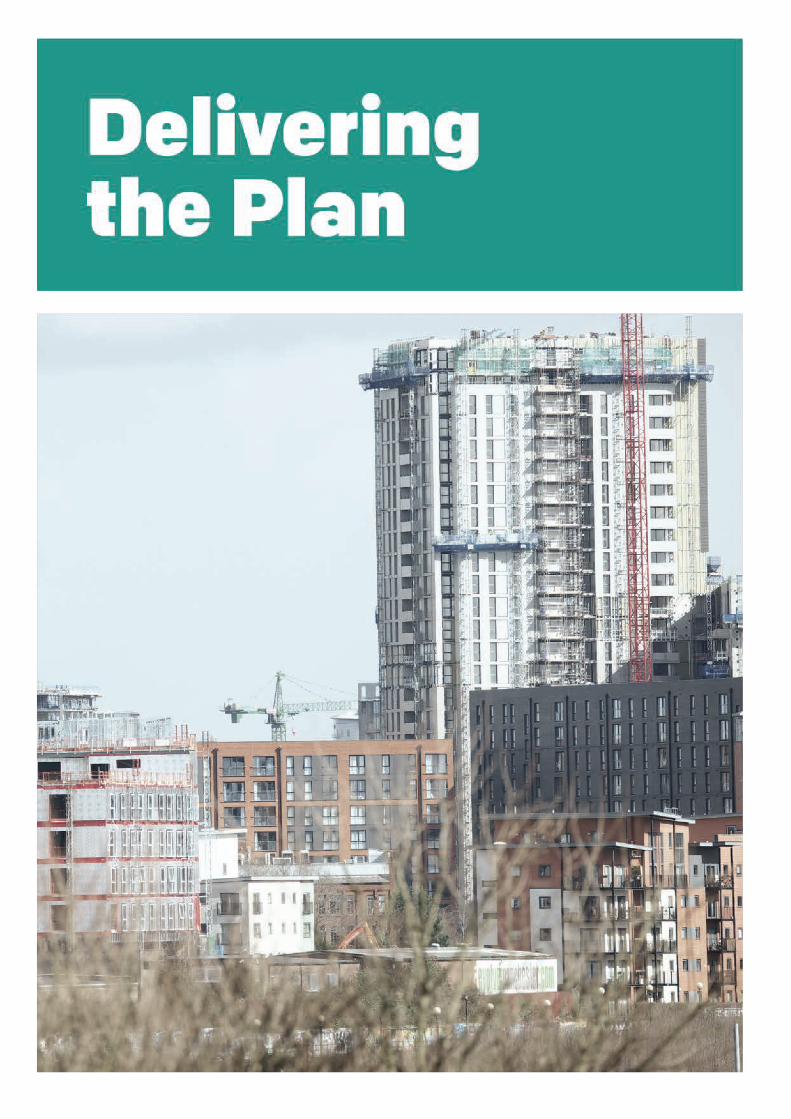

12.1 The Greater Manchester Strategy (GMS) sets out a clear vision for Greater Manchester.This Plan has a vital role in delivering this vision but many of the necessary actions lie outsideits scope and will be taken forward through other strategies, plans and programmes. Deliveringthese ambitions is a challenge but our history demonstrates that we are able to rise to thischallenge. The level of growth proposed will require substantial amounts of investment fromboth the public and the private sector. It is therefore important that this Plan is supported bysources of funding and delivery mechanisms that are both timely and appropriate.
12.2 There are a number of adopted or emerging strategies and plans which relate to differentinfrastructure provision or influence the policy direction within this Plan, for instance theInfrastructure Strategy, Housing Strategy, Greater Manchester Transport Strategy 2040refresh, Estates Strategy, Health and Social Care Strategic Plan, 5 year Environment Planand the Natural Capital Investment Plan. Please see each of these strategies for their ownmethods of delivery.
Implementation
12.3 In implementing the policies and proposals within this Plan, Local Authorities, the Mayor andGMCA will all have important roles, and should make best of all appropriate deliverymechanisms available, including:
Working in partnership with other delivery agencies and organisations such as HomesEngland, the Environment Agency, Sport England, Highways England, Transport forGreater Manchester and utilities companies to ensure that essential infrastructure isprovided.Working in partnership with landowners, developers and other private sectororganisations to secure deliverable development proposals and investment.Establishing Mayoral Development Corporations, and preparation of Local Plans, LocalDevelopment Orders, Supplementary Planning Documents, Masterplans and otherframeworks to provide context and support for site and area-specific delivery.Support for Neighbourhood Planning and other local and community-led initiatives.Application of the Development Management process and other relevant regulatoryfunctions.Use of compulsory purchase powers to assist with site assembly.Proactive use of publicly owned land holdings to assist in land assembly and the deliveryof development.Use of Government grants, other sources of funding and prudential borrowing.Use of Section 106 agreements to secure affordable housing and other types of planningobligations.Use of tariff-based systems such as the Strategic Infrastructure Tariff and CommunityInfrastructure Levy for infrastructure delivery, where appropriate and in with the mostcurrent statutory regulations.Use of other sources of funding such as the lottery fund and other initiatives as theyarise.
GMCONSULT.ORG383
Places for Everyone

12.4 We will work in a collaborative way with infrastructure providers, national government,regulators and others involved in infrastructure planning and funding, to ensure the effectivedevelopment and implementation of the infrastructure needed to support the delivery of thevision and objectives set out in this Framework.
Policy JP-D 1
Infrastructure Implementation
To make this happen we will:
1. Take a long term, strategic, holistic and integrated approach to place shaping, supportedby devolved resources and powers. Utilising the spatial locations set out in this Plan aplace-based approach will be undertaken to overcome barriers, achieving prosperity andopportunity;
2. Promote collaboration and synchronisation of investment plans between ourselves and themain infrastructure providers: Clinical Commissioning Groups, the NHS, Highways England,Network Rail, Transport for Greater Manchester, United Utilities, the Environment Agency,National Grid, Cadent, United Utilities and digital/telecommunication providers;
3. Work directly with the infrastructure providers and regulators (including Ofcom, Ofwat andOfgem) to ensure that future investment plans are consistent with this Plan;
4. Establish a new long-term funding mechanism for transport and site specific infrastructureto ensure timely delivery and capture of developer contributions;
5. Encourage early dialogue between developers and infrastructure providers to identify theinfrastructure needs arising from new development and ensuring that these are addressedthrough building design, utility networks and connections in time to serve the proposeddevelopment;
6. Require applicants to prepare an infrastructure phasing and delivery strategy for strategicsites, and major sites where build out will be delivered by different developers or in phases.This strategy must outline what needs to be provided by when and who will fund and deliverit;
7. Ensure that development does not lead to capacity or reliability problems in the surroundingarea by requiring applicants to demonstrate that there will be adequate utility infrastructurecapacity, from first occupation until development completion. As a minimum, applicantsshould identify and plan for:
Minimising the demand for energy, water and utility services by requiring sustainablebuilding design and the incorporation of demand management measures within all newdevelopment and conversions where practicable;Electricity supply to serve the construction phase and the intended use for the site,and identify, in conjunction with electricity providers the estimated load capacity of thebuilding and the substations and routes for supply;Reasonable gas and water supply, considering the need to conserve natural resources;
384GMCONSULT.ORG
Places for Everyone

The provision of multiple-ducting to support full fibre digital connections from differentproviders;Heating and cooling demand and the viability of its provision via decentralised energynetworks. Designs must incorporate access to existing networks where feasible andviable; andWhere potential capacity problems are identified and no improvements are programmedby the relevant infrastructure provider, we will require the developer to contribute toand/or facilitate necessary improvements.
8. Work with infrastructure providers to minimise disruption to highways and businesses duringmajor infrastructure upgrades and pipe subway construction; and
9. Promote the provision and use of shared routing, trenching and programming particularlyin areas where there is extreme pipe and cable congestion under the streets to reducedisruption.
12.5 We have strong links with the various infrastructure providers that service the conurbation,including United Utilities, Environment Agency, Electricity North West, Cadent (gas)digital/telecommunication providers.The continuation of this co-operative working relationshipis key to ensuring delivery of this policy. Developers, landowners and building occupantsalso have a role to play in demand management, early engagement with utility providersand co-operative working to avoid disruption.
Infrastructure Strategy
12.6 The quality, distribution and resilience of infrastructure will be an important factor indetermining whether the GMS and consequently this Plan, is successfully implemented anddelivered. Infrastructure is essential to support the delivery of the vision and objectives ofthis Plan.
12.7 The capacity of the utility network to accommodate increased demand is considered generallyrobust. However, population, economic growth and changes in technology will increasedemand, both for new and for existing infrastructure. Combined with a backlog of capitalinvestment, historically low levels of investment compared to other countries and continuallygrowing and changing expectations for infrastructure requirements over the next thirty yearswill be substantial. This is why we are working with the Government through the LocalIndustrial Strategy to ensure that the right powers and funding are in place to ensure thetimely delivery of the right infrastructure in the right place at the right time.
12.8 An Infrastructure Framework for Greater Manchester(142) has been produced. It frames thekey issues and priorities which need to be addressed and sets out:
The key trends affecting Greater Manchester's Infrastructure to 2040
142 greater-manchester-infrastructure-framework-2040.pdf (greatermanchester-ca.gov.uk)
GMCONSULT.ORG385
Places for Everyone

How these trends will affect each infrastructure networkThe eleven challenges that will have to be overcome through a series responses
12.9 The Greater Manchester Strategic Infrastructure Board will consider and respond to theissues and challenges raised by the Infrastructure Framework. It includes representativesfrom United Utilities, Electricity North West, Cadent, Environment Agency, Transport forGreater Manchester as well as GMCA officers and Chief Resilience Officer.
Delivering New Infrastructure
12.10 To achieve our ambitions, investment in transport infrastructure is required, as is the needto invest in enabling infrastructure, such as social infrastructure, green infrastructure, water,waste water, energy and digital connectivity.
12.11 The “Greater Manchester Transport Strategy 2040” (refreshed in 2020) describes ourambitions for transport in more detail. It outlines how significant investment in sustainablemodes of transport, in particular, will be essential to achieving this more sustainable visionfor the future. The Strategy is supported by Our Five Year Transport Delivery Plan, updatedannually, to set out the immediate and longer term programme for transport interventionsneeded to support sustainable growth. The Greater Manchester Cycling and WalkingInfrastructure Proposal sets out a vision for Greater Manchester to become the first cityregion in the UK to have a fully joined up walking and cycling network.(143) To support thedelivery of the proposal, a broad range of improvement measures will be required, varyingfrom route to route, including the provision of easy crossing points, innovative approachesto junction design, and the creation of fully segregated cycleways. The availability of futurefunding, particularly from central government, will be a key determinant of the extent to whichthe necessary improvements to our connectivity and transport infrastructure can be achieved.New development will also have a significant role in supporting the delivery of new andimproved transport infrastructure and services.
12.12 There is a growing need for social infrastructure across the Plan area, in particular to supporteducation and health provision. Central government provides the majority of the capitalfunding through the basic need grant and Department for Education (DfE) free schoolprogramme to create school places and to carry out capital maintenance and repair work toexisting school buildings, supplemented by capital contributions from individual localauthorities. Since 2013, Public Health has been the responsibility of local authorities, whichallows for a more joined-up approach to the delivery of public health policies and facilities. InApril 2016, Greater Manchester became the first region in the country to take control of itscombined health and social care budgets. As part of this, a key aim is to better integratehealth and social care services including wider community health services. Local Authoritieswork with Clinical Commissioning Groups and NHS England to determine what investmentis required by monitoring housing and population growth. Contributions secured throughSection 106 agreements can be used to support the provision of new social infrastructurefacilities, particularly in Strategic Allocations where there is limited existing infrastructure.
143 Mayor of Greater Manchester, Greater Manchester Combined Authority and Transport for Greater Manchester (2018): Greater Manchester'scycling and walking infrastructure proposal
386GMCONSULT.ORG
Places for Everyone

12.13 The city’s green infrastructure provides a wide range of benefits and services that generatesignificant economic value in a cost-effective way. However, provision of green infrastructurehas traditionally been the responsibility of public authorities and various public or third-sectorland-management bodies. In an attempt to address the problem of not properly valuing theservices and benefits of green infrastructure, the Government has committed to includingnatural capital accounts in the UK Environmental Accounts by 2020. This re-framing of ourunderstanding of the economic value of green infrastructure should mean that developersare more willing to integrate green infrastructure into developments rather than consideringthe provision of green space as simply a condition of planning. A Natural Capital InvestmentPlan for Greater Manchester is being prepared which will promote investment and deliveryof opportunities to protect and enhance our natural capital.This Plan will help to ensure thatthe economic benefits of green infrastructure can be understood alongside other key indicatorsof economic performance.
12.14 Investment in energy, fresh water and waste water infrastructure is usually funded by providersthrough user charges to the consumer and connections charges to developers. Spend onnew assets and operating costs are agreed through negotiations between the provider andregulator.These plans are then set out at the beginning of the regulatory price-control periodin the provider’s business plan. Capital expenditure is funded through user charges, soutilities companies typically borrow to fund the upfront costs of investment. The scale ofgrowth in some parts of the Plan area may require significant capital investment in waterand energy infrastructure, so investment ahead of demand will be required to ensure theutilities are available when sites are developed. In collaboration with the GMCA weare working with providers to ensure the investment is secured to support development atthe right time.
12.15 New digital connectivity infrastructure is typically paid for upfront through finance or privateequity investment backed by user charges and connections charges to developers. In general,decisions on where to invest in infrastructure are determined on a demand-led basis. Thefast changing nature of digital technology and increasing dependence on faster broadbandmeans that investment ahead of demand should be supported. In collaboration with theGMCA we are working with providers to ensure the investment is secured to supportdevelopment at the right time.
Funding
12.16 There is a significant gap between the public-sector funding required to deliver and supportour growth, and the amount currently committed to fund it. In some areas of the city region,major development projects are not being progressed because of the uncertainty aroundfunding. Developments will need to deliver, or help to enable the delivery of, infrastructurerequired to support sustainable communities, through planning conditions, and developercontributions secured in a variety of ways. These methods include: Section 106 planningobligations, the Community Infrastructure Levy, agreements made under Section 278 of theHighways Act 1990 (as amended), or the potential introduction of a Strategic InfrastructureTariff.
GMCONSULT.ORG387
Places for Everyone

12.17 Planning obligations made under Section 106 of the Town and Country Planning Act 1990(as amended), are a mechanism used to make development acceptable in planning termsthrough securing the provision of affordable housing or the delivery of infrastructure, orrequiring development to be used in a particular way. Planning obligations must be used inaccordance with national guidance and legislation, and are subject to statutory and policytests to ensure that they are necessary to make the development acceptable in planningterms, directly related to the development, and fairly and reasonably related in scale andkind to the development. A local planning authority should set out policies which indicatethe level of contributions required. Site-specific legal contracts taking account of these policiesare then made on a site by site basis, securing financial sums to pay for infrastructureprovision, or through ‘in-kind’ contributions. Examples of in-kind contributions include:provision of land to accommodate new facilities provided by other organisations, constructionand fit-out of new facilities, or provision of ‘shell and core’ space at peppercorn rent; howeverany direct delivery must not contravene state aid or public procurement rules.
12.18 The Community Infrastructure Levy (CIL) is a locally-determined, non-negotiable,pounds-per-square metre development charge designed to help finance the delivery ofinfrastructure, and was introduced as a mechanism by the Government in April 2010. Incontrast to Section 106, which require developer contributions for infrastructure to mitigatea specific development, CIL is intended to address the cumulative impact of developmentsacross an area.Variations in charging rates are permitted between areas within the planningauthority, as well as by different types of development, which must be set out in a publishedcharging schedule. Local authorities are able to determine their CIL charges according tolocal considerations, although these are subject to two rounds of public consultation andreview by an Independent Examiner. Across the Plan area, only one Local Authority hasprogressed work sufficiently to implement a CIL charging schedule, adopted in Trafford inJuly 2014.
12.19 In August 2020 the Government published its White Paper ‘Planning For The Future’. TheWhite Paper was accompanied by a consultation document, ‘Changes to the current planningsystem’. Together, these documents propose radical reforms to the planning system – longand short term. Key changes include zoning of land in local plans into three types of area –Growth, Renewal and Protection and replacing the current system of planning obligationsand CIL with a single development levy to fund local infrastructure. However, these proposalsare still subject to potential change following the public consultation in 2020. It is also notedthat primary legislation may be required to bring forward the proposals.
12.20 Across the Plan area we have a range of locally based priorities to be fulfilled throughdeveloper contributions. Some boroughs have supplementary planning documents settingout these priorities and the likely scale of contributions that different types of developmentare likely to require.
388GMCONSULT.ORG
Places for Everyone

Policy JP-D 2
Developer Contributions
We will require developers to provide, or contribute towards, the provision of mitigation measuresto make the development acceptable in planning terms.These will be secured through the mostappropriate mechanism, including, but not limited to, planning conditions, legal contracts, or CIL(or any subsequently adopted planning gain regime).
Applicants should take account of policies in development plans and other relevant documentswhen developing proposals and acquiring land. It is expected that viability assessments shouldonly be undertaken where there are clear circumstances creating barriers to delivery. If anapplicant wishes to make the case that viability should be considered, they should provide clearevidence at the planning application submission stage, demonstrating the specific issues thatwould create barriers to delivery in a transparent manner and reflecting national guidance.
Where it is accepted that viability should be considered as part of the determination of anapplication, the Local Planning Authority should determine the weight to be given to a viabilityassessment alongside other material considerations.
Monitoring
12.21 Monitoring is a key component of any development plan document and therefore is key tothe success of this Plan. To be effective plans need to be kept up-to-date and monitored.We need to regularly monitor performance to assess whether we are achieving our strategicobjectives and whether our policies remain relevant, or whether they need to be updated.
12.22 This plan is based on a number of projections, forecasts and research available at this pointin time. While these provide a sound basis for the plan’s overall strategy and policies, it isimportant to understand that circumstances can change and that the plan is flexible to thischange. It is therefore important to establish indicators that can be robustly monitored, togain an understanding of any significant changes that could give rise to reconsideration ofthe content of the strategy or policies and to update the associated evidence base whererequired.
12.23 The table below sets out the proposed monitoring framework for this Plan. It focuses on thekey priorities of the plan.
GMCONSULT.ORG389
Places for Everyone

Places for Everyone StrategicObjective
Policy Outcome/IndicatorsKPI / Target
Baseline at 2020 unlessotherwise stated
Strategy
1, 2, 3, 4, 5, 6, 9Total employment and housinggrowth
Significant growth inemployment and housing in theCore Growth Area
1, 2, 3, 4, 5, 9Total employment and housinggrowth
Significant increase in growthemployment and housing innorth of conurbation
1, 2, 3, 4, 5, 9Total employment and housinggrowth
Sustain the competitiveness ofthe employment and housingoffer in our part of the south ofconurbation
3, 5, 10% increase in GVA per jobImprove productivity
3, 5, 10Proportion of our residents inemployment
Increased number of jobs
1, 2, 3, 5, 6, 7, 9% increase in residentialdevelopment in main towncentres
Secure main town centres aslocal economic drivers
% vacancy rate in main towncentres
Sustainable & Resilient
2, 5, 7, 8, 10% of new development meetingthe net zero carbon standard
Reduce carbon emissions fromnew development
2, 3, 5, 7, 8, 9% of development on brownfieldland
Prioritise brownfield land fordevelopment
2, 8% of homes at risk of floodingNo increase in number ofhomes and commercialpremises at risk of flooding % of commercial premises at
risk of flooding
2, 5, 7, 8, 10Number of EV charging pointsImprove air quality
390GMCONSULT.ORG
Places for Everyone

Places for Everyone StrategicObjective
Policy Outcome/IndicatorsKPI / Target
Baseline at 2020 unlessotherwise stated
% of development within 800mof transport hubs
Number of controlled parkingzones around schools and earlyyears’ settings
Jobs
4, 5Number of local labouragreements
Improve access to jobs
3, 5Deliver 3.3 mill sqm by 2037Increase overall employmentland
Homes
1, 2, 3, 5, 7, 10Deliver approx. 8,700 annuallyby 2025
Deliver net increase of newhomes
Deliver approx. 10,300 annuallyby 2030
Deliver approx. 11,200 annuallyby 2037
1, 2, 5, 10Deliver our share of 50,000additional affordable homes by2037
Increase no of additionalaffordable homes
Number of additional affordablehomes Number of peopleremoved from the waiting list
1, 2, 5, 10% new homes meeting NDSSIncrease the number of homesmeeting NDSS
1, 2, 5, 10% new homes meeting A&Astandard
Increase the number of newhomes meeting A&A standard
GMCONSULT.ORG391
Places for Everyone

Places for Everyone StrategicObjective
Policy Outcome/IndicatorsKPI / Target
Baseline at 2020 unlessotherwise stated
Greener
2, 5, 7, 8, 9, 10Number of developmentsdelivering a 10% gain inbiodiversity
Enhance the greeninfrastructure network
2, 5, 7, 8, 9, 10Number of trees plantedannually
Increase tree planting
2, 5, 7, 8, 9, 10Number of hectares of newgreen infrastructure
Increase access to greeninfrastructure
People
2Increase % of new buildingsconsistent with National DesignGuide
High design quality
2, 4Increase % of buildings on the“at risk register” with a strategyfor their repair and re-use
Conserve, sustain and enhanceour historic environment andheritage assets
2, 4Number of new cultural facilitiesImprove the cultural offer
2, 9Increased numbers of schoolplaces
Provision of additional schoolplaces to support newdevelopment
3, 5Workforce is ready to benefitfrom new employmentopportunities
Increase the % of working agepopulation with Higher Level(4+) qualification(s) and reducethe % of working age populationwith sub Level 2 qualification(s)
Connected
2, 5, 6, 7, 10% of daily trips made by publictransport, walking and cycling
Increased proportion of dailytrips by modes other than thecar
% of development within 800mof transport hubs
392GMCONSULT.ORG
Places for Everyone

Places for Everyone StrategicObjective
Policy Outcome/IndicatorsKPI / Target
Baseline at 2020 unlessotherwise stated
2, 3, 4, 5, 6Number of premises with fullfibre connectivity
Digital connectivity
Number of locations with free,secure, high speed public wi-ficonnections
2, 6, 7Number of EV charging pointsIncreasing EV charginginfrastructure
Delivering the Plan
1, 2, 3, 4, 5, 6, 7, 8, 9, 10Delivery of necessary newinfrastructure
Ensuring the right infrastructureis delivered at the right time
1, 2, 3, 4, 5, 6, 7, 8, 9, 10Developer contributions for thedelivery of infrastructure
Secure appropriate S106contributions
Developer contributions for thedelivery of affordable housing
Table 12.1 Places for Everyone Monitoring Framework
GMCONSULT.ORG393
Places for Everyone

GMCONSULT.ORG394
Places for Everyone


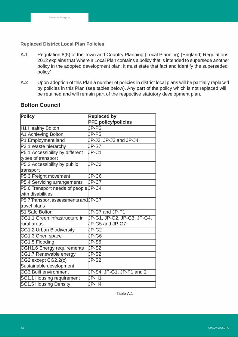
Replaced District Local Plan Policies
A.1 Regulation 8(5) of the Town and Country Planning (Local Planning) (England) Regulations2012 explains that ‘where a Local Plan contains a policy that is intended to supersede anotherpolicy in the adopted development plan, it must state that fact and identify the supersededpolicy.’
A.2 Upon adoption of this Plan a number of policies in district local plans will be partially replacedby policies in this Plan (see tables below). Any part of the policy which is not replaced willbe retained and will remain part of the respective statutory development plan.
Bolton Council
Replaced byPFE policy/policies
Policy
JP-P6H1 Healthy BoltonJP-P5A1 Achieving BoltonJP-J2, JP-J3 and JP-J4P1 Employment landJP-S7P3.1 Waste hierarchyJP-C1P5.1 Accessibility by different
types of transportJP-C3P5.2 Accessibility by public
transportJP-C6P5.3 Freight movementJP-C7P5.4 Servicing arrangementsJP-C4P5.6 Transport needs of people
with disabilitiesJP-C7P5.7 Transport assessments and
travel plansJP-C7 and JP-P1S1 Safe BoltonJP-G1, JP-G2, JP-G3, JP-G4,JP-G5 and JP-G7
CG1.1 Green infrastructure inrural areas
JP-G2CG1.2 Urban BiodiversityJP-G6CG1.3 Open spaceJP-S5CG1.5 FloodingJP-S2CGH1.6 Energy requirementsJP-S2CG1.7 Renewable energyJP-S2CG2 except CG2.2(c)
Sustainable developmentJP-S4, JP-G1, JP-P1 and 2CG3 Built environmentJP-H1SC1.1 Housing requirementJP-H4SC1.5 Housing Density
Table A.1
GMCONSULT.ORG399
Places for Everyone

Bury Council
Replaced by PFEpolicy/policies
Policy
JP-J1EC1 Employment Land ProvisionJP-J2 and JP-J4EC2 Existing Industrial Areas
and PremisesJP-J2EC3 Improvement of Older
Industrial Areas and PremisesJP-J2EC3/1 Measures to Improve
Industrial AreasJP-J3EC5 OfficesJP-H1H1 Housing Land ProvisionJP-H3H2 Housing Environment and
DesignJP-H3H4 Housing NeedJP-P1EN1 EnvironmentJP-P1EN1/1 Visual AmenityJP-P1EN1/3 Landscaping ProvisionJP-P1EN1/11 Public Utility
InfrastructureJP-P2EN2 Conservation and Listed
BuildingsJP-S2 and JP-S3EN4 Energy ConservationJP-S2 and JP-S3EN4/1 Renewable EnergyJP-S2 and JP-S3EN4/2 Energy EfficiencyJP-S5EN5 Flood Protection and
DefenceJP-S5EN5/1 New Development and
Flood RiskJP-G9EN6 Conservation of the Natural
EnvironmentJP-G9EN6/5 Sites of Geological
InterestJP-P1EN7 Pollution ControlJP-S6EN7/1 Atmospheric PollutionJP-G7EN8 Woodland and TreesJP-G1EN9 LandscapeJP-G1EN9/1 Special Landscape AreaJP-G10OL1 Green BeltJP-G10OL1/1 Designation of Green BeltJP-G6OL3 Urban Open SpaceJP-G6OL3/1 Protection of Urban Open
Space
400GMCONSULT.ORG
Places for Everyone

JP-G3OL5 River ValleysJP-P7RT2 New Provision for
Recreation in the Urban AreaJP-P7RT2/3 Education Recreation
FacilitiesJP-P7RT2/4 Dual-Use of Education
FacilitiesJP-G3, JP-G2 and JP-G5RT3 Recreation In The
CountrysideJP-C1, JP-P1 and JP-C4HT1 A Balanced Transportation
StrategyJP-C7HT2/6 – Replacement Car
ParkingJP-C7HT2/10 – Development Affecting
Trunk RoadsJP-C1 and JP-C3HT3 Public TransportJP-C7HT4 New DevelopmentJP-C1, JP-C4 and JP-C5HT6 Pedestrians and CyclistsJP-C4 and JP-C5HT6/2 – Pedestrian/Vehicular
ConflictJP-C6HT7 FreightJP-P1 and JP-P3CF1 Proposals for New and
Improved Community FacilitiesJP-P5CF2 Education Land and
BuildingsJP-P6CF4 Healthcare FacilitiesJP-P5CF5 Childcare FacilitiesJP-S7MW1 Protection Of Mineral
ResourcesJP-S7MW2 Environmental
Considerations For MineralWorkings
JP-S7MW3 Waste Disposal FacilitiesJP-S7MW3/1 Derelict or Degraded
Land (Waste)JP-S7MW3/2 Waste Recycling and
Bulk Reduction
Table A.2
Manchester City Council
Replaced byPFE policy/policies
Policy
JP-S1SP1 Spatial Principles (Partially)
GMCONSULT.ORG401
Places for Everyone

JP-J3 and JP-J4EC1 Employment and EconomicGrowth in Manchester (Partially)
JP-H1H1 Overall Housing Provision(Partially)
JP-S1, JP-S2 and JP-S5H2 Strategic Housing Location(Partially)
JP-H2H8 Affordable Housing (Partially)JP-C1T1 Sustainable Transport
(Partially)JP-P2EN3 Heritage (Partially)JP-S2EN4 Reducing CO2 Emissions
by Enabling Low and ZeroCarbon Development (Partially)
JP-S2EN6 Target Framework for CO2Reductions from Low or ZeroCarbon Energy Supplies(Partially)
JP-S2 and JP-S4EN8 Adaption to ClimateChange (Partially)
JP-G9EN14 Flood Risk (Partially)JP-G9EN15 Biodiversity and
Geological Conservation(Partially)
JP-S6EN16 Air Quality (Partially)JP-S5EN17 Water Quality (Partially)
Table A.3
Oldham Council
Replaced byPFE policy/policies
Policy
JP-H13 An Address of Choice(Partially)
JP-J3 and JP-J44 Promoting SustainableRegeneration and Prosperity(Partially)
JP-C3, JP-C4, JP-C5 and JP-C75 Promoting Accessibility andSustainable Transport Modes(Partially)
JP-S218 Energy (Partially)JP-S519 Flooding (Partially)JP-P120 DesignJPA12, JPA14,JPA15, JPA16 and JP-G10
22 Protecting Open Land(Partially)
402GMCONSULT.ORG
Places for Everyone

JP-D225 Developer ContributionsJPA14UDP Policy B1.1.24 Royton
Moss, Moss Lane, RoytonJPA17UDP Policy H1.2.17 Housing
Land Release Phase IIJPA15UDP Policy OE1.8 Major
Developed Site in the Green Belt
Table A.4
Rochdale Council
Replaced by PFEpolicy/policies
Policy
JP-J3 and JP-J4E2 Increasing jobs andprosperity (Partially)
JP-J1, JP-J2, JP-J3 and JP-J4E4 Managing the release of landto meet future employmentneeds
JP-H1C1 Delivering the right amountof housing in the right places(Partially)
JP-S1, JP-S2 and JP-S3G1 Tackling and adapting toclimate change
JP-S1, JP-S2 and JP-S3G2 Energy and newdevelopment
JP-S1, JP-S2 and JP-S3G3 Renewable and low carbonenergy developments (Partially)
JP-G10G4 Protecting Green Belt landJP-G10G5 Managing protected open
land (Partially)
Table A.5
Salford Council
Replaced by PFEpolicy/policies
Policy
JP-S1ST1 Sustainable UrbanNeighbourhoods
JP-J1, JP-J3 and JP-J4ST3 Employment SupplyJP-C1, JP-C3, JP-C4, JP-C5,JP-C6 and JP-C7
ST5 Transport Networks
JP-H4ST12 Development Density
GMCONSULT.ORG403
Places for Everyone

JP-G1, JP-G2, JP-G3, JP-G4,JP-G6, JP-G7, JP-G8, JP-G9and JP-G10
ST13 Natural EnvironmentAssets
JP-S2ST14 Global EnvironmentJP-P2ST15 Historic EnvironmentJP-G10EN1 Development Affecting the
Green Belt
Table A.6
Tameside Council
Replaced by PFEpolicy/policies
Policy
JP-H1H1 Housing Land Provision(Partially)
JP-H4H7 Mixed Use and Density(Partially)
JP-G10OL1 Protection of the Green BeltJP-G10OL2 Existing Buildings in the
Green BeltJP-G10OL3 Major Developed Sites in
the Green BeltJP-C5 and JP-C7T7 Cycling (Partially)JP-C5 and JP-C7T8 Walking (Partially)JP-S6MW14 Air Quality (Partially)JP-S5U4 Flood Prevention (Partially)
Table A.7
Trafford Council
Replaced by PFEpolicy/policies
Policy
JP-S5SL1 Pomona Island (Partially)JP-S1 and JP-S3SL2 Trafford Wharfside
(Partially)JP-S9, JP-S11 and JPA33SL5 Carrington (Partially)JP-H1 and JP-H4L1 Land For New Homes
(Partially)JP-H2 and JP-H3L2 Meeting Housing Needs
(Partially)JP-S5 and JP-S11L3 Regeneration and Reducing
Inequalities (Partially)JP-S14, JP-C1, JP-C3, JP-C4, JP-C5, JP-C6and JP-C7
L4 Sustainable Transport andAccessibility (Partially)
404GMCONSULT.ORG
Places for Everyone

JP-S2, JP-S3, JP-S5 and JP-S6L5 Climate Change (Partially)JP-S7L6 Waste (Partially)JP-P1L7 Design (Partially)JP-D1 and JP-D2L8 Planning Obligations
(Partially)JP-S9, JP-J1, JP-J2, JP-J3and JP-J4
W1 Economy (Partially)
JP-S9, JP-S12 and JP-P4W2 Town Centres and Retail(Partially)
JP-S7W3 Minerals (Partially)JP-P2R1 Historic Environment
(Partially)JP-S13, JP-G1, JP-G3, JP-G4, JP-G7, JP-G9and JP-G10
R2 Natural Environment(Partially)
JP-S13, JP-G2, JP-G3, JP-G4, JP-G7and JP-G9
R3 Green Infrastructure(Partially)
JP-S9, JP-S10, JP-S11, JP-G11, JP-G12,JPA3.2 and JPA33
R4 Green Belt, Countryside andOther Protected Open Land(Partially)
JP-G6 and JP-P7R5 Open Space, Sport andRecreation (Partially)
JP-P3R6 Culture and Tourism(Partially)
Table A.8
Wigan Council
Replaced by PFEpolicy/policies
Policy
JP-S1SD1 Presumption in Favour ofSustainable Development
JP-P6CP1 Health and WellbeingJP-P5CP4 Education and LearningJP-J1 and JP-J2CP5 Economy and EnvironmentJP-H1CP6 Housing (Clause 1 only)JP-G10 and JP-G11CP8 Green Belt and Safeguarded
LandJP-G1 and JP-G2CP9 Landscape and Green
InfrastructureJP-G9CP12 Wildlife Habitats and SpeciesJP-S2 and JP-S3CP13 Low Carbon DevelopmentJP-S7CP14 WasteJP-S2 and JP-S7CP15 Minerals
Table A.9
GMCONSULT.ORG405
Places for Everyone

GMCONSULT.ORG406
Places for Everyone


All Additions to the Green Belt
B.1 In certain locations land which was not previously in the Green Belt has now been designatedas such because it is assessed to meet one or more of the five purposes, for example toprevent settlements merging, and necessary to keep it permanently open. These proposedadditions to the Green Belt are shown on the index map below and identified on the PoliciesMap.
Picture B.2 All Additions to the Green Belt 2021
Area HaSite NameGreen BeltAddition ID
District
41.3Ditchers Farm, WesthoughtonGBA01Bolton
24.1Horwich Golf Club / KnowlesFarm
GBA02Bolton
5.6Pigs Lea Brook 1GBA03Bury
GMCONSULT.ORG409
Places for Everyone

Area HaSite NameGreen BeltAddition ID
District
3.0North of Nuttall ParkGBA04Bury
0.6Pigs Lea Brook 2GBA05Bury
3.1Hollins BrookGBA06Bury
3.3Off New Road, RadcliffeGBA07Bury
2.3Hollins BrowGBA08Bury
1.2Hollybank Street, RadcliffeGBA09Bury
13.7Crow Lumb WoodGBA10Bury
0.4Nuttall West, RamsbottomGBA11Bury
12.5Woolfold, BuryGBA12Bury
1.0Nuttall East, RamsbottomGBA13Bury
8.1Chesham, BuryGBA14Bury
9.1Broad Hey Wood NorthGBA15Bury
14.5Lower HindsGBA16Bury
0.6Land behind Denshaw VillageHall
GBA17Oldham
62.0Land within the Roch Valley,Smallbridge
GBA18Rochdale
46.7Land to west of StakehillBusiness Park
GBA19Rochdale
17.7Land at Firgrove Playing Fields,Rochdale
GBA20Rochdale
9.8Land between railway line andRochdale Canal, Littleborough
GBA21Rochdale
8.1Land north of St Andrew'sChurch, Dearnley
GBA22Rochdale
4.7Land at Townhouse Brook,Littleborough
GBA23Rochdale
410GMCONSULT.ORG
Places for Everyone
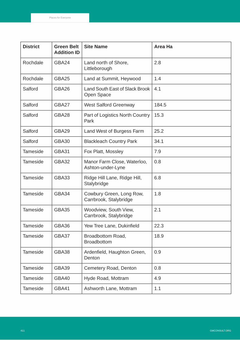
Area HaSite NameGreen BeltAddition ID
District
2.8Land north of Shore,Littleborough
GBA24Rochdale
1.4Land at Summit, HeywoodGBA25Rochdale
4.1Land South East of Slack BrookOpen Space
GBA26Salford
184.5West Salford GreenwayGBA27Salford
15.3Part of Logistics North CountryPark
GBA28Salford
25.2Land West of Burgess FarmGBA29Salford
34.1Blackleach Country ParkGBA30Salford
7.9Fox Platt, MossleyGBA31Tameside
0.8Manor Farm Close, Waterloo,Ashton-under-Lyne
GBA32Tameside
6.8Ridge Hill Lane, Ridge Hill,Stalybridge
GBA33Tameside
1.8Cowbury Green, Long Row,Carrbrook, Stalybridge
GBA34Tameside
2.1Woodview, South View,Carrbrook, Stalybridge
GBA35Tameside
22.3Yew Tree Lane, DukinfieldGBA36Tameside
18.9Broadbottom Road,Broadbottom
GBA37Tameside
0.9Ardenfield, Haughton Green,Denton
GBA38Tameside
0.8Cemetery Road, DentonGBA39Tameside
4.9Hyde Road, MottramGBA40Tameside
1.1Ashworth Lane, MottramGBA41Tameside
GMCONSULT.ORG411
Places for Everyone

Area HaSite NameGreen BeltAddition ID
District
6.9Horses Field, Danebank,Denton
GBA42Tameside
2.7Midlands Farm, Moss LaneGBA43Trafford
0.8Land off Fir Tree Street, InceGBA44Wigan
3.1Pennington FC Pitches, HoweBridge, Atherton
GBA45Wigan
26.1Hope Carr Nature Reserve,Leigh
GBA46Wigan
1.8Crow Orchard Road, StandishGBA47Wigan
1.2North Bradley Lane, StandishGBA48Wigan
3.7Coppull Lane, WiganGBA49Wigan
Table B.1 List of Places for Everyone Green Belt Additions
412GMCONSULT.ORG
Places for Everyone

Additions to the Green Belt in Bolton
Policy Green Belt Addition 1
Ditchers Farm, Westhoughton
Picture B.3 GBA 1 Ditchers Farm, Westhoughton
GMCONSULT.ORG413
Places for Everyone
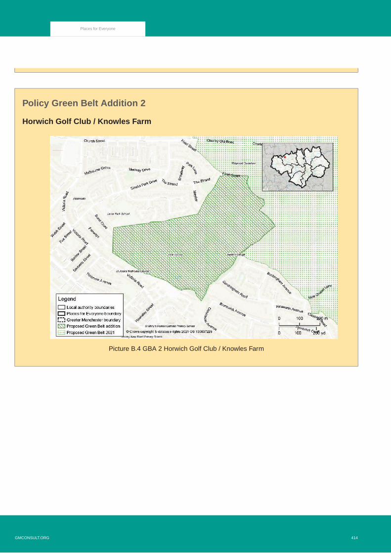
Policy Green Belt Addition 2
Horwich Golf Club / Knowles Farm
Picture B.4 GBA 2 Horwich Golf Club / Knowles Farm
414GMCONSULT.ORG
Places for Everyone

Additions to the Green Belt in Bury
Policy Green Belt Addition 3
Pigs Lea Brook 1
Picture B.5 GBA 3 Pigs Lea Brook 1
GMCONSULT.ORG415
Places for Everyone
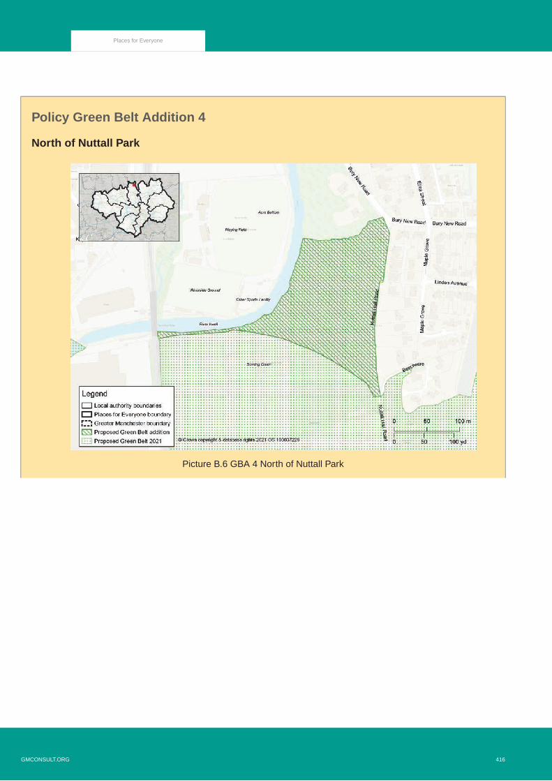
Policy Green Belt Addition 4
North of Nuttall Park
Picture B.6 GBA 4 North of Nuttall Park
416GMCONSULT.ORG
Places for Everyone

Policy Green Belt Addition 5
Pigs Lea Brook 2
Picture B.7 GBA 5 Pigs Lea Brook 2
GMCONSULT.ORG417
Places for Everyone

Policy Green Belt Addition 6
Hollins Brook
Picture B.8 GBA 6 Hollins Brook
418GMCONSULT.ORG
Places for Everyone

Policy Green Belt Addition 7
Off New Road, Radcliffe
Picture B.9 GBA 7 Off New Road, Radcliffe
GMCONSULT.ORG419
Places for Everyone

Policy Green Belt Addition 8
Hollins Brow
Picture B.10 GBA 8 Hollins Brow
420GMCONSULT.ORG
Places for Everyone

Policy Green Belt Addition 9
Hollybank Street, Radcliffe
Picture B.11 GBA 9 Hollybank Street, Radcliffe
GMCONSULT.ORG421
Places for Everyone
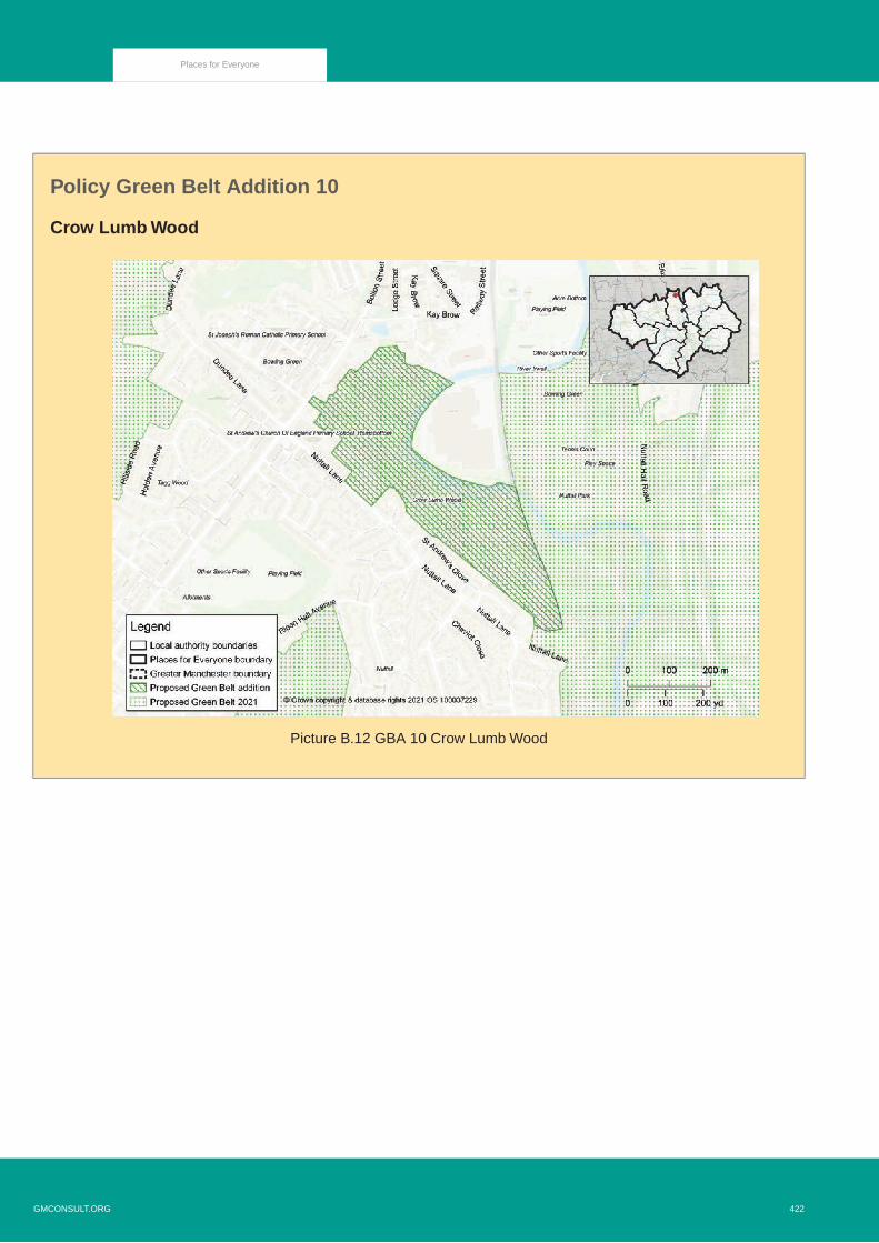
Policy Green Belt Addition 10
Crow Lumb Wood
Picture B.12 GBA 10 Crow Lumb Wood
422GMCONSULT.ORG
Places for Everyone

Policy Green Belt Addition 11
Nuttall West, Ramsbottom
Picture B.13 GBA 11 Nuttall West, Ramsbottom
GMCONSULT.ORG423
Places for Everyone

Policy Green Belt Addition 12
Woolfold, Bury
Picture B.14 GBA 12 Woolfold, Bury
424GMCONSULT.ORG
Places for Everyone

Policy Green Belt Addition 13
Nuttall East, Ramsbottom
Picture B.15 GBA 13 Nuttall East, Ramsbottom
GMCONSULT.ORG425
Places for Everyone

Policy Green Belt Addition 14
Chesham, Bury
Picture B.16 GBA 14 Chesham, Bury
426GMCONSULT.ORG
Places for Everyone

Policy Green Belt Addition 15
Broad Hey Wood North
Picture B.17 GBA 15 Broad Hey Wood North
GMCONSULT.ORG427
Places for Everyone

Policy Green Belt Addition 16
Lower Hinds
Picture B.18 GBA 16 Lower Hinds
428GMCONSULT.ORG
Places for Everyone

Additions to the Green Belt in Oldham
Policy Green Belt Addition 17
Land behind Denshaw Village Hall
Picture B.19 GBA 17 Land behind Denshaw Village Hall
GMCONSULT.ORG429
Places for Everyone

Additions to the Green Belt in Rochdale
Policy Green Belt Addition 18
Land within the Roch Valley, Smallbridge
Picture B.20 GBA 18 Land within the Roch Valley, Smallbridge
430GMCONSULT.ORG
Places for Everyone

Policy Green Belt Addition 19
Land west of Stakehill Business Park
Picture B.21 GBA 19 Land to west of Stakehill Business Park
GMCONSULT.ORG431
Places for Everyone

Policy Green Belt Addition 20
Land at Firgrove Playing Fields, Rochdale
Picture B.22 GBA 20 Land at Firgrove Playing Fields, Rochdale
432GMCONSULT.ORG
Places for Everyone
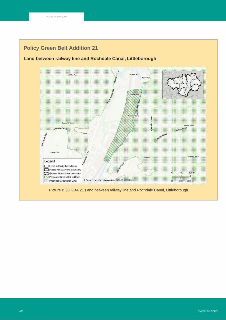
Policy Green Belt Addition 21
Land between railway line and Rochdale Canal, Littleborough
Picture B.23 GBA 21 Land between railway line and Rochdale Canal, Littleborough
GMCONSULT.ORG433
Places for Everyone

Policy Green Belt Addition 22
Land north of St Andrew's Church, Dearnley
Picture B.24 GBA 22 Land north of St Andrew's Church, Dearnley
434GMCONSULT.ORG
Places for Everyone

Policy Green Belt Addition 23
Land at Townhouse Brook, Littleborough
Picture B.25 GBA 23 Land at Townhouse Brook, Littleborough
GMCONSULT.ORG435
Places for Everyone

Policy Green Belt Addition 24
Land north of Shore, Littleborough
Picture B.26 GBA 24 Land north of Shore, Littleborough
436GMCONSULT.ORG
Places for Everyone
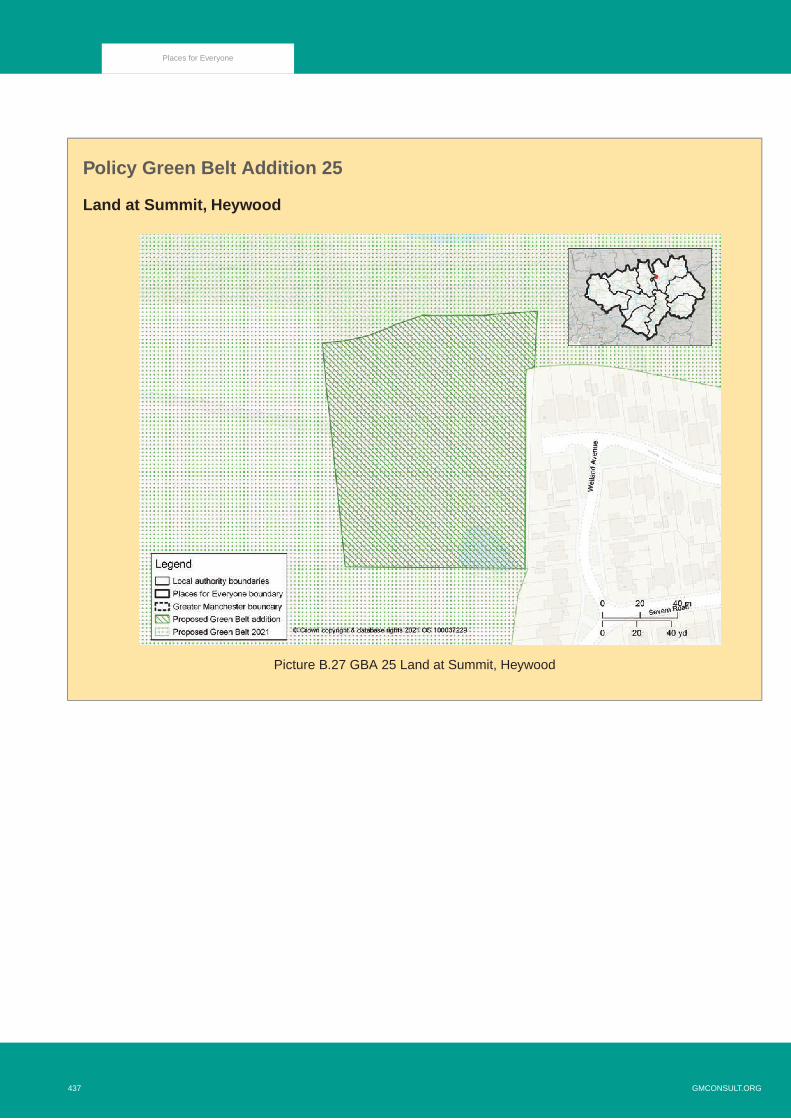
Policy Green Belt Addition 25
Land at Summit, Heywood
Picture B.27 GBA 25 Land at Summit, Heywood
GMCONSULT.ORG437
Places for Everyone

Additions to the Green Belt in Salford
Policy Green Belt Addition 26
Land South East of Slack Brook Open Space
Picture B.28 GBA 26 Land South East of Slack Brook Open Space
438GMCONSULT.ORG
Places for Everyone

Policy Green Belt Addition 27
West Salford Greenway
Picture B.29 GBA 27 West Salford Greenway
GMCONSULT.ORG439
Places for Everyone

Policy Green Belt Addition 28
Part of Logistics North Country Park
Picture B.30 GBA 28 Part of Logistics North Country Park
440GMCONSULT.ORG
Places for Everyone

Policy Green Belt Addition 29
Land West of Burgess Farm
Picture B.31 GBA 29 Land West of Burgess Farm
GMCONSULT.ORG441
Places for Everyone

Policy Green Belt Addition 30
Blackleach Country Park
Picture B.32 GBA 30 Blackleach Country Park
442GMCONSULT.ORG
Places for Everyone

Additions to the Green Belt in Tameside
Policy Green Belt Addition 31
Fox Platt, Mossley
Picture B.33 GBA 31 Fox Platt, Mossley
GMCONSULT.ORG443
Places for Everyone

Policy Green Belt Addition 32
Manor Farm Close, Waterloo, Ashton-under-Lyne
Picture B.34 GBA 32 Manor Farm Close, Waterloo, Ashton-under-Lyne
444GMCONSULT.ORG
Places for Everyone

Policy Green Belt Addition 33
Ridge Hill Lane, Ridge Hill, Stalybridge
Picture B.35 GBA 33 Ridge Hill Lane, Ridge Hill, Stalybridge
GMCONSULT.ORG445
Places for Everyone

Policy Green Belt Addition 34
Cowbury Green, Long Row, Carrbrook, Stalybridge
Picture B.36 GBA 34 Cowbury Green, Long Row, Carrbrook, Stalybridge
446GMCONSULT.ORG
Places for Everyone

Policy Green Belt Addition 35
Woodview, South View, Carrbrook, Stalybridge
Picture B.37 GBA 35 Woodview, South View, Carrbrook, Stalybridge
GMCONSULT.ORG447
Places for Everyone
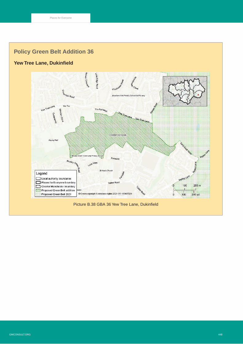
Policy Green Belt Addition 36
Yew Tree Lane, Dukinfield
Picture B.38 GBA 36 Yew Tree Lane, Dukinfield
448GMCONSULT.ORG
Places for Everyone

Policy Green Belt Addition 37
Broadbottom Road, Broadbottom
Picture B.39 GBA 37 Broadbottom Road, Broadbottom
GMCONSULT.ORG449
Places for Everyone

Policy Green Belt Addition 38
Ardenfield, Haughton Green, Denton
Picture B.40 GBA 38 Ardenfield, Haughton Green, Denton
450GMCONSULT.ORG
Places for Everyone

Policy Green Belt Addition 39
Cemetery Road, Denton
Picture B.41 GBA 39 Cemetery Road, Denton
GMCONSULT.ORG451
Places for Everyone

Policy Green Belt Addition 40
Hyde Road, Mottram
Picture B.42 GBA 40 Hyde Road, Mottram
452GMCONSULT.ORG
Places for Everyone

Policy Green Belt Addition 41
Ashworth Lane, Mottram
Picture B.43 GBA 41 Ashworth Lane, Mottram
GMCONSULT.ORG453
Places for Everyone

Policy Green Belt Addition 42
Horses Field, Danebank, Denton
Picture B.44 GBA 42 Horses Field, Danebank, Denton
454GMCONSULT.ORG
Places for Everyone

Additions to the Green Belt in Trafford
Policy Green Belt Addition 43
Midlands Farm, Moss Lane
Picture B.45 GBA 43 Midlands Farm, Moss Lane
GMCONSULT.ORG455
Places for Everyone

Additions to the Green Belt in Wigan
Policy Green Belt Addition 44
Land off Fir Tree Street, Ince
Picture B.46 GBA 44 Land off Fir Tree Street, Ince
456GMCONSULT.ORG
Places for Everyone

Policy Green Belt Addition 45
Pennington FC Pitches, Howe Bridge, Atherton
Picture B.47 GBA 45 Pennington FC pitches
GMCONSULT.ORG457
Places for Everyone

Policy Green Belt Addition 46
Hope Carr Nature Reserve, Leigh
Picture B.48 GBA 46 Hope Carr Nature Reserve
458GMCONSULT.ORG
Places for Everyone

Policy Green Belt Addition 47
Crow Orchard Road, Standish
Picture B.49 GBA 47 Crow Orchard Road
GMCONSULT.ORG459
Places for Everyone

Policy Green Belt Addition 48
North Bradley Lane, Standish
Picture B.50 GBA 48 North Bradley Lane
460GMCONSULT.ORG
Places for Everyone

Policy Green Belt Addition 49
Coppull Lane, Wigan
Picture B.51 GBA 49 Coppull Lane
GMCONSULT.ORG461
Places for Everyone

GMCONSULT.ORG462
Places for Everyone


Places for Everyone Policies Map
Picture C.2 Places for Everyone 2021 Policies Map
GMCONSULT.ORG465
Places for Everyone
Copyright © 2022 FDOKUMEN