Peter Ellis Penoyer for the degree of herein. These Tertiary units are ...
250
AN ABSTRACT OF THE THESIS OF Peter Ellis Penoyer for the degree of Master of Science in Geology presented on October Z9. 1976 Title: GEOLOGY OF THE SADDLE AND HUMBUG MOUNTAIN AREA, CLATSOP COUNTY, NORTHWESTERN OREGON Redacted for Privacy Abstract approved: Alan R. Niem Six early to middle Tertiary geologic units crop out in the Saddle and Humbug Mountain area. They include the late Eocene to early Miocene Oswald West muds tones, the lower Silver Point and the upper Silver Point tongues of the middle Miocene Astoria Forma- tion, and the middle Miocene Depoe Bay and Cape Foulweather Basalts. One new lithologically distinct unit, the Falls Creek member of the Oswald West muds tones, is mapped, described, and named informally herein. These Tertiary units are locally overlain by Quaternary stream alluvium and landslide deposits. The Oswald West mudstones consist of more than 500 meters of thickly bedded grayish to yellowish orange bioturbated tuffaceous siltstones and mudstones interstratified with minor glauconitic sand- stones and tuff beds. An open-marine, deep-water, slightly reducing depositional environment (outer shelf-continental slope) is indicated by Foraminifera, trace fossils, glauconite, and the predominantly
-
Upload
khangminh22 -
Category
Documents
-
view
1 -
download
0
Transcript of Peter Ellis Penoyer for the degree of herein. These Tertiary units are ...

AN ABSTRACT OF THE THESIS OF
Peter Ellis Penoyer for the degree of Master of Science
in Geology presented on October Z9. 1976
Title: GEOLOGY OF THE SADDLE AND HUMBUG MOUNTAIN
AREA, CLATSOP COUNTY, NORTHWESTERN OREGONRedacted for Privacy
Abstract approved:Alan R. Niem
Six early to middle Tertiary geologic units crop out in the
Saddle and Humbug Mountain area. They include the late Eocene to
early Miocene Oswald West muds tones, the lower Silver Point and
the upper Silver Point tongues of the middle Miocene Astoria Forma-
tion, and the middle Miocene Depoe Bay and Cape Foulweather Basalts.
One new lithologically distinct unit, the Falls Creek member of the
Oswald West muds tones, is mapped, described, and named informally
herein. These Tertiary units are locally overlain by Quaternary
stream alluvium and landslide deposits.
The Oswald West mudstones consist of more than 500 meters of
thickly bedded grayish to yellowish orange bioturbated tuffaceous
siltstones and mudstones interstratified with minor glauconitic sand-
stones and tuff beds. An open-marine, deep-water, slightly reducing
depositional environment (outer shelf-continental slope) is indicated
by Foraminifera, trace fossils, glauconite, and the predominantly

fine-grained character of the unit. Deposition of the Falls Creek
silts tone member which contains a very shallow water molluscan
fossil assemblage probably occurred during gradual shallowing near
the end of the late Oligocene, possibly due to adjacent deltaic pro-
gradation.
An angular unconformity separates the Oswald West muds tones
from the overlying lower Silver Point tongue and suggests that a
broad uplift occurred during an early Miocene hiatus. Thin feld-
spathic sandstone lenses occur locally above the unconformity and
mark the beginning of a middle Miocene marine transgression during
lower Silver Point time.
The approximately 300-meter thick Silver Point member is com-
posed of two intertonguing lithosomes. The lower tongue consists of
rhythmically bedded, light gray, laminated, micaceous and carbonace-
ous sandstones and dark gray siltstones. Graded bedding and partial
Bouma sequences suggest that these sandstones were deposited by
turbidity currents, possibly on a delta slope or outer delta platform.
Paleocurrent measurements and facies patterns indicate that these
turbidity flows originated at a south to southeasterly source, probably
by slumping off the nearby Angora Peak delta front. Thick-bedded,
structureless, arkosic sandstones which locally interfinger with the
basal part of the lower Silver Point tongue probably also reflect re-
deposition of "clean" delta front sheet sands into deeper water delta

slope environments.
The lower Silver Point tongue grades upward into the 200-meter
thick upper Silver Point tongue which consists of dark gray structure-
less to finely laminated mudstones and rare thin sandstone beds.
Foraminifera and the overall fine-grained lithology indicate that this
unit was deposited under deep marine (upper bathyal), low energy
conditions and reflects continuing marine transgression over the
region.
Postulated underthrusting caused by convergence of the Juan de
Fuca oceanic plate and the North American continental plate along the
middle Miocene Oregon continental margin (Ku lm and Fowler, 1974a,
1974b), may have caused the uplift and high-angle faulting and develop-
ment of an unconformity which followed upper Silver Point marine
deposition. Rapid subsidence and marine transgression ended this
short-lived erosion period as evidenced by the local eruption of over
600 meters of palagonitized Depoe Bay submarine basaltic breccias
and pillow lavas and more than 200 meters of sparsely porphyritic
Cape Foulweather submarine pillow lavas. The Depoe Bay Basalt lies
with angular unconformity over the faulted Silver Point member and
Oswald West mudstones. A local basaltic conglomerate interbed
within the Depoe Bay breccias (near the base) suggests that some
early Depoe Bay volcanic buildups developed above wave base. Chem-
ical analyses show that these basalts are tholeiites and are comparable

to the type Cape Foulweather and Depoe Bay petrologic-types along
the central Oregon Coast.
All Tertiary sedimentary units are intruded by numerous dikes,
sills, and irregular-shaped plutons. Regional dike swarms and local
feeder dikes to Depoe Bay Basalt eruptive centers such as Saddle
Mountain, commonly, either parallel or coincide with northeast-
trending or northwest-trending lineaments and high-angle faults, sug-
gesting a structural control for the emplacement of the intrusives
and location of the volcanic centers. The largest fault in the study
area (Humbug Mountain fault) is co-linear with the northwest-trending
Gales Creek Fault and another unnamed fault southeast of the study
area. In total, these three faults form an almost continuous line of
faults across the northern Oregon Coast Range for a distance of 100
km.

Geology of the Saddle and Humbug Mountain Area,Clatsop County, Northwestern Oregon
by
Peter Ellis Penoyer
A THESIS
submitted to
Oregon State University
in partial fulfillment ofthe requirements for the
degree of
Master of Science
Commencement June 1977
APPROVED:
Redacted for Privacy
Associate Professor of Geologyin charge of major
Redacted for PrivacyChairman of Department of Geology
Redacted for Privacy
Dean of Graduate School
Date thesis is presented October 29, 1976
Typed by Opal Grossnicklaus for Peter Ellis Penoyer

ACKNOWLEDGEMENTS
I wish to express my sincere appreciation to Dr. Alan R. Niem
for his guidance, cooperation, and generous counsel during comple-
tion of this thesis. Dr. E. M. Taylor and Dr. H. E. En lows critically
read the manuscript and provided helpful suggestions for which I am
grateful.
I am further indebted to the following individuals who materially
contributed to the content of this investigation. Dr. Weldon W. Rau
of the Washington Department of Natural Resources, Geology and
Earth Resources Division and Dr. Warren 0. Addicott of the United
States Geological Survey identified collected Foraminifera and mol-
luscan fossil assemblages respectively, and interpreted their paleo-
depositional environments. Ichno-fossils were identified and their
paleoecology were interpreted by Dr. C. Kent Chamberlain of Ohio
University. I wish to acknowledge Jim Lave ly of Crown Zellerbach
Corporation and Curt Degens of the Oregon National Guard for provid-
ing me with detailed topographic maps and side scanning radar imag-
ery of the thesis area, respectively.
I wish to thank Mike Cooper for many intellectually stimulating
discussions concerning the Astoria Formation problem and his labora-
tory assistance.
Field work expenses were in part defrayed by a Grant-in-Aid

for Scientific Research from the Society of Sigma Xi and a per diem
allotment from the Oregon Department of Geology and Mineral Indus-
tries. Grants made to Dr. A. R. Niem by Shell Development Company
and the Petroleum Research fund, administered by the American
Chemical Society, defrayed laboratory expenses and provided finan-
cial support while writing the thesis.
For the patience shown, and the encouragement and financial
assistance given me by my family, throughout the duration of this
study, I extend a special thank you.

TABLE OF CONTENTS
INTRODUCTION 1
Purposes of Investigation 1
Location and Accessibility 2
Topography and Principal Geographic Features 2
Climate and Vegetation 6
Previous Work 8
Methods of Investigation 12
Field Methods 12
Laboratory Methods 13
REGIONAL GEOLOGY 16
DESCRIPTIVE GEOLOGY 23
Introduction 23
Oswald West Muds tones 28
Nomenclature 28
Distribution 28
Lithology 30
Falls Creek Siltstone Member 40Nomenclature and Distribution 40Lithology 41
Petrology 42Age and Correlation 49Contact Relationships 51
Depositional Environment 53
Astoria Formation 55
Silver Point Member 57
Nomenclature 58Distribution 59Lower Silver Point Tongue 59
Lithology 59Contact Relations hips 67
Age and Correlation 69Upper Silver Point Tongue 70
Lithology 71
Age, Correlation, and ContactRelations hips 73
Petrology of the Silver Point Member 74

Middle Miocene Basalts 83Introduction 83Depoe Bay Basalt 85
Nomenclature 85Distribution 85Intrusives 87
Lithology 87Petrology 92
Extrusives 98Lithology 98
Hyaloclastites 103Terminology 103Lithology 104
Petrology of the Depoe Bay Brecciasand Hyaloclastites 104
Interbedded Sedimentary Rocks 110Contact Relationships 114Age and Correlation 115
Cape Foulweather Basalt 116Nomenclature 116Distribution 116Intrusives 118
Lithology 118Peperites 122Petrology 125
Extrusives 131
Petrology 132Interbedded Sedimentary Rocks 134
Petrology 136Contact Relationships 139Age and Correlation 140
Basalt Chemistry 141
Quaternary Deposits 144Channel Conglomerate 144Colluvium Deposits 148Stream Alluvium 151
Structural Geology 151
Regional Structure 151Thesis Area Structure 153
Folds 154Faults 156
ORIGIN OF SADDLE AND HUMBUG MOUNTAINS 16.6

TERTIARY GEOLOGIC HISTORY 168
Paleocurrent Data 168Provenance 171Geologic History, Summary, and Conclusions 174
GEOLOGIC HAZARDS 198
ECONOMIC GEOLOGY 201
Crushed Rock Resources 201
Petroleum 202
REFERENCES CITED 206
APPENDICES 213

LIST OF FIGURES
Figure Page
1. Index map showing the location of the thesis area. 3
2. Scenic view looking west-northwest along SunsetHighway. 4
3. Scenic view looking east up the Lewis and ClarkRiver valley. 5
View of westernmost peak of Saddle Mountain. 7
175. Regional map of northwest Oregon Coast Range.
6. Rock correlation chart of the northern and centralOregon Coast Range. 19
7. Tertiary stratigraphy of the thesis area. 25
8. Generalized columnar section for the Saddle andHumbug Mountain area. 27
9. Generalized outcrop distribution map of the OswaldWest muds tones.
10. Mudstone hand samples from the Oswald Westmuds tone.
11. Typical outcrop of the middle part of the Oswald Westmuds tone.
12. Sandstone hand samples from the Oswald Westmuds tones.
29
32
33
35
13. Typical outcrop of the upper part of the Oswald Westmudstone. 37
14. Classification of point counted sandstones. 43
15. Photomicrograph of glauconitic sandstone. 46
16. Photomicrograph of burrowed Oswald West mudstone. 48

Figure Page
17. Outcrop distribution of the Silver Point member. 60
18. Typical outcrop of the lower Silver Point tongue. 62
19. Representative hand samples from the Lower SilverPoint tongue. 63
20. Close-up of Lower Silver Point turbidites showingintervals C, D, A, and B of Bouma sequence. 64
21. Close-up of lower Silver Point turbidite showingBouma intervals D and E. 64
22. Photomicrograph showing internal grading oflaminated D Bouma interval. 65
23. Photomicrograph of the laminated upper part of thelower Silver Point tongue. 76
24. Photomicrograph of the laminated upper part of thelower Silver Point tongue. 77
24a. Typical matrix-rich texture displayed by the SilverPoint turbidite feldspathic sandstones. 77
25. Photomicrograph of a typical upper Silver Pointsandstone. 79
26. Outcrop distribution of the Depoe Bay Basalt. 86
27. Sill of Depoe Bay Basalt which intruded upperSilver Point muds tones. 88
28, Dike of Depoe Bay Basalt cross-cutting breccias. 91
29. Photomicrograph of intrusive Depoe Bay basalticdike sample. 94
30. Photomicrograph of intrusive Depoe Basalt sillsample. 94
31. Photomicrograph of intrusive Depoe Bay breccia. 97
Typical exposure of structureless Depoe Bay breccias. 100

Figure Page
Outcrop showing close-packed Depoe Bay pillowbreccias 102
34. Photomicrograph of heulandite cemented hyaloclastite. 106
35. Photomicrograph showing alteration zones in a basaltclas t.
36. Photomicrograph of altered basalt clast under crossednicols.
107
108
37. Outcrop of interbedded conglomerate near base of DepoeBay breccias. 112
38. Outcrop distribution map of the Cape FoulweatherBasalt. 117
39. Outcrop of a Cape Foulweather feeder dike.
40. Close-up of peperite hand sample.
41. Photomicrograph of Cape Foulweather intrusivebasalt.
42. Photomicrograph of Cape Foulweather peperite.
121
124
128
130
43. Photomicrograph of laminated muds tone xenolithin Cape Foulweather peperite. 130
44. Photomicrograph of vitrophyric Cape FoulweatherBasalt. 133
45. Photomicrograph of a partially resorbed plagioclasephenocryst in tachylyte glass. 133
46. Photomicrograph of amygdaloidal Cape FoulweatherBas alt.
135
47. Photomicrograph showing partial alteration of anaugite crystal to ch.loroph.aeite. 135
48. Photomicrograph of typical interbedded sandstone inthe Cape Foulweather Basalt. 138

Figure
49. Silica variation diagram of selected basalt samples.
50. Outcrop distribution of Quaternary deposits.
51. Photomicrograph of a cobble conglomerate froma paleo-stream channel. 147
Page
142
145
52. Spheroidally weathered boulder perched on a ledgeon Saddle Mountain.
Structure and tectonic lineament map of the Saddleand Humbug Mountain area.
54. U-2 Hi flight photograph showing lineaments in thethesis area.
55. Outcrop of Depoe Bay breccia showing well developedjointing.
150
155
158
159
56. Fault offsetting Cape Foulweather basalts and sedi-mentary interbeds. 163
57. Rose diagram of paleo-current measurements fromthe lower Silver Point tongue. 170
58. Paleogeographic map of northwestern Oregon during earlyand middle Oswald West time (late Eocene-middleOligocene) 177
59, Paleogeographic map of northwestern Oregon during lateOswald West time (late Oligocene-early Miocene). 180
60. Paleogeographic map of northwestern Oregon duringthe early Miocene hiatus. 182
61. Paleogeographic map of northwestern Oregon duringAngora Peak and lower Silver Point times (middleMiocene). 184
62. Paleogeographic map of northwestern Oregon duringupper Silver Point time. 186

Figure Page
63. Paleogeographic map of northwestern Oregon showingfaults in thesis area (Gales Creek-Humbug Mountainfault zone) during the tectonically active late middleMiocene hiatus.
64. Paleogeographic map of northwestern Oregon duringthe late middle Miocene volcanic episode.
65. Conjectural (oblique) view across northwest Oregonand southwest Washington showing hypothetical platesubduction during middle Miocene volcanic period.
66. Diagrammatic N-S cross-section between Saddle andHumbug Mountains showing the inferred (late Mioceneto Present) formation of the Lewis and Clark Rivervalley.
67. Geologic map of northwestern Oregon showing presentdistribution of Tertiary volcanic and sedimentaryunits.
188
191
192
195
197

LIST OF TABLES
Table Page
1. Average mineralogic composition of sandstones inTertiary units. 45
2. Modal analyses of selected samples of intrusiveDepoe Bay Basalt. 95
3. Modal analyses of selected samples of CapeFoulweather Basalt. 126
Plate
LIST OF PLATES
Geologic map of the Saddle and Humbug Mountainarea, Clatsop County, northwestern Oregon (inpocket)
Diagrammatic geologic cross-sections (in pocket)

GEOLOGY OF THE SADDLE AND HUMBUG MOUNTAIN AREA,CLATSOP COUNTY, NORTHWESTERN OREGON
INTRODUCTION
Purposes of Investigation
A fascinating record of submarine basaltic volcanism and the
sedimentary response to tectonism and progradation of deltaic
sequences across an unstable continental margin is well preserved
in the Tertiary rocks of northwestern Oregon. Not until recently,
have detailed structural, paleoenvironnnental, and facies mapping
studies begun in the region in earnest. As part of a joint geologic
study of much of northwestern Oregon involving graduate students at
Oregon State University working under the guidance of Dr. Alan R.
Niem of the Geology Department, it is the purpose of this geological
investigation of the Saddle and Humbug Mountain Area:
1) to map and describe the sedimentary and volcanic rock units
2) to interpret the paleoenvironments of deposition and facies
relationships of the sedimentary and volcanic rock units
3) to determine provenances of the sedimentary rocks and recon-
struct the depositional and tectonic history, and
4) to evaluate the economic potential of the area and delineate
potential geologic hazards.

2
Location and Accessibility
The roughly rectangular 133 sq km study area is located in
east-central Clatsop County, approximately 10 km southeast of
Seaside, Oregon and 20 km south of Astoria (Figure 1). The Coast
Range summits and the Pacific Ocean are visible to the east and
west respectively, from the topographically high parts of the thesis
area.
Accessibility to the study area and to all parts within the area
is excellent. The principal access highway, U. S. 26 (Sunset Highway),
forms part of the irregular southern boundary in the eastern one-half
of the area (Figures 1 and 2). Its junction with State Highway 53
occurs immediately south of the central part of the thesis area (Fig-
ure 1). Two improved roads, the Saddle Mountain State Park road
and the Lewis and Clark Mainline logging road crisscross the interior
of the study area. Numerous additional gravel logging roads (main-
tained by Crown Zellerbach Corporation) provide access to the more
remote parts of the area (see roads on Plate I).
Topography and Principal Geographic Features
The eastern part of the thesis area consists of steep, rugged,
volcanic mountains surrounded by broad stream valleys and hummocky
lowlands composed of less resistant sedimentary rocks (Figure 3).

3
Thesis Area
Figure 1. Index map showing the location of the thesis area.

Figure 2.
I
View of thesis area looking west-northwest alongSunset Highway (U. S. 26) toward unnamed middleMiocene volcanic peaks west of Humbug Mountain.
4

5
Figure 3. Scenic view looking east up the Lewis and ClarkRiver Valley between Saddle Mountain (its eastern-most peak is on left) and Humbug Mountain (right).
6
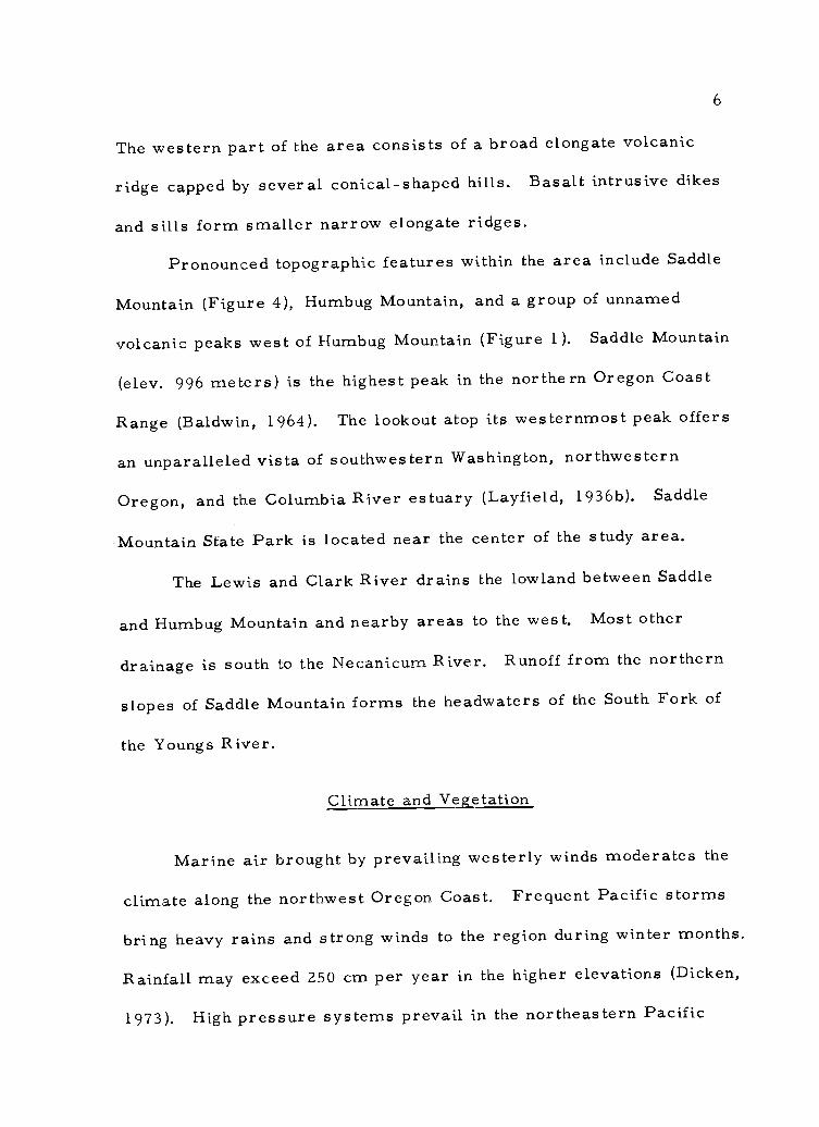
The western part of the area consists of a broad elongate volcanic
ridge capped by several conical-shaped hills. Basalt intrusive dikes
and sills form smaller narrow elongate ridges.
Pronounced topographic features within the area include Saddle
Mountain (Figure 4), Humbug Mountain, and a group of unnamed
volcanic peaks west of Humbug Mountain (Figure 1). Saddle Mountain
(elev. 996 meters) is the highest peak in the northern Oregon Coast
Range (Baldwin, 1964). The lookout atop its westernmost peak offers
an unparalleled vista of southwestern Washington, northwestern
Oregon, and the Columbia River estuary (Layfield, 1936b). Saddle
Mountain State Park is located near the center of the study area.
The Lewis and Clark River drains the lowland between Saddle
and Humbug Mountain and nearby areas to the west. Most other
drainage is south to the Necanicum River. Runoff from the northern
slopes of Saddle Mountain forms the headwaters of the South Fork of
the Youngs River.
Climate and Vegetation
Marine air brought by prevailing westerly winds moderates the
climate along the northwest Oregon Coast. Frequent Pacific storms
bring heavy rains and strong winds to the region during winter months.
Rainfall may exceed 250 cm per year in the higher elevations (Dicken,
1973). High pressure systems prevail in the northeastern Pacific

Figure 4. View of westernmost peak of Saddle Mountain takenwith telephoto lens from southwest base of HumbugMountain. Note dikes situated in notch (center) andups lope from trees (right). Joint planes appear asshadows.

8
during summer months and rain is much less frequent. Easterly
winds may develop and month-long dry spells characterized by clear
warm weather result from this offshore flow. Coastal upwelling
commonly produces a morning fog which may extend inland several
miles.
The yearly average temperature range on the coast is approx-
imately 11° C at Seaside (U. S. Department of Commerce, 1972).
August and December have the highest (17° C) and lowest (6° C) aver-
age temperatures respectively.
A spruce-cedar-hemlock forest (Picea- Thuja- Tsuga) is native
to the area (U. S. Department of Interior National Atlas, 1970). Log-
ging operations have removed most of the old growth trees and clear-
cut areas are sparsely resettled with small conifers and a thick
understory of alder and c3alal.
Saddle Mountain is the southern limit of the Coast Range for
Alaska Cypress (Chamecyparis Nootkatensis). A species of flower,
Cladothamus pyrolaeflorus, is native only to Saddle Mountain and
Monoeses uniflora, a rare single species, is also found on the moun-
tain (Layfield, 1936b).
Previous Work
It is not surprising that the most prominent topographic feature
in the northern Oregon Coast Range, Saddle Mountain, attracted the

9
attention of the earliest geological investigators in the area. The
first literary reference to Saddle Mountain was made by Geologist
James D. Dana while accompanying the Wilkes Exploring Expedition
(1838-1842). He recognized the mountain as a "volcanic peak. "
Diller (1896) in a pioneer study which emphasized the mineral re-
sources of northwest Oregon, noted that Saddle Mountain and other
volcanic ridges of the area are oriented "transverse to the general
trend of the Coast Range. "
The general geology of Saddle Mountain State Park and vicinity
was first described by Layfield (1936a, 1936b). He reported that the
dikes which "stand out from the surrounding ma. terial as walls up to
50 feet high" were emplaced along joints in the basaltic breccias and
are not true feeders (Figure 4). Layfield (1936b) attributed the
occurrence of volcanic breccias to local extrusion along NW-SE
fissures. He also suggested that the "micaceous clay shales" in the
park area, which are overlain by the basaltic breccias, are part of
the Astoria Formation.
Baldwin (1964) considers Saddle Mountain to be an erosional
remnant of a once widespread unit of submarine volcanic breccia.
He suggested that Saddle Mountain, Wickiup Mountain, and Nicolai
Ridge form the upturned limb of a syncline whose axis parallels the
Columbia River.
Other early workers in northwestern Oregon were principally

10
interested in determining the oil and gas potential of the region.
Confronted with the almost impenetrable brush and tack of outcrops in
the interior, Washburne (1914), confined much of his work to the sea
coast. Regional mapping of the area (Warren and others, 1945) led
to the publication of a U.S. Geological Survey oil and gas investiga-
tions map (1>143, 000) in which basalts were differentiated from un-
differentiated Tertiary sedimentary rocks. Wells and Peck (1961)
published a "Geologic Map of Oregon West of the 121st Meridian"
showing major structures and the outcrop distribution of the Astoria
Formation. Eocene-Oligocene rocks remained undifferentiated on
this map.
Schlicker and others (1972), in a regional investigation of
northwestern Oregon further restricted the Astoria Formation to a
middle Miocene sandstone unit to accentuate its geological engineering
properties. Beaulieu (1973) described the environmental geology of
inland Tillamook and Clatsop counties. His map shows that the
basaltic breccias that compose Saddle and Humbug Mountain are of
extrusive origin.
The first paleontological work in this part of Oregon was pub-
lished by Conrad (1848). He described some Miocene molluscan
fossils collected by J. K. Townsend in the mudstone units near
Astoria, Oregon. Howe (1926) described the stratigraphic section
at Astoria and named it the type area for the Astoria Formation.

11
The regional stratigraphy and geologic history of the Oregon
Coast Range which includes northwes tern Oregon, has been reviewed
by many investigators (Snavely and others, 1963, 1964, 1969a;
Baldwin, 1964; Braislin and others, 1970; Beaulieu, 1971; and Niem
and Van Atta, 1973).
Petrography, chemical composition, radiometric age, and
correlation of the middle Miocene extrusive and intrusive coastal
basalts of Oregon is reported by Snavely and others (1963, 1969a,
1973). Their work indicates that two basalt types in northwestern
Oregon can be distinguished by petrographic characteristics and
distinct chemical compositions. Snavely and others (1973) demon-
strated this correlation with chemical types of the Columbia River
Group.
Four detailed geologic thesis studies by Masters students at
Oregon State University in which Oligocene to middle Miocene units
are differentiated from the mouth of the Nehalem River 32 km north-
ward to Youngs River have been recently completed. Two widespread
informal members of the Astoria Formation have been recognized; a
lower 1,000-foot (300 m) thick shallow marine sandstone known as
the Angora Peak sandstone member (Cressy, 1974), and an overlying
deep-water turbidite sequence referred to as the Silver Point mud-
stone member (Smith, 1975). Tolson (1976) and Neel (1976) have
traced these units into adjacent areas north and south of the thesis

12
area, respectively. Tolson (1976) also informally named and mapped
two mudstone tongues and one sandstone tongue of local extent within
the Astoria Formation. Recently, Doctoral candidate David M.
Cooper, has completed a regional paleoenvironmental study of the
Astoria Formation in western Oregon under the direction of Dr. A. R.
Niem at Oregon State University. He pictures the Astoria Formation
as forming in part, a high energy wave dominated delta and associated
delta slope facies in the Nehalem- Astoria area.
Methods of Investigation
Field Methods
Field work consisting of geologic mapping and lithologic describ-
ing was done over a two and one-half month period in the summer of
1974 and intermittently thereafter through May 1976. More than 1 50
representative rock and fossil samples were collected from lithologic
units in the area. Attitudes of rock strata and dike and joint azimuths
were measured with a Brunton compass.
Field data were initially compiled on Crown Zellerbach. Corpo-
ration topographic maps (scale 1 :12, 000). Field location and interpre-
tation of tectonic structures was aided by the use of Oregon State
Forest Service aerial photographs taken in 1 971 at the same scale.
All data were later transferred to enlarged (1 :16, 000) portions of the

13
Saddle Mountain and Cannon Beach quadrangle maps (1955: Plate I).
Stratification, cross stratification, and grain size terminology
used in the field descriptions is that of Mckee and Weir (1953),
Bouma and Brouwer (1964), and Wentworth (1922), respectively.
Colors used in field descriptions are from the Geological Society of
America "Rock Color Chart" (1964) which follows the Munsell system.
Laboratory Methods
Sieving procedures described by Royse (1970) were used to
perform grain size analyses on seven disaggregated sandstones
(Appendix IV), and results were analyzed quantitatively using the
statistical parameters of Folk and Ward (1957) and Inman (1952).
Plots of these data on Friedman's (1962) and Passega's (1957) binary
graphs aided interpretation of the depositional environments for the
sandstones (Appendix IX).
A Ncrelco X-ray diffractometer was used to determine clay
minerals contained in four muds tones and the clay size matrix of
three sandstones. Pretreatment techniques included disaggregation
by gentle grinding, soaking in hot water, and cation saturation (Mg)
of the clay samples (See Appendix VI for further discussion of clay
analysis procedures). In addition, zeolites infilling small vugs in
the basalts underwent X-ray diffraction analysis. The A. S. T. M.
Inorganic Index to the Powder Diffraction File (1970) and clay mineral

14
diffraction patterns obtained by Grim (1968), Brown (1969), and
Carol (1970) were used as a comparison in deciphering sample diffrac-
tion records.
Sandstone samples were thin-sectioned, point counted, and clas-
sified in accordance with the scheme presented by Williams and others
(1954). Feldspar staining techniques outlined by Bailey and Stevens
(1970) were employed on ten sandstone samples and the sand matrix
of one conglomerate sample to facilitate feldspar identification.
Eleven sandstone samples underwent heavy mineral analysis
following Royse's (1970) procedure that uses tetrabromoethane
(sp. gr. 2. 95, Appendix II). Milner's (1962) petrography text was
used to aid in identification and provenance interpretation of the
heavy mineral suites.
Total weight percent hydrocarbons in 23 samples of organic-
rich muds tones and fine-grained sandstones were determined by the
pyrolysis-fluorescence process using a Turner No. 110 Fluorometer
(See Appendix VII for a more complete discussion of procedures).
Lineaments were examined stereoscopically in U-2 Hi-flight
infra-red imagery (1:130,000; available from the Oregon State Univer-
sity remote sensing laboratory) and in side-scanning radar imagery
(1:500, 000; available from the Oregon National Guard) to determine
their regional extent.
Fifteen unweathered basalt samples and one altered

15
hyaloclastite were chemically analyzed for weight percents of SiO2,
A1203, FeO (total iron), CaO, K20, Na20, MgO, and TiO2
(Appendix
VII). Oxide percentages were obtained using atomic absorption spec-
trophotometry, visible light spectrophotometry, and X-ray fluores-
cence. Analyzed rocks were prepared in accordance with Taylor's
Cookbook for Standard Chemical Analysis.
Dr. Weldon Rau of the Washington Department of Natural Re-
sources identified microfossils which I had separated and mounted
from disaggregated muds tone samples after a 15 min. boiling treat-
ment. Dr. Warren Addicott of the U. S. Geological Survey, Menlo
Park, identified molluscan fossils and made paleoecological interpre-
tations.
Ichno-fossils (trace fossils) were sent to Dr. C. Kent Chamber-
lain of Ohio University for examination and paleowater depth interpre-
tation. Fossil data and collection locations are listed in Appendix I.

16
REGIONAL GEOLOGY
Structurally, the northern Oregon Coast Range is a northward
plunging anticlinorium truncated by high angle normal and reverse
faults (Snavely and Wagner, 1964; Figure 5). A central basaltic core
composed of the Tillamook Volcanic Series (Warren and others,
1945) is flanked by an off-lapping approximately 7,000-meter thick,
younger sequence of late Eocene through middle Miocene marine
sedimentary rocks and subordinate interbedded volcanics (Braislin
and others, 1970; Niem and Van Atta, 1973).
Several NW-SE broad folds outline the anticlinorium which
suggest that the region has been subjected to mild compression.
Structural trends and the central uplifted axis of the Coast Range
resulted from faulting and folding in the late middle Miocene-Pliocene
period (Baldwin, 1976). Snavely and Wagner (1973) suggest that the
regional distribution of dikes and sills indicate a north to northeast
series of fracture zones controlled the emplacement of intrusive and
extrusive rocks during the middle Miocene. Igneous activity and
structural deformation were coincident with a period of presumed
rapid underthrusting of the Juan de Fuca oceanic plate beneath the
North American continental crust (Atwater, 1970).
The oldest rocks in the Coast Range, the early to middle Eocene
Tillamook Volcanic Series consists of a thick (6,000-m) sequence

17
1
TillamookHead
Oswald West
CapeMeares
EXPLANATION
Quaternary/Pliocene sediments
Middle MioceneBasalts
Astoria Formation
Eocene to Oligocene sedimentary rocks( undiff erentiated )
Tas
Cape Lookout
0 58=12=
Miles
111111111111MMUMNM-Columbia River
Basalts
Pittsburg Bluff Formation
Keasey Formation
Cowlitz Formation
Eocene volcanics (Tillamookand Goble series)
Figure 5. Regional geologic map of the northwest Oregon Coast Range. (Map after Wells and
Peck, 1961).

18
of submarine basalt flows, pillow lavas, basaltic breccias, and minor
associated water-laid tuffaceous sedimentary rocks. This unit corre-
lates with the Siletz River Volcanic Series in the Central Oregon Coast
Range (Snavely and Baldwin, 1948). Snavely and others (1968) sug-
gested that these low potassium tholeiitic basalts have been accreted
onto the continental margin.
Baldwin (1976) recognized six pre-Columbia River Basalt sedi-
mentary formations in the northwestern Oregon Coast Range. Listed
chronologically from oldest to youngest, they include the Yamhill,
Cowlitz, Keasey, Pittsburg Bluff, Scappoose, and Astoria Formations.
In addition, regional unconformities occur at the base of the Yamhill
and Astoria Formations (see Figure 6).
The middle .Eocene Yamhill Formation is not exposed in the
area shown in Figure 5. Southeast of this area the unit directly over-
lies the Siletz River Volcanics (Baldwin, Brown, Gain, and Pease,
1955). There, the formaticn consists of micaceous siltstone and fine-
grained sandstone approximately 1, 200 meters thick.
Conformably overlying and interfingering with the Yamhill
Formation is the late Eocene Cowlf_tz Formation. Where the Yamh."'
Formation is not present in northern Oregon (as in the area shown in
Figure 5), the Cowlitz Formation unconformably overlies late Eocene
Tillamook volcanics. The Cowlitz Formation consists of over 300
meters of conglomerate, arkosic sandstone, and siltstone. The upper

Pacific Coast Northwest OregonCoast Range
(Baldwin, 1964)
Central OregonCoast Area
Snavely et al., 1969, 1973This Thesis
Standard StagesMegafossil Foraminifer al
I<4
Terrace Mat. Alluvium & Terracedeposits
CapeFoulweather Basalt
-
Stream Alluvium +landslide deposits
Tulare
CapeBasaltSediInt
Mlicbm
Foulweatherandentaryeds
I I li I I I
1
I I
Portland Hills Silt
>"c:4
1=4
41(,
d.-..
ii:
San Joaquin Cl. LavaBoring
Etchogoin Troutdale Formaonti
edimentary Roc(at Clifton)
Jacalitos iiiriC1Yre an step: .
ct,
00o
Lateepoe Bay Basalt
Neroly
Cierbo
MiddleBriones
Temblor
Columbia River Basalt ----e izian .".IMIIMIIWIMMIMMMIUM De e a B salt
Astoria Formation Astoria FormationSaucesian
Zemorrian
mumunintisminaNINIpper
Tourminummanosumnoye u. stoneEarly a ueros MI 0 swim....
Scappoose Formation
imirommuu Ara MA
Astoria FormationSilver Point Member
Mud stones ofOswald West
Blakeley Yaquina Formation
49
0o.1144
°
Late
Lincoln
Pittsburg Bluff Fm.( includes Gries Ranch
Cgl) Silutone of AlseaEarly Refugian Keasey FormationKeasey 7 volcanic
v.90o4.1
LateNestucca rocks
Tejon
hieCowlitz VolcsFormationNarizian
Formation
1 1 1 1 1 II I 1 1 I 1 HYanihill
ransition bedsyrmation
Middle Yamhill FormationUlatisian
DomengineTyee Formation
1 ilI I
I 1 11
tuff siltstone
CapayEarly Penutian/mem
Siletz River VolcanicsSiletz River Volcanics
Figure 6. Rock correlation chart for the northern Oregon Coast Range (modified from VanAtta, 1973).10

20
part of the formation interfingers with basaltic flows and breccias of
the Goble Volcanics (Niem and Van Atta, 1973).
The Keasey Formation was originally named and described by
Schenck (1927). Warren and others (1945) divided the unit into three
members. The lower member is a 200-meter thick calcareous pebbly
volcanic sandstone with inters tratified beds of dark gray tuffaceous
muds tone. A 550-meter thick structureless, fossiliferous, tuffaceous
siltstone comprises the middle member and a much thinner (60-to-
100-meter thick) upper member is composed of concretionary, tufface-
ous siltstone and muds tone beds. Warren and Norbisrath (1946) sug-
gested a conformable contact with the underlying Cowlitz Formation
due to similarities of rock type and apparent concordance of forma-
tional exposures in the field.
Strata of middle Oligocene age named by Hertlein and Crickmay
(1925) form the Pittsburg Bluff Formation in the eastern part of the
northern Coast Range. The unit consists of finely laminated fossilifer-
ous, shallow marine arkose, glauconitic sandstone, and muds tone and
overlies the Keasey Formation. Local coal beds and fluvial con-
glomerates (Niem and Van Atta, 1973) in the upper part indicate a
probable deltaic origin of the formation. The thickness of this unit
is not known exactly, but a minimum thickness of 250 meters is indi-
cated from outcrop exposures (Warren and others, 1945).
A 450-meter thick fossiliferous, micaceous, arkose and gray

21
tuffaceous muds tone unit of late Oligocene to early Miocene age
(Blakely megafossil stage) was named the Scappoose Formation by
Warren and Norbisrath (1946). Van Atta (1973) presented evidence
for a deltaic origin for the Scappoose Formation. A disconformable
relationship with the underlying Pittsburg Bluff Formation is sug-
gested by the presence of a basal conglomerate in the Scappoose.
With the exception of the middle Miocene Astoria Formation,
late Eocene to late Oligocene sedimentary rocks on the western side
of the Coast Range were largely mapped as undifferentiated strata by
Wells and Peck (1961), Beaulieu (1971), and Schlicker and others
(1973). The type Astoria described by Howe (1926) consisted of
three members: 1) a lower approximately 50-meter thick sandstone
(base not exposed), 2) a middle 300-meter thick olive gray shale
member, and 3) an upper member of several fossiliferous, structure-
less to cross-bedded, arkosic and micaceous sandstone beds.
Subaerial Columbia River basalt flows occur along the north-
eastern portion of the Oregon Coast Range (Figure 5), Along the
coast and in the Astoria embayment, chemically equivalent coeval
submarine breccias and associated sills and dikes known as the Depoe
and Cape Foulweather Basalts overlie and intrude the Astoria Forma-
tion and older units. Snavely and others (1973) attributed the occur-
rence of these thick breccias to local extrusion of basaltic magma
through fissures on the middle Miocene sea floor.

22
Nonmarine friable, arkosic sandstone and carbonaceous silt-
stones are locally exposed along the Columbia River at Clifton and
interfinger with and overlie the upper part of the Columbia River
basalt flows (Niem and Van Atta, 1973). They are approximately
150 meters thick and of middle Miocene to early Pliocene(?) age.
Pliocene deposits in northern Oregon are rare. Schlicker and
others (1972) correlated local basaltic and quartzite gravel deposits
in the Clatskanie and Astoria areas with the early Pliocene Troutdale
Formation of the Portland area. Middle to late Pliocene Formations
include the Boring lavas and Portland Hills silt which cap ridges in
the Portland area.
Pleistocene and recent sediments in the northern Coast Range
are principally nonmarine stream terrace deposits, beach and dune
sands (Clatsop Plains), and stream alluvium.

23
DESCRIPTIVE GEOLOGY
Introduction
In recent masters theses in northwestern Oregon, geology
graduate students from Oregon State University have mapped, de-
scribed, and informally named several rock units adjacent to this
thesis area. Four of these newly defined informal units are exposed
in the Saddle and Humbug Mountain area. They are the Oswald West
mudstones, lower and upper Silver Point tongues, and the Depoe Bay
and Cape Foulweather basalts and associated interbeds.
The oldest rocks in the area are the late Oligocene-early
Miocene Oswald West mudstones which were first described by
Cressy (1974). The type area is at Oswald West State Park on the
Oregon coast, approximately 28 km south-southwest of the study
area. This thick, well-bedded, deep marine sequence of bioturbated
mudstones and siltstones was mapped immediately south of this thesis
area by Tolson (1976). Nearly one-third of the study area is under-
lain by this unit (Plate I).
Cressy (1974) also described and differentiated a basal sand-
stone member of the middle Miocene Astoria Formation which he
named the Angora Peak sandstone member. The member unconform-
ably overlies the Oswald West mudstones at Oswald West Park, He
suggests that this 300-meter thick fluvial to shallow marine sandstone

24
unit was a deltaic deposit. Local coal beds and channel conglomer-
ates also form part of this member.
Further differentiation of the Astoria Formation in the Onion
Peak area by Smith (1975), included the 150-meter thick, fine-grained
Silver Point member which overlies the Angora Peak sandstone mem-
ber. The Silver Point member consists of a basal rhythmically
bedded, carbonaceous and micaceous, laminated turbidite sandstone
and siltstone and overlying thick laminated mudstone and siltstone.
This informal member is well exposed on the coast a.t Silver Point,
the type section, near Cannon Beach Oregon. Neel (1976) and Tolson
(1976) have mapped the Silver Point member southwest and northwest
of this thesis area, respectively. Tolson (1976) determined that, in
the Seaside-Youngs River Falls area the Silver Point member consists
of an intertonguing sequence of four informal mappable tongues. Two
units, the "J" unit and Airplane mudstones are located between the
upper and lower Silver Point tongues. He recognized that these in-
formal units may not be laterally extensive and recommended against
formal naming of these members. Field mapping has determined that
the Airplane mudstones and the "J" unit do not extend into the Saddle
and Humbug Mountain area. The Airplane and upper Silver Point
tongue (Tolson, 1976) and the middle mudstone member of Howe (1926)
are probably correlative with the upper Silver Point tongue I mapped
(Figure 7).

25
Pacific Coaststandard stages Northwest
SouthNortheast
CentralMega-Foram.oram.
Fa)
0o0oo
4JCd
.4
Neroly
Sandstone interbedsCierbo
au,"0',J
Briones
TembloRelizia
ape Fou weat erBasalt
mudstone interbeds
IIIIIIIIIIIIIIIIIIIIIUpper Silver Point Tongue
.....
Sauces-ian
-...... Angora Peak SS......, equivalent
Lower Silver Point To
>..
cdw
VaOguer
S
Falls Crk..Glauconitic Member
Upper SS
part
Blake le
OS IN A LD
Zemor-ian
cv
u0bo
8-
0
.4
Middlepart
WEST
LincolnMUDSTONE
Lowerpart
efugia$..caw
u opo 06.)
a,
,_.1
Figure 7. Tertiary stratigraphy of the thesis area.

26
Tolson (1976) also mapped a thin discontinuous middle Miocene
sandstone that unconformably overlies the upper Silver Point tongue
and Airplane muds tones. He concluded that this informal unit, the
Dump sandstone, is preserved only where locally covered by middle
Miocene Depoe Bay and Cape Foulweather basalts. This isolated unit
is not exposed in this thesis area.
In northwestern Oregon, two distinct middle Miocene petrologic
basalt units have been differentiated on the basis of chemical, petro-
graphic and field criteria (Snavely and others, 1973). Mapping in
adjacent areas by Neel, Smith, and Tolson has delineated these two
basalt petrologic units. My mapping of the Depoe Bay and Cape
Foulweather chemical types is consistent with earlier work.
The extrusive pillow basalts and flow breccias are locally inter-
calated with thin, dark gray mudstone and sandstone beds. These
interbeds form a significant volumetric component of the Cape Foul-
weather extrusive basalt unit. Thick Depoe Bay and Cape Foulweather
interbeds are mapped in Plate I.
Quaternary deposits are limited to the occurrence of stream
alluvium along the North Fork of the Necanicum River. There, gravel
deposits composed of basalt stream pebbles and cobbles form a thin
alluvial cover ( <2 m thick) unconformably overlying the Oligocene
Oswald West mudstone.
In Figure 8 the Tertiary lithologies exposed in the Saddle and

27
Pacific Coaststandard stasesMega-
Character of rocksfossil Foram.
Nero ly
CierboB- riones- ri--""'- 1- Iii---1 Cape Foulweather pillowed basalt flows,
:->.-: _O P,.. r t flow/breccias and marine sedimentaryRelizian 7 1 0) ( 4:4 interbeds
rrawar-Jsa-_,Far- Depoe Bay pillowed basalt flows and flowIr..-iimaanorm.. F=----111110:-"Il breccias with marine sedimentary inter-r, ge... bedcTemblor i6.01.11.111.4wdL111... hI2ITIR
"ar -r- -..7 - 'S ypper Silver Point tongue structurelessant muastones with rare tun Deets41)
t--:: ;-..L-r -.:- Lower Silver Point tongue turbidite sand-stones interfingering with Angora Peak(?)
Sauces-sandstone. Transgressive relict sheet
ian
I 1
sandstones at base occur locally
hquero- -
.:.
__ Upper part - structureless burrowed mud-_-- __-- stones with rare tuffaceous sandstone and
4) = local glauconitic sandstone lenses_-7-
Blakele7
Zemorri Middle part - well indurated siltstones4... c.an .. . .. - and concretionary sandstone 1
- 0 :0 :,45 0 .:e, 10 _a Sandstone dikes near base1
- 'SR..I
LincolnLower part - Massive burrowed mudstones!, - ,
-5_ -__ 5 -, 1 ,...._
and siltstones with rare tuff beds
_ __- _g(L)
_o Refugia
_
p
-.F4CO
-- _- _
Keasey _-- -_-_
t1Jg....,I) S ---.- . ....U0 -.... ...." ( ......_
S._. -...-.. ? -..... ....
Lt3
Figure 8. Generalized columnar section for the Saddle and HumbugMountain area.

28
Humbug Mountain area are illustrated in a generalized columnar
section.
Oswald West Muds tones
Nomenclature
Niem and Van Atta (1973) and Cressy (1974) introduced the
informal name Oswald West mudstone for a 500-meter thick deep
marine sequence of well bedded, bioturbated mudstones and silts tones
which is overlain with angular unconformity by the Astoria Forma-
tion. Cressy (1974) measured, mapped, and described the late
Oligocene to middle Miocene unit which is well-exposed in sea cliffs
along Short Sands beach, 25 km southwest of the thesis area.
Distribution
The Oswald West mudstone is the second most extensive map-
pable unit in the thesis area. Forty-four sq km or 33% of the area
is underlain by this late Eocene to early Miocene unit. The outcrop
distribution of these mudstones is confined to the northeasternmost
corner and to an east-west belt in the southern one-third of the area
(Figure 9 and Plate I).
The area underlain by Oswald West mudstone is maturely dis-
sected by several tributaries of the Necanicum River and Humbug,

EXPLANATIONUpper part of the Oswald West mudstones with Falls Creekmember (crosshatched) and glauconitic sandstone (black).
Middle part of the Oswald West mudstone.
Lower part of the Oswald West mudstone.
R. 8 W.
N
Figure 9.Generalized map showing outcrop distribution of the upper, middle, and lower parts of the Oswald West mudstones.

30
East Humbug, Little Fishhawk and Falls Creeks (Plate I). The low
hills composed of Oswald West mudstones bordering these streams
are hummocky.
In the central part of the thesis area, faulting has juxtaposed
Oswald West mudstones against upper Silver Point strata. Subsequent
differential erosion has left a 120-meter high ridge composed of these
older and more resistant mudstones south of the fault trace between
Humbug Mountain and the volcanic peaks west of Humbug Mountain
(see Plate I). Thickness calculations based on outcrop distribution
and regional dips suggest that the unit may exceed 400 meters in
thickness, in the area along Charlie Creek Mainline road from the
middle Miocene basaltic breccia to Sunset Highway (U. S. 26). Fault-
ing along the southwestern border of the map area and in the north-
eastern part has also juxtaposed Oswald West strata against upper
Silver Point mudstone (Plate I).
Litho logy
The Oswald West mudstone in the thesis area consists of a
thick sequence of well-bedded to structureless, light gray bioturbated
mudstones and tuffaceous siltstones. Neel (1976) reported a general
3-fold division of this deep marine unit in the Tillamook Head-
Necanicum Junction area adjacent to this study area. A similar
3-part division is characteristic of this unit in the Saddle and

31
Humbug Mountain area (Figure 7 and Figure 9). In addition, a new
informal member is proposed for a local structureless, tuffaceous
siltstone and fine-grained shallow marine sandstone facies in the upper
part of the unit. This informal member, the Falls Creek member, is
exposed in the northeastern part of the thesis area (Figure 9 and
Plate I).
The lower part of the Oswald West mudstones consists of poorly
indurated, predominantly structureless, silty mudstones which locally
contain thin, buff colored tuff beds. On fresh surfaces the unit is
moderate yellowish brown (10YR 5/4) but becomes grayish orange
(10YR 7/4) to very pale orange (10YR 8/2) in color when weathered
(Figure 10). Along logging spur 17-A (sec. 2, T. 3 N. R. 8 W. ) the
lower part consists of weathered yellowish brown (10YR 5/4) bio-
turba.ted mudstones and very fine-grained silts tones. Scalarituba
burrows at this locality are light greenish gray (5GY 8/1) and are
up to 2 cm long and 2 mm wide (Figure 10).
Excellent exposures of the middle part of the Oswald West mud-
stone occur along Charlie Creek Main Line logging road (sec. 14,
T. 5 N. R. 9 W. ). Along this logging road a series of vertical road-
cuts nearly 7 meters high, expose very well-indurated and well-bedded,
fossiliferous fine-grained sandstones and tuffaceous siltstones (Fig-
ure 11). The indurated character is due in part to a pervasive calcite
cement. These beds display a very similar tithology and color to the

Figure 10. Slabbed hand samples of Oswald West muds tone fromtype area (left), upper part in thesis area (center) andlower part in thesis area (right). Arrows point toburrows in the three samples.

33
Figure 11. Typical. exposure of the very welt indurated sandstonesin the middle part of the Oswald West mudstone.

34
type section described by Cressy (1974) at Oswald West State Park.
The very fine-grained sandstones are structureless, yellowish gray
(5Y 8/1) to light greenish gray (5GY 8/1) and are sparsely micaceous
(Figure 1 2). Angular, medium light gray (N6) mudstone rip-ups up
to 3 mm long make up an estimated one percent of the rock. A gray-
ish orange weathering rind 5 mm thick commonly occurs along bed-
ding planes and joints.
Below these sandstones, a moderately well indurated, fossilifer-
ous siltstone is intruded by numerous thin sandstone dikes. Smith
(1975) also reported clastic dikes of fine-grained sandstone in the
middle part of the unit which he concluded were hydroplastically
squeezed into the overlying mudstone and siltstone during consolida-
tion.
Up section and further north along Charlie Creek Main Line,
the middle part consists predominantly of structureless, bluish gray
(5B 7/1) silts tones. A gradational contact with the upper part is
inferred because of the similarities in lithology. Due to the rela-
tively high degree of induration and consequent difficulty in disaggre-
gating the mudstones and siltstones from the middle part, a fora-
miniferal assemblage was not obtained. However, an invertebrate
megafossil assemblage consisting of the gastropod Aforia cf. A.
Wardi Tegland, the bivalve Lucinoma sp. , the scaphopod Dentalium
sp. were collected from the Charlie Creek Main Line locality (sample

35
I
Figure 12. Two Oswald West sandstone (rare) handsamples fromthe middle (left) and upper (right) parts of the unit.

36
location 36, Plate I) indicating a late Oligocene age (lower part of
the Blakely stage) for the strata (W. Addicott, written commun.
1975). In addition, the middle part contains the largest trace fossil
assemblage including the burrow forms Asterasoma/Teichichnus,
Ghondrites, Helminthoida, Scalarituba, and Teredo borings (written
commun. C. K. Chamberlain, 1976). These fossil assemblages indi-
cate bathyal conditions of deposition for the middle part of the Oswald
West mudstones. For a complete listing of the megafossils and
burrow forms collected and their locations see Appendix I.
The upper part of the Oswald West mudstones consists of well
indurated, burrowed, structureless to thick-bedded medium gray
muds tones. Subordinate tuffaceous sandy silts tones interbedded with
rare, medium-to coarse-grained tuffaceous sandstones also occur.
Hand samples of the mudstones and sandstones are shown in Figures
10 and 12 respectively. The upper part is well exposed along Clatsop
Fir Main Line logging road (sec. 7, T. 5 N. R. 9 W. ) northward for
one kilometer beginning at its intersection with Big Tree spur (Plate
I). There in a fault-line scarp, typical upper Oswald West roadcut
exposures consist of jointed, slabby, medium gray (N5) burrowed,
structureless mudstone with chippy talus slopes (Figure 13). On
weathered surfaces the mudstone is dark yellowish orange (10YR 6/6)
and commonly mottled due to bioturbation. Frequent staining by
manganese oxide(?) has produced a dusky brown (10YR 2/2)

37
Figure 13. Typical exposure of slabby Oswald West mudstone(upper part) with chippy talus below outcrop. Notehammer in center of photo for scale.
38
discoloration along joints. Bedding is distinguishable only by rare
light gray tuff beds or thin (< 2 cm) argillaceous partings which dis-
play irregular bedding planes.
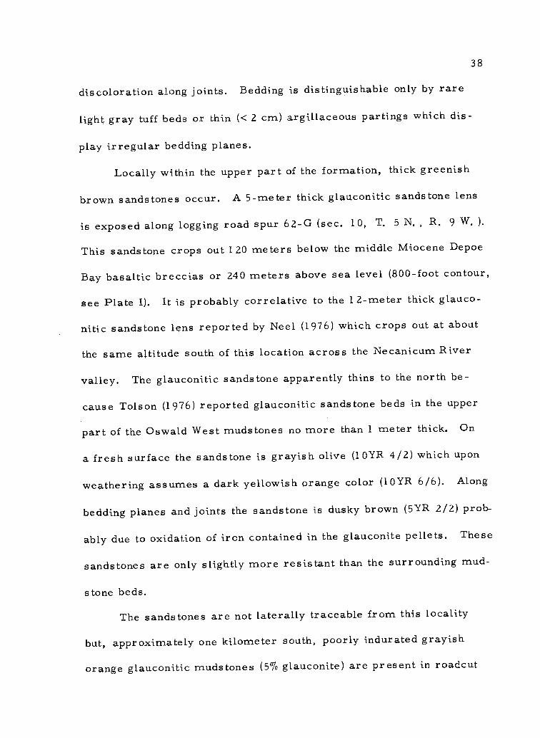
Locally within the upper part of the formation, thick greenish
brown sandstones occur. A 5-meter thick glauconitic sandstone lens
is exposed along logging road spur 62-G (sec. 10, T. 5 N. R, 9 W. ).
This sandstone crops out 120 meters below the middle Miocene Depoe
Bay basaltic breccias or 240 meters above sea level (800-foot contour,
see Plate I). It is probably correlative to the 12-meter thick glauco-
nitic sandstone lens reported by Neel (1976) which crops out at about
the same altitude south of this location across the Necanicum River
valley. The glauconitic sandstone apparently thins to the north be-
cause Tolson (1976) reported glauconitic sandstone beds in the upper
part of the Oswald West mudstones no more than 1 meter thick. On
a fresh surface the sandstone is grayish olive (10YR 4/2) which upon
weathering assumes a dark yellowish orange color (10YR 6/6). Along
bedding planes and joints the sandstone is dusky brown (5YR 2/2) prob-
ably due to oxidation of iron contained in the glauconite pellets. These
sandstones are only slightly more resistant than the surrounding mud-
stone beds.
The sandstones are not laterally traceable from this locality
but, approximately one kilometer south, poorly indurated grayish
orange glauconitic mudstones (5% glauconite) are present in roadcut

39
exposures along logging road Spur 63. This discontinuous nature sug-
gests that the glauconitic sandstone bodies owe their occurrence to
some local depositional process or reducing environmental condition
which occurred on the Oligocene sea floor. Although glauconitic
sandstones are not volumetrically significant in the upper Oswald
West muds tones, they are significant mappable units.
Pebbles from the upper part of the Oswald West muds tone were
obtained from rare, deeply weathered, friable channel sandstones
which occur immediately below the base of the Depoe Bay basaltic
breccias and lower Silver Point mudstones (secs. 8 & 15, T. 5 N.
R. 9 W. See sample localities 105 and 25 in Plate I). The major
pebble lithologies identified in thin section include basic volcanics,
chert, and metamorphic quartzite. Minor pebble constituents include
white quartz, sedimentary quartzite, welded tuff, and felsic and
mafic plutonic rocks. A quantitative breakdown of the pebble litholo-
gies is presented in Appendix II.
X-ray diffraction analysis of Oswald West mudstones from the
upper part revealed smectite, glauconite, chloritic intergrades, and
possible kaolinite and/or chlorite as the clay minerals present (see
Appendix VI for analytical techniques and tabulated results). The
clay matrix of one channel sandstone was composed entirely of
smectite.
Foraminifera are locally abundant in the Oswald West mudstones.

40
A microfossil suite collected from the lower part suggest a latest
Eocene age (written commun, W. Rau, 1975). Foraminifera from
other parts were nondiagnostic.
Falls Creek Siltstone Member
Nomenclature and Distribution
The Falls Creek siltstone member is informally proposed herein
for a fossiliferous, tuffaceous siltstone and subordinate medium- to
fine-grained sandstone unit which crops out on a high ridge approx-
imately one kilometer northeast of Saddle Mountain (Figure 9 and
Plate I). The name, Falls Creek, was adopted from one of several
small streams which drains the immediate area. A shallow water
molluscan fauna, unlike the deeper water microfossil fauna more
typical of the Oswald West muds tones, is a distinctive characteristic
of this unit. The unit is also slightly coarser-grained.
The nearly 100-m thick member covers approximately 2 sq. km.
of the study area and is best exposed along logging Spur 46 (sec. 26,
T. 6 N. R. 8 W. ) which is the type section. There, several local
irregular Depoe Bay Basalt sills have intruded the member, and a
thick sill crops out at the base of the member along East Leg Saddle
Mountain Road (Plate I).

41
Litho logy
The Falls Creek member is predominantly comprised of thick
(3 to 5 m) structureless yellowish gray (5Y 7/2) tuffaceous sandy
siltstones and very light gray (N8) fine-grained sandstones. Subordi-
nate thin beds (0. 5 m thick) of dark gray (N3) muds tone and light
bluish gray (5B 7/1) to medium gray (N5) micaceous sandstone are
locally interbedded in the upper part of the member along logging
Spur 46. The sandstones in the member are composed of abundant
subangular to subrounded quartz and plagioclase feldspar grains in
clay-silt matrix support. Some of the sandstones contain molds and
hematite replaced fossils. Clay minerals are estimated to compose
up to 50% of the rock by volume and form the principal cementing
material. No sieve analyses were performed on the Falls Creek
member sandstones due to the difficulty in their disaggregation.
Typically, the Falls Creek siltstones contain spheroidal calcar-
eous concretions up to 3 cm in diameter with small molluscan shells
as nuclei. Some of the bivalves and gastropods are fragile and
crumble easily upon collecting. The fauna indicates that the deposi-
tional environment was characterized by shallow water depths of from
10 to 30 meters (W. 0. Addicott, written commun. , 1975) but the
presence of unbroken thin-shelled pelecypods suggests low energy
conditions.

42
Petrology
Sixteen thin sections of Oswald West muds tone (8), siltstone
(3), and sandstone (5), were examined microscopically including one
from the lower part, four from the middle part, and 11 from the upper
part (including Falls Creek member). Modal analyses were per-
formed on one glauconitic sandstone and two channel sandstones from
the upper part (Appendix III). These point counted channel sandstones
are texturally and compositionally immature following Folk's (1951)
concept of maturity. The pebbly channel sandstones are very coarse-
to medium-grained lithic wackes (Figure 14). Framework grains are
principally quartz (8-20%), quartzite (8%), chert (3-9%), plagioclase
feldspar (10-15%), and volcanic (basalt and andesite) rock fragments
(15-26%). Potassium feldspar (largely orthoclase) does not exceed
five percent. Plagioclase feldspar is mostly andesine (An 40-50) and
labradorite (An 55-62). Detrital micas (muscovite, biotite) are very
rare and normally make up one percent or less of the rock by volume.
Volcanic clasts display intergranular to intersertal textures. Com-
monly the glassy groundmass of the volcanic rock fragments are in
various states of alteration to clay minerals and grain boundaries are
typically fuzzy. Pebble and coarse sand size clasts of volcanic chert
containing microveinlets of polycrystalline quartz are common.
The coarse-grained channel sandstones are poorly sorted

Q: Stable grains, quartz, chert, quartziteF: FeldsparR: Rock Fragments
A: QuartzB: FeldspathicC: ArkosicD: Lithic
Cape Foulweather interbeddedsandstone 0
Silver Point UpperLower
Oswald West -
Figure 14. Classification of point counted sandstones (After Williams and others, 1955) from the Oswald West mudstone, Silver Point mudstone and
Cape Foulweather interbedded sandstones.
44
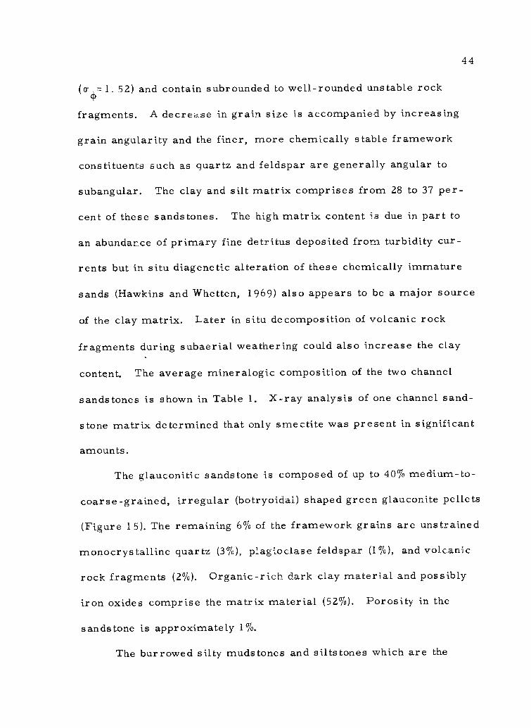
(0=1.52) and contain subrounded to well-rounded unstable rock
fragments. A decrease in grain size is accompanied by increasing
grain angularity and the finer, more chemically stable framework
constituents such as quartz and feldspar are generally angular to
subangular. The clay and silt matrix comprises from 28 to 37 per-
cent of these sandstones. The high matrix content is due in part to
an abundance of primary fine detritus deposited from turbidity cur-
rents but in situ diagenetic alteration of these chemically immature
sands (Hawkins and Whetten, 1969) also appears to be a major source
of the clay matrix. Later in situ decomposition of volcanic rock
fragments during subaerial weathering could also increase the clay
content. The average mineralogic composition of the two channel
sandstones is shown in Table 1. X-ray analysis of one channel sand-
stone matrix determined that only smectite was present in significant
amounts.
The glauconitic sandstone is composed of up to 40% medium-to-
coarse-grained, irregular (botryoidal) shaped green glauconite pellets
(Figure 15). The remaining 6% of the framework grains are unstrained
monocrystalline quartz (3%), plagioclase feldspar (1%), and volcanic
rock fragments (2%). Organic-rich dark clay material and possibly
iron oxides comprise the matrix material (52%). Porosity in the
sandstone is approximately 1%.
The burrowed silty muds tones and siltstones which are the

Table 1. Average mineralogic composition of sandstones in Tertiary units.
MineralNo. of pt.
counted samples
Oswald West*(channel sandstones)
(3)
Silver Point Cape Foulweatherinterbeds
(3)Upper(1)
Lower Angora Peak equivalent?
(3) (1)
Quartz 14 28 22 12 23
Quartzite ** 8 4 8 4 4
Chert 6 5 1 1 3
Plagioclase 12 13 8 8 17
K- feldspar 5 1 1 17 1
VRF 21 9 24 26 1
MRF +IRF+SRF tr tr tr
Mica tr S tr tr 10
Mafics tr 1 tr tr 1
Opaques tr tr tr tr 1
Matrix 32 33 26 29 37
Cement (CaCO 3) - 6 -
Porosity 1 1 1 3 1
* Does not include glauconitic sandstone
** Quartzite = polycrystalline quatz
Tr = less than 0.5%
VRF = volcanic rock fragments
MRF, IRF, SRF r metamorphic, igneous and sedimentary rock fragments.
46
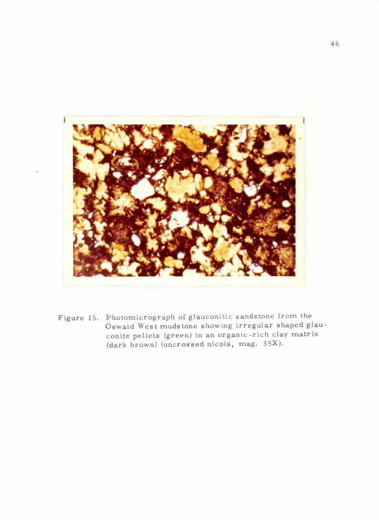
I
Figure 15. Photomicrograph of glauconitic sandstone from theOswald West mudstone showing irregular shaped glau-conite pellets (green) in an organic-rich clay matrix(dark brown) (uncrossed nicols, mag. 35X).

47
predominant lithology in the upper and lower parts of the Oswald West
muds tones are composed of silt-sized angular to subangular quartz
and feldspar grains and comminuted or finely disseminated organic
detritus in a clay mineral matrix. In thin section, clay filled burrows
consist of fine silt and clay sized (fecal?) material possibly resulting
from the breakdown of muds in the digestive tracts of the burrowing
organism (Figure 16). Burrows are commonly bounded by a reddish
oxidized outer rim. Dr. C. Kent Chamberlain of Ohio University
identified the deep water burrow forms as fecal. ribbon Scalarituba
(Helminthoida) and "composite" worm tubes called Helminthoida-
Phycosiphon (written commun. , 1976).
Sandstones in the middle part of the unit have a median grain
size of fine sand (2. 750) and a mean of very fine sand (3. 30) using
Folk and Ward's (1957) and Inman's (1952) methods for calculating
statistical size parameters respectively (see Appendix IV). Much of
the quartz is polycrystalline or strained monocrystalline. Quartz is
approximately twice as abundant as both plagioclase and potassium
feldspar. Other framework grains include muscovite and biotite mica
(1 -2 %), mafic minerals (< 2%) such as pyroxene, hornblende, and
iron oxides, and angular mudstone rock fragments
cement accounts for up to 40% of some samples and
<1%). Calcite
appears as a
pore filling and authigenic replacement mineral of other framework
grains. Clay minerals are subordinate and authigenic chlorite is rare.

I8
Figure 16. Photomicrograph of burrowed Oswald West mudstonefrom lower part of formation (silty muds tone). Scalaritubaburrow is approximately 1 mm in diameter (clay filled).Colorless silt-sized material is largely angular quartzand feldspar. Black specks are organic matter and opaqueiron oxides (uncrossed nicols, mag. 22X).

49
A thin section of a large banded concretion collected from the
middle part contained rare devitrified glass shards altered to clay
minerals and abundant calcareous sponge spicules, some reaching
a millimeter in length.
A limited heavy mineral suite characterizes the Oswald West
sandstones. The most abundant heavy minerals (sp. gr. > 2. 95) in
the 3. 5-4. 00 size range are the opaque iron and titanium oxides,
leucoxene, magnetite, and ilmenite (Appendix II). Angular, colorless
to pale reddish garnets, zircons, and rutile are rare in the channel
sandstones but abundant in the sandstones from the middle part of the
formation. The rare tuffaceous sandstone interbeds in the upper part
contain no heavy mineral assemblage, suggesting that the sandstones
may have been largely derived locally by reworking of volcanic air
fall deposits, during which chemically unstable heavy minerals were
destroyed by weathering and erosional processes. Of particular note
is the absence of green hornblende, hypersthene, clinopyroxene,
enstatite, and epidote which are present in nearly all younger Terti-
ary sandstone heavy mineral suites (see Silver Point Petrology sec-
tion, p. 74).
Age and Correlation
The rocks mapped as Oswald West mudstone in this thesis area
range from latest Eocene to early Miocene in age based on the
50
molluscan fossil assemblages collected from localities x36, xs46,
x55, and x70, and the foranniniferal assemblage from locality x57
(Plate I, Appendix I). The megafossil assemblage from the middle
part of the unit (x36) indicates a late Oligocene age, correlative to
the lower part of the Blakely stage (Warren Addicott, written com-
mun. , 1975). These data suggest that the lower part of the Oswald
West mudstone is probably correlative to the Keasey Formation of
the northeast Coast Range and that the middle and upper parts are
roughly time equivalents of the Pittsburg Bluff and Scappoose Forma-
tions, respectively (Warren and others, 1945) (see Figure 6). The
middle and upper Oswald West lithostratigraphic units in the thesis
area correlate best with the type area at Oswald West State Park on
the basis of lithology and faunal age. This correlation is further sub-
stantiated by continuous mapping southward from the thesis area to the
type area (Smith, 1975; Neel, 1976).
Northwest of this thesis area, Oswald West mudstones that
occupy a similar stratigraphic position were also dated as Blakely
age by Tolson (1976). Immediately south of the study area, Neel
(1976) recovered Foraminifera of late Eocene age in strata which
he reported from the lowest part of the Oswald West mudstone. Thus,
I have defined as did others (Neel, 1976; Smith, 1975), the Oswald
West mudstones to include more and older strata than originally
defined by Cressy (1974) at the type section. This is because the

51
basal contact of the Oswald West formation was not defined in the
type area and subsequent mapping to the north by Neel, Smith,
Tolson, and in this study shows that lithologically similar strata
extend down into the late Eocene without any distinctive stratigraphic
changes.
Contact Relationships
The basal contact of the Oswald West mudstone is not exposed
in the thesis area. However, previous work by Wells and Peck (1961)
and Beaulieu and others (1973, 1975) in this part of the northwestern
Oregon Coast Range has left Eocene-Oligocene muds tones undifferen-
tiated. This suggests that a well-defined lithologic break with the
underlying late Eocene Keasey or Cowlitz Formation(?) may not
occur.
The distribution of the unit suggests that the oldest strata of
the Oswald West mudstone are exposed where East Humbug Creek
and the Necanicum River leave the thesis area on the eastern and
southern map boundaries, 'respectively. The oldest dated outcrop
occurs near the head waters of the Necanicum River at the southern
base of Humbug Mountain (sec. 18, T. 5 N. , R. 8 W. Plate I)
where a latest Eocene (Refugian) age was obtained on a foraminiferal
assemblage (W. Rau, written commun. , 1975).
The presence of Turritella n. sp. indicates that the Falls Creek

52
siltstone member is early Miocene (Temblor) in age. This species
is equivalent in age to the same species which occurs in the early
Miocene Nye Muds tone in the Newport embayment 150 km to the south
(W. Addicott, written commun. , 1975). Thus, the member is tenta-
tively correlative with the Nye Muds tone of the central Coast Range
(Snavely and others, 1969).
The basal contact of the Falls Creek member is not exposed.
However, it is believed that a 60-m thick sill of Depoe Bay Basalt
was intruded along the lower contact of this unit. Near intrusive
contacts the muds tones have that well developed "poker chip" fissility
common to other Oswald West muds tones. Similarities in lithology
and the closely associated outcrop distribution of the unit with Oswald
West muds tones in the study area suggests that the Falls Creek
member conformably overlies and possibly interfingers with the
upper part of the Oswald West muds tones. The upper Oswald West
muds tones are also part early Miocene in age. This member has not
been recognized in equivalent aged Oswald West strata to the north-
west and south (Cressy, 1974; Smith, 1975; Neel, 1976; Tolson, 1976),
but is thought to represent a shallowing to the northeast.
That the Oswald West muds tone is overlain with apparent
angular unconformity is suggested by (1) the discrepancy in strikes
and dips with the overlying Silver Point member of the Astoria
Formation, (2) the occurrence of channel sandstones in the uppermost

53
part, and (3) local absence of the Silver Point member between the
Oswald West mudstone and overlying middle Miocene basaltic breccias.
Further discussion of the contact relationships occurs in the Contact
Relationships section of the lower Silver Point tongue of the Astoria
Formation.
Depositional Environment
The thick, structureless muds tones and siltstones of the lower
and upper parts of the Oswald West formation represent open, deep
marine deposition in a low energy environment on the continental
slope. Benthonic foraminiferal assemblages including Leticulina cf.
L. Limbos us hockleynsis Cushman, Pseudoglandulina inflata
Borneman, Karriella washingtonesis Rau, and Gyroidina orbicularis
planata Cushman, are indicative of cool water and outer sublittoral
to upper bathyal depths (W. Rau, written commun. , 1975). According
to Chamberlain (written commun. , 1976), Scalarituba and Chondrites
burrow forms are typical of deep to intermediate water depths (middle
shelf to abyssal).
The occurrence of glauconitic sandstones and muds tones which
are indicative of deeper water environments than those recently noted
on the shallow inner and middle Oregon continental shelf today (Ku lm
and others, 1975) support this interpretation. The overall fine-
grained, poorly sorted, and bioturbated character of the structureless

54
lower and upper Oswald West mudstones suggest a lack of current
winnowing.
The fine sandstones and siltstones which comprise much of the
middle part may indicate a period of local basin shallowing due to
filling or a regressive marine phase. The lack of sedimentary struc-
tures and common occurrence of unbroken fossil shells are indicative
of low to moderate energy, shelf conditions. Extensive bioturbation
on the Oligocene sea floor could have prevented preservation of
primary sedimentary structures which is commonplace on the present
Oregon continental shelf (Kulm and others, 1975). Both modern
Oregon continental shelf sands and middle Oswald West sands are
similar in that they are fine-grained, poorly sorted, structureless,
and associated with structureless bioturbated silts tones.
It is unclear due to a lack of exposure whether the local channel
sandstones in the uppermost part of the Oswald West mudstones are
remnants of a subaerial erosive cycle during early Miocene time
or whether they are submarine distributary channels associated with
a prograding delta slope environment from the southeast (Cressy,
1974). No major erosional unconformities are recognized on the
present Oregon continental shelf during the early Miocene (Ku lm and
Fowler, 1974) which suggests the latter explanation may have more
credence.
Gradual shallowing at the end of the late Oligocene and into the

55
early Miocene is also suggested by deposition of the Falls Creek
member in the northeastern part of the study area with its associated
shallow water molluscan fossils and bioturbated, coarser detritus.
According to W. Addicott (written commun. , 1975), the Spur 46
assemblage (sample locality xs46, Plate I), which includes the gastro-
pods Priscofusus sp. , Turritella cf. T. Hamiltonesis Clark, and
Turritella n. sp. and the bivalves paL-1222a, Abrupta Conrad, Macoma
cf. M. Albaria Conrad, and Securella Ensifera Dall, is suggestive of
substantially shallower water depths (10-30 meters) than several of
the other Oswald West molluscan assemblages (see Appendix I for
more complete fossil listing). Therefore, it is suggested that this
member represents deposition on a broad shallow shelf (inner to
middle) probably under low energy conditions because of the abundance
of unbroken molluscan shells and the lack of sedimentary structures.
This member's temporal and spatial relationship to the deltaic
Scappoose Formation of the northeastern Coast Range (Van Atta,
1971), suggests it alternatively may be a proximal delta slope facies
of that formation.
Astoria Formation
The name "Astoria Formation" has been used as a time strati-
graphic unit, to apply to many sedimentary rocks of middle Miocene
age along the Oregon Coast even though this formation has different

56
mappable lithologic facies (Moore, 1963; Niem and Van Atta, 1973).
The formation crops out in three marine embayments from Newport,
Oregon to Astoria, Oregon (Wells and Peck, 1961). They are the
Newport, Tillamook, and Astoria Embayments. Regional correlation
of the Astoria Formation has been done on a faunal basis as far south
as Cape Blanco, Oregon (Durham, 1953) and into southwestern
Washington (Pease and Hoover, 1957; Snavely and others, 1958;
McKee and others, 1973). A recent detailed geologic investigation
by Cooper (1976) indicates that the Astoria Formation in the Astoria
embayment consists of three major intertongueing lithosomes; a
thick shallow marine and deltaic sandstone on the south and southeast
that intertongues northerly and northwesterly with a deeper marine
turbidite sandstone and muds tone sequence which in turn intertongues
northerly and northwesterly with a deep water muds tone at the type
area.
Commonly, the formation in N. W. Oregon exhibits rapid facies
changes from fluvial or shallow marine to deep marine mudstones,
siltstones, and turbidite sandstones (Smith, 1975). Because some
lithosomes are mappable yet lithologically dissimilar to those of the
type area, recent workers (Smith, 1975; Neel, 1976; Tolson, 1976)
proposed informal members and tongues within the formation. The
naming of informal members is in accordance with the American Code
of Stratigraphic Nomenclature (1 961) and has aided in mapping and

57
describing the various Astoria lithologies while retaining the middle
Miocene status and name of the unit which is deeply engrained in the
literature. It is hoped that this approach may alleviate much of the
confusion regarding the stratigraphy and distribution of the Astoria
Formation which has resulted from reconnaissance mapping in iso-
lated areas mainly on the basis of middle Miocene faunal assemblages
(Moore, 1963) and not on lithostratigraphic comparison to the type
area.
Silver Point Member
The Silver Point member (informal) of the Astoria Formation
is a thick marine sequence of interbedded, thinly laminated, micace-
ous, fine-grained sandstones, and structureless to finely laminated
dark gray muds tones and silts tones. Smith (1975) and Neel (1976)
divided the unit into two parts for descriptive purposes in the areas
immediately south of this study area. The lower part consists of
mudstone rhythmically interbedded with dark medium gray siltstones
and light gray well-bedded, laminated, fine-grained feldspathic
turbidite sandstones. The unit grades upward into thick, structure-
less to well-laminated micaceous muds tone, with locally interstrati-
fied bioturbated silts tone and very fine-grained sandstone. Tolson
(1976) used these criteria in informally dividing the member into
several tongues immediately northwest of this study area. There he

58
recognized an interfingering relationship between the lower part and
the upper part and defined two new lithologies of more local extent
(the "J" unit and Airplane tongue). In the Saddle and Humbug Mountain
area, the Silver Point member is also divided into upper and lower
tongues, but the Airplane and "J" units which are found locally by
Tolson (1976) separating the tongues in the Seaside-Youngs River
Falls area do not occur.
Neel. (1976) calculated the Silver Point member to be from 180
to 300 meters thick based on regional dips and outcrop distribution in
the Tillamook Head-Necanicum Junction area immediately to the south
of the area. Tolson (1976) reported that the upper tongue is up to 100
meters thick and the lower tongue ranges from approximately 30 to 75
meters in thickness. The outcrop distribution and stratigraphic rela-
tionships in this study area indicate that the Silver Point member is
intermediate in thickness (200 to 250 meters) to those reported by
Neel and Tolson. These data suggest that both tongues and the mem-
ber as a whole thicken in a southerly direction.
Nomenclatur e
Smith (1975) designated the informal name Silver Point mudstone
member for a 200-meter thick well-bedded marine sequence of dark
muds tones, silts tones, and turbidite sandstones which conformably
overlie the Angora Peak sandstone member of the Astoria Formation

59
at Silver Point. The name is derived from a viewpoint near the town
of Tolovana Park on the northern Oregon Coast where the unit is well -
exposed in sea cliffs. The type section is approximately 15 km south-
west of this study area.
Distribution
The Silver Point member is the most widespread unit mapped
in the thesis area. The unit principally crops out in the northern two-
thirds of the area where it underlies 40 sq km (37%) of the thesis area
(Figure 17 and Plate I). The informal member forms low hummocky
hills.and valleys between high ridges of overlying middle Miocene
basalt extrusive centers such as Humbug and Saddle Mountains.
Lower Silver Point strata crop out in the immediate vicinity of the
Lewis and Clark River (14 sq km) and the upper Silver Point tongue
(35 sq km) parallels this outcrop pattern to include valley slopes and
adjacent hills surrounding Saddle Mountain, the north side of Humbug
Mountain, and the volcanic ridge west of Humbug Mountain (Figure 17
and Plate I).
Lower Silver Point Tongue
Lithology
The lower Silver Point tongue consists of rhythmically inter-
bedded, laminated sandstones alternating with dark gray siltstones

Upper Silver Point tongue
Lower Silver Point tongue
R. 8 W.
Figure 17. Outcrop distribution map of the Silver Point member.

61
and mudstones (Figure 18) The sandstones are feldspathic, dirty,
fine- to coarse-grained and are characterized by concentrations of
carbonaceous plant debris and muscovite flakes that form the dark
laminations (Figure 19). Internal sedimentary structures in fresh
exposures include (from bottom of bed upward) Bouma intervals A
through E; which consist of normal grading (A), overlain by parallel
laminations (B) followed by micro trough laminations or convolute
laminations (C) and parallel laminations (D)(Figures 19, 20, 21 and
22). Although complete Bouma sequences are rare, Bouma intervals
Tab and Tcd (Bouma, 1962) are common. The repeated graded bed-
ding, sequence of internal Bouma sedimentary structures in addition
to mudstone rip-ups and scour and fill structures in the lower Silver
Point tongue suggest that these sandstones were deposited by turbidity
currents. Sandstones range from 1 to 15 cm in thickness and are
even-bedded. Upper contacts of the sandstone with the overyling
siltstone and muds tone interbeds are gradational to irregular, but
bottom contacts are sharp and contain load and flame structures due
to rapid deposition of sand over water-saturated muds (Figure 20).
Lower Silver Point sandstone exposures are typically deeply
weathered a moderate yellowish brown (10YR 5/4), are friable, form
chippy talus (Figure 18), and are iron stained with Liesegang rings.
As a result, internal sedimentary structures tend to be obliterated.
Resistant overhanging beds, the bottoms of which are best sites for

Figure 18. Typical logging road exposure (center, sec. 7, T. 5 N. ,R. 9 W. ) of the lower Silver Point tongue. Well-beddedsandstones, siltstones, and muds tones are cut by abasaltic dike. Note the fine chippy talus slope in fore-ground.

63
I
Figure 19. Representative hand samples from the lower SilverPoint tongue. Sample in center is from lower partof tongue, other two are from the predominantlylaminated muds tone upper part. Sample in centerand on right were impregnated with epoxy.

Figure 20. Sedimentary structures in the lower Silver Point turbidites.Note succession upward of Bouma intervals: beginning atpen point: convolute laminations (C), parallel laminations(D), normally graded sandstone bed (A), and parallellaminations (B).
Figure 21. Lower Silver Point turbidites containing thick interval ofparallel and cross laminations overlain by pelitic (E)interval.

z
Figure 22. Photomicrograph of micro-laminated silty (D)interval from hand sample shown in Figure 19(far right hand side). Note normal grading (veryfine sand to silty clay) and sharp basal contact oflaminae in this silt turbidite(?).

66
preserving sole marks, are absent. Paleocurrent orientations of the
trough micro cross-laminations at one locality suggest that the sand-
stones were deposited by turbidity currents that flowed from south
to north (see section on Paleocurrent Data for further discussion).
The intervening mudstones are thin to thick-bedded (2-15 cm)
and are laminated to structureless (Figure 21). Mudstones are olive
gray (5Y 3/2) and weather to a light brown (5YR 5/6) and form yellow
orange chippy talus (Figure 19). Siltstones are olive gray (5Y 3/2)
when fresh but rapidly weather to a light olive gray (5Y 5/2). Lower
Silver Point mudstones are rarely burrowed in the study area. How-
ever, Tolson (1976) attributed the mottled appearance of many mud-
stone layers to intense bioturbation. He reported the burrow forms
Helminthoida and Siphonites. Siphonites is indicative of relatively
shallow water (9-25 meters).
Neel (1976) reported late Saucesian deep rra rine Foraminifera
assemblages (outer shelf to slope) in the intervening mudstones in the
lower Silver Point tongue. No forams were recovered from the lower
Silver Point muds tones in the study area.
The sandstone to mudstone ratio near the base of the lower
Silver Point tongue is about 2z1 (Figure 18). Overall this rhythmically
bedded tongue fines upward. Coarse- and medium-grained sandstones
are nearly absent or very thinly bedded in the upper part of the tongue
and the silts tone and muds tone interbeds are much thicker (0. 5 to

67
2 meters).
The lower Silver Point tongue is a slope former. Steep-faced
exposures occur only where these dirty sandstones are cemented by
calcite or where the unit is baked due to a nearby intrusion. Such
well exposed, rhythmically bedded lower Silver Point strata display-
ing excellent Bouma sequences crop out along Clatsop Fir Main Line
logging road (center, sec. 7, T. 5 N. , R. 9 W. ), and on the north
side of Humbug Mountain (NW 1/4 NW 1/4 sec. 9, T. 5 N. , R. 8 W.
A low-lying hummocky topography is most characteristic of the
surface expression of this unit in the study area (Figure 3).
An unusual lithologic variation within the lower Silver Point
tongue occurs near its base in the western part of the study area
along Lewis and Clark Main Line logging road and along logging spurs
11 and 18. At these localities, isolated, very thick-bedded (up to 3
meters) structureless, clean feldspathic to lithic sandstones crop out
(see Plate I). Discont!_nuous exposures in this part of the study area
makes correlation of these very thick-bedded sandstones difficult.
The beds strike northeast and their outcrop distribution and overall
geometry suggest that they may be shoestring sandstones.
Contact Relationships
Due to soil and vegetative cover, no contacts between the lower
Silver Point tongue and the underlying Oswald West muds tone are

68
exposed in the study area. The following field evidence suggests,
however, that the Oswald West mudstone member is disconformably
overlain by the Silver Point mudstone member: 1) there is a slight
angular discordance in strikes and dips between the two units, 2) the
Oswald West mudstones are commonly much more indurated than the
Silver Point mudstones, and 3) sandstone channel-and-fill structures
occur in the upper part of the Oswald West mudstones.
An incomplete faunal succession between the Oswald West and
lower Silver Point tongue indicated by the absence of a molluscan
fossil assemblage belonging to the Vaqueros stage is further argument
for an unconformity. Molluscan fossils from the Oswald West mud-
stone and Astoria Formation are of Blakely and Temblor age, respec-
tively (Cressy, 1974; Smith, 1975; Neel, 1976; Tolson, 1976). Thus,
there is no fossil evidence for deposition in the study area during
1
Vaqueros time a. e. middle to late early Miocene). This hiatus also
correlates with an early Miocene regional unconformity throughout
much of the Pacific (Dott, 1969; Moore, 1974).
The channels have two possible explanations: 1) they were pro-
duced by streams on a subaerially exposed surface or 2) they are
'Note, although the Vaqueros molluscan stage is recognized inCalifornia, it has not been recognized in western Oregon and Washing-ton and thus may not be defined here as a time stratigraphic interval.There may have been continuous deposition between the Blakely andTemblor aged strata in western Oregon and Washington (i. e. no timebreak) (Niem, 1976; personal communication).


71
Silver Point tongue is thickest, the tongue is directly overlain by
Cape Foulweather Basalt.
Litho logy
The upper Silver Point tongue consists of well-laminated to
structureless, thick-bedded, dark gray mudstones and siltstones, and
rare thin-bedded sandstones. Thin tuff beds are common in the upper
part of the unit. Although upper Silver Point mudstones are wide-
spread in the study area, they are relatively poorly exposed. Fresh
logging road exposures of this slump-prone unit rapidly become cov-
ered with colluvium and vegetation within a few years. The thickness
of the unit is variable although it is approximately 100 to 150 meters
thick based on geometric measurement of the outcrop distribution
and bed attitudes.
Strata north of Saddle Mountain are tentatively mapped as upper
Silver Point tongue because the sedimentary rocks are poorly exposed,
and the few outcrops are deeply weathered making identification diffi-
cult. However, if the gently northward dipping upper Silver Point
mudstones immediately south of Saddle Mountain continue unfaulted
beneath Saddle Mountain, then this unit should crop out on the north
side of the mountain.
Upper Silver Point tongue strata are best exposed in a deep
ravine cut by Beerman Creek (sec. 35, T. 6 N. R. 10 W. ) in the

72
extreme western part of the area and along the ridge which extends
westward from Saddle Mountain in the northern part of area (Plate I).
Fresh mudstone and si1tstone beds are medium light gray (N6) to
dark gray (N3) in color. Upon weathering they alter to iron-stained
grayish orange (10YR 7/4) to moderate brown (5YR 3/4). Rare,
interbedded, medium-grained, lithic sandstones are somewhat lighter
in color, ranging from a yellowish gray (5Y 8/1) to a greenish gray
(5GY 6/1). Very light gray (N8) tuff laminae and tuff beds up to 3 cm
thick are common in the upper part of the tongue and commonly define
bedding in the unit.
A few isolated clastic dikes composed of medium- to coarse-
grained calcite cemented lithic sandstones locally cut the mudstones.
Sparse, angular, medium light gray (N6) mudstone clasts up to 8 mm
in diameter occur in some of these sandstone dikes.
Numerous Depoe Bay basaltic dikes and sills have locally de-
formed the upper Silver Point strata. For example, along 300 Main
Line logging road (secs. 4 and 5, T. 5 N. , R. 9 W) a large basaltic
sill has extensively deformed the upper Silver Point strata (Plate I).
Commonly the mudstone samples collected from beds in close prox-
imity to the intrusions show irregular contorted laminae, microfaults,
and shears, suggesting penecontemporaneous soft sediment deforma-
tion. Zeolites, quartz, and pyrite are the most common minerals
which fill these fractures and faults.

73
Age, Correlation, and Contact Relationships
Saucesian age (middle Miocene) is assigned to the upper Silver
Point tongue based on stratigraphic relationships. The unit is dis-
conformably overlain by middle Miocene Depoe Bay and Cape Foul-
weather Basalts. A foraminiferal suite collected west of Saddle
Mountain (sample no. 42, Appendix I and Plate I) indicates that the
tongue may be older in that direction (north) because a possible lower
part of the Saucesian stage was indicated (W. Rau, written commun. ,
1975).
Similar lithologies and foraminiferal suites suggest that the
upper Silver Point tongue in this thesis area, the upper part of the
Silver Point member in the Tillamook Head-Necanicum Junction area
(Neel, 1975) and the upper Silver Point tongue and Airplane muds tones
in the Seaside-Youngs River Falls area (Tolson, 1976) are correlative.
Field mapping suggests that the upper Silver Point tongue con-
formably overlies the lower Silver Point tongue and that the contact
is gradational. The occurrence of thick mudstone interbeds (up to 2
meters) in the upper part of the lower tongue north of Humbug Moun-
tain (secs. 5 & 6, T. 5 N. , R. 8 W. ) indicates that local interfinger-
ing of the two tongues may occur. The upper contact of the upper
Silver Point tongue is discussed further in the Contact Relationship
section of the Cape Foulweather and Depoe Bay extrusive basalts.
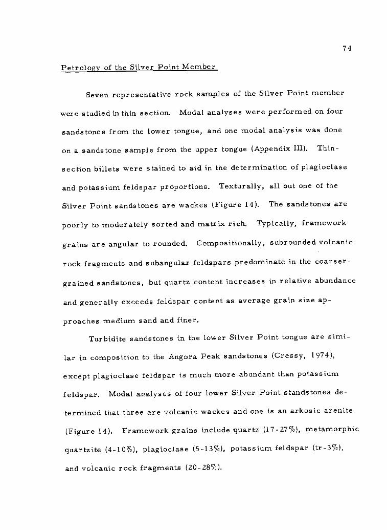
74
Petrology of the Silver Point Member
Seven representative rock samples of the Silver Point member
were studied in thin section. Modal analyses were performed on four
sandstones from the lower tongue, and one modal analysis was done
on a sandstone sample from the upper tongue (Appendix III). Thin-
section billets were stained to aid in the determination of plagioclase
and potassium feldspar proportions. Texturally, all but one of the
Silver Point sandstones are wackes (Figure 14). The sandstones are
poorly to moderately sorted and matrix rich. Typically, framework
grains are angular to rounded. Compositionally, subrounded volcanic
rock fragments and subangular feldspars predominate in the coarser-
grained sandstones, but quartz content increases in relative abundance
and generally exceeds feldspar content as average grain size ap-
proaches medium sand and finer.
Turbidite sandstones in the lower Silver Point tongue are simi-
lar in composition to the Angora Peak sandstones (Cressy, 1974),
except plagioclase feldspar is much more abundant than potassium
feldspar. Modal analyses of four lower Silver Point standstones de-
termined that three are volcanic wackes and one is an arkosic arenite
(Figure 14). Framework grains include quartz (17-27%), metamorphic
quartzite (4-10%), plagioclase (5-13%), potassium feldspar (tr-3%),
and volcanic rock fragments (20-28%).

75
The detrital or authigenic clay matrix of the turbidite sand-
stones is high except for one sandstone (matrix= 2`70) in which inter-
stitial calcite cement composes 18% of the rock (Figure 23).
According to Folk's (1968) criteria for textural maturity, the
lower Silver Point sandstones are immature to submature suggesting
rapid deposition with little or no later winnowing by currents. Com-
positionally, they are immature to submature. A preferred orienta-
tion of the grains parallel to bedding is a common feature in the more
micaceous and carbonaceous finer-grained turbidite sandstones.
Concentrations of micas and carbonaceous plant debris characteris-
tically define laminations (Figure 24). Clasts in the coarser-grained
sandstones typically display a wide range of rounding (Figure 23).
The wide range in rounding, alteration, and composition of the
sandstones from the lower Silver Point tongue suggest mixing of
detritus from multiple (volcanic, sedimentary, metamorphic) source
areas. However, much of the detritus is dominantly volcanic in
origin and probably derived from intermediate and basalt lavas such
as the Eocene Siletz River Volcanics of the Oregon Coast Range or
Eocene to Miocene Little Butte Volcanics of the Western Cascades.
The calcite cement found locally undoubtedly formed diagenetically
from hydrolysis of the calcic plagioclase feldspars or by solution of
calcareous microfossils. It was probably formed at some early
stage of burial because the unstable clasts (volcanic rock fragments)

76
Figure 23. Photomicrograph of calcite cemented volcanic arenitefrom the lower Silver Point turbidite sandstones. Notethe range of grain rounding displayed by the differentclasts and the abundance of unaltered isotropic glassin the volcanic rock fragments (crossed nicols, mag.22X).

Figure 24. Photomicrograph of laminated lower Silver Point sandstone from the upper part ofthe tongue. Dark laminations consist of concentrations of biotite and disseminatedcrushed carbonaceous plant debris and small amounts of hydrocarbons ( kerogen)(crossed nicols, mag. 22X).
Figure 24a. Typical matrix-rich texture displayed by the Silver Point turbidite feldspathicsandstones. Note the difficulty in distinguishing the grain boundaries of the clayaltered volcanic clasts due to its mergence with the surrounding clay matrix(crossed nicols, mag. 35X).
77

78
are largely unaltered. Diagenetic alteration of the unstable constitu-
ents such as volcanic rock fragments accounts for most of the clay
matrix.
Monocrystalline unstrained quartz (9%) is the most abundant
quartz variety in the lower Silver Point sandstone. Polycrystalline
quartz (7%) is less than or rarely equal to the monocrystalline un-
strained quartz in abundance. Monocrystalline strained quarts (3%)
is subordinate to the other two varieties in thin section. Metamorphic
quartzite clasts comprise up to 11% of some Silver Point turbidite
sandstones. Foliation is defined within the metamorphic clasts by
alignment of subparallel, contorted mica flakes along sutured (crenu-
lated) crystal boundaries. A few large flakes of biotite and muscovite
occur up to 2 mm in length in the sandstone (Figure 25).
Plagioclase feldspars range in composition from labradorite to
andesine (An 56to An 34). Commonly plagioclase is altered to white
micas and other clay minerals along cleavage planes and jagged
fractures which transect these crystals. Sparry calcite embayments
in both feldspars and volcanic rock fragments are common and nearly
all framework grains have corroded boundaries (Figure 23). In some
samples, a pseudo-albite twinning is preserved in the calcite cement
in which all but the remnant outline of the feldspar grain has been
obliterated.
Thick-bedded, structureless, medium- to coarse-grained

79
Figure 25. Photomicrograph of one upper Silver Point sandstone(feldspathic wacke). Note the abundant detrital micaand high angularity of the quartz and feldspar (un-crossed nicols, mag. 35X).

80
Angora Peak(?) sandstones which interfinger near the base of the
lower Silver Point tongue are volcanic wackes (sample #46 Appendix
III and Figure 14). In thin section the basal sandstones texturally and
compositionally resemble the Angora Peak sandstone described by
many workers (Cressy, 1974; Smith, 1975; Neel, 1976; Tolson, 1976).
The sandstones are poorly sorted and contain a high percentage of
matrix (29%), but framework clasts are in grain support. Frame-
work grains range from angular to well-rounded in thin section (0. 20-
0.85; roundness scale of Powers, 1953), although the average rounding
(R=0.30) and sphericity is low. Quartz and feldspar clasts are sub-
angular to subrounded. The volcanic rock fragments are subrounded
to rounded. Variability in rounding apparently is due to the relative
hardness and cleavage properties of grains of different composition.
The principal framework grains in the thick-bedded Angora
Peak(?) sandstones include volcanic rock fragments (24%), potassium
feldspar (18%), quartz (12%), and plagioclase (9%). Other framework
grains which do not exceed 5% in total are metamorphic quartzite,
chert, muscovite, and biotite. Orthoclase is much more abundant
than microcline. A distinguishing feature of this sandstone is the
abundance of potassium feldspar, which exceeds the percentage of
plagioclase; a characteristic common to the Angora Peak sandstone
(Neel, 1976).
Volcanic rock fragments are of andesitic to basaltic composition

81
and display intergranular, intersertal, pilotaxitic, and trachytic
igneous textures. Most of the chert is dirty" in plane light and is
probably volcanic in origin. Altered, fine siliceous igneous rock
fragments, such as the groundmass of rhyolite and devitrified silicic
glass, are petrographically difficult to distinguish from sedimentary
chert (Dott, 1966). Commonly, however, devitrification or altera-
tion of the unstable interstitial silicic glass has resulted in the forma-
tion of a range of products besides microcrystalline silica, including
calcite, chlorite, white micas, and iron oxides. These constituents
impart a dirty appearance to the chert. In contrast, detrital sedi-
mentary chert is generally clear. Neel (1976) reported finely dis-
seminated nontronite and possibly kaolinite, and Tolson (1976) noted
the occurrence of interstitial celadonite in Angora Peak chert grains
also suggesting a volcanic origin.
The matrix consists of diagenetic clays and lesser amounts
of detrital brown carbonaceous material, silt-sized quartz, and
feldspar grains. Some grains in thin section are coated with iron
oxides, and others have indistinct boundaries that merge into the
adjacent clay matrix. This evidence also suggests that much of the
surrounding clay matrix is diagenetic in origin.
X-ray analysis of one lower Silver Point sandstone matrix
determined that smectite, chlorite and/or kaolinite, chloritic inter-
grades, and mica compose the clay fraction (Appendix VI).

82
Heavy minerals comprise less than 2% by weight in the 3. 50
to 4. 00 size fraction. The most common are green hornblende,
hypersthene, garnet, zircon, biotite, epidote, and opaques. The
garnets are mostly clear but a few are pink (possibly grossularite)
and opaque minerals are principally leucoxene, ilmenite, and magne-
tite (Appendix II).
Modal analysis of one upper silver Point sandstone determined
that it is a feldspathic wacke (Figure 14). Major framework constitu-
ents include quartz (28%), plagioclase (13%), and volcanic rock frag-
ments (9%). Each of the remaining framework constituents (meta-
morphic quartzite, chert, potassium feldspar, muscovite, biotite)
comprise no more than 5%. This fine-grained sandstone contains
more quartz, chert, and mica and less volcanic rock fragments than
lower Silver Point sandstones (Appendix III). Texturally, this sand-
s tone is immature (matrix=33%) and quartz and feldspar grains are
mostly subangular (Figure 25). The plagioclase composition is that of
labradorite (An52-An58).
The heavy mineral suite of the upper Silver Point tongue is very
similar to that of the lower tongue. The more common heavy minerals
in the 3. 50 to 4. 00 size fraction include green hornblende, hypersthene,
clinopyroxene, biotite, and opaque iron oxides.
Petrographically, lower Silver Point and upper Silver Point
mudstones are indistinguishable. The dark gray silty mudstones

83
that form the major portions of both tongues consist of silt-sized
grains of quartz, feldspars, muscovite, biotite, chlorite, and finely
disseminated organic matter. Scattered Foraminifera also occur
in the upper tongue but none were found in thin section in the lower
tongue. X-ray diffraction of a sample collected from an unusual
1-meter thick greenish mudstone bed in the upper Silver Point tongue
determined only smectite, suggesting a possible ash bed (Appendix
VI).
Middle Miocene Basalts
Introduction
Two middle Miocene basalts of local origin overlie the Astoria
Formation throughout much of the study area. The Depoe Bay Basalt
and Cape Foulweather Basalt petrologic-types were defined by Snavely
and others (1973) in the Oregon and Washington Coast Range. These
tholeiitic basalts at the type area along the central Oregon Coast con-
sist predominantly of submarine pillow basalts and flow breccias,
related water-laid fragmental debris, dikes, sills, and irregular
intrusive bodies. The basalt units are differentiable on the basis of
lithology, chemistry, age, and stratigraphic position. Some of the
flows are interbedded with middle Miocene sedimentary rocks.
The older Depoe Bay Basalt and the younger Cape Foulweather
Basalt were extruded from fissures and vents on the middle Miocene

84
sea floor with some local accumulations reaching above sea level
(Snavely and others, 1969, 1973). The stratigraphic relationship
of the two basalt units is clearly displayed at Depoe Bay, Oregon
where Cape Foulweather basaltic breccias and the underlying shallow
marine sandstones of Whale Cove (informal) unconformably overlie
Depoe Bay pillow lavas. There is no evidence in the Oregon Coast
Range to indicate that the type Cape Foulweather Basalt or Depoe Bay
Basalt were ever extensive volcanic units, thus a purely stratigraphic
use of these terms would be inappropriate. In this study, these names
are used in a petrologic sense rather than as stratigraphic terms.
Thus, it should be understood that rocks called Depoe Bay Basalt or
Cape Foulweather Basalt in the thesis area are middle Miocene
petrologic-types that are similar to the type Depoe Bay or Cape
Foulweather of the central Coast Range in chemistry, petrology, age,
and stratigraphic position. They do not necessarily represent a simul-
taneous volcanic event with the type Depoe Bay and Cape Foulweather
basalts.
Depoe Bay Basalt is distinguished from Cape Foulweather Basalt
by its non-porphyritic aphanitic texture, higher SiO2
and its lower
Radiometric dates of Depoe Baytotal iron oxide, and TiO2
content.
Basalt range from 14 ± 2.7 m. y. to 16± 0. 65 m. y. (Snavely and others,
1973; Turner, 1970) which agree well with middle Miocene (Saucesian
and Relizian) foraminiferal assemblages collected from marine

85
interbeds (Braislin and others, 1971). Snavely and others have shown
that Depoe Bay Basalt and Cape Fo4Lweather Basalt correlate chem-
ically, petrologically, and chronologically with Yakima and Late
Yakima Basalt respectively, of the Columbia River Group of eastern
Oregon and Washington (Waters, 1961).
Depoe Bay Basalt
Nomenclature
The name Depoe Bay Basalt was first proposed by Snavely and
others (1973) for the oldest of two middle Miocene volcanic units in
the Oregon Coast Range. The name was adopted from the coastal
town of Depoe Bay, the type locality, located approximately 140 km
south of the thesis area. At the type locality, Depoe Bay Basalt un-
conformably overlies middle Miocene sandstones and siltstone of the
Astoria Formation.
Distribution
The middle Miocene Depoe Bay Basalt petrologic type is wide-.
spread and underlies approximately 23% of the study area (Figure 26).
Nearly 22 sq km of extrusive Depoe Bay breccias compose the princi-
pal topographic highs in the western and central parts of the thesis
area (Plate I). These include Saddle Mountain, Humbug Mountain,

R lOW
VA Depoe Bay Basalt petrologic-type
R 9W
R 8W
L4,41, . - i
IiirAP0#4 ./ -. I
Y- , /. vi
-.
% ` - and, _ -- lark
, ;
I
a 0
*IA4,4'
v
1,-04 e ,
,
4,1 1
:011_,prr,--' ---, ,z,
Mail) ,,, ..:c3," 4, I,
, t, .
ILine , ---,e
, 4s -',,
_ ,-1 ,-"e", 0, ,q ,, .... -., ,.....,c .., .1 t7: OP
1
,..
lye.; -
Figure 26. Outcrop distribution of the Depot Bay Basalt petrologic-type.
5
T 5 N

87
and the unnamed volcanic peaks west of Humbug Mountain. Intrusive
Depoe Bay Basalt is less extensive. Approximately 9 sq km of
intrusive are exposed, principally in the western part of the area
where a 100-meter thick sill of this basalt intruded upper Silver Point
mudstone (Plate I). In addition, many small, isolated dikes, sills,
and irregular intrusive bodies of Depoe Bay Basalt occur throughout
the map area (Plate I).
Intrusives
Litho logy
Depoe Bay basaltic dikes, sills, and irregular intrusive bodies
are abundant and cross-cut all Tertiary sedimentary units mapped in
this thesis area (Plate I). On afresh surface the intrusive Depoe Bay
basalts are olive gray (5Y 4/1) to olive black (5Y 2/1) and commonly
apthanitic to finely crystalline. Weathered surfaces are moderate
yellowish brown (10YR 5/4), and joint faces are dark yellowish brown
(10YR 4/2) to grayish brown (5YR 3/2).
The largest Depoe Bay intrusion in the area is a thick sill in
upper Silver Point strata which underlies an unnamed ridge capped by
Cape Foulweather pillow breccias and sedimentary interbeds. The
sill is located in the northwestern part of the study area (see Figure 27
and secs. 4, 5, and 8, T. 5 N. , R. 9 W. and secs. 32, 33, and 34,

88
Figure 27. Thick sill of Depoe Bay Basalt beneath skyline (right,above dark line). Roadcuts below are in Oswald Westmuds tones.

89
T. 6 N. , R. 9 W. in Plate I). This sill ranges in thickness from 100
to 150 meters and extends north into the Seaside-Youngs River Falls
area where it has also been mapped extensively by Tolson (1976).
This sill is thought to underlie much of the northwestern part of the
study area.
The sill is well-exposed in many roadcuts, quarries, and ra-
vines along Klootchy Creek Main Line logging road which parallels
its southern bottom boundary. These basalts generally display
columnar jointing, but exposures of structureless rock are not un-
common. The basalt is aphanitic to finely-crystalline at the sill
margins. A more coarsely crystalline part of this pluton is well-
exposed in the bed of a small stream which has downcut deep into the
sill's interior (NW 1/4 sec. 4, T. 5 N. , R. 9 W. ). There, the basalt
is a medium crystalline diabase.
Because the lower perimeter of this sill and other plutons in
the area are commonly covered by slumps, thick soils, talus, or
dense vegetation, few basal contacts are precisely located and there-
fore are approximated on the geologic map (Plate I). The upper
contact of the thick Depoe Bay sill is well exposed along logging
Spur 325 and the 300 Main Line logging road. There, in a quarry
(sec. 5, T. 5 N. , R. 9 W. ) the contact with overlying upper Silver
Point muds tone is step-like. The accompanying baked zone is thin
(5 cm) considering the thickness of the intrusion. Elsewhere, the

90
isolated occurrence of peperites, dike-like apophyses at the top of
the sill, and penecontemporaneously deformed and contorted strata
(secs. 4 & 5, T. 5 N. , R. 9 W. ) suggest that some of the Silver Point
sedimentary pile consisted of semi-consolidated, water saturated
sediments at the time of intrusion. Neel (1976) noted extensive pene-
contemporaneous deformed zones of Silver Point strata associated
with dike-like apophyses at the top of the nearby Tillamook Head sill
which is almost the same age as the strata it intruded.
Eight dikes of Depoe Bay Basalt ranging in thickness from one
to two meters have intruded the breccias of Saddle Mountain (Plate I).
The nearly vertical dikes strike northeast, display well-developed
horizontal columnar jointing, and are aphanitic. Some dikes crop
out intermittently forming a discontinuous series of resistant vertical
walls up to 7 m high which protrude above the surrounding less resis-
tant basaltic breccias (Figures 4 and 28). Many of the dikes are easily
spotted in aerial photos (scale 1 :12, 000). They coincide with sets of
large-scale north-northwest and northeast-trending joints or fractures
developed in the mountain (Plate I). A 2-meter thick dike laid bare
by stream erosion is well-exposed in a deep ravine on the north side
of Saddle Mountain (center, SW 1/4 sec. 28, T. 6 N. , R. 8 W. ,
Plate I). The dike forms the west wall of the ravine for a distance
of about 50 meters before it bifurcates and disappears into surround-
ing breccias higher on the mountain. The location of this dike (at a

91
Figure 28. Dikes of intrusive Depoe Bay Basalt (right)cross-cutting unstratified breccias (left) whichcomprise Saddle Mountain. Note well-developedhorizontal columns in dike in foreground. Asecond dike in distance is approximately 7 metershigh. Forested valley in background is underlainby Silver Point muds tones.

92
low elevation and well into the mountain's interior) and its relatively
large size suggest that it is the principal feeder to the breccias
which form Saddle Mountain. I suspect that other dikes may be con-
cealed by dense vegetation on the mountain's north side. The several
well-exposed dikes at higher elevations on the south side of Saddle
Mountain probably developed late and fed breccias higher in the pile
(Figure 28).
Intrusive Depoe Bay basaltic breccias are rare and usually
occur as thin dikes (< 2 m across) with peperitic margins. They are
greenish black (50 2/1) when fresh, are grayish olive on weathered
surfaces, and break with an irregular hackly fracture along fragment
boundaries. The intrusive breccias are comprised of very poorly
sorted, angular, vitreous dark gray (N3) tachylyte and sideromelane
fragments. Most are from 1 to 20 mm in diameter and are in frame-
work support. The matrix consists of light olive gray (5Y 5/2) to
light olive brown (5Y 5/6) palagonite and clay minerals. Heulandite
and rarely calcite locally occur as interstitial cements. Brecciated
dikes of the Depoe Bay type crop out along Clatsop Fir Main Line
(SW 1/4 sec. 8, T. 5 N. , R. 9 W. ) and are possibly feeders to the
thick sill immediately north (Plate I).
Petrology
Intrusive Depoe Bay petrologic type basalts are aphanitic (rarely

93
glassy) to finely crystalline and equigranular to microporphyritic.
In general, the basalt is more finely crystalline or in part glassy
when sampled from smaller intrusives (thin sills or dikes) or from
near the sedimentary/intrusive contacts of larger plutons. Common
igneous textures displayed by these intrusive basalts in thin section
are subophitic, hylaophitic, intersertal, and intergranular (Figures
29 and 30).
Holocrystalline basalts are composed of finely-crystalline inter-
growths of calcic and intermediate plagioclase (45-61%), pyroxene
(10-36%), and opaque minerals (3-9%), primarily magnetite and
ilmenite (see Table 2). Basaltic hornblende, olivine, and apatite
crystals are rare (0-1%). Anhedral to subhedral labradorite
(An64
-An55)is the principal plagioclase and occurs as microlites
in the groundmass and as faintly zoned microphenocrysts up to 1 mm
in length. Andesine (An44-An 40) is common in some dikes. Anhedral
calcic and subcalcic augite (2V =40-85) is the principal pyroxene.
However, pigeonite (2V <5) occurs in subophitic intergrowth with
plagioclase in one sample from a diabase sill (Figure 30). Ortho-
pyroxenes are very rare or absent. An interstitial residuum in the
groundmass consists of incipient fibrous intergrowths of opaque iron
oxides, feldspars, and pyroxenes and may account for as much as
5% of these basalts. Common groundmass alteration products include
chlorophaeite, mixed layer chlorite-smectite clay, and white micas.

Figure 29. Photomicrograph of intrusive Depoe Bay Basalt samplecollected from a dike on Saddle Mountain. Note darkturbid interstitial glass (intersertal texture) (uncrossednicols, mag. 22X).
Figure 30. Photomicrograph of intrusive Depoe Bay Basalt samplefrom diabasic sill (center, SE 1/4 sec. 11 T. 5 N. R.9 W. ). Igneous texture is subophitic. Plagioclase islabradorite and pyroxene is pigeonite (crossed nicols,mag. 100X).
94

Table 2. Modal analyses of selected samples of intrusive Depoe Bay Basalt Petrologic-type #1
Sample No. PEP PEP PEP PEP PEP PEP PEP
119 58 77 6 22 102* 110*
Plagioclase 61% 59% 45% 55% 60% 13% 19%
Clinopyroxene 30 10 36 34 32 8 8
Iron Oxides 3 7 9 6 6 tr tr
Olivine-Iddingsite tr - - - tr tr
Hornblende tr 1 1 1
Crypto-crystallineinterstitial residuum 5 3 - -
Apatite tr tr tr tr tr tr tr
Alteration Products
Chlorophaeite tr - - 4 - -
Chlorite-stnectite 6 18 7 tr 2 -
Palagonite - 21 40
Calcite _ tr 4
Glass
Tachylyte - 50 12
Sideromelane - - - - 7 15
#1 Sample locality and identification numbers are listed in Appendix VIII and occur on Plate I.
* Intrusive breccias
tr =, less than 0. 5% u-t

96
Alteration products comprise up to 1.8% of some samples. Modal
analyses of seven Depoe Bay basalts are illustrated in Table 2. This
data indicates that the petrologic composition of the Depoe Bay basalts
in the thesis area does not differ significantly from that of the type
area (Snavely and others, 1973).
Intrusive Depoe Bay breccias display a wide variety of hyalo-
clastic textures in thin section. Typically, unsorted angular to sub-
angular dark turbid basaltic glass fragments ranging in diameter
from 0.1 to 20 mm are set in a matrix of glass alteration products,
small plagioclase and pyroxene crystals and rare detrital minerals.
Yellowish brown, perlitic sideromelane glass (7-15%) and black to
turbid brown tachylyte glass (12-15%) comprise the framework clasts
(Figure 31). The glass fragments display intersertal to hyalopilitic
textures. Euhedral pyroxene and plagioclase feldspars occur as
microlites and microphenocrysts and comprise approximately 10 to
20% of the glassy fragments. A fluidal texture is sometimes appar-
ent.
The matrix is chiefly comprised of palagonite (21-40%) derived
from the chemical breakdown of the glass and of whole crystals and
crystal fragments of pyroxene (tr-2%) and plagioclase (1-10%).
Calcite (tr-4%), zeolites (clinoptilolite, heulandite), and poorly
crystalline iron oxides(?) are common cements binding the glassy
framework clasts together. Rare detrital grains include micas,

97
Figure 31. Photomicrograph of intrusive Depoe Bay breccia showingtypical hyaloclastic texture. Note perlitic sideromelaneglass fragment (lower left) and black tachylyte glass frag-ment with calcite vein (lower right) set in yellowish brownpalagonite matrix with scattered plagioclase and pyroxenecrystals (uncrossed nicols, mag. 35X).

98
hornblende, quartz, chert, and feldspar. Their presence suggests
that some contamination by the host sedimentary rock occurred.
Hematite occurs rarely as minute fracture fillings which cross-cut
both matrix and framework clasts. The modal analyses shown in
Table 2 suggest that quick quenching of the Depoe Bay basaltic magma
is the probable cause of smaller percentages of total pyroxene and
plagioclase in the glassy breccias than in the holocrystalline intrusive
basalts.
Extrusives
Lithology
All prominent topographic features in the thesis area are com-
posed of resistant extrusive Depoe Bay Basalt with the exception of
a northwest-trending ridge capped by Cape Foulweather Basalt in the
western part of the area (Plate I). Extrusive Depoe Bay Basalts are
thick (up to 600 meters), structureless, unsorted submarine breccias
and subordinate poorly stratified pillow breccias and hyaloclastites.
Interbedded within the breccia piles are isolated beds of marine mud-
stones, sandstones, and rare basaltic conglomerates (Plate I). Large
irregular blocks (up to 20 meters across) of Oswald West and Silver
Point mudstones are locally incorporated in the breccia accumulations.
The term "extrusive breccia" will be used herein for all lavas

99
which flowed from sea floor vents or fissures. It is sometimes
difficult on the basis of poorly exposed field relationships to dis-
tinguish between extrusive breccias and local intrusive basaltic
breccias associated with thick sills. However, the latter appear to
be volumetrically minor.
Depoe Bay extrusive breccias are best exposed in the many
precipitous natural cliff faces of Saddle Mountain, Humbug Mountain
and the unnamed volcanic peaks west of Humbug Mountain (Figures 3,
4, and 32). The bre ccias locally grade downward into columnar
jointed to structureless crystalline intrusive basalts, which pre-
sumably form the roots of most volcanic breccia piles in the area
(as at the eastern side of Saddle Mountain, Plate I). Coarse breccias
commonly grade laterally into more finely fragmented hyaloclastites.
Very rarely a thin sill of columnar jointed basalt occurs within a
sequence of basaltic breccias.
Fresh exposures of extrusive breccia are dark greenish black
(5G 2/1). Individual breccia clasts are basaltic glass (sideromelane
and tachylyte) predominantly of lapilli size. The breccias are light
olive gray (5Y 5/2) in weathered exposures but may also be various
shades of brown and yellow due to later staining by iron and manganese
oxides.
Where the few pillow lavas do occur as along logging Spur 336
SW 1/4 sec. 2, T. 5 N. , R. 9 W. they are of the close-packed type

100
Figure 32. Typical exposure of structureless extrusiveDepoe Bay breccias near the summit of SaddleMountain. Note bulbous shapes pointed to inforeground. Elliptical form in lower right maybe a pillow.

101
(Carlisle, 1963) of Figure 33. Pillows are uniform in size, and are
approximately 1 meter in diameter. Most pillows have irregular
subellipitical shapes. Very small pillows are rare. Internal struc-
tures such as concentric jointing or radial jointing are generally
poorly developed. Dark sideromelane glass selvages are usually
less than 1 cm thick. Interiors of pillows consist of lapilli size
angular fragments of tachylyte glass and aphanitic basalt. The inter-
pillow matrix consists of yellowish orange palagonite, poorly crystal-
line iron oxides, and granule size angular clasts of basaltic glass
(sideromelane and tachylyte) which presumably spalled from the
pillows during pillow formation. No admixtures of terrigenous debris
or accidental fragments were observed in the palagonite matrix be-
tween pillows.
Crudely stratified flow breccias of Depoe Bay Basalt are ex-
posed along logging Spur 29 (S 1/4 NW 1/4 sec. 11, T. 5 N. R. 9 W.).
In one exposure, three 1-meter thick lithologically distinct zones are
apparent; the base (unit 1) consists of crumbly ash to fine lapilli
size fragments of sideromelane glass. A white zeolite cement oc-
curs interstitially in small amounts and as vesicle fillings in the
larger framework clasts. The thickness of this lower unit is more
than 1 meter and its base is not exposed. Unit 1 coarsens upward
and grades into unit 2 which is composed of coarse, blocky, well-
indurated breccias and subordinate amounts of more finely fragmented

102
Figure 33. Close-packed Depoe Bay pillow breccias. Pillowinteriors are composed of aphanitic basalt andglass. Interpillow matrix (yellow-brown) consistsof palagonite and ash to fine lapilli size basalticglass.

103
basaltic glass. Large vessiculated clasts (up to 10 cm across) which
contain amygdules filled with light gray-blue and white zeolites (possi-
bly phillipsite) are abundant in this unit. Unit 3 consists of structure-
less to poorly jointed aphanitic basalt. It is in gradational contact
with unit.2 and its upper contact is not exposed. Possibly units 1-3
are a single submarine flow, unit 1 being the finely brecciated lower
margin which grades upward through the coarser breccias of unit 2
and into unit 3, the more crystalline flow interior. Carlisle (1963)
has described basaltic submarine flow breccias similar to this on
Quadra Island, British Columbia.
Rare isolated pillows occur in the breccias which form Saddle
Mountain. Litho logically, these rocks are similar to breccia flows
described as "isolated pillow breccias" and "broken pillow breccias"
by Carlisle (1963).
Hyaloclas tite s
Terminology
The term "hyaloclastite" (literally meaning "broken glass rock")
was suggested by Rittmann (1960) for consolidated breccias formed
from mafic glass fragments which resulted from the granulation or
disintegration of lava flows in water. Hyaloclastite may occur as
massive deposits or in beds with internal structures typical of sedi-
mentary rocks (MacDonald, 1972). This glassy fragmental debris is

104
not a true pyroclastic deposit and grain shapes and textures reflect
this difference in origin. In contrast to lapilli-stones or lapilli-tuffs
(Fisher, 1961), hyaloclastites are composed of angular chips or flat
plates with only rare curved surfaces of disrupted vesicles. Typically,
the original mafic glass has been altered to palagonite by oxidation
and hydration. In this thesis, the term hyaloclastite is applied to the
more glassy and finely fragmented (generally lapilli size or smaller)
Depoe Bay breccias because coarser breccias display a greater
degree of crystallinity and less extensive palagonitization.
Litho logy
Hyaloclastites are very abundant in the study area and occur in
all of the larger Depoe Bay volcanic accumulations. Along logging
Spur 345 (SE 1/4 SE 1/4 sec. 10, T. 5 N. R. 9 W. ) hyaloclastite is
well exposed atop a 600-meter high peak of Depoe Bay breccias.
The hyaloclastite is dark gray (N3) and cemented with heulandite in
roadcut exposures. The angular basaltic glass fragments range in
diameter from 1 to 5 mm. Small vugs in the hyaloclastite contain
pyrite, quartz, and heulandite. Both cement and vug fillings were
determined by X-ray diffraction analysis.
Petrology of the Depoe Bay Breccias and Hyaloclastites
In thin section the coarse Depoe Bay extrusive breccias are

105
very similar to the intrusive breccias described previously. The
large, very angular basaltic glass fragments are aphanitic to glassy
(hypocrystalline) and contain hyalopilitic textures. Plagioclase micro-
lites and augite crystals are commonly abundant and scattered ran-
domly throughout the dark brown to black tachylyte glass. Micro-
phenocrysts of plagioclase (labradorite) and pyroxene are rare and
occur up to 1 mm in length in the glass fragments. Olivine occurs
rarely. Outer portions of the breccia fragments are sometimes
palagonitized.
Thin section studies of the hyaloclastites indicate that most
of the smaller clasts are completely altered to dark reddish brown
palagonite and poorly crystallized iron oxides but lapilli size frag-
ments commonly contain unaltered cores of fresh sideromelane glass
with small microlites of plagioclase and pyroxene (Figure 34). Com-
monly as many as three optically distinct zones occur in the altered
rind. Proceeding outward through increasingly oxidized and hydrated
portions of the glass fragments, the palagonite decreases in refrac-
tive index, changing from brown turbid palagonite to a colorless sub-
stance (opal or palagonite(?)) followed by reddish brown palagonite
and iron oxides (Figure 35). All parts of the palagonite rind are iso-
tropic except for the thin colorless middle zone which is faintly aniso-
tropic and a birefringent fibrous chloritic(?) clay material which
surrounds the outermost reddish brown palagonite zone (Figure 36).

106
Figure 34. Photomicrograph of Depoe Bay hyaloclastite composedof palagonitized angular basaltic glass (sideromelane)fragments largely in grain support. The zeolite heu-Landite is the clear cement. Note that nearly all ofthese smaller clasts have been completely altered fromrim to core and contain no fresh sideromelane glass(uncrossed nicols, mag. 22X).

MD.
Figure 35. Photomicrograph showing alteration zones in a singlelapilli size clast from Depoe Bay hyaloclastite; fromleft to right, fresh sideromelane glass (olive buff),turbid gray palagonite, colorless palagonite (or opal?),reddish brown palagonite and iron oxides (oxidizedouter rind of clast), and heulandite cement (colorless).Indices of refraction decrease outward from glass coreexcept for outermost iron oxide-rich rind (uncrossednicols, mag. 35X).
107

108
Figure 36. Photomicrograph of clast shown in Figure 35 underlower magnification (22X) with nicols crossed. Noteglass and palagonite are isotropic (left). A fibrousto crypto-crystalline, birefringent clay material(possibly poorly crystallized celadonite or mixedlayer chlorite/snnectite) completely surround outer-most oxidized rind.

109
Some of these features are petrologically similar to the palagonite
rims of pillow basalts described by Moore (1966). He also reported
that on the basis of micro-probe analysis of several palagonite rinds,
sodium, calcium, and magnesium ions are lost; and potassium, iron,
and titanium are gained through cation exchange with sea water during
replacement of the basaltic glass by palagonite. He found that calcium
was reduced to as little as one-tenth of its original weight percentage
in the palagonite relative to the glass which it replaces.
A similar loss of calcium ions to interstitial sea water probably
caused local chemical conditions favorable for the precipitation of the
calcium-rich zeolite heulandite in the void spaces of the hyaloclastite.
Moreover, exchange of iron from interstitial sea water to outer
margins of fragments and its subsequent oxidation (hematite, goethite),
probably produced the reddish brown color in the outermost zone of
the clasts. Thus, the change in optical properties (color, refractive
index) of successive zones, probably reflects a chemical zonation
caused either by 1) ion migration across a thermal gradient from
core to rim of a still hot clast (Bailey and others, 1964) or 2) the
palagonitization of cold fragments attendant with submarine weathering
the rate of which is geologically slow (1 mm /500, 000 yrs. ) (Moore,
1966). If heulandite cement formed early under hydrothermal condi-
tions, subsequent exchange would be greatly slowed or prevented due
to the absence of interstitial fluids and thus argues against possibility

110
no. 1.
Bass (1975) recently postulated that palagonitization occurs in
pillow lava glassy rinds by submarine oxidative and nonoxidative
diagenesis. Niem and others (1976) in X-ray diffraction analysis of
Cape Foulweather basaltic breccias found the palagonite to be com-
posed of a poorly crystallized chlorite/smectite intergrade and
hydrated iron oxides. They suggest submarine oxidative diagenesis
through contact with sea water and later oxidation during subaerial
weathering were dominant causes of palagonitization.
Interbedded Sedimentary Rocks
Sedimentary rocks interbedded with Depoe Bay extrusive
breccias include mudstone, siltstone, sandstone, and conglomerate.
Mudstone and siltstone interbeds are scattered widely whereas sand-
stones and conglomerates are very restricted in occurrence. All
interbeds are volumetrically small in comparison to the breccias
(< 1% of the volcanic piles) and cover less than 1 sq km (large inter-
beds are delineated in Plate I). The thickest sedimentary interbed
occurs near the top of Humbug Mountain. Approximately 100 m of
structureless to crudely bedded dark gray (N3) marine muds tone is
exposed in a very steep stream bed (NW 1/4 SW 1/4 sec. 8, T. 5 N. ,
R. 8 W. ). The stream plunges north out of a notch between the cen-
tral and western peaks of the mountain (Plate I). The upper and lower

111
contacts of this large interbed are covered by vegetation and it is
not known positively if breccias overlie this mudstone unit. It is
also possible that the mudstone unit is younger than the breccias and
at one time was part of a thicker mudstone unit which capped Humbug
Mountain. Subsequent faulting juxtaposed the mudstone with underly-
ing breccias and preserved the less resistant mustone from erosion.
In the volcanic pile west of Humbug Mountain (Figure 2), several
mudstone and fine-grained sandstone interbeds (<2 m thick) crop out.
The interbeds are best exposed in roadcuts along logging Spur 336-C
(SW 1/4 SW 1/4 sec. 2, T. 5 N., R. 9 W. , Plate I). The mudstone
interbeds are medium to dark gray and structureless. Tuffaceous
sandstone interbeds are yellowish gray (5Y 7/2) and are commonly
laminated to thinly bedded. Quartz and feldspar are the principal
framework constituents and carbonaceous plant debris consisting of
broken stems and leaves are abundant along bedding planes and part-
ings. The contacts are not well-exposed but seem to be irregular.
Along Klootchy Creek Main Line logging road (center, sec. 3,
T. 5 N. , R. 9 W. ) near the base of the Depoe Bay Breccias, a well-
indurated thick interbed of basaltic conglomerate is exposed at the
base of a cliff (Figure 37). The geometry of the deposit appears to
be apron-like. The framework of the conglomerate is composed of
large well-rounded dark gray (N3) basaltic cobbles up to 20 cm in
diameter in grain support. On a weathered surface the cobbles are

1 1 2
Figure 37. Outcrop of interbedded basaltic conglomerate near baseof the Depoe Bay breccias. In this exposure a mixtureof well rounded and angular basalt cobbles grade upwardinto overlying flow breccias (center, sec. 3, T. 5 N.R. 9 W. ).

113
dusky yellowish brown (10YR 2/2). The matrix is principally a sandy
dark greenish gray (5GY 4/1) palagonitized debris which weathers to
dark yellowish orange (10YR 6/6).
Although the contacts are poorly exposed, the conglomerate
seems to grade upward into the overlying breccia. This interpreta-
tion is supported by the occurrence of both angular fragments of
breccia and very well-rounded Depoe Bay Basalt clasts lodged side
by side in the conglomerate matrix in the upper parts of the deposit.
This evidence suggests extrusive submarine breccias flowed over the
conglomerates and incorporated the well rounded cobbles in the base
of the flow. Because both the angular and well rounded clasts are
basaltic in composition and have aphanitic to glassy textures charac-
teristic of Depoe Bay Basalt, it seems likely that the well rounded
clasts were derived from the breccias and exposed intrusive sills
during lower stands of the sea when some of the surrounding volcanic
highs were locally subjected to intense wave action. Later Depoe Bay
basaltic eruptions under deeper water conditions is indicated by the
presence of middle Miocene (Saucesian) Foraminifera in a muds tone
interbed near Onion Peak which suggests the breccias were extruded
in 500 m of water or more (Neel, 1976).
The presence of sedimentary interbeds in the volcan piles
suggests eruptions of Depoe Bay lava were intermittent. No sedi-
mentary interbeds were found in the breccias which comprise Saddle
Mountain, suggesting that volcanic activity there was more constant,

114
allowing little time for detrital sediment to accumulate between
eruptions.
Contact Relationships
Sills and dikes composed of Depoe Bay basalt have sharp but
commonly irregular contacts with surrounding sedimentary units.
Well-indurated baked zones of bleached country rock seldom exceed
a few meters in thickness and are generally on the order of a few tens
of centimeters. The upper contact of some sills is best described as
sharp and step-like. The thermal effects of two large sills which
extend south and northeast from Saddle Mountain (sec. 3, T. 5 N.
R. 8 W., and SW 1/4 sec. 35, T. 6 N. R. 8 W. respectively) have
imparted a "poker chip" fissility to the overlying muds tones. Large
scale disruption of upper Silver Point strata has occurred along the
contact of a thick Depoe Bay sill in the western part of the area
(Plate I).
Depoe Bay submarine flow breccias overlie both Silver Point
mudstones and Oswald West mudstones with apparent angular uncon-
formity. Although the exact contact is not commonly exposed,
regional geologic map patterns strongly suggest an unconformable
relationship. In the central part of the study area the Silver Point
mudstones dip 10°-20° south beneath more gently, northerly dipping
extrusive basalt flows of Humbug Mountain (Plate I). On the southern

115
side of Humbug Mountain, the 200-300 meter thick middle Miocene
sedimentary sequence is missing entirely and the breccias uncon-
formably overlie the late Eocene to early Miocene Oswald West
mudstones (Plate I). An Oligocene (possibly latest Eocene) age is
indicated by Foraminifera collected directly below the breccia (NE
corner of sec. 18, T. 5 N. R. 8, W. ). Except where roadcuts pin-
point contacts between breccias and underlying sedimentary units, a
sharp break in slope between the steep cliffs of the breccia and the
subdued underlying muds tone topography is the principal criterion
used to delineate approximate contact locations.
In many places, landslide debris, soil, or vegetation cover the
contact between the Depoe Bay breccias and the underlying mudstones.
However, along North Humbug logging road and logging Spurs 13 and
21 the contact is exposed. It is generally sharp but highly irregular
with small bulbous fingers of breccia protruding into the underlying
muds tone.
Age and Correlation
A middle Miocene age is assigned to the Depoe Bay Basalt
petrologic-type in the thesis area on the basis of stratigraphic posi-
tion. Depoe Bay submarine flow breccias overlie the middle Miocene
Astoria Formation and are cross-cut by dikes of the middle Miocene
Cape Foulweather Basalt petrologic-type.

116
A tentative correlation of these basalts with basalts designated
as Depoe Bay petrologic-type from the type area is done on the basis
of similarities in stratigraphic position, petrology, and chemistry.
Radiometric dates of this basalt from the Mt. Hebo sill, Cape Mears,
and Ecola State Park yielded ages of 16± 0. 65 m. y. ; 14. 5± 1. 0 m. y.
and 15. 2± 0. 6 m. y.; 14± 2.7 m. y. ; respectively (Snavely and others,
1973).
Cape Foulweather Basalt
Nomenclature
Snavely and others (1973) adopted the name Cape Foulweather
Basalt for exposures of the youngest of two middle Miocene basalt
petrologic types in western Oregon which occur at Cape Foulweather.
A 7 km long coastal strip between Otter Crest and Cape Foulweather
was designated the type locality of the Cape Foulweather Basalt. It is
located approximately 145 km south of this thesis area.
Distribution
Cape Foulweather Basalt petrologic type forms the least wide-
spread rock unit in the thesis area (Figure 38). Cape Foulweather
extrusive pillow breccias crop out over a 9 sq km area which is
roughly coterminous with an unnamed westerly trending ridge in the
northwestern part of the study area (Plate I). These porphyritic

EE Cape Foulweather Basalt andsedimentary interbeds
GalThick sedimentary interbeds
R 10 W
R 8 W
I State ParklI_i _1
-.....(
....,, "--.....e -, \-
%N
II %
, IsiZ?11
I/ 'I r, ,.I i a
i
i,
, :_-6,, ,i,,,,.
e \' Fir , '431', -' '.. 4,
AIL ' Ni. ,a iiii/Pp, :
GI-1 ...e.., 4L .4
v. %.,45' ,-. .sceii:-
2S .?'% . C.\'' / l
c,
I e - -P I,.trcr
Figure 38. Outcrop distribution map of the Cape Foulweather Basalt and sedimentary interbeds.
T S N

118
pillow breccias range in thickness from a few tens of meters on
the eastern and southern sides of the ridge to hundreds of meters
on the northern side of the ridge.
Intrusive Cape Foulweather Basalt occurs as small isolated
dikes and sills principally in the western half of the study area (Plate
I). Several dikes (probably feeders) form a crudely radial pattern in
association with some volcanic peaks (sec. 32 and 33, T. 6 N. R.
9 W. , Plate I), which form the highest topographic points on the un-
named ridge of extrusive Cape Foulweather Basalts. Locally, Cape
Foulweather dikes and sills cross-cut older Depoe Bay breccias such
as in sections 10 and 11, T. 5 N. R. (6)W. The presence of charac-
teristic scattered yellowish plagioclase phenocrysts in the Cape
Foulweather Basalt dikes and sills makes it possible to define these
cross-cutting relationships in the field.
Intrusive s
Litho logy
Dikes and sills of Cape Foulweather Basalt are aphanitic to
glassy and contain sparse large plagioclase phenocrysts. The intru-
sives range in thickness from 1 to 4 meters. Thin intrusive bodies
(<1 m) tend to be structureless whereas thicker dikes or sills show
crudely to well developed columnar jointing. Brecciated margins of
dikes and small sills are common.

119
The Cape Foulweather intrusive breccias are greenish black
(5G 2/1) on fresh surfaces. When weathered, they are dark yellowish
brown (10YR 5/4). The breccias tend to be composed of lapilli sized
glass fragments predominantly in the 1 to 5 cm range. These clasts
are typically angular and have pitted surfaces probably due to selective
weathering of olivine and pyroxene. The breccias break with a hackly
fracture but rarely across the glassy fragments. Exfoliation boulders
are locally abundant in deeply weathered exposures of the breccia.
Unbrecciated Cape Foulweather intrusives are dark gray (N3)
on a fresh surface and weather to dark yellowish orange (10YR 6/6).
Locally, phenocrysts are abundant (up to 5%) but more commonly they
occur as sparse laths (< 1 %) seldom exceeding 2 cm in length and
0. 5 cm in width. Fresh phenocrysts are translucent with a dark
greenish yellow tint (10Y 6/6) and weathered ones are very pale orange
(10YR 8/2).
Eight steeply dipping feeder dikes are exposed within a 50-meter
distance along logging Spur 328-A (center sec. 33, T. 6 N. R. 9 W.
Plate I). The contacts of these dikes with the surrounding Silver
Point muds tones is very irregular. Although each dike is separated
from the next closest by no more than a few meters of contorted
strata, some are entirely brecciated while others are composed of
finely crystalline columnar basalt. The reason for these two modes
of occurrence under such obviously similar conditions is not clear.

120
The dikes become increasingly brecciated and irregular in form as
they merge into overlying Cape Foulweather extrusive breccias.
Perhaps the brecciated dikes represent single magma pulses which
were of insufficient magnitude or duration to completely penetrate
the water saturated sedimentary-column whereas the crystalline dikes
acted as feeder conduits for the overlying basaltic breccia for some
length of time before consolidation, They may also represent two
different periods of intrusion. The brecciated dikes intruded while
the sediments were still semi-consolidated and water-saturated
(underwent steam blasting during intrusion) whereas the columnar
basalt formed by later intrusion when the strata were more consoli-
dated and not water-saturated.
The contact relationships of one Cape Foulweather feeder dike
and the overlying extrusive breccias is well exposed in a roadcut
along logging Spur 326 near the top of another high volcanic hill (SW
1/4 SW 1/4 sec. 36, T. 6 N. R. 9 W. ). In this outcrop, the jointed
crystalline dike brecciates upward after dividing into three finger-
like apophyses and terminates in the overlying pillow breccias
(Figure 39).
North of Saddle Mountain, a single 1 meter-thick dike of Cape
Foulweather Basalt crosscuts upper Silver Point(?) muds tone and
trends toward the mountain (Plate I). The dike is well exposed in a
roadcut along Spur 10-F, a distance of nearly 10 km from any other

121
Figure 39. Terminous of sparsely porphyritic Cape Foulweatherfeeder dike in overlying Cape Foulweather extrusivebasaltic breccias. Note the bifurcation of the dikeinto several finger-like apophyses. Photo taken ofroadcut along Spur 326 near top of volcanic peak(ele. 640 m).

122
occurrence of this basalt petrologic type. Rare float of porphyritic
Cape Foulweather Basalt in the talus around Saddle Mountain suggests
that other intrusions of Cape Foulweather Basalt probably are on the
mountain, although none were found in-this investigation.
In sections 35 and 36 T. 6 N., R. 10 W. , two large dikes of
Cape Foulweather Basalt extend northward from Twin Peaks (Plate I).
The 3 m thick dikes form prominent ridges which are readily visible
in aerial photographs and topographic maps. A small 3 m high water
fall is formed as a stream passes from the resistant basalt of one
dike to the adjoining less resistant upper Silver Point muds tones.
The contacts of these large dikes with the surrounding mudstone is
sharp in the few exposures.
A sill and columnar jointed dike of Cape Foulweather Basalt
crosscut Depoe Bay extrusive breccias in the unnamed volcanic peaks
immediately west of Humbug Mountain (secs. 3 & 11, T. 5 N. R. 9
W. ). Both intrusives contain large phenocrysts of plagioclase feld-
spar. The surrounding basaltic extrusive breccias are aphanitic
to finely crystalline. The dike contains well developed five-sided
basalt columns (horizontal) up to 10 cm across.
Peperites
Peperites are a fragmental rock consisting of mixed sedimentary
and primary intrusive debris (Rittmann, 1962). The term is used
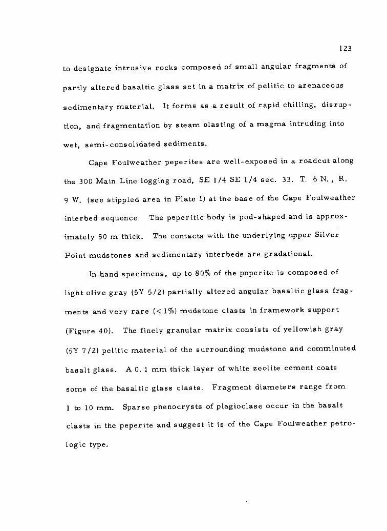
123
to designate intrusive rocks composed of small angular fragments of
partly altered basaltic glass set in a matrix of pelitic to arenaceous
sedimentary material. It forms as a result of rapid chilling, disrup-
tion, and fragmentation by steam blasting of a magma intruding into
wet, semi-consolidated sediments.
Cape Foulweather peperites are well-exposed in a roadcut along
the 300 Main Line logging road, SE 1/4 SE 1/4 sec. 33. T. 6 N. R.
9 W. (see stippled area in Plate I) at the base of the Cape Foulweather
interbed sequence. The peperitic body is pod-shaped and is approx-
imately 50 m thick. The contacts with the underlying upper Silver
Point mudstones and sedimentary interbeds are gradational.
In hand specimens, up to 80% of the peperite is composed of
light olive gray (5Y 5/2) partially altered angular basaltic glass frag-
ments and very rare (< 1 %) muds tone clasts in framework support
(Figure 40). The finely granular matrix consists of yellowish gray
(5Y 7/2) pelitic material of the surrounding mudstone and comminuted
basalt glass. A 0.1 mm thick layer of white zeolite cement coats
some of the basaltic glass clasts. Fragment diameters range from
1 to 10 mm. Sparse phenocrysts of plagioclase occur in the basalt
clasts in the peperite and suggest it is of the Cape Foulweather petro-
logic type.

1 2 4
Figure 40. A peperite hand specimen. Dark angular clasts ofpartially devitrified basaltic glass set in a very finematrix of indurated mud and finely granular comminutedbasalt.

125
Petrology
Based on petrographic examination of eight thin sections and
five modal analyses of Cape Foulweather intrusive basalts from the
study area, it was determined that this basalt differs from Depoe
Bay Basalt as follows: Cape Foulweather Basalt is 1) sparsely
porphyritic, 2) contains olivine and its pseudomorph iddingsite in
a much greater abundance, 3) contains a slightly more calcic feldspar
groundmass (also see Tolson, 1976), and 4) lacks primary hornblende.
According to Snavely and others (1976), Cape Foulweather Basalt at
the type area has a very similar petrology.
Major constituents of Cape Foulweather intrusive basalt include
plagioclase (38-66%), clinopyroxene (19-26%), opaque iron oxides
(9-16%), and basaltic glass (0-19%), (Table 3). Olivine commonly
has an alteration halo of pseudomorphic iddingsite and together these
two minerals comprise of 2-5% of the rock. A crypto-crystalline
silicic residuum (6-21%) is common in holocrystalline samples from
larger intrusive bodies whereas tachylyte glass is more common-
place in thinner dikes and sills. Apatite is a ubiquitous accessory
mineral and occurs in trace amounts.
Alteration products comprise from 0 to 28% of the basalts and
include chlorophaeite, calcite, and mixed layer smectite-chlorite
clay Most are products of the breakdown or devitrification of glass.

Table 3. Modal analyses of selected samples of Cape Foulweather Basalt.
Sample No.
Intrusives
PEP PEP PEP PEP PEP
27 76 86 91 92
Extrusives
PEP PEP PEP
2 89 200
Plagioclase 66% 38% 48% 55% 51%
Clinopyroxene 21 25 19 22 26
Iron Oxides (opaques) 8 16 10 9 9
Olivine-Iddingsite 2 2 2 5 5 4 - -
Crypto-crystallineinterstitial-residuum - 21 9 6 4 - -
Apatite tr tr tr tr tr tr tr tr
Alteration Products
Chlorophaeite - tr 17 5 -
Smectite -Chlorite 3 - - 25
Palagonite - - - - -
Calcite - tr - 1 tr
Glass
Tac.hylyte 19 - 3 35 14
Sideromelane - - - 63
15% 35% 36%
tr 14 16
tr 11 9
tr < 0. 5%
Sample localities are presented in Appendix VIII and Plate I.

127
and deuteric alteration of less stable early precipitates such as
pyroxene and olivine.
Cape Foulweather intrusive basalts have porphyritic inter-
sertal, intergranular, and subophitic textures (Figure 41). The
plagioclase composition ranges from calcic labradorite (An 64) to
calcic andesine (An 48). Phenocrysts of plagioclase (<1%) are euhed-
ral to subhedral, tend to be more calcic than the microlites, and
commonly show normal zoning, resorbed cores, and alteration to
white micas along cleavage traces and fractures (Figure 41). Euhed-
ral to subhedral calcic and subcalcic augite (2V=50-85) is the most
abundant clinopyroxene. Finely crystalline pigeonite (2V,--10-15) oc-
curs interstitially and rarely as coarse crystals intergrown with
plagioclase. No orthopyroxenes were found in thin section studies,
but Tolson (1976) and Neel (1976) reported small amounts of this
mineral (<2%) in a few samples. Iron oxides, principally magnetite
and ilmenite, occur in the groundmass as euhedral equidimensional
grains and as acicular crystals up to 1 mm in length.
In thin section, Cape Foulweather peperites consist of scat
tered, rarely porphyritic, basaltic glass fragments set in a matrix
composed of silt and clay sized sedimentary debris and the finely
comminuted basaltic glass (Figure 42). Scattered euhedral plagio-
clase phenocrysts up to 3 mm in diameter occur in the glass frag-
ments. The altered glass fragments have a groundmass composed

128
I
Figure 41. Photomicrograph of intrusive basalt of the CapeFoulweather petrologic-type. Porphyritic sub-ophitic basalt consisting of scattered plagioclasephenocrysts (P) set in a groundmass of small plagio-clase laths, clinopyroxene, magnetite and/or ilmenite,and rare olivine crystals (partly or wholly altered toiddingsite. Note also, alteration of plagioclase towhite micas along cracks in phenocryst (crossednicols, ma g. 22X).

129
of andesine microlites (An 42) and partially devitrified and palagoni-
tized glass showing perlitic fracture. Commonly concentric banding
is well developed parallel to internal fractures and the outer boundary
of the glass clasts. A 1. 0 to 0. 5 mm wide reddish brown border
surrounds most glass fragments and probably results from diagenetic
alteration of the glass (Figure 42). Some of the larger glass frag-
ments are rimmed with a 0.1 mm wide colorless isotropic material
which is probably opal. Calcite, palagonite, and zeolites are the
other principal alteration products of the glass.
Although most of the glass fragments are angular, some have
a globular appearance suggesting that the glass was still viscous
when it was injected into the semi-fluid fine marine muds.
A few accidental sedimentary clasts occur in addition to the
glass fragments. They include angular clasts of fine-grained clayey
sandstones, laminated siltstones, and carbonaceous mudstones.
The laminated silty mudstone clast in Figure 43 is very similar to
lower Silver Point lithology (compare with Figure 24).
The sedimentary matrix consists of very fine grains of angular
quartz, plagioclase feldspar, pyroxene, and green hornblende. The
detrital micas, muscovite and biotite and opaque iron oxides are also
common. Secondary constituents in the matrix include zeolites,
opal, and palagonite. Glass shards are very rare and usually re-
placed by opal.

130
Figure 42. Photomicrograph of Cape Foulweather peperite. Note the partially altered clast ofdark basaltic glass contains feldspar microlites and a small plagioclase phenocryst (P)rests in a detrital silt-clay matrix composed of upper Silver Point mudstones ( uncrossednicols, mag. 22X.
Figure 43. Photomicrograph of a rare laminated carbonaceous mudstone xenolith (lowerSilver Point?) lodged in peperite matrix (uncrossed nicols, mag. 22X).

131
Extrusives
Cape Foulweather extrusive basalts in the study area are pre-
dominantly flow breccias, subordinate pillow lavas, and very small
quantities of massive holocrystalline basalt. Pillow lavas are more
abundant in the Cape Foulweather Basalts than in the Depoe Bay
Basalts. Both isolated and close-packed pillow lavas are common.
The basalt is fresh, glassy, and sparsely porphyritic. Plagio-
clase phenocrysts are ubiquitous but only locally abundant. Some
phenocrysts are up to 2 cm in length. Typically, the breccias and
pillow lavas are composed of fine lapilli-size angular clasts of dark
gray (N3) basaltic glass (tachylyte and sideromelane). On a weathered
surface the basalts are dusky brown (5R 2/2). Pillows range in di-
ameter from 0.3 to 1 m and commonly contain zeolites or calcite in
fractures or as amygdules.
Rare, unbrecciated vesicular flows, possibly subaerial in
origin, crop out along logging road Spur 322 (SE 1/4 NE 1/4 sec. 31,
T. 6 N., R. 9 W. ) and at the end of logging road Spur 321-A (center
sec. 31, T. 6 N. R. 9 W. ). The vesicles, up to 1 cm in diameter,
are so abundant that the rock appears clinkery. Approximately 20%
of the vesicles contain white zeolites.
Cape Foulweather lavas contain sedimentary interbeds in much
greater abundance than Depoe Bay extrusives. The intercalated

132
sedimentary units include dark gray structureless muds tones which
are indistinguishable from those mapped in the upper Silver Point
tongue and also include fine- to medium-grained structureless arkosic
sandstones very similar to the Dump sandstone unit (informal) de-
scribed by Tolson (1976). A foraminiferal suite collected from one
of the mudstone interbeds (SE 1/4 SE 1/4 sec. 32, T. 6 N. R. 9 W. ;
sample #11) indicates a Saucesian to Relizian age (middle Miocene)
and bathyal depositional depths (Rau, written commun. , 1975).
Calculations using regional dips and distribution of outcrops
suggest that at least 250 meters of Cape Foulweather lavas and inter-
bedded sedimentary rocks occur in the study area.
Petrology
Extrusive Cape Foulweather Basalts have predominantly hyalo-
pilitic to subophitic and rarely vitrophyric textures. In large parts
of some flows the glass is entirely sideromelane (R. I. =1. 602) while
in other parts the glass is predominantly tachylyte (R. I. =1. 546)
(Figures 44 and 45). Commonly brecciated flows contain clasts of
both types of basaltic glass in close association. In three point
counted samples (Table 3), glass ranged from 14 to 63% of the total
volume of the rock. Plagioclase phenocrysts (An 60) and microlites
in the groundmass accounted for 15-36% of the breccias. The
clinopyroxene, augite (tr-16%), and opaque iron oxides (9-11%),

Figure 44. Photomicrograph of fresh sideromelane glass withperlitic hyalopilitic texture. Note iddingsite (reddishbrown) and smectite-chlorite (green) pseudomorphsafter olivine (uncrossed nicols, mag. 100X).
133
Figure 45. Photomicrograph of partially resorbed plagioclasephenocryst in tachylyte glass. Note the relativelyless resorbed outer rind of the crystal (crossed nicols,mag. 22X).

134
principally magnetite and ilmenite accounted for most of the remain-
ing crystalline portion. Olivine (0-4%) is only present in the flow
containing sideromelane glass (Figure 44). The olivine is deuter-
ically altered to reddish brown iddingsite(?) and green smectite-
c hlorite which occur as pseudomorphs (Figure 44). According to
Wilshire (1958), alteration products of olivine and orthopyroxene in
basic lavas and shallow intrusions previously identified as iddingsite,
bowlingite, and serpentine among other minerals, have been found to
consist predominantly of mixed layer smectite-chlorite. Scattered
microlites of labradorite and andesine (An48-An
52)in the glassy
basalt groundmass are euhedral and commonly fringed by a dark
brownish isotropic material (possibly chlorophaeite or hydrated iron
oxide). Calcite, chlorophaeite, heulandite, clinoptilolite and other
zeolites, and palagonite commonly occur as vesicle fillings in the
breccias (Figure 46). Chlorophaeite is also common as an alteration
product of pyroxene (Figure 47). The phenocryst in Figure 45 is
normally zoned as the outer rim is less resorbed than the central
portion of the crystal. Modal analyses of these basalts in the thesis
area are petrologically very similar to the Cape Foulweather Basalt
of the type area (Snavely and others, 1973).
Interbedded Sedimentary Rocks
Sedimentary interbeds in the Cape Foulweather extrusive

135
Figure 46. Photomicrograph of an amygdaloidal Cape FoulweatherBasalt. Calcite and chlorophaeite fill vesicles. Morebirefringent reddish brown material lining vesicles maybe incipient crystallization of a chlorite clay mineral(crossed nicols, mag. 35X).
Figure 47. Photomicrograph of augite crystal partially altered toreddish brown chlorophaeite. Note labradorite microlitesin dark tachylyte glass (uncrossed nicols, mag. 35X).

136
breccias range in thickness from one to four meters. Most beds
are thin (<2 m) and difficult to trace laterally due to their limited
exposure. A few of the thicker beds, however are mappable over
small areas (see Plate I).
Near the source of Little South Fork Creek (E 1/3 sec. 31, T.
6 N. , R. 9 W. ), a thick (minimum of 3 m) structureless muds tone
interbed crops out. The muds tone is dark gray (N3) in some of the
streambed exposures but where more commonly weathered, the bed
is a dark yellowish orange (10YR 8/6). It is evident from nearby
streambed exposures that the muds tone bed is overlain and underlain
by Cape Foulweather breccias although the upper and lower contacts
are not exposed here.
Sandstone interbeds are best exposed in roadcuts along logging
Spurs 319 and 321-A, section 31, T. 6 N. R. 9 W. (Plate I). The
thickest bed is approximately 3 m. The sandstones are fine- to very
fine-grained, micaceous, well indurated and structureless. Sieve
analyses of two samples determined that the median diameter of both
is . 11 millimeters and they are poorly sorted (Appendix IV). On a
weathered surface the sandstones are yellowish gray (5Y 7/2) to very
pale orange (5YR 8/4). Fresh samples are a lighter buff color.
Petrology
Cape Foulweather interbedded sandstones are compositionally

137
and texturally immature arkosic wackes (Williams and others, 1954;
Folk, 1964) (Figures 14 and 48a). Modal analyses of three interbedded
sandstones showed that quartz (20-28%), plagioclase (12-24%), and
micas (biotite and muscovite) (9-12%) are the principal framework
grains (Appendix III). The rest of the framework grains including
metamorphic quartzite, chert, potassium feldspar, basic volcanic
rock fragments, mafic minerals (hornblende, pyroxene epidote), and
opaque iron oxides average less than 5% (Appendix III),
In thin section (Figure 48), framework grains are mostly angu-
lar; but some quartz grains are well-rounded, suggesting a recycled
origin from a sandstone source area. Much of the mica is crenulated
and molded around other detrital grains, suggesting extensive com-
paction of the sandstones, presumably by the thick overlying.denser
breccias. Most framework grains are anhedral to subhedral, and
some have indistinct boundaries.
The matrix, principally detrital. silt and clay and diagenetic
chlorite(?) (lacks crystal boundaries) account for from 23 to 47% of
the rock volume. X-ray diffraction analysis shows that smectite,
kaolinite/chlorite, and chloritic intergrades are the principal clay
size minerals present in the matrix (Appendix VI). Due to the
apparent compaction and presence of diagenetic clay minerals the
point counted porosity of these sandstones is very low (<1%).
The heavy mineral suite in these sandstones includes green

I
V)
138
Figure 48. Photomicrograph of typical interbedded sandstone in theCape Foulweather Basalt. Note the textural similaritywith upper Silver Point sandstone (Figure 25), (uncrossednicols, mag. 100X).

139
hornblende, hypersthene, clinopyroxene, garnet, zircon, biotite,
epidote, rutile, tourmaline, opaque iron oxides (magnetite, ilmenite,
and leucoxene) and apatite. The grains are equidimensional, but
average rounding is low (0. 30 on Powers scale).
Contact Relationships
Cape Foulweather pillow breccias lie with angular unconformity
on upper Silver Point strata in the study area. An unconformable
relationship is supported by:
1) the occurrence of local discrepancies in strike and dip of the
two units although some differences are probably due to the
disruption of upper Silver Point strata by Cape Foulweather
intrusions.
2) large variations (up to 300 m) occur in both the thickness of the
Cape Foulweather extrusive basalts and the elevation (800 to
1, 000 foot contour) at which the unfaulted base of the unit crops
out
3) the fact that there is an unconformable relationship between
Depoe Bay Basalt and upper Silver Point mudstones also indi-
cates there is an unconformity between the Cape Foulweather
and Silver Point strata because younger Cape Foulweather intru-
sives cross-cut Depoe Bay breccias.
Although Cape Foulweather extrusive basalt generally crops out

140
in a northeasterly-trending belt located west of the Depoe Bay extru-
sive basalts, there is no apparent overlapping of flows in the study
area. Geologic mapping in the thesis area suggests that the absence
of Depoe Bay breccias between Cape Foulweather breccias and upper
Silver Point mudstone is probably due to the localized eruptive nature
of the two basaltic units, rather than to erosion of the older basalt
unit.
Age and Correlation
A middle Miocene age (Saucesian-Relizian) is assigned to the
Cape Foulweather Basalt and interbedded sedimentary rocks on the
basis of a foraminiferal fossil assemblage collected from a mudstone
interbed in the middle part of the unit (SW 1/4 SE 1/4 sec. 32, T.
6 N., R. 9 W.) (W. Rau, written commun. 1975).
Stratigraphically, Cape Foulweather extrusive basaltic dikes
and sills cross-cut the Depoe Bay basalt thus providing the principal
evidence in the study area for interpretation of the age relationships
of the volcanic units. Snavely and others (1973) have suggested that
similar stratigraphic and intrusive cross-cutting relationships charac-
terize the middle Miocene section throughout the western Oregon
Coast Range.
A tentative petrologic correlation of these basalts with basalts
designated as Cape Foulweather petrologic-type from the type area is

141
done on the basis of similarities in stratigraphic position, petrology,
and chemistry.
Basalt Chemistry
Snavely and others (1973) have shown that two middle Miocene
basalt petrologic-types, the porphyritic Cape Foulweather Basalt and
the nonporphyritic Depoe Bay Basalt, are differentiable on the basis
of age, stratigraphic position, petrography, and chemical composition
in western Oregon. The Cape Foulweather basalt petrologic-type is
lower in the percentages of SiO2
and higher in percent total iron,
TiO2'
and P205 than Depoe Bay Basalt.
Whole rock chemical analyses were completed on 15 intrusive
and extrusive basalt samples from the study area to determine if
these basalts fall within the compositional variation Limits that have
been established for Cape Foulweather and Depoe Bay Basalts through-
out the Oregon Coast Range. The chemical analyses also were used
to substantiate initial identification and field mapping of the two basalt
units. Only one chemical analysis had been done of a basalt in the
area previously, a Depoe Bay pillow breccia sample from Saddle
Mountain (Snavely and others, 1973).
The majority of the samples which are plotted on silica varia-
tion diagrams (Figure 49) plot within or very close to the previously
established compositional variation limits and confirm the

16
14
A120%12
Fe0%
MgO%
16
14
12
10
8
6
4
2
/102N,
1
``__ _3
40
8. 9 11
lb' 1307 12\
76 1
I 53 17..d) 6
IO2 814g
co' 11'7 15-13
5 7, 14 -
O"a,3 /
(32 0/17. 124 6
- _10
I
_1 t>2 40 715
3CLI8911:113A
50 52 54 56 50
(SiO2)2
52 54
Cape Foulweather petrologic-type basalt compositional limitsDepoe Bay petrologic-type basalt compositional limits
56
12
10
8
6
4
3
2
2
CaO%
Na 0%2
K 0%2
1
0
4
1
TiO %2
142
Sample descriptions and locations shown 2, 4, 5,7, 0 Mapped as Cape Foulweatherin Appendix VIII and on Plate I Diagram Basaltafter Snavely and others (1973) 1, 3, 6, 8, 9,
10, 11, 12,13, 15,17 . Mapped as Depoe Bay Basalt
Figure 49. Comparison of Cape Foulweather and Depoe Bay Basalt petrologic types variationlimits with selected basalt samples in thesis area.

143
initial identifications of Cape Foulweather and Depoe Bay
petrologic-types. However, samples PEP-22a and PEP-86 (sample
nos. 1 and 7 in Figure 49, respectively) gave consistently anomalous
plots that probably exceed possible errors which could be attributed
to either variations in analytical equipment or sample contamination
during preparation for analysis. Sample PEP-22a is from the base
of a thick (100 m) non-porphyritic sill (NW 1/4 sec. 4, T. 5 N.: R.
9 W. ). However, it plots in the compositional region of (porphyritic)
Cape Foulweather petrologic-type basalt. Two other chemically
analyzed basalt samples from the upper part of the same sill plot
almost consistently within the variation limits of Depoe Bay Basalt
(sample nos. 9 & 11 in Figure 49 and Appendix VIII). The anomalous
plot of PEP-86 (sample no. 7 in Figure 49 and Appendix VII) is another
enigma because that sample has Depoe Bay chemistry and is from a
porphyritic dike north of Saddle Mountain (SE 1/4 NW 1/4 sec. 27,
T. 6 N. , R. 9 W. ; Plate I). In addition, three samples (nos. 3, 4, &
5, Figure 49 and Appendix VII) have intermediate silica compositions
to the variation limits of the Depoe Bay and Cape Foulweather petro-
logic-types established by Snavely and others (1973). Although there
are several possible explanations for such anomalous results, the
likeliest is probably that, instead of a complete separate chemistry
between the two basalt types, there may be some gradational overlap
not previously recognized with the Limited sampling that Snavely and

144
others (1973) did. This explanation is further supported by field
relationships which indicate that the thick non-porphyritic sill in the
western part of the area and the overlying porphyritic Cape Foul-
weather breccias are genetically related. For example, only a few
tens of meters of contorted Silver Point mudstones separate the
intrusive Depoe Bay Basalt from the extrusive Cape Foulweather
breccias and this mudstone is cross-cut by numerous porphyritic and
a few non-porphyritic dikes.
Quaternary Deposits
Quaternary deposits are local in nature in the thesis area.
They consist of three principal types: 1. Pleistocene(?) indurated
channel conglomerate, 2. Recent landslide, rockslide, and basaltic
breccia colluvium deposits, and 3. Recent stream alluvium. The
approximate outcrop distribution of these deposits is illustrated in
Figure 50.
Channel Conglomerate
A single conglomeratic channel deposit comprised of structure-
less, poorly sorted basaltic cobbles and boulders crops out along the
300 Main Line logging road (SW 1/4 SW 1/4 sec. 34, T. 6 N. R.
9 W. ). The channel is 3 m in width and 2 m thick. It cuts sandstone
which occurs adjacent to a steeply dipping sill-like intrusion. The

Channel Conglomerate
Landslide Deposits
Stream Alluvium
R 10 W R 9 W
11 /
R 8 W
L
ti
1
) .I C._ , 1/4
N:CO;Pa' ,%.,
N 1 ....
e
-#.....1 ./.. tI
/1e ,..
- (1 I \
......--... -...-1 7
r<X
Clots° I .1...." - .. _,....4.
4?1
Ivu... ......t-
/ 1 -.4., i
-1 ,', ..,....7 .../
\ Z ..z....6,
,"tit.., /
...-''' () (,--1?-ty
4......./Iv
i1-
t,et/
t
is °12c1
i.12ver-Q
,..\\14h\ ki
4).11r%111",(S,
',Q1
Figure 50. Outcrop distribution of the Quaternary Deposits.
T 5 N

146
dark gray well-rounded aphanitic basalt cobbles range in diameter
from 3 to 15 cm. Typically they are weathered grayish orange (10YR
7/4) to moderate yellowish brown (10YR 5/4). Some cobbles have
a weathering rind up to 1 mm thick. The matrix of the conglomerate
is comprised of medium to coarse-grained grayish orange (10YR 7/4)
micaceous lithic sand.
In thin section the cobbles display intergranular to intersertal
textures with interstitial glass and alteration products that include
white micas, devitrified glass, and the opaque iron oxides (hematite,
limonite) (Figure 51). Modal analysis of the surrounding matrix
reveals that angular quartz (15%), plagioclase feldspar (5%), and
volcanic rock fragments (52%) are the principal constituents (Appen-
dix III). Interstitial clays and alteration products derived chiefly from
devitrification or diagenetic alteration of the glass account for 21%
of the sandstone matrix. This probably accounts for the low porosity
(<1%) of the sandy conglomerate.
One cobble was chemically analyzed for major metal oxides
and silica. A plot of the results on a silica variation diagram (sample
no. 14 in Figure 49) falls within the compositional variation limits of
the Depoe Bay Basalt suggesting that much of the conglomeratic ma-
terial was derived locally. That only very short transport distances
are required to round basalt cobbles is indicated by the rounded
basalt cobbles in short streams which currently drain Saddle

I
147
Figure 51. Photomicrograph of a cobble conglomerate collectedfrom a Pleistocene(?) stream channel. Basalt cobble(right) is separated from its weathering rind by afracture. Glassy volcanic rock fragments, plagioclase,quartz, diagenetic alteration products comprise muchof the matrix material (left), (uncrossed nicols, mag.22X).

148
Mountain.
The stratigraphic relationship of the channel conglomerate to
the middle Miocene basalts and muds tones which it overlies(?) is
complicated by nearby faulting and intrusion and its poor exposure.
Because Depoe Bay basalts were erupted under marine conditions
and the channel contains cobbles of Depoe Bay basalt, it seems
reasonable to assume the channel deposit was formed during a post-
Depoe Bay time erosive cycle (1. e. late Miocene to Recent). The
perched position of the channel, at the top of a narrow ridge suggests
abandonment, possibly due to stream piracy during a particularly
active period of stream downcutting such as that which characterized
the Pleistocene.
Colluvium Deposits
Locally thick colluvium deposits occur near Saddle Mountain,
Humbug Mountain, and the unnamed volcanic peaks west of Humbug
Mountain (Figure 50). The colluvium is comprised chiefly of land-
slide and rockfall blocks and boulders of Depoe Bay Breccia and minor
amounts of muds tone. The chaotic masses of rubble are unconsoli-
dated, very poorly sorted, and lack stratification. A relatively thick
(<3 m) deposit of colluvium is exposed in a stream bank along the
southwest side of Saddle Mountain.
The contacts of the colluvium deposits are only approximate

149
because much of the area surrounding the mountains is covered by
dense vegetation (Plate I). In addition, weathering processes form
a reddish orange iron oxide-stained regolith and sd I cover over the
colluvium deposits which is similar to that developed over the in-
place breccias.
Examination of a recent rock slide on the north side of Humbug
Mountain (center SW 1/4 sec. 9, T. 5 N. , R. 8 W. ) indicates that
the breccias fail along joint surfaces and large walls of rock may
cleave from the mountains. This mass wasting mechanism works
in conjunction with slope and stream erosion which undercuts the less
resistant Tertiary muds tones that support the topographically higher
resistant volcanic breccias. Both processes give rise to the nearly
vertical cliffs that characterize Saddle and Humbug Mountains.
The few large, more rounded and widely scattered breccia
boulders found up to several hundred meters from the mountains
have a different origin. The boulders range up to 4 m in diameter,
and some occur resting on muds tones nearly 0. 5 km from the base
of the mountain. At the 850-meter elevation level (2, 800 ft contour)
below the central peak of Saddle Mountain, a single boulder roughly
two meters in diameter is perched on a small ledge which is transact-
ed by several joint sets (Figure 52). Apparently the boulder formed
by spheroidal weathering (in situ) of breccia blocks bounded by inter-
secting joint sets. If subsequently loosened by earth tremors and/or

150
I
Figure 52. Large spheroidally weathered Depoe Bay basalticbreccia boulder (arrow) perched on a ledge on thesouth side of Saddle Mountain. Boulder formedin situ by weathering of jointed breccias.

151
weathering away of rock material below, this and other such boulders
could gain sufficient momentum in rolling down the mountain to be
carried large distances from the mountain front.
Stream Alluvium
Unconsolidated, poorly sorted, Recent stream alluvium com-
posed of rounded basalt cobbles and subordinate interstitial medium-
to coarse-grained sand crops out in isolated exposures along the
North Fork of the Necanicum River (secs. 9 & 16, T. 5 N. R. 9 W. )
(Plate I and Figure 50). The well-rounded, grain-supported cobbles
range from 2 to 20 cm in diameter and are derived from local Cape
Foulweather and Depoe Bay basalt sills and breccias. The alluvium
is at most 2 meters thick.
Structural Geology
Regional Structure
The structure of the northern Oregon Coast Range is dominated
by a northward plunging anticlinorium having several north to north-
west striking open folds with wavelengths up to several kilometers
(Baldwin, 1952; Wells and Peck, 1961; Snavely and others, 1964;
Niem and Van Atta, 1973). The folds are normal compressional type
(Braislin and others, 1971). According to Snavely and Wagner (1964),

152
the region is truncated by several high angle normal and reverse
faults.
The core of the anticlinorium consists of early-middle Eocene
Tillamook Volcanics which are flanked on the east, north, and west
by younger Tertiary sedimentary strata (late Eocene to middle Mio-
cene). All major stratigraphic units dip homoclinally off the flanks
of the uplift. The sedimentary sequence is thickest ( > 2, 504m)
along the axis of the Astoria embayment (Bromery and Snavely, 1974),
the northernmost of three structural downwarps formed during late
Eocene time (Snavely and Wagner, 1964). These structural embay-
ments strike normal to the anticlinal axis of the present Coast Range.
Scattered occurrences of locally thick eroded middle Miocene
submarine basaltic breccias overlie the younger Tertiary sedimen-
tary sequence along the western Oregon Coast from Newport to
Cannon Beach. From there the breccias extend northeasterly 40 km
inland toward the present axis of the Astoria embayment. Immedi-
ately northeast of the submarine breccias, in the Wickiup Ridge-
Nicolai Mountain area along the Columbia River are coeval subaerial
(plateau derived) basalt flows of the Columbia River Group (Snavely
and others, 1973). Snavely and others (1973) have suggested that
basic magmas that fed the Cape Foulweather and Depoe Bay coastal
basalts rose along northerly-trending deep crustal fracture zones.
These zones in the Astoria embayment were offset by a

1 53
northeast-trending fracture zone that controlled the geographic occur-
rence of these middle Miocene volcanics.
The younger Tertiary sedimentary sequence contains several
local and regional unconformities. Local unconformities are common
along the margins of the Astoria embayment and surrounding volcanic
buildups (Snavely and Wagner, 1964, Van Atta, 1971; Warren and
others, 1945; Cooper, 1977). Regional unconformities between
Tertiary units resulted from both eustatic changes and local tecton-
ism.
Geophysical studies of the region indicate that offshore folds
and faults generally parallel the north-south trend of the coastline
(Kulm and Fowler, 1974b), whereas, onshore structures strike north-
west and northeast (Zietz and others, 1971). The abrupt break be-
tween onshore and offshore magnetic trends in the volcanic basement
suggests a major fault(s) (Zietz and others, 1971).
Thesis Area Structure
Structure in the thesis area conforms well with the regional
structure of northwestern Oregon. Normal and reverse(?) fault sets
strike northwest and northeast. In addition, a large northwest-
tie nding anticline in the study area parallels a syncline delineated
north of the area (Baldwin, 1952; Wells and Peck, 1961).

154
Folds
The largest structural feature in the thesis area is a broad
northwest plunging anticline (Figure 53, Plate I). The axis of the
anticline strikes N 74° W in the eastern part of the area and then
curves north to a bearing of N 49° W in the central part of the area.
The structure is formed in the Silver Point and Oswald West mud-
stones. The limbs of the structure are symmetrical and dip from
11° to 16 °. The southwest limb is truncated by a large fault which
parallels the structure and juxtaposes Oswald West muds tone against
Silver Point muds tone (Plate I). The relationship of this fault to the
fold is schematically illustrated in cross-section A-A' in Plate II.
The broad fold is breached by the Lewis and Clark River which
is a consequent stream that has formed in an anticlinal valley between
Saddle and Humbug Mountains (Figure 53). Evidence of the anticlinal
fold includes dip reversals of strata exposed in opposing valley sides
and the outcrop pattern of the Tertiary units. The lower Silver Point
s trata are exposed in the center of the fold and younger northward and
southward dipping upper Silver Point strata form the limbs of the fold
(Plate I; Plate II cross-section A-A' ). Because rotational slumping
of sedimentary blocks could cause similar dip reversals, the anticline
is only inferred (dashed on map).
The anomalous outcrop pattern (downstream V's) of the sedi-
mentary units in the central part of the area is caused by an anticlinal

R 10 W
Anticline
4 Small Syncline
Fault
LineamentR9 W
R8 W
// /4tio
4,
,/ // 'bug
4fao
I 7 i si .
t ./.:a,
91, 4.1 ,...,.. __lc, - 4, ),"..
/ P.4., la l''. ,-/
\/
j --iState Park
II , >,
f
L _ 2/ \\.. kk (/' I
"VsL ,' 4, L _ _ \, r I ,...z.
I ';7,o421:,,,,s. :N
r .4 ', / ///m/74:...i -"4-....L. \---
4is
_ __ ._*,..aod i-% 1 -,,,,\
-ptork_74,/ ,.:)i -, --,-_,-
_
b N:szk-' ; U , I ie
.0.0
2
Figure 53. Structure and tectonic lineament map of the Saddle and Humbug Mountain area. Lineaments from U-2 Hi-flight PhotographyInfrared (positive) Imagery.

156
plunge of from 5 to 10 degrees (see Plate II, cross-section B -B').
This plunge is approximately equal to the regional dip and well ex-
ceeds the valley slope of between 1 and 2 degrees.
The anticline may terminate against a complex of faults and
middle Miocene Depoe Bay intrusions 1 km northwest of the study
area (Tolson, 1976), but outcrop patterns further to the northwest
near the coast indicate that this structure may continue at least as
far as the coast.
The youngest folded sedimentary unit is the middle Miocene
Silver Point member. Apparently the overlying Depoe Bay breccias
were also involved late(?) in the folding because Baldwin (19-52) re-
ported that the Saddle Mountain breccias dip gently north to northwest
approximately 10°. Topographically, the lowest contacts of the Depoe
Bay basaltic breccias which form Saddle Mountain and Humbug Moun-
tain occur along the northwestern and southwestern sides of the moun-
tains, respectively. This field evidence is also consistent with a
northwestward anticlinal plunge.
Faults
Faults in the thesis area were recognized by juxtaposition of
stratigraphically separated formations, linear fault-line scarps,
offset of formational contacts, and by low altitude and U-2 Hi-flight
photo lineaments. Two major high angle fault sets strike N 40 °W

157
and N 30°-50° E in the study area (Figure 53). Several lineaments
apparent in U-2 Hi-flight infrared imagery either parallel or coincide
with the fault trends mapped in the field (Figure 53) as do long seg-
ments of several streams.
Relative movement along the three best exposed faults (solid
lines in Figure 53) are normal dip-slip, and offsets range from a few
tens of meters to approximately 200 meters. Most of the fault move-
ment apparently predates middle Miocene volcanic extrusion because
few normal offsets occur in the breccias whereas sedimentary units
are more commonly juxtaposed by faults. Extrapolation of fault
trends is greatly aided by photo interpretation. In addition to normal
faulting, small scale right-lateral strike-slip movement (?) subse-
quent to middle Miocene volcanic extrusion is suggested by slight
(<20 m) offsets of the 1) intrusive rocks, 2) lineaments, and 3) joint
sets in the breccias (see Figure 55).
The trace of the largest fault (Humbug Mountain fault) in the
area strikes N 45 °W and is partly hidden by the overlying Depoe Bay
basaltic breccias comprising Humbug Mountain. Immediately north
of the fault trace, middle Miocene Silver Point mudstones north of
Humbug Mountain are downdropped possibly as much as 200 meters
(see Plate II, cross-section A-A'). On the south side of Humbug
Mountain, a microfossil date (NE corner sec. 18, T. 5 N. , R. 8 W. )
indicates that Oswald West strata may be as old as latest .Eocene

Figure 54. Slightly offset northwest-trending and northeast-trending lineaments are shown in thisU-2 Hi-flight photograph of the thesis area and surrounding region. Series of parallelridges (slightly offset) east of study area is a dike swarm. Note also the co-lineardrainages of Saddle Mountain (center) and Elk Mountain (upper right) which are segmentsof a northeast-trending lineament extending from Cape Falcon to the Columbia Riveralong which several middle Miocene eruptive centers occur (scale 1:37 0, 000, this photo).

159
Figure 55. Well. developed, closely spaced jointing in the middleMiocene Depoe breccias west of Humbug Mountain (sec.2, T. 5 N. R. 9 W. ). Joint spacings range fromseveral centimeters as in this photo to several tensof meters on Saddle and Humbug Mountains. Notehammer for scale.

160
(Rau, written commun. , 1975). West of Humbug Mountain a 100 -
meter high fauttline scarp of Oswald West muds tone forms a ridge
south of the fault trace. Because movement on this fault predates
the middle Miocene volcanic breccias that form Humbug Mountain
(not offset by fault) and because intrusive bodies occur along parts
of its trace, the fault plane is presumed to have acted as a zone of
weakness along which later middle Miocene fissure eruptions oc-
curred (Plate II, cross-section A-AT).
Immediately southeast of the study area the Humbug Mountain
fault is poorly defined because of the difficulty in recognizing offsets
in older rock types (i. e. undifferentiated Eocene to early Miocene
tuffaceous shales and siltstones; Wells and Peck, 1961). However,
extending along strike southeast from the town of Elsie, approximately
9 km southeast of the study area, Beaulieu (1973) mapped what ap-
pears to be a continuation of this fault. He states:
Along Sunset Highway in the Birkenfield quadrangle,exposures of Eocene volcanic rock unit-2 form a north-west-trending linear ridge which overlooks the highwayfrom the south. Apparently the volcanic rocks were up-faulted relative to the stratigraphically higher sedimen-tary rocks (Tesu) which underlie the valley in which thehighway is situated.
In the central part of the study area the distribution of the juxtaposed
Oswald West and Silver Point lithologies along the Humbug Mountain
fault suggest offset by a northeast-trending fault (Plate I). Northwest
of the study area the fault trace is covered by unfaulted middle

161
Miocene Depoe Bay volcanics (a possible volcanic center, see Tolson,
1976). A large northwest-trending Eocene basement structural
discontinuity(?) there based on aeromagnetic data (Tolson, 1976)
may reflect the continuation of this fault in the subsurface. A large
deflection in the gravity contours in the Saddle and Humbug Mountain
area (Bromery and Snavely, 1964), may suggest downthrow to the
north or right-lateral offset of the deep seated Tillamook volcanic
basement along this fault. However, thick middle Miocene basaltic
sills and surface accumulations of breccia south of this discontinuity
may have caused these gravity and magnetic anomalies.
The general northwest strike, displacement, and age of this
fault in the thesis area suggest that it is a continuation of the fault
mapped by Beaulieu (1973) and is of regional extent. Possibly it is
a continuation of the co-linear Gales Creek Fault which occurs on the
eastern side of the Coast Range (Warren and others, 1945; Wells
and Peck, 1961). The on-strike alignment of these three faults with
valley trends across the Coast Range axis is readily observable on
the State of Oregon 1 :250, 000 plastic relief map series. Should this
apparent alignment of structural and morphological features be a
single fault or fault system, its total length would extend more than
100 km from the town of Forest Grove on the eastern side of the
Oregon Coast Range northwest to the coast north of Seaside, and
may delineate a major fault system. However, more detailed

162
magnetic and gravity surveys are needed to substantiate this hypothe-
sis. It is interesting that the trend of this fault system(?) parallels
the Portland Hills Fault-Clackamas River structural alignment de-
fined by Schmela and Palmer (1972).
Another large fault occurs in the extreme southwestern part
of the study area (secs. 6 & 7, T. 5 N. , R. 9 W. ), trends north to
northeast, and coincides with the course of a tributary to Klootchy
Creek. On opposite sides of the creek, the contact between the lower
Silver Point tongue and the Oswald West mudstone is offset vertically
more than 150 meters and horizontally nearly one kilometer. The
fault bifurcates at its northern end. This fault also predates- the
volcanics as there is no apparent offset of the Cape Foulweather
breccias at the northern extension of the fault. The eastern side of
the fault trace is bounded by a 50-meter high fault line scarp of
Oswald West mudstone, and the west side of the fault is bounded by
low-lying weakly resistant lower Silver Point strat dipping eastward
into the Oswald West strata. The upthrown Oswald West strata dip
steeply (82°) westward adjacent to the fault suggesting drag folding.
In the western part of the study area, a large northwest-
trending fault (younger than but parallel to the Humbug Mountain
fault) offsets Cape Foulweather basaltic breccias and interbeds more
than 100 meters. The fault is well-exposed in a roadcut along Spur
321-A (center sec. 31, T. 6 N. R. 9 W. ; Figure 56). Again the

M
163
Figure 56. Well developed, closely spaced jointing in the middleMiocene Depoe Bay breccias west of Humbug Mountain(sec. 2, T. 5 N. , R. 9 W. ), Joint spacings range fromseveral centimeters as in this photo to several tens ofmeters on Saddle and Humbug Mountains. Note hammerfor scale.

1 b4
Again the northern side is downthrown because the basaltic breccias
are exposed at a much lower elevation on the north side of the ridge
(see Plate II, cross-section C-0). Several older northwest-trending
and northeast-striking normal faults may have offset sedimentary
units beneath the basaltic breccias in this area, but due to the lack
of outcrop exposure and later unfaulted middle Miocene volcanic cover
they are very difficult to delineate in the field.
In the notch between the western and central peaks of Humbug
Mountain (Plate I), a 60-meter thick dark marine mudstone unit is
down faulted against Depoe Bay volcanic breccias. The fault trace
coincides with a small stream which cascades out of the notch in a
northerly direction. The downthrown muds tones dip 40° into the
fault plane (see cross-section A-AT, Plate II). This small fault is
younger than the large Humbug Mountain fault because it cuts the
Depoe Bay breccia that forms Humbug Mountain whereas the Humbug
Mountain fault does not. Due to the dense vegetation on the upper
slopes of Humbug Mountain, exposures of this thick mudstone inter-
bed(?) are very isolated and its areal extent may be greater than
illustrated in Plate I.
Three other faults in the study area are largely inferred (dashed
in Plate I) because older rock units occur topographically higher than
adjacent younger units. These faults are associated with thick sills
(up to 100 m) which may have indirectly caused some of the faulting

1b5
as the intrusions displaced sedimentary rocks during intrusion. One
of these faults occurs in the northeastern part of the study area (secs.
27 & 35, T. 6 N. R. 8 W. ) and coincides with East Leg Road. The
fault strikes northwest and uplifts the Falls Creek member and upper
Oswald West muds tones on the east side against upper Silver Point
mudstones(?) on the west side (see cross-section A-A' ).
In the central part of the study area (secs. 3 & 9, T. 5 N.
R. 9 W. and sec. 34, T. 6 N. , R. 9 W. ), a large northeast-trending
fault has juxtaposed a thick sill of Depoe Bay Basalt and Oswald West
muds tone against extrusive breccias and Silver Point mudstones. The
downthrown lower Silver Point strata are dipping 77° in a stream-cut
exposure along this fault which has approximately 100-meters of
displacement (Plate I). Oswald West mudstones are upthrown against
a Depoe Bay basaltic sill along a small northwest-striking fault
immediately west of this large fault in section 9, T. 5 N. R. 9 W.
(Plate I).

166
ORIGIN OF SADDLE AND HUMBUG MOUNTAINS
It is hypothesized that the Depoe Bay basalt breccias that form
Saddle Mountain and Humbug Mountain are erosional remnants of
gently dipping co-extensive flows derived from two volcanic centers.
The occurrence of several thick (10-100 m) intrusive bodies along the
perimeters of both mountains and feeder(?) dikes within the volcanic
accumulations (Plate I) suggest that Saddle Mountain and Humbug
Mountain are erosional remnants of these volcanic centers (Figure 54).
Examination of U-2 Hi-flight infrared imagery indicates that
Saddle Mountain is situated at the intersection of two lineaments
(possible faults or fractures which may have been zones of weakness
along which magma vented from the subsurface). Furthermore, field
evidence suggests that Humbug Mountain (elongate in a NW-SE direc-
tion) straddles a large northwest-trending fault (Figure 54 and Plate I).
Trigonometric caluculations based on the present thickness of
the Depoe Bay breccias at Saddle Mountain and Humbug Mountain
(600 m and 300 m respectively), their distance apart (ay. 3.5 km)
and using 22° (the average slope of seamounts; McBirney, 1971) as
a likely maximum dip for submarine flows, suggest that the flow
breccias would have originally coalesced on the sea floor.
It seems reasonable to conclude that the thesis area, and pos-
sibly much of northwestern Oregon, was completely covered by flow

167
breccias which spread from numerous sea floor vents in the late
middle Miocene.

168
TERTIARY GEOLOGIC HISTORY
Paleocurrent Data
In general, paleocurrent data were not obtainable from the
predominantly burrowed Oswald West muds tones due to lack of cur-
rent formed sedimentary structures. However, two channel fill
deposits located in the central part of the area (SW 1/4 SE 1/4 sec. 8,
T. 5 N. , R. 9 W. ; sample locality no. 105) and (NE 1/4 SW 1/4 sec.
15, T. 5 N. , R. 9 W. ; sample locality no. 25) in the upper Oswald
West mudstone indicate that paleosediment dispersal patterns and the
paleoslope direction during late Oswald West time was to the north to
northwest. Cressy (1974) indicated a south to southwest paleoslope
based on paleocurrent measurements collected from microcross-
laminated Oswald West silts tones exposed 20 km south of the study
area. These data, although meager, suggest a radiating paleocurrent
pattern caused by deltaic progradation with a source located to the
east of these areas during early Miocene time.
The turbidite sandstones of the lower Silver Point tongue contain
the only current-formed primary sedimentary structures observed in
the study area. A total of 14 paleocurrent measurements were ob-
tained from microtrough cross-laminations in the Bouma C-intervals
of several turbidite sandstones. Beds containing the micro cross -
laminations occur near the base of the lower Silver Point tongue in

169
the western part of the study area (SW 1/4 sec. 6, T. 5 N. R. 9 W. ;
along Clatsop Fir Main Line logging road) and dip very gently (master
stratification <8°). Thus, no corrections for later tectonic tilt were
necessary. The measurements are graphically illustrated using a
rose diagram (Figure 57). The mean (356°) and standard deviation
(70) of these measurements were calculated following the method
outlined by Royse (1970). This plot shows a paleocurrent dispersal
pattern which is strongly unimodaL from south to north. The slight
northwest trend is in agreement with paleocurrent data obtained
from the lower Silver Point tongue immediately north of the study
area (Tolson, 1976).
These data suggest that turbidity flows were generated at the
delta slope front of the middle Miocene Angora Peak sandstone delta
located 28 km south of the study area (Cressy, 1974) and moved
northward down the paleoslope of the deep marine Astoria embayment.
Thinning of the lower Silver Point tongue to the north (Cooper, per-
sonal commun. , 1976) supports such a direction of sediment transport.
The overlying upper Silver Point muds tones contain no paleo-
current indicators and is interpreted as a lower energy, deeper
water facies based on lithology, faunal, and trace fossil assemblages
(Rau, written commun., 1975). The upper tongue advanced over the
lower tongue either during a subsequent eustatic rise in sea level
and/or during subsidence of the nearby subaerial delta.

R 10 W
X Channel Fill Deposit showingapproximate axial trend.
1 0 1 2
Miles
R 2 W
'O
0 7
356°
standard deviation = 7°
It
/f
/s1ii/
' / /- ,
I
C'41 t',S. '''I'. ./. 4k- // / 1:, :
ML-/./..P.
7c- (:)."/
st t-SCo. , .4s .'"- ...3P ;-
_,-_,./ C.) ." -,--;
'State Park
__I L-1
`,-,,,(\_ I '11/1, II
1 -77ci Fig //, L _........ _Le
i e
Lek, is ri 1. `_ . /1 I 17 --'/ I k ""
I
I I
,,.. -,
.34
ie
T 5 N
Figure 57. Rose diagram of paleocurrent measurements from the lower Silver Point turbidite sandstones. The number of measurements
and mean azimuth directions (arrows) are given with rose.

171
Provenance
The stratigraphy of the study area consists of the late Eocene
to early Miocene Oswald mudstones, the Silver Point member of the
middle Miocene Astoria Formation, and the late middle Miocene
Depoe Bay and Cape Foulweather Basalt petrologic-types and associ-
ated sedimentary interbeds.
The largely pelitic character of the sedimentary units makes it
difficult to determine their source area(s). However, the pervasive
tuffaceous imprint in all units (all clay X-ray analyses determined the
presence of smectite) suggest that much of the fine-grained sediment
was derived from weathering 4d erosion of intermediate and acidic
volcanics of the ancestral western Cascades. In addition, the ubiqui-
tous occurrence of tuff beds throughout the Tertiary sedimentary
section indicate that intermittent ash falls occurred.
Previous investigators studying the provenance of the Astoria
feldspathic and volcanic sandstones in the region have suggested that
much of the andesitic and basaltic detritus that forms these sand-
stones were derived from the intermediate lavas and acidic tuffs in
the ancestral western Cascades and also locally from Eocene basaltic
highlands (e. g. Tillamook Volcanics of the Oregon Coast Range). In
addition, minor quantities of non-volcanic detritus were derived
from the Mesozoic acid plutonic and metamorphic terrains east of

172
the Cascades (Cressy, 1974; Smith, 1975; Neel, 1976). Low grade
metamorphic and granitic areas drained by the "ancestral" Columbia
River system such as in southwestern British Columbia, northcentral
Washington, Idaho and eastern Oregon have been suggested as pos-
sible source areas for much of this non-volcanic detritus. Pebble
counts and petrographic and heavy mineral studies completed on
sandstone samples collected from the Silver Point and Oswald West
strata in this study area warrant similar conclusions.
Channel sandstones in the upper Oswald West muds tone and
turbidite sandstones in the lower Silver Point tongue contain scattered
pebbles and sand-size grains of metamorphic quartzite, schist, sedi-
mentary quartzite, acid igneous rock fragments, muscovite, and
microcline (Appendix II). The nearest potential source areas for
this type of detritus are those Mesozoic metamorphic and granitic
areas stated above, which lie east of the Cascades. The nearest
source areas for sedimentary quartzite are the Precambrian Belt
sandstones of Montana or the Ordovician Eureka Quartzite of northern
Nevada. The more abundant andesite and basalt lava fragments and
the few diabase(?) clasts probably were derived from volcanic and
intrusive rocks in the ancestral Cascades and ancestral Oregon and
Washington Coast Ranges.
Local early to mid-Tertiary upwarps of the early to middle
Eocene Siletz River Volcanics (Snavely and Wagner, 1963) of the

173
Oregon Coast Range are thought to have been provenances for much
of the extrusive and intrusive basaltic pebbles in these Tertiary
marine sandstones. The unconformities and basaltic conglomeratic
aprons associated with the Goble Volcanics in the northeastern Oregon
Coast Range (Van Atta, 1971) suggest that this unit contributed some
basaltic debris as well. Several western Cascade subaerial volcanic
units including the Eocene Eagle Creek Formation, the Oligocene-
early Miocene Little Butte Volcanics, and the middle and upper
Miocene Sardine Volcanics were other likely sources for andesitic
and basaltic clasts of the Oswald West and lower Silver Point sand-
stones.
The paucity of heavy minerals in the few Oswald West sand-
stones in the study area (garnet, zircon, rutile, and opaques) pre-
cludes speculation as to provenance other than some contribution from
some metamorphic and acid igneous source (Milner, 1940). However,
Neel (1976) presents a thorough discussion of the Oswald West
provenance based on a more complete heavy mineral suite. He and
Cressy (1973) also noted the close mineralogical similarity between
Oswald West sandstones and the contemporaneous late Oligocene del-
taic Scappoose Formation of the eastern Oregon Coast Range. They
suggested that the bioturbated Oswald West muds tones were probably
a deeper water prodelta facies of the Scappoose Formation.
Heavy mineral suites from sandstones in both Silver Point

174
tongues and the sedimentary interbeds in the Cape Foulweather
Basalt are very similar (Appendix II). They contain abundant euhed-
ral hypersthene, clinopyroxene (augite), green hornblende, enstatite,
and olivine which could have been derived from andesitic or basaltic
lavas of the western Cascades. The occurrence of biotite, epidote,
and garnet indicate some metamorphic or granodiorite source and
monazite (rare) suggests contribution from an acid plutonic source.
Although scanty paleocurrent data and paleodispersal indicators
in the study area suggest a sediment transport direction from the
south or southeast (see section on Paleocurrent Data), this appears
to be a local effect of turbidity flows which moved northward into a
subsiding basin (centered near the city of Astoria) that was developing
marginally to a westward prograding Angora Peak delta. A regional
paleocurrent study of the Astoria Formation by Cooper (1977) sup-
ports this hypothesis.
Geologic History, Summ s
The geologic history of this region and the conclusions of this
thesis are summarized in the following paleogeographic reconstruc-
tion. Paleoenvironmental interpretations are based largely on
stratigraphic, structural, petrologic, and paleontologic data. Data
reported by Oregon State University graduate students (Van Atta,
1971; Cressy, 1974; Smith, 1975; Neel, 1976; Tolson, 1976;

175
Cooper, 1977) who have completed geological studies in surrounding
areas, provided additional information for comparison and a more
regional interpretation of depositional environment and facies rela-
tionships. Other important general sources of information included
a regional study by Warren and others (1945), and Baldwin (1976)
and Snavely and others (1963, 1964, 1969a, 1973).
It is the intent of this reconstruction to provide an understanding
of temporal and spatial facies relationships through the Tertiary and
to pictorially summarize the periods of deposition, erosion, pro-
nounced structural deformation, and volcanism in northwest Oregon,
through a series of paleogeographic sketch maps (Figures 58 through
64) (See Key to these figures in Appendix X). Briefly I will discuss
these periods in relation to a plate tectonic model. Fluctuations of
sea level as indicated by the thesis area stratigraphy (see strati-
graphic column inset in each figure) are also compared with the
Eustatic Supercycle Chart developed by Vail and others (1976).
Six mappable rock units comprise the stratigraphy of the thesis
area. From oldest to youngest, these units are the Oswald West
mudstone and the Falls Creek siltstone member, Angora Peak sand-
stone lenses(?), the lower Silver Point tongue and the upper Silver
Point tongue of the Astoria Formation, and the Depoe Bay and Cape
Foulweather Basalt petrologic-types. Quaternary deposits consisting
of indurated Pleistocene(?) channel conglomerate and recent stream

176
alluvium and landslide deposits are mapped locally.
Late early Miocene and middle Miocene unconformities bound
the Astoria Formation in the study area. A third unconformity
separates Quaternary deposits from underlying Tertiary rock units.
Data from the Standard Hoagland well, 20 km north of the study
area indicate that the early to middle Eocene Tillamook Volcanics
form the geological basement of northwestern Oregon (Tolson, 1976).
Snavely and Wagner (1963) suggest that 3,300 m (10, 000 ft) of these
basalts and their equivalents accumulated along the axis of a rapidly
subsiding Tertiary eugeosyncline that occupied the present area of
the Olympic Mountains, Coast Ranges, and Puget-Willamette low-
land. Several local unconformities indicate that some volcanic areas
formed above sea level. Because the Eocene Coast Range basalts
have close chemical similarities to ocean floor basalts, Snavely and
others (1968, 1973) suggest that these basalts may have formed at a
spreading ridge and have been subsequently accreted to the North
American continent.
The sedimentary record in the study area begins in late Eocene
(Refugian) time with deposition of the lower Oswald West mudstones
along the western (seaward) margin of a eugeosyncline (Snavely and
others, 1963) (Figure 58, interval 1). The fine-grained hemipelagic
character of the unit, the occurrence of pyrite, glauconitic sandstone
lenses, and deep-water fossil assemblages and bioturbation features

s""toL---
124°1.. , e --,.e , ... ., - _
....00/ -- - - ..'" 7; - - .. - - ::-......../.. \ %. 1 '.1''' e
,::,:',LI.:M1314:
e... ..\c, ...-... .3.0 \ l\'."1"". / .1
i 1
, 'I e I\ /...... ."
V 11 %..., f -'-'11ts,, -- i5.1:TC:RIA %----'-'
% 1
%1,I, 5t I, .N
% II% 0..t sof
\Vg111
AP(D.12to
//..).
Ken
SEASIDE
STRAT. OL. SEA LEV.....to
74
:::N.::4;*
Y*
I Tow221-s-
ENVIRONMENT.e
, --i -_
1 NECAN I C UM if
-,I I
1
I' % i
..., 2. I rI 1 -......,
--',.I
1 e ,,I
I /NEHALEM a, ,---
Hemlpelagicmuds
RAY j
Figure 58.
, S .
s
)4.'1.4
-
1,
I t
***- VERNONIA
Strand linelocated to
east
i'riliamaok ice?Paleogeographic map of northwestern Oregon during early and middleOswald West time (late Eocene-middle Oligocene).

178
suggest that deposition was predominantly under quiet, deep marine,
and slightly reducing conditions. This paleoenvironmental interpre-
tation is consistent with sediment types and environmental conditions
on the present Oregon continental slope (Ku lm and Fowler, 1974b)
and is further supported by evidence for the existence of a late
Eocene strand line situated far to the east near the present eastern
margin of the Willamette Valley (Snavely and Wagner, 1968).
Atwater (1970) hypothesized from paleomagnetic reconstruc-
tions that during the early Tertiary, a triple junction (ridge-trench-
transform) migrated northward along the west coast of North America.
With the subsequent development of an arc-trench system along the
Oregon continental margin, the classical "eugeosyncline" became,
in the context of plate tectonic theory, a fore-arc basin. Incipient
formation of the Astoria structural embayment may have been caused
by isostatic plate adjustments associated with the passage of the
triple junction and onset of plate subduction. Over 2, 500 meters of
clastic sediment accumulated in this subsiding embayment before
its destruction in the late Miocene.
Middle Oligocene volcanism along the newly formed ancestral
western Cascade(?) arc contributed large quantities of intermediate(?)
and acidic tuffaceous detritus to the fore-arc basin but little coarse
material reached western parts of the basin. Deposition of the
coarser-grained (sandstones) middle part of the Oswald West
179
mudstone may be attributable to a short-termed, world-wide regres-
sion that occurred at about the same time (Vail and others, 1976)
(Figure 58, interval 2). The ensuing slow eustatic rise in sea level
could not keep pace with basin filling as arc volcanism continued or
increased(?) into the late Oligocene. Consequently, there was a
great reduction in basin area as sedimentary depocenter(s) shifted
westward. The basin began to resemble a broad shallow shelf as
shoaling caused by deltaic progradation continued in the thesis area
and surrounding areas. Evidence of the shoaling is deposition of the
Falls Creek siltstone member in the study area, which contains a
very shallow-water fossil assemblage. Water depths of 10-30 meters
(inner shelf) are indicated by the molluscan assemblage (W. Addicott,
written commun. , 1975). Westward of the Falls Creek siltstone
facies, in the western part of the thesis area were deeper water
Oswald West muds tones that probably represent an outer shelf to
upper continental slope(?) facies (Figure 59, interval 1).
Depositional conditions probably changed little into the early
Miocene. The few glauconitic sandstones and muds tones in the upper
part of the Oswald West muds tones indicate that marine conditions
existed which are similar to those on the outer Oregon continental
shelf today where glauconitic sands and muds are being deposited
(Ku lm and others, 1975).
An erosional unconformity between the Oswald West muds tones

- ,1174° .; . ,p"..... N., 1 ' t, ...
f`.."/ /rte ..;.-
,,'...2:.
1.0 \ . ...." C :' % , CI L.:'41::i; 1.1.
.... -.. , '',, /
r 'iC0.! t
ONt
N.1
' 6 f I
7O. s
.... Ilb r
\ ,. - ..; Al-:T;'t
;I1:14, 1,
1
1lUf U5..
% ir1
1
I Iitt
tt
1
- 46"
-
E
try
trz
,t
STRAT. C L.TOwf
(0 Ez --s G I
tImlogy- R
Z 5 -5 E 1
3- Tow_ Stal
5 _
".'^=__ 77: ;I: EN /IRONMENTE1Lt
0 1
N
OUTER SHELF
Fa lls Creek 'tMember
-1
ContinentalSlope
NEHM. MBAY
s----ss',,Inner ,arAtilcum ,i. ___,
Con tin-elita 1Outer SheaShelf
Scap pose \Delta \\/.
(after Van Atta1971)
t I
t '' t,...-.... .
1...iNE:Ckl'.I
r--, ,--
Tillamook/ -" ( "?Volcaric
Ancestral Columbia R.
NIA
Figure 59. Paleogeographic map of northwestern Oregon during late Oswald Westtime (late Oligocene-early Miocene)' .
181
and the lower Silver Point strata in the study area suggest that in
the latter part of the early Miocene there was a marine regression.
Regional geologic studies of northwestern Oregon also indicate a
similar widespread hiatus during this period (Warren and others,
1945; Snavely and others, 1974). Dott (1969) reported evidence for
an early Miocene hiatus in the circum-Pacific area possibly caused
by structural rejuvenation associated with plate readjustments. Thus,
the early Miocene strand line is inferred to have moved westward past
the location of the present day coastline (Figure 60, interval 1). How-
ever, north of the study area at Astoria, field evidence suggests that
deep marine deposition may have continued uninterrupted (M. Nelson
and G. Coryell, personal commun. , 1976). I speculate that, the
Scappoose delta of Van Atta (1971) may have migrated rapidly west-
ward late in the early Miocene in response to this regression. By
Angora Peak time (an early middle Miocene stilistand ?) the depo-
center had reached a point southwest of the study area approximately
coincident with the present day coastline.
Northwestern Oregon's close proximity to an active plate junc-
ture characterized by rapid subduction along an offshore trench
(Atwater, 1970) and the occurrence of the early Miocene regression
during a eustatic rise in sea level (Vail and others, 1976) suggest a
local tectonic event such as broad uplift may have caused the regres-
sion. Furthermore, this uplift may have been precipitated by a

1 Z 4° 's / ._... 4' ' t '5 5.
.. s * \ 5\ - - 5/ .7,-. 4', .....," ............... 4...- - -. ... - - :.--.1-444 45 ,
/ 5 ./4'...... ,. 1 s' I'''' .4. -.......,.. 44ow .
/ cs /-c,
\ 4 .., ,..,\, ..,..." &. :',.... LI::4 2.1A I.. . ,.
K 45 % st s '.1.4 ) r '' 1
.\1
1....- 5. .
t .4
tWs.
, ' ( 1
'ft' i-I s
Is c l _--,0, Z 14 5,
1
P.:.11 C.;-- IA '...-/- -( IIrl .1 1
Ui
\I t eII l\ e.r..
I''1'11../
I x 1601 !fIlq ,,,- cc,
,,..
LEVEL
SUBAER L
z
`c.;*
"'" 7,,
Z .,
r .,.\
----7 Low Rolling Pia in..--'
5 --3,5 \
5./ ...44; ...,, . - -
-- .'..%:.:',-, 4.4 .... .......- 47.44. '.... , / EN ;IRON 4IENT
/ /I / - I t
5
1 /
MEGAN IC Uhl
- -f
_t
R. /
'/
poloCo1u01%°
R.
Figure 60. Paleogeographic map of northwestern Oregon during the early Miocenehiatus.

183
minor change in plate motions approximately 20 m. y. ago that has
been postulated by Atwater (1970).
Angora Peak time (middle Miocene) marks a short stillstand
prior to the gradual marine transgression which characterized the
first half of the middle Miocene in northwestern Oregon (Figure 61,
interval 1). South of the study area more than 300 meters of fluvial
marine sandstones were deposited. Cressy (1974) and Smith (1975)
suggested that these Astoria Formation sandstones (the Angora Peak
sandstone member) are deltaic deposits of the ancestral Columbia
River. In the thesis area there is little evidence for shallow Angora
Peak sandstone deposition. Equivalent (littoral) sandstones immedi-
ately northwest of the study area interpreted by Tolson (1976) as
beach or barrier bar deposits off the main delta depocenter, may
reflect the temporary position of the Angora Peak strand line. The
few isolated relict Angora Peak sandstones(?) which occur at the
base of the lower Silver Point tongue may also reflect a similar
(slightly later) strand line in the thesis area (Figure 61, interval 2).
I interpret these thin sandstones which unconformably overlie the
Oswald West muds tones as marking the onset of marine transgres-
sion in the study area. This transgression may have been accom-
panied by eastward regression of the ancestral Columbia River
depocenter (Figure 61, interval 1-3). Oversteepening of delta front
slopes and subsequent slumping of carbonaceous sands and muds

K
I 2 1' '..' ..."--N, ' ......N.
'1 . ,
...-.NI.
I Ns. ._
` : . r,- . . e IC51%
%0 31,Ci , - -1...e
1
..1,_ ; p::::rn::::,!), -41 --- Z\ks.. 0 --.f ,J I
tI r /..- 4; ".;
_ENV I R ON M ENT,..k.,, co
*".
1
-lc /i
e,'i° / 0
%.
I
NI I.
..
) 012 .0V 0 N'''' ,..
1 // 2f:''''
40/- I, (D
SEASIDE fy _ A/
Parricr islands / /I ,;/ __1,---- 1 , , , ,
/ '-,,, W05\°1
J--- _:,,I ; NECAN IC /
P.
..0. i \.1/4 0 %.,
STRAT COL.
o*": 1 ( I I r
;,. c°)/_
SEA LEVEL
E I
G
RE I
0
TR
A
P ROD ELIA
Aincestra I Columbia
VERNOMA
. ,.....;
) ..-,` >, \ ----; ;.s. r...
1
.1,,,, t_.
'ff-ikI 1---,
N E 4A--E km, rt. - , -: )3k, ,,(,),;
(' :1ri (,, 'if'
.0/
Figure 61. Paleogeographic map of northwestern Oregon during Angora Peak andlower Silver Point times (middle Miocene).

185
generated the shallow-water turbidity flows which moved west and
north into the subsiding Astoria embayment (Figure 61, interval 3).
At this time lower Silver Point tongue turbidites were deposited in
the thesis area (delta slope) and almost as far north as the city of
Astoria (Cooper, personal commun. , 1976).
By upper Silver Point time, the middle Miocene marine trans-
gression has reached a maximum due either, to the general eustatic
rise in sea level (Vail, 1976) and/or to local differential downwarp
of this arc-trench gap area (Figure 62). Deposition of the structure-
less, deep-water upper Silver Point tongue mudstones in the study
area record open marine low energy conditions. The Astoria embay-
ment reached furthest east during upper Silver Point time, probably at
least as far as Westport on the Columbia River (35 km east of Astoria)
(Wells and Peck, 1961). It appears that middle Miocene differential
warping (uplift and/or downwarp) of the arc trench gap area resulted
in the gradual(?)northeastward shift of the Columbia River to its
approximate present day position. Northeast of the study area, in
the vicinity of Big Creek, a thick sequence of high energy delta
front(?) sandstones (the Big Creek sandstone member of the Astoria
Formation of Cooper 1977) of middle Miocene age overlie the lower
Silver Point tongue and interfinger to the west with upper Silver Point
strata (M. Nelson and G. Coryell, personal commun. , 1976). This
stratigraphic evidence supports a northward shift with time of the

*\4.
STRA 1: COL...
1. e ...0"--"",.. %.S.
''' - - .E I
.....,./ --__ z.-. - - - - - ,.. ,..., ..--.'" \\.\ ' r ....,./,' '1:.'(',,,,....' %-.:.....
I..-- \ E I
G
a R I
(,0
.. e 'e ... i \1
N4% S I,e' .I
' , - '' I
. /I
s
U) I
%
'....., ..-........,..-'..'.
//
/ / 1 . ' " 'f., \ .... ... -....,
...-0 I
, ..., : big43rited, : .
r MID. It)ii ....... -
o i'',cf,4. '.sand tone (prodeita) l__.
rii ,,,.I -,-:.. . t.,,. .. e------
/ *
ccA LEVEL
AN
/
I/ '
tz1
tab
I t.
SEASIDE ;1,' :71
Ir
I
2:I
I
'Ct's
/ I .00 7-7
1 ,
5
,
/".
NC4ALEliBAY
NECASt !CUM sk.
-
Northeast shift ofonce stria!Co Iumbig,
7--I ...... ooe
CD...-, f ..... ..../
...,. ......4' .... 7...- ...--,__i- - ...... ,_.. ,
,. ....
I- _.
_ - , 'V ,-":.. ' -.5 VER NOMA1 ..-- ....--
e, ' \ o'" ------.
...-; ;' /
'.-- - ' /toi
IFigure 62. Paleogeographic map of northwestern Oregon during upper Silver Point
time (middle Miocene).
re'

187
ancestral Columbia River depocenter.
Large normal offsets of the middle Miocene sedimentary units
along northwest and northeast fault trends suggest a period of ten-
sional tectonics during the late middle Miocene prior to the extrusion
of the Depoe Bay and Cape Foulweather Basalts (Figure 63). Several
lineaments which parallel or coincide with fault trends on U-2 Hi-
flight photos (Plate I and Figure 54) suggest that faulting of sedimen-
tary units may be more extensive than field mapping can verify due
to the limited exposure of the sedimentary units. The largest fault
in the study area (Humbug Mountain fault) is co-linear with faults
mapped to the southeast by Warren and others (1945) and by Beaulieu
(1973). The Humbug Mountain fault may be one segment of a major
fault trend or fault zone with the same dip-slip component extending
northwest from the Gales Creek Fault on the eastern side of the Coast
Range (Figure 63, Plate I).
A rapid, relatively short-term regression which accompanied
or soon followed normal faulting is inferred because fault scarps
in the thesis area were eroded prior to submarine extrusion of the
middle Miocene lavas. Field evidence indicates that unfaulted Humbug
Mountain Depoe Bay breccias rest with angular unconformity at the
same elevations on upfaulted late Eocene and downfaulted middle
Miocene strata (Plate I). Schlicker and other (1972) and Snavely and
others (1969, 1973) recognize a similar post-Astoria unconformity

1,, ,.......\ \ -1 1
.o.0. 'f) r r': ./'. , '-. ... , is,
.Oe ".......w...,1 ... %
I 0 ,.., :, L :. : M 1:4,1,' 14.. ----, 'N..? i,-.0 _ _ .../. c; a ,/ p
I
ILI',
0-,N I
I
45'1,
it
K ks,./.., ,^, '1
' /
c'l ,,, __,. ,
a , ,.- 1\ ,--, ; P.:.:T;'):::;;.; ------ 1
1
,, ,1 , ' P/
Strand lineMEMO
STRAT COL. S
rrihio..FuS
A LEVEL
RcP
E I
AR
I 8E I
1
0N I
SUBAERIAL
I
I
1
I
I
NECAR MUM g,
Figure 63.
e VERN() NIA
1
,IMALEM,NAY
I I
I
R.
ee4,
oL06,
Paleogeographic map of northwestern Oregon during the tectonicallyactive late middle Miocene hiatus (shows faults in thesis area andGales Creek-Humbug Mountain fault zone?).

189
reflecting a short-term regression in the northwest Oregon coast and
Central coast areas, respectively. This local regression coincides
with the transgressive phase of a eustatic supercycle (Vail, 1976).
Thus, the regression is likely caused by local uplift or buckling of the
continental margin. This uplift may be associated with increased
imbricate underthrusting during a time of more rapid plate conver-
gence caused by rifting ,(extensional tectonics) in eastern Oregon and
eastern Washington (Beaulieu, 1976; McDougall, 1976).
Volcanic rocks of late middle Miocene age in northwestern
Oregon record yet another marine transgression. However, this
transgression was less extensive (limited to the Astoria embayment),
probably caused by local subsidence, and followed shortly thereafter
by widespread submarine volcanism (Figure 63). In the study area,
minimum accumulations of submarine tholeiitic flow breccias of
Depoe Bay Basalt and Cape Foulweather Basalt petrologic-types
exceed 600 meters at Saddle Mountain and 300 meters along the un-
named ridge west of Humbug Mountain. Cape Foulweather sedimen-
tary marine interbeds contain a foraminiferal assemblage suggestive
of bathyal conditions of deposition (W. Rau, written commun. , 1975).
Possible reworked, rounded Depoe Bay basalt conglomerate interbeds
and isolated highly vesicular Cape Foulweather (subaerial?) flows
suggest that some volcanic highs built up above or near spa level.
The coincidence of dikes, thick sills, and submarine eruptive

190
centers (e. g. Saddle Mountain) with mapped fault trends and with
intersecting lineaments recognized on U-2 photos suggest that the
lavas were erupted along numerous sea floor fissures which coincide
with older northeast and northwest trending faults (Figure 63). Al-
though individual submarine flows were probably shorter and thicker
than their subaerial petrologic equivalents derived from a Columbia
River Plateau source, the Depoe Bay unit as a whole was probably
extensive in the Astoria embayment (Baldwin, 1976). Field evidence
in this thesis area suggests that at least flow breccias from Saddle
Mountain and Humbug Mountain were once coextensive before late
Miocene-Pleistocene uplift and erosion. Some subaerial Columbia
River Plateau derived basalts may intermingle with locally derived
submarine and subaerial coastal basalts in the Wickiup-Nicolai Ridge
area (Figure 64) (G. Coryell, personal commun. , 1976). Snavely
and others (1973) postulate that generation of the magma that produced
the middle Miocene coastal and plateau basalts may not have been
directly related to plate tectonics. They propose a model which
evolves 1) partial melting in the upper mantle, 2) continuous fractiona-
tion during magma ascent to the base of the lithosphere and 3) lateral
spreading of the magma (along the base of the lithosphere) and venting
along fracture zones on the Coast (Figure 65) and Columbia River
Plateau.
Although the genesis of middle Miocene basalts may bare no

SEA LEVEL
E I
I
Ft I
E I
$
0N
PWIRONMENT SHELF
Plateau BasaltsDerived from Eastern
Oregon and Washington.
NEB NICUM
NiA
Figure 64. Paleogeographic map of northwestern Oregon during the late middleMiocene Depoe Bay and Cape Foulweather volcanic episode.

Km0 50
Submarinecoastal basalts
COAST RANGE PROVINCE
CASCADE PROVINCEandesite and
basalt
HingeLine
Subaerial Columbia RiverBasalt
TillamookHead
LITHOSPHERE
Figure 65. Oblique section across northwestern Oregon and southwestern Washington, showing hypothesized plate subduction during middleMiocene volcanism.

193
relation to plate tectonics, it seems likely that the occurrence or
surface distribution of the coastal basalts may be directly related
to major faults or fractures in the lithosphere (Snavely and others,
1973).
The late Miocene marked the beginning of broad regional uplift
which formed the present Coast Range of Oregon and Washington
(Baldwin, 1976). The submarine origin of breccias comprising
Saddle Mountain (elev. 1,000 m) indicate that at Least 1, 000 meters
of uplift has occurred in the thesis area since the beginning of the
late Miocene. Isostatic adjustments in the arc-trench gap area and
associated imbricate thrusting along the outer continental margin as
a result of plate convergence are two postulated causes (Ku lm and
Fowler, 1974b). Ku lm and Fowler (1974b) calculated a rate of uplift
of 100 m. /m. y. for the present outer Oregon continental shelf. Neel
(1976) arrived at a similar rate of uplift for the Tillamook Head-
Necanicum Junction area based on calculations using the absolute age
of the Cape Foulweather Basalts and water depths indicated by Fora-
minifera in the sedirr entary interbeds. Thus, it seems likely that
the imbricate thrusting model may describe the nature of the Oregon
continental margin as far back as the late Miocene.
Onset of this late Miocene-Pleistocene uplift occurred during
a regressive phase of a eustatic supercycle (Vail and others, 1976)
which was possibly caused by continental glaciation in the Antarctic.

194
The regional relief in northwest Oregon was probably great due to
the combined effect of local isostatic uplift and sea level lowering
along the continental margin during this world wide lowering of sea
level. Consequently, high gradient coastal streams probably downcut
rapidly through the basaltic breccias where the flows were thinner
between eruptive centers (e. g. Saddle and Humbug Mountain). Once
stream base level reached underlying soft Miocene and Oligocene
sedimentary units, stream undercutting and mass was-ting (landsliding,
rockfall) probably became the dominant erosional processes.
Figures 66a-c are diagramatic geologic N-S cross-sections
between Saddle Mountain and Humbug Mountain illustrating the inferred
formation of the antecedent Lewis and Clark valley. They correspond
approximately to the line of section A-A' in Plate I.
In the study area today, stream valleys are much broader and
the breccias have been eroded far back from the main stream courses.
The nearly vertical slopes and abundant rockfall debris surrounding
the breccia piles indicate that present volcanic peaks are erosional
remnants. The breccias and hyaloclastites are very susceptible to
denudation effects of chemical and physical weathering. These fea-
tures coupled with slumping of underlying sedimentary units and
stream erosion apparently were sufficiently effective to remove much
of the middle Miocene basalt breccia which covered the study area and
possibly much of northwestern Oregon in the late Miocene (Baldwin,

195
(a) Late Miocene
(b) Plio-Pleistocene
(c) PresentSaddle Mtn
HumbugMtn
Lewis and ClarkRiver
Figure 66. Inferred formation of the antecedent Lewis and Clark River valley.

196
1976).
Although the erosive power of streams probably fluctuated
greatly in response to several Plio-Pleistocene eustatic changes,
subaerial erosion probably continued uninterrupted in the study area
to the present. The predominant northwest trend of major streams
and northeast trend of their tributaries suggests the subsequent
drainage is controlled by structure (Figure 67).

2 4' \ eo ". .----..N. N Is ., ., "" 1 _
1 .....: s ........# -... ../N %
...,'"°' \.2.e \ s .. ... (.3(
;,C.L1.:MI:1111, I..
.. ... ,.. 2 _ _- , --,
ENVIRONMENT
SEASIDE
VER90141A
ftEM.ALENS AY
TillamookHighland/ I
Figure 67. Geologic map of northwestern Oregon showing present distribution ofTertiary volcanic and sedimentary rocks (after Wells and Peck, 1961).

198
GEOLOGIC HAZARDS
The soft Tertiary sedimentary rock units in the northwestern
Oregon Coast Range have low shear strengths and are very prone to
mass wasting (Beaulieu, 1973). This presents the most serious geo-
logic hazard in the study area. Several types of mass wasting are
evident including creep, rockfall, rockslide, and slump. Slumping
is by far the most common and gives rise to the characteristic
"hummocky topography" so common of inland areas in the Coast
Range. Active slumps and those areas wholly or in part covered
by rockslide, rockfall, or landslide debris are delineated in Plate I.
All active slumps in the study area are in sedimentary units that
underlie slopes exceeding 25% (Beaulieu, 1973). Rockslides and
rockfalls of basaltic debris are limited to steeper slopes ( > 50%)
adjoining upland areas underlain by basaltic breccias.
The lower Silver Point tongue of the Astoria Formation appears
to be the most susceptible to slumping because interbedded sandstones
permit ground water to percolate between muds tone beds. The con-
comitant increase in pore pressure, saturation of expandable clays
(smectite), and dissolution of ions or mineral compounds are impor-
tant factors contributing to slope instability. Although quite extensive,
slumping of this unit probably accounts for its poor exposure in the
study area. Thicker intrusive bodies such as the large basaltic sill

199
in the western half of the study area are least slump-prone because
of their high shear strength. The Oswald West and upper Silver Point
mudstones are also susceptible to slumping.
The largest active slump in the study area is formed in the
Oswald West mudstone immediately below the Depoe Bay breccias at
the unnamed volcanic peaks west of Humbug Mountain (center sec. 10,
T. 5 N. R. 9 W. ). Evidence for recent slumping includes a fresh
scarp, disorientated rotated blocks of mudstone, and uprooted trees.
Failures associated with this and most other slumps in the study area
appear in the field to be restricted to shallow and moderate depths
(<20 m). Several sections of Sunset Highway east of the study area
exhibit mass movement features (large cracks in the pavement) sug-
gesting that parts of the highway cross slump blocks (Beaulieu, 1973).
Regional flooding in northwestern Oregon is essentially a phe-
nomenon that is restricted to the narrow Oregon Coast. Schlicker
and others (1972) reported little bank overflow during the 100-year
flood of January 1972 in the upland areas paralleling the coast.
Although annual runoff is high due to the low permeability of Terti-
ary units, flooding is a secondary hazard in the study area. Small
drainage areas, wide oversized valleys, and high stream terrace
banks are local factors which minimize the flooding potential. A
general lack of overbank deposits and stream alluvium also indicates
little, if any, recent flooding has occurred along the Lewis and Clark

200
River. Most activities of man in the study area have probably in-
creased runoff and slope instability through extensive clearcutting
and logging road construction.
Although northwestern Oregon is included in an active tectonic
belt which encircles the Pacific Ocean, seismicity in this region is
not great. A total of 47 earthquakes have been felt in the Portland
area since 1841 and nearly all were of Low intensity (Couch and others,
1972). One of the largest earthquakes was in 1957 with an epicenter
near Beaver, Oregon, 65 km southeast of the study area. An inten-
sity of 5. 0 on the Richter scale was calculated by Couch and others
(1972). The primary threat of earthquake activity in the region is its
potential to initiate further mass wasting, particularly slumping
during wet winter months, when near surface sedimentary rocks
are saturated.

201
ECONOMIC GEOLOGY
Crushed Rock Resources
The most important crushed rock resource in the thesis area is
the intrusive Cape Foulweather and Depoe Bay Basalts. Logging
companies and state and county highway departments have exploited
this resource for road aggregate, rip rap, and fill. The basalts are
nearly ubiquitous, an advantageous economic factor because quarries
can commonly be developed near construction sites, thus reducing
transportation costs. For some uses, crushing costs can be reduced
or eliminated by quarrying the closely jointed intrusive rocks. Gener-
ally, quarries should be developed in thick columnar jointed sills hav-
ing little overburden for optimum economic recovery. Plate I shows
the distribution of rock quarries in the thesis area, but most are
currently inactive. Some of this inactivity results from the increasing
sedimentary rock and soil overburden encountered as quarries are dug
deeper into the hillsides. Because of the accessibility and abundant
reserves of the large sill in the western part of the study area, it
probably has the greatest potential for further development.
Two large quarries occur in the study area. The quarry Located
in the SW 1/4 SW 1/4 sec. 26, T. 6 N. , R. 9 W. , is owned and oper-
ated by Crown Zellerbach Corporation. The other large quarry is
located along Highway 26 and belongs to the Oregon State Highway

202
Department. Both have considerable untapped reserves.
Alluvial basaltic gravel deposits occur along the North Fork of
the Necanicum River secs. 9 & 16, T. 5 N., R. 9 W. but they are
probably uneconomic as road aggregate due to their limited extent
and thickness.
Petroleum
The history of exploration and drilling for petroleum in the
region has recently been summarized by Braislin and others (1971),
Neel (1976), and Tolson (1976). Briefly, five exploratory wells (3 on-
shore and 2 offshore) have been drilled in northwestern Oregon and
southwestern Washington since 1955. The first well was drilled
onshore by Standard Oil Company of California (Hoagland well unit
#1) approximately 20 km north of the study area near the town of
Warrenton. The 2, 160 -meter well penetrated predominantly low
porosity mudstones and siltstones (1523 m) of Oligocene to Eocene
age before reaching Eocene volcanic basement (Tolson, 1976). Ap-
proximately 100 km north in Grays Harbor County, Washington, the
Sunshine Mining Company's Medina No. 1 well recorded the first
significant hydrocarbon production in the Pacific Northwest. This
well produced 175 bbl/day of 38. 9°-gravity paraffin base oil from
Oswald West muds tone and Astoria Formation (this report) equivalents
before being plugged and abandoned in August 1962 after producing

203
more than 12,000 bbl of oil (Neel, 1976). An earlier onshore explora-
tory well was drilled by Necarney Oil Company to a depth of about
4,600 meters 26 km south of the study area near Nehalem. This well
yielded gas shows in the Oswald West mudstone (Cressy, 1974).
Two offshore wells drilled in the region in the 1960's by Shell
Oil Company included Shell OCS P075 lET (46°09'08" N. , 124°24'
30" W. ) and Shell OCS P078 lET (46°02°50" N. 124°29'55" W. ).
Both wells are located on the continental shelf approximately 40 km
from the coastal town of Seaside. The deepest well reached 3, 097
meters. Although the principal targets were middle Miocene Astoria
Formation and overlying Pliocene sedimentary deposits thought to
have sandstone reservoir potential, only fine-grained silts tones and
claystones were encountered in this 1800-meter thick interval (Cooper,
1977). Cooper (1977) has shown that these wells were drilled too far
offshore to intersect the middle Miocene Angora Peak coarse-grained
sandstone facies within the Astoria Formation. The Angora Peak
member represents the best potential reservoir in the region (with
the possible exception of the Pipeline sandstone near Astoria) with
permeabilities up to 4 darcies.
Crude determinations of percentage organic matter by treatment
with 30% hydrogen peroxide (H202) solution suggest that the Oswald
West muds tone and Silver Point muds tones are potential hydrocarbon
source rocks (Cressy, 1974; Neel, 1976; Tolson, 1976). However,

204
quantitative determinations of source rock quality done in this study
based on more sophisticated pyrolysis fluorescence tests showed
that amounts of live hydrocarbons in these Tertiary mudstones are
low (see Appendix VII for further discussion of techniques). Only one
Silver Point muds tone out of a total of 23 samples tested contained
sufficient hydrocarbons (0. 9%) to qualify as a "marginal source rock."
It should be emphasized that the difficulty in obtaining fresh samples
from surface exposures in the study area due to the deep weathering
could have abnormally lowered the results of these tests.
Because thick "clean" sandstone units such as the Angora Peak
sandstone member of the Astoria Formation (Cressy, 1974) are
generally lacking in the study area, the unit with the best sandstone
reservoir potential is the lower Silver Point turbidite sequence and in
particular the clean friable sandstone lenses (Angora Peak equiva-
lent(?)) which interfinger near the base of the Silver Point unit.
Because subsequent erosion has exposed all Tertiary units in the
study area and has removed the only cap rock (upper Silver Point
muds tone), the best geologic conditions for hydrocarbon accumulation
(combination of source beds, reservoir rocks, entrapment structures,
and sufficient burial) are probably more likely in nearby offshore
areas.
Although the large northwest-trending anticline in the eastern
and central parts of the study area (Plate I) provides the best

205
structural trap for economic accumulations of hydrocarbons, it has
been breached by erosion with both potential cap rocks (upper Silver
Point tongue) and reservoir rocks (lower Silver Point tongue) exposed
at the surface or eroded away. Similar breaching of potential reser-
voir rocks along the major fault which parallels the antic Line has
also occurred (Plate I). However, should this anticline or fault
continue offshore, they would provide excellent structural traps be-
cause up to 900 m of Pliocene strata overlie the Miocene sequence
(Ku lm and Fowler, 1974a).
Several potential fault traps occur in the western and central
parts of the study area where normal faulting has juxtaposed lower
Silver Point turbidite sandstone against Oswald West mudstones of low
permeability. There is Little likelihood of trapped hydrocarbons in
these structures because of downcutting by tributaries to the Necani -
cum River and numerous volcanic intrusions, the heat from which
may have driven off any hydrocarbons.
The nearby Hoagland well has established that little reservoir
sandstone potential occurs in the Oligocene-Eocene mudstones and
that the Tillamook volcanic basement lacks reservoir rocks. Thus,
the study area probably has little petroleum potential.

206
REFERENCES CITED
Addicott, W. 0. Paleontologist, U. S. Geological Survey, Writtencommunication, 1975.
Atwater, T. , 1970, Implications of plate tectonics for the Cenozoicevolution of western North America: Geological Society ofAmerica Bulletin, v. 81, p. 3513-3535.
Bailey, E. H. , Irwin, W. P. , and Jones, D. L. , 1964, Franciscanand related rocks, and their significance in the geology ofwestern California: California Division of Mines and GeologyBulletin 183, 177 p.
Bailey, E. H. and Stevens, R. E., 1960, Selective staining of potas-sium feldspar and plagioclase on rock slabs and thin sections:American Mineralogist, v. 45, p. 1020-1025.
Baldwin, E. M. , 1952, The geology of Saddle Mountain, ClatsopCounty, Oregon: Oregon Geological Society Country NewsLetter, v. 16, p. 77-81.
, 1976, Geology of Oregon, 3rd edition: Kendall/Hunt Publishing Company, Dubuque, Iowa, 147 p.
Bass, M. N. 1976, Secondary minerals in oceanic basalt, withspecial reference to Leg 34, Deep Sea Drilling Project, inYeats, R. S. and others, Initial reports of the Deep-Sea DrillingProject, v. 34, Washington (U. S. Government Printing Office),p. 393-434.
Beaulieu, J. D. , 1971, Geologic formations of western Oregon:Oregon Department of Geology and Mineral Industries, Bulle-tin 70, 72 p.
, 1973, Environmental geology of inland Tillamookand Clatsop Counties, Oregon: Oregon Department of Geologyand Mineral Industries Bulletin 79.
, and Allen, J. E. 1976, Plate tectonic structuresin Oregon: The Ore Bin, v. 38, no. 6, p. 87-99.
Bouma, A. H. and Brouwer, A. , 1964, Developments in sedimen-tology, v. 3; Turbidites: Elsevier Publishing Company,Amsterdam, 264 p.

207
Braislin, D. B. , Hastings, D. D. , and Snavely, P. D. Jr. 1970,Petroleum potential of western Oregon and Washington andadjacent continental margin: American Association of Petrole-um Geologists Memoir 15, p. 229-238.
Brown, G. ed. , 1969, The X-ray identification and crystal structuresof clay minerals: Mineral Society of Great Britain, Mono-graph, 544 p.
Carlisle, Donald, 1963, Pillow breccias and their aquagene tuffs,Quadra Island, British Columbia: Journal of Geology, v. 71no. 1, p. 48-71.
Carroll, Dorothy, 1970, Clay minerals: a guide to their X-rayidentification: Geological Society of America Special Paper126, 80 p.
Conrad, T. A. 1848, Fossil shells from Tertiary deposits on theColumbia River, Near Astoria: American Journal of Science,v. 5, P. 432-433.
Cooper, D. M. 1976, Ph. D. Candidate, Oregon State University.Personal communication, 1975.
, 1977, Sedimentation, stratigraphy, and faciesvariations within the middle Miocene Astoria Formation inOregon: Ph. D. thesis Oregon State University, Corvallis.
Coryell, G. F. , 1976, Graduate Student, Oregon State UniversityPersonal communication, 1976.
Couch, Richard, Victor, Linda, and Keeling, Richard, 1974, Coastaland offshore earthquakes of the Pacific Northwest between 39°49° 101N. latitude and 123° and 131°W. longitude: State ofOregon Department of Geology and Mineral Industries, 67 p.
Cressy, F. B. Jr. , 1974, Stratigraphy and sedin entation of theNeahkahnie Mountain-Angora Peak area, Tillamook and ClatsopCounties, Oregon: Oregon State University, Corvallis, Mas-ter's thesis, 148 p. unpublished.
Dana, J. D. , 1849, Wilkes exploring expedition, 1838-1842: v. 10,(Geol. ) p. 653.

208
Dicken, S. N., 1973, Oregon geography, 5th edition: EdwardsBrothers Inc. , Ann Arbor, Michigan.
Diller, J. S. 1896, Geological reconnaissance in northwesternOregon: U. S. Geological Survey 17th Annual Report, p. 1-80.
Dott, R. H. , Jr. , 1966, Eocene deltaic sedimentation at Coos Bay,Oregon: Journal of Geology, v. 74, p. 373-420.
, 1969, Circum-Pacific late Cenozoic structuralrejuvenation: implications for Sea-floor spreading: science,v. 166, p. 874-876.
Durham, R. J. 1962, Classification of carbonate rocks accordingto depositional texture: American Association of PetroleumGeologists Memoir 1, p. 108-121.
Fisher, R. V. 1961, Proposed classification of volcanoclas ticsediments and rocks: Geological Society of America Bulletin,v. 72, p. 1409-1414.
Folk, R. L. and Ward, W. C. , 1957, Brazos River bar: a study inthe significance of grain size parameters: Journal of Sedimen-tary Petrology, v. 31, no. 4, p. 514-529.
Friedman, G. M. , 1962, Comparison of moment measures forsieving and thin-section data in sedimentary and petrologicalstudies: Journal of Sedimentary Petrology, v. 32, p. 15-25.
Grim, R. E., 1968, Clay mineralogy, 2nd ed. McGraw-Hill,New York, 596 p.
Hawkins, D. B. and Roy, R. , 1963, Experimental hydrothermalstudies on rock alteration and clay mineral formation. Geoch.et Cosmoc. Deta, v. 27, p. 1047-1054.
Howe, H V. , 1926, Mid- Tertic type of Pacific Coast: Pan AmericanGeologist, v. 45, p. 295-306.
Inman, D. L. , 1952, Measures for describing the size distributionof sediments: Journal of Sedimentary Petrology, v. 22, p. 125145.
KuIm, L. D. and Fowler, G. A. 1974a, Cenozoic sedimentary frame-work of the Gorda-Juan de Fuca plate and adjacent continental

209
margin: Society of Economic Paleontologists and MineralogistsSpecial Publication 19, p. 212-229.
1974b, Oregon continental margin structure andstratigraphy: a test of the imbricate thrust model; in Burk,C. A. and Drake, D. L. (eds. ), the Geology of Continentalmargins: Springer-Verlag, New York, 1009 p.
Ku Im, L. D. , Roush, R. C. Harlet, J. C. Neudeck, R. H.Chambers, D. M. and Runge, E. J. , 1975, Oregon conti-nental shelf sedimentation: interrelationships of facies dis-tribution and sedimentary processes: Journal of Geology, v. 2,no. 83, p. 145-176.
Layfield, Robert, 1936a, Saddle Mountain: Geological Society ofOregon Country News Letter, v. 2, no. 13, p. 7.
1936b, Geology of Saddle Mountain State Parkand vicinity: Geological Society of Oregon Country News Letter,v. 2, no. 24, p. 4-10.
MacDonald, G. A. 1972, Volcanoes, 1st edition: Prentice-Hall,Inc. Englewood Cliffs, New Jersey, 510 p.
McKee, E. D. and Weir, G. W. , 1953, Terminology for stratifica-tion and cross-stratification in sedimentary rocks: GeologicalSociety of America Bull. , v. 64, p. 381-390.
Moore, E. J. 1963, Miocene marine mollusks from the AstoriaFormation in Oregon: U. S. Geological Survey Prof. Paper419, 109 p.
Neel, R. H. , 1976, Geology of the Tillamook Head-Necanicum Junctionarea, Clatsop County, Oregon: Oregon State University,Corvallis, Master's Thesis, unpublished.
Nelson, M. P. , 1976, Graduate Student, Oregon State University,Personal communication, 1976.
Niem, A. R. and Van Atta, R. O. , 1973, Cenozoic stratigraphyof northwestern Oregon and adjacent southwestern Washington,in Beaulieu, J. D. , ed. , Geologic field trips in northern Oregonand southern Washington: Oregon Department of Geology andMineral Industries, Bull. 77, p. 75-92.

210
Passega, R. , 1957. Texture as a characteristic of clastic deposition:American Association of Petroleum Geologists Bull. v. 41,p. 1952-1984.
Powers, M. C. , 1953, A new roundness scale for sedimentary par-ticles: Journal of Sedimentary Petrology, v. 43, p. 117-119.
Rau, W. W. Biostratigrapher, Washington Department of NaturalResources, Geology and Earth Resources Division, Writtencommunication, 1975.
Royse, C. F. Jr. 1970, An introduction to sediment analysis:Tempe, Arizona, 180 p.
Schlicker, H. F. , Deacon, R. J. , Beaulieu, J. D. , and Olcott, G.W.1972, Environmental geology of the coastal region of Tillamookand Clatsop Counties, Oregon: Oregon Department of Geologyand Mineral Industries, Bulletin 74, 164 p.
Schmela, R. J. , and Palmer, L. A. 1972, Geologic analysis of thePortland Hills-Clackamas River alignment, Oregon: Ore Bin,vol. 34, no. 6, p. 93-103.
Smith, T. N. , 1975, Stratigraphy and sedimentation of the Onion Peakarea, Clatsop County, Oregon: Master of Science thesis,Oregon State University, Corvallis.
Snavely, P. D. , Jr. and Baldwin, E. M. , 1948, Siletz River volcanicseries, northwestern Oregon: American Association of Petrol-eum Geologists Bull. v. 32, p. 805-812.
Snavely, P. D. Jr. , Macleod, N. S. , and Wagner, H. C. , 1968,Tholeiitic and alkalic basalts of the Eocene Siletz River Vol-canics, Oregon Coast Range: American Journal of Science,v. 266, no. 6, p. 454-481.
Snavely, P. D. Jr. MacLeod, N. S. and Wagner, H. C. , 1973,Miocene tholeiitic basalts of coastal Oregon and Washingtonand their relations to coeval basalts of the Columbia Plateau:Geological Society of America Bull. v. 84, no. 2, p. 387-424.
Snavely, P. D. Jr. and Wagner, H. C. 1963, Tertiary geologichistory of western Oregon and Washington: Washington StateDivision of Mines and Geology, Report Investigation 22, 25 p.

211
Snavely, P. D. Jr. , and Wagner, H. C. 1964, Geologic Sketchof northwestern Oregon: U. S. Geological Survey Bull. 1181-M,p. 1-17.
Snavely, P. D. Jr. and MacLeod, N. S. , 1969a, Geology of westernOregon north of the Klamath Mountains, in Mineral and WaterResources of Oregon: Oregon Department of Geology and Min-eral Industries, Bull. 64, p. 32-46.
Thayer, T. P. , 1939, Geology of the Salem Hills and the NorthSantiam River Basin, Oregon: Oregon Department of Geologyand Mineral Industries, Bull. 15, 40 p.
Tolson, P. M. , 1976, Geology of the Seaside-Young 's River Fallsarea, Clatsop County, Oregon: Master of Science thesis,Oregon State University, Corvallis.
U. S. Department of Commerce, 1972, Climatological Data, Oregon:National Oceanic and Atmospheric Administration.
U. S. Department of Interior, 1970, National Atlas.
Vail, P. R. , Mitchum, R. M. Jr. Sangree, J. B. Thompson, S.III, 1976, Eustatic cycles of sea level change: unpublishedpaper, Exxon Production Research Company, Houston, Texas.
Van Atta, R. 0. , 1971, Sedimentary petrology of some Tertiaryformations, upper Nehalem River basin, Oregon: Ph. D. thesisOregon State University, Corvallis, 245 p.
Warren, W. C. , Norbisrath, Hans, 1946, Stratigraphy of the upperNehalem River basin, northwestern Oregon, west of theWillamette River and north of latitude 45°-15': U. S. Geolog-ical Survey Oil and Gas Inv. Map OM 42.
Washburne, C. W. , 1914, Reconnaissance of the geology and oilprospects of northwestern Oregon: U. S. Geological SurveyBull. 590, 111 p.
Wells, F. G. and Peck, D. L. , 1961, Geologic map of Oregon westof the 121st meridian: U. S. Geological Survey Misc. Geol. Inv.Map 1-325, in coop. with Oregon Dept. Geol. and Mineral Indus.
Wentworth, C. K. , 1922, A scale of grade and class terms for clas ticsediments: Journal of Geology, v. 30, p. 85-90.

212
Williams, H. , Turner, F. J. , and Gilbert, C. M. , 1954, Petrog-raphy: W. H. Freeman and Company, San Francisco, 406 p.
Wilshire, H. G. 1958, Alteration of olivine and orthopyroNene inbasic lavas and shallow intrusions: American Mineralogist,v. 43, p. 120-147.
Zietz, I. , Hearn, B. C. J. R. Higgins, M. W. Robinson, G. D.and Swanson, D. A. , 1971, Interpretation of an aeromagneticstrip across the Northwestern United States: Geological Soc.of America Bull. , v. 82, p. 3347-3372.

APPENDICES

APPENDIX I. CHECKLIST OF FOSSILS FROM THE OSWALD WEST MUDSTONES
Fossil36 S46 55
Sample70 57 116
BIVALVIA
Katherinella sp.Lucinoma sp.Anadara sp.Macoma Arctata (Conrad)Macoma cf. M. Albaria ConradPanopea Abrupta (Conrad)Secure Ila sp.Delectopecten Peckhami (Gabb)Periploma Bainbridgenesis (Clark)Securella Ensifera (Dail)
GA STROPODAAforia cf. A. Wardi (Tegland)Priscofusus sp.Turitella n. sp.NaticidPriscofusus Hannibali (Clark and Arnold)Spirotropis n. sp.Turitella cf. T. Hamiltonesis Clark
ScaphopodaDentalium sp.
x
x
x x
FORA MINIFERALeticulina cf. L. Limbosus hockleynsis (Cushman) - - x -
Pseudoglandulina inflata (Borneman) - - - x -
Dentalina spp. - - x -
Karreriella washingtonesis Rau - - x - tvEpistomina eoceniea Cushman and M. A. Hanna - - - x -
u..)

APPENDIX I. (Continued)
Fossil36 S46 55
Sample70 57 116
TRACE FOSSILSA sterasoma/ Teichichnus x - - -Chondrites x - -Helminthoida x - _
Scalarituba x - - xTeredo borings x - -
LEGEND
Sample Number USGS Cenozoic Number Location
PEP-36 M6428 Roadcut: 1, 200 ft N, 2, 100 ft E of SW cor. sec. 14, T. 5 N. , R. 9 W.
S46 M5992 Roadcut SE 1/4 SW 1/4 sec. 26, T. 6 N., R. 8 W.
PEP-55 M6430 Roadcut: 1, 100 ft S, 550 ft E of NW cor. sec. 18, T. 5 N., R. 8 W.
PEP-70 M6431 Roadcut: 2, 100 ft S, 2, 000 ft W of NE cor. sec. 3 T. 5 N., R. 8 W.
PEP-57 - Roadcut: 300 ft S, 400 ft W of NE cor. sec. 18, T. 5 N. , R. 8 W.
PEP-116 - Roadcut: 2, 000 ft W of SE cor. sec. 2, T. 5 N. , R. 8 W.
Identification of molluscan fauna by W. 0. Addicott, U. S. Geological Survey
Identification of microfossils by Weldon Rau, Geology and Earth Resources Division of the Washington Department of Natural Resources
Identification of trace fossils by C. K. Chamberlain, Ohio University

APPENDIX I. (Continued)
CHECKLIST OF FOSSILS FROM THE SILVER POINT MEMBER OF THE ASTORIA FORMATION
Fossil Sample14 16 114 42 85
BIVA LVIA
Nucula sp.TellinidDelectopecten cf. D. Peckhami ( Gabb)Portlandia sp.
ForaminiferaUvigerina sp.
Valvulinoria araucana d'orbignyGyroidina orbicularis planata CushmanNonion incisum Kernesis KleinpellCassudulina spp.Globigerina spp.Bulimina ovata d'orbignyBulimina alligata Cushman and LamingNodosaria longiscata d'orbignyBuliminella sp.
LEGEND
xx
x
xx
X
X
X
X
X
X
X
- - xX
X
x
x
Sample Number USGS Cenozoic Number LocationPEP-14 M6426 Roadcut: 1, 500 ft N, 400 ft W of SE col.. sec. 33 T. 6 N. , R. 9 W.PEP-16 M6427 Roadcut: 2, 100 ft N, 1, 700 ft E of SW cor. sec. 35, T. 6 N. , R. 9 W.PEP.- 114 - Roadcut: NE cor. of sec. 6, T. 5 N. , R. 8 W.PEP-42 - Roadcut: 1, 000 ft N, 2, 000 ft W. of SE cor. sec. 19 T. 6 N. , R. 8 W.PEP-85 Roadcut: Center of sec. 27, T. 6 N., R. 8 W.

APPENDIX I. (Continued)
CHECKLIST OF FOSSILS FROM THE CAPE FOULWEATHER INTERBEDS
Fossil Sample11
ForaminiferaSiphogenerina sp.Virgulina sp.
LEGEND
xx
Sample Number USGS Cenozoic Number LocationPEP -11 Roadcut: 500 ft N., 1, 000 ft E. of SE cor. sec. 32, T. 6 N. , R. 9 W.

APPENDIX II. HEAVY MINERALOGY OF SELECTED SAMPLES
NOV)P;W
tv.-..-4a.W
-1.-,.-1
ti.ala.
inmri,
md.44a.
Et)(V
G.ind.a.al
00.-.ct,
W
ulcri.W
c,rei.a3a.
t-.1
o!..wa.
MineralsHornblende
Green R R - - A F A A -Basaltic - ? R - - - ? -
Monazite R - - - - - - -Hypersthene R - R - C - C F F R -Clinopyx R - R C - C F R R ?
Enstatite ? - - ? - ? R ? R
Garnet C C F A - R F R F C F
Zircon R R F F F R - R F F R
Apatite R - - - - R R - R F
Biotite R - A R A C C C - A
Epidote F R - - F F F F -Olivine - - ? - F -Rutile - C F - R F - - - -Opaques
Leucoxene F C C C C A C F C A COthers A A A A C A A F A A F
Tourmalene R F F - R C - ? R R
Glass A - - - - - -Sphene ? - - - - -
(Rare, R < 1%; Frequent, F= 1-5%; Common. C=5-15%; Abundant, A >15%)
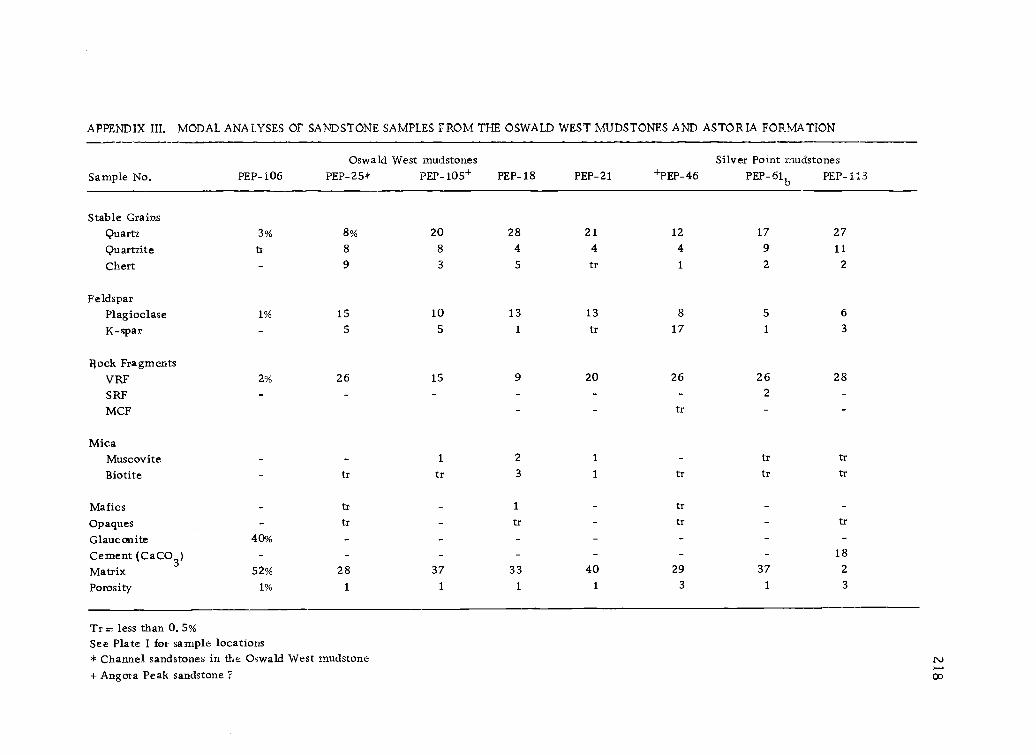
APPENDIX HI. MODAL ANALYSES OF SANDSTONE SAMPLES FROM THE OSWALD WEST IvIUDSTONES AND ASTOR IA FORMATION
Sample No. PEP-106Oswald West mudstones
PEP-25* PEP-105+ PEP-18 PEP-21 +PEP-46Silver Point mudstones
PEP -61b PEP-113
Stable GrainsQuartz 3% 8% 20 28 21 12 17 27
Quartzite tr 8 8 4 4 4 9 11
Chert 9 3 5 tr 1 2 2
FeldsparPlagioclase 1% 15 10 13 13 8 5 6
K-spar 5 5 1 tr 17 1 3
Flock FragmentsVRF 2% 26 15 9 20 26 26 28
SRF - - - - 2
MCF - tr
MicaMuscovite 1 2 1 tr trBiotite tr tr 3 1 tr tr tr
Mafics tr - 1 tr -Opaques tr - tr - tr tr
Glauconite 40% - _ - - - -Cement (CaCO3) - - - - - 18
Matrix 52% 28 37 33 40 29 37 2
Porosity 1% 1 1 1 1 3 1 3
Tr = less than 0. 5%See Plate I for sample locations* Channel sandstones in the Oswald West mudstone+ Angora Peak sandstone T co

APPENDIX I II. ( Continued )MODAL ANALYSES OF SANDSTONE SAMPLES FROM THE CAPE FOULWEATHER INTERBEDS AND CHANNEL SANDS
Sample no. PEP -3
Cape Foulweather lnterbedsPEP -5 PEP-12.2
Pleistocene Channel ConglomeratePEP-74*
Stable GrainsQuartz 22% 28% 20 15%
Quartzite tr 9 3 3
Chert 5 3 2 1
FeldsparPlagioclase 12 24 16 5
K-spar 4 tr tr tr
Rock FragmentsVRF 2 tr 1 52
SRF
MicaMuscovite 5 3 3 1
Biotite 7 6 7 tr
Mafics 1 1 1 1
Opaques 1 tr 1
GlauconiteCement (CaCO3)Matrix 40 23 47 21
Porosity 2 tr 1
tr = less than 0. 5%See Plate I for sample locations*Sand matrix of cobble conglomerate

APPENDIX IV, ANALYSES OF SELECTED SANDSTONESStatistical parameters are those of Folk and Ward (1957).
Samples:Granule Sand Silt + Clay Coarsest
1% mmMedian'
mmMedian'
phiMeanphi
Sortingphi
Skewnessphi
PEP-25 3.32 90.68 6.00 3.6044
1.18 1.12 1.52 .20
PEP-65 0 93.90 6.10 1.30 . 27 1.88 1.82 1.21 . 28
PEP-112 0 90.46 9.54 .94 . 23 2.12 2.00 1.14 . 63
PEP -502 0 95.09 4.91 1.80 . 55 . 85 . 88 1.26 . 12
PEP-35 0 81.72 18.28 .50 . 13 2.92 3.33 1.98 . 17
PEP-3 0 75.45 24.55 .55 . 11 3.18 3.23 -
PEP-5 0 70.62 29.38 .53 . 11 3.19 3.23
1From Inman (1952).

APPENDIX IV. (Continued)
Sample Location
Oswald West mudstone
PEP-35
channel sandstones
PEP-25
PEP-65
Silver Point mudstone
PEP-112
PEP-502
Cape Foulweather interbeds
PEP-3
PEP-5
Roadcut: NW 1/4 SE 1/4 section 14, T. 5 N., R. 9 W.
Roadcut: NE 1/4 SW 1/4 section 15, T. 5 N. , R. 9 W.
Roadcut: SE 1/4 SW 1/4 section 9, T. 5 N., R. 8 W.
Stream bank: SW corner of section 36, T. 6 N., R. 9 W.
Roadcut: NW 1/4 NW 1/4 section 36, T. 6 N. , R. 9 W.
Roadcut: NE 1/4 SW 1/4 section 31 T. 6 N., R. 9 W.
Roadcut: SW 1/4 NE 1/4 section 18 T. 5 N., R. 9 W.

222
APPENDIX V. PEBBLE COUNT
SamplesChannel sandstone
PEP-25
Metamorphic Quartzite 20%
Sedimentary Quartzite 4%
Chert 23%
Quartz 6%
Basic Volcanic 44%
Welded Tuff 1%
Acid Igneous( ?) 1%
Basic Igneous 1%
Based on 319 pebbles and granules from a pebbly sandstone, identified in thin sections.
Location: Roadcut, Clatsop Fir Main Line logging road: NW 1/4 SW 1/4, section 15,T. S N., R 9 W.

223
APPENDIX VI. CLAY MINERALOGY OF SELECTED SAMPLES
Procedure
Clay minerals contained in four Oswald West and Silver Point mudstones and the matrix
from three Tertiary sandstones were determined by X-ray diffraction methods using a Norelco
X-ray diffractometer in the Department of Geology at Oregon State University. Pretreatment
included disaggregation by gentle grinding, soaking in hot water, and cation (Mg) saturation of
the clays. After dispersion of the fine-grained sediment in a Calgon solution, the silt fraction
was removed by centrifuging and the clay size fraction was smeared onto glass slides for X-ray
diffraction analysis. Four runs were made on each sample 1) dried at room temperature; 2)
treated with ethylene glycol overnight; and 3) heated to 400° C for 1 hr.

APPENDIX VI. CLAY MINERALOGY OF SELECTED SAMPLES ( Locations are shown in Plate I).
Chloritic Chlorite/
Sample Smectite Intergrades Kaolinite Mica Glauconite
Oswald West mudstones:
PEP-500
PEP-105
PEP-103
Silver Point mudstones:
PEP-17
PEP-111
Interbedded sandstones:
PEP-5
Channel sandstones:
PEP-25
x
x
x - x
x - -
x - -

225
APPENDIX VII. DETERMINATION OF WEIGHT PERCENT TOTAL HYDROCARBON
Procedure
The pyrolysis-fluorescence is a quantitative means of determining weight percent total live
hydrocarbons in possible mudstone and sandstone source rocks. Determinations on 23 rock samples
ranging in grain size from clay-rich silty mudstones to fine-grained sandstones were made. The
procedure, described by Shell Development Company for use in its Northwest Division Source Rock
Laboratory, was followed with minor changes. Each sample was prepared by crushing the rock
sample to small pieces slightly larger than a coarse powder and thoroughly mixing. A 0.2 gm
sample was then placed in a 10x75 culture tube and heated over a Bunsen burner flame until it
emitted a red glow. After cooling, chlorothene (1, 1, 2-trichloroethane, practical grade) was added
followed by immediate decanting of the supernatant to a clean test tube. After calibration of the
pre-warmed Turner No. 110 Fluorometer with a known fluorescent standard ( 42 ± 2 fluorescence
units) successive unknowns were determined. Weight percent total hydrocarbon in the samples was
determined by comparison of fluorescence readings with an empirically derived curve provided by
Shell Oil Company that relates fluorescence units to hydrocarbon abundance.
Most samples were from roadcut exposures and few are fresh due to the deep weathering effects
in the area. Therefore the assumption was made that all samples were at least slightly weathered
and may not be truly representative of source rock hydrocarbon quality of subsurface unweathered
strata. This fluorescence method does not determine the percent of light hydrocarbons in the
sample such as methane gas.

226
APPENDIX VII. ( Continued)
HYDROCARBON CONTENT OF SELECTED SAMPLES
( Locations are shown in Plate I)
Sample No.Unit and Wt. % Total Source rockLithology Hydrocarbon qualtiy
PEP-7 O. W. mudst. < 0.5 non-source
PEP-16 S. P. siltst. < 0.5 non-source
PEP-20 0. W. tuffaceous siltst. < 0.5 non-source
PEP-21 S. P. bedded mudst. / sandst. < 0.5 non-source
PEP-35 0. W. fine sandst. < 0.5 non-source
PEP-37 0. W. fine sandst. < 0.5 non-source
PEP-40 0. W. dk. mudst. < 0.5 non-source
PEP-41 O. W. dk. mudst. < 0.5 non-source
PEP-42 0. W. dk. mudst. < 0.5 non-source
PEP-43 0. W. dk. mudst. < 0.5 non-source
PEP-44 0. W. dk. mudst. < 0.5 non-source
PEP-53 0. W. mudst. < 0.5 non-source
PEP-56 O. W. dk. mudst. < 0.5 non-source
PEP-61 S. P. sandy silst. < 0.5 non-source
PEP-62 S. P. laminated siltst. < 0.5 non-source
PEP-74 channel sandst. < 0.5 non-source
PEP-75 channel sandst. < 0.5 non-source
PEP-78 0. W. mudst. < 0.5 non-source
PEP-82 S. P. laminated sandst < 0.5 non-source
PEP-99 0. W. mudst. < 0.5 non-source
PEP-111 S. P. micaceous laminated dk. mudst 0.9 marginal source
PEP-112 S. Pdk. mudst. < 0.5 non-source
PEP-121 S. P. bedded mudst / sandst < 0.. 5 non-source

APPENDIX VII. ( Continued)
Sample
Oswald West mudstones:
PEP-500
PEP -105
PEP-103
Silver Point mudstones:
PEP-17
PEP-111
Interbedded sandstones:
PEP-5
Channel sandstones
PEP-25
Mudstone outcrop in roadcut: SW 1/4 SE 1/4, section 17, T. 5 N. , R. 8 W.
Sandstone outcrop in roadcut: C, SE 1/4, section 8, T. 5 N., R. 9 W.
Tuffaceous siltstone outcrop in roadcut: SW 1/4 NE 1/ section 17, T. 5 N., R. 9 W.
Green bentonite bed in roadcut: NE 1/4 SW 1/4, section 35, T. 6 N., R. 9 W.
Laminated micaceous mudstones in streamcut: NW 1/4 SE 1/4, section 3, T. 5 N., R. 9 W.
Massive sandstone bed in roadcut: SW 1/4 NE 1/4, section 31, T. 6 N. , R. 9 W.
Massive pebble sandstone in roadcut: NE 1/4 SW 1/4 section 15, T. 5 N., R. 9 W.

APPENDIX VIII.
Plot No.Sample:
CHEMICAL ANALYSES OF SELECTED BASALT SAMPLES
1 2 3 4
PEP-22 PEP-93 PEP-77 PEP-89a
5
PEP-926
PEP-1197
PEP-868
PEP-6029
PEP-10
SiO2
51.4 51.6 52.8 53.0 53.1 54.3 54.3 54.5 54.8
Al22O3
3
12.6 12.7 13.5 14.0 13.8 13.8 13.5 13.0 13.5
FeO 15.7 15.7 13.5 10.9 12.9 12.3 13.2 14.3 13.9
MgO 4. 1 4. 1 5. 2 3. 1 4,8 5. 6 3. 7 3.6 3. 5
CaO 7.8 7.7 8.6 8.7 8.0 8.6 6.7 6.9 6.4
Na.220 3. 3 3. 2 3. 3 3. 6 3. 2 3.0 3. 5 3. 5 3. 6
K2O 0. 90 1. 10 0. 80 0.80 1. 00 0. 85 1. 50 1.45 1. 65
TiO2
3. 25 3. 15 1. 85 3. 30 1.90 0.60 2.40 2. 35 2. 10
P2O5 - - - - - - -
Plot No. 10 11 12 13 14 15 161 3
Sample: PEP-601 PEP-600 PEP-67 PEP-63 PEP-75 PEP-58 PEP-13 SR64-171
SiO2
55. 3 55.7 55. 8 55.9 56. 0 56.5 50. 0 54.2A1203 13.5 12.8 13.3 13.1 14.9 13.4 12.6 14.3
FeO 13.7 14.0 13.2 13.2 11.4 12.6 10.5 11.6
MgO 3.2 3.6 3.7 3.7 2.9 3.8 2.7 4.7CaO 6.0 6.4 6.2 6.8 5.6 6.1 12.2 8.7Na2O 2. 5 3. 6 3. 4 3. 6 3. 8 3. 5 1. 5 3. 1
K2O 1. 55 1. 60 1. 80 1.40 2. 05 1.05 1. 45 2. 3
TiO2
2. 25 2.05 2. 30 1.95 2. 55 2.05 1. 75 2. 50
P2O5 0.44
'Basalt cobble from stream channel2Altered hyaloclastite, not plotted in figure 493From: Snavely and others, 1973 N.)
co

229
APPENDIX VIII. (Continued)
Sample Locations
Depoe Bay Basalts:
PEP-22 : Sill: C NW 1/4, section 4, T. 5 N., R. 9 W.a
PEP-77: Dike: Saddle Mountain, C NW 1/4, section 33, T. 6 N., R. 8 W.
PEP-119: Sill: NE 1/4 SE 1/4, section 11, T. 5 N., R. 9 W.
PEP-602: Pillow: C SW 1/4, section 2, T. 5 N., R. 9 W.
PEP-10: Sill: C NW 1/4, section 5, T. 5 N. , R. 9 W.
PEP-601: Breccia: NW 1/4 NE 1/4, section 3, T. 5 N. , R. 3 W.
PEP-600: Sill: SW 1/4 SW 1/4, section 34, T. 6 N. , R. 9 W.
PEP-67: Dike: NE 1/4 NE 1/4, section 10, T. S N , R. 8 W.
PEP-63: Flow: Humbug Mountain, NW 1/4 SW 1/4, section 9, T. 5 N.,
R. 8 W.
PEP-75: Cobble from channel conglomerate: SW 1/4 SW 1/4, section 34,
T. 6 N., R. 9 W.
PEP-58 Large dike: Humbug Mountain, E 1/3 SW 1/4, section 17,
T. 5 N., R. 8 W.
PEP-13: Hyaloclastite: NE 1/4 SE 1/4, section 32, T. 6 N., R. 9 W.
SR 64-171: Pillow: SW 1/4, section 28, T. 6 N., R. 8 W.
Cape Foulweather Basalts:
PEP-93:
PEP-89:
PEP-92:
PEP-86:
Dike: NE 1/4 NW 1/4, section 4, T. 5 N., R. 9 W.
Breccia: NE 1/4 SE 1/4, section 31, T. 6 N., R. 9 W.
Small sill: SE 1/4 SW 1/4, section 33, T. 6 N., R. 9 W.
Dike: SE 1/4 NW 1/4, section 27, T. 6 N., R. 8 W.

APPENDIX IX. STATISTICAL PARAMETERS FROM SIZE ANALYSES PLOTTED ON PASSEGA'S
(1957) CHART
C = 4, 000Basic Patterns
C = 1, 000
C = 500
C = 100
I, N, VI: rivers, tractive currentsII, VIa, VIb: turbidity currentsIII: quiet water depositsVII: beachers
65VII
25
M=10
M = median in microns
C = size with 1% coarser in microns
M=100 1, 000
23 0

APPENDIX IX. ( Continued)STATISTICAL PA RAMTETRS FROM SIZE ANALYSES PLOTTED ONFRIEDMAN'S (1962) GRAPHS
+2
+1
0
- 1
- 2
1.0
0. 8
0. 6
0.4
0. 2
Surf
TractiveCurrents
112
65112 25 0.)
35 '502
0.2 0.4 0. 6 0.8 1.0Standard Deviation (sorting)
1.2
Mixed
0 250 65502
Om, 635
TractiveCurrents
Wind
-1 0 +1
Mean Size
+2
(in 1)
+3
23 1

APPENDIX X. KEY TO FIGURES 58-66
Symbols
Strand line
Swamp
Gently rollingplain
Barrier baror island
eustatic curve
P = present sea level
FissUres
Intrusive
Probable volcaniccenter
Syncline
Anticline
Fault (hatchures ondownthrown side)
\it
Litho logy
Sands tone
Silts tone
Muds tone(burrowed)
Glauconitic ss.lense
Pillow basaltsand brecciasDepoe BayCape Foulweather
23 2
Areal distribution of lavas
1. Depoe BayCape Foulweather
overlap areas2. Subaerial plateau
derived basalts