Perdaman Urea Project
307
Perdaman Urea Project Environmental Review Document Perdaman Chemicals and Fertilisers 26 March 2020 Cardno i Perdaman Urea Project Environmental Review Document Assessment No. 2184 (WA) – 2018/8383 (Commonwealth) Prepared for Perdaman Chemicals and Fertilisers by Cardno Rev 3.1 26 March 2020
-
Upload
khangminh22 -
Category
Documents
-
view
1 -
download
0
Transcript of Perdaman Urea Project

Perdaman Urea Project Environmental Review Document
Perdaman Chemicals and Fertilisers
26 March 2020 Cardno i
Perdaman Urea Project
Environmental Review Document
Assessment No. 2184 (WA) – 2018/8383 (Commonwealth)
Prepared for Perdaman Chemicals and Fertilisers by Cardno Rev 3.1 26 March 2020

© Cardno. Copyright in the whole and every part of this document belongs to Cardno and may not be used, sold, transferred, copied or reproduced in whole or in part in any manner or form or in or on any media to any person other than by agreement with Cardno. This document is produced by Cardno solely for the benefit and use by the client in accordance with the terms of the engagement. Cardno does not and shall not assume any responsibility or liability whatsoever to any third party arising out of any use or reliance by any third party on the content of this document.
EPA Assessment 2184 EPBC referral 2018/8383
ii
Contact Information Document Information Cardno (WA) Pty Ltd
ABN 77 009 119 000
11 Harvest Terrace
West Perth WA 6005
Australia
www.cardno.com
Phone +61 8 9273 3888
Fax +61 8 9486 8664
Prepared for Perdaman Chemicals and
Fertilisers
Project Name Perdaman Urea Project
File Reference
EPA Assessment
No
2184
EPBC referral No 2018/8383
Date 26 March 2020
Version Number 3.1
Document Control Version Effective Date Description of Revision Prepared by Reviewed by
Rev A 15/02/2019 Internal Draft Template MB DH
Rev B 30/07/2019 Internal Draft MB/RD DH
Rev C 23/08/2019 External Draft (Client review) MB/DH PS/SNC/PCF
Rev D 01/09/2019 Final Draft MB DH
1.0 04/10/2019 Final Draft (EPA submission) MB/DH EPA
1.1 21/10/2019 Final Draft Rev 1 MB/DH EPA
1.2 14/11/2019 Final Draft Rev 2 MB/DH DMAs
1.3 13/12/2019 Heritage survey inputs MB/PS/DH DMA/DoEE
2.0 20/03/2020 DMA review comments MB/PS/BR/DH/NH ME/DH
3.0 25/03/2020 Final Review. BR DH
3.1 26/03/2020 Public Review JA/BR DH

Invitation to make a submission
The Environmental Protection Authority (EPA) invites people to make a submission on the environmental review for this proposal.
Perdaman Chemicals and Fertilisers Pty Ltd proposes to establish a state of the art urea production plant at the proposed Burrup Strategic Industrial Area, approximately 10km from Dampier and 20km north-west of Karratha on the north-west coastline of Western Australia. The Environmental Review Document (ERD) has been prepared in accordance with the EPA’s Procedures Manual (Part IV Divisions 1 and 2). The ERD is the report by the proponent on their environmental review which describes this proposal and its likely effects on the environment.
The ERD is available for a public review period of 12 weeks from Monday 30th March, 2020, closing on
Monday 22nd June, 2020.
Information on the proposal from the public may assist the EPA to prepare an assessment report in which it will make recommendations on the proposal to the Minister for Environment.
Why write a submission?
The EPA seeks information that will inform the EPA’s consideration of the likely effect of the proposal, if implemented, on the environment. This may include relevant new information that is not in the ERD, such as alternative courses of action or approaches.
In preparing its assessment report for the Minister for Environment, the EPA will consider the information in submissions, the proponent’s responses and other relevant information.
Submissions will be treated as public documents unless provided and received in confidence, subject to the requirements of the Freedom of Information Act 1992.
Why not join a group?
It may be worthwhile joining a group or other groups interested in making a submission on similar issues. Joint submissions may help to reduce the workload for an individual or group. If you form a small group (up to 10 people) please indicate all the names of the participants. If your group is larger, please indicate how many people your submission represents.
Developing a submission
You may agree or disagree with, or comment on information in the ERD.
When making comments on specific elements in the ERD:
> Clearly state your point of view and give reasons for your conclusions.
> Reference the source of your information, where applicable.
> Suggest alternatives to improve the outcomes on the environment.
What to include in your submission
Include the following in your submission to make it easier for the EPA to consider your submission:
> Your contact details – name and address.
> Date of your submission
> Whether you want your contact details to be confidential.
> Summary of your submission, if your submission is long.
> List points so that issues raised are clear, preferably by environmental factor.
> Refer each point to the page, section and if possible, paragraph of the ERD.
> Attach any reference material, if applicable. Make sure your information is accurate.

The closing date for public submissions is: Monday 22nd June, 2020The EPA prefers submissions to be made electronically via the EPA’s Consultation Hub at https://consultation.epa.wa.gov.au.
Alternatively submissions can be:
> posted to: Chairman, Environmental Protection Authority, Locked Bag 10, Joondalup DC, WA 6919, or
> delivered to: the Environmental Protection Authority, Prime House, 8 Davidson Terrace, Joondalup, WA6027.
If you have any questions on how to make a submission, please contact the EPA Services at the Department of Water and Environmental Regulation on 6364 7000.

Perdaman Urea Project Environmental Review Document
Perdaman Chemicals and Fertilisers
EPA Assessment 2184 EPBC referral 2018/8383
v
Scoping checklist
The table below summarises the work required for each preliminary key environmental factor and the relevant Section of this ERD where the outcome of the environmental impact assessment is presented.
Task No.
Scope of work Section No.
Coastal Processes 4.2
1.1. Review the potential impacts associated with the Proposal on coastal processes. 4.2.4
1.2. Describe water movements and the period and frequency that the area either side of the causeway is flooded, pre- and post-construction, including under cyclonic conditions.
4.2.5
1.3. Describe the potential consequences of any changes to sediment erosion and deposition and to adjacent benthic communities and habitats.
4.2.5
1.4. Demonstrate how the Proposal has been located and designed to avoid, minimise and mitigate impacts to coastal processes.
4.2.6
1.5. Demonstrate and document how the EPA’s objective for this factor can be met. 4.2.6
1.6. To the extent that residual impacts cannot be avoided, reduced, mitigated or subsequently restored, describe the implementation of appropriate offsets.
NA
Marine Environmental Quality 4.3
2.1. Confirm that the Project wastewater discharge quantity can be accommodated by the Water Corporation approved MUBRL.
Appendix J
2.2. Demonstrate how all reasonable and practicable steps have been taken to prevent or minimise the wastewater discharge and associated contaminants from the Proposal.
4.3.5
2.3. Describe the volume, composition and frequency of wastewater discharge from the urea plant to the MUBRL.
4.3.5
2.4. Demonstrate that the residual contaminants in the predicted wastewater discharge from the Proposal, in combination with other future industrial discharges to the MUBRL, will not compromise the ability of the Water Corporation to meet the requirements of Ministerial Statement 594 and the ANZECC and ARMCANZ (2000) species protection level water quality guidelines within the 0.01 km2 mixing zone as recommended in the EPA Report 1044.
4.3.5
2.5. Prepare a monitoring and management plan prior to construction that establishes acceptable water quality targets for the urea plant discharge to the MUBRL and the monitoring locations, frequency, measurement protocols, assessment protocols, management commitments and reporting arrangements for demonstrating the water quality targets are met.
Appendix K
2.6. Assess the potential impact on marine water quality from the Proposal’s air emissions and demonstrate the application of the mitigation hierarchy.
Table 4-5
Marine Fauna 4.4
3.1. Describe the marine fauna likely to be impacted by the Proposal, including identification of critical habitat and ecological windows for affected species (including, but not limited to, the Loggerhead Turtle – Caretta caretta, the Green
Appendix C

Perdaman Urea Project Environmental Review Document
Perdaman Chemicals and Fertilisers
EPA Assessment 2184 EPBC referral 2018/8383
vi
Task No.
Scope of work Section No.
Turtle - Chelonia mydas, the Leatherback Turtle – Dermochelys coriacea, Hawksbill Turtle – Eretmochelys imbricate and the Flatback Turtle – Natator depressus).
3.2. Assess the values and significance of marine fauna likely to be impacted by the Proposal.
Appendix C
3.3. Quantify the likely direct and indirect impacts to marine fauna in terms of the extent, duration and severity.
4.4.5
3.4. Outline the proposed mitigation measures and monitoring strategies to avoid and/or minimise impacts on marine fauna.
4.4.6
3.5. To the extent that residual impacts cannot be avoided, reduced, mitigated or subsequently restored, describe the implementation of appropriate offsets.
4.4.7
Flora and Vegetation 4.5
4.1. Characterise the flora and vegetation within the proposed project area including its significance within a wider regional context.
4.5.3
4.2. Identify and characterise the flora and vegetation of areas that may directly or indirectly be impacted by the proposal in accordance with Technical Guidance - Flora and Vegetation Surveys for Environmental Impact Assessment, December 2016. This should include sampling more broadly to inform local and regional context.
Appendix B
4.3. Review and revise as appropriate, matters in relation to the northern option for realignment of Hearson Cove Road to further inform and update the previous considerations pursuant to EPA Bulletin 985 and Ministerial Statement 552 on relevant environmental impacts.
4.5.5
4.4. Provide an analysis of the vegetation and significant flora species present and likely to be present within the proposed development envelope, including any potential indirect impact areas outside of the project footprint. Include a quantitative assessment of levels of impact on significant flora, priority ecological communities and all vegetation units. Index of Biodiversity Surveys for Assessments (IBSA) data package will be provided with the draft ERD.
a. For significant flora, this includes:
i. Establish a regional baseline context
ii. Number of individuals and population records in the context of the Murujuga National Park and other surveyed sites
iii. Numbers and proportions of individuals and populations directly or potentially indirectly impacted, and
iv. Number / proportions / populations currently protected within the conservation estate (where known)
b. For significant ecological communities and all vegetation units this includes:
i. The area of representation in the project area (in hectares) and relative to representation in the Murujuga National Park directly or potentially indirectly impacted, and
ii. Proportion / hectares of the species, community or vegetation unit currently protected within conservation estate
4.5.3, Appendix B
4.5. Demonstrate application of the mitigation hierarchy and that all reasonable and practicable measures have been taken to reduce the proposed project footprint
4.5.6

Perdaman Urea Project Environmental Review Document
Perdaman Chemicals and Fertilisers
EPA Assessment 2184 EPBC referral 2018/8383
vii
Task No.
Scope of work Section No.
based on progress in the Proposal design and understanding the environmental impacts.
4.6. Outline the proposed mitigation measures and monitoring strategies to avoid and/or minimise impacts on flora and vegetation.
4.5.6, Appendix K
4.7. To the extent that residual impacts cannot be avoided, reduced, mitigated or subsequently restored, describe the implementation of appropriate offsets.
4.5.7
Section 7
Terrestrial Fauna 4.6
5.1. Characterise the terrestrial fauna within the proposed project area including its significance within a wider regional context.
4.6.3
5.2. Undertake fauna surveys, as required and in accordance with the EPA Technical Guidance, in areas that are likely to be directly or indirectly impacted as a result of the Proposal. Where surveys were undertaken prior to scoping, justification will be provided to demonstrate that they are relevant and consistent with current EPA Guidance.
Appendix B
5.3. Describe the impacts and risks associated with the proposal on the identified species including, but not limited to, the Olive Python (Pilbara subspecies) (Liasis olivaceus barroni), the Northern Quoll (Dasyurus hallucatus) and the Ghost Bat (Macroderma gigas).
4.6.4, 4.6.5, Appendix B
5.4. Identify the potential impacts to the Priority 1 Priority Ecological Community (PEC) – Burrup Peninsula Rock Pool Communities, including Short-Range Endemics (SREs).
4.6.5
5.5. Identify likelihood of EPBC Act conservation significant species to occur within/near the proposed project area, including:
a. Information on the abundance, distribution, ecology, and habitat preference of the listed species.
b. Information on the conservation value of each habitat type from a local and regional perspective, including the percentage representation of each habitat type on site in relation to its local and regional extent.
c. If a population of a listed species is present on the site, its size and the importance of that population from a local and regional perspective.
d. An assessment of the risk of impact to any listed threatened species as a result of project activities.
e. IBSA data package will be provided with the draft ERD.
6.7, Appendix B
5.6. Analyse the extent of clearing, including the type of habitat to be cleared or impacted, and determine the significance of impact in relation to terrestrial fauna, including the listed threatened species and listed migratory species.
4.6.5
5.7. Review and revise as appropriate, matters in relation to the northern option for realignment of Hearson Cove Road to further inform and update the previous considerations pursuant to EPA Bulletin 985 and Ministerial Statement 552 on relevant environmental impacts.
4.6.5
5.8. Demonstrate application of the mitigation hierarchy to avoid and minimise impacts to terrestrial fauna.
4.6.6
5.9. Describe the proposed mitigation measures and monitoring strategies to avoid and/or minimise impacts on terrestrial fauna.
4.6.6, Appendix K

Perdaman Urea Project Environmental Review Document
Perdaman Chemicals and Fertilisers
EPA Assessment 2184 EPBC referral 2018/8383
viii
Task No.
Scope of work Section No.
5.10. To the extent that residual impacts cannot be managed to ALARP, describe the implementation of appropriate offsets.
7
5.11. Demonstrate and document how the EPA’s objective for this factor can be met. 4.6.7
Inland Waters 4.7
6.1. Identify and describe the environmental values and significance of the hydrological regime within the development envelope.
4.7.3
6.2. Assess the potential impacts from construction and operation of the Proposal on the dependent environmental values identified.
4.7.5
6.3. Review and revise as appropriate matters in relation to the northern option for realignment of Hearson Cove Road to further inform and update the previous considerations pursuant to EPA Bulletin 985 and Ministerial Statement 552 on relevant environmental impacts.
4.7.5
6.4. Demonstrate application of the mitigation hierarchy and that all reasonable and practicable measures have been taken to ensure hydrological regime and groundwater quality are maintained.
4.7.6
6.5. Develop an environmental monitoring program to outline the proposed monitoring regime to ensure the objectives for surface water and groundwater quality are being achieved and to include contingency measures in the event that they are not met.
4.7.6
6.6. Demonstrate and document how the EPA’s objective for this factor can be met. 4.7.7
Air Quality 4.8
7.1. Characterise existing (baseline) air quality and meteorology within the Murujuga airshed, drawing on the findings of relevant studies and publicly available monitoring datasets. This would be undertaken either separately by the Proponent, or collaboratively with other industry data custodians.
4.8.3.3
7.2. Identify the key air pollutants of potential concern and characterise the emissions from the Project and other existing and proposed future industrial emission sources and both existing and proposed future shipping activities within the Murujuga airshed, within the context of the current air emissions inventory for the region.
4.8.4, Appendix D
7.3. Identify the key sensitive receptors in terms of potential health and amenity impacts and heritage values within the Murujuga airshed.
4.8.4
7.4. Evaluate the potential incremental impact of air emissions from the Project on key receptors in the vicinity of the project area.
a. Undertake air dispersion modelling. The objective of this modelling is to predict the potential ambient air quality impacts of the Project. This will include scenarios considering the emissions from the Project (in isolation), the increased emissions that would be generated during start-up, upset conditions, and shutdown; and the incremental cumulative impact of the Project considering other industry currently operating (or approved to operate but yet to be built) and proposed future industrial facilities such as Wesfarmers Downstream Chemical
4.8.5

Perdaman Urea Project Environmental Review Document
Perdaman Chemicals and Fertilisers
EPA Assessment 2184 EPBC referral 2018/8383
ix
Task No.
Scope of work Section No.
Production Facility1 in the project area. Emissions from existing and proposed future shipping activities will also be included in the cumulative air quality modelling scenarios2. Contour plots and tables listing the modelled ambient ground level concentrations for the air pollutants of concern for the relevant modelling scenarios will be included.
b. Evaluate the potential incremental human health and amenity impact of the Project by assessing predicted pollutant concentrations in the ambient air at key receptors against relevant ambient air quality standards.
c. Evaluate the potential incremental risk of impact upon rock art by assessing predicted pollutant deposition rates at key sensitive receptors. This assessment will be done within the context of the Murujuga Rock Art Strategy (released on 15 February 2019), which provides a monitoring, analysis and decision-making framework to protect Aboriginal rock art located on the Dampier Archipelago and Burrup Peninsula listed National Heritage Place.
7.5. Identify and justify all reasonable and practicable emission reduction equipment and proposed technologies, and demonstrate the use of industry best practice pollution control technology and plant processes including benchmarking against world’s best practice for urea production plants.
4.8.6, Apppendix L
7.6. Characterise greenhouse gas emissions (type and quantities) from the Project and estimate the expected direct and indirect greenhouse gas emissions in accordance with the National Greenhouse and Energy Reporting Act 2007 (NGER Act), and assess the contribution to regional, state, national, and international greenhouse gas emissions
4.8.4.2
Appendix E
7.7. Analyse greenhouse gas intensity (i.e. quantity of carbon dioxide equivalent - CO2-e generated per tonne of product produced) and compare with published current benchmarked world’s best practice for urea production plants, equipment and operations. Develop a Greenhouse Gas Management Plan and detail the management and mitigation measures that will be used to reduce greenhouse gas emissions and improve operational efficiency using the mitigation hierarchy, including the management and mitigation measures that can be implemented over time to achieve a long-term reduction in greenhouse gas emissions. Identify and justify the contemporary best practice management and mitigation measures that will be implemented.
Appendix E,
Appendix K
7.8. Include information on the development of an Air Quality Management Plan and the objectives, management and mitigation measures, trigger and contingency actions, and monitoring of air emissions and ambient air quality, that will be employed to ensure that residual impacts are not greater than predicted. Potential credible opportunities to achieve a long-term reduction in air emissions of concern using best practice measures will be identified and evaluated in the ERD.
Appendix K
7.9. Demonstrate and document how the EPA’s objective for this factor can be met. 4.8.7
1In relation to proposed future industrial facilities it is noted that as these facilities are only proposals and not yet approved, relevant primary emissions data may not be accessible in the public domain. While best endeavours will be used to access relevant primary data, where this cannot be sourced the modelling will include generic surrogate information for a comparable plant and sited in the proposed development location. 2 In relation to emissions from shipping it is noted that primary data recording emissions from actual individual or aggregate shipping movements in the Port of Dampier is not available. Therefore, an appropriate surrogate dataset as agreed with the Air Quality Branch and WA EPA will be incorporated in the model to account for this source of emissions into the Murujuga airshed.

Perdaman Urea Project Environmental Review Document
Perdaman Chemicals and Fertilisers
EPA Assessment 2184 EPBC referral 2018/8383
x
Task No.
Scope of work Section No.
7.10. Predict the extent, severity, and duration of any residual impacts associated with the air pollutant and greenhouse gas emissions from the Project that may be expected after implementing the proposed management and mitigation measures.
4.8.7
Social Surroundings 4.9
8.1. Identify and characterise the existing amenity enjoyed in the area, including further stakeholder consultation processes.
4.9.3
8.2. Identify relevant locations of traditional cultural or heritage significance to Aboriginal people with a connection to country within the Project footprint, including further consultation with the Traditional Owners.
4.9.5.2
8.3. Identify, describe, document and map the natural, historical and cultural heritage values that may be impacted, including, but not limited to, those of the Dampier Archipelago (including Burrup Peninsula) National Heritage Listed Place, as well as proposed culturally appropriate avoidance and mitigation measures.
4.9.5, 4.9.6, Appendix K
8.4. Ensure all responsibilities and requirements under the Aboriginal Heritage Act 1972 are met, including any relevant and necessary Aboriginal heritage and cultural survey requirements.
4.9.5.2
8.5. Outline in detail and review traffic impacts of construction and operational aspects of the urea Project, particularly with respect to the relocation of the Hearson Cove access road and provide mitigation strategies to ensure impacts are avoided or minimised.
Appendix H
8.6. Conduct a landscape and visual impact assessment including an assessment of impacts from an Aboriginal cultural context. This will include:
a. Description of the visual components of the proposal
b. Landscape character assessment and a viewshed analysis
c. Assessment of the likely range of visual impacts from indicativeviewpoints within the public domain and any residential receptors, aswell as considering cumulative impacts
d. Provide management strategies, if required, for minimising the visualimpact from publicly accessible viewpoints and for residentialreceptors; and
e. Identify any significant issues for consideration in the plant design /layout.
Appendix G
8.7. Conduct analysis, modelling and predictions of impacts from odour, dust and noise emissions, including likely potential amenity impacts associated with various urea plant operating scenarios. This will include:
a. Ambient noise monitoring to determine the existing noise levels
b. Operational noise modelling and assessment
c. Construction noise and vibration impact assessment
d. Outline mitigation strategies to minimise potential impacts, including,but not limited to, potential impacts to the values of the NHL area
4.9.3.3, 4.9.5.4, 4.9.6
Appendix F
8.8. Provide a summary of proposed technologies, emission reduction equipment and management practices to demonstrate how potential impacts have been avoided or minimised.
Appendix L

Perdaman Urea Project Environmental Review Document
Perdaman Chemicals and Fertilisers
EPA Assessment 2184 EPBC referral 2018/8383
xi
Task No.
Scope of work Section No.
8.9. Describe proposed management and monitoring arrangements to ensure residual impacts on amenity are not greater than predicted and achieve predicted outcomes/objectives.
4.9.6
8.10. Develop a specific Heritage Management Plan that outlines how heritage sites will be protected and preserved, including detail of the procedure, requirements and contingencies against local land and cultural heritage disturbance (including those associated with the realignment of Hearson Cove Road). This Management Plan will be endorsed by MAC as a representative of the Traditional Owners.
Appendix K
8.11. Summarise residual impacts on amenity, after considering avoidance and minimisation. If significant residual impacts remain, propose appropriate offsets.
4.9.7
8.12. Demonstrate and document how the EPA’s objective for this factor can be met. 4.9.7
8.13. Outline an approach to improvement planning for industry best practical approach to emissions reduction and risk management relevant to amenity.
4.9.6

Perdaman Urea Project Environmental Review Document
Perdaman Chemicals and Fertilisers
EPA Assessment 2184 EPBC referral 2018/8383
xii
Executive Summary
Introduction
Perdaman Chemicals and Fertilisers Pty Ltd proposes to establish a state of the art urea production plant (‘the Project’) using natural gas as feedstock within the Burrup Strategic Industrial Area (BSIA), on the Burrup Peninsula approximately 8 km from Dampier and 20 km north-west of Karratha on the north-west coastline of Western Australia (Figure ES1).
The urea plant will have a production capacity of approximately 2 million tonnes per annum (Mtpa) on Sites C and F within the BSIA, with a causeway linking the two sites. The project will access these sites through a 40-year lease, with option to extend for a further 40-years (i.e. for a project life of up to 80 years), fromDevelopmentWA (formerly LandCorp). The Project proposes to utilise common-user infrastructure andcorridors to transfer urea for product export through the Port of Dampier.
The Project involves piping natural gas from the nearby Woodside LNG plant to the Project site under a long-term commercial off-take agreement.
The Project has been granted Project of State Significance status under the Lead Agency Framework by the WA Government. The Project has also been granted Major Project Facilitation (MPF) status by the Commonwealth Government.
Background and context
Murujuga (meaning “hip bone sticking out”) is the traditional Aboriginal name for the Dampier Archipelago and surrounding islands, including the Burrup Peninsula. The Ngarda-Ngarli people are the five Traditional Owner groups of Murujuga, being Ngarluma, Yindjibarndi, Yaburara, Mardudhunera and Wong-Goo-Tt-Oo.
The BSIA is a State designated area for industrial development managed by DevelopmentWA (formerly LandCorp) under the Burrup and Maitland Industrial Estates Agreement (BMIEA). The BMIEA enabled the State to compulsorily acquire Native Title rights and interests in the area of the Burrup Peninsula / Maitland Estate region and allowed for the establishment of the industrial areas including BSIA and Maitland SIA.
The BMIEA provided a variety of benefits to local Indigenous people through financial compensation, establishment of various employment and training opportunities, educational support, establishment of a Rock Art Study to monitor the industrial emissions, and the development of a Roebourne Enhancement Scheme. The Murujuga Aboriginal Corporation 2006 (MAC), which represents the Traditional Owner groups, is the approved body corporate for the BMIEA. It oversees the implementation and contractual obligations contained therein.
The Project site is located close to Murujuga National Park. Murujuga National Park is freehold land on the Burrup Peninsula, owned by MAC and leased back to the State of Western Australia. Murujuga National Park is jointly managed by representatives of MAC and the Department of Biodiversity, Conservation and Attractions (DBCA).
Overview of the proposal
The regional location of the Project is depicted in Figure ES1. Table ES1 provides a summary of the Proposal and Table ES2 describes the proposed extent of physical and operational elements.
Table ES1 - Summary of the Proposal
Item Detail
Proposal title Perdaman Urea Project
Proponent name Perdaman Chemical and Fertilisers Pty Ltd
Short description The Proponent intends to construct and operate a urea plant with a production capacity of approximately 2 million tonnes per annum (Mtpa) on Sites C and F within the Burrup Strategic Industrial Area (BSIA) on the Burrup Peninsula.
Natural gas for the urea plant will be sourced from a nearby domestic gas plant. The urea product will be transported via closed conveyor to the nearby Dampier Port for export via Panamax vessels.

±Map Produced by Cardno WA
Date: 2020-03-16Coordinate System: GCS GDA 1994
Project: CW1055600Map: CW1055600_EN_001_RegionalLocation 03.mxd
Aerial Imagery Supplied by Nearmap (April 2019)
LegendCadastre (Landgate, 2017)Proposal Development EnvelopeNational Heritage Listed AreaMurujuga National Park Tenure (DBCA, May 2019)
Regional LocationPERDAMAN UREA PROJECT
FIGURE ES10 200 400 600 800
MetersScale at A41:28,000
Site
DAMPIER PORT
KING BAY
HEARSON COVESite C
Site F
Yara PilbaraFertilisers
Yara PilbaraNitrates
Pluto LNGplant
King BaySupply Base

Perdaman Urea Project Environmental Review Document
Perdaman Chemicals and Fertilisers
EPA Assessment 2184 EPBC referral 2018/8383
xiv
Table ES2 – Location and proposed extent of physical and operational elements
Element Location Proposed extent
Physical elements
Overall extent of the Perdaman Urea Project
Figure 1 Clearing of no more than 73 ha within a Development Envelope of 106 ha.
Sites C & F Figure 1 & 2
Site C: Approximately 34 ha with clearing of up to 34 ha.
Site F: Approximately 32.6 ha with clearing of up to 30 ha.
Causeway: Approximately 1.5 ha with clearing of up to 1.5 ha.
Ammonia Plant Figure 2 & 3
3,500 tpd nominal capacity - no 3rd party sales.
Urea Production Plant Figure 2 & 3
Footprint approximately 68.1 ha with clearing of up to 65.5 ha.
6,200 tpd nominal capacity, granulated product nominal 2.05 Mtpa.
Infrastructure and Logistics Buildings
Figure 2 & 3
including:
▪ Administration buildings;
▪ Operation control room;
▪ Maintenance workshop;
▪ Parts and materials warehousing; and
▪ Plant security.
Utility Block Figure 3 ▪ Air separation (~2,200 tpd);
▪ Power generation (~ 100 MW);
▪ Water treatment;
▪ Cooling water;
▪ Flare;
▪ Firefighting facilities; and
▪ Other utilities.
Hearson Cove Road realignment to the northern boundary of Site F
Figure 3 Approximately 4 ha with clearing of up to 4 ha including construction laydown.
Laydown associated with Construction
Figure 2 Clearing/fill of approximately 50 ha comprising of up to 21 ha in Site F and up to 29 ha across other construction elements.
Product Conveyor to Port Figure 2 Closed conveyor along the existing East West Service Corridor (10ha) which is already disturbed.
Clearing of 1 ha to connect from site boundary to the East West Service Corridor (3 options under consideration).
Product Storage Areas Figure 2 Ammonia: Storage of a maximum of 10,000 tonnes capacity on plant site in refrigerated tank.
Urea (plant site): minimum 75,000 tonnes capacity, fully enclosed shed.
Urea (port site): 75,000 tonnes capacity, fully enclosed shed.
Operational elements
Gas Supply (Natural Gas) 130 terajoules per day supplied via a gas pipeline.
Urea Formaldehyde Input 11 ktpa approximately.
Power Supply Internal generation.
Water Supply 25.2 GLpa from existing sea water supply by Water Corporation.
Stormwater Stormwater will be treated and re-used on site to the fullest extent practicable.
Wastewater Domestic wastewater will be treated and re-used on site. Any excess will be combined with saline water prior to being

Perdaman Urea Project Environmental Review Document
Perdaman Chemicals and Fertilisers
EPA Assessment 2184 EPBC referral 2018/8383
xv
Element Location Proposed extent
discharged into the existing Multi-User Brine Return Line (MUBRL), subject to agreement with the Water Corporation.
Saline Water Discharge Up to approximately 20 GL/yr (including excess treated wastewater) will be discharged into the existing MUBRL, subject to agreement with the Water Corporation.
Solid Waste Some solid waste from site water treatment residue to appropriate disposal site.
Spent catalyst/resins to appropriate disposal sites.
Construction waste streams to be recycled where such services are available from waste management contractors. Residual wastes to local landfill in accordance with landfill classification.
Energy Efficiency Approximately 21 GJ/t urea (LHV).
Approximately 5.1 Gcal/t urea (LHV).
Material Transport Figure 1 & 2
Transport of urea (granules) through conveyor to Dampier Port along existing service corridor.
Urea Shiploading System Figure 2 Travelling (closed) conveyor-fed, cantilever arm loader with direct discharge to ship hold via chute.
Nominal loading capacity of 2,200 tonnes per hour.
Shipping Figure 2 Urea 50-100 times per year, depending on destination port limits on vessel capacity.
Noise < 35 dB(A) at nearest noise sensitive premises.
< 65 dB(A) at plant boundary.
Air Emissions
Oxides of Nitrogen (NOx) (as NO2)
319 tpa approximately from power generation and fired heater.
Carbon Dioxide (CO2) 0.7 Mtpa approximately.
Includes 0.07 Mtpa of CO2 supplied in natural gas.
Sulphur Dioxide (SO2) 5 tpa approximately.
Methane (CH4) Traces, < 1 tpa.
Ammonia (NH3) 400 tpa maximum, to be minimised as practicable during detailed engineering design.
Urea Particulates 353 tpa maximum, to be minimised as practicable during detailed engineering design.
Methanol < 1 tpa.
Dust Construction and fugitive operational emissions.
Units and abbreviations
dB(A) decibels, A weighted ktpa kilotonnes per annum Gcal/t gigacalories per tonne LHV lower heating value GJ/t gigajoules per tonne Mtpa million tonnes per annum GLpa gigalitres per annum MW megawatts GL/yr gigalitres per year tpa tonnes per annum ha hectares tpd tonnes per day
Summary of potential impacts, proposed mitigation and outcomes
The key environmental factors relevant to this Proposal are:
> Coastal Processes;
> Marine Environmental Quality;
> Marine Fauna;

Perdaman Urea Project Environmental Review Document
Perdaman Chemicals and Fertilisers
EPA Assessment 2184 EPBC referral 2018/8383
xvi
> Flora and Vegetation;
> Terrestrial Fauna;
> Inland Waters;
> Air Quality; and
> Social Surroundings.
Matters of National Environmental Significance (MNES) that may be impacted by the Proposal are identified in this ERD and the potential impacts on these matters addressed within each relevant environmental factor.3
The impacts of the Proposal and mitigation actions to address any potential residual impacts on key environmental factors are summarised in Table ES3. Based on the mitigation and management measures proposed, the Proposal is considered to meet the EPA’s objectives for relevant environmental factors.
Table ES3 – Summary of environmental impact assessment of key environmental factors
Coastal Processes
EPA objective To maintain the geophysical processes that shape coastal morphology so that the environmental values of the coast are protected.
Potential Impacts A causeway interconnecting Sites C and F has the potential to impact on tidal movements. Depending on design, this could affect groundwater salinity, hydrodynamics and sediment deposition which in turn could result in impacts to intertidal and supratidal vegetation.
Mitigation Avoid:
The design concept of an amalgamation of Sites C & F into a single industrial site has been abandoned and the plant redesigned to avoid impacts on the intertidal flat area.
Minimise:
The causeway connecting the two sites will be built on culverts to avoid impeding water movements.
Outcomes Residual Impact:
It is not anticipated that the Project will have a significant impact on coastal processes.
Offset:
No offset is proposed for this factor.
Marine Environmental Quality
EPA objective To maintain the quality of water, sediment and biota so that environmental values are protected.
Potential Impacts ▪ Direct impact on marine water quality from the discharge of the Water Corporation outfall,which will contain the brine return from the urea plant.
▪ Impact from air emissions that deposit in the marine environment.
▪ Additional stormwater runoff from hardstand areas causing erosion and deposition ofsediments reaching King Bay via the supratidal flats.
Mitigation Avoid:
Any discharge to the MUBRL from the Project site will comply with the Water Corporation Ministerial Conditions for the Scheme, including water quality standards.
Best available technology in design is applied which reduces and minimizes air emissions which in turn avoids potential detrimental marine environmental quality impacts from Project air emissions.
No untreated domestic wastewater will be discharged to the MUBRL from the Project.
Minimise:
In the unlikely event that the Brine pond water with blending is still outside of the ANZECC specification, the water will be evaporated, and the residual salt will be collected and discarded to an approved disposal site.
3 As the Pilbara Ports has indicated it will seek any necessary approvals for expansion of its facilities, including those necessary to service the Project’s requirements and Water Corporation has indicated it is responsible if any approvals are required for its approved multiuser facility, including any works required to accommodate the Project’s requirements, the Department of the Environment and Energy has indicated it is not undertaking an assessment of the actions/impacts associated with shipping movements/activities nor undertaking an assessment of the actions/impacts associated with seawater uptake and brine disposal.

Perdaman Urea Project Environmental Review Document
Perdaman Chemicals and Fertilisers
EPA Assessment 2184 EPBC referral 2018/8383
xvii
Water quality monitoring (analysis) of collected water before allocation of use will be undertaken. It is expected that the quality of the stormwater will be (much) better than seawater (a much lower salt content), and as such can be re-used to reduce seawater make-up in the circulating cooling system.
Erosion and Sediment Control Plans will be implemented and monitored.
Project saline water discharged to the MUBRL will meet, or be better than, the requirements of Ministerial Statement 594 (MS 594) for that facility.
Water Corporation has confirmed that the quantity of saline water discharged to the MUBRL can be accommodated under the quantity approved pursuant to MS 594.
As the quality and quantity of saline water discharged to the MUBRL will be compliant with the requirements approved in MS 594, the ultimate loading from the Project input when mixed with brine already in the MUBRL (which is assumed will also comply) will comply with the requirement of MS594 and therefore minimise any potential impacts on marine water quality.
Outcomes Residual Impact:
The Project is not expected to have a significant impact on the quality of the marine environmental quality.
Offset:
No offset is proposed for this factor.
Marine Fauna
EPA objective To protect marine fauna so that biological diversity and ecological integrity are maintained.
Potential Impacts ▪ Direct and cumulative impact from lighting spill;
▪ Accidental product discharge during ship loading; and
▪ Underwater noise during construction.
Mitigation Avoid:
All port infrastructure will be installed above the water level; the Proposal will not be a source of underwater noise.
Minimise:
Lighting will be used only for required operational areas, all light sources will be aimed towards work areas, with a low vertical angle, and light shields will be placed on large equipment to minimise light spillover.
Where possible, lighting will be the minimum wattage, whilst not compromising safety or OH&S requirements.
All vessels will comply with relevant legislation, including the Fish Resources Management Act 1994, and Pilbara Ports Authority (PPA)’s procedures.
Only trained and qualified personnel will operate the ship loader.
PPA Procedures, emergency plans and EMP to be followed at all times.
Outcomes Residual Impact:
The Proposal is unlikely to result in a significant impact to the marine fauna species.
Offset:
No offset is proposed for this factor.
Flora and Vegetation
EPA objective To protect flora and vegetation so that biological diversity and ecological integrity are maintained.
Potential Impacts ▪ Clearing of native vegetation
▪ Impact on significant flora species
▪ Dust deposition
▪ Hydrological changes
▪ Waste management
▪ Altered fire regimes
Mitigation Avoid:
The plant layout has been optimized to reduce the clearing of Samphire Shrubland/Saltplains vegetation. The Project has been designed to avoid PECs and conservation significant flora to the fullest extent practicable.

Perdaman Urea Project Environmental Review Document
Perdaman Chemicals and Fertilisers
EPA Assessment 2184 EPBC referral 2018/8383
xviii
The location and identification of Terminalia supranitifolia (P3) and Rhynchosia bungarensis (P4) will be clearly communicated to construction personnel prior to construction activity to avoid accidental disturbance and/or clearance to this species.
Any imported fill material / soil will be obtained from weed free sources to prevent further spread of weeds.
Minimise:
Ground disturbance and clearing of vegetation will be kept to a minimum necessary for safe and efficient construction and operation.
Topsoil and vegetation will be stripped and stockpiled for use in rehabilitation prior to commencement of construction works.
Agreed and approved clearing limits will be marked clearly on construction design plans and pegged in the field prior to any clearing taken place. Areas outside the construction footprint will be protected by temporary fencing and/or flagging.
Vegetation will be progressively cleared to prevent soil erosion, dust generation and weed introduction/ colonisation.
A Weed Management Plan will be implemented to prevent the spread and/or distribution of weeds within the Project Area and to surrounding areas.
Staff will be trained in the use of fire extinguishers and all vehicles will be fitted with fire extinguishers.
Cigarette disposal units will be designated in approved smoking areas on site. Employees will not be permitted to smoke in vehicles within the Project Area.
Vehicles will be required to remain on established tracks and roads only and will be instructed in avoiding leaving vehicles idling over vegetation, regrowth or dry grass, in the summer months.
Rehabilitate:
Cleared areas will be progressively rehabilitated where they are no longer required for Project activities. Local provenance seed will be used in rehabilitation activities in order to facilitate preservation of local genetic diversity within the re-established vegetation.
Outcomes Residual Impact:
Loss of approximately 52 ha of good to excellent condition vegetation. Loss of 0.13 ha of vegetation considered representative of the P1 PEC Burrup Peninsula rock pile communities
Offset:
Monetary compensation for the loss of good to excellent vegetation, and the loss of vegetation considered representative of the P1 PEC Burrup Peninsula rock pile communities will be proposed in accordance with applicable offset guidance. The Pilbara Environmental Offset Fund has been identified as the likely receiver of this compensation.
Terrestrial Fauna
EPA objective To protect terrestrial fauna so that biological diversity and ecological integrity are maintained.
In the context of this objective: Ecological integrity is the composition, structure, function and processes of ecosystems, and the natural range of variation of these elements.
Potential Impacts ▪ Direct disturbance from noise, vibration, light and other anthropogenic activities.
▪ Indirect and cumulative impact through removal of breeding, nesting and foraging habitats andthe introduction of predators.
▪ Habitat disturbance and fragmentation of fauna habitats as a result of construction.
▪ Fauna entrapment, injury or death during construction and operations.
▪ Inadvertent injury and/or mortality as a result of vehicle strikes from increased traffic duringconstruction and operations.
▪ Injury and/or mortality as a result of increased waste material during construction andoperations.
Mitigation Avoid:
Avoid clearing of rocky/boulder habitat that may contain micro-habitat suitable for refuge for some small terrestrial mammal species, including the Pilbara Olive Python.
The creekline in the south-west of Site F, which is likely to be used by the Ghost Bat for foraging, will be avoided: location of the construction fenceline has been modified accordingly.
No domestic animals will be allowed on site.
Minimise:
The causeway will contain large culverts to maintain hydrological and tidal flows and also allow fauna to freely move through the structure.

Perdaman Urea Project Environmental Review Document
Perdaman Chemicals and Fertilisers
EPA Assessment 2184 EPBC referral 2018/8383
xix
Vehicle speeds will be managed on site (including entry and exit points) by enforcing speed limits in construction areas to reduce the potential for vehicle strikes.
Introduce and implement hygiene procedures which result in the reduction of food waste around the processing facility to ensure that feral predators are not attracted to the facility.
Lighting will be used only for required operational areas, all light sources will be aimed towards specific work areas requiring light for safe construction and/or operation, with a low vertical angle, and light shields will be placed on large equipment to minimise light spill over.
Where possible, lighting will be the minimum wattage, whilst not compromising safety or OH&S requirements.
Maintain equipment such that all noise emitting equipment is fully serviceable and working to the correct specifications.
Where possible, all non-essential movement will be scheduled to take place during the day.
Horizontal wire strands or barb wire fences will not be used on site during or following construction. If the site must be fenced for security, barbed/razor wire should be placed at the base of the fence on the ground and the fence itself must be cyclone mesh.
Fauna egress will be installed on all excavations, even if temporary.
Rehabilitate:
Following construction, ensure that any disturbed habitats (laydown areas) are returned to their pre-disturbance state to reduce the overall impact of habitat loss.
Outcomes Residual Impact:
It is expected that the Proposal will have a negligible impact on the abundance, species diversity, geographic distribution and productivity of terrestrial fauna.
Offset:
No offset is proposed for this factor. However, a monetary offset is proposed for clearing of vegetation. Refer to Key Environmental Factor – Flora and Vegetation above.
Inland Waters
EPA objective To maintain the hydrological regimes and quality of groundwater and surface water so that environmental values are protected.
Potential Impacts ▪ Alteration of surface drainage and water flow pathways, including surface, ground and tidalwater flow to supratidal vegetation.
▪ A decrease in infiltration from rainfall and surface to groundwater within the Project site.
▪ Impact on surface and groundwater quality as a result of construction activities.
▪ Erosion of surface features and formation of features such as rills and gullies.
▪ Increase of surface water runoff volumes from hardstand surfaces.
▪ Degradation of water quality from elevated levels of suspended solids or contaminants insurface water runoff.
▪ Indirect impact on the mangrove communities of King Bay as a result of water quality changes.
Mitigation Minimise:
Site specific Erosion and Sediment Control Plans (ESCPs) will be developed by the Subcontractor for all Project areas and implemented during construction activities.
Stormwater generated onsite that could be contaminated will be directed to holding ponds for pre-treatment, prior to reuse as a component of the seawater used for cooling.
During extreme rain events, stormwater may exceed the design capacity (based on 1in100 year event). Emergency overflow to the perimeter ditch is incorporated to minimise potential for erosion from such emergency overflow.
Regular inspections and audits will be undertaken to ensure the environmental protection outcomes of the Project are achieved.
Inspection and maintenance activities will follow the Monitoring and Compliance requirements outlined in the Environmental Management Plan (EMP).
Drainage controls shall be installed prior to commencement of construction.
Sediment controls are designed to prevent the transportation of sediment and other pollutants from worksites to waterways. They will be installed across the Project sites, downstream of areas where land is disturbed.
In order to minimise the land exposure and potential risk of erosion, all land disturbances will be confined to a minimum practical working area and within the vicinity of the identified work areas.
Outcomes Residual Impact:

Perdaman Urea Project Environmental Review Document
Perdaman Chemicals and Fertilisers
EPA Assessment 2184 EPBC referral 2018/8383
xx
Taking into account the proposed mitigation and management measures, impact on inland waters will be minimal.
Offset:
No offset is proposed for this factor.
Air Quality
EPA objective To maintain air quality and minimise emissions so that environmental values are protected.
Potential Impacts ▪ Air emissions from the proposed urea plant have the potential to impact on air quality, nearbyrock art, and NHL values in the region.
▪ Air emissions from the proposed urea plant have the potential to contribute to climate change.
▪ Air emissions from the urea plant have the potential to stimulate vegetation growth, whichcould potentially increase the risk of fires.
Mitigation Avoid
The use of natural gas ensures the Project will achieve the highest energy efficiency and lowest
GHG emissions compared to coal.
The co-location of ammonia-urea production allows for the CO2 generated as a by-product of gas
reforming to be used as a reagent in the urea synthesis process, and hence avoiding
approximately 1.5 Mtpa of GHG emissions from the Project.
Minimise:
Basis of Design has incorporated requirements for emissions avoidance, reduction and minimization.
Emissions will be minimized using contemporary best practice pollution control technology within the plant.
Operational practices will be developed and implemented to optimize plant performance including minimizing emissions.
Continuous improvement will be evaluated and where practicable adopted to reduce emissions over the Project life.
Monitoring and adaptive management will be implemented to practicably align with future Murujuga Rock Art Strategy baseline data and emissions thresholds
Outcomes Residual Impact:
Modelling indicates that there may be increases in the ground level concentrations of pollutants beyond the Project footprint, including at culturally important heritage locations.
Other than for urea dust and ammonia, these increases are relatively small in terms of concentration change.
It is noted that increased emission of acid forming pollutants and potential for increase of nitrate enhanced microbial activity have intrinsically been suggested to be prime causes of potential impacts to the integrity of rock art and associated NHL values and amenity at Murujuga.
Against this background, it is noted that urea is
• mildly alkaline;
• not a nitrate; and
• decomposes relatively rapidly in dry hot terrestrial conditions, such as those typical ofMurujuga.
It is further noted that ammonia is also alkaline and therefore does not contribute to potential impacts associated with acidic and acid forming emissions,
Therefore, any relatively low level of emitted urea dust is not an acidic pollutant and urea dust does not contribute to nitrate enhancement of microbial activity in any stand-alone analysis of the project emissions.
Further, given the differences in its activity in the nitrogen cycle to NOx and ammonium nitrate, urea dust emissions could be considered not to contribute to cumulative impacts in these two aspects of potential concern.
It is further noted that ammonia is also alkaline and therefore does not contribute to potential impacts associated with acidic and acid forming emissions,
In addition, monitoring results and other scientific work presented in 2019 at the DoEE convened Murujuga Annual Strategic Meeting, provide an enhanced scientific basis for understanding and evaluating the impact of anthropogenic emissions in the region (Warren Fish pers comm)
Residual impacts to the integrity of rock art and associated NHL values/amenity at Murujuga, if any, as a result of limited urea dust emissions are not considered to be significant.

Perdaman Urea Project Environmental Review Document
Perdaman Chemicals and Fertilisers
EPA Assessment 2184 EPBC referral 2018/8383
xxi
The net reduction in GHG emissions from the Project by CO2 reuse in the urea synthesis process is estimated to avoid 1.5 Mtpa CO2-e (approximately 70% of the total Project GHG)
The Project has the capacity to displace all Australian imports of urea, which would have a net benefit (~ 1.1 Mtpa CO2-e) as GHG emissions from the Project represent international best practice and a significant improvement upon global CO2 emissions attributable to urea imported from the Middle East and China.
This net benefit from displacing imported urea far outweighs the total GHG emissions estimated for the Project (0.65 Mtpa CO2-e.)
Offset:
The Proponent has committed to MAC to participate and contribute to the development of an Environmental Quality Management Framework as detailed in the Murujuga Rock Art Strategy (DWER, 2019)
Social Surroundings
EPA objective To protect social surroundings from significant harm.
The “social surroundings” of man are his aesthetic, cultural, economic and social surroundings to the extent that those surroundings directly affect or are affected by his physical or biological surroundings.
Potential Impacts ▪ The construction of the urea plant and port located infrastructure have the potential to impacton some aspects of the visual amenity of Murujuga (particularly aspects associated withsocietal amenity in the proximal NHL area and Murujuga National Park).
▪ The construction of the plant and site access easements have the potential to impact onheritage sites.
▪ The Proposal has the potential to impact on public safety and recreational activities as a resultof increased road traffic.
▪ The construction and operation of the urea plant has the potential to impact upon the ambientnoise levels of the surrounding environment.
▪ Cumulative noise levels due to the additional noise emissions from the urea plant may impacton people visiting Hearson Cove or the NHL area.
Mitigation Avoid:
Use of fully enclosed conveyor for the transport of product to ensure no urea dust issues arise.
Loss of amenity can be associated with FIFO operations, during operation Perdaman is committed to a local workforce that will avoid the potential impacts, and will enhance social amenity in the region.
Perdaman has agreed with MAC to conduct Cultural Awareness training for all Project personnel. This ensures there is an appropriate awareness and respect for traditional heritage and culture as well as an awareness of the heritage significance across the Project site and the Murujuga region. This has been implemented for Project personnel engaged in preliminary studies across the Project site.
Areas of known petroglyphs within the project footprint will be clearly communicated to construction personnel prior to construction activity to avoid accidental damage, including through the implementation of access/work permits prior to any ground disturbing activities.
A compulsory access/work permit system will be implemented during construction to ensure the heritage significance of each individual construction work area is understood and appropriate procedures in place to manage the area before work in an area commences.
The Permit system will be implemented during operations for any ground disturbing works post construction across the site to ensure a continuing understanding of the relevance and significance and to manage all areas across the Project site for the life of the Project.
Best practicable effort will be made at the Project design stage to ensure all Aboriginal cultural heritage sites (especially petroglyphs) are protected in situ rather than moved or disturbed.
The southwest corner of Site F will not be used for the Project to preserve access to the known cultural meeting place at this location.
This area includes the Yatha (the bough structure) constructed and used by MAC for cultural inductions and by traditional custodians when on-country.
This will be excluded from the Project footprint with the Project boundary fence positioned to the north east of the site to ensure continuing unimpeded access
On the basis of consultation with MAC and NYFL, the known location of NHL cultural sites within Site F (Site ID 9439) will be avoided and fencing, to be installed during the construction phase, will be placed in a way that access for Traditional Custodians to these areas is managed, but not

Perdaman Urea Project Environmental Review Document
Perdaman Chemicals and Fertilisers
EPA Assessment 2184 EPBC referral 2018/8383
xxii
precluded. As this site is currently surrounded by a Government Reserve without any formal access route, there will be no significant change to current access restrictions for the public.
Existing access to other tourist and cultural areas will not be permanently restricted or interrupted by the Project. There may be some usual short term interruptions associated with construction activities, however these will be managed in accordance with the Project Traffic Management Plan which will be prepared before construction. Where necessary, appropriate permits will be sought from the appropriate controlling authority.
The Proponent will liaise with the State so that relocation of the Hearson Cove road is managed to ensure access to tourist and cultural sites accessed via the current road is maintained throughout the relocation.
As highlighted during stakeholder consultation, a societal desire for enhanced access to the Murujuga National Park and NHL area and region more generally for those who wish to visit by sea can result.
This will avoid existing impacts to societal amenity associated with the current lack of this capacity.
Minimise:
Construction equipment will be checked to ensure they are in good condition. Machines found to produce excessive noise compared to industry best practice will be removed from the site or stood down until repairs or modification can be made.
Vehicle speeds on and around work sites will be reduced where necessary to minimise dust emissions.
Lighting will be designed to reduce light spill.
Construction workers will be transported to and from site via shuttle bus service thereby significantly reducing the number of private vehicle trips.
A gatehouse and boom gates will be positioned on the causeway and Site F entry points with the new Hearson Cove Road maintaining priority right of way for normal traffic at all times during both construction and operations.
Natural coloured materials/finishes for buildings and roof forms will be used to reduce visual contrast, which are non-reflective.
Where suitable local indigenous species can practicably be used, fast growing trees and shrubs will be established along the property boundary (where safe to do so) and/or along Hearson Cove road reserve to provide a vegetative screening. Species suitability will be examined in consultation with MAC.
If future disturbance or damage to heritage site is practicably unavoidable, then Section 18 consent under the AHA would be sought under the recommendations agreed with MAC that:
▪ A detailed salvage assessment be undertaken to produce a plan for each physical componentof the site requiring salvage;
▪ Consultation and agreement be made with MAC to delineate a suitable area for relocatedheritage items;
▪ The salvage works are undertaken pursuant to S.18 consent conditions and will be under theguidance of appropriate senior traditional owner monitors and a qualified and experiencedarchaeologist.
Monitoring requirements will be detailed in an Aboriginal Heritage Management Plan that will be submitted to MAC for endorsement.
MAC traditional owners will be consulted and involved by the Proponent for the monitoring of ground disturbing works, especially in areas where high and moderate risk is identified for buried heritage or cultural material, in order to prevent and minimise any impacts to potential subsurface artefacts.
Perdaman has initiated dialogue and will continue to engage with MAC on opportunities to use the wall surfaces of project buildings and facilities as a medium for Aboriginal artworks.
This provides the opportunity to continue visually communicating cultural/heritage aspects associated with heritage and cultural values/amenity of Murujuga in contemporary society.
Agreement in place for support which will be provided by Perdaman to assist MACs application for World Heritage Listing in relation to Murujuga4.
All Project’s employees and contractors to undertake cultural awareness training provided by MAC.
4 WA Environment Minister announced on 28 January 2020 that a Tentative List Submission for the Murujuga Cultural Landscape has been formally transmitted by the Australian Government to the UNESCO World Heritage Centre so the area can be added to Australia's World Heritage Tentative List later this year. See https://www.mediastatements.wa.gov.au/Pages/McGowan/2020/01/Murujuga-World-Heritage-listing-one-step-closer.aspx Also see https://whc.unesco.org/en/tentativelists/6445/

Perdaman Urea Project Environmental Review Document
Perdaman Chemicals and Fertilisers
EPA Assessment 2184 EPBC referral 2018/8383
xxiii
Regular meetings and open communication between MAC and the Proponent will continue throughout the life of the Project.
Outcomes Residual Impact:
Four Aboriginal heritage sites have been identified following a detailed archaeologic survey, as intersecting with the proposed plant footprint. Avoiding disturbance of these sites is considered impracticable and Section 18 consent will be sought for these sites in accordance with the mitigation measures outlined above.
Perdaman is implementing actions in accordance with the Burra Charter that sets out a step to follow in planning and managing places of cultural significance. In accordance with step 3 of the Burra Charter, the Proponent has prepared an overarching position for heritage interaction and management, including rock art and Murujuga (Project Destiny Heritage Charter). MAC has endorsed this Charter in principle, pending final Part IV Ministerial Approval.
Implementation of Environmental Management Plans, compliance with the EPA requirements embodied in Ministerial conditions, through its agreement with MAC, and implementation of its Project Destiny Heritage Charter will assist to preserve the heritage values of Murujuga and that its activities are not a threat for achieving the aspiration of a World Heritage listing of Murujuga from the recently lodged application.
Offset:
Given that the residual impacts, if any, are generally to aspect of prime relevance to MAC and its members, following extensive dialogue with these impacted stakeholders, the Proponent has entered a confidential agreement with MAC including the contribution to
• develop the Murujuga Living Knowledge Centre,
• significant contributions over the life of the Project to support the Murujuga Future Fund, and
• >$100,000 towards progressing the application for World Heritage Listing.
Under the agreement both Perdaman and MAC will mutually explore the enhancement of business, heritage as well as social and community benefits available as a result of the Project development.
ERD Report Structure
The format of the Environmental Review Document is as follows (Table ES4):
Table ES4 – Format and summary of ERD chapters.
Chapter Title Overview
Chapter 1 Introduction Purpose and scope of the ERD. Details of the the proponent and key contacts. Key legislative requirements and other approvals and regulation relating to the Proposal.
Chapter 2 The proposal Level of assessment and the ESD approval date.
The need and benefits of the Project at the local, regional and national scale.
A detailed description of the scope of the Project, the key proposal characteristics including project alternatives considered.
Chapter 3 Stakeholder engagement A summary of the stakeholder consultation process and public involvement in the Project.
Chapter 4 Environmental Principles and Factors
Summary of the EP Act principles considered in relation to the proposal. Key environmental factors and objectives considered. Detailed record of the receiving environment within and around the Project and potential impacts and proposed management measures
Chapter 5 Other Environmental Factors or Matters
No other environmental factors or matters were identified during the EIA.
Chapter 6 Matters of National Environmental Significance
Potential impacts associated with the Project on Matters of National Environmental Significance (MNES) identified under the EPBC Act.
Chapter 7 Environmental Offsets Offsets have not been proposed in relation to the MNES being assessed pursuant to the EPBC Act.
Chapter 8 Holistic Impact Assessment
Holistic assessment of the impacts of the proposal on the whole environment including the connections and interactions between the parts

Perdaman Urea Project Environmental Review Document
Perdaman Chemicals and Fertilisers
EPA Assessment 2184 EPBC referral 2018/8383
xxiv
Chapter Title Overview
of the environment and predicted outcomes in relation to the environmental principles and the EPA’s environmental objectives
Chapter 9 References References used in the ERD
ERD Specialist Studies and Data Sources
This ERD has built upon work previously undertaken by or in collaboration with the Proponent, the Government, non-governmental organisations (NGOs) and other projects in the region. Baseline studies, stakeholder engagement and preliminary impact studies commenced in November 2018. The results of these specialist studies and Management Plans prepared for the Project have been compiled in the following reports (Table ES5). This information has been incorporated into the Project design.
Table ES5 – Specialist studies commissioned as part of the ERD.
Specialist Study Title Author ERD Technical Appendix
Biological Surveys Animal Plant Mineral Pty Ltd (APM) Appendix B
Marine Fauna Assessment
Pendoley Environmental Pty Ltd Appendix C
Air Quality Modelling Jacobs Group (Australia) Pty Limited Appendix D
Greenhouse Gas Assessment
Environmental Technologies & Analytics Pty Ltd Appendix E
Noise Assessment Lloyd George Acoustics Appendix F
Landscape / Visual Assessment
Cardno QLD Appendix G
Traffic Impact Assessment
Cardno WA Appendix H
Community Consultation Cardno WA Appendix I
Project correspondence Appendix J
Management Plans ▪ Project Environmental Management Plan – Cardno WA
▪ Surface Water Management Plan – Cardno WA
▪ Weed Management Plan – Cardno WA
▪ Emergency Response Management Plan – Cardno WA
▪ Threatened Species Management Plan – Cardno WA
▪ Fauna Management Plan – Cardno WA
▪ Flora Management Plan – Cardno WA
▪ Aboriginal Heritage Management Plan – Cardno WA
▪ Air Quality and Greenhouse Gas Emissions Management Plan -Environmental Technologies & Analytics Pty Ltd
Appendix K
Review of Technology Review of The Technology Selections - SNC-Lavalin Appendix L
PCF Environmental Policies
Appendix M

Perdaman Urea Project Environmental Review Document
Perdaman Chemicals and Fertilisers
EPA Assessment 2184 EPBC referral 2018/8383
xxv
Acronyms and Abbreviations
Technical Terms & Acronyms
AHD Australian Height Datum
AHIS Aboriginal Heritage Inquiry System
AHMP Aboriginal Heritage Management Plan
ALARP As Low as Reasonably Practicable
ANZECC Australian and New Zealand Environment and Conservation Council
APM Animal Plant Mineral Pty Ltd
AS Australian Standard
ASU Air Separation Unit
BAT Best Available Technique
BC Act Biodiversity Conservation Act 2016
BGL Below Ground Level
BMIEA Burrup Maitland Industrial Estates Agreement
BSIA Burrup Strategic Industrial Area
Ca. Around/approximately/about/of the order of
CALM Department of Conservation and Land Management
CALM Act Conservation and Land Management Act 1984
CMA Commonwealth Marine Area
CO Carbon Monoxide
CO2 Carbon Dioxide
CoC Cycles of Concentration
DBCA Department of Biodiversity, Conservation and Attractions
DBNGP Dampier to Bunbury Natural Gas Pipeline
DoEE Department of the Environment and Energy
DPLH Department of Planning, Lands and Heritage
DSEWPaC Department of Sustainability, Environment, Water, Population and Communities (now DoEE)
DWER Department of Water and Environmental Regulation
EP Act Environmental Protection Act 1986
EPA Environment Protection Authority
EPBC Environment Protection and Biodiversity Conservation
EPBC Act Commonwealth EPBC Act 1999
EIA Environmental Impact Assessment
ESA Environmental Site Assessment
ESD Environmental Scoping Document
ERA Environmental Risk Assessment
ERD Environmental Review Document
EQMF Environmental Quality Management Frameworks (as detailed in the MRAS)
EWSC East-West Service Corridor

Perdaman Urea Project Environmental Review Document
Perdaman Chemicals and Fertilisers
EPA Assessment 2184 EPBC referral 2018/8383
xxvi
FIFO Fly in fly out
GDA Geocentric Data of Australia
GDP Ground Disturbance Permit
GHG Greenhouse Gas
GLC Ground Level Concentration
GIS Geographic Information System
IHS Integrated Heritage Services Pty Ltd
IA International Agreement (Migratory birds)
IBRA Interim Biogeographic Regionalisation for Australia
JTSI Department of Jobs, Tourism, Science and Innovation
LGA Lloyd George Acoustic
LEP Level of Ecological Protection
LVIA Landscape and Visual Impact Assessment
MAC Murujuga Aboriginal Corporation
MLKC Murujuga Living Knowledge Centre
MRAS Murujuga Rock Art Strategy
MGA Map Grid of Australia
MNES Matters of National Environmental Significance
NAC Ngarluma Aboriginal Corporation
NATA National Association of Testing Authorities
NEPC National Environment Protection Council
NEPM National Environmental Protection Measure
NOx Oxides of Nitrogen
NHL National Heritage Listed
NH3 Ammonia
Normalised Normalised to Standard temperature and Pressure 0°C & 101.325 kPa
PDE Proposal Development Envelope
PEC Priority Ecological Community
PM Particulate Matter
SIA Strategic Industrial Area
SO2 Sulfur dioxide
Syngas The gas product produced by reforming of natural gas comprised of hydrogen and carbon dioxide
TEC Threatened Ecological Community
TRH Total Recoverable Hydrocarbons
UPDE Urea Plant Development Envelope
VOC Volatile Organic Compounds
Units cal calorie
dB decibel
GL/a Gigalitres per annum
ha Hectares

Perdaman Urea Project Environmental Review Document
Perdaman Chemicals and Fertilisers
EPA Assessment 2184 EPBC referral 2018/8383
xxvii
J Joules
m Metre
mbgl Metres Below Ground Level
mBGS Metres Below Ground Surface
mg/kg Milligram per Kilogram (approximately equivalent to ppm)
mg/L Milligram per Litre
mg/m3 Milligram per Cubic Metre
Mg/Nm3 Milligram per Normal Cubic Metre (@ STP - - 0°C & 101.325 kPa)
Mtpa million tonnes per annum
ppb Part per Billion
ppm Parts per Million
ppmv Parts per Million Volume
tpd tonnes per day
µg/kg Microgram per Kilogram (approximately equivalent to ppb)
µg/L Microgram per Litre

Perdaman Urea Project Environmental Review Document
Perdaman Chemicals and Fertilisers
EPA Assessment 2184 EPBC referral 2018/8383
xxviii
Table of Contents
Scoping checklist v
Executive Summary xii
Acronyms and Abbreviations xxv 1 Introduction 1
1.1 Purpose and Scope of the ERD 1
1.2 Proponent 1
1.2.1 Perdaman Chemicals and Fertilisers 1
1.2.2 Proponent Contact Details 2
1.2.3 Environmental Consultant Contact Details 2
1.3 Environmental Impact Assessment process 3
1.4 Other approvals and regulation 3 2 The proposal 5
2.1 Background 5
2.2 Justification and Alternatives Considered 7
2.2.1 Project Benefits 7
2.2.2 Need for Urea 8
2.2.3 No Development Option 9
2.2.4 Location Alternatives 9
2.2.5 Basis for selection of preferred location 12
2.2.6 Proposal Layout Considerations 13
2.2.7 Product Conveyance and Shipping 17
2.2.8 Technology Considerations 20
2.2.9 Emission reduction by design 21
2.3 Proposal Description 22
2.3.1 Project Overview 22
2.3.2 Proposal Development Envelope 24
2.3.3 Urea Plant 26
2.3.4 Agreement with Water Corporation to use Multi-User Brine Return Line (MUBRL) 30
2.3.5 Agreement with Pilbara Port Authority 31
2.3.6 Development Strategy 31
2.3.7 Project Timeframes 31
2.4 Local and regional context 32
2.4.1 Burrup Strategic Industrial Area 32
2.4.2 Environmental Significance 32
2.4.3 Climate 32
2.4.4 Geology 33
2.4.5 Topography and Landforms 33
2.4.6 Hydrology 34
2.4.7 Hydrogeology 34
2.4.8 Environmentally Sensitive Areas 34
2.4.9 Wetlands 34
2.4.10 Biogeographical Region 34
Perdaman Urea Project Environmental Review Document
Perdaman Chemicals and Fertilisers
EPA Assessment 2184 EPBC referral 2018/8383
xxvix
3 Stakeholder engagement 35
3.1 Key stakeholders 35
3.2 Stakeholder engagement process 36
3.3 Stakeholder consultation 36 4 Environmental Principles and Factors 41
4.1 Environmental Protection Principles 41
4.2 Coastal Processes 43
4.2.1 EPA objective 43
4.2.2 Policy and guidance 43
4.2.3 Receiving environment 43
4.2.4 Potential impacts 43
4.2.5 Assessment of impacts 43
4.2.6 Mitigation 44
4.2.7 Predicted outcome 44
4.3 Marine Environmental Quality 45
4.3.1 EPA objective 45
4.3.2 Policy and guidance 45
4.3.3 Receiving environment 45
4.3.4 Potential impacts 47
4.3.5 Assessment of impacts 47
4.3.6 Mitigation 51
4.3.7 Predicted outcome 58
4.4 Marine Fauna 59
4.4.1 EPA objective 59
4.4.2 Policy and guidance 59
4.4.3 Receiving environment 59
4.4.4 Potential impacts 61
4.4.5 Assessment of impacts 61
4.4.6 Mitigation 62
4.4.7 Predicted outcome 68
4.5 Flora and Vegetation 69
4.5.1 EPA objective 69
4.5.2 Policy and guidance 69
4.5.3 Receiving environment 69
4.5.4 Potential impacts 89
4.5.5 Assessment of impacts 90
4.5.6 Mitigation 92
4.5.7 Predicted outcome 99
4.6 Terrestrial Fauna 100
4.6.1 EPA objective 100
4.6.2 Policy and guidance 100
4.6.3 Receiving environment 100
4.6.4 Potential impacts 118
4.6.5 Assessment of impacts 118
4.6.6 Mitigation 122
4.6.7 Predicted outcome 125

Perdaman Urea Project Environmental Review Document
Perdaman Chemicals and Fertilisers
EPA Assessment 2184 EPBC referral 2018/8383
xxx
4.7 Inland Waters 126
4.7.1 EPA objective 126
4.7.2 Policy and guidance 126
4.7.3 Receiving environment 126
4.7.4 Potential impacts 126
4.7.5 Assessment of impacts 127
4.7.6 Mitigation 129
4.7.7 Predicted outcome 137
4.8 Air Quality 138
4.8.1 EPA objective 138
4.8.2 Policy and guidance 138
4.8.3 Receiving environment 138
4.8.4 Potential impacts 147
4.8.5 Assessment of impacts 160
4.8.6 Mitigation 175
4.8.7 Predicted outcome 180
4.9 Social Surroundings 181
4.9.1 EPA objective 181
4.9.2 Policy and guidance 181
4.9.3 Receiving environment 181
4.9.4 Potential impacts 186
4.9.5 Assessment of impacts 186
4.9.6 Mitigation 198
4.9.7 Predicted outcome 203 5 Other Environmental Factors or Matters 204 6 Matters of National Environmental Significance 205
6.1 EPBC Act Referral 205
6.2 Relevant Policy and Guidelines: 205
6.3 Scope of the Assessment 206
6.4 Environmental record of the person proposing to take the action 207
6.5 Protected Matters Search Tool Results 207
6.6 National Heritage Place 209
6.6.1 Dampier Archipelago (including Burrup Peninsula) 209
6.6.2 Potential impacts 209
6.6.3 Assessment of impacts 210
6.6.4 Mitigation 211
6.6.5 Predicted outcome 211
6.7 Listed Threatened Species and Communities 211
6.7.2 Mammals 216
6.7.3 Reptiles 217
6.7.4 Birds 218
6.7.5 Aquatic fauna 220
6.7.6 Potential impacts 221
6.7.7 Assessment of potential impacts 222
6.7.8 Mitigation 232
6.7.9 Predicted outcome 233

Perdaman Urea Project Environmental Review Document
Perdaman Chemicals and Fertilisers
EPA Assessment 2184 EPBC referral 2018/8383
xxxi
6.8 Listed Migratory Species 239
6.8.1 Migratory birds 239
6.8.2 Migratory marine species 241
6.8.3 Potential impacts 243
6.8.4 Assessment of potential impacts 244
6.8.5 Mitigation 244
6.8.6 Predicted outcome 245
6.9 Commonwealth Marine Areas 246
6.9.1 Potential impacts 246
6.9.2 Predicted outcome 246
6.10 Conclusions on MNES 246 7 Environmental Offsets 247 8 Holistic Impact Assessment 248 9 References 252

Perdaman Urea Project Environmental Review Document
Perdaman Chemicals and Fertilisers
EPA Assessment 2184 EPBC referral 2018/8383
xxxii
Tables
Table ES1 - Summary of the Proposal xii
Table ES2 – Location and proposed extent of physical and operational elements xiv
Table ES3 – Summary of environmental impact assessment of key environmental factors xvi
Table ES4 – Format and summary of ERD chapters. xxiii
Table ES5 – Specialist studies commissioned as part of the ERD. xxiv
Table 1-1 Other approvals 4
Table 2-1 Maitland location options 11
Table 2-2 Summary of the Proposal 22
Table 2-3 Location and proposed extent of physical and operational elements 23
Table 2-4 Main categories of the Project 27
Table 2-5 Indicative Project Timeframes 31
Table 2-6 Climatic Data for the Karratha Aerodrome Station (BoM, 2018) 32
Table 3-1 Key Stakeholders 35
Table 3-2 Stakeholder Consultation Register 37
Table 3-3 Stakeholder Consultation Plan 40
Table 4-1 EP Act Principles Consideration 41
Table 4-2 Mitigation of Potential Impacts to Coastal Processes 44
Table 4-3 Constraining saline water acceptance criteria to MUBRL to be achieved by the Project49
Table 4-4 Assumed Seawater Composition (with selected criteria) 49
Table 4-5 Mitigation of Potential Impacts to Marine Environmental Quality 52
Table 4-6 Receiving environment studies – Marine Fauna 59
Table 4-7 Mitigation of Potential Impacts to Marine Fauna 63
Table 4-8 Conservation significant flora identified from the database searches and their likelihood of occurrence 71
Table 4-9 Flora taxa of special interest as described by Trudgen & Associates (2002) in Burrup Peninsula 74
Table 4-10 Receiving environment studies – Flora and Vegetation 78
Table 4-11 Vegetation occurring in the study area and number of occurrences for vegetation units listed by Trudgen and Associates (2002) as having fewer than 25 occurrences
81
Table 4-12 Vegetation association clearing amounts within the Project area. 91
Table 4-13 Mitigation of Potential Impacts to Flora and Vegetation 93
Table 4-14 Receiving environment studies – Terrestrial Fauna 107
Table 4-15 Fauna survey characteristics 109
Table 4-16 Western Australian Museum molluscs and arachnids/myriapods database search results 113
Table 4-17 Conservation Significant Fauna identified in the databases or studies conducted in the Burrup area (Worley Astron, 2006) and/or recorded by APM (2018, 2019) 116
Table 4-18 Fauna habitat types within the Project sites 119

Perdaman Urea Project Environmental Review Document
Perdaman Chemicals and Fertilisers
EPA Assessment 2184 EPBC referral 2018/8383
xxxiii
Table 4-19 Habitat types in the fauna study area, Burrup Peninsula and in the Murujuga National Park. 119
Table 4-20 Mitigation of Potential Impacts to Terrestrial Fauna 123
Table 4-21 Mitigation of Potential Impacts to Inland Waters 130
Table 4-22 Receiving environment studies – Air Quality 138
Table 4-23 Existing Industry emission inventory – Burrup Peninsula (Jacobs, 2019) 142
Table 4-24 Basis of modelled baseline | existing air quality (Jacobs, 2019) 144
Table 4-26 Summary of air quality assessment criteria – protection of environmental values 150
Table 4-27 Perdaman Urea Project atmospheric emission characteristics – normal operations 155
Table 4-28 Perdaman Urea Project atmospheric emission characteristics – upset conditions operations 155
Table 4-29 Normalised mass concentration of key emissions (mg/Nm3) 156
Table 4-30 Normalised volumetric concentration of key emissions (ppmv) 156
Table 4-31 Benchmarking of key emissions 157
Table 4-32 Greenhouse gas emission estimation – Production and consumption data. 158
Table 4-33 Project compared to Australia and Western Australia GHG emissions 159
Table 4-34 Air Quality Assessment – Modelled Scenarios 161
Table 4-35 Modelled regional concentrations of NO2, SO2, NH3 and O3 (1-hour averages) showing incremental increase from the project and cumulative (Sourced from Jacobs 2020 (Table D-3, D-4, D-5 and D-6) 163
Table 4-36 Modelled regional concentrations of SO2, PM10 and PM2.5 (24-hour averages) showing incremental increase from the project and cumulative 164
Table 4-37 Modelled regional concentrations of NO2, SO2, PM10 and PM2.5 (annual averages) showing incremental increase from the project and cumulative 166
Table 4-38 Modelled regional concentrations of gases showing incremental increase from the project and cumulative scenario 167
Table 4-39 Summary of Deposition Results (maxima and medians) 168
Table 4-40 Energy efficiency and GHG intensity estimates 170
Table 4-41 International performance benchmark 172
Table 4-42 Comparison to approved Western Australian projects 174
Table 4-43 Mitigation of Potential Impacts to Air Quality 177
Table 4-44 Viewer Group ‘Scenic Demand’ levels 186
Table 4-45 Archaeological Sites Description 190
Table 4-46 Adjustments where characteristics cannot be removed 194
Table 4-47 Baseline Assigned Noise Levels 194
Table 4-48 Assigned Noise Levels 194
Table 4-49 External Receivers ‘Worst-case’ Predicted Noise Levels 195
Table 4-50 Mitigation of Potential Impacts to Social Surrounding 200
Table 6-1 Protected matters search results for 10km buffer surrounding the Project area 207
Table 6-2 Description, habitat and likelihood of occurrence for threatened terrestrial fauna species identified within 10km buffer 213
Table 6-3 Description of threatened aquatic fauna species identified within 10km buffer 220
Table 6-4 Mitigation of Potential Impacts to Threatened Species 234

Perdaman Urea Project Environmental Review Document
Perdaman Chemicals and Fertilisers
EPA Assessment 2184 EPBC referral 2018/8383
xxxiv
Table 6-5 EPBC Act listed migratory bird species identified within 10km buffer 239
Table 6-6 EPBC Act listed migratory marine species identified within 10km buffer 242
Table 8-1 Holistic Impact Assessment 249
Figures
Figure ES1 Regional Location xiii
Figure 2-1 Proposal Development Envelope 6
Figure 2-2 Initial Site Proposed Layout 14
Figure 2-3 Preliminary Plant Layout 16
Figure 2-4 Conveyor Alignment Options (1/2) (Engenium, 2018) 18
Figure 2-5 Conveyor Alignment Options (2/2) (Engenium, 2018) 19
Figure 2-6 Development Envelope and Indicative Infrastructure 25
Figure 2-7 Syngas production, Product and Utilities 26
Figure 4-1 Levels of Ecological Protection (LEPs) in the Mermaid Sound region (extracted from Map 10, DOE, 2006). 46
Figure 4-2 Holden Beach and No Name Bay locations (Imagery: Nearmap 2019) 60
Figure 4-3 Conservation significant flora identified by Department of Biodiversity, Conservation and Attractions database search as occurring in the vicinity of the study area (APM, 2019) 70
Figure 4-4 Vegetation Types in the Burrup Peninsula. Map re-produced from Trudgen and Associates (2002) data obtained from the Department of Parks and Wildlife (DPAW).
75
Figure 4-5 Priority Ecological Communities (PECs) in the Burrup Peninsula (APM, 2019) 76
Figure 4-6 Flora and fauna study area (APM, 2019) 80
Figure 4-7 Vegetation Communities of the Study Area (North) (APM, 2019) 83
Figure 4-8 Study Area (South) (APM, 2019) 84
Figure 4-9 Conservation Significant Flora and Vegetation Communities of the Study Area (APM, 2019) 86
Figure 4-10 Vegetation Condition in the Study Area (APM, 2019) 88
Figure 4-11 Habitats of the Burrup Peninsula and their extent in relation to the Murujuga National Park 101
Figure 4-12 Rocky Outcrop Habitat Trapping Sites (APM, 2019) 102
Figure 4-13 Hummock Grasslands on Mid-slope Trapping Sites (APM, 2019) 103
Figure 4-14 Samphire Shrubland / Supratidal Flat Trapping Sites (APM, 2019) 104
Figure 4-15 Drainage Line Habitat in the Southwest Corner of the Study Area (APM, 2019) 104
Figure 4-16 Fauna Habitats (APM, 2019) 106
Figure 4-17 Results from the WA Museum Short-range endemics databases 115
Figure 4-18 Project location and existing industry emission sources and existing ambient monitoring locations (Jacobs, 2019) 141
Figure 4-19 Project location and key residential receptor locations (Jacobs, 2019) 146
Figure 4-20 Estimated annual greenhouse gas emissions 159

Perdaman Urea Project Environmental Review Document
Perdaman Chemicals and Fertilisers
EPA Assessment 2184 EPBC referral 2018/8383
xxxv
Figure 4-21 Project compared to Western Australia longer term GHG emissions trend 160
Figure 4-22 Life Cycle CO2 Emissions on 1 ha of Wheat 171
Figure 4-23 National average GHG intensity for ammonia production 172
Figure 4-24 Aboriginal Heritage Places (North) (DLPH, 2019) 183
Figure 4-25 Aboriginal Heritage Places (South) (DLPH, 2019) 184
Figure 4-26 Noise Logger Locations (LGA, 2019) 185
Figure 4-27 Existing view from VP03 Hearson Cove Road looking west 187
Figure 4-28 Proposed development from VP03 Hearson Cove Road looking west (Photomontage Cardno, 2019) 187
Figure 4-29 Visibility analysis modelling showing the viewpoints and visibility of the Proposal 188
Figure 4-30 Noise Contour Map – Plant Noise Emissions (inc. Flare) to East (LGA, 2019) 196
Figure 4-31 Noise Contour Map – Plant Noise Emissions (inc. Flare) to West (LGA, 2019) 197
Appendices
Appendix A Figures
Appendix B Biological Surveys
Appendix C Marine Fauna Assessment
Appendix D Air Quality Modelling
Appendix E Greenhouse Gas Assessment
Appendix F Noise Assessment
Appendix G Landscape / Visual Assessment
Appendix H Traffic Impact Assessment
Appendix I Community Consultation
Appendix J Project Correspondence
Appendix K Management Plans
Appendix L Review of Technology
Appendix M PCF Environmental Policies

Perdaman Urea Project Environmental Review Document
Perdaman Chemicals and Fertilisers
EPA Assessment 2184 EPBC referral 2018/8383
1
1 Introduction
1.1 Purpose and Scope of the ERD
This Environmental Review Document (ERD) presents a detailed environmental review of Perdaman Chemicals and Fertilisers’ (‘the Proponent’) Proposal to establish a state-of-the-art urea production plant (‘the Project’) within the Burrup Strategic Industrial Area (BSIA), approximately 8 km from Dampier and 20 km north-west of Karratha on the north-west coastline of Western Australia (WA).
The purpose of this ERD is to inform an Environmental Impact Assessment (EIA) of the Proposal for public review and assessment by the Environmental Protection Authority (EPA) in accordance with Section 38 (Part IV) of the Environmental Protection Act 1986 (EP Act). This document also satisfies the requirements for anassessment under the Environment Protection and Biodiversity Conservation Act 1999 (EPBC Act) throughthe s.87 accreditation provisions.
In accordance with the requirement of the EPA’s ‘Instruction on how to Prepare an Environmental Review Document’, and Environmental Impact Assessment Administrative Procedures 2016 (EPA, 2016), the scope of the document includes:
> A description of the Proposal, including key characteristics of the Proposal which have the potential tocause an impact on the environment (Section 2);
> A summary of stakeholder consultation undertaken in support of the Proposal (Section 3);
> An assessment of the potential environmental impacts of the Proposal for each of the EPA’s KeyEnvironmental Factors (Section 4);
> An assessment of potential environmental impacts of the Proposal on other relevant EnvironmentalFactors Section 5);
> An assessment of potential impacts of the Proposal on Matters of National Environmental Significance(Section 6);
> Identification of any offsets proposed for the Proposal (Section 7); and
> A holistic impact assessment summarising the potential impacts of the Proposal (Section 8).
1.2 Proponent
The Proponent for this Proposal is Perdaman Chemicals and Fertilisers Pty Ltd.
1.2.1 Perdaman Chemicals and Fertilisers
Perdaman Chemicals and Fertilisers Pty Ltd, originally North West Chemicals and Fertilisers, is majority controlled by Perdaman Industries, a company formed in 2006 by Founding Chairman, Vikas Rambal. The Company is a Western Australian based multinational group with a current focus on urea production, primarily intended for international markets.
Mr Rambal is Managing Director and Chairman of Perdaman Group. Mr Rambal was the former Managing Director of Burrup Fertilisers (now Yara), which operates a world scale ammonia plant on the Burrup Peninsula.

Perdaman Urea Project Environmental Review Document
Perdaman Chemicals and Fertilisers
EPA Assessment 2184 EPBC referral 2018/8383
2
1.2.2 Proponent Contact Details
Company Perdaman Chemicals and Fertilisers Pty Ltd
ACN: 121 263 741
Contact Person Mr Vikas Rambal
Position Chairman and Managing Director
Office Address Level 17, Alluvion Building
58 Mounts Bay Road
Perth WA 6000
Postal Address As Above
Phone (08) 9429 5111
Email [email protected]
Fax (08) 9429 5100
Project Website https://www.perdamanindustries.com.au/project-destiny/
1.2.3 Environmental Consultant Contact Details
Company Cardno WA
Contact Person Daniel Hunter
Position Manager Environmental Planning and Approvals
Office Address 11 Harvest Tce, West Perth WA 6005
Postal Address PO Box 447
Phone (08) 9273 3888
Email [email protected]
Fax (08) 9486 8664

Perdaman Urea Project Environmental Review Document
Perdaman Chemicals and Fertilisers
EPA Assessment 2184 EPBC referral 2018/8383
3
1.3 Environmental Impact Assessment process
Key legislation applicable to the Environmental Impact Assessment (EIA) and approval of the Proposal includes:
> Part IV of the Environmental Protection Act 1986 (EP Act); and
> Section 87 of the Commonwealth Environment Protection and Biodiversity Conservation Act 1999 (EPBCAct).
The EP Act provides for “the prevention, control and abatement of pollution and environmental harm, for the conservation, preservation, protection, enhancement and management of the environment and for matters incidental to or connected with the foregoing”. It is administered by the EPA Services of the Department of Water and Environmental Regulation (DWER), which is responsible for overseeing implementation of proposals under Part IV.
The EPBC Act is the Australian Government’s central piece of environmental legislation. It provides a legal framework to protect and manage nationally and internationally important flora, fauna, ecological communities and heritage places – defined in the EPBC Act as matters of national environmental significance (MNES).
Under the EPBC Act, a proponent must refer a project to the Commonwealth Department of the Environment and Energy (DoEE) if it will or is likely to have a significant impact on a MNES.
Once a valid referral has been received, the Commonwealth DoEE has 20 business days to decide if the proposed action is a controlled action and therefore requires a formal assessment and approval.
If the Commonwealth DoEE determines that the project is a controlled action, the decision is publicly notified together with the method of assessment (e.g. by environmental impact statement or public environment report). Pursuant to the provisions of s.87 of the EPBC Act, a state or territory accredited assessment process may be used to assess the project’s impacts for the EPBC Act assessment.
The final decision on whether or not to approve the action remains with the Commonwealth DoEE, who will make a decision based on the state government’s assessment. The Perdaman Urea Project is being assessed under this accredited process provision.5
The area subject to assessment is the Proposal Development Area as shown in Figure 2-1.
1.4 Other approvals and regulation
The Perdaman Urea Project is to be located within the BSIA on the Burrup Peninsula in the north-west of Western Australia. The BSIA is approximately 8 km from Dampier and 20 km north-west of Karratha (0).
The BSIA is a State designated area for industrial development. The Department of Jobs, Tourism, Science and Innovation (JTSI) is the lead agency for the development of the BSIA and DevelopmentWA (formerly LandCorp) is the estate manager.
As part of the Ngarluma-Yindjibarndi Native Title Determination, Number WAD6017/1996, the Federal Court determined Native Title no longer existed over the Burrup Peninsula. However, prior to this determination, the State executed the Burrup Maitland Industrial Estates Agreement (BMIEA). The various claimants to the application under the Native Title Act have Future Act Right to Negotiate provision. The BMIEA agreed to extinguish Native Title and grant freehold title over the developable industrial sites. Locations are subject to agreed leaseback to DevelopmentWA (formerly LandCorp) and payments by eventual proponents developing those sites.
5 As Pilbara Ports Authority (PPA) has indicated it will seek necessary approvals for expansion of facilities at the Port of
Dampier for multi user requirements, including those of the Project (see Appendix J), the Commonwealth Department of Energy and the Environment is not undertaking an assessment under the EPBC Act of the actions/impacts associated with shipping movements/activities. Therefore, those aspects are not covered in this ERD
Further, as Water Corporation has indicated it will seek any necessary approvals for its MUBRL facilities required to accommodate further multiuser requirements, including those of the Project (see Appendix J), the Commonwealth Department of Energy and the Environment is not undertaking an assessment of the actions/impacts associated with seawater uptake and brine disposal from the MUBRL facility. Therefore, those aspects are not covered in this ERD.

Perdaman Urea Project Environmental Review Document
Perdaman Chemicals and Fertilisers
EPA Assessment 2184 EPBC referral 2018/8383
4
The proposed plant site location (Sites C and F) falls within the industrial areas defined by the BMIEA. Site C is part of the area to which proponent payments under the BMIEA apply. Site F is not subject to these payments as it was treated as “existing industry” under the BMIEA (as it had previously been used as a laydown site).
The nearby Woodside LNG facility will provide natural gas to the project site under a long term commercial off-take agreement. The approvals and construction of the pipeline from the Dampier to Bunbury Natural Gas Pipeline (DBNGP) to the Project’s battery limits will be the responsibility of the gas supplier (Woodside).
The granulated urea product will be transported by closed conveyor along the East West Service Corridor through to Dampier Port, where new facilities will include a storage shed and loading arm. Approvals for the conveyor, storage and load out facilities will be the responsibility of the Proponent. Pilbara Ports Authority will be responsible for the shipping berths (see Appendix J and Footnote 6).
Other approvals identified as required prior to construction and operation of the Project are listed in Table 1-1.
Table 1-1 Other approvals
Proposal activities Type of Approval Responsible Government Agency
Legislation regulating the activity
Land allocation Approvals relating to land allocation within the BSIA
Department of Jobs, Tourism, Science and Innovation
Consent to use the land is required to disturb a protected site where a heritage site is deemed unavoidable.
Heritage clearance Department of Planning, Lands and Heritage
Aboriginal Heritage Act 1972 (s.18)
Construction of the plant Local planning/ development approval and permits
City of Karratha Building Act 2011 and Planning and Development Act 2005 (WA)
Hearson Cove Road Realignment
Road Closure City of Karratha Land Administration Act 1997 (s.58)
Construction and operation of the plant
Works approval, License Department of Water and Environmental Regulation
Environmental Protection Act 1986 (Part V)
Construction and operation of the plant
Approvals for the construction and operation of a Major Hazard Facility
Department of Mines, Industry Regulation and Safety
Dangerous Goods Safety Act 2004 and associated Dangerous Goods Safety Regulation 2007
Port ground lease and construction of port infrastructure
Approval to develop material handling infrastructure at Dampier Port
Pilbara Ports Authority
Port Authorities Act 1999 and Ports Authority Regulations 2001
Wastewater discharge into the MUBRL
Wastewater discharge into the MUBRL
Water Corporation Environmental Protection Act 1986 (Part IV)

Perdaman Urea Project Environmental Review Document
Perdaman Chemicals and Fertilisers
EPA Assessment 2184 EPBC referral 2018/8383
5
2 The proposal
2.1 Background
The Project was referred by a third party under section 38 of the EP Act in June 2018.
Pursuant to s.39A (1) of the EP Act, the EPA decided to assess the Proposal on 28 November 2018.
The level of assessment under the EP Act was set as Public Environment Review with a 12-week public comment period.
The Environmental Scoping Document (ESD), prepared in accordance with the EPA’s ‘Instructions on how to prepare an Environmental Scoping Document’, was available for a two-week public review period from 5th June 2019, closing on 19th June 2019. The EPA approved the ESD on 22 July 2019. A copy of the approved ESD is available on the EPA website.
The preliminary key environmental factors for the environmental review are:
1. Coastal Processes
2. Marine Environmental Quality
3. Marine Fauna
4. Flora and Vegetation
5. Terrestrial Fauna
6. Inland Waters
7. Air Quality
8. Social Surroundings
Perdaman Chemicals and Fertilisers submitted a referral for the Project to the Commonwealth Department of the Environment and Energy (DoEE) under the EPBC Act on 21st December 2018 (Reference: 2018/8383).
The EPBC referral was available for public comment for 10 business days closing on 4th February 2019.
The Commonwealth DoEE determined on 28th March 2019 that the Proposed Action was a “Controlled Action” under s.75 of the EPBC Act and the Proposal can be assessed under the accredited process provisions in section 87(1)(a) of that Act.
The relevant controlling provisions for this Proposal are:
> The heritage values of a National Heritage Property (sections 15B & 15C);
> Listed Threatened Species and Communities (sections 18 & 18A);
> Listed Migratory Species (sections 20 & 20A); and
> Commonwealth Marine Areas (sections 23 & 24A).

±Map Produced by Cardno WA
Date: 2020-03-16Coordinate System: GCS GDA 1994
Project: CW1055600Map: CW1055600_EN_001_RegionalLocation 03.mxd
Aerial Imagery Supplied by Nearmap (April 2019)
LegendCadastre (Landgate, 2017)Development EnvelopeNational Heritage Listed AreaMurujuga National Park Tenure (DBCA, May 2019)
Regional LocationPERDAMAN UREA PROJECT
FIGURE 2-10 200 400 600 800
MetersScale at A41:28,000
Site
DAMPIER PORT
KING BAY
HEARSON COVESite C
Site F
Yara PilbaraFertilisers
Yara PilbaraNitrates
Pluto LNGplant
King BaySupply Base

Perdaman Urea Project Environmental Review Document
Perdaman Chemicals and Fertilisers
EPA Assessment 2184 EPBC referral 2018/8383
7
2.2 Justification and Alternatives Considered
2.2.1 Project Benefits
The Project justification is provided in terms of the global market and the likely economic and social benefits of the Project at the national, regional and local level.
The Project involves piping natural gas from the nearby Woodside LNG plant to the Project site to produce approximately 2.05 million tonnes a year of urea. The urea produced will be transported to both local and international markets.
2.2.1.1 Economic benefits
> The construction and operation of the proposed greenfields urea plant will generate substantial economic revenue for the State, Commonwealth, the City of Karratha and surrounding communities. Capital investment for this Project is estimated at US$4 billion (bn), of which most (approximately 61%) of it is anticipated to be spent within Australia, especially within Western Australia.
> The Project prefer Western Australian sub-contractors. This will have significant, downstream economic and financial benefits to the local supply-chain both in the Pilbara, and Western Australia as a whole.
> Total revenue over the 40+year operating life of the Project is estimated at approximately US$70bn (nom).
> Government tax revenues (both State and Commonwealth) over 25 years: >US$4.5bn.
> It is estimated that the Project will bring some $US15 billion NPV into the local economy over the life of the plant.
> Other unquantified Government PAYG tax revenues and company tax revenues from Project suppliers will also occur.
> Projected economic costs and benefits of establishing a urea plant was clearly demonstrated in a study by the Allen Consulting Group “The Collie Coal-to-Urea Project” (Allen Consulting Group, 2010). This study was based on a similar order of magnitude capital investment for the production of the same quantity of urea but using coal rather than natural gas as the feedstock. As the current project is based on the evolution of this coal based plant at Collie to the current natural gas based plant, the fundamental cost benefits related to a greenfield urea development are also transferrable in terms of the order of magnitude outcomes from such a study. The Proponent has therefore based evaluation of project benefits on that study with updates attributable to specific project changes such as coal to natural gas feed, proximity to export port, regional specifics and availability of government pre-investment in multi user industrial support facilities in a dedicated strategic industrial estate.
2.2.1.2 Social Benefits
> The Project will create in excess of 2,000 direct jobs during the 3-year construction phase.
> While the majority of the construction work force will be FIFO, opportunity for local hire personnel will be availed of as a priority and a core management team will join the local community as permanent residents.
> In consultation with the City of Karratha and community stakeholder, the Proponent will source fit for purpose facilities to meet its FIFO accommodation requirements.
> Perdaman is firmly committed to develop a non-FIFO operational workforce of about 150 full time employees. The Project will offer its operational employees a home during the life of the Project and intends to develop a residential housing village and associated services to cater for 150 homes within the Karratha region. The Project expects to develop a joint venture with MAC in developing homes for its employees.
> The Proponent is committed to employing and training local indigenous people, and the focus will be predominantly on local hires, with no FIFO during operations. It is anticipated that synergistic and co-ordinated construction with Woodside’s Scarborough Project will be a game changer for Karratha and the surrounding region.
> The Proponent estimates that direct payroll payments to employees during construction, commissioning and pre-commissioning will be in excess of AU$84 million.

Perdaman Urea Project Environmental Review Document
Perdaman Chemicals and Fertilisers
EPA Assessment 2184 EPBC referral 2018/8383
8
> In addition to the permanent workforce, the Project will create indirect employment opportunities in third party services from industries including transport, mining, engineering and human services.
> The Proponent has entered a Confidential Commercial Agreement with MAC in order to establish a collaborative, working relationship with the five traditional groups of the Burrup (the Ngarluma People, the Mardudhunera People, the Yaburara People, the Yindjibarndi People, and the Wong- Goo-Tt-Oo people). In addition to meeting the contractual obligations of the BMIEA, the Commercial Agreement will set up transformative commercial opportunities for the traditional owner groups with regards to the Project. It also collaboratively supports MAC in its pursuit of World Heritage Listing for Murujuga. The Confidential Commercial Agreement was signed by the MAC Board in November 2019.
> The Project will aim to supply the global agricultural sector with the production of over 2.0 million tonnes of urea per annum. This is sufficient to feed more than 90 million people globally.
2.2.1.3 Long-term agreements and cumulative benefits to the region, state and commonwealth
> The Proponent has secured a 20-year binding agreement (with options to extend) for supply of natural gas from Woodside for the Project, that also gives a boost to the proposed $US11 billion ($15.2 million) Scarborough gas project. Woodside is currently considering a final investment decision on the Scarborough project, which will also involve an additional LNG train to be built at the Pluto LNG site. Cumulatively, the Project will inject a considerable amount to the local and regional economies.
> The gas supply agreement (with options to extend) leverages the State’s domestic gas reservation policy, with provision for extension at the end of the contract. This long-term intention has a number of benefits, most notably being the certainty that this Project will go ahead, thereby enabling longer term planning and stability of the operations in terms of the plant’s workforce, environmental management procedures and economic stimulus for the region.
> Under the 20-year gas deal, Woodside will supply 125 terajoules a day of fuel, mostly from its Scarborough field. This was a significant deal for Woodside and significant step towards establishing its Burrup Hub, which would see gas supply and production optimised between the Pluto and North West Shelf ventures that lie close by each other on the Burrup Peninsula. Woodside expects that the optimised supply line would ensure that the world-class North West Shelf and Pluto facilities on the Burrup Peninsula are positioned to meet both domestic gas and global LNG demand for future decade (Macdonald-Smith, 2018).
> The Proponent and Woodside agreed to co-operate on a hydrogen and gas technology park that is to be powered by renewable energy. The park would support the Burrup Hub and the development of a broader renewable energy economy in Western Australia targeting the domestic and export markets. The park, to be used for trials and field testing could support future Project emission reduction aspirations..
> A blue chip listed International company and key commercial terms of the offtake heads of agreements are now being finalised.
> In addition to the above points, a bulk port expansion project (Pilbara Port Authority) and water supply upgrade and expansion project (Water Corporation) will be developed at the Port of Dampier. Both have broader economic and social benefits for the region and would not occur if not for the Proponent being a foundation user of both projects.
2.2.2 Need for Urea
The demand for urea throughout the world is significant, with organisations including the International Fertilizer Association (IFA) estimating the need is in excess of 170 million tonnes per annum. Global demand for urea for all uses is forecast to increase by 1.5% per annum to reach 187 million tonnes in 2021 (IFA, 2017). The Project will be Australia’s first urea export project supplying growing Asia Pacific demand.
Australia's agricultural industry has a high demand for urea importing over 1.6 million tonnes annually.
The need for fertilisers to boost crop yields has become more critical than ever given the world's increasing demand for food. Global demand for urea in fertiliser production is high, particularly throughout Asia for the growth of staple foods such as rice and wheat.
Globally, urea is the most popular nitrogen-based fertiliser. Nitrogen is essential for crop growth as it is an element used by plants to produce protein as well as it being a component of their DNA. Subject to site conditions, every tonne of grain requires approximately 25 kilograms of nitrogen. Urea contains 46% nitrogen.
Urea is a commonly used fertiliser and not considered hazardous or toxic with normal use. It is one of the most economical sources of nitrogen fertiliser and is used throughout Australia and is available from rural produce

Perdaman Urea Project Environmental Review Document
Perdaman Chemicals and Fertilisers
EPA Assessment 2184 EPBC referral 2018/8383
9
stores and nursery suppliers. It is typically produced as small round (granulated) pellets to assist in spread and to minimise dust.
Aside from the use of urea as a fertiliser, it also has other applications, including:
> A raw material for the manufacture of resins (urea-formaldehyde);
> A raw material for the manufacture of various glues (urea-formaldehyde or urea-melamine- formaldehyde);
> An alternative to rock salt in the de-icing of roadways and runways (it does not promote metal corrosion to the extent that salt does);
> A flame-proofing agent (commonly used in dry chemical fire extinguishers as urea-potassium bicarbonate).
> Melamine polymer; and
> Cattle feed supplement.
Urea is also an effective additive in fuels with Selective Catalytic Reduction (SCR) to reduce NOx emissions from gas turbines and diesel engines. Diesel technology is now making the shift to higher pressure fuel injection in order to reduce particle emissions. This has a side effect of increasing NOx during combustion. By adding urea solution to this process, NOx emissions are reduced to harmless nitrogen and water vapour.
2.2.3 No Development Option
In the event of the urea Project not proceeding (i.e. ‘No Project Option’), there would be a significant opportunity cost to the Karratha region, the State of Western Australia and the Commonwealth.
Lost opportunity would be associated with:
> Direct and indirect long-term employment and training opportunities;
> Infrastructure investment and maintenance investment at the BSIA;
> Economic growth for the Karratha Region;
> Significant additional investment into the Western Australian economy; and
> Introduction of a new producer in the global urea market.
2.2.4 Location Alternatives
2.2.4.1 Collie
The Proponent had previously considered a urea project of similar production magnitude located at the Shotts Industrial Park near Collie, WA. Although approved, the project was not feasible due to the absence of a long-term, commercially viable coal supply. Coal was the Collie project’s principal process input.
Whilst Karratha has a hotter climate than Collie, the benefits of the new location for the Project includes the following:
> Sea water circulation versus Wellington Dam raw water usage;
> Ready access to Natural Gas, a significantly cleaner principal process input than coal i.e. significant avoidance of comparable emissions;
> Reduced conveyor lengths with resulting reduced construction resource use and energy requirement for conveying over project life; and
> Reduced distance to the export Port with resulting reduction in product transport emissions before export.
2.2.4.2 North-West Regional Locations Considered
The fundamental requirements for the gas to urea Project are:
> Availability of, and access to, a stable and relatively large gas supply;
> Access to a port with capacity and capability to handle export of the urea product;
> Adequately sized site to allow management of site safety and process compatibility/synergy issues;
> Minimised site engineering impediments;

Perdaman Urea Project Environmental Review Document
Perdaman Chemicals and Fertilisers
EPA Assessment 2184 EPBC referral 2018/8383
10
> Access to a reliable and suitably sized source of cooling water;
> The ability to dispose of wastewater, either through an existing commercial scheme or a dedicated scheme;
> Access to a port capable of supporting any import of preassembled modules during construction and transport corridors for feasible transfer from the port to the development site;
> Access to appropriately sized, stable, reliable third-party power generation or the ability to be self-sufficient to meet project power requirements drawing on the stable, large gas supply; and
> Access to an appropriate construction, then operational workforce.
Potential industrial sites in the north-west of Western Australia that were considered include Ashburton North SIA (Onslow region), Maitland SIA (Karratha region) and Burrup SIA (Karratha region).
2.2.4.3 Ashburton North SIA
The Ashburton North location was rejected due to its remoteness and distance from a gas supply with sufficient available capacity to underpin the urea Proposal. The lack of adequate and appropriate gas supply was a fatal flaw for a feasible project at this location. Additional impediments to advancing a feasible urea project at this location also included:
> Ashburton North does not have an appropriate local port for the export of urea. As such, the use of an existing port with available or feasible export capacity was considered for product export.
> In this scenario, locating the proposed urea plant at Ashburton North would have required transhipment by truck to the port. This is not considered feasible as it introduces significant road safety concerns, increased transport costs and operational risks.
> Urea export at the new dedicated LNG port servicing Wheatstone at Ashburton North and the Onslow port currently dedicated to salt export were also considered. However, these were also not considered feasible due to significant additional capital expenditure required for the Project.
> In addition, Ashburton North would require new permitting and significant additional capital expenditure for sea water supply and brine disposal.
Therefore, these aspects further preclude the potential feasibility of the Ashburton North option even if a feasible input gas supply could be sourced at this location.
2.2.4.4 Maitland SIA
In the Karratha region, Perdaman initially evaluated locating the Project at the Maitland SIA.
The following attributes drew Perdaman to evaluate this potential option:
> Maitland is a State Strategic Industrial Area managed by DevelopmentWA (formerly LandCorp);
> The total area available is 16,000 ha within the estate, comprising a mainland portion of 4,500 ha plus 8,000 ha of buffer zone, corridor and port area;
> The mainland portion could offer a comparatively flat and unencumbered site, from an engineering perspective;
> There are few apparent environmental issues within Maitland SIA mainland portion, noting some inundation and vegetation community (mangrove) issues towards the north-western corner and a port connecting infrastructure corridor to be evaluated and addressed;
> Potentially a very large area would be available which provides an excellent basis for synergistic development of other downstream processing industries;
> Less concerns from community regarding emissions are perceived for a location at Maitland, although Perdaman understood that these perceptions have not been scientifically validated;
> The impact on tourist and scenic values is considered negligible;
> A proposed port area and wharf are identified by Government strategic planning processes;
> A proposed service corridor is identified by Government strategic planning processes;
> Proximity to DBNGP Gas Pipeline; and
> Proximity to North West Coast Highway.

Perdaman Urea Project Environmental Review Document
Perdaman Chemicals and Fertilisers
EPA Assessment 2184 EPBC referral 2018/8383
11
Two export points and routes were considered for a Maitland SIA location, the assumptions and issues identified for each option are presented in the table below.
Table 2-1 Maitland location options
Maitland export route option 1 Maitland export route option 2
Maitland SIA location with its export point at a new port on West Intercourse Island. (Imagery: Landgate 2019)
Maitland SIA location with export point through the existing Dampier Port. (Imagery: Landgate 2019)
Assumptions
> The Project would be located near the DBNGP corridor in the centre of the SIA due to topography and proximity to existing services;
> Distance to Port would be ~17-20 km from the assumed plant site; and
> If a potential alternative project location at the northern extent of Maitland was considered, this would reduce the distance to port to approximately 10 km. However, substantial additional earthworks and related impacts would be required to accommodate modelled levels of coastal inundation.
> The Project would be located near DBNGP corridor on Eastern edge of SIA due to topography and proximity to services.
> Distance to existing Dampier Port: ~40 km from assumed site.
Identified Issues
> A significant clearing of national heritage listed (NHL) area on West Intercourse Island would be required for both the corridor and port construction;
> Significant clearing of land including NHL areas at the base of the Burrup Peninsula would be required for the corridor construction;
> Any corridor connecting Maitland SIA to Dampier Port will impact on the determined

Perdaman Urea Project Environmental Review Document
Perdaman Chemicals and Fertilisers
EPA Assessment 2184 EPBC referral 2018/8383
12
Maitland export route option 1 Maitland export route option 2
> Numerous registered Aboriginal heritage sites exist within the footprint of the required service corridor and new West Intercourse Island port;
> Significant environmental issues, including on matters of national environmental significance (e.g. large tracts of mangrove vegetation assemblages with dependent fauna communities, listed marine species such as turtle and cetaceans) associated with required service corridor and new West Intercourse Island port; and
> Significant additional earthworks and additional related impacts to deal with coastal inundation aspects if plant is located closer to the West Intercourse Island Port in an effort to reduce infrastructure corridor length.
Native Title rights of the Ngarluma Aboriginal Corporation (NAC); and
> The timeframe for addressing these rights will be dependent on whether an Indigenous Land Use Agreement can be negotiated with NAC, otherwise a compulsory acquisition process will be required.
No established water infrastructure exists at Maitland, requiring significant capital investment, having undefined/unquantifiable environmental and heritage issues.
Land assembly issues need to be addressed to allow DevelopmentWA (formerly LandCorp) to grant secure project tenure needed to underpin secure project funding. Due to a lack of interest in Maitland to date, this process has not been completed, i.e. the site is not considered “Project Ready”.
State investment estimated at ~$700-1b, is needed to address port, water and service corridor infrastructure requirements.
Alternative requirement for any “first mover” large-scale project to fund these current requirements affects the commercial feasibility of that project.
Projected timeframe for land assembly is 6-12 month depending on whether agreement can be made with NAC.
2.2.5 Basis for selection of preferred location
Other potential industrial sites in the north-west region which were considered include Maitland and Ashburton North SIAs. However, both of these locations were rejected due to remoteness, distance from a gas supply and proximity to a suitable export harbour (Maitland SIA is 40 km from Dampier Port). A 40 km conveyor would add considerable cost, lead to potential water ingress to the urea product as well as increased spillage risk. Locating a urea plant at either of these sites would therefore require transhipment with trucks and large storage shed requirements at both the port and plant site. Both Maitland and Ashburton North SIAs would require new permitting for sea water supply and brine disposal. The absence of adjacent industrial facilities could result in additional project risk due to reduced availability of a skilled workforce.
The BSIA is the location of a number of established industrial facilities and considerable public/common-user infrastructure necessary to support existing and additional large-scale industrial developments is in place.
In comparison, Maitland is a former pastoral property with little industrial development, apart from a small domestic LNG processing plant and truck load out facility. Little of the necessary public/common-user infrastructure needed to support largescale industrial development is yet in place for Maitland. Therefore, the Project is not economically feasible if the Proponent is required to meet the cost (~$700-1b) required to address identified common-user infrastructure shortfalls (port, water and service corridor related) as a “first-mover” and the WA Government has not indicated a preparedness to invest in such at Maitland at this time.
The fundamental requirement for the urea Project is a stable and relatively large gas supply, and the proximity of the BSIA to the Woodside’s North West Shelf and Pluto gas plants provides excellent stability.
Although not implemented, development proposals occupying Sites C and F have also previously been subject to assessment and were approved pursuant to Part IV of the EP Act and the Environmental Protection Biodiversity Conservation Act 1999 (EPBC Act).
In summary, the selection of the Burrup SIA (sites C & F) near Karratha is underpinned by:
> The BSIA is a State designated area for industrial development;
> Proximity to existing DBNGP gas supply (approximately 200 m);

Perdaman Urea Project Environmental Review Document
Perdaman Chemicals and Fertilisers
EPA Assessment 2184 EPBC referral 2018/8383
13
> Proximity to existing Water Corporation sea water supply (approximately 50 m) with existing environmental approvals;
> Proximity to existing Water Corporation approved brine water return (approximately 50 m) with existing environmental approvals;
> Proximity to Dampier port (approximately 3 km), allowing conveyor transfer of 2 Mtpa of urea;
> Proximity to existing cleared Burrup service corridors (approximately 500 m);
> Neighbouring downstream gas-processing plants; and
> Availability of a skilled labour force.
2.2.6 Proposal Layout Considerations
2.2.6.1 Plant site layout
The site layout has been optimised to minimise the loss of habitat, fragmentation and obstruction of surface water flows, whilst considering the operational safety aspects of a major hazard facility (MHF).
The area between Sites C and F has been examined by JTSI/DevelopmentWA (formerly LandCorp) to establish the technical feasibility of amalgamating these two separate locations to a single industrial location.
The initial basis for the site layout was taken from the Collie plant layout, allowing for reduced and smaller units based on converting to a gas feedstock. The initial site layout is shown on Figure 2-2.
The total area of Site C, Site F and the amalgamation area is around 105 ha. This initial layout required clearing of approximately 80 ha and significant earthworks in the amalgamation area (tidal flats) to reclaim the site.

Perdaman Urea Project Environmental Review Document
Perdaman Chemicals and Fertilisers
EPA Assessment 2184 EPBC referral 2018/8383
14
Figure 2-2 Initial Site Proposed Layout
The first of two biological surveys, undertaken in November 2018 (APM, 2018), was based on this initial site layout (Figure 2-2) which would have required significant infill of the amalgamation area between Sites C and F. The impacts associated with this initial site layout would have included a large loss of fauna habitat, risk of fragmentation, and obstruction of surface water flows. This would have resulted in a potential significant impact on the associated ecological communities.
Consequently, the decision was made to limit the location of the process plant infrastructure within Sites C and F, and to construct a causeway with culverts between the two areas (Figure 2-3). This causeway will allow for construction and maintenance access, via a structure approximately 12 m wide, within an easement of 30 m. The footprint of this proposed layout has significantly reduced the impact on the coastal ecology by avoiding fragmentation and will not impede surface water flow associated with extreme tides and storm surge.
The total area of Site C and F is approximately 66.6 ha. Of this, approximately 64 ha would require clearing to accommodate the required processing plant, along with site easements and laydown areas. The proposed conceptual plant site layout is shown on Figure 2-3 and in Figure 3, Appendix A.

Perdaman Urea Project Environmental Review Document
Perdaman Chemicals and Fertilisers
EPA Assessment 2184 EPBC referral 2018/8383
15
2.2.6.2 Hearson Cove Road Relocation
Hearson Cove Road currently transects Site F and is proposed to be realigned to the existing gazetted road reserve at the northern extent of Site F (0).
The existing location of Hearson Cove Road does not follow its gazetted legal alignment. The gazetted legal alignment closely corresponds to a track which had been cleared previously, but was subject to periodic inundation in storm surge events. As a consequence, the current road follows an informal alignment that more or less corresponds to the ~6 meters relative to the Australian Height Datum (mAHD) contour line.
The decision for the realignment was made because it was the most inexpensive option for construction of the sealed road. This historical issue has been tolerated due to the cost of relocating Hearson Cove Road to the correct alignment. This relocation will require a new intersection and additional earthworks to avoid the road being flooded during storm surge events. Building the road along the southern boundary of Site F though considered historically, was not viable due to high earthworks costs at that time.
In recognition of these costs, both JTSI (as Department of State Development DSD (DSD) and DevelopmentWA (formerly LandCorp) consented to the sealing of Hearson Cove Road along the informal alignment until such time as a proponent sought to develop Site F. It was acknowledged that the road would need to be moved to enable the development of Site F.
It is noted that the environmental impact of this alignment was previously assessed in EPA Bulletin 985 (July 2000) and approved as part of Ministerial Statement 552 on 14 September 2000.
The intersection of Hearson Cove Road and Burrup Road will be relocated approximately 100 m north of its existing location.
At the early stages of the Project design, it was envisaged to relocate Hearson Cove Road alongside the east and south of Site F to avoid the presence of a public road in the middle of a Major Hazard Facility. Following the site layout changes and the plant infrastructure being relocated to Site C only, a realignment to the official gazetted road reserve was adopted as the preferred option.
The proposed causeway will form an intersection with the relocated Hearson Cove Road and Site F entry point. Traffic on Hearson Cove Road will have right of way, with stop signs controlling traffic leaving the causeway and Site F.
After the new Hearson Cove Road has been realigned (and the existing closed), the main entry point to Site F will be via the new Hearson Cove Road. Site C and Site F will be established with their own office and crib facilities for workers in those areas. This will minimise personnel movement (in light vehicles and buses) throughout the day between the two sites. The causeway will be used as a heavy vehicle transport route between the laydown area in Site F and the Site C plant construction site. This will include the movement of large modules and heavy materials on slow moving vehicles which will avoid impacting traffic on the area’s main thoroughfare, Burrup Road. Traffic management personnel will be used to safely control the movement of these vehicles across the Hearson Cove Road / causeway / Site F intersection eliminating interactions between causeway construction traffic and the general public using Hearson Cove Road.
For the operational phase of the plant, the main Site F entry point will be at the Hearson Cove Road / causeway / Site F intersection. Once construction is complete, the current Hearson Cove Road (dissecting Site F) and Site F laydown area will be rehabilitated. A gatehouse and boom gates will be positioned on the causeway and Site F entry points with the new Hearson Cove Road maintaining right of way traffic at all times during both construction and operations.

±Map Produced by Cardno WA
Date: 2020-03-16Coordinate System: GDA 1994 MGA Zone 50
Project: CW1055600Map: CW1055600_EN_003_PlantLayout 01.mxdAerial Imagery Supplied by Nearmap (April, 2019)
LegendProjectPlant Layout
PERDAMAN UREA PROJECTFIGURE 2-3
Preliminary Plant Layout0 50 100 150 200
MetresScale at A41:8,000

Perdaman Urea Project Environmental Review Document
Perdaman Chemicals and Fertilisers
EPA Assessment 2184 EPBC referral 2018/8383
17
2.2.7 Product Conveyance and Shipping
The granulated urea product will be transported by closed conveyor along the East-West Service Corridor (EWSC) through to Dampier Port, where new facilities will include a storage shed, conveyor and ship loading facilities. The location of Dampier Port with respect to the urea plant site is shown on Figure 1 of Appendix A.
The EWSC was constructed by DevelopmentWA (formerly LandCorp) in 2004. The Corridor is part of the infrastructure provided on behalf of the WA State Government to facilitate the establishment of gas processing industries on the Burrup Peninsula. The service corridor provides for the installation of product and other pipelines between the King Bay-Hearson Cove precinct and the vacant lots within the BSIA (RPS, 2014).
Three options were considered for the conveyor connection from the urea plant to the EWSC east of Burrup Road. These conveyor options have been labelled as Option A, Option B and Option C and are depicted in 0 and 0 below. West of Burrup Road, the three conveyor options were considered identical.
Engenium Pty Ltd were commissioned by DevelopmentWA (formerly LandCorp)/JTSI to complete a study to investigate the feasibility of each of these alignment options (Engenium, 2018).

Figure 2-4: Conveyor Alignment Options (1/2) (Engenium, 2018)

Figure 2-5: Conveyor Alignment Options (2/2) (Engenium, 2018)

Perdaman Urea Project Environmental Review Document
Perdaman Chemicals and Fertilisers
EPA Assessment 2184 EPBC referral 2018/8383
20
Engenium’s high-level review concluded that all three conveyor alignments are possible to construct, with the most economical conveyor alignment being Option B due to the relatively low cost and low number of constraints encountered. Engenium determined that the potential for product storage at the Port, which would reduce the required loading rate of the conveyor and therefore the conveyor size/speed required would reduce the overall footprint in the EWSC and conveyor alignment towards site C.
Within the EWSC, the proposed alignment of the urea conveyor will sit parallel to the Yara Pilbara Fertiliser pipeline, allowing room for a maintenance track and as much room as possible for future development. The conveyor will sit at ground level where possible, with exceptions being when the conveyor passes underground and when the conveyor is elevated over the watercourse east of Burrup Road. The steepest natural surface grades along the conveyor alignment were found to be not steeper than the maximum allowable conveyor grade for urea (18º or 32%).
With respect to port facilities, Perdaman intends to install unloading, warehouse, conveying systems and a ship loader that will have a nominal loading capacity of up to 2,200 tonnes per hour.
Three options have been considered for the location of the Port facilities.
During stakeholder consultation, the City of Karratha indicated its preference for the expansion and use of the Dampier Cargo Wharf rather than using the existing Dampier Bulk Liquids Berth. This would allow Dampier Port to increase its capacity to receive cruise ships. As this option is the chosen option for the Project, the proposed storage shed will be built on already disturbed Port land adjacent to the wharf and will not impact other Port users.
2.2.8 Technology Considerations
The proposed urea plant will use latest commercially available technology packages to maximise urea production from natural gas feedstock and minimise environmental impacts. This section discusses alternative technologies/technology packages available and the reasons that Perdaman’s proposed technologies are the most advanced and appropriate for this Project. Further information is also found in Appendix L. State of the art technologies and technology packages will continue to evolve. The proponent will continue to evaluate the practicability and merits of implementing alternative technologies that deliver overall performance outcomes as good as or better than described in this ERD.
2.2.8.1 Feedstock Options
Perdaman had previously considered a urea project of a similar production magnitude based on an alternative technology using coal gasification as the primary feedstock. The Collie Coal-to-Urea Project was assessed under the EP Act (Assessment 1784) through a public environmental review (PER) process and approved (EPA Report 1358, May 2010). and EPBC (referral number 2009/5067) as not a controlled action if undertaken in a particular manner. The project was also recognised as using best available technology (BAT) by an independent Nexant benchmarking study. Although approved, the project was not to be feasible due to the absence of a long-term, commercially viable, coal supply. Coal was the Collie project’s principal process input.
The current Proposal is considering a gas-based fertiliser plant rather than coal-based, to be located in the Karratha region rather than Collie. Whilst Karratha has a hotter climate than Collie, the conversion from a coal feed to a gas feed is seen to have many environmental, social and economic benefits for the Project including:
> Gas has a lower thermal consumption rate than coal, to produce urea;
> The process is simpler, resulting in reduced solids handling;
> Considerably lower SO2 emissions;
> Eliminated H2S emissions;
> Lower NOx emissions;
> Lower dust emissions;
> Significantly less net CO2 is produced;
> Lower water usage per tonne of product;
> Reduced power consumption; and
> Reduced waste handling.

Perdaman Urea Project Environmental Review Document
Perdaman Chemicals and Fertilisers
EPA Assessment 2184 EPBC referral 2018/8383
21
2.2.8.2 Gas to Urea – Technology considerations
A number of design options were considered, in order to minimise potential environmental impacts. Key design features of the selected technology include:
> Water system: The proposed predominantly seawater cooled water system was selected as fresh water is scarce in the region. This approach minimises the need for fresh make-up water, minimising desalination and hence, power input costs. Whilst air cooling was considered (such as with the LNG trains), the condensing temperature of water is more effective and allows a better approach over ambient air temperatures. This seawater approach is in line with the existing Yara Fertilisers plant, and would utilise the Water Corporation seawater plant, which was sized for several industrial users.
> Reforming process: Catalytic reforming has been selected over conventional steam reforming. For large plants this provides an environmental advantage with 3% lower overall energy usage, and substantial reduction in the steam and water make-up flows. This approach uses oxygen, with an air separation unit (ASU), and the autothermal reforming allows a higher carbon retention in the syngas compared to conventional ammonia plants. This enables full conversion of all ammonia produced to urea, rather than some ammonia exports, and additional equipment to increase CO2 capture.
> Power Generation: Power is also a significant utility. The Project’s approach is to apply a combined cycle gas turbine with cogeneration mode to balance plant steam requirements. This offers material efficiency improvements over a steam raising boiler and condensing steam turbine approach for plant power requirements. With natural gas on tap the start-up of the plant is relatively simple, reducing dependence on a diesel fired mode.
2.2.9 Emission reduction by design
The prime objective has been to design the ammonia-urea process for the Burrup location, that minimises production of potential emissions.
Features include:
1. Process uses a light natural gas with a very low Sulfur content.
2. Application of ATR (catalytic reforming) technology – which reduces steam consumption, make-up water and process water processing requirements. Further this results in a concentrated low inert syngas.
3. Application of low steam Shift technology – reduces steam consumption and process water processing.
4. On purpose CO2 production, with ability to adjust CO2 recovery.
5. Cryogenic wash that results in a very low inert level in the ammonia synthesis circulating loop – this avoids a purge stream containing ammonia and smaller reactor volume.
6. Granular urea with lowest urea formaldehyde (UF85) addition.
7. Lower granulator dust generation than competing processes, with recycle (dissolved) of recovered (>99.5%) dust to the process.
8. Lower steam Urea process - a reduction of 0.1t/t (steam per tonne of urea).
9. The process normally has no flared gas – combustible streams are collected and used to provide process heat on the fired heater.
10. Combined cycle site power generation, with cogen mode to optimise start-up and convert excess process steam to power. As such there is no auxiliary boiler on site.
11. High degree of re-use of process water from both the ammonia and urea plant sections – for boil feed water. This reduces the desalination requirement of the plant.
12. Circulating water cooling is used to assist in reducing the impact of the high ambient temperatures in the Burrup and use of seawater as water supply.

Perdaman Urea Project Environmental Review Document
Perdaman Chemicals and Fertilisers
EPA Assessment 2184 EPBC referral 2018/8383
22
2.3 Proposal Description
2.3.1 Project Overview
A summary of the Proposal is provided in Table 2-2.
Table 2-2 Summary of the Proposal
Item Detail
Proposal title Perdaman Urea Project
Proponent name Perdaman Chemical and Fertilisers Pty Ltd
Short description The Proponent intends to construct and operate a urea plant with a production capacity of approximately 2 million tonnes per annum (Mtpa) on Sites C and F within the Burrup Strategic Industrial Area (BSIA) on the Burrup Peninsula.
Natural gas for the urea plant will be sourced from a nearby domestic gas plant. The urea product will be transported via closed conveyor to the nearby Dampier Port for export via Panamax vessels.
The Project involves piping natural gas from the nearby Woodside operated LNG facilities to the Project site under a long-term commercial off-take agreement.
Natural gas is then converted to urea and the final product is transported by a closed conveyor to the Dampier Port for export, all of these components being within the BSIA.
The proposed site layout option is to split the urea plant footprint into two parts that are aligned with Sites C and F. The two sites will be connected by an elevated causeway for road and infrastructure requirements. The existing public access road to Hearson Cove will be realigned to its gazetted road alignment.
The proposed Project plant footprint will be approximately 50 ha with the product conveyor footprint through to the port of up to 5 ha. The causeway connecting Site C and Site F is approximately 30 m wide and 500 m long (1.5 ha). A preliminary layout of the proposed plant site overlain on aerial photography is shown on Figure 2-3.
The following key physical and operational elements broadly describe the Proposal:
> 130 terajoules per day of natural gas to be supplied by Woodside LNG facility as feedstock;
> Natural gas supply lateral;
> 3,500 tonnes per day ammonia synthesis unit;
> 6,200 tonnes per day urea synthesis and granulation plant;
> Acid gas recovery unit to extract carbon dioxide from the raw synthesis gas;
> Air separation unit to extract 2,200 tonnes per day of oxygen from the atmosphere;
> Gas turbine power plant to produce electricity using natural gas fuel;
> Seawater circulation system for cooling the process units;
> Water treatment plant to produce desalinated and demineralised water for plant use;
> Wastewater treatment plant;
> Flare and vent stacks;
> Intermediate storage for chemicals, ammonia, oxygen and nitrogen;
> Urea storage shed and conveyor loading facilities;
> Urea export facilities including conveyor, storage shed and ship-loader at Dampier Port; and
> Associated support facilities including administration offices, warehousing and maintenance buildings.
Off-site infrastructure includes the sea water supply pipeline, natural gas pipeline from the Woodside LNG facility to the site and the saline wastewater pipeline connecting the urea plant boundary flange to the existing Water Corporation Brine discharge pipeline. All necessary approvals for the offsite infrastructure is the responsibility of the commercial supplier i.e. Water Corporation and Woodside.

Perdaman Urea Project Environmental Review Document
Perdaman Chemicals and Fertilisers
EPA Assessment 2184 EPBC referral 2018/8383
23
Table 2-3 Location and proposed extent of physical and operational elements
Element Location Proposed extent
Physical elements
Overall extent of the Perdaman Urea Project
Figure 1 Clearing of no more than 73 ha within a Development Envelope of 106 ha.
Sites C & F Figure 1 & 2
Site C: Approximately 34 ha with clearing of up to 34 ha.
Site F: Approximately 32.6 ha with clearing of up to 30 ha.
Causeway: Approximately 1.5 ha with clearing of up to 1.5 ha.
Ammonia Plant Figure 2 & 3
3,500 tpd nominal capacity - no 3rd party sales.
Urea Production Plant Figure 2 & 3
Footprint approximately 68.1 ha with clearing of up to 65.5 ha.
6,200 tpd nominal capacity, granulated product nominal 2.05 Mtpa.
Infrastructure and Logistics Buildings
Figure 2 & 3
including:
▪ Administration buildings;
▪ Operation control room;
▪ Maintenance workshop;
▪ Parts and materials warehousing; and
▪ Plant security.
Utility Block Figure 3 ▪ Air separation (~2,200 tpd);
▪ Power generation (~ 100 MW);
▪ Water treatment;
▪ Cooling water;
▪ Flare;
▪ Firefighting facilities; and
▪ Other utilities.
Hearson Cove Road realignment to the northern boundary of Site F
Figure 3 Approximately 4 ha with clearing of up to 4 ha including construction laydown.
Laydown associated with Construction
Figure 2 Clearing/fill of approximately 50 ha comprising of up to 21 ha in Site F and up to 29 ha across other construction elements.
Product Conveyor to Port Figure 2 Closed conveyor along the existing East West Service Corridor (10ha) which is already disturbed.
Clearing of 1 ha to connect from site boundary to the East West Service Corridor (3 options under consideration).
Product Storage Areas Figure 2 Ammonia: Storage of a maximum of 10,000 tonnes capacity on plant site in refrigerated tank.
Urea (plant site): minimum 75,000 tonnes capacity, fully enclosed shed.
Urea (port site): 75,000 tonnes capacity, fully enclosed shed.
Operational elements
Gas Supply (Natural Gas) 130 terajoules per day supplied via a gas pipeline.
Urea Formaldehyde Input 11 ktpa approximately.
Power Supply Internal generation.
Water Supply 25.2 GLpa from existing sea water supply by Water Corporation.
Stormwater Stormwater will be treated and re-used on site to the fullest extent practicable.
Wastewater Domestic wastewater will be treated and re-used on site. Any excess will be combined with saline water prior to being

Perdaman Urea Project Environmental Review Document
Perdaman Chemicals and Fertilisers
EPA Assessment 2184 EPBC referral 2018/8383
24
Element Location Proposed extent
discharged into the existing Multi-User Brine Return Line (MUBRL), subject to agreement with the Water Corporation.
Saline Water Discharge Up to approximately 20 GL/yr (including excess treated wastewater) will be discharged into the existing MUBRL, subject to agreement with the Water Corporation.
Solid Waste Some solid waste from site water treatment residue to appropriate disposal site.
Spent catalyst/resins to appropriate disposal sites.
Construction waste streams to be recycled where such services are available from waste management contractors. Residual wastes to local landfill in accordance with landfill classification.
Energy Efficiency Approximately 21 GJ/t urea (LHV).
Approximately 5.1 Gcal/t urea (LHV).
Material Transport Figure 1 & 2
Transport of urea (granules) through conveyor to Dampier Port along existing service corridor.
Urea Shiploading System Figure 2 Travelling (closed) conveyor-fed, cantilever arm loader with direct discharge to ship hold via chute.
Nominal loading capacity of 2,200 tonnes per hour.
Shipping Figure 2 Urea 50-100 times per year, depending on destination port limits on vessel capacity.
Noise < 35 dB(A) at nearest noise sensitive premises.
< 65 dB(A) at plant boundary.
Air Emissions
Oxides of Nitrogen (NOx) (as NO2) 319 tpa approximately from power generation and fired heater.
Carbon Dioxide (CO2) 0.7 Mtpa approximately.
Includes 0.07 Mtpa of CO2 supplied in natural gas.
Sulphur Dioxide (SO2) 5 tpa approximately.
Methane (CH4) Traces, < 1 tpa.
Ammonia (NH3) 400 tpa maximum, to be minimised as practicable during detailed engineering design.
Urea Particulates 353 tpa maximum, to be minimised as practicable during detailed engineering design.
Methanol < 1 tpa.
Dust Construction and fugitive operational emissions.
Units and abbreviations
dB(A) decibels, A weighted ktpa kilotonnes per annum Gcal/t gigacalories per tonne LHV lower heating value GJ/t gigajoules per tonne Mtpa million tonnes per annum GLpa gigalitres per annum MW megawatts GL/yr gigalitres per year tpa tonnes per annum ha hectares tpd tonnes per day
2.3.2 Proposal Development Envelope
A Proposal Development Envelope (PDE) has been proposed to allow the development of the Project whilst minimising potential environmental and social impacts (0). At approximately 106 ha, the PDE is a much-reduced zone, encompassing key land areas currently required for construction and operational activities. The final extent of the PDE may be altered based on the outcomes of discussions with government, stakeholders, the results of the technical studies and / or revised operating conditions.
No construction or operation Project activities are expected to be undertaken outside of the PDE.

±Map Produced by Cardno WA
Date: 2020-03-16Coordinate System: GCS GDA 1994
Project: CW1055600Map: CW1055600_EN_002_DevelopmentEnvelope 06.mxd
Aerial Imagery Supplied by Nearmap (April 2019)
LegendProposal Development EnvelopeMurujuga National Park Tenure (DBCA, 15/05/2019) Project FootprintHearson Cove Road proposed realignment National Heritage Listed Area
PERDAMAN UREA PROJECTFIGURE 2-6
Development Envelope and Indicative Infrastructure0 200 400 600
MetersScale at A41:18,000
Shiploader - Feed conveyor
Storage Shed - Port
Storage Shed - Site C
Car park
Heritage Listed Area
Constructionlaydown area
Administration building& car park
Non-process Infrastructure
Causeway
Plant Infrastructure

Perdaman Urea Project Environmental Review Document
Perdaman Chemicals and Fertilisers
EPA Assessment 2184 EPBC referral 2018/8383
26
2.3.3 Urea Plant
This Project is being developed on a commercial basis using proven process technology units and scales. The plant will incorporate Haldor Topsoe reforming and gas treatment technology, Haldor Topsoe ammonia synthesis technology and Stamicarbon Urea melt and granulation technologies.
The conversion of natural gas (NG) to urea is a five-step process (Figure 2-7);
1. Gas reforming - The NG is catalytically reformed with oxygen and steam to produce syngas, which is then purified to a separate hydrogen and CO2 stream.
2. Ammonia synthesis - The hydrogen and nitrogen mixture are compressed and reacted (with help of a catalyst) to form ammonia. This chemical reaction releases heat which is recovered as steam which improves the overall process thermal efficiency, and consequently lowers emissions.
3. Urea Synthesis - Ammonia and CO2 are reacted to form urea (solution) in a two-stage process which includes a carbamate intermediate. The urea solution is concentrated to over 95 per cent.
4. Urea granulation - The concentrated urea solution is dried and granulated. Granules are a strong, easily handled product, which minimises potential dust formation during the logistics chain of taking the urea from the plant to storage and export.
5. Storage and warehousing - The urea granules are cooled and stored in a shed before being loaded on a closed conveyor and transported to Dampier Port. Here, the urea granules are unloaded into a second storage shed and then loaded onto Panamax ships for export.
Figure 2-7 Syngas production, Product and Utilities
Proven technology underpins each of the key stages of this project. The technologies being considered for the plant are equivalent to the industry best for the specific applications and successfully operate elsewhere in the world. A review of the technology selections is presented in Appendix L.
The technology being utilised recovers much of the energy generated at various stages of the process and re-uses this energy in the process.

Perdaman Urea Project Environmental Review Document
Perdaman Chemicals and Fertilisers
EPA Assessment 2184 EPBC referral 2018/8383
27
The project can be broadly considered into four sections , or blocks Table 2-4:
Table 2-4 Main categories of the Project
Blocks Process units
Gas Block > Syngas and Gas Treatment;
Product Block > Ammonia synthesis;
> Urea synthesis;
> Urea granulation; and
> Product storage and conveyor loading.
Utility Block > Air separation;
> Power generation;
> Water treatment;
> Cooling water;
> Flare;
> Firefighting facilities; and
> Other utilities.
Infrastructure and Logistics > Administration buildings;
> Operations control room;
> Maintenance workshops;
> Parts and materials warehousing; and
> Plant Security.
Each of the process blocks is made up of a number of process units or physical sections of the plant. The major process sections are discussed below.
2.3.3.2 Gas Block Reforming
Catalytic reforming converts natural gas to (syngas) gas at a high efficiency under pressure (i.e. closed to atmosphere) by partial oxidation of gas with oxygen, to mainly CO (carbon monoxide) and hydrogen. The oxygen is obtained from an Air Separation unit which concentrates oxygen from air for efficient use in reforming.
Gas adjustment
The hydrogen concentration in the syngas is maximized by converting the CO with steam to H2 and CO2, via the Shift reaction.
Acid gas cleanup
The CO2 is selectively removed from the syngas. The cleaned syngas (mainly hydrogen) is blended with nitrogen from Air Separation to the correct mixture required for ammonia synthesis. A fuel gas side-stream is recovered for preheating of the natural gas. Over 75 per cent of the CO2 in the syngas is used during Urea synthesis.

Perdaman Urea Project Environmental Review Document
Perdaman Chemicals and Fertilisers
EPA Assessment 2184 EPBC referral 2018/8383
28
2.3.3.3 Product Block
The Product Block takes clean syngas and converts this to ammonia, followed by conversion to urea.
Ammonia Synthesis
Ammonia (NH3) is produced by reacting a mixture of hydrogen and nitrogen over a conventional magnetite-based catalyst.
N2 + 3H2 ➔ 2NH3 (exothermic)
This reaction is exothermic, implying it releases heat, which is recovered as steam. The required ammonia plant produces approximately 3,500 tpd which is required for urea production. There will be on-site cryogenic atmospheric storage tank of up to 10kt of liquefied NH3 in order to prevent downstream impact during upsets in the ammonia plant. All NH3 requirements are produced at the plant. There are no external NH3 sales.
Urea Synthesis
Urea is produced by reacting ammonia and carbon dioxide at elevated pressure, in two reaction stages. In the first reaction, CO2 and NH3 are converted to ammonium carbamate.
2NH3 + CO2 ➔ NH3-CO2-NH3 (exothermic) (Reaction 1)
In the second reaction, ammonium carbamate dehydrates to produce urea and water. This reaction water is recovered and cleaned by a stripping process for internal re-use.
NH3-CO2-NH3 ➔ NH2-CO-NH2 + H2O (endothermic) (Reaction 2)
Urea Granulation
Urea solution at a concentration of approximately 96 per cent by weight is dried and granulated. Granulation technology results in a stronger and more consistent urea particle size. This assists with simpler transport (less dust), and easier application by farmers.
Urea solution is atomized into fine droplets and sprayed onto the seed particles in the granulator. The granulation uses air as a fluidising and cooling medium. The exhaust air treatment is discussed further below.
A small amount of urea formaldehyde (less than one per cent per mass) is added to the urea to improve the particle strength and reduce dust formation during transport.
Dust Emission and Recovery
The exhaust air containing some amount of urea dust (typically ~ 4 - 5 per cent) is cleaned in commercially available scrubbers. The recovered dust is recycled to the urea synthesis section as a 45 per cent urea solution.
2.3.3.4 Utility Block
The Utility Block delivers process utility requirements such as oxygen, nitrogen, power, steam and water.
Air Separation
Air is compressed and separated in a conventional cryogenic air separation unit.
The envisaged Project requirement is a world scale plant delivering 99.5 per cent purity oxygen; with sufficient nitrogen compression to supply nitrogen make-up for ammonia synthesis and inert duties.
Power Generation
The internal power requirements are anticipated to be generated onsite. For normal operation, internal generation will match internal demand (i.e. power neutral).
The process power requirements are intended to be met with a high energy efficiency combined cycle gas turbine that includes generating cogen steam, and a steam turbine for excess steam. The gas turbine will normally operate on pipeline natural gas. The gas turbine will achieve low nitrogen oxides (NOx) emissions by using a DLN (low NOx) burner. There will be no grid connection.
Water Systems
The main water uses in the facility will be:

Perdaman Urea Project Environmental Review Document
Perdaman Chemicals and Fertilisers
EPA Assessment 2184 EPBC referral 2018/8383
29
> Raw water filtering and desalinisation;
> Closed cooling water make-up demand and losses;
> Process water balance;
> Steam balance makeup via demineralised water;
> Ancillary water (potable, fire water);
> Domestic wastewater treatment; and
> Stormwater collection and management.
Desalinated water
Seawater which is sourced from the Water Corporation’s seawater supply pipeline (MUBRL), which abstracts seawater from King Bay, is also used for desalination to meet plant demands for raw, potable and demineralised water.
Cooling water system
Seawater is used in the cooling water system, which is sourced from the Water Corporation’s seawater supply pipeline (MUBRL), which abstracts seawater from King Bay. Sea cooling water is circulated to the process with a design supply temperature of 35°C. The return water, technically referred to as blowdown, will form part of the wastewater brine, be cooled to a temperature which will meet the applicable criteria before discharge.
The water is contacted with air in forced draft cooling tower modules. This results in evaporation of some of the water and cooling of the recycled stream. Process units will either be directly cooled with seawater, or via a high purity closed circulating cooling water system.
Treated domestic wastewater will be recycled and reused in the cooling water system.
Steam system
Steam is required for heating purposes for drying and other uses. Process steam is generated from recovering excess heat from various process units such as ammonia synthesis. Excess steam is generated or removed from the heat recovery steam generator (HRSG) section in the power generation utilities. Various steam levels are provided.
Domestic Wastewater
Domestic wastewater, primarily black and grey water from staff amenities including toilets, shower, washing and kitchen facilities is not discharge separately to the MUBRL. It is treated, recycled and reused within the plant, with any excess in those streams forming part of the saline water that is ultimately disposed of to the MUBRL.
Black water will be treated in a typical pre-treatment package unit to ensure that an acceptable water quality is achieved for recycling and reuse on site with no usual direct disposal to the environment or offsite. Solid wastes from the treatment plant will be disposed offsite by an appropriately licensed waste contractor.
Stormwater
Stormwater generated on site will be managed as two separate streams:
> Peripheral drains will be installed to divert clean stormwater around the project footprint. This will maintain surface water flow downstream of the project footprint.
> Stormwater that could be contaminated by spills or leaks from process activities will be directed to holding ponds for pre-treatment, prior to reuse as a component of the seawater used on site for cooling; and
> Uncontaminated stormwater will not be treated, but will normally be pumped directly from the stormwater holding pond into the seawater used for cooling on site or used to dilute seawater at inlet of desalination plant.
Saline Water
Saline water is a mixture of partially recycled and concentrated seawater cooling stream blowdown mixed with minor excess recycled/reused treated black and/or grey water and minor other operational wastewater. It is expected to have a salinity increase limited to approximately 1.4 times the inlet seawater TDS. The mixing of excess treated black water or other minor operational wastewater, if any, will reduce salinity and assist meeting MS 594 salinity compliance levels.

Perdaman Urea Project Environmental Review Document
Perdaman Chemicals and Fertilisers
EPA Assessment 2184 EPBC referral 2018/8383
30
The Proponent’s preferred saline water management approach is to manage, monitor and discharge saline water from the Urea plant via the existing Water Corporation’s Multi-User Brine Return Line (MUBRL) saline ocean outfall.
The MUBRL was approved as facilities, and with capacities, to service multiple identified and future projects. The approvals were sought and therefore provide, the potential for capital works being required over time to satisfy future demands within the umbrella of the approvals pursuant to Ministerial Statements 567 then as amended by Statement 594. These ministerial statements outline this overarching umbrella capacity for then current and potential future industries.
Other Utilities
Further to the plant operations and transporting of urea, other utilities and infrastructure associated with the production of urea include:
> Process chemicals;
> Flare;
> Control room facilities;
> Fuel gas/emergency liquid fuel supply; and
> Uninterruptible Power Supply (UPS).
The plant will be self-sufficient for all utilities including start-up, normal operation and shut down (including emergency shutdown).
2.3.3.5 Logistics Conveyor to Dampier Port
The urea granules are transferred from the Granulator section to the site storage shed (storage capacity of 75,000 tonnes). The urea product will be loaded onto a closed conveyor and transported to Dampier Port for storage prior to ship loading.
Storage at Dampier Port
A storage shed is to be constructed by the Proponent at Dampier Port. This shed will have the capacity to store at least one Panamax shipload of urea, which is approximately 50,000 tonnes but may store as much as 65,000 tonnes. The shed atmosphere will be maintained to minimise moisture ingress to the urea product.
Ship Loading
A conveying ship loader will be constructed at Dampier Port to allow ship loading from the storage shed.
The ship loader will incorporate weather protection to prevent ingress of moisture (rain) and minimise particulate emissions.
Shipping
Urea will be loaded to the shipping vessels from the Dampier Port. The Project will result in increase of 1 or 2 shipping vessels per week for the export of urea.
2.3.4 Agreement with Water Corporation to use Multi-User Brine Return Line (MUBRL)
The Water Corporation holds Ministerial Statement 594 issued under the EP Act for the supply of seawater and the discharge of a combined brine and wastewater stream to King Bay. The MUBRL was approved to provide a seawater supply system with a capacity of approximately 280ML/d; provide a brine discharge into King Bay with capacity of 208ML/d; to accept treated industrial and domestic wastewater into brine discharge stream from facilities with environmental approval; and to construct and operate desalination plants on the Yara Fertilisers lease and potentially other sites.
The existing discharge to MUBRL (mainly from Yara) is less than 57ML/d, and the Project will add ~55ML/d to the facility discharge as a continuous stream aligned to operational throughput. In aggregate, these combined user inputs are well below the approved discharge capacity for the facility (208ML/d), but may require work to augment installed capital equipment to accommodate this increase. If additional statutory and government approvals are required for this augmentation, as per letter dated 25 Feb 2019 (Appendix J), Water Corporation as the facility provider and current approval holder has responsibility for such (see Appendix J). By letter of 29 January, 2020 Water Corporation (Appendix J) confirms MUBRL's ability to accept the Projects saline water disposal quantity once the Project is approved.

Perdaman Urea Project Environmental Review Document
Perdaman Chemicals and Fertilisers
EPA Assessment 2184 EPBC referral 2018/8383
31
The saline water disposal system basis of design will ensure that treated saline water will comply with, or be better than, the Water Corporation Ministerial conditions (refer to the Ministerial Statement 594) which are reflected in the Water Corporation Technical Compliance Advice Bulletin Ref. PM20992155 (22 Feb 2019). These are reflected in Table 4-3 and also require the stipulated ANZECC 2000 99% species protection criteria for toxicants on entry into the brine discharge system. Excess salts would be crystallised and sent to a suitable solid waste disposal. Site domestic wastewater and stormwater will be recovered, treated and re-used to the extent practicable.
As noted, the Project discharge to the MUBRL will comply with, or be better than, the Ministerial Condition requirements. Therefore, when the Project’s compliant saline water discharge is mixed in the MUBRL with existing brine already in the MUBRL that also meet these requirements, the overall combined output to the marine environment from the MUBRL would be compliant with the existing applicable MUBRL approval standards for averaged quality, total quantity and therefore loading in the marine environment on discharge.
2.3.5 Agreement with Pilbara Port Authority
The Project will transport granulated urea product by closed conveyor along the East West Service Corridor through to Dampier Port. As part of the Project, a storage shed and loading arm will be constructed in existing Dampier Port facility. Pilbara Ports Authority (PPA) will be responsible for construction / maintaining the shipping berths and any necessary material handling infrastructure.
As per the letter dated 5 March 2019 (Appendix J), PPA will seek necessary approvals to develop new port infrastructure in the Port of Dampier to service multiple users, including Perdaman's proposed Urea Project. Once the scope of development is determined PPA will seek necessary Commonwealth and State environmental approvals for the development and its operation, including marine works such as jetty expansions.
PPA will ensure all direct and indirect impacts as a consequence of the expansion of the Port of Dampier's capacity, including the cumulative effect of additional shipping movements from Perdaman's proposed Urea Project and any third party users of the infrastructure, will be assessed as required under both the WA Environmental Protection Act and/or the Commonwealth EPBC Act.
This will include relevant EPBC Act controlled action triggers for the Commonwealth marine area and listed marine species, such as whales and other migratory species, and their application to shipping movements from the Port of Dampier associated with, or arising as a consequence of, the port expansion work.
2.3.6 Development Strategy
The Engineering, Procurement and Construction (EPC) contractor will be responsible for constructing the plant and associated infrastructure.
Further geotechnical studies will be conducted as part of the construction-planning phase to determine the extent of the site ground preparation work required.
Some parts of the plant will be pre-assembled and tested modules constructed offsite and erected on site where practical. The balance of the plant will be constructed onsite.
2.3.7 Project Timeframes
Indicative timeframes for the Project are summarised in Table 2-5.
Table 2-5 Indicative Project Timeframes
Timeframe Description
October 2018 – July 2020 Environmental Impact Assessment, Basic Engineering, FEED
July 2020 – Q4 2020 Financing arrangements and EPA approval process. Detailed engineering,
Q4 2020 – Q4 2023 Financial Close and Construction commences
Q1 2024 Commissioning of the plant, Start-up, Full Production
2100 (estimated) Decommissioning

Perdaman Urea Project Environmental Review Document
Perdaman Chemicals and Fertilisers
EPA Assessment 2184 EPBC referral 2018/8383
32
2.4 Local and regional context
2.4.1 Burrup Strategic Industrial Area
The Project will be located within the BSIA, a State designated area for industrial development with a focus on downstream processing projects based on the local resources, particularly natural gas (LandCorp, 2014). Site C and F of the estate have been allocated for the plant and associated infrastructure, and the conveyor through to the Port will be located within the existing East West Service Corridor.
A number of industries already operate on the BSIA such as:
> The Woodside-operated North West Shelf Venture project;
> Woodside’s Pluto LNG plant;
> The Yara Pilbara Fertilisers plant; and
> Yara Pilbara Nitrates’ technical ammonium nitrate plant.
The BSIA is located within the City of Karratha and the area is zoned ‘Strategic Industry’ under the City’s Town Planning Scheme No.8. It is understood that Site L at the northern end of the BSIA, previously zoned for industrial use, was recently incorporated into the Murujuga National Park.
2.4.2 Environmental Significance
The Pilbara covers an area of over 500,000 km2 and is around 2.8 billion years old. The Pilbara contains some of the earth oldest rock formations and most important mineral deposits.
The Burrup Peninsula, approximately 22 km long and 5 km wide, was originally an island that formed part of the Dampier Archipelago. It was joined to the mainland in the mid-1960s by a road causeway, forming the Burrup Peninsula.
The Burrup Peninsula and surrounding Dampier Archipelago, traditionally referred to as Murujuga, is considered to be of international significance supporting significant natural environmental and Aboriginal heritage sites. The petroglyphs (Aboriginal rock art) are considered to be the most significant of all the Burrup’s values (Department of Environment and Conservation, 2006). Murujuga is home to the largest collection of rock art in the world, which is of immense cultural and spiritual significance. In August 2018, the WA Government and MAC have agreed to progress the UNESCO World Heritage nomination for Murujuga.
The Dampier Archipelago (including Burrup Peninsula) has been registered on the National Heritage List (NHL) since July 2007 (Place ID 105727). The Project site is located close to Murujuga National Park. Murujuga National Park covers an area of 4,913 ha, it is freehold land on the Burrup Peninsula, owned by MAC and leased back to the State of Western Australia. The establishment of the National Park was a result of the BMIEA between the Traditional Custodians and the State, which concluded in January 2013, allowing for the development of industry and customary use of the land. The boundaries of the NHL area and the Murujuga National Park in relation to the Project site are shown on Figures 1 & 2,Appendix A.
2.4.3 Climate
Karratha and the Burrup Peninsula experience a semi-arid climate with a tropical savannah climate influence. The general seasonal characteristics of this area are hot summers with periodic heavy rains (October to April) and mild winters with occasional rainfalls (May to September). Temperatures are warm to hot all year round. The mean daily maximum is generally in the order of 36°C in January and around 26°C during July and the cooler months (BoM, 2018). Tropical cyclones can occur between the months of December and April, with wind speeds of up to 250 km/hr, heavy swells and torrential rain likely to be experienced. (SKM, 2001).
The Bureau of Meteorology (BoM) website (accessed 5 November 2018) provides summary climate statistics for the Karratha Aerodrome weather station (Station No. 004083), situated approximately 9 km South of the Project site, which indicates that the annual average rainfall is 300 mm with most of the rain falling between January and March. Summary data is provided in Table 2-6.
Table 2-6 Climatic Data for the Karratha Aerodrome Station (BoM, 2018)
Statistics Value
Mean Annual Maximum Temperature Range (OC)1 26.3 (July)
36.2 (March)
Mean Annual Minimum Temperature Range (OC)1 13.8 (July)

Perdaman Urea Project Environmental Review Document
Perdaman Chemicals and Fertilisers
EPA Assessment 2184 EPBC referral 2018/8383
33
Statistics Value
26.8 (January)
Mean Annual Rainfall2 300.4 mm
Mean Annual Rain Days per annum2 19.6
Notes:
1. Data recorded between 1993 and 2018.
2. Data recorded between 1972 and 2018.
2.4.4 Geology
2.4.4.1 Regional Geology
The study area is located in the Pilbara Region. The Australian Soil Resource Information System (ASRIS, 2018) describes the landforms of this region as; dissected plateaus; hills and ridges; undulating plains; alluvial plains.
The 1:500,000 Interpreted Bedrock geology map (Geological Survey of Western Australia, 2016) indicated that the site is underlined by Gidley Granophyre described as fine to medium-grained granophyre; commonly porphyritic; underlain by gabbro.
The surface geology at the site is described by Geoscience Australia 1:250,000 Dampier geological map sheet as Quaternary (Qc and Qs) and detailed as:
> Colluvium - sand, silt, and gravel in outwash fans; scree and talus; proximal mass-wasting deposits;
> Aeolian sand - red-yellow, wind-blown sand; local sand ridges; and
> Dolerite and Gabbro dykes may also occur.
Saline flats are located in a sediment-filled strait between King Bay and Hearson Cove. The soils of the mudflat area are typically alkaline due to the high carbonate content originating from marine sand and underlying calcrete bedrock.
2.4.4.2 Site Geology
The proposed Project site includes exposed granophyre bedrock, colluvium of sand, silt and gravel in outwash fans of the supra‐tidal flats that run through the middle of the Project area and indicate a soil profile associated with a low energy marine depositional environment. The soil profile is largely comprised of sandy loams to silty sands generally brown to grey in colour. The sediments are typically organically rich and often contain a thin veneer of shelly lenses.
2.4.5 Topography and Landforms
Large outcrops and ranges of fractured red boulder slopes dominate the rugged landscape of the Burrup Peninsula. The land is elevated from the typically low and flat coastal plains of the west Pilbara. There are numerous gorges, creeks and drainage lines cutting across the landscape, which provide variety in the landscape. This landscape is distinctive in its appearance and is restricted to the Burrup Peninsula and some nearby islands and adjacent mainland. In overall morphology, the Burrup Peninsula is divided into two sections. Between Hearson Cove and King Bay, a low lying expanse of supratidal mud flat and sand dunes, between one and two kilometres wide, effectively separating the northern and southern elevated rocky sections of the Peninsula. Tidal mud flats characterise the sheltered bays along both eastern and western coasts of the Peninsula including northern Conzinc Bay, Hearson Cove, Cowrie Cove, and Watering Cove) (Cardno, 2019).
The following broad landscape character types can be found at or near the Project site:
> Coastline – the Burrup Peninsula coastline and the waters of the Dampier Archipelago and the Indian Ocean, including the bays (Kings Bay, Withnell Bay, Conzinc and Hearson Cove), Dampier Islands (approximately 54), and the foredunes, mangroves and sandy beaches;
> Lowlands – drainage channels and ‘narrow valleys’, scrublands, and the supratidal flats;
> Rocky outcrops; the steep rugged red rock scree slopes in the north and south of the Peninsula; and
> Industry/Urban – including the Burrup Strategic Industrial Area (BSIA) and the Dampier Port and wharves, industrial islands of Dampier and Karratha townships.

Perdaman Urea Project Environmental Review Document
Perdaman Chemicals and Fertilisers
EPA Assessment 2184 EPBC referral 2018/8383
34
2.4.6 Hydrology
The study area is located within the Port Hedland Coast basin and the Karratha Coast Catchment.
There are no permanent surface water bodies occurring at the plant site. The closest natural surface water features are features of the marine environment, King Bay, approximately 700 m east of the site at its closest point and Hearson Cove (Indian Ocean) 2 km west of the site.
Rainfall onto the site is generally expected to directly infiltrate during periods of low groundwater levels migrating vertically towards groundwater, evaporate at the site surface, and/or be taken up by vegetation (root uptake). During periods of heavy prolonged rainfall and high groundwater levels (i.e. wet season) surface water is expected to migrate via overland flow through drainage channels. Drainage flow is northwards for site F and southward for site C, through small ephemeral creeks from the rocky outcrops towards the tidal flats between sites C and F. The mudflat area drains westward to King Bay.
During periods of heavy rains and extreme spring tides, the tidal mudflats between sites C and F are subject to flooding.
2.4.7 Hydrogeology
The groundwater resources in the Pilbara are mainly alluvial, sedimentary or fractured rock aquifers.
The Department of Water (DoW) Hydrogeological Atlas details the site as being underlain by the Pilbara Fractured Rock Aquifer which consists of Precambrian granite-greenstone terrain overlain by superficial sediments in river valleys. Water in fractured rock aquifers is harder to locate than in the coastal alluvial aquifers and the amount of water available from them is difficult to predict.
Groundwater across the site is expected to be found at shallow depth [inferior to 2 m below ground level (mBGL)] due to the level of the site in relation to the tide and to be hypersaline. Previous investigations undertaken on behalf of Syntroleum (Astron Environmental, 1999) reported that groundwater was encountered at approximately 0.1-1.0 mBGL within the tidal flats area.
2.4.8 Environmentally Sensitive Areas
No Environmentally Sensitive Areas (ESA) occur within 10 km of the Project site. The closest ESA (Dampier Archipelago) is situated approximately 8 km west of Dampier Port at its closest point.
2.4.9 Wetlands
A search of the Protected Matters Database (DoEE, 2010) indicated that there are no Ramsar or Directory of Important Australian wetlands at the Project site, or within 10 km of the site.
The closest Ramsar wetland (Eighty-mile Beach wetland) is located approximately 310 km to the northeast of Karratha. The closest Directory of Important Australian wetlands (Leslie Salt Fields System) is located approximately 200 km to the northeast of Karratha.
2.4.10 Biogeographical Region
The Interim Biogeographic Regionalisation for Australia (IBRA) version 7 (DoEE, 2012), classifies Australia’s landscape into 89 bioregions based on common climate, geology, landform, native vegetation and species information; and 419 sub-regions which are more localised and homogeneous geomorphological units in each bioregion (DoEE, 2012). The Project site is located within the Pilbara Interim Biogeographical Region and the Roebourne sub-region (PIL04). The Pilbara bioregion is characterised by vast coastal plains and inland mountain ranges with cliffs and Ngajarli (formerly referred to as Deep Gorge). Vegetation is predominantly mulga low woodlands or snappy gum over bunch and hummock grasses. The Roebourne sub-region is described as:
> Quaternary alluvial and older colluvial coastal and sub-coastal plains with vegetation described as grass savannah of mixed bunch and hummock grasses, and dwarf shrub steppe of Accacia species;
> Uplands are dominated by Triodia hummock grasslands;
> Ephemeral drainage lines support Eucalyptus victrix or Corymbia hamerleyana woodlands;
> Samphire, Sporobolus and mangal occur on marine alluvial flats and river deltas; and
> Resistant linear ranges of basalts occur across the coastal plains, with minor exposures of granite (Kendrick and Stanley, 2001).

Perdaman Urea Project Environmental Review Document
Perdaman Chemicals and Fertilisers
EPA Assessment 2184 EPBC referral 2018/8383
35
3 Stakeholder engagement
3.1 Key stakeholders
The Proponent has commenced a consultation process with key stakeholders including:
> Federal government;
> State government;
> Local government; and
> Non-government organisations and interest groups.
The key stakeholders identified for the Proposal are listed in Table 3-1 below.
Table 3-1 Key Stakeholders
Indigenous People
Murujuga Aboriginal Corporation (MAC) Ngarluma Yinjibarndi Foundation Limited (NYFL)
Signatories of the BMIEA being represented by MAC Registered Native Title claimants of the Yaburara Mardudhunera Native Title claim (No. WAG 127/97) being represented by MAC
Registered Native Title claimants of the Ngarluma Yindjibarndi Native Title claim (No. WAG 6017/96) being represented by Ngarluma Aboriginal Corporation (NAC)
Registered Native Title claimants of the Wong-Goo-Tt-Oo Native Title claim (No. WAG 6256/98) being represented by MAC
WA Government6
Conservation Commission Department of Planning, Lands and Heritage
Department of Biodiversity, Conservation and Attractions Department of Mines, Industry Regulation and Safety
Department of Jobs, Tourism, Science and Innovation Department of Water and Environmental Regulation
Horizon Power Main Roads Western Australia
DevelopmentWA (formerly LandCorp) Pilbara Development Commission
Pilbara Ports Authority Water Corporation
Local Government
City of Karratha
Commonwealth Government
Commonwealth Department of the Environment and Energy
Community and Environmental Non-Government Organisation
Conservation Council of WA DBNGP (WA) Nominees Pty Ltd
Friends of Australian Rock Art (FARA) Hon Robin Chapple MLC – 3rd party referrer under s.38 of EP Act
Hon Kevin Michel MLA Hon Melissa Price MP
Karratha Chamber of Commerce Quadrant Energy Australia Ltd
Rio Tinto Telstra Corporation Ltd
University of Western Australia Centre for Rock Art Research
Western Australian Museum
Westfarmers Chemicals, Energy & Fertilisers Limited Woodside Energy
Yara Pilbara Fertilisers Pty Ltd Yara Pilbara Nitrates Pty Ltd
6 As the Project has Project of State Significance status under the WA Government Lead Agency Framework, consultation with WA Government agencies and stakeholders is through JTSI rather than with stakeholders individually in the first instance.

Perdaman Urea Project Environmental Review Document
Perdaman Chemicals and Fertilisers
EPA Assessment 2184 EPBC referral 2018/8383
36
3.2 Stakeholder engagement process
In an effort to capture and understand local community interest and relevant concerns for the Project, consultation with key stakeholders has been ongoing since the early stages of the Project. This comprised a combination of targeted presentation and workshops with identified stakeholders, internet and media releases, as well as broader public consultation, including open days and online capacity to lodge queries for consideration in this ERD.
A key focus of the stakeholder consultation program was how best to design, construct and operate the Project so that the project benefits could be realised and residual environmental, heritage and social impacts would be acceptable. The consultation program was designed to obtain input at key decision making stages of the ERD process.
The Proponent will continue to consult with relevant stakeholders to enable all stakeholders consulted to make informed decisions and views about the Project and provide ongoing support through the environmental approval process and implementation of this Proposal.
3.3 Stakeholder consultation
The purpose of the consultation process was to:
> Provide the key stakeholders with relevant information to ensure they have the knowledge and understanding to make informed opinions;
> Obtain feedback from affected stakeholders to inform Project development and ensure that outcomes appropriately meet the relevant needs of those concerned; and
> Provide updates about consultation outcomes to the relevant stakeholders.
A summary of the stakeholder consultation undertaken to date for the Proposal is provided in Table 3-27.
Identified areas of stakeholder interest that emerged from consultation undertaken in relation to the Project development include:
> Choice of the BSIA for the Project location;
> Understanding of the processing plant characteristics;
> Plant emissions, potential impact on the Burrup Rock Art;
> Cumulative impacts;
> Opportunities to leverage community use of regional improvements that may be stimulated by the Project as a catalyst but which may otherwise not happen; and
> Project timeline and business/employment opportunities;
Information relevant to the areas of interest listed above is provided within this ERD and stakeholder feedback has been considered into the development of management measures for these aspects.
A Consultation Plan has been developed which outlines specific ongoing and future stakeholder consultation activities, subjects to be raised and timing of these engagements relevant to the Proposal and environmental review process. A summary of the Consultation Plan is provided in Table 3-3. Further details are provided in the Stakeholder and Community Consultation Report (Appendix I).
7 Generic discussions with Decision Making Authorities have not been included in this table.

Perdaman Urea Project Environmental Review Document
Perdaman Chemicals and Fertilisers
EPA Assessment 2184 EPBC referral 2018/8383
37
Table 3-2 Stakeholder Consultation Register
Date Stakeholder Consultation type
Issues/topic raised Proponent response/outcome
12 February 2019
Murujuga Aboriginal Corporation (MAC)
City of Karratha
▪ Site visit / Presentation
▪ MAC :
▪ Construction phase, Site preparation, Plant erection
▪ Potential Heritage issues
▪ Plant emissions / impacts on Burrup Rock Art
▪ General processing plant understanding
▪ Employment, training and business opportunities MAC could benefit from
▪ Work undertaken to evaluate a Project location at Maitland
▪ City of Karratha:
▪ The City of Karratha would prefer that the Dampier public wharf be used and the shed located north of proposed options A & B.
▪ Section 2.3.3 of this ERD
▪ Section 2.2.4 of this ERD
▪ Third option ‘C’ added to the Port infrastructure location options. Refer to section 2.2.6 of this ERD
25 February 2019
Water Corporation Letter ▪ Discharge in the MUBRL and seawater intake Appendix J
February 2019
Senator Michaelia Cash, Federal Minister for Employment, Skills, Small and Family
▪ Update on Project including
– Potential social benefits
– Potential employment & training opportunities
– Potential economic opportunities
▪ Details discussed
April 2019 Woodside Meeting ▪ Air Quality modelling Data share agreement
16 May 2019
NYFL Presentation / workshop
▪ Approach to monitoring and detriment to rock art
▪ NYFL Chairman requested information about continuous access for Aboriginal people to NHL area thought to be associated with “Fish Thalu” site within the boundary of site F
▪ Any changes to the access to Ngajarli as a result of Hearson Cove Road realignment
▪ Access to the meeting site in the south-west corner of site F
▪ Visual aspects and opportunities
▪ The Proponent worked with Woodside to obtain a comprehensive regional airshed model (section 4.8.5 and Appendix D). An Air Quality Management Plan and Heritage Management Plan have been developed (Appendix K)
▪ The Proponent will make access arrangements whereby those with connection to the NHL site would be met at the gate and escorted to the sacred site. The sacred “Fish Thalu” site is outside the operational site boundary (refer to plan layout, Figure 3,Appendix A)
▪ Hearson Cove Road will be realigned to its official gazetted alignment. Access to Ngajarli will be maintained

Perdaman Urea Project Environmental Review Document
Perdaman Chemicals and Fertilisers
EPA Assessment 2184 EPBC referral 2018/8383
38
Date Stakeholder Consultation type
Issues/topic raised Proponent response/outcome
▪ The construction-phase boundary has been modified to ensure this cultural site is outside of the fenced area and its use is not impaired
▪ Discussed opportunities to use the wall surfaces of project buildings and facilities as a medium for Aboriginal artworks and as a visual medium to communicate heritage stories
16 May 2019
Pilbara Development Corporation (PDC)
Meeting ▪ PDC indicated a preference for flexible working hours for employees so they can pursue activities/sports
▪ Visual amenity
▪ The Proponent is committing to give the opportunity to all employees to request flexibility to pursue nominated activities/hobbies/sports.
▪ Refer to section 4.9.5
June 2019 Karratha, Roebourne, Dampier and Wickham Community
Information booths, online form
▪ Project timeline
▪ Employment opportunities
▪ Refer to section 2.3.7
05 July 2019 MAC Presentation / Meeting
▪ Assessment timeline clarification
▪ Plant design
▪ The Proponent provided clarification regarding the environmental approval processes
▪ The Proponent provided an update on the plant design
▪ MAC advised that they support the draft ESD and confirmed the Project aligns with their core objectives (ref. email to the EPA of the 8th July 2019)
June-August 2019
Pilbara Ports Authority (PPA)
Online form, letter
▪ Panamax size vessels
▪ Capacity of the shed at the Port
▪ The Proponent will be using high tides to access the berth
▪ Storage capacity at the port changed to 65,000 tonnes
4 September 2019
MAC & Advisors Meeting ▪ Commercial Agreement, transformative opportunities
▪ Further discussions to be held between MAC and the Proponent
20 September 2019
MAC & Advisors Meeting ▪ Commercial Agreement, transformative opportunities
▪ Further discussions to be held between MAC and the Proponent
September, 2019
Hon. Ben Wyatt, Treasurer
Presentation / Meeting
▪ Update on Project including the Environmental Impact Assessment
▪ Details discussed including potential social and economic benefits
14 October 2019
MAC Workshop ▪ Commercial Agreement, transformative opportunities
▪ Further discussions to be held between MAC and the Proponent

Perdaman Urea Project Environmental Review Document
Perdaman Chemicals and Fertilisers
EPA Assessment 2184 EPBC referral 2018/8383
39
Date Stakeholder Consultation type
Issues/topic raised Proponent response/outcome
14 October 2019
Circle of Elders Presentation / Meeting
▪ Access to the meeting site in the south-west corner of site F
▪ Location of the proposed infrastructure on site
▪ Transformative opportunities
▪ The fence that will be installed aims at preventing site workers to access the cultural site and will not block access for the Traditional Owners (TO)
▪ Refer to Figures in Appendix A
▪ Commercial Agreement to be signed with MAC
14 October 2019
City of Karratha, PDC Meeting ▪ Update on the Environmental Impact Assessment
▪ Discussions about housing strategy, City of Karratha is supportive of a strategy that will provide long-term benefits to the community.
▪ Details discussed
▪ Accommodations for the Project will be integrated to the local community rather than building isolated camps
14 October 2019
Kevin Michel MLA, Karratha
Briefing ▪ Update on the Environmental Impact Assessment
▪ Update on liaison with other community stakeholders
▪ Details discussed
27/11/2019 MAC Agreement Signing
▪ Signing of Commercial Agreement, transformative opportunities
▪ Agreement on mutual support for future aspirations of both parties
November 2019
Hon. Ben Morton, Assistant Minister to the Prime Minister and Cabinet
Presentation / Meeting
▪ Project update including
– Community stakeholder consultation & feedback
– Social benefits
– Employment opportunities
– Training opportunities
– Environmental Impact Assessment
– Common-user infrastructure
▪ Details discussed including potential social and economic benefits
▪ Commercial arrangements with State GTEs and common-user infrastructure requirements
November and December 2019
Hon. Mark McGowen, Premier
Presentation / Meeting
▪ Project update including
– Community stakeholder consultation & feedback
– Environmental Impact Assessment
– Common-user infrastructure
– Social benefits
– Employment opportunities
– Training opportunities
▪ Details discussed including potential social and economic benefits
▪ Commercial arrangements with PPA and Water Corporation
January 2020
MAC In principle Endorsement of
▪ Overarching Perdaman Project Destiny Overarching Position for Heritage Interaction and management, including Rock Art and Murujuga.
▪ In principle (subject to final Pat IV approval of Proposal) endorsement of Proponent commitment to its overarching position which will underpin Aboriginal

Perdaman Urea Project Environmental Review Document
Perdaman Chemicals and Fertilisers
EPA Assessment 2184 EPBC referral 2018/8383
40
Date Stakeholder Consultation type
Issues/topic raised Proponent response/outcome
Heritage Charter
Heritage Management Plans, protocols and actions for life of the Project
2019 & 2020
Various times during the period
Hon. Alannah MacTiernan
Presentation / Meeting
▪ Project update including
– Community stakeholder consultation & feedback
– Environmental Impact Assessment
– Common-user infrastructure
– Social benefits
– Employment opportunities
– Training opportunities
▪ Details discussed including potential social and economic benefits
▪ Commercial arrangements with PPA and Water Corporation
Table 3-3 Stakeholder Consultation Plan
Timing Stakeholder Purpose of planned engagement Issue/topic to be raised
Q2 2020 City of Karratha Application for development approval Use and development of Sites C & F
Hearson Cove Road realignment
Q2 2020 DWER Obtain Works Approvals/Operating Licence under Part V of the EP Act
Future Works Approvals/Licence conditions
Q2 2020 Water Corporation Agreement for seawater intake / Brine disposal Commercial terms, conformance with input requirements of Ministerial Statement 594
Q2 2020 PPA Development on Port land Location of the infrastructure
Lease terms
Q2 2020 Main Roads WA, JTSI Approvals for road relocation/closure Hearson Cove Road realignment
ongoing MAC, NYFL Ongoing information on the Project, explore mutual opportunities
Inform and seek feedback
Project Development, outcomes of the Environmental Impact Assessment
ongoing Karratha, Roebourne, Dampier and Wickham Community
Inform and seek feedback Outcomes of the Environmental Impact Assessment
Updates on the Project

Perdaman Urea Project Environmental Review Document
Perdaman Chemicals and Fertilisers
EPA Assessment 2184 EPBC referral 2018/8383
41
4 Environmental Principles and Factors
4.1 Environmental Protection Principles
The Proponent’s consideration of the EP Act environmental protection principles for the Proposal is described in Table 4-1 below.
Table 4-1 EP Act Principles Consideration
Principle Consideration
1. The precautionary principle
Where there are threats of serious or irreversible damage, lack of full scientific certainty should not be used as a reason for postponing measures to prevent environmental degradation.
In application of this precautionary principle, decisions should be guided by:
a) Careful evaluation to avoid, where practicable, serious or irreversible damage to the environment; and
b) An assessment of the risk-weighted consequences of various options.
The Proponent has commissioned a number of comprehensive baseline studies, investigations and modelling to assess potential impacts to the environment resulting from the Proposal and to inform the design of the Project.
The Proponent has applied, through the EIA process, and will continue to apply the precautionary principle to avoid, where practicable, serious or irreversible damage to the environment.
All design considerations have been established on a risk-based approach. Where there has been any uncertainty in the prediction of impacts throughout the EIA process, a conservative approach was adopted, such as a complete revision of the plant design to relocate most of the plant infrastructure on Site C.
Where potential significant impacts to the environment have been identified, management strategies have been, and will continue to be, implemented to avoid or minimise these impacts to a level that is as low as reasonably practicable.
The Proponent maintains an environmental management system (EMS) that addresses activities with a potential to affect the environment. A key element of the EMS includes assessing risk to identify potential impacts early in the risk assessment process to enable sufficient planning for avoidance and/or mitigation.
The environmental risks associated with this Proposal have been assessed.
2. The principle of intergenerational equity
The present generation should ensure that the health, diversity and productivity of the environment is maintained and enhanced for the benefit of future generations.
The proposal meets the principle of intergenerational equity by ensuring the health and ecological functions of the environmental values are maintained for future generations.
The Proponent’s Environmental Policies outline its strategy to ensure that the health, diversity and productivity of the environment is maintained and enhanced for the benefit of future generations. As stated in the Policies (Appendix M), the Proponent will:
▪ Maintain a frank and open dialogue, based on mutual respect with MAC, its board and Circle of Elders in line with the existing MAC/Perdaman Agreement executed on 27 November 2019;
▪ Apply the principles of sustainable development, pollution minimisation and life cycle management;
▪ Maintain regular communications on environmental performance openly with local communities and regulators;
▪ Provide employees with training and clear accountabilities in relation to the achievement of environmental objectives and targets;
▪ Be proactive in anticipating potential environmental issues and in promoting environmental awareness;
▪ Contribute to research in greenhouse emissions reduction technologies;
▪ Participate in industry and community initiatives to reduce greenhouse emissions; and
▪ Be proactive in anticipating potential greenhouse issues and in promoting science based climate change awareness.
3. The principle of the conservation of biological diversity and ecological integrity
The conservation of biological diversity and ecological integrity was a fundamental consideration during the assessment of this Proposal.
The Proponent has commissioned studies and investigations to assess potential impacts to biological diversity and ecological integrity resulting from the Project. Outcomes of these surveys and studies have been documented in

Perdaman Urea Project Environmental Review Document
Perdaman Chemicals and Fertilisers
EPA Assessment 2184 EPBC referral 2018/8383
42
Principle Consideration
Conservation of biological diversity and ecological integrity should be a fundamental consideration.
this ERD. Clearing has been avoided and/or minimised wherever possible and infrastructure sited away from ecological sensitive areas wherever possible.
Where potential significant impacts to biological diversity and ecological integrity have been identified, management strategies have been, and will continue to be, implemented to avoid or minimise these impacts to a level that is as low as reasonably practicable.
Where significant residual impacts were identified, offsets are proposed and will result in net environmental benefits.
4. Principles relating to improved valuation, pricing and incentive mechanisms
a. Environmental factors should be included in the valuation of assets and services.
b. The polluter pays principles – those who generate pollution and waste should bear the cost of containment, avoidance and abatement.
c. The users of goods and services should pay prices based on the full life-cycle costs of providing goods and services, including the use of natural resources and assets and the ultimate disposal of any waste.
d. Environmental goals, having been established, should be pursued in the most cost-effective way, by establishing incentive structure, including market mechanisms, which enable those best placed to maximise benefits and/or minimise costs to develop their own solution and responses to environmental problems.
In accordance with its Environmental Policies, the Proponent will:
▪ Comply with all relevant environmental laws, regulations, licenses, consents and standards that relate to its operations;
▪ Establish and measure targets and milestones to continuously monitor and improve environmental performance;
▪ Develop and implement cost effective greenhouse emissions reduction initiatives at its sites;
▪ Develop and implement cost effective greenhouse emissions offset initiatives;
▪ Measure and report greenhouse emissions at its manufacturing sites; and
▪ Implement cost effective measures to improve energy efficiency at its sites.
The Proponent will comply with the Ministerial Statement and approval conditions to be issued under Part IV of the EP Act.
The Proponent will operate under a Works Approval / Licence issued by the DWER under Part V of the EP Act.
Management strategies will be implemented through a project Environmental Management Plan (EMP) and subsidiary Management Plans, including but not limited to, the following sub-plans:
> Drainage Management Plan;
> Heritage Management Plan;
> Fauna Management Plan,
> Flora Management Plan;
> Listed Species Management Plan;
> Greenhouse Gas Management Plan; and
> Air Quality Management Plan.
Environmental factors have played a role in determining the sensitive siting of infrastructure. Procedures and mitigation are in place to ensure that emissions and discharges to the environment are minimized as far as practicable.
The cost of closure and rehabilitation has been incorporated into the costs of the product from commencement of operation.
5. The principle of waste minimisation
All reasonable and practicable measures should be taken to minimise the generation of waste and its discharge into the environment.
The Project design has embraced the principle of waste minimisation through the proposal for a more energy efficient natural gas-based urea plant rather than the alternative coal-based project option. The use of natural gas over coal also offers environmental benefits in terms of considerably lower emissions of SO2, NOx and PM.
All reasonable and practicable measures will be undertaken during the construction and operation phases of the Proposal to minimise the generation of waste.
Waste generated by the Proposal will be managed adopting the hierarchy of waste control: avoid, minimise, reuse, recycle and safe disposal.

Perdaman Urea Project Environmental Review Document
Perdaman Chemicals and Fertilisers
EPA Assessment 2184 EPBC referral 2018/8383
43
4.2 Coastal Processes
4.2.1 EPA objective
To maintain the geophysical processes that shape coastal morphology so that the environmental values of the coast are protected.
4.2.2 Policy and guidance
The following policies and guidance have been considered for the assessment:
> EPA (2018) Statement of Environmental Principles, Factors and Objectives;
> EPA (2018) Environmental Impact Assessment (Part IV Divisions 1 and 2) Procedures Manual;
> EPA (2016) Environmental Impact Assessment (Part IV Divisions 1 and 2) Administrative Procedures 2016; and
> EPA (2016) Environmental Factor Guideline: Coastal Processes.
4.2.3 Receiving environment
A range of coastal processes occur across the Dampier/Karratha area which act to shape the coastal landform in the region. Eliot et al. (2013) states that coastal dynamics within the region are recognised to be a complex interplay between rock features, fluvial systems and coastal floodplains.
Sites C and F are situated to the east of Burrup Road causeway, on either side of the Hearson Cove/King Bay tidal flats. The supratidal flats area is known to be subject to flooding from storm surge events.
Woodward-Clyde (1998) reported tide variability in King Bay from -2.7 m AHD to 2.4 m AHD. The submergence curve for King Bay shows a highest recorded tide level of 3.23 m AHD. Woodward-Clyde (1998) also reported a 1-in-100-year design peak storm surge level of 5.0 m AHD at the Burrup Road Causeway. This level included combined components of tide, storm surge and wave set-up. Storm surge estimates for this area obtained from the Karratha Storm Surge Study (BoM, 1997) using a deterministic regional ocean model and historical cyclone events, found that 1-in-100-year storm events are expected to yield a storm surge of 5 m AHD while 1-in-50-year storm events would produce a storm surge of 4.6 m AHD.
The Burrup Road causeway, originally constructed in the early 1980’s has a minimum pavement level of 5 m AHD to provide some protection from storm surge from King Bay.
Stormwater flow direction will be east to west towards the Burrup Road causeway culvert. On rare occasions however, spring tide conditions may generate small tidal flows in the opposite direction. The mean high-water spring tide is 1.78 m AHD, so in the absence of storm surge, penetration of such tides past the site’s eastern boundary is unlikely.
The King Bay mangrove community west of Burrup Road is supported by the tidal movement that provides sedimentation, seawater recharge to maintain prevailing salinity fields, nutrient delivery and recruitment of benthos (Semeniuk, 1994).
4.2.4 Potential impacts
A causeway interconnecting Sites C and F has the potential to impact on tidal movements. Depending on design, this could affect groundwater salinity, hydrodynamics and sediment deposition which in turn could result in impacts to intertidal and supratidal vegetation.
4.2.5 Assessment of impacts
The amalgamation of Sites C and F into one single site had the potential to significantly impact on the tidal movements within King Bay/Hearson Cove supratidal to intertidal flat area. This layout, which included a large-scale infill program of the supratidal flat, has since been revisited and major design changes have been made to avoid impacts on coastal processes, amongst other factors (refer to section 2.2.6).
The level of the now proposed causeway between Sites C and F will be approximately 6 m AHD, which is 1 m above the 1in100 year storm surge level.
The Project’s causeway will have seven culverts (each 4.37 m wide) across a narrow section of the supratidal flat spanning approximately 210 m. In comparison, the existing Burrup Road causeway has only one culvert (approximately 10 m wide). It spans a wider supratidal flat, approximately 450 m wide, and as it is closer to King Bay, is more susceptible to storm surge. As such, the Project’s proposed causeway and culvert design

Perdaman Urea Project Environmental Review Document
Perdaman Chemicals and Fertilisers
EPA Assessment 2184 EPBC referral 2018/8383
44
allows for greater flow across multiple points than the existing Burrup Road causeway located further to the west.
It is not anticipated that the causeway will cause any significant changes to sedimentation, erosion or deposition. The seven-culvert design will allow for continued water flow through the supratidal flat.
The causeway will have a limited impact on the east-west water flow through the supratidal flat, including during storm surge events from King Bay. Similarly, the current design will not promote flooding in the supratidal flat east of the causeway, as it will not impede the flow westwards into King Bay.
Due to the distance of the Project site to King Bay and the obstruction of existing and future flow by Burrup Road it is highly unlikely that any erosion and deposition will impact the benthic communities and habitats west of Burrup Road causeway.
4.2.6 Mitigation
Impacts to coastal processes have been avoided through major design improvements of the plant layout and associated footprint. The tidal flat area between Sites C and F is no longer planned to be reclaimed (filled) to accommodate the plant.
Seven culverts will be installed beneath the causeway linking Sites C and F to avoid impeding water movements within King Bay/Hearson Cove supratidal to intertidal flat area see Figure 4 in Appendix A
Table 4-2 summarises the application of the mitigation hierarchy against the EPA environmental objective for the coastal processes factor.
Table 4-2 Mitigation of Potential Impacts to Coastal Processes
Potential Impacts Mitigation Measures
EPA Objective: To maintain the geophysical processes that shape coastal morphology so that the environmental values of the coast are protected.
Changes to tidal movements Avoid
The design concept of an amalgamation of Sites C & F into a single industrial site has been abandoned and the plant redesigned to avoid impacts on the intertidal flat area.
Minimise
The causeway connecting the two sites will be built on culverts to avoid impeding water movements.
Degradation of intertidal to supratidal vegetation
Changes in sedimentation and/or water quality could affect the intertidal to supratidal vegetation
Minimise
The proposed seven-culvert design will allow for continued water flow through the supratidal flat, therefore maintaining the existing dry-wet and sedimentation regimes of the intertidal and supratidal vegetation.
4.2.7 Predicted outcome
It is not anticipated that the Project will have a significant impact on coastal processes.
The EPA objective for this factor can be met.

Perdaman Urea Project Environmental Review Document
Perdaman Chemicals and Fertilisers
EPA Assessment 2184 EPBC referral 2018/8383
45
4.3 Marine Environmental Quality
4.3.1 EPA objective
To maintain the quality of water, sediment and biota so that environmental values are protected.
4.3.2 Policy and guidance
The following policies and guidance have been considered for the assessment:
> EPA (2018) Statement of Environmental Principles, Factors and Objectives;
> EPA (2018) Environmental Impact Assessment (Part IV Divisions 1 and 2) Procedures Manual;
> EPA (2016) Environmental Impact Assessment (Part IV Divisions 1 and 2) Administrative Procedures 2016;
> EPA (2016) Environmental Factor Guideline: Marine Environmental Quality;
> EPA (2016) Technical Guidance: Protecting the Quality of Western Australia’s Marine Environment;
> ANZECC & ARMCANZ (2000, as amended 2018) Australian and New Zealand Guidelines for Fresh and Marine Water Quality;
> DOE (2006) Pilbara Coastal Water Quality Consultation Outcomes – Environmental Values and Environmental Quality Objectives, Marine Series Report No 1; and
> Pilbara Port Authority (2017) Environmental Management Plan 2017-2018.
It is also noted that EPBC Act referral 2008/4546 (BURRUP NITRATES PTY LTD. Manufacturing, King Bay/Hearson Cove Industrial Precinct, Burrup Peninsula, Western Australia - Proposed technical ammonium nitrate production facility) and its consolidated approval dated 14 September 2017, provides guidance as it relates to consideration of the use of the Water Corporation MUBRL facility by a user under the multi-user scope of state approvals for the facility pursuant to Ministerial Statement 594 in a similar manner to this Proposal.
4.3.3 Receiving environment
The Pilbara region has experienced periods of rapid economic development across a range of marine-related industry sectors, including offshore oil and gas, ports, shipping, mining, minerals processing industries, solar salt production, aquaculture, commercial fishing and nature-based tourism (DOE, 2006).
The Project is located on the Burrup Peninsula, at proximity to the Dampier Archipelago that has unique environmental values that require protection from anthropogenic disturbance and threats. Marine Levels of Ecological Protection (LEP) in Pilbara region set out and updated following the Pilbara Coastal Water Quality Consultation Outcomes (DoE, 2006). The majority of the Mermaid Sound have been allocated high to maximum LEPs (DWER, 2019). The areas surrounding the jetties and wharves have a moderate LEP and the brine and process water discharge areas have a low LEP (Figure 4-1). Areas around the Dampier port has moderate LEP and MUBRL discharge area in King Bay is categorised as low LEP.

Perdaman Urea Project Environmental Review Document
Perdaman Chemicals and Fertilisers
EPA Assessment 2184 EPBC referral 2018/8383
46
Figure 4-1 Levels of Ecological Protection (LEPs) in the Mermaid Sound region (extracted from Map 10, DOE, 2006).
King Bay
Brine and process water discharge (area of low ecosystem protection = 1ha)
Project Location

Perdaman Urea Project Environmental Review Document
Perdaman Chemicals and Fertilisers
EPA Assessment 2184 EPBC referral 2018/8383
47
4.3.4 Potential impacts
The key potential impacts to marine environmental quality from the Project include:
> Potential impacts on marine environmental quality from accidental spillages of urea product and fugitive urea dust during ship loading and conveying of urea from the storage shed to the ship loader;
> Urea dust emissions during operations; and
> Stormwater runoff from hardstand areas causing erosion and deposition of sediments reaching King Bay via the supratidal flats.
There is potential for impacts associated with the Water Corporations’ MUBRL brine discharge outfall if brine/ wastewater doesn’t meet the regulatory water quality limits.
The Water Corporation owns and manage the brine and wastewater discharge system of the MUBRL pursuant to approval under Ministerial Statement 594. The Water Corporation monitor and report on the individual effluent streams entering and the combined discharge leaving the system. Pursuant to MS 594, the Corporation implements an Environmental Management Program that includes monitoring and reporting of water quality, sediment and biota, for the wastewater system and the ambient environment.
The Projects’ saline water management measures are discussed below..
Potential direct or indirect impacts to marine water quality arising from product storage and loading of material to ships at Dampier Port will be managed by the PPA (Appendix J). Section 2.3.6 discuss detailed arrangement with the PPA.
Any potential impacts to marine environmental quality related to the conduct of those business activities are not part of the current assessment and therefore not addressed here.
4.3.5 Assessment of impacts
4.3.5.1 Accidental spills and fugitive dust emissions
Accidental (nonroutine) spills and leaks may occur during construction and operations phase. Accidents that occur in proximity to the port will have a potential impact to marine environmental quality.
The design scope for the fully enclosed conveying and ship loading system requires elimination of the risk of loss of urea product as fugitive dust emissions or spills with the consequential loss of valuable product and potential environment impacts. Further the granular urea product is much harder than prilled urea, therefore creating less fines and dust when handled and transported.
The ability of the design to address these risks has been confirmed during routine engineering review processes in the normal manner.
The risk of direct impact on marine environmental quality from spillages of urea product and fugitive urea dust during ship loading and conveying of urea from the storage shed to the ship loader are considered to be insignificant. This is similar to the situation outlined in Section 4.8.5 in relation to potential spillages and fugitive urea dust impacts in the terrestrial setting.
PPA has strict management policies, management plans and procedures in place to manage contamination risks from current and future port related activities, it is expected that contamination risks can be managed effectively during construction and operational activities within the Port area. The Proponent’s operations within the port precinct will be conducted in compliance with the applicable PPA policies, manuals and procedures noted above. Product discharge to the marine environment during ship loading is unlikely to occur as the ship loader will be equipped with a telescopic chute and shroud. Only personnel properly trained and qualified will be able to operate the ship loader and PPA procedural requirements will be adhered to.
The current approved PPA Environmental Management Plan is available at: https://www.pilbaraports.com.au/Home/Environment-and-heritage/Environmental-management-plan.
4.3.5.2 Urea dust emissions on marine water quality
As noted in Section 4.8.5, as a result of the application of best available technology in design the project has reduced and minimised air emissions. With the exception of NH3 and urea dust, overall the Project contribution to the regional airshed is demonstrated not to be significant in terms of quantity. Thus, there is little likelihood of any significant change to current marine water quality resulting from the Project from those emissions. With respect to NH3 and urea dust, where this contacts marine waters it could dissolve, but be rapidly disperse by currents and large tidal flows associated with the usual daily tidal range (~5m) in the location.

Perdaman Urea Project Environmental Review Document
Perdaman Chemicals and Fertilisers
EPA Assessment 2184 EPBC referral 2018/8383
48
4.3.5.3 Stormwater runoff
Burrup Peninsula is subjected to extreme weather events such as cyclones, torrential rain events and king tides. The basis of design ensures that these extreme weather events are considered and loss of containment of urea from process vessels, enclosed conveyors and product storage sheds would only occur as a result of catastrophic failure. The potential resulting impacts of such are managed through the Project Emergency Response Plan.
The potential for unexpected urea spills is managed by design of enclosed product systems, and plant operational procedures, thereby minimising potential release into the supratidal flat through stormwater pathways. All stormwater runoff will be captured in bunded areas and liquid waste streams will be treated prior to reuse on site or discharge. All structures will be designed to withstand extreme weather events.
The design of the stormwater system including the underpinning design approach to stormwater management and risk mitigation is discussed is Section 4.7 Inland Waters.
Stormwater runoff impacts are at higher risk of occurring during construction rather than post-construction as a result of increased potential for sedimentation and erosion associated with initial civil works.
Risks are to be managed during construction via erosion and sediment pollution control plans as described in Section 4.7.6 and included in the EMP and Surface Water Management Plan (SWMP) of this ERD (see Appendix K).
Post-construction, stormwater management is guided by the site’s stormwater management plan which includes, project designs such as stormwater collection pits, stormwater basins, plus operating protocols/procedures such as maximising water reuse and water quality monitoring programs.
It is not anticipated that the causeway will cause any significant impact to sedimentation, erosion or deposition. The seven-culvert design will allow for continued water flow post construction through the supratidal flat. The culvert design is oversized to avoid impeding flows and to replicate pre-development dry-wet and sedimentation regimes of the supratidal flat areas.
Due to the distance of the Project site to King Bay and the obstruction of existing and future flow by Burrup Road, it is highly unlikely that any erosion and deposition will impact the benthic communities and habitats.
4.3.5.4 Saline Water
The main liquid waste stream from the Project is saline water (brine). The saline water management approach is aligned with the existing Yara fertiliser project’s approach, and essentially the seawater salts received are concentrated due to evaporating a portion of the water in the seawater for removing heat generated in the ammonia and urea plants. This maximum concentration (and temperature) is regulated by the 2004 MUBRL licensing conditions see Table 4-3. The Project will monitor the quality and quantity of inputs to the MUBRL at it site boundary as part of its contractual agreement with Water Corporation for using the facility.
Very small amounts of additional chemicals are added (<0.01%) - mainly water treatment chemicals such as Sulfuric and hydrochloric acid and caustic soda.
Some traces of ammonia are expected to be added, that will comply to the Water Corporation guideline of <1.7mg/L with most sourced from the condensate polishing unit regeneration stream.
During normal operation saline water is discharged at a stable rate of approximately 54-55ML/d. The operational discharge rate varies as it is subject to ambient temperature and relative humidity, These factors impact the degree of cooling required, and effectiveness of evaporative cooling which then impacts the actual rate of wastewater brine to be discharged.
The approach of continuous discharge is accepted by Water Corporation (rather than batching) as this gives a smoother plume dispersion and simpler operation.
The key principle applied by the Project to minimising saline water is by maximising efficiency. The Project is planning to use a BAT for production of ammonia and urea. The overall thermal efficiency is world class, particularly noting that the Burrup ambient conditions are less favourable than other sites, and no fresh make-up water is used. Both ammonia and urea processes recover low salt process water and this is re-used to minimise seawater use, which in turn reduces wastewater brine discharge. Similarly steam blowdown is recovered and used to reduce wastewater. The process chemistry is simple with minimal non-ammonia contaminants, and the saline water quantity and quality is principally a function of the salt discharge allowed from the cooling water system. The basis of design for final detailed design with provision for operational process monitoring will be used to monitor and control these aspects.

Perdaman Urea Project Environmental Review Document
Perdaman Chemicals and Fertilisers
EPA Assessment 2184 EPBC referral 2018/8383
49
Table 4-3 Constraining saline water acceptance criteria to MUBRL to be achieved by the Project8
Parameter Target
Water temperature Effluent discharge temperature to be less than 2oC above the inlet seawater temperature for 80% of the time and exceeding a maximum limit of 5oC above.
pH >6.9 & < 8.3 pH units
Conductivity (TDS) <75 mS/cm
Oxidation-reduction potential <228 mV
Ammonia <1,700 µg/L
Turbidity <63 NTU
Arsenic III <140 µg/L
Arsenic V <275 µg/L
Cadmium <36 µg/L
Chromium III <459 µg/L
Chromium IV <8.5 µg/L
Cobalt <61 µg/L
Copper <11 µg/L
Lead <134 µg/L
Mercury <1.4 µg/L
Nickel <427 µg/L
Selenium <183 µg/L
Silver <49 µg/L
Vanadium <3,050 µg/L
Zinc <419 µg/L
E. Coli <13,000 MPN/100 ml
Thermotolerant coliforms <910 CFU/100 ml
Interpretation
> The max 75 mS/cm conductivity is effectively 55,300 mg/L TDS (Water Corporation Technical note).
> The max 1,700 μg/L Ammonia is approximately equivalent to 80-85 kg/d at expected outflows.
> The E. coli and Thermotolerant coliforms relate to black and grey wastewater which will be treated in a typical pre-treatment package unit to ensure that an acceptable water quality is achieved, for recycling and reuse on site.
> Seawater is slightly alkaline and the pH is managed with acid addition, offset by traces of ammonia water.
> From Basis of Design (SNCL, 2019), the typical seawater composition is assumed as shown in Table 4-4:
Table 4-4 Assumed Seawater Composition (with selected criteria)
Parameter Unit Seawater in With 1.4 CoC9
Make-up Temperature °C 35 37
pH - 8.1 6.9-8.3
Copper µg/L <5 <7
8 As per Water Corporation Technical Compliance Advice Bulletin Ref. PM20992155 (22 Feb 2019) 9 1.4 CoC refers to the cycling of seawater for cooling where cooling causes evaporation and an increase in brine salinity to a limit of approximately 1.4 times the original inlet seawater salinity

Perdaman Urea Project Environmental Review Document
Perdaman Chemicals and Fertilisers
EPA Assessment 2184 EPBC referral 2018/8383
50
Parameter Unit Seawater in With 1.4 CoC9
Cadmium µg/L <0.004 0.004
Chromium µg/L <0.15 0.15
Mercury µg/L <0.001 0.001
Zinc µg/L 0.12 0.16
Total dissolved solids (TDS) mg/L 39,600 Ca. 54,000
Conductivity mS/cm 55.3 Ca. 74.8
The seawater cooling blowdown is combined with the desalination plant concentrated saline stream (the 2nd largest flow contributor to the blowdown) to produce an overall saline water (brine) that is compliant with respect to the outlet temperature, TDS and other criteria.
The desalination plant concentrate is typically 65-75,000 mg/L TDS, in order for the RO system to operate effectively. This concentrate must be diluted to the max 55,300 mg/L TDS to meet the MUBRL conditions. This means that the seawater cooling water circulation blowdown (ca. 95% of the blowdown) is typically slightly lower than 55,300 mg/L to meet the overall blended TDS criteria. The blowdown TDS is therefore controlled with the seawater cooling blowdown rate.
Other water streams added to the saline water to form a single waste stream include:
> Polishing water back flush;
> Seawater Filter back wash water;
> Cooling tower pit water; and
> Brine pond (blending).
The polishing water flush is essentially demineralised water with some cation and anion salts (sulfuric/caustic). The TDS is considered very low compared to seawater, and will directionally improve (reduce) its TDS.
The seawater filter backwash (Bernoulli) is essentially seawater with increased TSS. The TSS is derived from the received seawater, so this is returned with a 1.4 Cycles of Concentration. This stream is very small compared to the total blowdown.
The Cooling tower pit water is collected from drift/spillage of seawater – therefore essentially circulating seawater by composition, with possibly some dirt.
Black and grey water is processed ablutions water from the office and workshops. This is pre-treated before addition to the blowdown as an ultimate saline water that is discharged. The key criteria are meeting the bacterial count (noting that this is diluted by ca. 700x). This water also adds traces of nitrogenous compounds; however, this is negligible in the overall blowdown.
Brine pond water (when it has been fully analysed) will also be blended in small amounts, ensuring that the overall MUBRL blowdown criteria are fully met.
The blowdown temperature compliance requirement has been set as max 2⁰C above the feed seawater in (at BL point), for 80% of the time, with an absolute exceedance of 5⁰C at any time.
It is recognised that:
1. The site ambient temperature is prone to hot summers and cool winters, which impact both plant operation efficiency as well as seawater supply temperature
2. The average site air temperature is ca. 28.5⁰C
3. The plant is designed to de-rate with extreme daily temperature (>40⁰C), which is expected to be circa. 1% of the annual hours
4. The wet bulb temperature is consistently at least 6⁰C lower than the average daily seawater supply temperature – this is for the most challenging months of February-March
5. The seawater cooling tower is designed for a minimum 6⁰C temperature approach (to the wet bulb) for the hottest monthly average of supply at 35⁰C
6. The cooling towers will be capable of reducing the cooled seawater temperature to max 2⁰C increase above as received during normal operation
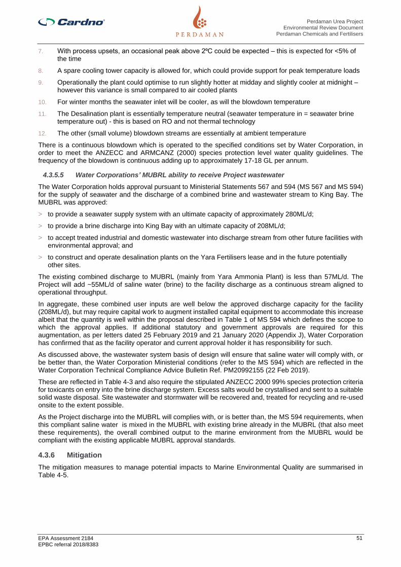
Perdaman Urea Project Environmental Review Document
Perdaman Chemicals and Fertilisers
EPA Assessment 2184 EPBC referral 2018/8383
51
7. With process upsets, an occasional peak above 2⁰C could be expected – this is expected for <5% of the time
8. A spare cooling tower capacity is allowed for, which could provide support for peak temperature loads
9. Operationally the plant could optimise to run slightly hotter at midday and slightly cooler at midnight – however this variance is small compared to air cooled plants
10. For winter months the seawater inlet will be cooler, as will the blowdown temperature
11. The Desalination plant is essentially temperature neutral (seawater temperature in = seawater brine temperature out) - this is based on RO and not thermal technology
12. The other (small volume) blowdown streams are essentially at ambient temperature
There is a continuous blowdown which is operated to the specified conditions set by Water Corporation, in order to meet the ANZECC and ARMCANZ (2000) species protection level water quality guidelines. The frequency of the blowdown is continuous adding up to approximately 17-18 GL per annum.
4.3.5.5 Water Corporations’ MUBRL ability to receive Project wastewater
The Water Corporation holds approval pursuant to Ministerial Statements 567 and 594 (MS 567 and MS 594) for the supply of seawater and the discharge of a combined brine and wastewater stream to King Bay. The MUBRL was approved:
> to provide a seawater supply system with an ultimate capacity of approximately 280ML/d;
> to provide a brine discharge into King Bay with an ultimate capacity of 208ML/d;
> to accept treated industrial and domestic wastewater into discharge stream from other future facilities with environmental approval; and
> to construct and operate desalination plants on the Yara Fertilisers lease and in the future potentially other sites.
The existing combined discharge to MUBRL (mainly from Yara Ammonia Plant) is less than 57ML/d. The Project will add ~55ML/d of saline water (brine) to the facility discharge as a continuous stream aligned to operational throughput.
In aggregate, these combined user inputs are well below the approved discharge capacity for the facility (208ML/d), but may require capital work to augment installed capital equipment to accommodate this increase albeit that the quantity is well within the proposal described in Table 1 of MS 594 which defines the scope to which the approval applies. If additional statutory and government approvals are required for this augmentation, as per letters dated 25 February 2019 and 21 January 2020 (Appendix J), Water Corporation has confirmed that as the facility operator and current approval holder it has responsibility for such.
As discussed above, the wastewater system basis of design will ensure that saline water will comply with, or be better than, the Water Corporation Ministerial conditions (refer to the MS 594) which are reflected in the Water Corporation Technical Compliance Advice Bulletin Ref. PM20992155 (22 Feb 2019).
These are reflected in Table 4-3 and also require the stipulated ANZECC 2000 99% species protection criteria for toxicants on entry into the brine discharge system. Excess salts would be crystallised and sent to a suitable solid waste disposal. Site wastewater and stormwater will be recovered and, treated for recycling and re-used onsite to the extent possible.
As the Project discharge into the MUBRL will complies with, or is better than, the MS 594 requirements, when this compliant saline water is mixed in the MUBRL with existing brine already in the MUBRL (that also meet these requirements), the overall combined output to the marine environment from the MUBRL would be compliant with the existing applicable MUBRL approval standards.
4.3.6 Mitigation
The mitigation measures to manage potential impacts to Marine Environmental Quality are summarised in Table 4-5.

Perdaman Urea Project Environmental Review Document
Perdaman Chemicals and Fertilisers
EPA Assessment 2184 EPBC referral 2018/8383
52
Table 4-5 Mitigation of Potential Impacts to Marine Environmental Quality
Potential Impacts Mitigation Measures
EPA Objective: To maintain the quality of water, sediment and biota so that environmental values are protected.
Changes to water quality
Wastewater discharge to the MUBRL has the potential to impact on marine environmental quality.
Avoid
The objective is to ensure that the seawater blow down discharge to MUBRL, in
combination with other future industrial discharges to the MUBRL, will not compromise the
ability of the Water Corporation to meet the requirements of Ministerial Statement 594 and
the ANZECC and ARMCANZ (2000) species protection level water quality guidelines
within the 0.01 km2 mixing zone as recommended in the EPA Report 1044.
In principle there are three balances to consider:
▪ Water – which contains site seawater, storm water, potable and grey water, process water and various condensates, including condensed air moisture;
▪ Salts – deriving (mainly) from seawater, but also some from dosing chemical additions – effectively as TDS (and measured as conductivity); and
▪ Thermal – managing the average blowdown return temperature.
The Project can extract water from the seawater provided the concentrated salts of the
blowdown comply with the ANZECC guidelines.
▪ Most of the seawater use (ca. 95%) is via the site circulating seawater cooling system. This circulates seawater removing process heat with seawater cooling tower, with roughly a 1.4 cycle of concentration (CoC);
▪ Essentially pure water evaporates (cooling), and the salts in the circulating seawater are concentrated;
▪ There are virtually no additional salts added – there is a modest (small) sulfuric acid and hypochlorite dosing for pH control and bio growth inhibition;
▪ There is no addition of heavy metals, as the process is based on clean natural gas. For seawater all the heat exchangers are constructed of titanium to reduce corrosion;
▪ In extreme cases some biocide may be added to control bio growth, but not during normal operation. Following this and measurement, sodium metabisulphite would be added and mixed to the blowdown water to decompose the residual biocide;
▪ The expected drift loss is expected to be <0.001% of the circulating flow. This drift loss is at the same salinity of the cooling tower circulation flow;
▪ There is a continuous blowdown which is operated to the specified conditions set by the Water Corporation, in order to meet the ANZECC and ARMCANZ (2000) species protection level water quality guidelines; and
This is summarized as below (Water Corp Technical Compliance Advice bulletin Ref.
PM20992155 (22 Feb 2019)) and provided in Table 4-3.
Minimise

Perdaman Urea Project Environmental Review Document
Perdaman Chemicals and Fertilisers
EPA Assessment 2184 EPBC referral 2018/8383
53
Potential Impacts Mitigation Measures
The Brine evaporation pond is required for operational flexibility:
▪ Such as if/when the brine return is offspec (i.e. will not be accepted by Water Corporation with respect to not meeting the ANZECC specifications);
▪ Operating flexibility to deal with saline streams in excess of 55,300 mg/l TDS;
▪ Site stormwater overflow;
▪ Collection of contaminated chemical sewer streams other than Amine section;
▪ During normal operation the pond is expected to be dry – the site evaporation rate is high, and minimal salt containing streams should be added;
▪ During start-up, high salt (>55,300 TDS) brine is expected from the Desalination Plant. This could be diluted and returned to the MUBRL, however temporary storage in the brine pond allows minimisation of seawater usage. Further, there could be ammonia water streams;
▪ Once the main plant is operating and MUBRL blowdown established, the Brine pond water will be fully analysed and should this be acceptable, blended back into the blowdown stream as a small addition, ensuring outfall compliance is not compromised. This disposal is considered feasible as under normal operating circumstances the water should basically contain high saline seawater and possible traces of ammonia – both these components are acceptable to the MUBRL ocean outfall mixing zone provide the mixed stream complies with the criteria – i.e. ensure TDS is <55,300mg/l and the ammonia does not exceed 1,700 mg/m3 of blowdown;
▪ In the unlikely event that the Brine pond water with blending is still outside the ANZECC specification, the water will be evaporated, and the residual salt collected to an approved disposal site;
▪ The Brine pond specifically will not receive organic (grey water) nor MDEA nor oil containing wastewater; and
▪ The Brine pond has transfer pumps and reticulation to receive and pump out water.
Water Quality
Degradation of water quality from elevated levels of suspended solids or contaminants in surface water runoff.
Indirect impact on the mangrove communities of King Bay as a result of water quality changes.
Impacts on marine environmental quality from runoff collected from the hardstand surfaces, conveyor, and product storage shed within the Dampier Port area
Impacts on marine environmental quality from Project air emissions.
Avoid
The design scope for the fully enclosed conveying and ship loading system eliminates of the risk of loss of urea product as fugitive dust emissions or spills with the consequential loss of valuable product and potential environment impacts of degradation of water quality in the terrestrial and marine environments.
Minimise
Best available technology design has been incorporated to reduce and minimize Project air emissions. This in turn minimizes any potential impacts on marine environmental quality from Proposal air emissions.
An Operational Environmental Management Plant (OEMP) is required to be prepared and submitted for review prior to any operational activities taking place on PPA’s lands. It is a standard requirement of PPA’s Commercial Agreements with tenants.

Perdaman Urea Project Environmental Review Document
Perdaman Chemicals and Fertilisers
EPA Assessment 2184 EPBC referral 2018/8383
54
Potential Impacts Mitigation Measures
An OEMP is a practical and site-specific plan of management measures which is designed to manage risks and minimise environmental impacts from PPA’s tenant’s normal activities. It will also identify what measures will be in place or are actioned to manage any incidents and emergencies that may arise during normal operations. As such, the foundation of any OEMP is an operational environmental risk assessment.
An OEMP is a dynamic document, which should be maintained and audited periodically to ensure it reflects current environment risks and management measures from site activities and operations
During Construction
Drainage, Erosion and Sediment Pollution Controls
The following controls shall be installed prior to commencement of construction to prevent contamination of surface water and receiving environments.
Drainage Controls
▪ Existing drainage lines will be protected and any diversion of these lines should be kept to a minimum;
▪ Flow management across the site will prevent the concentration and diversion of waters onto steep or erosion prone slopes;
▪ Any diversion of drainage lines will be directed to slopes that are not prone to erosion;
▪ External water flows entering the Project’s battery limits will be diverted around the construction footprint, using drainage structures such as catch drains and bunds;
▪ Temporary drainage structures will be designed to reduce run-off velocities by using wider inverts, flat bottomed drains rather than V-shaped drains, check dams (or similar), silt fencing and revegetation of completed areas;
▪ All drainage lines likely to receive run-off from disturbed areas, such as those downstream of worksites, will be fitted with geotextile silt fences. Rock checks should also be used in drains to slow flows and provide a lining to prevent scouring of underlying surfaces. Sediment basins will be added to drainage lines as necessary. Basins shall be designed relative to the catchment and likely flow levels for higher rainfall events;
▪ Where silt fences are installed for sediment control, they must be constructed with a centre section lower than the ground levels at the end of the silt fence to avoid outflanking during heavy rainfall events;
▪ Silt and sediment fences shall be maintained until the areas above them have been adequately stabilised to minimise the erosion risk such that the controls can be removed;
▪ All stormwater proposed for discharge will first be contained in an appropriately lined sediment basin, to all sediment to settle out;
▪ Any discharge to the MUBRL must comply with the conditions, including water quality standards of the license or approval that applies to the discharge; and

Perdaman Urea Project Environmental Review Document
Perdaman Chemicals and Fertilisers
EPA Assessment 2184 EPBC referral 2018/8383
55
Potential Impacts Mitigation Measures
▪ Construction activities will be scheduled to avoid periods of heavy rainfall, strong winds or peak water flow.
Erosion and Sediment Pollution Controls
Sediment controls are designed to prevent the transportation of sediment and other pollutants from worksites to waterways. They will be installed across the Project sites in areas where land is disturbed. In order to minimise the land exposure and potential risk of erosion, all land disturbances should be confined to a minimum practical working area and within the vicinity of the identified work areas.
Where possible, existing vegetation surrounding the construction site will be used as a buffer zone to help filter surface runoff and should not be disturbed unless necessary for the purpose of construction.
To ensure that silt from batters, cut-off drains, table drains and road works is retained on site and replaced as soon as practicable, sediment controls will be installed downstream of any disturbed land such as worksites, prior to that work being undertaken.
Run-off controls will be developed and maintained to the following standards:
▪ Controls will be designed to take predicted flows, based on 140436-000-41EG-0001 Standard Specification Geographic, Climatic and Wind / Seismic Data;
▪ Exposed ground will have control measures that minimise the level of erosion;
▪ Drains will be installed across the site to divert clean surface water to stable areas and away from parts of the site where soil is exposed;
▪ Installation of sediment traps and basins with a riser pipe or flexible pipe and spillway to avoid adverse flood risk to adjoining properties. These systems shall allow for the gradual discharge of the clearest water during a storm event as detailed in 6.1.3;
▪ Geotextile silt fences shall be installed in surface water flow areas to minimise the sediment discharge from the site (refer to Attachment C);
▪ Should hay bales be used for sediment control, they will be made of straw sourced from cereal crops and be free of weed seeds;
▪ If any areas of localised erosion develop, they will be remediated as soon as practicable to prevent further erosion or sediment deposition in offsite areas;
▪ Regularly inspect stormwater drainage and sediment control structures to ensure hydraulic integrity and erosion and pollution control effectiveness. If the control structures are obstructed or have their capacity reduced by 30% or more through the accumulation of silt, litter, vegetation and other debris, they shall be cleared, with silt returned to a stabilised part of the project;
▪ Sediment control structures at waterway crossings will be developed during the detailed design process before any such work takes place; and
▪ Throughout construction, rehabilitation of disturbed areas will be progressively undertaken, or as soon as practicable, following completion of specific works.
Post- Construction

Perdaman Urea Project Environmental Review Document
Perdaman Chemicals and Fertilisers
EPA Assessment 2184 EPBC referral 2018/8383
56
Potential Impacts Mitigation Measures
The following principals shall be applied:
▪ The granular urea product is much harder than prilled urea, therefore creating less fines and dust when handled and transported which minimizes the urea fines and dust that could be accidentally released during conveying and ship loading activities;
▪ Spill contingency and emergency response plans and procedures that align with the appropriate PPA plans and procedures, will be developed and implemented to address environmental risks and potential impacts specifically related to the operational phase;
▪ The stormwater pond includes an oil skimmer for removal of oil traces. These are sent to the Oily water collection pit/processing;
▪ Water quality monitoring (analysis) of collected water before allocation of use will be undertaken. It is expected that the quality of the stormwater will be (much) better than seawater (a much lower salt content), and as such can be re-used to reduce seawater make-up in the circulating cooling system;
▪ Collected stormwater is pumped to the seawater cooling tower circulating basin. The make-up seawater it is replacing is up to 3,000 m3/h; and
▪ For paved areas of the urea processing plant, there will be stormwater collection pits (epoxy coated concrete pit) where the first 15mm of stormwater can be collected. Stormwater collected will be treated by steam stripping or other means to bring ammonia (Total Kjeldahl Nitrogen) in water within limit.
Ongoing Monitoring
Regular inspections and audits will be undertaken to ensure the environmental protection outcomes of the Project are achieved. Inspection and maintenance activities will follow the Monitoring and Compliance requirements outlined in the Construction Environmental Management Plan (CEMP) and will include:
▪ Review of Erosion and Sediment Control Plans and validate that the proposed erosion and sediment controls have been implemented and, where relevant, revised to accommodate the changing environment;
▪ Inspections to observe and record any scouring, erosion and sediment transfer particularly beyond the Project footprint;
▪ Cleaning of sedimentation basins when the accumulated sediment has reduced the basin capacity by more than 30%, as indicated by depth pegs;
▪ Cleaning of all drains to remove silt, vegetation (where capacity is reduced) and litter;
▪ Weekly inspection of access roads and hardstand areas to identify erosion damage in need of maintenance. Remediation is to occur within one month or earlier if heavy rains are likely; and
▪ Discharge from any oily water separator shall be monitored to ensure it contains less than 5ppm Total Recoverable Hydrocarbons (TRH) and is in compliance with Project approval conditions before it can be used for dust suppression or discharged into the

Perdaman Urea Project Environmental Review Document
Perdaman Chemicals and Fertilisers
EPA Assessment 2184 EPBC referral 2018/8383
57
Potential Impacts Mitigation Measures
environment. Written approval from the Contractor’s Environment Manager must be obtained prior to reuse or discharge to the environment.
Contingency measures include:
▪ Where erosion or sediment deposition occurs, rehabilitation corrective actions shall be implemented as soon as practicable;
▪ Where sedimentation occurs the source of the sediment should be determined to identify likely erosion in up gradient areas. The sediment should be removed and deposited, if possible as part of erosion controls; and
▪ Where erosion is identified and requires rehabilitation the impacted area shall be filled, compacted and contoured to merge with the surrounding landscape.

Perdaman Urea Project Environmental Review Document
Perdaman Chemicals and Fertilisers
EPA Assessment 2184 EPBC referral 2018/8383
58
4.3.7 Predicted outcome
It is expected the objectives for managing marine environmental quality will be achieved, which would minimise impacts to the marine environments. The treated saline water discharge into the Water Corporation Brine Disposal Scheme is not expected to have a significant impact on the quality of the marine environment. The EPA objective for this factor can be met.
No offsets are proposed for this factor.

Perdaman Urea Project Environmental Review Document
Perdaman Chemicals and Fertilisers
EPA Assessment 2184 EPBC referral 2018/8383
59
4.4 Marine Fauna
4.4.1 EPA objective
To protect marine fauna so that biological diversity and ecological integrity are maintained.
4.4.2 Policy and guidance
The following policies and guidance have been considered for the assessment:
> DEWHA (2008) Approved Conservation Advice for Dermochelys coriacea (Leatherback Turtle);
> DoEE (2017) Habitat critical to the survival of marine turtles in Australian Waters;
> DoEE (2017) Recovery plan for marine turtles in Australia 2017-2027;
> EPA (2018) Statement of Environmental Principles, Factors and Objectives;
> EPA (2018) Environmental Impact Assessment (Part IV Divisions 1 and 2) Procedures Manual;
> EPA (2016) Environmental Impact Assessment (Part IV Divisions 1 and 2) Administrative Procedures 2016;
> EPA (2016) Environmental Factor Guideline: Marine Fauna;
> Threatened Species Scientific Committee (TSSC) (2009) Commonwealth Listing Advice on Dermochelys coriacea; and
> Pilbara Port Authority (2017-2018) Environmental Management Plan 2017-2018.
Policy and guidelines considered under the EPBC Act - Matters of National Significance are listed under the Section 6.2.
4.4.3 Receiving environment
The Port of Dampier, where the export facilities for the Project are proposed to be located, sits within the Dampier Archipelago. The Protected Matters Search Tool identified several species of marine birds, mammals and reptiles as well as sharks and rays, with the potential to occur within 10 km of the Dampier Port location. This includes species classified as threatened and/or marine under the EPBC Act.
Studies of marine fauna that are relevant to the Proposal are identified in Table 4-6. Pendoley Environmental was engaged to undertake a Marine Fauna desktop Assessment for the Project. Pendoley’s report is provided in Appendix C.
Table 4-6 Receiving environment studies – Marine Fauna
Author (Date) Study
Pendoley Environmental (2019) Perdaman Urea Project Marine Fauna Desktop Assessment
Woodside (2018) Pluto LNG Project Sea Turtle Management Plan Operations and Maintenance
Pendoley K., Whittock P.A., Vitenbergs A. and Bell C. (2016)
Twenty years of turtle tracks: marine turtle nesting activity at remote locations in the Pilbara, Western Australia
DoEE (2015) National Conservation Values Atlas
Pendoley Environmental (2006) Pluto LNG Development: Holden Beach and West Intercourse Island Beach Sea Turtle Habitat Use Survey
The following summary focuses on the species that have been identified as having ecologically significant interactions in the area. Migratory marine / wetland birds are further described in Section 4.6 and Section 6.
Section 6 address the potential impacts of the Project on Matters of National Environmental Significance (MNES) identified under the EPBC Act.
As per the Recovery Plan for Marine Turtles in Australia 2017-2027 (DoEE, 2017), Dampier Archipelago (with an interesting buffer) is identified as habitat critical to the survival of Green turtle (Chelonia mydas), Flatback turtle (Natator depressus) and Hawksbill turtle (Eretmochelys imbricata). Further, Dampier Archipelago forms part of the Biological Important Area for the above-mentioned species and Olive ridley turtle (Lepidochelys olivacea), endangered Loggerhead turtle (Caretta caretta) and Leatherback turtle (Dermochelys coriacea).
Significant nesting and aggregation areas for marine turtles within the Dampier Archipelago were reported by CALM (2005). On the Burrup Peninsula, turtle nesting activity has been recorded at Holden Beach and No

Perdaman Urea Project Environmental Review Document
Perdaman Chemicals and Fertilisers
EPA Assessment 2184 EPBC referral 2018/8383
60
Name Bay (~0.5-1 km from Dampier Port). Pendoley’s desktop study indicates records of nesting behaviour on islands of the Dampier Archipelago for the following EPBC listed marine turtles:
> Loggerhead Turtle – Caretta caretta;
> Green Turtle - Chelonia mydas;
> Hawksbill Turtle – Eretmochelys imbricate; and
> Flatback Turtle – Natator depressus.
Figure 4-2 Holden Beach and No Name Bay locations (Imagery: Nearmap 2019)
Although loggerhead turtle nesting activity had previously been reported, Pendoley Environmental (2019) did not find any evidence of this species activity over 20 years of track data within the waters of the Dampier Archipelago.
Within the Dampier Archipelago, Rosemary Island, 20 km from Dampier Port, has the most significant nesting beaches, determined as mean number of hawksbill, green and flatback turtle tracks per day. Other islands that also had moderate nesting activity (11 – 100 tracks per day) for all three species, include Delambre Island, Enderby Island, Eaglehawk Island and Angel Island, 38 km, 17 km, 31 km and 12 km from Dampier Port respectively. Delambre Island (38 km from Dampier Port) has been recognised as the largest flatback turtle rookery in Australia with an estimated 3500 nesting females per year (Pendoley Environmental, 2019).
Tracking data for green and hawksbill turtle nesting on Rosemary Island suggested that nesting female hawksbill turtles remained within 1 km of nesting beaches. Female green turtles travelled greater distances,

Perdaman Urea Project Environmental Review Document
Perdaman Chemicals and Fertilisers
EPA Assessment 2184 EPBC referral 2018/8383
61
up to 5 km, but typically remained within shallow, nearshore waters between 0 and 10 m deep (Pendoley, 2005). Other studies have showed that flatback turtles travelled greater distances, up to 62 km.
Tracking data has highlighted the importance of the Dampier Archipelago for both green and hawksbill turtles on migration, though tracks indicated individuals stayed on the further most islands of the Archipelago, and the eastern side of the Burrup Peninsula, rather than waters close to Dampier Port (Pendoley, 2005).
The tracking data from Pendoley (2005) did not identify any foraging grounds for green and hawksbill turtles within the Dampier Archipelago. Since all marine turtle species identified above can be found in shallow water habitats, it remains plausible that foraging individuals may occur within the waters of the Dampier Archipelago.
4.4.4 Potential impacts
In the absence of mitigation, the most significant potential impacts on marine fauna and marine habitats as a direct result of the Project are expected to be related to:
> Direct and cumulative impact from artificial lighting spill; and
> Accidental product discharge during ship loading.
Potential direct or indirect water quality impacts associated with the MUBRL discharge on marine fauna is not part of the current assessment and is not addressed here. The Water Corporation monitor and report on the individual effluent streams entering and the combined discharge leaving the system. Pursuant to MS 594, the Corporation implements an Environmental Management Program that includes monitoring and reporting of water quality, sediment and biota, for the wastewater system and the ambient environment. Section 2.3.5 discuss detail arrangement with the Water Corporation to discharge brine to the MUBRL.
Potential direct or indirect impacts to marine water quality arising from product storage and loading of material to ships at Dampier Port will be managed by the PPA (Appendix J). Section 2.3.6 discuss detailed arrangement with the PPA.
Any potential impacts to marine environmental quality related to the conduct of those business activities are not part of this assessment and therefore not addressed here. These could include:
> Direct and cumulative impact from vessel strikes;
> Introduction of marine pests from interstate/overseas vessels; and
> Underwater noise during construction.
The Project will result in increase of 1 or 2 shipping vessel movements per week for the export of urea. However, the Port of Dampier and Port Hedland are two of the world’s largest bulk export ports with 10,521 vessel movements recorded in the Port of Dampier for the 2018-19 period (Pilbara Ports Authority, 2019).
This small increase in shipping numbers would be overshadowed by the typical variability in shipping numbers associated with existing and future proposed industries. It is therefore considered that the incremental risk to marine fauna associated with shipping movements is unlikely to be significant.
4.4.5 Assessment of impacts
4.4.5.1 Direct and cumulative impact from artificial lighting spill
Artificial light associated with the onshore facilities (storage shed and port facilities) has the potential to impact marine fauna.
Sea birds and marine turtles use light mainly for orientation and navigation and can result in behavioural changes in foraging, navigating and breeding activity. Coastal lighting spills disorientate turtle hatchlings and prevents or delays them from locating the sea. It also affects female turtles returning to nesting beaches. Lighting of jetties, vessels or platforms can create pools of light that attract swimming hatchlings and increase their risk of predation. Artificial light can therefore cause a gradual decline in the reproductive output of a nesting area. Sea birds use natural light cues to navigate and artificial lighting may have the potential to disorientation (Davies et al., 2014).
Blue artificial light has a higher potential to impact marine fauna as it penetrates deeper in the ocean (Gaston et al., 2013). However, lights of any wavelength can affect behaviour and light glow can disrupt marine turtles when it out-competes natural light sources (Commonwealth of Australia, 2017).
Turtles are at most risk from impacts during nesting, hatchling emergence and at-sea dispersal. Low level turtle nesting is expected in proximity of the PDE, in particular at Holden Beach and No Name Bay, approximately 0.5-1 km from the development envelope (Figure 4-2). If light emissions are not effectively

Perdaman Urea Project Environmental Review Document
Perdaman Chemicals and Fertilisers
EPA Assessment 2184 EPBC referral 2018/8383
62
managed either through sensitive lighting design and/or by efficient use during operations, there is risk that light spill could impact these sites.
Artificial lighting near marine habitats will be used during construction works in the Dampier Port storage and load out facilities and during ship loading operations. However, Dampier Port is one of the major industrial ports in Western Australia and one of the largest bulk export ports in the world. Therefore, additional artificial light from the Project is unlikely to result in significant impacts over and above those already occurring from existing light sources at Dampier Port and across the Burrup Peninsula.
Existing development on the north shore of King Bay may already contribute to direct light spill onto surrounding marine habitats. The Project may result in additional light spill from the east (Site C) and north (Site F), resulting in a cumulative increase in the extent and severity of light spill. However, given the size of the nesting population at these locations and the proposed mitigation measures being implemented to reduce light emissions, impacts are unlikely to result in population-level effects. Light management and mitigation measures incorporated into the design and operation of the proposed development to minimise the potential impacts to marine fauna are listed in Table 4-7.
4.4.5.2 Accidental product discharge during ship loading.
Contamination of marine waters and associated marine habitats could potentially result from accidental leakage and spillage of materials, including fuel, hydrocarbons during construction and subsequent operation of Project facilities and/or the urea product handled at the port facility during the Project life.
To minimise risk of accidental product spills the Project uses fully enclosed conveying and ship loading system. Further, the granular urea product is much harder than prilled urea, therefore creating less fines and dust when handled and transported resulting less impacts from the Project.
Oil spills can heavily impact on marine mammals and reptiles because of their need to surface to breathe or to leave the water to breed. Subsequently, coastal dwelling birds feeding on fish are also at high risk from hydrocarbon spills.
Given the strict management policies, management plans and procedures PPA has in place to manage contamination risks from current and future port related activities, it is expected that contamination risks can be managed effectively during construction and operational activities within the Port boundaries. The Proponent’s operations within the port precinct will be conducted in compliance with the applicable PPA policies, manuals and procedures noted above. Product discharge to the marine environment during ship loading is unlikely to occur as the ship loader will be equipped with a telescopic chute and shroud. Only personnel properly trained and qualified will be able to operate the ship loader and PPA procedural requirements will be adhered to.
The current approved PPA Environmental management Plan is available at: https://www.pilbaraports.com.au/Home/Environment-and-heritage/Environmental-management-plan
4.4.6 Mitigation
Environmental Management Plan, Fauna Management Plan and Threatened Species Management Plan for the Project (see Appendix K) will be implemented to assess the efficacy of the mitigation measures and to inform any requirements for adaptive management. Diligent application of best practices for managing potential impacts is expected to significantly decrease the potential for residual impacts.
All vessels used for product export from the Project and all activities at Dampier Port will be compliant with the relevant legislation and PPA’s procedures.
The mitigation measures to manage potential impacts to marine fauna described in section 4.4.4 and assessed in section 4.45 are summarised in Table 4-7.

Perdaman Urea Project Environmental Review Document
Perdaman Chemicals and Fertilisers
EPA Assessment 2184 EPBC referral 2018/8383
63
Table 4-7 Mitigation of Potential Impacts to Marine Fauna
Potential Impacts
EPA Objective: To protect marine fauna so that biological diversity and ecological integrity are maintained
Lighting
Artificial light can alter foraging patterns, increase predation risk, disrupt biological clocks, and disrupt of dispersal movements.
Minimise
Lighting will be designed in accordance with AS 4282-1997: Control of Obtrusive Effects of Outdoor Lighting Guidelines.
Lighting will be used only for required operational areas, all light sources will be aimed towards specific work areas requiring light for safe construction and/or operation, with a low vertical angle, and light shields will be placed on large equipment to minimise light spill over.
Where possible, lighting will be the minimum wattage, whilst not compromising safety or OH&S requirements.
Marine Pests
The introduction of marine organisms to the Port of Dampier has the potential to significantly impact marine fauna.
Minimise
The Proponent has obtained confirmation from PPA that it will provide services and access to the port precinct in compliance with any existing or further conditions related to applicable statutory approvals (Appendix J)
PPA Environmental Management Plan has a Biosecurity Management Program in accordance with Biosecurity Act 2015 to manage marine pests.
PPA indicates that discharge of ballast water in the Port of Dampier will be consistent with Australian Quarantine and Inspection Services (AQIS) mandatory Australian ballast water management requirements.
Vessel Strike
Impact with vessel can cause injury or death of marine fauna.
Minimise
The Proponent has obtained confirmation from PPA that it will provide services and access to the port precinct in compliance with any existing or further conditions related to applicable statutory approvals (Appendix J)
Changes to water quality
Wastewater discharge to the MUBRL has the potential to impact on marine environmental quality.
Avoid
The objective is to ensure that the seawater blow down discharge to MUBRL, in combination with other future industrial discharges to the
MUBRL, will not compromise the ability of the Water Corporation to meet the requirements of Ministerial Statement 594 and the ANZECC and
ARMCANZ (2000) species protection level water quality guidelines within the 0.01 km2 mixing zone as recommended in the EPA Report 1044.
In principle there are three balances to consider:
▪ Water – which contains site seawater, storm water, potable and grey water, process water and various condensates, including condensed air moisture.
▪ Salts – deriving (mainly) from seawater, but also some from dosing chemical additions – effectively as TDS (and measured as conductivity).
▪ Thermal – managing the average blowdown return temperature.
The Project can extract water from the seawater provided the concentrated salts of the blowdown comply with the ANZECC guidelines.
▪ Most of the seawater use (ca. 95%) is via the site circulating seawater cooling system. This circulates seawater removing process heat with seawater cooling tower, with roughly a 1.4 cycle of concentration (CoC).
▪ Essentially pure water evaporates (cooling), and the salts in the circulating seawater are concentrated.

Perdaman Urea Project Environmental Review Document
Perdaman Chemicals and Fertilisers
EPA Assessment 2184 EPBC referral 2018/8383
64
Potential Impacts
▪ There are virtually no additional salts added – there is a modest (small) sulfuric acid and hypochlorite dosing for pH control and bio growth inhibition.
▪ There is no addition of heavy metals, as the process is based on clean natural gas. For seawater all the heat exchangers are constructed of titanium to reduce corrosion.
▪ In extreme cases some biocide may be added to control bio growth, but not during normal operation. Following this and measurement, sodium metabisulphite would be added and mixed to the blowdown water to decompose the residual biocide.
▪ The expected drift loss is expected to be <0.001% of the circulating flow. This drift loss is at the same salinity of the cooling tower circulation flow.
▪ There is a continuous blowdown which is operated to the specified conditions set by the Water Corporation, in order to meet the ANZECC and ARMCANZ (2000) species protection level water quality guidelines.
This is summarized as below (Water Corp Technical Compliance Advice bulletin Ref. PM20992155 (22 Feb 2019)) and provided in Table 4-3.
Minimise
The Brine evaporation pond is required for operational flexibility:
▪ Such as if/when the brine return is offspec (i.e. will not be accepted by Water Corporation with respect to not meeting the ANZECC specifications);
▪ Operating flexibility to deal with saline streams in excess of 55,300 mg/l TDS;
▪ Site stormwater overflow;
▪ Collection of contaminated chemical sewer streams other than Amine section;
▪ During normal operation the pond is expected to be dry – the site evaporation rate is high, and minimal salt containing streams should be added;
▪ During start-up, high salt (>55,300 TDS) brine is expected from the Desalination Plant. This could be diluted and returned to the MUBRL, however temporary storage in the brine pond allows minimisation of seawater usage. Further, there could be ammonia water streams;
▪ Once the main plant is operating and MUBRL blowdown established, the Brine pond water will be fully analysed and should this be acceptable, blended back into the blowdown stream as a small addition, ensuring outfall compliance is not compromised. This disposal is considered feasible as under normal operating circumstances the water should basically contain high saline seawater and possible traces of ammonia – both these components are acceptable to the MUBRL ocean outfall mixing zone provide the mixed stream complies with the criteria – i.e. ensure TDS is <55,300mg/l and the ammonia does not exceed 1,700 mg/m3 of blowdown;
▪ In the unlikely event that the Brine pond water with blending is still outside the ANZECC specification, the water will be evaporated, and the residual salt collected to an approved disposal site;
▪ The Brine pond specifically will not receive organic (grey water) nor MDEA nor oil containing wastewater; and
▪ The Brine pond has transfer pumps and reticulation to receive and pump out water.
Water Quality
Degradation of water quality from elevated levels of suspended solids or contaminants in surface water runoff.
Avoid
The design scope for the fully enclosed conveying and ship loading system eliminates of the risk of loss of urea product as fugitive dust emissions or spills with the consequential loss of valuable product and potential environment impacts of degradation of water quality in the terrestrial and marine environments.

Perdaman Urea Project Environmental Review Document
Perdaman Chemicals and Fertilisers
EPA Assessment 2184 EPBC referral 2018/8383
65
Potential Impacts
Indirect impact on the mangrove communities of King Bay as a result of water quality changes.
Impacts on marine environmental quality from runoff collected from the hardstand surfaces, conveyor, and product storage shed within the Dampier Port area
Impacts on marine environmental quality from Project air emissions.
Minimise
Best available technology design has been incorporated to reduce and minimize Project air emissions. This in turn minimizes any potential impacts on marine environmental quality from Proposal air emissions.
An Operational Environmental Management Plant (OEMP) is required to be prepared and submitted for review prior to any operational activities taking place on PPA’s lands. It is a standard requirement of PPA’s Commercial Agreements with tenants.
An OEMP is a practical and site-specific plan of management measures which is designed to manage risks and minimise environmental impacts from PPA’s tenant’s normal activities. It will also identify what measures will be in place or are actioned to manage any incidents and emergencies that may arise during normal operations. As such, the foundation of any OEMP is an operational environmental risk assessment.
An OEMP is a dynamic document, which should be maintained and audited periodically to ensure it reflects current environment risks and management measures from site activities and operations
During Construction
Drainage, Erosion and Sediment Pollution Controls
The following controls shall be installed prior to commencement of construction to prevent contamination of surface water and receiving environments.
Drainage Controls
▪ Existing drainage lines will be protected and any diversion of these lines should be kept to a minimum.
▪ Flow management across the site will prevent the concentration and diversion of waters onto steep or erosion prone slopes.
▪ Any diversion of drainage lines will be directed to slopes that are not prone to erosion.
▪ External water flows entering the Project’s battery limits will be diverted around the construction footprint, using drainage structures such as catch drains and bunds.
▪ Temporary drainage structures will be designed to reduce run-off velocities by using wider inverts, flat bottomed drains rather than V-shaped drains, check dams (or similar), silt fencing and revegetation of completed areas.
▪ All drainage lines likely to receive run-off from disturbed areas, such as those downstream of worksites, will be fitted with geotextile silt fences. Rock checks should also be used in drains to slow flows and provide a lining to prevent scouring of underlying surfaces. Sediment basins will be added to drainage lines as necessary. Basins shall be designed relative to the catchment and likely flow levels for higher rainfall events.
▪ Where silt fences are installed for sediment control, they must be constructed with a centre section lower than the ground levels at the end of the silt fence to avoid outflanking during heavy rainfall events.
▪ Silt and sediment fences shall be maintained until the areas above them have been adequately stabilised to minimise the erosion risk such that the controls can be removed.
▪ All stormwater proposed for discharge will first be contained in an appropriately lined sediment basin, to all sediment to settle out.
▪ Any discharge to the MUBRL must comply with the conditions, including water quality standards of the license or approval that applies to the discharge.
▪ Construction activities will be scheduled to avoid periods of heavy rainfall, strong winds or peak water flow.
Erosion and Sediment Pollution Controls

Perdaman Urea Project Environmental Review Document
Perdaman Chemicals and Fertilisers
EPA Assessment 2184 EPBC referral 2018/8383
66
Potential Impacts
Sediment controls are designed to prevent the transportation of sediment and other pollutants from worksites to waterways. They will be installed across the Project sites in areas where land is disturbed. In order to minimise the land exposure and potential risk of erosion, all land disturbances should be confined to a minimum practical working area and within the vicinity of the identified work areas.
Where possible, existing vegetation surrounding the construction site will be used as a buffer zone to help filter surface runoff and should not be disturbed unless necessary for the purpose of construction.
To ensure that silt from batters, cut-off drains, table drains and road works is retained on site and replaced as soon as practicable, sediment controls will be installed downstream of any disturbed land such as worksites, prior to that work being undertaken.
Run-off controls will be developed and maintained to the following standards:
▪ Controls will be designed to take predicted flows, based on 140436-000-41EG-0001 Standard Specification Geographic, Climatic and Wind / Seismic Data;
▪ Exposed ground will have control measures that minimise the level of erosion;
▪ Drains will be installed across the site to divert clean surface water to stable areas and away from parts of the site where soil is exposed;
▪ Installation of sediment traps and basins with a riser pipe or flexible pipe and spillway to avoid adverse flood risk to adjoining properties. These systems shall allow for the gradual discharge of the clearest water during a storm event as detailed in 6.1.3;
▪ Geotextile silt fences shall be installed in surface water flow areas to minimise the sediment discharge from the site (refer to Attachment C).
▪ Should hay bales be used for sediment control, they will be made of straw sourced from cereal crops and be free of weed seeds;
▪ If any areas of localised erosion develop, they will be remediated as soon as practicable to prevent further erosion or sediment deposition in offsite areas;
▪ Regularly inspect stormwater drainage and sediment control structures to ensure hydraulic integrity and erosion and pollution control effectiveness. If the control structures are obstructed or have their capacity reduced by 30% or more through the accumulation of silt, litter, vegetation and other debris, they shall be cleared, with silt returned to a stabilised part of the project;
▪ Sediment control structures at waterway crossings will be developed during the detailed design process before any such work takes place; and
▪ Throughout construction, rehabilitation of disturbed areas will be progressively undertaken, or as soon as practicable, following completion of specific works.
Post- Construction
The following principals shall be applied:
▪ The granular urea product is much harder than prilled urea, therefore creating less fines and dust when handled and transported which minimizes the urea fines and dust that could be accidentally released during conveying and ship loading activities;
▪ Spill contingency and emergency response plans and procedures that align with the appropriate PPA plans and procedures, will be developed and implemented to address environmental risks and potential impacts specifically related to the operational phase;
▪ The stormwater pond includes an oil skimmer for removal of oil traces. These are sent to the Oily water collection pit/processing;
▪ Water quality monitoring (analysis) of collected water before allocation of use will be undertaken. It is expected that the quality of the stormwater will be (much) better than seawater (a much lower salt content), and as such can be re-used to reduce seawater make-up in the circulating cooling system;
▪ Collected stormwater is pumped to the seawater cooling tower circulating basin. The make-up seawater it is replacing is up to 3,000 m3/h; and

Perdaman Urea Project Environmental Review Document
Perdaman Chemicals and Fertilisers
EPA Assessment 2184 EPBC referral 2018/8383
67
Potential Impacts
▪ For paved areas of the urea processing plant, there will be stormwater collection pits (epoxy coated concrete pit) where the first 15mm of stormwater can be collected. Stormwater collected will be treated by steam stripping or other means to bring ammonia (Total Kjeldahl Nitrogen) in water within limit.
Ongoing Monitoring
Regular inspections and audits will be undertaken to ensure the environmental protection outcomes of the Project are achieved. Inspection and maintenance activities will follow the Monitoring and Compliance requirements outlined in the Construction Environmental Management Plan (CEMP) and will include:
▪ Review of Erosion and Sediment Control Plans and validate that the proposed erosion and sediment controls have been implemented and, where relevant, revised to accommodate the changing environment;
▪ Inspections to observe and record any scouring, erosion and sediment transfer particularly beyond the Project footprint;
▪ Cleaning of sedimentation basins when the accumulated sediment has reduced the basin capacity by more than 30%, as indicated by depth pegs;
▪ Cleaning of all drains to remove silt, vegetation (where capacity is reduced) and litter;
▪ Weekly inspection of access roads and hardstand areas to identify erosion damage in need of maintenance. Remediation is to occur within one month or earlier if heavy rains are likely; and
▪ Discharge from any oily water separator shall be monitored to ensure it contains less than 5ppm Total Recoverable Hydrocarbons (TRH) and is in compliance with Project approval conditions before it can be used for dust suppression or discharged into the environment. Written approval from the Contractor’s Environment Manager must be obtained prior to reuse or discharge to the environment.
Contingency measures include:
▪ Where erosion or sediment deposition occurs, rehabilitation corrective actions shall be implemented as soon as practicable;
▪ Where sedimentation occurs the source of the sediment should be determined to identify likely erosion in up gradient areas. The sediment should be removed and deposited, if possible as part of erosion controls; and
▪ Where erosion is identified and requires rehabilitation the impacted area shall be filled, compacted and contoured to merge with the surrounding landscape.

Perdaman Urea Project Environmental Review Document
Perdaman Chemicals and Fertilisers
EPA Assessment 2184 EPBC referral 2018/8383
68
4.4.7 Predicted outcome
It is expected the objectives for managing impacts on marine fauna can be achieved. The Proposal is unlikely to result in permanent or long-term impact to the marine fauna species. The identified impacts are unlikely to be significant as Project related activities will be compliant with relevant regulations and the recommended management measures will be implemented.

Perdaman Urea Project Environmental Review Document
Perdaman Chemicals and Fertilisers
EPA Assessment 2184 EPBC referral 2018/8383
69
4.5 Flora and Vegetation
4.5.1 EPA objective
To protect flora and vegetation so that biological diversity and ecological integrity are maintained.
4.5.2 Policy and guidance
The following policies and guidance have been considered for the biological assessment:
> EPA (2018) Statement of Environmental Principles, Factors and Objectives;
> EPA (2018) Environmental Impact Assessment (Part IV Divisions 1 and 2) Procedures Manual;
> EPA (2016) Environmental Impact Assessment (Part IV Divisions 1 and 2) Administrative Procedures 2016;
> EPA (2016) Environmental Factor Guideline: Flora and Vegetation;
> EPA (2016) Technical Guidance: Flora and Vegetation Surveys for Environmental Impact Assessment;
> DoEE (Undated) How to use the Offsets Assessment Guide;
> DSEWPaC (2012) EPBC Act Environmental Offsets Policy;
> Government of Western Australia (2011) WA Environmental Offsets Policy; and
> Government of Western Australia (2014) WA Environmental Offsets Guidelines.
4.5.3 Receiving environment
The Burrup Peninsula is located at the western end of the Abydos Plains in the Pilbara biogeographic region, within the Roebourne subregion (Department of the Environment, 2012). The 'Bioregional Summary of the 2002 Biodiversity Audit for Western Australia' (McKenzie et al. 2003) describes the Roebourne subregion, as Quaternary alluvial and older colluvial coastal and sub-coastal plains, with a grass savannah of mixed bunch and hummock grasses, and dwarf shrub steppe of Acacia translucens or A. pyrifolia and A. inequilatera. Resistant linear ranges of basalts occur across the coastal plains. These uplands are dominated by Triodia hummock grasslands. Ephemeral drainage lines support Eucalyptus woodlands. Samphire, Sporobolus grasslands and mangal occur on marine alluvial flats and river deltas. The islands are either Quaternary sand accumulations, or composed of basalt or limestone, or combinations of any of these three. Climate is arid (semi-desert) tropical with highly variable rainfall, falling mainly in summer. Cyclonic activity is significant, with several systems affecting the coast and hinterland annually.
Across the Burrup Peninsula there are numerous gorges, creeks and drainage lines cutting across the landscape, which provides heterogeneity in the topography and the vegetation communities it supports. However, there were no deeply dissected drainage lines or gorges in the Project area. (APM, 2018)
The Burrup Peninsula lies within the Fortescue Botanical District, which is part of the biogeographical region known as the Eremaean Botanical Province (Beard, 1975).
No plants declared rare or threatened under the EPBC Act are known from the Burrup Peninsula, or within 100 km of the study area. No plants declared rare under the WC Act are known from the Burrup Peninsula.
From the Department of Biodiversity, Conservation and Attractions database priority flora identified as being in the Roebourne Bioregion coastal zone and Islands is shown in Figure 4-3. Their habitat description and the likelihood of occurrence in the wider study area is shown in the Table 4-8.

Perdaman Urea Project Environmental Review Document
Perdaman Chemicals and Fertilisers
EPA Assessment 2184 EPBC referral 2018/8383
70
Figure 4-3 Conservation significant flora identified by Department of Biodiversity, Conservation and Attractions database search as occurring in the vicinity of the study area (APM, 2019)
Burrup
Conservation significant flora in the Burrup Peninsula
Onslow
Dampier Archipelago
Roebourne
Dampier Archipelag
o

Perdaman Urea Project Environmental Review Document
Perdaman Chemicals and Fertilisers
EPA Assessment 2184 EPBC referral 2018/8383
71
Table 4-8 Conservation significant flora identified from the database searches and their likelihood of occurrence
Species Current WA Conser-vation Status
Description & Habitat Likelihood of Occurrence in study area and likelihood of Detection if Present
Abutilon sp. Pritzelianum (S. van Leeuwen 5095)
P1 Shrub to 1.5 m Red stony loam with Acacia inaequilatera, Sida sp., A. coriacia, Hibiscus leptocladus.
Possible. Known from 1 location 40 km to the east on the mainland.
Tephrosia rosea var. Port Hedland (A.S. George 1114)
P1 Erect, spreading shrub 1 m Straggly open tomentose perennial. All parts densely grey/white felt, except inner petals. Deep burgundy flowers. Lower leaves becoming large. Raceme terminal 22‐38 cm long. Legume 2.5‐3 cm, tomentose. coastal dune sands, Open shrubland of Acacia coriacea subsp. coriacea and Acacia sabulosa over scattered shrubs of Tephrosia rosea var. Port Hedland over Triodia epactia, *Cenchrus ciliaris and *Aerva javanica. Also Small rocky hillcrest adjacent to lower‐lying saline drainage areas at or just above sea level. with Triodia wiseana, T. epactia hummock grassland.
Possible but most locations on rocky terrain closer to the coast.
Terminalia supranitifolia
P3 Rocky outcrops. Stunted canopy tree, very gnarled twisted trunk, intricate branches, grey in colour. Leaves glossy, silvery silky tomentum. Flowers lemon, fruits not winged. Leaves
lemon‐green colour.
Occurs in study area. Locally common in the central area of the Burrup Peninsula. Suitable habitat exists on the rocky outcrops. Closest DBCA record less than 300 m from the study area. Fertile specimen positively detected in study area by APM.
Stackhousia clementii P3 King Bay ‐ Hearson Cove tidal inlet, Burrup Peninsula. Lime‐green, more or less leafless plant (or scale like leaves) to 45 cm with numerous erect slender branches. Flowers in clusters, forming a cylindrical spike. Woody base. Soft, silty saline soil over limestone ‐ with much limestone and coral rubble, on small 'island' within tidal inlet (very rarely inundated). But also with Tall shrubland of Acacia bivenosa over open hummock grassland of Triodia epactia with open tussock grassland of *Cenchrus ciliaris, on sandy clay loam flats.
Likely. Located in the supratidal zone common to the Project Area. Records located 600 m to the east of the Project Area visited and healthy individuals noted. Records of flowering in all months.
Vigna triodiophila P3 Burrup Peninsula. Herb. Slender vine entwined in Triodia epactia and rocks. Vine with thickened root ‐ probably perennial but dying back to rootstock in dry. Flowers yellow. Rockpiles.
Likely. Locally common in the central area of the Burrup Peninsula. Suitable habitat exists on the rocky outcrops. Closest DBCA record is 700 m from the Project Area. Fertile material recorded in June.
Gomphrena leptophylla P3 Prostrate, compact herb 20 cm high x 60 cm wide. Stem leaves acute, mucronate, revolute linear leaves 10‐30 mm long x 1‐2 mm wide. Flowers green, yellow stamens. Axillary corolla 5 mm long. Cylindrical flower head 20 mm long x 7 mm wide. Bracts incurved. Flowers white, Mar to Sep. Sand, sandy to clayey loam, granite, quartzite. Open flats, sandy creek beds, edges salt pans & marshes, stony hillsides.
Possible. Diverse range of habitat associations.

Perdaman Urea Project Environmental Review Document
Perdaman Chemicals and Fertilisers
EPA Assessment 2184 EPBC referral 2018/8383
72
Owenia acidula P3 Mardie Station. Small tree to 3m, often dense stands as suckers. Leaves pseudopinnate. Known from sand dune, Shrub steppe.
Possible. Easily detected from vegetative growth all year.
Rhynchosia bungarensis
P4 Burrup Peninsula. Creeper Viscid, spreading 1 m high. Steeply sloping rock pile (boulder scree) on valley side, E facing. Orange brown loam between cobbles (vegetated patch). Medium grained volcanic. Fire >10 years. Terminalia circumulata high open shrubland (low open woodland) over Acacia coriacea subsp. coriacea, Flueggia virosa subsp. melanthesoides high open shrubland over Scaevola spinescens (narrow form), Rhagodia eremaea scattered shrubs over Triodia epactia
Occurs in study area. Locally common on the Burrup Peninsula. Suitable habitat exists on the rocky outcrops and slopes. Closest DBCA record less than 300 m from the study area. Specimens positively detected in study area by APM.
Goodenia pallida P1 Balmoral Homestead. Corolla very pale purple. Plain, dry red sand. Annual grassland, Acacia steppe.
Unlikely. No suitable Habitat.
Helichrysum oligochaetum
P1 Erect annual, herb, to ca 0.25 m high. Fl. yellow, Aug to Nov. Red clay. Alluvial plains. Unlikely. No suitable habitat
Pentalepis trichodesmoides subsp. hispida
P2 0.5 m tall x 1.5 m wide with long stems extending from the base, or just above. Phyllodes, green‐yellow lanceolate, tomentose, 8 x 0.9 cm, 3 prominent veins. Flowers yellow with 5 petals. Bracts present. Banks of creeks and edges of basalt screes
Unlikely. No suitable habitat.
Atriplex lindleyi subsp. conduplicata
P3 Open straggly rotund shrub, growing up to 0.2 m tall. Sparse tussock grassland of Eragrostis xerophila. Crabhole plains.
Unlikely. No suitable habitat.
Cucumis sp. Barrow Island (D.W. Goodall 1264)
P3 Barrow Island Nature Reserve Herbaceous climber, 0.4 m high, 0.4 m wide. Very sticky
creeper. Stems and leaves hirsute. Leaves mid‐green, trifoliate, simple from nodes at regular intervals. One leaf and flower at each node. Perianth 0.5 cm long, 5 bright yellow petals. Flower approximately 0.5 cm diameter. Gentle calcrete slope. Red, sandy loam. Triodia angusta with scattered Grevillea pyramidalis. Species in vicinity (burn area): Acacia bivenosa, Acanthocarpus verticillatus, Adriana tomentosa, Corchorus congener, Diplopeltis eriocarpa
Unlikely. Restricted to Barrow Island 140 km to the west. Flowering known from June and October.
Carpobrotus sp. Thevenard Island (M. White 050)
P3 Thevenard Island. Prostrate succulent, glabrous plant. Leaves sessile, triangular in cross section to 10 cm in length. Sides 17mm wide. Flowers cream, solitary, 3‐5 cm in diameter on
thick peduncles 4‐5, 2 large, leaflike, others small. Fruit turbinate. Coarse white sand on top of dune. Disturbed area.
Unlikely. No suitable Habitat. Restricted to Thevenard Island 200 km to the south‐west.
Corchorus congener P3 Barrow Island. Spreading plant to 75 cm diameter. Old stems grey‐brown. New stems pale
green and plumose. Leaves pale green, dentate, oval, 1‐3 cm long x 1‐1.5 cm wide, plumose. Flowers in umbels along stems. 4 bright yellow petals, numerous bright yellow stamens.
Unlikely. Restricted to Barrow Island 140 km to the west. Flowering known from June and October.
Eleocharis papillosa P3 Broad drainage area through sandy coastal plain Red clay over granite, open clay flats. Claypans. Mosaic of Tecticornia (formerly Halosarcia) low shrubland with mixed tussock grassland of Sporobolus mitchellii, Eriachne benthamii, Eulalia aurea.
Unlikely. No suitable habitat.
Eragrostis lanicaulis P3 Knotty or bulbous rhizomatous, perennial, grass‐like or herb, 0.45‐0.5 m high. Fl. Mar to May or Aug to Oct. Red sandy clay. Flats.
Unlikely. No suitable habitat.

Perdaman Urea Project Environmental Review Document
Perdaman Chemicals and Fertilisers
EPA Assessment 2184 EPBC referral 2018/8383
73
Eragrostis surreyana P3 Tufted annual grass 1‐2 cm high. Seepage/wetland areas on boulder/rocky areas. Stoney soil of red‐brown sandy‐clay. Cyperus vaginatus, Schoenus falcatus, Fimbristylis rara,
Schoenoplectus littoralis, Eragrostis sp. Mt Montague, sedgeland ‐ tussock grassland with Stemodia grossa, Pluchea rubelliflora, Stylidium fluminense, Peplidium sp. E herbland.
Unlikely. No suitable habitat
Eremophila forrestii subsp. viridis
P3 Shrub, 0.8 ‐ 1.5 m tall, Flowers pink‐cream. Red sands ‐ red/brown sandy loams of flat interdunal swales (not within dunes). Generally, occurs on the flats where a hardpan develops in between inland dunes. Acacia tetragonophylla, A. stellaticeps, Triodia epactia.
Unlikely. No suitable habitat
Gomphrena cucullata P3 Prostrate, compact herb 20 cm high x 55 cm wide. Wiry red stems, young stems slightly
hairy. Revolute, linear leaves, acute 10‐47 mm long x 1 mm wide. Flowers white‐pink, orange stamens, corolla 4 mm long. Flower head cylindrical, 20 mm long x 7 mm wide. Floodplain, red loam, Grassland
Unlikely. No suitable habitat
Gymnanthera cunninghamii
P3 Enderby Island, Erect, multi-stemmed shrub to 2 m tall, Stem very pliable, bronze colour, glabrous. Leaves opposite, margins undulating, glossy, lime green above, dull beneath.
Petioles 2‐2.5 cm long. Milky sap. Growing in beach sand at base of dolerite hills.
Unlikely. No suitable Habitat. Records of flowering in all months.
Oldenlandia sp. Hamersley Station (A.A. Mitchell PRP 1479)
P3 Alluvial silt and clay in floodplain. Brown clay loam, Tussock Grassland of Eriachne sp. over Very Open Herbs.
Unlikely. No suitable habitat
Schoenus punctatus P3 Tufting plant to 80 cm high. Mid green leaves and culms. Leaf base dark red. Heads fine panicles above leaves. Spikelets brown to dark brown. Growing near Stylidium fluminense, Cyperus sp. and other water dependent spp. in creekline mud.
Unlikely. No suitable habitat
Themeda sp. Hamersley Station (M.E. Trudgen 11431)
P3 1.8m tall upright grass bases not buried in ground. Flowers Aug. Red clay. Clay pan, grass plain.
Unlikely. No suitable habitat
Triumfetta echinata P3 Prostrate perennial shrub, spreading to ca 1 m diameter. sand dune with Soft spinifex. Unlikely. No suitable habitat

Perdaman Urea Project Environmental Review Document
Perdaman Chemicals and Fertilisers
EPA Assessment 2184 EPBC referral 2018/8383
74
Vegetation of the Burrup Peninsula was described in detail by Trudgen and Associates (2002). Vegetation surveys took place during periods 19th May to 6th of June 2000 and 18th August to the 4th September 2000 and remains the most comprehensive mapping of the Burrup Peninsula vegetation to date. Figure 4-4 shows the vegetation mapping of the Burrup Peninsula by Trudgen and Associates (2002).
Trudgen & Associates (2002) identified a number of species of conservation significance (Table 4-9). These are species identified as having high conservation value for being at the extent of their range or those for which there is a lack of scientific knowledge, or because their distribution is limited. Nine of these species are perennials, 16 are annuals, six are annual / ephemerals and five are ephemerals (one species was unknown).
Table 4-9 Flora taxa of special interest as described by Trudgen & Associates (2002) in Burrup Peninsula
Characteristic of Interest Flora Taxa
Uncommon or rare, very restricted, newly recognised taxa
Stackhousia sp. (BMor 153), Euphorbia sp. (B34‐11), Amaranthus aff. pallidiflorus (D89), Sida aff. cardiophylla (B22‐37), Tephrosia aff. clementii
(5) B184, Sida aff. fibulifera (B181‐5B), Tephrosia aff. densa (B16‐22), Sida
aff. fibulifera (B235‐7), Vigna sp. Burrup (B18), Sida aff. fibulifera (D109).
Not common, very restricted, newly recognised taxa
Cheilanthes aff. tenuifolia (B18), Euphorbia sp. (G133), Amaranthus sp.
(D111), Triumfetta cf. propinqua (B13‐13), Euphorbia sp. (BPBS2), Ehretia
sp. (B23‐22), Euphorbia sp. (D105‐1)
Apparently rare, fairly geographically restricted, habitat restricted taxa
Eragrostis sp. Mt Montagu (Trudgen 15,246), Rhynchosia sp. King Bay (B181‐13)
Apparently quite uncommon, but widespread taxa
Cyperus blakeanus, Euphorbia aff. australis type 1 (erect stems)
Locally common, moderately restricted, newly recognised taxa
Paspalidium tabulatum (Burrup form), Themeda sp. Burrup (B84)
Very uncommon, quite restricted, newly recognized taxa
Tephrosia aff. clementii (4) (M35‐14), Euphorbia sp. (B170‐4), Abutilon sp.
Fortescue (M. Maier 28A‐4), Sida aff. fibulifera (B64‐13B)
Not uncommon where occurs, fairly restricted, newly recognised taxa
Fimbristylis aff. dichotoma (M75‐4), Tephrosia aff. densa (B17)
Locally very common to abundant, moderately restricted, newly recognized taxa
Triodia angusta (Burrup form), Corchorus walcottii, Triodia epactia (Burrup form) Triumfetta appendiculate (Burrup form), Triodia wiseana (Burrup form), Euphorbia tannensis subsp. eremophila (Burrup form), Rhynchosia sp. Burrup (82‐1C)
Species at or near their southern end of range and not common locally
Abutilon indicum var. australiense
No Threatened Ecological Communities (TEC) listed under the EPBC Act are known to occur on the Burrup Peninsula. No TECs listed under the BC Act are known to occur on the Burrup Peninsula (DBCA, 2018).
There are two Priority Ecological Communities (PEC) listed in the DBCA database known to occur in the Burrup Peninsula (Figure 4-5):
> Burrup Peninsula rock pool communities (Priority 1): Calcareous tufa deposits. Threats: recreational impacts, and potential development; possibly NOx and SOx emissions, weed invasion including *Passiflora foetida (stinking passion flower); and
> Burrup Peninsula rock pile communities (Priority 1): Pockets of vegetation in rock piles, rock pockets and outcrops. Comprise a mixture of Pilbara and Kimberley species and communities are different from those of the Hamersley and Chichester Ranges. Short-range endemic land snails present. Threats: industrial development dust emissions. Weed invasion including *Cenchrus ciliaris (Buffel Grass) and *Passiflora foetida (stinking passion flower)

Perdaman Urea Project Environmental Review Document
Perdaman Chemicals and Fertilisers
EPA Assessment 2184 EPBC referral 2018/8383
75
Figure 4-4 Vegetation Types in the Burrup Peninsula. Map re-produced from Trudgen and Associates (2002) data obtained from the Department of Parks and Wildlife (DPAW).

Perdaman Urea Project Environmental Review Document
Perdaman Chemicals and Fertilisers
EPA Assessment 2184 EPBC referral 2018/8383
76
Figure 4-5 Priority Ecological Communities (PECs) in the Burrup Peninsula (APM, 2019)

Perdaman Urea Project Environmental Review Document
Perdaman Chemicals and Fertilisers
EPA Assessment 2184 EPBC referral 2018/8383
77
4.5.3.1 Previous Flora and Vegetation Studies
Flora and vegetation information collected for the assessment have been considered in the context of previous records and survey reports, including those identified in Table 4-10. The most recent comprehensive flora and vegetation surveys (APM 2019), are included in Appendix B.
Table 4-8 identifies known habitat associations, distribution and flowering times of these taxa and assesses the likelihood of occurrence for each taxon given the habitats present in the study area. For the taxa assessed as likely to occur in the study area, an assessment is made about the likelihood of detection given the climatic conditions during survey.
4.5.3.2 Survey Efforts and Methodology
A ‘two-season’ survey approach has been undertaken as per recommendations in the EPA Technical Guidance: Flora and Vegetation Surveys for Environmental Impact Assessment (EPA, 2016).
The survey/study area comprises Sites C and F and the area between the two sites, the proposed site access easements and the conveyor alignment east of Burrup Road (0). Flora surveys were undertaken in all the vegetation/soil types/landforms units present in the study area, at representative locations established following the desktop assessments and initial site reconnaissance.
More details about survey effort, field data and parameters recorded can be found in APM report (APM, 2019 – Appendix B).
> Phase I – Pre-wet season survey
Field survey work was conducted over four field days by a Senior Botanist and assisting Environmental Scientist from the 19th to the 22nd of November 2018. The seasonal condition was pre-wet season. Flora surveys were undertaken in all of the vegetation/soil types/landform units present in the study area, at representative locations established following the desktop assessments and initial site reconnaissance.
> Phase II – Post-wet season survey
The 2019 wet season (Jan-March) experienced lower than average rainfall, however, prior to the Phase II field survey was undertaken, cyclone Veronica had passed through the Pilbara region on 24 March, 2019 delivering up to 200 mm of rain to the Karratha/Dampier region, providing ideal conditions for biological surveys. The Phase II field survey was completed during the period from the 11th to the 15th of May 2019.
A summary of the flora and vegetation desktop and field surveys is outlined in the following sections. More detail is provided within APM report in Appendix B.

Perdaman Urea Project Environmental Review Document
Perdaman Chemicals and Fertilisers
EPA Assessment 2184 EPBC referral 2018/8383
78
Table 4-10 Receiving environment studies – Flora and Vegetation
Report Title Consultant Year Survey Type Purpose
Flora and Vegetation Survey of the Proposed Gas to Synthetic Hydrocarbons Plant
Astron Environmental
1999 Detailed Survey To map vegetation present on the site and to sample flora in order to confirm or negate the presence of flora of conservation significance.
Flora and Vegetation Survey of the Proposed Ammonia Plant
Astron Environmental
2001 Reconnaissance Survey To map vegetation present on the site and to sample flora in order to confirm or negate the presence of flora of conservation significance. This site is adjacent to APM study area and their survey area overlaps the project.
A Flora, Vegetation and Floristic Survey of the Burrup Peninsula, some adjoining areas and part of the Dampier Archipelago, with comparisons to the floristics of areas on the adjoining mainland (Volume 2)
M. E. Trudgen & Associates
2001 Detailed Survey To map vegetation present on the site and to sample flora in order to confirm or negate the presence of flora of conservation significance. This study is the most comprehensive assessment of the regional significance of flora and vegetation.
A Flora, Vegetation and Floristic Survey of the Burrup Peninsula, some adjoining areas and part of the Dampier Archipelago, with comparisons to the floristics of areas on the adjoining mainland (Volume 1)
M. E. Trudgen & Associates
2002 Detailed Survey To map vegetation present on the site and to sample flora in order to confirm or negate the presence of flora of conservation significance. This study is the most comprehensive assessment of the regional flora and vegetation.
King Bay Eastern Lease Area Industrial Estate Vegetation and Flora Report
Astron Environmental
2003 Reconnaissance Survey To map vegetation types at a broad scale and identify any significant flora or vegetation and weed species present on site to assist relevant government bodies in achieving a low-level assessment. This study was reviewed.
Dampier Nitrogen Plant Site Wet Season Vegetation and Flora Survey Report as prepared for URS Consultants (Ref: 3909 2005-RV-01)
Astron Environmental
2005 Detailed Survey To map the vegetation and supplement information presented in the Astron 1997 dry-season report by conducting a wet-season survey to identify all Priority and Threatened flora, weeds and Declared weeds.
Pluto LNG Development Vegetation and Flora Survey Site A
Astron Environmental
2005 Detailed Survey To map the vegetation and compare previously mapped vegetation associations to be used in significance assessment. Identify Priority and Threatened flora, weeds and Declared weeds in order to designate areas of sensitivity and conservation. This study was reviewed.
Pluto LNG Development Site B North – Flora and Vegetation Assessment Survey
ENV Australia 2006 Detailed Survey To identify all flora and vegetation associations occurring within Site B North in order to assess conservation significance. This study was reviewed.
Pluto LNG Development Proposed Gas Trunkline Option 1: Flora and Vegetation Condition Assessment
ENV Australia 2006 Targeted Survey To search and assess presence or absence of Priority flora and undertake a vegetation condition assessment for the Pluto LNG Development Proposed Pipeline Route Terminating at

Perdaman Urea Project Environmental Review Document
Perdaman Chemicals and Fertilisers
EPA Assessment 2184 EPBC referral 2018/8383
79
Report Title Consultant Year Survey Type Purpose
Gas Trunkline Option 1 where vegetation is likely to be disturbed along the pipeline route. This study was reviewed.
Technical Ammonium Nitrate Production Facility. Public Environmental Review for Burrup Nitrates Pty Ltd
Environmental Resources Management / Outback Ecology
2009 Reconnaissance Survey To provide a comprehensive desktop assessment of the area (Site D) for the Technical Ammonium Nitrate Production Facility including vegetation communities, the extent of the now Murujuga National Park, broad landscape and vegetation attributes and hydrology and drainage. This site is within the same catchment as the Project Area.
Pre-Wet Season Biological Survey APM 2018 Detailed Survey To undertake a pre-wet season survey to assess vegetation associations of Sites C and F and the ‘C and F amalgamation’ zone through detailed sampling of flora to identify the types of species assemblages and vegetation communities that are present within the Project and to shape the survey efforts for the following season survey and adequately determine if significant flora or vegetation are likely to occur at the Project, given the distribution of habitats.
Wet Season Biological Survey APM 2019 Detailed Survey To undertake a post-wet season survey following the pre-wet season survey.

Perdaman Urea Project Environmental Review Document
Perdaman Chemicals and Fertilisers
EPA Assessment 2184 EPBC referral 2018/8383
80
Figure 4-6 Flora and fauna study area (APM, 2019)
4.5.3.3 Vegetation classification
Vegetation has been mapped using structural descriptions to the level of association across the study area by Trudgen & Associates (2002), and across much of the northern and all of the central and southern sections of the study area by Astron Environmental (1999, 2005). As Trudgen & Associates (2002) mapped the region at the association scale, APM have prioritised retention of descriptions published in the 2002 report where they are still relevant. This is to facilitate impact assessment as many completed projects on the Burrup use the 2002 report associations which allows for calculation of cumulative impact. Astron Environmental (2005) provides a more detailed description and mapping of rocky outcrop and tidal inlet vegetation associations and has mapped the area of tidal inlet extensively beyond the current project. APM have prioritised retention of the 2005 report descriptions where relevant, to allow for calculations of local cumulative impact.

Perdaman Urea Project Environmental Review Document
Perdaman Chemicals and Fertilisers
EPA Assessment 2184 EPBC referral 2018/8383
81
In a few situations neither the Trudgen & Associates (2002) or Astron Environmental (2005) mapping adequately described the vegetation present. Astron Environmental (2005) also noted discrepancies between the vegetation present in 2005 and that recorded by Trudgen & Associates (2002). It is considered that the vegetation of the Burrup Peninsula is highly dynamic as a consequence of the stochastic nature of the magnitude and frequency of rainfall events. The dominance of short-lived perennial species in the vegetation composition means there can be significant fluctuations in the structure and floristic composition of specific locations over time.
35 vegetation associations were mapped by APM at the study area. The mapped locations of these associations within the study area are shown in Figure 4-7(north section) and Figure 4-8 (south section).
Table 4-11 below lists the vegetation units occurring in the Project sites and the area of each of these that are present in the Trudgen and Associates (2002) mapped area across the Burrup Peninsula (BP), and within the Murujuga National Park (MNP). These vegetation units are mapped in relation to the National Park in Figure 4-4.
Table 4-11 Vegetation occurring in the study area and number of occurrences for vegetation units listed by Trudgen and Associates (2002) as having fewer than 25 occurrences
Vegetation mapping code#
Habitat Occurrences on the Burrup
Peninsula
Extent on the †BP
(ha)
Extent in the MNP (ha)
Extent in the study area (ha)
(Te)Sv Samphire shrubland 29.84 3.00 1.65
*Cc*AjTt (TtTe) Drainage lines 3.99 2.25 0.61
*CcTs and TaTsRm
Triodia hummock grasslands on midslopes
1 0.44 0.00 0.59
1999 4a (TcTrTa) Drainage lines 10.43 7.69 0.06
AbHlCwTe and AbHlTe (AbCwTe)
Triodia hummock grasslands on midslopes
64.52 3.06 1.31
AbImTe Triodia hummock grasslands on midslopes
4 – 9 23.45 1.81 6.23
AbTa Triodia hummock grasslands on midslopes
4 – 9 6.76 0.21 5.61
AbTe*Cc (AbTe) Triodia hummock grasslands on midslopes
68.61 52.25 12.58
AiGpTe (AiTe) Triodia hummock grasslands on midslopes
5.88 3.80 3.07
BaAcIc (R) Rocky Outcrops 2058.29 1670.48 0.13
ChAbSg Drainage lines 2 – 4 3.39 0.48 0.75
ChImTe Drainage lines 10 – 24 9.02 3.70 0.24
ChTh Drainage lines 54.47 40.53 0.52
EvAa Drainage lines 4 – 9 3.26 1.92 0.07
EvDsTa Drainage lines 10 – 24 13.40 5.69 0.53
Hht and HhtHil (Sm)
Samphire shrubland 99.82 23.72 4.97
Te and TeAtSd (Te)
Samphire shrubland 383.47 202.13 0.56
TeAb Triodia hummock grasslands on midslopes
84.96 13.96 3.56
TeCa Triodia hummock grasslands on midslopes
35.99 1.47 0.07
TeRm Triodia hummock grasslands on midslopes
51.59 10.24 0.99

Perdaman Urea Project Environmental Review Document
Perdaman Chemicals and Fertilisers
EPA Assessment 2184 EPBC referral 2018/8383
82
Vegetation mapping code#
Habitat Occurrences on the Burrup
Peninsula
Extent on the †BP
(ha)
Extent in the MNP (ha)
Extent in the study area (ha)
TeTh Triodia hummock grasslands on midslopes
567.90 310.06 10.75
Tw Triodia hummock grasslands on midslopes
82.51 57.20 0.25
# The APM (2019) mapping code plus the Trudgen and Associates (2002) equivalent in brackets. BP Burrup Peninsula, MNP Murujuga National Park. † Calculated using the Trudgen and Associates (2002) mapping.
According to Trudgen & Associates (2002), ten or fewer occurrences of any vegetation association should be treated as significant, and more so if those occurrences are limited to the area zoned for industry. Using Trudgen & Griffin’s (2001) significance assessment criteria, the vegetation communities identified by Trudgen & Associates (2002) from the study area that are considered significant are listed in Table 4-11.
The area mapped by APM as AbHlCwTe contains Dolichandrone occidentalis (formerly heterophylla). Astron Environmental (2005) notes that this locality is the only known occurrence of Dolichandrone occidentalis on the Burrup Peninsula. The density of Dolichandrone occidentalis within the APM mapped area is scattered shrubs, whereas in the areas outside of the study area, the species is a canopy dominant. The species also has a large distribution across the tropical regions to the east and north (Atlas of Living Australia, 2018). The Burrup Peninsula is close to the westernmost distribution of this species. The most western occurrence of the species is in the Barrow Island Class A Reserve (Atlas of Living Australia, 2018).
Trudgen & Associates (2002) identifies the tidal inlet between Hearson Cove and King Bay as being of conservation significance. The basic vegetation units mapped by Trudgen & Associates (2002) in the tidal inlet were designated Sm and (Te)Sv. In the assessment of occurrence Sm is represented by 50 to 99 occurrences and (Te)Sv is represented by 25 to 49 occurrences, both above the 10-occurrence threshold.

TeThAbTe*Cc
Roads andInfrastructure
AbImTe
ChAbSg TeCa
AbHlTe
FvRpAc
EvAbTaEvAa
TeAtSd
TeAb
(Te)SvHhtHil
AbTa
Tw
AiGpTe
TeRm
AbHlCwTe
Lv
Hht
FbBaTsAc
1999 4a
BaAcIc
Te
*Cc*AjTt
± Map Produced by Cardno VICDate: 2019-12-19
Coordinate System: GDA 1994 MGA Zone 50Project: CW1055600
Map: CW1055600-GS-002-VegCommunities_A3.mxd 01Aerial Imagery Supplied by Nearmap (April, 2019)
LegendProject AreaPlant Layout
APM 2018/2019(Te)Sv*Cc*AjTt*CcTs
1999 4aAbHlCwTeAbHlTeAbImTeAbTaAbTe*Cc
AiGpTeBaAcIcChAbSgChImTeChThEvAa
EvAbTaEvDsTaHhtHhtHilRoads andInfrastructure
TaTsRmTcEtSeTeTeAbTeAtSdTeCa
TeRmTeThTw
Vegetation Communities (North)PERDAMAN UREA PROJECT
FIGURE 4-70 50 100
Metres
4-3
4-4
Scale at A31:4,000

ChTh
EvDsTa
ChAbTe
TeTh
*CcTs
AbTe*Cc
FbBaTsAc
TaTsRm
TcEtSe
GpCwTe
AbCgTe
ChImTe
AbTa
Roads andInfrastructure
AbImTeChAbSg
TeAb
(Te)Sv
TeRm
AbHlCwTe
Lv
HhtHil
Hht
AiGpTe
*Cc*AjTt
BaAcIc
Te
Ev*CcTe
± Map Produced by Cardno VICDate: 2020-03-16
Coordinate System: GDA 1994 MGA Zone 50Project: CW1055600
Map: CW1055600-GS-002-VegCommunities_A3.mxd 01Aerial Imagery Supplied by Nearmap (April, 2019)
LegendProjectPlant Layout
APM 2018/2019(Te)Sv*Cc*AjTt*CcTs
1999 4aAbHlCwTeAbHlTeAbImTeAbTaAbTe*Cc
AiGpTeBaAcIcChAbSgChImTeChThEvAa
EvAbTaEvDsTaHhtHhtHilRoads andInfrastructure
TaTsRmTcEtSeTeTeAbTeAtSdTeCa
TeRmTeThTw
Vegetation Communities (South)PERDAMAN UREA PROJECT
FIGURE 4-80 50 100
Metres
4-3
4-4
Scale at A31:4,000

Perdaman Urea Project Environmental Review Document
Perdaman Chemicals and Fertilisers
EPA Assessment 2184 EPBC referral 2018/8383
85
4.5.3.4 Conservation Significant Flora
No plants declared rare or threatened under the EPBC Act are known within 100 km of the flora and fauna study area. No plants declared rare under the WC Act are known from the Burrup Peninsula.
DBCA Database searches did not identify any known Priority flora locations within the study area.
Two flora species of conservation significance were located by APM to occur in the study area:
1. Terminalia supranitifolia (Priority 3) - Four Terminalia supranitifolia trees were recorded within the study area. Terminalia supranitifolia is typically found as a low spreading tree on rockpiles on the Burrup Peninsula. Rock pile vegetation communities, of which Terminalia supranitifolia is a component, have PEC status. ENV Australia (2006) recorded this species at four sites within the Pluto LNG ‘Site B North’ study area, to the north east of the study area. It was found at rockpiles and drainage lines, with one or “a few” individuals at each site. Terminalia supranitifolia has been discovered in scattered populations in the Chichester Ranges, leading to a reclassification from P1 to P3 in 2005.
2. Rhynchosia bungarensis (Priority 4) - Rhynchosia bungarensis is reasonably widespread on the Burrup Peninsula. It is frequently found along the more sheltered bases of rockpiles, along gully walls or in more dense vegetation where it is protected. The species occurs as scattered populations within the Pilbara. Rhynchosia bungarensis is listed as flora of conservation significance by Trudgen & Associates (2002).
Locations of the Priority flora located by APM are shown in 0.
Known populations of Stackhousia clementii (P3) to the east of the biological study area were visited during the post-wet season survey and healthy individuals were located. Despite the survey effort, APM did not locate this priority species inside the study area during their surveys.
4.5.3.5 Conservation Significant Ecological Communities
26 rocky outcrops were identified in the APM survey that constitute as Priority Ecological Communities (PEC).
Burrup Peninsula rock pile communities (Priority 1): Pockets of vegetation in rock piles, rock pockets and outcrops. Comprise a mixture of Pilbara and Kimberley species and communities are different from those of the Hamersley and Chichester Ranges. Short-range endemic land snails present.
Threats: industrial development dust emissions. Weed invasion including *Cenchrus ciliaris (Buffel Grass) and *Passiflora foetida (stinking passion flower). Locations of these are displayed in 0.

!(
!(
!(
!(
!(
!(
±Map Produced by Cardno VIC
Date: 2020-03-16Coordinate System: GDA 1994 MGA Zone 50
Project: CW1055600Map: CW1055600-GS-005-ConSigCommunities 02.mxd 01
LegendPriority Taxon
!(Terminaliasupranitifolia(P3)
!(
Rhynchosiabungarensis(P4)PEC BurrupRock PileCommunities(P1)Trudgen: YellowTrudgen: LightOrangeTrudgen: DarkOrangeTrudgen: RedLocallySignificant floraProject AreaPlant Layout
Conservation Significant Flora and Vegetation Communities
PERDAMAN UREA PROJECTFIGURE 4-9
Scale at A31:6,000
0 150 30075Meters

Perdaman Urea Project Environmental Review Document
Perdaman Chemicals and Fertilisers
EPA Assessment 2184 EPBC referral 2018/8383
87
4.5.3.6 Vegetation Condition
Vegetation condition was classified by APM using the scale developed for the Eremaen and Northern Botanical Provinces adapted from Trudgen (1988) as recommended in EPA (2016). Vegetation ranges from Excellent condition to “Completely Degraded”. Vegetation condition is displayed in 0. Areas classified as completely degraded contain roads and infrastructure and are maintained in a vegetation free state. One narrow area in the south western part of the study area has been classified as Degraded condition. This is a rehabilitated road that has not returned to a good cover or diversity of vegetation.
The larger area of Poor condition vegetation towards the South end of the study area contains the vegetation association TeTh (previously disturbed). A large shelly lens in close proximity to the surface has been exposed during the rehabilitation process which provides poor quality soil and has slowed the rehabilitation trajectory in this area. The cover and diversity of plants is lower than would be expected under undisturbed conditions. The time since rehabilitation indicates the area is unlikely to regain pre-disturbance structure without further intervention. There is also a presence of the aggressive weed *Cenchrus ciliaris.
A number of areas have been designated as in Good condition. These are distributed across the study area. The large areas to the south surrounding Hearson Cove Road are previously disturbed and rehabilitated and although there are also some poorer quality subsoils present at the surface, there is a reasonable diversity of species and a high abundance of plants in multiple strata. The introduced species *Cenchrus ciliaris and/or *Aerva javanica were found in these areas.
Areas designated in Very Good condition have vehicle tracks or other infrastructure nearby that are causing some level of disturbance to the continuity of the landscape but are otherwise not disturbed. All other areas are in Excellent condition and displayed no signs of disturbance.
A large amount of dust was noted on the foliage of shrubs and trees across the entire study area during the dry season. (APM, 2018).

Excellent
Good
Degraded
Completely Degraded
Poor
Very Good
±Map Produced by Cardno VIC
Date: 2020-03-16Coordinate System: GDA 1994 MGA Zone 50
Project: CW1055600Map: CW1055600-GS-003-VegCondition 02.mxd 01
LegendProposal DevelopmentEnvelope
Vegetation ConditionCompletelyDegradedDegradedExcellentGoodPoorVery GoodPlant Layout
Vegetation ConditionPERDAMAN UREA PROJECT
FIGURE 4-10Scale at A31:6,000
0 150 30075Meters

Perdaman Urea Project Environmental Review Document
Perdaman Chemicals and Fertilisers
EPA Assessment 2184 EPBC referral 2018/8383
89
4.5.3.7 Introduced Flora
Three introduced species were recorded in the biological study area (APM, 2019):
> The introduced species *Cenchrus ciliaris (buffel grass) was common across the study area in a verysenesced and heavily grazed state.
> *Aerva javanica (kapok) was in a very senesced state and was recorded from only a small number of siteswhere sufficient material remained to make a positive identification.
> *Passiflora foetida var. foetida (Passion vine) has not previously been recorded on the site and is a relativelynew invasion for the area. The weed is restricted to the riparian vegetation in the north west corner of thestudy area. Although the distribution is restricted, where it does occur it has a very aggressive infestationand is likely to cause significant decline to the quality of the vegetation in the near future if not controlled.
No “Declared” weeds or weeds with “Control Categories” under the Biosecurity and Agriculture Management Act 2007 were located in the study area.
The native species Acacia ancistrocarpa and A. synchronicia are common in the Pilbara but not common on the Burrup Peninsula. They were recorded as an opportunistic collection near Hearson Cove Road and are likely to have arrived in the area by transport of seed on vehicles (Trudgen & Associates, 2002).
4.5.4 Potential impacts
The key potential impacts to flora and vegetation resulting from the project include:
> Clearing of native vegetation
Flora and vegetation will need to be cleared to facilitate the construction of the urea plant and associated infrastructure. The primary impact on flora and vegetation will be the permanent clearing required for the urea plant, storage shed, car park facilities, conveyor corridor, causeway and administration buildings across both Sites C and F. There will be temporary disturbance for vegetation in the construction laydown area in Site F.
> Impacts on significant flora species
Conservation significant flora species occur in the Project area and may be impacted by Project activities including clearing.
> Introduction and/or spread of weeds
The introduction and/or spread of these species have the potential to occur when moving vegetative material and topsoil (containing seed) from one site to another. There is also the potential that movement of vehicles in the Project area could increase weeds abundance, which could indirectly impact flora and vegetation. Without suitable management, these species can be aggressive (particularly buffel grass) and have the potential to further degrade the quality of vegetation within the site and surrounding area.
> Dust deposition
Dust deposition on vegetation can affect transpiration and photosynthesis, which are essential processes for plant survival. Dust deposition generated during construction and operations is only likely to be an issue where such populations are located close to roadside and plant construction areas.
> Hydrological changes
Changes to the quality and quantity of surface and groundwater flow regimes have the potential to impact the condition of surrounding flora and vegetation.
> Waste management
During construction, a wide variety of waste materials may be introduced to construction areas, or generated by the construction workforce. These may include hydrocarbons, effluent (sewerage) and general rubbish discarded by the workforce. Unless suitably managed and disposed of, these waste products have the potential to pollute the soil, water and ultimately degrade existing native vegetation values of the immediate and surrounding area.
> Altered fire regimes
Altered fire regimes resulting from Project activities could result in increased loss of native vegetation and/ or flora due to fire impacts.

Perdaman Urea Project Environmental Review Document
Perdaman Chemicals and Fertilisers
EPA Assessment 2184 EPBC referral 2018/8383
90
4.5.5 Assessment of impacts
There are no proposed impacts to flora and vegetation Matters of National Environmental Significance.
Two flora species of conservation significance were located within the biological study area (APM, 2019). Three occurrences of T. supranitifolia (P3) occur on rockpiles within Site F, which are also classified as the P1 PEC - Rockpiles of the Burrup Peninsula. One specimen of R. bungarensis (P4) was collected from near the eastern boundary in a shallow drainage area. However, all current individual priority species recorded are located outside the proposed disturbance footprint.
Two flora species of conservation significance were identified inside the study area. Three Terminalia supranitifolia (P3) trees occur on rockpile vegetation in the south of the surveyed area which are also classified as the P1 PEC - Rockpiles of the Burrup Peninsula. One specimen of R. bungarensis (P4) was collected from near the eastern boundary in a shallow drainage area. T. supranitifolia is found in other areas on the Burrup Peninsula, and other areas of the Pilbara, while R. bungarensis is widespread throughout the Burrup Peninsula. As such, the study area does not represent a significant area of these species. The proposed Project layout has been designed to avoid the impacts to conservation significant flora and vegetation as mentioned above whilst simultaneously considering the impact to fauna and heritage.
No Priority flora located during the field surveys will be impacted by the proposed layout. Dolichandrone occidentalis has been identified previously as being of local conservation significance as the distribution on the Burrup Peninsula is limited to one known area, despite it being widespread on the mainland. The study area intersects with small pockets of this species; however, majority of its distribution is to the north of the study area and will not be impacted.
The total cover of all Priority 1 ecological community Rockpiles of the Burrup Peninsula in the study area is 1.8 ha. This includes 21 Priority 1 ecological community Rockpiles of the Burrup Peninsula, totalling 1.656 ha, with the vegetation community BaAcIc (Open low woodland of Brachychiton acuminatus over mixed shrubland of Acacia coriacea, Scaevola spinescens, Ipomoea costata over herbs and very open grassland of Triodia epactia with Cymbopogon ambiguus and Paspalidium clementii) ranging in size from 0.013 ha to 0.312 ha. Of these, five small rock outcrops, totalling 0.13 ha, will potentially be impacted by Project clearing activities. It is also noted that there are large, undisturbed areas of the Priority 1 ecological community Rockpiles of the Burrup Peninsula to the north and south of the study area, with a large proportion of the total area on the Burrup Peninsula occurring in reserve (National Park) areas. As such the proposed impact is not considered to have a significant effect on the overall sustainability of this vegetation type. BaAcIc community occurs mainly outside the proposed Project layout in Site C which has been designed to avoid or minimise the impact to the BaAcIc vegetation community, fauna habitat and heritage values.
The study area intersects a number of vegetation associations identified in Trudgen and Associates (2002) as being of regional conservation significance. The area mapped as TaTsRm (Triodia angusta, Triodia epactia grassland with Tephrosia supina herbland and Rhyncosia minima lianes) by Trudgen and Associates (2002), was recorded as a single occurrence and thus of high conservation significance. In its Biological Assessment APM (2019) have retained the description given by Trudgen and Associates (2002) but note a much lower abundance of Tephrosia supina herbland and Rhyncosia minima lianes, likely due to the lower than average rainfall conditions. APM also note that this area is a very narrow (15 m wide) strip of area (both in 2002 and 2019) immediately adjacent to the disturbed and rehabilitated zones to the east. In the Cluster analysis, the site was grouped with other sites based on the presence of Triodia angusta, and in the present study this locality is one of the furthest occurrences of T. angusta from the inlet. It is considered here that the area mapped as *CcTs is synonymous with TaTsRm, albeit in poorer condition due to the presence of a weedy grass. APM (2019) mapped a greater area than Trudgen and Associates (2002) of this vegetation type. The study area included 0.66 ha of these combined vegetation associations. Of this, 0.65 ha will be cleared as part of the Project. Where the study area intersected the vegetation association, it did not contain T. angusta, the majority of which occurs towards the centre of the mapped distribution. Clearing of 1.7 ha of *CcTs has already occurred. The proposed Project layout has been designed to avoid impacting the TaTsRm vegetation association in Site F.
The study area also intersects three vegetation associations that were recorded by Trudgen and Associates (2002) as having 5 to 9 occurrences. This includes 5.67 ha of the vegetation association AbTa (Acacia bivenosa high open shrubs over Triodia angusta hummock grassland) is which is within the clearing area. Using the combination of APM (2019) and Trudgen and Associates (2002) vegetation mapping, there is approximately 12 ha in total and there will be 11 occurrences remaining outside the study area. There are no occurrences of this vegetation within the Murujuga National Park. Appendix B maps the extent of this vegetation type. AbTa vegetation type occurs in the Site C and Site F northern access road footprint. In line with appropriate guidelines and in consultation with the regulatory bodies, the Project Proponent will finalise the offset objectives during the assessment process.

Perdaman Urea Project Environmental Review Document
Perdaman Chemicals and Fertilisers
EPA Assessment 2184 EPBC referral 2018/8383
91
The project will disturb 6.22 ha of the vegetation community AbImTe (Acacia bivenosa high open shrubland to high shrubland over Indigofera monophyla scattered low shrubs to low open shrubland over Triodia epactia hummock grassland to closed hummock grassland). They are mainly present in Site C. Trudgen and Associates (2002) mapped a total of 23.4 ha of this vegetation type as a single unit and a further 8.1 ha as mixed units. The area mapped by Trudgen and Associates (2002) outside of the study area intersects other developments and 10.981 ha has already been cleared but no occurrences have been completely cleared. There are 8 occurrences outside the study area and 2 more occurrences as a mixed unit. Appendix B maps the extent of this vegetation type. In line with appropriate guidelines and in consultation with the regulatory bodies, the Project Proponent will finalise the offset objectives during the assessment process.
The study area contains 0.06 ha of the vegetation association EvAa (Eucalyptus victrix low woodland over Acacia ampliceps open heath over Cyperus vaginatus, Eriachne tenuiculmis, Triodia angusta sedgeland and tussock/hummock grassland). This is 2.15% of the distribution extent on the Burrup Peninsula. Cumulative impact analysis found 0.208 ha has been cleared by other developments which would total a reduction of 8.5%. There are 8 occurrences outside the study area. Appendix B maps the extent of this vegetation type. The EvAa vegetation association occurs near to the conveyor connection to the Burrup multi-user service corridor. The Proponent will avoid the impacts to the EvAa vegetation community as practicable. Additionally, in line with appropriate guidelines and in consultation with the regulatory bodies, the Project Proponent will finalise the offset objectives during the assessment process.
There is one ChAbSg vegetation association recorded by Trudgen and Associates (2002) inside the study area, as having 2 to 4 occurrences, therefore ChAbSg (Corymbia hamersleyana low open woodland over Acacia bivenosa high open shrubland over Dichrostachys spicata scattered shrubs over Stemodia grossa low shrubland to low open heath over Triodia epactia hummock grassland) is of conservation significance. No clearing has occurred of this vegetation from prior development. There are 4 occurrences of this vegetation remaining outside the study area. Appendix B maps the extent of this vegetation type. 0.89 ha of ChAbSg mainly found in the Site C, will be impacted by the Project. In line with appropriate guidelines and in consultation with the regulatory bodies, the Project Proponent will finalise the offset objectives during the assessment process.
The Project sites intersect two vegetation associations that were recorded by Trudgen and Associates (2002) as having 10 to 24 occurrences. Analysis of cumulative impacts was included for these as a small reduction of occurrences may have led them to be reclassified under the Trudgen and Associates (2002) system as of Conservation Significance. No prior clearing has occurred for ChImTe or EvDsTa. Though the Project’s proposed clearing could impact up to 0.26 ha of ChImTe and 0.63 ha of EvDsTa, it will not remove entire occurrences of the vegetation type and therefore there is no change to their conservation significance as assessed through the method of Trudgen and Associates (2002). Appendix B maps the extent of these vegetation types.
Table 4-12 summarises the estimated clearing amounts for each of the vegetation associations identified within the Project area.
Table 4-12 Vegetation association clearing amounts within the Project area.
Vegetation Sum of Area (ha)
(Te)Sv 1.71
*Cc*AjTt 0.68
*CcTs 0.44
AbHlCwTe 0.87
AbHlTe 0.87
AbImTe 6.22
AbTa 5.67
AbTe*Cc 12.95
AiGpTe 2.96
BaAcIc 0.13
ChAbSg 0.89
ChImTe 0.26
ChTh 0.53
EvAa 0.06
EvDsTa 0.63

Perdaman Urea Project Environmental Review Document
Perdaman Chemicals and Fertilisers
EPA Assessment 2184 EPBC referral 2018/8383
92
Vegetation Sum of Area (ha)
Hht 0.17
HhtHil 4.88
TaTsRm 0.21
TcEtSe 0.04
Te 0.48
TeAb 5.74
TeAtSd 0.09
TeCa 0.06
TeRm 1.25
TeTh 13.18
Tw 0.23
4.5.6 Mitigation
The Project Environmental Management Plan (Appendix K) and Flora Management Plan (Appendix K), detail specific measures to avoid, minimise and mitigate impacts on flora.
A summary is outlined below.
> Vegetation clearing is limited to the planned disturbance;
> The clearing of vegetation of conservation significance will be minimised to ALARP; and
> Weed control measures are undertaken.
Key actions to mitigate potential impacts to vegetation and flora described at section 4.5.4 and assessed at section 4.5.5 are summarised in Table 4-13.
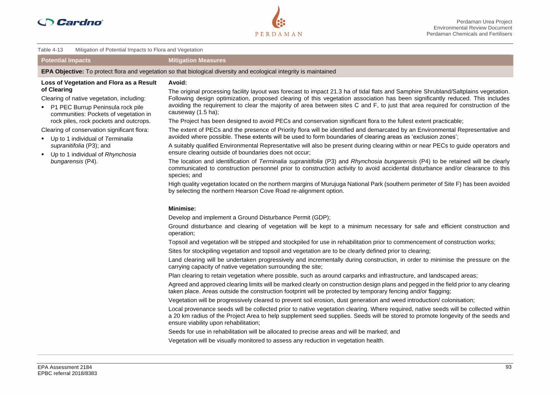
Perdaman Urea Project Environmental Review Document
Perdaman Chemicals and Fertilisers
EPA Assessment 2184 EPBC referral 2018/8383
93
Table 4-13 Mitigation of Potential Impacts to Flora and Vegetation
Potential Impacts Mitigation Measures
EPA Objective: To protect flora and vegetation so that biological diversity and ecological integrity is maintained
Loss of Vegetation and Flora as a Result of Clearing
Clearing of native vegetation, including:
▪ P1 PEC Burrup Peninsula rock pile communities: Pockets of vegetation in rock piles, rock pockets and outcrops.
Clearing of conservation significant flora:
▪ Up to 1 individual of Terminalia supranitifolia (P3); and
▪ Up to 1 individual of Rhynchosia bungarensis (P4).
Avoid:
The original processing facility layout was forecast to impact 21.3 ha of tidal flats and Samphire Shrubland/Saltplains vegetation. Following design optimization, proposed clearing of this vegetation association has been significantly reduced. This includes avoiding the requirement to clear the majority of area between sites C and F, to just that area required for construction of the causeway (1.5 ha);
The Project has been designed to avoid PECs and conservation significant flora to the fullest extent practicable;
The extent of PECs and the presence of Priority flora will be identified and demarcated by an Environmental Representative and avoided where possible. These extents will be used to form boundaries of clearing areas as ‘exclusion zones’;
A suitably qualified Environmental Representative will also be present during clearing within or near PECs to guide operators and ensure clearing outside of boundaries does not occur;
The location and identification of Terminalia supranitifolia (P3) and Rhynchosia bungarensis (P4) to be retained will be clearly communicated to construction personnel prior to construction activity to avoid accidental disturbance and/or clearance to this species; and
High quality vegetation located on the northern margins of Murujuga National Park (southern perimeter of Site F) has been avoided by selecting the northern Hearson Cove Road re-alignment option.
Minimise:
Develop and implement a Ground Disturbance Permit (GDP);
Ground disturbance and clearing of vegetation will be kept to a minimum necessary for safe and efficient construction and operation;
Topsoil and vegetation will be stripped and stockpiled for use in rehabilitation prior to commencement of construction works;
Sites for stockpiling vegetation and topsoil and vegetation are to be clearly defined prior to clearing;
Land clearing will be undertaken progressively and incrementally during construction, in order to minimise the pressure on the carrying capacity of native vegetation surrounding the site;
Plan clearing to retain vegetation where possible, such as around carparks and infrastructure, and landscaped areas;
Agreed and approved clearing limits will be marked clearly on construction design plans and pegged in the field prior to any clearing taken place. Areas outside the construction footprint will be protected by temporary fencing and/or flagging;
Vegetation will be progressively cleared to prevent soil erosion, dust generation and weed introduction/ colonisation;
Local provenance seeds will be collected prior to native vegetation clearing. Where required, native seeds will be collected within a 20 km radius of the Project Area to help supplement seed supplies. Seeds will be stored to promote longevity of the seeds and ensure viability upon rehabilitation;
Seeds for use in rehabilitation will be allocated to precise areas and will be marked; and
Vegetation will be visually monitored to assess any reduction in vegetation health.

Perdaman Urea Project Environmental Review Document
Perdaman Chemicals and Fertilisers
EPA Assessment 2184 EPBC referral 2018/8383
94
Rehabilitate:
Cleared areas will be progressively rehabilitated where they are no longer required for Project activities;
Local provenance seed will be used in rehabilitation activities in order to facilitate preservation of local genetic diversity within the re-established vegetation; and
Top soil will be stockpiled and re-spread over disturbed areas to maximize germination of pioneer species from the soil seedbank.
Degradation of Vegetation as a Result of Ingress of Weeds
Clearing and/ or movement of vehicles containing weed seeds throughout Project Area could result in increased weed abundance.
Avoid
Any imported fill material / soil will be obtained from weed free sources to prevent further spread of weeds; and
Prior the importation of any fill material to the Project site, a written verification from the supplier will be obtain certifying that the material is weed free and meets the criteria of clean fill as defined in the DWER Landfill Waste Classification and Waste Definition 1996 (as amended 2018).
Minimise
To prevent the spread and/or distribution of weeds within the Project Area and to surrounding areas a Weed Management Plan will be prepared prior to the commencement of construction. This plan will outline weed hygiene and management procedures to be undertaken during construction and operations, particularly in referring to controlling the spread of Cenchrus ciliaris (Buffel Grass);
Active management of edge effects will be employed which may involve weeding to ensure no creep of disturbance responsive weed species into remaining vegetation;
Appropriate eradication of problematic species will be employed within construction and operation areas, so that weed control measures do not adversely affect adjacent native vegetation;
Clean entry procedures will be enforced for all vehicles, equipment and personnel entering the Project past public carparks. Vehicles will be required to go through a site entry check and wash down. All employees and contractors will be inducted and trained in wash down procedures;
All vehicles and equipment are restricted to designated roads and other paved areas to prevent excessive disturbance and dispersal of weed species;
Ongoing weed monitoring will occur within the project site and along the site boundary for new infestations during and following construction activities; and
Weed risk areas will be identified on weed maps and through the Ground Disturbance Permit (GDP) process and shall be treated as avoidance sites wherever possible.
Dust deposition
During the construction phase of the Project dust generation is likely, particularly during the dry periods and earthworks.
Minimise
A Dust Management Procedure shall be developed and submitted to and approved by the Environment and Heritage Manager prior to commencing Works likely to generate dust emissions;
Dust suppression techniques (e.g. water trucks) shall be used on unsealed roads and access tracks, cleared areas and at locations of high dust risk;
Dust suppression measures shall be implemented where dust is visible, except during topsoil stripping;
Saline water (> 5000 mg/L TDS) shall not be used for dust suppression unless approved by the Environment and Heritage Manager;
Where the use of saline water for dust suppression (> 5000 mg/L TDS) is approved, dribble bars shall be used to control overspray onto adjacent vegetation;

Perdaman Urea Project Environmental Review Document
Perdaman Chemicals and Fertilisers
EPA Assessment 2184 EPBC referral 2018/8383
95
A log of water used for dust suppression will be maintained and reported in the Monthly Environmental Report. Information reported will include, where relevant, the source of the water (eg: bore reference number or standpipe reference), date and time, volume removed (including meter reading at start and finish), location where water was used;
Vegetation clearing and exposed surfaces shall be kept to a minimum wherever practicable;
Vehicle speeds on access tracks and around work sites shall be reduced where necessary to minimise dust emissions.
Vehicles shall remain within designated roads and park only in allocated areas;
Dust suppressant additives or methods that reduce overall water consumption should be used wherever practicable. This shall include restricting traffic within cleared areas until access is needed;
Vegetation clearing, grubbing and earthworks during high winds (>40 km/hr) should be avoided. Where these works are required to be conducted during high winds, additional management measures must be implemented to minimise and control dust emissions;
Where community complaints are received regarding dust emissions Perdaman may install dust monitors; and
Dust emissions from the conveyor, product storage sheds and shiploading operations will be monitored and minimised throughout the life of the Project. Should emissions exceed the Project’s approval conditions, corrective actions must be implemented, as soon as practicable, to reduce emissions to the permitted level.
Changes to surface and groundwater quality
Changes to the quality and quantity of surface and groundwater flow regimes have the potential to impact the condition of surrounding flora and vegetation.
Avoid
The design scope for the fully enclosed conveying and ship loading system eliminates of the risk of loss of urea product as fugitive dust emissions or spills with the consequential loss of valuable product and potential environment impacts of degradation of water quality in the terrestrial environment.
Minimise
During Construction
Drainage, Erosion and Sediment Pollution Controls
The following controls shall be installed prior to commencement of construction to prevent contamination of surface water and receiving environments.
Drainage Controls
▪ Existing drainage lines will be protected and any diversion of these lines should be kept to a minimum;
▪ Flow management across the site will prevent the concentration and diversion of waters onto steep or erosion prone slopes;
▪ Any diversion of drainage lines will be directed to slopes that are not prone to erosion;
▪ External water flows entering the Project’s battery limits will be diverted around the construction footprint, using drainagestructures such as catch drains and bunds;
▪ Temporary drainage structures will be designed to reduce run-off velocities by using wider inverts, flat bottomed drains ratherthan V-shaped drains, check dams (or similar), silt fencing and revegetation of completed areas;
▪ All drainage lines likely to receive run-off from disturbed areas, such as those downstream of worksites, will be fitted withgeotextile silt fences. Rock checks should also be used in drains to slow flows and provide a lining to prevent scouring ofunderlying surfaces. Sediment basins will be added to drainage lines as necessary. Basins shall be designed relative to thecatchment and likely flow levels for higher rainfall events;
▪ Where silt fences are installed for sediment control, they must be constructed with a centre section lower than the groundlevels at the end of the silt fence to avoid outflanking during heavy rainfall events;

Perdaman Urea Project Environmental Review Document
Perdaman Chemicals and Fertilisers
EPA Assessment 2184 EPBC referral 2018/8383
96
▪ Silt and sediment fences shall be maintained until the areas above them have been adequately stabilised to minimise the erosion risk such that the controls can be removed;
▪ All stormwater proposed for discharge will first be contained in an appropriately lined sediment basin, to all sediment to settle out; and
▪ Construction activities will be scheduled to avoid periods of heavy rainfall, strong winds or peak water flow.
Erosion and Sediment Pollution Controls
Sediment controls are designed to prevent the transportation of sediment and other pollutants from worksites to waterways. They will be installed across the Project sites in areas where land is disturbed. In order to minimise the land exposure and potential risk of erosion, all land disturbances should be confined to a minimum practical working area and within the vicinity of the identified work areas;
Where possible, existing vegetation surrounding the construction site will be used as a buffer zone to help filter surface runoff and should not be disturbed unless necessary for the purpose of construction; and
To ensure that silt from batters, cut-off drains, table drains and road works is retained on site and replaced as soon as practicable, sediment controls will be installed downstream of any disturbed land such as worksites, prior to that work being undertaken.
Run-off controls will be developed and maintained to the following standards:
▪ Controls will be designed to take predicted flows, based on 140436-000-41EG-0001 Standard Specification Geographic, Climatic and Wind / Seismic Data;
▪ Exposed ground will have control measures that minimise the level of erosion;
▪ Drains will be installed across the site to divert clean surface water to stable areas and away from parts of the site where soil is exposed;
▪ Installation of sediment traps and basins with a riser pipe or flexible pipe and spillway to avoid adverse flood risk to adjoining properties. These systems shall allow for the gradual discharge of the clearest water during a storm event as detailed in 6.1.3;
▪ Geotextile silt fences shall be installed in surface water flow areas to minimise the sediment discharge from the site (refer to Attachment C);
▪ Should hay bales be used for sediment control, they will be made of straw sourced from cereal crops and be free of weed seeds;
▪ If any areas of localised erosion develop, they will be remediated as soon as practicable to prevent further erosion or sediment deposition in offsite areas;
▪ Regularly inspect stormwater drainage and sediment control structures to ensure hydraulic integrity and erosion and pollution control effectiveness. If the control structures are obstructed or have their capacity reduced by 30% or more through the accumulation of silt, litter, vegetation and other debris, they shall be cleared, with silt returned to a stabilised part of the project;
▪ Sediment control structures at waterway crossings will be developed during the detailed design process before any such work takes place; and
▪ Throughout construction, rehabilitation of disturbed areas will be progressively undertaken, or as soon as practicable, following completion of specific works.
▪

Perdaman Urea Project Environmental Review Document
Perdaman Chemicals and Fertilisers
EPA Assessment 2184 EPBC referral 2018/8383
97
Post- Construction
The following principals shall be applied:
▪ The granular urea product is much harder than prilled urea, therefore creating less fines and dust when handled and transported which minimizes the urea fines and dust that could be accidentally released during conveying and ship loading activities;
▪ Spill contingency and emergency response plans and procedures will be developed and implemented to address environmental risks and potential impacts specifically related to the operational phase;
▪ The stormwater pond includes an oil skimmer for removal of oil traces. These are sent to the oily water collection pit/processing; and
▪ For paved areas of the urea processing plant, there will be stormwater collection pits (epoxy coated concrete pit) where the first 15mm of stormwater can be collected. Stormwater collected will be treated by steam stripping or other means to bring ammonia (Total Kjeldahl Nitrogen) in water within limit, prior to reuse within the process plant.
Ongoing Monitoring
Regular inspections and audits will be undertaken to ensure the environmental protection outcomes of the Project are achieved. Inspection and maintenance activities will follow the Monitoring and Compliance requirements outlined in the Project Environmental Management Plan (PEMP) and will include:
▪ Review of Erosion and Sediment Control Plans and validate that the proposed erosion and sediment controls have been implemented and, where relevant, revised to accommodate the changing environment;
▪ Inspections to observe and record any scouring, erosion and sediment transfer particularly beyond the Project footprint;
▪ Cleaning of sedimentation basins when the accumulated sediment has reduced the basin capacity by more than 30%, as indicated by depth pegs;
▪ Cleaning of all drains to remove silt, vegetation (where capacity is reduced) and litter;
▪ Weekly inspection of access roads and hardstand areas to identify erosion damage in need of maintenance. Remediation is to occur within one month or earlier if heavy rains are likely; and
▪ Discharge from any oily water separator shall be monitored to ensure it contains less than 5ppm Total Recoverable Hydrocarbons (TRH) and is in compliance with Project approval conditions before it can be used for dust suppression or discharged into the environment. Written approval from the Contractor’s Environment Manager must be obtained prior to reuse or discharge to the environment.
Contingency measures include:
▪ Where erosion or sediment deposition occurs, rehabilitation corrective actions shall be implemented as soon as practicable;
▪ Where sedimentation occurs the source of the sediment should be determined to identify likely erosion in up gradient areas. The sediment should be removed and deposited, if possible as part of erosion controls; and
▪ Where erosion is identified and requires rehabilitation the impacted area shall be filled, compacted and contoured to merge with the surrounding landscape.
Loss of Vegetation and/or Flora from Fire
Altered fire regimes resulting from Project activities could result in increased loss of native vegetation and/ or flora due to fire impacts.
Minimise
Manage fire to reduce frequency and intensity around the Project area and the local area;
Staff will be trained in the use of fire extinguishers;
Spot fire control measures will be devised;

Perdaman Urea Project Environmental Review Document
Perdaman Chemicals and Fertilisers
EPA Assessment 2184 EPBC referral 2018/8383
98
All vehicles will be fitted with fire extinguishers;
A Hot Work Permit system will be devised and implemented;
Cigarette disposal units will be designated in approved smoking areas on site. Employees will not be permitted to smoke in vehicles within the Project Area; and
Vehicles will be required to remain on established tracks and roads only and will be instructed in avoiding leaving vehicles idling over vegetation, regrowth or dry grass, in the summer months.

Perdaman Urea Project Environmental Review Document
Perdaman Chemicals and Fertilisers
EPA Assessment 2184 EPBC referral 2018/8383
99
4.5.7 Predicted outcome
It is not expected that the construction or operation of the Project will significantly impact upon the conservation status of flora or vegetation communities recorded within the Project study area.
Clearing of vegetation will be limited to ALARP and the area used for construction laydown (west of Site F) will be rehabilitated following construction activities. Where impacts upon priority flora cannot be avoided, the Proponent will relocate or replace all of the specimens affected. Clearing requirements for the Project will not significantly impact vegetation communities in a regional context.
Taking into account the proposed management and mitigation commitments outlined above and within the EMP, it is considered that the environmental objectives for flora and vegetation can be met by the Project.
The Proponent commits to management and mitigation measures outlined in the Project Environmental Management Plan (Appendix K) and the Flora Management Plan (Appendix 7) prepared for the Project to minimise potential impacts on flora and vegetation including those outlined above.
In line with appropriate guidelines and in consultation with the regulatory bodies, the Project Proponent will finalise the offset objectives during the assessment process.

Perdaman Urea Project Environmental Review Document
Perdaman Chemicals and Fertilisers
EPA Assessment 2184 EPBC referral 2018/8383
100
4.6 Terrestrial Fauna
4.6.1 EPA objective
To protect terrestrial fauna so that biological diversity and ecological integrity are maintained.
In the context of this objective: Ecological integrity is the composition, structure, function and processes of ecosystems, and the natural range of variation of these elements.
4.6.2 Policy and guidance
The following policies and guidance have been considered for the assessment:
> EPA (2018) Statement of Environmental Principles, Factors and Objectives;
> EPA (2018) Environmental Impact Assessment (Part IV Divisions 1 and 2) Procedures Manual;
> EPA (2016) Environmental Impact Assessment (Part IV Divisions 1 and 2) Administrative Procedures2016;
> EPA (2016) Environmental Factor Guideline: Terrestrial Fauna;
> EPA (2016) Technical Guidance: Terrestrial Fauna Survey;
> EPA (2016) Technical Guidance: Sampling Methods for Terrestrial Vertebrate Fauna;
> EPA (2016) Technical Guidance: Sampling of short range endemic invertebrate fauna;
> Commonwealth of Australia (1996) The National Strategy for the Conservation of Australia’s BiologicalDiversity;
> Commonwealth of Australia (2001) National Objectives and Targets for Biodiversity Conservation 2001-2005;
> Department of the Environment (2015) Wildlife Conservation Plan for Migratory Shorebirds;
> DoEE (2017) Industry guidelines for avoiding, assessing and mitigating impacts on EPBC Act listedmigratory shorebird species;
> DEWHA (2009) Significant impact guidelines for 36 migratory shorebirds species (EPBC Act PolicyStatement 3.21;
> DEWHA (2010) Survey Guidelines for Australia’s Threatened Bats;
> DEWHA (2010) Survey Guidelines for Australia’s Threatened Birds;
> DEWHA (2011) Survey Guidelines for Australia’s Threatened Reptiles;
> Government of Western Australia (2014) Environmental Offsets Guidelines; and
> Government of Western Australia (2011) Environmental Offsets Policy.
4.6.3 Receiving environment
Vegetation of the Burrup Peninsula was described in detail by Trudgen and Associates (2002). The dominant vegetation type of the Burrup Peninsula can be broadly described as mid-dense hummock (Triodia sp) grass with mixed scrub and open low woodland with scattered substrate related minor communities (Section 4.5). Figure 4-4 shows the vegetation mapping of the Burrup Peninsula by Trudgen and Associates (2002).
Vegetation units of the Burrup Peninsula were then categorised into fauna habitats to assess the potential impacts of the Project on fauna (Figure 4-11). Four fauna habitat types identified within the main Project sites: rocky outcrops, Hummock Grasslands on Mid-slopes, Samphire Shrublands/Saltplains, and Drainage Lines.

Perdaman Urea Project Environmental Review Document
Perdaman Chemicals and Fertilisers
EPA Assessment 2184 EPBC referral 2018/8383
101
Figure 4-11 Habitats of the Burrup Peninsula and their extent in relation to the Murujuga National Park

Perdaman Urea Project Environmental Review Document
Perdaman Chemicals and Fertilisers
EPA Assessment 2184 EPBC referral 2018/8383
102
4.6.3.2 Rocky Outcrops
Characteristic of the Burrup Peninsula, the formation of Proterozoic igneous rock outcrops (Gidley Granophyre) within the Biological study area, weathered over time and resistant to extensive erosion, produce aggregates of split boulder screes (Figure 4-12). These formations create good cover for reptiles in the pockets for adequate shade and protection, and also caves for bats and other small terrestrial mammals. This habitat type is also suitable for the Pilbara Olive Python (Liasis olivaceus barroni), and though not recorded during the surveys (APM, 2018 & 2019) or previous adjacent surveys (Worley Astron, 2006), it is likely this species may occur in the area due to the availability of suitable habitat.
Weathering has also created exposed granophyre bedrock, providing extensive plains of small-sized rocks, dominating the topsoil layer. While this may represent appropriate habitat for the Western pebble-mound mouse (Pseudomys chapmani), the species was not recorded in the study area and is likely now locally extinct, as it is currently only patchily distributed in the central and southern Pilbara (Western Wildlife, 2008). The outcrops within the study area are small and isolated, and likely to be less important than the larger outcrops to the south, which provide greater connectivity and opportunity for secure and productive habitat.
The study area may be occupied by the Rothschild’s Rock Wallaby (Petrogale rothschildi), though records suggest the species exists on the islands of the Dampier Archipelago at low densities, and any populations south of Withnell Bay are now rare or completely absent (Pearson & Eldridge, 2008). At sites in the northern parts of the Burrup Peninsula, Rock Wallaby (Petrogale rothschildi) recovered in response to fox baiting operations. The sub-species could use the rocky outcrops and creeklines nearby that contain diverse grasses and shrubs for foraging, though the species is not likely to be present as it requires deep caves for shelter during the heat of the day, and most of the rock piles are not significant enough to provide this. It is more likely the species would utilise rockpiles on islands interspersed by areas of spinifex and soft grasses around beaches which are undisturbed by humans and enables them to venture short distances from their shelter sites to forage [Department of Parks and Wildlife (DPaW), 2013].
Evidence of Echidnas (Tachyglossus aculeatus) (scats found atop rockpiles) were located at the study area in reasonable quantities suggesting a persisting population on the Burrup Peninsula. The Finlayson’s Cave Bat (Vespadelus finlaysoni) was recorded within this habitat type north-west of the study area (via acoustic bat recorder), close to the boundary. It was also recorded at the south eastern boundary of the study area, suggesting it was likely roosting somewhere in the extensive rocky outcrops that spread east to south east adjacent to the site, and using the hummock grasslands for foraging. Similarly, the Little Broad-nosed Bat (Scotorepens greyii) was recorded in the same sites (via acoustic bat recorder), which is unusual for this species, as it is not a cave-dweller. It is likely a reflection of the survey season (i.e. pre-wet), as the creekbeds are dry, and during this time, the species would switch to foraging within the hummock grasslands, instead of the tree-lined and water-filled riparian drainage lines expected during the wet.
Figure 4-12 Rocky Outcrop Habitat Trapping Sites (APM, 2019)

Perdaman Urea Project Environmental Review Document
Perdaman Chemicals and Fertilisers
EPA Assessment 2184 EPBC referral 2018/8383
103
4.6.3.3 Hummock Grasslands on Mid-slopes
The biological study area and the wider Burrup Peninsula contain coastal and subcoastal plains with mixed savannah hummock and tussock grasslands, and scattered shrubs of Acacia pyrifolia and Acacia inaequilatera (Figure 4-13). The presence of hummock-grasses and relatively deep soils within this habitat type provides important shelter for a range of small species such as Main’s Frog (C. maini), Leonhard’s Ctenotus (Ctenotus leonhardii) and the Western Bearded Dragon (Pogona minor mitchelli), as well as larger snake species, such as the Western Brown Snake (Pseudonaja mengdeni).
This habitat type will also provide foraging habitat for grazers, primarily Euros (Osphranter robustus), but also potentially Rothschild’s Rock Wallaby (Petrogale rothschildi), especially given that the species feeds on both native and non-native grasses (e.g. Buffel grass) (Pearson & Eldridge, 2008), which are present in this habitat type.
Small rodents such as the Delicate Mouse (Pseudomys delicatulus), which has not suffered dramatic range declines like most of Australia’s native rodents, may occur in the Project Area as the expanse of this habitat type would provide grass seeds that make up the majority of the species diet. The Sandy Inland Mouse (Pseudomys hermannsburgensis) may also occur, as the species resides within hummock and tussock grasslands creating shallow burrows or using pre-existing burrows and foraging close to cover (Van Dyck & Strahan, 2008). The species population fluctuates greatly in response to rainfall.
Evidence of Echidna (T. aculeatus) was recorded in this habitat type, as well as wild dog/dingo (Canis sp.) and feral cat (Felis catus) scats. The Northern freetail bat (Chaerephon jobensis) was recorded in this habitat type on only one of the trap nights and on one recorder only (APM, 2018).
Figure 4-13 Hummock Grasslands on Mid-slope Trapping Sites (APM, 2019)
4.6.3.4 Samphire Shrubland/Saltplains
The Burrup Peninsula contains marine alluvial flats and river deltas that support Samphire and mangal ecosystems/mangroves (Figure 4-14). Although not extensive in a regional context, the intertidal flats around the Burrup contain a variety of marine waders, and these flats are locally significant (DEC, 2013). Such areas are important for migratory shorebirds and those that rely on seasonal water availability or opportunistic foraging, such as predatory birds like the Peregrine Falcon (Falco peregrinus), Eastern Osprey (Pandion cristatus), and Wedge-tailed Eagle (Aquila audax).
Fauna diversity and density is likely to be low during the dry and pre-wet seasons as there is lack of canopy cover of this habitat type in the Project Area. This habitat will become increasingly important at times of inundation during high tide when waders and shorebirds use the area for feeding, roosting and potentially nesting [e.g. Red-capped Plover (Charadrius ruficapillus)].
The supratidal flats between King Bay and Hearson Cove and those that run directly through the middle of the Project Area contain mangal systems that would be likely to support a diverse range of fauna. This includes many birds that may use the rich organic marine sediment to forage and potentially nest [such as Brahminy Kite (Haliastur indus) and Mangrove Golden Whistler (Pachycephala melanura)]. Mammals such as the Water Rat (Hydromys chrysogaster) could also reside among the extensive mangal system present at the mouth of King Bay which flows into the tidal flats and smaller mangrove habitat just outside the Project development area, where the species could be foraging at low tide. The North-Western Free-Tailed Bat (Ozimops cobourgianus) is a user of mangroves for roosting, particularly those adjacent to forest and along large

Perdaman Urea Project Environmental Review Document
Perdaman Chemicals and Fertilisers
EPA Assessment 2184 EPBC referral 2018/8383
104
waterways. This species was recorded six times on three separate nights via bat detectors. It was recorded on three of the four bat detectors placed around site (APM, 2018).
When the area is not inundated, the most common fauna to use the site is the Euro (O. robustus). Frequent evidence of this species was found across the flats (tracks and scats) during the pre-wet survey (APM, 2018).
Existing mangrove communities are not forecast for disturbance based on the current site layout.
Figure 4-14 Samphire Shrubland / Supratidal Flat Trapping Sites (APM, 2019)
4.6.3.5 Drainage Lines
Rapid weathering of the geology of the area has also formed deeply incised narrow valleys amongst the exposed bedrock. These channels trend southwest to northeast and east to west throughout the Burrup Peninsula. The drainage channel present in the biological study area in the southwest corner is quite significant (Figure 4-15).
The Eucalyptus communities within and beside the watercourses contain large, tall trees that may provide hollows suitable for birds such as the Galah (Cacatua roseicapilla) and Little Corella (Cacatua sanguinea). Similarly, this habitat provides general roosting, nesting, perching and foraging habitat for the Red-browed Pardalote (Pardalotus rubricatus), Red-backed Kingfisher (Todiramphus pyrrhopygius) and Black-faced Woodswallow (Artamus cinereus). If trees are large enough and have many hollows, some bats such as the Northern Freetail Bat (Chaerephon jobensis), Beccari’s Freetail Bat (Mormopterus beccarii), Yellow-bellied Sheathtail Bat (Saccolaimus flaviventris) and Common Sheathtail (Taphozous georgianus) may seek refuge within this habitat. C. jobensis and T. georgianus were both recorded during the pre-wet season survey. T. georgianus was recorded on all four of the bat detectors, on each trap night.
Figure 4-15 Drainage Line Habitat in the Southwest Corner of the Study Area (APM, 2019)
4.6.3.6 Rocky Outcrops and Dunes
Additional to the plant site (Site C and Site F), a small hardstand area is designated to be built adjacent to the existing industrial storage area located a few hundred metres from the Pilbara Ports Authority office. The development area is immediately adjacent to the coast, where a ship loader will reside, connecting to the proposed arm for shipment that will extend north along the existing hardstand areas. The coastal area meets scattered rocky outcrops which adjoin a large outcrop extending to about 100 m north to south (most of this

Perdaman Urea Project Environmental Review Document
Perdaman Chemicals and Fertilisers
EPA Assessment 2184 EPBC referral 2018/8383
105
landmass residing outside the development area). The outcropping shifts into red sandy loam dunes with scattered hummock grasses. Further inland, the proposed urea shed will be placed upon pre-existing hardstand area. A service corridor currently exists adjacent to this site, where material can be delivered to the shed. Larger scattered rocky outcrops and hummock grasslands exist in this area.
This habitat type is likely to support a diversity of reptiles. According to NatureMap database, there are several records of the Spotted Dtella (Gehyra punctata) and Tree Dtella (Gehyra variegata) geckoes from the rocky outcrop immediately adjacent to the coast. The area could support the Pilbara Olive Python (Lialis olivaceus barroni), which has been sighted numerous times near the Pluto LNG Park and Karratha Gas Plant.
The area to be developed is miniscule in scale compared to the wider developed area of the Burrup Industrial Estate that still contains a significant amount of undisturbed habitat. Some of the species expected to utilise the Rocky Outcrops habitat type in the major development area are likely to occur in this area also.
Possible, though quite unlikely would be the presence of the Northern Quoll. A record does exist of this species in the King Bay Supply Base just south of the proposed development and in the rocky outcrops just south of the Woodside Southern Expansion Lease Yard, about 2 km northeast of the proposed development, suggesting the species may be inhabiting around and within these developed areas for the purpose of foraging. Suitable habitat may be directly impacted however the effects are minimal given the extensive suitable habitat still available in the undeveloped areas.
4.6.3.7 Coastal Rocky Shore
The proposed ship loader that will attach to the offshore jetty will intersect a portion of Coastal Rocky Shore habitat. The only species that could utilise this habitat-type is potentially the Water Rat (Hydromys chrysogaster) which do feed on marine invertebrates, crustaceans and even turtle eggs. However, they tend to occupy sheltered areas of estuaries containing mangroves, and may forage further into coastal/intertidal areas, but would not utilise coastal rocky shores, like that in the development area, solely as a protective habitat. It is unlikely the Water Rat would be utilising the area for feeding because there is so much development on land, and there is limited shelter as means for predator protection. This habitat type is not synonymous with any other conservation significant fauna.
4.6.3.8 Previous Fauna Surveys
Studies of terrestrial fauna that are relevant to the Proposal are identified in Table 4-14. The most recent comprehensive fauna survey report (APM 2019) is included in Appendix B.
In total, across all database searches and published reports, 323 terrestrial vertebrate fauna species were identified that may occur within the study area and surrounds. This included 196 birds, 87 reptiles, 4 amphibians and 36 mammals. The multitude of developments situated on the Burrup Peninsula have resulted in a range of biological surveys extending back to the 1970s. However, many of these surveys are not freely available. Table 4-14 includes the previous desktop and field assessments carried out for nearby projects as well.

HummockGrasslands on
Mid Slopes
Disturbed
DrainageLines
RockyOutcrops
SamphireShrubland/Supratidal
Flats
±Map Produced by Cardno VIC
Date: 2020-03-16Coordinate System: GDA 1994 MGA Zone 50
Project: CW1055600Map: CW1055600-GS-004-FaunaHabitats.mxd 01Aerial Imagery Supplied by Nearmap (April, 2019)
Legend Proposal Development
Envelope
Fauna HabitatDisturbedDrainage LinesHummockGrasslands on MidSlopesRocky OutcropsSamphireShrubland/SupratidalFlatsPlant Layout
Fauna HabitatsPERDAMAN UREA PROJECT
FIGURE 4-160 50 100 150 200
MetresScale at A41:9,000

Perdaman Urea Project Environmental Review Document
Perdaman Chemicals and Fertilisers
EPA Assessment 2184 EPBC referral 2018/8383
107
Table 4-14 Receiving environment studies – Terrestrial Fauna
Report Title Consultant Year Survey Type Purpose
Fauna and Marine Biota. In: Burrup Peninsula Draft Land Use and Management Plan, Technical Appendices. Unpublished report by O’Brien Planning Consultants
H. Butler 1996 Cited in Worley Astron 2006 – Scope and methodology of report not known as report is no longer available
Burrup Liquid Ammonia Plant targeted fauna survey. Unpublished report for Sinclair Knight Merz Pty Ltd
Biota Environmental Services
2001 Cited in Worley Astron 2006 – Scope and methodology of report not known as report is no longer available
Terrestrial Fauna and Habitats. In: Methanex Australia Pty Ltd, Methanol Complex, Burrup Peninsula Western Australia, Public Environmental Review (Section 5.8)
Biota Environmental Services
2002 Cited in Worley Astron 2006 – Scope and methodology of report not known as report is no longer available
Burrup Fertilisers Pty Ltd. Fauna of the Burrup Peninsula and the Proposed Ammonia Plant (Revised version). Unpublished report to Sinclair Knight Merz Pty Ltd
Astron Environmental
2001 Cited in Worley Astron 2006 – Scope and methodology of report not known as report is no longer available
Natural Gas to Synthetic Oil Project Product and Feed pipelines, Vegetation, Flora and Fauna Survey. Unpublished report for Syntroleum Corporation
Astron Environmental
1999 Cited in Worley Astron 2006 – Scope and methodology of report not known as report is no longer available
Terrestrial Fauna and Habitats. In: Burrup Peninsula Fertilisers Pty Ltd, Proposed 2,200 tpd Ammonia Plant, Burrup Peninsula Western Australia, Public Environmental Review (Section 5.8). August 2001. Prepared for Sinclair Knight Merz
Astron Environmental
1999 Cited in Worley Astron 2006 – Scope and methodology of report not known as report is no longer available
Vegetation, Flora and Fauna Survey. In: Syntroleum, Proposed Gas to Synthetic Hydrocarbons Plant, Burrup Peninsula Western Australia, Consultative Environmental Review. November 1999. Prepared for HLA – Envirosciences Pty Ltd
Astron Environmental
2001 Cited in Worley Astron 2006 – Scope and methodology of report not known as report is no longer available
Annual Report on Environmental Investigations and Monitoring
Woodside Offshore Petroleum Pty Ltd
1995 Cited in Worley Astron 2006 – Scope and methodology of report not known as report is no longer available
Annual Report on Environmental Investigations and Monitoring
Woodside Offshore Petroleum Pty Ltd
1997 Cited in Worley Astron 2006 – Scope and methodology of report not known as report is no longer available

Perdaman Urea Project Environmental Review Document
Perdaman Chemicals and Fertilisers
EPA Assessment 2184 EPBC referral 2018/8383
108
Annual Report on Environmental Investigations and Monitoring
Woodside Offshore Petroleum Pty Ltd
1998 Cited in Worley Astron 2006 – Scope and methodology of report not known as report is no longer available
Annual Report on Environmental Investigations and Monitoring
Woodside Energy Pty Ltd
1999 Cited in Worley Astron 2006 – Scope and methodology of report not known as report is no longer available
Pluto LNG Development Survey of Non-marine Molluscs
S.M. Slack-Smith 2005 Targeted Survey Cited in Worley Astron 2006 – A targeted assessment of the non-marine mollusc fauna of the Burrup Peninsula to allow assessment of the probable effect of the land based components associated with the Pluto LNG Development proposed by Woodside.
Fauna assessment surveys of the Pluto LNG Development pipeline corridors
ENV Australia 2006 Cited in Worley Astron 2006 – Scope and methodology of report not known as report is no longer available
Pluto LNG Development Holden Beach Sea Turtle Habitat Use Survey
Pendoley Environmental
2006 Targeted Survey To search for evidence of sea turtle nesting activity within the vicinity of a trunkline shore crossing location associated with the proposed Pluto LNG Development at Holden Beach
Terrestrial Fauna of the Burrup Peninsula, unpublished report prepared for BGC Contracting
Astron Environmental
2003 Desktop Survey To provide a comprehensive desktop assessment of the King Bay Eastern Leases area and determine fauna of significance that may inhabit the lease of adjoining areas
Pluto LNG Development Desktop Fauna Report Worley Astron 2006 Level 1 Desktop Survey
To provide a comprehensive desktop assessment of the Pluto LNG Development area and determine fauna of significance that will be required to be assessed for presence/absence in future targeted surveys.
Technical Ammonium Nitrate Production Facility. Public Environmental Review for Burrup Nitrates Pty Ltd
Environmental Resources Management
2009 Reconnaissance Survey
To provide a comprehensive desktop assessment of the area (Site D) for the Technical Ammonium Nitrate Production Facility including noise monitoring sites, noise contouring and reduction measures, the extent of the now Murujuga National Park, broad landscape and vegetation attributes and hydrology and drainage.

Perdaman Urea Project Environmental Review Document
Perdaman Chemicals and Fertilisers
EPA Assessment 2184 EPBC referral 2018/8383
109
4.6.3.9 Field Surveys
Fauna surveys were conducted according to the EPA (2016) Technical Guidance: Sampling Methods for Terrestrial Vertebrate Fauna. The terrestrial vertebrate fauna survey was conducted by APM (2019) in two discrete periods, the initial, pre-wet season Level 1 survey, and the follow-up, post-wet season Level 2 survey. Survey efforts included trapping, deployment of camera traps and acoustic bat detectors, bird surveys, targeted searching for threatened species and land snails. Full details are provided within APM (2019) report Appendix B. As per the vegetation and flora survey, the fauna survey was conducted over two phases, comprehensiveof the two seasons experienced in the Pilbara. Species accumulation curves are provided in the Appendix Bto ascertain whether the trapping efforts have been sufficient. Fauna habitats and fauna data collection pointswithin the Study Area can be seen in 0.
Fauna survey details and constrains are provided in the Table 4-15 below.
> Phase I – Pre-wet season survey
APM Phase I Level 1 terrestrial vertebrate fauna survey was conducted between 19th to 22nd of November, by Dr. S Dawson (Senior Zoologist) and Dr. F. Holmes (Senior Ornithologist). While a Level 1 survey generally only requires a site visit and description/mapping of fauna habitat, the current survey was expanded slightly to include daily bird surveys, camera trapping, and deployment of acoustic bat detectors.
> Phase II – Wet season survey
The post-wet season Level 2 survey was carried out between the 27th of March and the 5th of April by Dr S. Dawson (Senior Zoologist), Dr G. Hayes (Senior Zoologist), Dr F. Holmes (Senior Ornithologist), S. Flemington (Environmental Scientist) and A. Hogan-West (Graduate Environmental Scientist). This survey included the deployment of six trap sites across the habitats available within the site. In addition, morning and afternoon bird surveys and nocturnal spotlight surveys were conducted.
The findings of the two-phase fauna survey are detailed below, further details on the survey efforts and data collected are provided within Appendix B.
Table 4-15 Fauna survey characteristics
Factor Description
Survey team The personnel that executed these surveys included practitioners that are regarded as suitably qualified in their respective fields.
Dr Eleanor Hoy – Senior Botanist (10 years’ experience)
Dr Stuart Dawson – Senior Zoologist (5 years’ experience)
Dr Geneieve Hayes ‐ Senior Zoologist (5 years’ experience)
Sarah Flemington – Environmental Scientist (2 years’ experience)
Scope of fauna survey
The scope of the fauna survey was Level 1 and Level 2 surveys. In order to achieve the survey effort outlines in the guidelines for biodiversity surveys, trapping was conducted over 7 trap nights, and all methods of sampling were achieved within this time period.
Timing, weather, season, cycle
Field surveys were conducted in November 2018 and March, April and May 2019. As such, surveys were conducted in a broad range of seasonal conditions. The 2019 wet season (Jan‐March) experienced lower than average rainfall. This is likely to result in diversity and abundance of fauna and ephemeral flora being slightly lower than average years.
While the survey timing did not include a period of spring tide, during which the tidal salt flats would be inundated, a cyclonic event just prior to fieldwork resulted in abundant available water on the plains. This availability of water negates the limitation of the lack of spring tide.
Sources of information
The fauna assemblage of the Burrup Peninsula is well studied, largely due to the number of different facilities that have been built on the peninsula in the last 30 years, and the resulting biological surveys. Many of these surveys are not freely available, however, while being referred to in more recent documents. The literature search is therefore deliberately limited to include surveys that include data directly comparable to our survey. Given the number of previous surveys and database searches, this is not considered a limitation.
Completeness of fauna survey
305 vertebrate fauna taxa have either been recorded or are expected to occur in the Burrup Peninsula (Worley Astron, 2006).
The Level 2 biological survey conducted in the early 2019, coupled with the Level 1 survey conducted in late 2018, represents an appropriate survey effort to provide a reasonable inventory of species occupying the site. Similarly, the bird survey was conducted in accordance with guidelines. The data gathered in this survey, coupled with previous surveys on the Burrup Peninsula, and
Perdaman Urea Project Environmental Review Document
Perdaman Chemicals and Fertilisers
EPA Assessment 2184 EPBC referral 2018/8383
110
appropriate database searches, provides an adequate understanding of the faunal assemblage at the site, such that completeness is not considered a limitation.
Trapping could not be conducted in the floodplain during the March/April survey, due to the area being waterlogged from the recent rainfall. Given the area is completely devoid of cover, this area is unlikely to support many small animals.
> Short-range endemic (SRE) species survey
Short-range endemic (SRE) species surveys in the wider Project region by Worley Astron (2006) have identified three species of Camaenidae, three species of Pupillidae and one species belonging to the Helicodiscidae family.
Therefore, Western Australian Museum was commissioned to perform database searches for SRE fauna occurring within the main study area. An aggregated database does not exist, and, as such, four separate databases were searched – “Arachnids/Myriapods”, “Crustacea and Worms”, “Insects”, and “Molluscs”.
The database search area was a rectangle, with the northwest corner co-ordinates: -20.614468, 116.761546, and southeast corner co-ordinates: -20.648286, 116.789698.
The WA Museum database searches are automated for the SRE filter, returning results for any species/taxa within the defined area that have distributions of less than 100 x 100 km (i.e. any potential SRE taxa). For taxa that are identified as occurring within the search area, all records of that taxa within WA are returned.
Additionally, the Department of Biodiversity, Conservation and Attractions (DBCA) Database for Threatened and Priority Ecological Communities was searched for the location of PECs known to be important habitat for SRE snails. Priority Ecological Communities identified from APM (2019) Biological Survey were also searched.
SRE – species specific Camaenid land snails survey was conducted immediately post Tropical Cyclone Veronica. In total, 18 quadrats (10 x 10 m) were searched. 12 quadrats were within the study area, and an additional six control quadrats were searched outside the study area. Quadrats were located on rockpiles and creeklines and were searched by two people for 20 minutes. Searchers focused on cooler and humid microclimates, including under spinifex hummocks, within rockpiles, and beneath rocks. All snail shells were collected, stored in plastic containers, and kept for identification.
Of the 12 quadrats searched, snails were collected from five quadrats. They are collected all outside of the Project footprint. Thirteen snail shells were sent to the WA Museum for identification, with the results still in preparation.
4.6.3.10 Mammals
In total, 30 mammals have been recorded on the Burrup Peninsula, inclusive of APM and other published report survey results (years 1994-2002) (Worley Astron, 2006). Despite the survey efforts, Northern Quolls (D. hallucatus) were not recorded during APM surveys.
The Ghost Bat (M. gigas), listed as Vulnerable under both commonwealth and state legislation, was recorded on two evenings in the southern section of the study area. This species often forages along creeklines, using the taller trees as vantage points from which to spot prey. The creekline in the south west of the study area, outside the PDE, is likely to provide important foraging habitat for the Ghost Bat, especially given its close proximity to Murujuga National Park, which is likely to provide important roosting opportunities.
The North-western free-tailed bat (Mormopterus cobourgianus), listed as Priority 1 (Poorly-known species) in WA, was also recorded at numerous sites, on multiple occasions, throughout the study area. This species is known to roost in Grey Mangroves, which are likely to be present in the vicinity of King Bay to the west of the study area. It is unlikely that the Project will impact this species.
APM recorded 7 non‐volant mammals and other various small and medium sized mammals including the Short-Beaked Echidna (T. aculeatus), Euro (O. robustus), Delicate Mouse (Psuedomys delicatulus) and Desert Mouse (P. desertor). A range of naturalised (Dog Canis familiaris) and introduced (Feral Cat Felis catus, Black Rat, Rattus rattus) were also recorded. In addition, flying foxes have been observed in the mangroves to the west of the study area (Pteropus sp.) during the APM 2018 survey, and in previous surveys (Worley Astron, 2006).
During both the pre‐wet season, and post‐wet season surveys, cage and Elliot trapping, camera traps were deployed in rocky outcrop areas, and nightly spotlight searches and scat searches were conducted in an effort to record the Northern Quoll (D. hallucatus). Despite this survey effort, no species was recorded during the APM surveys. While the survey design was appropriate, Northern Quoll is cryptic and often inhabit complex

Perdaman Urea Project Environmental Review Document
Perdaman Chemicals and Fertilisers
EPA Assessment 2184 EPBC referral 2018/8383
111
landscapes where detection is difficult. Given the low density of mainland populations of this species, and its nature, the lack of detections during APM surveys may not indicate the absence of this species from the area. However, the lack of detections does indicate that this species is rare in habitats at the study area.
4.6.3.11 Birds
APM recorded 63 bird species across the pre-wet and post-wet season surveys including 26 listed bird species. In total, 150 bird species have been recorded to date on the Burrup Peninsula in surveys conducted in 1994, 1998, 2002, 2005 (Worley Astron, 2006) and the two surveys by APM in 2018 and 2019. Six of the species recorded by APM were not recorded in previous surveys or database searches including the migratory species, the Pacific Golden Plover (Pluvialis fulva).
While survey timing was appropriate to target migratory species, late 2018 and early 2019 was an unseasonably dry period on the Burrup Peninsula. However, a cyclonic rainfall event (Cyclone Veronica) before the March survey resulted in areas of available surface water, which is likely to have increased the use of the site by migratory waders and shorebirds, therefore increasing the probability of being recorded during surveys. Of the migratory and marine bird species recorded within the study area, the most numerous species were the Red‐capped Plover (C. ruficapillus), Grey‐tailed Tattler (T. brevipes), and Common Greenshank (T. nebularia). The proximity of the sites to beaches and mangroves suggests that migratory shorebirds and waders may be seasonally present within the PDE or in the adjacent areas.
Eleven species of raptors were recorded during the fauna surveys, suggesting the large, open plains and claypans and adjacent grassland and rocky areas within the study area provide favourable foraging areas. Most were observed on two or more of the survey days, and most were seen in pairs. The Nankeen Kestrel (F. cenchroides) and Whistling Kite (H. shenurus) were observed on all four of the survey days. The Whistling Kite usually targets carrion rather than live prey. The reduction of habitat associated with the development of the study area is unlikely to significantly reduce its local foraging opportunities, given the proximity to a National Park. In addition, the species also uses coastal and tall mangrove habitats, which are abundant on the Burrup and Dampier regions. The Nankeen Kestrel is opportunistic in its nest site selection, often using old nests of other raptors in tall trees. This species also frequents roadsides for roadkill, as well as coastal dunes. Given the proximity to a protected area (Murujuga National Park), and the availability of undisturbed habitat, the development of the Project is unlikely to present a significant reduction in local foraging or nesting habitat for any raptor species.
4.6.3.12 Reptiles and Amphibians
Published reports indicate that at least 49 reptiles and two amphibians have been recorded before on the Burrup Peninsula (Worley Astron, 2006). APM recorded 27 species of reptiles and 1 amphibian spices during the post-wet season trapping survey.
Rocky outcrop areas inside and immediately adjacent to the study area were nocturnally searched using spotlight surveys in an effort to record the Pilbara Olive Python (L. olivaceus barroni) during both APM surveys. However, this species was not recorded by APM. While the rainfall leading up to the 2019 post‐wet season survey was below average, the cyclone event in the preceding week resulted in some fresh water being available. The frequency with which Pygmy Pythons (Anteresia perthensis) were detected during the post‐ wet season survey (5 individuals across 4 nights) suggested that conditions were appropriate for other python species during this survey. This species is highly cryptic, and occupies complex rocky outcrops and fissures that make detection probability for this species low. As such, it is possible that Pilbara Olive Pythons will use the study area. The lack of detections during the APM survey, however, suggest it is infrequent if present. The current study area does not include the well‐developed and extensive rocky outcrops present immediately north and south of the site.
The reptile assemblage on the Burrup Peninsula is generally consistent with the nearby mainland. A range of geckos, including the Fat-tailed Gecko (Diplodactylus stenodactulys), the Jewelled Gecko (Strophurusa elderi), and the Spotted Dtella (Gehyra punctata) have been recorded, as well as a range of Dragons, Skinks, Varanids and Snakes.
The diversity and density of the amphibian assemblage on the Burrup Peninsula is generally low, likely due to the absence of permanent freshwater, and the extremely short time during which ephemeral water is available. The Mains Burrowing Frog (Cyclorana maini) was recorded by APM following a major rainfall event, and the Desert Tree Frog (Litoria rubella) has previously been recorded.

Perdaman Urea Project Environmental Review Document
Perdaman Chemicals and Fertilisers
EPA Assessment 2184 EPBC referral 2018/8383
112
4.6.3.13 Invertebrate Fauna
Information regarding the invertebrate fauna of the Burrup Peninsula is limited.
Short-range endemics (SRE) typically inhabit relatively mesic, sheltered environments that were isolated during the aridification of Australia. SREs are defined as terrestrial and freshwater invertebrates that have naturally small distributions of less than 10,000 km2. Within this distribution, the actual areas occupied may be small, discontinuous or fragmented (EPA, 2016). Within Western Australia (WA), classification of SRE is predicated on Harvey’s (2002) seminal review of short-range endemism, in which he noted that SRE fauna have characteristics that include:
> poor dispersal abilities;
> confinement to discontinuous habitats;
> seasonal activity patterns (especially during cooler, wetter periods); and
> low levels of fecundity.
The relictual nature of these environments has contributed to the small distributions of the species that evolved in isolation. SRE habitats may include vine thickets, rock piles, isolated hills, and dense vegetation (EPA, 2016). In Western Australia, SREs are mainly within the Phylums of Mollusca (mussels and snails), Annelida (Earthworms), Onychophora (Velvet worms), Arthropoda (spiders, pseudoscorpions, mites, crayfish and millipedes).
> Molluscs
Several species of Camaenid land snails and mygalomorph spiders known from the Burrup Peninsula are of conservation significance under the Biodiversity Conservation Act 2016 (BC Act). The Murujuga National Park Management Plan (DEC, 2013) considers that it is highly likely that SRE species will be identified among the invertebrate fauna of the Burrup Peninsula. In particular, there are two species of Camaenid land snail currently undescribed on the peninsula, one of which has a very restricted distribution.
Within Western Australia, the Camaenidae family is diverse in the Pilbara region, where Rhagada and Quistrachia are currently the most species-rich genera (Johnson et al., 2013). In 2003, a Dampier Port Authority-commissioned assessment of the Burrup Peninsula found two species of Camaenid land snail to be of high conservation value, an undescribed species of Rhagada and Quistrachia legendrei.
The genus Rhagada is endemic to Western Australia and is found from the northern Kimberley down to the Carnarvon area. Numerous species of Rhagada inhabit the Pilbara region and some qualify as SRE using the 10,000 km2 criterion. In the Pilbara, these snails are often found beneath Triodia hummocks on loamy flats, or along drainage lines, and among rockpiles (EPA, 2016).
Quistrachia species are distributed across the lower Kimberley, Pilbara, and Shark Bay, with one known species from Queensland (Whisson and Kirkendale, 2014; Stanisic, 2016). There are many confirmed SRE in this genus (Whisson and Kirkendale, 2014). Quistrachia species inhabit rocky areas in spinifex grasslands, living under rocks and vegetation (Stanisic, 2016). On the Burrup Peninsula, Quistrachia legendrei are dependent on rock crevices of granophyre outcrops and ridges (BGC Contracting, 2003).
Camaenid land snails are typically active during wet conditions, with some species also strictly nocturnal. They are known to aestivate during dry conditions, in sheltered, cool locations (EPA, 2016). Old shells scattered on the surface may indicate live snails nearby (EPA, 2016). Database records shown in Figure 4-17 indicate the Camaenid land snails in the vicinity of the Project have been found in conjunction with the Rockpiles and in drainage lines. Based on desktop studies, it would appear that some records of the Camaenid land snail may occur south (within rocky hill habitat) and east (towards Hearson Cove on sandy low-lying habitats) of the study area.
Results from the WA Museum databases are listed in Table 4-16 below and the location of the species found are mapped in Figure 4-17.
In 2008 two priority ecological communities (PECs) were listed on the Burrup Peninsula. The ‘Burrup Peninsula rock pile communities’ are pockets of vegetation in the rock piles and outcrops. The rock piles in particular are important for providing fire and evolutionary refuge for flora (Kendrick & Stanley 2001) and SRE Land Snails (DPAW 2019). The second priority ecological community is the ‘Burrup Peninsula rock pool communities’ which are described as calcareous tufa deposits with interesting aquatic snails.
The closest record of PEC Rockpools of the Burrup Peninsula is 1 km to the east of the PDE. The fauna study area intersects with many of the 200 m buffers for the P1 PEC Rockpiles of the Burrup Peninsula in the Port

Perdaman Urea Project Environmental Review Document
Perdaman Chemicals and Fertilisers
EPA Assessment 2184 EPBC referral 2018/8383
113
area (Figure 4-5), however the proposed Project layout in this location is restricted to the existing road infrastructure and requires no further disturbance.
The fauna study area intersects with two small areas of P1 PEC Rockpiles of the Burrup Peninsula identified from the APM (2019) Biological Survey, shown in 0. These Rockpiles were not previously recorded on the DBCA Database but were found to have landform and vegetation characteristics typical of the P1 PEC.
> Arachnids and Myriapods
Many arachnids and myriapods constitute SRE fauna in Western Australia. Mygalomorphs (trapdoor spiders) are an important component of the ground-dwelling spiders of Australia, and Nemesiidae is a large family within this group. Many genera from the Nemesiidae family are poorly studied, with low taxonomic resolution, including the genus Kwonkan (Framenau and Harvey, 2009; Harvey et al., 2012). This genus contains at least 10 recognised, but currently undescribed, taxa in WA (WAM, 2020).
Gnaphosidae is a diverse ground spider family, with over 2,000 species from more than 120 genera worldwide (Azevedo et al., 2017). Despite its extensiveness, there is large taxonomic uncertainty in this family. The genus Cerydera is a poorly known component of this family (Australian Faunal Directory, 2019).
Within Australia, Lychas is the most widely distributed scorpion genus. During the Pilbara Biodiversity Survey, 10 (morpho)species of the genus were collected and identified. All Australian species from the genus Lychas are endemic to the country, although the genus is also represented on other continents (Volschenk et al., 2010). Species from the genus tend to be small with mottled colouration (Harvey and Leng, 2008). Ongoing molecular studies at the WA Museum suggest that at least some species of Lychas are likely to qualify as SRE (Dolman, 2016).
Due to the scarcity in research on invertebrate fauna in the Pilbara, limited information about preferred habitats exists for most arachnids and myriapods in the region. During the Pilbara cyclone season, there is an increased activity of invertebrate fauna, including some mygalomorph spiders (EPA, 2016). These spiders are ambush predators that live in burrows and wet environments to protect them from desiccation. They rarely leave their burrows, and males will wait for specific ambient conditions to venture to the surface in search of mates (EPA, 2016). The record of Kwonkan sp. indet within the search area was found in Rockpile vegetation.
Within Australia, species from the scorpion genus Lychas forage on the ground and are active nocturnally. They have been observed to seek refuge under leaf litter, logs, or the bark of trees (Volschenk et al., 2010). The record from within the search area does not have the habitat recorded but is located in an area of Rockpile vegetation.
Spiroblid millipedes are a species-rich order of millipedes from across Australia, including from the Pilbara. Austrostrophus stictopygus, which was first described from specimens collected at the Burrup Peninsula (specifically, Rocky Hill at Hearson Cove) (Hoffman, 2003), is endemic to the Pilbara region. While Austrostrophus is currently a monotypic genus, it is expected that there is much higher diversity within the group, with at least two other undescribed species recognised by the WA Museum (WAM, 2020). The millipede records in the vicinity of the Project were found in conjunction with rockpile vegetation.
Results from the WA Museum databases are listed in Table 4-16 below. No results were returned from searches of either of the “Crustacea and Worms” or “Insects” databases.
Table 4-16 Western Australian Museum molluscs and arachnids/myriapods database search results
Database Species No. records within DSA
Molluscs Rhagada angulata (Camaenid land snail) 1
Quistrachia legendrei (Camaenid land snail) 18
Arachnids/ Myriapods Austrostrophus stictopygus (trigoniulid millipede) 3
Ceryerda sp. (ground spider) 1
Kwonkan sp. “indet. (juvenile)” (mygalomorph spider) 1
Lychas sp. 1

Perdaman Urea Project Environmental Review Document
Perdaman Chemicals and Fertilisers
EPA Assessment 2184 EPBC referral 2018/8383
114
4.6.3.14 Conservation Significant Fauna
Several Threatened and Priority fauna species are known to occur on the Burrup Peninsula. Those expected and/or recorded as occurring in the study area is summarised in Table 4-17 and species listed under the EPBC Act are further discussed in Section 6 (Matters of National Environmental Significance).
Of the 99 conservation significant species that have been recorded, or have the potential to occur, 88 are birds, many of which are listed as migratory or marine under the EPBC Act. A range of threatened species also have the potential to occur. The Curlew Sandpiper (Calidris ferruginea), Great Knot (Calidris tenuirostris), and Eastern Curlew (Numenius madagascariensis) are all listed as Critically Endangered and have been recorded in previous surveys at neighbouring sites. The Northern Quoll (Dasyurus hallucatus) and the Black-footed rock wallaby (Petrogale lateralis) are both listed as Endangered and have been recorded in previous surveys in the vicinity. The Pilbara Olive Python (Liasis olivaceus barroni) and Ghost Bat (Macroderma gigas) are listed as Vulnerable. While records exist for both species in the database searches, only the Ghost Bat was recorded using acoustic bat detectors on two occasions during the post-wet season survey.

Perdaman Urea Project Environmental Review Document
Perdaman Chemicals and Fertilisers
EPA Assessment 2184 EPBC referral 2018/8383
115
Figure 4-17 Results from the WA Museum Short-range endemics databases

Perdaman Urea Project Environmental Review Document
Perdaman Chemicals and Fertilisers
EPA Assessment 2184 EPBC referral 2018/8383
116
Table 4-17 Conservation Significant Fauna identified in the databases or studies conducted in the Burrup area (Worley Astron, 2006) and/or recorded by APM (2018, 2019)
Species Common Name Conservation Code Database / Study APM Biological Surveys in 2018, 2019
Commonwealth WA State NatureMap (10 km buffer)
AoLA (10 km buffer)
DBCA (~25)
EPBC (5 km)
Worley Astron 2006
Birds
Calidris canutus Red Knot EN, IA, M EN x x x
Calidris ferruginea Curlew Sandpiper CR, IA, M CR x x x
Calidris tenuirostris Great knot CR, IA, M CR x
Charadrius leschenaultii Greater Sand Plover VU, IA VU, IA x x x
Charadrius mongolus Lesser Sand Plover EN, IA EN, IA x x
Falco peregrinus Peregrine Falcon ‐ OS x x x
Limosa lapponica baueri Bar‐tailed Godwit VU, IA VU, IA x x x x x
Limosa lapponica menzbieri Northern Siberian Bar‐ tailed Godwit CR, IA, M CR, IA, M x
Numenius madagascariensis Eastern Curlew IA CR x x x x x
Pezoporus occidentalis Night Parrot EN CR x
Rostratula australis Australian Painted‐Snipe EN EN x
Sternula nereis nereis Australian Fairy tern VU VU x x x
Tringa brevipes Grey‐tailed Tattler IA IA, P4 x x x x x
Reptile
Ctenotus angusticeps Northwestern Coastal Ctenotus VU P3 x
Liasis olivaceus subsp. barroni
Pilbara Olive Python VU VU x x x
Notoscincus butleri Lined‐soil Crevice Skink (Dampier) ‐ P4 x
Mammal
Dasyurus hallucatus Northern Quoll EN EN x x x x
Hydromys chrysogaster Water‐rat ‐ P4 x x
Macroderma gigas Ghost Bat VU VU x x x x
Macrotis lagotis Greater Bilby VU VU x

Perdaman Urea Project Environmental Review Document
Perdaman Chemicals and Fertilisers
EPA Assessment 2184 EPBC referral 2018/8383
117
Species Common Name Conservation Code Database / Study APM Biological Surveys in 2018, 2019
Commonwealth WA State NatureMap (10 km buffer)
AoLA (10 km buffer)
DBCA (~25)
EPBC (5 km)
Worley Astron 2006
Mormopterus cobourgianus North-western free-tailed bat ‐ P1 x x x x
Pseudomys chapmani Western Pebble‐mound Mouse ‐ P4 x x
Rhinonicteris aurantia Pilbara Leaf‐Nosed Bat VU P4 x

Perdaman Urea Project Environmental Review Document
Perdaman Chemicals and Fertilisers
EPA Assessment 2184 EPBC referral 2018/8383
118
4.6.4 Potential impacts
Activities that impact on vegetation and flora typically extend to fauna that rely on this habitat for nesting, foraging and/or shelter. These impacts may take effect at a regional, local and or on an individual microhabitat level.
The potential impacts of the Project on terrestrial fauna includes:
> Direct disturbance from noise, vibration, light and other anthropogenic activities;
> Indirect and cumulative impact through removal of breeding, nesting and foraging habitats and theintroduction of predators;
> Habitat disturbance and fragmentation of fauna habitats as a result of construction;
> Fauna entrapment, injury or death during construction and operations;
> Inadvertent injury and/or mortality as a result of vehicle strikes from increased traffic during constructionand operations; and
> Injury and/or mortality as a result of increased waste material during construction and operations.
While the development of the Project Area may not represent a significant impact to many species through direct habitat loss, it may present a risk to some species via habitat disturbance and fragmentation, particularly the Northern Quoll (D. hallucatus). As much as 4913 ha of appropriate habitat has been protected as National Park (Murujuga National Park). This means that approximately 44% of the Burrup Peninsula land mass available for this species is protected from further disturbance. The development of the Project Area may locally exacerbate the factors that have contributed to the decline of this species. Specifically, the development will not impact denning habitat but will decrease foraging habitat by land clearing and may increase the frequency of fires and the presence of introduced predators such as feral cats (F. catus) and red foxes (V. vulpes), disease and habitat fragmentation (Cramer et al. 2016; Hill & Ward 2010).
4.6.5 Assessment of impacts
In total, APM recorded 63 bird, 7 non‐volant mammal, 8 bat, 27 reptile and 1 amphibian species during two surveys. Within this assemblage, one Threatened fauna species, the Ghost Bat (M. gigas), one Priority 1 species, the North-western free-tailed bat (Mormopterus cobourgianus), and 26 listed bird species were recorded.
Of the migratory and marine bird species recorded within the study area, the most numerous species were the Red‐capped Plover (C. ruficapillus), Grey‐tailed Tattler (T. brevipes), and Common Greenshank (T. nebularia).
While the supra‐tidal flats in the study area represent a locally important habitat type for migratory shorebirds, its importance on a regional scale is low. For example, an average of 19,800 Red‐necked Stints (C. ruficollis) seasonally feed in Roebuck Bay (DoEE, 2018) where only one was recorded during the APM surveys. As such, the study area is not likely to be of key importance to migratory species. The Protected Matters Search Tool (search radius 100 km with the centre point on the study area) lists 66 migratory bird species. Many are not expected to utilise the study area during their periodic visits.
In addition, the area is already subject to disturbance from the busy Burrup road, and as a result any species that currently use the areas are likely to be relatively resilient to anthropogenic disturbance.
The current Project design of the development within the study area largely avoids any disturbance to the supra‐tidal flats or the surrounding Samphire Shrublands. As there is infrastructure being built on both the north and south sides of the supra‐tidal flats, there will be small causeway across the supra‐tidal flats to connect the two areas. This causeway has been designed with large culverts to maintain hydrological and tidal flows and allow fauna to freely move through the structure between Hearson Cove and King Bay.
A range of other bird species were recorded, especially in the post‐wet season survey in March 2019, including 11 species of raptors. However, no threatened bird species were recorded during surveys. The Grey‐tailed
Tattler is a Priority 4 species, meaning it is considered Near‐Threatened under the Western Australian state legislation. The lack of threatened bird species using the study area indicates that the proposed development is unlikely to reduce the availability of habitat for such species.
Based on survey work to date, the study area is not likely to be used by large numbers of any of these species. This is primarily to do with the small size of the habitats and the high level of local disturbance. Moreover, there are other larger and less disturbed areas of habitat available nearby.
Types of fauna habitats in Proposed Project sites are detailed in Table 4-18 below.
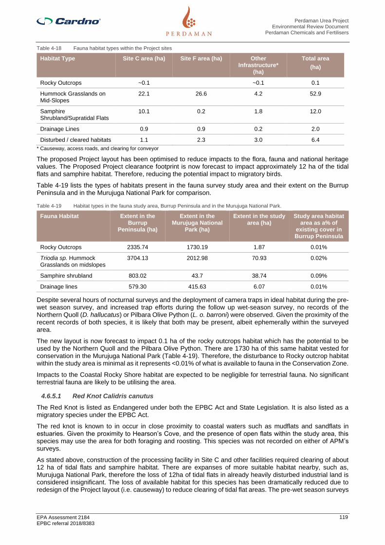
Perdaman Urea Project Environmental Review Document
Perdaman Chemicals and Fertilisers
EPA Assessment 2184 EPBC referral 2018/8383
119
Table 4-18 Fauna habitat types within the Project sites
Habitat Type Site C area (ha) Site F area (ha) Other Infrastructure*
(ha)
Total area
(ha)
Rocky Outcrops ~0.1 ~0.1 0.1
Hummock Grasslands on Mid-Slopes
22.1 26.6 4.2 52.9
Samphire Shrubland/Supratidal Flats
10.1 0.2 1.8 12.0
Drainage Lines 0.9 0.9 0.2 2.0
Disturbed / cleared habitats 1.1 2.3 3.0 6.4
* Causeway, access roads, and clearing for conveyor
The proposed Project layout has been optimised to reduce impacts to the flora, fauna and national heritage values. The Proposed Project clearance footprint is now forecast to impact approximately 12 ha of the tidal flats and samphire habitat. Therefore, reducing the potential impact to migratory birds.
Table 4-19 lists the types of habitats present in the fauna survey study area and their extent on the Burrup Peninsula and in the Murujuga National Park for comparison.
Table 4-19 Habitat types in the fauna study area, Burrup Peninsula and in the Murujuga National Park.
Fauna Habitat Extent in the Burrup
Peninsula (ha)
Extent in the Murujuga National
Park (ha)
Extent in the study area (ha)
Study area habitat area as a% of
existing cover in Burrup Peninsula
Rocky Outcrops 2335.74 1730.19 1.87 0.01%
Triodia sp. Hummock Grasslands on midslopes
3704.13 2012.98 70.93 0.02%
Samphire shrubland 803.02 43.7 38.74 0.09%
Drainage lines 579.30 415.63 6.07 0.01%
Despite several hours of nocturnal surveys and the deployment of camera traps in ideal habitat during the pre-wet season survey, and increased trap efforts during the follow up wet-season survey, no records of the Northern Quoll (D. hallucatus) or Pilbara Olive Python (L. o. barroni) were observed. Given the proximity of the recent records of both species, it is likely that both may be present, albeit ephemerally within the surveyed area.
The new layout is now forecast to impact 0.1 ha of the rocky outcrops habitat which has the potential to be used by the Northern Quoll and the Pilbara Olive Python. There are 1730 ha of this same habitat vested for conservation in the Murujuga National Park (Table 4-19). Therefore, the disturbance to Rocky outcrop habitat within the study area is minimal as it represents <0.01% of what is available to fauna in the Conservation Zone.
Impacts to the Coastal Rocky Shore habitat are expected to be negligible for terrestrial fauna. No significant terrestrial fauna are likely to be utilising the area.
4.6.5.1 Red Knot Calidris canutus
The Red Knot is listed as Endangered under both the EPBC Act and State Legislation. It is also listed as a migratory species under the EPBC Act.
The red knot is known to in occur in close proximity to coastal waters such as mudflats and sandflats in estuaries. Given the proximity to Hearson’s Cove, and the presence of open flats within the study area, this species may use the area for both foraging and roosting. This species was not recorded on either of APM’s surveys.
As stated above, construction of the processing facility in Site C and other facilities required clearing of about 12 ha of tidal flats and samphire habitat. There are expanses of more suitable habitat nearby, such as, Murujuga National Park, therefore the loss of 12ha of tidal flats in already heavily disturbed industrial land is considered insignificant. The loss of available habitat for this species has been dramatically reduced due to redesign of the Project layout (i.e. causeway) to reduce clearing of tidal flat areas. The pre-wet season surveys

Perdaman Urea Project Environmental Review Document
Perdaman Chemicals and Fertilisers
EPA Assessment 2184 EPBC referral 2018/8383
120
(APM, 2018) informed the redesign of the Project layout to reduce the clearing of the tidal flats and samphire habitat.
Strict fauna management measures will be implemented to avoid and manage any impacts to this species.
4.6.5.1 Northern Quoll Dasyurus hallucatus
The Northern Quoll is listed as Endangered under both Commonwealth and State legislation. In addition to its conservation significance, the species is considered a keystone species in the Pilbara, and one of many ‘critical-weight range’ (CWR) mammals under threat from anthropological influences.
In the Pilbara, the distribution of quolls is fragmented and the species is mostly confined to ironstone formations and some river systems and the Burrup Peninsula and adjacent offshore islands (Hill & Ward, 2010). While it is still possible that the species lives on the Burrup Peninsula, population status of the northern quoll remains unclear and it is suspected that the presence of the European red fox (Vulpes vulpes) may have contributed to its local decline (Worley Astron, 2006).
The primary cause of decline in this species across northern Australia has been death from predation attempts on the toxic introduced cane toad (Rhinella marina). Other key threats to the species include: removal, degradation and fragmentation of habitat as a result of development actions, inappropriate fire regimes, weeds and predation by feral animals (European red fox Vulpes vulpes, wild dogs Canis lupus familiaris and feral cats Felis catus).
Though clearing of 0.1 ha of rocky outcrops for the project remains a possible threat to the Northern quoll population, as much as 1730 ha of usable habitat has been vested as National Park (Murujuga National Park) and about 2335ha total in Burrup Peninsula. To eliminate the risk of habitat fragmentation for the species, the Project has been designed with small causeway with large culverts to maintain hydrological and tidal flows and allow fauna to freely move through the structure between Hearson Cove and King Bay.
During construction and operations of the Project there is a potential increased risk of vehicle strikes due to the increase in traffic movement. The Burrup Road is the main arterial road in the peninsular and currently have heavy traffic due to the industries present in the region. As a result, it is possible this species may avoid the region as they have not have been collected as a road kill, considering volumes of traffic which transverse suitable habitat between Dampier and the existing Karratha gas plant, and around the town of Dampier (Worley Astron, 2006).
The Project will apply strict fauna management measures to avoid and manage any impacts to this species in and around the study area during construction and operations to reduce the extent of impact.
4.6.5.2 Pilbara Olive Python Liasis olivaceus barroni
Typically occurs in areas of rocky hills, outcrops and ranges. This species has been historically recorded on Dolphin Island in the Dampier region and in King Bay, Hearson’s Cove and in many locations around the Karratha Gas Plant and Pluto LNG facility, particularly where artificial water sources occur (open water pit). It is often recorded around the built environment and highly disturbed areas. Despite the survey efforts, biological surveys did not record the species on either of the surveys.
Design phase of the Project has taken measures to reduce impacts to the rocky outcrops’ habitats. The Project design involves clearing of about 0.1 ha of rocky outcrop areas. There is 1730 ha of this same habitat vested for conservation in the Murujuga National Park and it is considered the impact to the Pilbara Olive Python resulting from the Project is minimal.
Introduced predators represent the main threats to the Pilbara Olive Python. Foxes and cats will prey upon juvenile pythons and compete with adults for prey (DEC, 2018; Carwardine et al. 2014).
Increased development can also alter the availability of prey and increase the potential for road deaths from vehicles associated with construction and/or operation.
Strict fauna management measures will be implemented to avoid and manage any impacts to this species in and around the study area during construction and operations to reduce the extent of impact and maintain the population that is likely utilising this area.
4.6.5.3 Ghost Bat Macroderma gigas
There are likely no roosts within the study area for the Ghost Bat, and the reduction of clearing impacts to tidal flat and samphire habitat within the study area as a result of design optimisation, does not represent a significant impact to foraging habitat for this species.

Perdaman Urea Project Environmental Review Document
Perdaman Chemicals and Fertilisers
EPA Assessment 2184 EPBC referral 2018/8383
121
As the study area is situated in a valley with potentially perching trees throughout, there is a high likelihood the area has some value for foraging. The creekline in the south-west of the study area is likely to provide important foraging habitat for this species. However, construction of the processing plant should not preclude foraging. Ghost Bats typically fly low to the ground, around fence height, and are prone to collisions with wire fences. Given the low fecundity, even infrequent deaths due on fences can have a moderate impact on the populations (APM, 2019). No barbed wire will be used on any fences during the construction or operation phases of the Project.
There are likely no roosts within the study area for the Ghost Bat, and the reduction of clearing impacts to tidal flat and samphire habitat, does not represent a significant impact to foraging habitat for this species.
Strict fauna management measures will be implemented to avoid and manage any impacts to this species in and around the study area during construction and operations to reduce the extent of impact and maintain the population that is likely utilising this area.
4.6.5.4 North-western free-tailed bat Ozimops cobourgianus
North-western free-tailed bat is listed as Priority 1 under the BC Act as it is a relatively little‐known species. There are few published studies on this species, with most relying on general information about the Genus, or field guides. This species occurs in coastal areas of the Pilbara region in WA, and in the north of Northern Territory (Churchill, 2008). The North-western free-tailed bat is brown to grey‐brown, with a paler belly that is greyish lemon. They roost in the upper dead branches of the Grey Mangrove (Avicennia marina), emerging in groups of up to 100 after sunset and dispersing to forage in pairs or alone (Churchill, 2008).
The North-western free-tailed bat generally forages in mangroves and associated monsoon forests and is known to use openings and linear clearings (such as roads or creeks) to navigate through the canopy (Churchill, 2008). Suitable foraging habitat in close proximity to roosting/breeding habitat likely to exist outside of the study area, specifically, at Cowrie Cove Bay, just north of Hearson Cove, where the species has been recorded previously. As the species has been recorded on multiple bat-detection devices across the site during APM surveys, the surveyed area is highly likely to contain valuable foraging habitat, in the form of the creeklines, and existing roads/pathways. They are likely to roost in the Grey Mangroves present in the King Bay area to the west of the study area. Eucalyptus victrix low woodland over Cyperus vaginatus, Eriachne tenuiculmis and Triodia angusta sedge/tussock/hummock grassland in the wider study area was observed to be a foraging ground where a recording was made.
The mangrove habitat upon which this species utilises for foraging or roosting will not be directly impacted by the Project. Given the proximity of the mangal habitat to the Burrup Road, it is unlikely the species would be utilising the study area for roosting and breeding, and secondary impacts such as noise and light are likely not to be an issue for this species, regardless if it is using the mangroves. It is unlikely that the Project will impact this species.
4.6.5.5 The Peregrine Falcon
The Peregrine Falcon (Falco peregrinus) is listed under the Biodiversity Conservation Act 2016 as Schedule 7 – Other Specially Protected Fauna–in need of special protection to ensure their conservation. The Peregrine Falcon experienced a large population decline as a result of reduced breeding success caused by herbicide and pesticide use. Since the banning of such chemicals, the population has stabilised and expanded. In Western Australia, populations are stable in areas with granite outcrops and cliffs which are its preferred breeding habitat (Johnstone & Storr 1998). In the absence of such habitats, the species has been known to use nests of crows and ravens (Corvus spp.) and occasionally tree hollows for nesting (Marchant & Higgins 1993).
Database searches indicate that species hasn’t been recorded in the vicinity of the study area. The likelihood of the Peregrine Falcon occurring in the study area is low.
4.6.5.6 Short-range endemic (SRE) species
Due to their restricted ranges, SRE are at greater risk to extirpations than other, less-restricted taxa, and may experience more frequent changes in conservation status.
The Project has no impact to the Priority 1 Ecological Community Rockpools of the Burrup Peninsula, which is significant habitat for some SRE species on the Burrup Peninsula. Main threats to these PECs are listed as recreational impacts, potential (industrial) development and weed invasion particularly from Cenchrus ciliaris and Passiflora foetida.
The Project may reduce habitat available for invertebrate fauna associated with rocky outcrops. This habitat is important for supporting populations of Camaenid land snails and may also support other SRE fauna identified
Perdaman Urea Project Environmental Review Document
Perdaman Chemicals and Fertilisers
EPA Assessment 2184 EPBC referral 2018/8383
122
in the database searches. In particular, Quistrachia legendrei is known to rely on rocky outcrops of this type. No records of SREs occur on the rocky outcrops that occur within the Project footprint.
As discussed above, the new Project layout avoids disturbance to the rocky outcrops as practicable. The new layout is now forecast to impact 0.1 ha of the rocky outcrops habitat which has the potential to be used by SREs. However, the rocky outcrops habitat is more abundant and of higher quality in the areas immediately adjacent to the study area (Murujuga National Park).
Very limited information exists relating to preferred habitats and distribution of the Arachnids and Myriopod species identified in this document as potential SRE. This makes assessment of impact on these species difficult. However, most have been found in conjunction with rockpiles. No records of these species occur within the Project footprint.
The Rockpile habitat that occurs within the Project footprint consists of small and somewhat isolated patches that occur between the Burrup Road and the gas pipeline. The area is already fragmented by these pieces of infrastructure, such that the proposed development will not constitute significant increase to the level of habitat fragmentation.
None of the SRE species identified from the Database Search have a conservation code allocated under the Biodiversity Conservation Act or the EPBC Act. There are Kwonkan species with a conservation code however the juvenile individual returned from the database search was unable to be allocated a species name. Further research may be required to determine whether conservation significant Kwonkan species occur on the Burrup Peninsula.
4.6.6 Mitigation
The development of the Project will result in potential impacts of varying degrees of significance to terrestrial species during construction and operation. Management, mitigation and monitoring measures will be implemented to avoid, minimise or mitigate impacts to the extent practicable. Diligent application of best practices for managing potential impacts is expected to significantly decrease the potential for residual impacts. Detailed management plans related to terrestrial fauna are provided in Appendix K:
> Environmental Management Plan (CW1055600-EN-PL-001);
> Fauna Management Plan (CW1055600-EN-PL-006); and
> Threatened Species Management Plan (CW1055600-EN-PL-005).
The management of any impacts on terrestrial fauna closely coincides with the mitigation measures put in place for the protection of flora and vegetation. Flora Management Plan is included in Appendix K.
The mitigation measures to manage potential impacts to terrestrial fauna identified in Section 4.6.4 and assessed at Section 4.6.5 are summarised in Table 4-20. Further detail is provided in the Environmental Management Plans in Appendix K.

Perdaman Urea Project Environmental Review Document
Perdaman Chemicals and Fertilisers
EPA Assessment 2184 EPBC referral 2018/8383
123
Table 4-20 Mitigation of Potential Impacts to Terrestrial Fauna
Potential Impacts Mitigation Measures
Objective: To protect terrestrial fauna so that biological diversity and ecological integrity are maintained.
Reduction and / or fragmentation of fauna habitat
Clearing of vegetation can lead to direct loss or fragmentation of fauna habitat.
Avoid
The original processing facility layout was forecast to impact 21.3 ha of the tidal flats and Samphire Shrubland/Saltplains habitat. Following design optimization, proposed clearing of this habitat type has been significantly reduced;
Limit clearing to that which is absolutely necessary;
Avoid clearing of rocky/boulder habitat that may contain micro-habitat suitable for refuge for some small terrestrial mammal species, including the Pilbara Olive Python; and
Impact on the creekline in the south-west of Site F, which is likely to be used by the Ghost Bat for foraging, will be avoided: location of the construction fenceline has been modified accordingly. High quality vegetation located on the northern margins of Murujuga National Park (southern perimeter of Site F) has been avoided by selecting the northern Hearson Cove Road re-alignment option.
Minimise
The entire project layout has been redesigned to minimise habitat fragmentation. The tidal flat area is no longer being reclaimed and raised to a level to support construction. Instead, the processing plant will be located on Site C and Site F will contain administrative buildings and a designated laydown area for construction. The two sites will be joined across the tidal flats by a small causeway enabling access between the two sites. The causeway will contain large culverts to maintain hydrological and tidal flows and also allow fauna to freely move through the structure;
Do not disturb rock piles between the months of early November to late April where practicable as this is a time of inactivity for the Pilbara Olive Python and a period where individuals are slow to move and unable to avoid impact from land clearing;
Maintain denning habitat by avoiding disturbance to rock piles on the upper slopes of the valleys;
Bury concrete or steel structures of a suitable size to a suitable depth where practicable in the rock batters used to elevate and stabilize the plant to create potential day time or maternity roosts;
Develop and implement a GDP system prior to the commencement of construction. Prior to any clearing, a GDP is required to be approved by the site Environmental Officer;
Preferential clearing will occur for well represented habitat types over other habitat types that do not cover significant portions of the site;
Land clearing to commence no more than six months prior to commencement of construction;
Clearing will be planned to maximise the ‘area to perimeter’ ratio of remnant vegetation;
Clearing of vegetation will be kept to a minimum necessary for safe and efficient construction and operation;
Land clearing will be undertaken progressively and incrementally during construction, in order to minimise the pressure on the carrying capacity of native vegetation surrounding the site;and
Plan clearing to retain vegetation where possible, such as around carparks and infrastructure, and landscaped areas.
Rehabilitate
Following construction, ensure that any disturbed habitats (laydown areas) are returned to their pre-disturbance state to reduce the overall impact of habitat loss; and
Attempt to reinstate valuable microhabitat elements to the landscape to encourage use of the periphery of the site by this conservation-dependent fauna. Construction of the processing facility on the slopes of Site C and F will require significant cut and fill to bring levels up. The scheduling for materials dumped to fill could be manipulated to ensure large boulders are grouped as conglomerates around the periphery of the retaining batters. These large boulders should then, by virtue of their position in the batter slopes, offer potential cave and crevice habitat for the Pilbara Olive Python, contributing to the availability of secure refuge in the local area.
Vehicle strike
Impacts with moving vehicles can cause injury or death of native fauna.
Minimise
Vehicle speeds will be managed on site (including entry and exit points) by enforcing speed limits in construction areas to reduce the potential for vehicle strikes;
All employees will be required to record and report any native fauna strikes;
Roadkill will be removed at least 10 m into surrounding vegetation, when safe to do so, by designated personnel to avoid further strikes of fauna feeding on carcasses;
Site induction to emphasise that all native fauna has right-of-way, where possible and safe to do so;
Personnel will be inducted regarding the key risk times for vehicle strike to fauna (e.g. dusk and dawn);
Where possible, all non-essential movement will be scheduled to take place during the day; and
Site inductions to introduce personnel to local conservation significant fauna, and signage displayed in crib rooms and notice boards, to ensure all personnel can identify all larger conservation significant species.
Increase in introduced fauna
Food waste and increased water availability within the Project Area could potentially increase introduced fauna numbers.
Cane Toad populations may in future migrate into the Burrup Peninsula.
Avoid
No domestic animals will be allowed on site.
Minimise
Predator control (wild dogs Canis lupus familiaris, feral cats Felis catus, red foxes Vulpes vulpes) has been identified as an absolute priority to minimise the impact of the Project;
Initiate a feral fauna trapping and euthanisation program to reduce the number of feral fauna around the site;
Introduce and implement hygiene procedures which result in the reduction of food waste around the processing facility to ensure that feral predators are not attracted to the facility;
Develop and implement an introduced predator control program;
Liaise with PPA and YACMAC Rangers and participate in existing and/or planned catchment wide pest animal management programs (i.e. Feral Cat control);
Develop a Cane Toad Monitoring Program; and
Develop a Cane Toad Control Program for potential future implementation.
Lighting
Artificial light can alter foraging patterns, increase predation risk, disrupt biological clocks, and disrupt of dispersal movements.
Minimise
Lighting will be designed in accordance with AS 4282-1997: Control of Obtrusive Effects of Outdoor Lighting Guidelines;
Lighting will be used only for required operational areas, all light sources will be aimed towards specific work areas requiring light for safe construction and/or operation, with a low vertical angle, and light shields will be placed on large equipment to minimise light spill over; and

Perdaman Urea Project Environmental Review Document
Perdaman Chemicals and Fertilisers
EPA Assessment 2184 EPBC referral 2018/8383
124
Where possible, lighting will be the minimum wattage, whilst not compromising safety or OH&S requirements.
Noise and vibration
Noise and vibration acts as a general stressor, masks acoustic signals, and can disturb ecosystem balance.
Minimise
Noise emissions will comply with Environmental Protection (Noise) Regulations 1997;
Maintain equipment such that all noise emitting equipment is fully serviceable and working to the correct specifications; and
Where possible, all non-essential movement will be scheduled to take place during the day.
Fauna entrapment and poisoning
Fauna may be trapped in artificial water bodies and excavations leading to injury and/ or death.
Minimise
Horizontal wire strands or barb wire fences will not be used on site during or following construction. If the site must be fenced for security, barbed/razor wire should be placed at the base of the fence on the ground and the fence itself must be cyclone mesh;
Fauna egress will be installed on all excavations, even if temporary;
All excavations will be checked for trapped fauna within three hours of sunrise if left open overnight. All fauna should be removed by qualified personnel;
All excavations that must be left open for more than 12 hours must have gentle ramped egress that all fauna are capable of using; and
Where practicable avoid the use of larvicides and adulticides for chemical control of mosquitoes in on-site storage ponds. Should larvicide or adulticide be applied, Perdaman shall develop a management plan to ensure the protection of native fauna.

Perdaman Urea Project Environmental Review Document
Perdaman Chemicals and Fertilisers
EPA Assessment 2184 EPBC referral 2018/8383
125
4.6.7 Predicted outcome
Taking into account the management and mitigation measures outlined above in Table 4-20 and in Section 4.6.6, impacts on terrestrial fauna and constituent habitats are likely to be minimal and affect habitat that is either widespread in the locality and the region and/or has been previously disturbed.
It is expected that the Proposal will have a negligible impact on the abundance, species diversity, geographic distribution and productivity of terrestrial fauna.

Perdaman Urea Project Environmental Review Document
Perdaman Chemicals and Fertilisers
EPA Assessment 2184 EPBC referral 2018/8383
126
4.7 Inland Waters
4.7.1 EPA objective
To maintain the hydrological regimes and quality of groundwater and surface water so that environmental values are protected.
4.7.2 Policy and guidance
The following policies and guidance have been considered for the assessment:
> EPA (2018) Statement of Environmental Principles, Factors and Objectives
> EPA (2018) Environmental Impact Assessment (Part IV Divisions 1 and 2) Procedures Manual
> EPA (2018) Environmental Factor Guideline: Inland Waters
4.7.3 Receiving environment
4.7.3.1 Surface Water and Drainage
There are no permanent surface water bodies (including wetlands) occurring at the plant site.
Rainfall onto the site is generally expected to directly infiltrate highly permeable soils at the site during periods of low groundwater levels. During periods of heavy prolonged rainfall and high groundwater levels (i.e. wet season) surface water is expected to migrate via overland flow through ephemeral creeklines. Drainage flow is northwards for site F and southward for site C, through small ephemeral creeks from the rocky outcrops towards the tidal flats between sites C and F. The supratidal flat area drains westward to King Bay. While there are no permanent natural watercourses or wetlands within the site, two ephemeral watercourses cross the south west corner of Site F and are reported to be deeply incised indicating potential to convey large flows in storm events.
During periods of heavy rains and extreme spring tides, the supratidal flats between sites C and F are subject to flooding.
4.7.3.2 Groundwater
Groundwater across the site is expected to be found at shallow depth (inferior to 2 mBGL) due to the level of the site in relation to the tide, and to be hypersaline. Previous investigations undertaken on behalf of Syntroleum (Astron Environmental, 1999) reported that groundwater was encountered at approximately 0.1 -1.0 mBGL within the tidal flats area. Investigations undertaken for Site C by Soil and Rock Engineering in 2000 found groundwater levels ranged from 0.7 to 2.8 m below ground surface. The shallowest reading was located near the flood plain.
As with surface water, groundwater flow directions are likely to occur from the higher rocky slopes of the north and south of Sites C and F, to the supratidal mudflat in the centre.
The quality of groundwater was investigated at the site by HLA Envirosciences (1999). No hydrocarbons or organic compounds were observed in groundwater beneath the site and levels of metals, sulphates and pH were all within regulatory guidelines. Total dissolved salt (TDS) concentrations were measured to be greater than the TDS concentration for seawater (40,000 – 50,000 mS/cm) (SKM, 2001). This is typical of supratidal environments that are subject to greater evaporation rates (HLA Envirosciences, 1999).
4.7.3.3 Beneficial Users
A search of the Department of Water and Environmental Regulation Water Register [accessed 15 July 2019 (https://maps.water.wa.gov.au/#/webmap/register)] shows there are no surface or groundwater users within a 1 km radius of the site.
4.7.4 Potential impacts
During the construction phase of the works, a range of activities may potentially impact flow and quality of surface waters across the Project Site’s and adjoining areas. Activities include:
> Grubbing, clearing and cut and fill works;
> Dewatering;
> Concrete batch plants;

Perdaman Urea Project Environmental Review Document
Perdaman Chemicals and Fertilisers
EPA Assessment 2184 EPBC referral 2018/8383
127
> Stockpiling imported raw materials and local topsoil and subsoils;
> Storage and handling of chemicals, hazardous materials and saline water;
> Access tracks, laydown areas and hardstands; and
> Construction of Hearson Cove Road realignment.
The key potential impacts to inland waters from the project during construction include:
> Short and long term alteration of surface drainage and water flow pathways, including surface, ground and tidal water flow to supratidal vegetation;
> A decrease in infiltration from rainfall and surface to groundwater within the Project site;
> Increased turbidity of surface waters due to soil erosion and/or the transport of mobilised sediments from excavation activities (i.e. cut and fill) and imported fill material;
> Increased acidity within surface and groundwater from disturbance of Potential Acid Sulfate Soils (PASS); and
> Contamination of surface and groundwater due to accidental spills of hydrocarbons / chemicals used during construction.
Following construction, the potential impacts to inland waters from the Project are:
> Permanent alteration of surface drainage and water flow pathways, including surface, ground and tidal water flow to supratidal vegetation;
> Ongoing decrease in infiltration from rainfall and surface to groundwater within the Project site;
> Redirection and redistribution of surface water runoff volumes from hardstand surfaces into a managed system;
> Degradation of water quality from elevated levels of suspended solids or contaminants in surface water runoff;
> Regional stormwater flows from the catchment flowing through the supratidal flats to the Burrup Road Causeway Culvert; and
> Indirect impact on the mangrove communities of King Bay as a result of potential water quality changes.
4.7.5 Assessment of impacts
Stormwater generated on site will be managed as two separate streams:
> Stormwater that could be contaminated by spills or leaks from process activities will be directed to holding ponds for pre-treatment, prior to reuse as a component of the seawater used on site for cooling, highlighted in “Green” in Figure 5 (in Appendix A); and
> Uncontaminated stormwater will not be treated, but will normally be pumped directly from the stormwater holding pond into the seawater used for cooling on site or used to dilute seawater at inlet of desalination plant, highlighted in “Green” in Figure 5 (in Appendix A).
The following principles are applied manage stormwater:
> It is noted that the site average rainfall is 320 mm/year;
> The Site C rainfall runoff is collected to the double lined Runoff Stormwater pond (from most of the site area, as well as the onsite roads);
- This stream is considered essentially 'clean' as the process contains virtually no higher hydrocarbons (> ethane), and site process streams are largely gaseous or traces of ammonia/urea in water.
- The pond volume is at least 8,000 m3 with a lined (in ground) pond. The 1-in-100-year storm event is calculated as up to 21,000 m3 of storm water run-off, which is based on max 200 mm over 24 hours on the site (highest as recorded in pre-2020 BoM records).
- In the event of overflow, excess stormwater is pumped from the stormwater pond to the brine evaporation holding pond (14,000 m3) - this allows sufficient capacity to handle a 1-in-100-year storm event. The transfer rate pump (on emergency power) is 2 x 400 m3/h - which is the estimated hourly peak flow over the 24h storm event.

Perdaman Urea Project Environmental Review Document
Perdaman Chemicals and Fertilisers
EPA Assessment 2184 EPBC referral 2018/8383
128
- This quality checked stormwater can also be diverted to the cooling circuit which reduces seawatermake-up in the cooling towers, and provides additional stormwater storage capacity.
- In an emergency situation >1-in-100-year storm event, a spillway is incorporated in the designdiverting overflow to the supratidal saline flats adjacent to the site. This will only be operated in a lastresort.
- This Pond includes oil skimmer for removal of oil traces. These are sent to the Oily water collectionpit/processing.
> There will always be quality monitoring quality (analysis) of collected water before allocation of use, aswell as leak detection monitoring; and
> It is expected that the quality of the stormwater will be (much) better than seawater (a much lower saltcontent), and as such can be re-used to reduce seawater make-up in the circulating cooling system.Collected stormwater is pumped to the seawater cooling tower circulating basin. The make-up seawater itis replacing is up to 3,000 m3/h. Excess water of the pond volume (1-in-100-year storm event capacity) ispumped (on emergency power) to the Brine evaporation pond at the Desalination plant.
Impacts are at higher risk of occurring during construction rather than post-construction as a result of sedimentation and erosion.
Risks are to be managed during construction via erosion and sediment pollution control plans as described in Section 4.7.6.
Site runoff from stormwater is managed primarily through application of an appropriate design following impact risk assessment in developing the Basis of Design.
The following design principles are applied to avoid, mitigate and manage potential stormwater impacts:
> The Site C rainfall runoff is collected to the double lined Runoff Stormwater pond (from most of the sitearea, as well as the roads);
- This stream is considered essentially 'clean' as the process contains virtually no higher hydrocarbons(>ethane), and site process streams are largely gaseous or traces of ammonia/urea in water.
- Design specifications include quality monitoring (analysis) of collected water before allocation of use,as well as leak detection monitoring.
- The pond volume is at least 8,000 m3, with a lined (in ground) pond design.
- The 1-in-100-year storm event is calculated as up to 21,000 m3 of storm water run-off, which is basedon max 200 mm over 24 hours on the site (highest as recorded in BoM records).
- In the event of overflow, excess stormwater is pumped from the storm water pond to the Brineevaporation holding pond (14,000 m3) - this allows sufficient capacity to handle the 1-in-100-yearstorm event.
- The transfer pump rate (on emergency power) is 2 x 400 m3/h - which is the estimated hourly peakflow over the 24h storm event.
- This quality checked stormwater can also be diverted to reduce seawater make-up in the coolingtowers, and provides additional storage capacity.
- In an emergency situation assuming >1-in-100-year event rainfall, a spillway is provided to thesupratidal saline flats adjacent to the site. This will only be operated in a last resort where largevolumes of storm derived water must be disposed of.
- The design specifications note that the site average rainfall is 320 mm/year.
- This Pond includes oil skimmer for removal of oil traces.
- These are sent to the Oily water collection pit/processing.
- It is expected that the quality of the stormwater will be (much) better than seawater (a much lower saltcontent), and as such can be re-used to reduce seawater make-up in the circulating cooling system.
- Collected stormwater is pumped to the seawater cooling tower circulating basin.
- The make-up seawater it is replacing is up to 3,000 m3/h, thus reducing the seawater intake andreducing the salinity of cooling blowdown.

Perdaman Urea Project Environmental Review Document
Perdaman Chemicals and Fertilisers
EPA Assessment 2184 EPBC referral 2018/8383
129
- Excess water of the pond volume (1-in-100-year storm event) is pumped (on emergency power) to the Brine evaporation pond at the desalination plant.
> Storm water diversion from the hills on the north of the site will be applied, and this (offsite) water will be guided around the site to the supratidal flats. This will maintain the contribution from the hills to this receiving area, highlighted in “Green” in Figure 6 (in Appendix A);
- The overall site will be largely levelled to +6m above the normal sea level (to deal with tidal extremes), and a drainage layout provided to collect water to the stormwater pond. (a small portion of the plant will be at a higher bench cut in the north east of the site). The overall site gradients will be as per typical civil engineering guidelines.
> It is not anticipated that the causeway between Sites C & F will cause any significant impact to sedimentation, erosion or deposition. The seven-culvert design will allow for continued water flow post construction through the supratidal flat. The culvert design is suitably oversized to ensure surface flows are not impeded through this area; and
> There are no process units on Site F, thus any stormwater encountered on Site F is not expected to be contaminated, highlighted in “Green” in Figure 7 (Appendix A).
- The Building area on Site F has run off collection to storm water pond (1250m3).
- There is capability to pump stormwater to main Site C stormwater pond (via the Causeway).
- An emergency overflow is incorporated to manage stormwater in extreme rainfall events (>1-in-100-year storm event) which directs stormwater to the perimeter ditch and ultimately to the intertidal zone.
- The NHL Heritage area will be fenced off and consists of a minor rocky portion (higher than the rest of Site F surfaces), as such water will run off from and not to it.
- Any materials in the laydown areas in Site F which are assessed as presenting a potential for contamination to stormwater, will be located within fit for purpose temporary bunding before being relocated out of the bunding for installation or use.
It is not anticipated that construction of Hearson Cove Road realignment will cause any significant impact to the local hydrology of the Project area. The design of the realignment as not been completed; however, the design of the road is expected to include installation of a number of culverts and a spoon drainage system to ensure south-north surface flows.
Increases in the acidity of surface and groundwater systems is not likely. Any dewatering and/or excavation of PASS material will comply with the Project’s Acid Sulfate Soils and Dewatering Management Plan, which will be developed prior to construction, should PASS or ASS be identified. Prior to undertaking any dewatering or excavation of PASS, an Acid Sulphate Soils Treatment Plan will be prepared which will detail the methods to be used for dewatering, containment, treatment, reuse or discharge of wastewater and treatment of PASS material. Due to the distance of the Project site to King Bay and the obstruction of existing and future flow by Burrup Road, it is highly unlikely that any erosion and deposition will impact the benthic communities and habitats.
Seawater will be recirculated with a small component (approximately 1%) blown down and discharged off site via the MUBRL. This will therefore result in no impact on inland waters. Highlighted in “Blue” in Figure CW10556600-CI-SD-001 (in Appendix A).
Process condensate will be polished before being added back into the demineralised water and reused. This will therefore also result in no impact on inland waters
4.7.6 Mitigation
The mitigation measures to manage potential impacts to inland waters identified at section 4.7.4 and assessed at section 4.7.5 are summarised in Table 4-21. Further detail is provided in the Appendix K2 - Surface Water Management Plan (Appendix K).

Perdaman Urea Project Environmental Review Document
Perdaman Chemicals and Fertilisers
EPA Assessment 2184 EPBC referral 2018/8383
130
Table 4-21 Mitigation of Potential Impacts to Inland Waters
Potential Impact Mitigation Measure
EPA Objective: To maintain the hydrological regimes and quality of groundwater and surface water so that environmental values are protected
Erosion
Erosion of surface features and formation of features such as rills and gullies
Minimise
Progressive Erosion and Sediment Control Plans
Site specific Erosion and Sediment Control Plans (ESCPs) will be developed by the Proponent for all Project areas. The plans should address, as a minimum, the following key points and any other issues which may be specific to the site:
> Site battery limits
> Soil and general geotechnical description
> Existing and planned contours including location of cut and fill banks
> Existing and final overland flow drainage paths
> Limits of clearing or land disturbance allowed for the proposed scope of works and or the broader Project
> Location of vegetated buffer strips
> Stabilised entry/exit point (rumble pad)
> Location of soil and sand stockpiles
> Location of all proposed temporary drainage control measures
> Location of all proposed erosion control measures including installation sequence and maintenance requirements
> Permanent site stabilisation measures
The ESCPs will be developed and submitted as part of the GDP application process at least 2 weeks prior to commencing any work in the area being the subject of the GDP. Issuance of the GDP is subject to submission and approval of a suitable ESCP(s) for the duration of works.
Post- Construction
The following principals apply:
> Structural culverts and rip rap will be used to ensure no erosion at the outlet points.
> Rock armoring and other erosion controls shall be installed in areas of high erosion potential including steep gradients, bends and discharge points.
Changes to stormwater volumes
Changes surface water runoff volumes and redirection from hardstand surfaces.
Avoid
Diversion system at Site C to intercept surface flows from the northern boundary of the plant to redirect this surface flow through to the supratidal area to the south of the plant with no change in water quality.
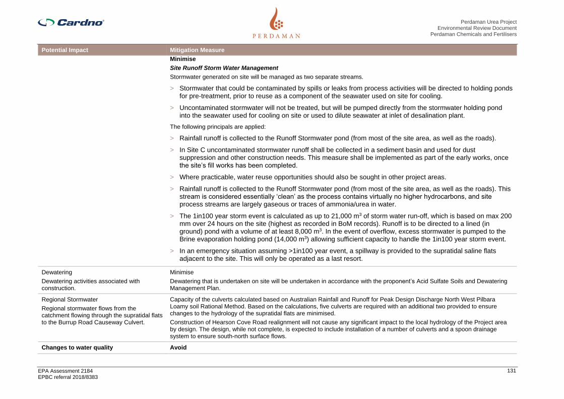
Perdaman Urea Project Environmental Review Document
Perdaman Chemicals and Fertilisers
EPA Assessment 2184 EPBC referral 2018/8383
131
Potential Impact Mitigation Measure
Minimise
Site Runoff Storm Water Management
Stormwater generated on site will be managed as two separate streams.
> Stormwater that could be contaminated by spills or leaks from process activities will be directed to holding ponds for pre-treatment, prior to reuse as a component of the seawater used on site for cooling.
> Uncontaminated stormwater will not be treated, but will be pumped directly from the stormwater holding pond into the seawater used for cooling on site or used to dilute seawater at inlet of desalination plant.
The following principals are applied:
> Rainfall runoff is collected to the Runoff Stormwater pond (from most of the site area, as well as the roads).
> In Site C uncontaminated stormwater runoff shall be collected in a sediment basin and used for dust suppression and other construction needs. This measure shall be implemented as part of the early works, once the site’s fill works has been completed.
> Where practicable, water reuse opportunities should also be sought in other project areas.
> Rainfall runoff is collected to the Runoff Stormwater pond (from most of the site area, as well as the roads). This stream is considered essentially ‘clean’ as the process contains virtually no higher hydrocarbons, and site process streams are largely gaseous or traces of ammonia/urea in water.
> The 1in100 year storm event is calculated as up to 21,000 m3 of storm water run-off, which is based on max 200 mm over 24 hours on the site (highest as recorded in BoM records). Runoff is to be directed to a lined (in ground) pond with a volume of at least 8,000 m3. In the event of overflow, excess stormwater is pumped to the Brine evaporation holding pond (14,000 m3) allowing sufficient capacity to handle the 1in100 year storm event.
> In an emergency situation assuming >1in100 year event, a spillway is provided to the supratidal saline flats adjacent to the site. This will only be operated as a last resort.
Dewatering
Dewatering activities associated with construction.
Minimise
Dewatering that is undertaken on site will be undertaken in accordance with the proponent’s Acid Sulfate Soils and Dewatering Management Plan.
Regional Stormwater
Regional stormwater flows from the catchment flowing through the supratidal flats to the Burrup Road Causeway Culvert.
Capacity of the culverts calculated based on Australian Rainfall and Runoff for Peak Design Discharge North West Pilbara Loamy soil Rational Method. Based on the calculations, five culverts are required with an additional two provided to ensure changes to the hydrology of the supratidal flats are minimised.
Construction of Hearson Cove Road realignment will not cause any significant impact to the local hydrology of the Project area by design. The design, while not complete, is expected to include installation of a number of culverts and a spoon drainage system to ensure south-north surface flows.
Changes to water quality Avoid

Perdaman Urea Project Environmental Review Document
Perdaman Chemicals and Fertilisers
EPA Assessment 2184 EPBC referral 2018/8383
132
Potential Impact Mitigation Measure
Wastewater discharge to the MUBRL has the potential to impact on marine environmental quality.
The objective is to ensure that the seawater blow down discharge to MUBRL, in combination with other future industrial
discharges to the MUBRL, will not compromise the ability of the Water Corporation to meet the requirements of Ministerial
Statement 594 and the ANZECC and ARMCANZ (2000) species protection level water quality guidelines within the 0.01 km2
mixing zone as recommended in the EPA Report 1044.
In principle there are three balances to consider:
▪ Water – which contains site seawater, storm water, potable and grey water, process water and various condensates, including condensed air moisture.
▪ Salts – deriving (mainly) from seawater, but also some from dosing chemical additions – effectively as TDS (and measured as conductivity).
▪ Thermal – managing the average blowdown return temperature.
The Project can extract water from the seawater provided the concentrated salts of the blowdown comply with the ANZECC
guidelines.
▪ Most of the seawater use (ca. 95%) is via the site circulating seawater cooling system. This circulates seawater removing process heat with seawater cooling tower, with roughly a 1.4 cycle of concentration (CoC).
▪ Essentially pure water evaporates (cooling), and the salts in the circulating seawater are concentrated.
▪ There are virtually no additional salts added – there is a modest (small) sulfuric acid and hypochlorite dosing for pH control and bio growth inhibition.
▪ There is no addition of heavy metals, as the process is based on clean natural gas. For seawater all the heat exchangers are constructed of titanium to reduce corrosion.
▪ In extreme cases some biocide may be added to control bio growth, but not during normal operation. Following this and measurement, sodium metabisulphite would be added and mixed to the blowdown water to decompose the residual biocide.
▪ The expected drift loss is expected to be <0.001% of the circulating flow. This drift loss is at the same salinity of the cooling tower circulation flow.
▪ There is a continuous blowdown which is operated to the specified conditions set by the Water Corporation, in order to meet the ANZECC and ARMCANZ (2000) species protection level water quality guidelines.
This is summarized as below (Water Corp Technical Compliance Advice bulletin Ref. PM20992155 (22 Feb 2019)) and provided
in Table 4-3.
Minimise
The Brine evaporation pond is required for operational flexibility:
▪ Such as if/when the brine return is offspec (i.e. will not be accepted by Water Corporation with respect to not meeting the ANZECC specifications);
▪ Operating flexibility to deal with saline streams in excess of 55,300 mg/l TDS;
▪ Site stormwater overflow;
▪ Collection of contaminated chemical sewer streams other than Amine section;
▪ During normal operation the pond is expected to be dry – the site evaporation rate is high, and minimal salt containing streams should be added;

Perdaman Urea Project Environmental Review Document
Perdaman Chemicals and Fertilisers
EPA Assessment 2184 EPBC referral 2018/8383
133
Potential Impact Mitigation Measure
▪ During start-up, high salt (>55,300 TDS) brine is expected from the Desalination Plant. This could be diluted and returned to the MUBRL, however temporary storage in the brine pond allows minimisation of seawater usage. Further, there could be ammonia water streams;
▪ Once the main plant is operating and MUBRL blowdown established, the Brine pond water will be fully analysed and should this be acceptable, blended back into the blowdown stream as a small addition, ensuring outfall compliance is not compromised. This disposal is considered feasible as under normal operating circumstances the water should basically contain high saline seawater and possible traces of ammonia – both these components are acceptable to the MUBRL ocean outfall mixing zone provide the mixed stream complies with the criteria – i.e. ensure TDS is <55,300mg/l and the ammonia does not exceed 1,700 mg/m3 of blowdown;
▪ In the unlikely event that the Brine pond water with blending is still outside the ANZECC specification, the water will be evaporated, and the residual salt collected to an approved disposal site;
▪ The Brine pond specifically will not receive organic (grey water) nor MDEA nor oil containing wastewater; and
▪ The Brine pond has transfer pumps and reticulation to receive and pump out water.
Water Quality
Degradation of water quality from elevated levels of suspended solids or contaminants in surface water runoff.
Indirect impact on the mangrove communities of King Bay as a result of water quality changes.
Impacts on marine environmental quality from runoff collected from the hardstand surfaces, conveyor, and product storage shed within the Dampier Port area
Impacts on marine environmental quality from Project air emissions.
Avoid
The design scope for the fully enclosed conveying and ship loading system eliminates of the risk of loss of urea product as fugitive dust emissions or spills with the consequential loss of valuable product and potential environment impacts of degradation of water quality in the terrestrial and marine environments.
Minimise
Best available technology design has been incorporated to reduce and minimize Project air emissions. This in turn minimizes any potential impacts on marine environmental quality from Proposal air emissions.
An Operational Environmental Management Plant (OEMP) is required to be prepared and submitted for review prior to any operational activities taking place on PPA’s lands. It is a standard requirement of PPA’s Commercial Agreements with tenants.
An OEMP is a practical and site-specific plan of management measures which is designed to manage risks and minimise environmental impacts from PPA’s tenant’s normal activities. It will also identify what measures will be in place or are actioned to manage any incidents and emergencies that may arise during normal operations. As such, the foundation of any OEMP is an operational environmental risk assessment.
An OEMP is a dynamic document, which should be maintained and audited periodically to ensure it reflects current environment risks and management measures from site activities and operations
During Construction
Drainage, Erosion and Sediment Pollution Controls
The following controls shall be installed prior to commencement of construction to prevent contamination of surface water and receiving environments.
Drainage Controls
▪ Existing drainage lines will be protected and any diversion of these lines should be kept to a minimum.
▪ Flow management across the site will prevent the concentration and diversion of waters onto steep or erosion prone slopes.
▪ Any diversion of drainage lines will be directed to slopes that are not prone to erosion.

Perdaman Urea Project Environmental Review Document
Perdaman Chemicals and Fertilisers
EPA Assessment 2184 EPBC referral 2018/8383
134
Potential Impact Mitigation Measure
▪ External water flows entering the Project’s battery limits will be diverted around the construction footprint, using drainagestructures such as catch drains and bunds.
▪ Temporary drainage structures will be designed to reduce run-off velocities by using wider inverts, flat bottomed drains ratherthan V-shaped drains, check dams (or similar), silt fencing and revegetation of completed areas.
▪ All drainage lines likely to receive run-off from disturbed areas, such as those downstream of worksites, will be fitted withgeotextile silt fences. Rock checks should also be used in drains to slow flows and provide a lining to prevent scouring ofunderlying surfaces. Sediment basins will be added to drainage lines as necessary. Basins shall be designed relative to thecatchment and likely flow levels for higher rainfall events.
▪ Where silt fences are installed for sediment control, they must be constructed with a centre section lower than the groundlevels at the end of the silt fence to avoid outflanking during heavy rainfall events.
▪ Silt and sediment fences shall be maintained until the areas above them have been adequately stabilised to minimise theerosion risk such that the controls can be removed.
▪ All stormwater proposed for discharge will first be contained in an appropriately lined sediment basin, to all sediment to settleout.
▪ Any discharge to the MUBRL must comply with the conditions, including water quality standards of the license or approval that applies to the discharge.
▪ Construction activities will be scheduled to avoid periods of heavy rainfall, strong winds or peak water flow.
Erosion and Sediment Pollution Controls
Sediment controls are designed to prevent the transportation of sediment and other pollutants from worksites to waterways. They will be installed across the Project sites in areas where land is disturbed. In order to minimise the land exposure and potential risk of erosion, all land disturbances should be confined to a minimum practical working area and within the vicinity of the identified work areas.
Where possible, existing vegetation surrounding the construction site will be used as a buffer zone to help filter surface runoff and should not be disturbed unless necessary for the purpose of construction.
To ensure that silt from batters, cut-off drains, table drains and road works is retained on site and replaced as soon as practicable, sediment controls will be installed downstream of any disturbed land such as worksites, prior to that work being undertaken.
Run-off controls will be developed and maintained to the following standards:
▪ Controls will be designed to take predicted flows, based on 140436-000-41EG-0001 Standard Specification Geographic,Climatic and Wind / Seismic Data.
▪ Exposed ground will have control measures that minimise the level of erosion.
▪ Drains will be installed across the site to divert clean surface water to stable areas and away from parts of the site where soilis exposed.
▪ Installation of sediment traps and basins with a riser pipe or flexible pipe and spillway to avoid adverse flood risk to adjoiningproperties. These systems shall allow for the gradual discharge of the clearest water during a storm event as detailed in 6.1.3.
▪ Geotextile silt fences shall be installed in surface water flow areas to minimise the sediment discharge from the site (refer toAttachment C).
▪ Should hay bales be used for sediment control, they will be made of straw sourced from cereal crops and be free of weedseeds.

Perdaman Urea Project Environmental Review Document
Perdaman Chemicals and Fertilisers
EPA Assessment 2184 EPBC referral 2018/8383
135
Potential Impact Mitigation Measure
▪ If any areas of localised erosion develop, they will be remediated as soon as practicable to prevent further erosion or sediment deposition in offsite areas.
▪ Regularly inspect stormwater drainage and sediment control structures to ensure hydraulic integrity and erosion and pollution control effectiveness. If the control structures are obstructed or have their capacity reduced by 30% or more through the accumulation of silt, litter, vegetation and other debris, they shall be cleared, with silt returned to a stabilised part of the project.
▪ Sediment control structures at waterway crossings will be developed during the detailed design process before any such work takes place.
▪ Throughout construction, rehabilitation of disturbed areas will be progressively undertaken, or as soon as practicable, following completion of specific works.
Post- Construction
The following principals shall be applied:
▪ The granular urea product is much harder than prilled urea, therefore creating less fines and dust when handled and transported which minimizes the urea fines and dust that could be accidentally released during conveying and ship loading activities.
▪ Spill contingency and emergency response plans and procedures that align with the appropriate PPA plans and procedures, will be developed and implemented to address environmental risks and potential impacts specifically related to the operational phase
▪ The stormwater pond includes an oil skimmer for removal of oil traces. These are sent to the Oily water collection pit/processing.
▪ Water quality monitoring (analysis) of collected water before allocation of use will be undertaken. It is expected that the quality of the stormwater will be (much) better than seawater (a much lower salt content), and as such can be re-used to reduce seawater make-up in the circulating cooling system.
▪ Collected stormwater is pumped to the seawater cooling tower circulating basin. The make-up seawater it is replacing is up to 3,000 m3/h.
▪ For paved areas of the urea processing plant, there will be stormwater collection pits (epoxy coated concrete pit) where the first 15mm of stormwater can be collected. Stormwater collected will be treated by steam stripping or other means to bring ammonia (Total Kjeldahl Nitrogen) in water within limit.
Ongoing Monitoring
Regular inspections and audits will be undertaken to ensure the environmental protection outcomes of the Project are achieved. Inspection and maintenance activities will follow the Monitoring and Compliance requirements outlined in the Construction Environmental Management Plan (CEMP) and will include:
▪ Review of Erosion and Sediment Control Plans and validate that the proposed erosion and sediment controls have been implemented and, where relevant, revised to accommodate the changing environment.
▪ Inspections to observe and record any scouring, erosion and sediment transfer particularly beyond the Project footprint.
▪ Cleaning of sedimentation basins when the accumulated sediment has reduced the basin capacity by more than 30%, as indicated by depth pegs.
▪ Cleaning of all drains to remove silt, vegetation (where capacity is reduced) and litter.

Perdaman Urea Project Environmental Review Document
Perdaman Chemicals and Fertilisers
EPA Assessment 2184 EPBC referral 2018/8383
136
Potential Impact Mitigation Measure
▪ Weekly inspection of access roads and hardstand areas to identify erosion damage in need of maintenance. Remediation is to occur within one month or earlier if heavy rains are likely.
▪ Discharge from any oily water separator shall be monitored to ensure it contains less than 5ppm Total Recoverable Hydrocarbons (TRH) and is in compliance with Project approval conditions before it can be used for dust suppression or discharged into the environment. Written approval from the Contractor’s Environment Manager must be obtained prior to reuse or discharge to the environment.
Contingency measures include:
▪ Where erosion or sediment deposition occurs, rehabilitation corrective actions shall be implemented as soon as practicable.
▪ Where sedimentation occurs the source of the sediment should be determined to identify likely erosion in up gradient areas. The sediment should be removed and deposited, if possible as part of erosion controls.
▪ Where erosion is identified and requires rehabilitation the impacted area shall be filled, compacted and contoured to merge with the surrounding landscape.

Perdaman Urea Project Environmental Review Document
Perdaman Chemicals and Fertilisers
EPA Assessment 2184 EPBC referral 2018/8383
137
4.7.7 Predicted outcome
Taking into account the management and mitigation measures outlined above in Table 4-21, impacts on Inland Waters are likely to be minimal and not have an indirect impact on the mangrove communities of King Bay.
The Proponent will implement the following to ensure impacts are minimised:
> Erosion and Sediment Control Plans for all project areas; and
> Acid Sulfate Soils and Dewatering Management Plan.
The EPA objective for inland waters can be met.

Perdaman Urea Project Environmental Review Document
Perdaman Chemicals and Fertilisers
EPA Assessment 2184 EPBC referral 2018/8383
138
4.8 Air Quality
4.8.1 EPA objective
To maintain air quality and minimise emissions so that environmental values are protected.
4.8.2 Policy and guidance
The following policies and guidance have been considered for the assessment:
> EPA (2019) Environmental Factor Guideline: Greenhouse Gas Emissions (proposed as draft for consultation only);
> EPA (2019) Technical Guidance: Mitigating Greenhouse Gas Emissions;
> EPA (2018) Statement of Environmental Principles, Factors and Objectives;
> EPA (2018) Environmental Impact Assessment (Part IV Divisions 1 and 2) Procedures Manual;
> EPA (2016) Environmental Factor Guideline: Air Quality;
> EPA (2016) Environmental Factor Guideline: Social Surroundings;
> Commonwealth of Australia (1999). Environment Protection and Biodiversity Conservation Act;
> Commonwealth of Australia (2007). National Greenhouse and Energy Reporting Act;
> DEC (2010) A guideline for managing the impacts of dust and associated contaminants from land development sites, contaminated site remediation and other related activities;
> DEC (2006) Guidance Notes: Air Quality and Air Pollution Modelling;
> DWER (2019) Murujuga Rock Art Strategy;
> Government of Western Australia (2019) Greenhouse Gas Emissions Policy for Major Projects; and
> NEPC (2015, 2019) National Environmental Protection Measure (NEPM) for Ambient Air Quality.
Guidance on how greenhouse gas (GHG) emissions are to be considered in the context of the State regulatory EIA process is currently being updated by the EPA. The proposed guidance on GHG emissions assessment has been published for consultation purposes and is used as a reference to supplement the requirements outlined in the ESD (Cardno, 2019). The approach used to assess GHG emissions from the Project is consistent with the proposed guidance published by the EPA (2019).
4.8.3 Receiving environment
Studies of air quality that are relevant to the Proposal are identified in Table 4-22.
Table 4-22 Receiving environment studies – Air Quality
Author (Date) Study
Physick and Blockley (2001) An evaluation of air quality models for the Pilbara region
SKM (2003) Burrup rock art: atmospheric modelling – concentrations and depositions, report to the Department of Industry and Resources
DoE (2004) Pilbara Air Quality Study
DEP (2002) Karratha–Dampier and Burrup Peninsula Emissions Inventory 1999
CSIRO (2006) Burrup Peninsula air pollution study: final report, report to the WA Department of Industry and Resources Rock Art Committee
CSIRO (2007) Field studies of rock art appearance – final report: fumigation & dust
deposition; – progress report: colour change & spectral mineralogy, final report to the WA Burrup Rock Art Committee
CSIRO (2010) Burrup Peninsula air pollution study: report for 2004/2005,
2007/2008 and 2008/2009
SKM (2009a) Burrup Rock Art Monitoring Program – summary of reports, report to
the Burrup Rock Art Monitoring Management Committee
SKM (2009b) Burrup rock art: revised modelling taking into account recent

Perdaman Urea Project Environmental Review Document
Perdaman Chemicals and Fertilisers
EPA Assessment 2184 EPBC referral 2018/8383
139
Author (Date) Study
monitoring results
CSIRO (2017) Burrup Peninsula Aboriginal petroglyphs: colour change and spectral
mineralogy 2004–2016, Report EP161761
Woodside (Jacobs, 2019a) Air Quality Impact Assessment, Pluto LNG Expansion, Woodside Energy Ltd., Revision 1, 28 June 2019.
Woodside (Jacobs, 2019b) Air Quality Impact Assessment, NWS Project Extension, Woodside Energy Ltd., Revision 0, 4 July 2019.
Jacobs (2019) Perdaman Urea Project – Air Quality Impact Assessment
Jacobs (2020) Perdaman Urea Project – Air Quality Impact Assessment (Draft Rev 5, 6 March 2020)
ETA (2019) Perdaman Urea Project – Greenhouse Gas Assessment
4.8.3.2 Climate
Meteorological data is a critical consideration in air quality assessments. The data used for the assessment was sourced from the nearest Bureau of Meteorology (BoM) climate station at the Karratha Aerodrome (Site number; 004083) 0. It is located approximately 12km south from the project premises, and records wind speeds and wind directions. The BoM also reports rainfall and evaporation at this climate station. This long term data is therefore available when considering impacts on rock art where impacts may be influenced either both short and long term trends in these parameters.
Analysis (Jacobs, 2019) shows the long term (1993-2018) daily maximum and minimum temperatures range from 48oC in the wet season to only 7oC in the dry season, from 1993 to 2018. The long term (1972-2018) rainfall observations shows a wet season running from approximately January to June, and a dry season from approximately July to December. The annual wind roses (2010-2018) for the BoM station shows a dominant westerly air flow that is prevalent throughout the year with the exception being the winter months in some years when an easterly, southerly or north-easterly wind flow is dominant. Average daily wind speeds (2003-2018) range between 4 m/s and 6 m/s, with gusts between 18 m/s and 40 m/s. The region also lies within an area influenced by cyclonic conditions, where wind gusts over 200 km/h have been recorded, and rainfall events of 400 mm.
4.8.3.3 Background - Existing air quality
An air emissions assessment for the project has been undertaken by Jacobs (2020) (Appendix D). A description of the receiving environment was included as part of that assessment and key findings are summarised below. The assessment has referenced available air quality monitoring data from both historical and more recent studies. Land use around the Burrup Peninsula is diverse, with the most significant industries being liquefied natural gas (LNG), liquefied petroleum gas (LPG), and ammonia production for export, as well as iron ore export and solar salt production for export. Other land uses in the region include pastoralism, tourism and Aboriginal lands (DEC, 2013).
The primary land uses in close proximity to the project include the industrial estates, Murujuga National Park, and the populated centres of Dampier and Karratha. Air quality is influenced by existing industrial activities on the Burrup Peninsula including the North West Shelf Project, the Pluto LNG Project, Yara Pilbara Nitrates Pty Ltd (Yara), Technical Ammonium Nitrate Production Facility (TANPF) and the Port of Dampier. Air quality is influenced by regional events including those associated with bushfires, and photochemistry.
Existing activities on the Burrup Peninsula are a significant source of atmospheric emissions in the region, thereby influencing the background or existing air quality of the area. The most significant emissions produced by industry on the Burrup Peninsula includes:
> oxides of nitrogen (NOx) that arise from combustion of natural gas or other fuels, including shipping activities;
> volatile organic compounds (VOCs) generated largely from onshore gas processing;
> sulfur dioxide (SO2) associated with fuel combustion including shipping activities at the Port of Dampier;
> carbon monoxide (CO) from combustion of natural gas or other fuels;
> particulate matter (PM) from combustion of natural gas or other fuels, noting also wind-blown dust from ore handling in Port; and
Perdaman Urea Project Environmental Review Document
Perdaman Chemicals and Fertilisers
EPA Assessment 2184 EPBC referral 2018/8383
140
> ammonia (NH3) from industrial sources.
As well as these “man-made” emission, there is a significant amount of wind-borne sea salt deposition on the rocks and vegetation of Murujuga. The Burrup Peninsula Air Pollution Study (CSIRO, 2010) shows a significant portion of the total suspended solids recovered during monitoring between 2004 and 2009 comprised sea salt, with iron ore dust being the other prime component. This wind-borne sea salt can act as a natural buffer to acidification associated with NOx and SOx emissions (Dr Ian MacLeod, pers. comm)
An inventory of air emissions for the Karratha region previously compiled for the Pilbara region (DEP, 2004) has been updated for this assessment (Jacobs, 2019). The industries included in the inventory for this assessment are shown inTable 4-18, and listed in Table 4-23.
Collectively these emission sources were used to generate the Baseline air emissions scenario for the assessment.
In its recent Inquiry under section 46 of the EP Act on the Yara Technical Ammonium Nitrate Production Facility, Burrup Peninsula, the EPA stated:
“In considering the above principle, the EPA has noted that there is currently no compelling scientific evidence which indicates that there is an immediate material threat of serious or irreversible damage to rock art from cumulative industrial air emissions within the Murujuga airshed. As the TANPF utilises contemporary best practice pollution control technology to minimise air emissions within the Murujuga airshed, the EPA considers that the risk of rock art being damaged due to the operation of the TANPF has also been minimised, whilst recognising the lack of full scientific certainty in regard to whether cumulative industrial air emissions within the Murujuga airshed are damaging rock art. On the above basis, the EPA considers that there is sufficient time for the monitoring and evaluation activities associated with the Murujuga Rock Art Monitoring Program to be undertaken and for definitive information in regard to whether cumulative industrial air emissions within the Murujuga airshed are adversely affecting rock art to be obtained.” (EPA Report 1648, September 2019)
Proponent notes this relevant context with respect to considering the precautionary principle and its applicability to assessment of air emissions potential cumulative impacts on the integrity of rock art.

Perdaman Urea Project Environmental Review Document
Perdaman Chemicals and Fertilisers
EPA Assessment 2184 EPBC referral 2018/8383
141
Figure 4-18 Project location and existing industry emission sources and existing ambient monitoring locations (Jacobs, 2019)
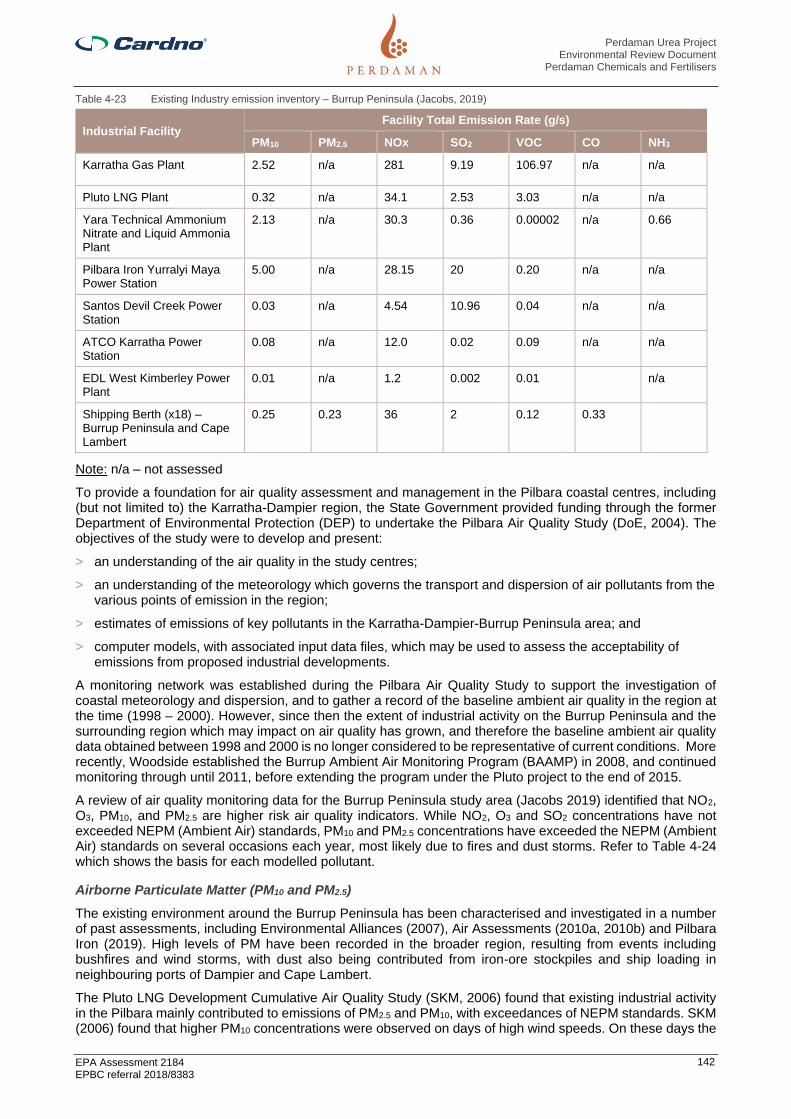
Perdaman Urea Project Environmental Review Document
Perdaman Chemicals and Fertilisers
EPA Assessment 2184 EPBC referral 2018/8383
142
Table 4-23 Existing Industry emission inventory – Burrup Peninsula (Jacobs, 2019)
Industrial Facility Facility Total Emission Rate (g/s)
PM10 PM2.5 NOx SO2 VOC CO NH3
Karratha Gas Plant 2.52 n/a 281 9.19 106.97 n/a n/a
Pluto LNG Plant 0.32 n/a 34.1 2.53 3.03 n/a n/a
Yara Technical Ammonium Nitrate and Liquid Ammonia Plant
2.13 n/a 30.3 0.36 0.00002 n/a 0.66
Pilbara Iron Yurralyi Maya Power Station
5.00 n/a 28.15 20 0.20 n/a n/a
Santos Devil Creek Power Station
0.03 n/a 4.54 10.96 0.04 n/a n/a
ATCO Karratha Power Station
0.08 n/a 12.0 0.02 0.09 n/a n/a
EDL West Kimberley Power Plant
0.01 n/a 1.2 0.002 0.01 n/a
Shipping Berth (x18) – Burrup Peninsula and Cape Lambert
0.25 0.23 36 2 0.12 0.33
Note: n/a – not assessed
To provide a foundation for air quality assessment and management in the Pilbara coastal centres, including (but not limited to) the Karratha-Dampier region, the State Government provided funding through the former Department of Environmental Protection (DEP) to undertake the Pilbara Air Quality Study (DoE, 2004). The objectives of the study were to develop and present:
> an understanding of the air quality in the study centres;
> an understanding of the meteorology which governs the transport and dispersion of air pollutants from the various points of emission in the region;
> estimates of emissions of key pollutants in the Karratha-Dampier-Burrup Peninsula area; and
> computer models, with associated input data files, which may be used to assess the acceptability of emissions from proposed industrial developments.
A monitoring network was established during the Pilbara Air Quality Study to support the investigation of coastal meteorology and dispersion, and to gather a record of the baseline ambient air quality in the region at the time (1998 – 2000). However, since then the extent of industrial activity on the Burrup Peninsula and the surrounding region which may impact on air quality has grown, and therefore the baseline ambient air quality data obtained between 1998 and 2000 is no longer considered to be representative of current conditions. More recently, Woodside established the Burrup Ambient Air Monitoring Program (BAAMP) in 2008, and continued monitoring through until 2011, before extending the program under the Pluto project to the end of 2015.
A review of air quality monitoring data for the Burrup Peninsula study area (Jacobs 2019) identified that NO2, O3, PM10, and PM2.5 are higher risk air quality indicators. While NO2, O3 and SO2 concentrations have not exceeded NEPM (Ambient Air) standards, PM10 and PM2.5 concentrations have exceeded the NEPM (Ambient Air) standards on several occasions each year, most likely due to fires and dust storms. Refer to Table 4-24 which shows the basis for each modelled pollutant.
Airborne Particulate Matter (PM10 and PM2.5)
The existing environment around the Burrup Peninsula has been characterised and investigated in a number of past assessments, including Environmental Alliances (2007), Air Assessments (2010a, 2010b) and Pilbara Iron (2019). High levels of PM have been recorded in the broader region, resulting from events including bushfires and wind storms, with dust also being contributed from iron-ore stockpiles and ship loading in neighbouring ports of Dampier and Cape Lambert.
The Pluto LNG Development Cumulative Air Quality Study (SKM, 2006) found that existing industrial activity in the Pilbara mainly contributed to emissions of PM2.5 and PM10, with exceedances of NEPM standards. SKM (2006) found that higher PM10 concentrations were observed on days of high wind speeds. On these days the

Perdaman Urea Project Environmental Review Document
Perdaman Chemicals and Fertilisers
EPA Assessment 2184 EPBC referral 2018/8383
143
PM2.5/PM10 fraction was reduced from approximately 50% to approximately 20%, pointing to wind-blown dust as the cause of the higher PM10 concentrations rather than smoke emissions, which comprise more, smaller particles.
Referencing Environmental Alliances (2007) an estimate of the ‘clean air background’ PM10 levels are approximately 10 µg/m3, with a median or average closer to approximately 20 µg/m3. These values are typical of PM10 concentrations measured in other parts of Australia, such as Keywood et al. (2017) (Jacobs, 2019).
Ammonia (NH3)
Ammonia is an important source of nitrogen deposition, and is a precursor to secondary PM formation. Ammonia levels around the Burrup Peninsula are mainly a result of existing industry emissions in the area, and contributions from soils (Jacobs, 2019). Background NH3 concentrations in continental air (land sources) range from 0.1–10 ppb (Seinfeld and Pandis, 2016). Cattle feed lots are a significant source of higher NH3 concentrations within a radius of approximately 7 km from the feed lots; recent Australian examples are: Shen et al. (2016) and Hacker et al. (2016), however there are currently no large scale or intensive facilities in close proximity to the Burrup Peninsula. Low-level airborne measurements of NH3 (in Victoria by Hacker et al. (2016)) showed background NH3 levels ranging from approximately 1 ppb near sunrise and sunset to approximately 2 ppb near midday.
Strategen (2018) provided a summary of local NH3 monitoring (2016-2018) near the Yara Pilbara fertilisers and nitrate plants. The monitoring has been conducted in locations expected to be influenced by industrial sources. Concentrations range, on average, from 0.78 µg/m3 to 2.00 µg/m3 (1.12 ppb to 2.88 ppb), with maximums of 4.35 µg/m3 (6.26 ppb) also having been recorded.
Gillett et al. (2012) determined a background NH3 level of 0.5 ppb (0.35 µg/m3 at 25oC) in their review of results from eight monitoring stations on the Burrup Peninsula obtained in 2004-2005. The general conclusion was concentrations of NH3 (and other pollutants) in the Burrup Peninsula region were similar to other remote terrestrial areas, and very low compared to urban areas. This has been adopted as the background concentration in the absence of industrial and other sources.
Nitrogen Dioxide (NO2) | Oxides of Nitrogen (NOx)
While NO (nitric oxide) is naturally produced by the human body and is a principal life support chemical that controls blood pressure, in the industrial setting nitrogen dioxide (NO2) and oxides of nitrogen (NOx) mainly arise as result of the combustion of fuels. NOx is an expression of the total amount of both nitric oxide (NO) and NO2 in a gas, with the mass of NOx calculated by assuming all of the NO has been oxidised to NO2. It is an important direct pollutant, as well as one critical for consideration in the formation of photochemical pollutants in the region.
A review of the BAAMP dataset of hourly average NOx for the period 2008 to 2015 was completed by Jacobs (2019). The review confirmed that typically NO2 exists in levels well below the relevant NEPM standard of 120 ppb on the Burrup Peninsula, and in Karratha and Dampier.
Ozone (O3)
Ozone is used as an indicator pollutant of photochemistry and secondary pollutants. The production of O3 in the air environment is a complex process when emissions of NOx and other pollutants such as VOCs and CO, occur in the presence of sunlight and heat (Seinfeld and Pandis, 2016). Emissions from both industrial sources and natural events, such as bushfires, will contribute to the formation of O3 in the region.
Physick and Blockley (2001) showed via modelling that NO2 concentrations higher than those monitored at Dampier could occur within the region due to photochemical processes. The formation of O3 that can be attributed to current industrial VOC emissions is low, due to the corresponding relatively low photochemical reactivity of these emissions (mainly methane and other alkanes) (DoE, 2004), with appreciable levels of O3 recorded during the Pilbara Air Quality Study found to be associated with smoke from bushfires that occur in the region.
A review of the BAAMP dataset of hourly average O3 for the period 2008 to 2015 was completed by Jacobs (2019). The review showed that O3 is a higher risk air pollutant for the Burrup Peninsula than other photochemically reactive pollutants. The monitoring results also showed higher O3 concentrations in Dampier and Karratha in comparison with NO2. This is an example of the complex reactions taking place over time as pollutants migrate across the airshed. Jacobs (2019) interpret these results as being the consequence of existing industry NOx emissions dispersing to lower concentrations by the time it reaches the townships of Dampier and Karratha. This would lower the amounts of NOx in the vicinity of the townships available to react

Perdaman Urea Project Environmental Review Document
Perdaman Chemicals and Fertilisers
EPA Assessment 2184 EPBC referral 2018/8383
144
and destroy the O3 that built up to higher concentrations there. Given the complex reactions that are associated with the formation of O3, these results may also be an indicator that NOx has reacted overtime to form O3.
Hydrocarbons
Hydrocarbons, or Volatile Organic Compounds (VOCs), are a group of organic chemical compounds that have a vapour pressure that is high enough under normal conditions to enter ambient air. VOCs were monitored by Woodside over the period 2009-2015. A review of results by Jacobs (2019) shows that emissions of Benzene, Toluene and Xylenes (BTX), as an indicator of all VOCs (primarily emitted to air from petroleum hydrocarbons, including oil and gas products), were insignificant when measured in Dampier and Karratha. For most of the time, BTX concentrations were recorded as nil at those locations. Further analysis concluded that formaldehyde would have low concentrations with a similar low risk of air quality impact as Benzene.
Sulfur Dioxide
Sulfur dioxide (SO2) sources are principally from the combustion of fuel containing sulfur, both on land and associated with shipping activities in the vicinity. SO2 is also a precursor to secondary PM formation. A review of ambient SO2 monitoring on the Burrup Peninsula was undertaken by Air Assessments (2010b), noting very low sulfur-in-fuel concentrations (Jacobs, 2019).
Based on the analysis, a reasonable estimate for an annual average SO2 concentration was estimated to be 0.1 ppb. Maximum hourly average concentrations would not be expected to exceed 10 ppb for most locations with the exception of those under the direct influence of shipping exhaust plumes.
Carbon monoxide
Carbon monoxide (CO) is formed from the incomplete combustion of carbon containing fuels. Industry is a minor contributing source, with bushfires in the region being the most significant source.
Deposition Fluxes of Nitrogen and Sulfur
The deposition of air pollutants containing nitrogen and sulfur such as NH3, NO2 and SO2, is of importance in the consideration of the potential air quality impacts on land surfaces.
NOx emissions may have a number of impacts on surrounding areas through wet or dry deposition. While NOx in air may impact vegetation uptake through plant stomata, there is little information available on the effect on species found in the Burrup area. NOx may also contribute to the acidification or increased nitrogen content of the soil. This may increase the nitrogen availability in the soil leading to changes in uptake rates of native species, and encouraging weed growth (Campbell, 2002). Again, there is limited information on the impact deposition presents to species found on the Burrup. Ammonia deposition will likely add to the potential impact of NOx deposition; hence deposition is considered collectively.
Gillett (2008) determined total deposition flux of nitrogen and sulfur at a number of measurement sites in 2004/2005 and 2007/2008 on the Burrup Peninsula. Based on the work of Gillett, a typical high, total dry deposition for all gaseous pollutants is approximately 20 meq/m2/year, with a background dry NH3 deposition of approximately 4 meq/m2/year. Subsequent monitoring on the Burrup Peninsula, reported by Yara Pilbara Nitrates (YPN) and Strategen Environmental (YPN, 2017) over the period 2013-2016 indicates an increase in the typical high, total dry deposition to around 20-30 meq/m2/year.
Table 4-24 Basis of modelled baseline | existing air quality (Jacobs, 2019)
Pollutant Basis
NOx as NO2 BAAMP monitoring
Photochemical oxidants (as O3) BAAMP monitoring
SOx as SO2 Air Assessments (2010b)
Particulates as PM10
Environmental Alliances (2007) Particulates as PM2.5
Particulates as PM2.5

Perdaman Urea Project Environmental Review Document
Perdaman Chemicals and Fertilisers
EPA Assessment 2184 EPBC referral 2018/8383
145
4.8.3.4 Sensitive receptors
Sensitive residential receptors within the receiving environment are shown relative to the project area in Figure 4-19. In line with Scope of Work items 7.3 and 7.4(c), other non-residential sensitive receptors have beenreviewed in the modelling and assessment of potential impacts on amenity and heritage values within theMurujuga airshed including:
> Ngajarli;
> Hearson Cove;
> King Bay;
> Murujua National Park (central northern and southern extents) (MNP-CN and MNP-SE);
> Standing Stones; and
> the proposed location of the Living Knowledge Centre (MLKC) proposed by MAC in the vicinity of ConzincBay approximately 9km to the north of Site C.

Perdaman Urea Project Environmental Review Document
Perdaman Chemicals and Fertilisers
EPA Assessment 2184 EPBC referral 2018/8383
146
Figure 4-19 Project location and key residential receptor locations (Jacobs, 2019)

Perdaman Urea Project Environmental Review Document
Perdaman Chemicals and Fertilisers
EPA Assessment 2184 EPBC referral 2018/8383
147
The potential impact on a sensitive receptor is generally assessed by comparison of the modelled ground levels concentrations to a pre-determined criterion. The criteria adopted in this study, relevant to residential receptors is shown in Table 4-26.
The Aboriginal rock art (petroglyphs) located on the Burrup Peninsula is of immense cultural and spiritual significance to Aboriginal people, and of significant national and international archaeological heritage value. Numerous scientific studies and monitoring have been undertaken since 2004 to investigate potential air emission impacts upon the Burrup rock art. A summary listing of these studies can be found in the Murujuga Rock Art Strategy (DWER, 2019).
A synthesis of these previous studies is also included in Appendix H of Woodside‘s North West Shelf Project Extension – Environmental Review Document (Woodside, 2019).
The strategy sets out the framework for the long-term management and monitoring of environmental quality to protect the rock art on Murujuga (the Dampier Archipelago and Burrup Peninsula) from the impacts of anthropogenic emissions. The strategy will also lead to the development of an Environmental Quality Management Framework (EQMF) which is expected to establish the environmental quality criteria that will define acceptable change in the rock art. There is no existing guideline for protection, to support quantitative analysis of potential impact.
Although no conclusive scientific evidence of any measurable impact of industrial emissions on the rate of deterioration of the Burrup rock art has been found, the conclusions of some of these studies have been contested based on criticisms of the methodology used and the interpretation of the findings. It is expected that monitoring studies will continue, with a view to determining if the rock art on Murujuga is being subject to accelerated change (DWER, 2019). There is a prima facie suggestion that intrinsically acid forming pollutants and nitrate enhanced microbial activity may be factors of prime concern.
To aid understanding and assessment of Project emissions and potential air quality impacts in the NHL area and in relation to the associated heritage and cultural values and/or amenity, three additional reference receptor sites were included during the modelling. These were the Standing Stone site, Ngajarli and Hearson Cove.
4.8.4 Potential impacts
The Project related activities identified as having the potential to generate emissions are:
> construction activities generating dust/particulate emissions;
> product transport and ship loading activities; and
> operation of the urea plant.
Potential air quality impacts from the project were identified for three key risk areas, being:
> Air emissions from the urea plant having the potential to impact on sensitive receptors including nearbyrock art and contributing to a cumulative industrial emissions load that could increase the potential forsignificant impact to the values of the NHL listed place;
> Air emissions from the urea plant having the potential to contribute to climate change;
> Air emissions from the urea plant having the potential to stimulate vegetation growth, which couldpotentially increase the risk of fires; and
These potential risks are discussed further in the subsections below.
Construction activities
Construction related activities have the potential to impact upon air quality for a short and intermittent period. The related activities are principally associated with vegetation clearing, earthworks and vehicle and equipment operation. These potential impacts that may occur as a consequence of the construction activity include:
> Reduced air quality due to:
- Construction vehicle, heavy equipment and power combustion emissions; and
- Dust generated from construction activities.
> Increase in greenhouse gas emissions.
> Amenity impacts as a result of the potential nuisance and aesthetic impact of visible dust.
> Health impacts on sensitive receptors and native flora and fauna as a result of dust emissions.

Perdaman Urea Project Environmental Review Document
Perdaman Chemicals and Fertilisers
EPA Assessment 2184 EPBC referral 2018/8383
148
Based on the relatively short duration and temporary nature of the associated emission source, further assessment is not provided on the potential impact of construction activities. Potential impacts associated with construction will be addressed through management controls.
Operational activities
Operational related activities have the potential to impact upon air quality during normal and upset operating conditions of the Project process, with contributing sources being the urea plant, equipment and vehicles. These potential impacts that may occur as a consequence of operating the project include:
> Reduced air quality due to:
- Vehicle and heavy equipment combustion emissions.
- Power generation combustion emissions.
- Pollutant emissions from the process.
> Increase in greenhouse gas emissions.
> Reduced amenity as a result of the potential nuisance and aesthetic impact of dust and odorouspollutants.
> Health and amenity impact on sensitive receptors as a result of pollutant and dust emissions from theproject.
> Changes in air quality causing deposits on:
- nearby vegetation; and
- nearby heritage features including national heritage places and areas featuring rock art.
The most significant emissions from the Project in terms of potential air quality impacts will be associated with the:
> release of NH3 from the urea production process;
> NOx emissions generated from onsite power generation;
> process flaring (under abnormal | upset operations only); and
> PM emissions from the urea granulation process.
Details of air emissions from the Project are summarised in Table 4-25, alongside with the pollution controls incorporated into the plant and process design. The Topsoe Syncor™ Autothermal Reforming (ATR) technology materially reduces the emissions compared to conventional steam reforming. This is principally a result of the fired heater being significantly smaller than the conventional steam reforming fuel gas requirement. This leads to the NOx per tonne of ammonia (and urea) being lower than other leading ammonia-urea plants around the world. Most of these plants also use a steam boiler (required for starting the steam reformer) and steam turbine power generation, which again is inferior in environmental performance to the combined cycle power plant (typically around 33-35% efficiency for steam to power compared to 52% for CCGT) as adopted by the Project.
The Project urea train sizes are comparable to the best around the world, and the Stamicarbon model adopted is recognised as a leader in this field, with a high efficiency melt process, and leading granulation technology performance leading to reduced particulate and ammonia emissions in comparison to other technologies. The sprayer design increases the on-spec granulation production and reduces dust formation from undersize of crushing fewer oversize granules. Emission of PM as urea dust is reduced by initial water scrubbing followed by acid scrubbing discussed below.
The vendor has identified 0.1 kg/t ammonia emission for urea product, which again is considered leading compared to typically 0.11-0.15 kg/t for modern (competing) urea plants.
With the additional acid scrubbing, the granulator ammonia emission is further reduced to guaranteed less than 20 mg/Nm3, with normal operations expected to achieve around 15 mg/Nm3. There are several other plants around the world which also use acid washing to reduce the ammonia emission. It is noted that many large plants do not apply acid scrubbing. The Project will apply 2nd generation acid scrubbing. As such the overall Project urea granulator ammonia emissions will be comparable to the best in the world (at comparable ambient conditions).
In terms of sulfur emissions, the natural gas supply available in Western Australia has a very low sulfur content in comparison to international sources. This leads to relatively low sulfur emissions to air.

Perdaman Urea Project Environmental Review Document
Perdaman Chemicals and Fertilisers
EPA Assessment 2184 EPBC referral 2018/8383
149
There is the potential for cumulative impacts to occur as a result of an incremental increase to the current baseline air quality of the region, and as a result of the other industrial developments proposed for the Burrup Peninsula that are currently under assessment. The key pollutants of potential concern with respect to cumulative impacts include NO2, NH3 and PM. As the emission estimates for the Project indicate that it is a relatively minor NOx emission source and VOCs are expected to be present in emissions at trace levels only, the Project is not expected to significantly contribute to O3 formation in the region. The Project could also contribute to pollutant deposition as an additional emission source to the airshed.
The emissions from the Project have been estimated for normal operating conditions, and under an upset operating condition. The upset condition is described as the Project plant operating with flaring occurring over a period of 1-2 weeks annually. The key pollutants, the point of discharge to the environment, and the relevant emission characteristics are summarised in Table 4-27 for normal operating conditions and in Table 4-28 for upset operating conditions.
Table 4-25 Project air emissions and incorporated design controls
Process component
Emission source
Controls Emission characteristics
Power generation
Gas turbine (GE 4211)
Modern industrial gas turbine combined cycle to generate the Plants power requirements.
DLN (dry low NOx)
energy to power efficiency approximately 52%LHV (compared to open cycle gas turbines of around 35%LHV) - substantially reducing the NOx/MWh.
15ppmv NOx (NO + NO2 at 15% oxygen dry gas) at all normal operating conditions
Low PM
Autothermal reforming
Fired Heater Syncor™ ATR (autothermal reforming) rather than steam reforming
NOx – 134 mg/Nm3 as specified by the Process Licensor design.
Urea granulator
Urea granulator fluidising exhaust air flow
Water scrubber (dust minimisation)
Acid Scrubbing (NH3 minimisation)
and recovered materials recycled to process
PM as urea dust (99.5% reduction) which is
Mildly alkaline in nature i.e. not acidic
Degrades rapidly in a hot atmosphere without abundant water
Is not a nitrate so is not accretive with ammonium nitrate from other regional sources
Ammonia Plant
Flare gas. The syngas and refrigeration compressors have high integrity sealing to minimise any ammonia loss (most is internal), with a nitrogen barrier seal to ambient.
The synloop uses a cryogenic wash unit to reduce inerts to very low levels thereby minimising purging to fuel gas.
The Syncor™ Ammonia plant has no detectable ammonia emissions during normal operation. There is normally no flare gas.
Urea production
Urea plant, and Granulator fluidising exhaust
Acid scrubbing system Traces of ammonia are released by the Urea plant, and specifically the Granulator fluidising exhaust air flow (ca. 87% of the total ammonia emissions).
Ammonia maximum 0.1kg/t urea product, before acid scrubbing ≤110mg/Nm3.
Acid scrubbing removes most ammonia in the exhaust air, and recovers the ammonia as a fertiliser salt (approx. 70% reduction on a plant wide basis from the base case without scrubbing).
Granulator stack NH3 emission ≤20mg/Nm3

Perdaman Urea Project Environmental Review Document
Perdaman Chemicals and Fertilisers
EPA Assessment 2184 EPBC referral 2018/8383
150
4.8.4.1 Emissions of primary concern
The atmospheric emissions from the Project are derived from the combustion of natural gas and the production of urea. Of primary concern, on both the local and regional scale are:
> Oxides of Nitrogen (NOX) consisting of Nitric Oxide (NO) and Nitrogen Dioxide (NO2). These emissionscome from combustion, both from the high temperature combustion where nitrogen in the air is oxidisedand from nitrogen in the fuel, and from the production of urea. The Project is estimated to contribute lessthan 5% of the estimated NOx emissions in the airshed, based on current approved projects operations;
> Oxides of Sulfur (SOX) principally Sulfur Dioxide (SO2). These arise from sulfur in the natural gas, usuallyin the form of Hydrogen Sulphide (H2S) which is oxidised by the combustion processes. The Project isestimated to contribute less than 1% of the SO2 emissions in the airshed, based on current approvedprojects operations;
> Carbon Monoxide (CO), from the gas combustion process, specifically the fired heater and the gasturbines;
> Volatile Organic Compounds (VOC) (i.e. unburnt hydrocarbons) from un-combusted gas;
> Formaldehyde which may arise from combustion of gas;
> Ammonia (NH3) with the Project estimated to become the main contributing source of NH3 on the BurrupPeninsula;
> Particulates as PM10 and PM2.5. Extremely small quantities PM are emitted from the incompletecombustion of methane and VOCs. The Project will introduce PM10 and PM2.5 urea dust as the solesource to the regional airshed. Urea is not typically a significant component in the background airshed;
> Ozone (O3) while not a direct emission from the project, it is formed through atmospheric photochemicalreactions involving emissions discharged from the project (mainly the reactions of NOX, CO and VOCs).Given the complex nature of the reactions and the many variables, it is assumed that any project on theBurrup Peninsula emitting photochemically reactive pollutants will contribute to the process of ozoneformation, noting that changes may be both increases and decreases at discrete locations; and
> Deposition (wet and dry) of NOx, SO2 and NH3 – from multiple sources associated with the Project, willcollectively, contribute to the regional airshed emission inventory. This will be relatively minor for NOx andSO2 given these emissions from the Project are 5% and 1% respectively. For NH3 the contribution will bemore notable as the Project will be the major industrial source, however as noted in Section 4.8.5 theimpacts are not significant.
Exposure to specific ambient pollutants has been linked to various adverse health effects, which are well documented based on comprehensive national and international research efforts. These effects may result from both short term and long-term exposures, and may lead to health effects that are reversible (i.e. the impact stops once exposure is reduced or removed) or may be irreversible (i.e. leading to permanent ill effect or mortality).
The Ambient Air Quality National Environment Protection Measure (NEPM) is an instrument established in 1998 under the National Environment Protection Act 1994 to provide a nationally consistent framework for monitoring and reporting on common ambient air pollutants, including (but not limited to) NO2, CO, SO2, O3, PM10 and PM2.5. The NEPM was revised in 2015 based on the latest scientific understanding of the health risks arising from airborne particle pollution, and a review of the ambient air quality standards for NO2, SO2 and O3 is currently underway (2016-2019) to consider new evidence on the health effects of these air pollutants. The Ambient Air Quality NEPM aims to guide policy formation that allows for the adequate protection of human health and wellbeing, but it does not compel or direct pollution control measures or set penalties for non-compliance. The ambient air quality standards set out in the NEPM have been adopted as suitable criteria for the assessment of potential health impacts of the Project. The relevant criteria are summarised in Table 4-26.
Table 4-26 Summary of air quality assessment criteria – protection of environmental values
Pollutant Concentration (maximum)
Averaging period
Environmental outcome
Reference
NOx as NO2 120 ppb 1-hour Protection of human health
NEPM
30 ppb 1-year
16.2 ppb 1-year Protection of vegetation - indicator
EU

Perdaman Urea Project Environmental Review Document
Perdaman Chemicals and Fertilisers
EPA Assessment 2184 EPBC referral 2018/8383
151
Pollutant Concentration (maximum)
Averaging period
Environmental outcome
Reference
Photochemical oxidants (as O3)
100 ppb 1-hour Protection of human health
NEPM
80 ppb 4-hour
SOx as SO2 200 ppb 1-hour Protection of human health
NEPM
80 ppb 24-hours
20 ppb 1-year
7.8 ppb 1-year Protection of vegetation - indicator
EU
Particulates as PM10 50 µg/m3 24-hours Protection of human health
NEPM
Particulates as PM2.5 25 µg/m3 24-hour Advisory protection of human health
8 µg/m3 1-year
Carbon monoxide (CO) 9.0 ppm 8-hours Protection of human health
NEPM
Ammonia (NH3) 330 µg/m3 1-hour Protection of human health
NSW EPA
Formaldehyde (CH2O) 20 µg/m3 1-hour Protection of human health - indicator of highest risk VOC
NSW EPA
Methanol 3000 µg/m3 1-hour Protection of human health
NSW EPA
Benzene 9 ppb 1-hour Protection of human health
NSW EPA
Toluene 90 ppb 1-hour Protection of human health
NSW EPA
Xylenes 40 ppb 1-hour Protection of human health
NSW EPA
Dry deposition of NH3, NO2, SO2
No numerical value set - relative change in air quality environment reported as an indicator of potential contribution to impact
Protection of Cultural – heritage values
Protection of vegetation
-
Odour sources are likely to be limited to ammonia that is present in emissions at very low concentrations. Under normal operations there is unlikely to be any odour emanating from the urea plant.
Note that the upset condition defined for modelling purposes results in a lower Ammonia emission rate (g/s) than for normal operating conditions. The upset conditions are defined as when the plant is operating in turndown mode (i.e. at around 60% of the normal operating rate). The normal operating parameters for the plant are typically near 100% of design. The ammonia plant is designed to precisely control the gas inputs to the various process units, within varying operating conditions. These include the amount of natural gas and steam to the process as well as oxygen and nitrogen. Likewise, the urea plant controls the ratio of ammonia/CO2, and recycle/rework the unreacted reagent (Stamicarbon apply CO2 stripping). The overall plant is designed to have no flaring during normal operation (or turndown operation). There is only flaring during start-up or shutdown (which is considered to be infrequent) or when there is severe blockage or mechanical equipment failure and the plant trips. Most emissions are effectively proportional to process output, not normal process variation. As such, during upset operating conditions, this results in reduced emissions as the various process units are operated at reduced output. This results in a higher energy intensity (various compressors have a modest turndown ratio), and in higher emissions per tonne of ammonia/urea. However, during such upset operations, the overall mass emission rates are reduced.
Criteria for the protection of health and amenity impacts of ammonia at sensitive receptors are also set out in Table 4-26.

Perdaman Urea Project Environmental Review Document
Perdaman Chemicals and Fertilisers
EPA Assessment 2184 EPBC referral 2018/8383
152
The nearest residential populations located at Dampier approximately 8 km to the south west and at Karratha approximately 12 km to the south, and Ammonia odours are unlikely to be detected at such distances from the Project.
Other discrete receptor locations of importance for tourism, recreation and Aboriginal cultural heritage, such as Hearson Cove, Ngajarli Gorge, Standing Stones and King Bay, are located in closer proximity to the Project, and therefore there could be a minor increase in potential for low order odour impacts at these sites. Air emissions have been assessed at these four sites to provide an indication of the potential impacts across the NHL area in proximity to the development envelope.
Emissions on Cultural Heritage
A concern has been raised about the potential impact of industrial air emissions on areas of important cultural and heritage significance, in particular the Murujuga rock art (petroglyphs). A key issue of concern is the potential for colour change on the rock art due to natural weathering of the rock being accelerated by industrial emissions. An understanding of the weathering processes that are naturally affecting the rock art, and how anthropogenic emissions may alter these processes, is not yet clearly established. One theoretical premise for this is that an increase in acidity of rock surfaces through acid rain and organic acids from nitrate-stimulated microbial growth may alter the mineral composition, integrity and colour of the rock varnish (J. L. Black, et al., 2017).
There are currently no recognised quantitative criteria suitable for the assessment of air quality impacts upon Burrup rock art. Previous studies undertaken by the CSIRO relied on the findings of a global assessment of ecosystem sensitivity to acid deposition authored by Cinderby et al. (1998) to define a ‘critical load’ for the assessment of impacts on rock art, however this is no longer considered a valid assessment approach.
In the absence of such criteria, the incremental increase in deposition of acid forming pollutants predicted for the Project will be presented as a proxy reference point to review the relative change in air quality at these sensitive locations.
Urea Dust Emissions
Of relevance to consideration of impacts arising from emissions of urea dust, it is noted that in its report on Protection of Aboriginal Rock Art of the Burrup Peninsula (2018), the Senate Environment and Communications Reference Committee records:-10
At paragraph 3.19
“…. Professor Black concluded that:
There is irrefutable empirical and theoretical evidence that any increasing acid accumulation on the surface of rocks on Burrup Peninsula is now destroying and will completely dissolve the desert varnish patina. These processes will result in the destruction of the petroglyphs within the next 20-30 years at the current rate of acid emissions.”
At paragraph 3.30
“Professor Black explained that desert varnish forms in low rainfall arid conditions where rock surfaces are alkaline. It has a growth rate of up to 10 microns per thousand years, and is formed by micro-organisms extracting minerals and clay from manganese and iron compounds. These micro-organisms deposit extracted iron and manganese into an outer sheath which protects them from the harsh environment of the Burrup Peninsula, where temperatures can exceed 70 degrees centigrade. These micro-organisms are thought to live for hundreds of years, lie dormant for much of the time, and only grow during favourable conditions. It is believed that the death of five of these micro-organisms per 1000 years is sufficient to form desert varnish when incorporated with clay. Under normal alkaline desert environments, desert varnish continues to increase in thickness over time, albeit slowly.”
At paragraph 3.31
“Desert varnish is susceptible to damage from an increase in the presence of acids in the environment, as acid dissolves manganese and iron compounds. This makes desert varnish thinner, weaker and lighter in colour. Professor Black submitted that:
Removal of darker manganese and iron compounds from the outer, desert varnish layer, and the relative increase in ferrous oxide and clays in the desert varnish will result in the rock surface layers becoming thinner,
10 Available at https://www.aph.gov.au/Parliamentary_Business/Committees/Senate/Environment_and_Communications/BurrupPeninusla/Report/

Perdaman Urea Project Environmental Review Document
Perdaman Chemicals and Fertilisers
EPA Assessment 2184 EPBC referral 2018/8383
153
lighter, redder and more white/yellow in colour over time. The impact on engraved surfaces will be greater because the desert varnish is thinner than on the non-engraved surface rock. Pollution from industry with an increase in acidity of the rock surfaces on Burrup Peninsula is likely to destroy the rock art over time.”
At paragraph 3.33
“Professor Black highlighted research undertaken by Dr Ian MacLeod11, former Director of the Western Australian Maritime Museum, which found that the growth of adventitious bacteria, algae, fungi and lichens increased as the nitrogen content of rock surfaces increases. Of particular note is the finding that these organisms will overrun and out-compete varnish forming micro-organisms, and produce organic acids which increase the acidity of rock surfaces. Further, Dr MacLeod found that the hyphae of growing fungi penetrate the soft weathering rind below the desert varnish layer, and break away the edges of petroglyph engravings. Lichen and fungi also produce organic acids such as oxalic and acetic acid which substantially weather desert varnish.”
At paragraph 4.32
“ Professor Black also stated that scientific principles and empirical evidence shows that rock patina dissolution commences once pH falls into the acidic range and that the acidity of rock surfaces on the Burrup Peninsula are already in the strongly acid pH range of 4–5. As such, the total acid load emitted from the TANPF should be as low as possible.”
In addition, of relevance in considering impacts arising from emissions of urea dust, it is noted that Purdue University, Department of Agronomy in its Soil Fertility Update of 9 June 2017 “Improving the Efficiency of Urea-containing Fertilizers” 12 indicates that
“Summary: Surface-applied urea fertilizers can result in some nitrogen being lost to the air as ammonia. Losses are more likely and greater in magnitude in no-till cropping systems and when temperatures are warm. …………………………………………..
… if urea remains on the surface of residue (sic of vegetation) or soil some of the ammonium can be converted to ammonia which can be lost to air. This process is called ammonia volatilization (AVOL) and is the primary factor reducing the effectiveness of urea as a surface applied fertilizer. Under the worst of conditions, up to 60% of the N in urea can be lost by AVOL,….”
Further, there is a significant body of international work and publications that further highlight the complexity of the nitrogen cycle and the difference in nitrogen uptake from nitrate fertiliser compared to, urea. A useful background summary by Texas A&M University Agrilife Extension can be viewed at https://cdn-ext.agnet.tamu.edu/wp-content/uploads/2018/10/E59-what-happens-to-nitrogen-in-soils.pdf Of particular relevance in the current consideration are the information relating to:
> Plant uptake requires either nitrate (NO3-) form or ammonium (NH4+) form, not urea or ammonia directly.(As noted below, urea does degrade to ammonium, but only when integrated into soil in a moistenvironment in the presence of the biological enzyme urease);
> The nitrogen cycle is a complex system involving the air, soil and plant; and
> Removal of Nitrogen from Soil – Gaseous loss (if surface-applied the urea degrades to gaseous ammoniaand lost through AVOL).
In the Journal of the Japanese Society of Plant Physiologists, Plant Cell Physiology 2015 (Huayiu Yang et al., 2015) it is indicated that:
“Urea is the most widespread nitrogen (N) fertilizer worldwide and is rapidly degraded in soil to ammonium by urease. Ammonium is either taken up by plant roots or is further processed to nitrate by soil microorganisms. However, urea can be taken up by roots and is further degraded to ammonium by plant urease for assimilation. When urea is supplied under sterile conditions, it acts as a poor N source for seedlings or adult Arabidopsis thaliana plants. Here, the gene expression of young seedlings exposed to urea and ammonium nitrate nutrition was compared. Several primary metabolism and transport genes, including those for nitrate and urea, were differentially expressed in seedlings. ………….”
This work highlights that different primary metabolism and transport mechanisms down to a genetic level, act for the utilisation of nitrogen from urea and ammonium nitrate sources. Thus as these mechanisms may be expressed differently across the receiving environment and across different elements of the biosphere, it is not
11 Given the apparent relevance of the work conducted by Dr MacLeod being quoted in various public fora, Perdaman consulted with Dr MacLeod in relation to material in this ERD relating to potential impacts by the Proposal air emissions on the integrity of rock art 12 Available at https://ag.purdue.edu/agry/extension/Documents/Soil%20Fertility/Urea%20June%202017.pdf

Perdaman Urea Project Environmental Review Document
Perdaman Chemicals and Fertilisers
EPA Assessment 2184 EPBC referral 2018/8383
154
appropriate to consider urea and ammonium nitrate with assumed potential for “one-size-fits all” outcomes, whether those outcomes are positive or negative.
In New Zealand native plants have evolved in geographic and evolutionary isolation on soils developed from primary rocks low in essential plant nutrients, many of which are leached or deeply weathered. In this setting it has been noted that native species are adapted to low nitrogen environments. (Franklin et al. 2015). In general terms, this is comparable to the evolutionary setting at Murujuga. Research indicated in this setting, that native species may tolerate high N-loadings although showing negligible growth response (Franklin et al., 2015). This research also serves to highlight the complexity of biological uptake of nitrogen from various sources and chemistries.
In this context, it should be recognised that urea dust differs significantly in its ability to provide nitrogen for nutritional outcomes connected to ammonium nitrate, namely it has a pH >7 i.e. is mildly alkaline, can decompose rapidly to volatile gas phases and is not an acid pollutant. Also, urea dust emissions from the Project are:
> surface deposited;
> not tilled into the soil; and
> deposit in a hot, dry ambient terrestrial environment with little or no potential for regular rain.
The potential for significant losses through volatilization is also recognized in WA in advisory publications by the WA Department of Primary Industries and Regional Development including the recommendation:
“8. Apply urea within a few days of major rain (10mm): rain is required to wash N into the soil and prevent volatilisation. “ see https://www.agric.wa.gov.au/pasture-management/boosting-winter-pasture-growth-nitrogen-fertiliser
In its assessment of the urea manufacturing proposal by Dampier Nitrogen on Site C, the EPA noted that natural nitrogen deposition has been measured near Darwin of 1.4 kg/ha/year and may fluctuate within a 30% range. However, no data exists regarding the effects on vegetation of nitrogen deposition at this level (EPA 2002).
There are no scheduled criteria for deposited urea (nitrogen) in WA. Urea has a nitrogen content of 46.7% by weight.
A review in Denmark of the state modelling of nitrogen deposition on a local scale cites a UN expert workshop on critical loads for nitrogen (Hertel et al. 2006 and UN ECE 2002). A critical load is here defined as the maximum load of atmospheric nitrogen deposition that an ecosystem can tolerate and still keep the same status. Below this critical load no harmful effects on an ecosystem are expected. This critical load is cited as being in the range of 10 to 20 kg/ha/year total deposited nitrogen.
Therefore, urea dust is not demonstrably a contributor source to identified environmental impacts of current recognised concern for rock art integrity. Also given the internationally recognised differences in the nitrogen cycle between urea and ammonium nitrate, urea dust is not comparable with material emitted from Yara’s TANPF. On this basis, cumulative deposition of urea dust combined with ammonium nitrate has not been modelled.
International Maritime Organization (IMO) regulations to reduce Sulfur Oxides (SOx) emissions from ships came into force in 2005, under Annex VI of the International Convention for the Prevention of Pollution from Ships (the MARPOL Convention). From 1 January 2020, the limit for sulfur in marine fuel is reduced from 3.50% mass-by-mass (m/m) to 0.50% m/m. This will significantly reduce the amount of Sulfur Oxides emanating from ships (DWER, 2019).
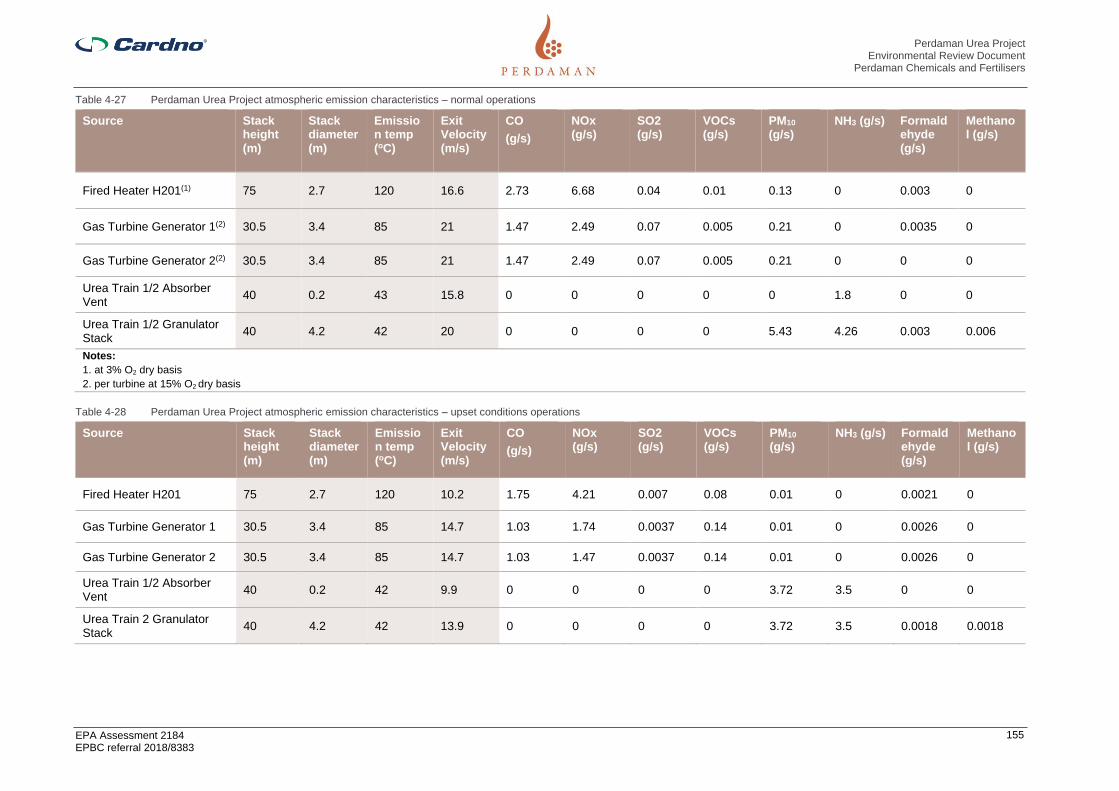
Perdaman Urea Project Environmental Review Document
Perdaman Chemicals and Fertilisers
EPA Assessment 2184 EPBC referral 2018/8383
155
Table 4-27 Perdaman Urea Project atmospheric emission characteristics – normal operations
Source Stack height (m)
Stack diameter (m)
Emission temp (oC)
Exit Velocity (m/s)
CO
(g/s)
NOx (g/s)
SO2 (g/s)
VOCs (g/s)
PM10 (g/s)
NH3 (g/s) Formaldehyde (g/s)
Methanol (g/s)
Fired Heater H201(1) 75 2.7 120 16.6 2.73 6.68 0.04 0.01 0.13 0 0.003 0
Gas Turbine Generator 1(2) 30.5 3.4 85 21 1.47 2.49 0.07 0.005 0.21 0 0.0035 0
Gas Turbine Generator 2(2) 30.5 3.4 85 21 1.47 2.49 0.07 0.005 0.21 0 0 0
Urea Train 1/2 Absorber Vent
40 0.2 43 15.8 0 0 0 0 0 1.8 0 0
Urea Train 1/2 Granulator Stack
40 4.2 42 20 0 0 0 0 5.43 4.26 0.003 0.006
Notes:
1. at 3% O2 dry basis
2. per turbine at 15% O2 dry basis
Table 4-28 Perdaman Urea Project atmospheric emission characteristics – upset conditions operations
Source Stack height (m)
Stack diameter (m)
Emission temp (oC)
Exit Velocity (m/s)
CO
(g/s)
NOx (g/s)
SO2 (g/s)
VOCs (g/s)
PM10 (g/s)
NH3 (g/s) Formaldehyde (g/s)
Methanol (g/s)
Fired Heater H201 75 2.7 120 10.2 1.75 4.21 0.007 0.08 0.01 0 0.0021 0
Gas Turbine Generator 1 30.5 3.4 85 14.7 1.03 1.74 0.0037 0.14 0.01 0 0.0026 0
Gas Turbine Generator 2 30.5 3.4 85 14.7 1.03 1.47 0.0037 0.14 0.01 0 0.0026 0
Urea Train 1/2 Absorber Vent
40 0.2 42 9.9 0 0 0 0 3.72 3.5 0 0
Urea Train 2 Granulator Stack
40 4.2 42 13.9 0 0 0 0 3.72 3.5 0.0018 0.0018
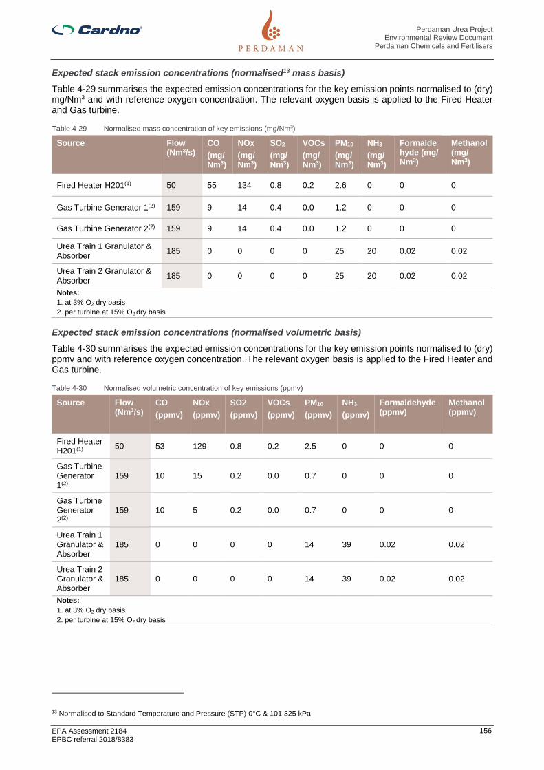
Perdaman Urea Project Environmental Review Document
Perdaman Chemicals and Fertilisers
EPA Assessment 2184 EPBC referral 2018/8383
156
Expected stack emission concentrations (normalised13 mass basis)
Table 4-29 summarises the expected emission concentrations for the key emission points normalised to (dry) mg/Nm3 and with reference oxygen concentration. The relevant oxygen basis is applied to the Fired Heater and Gas turbine.
Table 4-29 Normalised mass concentration of key emissions (mg/Nm3)
Source Flow (Nm3/s)
CO
(mg/ Nm3)
NOx
(mg/ Nm3)
SO2
(mg/ Nm3)
VOCs
(mg/ Nm3)
PM10
(mg/ Nm3)
NH3
(mg/ Nm3)
Formaldehyde (mg/ Nm3)
Methanol (mg/ Nm3)
Fired Heater H201(1) 50 55 134 0.8 0.2 2.6 0 0 0
Gas Turbine Generator 1(2) 159 9 14 0.4 0.0 1.2 0 0 0
Gas Turbine Generator 2(2) 159 9 14 0.4 0.0 1.2 0 0 0
Urea Train 1 Granulator & Absorber
185 0 0 0 0 25 20 0.02 0.02
Urea Train 2 Granulator & Absorber
185 0 0 0 0 25 20 0.02 0.02
Notes:
1. at 3% O2 dry basis
2. per turbine at 15% O2 dry basis
Expected stack emission concentrations (normalised volumetric basis)
Table 4-30 summarises the expected emission concentrations for the key emission points normalised to (dry) ppmv and with reference oxygen concentration. The relevant oxygen basis is applied to the Fired Heater and Gas turbine.
Table 4-30 Normalised volumetric concentration of key emissions (ppmv)
Source Flow (Nm3/s)
CO
(ppmv)
NOx
(ppmv)
SO2
(ppmv)
VOCs
(ppmv)
PM10
(ppmv)
NH3
(ppmv)
Formaldehyde (ppmv)
Methanol (ppmv)
Fired Heater H201(1)
50 53 129 0.8 0.2 2.5 0 0 0
Gas Turbine Generator 1(2)
159 10 15 0.2 0.0 0.7 0 0 0
Gas Turbine Generator 2(2)
159 10 5 0.2 0.0 0.7 0 0 0
Urea Train 1 Granulator & Absorber
185 0 0 0 0 14 39 0.02 0.02
Urea Train 2 Granulator & Absorber
185 0 0 0 0 14 39 0.02 0.02
Notes:
1. at 3% O2 dry basis
2. per turbine at 15% O2 dry basis
13 Normalised to Standard Temperature and Pressure (STP) 0°C & 101.325 kPa

Perdaman Urea Project Environmental Review Document
Perdaman Chemicals and Fertilisers
EPA Assessment 2184 EPBC referral 2018/8383
157
Benchmarking of key emissions
Table 4-31 presents the expected emissions for the Project compared to the European Commission BAT Reference Document for Large Volume Inorganic Chemicals - Ammonia, Acids and Fertilisers (2007) and the European Commission Best Available Techniques (BAT) Reference Document for Large Combustion Plants – (EFMU and EU respectively). (2010/75/EU), as well as the Yara Ammonia plant (PER1036) and DampierNitrogen proposed urea plant (EPA1065) respectively neighbouring and proposed for the same location.
Table 4-31 Benchmarking of key emissions
Source Perdaman Project
BAT
(EFMA€ or EU¥)
Yara Ammonia
(PER 1036)
Dampier Nitrogen
(EPA 1065)
Comment
Fired Heater (dry at 3% oxygen)
BAT from EFMA Book 1 Ammonia
Natural Gas feed,
NOx mg/Nm3 <150 <150 <180 Conventional plant has reformer
SOx mg/Nm3 <1 <1 <1 Low S in gas
PM mg/Nm3 3 <5 <5 <5 Low expected
CO mg/Nm3 <100 <100 <110
NH3 mg/Nm3 0 0 0 0 Not present
Gas Turbine 1&2 - each (dry at 15% oxygen)
BAT from EU medium combustion plants 1-50MW 380-476 2013
Natural Gas feed
NOx ppmv 15 <50 <90 <75 Yara has steam turbine power
SOx mg/Nm3 0.5 <1 <1 1 NWS gas is low Sulfur
PM mg/Nm3 1.6 <5 <5
CO mg/Nm3 <10 <20 <50 Yara has boiler
NH3 mg/Nm3 0 0 0 0 Not present
Urea Absorber vents (2 off) - each Vents
PM mg/Nm3 0 0 - 0 EFMA
CO mg/Nm3 <1 <1 - <1
NH3 mg/Nm3 6 5-8 - <10
Urea Granulator (2 off) – each Air
NOx mg/Nm3 0 0 - 0 EFMA
PM mg/Nm3 25 ≤30 - 35 EFMA
NH3(with acid scrubbing)mg/Nm3
20 20-30 - EFMA
Other – formaldehyde/ methanol mg/Nm3
<0.1 <0.2 - <0.3 Stamicarbon technology uses less formaldehyde
Notes:
1. Based on average annual design conditions (32⁰C)
2. Burrup average ambient temperature has approximately 3% de-rating compared to BAT
3. Non harmful/inert trace fugitive emissions not listed
4.8.4.2 Greenhouse Gas emissions
GHGs from the Project will be primarily generated directly from ammonia synthesis (natural gas reforming), and stationary energy generated onsite. Natural gas from the nearby Woodside LNG plant will be used as feedstock to the gas reforming process. Natural gas is catalytically reformed with oxygen and steam to form ‘syngas’, which is purified to a hydrogen rich and CO2 stream.

Perdaman Urea Project Environmental Review Document
Perdaman Chemicals and Fertilisers
EPA Assessment 2184 EPBC referral 2018/8383
158
The CO2 generated as a by-product of gas reforming is used as a reagent in the urea synthesis process, and hence accounts for a net reduction in emissions from the Project. This is an important feature of the Project design, with the production of ammonia fully balanced to urea, such that no ammonia is produced for export as with typical plants, resulting in consumption of CO2 generated from gas reforming within the urea synthesis process.
The power and steam requirements for the Project will be met with a high efficiency combined cycle gas turbine (CCGT) that includes cogeneration of steam, and a steam turbine for excess steam. The gas turbine will be operated on natural gas under normal conditions. Combustion of natural gas for onsite power and steam generation comprise the key stationary energy GHG emission sources. The gas turbine combined cycle site power generation carbon intensity is ca. 0.45 t CO2/MWh, which is BAT considering the scale of turbine (<100MW) and the high ambient temperature conditions in the Burrup.
This compares favourably with typical OCGT (open cycle gas turbine) as applied in the Burrup, which have a carbon intensity of ca. 0.7 t CO2/MWh.
For normal operation, the Perdaman GTCC thermal efficiency is 52% LHV, compared with ca. 33-35% for OCGT, in the context of the Karratha ambient conditions -ie >50% more thermally efficient.
The layout uses dual gas turbines with dual HRSG (heat recovery steam generators), with a shared steam turbine. Any modest excess of process steam in the process circuit will also be used in the steam turbine to supplement power production when available. This can reduce the power demand from the gas turbine with potential to reduce resultant product of combustion emissions, principally NOx, CO2 and VOCs.
Other minor sources of GHG emissions from the Project include:
> operation of the flare pilot burner, so in the event of abnormal plant operations emissions containingammonia and other volatile gases can be safely discharged;
> the leakage or loss of CH4 and CO2 from the gas reforming and urea synthesis process circuits; and
> use of heavy vehicles for material handling within the product storage sheds at the Project site andDampier Port (not considered further as only a very minor contributor to Project emissions).
Estimates of GHG emissions from all key sources associated with the Project have been derived using accepted methods of emission estimation. Emissions from the main sources which are gas reforming and stationary energy, have been estimated using methods prescribed under the National Greenhouse and Energy Reporting Scheme (NGERS). The Method 1 default emission factor for natural gas of 51.4 kg CO2e/GJ has been adopted, taken from the most recent NGERS (2019) measurement determination. GHG emissions from the Project are primarily comprised of CO2.
The production and consumption data used as the basis of the GHG emission estimation is presented in Table 4-32.
Table 4-32 Greenhouse gas emission estimation – Production and consumption data.
Type Parameter Input Units
Production/Design
Ammonia production(1) 1,157,310 tpa
Urea production(2) 2,046,000 tpa
CO2 recovered from urea production
1,503,810 tpa
Combined Cycle Gas Turbine(3)
792,000 MWh/y
Fuel (natural gas) Consumption(4)
Primary steam reforming 101,404 GJ/d
Combined Cycle Gas Turbine
18,259 GJ/d
Process heat/steam generation
7,195 GJ/d
Flaring 126 GJ/d
Leakage/loss
Primary steam reforming 300 kg/y of CH4
Urea production 22.7 tpa of CH4
35.0 tpa of CO2

Perdaman Urea Project Environmental Review Document
Perdaman Chemicals and Fertilisers
EPA Assessment 2184 EPBC referral 2018/8383
159
Type Parameter Input Units
Notes:
1. Nominal capacity of 3,507 tpa ammonia production and assumed equipment availability (330 days/y).
2. Nominal capacity of 6,200 tpa urea production and assumed equipment availability (330 days/y).
3. 100 MW power generating capacity, assumed to operate continuously (330 days/y).
4. Higher Heating Value (HHV) based on Woodside/Dampier Bunbury Pipeline (DBP), using ISO 6976(1995).
A summary of the estimated annual GHG emissions from the Project are shown in Figure 4-20. Total net GHG emissions for the Project are estimated to be equal to 0.65 Mtpa CO2-e. Gas reforming is the largest single source of GHG emissions (1.72 Mtpa CO2-e). Emissions from this source, however, are almost entirely offset through the consumption of CO2 within the urea production process (-1.50 Mtpa CO2-e), such that net GHG emissions are estimated to be equal to 0.22 Mtpa CO2-e, which represents 33% of Project emissions. GHG emissions from stationary energy sources are estimated to be equal to 0.43 Mtpa CO2-e, which represents 67% of Project emissions.
Figure 4-20 Estimated annual greenhouse gas emissions
To evaluate the extent to which GHG emissions from the Project could contribute to national and state GHG emissions, estimated Project emissions have been compared to the latest available data published in the Australian National Greenhouse Accounts by the Commonwealth DoEE (2019 & 2019a), presented in Table 4-33.
Table 4-33 Project compared to Australia and Western Australia GHG emissions
Source Total emissions 2017 (Mt CO2-e)
Total emissions 2017 (Including Project)
Estimated Project Contribution (%)
Australia 534.7 (1) 535.4 0.1
Western Australia 88.5 (2) 89.2 0.7
Notes:
1. 2017 calendar year.
2. 2017 financial year.

Perdaman Urea Project Environmental Review Document
Perdaman Chemicals and Fertilisers
EPA Assessment 2184 EPBC referral 2018/8383
160
The GHG emissions from the Project have also been assessed in the context of longer-term trends in State GHG emissions, presented in Figure 4-21. As a proportion of the State’s GHG emissions, the contribution of the Project is low, but still of significance within the context of an increasing trend in Western Australian GHG emissions.
Figure 4-21 Project compared to Western Australia longer term GHG emissions trend
It is also important to consider the contribution of the Project to State and National GHG emissions in the context of international urea production markets and Australian urea imports. In recent years, Australia has imported on average approximately 2 Mtpa of urea, mostly from the Middle East with smaller volumes imported from China and other countries. Urea imported from the Middle East is typically sourced from older plants (10 to 25 years old) which operate under a low-cost natural gas regime where economic efficiency drivers are less critical, and therefore associated GHG emissions are higher. Similarly, urea imported from China is primarily produced using coal rather than natural gas as feedstock, and is therefore also associated with higher GHG emissions (SNC-Lavalin, 2019).
The Project has the capacity to displace all Australian imports of urea, which would have a net benefit as GHG emissions from the Project represent international best practice and a significant improvement upon urea imported from the Middle East and China. On the basis that the Project displaces all imported urea, Australia’s net CO2 position could be reduced by an estimated 1.1 Mtpa or more (SNC-Lavalin, 2019), which would far outweigh the total GHG emissions estimated for the Project.
4.8.5 Assessment of impacts
To support the assessment of the potential environmental impact of the Project, a series of modelling scenarios were defined and simulations run for a suite of key pollutants of potential concern. These modelled scenarios support the evaluation of the potential impacts (direct, indirect and cumulative) under the current level of industrial activity on the Burrup Peninsula (as approved) as well as a future expanded level that accounts for the development of the proposed Methanol plant. These scenarios are described briefly in Table 4-34.
Comparison of the modelled results to the respective assessment criteria is made with reference to the maximum predicted ground level concentration (GLC) on the grid, and the predicted GLCs at the sensitive receptor locations of relevance. As there are currently no agreed criteria against which to assess potential impacts on the Burrup rock art, an indicator of potential impact has not been adopted, with the relative incremental change reported to facilitate future assessment. Criteria are summarised in Table 4-26.

Perdaman Urea Project Environmental Review Document
Perdaman Chemicals and Fertilisers
EPA Assessment 2184 EPBC referral 2018/8383
161
Table 4-34 Air Quality Assessment – Modelled Scenarios
Scenario Description and Emission Sources
Existing air emissions
(Baseline)
The Baseline scenario represents all current relevant air pollutant sources, including:
KGP, PLP, Yara Technical Ammonium Nitrate and Liquid Ammonia Plant, Pilbara Iron
Yurralyi Maya Power Station, Santos Devil Creek Power Station, ATCO Karratha Power
Station, EDL West Kimberley Power Plant, All shipping berths on the Burrup Peninsula
and at Cape Lambert.
Baseline represents the current and near-term operating scenario and could be
described as a ‘near-term most likely’ case.
Perdaman in isolation
(Normal operations
conditions)
(PNO)
The PNO scenario represents the Project in isolation as the sole emission source,
operating under normal conditions.
Perdaman in isolation
(upset conditions)
(PUC)
The PUC scenario represents the Project in isolation as the sole emission source,
operating under the upset condition of flaring, over a period of 1-2 weeks annually.
Cumulative - Baseline
condition including
Perdaman (Normal
operations conditions)
(BPNO)
The BPNO scenario reflects the implementation of the Project under normal operating
conditions and includes cumulative impacts from current facilities on the Burrup
Peninsula.
This scenario includes emissions from:
• All the currently operating facilities listed above under the Baseline scenario
• The implementation of the Project under normal operating conditions
• Future development on the Burrup Peninsula is not considered.
It is considered to be a ‘most likely’ and ‘best case’ for future ambient air quality on the
Burrup Peninsula.
Cumulative - Baseline
condition including
Perdaman (upset
conditions)
(BPUC)
The BPUC scenario reflects the implementation of the Project under upset operating
conditions and includes cumulative impacts from current facilities on the Burrup
Peninsula.
This scenario includes emissions from:
• All the currently operating facilities listed above under the Baseline scenario
• The implementation of the Project under upset operating conditions
• Future development on the Burrup Peninsula is not considered.
Cumulative - Baseline
condition including
Perdaman and other
proposed projects
(FPNO)
The FPNO scenario reflects the implementation of the Project and includes cumulative
impacts from current and likely future facilities on the Burrup Peninsula.
This scenario includes emissions from:
• All the currently operating facilities listed above under the Baseline scenario
• The implementation of the Project under normal operating conditions
• Future development on the Burrup Peninsula represented by the Methanol plant.
It is considered to be the ‘most likely’ and ‘worst case’ for future ambient air quality on
the Burrup Peninsula.
Perdaman normal
operations plus Yara
Pilbara sources (NH3 only)
(Total Ammonia)
The Total Ammonia scenario represents the implementation of the Project operating
under normal conditions alongside the existing Yara Pilbara facilities on the Burrup
Peninsula.
The Total Ammonia scenario represents modelling of NH3 emissions based on a ‘low-
NH3’ emissions scenario representing operation of the plant with mitigation (e.g. acid
scrubbing) in place from day one. It should be noted that the modelled emissions are
considered to be representative of the second year of operations and onwards, as the
first year is likely to include testing and commissioning with reduced operational time
and assumed lower emissions.

Perdaman Urea Project Environmental Review Document
Perdaman Chemicals and Fertilisers
EPA Assessment 2184 EPBC referral 2018/8383
162
Scenario Description and Emission Sources
Perdaman Urea emissions
(in isolation) as PM10
For determination of particulate urea deposition due to emissions from the Project
granulator vents, assuming urea is the sole particulate species from those vents (100%
of PM10 emissions). While emitted urea dust may decompose after emissions, as a
worst-case scenario, no degradation was assumed. Also, as urea is basic, and not an
acid-forming nitrate, cumulative modelling with ammonium nitrate emissions, e.g. from
the Yara plants, was not included.
4.8.5.1 Impact on sensitive receptors – human health and amenity
The townships of Dampier and Karratha (AQMS Dampier and AQMS Karratha) were identified as key sensitive receptor locations for determining the potential impact on human health and amenity for both direct, indirect and cumulative impacts.
A further sensitive receptor has been selected in King Bay. The location is close to the MAC offices where people congregate during work hours, is a place of amenity for cultural practices and adjacent to the NHL area to the north of King Bay northern shoreline.
Additional sensitive receptors incorporated into the model include: Ngajarli Gorge, Hearson Cove, Murujua National Park (central northern and southern extents) (MNP-CN and MNP-SE), Standing Stones and the proposed location of the Living Knowledge Centre (MLKC) proposed by MAC will probably be in the vicinity of Conzinc Bay approximately 9km to the north of Site C.
Short term impacts on human health and amenity
The potential for short term health impacts is assessed by comparison to criteria over short durations of 1-hour and 24-hour averages, at key sensitive receptor locations. The direct and cumulative impacts are summarised in Table 4-35 for NO2, SO2, NH3 and O3 (1-hour averages), and in Table 4-36 for SO2 and PM (24-hour averages). These tables highlight the relatively low cumulative concentrations of SO2 in the airshed (less than 3% of the criteria), and the relatively minor contribution of the Project to these short-term levels (less than 1% of the assessment criteria).
NO2 emissions from the Project, when considered in isolation, result in an insignificant contribution to the airshed with the maximum predicted NO2 GLC in the area being less than 1% of the assessment criteria. The maximum cumulative impact is estimated to around 21% of the assessment criteria. The contribution at the sensitive receptor locations of the MLKC, Dampier and Karratha are lower again, indicating that the project will not create an unacceptable impact.
The maximum PM10 and PM2.5 GLCs from the Project when considered in isolation are less than 5% of the assessment criteria, respectively, and present a relatively low risk of impact. Existing sources (industry and natural background) contribute levels approximately 70% of the PM10 criteria and 60% of the PM2.5 criteria.
Ammonia emissions from the Project are predicted to be the largest source in comparison to the current emission inventory. Modelled maximum concentrations are less than 2% of the assessment criteria at the sensitive receptor locations of Dampier and Karratha, and are not predicted to present an odour impact under normal or modelled upset operating conditions. While modelled maximum concentrations are relatively higher at the proposed location for the MLKC they remain within the assessment criteria. The cumulative impact from the introduction of the Project will see maximum predicted NH3 concentrations less than 10% of the assessment criteria, and lower again at the sensitive receptors. There is predicted to be no discernible difference in the ground level concentrations of NH3 from the Perdaman plant under upset conditions compared to normal operations.
As outlined previously O3 formation is a complex process. Due to the nature of the contributing sources occurring over a wide regional extent, and wind circulation patterns and temperatures in the region, peak O3 concentrations may occur at some distance to the actual emission sources. The model adopted for this assessment (TAPM-GRS) has a relatively simplified approach to accounting for the multiple complex reactions that could occur. As the emission inventory has demonstrated, the Project is a relatively small contributing source to the key O3 formation pollutants, principally NOx and VOCs. On this basis the model is considered an appropriate model for screening-level assessment of potential photochemical impacts from project emissions. The results in Table 4-35 show a comparison of the ‘background - existing air quality’ scenario (excludes the Project) and the cumulative scenario which includes the Project. The non-significant contribution of the Project’s emissions is evident in that the predicted impacts of these two scenarios do not differ significantly.

Perdaman Urea Project Environmental Review Document
Perdaman Chemicals and Fertilisers
EPA Assessment 2184 EPBC referral 2018/8383
163
Table 4-35 Modelled regional concentrations of NO2, SO2, NH3 and O3 (1-hour averages) showing incremental increase from the project and cumulative (Sourced from Jacobs 2020 (Table D-3, D-4, D-5 and D-6)
Pollutant Average period
Scenario Grid Maximum
AQMS Dampier
AQMS Karratha
Ngajarli Hearson Cove
MNP-CN
MNP-SE
King Bay
Standing Stones
MLKC
NO2
(ppb)
1-hour
Baseline 42.6 24.8 24.9 36.6 33.4 24.4 30 33.6 30.5 19
% of criteria 36% 21% 21% 31% 28% 20% 25% 28% 25% 16%
BPNO 43.1 24.8 25.6 37 33.7 25.7 31.6 34.1 31.5 20.6
% of criteria 36% 21% 21% 31% 28% 21% 26% 28% 26% 17%
BPUC 42.9 24.8 25.4 36.9 33.7 25.4 31.2 34.2 31.1 19.8
% of criteria 17% 21% 21% 31% 28% 21% 26% 29% 26% 21%
FPNO 43.9 25.8 28.4 37.7 35.4 30.2 32.9 36 33.9 25.5
% of criteria 37% 22% 24% 31% 30% 25% 27% 30% 28% 21%
O3
(ppb)
Baseline 61.8 55.4 58.2 55 56.1 59 57.4 59.2 60.3 59
% of criteria 62% 55% 58% 55% 56% 59% 57% 59% 60% 59%
BPNO 62 55.4 58.6 55.3 56.3 59.1 57.3 58 60.4 59.2
% of criteria 62% 55% 59% 55% 56% 59% 57% 58% 60% 59%
BPUC 61.9 55.4 58.4 55.1 56.1 59.2 57.3 58.1 60.3 59.2
% of criteria 59% 55% 58% 55% 56% 59% 57% 58% 60% 55%
FPNO 63 56.5 61.2 56.1 57.7 59.3 57.8 58.1 61.3 58.7
% of criteria 63% 57% 61% 56% 58% 59% 58% 58% 61% 59%
SO2
(ppb)
Baseline 18.2 13.2 3.6 9.2 9.5 7.3 8.7 9.3 10.9 9
% of criteria 9% 7% 2% 5% 5% 4% 4% 5% 5% 5%
BPNO 18.1 12.9 3.6 9.2 9.6 7.4 8.4 10.5 10.9 10
% of criteria 9% 6% 2% 5% 5% 4% 4% 5% 5% 5%
BPUC 18.1 12.9 3.6 9.2 9.6 7.4 8.4 10.5 10.9 10
% of criteria 5% 6% 2% 5% 5% 4% 4% 5% 5% 6%
FPNO 18.1 12.9 3.6 9.2 9.6 7.4 8.4 10.6 10.9 10
% of criteria 9% 6% 2% 5% 5% 4% 4% 5% 5% 5%

Perdaman Urea Project Environmental Review Document
Perdaman Chemicals and Fertilisers
EPA Assessment 2184 EPBC referral 2018/8383
164
Pollutant Average period
Scenario Grid Maximum
AQMS Dampier
AQMS Karratha
Ngajarli Hearson Cove
MNP-CN
MNP-SE
King Bay
Standing Stones
MLKC
NH3
(ppb)
Baseline 0.4 0.7 0.9 1.1 0.9 1 1.1 0.1 1.2 1
% of criteria 1% 2% 3% 3% 3% 3% 3% 0% 4% 3%
BPNO 77.3 17.4 9.1 34.2 35.2 10.7 31.8 36.2 37.4 25.7
% of criteria 23% 5% 3% 10% 11% 3% 10% 11% 11% 8%
BPUC 76.2 16.6 9.1 28.9 28 12.3 22.9 34.5 35.3 27.1
% of criteria 23% 5% 3% 9% 8% 4% 7% 10% 11% 5%
FPNO 77.3 17.4 9.1 34.2 35.2 10.7 31.8 36.2 37.4 25.7
% of criteria 23% 5% 3% 10% 11% 3% 10% 11% 11% 8%
Table 4-36 Modelled regional concentrations of SO2, PM10 and PM2.5 (24-hour averages) showing incremental increase from the project and cumulative
Pollutant Average period
Scenario Grid Maximum
AQMS Dampier
AQMS Karratha
Ngajarli Hearson Cove
MNP-CN
MNP-SE
King Bay
Standing Stones
MLKC
SO2
(ppb)
24-hour
Baseline 7 4.5 1.7 4 3.5 2.3 3 4.2 5 3
% of criteria 9% 6% 2% 5% 4% 3% 4% 5% 6% 4%
BPNO 7 4.6 1.7 4 3.5 2.3 3 4.1 5 2.9
% of criteria 4% 6% 2% 5% 4% 3% 4% 5% 6% 4%
BPUC 7 4.6 1.7 4 3.5 2.3 3 4.1 5 2.9
% of criteria 9% 6% 2% 5% 4% 3% 4% 5% 6% 4%
FPNO 7 4.6 1.7 4 3.5 2.3 3 4.1 5 2.9
% of criteria 6% 2% 5% 4% 3% 4% 5% 6% 4%
PM10
(µg/m3)
Baseline 35.5 34.5 34.1 34.4 34.3 33.9 34.2 34.5 34.4 34
% of criteria 142% 138% 136% 138% 137% 136% 137% 138% 138% 136%
BPNO 44.7 34.6 34.4 39.2 39.6 34.2 35.4 37.6 35.5 34.6
% of criteria 89% 69% 69% 78% 79% 68% 71% 75% 71% 69%
BPUC 53 34.7 34.5 41.7 42.4 34.5 36.3 39.6 36.1 35.2
% of criteria 106% 69% 69% 83% 85% 69% 73% 79% 72% 70%
FPNO 34.7 34.7 34.4 39.3 39.6 34.2 35.5 37.6 35.6 34.6

Perdaman Urea Project Environmental Review Document
Perdaman Chemicals and Fertilisers
EPA Assessment 2184 EPBC referral 2018/8383
165
Pollutant Average period
Scenario Grid Maximum
AQMS Dampier
AQMS Karratha
Ngajarli Hearson Cove
MNP-CN
MNP-SE
King Bay
Standing Stones
MLKC
% of criteria 69% 69% 69% 79% 79% 68% 71% 75% 71% 69%
PM2.5
(µg/m3)
Baseline 15.5 15.3 14.5 14.9 15 14.5 14.6 15 14.9 14.7
% of criteria 194% 191% 181% 186% 188% 181% 183% 188% 186% 184%
BPNO 17.4 15.5 14.7 16 15.9 14.7 14.9 15.6 15.4 14.7
% of criteria 70% 62% 59% 64% 64% 59% 60% 62% 62% 59%
BPUC 18.9 15.5 14.8 16.6 16.5 14.7 15 15.9 15.5 14.7
% of criteria 76% 62% 59% 66% 66% 59% 60% 64% 62% 59%
FPNO 17.4 15.5 14.8 16.1 16 14.7 15 15.8 15.5 14.7
% of criteria 59% 62% 59% 64% 64% 59% 60% 63% 62% 62%

Perdaman Urea Project Environmental Review Document
Perdaman Chemicals and Fertilisers
EPA Assessment 2184 EPBC referral 2018/8383
166
Long term impacts on human health
The direct impact of the Project is demonstrated by the maximum modelled concentration off-site, as determine at key community receptor locations. This is illustrated for the potential longer-term impacts in Table 4-37 (annual NOx, SO2 and PM). The table summarises the incremental increase in predicted ground level concentrations for the background or existing operations without the Perdaman operations (Baseline without CF), the normal Perdaman operating scenario with baseline (BPNO), and the cumulative impact arising with the addition of the project to the existing conditions (FPNO). This is considered at the locations of Dampier, Karratha and the proposed MLKC, noting that the latter is modelled to experience lower ground level concentrations than Dampier and Karratha.
This summary highlights the relatively low concentrations of NOx and SO2 in the existing environment and the relatively minor increase attributable to the Project in future. In contrast is the relatively high concentrations (greater than 99% of the NEPM criteria) of PM10 and PM2.5 already present in the airshed, largely influenced by non-industrial sources. Again, the incremental contribution of the Project is relatively insignificant with less than 1 µg/m3 increase in PM10 estimated to occur at the community receptors, and a worst-case maximum on grid increase of 2.5 µg/m3.
Table 4-37 Modelled regional concentrations of NO2, SO2, PM10 and PM2.5 (annual averages) showing incremental increase from the project and cumulative
Pollutant Average period
Scenario Grid Maximum
AQMS Dampier
AQMS Karratha
MLKC
NO2
(ppb)
Annual Average
Baseline (without CF)
5 1.7 0.9
% of criteria 17% 6% 3%
BPNO 5.6 1.7 0.9 1.7
% of criteria 19% 6% 3% 6%
FPNO 5.9 1.8 1 1.9
% of criteria 20% 6% 3% 6%
SO2
(ppb)
Baseline 4.5 1.6 0.9
% of criteria 23% 8% 5%
BPNO 4.5 1.6 0.9 1.1
% of criteria 23% 8% 5% 6%
FPNO 4.5 1.6 0.9 1.1
% of criteria 23% 8% 5% 6%
PM10
(µg/m3)
Baseline 28.4 23.7 23.8
% of criteria 99% 95% 95%
BPNO 30.9 23.8 23.9 23.8
% of criteria 124% 95% 96% 95%
FPNO 30.8 23.8 23.9 23.8
% of criteria 123% 95% 96% 95%
PM2.5
(µg/m3)
Baseline 8.4 7.9 7.9
% of criteria 105% 99% 99%
BPNO 8 7.9 8
% of criteria 124% 95% 96% 95%
FPNO 10.3 8 7.9 8
% of criteria 129% 100% 99% 100%

Perdaman Urea Project Environmental Review Document
Perdaman Chemicals and Fertilisers
EPA Assessment 2184 EPBC referral 2018/8383
167
4.8.5.2 Impact on sensitive receptors – cultural heritage values and amenity
To interpret the incremental change in air quality arising from the Project, ground level concentrations were predicted in the vicinity of four culturally important locations, and in two additional locations within the Murujuga National Park (central north and central south), noting that the site of the proposed MLKC was discussed in the previous subsection. These two additional sites are locations representing significant known NHL heritage and cultural values/amenity and were selected after discussions with MAC. For cultural sensitivity reasons the precise location of these sites is confidential and not disclosed here.
As shown in the previous discussion on the potential impact on human health and amenity, the Project’s contribution is relatively insignificant in terms of the predicted ground level concentrations of NO2, SO2, PM10 and NH3 into the cumulative airshed, considering both the maximum predicted concentrations in the region, as well as at Dampier and Karratha. This is a similar outcome when results are reviewed at the nominated cultural and heritage receptor locations
These results are summarised in Table 4-38. Due to the absence of a relevant quantitative assessment criteria only the relative contribution of the Project to the cumulative scenario is included.
Notably, the maximum on grid does not correspond to any of the impact indicator locations.
Table 4-38 Modelled regional concentrations of gases showing incremental increase from the project and cumulative scenario
Pollutant Average period
Scenario Ngajarli Hearson Cove
MNP-CN(1)
MNP-SE(2)
King Bay
Standing Stones
MLKC
NO2
(ppb) 1-hour
Baseline 36.6 33.4 24.4 30 33.6 30.5
BPNO 37 33.7 25.7 31.6 34.1 31.5 20.6
FPNO 37.7 35.4 30.2 32.9 36 33.9 25.5
24-hour
Baseline 3.1 3.6 1.3 1.3 2.6 2.4
BPNO 3.4 4 1.4 1.3 3 2.5 1.7
FPNO 3.7 4.4 1.6 1.4 3.7 2.7 1.9
SO2
(ppb)
1-hour
Baseline 9.2 9.5 7.3 8.7 9.3 10.9
BPNO 9.2 9.6 7.4 8.4 10.5 10.9 10
FPNO 9.2 9.6 7.4 8.4 10.6 10.9 10
24-hour
Baseline 4 3.5 2.3 3 4.2 5
BPNO 4 3.5 2.3 3 4.1 5 2.9
FPNO 4 3.5 2.3 3 4.1 5 2.9
NH3
(ppb)
1-hour
Baseline 1.1 0.9 1 1.1 0.1 1.2
BPNO 34.2 35.2 10.7 31.8 36.2 37.4 25.7
FPNO 34.2 35.2 10.7 31.8 36.2 37.4 25.7
PM10
(µg/m3)
24-hour
Baseline 34.4 34.3 33.9 34.2 34.5 34.4
BPNO 39.2 39.6 34.2 35.4 37.6 35.5 34.6
FPNO 39.3 39.6 34.2 35.5 37.6 35.6 34.6
PM2.5
(µg/m3)
24-hour
Baseline 14.9 15 14.5 14.6 15 14.9
BPNO 16 15.9 14.7 14.9 15.6 15.4 14.7
FPNO 16.1 16 14.7 15 15.8 15.5 14.7
Notes: (1)Murujuga National Park Central North location (2) Murujuga National Park Central South location
As outlined in Section 4.8.4.1, in the absence of specific compliance criteria and in accordance with risk mitigation precautionary management principles emission of acidic pollutants and nitrate enhancement of microbial activity are prime aspect of potential concern when considering the integrity of rock art. As neither NH3 nor urea are acidic pollutants or nitrates, there is little likelihood that emissions of these by the Project will result in increased potential impacts in either of these specific aspects of concern.

Perdaman Urea Project Environmental Review Document
Perdaman Chemicals and Fertilisers
EPA Assessment 2184 EPBC referral 2018/8383
168
As noted in Section 4.8.5.3, the Proponent has consulted with Dr Ian MacLeod on matters relating to potential impacts on the integrity of rock art as recorded by the 2018 Senate Enquiry and more broadly on the issue of rock art integrity.
Dr MacLeod clarified that any change of micronutrients may in theory have the possibility of activating a group of microflora that have hitherto been dormant, owing to the lack of suitable niche nutrients. If such theoretical reactivation occurs this could also potentially lead to acidification through metabolic processes.
The Proponent notes that there is currently no definitive data on the presence or otherwise of such microflora at Murujuga. However, based on the work of Franklin et al. (2015) and Huayiu Yang et al. (2015) as noted in Section 4.8.4.1, there is a strong probability that given the lack of naturally occurring urea, through processes of natural selection such microflora may never have evolved or if they evolved may not have a genetic predisposition for this type of nitrogen micronutrient uptake.
While there has been a focus on the impacts of acidic and acid forming emission, the release of ammonia (strongly alkaline) and urea (mildly alkaline) also has a theoretical ability or capacity to bring about changes in the rock art patina and so alter the perception of colour differences, as this is not fully understood.
The proponent has committed to MAC to participate and contribute to the development of an EQMF as detailed in the MRAS where it would suggest these theoretical impact pathways be examined.
The Proponent, in consultation with MAC as endorsed in the recommendations of the IHS heritage survey report (see Section 4.9 .5.2.1), will undertake monitoring during construction and before commissioning to establish a robust baseline against which to compare its contribution to the regional airshed for ammonia and urea and impacts from its contribution to deposition of these species which may impact rock art.
Further analysis of emissions in the form of deposition (nitrogen and sulfur products such as NH3, NO2 and SO2) was undertaken via modelling and through comparison to available monitoring data (Jacobs, 2019).
Estimates for dry deposition of gaseous NH3, NO2 and SO2 were determined from a combination of modelled results and calculations, and comparisons were made with monitoring results described by Gillett (2008), Gillett et al. (2012), and Strategen (2018). The modelled results are summarised in Appendix D and Table 4-39. By comaring the Project only result to the cumulative result (or Total NH3), it is evident that the Project is predicted to be the significant contributing source to the estimated annual deposition of NH3 (which is not considered an acidic pollutant as noted previously), and a non-significant contributor to the annual deposition of NO2 and SO2. It is important to note when interpreting the maxima result that this impact is likely to occur within close proximity to the facility. The median results are considered to be an indicator of typical deposition values modelled and calculated (Jacobs, 2019).
Table 4-39 Summary of Deposition Results (maxima and medians)14
Annual Deposition Perdaman Only Baseline Cumulative Total NH3
NH3 (kg/ha/year) 4.9, 0.1 See Total NH3* See Total NH3 25.3, 0.8
NO2 (kg/ha/year) # 5.7, 0.5 6.8, 0.6 #
SO2 (kg/ha/year) # 13.6, 2.8 13.7, 2.8 #
NH3 (meq/m2/year) 29.1, 0.7 See Total NH3 See Total NH3 148.3, 5.0**
NO2 (meq/m2/year) # 12.4, 1.2 14.9, 1.3 #
SO2 (meq/m2/year) # 42.5, 8.9 42.6, 8.9 #
Urea dust (t/year) 353,n/a n/a 353
Note:
*NH3 deposition calculated using TAPM tracer mode results
**Without capacity factor. With capacity factor of 90.6% values are 134.3, 4.5
# NO2 and SO2 deposition from outputs from TAPM-GRS
The Proponent has committed to MAC to participate and contribute to the development of an EQMF as detailed in the MRAS.
14 In relation to fine urea dust, the granulator stack emits approximately 0.17 kg/t of produced urea. This equates to approximately 353 tpa of urea released (Table ES2), and therefore subject to prior degradation potentially deposited, in the area surrounding the plant

Perdaman Urea Project Environmental Review Document
Perdaman Chemicals and Fertilisers
EPA Assessment 2184 EPBC referral 2018/8383
169
4.8.5.3 Impact on sensitive receptors – Vegetation growth
Murujuga is ecologically and biologically diverse. Major landforms and habitats within the National Park include steep scree strewn granophyre and gabbro hills, narrow valleys, sandy and rocky shores, mangroves, mudflats and sea cliffs. Triodia pungens hummock grasslands predominate, but there are a large number of other vegetation communities of limited distribution. A number of threatened and migratory species are known to frequent the area and are protected under State and national environmental laws (DEC, 2013). As outlined in previous sections, the potential impact on vegetation from increases in pollutant concentrations is not well understood for the communities found in the Burrup Region.
The emitted dust is essentially all urea. The quantity at 0.17kg/t urea is equivalent to BAT compared to other granular urea plants globally, and is significantly lower than processes for prill based urea. This equates to approximately 353tpa of urea dust emitted (Table ES2), and therefore, subject to prior degradation indicated below potentially dispersed then deposited, in the area surrounding the plant. By way of comparisons, Perdaman’s approved Collie Coal-to-Urea Projects was forecast to emit PM10 (principally urea) of approximately 561tpa or approximately 0.25kg/t of urea produced, and the former Plenty River Ammonia Urea proposal as approved for Site C forecast 0.24kg/t of urea produced (Plenty River Corporation Limited, 1998)
By way of comparison, the impact of urea dust deposition was described and assessed for Perdaman’s Collie Coal-to-urea Project. Ausplume was used to model urea deposition in that setting. The predicted maximum urea deposition within the model domain was 11.6 kg/ha/year (GHD, 2009). In contrast, the maximum predicted by modelling for the Proposal is 9.06 kg/ha/year (combine PM10 and PM2.5) (Jacobs, 2020). The median annual rates of urea deposition across the 2601 grid receptors modelled are 0.01kg/ha/year at PM10 and 0.002 kg/ha/year (Jacobs, 2020).
As an easy context to compare the modelled rate of likely surface urea deposition from Project emissions, using WA retail urea supplier Richgro’s online calculator15 shows that the optimal rate of urea application for 1ha of lawn is 50x 4kg bags or 200kg in a single application placed on the surface of the soil surface and the area is watered heavily. Thus, the median deposition from the conservative modelling which assumes no decomposition, is four orders of magnitude below this single application rate. Based on this comparison, the likelihood of significant impacts on vegetation is negligible.
Environmental impacts are not expected to be significant as when released to the atmosphere, urea will degrade rapidly (half-life of 9.6 hr)16. If released to soil in a moist state and dug in, urea is hydrolyzed to ammonium (not a nitrate) through soil urease enzyme activity. The rate of hydrolysis can be fast (24 hr), which mitigates any accumulation of urea. Some plants can have root uptake of residual urea which is then subject to urease activity within the plant.
Thus, fine urea dust deposition is considered transient, as, unlike nitrates, it rapidly degrades to gaseous products (CO2 and ammonia). As the urea dust is a fine residual in the process stream, decomposition is likely to be faster than for prilled or granulated urea applied as a fertiliser due to the larger reactive surface area of fine particles per unit volume.
In summary, as urea dust and ammonium nitrate dust behave differently in relation to decomposition in the environment and as noted in Section 4.8.4 have significantly different uptake properties in the N cycle they should not be considered accretive.
Given the use of best practice pollution control technology within the plant (i.e. the scrubbing system in the plant will remove approximately 99.5% of the entrained urea dust, and approximately 80% of the ammonia) and the use of an enclosed conveyor system, it is unlikely that the vegetation in areas surrounding the plant would be significantly impacted.
4.8.5.1 Impact on sensitive receptors – Microbial growth
Further, recent work suggests that nitrate stimulated microbial growth is a prime contributor to impacts by biodegradation of petroglyphs. Therefore, given:
> that urea (dust) is mildly alkaline, not acidic;
> the relatively low rates of urea dust emitted due to scrubbing;
15 Available at https://www.richgro.com.au/products/natives-fertilisers/urea-4kg/ 16 See Fischer urea MSDS CAS 57-13-6
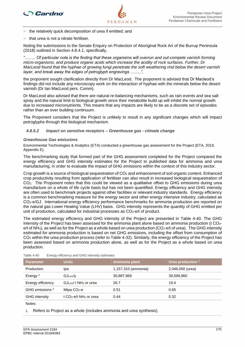
Perdaman Urea Project Environmental Review Document
Perdaman Chemicals and Fertilisers
EPA Assessment 2184 EPBC referral 2018/8383
170
> the relatively quick decomposition of urea if emitted; and
> that urea is not a nitrate fertiliser.
Noting the submissions to the Senate Enquiry on Protection of Aboriginal Rock Art of the Burrup Peninsula (2018) outlined in Section 4.8.4.1, specifically,
“…….. Of particular note is the finding that these organisms will overrun and out-compete varnish forming micro-organisms, and produce organic acids which increase the acidity of rock surfaces. Further, Dr MacLeod found that the hyphae of growing fungi penetrate the soft weathering rind below the desert varnish layer, and break away the edges of petroglyph engravings ……..”,
the proponent sought clarification directly from Dr MacLeod. The proponent is advised that Dr Macleod’s findings did not include any microscopy work on the interaction of hyphae with the minerals below the desert varnish (Dr Ian MacLeod pers. Comm).
Dr MacLeod also advised that there are natural re-balancing mechanisms, such as rain events and sea salt spray and the natural limit to biological growth since their metabolite build up will inhibit the normal growth due to increased micronutrients. This means that any impacts are likely to be as a discrete set of episodes rather than an ever building continuum.
The Proponent considers that the Project is unlikely to result in any significant changes which will impact petroglyphs through this biological mechanism.
4.8.5.2 Impact on sensitive receptors – Greenhouse gas - climate change
Greenhouse Gas emissions
Environmental Technologies & Analytics (ETA) conducted a greenhouse gas assessment for the Project (ETA, 2019, Appendix E).
The benchmarking study that formed part of the GHG assessment completed for the Project compared the energy efficiency and GHG intensity estimates for the Project to published data for ammonia and urea manufacturing, in order to evaluate the impact of GHG emissions within the context of this industry sector.
Crop growth is a source of biological sequestration of CO2 and enhancement of soil organic content. Enhanced crop productivity resulting from application of fertiliser can also result in increased biological sequestration of CO2. The Proponent notes that this could be viewed as a qualitative offset to GHG emissions during urea manufacture on a whole of life cycle basis but has not been quantified. Energy efficiency and GHG intensity are often used to benchmark projects against other facilities or relevant industry standards. Energy efficiency is a common benchmarking measure for the energy sector and other energy intensive industry, calculated as CO2-e/GJ. International energy efficiency performance benchmarks for ammonia production are reported on the natural gas Lower Heating Value (LHV) basis. GHG intensity represents the quantity of GHG emitted per unit of production, calculated for industrial processes as CO2-e/t of product.
The estimated energy efficiency and GHG intensity of the Project are presented in Table 4-40. The GHG intensity of the Project has been assessed for the ammonia plant alone based on ammonia production (t CO2-e/t of NH3), as well as for the Project as a whole based on urea production (CO2-e/t of urea). The GHG intensity estimated for ammonia production is based on net GHG emissions, including the offset from consumption of CO2 within the urea production process (refer to Table 4-32). Similarly, the energy efficiency of the Project has been assessed based on ammonia production alone, as well as for the Project as a whole based on urea production.
Table 4-40 Energy efficiency and GHG intensity estimates
Parameter Units Ammonia plant Urea production 1
Production tpa 1,157,310 (ammonia) 2,046,000 (urea)
Energy 2 GJLHV/y 30,887,969 39,599,960
Energy efficiency GJLHV/ t NH3 or urea 26.7 19.4
GHG emissions 3 Mtpa CO2-e 0.51 0.65
GHG intensity t CO2-e/t NH3 or urea 0.44 0.32
Notes:
1. Refers to Project as a whole (includes ammonia and urea synthesis).

Perdaman Urea Project Environmental Review Document
Perdaman Chemicals and Fertilisers
EPA Assessment 2184 EPBC referral 2018/8383
171
2. Natural gas consumption presented on LHV basis. LHV:HHV ratio of 0.945 applied (Pers comm J De Boer [SNC-Lavalin], 11 September 2019).
3. Stationary energy demands of the Project apportioned as 78% required for ammonia synthesis and 22% for urea synthesis (Pers comm (SNC-Lavalin, 11 September 2019).
Greenhouse Gas Emissions and Fertiliser Use
It is well established that various agricultural management practices can be used to increase carbon sequestration in soils, thereby reducing GHG emissions. When properly used, fertilisers assist plants to capture more carbon than is emitted during the production, transport and application of fertilizers (see Figure 4-22). The case is made that fertilisers foster higher yields, and thus increasing “the amount of carbon that is sequestered by the plant and re-leased into the soil during growth, or when incorporating plant residues into the soil.” (Bellarby et al., 2008). Appropriate fertilizer use can also slow the decline of soil organic matter. In contrast, inadequate fertilisation limits crop biomass production and can result in lower soil organic matter and, potentially, impaired long-term soil productivity (Snyder et al., 2007).
Figure 4-22 Life Cycle CO2 Emissions on 1 ha of Wheat
Source: Data from Kusters and Lammel (1999) quoted in EFMA (2003
Therefore, the production of urea from natural gas, rather than its use for electricity generation or other potential alternative uses, can be seen as having potential greenhouse gas benefits when considered across the full lifecycle.
Benchmarking of Greenhouse Gas emissions
The GHG benchmarking study has been approached in a tiered manner, through comparison of feedstock, international performance benchmarks, Australian ammonia production and approved Western Australian projects, the results of which are outlined below.
Feedstock
The type of feedstock used in ammonia (and urea) production, plays a significant role in the amount of energy that is consumed and GHG emissions produced. The type of process technology used for gas reforming is another key factor. The selection of natural gas as feedstock for the Project is considered the most energy efficient and least GHG intensive option.
Data published by the International Fertiliser Industry Association (IFA) (2009) indicates that the energy requirement in coal-based ammonia production plants is significantly higher, producing some 2.4 times more CO2 per tonne of ammonia than natural gas plants.

Perdaman Urea Project Environmental Review Document
Perdaman Chemicals and Fertilisers
EPA Assessment 2184 EPBC referral 2018/8383
172
International performance benchmarks
The Fertilisers Europe, formerly the European Fertiliser Manufactures Association (EFMA), publication series on Best Available Techniques (BAT) in the European fertiliser industry (Fertilisers Europe, 2000) is adopted as the relevant international environmental performance benchmark for ammonia production (Table 4-41), used to evaluate the energy efficiency of the Project in terms of world’s best practice. The energy efficiency benchmark for ammonia production (28.4 GJLHV/t NH3) is comparable to theoretical design efficiencies and the optimum efficiency level for new plant of approximately 28-29 GJ/t NH3 (IFA, 2009).
Comparison of the Project metric to this international performance benchmark demonstrates that the Project meets international best practice for energy efficiency in ammonia production.
Table 4-41 International performance benchmark
Parameter Product Units Benchmark (1) Project
Energy efficiency (2) ammonia GJLHV/t NH3 28.4 (3) 26.7
Notes:
1. Sourced from Fertilisers Europe (2000).
2. Natural gas consumption reported on Lower Heating Value (LHV) basis.
3. Sum of 24.8 GJ (LHV)/t NH3 (typical feedstock requirement for modern plants using autothermal reforming) and 3.6 GJ (LHV)/t NH3 (low end of range given for fuel requirements for autothermal reforming).
The energy demands of urea production are small compared to those of ammonia production and no efficiency benchmark is provided in the relevant the EFMA BAT publication series for urea production (Fertilisers Europe, 2000a).
Australian ammonia production
The latest available data published in the Australian National Greenhouse Accounts (Department of the Environment and Energy, 2019) provides production and emissions information from the manufacture of ammonia in Australia reported from 2009 onwards under the NGERS. This data has been used to derive an average GHG intensity for ammonia production in Australia over this time period (Figure 4-23).
The GHG intensity of the Project is a significant improvement on the national average for ammonia production in Australia and will further enhance the reduction in the national average GHG intensity that can be seen in the longer-term trend.
Figure 4-23 National average GHG intensity for ammonia production

Perdaman Urea Project Environmental Review Document
Perdaman Chemicals and Fertilisers
EPA Assessment 2184 EPBC referral 2018/8383
173
Approved Western Australian projects
The GHG intensity of the Project has been compared to other comparative ammonia and urea projects in Western Australia that have been granted environmental regulatory approval, summarised in Table 4-42.
The enhanced energy efficiency of the Project is indicated by the lower energy requirement estimated for the Project compared to other projects that have been approved in Western Australia, when considered both on an ammonia production basis and on a urea production basis. Furthermore, there is a more significant improvement in GHG intensity for the Project compared to the Dampier Nitrogen project, also an ammonia-urea plant and hence most suitable for comparison, attributable to the increased net reduction (offset) of CO2 emissions in the urea synthesis process from ‘balanced’ ammonia to urea production (refer to Section 4.8.4.2).
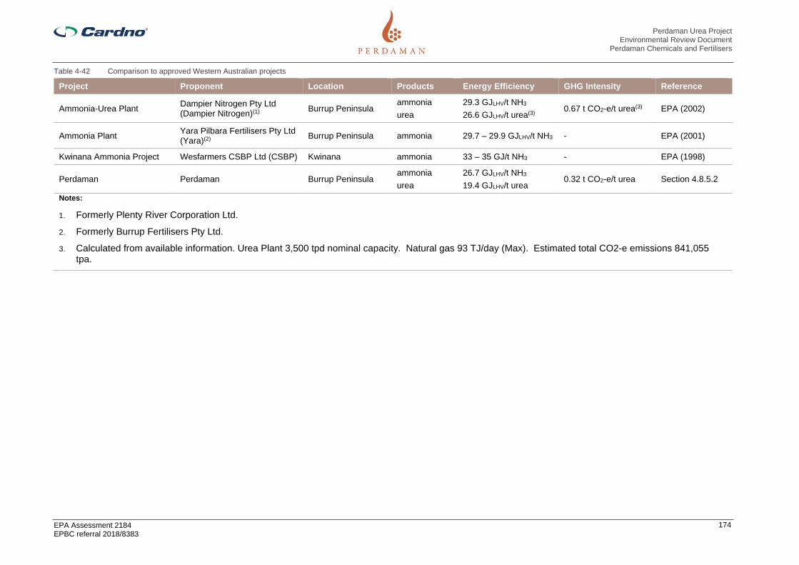
Perdaman Urea Project Environmental Review Document
Perdaman Chemicals and Fertilisers
EPA Assessment 2184 EPBC referral 2018/8383
174
Table 4-42 Comparison to approved Western Australian projects
Project Proponent Location Products Energy Efficiency GHG Intensity Reference
Ammonia-Urea Plant Dampier Nitrogen Pty Ltd (Dampier Nitrogen)(1)
Burrup Peninsula ammonia
urea
29.3 GJLHV/t NH3
26.6 GJLHV/t urea(3) 0.67 t CO2-e/t urea(3) EPA (2002)
Ammonia Plant Yara Pilbara Fertilisers Pty Ltd (Yara)(2)
Burrup Peninsula ammonia 29.7 – 29.9 GJLHV/t NH3 - EPA (2001)
Kwinana Ammonia Project Wesfarmers CSBP Ltd (CSBP) Kwinana ammonia 33 – 35 GJ/t NH3 - EPA (1998)
Perdaman Perdaman Burrup Peninsula ammonia
urea
26.7 GJLHV/t NH3
19.4 GJLHV/t urea 0.32 t CO2-e/t urea Section 4.8.5.2
Notes:
1. Formerly Plenty River Corporation Ltd.
2. Formerly Burrup Fertilisers Pty Ltd.
3. Calculated from available information. Urea Plant 3,500 tpd nominal capacity. Natural gas 93 TJ/day (Max). Estimated total CO2-e emissions 841,055 tpa.

Perdaman Urea Project Environmental Review Document
Perdaman Chemicals and Fertilisers
EPA Assessment 2184 EPBC referral 2018/8383
175
Overall assessment findings
The overall conclusions of the benchmarking of GHG emissions from the Project are:
> Selection of natural gas as feedstock for the Project is considered the most energy efficient and leastGHG intensive option of the alternative feedstocks used for ammonia production.
> The Project meets the international best practice benchmark established by the EFMA (2000) for energyefficiency in ammonia production.
> The GHG intensity of the Project is a significant improvement on the national average for ammoniaproduction in Australia and will further enhance the reduction in the national average GHG intensity thatcan be seen in the longer-term trends in data published in the Australian National Greenhouse Accounts.
> The enhanced energy efficiency of the Project is indicated by the lower energy requirement estimated forthe Project compared to other projects that have been approved in Western Australia.
Urea Life-cycle assessment
It is recognised that the production, distribution and use of fertilisers contribute directly and indirectly to emissions of GHGs. At the same time, fertilisers help increase agricultural productivity, reducing GHG emissions per unit of agricultural output. Enhanced yields are particularly important in helping to prevent deforestation, which is the most important contribution of GHGs related to agriculture on a global scale (IFIA, 2009).
The life-cycle assessment of GHG emissions associated with urea needs to weigh emissions against the energy and carbon capture that fertiliser use promotes. When fertilisers are used properly, they help plants to produce more energy than is consumed during the production, transport and application of fertilisers. They also encourage the conversion of CO2 in biomass through photosynthesis, although the length of time during which the carbon is bound will depend on whether the biomass is used immediately, ploughed into the soil, part of a perennial plant or used for bioenergy/biomaterials (IFIA, 2009).
This opportunity for reduced GHG emissions through downstream urea product use is relatively unique for petrochemical and gas products, as most such products result in additional carbon emissions in their processing and use (SNC-Lavalin, 2019).
4.8.6 Mitigation
The principle of waste minimisation requires that all reasonable and practicable measures should be taken to minimise the generation of waste and its discharge into the environment. The Project design has embraced the concept of waste minimisation through the proposal for a more energy efficient natural gas-based fertiliser plant rather than the alternative coal-based project option (refer to Section 2.2.8). The use of natural gas over coal also offers environmental benefits in terms of considerably lower emissions of SO2, NOx and PM.
The pollution control technologies that have been adopted and will be implemented to minimise all relevant emissions from the Project are listed below.
> Power for the Project will be generated using combined cycle gas turbines (CCGTs) fitted with Dry low-NOx burner technology to minimise emissions of NOx;
> Two-stage scrubbing of urea granulator exhaust air to remove entrained urea dust and trace levels ofAmmonia. The first stage uses wet scrubbing to remove entrained urea dust, and the second stage usesacid scrubbing to remove Ammonia. The scrubbing system will remove approximately 99.5% of theentrained urea dust (recycling of recovered dust to the process), and approximately 80% compared to thegranulator base case expected Ammonia emissions;
> To ensure the safe discharge of process gases containing NH3 and other volatile gases during abnormalprocess plant operations, an elevated flare will be incorporated into the Project design;
> Urea product is formed through granulation rather than pilling to provide superior surface properties thatare less susceptible to particle attrition and therefore significantly reduce the potential for fugitive dustemissions from material handling activities from product conveying, storage and export. Further, variousdesign features will be included to minimise the potential for fugitive dust emissions, including:
- fully enclosed conveyor system
- fully enclosed storage shed at the port
- telescopic chute and shroud on the ship loader

Perdaman Urea Project Environmental Review Document
Perdaman Chemicals and Fertilisers
EPA Assessment 2184 EPBC referral 2018/8383
176
> Similarly, the GHG mitigation and management framework for the Project has been developed inaccordance with the mitigation hierarchy (avoid, reduce, offset);
> avoiding emissions through best practice design and benchmarking;
> continuous improvement to reduce emissions over the project life; and
> offsetting emissions.
Energy efficiency and GHG emission considerations during the design stage of the Project is critical to reducing emissions over the life of the Project, with the most significant opportunities to avoid and reduce emissions associated with technology selection and choice of feedstock (refer to Section 2.2.6).
There may also be opportunities to further improve energy efficiency and reduce emissions through continuous improvement over the life of the Project, and to develop and implement cost effective GHG emission reduction initiatives, as described below.
For the precursor option of a coal-based urea plant in Collie (refer Section 2.2.4) carbon capture and storage (CCS) was considered and evaluated. Such a potential option for enhanced GHG performance was included based on the potential utilisation of the WA Government led/sponsored SW Hub CCS Project initiative using the Harvey Ridge as a disposal location. Work undertaken by the Proponent (Allen Consulting, 2010) indicated that globally across the fertiliser industry, where CO2 was not reused in the manufacture of urea, where CO2 is capture it is sold either to the oil and gas industry for injection into wells, including for enhanced oil recovery (EOR); or the beverage industry.
Given the level of oil and gas activity in the region off shore of Murujuga, potential for EOR. Drawing on Collie learnings, the Proponent is amenable to explore potential to participate in a comparable industry or government sponsored/led initiative.
As noted in Section 2.2.1, the Proponent has agreed to collaborate with Woodside on exploring the opportunity for a hydrogen and gas technology park that is to be powered by renewable energy. The park would support the Proponent’s aspirational CO2 reduction targets going forward and the development of a broader renewable energy economy in Western Australia targeting the domestic and export markets. The park, would be used for trials and field testing. If successful, this could potentially enable the opportunity to explore substitution of hydrogen for natural gas as a fuel source in the Project power supply.
The key actions to mitigate potential air quality and GHG emission impacts are summarised in Table 4-43.
A draft Air Quality and GHG Emissions Management Plan has been prepared to support the ERD (refer to Appendix K), and will be progressively reviewed and developed as the Project proceeds through the design, construction, commissioning and operational phases.

Perdaman Urea Project Environmental Review Document
Perdaman Chemicals and Fertilisers
EPA Assessment 2184 EPBC referral 2018/8383
177
Table 4-43 Mitigation of Potential Impacts to Air Quality
Potential Impact Mitigation Measure
EPA Objective: To maintain air quality and minimise emissions so that environmental values are protected.
Adverse impacts upon ambient air quality
Avoid
The Project will apply the most advanced commercially available ammonia synthesis and urea production technology, provided by well-established companies with a proven track record in the international market.
Minimise
The pollution control technologies that have been adopted and will be implemented to minimize all relevant emissions from the Project include:
▪ Power for the Project will be generated using combined cycle gas turbines (CCGTs) fitted with Dry low-NOx burner technology to minimise emissions of NOx.
▪ Two-stage scrubbing of urea granulation process off-gas to remove entrained urea dust and trace levels of ammonia. The first stage uses wet scrubbing to remove entrained urea dust, and the second stage uses acid scrubbing to remove ammonia. The scrubbing system will remove approximately 99.5% of the entrained urea dust, and approximately 80% compared to the granulator base case expected ammonia emissions.
▪ To ensure the safe discharge of process gases containing NH3 and other volatile gases during abnormal process plant operations, an elevated flare will be incorporated into the Project design.
▪ Urea product is formed through granulation rather than pilling to provide superior surface properties that are less susceptible to particle attrition and therefore significantly reduce the potential for fugitive dust emissions from material handling activities from product conveying, storage and export. Further, various design features will be included to minimise the potential for fugitive dust emissions, including:
– fully enclosed conveyor system
– fully enclosed storage shed at the port
– telescopic chute and shroud on the ship loader.
▪ The Proponent has committed to MAC to participate and contribute to the development of an EQMF as detailed in the MRAS.
▪ At 5 yearly intervals after the completion of Project commissioning, the Proponent will conduct a study to identify potentially applicable technologies for reduction of project air emissions and assess the practicability of the application of those technologies to enhance the overall
environmental performance of the Project.
▪ The Proponent will liaise with the EPA with the objective of applying best practicable endeavours to implement technology that the report confirms can be practicably applied to improve overall environmental performance in an agreed timeframe.
Contribute to climate change Avoid
Natural gas from the nearby Woodside LNG plant will be used as feedstock to the process. The use of natural gas ensures the Project will achieve the highest energy efficiency and lowest GHG emissions compared to coal, an alternative feedstock sometimes used in the manufacture of ammonia. Further, the Project will receive natural gas feedstock with a relatively high methane content, and therefore slightly lower associated GHG emissions.
The ammonia synthesis technology will be supplied by Haldor Topsøe, using SynCOR AmmoniaTM technology. This applies a proprietary method of steam reforming based on oxygen-fired autothermal reforming to reduce the steam/carbon ratio from 3.0 (typical) down to 0.6, resulting in substantial energy savings in gas reforming. The urea production technology will be supplied by Stamicarbon, using an energy enhanced layout that reduces process steam requirements, also resulting in improved energy efficiency.

Perdaman Urea Project Environmental Review Document
Perdaman Chemicals and Fertilisers
EPA Assessment 2184 EPBC referral 2018/8383
178
Potential Impact Mitigation Measure
The proposed co-location of ammonia-urea production allows for the CO2 generated as a by-product of gas reforming to be used as a reagent in the urea synthesis process, and hence accounts for a net reduction (offset) in emissions from the Project. An important feature of the Project design is that the production of ammonia is fully ‘balanced’ to urea, such that no ammonia is produced for export as with typical plants, resulting in consumption of CO2 generated from gas reforming, within the urea synthesis process. The net reduction is estimated to be ~1.5 Mt CO2-e per annum.
Various other specific design features will be incorporated into the Project to improved energy efficiency and lower GHG emissions, including (but not limited to):
– modern combined cycle power plant with cogeneration mode for start-up
– autothermal reforming layout to reduce steam demand
– maximized waste heat steam recovery systems
– high efficiency pump selection
– low energy reverse osmosis desalination plant.
Minimise
Modern ammonia production technology is rapidly approaching the theoretical minimum energy consumption for ammonia production (IFA, 2009a).
The opportunity for further significant improvement in energy efficiency and GHG emissions over the life of the Project is therefore expected to be
limited, with continuous improvement focused on attaining optimal equipment performance and reliability.
Therefore, the Proponent will investigate suitable GHG emissions reduction initiatives in order to achieve the interim and long-term aspirational
targets it has established to avoid, reduce or offset 32,500 tpa CO2-e by 2035 and 65,000 tpa CO2-e by 2050. The Proponent will seek continuous
improvements in its operational procedures, plans, utilisation of installed plant and actions with the objective of attaining these aspirational targets
A comprehensive energy efficiency and GHG emissions monitoring and reporting systems will be developed and implemented to track relevant
performance metrics over the life of the Project, and to inform decisions on opportunities to implement cost effective measures to improve energy
efficiency.
Monitoring and reporting of GHG emissions from the Project will be in accordance with obligations under the NGER Act. Acknowledging the current
restrictions on publication of facility-level data under the NGER Act, relevant GHG emissions data will also be publicly disclosed by the Proponent.
The intent of this is to ensure accountability and public transparency on progress made to minimise emissions over the life of the Project and
ensure the commitments in relation to emission intensity performance are met.
Opportunities to develop and implement innovative, cost effective GHG emissions reduction initiatives will continue to be evaluated over the life of
the Project.
At 5 yearly intervals after the completion of Project commissioning, the Proponent will conduct a study to identify potentially applicable technologies
for reduction of GHG emissions and assess the practicability of the application of those technologies to enhance the overall environmental
performance of the Project.
Where the study is able to demonstrate that the technology can be practicably implemented to provide a minimum GHG performance enhancement
of 10% and not be detrimental to other key environmental values, in particular maintaining the integrity of rock art, the Proponent will liaise with the
EPA with the objective of applying best practicable endeavours to implement the technology in an agreed timeframe.

Perdaman Urea Project Environmental Review Document
Perdaman Chemicals and Fertilisers
EPA Assessment 2184 EPBC referral 2018/8383
179
Potential Impact Mitigation Measure
Explore opportunities for involvement in an industry based regional CCS scheme where project generated GHG could be disposed rather than
emitted to atmosphere.
Explore the opportunity for a hydrogen and gas technology park that is to be powered by renewable energy, including an objective to assess the
practicability for potential hydrogen based future retrofit for Project power requirements
Offset
GHG offsets (carbon offsets or carbon credits) are generated from activities that prevent or reduce the release of GHG emissions to the atmosphere or remove GHGs from the atmosphere (i.e. through ‘carbon sequestration’ in soils, geological reservoirs, forests and vegetation).
Opportunities to develop and implement cost effective GHG emissions offset initiatives will continue to be evaluated over the life of the Project.
The Proponent will also explore opportunities to foster and support the development of potential collaborative government and industry GHG offset initiatives, such as:
• local tertiary industry that could make use of the high-grade purity CO2 produced as a by-product of the Gas Reforming plant;
• a common-user sequestration site for GHG emissions produced by regional industries, such as potential use of depleted oil and gasreservoirs; and
• fuel replacement for stationary energy production that may arise if large scale hydrogen production proves feasible in the Karratharegion.

Perdaman Urea Project Environmental Review Document
Perdaman Chemicals and Fertilisers
EPA Assessment 2184 EPBC referral 2018/8383
180
4.8.7 Predicted outcome
Air quality modelling indicates that direct and cumulative:
> NOx and SO2 emissions associated with the Project are not likely to result in unacceptable air quality impacts to human health, with respect to the NEPM standards;
> PM (as PM10 and PM2.5) emissions associated with the Project are not likely to result in unacceptable air quality impacts to human health, with respect to the NEPM standards;
> Ammonia emissions associated with the project are not likely to result in unacceptable air quality impacts to human health and amenity (odour nuisance); and
> Deposition from Project emissions as shown on contour plots in marine settlings are not likely to result in significant impacts in the marine environment, especially when considered with the secondary dispersion through large tidal water movements in the region.
Modelling indicates that ozone production in the region (as an indicator of photochemical smog) is unlikely to be influenced by the emissions from the Project.
The potential impact on vegetation from increases in pollutant concentrations is not well understood for the communities found in the Burrup Region. The maximum point of impact is expected to occur in close proximity to the project area, based on the modelling. The NOx and SO2 emissions associated with the Project are proportionally smaller than the existing emissions from the existing airshed sources. Given the use of best practice pollution control technology within the plant (i.e. the scrubbing system in the plant will remove approximately 99.5% of the entrained urea dust, and approximately 80% of the ammonia) and the use of an enclosed conveyor system, it is unlikely that the vegetation in areas surrounding the Project would be significantly impacted by dust.
Modelling indicates that there may be increases in the ground level concentrations of pollutants at culturally important heritage locations. These increases are relatively small in terms of concentration change, impacts on human health are within national and international acceptance standards, and resultant potential for impacts to cultural values and/or amenity are discussed further in Section 4.9.3.
In line with the recommendation in the IHS Heritage Survey Report (IHS, 2019) endorsed by MAC and noted in Section 4.9, the Proponents will consult with MAC to develop a plan for additional monitoring of the rock art pH and redox potentials; as well as soluble anions and cations on the rock surfaces. This plan will identify appropriate monitoring rocks referenced by MAC. Where this monitoring demonstrates urea related impacts the Proponent will consult with MAC to bring about any changes in contamination of the sites by urea as is necessary to mitigate any adverse changes to the rock engravings.
4.8.7.1 Greenhouse gas emissions
Total net GHG emissions from the Project are estimated to be equal to 0.65 Mtpa CO2-e.
The Project will apply the most advanced commercially available ammonia synthesis and urea production technology, provided by well-established companies with a proven track record in the international market. The selection of technology for the Project represents international best practice in terms of energy efficiency in ammonia production, as demonstrated in the benchmarking assessment undertaken for the Project.
The proposed co-location of ammonia-urea production allows for the CO2 generated as a by-product of gas reforming to be used as a reagent in the urea synthesis process, and hence accounts for a net reduction (offset) in emissions from the Project. The net reduction by reuse is estimated to be 1.5 Mt CO2-e per annum.
As a proportion of national and State GHG emissions, the contribution of the Project is low (0.1% and 0.7% respectively), but still of significance within the context of an increasing trend in Western Australian emissions of GHG species.
The GHG intensity of the Project is a significant improvement on the national average for ammonia production in Australia and will further enhance the reduction in the national average GHG intensity that can be seen in the longer-term trends in data published in the Australian National Greenhouse Accounts.
The Project has the capacity to displace all Australian imports of urea, which would have a net benefit (~1.1 Mtpa CO2-e) as GHG emissions from the Project represent international best practice and a significant improvement upon urea imported from the Middle East and China. This would far outweigh the total GHG emissions estimated for the Project.

Perdaman Urea Project Environmental Review Document
Perdaman Chemicals and Fertilisers
EPA Assessment 2184 EPBC referral 2018/8383
181
4.9 Social Surroundings
4.9.1 EPA objective
To protect social surroundings from significant harm.
The “social surroundings” of man are his/hers aesthetic, cultural, economic and social surroundings to the extent that those surroundings directly affect or are affected by his/hers physical or biological surroundings.
4.9.2 Policy and guidance
The following policies and guidance have been considered for the assessment:
> EPA (2018) Statement of Environmental Principles, Factors and Objectives;
> EPA (2018) Environmental Impact Assessment (Part IV Divisions 1 and 2) Procedures Manual;
> EPA (2016) Environmental Factor Guideline: Social Surroundings;
> EPA (2004) Guidance Statement 41 - Assessment of Aboriginal Heritage;
> Aboriginal Heritage Act 1972;
> Commonwealth of Australia (1999) Environment Protection and Biodiversity Conservation Act;
> Department of Aboriginal Affairs & Department of the Premier and Cabinet (2013) Due DiligenceGuidelines (Version 3.0);
> Department of the Environment (2016) Engage Early. Guidance for proponents on best practiceIndigenous engagement for environmental assessments under the EPBC Act;
> DWER (2019) Murujuga Rock Art Strategy;
> Environment and Sustainability Directorate, Department for Planning and Infrastructure (2007) VisualLandscape Planning in Western Australia;
> Australian Institute of Landscape Architect (2018) Guidance Note for Landscape and Visual Assessment;and
> Australian Planning Commission (WAPC) Transport Assessment Guidelines for Developments: Volume 4– Individual Development Government of Western Australia (2017) Environmental Protection (Noise)Regulation 1997.
The Urea Plant Development Envelope (UPDE) comprises all Project Areas covered by recent heritage surveying undertaken by IHS for JTSI through MAC shown with coloured shading on the General Locality Map in Appendix C of the AHMP.
4.9.3 Receiving environment
4.9.3.1 Amenity
The Burrup Peninsula is a popular tourist and recreational destination. The area also comprises an industrial area (Burrup SIA) and a number of large industrial developments have already been implemented when others are currently being proposed for development.
The Hearson Cove foreshore is located 2 km to the east of the plant site. Hearson Cove beach is a popular recreational place with a strong social value for locals and visitors. The Hearson Cove foreshore is contained within Reserve 47014, vested in and managed by the City of Karratha. The foreshore reserve is zoned as ‘Conservation, Recreation and Natural Landscapes’ in the City of Karratha Local Planning Scheme No.8.
Hearson Cove foreshore is currently accessed via a Hearson Cove Road which transects Site F. This road currently lies outside of the land that is gazetted for this purpose. The formal gazetted location for this road lies to the north of the boundary of Site F.
National Heritage
The Dampier Archipelago (including Burrup Peninsula), traditionally known as Murujuga, was included in the National Heritage List on 3 July 2007 (place ID 105727).
The NHL area sits adjacent to Sites C and F on their northern and southern/eastern boundaries respectively and a small rectangular NHL designation area (Site ID 9439) previously thought to correspond to the sacred site “Fish Thalu” is situated within Site F (Figure 2, Appendix A). According to recent Aboriginal Heritage survey

Perdaman Urea Project Environmental Review Document
Perdaman Chemicals and Fertilisers
EPA Assessment 2184 EPBC referral 2018/8383
182
work in 2019, the Fish Thalu site is not physically located within this rectangle that forms part of the NHL, but is located to the north east of Site F, outside the Project area (IHS, 2019).
An application for World Heritage listing of Murujuga was submitted in January 2020.
Aboriginal sites and significant cultural associations
The Dampier Archipelago is generally recognised as home to one of the richest collections of Aboriginal rock engravings (petroglyphs) in Australia. The heritage features also include quarries, middens, fish traps, rock shelters, ceremonial places, artefacts scatters, grinding patches and stone arrangements (Australian Heritage Council, 2012).
The Murujuga National Park covers the northern area of the Burrup Peninsula and sits within the broader NHL area. Murujuga was declared a National Park in January 2013 as a result of the BMIEA. The Murujuga National Park is jointly managed by MAC and the Parks and Wildlife Service, Service, Department of Biodiversity, Conservation and Attractions (DBCA) through the Murujuga Parks Council, and the management guided by the Murujuga National Park Management Plan No. 78 (DEC, 2013) approved by the Minister for Environment under the Conservation and Land Management Act 1984 (CALM Act). The management plan provides detailed information on the biodiversity and cultural values of the Murujuga National Park.
Murujuga, including the Project area, was once an area of a variety of cultural traditions and activities over a very long period of time. The Ngarda-Ngarlie traditional owners consider the Aboriginal heritage sites to be highly significant and the ongoing management and caretaking of the wider Murujuga area is incumbent on them, to uphold and maintain Law on Country. This is because the precepts of Law and culture have commonalities (the same Law) throughout the region, and while the original inhabitants are no longer occupying this Country, it has been passed to others from this area to caretake on behalf of everyone. This responsibility is shared among all groups who are from this region, who share the responsibility of managing and caretaking these important significant sites (IHS, 2019).
There are no Aboriginal ethnographic sites within the Project area (IHS, 2019).
There are many Aboriginal sites in and around the UPDE. For example, Hearson Cove Road provides access to Ngajarli Gorge, a culturally significant place for Aboriginal traditional owners that features significant densities of petroglyphs (rock art) as well as midden and artefact sites. Ngajarli is signposted and serves as a publicly accessible area to view Aboriginal heritage sites and is currently often incorporated into tourist itineraries run by MAC and other operators. The Yatha is located in the southwest section of Site F and is a significant meeting place for traditional owners, the Circle of Elders. It is also a place for teaching dances, plays and songs and where the women Elders teach the young women about culture There are a range of plant resources here, used currently for bush medicine and food (IHS, 2019). The petroglyphs themselves at Murujuga feature motifs pertaining to Aboriginal Law and cultural traditions and they can be considered as significant, or sacred (IHS, 2019).
The Department of Planning Lands and Heritage (DLPH) maintain the Register of Places and Objects whereby places have been reported as possible Aboriginal sites within the meaning of the Aboriginal Heritage Act 1972 (AHA). 0 and 0 present the heritage sites listed on the Register of Places and Objects near within the PDE.
The IHS 2019 Aboriginal cultural heritage survey recorded all previously recorded Aboriginal heritage sites and added several previously unrecorded sites to the database. The survey, consultations and associated report considered Aboriginal heritage significance assessments in relation to Section 5 of the AHA.A preliminary Aboriginal Heritage Management Plan (AHMP) is included in Appendix K. As noted in Section 4.9.5.2, this draws on the IHS heritage survey work and report recommendations or Sites C and F undertaken for JTSI and co-ordinated by MAC in the second half of 2019 (IHS, 2019).

9844
9848
17746 18616
2268822689
8290
94019435
9597
9598
9599
9611 9613
9641
9754
9755
9759
9808
9809
9832
9841
9842
9845
10208
16636
16775
17683
17684
1774517745
18615
19758
1975919761
19762
19763
19766
19767
1976819769
19770
1977119772
19773
19774
19775
19776
19777
1977819779
1978119782
19783
19786
19787
19788
1978919790
19791
19792
20068
20069
2007020072
2007320074
20075
20076
20078
20080
20081
20082
23383
23402
23372
9255
23763
23736
8291
8289
8288
10558
23340
9600
90699073
9215
9216
9813
9756
10559
1916619167
19168
19235
1923619237
19238
19239
19240
19618
19836
19874
19876
1987719878
19885
19887
19888
19894
20035
20036
20037
20038
2003920041
20083
202642026520266
2027020271
2027420275
20276
2027720279
20283
2028420285
207312073220733
20919
21732
21780
23200
17292
17747
20131
18959
18959
18959
18959
18959
18959
18959
1895919088
19089
19090
19093
19094
19100
19157
19160
19188
19726
20040
± Map Produced by Cardno VICDate: 2019-12-19
Coordinate System: GDA 1994 MGA Zone 50Project: CW1055600
Map: CW1055600-EN-010-AboriginalReg_A3.mxd 01Aerial Imagery Supplied by Nearmap (October, 2019)
LegendProject AreaPlant Layout
Aboriginal HeritagePlace (DPLH, 2019)STATUS
LodgedRegistered SiteStored Data / Nota SiteNational HeritageListed Area
Aboriginal Heritage Places (DPLH, 2019)PERDAMAN UREA PROJECT
FIGURE 4-240 50 100
Metres
4-13
4-14
Scale at A31:4,000

17746 18616
2268822689
22690
2269122692
9275
9295 9296
9401
9435
9439
9597
9598
96109611
9613
9641
9832
1056010561
10562
10563
16636
16775
18615
19758
19762
20068
2006923402
23736
9069
9073
9215
9216
9813
358
9729
10559
19235
19239
19836
19874
19885
20028
20035
20036
200372073120732
20733
17747 18959
19088
19090
19093
19094
19100
19160
19726
26008
20040
± Map Produced by Cardno VICDate: 2020-03-16
Coordinate System: GDA 1994 MGA Zone 50Project: CW1055600
Map: CW1055600-EN-010-AboriginalReg_A3.mxd 01Aerial Imagery Supplied by Nearmap (October, 2019)
LegendProject AreaPlant Layout
Aboriginal HeritagePlace (DPLH, 2019)STATUS
LodgedRegistered SiteStored Data / Nota SiteNational HeritageListed Area
Aboriginal Heritage Places (DPLH, 2019)PERDAMAN UREA PROJECT
FIGURE 4-250 50 100
Metres
4-13
4-14
Scale at A31:4,000

Perdaman Urea Project Environmental Review Document
Perdaman Chemicals and Fertilisers
EPA Assessment 2184 EPBC referral 2018/8383
185
4.9.3.2 Landscape
A Landscape and Visual Impact Assessment (LVIA) was undertaken for the Project (Cardno, 2019) which can be seen in Appendix G. The existing environment in the Project area includes the following broad landscape character types:
> Coastline – including the beaches, bays, the waters of the Dampier Archipelago and Indian Ocean, Nickol Bay, and dunes and mangroves;
> Lowlands – supratidal flats, drainage channels, valleys and gorges;
> Rocky outcrops; including red rock scree, and outcrops including headlands; and
> Urban and Industry – including towns, industry, roads, ports and wharves.
The above landscapes character types are important landscape features of Murujuga. They are further described in the LVIA report (Appendix G). Industrial development forms part of the existing mosaic of land use on the Burrup Peninsula.
4.9.3.3 Ambient Noise
Ambient noise monitoring was undertaken by Lloyd George Acoustics (LGA, 2019) to characterise the existing noise emissions at Hearson Cove, Ngajarli and the Yara ammonia plant boundary. Detailed monitoring results are presented within Appendix F, a summary is outlined below.
Monitoring was undertaken in accordance with the requirements of the Environmental Protection (Noise) Regulations 1997 Figure 4-26 shows the location of the noise loggers.
Figure 4-26 Noise Logger Locations (LGA, 2019)
Results show that the noise levels recorded at Hearson Cove and Ngajarli sampling station generally follow an ‘inverted day-night’ pattern whereby night-time noise levels are mostly higher than during the day. Based on observations on site and the audio recordings, the background noise levels at these locations mostly consisted of wind induced noise, wildlife noise, some industrial noise and local or distant vehicular traffic. At Hearson Cove, it was also noted that local works were carried out during the monitoring period, which are likely to have influenced day-time noise level at this location.
During the night period, background noise levels over 45 dB LA90 were consistently recorded at both Hearson Cove and Ngajarli sampling station given that some local wildlife became more active.
At the Yara Ammonia Plant Boundary, the daytime noise levels were dominated by local works on site with background noise levels recorded between 55 dB LA90 and 60 dB LA90.

Perdaman Urea Project Environmental Review Document
Perdaman Chemicals and Fertilisers
EPA Assessment 2184 EPBC referral 2018/8383
186
4.9.4 Potential impacts
The construction of the urea plant and port infrastructure have the potential to impact on the visual amenity of Murujuga (including the NHL area and Murujuga National Park).
The construction of the plant and site access easements have the potential to impact on heritage sites.
The Proposal has the potential to impact on public safety and recreational activities as a result of increased road traffic.
The construction and operation of the urea plant has the potential to impact upon the ambient noise levels of the surrounding environment. Cumulative noise levels due to the additional noise emissions from the urea plant may impact on people visiting Hearson Cove.
The cumulative impact of an increased industrial presence may be a potential threat in relation to the aspiration for a World Heritage listing of Murujuga.
4.9.5 Assessment of impacts
It is not expected that the access to the Hearson Cove foreshore or Ngajarli site would be interrupted at any time during the Project development. Hearson Cove Road will be realigned to its dedicated alignment, north of Site F as depicted on Figure 2, Appendix A.
4.9.5.1 Landscape and Visual Assessment
Cardno (2019) assessed the existing and future Landscape and Visual Environment in terms of its contribution to character, scenic amenity and natural landscape values, as well as aesthetic values of the NHL area and Murujuga National Park.
The LVIA was based on a viewpoint-based approach and included consideration of the visibility, the appearance and the visual impacts of the Project.
Five viewer groups were defined for the assessment and ‘scenic demand’ categories were allocated to each of these based on their likely scenic expectations. Table 4-44 presents the ‘scenic demand’ levels for each viewer group.
Table 4-44 Viewer Group ‘Scenic Demand’ levels
Viewer Groups Relative Numbers Likely Relative Scenic Expectations
Viewer Group Scenic Demand Level
Recreational users High Medium Medium
Traditional Owners Unknown High High
National Park users and tourists High High High
On-site workers and contractors Medium Low Low
Local Residents Medium Medium Medium
Nine viewpoints were selected based on viewer group and viewpoint sensitivity. The impact assessment has been based on visibility mapping and selected photomontages.
A visibility analysis modelling was conducted using a GIS (ArcGIS) Digital Surface Model (DSM) which includes existing vegetation, buildings and landform. The likely visibility of the Project components is presented on Figure 4-29.
Photomontages were prepared for the viewpoint assessment. One photomontage is presented in Figure 4-27 and Figure 4-28 below; all photomontages are provided within the LVIA report (Appendix G).

Perdaman Urea Project Environmental Review Document
Perdaman Chemicals and Fertilisers
EPA Assessment 2184 EPBC referral 2018/8383
187
Figure 4-27 Existing view from VP03 Hearson Cove Road looking west
Figure 4-28 Proposed development from VP03 Hearson Cove Road looking west (Photomontage Cardno, 2019)

Figure 4-29 Visibility Analysis

Perdaman Urea Project Environmental Review Document
Perdaman Chemicals and Fertilisers
EPA Assessment 2184 EPBC referral 2018/8383
189
The plant facilities on Site C and F are consistent with the existing and intended industrial character of the BSIA17 as seen from most viewpoints, and there will be no significant impacts on visual amenity due to viewing distance.
The facilities at the port will be integrated in a land designated for industrial use where traffic is mainly associated with industrial purposes. Therefore, the visual amenity at the port site is not expected to be impacted by the Project.
4.9.5.2 Aboriginal Heritage
Integrated Heritage Services Pty Ltd (IHS) was engaged by MAC to undertake Aboriginal cultural heritage surveys of an area comprising Sites C and F, the proposed causeway between Sites C and F, the conveyor route east of Burrup Road, and the realignment of Hearson Cove Road to the north of Site F. IHS consultants, in partnership with MAC, recorded all visible archaeological features and known Aboriginal sites within the survey area. The surveys did not include the infrastructure zone associated with the project, namely the previously disturbed common user east-west corridor, which has been fully cleared and made project ready by the WA government, or the lands within the Dampier Port.
The survey’s objective was to identify and digitally record all Aboriginal cultural heritage sites within or near the PDE in order to provide recommended management measures in the context of any proposed development in the area. The scope of works included:
> Undertake a background research of all available information and records held by DPLH pertaining to previously recorded Aboriginal heritage sites and other heritage places within the survey area;
> Conduct Aboriginal cultural heritage surveys including archaeological and ethnographic surveys; and
> Assess the significance of each recorded site including mapping of Aboriginal cultural heritage sites and other areas of cultural sensitivity.
The outcomes of the Aboriginal Cultural Heritage Surveys are presented in a confidential report (IHS, 2019) which formed the basis of the impact assessment and mitigation measures presented in the Sections below. The IHS report describes and maps a total of 60 Heritage Places.
4.9.5.3 Summary of findings
A description of 31 archaeological sites recorded in or at close proximity of the plant site is provided in Table 4-45. All previously recorded entries in the AHIS database were checked for remnant archaeological features.
In relation to the full suite of potentially relevant sites identified in the DPLH records, the IHS 2019 report noted that:
> 26 heavily buffered entries in the Register of Places and Objects recorded as potentially intersecting the PDE (IDs 358, 9435, 9612, 11936, 19672, 19786, 19836, 19888, 20028,23200, 23383, 23402, 23736, 10558, 9069, 9073, 9215, 9216, 9813, 19088, 19090, 19093, 19094, 19100, 19160, & 19726) were confirmed as definitely not containing any physical features within the current PDE; and
> 20 sites registered in the AHIS database (IDs 9275, 9295, 9401, 9611, 9641, 9754, 9756, 10559/17747, 17746, 18959, 19235, 19758, 20068, 20069, 20731, 22688, 22689, 22690, 22691 & 22692) were confirmed not Aboriginal sites or stored data during the 2019 survey works. IHS recommends the status of these sites be changed to “Not a Site” in the Register.
No further discussion is considered relevant in relation to these 46 sites due to lack of potential impact by the Project.
17 See https://www.jtsi.wa.gov.au/what-we-do/offer-project-support/industrial-land which articulates the WA government’s industrial land policy that identifies the industrial character of the BSIA and other strategic industrial areas as elements of the WA Government management of this matter. Also see https://vimeo.com/118194355 which is a WA Government video explaining and visually showing the current and intended industrial character of the BSIA

Perdaman Urea Project Environmental Review Document
Perdaman Chemicals and Fertilisers
EPA Assessment 2184 EPBC referral 2018/8383
190
Table 4-45 Archaeological Sites Description
Site ID Site Type Register Status 2019 Status (IHS) Gender restrictions Significance Relation to Project Footprint
9296 Artefacts/Scatter, Engraving Registered In situ (partial) Men’s restricted High Outside
9439 Man Made Structure / Engraving
Registered In situ None High Outside (NHL area within Site F)
9597 Artefacts/Scatter, Engraving, Grinding Patches / Grooves, Midden / Scatter
Registered In situ, partially salvaged
None High Outside
9599(1) Engraving, Grinding Patches / Grooves
Registered In situ None High Outside
9610 Midden / Artefact Scatter Registered (cleared) In situ None Medium Outside
9755 Engraving Registered In situ None High Outside
9808 Engraving Registered In situ None High Outside
10558 Engraving Registered In situ Men’s restricted High Outside
16636 Midden Artefact Assemblage Registered In situ None Low Outside
18615 Engraving, Grinding Patches / Grooves
Registered In situ Men’s restricted High Inside (Site C - East)
19239 Grinding Patches / Grooves Lodged In situ None Low Inside (Site C)
19766 Engraving Registered In situ Men’s restricted High Outside
19787(2) Engraving, Grinding Patches / Grooves, Natural feature
Lodged In situ, previously disturbed
Men’s restricted High Outside
19788 Artefacts/Scatter, Engraving Registered In situ Men’s restricted High Outside
19874(3) Engraving Lodged In situ None High Inside (Site C – West)
19876 Engraving, Grinding Patches / Grooves
Lodged In situ None High Outside
19885 Engraving, Grinding Patch Lodged In situ None Low Outside
20035 Engraving Lodged In situ None High Outside
20037 Engraving Lodged In situ None High Inside (Site C – West)
20038 Engraving Lodged In situ None High Outside
20039 Engraving Lodged In situ Men’s restricted High Outside

Perdaman Urea Project Environmental Review Document
Perdaman Chemicals and Fertilisers
EPA Assessment 2184 EPBC referral 2018/8383
191
Site ID Site Type Register Status 2019 Status (IHS) Gender restrictions Significance Relation to Project Footprint
20040 Engraving Lodged In situ Men’s restricted High Outside
26008 Engraving Lodged In situ None High Outside
MAC 001 Midden / Artefact Assemblage - - None Medium Outside
MAC 002 Engraving - - None High Outside
MAC 003 Engraving - - Men’s restricted High Outside
MAC 004 Engraving - - None High Outside
MAC 005 Artefact Assemblage - - None Low Outside
MAC 006 Engraving - - Men’s restricted High Outside
MAC 007 Engraving - - Men’s restricted High Outside
MAC 008 Engraving - - Men’s restricted High Outside
Note:
(1) Site ID 9599 was noted as a duplicate of registered site ID 16775.
(2) Site ID 19618 was assessed by IHS as a duplicate of site 19787. The current 2019 survey proposes a consolidation of the site to the later recording (Site ID 19787).
(3) Site ID 19874 was noted as a duplicate of lodged site ID 20036.

Perdaman Urea Project Environmental Review Document
Perdaman Chemicals and Fertilisers
EPA Assessment 2184 EPBC referral 2018/8383
192
Of the 31 sites with recorded boundaries in the AHIS database intersecting the Project area, only four (4) sites are located within the proposed plant footprint (IDs 18615, 19239, 19874/20036 & 20037). Three of these have been assessed by IHS as having a high significance to the Traditional Owners and one has low significance.
IHS also identified landform that has the potential to feature subsurface archaeological sites, objects or burials. Isolated artefacts were recorded throughout the survey area, especially within the salt flats north of Site F and across Site C. IHS notes that these were often situated within disturbed contexts with a ground surface visibility ranging from about 10% (i.e. middle of Site C) to 100% (southern inundation zone in Site C and Perdaman Site Corridor).
This IHS report notes that the petroglyphs are of high significance to the senior traditional owners and it would be culturally inappropriate in Traditional Law, that any rock art sites can be moved or disturbed. Accordingly, it is the first recommendation and preference of the Traditional Owners that best efforts are made to ensure all Aboriginal cultural heritage sites are protected in situ. Further, the IHS report states if future disturbance or damage to an Aboriginal heritage site is unavoidable, then Section 18 consent under the AHA should be sought.
Any Section 18 consent should include:
> A detailed salvage assessment be undertaken to produce a plan for each physical component of the site requiring salvage (this may also require Section 16 consent under the AHA);
> Consultation and agreement be made with MAC to delineate a suitable area for relocated heritage items; and
> The salvage works are undertaken under the guidance of senior traditional owner monitors and a qualified and experienced archaeologist.
Other recommendations include:
> updating relevant details on the DPLH Register of Places and Objects;
> Cultural Heritage Management Plans be written addressing Aboriginal heritage management requirements for initial ground disturbance, construction and ongoing operations;
> monitor all ground disturbance works for the potential unearthing of buried archaeological sites, objects or burials, and to shift surface isolated artefacts from probable impact by the works and to consider additional monitoring by a qualified and experience archaeologist, for the moderate and high-risk areas and all areas within proximity of extant Aboriginal cultural heritage sites;
> the Yatha be excised from the PDE and support given for ownership and control to be transferred to MAC;
> special efforts be made to ensure the preservation and management of the highly significant Fish Thalu site to the east and outside of the PDE, with no detrimental changes to its environmental context and conditions;
> MAC should be engaged to provide cultural awareness training on an ongoing basis to the Perdaman Project, its employees and contractors, to accompany site inductions for all managers and workers; and
> MAC be invited to participate in discussions and agreements with the proposed Perdaman Project for the identification of environmental controls and the operational standards set for the project development and operations and that there be support for studies concerned with the protection of cultural heritage sites from secondary impacts of development such as aerial-borne particulate depositions and other emissions i.e. specifically support for the Murujuga Rock Art Strategy;
MAC and its Circle of Elders have endorsed the recommendations in the IHS report and agreed to processes as describe above. In relation to each of the above recommendations, the proponent notes:
Where an identified site cannot practicably be avoided, approval pursuant to s.18 of the AHA will be sought. The s.18 application will include:
> A detailed salvage assessment undertaken to produce a plan for each physical component of the site requiring salvage (this may also require Section 16 consent under the AHA);
> Consultation and agreement with MAC to delineate a suitable area for relocated heritage items; and

Perdaman Urea Project Environmental Review Document
Perdaman Chemicals and Fertilisers
EPA Assessment 2184 EPBC referral 2018/8383
193
> The salvage works will be undertaken under the guidance of senior traditional owner monitors and a qualified and experienced archaeologist.
As noted previously, a preliminary Aboriginal Heritage Management Plan is included in Appendix K addressing Aboriginal heritage management requirements for initial ground disturbance, construction and ongoing operations. This plan also addresses Aboriginal heritage management relating to the proximal NHL areas.
The AHMP will be reviewed and revised to include appropriate strategies, procedures and actions to ensure where project ground disturbing activities are proposed, including any that involve these identified landforms, the requirements of the AHA are met. The AHMP will include a requirement to obtain and implement a project Ground Disturbance Permit (GDP) before any ground disturbing works commence.
The GDP will include the requirement to assess the potential for the works to impact on Aboriginal heritage aspects, including the potential unearthing of buried archaeological sites, objects or burials, and to shift surface isolated artefacts from probable impact by the works. It will also require actions to consider additional monitoring by a qualified and experience archaeologist, for the moderate and high-risk areas and all areas within proximity of extant Aboriginal cultural heritage sites.
The Yatha (the bough structure) constructed and used by MAC for cultural inductions and by traditional custodians when on-country, lies at the south-western corner of Site F. In response to the endorsed recommendation of the IHS survey report noted above, this area has been excluded from the Project footprint under the provisions of s.43A of the EP Act. The Project boundary fence will now be positioned to the north east of the site to ensure continuing unimpeded access.
In relation to support for studies concerned with the protection of cultural heritage sites from secondary impacts of development such as aerial-borne particulate depositions and other emissions. As noted in Table ES-3, and Section 4.8.5.2, the Proponent has committed to MAC to participate and contribute to the development of an EQMF as detailed in the MRAS where it would suggest these theoretical impact pathways be examined.
4.9.5.4 Noise Impact Assessment
The Proponent commissioned a noise assessment to estimate the noise impact from the Proposal. The methodology, results and assessment are presented in Lloyd George Acoustic report (LGA, 2019) provided in Appendix F. A summary of the assessment is outlined below.
Operational Noise
Environmental noise in Western Australia is governed by the EP Act, through the Environmental Protection (Noise) Regulations 1997 (the Regulations).
Regulation 7 defines the prescribed standard for noise emissions as follows:
“7. (1) Noise emitted from any premises or public place when received at other premises –
(a) Must not cause or significantly contribute to, a level of noise which exceeds the assigned level in respect of noise received at premises of that kind; and
(b) Must be free of –
> tonality;
> impulsiveness; and
> modulation,
when assessed under regulation 9”
A “…noise emission is taken to significantly contribute to a level of noise if the noise emission … exceeds a value which is 5 dB below the assigned level…”
Tonality, impulsiveness and modulation are defined in Regulation 9. Noise is to be taken to be free of these characteristics if:
(a) The characteristics cannot be reasonably and practicably removed by techniques other than attenuating the overall level of noise emission; and
(b) The noise emission complies with the standard prescribed under regulation 7 after the adjustments of Table 4-46 are made to the noise emission as measured at the point of reception.

Perdaman Urea Project Environmental Review Document
Perdaman Chemicals and Fertilisers
EPA Assessment 2184 EPBC referral 2018/8383
194
Table 4-46 Adjustments where characteristics cannot be removed
Where Noise Emission is Not Music Where Noise Emission is Music
Tonality Modulation Impulsiveness No Impulsiveness Impulsiveness
+ 5 dB + 5 dB + 10 dB + 10 dB + 15 dB
Note : The above adjustments are cumulative to a maximum of 15 dB
The baseline assigned levels (prescribed standards) are specified in Regulation 8 and are shown in Table 4-47.
Table 4-47 Baseline Assigned Noise Levels
Premises Receiving Noise
Time of Day Assigned Level (dB)
LA10 LA1 LAmax
Noise sensitive premises: highly sensitive area1
0700 to 1900 hours Monday to Saturday (Day
45 + influencing factor
55 + influencing factor
65 + influencing factor
0900 to 1900 hours Sunday and public holidays (Sunday)
40 + influencing factor
50 + influencing factor
65 + influencing factor
1900 to 2200 hours all days (Evenings) 40 + influencing factor
50 + influencing factor
55 + influencing factor
2200 hours on any day to 0700 hours Monday to Saturday and 0900 hours Sunday and public holidays (Night)
35 + influencing factor
45 + influencing factor
55 + influencing factor
Noise sensitive premises: any area other than highly sensitive area
All hours
60 75 80
Industrial All hours 65 80 90
Note: 1. Highly sensitive area means that area (if any) of noise sensitive premises comprising –
(a) a building, or a part of a building, on the premises that is used for a noise sensitive purpose; and
(b) any other part of the premises within 15 meters of that building or that part of the building.
The Project is located in a remote area with no residential areas in the vicinity. The following receiver locations were considered relevant for this assessment:
> Hearson Cove;
> Ngajarli Gorge;
> Proposed Urea plant and Yara Pilbara Fertilisers site boundaries; and
> Eastern part of the industrial area located of Burrup Road.
Due to the 24/7 nature of the proposed operations, only the LA10 assigned noise level is considered relevant to this assessment. The applicable LA10 assigned noise level at each of the locations above are summarised in Table 4-48.
Table 4-48 Assigned Noise Levels
Premise receiving noise Time of Day LA10 Assigned Level (dB)
Hearson Cove All hours 45
Ngajarli (formerly referred to as Deep Gorge)
All hours 60
Urea plant and Yara site boundary All hours 65
West industrial area All hours 65

Perdaman Urea Project Environmental Review Document
Perdaman Chemicals and Fertilisers
EPA Assessment 2184 EPBC referral 2018/8383
195
Noise levels were also predicted at several points along the proposed urea plant boundary (site C). These receiver locations are included in LGA (2019) report provided in Appendix F
The noise modelling software used was SoundPLAN 8.1 together with the CONCAWE noise propagation algorithms. These algorithms have been selected as they include the influence of wind and atmospheric stability. Input data required in the model are:
> Meteorological information;
> Topographical data;
> Ground absorption; and
> Source sound power levels.
Detailed plant design was not available at the time of this modelling. Therefore, indicative sound power levels have been used based on the conceptual plant layout. Further details on the modelling approach are included in Appendix F.
Although the Proposal is for a 24-hour operation, some of the noise sources (such as flares and stack vents) will not operate continuously. Nevertheless, to be conservative, it has been assumed that, in the worst case, all sources will operate simultaneously, with the predicted noise level representing the LA10 noise level.
The predicted noise levels under “worst case” meteorological conditions for normal operations, including the flare and assuming the overland conveyor is operating, are presented in Table 4-49.
Table 4-49 External Receivers ‘Worst-case’ Predicted Noise Levels
Receiver Night, dB LA10 Day, dB LA10
Hearson Cove 41 40
Ngajarli (formerly referred to as Deep Gorge)
43 42
Yara Plant Boundary 64 64
Industrial Estate (West) 59 59
The predicted LA10 Noise level contours at 1.5 meters above ground for the night-time weather conditions are depicted on 0 and 0.
The predicted noise levels at Hearson Cove under worst-case meteorological conditions are 40-41 db(A). These levels comply with the assigned noise level of 45 db(A) prescribed by the DWER for past and recent projects.
Construction Noise
Due to the distance of the closest sensitive receptors (Hearson Cove, >2 km; Ngajarli, 1.5 km) and these locations being ‘day use’ areas, noise impact from construction noise are considered negligible.

Hearson Cove South
Hearson Cove Mid
Herson Cove North
Deep Gorge
strial Estate
Yara Boundary
Noise LeveldB LA10
= 40= 45= 50= 55= 60= 65
GEORGE
LLOYD
A c o u s t i c s
Lloyd George Acousticsby Olivier Mallié[email protected] 987 455
Signs and symbols
Receiver
Noise Source
Development Envelope
Indicative Site Layout
Conveyor
Cooling Towers
Buildings and Tanks
27-May-19
Length Scale 1:120000 50 100 200 300
m
Perdaman Urea - Plant Noise Emissions (Inc. Flare) to EastBurrup Peninsula Figure 4-30

Industrial Estate
Noise LeveldB LA10
= 40= 45= 50= 55= 60= 65
GEORGE
LLOYD
A c o u s t i c s
Lloyd George Acousticsby Olivier Mallié[email protected] 987 455
Signs and symbols
Receiver
Noise Source
Development Envelope
Indicative Site Layout
Conveyor
Cooling Towers
Buildings and Tanks
27-May-19
Length Scale 1:120000 50 100 200 300
m
Perdaman Urea - Plant Noise Emissions (Inc. Flare) to WestBurrup Peninsula Figure 4-31

EPA Assessment 2184 EPBC referral 2018/8383
198
4.9.5.5 Traffic Impact Assessment
A detailed Traffic Impact Assessment (TIA) was undertaken to outline the traffic impacts of the Proposal to the surrounding road network during its construction and operation phases. The TIA report (Appendix H) was prepared in accordance with the Western Australian Planning Commission (WAPC) Transport Assessment Guidelines for Developments: Volume 4 – Individual Development.
The assessment comprised a review of the existing road network, intersections, traffic volume and crash data. A detailed traffic analysis was then conducted based on the proposed development access arrangements. A SIDRA intersection software was used to analyse the intersections performance for the following scenarios:
> 2019 existing traffic without development traffic;
> 2021 traffic with construction development traffic;
> 2024 traffic with operational development traffic; and
> 2034 traffic with operational development traffic.
The SIDRA results ((Appendix H) show that for all the above scenarios, the intersections and accesses to the Project site operate at an acceptable level of service.
The TIA demonstrated that the overall traffic impacts on the existing road network during construction and day-to-day operations will be minor and is unlikely to result in any capacity constraints.
4.9.5.6 World Heritage Listing
For a property to be inscribed on the World Heritage List, it must be accepted by the World Heritage Committee as being of Outstanding Universal Value. The Australian Heritage Council (2012) indicates that there is adequate existing research and data to justify that the heritage of the Dampier Archipelago could meet the threshold of Outstanding Universal Value against World Heritage criterion (i) ‘To represent a masterpiece of human creative genius’.
A World Heritage Tentative List Submission prepared by Murujuga Aboriginal Corporation in cooperation with Western Australian Government (Department of Biodiversity, Conservation and Attractions) and Australian Government (Department of the Environment and Energy) was submitted on 1 February 2020.The confidential agreement between MAC and Perdaman, provides support for MAC in pursuit of this application, including support to demonstrate the merits of the application are not diminished by the Project.
Conditions of authenticity and integrity must be met for a place to be of Outstanding Universal Value. The boundaries of the area to be assessed for Outstanding Universal Values have not been clearly defined at this stage. The NHL boundaries have been considered for the purpose of this impact assessment.
There will be minimal incursion into the NHL area as a result of the Project being limited to the conveyor easement between the plant and the East West common-user service corridor. It is anticipated that the conveyor easement will have a negligible impact on the heritage values of the NHL according to the results of the heritage surveys (IHS, 2019).
The potential for a visual integrity impact of the Project has been further assessed through a Landscape and Visual impact assessment (refer to Section 4.9.5.1 and Appendix G). The nature of the archipelago and its topography (deeply dissected gorges, valleys and scree slopes) make it unlikely that the cumulative impact of the Project and existing industrial features will affect the visual integrity of the NHL area.
Rock art and its continuing integrity are prime underlying aspects of importance to the world heritage listing justification. As noted in Section 4.8.3.4, 4.8.4.1, 4.8.5.2 and 4.8.5.3, as well as in Tables ES3 and 4-44 Project air emissions are likely to have little or no impact in relation to acid forming pollution regionally or nitrate induced microbial activity which are recognised as prime potential aspects of concern related to the integrity of rock art at Murujuga.
4.9.6 Mitigation
The mitigation measures to manage potential impacts to social surroundings identified in section 4.9.4 and assessed in section 4.7.5 are summarised in Table 4-50.
The confidential agreement concluded between Perdaman and MAC in November 2019 includes financial, technical and other support for MAC’s application for World Heritage Listing in relation to Murujuga (refer to the press release in Appendix J).
Perdaman Urea Project Environmental Review Document
Perdaman Chemicals and Fertilisers

EPA Assessment 2184 EPBC referral 2018/8383
199
A draft Aboriginal Heritage Management Plan reflecting a respect for cultural and heritage values associated with country, which will be submitted for endorsement by MAC pending Ministerial Conditions, is provided in Appendix K.
Perdaman Urea Project Environmental Review Document
Perdaman Chemicals and Fertilisers

EPA Assessment 2184 EPBC referral 2018/8383
200
Table 4-50 Mitigation of Potential Impacts to Social Surrounding
Potential Impact Mitigation Measure
EPA Objective: To protect social surroundings from significant harm.
Noise
construction and operational noise
Minimise
Construction equipment will be checked to ensure they are in good condition.
Machines will be operated at low speed where practical and will be switched off when not being used rather than left idling for prolonged period.
Machines found to produce excessive noise compared to industry best practice will be removed from the site or stood down until repairs or modification can be made.
Reduction of amenity
construction of the urea plant and associated infrastructure and export facilities
Avoid
Use of fully enclosed conveyor for the transport of product to ensure no urea dust issues arise.
Loss of amenity can be associated with FIFO operations, during operation Perdaman is committed to a local workforce. This will avoid the potential impacts associated with FIFO during operations, and will enhance social amenity in the region.
Minimise
Vehicle speeds on and around work sites shall be reduced where necessary to minimise dust emissions.
Lighting will be designed to reduce light spill.
Natural coloured materials/finishes for buildings and roof forms which are non-reflective will be used to reduce visual contrast.
Where suitable local indigenous species can practicably be used, fast growing trees and shrubs will be established along the property boundary (where safe to do so) and/or along Hearson Cove road reserve to provide a vegetative screening.
Rehabilitate
Commence rehabilitation as soon as possible after construction in areas no longer required for Project activities.
Degradation of heritage values Avoid
Area of known Aboriginal sites (including recorded sites and areas with potential for subsurface features) on- and at proximity of the Project) will be clearly communicated to construction personnel prior to construction activity to avoid accidental damage.
A Project wide ground disturbance permit system will be implemented to avoid accidental damage.
Best practicable effort will be made at the Project design stage to ensure all Aboriginal cultural heritage sites (especially petroglyph sites) are protected in situ and not moved or disturbed.
Product selection avoids a range of potential degradation pathways that could impact heritage values, particularly rock art integrity (Dr Ian MacLeod, pers. Comm). The production of urea instead of ammonium nitrate as the Project output avoids potential degradation issues associated with nitrates in the nitrogen cycle.
While the Project will be a significant regional source of ammonia emissions to air, ammonia is alkaline so does not contribute potential degradation of heritage values, particularly rock art integrity that is commonly suggested as being associated with acid emissions.
Minimise
Potential impact on heritage values by project emissions to air are minimised by:-
• Utilising best applicable technology in design to minimise emissions
Perdaman Urea Project Environmental Review Document
Perdaman Chemicals and Fertilisers

EPA Assessment 2184 EPBC referral 2018/8383
201
Potential Impact Mitigation Measure
• Using Woodside gas feed for power generation. This is a light (clean burning) gas with >85% desulfurized beforedispatch to downstream users. Thus the emission of SO2 as a product of combustion is minimised.
• Utilising DLN burners for the CGT power station to minimise the Project NOx emissions
• Capture and reuse of CO2 from the syngas process which reduces GHG emissions by ~1.5mtpa CO2-e
• As an alkaline gas, ammonia has a capacity to buffer acid air emission in much the same manner as wind-borne sea salthave been noted to buffer these acidic emissions (Dr Ian MacLeod, pers comm).
Agreement in place for support which will be provided by Perdaman to assist MACs application for World Heritage Listing in relation to Murujuga.
All Project’s employees and contractors to undertake a cultural awareness training provided by MAC. This has been implemented for Project personnel engaged in preliminary studies across the Project site.
If future disturbance or damage to the site is practicably unavoidable, then Section 18 consent under the AHA will be sought under the recommendations agreed with MAC that:
▪ A detailed salvage assessment be undertaken to produce a plan for each physical component of the site requiring salvage;
▪ Consultation and agreement be made with MAC to delineate a suitable area for relocated heritage items;
▪ The salvage works are undertaken pursuant to S.18 consent conditions and will be under the guidance of appropriate seniortraditional owner monitors and a qualified and experienced archaeologist.
Monitoring requirements will be detailed in an Aboriginal Heritage Management Plan that will be submitted to MAC for endorsement.
MAC traditional owners will be consulted and involved by the Proponent for the monitoring of ground disturbance works, especially in the high and moderate risk areas, in order to avoid and minimise any impacts to potential subsurface artefacts.
Regular meetings and open communication between MAC and the Proponent will continue throughout the life of the Project.
Access to tourist and cultural areas Avoid
Access to tourist and cultural areas will not be restricted or interrupted by the Project.
The southwest corner of Site F will not be used for the Project to preserve access to the known cultural meeting place at this location.
The known location of cultural site within Site F will be avoided and fencing during the construction phase, which will remain for the operational phase, will be placed in a way that access to these areas is not impeded.
Traffic
Increased road traffic
Avoid
The causeway will be used as a heavy vehicle transport route between the laydown area in Site F and the Site C plant construction site. This will include the movement of large modules and heavy materials on slow moving vehicles which will avoid impacting traffic on the areas main thoroughfare, Burrup Road. Traffic management personnel will be used to safely control the movement of these vehicles across the Hearson Cove Road / causeway / Site F intersection eliminating interactions between causeway construction traffic and the general public using Hearson Cove Road.
Minimise
Perdaman Urea Project Environmental Review Document
Perdaman Chemicals and Fertilisers

EPA Assessment 2184 EPBC referral 2018/8383
202
Potential Impact Mitigation Measure
Construction workers will be transported to and from site via shuttle bus service thereby significantly reducing the number of private vehicle trips.
Site C and Site F will be established with their own office and crib facilities for workers in those areas. This will minimise personnel movement (in LVs and buses) throughout the day between the two sites
A gatehouse and boom gates will be positioned on the causeway and Site F entry points with the new Hearson Cove Road maintaining right of way traffic at all times during both construction and operations.
Perdaman Urea Project Environmental Review Document
Perdaman Chemicals and Fertilisers

Perdaman Urea Project Environmental Review Document
Perdaman Chemicals and Fertilisers
EPA Assessment 2184 EPBC referral 2018/8383
203
4.9.7 Predicted outcome
The Project benefits are discussed in Section 2.2.1 above. The overall social impacts of the Project are expected to be positive. The impact of the Project on the local economy and community services will be maximised. This has been recognised and is reinforced by the Commonwealth Government in its decision to grant Major Project Facilitation Status to the project and by the State Government in designating the Project as a Project of State Significant. The confidential commercial agreement between MAC and Perdaman will also assist delivery of economic and social benefits accruing to that part of the community with direct traditional and cultural links to Murujuga.
Noting that there are existing access restrictions to the general public both within the BSIA where DevelopmentWA (formerly LandCorp) has a Government Reserve for industrial purposes and in the national park areas where The Department of Biodiversity, Conservation and Attractions have leaseback arrangements under the BMIEA, the existing access to recreational, tourist and cultural areas will not be affected by the Proposal and the impact to the amenity of the area is not considered significant. Within Sites C and F access for MAC members with traditional connection to country across those sites has been a core element of extensive discussions and agreement between Perdaman and MAC.
In relation to the NHL area within Site F, corresponding to the sacred site “Fish Thalu” it is noted that while the physical heritage material associated with the Fish Thalu is located outside the boundary of the NHL area and outside of Site F and the PDE, the NHL site has other recognised heritage and amenity values. The general public does not currently have unfettered access to this site. Access restrictions for those without a connection will continue. The NHL area will be fenced with an appropriate buffer to prevent accidental access from Site F. The requirement to implement safe access processes and protocols has been discussed with MAC. It has been agreed that Proponent will ensure all reasonable efforts are made to ensure any impediment to access for MAC and those with traditional connection to the site is minimised.
Further, the Yatha (the bough structure) constructed and used by MAC members for cultural inductions and by traditional custodians when on-country, lies in the south-western corner of Site F. The significance and utilisation of this area has been discussed with MAC and others with traditional connections who use the area when on-country. The proponent has agreed with MAC that this area will be excluded from its plant site with the plant site boundary to be fenced to the north-east of the Yatha ensuring the current level of access and amenity continues unimpeded. On the basis of dialogue with MAC, since the ESD was released, the Proponent has requested that the Proposal Development Envelope be amended to excise the Yatha. The relocation of Hearson Cove Road to the north of Site F rather than the option to the south of the site avoids potential impacts on the Yatha that may have arisen with a southern relocation of this road.
As an outcome of extensive discussions, MAC have expressed their support for Perdaman’s proposal to the Chairman of the EPA (Appendix J) and concluded a confidential agreement with Perdaman as noted previously.
Four Aboriginal heritage sites have been identified following a detailed archaeologic survey, as intersecting with the proposed plant footprint. Disturbance of these sites is considered likely impracticable and Section 18 consent will be thought for these sites in accordance with the mitigation measures outlined in Section 4.9.6.
The visual impact of the Project will be consistent with the current and future industrial development of the BSIA. 18
Development and industrial activities can and do occur in World Heritage places around the World. Through the implementation of Environmental Management Plans, and compliance with the EPA and Ministerial conditions, and through its agreement with MAC, Perdaman is committing to implement project policies, procedures and actions that accord with the Burra Charter and harmonise with the Western Australian Government’s Murujuga Rock Art Strategy which in turn will assist to preserve the heritage values of Murujuga and that its activities are not a threat for the recently submitted application for World Heritage listing of Murujuga. The recently concluded confidential agreement between MAC and Perdaman reflects this position and supports MAC’s objective of achieving this listing.
The Project can achieve the EPA objective of protecting the social surrounding from significant harm.
18 The current and intended industrial purpose and character of the BSIA is present by the WA government in the video located at
https://vimeo.com/118194355

Perdaman Urea Project Environmental Review Document
Perdaman Chemicals and Fertilisers
EPA Assessment 2184 EPBC referral 2018/8383
204
5 Other Environmental Factors or Matters
No other environmental factors or matters were identified during the EIA.

Perdaman Urea Project Environmental Review Document
Perdaman Chemicals and Fertilisers
EPA Assessment 2184 EPBC referral 2018/8383
205
6 Matters of National Environmental Significance
This chapter assesses potential impacts associated with the Project on Matters of National Environmental Significance (MNES) identified under the EPBC Act. Also described are the existing controls and additional treatments that the Proponent will implement through the Project design, construction, operations and decommissioning to mitigate potential impacts on MNES.
Detailed flora and fauna surveys conducted for the Project area are provided in Appendices B, and marine fauna assessment is attached in Appendix C. These contain the results of desktop investigations, field surveys and likelihood of occurrence assessments. The outcomes of this work are presented in this chapter as it relates to MNES. This chapter should be read in conjunction with Sections 4.4 (Marine Fauna), 4.5 (Flora and Vegetation), 4.6 (Terrestrial Fauna) and 4.9 (Social Surroundings).
6.1 EPBC Act Referral
The Proposal has been referred to the Commonwealth Minister for the Environment in January 2019 and subsequently determined to be a controlled action under the Environment Protection and Biodiversity Conservation Act 1999 (EPBC Act) and is being assessed by the Commonwealth of Australia and the State of Western Australia as an accredited assessment.
The relevant controlling provisions for this Proposal are:
> The heritage values of a National Heritage Property (sections 15B & 15C);
> Listed Threatened Species and Communities (sections 18 & 18A);
> Listed Migratory Species (sections 20 & 20A); and
> Commonwealth Marine Areas (sections 23 & 24A).
6.2 Relevant Policy and Guidelines:
The following policies and guidance have been considered for the assessment:
> Commonwealth of Australia (1999) Environment Protection and Biodiversity Conservation Act;
> DoEE (2017) Recovery Plan for Marine Turtles in Australia 2017-2027;
> DSEWPaC (2012) Schedule 2 of the Marine bioregional plan for the North-west Marine Region - Regionaladvice on matters of national environmental significance;
> Department of the Environment, Water, Heritage and the Arts, 2013, Significant Impact Guidelines 1.1 -Matters of National Environmental Significance;
> Department of the Environment and Energy (2017). Threat abatement plan for predation, habitatdegradation, competition and disease transmission by feral pigs (Sus scrofa) (2017). Canberra, ACT:Commonwealth of Australia;
> Department of the Environment and Energy (2018). Threat Abatement Plan for the impacts of marinedebris on the vertebrate wildlife of Australia's coasts and oceans (2018). Canberra, ACT: Commonwealthof Australia;
> Department of the Environment, Water, Heritage and the Arts (DEWHA) (2008). Threat abatement planfor predation by the European red fox. DEWHA, Canberra;
> Department of Sustainability, Environment, Water, Population and Communities (DSEWPaC) (2012).Marine bioregional plan for the North-west Marine Region. Prepared under the Environment Protectionand Biodiversity Conservation Act 1999;
> Threatened Species Scientific Committee (2005). Commonwealth Listing Advice on Northem Quoll(Dasyurus hallucatus);
> Hill, B.M. & S.J. Ward (2010). National Recovery Plan for the Northern Quoll Dasyurus hallucatus,Department of Natural Resources, Environment, The Arts and Sport, Darwin;
> Threatened Species Scientific Committee (2016). Conservation Advice Macroderma gigas Ghost Bat.Canberra: Department of the Environment;

Perdaman Urea Project Environmental Review Document
Perdaman Chemicals and Fertilisers
EPA Assessment 2184 EPBC referral 2018/8383
206
> Department of the Environment, Water, Heritage and the Arts (2008). Approved Conservation Advice for Liasis olivaceus barroni (Olive Python - Pilbara subspecies). Canberra: Department of the Environment, Water, Heritage and the Arts;
> Department of the Environment (2015). Conservation Advice Calidris ferruginea Curlew Sandpiper. Canberra: Department of the Environment;
> Threatened Species Scientific Committee (2016). Conservation Advice Calidris tenuirostriss Great knot. Canberra: Department of the Environment;
> Department of the Environment (2015). Conservation Advice Numenius madagascariensis Eastern Curlew. Canberra: Department of the Environment;
> Threatened Species Scientific Committee (2016). Conservation Advice Calidris canutus Red knot. Canberra: Department of the Environment;
> Threatened Species Scientific Committee (2016). Conservation Advice Charadrius mongolus Lesser sand plover. Canberra: Department of the Environment;
> Threatened Species Scientific Committee (2016). Conservation Advice Limosa lapponica baueri Bar-tailed godwit (western Alaskan). Canberra: Department of the Environment;
> Threatened Species Scientific Committee (2015). Conservation Advice Megaptera novaeangliae Humpback whale. Canberra: Department of the Environment;
> Department of Sustainability, Environment, Water, Population and Communities (2011). Approved Conservation Advice for Sternula nereis nereis (Fairy Tern). Canberra, ACT: Department of Sustainability, Environment, Water, Population and Communities;
> Department of the Environment (2015). Threat abatement plan for predation by feral cats. Canberra, ACT: Commonwealth of Australia;
> Department of Sustainability, Environment, Water, Population and Communities (20'11). Threat abatement plan for the biological effects, including lethal toxic ingestion, caused by cane toads. Canberra, jl,CT: Commonwealth of Australia;
> Department of Sustainability, Environment, Water, Population and Communities (20' 2). Threat abatement plan to reduce the impacts on northern Australia's biodiversity by the five listed grasses. Department of Sustainability, Environment, Water, Population and Communities; and
> Department of Sustainability, Environment, Water, Population and Communities (DSEWPaC) (2012). Marine bioregional plan for the North-west Marine Region. Prepared under the Environment Protection and Biodiversity Conservation Act 1999.
Commonwealth of Australia (2015). Wildlife Conservation Plan for Migratory Shorebirds. Canberra, ACT: Department of the I Environment.
6.3 Scope of the Assessment
Impacts to the MNES from the construction, operation or the decommissioning of the sea water supply pipeline; natural gas pipeline from the Woodside LNG facility to the site; and the saline wastewater pipeline connecting the urea plant boundary flange to the existing Water Corporation MUBRL were indicated in the EPBC Act referral to be “off-site” and are not part of the referred Proposal, so is not being assessed in this ERD.
As noted in Section 1.4, the Pilbara Port Authority has indicated that it will seek necessary approvals for expansion of facilities at the Port of Dampier for Project requirements (see Appendix J), the Commonwealth Department of Energy and the Environment is not undertaking an assessment under the EPBC Act of the actions/impacts associated with shipping movements/activities. Therefore, those aspects are not covered in this section.
Further, as noted in Section 1.4, Water Corporation has indicated it will seek any necessary approvals for its MUBRL facilities required to accommodate further multiuser requirements, including those of the Project (see Appendix J), therefore the Commonwealth Department of Energy and the Environment is not undertaking an assessment of the actions/impacts associated with seawater uptake and brine disposal from the MUBRL facility. Accordingly, those aspects are not covered in this section.

Perdaman Urea Project Environmental Review Document
Perdaman Chemicals and Fertilisers
EPA Assessment 2184 EPBC referral 2018/8383
207
6.4 Environmental record of the person proposing to take the action
Perdaman Chemicals and Fertilisers Pty Ltd is majority controlled by Perdaman Industries, a company formed in 2006 by Founding Chairman, Vikas Rambal.
Mr Rambal is Managing Director and Chairman of Perdaman Group. Mr Rambal was the former Managing Director of Burrup Fertilisers Pty Ltd. and led the development and approvals of the Burrup Ammonia Project from a greenfield site through construction, commissioning and operation. The Burrup Ammonia plant is now owned and operated by Yara.
Subsequently, Mr Rambal managed the design and approvals of the Collie Urea Project, which successfully achieved environmental approvals at both State and Federal level. The Collie Urea Project was assessed under the EP Act through a public environmental review process, and approved (EPA Assessment No. 1358, May 2010). The project was referred under the EPBC Act (EPBC referral number 2009/5067) and determined not to be a controlled action if undertaken in a particular manner. However, the Collie Urea Project did not proceed.
The Proposal will be developed in accordance with the Perdaman Chemicals and Fertilisers Environmental Policies as detailed in Appendix M.
6.5 Protected Matters Search Tool Results
The EPBC Act protected matters search (Appendix B) was undertaken to identify MNES within the Project area with the following buffers:
> Regional assessment - 100km buffer (13/11/2018); and
> Assessment within the entire PDE including port infrastructure and conveyor belt - 10km buffer (01/03/2020).
A summary of the MNES search results and potential impact of the Project is provided in Table 6-1.
Table 6-1 Protected matters search results for 10km buffer surrounding the Project area
Matters of National Environmental Significance
Number (10km Buffer)
Comments
National Heritage Places
1 Dampier Archipelago (including Burrup Peninsula)
Listed Threatened Species
29 The 10km buffer search identified 29 threatened fauna species:
▪ 12 bird species;
▪ 5 mammal species;
▪ 7 reptile species; and
▪ 5 shark species.
Only the Ghost Bat (Macroderma gigas) was recorded using acoustic bat detectors on two occasions during the post wet season survey
No flora species of significance are listed within 10km of the study area.
Listed Migratory Species
58 The 10km buffer search identified 58 migratory species listed under the EPBC Act:
▪ 8 migratory marine bird species;
▪ 19 migratory marine species;
▪ 3 migratory terrestrial species; and
▪ 28 migratory wetland species.
The following EPBC Act listed species were identified during the fauna surveys (APM, 2019) Caspian Tern (Hydroprogne caspia), Eastern Osprey (Pandion haliaetus), Common Greenshank (Tringa nebularia), Whimbrel (Numenius phaeopus) and Pacific golden plover (Pluvialis fulva)
Commonwealth Land 1
Listed Marine Species 98 The 10km buffer search identified 29 threatened fauna species:
▪ 49 bird species;
▪ 26 fish species;
▪ 1 mammal species; and

Perdaman Urea Project Environmental Review Document
Perdaman Chemicals and Fertilisers
EPA Assessment 2184 EPBC referral 2018/8383
208
▪ 22 reptile species.
Whales and Other Cetaceans:
12 12 mammal species were identified within the 10km buffer search

Perdaman Urea Project Environmental Review Document
Perdaman Chemicals and Fertilisers
EPA Assessment 2184 EPBC referral 2018/8383
209
6.6 National Heritage Place
6.6.1 Dampier Archipelago (including Burrup Peninsula)
The Dampier Archipelago (including Burrup Peninsula), traditionally known as Murujuga, was included in the National Heritage List (NHL) on 3 July 2007 (place ID 105727; place file No 5/08/203/0056).
The NHL area sits adjacent to Sites C and F on their northern and southern/eastern boundaries respectively; the conveyor moving product from Site C and connecting to the East-west Service Corridor (EWSC) passes through part of the NHL area; and a small rectangular area corresponding to the sacred site “Fish Thalu” is situated within Site F is part of the NHL area (Figure 2, Appendix M).
According to the DoEE Australian Heritage Database (DoEE, 2019), Murujuga contains one of the densest concentrations of rock engravings in Australia with some sites containing thousands or tens of thousands of images. Murujuga has been included in the NHL as it meets the following National Heritage Criteria for National Heritage values prescribed in the EPBC Regulations:
1. “Events and processes” the place has outstanding heritage value to the nation because of the place’s importance in the course, or pattern, of Australia’s natural or cultural history;
2. “Rarity” the place has outstanding heritage value to the nation because of the place’s possession of uncommon, rare or endangered aspects of Australia’s natural or cultural history;
3. “Research” the place has outstanding heritage value to the nation because of the place’s potential to yield information that will contribute to an understanding of Australia’s natural or cultural history;
4. “Principal characteristics of a class of places” the place has outstanding heritage value to the nation because of the place’s importance in demonstrating the principal characteristics of a class of Australia’s natural or cultural places; and
5. “Creative or technical achievement” the place has outstanding heritage value to the nation because of the place’s importance in demonstrating a high degree of creative or technical achievement at a particular period.
The integrated NHL and industrial character of the area is recognised by the Commonwealth government’s DoEE website on National Heritage Listed places19 where in relation to Murujuga it is noted as follows:-
“Pre-history meets the industrial age
The Dampier Archipelago is home to the most ancient works created by man, as well as a multi-billion-dollar resource industry.
The Archipelago is located near significant reserves of natural gas, petroleum and iron ore resources. Industries have already invested in excess of $35 billion in developments, while trade to and from the Dampier Port reached 88.9 million tonnes for 2003-04, making Dampier the second largest tonnage port in the country. The area has also created thousands of jobs.
A balance between heritage management and economic prosperity is being achieved through a collaborative partnership involving Indigenous groups, industry, governments and the community. Careful, long-term management of the Dampier Archipelago and Burrup Peninsula will see both our heritage and economy protected into the future, to the advantage of all Australians.”
This is a clear articulation by the Commonwealth reflecting the value contemporary society attributes to industrial activity.
6.6.2 Potential impacts
Potential impacts to the heritage values of the NHL place include:
> Direct accidental physical damage to heritage features within the UPDE from people, vehicles and equipment;
> Reduced amenity to heritage features outside the UPDE as a result of nuisance-causing emissions and discharges (noise, air emissions, odour); and
> The construction of buildings or other structures within, adjacent to, or within important sight lines of, a National Heritage place which are inconsistent with relevant values.
19 Website http://www.environment.gov.au/heritage/places/national/dampier-archipelago

Perdaman Urea Project Environmental Review Document
Perdaman Chemicals and Fertilisers
EPA Assessment 2184 EPBC referral 2018/8383
210
6.6.3 Assessment of impacts
Potential impacts identified in section 6.6.2 were assessed against the significant impact criteria for National Heritage places of the Significant impact guideline (DoE, 2013).
Detailed archaeologic and ethnographic surveys were undertaken (IHS, 2019) with a summary of findings presented in Section 4.9.5.2 of this ERD.
An Air Quality Assessment was undertaken for the Project, results are presented in Jacobs (2020) report (Appendix D) and the assessment of impacts is detailed in Section 4.8.5. of this ERD.
A Visual Impact Assessment was conducted to assess potential impacts to the visual integrity of the NHL area. Results area presented in Cardno (2020) report (Appendix G) and Section 4.9.5.1 of this ERD.
Stakeholder feedback has identified the following specific potential impacts:
> desecration of NHL;
> values and reduction of integrity of the NHL site;
> reduction of cultural access of Traditional Owners and general public to NHL values; and
> reduction of Traditional Owner connection to NHL values
Addressing these specific issues
> The PEMP and AHMP in Appendix K address desecration by project personnel, through heritage awareness training in inductions and a ground disturbance permit system before undertaking any ground-breaking activities.
- The Proponent is not accountable for desecration by the general public.
> Values and reduction in integrity of NHL site and reduction in Traditional owner connection to NHL values, these aspects are being addressed through extensive dialogue with MAC, including through the execution of the confidential agreement between Perdaman and MAC noted previously in Section 4.9;
> Reduction in cultural access to NHL areas by TOs – see Section 4.9 including
- Yatha site (although not in an NHL listed area but with recognised heritage and cultural significance) has been removed from Proposal Development Envelope
- For the NHL area within Site F, traditional owner aspects have been discussed with MAC.
- The site will be fenced at the commencement of construction to provide a physical separation from development activities.
- It has been agreed that as safety for TOs during access is important for all parties, access will be retained under an agreed protocol.
- Access to the location for the general public is currently constrained as there is no direct access, access would be across the Government Industrial reserve which includes Site F which is not publicly accessible without first obtaining a s.91 licence under the land Administration Act and consulting with TOs via MAC.
- If a 3rd party desires access, this should first be through the relevant statutory authority to obtain a s.91 licence and liaison with MAC which could chose to implement the agreed protocols.
- Thus there will be no significant change to this existing constraint on public access.
> With respect to the conveyor connection between site C and the EWSC passes through NHL area to the northwest of Site C the following;
- Flora, Fauna, Noise and Air Quality surveys/studies informing this ERD all cover this area. (see Appendices B, D and F and Sections 4.5, 4.6, 4.8 and 4.9);
- The confidential Heritage Survey executed through MAC on behalf of JTSI also covers this area and has been used to inform this Project designs and the ERD;
- It is noted that the heritage surveying identified two sites in the NHL area within the preferred conveyor corridor where this traverses the NHL area; and
- The proponent has initiated discussions with MAC on the management of potential impacts on those sites as well as the four identified sites within Site C that it may be impracticable to avoid. If it is

Perdaman Urea Project Environmental Review Document
Perdaman Chemicals and Fertilisers
EPA Assessment 2184 EPBC referral 2018/8383
211
impracticable to avoid these sites, a s.18 consent to take the sites may be sought pursuant to processes outline in Section 4.9.4 and the AHMP.
6.6.4 Mitigation
The design and layout of the plant facility has taken into account the known location of heritage sites within the plant lease including the rectangular NHL area located near the northern boundary of Site F which has been excluded from the plant footprint and will be protected from any construction or operational impacts with a suitable buffer zone (in the order of 0.3 ha). Access to this site for Traditional Owners will be preserved.
It should be noted that during recent heritage surveys, it is reported that the Fish Thalu site material is physically located to the north-east of Site F (IHS, 2019). It is therefore outside of the plant footprint so impact can be avoided. The Proponent has no rights in relation to the land on which the Fish Thalu is located.
Consistent with the recommendations of the IHS heritage survey report endorsed by MAC and the Circle of Elders, the southwest corner of Site F (‘Yatha’ site) has been excised and will not be used for any construction or operation activities and will not be fenced off to avoid restricting access to the Aboriginal cultural meeting site. This also reduces potential impacts on the foraging area for the threaten Ghost bat species.
During detailed design and construction planning, the Proponent will undertake a assessment of risks to refine the current level of risk understanding and ensure that risks are managed as part of the design process and construction planning to levels that are as low as reasonably practicable. This will inform any liaison with MAC in relation to s.18 requirements.
As part of implementation of the Proposal, during construction, as provided in the PEMP (Appendix K) a ground disturbance permit system will be implemented to address potential impacts.
6.6.5 Predicted outcome
With the implementation of the avoidance and mitigation strategies outlined in section 6.6.4 and the Heritage Management Plan (Appendix K) it is not likely that the Proposal will cause the loss of one or more of the National Heritage values of the Dampier Archipelago (including Burrup Peninsula).
A Section 18 consent will be sought for any disturbance which cannot practicably be avoided to an Aboriginal heritage site. The Proponent will therefore ensure that the Heritage cultural values of the NHL Area are not degraded or damaged.
Through the implementation of the Environmental Management, Aboriginal Heritage and Air Quality Management Plans (Appendix K), it is unlikely that the cultural values of Murujuga would be notably altered, modified, obscured or diminished.
The Project’s facilities will be consistent with existing and intended industrial character of the BSIA, and due to the topographic nature of the site there will be no significant impacts on the visual amenity of the NHL area.
Perdaman has initiated dialogue and will continue to engage with MAC on opportunities to use project buildings/facilities as a contemporary medium for Aboriginal artworks to continue a tradition of visually communicating cultural/heritage aspects in contemporary society.
Access to significant cultural sites for the Traditional Owners will not be restricted by the Proposal.
In November 2019, Perdaman and MAC concluded a confidential agreement covering a range of aspects related to the Perdaman fertiliser plant development and operation, including heritage aspects and broader community related matters. A joint statement by Perdaman and MAC in relation to this agreement on 27 November 2019 was reported in WA media.
6.7 Listed Threatened Species and Communities
No Threatened Ecological Communities (TECs) listed under the EPBC Act are known to occur on the Burrup Peninsula.
No plants declared rare or threatened under the EPBC Act are known from the Burrup Peninsula, or within 100 km of the Proposal Development Envelope.
During flora and fauna surveys (APM, 2019) one Threatened fauna species, the Ghost Bat (M. gigas) was recorded.
Habitat requirements and an assessment of the likelihood of occurrence for terrestrial fauna species listed as threatened under the EPBC Act, identified through the desktop assessment is provided in Table 6-2. EPBC Act listed threatened fauna species “known to occur” or considered “likely to occur” in the project area are

Perdaman Urea Project Environmental Review Document
Perdaman Chemicals and Fertilisers
EPA Assessment 2184 EPBC referral 2018/8383
212
considered MNES that could be affected by the project. Details of the distribution, ecology and habitat preferences of these species and impact assessment are provided in the sections below.

Perdaman Urea Project Environmental Review Document
Perdaman Chemicals and Fertilisers
EPA Assessment 2184 EPBC referral 2018/8383
213
Table 6-2 Description, habitat and likelihood of occurrence for threatened terrestrial fauna species identified within 10km buffer
Species Common Name
EPBC Act Status #
Habitat requirements Assessment summary
Species or species habitat known to occur within area
Calidris ferruginea
Curlew Sandpiper
CR Known to occupy drying near-coastal freshwater lakes and swamps. Predominantly occurring in the shallows of estuaries and attracted to near-coastal water bodies, such as salt ponds, salt lakes, sewage ponds, beaches and freshwater swamps and lakes.
This species has been recorded in the Dampier region (DBCA, 2018) and historically on the Burrup (Worley Astron, 2006). This species may use the Project area during the wet season, though records suggest that the species prefers undisturbed islands and islets.
The likelihood of the species occurrence in the Project area is moderate.
Calidris tenuirostris
Great Knot CR Often seen in large flocks of hundreds to thousands of birds. Forages over inter-tidal flats. Will reside in sheltered coastal mudflats of estuaries, lagoons and mangrove swamps. Sometimes uses salt lakes but rarely inland waters.
This species has been historically recorded on the Burrup Peninsula (Worley Astron, 2006). It was not recorded during either of APM’s (2019) surveys. The samphire /mudflat habitat exist in the Project area is likely fairly open for this species and it does not that contain the mangrove swamps it prefers.
The likelihood of the species occurrence in the Project area is low.
Numenius madagascariensis
Eastern Curlew
CR Predominately found in estuarine systems, saltmarshes, tidal mudflats and mangroves. Can be found in brackish or freshwater lakes.
This species has been recorded at Nickol Bay (east coast of Burrup) (DBCA, 2018). This species is a common migrant to the north, northeast and southeast of Australia.
The likelihood of the species occurrence in the Project area is moderate.
Calidris canutus Red Knot E In close proximity to coastal waters such as mudflats and sandflats in estuaries. Also known to occur in salt ponds and salt lakes near the coast.
This species has been recorded in the Dampier region (DBCA, 2018) and less recently on the Burrup Peninsula (Worley Astron, 2006). The species is known to follow tide edges when foraging, and can be seen with many other shore birds, such as the Red-necked Stint, which was recorded on site, within the samphire habitat. Given the proximity to Hearson Cove, and the presence of open flats within the Project Area, this species may use the area for both foraging and roosting. This species was not recorded on either of APM’s surveys.
The likelihood of the species occurrence in the Project area is moderate.
Charadrius mongolus
Lesser Sand Plover
E Inhabits intertidal sandflats and mudflats, beaches and sandbars and reef flats.
This species has been historically recorded on Dolphin Island in the Dampier region. This species sometimes overwinters in northern Australia. It is abundant in Queensland, and uncommon elsewhere in Australia. This species is not expected to rely on habitats present in the Project area, especially as this species does not breed in Australia.
The likelihood of the species occurrence in the Project area is low.

Perdaman Urea Project Environmental Review Document
Perdaman Chemicals and Fertilisers
EPA Assessment 2184 EPBC referral 2018/8383
214
Species Common Name
EPBC Act Status #
Habitat requirements Assessment summary
Dasyurus hallucatus
Northern Quoll
E Inhabits rocky outcrops and mezzo formations in areas with Eucalyptus woodlands.
This species has been previously recorded on Dolphin Island in the Dampier region and on the Burrup Peninsula in various locations, including a sighting at the port area of King Bay warehouse.
The likelihood of the species occurrence in the Project area is moderate.
Charadrius leschenaultii
Greater Sand Plover
V Resides in large mixed-species flocks on coastal, intertidal mudflats and sandbanks of sheltered bays. Less common on coastal salt marshes and brackish or freshwater wetlands.
This species has been recorded northeast of Rosemary Island on an islet called Lady Nora within the Dampier archipelago and Hearson Cove. This species is a regular migrant between August and May and is most common in northern Australia. The species is not expected to be reliant on the Project area habitats given it prefers sheltered bays and intertidal mudflats.
The likelihood of the species occurrence in the Project area is moderate.
Limosa lapponica baueri
Bar-tailed Godwit (baueri)
V This species forages over coastal dunes. Has been observed amongst sand and mud flats in estuarine and beach areas, as well as near-coastal salt ponds and salt lakes.
This species has been recorded in the Dampier region on Dolphin Island and Hearson Cove (DBCA, 2018). This species may forage over the salt ponds and mud flats present in the Project area.
The likelihood of the species occurrence in the Project area is moderate.
Sternula nereis nereis
Australian Fairy Tern
V Habitat includes sheltered coasts, bays, inlets, estuaries, coastal lagoons, ocean beaches and also inland salt ponds and lakes and wetlands near the coast. However, it favours sand spits of islets in river-mouth channels, where they can forage on the seaward side of reefs and islands. Breeding known to occur within the wider 10km buffer area.
This species has been recorded on Egret Island on the Dampier archipelago (DBCA, 2018). This species would be more inclined to use the sheltered and undisturbed bays within the islands and islets of the archipelago.
The likelihood of the species occurrence in the Project area is low.
Liasis olivaceus barroni
Olive Python (Pilbara subspecies)
V Occurs in a range of habitats from savannah woodlands to monsoonal forests. Typically, in areas of rocky hills, outcrops and ranges.
This species has been historically recorded on Dolphin Island in the Dampier region and in King Bay, Hearson Cove and in many locations around the Karratha Gas Plant and Pluto LNG facility, particularly where artificial water sources occur (open water pit) It is often recorded around the built environment and highly disturbed areas. APM did not record the species on either of the surveys.
The likelihood of the species occurrence in the Project area is high.
Species or species habitat likely to occur within area
Macroderma gigas
Ghost Bat V Inhabits arid spinifex hillsides, open savannah woodland, tall open forest etc. They roost in sandstone or limestone caves or under boulder piles and abandoned mines. They prefer to roost deep in
This species has been recorded on the Burrup Peninsula about 4 km northeast of the Project Area (DBCA, 2018) and more recently by APM during the post-wet season survey. This species was once distributed over the entire north of Australia but is now restricted to pockets within

Perdaman Urea Project Environmental Review Document
Perdaman Chemicals and Fertilisers
EPA Assessment 2184 EPBC referral 2018/8383
215
Species Common Name
EPBC Act Status #
Habitat requirements Assessment summary
the cave system and in a relatively open space in the cavity. This has to do with humidity and temperature in the microclimate that caves produce. Females roost with young preferentially in the large open cavity far from the cave entrance.
tropical areas. This is partly due to the introduction of the Cane Toad, but also loss and disturbance of roost sites and loss of foraging habitat through inappropriate management and dramatic land-use change (DENR, 2016).
The species has been recorded in the Project area.
# EPBC Act Status: V – Vulnerable, E – Endangered, CR - Critically Endangered

Perdaman Urea Project Environmental Review Document
Perdaman Chemicals and Fertilisers
EPA Assessment 2184 EPBC referral 2018/8383
216
6.7.2 Mammals
6.7.2.1 Northern Quoll - Dasyurus hallucatus
The Northern Quoll is listed as Endangered under both Commonwealth and State legislation. In addition to its conservation significance, the species is considered a keystone species in the Pilbara, and one of many ‘critical-weight range’ (CWR) mammals under threat from anthropological influences.
Northern Quolls are nocturnal, partially arboreal and omnivorous, primarily feeding on invertebrates, small mammals and reptiles (Schmitt et al. 1989). Once thought to have occupied almost the entire northern third of Australia, the distribution of Northern Quolls is suspected to have declined by over 75% (Braithwaite & Griffiths 1994). The Northern Quoll is present in a wide range of habitats including: rocky areas, eucalypt forest and woodlands, rainforests, sandy lowlands and beaches, shrubland, grasslands and desert, and has been found to be most abundant in rocky and broken country within open Eucalypt forest. The Northern Quoll is arboreal and will usually den in hollow tree trunks (Hill & Ward, 2010) or in small caves and crevices in rocky outcrops (DoE, 2014).
There are currently 6539 records of northern quoll in the Pilbara region, the vast majority of which (nearly 80%) have been recorded in the past few years. Prior to 2009, there were only 300 records in the Pilbara. This reflected the lack of survey work in the area. Biological surveys associated with mining environmental impact studies have contributed massively to the collection records, as have regional surveys by the DBCA (3027 records added between 2010 and 2017).
In the Pilbara, the distribution of quolls is fragmented and the species is mostly confined to ironstone formations, deep drainage lines, steep hills and the Burrup Peninsula and gorges on the adjacent offshore islands (Hill & Ward, 2010). While it is still possible that the species lives on the Burrup Peninsula, population status of the northern quoll remains unclear and it is suspected that the presence of the European red fox (Vulpes vulpes) may have contributed to species decline (Worley Astron, 2006). Given the low density of mainland populations of this species, and its cryptic nature, the lack of detections during APM surveys may not indicate the absence of this species from the area. However, the lack of detections does indicate that this species is rare in habitats at the study area.
The primary cause of decline in this species across northern Australia has been death from predation attempts on the toxic introduced cane toad (Rhinella marina). Other key threats to the species include: removal, degradation and fragmentation of habitat as a result of development actions, inappropriate fire regimes, weeds and predation by feral animals (European red fox Vulpes vulpes, wild dogs Canis lupus familiaris and feral cats Felis catus).
Though clearing of 0.1 ha of rocky outcrops for the project remains a possible threat to the Northern quoll population, as much as 1730 ha of usable habitat has been vested as National Park (Murujuga National Park) and about 2335ha total in Burrup Peninsula. To eliminate the risk of habitat fragmentation for the species, the Project has been designed with small causeway with large culverts to maintain hydrological and tidal flows and allow fauna to freely move through the structure between Hearson Cove and King Bay.
During construction and operations of the Project there is a potential increased risk of vehicle strikes due to the increase in traffic movement. The Burrup Road is the main arterial road in the peninsular and currently have heavy traffic due to the industries present in the region. As a result, it is possible this species may avoid the region as they have not have been collected as a road kill, considering volumes of traffic which transverse suitable habitat between Dampier and the existing Karratha gas plant, and around the town of Dampier (Worley Astron, 2006).
The Project will apply strict fauna management measures to manage any impacts to this species in and around the Project area during construction and operations to reduce the extent of impact. Further management and mitigation measured are outlined in management palns included in Appendix K.
6.7.2.2 Ghost Bat - Macroderma gigas
The Ghost Bat, listed as vulnerable under the EPBC Act, is the largest microchiropteran bat in Australia and the second largest in the world (Woinarski et al. 2014; Richards et al. 2008). This species is Australia’s only truly carnivorous bat, preying on frogs, birds, mice, small lizards, insects and other bats (Michael and Lindenmayer, 2018; Woinarski et al. 2014) and the sole residing member of the family Megadermatidae (False Vampires) in Australia. It is endemic to the continent (Woinarski et al. 2014; Richards et al. 2008). Originally widespread across mainland Australia, the species has experienced a range contraction, and now only persists in the Pilbara and Kimberley regions and patchily along coastal Queensland and the northern extent of the Northern Territory (Michael and Lindenmayer, 2018; BHP, 2017; Woinarski et al. 2008). This species has been recorded on the Burrup Peninsula about 4 km northeast of the Project area (DBCA, 2018)

Perdaman Urea Project Environmental Review Document
Perdaman Chemicals and Fertilisers
EPA Assessment 2184 EPBC referral 2018/8383
217
and south of the Project plant site during APM post-wet survey (APM, 2019). The Ghost Bat was recorded on two evenings in the study area.
While it is daytime, they roost in deep, complex natural cave systems and rock fissures with stable temperatures of 23°–28° and a relative humidity of 50-100% (Woinarski et al. 2014). Approximately 1 hour after sunset the bats will emerge from their roots and commence hunting for a period of 2 hours (BHP, 2017). The suitability of roost sites is the most influential and limiting factor for the distribution of these bats (BHP, 2017). Ghost bats have exploited abandoned mine shafts and underground pits and found these types of roost sites to be favourable, however this species is particularly sensitive to disturbance and are unlikely to return to a site once it has been disturbed in any way (Michael and Lindenmayer, 2018; BHP, 2017; Woinarski et al. 2014). No roost sites were observed in the study area.
The Ghost Bat uses a surface foraging strategy in which it will perch on vegetation with vantage points to either ambush passing prey on the ground or in the air, or it will glean prey from the ground whilst in flight (Woinarski et al. 2014). Bats change viewpoints frequently during foraging activity and may move up to 360 metres between viewpoints (Woinarski et al. 2014). Ghost Bats typically fly low to the ground, around fence height, and are prone to collisions with wire fences.
Ghost Bats have an average foraging area of 61 ha, with individuals typically ranging as far out as 1.9 kilometres from their day roost (Woinarski et al. 2014). Given the landscape and topography it is unlikely that suitable roosts occur within 1.9 km of the study area.
Upon the commencement of mating season in July, Ghost Bats will congregate around relatively few roost sites to birth young. These sites are referred to as maternity roosts. The gestation period takes three months from which offspring are born during September to November. Juveniles hunt with their mothers until they become completely independent. Colony sizes range from a few individuals to greater than 100, although large colonies are now rare. In the Pilbara, colony sizes in natural roosts are generally much smaller, often consisting of just a few animals. It is during the time of breeding and rearing young, that these bats are most sensitive to disturbance. There are no known maternity roosts within or near the Project area.
No suitable roosting caves were located within the study area during APM surveys, although Ghost Bats were detected on two occasions on the south side of the study area in close proximity to rocky outcrops. The creekline in the southwest of the study area, outside the Project sites, contained large trees and is in close proximity to the rocky outcrops of Murujuga National Park, where roosting habitat may be present. Given the provision of tall trees as vantage points and the proximity to potential roosting habitat, this creekline is considered important Ghost Bat habitat.
6.7.3 Reptiles
6.7.3.1 Olive Python - Liasis olivaceus barroni
The Olive Python is endemic to Australia and occurs as two distinct subspecies, Liasis olivaceus olivaceus, which occurs from the Kimberley region to the Great Dividing Range in Queensland, and Liasis olivaceus barroni (the Pilbara Olive Python) which is restricted only to the Pilbara region, predominantly within the Hamersley Range and the Dampier Archipelago. Other populations of the L. o. barroni subspecies have also been recorded in Pannawonica, Tom Price, Millstream and the Burrup Peninsula (DEC, 2018; Pearson, 2006).
The Pilbara Olive Python is listed as vulnerable under the EPBC Act. It has been recorded in areas with gorges, escarpments and particularly, in close proximity to water holes (DEC, 2018; Doughty et al. 2011; Astron Environmental, 2003). During the cooler months, they will typically hide in caves, crevices and fissures away from water sources. However, in the warmer months they become active and tend to stay near rocky outcrops and water (DEC, 2018). Their preference for water holes is likely due to resulting abundance of prey, rather than a need for drinking water. This species readily swims in water holes to hunt prey. On the Burrup Peninsula, Olive Pythons have been found to prefer granophyre rock piles and occasionally are found in neighbouring spinifex grasslands.
The Breeding season commences from June through to August. The mating pair will isolate themselves in shelter for up to three weeks. The eggs are deposited around October after a gestation period of 3 months and hatch in January, after which the young disperse.
On the Burrup Peninsula, Olive Pythons prefer granophyre rock piles and occasionally are found in neighbouring spinifex grasslands. This species has been historically recorded on Dolphin Island, in King Bay, Hearson Cove and in many locations around the Karratha Gas Plant and Pluto LNG facility, particularly where artificial water sources occur, such as open water pits or turkey’s nests. It is often recorded around the built environment and highly disturbed areas.
Perdaman Urea Project Environmental Review Document
Perdaman Chemicals and Fertilisers
EPA Assessment 2184 EPBC referral 2018/8383
218
Introduced predators represent the main threats to the Pilbara Olive Python. Foxes and cats will prey upon juvenile pythons and compete with adults for prey (Carwardine et al. 2014). Within isolated areas, such as the Burrup Peninsula, development of mining infrastructure may also have adverse impacts on the Pilbara Olive Python. Further, mining development could alter the availability of prey and increase road deaths of this species.
Rocky outcrop areas inside and immediately adjacent to the study area were nocturnally searched during both APM surveys; no Pilbara Olive Pythons, however, were recorded. While the rainfall leading up to the 2019 post‐ wet season survey was below average, the cyclone event in the preceding week resulted in some fresh water being available. The frequency with which Pygmy Pythons (Anteresia perthensis) were detected during the post‐ wet season survey (5 individuals across 4 nights) suggested that conditions were appropriate for other python species during this survey.
This species is highly cryptic, and occupies complex rocky outcrops and fissures that make detection probability for this species low. As such, it is possible that Pilbara Olive Pythons will use the study area. The lack of detections during the APM survey, however, suggest it is infrequent if present. The current survey area does not include the well‐developed and extensive rocky outcrops present immediately north and south of the site.
6.7.4 Birds
6.7.4.1 Curlew Sandpiper - Calidris ferruginea
The Curlew Sandpiper is listed as Critically Endangered as well as Migratory under the EPBC Act.
In Australia, Curlew Sandpipers occur around the coasts and are also quite widespread inland, though in smaller numbers. In Western Australia, they are widespread around coastal and subcoastal plains from Cape Arid to south-west Kimberley Division, but are more sparsely distributed between Carnarvon and Dampier Archipelago. Curlew Sandpipers mainly occur on intertidal mudflats in sheltered coastal areas, such as estuaries, bays, inlets and lagoons, and also around non-tidal swamps, lakes and lagoons near the coast, and ponds in saltworks and sewage farms. They are also recorded inland, though less often, including around ephemeral and permanent lakes, dams, waterholes and bore drains, usually with bare edges of mud or sand (Calidris ferruginea, curlew sandpiper, Conservation Advice, 2015).
This species has been recorded in the Dampier region (DBCA, 2018) and historically on the Burrup area (Worley Astron, 2006). This species may use the Project area during the wet season. The records suggest that the species prefers undisturbed islands and islets and therefore, likelihood of the species occurrence in the Project area is moderate. Significant impact to the species or the habitat is not anticipated.
6.7.4.2 Great Knot - Calidris tenuirostris
The Great Knot is also listed as Critically Endangered as well as Migratory under the EPBC Act.
The Great Knot has been recorded around the entire Australian coast. The species is common on the coasts of the Pilbara and Kimberley, from the Dampier Archipelago to the Northern Territory border. The sites of significance within Western Australia where large numbers of flock observed include: Eighty Mile Beach and Roebuck Bay (Calidris tenuirostris, great knot, Conservation Advice, 2016). This species has been historically recorded on the Burrup Peninsula (Worley Astron, 2006). It was not recorded during either of APM’s (2019) surveys.
The species typically prefers sheltered coastal habitats, with large intertidal mudflats or sandflats. This includes inlets, bays, harbours, estuaries and lagoons. The Great Knot rarely occurs on inland lakes and swamps
The samphire /mudflat habitats found near the Project sites are likely fairly open for this species and it does not that contain the mangrove swamps it prefers, therefore the likelihood of the species occurrence in the Project area is low. Significant impact to the species or the habitat is not anticipated.
6.7.4.3 Eastern Curlew - Numenius madagascariensis
The Eastern Curlew is also listed as Critically Endangered as well as Migratory under the EPBC Act.
Habitat distribution of Eastern Curlew within Australia is primarily within coastal areas. The species is found in all states, particularly the north, east, and south-east regions including Tasmania. Eastern curlews are rarely recorded inland. They have been found in Barrow Island and Dampier Archipelago in Western Australia along with Kimberly Region. The Eastern Curlew is endemic to the East Asian – Australasian Flyway. The species takes an annual migratory flight to Russia and north-eastern China to breed, arriving back home to Australia

Perdaman Urea Project Environmental Review Document
Perdaman Chemicals and Fertilisers
EPA Assessment 2184 EPBC referral 2018/8383
219
in August. It is extremely shy and will take flight at the first sign of danger (Eastern curlew, Conservation Advice, 2015).
During the non-breeding season in Australia, the Eastern Curlew is most commonly associated with sheltered coasts, especially estuaries, bays, harbours, inlets and coastal lagoons, with large intertidal mudflats fringed by mangroves or sandflats, often with beds of seagrass (Zosteraceae). Occasionally, the species occurs on ocean beaches (often near estuaries), and coral reefs, rock platforms, or rocky islets (Eastern curlew, Conservation Advice, 2015).
The Eastern Curlew is one of 20 birds that the Australian Government has prioritised resource allocation to support the species recovery effort.
Closer to the project area, this species has been recently recorded at Nickol Bay (east coast of Burrup) (DBCA, 2018). The likelihood of the species occurrence in the Project area is moderate. Significant impact to the species or the habitat is not anticipated.
6.7.4.4 Red Knot - Calidris canutus
The Red Knot is listed as Endangered under the EPBC Act. It is also listed as a migratory species under the EPBC Act. The Red Knot is common in all the suitable wader habitats around the coast of Australia.
In Western Australia there are scattered records in the south, and it is occasionally seen around Peron Peninsula and Carnarvon. It is widespread on the coast from Ningaloo and Barrow Island to the south-west Kimberley Division. The Red Knot usually forage in soft substrate near the edge of water on intertidal mudflats or sandflats exposed by low tide. At high tide the may feed at nearby lakes, sewage ponds and floodwaters. Breeding season is in June and after that they migrate to non-breeding areas. They usually arrive in north-west Australia during late August (Conservation Advice- Red knot, 2016).
Despite the survey efforts this species was not observed during the field surveys, however has been recorded in the Dampier region (DBCA, 2018) and less recently on the Burrup Peninsula (Worley Astron, 2006). Given the proximity to Hearson Cove, and the presence of open flats within the Project Area, this species may use the area for both foraging and roosting. The likelihood of the species occurrence in the Project area is moderate. Significant impact to the species habitat is not anticipated.
6.7.4.1 Lesser Sand Plover - Charadrius mongolus
The Lesser Sand Plover is also listed as Endangered as well as Migratory under the EPBC Act.
The Lesser Sand Plover breeds in the northern hemisphere and undertakes annual migrations to and from southern feeding grounds for the austral summer. Within Australia, the Lesser Sand Plover is widespread in coastal regions and has been recorded in all states. It mainly occurs in northern and eastern Australian coast. It is most numerous in Queensland and New South Wales and uncommon elsewhere in Australia. During the non-breeding season, the species prefer sandy beaches, mudflats of coastal bays and estuaries, sand-flats and dunes near the coast and occasionally frequenting mangrove mudflats in Australia (Lesser sand plover - Conservation Advice, 2016).
The species feeds mostly on extensive, freshly-exposed areas of intertidal sandflats and mudflats in estuaries or beaches, or in shallow ponds in saltworks. They also occasionally forage on coral reefs and on sandy or muddy river margins. At inland sites, they have been recorded foraging in muddy areas around lakes, soaks and bores.
They roost near foraging areas, on beaches, banks, spits and banks of sand or shells, and occasionally on rocky spits, islets or reefs. They rarely roost in mangroves. At inland sites, the species has been recorded roosting on a sandbank in swamp associated with an artesian bore, on the grassy margins of temporary pools on low-lying river islets, and on an inland claypan.
This species has been historically recorded on Dolphin Island in the Dampier region. This species is not expected to rely on habitats present in the Project area and the likelihood of the species occurrence in the Project area is low. Significant impact to the species habitat is not anticipated.
6.7.4.2 Bar-tailed Godwit (baueri) - Limosa lapponica baueri
The Bar-tailed Godwit (baueri) or Western Alaskan Bar-tailed Godwit is listed as vulnerable under the EPBC Act.
In Australia, Bar-tailed Godwit (western Alaskan) mainly occur along the north and east coasts. In Western Australia it is widespread around the coast, from Eyre to Derby, with a few scattered records elsewhere in the Kimberley Division.

Perdaman Urea Project Environmental Review Document
Perdaman Chemicals and Fertilisers
EPA Assessment 2184 EPBC referral 2018/8383
220
The bar-tailed godwit (western Alaskan) occurs mainly in coastal habitats such as large intertidal sandflats, banks, mudflats, estuaries, inlets, harbours, coastal lagoons and bays. It has also been recorded in coastal sewage farms and saltworks, saltlakes and brackish wetlands near coasts, sandy ocean beaches, rock platforms, and coral reef-flats. It is rarely found on inland wetlands or in areas of short grass.
They usually forage near the edge of water or in shallow water, mainly in tidal estuaries and harbours. They prefer exposed sandy substrates on intertidal flats, banks and beaches. The also prefer soft mud; often with beds of eelgrass Zostera or other seagrasses. Occasionally they have been known to forage among mangroves, or on coral reefs or rock platforms among rubble, crevices and holes. They rarely forage in grassy or vegetated areas. The Bar-tailed Godwit usually roosts on sandy beaches, sandbars, spits and also in near-coastal saltmarsh (Bar-tailed Godwit - Conservation Advice, 2016).
This species has been recorded in the Dampier region on Dolphin Island and Hearson Cove (DBCA, 2018). This species may forage over the salt ponds and mud flats present in the Project area and the likelihood of the species occurrence in the Project area is moderate. Significant impact to the species habitat is not anticipated.
6.7.4.3 Australian Fairy Tern - Sternula nereis nereis
The Australian Fairy Tern is listed as vulnerable under the EPBC Act.
Within Australia, the Fairy Tern occurs along the coasts of Victoria, Tasmania, South Australia and Western Australia; occurring as far north as the Dampier Archipelago near Karratha. The Australian Fairy Tern nests on sheltered sandy beaches, spits and banks above the high tide line and below vegetation. The subspecies has been found in embayments of a variety of habitats including offshore, estuarine or lacustrine (lake) islands, wetlands and mainland coastline. The bird roosts on beaches at night (Australian Fairy Tern - Conservation Advice, 2011).
The Australian Fairy Tern has been recorded breeding at several islands of the Dampier Archipelago, the closest being Elphick Nob 20 km from Dampier Port (CALM, 1990; Table 2; Figure 1). Eggs are laid in late July to early Sept (Johnstone et al., 2013) and incubated for approximately 18 days (Higgins & Davies, 1996). Once hatched, chicks are guarded by at least one parent continually until approximately 14–15 days of age (Higgins & Davies, 1996). If breeding fails at one area, the birds will often move to new locations to attempt relaying within the same season (Higgins & Davies, 1996). Colonies tend to occupy areas rather than specific sites, and nest sites are often abandoned after one year, regardless of success (Saunders & de Rebeira, 1985).
Australian Fairy Terns favour sheltered inshore waters and appear to be present around breeding sites throughout the year (Johnstone et al., 2013). This species would be more inclined to use the sheltered and undisturbed bays within the islands and islets of the archipelago for nesting, foraging and roosting and the likelihood of the species occurrence in the Project area is low. Significant impact to the species habitat is not anticipated.
6.7.5 Aquatic fauna
Table 6-3 Description of threatened aquatic fauna species identified within 10km buffer
Species Common Name EPBC Act Status #
Type of Presence
Species or species habitat known to occur within area
Caretta caretta Loggerhead Turtle E Foraging, feeding or related behaviour known to occur within area
Megaptera novaeangliae Humpback Whale V Species or species habitat known to occur within area
Chelonia mydas Green Turtle V Breeding known to occur within area
Eretmochelys imbricata Hawksbill Turtle V Breeding known to occur within area
Natator depressus Flatback Turtle V Breeding known to occur within area
Pristis clavata Dwarf Sawfish, Queensland Sawfish
V Species or species habitat known to occur within area
Species or species habitat likely to occur within area
Aipysurus apraefrontalis Short-nosed Seasnake
CR Species or species habitat likely to occur within area

Perdaman Urea Project Environmental Review Document
Perdaman Chemicals and Fertilisers
EPA Assessment 2184 EPBC referral 2018/8383
221
Species Common Name EPBC Act Status #
Type of Presence
Species or species habitat known to occur within area
Balaenoptera musculus Blue Whale E Species or species habitat likely to occur within area
Dermochelys coriacea Leatherback Turtle E Breeding likely to occur within area
Carcharias Taurus (west coast population)
Grey Nurse Shark (west coast population)
V Species or species habitat likely to occur within area
Pristis zijsron Green Sawfish, Dindagubba, Narrowsnout Sawfish
V Breeding likely to occur within area
The following summary focuses on the aquatic fauna that have been listed as threatened under the EPBC Act occurring within a 10km buffer from the Project area (Table 6-3).
With its variety of conditions, the Dampier Archipelago supports a wide range of marine habitat types including mangroves, rocky shores, sand and mud shores, macroalgal communities and coral reefs. Within these habitats there is a high diversity of marine fauna including species of special significance including migratory humpback whales, migratory sea/shorebirds (section 6.8.1) and marine turtles.
As per the Recovery Plan for Marine Turtles in Australia 2017-2027 (DoEE, 2017), Dampier Archipelago (with an interesting buffer) is identified as habitat critical to the survival of Green Turtle, Flatback Turtle and Hawksbill Turtle. Further, Dampier Archipelago forms part of the Biological Important Area for the above-mentioned species and Olive Ridley Turtle (Lepidochelys olivacea), Loggerhead Turtle and Leatherback Turtle.
Significant nesting and aggregation areas for marine turtles within the Dampier Archipelago were reported by CALM (2005). On the Burrup Peninsula, turtle nesting activity has been recorded at Holden Beach and No Name Bay (~0.5-1 km from Dampier Port).
Pendoley’s desktop study indicates records of nesting behaviour of Loggerhead Turtle, Green Turtle, Hawksbill Turtle and Flatback Turtle on islands of the Dampier Archipelago. Pendoley’s desktop study also indicates that Rosemary Island, which is 20 km form Dampier Port, is recognised as an internationally significant rookery for Hawksbill Turtles. Delambre Island (38 km from Dampier Port) has been recognised as the largest Flatback Turtle rookery in Australia with an estimated 3500 nesting females per year. Compared to green and Hawksbill Turtles, Flatback Turtle internesting movements extend further offshore and up to 62 km from nesting beaches, primarily in a longshore direction or from islands towards the mainland. Other studies have showed flatback turtles travelled at least 26 km and up to 48 km in all directions from nesting beaches on the Lacepede Islands during internesting. Given the distances travelled at other Flatback Turtle rookeries, it is possible that internesting females could occur anywhere in the waters of the Dampier Archipelago.
Tracking data has highlighted the importance of the Dampier Archipelago for both Green and Hawksbill Turtles on migration (Pendoley, 2019), though tracks indicted individuals stayed on the further most islands of the Archipelago, and the eastern side of the Burrup Peninsula, rather than waters close to Dampier Port (Pendoley, 2005). The tracking data from Pendoley (2005) did not identify any foraging grounds for Green and Hawksbill Turtles within the Dampier Archipelago. Since all marine turtle species identified above can be found in shallow water habitats, it remains plausible that foraging individuals may occur within the waters of the Dampier Archipelago.
All significant migratory marine species are described in section 6.8.2.
6.7.6 Potential impacts
The following sections assess potential impacts on the species that have been included by the Commonwealth DoEE as MNES which are the controlling provisions for the Proposal.
There are no proposed impacts to flora and vegetation MNES.
Potential impacts of the Project to the fauna species MNES include:
> Direct loss of fauna habitat as a result of vegetation clearing;
> Injury or death caused by vehicle strike;
> Direct impact due to introduced predators;

Perdaman Urea Project Environmental Review Document
Perdaman Chemicals and Fertilisers
EPA Assessment 2184 EPBC referral 2018/8383
222
> Direct impact from accidental chemical discharges to marine and terrestrial environments;
> Direct and indirect impacts due to anthropogenic activities (such as lighting, noise and vibration); and
> Direct impact cause by entrapment or poisoning at the Project site.
General assessment of impacts to marine fauna are described in Section 4.4.5 and related mitigation and management measures are discussed in 4.4.6. General impacts to terrestrial fauna are described in 4.6.5 and management and mitigation measures are discussed in 4.6.6.
Below sections describe potential impacts for individual MNES fauna species and proposed management and mitigation measures.
6.7.7 Assessment of potential impacts
Impacts on MNES are required to consider the criteria established by the Significant Impact Guidelines – EPBC Act Policy Statement 1.1 (DEWHA, 2013). An assessment has been undertaken against this guideline for MNES that may be impacted by the project. Results of the assessment are provided in the sections below. Where more specific guidelines have been published for species or groups of species, these are also described below. The assessment of significance considers implementation of mitigation measures listed in Section 4.4.6 and Section 4.6.6 and also the specific mitigation measures provided in this section.
6.7.7.1 Northern Quoll - Dasyurus hallucatus
The Northern Quoll is listed as Endangered under both Commonwealth and State legislation.
To assess whether the Project is likely to have a significant impact on Northern Quoll, listed as Endangered under the EPBC Act, the following guidelines have been used:
> EPBC Act Policy Statement 1.1 Significant Impact Guidelines;
> Northern Quoll EPBC Act referral guideline for the endangered northern quoll (Dasyurus hallucatus); and
> Threatened Species Scientific Committee (2005). Commonwealth Listing Advice on Northern Quoll (Dasyurus hallucatus).
Northern Quoll Significant Impact Assessment
An action is likely to have a significant impact on a critically endangered or endangered species if there is a real chance or possibility that it will:
Significant Impact Criteria Assessment
lead to a long-term decrease in the size of a population
The Northern Quoll population in Burrup Peninsula is unclear and AMP fauna surveys didn’t detect any species. The Northern Quoll is present in a wide range of habitats including rocky outcrops present in the study area.
Given the low density of mainland populations of this species, and its cryptic nature, the lack of detections during APM surveys may not indicate the absence of this species from the area. However, the lack of detections does indicate that this species is rare in habitats at the study area. The Project does not lead to a long-term decrease in the size of the population.
reduce the area of occupancy of the species
The Project layout is forecast to impact 0.1 ha of the rocky outcrops habitat which has the potential to be used by the Northern Quoll. However, there is 1730 ha of this same habitat vested for conservation in the Murujuga National Park. Therefore, the disturbance to rocky outcrop habitat within the
study area is minimal as it represents < 0.01% of what is available to fauna
in the Conservation Zone.
fragment an existing population into two or more populations
To eliminate the risk of habitat fragmentation for the species, the Project has been designed with small causeway with large culverts to maintain hydrological and tidal flows and allow fauna to freely move through the structure between Hearson Cove and King Bay.
adversely affect habitat critical to the survival of a species
The habitat on the project site is not critical to the survival of the species, which is locally common and abundant in Murujuga National Park.
disrupt the breeding cycle of a population
Given the lack of detections of this species in the study area, it is assumed that they are rare in habitats at the study area therefore it is assumed that they do not use this area for breeding

Perdaman Urea Project Environmental Review Document
Perdaman Chemicals and Fertilisers
EPA Assessment 2184 EPBC referral 2018/8383
223
modify, destroy, remove, isolate or decrease the availability or quality of habitat to the extent that the species is likely to decline
The species is less likely to use this habitat given there is abundant undisturbed habitats in Murujuga National Park.
result in invasive species that are harmful to a critically endangered or endangered species becoming established in the endangered or critically endangered species’ habitat
The following management plans (see Appendix K) have been developed to
manage and mitigate impacts from invasive species:
▪ Threatened Species Management Plan (CW1055600-EN-PL-005)
▪ Project Environmental Management Plan (CW1055600-EN-PL-001)
▪ Fauna Management Plan (CW1055600-EN-PL-006)
▪ Flora Management Plan (CW1055600-EN-PL-007)
introduce disease that may cause the species to decline, or
This species is not known to be susceptible to any disease which may be transferred or introduced to the project area as a result of the proposed action.
interfere with the recovery of the species.
Northern Territory Department of Natural Resources, Environment, The Arts and Sport have developed the “National Recovery Plan for the Northern Quoll (Dasyurus hallucatus), 2010”. The Project will not interfere with the recovery of the species
Based on the discussion above, significant impact to the Northern Quoll species is not anticipated.
6.7.7.2 Ghost Bat - Macroderma gigas
The Ghost Bat, listed as vulnerable under the EPBC Act.
To assess whether the Project is likely to have a significant impact on Ghost Bat, the following guidelines have been used:
> EPBC Act Policy Statement 1.1 Significant Impact Guidelines; and
> Threatened Species Scientific Committee (2016). Conservation Advice Macroderma gigas ghost bat.
Ghost Bat Significant Impact Assessment
An action is likely to have a significant impact on a vulnerable species if there is a real chance or possibility that it will:
Significant Impact Criteria Assessment
lead to a long-term decrease in the size of an important population of a species
Ghost Bat population now persists in the Pilbara and Kimberley regions and patchily along coastal Queensland and the northern extent of the Northern Territory. This species has been recorded on the Burrup Peninsula about 4 km northeast of the study area and south of the Project plant site during APM post-wet survey. The Ghost Bat was recorded on two evenings in the study area.
No suitable habitat present in the Project site for this species to roost however, they might forage in the immediate study area.
The population of Ghost Bats foraging in the study area, does not comprise an ‘important population’
reduce the area of occupancy of an important population
The rocky outcrops and creeklines along the southern boundary of the study area should be considered suitable Ghost Bat foraging habitat. However, construction of the processing plant should not preclude foraging and may actually increase foraging opportunities, with 24/7 lighting certain to draw a high number of invertebrates to the site. Ghost Bats typically fly low to the ground, around fence height, and are prone to collisions with wire fences.
The population of Ghost Bats foraging in the study area, does not comprise an ‘important population’
The following management plans (see Appendix K) have been developed to manage and mitigate impacts to Ghost Bat population:
▪ Threatened Species Management Plan (CW1055600-EN-PL-005)
▪ Project Environmental Management Plan (CW1055600-EN-PL-001)
▪ Fauna Management Plan (CW1055600-EN-PL-006)

Perdaman Urea Project Environmental Review Document
Perdaman Chemicals and Fertilisers
EPA Assessment 2184 EPBC referral 2018/8383
224
Significant Impact Criteria Assessment
fragment an existing important population into two or more populations
The Project will not fragment an existing important population
adversely affect habitat critical to the survival of a species
The habitat on the project site is not critical to the survival of the species, which is locally common and abundant in Murujuga National Park.
disrupt the breeding cycle of an important population
There are no known maternity roosts within or near the study area. The population of Ghost Bats foraging in the study area, does not comprise an ‘important population’
modify, destroy, remove or isolate or decrease the availability or quality of habitat to the extent that the species is likely to decline
The rocky outcrops and creeklines along the southern boundary of the study area should be considered suitable Ghost Bat foraging habitat. However, construction of the processing plant should not preclude foraging
result in invasive species that are harmful to a vulnerable species becoming established in the vulnerable species’ habitat
The following management plans (see Appendix K) have been developed
to manage and mitigate impacts from invasive species:
▪ Threatened Species Management Plan (CW1055600-EN-PL-005)
▪ Project Environmental Management Plan (CW1055600-EN-PL-001)
▪ Fauna Management Plan (CW1055600-EN-PL-006)
▪ Flora Management Plan (CW1055600-EN-PL-007)
introduce disease that may cause the species to decline, or
This species is not known to be susceptible to any disease which may be transferred or introduced to the project area as a result of the proposed action.
interfere substantially with the recovery of the species.
No national recovery plan exists for the Ghost Bat. The proposed action is not expected to substantially interfere with the recovery of the species.
Based on the discussion above, significant impact to the Ghost Bat species is not anticipated.
6.7.7.3 Olive Python - Liasis olivaceus barroni
The Olive Python is listed as vulnerable under the EPBC Act.
To assess whether the Project is likely to have a significant impact on Olive Python, the following guidelines have been used:
> EPBC Act Policy Statement 1.1 Significant Impact Guidelines; and
> Department of the Environment, Water, Heritage and the Arts (2008). Approved Conservation Advice for Liasis olivaceus barroni (Olive Python - Pilbara subspecies).
Olive Python Significant Impact Assessment
An action is likely to have a significant impact on a vulnerable species if there is a real chance or possibility that it will:
Significant Impact Criteria Assessment
lead to a long-term decrease in the size of an important population of a species
On the Burrup Peninsula, Olive Pythons have been found to prefer granophyre rock piles and occasionally are found in neighbouring spinifex grasslands.
This species is highly cryptic, and occupies complex rocky outcrops and fissures that make detection probability for this species low. As such, it is possible that Pilbara Olive Pythons will use the study area. The lack of detections during the APM survey, however, suggest it is infrequent if present. Therefore, if present, the population of Pilbara Olive Pythons in the study area, does not comprise an ‘important population’
The current survey area does not include the well‐developed and extensive rocky outcrops present immediately north and south of the site.
reduce the area of occupancy of an important population
The current survey area does not include the well‐developed and extensive rocky outcrops present immediately north and south of the site.
The Project layout is forecast to impact 0.1 ha of the rocky outcrops habitat which has the potential to be used by the Pilbara Olive Pythons. However, there is 1730 ha of this same habitat vested for conservation in the Murujuga

Perdaman Urea Project Environmental Review Document
Perdaman Chemicals and Fertilisers
EPA Assessment 2184 EPBC referral 2018/8383
225
Significant Impact Criteria Assessment
National Park. Therefore, the disturbance to rocky outcrop habitat within the study area is minimal as it represents < 0.01% of what is available to fauna in the Conservation Zone.
If present, the population of Pilbara Olive Pythons in the study area, does not comprise an ‘important population’.
fragment an existing important population into two or more populations
To eliminate the risk of habitat fragmentation for fauna, the Project has been designed with small causeway with large culverts to maintain hydrological and tidal flows and allow fauna to freely move through the structure between Hearson Cove and King Bay.
If present, the population of Pilbara Olive Pythons in the study area, does not comprise an ‘important population’.
adversely affect habitat critical to the survival of a species
The habitat on the project site is not critical to the survival of the species, which is locally common and abundant in Murujuga National Park.
disrupt the breeding cycle of an important population
The species is less likely to use this habitat given there is abundant undisturbed habitats in Murujuga National Park.
modify, destroy, remove or isolate or decrease the availability or quality of habitat to the extent that the species is likely to decline
The species is less likely to use this habitat given there is abundant undisturbed habitats in Murujuga National Park.
result in invasive species that are harmful to a vulnerable species becoming established in the vulnerable species’ habitat
The following management plans (Appendix K) have been developed to
manage and mitigate impacts from invasive species:
▪ Threatened Species Management Plan (CW1055600-EN-PL-005)
▪ Project Environmental Management Plan (CW1055600-EN-PL-001)
▪ Fauna Management Plan (CW1055600-EN-PL-006)
▪ Flora Management Plan (CW1055600-EN-PL-007)
introduce disease that may cause the species to decline, or
This species is not known to be susceptible to any disease which may be transferred or introduced to the project area as a result of the proposed action.
interfere substantially with the recovery of the species.
No national recovery plan exists for the Pilbara Olive Python. The proposed action is not expected to substantially interfere with the recovery of the species.
Based on the discussion above, significant impact to the Pilbara Olive Python species is not anticipated.
6.7.7.4 Curlew Sandpiper - Calidris ferruginea
The Curlew Sandpiper is listed as Critically Endangered as well as Migratory under the EPBC Act.
To assess whether the Project is likely to have a significant impact on Curlew Sandpiper, the following guidelines have been used:
> EPBC Act Policy Statement 1.1 Significant Impact Guidelines;
> EPBC Act Policy Statement 3.21 - Industry Guidelines for avoiding, assessing and mitigating impacts on EBBC Act listed migratory shorebird species; and
> Department of the Environment (2015). Conservation Advice Calidris ferruginea Curlew Sandpiper.
Curlew Sandpiper Significant Impact Assessment
An action is likely to have a significant impact on a critically endangered or endangered species if there is a real chance or possibility that it will:
Significant Impact Criteria Assessment
lead to a long-term decrease in the size of a population
In Western Australia, Curlew Sandpipers are widespread around coastal and subcoastal plains but in Dampier Archipelago they are more sparsely distributed. Curlew Sandpipers mainly occur on intertidal mudflats in sheltered coastal areas and may use the study area mudflats during the wet season. APM surveys did not detect this species and records suggest that the species prefers sheltered and undisturbed islands and islets and therefore study area may not be an important habitat.

Perdaman Urea Project Environmental Review Document
Perdaman Chemicals and Fertilisers
EPA Assessment 2184 EPBC referral 2018/8383
226
Significant Impact Criteria Assessment
The Project does not lead to a long-term decrease in the size of the population.
reduce the area of occupancy of the species
The Project layout is forecast to impact 12 ha of the mudflats. However, records suggest that the species prefers sheltered and undisturbed islands and islets and therefore study area may not be an important habitat. Dampier Archipelago presents more suitable habitats for this species to roost and forage, therefore the Project will not reduce the area of occupancy of the species.
fragment an existing population into two or more populations
The Project will not fragment an existing population.
adversely affect habitat critical to the survival of a species
The habitat on the project site is not critical to the survival of the species, which is locally common and abundant in Dampier Archipelago.
disrupt the breeding cycle of a population
This species does not breed in Australia
modify, destroy, remove, isolate or decrease the availability or quality of habitat to the extent that the species is likely to decline
The species is less likely to use the Project habitats given there is abundant undisturbed habitats in Damipier Archipelago.
result in invasive species that are harmful to a critically endangered or endangered species becoming established in the endangered or critically endangered species’ habitat
The following management plans (see Appendix K) have been developed to
manage and mitigate impacts from invasive species:
▪ Threatened Species Management Plan (CW1055600-EN-PL-005)
▪ Project Environmental Management Plan (CW1055600-EN-PL-001)
▪ Fauna Management Plan (CW1055600-EN-PL-006)
▪ Flora Management Plan (CW1055600-EN-PL-007)
introduce disease that may cause the species to decline, or
This species is not known to be susceptible to any disease which may be transferred or introduced to the project area as a result of the proposed action.
interfere with the recovery of the species.
No national recovery plan exists for the Curlew Sandpipers. However, there’s the Commonwealth of Australia (2015). Wildlife Conservation Plan for Migratory Shorebirds.
The proposed action is not expected to substantially interfere with the recovery of the species.
Based on the discussion above, significant impact to the Curlew Sandpipers species is not anticipated.
6.7.7.5 Great Knot - Calidris tenuirostris
The Great Knot is listed as Critically Endangered as well as Migratory under the EPBC Act.
To assess whether the Project is likely to have a significant impact on Great Knot, the following guidelines have been used:
> EPBC Act Policy Statement 1.1 Significant Impact Guidelines;
> EPBC Act Policy Statement 3.21 - Industry Guidelines for avoiding, assessing and mitigating impacts on EBBC Act listed migratory shorebird species; and
> Threatened Species Scientific Committee (2016). Conservation Advice Calidris tenuirostriss Great Knot.
Great Knot Significant Impact Assessment
An action is likely to have a significant impact on a critically endangered or endangered species if there is a real chance or possibility that it will:
Significant Impact Criteria Assessment
lead to a long-term decrease in the size of a population
The species is common on the coasts of the Pilbara and Kimberley and can be found in the Dampier Archipelago. This species has been historically recorded on the Burrup Peninsula but however not recorded during either of APM’s (2019) surveys.
The species typically prefers sheltered coastal habitats, with large intertidal mudflats or sandflats. The samphire /mudflat habitats found near the Project

Perdaman Urea Project Environmental Review Document
Perdaman Chemicals and Fertilisers
EPA Assessment 2184 EPBC referral 2018/8383
227
Significant Impact Criteria Assessment
sites are likely fairly open for this species and it does not that contain the mangrove swamps it prefers, therefore the likelihood of the species occurrence in the study area is low and study area may not be an important habitat.
The Project does not lead to a long-term decrease in the size of the population.
reduce the area of occupancy of the species
The Project layout is forecast to impact 12 ha of the mudflats. However, mudflat habitats found near the Project sites are likely fairly open for this species and it does not that contain the mangrove swamps it prefers and therefore study area may not be an important habitat. Dampier Archipelago presents more suitable habitats for this species to roost and forage, therefore the Project will not reduce the area of occupancy of the species.
fragment an existing population into two or more populations
The Project will not fragment an existing population.
adversely affect habitat critical to the survival of a species
The habitat on the project site is not critical to the survival of the species, which is locally common and abundant in Dampier Archipelago.
disrupt the breeding cycle of a population
This species does not breed in Australia
modify, destroy, remove, isolate or decrease the availability or quality of habitat to the extent that the species is likely to decline
The species is less likely to use the Project habitats given there is abundant undisturbed habitats in Damipier Archipelago.
result in invasive species that are harmful to a critically endangered or endangered species becoming established in the endangered or critically endangered species’ habitat
The following management plans (see Appendix K) have been developed to manage and mitigate impacts from invasive species:
▪ Threatened Species Management Plan (CW1055600-EN-PL-005)
▪ Project Environmental Management Plan (CW1055600-EN-PL-001)
▪ Fauna Management Plan (CW1055600-EN-PL-006)
▪ Flora Management Plan (CW1055600-EN-PL-007)
introduce disease that may cause the species to decline, or
This species is not known to be susceptible to any disease which may be transferred or introduced to the project area as a result of the proposed action.
interfere with the recovery of the species.
No national recovery plan exists for the Great Knot. However, there’s the Commonwealth of Australia (2015). Wildlife Conservation Plan for Migratory Shorebirds.
The proposed action is not expected to substantially interfere with the recovery of the species.
Based on the discussion above, significant impact to the Great Knot species is not anticipated.
6.7.7.6 Eastern Curlew - Numenius madagascariensis
The Eastern Curlew is also listed as Critically Endangered as well as Migratory under the EPBC Act.
To assess whether the Project is likely to have a significant impact on Eastern Curlew, the following guidelines have been used:
> EPBC Act Policy Statement 1.1 Significant Impact Guidelines;
> EPBC Act Policy Statement 3.21 - Industry Guidelines for avoiding, assessing and mitigating impacts on EBBC Act listed migratory shorebird species; and
> Department of the Environment (2015). Conservation Advice Numenius madagascariensis eastern curlew.
Eastern Curlew Significant Impact Assessment
An action is likely to have a significant impact on a critically endangered or endangered species if there is a real chance or possibility that it will:

Perdaman Urea Project Environmental Review Document
Perdaman Chemicals and Fertilisers
EPA Assessment 2184 EPBC referral 2018/8383
228
Significant Impact Criteria Assessment
lead to a long-term decrease in the size of a population
Migratory populations of Eastern Curlew have been found in Barrow Island and Dampier Archipelago in Western Australia along with Kimberly Region. This species has not been recorded during either of APM’s (2019) surveys.
Eastern Curlew typically prefers sheltered coasts, especially estuaries, bays, harbours, inlets and coastal lagoons, with large intertidal mudflats fringed by mangroves or sandflats.
The samphire /mudflat habitats found near the Project sites are likely fairly open for this species and it does not that contain the mangrove swamps it prefers, therefore the likelihood of the species occurrence in the study area is low and study area may not be an important habitat.
The Project does not lead to a long-term decrease in the size of the population.
reduce the area of occupancy of the species
The Project layout is forecast to impact 12 ha of the mudflats. However, mudflat habitats found near the Project sites are likely fairly open for this species and therefore study area may not be an important habitat. Dampier Archipelago presents more suitable habitats for this species to roost and forage, therefore the Project will not reduce the area of occupancy of the species.
fragment an existing population into two or more populations
The Project will not fragment an existing population.
adversely affect habitat critical to the survival of a species
The habitat on the project site is not critical to the survival of the species, which is locally common and abundant in Dampier Archipelago.
disrupt the breeding cycle of a population
This species does not breed in Australia
modify, destroy, remove, isolate or decrease the availability or quality of habitat to the extent that the species is likely to decline
The species is less likely to use the Project habitats given there is abundant undisturbed habitats in Damipier Archipelago.
result in invasive species that are harmful to a critically endangered or endangered species becoming established in the endangered or critically endangered species’ habitat
The following management plans (see Appendix K) have been developed to
manage and mitigate impacts from invasive species:
▪ Threatened Species Management Plan (CW1055600-EN-PL-005)
▪ Project Environmental Management Plan (CW1055600-EN-PL-001)
▪ Fauna Management Plan (CW1055600-EN-PL-006)
▪ Flora Management Plan (CW1055600-EN-PL-007)
introduce disease that may cause the species to decline, or
This species is not known to be susceptible to any disease which may be transferred or introduced to the project area as a result of the proposed action.
interfere with the recovery of the species.
Eastern Curlew is one of 20 birds that the Australian Government has prioritised resource allocation to support the species recovery effort.
The Commonwealth of Australia (2015). Wildlife Conservation Plan for Migratory Shorebirds.
The proposed action is not expected to substantially interfere with the recovery of the species.
Based on the discussion above, significant impact to the Eastern Curlew species is not anticipated.
6.7.7.7 Red Knot - Calidris canutus
The Red Knot is listed as Endangered under the EPBC Act. It is also listed as a migratory species under the EPBC Act.
To assess whether the Project is likely to have a significant impact on Red Knot, the following guidelines have been used:
> EPBC Act Policy Statement 1.1 Significant Impact Guidelines;
> EPBC Act Policy Statement 3.21 - Industry Guidelines for avoiding, assessing and mitigating impacts on EBBC Act listed migratory shorebird species; and
> Threatened Species Scientific Committee (2016). Conservation Advice Calidris canutus Red knot.

Perdaman Urea Project Environmental Review Document
Perdaman Chemicals and Fertilisers
EPA Assessment 2184 EPBC referral 2018/8383
229
Red Knot Significant Impact Assessment
An action is likely to have a significant impact on a critically endangered or endangered species if there is a real chance or possibility that it will:
Significant Impact Criteria Assessment
lead to a long-term decrease in the size of a population
Despite the survey efforts this species was not observed during the field surveys, however has been recorded in the Dampier region (DBCA, 2018) and less recently on the Burrup Peninsula (Worley Astron, 2006). Given the proximity to Hearson Cove, and the presence of open flats within the study area, this species may use the area for both foraging and roosting.
The Project layout is forecast to impact 12 ha of the mudflats. However, Dampier Archipelago in general provide more suitable habitats for this species, given that they are sensitive to development activities and human disturbances happening around the Burrup industrial area.
The study area may not be an important habitat for this species and the Project does not lead to a long-term decrease in the size of the population.
reduce the area of occupancy of the species
The study area may not be an important habitat for this species and therefore the Project will not reduce the area of occupancy of the species.
fragment an existing population into two or more populations
The Project will not fragment an existing population.
adversely affect habitat critical to the survival of a species
The habitat on the project site is not critical to the survival of the species, which is locally common and abundant in Dampier Archipelago.
disrupt the breeding cycle of a population
This species does not breed in Australia
modify, destroy, remove, isolate or decrease the availability or quality of habitat to the extent that the species is likely to decline
The species is less likely to use the Project habitats given there is abundant undisturbed habitats in Damipier Archipelago.
result in invasive species that are harmful to a critically endangered or endangered species becoming established in the endangered or critically endangered species’ habitat
The following management plans (Appendix K) have been developed to
manage and mitigate impacts from invasive species:
▪ Threatened Species Management Plan (CW1055600-EN-PL-005)
▪ Project Environmental Management Plan (CW1055600-EN-PL-001)
▪ Fauna Management Plan (CW1055600-EN-PL-006)
▪ Flora Management Plan (CW1055600-EN-PL-007)
introduce disease that may cause the species to decline, or
This species is not known to be susceptible to any disease which may be transferred or introduced to the project area as a result of the proposed action.
interfere with the recovery of the species.
The Commonwealth of Australia (2015). Wildlife Conservation Plan for Migratory Shorebirds.
The proposed action is not expected to substantially interfere with the recovery of the species.
Based on the discussion above, significant impact to the Red Knot species is not anticipated.
6.7.7.8 Lesser Sand Plover - Charadrius mongolus
The Lesser Sand Plover is also listed as Endangered as well as Migratory under the EPBC Act.
To assess whether the Project is likely to have a significant impact on Lesser Sand Plover, the following guidelines have been used:
> EPBC Act Policy Statement 1.1 Significant Impact Guidelines;
> EPBC Act Policy Statement 3.21 - Industry Guidelines for avoiding, assessing and mitigating impacts on EBBC Act listed migratory shorebird species; and
> Threatened Species Scientific Committee (2016). Conservation Advice Charadrius mongolus Lesser Sand Plover.

Perdaman Urea Project Environmental Review Document
Perdaman Chemicals and Fertilisers
EPA Assessment 2184 EPBC referral 2018/8383
230
Lesser Sand Plover Significant Impact Assessment
An action is likely to have a significant impact on a critically endangered or endangered species if there is a real chance or possibility that it will:
Significant Impact Criteria Assessment
lead to a long-term decrease in the size of a population
This species has been historically recorded on Dolphin Island in the Dampier region. The species feeds mostly on extensive, freshly-exposed areas of intertidal sandflats and mudflats. Given the proximity to Hearson Cove, and the presence of open flats within the study area, this species may use the area for both foraging and roosting.
The Project layout is forecast to impact 12 ha of the mudflats. However, Dampier Archipelago in general provide more suitable habitats for this species, given that they are sensitive to development activities and human disturbances happening around the Burrup industrial area.
The study area may not be an important habitat for this species and the Project does not lead to a long-term decrease in the size of the population.
reduce the area of occupancy of the species
The study area may not be an important habitat for this species and therefore the Project will not reduce the area of occupancy of the species.
fragment an existing population into two or more populations
The Project will not fragment an existing population.
adversely affect habitat critical to the survival of a species
The habitat on the project site is not critical to the survival of the species, which is locally common and abundant in Dampier Archipelago.
disrupt the breeding cycle of a population
This species does not breed in Australia
modify, destroy, remove, isolate or decrease the availability or quality of habitat to the extent that the species is likely to decline
The species is less likely to use the Project habitats given there is abundant undisturbed habitats in Damipier Archipelago.
result in invasive species that are harmful to a critically endangered or endangered species becoming established in the endangered or critically endangered species’ habitat
The following management plans (see Appendix K) have been developed to
manage and mitigate impacts from invasive species:
▪ Threatened Species Management Plan (CW1055600-EN-PL-005)
▪ Project Environmental Management Plan (CW1055600-EN-PL-001)
▪ Fauna Management Plan (CW1055600-EN-PL-006)
▪ Flora Management Plan (CW1055600-EN-PL-007)
introduce disease that may cause the species to decline, or
This species is not known to be susceptible to any disease which may be transferred or introduced to the project area as a result of the proposed action.
interfere with the recovery of the species.
The Commonwealth of Australia (2015). Wildlife Conservation Plan for Migratory Shorebirds.
The proposed action is not expected to substantially interfere with the recovery of the species.
Based on the discussion above, significant impact to the Lesser Sand Plover species is not anticipated.
6.7.7.9 Bar-tailed Godwit (baueri) - Limosa lapponica baueri
The Bar-tailed Godwit (baueri) or Western Alaskan Bar-tailed Godwit is listed as vulnerable under the EPBC Act.
To assess whether the Project is likely to have a significant impact on Bar-tailed Godwit, the following guidelines have been used:
> EPBC Act Policy Statement 1.1 Significant Impact Guidelines;
> EPBC Act Policy Statement 3.21 - Industry Guidelines for avoiding, assessing and mitigating impacts on EBBC Act listed migratory shorebird species;
> Threatened Species Scientific Committee (2016). Conservation Advice Limosa lapponica baueri - Bar-tailed Godwit (baueri).

Perdaman Urea Project Environmental Review Document
Perdaman Chemicals and Fertilisers
EPA Assessment 2184 EPBC referral 2018/8383
231
Bar-tailed Godwit Significant Impact Assessment
An action is likely to have a significant impact on a vulnerable species if there is a real chance or possibility that it will:
Significant Impact Criteria Assessment
lead to a long-term decrease in the size of an important population of a species
This species has been historically recorded on Dolphin Island in the Dampier region. They usually forage near the edge of water or in shallow water, mainly in tidal estuaries and harbours. They prefer exposed sandy or soft mud substrates.
Given the proximity to Hearson Cove, and the presence of mud flats within the study area, this species may use the area for both foraging and roosting.
The Project layout is forecast to impact 12 ha of the mudflats. However, Dampier Archipelago in general provide more suitable habitats for this species, given that they are sensitive to development activities and human disturbances happening around the Burrup industrial area.
If present, they do not comprise an ‘important population’
The study area may not be an important habitat for this species and the Project does not lead to a long-term decrease in the size of the population.
reduce the area of occupancy of an important population
The study area may not be an important habitat for this species and therefore the Project will not reduce the area of occupancy of the species.
If present, the population do not comprise an ‘important population’
fragment an existing important population into two or more populations
The Project will not fragment an existing population
If present, the population do not comprise an ‘important population’
adversely affect habitat critical to the survival of a species
The habitat on the project site is not critical to the survival of the species, which is locally common and abundant in Dampier Archipelago.
disrupt the breeding cycle of an important population
This species does not breed in Australia
modify, destroy, remove or isolate or decrease the availability or quality of habitat to the extent that the species is likely to decline
The species is less likely to use the Project habitats given there is abundant undisturbed habitats in Damipier Archipelago.
result in invasive species that are harmful to a vulnerable species becoming established in the vulnerable species’ habitat
The following management plans (see Appendix K) have been developed
to manage and mitigate impacts from invasive species:
▪ Threatened Species Management Plan (CW1055600-EN-PL-005)
▪ Project Environmental Management Plan (CW1055600-EN-PL-001)
▪ Fauna Management Plan (CW1055600-EN-PL-006)
▪ Flora Management Plan (CW1055600-EN-PL-007)
introduce disease that may cause the species to decline, or
This species is not known to be susceptible to any disease which may be transferred or introduced to the project area as a result of the proposed action.
interfere substantially with the recovery of the species.
The Commonwealth of Australia (2015). Wildlife Conservation Plan for Migratory Shorebirds.
The proposed action is not expected to substantially interfere with the recovery of the species.
Based on the discussion above, significant impact to the Bar-tailed Godwit species is not anticipated.
6.7.7.10 Australian Fairy Tern - Sternula nereis nereis
The Australian Fairy Tern is listed as vulnerable under the EPBC Act.
To assess whether the Project is likely to have a significant impact on Australian Fairy Tern, the following guidelines have been used:
> EPBC Act Policy Statement 1.1 Significant Impact Guidelines
> Department of Sustainability, Environment, Water, Population and Communities (2011). Approved Conservation Advice for Sternula nereis nereis (Fairy Tern)

Perdaman Urea Project Environmental Review Document
Perdaman Chemicals and Fertilisers
EPA Assessment 2184 EPBC referral 2018/8383
232
> Threatened Species Scientific Committee (TSSC) (2011). Commonwealth Listing Advice on Sternula nereis nereis (Fairy Tern)
Australian Fairy Tern Significant Impact Assessment
An action is likely to have a significant impact on a vulnerable species if there is a real chance or possibility that it will:
Significant Impact Criteria Assessment
lead to a long-term decrease in the size of an important population of a species
This species has been historically recorded in Dampier Archipelago. They usually found in estuarine or lacustrine (lake) islands, wetlands and mainland coastline.
The study area may not be an important habitat for this species and the Project does not lead to a long-term decrease in the size of the population.
If present, they do not comprise an ‘important population’
reduce the area of occupancy of an important population
The study area may not be an important habitat for this species and therefore the Project will not reduce the area of occupancy of the species.
If present, the population do not comprise an ‘important population’
fragment an existing important population into two or more populations
The Project will not fragment an existing population
If present, the population do not comprise an ‘important population’
adversely affect habitat critical to the survival of a species
The habitat on the project site is not critical to the survival of the species, which is locally common and abundant in Dampier Archipelago.
disrupt the breeding cycle of an important population
The study area may not be an important habitat for this species and if present in the area, they do not comprise an ‘important population’
modify, destroy, remove or isolate or decrease the availability or quality of habitat to the extent that the species is likely to decline
The species is less likely to use the study area given there is abundant undisturbed habitats in Damipier Archipelago.
result in invasive species that are harmful to a vulnerable species becoming established in the vulnerable species’ habitat
The following management plans (Appendix K) have been developed to
manage and mitigate impacts from invasive species:
▪ Threatened Species Management Plan (CW1055600-EN-PL-005)
▪ Project Environmental Management Plan (CW1055600-EN-PL-001)
▪ Fauna Management Plan (CW1055600-EN-PL-006)
▪ Flora Management Plan (CW1055600-EN-PL-007)
introduce disease that may cause the species to decline, or
This species is not known to be susceptible to any disease which may be transferred or introduced to the project area as a result of the proposed action.
interfere substantially with the recovery of the species.
There is no national recovery plan exists for the Australian fairy tern.
The proposed action is not expected to substantially interfere with the recovery of the species.
Based on the discussion above, significant impact to the Australian fairy tern species is not anticipated.
6.7.8 Mitigation
Strict fauna management measures will be implemented to manage these species in and around the Project area during construction and operations to reduce the extent of impact and maintain the population that is likely utilising this area. Mitigation measures to manage the potential impacts identified above have been summarised in Table 6-4.
A detailed Threated Species Management Plan (CW1055600-EN-PL-005) has been prepared for the Project and is provided in Appendix K. In addition, the following management plans have been prepared for the Project and provided in Appendix K.
> Environmental Management Plan (CW1055600-EN-PL-001); and
> Fauna Management Plan (CW1055600-EN-PL-006).

Perdaman Urea Project Environmental Review Document
Perdaman Chemicals and Fertilisers
EPA Assessment 2184 EPBC referral 2018/8383
233
6.7.9 Predicted outcome
It is not likely that the Proposal will have a significant impact on the vulnerable or endangered species listed above, as it is not expected that the Proposal will:
> lead to a long-term decrease in the size of an important population of a species;
> reduce the area of occupancy of an important population;
> fragment an existing important population into two or more populations;
> adversely affect habitat critical to the survival of a species;
> disrupt the breeding cycle of an important population;
> modify, destroy, remove or isolate or decrease the availability or quality of habitat to the extent that the species is likely to decline;
> result in invasive species that are harmful to a vulnerable or endangered species becoming established in the species’ habitat;
> introduce disease that may cause the species to decline; or
> interfere with the recovery of the species.

Perdaman Urea Project Environmental Review Document
Perdaman Chemicals and Fertilisers
EPA Assessment 2184 EPBC referral 2018/8383
234
Table 6-4 Mitigation of Potential Impacts to Threatened Species
Potential Impacts Mitigation Measures Impacted threatened species
Objective: To protect threatened species so that biological diversity and ecological integrity are maintained.
Reduction and / or fragmentation of fauna habitat
Clearing of vegetation can lead to direct loss or fragmentation of fauna habitat.
Avoid
The original processing facility layout was forecast to impact 21.3 ha of the tidal flats and Samphire Shrubland/Saltplains habitat. Following design optimization, proposed clearing of this habitat type has been significantly reduced.
Limit clearing to that which is absolutely necessary.
Avoid clearing of rocky/boulder habitat that may contain micro-habitat suitable for refuge for some small terrestrial mammal species, including the Pilbara Olive Python.
Impact on the creekline in the south-west of Site F, which is likely to be used by the Ghost Bat for foraging, will be avoided: location of the construction fenceline has been modified accordingly.
Minimise
The entire project layout has been redesigned to minimise habitat fragmentation. The tidal flat area is no longer being reclaimed and raised to a level to support construction. Instead, the processing plant will be located on Site C and Site F will contain administrative buildings and a designated laydown area for construction. The two sites will be joined across the tidal flats by a small causeway enabling access between the two sites. The causeway will contain large culverts to maintain hydrological and tidal flows and also allow fauna to freely move through the structure.
Do not disturb rock piles between the months of early November to late April where practicable as this is a time of inactivity for the Pilbara Olive Python and a period where individuals are slow to move and unable to avoid impact from land clearing.
Maintain denning habitat by avoiding disturbance to rock piles on the upper slopes of the valleys.
Bury concrete or steel structures of a suitable size to a suitable depth where practicable in the rock batters used to elevate and stabilize the plant to create potential day time or maternity roosts.
Develop and implement a GDP system prior to the commencement of construction. Prior to any clearing, a GDP is required to be approved by the site Environmental Officer.
Preferential clearing will occur for well represented habitat types over other habitat types that do not cover significant portions of the site.
Land clearing to commence no more than six months prior to commencement of construction.
Clearing will be planned to maximise the ‘area to perimeter’ ratio of remnant vegetation.
Clearing of vegetation will be kept to a minimum necessary for safe and efficient construction and operation.
Land clearing will be undertaken progressively and incrementally during construction, in order to minimise the pressure on the carrying capacity of native vegetation surrounding the site.
Plan clearing to retain vegetation where possible, such as around carparks and infrastructure, and landscaped areas.
Rehabilitate
Following construction, ensure that any disturbed habitats (laydown areas) are returned to their pre-disturbance state to reduce the overall impact of habitat loss.
Attempt to reinstate valuable microhabitat elements to the landscape to encourage use of the periphery of the site by this conservation-dependent fauna. Construction of the processing facility on the slopes of Site C and F will require significant cut and fill to bring levels up. The scheduling for materials dumped to fill could be manipulated to ensure large boulders are grouped as conglomerates around the periphery of the retaining batters. These large boulders should then, by virtue of their position in the batter slopes, offer potential cave and crevice habitat for the Pilbara Olive Python, contributing to the availability of secure refuge in the local area.
Red Knot
Curlew Sandpiper
Great Knot
Greater Sand Plover
Lesser Sand Plover
Northern Quoll
Olive Python (Pilbara subspecies)
Bar-tailed Godwit (baueri)
Eastern Curlew
Australian Fairy Wren
Ghost Bat
Vehicle strike
Impacts with moving vehicles can cause injury or death of native fauna.
Minimise
Vehicle speeds will be managed on site (including entry and exit points) by enforcing speed limits in construction areas to reduce the potential for vehicle strikes.
All employees will be required to record and report any native fauna strikes.
Roadkill will be removed at least 10 m into surrounding vegetation, when safe to do so, by designated personnel to avoid further strikes of fauna feeding on carcasses.
Site induction to emphasise that all native fauna has right-of-way, where possible and safe to do so.
Personnel will be inducted regarding the key risk times for vehicle strike to fauna (e.g. dusk and dawn).
Where possible, all non-essential movement will be scheduled to take place during the day.
Site inductions to introduce personnel to local conservation significant fauna, and signage displayed in crib rooms and notice boards, to ensure all personnel can identify all larger conservation significant species.
Red Knot
Curlew Sandpiper
Great Knot
Greater Sand Plover
Lesser Sand Plover
Northern Quoll
Olive Python (Pilbara subspecies)
Bar-tailed Godwit (baueri)
Eastern Curlew
Australian Fairy Wren
Ghost Bat
Increase in introduced fauna
Food waste and increased water availability within the Project Area could potentially increase introduced fauna numbers.
Cane Toad populations may in future migrate into the Burrup Peninsula.
Avoid
No domestic animals will be allowed on site.
Minimise
Predator control (wild dogs (Canis lupus familiaris), feral cats (Felis catus), red foxes (Vulpes Vulpes)) has been identified as an absolute priority to minimise the impact of the Project.
Initiate a feral fauna trapping and euthanisation program to reduce the number of feral fauna around the site.
Introduce and implement hygiene procedures which result in the reduction of food waste around the processing facility to ensure that feral predators are not attracted to the facility.
Develop and implement an introduced predator control program.
Liaise with PPA and YACMAC Rangers and participate in existing and/or planned catchment wide pest animal management programs (i.e. Feral Cat control).
Red Knot
Curlew Sandpiper
Great Knot
Greater Sand Plover
Lesser Sand Plover
Northern Quoll
Olive Python (Pilbara subspecies)
Bar-tailed Godwit (baueri)
Eastern Curlew

Perdaman Urea Project Environmental Review Document
Perdaman Chemicals and Fertilisers
EPA Assessment 2184 EPBC referral 2018/8383
235
Potential Impacts Mitigation Measures Impacted threatened species
Develop a Cane Toad Monitoring Program
Develop a Cane Toad Control Program for potential future implementation.
Australian Fairy Wren
Ghost Bat
Lighting
Artificial light can alter foraging patterns, increase predation risk, disrupt biological clocks, and disrupt of dispersal movements.
Minimise
Lighting will be designed in accordance with AS 4282-1997: Control of Obtrusive Effects of Outdoor Lighting Guidelines.
Lighting will be used only for required operational areas, all light sources will be aimed towards specific work areas requiring light for safe construction and/or operation, with a low vertical angle, and light shields will be placed on large equipment to minimise light spill over.
Where possible, lighting will be the minimum wattage, whilst not compromising safety or OH&S requirements.
Red Knot
Curlew Sandpiper
Great Knot
Greater Sand Plover
Lesser Sand Plover
Northern Quoll
Olive Python (Pilbara subspecies)
Bar-tailed Godwit (baueri)
Eastern Curlew
Australian Fairy Wren
Ghost Bat
Green Turtle
Hawksbill Turtle
Flatback Turtle
Leatherback Turtle / Leathery Turtle
Noise and vibration
Noise and vibration acts as a general stressor, masks acoustic signals, and can disturb ecosystem balance.
Minimise
Noise emissions will comply with Environmental Protection (Noise) Regulations 1997.
Maintain equipment such that all noise emitting equipment is fully serviceable and working to the correct specifications.
Where possible, all non-essential movement will be scheduled to take place during the day.
Red Knot
Curlew Sandpiper
Great Knot
Greater Sand Plover
Lesser Sand Plover
Northern Quoll
Olive Python (Pilbara subspecies)
Bar-tailed Godwit (baueri)
Eastern Curlew
Australian Fairy Wren
Ghost bat
Fauna entrapment and poisoning
Fauna may be trapped in artificial water bodies and excavations leading to injury and/ or death.
Minimise
Horizontal wire strands or barb wire fences will not be used on site during or following construction. If the site must be fenced for security, barbed/razor wire should be placed at the base of the fence on the ground and the fence itself must be cyclone mesh.
Fauna egress will be installed on all excavations, even if temporary.
All excavations will be checked for trapped fauna within three hours of sunrise if left open overnight. All fauna should be removed by qualified personnel.
All excavations that must be left open for more than 12 hours must have gentle ramped egress that all fauna are capable of using.
Where practicable avoid the use of larvicides and adulticides for chemical control of mosquitoes in on-site storage ponds. Should larvicide or adulticide be applied, Perdaman shall develop a management plan to ensure the protection of native fauna.
Red Knot
Curlew Sandpiper
Great Knot
Greater Sand Plover
Lesser Sand Plover
Northern Quoll
Olive Python (Pilbara subspecies)
Bar-tailed Godwit (baueri)
Eastern Curlew
Australian Fairy Wren
Ghost Bat
Changes to water quality
Wastewater discharge to the MUBRL has the potential to impact on marine environmental quality.
Avoid
The objective is to ensure that the seawater blow down discharge to MUBRL, in combination with other future industrial discharges to the MUBRL, will not compromise the
ability of the Water Corporation to meet the requirements of Ministerial Statement 594 and the ANZECC and ARMCANZ (2000) species protection level water quality
guidelines within the 0.01 km2 mixing zone as recommended in the EPA Report 1044.
In principle there are three balances to consider:
▪ Water – which contains site seawater, storm water, potable and grey water, process water and various condensates, including condensed air moisture.
▪ Salts – deriving (mainly) from seawater, but also some from dosing chemical additions – effectively as TDS (and measured as conductivity).
▪ Thermal – managing the average blowdown return temperature.
The Project can extract water from the seawater provided the concentrated salts of the blowdown comply with the ANZECC guidelines.
Humpback Whale
Green Turtle
Hawksbill Turtle
Flatback Turtle
Dwarf Sawfish / Queensland Sawfish
Short-nosed Seasnake
Blue Whale
Leatherback Turtle / Leathery Turtle
Grey Nurse Shark (west coast population)

Perdaman Urea Project Environmental Review Document
Perdaman Chemicals and Fertilisers
EPA Assessment 2184 EPBC referral 2018/8383
236
Potential Impacts Mitigation Measures Impacted threatened species
▪ Most of the seawater use (ca. 95%) is via the site circulating seawater cooling system. This circulates seawater removing process heat with seawater cooling tower, with roughly a 1.4 cycle of concentration (CoC).
▪ Essentially pure water evaporates (cooling), and the salts in the circulating seawater are concentrated.
▪ There are virtually no additional salts added – there is a modest (small) sulfuric acid and hypochlorite dosing for pH control and bio growth inhibition.
▪ There is no addition of heavy metals, as the process is based on clean natural gas. For seawater all the heat exchangers are constructed of titanium to reduce corrosion.
▪ In extreme cases some biocide may be added to control bio growth, but not during normal operation. Following this and measurement, sodium metabisulphite would be added and mixed to the blowdown water to decompose the residual biocide.
▪ The expected drift loss is expected to be <0.001% of the circulating flow. This drift loss is at the same salinity of the cooling tower circulation flow.
▪ There is a continuous blowdown which is operated to the specified conditions set by the Water Corporation, in order to meet the ANZECC and ARMCANZ (2000) species protection level water quality guidelines.
This is summarized as below (Water Corp Technical Compliance Advice bulletin Ref. PM20992155 (22 Feb 2019)) and provided in Table 4-3.
Minimise
The Brine evaporation pond is required for operational flexibility:
▪ Such as if/when the brine return is offspec (i.e. will not be accepted by Water Corporation with respect to not meeting the ANZECC specifications);
▪ Operating flexibility to deal with saline streams in excess of 55,300 mg/l TDS;
▪ Site stormwater overflow;
▪ Collection of contaminated chemical sewer streams other than Amine section;
▪ During normal operation the pond is expected to be dry – the site evaporation rate is high, and minimal salt containing streams should be added;
▪ During start-up, high salt (>55,300 TDS) brine is expected from the Desalination Plant. This could be diluted and returned to the MUBRL, however temporary storage in the brine pond allows minimisation of seawater usage. Further, there could be ammonia water streams;
▪ Once the main plant is operating and MUBRL blowdown established, the Brine pond water will be fully analysed and should this be acceptable, blended back into the blowdown stream as a small addition, ensuring outfall compliance is not compromised. This disposal is considered feasible as under normal operating circumstances the water should basically contain high saline seawater and possible traces of ammonia – both these components are acceptable to the MUBRL ocean outfall mixing zone provide the mixed stream complies with the criteria – i.e. ensure TDS is <55,300mg/l and the ammonia does not exceed 1,700 mg/m3 of blowdown;
▪ In the unlikely event that the Brine pond water with blending is still outside the ANZECC specification, the water will be evaporated, and the residual salt collected to an approved disposal site;
▪ The Brine pond specifically will not receive organic (grey water) nor MDEA nor oil containing wastewater; and
▪ The Brine pond has transfer pumps and reticulation to receive and pump out water.
Green Sawfish / Dindagubba / Narrowsnout Sawfish
Water Quality
Degradation of water quality from elevated levels of suspended solids or contaminants in surface water runoff.
Indirect impact on the mangrove communities of King Bay as a result of water quality changes.
Impacts on marine environmental quality from runoff collected from the hardstand surfaces, conveyor, and product storage shed within the Dampier Port area
Impacts on marine environmental quality from Project air emissions.
Avoid
The design scope for the fully enclosed conveying and ship loading system eliminates of the risk of loss of urea product as fugitive dust emissions or spills with the consequential loss of valuable product and potential environment impacts of degradation of water quality in the terrestrial and marine environments.
Minimise
Best available technology design has been incorporated to reduce and minimize Project air emissions. This in turn minimizes any potential impacts on marine environmental quality from Proposal air emissions.
An Operational Environmental Management Plant (OEMP) is required to be prepared and submitted for review prior to any operational activities taking place on PPA’s lands. It is a standard requirement of PPA’s Commercial Agreements with tenants.
An OEMP is a practical and site-specific plan of management measures which is designed to manage risks and minimise environmental impacts from PPA’s tenant’s normal activities. It will also identify what measures will be in place or are actioned to manage any incidents and emergencies that may arise during normal operations. As such, the foundation of any OEMP is an operational environmental risk assessment.
An OEMP is a dynamic document, which should be maintained and audited periodically to ensure it reflects current environment risks and management measures from site activities and operations
During Construction
Drainage, Erosion and Sediment Pollution Controls
The following controls shall be installed prior to commencement of construction to prevent contamination of surface water and receiving environments.
Drainage Controls
▪ Existing drainage lines will be protected and any diversion of these lines should be kept to a minimum.
▪ Flow management across the site will prevent the concentration and diversion of waters onto steep or erosion prone slopes.
▪ Any diversion of drainage lines will be directed to slopes that are not prone to erosion.
▪ External water flows entering the Project’s battery limits will be diverted around the construction footprint, using drainage structures such as catch drains and bunds.
▪ Temporary drainage structures will be designed to reduce run-off velocities by using wider inverts, flat bottomed drains rather than V-shaped drains, check dams (or similar), silt fencing and revegetation of completed areas.
▪ All drainage lines likely to receive run-off from disturbed areas, such as those downstream of worksites, will be fitted with geotextile silt fences. Rock checks should also be used in drains to slow flows and provide a lining to prevent scouring of underlying surfaces. Sediment basins will be added to drainage lines as necessary. Basins shall be designed relative to the catchment and likely flow levels for higher rainfall events.
Humpback Whale
Green Turtle
Hawksbill Turtle
Flatback Turtle
Dwarf Sawfish / Queensland Sawfish
Short-nosed Seasnake
Blue Whale
Leatherback Turtle / Leathery Turtle
Grey Nurse Shark (west coast population)
Green Sawfish / Dindagubba / Narrowsnout Sawfish
Perdaman Urea Project Environmental Review Document
Perdaman Chemicals and Fertilisers
EPA Assessment 2184 EPBC referral 2018/8383
237
Potential Impacts Mitigation Measures Impacted threatened species
▪ Where silt fences are installed for sediment control, they must be constructed with a centre section lower than the ground levels at the end of the silt fence to avoid outflanking during heavy rainfall events.
▪ Silt and sediment fences shall be maintained until the areas above them have been adequately stabilised to minimise the erosion risk such that the controls can be removed.
▪ All stormwater proposed for discharge will first be contained in an appropriately lined sediment basin, to all sediment to settle out.
▪ Any discharge to the MUBRL must comply with the conditions, including water quality standards of the license or approval that applies to the discharge.
▪ Construction activities will be scheduled to avoid periods of heavy rainfall, strong winds or peak water flow.
Erosion and Sediment Pollution Controls
Sediment controls are designed to prevent the transportation of sediment and other pollutants from worksites to waterways. They will be installed across the Project sites in areas where land is disturbed. In order to minimise the land exposure and potential risk of erosion, all land disturbances should be confined to a minimum practical working area and within the vicinity of the identified work areas.
Where possible, existing vegetation surrounding the construction site will be used as a buffer zone to help filter surface runoff and should not be disturbed unless necessary for the purpose of construction.
To ensure that silt from batters, cut-off drains, table drains and road works is retained on site and replaced as soon as practicable, sediment controls will be installed downstream of any disturbed land such as worksites, prior to that work being undertaken.
Run-off controls will be developed and maintained to the following standards:
▪ Controls will be designed to take predicted flows, based on 140436-000-41EG-0001 Standard Specification Geographic, Climatic and Wind / Seismic Data.
▪ Exposed ground will have control measures that minimise the level of erosion.
▪ Drains will be installed across the site to divert clean surface water to stable areas and away from parts of the site where soil is exposed.
▪ Installation of sediment traps and basins with a riser pipe or flexible pipe and spillway to avoid adverse flood risk to adjoining properties. These systems shall allow for the gradual discharge of the clearest water during a storm event as detailed in 6.1.3.
▪ Geotextile silt fences shall be installed in surface water flow areas to minimise the sediment discharge from the site (refer to Attachment C).
▪ Should hay bales be used for sediment control, they will be made of straw sourced from cereal crops and be free of weed seeds.
▪ If any areas of localised erosion develop, they will be remediated as soon as practicable to prevent further erosion or sediment deposition in offsite areas.
▪ Regularly inspect stormwater drainage and sediment control structures to ensure hydraulic integrity and erosion and pollution control effectiveness. If the control structures are obstructed or have their capacity reduced by 30% or more through the accumulation of silt, litter, vegetation and other debris, they shall be cleared, with silt returned to a stabilised part of the project.
▪ Sediment control structures at waterway crossings will be developed during the detailed design process before any such work takes place.
▪ Throughout construction, rehabilitation of disturbed areas will be progressively undertaken, or as soon as practicable, following completion of specific works.
Post- Construction
The following principals shall be applied:
▪ The granular urea product is much harder than prilled urea, therefore creating less fines and dust when handled and transported which minimizes the urea fines and dust that could be accidentally released during conveying and ship loading activities.
▪ Spill contingency and emergency response plans and procedures that align with the appropriate PPA plans and procedures, will be developed and implemented to address environmental risks and potential impacts specifically related to the operational phase
▪ The stormwater pond includes an oil skimmer for removal of oil traces. These are sent to the Oily water collection pit/processing.
▪ Water quality monitoring (analysis) of collected water before allocation of use will be undertaken. It is expected that the quality of the stormwater will be (much) better than seawater (a much lower salt content), and as such can be re-used to reduce seawater make-up in the circulating cooling system.
▪ Collected stormwater is pumped to the seawater cooling tower circulating basin. The make-up seawater it is replacing is up to 3,000 m3/h.
▪ For paved areas of the urea processing plant, there will be stormwater collection pits (epoxy coated concrete pit) where the first 15mm of stormwater can be collected. Stormwater collected will be treated by steam stripping or other means to bring ammonia (Total Kjeldahl Nitrogen) in water within limit.
Ongoing Monitoring
Regular inspections and audits will be undertaken to ensure the environmental protection outcomes of the Project are achieved. Inspection and maintenance activities will follow the Monitoring and Compliance requirements outlined in the PEMP and will include:
▪ Review of Erosion and Sediment Control Plans and validate that the proposed erosion and sediment controls have been implemented and, where relevant, revised to accommodate the changing environment.
▪ Inspections to observe and record any scouring, erosion and sediment transfer particularly beyond the Project footprint.
▪ Cleaning of sedimentation basins when the accumulated sediment has reduced the basin capacity by more than 30%, as indicated by depth pegs.
▪ Cleaning of all drains to remove silt, vegetation (where capacity is reduced) and litter.
▪ Weekly inspection of access roads and hardstand areas to identify erosion damage in need of maintenance. Remediation is to occur within one month or earlier if heavy rains are likely.
▪ Discharge from any oily water separator shall be monitored to ensure it contains less than 5ppm Total Recoverable Hydrocarbons (TRH) and is in compliance with Project approval conditions before it can be used for dust suppression or discharged into the environment. Written approval from the Contractor’s Environment Manager must be obtained prior to reuse or discharge to the environment.
Contingency measures include:
▪ Where erosion or sediment deposition occurs, rehabilitation corrective actions shall be implemented as soon as practicable.

Perdaman Urea Project Environmental Review Document
Perdaman Chemicals and Fertilisers
EPA Assessment 2184 EPBC referral 2018/8383
238
Potential Impacts Mitigation Measures Impacted threatened species
▪ Where sedimentation occurs the source of the sediment should be determined to identify likely erosion in up gradient areas. The sediment should be removed and deposited, if possible as part of erosion controls.
▪ Where erosion is identified and requires rehabilitation the impacted area shall be filled, compacted and contoured to merge with the surrounding landscape.

Perdaman Urea Project Environmental Review Document
Perdaman Chemicals and Fertilisers
EPA Assessment 2184 EPBC referral 2018/8383
239
6.8 Listed Migratory Species
The Protected Matters Search Tool identified 58 migratory EPBC Act listed species in a 10 km search radius from the study area:
> Migratory Marine Birds - 8
> Migratory Marine Species - 19
> Migratory Terrestrial Species – 3
> Migratory Wetlands Species – 28
6.8.1 Migratory birds
From the total of 39 migratory bird species identified, about 30 bird species are listed as “known to occur” within the 10km buffer area and 2 species are identified as “likely to occur”. Further 7 have been identified as “may occur” within the area. Refer to Table 6-5 for the full list of EPBC Act listed migratory bird species identified within a 10km buffer from the Study Area courtesy of a search on the DoEE Protected Matters Search Tool.
Table 6-5 EPBC Act listed migratory bird species identified within 10km buffer
Species Common Name EPBC Act Status #
Type of Presence Type of Migratory Bird Species
Species or species habitat known to occur within area
Calidris ferruginea Curlew Sandpiper CR Species or species habitat known to occur
Migratory Wetlands Species
Calidris tenuirostris Great Knot CR Species or species habitat known to occur
Migratory Wetlands Species
Numenius madagascariensis
Eastern Curlew CR Species or species habitat known to occur
Migratory Wetlands Species
Calidris canutus Red Knot E Species or species habitat known to occur
Migratory Wetlands Species
Charadrius mongolus Lesser Sand Plover E Species or species habitat known to occur
Migratory Wetlands Species
Charadrius leschenaultii
Greater Sand Plover V Species or species habitat known to occur
Migratory Wetlands Species
Numenius phaeopus Whimbrel Recorded during Project fauna surveys
Migratory Wetlands Species
Tringa brevipes Grey-tailed Tattler Recorded during Project fauna surveys
Migratory Wetlands Species
Calidris ruficollis Red-necked Stint Recorded during Project fauna surveys
Migratory Wetlands Species
Pluvialis fulva Pacific Golden Plover
Recorded during Project fauna surveys
Migratory Wetlands Species
Ardenna pacifica Wedge-tailed Shearwater
Breeding known to occur within area
Migratory Marine Birds
Fregata ariel Lesser Frigatebird Species or species habitat known to occur
Migratory Marine Birds
Hydroprogne caspia Caspian Tern Breeding known to occur within area
Migratory Wetlands Species
Actitis hypoleucos Common Sandpiper Species or species habitat known to occur
Migratory Wetlands Species
Arenaria interpres Ruddy Turnstone Species or species habitat known to occur
Migratory Wetlands Species

Perdaman Urea Project Environmental Review Document
Perdaman Chemicals and Fertilisers
EPA Assessment 2184 EPBC referral 2018/8383
240
Species Common Name EPBC Act Status #
Type of Presence Type of Migratory Bird Species
Calidris acuminata Sharp-tailed Sandpiper
Species or species habitat known to occur
Migratory Wetlands Species
Calidris alba Sanderling Species or species habitat known to occur
Migratory Wetlands Species
Calidris subminuta Long-toed Stint Species or species habitat known to occur
Migratory Wetlands Species
Charadrius veredus Oriental Plover Species or species habitat known to occur
Migratory Wetlands Species
Glareola maldivarum Oriental Pratincole Species or species habitat known to occur
Migratory Marine Birds
Limicola falcinellus Broad-billed Sandpiper
Species or species habitat known to occur
Migratory Wetlands Species
Limosa lapponica Bar-tailed Godwit Species or species habitat known to occur
Migratory Wetlands Species
Limosa limosa Black-tailed Godwit Species or species habitat known to occur
Migratory Wetlands Species
Pandion haliaetus Osprey Breeding known to occur within area
Migratory Wetlands Species
Phalaropus lobatus Red-necked Phalarope
Species or species habitat known to occur
Migratory Wetlands Species
Pluvialis squatarola Grey Plover Species or species habitat known to occur
Migratory Wetlands Species
Tringa nebularia Common Greenshank
Species or species habitat known to occur
Migratory Wetlands Species
Tringa stagnatilis Marsh Sandpiper Species or species habitat known to occur
Migratory Wetlands Species
Tringa totanus Common Redshank Species or species habitat known to occur
Migratory Wetlands Species
Xenus cinereus Terek Sandpiper Species or species habitat known to occur
Migratory Wetlands Species
Species or species habitat likely to occur within area
Apus pacificus Fork-tailed Swift Species or species habitat likely to occur
Sterna dougallii Roseate Tern Foraging, feeding or related behaviour likely to occur
Species or species habitat may occur within area
Anous stolidus Common Noddy Species or species habitat may occur within area
Migratory Marine Birds
Calonectris leucomelas
Streaked Shearwater Species or species habitat may occur within area
Migratory Marine Birds
Macronectes giganteus
Southern Giant-Petrel
E Species or species habitat may occur within area
Migratory Marine Birds
Hirundo rustica Barn Swallow Species or species habitat may occur within area
Migratory Terrestrial Species
Motacilla cinerea Grey Wagtail Species or species habitat may occur within area
Migratory Terrestrial Species
Motacilla flava Yellow Wagtail Species or species habitat may occur within area
Migratory Terrestrial Species

Perdaman Urea Project Environmental Review Document
Perdaman Chemicals and Fertilisers
EPA Assessment 2184 EPBC referral 2018/8383
241
Species Common Name EPBC Act Status #
Type of Presence Type of Migratory Bird Species
Calidris melanotos Pectoral Sandpiper Species or species habitat may occur within area
Migratory Wetlands Species
Seven bird species listed as migratory under the EPBC Act were recorded during APM Fauna Surveys: the Caspian Tern (Hydroprogne caspia), Whimbrel (Numenius phaeopus), Grey-tailed Tattler (Tringa brevipes), which is also listed as Priority 4 at the State level, Red-necked Stint (Calidris ruficollis) which is also listed under the 37 migratory shorebird species in the EPBC Act, Eastern Osprey (Pandion haliaetus), Pacific Golden Plover (Pluvialis fulva), and the Common Greenshank (Tringa nebularia). No threatened bird species was recorded during the field surveys.
For migratory species, the waters of the Dampier Archipelago may provide foraging habitat during nonbreeding periods or for juvenile birds yet to reach sexual maturation. Marine fauna presence in the Dampier Archipelago is further described in Pendoley, 2019, Marine Fauna Desktop Assessment in Appendix C.
Three migratory sea bird species, Wedge-tailed Shearwater, Caspian Tern and Roseate Tern, are known to breed on islands of the Dampier Archipelago (Table 2). For all except the Caspian tern, the area has been recognised as Biologically Important Areas (BIAs) based on known breeding activity (DoEE, 2019).
The Wedge-tailed Shearwater (Ardenna pacifica) is a common breeding visitor to the Pilbara (Johnstone et al., 2013), and has been recorded breeding on several islands of the Dampier Archipelago (Johnstone et al., 2013; CALM, 1990), the closest of which is Conzinc Island, 9 km from Dampier Port. Adults are absent from their breeding colonies during the interbreeding period and return from their tropical Indian Ocean over-wintering grounds from late June onwards to re-excavate their burrows. It is possible that Wedge-tailed Shearwaters breeding on the Dampier Archipelago also exhibit dual foraging strategies comprising short trips in local waters and longer trips at greater distances from the breeding colonies
Caspian Terns (Hydroprogne caspia) have been recorded breeding on several islands of the Dampier Archipelago (CALM, 1990), the closest being Conzinc Island, 9 km from Dampier Port. Although the species may forage up to 60 km from their nesting site (DoEE, 2019), they favour sheltered seas, flooded coastal samphire flats, brackish pools on lower courses of rivers and saltwork ponds (Johnstone et al., 2013) and therefore are likely to forage in the vicinity of Dampier Port.
Roseate Terns have been recorded breeding on Goodwyn Island, 22 km from Dampier Port (Higgins and Davies, 1996). They are known to move away from breeding colonies following breeding, but their non-breeding range is not well defined (Higgins & Davies, 1996). They are usually associated with coral reefs and may also forage around islands on the continental shelf. They are rarely recorded foraging in shallow sheltered inshore waters usually venturing into these areas only accidentally, when nesting islands are nearby. It is likely that Roseate Terns will forage with waters of the Dampier Archipelago, though habitat preferences suggest they will not be as common as Caspian or Australian Fairy Terns described above.
The proximity of the sites to beaches and mangroves suggests that migratory sea birds and shorebirds may also be seasonally present within the PDE, or in the adjacent areas. The Burrup Road, a busy road providing access to the many processing facilities and Port, is situated immediately to the west of the supratidal flats. As a result, this area is already subject to noise disturbance from traffic, and the species observed during the Flora and Fauna Surveys (Appendix B), are present despite this disturbance. While further disturbance to this area should be minimised, it is unlikely to present a significant increase to that already created by the Burrup Road.
6.8.2 Migratory marine species
The DoEE Protected Matters Search Tool identified a total of 19 migratory marine species within a 10 km search radius from the Project area. 10 species are known to occur within the 10km buffer area and 5 species are likely to use the habitats in the wider Project area.

Perdaman Urea Project Environmental Review Document
Perdaman Chemicals and Fertilisers
EPA Assessment 2184 EPBC referral 2018/8383
242
Table 6-6 EPBC Act listed migratory marine species identified within 10km buffer
Species Common Name EPBC Act Status #
Type of Presence
Species or species habitat known to occur within area
Caretta caretta Loggerhead Turtle E Foraging, feeding or related behaviour known to occur within area
Chelonia mydas Green Turtle V Breeding known to occur within area
Eretmochelys imbricata
Hawksbill Turtle V Breeding known to occur within area
Megaptera novaeangliae
Humpback Whale V Species or species habitat known to occur within area
Natator depressus Flatback Turtle V Breeding known to occur within area
Pristis clavata Dwarf Sawfish V Species or species habitat known to occur within area
Dugong dugon Dugong Species or species habitat known to occur within area
Manta alfredi Reef Manta Ray Species or species habitat known to occur within area
Sousa chinensis
Sousa sahulensis — Australian Humpback Dolphin
Indo-Pacific Humpback Dolphin
Species or species habitat known to occur within area
Tursiops aduncus (Arafura/Timor Sea populations)
Spotted Bottlenose Dolphin (Arafura/Timor Sea populations)
Species or species habitat known to occur within area
Species or species habitat likely to occur within area
Balaenoptera musculus
Blue Whale E Species or species habitat likely to occur within area
Dermochelys coriacea Leatherback Turtle E Breeding likely to occur within area
Pristis zijsron Green Sawfish V Breeding likely to occur within area
Anoxypristis cuspidata Narrow Sawfish Species or species habitat likely to occur within area
Manta birostris Giant Manta Ray Species or species habitat likely to occur within area
The EPBC Act Protected Matters Search Tool identified a number of marine mammal species that are known to occur within the vicinity of the 10km buffer of the Project area in Dampier Archipelago associated waters:
> Humpback Whale;
> Dugong; and
> Indo-Pacific Humpback Dolphin.
6.8.2.2 Humpback Whale (Megaptera novaeangliae)
Humpback Whales are listed as Vulnerable and migratory under the EPBC Act. There are genetically different two subpopulations of Humpback Whales occur within Australian waters. west coast population and east coast population (Conservation Advice - Humpback Whale, 2015). Both the west and east coast populations of Humpback Whales migrate along the Australian coast from May to November each year. The migration pathway for the western Australian population is generally within 200 km from shore, though some instances they were tagged to be less than 25 km closer to shoreline (Conservation Advice - Humpback Whale, 2015). Kimberley region and particularly between Lacepede Islands and Camden Sound have been identified as major calving areas for the west coast population.
Resting areas are used by cow-calf pairs and attendant males during the southern migration. Main resting areas identified in Western Australia: southern Kimberley region, Exmouth Gulf, Shark Bay, Geographe Bay, and Augusta. Woodside (2019) noted that the inshore waters of the Dampier Archipelago are also used as resting areas.

Perdaman Urea Project Environmental Review Document
Perdaman Chemicals and Fertilisers
EPA Assessment 2184 EPBC referral 2018/8383
243
6.8.2.3 Dugong (Dugong dugon)
Dugongs are listed under the migratory species in EPBC Act. In Australia, Dugongs occur in coastal and island waters from Shark Bay in Western Australia across the northern coastline to Moreton Bay in Queensland. In Western Australia the following areas specifically known to support Dugong populations: Shark Bay; Ningaloo and Exmouth Gulf; the Pilbara coast; Eighty Mile Beach and Kimberley Coast Region, including Roebuck Bay (Department of the Environment, 2015). Dugongs mainly feed on seagrasses and the range of the dugong population is broadly coincident with the distribution of seagrasses in the tropical and sub-tropical waters in the Australian waters.
A relatively dispersed dugong population of about 2000 was observed during an aerial survey conducted in the Pilbara coast in 2000 (Hodgson et al., 2008). However, it is estimated that there is a high-density dugong population in the Kimberley region. Both Woodside (2019) and URS (2008) studies mentioned that there have been number of Dugongs recorded near various islands in Dampier Archipelago and Cape Preston.
Dugongs have important cultural and social values for Aboriginal and Torres Strait Islander people living in coastal areas of northern Australia. Hunting these species is important for maintaining family relations (kinship) and social structure, has important ceremonial and community purposes and also provides valuable protein in regions where fresh food is expensive and difficult to obtain.
6.8.2.4 Australian Humpback Dolphin - Sousa sahulensis
Australian Humpback Dolphins are listed under the migratory species in EPBC Act.
Recognised as a separate species to the Indo-Pacific Humpback, Australian Humpback Dolphins are found in tropical/subtropical waters of the Sahul Shelf from northern Australia to the southern waters of the island of New Guinea. In Australia, Humpback Dolphins are thought to be widely distributed along the northern Australian coastline from approximately the Queensland–New South Wales border to Western Shark Bay, Western Australia. Across Australia, Humpback Dolphins have been observed feeding in a wide range of inshore-estuarine coastal habitats including rivers and creeks, exposed banks, shallow flats, rock and coral reefs as well as over submerged reefs in waters at least up to 40 m deep (Department of the Environment, 2015).
Humpback Dolphins mainly found in shallow waters close to coastlines, islands, reef or estuaries throughout their distribution in Pilbara region. Their home range possibly extends further into the Exmouth Gulf and Ningaloo Reef regions (Hunt, et.al., 2017)
All other significant migratory marine species are described in section 6.8.2.
6.8.3 Potential impacts
The potential impacts to listed migratory species identified for the Project are:
> Direct and cumulative impact from lighting spill;
> Accidental product discharge during ship loading; and
> Indirect and cumulative impact through removal of breeding, nesting and foraging habitats.
It is noted that potential impacts to listed migratory species may arise for government trading enterprises that are likely to provide services to the Project under commercial arrangements, specifically Pilbara Ports and Water Corporation.
It is usual for organisations providing services under commercial arrangements, the service provided bears responsibility for ensuring it has relevant statutory approvals in place either presently when contracting or in a timely manner to enable service delivery to the contracted schedule.
It is noted that in the case for EPBC Act referrals 2001/199, 2001/509, 2001/521 and 2001/528:
> the Dampier Port Authority would accept responsibility for securing approvals that may be necessary associated with expansions and shipping movements that may arise to export products manufacture in the BSIA; and
> that in each case the referred project proposed to take seawater and dispose of return brine through the Water Corporation multi-user facility which in each case was not determined to be a controlled action for the project
Letters from Pilbara Ports and Water Corporation included in Appendix J, provided that these bodies will be responsible for securing amendment to existing or any additional approvals required to provide contracted

Perdaman Urea Project Environmental Review Document
Perdaman Chemicals and Fertilisers
EPA Assessment 2184 EPBC referral 2018/8383
244
support to the Project. Therefore, any potential impacts related to the conduct of those business activities are not part of the current assessment and therefore not addressed here. These could include:
> Direct and cumulative impact from vessel strikes;
> Introduction of marine pests from interstate/overseas vessels; and
> Direct or indirect impacts related to delivery of seawater to the Project and discharge of Project saline water in combination with that derived from others through Water Corporations’ MUBRL.
The Project will result in increase of 1 or 2 shipping vessel movements per week for the export of urea. However, the Port of Dampier and Port Hedland are two of the world’s largest bulk export ports with 10,521 vessel movements were recorded in the Port of Dampier for the 2018-19 period (Pilbara Ports Authority, 2019).
This small increase in shipping numbers would be overshadowed by the typical variability in shipping numbers associated with existing and future proposed industries. It is therefore considered that the incremental risk to marine fauna associated with shipping movements is unlikely to be significant.
6.8.4 Assessment of potential impacts
Potential impacts identified in section 6.8.3 were assessed against the significant impact criteria for listed migratory species of the Significant impact guideline (DoE, 2013).
Artificial light has the potential to directly impact migratory species, including birds and turtles, and can result in detrimental changes in behaviour. The additional artificial light from the Proposal could increase the light glow from the Burrup industrial estate.
Oil spills can heavily impact on turtles because of their need to surface to breathe or to leave the water to breed. Subsequently, coastal dwelling birds feeding on fish are also at high risk from hydrocarbon spills. However, strict management policies, plans and procedures by PPA to manage contamination risks associated with all current and future Port related business and operational activities within the port are precinct currently in place. An Operational Environmental Management Plant (OEMP) is required to be prepared and submitted to PPA for review prior to any operational activities taking place on PPA’s lands. It is a standard requirement of PPA’s Commercial Agreements with tenants.
The proponent is committed to conduct all its activities within the port precinct both during the construction and operational phases wholly in compliance with the applicable approved PPA management policies, plans and procedures. Therefore, it is expected that these risks can be managed effectively during construction and operational activities.
Product discharge to the marine environment during ship loading is unlikely to occur as the ship loader will be equipped with a telescopic chute and shroud. Only personnel properly trained and qualified will be able to operate the ship loader and PPA procedural requirements will be adhered to. As noted above, the proponent is committed to conduct all its activities within the port precinct during both the construction and operational phases wholly in compliance with the applicable approved PPA management policies, plans and procedures. Therefore, it is expected that these risks can be managed effectively during construction and operational activities.
Turtles are at most risk from impacts during nesting, hatchling emergence and at-sea dispersal. Low level turtle nesting is expected at proximity of the Proposal Development Envelope, and given the proposed mitigation measures being implemented to reduce light emissions, potential impacts are unlikely to result in population-level effects.
Many, but not all of the migratory bird species are expected to utilise the Project area at some time during their periodic visits. However, based on survey work to date the Project area is not likely to be used by large numbers of any of these species. This is primarily to do with the small size of the habitats and the level of local disturbance. Moreover, there are other larger and less disturbed areas of habitat available nearby, such as the Murujuga National Park protected area.
6.8.5 Mitigation
Mitigation measures to manage the potential impacts to the migratory marine species have been summarised in Table 4-7 and mitigation measures to manage the potential impacts to the migratory terrestrial species have been summarised in Table 4-20. Mitigation measures to manage potential impacts to threatened species are summarised in Table 6-4.

Perdaman Urea Project Environmental Review Document
Perdaman Chemicals and Fertilisers
EPA Assessment 2184 EPBC referral 2018/8383
245
6.8.6 Predicted outcome
With the implementation of the mitigation measures recommended, the Proposal is unlikely to result in a significant impact to the listed migratory species. It is not expected that the Proposal would:
> Substantially modify, destroy or isolate an area of important habitat for a migratory species;
> Result in an invasive species that is harmful to the migratory species becoming established in an area of important habitat for the migratory species; or
> Seriously disrupt the lifecycle of an ecologically significant proportion of the population of a migratory species.

Perdaman Urea Project Environmental Review Document
Perdaman Chemicals and Fertilisers
EPA Assessment 2184 EPBC referral 2018/8383
246
6.9 Commonwealth Marine Areas
This section addresses the potential impacts of the Proposal on the environment of the Commonwealth Marine Areas (CMA) for the consideration of the Commonwealth DoEE. This section does not form part of the EPA’s assessment of the Proposal.
The CMA extends beyond the outer edge of State and Territory waters, generally 3 nautical miles (or 5.5 kilometres) from the coast, to the boundary of Australia’s exclusive economic zone (s.24 of the EPBC Act). Under the EPBC Act, the environment within the CMA is a MNES.
The conservation values of the CMA are defined as:
> Key ecological features of the CMA;
> Species listed under Part 13 of the EPBC Act that live in the CMA or for which the CMA is necessary for a part of their life cycle; and
> Protected places including marine reserves, heritage places and historic shipwrecks in the CMA.
The Marine bioregional plan for the North-west Marine Region (DSEWPaC, 2012) identifies the conservation values of the Commonwealth waters from the Western Australia – Northern Territory border to Kalbarri, south of Shark Bay.
> None of the thirteen key ecological features identified in the North-west Marine Region is located within or at proximity of the Proposal Development Envelope.
> The National Conservation Values Atlas (DoEE, 2015) maps the waters directly adjacent to Dampier Port as a Biologically Important Area (BIA) for some marine turtle species protected under the EPBC Act. The following turtle species have BIAs (internesting) identified at proximity of the Dampier Port:
- Flatback Turtle – Natator depressus;
- Green Turtle - Chelonia mydas;
- Hawksbill Turtle – Eretmochelys imbricate; and
- Loggerhead Turtle – Caretta caretta
> No protected places, heritage places and historic shipwrecks occur within or at proximity of the PDE.
6.9.1 Potential impacts
There are no proposed impacts to key ecological features or protected places of the CMA.
Potential impacts on marine turtle species are identified at section 6.8.3 and assessed at section 6.7.7.
Mitigation measures to be implemented to manage potential impacts on marine turtle species are detailed in section 4.4.6.
6.9.2 Predicted outcome
It is not likely that the Proposal will have a significant impact on the environment in the CMA.
6.10 Conclusions on MNES
The assessment of potential impacts on MNES demonstrates that the Proposal will not represent a significant risk to these MNES. The surveys and studies undertaken provide sufficient information to form the basis of the impact assessment. The implementation of the mitigation measures described above will ensure any identified environmental impact is avoided or appropriately mitigated such that they are not significant.

Perdaman Urea Project Environmental Review Document
Perdaman Chemicals and Fertilisers
EPA Assessment 2184 EPBC referral 2018/8383
247
7 Environmental Offsets
Environmental offsets are actions that provide environmental benefits which counterbalance the significant residual environmental impacts or risks of a project (Government of WA, 2014).
The following policies and guidelines have been considered for the determination of appropriate environmental offsets:
> Government of WA (2011) WA Environmental Offsets Policy
> Government of WA (2014) WA Environmental Offsets Guidelines
> Department of Sustainability, Environment, Water, Population and Communities, (2012) EPBC Act Environmental Offsets Policy
Monetary compensation for the loss of good to excellent vegetation will be proposed in accordance with applicable offset guidance. A contribution will be made to the Pilbara Offsets Fund. The Fund pools environmental offsets for resource and infrastructure projects approved under the EP Act which are conditioned in accordance with the WA Environmental Offsets Policy (Government of Western Australia, 2011) and associated guidelines. Offsets contributed to the Fund will be used to implement conservation projects that counterbalance the significant residual impacts of those developments at a landscape (Government of Western Australia, undated).
As noted is Section 6.6, in relation to MNES, the Proponent considers that the implementation of the mitigation measures described above, will ensure any identified potential environmental impact is avoided or appropriately mitigated such that they are not significant. In this case, offsets have not been proposed in relation to the MNES being assessed pursuant to the EPBC Act.
In addition, Perdaman and MAC have concluded a confidential agreement covering a comprehensive range of commercial, technical, heritage and social aspects. Under the agreement, both Perdaman and MAC will mutually explore enhancement opportunities for business, heritage as well as social and community benefits available as a result of the Project development. This will directly address any potential significant residual environmental impacts or risks of the project in relation to the environmental values of social surroundings especially relating to heritage values, cultural aspects and amenity, with those directly impacted by those potential residual outcomes though their traditional connection to country.

Perdaman Urea Project Environmental Review Document
Perdaman Chemicals and Fertilisers
EPA Assessment 2184 EPBC referral 2018/8383
248
8 Holistic Impact Assessment
This ERD provides a detailed Environmental Impact Assessment (EIA) associated with the Proposal and the management strategies adopted for each environmental factor. Key environmental factors have been identified and assessed against EPA objectives as defined in the EPA’s Statement of Environmental Principles, Factors and Objectives (EPA, 2018). The EP Act Principles and relevant EPA guidance have been considered during the EIA process.
The cumulative impacts of activity already occurring on the Burrup Peninsula, developments known to be implemented in the near future, and the Proposal, have been taken into account in the EIA process.
The Proponent has applied the mitigation hierarchy (avoid, minimise, rehabilitate, offset) to all potential environmental impacts and the EIA has informed the Project design. Further Management Plans have been identified during the assessment and prepared to provide additional management strategies (Appendix K).
Based on the proposed management strategies, the Proponent considers that for all environmental factors, the EPA objectives can be met and the Proposal is not expected to represent a significant environmental risk (where significant residual impacts have been identified offsets have been proposed).
Extensive targeted stakeholder engagement has been undertaken since the early stages of the Project. Consultation will continue throughout the remaining development stages of the Project, including construction and operational phases.
Table 8-1 presents the interactions between the parts of the environment (Land, Water and Air) and demonstrates how the EP Act principles have been considered.

Perdaman Urea Project Environmental Review Document
Perdaman Chemicals and Fertilisers
EPA Assessment 2184 EPBC referral 2018/8383
249
Table 8-1 Holistic Impact Assessment
Theme Impact Management Measures EP Act Principles
Land
Clearing of 61.2 ha of vegetation, of this 87.5 % is in good to excellent condition. This will result in the loss of 0.13 ha of the P1 PEC Burrup Peninsula rock pile communities.
The area to be cleared includes potential native fauna habitat. Recent intensive biological surveys returned very little records of fauna which might suggest that fauna do not heavily rely on the habitats present in the Project Area. In addition, surroundings of the site are already subject to anthropogenic disturbance.
The habitats proposed for disturbance are available and more suitable for fauna in the nearby Conservation zone in the Murujuga National Park.
Increased development can put pressure on the land but has also the potential to provide refuge for some species to some extent. It is not expected that alteration of surface water drainage as a result of the Proposal would have a significant impact.
The site layout has been optimised to minimise the loss of habitat, fragmentation and obstruction of surface water flows.
Cleared areas will be progressively rehabilitated where they are no longer required for Project activities. Areas of significant vegetation and communities will be clearly identified prior to construction to avoid/minimise disturbance.
Impacts to flora and fauna will be managed through the Project’s CEMP and OMP.
Erosion and sedimentation impacts will be managed through the Project’s Drainage Management Plan.
▪ Dialogue and agreement with MAC in relation to issue of relevance to Traditional Custodians with connection to country at Murujuga, especially in relation to the flora and fauna of Murujuga.
▪
Precautionary Principle
▪ The plant has been entirely redesigned (since conceptual / early design phases) to significantly reduce the impact on the tidal flats and the risk of fragmentation and obstruction of surface water flows.
▪ Areas mapped as potential PEC have been treated as actual PEC.
Intergenerational Equity
▪ Management and mitigation measures to reduce impact to the environment to ALARP.
▪ Dialogue and agreement with MAC in relation to issue of relevance to Traditional Custodians with connection to country at Murujuga, especially in relation to the flora and fauna of Murujuga.
Conservation of biological diversity and ecological integrity
▪ The biological surveys undertaken have provided a better knowledge of the Flora and Fauna species of Murujuga allowing for more effective environmental management and reduced impacts.
Improved valuation, pricing and incentive mechanisms
▪ Offsets will be proposed for the loss of good to excellent vegetation and will result in net environmental benefit.
▪ The cost of closure and rehabilitation has been incorporated into the costs of the product from commencement of operation.
Waste Minimisation
▪ All reasonable and practicable measures will be undertaken during the construction and operation phases of the Project to minimise the generation of waste.
Water
During periods of heavy rains and extreme spring tides, the tidal mudflats between sites C and F are subject to inundation. The causeway linking the two sites will be built on culverts to avoid impeding surface water flows.
Seawater will be supplied from the Water Corporation and saline water meeting the ANZECC criteria will be discharged into the MUBRL.
Stormwater will be treated onsite prior to reuse or discharge into the MUBRL.
During extreme rain events, the holding capacity of stormwater retention may be exceeded. Emergency overflow is provided in such cases.
Precautionary Principle
▪ The causeway design is conservative with seven large culverts instead of the minimal requirement of five.
▪ Compliance with MUBRL approved quality and volume criteria for saline water discharged into the MUBRL ensures that the saline water produced from the Project is managed to comply with the existing approved

Perdaman Urea Project Environmental Review Document
Perdaman Chemicals and Fertilisers
EPA Assessment 2184 EPBC referral 2018/8383
250
Theme Impact Management Measures EP Act Principles
Erosion and sedimentation impacts will be managed through the Project’s Drainage Management Plan.
The basis of design for the water system will include requirements to achieve discharge quality levels that meet, or are better than, Water Corporation’s approval for the MUBRL.
Water quality will be monitored during operation to ensure compliance of water discharge into the MUBRL. If monitoring shows the blended saline water is outside of the ANZECC criteria, the water will be evaporated and the residual salt will be collected and discarded to an approved disposal facility.
conditions for operation of the MUBRL for multiple projects.
Intergenerational Equity
▪ Management and mitigation measures to reduce impact to the environment to ALARP.
Conservation of biological diversity and ecological integrity
▪ ANZECC 99% species protection criteria will be applied for discharged water compliance.
Improved valuation, pricing and incentive mechanisms
▪ Upgrade of the Water Corporation water supply scheme.
Waste Minimisation
▪ Evaporation of water and solid waste (salt) disposal is considered a last resort option.
Air
The principal air emissions from the Project will arise from combustion of natural gas and the production of urea. The key substances identified during the preliminary risk assessment are PM10, PM2.5, NH3, NO2 and O3 with lower risks associated with SO2, methanol and VOCs. Emissions from regional shipping were also considered in the impact assessment. The air quality impact assessment and modelling results showed no predicted exceedances of assessment criteria for the above substances.
The presence of acid forming pollutants and nitrate enhanced microbial activity are empirically considered to be a concern in relation to longterm impacts on rock art. In the absence of recognized quantitative criteria suitable for the assessment of air quality impacts upon Burrup rock art, the incremental increase in deposition of acid forming pollutants predicted for the Project has been used to form the basis of the impact assessment It is also noted that NH3 is alkaline with a pH of up to 11 so is not considered an acidic pollutant. PM will largely be urea dust, which is mildly alkaline and rapidly decomposes. Urea is also not a nitrate, so urea dust does not contribute to nitrate enhancement of microbial activity
Use of contemporary best practice pollution control technology within the plant.
Monitoring and reporting of GHG emissions from the Project will be in accordance with obligations under the NGERS.
Implementation of the management measures detailed in the Air Quality and GHG EMP.
Precautionary Principle
▪ Acid scrubbing equipment will be installed to reduce ammonia emissions.
▪ Assessment of impacts from air emissions have assumed worst-case scenarios.
▪ NH3 is not an acidic pollutant
▪ Urea dust is mildly alkaline, decomposes rapidly, is not a nitrate.
Intergenerational Equity
▪ Investigation of practicable measures to mitigate the risk of rock art being damaged by air emissions from the Project so that it can be appreciated by local Indigenous people, the broader community, and future generations.
▪ Increased crop yields through utilization of the produced urea as fertilizer will assist to sustain current and future generations globally. The Project is estimated to enable food production to feed approximately 90 million people.
– This could be compared to the way petroglyphs at Murujuga have assisted to feed and sustain past generations as observed in “Rock Art of the Macropod Hunters and Mollusc Harvesters” (Mulvaney2015) and in the description of the Murujuga Cultural landscape provided to UNESCO as part of the World Heritage listing.

Perdaman Urea Project Environmental Review Document
Perdaman Chemicals and Fertilisers
EPA Assessment 2184 EPBC referral 2018/8383
251
Theme Impact Management Measures EP Act Principles
The proposed co-location of ammonia/urea production allow for the CO2 generated as a by-product of gas reforming to be used as a reagent in the urea synthesis process, and hence accounts for a net reduction (offset by reuse) in emissions from the Project.
– See
https://whc.unesco.org/en/tentativelists/6445/
Improved valuation, pricing and incentive mechanisms
▪ The selection of technology for the Project represents international best practice in terms of energy efficiency and GHG emissions.
▪ A comprehensive energy efficiency and GHG emissions monitoring and reporting system will be developed and implemented to track relevant energy efficiency performance metrics over the life of the Project. This monitoring and reporting system will help inform decisions on opportunities to implement cost effective measures to improve energy efficiency.
Waste Minimisation / Intergenerational Equity
▪ Use of natural gas rather than the alternative coal is a more energy efficient process and produces considerably lower emissions.
▪ Internal power requirements to be generated onsite (power neutral).

Perdaman Urea Project Environmental Review Document
Perdaman Chemicals and Fertilisers
EPA Assessment 2184 EPBC referral 2018/8383
252
9 References
1. Air Assessments, 2010a, Browse LNG Development, Air Quality Assessment, Woodside Energy Ltd. Available from: https://www.jtsi.wa.gov.au/docs/default-source/default-document-library/browse_sar_appendix_c-25_1210.pdf?sfvrsn=d2686b1c_10
2. Air Assessments, 2010b, 2009 Burrup Ambient Air Quality Study, Woodside Energy Ltd
3. Animal Plant Mineral, 2018, Perdaman Urea Project – Pre-wet Season Biological Survey
4. Animal Plant Mineral, 2019, Perdaman Urea Project – Pre and Post-wet Season Biological Survey
6. Astron Environmental, 1999, Syntroleum Project, Burrup Peninsula – Vegetation and Flora and Fauna Report
7. Astron Environmental, 2001, Flora and Vegetation Survey of the Proposed Ammonia Plant
8. Astron Environmental, 2005, Dampier Nitrogen Plant Site – Wet Season Vegetation and Flora Survey
9. Astron Environmental, 2009, Dampier Nitrogen Plant Site – Wet Season Vegetation and Flora Survey Addendum
10. Australian and New Zealand Environment and Conservation Council (ANZECC) & Agriculture and Resource Management Council of Australia and New Zealand (ARMCANZ), 2000 as amended 2018, Australian and New Zealand Guidelines for Fresh and Marine Water Quality
11. Australian Heritage Council, 2012, The Potential Outstanding Universal Values of the Dampier Archipelago Site and Threats to that Site, A report by the Australian Heritage Council to the Minister for Sustainability, Environment, Water, Population and Communities. Available from http://www.environment.gov.au/system/files/pages/5b14f51b-b7e1-432f-8049-1e653713607d/files/outstanding-universal-values-may2012.pdf
12. Beard, 1975, Vegetation Survey of WA, 1:1,000,000 series, Pilbara Sheet and Explanatory Notes.
13. Bureau of Meteorology, 2018, Climate Statistics for Australian Locations: Summary Statistics Karratha Aerodrome
14. Bureau of Meteorology, 1997, Karratha Storm Surge Study
15. CALM, 2005, Indicative Management Plan for the Proposed Dampier Archipelago Marine Park and Cape Preston Marine Management Area
16. Cardno, 2019, Perdaman Urea Project, Environmental Scoping Document. Available from https://www.perdamanindustries.com.au/wp-content/uploads/2019/07/CW1055600_Environmental-Scoping-Document_05.0_Final.pdf
17. Cardno, 2019, Landscape and Visual Impact Assessment – Perdaman Urea Project
18. Cinderby, S. Cambridge, H.M. Herrera, R. Hicks, W.K. et al., 1998, Global assessment of ecosystem sensitivity to acid deposition
19. Commonwealth of Australia,1999, Environment Protection and Biodiversity Conservation Act 1999. Available from: https://www.legislation.gov.au/Series/C2004A00485
20. Commonwealth of Australia, 2017. Recovery Plan for Marine Turtles in Australia. Available from: http://www.environment.gov.au/system/files/resources/46eedcfc-204b-43de-99c5-4d6f6e72704f/files/recovery-plan-marine-turtles-2017.pdf
21. CSIRO, 2017, Burrup Peninsula Aboriginal Petroglyphs: Colour Change & Spectral Mineralogy 2004-2016. Available from: https://www.der.wa.gov.au/our-work/programs/36-murujuga-rock-art-monitoring-program
22. CSIRO, 2008, Burrup Peninsula Air Pollution Study: Report for 2004/2005 and 2007/2008. Available from: https://www.der.wa.gov.au/our-work/programs/36-murujuga-rock-art-monitoring-program
23. CSIRO, 2007, Field Studies of Rock Art Appearance. Final Report: Fumigation & Dust Deposition – Progress Report: Colour Change & Spectral Mineralogy. Available from: https://www.der.wa.gov.au/our-work/programs/36-murujuga-rock-art-monitoring-program

Perdaman Urea Project Environmental Review Document
Perdaman Chemicals and Fertilisers
EPA Assessment 2184 EPBC referral 2018/8383
253
24. CSIRO 2006, Burrup Peninsula Air Pollution Study: Final Report, Western Australia DOIR Rock Art Committee. Available from: https://www.der.wa.gov.au/our-work/programs/36-murujuga-rock-art-monitoring-program
25. CSIRO 2010, Burrup Peninsula Air Pollution Study: Report for 2004/2005, 2007/2008 and 2008/2009, Available from: https://www.der.wa.gov.au/our-work/programs/36-murujuga-rock-art-monitoring-program
26. Davies, T. W., Duffy, J. P., Bennie, J. Gaston, K.J. (2014). The nature, extent, and ecological implications of marine light pollution. Frontiers in Ecology and the Environment 12(6): 347–355
27. Department of the Environment, 2016, Engage Early. Guidance for proponents on best practice Indigenous engagement for environmental assessments under the EPBC Act
28. Department of the Environment, 2013, Significant impact guidelines 1.1 Matters of National Significance. Available from: https://www.environment.gov.au/system/files/resources/42f84df4-720b-4dcf-b262-48679a3aba58/files/nes-guidelines_1.pdf
29. Department of Environment, 2006, Air Quality Modelling Guidance Notes. Available from: https://www.der.wa.gov.au/your-environment/air/203-air-quality-publications
30. Department of Environment, 2006, Pilbara Coastal Water Quality Consultation Outcomes: Environmental Values and Environmental Quality Objectives – Marine Report Series, Report No.1. Available from: http://www.epa.wa.gov.au/sites/default/files/Policies_and_Guidance/pilbaracoastalwaterquality_Marine%20Report%201.pdf
31. Department of Environment, 2004, Pilbara Air Quality Summary Report. Available from: https://www.der.wa.gov.au/images/documents/your-environment/air/publications/pilbara-air-quality-report-2004.pdf
32. Department of Environment and Conservation, 2013, Murujuga National Park management plan 78. Available from https://www.dpaw.wa.gov.au/images/documents/parks/management-plans/decarchive/murujuga-national-park-management-web-final.pdf
33. Department of Environment and Conservation, 2006, Proposed Burrup Peninsula Conservation Reserve Draft Management Plan 2006 – 2016
34. Department of the Environment (2020). Sousa sahulensis in Species Profile and Threats Database, Department of the Environment, Canberra. Available from: http://www.environment.gov.au/cgi-bin/sprat/public/publicspecies.pl?taxon_id=50. Accessed Wed, 4 Mar 2020.
35. Department of the Environment (2015). Dugong dugon in Species Profile and Threats Database, Department of the Environment, Canberra. Available from: http://www.environment.gov.au/cgi-bin/sprat/public/publicspecies.pl?taxon_id=28, Accessed Wed, 4 Mar 2020.
36. Department of the Environment and Energy, 2015, National Conservation Values Atlas, available from: https://www.environment.gov.au/webgis-framework/apps/ncva/ncva.jsf (accessed 2019)
37. Department of the Environment and Energy, 2012, Interim Biogeographic Regionalisation for Australia (IBRA), Version 7
38. Department of the Environment and Energy, 2010, Protected Matters Search Tool. Available from: http://www.environment.gov.au/webgis-framework/apps/pmst/pmst.jsf (accessed 2019)
39. Department of the Environment and Energy, undated, How to use the offsets assessment guide
40. Department of Sustainability, Environment, Water, Population and Communities, 2012, EPBC Act Environmental Offsets Policy
41. Department of Sustainability, Environment, Water, Population and Communities, 2012, Marine bioregional plan for the North-west Marine Region. Available from: https://www.environment.gov.au/system/files/pages/1670366b-988b-4201-94a1-1f29175a4d65/files/north-west-marine-plan.pdf
42. Department of Water and Environmental Regulation, 2019, Murujuga Rock Art Strategy. Available from: https://www.der.wa.gov.au/images/documents/our-work/programs/burrup/Murujuga_Rock_Art_Strategy.pdf
43. Department of Water and Environmental Regulation, 2019, Levels of Ecological Protection – Map 10 – Mermaid Sound. Available from:

Perdaman Urea Project Environmental Review Document
Perdaman Chemicals and Fertilisers
EPA Assessment 2184 EPBC referral 2018/8383
254
http://epa.wa.gov.au/sites/default/files/Policies_and_Guidance/Levels%20of%20Ecological%20Protection%20-%20Map%2010%20-%20Mermaid%20Sound.pdf
44. Eliot et al, 2013, Geology, Geomorphology and Vulnerability of the Pilbara Coast, in the Shires of Ashburton, East Pilbara and Roebourne, and the Town of Port Hedland, Western Australia
45. Engenium, 2018, Bulk Liquids Berth Jetty to Site C – Conveyor Alignment Options, Study Report prepared for LandCorp by Engenium Pty Ltd, September 2018.
46. Environment and Sustainability Directorate, Department for Planning and Infrastructure, 2007, Visual Landscape Planning in Western Australia. Available from: https://www.dplh.wa.gov.au/getmedia/eb523b89-fbdf-4af7-aff1-c3575c0b5c8a/ML_Visual-landscape-planning-in-Western-Australia
47. Environmental Alliances, 2007, Dust Dispersion Modelling for Pilbara Iron Dampier Port Expansion to 145 Mtpa (Phase B), Prepared for Sinclair Knight Merz (SKM) by Environmental Alliances Pty Ltd, May 2007.
48. Environmental Protection Act 1986. Available from: https://www.legislation.wa.gov.au/legislation/statutes.nsf/main_mrtitle_304_homepage.html
49. Environmental Protection Authority, 2010, Collie Urea Project Shotts Industrial park, Shire of Collie and Port of Bunbury, Perdaman Chemicals and Fertilisers Pty Ltd, Report and recommendations of the Environmental Protection Authority. Report 1358, May 2010
50. Environmental Technologies & Analytics, 2019, Perdaman Urea Project – Greenhouse Gas Assessment
51. Fertilizers Europe, 2000, Best Available Techniques for Pollution Prevention and Control in the European Fertilizer Industry – Booklet No. 5 of 8: Production of Urea and Urea Ammonium Nitrate
52. Gaston KJ, Bennie J, Davies TW, and Hopkins J. 2013. The ecological impacts of nighttime light pollution: a mechanistic appraisal. Biological Reviews 88: 912–27.
53. Geological Survey of Western Australia, 2016, 1:500,000 interpreted bedrock geology of Western Australia (interactive map, accessed 2019)
54. Gillett, R, Selleck, P, & Powell, J, 2012, An acid deposition study in a remote area of north western Australia, Air Quality and Climate Change, Vol. 46, No. 3, pp.28-34, August 2012.
55. Gillett, R., 2008, Burrup Peninsula Air Pollution Study: Report for 2004/2005 and 2007/2008. CSIRO Marine and Atmospheric Research.
56. GHD, 2009, Ammonium Nitrate Project – Level 1 Fauna Assessment and Short Range Endemic Survey
57. GHD, 2009. Report for Collie urea project - Air quality assessment, November 2009 (61/ 23685/06/87117). Perth, WA: Perdaman Chemicals and Fertilisers.
58. Government of New South Wales – EPA, 2016, Approved Methods for the Modelling and Assessment of Air Pollutants in New South Wales
59. Government of Western Australia – EPA, 2019, Environmental Factor Guideline: Greenhouse Gas Emissions (proposed as draft for consultation only)
60. Government of Western Australia – EPA, 2019, Technical Guidance: Mitigating Greenhouse Gas Emissions
61. Government of Western Australia – EPA, 2018, Statement of Environmental Principles, Factors and Objectives. Available from: http://www.epa.wa.gov.au/statement-environmental-principles-factors-and-objectives
62. Government of Western Australia – EPA, 2018, Environmental Impact Assessment (Part IV Divisions 1 and 2) Procedures Manual. Available from: https://www.epa.wa.gov.au/procedures-manual
63. Government of Western Australia – EPA, 2018, Environmental Factor Guideline: Inland Waters. Available from: http://www.epa.wa.gov.au/policies-guidance/water
64. Government of Western Australia – EPA, 2016, Environmental Factor Guideline: Coastal Processes. Available from: http://www.epa.wa.gov.au/policies-guidance/sea

Perdaman Urea Project Environmental Review Document
Perdaman Chemicals and Fertilisers
EPA Assessment 2184 EPBC referral 2018/8383
255
65. Government of Western Australia – EPA, 2016, Environmental Factor Guideline: Marine Environmental Quality. Available from: http://www.epa.wa.gov.au/policies-guidance/sea
66. Government of Western Australia – EPA, 2016, Environmental Factor Guideline: Marine Fauna. Available from: http://www.epa.wa.gov.au/policies-guidance/sea
67. Government of Western Australia – EPA, 2016, Environmental Factor Guideline: Flora and Vegetation. Available from: http://www.epa.wa.gov.au/policies-guidance/land
68. Government of Western Australia – EPA, 2016, Environmental Factor Guideline: Terrestrial Fauna. Available from: http://www.epa.wa.gov.au/policies-guidance/land
69. Government of Western Australia – EPA, 2016, Environmental Factor Guideline: Air Quality. Available from: http://www.epa.wa.gov.au/policies-guidance/air
70. Government of Western Australia – EPA, 2016, Environmental Factor Guideline: Social Surroundings. Available from: http://www.epa.wa.gov.au/policies-guidance/environmental-factor-guideline-social-surroundings
71. Government of Western Australia – EPA, 2016, Environmental Impact Assessment (Part IV Divisions 1 and 2) Administrative Procedures 2016. Available from: http://www.epa.wa.gov.au/administrative-procedures
72. Government of Western Australia – EPA, 2016, Technical Guidance: Flora and Vegetation Surveys for Environmental Impact Assessment. Available from: http://www.epa.wa.gov.au/policies-guidance/land
73. Government of Western Australia – EPA, 2016, Technical Guidance: Protecting the Quality of Western Australia’s Marine Environment. Available from: http://www.epa.wa.gov.au/sites/default/files/Policies_and_Guidance/TechnicalGuidance_ProtectingTheQualityOfWAMarineEnvironment-131216_0.pdf
74. Government of Western Australia – EPA, 2016, Technical Guidance: Terrestrial Fauna Survey. Available from: http://www.epa.wa.gov.au/policies-guidance/land
75. Government of Western Australia – EPA, 2016, Technical Guidance: Sampling Methods for Terrestrial Vertebrate Fauna. Available from: http://www.epa.wa.gov.au/policies-guidance/land
76. Government of Western Australia – EPA, 2016, Technical Guidance: Sampling of short range endemic invertebrate fauna. Available from: http://www.epa.wa.gov.au/policies-guidance/land
77. Government of Western Australia – EPA, 2014, Cumulative environmental impacts of development in the Pilbara region
78. Government of Western Australia – EPA, 2004, Guidance for the Assessment of Environmental Factors Assessment of Aboriginal Heritage No 41. Available from: http://www.epa.wa.gov.au/sites/default/files/Policies_and_Guidance/1026_GS41.pdf
79. Government of Western Australia, 2014, WA Environmental Offsets Guidelines. Available from: http://www.epa.wa.gov.au/sites/default/files/Policies_and_Guidance/WA%20Environmental%20Offsets%20Guideline%20August%202014.pdf
80. Government of Western Australia, 2011, WA Environmental Offsets Policy. Available from: http://www.epa.wa.gov.au/sites/default/files/Policies_and_Guidance/WAEnvOffsetsPolicy-270911.pdf
81. Government of Western Australia, undated, Pilbara Conservation Strategy
82. Hacker, J, Chen, D, Bai, M, Ewenz, C, Junkermann, W, Lieff, W, McManus, B, Neininger, B, Sun, J, Coates, T, Denmead, T, Flesch, T, McGinn, S & Hill, J, 2016, Using airborne technology to quantify and apportion emissions of CH4 and NH3 from feedlots. Animal Production Science, 56, 190-203, doi:10.1071/AN15513, http://dx.doi.org/10.1071/AN15513, CSIRO Publishing, 2016.
83. HLA Envirosciences, 1999, Proposed Gas to Synthetic Hydrocarbons Plant, Burrup Peninsula, Western Australia – Consultative Environmental Review
84. Hunt, T. N., Bejder, L., Allen, S.J., Rankin, R. W., Hanf, D. and Parra, G.J. (2017). Demographic characteristics of Australian humpback dolphins reveal important habitat toward the southwestern limit of their range. Endangered Species Research 32: 71–88.
85. Integrated Heritage Services, D. Mott, M. Wimmer & C. Medlin, 2019, Aboriginal Cultural Heritage Survey of Industrial Sites C, F and Other Areas, Murujuga, Burrup Peninsula, Western Australia. Confidential report.

Perdaman Urea Project Environmental Review Document
Perdaman Chemicals and Fertilisers
EPA Assessment 2184 EPBC referral 2018/8383
256
86. International Fertilizer Association, 2017, IFA Annual Conference - Fertilizer Outlook 2017-2021
87. Jacobs, 2019, Perdaman Urea Project – Air Quality Impact assessment
88. Kendrick P. and Stanley F., 2001, Pilbara 4 (PIL4 – Roebourne synopsis). In a Biodiversity Audit of Western Australia’s 53 Biogeographical Subregions in 2002 (DEC)
89. Keywood, M, Hibberd, M and Emmerson, K, 2017, Australia State of the Environment 2016: Atmosphere, independent report to the Australian Government, Minister for the Environment and Energy, Australian Government Department of the Environment and Energy, Canberra, doi:10.4226/94/58b65c70bc372.
90. LandCorp, 2014, Burrup Strategic Industrial Area. Available from: https://www.landcorp.com.au/Industrial-and-Commercial/Burrup-SIA/
91. Lloyd George Acoustic, 2019, Environmental Noise Assessment, Perdaman Urea Project, Burrup Peninsula
92. McKenzie N. L., May J. E. and McKenna S., 2003, Bioregional Summary of the 2002 Biodiversity Audit for Western Australia
93. Pendoley Environmental, 2019, Perdaman Urea Project: Marine Fauna Desktop Assessment
94. Pendoley K., 2005, Sea turtles and the environmental management of industrial activities in North Western Australia. PhD Thesis. Murdoch University
95. Physick W.L. and Blockley A., 2001, An evaluation of air quality models for the Pilbara region. CSIRO Division of Atmospheric Research
96. Pilbara Iron, 2019, Dust Monitoring. Available from: http://vdv.benchmarkmonitoring.com.au/vdv/vdv_gmap.php
97. Pilbara Ports Authority, 2019. Annual Report 2019, Available from: https://www.pilbaraports.com.au/PilbaraPortsAuthority/media/Documents/ABOUT%20THE%20PORT/Corporate%20Governance/Annual%20Reports/2019/2019-PPA-Annual-Report.pdf (accessed March 2020)
98. Plenty River Corporation Limited, 1998, Burrup Peninsula World Scale Ammonia/Urea Plant. Consultative Environmental Review, October 1998.
99. RPS, 2014, Aboriginal Heritage Clearance/Approval Advice for the proposed pipeline link in the Burrup Peninsula
100. Seinfeld, J & Pandis, S, 2016, Atmospheric Chemistry and Physics: From Air Pollution to Climate Change, 3rd Edition, ISBN: 978-1-118-94740-1.
101. Semeniuk V.C., 1994, An Assessment of Proposed Industrial Development on the High Tidal and Supratidal Flats of King Bay
102. Shen, J, Chen, D, Bai, M, Sun, J, Coates, T, Lam, S. K., & Li, Y, 2016, Ammonia deposition in the neighbourhood of an intensive cattle feedlot in Victoria, Australia. Scientific Reports, 6(1), 32793-32793. doi:10.1038/srep32793 Nature, 7 September 2016.
103. SKM, 2009, Burrup Rock Art Monitoring Program – Summary of Study Reports. A report to the Burrup Rock Art Monitoring Management Committee. Available from: https://www.der.wa.gov.au/our-work/programs/36-murujuga-rock-art-monitoring-program
104. SKM 2003, Aggregated Emissions Inventory for the Pilbara Airshed 1999/2000. Report prepared for the WA Department of Environmental Protection (DEP), Available from: http://www.npi.gov.au/resource/pilbara-airshed-emissions-study-1999-2000
105. SKM, 2001, Proposed 2,200 tpd Ammonia Plant, Burrup Peninsula Western Australia, Public Environment Review. Prepared by SKM for Burrup Fertilisers Pty Ltd, August 2001.
106. SNC Lavalin, 2019, Perdaman Project Destiny Benchmarking of Technology BAT and Emissions.
107. SNC Lavalin, 2019, Perdaman Project Destiny Review of the Technology Selections.
108. Strategen, 2018, Ambient air quality report 2017-2018, EPBC 2008/45546, Prepared by Strategen Environmental for Yara Pilbara Nitrates.

Perdaman Urea Project Environmental Review Document
Perdaman Chemicals and Fertilisers
EPA Assessment 2184 EPBC referral 2018/8383
257
109. Trudgen M.E. & Griffin, 2001, A Flora, Vegetation and Floristic Survey of the Burrup Peninsula, some adjoining areas and part of the Dampier Archipelago, with comparisons to the floristics of areas on the adjoining mainland.
110. Trudgen M.E., 1988, A report on the Flora and Vegetation of the Port Kennedy Area
111. Woinarski J. C. Z., Burbidge A. A., Harrison P. L., 2014, The Action Plan for Australian Mammals 2012
112. Woodside, 2006, Pluto LNG Draft Public Environment Report – EPBC Referral 2006/2968, Assessment No. 1632
113. Woodside, 2019, Woodside, North West Shelf Project Extension, Environmental Review Document, EPA Assessment No. 2186, EPBC 2018/8335, Revision 1 – December 2019.
114. Woodward-Clyde, 1998, Burrup Peninsula World Scale Ammonia/Urea Plant – Consultative Environmental Review

Perdaman Urea Project Environmental Review Document
Perdaman Chemicals and Fertilisers
EPA Assessment 2184 EPBC referral 2018/8383
258
Appendices on USB thumb drive
A - Figures
B – Biological Surveys
C – Marine Fauna Assessment
D – Air Quality Modelling
E – Greenhouse Gas Assessment
F – Noise Assessment
G – Landscape / Visual Assessment
H – Traffic Impact Assessment
I – Community Consultation
J – Project Correspondence
K – Draft Management Plans
L – Review of Technology
M – PCF Environmental Policies

Perdaman Urea Project Environmental Review Document
Perdaman Chemicals and Fertilisers
EPA Assessment 2184 EPBC referral 2018/8383
259
APPENDIX
FIGURES

Perdaman Urea Project Environmental Review Document
Perdaman Chemicals and Fertilisers
EPA Assessment 2184 EPBC referral 2018/8383
261
APPENDIX
BIOLOGICAL SURVEYS

Perdaman Urea Project Environmental Review Document
Perdaman Chemicals and Fertilisers
EPA Assessment 2184 EPBC referral 2018/8383
263
APPENDIX
MARINE FAUNA ASSESSMENT

Perdaman Urea Project Environmental Review Document
Perdaman Chemicals and Fertilisers
EPA Assessment 2184 EPBC referral 2018/8383
265
APPENDIX
AIR QUALITY MODELLING

Perdaman Urea Project Environmental Review Document
Perdaman Chemicals and Fertilisers
EPA Assessment 2184 EPBC referral 2018/8383
267
APPENDIX
GREENHOUSE GAS ASSESSMENT

Perdaman Urea Project Environmental Review Document
Perdaman Chemicals and Fertilisers
EPA Assessment 2184 EPBC referral 2018/8383
269
Environmental Review Document
APPENDIX
NOISE ASSESSMENT

Perdaman Urea Project Environmental Review Document
Perdaman Chemicals and Fertilisers
EPA Assessment 2184 EPBC referral 2018/8383
271
APPENDIX
LANDSCAPE / VISUAL ASSESSMENT

Perdaman Urea Project Environmental Review Document
Perdaman Chemicals and Fertilisers
EPA Assessment 2184 EPBC referral 2018/8383
273
Environmental Review Document
APPENDIX
TRAFFIC IMPACT ASSESSMENT

Perdaman Urea Project Environmental Review Document
Perdaman Chemicals and Fertilisers
EPA Assessment 2184 EPBC referral 2018/8383
275
APPENDIX
COMMUNITY CONSULTATION

Perdaman Urea Project Environmental Review Document
Perdaman Chemicals and Fertilisers
EPA Assessment 2184 EPBC referral 2018/8383
277
Environmental Review Document
APPENDIX
PROJECT CORRESPONDENCE

Perdaman Urea Project Environmental Review Document
Perdaman Chemicals and Fertilisers
EPA Assessment 2184 EPBC referral 2018/8383
279
APPENDIX
MANAGEMENT PLANS

Perdaman Urea Project Environmental Review Document
Perdaman Chemicals and Fertilisers
EPA Assessment 2184 EPBC referral 2018/8383
281
APPENDIX
REVIEW OF TECHNOLOGY

Perdaman Urea Project Environmental Review Document
Perdaman Chemicals and Fertilisers
EPA Assessment 2184 EPBC referral 2018/8383
283
APPENDIX
PCF ENVIRONMENTAL POLICIES

Perdaman Urea Project Environmental Review Document
Perdaman Chemicals and Fertilisers
EPA Assessment 2184 EPBC referral 2018/8383
286
About Cardno Cardno is a professional infrastructure and environmental services company, with expertise in the development and improvement of physical and social infrastructure for communities around the world. Cardno’s team includes leading professionals who plan, design, manage and deliver sustainable projects and community programs. Cardno is an international company listed on the Australian Securities Exchange [ASX:CDD].
Contact 11 Harvest Terrace West Perth WA 6005 Australia Phone +61 8 9273 3888 Fax +61 8 9486 8664 Web Address www.cardno.com