PAST PRESENTED - Mesoweb
42
PAST PRESENTED Archaeological Illustration and the Ancient Americas JOANNE PILLSBURY Editor DUMBARTON OAKS RESEARCH LIBRARY AND COLLECTION Washington, D.C.
-
Upload
khangminh22 -
Category
Documents
-
view
0 -
download
0
Transcript of PAST PRESENTED - Mesoweb

PAST PR ESENTEDArchaeological Illustration and the Ancient Americas
JOANNE PILLSBURYEditor
DUMBARTON OAKS R ESEARCH LIBR ARY AND COLLECTION
Washington, D.C.

This publication was made possible in part by a gift from the estates of Milton L. and Muriel F. Shurr.
© 2012 Dumbarton Oaks
Trustees for Harvard University, Washington, D.C.
All rights reserved.
Printed in China by Everbest Printing, Ltd.
16 15 14 13 12 1 2 3 4 5
Library of Congress Cataloging-in-Publication Data
Past presented : archaeological illustration and the ancient Americas / Joanne Pillsbury, editor.
p. cm. — Dumbarton Oaks Pre-Columbian symposia and colloquia
Includes index.
isbn 978-0-88402-380-7 (hardcover : alk. paper)
1. Indians—Historiography—Pictorial works.
2. Indians—Antiquities—Pictorial works.
3. Archaeology—America—Pictorial works.
4. America—Antiquities—Pictorial works.
I. Pillsbury, Joanne.
e58.p27 2012
970.004'97—dc23
2011036487
Volume based on papers presented at the symposium “Past Presented: A Symposium on the History of
Archaeological Illustration,” held at the Dumbarton Oaks Research Library and Collection, Washington, D.C.,
on October 9–10, 2009.
Series Editor: Joanne Pillsbury
Art Director: Kathleen Sparkes
Design and Composition: Melissa Tandysh
Managing Editor: Sara Taylor
Jacket illustrations: front cover: Henry Warren, Broken Idol at Copan, from Frederick Catherwood, Views
of Ancient Monuments in Central America, Chiapas, and Yucatan, 1844. Back cover: Stela D, Copan, from
John Lloyd Stephens, Incidents of Travel in Central America, Chiapas, and Yucatan, 1841.
Frontispiece: Francisco Laso, Inhabitant of the Cordillera of Peru, 1855, oil on canvas, 135 × 86 cm, Pinacoteca
Municipal “Ignacio Merino,” Municipalidad Metropolitana de Lima, Lima.
www.doaks.org/publications

vi i
l ist of illustr ations | ix
pr eface a n d ack now ledgm en ts | xix
1 Perspectives: Representing the Pre-Columbian Past | 1Joanne Pillsbury
2 European Antiquarianism and the Discovery of the New World | 49Alain Schnapp
3 The First Steps on a Long Journey: Archaeological Illustration in Eighteenth-Century New Spain | 69
Leonardo López Luján
4 The Uncanny Tombs in Martínez Compañón’s Trujillo del Perú | 107Lisa Trever
5 Beyond Stephens and Catherwood: Ancient Mesoamerica as Public Entertainment in the Early Nineteenth Century | 143
Khristaan D. Villela
6 Antonio Raimondi, Archaeology, and National Discourse: Representations and Meanings of the Past in Nineteenth-Century Peru | 173
Luis Felipe Villacorta Ostolaza
7 Nineteenth-Century Photographs of Archaeological Collections from Mexico | 207
Adam T. Sellen
8 Drawing Glyphs Together | 231Byron Ellsworth Hamann
9 “Unavoidable Imperfections”: Historical Contexts for Representing Ruined Maya Buildings | 283
Scott R. Hutson
10 “Wings over the Andes”: Aerial Photography and the Dematerialization of Archaeology circa 1931 | 319
Jason Weems
c on t e n t s

vi i i contents
11 Printed Pictures of Maya Sculpture | 355Bryan R. Just
12 Telling It Slant: Imaginative Reconstructions of Classic Maya Life | 387Stephen D. Houston
13 Realizing the Illustration Potential of Digital Models and Images: Beyond Visualization | 413
John W. Rick
14 Beyond the Naked Eye: Multidimensionality of Sculpture in Archaeological Illustration | 449
Barbara W. Fash
con tr ibu tors | 471
i n dex | 477


69
l e o n a r d o l ó p e z l u j á n
The First Steps on a Long Journey
Archaeological Illustration in Eighteenth-Century New Spain
3
Figure 3.23
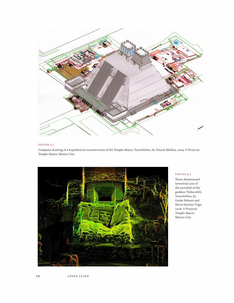
The exhilarating pace of change in today’s world of tech-nology means that advances are made virtually every day. Scientific activities are evolving at an unprecedented rate, and the tools for the observation and representation of the objec-tive world are reaching toward ever-expanding horizons. This rapid development enables us to pose different questions concerning an increasingly complex reality and to answer them with tools that our predecessors never imagined and, to be honest, that we never imagined either. For example, only thirty-four years ago, when the Templo Mayor Project in Mexico City was started, we approached the past with technical resources that today can only be described as obsolete. They were extremely time-consuming and the results, at least in retrospect, were fairly limited. Today, on the other hand, we can make use of innovative visualization techniques that broaden the scope of our research: high-resolution photos and satellite images allow us to analyze the landscapes of ancient societies; total stations and architectural programs aid topographers in mapping, drawing detailed plans, and making hypothetical reconstructions (Figure 3.1); terrestrial scanners help us capture three-dimensional information about entire archaeological sites, millimeter by millimeter (Figure 3.2); scanners for archaeological features and artifacts record three-dimensional information on surfaces, textures, and colors; a wide range of graphic programs translate measurements from geophysical equipment that describe the subsoil and render it visually; and digital photographs serve as the basis for a wide range of drawings.
Clearly, these exciting times stand out even more when considered historically: our work is the result of a long tradition that has lasted almost 250 years. Standing at the other end of the historical spectrum are eighteenth-century antiquarians, collectors, and artists
70 lópez luján70
Figure 3.1
Computer drawing of a hypothetical reconstruction of the Templo Mayor, Tenochtitlan, by Tenoch Medina, 2009. © Proyecto Templo Mayor, Mexico City.
Figure 3.2
Three-dimensional terrestrial scan of the monolith of the goddess Tlaltecuhtli, Tenochtitlan, by Guido Balzani and María Sánchez Vega, 2008. © Proyecto Templo Mayor, Mexico City.

7 1The First Steps on a Long Journey 7 1
who were the first individuals to show interest in the cultural expressions of pre-Hispanic civilizations for scientific as well as political reasons and who gave new meaning to antiqui-ties in historical and aesthetic terms. Who were these individuals, and how were they con-nected? What were their interests and their backgrounds related to presenting the past in text and image? What artistic techniques and visual conventions did they use? And above all, what was the function of the drawings and engravings that they produced? In this dis-cussion, I attempt to offer a survey of the archaeological illustrations that these men pro-duced in Mexico at the end of the colonial period. My fundamental purpose is to better understand the origin of archaeology at those sites where work is being conducted today and to reveal the perspectives of the antiquarians and artists who came before us.
Unique Images
Eighteenth-century images with archaeological subject matter can be divided into two major groups. The oldest images date to the first half of that century and consist of a few paint-ings created for legal or religious purposes rather than for scientific reasons. Good examples are the three maps of San Francisco Mazapan, which are well known today because they represent major monuments from Teotihuacan (Boone 2000:373–374; Glass and Robertson 1975:204; Kubler 1982; Schávelzon 2005:678–682). The first of these maps was donated by archaeologist Marshall Saville to the American Museum of Natural History (Figure 3.3); the second was acquired by collector Edward E. Ayer and today is part of the Newberry Library collection; and the whereabouts of the third, first brought to light by the Mexican priest José María Arreola, are unfortunately currently unknown. Although several authors have sug-gested that the three maps date to roughly 1560, today we know that they were made by indig-enous tlacuilos, or scribes, in the early decades of the eighteenth century (Oudijk and López Luján 2006, n.d.). This fact is evident in the particular way that the Nahuatl glosses were writ-ten, in the late pictorial style of the images (similar to the Techialoyan codices), and in a series of late colonial documents of the area that have shed light upon the antiquity of the maps.
The maps of San Francisco Mazapan display major differences compared to sixteenth-century cartographic documents, such as the Codex Xolotl or the Mapa de Uppsala, in which the ruins of Teotihuacan are marked simply with one or two stepped pyramids, some-times complemented by a cave or a shiny sun (e.g., Dibble 1980:maps 1, 3, 6; León-Portilla and Aguilera 1986). Only the Relación de Tequizistlán y su partido (1986) of 1580 departs from the norm: in addition to the pyramids of the Sun and the Moon rendered with their correct orientation, seven small triangular or trapezoidal mounds bordering the Street of the Dead can be seen. In contrast, the maps of San Francisco contain a much larger number of build-ings, which are easily identifiable. For example, in Saville’s map (Figure 3.3), the pyramids of the Sun and the Moon are depicted as blue hills with several superimposed levels covered with vegetation. The Pyramid of the Moon, on the far left of the image, is visually described by a moon that surrounds a human face, while the Pyramid of the Sun, toward the center of the image, is framed by an enormous rectangular platform. In addition, the quadrangle of the Ciudadela, on the right, can be seen with five of its seventeen shrines—represented as crosshatched mounds—on its perimeter. The Temple of the Feathered Serpent is shown within the precinct as a reddish hill with agaves and a radiant anthropomorphized sun.

72 lópez luján72
I believe it is represented there—and not over the Pyramid of the Sun—as the result of an error on the part of the scribe. Other discernable features include the Street of the Dead, shown across of the bottom of the image with the three crosshatched mounds of the Plaza of the Columns, and the three reddish mounds of Compound 5 at the left. Furthermore, by comparing an aerial photo of Teotihuacan and any one of these maps, we can see clearly that the scribe was fairly accurate when it came to the orientation, position, and relative distance between the buildings.
These maps also depict a variety of natural features, such as caves and water currents, and cultural elements, including roads and colonial buildings from San Francisco Mazapan, which was one of the barrios of the town of San Martín Obispo. What stand out are land-marks in the neighboring barrios of Purificación and Santa María Coatlán, small settle-ments dependent on the town of San Juan Teotihuacán. Glyphs identify place-names and proper names of the first caciques who owned the lands.
Several legal files in Mexico City’s Archivo General de la Nación (agn t. 1710, exp. 2; agn t. 2607, exp. 1; Oudijk and López Luján 2006) attest to a series of land disputes between San Martín and San Juan in the eighteenth century, which made it necessary to produce these maps and to carry out subsequent vistas de ojo, inspections to verify boundaries. Within this context, the maps of San Francisco Mazapan would have served as legal docu-ments, in other words, as bureaucratic, administrative devices that visually recorded the voices of witnesses and their descriptions of the plots of land (see Mundy 1996:186–187; Russo 2005:51–54). The archaeological monuments were drawn with care, even though they did not obey scientific interests but rather the pragmatic desire to define landmarks clearly.
Another document that should be mentioned briefly is a map of Lake Pátzcuaro, Michoacán, held in the Archivo General de la Nación (Anonymous 1778:98) and first
Figure 3.3
Mapa de San Francisco Mazapan, Teotihuacan, ca. 1700, collected by Marshall
Saville. Courtesy of the Division of Anthropology,
American Museum of Natural History, New York.

73The First Steps on a Long Journey 73
published by Elías Trabulse (1995a:24). Created in 1778, the map records the relocation of the regional ecclesiastical seat from Tzintzuntzan to Pátzcuaro (Figure 3.4). This event is recorded on the lower left of the map through the inclusion of a gloss and by the depiction of a group of individuals transporting a bell and an organ from one town to another. The map provides a beautiful panorama of the lake, with its islands and lakeside community viewed from the north. Of particular interest here are the representations of two major Tarascan archaeological sites: Tzintzuntzan and Ihuatzio. The location of Tzintzuntzan, at the lower center right of the image, is marked with four pyramids (yácatas) instead of the five that exist. Shown on a hill above the town, the yácatas dominate the convent of San Francisco, the cemetery, and the main square of the colonial settlement. Each yácata was painted as a truncated cone and crowned by a horizontal beam and a complete cone that represents the superstructure, a temple built originally with perishable materials. The ruins of three other pyramids to the left, designated “Yacatas del Rey,” are shown at the already abandoned site of Ihuatzio. Although formally more complex, they resemble images used for Tzintzuntzan.
Other maps from this period, although produced by artists trained in European styles, are the two commissioned by Lorenzo Boturini Benaducci during his sojourn in New Spain between 1736 and 1743. The first is known as the Códice de Teotenantzin (n.d.; Caso 1979;
Figure 3.4
La ciudad de Tzintzuntzan, Patzquaro, y poblaciones de alrededor de la laguna y la traslacion de la silla a Patzquaro, 1778, from Historia, vol. 10, ch. 5, fol. 98, Archivo General de la Nación, Mexico City. Photograph courtesy of the Archivo General de la Nación, Mexico City.

74 lópez luján74
Krickeberg 1949:108–109; López Luján and Noguez n.d.; Noguez 1993:152–155) and until recently was regarded as the sole visual evidence of the cult to female deities in the zone of Tepeyac prior to the phenomenon of the Virgin of Guadalupe. Through the use of ink and gouache, the artist represented a mountain range with an undulating silhouette (Figure 3.5). He positioned himself opposite the hills to capture an enlarged Albertian perspective (see Mundy 1996:xiii) from the level of the plain. In the middle ground, he detailed the flank of the mountain range, representing it with paths, water channels, and cliffs, in addition to showing sparse vegetation and a pair of colonial buildings. In the foreground and as the focus of the composition, he drew two bas-relief carvings that represent pre-Hispanic deities, perhaps Cihuacoatl and Chicomecoatl. These reliefs are depicted with relative pre-cision, a fact that may be confirmed by comparing them to an unpublished drawing by Guillermo Dupaix (n.d.a; López Luján and Noguez n.d.), a captain of the dragoons who from the time of his arrival in New Spain in 1791 became well known for his interest in archaeology (Figure 3.6). By that time, the deity on the left had already been destroyed. Nonetheless, Dupaix made a careful visual record of the vestiges of the band of the god-dess’s headdress.
The artist’s main objective in the Códice de Teotenantzin was to show the viewer that the reliefs were not on Tepeyac Hill, but rather on the contiguous Zacahuitzco Hill, located directly to the north, and he managed to mark their precise geographic position by depict-ing a series of natural and cultural details. This objective is clearly based on a comparison of the Códice de Teotenantzin and the Plano topográfico de la Villa de Nuestra Señora de Guadalupe y sus alrededores en 1691 (Valero de García Lascuráin 2004) with modern satel-lite images (Figures 3.7–3.8). One should bear in mind that in the Códice de Teotenantzin, the southwest is at the top and the northeast is at the bottom, while in the Plano topográ-fico, the southwest is toward the left and northeast is toward the right. Identifiable features include Tepeyac Hill and the hermitage on its summit (a); the spring and hermitage of the Pocito (b); the depression between Tepeyac and Zacahuitzco hills (c); a field of agave plants (d); the famous holy casahuate, or morning glory tree (Ipomoea arborescens), where the Virgin of Guadalupe appeared to Juan Diego (e); Zacahuitzco Hill (f); Yohualtecatl Hill (g); Coyoco Hill (h); and Estanzuela, a settlement where there was a house with a corral (i).
Figure 3.5
Códice de Teotenantzin, Sierra de Guadalupe,
commissioned by Lorenzo Boturini Benaducci, ca.
1736–1743, Biblioteca Nacional de Antropología e Historia,
Mexico City. conaculta-inah-mex; reproduced with
permission from the Instituto Nacional de Antropología e
Historia, Mexico City.

75The First Steps on a Long Journey 75
The location of the reliefs on Zacahuitzco Hill is corroborated by an earlier inventory from the Boturini Collection, where the codex is described as “a map on Spanish paper of the famed idol Teotenanci (which means mother of the gods), that is found on the hill contigu-ous to that of Guadalupe, where historians say that she wanted to appear after the mother of the true God” (Peñafiel 1890:1:67).1 This spot is also confirmed in the aforementioned drawing by Dupaix (n.d.a), which is accompanied by the gloss “shortly after Guadalupe, on a Cerrito [Little Hill], on the left side of the Camino Real [Royal Road].” Based on this evidence, Boturini might have wished to support the proposal of some individuals involved in the debate who identified Zacahuitzco Hill as the site of the miracle of the apparition of Mary as Guadalupe and to include this map in the essay that he planned to publish on the Virgin of Guadalupe (see Boturini 1746:88). It is highly suggestive that in pre-Hispanic times, Zacahuitzco Hill was the setting for the veneration of Tonantzin, a manifestation of the ancient goddess Cihuacoatl (López Luján and Noguez n.d.).
The second document commissioned by Boturini is a drawing of the Pyramid of the Sun, which is unfortunately now lost. The knight from Milan wrote the following concern-ing the map:
This hill from antiquity was perfectly square, whitewashed, and beautiful [and] one climbed to the summit on some steps that today are covered for they have been filled with the ruins themselves and with the soil cast by the winds on which trees and thistles have grown. Nevertheless, I was on it and out of curiosity I measured
Figure 3.6
Guillermo Dupaix, Reliefs on Zacahuitzco Hill, Sierra de Guadalupe, ca. 1791–1804, ink and charcoal drawing, Biblioteca Nacional de Antropología e Historia, Mexico City. conaculta-inah-mex; reproduced with permission from the Instituto Nacional de Antropología e Historia, Mexico City.

76 lópez luján76
Figure 3.7
Diagram of the Códice de Teotenantzin, Sierra de Guadalupe, by Julio Romero, 2009. © Proyecto Templo Mayor, Mexico City.
Figure 3.8
Diagram of the Plano topográfico de la Villa de Nuestra Señora de Guadalupe y sus alrededores en 1691, Sierra de Guadalupe, by Julio Romero, 2009. © Proyecto Templo Mayor, Mexico City.

7 7The First Steps on a Long Journey 7 7
it and if I am not mistaken, it is 200 varas [about 548 ½ ft.] tall. Furthermore, I had a map made that I have in my archive and surrounding it I saw that the cel-ebrated don Carlos de Sigüenza y Góngora had attempted to drill it, but he met with resistance. Everybody knows it is hollow in the middle (Boturini 1746:42–43; translation by author).
In the opinion of Daniel Schávelzon (2005:682), Boturini’s was the first archaeological plan drawn in the Western scientific tradition, which is suggestive, but difficult to confirm given the absence of the document.
Representations in Series
A new era in archaeological illustration dawned in the second half of the eighteenth cen-tury, when the use of copperplate engraving became widespread in scientific publications. Copperplate engraving facilitated the creation of multiple images, making it possible to spread the new discoveries to a much larger public. As a result, prints took the place of paintings and drawings as the visual support of scientific claims. Copperplate engraving was introduced to New Spain at the end of the sixteenth century (Medina 1989:1:ccix–ccx; Romero de Terreros 1948:13–14), but for many decades it was used almost exclusively for religious images, portraits, frontispieces of books, coats of arms, allegories, emblems, plans, views, and typographic decorations (Galí Boadella 2008:51, 69–81; Martínez Peñaloza 1995:35; Romero de Terreros 1948:10); to a lesser extent, it was also used to illustrate romances, couplets, riddles, accounts, gazettes, almanacs, cards, games, and so forth (Galí Boadella 2008:21, 35, 63–67, 83–91).
During the Enlightenment, copperplate engraving became the ideal procedure for sci-entific and technological fields because it made possible the reproduction of images that were both more precise and on a larger scale than wood engravings (López Piñero 1987:13).2 Discoveries, inventions, and studies on virtually all spheres of knowledge were communi-cated through this medium. It was expensive, however, particularly if the images had to be colored by hand, and it did not allow for the easy printing of text and image on the same page. In addition, it required highly experienced engravers to transform sketches or draw-ings into the rich, complex monochrome language of copperplates (Báez Macías 1986:1191; Carrete Parrondo 1987:206–209, 222; Trabulse 1992:13, 1995a:29). As would be expected, from early on a close symbiosis arose between engravers and printers (Galí Boadella 2008:41–44; Martínez Peñaloza 1995:36). Apparently, engravers tended to live in the printers’ workshops and to work for them as servants.
When it comes to eighteenth-century engravings for scientific books, a good exam-ple is the frontispiece from Lecciones matemáticas by José Ignacio Bartolache, published in 1769. It depicts an allegory of geometry executed by José Mariano Navarro in which experimentation and quantification are shown as supports for knowledge of the physical world (Romero de Terreros 1948:516–518; Trabulse 1992:16, 1995a:85–86). Other outstand-ing images are included in the Elementa recentioris philosophiae by Juan Benito Díaz de Gamarra, published five years later and illustrated by Antonio Onofre Moreno (Romero de Terreros 1948:508–509; Trabulse 1992:17, 1995a:86–88).

7 8 lópez luján7 8
Of even greater importance was the abundance of periodicals that were produced at that time in Mexico City. These magazines and journals disseminated news on recent discoveries originally issued in French, German, English, Italian, Spanish, American, and Swedish pub-lications, in addition to local innovations and debates (Cody 1953; Saladino García 1990:101–109; Torres Alamilla 2001; Trabulse 1992:17–20, 1995a:88–84). The prolific and polymath José Antonio de Alzate y Ramírez, regarded as the father of scientific journalism, founded four influential journals between 1768 and 1795, the most well known of which was the Gazeta de literatura de México. In them, he published about four hundred of his own articles plus about one hundred more attributed to other writers on medicine, botany, zoology, phys-ics, chemistry, astronomy, meteorology, geography, cartography, metallurgy, agricultural and industrial techniques, jurisprudence, philosophy, linguistics, history, and archaeology. Among the articles illustrated with copperplate engravings are those on the Venus passage of the Sun on June 3, 1769, and the lunar eclipse of December 12 in the same year. Both prints are the work of the aforementioned José Mariano Navarro. Other outstanding examples are the three colored plates on cochineal cultivation, the foldout of the Castilla elastica (rubber tree), and the tabla quimológica by Joaquín Alejo de Meave, which was used to calculate the time it took the sound of thunder to reach a person who had seen a bolt of lightning (Trabulse 1995a:94–98). These five images were executed by Francisco Agüera y Bustamante, who was active as an engraver from 1784 to 1805 (Martínez Peñaloza 1995:61; Medina 1989:1:ccxiii; Romero de Terreros 1948:463–466, 516–518). Agüera won recognition for his religious prints of saints and virgins (the majority of which were published by the print shop of Zúñiga y Ontiveros), the portrait of Father Santa María for the Reflexiones by Father San Cirilo, the plates for Novena de la Virgen de Loreto by Father Croiset, and the engravings for La por-tentosa vida de la muerte by Friar Joaquín de Bolaños, in addition to several coats of arms and bookplates. Equally noteworthy are his maps of Juquila and Lake Texcoco, different geometric figures in Exercicios públicos by José Otero, and his archaeological illustrations.
Xo c h ic a l c o
Xochicalco enjoys the distinction of being the first Mesoamerican archaeological site that was the focus of scientific study, even earlier than Palenque. In fact, Antonio Alzate came before three other Antonios—Calderón, del Río, and Bernasconi—to carry out his own pre-liminary inquiries on November 12, 1777 (López Luján 2001). On that historic date, while on a trip he made to southern Mexico to examine some mines of quicksilver, Alzate was told of the existence of the “castle of Xochicalco.” Intrigued, Alzate went straight to the site to undertake an initial reconnaissance. During his brief stay, he calculated the height of the hills at the site with the aid of a barometer, and he recorded the main characteristics of this Epiclassic settlement. The following year, Alzate wrote his Descripcion de Xochicalco, dedi-cated to Viceroy Antonio María de Bucareli y Ursúa (1771–1779). This manuscript focused on technical, measurable aspects of the site, above all its urbanism and architecture, where he could make use of his profound knowledge of natural, physical, and mechanical sciences (Alzate y Ramírez 1777–1778; Molina Montes 1991; Ramírez 1982:112). He wrote of the char-acteristics of the materials, praised the skill of the builders, inferred the military functions of the complex, and concluded that it was the work of a people of great intelligence.
The manuscript is accompanied by nine figures organized into six plates, all of them drawn by Alzate himself. They include plans, elevations, and perspectives in ink and

79The First Steps on a Long Journey 79
gouache of the hills of Xochicalco and La Bodega, the “underground passages,” and the main plaza. The most interesting elements of each image are singled out with letters that are associated with explanatory texts that often include measurements in Spanish varas. What is particularly noteworthy is the plate in which Alzate represented the two facades of the Temple of the Feathered Serpent (Figure 3.9; Alzate y Ramírez 1777–1778:estampa 2ª).3 He did not draw the temple’s well-known reliefs, but rather, in their place, he reproduced
Figure 3.9
José Antonio de Alzate y Ramírez, Temple of the Feathered Serpent, Xochicalco, 1777–1778, ink and gouache drawing, Tozzer Library, Harvard University, Cambridge, Mass.

80 lópez luján80
Mexica glyphs from the tribute list known as the Matrícula de Tributos (Figure 3.10), taken arbitrarily from the Historia de la Nueva España by Cardinal Lorenzana (1770), as noted by Roberto Moreno de los Arcos (Molina Montes 1991:62). This substitution may be explained by Alzate’s feeble painting skills but also by his dogged aversion to the formal and symbolic aspects of pre-Hispanic art and by the low opinion he held of the iconographic inquiries of his contemporary, the astronomer-antiquarian Antonio de
Figure 3.10
Copperplate engraving of a plate of the Matrícula de
Tributos, from Francisco Antonio Lorenzana, Historia de la Nueva
España, 1770.

81The First Steps on a Long Journey 81
León y Gama (López Luján 2009:196–211; Ramírez 1982:142–143). Taking the same liber-ties, Alzate reconstructed the fragmentary relief of a man being attacked by a bird of prey (Figure 3.11). He did so supposedly based on the description given by one of his native guides, although in reality it would seem to have been based on the well-known relief carved on the wall of the atrium of the church of San Hipólito in Mexico City (Figure 3.12; Sánchez 1886).
Figure 3.11
José Antonio de Alzate y Ramírez, Bas-Relief of a Man Being Attacked by a Bird of Prey, Xochicalco, 1777–1778, ink and gouache drawing, Tozzer Library, Harvard University, Cambridge, Mass.

82 lópez luján82
Figure 3.12
Lithograph of the bas-relief on the atrium wall
of the church of San Hipólito, Mexico City,
from Jesús Sánchez, “Notas arqueológicas
iv: El sueño de Motecuhzoma,” 1886,
vol. 3, pl. 1.

83The First Steps on a Long Journey 83
Figure 3.13
A Facade of the Temple of the Feathered Serpent, Xochicalco, 1784–1791, copperplate engraving by Francisco Agüera, after drawing by Arana, from José Antonio de Alzate y Ramírez, Descripcion de las antiguedades de Xochicalco. Dedicada a los señores de la actual expedicion marítima al rededor del orbe, 1791, pl. iii.
Figure 3.14
Copperplate engraving of various reliefs, Xochicalco, from Pietro [Pedro] Márquez, Due antichi monumenti di architettura messicana, 1804, pl. iv.
84 lópez luján84
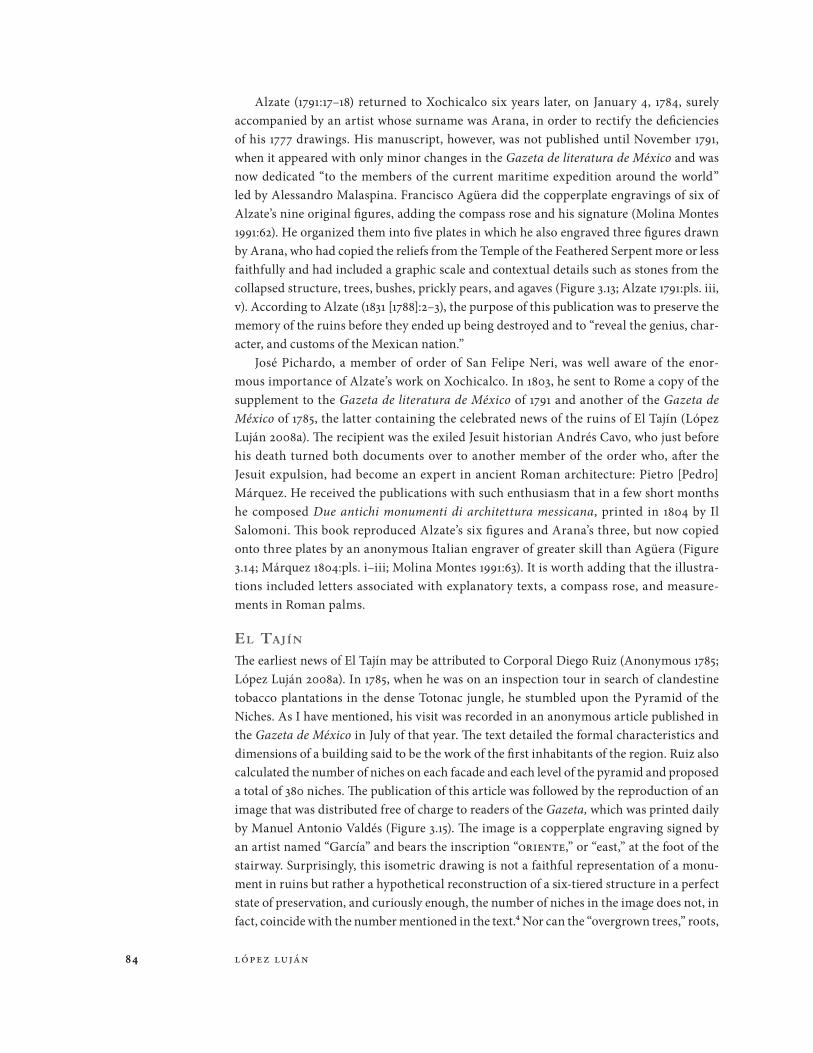
Alzate (1791:17–18) returned to Xochicalco six years later, on January 4, 1784, surely accompanied by an artist whose surname was Arana, in order to rectify the deficiencies of his 1777 drawings. His manuscript, however, was not published until November 1791, when it appeared with only minor changes in the Gazeta de literatura de México and was now dedicated “to the members of the current maritime expedition around the world” led by Alessandro Malaspina. Francisco Agüera did the copperplate engravings of six of Alzate’s nine original figures, adding the compass rose and his signature (Molina Montes 1991:62). He organized them into five plates in which he also engraved three figures drawn by Arana, who had copied the reliefs from the Temple of the Feathered Serpent more or less faithfully and had included a graphic scale and contextual details such as stones from the collapsed structure, trees, bushes, prickly pears, and agaves (Figure 3.13; Alzate 1791:pls. iii, v). According to Alzate (1831 [1788]:2–3), the purpose of this publication was to preserve the memory of the ruins before they ended up being destroyed and to “reveal the genius, char-acter, and customs of the Mexican nation.”
José Pichardo, a member of order of San Felipe Neri, was well aware of the enor-mous importance of Alzate’s work on Xochicalco. In 1803, he sent to Rome a copy of the supplement to the Gazeta de literatura de México of 1791 and another of the Gazeta de México of 1785, the latter containing the celebrated news of the ruins of El Tajín (López Luján 2008a). The recipient was the exiled Jesuit historian Andrés Cavo, who just before his death turned both documents over to another member of the order who, after the Jesuit expulsion, had become an expert in ancient Roman architecture: Pietro [Pedro] Márquez. He received the publications with such enthusiasm that in a few short months he composed Due antichi monumenti di architettura messicana, printed in 1804 by Il Salomoni. This book reproduced Alzate’s six figures and Arana’s three, but now copied onto three plates by an anonymous Italian engraver of greater skill than Agüera (Figure 3.14; Márquez 1804:pls. i–iii; Molina Montes 1991:63). It is worth adding that the illustra-tions included letters associated with explanatory texts, a compass rose, and measure-ments in Roman palms.
el Taj í n
The earliest news of El Tajín may be attributed to Corporal Diego Ruiz (Anonymous 1785; López Luján 2008a). In 1785, when he was on an inspection tour in search of clandestine tobacco plantations in the dense Totonac jungle, he stumbled upon the Pyramid of the Niches. As I have mentioned, his visit was recorded in an anonymous article published in the Gazeta de México in July of that year. The text detailed the formal characteristics and dimensions of a building said to be the work of the first inhabitants of the region. Ruiz also calculated the number of niches on each facade and each level of the pyramid and proposed a total of 380 niches. The publication of this article was followed by the reproduction of an image that was distributed free of charge to readers of the Gazeta, which was printed daily by Manuel Antonio Valdés (Figure 3.15). The image is a copperplate engraving signed by an artist named “García” and bears the inscription “oriente,” or “east,” at the foot of the stairway. Surprisingly, this isometric drawing is not a faithful representation of a monu-ment in ruins but rather a hypothetical reconstruction of a six-tiered structure in a perfect state of preservation, and curiously enough, the number of niches in the image does not, in fact, coincide with the number mentioned in the text.4 Nor can the “overgrown trees,” roots,

85The First Steps on a Long Journey 85
Figure 3.15
The Pyramid of the Niches, El Tajín, copperplate engraving by García, from Anonymous, “Papantla,” 1785, pl. i.
Figure 3.16
Guillermo Dupaix, Pyramid of the Niches, El Tajín, ca. 1791–1804, ink and charcoal drawing. Image courtesy of the American Philosophical Society, Philadelphia.

86 lópez luján86
undergrowth, and dead leaves that covered the stairway according to the written descrip-tion be seen; in fact, the vegetation is limited here to a pair of small plants in the foreground.
Sometime between 1791 and 1804, Captain Dupaix independently organized an expedi-tion through what are now the states of Puebla and Veracruz aimed at reaching the ruins of El Tajín. Once there, he hired a large crew of indigenous locals, armed with axes and machetes, to cut down trees to uncover the most illustrious monuments so that he could describe them and prepare ink and charcoal sketches. All of this work was recorded in a manuscript that was published and analyzed recently (Dupaix n.d.b; López Luján 2008a). What is interesting is that Dupaix did not include an original sketch of the Pyramid of the Niches. Instead, he was satisfied with a charcoal tracing of the isometric drawing published in the Gazeta de México, although he added a seventh tier at the summit, six rows of stone blocks that served as a foundation, and details of the niches and the bases for standards at the foot of the stairway, in addition to explicative glosses (Figure 3.16). In this image and the corresponding text, he was not concerned with the number of niches and suggested they were used to hold images of gods, trophy heads, or lamps.
The previously mentioned book by Márquez (1804) discussed the significance of the 380 niches, proposing that 365 represented the days of the year, that 13 represented the days needed to correct for the leap year in a 52-year cycle, and that the 2 remaining niches sym-bolized the 52-year cycles that fit in a period of 104 years. In this way, Márquez deduced that the pyramid served a calendrical function, similar to that of the Arch of Janus in Rome. The publication contained an anonymous engraving inspired by the print from the Gazeta de México (Figure 3.17; Márquez 1804:pl. iv). But the angle of the view was modified to show
Figure 3.17
Copperplate engraving of the Pyramid of the Niches,
El Tajín, from Pietro [Pedro] Márquez, Due antichi
monumenti di architettura messicana, 1804, pl. i.

87The First Steps on a Long Journey 87
two vanishing points, one for the six tiers of the pyramid and the other for the stairway. On the other hand, care was taken to depict the exact number of niches reported by Diego Ruiz on the east and south facades.
Teno c h T i T l a n
Mexico City underwent a true urban revolution in the second half of the eighteenth century, particularly with the arrival in New Spain of Juan Vicente de Güemes Pacheco de Padilla y Horcasitas (1789–1794), second count of Revillagigedo, who occupied the position of vice-roy, governor, captain general, and superintendent of the royal treasury (Díaz-Trechuelo et al. 1972; Lombardo de Ruiz 1999; López Luján 2009:124–135). This process began in 1789, when the city had grown to 131,000 inhabitants, and it stood as the most populous capital in the Western Hemisphere. Revillagigedo was a creole born in Havana and raised in New Spain during the administration of his father (1746–1755). He lived most of his life in Spain, where he was able to observe the urban renaissance of Madrid, orchestrated by the Sicilian architect Francesco Sabatini under the orders of Charles III. This must have left a deep impression on Revillagigedo, for when he returned to New Spain at the age of forty-nine, he set out to transform the face of the capital city—which was ruled by chaos, unhealthy conditions, and minimal safety—no matter what the cost.
To bring his plans to life, the controversial viceroy made use of the services of architect and urban planner Ignacio de Castera, who soon began the works. The city was embel-lished with civic monuments, while the exuberant baroque buildings were demolished to be replaced by austere, functional neoclassical constructions. The grid plan was standardized by the opening, expansion, and alignment of many streets. New avenues and bridges were built. Furthermore, downtown streets were covered with cobblestones and given wide side-walks; markets in public plazas were reorganized; many facades were painted; and public streetlights were installed. Simultaneously, the city as a whole was rezoned: a division into quarters and blocks was devised; streets and plazas were named; and houses were num-bered. The water distribution network improved substantially thanks to the installation of aqueducts, pipes, and fountains. Major urban sanitation works, including the construc-tion and repair of irrigation channels and drainage and sewer systems, were undertaken to channel rainwater and sewage properly. Homeowners were also ordered to install latrines and trash deposits in their homes. The greatest efforts aimed at urban improvement took place in the Plaza de Armas, the main square, and were overseen by military engineer Miguel Constanzó.
These urban works resulted in the unexpected uncovering of large-scale archaeological monuments from the Mexica culture. José Gómez (1986:109), a halberdier from Granada, attested to these discoveries in a single comment summing up cause and effect: “At that time the entire city was mined and filled with holes and several idols from the time of the pagans were removed [from the ground].” Contrary to what had always been done in the past, how-ever, the recently uncovered antiquities were no longer destroyed, for now they were seen as possessing rich historical content and a certain degree of artistic value. For this reason, many of these monuments were used as decorative elements at corners, lintels, and entry-ways of mansions that were built at the time, while others went into the growing number of public and private collections in the capital. The presence of these enigmatic stones in visible spots spurred curiosity, debate, publications, and the desire to preserve them for posterity.
88 lópez luján88
As is widely known, a Coatlicue was unearthed in the Plaza de Armas in August 1790 and the Sun Stone (also known as the Calendar Stone) in December that same year. As for the first of these monoliths (see López Luján 2009:137–147), it is highly interesting that Bernardo Bonavia y Zapata, corregidor intendente of Mexico City, sent a note to Revillagigedo on September 5 in which he proposed not only to transfer this monument to the university, but also to draw it and produce a series of engravings to illustrate an account:
In the excavations that are taking place in the Plaza of the Palace for the construc-tion of drains, it is known that a figure of stone of considerable size has been found that is suggested to be earlier than the conquest. I consider it worthy of preserving for its antiquity, for the scarcity of monuments that remain to us from those times, and for what it might be able to contribute to enlighten us. Convinced that for this purpose it could not be placed in better hands than in those of the Real Pontificia Universidad, it seems to me it would be convenient to place it there, having no doubt that it will be accepted there with pleasure, remaining under my charge, if Your Excellency sees fit to have it measured, weighed, drawn, and engraved so that it be published with the news that said body might have, enquire, or discover as to its origin (Bonavia y Zapata 1790:fol. 1r).
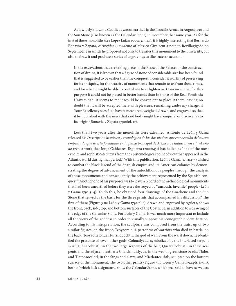
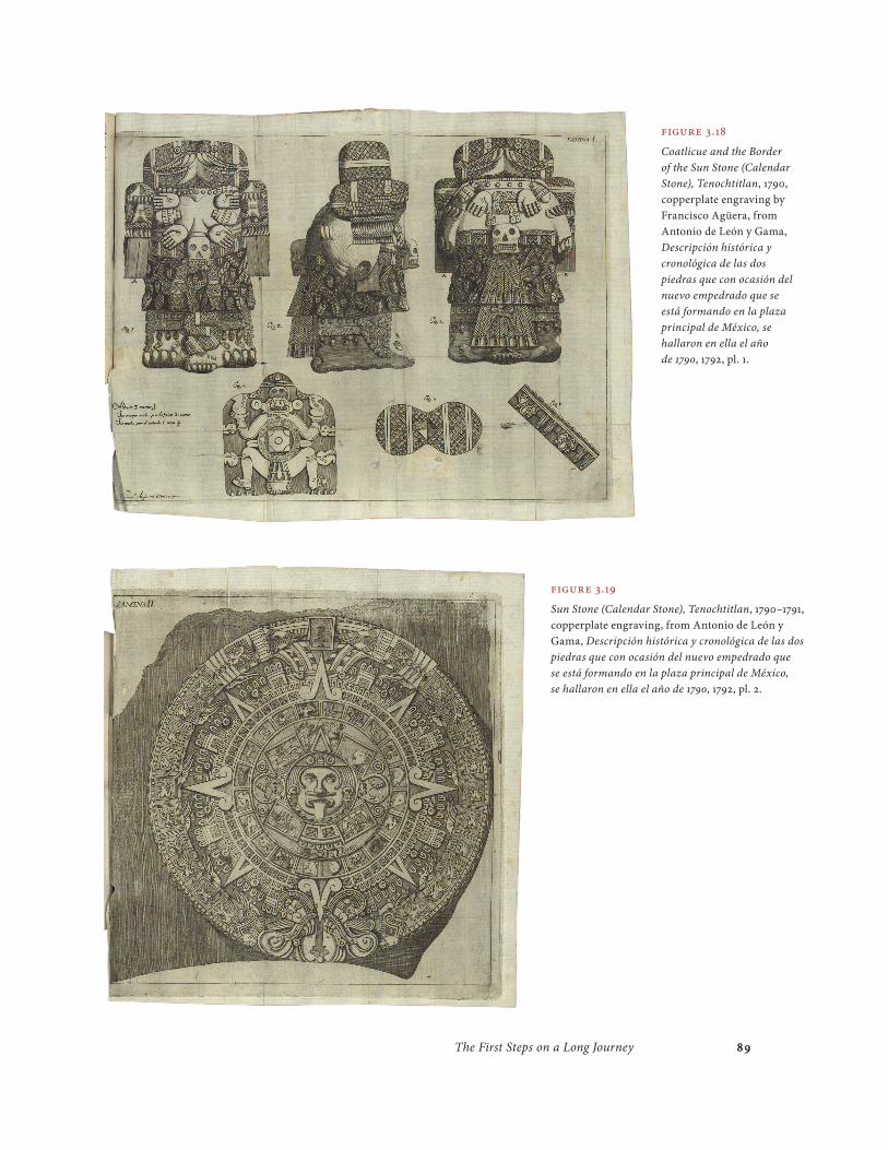
Less than two years after the monoliths were exhumed, Antonio de León y Gama released his Descripción histórica y cronológica de las dos piedras que con ocasión del nuevo empedrado que se está formando en la plaza principal de México, se hallaron en ella el año de 1790, a work that Jorge Cañizares-Esguerra (2006:451) has hailed as “one of the most erudite and sophisticated texts from the epistemological point of view that appeared in the Atlantic world during that period.” With this publication, León y Gama (1792:4–5) wished to combat the black legend of the Spanish empire and its American colonies by demon-strating the degree of advancement of the autochthonous peoples through the analysis of these monuments and consequently the achievement represented by the Spanish con-quest.5 Another one of his purposes was to leave a record of the archaeological monuments that had been unearthed before they were destroyed by “uncouth, juvenile” people (León y Gama 1792:3–4). To do this, he obtained four drawings of the Coatlicue and the Sun Stone that served as the basis for the three prints that accompanied his discussion.6 The first of these (Figure 3.18; León y Gama 1792:pl. i), drawn and engraved by Agüera, shows the front, back, side, top, and bottom surfaces of the Coatlicue, in addition to a drawing of the edge of the Calendar Stone. For León y Gama, it was much more important to include all the views of the goddess in order to visually support his iconographic identification. According to his interpretation, the sculpture was composed from the waist up of two similar figures: on the front, Teoyaomiqui, patroness of warriors who died in battle; on the back, Teoyaotlatohua Huitzilopochtli, the god of war. From the waist down, he identi-fied the presence of seven other gods: Cohuatlycue, symbolized by the interlaced serpent skirt; Cihuacohuatl, in the two large serpents of the belt; Quetzalcohuatl, in these ser-pents and the adjacent feathers; Chalchihuitlycue, in the web of greenstone beads; Tlaloc and Tlatocaocelotl, in the fangs and claws; and Mictlantecuhtli, sculpted on the bottom surface of the monument. The two other prints (Figure 3.19; León y Gama 1792:pls. ii–iii), both of which lack a signature, show the Calendar Stone, which was said to have served as
89The First Steps on a Long Journey 89
Figure 3.18
Coatlicue and the Border of the Sun Stone (Calendar Stone), Tenochtitlan, 1790, copperplate engraving by Francisco Agüera, from Antonio de León y Gama, Descripción histórica y cronológica de las dos piedras que con ocasión del nuevo empedrado que se está formando en la plaza principal de México, se hallaron en ella el año de 1790, 1792, pl. 1.
Figure 3.19
Sun Stone (Calendar Stone), Tenochtitlan, 1790–1791, copperplate engraving, from Antonio de León y Gama, Descripción histórica y cronológica de las dos piedras que con ocasión del nuevo empedrado que se está formando en la plaza principal de México, se hallaron en ella el año de 1790, 1792, pl. 2.

90 lópez luján90
a sacrificial altar, a sun dial, a calendar of half of the ecliptic, and a marker for equinox, solstice, and zenith passages.
León y Gama’s Descripción histórica incited enraged criticism, mainly on the part of Alzate.7 This critique led León y Gama (1792:116, 1832, pt. 2:1–148) to write a second part, enti-tled “Advertencias anti-criticas,” to respond to the challenges that had been raised and also to report on twenty-four sculptures discovered at that time. For this purpose, Agüera drew
Figure 3.20
Guillermo Dupaix, Archaeological Collection of
Vicente Cervantes, Mexico City, ca. 1791–1804, ink and charcoal
drawing, Biblioteca Nacional de Antropología e Historia,
Mexico City. conaculta-inah-mex; reproduced with
permission from the Instituto Nacional de Antropología e
Historia, Mexico City.
Figure 3.21
Guillermo Dupaix, Archaeological Collection
of Ciriaco González de Carvajal, Mexico City, ca.
1791–1804, ink and charcoal drawing, Biblioteca Nacional
de Antropología e Historia, Mexico City. conaculta-
inah-mex; reproduced with permission from the Instituto
Nacional de Antropología e Historia, Mexico City.

91The First Steps on a Long Journey 91
and engraved five new plates in which he represented these sculptures (León y Gama 1832, pt. 1:vii; Jesús Sánchez in León y Gama 1886:245), including the five that were in his patron’s collection.8 Unfortunately, León y Gama passed away in 1802 before he could see the publi-cation of his sequel, which was printed three decades later, but without illustrations.
Apart from León y Gama’s collection, other privately owned pieces are known thanks to Dupaix’s unpublished sketches (López Luján and Fauvet-Berthelot 2007a, 2007b). The
Figure 3.22
Guillermo Dupaix, Archaeological Collection of Guillermo Dupaix, Mexico City, ca. 1791–1804, ink and charcoal drawing, Biblioteca Nacional de Antropología e Historia, Mexico City. conaculta-inah-mex; reproduced with permission from the Instituto Nacional de Antropología e Historia, Mexico City.

92 lópez luján92
captain was an assiduous visitor to cabinets of curiosities in Mexico City, where he admired recent acquisitions, debated their significance, and made pencil drawings of them. These sketches make it clear that Dupaix lacked any artistic training whatsoever, although he was sufficiently meticulous that today some of these pieces can be identified. An interest-ing collection is the one assembled by Vicente Cervantes, a Spanish botanist who came to Mexico in 1787 and founded the Real Jardín Botánico and the professorship in this subject at the Royal University. Cervantes had in his possession a rich herbarium, a valuable col-lection of minerals, and drawings from Antonio del Río’s expedition to Palenque. One of Dupaix’s sketches shows the image of Xipe Totec next to a jar of “eggs that were removed from a woman’s breast.” Another image (Figure 3.20) depicts a Mixtec penate, a T-shaped copper axe, nine copper bells, as well as a greenstone female head today in the collection of the Musée du quai Branly (mqb 87.101.619).
An even larger collection was the one amassed by Ciriaco González de Carvajal, who was born in Andalusia and came to Mexico in 1790 as a high court judge (oidor) of the Real Audiencia. In New Spain, he developed an interest in minerals and antiquities. Dupaix recorded nine objects from his collection (Figure 3.21), including a Mixtec rain god head now in the British Museum (bm et 1849, 6-29.9) and an obsidian mirror that subsequently became part of the collections of the mining school (now Museo Histórico Minero Don Felipe de Borbón y Grecia) in Madrid (Bernárdez Gómez and Guisado di Monti 2004:88). Finally, the collection assembled by Dupaix himself should be mentioned. As is well known, when he came to Mexico he undertook a long series of private expeditions to visit pre-Hispanic ruins and monuments. These travels gave him ample opportunity to form a col-lection with pieces as spectacular as the head of the water goddess sculpted in greenstone (Figure 3.22), today in the Museo Nacional de Antropología (mna inv. 10-15717).
The Academy of San Carlos
Eighteenth-century scientific drawing was transformed in 1788 with the establishment of the Escuela Provisional de Dibujo, which was opened in the Casa de Moneda, and five years later, the foundation of the Real Academia de las Tres Nobles Artes de San Carlos. Spanish engraver Jerónimo Antonio Gil was appointed to head both institutions (Báez Macías 1974:15, 30; Bargellini and Fuentes 1990:19–21; Chávez Silva 2002:121–122; Torales Pacheco 2001:219–221). Thanks to his initiative and the strong support of Charles III, the academy was endowed from the start with a generous budget, professors of the highest caliber, and spectacular didactic collections of paintings, engravings, medals, plaster casts of renowned sculptures, and books brought from Spain and Italy. A sense of its importance is sug-gested by its picture collection, which had works by the likes of Ribera, Zurbarán, Cortona, Michelangelo, and the school of Raphael; the plaster casts included copies of Laocoon, the Venus de’ Medici, and the Castor and Pollux group; and its library held treasures such as works by Vitruvius, Serlio, Vesalius, Piranesi, and the new volumes on the excavations at Herculaneum (Angulo Iñiguez 1935:19–21; Báez Macías 1974:107; Bargellini and Fuentes 1990:21; López Luján 2008b).
The academy accepted students from all social classes, offering traditional guild teach-ing with long years of study and a system that recognized individual talent. The educational

93The First Steps on a Long Journey 93
content went against the religious aesthetic that had dominated the baroque by promoting secular, neoclassical forms of expression (Lombardo de Ruiz 1986:1245–1251). On a techni-cal level, it trained superb engravers, whose work stood out for the precise, clean lines in their prints (Báez Macías 1986:1191; Romero de Terreros 1948:14). The most outstanding of its students were called to join the ongoing scientific expeditions that the Spanish crown organized to evaluate the economic potential of its colonies and its geopolitical vulnerabil-ity (González Claverán 1994:115).
Among these expeditions, the Real Expedición Botánica de Nueva España was led by physician Martín Sessé. From 1787 to 1803, the members drew thousands of minerals, plants, and animals from Guatemala to California, as well as from British Columbia, Cuba, and Puerto Rico (Engstrand 1981:37, 40, 42, 127, 149, 160, 169, 1998:100–104; González Claverán 1994:117–119; Lozoya 1984). What is interesting is that they chose two young graduates from the Academy of San Carlos for this purpose: Vicente de la Cerda and Atanasio Echeverría (Engstrand 1981:25; Trabulse 1992:36, 1995a:110–114). The work of the latter, which amazed Alexander von Humboldt for its scientific and artistic quality,9 has survived and is now in the Hunt Institute for Botanical Documentation in Pittsburgh and the Real Jardín Botánico de Madrid.
Echeverría also participated in the so-called Expedición de Límites headed by Juan Francisco de la Bodega y Quadra, which explored the southwest of Canada in 1792 for territorial reconnaissance, evaluation of the importance of the fur trade, and prevention of the advance of the Russians and the British. Echeverría’s original sketches—mainly of land-scapes, plants, animals, and the native peoples of the region—were taken to Mexico City to be reproduced in duplicate by sixteen students at the Academy of San Carlos (Engstrand 1981:112, 116, 126–127, 1998:100–101; Palau de Iglesias 1998:iv; Trabulse 1992:36–38, 1995a:114–128).10
The Viaje Político-Científico alrededor del Mundo of 1789 to 1794, headed by the Italian Alessandro Malaspina, was also the impetus for a large number of scientific illustrations. To accompany Malaspina on his expedition in search of the nonexistent Strait of Anian, the academy selected draftsman-engraver Tomás de Suria, who later painted superb portraits of the native peoples of British Columbia (Engstrand 1981:52–53, 55–56, 58–59; González Claverán 1988:208–209, 1994:121; Palau de Iglesias 1980:41; Sotos Serrano 1982:139–149; Suria 1980). A section of Malaspina’s expedition, the Comisión Científica Novohispana, directed by the military figure and naturalist from Guatemala Antonio Pineda, engaged the services of architect José Gutiérrez and painter Francisco Lindo (Engstrand 1981:95, 98; González Claverán 1994:119–121; Sotos Serrano 1982:151–154). Gutiérrez devoted his atten-tion to illustrating technological devices and geographic plans and views; Lindo executed botanical images. Pineda himself prepared a sketch of a shrine at the pre-Hispanic site of Mexicaltzingo, now a neighborhood of Mexico City (González Claverán 1991:119).
The artists from the Academy of San Carlos also executed drawings on archaeologi-cal subject matter. Humboldt obtained four of these images during his stay in New Spain between 1803 and 1804. Two of these were provided by Captain Dupaix (Figure 3.23; Humboldt 1995 [1810]:1:pls. 1–2). They are the work of an anonymous student and represent the front and back of a sculpture of the goddess Chalchiuhtlicue that belonged to Dupaix and is now in the British Museum (bm et Am, St. 373).11 He acquired the other two from the Marquis de Branciforte, viceroy of New Spain from 1794 to 1798 (Figures 3.24–3.25; Humboldt 1995 [1810]:1:pls. 49–50). They were drawn by Luis de Martín, a Spanish architect

94 lópez luján94
Figure 3.23
Sculpture of the Goddess Chalchiuhtlicue, Mexico City, 1804–1810, copperplate engraving by Massard, after drawing by a student at the Academy of San Carlos, from Alexander von Humboldt, Vues des cordillères, et monumens des peuples indigènes de l’Amérique, 1810, pl. 1.

95The First Steps on a Long Journey 95
Figure 3.24
Plan of the Palace, Mitla, 1802–1810, copperplate engraving by Massard, after drawing by Luis de Martín and Antonio Laguna, from Alexander von Humboldt, Vues des cordillères, et monumens des peuples indigènes de l’Amérique, 1810, pl. 49.
Figure 3.25
An Elevation of the Palace, Mitla, 1802–1810, copperplate engraving by Massard, after drawing by
Luis de Martín and Antonio Laguna, from Alexander von Humboldt, Vues des cordillères, et monumens des
peuples indigènes de l’Amérique, 1810, pl. 50.

96 lópez luján96
and scholar who was assisted in 1802 by Colonel Antonio Laguna, and record the plan and elevation of the Palace of Mitla. Their work is distinguished by the use of graphic scales in Spanish feet and varas; the precision of these drawings amazed the judge and collector González de Carvajal as well as Fausto Elhuyar, the director of the Royal Tribunal of Mines (Estrada de Gerlero 1993:80, 1994a:168; Sellen 2009).
Another interesting case is that of Benito Moxó y Francolí. This Benedictine from Catalonia lived in New Spain for almost two years during 1804 and 1805 before leaving for
Figure 3.26
Benito Moxó’s personal museo,
1804–1805, copperplate engraving by G. B.
Campo Antico, after drawing by Saávedra,
original gouaches by Rafael Ximeno y Planes, from Benito
María de Moxó, Cartas mejicanas, 1837,
frontispiece.

97The First Steps on a Long Journey 97
Bolivia to become the archbishop of Charcas. Contrary to Humboldt, Moxó placed new value on the aesthetic content of Mesoamerican creations and collected all kinds of old artifacts. In his Cartas mejicanas (first published in 1837), Moxó described his personal treasures and included three copper engravings of them based on gouaches painted by the reknowned Spanish artist and general director of the academy Rafael Ximeno y Planes (Figure 3.26; Trabulse 1995b:xl–xli). Thanks to him, we know Moxó possessed an important collection of musical instruments, fragments of architecture, and ritual objects, as well as images of temples, deities, and animals made of stone and clay.
In 1794, Dupaix (n.d.c:51r; López Luján 2011) hired José Antonio Polanco, for he regarded him as a “good draftsman and with a strong affinity for Antiquities.”12 A graduate of the academy, Polanco had a painting workshop—with a journeyman and several appren-tices—on the street known as Calle del Parque in Mexico City (Anonymous 1791a, 1791b). There he redrew in ink and gouache Dupaix’s (1794; see López Luján 2011) pencil sketches of his “Descripcion de monumentos antiguos mexicanos,” creating a handsome album
Figure 3.27
José Antonio Polanco, Indio triste (Sad Indian), 1794, ink and charcoal drawing, Biblioteca Nacional de Antropología e Historia, Mexico City. conaculta-inah-mex; reproduced with permission from the Instituto Nacional de Antropología e Historia, Mexico City.

98 lópez luján98
that illustrates eighteen Postclassic stone sculptures and a ceramic flute found accidentally in Mexico City and its environs (Figure 3.27). Four of these sculptures were exhibited in the Academy of San Carlos together with plaster copies of Greco-Roman sculpture: the renowned Indio triste (Sad Indian; mna inv. 10-0081560), the ahuizote (mna inv. 10-81577), a serpent (mna inv. 10-1122), and a toad (Museo de Santa Cecilia Acatitlan inv. 10-136117). It is worth saying that with this album, Dupaix began his own museo cartaceo (paper museum), a personal collection of hundred of images about the cultural heritage—visual and tan-gible—of pre-Hispanic times (see Bickendorf 2010).
Eleven years later, Dupaix was commissioned by Charles IV to document the antiquities of New Spain in text and image (Alcina Franch 1995; Dupaix 1969; Estrada de Gerlero 1994b; Fauvet-Berthelot et al. 2007). From 1805 to 1809, Dupaix conducted three expeditions accom-panied by a draftsman from San Carlos by the name of José Luciano Castañeda.13 He traveled to the central and southern regions of the colony, going as far south as the ruins of Palenque. The Napoleonic invasion of Spain, however, led to the sudden cancellation of the project, so Castañeda’s drawings were never transferred to copperplate engravings for publication in Madrid. These drawings were unknown for many years, but they were finally published as lithographs—not in Spain but rather in Mexico City, London, and Paris (see Aguilar Ochoa 2007; Baudez 1993:51–53; Dupaix 1831, 1978 [1834]; Estrada de Gerlero 1994c, 2000:156, 168; Icaza and Gondra 1827), where they formed part of the history of the nineteenth century.
Final Considerations
Despite the fragmentary and dispersed nature of the information we have examined, we have been able to discern glimpses of a changing world throughout the course of our survey. The eighteenth century was a period prior to the invention of photography, a time in which drawing was the only means to represent and transmit images. And images at that time took on a greater role than in earlier centuries and assumed greater complexity. To a con-siderable degree, this new role was possible thanks to copperplate engraving. The potential for reproduction and the high quality of the images turned the technique into the principal means of visual expression in science.
In this new context, the rare drawings that displayed archaeological elements gradually transcended the rural indigenous universe—where ruins served as landmarks—to prolif-erate in the urban milieu, but in the form of prints and as evidence of a glorious past that was beginning to be reappraised. In Mexico City, copperplate engravings of antiquities were primarily produced by specialists such as Francisco Agüera and a virtually unknown artist by the name of García, who were trained in the traditional system of guilds and were attached to well-known print shops. Later, archaeological images were created by profes-sionals trained at the budding Academy of San Carlos, the bastion of the new neoclassic aesthetic. The major figures of this phase, including José Antonio Polanco, Luis de Martín, Rafael Ximeno y Planes, and José Luciano Castañeda, created some of the most enduring images of archaeological sites, buildings, and artifacts.
All of these artists established client-patron relationships with antiquarians and aficionados—generally enlightened creoles or European travelers—who occupied a niche in the colonial capital as well-educated men of means, usually connected in some way to

99The First Steps on a Long Journey 99
the Academy of San Carlos (López Luján and Fauvet-Berthelot 2007a). They shared a taste for antiquities often expressed in the form of collecting: around their cabinets of curiosi-ties, they organized gatherings to show each other their recent acquisitions and to exchange objects, drawings, and publications.
Dupaix and Alzate turned to the services of Polanco and Agüera, respectively, to translate their imperfect sketches into ink and gouache illustrations for a personal album or copperplate engravings for a supplement of the Gazeta de literatura de México. In other cases, the antiquarian asked the artist to draw directly from the original object: Alzate commissioned Arana to generate an elevation and two details of the Temple of the Feathered Serpent, while León y Gama asked Agüera to create five views of the Coatlicue. These commissions imply that the images were created in situ and under the strict supervi-sion of the patron. The resulting drawings are precise in terms of measurements and pro-portions. The artists omitted the effects of shadows and dramatic chiaroscuro so that, in the sobriety and sharpness of their forms, the drawings went on to become the best visual references for the lengthy arguments in their accompanying texts.
By analyzing this corpus of drawings and prints on archaeological subject matter as a whole, we see that with a greater or lesser degree of success artists trained in the guild system and in the academy attempted to pursue a discourse aimed at empirical precision, one that rejected the theatrical exaggeration inherent to picturesque visions. Clearly, these illustrations followed norms and conventions taken from other scientific and technical dis-ciplines whose publications reached New Spain from Europe and the United States. Each plate, framed with a fine black line, could contain one or several figures, all of which were duly numbered and referred to in texts. To capture three-dimensional reality, the artists used different points of view (plans, elevations, profiles, cross sections), although they also drew perspectives, isometrics, and three-quarter views. The images were commonly accom-panied by graphic scales, compass roses, and letters that linked the image to explicative texts. The subject matter represented encompassed not only buildings, monoliths, reliefs, and artifacts treasured in public or private collections, but entire archaeological sites. Unlike what was customary in Peru at that time (see Pillsbury and Trever 2008; Trever, this volume), however, stratigraphic profiles and archaeological contexts freed from dirt during the excavation process were not recorded. Mexico had to wait until the nineteenth century for these images to appear.
Acknowledgments
I would like to thank Joanne Pillsbury, who has unconditionally supported my research on the history of archaeology in Mexico over the years, for her invitation to participate in this symposium. I am also grateful to Adrián Benavides, Davíd Carrasco, Christina Elson, Marie-France Fauvet-Berthelot, Laura Filloy Nadal, Miguel Ángel Gasca, Bridget Gazzo, Julieta Gil Elorduy, Roy E. Goodman, Linda Lott, César Moheno, Debra Nagao, Xavier Noguez, Megan O’Neil, Guilhem Olivier, Sonia Arlette Pérez, Miguel Ángel Quemain, Leticia Ruiz Rivera, and Adam T. Sellen for their help.

100 lópez luján100
Notes 1 All translations by Debra Nagao. 2 According to Trabulse (1992:13), “in Mexico, scientific
copper engraving appeared in the seventeenth century in geographic maps such as that of the Crónica of the Dieguinos (Brothers of Saint James) by Baltasar de Medina, and in celestial and astronomical maps such as that of Eusebio Kino’s Exposición astronómica del cometa de 1681 or the noteworthy map of the shadow of the total eclipse of the Sun in 1727 that appears in the work of Juan Antonio de Mendoza y González pub-lished in that year.”
3 Alzate ( 1777–1778:4) stated: “I have attempted to pro-vide the most complete description possible, the only thing that is missing is having specified the hieroglyphs that adorn it, because the ones in the print are random, I only tried to give an idea, substituting others used by the Indians, but because I didn’t have a draftsman with me, my feeble painting skills, and the rugged nature of the top of the hill in the vicinity of the building, are why I have not provided the description in its entirety, since one can see at least that it is one or another sculp-ture so it gives [one] an idea, and is replaced with an equivalent.”
4 This way of representing the Pyramid of the Niches as an undamaged building was perpetuated until the mid-nineteenth century and includes the famed lithograph by Carl Nebel (López Luján 2006:30).
5 León y Gama (1792:4–5) stated: “I was also moved to this by the manifestation of the literary sphere drawn from the great knowledge possessed by the Indians of this America in the arts and sciences, at the time when they were gentiles, so that it be known how falsely the enemies of our Spaniards slander them as irrational or simple, attempting to dim the glorious feats that they carried out in the conquest of these kingdoms.” Dupaix (1978 [1834]:23) confessed to having similar motives.
6 León y Gama (1832, pt. 1:vii) explained, “after the stones were unearthed, I got four drawings of them, and I had copperplates made, before the figures were broken, and before the same happened to others, which are still visible on the streets, and in the houses of the city, I have had them engraved on other copperplates.” In another passage, he commented on the Sun Stone: “Before it is damaged further, or it is given another fate, as had already been thought, I had an exact copy of it
made in my sight to keep it in my power as an original monument of antiquity” (León y Gama 1832, pt. 1:3).
7 Alzate (1831 [1792]:399) wrote with sarcasm that “in the office where this is printed, a quarto-size volume has been published, in which two of the four stones that once adorned the ancient temple of the Mexicans are represented, its author is D. Antonio de León y Gama . . . the publication of the volume presents two subjects: three prints that represent the figure of the two stones copied with precision, and the interpretation of the hieroglyphs . . . let us give deep thanks to Mr. de Gama, who, moved by a patriotic spirit, published the prints, which are exact: whether the interpretation is genuine, I cannot say.”
8 Among them were a small chacmool, a maize goddess, and a monumental feathered serpent (León y Gama 1832, pt. 2:83–84, 88–89, 105–107). Today these three objects are in the Musée du quai Branly (1878.1.307), the British Museum (bm et Am, St. 374), and the Museo Nacional de Antropología (mna inv. 10-46698), respectively.
9 Humboldt (1966 [1811]:80) wrote that Echeverría’s “work . . . can compete with the most perfect that Europe has produced in this genre.”
10 The two sets of drawings were completed by José Gutiérrez, José Cardero, Gabriel Gil, José María Montes de Oca, and Francisco Lindo (views); José María Guerrero, José María Vázquez, Julián Marchena, Tomás Suria, Nicolás Moncayo, José Mariano del Águila, and M. García (native ceremo-nies, festivities, and customs); and José Castañeda Mendoza, Vicente de la Cerda, Miguel Albián, Manuel López, Francisco Lindo, and José María Montes de Oca (botany and zoology).
11 According to Humboldt (1995 [1810]:1:23), “this bust has been drawn with extreme precision before the eyes of Mr. Dupé [sic], by a student at the Academy of Painting in Mexico.”
12 There is a record of Polanco giving Dupaix the ancient sculpture of a toad (Dupaix n.d.c:card 16).
13 Castañeda was born in Toluca in 1774 and died in Mexico City sometime between April 1833 and January 1835. He was active in the academy from 1789 to 1802 (Anonymous 1790; Bargellini and Fuentes 1990:86–89, 94).

101The First Steps on a Long Journey 101
References CitedAguilar Ochoa, Arturo 2007 Los inicios de la litografía en México: El periodo
oscuro (1827–1837). Anales del Instituto de Inves-tigaciones Estéticas 90:65–100.
Alcina Franch, José 1995 Arqueólogos o anticuarios: Historia antigua de
la arqueología en la América española. Serbal, Madrid.
Alzate y Ramírez, José Antonio de 1777–1778 Descripcion de Xochicalco antiguedad mexicana
registrada en 12 de Noviembre 1777 . . . [por] Don José Antonio Alzate y Ramires. n.p.
1791 Descripcion de las antiguedades de Xochicalco. Dedicada a los señores de la actual expedi-cion marítima al rededor del orbe. Zuñiga y Ontiveros, Mexico City.
1831 [1788] Prólogo. Gazeta de literatura de México 1:3–4.
1831 [1792] Untitled article. Gazeta de literatura de México 2:399–400.
Angulo Iñiguez, Diego 1935 La Academia de Bellas Artes de Méjico y sus pin-
turas españolas. In Arte en América y Filipinas, vol. 1, edited by Diego Angulo Iñiguez, pp. 1–75. Imprenta de la Gavidia, Seville.
Anonymous 1778 Esta es la ciudad de Tzintzotzan, Patzquaro
y poblazones de al rededor de a laguna, y la traslación de la silla à Patzquaro. Historia, vol. 10, ch. 5, fol. 98. Archivo General de la Nación, Mexico City.
1785 Papantla. Gazeta de México 42:349–351.
1790 Expediente completo de José Luciano Castañeda, incluyendo su acta de bautismo de Toluca, gav. 4, ref. 602. Archivo de la Antigua Academia de San Carlos, Mexico City.
1791a Causa criminal a José Antonio Polanco, pintor, del 9 de marzo, gav. 5, ref. 674. Archivo de la Antigua Academia de San Carlos, Mexico City.
1791b Nómina de los pintores y obradores de pintura que hay en México el 23 de julio, gav. 5, ref. 630. Archivo de la Antigua Academia de San Carlos, Mexico City.
Báez Macías, Eduardo 1974 Fundación e historia de la Academia de San
Carlos. Departamento del Distrito Federal, Mexico City.
1986 El grabado durante la época colonial. In Historia del arte mexicano, vol. 8, edited by Juan Salvat and José Luis Rosas, pp. 1191–1205. Secretaría de Educación Pública/Salvat, Mexico City.
Bargellini, Clara, and Elizabeth Fuentes 1990 Clasicismo en México. Centro Cultural/
Arte Contemporáneo, Mexico City.
Bartolache, José Ignacio 1769 Lecciones matemáticas. Bibliotéca Mexicána,
Mexico City.
Baudez, Claude F. 1993 Jean-Frédéric Waldeck, peintre: Le premier
explorateur des ruines mayas. Hazan, Paris.
Bernárdez Gómez, María José, and Juan Carlos Guisado di Monti
2004 Fondos arqueológicos del Museo Histórico Minero D. Felipe de Borbón y Grecia. Escuela Técnica Superior de Ingenieros de Minas, Madrid.
Bickendorf, Gabriele 2010 Musées de papier—musées de l’art, des sciences
et de l’histoire. In Musées de papier: L’antiquité en livres 1600–1800, edited by Elisabeth Décultot, pp. 10–23. Louvre éditions, Paris.
Bonavia y Zapata, Bernardo 1790 Esquela enviada al virrey Revillagigedo el 5 de
septiembre de 1790, vol. 2254, exp. 22. Archivo Histórico del Gobierno del Distrito Federal, Mexico City.
Boone, Elizabeth Hill 2000 Venerable Place of Beginnings: The Aztec
Understanding of Teotihuacan. In Meso-america’s Classic Heritage: From Teotihuacan to the Aztecs, edited by Davíd Carrasco, Lindsay Jones, and Scott Sessions, pp. 371–395. University Press of Colorado, Boulder.
Boturini, Loreno Benaducci 1746 Idea de una nueva historia general de la
America Septentrional. Imprenta de Juan de Zúñiga, Madrid.
Cañizares-Esguerra, Jorge 2006 Cómo escribir la historia del Nuevo Mundo:
Historiografías, epistemologías e identidades en el mundo atlántico del siglo XVIII. Fondo de Cultura Económica, Mexico City.
Carrete Parrondo, Juan 1987 El grabado y la estampa barroca. In Siglos XV
al XVIII. Vol. 1 of El grabado en España, edited by Juan Carrete Parrondo, Fernando Checa Cremades, and Valeriano Bozal, pp. 203–391. Espasa-Calpe, Madrid.
Caso, Alfonso 1979 Códice de Teotenantzin. In Estudios inéditos
del Dr. Alfonso Caso existentes en la bnah, edited by Virginia Guzmán Monroy, pp. 1–7. Biblioteca Nacional de Antropología e Historia, Mexico City.

102 lópez luján102
Chávez Silva, Eduardo Antonio 2002 Enseñanza del dibujo en la Academia de San
Carlos. In Maravillas y curiosidades: Mundos inéditos de la universidad, edited by Lucinda Gutiérrez, Gabriela Pardo, and Jimena Mateos, pp. 121–133. Antiguo Colegio de San Ildefonso, Mexico City.
Códice de Teotenantzin n.d. Documento 35–86. Biblioteca Nacional de
Antropología e Historia, Mexico City.
Cody, W. F. 1953 An Index to the Periodicals Published by Jose
Antonio Alzate y Ramirez. Hispanic American Historical Review 33(3):442–475.
Díaz de Gamarra y Dávalos, Juan Benito 1774 Elementa recentioris philosophiae. Jauregui,
Mexico City.
Díaz-Trechuelo Spínola, María Lourdes, Concepción Pajarón Parody, and Adolfo Rubio Gil
1972 Juan Vicente de Güemes Pacheco, Segundo Conde de Revillagigedo (1789–1794). In Los vir-reyes de Nueva España en el reinado de Carlos IV, vol. 1, edited by José Antonio Calderón Quijano, pp. 85–366. Escuela de Estudios Hispanoamericanos, Seville.
Dibble, Charles (editor) 1980 Códice Xólotl. 2 vols. Universidad Nacional
Autónoma de México, Mexico City.
Dupaix, Guillermo 1794 Descripcion de monumentos antiguos mexi-
canos. Biblioteca Nacional de Antropología e Historia, Mexico City.
1831 Viages de Guillermo Dupaix sobre las antigüe-dades mejicanas. In Antiquities of Mexico, vol. 5, edited by Lord Kingsborough, pp. 207–343. James Moyes, London.
1969 Expediciones acerca de los antiguos monu-mentos de la Nueva España, 1805–1808. Porrúa Turanzas, Madrid.
1978 [1834] Atlas de las antigüedades mexicanas hal-ladas en el curso de los tres viajes de la Real Expedición de Antigüedades de la Nueva España, emprendidos en 1805, 1806 y 1807. San Ángel Ediciones, Mexico City.
n.d.a Dibujo de los relieves de Guadalupe. Biblio-teca Nacional de Antropología e Historia, Mexico City.
n.d.b Notes on Mexican Antiquities, manuscript 913.72 n84. American Philosophical Society, Philadelphia.
n.d.c Papeles varios, col. Gómez Orozco 131 y 131b. Biblioteca Nacional de Antropología e Historia, Mexico City.
Engstrand, Iris H. W. 1981 Spanish Scientists in the New World: The
Eighteenth-Century Expeditions. University of Washington Press, Seattle.
1998 Los naturalistas Moziño y Maldonado y sus viajes a Nueva España. In Nutka 1792, edited by Mercedes Palau, Freeman Tovell, Pamela Sprätz, and Robin Inglis, pp. 98–107. Ministerio de Asuntos Exteriores de España, Dirección General de Relaciones Culturales y Científicas, Madrid.
Estrada de Gerlero, Elena Isabel 1993 Carlos III y los estudios anticuario en Nueva
España. In 1492–1992, V centenario arte e historia, edited by Xavier Moyssén and Louise Noelle, pp. 62–92. Universidad Nacional Autónoma de México, Mexico City.
1994a Nueva España y el arte científico de la ilustra-ción. In México en el mundo de las colecciones de arte, vol. 4, pp. 168–181. Grupo Azabache, Mexico City.
1994b La labor anticuaria novohispana en la época de Carlos IV: Guillermo Dupaix, precursor de la historia del arte prehispánico. In Arte, historia e identidad en América: Visiones comparati-vas, vol. 1, edited by Gonzalo Curiel, Renato González Mello, and Juana Gutiérrez Haces, pp. 191–205. Universidad Nacional Autónoma de México, Mexico City.
1994c En defensa de América: La difusión litográ-fica de las antigüedades mexicanas en el siglo XIX. In México en el mundo de las colecciones de arte, vol. 5, pp. 23–37. Grupo Azabache, Mexico City.
2000 La litografía y el Museo Nacional como armas del nacionalismo. In De la patria criolla a la nación mexicana, 1750–1860, pp. 152–169. Museo Nacional de Arte, Mexico City.
Fauvet-Berthelot, Marie-France, Leonardo López Luján, and Susana Guimarâes
2007 Six personnages en quête d’objets: Histoire de la collection archéologique de la Real Expedición Anticuaria en Nouvelle Espagne. Gradhiva, revue d’anthropologie et de muséolo-gie 6:104–126.
Galí Boadella, Montserrat 2008 La estampa popular novohispana. Museo
Taller Erasto Cortés, Gobierno del Estado de Puebla, Consejo Nacional para la Cultura y las Artes, Biblioteca Burgoa, Fundación Alfredo Harp Helú, and Fundación Manuel Toussaint, Mexico City.

103The First Steps on a Long Journey 103
Glass, John, and Donald Robertson 1975 A Census of Native Middle American Pictorial
Manuscripts. In Guide to Ethnohistorical Sources, edited by Howard F. Cline, pp. 81–252. Vol. 14 of Handbook of Middle American Indians, edited by Robert Wauchope. University of Texas Press, Austin.
Gómez, José 1986 Diario curioso y cuaderno de las cosas
memorables en México durante el gobierno de Revillagidedo (1789–1794). Universidad Nacional Autónoma de México, Mexico City.
González Claverán, Virginia 1988 Un verano en el México de Revillagigedo, 1791.
Historia mexicana 150:199–240.
1991 Antonio Pineda: Naturalista y prearqueólogo. In Cincuenta años de historia en México: En el cincuentenario del Centro de Estudios Históricos, vol. 2, edited by Alicia Hernández Chávez and Manuel Miño Grijalva, pp. 105–121. El Colegio de México, Mexico City.
1994 Nueva España y el arte científico de la ilustra-ción. In México en el mundo de las colecciones de arte, vol. 4, pp. 115–167. Grupo Azabache, Mexico City.
Humboldt, Alexander von 1810 Vues des cordillères, et monumens des peuples
indigènes de l’Amérique. 2 vols. F. Schoell, Paris.
1966 [1811] Ensayo político sobre el reino de la Nueva España. Editorial Porrúa, Mexico City.
1995 [1810] Vistas de las cordilleras y monumentos de los pueblos indígenas de América. 2 vols. Siglo Veintiuno Editores, Mexico City.
Icaza, Isidro Ignacio de, and Isidro Rafael Gondra 1827 Colección de las antigüedades mexicanas
que existian en el Museo Nacional. Museo Nacional, Mexico City.
Krickeberg, Walter 1949 Felsplastik und Felsbilder bei den Kulturvolkern
Altamerikas mit besonderer Berücksichtigung Mexicos. Palmen, Berlin.
Kubler, George 1982 The Mazapan Maps of Teotihuacan in 1560.
Indiana 7:43–55.
León-Portilla, Miguel, and Carmen Aguilera (editors) 1986 Mapa de México Tenochtitlan y sus contornos
hacia 1550. Celanese Mexicana, Mexico City.
León y Gama, Antonio de 1792 Descripción histórica y cronológica de las dos
piedras que con ocasión del nuevo empedrado que se está formando en la plaza principal de México, se hallaron en ella el año de 1790.
Imprenta de don Felipe de Zúñiga y Ontiveros, Mexico City.
1832 Descripción histórica y cronológica de las dos piedras, que con ocasión del nuevo empedrado que se está formando en la plaza principal de México, se hallaron en ella el año de 1790. 2nd ed. Imprenta del ciudadano Alejandro Valdés, Mexico City.
1886 Fragmentos de la obra de Gama titulada “Las dos piedras,” &c. Con una advertencia y notas por J. Sánchez. Anales del Museo Nacional de México, época 1, 3:245–257.
Lombardo de Ruiz, Sonia 1986 Las reformas borbónicas y su influencia en el
arte de la Nueva España. In Historia del arte mexicano, vol. 9, edited by Juan Salvat and José Luis Rosas, pp. 1232–1255. Secretaría de Educación Pública/Salvat, Mexico City.
1999 El segundo Conde de Revillagigedo, una sem-blanza a través de las voces de su tiempo. In Juan Vicente de Güemes Pacheco de Padilla, segundo conde de Revillavigedo, edited by Lina O. Güemes and H. Madrid Mulia, pp. xix–xxxviii. Gobierno de la Ciudad de México, Mexico City.
López Luján, Leonardo 2001 La arqueología del epiclásico en el centro
de México. In Descubridores del pasado en Mesoamérica, edited by Eduardo Matos Moctezuma et al., pp. 285–313, 377–379, 401–402. Antiguo Colegio de San Ildefonso, Mexico City.
2006 Carl Nebel y la arqueología mesoamericana. Artes de México 80:20–33.
2008a El Tajín en el siglo XVIII: Dos exploraciones pioneras en Veracruz. Arqueología mexicana 89:74–81.
2008b Noticias de Herculano: Las primeras publica-ciones de arqueología en México. Arqueología mexicana 90:74–80.
2009 La Coatlicue. In Escultura monumental mexica, edited by Eduardo Matos Moctezuma and Leonardo López Luján, pp. 115–229. Fundación Conmemoraciones 2010, Mexico City.
2011 El capitán Guillermo Dupaix y su álbum arqueológico de 1794. Arqueología mexicana 109:71–81.
López Luján, Leonardo, and Marie-France Fauvet-Berthelot
2007a Coleccionismo arqueológico novohispano: La revaloración del pasado prehispánico a fines del periodo colonial. Paper presented at the colloquium “Las vitrinas de la memo-ria, los entresijos del olvido: Coleccionismo

104 lópez luján104
e invención de memoria cultural,” Uni-versidad Nacional Autónoma de México, Unidad Académica de Ciencias Sociales y Humanidades, Mérida.
2007b From New Spain to Paris: Guillermo Dupaix, the Royal Expedition of Antiquities (1805–1808), and the History of an Archaeological Collection. Paper presented at the workshop on Collectionism in America (1500–1800), University of Southern California and Huntington Early Modern Studies Institute, Los Angeles.
López Luján, Leonardo, and Xavier Noguez n.d. The Codex Teotenantzin and Pre-Hispanic
Images of the Sierra de Guadalupe, Mexico. Res: Anthropology and Aesthetics, in press.
López Piñero, José Maria 1987 El grabado en la ciencia hispánica. Consejo
Superior de Investigaciones Científicas, Madrid.
Lorenzana, Francisco Antonio 1770 Historia de la Nueva España. Escrita por
su esclarecido conquistador Hernán Cortés. Imprenta de Joseph Antonio de Hogal, Mexico City.
Lozoya, Xavier 1984 Plantas y luces en México: La real expedi ción
científica a Nueva España, 1787–1803. Ediciones del Serbal, Barcelona.
Márquez, Pietro [Pedro] 1804 Due antichi monumenti di architettura messi-
cana. Il Salomoni, Rome.
Martínez Peñaloza, María Teresa 1995 Atisbos del barroco mexicano. In Imprentas,
ediciones y grabados de México barroco, pp. 19–68. Backal Editores, Mexico City.
Medina, José Toribio 1989 La imprenta en México (1539–1821). 8 vols.
Universidad Nacional Autónoma de México, Mexico City.
Molina Montes, Augusto 1991 Una visión de Xochicalco en el siglo XIX:
Dupaix y Castañeda, 1805. Anales del Instituto de Investigaciones Estéticas 62:53–68.
Moxó, Benito María de 1837 Cartas mejicanas. Tipografia Pellas, Genoa.
Mundy, Barbara E. 1996 The Mapping of New Spain: Indigenous
Cartography and the Maps of the Relaciones Geográficas. University of Chicago Press, Chicago.
Noguez, Xavier 1993 Documentos guadalupanos: Un estudio sobre
las fuentes de información tempranas en torno a las mariofanías en el Tepeyac. Fondo de Cultura Económica, Mexico City, and El Colegio Mexiquense, Toluca.
Oudijk, Michel, and Leonardo López Luján 2006 Los mapas de San Francisco Mazapan. Paper
presented at the 52nd International Congress of Americanists, Seville.
n.d. Los mapas de San Francisco Mazapan. In Códices y documentos de tradición indígena del Estado de México, edited by Xavier Noguez and Raymundo Martínez García. El Colegio Mexiquense, Toluca, in press.
Palau de Iglesias, Mercedes 1980 Catálogo de los dibujos, aguadas y acuare-
las de la Expedición Malaspina 1789–1794 (Donación Carlos Sanz). Ministerio de Cultura, Dirección General de Bellas Artes, Archivos y Bibliotecas, Patronato Nacional de Museos, Madrid.
1998 Introduction to Nutka 1792, edited by Mercedes Palau, Freeman Tovell, Pamela Sprätz, and Robin Inglis, pp. ii–v. Ministerio de Asuntos Exteriores de España, Dirección General de Relaciones Culturales y Científicas, Madrid.
Peñafiel, Antonio 1890 Monumentos del arte mexicano antiguo:
Ornamentación, mitología, tributos y monumentos. 3 vols. A. Asher, Berlin.
Pillsbury, Joanne, and Lisa Trever 2008 The King, the Bishop, and the Creation of an
American Antiquity. Ñawpa Pacha 29:191–219.
Ramírez, Fausto 1982 Observaciones acerca de las artes plásticas en
las publicaciones periódicas de José Antonio de Alzate y Ramírez. Anales del Instituto de Investigaciones Estéticas 50:111–152.
Relación de Tequizistlán y su partido 1986 Relación de Tequizistlán y su partido. In
Relaciones geográficas del siglo XVI: México, vol. 6, edited by René Acuña, pp. 211–251. Universidad Nacional Autónoma de México, Mexico City.
Romero de Terreros, Manuel 1948 Grabados y grabadores en la Nueva España.
Ediciones Arte Mexicano, Mexico City.
Russo, Alessandra 2005 El realismo circular: Tierras, espacios y paisajes
de la cartografía novohispana, siglos XVI y XVII. Universidad Nacional Autónoma de México, Mexico City.

105The First Steps on a Long Journey 105
Saladino García, Alberto 1990 Dos científicos de la ilustración hispanoameri-
cana: J. A. Alzate y F. J. de Caldas. Universidad Nacional Autónoma de México, Universidad Autónoma del Estado de México, Mexico City.
Sánchez, Jesús 1886 Notas arqueológicas IV: El sueño de
Motecuhzoma. Anales del Museo Nacional de México, época 1, 1:301–304.
Schávelzon, Daniel 2005 Las imágenes de la ciudad prehispánica: La
cartografía de Teotihuacan. In Arquitectura y urbanismo: Pasado y presente de los espacios en Teotihuacan; Memoria de la Tercera Mesa Redonda de Teotihuacan, edited by María Elena Ruiz Gallut and Jesús Torres Peralta, pp. 677–701. Instituto Nacional de Antropología e Historia, Mexico City.
Sellen, Adam 2009 Orphans of the Muse. Manuscript on file,
Mesoamerican Studies, Universidad Nacional Autónoma de México, Mérida.
Sotos Serrano, Carmen 1982 Los pintores de la expedición de Alejandro
Malaspina. Real Academia de la Historia, Madrid.
Suria, Tomás de 1980 Journal of Tomás de Suría of His Voyage with
Malaspina to the Northwest Coast of America in 1791. Ye Galleon Press, Fairfield, Wash.
Torales Pacheco, María Cristina 2001 La ciudad de México a fines del siglo XVIII:
Expresión urbana de la ilustración. In Historia de la ciudad de México en los fines de siglo (XV–XX), edited by Manuel Ramos Medina, pp. 63–233. Grupo Carso, Mexico City.
Torres Alamilla, Silvia 2001 Alzate y la divulgación científica. In José
Antonio Alzate y la ciencia mexicana, edited by Teresa Rojas Rabiela, pp. 221–233. Universidad Michoacana de San Nicolás Hidalgo, Morelia, and Sociedad Mexicana de Historia de la Ciencia y de la Tecnología, Secretaría de Educación Pública, Mexico City.
Trabulse, Elías 1992 El arte de la ilustración científica en México
(1769–1868). In José María Velasco: Un pai-saje de la ciencia en México, edited by Elías Trabulse, pp. 11–112. Instituto Mexiquense de Cultura, Toluca.
1995a Arte y ciencia en la historia de México. Fomento Cultural Banamex, Mexico City.
1995b Benito María de Moxó y Francolí (1763–1816): Historiador del México antiguo. In Cartas mejicanas, edited by Benito María de Moxó, pp. xix–lxxv. Biblioteca Mexicana de la Fundación Miguel Alemán, Mexico City.
Valero de García Lascuráin, Ana Rita 2004 Plano topográfico de la Villa de Nuestra Señora
de Guadalupe y sus alrededores en 1691. Centro de Investigaciones y Estudios en Antropología Social/Insigne y Nacional Basílica de Guadalupe, Mexico City.