Partition between collision and subduction accretionary prisms along an inherited transcurrent fault...
13
TECTONICS, VOL. 18,NO. 3, PAGES 546-558, JUNE 1999 Partition between collisionand subduction accretionary prisms alongan inherited transcurrentfault zone' New insights on the Taiwan fold and thrust belt St6phan½ Brussct, • Pierre Souquct, • Joachim Dbramond, • Jean-Claude Sibuct, 2 Shu-Kun Hsu, 3Benoit D½ffontain½s, 4and Hao-Tsu Chu • Abstract. A new geotectonic framework of the Taiwan orogen is presented in accordance with the hypothesis of an oblique arc- arccollision. The colliding Luzonarc is physically connected to the eastern Coastal Range in which a subduction complex remnant is preserved andbackthrust with intra-arcsediments in a small retroforeland basin. A southern and extinct extension of the Ryukyu arcis characterized in western Taiwan. It displays a duplex structure (Tananao and Backbonehorses and Lishan triangle zone)between a buried floor thrustlocated in the arc crustand a roof thrustdeveloped in the arc cover(Hsfiehshan Rangeand South Backbone Range).Westwardthe basal thrust climbs in the sedimentary seriesof the westernproforeland (Foothills andHengchun Peninsula) anddiesoutin a buried tip line. The northern part of the orogen, including all the Tananao arc core, is shown as an intra-oceanic-continental arc-arc collision belt characterized by an unroofed duplex culmination above a leading floor thrust and both proforeland and retroforeland basins. The southern part, which displays a roof thrust sequence above a buried duplex, is shown as an accretionary prism built in a transition zonebetweencontinent and oceanic subduction (transitionfrom the Asian continental crust, includingthe former Ryukyu arc, to the oceanic Old Philippine Seacrust). The partition is believed to be induced by a deep intracontinental transcurrent fault zoneable to influence the difference in shortening, duplexpattern,and leadingthrust depth.The evolution was controlled by the Ryukyu subduction (backarc extension, arc magmatism extinction, and cooling and intra-arc collapse) until the early middle Miocene (around15 Ma) and then it was controlled by the Luzon arc progression (continental subduction, collision, indentation, and hinterland uplift andfrontal thrust propagation). 1. Introduction The Taiwan mountain belt is located along the Eurasia- Philippine Seaplateboundary between the northdipping Ryukyu lDynamique des bassins, Universit• Paul Sabatier, Toulouse, France. 2Centre de Brest, Institut Fran9ais de Recherche pour l'Exploitation de la Mer, Plouzan•, France. 3Institute of Oceanography, National Taiwan University, Taipei, Taiwan 4D•partement de G•otectonique, URA 1759, Universit6 Pierre et Marie Curie, Paris,France. 5Central Geological Survey, Ministry of Economic Affairs, Taipei, Taiwan. Copyright 1999 bythe American Geophysical Union. Paper numbe• 1999TC900005. 0278-7407/99/1999TC900005512.00 subduction zone to the north and the eastdipping Luzon subduction zone to the south [Angelier, 1986]. It is considered as the result of the collision of the intra-oceanic Luzon arc with the passive margin of the Asian continent [Suppe, 1984]or with an extinctpart of the Ryukyu arc bordering this Asian continent [Sibuet andHsu, 1997]. The platesuture is recognized along the Longitudinal Valley Fault on the limit of an eastern unit, the Coastal Range whichis connected to the Luzonarc (Figure 1). Our purpose is to show that the western units constitute an arc- arc collisionprism, involving Ryukyu arc materialsin the northern part of the belt and a subduction accretionary prism overlying the Eurasia plate margin which includes the extinct former Ryukyu arc in the southern part. We alsodiscuss the relationships between these two tectonic wedges and the relationships between themandthe Coastal Range. The newly proposed geotectonic schemeagreeswith the recent hypothesis of an arc-arc collision by Sibuet and Hsu [1997]. The scheme takesinto account satellite-derived gravity anomalies [Sibuet andHsu, 1997] andseismic profiles [Reed et al., 1992] from the southern Taiwan offshore. The scheme is based on a thrust interpretation according to the concepts of Boyer and Elliott [1982] and on a stratigraphical synthesis (Figure 2) coming fromHo [1988], bothcompleted by regional studies quoted in the text andby our own field investigations. We attempt to explainthe geometry and the progression of the deformation front using a model[Specht et al.; 1991; D•ramond et al.; 1993]already applied in the TaiwanFoothills [Ddramond et al., 1996] that links the thrust propagation andthe growth of the associated anticline to the sedimentation in a frontal synclinal depression. 2. Present-Day Configuration:A Revised Geotectonic Framework The Taiwan mountain belt is divided intoN-S trending units [Ho, 1988].These are, fromEastto West (Figure 1), the Coastal Range (CR) east of the Longitudinal Valley Fault (LVF); the Tananao Schist (TS), the Backbone Range (BR), and the Hsfiehshan Range (HR) grouped into the Central Range; andthe Western Foothills (WFH). The Coastal Range is connected to the Luzon arc. We intend to show thatthe other units belong to two different tectonicwedges controlled by two distinct basal d6collement surfaces. 2.1. Structural and Stratigraphical Setting 2.1.1. Coastal Range. The Coastal Rangerepresents the collided northern extension of the Luzon arc now accreted to the eastern Taiwan(Figure1). It is bounded westward by the Lon- 546
Transcript of Partition between collision and subduction accretionary prisms along an inherited transcurrent fault...

TECTONICS, VOL. 18, NO. 3, PAGES 546-558, JUNE 1999
Partition between collision and subduction accretionary prisms along an inherited transcurrent fault zone' New insights on the Taiwan fold and thrust belt
St6phan½ Brussct, • Pierre Souquct, • Joachim Dbramond, • Jean-Claude Sibuct, 2 Shu-Kun Hsu, 3 Benoit D½ffontain½s, 4 and Hao-Tsu Chu •
Abstract. A new geotectonic framework of the Taiwan orogen is presented in accordance with the hypothesis of an oblique arc- arc collision. The colliding Luzon arc is physically connected to the eastern Coastal Range in which a subduction complex remnant is preserved and backthrust with intra-arc sediments in a small retroforeland basin. A southern and extinct extension of
the Ryukyu arc is characterized in western Taiwan. It displays a duplex structure (Tananao and Backbone horses and Lishan triangle zone) between a buried floor thrust located in the arc crust and a roof thrust developed in the arc cover (Hsfiehshan Range and South Backbone Range). Westward the basal thrust climbs in the sedimentary series of the western proforeland (Foothills and Hengchun Peninsula) and dies out in a buried tip line. The northern part of the orogen, including all the Tananao arc core, is shown as an intra-oceanic-continental arc-arc collision belt characterized by an unroofed duplex culmination above a leading floor thrust and both proforeland and retroforeland basins. The southern part, which displays a roof thrust sequence above a buried duplex, is shown as an accretionary prism built in a transition zone between continent and oceanic subduction (transition from the Asian continental crust, including the former Ryukyu arc, to the oceanic Old Philippine Sea crust). The partition is believed to be induced by a deep intracontinental transcurrent fault zone able to influence the difference in shortening, duplex pattern, and leading thrust depth. The evolution was controlled by the Ryukyu subduction (backarc extension, arc magmatism extinction, and cooling and intra-arc collapse) until the early middle Miocene (around 15 Ma) and then it was controlled by the Luzon arc progression (continental subduction, collision, indentation, and hinterland uplift and frontal thrust propagation).
1. Introduction
The Taiwan mountain belt is located along the Eurasia- Philippine Sea plate boundary between the northdipping Ryukyu
lDynamique des bassins, Universit• Paul Sabatier, Toulouse, France. 2Centre de Brest, Institut Fran9ais de Recherche pour l'Exploitation
de la Mer, Plouzan•, France. 3Institute of Oceanography, National Taiwan University, Taipei, Taiwan 4D•partement de G•otectonique, URA 1759, Universit6 Pierre et Marie
Curie, Paris, France. 5Central Geological Survey, Ministry of Economic Affairs, Taipei, Taiwan.
Copyright 1999 by the American Geophysical Union.
Paper numbe• 1999TC900005. 0278-7407/99/1999TC900005512.00
subduction zone to the north and the eastdipping Luzon subduction zone to the south [Angelier, 1986]. It is considered as the result of the collision of the intra-oceanic Luzon arc with the
passive margin of the Asian continent [Suppe, 1984] or with an extinct part of the Ryukyu arc bordering this Asian continent [Sibuet and Hsu, 1997]. The plate suture is recognized along the Longitudinal Valley Fault on the limit of an eastern unit, the Coastal Range which is connected to the Luzon arc (Figure 1). Our purpose is to show that the western units constitute an arc- arc collision prism, involving Ryukyu arc materials in the northern part of the belt and a subduction accretionary prism overlying the Eurasia plate margin which includes the extinct former Ryukyu arc in the southern part. We also discuss the relationships between these two tectonic wedges and the relationships between them and the Coastal Range.
The newly proposed geotectonic scheme agrees with the recent hypothesis of an arc-arc collision by Sibuet and Hsu [1997]. The scheme takes into account satellite-derived gravity
_
anomalies [Sibuet and Hsu, 1997] and seismic profiles [Reed et al., 1992] from the southern Taiwan offshore. The scheme is based on a thrust interpretation according to the concepts of Boyer and Elliott [1982] and on a stratigraphical synthesis (Figure 2) coming from Ho [1988], both completed by regional studies quoted in the text and by our own field investigations. We attempt to explain the geometry and the progression of the deformation front using a model [Specht et al.; 1991; D•ramond et al.; 1993] already applied in the Taiwan Foothills [Ddramond et al., 1996] that links the thrust propagation and the growth of the associated anticline to the sedimentation in a frontal
synclinal depression.
2. Present-Day Configuration: A Revised Geotectonic Framework
The Taiwan mountain belt is divided into N-S trending units [Ho, 1988]. These are, from East to West (Figure 1), the Coastal Range (CR) east of the Longitudinal Valley Fault (LVF); the Tananao Schist (TS), the Backbone Range (BR), and the Hsfiehshan Range (HR) grouped into the Central Range; and the Western Foothills (WFH). The Coastal Range is connected to the Luzon arc. We intend to show that the other units belong to two different tectonic wedges controlled by two distinct basal d6collement surfaces.
2.1. Structural and Stratigraphical Setting
2.1.1. Coastal Range. The Coastal Range represents the collided northern extension of the Luzon arc now accreted to the
eastern Taiwan (Figure 1). It is bounded westward by the Lon-
546
BRUSSET ET AL.: COLLISION AND SUBDUCTION PRISMS IN TAIWAN 547
25 ø /
24 ø /
23 ø
22 ø
120 ø 121 o 122 •
TAIWAN PEIKANG HIGH
OKINAWA TROUGH
ARCI
PHILIPPINE SEA PLATE
25 ø
24 ø
23 ø
22 ø
Thrust
_ n - Normal fault
TS BR HRWFH
Northern pr, sm SBR WFH
IIIIIIIIII!I ..... iiiili Southern prism
...... Deep transcurrent fault zone
•0• Coastal Range '[,, .•.•]• Luzon Arc
•-• Ryukyu Arc
120 ø 121 o 122 ø
Figure 1. Simplified structural map of the'Taiwan orogen. CR, Coastal Range; SBR, Southern Backbone Range; TS, Tananao Schist; BR, Backbone Range; WFH, Western Foothills; HP, Hengchun Peninsula; LVF, Longitudinal Valley Fault; SLT, Southern Longitudinal Trough; OPSP, Old Philippine Sea plate; HR, Hsiiehshan Range [modified after Stephan et al., 1986; Ho, 1988; Biq, 1992; Huang et al., 1995; Di, ramond et al., 1996; Sibuet and Hsu, 1997].
gitudinal Valley Fault (present-day plate suture), which displays a sinistral strike-slip component, and we interpret it as a former west-vergent thrust (Figure 3 and 4). The Coastal Range com- prises rocks of the precollisional Luzon arc-trench system corresponding to an early Miocene to P liocene forearc sequence (or intra-arc sequence) [Huang et al., 1995] of volcaniclastics (Tuluanshan Formation) overlying an igneous complex (Luzon arc) and to a synchronous subduction complex we identify in the Lichi subruction m61ange (Figure 2). Owing to the N-S progres- sion of the collision [Suppe, 1984], this m61ange is preserved in the southern end of the Longitudinal Valley Fault and elsewhere eroded. Syncollisional orogenic sediments are represented by the overlying Plio-Pleistocene sequence of terrigenous and intra- basinal gravity flow sediments (Takangkou-Shuilien-Chimei Formation) which fill several small en 6chelon basins. We inter- pret. these basins, which exhibit a southeastward youaging trend and include Taiwan be}t-derived detritus [Huang et aL, 1995], as migrating depocenters in a retroforeland basin generated by an east-vergent backthrust sequence and then deformed by a sinistral strike-slip faulting (Figure 3 and 4).
The Coastal Range extends southward to the northern sub- marine portion of the Luzon arc system (Figure 1). This colliding system develops east of the plate bouadary fault, marked by a
postcollisional episutural basin Bmning from the onshore Longitudinal Valley to the offshore Southern Longitudinal Trough. It encompasses, from east to west [Huang et al., 1995]; the Luzon arc basement (volcanic islands), a forearc basin (North Luzon Trough), and a subduction complex (Huatuag Ridge). This subduction complex represents for us the offshore extension of the Lichi m•lange. Seismic profiles [Reed et al., 1992; Lundberg et aL, 1997] show a strong deformation by east- vergent backthrusts as described above in the Coastal Range.
2.1.2. Northern are-are collisional prism. The four units developed west of the Longitudinal Valley Fault (Figure 1) constitute a westvergent tectonic wedge (Figure 2 and 3) we relate to a former Ryukyu arc system.
2.1.2.1. Tananao Schist: The Tananao Schist is unit is a pre- Tertiary metamorphic complex originated in the uaderthrust Asian continent and incorporated in the mouatain core. It has been interpreted as a remnant of a passive continental margin [Huang et al., 1997] or of a magmatic arc system [Biq, 1981; Chen, 1991]. The latter interpretation is supported by the petrotectonic polarity, which led us to consider the Tananao Schist as the southern extension of the Ryukyu arc [Kisald, 1986; Sibuet and Hsu, 1997]. The Tananao Schist includes then [Ho, 1988] remnants of a magmatic arc (western Tailuko belt:

548 BRUSSET ET AL.: COLLISION AND SUBDUCTION PRISMS IN TAIWAN
[.,1.] MIgV• (IIqV'I•IIOA I MI,gVtt DSV•IOA • AIStgVi• DSV-MOZflq
• • I x•o• '<• •DNV'I•B/11-[DI'I
•INOZ J:Ifl%l &N•rlPdllDSNVIt& 'IVJ•N•INIJ•NODV}IJA•II

BRUSSET ET AL.: COLLISION AND SUBDUCTION PRISMS IN TAIWAN 549
NW
W ESTE
F(. )T!111,I,S Philippine Sea
+++++++++4-++
+4-++++++++++++++++++
++4-+++++++++++++++++++++
+4-++++++++++++++++++++++
+++++4-+4-+++++++++++++++++ '' +4.+++4-++++++++++++++
4-++++++++++++++++
1 OKra
10Km
V V V V V V V V V
V V V V V V V
V V V V V V
V V V V
,I - /I • / I .•_ /I •
WEST ;ERN PROFOKELAND
Western Foothills
I, •1 • + + + •'.:ncl•u2g •m ++
EASTERN RETROFORELAND
[• Luzon arc crust .
x ,F'F• Ryukyu arc crust
• Ryukyu mafic crust
Synco!lisional•f deposits
Plio-Pleistocene
Early Pliocene- Late Miocene
Middle-Late Miocene
Asian pre-Tertiar3r basement Precollisional
deposits Eocene to Middle Miocene
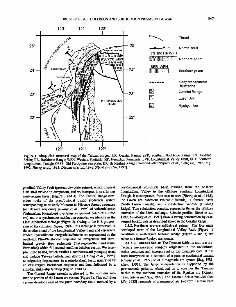
Figure 3. Synthetic cross sections of the northern arc-arc collisional prism (see location in Figure 1): (a) crustal-scale cross-section displaying the arc core passive roof duplex and the two foreland basins; (b) enlargement of the proforeland basin showing the shallow hinterland dipping duplex, the roof thrust sequence, and the synshortening deposits; (c) enlargement of the retroforeland superimposed on the closed forearc basin. Ch. F. Chuchih Fault.
metapelites, marbles, gneisses, migmatites, granitoids, and amphibolites) and of a former forearc and subduction m61ange (eastern Yuli belt: metapelites, glaucophane schists, and exotic blocks of mafic and oceanic rocks). These paired metamorphic belts (Figure 3) were strongly deformed by west-vergent thrusts and overprinted by upper greenschist facies metamorphism [Yen, 1962] during the arc-arc collision.
2.1.2.2. Backbone Range: The Backbone Range exposes a low-grade metamorphosed sl•.:comp!ex di.•ded into two sequences (Figure 2) separated bY •an'•'E0'cene,'h• ........... ••••ne•.•ak [Chang, 1972; Huang, 1980]. The underlying Pilushan Formation (shallow marine siliciclastics, volcanics, and volcaniclastics) was deposited on an Eocene arc-platform. The overlying Lushan Formation (siliciclastic turbidites, and volcanics) recorded a sharp deepening in depositional and tectonic settings. It has been interpreted as accreted into a
subduction wedge and thought as deposited in a slope-trench environment belonging to the Luzon subduction zone [Huang et at., 1997]. We do not agree with this assumption: (1) because the- •IztZOn-subduction wedge can be viewed in the Lichi m61ange which occurs in the area between the subduction surface
(Longitudinal Valley Fault) and the volcanic arc (Coastal Range); (2) because the Backbone Range is involved into a thrust sequence (Tananao Schist, Backbone Range, Lishan
triangle zone, Hsfiehshan Range th..•::.or .dex•.•d from the hinterland; Figure 3) where all the other imbricated slices come from the underlying Eurasia plate. Then we link the Lushan Formation with the Eurasia plate and relate its depositional setting to a collapse of the Ryukyu arc. The Backbone Range is bounded on its western part by an east-dipping fault (Figure 3). Generally this fault does not merge because it is covered by the west-dipping Lishan fault except in the Lishan area (Figure 1)
BRUSSET ET AL.: COLLISION AND SUBDUCTION PRISMS IN TAIWAN
[Tillman and Byrne 1995; Lee et al., 1997]. The Backbone Range is deformed by thrusts associated with asymmetric folds and axial planar cleavage.
2.1.2.3. Itsiiehshan Range: The stratigraphical series of the Hsiiehshan Range are a continuous Eocene to Miocene sequence of shelf to basin environments (Figure 2) that we relate to a back arc basin [Sibuet and Hsu, 1997]: the Tachien Formation (sandstones with volcanic detritus)and the Chiayang Formation (slate-dominated) overlain or laterally replaced by the Paileng Formation (sandstone-dominated) and by several northern equivalents as Tatungshan Formation which includes volcanic rocks regarded as erupted from intrabasinal fissures [Ho, 1988]. These formations belong to a thick Oligocene depocenter overlain by the Aoti Formation (carbonaceous sandstones) and the Sulo Formation (interbedded sandstones and shales) preserved in the northern Taiwan. The Hsiiehshan Range is bounded by two main thrusts (Figure 3): eastward the westdipping Lishan Fault and westward the eastdipping Chuchih Fault. Therefore it is considered as a pop-up [Clark et al., 1993] internally deformed by upright symmetrical folds and subvertical cleavage [Tillman and Byrne 1995].
2.1.2.4. Lishan triangle zone: A buried triangle zone was defined in the Lishan area (Figure 1) by Tillman and Byrne [1995] below the west-vergent Backbone Range front and the east-vergent Lishan fault (Figure 3). The only outcropping constituents are weak deformed sediments [Tillman and Byrne, 1995] which we relate to an inferred cover of an arc-crust- derived basement.
2.1.2.5. Northwestern Foothills: We distinguish two major sedimentary sequences in the Notrhwestem Foothils (Figure 2: an Oligocene to early-middle Miocene precollisional sequence of Wuchihshan to Nankang Formations (shallow marine terrigenous deposits with volcanics) related to the back arc basin margin and a middle Miocene to Pleistocene syncollisional foreland sequence made of Nanchuang to Toukoshan Formations (Figure 2) and evolving from marine to fluvial environments. These two sequences extend westward on the Asian continent cover. Concerning the structure we identify (Figure 3 b) [Ddramond et al., 1996] a hinterland dipping duplex related to a late Miocene to early P liocene syntectonic deposition (Kuechulin Formation) and a roof thrust sequence related to a syntectonic deposition since the late P liocene (Chinshui, Cholan and Toukoshan Formations).
2.1.3. Southern subduetion aeeretionary prism. Three main structural units can be distinguished in the southern subduction accretionary prism. These are, from east to west (Figure 1); the Southern Backbone Range (SBR), the Hengchun Peninsula (HP), and the Southwestern Foothills (WFH). These units belong to a west-vergent fold-and-thrust belt (Figure 2 and 4) which extends southward to the offshore Hengchun Ridge [Reed et al., 1992] and represents the accretionary wedge formed during the late Miocene to present-day Luzon subduction [Pelletier and Stephan, 1986]. Its growth was controlled by thrust propagation toward the Asian continent margin including the Tainan back arc basin and the associated extinct arc newly revealed by gravity anomalies [Sibuet and Hsu, 1997].
2.1.3.1. Southern Backbone Range: We distinguish the Southern Backbone Range in the Backbone Range (Figure 1) because it corresponds to imbricates which imply a basal d6collement level located above the metamorphic basement near
the base of the sedimentary cover (Likuan and Lushan Formations; Figure2).
2.1.3.2.1tengehun Peninsula: The Hengchun peninsula displays successive frontal depocenters which record the deformation-front progression as follows (Figure 2 and 4): (1) Miocene deep sea turbidites of Mutan Formation with mafic to ophiolitic clasts (since 15 to 5 Ma) related to the Southern Backbone Range frontal thrust and (2) Plio-Pleistocene turbiditic (Kenting Formation) to shallow marine (Maanshan Formation) sequences (since 5 to 0.8 Ma) related to the Hengchun thrust.
2.1.3.3. Southwestern Foothills: The southwestern Foothills, a foreland basin [Ddramond et al., 1996] experienced the forward propagation of the following thrust-depocenter sequence (Figure 4): frontal thrust of the Southern Backbone Range- Miocene depocenter (since 15 to 5 Ma) equivalent to the Mutan Formation (buried in the Pingtung syncline; Figure 2 and 7c); Chishan thrust-turbiditic Pliocene Lower Gutingkeng Formation (since 5 Ma to 3 Ma), Lundchung thrust-turbiditic early Pleistocene Lower Gutinkeng Formation (since 3 to 1.6 Ma), Hsiaokunshi thrust-Pleistocene shelfal Upper Gutinkeng Formation (since 0.8 Ma), external blind Meiling thrust (Gong et al., 1995)-shallow marine late Pleistocene Liushang Formation and coeval Kaohsiung coralgal reefs (0.8 Ma to present-day) developed on the top of the associated anticline. A hinterland uplift is recorded by Pleistocene unconformities associated with stratigraphical hiatus and piggyback basin development: deltaic to fluvial Lingkou Formation (since 1.6 to 0.5 Ma) on the hanging wall of the Chishan thrust and reef- lagoon Hengchun to Szekou Formations and alluvial Taiping Formation above the most external thrust of the Hengchun Peninsula.
2.2. D•collement Surfaces and Main Faults
The thrusts bounding and deforming the major structural units of the Taiwan orogen branch at depth onto a basal d•collement surface connected eastward to a subduction plane dipping beneath the Luzon volcanic arc (Figure 3 and 4) as is imaged on the seismic profiles through the offshore of southern Taiwan [Reed et al., 1992]. The main difference between the northern and southern tectonic prisms is due to the location of the leading thrust with respect to the extinct Ryukyu arc crust.
2.2.1. Coastal Range. The Longitudinal Valley Fault corresponds to the Coastal Range-Tananao Schist boundary and is interpreted as a collision zone between the intra-oceanic Luzon arc and the continental Ryukyu arc. A secondary d•collement surface branches onto this fault (Figure 3c and 4) and runs into the Miocene to early Pliocene forearc Tuluanshan Formation (Figure 2). From this surface several thrusts develop eastward with a forward propagation generating a small retroforeland basin filled with Plio-Pleistocene Taiwan-derived
terrigenous sediments. The Coastal Range presents now an en •chelon arrangement stet to a sinistral strike-slip motion along the Longitudinal Valley Fault.
2.2.2. Northern are-are collisional prism. The Ryukyu arc crust (Tananao Schist) is involved in the collisional belt (Figure 3). Indeed, the d6collement level cuts the former Ryukyu arc, using probably two inherited surfaces of the previous detachment systems which have generated the Oligocene back arc basin (Hsiiehshan Trough; Figure 3 and 5a) and the Miocene

BRUSSET ET AL.: COLLISION AND SUBDUCTION PRISMS IN TAIWAN 551
SOUTH
WESTERN BACKBONE RANGE
• c • • c •.o .-o• WESTERN PROFORELAND
+ + + + + + .•- . -.• / • • /, +++++++++++++ -• • • • • X •t /i•./• • '• • ./I • . /1 v
". ' ,•J 3- •--•' 7' •' i•" /•.' •-" ' "• •' /"• _V V ++++ ++ + + + +++ + + + + 7- I ,/. ! ,1. [ + + + + + + + + + + + + + •\.FORMERRYUKYU. ARC i+ + + + + + + + + ,
10Km[ ..... ' ]OKm X,,[ •..• L.u:o.n Tcrus t
!f Pleistocene ! , .I tg•t ' ß
-:': [ I?[••./ Ryukyu arc crest Syncollisiona deposits :•'""•"• Pliocene '_• R•mk•m mafic crust ..... ':: Middle-Late Miocene
_[•q Asian pre-Tertiary basement Precollisional 1"' i ! Old Philippine Sea Plate deposits '• Eocene to Middle Miocene
Figure 4. Synthetic cross section of the southern continental subcluction prism (see location in Figure 1). The crustal-scale cross- section shows the arc core duplex, the roof thrust sequence, and two associated proforeland and retroforeland basins. Note that the buried Tainan basin is not inverted.
arc-collapse basin (Backbone Trough; Figure 3 and 5b). Westward the d6collement surface climbs in the foreland series
and dies out in the Western Foothills where the deformation
front is buried.
2.2.2.1. Tananao Schist-Backbone Range boundary: The Tananao Schist-Backbone Range boundary, called Schist-Slate boundary [Ho, 1988] corresponds to a west-vergent thrust (Figure 3) along which the schists of the Tananao complex (Ryukyu arc crus0 overthrust the slates of the Backbone Range (metasediments of the Backbone Trough). The Tananao Schist is divided by another west-vergent thrust: the Shoufeng Fault [Ho, 1988] between the eastern Yffii belt (Ryukyu forearc mafic crusO and the western Tailuko belt (Ryukyu arc massif crust).
2.2.2.2. Backbone Range-Itsiiehshan Range boundary. Backbone Range-Hsiiehshan Range boundary corresponds to the intersection between two thrusts with opposing vergence forming the buried Lishan triangle zone (Figure 3) [l•llman and Byrne, 1995]. The west-vergent thrust, the true limit of the Backbone Range, is interpreted as a previous normal fault controlling westward the Backbone Trough (Figure 5b). The western east-vergent thrust, the Lishan Fault, appears as the result of the inversion of an antithetic normal fault bordering the easternmost side of the back arc Hsiiehshan Trough [Lee et al., 19971.
The Lishan fault separates the back-arc sediments of the Hsiiehshan Range on its hanging wall from the arc massif and the cover of the Lishan triangle zone and Backbone Range on its footwall, and the Lishan Fault branches onto the basal d6col- lement (Figure 3). This fault appears then as a passive roof thrust in front of a duplex culmination represented by the horses of the triangle zone, Backbone Range, Tailuko belt and Yuli belt. The main faults (Backbone frontal thrust, Schist-Slate Fault, and Shoufeng Fault) are link thrusts in the duplex. The culmination core is constituted by Ryulcyu arc material which is at the present day visible owing to roof erosion.
2.2.2.3. Hsiiehshan Range-Western Foothills boundary: The Chuchih thrust (Figure 3) corresponds to the inverted westernmost fault of the backarc Hsiiehshan Trough (Figure 5a). In the Western Foothills the d6collement surface climbs into less
competent sedimentary units. The Western Foothills duplex stretches out between a .floor thrust located in the Oligocene Wuchihshan Formation and a roof thrust located in the Miocene
Nanchuang Formation (Figure 3b). Fault-propagation folds are linked to this roof thrust.
2.2.3. Southern subruction aeeretionary prism. At the southern end of the Tananao Schist, the metamorphic basement is in fault contact with the Miocene cover, which is involved in the folds and thrusts of the Southern Backbone Range (Figure

552 BRUSSET ET AL.: COLLISION AND SUBDUCTION PRISMS IN TAIWAN
NW • RYUKYU BACK ARC BASIN • .
•uch•hshan • •tuagshan • [ .... BAS•' •._ ,:::: •nown oepos,m
:7' •':-., 1.7' •:-< ! :• • 7..,•- • ..... ß ••c• ø" -
• '?'2• :2 •'-•Arc mawr crust / •%• '' / Sea Plate
69 ARC-COLLAPSE • • SYSTEM o
BACKBONE •
•'•o•:•. t Luzon subduction .Lushan Frn Lushan • • Y' 'C•. ,•':"• , .
• + + + + + + + + + + + + + + +••;• , - / '• /-. : ,• /- / / ----•-- ) + + + • + + + + + + + + •-. .• ...... • •o- • • .......... •u LJshan E•m• and cooling Ryu•u Arc triangle zone
•ddle Miocene
(arerand 15 •)
[:•"::'•:>'• Arc-collapse depocentre Miocene
tOKm Oligocene Backarc .... Forearc ------- setting, 'setting 10Km
Eocene Arc plattbrm Figure 5. Ryukyu subduction evolution (see legend Figure 3 or 4), where Eocene arc platform stage (Pilushan Formation) was followed by two extensional episodes driven by two eastvergent d6collement levels. (a) Oligocene backarc extension related to active subduction. The antithetic Lishan Fault separated the back arc Hstiehshan trough from an arc basement exposed to subaerial erosion (future Lishan triangle zone and Backbone Range); (b) Early-middle Miocene arc-collapse system related to subduction locking and arc extinction: lntra-arc to forearc blocks (Backbone Trough, Tailuko belt, and Yuli belt) were tilted in its hanging wall, and the arc to back arc basement was linked to the Asian continent in its footwall (future Lishan triangle zone and Hstiehshan Range).
1). Indeed, the d6collement level appears localized near the base of this cover, in the Likuan-Lushan Formations (Figure 3). To the west, in the Hengchun Peninsula and Southwestern Foothills, it climbs into less competent units of the foreland series (Figure 4). The presence of mafic and oceanic clasts in the early syntectonic depocenters (Mutan Formation; Kenting Formation) of the Hengchun Peninsula formed in front of the Southern Backbone Range implies a source-rocks of such lithologies in more internal and older imbricates. These can correspond to imbricates of Ryulcyu forearc material linked to
underlying thrusts or, as illustrated in Figure 7a, to the overthrusting Luzon subduction complex represented by the Lichi m61ange.
Gravity anomalies have reveldeal [Sibuet and Hsu, 1997] a back arc basin (Tai!l• basill) btlried ill khe Asian continent margin and arc crust blocks buried below the basal thrust of the Foothills (Figure 4). By comparison to the northern prism, we can interpret this underthrust arc material as the extension of the Ryukyu arc-derived duplex identified in the outcropping Tananao Schist and Backbone Range and in the buried Lishan

BRUSSET ET AL.: COLLISION AND SUBDUCTION PRISMS IN TAIWAN 553
triangle zone. Contrary to the northern collisional prism, the floor thrust does not reach the back arc domain (Figure 4), which indicates a less important shortening in this southern part of the Taiwan orogen.
2.3. Relationships Between Northern and Southern Prisms
West of the Coastal Range (colliding Luzon arc) the defor- mation involves an extinct part of the Ryukyu arc belonging to the Asian continent. The shortening is accommodated in (1) the arc core (Central Range), by duplex between a floor thrust in the arc crust and a roof thrust in the arc cover, and (2) in the proforeland (Western Foothills), by duplex and/or imbricate fans branched onto one of the preceding thrusts and dying out in a buffed tip line which constitutes the deformation front (Figure 3 and 4).
The northern prism records the Luzon-Ryukyu arc-arc colli- sion. The collided arc is upraised in an unroofed duplex culmination, displaying below the Lishan passive roof thrust the Tananao and Backbone horses and the Shoufeng and Schist- Slate link thrusts (Figure 3 and 6c). The thrust system appears as an unroofed duplex culmination and has most of its displacement on the floor thrust. The southern prism records the Eurasia plate subduction in a transition zone between the extinct Ryukyu continental arc and the Old Philippine Sea Ocean. The subducting arc is a part of the flexed Asian continental margin and is shortened by duplex below a roof thrust sequence developed in the Southern Backbone Range, Hengchun Peninsula, and Southwestern Foothills (Figure 4). The thrust system appears as a hinterland dipping duplex and a roof thrust sequence, and has most of its displacement on the roof thrust. The relationships between the two prisms can be explained by the following interfering factors: an oblique convergence [Suppe, 1984], a southward direction of plunge; a reduction in volume of the Ry• arc material in this direction towards its southern end [Sibuet and Hsu, 1997], a difference in depth of the erosional level, and a lateral ramp or a transverse fault zone, both controlled by possible reactivation of deeper structures.
Concerning these deep structures they have been already described [Deffontaines et al., 1997] to induce NNW-SSE transfer fault zones in the Western Foothills. Thus the Sani
transfer fault zone was related to the northern boundary of the Peikang High (Figure 1) recognized by Rau et al. (1998) in a NNW-SSE seismic fault inducing a Moro offset below the Western Foothills and the Hsfiehshan Range. Then we deduce that this lithospheric fault could have guided the lateral ramp needed to connect the collision prism and the subruction prism.
3. Tectonosedimentary Evolution
To illustrate the Taiwan mountain building, we present evolutive cross sections of crustal scale ranging from early Miocene (around 25 Ma) to present-day (Figure 5-7). The geodynamic history is believed to be uniform throughout the entirety of Taiwan until the middle Miocene (around 15 Ma) as long as it was controlled by the Ryukyu subduction zone (Figure 5). The geodynamic history diverges in the two orogenic prisms (Figure 6 and 7) since around 15 Ma when the west dipping Ryukyu subduction was supplanted by the east dipping Luzon subduction linked to the oblique consumption of the intermediate oceanic Old Philippine Sea plate [Sibuet and Hsu, 1997].
3.1. Evolution Controlled by the Ryukyu Subduction
The former Ryukyu subduction zone can be reconstructed as a west dipping arc-trench system NE-SW trending on the boundary between the continental Eurasia plate and the oceanic Old Philippine Sea plate and cut by the inherited intracontinental transcurrent fault zone probably oriented NW- SE. Three successive stages can be distinguished.
3.1.1. Eocene are-platform (until 36 Ma). Sedimentary and magmatic remnants (Pilushan Formation, Tachien Formation) indicate an arc-platform development (Figure 5). A sloping is postulated to the southeast toward a forearc including a marie basement (future Yuli belt) and a subduction complex (not preserved in the collision suture).
3.1.2. Oligoeene backare extension (around 36 to 25 Ma). The systematic eastward progression of the arc system [Sibuet and Hsu, 1997] resulted in extensional back arc basins (Hsfiehshan and Tainan Troughs) driven by an east dipping detachment level located at the base of the Tachien Formation
and descending in the underlying arc crust (Figure 5a). The Hsfiehshan graben [Teng et al., 1991] was limited on the opposite side by an antithetic extensional fault (Lishan Fault) bounding an arc-basement high (future Lishan triangle zone) which experienced a subaerial erosion [Teng et al., 1991 ].
3.1.3. Early-middle Miocene intra-are collapse (around 25 to 15 Ma). The locking of the west dipping subduction and the extensional faulting of the thermally weakened arc crust resulted in an arc-collapse system driven by an east-vergent detachment (Figure 6b). The arc crust stretching created the Backbone Trough (future Backbone Range) and two main blocks (Tailuko belt and Yuli be10 separated by synthetic listtic faults (Schist- Slate Fault and Shoufeng Faul0.
Thus the stopping of the R• subduction had left an Asian continent margin including great heterogeneities: a locked west dipping subduction fault and two east dipping detachment systems. The initial stage chosen for the kinematic reconstructions is at the time when the Ryukyu subduction became inactive, i.e., around 25 Ma (Figure 5b).
3.2. Evolution Controlled by the Luzon Are Progression
Since middle Miocene time, when the east dipping Luzon subduction zone and the north growing Luzon arc reached obliquely the Asian margin, the geodynamic history differs in the two prisms of the orogen.
3.2.1. Northern arc-are collisional prism. The northern extension of the Luzon arc can be reconstructed from records
preserved in the southern part of the Coastal Range. It is viewed as an arc trench system including a subduction complex (Lichi m61ange), a forearc basin (Tuluanshan Formation with terrigenous components of Luzon affinity), and an arc massif (igneous basement). The collision with the Eurasia plate can be subdivided into the stages in sections 3.2.1.1-3.2.1.3.
3.2.1.1. Are-are collision (middle-late Miocene, around 15 to 8 Ma): The Arc-arc collision began after consumption of the oceanic slab of the Old Philippine Sea plate in the Luzon subduction zone. The Luzon and Ryukyu arc crust (Coastal Range and Yuli belt) came in contact, and the Luzon subduction wedge (Lichi m61ange) was uplifted in between (Figure 6a). To a•com•oclate the shortening, the Ryukyu arc-collapse system was inverted in a duplex between the inh•ted intra-arc detachment surface, and a roof thrust developed in the arc cover. _

554 BRUSSET ET AL.: COLLISION AND SUBDUCTION PRISMS IN TAIWAN
$[
WESTERN FORELAND FOREARC BASIN
•.Lichi I•t'elange Tuluanshan F-m _ _ • .... V V V V V
. -"""--• _ . .,,
Late Miocene
(around 8 Ma)
t.< • c:: .- -• e.. -.- ,,--
a:: .- o 09 O ...s 09
PROFORF_J. AND • • f f • RETROFORELAND .,., Kuelchulin Fm [ • .... '"' '" . ß • --- I
Early Pliocene (around 3 Ma)
Figure 6. Luzon arc progression in the northern arc-arc collisional prism: (a) arc-arc collision showing inversion of the arc-collapse system in a duplex and initiation of a proforeland basin; (b) arc-arc indentation showing forward progression, uplift, and erosion of a passive roof duplex; shallow duplex development in the proforeland basin, and initiation of a retroforeland over a closing forearc basin; and (c) frontal thrust propagation and hinterland uplift: growth and erosion of the duplex culmination is coeval to thrust- depocenter propagation in both proforeland and retroforeland basins. LTZ, Lishan triangle zone; TB, Tailuko belt; YB Yuli belt.
The link thrusts propagated in sequence and wor• f0ptr@!l½d by the anisotropy of the precollisional arc system. They O9,1jYpO successively from the following inherited surfaces: (1)•Yi•. • mafic crust/Tailuko arc massif fault contact (Shoufeng thrus, t it0 the Tananao Schis0, (2) arc massif/intra-arc basin fault Cbntaet (Schist/Slate thrust between Tananao Schist and Backbon0 Range), and (3) listtic fault controlling the Backbone Trough
(future frontal thrust of the Backbone Range). Therefore an incipient foreland basin developed westward over the previous back arc area, filled with a depocenter (not preserved), probably located over the future Lishan triangle zone and with a marginal wedge (Nanchuang Formation) overlying the Hsfiehshan Trough and its Asian continent margin
3.2.1.2. Arc-are indentation (late Miocene to early
BRUSSET ET AL.: COLLISION AND SUBDUCTION PRISMS IN TAIWAN 555
ROOF THRUST SEQUENCE
o
r•OFO•L^•D • g • FO•^RC NORTH-LUZON TROUGH f f Uchim•lange ,
'T
NORTH.LUZON TROUGH
_
v v v v v v
v ß LUZONARC
v v
v
._._ .... . ....... ..,=• ............ ..../\_/\.,\_ .•....•: ................. . .................. . ..... 5_/ ..... ...... " ß / / / / "•.;:•:5_..:•5•:•:•>•i: ""•:' / • •5' •_.• / • • +++++++++++++ .... •.:.-,.I,./: .... / ./_// . + + + + + + + + + + + + + + •. ./•_.!!.•..fl.•_! _._. • • •_! • •.• •
.+ + + + + + + + + + + + + + +•+ 5 /•'• /•'[5/•'IG/• •+ + + + + + + + + + + + + z/•, •/•"•/•':, I•I +++++++ •../, -- /, '•
Early Pliocene • • • • • (around 5 •3 • = • • m
•OFORELA_N• • • • • RE•OFO•LA•'D BL•mDTAINAN • • 4 } 4 PhilippineSea
t •. L•o• • ,
10Km
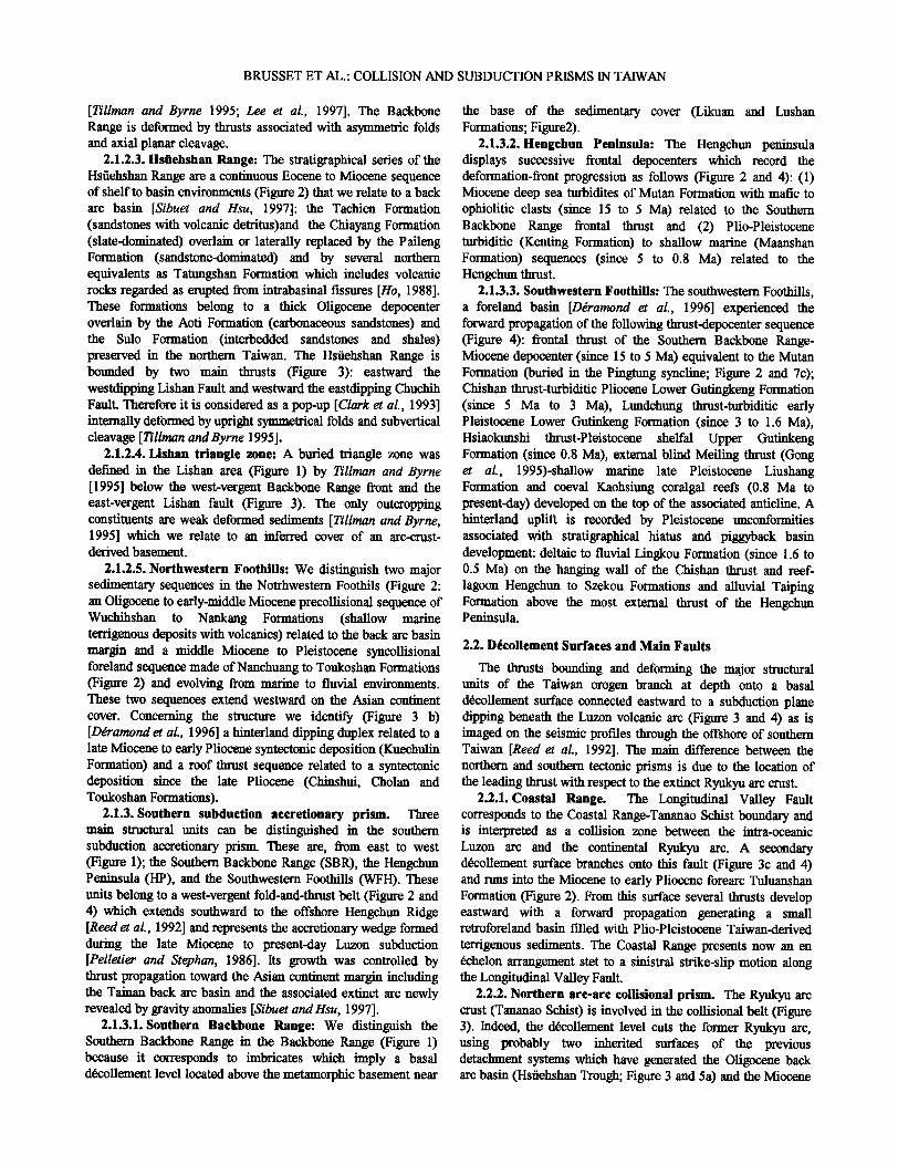
Figure 7. Luzon arc progression in the southern subduction prism (see legend for Figure 4): (a) end of oceanic subduction showing development of duplex in the subducting arc crust associated with a roof thrust sequence in the arc cover and initiation of a deep and continental floored foreland basin; (b) continental subduction showing involvement of western arc-derived horse in the duplex and forward propagation of the roof thrust sequence and migration of the deep marine foreland basin; (c) continental subduction - showing forward progression of the thrust systems and initiation of a retroforeland basin with closure of the Luzon forearc basin.

556 BRUSSET ET AL.-COLLISION AND SUBDUCTION PRISMS IN TAIWAN
WFH
continental plate
lal
HR
Lishan passive roof thrust
Floor Major d6collement
Lithospheric mantle
Roof Major d6collement
Eurasia continental
plate Moho
Plate suture LVF
$E
LzA Philippine Sea plate
LVF
Roof thrust sequence ß
WFH -
LzA
Philippine Sea plate
Lithospheric mantle
Figure 8. Proposed lithospheric-scale model of the Taiwan mountain belt: (b) collisional prism showing arc crust culmination duplex with major floor d6collement controlling the Lishan passive roof thrust and the foreland thrust system. Crustal collision can be accommodated by subduction of the lithospheric manfie (Eurasia plate). TZ, triangle zone; LzA, Luzon arc and (b) subduction prism showing arc crust duplex with major roof d6collement controlled by the subduction of the whole continental lithosphere (Eurasia Plate).
Plioeene, around 8 to 3 Ma): The progression of the collision resulted in the inversion of the former Ryukyu back arc system (Figure 6b). This inversion suggests that the basal d6collement fatfit extended through the Ryukyu arc massif to connect the back arc detachment system and then created the floor thrust of the intermediate Lishan triangle zone. Then the collisional belt grew by a forward propagation of the thrusts as follows: (1) stacking of the Tananao and Backbone thrust horses, which overlap the Lishan triangle zone, (2) frontal progression of the duplex which underthrust the Hsfiehshan Trough changed into the Hsfiehshan Range above the east-vergent Lishan passive roof thrust, and (3) simtfitaneous development of the Chuchih thrust by inversion of the western boundary fatfit of the Hsfiehshan Trough. The westward movement of the thrusts induced the migration of the foreland basin on the flexed Asian continent
margin. Compressive structures were represented by a hinterland dipping duplex (Figure 3b) bounded by a floor thrust located in precollisional series (Wuchihshan Formation) and a roof thrust developed in early syncollisional series (Nanchuang Formation). The associated deposits are only preserved on the continental margin of the foreland basin (Kueichtfiin Formation). Simtfitaneously, the indented Ryukyu arc duplex experienced uplift and unroofmg of its internal horses (Backbone Range and Tananao Schis0 while the indenter Luzon arc underwent an east-vergent backthrusting. Then an eastern retroforeland basin was created by the backthrusting of the Luzon subduction m61ange (Lichi Formation) over the previous Luzon forearc basin and it became the repository of slate detritus (Takangkou Formation) deriving from the Ryukyu duplex culmination.
3.2.1.3. Itinterland uplift and thrust propagation in the

BRUSSET ET AL.: COLLISION AND SUBDUCTION PRISMS IN TAIWAN 557
proforeland and retroforeland basins (since late Pliocene, around 3 Ma): The shortening has been accommodated in different ways (Figure 6c). In the hinterland the Tananao and Backbone horses continued uplifting. In the western proforeland (Figure 3b) the deformation remained dominated by forward propagation of the roof thrust sequence and died out in fault- propagation folds associated with migrating depocenters (Chinshui to Toukoshan Formation and Terrace; Figure 2). In the eastern retroforeland (Figure 3c) the southeastward youngjag trend of the depocenters (Takangkou, Shuilien, and Chimei formations) suggests a kinematic control by forward propagation of the thrusts toward the Luzon arc. The strike slip along the arc- arc suture (Longitudinal Valley Fault) postdates the thrust evolution reconstructed stet.
3.2.2. Southern subruction accretionary prism. In the plate setting of the east dipping Luzon subduction zone the evolution concerns the transition from an oceanic subduction, active south of Taiwan (Manila trench), to a continental subduction, active in the Taiwan island. The subduction of the oceanic slab of the Old Philippine Sea plate led to an east dipping arc-trench system including a submarine accretionary wedge (Huattmg ridge, Lichi m61ange), a forearc basin (North Luzon Trough) and an intra-oceanic arc massif (Luzon arc, Coastal Range). The subsequent subduction of the flexed Asian continent margin induced the shortening of the downgoing Ryukyu arc crust by development of a duplex in the arc massif and a roof thrust sequence in the arc cover and synshortening deposits. This evolution can be subdivided into diachronous stages occurring in the conditions of time-space equivalence (Figure 7).
3.2.2.1. Ryukyu are duplexing and deep-marine foreland basin (middle-late Miocene, around 15 to 8 Ma): The accretionary prism can be drawn as a blind leading imbricate fan (incipient Southern Backbone Range) branched onto the roof thrust of the first horse of the underlying duplex (Figure 7a). In front of this incipient fold and thrust belt, the trench evolved into a continental floored foreland basin receiving (Mutan Formation in Hengchun Peninsula), longitudinally, deep water turbidites of northern provenance and, transversely, ophiolitic olistostromes recycled from the uplifted subduction m61ange (Lichi Formation).
3.2.2.2. Luzon are progression and submarine to subaerial aeeretionary prism (since late Miocene, around 8 Ma): AS far as the Luzon arc continued its northwestward progression, the crustal duplex involved more western horses and the roof sequence propagated westward (Southwestern Foothills and Hengchun Peninsula; Figure 7b and 7c). This thrust sequence induced the development of a foreland basin infilled with westward propagating depocenters successively involved in the fold and thrust belt (Figure 7c). The uplifted hinterland experienced subaerial erosion and piggy-back basin development related to out-of-sequence and/or reactivated thrusts. In the Luzon arcward flank of the orogenic prism, the Luzon accretionary wedge (Huatung Ridge, Lichi m61ange) backthrust and closed the forearc basin (North Luzon Trough) as recorded by seismic profiles [Reed et al., 1992; Lundberg et al., 1997].
4. Statements on Lithosphere Growth
According to the tcctonoscdimcntary model proposed in section 3., the growth of the lithosphere in the Taiwan mountain
belt is due to thrust tectonics controlled by two major surfaces (Figure 8). The higher is the Benioff-Wadati surface between the Eurasia and Philippine Sea plates. It induced the superposition of the lithospheres in southern Taiwan and the juxtaposition of the arc crests along the Longitudinal Valley Fault in northern Taiwan. The lower is a detachement fault located into the
Eurasia plate and climbing from the Moro to the deformation front. It corresponds to a detachment level inherited from the stretching of the arc bordering the Asian continent and reactivated by the continental subduction. It induced an intracmstal duplexing of the arc material. In the southern continental subduction prism (Figure 8a), only the arc massif is cut by the floor thrust, and most of the displacement is transferred on the roof thrust. In the northern arc-arc collisional
prism (Figure 8b), most of the displacement is on the floor thrust, which reaches the backarc and the Asian continent.
We suggest that the oblique plate convergence was accom- modated by the eastward subduction of the Eurasia continental lithosphere below the southern subduction prism (Figure 8a) and by the subduction of the Eurasia lithospheric mantle below the northern arc-arc collisional prism. One question arises now: where is the oceanic slab of the Old Philippine Sea plate ? Is it detached along the west dipping surface of the former Ryukyu subduction zone and sinking at depth (figure 7b) generating the rapid isostatic uplift of the Central Range ?
According to the above proposed model, the whole lithosphere is involved in the Taiwan mountain belt, contrary to the current continent-arc collision model in which, essentially, sediments are folded and uplifted [Suppe, 1981; Teng, 1990]. Our model seems consistent with the recent tomographic imaging [Wu et al., 1997] which indicate that the shortening concerns the whole lithosphere.
5. Conclusions
The revised geotectonic framework of the Taiwan mountain belt agrees with the hypothesis of an oblique convergence between the intra-oceanic Luzon arc and an extinct part of the Ryukyu arc belonging to the Asian continent [Sibuet and Hsu, 1997]. The structural evolution was successively controlled by the Ryukyu subduction and, since the middle Miocene (around 15 Ma), by the Luzon arc progression. East of the suture (Longitudinal Valley Fault) the Coastal Range, which constitutes the northern extension of the colliding Luzon arc includes a retroforeland basin recording an arc-arc indentation. West of the suture the deformation involves the southern extension of the
Ryukyu arc system and a proforeland basin. The thrust structures have been controlled by a d•collement level branching onto the Luzon subduction surface. This floor thrust is located in the arc
crust and determines a duplex in the arc massif and attached cover (Tananao and Backbone horses and buried Lishan triangle zone). Roof thrusts develop in the detached arc cover generating an eastvergent passive roof thrust (Lishan Fault) and a west- vergent roof thrust sequence (Southern Backbone Range). Proforeland thrusts are driven by the floor thrust (Northwestern Foothills) or by the roof thrust (Hengchun Peninsula and Southwestern Foothills).
The northern arc-arc collisional prism is characterized by an tinroofed duplex culmination associated with passive roof thrust (Central Range) and by shallow hinterland dipping duplex associated to fault-propagation folds (Foothills) and by both

558 BRUSSET ET AL.: COLLISION AND SUBDUCTION PRISMS IN TAlWAN
proforeland and retroforeland basins. The maximum displacement is on the floor thrust. The prism can restfit from Eurasia lithospheric mantle subduction. The southern continental subduction prism is characterized by a crustal hinterland dipping duplex associated with roof thrust sequence. The maximum displacement is on the roof thrust. This prism restfits from the subduction of a Eurasia continental lithosphere.
The N-S difference in duplex pattern and leading thrust is believed to be controlled by an inherited lithospheric fatfit zone.
Acknowledgments. We wish to thank J. Angelier for thoughtful discussions. Special thanks are due to O. /• Pfi•er for his attention concerning our work and his conslructive comments. We are grateful to an anonymous reviewer for helpful comments.
References
Angelier, J., Preface, Tectonophysics, 125, IX-X, 1986. Biq, C., Collision, Taiwan-style, Me• Geol. $oc.
China, 4, 91-102, 1981. Biq, C., Another Coastal Range in Taiwan, Ti-chi, 12, 1,
1-12, 1992.
Boyer, S. E., and D., Elliott, Thrust systems, AAPG Bull., 66, 1196-1230, 1982.
Chang, L.-S., Eocene/Miocene hiatus and N conglomerate in the Central Range, Proc. Geol. Sec. China, 15, 93-98, 1972.
Chen, P.-Y., Basaltic-andositic volcanic rocks from the areas of Changshinchiao and Hsiangyang southern E- W cross island highway, Taiwan, Spec. Publ. CenL Geol. Sum., 2, 1-3, 1991.
Clark, M. B., Fisher, D. M., Lu, C. Y., and Chon, C. I-L, Kinematic analyses of the Hsõehshan Range, Taiwan: A large-scale pop-up structure, Tectonics, 12, 205- 217, 1993.
Deffontaines, B., O., Lacombe, J., Angelier, H.T., Chu, F., Mouthereau, C.T., Lee, J., D6ramond, J.F., Lee, M.S., Yu, and P.M., Liew, Quaternary transfer faulting in the Taiwan Foothillg: Evidence from multisource approach, Tectonophysics, 274, 61-82, 1997.
D6ramond, J., B., Delcaillau, P., Souquet, J., Angelier, I-L-T, Chu, J.-F., Lee, T.-Q., Lee, P.-M., Liew, T.-S., L/n, and L., Teng, Signatures de la surrection et de la subsidence dans les bassins d'avant-cha•me actit•: Les
Foothills de Taiwan (do 8 Ma i l'Actuel), Bull Sec. Geol. Fr., 167, (1), 111-123, 1996.
D&amond, J., P., Souquet, M.-J., Fondocave-Wallez, and M., Specht, Relationships between thrust tectonics and sequence stratigraphy surfaces in foredeeps: Model and examples from the Pyrenees (Cretaceons- Eocene, France, Spain), Geol. $oc. Spec. Publ., 71, 193-219, 1993.
Gong, S.-H., T.-Y, Lee, J.-C., Wu, S.-W Wang, and IC- M., Yang, Possible • between Plio-Pleistocene reef development and thrust migration in the South- western Taiwan, paper presented at ACT, The international conference and 3rd Sine-French
Symposium on "Active Collision in Taiwain", Taipei, Geol. Sec. of China, 1995
He, C. S., An introduction to the geology of Taiwan: explanatory text of the geological map of Taiwan, Cent Geol. $urv., Minist. of Econ. Affairs, Taipei, Republic of China, 1988.
Huang, C.-Y., P. B., Yuan, S.-R., Song, C.-W., Lin, C., Wang, C.-T., Shyu and B., Karp, Field guide to the
tectonics of short-lived intra-arc basins in the arc-
continent collision terrane of the Coastal Range, eastern Taiwan,. paper presented at ACT, The international conference and 3rd Sine-French
Symposium on "Active Collision in Taiwain", Taipei, Geol. Sec. of China, 1995
Huang, C.-Y., W.-Y., Wu, C.-P., Chang, S., Tsao, P.-B., Yuan, C.-W., Lin, X., Kuan-Yuan, Tectonic evolution of accretionary prism in the arc-continent collision terrane of Taiwan, Tectonophysics, 281, 31-51, 1997.
Huang, T.-C., Calcareons nannofofossils from the slate terrane west of Yakou, Southern Cross-Island Highway, Petrol. Geol. Taiwan, 17, 59-74, 1980.
Ki_saki, IC, Geology and tectonics of the Ryukyu island, Tectonophysics, 186, 193-207, 1986.
Lee, J.C., l., Angelier, and H.T., Chu, Polyphase history and kinematics of a complex major fault zone in the northern Taiwan mountain belt: The Lishan fault, Tectonophysics, 274, 97-115, 1997.
Lundberg, N., D. L., Reed, C.-S., Liu, and l., Lieske, Jr., Forearc-basin closure and arc accretion in the
submarine suture zone south of Taiwan, Tectonophysics, 274, 5-23, 1997.
Odin, G.S., Geological Time scale, C. R. Acad $ci., 318, 59-71, 1994.
Pelletier, B. and J.-F., Stephan, Middle Miocene obduc- fion and late Miocene be•nnin E of the collision registered in the Hengchun peninsula: geodynamic implications for the evolution of Taiwan, Tectono- physics, 125, 133-160, 1986.
Rau, R. J., Lee, J.C., Kao, I-L, and Chu, H.T., Origin of a 80 km long NW-SE trending seismic zone in North- western Taiwan: A consequence of Moho offset and stress concentration, Paper presented at Annual Meeting Geol. Sec. of China, ChunEli• Taiwan, 1998.
Reed, D.L., N., Lundboig, C.-S., Liu, and B.-Y., Kuo, Structural relations along the margins of the offshore Taiwan accretionary wedge: Implication for accretion and crustal kinematics, Acta Geol. Taiwar•, 30, 105- 122, 1992.
Sibuet, J.-C., and S.-IC, Hsu, Geodynamics of the Taiwan arc-arc collision, Tectonophysics, 274, 221-252, 1997.
Specht, M., J., D6ramond, and P., Souquet, Relations tectonique-s6dimontation dans les bassins d'avant- pays: Utilisation des surfaces stratigraphiques
isochrones cornroe marqueurs. de la d6formation, Bull. $oc. Geol. Fr., 162(3), 553-562, 1991.
Stephan, J.-F., 1L, Blancbet, C., Rangin, B., Pelletier, J., Letouzey, and C., Muller, Geedynamic evolution of the Taiwan-Luzon-Mindoro belt since the Late
Eocene, Tectonophysics, 125, 245-268, 1986. Suppe, J., Mechanics of mountain building and
metamorphisim in Taiwan, Merr• Geol. Sec. China, 4, 6%89, 1981.
Suppe, J., Kinematics of an arc-continent collision, •p- ping of subdu•tion, and back-arc spreading near Taiwan, Proc. Geol. Sec. China, 6, 21-34, 1984.
Teng, L. S., Geotectonic evolution of the late Cenozoic arc-•ontinent collision in Taiwan, Tectonophysics, 183, 53-76, 1990.
Teng, L. S., Y., Wang, C.-H., Tang, C.-Y., Huang, T.-C., Huang, M.-S. Yu, and A., Ke, Tectonic aspects of the Paleogene dopositioual basin of Northern Taiwan, Proc. Geol. $oc. China, 34(4), 313-336, 1991.
Tillman, K.S., and T.B., Byrne, Kinematic analysis of the Taiwan Slate Belt, Tectonics, 14, 322-341, 1995.
Wu F.T., R.-J. Rau and D. Salzberg, Taiwan orogeny: Thin-skinned or lithospheric collision?, Tectono- physics, 274, 191-220, 1997.
Yen, T.P., The grade of metamorphism of the Tananao schist, Bull. Geol. $urv. Taiwan, 5, 101-108, 1962.
S. Brusset, J. D6ramond, and P. Souquet, Dynamique des bassins, Universit6 Paul Sabatier, 38 rue des 36 ponts, F-31 400 Toulouse, France. (Geostmc•cict. fr)
H.-T. Chu, Central Geological Survey, MOEA, PO Box 968, Taipei, Taiwan.
B. Deffontaines, D6partement de CJ6otectonique, URA 1759, Universit6 Pierre et Marie Curie, T.26, El, Case 129, 4, place Jussieu, F-75 252 Paris Cedex 05, France.
S.-K. Hsu, Institute of Oceanography, National Taiwan University, Taipei, Taiwan.
J.-C. Sibuct, Centre de Brest, Institut Francais de Rechcrchc pour I'Exploitation de la Met, BP 70, F-29 280 PIouzan6, France.
(Received October 6, 1997; revised December 28, 1998; accepted January 11, 1999.)