Participatory Planning for a Promised Land: Citizen-Led ...
339
Antioch University Antioch University AURA - Antioch University Repository and Archive AURA - Antioch University Repository and Archive Antioch University Full-Text Dissertations & Theses Antioch University Dissertations and Theses 2010 Participatory Planning for a Promised Land: Citizen-Led, Participatory Planning for a Promised Land: Citizen-Led, Comprehensive Land Use Planning in New York’s Adirondack Park Comprehensive Land Use Planning in New York’s Adirondack Park Ann Hope Ruzow Holland Follow this and additional works at: https://aura.antioch.edu/etds Part of the Climate Commons, Communication Commons, Ecology and Evolutionary Biology Commons, Environmental Law Commons, Environmental Studies Commons, Geographic Information Sciences Commons, Natural Resources and Conservation Commons, and the Natural Resources Management and Policy Commons
-
Upload
khangminh22 -
Category
Documents
-
view
3 -
download
0
Transcript of Participatory Planning for a Promised Land: Citizen-Led ...

Antioch University Antioch University
AURA - Antioch University Repository and Archive AURA - Antioch University Repository and Archive
Antioch University Full-Text Dissertations & Theses Antioch University Dissertations and Theses
2010
Participatory Planning for a Promised Land: Citizen-Led, Participatory Planning for a Promised Land: Citizen-Led,
Comprehensive Land Use Planning in New York’s Adirondack Park Comprehensive Land Use Planning in New York’s Adirondack Park
Ann Hope Ruzow Holland
Follow this and additional works at: https://aura.antioch.edu/etds
Part of the Climate Commons, Communication Commons, Ecology and Evolutionary Biology
Commons, Environmental Law Commons, Environmental Studies Commons, Geographic Information
Sciences Commons, Natural Resources and Conservation Commons, and the Natural Resources
Management and Policy Commons

Department of Environmental Studies
DISSERTATION COMMITTEE PAGE
The undersigned have examined the dissertation entitled:
Participatory Planning for a Promised Land:
Citizen-led, Comprehensive Land Use Planning in New York’s Adirondack Park
presented by Ann Hope Ruzow Holland,
candidate for the degree of Doctor of Philosophy and hereby certify that it is accepted*.
James Jordan, Ph.D., Committee ChairCore Faculty and Director of MS Program, Department of Environmental Studies, AntiochUniversity, New England
Steven P. Guerriero, Ph.D., Committee MemberDean, School of Graduate Studies, Chestnut Hill College
Robert F. Baldwin, Ph.D., Committee MemberAssistant Professor, GIS and Conservation Biology, Department of Forestry and NaturalResources, Clemson University
Defense Date: November 22, 2010
Date Approved by all committee members: November 22, 2010
Date Submitted to the Registrar’s Office: December 21, 2010
*Signatures are on file with the Registrar’s Office at Antioch University New England

Participatory Planning For A Promised Land:
Citizen-Led, Comprehensive Land Use Planning in New York’s Adirondack Park
by
Ann Hope Ruzow Holland
A dissertation submitted in partial fulfillment of
the requirements for the degree of
Doctor of Philosophy
Environmental Studies
at
Antioch University New England
2010

©Copyright by Ann Hope Ruzow Holland 2010All Rights Reserved

i
Dedication
To David, Leslie Faith, and Briana Flo
With all my love and heart-felt thanks
For having strong hands and holding tight to my coat-tails
During the wild ride of the last four and one half years.

ii
Acknowledgements
The past ten years have been quite challenging for me. Losing my parents was especially
difficult for me because my Mother and Father, Renee and Teddy Ruzow, helped raise my
children, counseled me on my business, lived next-door, and were my best friends. On the heels
of my parents’ deaths came dramatic career and family alterations. My fledgling children grew
up and flew the coop. Menopause arrived. Life had unceremoniously dropped me on my bum. I
needed to revive myself. Some men and women buy shiny, bright-colored sports cars or
motorcycles or conduct illicit affairs with younger partners. I was not inclined to these options.
I pursued a Ph.D.
My precipitous arrival at Antioch University began with a frank conversation with my
very dear friends, Beverly and her late Husband, Jerry Reuter, about the pitfalls of pursuing a
terminal degree at the ripe age of fifty. When I could see more reasons than not to abandon the
endeavor, Jerry provided persuasive and logical counterpoints. His argument was benevolently
delivered in favor of a terminal degree. From the Reuter’s living room to Antioch’s doorstep
involved two phone calls. The first was with my long time friend, mentor, and mensch, Mark
Lapping, Distinguished University Professor and Executive Director Muskie School of Public
Service. Mark questioned me about my intentions, and once satisfied that I understood the
realities of the world I wished to enter, directed me to Mitch Thomashow at Antioch. A second
call followed and within weeks I was on my way to admission to the Environmental Studies
Ph.D. program. I want to acknowledge Beverly Reuter’s and Mark Lapping’s initial and
ongoing mentoring and friendship. They have patiently encouraged my academic work. And to
Jerry Reuter, wherever his soul flies, my thanks for his special role in placing my feet on this
path.

iii
It takes a community to write a comprehensive plan, many hands to produce a
dissertation. My Husband and Daughters watched me with concern as my stamina was tested
when sixteen hour days, seven days a week became the norm. They endured my absence from
daily activities and made efforts to cover my chores-not for weeks, but for years. My animals
suffered my neglect. Friends found new, polite ways of inquiring about my status and progress,
and wondered when we might get together. The Antioch Ph.D. Cohort (aka the Growhort)
provided unquestioned peer support and counseling, friendship and companionship. For all your
efforts on my behalf, could I love you more? Thank you.
Naming every person, organization or agency that made a contribution to this endeavor is
not possible, but to those of you who have gone un-named, please be assured that you have my
sincere appreciation and thanks for your participation in this work. I want to specially thank the
Town and citizens of Willsboro for participating in this project. A particular thanks to the
Willsboro Comprehensive Plan Steering Committee, Co-Chairs Bill Bardeen and John Oliver,
members Marty Stratton, Anne Lincoln, and citizen volunteers Sue Prud’homme, Ann Spilling,
and Cindy Pytlak for their help with the compilation of data. Thanks also to website master,
Darren Darrah for making internet access to data convenient, to Jim Kinley and Ashley Walker,
of the Zoning Office for their time and dedication to the effort. Two longtime family friends,
Peter Paine and Ed Hatch of Willsboro, provided essential and unique historical perspectives and
I thank them for giving me the benefit of their viewpoints. Gerry Smith of NRCS, and John
Banta, Barbara Rottier, and Jim Connelly of the Adirondack Park Agency provided great
assistance to me (and the community). The response from my colleagues on the faculty at the
Center for Earth and Environmental Science at Plattsburgh State University when I called upon
them to assist was outstanding. Thank you to Eileen Allen for her assistance with GIS technical

iv
services. Thanks also to Ken Adams, Dave Franzi, Danielle Garneau, Ed Romanowicz, and Tim
Mihuc for participating as subject-matter experts and to Dave Franzi for his technical advice.
Ken's, Dave’s, and Danielle’s collegial encouragement of my research, and Arts and Sciences
Dean, Kathy Lavoie’s, periodic inquiry into my progress and sage advice are sincerely
appreciated.
Composing and compiling the dissertation is not a small undertaking for a person with
limited technological experience. I extend special thanks to Donna Haynes, Keith Eighmey, and
Brendan Sullivan, for their work on formatting, GIS Maps, and graphics. Mary Dossin and
Murray Shor were especially helpful as outside readers to reflect back what I wrote and verify its
soundness.
Academic relationships with members of the Antioch faculty and staff contributed in
many ways to my dissertation and degree. Of special note, Jean Amaral’s excellent assistance,
always prompt, efficient and practical, was priceless. Special thanks to long-time mentors Joy
Ackerman and Steve Chase for their faith in me, and sincere appreciation to Tania Schusler and
Charles Curtin for providing valuable insights and advice during the drafting of the dissertation.
I want to extend my now transformed scholarly hand and tired, but happy heart to Jim
Jordan, Steve Guerriero, and Rob Baldwin, the members of my Dissertation Committee. From
my first contact with Rob in the fall of 2006 he has been an exceptional colleague and advisor,
providing me with clear and concise guidance. Rob made it his business to understand my
scholarly intentions and professional viewpoints. Thank you so much, Rob, for choosing to see
my dissertation research through to its conclusion and for giving me the benefit of your wise
counsel.

v
I felt very privileged that Steve Guerriero, a popular faculty member and highly respected
social scientist, agreed to collaborate with me on my doctoral studies and then serve on my
committee. Steve challenged me to understand and then justify an entirely new methodological
framework and historical philosophical context for my research. He was perceptive, available
when I called for assistance, and understood my nature, knowing how and when to push and prod
me. Steve’s feedback was always in a currency that was thought-provoking and practical. Steve,
my sincere thanks--for giving me the opportunity to learn about my new research area--and
myself.
Jim Jordan has exemplified the characteristics of the ideal dissertation committee Chair
and for that I send many blessings and thanks, not only to Jim, but upwards to the sky. He has
been prompt and available, honest and diplomatic, constructive in his criticism, and strong in his
leadership of our team. Jim’s tone and approach has been collegial and instructive, yet
sympathetic and intuitive. As good team members should, and without problems associated with
ego, Jim (and Rob as well) were able to defer to Steve in methodological matters that were
outside their area of their expertise. I couldn’t have had a better Chair and I am eternally grateful
to Jim for leading this effort to a successful conclusion.
Teddy and Renee might not have imagined that after their death I would write a Ph.D.
dissertation. They might have wryly envisioned a long-winded memoir having to do with land
and the Adirondacks. So I conclude my acknowledgements with blessings and thanks to my
Parents. Thanks for giving me broad shoulders, stamina, and the force of character to carry my
scholarship forward to fruition from the seed of an idea.

vi
Participatory Planning for a Promised Land:Citizen-led, Comprehensive Land Use Planning
in New York’s Adirondack Park
Abstract
New York’s Adirondack Park is internationally recognized for its biological diversity. Greater in
size than Yellowstone, Everglades, Glacier, and Grand Canyon National Park combined, the
Adirondacks are the largest protected area within the Northern Appalachian/Acadian Eco-Region
and within the contiguous United States. Ecologists, residents of the Park, and others are
concerned about rapid land use change occurring within the borders of the Park. Almost half of
the six million acres encompassed by the Park boundary is privately-owned, where 80% of land
use decisions fall within the jurisdiction of local governments. The comprehensive planning
process of one such local government, the Town of Willsboro, New York, was the focus of a
Participatory Action Research (PAR), single case study. Using a PAR, mixed methods approach,
community-led comprehensive planning integrated natural science, technology and citizen
participation. I evaluated the role of PAR in helping to transform conventional land use planning
practice into a more democratic, environmentally conscious, and durable civic responsibility.
Stakeholder viewpoints about the local environmental setting revealed deep connections to
nature. Findings of the research indicate that comprehensive land use planning capacity
increases when citizens increase their scientific and ecological literacy, especially when tools
such as Geographic Information Systems (GIS) are used for data collection and analysis.
Applying ecologically-based comprehensive planning utilizing a PAR framework improved
citizen’s confidence in land use decision-making and also expanded science literacy. PAR holds
great promise as a methodological framework to bring together ecologically-focused natural

vii
science with citizen-led collaborative land use planning. Areas of further research identified
during this study include assessing age-specific gaps in stakeholder participation, evaluating the
relationship between plan recommendations and regulatory implementation, and investigating
factors that contribute to a culture of community engagement. Local land use planning decisions
have important cumulative impacts on protected area land development at the local and regional
scale. A comprehensive plan can reflect an emergent process, where the primacy of community
self-determination and consensus-building yields recognition of the link between, and sanctity of,
nature, home, and homeland.
The electronic version of this dissertation and auxiliary data files are freely available
through the OhioLINK Electronic Theses and Dissertations Center, http://etd.ohiolink.edu/.
Keywords: Adirondack Park, Comprehensive Planning, Land Use, Participatory Action Research,
Collaborative Land Use Planning, Ecological-based Planning, Environmental Planning,
Conservation Planning, Collaborative Planning, Science Literacy, Single Case Study, Mixed
Methods Approach, Protected Areas, Rapid Land Use Change, Amenity-Rich Areas, Rapid Land
Use Change, Community-based Decision-making.

viii
TABLE OF CONTENTS
Dedication ........................................................................................................................................ iAcknowledgements......................................................................................................................... iiAbstract .......................................................................................................................................... viTable of Contents......................................................................................................................... viii
Chapter One: Contemplating the Four Corners: Comprehensive Planning at theCrossroads .......................................................................................................................1
Introduction......................................................................................................................................2Land Use Change, Open Space Preservation, Environmental Planning, and Civics...................2The Comprehensive Plan’s Legal Role in the Municipal Setting................................................3
An Exploration of Ecology, Planning, and Civic Engagement in Community-basedComprehensive Land Use Planning: A Literature Review..............................................................6
The Art and science of the Comprehensive Plan: A retrospective. .............................................6Comprehensive Land Use Planning and Civic Engagement .........................................................16Comprehensive Land Use Planning and Natural Science..............................................................19
Planning Terminology ...............................................................................................................19The Contributions of Natural Science to Comprehensive Planning ..........................................20
Integrating Theory and Praxis: Planning, Science and Citizen Participation ................................25
Chapter Two: Conducting the People's Research through Comprehensive Planning:The Theoretical Framework for Participatory Action Research and LandUse Planning ..................................................................................................................27
Planning Theory, Participation, and the People’s Research ..........................................................28Overview: Participatory Action Research Taxonomy and Nomenclature.....................................30Dominant Features of the Historical Landscape: Knowledge, Power and Purpose ......................32
The Common Ancestral Roots of Critical Theory and Planning...............................................32Jurgen Habermas, Social Discourse, and the Theory of Communicative Action......................35
Iconic Pathways to Follow: Equity, Discourse and Action ...........................................................39Kurt Lewin .................................................................................................................................39The Role of Lived Experience. ..................................................................................................40Dialogue.....................................................................................................................................42Inquiry........................................................................................................................................43Repairing the World...................................................................................................................44
Participatory Action Research and Planning Research..................................................................44Converging Theory and Praxis to Enable Citizen-Led Research ..................................................46
Chapter Three: At the Tipping Point: Private Land Use Planning in theAdirondacks...................................................................................................................48
The Politics of Sacred Space: A Brief History ..............................................................................49Jurisdiction of the Adirondack Park Agency within the Blue Line ...........................................52
Elegant in Design, Compromised by Politics ................................................................................53The “Patchwork Quilt” of Public and Private Lands .................................................................58State Action, Home Rule and Local Land Use Control.............................................................66

ix
A Two Tiered Approach to Land Use Regulation .....................................................................69Political Will, Social Capital, and Proactive Diplomacy: Willsboro and the Adirondack
Park Agency....................................................................................................................74Local Planning in the Context of Adirondack Park Regional Planning: A Blind Spot .................76Cumulative Growth Impacts ..........................................................................................................84
Chapter Four: Emergent Design to Achieve Empowerment, Engagement andEcological Awareness In Willsboro, New York: An Adirondack Park LocalPlanning Case Study .....................................................................................................86
Town-Level Comprehensive Planning in the Adirondack Park: The Research Problem..............87Framing the Research ...................................................................................................................89
The Research Questions.............................................................................................................89PAR Overarching Approach ......................................................................................................90Single Case Study ......................................................................................................................92Case Study Limitations and Delimitations ................................................................................94
The Case Study Site: Willsboro, New York -- “Where the Mountains Meet the Lake” ...............95Willsboro: An Adirondack Park Local Planning Case-in-Point ..................................................103Mixed Research Methods for Data Collection and Analysis: Emergent Design to Achieve
Empowerment, Engagement, and Ecological Awareness.............................................106Description of Individual Methods ..........................................................................................109
Chapter Five: Willsboro, New York Case Study: Utilizing PAR Methodology, SingleCase Study Approach, and Mixed Methods Data Collection to YieldResults ..........................................................................................................................127
Overview: Results ........................................................................................................................128Research Questions..................................................................................................................129Research Methods, Results, and Research Questions..............................................................129
Presentation of Results: Methods 1-7 ..........................................................................................133Method 1: Steering Committee Stakeholder Selection, Formal and Informal
Participation Pathways..................................................................................................133Method 2: August, 2009, Listening Sessions...........................................................................144Method 3: Development, Launch, Completion and Results of Community Survey ...............151Method 4: Discussions with Natural Science Subject-Matter Experts ....................................171Method 5: Results of Community Based Field Work and Development of GIS for
Community Profile and Analysis Work........................................................................174Method 6: Results of Decentralized Visioning Sessions and Straw-man Visioning
Statement.......................................................................................................................183Method 7: Results of Work Sessions with Straw-man Versions and GIS Map Analysis
to Develop Environment and Land Use Recommendations .........................................198PAR: A Relevant, Flexible, Data-Rich Planning Method ...........................................................217
Chapter Six: Life in the Promised Land: Merging Science with Politics, Preferencesand Property. Discussions and Conclusions ...........................................................................218The Four Corners of the Case Study: Discussion of the Research Results .................................219
Research Question # 1 .............................................................................................................219Research Question # 2 .............................................................................................................222
x
Research Question # 3 .............................................................................................................232Research Question # 4 .............................................................................................................238
Conclusions..................................................................................................................................242Participatory Action Research (PAR): An Effective Planning Framework.............................242The Inflective PAR Paradigm for Land Use Planning: Linking Planning, Participation,
and Science ...................................................................................................................244Local Planning in the Adirondack Park: How are we Going to Save Tomorrow?..................247Limiting Factors: Access to Best Available Science, Technology, and Planning
Resources ......................................................................................................................250Big Fish in a Small Pond: Coping Strategies when Confronted with Contested Power
and Home Rule .............................................................................................................252Participation, Decision-Making, and the Challenges of Acquiring Local Power and
Knowledge ....................................................................................................................253
Literature Cited ............................................................................................................................257
Appendix 4.1 Recruitment Survey.........................................................................................303Appendix 4.2 August, 2009 Listening Session Agenda, Workshop Questions .....................305Appendix 4.3 Community Survey..........................................................................................306Appendix 4.4 Roundtable Technique Debriefing ..................................................................322Appendix 5.0a Willsboro Steering Committee Stakeholder Engagement Analysis................323Appendix 5.1a August Listening Session Final Report ...........................................................323Appendix 5.1b Generative Themes Allocation ........................................................................323Appendix 5.2 Summary Report from Survey Monkey ..........................................................323Appendix 5.3a Visioning Session Final Report .......................................................................323Appendix 5.3b Visioning Focused Coding Analysis ...............................................................323
List of Tables
Table 1.1 Principles of Smart Growth.....................................................................................15Table 2.1 Illustrative Representation of PAR Nomenclature ..................................................31Table 3.1 Density Guidelines and Land Use Classifications for the APA Land
Use and Development Plan. ....................................................................................58Table 3.2 State Land Classification Definitions......................................................................60Table 3.3 Results And Benefits Of APA Approval Of A Local Land Use Program ..............71Table 3.4 Local Land Use Programs Approvals .....................................................................73Table 3.5 Comparison Between Regulatory Authority of Local Governments and
the APA 1990-1999.................................................................................................78Table 3.6 Top Ten Towns, New Structures Permitted, 1990-1999.........................................79Table 3.7 2009 Status of Land Use Planning in Adirondack Park Towns and
Villages....................................................................................................................81Table 4.1 Hydrology of Willsboro ........................................................................................101Table 5.1 Citizens Advisory Committee Stakeholder Profile ...............................................134

xi
Table 5.2 Willsboro Comprehensive Plan Steering Committee-Agency Partners-As Appointed: Stakeholder Engagement Profile...................................................138
Table 5.3 Citizen Attendance at Public Workshops: Stakeholder EngagementAnalysis: Finding ..................................................................................................141
Table 5.4 Citizen Attendance at Monthly Steering Committee Meetings:Stakeholder Engagement Analysis: Finding .........................................................142
Table 5.5 Sample Survey Responders’ Occupational Profile (First 39 responses):Stakeholder Engagement Analysis: Finding .........................................................143
Table 5.6 Agriculture, Open Space Concerns, and Critical Open Space Hot Spots.August, 2009 Listening Sessions. Theme Coding Example ................................146
Table 5.7 Relevant Survey Questions Selected for Case Study Research ............................154Table 5.8 Willsboro Subject-Matter Experts and Topics ......................................................173Table 5.9 GIS Map Inventory................................................................................................180Table 5.10 Willsboro Visioning Meeting Schedule and Attendance ......................................184Table 5.11 Decentralized Visioning Workshop Responses: Sample Coding to
Produce Generative Themes. Taken from Question 32 Responses.......................188Table 5.12 Regulatory Issues, Strategies and Recommendations. Natural Systems
and Built Environment: Sample Compilation of Cizen Comments. .....................200Table 5.13 Map Inventory-Analysis Maps..............................................................................202Table 6.1 Willsboro Case Study Timeline ............................................................................225Table 6.2 Willsboro Steering Committee Version 2 Working Draft
Recommendations. Natural Systems Built Environment and Land Use..............234
List of Figures
Figure 3.1. From Cascade Mountain looking southwest............................................................48Figure 3.2. Adirondack Park Blue Line in the context of New York State................................53Figure 3.3. Adirondack Land Use and Development Plan Private and State Land
Use Classifications map. .........................................................................................64Figure 3.4. Local Land Use Controls in the Adirondack Park. ..................................................81Figure 4.1. Northern Appalachian/Acadian Eco-Region ...........................................................95Figure 4.2. Location Map of Willsboro, New York...................................................................96Figure 4.3. Town of Willsboro View east from Rattlesnake Mountain towards Lake
Champlain ................................................................................................................98Figure 4.4. Willsboro Hydrology .............................................................................................100Figure 4.5. Willsboro Prime Agricultural Soil .........................................................................102Figure 4.6. Willsboro Waterfront Conditions. .........................................................................105Figure 4.7. Mixed Research Methods for Data Collection and Analysis.................................107Figure 5.1. Stakeholder Engagement Profile for Citizen Members. ........................................139Figure 5.2. Stakeholder Engagement Profile............................................................................140Figure 5.3. August 2009 Community Workshop Results/Themes...........................................148Figure 5.4. Question 4 of the Willsboro Community Survey ..................................................157Figure 5.5. Question 5 of the Willsboro Community Survey. .................................................159Figure 5.6. Question 6 of the Willsboro Community Survey. .................................................160Figure 5.7. Question 7 of the Willsboro Community Survey. .................................................162

xii
Figure 5.8. Question 8 of the Willsboro Community Survey. .................................................164Figure 5.9. Question 9 of the Willsboro Community Survey ..................................................166Figure 5.10. Question 12 of the Willsboro Community Survey. ...............................................168Figure 5.11. Question 15 of the Willsboro Community Survey. ...............................................170Figure 5.12. Scenic Resources Inventory and Analysis.............................................................176Figure 5.13. Recreation and Tourism Facilities.........................................................................177Figure 5.14. On-Site Wastewater Treatment Soil Suitability Ratings. ......................................179Figure 5.15. Town of Willsboro, New York Comprehensive Plan Vision Statement...............197Figure 5.16a. Land Suitability Analysis Map Series- One of Six ...............................................204Figure 5.16b. Land Suitability Analysis Map Series- Two of Six...............................................205Figure 5.16c. Land Suitability Analysis Map Series- Three of Six.............................................206Figure 5.16d. Land Suitability Analysis Map Series- Four of Six. .............................................207Figure 5.16e. Land Suitability Analysis Map Series- Five of Six. ..............................................208Figure 5.16f. Land Suitability Analysis Map Series- Six of Six.................................................209Figure 5.17. Version One Excerpt: Straw-man Document for Steering Committee. ................211Figure 5.18. Abbreviated Table of Contents..............................................................................213Figure 5.19. Version Two Excerpt: Straw-Man Document for Steering Committee. ...............214
Please note: All figures not in the public domain or developed by the author are usedwith permission.

1
Chapter One
Contemplating the Four Corners: Comprehensive Planning at the Crossroads
“The whole psyche of humanity is changing and what that change will ultimately bring
as future community I will not prophecy. It is already greatly changed.”
(Frank Lloyd Wright, Citizens Petition for Broadacre City, 1943)

2
Introduction
Land Use Change, Open Space Preservation, Environmental Planning and Civics
“For the past fifty years, we Americans have been building a national landscape that is
largely devoid of places worth caring about. If only there were some third choice available other
than bad growth or no growth . . . that third choice is good growth” (Duany, et al., 2001, pg x).
In an effort to search for Duany’s “third choice,” municipalities carry out land use planning
activities. When confronted with permit applications for real estate development projects,
citizen- planners face the realities of whether, and to what extent, they wish to see growth in their
community. They find themselves searching for their comprehensive plan on short notice and
trying to rapidly prepare for permit hearings that are attended by well-paid teams of experts often
funded by property developers. Finding their regulations stale and outdated, local governments
often adopt interim, short-term measures to address development projects until their
comprehensive planning programs and zoning re-writes can be fast-tracked towards adoption; in
this all-too-common scenario, piecemeal planning replaces comprehensive planning (New York
State Legislative Commission on Rural Resources, 2008).
Given sufficient time, attention and resources, local governments could engage in an
alternative and more reflective process to fragmentary planning. When reflective planning
occurs, citizens enthusiastically give of their time to ensure that development projects meet the
town’s vision for its future (Hunnsicker, 2007). Planning in the 21st Century should ideally be
collaborative, deliberative, scientifically based, and led by an engaged, public-minded citizenry.
Center-stage to this alternative future is the script: the continually updated, highly respected and
hopefully dog-eared community comprehensive plan. It acts as the mirror to remind citizens that

3
place-making is about community self-determination. Place-making is also about building
consensus and rowing the boat in the same direction. Comprehensive planning exemplifies a
consensus-building process, statutorily convened by government, but driven forward by its
citizens. Together the community constructs an informed reality about place and implements the
plan’s recommendations over time. The comprehensive plan offers the rare invitation to the
community to envision and transform place where, “we must endeavor as fish to see the water
that we swim in” (McLuhan in Reason & Bradbury, 2001, p. 312).
The Comprehensive Plan’s Legal Role in the Municipal Setting
Land use planning in the United States is as multifaceted and diverse as America’s
landscape. Planning for land use on private lands is reserved to the states under the Tenth
Amendment to the U.S. Constitution. The states, under their respective constitutions, enact
planning legislation and policy at the state level. Although respective state authority to legislate
land use at the regional and local echelons also varies based upon individual state constitutional
principles in force, in general states delegate land use planning legislative authority to the
regional and local authorities (Kelly & Becker, 2000). Strategic placement and devolution of
planning authorization is variable from state to state and region to region (Rybcznski, 2007).
The presence and strength of “Home Rule” policies at the state level contribute significantly to
the locus of power for land use control policy and decision-making (Rybcznski, 2007). For
example, in New York, which is a Home Rule state, most land use planning policy is made at the
local level with only minor direction from the state, making regional planning difficult. On the
other hand, in states such as Vermont, which are not Home Rule, land use policy authority is
vested with state government. As a result, regional planning is prodigious. The presence and

4
degree of regional or local planning is therefore constantly changing and variable across both
geography and time.
Public planning policy is further complicated by significant disparity among scholars
about the formulation of planning theory (Campbell & Fainstein, 2003; Batty, 1994). A single
canon or even general agreement by scholars does not exist and, as a result, practitioners
working with government go their own way (Campbell & Fainstein, 2003; Batty, 1994)
However, one common denominator in this irregular landscape is the use of the comprehensive
plan, a fundamental, legal building block of the planning process and the predominant American
form of local planning (Kelly & Becker, 2000).
As a predominant form of planning in the United States, comprehensive planning is
considered to be “central to the definition of the planning process and the planning profession
and their respective development in the twentieth century” (So, in Kelly & Becker, 2000, p. xiv).
In the first half of the 20th century (and earlier), most comprehensive planning was urban in form,
taking place in the larger cities of the United States. Since the 1970s, a majority of the states
require their respective municipalities to prepare comprehensive plans (Salkin, 2007). As
flexible and expansive planning tools, comprehensive plans gained widespread use over the past
thirty-five years and are commonly used for state-wide, regional, and local government planning
(Kelly & Becker, 2000). Salkin’s (2007) review of Sustainable Land Use practices in the United
States, found that states as diverse as Mississippi, New Jersey, Wisconsin and Arizona all
mandated municipal comprehensive planning.
The comprehensive plan is also known by synonyms, such as Master, Local Government
or General Plan, depending upon state or city statute and geographic or municipal location (Kelly
& Becker, 2000). What makes a plan, by any other name, comprehensive, is its content and its

5
temporal orientation. As late as 1993, the New York State Legislature by statute first defined
“comprehensive plan” to mean “. . . descriptive material that identify (ies) the goals, objectives,
principles, guidelines, policies, standards, devices and instruments for the immediate and long-
range protection, enhancement, growth and development of the municipality” (New York State
Department of State, 2007, p. XXX; Town Law Section 272-a, 2. (a)). A comprehensive plan
paints a picture of a community’s past and present, but New York’s legal definition also
emphasizes the future depictions of place which, in many plans, take center stage. According to
Damien Kelly and Barbara Becker (authors of the fourth seminal book written since 1938 on the
subject of comprehensive planning in the United States), there are three key attributes that define
a comprehensive plan: “Geographical coverage, subject-matter and time horizon” (Kelly &
Becker, 2000, p. 11). With regard to geographical coverage, the plan should be all-inclusive of
the political area boundaries. Subject areas must be complete and include the social, economic,
land use, natural resource, and community issues associated with the planning area.
Comprehensive plans are also, in part, about spatial theory; social, political and power
relationships; and the transformative practice of making space (Perry, 2003). The term’s two
simple words convey, “Great range, depth and complexity of knowledge and activity” (Branch,
Jr., 1959, p. 116). With such broad scope and temporal orientation, the writers of a
comprehensive plan can set into motion recommendations and actions that may impact many
people, properties and interests over various geographic scales.
The comprehensive plan serves to articulate the entire community’s vision (for itself) and
qualify its sense of place as a primary focus of the planning endeavor. In doing so, it bridges the
activities of a representative government with citizen engagement in direct democracy. In the
best of circumstances, the community is brought together to create a common vision of the future

6
and then strategize a course of action to actualize that future. This collective and systematic
analysis of problems and issues can result in collective civic action by ordinary citizens to
improve their lives through acceptable social change (Reason & Bradbury, 2001). The very
process of engaging the citizenry through social interaction of diverse interests, including
conservation, builds community and develops critical consciousness, a prerequisite for civic
action (Reason & Bradbury, 2001). An example of this is the case study of Castle Valley, Utah,
told by noted author and civic activist, Terry Tempest Williams. She points out an important
lesson: once a community reaches consensus on the belief that quality of life and homeland
needs preservation, and makes the global connection, civic action follows (Tempest Williams,
2005). A community cannot reach consensus without assembling. Compromise implies citizens
convening, coalescing and overcoming inertia to move from thought to achievement. If the
comprehensive plan (and the inherent process involved) facilitates the construction of an
informed reality, then citizens may follow through on their ideas through time. The
comprehensive planning process can be transactive, promoting dialogue in the context of the
future--in big and small terms--and iterative, but is also about making global-local connections.
An Exploration of Ecology, Planning and Civic Engagement in Community-based
Comprehensive Land Use Planning: A Literature Review
The Art and Science of the Comprehensive Plan: A Retrospective
Comprehensive (land use) planning, as it is practiced in the 21st century, is rooted in a
diverse set of social, political and economic theories as well as architectural movements.
Affecting physical and human properties of place, comprehensive planning is multi-dimensional,

7
sometimes referred to as an “eclectic blend of design, civil engineering, local politics,
community organization and social justice” (Campbell & Fainstein, 2003, p. 5). Comprehensive
planning is considered by some scholars as both science and art, where the dynamic between
praxis and theory provides the essential tension that enables the science of planning to develop
(Batty, 1994). The student of planning history may pick up any thread and unravel a completely
different theoretical framework, and, in the process, explore its limits and possibilities,
depending upon which discipline, philosophy or dimension is chosen.
On the spatial plane, architecture, landscape architecture and the art of place-making was
developed over thousands of years by an elite group of architects and landscape architects in
cities, public parks and private compounds. Hired by patrician families, affluent merchants and
the ruling classes, these individuals physically planned, designed and built cities such as Rome,
Alexandria, Thebes and Babylon. American cities developed as both planned and serendipitous
physical arrangements. More recent American examples continuing the formalized place-
making tradition include Philadelphia (1682) and Savannah (1733) (Vermont Department of
Housing and Community Affairs, 2008). Frederick Law Olmsted, Jr., principally known for his
role in designing New York’s Central Park, published in 1914 a literature review documenting
the American town planning movement in the late 19th and early 20th Centuries. Olmsted
believed that the movement reflected an urban focus and exhibited early signs of what was to
become planning theory’s tenacious genetic streak towards transdisciplinarity (Olmsted, 1914).
New York City is a good example of the hybridization of planning, design and organic
development. But as the Industrial Revolution and urbanization flourished, New York and cities
throughout America were experiencing the consequences of rapid population and economic
growth: congestion, unpaved roads, pollution, poverty, substandard construction practices, public

8
health problems, corruption and crime (NYC Public Arts Curriculum, 2008). Reform was to
arrive in the guise of two movements: the “Garden City” and “City Beautiful” Movements of the
early 19th Century (1899-1914.) The predominant theorists (and planning consultants) behind
these movements were the landscape architects Ebenezer Howard, Frederick Law Olmstead and
Daniel Burnham, among others (Kelly & Becker, 2000). Their contributions were to visualize,
model (Columbia Exposition in Chicago 1893) and build buildings, parks (Central Park in New
York City), cities (Columbia, Maryland, and Harrisburg, Pennsylvania), and to write and teach to
and promote and advocate for reform. Olmstead addressed comprehensive planning in his
presentation at the National Conference on City Planning in 1911; his endorsement and attention
helped to define its scope and gave the process national recognition (Kelly & Becker, 2000).
The dimension of space and place design continues to be a major function of
comprehensive planning. However, it would be an oversimplification to presume a linear story
line for the development of comprehensive planning in the United States, when so many
municipalities were concurrently involved with addressing the problems associated with rapid
urbanization and responding with faddish enthusiasm to the Garden City and City Beautiful
Movements. Rather like a braid, comprehensive planning pulled from the spatial plane its thread
of place-making (and re-making) so as to visualize, model, design, plan and improve
transportation systems, parks, buildings, green spaces and places. With threads from other
epistemologies, planning began to weave a profession unto itself with its own identity.
Late 19th and early 20th Century urbanization and rapid growth were creating havoc in
American cities, and trends in Modernist thought were equally affecting planning in
communities. As the Garden City and City Beautiful Movements were instituted but failed to
resolve urban problems, new ideas and solutions were sought (Jacobs, 2003). In response to

9
growing environmental and public health problems, a parallel initiative, the Social Welfare
Movement, also known as the Settlement Movement, developed in the cities. Olmsted spoke
highly of the members of the Social Welfare Movement, saying, “They are absolutely right in
their contention that town planning should first regard the total influence of what is proposed
upon the character of dwelling in which the ordinary citizen will live and upon the immediate
surroundings of that dwelling, and only second the economy and perfection of the facilities for
those public functions that affect the citizen less intimately” (Olmsted, 1914, p. 180). In New
York City, land use regulations were adopted in 1901 and 1916 as one method of many
employed to address the burgeoning problems of rapid urbanization and poverty. Land use
regulations helped to separate factories from residences, to control density, and to define
building setbacks and heights. Emulating New York, other cities followed (Vermont Department
of Housing and Community Affairs, 2007; Kelly & Becker, 2000).
The early promotions of Olmsted in 1911 and New York City’s actions adopting its first
zoning laws in 1901 and 1916 resulted in the creation in 1921 of a national level Advisory
Committee on City Planning and Zoning (Kelly & Becker, 2000). The Advisory Committee,
acting in conjunction with the U.S. Department of Commerce, published the Standard Zoning
Enabling Act of 1926, a model zoning law for use by municipalities. They later published the
Standard City Planning Enabling Act of 1928, which gave legal authority to municipalities to
plan and define a master plan (Kelly & Becker, 2000). The models were used at the state level to
enact respective authorizing legislation and, to this day, most authorizing legislation can be
traced directly to the 1926 and 1928 statutes.
The Standard Zoning Enabling Act of 1926 was not legally challenged in the court
system. But the zoning challenge of the Village of Euclid, Ohio’s case against Ambler Realty
10
wound its way up to the Supreme Court of the United States in 1926. The Supreme Court sided
with the Village of Euclid, upholding the constitutionality of the Village’s zoning law, and, in the
process, sustained the authority of the U.S. Department of Commerce Standard Enabling Acts of
1926 (and 1928). The Euclid decision continues to serve as the primary legal foundation for land
use regulations in the United States (Salkin, 2007). Euclidean Zoning made important
contributions to the American land use regulatory system during a time of rapid urbanization and
industrialization.
The Great Depression and World War II contributed new ways for government to enable
planners to integrate social reform policy with spatial planning. It was not until the Great
Society Movement of the 1960s and later into the 1970s that comprehensive planning became
more transformative and transactional. The general public became involved in the decision-
making process. Until that time, participation was limited to the elite, the propertied and the
powerful. As an organic invention of physical place, social welfare reform and political reality,
innovation in planning was occurring out of necessity. There was a desire for more open, direct
and responsive government, more pluralistic participation. The complexities of city life and
consideration of the interrelationship of urban systems required recognition, greater technical
skills and more knowledge-based planning.
Social movements and the nature of urban life, particularly in the post World War II
period, were popular topics at American colleges and universities where social reform was
incubated. In the period from the 1950s through the 1960s, the societal impacts and tensions of
class structure in a capitalist political economy and a democratic political system were openly
discussed. It became commonplace for planning scholars to discuss how spatial planning could
become more pluralist and reach a greater range of social classes (Friedmann, 1965; Campbell &

11
Fainstein, 2003). In 1965, Alan Altshuler, a political scientist at Cornell University, continued
the tradition of deconstructing comprehensive planning in order to evolve a better planning
model. Among other criticisms, he took issue with the term “comprehensive,” the duration of a
comprehensive plan’s prospect, and its relevance to the public interest (Altshuler, 1965). His
case studies illustrated that the practical implications of the process constrain the ideal of
comprehensiveness (Altshuler, 1965). Long term perspectives generally disinterest politically-
motivated officials who are focused on shorter term outlooks attached to alternative actions.
Altshuler argued that planners move too fast and frame issues in bureaucratic language so that “a
significant proportion of the great multitude of interests [cannot] express themselves” (Altshuler,
1965, p. 7). Altshuler’s (now) four decades-old valid criticisms of comprehensive planning are
still relevant and significant. As a political scientist, he contributed meaningful praxis:
comprehensive planning would be of little impact without a compelling political and intellectual
premise “to make politicians take notice” (Altshuler, 1965, p. 11). Altshuler’s seminal work was
a clarion call to the planning profession that kicked off a flurry of debate, continuing to the
present the deconstruction and dynamic evolution of the comprehensive plan process and
document (Friedmann, 1965).
Concurrent with scholarly, post-modern dialogue characterized by “intellectual ferment
and deep practical skepticism” about planning, there was great concern among American law
scholars about the long term consequences of municipalities not participating in comprehensive
planning (Batty, 1994, p. xxx; Mandelker, 2001). The legal community was concerned about the
disabling effect on communities, regions and states of the absence of growth-management
planning and subsequent public policy recommendations on which to build land use regulations
that would result from the absence of comprehensive planning. More than a half a century

12
transpired since cities first adopted zoning laws and prepared master plans based upon the
Standard City Planning Enabling Act. Under this model code, which almost every state in the
country adopted verbatim, zoning was required to be in conformance with a municipal master or
comprehensive plan. The courts destabilized the value of comprehensive plans by making an
interpretation that municipalities did not have to prepare an independent document on which to
base their zoning laws and could incorporate a “plan” within the zoning law. With this
interpretation in hand, local governments could forgo both the lengthy and expensive process of
comprehensive planning and produce instead a nominal document on which to rest their
regulations (Mandelker, 2001). Concerns over the legal status of land use laws across the
country were brought by the legal community to the attention of the Ford Foundation in the mid
1960s. They, in turn, funded a major study that resulted in the American Law Institute stepping
in to assist with a national effort to reform land use legislation at the state level (Mandelker,
2001). At the behest of the legal community, national-scale land use policy reform began to take
shape.
As part of the Post-War effort, Congress was busy passing the Housing Act of 1954.
This legislation included the 701 program, a financial subsidy for local governments that paid for
local planning. From 1954 through the late 1970s, the 701 program underwrote comprehensive
plans and local planning programs not only in cities, but in rural counties as well. Federally-
funded consultants and government planners were preparing literally thousands of
comprehensive plans in the field laboratory that scholars were theoretically dissecting in peer-
reviewed journals. Comprehensive planning was maturing into a rational, systematic and
transactional form of planning institutionalized throughout the United States (Batty, 1994).

13
Public funding of comprehensive planning in the 1970s and 1980s resulted in the
production of thousands of paper plans that some scholars and public administrators argued
served only to line institutional bookshelves. Most were developed with limited public
involvement and decision-making, so they rapidly became obsolete and irrelevant (Burby et al.,
1997). Theorists and practitioners continued to target the comprehensive plan as a document of
limited utility for cogent and reliable public policy. However, state legislatures continued to find
it unsupportable to allow municipalities to engage in zoning and subdivision regulation without
considering the larger background issues of growth-management and community goals, both of
which are addressed in the comprehensive plan. State governments were concerned that
municipalities would not plan and manage growth unless they worked through the big picture
issues of growth and development (Burby, et al., 1997). As a result, comprehensive planning
received reinforcement from state mandates that required municipalities to adopt comprehensive
plans as the statutory foundations of their land use regulatory programs. This was in part the
result of a 1971 report to the Council of Environmental Quality by noted authors Fred Bosselman
and David Callies, entitled The Quiet Revolution in Land Use Control. In the introductory
passages of the report, Bosselman and Callies define Quiet Revolution and address the
relationship of the title to the purpose of the report:
This country is in the midst of a revolution in the way we regulate the use of ourland. It is a peaceful revolution, conducted entirely within the law. It is a quietrevolution, and its supporters include both conservatives and liberals. . . . Theancient regime being overthrown is the feudal system under which the entirepattern of land development has been controlled by thousands of individual localgovernments, each seeking to maximize its tax base and minimize its socialproblems, caring less what happens to all the others. . . . The tools of therevolution are new laws taking a wide variety of forms but each sharing acommon theme—the need to provide some degree of state or regionalparticipation in the major decisions that affect the use of our increasingly limitedsupply of land. The function of this report is to discuss and analyze these new

14
laws and to try and predict and perhaps influence the course of this “quietrevolution." (Council of Environmental Quality 1971, p. 12).
This seminal report gave rise to the period in planning history known as the Quiet
Revolution, which gained in popularity during the 1970s. “Growth management” became the
watch phrase of planning efforts. Statewide comprehensive planning and management and/or
regional planning for critical environmental areas were adopted by ten states (Burby et al., 1997).
What followed were “waves” of action and reform through the decades of the 1970s, 1980s and
1990s, when greater numbers of states adopted land use programs or reformed existing ones.
While the intentions of the first wave of state reform of the 1970s and 1980s were
meritorious and reflected the tensions and concerns of the time, resources of the 1980s were
insufficient to support adequate maintenance-of-effort, enforcement or follow through. Little
evidence supports the connection between comprehensive planning produced through these
waves of state reform and the capacity for communities to manage growth (Burby et al., 1997).
As a result, research is still needed to understand the ability of today’s comprehensive plans to
build capacity at the local level to manage growth and conserve nature.
The turmoil of the social revolution of the 1960s and the environmental movement of the
1960s and 1970s provided an important framework for the first Quiet Revolution in land use
planning. State enabling regulations, and the regional and local government regulations based
upon them, have now been found to be the cause, in many instances, of sprawl, inefficient,
inflexible and unresponsive regulations, and the antithesis of the growing movement for
sustainable, “Smart Growth” and environmentally sensitive development (Salkin, 2007). Smart
Growth and sustainable development have replaced growth management as the planning jargon
of the 21st Century. Smart Growth is a foundation of post-modern comprehensive planning and

15
land use regulatory reform. It advocates compact, sustainable development and land use patterns.
Ten general principles provide a framework that, in aggregate, promotes conservation of physical
space, adaptive re-use of existing real estate, improvement to the social fabric of communities
and the use of consensus-building to achieve fair and representative outcomes:
Table 1.1Principles of Smart GrowthSmart Growth Online. (2010) Retrieved from http://www.smartgrowth.org/about/default.
Create Walkable NeighborhoodsWalkable communities are desirable places to live, work, learn, worship andplay, and therefore a key component of smart growth.
Encourage Community and Stakeholder CollaborationGrowth can create great places to live, work and play -- if it responds to acommunity’s own sense of how and where it wants to grow.
Foster Distinctive, Attractive Communities with a Strong Sense of PlaceSmart growth encourages communities to craft a vision and set standards fordevelopment and construction which respond to community values ofarchitectural beauty and distinctiveness, as well as expanded choices in housingand transportation.
Make Development Decisions Predictable, Fair and Cost EffectiveFor a community to be successful in implementing smart growth, it must beembraced by the private sector.
Mix Land UsesSmart growth supports the integration of mixed land uses into communities as acritical component of achieving better places to live.
Provide a Variety of Transportation ChoicesProviding people with more choices in housing, shopping, communities, andtransportation is a key aim of smart growth.
Strengthen and Direct Development Towards Existing CommunitiesSmart growth directs development towards existing communities already servedby infrastructure, seeking to utilize the resources that existing neighborhoodsoffer, and conserve open space and irreplaceable natural resources on the urbanfringe.
Take Advantage of Compact Building DesignSmart growth provides a means for communities to incorporate more compactbuilding design as an alternative to conventional, land consumptive development.
Smart Growth is inculcated into mainstream planning work and is now leading to what is
called the second Quiet Revolution in planning (Burchell, 2000). Smart Growth reacts to the

16
cumulative consequences of sprawl. It represents an attempt to provide restorative ideology,
approaches and processes in order to reverse the long term physical, economic and social effects
of sprawl on people and places.
Rapid urbanization, unsustainable exurban development, automobile-dependent and
sprawl-inducing land use-patterns, are the legacies of traditional planning (Vermont Department
of Housing and Community Affairs, 2007; Salkin, 2007). The content of local and regional
comprehensive plans and regulations, including low density recommendations and homogenous
use restrictions (and the state enabling laws on which they are based), can unintentionally be the
cause of sprawl. It is now understood that in the aggregate they work against the growing
movement for sustainable and environmentally sensitive development (Salkin, 2007). The new
generation of comprehensive plans attempts to address these issues with new tools: GIS, broad
public participation, web-based surveys, virtual meetings, natural science information, and
unprecedented quantities of data. Barclay Hudson observed that comprehensive planning
evolved parallel to increasingly complex societal and economic systems and, as a result, it too
became more complicated. Throughout each historical period, planning theory reflects and
recognizes the conflicts and uncertainties of modern life (Hudson, 1979).
Comprehensive Land Use Planning and Civic Engagement
Comprehensive planning prior to World War II was not a participatory process that
engaged citizens or provided opportunities for input from the community. Grassroots or
constituency-based planning did not exist in the modern sense of the concept because
participation by the general public did not exist. Planning at that time was an elitist, not pluralist

17
practice (Kelly & Becker, 2000). Public calls for open government and Sunshine Laws were
gaining popularity in California in the 1960s and were well established in New York by the
1970s (New York State Department of State, 2008). Interest in civic representation in
comprehensive planning followed. From the 1960s till the present, the methods of soliciting
citizen participation in the comprehensive plan process were designed to promote representation.
The legality and the integrity of a plan can be questioned if it does not fairly represent the
spectrum of stakeholder groups affected by its development or implementation (Beatly & Brower,
1994), including appropriate demographic representation.
To underscore the importance of the role citizens play in comprehensive planning, the
New York State Legislature explicitly directs local governments to involve citizens in the
process via special sections of the Laws of the State of New York: Town Law, Village Law, City
Law, General Municipal Law, etc.) Town Law states, “The participation of citizens in an open,
responsible and flexible planning process is essential to the designing of the optimum town
comprehensive plan” (New York State Department of State, 2007, p. XXX; Town Law 272-a.1.
[e]). Public funding of comprehensive planning resulted in public accountant and Inspector
General auditing of local government local planning programs which enabled plan processes to
be scrutinized for participatory processes. These audits provided retrospective evaluation of
local governments’ work to produce comprehensive plans. Audits revealed that a greater level
and range of participation by affected parties increased the likelihood of plans being utilized
(Burby, 2003). The publication, Ethical Principles in Planning, published by the American
Planning Association (1992), contained a provision emphasizing the rights of citizens to
participate in planning and urging professional planners to provide opportunities for meaningful
civic engagement and dialogue (Beatly & Brower, 1994). Legislative intent, funding, audit trails

18
and ethical standards moved comprehensive planning further down the road towards instituting
and deeply integrating citizen participation into the comprehensive planning process.
Participatory forms of comprehensive planning offer a platform to convene and
institutionalize the civic engagement process at the local level (Hou & Kinshita, 2007). In
citizen-led comprehensive planning, differing opinions can provide a forum for participation in a
civil society. Differing points of view are one of many forms of “stakeholder” involvement in
the planning process. “Stakeholders” is a term commonly used in planning practice to refer to
interest groups. An interest or “stake” in the planning proceedings can involve a person,
organization or business that is affected by or responsible for a problem or issue that the plan
will consider. Stakeholder can be broadly defined to include environmental, business, hunting,
fishing and other recreational interests, cultural and historic organizations, church groups,
taxpayer associations and individual residents. Stakeholders can also have the influence (power)
and/or the resources to block or implement solutions or strategies. They can also include
constructive interests that possess information essential for developing sound outcomes (Dougill
et al., 2006). In idealized circumstances, the broadest representation of stakeholders is invited to
participate from the earliest stages of the comprehensive planning process. Convening
stakeholders who hold differing opinions provides informal and formal opportunities to build
bridges. This is now seen as essential to the planning process.
Citizens entering a meeting room may come with multiple and varied preconceived
notions about their respective roles in the writing of a comprehensive plan (Rybcznski, 2007).
Their presumptive thinking about the efficacy of planning or their ability to contribute to the
planning process may be positive or negative. Citizens may bring to meetings “everyday
knowledge,” important local knowledge about their community and “an intimate familiarity with

19
their environment” (Park, 2001, p. 82). Each stakeholder maintains his or her own conceptual
framework of the natural world, and a specific and place-based relationship with neighbors and
the landscape. Shared relationships as neighbors, community members, parishioners, play an
important role in social dynamics and communication systems. As a collective group working
within a Democracy, citizens speak with one another, then develop a critical consciousness that
may motivate them to reflect: “[this plan can help our] lives can change for the better” (Park,
2001 p. 82). This is a positive presumptive mindset. Groups have mindsets composed of
presumptive thoughts that are also negative or neutral to the planning process. The collective
mindsets of citizen groups are not static and evolve as the participatory process unfolds over the
weeks and months developing the comprehensive plan. Antonio Gramsci believed that the
collective civic mindset was a powerful historical influence which created a “common sense”
(Gramsci, 1971, p. 325). Theory, statute and practice endorse the importance of civic
engagement in the deliberative process of comprehensive planning, “turning common sense into
good sense” (Park, 2001 p. 82).
Comprehensive Land Use Planning and Natural Science
Planning Terminology
A plethora of phrases describe land use planning activities associated with the “natural
environment.” Few are overtly or clearly defined, yet appear in professional and scholarly
writing. It is not the intention of this monograph to define and analyze planning terms, rather to
point out their proliferation. Discourse includes terms such as:
Natural resource planning Conservation planning

20
Sustainable development planning Ecological planning Ecologically-based planning Environmental planning Conservation Science Natural Science Environmental Science
With so many phrases distributed in the literature, I have chosen to use two terms in the
context of this monograph and the Willsboro Case Study. I use the traditional, European
definition of natural science that includes the branches of biology, chemistry, physics, earth
science, astronomy, oceanography, atmospheric and materials sciences (Wilson, 1999). Natural
science stands apart from the social sciences (and the humanities). For describing a broad and
flexible planning approach grounded in natural science, I use the term environmental planning.
Environmental planning incorporates a holistic, systems approach, and considers development
impacts on the biophysical setting of the built and natural environments (Slocombe, 1993).
The Contributions of Natural Science to Comprehensive Planning
Natural science can contribute in several ways to the development of a comprehensive
plan. First, it contributes information and data to develop a base of knowledge from which
planners and citizens can make informed decisions (Wilhere, et.al. 2007). Second, based upon
their geographic location and particular interests, natural scientists, such as conservation
biologists or ecologists, geologists or soil scientists, serve as stakeholders and participate in the
planning process (Knight, 1999). And third, natural science data can provide planners and
citizens with perspectives critical for interpreting and understanding landscapes in spatial and
temporal terms relative to the dynamics and impacts of development (Theobald & Hobbs, 2002).
Historically, planning did not rely upon scientific information to achieve its objectives; it
was architecturally and spatially based. With the advent of the Federal Housing Act of 1954, the

21
consequent HUD 701 Planning Program through the late 1970s, and transportation planning of
the ’50s, ‘60s and ‘70s, comprehensive planning occurred in thousands of municipalities,
including rural counties throughout the United States (Kelly & Becker, 2000). Concurrently,
sub-urbanization and development moved outwards into the rural areas of the country, and in
response to the environmental movement of the 1960s, environmental science, conservation, and
ecology flourished and increasingly provided scientific information relevant and applicable to
land use planning. In the mid 1950’s through the 1960’s, Ian McHarg, a pioneer of integrating
ecology and planning, promoted academic programs and the establishment of multi-disciplinary
faculty at various American universities (Ndubisi, 2002). His seminal work, Design with Nature,
originally published in 1969, found its way into land use planning courses and classrooms.
McHarg’s influence is considered to be the foundation for ecologically-based land use planning
in the United States (Ndubisi, 2002). Natural resource and open space planning were
customarily incorporated into the analysis process along with other components of the
comprehensive plan. When natural resources and open space planning were incorporated,
natural scientists were needed to provide data on the effects and impacts of development on
existing environmental conditions (Milder, 2007). As land use planning practices advanced,
scientific and technological information was considered necessary. For example, ecological
information was essential for modeling future land use impacts on various land use types, and
development of alternative land use scenarios based upon different development intensities
(Theobald & Hobbs, 2002; Wilhere, et al. 2007).
The ecological consequences of development have been studied by scientists for many
years. The presentation and availability of data changed radically with the accessibility of
geographic information systems. The internet has also facilitated the distribution of land use

22
information to the public. There was, and still is, a compelling interest in disseminating
scientific data in formats available to broader audiences, particularly to planners and local
government leaders. According to George Wilhere and his colleagues, “They [scientists] must
supply useful, objective, scientifically defensible information for land use planning. This
information must be understandable by a wide-range of clients: local citizens, stakeholders,
planners and elected officials” (Wilhere et al., 2007, p. 398). For example, comprehensive plans
often recommend subdivision regulations, and today planners are well aware of the more obvious
negative impacts of subdivisions on biotic and abiotic resources. Circumstances and situations,
such as lack of political will or limited technical expertise can prevent planners and local
governments from devising subdivisions and residential developments that enhance biodiversity,
establish low carbon footprints or incorporate components of exemplary environmental design
(Milder, 2007; Rybczynski, 2007; Lewis, et al., 2009).
GIS has enhanced land use planning through visualization of scientific and scenario
development data. This has enabled planning protocols to develop to new levels of analysis and
presentation. While McHarg worked on alternative futures projects in the 1960s (McHarg, 1971),
advances in technology and science made a significant difference in their depth and presentation.
David Theobald’s and N. Thompson Hobbs’ 2002 case study of Summit County, Colorado, was
an example of this type of alternative scenario modeling. In this study, the authors demonstrated
how biological diversity can be spatially overlaid with development patterns (and other inputs).
Stakeholders can visualize the potential impacts on biodiversity resulting from the various
development scenarios (Theobald & Hobbs, 2002). A similar study was conducted by Wilhere
and his colleagues for the Chico Creek Watershed in Washington State, utilizing existing
software (HABSCAPES, a collection of programs designed to integrate a variety of spatial data
23
in a way that allows versatile spatial analysis and visualization) and helping local planners to
construct alternative scenarios based upon habitats for nine identified focal species (Wilhere, et
al., 2007). These kinds of analytical tools and data are invaluable to planners and governments,
and they can influence or change how decisions are made. Predicting outcomes based upon
different decision sets is a powerful tool in the hands of local communities. Further study by
Wilhere and his colleagues demonstrated that, “scientists have an essential role to play in
determining the fate of rural landscapes” (Wilhere, et al., 2007, p. 398).
Planners and people need scientific information about protected landscapes, highly
disturbed landscapes, and contemporary urban environments (Miller & Hobbs, 2002; Cronon,
2005). “Amenity-rich” areas are in fact facing unprecedented development pressure, but so are
farmlands and uplands ninety miles from metropolitan areas (Theobald, 2001). The term
“Amenity-rich” is used to describe landscapes replete with attractive and pleasant environmental
qualities, such as scenic qualities, water resources, mountains and the supporting recreational
activities (Schmidt & Courant, 2006). Coastal areas and beaches are also considered amenity-
rich and are confronting sea level rise and urbanization pressures. Amenity-rich areas will
benefit from scientific information and research (Miller & Hobbs, 2002). Sharing the results of
scientific research with the beneficiaries and stakeholders of scholarly work will bring new
constituencies to hear, consider and perhaps act on the findings of the research (Cronon, 2005).
There are many ways that natural science can improve land use decision-making and the
development of comprehensive plans. Natural scientists can play a key stakeholder role if they
immerse themselves at the local level in the planning process (Theobald & Hobbs, 2002). They
can present a strong scientific basis for making the case that poorly implemented development,
including land fragmentation, are primary reasons for habitat loss and the subsequent loss of

24
biodiversity (Milder, 2007 and many others).For example, ecologists work at both the fine and
gross scale (i.e. microhabitat, landscape) and see the effects of land fragmentation and land use
change on earth systems and on biodiversity in particular. Natural scientists can appreciate and
understand the fine and gross scale (i.e. parcel, political subdivision) of comprehensive planning.
They can also contribute site-specific data (Milder, 2007). The absence of natural scientists from
the planning process increases the likelihood that planners and citizens will endorse an action
contrary to good ecologically sensitive land management (Thompson, 2004).
One role scientists can play is to contribute various multi-scalar data through ecologically
based planning and design (Milder, 2007). Using songbird habitat as an example, Eric Odell
makes the case that clustered development patterns minimize losses in wildlife habitat as
compared to traditional exurban development (Odell, 2003). When planners and citizens write
comprehensive plans, they customarily consider open space and subdivision concepts. To do so
without considering clustered development and land fragmentation might result in the
perpetuation of inferior conservation design principles.
Borderlands, are regions where protected areas and private lands meet. Studies indicate
that residential real estate demand and growth trends in and nearby these amenity-rich areas will
increase (Stein, et al., 2007). Examples include municipalities that share borders with or
incorporate U.S. National Forest tracts. These neighboring private lands represent more than a
half-million acres of adjacent private rural lands and are experiencing increased housing density
(Stein et al., 2007). Development at this scale can significantly impact the forests and grasslands
within the system. For example, forest fire containment and wildlife conflicts can become
problematic when housing developments border a National Forest (Stein et al., 2007). Natural
scientists can mitigate some of these risks through providing advice and information to local

25
authorities before permits to build are issued. Ideally, scientists provide information and advice
during the development of the comprehensive plan, so that areas of high conservation value and
areas of special concern (such as fire breaks, flood zones, etc.) are identified before development
is underway (Theobald & Hobbs, 2002).
Natural science is integral to making comprehensive plans comprehensive in every
landscape, private as well as public, from urban, to suburban, to exurban and rural, as well as in
protected areas. Scientists are needed in local planning for all land types and densities, for their
expertise and information, for their systematic approach, and for their role as stakeholders.
Many American conservation biologists and ecologists recognize that private lands are the next
“frontier”. “Demonstrating how to care for private lands to ensure their natural heritage is not
compromised by inappropriate development,” is essential for biodiversity conservation and the
protection of working landscapes (Knight, 1999 p. 224). Richard Knight advises that natural
scientists should push themselves to become involved with local community planning, which he
believes is more strenuous than voting, engaging in lawsuits and writing papers or letters. He
suggests that scientists “do the hard things…on the land, with honest conversations among
stakeholders and property owners” (Knight, 1999, p. 224).
Integrating Theory and Praxis: Planning, Science, and Citizen Participation
At the grassroots and local government levels, advocates of private land use planning and
natural resource conservation struggle with the challenges of creating a sense of stewardship and
community momentum, the first steps of which may be the comprehensive planning process.
The literature includes many examples of citizens in positions of power driving decision-making

26
about the stewardship of their landscape (Castellanet, et.al 2002; Williams, 2005; Brosius, 2003;
Hanna, 2005). More research is needed. Longitudinal, evidenced-based studies are needed to
determine whether comprehensive planning recommendations are carried through to be
implemented and enforced through zoning and subdivision regulations. Citizens need
understandable scientific, economic and social data that satisfies their requirements for
information. Scientists can help by supplying citizens with relevant and informative
scientifically defensible information that links local or regional natural resource information with
the comprehensive planning effort (Wilhere, et al., 2007). However, scientific information needs
to be understandable by a wide-range of stakeholders or its value is limited to a select few. The
comprehensive plan can be used as a nominal and symbolic embodiment of many types of policy
or, in the alternative, may serve a more substantial and significant purpose. Comprehensive
planning and land use planning can serve critical functions: as tools for empowerment,
stewardship and education, as vehicles for preserving the environment, and as techniques for
growth management.
Understanding comprehensive planning as a method for building capacity at the local
level to understand community, manage growth and conserve nature may be enhanced through
analysis of the philosophies and theories that serve as a foundation for land use planning and
participatory research. The physical, ecological and geographic dimensions of planning cannot
operate in isolation in a world governed by society and political economies. Land use planning’s
theoretical roots in critical theory and Participatory Action Research reveal important social,
psychological and political dimensions that contribute to the evolution of praxis.

27
Chapter Two
Conducting the People’s Research through Comprehensive Planning:
The Theoretical Framework for Participatory Action Research
and Land Use Planning
“The role of the educator is to present to the people
in challenging form the issues
they themselves have raised in a confused form.”
- Mao Zedong

28
Planning Theory, Participation, and the People’s Research
Land use planning theory is not a codified and unified system of thought. Planning
theory is based upon multiple and diverse viewpoints that coexist and maintain persistent and
lively competitive interaction among theorists and academics (Fainstein, 2005; Ferreira, et al.,
2009). Planning theory is alive, vibrant, and contentious (Healy, 1992; Ferreira, et.al, 2009;
Fainstein, 2005). Some theorists focus on the concepts of democracy, collective action,
economic and social development (Healy, 1992). Other schools of planning theory direct
attention to Habermas’ theory of communicative rationality (Fainstein, 2003). Physical, design-
based theories, such as New Urbanism and Neo-Traditional Development, among many others,
consider the ultimate impacts of planning on society (Fainstein, 2005). New thinking on the
subject of frameworks for planning theory suggests that discretion, flexibility and fluidity enable
one to freely choose and work with many theories at once, avoiding the “either-or” compromises
between one’s use of theories. In this way circumstance, changing conditions, and needs of the
constituency drive the solutions citizen planners and practicing planners choose to apply and
adapt from planning frameworks (Ferreira, et al., 2009).
An overlying theoretical framework for land use planning practice can be found in
Participatory Action Research (PAR). PAR provides the theoretical underpinnings of this type
of qualitative research process because it lines up well with land use planning practice. For
example, comprehensive planning is one method for building capacity at the local level to
understand community, manage growth, and conserve nature. Planning may be enhanced
through understanding its linkages with participatory research and critical theory. At the local
level, planning is a dynamic process subject to the vagaries of social interaction which can be

29
better understood through PAR. Land use planning’s theoretical roots in critical theory reveal
important social, psychological, and political dimensions that are shared with PAR. PAR
provides land use planning with a vehicle for the researcher to engage with the subjects of her
research, shoulder to shoulder, within a broader set of rules of procedure.
During my field research, I played a dynamic and flexible role as action-researcher,
keeping in mind that I conducted the “People’s” research as much as or more than I conducted
my own. Where some action-researchers may narrowly define the role of the researcher as one
of facilitator, Bhatt and Tandon (2001), indicate that the outside researcher’s role includes
“stimulating and assisting, focusing . . . activities towards mobilizing and catalyzing the
participation and advancement of citizens’ rights on one hand and solving problems of daily
survival on the other.” The researcher “focuses on valuing people’s knowledge, systematizing
the existing knowledge, creating systematic opportunities for adult learning, nurturing citizens’
capacities and enabling the capacities to reach their full potential” (Bhatt & Tandon, 2001). In
reality, I was engaged in many roles over the course of the research from passive and neutral
facilitator, to activist, enabler, nurturer and cheerleader etc., modeling the behavior described
above by Bhatt and Tandon (2001). PAR’s collaborative focus in mutual association with the
community established a basic theme for the approach to the research (Park, et al. 1993 & Park,
2001). In this way, planning’s physical, ecological and geographic dimensions operated to
provide information to building capacity within a world governed by psychological, social and
political economies.

30
Overview: Participatory Action Research Taxonomy and Nomenclature
When I began to consider Participatory Action Research as a methodology, several
scholars and colleagues attempted to dissuade me from my pursuit. I was told, “It does not fit
your research; there are not minorities or disempowered poor amongst your subjects; your
constituency does not fit the norm.” These arguments generalized PAR into a single canon
espoused by the narrowest of theorists. They succeeded in challenging me to understand the
taxonomy and nomenclature of PAR in order to rationalize and defend a rather rare
methodological choice for a multi-disciplinary land use planning research project. Exposure to
this narrow view of PAR caused me to adopt the definition of Action Research articulated by
Peter Reason and Hilary Bradbury:
. . . a participatory, democratic process concerned with developing practical knowing inthe pursuit of worthwhile human purposes, grounded in a participatory worldview whichwe believe is emerging at this historical moment. It seeks to bring together action withreflection, theory and practice, in participation with others, in the pursuit of practicalsolutions to issues of pressing concern to people, and more generally the flourishing ofindividual persons and their communities (Reason & Bradbury, 2001, p. 1).
This definition brings together PAR’s most notable and critical components: participation,
democracy, praxis, knowledge, action, reflection, problem solving, community, inter-
relationships, and transformation. Praxis is defined by Paulo Freire as, "the action and reflection
of men and women upon their world in order to transform it" (Freire, 2009, p. 79). In my
imagination I can see the theorists considering how they contributed to the making of this
statement and where, with great satisfaction, their points-of-view could be found in this one
working statement. My study of the many families of PAR theory reveals that Reason and
Bradbury’s definition of PAR exposes important common goals of PAR. One key shared

31
viewpoint is to equalize the playing field so all are welcome to learn by doing (Greenwood &
Levin, 2007).
In order to understand the various theoretical origins of PAR, I constructed the following
table (Table 2.1) to provide, from my perspective, an illustrative representation of the taxonomic
nomenclature or families of PAR. There is no single canon of PAR, nor is there general
agreement on what a single canon would look like. This representation of the families of thought
is offered to illustrate, in a very general sense, the various taxa and the individuals associated
with them.
Table 2.1Illustrative Representation of PAR Nomenclature
Industrial DemocracyTraditionOrganizationalDevelopment/LearningWorkplace Democracy
Action Research inEducation & ParticipatoryResearch/CommunityDevelopment
Human Inquiry and Co-Operative Inquiry
Kurt LewinAntonio GramsciTavistock Institute
Orlando Fals BordaPaulo FreireJohn GaventaHighlander Research &Education Center
Peter ParkJohn HeronPeter ReasonJohn Rowan
The richness and diversity of PAR’s roots are its strength. This research borrows from all
three families of PAR as these families continue to evolve, but more strongly from some
theorists than others. For example, PAR’s foundation in the work of Lewin, Fals Borda, Freire
and its evolution through Gaventa and Reason provide ample linkages to emphasize the social,
cultural, political and economic implications of utilizing PAR for land use planning research. It
is possible to view PAR narrowly and see it only as an avenue to conduct research in
circumstances where power differentials (oppressor and oppressed) exist or where educational

32
and organizational venues align closely with traditional PAR settings. However, PAR and
critical theorists remind us to “walk the walk,” and share common ground by encouraging
participants (and ourselves as PAR researchers) to challenge assumptions and ideology.
This investigation of the theoretical framework will not include an exhaustive discussion
of the entire ancestral list, including Marx, Dewey, etc. Critical theory’s strong relationship to
planning is discussed in the context of the connection with the work of Horkheimer and
Habermas. Planning and citizen participation create and implement, from a practical standpoint,
Habermas’ Theory of Communication Action.
The following sections of this chapter investigate the roots of PAR, including critical
theory and its relationship to land use planning theory and practice.
Dominant Features of the Historical Landscape: Knowledge, Power and Purpose
The Common Ancestral Roots of Critical Theory and Planning
Comprehensive (land use) Planning, as it is practiced in the 21st Century, is rooted in a
diverse set of social, political and economic theories and architectural movements. Affecting
physical and human properties of place, planning is multi-dimensional, sometimes referred to as
an “eclectic blend of design, civil engineering, local politics, community organization and social
justice” (Campbell & Fainstein, 2003, p. 5). Some scholars consider planning to be both a
science and an art, requiring technical and creative capacity. In this sense, modern planning is a
dynamic equilibrium between praxis and theory. The tension between praxis and theory enables
planning to evolve as a science, rather than only as process to plan space (Batty, 1994).
Exploring critical theory and planning depends upon which discipline, philosophy or dimension

33
is chosen. The student of its history may pick up any thread and unravel a completely different
theoretical framework. This monograph, threads through the dimensions of local politics,
community organization and social justice.
Public planning policy is further complicated by considerable disagreement amongst
scholars about the constitution of planning theory itself (Campbell & Fainstein, 2003. Modern
scholars agree that planning theory continues to be diffuse and ill-defined (Forester, 2009).
A strong connection can be made between the concepts promoted by critical theorists of
the pre-WWII and late 20th Century planning practice in the United States. In his 1937 essay,
Traditional and Critical Theory, Max Horkheimer, thought to be the founder of critical theory,
drew a significant line in the sand between traditional theoretical explanations and
understandings of society and his point of view. Critical theory finds crucial faults with
traditional social and economic theory (Kellner, 1997). The isolation of inquiry and analysis is
abandoned in favor of holistic or systems-wide consideration of understanding, structure,
explanation, regularity, and norms (Horkheimer, 1972). When this transition occurs, a moral
practicality can be achieved in a way that cannot be accomplished with traditional social theory
(Kellner, 1997).
Horkheimer, his colleagues and followers, developed distinguishing and critical
arguments that scrutinized the democratic, social and capitalistic economic systems in place at
the time. Their arguments did not stop at criticism; Horkheimer’s critical theory inferred
motivation and suggested transformation, “to a correct society.” Future-oriented analysis of the
“present” social and economic conditions coincides well with planning theory. Utilizing a range
of social and natural sciences, land use planning engages citizens and governments in a similar
practice of attempting to better understand social and land-based systems in their entirety

34
(Kellner, 1997). In addition, critical theorists pointed out that without the willingness to utilize a
range of social sciences through inter-disciplinarity, normative and moral practicality for human
transformation cannot be achieved (Horkheimer, 1972). Planning practice’s purpose is to
achieve human transformation in one form or another. Post-modern planning’s emphasis on
deliberative and transformational participatory planning strongly correlates with Horkheimer’s
statement that critical theory, “has as its object human beings as producers of their own historical
form of life” (Horkheimer, 1972 &1993, p. 21). Common ground is also found with planning
theory in the identification of existing and historical problems with social constructs
(communities). In a consensual, decision-making climate, key stakeholders engage in
conceptualizing and strategizing pathways to achieve long-term visions of place. The process of
consensual decision-making transforms, emancipates, and empowers the stakeholders. Long-
term visions become the norm, (compared to the previous historical practice) for the stakeholders
and the communities.
The German police closed the Frankfurt Institute of Social Research in 1933, just when
Horkheimer had begun his directorship. This forced the exile of the critical theory luminaries,
many of whom were Jewish, from Germany as a result of the Nazi regime (Benhabib, 1993).
The Frankfurt Institute of Social Research moved to Geneva, then to New York in 1934, and
ultimately to California, where it remained until 1948 (Benhabib, 1993). The trauma of exile,
confronting genocide, and living as a “guest” in a democratic country suspicious of socialist
theorists, influenced the writings of Horkheimer and his “inner circle” of contemporaries,
Adorno and Pollock (Benhabib, 1993). The Frankfurt School’s seminal essays (1934 to 1948)
might have comingled with scholarly planning discourse at American universities where the
study of planning was becoming institutionalized. Concurrent public health reform through the

35
Settlement House Movement in urban settings during the 1930s may have received further
reinforcement from the Frankfurt School’s critique of political economy and social systems
(Kellner, 1997). It is uncertain whether the intertwining of critical theory and planning would
have emerged prior to the end of WWII, as the Frankfurt School continued their work, wrote
their essays and endured their exile in America awaiting a safe return to Germany.
Planning theory may not have made the connection to critical theory until after World
War II. The last twenty-five years of the 20th Century was known as the “soul-searching” period
of American planning theory and practice (Campbell & Fainstein, 2003, p.6). During this time a
connection with critical theory may have been forged. Critical theory’s strong ties to
interdisciplinary studies, social critique, holistic understanding and transformation of society
harmonize well with planning theory and practice. If the late 20th century was a period of soul-
searching for planning scholars, then the celebrity and influence of Jurgen Habermas may be the
keystone connecting critical theory and planning.
Jurgen Habermas, Social Discourse, and the Theory of Communicative Action
Jurgen Habermas is considered by some to be a second-generation principal of the
Frankfurt School and an influential philosopher and theorist in contemporary western society
(Braaten, 1991; Benhabib, 1993; Crotty, 2003). He was born a Protestant in Germany in 1929
just before WWII and his family lived out the war there. Some authors speculate that his
exposure to the Nazi regime as an impressionable adolescent, his involvement with the Hitler
Youth movement, his military service on the Western Front, and his witnessing of the
Nuremberg Trials, significantly influenced the direction of his writings (Allen, 2006; Arneson,
2007). His German education eventually led him to become Theodor Adorno’s assistant at the

36
Frankfurt Institute of Social Research in 1956. His academic career saw his appointment at
various universities and institutes (Allen, 2006; Arneson, 2007).
American planning in the late 20th Century found some of its roots in Habermas’ theories.
Reflective scholars acknowledged that planning practice was in part about communication,
power, knowledge and participation, and not all about architecture and engineering. Few
planners had the benefit or depth of understanding about political economy, critical theory, or
participation but planners did know what they were up against with respect to society and
politics (Forester, 2009). Habermas’ theories provided foundation and support for field
observations, new inspiration and direction. Investigations into the connections between
Habermas’ theories and the theoretical framework of planning by the scholars of the last quarter
of the 20th Century are well documented (Hudson, et al., 1979; Braaten, 1991; Wilson, 1991;
Forester, 1993; Kellner, 1997; Campbell & Fainstein, 2003). It may be the best documented
period to show the connection between critical and planning theory.
Habermas’ work contains a plethora of concepts that correlate with planning theory and
Participatory Action Research. The strategic focus of my research is on the role of social
discourse, communicative action, and public sphere in producing collaborative transformative
action among complex and pluralistic social groups. Language is the means to purposeful
communication, and Jurgen Habermas’ Theory of Communicative Action constructs a model
establishing its fundamental importance to Participatory Action Research and planning theory
(Kellner, 1997; Braaten, 1991; Crespi, 2004; Bolton, 2005). Communication, its context,
motivations and consequences, for individuals and groups can lead to “action oriented to mutual
understanding” (Braaten, 1991, p. 57). Planning involves action focused on the future.

37
Discourse that leads to understanding is essential for future-oriented planning among individuals
and groups.
Habermas idealistically suggests that there is a natural tendency for people to achieve
“consensual outcomes.” Through speech and its underlying representations there is an
expectation that speech acts “hang together.” In order to achieve understanding and broad
unanimity, foundational values and group behaviors need to be in place. Defensible group,
societal or community norms, and to some extent, implicit motivation and commitments by the
individuals in the group to come to consensual outcomes are necessary. Speech and listening
enable problems that appear futile to become transformed into strategic outcomes, compromises
and intervention (Forester, 1988). These are framed by Habermas as aspects of “Communicative
Rationality” (Braaten, 1991). Fueled by this implicit motivation and commitment to
communicate to reach consensus and understanding, Habermas suggests that rational, reasoned
debate and cooperation may replace individualistic pursuits that frame the actions of a particular
Lifeworld or society (Bolton, 2005).
Edmund Husserl conceptualized the term Lifeworld, to characterize his approach to
phenomenology and to describe the intersubjective world (Natanson, 1974). Husserl’s
conceptualization was personal, “compris[ing] the sum of man’s involvement in everyday affairs:
his knowledge, interpretation, response, and organization of his experience. The unsophisticated
nature of much common sense is a strong characteristic--a positive one--of daily life, but it
would be a mistake to assume that what is naïve is necessarily empty or stupid” (Natanson, 1974,
p. 127). This conceptualization values local knowledge and personal cognitive, affective and
social contributions. Habermas evolved and popularized Lifeworld’s theoretical application. It
is within the microcosm of the Lifeworld (culture, society and personality) and the macrocosm of

38
the system (government/power), where communication, discourse and action occurs (Wilson,
1991). The Lifeworld includes “membership in the common world of action”, a space classified
as the public sphere (Forester, 1988, p. 109). The public sphere is not located in an overlapping
space between or abutting both Lifeworld and system. It is considered part of culture, society
and personality. In the public sphere resides the seat of civil society, a foundation of modern
planning practice, where communicative action occurs. Here one finds social places for
convening, organizing and communicating (Kellner, 1997). Participatory land use planning, in
theory, nests in the public sphere and occurs within the Lifeworld. In modern societies, planning
in the public interest for public amenities, infrastructure, public services, zoning, etc. occurs in
the commons where the Lifeworld and the system intersect and interact in both a physical
dimension and a social space.
Habermas’ observations of the characteristics and distinctions between the micro and the
macro are useful for planners to better understand how to mediate problems of the global
commons [air, water, public land, etc.] (Wilson, 1991). In practice, the culture and funding of
traditional land use planning occurs in the macrocosm of government. Building the capacity of
citizens to engage in planning may require a shift in paradigm from the seat of power in the
macrocosm of the “system,” to the public sphere within the Lifeworld. However, the paradigm
shift suggests a culture shift in modern American life where civil society needs to be willing and
capable to lead the effort.
One might argue that planning theorists found a keystone in critical theory and
Habermas’ work. If there is a need to emphasize and promote broad, pluralistic citizen
participation, and consensus driven, reflective and transformative dialogic processes, the
foundational philosophies of the Frankfurt School provide sufficient resources to do so (Bolton,

39
2005). The difficult transition (still underway in some places) from traditional planning
approaches of the 19th and early 20th Centuries that were driven by the privilege of the elite and
powerful to the interactive, cooperative and reflective processes managed by the citizen planner,
speak to the power of critical theorists, including Jurgen Habermas, to transform the public
sphere. They empowered planners to criticize and challenge traditional planning practice
embedded in privilege, power and the system. Critical theory and later, Jurgen Habermas,
enabled planning to challenge assumptions, ideology and produce action. The result may have
created significant changes in the direction of planning practice in America with consecutive
cultural, social and economic implications at the local, regional and national levels.
Iconic Pathways to Follow: Equity, Discourse, and Action
If critical theory and Jurgen Habermas provided the philosophical rationale for modern
planning theory to flexibly engage civil society in local planning, Participatory Action Research
provided a foundational set of values: equity, discourse and action for the process to follow.
Kurt Lewin
Kurt Lewin’s legacy of social change, learning and group dynamics provided
foundational philosophies for PAR and in social psychology (Lewin, 1997). Viewed from a 21st
century perspective, Kurt Lewin’s form of experimental work may appear commonplace by
today’s standards, but for its time it was radical and innovative. Lewin broke ground in areas
including human relations studies, community collaboration, educational psychology, and social
psychology. His seminal work in the study of human relations began before WWII when he, his
family and other German Jews fled to America to avoid persecution and death. Lewin

40
encouraged women to equitably participate in research and scholarly discussions as early as
1921, and in 1936 he was writing about pediatric psychological and educational issues, pointing
out the Nazi regime’s subtle system of social change through German educational reform
(Lewin, 1997).
Human-based problem solving is accepted as a form of academic research in the social
sciences due to Lewin’s work (Greenwood & Levin, 2007). The integration of theory and
praxis and its application to real-life situations has significant relevance to planning. Lewin’s
work legitimized creating and implementing field research through an Action Research lens,
thus enabling a legacy of academic social research involving land use planning and multiple
groups of stakeholders. His experiments and writings anchor creative participatory research to a
theoretical framework with philosophical foundations. Another prong of Lewin’s contribution
to PAR was the introduction of group self-reflection, known as reflective praxis, and the idea
that “a community [be] prepared to study the results of its own social action” (Lewin, 1997, p.
8). This form of realism and verification is often missing from the land use planning practice.
Incorporating reflection and examination of social action (or inaction) in the past and present
can be very powerful for planning. The traditional planning process can result in idealistic
documents abandoned on dust-ridden shelves. It may often leave communities unhappy with
the process outcomes and unmotivated to implement the plan recommendations. Lewin’s
promotion of action research to be self-examining and reflective can reform land use planning
in a constructive and thoughtful way.
The Role of Lived Experience
While there are many icons of action research in the education, community development
and human inquiry domains, Antonio Gramsci, Paolo Freire Orlando Fals Borda, John Gaventa,

41
and Peter Reason stand out as a core group of social reformists who have devoted their lives to
equity, discourse and action (Reason & Bradbury, 2001). It is not the intent of this paper to
conduct a full historical review or a comparative theoretical analysis. One brief observation
worth noting is how the rich histories of Gramisci, Freire, Fals Borda, Lewin, and Horkheimer
(and others) inform their theories on power, social interaction, democracy and civics.
These contemporary PAR and critical theorists may have drawn upon lived experience,
including those significant events experienced throughout their life, to inform and shape their
writings. Horkheimer and Lewin shared a common Jewish experience in Nazi Germany, the
Holocaust and immigrating to the US. These events inspired an entire body of inclusive and
socially empowering philosophical and action oriented strategies. As a child, Paolo Freire’s
Brazilian family lost everything in the 1929 World Depression and became suddenly
impoverished. His world changed when his economically impaired lifestyle required that he
attend private school on scholarship—and the other children were aware of his economic
circumstances. Freire confronted the stigma and barrier of poverty and class structure. While
he studied law, he chose education as his pathway in life (Freire & Barr, 1995). Freire’s work
brings one’s attention to the inter-relationship between racism, class, power, knowledge, and
dialogical practice to empower the powerless (Freire, 2008). Antonio Gramsci’s seminal work,
Notebooks, was penned from 2,800 pages of notes he made while imprisoned from 1929 until
1935. Gramsci was a member of the Italian Parliament and chair of the communist party when
he was arrested by the Mussolini regime (Gramsci, 1971). Columbian-born, Orland Fals Borda
produced ground-breaking writings on the social role of scientists and the problems of rural
areas and violence (Reason & Bradbury, 2001). He chronicled the ten-year period of peasant
slaughter that started in 1948 and revealed the political workings of the peasant political and

42
social system (Gott, 2008). Fals Borda is attributed with the early formulation of PAR as a
method that enables political participation (Gott, 2008). John Gaventa, a contemporary
American scholar of Action Research was inspired by Fals Borda’s work on participation, the
role of research in problem solving, and in the 1970s helped bring PAR to the United States
(Fals Borda & Gaventa, 1995). Gaventa is a highly respected Rhodes Scholar who bore witness
to the threats, income, and wage vulnerability of the labor-dependent mountain families and
their power struggles in the coal region of Appalachia. He worked for decades helping to
educate adults and continues to help labor and community groups in the Appalachian and
Southern regions of the U.S. (Gaventa, 1982). Living within or on the boundary of persecuted
or disempowered cultural groups is exemplified in the passionate loyalty of PAR theorists to
social justice and the concept of Tikkum Olam (to repair the world). The origins in critical
theory are evident in the infusion of social action commentary and critique. Lived experience,
equity, discourse, dialogue and action provide compelling themes that underlie PAR research.
Dialogue
Habermas and Freire point to and converge on the importance of dialogue and symmetry.
Freire emphasizes the engagement in dialogue because “… I recognize the social and not merely
the individualistic character of the process of knowing. In this sense, dialogue presents itself as
an indispensable component of both learning and knowing” (Freire, 2009, p. 17). Social action
will also not occur without motivation. Freire encapsulates this relevancy of issues to people’s
motivation to act as “Generative Themes” (Freire, 2009). These themes are results-oriented,
concrete issues of vital importance to community members, and when they are incorporated into
the planning process create momentum to carry the agenda forward. Freire restates Habermas’
points about communicative action and symmetry in very subtle and powerful ways. “Because

43
dialogue is an encounter among women and men who name the world, it must not be a situation
where some name on behalf of others” Freire, 2009, p. 89). He presents and names Habermas’
asymmetrical power struggle and the balance of learning and knowing. Egalitarian participation
becomes the fulcrum in a dialogic process where social action is the outcome of a learning and
knowing process. Traditional land use planning may comprise a governmental process, where
experts from outside the community appear for a short time to tell citizens what they should or
should not know and think. My research process is intended to be a sincerely dialogic process
where citizens, planners, and scientists exist on equal footing and utilize Lewin’s process of
reflective praxis and Freire’s “dialoging.” The outcome is not “just” learning and knowing for
process’s sake, but moving generative themes forward (Freire, 2009).
Inquiry
Another approach to the construction of knowledge by groups is Co-Operative Inquiry,
another genre of Action Research (Reason & Bradbury, 2001). John Heron and Peter Reason
(2001) suggest that one’s ways of knowing and the consequent inquiry process have specific and
defining features. The nomenclature is “radical-extended epistemology involving four different
ways of knowing” (Heron & Reason, 2001, p.183). This epistemology is important to my work
because it characterizes knowledge and experiential and relational issues in another conceptual
frame that is often tied to community-based planning and organizational dynamics. Radical-
extended epistemology includes “experiential knowing-direct face to face encounter,
presentational knowing-experiential knowing, propositional knowing-informative statements,
and practical knowing-‘how to’’’ (Heron & Reason, 2001, p.183). Nomenclature and
psychological dimension may vary by scholar and discipline, but the result achieved for PAR is

44
similar: to broaden the definition of knowledge and through knowledge and empowerment, move
people to action.
Repairing the World
One cannot conclude a discussion on the theoretical framework of PAR as it relates to
community planning without further discussion of John Gaventa. His ground-breaking work
with disenfranchised and at-risk populations in the United States integrated inquiry with
community empowerment. Gaventa discusses the realities of research in a world of everyday
life at the community level. In this world, forces work against action in subtle ways. Social
institutions, such as education and religion, play important roles in establishing power
relationships within communities (Gaventa, 1982). While my work is not necessarily directly
about empowerment in a political sense of the term, it employs Action Research as a theoretical
method to approach the “boundaries that separate power and structure” (Gaventa, 1982, p.X).
Land use planning is about effecting transformation in humans, communities and physical
landscapes. Gaventa’s work points to the inseparable link between action and change embodied
in community-led land use planning and the existence of social institutions and processes that
resist and work against change.
Participatory Action Research and Planning Research
Orlando Fals Borda, John Gaventa, Peter Reason, and Hillary Bradbury are important
leaders in the field of PAR and Social Change theory. Their integrated conceptual framework
aligns closely with my areas of interest because they are knowledge-based, egalitarian, pragmatic
and participatory. A shortcoming of theoretical research is that it leaves people without an

45
opportunity to learn how to learn to make changes in their lives (Heron & Reason, 2001.)
Traditional planning practice placed planners in a position of power and influence set high above
the society and the public sphere in which they were assigned to work. PAR requires the
researcher-as-planner to sit side by side with the community and engage in a collaborative
process. Collaboration humbles the planner’s position and increases the potential level of trust
and respect among the group members. This pluralistic setting borrows aspects from all three
families of the PAR tradition and provides ample opportunity to merge praxis with theory.
My positivist training in the sciences, professional planning and community development
work, and my desire to solve environmental problems draw me to applied research. Research
and action are a single process in PAR, which is a recognized departure from traditional forms of
research. Gaventa, Cornwall and Lewin write of knowledge leading to improvement and
improvement leading to action (Gaventa & Cornwall, 2001; Lewin, 1951). Joint action by the
community and the researcher produce critical knowledge and consciousness aimed at social
transformation. I am also drawn to the social justice aspects of PAR embodied in the principle of
Tikkum Olam and appreciate the role of higher education to help “level the playing field”
through a partnership approach to community educational processes. The literal linguistics of
the phrase, Participatory Action Research, demonstrates movement forward and harmonizes well
with my interests and work. Researcher, planner, citizen, facilitator—I am an actor of
Habermas’ ilk in the role of connecting community to external networks in order to provide
resources at the community’s direction which help transform place.

46
Converging Theory and Praxis to Enable Citizen-Led Research
PAR overlays post-modern land use planning practice in a seamless manner and enables
the convergence of professional and academic practice. It brings an egalitarian aspect to the
researcher-subject relationship, the locus of knowledge and power, and to the purpose and
benefits of the research. With stakeholders (i.e. people or groups with a vested interest) at the
center of the process, the research process is democratized, enabling knowledge to be socially
constructed by the group. A collective analysis of life experiences, local knowledge and other
forms of knowledge identified as necessary by the group is incorporated into the process so that
“Truths become products of a process in which people come together to share experiences
through a dynamic process of action, reflection and collective investigation. At the same time,
they remain firmly rooted in participants’ own conceptual worlds and in the interactions between
them” (Gaventa & Cornwall, 2001, p. 74). Knowledge, in a conventional sense, is no longer a
narrowly defined concept withheld from the many by the few. It is a broadly defined social
construction created by an empowered group. In theory, the group is transformed by its new
knowledge and motivated to take action. From a philosophical perspective, knowledge evolves
in definition away from its positivist roots to another terminology: “knowing-in-action” and
Humberto Maturana’s dictum "All doing is knowing, and all knowing is doing.” (Senge &
Scharmer, 2001, p.238; Maturana &Varela, 1992, p. 26).
Land use planning theory shares common ancestral roots with several schools of PAR in
critical theory. This overlap in ancestry is productive because it legitimizes a broad
interpretation of knowledge and provides common conceptual frames. The discourse about
understanding knowledge provides a number of shared conceptual frameworks that are helpful to

47
my research. The spectrum of knowledge is broad, flexible and diversified so that conventional
sources of information and data can be considered side-by-side with local knowledge and
conventional wisdom. Conceptual frames are not limited to the traditional, positivist lens of hard,
factual data. Multi-dimensional perspectives can be incorporated as well to include functional,
interpretive, relational, affective, and reflective domains. The knowledge and conceptual frames
generated by a group of people who convene to solve problems reflects real-time circumstances
and involves consideration of social fabric, socio-economic conditions, relational issues between
humans, and moral order (Park, et al. 1993; Park, 2001).
Civic empowerment and engagement in the comprehensive-planning process aligns
exceptionally well with the redefinition of knowledge as a locally defined, active learning
approach to problem-solving. The traditional approach of a consultant or a public land
management agency (or both) defining the problem and the solution in land use planning
programs in general, or in stewardship in protected areas in particular, does not result in
motivation or follow-through by stakeholders (Burby, et al. 1997, and others). Coming together
to solve problems involves consideration of social fabric, socio-economic conditions, relational
issues between humans, and moral order (Park, et al. 1993; Park, 2001). PAR provides a useful
tool for planning at the local level because it incorporates time for reflection and reflective
dialogue among participants that leads to knowledge and understanding. With understanding,
change can occur in how one sees the landscape.

48
Chapter Three
At the Tipping Point: Private Land Use Planning in the Adirondacks
The Adirondacks
It makes a man feel what it is to have all creation placed beneath his feet.
There are woods there, over which it would take a lifetime to hunt; mountains
that seem shouldering each other up and away, heavens knows where.
Thousands of little lakes are let in among them. Old Champlain, though fifty
miles off, glistens below you like a strip of white birch-bark; and the green
mountains of Vermont beyond it, fade and fade away, till they disappear as
gradually as a cold scent when the dew rises. (Charles Fenno Hoffman 1839,
Wild Scenes In Sulavik, 2005, p. 93; Figure 3.1)
Figure 3.1. From Cascade Mountain Looking Southwest.Mountains yield to foothills, and broad valleys illustrating adiverse topographic landscape. Source: B. Holland, 2009.

49
The Politics of Sacred Space: A Brief History
The unique Adirondack landscape is blanketed with boreal and hardwood forests, and
filled with thousands of lakes, ponds, rivers and streams. It creates the backbone for the
bioregion’s distinctiveness. The dome-shaped mountain system is over five million years old,
yet the region’s geology is active. Forming the southern boundary of the boreal forest, and the
northern border of the temperate forest, the Adirondacks possess extensive wilderness, old
growth forest tracts, and intact matrices. The two major watersheds, the Hudson and the St.
Lawrence, include more than 1,500 miles of rivers fed by an estimated 30,000 miles of brooks
and streams. Rivers brooks and streams supply 2,800 lakes and ponds and their associated
wetlands. These land and water environments provide important, ecologically rich source habitat
for diverse and thriving plant and animal communities. As part of the Northern
Appalachian/Acadian Eco-Region, the Adirondacks serve as a biological corridor and are include
several migratory flyways. Using the biological corridor, large mammals, such as the Moose, are
repopulating the Adirondacks after 100 years of absence (Trombulak, et al. 2008; Adirondack
Council, 2007; Adirondack Park Agency, 2009).
The Adirondack bioregion was recognized by nineteenth century New Yorkers for the
economic value and importance of its water and timber resources (Graham, 1978; Porter, et al.,
2009). This led to the creation of the Adirondack Forest Preserve in 1885 through the enactment
of Article 14 of the New York State Constitution which states:
The lands of the state, now owned or hereafter acquired, constituting the forestpreserve as now fixed by law, shall be forever kept as wild forest lands. Theyshall not be leased, sold or exchanged, or be taken by any corporation, public orprivate, nor shall the timber thereon be sold, removed or destroyed (State of NewYork, Department of State. New York State Constitution, 2010, p. 39).

50
For 125 years, this bold initiative, “one of the strongest protections of land in the world”
preserved core Adirondack ecosystems owned by the State of New York (Erickson, 2009,
p. 194).
Private lands encircling the state-owned Forest Preserve faced increased development
pressure in the form of logging, mining, fragmentation and conversion to residential and
commercial uses after World War II (Graham, 1978; Terrie, 2009). Private land began
experiencing society’s growing pains as post World War II American culture benefited from new
technology and affluence that provided money to buy automobiles, the freedom to enjoy shorter
workweeks, and increased access to transportation routes that brought people to the Adirondack
region with relative ease (Graham, 1978; Terrie, 2009). Uncontrolled suburban and ex-urban
development was evident and gaining momentum by the 1960s (Council of Environmental
Quality, 1971; Terrie, 2009). At that time, the Adirondack Park’s strategic location within a five
hour drive of 50 million people (84 million in 2010) residing in New York City, Boston,
Montreal and Toronto, made it susceptible to development pressure (Adirondack Association of
Towns and Villages, 2009). Contemporaneously, the region was linked from New York City in
the south to Montreal, Quebec in the north, through the Eisenhower Interstate System (Interstate
87, Adirondack Northway) in time for the 1967 international exposition in Montreal, Expo ’67.
The New York Constitutional Convention of 1967 became one forum on the future of the
Adirondacks and the management of growth impacts in its vicinity. Then New York Governor
Nelson Rockefeller’s brother, Laurence, was quoted in the New York Times resurrecting former
U.S. President Theodore Roosevelt’s idea of an Adirondack Mountains National Park (Graham,
1978; Brinkley, 2009; Terrie, 2009). Governor Rockefeller created the Temporary Study
Commission on the Adirondacks in 1969 to recommend to the New York State Legislature a

51
course of action regarding the region (Graham, 1978; Thorndike, 1999; Terrie, 2009). The
American cultural landscape was changing rapidly by the 1960s and 1970s. Perceptions about
the relationship between people and nature were shifting between practical utilitarianism
regarding natural resources and romanticism about wilderness (Terrie, 2009; Erickson, 2009).
By the late 20th Century the future of the Adirondack region would be of indelible public interest
and concern to all the people of the State of New York.
New York State possessed one of the largest and most environmentally significant
wilderness areas east of the Mississippi, but New York was not alone in its efforts at confronting
unplanned development. The 1960s and 70s were an era of growing environmental awareness
and New York was joined by ten states at the time who were motivated to confront unplanned
development in their own backyards through statewide comprehensive planning and
management and/or regional planning (Burby, et al., 1997; Terrie, 2009). A common concern
focused on the capacity of local governments to regulate land use considering the larger, big
picture issues of regional planning and managing growth (Burby, et al., 1997). The 1971
seminal report to the Council of Environmental Quality by noted authors Fred Bosselman and
David Callies, entitled The Quiet Revolution in Land Use Control, gave rise to the period in
planning history known as the Quiet Revolution, which gained in popularity during the 1970s.
The Quiet Revolution addressed concerns for the capacity of local government to manage growth
and recommended that states adopt land use programs or reform existing ones (Council of
Environmental Quality, 1971).
This country is in the midst of a revolution in the way we regulate the use of ourland. It is a peaceful revolution, conducted entirely within the law. It is a quietrevolution, and its supporters include both conservatives and liberals. . . . Theancient regime being overthrown is the feudal system under which the entirepattern of land development has been controlled by thousands of individual localgovernments, each seeking to maximize its tax base and minimize its social

52
problems, caring less what happens to all the others. . . . The tools of therevolution are new laws taking a wide variety of forms but each sharing acommon theme—the need to provide some degree of state or regionalparticipation in the major decisions that affect the use of our increasingly limitedsupply of land. The function of this report is to discuss and analyze these newlaws and to try and predict and perhaps influence the course of this “quietrevolution. (Council of Environmental Quality 1971, p. 12)
In the very same year, 1971, that Bossellman and Callies published their seminal report
giving the name, Quiet Revolution, to a growing national movement to manage growth on a
finite land resource, the New York State Legislature passed the Adirondack Park Agency Act
(APA Act) (State of New York, Adirondack Park Agency Act, 1999).
Jurisdiction of the Adirondack Park Agency Within the Blue Line
The Adirondack Park Agency (APA) Act gives regional land use planning authority to an
agency with a relatively small staff and budget within the New York State Executive Department
(Ruzow, 1984; Glennon, 2009; Adirondack Council, 2010). The Park’s geographic area is larger
than the Commonwealth of Massachusetts and contains over six million acres of public and
private lands (Figure 3.2). There are 12 counties and 103 municipalities with approximately
132,000 residents dispersed in the settlements and countryside encompassed by the Park
(Adirondack Association of Towns and Villages, 2009). The Park’s unusual pattern of land uses
is commonly referred to as a “patchwork quilt” of public and private lands (Erickson, 2009).
The boundaries of the jurisdiction of the APA are outlined in blue on the official state map and
are commonly referred to as the “Blue Line” (Figure 3.2).

53
Figure 3.2. Adirondack Park Blue Line in the Context of New York State.This figure illustrates the boundaries of the jurisdiction of the APA. Theseboundaries, outlined in blue on the official state map, are commonly referredto as the “Blue Line”. Source: New York State Division of Military andNaval Affairs.
Elegant in Design, Compromised by Politics
The 1971 APA Act’s Statement of Legislative Findings and Purposes (Section 801)
ideologically framed the APA Act. The Findings recognized the unique significance of the
Adirondack Park to New York, the United States and to the international community. The
Adirondack region’s unusual combination of settlements, private lands and public wilderness
was seen as an “historical document and a ‘sanctuary of dreams,’” a landscape of significant
value to the world (Terrie, 1997, p. xi).

54
Public sentiment and stakeholder interests were running high leading up to the New York
State Legislature’s action to protect the Adirondacks. As a major landholder, New York State
represented a substantial interest in protecting the people’s investment: “The State of New York
has an obligation to insure that contemporary and projected future pressures on the park
resources are provided for within a land use-control framework which recognizes not only
matters of local concern but also those of regional and state concern “(State of New York,
Adirondack Park Agency Act, 1999, p. 1). Present and future threats to the park were also
outlined and included unregulated development, growing population, technology, and expanding
economies. The Legislative “intent” further indicated the primacy of protecting, conserving and
preserving, developing and using the natural resources, open space character and aesthetic
resources of the park in a forum that reflected the interests of the people of the entire State of
New York (State of New York, Adirondack Park Agency Act, 1999). The 1971 findings speak
to the national trends for state and regional participation in growth management decision-making,
voiced by Bosselman and Callies (Council of Environmental Quality, 1971). Regional land use-
planning on private lands did not exist in the Adirondack Park, and less than ten % of the
municipalities in the Park had local zoning in 1971 (Graham, 1978). The large gap (and
complete absence in many cases) between regional land use regulations and growth management
planning that existed in the 12 counties and 103 municipalities was quite suddenly closed
(Graham, 1978).
The 1971 Adirondack Park Agency Act statute created, in theory, a state-of-the-art
protected landscape regulatory framework that attempted to manage growth issues within a six
million acre Adirondack Park region comprised of public and private lands (Glennon, 2009).
“The complementary needs of all the people of the state for the preservation of the park's

55
resources and open space character and of the park's permanent, seasonal and transient
populations for growth and service areas, employment, and a strong economic base, as well” was
institutionally represented in the distribution of key stakeholders in the Board of Commissioners
[originally smaller, then expanded to 11 in negotiations between the Governor and the
Legislature] (Adirondack Park Agency Act, 1999, p. 3). Five members must be residents of the
Adirondack Park; eight members are appointed by the Governor, subject to confirmation by the
Senate and can reside anywhere in New York State; and three ex-officio members include the
Commissioner of the Department of economic Development, the Secretary of State, and the
Commissioner of the Department of Environmental Conservation (State of New York,
Adirondack Park Agency Act, 1999, p. 9). The Statute directed the new agency to prepare two
regional land use plans, the Adirondack Park State Land Use Master Plan for the (now) 2.6
million acres of public lands (adopted by New York State in 1972), and the Adirondack Park
Land Use and Development Plan (adopted by New York State in 1973) for the (now) 3.4 million
acres of private lands (Graham, 1978; Glennon, 2009; State of New York, Adirondack Park
Agency, 2010). To meet its dictate, the fledgling Adirondack Park Agency utilized an
innovative approach to growth management for the time, employing Ian McHarg’s seminal work,
Design with Nature (McHarg, 1971). McHarg’s land resource capabilities model was combined
with an existing use analysis, to form the basis for the Adirondack Park Land Use and
Development Plan (Davis, 2009; McHarg, 1971).
As directed by the 1971 Statute, Governor Rockefeller submitted a bill to the New York
State Legislature to institutionalize the Adirondack Park Land Use and Development Plan
prepared by the APA staff. The democratic political process utilized bargaining, negotiation and
compromise in order to achieve passage that significantly reduced the efficacy of the growth

56
management protections (Graham, 1978; Terrie, 1997; Glennon, 2009). This was an ongoing
tradition with respect to Adirondack legislation. In 1971 when the original bill was introduced,
in order to “grandfather” local land use decision-making and control, the New York State
Legislature delayed passage of the Adirondack Park Agency Act for a limited time so that towns
within the Adirondacks could “push something through in a hurry” (Hochschild in Graham, 1978,
p. 246). From 1971 when the initial act was passed, until the Land Use and Development Plan
was adopted in 1973—a period during which temporary Park Agency regulations needed to be
established--some Adirondack towns rushed to encourage “marginal” second home development
projects in their communities before regulations could be instituted (Graham, 1978; Davis, 2009).
In 1973, the legislative wrangling had not changed very much, but the stakes had escalated.
Adirondack government officials, constituent state legislators, and businessmen objected to the
regulations on the grounds that they would hurt the economy, abuse personal liberty to control
private property and abuse local municipalities’ authority and rights to govern (Graham, 1978;
Terrie, 1997). Reactions to the first draft of the Land Use and Development Plan were mixed.
Responses from proponents were supportive and encouraging. Critics responded with outrage
and the proposal was modified to mollify their concerns (Graham, 1978). Compromise was
finally reached, the consequences of which involved reducing the powers of the agency and
diminishing the effectiveness of the land use plan from its original draft (Graham, 1978; Terrie,
1997; Glennon, 2009).
Land use planning used the innovations of the time and was generally designed to
achieve conservation of a protected area, based upon the directions of the Legislative Findings of
the 1971 Statute. While the essence of the plan remained intact, political will and stakeholder
concerns modified conservation planning goals for the region (Graham, 1978).

57
Modern conservationists can point to an illustrative casebook full of similar examples of
negotiated settlements for management of protected areas that attempt to balance expediency and
sustainable long-term conservation solutions with the risk of loss of biodiversity, key landscapes
and ultimate failure (Du Toit, 2010). Negotiations with the Legislature resulted in the following
modifications to the Adirondack Park Agency Act prior to final adoption:
Increased average number of buildings per acre in all land use classifications.Under the final density allowances, overall build-out in the park is estimated at400,000 new buildings Park-wide, based upon the APA Act as enacted;
Weakened APA review of shoreline projects; Relaxed building requirements on shorelines; Reduced minimum lot widths and building setbacks; Permitted smaller lots in shoreline subdivisions; Removed cut-off date for local governments to have instituted local land use
programs; Eliminated project approval performance standards; Raised minimum number of lot-threshold for APA permit jurisdiction; Reduced jurisdiction for roadside critical environmental areas; Excluded use zoning and remediation of existing uses; Established a 1 2-member watch-dog agency, the Adirondack Park Local
Government Review Board; Enlarged the Board of Commissioners to 11 members; Authorized a small Local Planning Assistance Fund (No longer available); Continued tax payments for State-owned land to municipalities within the Park
(Graham, 1978; Glennon, 2009).
It is with these modifications that the “Great Experiment in Conservation” was finally
launched by Governor Rockefeller and the New York State Legislature in 1973 (Porter, et al.
2009). Many hands and interests directed the process that culminated in the creation of the
Adirondack Park Agency Act. McHarg’s land resource capabilities model was combined with
an existing use analysis to form the basis for the Adirondack Park Land Use and Development
Plan. This was intelligent design for the times. New York’s hybrid legal framework, consisting
of a constitutional component of the Forest Preserve and the statutory component of the
Adirondack Park Agency Act, created an unusual legal situation (Malmsheimer, 2009). “As the

58
largest park of any sort in the continental United States, and as an unusual mix of private and
public land, the park was considered a regional treasure to outdoor enthusiasts and an exemplary
experiment in land use policy. As the country’s most prominent attempt at “greenlining,” the
Adirondack Park had been mentioned early on as a possible model for the larger 26-million acre
Northern Forest study area” (Dobbs, et al., 2008, p. 272). An imperfect, but functional tool was
at hand to implement protected area planning: and the world was watching.
The “Patchwork Quilt” of Public and Private Lands
The Adirondack Land Use and Development Plan created by the APA Act provides
various degrees of land use controls for the 3.4 million acres of private lands within the Park.
Private lands are zoned into six land use classifications based upon natural resource
characterization, carrying capacity and sustained use (Table 3.1).
Table 3.1Density Guidelines and Land Use Classifications for the APA Land Use and DevelopmentPlanSource: State of New York, Adirondack Park Agency, 2010 & Residents’ Committee toProtect the Adirondacks, 2001
Land Use Zone and APA Land UsePlan Map Color (See Figure 3.3)
Maximum PrincipalBuildings/Square Mile
Acres/Dwelling
Moderate Intensity (RED) 500 1.3
Low Intensity (ORANGE) 200 3.2
Rural Use (YELLOW) 75 8.5
Resource Management (GREEN) 15 42.7
Hamlet (BROWN) No Limits No Limits
Industrial (PURPLE) No Limits No Limits
Of the six private land use classifications (Table 3.1), 53,730 acres (0.92% of the Park)
are classified as “hamlet” where APA jurisdiction is minimal. Unless a project involves over

59
100 principal units, a height of over 40 feet or involvement of a critical environmental area,
Agency jurisdiction should not apply. Another 24.03% of land or 1.398 million acres are
classified with use or increasing density restrictions from moderate to low intensity, rural use and
industrial zones. As of 2007, the most restrictive and least local control focused on resource
management classifications that accounted for 25.5% or 1.543 million acres of land (State of
New York, Adirondack Park Agency, 2010).
In addition to having six land classifications (Table 3.1), the Adirondack Park Land Use
and Development Plan establishes characterizations and use categories for all classifications
except hamlets (primary and secondary). Two special categories of projects, cast as Class A and
Class B regional projects are also defined and discussed in the Act.
The ranked project jurisdiction of Class A and Class B regional projects utilized by the
Adirondack Park Agency Act Land Use and Development Plan is a comprehensive, but legally
complicated system. In developing the Land Use and Development Plan an analysis of the six
private land use-zones for carrying capacity was conducted for the possible range of land use
project types and intensities based upon the existing environmental conditions (Davis, 2009).
Class A projects represent a first-order ranking of project uses and intensities of regional
significance in scale or scope that require a permit from the Adirondack Park Agency. Class B
regional projects are of a second order importance in consequence and scope to the region.
Commercial, industrial, recreational and other land uses may be classified as either Class A or B
regional projects depending upon their magnitude and location. Residential subdivisions are a
land use example that can fall in either Class A or Class B. For example, residential subdivisions
of any size in Resource Management zoning districts are considered Class A. Subdivisions in
the five remaining zoning classifications are considered Class A regional projects when their size

60
ranges from 20 or more lots (Rural Use), 35 or more lots (Low Intensity), 75 or more lots
(Moderate Intensity) or 100 or more lots (Hamlet). Factors affecting whether a residential
subdivision project falls below the Class B determination include: zoning district location, lot
size, number of developable parcels and proximity to shorelines. The carrying capacity of the
land can be affected by the number and location of residential subdivisions. In the Hamlet
classification, where the Adirondack Park Land Use and Development Plan authors made a
determination that carrying capacity is substantial, a 99 unit residential subdivision can be “Non-
jurisdictional” (i.e. exempt from permitting) by the Adirondack Park Agency. In this example,
project review for a non-jurisdictional project is relegated to the local government. At the
municipal level, the absence or presence of land use regulations is locally controlled. Smaller
residential subdivisions of 14 or fewer lots, depending upon the zoning classification can also be
non-jurisdictional due to the limited impact upon the land (State of New York, Adirondack Park
Agency, 2010).
State Lands are also zoned into seven classifications within the State Land Master Plan
based upon use and characteristics (Thorndike, 1999; Table 3.2; Figure 3.3). The classifications
establish permitted and non-conforming uses (Buchanan, 2009).
Table 3.2State Land Classification DefinitionsSource: State of New York, Adirondack State Land Master Plan, 2001
State Land Classification Definitions
Classification Definition
Wilderness A wilderness area, in contrast with those areas where man and his
own works dominate the landscape, is an area where the earth and
its community of life are untrammeled by man--where man

61
State Land Classification Definitions
Classification Definition
himself is a visitor who does not remain. A wilderness area is
further defined to mean an area of state land or water having a
primeval character, without significant improvement or
permanent human habitation, which is protected and managed so
as to preserve, enhance and restore, where necessary, its natural
conditions, and which:
1. Generally appears to have been affected primarily by the
forces of nature, with the imprint of man's work
substantially unnoticeable;
2. Has outstanding opportunities for solitude or a primitive
and unconfined type of recreation;
3. Has at least ten thousand acres of contiguous land and
water or is of sufficient size and character as to make
practicable its preservation and use in an unimpaired
condition; and
4. May also contain ecological, geological or other features
of scientific, educational, scenic or historical value.
Primitive A primitive area is an area of land or water that is either:
1. Essentially wilderness in character but, (a) contains
structures, improvements, or uses that are inconsistent
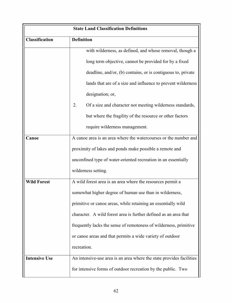
62
State Land Classification Definitions
Classification Definition
with wilderness, as defined, and whose removal, though a
long term objective, cannot be provided for by a fixed
deadline, and/or, (b) contains, or is contiguous to, private
lands that are of a size and influence to prevent wilderness
designation; or,
2. Of a size and character not meeting wilderness standards,
but where the fragility of the resource or other factors
require wilderness management.
Canoe A canoe area is an area where the watercourses or the number and
proximity of lakes and ponds make possible a remote and
unconfined type of water-oriented recreation in an essentially
wilderness setting.
Wild Forest A wild forest area is an area where the resources permit a
somewhat higher degree of human use than in wilderness,
primitive or canoe areas, while retaining an essentially wild
character. A wild forest area is further defined as an area that
frequently lacks the sense of remoteness of wilderness, primitive
or canoe areas and that permits a wide variety of outdoor
recreation.
Intensive Use An intensive-use area is an area where the state provides facilities
for intensive forms of outdoor recreation by the public. Two

63
State Land Classification Definitions
Classification Definition
types of intensive use areas are defined by this plan: campground
and day-use areas.
Historic Historic areas are locations of buildings, structures or sites owned
by the state (other than the Adirondack Forest Preserve itself) that
are significant in the history, architecture, archeology or culture
of the Adirondack Park, the state or the nation; that fall into one
of the following categories;
state historic sites
properties listed on the National Register of Historic
Places
properties recommended for nomination by the
Committee on Registers of the New York State Board for
Historic Preservation; and that are of a scale, character
and location appropriate for designation as an historic area
under this master plan and the state has committed
resources to manage such areas primarily for historic
objectives.
State
Administrative
State administrative areas are areas where the state provides
facilities for a variety of specific state purposes that are not
primarily designed to accommodate visitors to the Park.

64
Specific unit management-use plans are required to be prepared that are consistent with
the APA Act for all state-owned properties as directed by statute (Thorndike, 1999; State of New
York, Adirondack Park Agency Act, 2010). Constitutional prohibitions established for the
Forest Preserve guide the removal or destruction of timber and related resources (Thorndike,
1999; Buchanan, 2009). The Adirondack Park Agency also administers for public and private
lands within the Park the New York State Wild, Scenic and Recreational Rivers Systems Act and
the Freshwater Wetlands Act. Composite regulations provide an integrated approach to natural
resource protection, particularly on and adjacent to State-owned lands (Table 3.2 and Figure 3.3).
Figure 3.3. Adirondack Land Use and Development Plan Private and State Land UseClassifications Map. The “Zoning Map” for the Adirondacks identifies the location ofprivate and public land use classifications that accompany the written land use plan.Source: State of New York, Adirondack Park Agency, 2010.
65
The overall premise of the APA Act subscribes to the concept of conserving open space
by directing development into the Park’s existing hamlets and communities (State of New York,
Adirondack Park Agency, 2009 and Figure 3.3). Throughout the Park, wherever there is a
hamlet zone, the APA has very limited jurisdiction, giving the local government almost complete
control over what kinds of development can occur. The APA Act provides incentives in the
form of limited development controls that allow growth in hamlets, moderate intensity, low
intensity and rural use areas (State of New York, Adirondack Park Agency, 2010). In the
Resource Management zones (Figure 3.3), representing 1.9 million acres or 53% of the Park’s
private land, the Agency has substantial comparative jurisdiction (State of New York,
Adirondack Park Agency, 2010; Terrie, 1997). New York applied a hybrid legal framework
consisting of a constitutional component of the Forest Preserve and the statutory component of
the Adirondack Park Agency Act and created an unusual legal situation (Malmsheimer, 2009).
New York State conducted an exemplary land use planning experiment using the largest living
(and working) protected landscape in the continental United States. The Adirondack Park Land
Use and Development Plan (The APA Act), so often referred to as the international model, the
“Great Experiment in Conservation” was not perfectly executed (Glennon, 2009). It was not a
flawless theoretical model—a natural science-based planning approach was modified by politics
and public policy. However, the final statute enabled New York to move quickly from inaction
to proactively protecting and preserving the largest wilderness area east of the Rocky Mountains
and 85% of the designated wilderness in the northeastern U.S. (Thorndike, 1999).

66
State Action, Home Rule and Local Land Use Control
Political leadership in New York State in the 1960s and 1970s recognized Bosselman and
Callies’ (1971) concerns about the cumulative impact of hundreds of local decisions on a
landscape of statewide, national and international significance, and more specifically on the
Forest Preserve that represented a state asset and resource. The Statement of Legislative
Findings and Purposes states:
Local governments in the Adirondack Park find it increasingly difficult to copewith the unrelenting pressures for development being brought to bear on the area,and to exercise their discretionary powers to create an effective land use anddevelopment control framework. . . . .A further purpose of this article is to focusthe responsibility for developing long-range park policy in a forum reflectingstatewide concern. This policy shall recognize the major state interest in theconservation, use and development of the park's resources and the preservation ofits open space character, and at the same time, provide a continuing role for localgovernment. . . .recognizes matters of local concern and those of regional andstate concern, provides appropriate regulatory responsibilities for the agency andthe local governments of the park and seeks to achieve sound local land useplanning throughout the park (State of New York Adirondack Park Agency Act,2010, p. 1).
With the adoption of the Adirondack Park Agency Act in 1973, the New York State
Legislature withdrew from the municipalities within the Park what local governments believed to
be a significant piece of their authority to regulate land use. Local governments were operating
under the American tradition of independent, local home rule in general and their understanding
of New York’s specific constitutional license regarding Home Rule and municipal Home Rule
Law (State of New York, Department of State, New York Constitution, 2010). Perceiving a
usurpation of their authority by the Governor and the Legislature, towns and villages were
unhappy and angry with the creation of a regional authority comprised of broad state-wide
membership that could make local development and planning decisions (Graham, 1978; Erickson,
2009).

67
In all 50 states, municipalities do not automatically or naturally have powers of self-
government. State governments award or grant local government powers of self-government or
Home Rule, through a process of devolution. Local governments receive enabling charters from
the state. Constitutions and legislative statutes further define powers for self-government. State
governments also establish the delimitations for home rule authority for their respective local
governments. In general, Home Rule powers can fall into four areas: institutional, fiscal,
personnel and functional (National League of Cities, 2010). In the State of New York, Article 9
of the New York State Constitution endows a “Bill of Rights” for local governments (State of
New York, Department of State, New York Constitution, 2010). Embedded within Article 9,
Section 2, are the defined list of Home Rule powers for local governments. These are specific to
categories of government functions such as transportation systems, taxes and finance, lawmaking,
institutional management, and include the “rights, powers, privileges and immunities granted by
the constitution” (State of New York, Department of State, New York Constitution, 2010). In
addition to other sources of authority and rights, New York State Law in the form of Municipal
Home Rule Law, elaborates on the Article 9 Constitutional provisions of Home Rule. On the
surface it appears that local governments are delegated broad powers and local autonomy under
the Constitution and the laws of the State of New York. However, power is restricted in scope
(National League of Cities, 2010).
A keystone judicial interpretation that exists to counter-balance Home Rule in favor of
the states is Dillon’s Rule (Richardson, Jr., et al., 2003) Judge John F. Dillon of Iowa decided in
1868 that a state government’s relationship to a political sub-division (local government) is a
parental one. New York is one of 39 states that subscribes to Dillon’s Rule and one of 31 that
applies it to all municipalities. The rule goes on to clarify a very narrow and strict construction

68
of the breadth of local government powers, provides an approach for interpreting questionable
jurisdiction between local governments and the state, and defers to the state if there is any
reasonable doubt (Richardson, Jr. et al., 2003; National League of Cities, 2010). New York is a
Home Rule state, granting high levels of autonomy to local governments. However it also
employs Dillon’s Rule, invoking the broad powers of the New York Constitution and the ability
of the legislature to override and restrict municipal functions, such as land use planning, when it
is in the best interests of the State (Nolan, 1966 & 2001; National League of Cities, 2010).
Further judicial interpretation of the Home Rule provisions was made in 1977 when the
Adirondack Park Agency Act was legally challenged in the Court of Appeals (the highest court
in New York State). In Wambat Realty Corp. v. State of New York (1977, N.Y. LEXIS 1910),
the Adirondack Park Agency Act was upheld. The lawsuit argued that the APA Act preempted
local planning and zoning authority and was an unconstitutional violation of Home Rule (Nolan
1966 & 2001). The Court of Appeals’ decision stated that it was New York State’s purposeful
intention to forestall local governments from controlling land use decisions in order to serve a
supervening interest of the entire State. The Court stated, “to categorize as a matter of purely
local concern the future of the forests, open spaces, and natural resources of the vast Adirondack
Park region would doubtless offend aesthetic, ecological and conservation principles” (Wambat
Realty Corp. v. State of New York et al., 1977 N.Y. LEXIS 1910, p.2).
State primacy is consistent with Dillon’s Rule. In New York State, practical and
traditional application of Home Rule change is based upon the public policy concerns of the
State. The Constitution broadly defined Home Rule in a general sense, and the Legislature
preempted local decision-making on a case-by-case or issue basis when the matter was of critical
importance to the People of the State of New York (Nolan, 1966 & 2001; Glennon, 2009). And

69
the Court of Appeals emphatically stated in its decision that, “…preserving the priceless
Adirondack Park through a comprehensive land use and development plan is most
decidedly a substantial State concern, as it is most decidedly not merely 119 separate local
concerns…” (Wambat Realty Corp. v. State of New York et al.,1977 N.Y. LEXIS 1910 , p.5).
The judicial system uses the symbol of the scales of justice to present the weighing of
viewpoints in litigation. In this case, the balance between overarching concerns of the “state”
and individual local government concerns tips in favor of the public interest time and time again
in the State of New York judicial system (Nolan, 1966). New York’s judicial ruling confirming
the Adirondack Park Land Use and Development Plan does not excuse local governments from
land use planning. On the contrary, the roles and responsibilities for local government planning
are clearly established in the APA Act, enabling local governments to fully participate in a
voluntary tiered regional-local planning partnership.
A Two Tiered Approach to Land Use Regulation
The political wrangling that occurred among the Governor, State Legislators and
stakeholders between 1971 and 1973 removed the requirement that local governments within the
Adirondack Park immediately develop zoning (Graham, 1978; Glennon, 2009). The Court of
Appeals decision and The Adirondack Park Agency Act did not shut out local governments from
land use planning and decision-making, but rather encouraged future planning through some
overt and subtle incentives and, to some extent, funding. In fact, nothing prevents local
governments from preparing land use regulations, with the understanding that they conform to
and are consistent with (or are more restrictive than) the APA Act and New York State Law
(Town or Village Law and General Municipal Law). The Statement of Legislative Findings and
Purposes (Section 801) states, “. . .it is the further purpose of this article to adopt and implement

70
the land use and development plan and to provide for the plan's maintenance, administration and
enforcement in a continuing planning process that recognizes matters of local concern and those
of regional and state concern, provides appropriate regulatory responsibilities for the agency and
the local governments of the park and seeks to achieve sound local land use planning throughout
the park” (State of New York, Adirondack Park Agency Act, 1999, p. 1).
A two-tiered land use planning system created incentives for more local government
planning. One such incentive was partial return of project review jurisdiction for Class B
regional Projects. If a community receives APA approval for their local planning program, Class
B projects can be devolved to the jurisdiction of local government for permitting (State of New
York, Adirondack Park Agency Act, 1999; Malmsheimer, 2009). Local governments can
prepare and submit local planning programs for approval to the APA. If they meet performance
standards consistent with the Adirondack Park Land Use and Development Plan, then through
program approval, Class B project review jurisdiction can be shared or delegated to the local
government (State of New York, Adirondack Park Agency Act, 1999; Erickson, 2009).
The Adirondack Park Agency published a list of the results and benefits of approval of
local land use programs (Table 3.3). It provides many reasons why local governments should
pursue APA approved local planning programs. The list illustrates additional benefits to the
community including streamlined permit applications, lower legal costs, expedited and
collaborative decision-making (Table 3.3).

71
Table 3.3Results And Benefits Of APA Approval Of A Local Land Use ProgramSource: Adirondack Park Agency, 2010
RESULTS AND BENEFITS OF APA APPROVAL OF A LOCAL LAND USEPROGRAM
Source: James Connolly, Director of Planning,Adirondack Park Agency, Ray Brook, New York (2010)
Refinement of Density Pattern and Use of a Common Zoning MapWith an Agency approved program, the community and the Agency use the samezoning density pattern, one that better reflects local needs (e.g. areas of Rural Usesplit into 3 acre, 5 acre and 10 acre lot size districts to suit local objectives).One-Permit SystemTypically, the approval of a program results in a permit system that requires thatan applicant obtain one permit, either from the Town or the Agency (see below).Local Authority over Class B Regional ProjectsAgency authority over Class B projects is transferred to the town. The Agencyprovides follow-up as requested/necessary to help program get started. TheAgency may participate in a local Class B review with similar status as anadjacent landowner.More Local Participation in Agency Review of Class A Regional ProjectsThe Agency uses the local regulations for Class A projects and consults with theplanning board or other local representatives.Local Authority over Shoreline RestrictionsThe community administers the shoreline rules, including variances which may berequested. The Agency may reverse a ZBA approval of shoreline or densityvariances under limited criteria.Map AmendmentsTowns with completed background studies are in a better position to justifyamendments to the Park Plan. The APA Act provides for amendments with asimple majority Agency vote required after local adoption of a comprehensiveplan.Legal DefenseThe Attorney General represents the local government upon request and at no coston challenges involving the criteria of Agency approval of the local program.
Overall, APA Act’s intentional design and negotiated “re-design” incorporated and
encouraged a two-tiered land use planning system and local community planning through:
creation of a regional-local tiered project review system of Class B RegionalProject delegation;
approval of local planning programs; very minor regional controls in the hamlet zoning classification;

72
limited shoreline protections, leaving it up to local communities to create theirown;
shifting the responsibility for site planning, performance standards, use guidelines,and other regulatory techniques to the municipalities to implement as supplementsor complements to APA regulations--below the APA thresholds or at higherminimum standards at the local level.
Despite a design that enabled and empowered local governments to participate in their
own land use planning and obtain devolved authority from the APA process, only a few
communities engaged in land use planning during the early years of the Adirondack Park Land
Use and Development Plan. Many local governments were angry with New York State’s
decision and saw planning as proscribed. Almost one in four Adirondack Park communities do
not actively engage in land use planning. This may be a measure of the residual unhappiness and
the grudge held against New York State for its “preemption” of customary Home Rule.
A small subset of local governments moved forward with planning work throughout the
1970s and 1980s, creating community-based momentum to begin development of comprehensive
plans, zoning, subdivision regulations and special use laws in order to apply for APA approval of
their local planning programs. Table 3.4 provides a current accounting of the 18 (17.6%) local
governments that have obtained approval for their local planning programs from the Adirondack
Park Agency and the most recent date of that approval. The number is continually growing,
when, for many years, the number remained very small and stable (State of New York,
Adirondack Park Agency, 2010). Some argue that this number is considered small because the
expenses of planning are prohibitive. On the other hand, it is argued that it is easier to continue
to lay blame at the APA’s feet if any planning decisions go wrong (to avoid negative community
repercussions from development projects ) (Erickson, 2009).

73
Table 3.4Local Land Use Program ApprovalsSource: Adirondack Park Agency, 2009
Local Land Use Program ApprovalsSource: Adirondack Park Agency 2009
Year Town Year Town1977 INDIAN LAKE 1985 LAKE GEORGE (v)*1978 HAGUE*** 1992 DAY***
1978 (1976) HORICON*** 1993 NEWCOMB***1978 LAKE GEORGE* 1996 (1980) WILLSBORO**1980 BOLTON** 1996 WESTPORT***1980 CAROGA 1997 EDINBURG**1982 COLTON 2002 CHESTERFIELD1982 QUEENSBURY* 2005 CHESTER***1983 ARIETTA** 2007 JOHNSBURG
* Recent rewrite; ** working on rewrite; *** major/regular amendments
The two-tiered system of regional-local planning is operating within these 18
communities. Local planning is not a panacea, especially in a top-down regional planning
environment. Proponents of environmental planning struggle with the challenges of creating a
sense of stewardship and community momentum at the grassroots level and local government
scale (Castellanet & Jordan, 2002; Brosius, 2003; Hanna, 2005). However, the fact remains that
the Adirondack Park Approved Local Planning Program integrated into a two-tiered regional
planning system. Active participation in the program has the potential to empower local
governments and their indigenous communities to play a critical role in implementing protected
areas planning (Burby, 2003; Porter et al., 2009).

74
Political Will, Social Capital, and Proactive Diplomacy:
Willsboro and the Adirondack Park Agency
Adirondack historians note that the 1970s were a tipping point in the land use history of
the Adirondack Park and its communities, (Graham 1978; Schneider, 1997; Terrie, 1997).
Political, social and economic changes were created within and near the Adirondacks and
Champlain Valley by the legislative adoption of the Adirondack Park Agency Act. The town of
Willsboro deliberately chose to embrace change, to take a collaborative stance, and to institute a
proactive strategy when these changes were brewing in the New York State Legislature.
The political antagonism accompanying the creation of the Adirondack Park Agency Act
introduced mandatory regional and incentivized local planning. Willsboro already had decided
that it was in the public’s interest to move forward with a local planning program (Hatch & Paine,
2010). This constructive approach was counter-intuitive for most communities within the
Adirondack Park. (Commentators on the social and political history of the Park observe that
communities would rather “fight than win” [Whaley, undated]). The Town engaged in a
collaborative and positive strategy with the Adirondack Park Agency as soon as it was
established in 1971. This strategy included reaching out to the APA, and demonstrating
diplomacy and negotiation in its business with the Agency. When the majority of local
governments were shunning the Agency or using threatening behavior as their approach,
Willsboro stood out as a potential ally (Hatch, 2010). Engagement in diplomatic dialogue and
proactive planning forged the bond between regional planning at the APA and local planning in
Willsboro.
75
The town appointed a planning board in 1965 and adopted its first comprehensive plan in
1970, quite early for a rural town in northern New York (Hatch, 2010). This was well before the
legislative action creating the Adirondack Park Agency Act in 1971 and the adoption of the
Adirondack Land Use and Development Plan in 1973. But the towns in the Adirondacks,
including Willsboro, suspected that State-mandated land use regulations were coming to
Adirondack communities. Towns were informed by state and county political leadership that if
they did not enact their own land use regulations, the State might do it for them (Hatch, 2010).
Adirondack Park Agency Commissioner Peter S. Paine, Jr. and Park Agency Chair
Theodore M. Ruzow (both of Willsboro Point), played important roles in Park Agency matters
and in the enactment of local planning in Willsboro. Paine and Ruzow assisted Willsboro Town
Supervisor, Ed Hatch, and Planning Board Chairman, Ray Mero in developing Willsboro’s first
land use planning regulations (Hatch, 2010; Paine, 2010).
Attorneys by training, Ruzow and Paine had limited professional experience in land use
planning. During their appointments to the Adirondack Park Agency, they learned a great deal
about regional land use planning and the lack of local protection at the parcel-level indicated
within the Adirondack Land Use and Development Plan. During the period of 1971 through
1980, each was exposed to the jurisdictional gaps and shortcomings of the Land Use and
Development Plan. Vulnerability to future overdevelopment in the more settled areas of the
Adirondack Park, such as Willsboro was great. The APA statute was not going to protect
Willsboro in this regard and Paine was particularly conscious of this in the early 1970s (Paine,
2010).
In order to have local protections in place, then Supervisor Hatch collaborated with Paine
to prepare and adopt Willsboro’s first zoning ordinance in 1974. Paine and Ruzow worked with

76
Hatch to see that the 1970 comprehensive plan was further updated in 1977 with the assistance of
the Adirondack Park Agency staff and Federal funding through the HUD 701 program. In 1980,
Paine and Ruzow assisted the Town to rewrite the Willsboro land use regulations in 1980 to
virtually what they are today. There was concern at the town level at that time about lack of
institutional capacity to administer Class B Regional Projects. The Town succeeded in receiving
Adirondack Park Agency local planning program approval, but Willsboro delayed acceptance of
administration of Class B regional project review for a period of time until the capacity to
manage the program was in place (Hatch, 2010; Paine, 2010). Willsboro became one of the
earliest towns in the Adirondack Park to receive approval for its land use program and join with
the APA to administer the two-tiered regional/local planning program enacted by the Adirondack
Park Agency Act.
Local Planning in the Context of Adirondack Park Regional Planning: A Blind Spot
The expeditious efforts by New York State to adopt regional land use controls for the six
million acre Adirondack Park were intended to address immediate and long-term development
pressures that were reaching a tipping point. The amenity-rich assets of the Adirondack Region
were targeted by real estate speculators, second home developers, and other land based interests
as soon as multi-modal transportation enabled access to the region (Graham, 1978; Terrie, 1997;
Erickson, 2009). Policymakers throughout New York State and stakeholders of all factional
interests saw the handwriting on the wall with regard to increased development pressure on the
Adirondacks (Graham, 1978; Terrie, 1997& 2009). The hasty adoption of the APA Act was not
supposed to halt development as much as it was to place a build-out cap on density at 400,000

77
principal buildings. The APA Act’s expedited adoption was also intended to refocus speculative
real estate development away from critical habitat and environmentally sensitive areas and direct
growth into existing settlements where infrastructure and services existed to support growth. In
most cases, in the 1970s, existing settlements did not have local government-based land use
regulations in place. In recognition of this fact, three classifications [Hamlet (no significant
restrictions for development), Moderate Intensity (500 buildings/square mile or 1 principal
building on 1.3 acres) and Low Intensity (200 buildings/square mile or 1 principal building on
3.2 acres)] were designed to accommodate most of the anticipated growth in the Park. In 1973,
as a result of the Legislature’s negotiated concessions to stakeholders, significant protections
were lost to shorelines and roadsides. These critical environmental areas were generally
classified as Moderate Intensity, second only to Hamlet in development intensity in the Park
(State of New York, Adirondack Park Agency Act, 1999; Glennon, 2009).
Regardless of the design and intention of the APA Act, new development is appearing in
rapid succession on the shorelines, roadsides and in hamlets of the communities in the Park.
These are areas within the jurisdiction of local governments. From 1967-1987, 19,000 single
family dwellings were reported to have been built, representing approximately 5% of the total
Park build-out in just 20 years (Glennon, 2009). Tax parcels increased significantly as well.
From 1967-1992, the number of tax parcels increased from 45,886 to 72,269 (Residents’
Committee to Protect the Adirondacks, 2001). In 2007, the number of tax parcels was reported
to be 142,290, almost doubling in 15 years (Adirondack Association of Towns and Villages,
2009). In the three years from 1982-1985, subdivided property sales tripled and then doubled
again by 1988 (Erickson, 2009). Between 820 and 850 new structures were built annually in the
1990s (Residents’ Committee to Protect the Adirondacks, 2001). While all six APA land use

78
classifications have seen accelerated growth since 1973, the three land use classifications
(Moderate Intensity, Low Intensity and Hamlet) became the focus of increased development
from 1973 forward (Residents’ Committee to Protect the Adirondacks, 2001). In particular,
shorelines and roadsides were under limited, if any, jurisdiction of the APA and local
governments became the focus of intense and accelerated development (Residents’ Committee
for the Protection of the Adirondacks, 2001; Glennon, 2009). The location of the actual
development is consistent with the design and build-out of the APA Act. However, the gaps in
APA Act land use protections for private lands due to its broad scale and limitations of
regulatory “reach” enable Adirondack Park local governments to maintain overall, sole authority
to regulate a majority of total development in the Park, relegating the APA to a far more limited
role in the parcel-by-parcel land use decision-making. New residential, commercial and
industrial structures permitted in the decade of the 1990s indicated that local governments made
80% of the overall land use decisions and 57% of the new principal structure decisions in the
Park (Table 3.5).
Table 3.5Comparison Between Regulatory Authority of Local Governments and the APA 1990-1999Source: Residents’ Committee to Protect the Adirondacks, 2001
Development pressure and new construction is active at the community scale throughout
the Adirondack Park. Growth has not abated. A closer examination of the last decade reveals
LocalGovernments
AdirondackPark Agency
% of TotalRegulated by APA
Total activities permitted 47,762 9,647 20%
New residential, commercialand industrial structurespermitted
8,589 3,731 43%
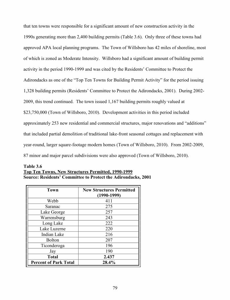
79
that ten towns were responsible for a significant amount of new construction activity in the
1990s generating more than 2,400 building permits (Table 3.6). Only three of these towns had
approved APA local planning programs. The Town of Willsboro has 42 miles of shoreline, most
of which is zoned as Moderate Intensity. Willsboro had a significant amount of building permit
activity in the period 1990-1999 and was cited by the Residents’ Committee to Protect the
Adirondacks as one of the “Top Ten Towns for Building Permit Activity” for the period issuing
1,328 building permits (Residents’ Committee to Protect the Adirondacks, 2001). During 2002-
2009, this trend continued. The town issued 1,167 building permits roughly valued at
$23,750,000 (Town of Willsboro, 2010). Development activities in this period included
approximately 253 new residential and commercial structures, major renovations and “additions”
that included partial demolition of traditional lake-front seasonal cottages and replacement with
year-round, larger square-footage modern homes (Town of Willsboro, 2010). From 2002-2009,
87 minor and major parcel subdivisions were also approved (Town of Willsboro, 2010).
Table 3.6Top Ten Towns, New Structures Permitted, 1990-1999Source: Residents’ Committee to Protect the Adirondacks, 2001
Town New Structures Permitted(1990-1999)
Webb 411Saranac 275
Lake George 257Warrensburg 243Long Lake 222
Lake Luzerne 220Indian Lake 216
Bolton 207Ticonderoga 196
Jay 190Total 2.437
Percent of Park Total 28.4%

80
The Adirondack Park Agency regulates on average only 20 % of the building activity in
the Park (Table 3.5), therefore its permitting activity may not be as accurate an indicator of
development pressure and new construction activity in the Park as local government permit
records. For example, in the 1990s, the highest number of APA permits issued was 404 in 1990
and the lowest was 242 in 1998 (Residents’ Committee to Protect the Adirondacks, 2001). In
2009, APA issued 375 permits, 127 were residential new construction and 86 were subdivisions
(State of New York, Adirondack Park Agency, 2009).
State, national, and international attention is centered on protected area, regional planning
and the institutionalization of the Adirondack Land Use and Development Plan, leaving limited
resources for local planning programs. Records exist that count (and recount) the number of
municipalities engaged in local planning activities. The presence of local planning programs at
the municipal level is evidence of basic capacity to conduct local land use planning. But the
existence of local planning programs may not reflect the adequacy of citizen participation,
quality programs of equitable administration and enforcement, systems of quality assurance, or
the environmental monitoring present at the municipal level.
Since the 1970s, a growing number of local governments have instituted land use
regulations (Table 3.7). Over 64% of Adirondack communities currently have a basic
comprehensive plan, up five % in the past five years, extending a state-wide trend (New York
State Legislative Commission on Rural Resources, 2008) (Figure 3.4). Zoning, subdivision and
site plan review laws are also increasing, following the statewide trend, with more than half the
municipalities having some form of local land use control. The number of Adirondack
municipalities that do not have any form of land use regulation hovers between 18 and 26%,
depending upon data source (Adirondack Park Agency, 2009) (Table 3.7, Figure 3.4).

81
Table 3.72009 Status of Land Use Planning in Adirondack Park Towns and VillagesSource: Adirondack Park Agency, 2009 & NYS Legislative Commission on RuralResources, 2004
Land Use Planning Activity 2004 2009 2010Approved APA Plans 17 18 18
Municipalities without any form of land usecontrols Unavailable 27 19
Municipal Comprehensive Plans 58 65Municipal Zoning Laws 57 61 64Municipal Subdivision Laws 60 60 63Municipal Site Plan Review Laws 54 61
Figure 3.4. Local Land Use Controls in the Adirondack Park. A snapshot of land usecontrols in place in the Adirondack Park as of May, 2010. Source: Adirondack Park Agency,2010.

82
The trend for municipalities throughout New York State, including those within the
Adirondack Park (although at a slower rate), to adopt comprehensive plans and land use
regulations is remarkable. It demonstrates local interest in taking control and managing growth
for local objectives (New York State Legislative Commission on Rural Resources, 2008).
Increased local participation in planning is an encouraging sign since it is a threshold factor in
growth management for a protected area (Dougill, et al., 2006; Park, 2001; Theobald & Hobbs,
2002; Castellanet & Jordan 2002; Brosius 2003; Hanna 2005). Conservation interests are also
beginning to see the importance of local land use planning. The Adirondack Council, the largest
conservation organization in the Adirondack Park stated: “Local planning . . is not a luxury in the
Adirondack Park. It is a necessity” (Adirondack Council, 2001, p. 7).
The percentage of municipalities with APA approved Local Land Use Programs is
growing currently at 17.6% (Figure 3.4). While the pace is slow, the growth rate is an
encouraging sign. Studies indicate that the cases where permit decision-making can devolve
from the APA to local governments in approved programs can be as high as 50 % (Residents’
Committee to Protect the Adirondacks, 2001). The APA’s project permit review jurisdiction is
generally 20%, with the remainder falling to local government jurisdiction (Table 3.5). In
municipalities with approved plans, the APA’s regulatory jurisdiction may be reduced from 20 %
to 8 % (Residents’ Committee to Protect the Adirondacks, 2001). Opinions vary on why
participation rates vary. Some believe it is because of lack of capacity (and the ultimate burden)
to prepare, adopt and implement sophisticated land use programs (Booth, 2009). Others believe
that communities allow the APA to take the responsibility for the consequences of local
development decisions (Erickson, 2009).
83
The percentage of municipalities in the Park with any form of planning continues to grow
but still lags behind the remainder of New York State (New York State Commission on Rural
Resources, 2008). Quality is not measured by quantity, and conservation interests point out that
the quality of land use regulations is also crucial to the environmental integrity of the
Adirondacks (Residents’ Committee for the Protection of the Adirondacks, 2001). Where
communities approach local planning in a comprehensive fashion (e.g. preparing a
comprehensive master plan, appointing a planning board, and adopting a suite of land use
regulations such as a zoning, subdivision and site plan review law) they are demonstrating, in
theory, increasing capacity and professionalism to manage local decision-making (Residents’
Committee to Protect the Adirondacks, 2001). No comparative analysis of the substance or
quality of municipal regulatory composition exists for land use planning programs within the
Adirondack Park. The APA approved land use programs provide a criterion-referenced basis for
17.6 % of the land use regulations, and some believe that these programs are exemplars in New
York State (Residents’ Committee to Protect the Adirondacks, 2001). Research is insufficient or
unavailable to ascertain the quality of any local land use programs sustain or improve ecosystem
health. Measurable goals or indicators of how local land use programs impact environmental
quality, societal improvements and economic vitality of the communities are not available
(Booth, 2009). Local land use programs, including the APA approved local land use program,
must meet minimum requirements to obtain APA approval, but there are no quality assurance
programs instituted to measure ongoing performance and enforcement at either the regional or
local level. Critics indicate that the standards for meeting APA plan approval have been
inconsistent and subject to political will over time (Glennon, 2009).

84
Without a measure of evaluation or quality assurance in the content of local land use
programs, one can only assess the outcomes of local decision-making within the Park by the
results in terms of the consequences of development. The loopholes in the weave of the
regionally-scaled Adirondack Land Use and Development Plan have directed development into
high density land classifications—all areas where local government action was conceptualized as
filling in the gaps. If local governments were consistently utilizing Smart Growth Principles,
then intensified growth would not fuel visible sprawl along roadsides and shorelines in Moderate
Intensity, Rural Use and Resource Management classifications where the APA Act has limited
reach (Residents’ Committee to Protect the Adirondacks, 2001). Another area where local
governments could strengthen their role would be in adopting clustering regulations to
concentrate and intensify development to avoid sprawl. The APA Act does not include a formal
regulatory provision for clustering development in all classifications and only refers to the
concept of clustering in Resource Management and Rural Use (State of New York, Adirondack
Park Agency, 2010). The cumulative effects of intensifying growth, lack of information and
feedback on the quality and scope of local land use programs can result in ineffectual local
planning programs and perpetuation of incompatible development.
Cumulative Growth Impacts
New York State needed to act quickly in order to address concerns for environmental
protection and manage stakeholder interests with the adoption of the Adirondack Park Land Use
and Development Plan and its companion State Land Master Plan. Unfortunately, the approach
had significant flaws despite its intelligent design at the time. Four decades of a principal focus

85
on institutionalizing the regional land use planning scheme have revealed chronic, structural
problems with land use planning in the Adirondacks (Booth, 2009). For example, threats from
cumulative growth, sprawl and unsustainable development patterns have increased on private
lands, especially in the land classifications of Moderate Intensity, Low Intensity and Rural Use.
The State (and international groups such as Two Countries, One Forest), focused on the
successes of the regional planning model, particularly as it applies to protecting the core
protected areas of public lands and contiguous private lands classified in Resource Management
(Trombulak, et al., 2008; Two Countries, One Forest, 2009). Scant attention and few resources
have been devoted to local governments’ responsibility and opportunity for managing land use
decisions within their borders. The Adirondack Park Land Use and Development Plan and
Adirondack Park State Land Master Plan were conceptualized at a scale to regionally manage six
million acres of public and private lands, more than 10,000 lakes and 30,000 miles of rivers and
streams. The protected area includes extended matrices comprised of diverse habitats including
boreal forests, old growth forests, floodplains and wetlands of many varieties. This massive land
area is the size of the state of Vermont or the Commonwealth of Massachusetts, and comprises
nearly one-fifth of New York State’s land area (State of New York, Adirondack Park Agency,
2009). Advantages can be gained by regional planning at this magnitude. But there are
disadvantages as well. Regardless of the flaws in design and execution, the Adirondack Park
Agency Land Use and Development Plan cannot protect this open space and sustain the
protected landscape if the indigenous local governments do not have the capacity to be full
partners in implementing the plan.

86
Chapter Four
Emergent Design to Achieve Empowerment, Engagement and Ecological Awareness In
Willsboro, New York: An Adirondack Park Local Planning Case Study
“Tell me and I will forget.
Show me and I may remember.
Involve me and I will understand.”
Confucius, 450 B.C.

87
Town-Level Comprehensive Planning in the Adirondack Park: The Research Problem
Comprehensive planning provides an extraordinary opportunity for citizens to fully
participate in land use decisions affecting property owners. Civic participation in a
comprehensive planning process is essential for community engagement in plan development
and implementation. It is equally important that the “state of the art” practices of planning and
the most current and available scientific information be used to inform and shape the process
(Burby, 2003). Communities engaging in comprehensive planning are able to evaluate which
land parcels or sections of a community are viable to develop (or not) based upon the
environmental, cultural, geographic, infrastructure, economic, etc. characteristics of the
community, including its land and water resources. The traditional approach is to use a method
referred to as the opportunities and constraints analysis (Kelly & Becker, 2000). As a
community process, this analysis should occur within a framework that provides a springboard
for creativity, initiative and action by the citizens. Such a planning framework requires the
collection of knowledge from all sources, including scientific, to help educate and inform
citizens in a coherent manner. Ideally, the analysis is broad, considering natural and man-made
environments. It is community-centric, demonstrating a respect for local knowledge, indigenous
people and place. Past is treated as prologue. Future trends, such as global environmental
change, require adaptive action. Even the best intentions can go wrong without a solid base of
information, and a strong planning program relies on good information. An inadequate
understanding of how the natural environment is influenced by growth and development can
result in a planning decision that is contrary to ecologically sensitive land management

88
(Thompson, 2004). Citizens need access to scientific information, shaped by a planning process,
in order to be effective decision-makers (Pahl-Wostl, 2007; Hunnsicker, 2007).
New York State policy contains ambiguous statements about local government
responsibility towards comprehensive planning. New York law does not mandate plan
preparation, but instead requires land use regulations to be prepared in accordance with a well-
considered plan (New York State Department of State, 2008). Comprehensive plans are
customary pursuant to planning theory and professional practice and state agencies recommend
their preparation (New York State Department of State, 2008; Kelly & Becker, 2000). As
described more thoroughly in Chapter One, the comprehensive plan is the legal backbone of the
land use laws promulgated by local governments. If a land use law is challenged, the
comprehensive plan becomes essential evidence to support a community’s case in judicial
proceedings. Comprehensive plans act as an essential reference required by funders. Grantees
are required to cite their capital projects in their comprehensive plans in order to secure grants.
Local governments can see comprehensive planning as complicated, expensive, mysterious, and
ambiguous. Effective planning is hindered by local governments’ lack of understanding of
comprehensive planning and ambiguous legal language offered by the state. Municipalities fear
legal challenges to land use laws. The writers of a comprehensive plan can set into motion
recommendations and actions that may impact many people, properties and interests over various
geographic scales. These constitute strong motives to undertake comprehensive planning.
Comprehensive planning is further encouraged by all parties for the pervasive impact that land
use decisions have on property owners.
I (and others) believe that comprehensive planning can play a critical role in responding
to land use change and can reorient the way a community reacts to, responds to, and manages

89
change (Hanna, 2005). This research project engaged with a specific community to study the
ways to utilize community comprehensive land use plans as the basis for science-based planning
and decision-making at the local level. The purpose of this case study was to describe, document,
explore and analyze, through the methodological lens of Participatory Action Research (PAR),
how the local land use planning process, specifically the town comprehensive planning process,
evolved within the community of Willsboro, New York. In addition to documenting the case
study, I analyzed the community-motivated processes used in Willsboro that exemplified the
most effective aspects of integrated planning and science, moved consensus-driven community
goals forward, served to perhaps ultimately conserve land, promoted environmental quality, and
protected biodiversity. I investigated dimensions of state and local public policy with respect to
home rule and locus of power, censorship, and land planning within a protected area.
Evaluations were conducted to determine whether planning processes could be more effective
using a broader, collaborative PAR approach than traditional planning processes, with the goal of
transforming planning practice into a more democratic, environmentally conscious and durable
civic responsibility.
Framing the Research
The Research Questions
Focusing on the comprehensive planning process, the central question framing this case
study was, “How can we build capacity to make land use decisions on private lands in protected
areas?” Four subsidiary questions provided further structure:

90
1. How can the presentation of and access to natural science data, evidence-based
technologies (GIS), modern planning theories and Participatory Action
Research (PAR) improve the comprehensive planning process and
comprehensive plan document in the form of private land conservation benefits
for protected areas?
2. To what extent did the Case Study Steering Committee engage, dialogue, and
participate in the exchange of new information (knowledge) as a result of the
citizen participation, natural science, evidence-based technologies and PAR
techniques utilized during the field research?
3. To what extent was language associated with environmental assessment,
ecological planning or conservation of natural resources included in planning
recommendations made by the Steering Committee?
4. After 32 years without a comprehensive planning process, to what extent does
the current comprehensive plan process in Willsboro engage a representative
cohort of interests in quantity, number, distribution, and weighting across
stakeholder groups in the planning process?
These research questions guide the PAR methodology and the use of the single case study
approach. The PAR overarching approach and the single case study enable the use of a mixed
methods data collection process in order to produce results responsive to the research questions.
PAR Overarching Approach
It is customary in planning practice for the professional consultant or government
planning agency (or both) to define the problem and the solution and “hand it over” to the local
land use planning citizen planners. Studies have shown that this procedure does not result in

91
motivation of or follow-through by stakeholders (Burby, 1997, and others). Civic empowerment
and engagement in comprehensive planning requires a redefinition of process, including a locally
defined determination of “what is knowledge” and an active learning approach to problem-
solving. Consideration of social fabric, socio-economic conditions, relational issues between
humans, and moral order is also necessary (Park, et al., 1993; Park, 2001). PAR empowers and
honors local decision-making and incorporates time for reflection and reflective dialogue among
participants that leads to knowledge and understanding.
The choice of PAR as a methodology established a low-constraint approach to the case
study. Controls were very limited on the research subjects and the stakeholders were generally
free to direct the process within a general land use planning framework. PAR limited my control
and direction over the research process in favor of empowering and engaging the stakeholders.
In addition, the chosen approach was naturalistic, directly observing the ordinary flow of events
in Willsboro in their actual setting (Stake, 1995). Direct interpretation, review and analysis of
written, audio, and visual materials collected over the course of the case study was supplemented
with historical records, demographics and other relevant forms of information in order to provide
a holistic understanding of the research questions. Open and focused coding was applied to
written records of citizen input to distill common themes or discourse. Issues, strategies, and
recommendations relating to environmental recommendations raised by the community were
examined and quantified by their number and scope and incorporated into planning documents.
Formal and informal participant feedback to gain multiple perspectives extended my analysis. I
used an iterative approach to review the data, allowing time to reflect and process information in
order to pull together my thoughts into a coherent pattern, and to write and re-write. I alternated

92
this with soliciting feedback from colleagues and community members. Possible patterns and
interpretations within and outside the context of the research questions were determined.
Correspondence between citizen participation, PAR techniques and the integration of
new learning within the case study were evaluated through volunteer feedback and direct
interpretation. How the comprehensive planning process changed when it shifted towards open
and full civic engagement with a natural science focus was evaluated through direct
interpretation. Alternative explanations of interpretations were proposed and sought from co-
researchers. My biases were also analyzed and disclosed, particularly when they might have
affected the interpretation of data.
Conclusions were framed as naturalistic generalizations, which were validated by
descriptive accounts of the case study, pre- and post-presentation of data, and clear accounts of
actual methods utilized. Lived experience, equity, discourse, dialogue and action provided
compelling themes that underlay the overarching PAR research methodology employed.
Single Case Study
A single Case Study method, within the framework of PAR, was used to document the
research. According to Stake (1995), in order to support the selection of a case study approach,
one seeks distinctive situations, intricate and unusual conditions that would pique interest in a
particular subject. Furthermore, single case studies can have internal or external contextual
importance (Stake, 1995). Multiple case studies rarely achieve a close examination of the novel
structure and detail that characterizes a specific single case study (Gerring, 2007). Single case
study provides a means to identify, observe and analyze specific mechanisms and causal
pathways of the research subject (Gerring, 2007).

93
The Adirondack Park’s globally recognized protected area model of state-imposed
regional and local planning is an ideal field laboratory in which to undertake a single case study.
The Town of Willsboro represents local and regional spatial planning challenges at two different
scales, territorial overlap and multijurisdictional governance, thus providing internal and external
contexts. The case study will be conducted within the perspective of a three-decade old, two-
tiered, regional-local land use planning framework in a Home Rule state. Willsboro is one of a
select group (18) of 102 local governments in the Adirondack Park that has collaborated with the
Adirondack Park Agency (APA) since 1973 to obtain approval for their local land use programs.
These municipalities maintain APA approval and are delegated limited review jurisdiction for
Class B Regional Projects. The Willsboro case study provides an opportunity to study
dimensional relationships between community, town, state and agency interests as they impact
private lands within a protected area. My research focused on community-driven efforts to move
forward after 32 years to prepare a third comprehensive plan. The field site met the suggested
guidelines of complexity, unique circumstances, and special conditions that would stimulate
interest in the case study (Stake, 1995). Willsboro’s location in the Adirondack Park and the
Park’s location in a protected living landscape of national and international importance met the
criteria of special conditions and unique circumstances. The criteria of complexity was met by
the presence of an administrative structure involving a two-tiered land use planning process at
the local government level, and utilization of PAR to engage and empower the community to
tackle the issue of rapid land use change on private lands.
After reviewing Case Study methods presented by Stake (1995), Gerring (2007), Yin
(2003), Gomm, Hammersley and Foster (2006), I used Stake (1995) and Gerring (2007) as the
authoritative sources for reference and guidance on procedural matters associated with the single

94
case study method utilized in this research. Stake and Gerring focused on single, qualitative case
study methods in fields related to land use planning. Their methods are consistent with the
single case study and with the theoretical framework of PAR. PAR and the single case study
method allowed for variations introduced by involvement of citizen co-researchers, resulting in
an emergent design and progressive focusing (Stake, 1995).
Case Study Limitations and Delimitations
According to Creswell (2003), delimitations establish the boundaries of the research
study and determine its range. Limitations define how applicable the research will be to other
situations and identify potential drawbacks (Creswell 2003). Every research endeavor has its
qualifications. The following assessment represents my best determination of the delimitations
and limitations of the case study.
The research project had the following delimitations:
This study restricted itself to a single case study of the Town of Willsboro’scomprehensive plan process.
The study tested the utilization of PAR techniques in the comprehensive planningprocess within a small-town context only.
With regard to natural science, only those that are situation-appropriate for thecase study community were utilized.
The research project had the following limitations:
The single case study and the method may not be appropriate to apply to allsituations where municipalities are developing Comprehensive Land Use Plans.
The conclusions or findings could be interpreted in alternative ways. The presence of public agencies in the process as grantors asserts influence over
the plan content and outcome. The researcher’s residency in the community or biases might influence the plan
content or outcome.

95
The Case Study Site: Willsboro, New York -- “Where the Mountains Meet the Lake”
Willsboro is located within New York’s Adirondack State Park where multiple protected
area designations overlay an ecologically diverse landscape. The six million public and private
acres of the Adirondack State Park are part of the UNESCO designated Adirondack/Champlain
Biosphere Reserve. The Park is also a small fraction and significant component of the 80 million
acre Northern Appalachian/Acadian Eco-region (Figure 4.1). Willsboro’s location is part of the
Lake Champlain Basin Program Management Area that encompasses portions of Quebec,
Vermont, and New York. The Adirondacks and Willsboro are included in the four-state
designation (New York, Vermont, New Hampshire and Maine) of the Northern Forest Region.
The Boquet River, whose main branch and delta are located in Willsboro, is a designated river
within the New York State Wild, Scenic, and Recreational Rivers System.
Figure 4.1. Northern Appalachian/Acadian Eco-Region. The Adirondacks are located withinthe grey boundary lines of New York State. The larger brown and green relief represents theAdirondacks Mountains. The smaller green and brown relief is the Tug Hill Plateau. Source:Two Countries, One Forest, 2010.

96
Situated on the northeastern border of the Adirondack Park at latitude 44.37% N and
longitude 73.41% Willsboro is bound on the east by the Lake Champlain shoreline (Figure 4.2).
Figure 4.2. Location Map of Willsboro, New York. This figure shows Willsboro'slocation in the northeast corner of New York’s Adirondack Park. Source:A. Holland, 2010.

97
When one thinks of the Adirondack Region, the conjured image is of mountains. But the
eastern margin of the Adirondacks is far more diverse and heterogeneous than its mountainous
central core. Willsboro, located in the northeast corner of the Adirondack Mountains and within
the Lake Champlain Valley, is situated within a distinctive ecotone and important mosaic
landscape, not only at the local level, but also at regional, continental, and international scales.
This landscape is defined by highly variable topography that originated from numerous geologic
events and processes. For example, the northwest and central western sections of the town,
consists primarily of steep, mountainous terrain where slopes range from 15-25% in the vicinity
of Rattlesnake (elevation: 1285 ft.) and Sugarloaf Mountains (elevation: 1467 ft.). The
physiography changes from east to west, and south to north towards the Lake Champlain
lowlands and the St. Lawrence Valley, respectively. The eastern and northeastern shorelines of
Lake Champlain are rocky and exhibit moderate slopes in the 3-15% range. East of the
Adirondacks, the lake plain extends to the south and contains gentler slopes, ranging from 3-8%.
The Champlain Valley is also interspersed with steeper terrain. The Boquet River corridor varies
considerably in topography from gently curving oxbows meandering across low-relief
floodplains to precipitous ravines that the river has carved into the Adirondack foothills (Town
of Willsboro Community Profile, 2010). Since the 18th Century, the countryside was further
modified by human activities, such as agriculture, mining and other land uses (Figure 4.3).

98
Figure 4.3. Town of Willsboro. View East from RattlesnakeMountain towards Lake Champlain. Source: B. Holland, 2010.
Willsboro’s land and water resources have valuable ecological significance. The
combined state and national designations of the Boquet River Watershed and Lake Champlain
point to the presence of important riparian communities. The New York State Natural Heritage
Program conducted a partial ecological inventory of Willsboro, which identified a diversity of
ecological communities, geological points of interest, and plant and animal species that are now
considered significant to New York State. A number of these plant and animal species in
Willsboro are classified as threatened, endangered, or rare (Town of Willsboro Community
Profile, 2010).
Willsboro is located between the Adirondack Mountains and Lake Champlain. Blessed
with abundant water resources, Willsboro encompasses a land area of 73.4 square miles and a
combined total of 30.4 square miles of surficial waters (Figure 4.4). Lake Champlain, Long
Pond, Warm Pond, north and main branches of the Boquet River and their appurtenant wetlands
define Willsboro as a Lake Champlain Basin town (Figure 4.4). Over 41 miles of shoreline

99
bound these extensive water resources (Figure 4.4 and Table 4.1). Flanking the foothills and
mountainous areas to the west and northwest are considerable acreages of privately owned mixed
hardwood and coniferous forests that abut the farmland and countryside to the east along the
Champlain Valley (Town of Willsboro Community Profile, 2010).

100
Figure 4.4. Willsboro Hydrology. New York State designated wetlands (NYS FreshwaterWetlands Act) and rivers (New York State Wild, Scenic, and Recreational Rivers Act).Source: Town of Willsboro Community Profile, 2010.

101
Table 4.1Hydrology of WillsboroSource: Town of Willsboro Community Profile, 2010
Water Body Area Perimeter orLength (Miles)
Lake Champlain Shoreline 19.9
Lake Champlain Area within Willsboro 30.4 (sq. Miles) 44.8 (shoreline andtown border)
Highlands Forge Lake 0.2 (sq. Miles) 2.3Long Pond 0.5 (sq. Miles) 5.0North Branch of the Boquet River 6.7Boquet River 7.2All Rivers, Streams, and Brooks 71.3APA Regulatory Wetlands 1,258 (Acres)
Farming has been an integral part of the town’s landscape history and economy since the
latter part of the 1700s when its founder, William Gilliland, sold tracks of land to subsistence
farmers. Willsboro retains expansive tracts of important Champlain Valley agricultural lands in
the northern Champlain Basin. The Agricultural District is comprised of 6,396 acres,
representing 23% of the land acreage in the Town (Town of Willsboro, 2009). The Agricultural
District does not include all the land in active or inactive agricultural use.
Level land, fair soils (Farmland of Statewide Importance, Prime Agricultural Soils and
Prime Agricultural Soils If Drained), and available water make Willsboro a good setting for
arable farmland (Figure 4.5) (Town of Willsboro, 2009). Cornell University operates a research
farm on substantial acreage on Willsboro Point. Research is being conducted on northern-hardy
crops including wine grapes, certified organic grains and rotational trials. Approximately 13
active farms of produce a variety of products including: dairy, equine, beef, pork, grapes, hay,
and vegetables. The number of small acreage farms (less than 250 acres) continues to grow
(Town of Willsboro, 2009).

102
Figure 4.5. Willsboro Prime Agricultural Soil. This figure represents important agriculturalsoils identified through the Natural Resource and Conservation Service database that aredistributed in the Champlain Valley lake-plain region of the Town. Source: Town ofWillsboro Community Profile, 2010.

103
Willsboro: An Adirondack Park Local Planning Case-in-Point
Willsboro’s strategic location makes it susceptible to development pressure. Within a
day’s drive of Willsboro are 84 million people residing in New York City, Boston, Montreal, and
Toronto (Adirondack Association of Towns and Villages, 2009). The Eisenhower Interstate
System (Adirondack Northway Interstate 87) is located seven miles away off Exit 33, making
Montreal, Albany, New York and points further north and south just hours away by car. Five
miles south is the Essex-Charlotte Ferry to Vermont linking Willsboro to Interstate 89 and the
New England metro areas. Amtrak rail service from New York City to Montreal operates daily,
bringing potential visitors into contact with Willsboro’s scenic vistas as they pass through the
community.
From mid June through Labor Day, the population of Willsboro increases from 2,000
year-round residents to over 5,000 (by some estimates it triples). Septic systems, road
congestion, boat pollution, jet skis, and community services are stressed to their limits.
“Location is everything,” and in Willsboro’s case, location is an economic asset that can quickly
overcome the carrying capacity of the natural resources and landscape that also drive the
economy.
In the 1990s Willsboro was recognized by the Residents’ Committee to Protect the
Adirondacks as one of the “Top Ten Towns for Building Permit Activity,” having issued 1,328
building permits during the period (Residents’ Committee to Protect the Adirondacks, 2001).
During the seven-year period from 2002-2009, the trend continued with the issuance of 1,167
building permits valued at a minimum of $23,750,000 (Town of Willsboro, 2010 During the
seven-year period from 2002-2009, the trend continued (Chapter Three) and 87 minor and major
parcel subdivisions were also approved (Town of Willsboro, 2010).

104
In the past 20 years, rapid land use change has occurred in Willsboro due to seasonal
swings in population that have driven the resort, retirement and year-round housing market.
While monetary data are not available for the 1990s, the permit issuance during that decade was
as vigorous as it was in the seven years between 2002 and 2009. The 23 million dollars cited in
construction expenditures is significantly understated due to the concern of applicants that their
taxes will be raised if they report actual costs. Notwithstanding this undervaluing, the 23 million
dollars investment in seven years is also important as an indicator of the role construction plays
as an economic driver in the community and how rapid development is transforming the land
regardless of the presence of the Adirondack Park Agency Act.
Ecologists are concerned about rapid land use change in the Adirondacks, a landscape
internationally renowned for its vertebrate diversity, important location and size (Baldwin et al.,
2008). Land use changes can be observed in the fragmentation of forests and farm fields, and in
the presence of intensive shoreline development and redevelopment. In communities where
waterfront development is present, shoreline conversion from a natural to artificial habitat is
another indicator of land use change. Native vegetative cover is eliminated in favor of lawns and
natural shorelines are occluded by the emplacement of retaining walls. Construction of
residential structures increases on small lots, and aquatic and ecotone habitat are destroyed
(Figure 4.6).

105
Figure 4.6. Willsboro Waterfront Conditions. This figure represents ShorelineHardening as an Indicator of Rapid Land Use Change. Removal of natural habitat,including woodlands and replacement with lawns and sea walls is noted. Source:Town of Willsboro Community Profile, 2010.

106
For the purposes of this case study, Willsboro is representative of serves the scientific
significance of the natural resource assets held in trust by local governments in the Adirondack
Region. Willsboro also is representative of the social and cultural realities of “living” landscapes
within protected areas where people reside and enjoy a singular quality of life. The town is a
veteran community of the APA-approved local planning program and has been engaged in
planning for over 30 years. Willsboro is a microcosm of local ecological, social and planning
issues within a protected area living landscape. It is an ideal research location to consider
planning capacity and how incremental and cumulative decisions about land are made.
Mixed Research Methods for Data Collection and Analysis:
Emergent Design to Achieve Empowerment, Engagement, and Ecological Awareness
In order to undertake the single case study a mixture of data collection methods was used.
These data gathering methods blend quantitative, scientific and qualitative data (Figure 4.7). In
Figure 4.7, scientific data is represented as its own sphere. Scientific data blended externally
gathered and locally generated qualitative and quantitative data. Qualitative and quantitative
data represented by the remaining two spheres were generated by the PAR-based methods.

107
Figure 4.7. Mixed Research Methods for Data Collection and Analysis. This figurerepresents, within a Venn Diagram, the eight data collection methods used in thecase study.
Data collection utilized publicly- available methods and included audio tapes, minutes of
public meetings and reports issued by the Town of Willsboro Comprehensive Plan Steering
Committee. In addition my attendance and participation in public meetings were documented in
personal journals and notes. Validity was achieved by utilizing multiple sources of evidence

108
(written public records, reports and papers) and review of the descriptive materials produced by
volunteer readers (informants) of the Steering Committee. A further form of validity was
achieved through feedback from the Steering Committee during the roundtable discussion of data
collection methods.
The volunteers serving on the Town of Willsboro Comprehensive Plan Steering
Committee determined the scope and substance of what they wished to know (and why) about
land use, community development and natural resources in the town and region as they moved
through the process. They did this through dialogue in order to share experiences and
information, ultimately arriving at consensus about terminology, concepts, and actions (Park, et
al., 1993; Park, 2001). Using a combination of Appreciative Inquiry, standard land use and
environmental planning practices, and interactive activities that I developed, I engaged with the
community to develop a comprehensive plan (Cooperrider & Whitney 2005). Appreciative
Inquiry is a holistic systems approach to change that focuses on the positive and visionary
aspects of human and social capital. Utilizing methods that encouraged contributions of multiple
perspectives that were beneficial, positive and purposeful, the “group” envisioned changes based
upon affirmative social constructions in order to achieve best practices (Cooperrider, & Whitney,
2005). The initial stakeholder selection and the data collection methods used with the Steering
Committee and citizens to develop the plan were shaped by the information and decisions made
by the community members in the room.
Eight data collection methods were used to test PAR techniques, to bring scientific
information and evidence-based technologies (GIS) to the planning process in the case study.
The data collection methods were guided by the methodological framework of PAR and

109
provided data to address the four research questions for this single case study. The eight data
collection methods included:
Steering Committee Stakeholder Selection, Formal and Informal ParticipationPathways;
August, 2009, Listening Sessions; Development, Launch, Completion and Results of Community Survey; Discussions with Natural Science Subject-Matter Experts; Community Based Field Work and Development of GIS for Community Profile
and Analysis Work; Decentralized Visioning Sessions and Straw man Visioning Statement; Work sessions with Straw man Versions and GIS Map Analysis to develop
Environment and Land Use Recommendations; Roundtable Discussion of Case Study Methods with Steering Committee.
Description of Individual Methods
Method #1: Steering committee stakeholder selection, formal and informal
participation pathways.
Steering committee stakeholder selection.
Comprehensive planning occurs within the framework of New York State law and as a
public process it was important to ensure that methods and techniques abided by the laws of the
state. In New York State, the Town Board or their designee may prepare a town comprehensive
plan (New York State, Department of State, Town Law Section 272-a 4, 2009.). Town Law
further provides for the Town Board to appoint the local planning board or a special board to
serve this purpose. A special board can consist of members of the planning board and other
community members (New York State, Department of State, Town Law Section 272-a 2. (c),
2009). Appointments are formalized by the Town Board. In New York State, comprehensive
plans are customarily prepared by a special board, sometimes called a Citizen Advisory
Committee or Steering Committee, who are appointed by the Town Board. The legislative

110
finding and intent of Town Law encourage that such committees comprise citizen representation
(New York State, Department of State, Town Law Section 272-a 1 (e), 2009).
The process of creating a Comprehensive Plan Steering Committee began with a series of
meetings in July, 2008 with the Willsboro, New York, Town Supervisor and Code
Enforcement/Zoning Officer to discuss the appointment of an advisory committee for the
preparation of the town comprehensive plan. Discussions included the background structure of
New York State law (as noted above) and the characterization of stakeholders (Welp, 2001).
A stakeholder can be defined broadly as one who: (a) is affected by or affects aparticular problem or issue and/or (b) is responsible for problems or issues and/or(c) has perspectives or knowledge needed to develop good solutions or strategies,and/or (d) has the power and resources to block or implement solutions orstrategies (Welp, 2001, p.9)..
The Town Supervisor prepared a preliminary list of stakeholders to be considered for
appointment to the Steering Committee based upon Welp’s definition (2001) and the following
four groupings:
Functional groups such as fish and game clubs, snowmobile clubs,agricultural interests, tourism related enterprises, watershed associations,business interests, conservation associations, seasonal property owners,etc.
Groups or individuals customarily voiceless or traditionally uninvited tothe table. These include senior citizens, very low income persons, thedisabled, young people and interests such as health care, education, andsubsidized housing.
Informal community leaders and knowledge “brokers” that are part of thesocial network and cliques or sub-groups dispersed throughout thecommunity. These individuals can move information along and acrosssocial networks.
Liaisons to the Town Board, Planning Board and Zoning Board ofAppeals.
In the fall of 2008, a core Organizing Committee comprised of the Town Supervisor,
Town Councilman, and a member of the Zoning and Planning Boards was formed by the Town.

111
They met regularly through March, 2009 to initiate the formation of a Steering Committee. The
group used the Town Supervisor’s preliminary list and conducted stakeholder analyses to
determine how responsive and redundant the candidates were to the four groupings. The
Organizing Committee distributed a recruitment survey in November, 2008 (Appendix 4.1) to
persons on the list and other possible candidates. The Town hosted a community meeting on
December 6, 2008, to brief the public about the plan and recruit volunteers to the process. Over
fifty people signed up for the list-serve after the meetings, and many stakeholder interests were
recruited through the survey. A secondary screening and stakeholder analysis was conducted on
the stakeholder recruitment survey responders. Three groups were formed from the responses: (1)
stakeholders who had government or agency affiliations and might serve as a Steering
Committee-Agency Partner; (2) stakeholders who would serve on the main Steering Committee
as citizen representatives; and (3) stakeholders who would serve as members of focus groups or
advisors. The survey responses were grouped into the following three categories: (1) Citizen
Steering Committee; (2) Agency Steering Committee; and (3) Focus Group based upon the
following criteria:
Willsboro Planning Program Citizen Members Stakeholders who:
Represent the diverse and multiple interests of the community; Listen well to the voices of the entire community; Have a balanced view of land protection and smart growth; Are big-picture thinkers; Are well respected or rather unknown; Can commit themselves to 3-5 hours per month for the next 12-14 months; Like to learn new things; Believe in moving forward through achieving consensus.
Willsboro Planning Program Agency Partners-Stakeholders who are:
Governmental Agencies with jurisdiction over the project; Agencies or organizations with overlapping geographies;

112
Institutions that want to know what is going on, but don’t intend to come to meetings; Outside organizations with inside-the-town interests; Recommended by New York State Department of State for consideration to serve on
the committees..
Willsboro Planning Program Focus Groups-Stakeholders who are:
Very specific in their area of interest or concern; Limited in the amount of time they can commit; Knowledgeable or experienced in a particular topic we will study; Interested in learning new things; Eager to help out; Civic minded.
After polling prospective members for confirmation of their interest in being appointed,
the Organizing Committee developed its recommended list of citizen and agency appointees. A
final community meeting was held in February, 2009 to recruit further possible members for the
Steering Committee and focus groups. The Willsboro Comprehensive Plan Steering Committee
was appointed by the Town Board in March, 2009 and held its first organizational meeting in
April. An organizational structure that included citizens and agencies in a tiered structure was
utilized. Seventeen stakeholders who were citizens of Willsboro comprised the Citizens
Advisory Committee. Twenty-one stakeholders who represented agencies and organizations
with jurisdictional oversight comprised the Agency Partners Advisory Committee. The agency
partners included State representatives and local organizations such as the Essex County
Planning Office, Willsboro Central School, Development Corporation and Bouquet River
Association. Several local citizens also represented the agencies. The Steering Committee
elected its own Co-Chairs, choosing to use a long time resident and a newcomer to the area to
fairly represent the two interests leading the committee.

113
Formal and informal participation pathways.
Meetings with the Steering Committee were held at least once a month for several hours
beginning in April, 2009 and notification was given through the newspaper, website, and the
continually growing listserv. Minutes of monthly Steering Committee meetings and written
monthly updates provided to the Town Board were posted on the Comprehensive Plan website.
Community outreach was conducted in order to ensure that the Steering Committee did not
dominate the content and become their own “interest” group. To encourage hearing alternative
viewpoints, frequent invitations to the public and list serve to attend meetings and work sessions
were issued. Draft documents were posted on the website to obtain feedback. When citizens
who were not on the Steering Committee attended meetings, they were invited to the table and
given full opportunity to engage in the discussion and the decision-making.
Method #2: August, 2009, listening sessions.
On a Friday evening and Saturday morning in mid-August, the Steering Committee
hosted two “listening” sessions for the citizenry of Willsboro. The timing and date of the
workshops were scheduled to encourage participation by the seasonal as well as year-round
residents. Two identical workshop sessions were offered so that optimal attendance might occur
(See Appendix 4.2). The purpose of the workshops was to obtain anecdotal information from the
citizens on natural and cultural conditions existing within the township. In order to promote
dialogue and expression of concerns about conditions of existing resources, five straw-man
questions were framed by the Steering Committee to use within small groups during the main
part of the workshop (Appendix 4.2):
1. In what ways is Willsboro different (physically, economically and culturally) than it was
five years ago? Ten years ago? How do you feel about these differences?

114
2. As the community continues to grow, I would be concerned if we lost ____________.
3. Please identify one issue about the way land is used or developed in Willsboro that you
are most concerned about _______________________.
4. Please identify one issue about the way lakes, rivers and ponds are used in Willsboro that
you are most concerned about ___________________.
5. Please tell us about land use, economic, or cultural issues that you are most concerned
about in the community.
Meeting notification efforts included print, cable, web, word of mouth, church notices,
direct email, and other forms of local advertisement. In order to staff the event, the Steering
Committee recruited from its membership and volunteer base a group willing to act as scribes
and facilitators. Thus, this event also provided an opportunity for the larger volunteer base to aid
in the information gathering process. Two facilitator and scribe trainings were held so that small
group activities met or bested basic training standards based upon individual facilitators’
experience. Participants were organized in four and six small groups respectively on Friday and
Saturday. Overall, there was a significant investment of time and energy by the volunteers both
in the training and in the management of the workshops. There was discussion on how to utilize
this investment of training and experience for future workshops.
Steering Committee member-volunteers arranged meeting logistics. The air conditioning
and room arrangements were very complimentary to the meeting mechanics. An hourglass
meeting model was employed: large group work was followed by intense small group work, then
a subsequent “on your feet” activity occurred, culminating in a group keynote presentation. This
process kept volunteer staff and attendees active and moving quickly during and between each

115
section of the activities, while for the participants it enabled intimate dialogue, reflection and
opportunity for cross-pollination between social groups that did not normally interact.
Data collection was achieved by the scribe’s note taking at each table on poster sized
post-it note pads. These large notes were then posted on walls around the room so that all
participants could read the comments from each table and then participate in the trending
exercise. When the small group time was over and all tables’ notes posted, a “dot” exercise was
employed to determine any trending.
Following the event, all information was transcribed as raw data to an Excel spreadsheet
by a citizen volunteer. An open coding method was applied three times by a Steering Committee
Member and by the principal researcher to the raw data in order to produce 12 themes. The 12
themes were then revised utilizing suggested topics generated by the Co-Chair. The results were
compiled and presented in a series of charts and tables by a citizen volunteer. The data were
reviewed by the Steering Committee on September 1, 2009. The representatives of the Steering
Committee who were present at the workshops were asked to verify the results to determine the
validity of the representations. The 12 themes were not lumped into smaller categories pursuant
to the discussion, but left as separate categories. The Steering Committee agreed to the release
of the data in its current form.
Method #3: Development, launch, completion, and results of community survey.
From April, 2009 through January, 2010, the Comprehensive Plan Steering Committee
researched and developed through multiple iterations a community survey. Prototype surveys
from communities around the U.S. were reviewed to cull survey questions of relevance to
Willsboro. A master list of survey questions by topic was compiled in Excel and shared with the
Steering Committee. A series of meetings was held with the Steering Committee and several

116
iterations made before there was consensus on the content of the final draft. The final draft was
circulated for comments to the Agency Partners and was quality-reviewed by a professor from
Antioch University New England. The Committee’s final draft survey and distribution plan were
submitted to New York State Department of State on October 22, 2009; a delay in obtaining
approval from Department of State until January 5, 2010 kept the distribution of the survey from
occurring until 2010.
The Steering Committee consulted with the Town of Willsboro, Willsboro Development
Corporation, and the U.S. Postmaster to craft an approach for notifying as many people as
possible about the survey. A postcard notification was mailed that provided a link to the survey
website and also offered a pick-up/drop-off alternative for a paper survey. During January 2010
the Town reviewed and cross-listed the Property Tax Rolls, voter records, and 911 addresses to
create a database and subsequent set of labels of full-time and seasonal residents. The public
was notified of the upcoming survey through posters and media announcement. Post cards were
then direct mailed.
A launch date for the survey was scheduled for February, 2010, and the Steering
Committee made it available via the internet on Survey Monkey as the primary method of access
for its completion. A secondary method of access was a paper copy for those without access to
the internet (Appendix 4.3). Nineteen hundred residents and property owners were asked via
postcard mailing to complete the Willsboro Community Survey in February, 2010.. Postcard
notices indicated a choice of ways to participate in the survey: a link to Survey Monkey, hard
copy pick-up at the Town Hall, or a request to the Town for a survey to be mailed or delivered.
Willsboro Central School agreed to participate fully in the survey by having Willsboro students
and teachers take the survey on line. Paine Memorial Library also served as an on-line survey

117
venue. The seasonal property associations, such as Long Pond Association, and Steering
Committee member listservs, reminded citizens to complete the survey. The Willsboro web
page included a PDF of the survey, the link to Survey Monkey to access the survey electronically,
and a reminder to complete the survey. A posting on the community announcements for cable
TV was also made, as well as notices in the local newspaper.
Completed hard copy surveys were returned to Town Hall and entered into Survey
Monkey by Willsboro Central School students under the direction of the Co-Chair. Survey
Monkey automatically compiles a quantitative analysis of the survey and provides detailed
summary reports for the entire survey. A qualitative analysis of the anecdotal comments was
prepared using open and focused coding to develop Generative Themes. Focused coding utilized
the themes developed from the August Listening Sessions and the Visioning Workshops.
Method #4: Discussions with natural science subject-matter experts.
The Steering Committee was provided with an assessment tool from the Vermont Forum
on Sprawl called the Smart Growth Scorecard (The Vermont Forum on Sprawl, 2000). The
purpose of providing this assessment was to focus and contextualize their early discussions and
research on existing land use conditions. Because several members of the Committee felt their
knowledge of Willsboro was inadequate to complete the assessment, my plan to set up meetings
with Subject-Matter Experts was reinforced. Presentations by and dialogue with Subject-Matter
Experts were scheduled at the same time as data collection on existing conditions was occurring.
The intent was to utilize neutral and objective experts from academia, rather than conservation or
regulatory personnel, to provide natural science information. These neutral parties helped
educate and orient the members early on in the process to the status and trends of natural
resources and land use in Willsboro. Meetings with Subject-Matter Experts on relevant land use

118
topics were intended to make the data inventory, analysis and ultimate recommendations more
meaningful to the Committee members and the community. Topics included a range of natural
science information and, at the request of Steering Committee members, the review of a large
industrial-park- development project on 90 acres of land adjacent to the Hamlet APA zoning
designation.
To reflect the content areas covered in the natural resource analysis, I recruited eight
specific Subject-Matter Experts. The experts came from nearby Plattsburgh State University and
through referrals from university faculty and members of the Steering Committee. These experts
met with the Steering Committee from August through January, 2010 as part of the monthly
meetings of the Steering Committee. Each expert was asked to prepare a specific and short
presentation, in lay terms, on their respective natural science resource specialization, in the
geographic context of Willsboro, in order to provide information access and orientation for the
Steering Committee. After each presentation, the topic was open for discussion. Ninety minutes
were allocated for presentation and discussion, although some discussions went far longer.
Method #5: Community based field work and development of GIS for community
profile and analysis work.
Mapping land use and natural and cultural resources for inventory and analysis is central
to traditional planning processes. Willsboro had not conducted any mapping of its physical
resources since the 1977 Comprehensive Plan. A review of the 1977 Comprehensive Plan maps
with the Co-Chair of the Steering Committee revealed out-of-date, faded paper maps. The
Adirondack Park Agency staff agreed to search for the original Mylar copies, but they never
were provided. The lack of a 1977 map database meant working from available GIS data layers.
Research revealed a remarkable disparity in the quantity, quality and electronic availability of

119
town-scale scientific, economic, recreational and cultural resource information. Developing a
community profile of existing natural and community resources was challenging. A three-
pronged approach was employed to address this significant lack of information. First, a
community-based, participatory mapping approach was initiated (Fox, et al., 2006). Steering
Committee members and community volunteers contributed time to conduct specific fieldwork,
such as the analysis of waterfront conditions, recreational facilities and trail maps. Steering
Committee members and volunteers also contributed local knowledge to revise and complete the
maps. Once maps were drafted, the Steering Committee reviewed them through an iterative
process. The maps were refined and revised until inventory maps sets were complete. This
process was also completed for analysis maps.
Second, the Steering Committee was provided with the tools, such as GPS units and a
GIS technician, to enable community-based mapping to occur. A collaborative effort by
Plattsburgh State University and the Soil and Water Conservation District enabled the GPS units
and GIS personnel to be made available. Funding from New York State Department of State
helped partially compensate for technical time.
Third, various agencies contributed GIS data. The USDA, Natural Resource
Conservation Service and Adirondack Park Agency contributed their expertise and technical
assistance to assist with the soil, septic suitability and agricultural soils mapping. This
information supported the formulation of maps and a database for the purposes of the project and
for future development (The GIS presently includes over 70 maps and map series). The Steering
Committee also produced specific analysis maps that merge data from the inventory maps in
order to make conclusions associated with their comprehensive plan recommendation. For
example, ortho-imagery, zoning classifications, and existing land use and septic suitability data

120
were analyzed to determine development impacts on Willsboro Point, on agricultural lands, and
on one neighborhood experiencing problems with on-site septic systems. Another map analysis
series developed by the Steering Committee illustrates how all the environmental considerations
affect suitability of land for development and locates three tiers of environmental risk from
development.
The Town of Willsboro intends to purchase GIS software to enable the maintenance of
the GIS mapping and database. Community capacity to maintain a GIS through a shared staffing
with the Boquet River Association, the local watershed group, was discussed as a concern.
Method # 6: Decentralized visioning sessions and straw man visioning statement.
Vision statements are a common ingredient in most modern land use plans. Derived
through consensus, they serve to frame and direct the community’s planning goals and
recommendations towards an idealized future state. But sometimes visioning can lead to poor
results and be ineffective (Dobson, undated; Cooperrider & Whitney, 2005). For example,
articulating the future based upon the liabilities and problems confronting a community may not
resolve the present weaknesses or encourage citizen action. Visioning, from the perspective of
community assets and attributes, establishes a constructive and positive reference point.
Appreciative Inquiry (AI) is a participatory approach meant to reinvigorate visioning to be more
affirmative and effective. AI starts with the premise that a community has resources and
strengths to build upon (Cooperrider & Whitney, 2005). AI differs from alternative approaches
that conceptualize community issues as “problems” that need solving.
Decentralized visioning sessions.
The Willsboro Steering Committee used a series of decentralized outreach meetings from
March through April, 2009 to bring planning workshops to various community gatherings.

121
Meetings were held at the Grange Hall with the farmers and the Senior Nutrition Site with the
Senior Citizens. The ecumenical community sponsored a meeting at the Methodist Church. A
general meeting open to the public was held at the Willsboro Visitor’s Center in May, 2009.
Meetings were coordinated through the social network of the Steering Committee and their
scheduling was dependent upon volunteer leadership from within the Steering Committee. An
effort was made to reach out to particular interest groups in the community, such as the
parent/teachers association, and business and outdoor recreation stakeholders. Meetings with
these groups were unable to be arranged.
I co-facilitated all four workshops with a representative of the Steering Committee, each
of which were attended by several members of the Steering Committee. Over 55 community
members attended the events.
Meeting approach.
Appreciative Inquiry was used as a guide for the workshop format and for the
development of themes from the coding of responses (Cooperrider & Whitney, 2005).
Discussions used a set of questions and dialogue to develop themes and topics related to the
vision statements. At all of the workshops, except the one held at the Senior Nutrition Site (due
to facility constraints), I entered on a laptop and projected participant comments and responses to
the visioning questions—this allowed for all participants to view, edit, and respond in real time.
Volunteer scribes also took independent notes and the sessions were audio taped. The questions
used for the March 13th Agriculture Workshop, noted below, were focused to reflect the farmer’s
interests and to probe more deeply into their vision for Willsboro.

122
Questions for March 13, 2010, Agricultural Focus Group:
1. Tell us about a time when you found yourself describing Willsboro as a great
place to live.
2. What are the core strengths of agriculture in Willsboro?
3. What does the community and government do best now with respect to providing
support for agriculture in Willsboro?
4. What does the Willsboro agricultural community do best for themselves with
respect to providing support?
5. How should Willsboro be involved to help transform the vitality and effectiveness
of Willsboro’s agribusinesses?
6. How will the global trends on the horizon with respect to agriculture (products,
technologies or general trends) transform Willsboro’s agricultural base? How
could the community and government of Willsboro support what the world is
calling for with regard to agribusiness?
7. If you left and returned in 10 years and found Willsboro to be a leading-edge
community what new things would you like to see?
Questions used for the April and May Workshops
1. Tell us about a peak experience you had in Willsboro.
2. When do you believe that Willsboro has been at its best--in all the time you have
been here?
3. What do you value most about Willsboro?
4. What are the core factors that make Willsboro what it is today?

123
5. If you could transform Willsboro in any way you wished, what two or three things
would you do to heighten its quality of life?
6. If you left and returned in 10 years and found Willsboro to be a leading edge
community, what new things would you like to see?
Consolidation of responses into generative themes and topics.
In addition to utilizing the results from the four workshops, the Steering Committee
distributed 1900 notices and received 330 responses to the Community Survey. Included on the
survey was a specific question regarding visioning (number 32). There were 246 responses to
this question that were added to the data collected from the visioning workshops.
The 55 attendees and 330 respondents to the survey generated 587 responses to the visioning
questions posed by the Steering Committee. The task of analyzing these data in order to look for
patterns, themes and meaning applied the strategy of open/focused coding and Generative
Themes (Freire, 2009). Open and focused coding enables the large number of responses to be
reduced to Generative Themes for further interpretation by the Steering Committee. A
Generative Theme is defined as a topic of community importance (Freire, 2009).
I completed the first run of coding by using open coding. Open coding allows the first set
of responses to suggest their own themes or patterns. These became the Generative Themes for
the data. Once the patterns emerge, the themes become established or “focused” for the next set
of data that is reviewed. In this way, responses generate the first set of themes through open
coding, they then become more or less fixed (focused), and are added to as new themes become
apparent until the last response is analyzed. In order to ensure reliability and validity of the
process, a second (or third) person may review or conduct the data analysis, to provide feedback
or to proof one another’s work. In this case, after I conducted the first run coding and theme

124
generation, the Co-Chair of the Steering Committee volunteered to review the analysis and
conduct a second run.
Developing themes and topics into a vision statement.
I drafted a Straw man Vision Statement based on the Generative Themes. I integrated
applicable Smart Growth principles and used my 33 years of professional planning experience to
write a draft statement. The statement linked topics and issues to recognize interrelated impacts
rather than siloing topics into functional areas such as housing, land use, open space, etc. When
the draft was prepared, it was reviewed and edited by the Co-Chairman of the Steering
Committee. The Steering Committee reviewed the Straw man statement at their June 1, 2010,
Steering Committee Meeting. In a 90-minute session nine members discussed, edited, and
revised the Straw man statement. They identified terminology and ideology that concerned them
and edited the statement after rich and productive dialogue. The final vision statement for the
comprehensive plan was revised and submitted to the New York State Department of State for
review. Department of State requested clarification on one sentence which required the
statement to be revised and a volunteer from the Steering Committee revised the sentence. The
statement was reviewed, revised, and ratified by the Steering Committee at their July 6, 2010
meeting.
Method #7: Work sessions with straw man versions and GIS map analysis to
develop environment and land use recommendations.
In traditional planning, the key sections of the comprehensive plan entitled “issues,
strategies and recommendations” would develop from the inventory and analysis of natural and
cultural resources in the community. Willsboro’s cumulative data base, comprised of qualitative,
quantitative and scientific data, became the basis for the Steering Committee’s final analysis

125
work that led to the first straw man iterations I would prepare of comprehensive plan
recommendations. Since the most controversial issues in the planning process focused on land
use regulatory and natural resource recommendations, it was determined that the initial set of
straw man recommendations would focus on this section then move to the more benign and less
controversial sections of the comprehensive plan recommendations. Public work sessions were
held during three sequential weeks in June, 2009. The purpose of these sessions was to devote
substantial time to discussion of straw man versions of natural resource and land use issues,
recommendations and strategies, and to understand the underlying rationale for the
recommendations. Citizen comments accumulated from the public participation process and the
evolving GIS map analyses became central to the process of drafting the document and to the
committee discussions. The town Zoning Officer was also invited to participate and react to the
draft recommendations during the three weeks of work sessions. The Steering Committee
utilized an iterative process of review, reflection, and dialogue over the three weeks.
In order to summarize the qualitative, quantitative, and scientific analysis work for these
sessions, three activities were completed:
1. A compilation of 703 comments from 453 citizens was assembled by the
researcher for the Steering Committee. Anecdotal comments regarding regulatory
issues, environment, growth and development made at any of the public
workshops and from the community survey were compiled. The compilation was
provided and reviewed by the Steering Committee for validity.
2. The Steering Committee’s GIS draft analysis maps were assembled and revised in
response to comments from the Committee. These included maps for strategic
areas of concern to the Committee and general natural resource constraints and

126
environmental risk maps. The entire suite of GIS maps was organized to be
available to the Committee and posted on the website in PDF form for immediate
access and use. During the sessions, new maps were conceptualized and
requested.
3. A series of Straw man iterations of possible land use and natural resource
recommendations was prepared and provided to the Steering Committee. The
Straw man iterations were based upon citizen comments, draft map analysis,
Smart Growth principles, existing Willsboro Zoning Ordinance language, New
York State Agriculture and Markets regulations associated with Agricultural
Districts and exemplary environmental standards for comprehensive plans. Each
succeeding iteration incorporated comments and edits from the Steering
Committee and additional information suggested by the group.
Method #8: Roundtable discussion of case study methods with steering committee.
A debriefing roundtable with the Steering Committee was held after the work sessions to
develop the Environment and Land Use Recommendations were concluded. The debriefing had
multiple purposes. One purpose was to evaluate the efficacy of PAR as a research methodology
for comprehensive planning. Another was to provide validity for the data collection methods. A
third was to incorporate into the design a way of bringing closure on the case study. The
debriefing roundtable was held at the July, 2010 monthly meeting of the Steering Committee. It
centered on the effectiveness of the specific methods and their comparative advantages and
disadvantages and how well the methods worked. A questionnaire was used (Appendix 4.4) to
focus the discussion.

127
Chapter Five
Willsboro, New York Case Study:
Utilizing PAR Methodology, Single Case Study Approach, and
Mixed Methods Data Collection to Yield Results

128
Overview: Results
Eight data collection methods were used to test Participatory Action Research (PAR)
techniques. The methods also brought to the case study, scientific information and evidence-
based technologies (GIS). The methodological framework of PAR guided data collection
methods. PAR and the single case study method accommodated variations introduced by
involvement of citizen co-researchers resulting in an emergent design (Stake, 1995). Data were
collected through a collaborative relationship with the Willsboro Steering Committee. Some
data sets are broad and comprehensive, extending far beyond the scope of the four research
questions for this single case study. For example, the Willsboro Community Survey collected
data on many social science subjects of local interest and concern, but some questions were of
limited relevance to the case study or specific applicability to the research questions. In this
chapter, I selected data that have relevance and bearing on the research questions and the case
study. Additional data are provided in the appendices. In selecting information to present in this
chapter, I balanced the need to avoid limited or narrow interpretations of the relevance of data
with the necessity to include significant results for its bearing on the case study.
PAR methodology brings together the data collection to answer the research questions
and frames the breadth and depth of the results presented in the chapter. In order to better
understand the case study results in the context of the research questions, the central research
questions are listed and numbered, followed by an integrated listing demonstrating how the four
questions relate to the PAR methods and case study results.

129
Research Questions
How can the presentation of and access to natural science data, evidence-based
technologies (GIS), modern planning theories, and Participatory Action Research (PAR)
improve the comprehensive planning process and comprehensive plan document in the
form of private land conservation benefits for protected areas?
1. To what extent did the Case Study Steering Committee engage, dialogue, and
participate in the exchange of new information (knowledge) as a result of the
citizen participation, natural science, evidence-based technologies, and PAR
techniques utilized during the field research?
2. To what extent was language associated with environmental assessment,
ecological planning or conservation of natural resources included in planning
recommendations made by the Steering Committee?
3. After 32 years without a comprehensive planning process, to what extent does the
current comprehensive plan process in Willsboro engage a representative cohort
of interests in quantity, number, distribution, and weighting across stakeholder
groups in the planning process?
Research Methods, Results, and Research Questions
The following outline links my research methods and results to my specific research questions:
1. Steering Committee Stakeholder Selection, Formal and Informal
Participation Pathways
a. Data Set(s): Stakeholder Engagement Analysis
b. Addresses Research Question(s): Number 4

130
2. August, 2009, Listening Sessions
a. Data Set(s): August, 2009 Final Report with coded themes & summary.
Steering Committee Comments from Debriefing on relative use of
method.
b. Addresses Research Question(s): Number 1
3. Development, Launch, Completion and Results of Community Survey
a. Data Set(s): Selected Questions Charts/Graphs and Narrative justification
on relevance to research questions. Survey Monkey Summary Report &
Excel list of comments. Simplified quantitative data. Steering Committee
Comments from Debriefing on relative use of method.
b. Addresses Research Question(s): Number 1
4. Discussions with Natural Science Subject-Matter Experts
a. Data Set(s): Subject-Matter Expert List of Presentations/Discussions.
Narrative of naturalistic observations. Steering Committee Comments
from Debriefing on relative use of method.
b. Addresses Research Question(s): Number 1
5. Community Based Field Work and Development of GIS for Community
Profile and Analysis Work
a. Data Set(s): Various sampling of map versions. Narrative of naturalistic
observations. Steering Committee comments from Debriefing on relative
use of method.
b. Addresses Research Question(s): Number 1

131
6. Decentralized Visioning Sessions and Straw man Visioning Statement
a. Data Set(s): Visioning coding results including themes generated, and
percentage of comments for each theme. Straw man and final vision
statements. Steering Committee comments from Debriefing on relative
use of method.
b. Addresses Research Question(s) Numbers 1 and 3
7. Work sessions with Straw man Versions and GIS Map Analysis to develop
Environment and Land Use Recommendations
a. Data Set(s): Narrative naturalistic observations. Sorted focused coded and
consolidated citizen comments related to land use and environmental
concerns. Environmental Analysis represented by sample GIS MAP
analysis series. Initial and revised straw man recommendations. Steering
Committee Comments from Debriefing on relative use of method.
b. Addresses Research Question(s): Numbers 1 and 3
8. Roundtable Discussion of Case Study Methods with Steering Committee.
a. Data Set(s): Naturalistic observations of roundtable discussion of case
study methods with Steering Committee. Steering Committee Comments
from Debriefing on relative use of methods.
b. Addresses Research Question(s): Number 2
The Steering Committee played two key roles with respect to the data collection process.
They provided a focal point and conduit for the reporting of results. For example, workshops,
surveys and information flowed to the Steering Committee. The Steering Committee reviewed
the information and warranted the reports I generated were consistent in content and purpose

132
with raw data and their first hand experiences in meetings (face validity). The social and
cognitive consequences of the various PAR techniques were reviewed for validity and warranted
through a debriefing roundtable with the Steering Committee that was held at the monthly
Steering Committee meeting on July 6, 2010 (Stake, 1995). Six Steering Committee members
evaluated the efficacy of PAR methods. They evaluated methods against the three criteria of
engagement, information transfer (knowledge) and dialogue. The criteria are used throughout
the methods wherever debriefing materials for the Steering Committee are presented. These
terms were defined for them as:
Engagement:
Connect to your interests Help you to participate Connect you to the activity Take up your whole attention
Information Transfer
Help you through conversation, reflection or presentation of information to acquirenew knowledge
Supply you with a new way of thinking about subjects or information that helpedyou to learn
Dialogue
Encourage you to take part in serious conversations Encourage you to take part in formal discussions Encourage you to take part in serious conversations between people or groups that
may include differing points of views, interests or opposing sides
An added value for this debriefing was that it helped bring closure to the case study.
Narratives from the discussions on the comparative advantages, disadvantages and how well
each method worked are reported throughout the Presentation of Results: Methods 1-7.

133
Presentation of Results: Methods 1-7
Method 1: Steering Committee Stakeholder Selection, Formal and Informal Participation
Pathways
This section presents information relevant to Research Question Four. Data addresses the
number and distribution of Steering Committee members across stakeholder groups and
Committee members’ level of involvement in the planning process. Other quantitative measures
of community stakeholder participation are reported and supporting documentation can be found
in Appendix 5.0.
1a. Steering Committee stakeholder analysis and selection.
The stakeholder selection process provided a Steering Committee that was fairly
representative of the community. The Town of Willsboro Comprehensive Plan Organizing
Committee was comprised of the Town Supervisor and Town Councilman, Chair of the Town
Planning Board, Chair of the Zoning Board of Appeals, and one At-Large Citizen. They
completed their stakeholder analysis with my assistance and recommended the appointment of
17 citizens to the Town of Willsboro Comprehensive plan in March of 2009. The Organizing
Committee devoted three meetings of two hours’ length each to the stakeholder analysis process.
Table 5.1 summarizes the representation achieved by the Organizing Committee. Six female and
11 male adults aged 40 years and older and two Willsboro Central School high school students
were appointed (Table 5.1). Part-time interests were represented by three seasonal stakeholders
and a proportion of the fourteen year-round residents who had, in the past, been seasonal
residents. Various types of business interests including: agriculture, tourist operations, building
contracting, engineering, and retail were also represented. In order to encourage participation by

134
customarily “voiceless” stakeholders, senior citizens, high school students and representatives of
the developmentally disabled were invited to participate. The recruitment effort resulted in
forty-one percent of the Steering Committee being constituted by less traditional stakeholders.
These included five senior citizens and two people under the age of 21. One of the senior
citizens serves on the board of directors of the regional developmentally disabled service
organization and represented their interests on the committee. Through multiple social,
volunteer, membership and professional affiliation networks, Steering Committee members
fulfilled further stakeholder roles in terms of conservation, education, hunting and fishing
interests, subsidized housing, etc. Connections to the town government were also created
through liaisons with the Town and Planning Boards and the Zoning Board of Appeals.
Table 5.1Citizens Advisory Committee Stakeholder ProfileStakeholder Engagement Profile AnalysisNote: Abbreviations in the Stakeholder Column refer to the initials of the stakeholders.
Stakeholder Gender Age
Group
Stakeholder Interest
BO F 60+ Year Round, Informal network to community; 1977
Comprehensive Plan Committee, Long Time Resident,
Former Teacher in local school
BA M 60+ Transition from Seasonal Resident to Year Round,
Shoreline Property Owner, Retiree, Newer Resident,
Senior Golf League and Wednesday Pool Group
BE M 40-60 Year Round, Town Councilman, Partner in
Construction Business, Contractor, Long Time

135
Stakeholder Gender Age
Group
Stakeholder Interest
Resident
BO M 40-60 Year Round, Chair of Planning Board, Downtown
Business Owner, State DOT Employee, Moderate
Term Resident
FE M 40-60 Year Round, Engineer/Partner in Construction
Business, Long Time Resident
GI M 60+ Year Round, Retiree, Zoning Board, Newer Resident
LI F 40-60 Year Round, Farmer, Professor at nearby College,
Moderate Term Resident.
SA M 40-60 Year Round, Farmer, Long Term Resident. Liaison
with Ag Community
SC F 40-60 Year Round, Marina Owner, Long Term Resident,
Graduate Degree in Environmental Science
SM M 60+ Year Round, Tourist Accommodation Owner,
Moderate Term Resident, Liaison with Environmental
Community
SP F 40-60 Year Round, Town Supervisor, Long Term Resident,
Farm Service Family, Liaison with Ag Community
ST F 40-60 In Transition from Seasonal to Year Round, Long
Term Resident, Willsboro Point Neighborhood

136
Stakeholder Gender Age
Group
Stakeholder Interest
Liaison, Author, Conservationist
CO M 40-60 Seasonal Resident for 50 years, President of Friends of
Long Pond (Seasonal Property Association), Treasurer
Adirondack Forty-Sixers, Affiliated with Pok-o-
MacCready Camps, Board, Adirondack District Boy
Scouts of American ,
COO F 60+ Year Round, Long Term Resident, ARC Liaison,
Former Town Supervisor and Clerk, President of the
Golden Agers senior citizens, Active in the
Congregational UCC, on the Senior Citizens Housing
Board, member of the Friends of the Library and
volunteer at the Smith House
BR M 16-20 Student at Willsboro Central School, Resident
RO M 16-20 Student at Willsboro Central School, Resident
OL M 40-60 Long Term Resident, Year Round, Science Teacher,
Fish and Game Liaison.
The New York State Department of State, a project funder, considered government
agencies with concerns in the region or township to be stakeholders. The Department of State
required the Town to appoint agencies with regulatory jurisdiction, or other interests, to be to the
Steering Committee. In order to empower and promote local decision-making and project

137
control, a Steering Committee-Agency Partner tier was established as an “outer circle” or adjunct
status to the “inner circle” of direct citizen membership.
Table 5.2 lists the twenty agencies appointed to the Steering Committee-Agency Partners
roster in March of 2009 as a result of the stakeholder analysis. The positions held by New York
State agencies, (Adirondack Park Agency, Departments of Conservation, and State) reflect these
agencies’ parallel role in the operation of the Adirondack Park Agency and Willsboro’s
prominent place as an approved local land use planning program town in the Adirondack Park.
Other agencies, such as the New York State Department of Transportation, wished to participate
in an advisory role because of their interests in New York State Route 22, a State-owned road
and State-designated Scenic Byway that transects the Town. Conservation interests were
represented by the Boquet watershed organization, the local chapter of the Nature Conservancy
(which is also a landowner), the Lake Champlain Basin Program and the Soil and Water
Conservation District and New York State (Table 5.2). Key economic sectors such as agriculture
and economic development organizations were invited to participate. Functional stakeholders
from health care, education and municipal services rounded out the agency partnership. Agency
representatives were appointed by the Town in March of 2009 to serve alongside the local citizen
members of the Steering Committee. Agencies were to contribute regional viewpoints and their
respective institutional agendas to the planning process.

138
Table 5.2Willsboro Comprehensive Plan Steering Committee- Agency Partners-As AppointedStakeholder Engagement Profile
New York State Department of State, Divisionof Coastal Resources
Adirondack Chapter of The NatureConservancy and the Adirondack LandTrust
New York State Department of Transportation,Region 1 Planning & Program Development
Essex County Farm Bureau
State of New York Executive Department,Adirondack Park Agency
Cornell Cooperative Extension of EssexCounty
State of New York, Department ofEnvironmental Conservation, Region 5
Essex County Soil and WaterConservation District,
Willsboro Central School Smith House Health Care CenterEssex County Industrial Development Agency-Executive Director
Lake Champlain Lake George RegionalPlanning Board
Essex County Industrial Development Agency-Willsboro Representative
Lake Champlain Basin Program
Essex County Planning Office Willsboro Development CorporationBoquet River Association (the local watershedassociation)
Willsboro Fire Department
NYS Department of Transportation-DistrictOffice
Mountain Lake Services
Community interest in the stakeholder development process generated two further groups
of citizens: those who wished to be kept informed of the planning program and those who
wanted to volunteer. An electronic mailing list was selected as the format to keep citizens
informed. Over 107 names are currently included on the mailing list.
The overflow of interested citizens who were not appointed to either the citizen or agency
tiers of the Steering Committee numbered 17. They agreed to serve as a volunteer pool for focus
groups, assisting with meetings, providing advice and support to the Committee.
1b. Stakeholder participation record in the Steering Committee.
In addition to work sessions and special meetings, 16 formal monthly meetings of the
Steering Committee were held. When the Organizing Committee contacted the 17 prospective

139
members of the Steering Committee, the recruits were informed of the responsibility to attend
monthly meetings. The prospective members agreed to do so. Fifty-three percent of the citizen
members attended 12 or more meetings (Figure 5.1). Four members representing 23% of the
membership attended once or not at all. The remaining 24% varied in their attendance between
four and 11 meetings (Figure 5.1).
Figure 5.1. Stakeholder Engagement Profile for Citizen Members. This figure illustratescitizen member’s rate of attendance. The abbreviations refer to the members’ names.
Agency partner participation is reported in Table 5.2. Eleven of the 20 agency partners
participated in Steering Committee meetings. The Boquet River Association (the local
watershed association), Essex County Planning Office (the County Planner lives in Willsboro),

140
and the Willsboro Development Corporation attended three or more meetings. Of the mandated
state agencies, only two attended a meeting, the New York State Department of State and
Department of Transportation. These two agencies only attended one meeting. The Nature
Conservancy and the Soil and Water Conservation Service, regional conservation interests,
attended once. The county economic development agency also attended once to give a
presentation. Among the agencies that did not attend or send representatives to attend were the
Lake Champlain Basin Program, the Regional Office of Department of Environmental
Conservation, and the Farm Bureau.
Figure 5.2. Stakeholder Engagement Profile for Agency Members. This figureillustrates Agency Partners’ rate of attendance. The acronyms refer to theagency names.

141
1c. Citizen attendance at public workshops and monthly Steering Committeemeetings and workshops.
Meetings and workshops were advertised through various media outlets (newspaper,
mailing list, posters around town, cable T.V.) and open to the public. 221 people attended
monthly meetings hosted by the Steering Committee of the Steering Committee between
December, 2008, and July,2009 .
In order to obtain input and feedback from the community, eight public meetings or
workshops attended by 195 people were held between December, 2008, and May, 2010
(Table 5.3). The December, 2008, and February, 2009, meetings occurred prior to the
appointment of the Steering Committee. These meetings were meant to inform the public about
the upcoming process and to promote involvement in the process. The largest attendance was at
the August 14 and 15, 2009, listening sessions where 35% of the entire community was in
attendance. The remaining four meetings were attended by 55 citizens who comprised the focus
groups for the visioning questions.
Table 5.3Citizen Attendance at Public WorkshopsStakeholder Engagement Analysis: Finding
Public Meetings and Workshops Attendance06-Dec-08 4126-Feb-09 3114-Aug-09 2815-Aug-09 4013-Mar-10 1501-Apr-10 2407-Apr-10 0825-May-10 08
Total: 195

142
Public attendance was welcomed at the monthly steering committee meetings and was
promoted by emailing notices to interested community members. At least one member of the
pubic attended 75% of the monthly meetings of the Steering Committee (Table 5.4).
Table 5.4Citizen Attendance at Monthly Steering Committee MeetingsStakeholder Engagement Analysis-Finding
Meeting Date Guests07-Apr-09 005-May-09 002-Jun-09 007-Jul-09 0
04-Aug-09 201-Sep-09 506-Oct-09 103-Nov-09 101-Dec-09 305-Jan-10 202-Feb-10 102-Mar-10 206-Apr-10 104-May-10 201-Jun-10 106-Jul-10 5
16 meetings 26 guests
1d. Respondents to the survey.
The Steering Committee utilized a web-based and paper community survey to provide
stakeholders with a direct and formal way to provide input to the Steering Committee in lieu of
attendance at meetings. Nineteen hundred residents and property owners were contacted and 330
responded producing an effective response rate of 17%. The profile of the major stakeholders
who participated in the survey revealed that:
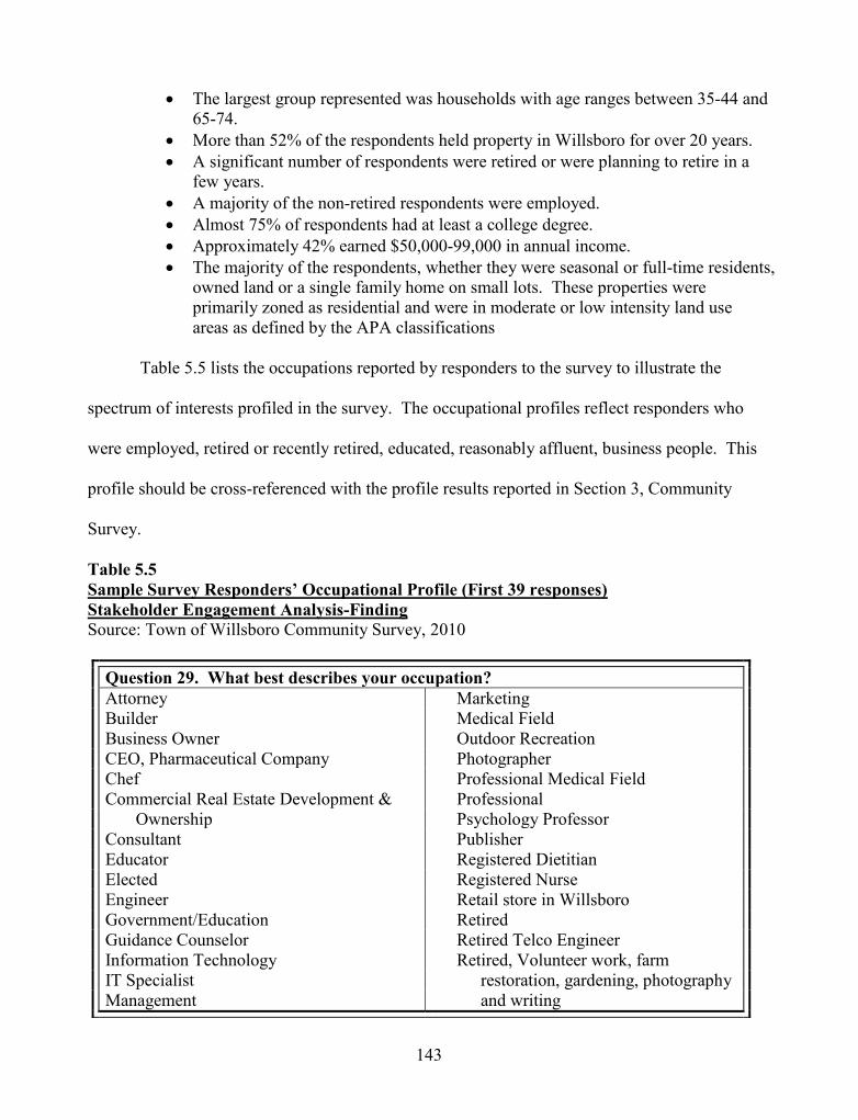
143
The largest group represented was households with age ranges between 35-44 and65-74.
More than 52% of the respondents held property in Willsboro for over 20 years. A significant number of respondents were retired or were planning to retire in a
few years. A majority of the non-retired respondents were employed. Almost 75% of respondents had at least a college degree. Approximately 42% earned $50,000-99,000 in annual income. The majority of the respondents, whether they were seasonal or full-time residents,
owned land or a single family home on small lots. These properties wereprimarily zoned as residential and were in moderate or low intensity land useareas as defined by the APA classifications
Table 5.5 lists the occupations reported by responders to the survey to illustrate the
spectrum of interests profiled in the survey. The occupational profiles reflect responders who
were employed, retired or recently retired, educated, reasonably affluent, business people. This
profile should be cross-referenced with the profile results reported in Section 3, Community
Survey.
Table 5.5Sample Survey Responders’ Occupational Profile (First 39 responses)Stakeholder Engagement Analysis-FindingSource: Town of Willsboro Community Survey, 2010
Question 29. What best describes your occupation?Attorney MarketingBuilder Medical FieldBusiness Owner Outdoor RecreationCEO, Pharmaceutical Company PhotographerChef Professional Medical FieldCommercial Real Estate Development & Professional
Ownership Psychology ProfessorConsultant PublisherEducator Registered DietitianElected Registered NurseEngineer Retail store in WillsboroGovernment/Education RetiredGuidance Counselor Retired Telco EngineerInformation Technology Retired, Volunteer work, farmIT Specialist restoration, gardening, photographyManagement and writing

144
The case study included eight workshops, 16 monthly meetings, web--and hard copy--
based surveys of the community, and electronic mailings, in order to provide year-round and
seasonal residents of Willsboro opportunities to participate in the development of the
comprehensive plan. A total of 588 people representing different interests elected to participate
through the enumerated activities. Choice was provided to citizenry, but participation was
voluntary. The form and duration of participation varied. Options to participate in person at one
or more meetings or by survey and email were provided.
Method 2: August, 2009, Listening Sessions
The data presented in this section provides evidence in support of Research Question One,
with particular emphasis on PAR methods. PAR was used in the August, 2009, Listening
Sessions and utilized inquiry, reflection, and dialogue techniques aimed at improving the quality
of conventional public participation and engagement at land use planning workshops. The
Steering Committee hosted two “listening” sessions for the citizenry of Willsboro. On Friday,
August 14, 2009, 23 citizens and five steering committee/agency representatives attended. On
Saturday, August 15, 2009, 32 citizens and eight committee/agency representatives attended.
They talked and we listened. Approximately 340 comments were received, compiled, and sorted.
An open coding method was applied three times by a Steering Committee Member and by Ann
Ruzow Holland to the raw data in order to categorize all 340 comments and produce 12 themes
(Table 5.6 and Figure 5.3). The full set of comments and allocation to themes is attached in
Appendix 5.1 together with the Steering Committee’s final report on the workshops. The 12
themes are listed below with an accompanying example of an attendee’s comment.

145
1. Agriculture and open space concerns, critical open space hot spots
i.e. “subdivision of farm land”
2. Buying local and supporting/celebrating local services
i.e. “Existing businesses like pharmacy, gas station, IGA, hardware store”
3. Changing demographics
i.e. “three different communities - Point - Town – Farms”
4. Concerns with clean water and water quality
i.e. “water quality deteriorating on lake, bay, river, Long Pond (invasive species -
zebra mussels - cormorants - geese on Long Pond”
5. Cross-cutting/hot button, high profile land use regulatory issues
i.e. “overbuilding on small lots - negative visual impact - septic impact”
6. Downtown/Main Street needs attention
i.e. “no vision for commercial area”
7. Environmental pollution (other than water) and concern for biodiversity and
habitat preservation
i.e. “loss of shoreline habitat due to tear down (homes, lawns, etc.)”
8. More growth and diversity of business base
i.e. “viability of community for young families”
9. Pattern and diversity of businesses (including agribusiness) in decline
i.e. “decrease in businesses downtown”
10. Small-town, open country, scenery, and rural feel
i.e. “maintain the character as it is (quiet and serene) in some areas i.e. Long
Pond”

146
11. Status and condition of cultural/recreation facilities and services
i.e. “there should be greater recreational facilities such as a social center, tennis
courts, bike trails (along the south river bank)”
12. Town government issues and services
i.e. “taxes - two-tiered - seasonal vs. year round”
Theme 1, Agriculture, open space concerns, and critical open space hot spots is presented
as a full example in Table 5.6.
Table 5.6Agriculture, Open Space Concerns, and Critical Open Space Hot SpotsAugust, 2009 Listening SessionsTheme Coding ExampleNote: Table contents are verbatim from respondents.Source: Town of Willsboro Comprehensive Plan Steering Committee, 2010
Agriculture, Open Space Concerns, and Critical Open Space Hot Spotsassisting farming loss of family farm
continue and encourage all types of farms loss of farmland
Create incentives to maintain farms - like csa's open and wooded space, ruraleducation concerning easements for environmentopportunities for farming open spacefarm land - open spaces open space/farmlandfarmers market preservation of open space/farmlandfarming role preservation of view shedsFarmland preserve/strengthen agriculturalfarms = jobs practicesFewer farms save open spaces on Willsboro Pointhamlet feel, rural feel and additional key areas in townkeep open land scenic vistasKeep the farmers! small family farmsLilly property subdivision of farm land
utilize Cornell-Baker farm

147
The 12 themes were compared for resonance to a theme list (below) independently
produced by the Co-Chair, who was a facilitator at one of the six tables at each of the two
workshops.
Small Town Atmosphere Long Term Growth, Rural Economy Town Center Appearance Capital Availability Declining Number of Farms Vistas, Maintaining Open Spaces Waterfront Land Values, Tax Burdens on Fixed Income Taxpayers Tourism, Seasonal Job Market Senior Citizen Services Recreational Opportunities School & River Underutilized Health Care Services, Maintaining Local Medical Presence Water Quality, Waste Disposal & Invasive Species
A series of charts and tables reporting the results were prepared in collaboration with Sue
Prudhomme, citizen volunteer. The data were reviewed by the Steering Committee on
September 1, 2009, and particularly by the Steering Committee members who were present at the
workshops to confirm their validity. New York State Department of State required that the
report be submitted for their review and comment prior to public dissemination. No comments
or changes were made. Approval to publically distribute was received on January 19, 2010.
Appendix 5.1 includes a copy of the full data report approved for public release by New York
State.
Further aggregation of the 12 themes (Figure 5.3) was achieved by consolidation of
similar themes: agriculture, open space, hot spots clean water, water quality, cross-cutting/hot
button issues, high profile land use regulatory issues, environmental pollution (other than water),
concern for biodiversity and habitat preservation, small-town, open country, scenery, and rural
feel. These data indicate that 42% of attendees were concerned about land use and

148
environmental issues. This is closely followed by 31% of attendees who were concerned about
economic sectors (aggregation of economic themes: downtown/Main Street needs attention,
pattern and diversity of businesses (including agribusiness) in decline, more growth and diversity
of business base, buying local and supporting/celebrating local services). The remaining three
issues, (status and condition of cultural/recreation facilities and services, town government issues
and service, changing demographics) did not lend themselves to further aggregation.
Figure 5.3. August, 2009 Community Workshop Results/Themes. Town of WillsboroComprehensive Plan Steering Committee. These are the 12 Generative Themes developedfrom the Coding exercise conducted from the August Listening Session results. Source:Town of Willsboro Planning Program September, 2009.
At the conclusion of each workshop, attendees were asked to provide feedback about
their experience. Attendees used strong language in their comments about meeting structure.
They commented that the meeting structure was “fascinating,” “fantastic,” “perfect” and a “great

149
process-really great.” People commented that they were astonished about the format for the
workshops. Residents who attended who had participated in land use planning workshops
elsewhere were expecting to be asked to sit in a chair and listen to speakers’ present information
ad infinitum. They did not expect to be subjected to the very briefest of presentations then be
asked to engage in small group discussions where the Steering Committee was doing the
listening and they were doing the talking. They were caught unaware and pleasantly surprised.
The six tables randomly grouped people from different walks of life. They shared
common ground in Willsboro in the summer, but many were complete strangers. Debriefing
comments indicated that attendees valued interacting with strangers. For example, attendees
stated, “Am gratified that we share the same concern” and “There are people on the same team:
farm, youth, and small town,” while another indicated, “I have a new way of looking at things.”
Attendee feedback revealed that small group discussions and interaction around the tables
provided an opportunity to learn that shared and differing viewpoints exist on community issues.
Attendees summarized their views on the value of the workshop at the personal and
community level. One commented that the listening session was, “Good reinforcement of
community spirit.” Another commented that, “I will take this with me wherever I go.”
Eleven months after the August, 2009, Listening Sessions, Steering Committee members
met to discuss the events and its outcomes. They evaluated the workshops and attendee-
generated data against the three criteria of Engagement, Information Transfer and Dialogue.
Steering Committee members indicated that they participated fully in the workshop
process and felt very engaged. A few members pointed out that the workshop did not include the
full spectrum of interests in the community because the “. . . problem is always that the people

150
who are engaged and interested are there. . .” (and the majority of the population is not present).
Citizen choice to attend was discussed as problematic.
Information transfer occurred on different levels. One level involved orientation to
hosting and running community meetings. Members mentioned that, “We were new at this and
getting our feet wet.” At the first set of community meetings hosted by the Steering Committee
one member stated, “This was the most labor intensive [activity] after the survey.” Members felt
there was a steep learning curve about preparation and planning associated with community
meetings. At the personal level members conveyed that new knowledge and ways of thinking
were gained from hearing what citizens had to say in response to the questions posed by the
Committee. They benefited from conversations during the small group work. “I [liked the
whole process and] learned a lot. It was very useful and a valuable experience.” Conversations
yielded learning based upon the cross-pollination of different viewpoints and voices coming
together across the table. One Steering Committee member commented, “The difference in
views was an information transfer.”
Workshop activity focused the discussions among the small group participants, and
Steering Committee members felt that the August Listening Sessions promoted courteous and
reflective dialogue by participants. One member who was a scribe and participant for separate
sessions pointed out that the depth of dialogue varied considerably from question to question and
workshop to workshop. Serious conversations on diverse topics with opposing viewpoints were
present at the meeting. There was concern by at least one member of the Steering Committee
that divisiveness between seasonal and year round residents might create contention at the
meeting, but civility was maintained. One Steering Committee member commented that,
“Different regions have their own issues which led to a lot of dialogue, heated discussions and

151
serious discussions.” This was echoed by other members who shared similar experiences in their
small groups. Members noted that the meeting format encouraged participation in conversations
between people or groups that include differing points of view, interests or opposing sides. Not
all members reported a comfort level with the tension that conflicting viewpoints elicited. One
reported, “I’m still having a problem taking part in serious conversations with differing points of
view.”
The Steering Committee’s conclusion regarding the Listening Sessions was that they met
the criteria of Engagement, Information Transfer and Dialogue very well for them, particularly
because of the design of the small group work.
Method 3: Development, Launch, Completion and Results of Community Survey
The Community Survey data presented in this section provide evidence in support of
Research Question One. Comprehensive planning generally involves polling the community and
surveys are a popular tool to reach out to citizens. Modern surveys utilize web or paper-based
survey instruments to ask a series of questions. Willsboro’s survey was a comprehensive tool
with 33 questions, two GIS maps and ample room for the public to provide anecdotal comments.
It was also meant to triangulate data collected from other sources during the
comprehensive planning process. For example, Question 32 asked responders to comment on
their vision for Willsboro. This information was used to triangulate data sets from the four
visioning workshops to produce the vision statement (see Section 6 results of this Chapter). For
Section 7 results, anecdotal comments received from all 33 questions were analyzed for the
purposes of identifying responses with environmental, land use or development themes. These
were triangulated with the evidence-based natural science data to produce the Steering
Committee’s natural resource draft recommendations as part of Section 7.

152
Development of the survey was a slow and painstaking process. Several factors
contributed to the deliberate and incremental PAR process that was employed to develop the
survey. As a collaborative PAR researcher, I did not want to take full responsibility for
designing the preliminary survey straw-man for the group. In the alternative, I provided them
with prototype examples of survey questions from other municipal community surveys. The
responsibility was placed on the Committee to explore the purpose and function of the survey
questions. It was important for the Committee to explore the link between the survey questions
and the information the Committee felt it needed to produce a comprehensive plan. I was willing
to guide this discussion, but I did not wish to substitute the valuable dialogue with a straw-man
document of my fabrication. The group was also just getting started and had not forged into a
cohesive team. From an organizational development perspective, I believed that the exercise of
discussion, reflection and debate that was involved in selecting survey questions was a necessary
prerequisite for future activities. This was a point of criticism for my application of the PAR
process. The Steering Committee wanted greater effort on my part to condense and expedite the
survey development process. The Steering Committee reviewed and discussed more than 100
representative questions on topics such as economic development, housing, land use and
demographics before settling on the 33 questions chosen. These were revised (and challenged)
numerous times through a series of editorial reviews by Steering Committee Agency Partners
and advisors. The final questions represent the Steering Committee’s best efforts at designing a
community survey accessible to the citizenry of Willsboro in a format that would also achieve
efficiency in analyzing the results.
1,900 residents and property owners were notified by postcard in February, 2010, and
asked to complete the Willsboro Community Survey. Three hundred-thirty residents responded,

153
an effective response rate of 17%. The internet-based Survey Monkey was selected for the web-
host in part because of its reputation and also because it automatically compiles a quantitative
analysis of the survey and provided a detailed summary report for the entire survey. Appendix
5.2 includes a full copy of the Survey Monkey-generated report results for all 33 questions.
For the purposes of this section, results for eight of the 33 questions are presented
(Table 5.7). Question 32 is reviewed in Section 6, (Visioning) and all the citizen comments were
reviewed and single focused coded for Section 7 (Straw Man Land Use Regulations). The eight
questions selected provide information directly related to the research questions. They are also
critical and complementary to the integrity of the mixed methods reported in the remaining
sections of Chapter 5. The subject areas covered are important because they focus citizen
response on development, land use, and environmental planning.

154
Table 5.7Relevant Survey Questions Selected for Case Study ResearchSource: Town of Willsboro Community Survey
Relevant Survey Questions Selected for Case Study ResearchQuestion # Question Summary:
(See each graph in this section for the full question details)4 How important are the following choices in making Willsboro a desirable
place for you to live?5 The Comprehensive Plan Steering Committee’s work is associated with
the future direction of Land Use Planning in Willsboro. In Willsboro,from 2002 through 2009 the Code Enforcement Office reported an annualaverage of 16 single-family homes permitted in the Town of Willsboro.As Willsboro continues to grow, how important are each of the followingstatements to you?
6 Are there any properties, scenic vistas, or shorelines within thecommunity that you feel the Comprehensive Plan Steering Committeeshould recommend be protected or preserved for natural, open space,farmland purposes or as cultural resources?
7 Please indicate your agreement with the following community land usegoals.
8 Should Willsboro seek development and growth in the following landuses?
9 Please indicate your agreement with the following statements in regards tothe Town of Willsboro’s Zoning and Subdivision Regulations.
12 Please indicate your agreement with the following statements in regards tothe Adirondack Park Agency Rules and Regulations.
15 Willsboro has 6,393 acres in the Agricultural District representing 23% ofthe land acreage in the Town. There are additional Agricultural Landsoutside the District. Please indicate how important the following farmlandissues are to you.
The following section presents the results of the community survey and begins with a
profile of the survey respondents. This is followed by eight subparts reporting the results of the
selected questions referenced in Table 5.7. Finally the debriefing results from the Steering
Committee are provided.

155
3a. Profile of the survey respondents.
Survey responses represent 17% of the mailing to 1,900 postal addresses and included a
mix of permanent and seasonal residents. More than 52% of the respondents have lived in
Willsboro for over 20 years. Many of the seasonal respondents stated they started coming to
Willsboro as youth and retained their family property. The majority of all respondents owned
land or a single family home. These properties are primarily zoned as residential and are in
moderate or low intensity land use areas as defined by the Adirondack Park Agency (APA)
classifications.
Two age ranges (35-44 and 65-74) dominated the households of the respondents.
Whether they were employed or retired, the majority of respondents were moderately to highly
skilled and trained members of the workforce. Almost 75% of respondents have a college
degree. Occupations ranged from unskilled to highly skilled positions requiring technical or
graduate education.
A significant number of respondents are retired or are planning to retire in a few years. A
majority of the non-retired respondents are employed. Approximately 42% earn $50,000 -
$99,000 in annual income. The profile of survey respondents indicated seasonal and year-round
residents who possessed moderate incomes and were highly educated. Middle aged, nearing or
at retirement, the respondents took the time to complete the survey and voice their interests and
concerns.

156
3b. Results for question 4.
How important are the following choices in making Willsboro a desirable place for you
to live?
Figure 5.4 illustrates the response to Question 4. Question 4 utilized a Likert scale that
rated responses based upon “importance” categories. The options for responding to Question 4
included environmental quality, walking/hiking/biking and the availability of local food. These
three items are linked to the research questions since they relate to the availability of open space
for recreation, productive agricultural lands, and the protection of natural resources. Each of
these three items rated high in importance to the respondents. Aggregating responses in all the
“importance” categories revealed that 310 of the 320 respondents, or 97%, felt that Willsboro's
environmental quality made it a desirable place to live. Walking/hiking/biking also rated high at
89% with the availability of food following at 88%.

157
Figure 5.4.
Figure 5.4. Question 4 the Willsboro Community Survey
Figu
re 5
.4.
Que
stio
n 4
of th
e W
illsb
oro
Com
mun
ity S
urve
y. T
his f
igur
eid
entif
ies r
espo
nden
t pre
fere
nces
rela
ting
to q
ualit
y of
life
and
com
mun
ity se
tting
. So
urce
: Tow
n of
Will
sbor
o C
omm
unity
Sur
vey.

158
3c. Results for question 5.
The Comprehensive Plan Steering Committee’s work is associated with the future
direction of Land Use Planning in Willsboro. In Willsboro, from 2002 through 2009,
the Code Enforcement Office reported an annual average of 16 single-family homes
permitted in the Town of Willsboro. As Willsboro continues to grow, how important
are each of the following statements to you?
Question five asked respondents to rate the importance of six land use approaches
(answer options) that the Steering Committee might consider recommending for the
comprehensive plan. Figure 5.5 graphically represents the percent response to this question. In
order to simply analysis and summarize results, all the Likert responses in the “importance” scale,
such as "extremely important”, “very important”, and “important”, were combined (aggregated).
Aggregated responses across all six answer options indicated that three options received more
than a 70% response rate, and these three answer options still hovered in the 70-80% range.
“Require grouping of residential and/or commercial structures to preserve open space and
agricultural land” gained 77%. This was followed by “Require developers to include outdoor
recreational space as part of their plans” at 75%. “Limit new development to areas with existing
or planned roads, water and sewer” received a 70% aggregate rating.
“Discourage small lot development in rural areas” was an answer option that appealed to
a majority of citizens, but also received the highest “not important” score of 34%. “Encourage
development to be kept within or immediately adjacent to existing built-up areas” also received
the second-highest “not important” score at 32%. Nineteen percent of respondents indicated that
they were uncertain in their response to, “Encourage multi-use neighborhood development.” The
terminology may have been confusing

159
Figu
re 5
.5.
Que
stio
n 5
of th
e W
illsb
oro
Com
mun
ity S
urve
y. T
his f
igur
e ill
ustra
tess
urve
y re
spon
ses t
o sp
ecifi
c ty
pes
of S
mar
t Gro
wth
land
use
stra
tegi
es.
Sour
ce: T
own
of W
illsb
oro
Com
mun
ity S
urve
y, 2
010.
Figure 5.5.Question 5 of the Willsboro Community Survey.

160
3d. Results for question 6.
Are there any properties, scenic vistas, or shorelines within the community that you
feel the Comprehensive Plan Steering Committee should recommend be protected or
preserved for natural, open space, farmland purposes or as cultural resources?
Seventy-five percent of respondents indicated there are properties, scenic vistas, or
shorelines that they would recommend be preserved or protected (Figure 5.6). Eighty-two
citizens provided specific examples in the comments section of this question to support their
answers. Responses emphasized waterfronts and shorelines on Willsboro Point and Bay, along
the Boquet River and specific places such as Hatch Point, Willsboro Bay cliffs, and Long Pond.
Scenic vistas and farmland were also mentioned as preservation priorities (compare with
Question 15, where responses indicate a strong lack of interest in conservation and agricultural
easements).
Figure 5.6. Question 6 of the Willsboro Community Survey. This figure illustratesthe percentage of respondents who indicated they would recommend properties tobe preserved or protected. Source: Town of Willsboro Community Survey, 2010.

161
3 e. Results for question 7.
Please indicate your agreement with the following community land use goals.
In Question 7, sixteen answer options were offered to the respondents (Figure 5.7). An
aggregation of the Likert importance-scale answers indicated that options separated into two
groups. The first comprised the first fourteen answer options. These appeared to receive ratings
from a low of 73% to a high of over 94%. In this grouping the highest rankings were:
Protect aquifers (groundwater / water quality) ranked 1 at 94% Protect air quality ranked 1 at 94% Protect historic sites and buildings ranked 2 at 89% Protect scenic vistas ranked 3 at 87% Protect shorelines ranked 3 at 87% Protect stream corridors ranked 3 at 87%
The lowest rankings of the 16 options were in the last two answer options. "Promote
public shoreline access" received 67% and "reduce light pollution/promote night skies" received
65%. These categories also had the highest number of “disagree/strongly disagree” respondents
than the remaining 14 categories of 18 and 15% respectively. "Promote public shoreline access"
received neutral responses of 18% and "reduce light pollution/promote night skies" received
20%. In addition to the lower rankings on the public shoreline access and light pollution options,
one other answer option demonstrated less clear positive support by respondents and more
tension in responses. "Protect ridgelines" received 50 neutral responses and 12 “don’t
know/unsure” responses comprising 19% of the responses. While 73% of the citizens responded
favorably to this option, it received the third lowest ranking of all the alternatives. Figure 5.7
provides the percent response to Question 7.

162
Figu
re 5
.7.
Que
stio
n7
ofth
e W
illsb
oro
Com
mun
ity S
urve
y. T
his f
igur
e ill
ustra
tesc
omm
unity
resp
onse
s to
spec
ific
land
use
goa
ls.
Sour
ce: T
own
of W
illsb
oro
Com
mun
ity S
urve
y, 2
010.
Figure 5.7. Question 7 of the Willsboro Community Survey.

163
3f. Results for question 8.Should Willsboro seek development and growth in the following land uses?
Question eight asks respondents about 14 development types for answer options
(Figure 5.8). The options ranged across all land use sectors including industrial, commercial
(including agribusiness and silviculture), residential, infrastructure, and conservation. The Likert
scale agreement options were aggregated and revealed that the only responses to receive more
than a 75% response rate included development of light industry, agribusiness, conservation and
open space, water and wastewater systems. The development of heavy industry was the least
popular option for agreement receiving a 26% score.
The Likert scale disagree options were also aggregated. No answer options approximated
51%. The highest ranking was heavy industry—an indication from citizens that it should not be
developed at 49%. The next highest rankings discouraged specific forms of development that
included downtown parking at 19% and second home development at 18%.
Neutral respondents were higher than disagreeing respondents in many categories. For
example, 43% responded as neutral to the option about developing downtown parking,
outranking aggregated responses for both “agree” (35%) and “disagree” (19%). Survey
respondents were more neutral on the question of developing second homes than they were with
development (30% vs. 18%), placing the comparison with agreement (49%) in a different light.
Question eight’s neutral response rates are consistently higher than the aggregate “disagree”
response-- except the heavy industry option.

164
Figure 5.8. Question 8 of the Willsboro Community Survey.
Figu
re 5
.8.
Que
stio
n 8
of th
e W
illsb
oro
Com
mun
ity S
urve
y. T
his f
igur
e ill
ustra
tes t
he re
spon
dent
s‘de
velo
pmen
tan
d gr
owth
pref
eren
cest
o pr
e-se
lect
ed la
nd u
ses.
Sour
ce:
Tow
n of
Will
sbor
o C
omm
unity
Sur
vey,
201
0.

165
3g. Results for question 9.
Please indicate your agreement with the following statements in regards to the Town of
Willsboro’s Zoning and Subdivision Regulations.
Question nine asked citizens to clarify their experience with the Town of Willsboro’s
land use regulations and administrative procedures (Figure 5.9). The Steering Committee
wanted to understand how literate citizens were with the land use process in the Town. Only
35% of respondents reported having read the zoning or subdivision regulations, yet 66% had
applied for a building permit for their property. A small percentage, 28%, had participated in the
variance process and an even smaller number, 10%, the subdivision process.
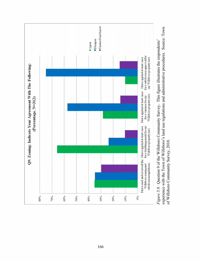
166
Figure 5.9. Question 9 of the Willsboro Community Survey
Figu
re 5
.9.
Que
stio
n9
of th
e W
illsb
oro
Com
mun
ity S
urve
y. T
his f
igur
e ill
ustra
tes t
he re
spon
dent
s’ex
perie
nce
with
the
Tow
n of
Will
sbor
o’s l
and
use
regu
latio
ns a
nd a
dmin
istra
tive
proc
edur
es.
Sour
ce: T
own
of W
illsb
oro
Com
mun
ity S
urve
y, 2
010.

167
3h. Results for question 12.
Please indicate your agreement with the following statements in regards to the
Adirondack Park Agency Rules and Regulations.
Question 12 gauges the literacy and experience of citizens with the Adirondack Park
Agency regulations that also govern the two-tiered system of land use regulations in Willsboro
(Figure 5.10). Slightly fewer citizens had read the APA regulations (31%) compared with 35%
having read the town regulations. Recognition that Willsboro was located within the Adirondack
Park was very high at 92%, but this recognition did not follow through to understanding that the
town had an approved partnership with the APA to conduct its local land use program. Only
39% were aware of this fact and 57% indicated that they were unaware of the relationship
between the town and the APA through the approved local planning program.

168
Figure 5.10. Question 12 of the Willsboro Community Survey. Figu
re 5
.10.
Que
stio
n12
of th
e W
illsb
oro
Com
mun
ity S
urve
y. T
his f
igur
e ill
ustra
tes t
helit
erac
y an
dex
perie
nce
ofci
tizen
s with
the
Adi
rond
ack
Park
Age
ncy
regu
latio
ns th
at a
lso
gove
rn th
e tw
o-tie
red
syst
em o
f lan
d us
e re
gula
tions
inW
illsb
oro.
Sour
ce: T
own
of W
illsb
oro
Com
mun
ity S
urve
y, 2
010.

169
3i. Results for question 15.
Willsboro has 6,393 acres in the Agricultural District representing 23% of the land
acreage in the Town. There are additional Agricultural Lands outside the District.
Please indicate how important the following farmland issues are to you.
Eighteen answer options are provided in Question 15 that focus on agriculture
(Figure 5.11). The approaches outlined in Question 15 are a mix of direct and indirect financial
and program best practices that help support agriculture. The Likert importance-scale responses
were aggregated, revealing that a majority of respondents supported all but one best practice
through ratings ranging from 62 to 85%.
The best practice that was not supported by a majority of respondents was paying farmers
by purchasing their development rights. Only 40% of respondents indicated this was
“important”. It should also be noted that 32% of respondents indicated that they were "unsure"
about their response to this option, exceeding the “not important” answers reported as 29%. This
option should be compared with similar questions on farmland and open space protection in
Questions 6 and 7.
Generally, the indirect and unsubsidized methods of supporting farmers were selected
over the direct subsidies. Direct marketing, help with environmental compliance, new products,
buy local, youth programs, and support services received high marks as compared with tax
incentives, utility cost reductions and finance programs.

170
Figure 5.11. Question 15 of the Willsboro Community Survey
Figu
re 5
.11.
Que
stio
n15
of th
e W
illsb
oro
Com
mun
ity S
urve
y. T
his f
igur
e ill
ustra
tes t
heim
porta
nce
of a
gric
ultu
ral i
ssue
sto
the
resp
onde
nts.
Sou
rce:
Tow
n of
Will
sbor
o C
omm
unity
Sur
vey,
201
0.

171
3j. Results of Steering Committee debriefing on the community survey.
The survey was prepared from May, 2009, through October, 2009. It then sat in a
holding pattern while the State of New York decided whether it would approve and release the
survey for distribution. That decision arrived on January 5, 2010. The Steering Committee then
launched the survey in February, 2010, and received completed surveys through March, 2010.
The Steering Committee reported mixed value from the survey process and product. There
was consensus that the development of the survey was arduous from many viewpoints. It was
voted the most labor intensive activity of the plan process. Many members felt the selection and
crafting of each topic and question was far too tedious and painstaking. One member
commented, “It was a thinking exercise.” It was the first effort to work together as a group, and
one member noted that the process of debating and reaching consensus began with the survey
questions. “Nobody left ticked off about it.”
The delays caused by New York State and the consequences caused by the delays in terms of
lost time to the plan process created frustration. Launching the survey and seeing the results
were restorative for the Committee. To some members the results were a good mix of new
information and reinforcement of expectations. “Some new information, most was depressing,
some was surprising.” There was concern that the survey did not reach as broad a spectrum of
the community as they had hoped.
Method 4: Discussions with Natural Science Subject-Matter Experts
Research Question One includes presentation of and access to natural science data as one
indicator to measure improvement of the comprehensive planning process. The results for
Method 4 include the description of the presentations and the Steering Committee debriefing on
the technique.

172
4a. Results of discussions with natural science subject-matter experts.
Natural Science Subject-Matter Experts presented natural science information to the
Steering Committee members who had very diverse backgrounds in science. Several members
possessed strong backgrounds as science teachers while others were inexperienced. Exposure to
the scientific data produced mixed results in part because of the presenters’ capacity to make the
material understandable to lay audiences and the diverse backgrounds of the Steering Committee
members. Despite the steep learning curve for the subject-matter, members were able to gain
experience with scientific data, use their personal knowledge of nature, and apply local scientific
knowledge during the discussions that followed each presentation. The reflective dialogue that
ensued helped them over the course of the planning program to make use of GIS and other
scientific knowledge that they developed over the course of the project.
Eight of the eleven subject-matter experts who met with the Willsboro Comprehensive
Plan Steering Committee from August, 2009, through January, 2010, discussed natural science
subjects. I selected water, geology, soils, wildlife, and ecology as the framing topics of land
planning analysis that needed to be covered in the time allotted. Table 5.8 details the Subject-
Matter Expert's names, affiliations and topics.

173
Table 5.8Willsboro Subject-Matter Experts and Topics
Topic Date Subject-Matter ExpertReview of Smart GrowthScorecard for Willsboro
August,2009
Jim Kinley, Zoning Officer, Town ofWillsboro
Water Resources in Willsboro September,2009
Professors Ed Romanowicz and TimMihuc of the Lake Champlain Instituteand Plattsburgh State University
Long Pond Watershed Issues September,2009
Phil Corell, Long Pond Association
Bouquet River Watershed andWatershed Protection Programs
October,2009
Julie Martin, Director, Boquet RiverAssociation
Geology, shoreline bank andsoil conditions, landslide andland slump risk in the WillsboroEnvirons
October,2009
David Franzi, Professor, PlattsburghState University
Willsboro Soils and the updatedEssex County Soil Survey
November,2009
Jerry Smith, Soil Scientist, USDANRCS
Plant and wildlife ecologyEcosystem management andadaptive management
December,2009
Professors Ken Adams and DanielleGarneau, Plattsburgh State University
Willsboro Commerce Park(90Acre) Development Plans
January,2009
Jody Olcott, Essex County IDA, BillMcClay, Willsboro DevelopmentCorporation, Wayne Ryan, AESEngineer.
4b. Results of Steering Committee debriefing on subject-matter experts.
The general engagement level between the Steering Committee members and the experts
was very high although the members saw their engagement as personally satisfying, rather than
useful as members of the Steering Committee. Steering Committee members used affective
adjectives, such as “I loved them,” “Really enjoyed,” and “You should have been there!” to
express their emotions for the experiences.
Members observed that while some of the material might have been “over their heads,”
they had learned a great deal from the meetings regardless of their prior experience with science.

174
One of the lay members commented, “I learned a lot, very much. I think the subjects I probably
didn’t know a lot about, I listened and absorbed.” The members with strong science
backgrounds felt that the level of detail provided by the presenters reinforced and supplemented
what they knew and provided a, “Very useful foundation to work on the plan.”
Members voiced concern that one or more of the university faculty did not understand the
audience sufficiently well to prepare an appropriate presentation. One member commented,
“They were trying to capture a whole semester’s worth of learning, that didn’t work for me. I
couldn’t connect the mapping to the discussions.” While the complexity of the information
conveyed by the experts may have confounded some members of the committee, dialogue with
the experts during the encounters was spirited. Committee members asked for clarification and
explanations. Inter-personal dialogue between the Steering Committee members during these
meetings was very limited, but conversations between the experts and individual members of the
Steering Committee were active and lively.
Method 5: Results of Community Based Field Work and Development of GIS forCommunity Profile and Analysis Work
This section provides evidence in support of Research Question One, with emphasis on
access to and presentation of evidenced-based technologies, i.e. Geographic Information Systems
(GIS). The Steering Committee’s debriefing summary on the PAR methods utilized to create the
maps and a sample of the GIS maps are presented.
Steering Committee members and Agency Partners collaborated to address the lack of a
spatial database. Where only local knowledge could supply what was needed to complete the
mapping, volunteers, Steering Committee members and town officials met with my GIS
technician to assemble data points and conduct GPS fieldwork. Specific maps were created from
these collaborations, including the inventory and analysis of visual/scenic and waterfront

175
conditions, sewer district map, building permit trends, recreational facilities, and trail maps.
Figures 5.12 and 5.13 present two of the maps, Scenic Resources and Recreational Facilities,
which were created from the collaborative effort.

176
Figure 5.12. Scenic Resources Inventory and Analysis. This figure represents an exampleof one GIS database built exclusively by the Steering Committee. Source: WillsboroComprehensive Planning Steering Committee, 2010.

177
Figure 5.13. Recreation and Tourism Facilities. This figure represents a second example ofa GIS database built by the Steering Committee. Source: Willsboro ComprehensivePlanning Steering Committee, 2010.

178
Additional inventory and analysis maps were created with spatial and statistical data
contributed from publicly available sites and with the assistance of agency partners.
Collaborations included the Boquet River Association, U.S. Department of the Interior, Fish and
Wildlife Service, New York State Department of Environmental Conservation, Natural Heritage
Trust, Essex County Cooperative Extension, Adirondack Park Agency, and Professor Dave
Franzi from SUNY Plattsburgh. These resources enabled the generation of maps that
incorporated local data. For example, data were provided for stream culvert locations,
significant ecological communities, agricultural district boundaries, and landslide and land slump
locations.
An intensive collaboration with a soil scientist with the Natural Resource and
Conservation Service (NRCS) spearheaded an effort to provide Willsboro with up-to-date soils
information from the recently completed Essex County Soil Survey. NRCS supplemented the
Adirondack Park Agency interpretations of soils information that led to the production of town-
wide soil wastewater suitability rating tables and maps. NRCS also assisted with the production
of key agricultural soils maps. NRCS provided scientific soils data in multiple formats:
photographs of representative soils series, guidebooks, staged mapping, and hands-on technical
assistance. This level of scientific interpretation supported the mapping process so that the
Steering Committee could understand how to read and utilize the maps for their analysis. Figure
5.14 presents one example of a soil suitability map created from this process.

179
Figure 5.14. On-Site Wastewater Treatment Soil Suitability Ratings. This figureillustrates how GIS was used to provide septic suitability information for interpretationby the Steering Committee and the community. Data provided by the NRCS andAdirondack Park Agency was consolidated into useful formats using GIS. Source:Willsboro Comprehensive Planning Steering Committee, 2010.

180
Approximately 100 maps, including map series, were created during this project
(Table 5.9). Steering Committee members used an iterative process to review and refine maps.
A GIS is not static and this process is continual as new information is discovered.
Table 5.9GIS Map InventorySource: Town of Willsboro Comprehensive Planning Program
Map Inventory-Completed Maps
Volunteers
Contributed
Data Points or
Field Work
Agency
Partners
Contributed
Data Points
Publicly
Available
Data
Natural Systems
Scenic Resources –
Remote Vistas and Road VistasX
Topography X
Water Quality X
Waterfront Conditions X X X
Forest Cover X
Environmental Issues X X
Unique Natural Features X
Geology - Surficial X
Geology - Bedrock X
Landslide/slump Locations X
Soils (9 Maps) X X

181
Map Inventory-Completed Maps
Volunteers
Contributed
Data Points or
Field Work
Agency
Partners
Contributed
Data Points
Publicly
Available
Data
On-Site Wastewater Treatment Suitability
Series (9 Maps)X X
Agricultural Soils Series: Capability for
Soils, Prime Agricultural Soils (9+ maps)X X
Hydrology X
Private Lands: Open Space/Undeveloped
Land (9+ maps)X
Economic and Cultural Features
Agricultural Lands and Agricultural
Districts
(3+ maps)
X X
Adirondack Park Agency Land Use
ClassificationX
Recreation and Tourism Destinations X
Transportation Routes X X
Unique Cultural Features-Historic Sites X
Community Facilities and Services X
Water District X

182
Map Inventory-Completed Maps
Volunteers
Contributed
Data Points or
Field Work
Agency
Partners
Contributed
Data Points
Publicly
Available
Data
Sewer District X
FEMA Flood Hazard Areas X
Zoning Districts –series X X
Building Permit Activity-series
Series (2002-2009 each year) (8 Maps)
2002-2009 :
Residential
Variances
Septic Installations
X
Existing Land Use Series (9 Maps) X
Steering Committee members stated that the GIS process succeeded in transferring
information to them by presenting a great quantity of information about Willsboro in a rapid,
audience-friendly medium. One member quipped, “A picture is worth a 1000 words.” Several
members noted that the spatial presentation of data on Willsboro (rather than other written or
graphic formats) gave new meaning and context to what might have been accepted as fact. One
member asked the group, “How many of us knew what made up Willsboro before we saw it
superimposed?” Another commented, “ . . . [I had] seen everything, but it had new meaning to

183
me.” The group agreed that they were engaged in the process and had communicated with each
other openly and actively during the process of developing and reviewing the maps.
The members mentioned that they were still trying to manage a large amount of information
even if it was in map form. They felt GIS technology was an asset to their work, especially
compared to the paper maps of the 1977 Plan. “Here we have the capability creating 70+ maps
defining soils, what is and isn’t a good place for septic, etc.--it is just amazing.”
Concluding comments from the Steering Committee indicated that their direct involvement
in the development of the GIS was educational and in one member’s opinion, “GIS maps are the
biggest resource” resulting from the project.
Method 6: Results of Decentralized Visioning Sessions and Straw-man Visioning Statement
Evidentiary data are provided in this section to support Research Questions One and
Three, and in particular PAR and comprehensive planning methods. Visioning sessions and a
vision statement are customary aspects of land use planning processes. Generally, a central
single meeting is held where the public is invited to participate in a visioning exercise facilitated
by a planner. A statement is generated then embedded into the comprehensive plan. In theory
the vision statement guides the issues, strategies, and recommendations included in the document.
In this case study, aspects of the PAR method of Appreciative Inquiry (AI) were used to
design a visioning process. AI was used to frame questions to ask citizens at four decentralized
visioning outreach meetings and to shape the agenda (Table 5.10). Focus groups were held with
the agricultural community and the senior citizens, although these meetings were also open to the
public. The remaining two meetings were open to the public and one was co-hosted by the
ecumenical community.

184
Table 5.10Willsboro Visioning Meeting Schedule and Attendance
Date Location Purpose # AttendeesMarch 13, 20101:00-3:00 PM
Whallonsburgh GrangeHall
AgriculturalStakeholders
15
April 1, 201012:00-1:30 PM
Senior Nutrition Site Senior Citizens 24
April 7, 20106:30-8:30 PM
Methodist Church General Audience-Ecumenical Community
8
May 25, 20106:30-8:30 PM
Willsboro Visitors Center General Audience 8
The March 13, 2010 meeting with 15 farmers used a slightly different set of questions
than the three other sessions, but the framing of the questions still utilized the AI approach. A
listing of the agricultural questions with one representative response follows. Appendix 5.3
includes the full set of comments from the attendees for all sessions. Three Steering Committee
members attended the meeting with the farmers and heard first hand their comments. The
remainder of the Steering Committee had access to the comments.
1. Tell us about a time when you found yourself describing Willsboro as a great
place to live.
i.e. “Close to the lake, beautiful views, whole area better places, surprising that a lot
of people know about Reber valley, nice place, family been here number of
generations”
2. What are the core strengths of agriculture in Willsboro?
i.e. “Not like eating from a supermarket in a big city”
3. What does the community and government do best now with respect to providing
support for agriculture in Willsboro?

185
i.e. “Think they are doing a pretty good job---if people come and buy land, the
planning board, has them build on the side of it so that other farmers can lease it or
rent it so that the land does not sit idle. The community and farmers can get more use
out of it. 11 dollar milk may not pay the bills it is 16 now.”
4. What does the Willsboro agricultural community do best for themselves with
respect to providing support?
i.e. “Train the next generation of farmers over and above college”
5. How should Willsboro be involved to help transform the vitality and effectiveness
of Willsboro’s agribusinesses?
i.e. “Town needs to promote the importance of agriculture in the town, custodian of
wildness and open area in the Town for the next 100 years.”
6. How will the global trends on the horizon with respect to agriculture (products,
technologies or general trends) transform Willsboro’s agricultural base? How
could the community and government of Willsboro support what the world is
calling for with regard to agribusiness?
i.e. “Price of petroleum, buying local food because buying food from far away will
become less and less viable.”
7. If you left and returned in 10 years and found Willsboro to be a leading edge
community, what new things would you like to see?
i.e. “Still open space and open land and still farming and new farmers.”
There was lively dialogue and discussion amongst the attendees on the range of subjects
raised by the questions. The members of the agricultural community voiced their appreciation
and satisfaction to the Steering Committee for hosting the meeting. Farmers represent a large

186
segment of the land ownership and land tenancy base in Willsboro (according to the Agricultural
District and Real Property tax information for the town, Willsboro has approximately 6,393 acres
in the Agricultural District representing 23% of the land acreage in the Town; additional
agricultural lands exist outside the district). At the conclusion of the meeting, the stakeholders
mentioned their interest in monitoring the comprehensive planning process to see that their
issues and concerns were satisfied by the recommendations of the Steering Committee.
The three general sessions followed the same pattern as the agricultural meeting. Forty
citizens attended the sessions for senior citizens and general audiences. Three Steering
Committee members attended and heard the conversations. The remaining members had access
to the written comments. Attendees were asked six questions using the AI approach. For the
purposes of presenting a representative sample of responses, the April 1, 2010, comments from
the seniors are provided below:
1. Tell us about a peak experience you had in Willsboro.
i.e. “We were driving an old pickup truck, out in the yard, everyone waved to us,
thought we were a native, very friendly atmosphere”
2. When do you believe that Willsboro has been at its best--in all the time you have
been here?
i.e. “Downtown was downtown, not uptown; there is nothing in Willsboro now to hold
anyone here, who can walk up the big hill; the valley is too steep to run up the hills;
Willsboro was founded on the river, not uptown”
3. What do you value most about Willsboro?
i.e. “The small towness of it versus the city--lack of traffic”

187
4. What are the core factors that make Willsboro what it is today?
i.e. “Used to feel free, but anywhere you don’t feel free, Willsboro is just plain
unique.”
5. If you could transform Willsboro in any way you wished, what two or three
things would you do to heighten its quality of life?
i.e. “Something to hold the young people here--there is no work here”
6. If you left and returned in 10 years and found Willsboro to be a leading edge
community, what new things would you like to see?
i.e. “Nothing--the way it is”
Each meeting was unique. The seniors were busy eating their noontime meal and
answered briefly and to the point. They did not mince words and there was little dialogue. The
room arrangements were very crowded and the acoustics were poor. These were not conducive
to extended conversation, especially with an elderly group. The Steering Committee member
who facilitated the meeting commented that despite the facility constraints faced by the seniors at
their meeting, comments were “. . .to the point. They were not afraid to say it and it went quick.
There wasn’t very much introspection.” The opportunity to meet with the seniors was important
and could not be missed.
The meetings at the Methodist Church and Visitors Center were relaxed, acoustics were
good and conversations among attendees flowed easily. The number and length of comments
appears to be greater as a result of the environment and facilities in which the workshop was held.
The questions asked at the four meetings generated 341 comments. Question 32 on the
Community Survey asked responders to briefly describe their vision for the community as they
saw it in 20 years. Survey responses provided 246 additional statements for a total of 587. To

188
manage 587 comments, open coding was used to develop Generative Themes. I conducted the
first sequence of open coding. In order to ensure reliability and validity of the process, the Co-
Chair of the Steering Committee conducted a second review. A comparative analysis of both
runs revealed no statistically significant difference between the two coding exercises. An
example of the comments coded to each Generative Theme is provided in Table 5.11. The
comprehensive allocation of all comments to the Generative Themes is provided in Appendix 5.3.
Table 5.11Decentralized Visioning Workshop ResponsesSample Coding to Produce Generative ThemesTaken from Question 32 Responses.Source: Town of Willsboro Steering Committee , 2010.
Generative Theme Representative Comment
The singular and exceptional Willsboro
experience as a sacred landscape of beauty, of
home and of happiness;
“A safe, clean community where my
children & grandchildren can continue
to enjoy the water and serenity of the
environment during the summer
months.”
Willsboro honors the tradition of welcoming
visitors and its seasonal residents; small town
(Social);
Our relationship with the Town of
Essex, isolated to the NE corner of
Essex County, keep and close
relationship-necessary, fire and rescue.
Churches serve populations together,
organizations important for the future to
be able to physically and
economically ….;

189
Generative Theme Representative Comment
Four season, vibrant business and creative
economy;
“A thriving downtown area with shops,
restaurants, art galleries, parks, parking
etc.”
Diverse mix of cultural and recreational
facilities & events;
“The same beautiful town with perhaps
more entertainment for all ages.”
High quality scenic resources, excellent water
quality for swimming, drinking and boating,
large biodiversity and habitat, large acreage of
agricultural lands, woods and fields are
maintained;
“A green oasis in a turbulent world!”
Demographic mix issues-changing to a
different mix (younger/older);
“If there is less jobs available and
opportunities we are going to see a
reduction in our younger age
population. This is already the case for
all communities in the “Blue Line."
Small town (physical) effects of size and
structure;
“Keep the rural feel of Willsboro.”
Revitalized properties; “The overall looks of the town are very
important. Without an effort to keep the
town looking good no one will want to
come here and live. I would hope the
Noblewood property would be better

190
Generative Theme Representative Comment
utilized and that we would encourage
more businesses to come to our
community. Preserve what historic
buildings we have left. Horrible that we
lost the old firehouse, first school and
town hall. History is important, a new
use for the grist mill and community
working together with other
communities.”
Public facilities and services are diverse,
maintained and responsive to the needs of the
community;
“Sewer and water for all!”
Property Taxes should be examined “As I see it, over the long term, property
taxes are driving out many current
residents and may limit future
residential growth. The ability to fund
local services, particularly the school, is
becoming very limited.”
Growth is controlled, limited, managed and
restrained so that the community's footprint
and character doesn't really change and natural
resources are really protected.
“Limiting development especially on
the Willsboro point. Also, keeping to a
building height on the bay and lake
shoreline.”

191
Generative Theme Representative Comment
Less Regulation “You people should not be getting into
telling us what to do with our land...
protecting this and that......noble, yes,
but we already have enough people
telling us what we can and can't do.
Another self appointed group of people
creating more layers of government is
NOT what we need.”
More Housing Development “I'd like to see affordable housing.”
After all the vision comments were sorted by theme, the number and percentage allocated
to each theme was calculated. The Generative Themes received the following rankings in terms
of allocated comments:
35.49% ........Four seasons, vibrant business, and creative economy
13.43 % .......High quality scenic resources, excellent water quality for swimming,
drinking and boating, large biodiversity and habitat, large acreage of
agricultural lands, woods and fields are maintained
9.62% .........Small town (physical) effects of size and structure
8.13% ..........Diverse mix of cultural and recreational facilities & events
7.79% ..........Willsboro honors the tradition of welcoming visitors and its seasonal
residents. Small town (Social)

192
6.80% ..........Growth is controlled, limited, managed, and restrained so that the
community's footprint and character doesn't really change and natural
resources are really protected
3.65% ..........Property taxes should be examined
3.32% ..........The singular and exceptional Willsboro experience as a sacred landscape of
beauty, of home, and of happiness
3.32% ..........Public facilities and services are diverse, maintained, and responsive to the
needs of the community
3.15% ..........Demographic mix Issues--changing to a different mix (younger/older)
2.82% ..........More housing development
1.99% ..........Revitalized properties
.50% ............Less regulation
With the completion of the rankings of the Generative Themes, the Steering Committee
had sufficient data to document how the citizens who participated in the four workshops and the
community survey viewed future scenarios for Willsboro. It was now time to utilize this
information as a basis for a vision statement for incorporation into the comprehensive plan. I
drafted a vision statement for the Steering Committee to consider. It was based upon the
Generative Themes and a review of the Smart Growth Principles. The first draft was reviewed
and edited by the Co-Chair of the Steering Committee.
The straw-man vision statement was presented to the Steering Committee for review on
June 1, 2010. More than an hour of substantive discussion ensued. Document modifications
were made that resulted in the Steering Committee feeling that the end product reflected their
personal interests and viewpoints. The modified document was submitted to the New York State

193
Department of State for review and comment. Clarification of one sentence was requested and a
member of the Steering Committee volunteered to re-write the sentence for reconsideration by
New York State and the Steering Committee. The revised vision statement reprinted below was
reviewed and adopted as modified at the July 6, 2010, Steering Committee Meeting (Figure 5.15).

194
Town of Willsboro, New York
Comprehensive Plan Vision Statement
Town of Willsboro Comprehensive Plan Steering Committee
Adopted by the Steering Committee 7 6 10
Willsboro is a neighborly place where its full time and part time residents care deeply
about its singular beauty, small town quality and the noble aspects of community life.
Willsboro honors the tradition of welcoming visitors and its seasonal residents both new
and old to its working landscape of field, forests, riverfronts and lakeshores. It enjoys a
diversified economic vitality based upon an active agricultural community, four-season
tourist attractions and several important industrial employers. Support services and retail
businesses provide additional job opportunities for residents and commuters from
neighboring communities.
Willsboro’s mountains, lakes, in particular the famous Lake Champlain, ponds, rivers,
forests, wildlife and pastoral settings still delight and draw residents and visitors. The
citizens and government of Willsboro maintain and protect these unique characteristics
that are endangered in many areas of the world and nation by integrating the natural
offerings with the practical and social needs of a community. The natural world and the
needs for human success- economic, housing, recreational and cultural opportunities, and
health services, are balanced to serve each other without harm or hindrance one to the
other.
Keeping in mind that the private lands in Willsboro are where most of its beauty resides,
citizens and government work together to communicate about, consciously and carefully

195
act and coordinate their projects. The quality of life in the town is very pleasurable and
distinctively satisfying as a result of that cooperation and deliberate hard work. The
physical and cultural environments mesh well for the visitor, the residents, the business-
owners and the next generation.
Willsboro takes full advantage of its strategic rural location, heritage, recreational
opportunities, and its scenic beauty to be an attractive destination for visitors and a good
home to all its residents. Its leaders use innovative practices and approaches to plan
growth wisely.
Willsboro offers opportunities for healthy and peaceful living in a spectacular scenic, but
vital country setting that we are all proud to call home.
Core Topics:
Natural Systems and Built Environment
Willsboro’s land use and natural resource programs promote:
A walkable, vibrant central business district.
Quiet and child-friendly residential neighborhoods.
Attractive and informative signage.
A visitor friendly environment.
Development that considers the context of the site in its surroundings.
Efficient and understandable processes for Town-administered zoning, site plan
review and subdivision that protect the Town’s natural resources.
Balance between shoreline and natural resource protection and waterway enhancement
and use.
Viable agricultural businesses, protection of farmers, and all forms of farming and

196
supportive agricultural research facilities.
Appropriate scaled residential development in keeping with Willsboro’s small town
character and interest in farmland preservation and open space protection by clustering
development wherever possible away from farm fields and scenic vistas.
The critical importance and protection of water quality, soils, biodiversity and wildlife
habitat when planning building projects and development.
Green communities technology including energy efficiency and local alternative
energy development.
Society, Economy, Transportation, Public Facilities & Services
Willsboro’s diverse community supports and sustains, in cooperation with state and local
agencies:
An appropriate housing mix for all income and age levels.
Respect and preservation for historic properties and structures, including stone fences
and dirt roads.
Maintenance of community heritage and character.
Ample and diverse attractive job opportunities.
Existing businesses, industries and commerce.
Public transportation.
Well maintained existing public facilities, including water and wastewater systems.
Expanded public services appropriate to the existing growth patterns in the community
to avoid sprawl and that use the best available technology.
Well maintained roads, bridges and sidewalks.
A globally connected, best technology communication system.

197
Figure 5.15.Town of Willsboro, New York Comprehensive Plan Vision Statement. Source:Town of Willsboro Steering Committee, 2010.
The Steering Committee intends to ask the public at a future community meeting to
consider the statement and provide feedback. For now, the statement reflects the Committee’s
vision based upon their review of the survey responses and work with the citizens at the four
vision workshops.
Not all the members of the Steering Committee who debriefed on the visioning process
and statement attended the workshops, but they participated in the crafting of the vision
statement. Members that attended workshops agreed that the meetings were “excellent,”
contributions from attendees were helpful and were reflected in the vision statement.
The comments made by the members on the relative advantages and disadvantages of this
method were focused on the technical aspects of the process and product. There was
A multi-purpose school building and system.
Health center and senior living options.
Willsboro’s four-season business district:
Is filled to capacity with a rich diversity of retail businesses.
Have sidewalks, parking lots and parks awash with color and art, benches and
greenery.
Offers shopping opportunities that complement its mix of cultural, historic and
recreational resources.
Capitalizes upon its natural assets of the Boquet River and connections to Lake
Champlain and the Essex Ferry.
Provides an information infrastructure where residents and visitors can access and
enjoy everything the community has to offer.

198
disappointment that volunteers did not step up to organize more meetings with additional
stakeholder groups. All agreed that my initiative to author the straw-man made it easier for the
Committee, but that it did not detract from the Steering Committee maintaining “ownership” of
the statement. One member commented that it saved the Committee from the tedious process
that they endured with the survey. There was concurrence with members’ statements that, “We
were willing to weigh in and say this [or that] should be different” and “You didn’t force
something down our throat. We weren’t bashful.”
In wrapping up the debriefing, one member demonstrating his engagement in the process
stated, “We are all partners and have been devoted to this.” Another pointed out “ownership” of
the vision statement by clarifying, “It was the community’s vision.”
Method 7: Results of Work Sessions with Straw-man Versions and GIS Map Analysis to
Develop Environment and Land Use Recommendations
Results presented in this section address Research Questions One and Three. The nature
and extent of Steering Committee recommendations associated with environmental conditions in
Willsboro raised in Research Question Three are also reported in this section.
The work session preparation and data analysis are summarized in phases as follows: first,
qualitative and quantitative data previously collected were compiled and citizen comments were
reviewed and single themed-focused coded. Second, quantitative data were prepared in a series
of preliminary analytical GIS maps. Third, I drafted a straw-man paper on natural systems, built
environment and land use issues, strategies and recommendations. Fourth, a series of PAR-
based Steering Committee work sessions involved discussion and modification of the
recommendations through further iterations. Appendix 5.4 includes a sampling of the Steering
Committee’s GIS that served as the basis for the straw-man paper, the compilation of citizen

199
comments associated with land use and development, and the first and second iterations of the
land use recommendations.
7a. Work session preparation and data analysis: phase one.
Qualitative citizen comments were reviewed and single themed-focused coded.
For the purposes of this method, the Generative Theme: Regulatory Issues, Strategies and
Recommendations Natural Systems and Built Environment were used for a single focused
coding exercise. All comments received from the August, 2009, Listening Sessions (two
sessions), Visioning Workshops (four workshops), and the Community Survey (where citizens
could write in a comment), were reviewed and, if applicable to this theme, classified and coded.
Anecdotal comments regarding regulatory issues, environment, growth, or development were
included. Table 5.12 provides a sampling of the classification and coding of comments. I
compiled 703 citizen comments from 453 citizens and provided them to the Steering Committee
where they were reviewed and verified for validity. A full copy of the Compilation of Citizen
Anecdotal Comments is included in Appendix 5.4.

200
Table 5.12Regulatory Issues, Strategies and RecommendationsNatural Systems and Built EnvironmentSample Compilation of Citizen CommentsSource: Town of Willsboro Steering Committee, 2010
Sample Compilation of Citizen Anecdotal Comments
Regulatory Issues, Strategies & Recommendations
Natural Systems and Built Environment
Community Survey Questions 1& 3
APA Regs providing protections to environment & small town character
Lack of commercialism, large corporations
We are summer residents who enjoy the beauty of the area.
LAKE/BOATING/RECREATION/QUIET/PEACEFUL
Low cost of housing
People staying out of our business......VERY important!!
Clean water and air
Family summered here for 3 generations, beauty and peace of this place
Ability to Farm
Plan to build a vacation home in future
Overdevelopment on Willsboro Point, seasonal congestion, loss of farmland and open
space is ruining the values and quality of life that make the essential character and charm
of Willsboro special.
Fewer services and oversized development of the bay affecting water quality, natural
resources (trees, wildlife) and aesthetics.

201
Sample Compilation of Citizen Anecdotal Comments
Regulatory Issues, Strategies & Recommendations
Regs have not been enforced to ensure appropriate and legally conforming development,
especially along the shoreline. Variances have been freely given out for inappropriate
development with great negative environmental impact that is irreversible. Taxes have
risen dramatically, especially on the county level, making it extremely difficult for many
people to stay in their homes.
Development on Willsboro Point is changing the character of neighborhoods in a negative
over-sized, year-round way.
Losing its rural character
1. taxes have skyrocketed
2. local businesses (e.g. Country IGA) can't afford to stay open
3. no control over water quality and excess traffic at/near the boat launch site
McMansions being built/ destruction of natural shoreline/ stripping land of all vegetation/
open spaces violated
Like some of the changes made, but not happy with many more people buying plots to
clear and build new houses.
It appears the infrastructure of the roads, schools, senior housing, and parks is in better
condition. Several existing residential properties have been improved, and the overall
quality of newer residential construction appears good.
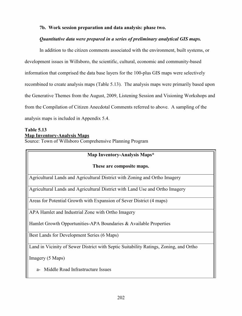
202
7b. Work session preparation and data analysis: phase two.
Quantitative data were prepared in a series of preliminary analytical GIS maps.
In addition to the citizen comments associated with the environment, built systems, or
development issues in Willsboro, the scientific, cultural, economic and community-based
information that comprised the data base layers for the 100-plus GIS maps were selectively
recombined to create analysis maps (Table 5.13). The analysis maps were primarily based upon
the Generative Themes from the August, 2009, Listening Session and Visioning Workshops and
from the Compilation of Citizen Anecdotal Comments referred to above. A sampling of the
analysis maps is included in Appendix 5.4.
Table 5.13Map Inventory-Analysis MapsSource: Town of Willsboro Comprehensive Planning Program
Map Inventory-Analysis Maps*
These are composite maps.
Agricultural Lands and Agricultural District with Zoning and Ortho Imagery
Agricultural Lands and Agricultural District with Land Use and Ortho Imagery
Areas for Potential Growth with Expansion of Sever District (4 maps)
APA Hamlet and Industrial Zone with Ortho Imagery
Hamlet Growth Opportunities-APA Boundaries & Available Properties
Best Lands for Development Series (6 Maps)
Land in Vicinity of Sewer District with Septic Suitability Ratings, Zoning, and Ortho
Imagery (5 Maps)
a- Middle Road Infrastructure Issues

203
Map Inventory-Analysis Maps*
These are composite maps.
Septic Systems, New and Repaired for 2002-2009 with Septic Suitability Ratings
Willsboro Point Land Use and Zoning with Ortho Imagery (2 Maps)
Build Out Potential for Vacant and Open Lands Series-Under Construction-Community Viz
Build Out scenarios-Based upon Zoning District/Building Permit Activity
Standard planning practice for determining land use recommendations traditionally
involves preparing a land use suitability map, also known as a development limitations and
opportunities map. Instead of preparing a single composite map in traditional format, I
instructed my GIS technician to prepare a series which would illustrate for the Steering
Committee how the various steps of scientific analysis work to create the suitability map and
which layers of scientific information (and why) are combined in each step (Figures 5.16a-5.16f).
The final map (Figure 5.16f) includes a distinct key that addresses environmental risk. The
results of this component of the GIS mapping activities were that the Steering Committee
members were able to understand and explain to other citizens how to read the maps, what the
maps meant in terms of scientific information, and how the maps related to the recommendations
they were making.

204
Figure 5.16a. Land Suitability Analysis Map Series - One of Six. This figure illustratesWetlands, Flood Areas, and Shoreline Hardening in the Town of Willsboro. Source: Townof Willsboro Steering Committee, 2010.

205
Figure 5.16b. Land Suitability Analysis Map Series - Two of Six. This figure illustratesWetlands, Flood Areas, Shoreline Hardening, and Landslide Risk in the Town of Willsboro.

206
Figure 5.16c. Land Suitability Analysis Map Series - Three of Six. This figure illustratesWetlands, Flood Areas, Shoreline Hardening Landslide Risk, and On-Site SepticSuitability in the Town of Willsboro. Source: Town of Willsboro Steering Committee,2010.

207
Figure 5.16d. Land Suitability Analysis Map Series - Four of Six. This figure illustratesWetlands, Flood Areas, Shoreline Hardening, Slope, Landslide Risk, On-Site SepticSuitability, and Significant Ecological Communities in the Town of Willsboro. Source:Town of Willsboro Steering Committee, 2010.

208
Figure 5.16e. Land Suitability Analysis Map Series - Five of Six. This figure illustratesWetlands, Flood Areas, Shoreline Hardening, Slope, Landslide Risk, On-Site SepticSuitability, Significant Ecological Communities, and Agricultural Soils in the Town ofWillsboro. Source: Town of Willsboro Steering Committee, 2010.

209
Figure 5.16f. Land Suitability Analysis Map Series - Six of Six. This figure illustrates theresults of the composite analysis of environmental impact and risk from growth anddevelopment. Categories were chosen, two where the risk to the environment was low, butsegregating out parcels of agricultural lands may have been involved. Areas in “pink” wereenvironmentally sensitive lands where growth impacts and risks were high. Source: Townof Willsboro Steering Committee, 2010.

210
7c. Work session preparation and data analysis: phase three.
Straw-man paper on natural systems, built environment and land use issues, strategies
and recommendations.
Scientific, economic, and community information accessed and presented through GIS,
PAR workshops and the Community Survey determined the outline of issues, strategies and
recommendations to include in the comprehensive plan. I prepared a first draft straw-man
document to present to the Steering Committee in order to create a focal point for dialogue and
reflection. Instead of preparing a full-fledged draft of the comprehensive plan, I chose to prepare
a 17 page digest of issues, strategies and recommendations that directly flowed from the natural
resource map inventory, citizen comments, and analysis work that had recently been completed
by the Steering Committee (Appendix 5.4). The first draft was based upon the Generative
Themes from work with citizens, incorporated language from the existing Town Zoning
Ordinance, Smart Growth Principles, New York State Agriculture and Markets regulations
associated with Agricultural Districts and exemplary environmental standards for comprehensive
plans. Each succeeding iteration incorporated comments and edits from the Steering Committee
and additional information suggested by the group. Figure 5.17 depicts a sample section of the
straw-man document in the format provided to the Steering Committee (fonts, size, spacing,
color).

211
Protect and Preserve Willsboro’s Soils. Ensure understanding of soilcharacteristics throughout the Town prior to undertaking projects and encourageprotection of soils. Prevent accelerated soil erosion and the potential for earthslippage. Respect existing natural features such as slope, soil texture andstructure; minimize removal of vegetative cover; rapidly re-vegetate clearedareas; limit cuts and fills; and employ such erosion control devises and measuresas are necessary to promptly stabilize slopes and surfaces and to control runoff.Minimize topographic alterations. Minimize excavation, cuts and fills and sitegrading by employing to advantage existing topographic features. Avoiddevelopment activities on steep slopes where environmental damage and costlydevelopment problems could result.Protect and improve the water quality of Lake Champlain, Long Pond, theBoquet River and the watershed in general.Surface WaterMaintain or enhance existing physical, chemical and biological water qualitycharacteristics and prevent any undue acceleration of existing rates ofeutrophication of bodies of water. Maintain wide buffer strips of naturalvegetation bordering water bodies. Minimize channel disturbance andalterations. Preserve shoreline vegetation. Minimize hydrologic changes whichwould result from damming or impounding. Avoid introduction of nutrients fromthe use of fertilizers and from sewage effluent. Avoid introduction of toxicmaterials to water bodies.
Figure 5.17. Version One Excerpt: Straw-man Document for Steering Committee. This figureillustrates a sample section of the straw-man document in the format provided to the SteeringCommittee.
The Steering Committee had great difficulty working through the straw-man. There were
some comments on the issues and content recommendations, but the primary reaction to the first
draft regarded approach. They felt the language throughout the 17 page document was too
academic and scientific and the material too dense. They commented that the document’s
organization was vague and difficult to navigate. Lastly, several members expressed that they
could not grasp a context for the straw-man material from only the natural resource inventory
and analysis and citizen comments. They needed a table of contents for the entire plan
(Figure 5.18) to understand where and how to situate the recommendations. I was sent back to

212
prepare a table of contents for the comprehensive plan and a second iteration addressing their
concerns for improved language, formatting and content.
I prepared a table of contents (Figure 5.18) and a second version that included an
introduction, a separate narrative on issues and four sections detailing goals, strategies, and
recommendations. A sample of one section of the version follows the table of contents. A full
copy of the second straw-man paper is included in Appendix 5.4. The four sections of the
second straw-man version were organized around the constructive aspects of PAR Appreciative
Inquiry and used the themes of:
Healthy and Protected Natural Resources Smarter Growth and Land Use Working Landscapes Building Neighborhoods and Community Character
The context of these four sections can be seen in the table of contents. A similar pattern
would follow for the other chapters.
Town of Willsboro Comprehensive Land Use and Action Plan
TABLE OF CONTENTS
Chapter One: Introduction
1.0 The Comprehensive Planning Process (or why we are here)
2.0 A Brief History of Willsboro
3.0 Community Profile
4.0 A Shared Vision of Willsboro
Chapter Two: Our Vital Marketplaces, Economy and Community Amenities
Chapter Three: Our Natural Systems, Built Environment and Land Use
1.0 Introduction

213
Town of Willsboro Comprehensive Land Use and Action Plan
TABLE OF CONTENTS
2.0 Willsboro Today-Issues
3.0 Goals, Strategies & Recommendations:
3.1 Healthy and Protected Natural Resources
3.2 Smarter Growth and Land Use
3.3 Working Landscapes
3.4 Building Neighborhoods and Community Character
Chapter Four: Transportation Corridors, Public Facilities and Services
Chapter Five: Next Steps
Implementation and Action Plan
References
Appendices:
Community Profile and Atlas
Figure 5.18. Abbreviated Table of Contents. This figure illustrates the Table of Contents ofthe draft Comprehensive Plan. Note the placement of Chapter 3, which was the focus of theresearch.
The table of contents and revised straw-man paper were provided to the Steering
Committee for further discussion. Figure.5.19 depicts a sample section of the second version of
the straw-man document in the format provided to the Steering Committee (fonts, size, spacing,
and color.)

214
Recommendations & Strategies
3. 1 Healthy and ProtectedNatural Resources
Recommendation
Willsboro is a jewel in a splendid setting. Protect and preserveWillsboro’s natural setting, open countryside and small towncharacter for the present and future generations.Strategy:Consider rezoning the interior and remaining shoreline and roadsidesections of Willsboro Point to a lower development density (i.e. 1, 2 and5+ acres in sections), including specific critical environmental areas asland conservation classification consistent with Willsboro Point’s significantprime soils, presence of aquifers, State designation as rare plant, animaland forest communities, its overall environmental, historic and open spacevalue.
Consider the presence of significant environmental resourceswhich attract residents and visitors alike. These natural resourcesinclude water, land, wildlife, soil and scenic ones.Strategy:Implement a land use program where natural science helps the planningprocess. Use information about existing and potential conditions andimpacts to soils, slope, critical environmental areas, wetlands, wildlife,water and air quality, etc. to make better decisions. Avoid judgments thatare counter-intuitive to good science without strong, compelling reasons.Give environmental considerations equal footing in project review for asingle family dwelling along the shoreline or near agricultural lands as it isfor a subdivision or commercial project. Evaluate the potential for adverseimpact upon the Town’s natural and cultural resources during project reviewand the public burden in providing facilities and services, includinginfrastructure. The planning and zoning boards should also recognize thecumulative impacts to the environment from permitting single projects ormultiple projects over time.Utilize an environmental assessment that is based upon natural science orecological planning that is open to scale changes (i.e. size of projectimpact) when a project is presented for review.
Figure 5.19. Version Two Excerpt: Straw-Man Document for Steering Committee. Thisfigure illustrates an excerpt from Chapter 3: Natural Systems, Built Environment, and LandUse Issues, Strategies, and Recommendations. This version was received more favorably bythe Steering Committee.

215
The second iteration and table of contents were well received by the Steering Committee.
While work continues through additional versions, the focus has moved from format and
approach to refining content and moving on to other chapters.
7d. Work session and data analysis: Phase Four.
Series of PAR-based Steering Committee work sessions
The Steering Committee scheduled three evening work sessions for sequential Tuesdays
during June, 2010, in order to devote uninterrupted time to the natural resource and land use
chapter recommendations. The general public and the Zoning Officer for the Town were also
invited to attend. Several citizens attended one or two, as did the Zoning Officer. They were
welcomed and fully participated in the meetings. At each meeting my GIS technician was
present so that map analysis work was conducted concurrently with review of the natural
resource and land use recommendations. In this manner, when a question arose that was
scientific or land use database-related, the GIS material could be called-up and immediately
consulted. The Steering Committee’s GIS draft analysis maps were assembled and revised in
response to comments from the Committee. These included maps for strategic areas of concern
to the Committee and general natural resource constraints and environmental risk maps. The
entire suite of GIS maps was organized to be available to the Committee and posted on the
website in PDF form for immediate access before, during, and after the meeting series. During
the sessions, new maps were conceptualized and requested. For example, ortho-imagery, zoning
classifications, existing land use and septic suitability GIS data were analyzed to determine
development impacts on Willsboro Point, on agricultural lands and in one neighborhood
experiencing problems with on-site septic systems.

216
The three work sessions were devoted to dialogue and reflection on the straw-man
recommendations working draft. Members came to the meeting with ideas and suggestions to
improve the document. They also came with questions and new information for consideration.
Time was devoted to listening to one another and discussing how to change the document to
reflect the concerns of the group. Discussions included the relationship between the
recommendations and the Town Board’s political will to implement the plan. Technical
questions arose on how the Town would affect the re-writing of the Town’s land use regulations.
7e. Debriefing with the Steering Committee on the use of work sessions, straw-man
versions, and GIS map analysis to develop Environment and Land Use
Recommendations.
Debriefing this method, the Steering Committee was concerned and tense for having to
raise a point of criticism. Two members commented, “Our first hiccup,” and “I was frustrated.”
“The first session drove me crazy.” In their opinions, the draft straw-man’s drawbacks were the
real first point of tension in 14 months of working together. Engagement and Information
Transfer were stymied by the written document. Members pointed out that they needed better
overall context from a table of contents and improved organization from the document to
understand the framework.
One member pointed out that the group dynamics had become well established and that
even though there was criticism and tension, they, “hashed it out. Ann went back to the drawing
board.”
Summarizing the sentiments of the group in terms of Engagement, members pointed out that
three aspects of this method were very engaging. The first two were the continued use of GIS as
a powerful tool and its application to the land suitability series to determine the areas for best

217
development. Finally, one member stated, “This was the first step, starting to do something
really concrete towards [writing] the plan. Too cool.”
PAR: A Relevant, Flexible, Data-Rich Planning Method
PAR provided a rich and diverse set of mixed methods data to report and present for this
case study. It provided an important backdrop that promoted data collection in a collaborative
manner with volunteer, citizen-based co-researchers. This collaborative climate presented
important opportunities to re-evaluate the relevance of methods and actual data to the case study
and to the research questions as part of the methodology. The length and complexity of this
chapter is testament to the value of PAR’s theoretical framework and its flexibility to add value
to environmental and land use planning research.

218
Chapter Six
Life in the Promised Land:
Merging Science withPolitics, Preferences and Property
Discussion and Conclusions
“This is a community of diverse individuals standing together in their desire to preserve the
integrity of their home. Our intent is to redefine prosperity in terms of a healthy ecosystem,
our watershed, viewshed, and night full of stars. We believe we can begin to live differently,
that the preservation of one's homeland is the preservation of the planet. “
(Tempest-Williams, 2005)

219
The Four Corners of the Case Study: Discussion of the Research Results
The discussion and conclusions presented in this chapter represent part of one town’s
story of its work to develop a comprehensive plan. PAR approaches were applied to
comprehensive land use planning activities and evaluated for their ability to build capacity for
decision-making. Planning capacity is a term that is often used but rarely defined. I define it as
the cognitive, affective, legal and administrative competence, aptitude and ability of an entity to
design and implement a land use planning program. Any community might benefit from the
PAR approaches I employed, but they may be of particular importance to communities located in
protected areas. The research questions were developed to focus the case study on natural
science, evidence-based technologies, and the public’s competence to participate in community-
based planning. In the following section of this chapter, I discuss the results for each of my
research questions.
Research Question # 1
How can the presentation of and access to natural science data, evidence-based
technologies (GIS), modern planning theories and Participatory Action Research (PAR)
improve the comprehensive planning process and comprehensive plan document in the
form of private land conservation benefits for protected areas?
In this case study, Participatory Action Research (PAR) provided a methodological focal
point, enabling representative elements of thoughtful and effective comprehensive planning to be
brought together in one protected area locale. At the town level, access to knowledge and
technology, inclusionary practices and citizen-driven decision-making resulted in a climate of
constructive engagement, collaborative development of knowledge about Willsboro’s

220
environment, and lively and civil debate about future land use recommendations. The case study
process, involving access to knowledge and technology, use of inclusionary practices and
citizen-driven decision-making, is distinctive in Willsboro. A citizen commented at a public
meeting to a member of the Comprehensive Plan Steering Committee that Willsboro was going
about the process much differently than other communities, with more data, more input from the
community and much more technology.
Effective and collaborative comprehensive planning can be hindered or impaired by
limited time, resources, professional experience, interest, and ambivalence to (or even disregard
for) the concept of civic engagement until it is reduced to the nominal and symbolic. Plans can
then become a limited-use document instead of a living one. Modern planners can unknowingly
limit the scope of the comprehensive plan because their professional specialties, which can range
from architecture to transportation, may not include sufficient natural resource planning to make
them comfortable with the requisite amount of analysis needed in an amenity-rich area. As a
result, ecological considerations can be severely curtailed during the comprehensive planning
process. In Willsboro’s case, natural science (inclusive of ecological and conservation science)
and GIS were accessed, presented, and then made available on an ongoing basis to the Steering
Committee. Instead of relying solely on the planning advisor, the Steering Committee members
learned how to utilize scientific data and GIS as tools to conduct rudimentary ecological land use
planning in a protected area town. We shared responsibility to screen natural resource
information and to interpret and direct the inventory and analysis process. For example, the
Steering Committee members participated in developing and editing maps and established
increasing competence to direct the process of ordering new analysis maps to suit their planning
needs. Discovery, recognition and discussion of local environmental conditions and “nature”

221
were powerful motivators for the preliminary land use recommendations associated with
conservation and Smart Growth.
Convening the representative elements of thoughtful and effective comprehensive
planning under the methodological umbrella of PAR provided a solid grounding for plan
recommendations, particularly the land use recommendations. When Steering Members shared
their scientific, mapping and statistical data with the public on July 24, 2010, citizens
commented that they were impressed with the thoroughness of the comprehensive plan work so
far. Some citizens were not aware that a plan considered scientific and environmental conditions
at all or that alternative scenarios were considered.
Comprehensive plans sometimes fall short of a pluralist viewpoint and represent the
interests of the most powerful and strongest factions. Outreach and engagement can always be
increased and improved, and the Willsboro case study is no exception. But Willsboro did not
engage in citizen participation as a symbolic gesture, and the increased attention paid to the
interests, issues and concerns of citizens was a significant aspect of the case study. There were
purposefully numerous forms of civic engagement (i.e. surveys, meetings, workshops, focus
groups, web access, emails, and list serves). In order to listen fully to the voices of the
community, public commentary weighed heavily with the Steering Committee in all their
deliberations. Over 703 comments from citizens framed the development of straw man planning
documents, including the town’s Vision Statement and the land use recommendations.
Careful listening to citizen comments, and reading them as they accumulate one by one,
could change the entire outlook of the comprehensive plan. What traditionally emerges as a
static document might become a developmental and democratic process of acquiring and sharing
knowledge embodied in a living document that reflects the will of the people.

222
Research Question # 2
To what extent did the Steering Committee engage, dialogue, and participate in the
exchange of new information (knowledge) as a result of the citizen participation, natural
science, evidence-based technologies and PAR techniques utilized during the field
research?
The Steering Committee was appointed at the Town Board meeting in March of 2009 and
met for the first time in April, 2009. When they first met with me in April of 2009, they were a
loosely aggregated group of town appointees. Over time, through joint effort and shared
experience, the committee was transformed into an organized and formal team. From my
research perspective, it was fortunate that the Steering Committee (those who attended meetings
regularly), quickly developed the interpersonal skills and practical knowledge necessary to
develop into a strong organizational team. Following Willsboro’s social and cultural traditions,
this group presented an air of collaboration and savoir-faire. This led to a consensus-building
agenda for conflict resolution and a can-do tactical approach to activities and issues.
It was initially, then chronically, difficult to dispel the Steering Committee’s notion of me
as “chief cook and bottle-washer” planner, since its expectations were that the planner
performed many or all decision-making and support functions, while the committee was left to
perform nominal or symbolic functions at the monthly meetings. I was routinely confronted with,
“You are the expert and our leader--tell us what to do--we don’t know what we are doing.” It
was a constant challenge to avoid seduction into a lead role. My assertive personality and
traditional planning experience prompted me to not only frame the plan process and approach for
the group, but also to lead and take responsibility for the decision-making for their project. As
the land use planning program progressed, I better understood the praxis of PAR. As a

223
consequence, my confidence and intuitive ability to move from passive and neutral facilitator to
activist, enabler, nurturer, and cheerleader improved (Bhatt & Tandon, 2001).
If PAR placed the Steering Committee in the proverbial driver’s seat, then satisfying the
Steering Committee-driven expectations that I would codify planning documents was also part of
the process. This presented a dilemma, as authorship might imply ownership. Expediting
complex, written work during the visioning and land use recommendations processes required
that I prepare what is customarily entitled a straw man document. Purposefully entitling a
document as a straw man allows it to be criticized, edited, and substantially modified in order to
shape it to the purpose and “ownership” of the group. During the debriefings, the Steering
Committee praised the process of presenting a straw man for the vision statement and the land
use recommendations. They reviewed the documents purposefully, looking for confirmation that
I had accurately reflected commentary from the citizens, data from the community profile, and
information from the scientific analyses. Having documents to react and respond to focused
attention on the content, and members pointed out that they were not bashful about making the
documents over in their “image.” When prepared as a neutral document ready for comment and
change, the straw man will not necessarily compromise the PAR process. If prepared with care
and precision, the straw man document will systematize citizen-gathered knowledge and create a
focal point for adult learning (Bhatt & Tandon 2001).
I did not meet the Steering Committee’s expectations and dominate the planning process.
I could have -- and the results might have produced an expedited comprehensive plan with a
substantially smaller investment of time and expense on everyone’s part. However, this case
study intended to deliberately utilize Participatory Action Research to alter the land use planning
process into a more democratic, reflective, and transformative experience for the Steering

224
Committee and citizens involved in the process. PAR’s approach to the design of planning
techniques, the development of documents, and the use of technology, shifts the role of
traditional planners from the powerful focal point of the process to system steward. PAR
proposes that planners preempt the exercise of their municipal government-assigned authority,
which may cause isolation and bureaucracy to segregate citizens from their government and,
instead establish a “facilitative-planner” relationship. In this way the planner cooperates and
collaborates fully with the community on equal footing; decision-making is delegated to the
citizen-group. Land use planning within a PAR framework can productively compromise the
planner’s power and position, increase the level of trust and respect among all group members,
and positively influence group dynamics. With the Steering Committee asking critical questions
about content and process, then making planning decisions, I felt the planning process change
and become energetic in its direction, intellectually important and dynamic in its discourse.
According to feedback from the Steering Committee, so did they.
The PAR methods utilized during the field research occurred from April, 2009 through
July, 2010 (Table 6.1). The Steering Committee members discussed the methods separately and
in retrospect.

225
Table 6.1Willsboro Case Study Timeline
PAR Method
Timeline2009 2010
Apr
/May
/Jun
Jul/A
ug/S
ep
Oct
/Nov
/Dec
Jan/
Feb/
Mar
Apr
/May
/Jun
Jul/A
ug/S
ep
Development, Launch, Completionand Results of Community Survey
August, 2009, Listening Sessions
Discussions with Natural ScienceSubject -Matter ExpertsCommunity Based Field Work andDevelopment of GIS for CommunityProfile and Analysis WorkDecentralized Visioning Sessionsand Straw man Visioning StatementWork sessions with Straw manVersions and GIS Map Analysis todevelop Environment and Land UseRecommendationsRoundtable Discussion of CaseStudy Methods with SteeringCommittee
At the beginning of this process, the group was new and untried to planning and I was
new and untried to them. The first big project was to design and “build” a community survey. I
had designed and built dozens of surveys, but not as a participatory process. PAR placed the
Committee in the position of determining the key decision points in the survey’s development.
For example, I posed the question: “How would specific information the Steering Committee
obtained from citizens be useful in establishing goals, strategies and recommendations and

226
why?” I could provide the content and framing information, and mentor them, but they had to
make the choices and decisions. I provided the prototypes and examples. They struggled to
discuss and determine what questions they wanted to ask of the public and why. Efforts were
made to overcome difficulties in communication. We would dialogue, discuss, reflect, then
select questions— and go onto the next version of the survey. The committee members were
overly tactful; they found the process of selecting and constructing questions excessively tedious,
difficult and time consuming, but did not express this. During debriefing more than a year later,
one member said that the survey was a “thinking exercise and took the most work of all the
methods.” But at the time, they struggled on and finally completed their task in approximately
six meetings over four months.
The survey was distributed to several subject-matter experts for review and comment,
and then was revised. To exacerbate the frustration of the survey project, when the Committee
was finally satisfied with the survey, New York State tabled the survey for over three months.
After the Co-Chairmen and the Town Supervisor actively lobbied the State, approval for the
survey to be launched was granted.
From the Committee’s perspective, the survey method could have done more to engage,
inform and improve dialogue among the Steering Committee. For example, I should have been
clearer in conveying to the Committee that for a survey to be very useful to its creators, the
process of creation is equally important as the development of the survey instrument. There is a
need to emphasize to the community the value in dialogue, discussion and reflection and why it
is important to balance them with the tedious and time consuming process of technical content
development. The survey outcome was successful, but in the future, the means to that outcome
needs improvement. The survey instrument and its results showed success, yielding good results

227
and a 17% return which is consistent with mail and electronic survey response rates. The citizen
comments were extensive and provided valuable input to the planning process.
The lesson learned from the development of the community survey was to better
understand the delicate balance between facilitating the planning process and enabling citizens to
lead and make decisions. The Steering Committee indicated that I provided a content-heavy
survey design which they found monotonous and overwhelming in substance. The adaptive
strategy employed for the remaining content-rich activities, (such as community profile, GIS
Mapping, Visioning Statement and Land Use Recommendations), was to use preliminary drafts,
summary findings and straw-man documents. These appeared to address the concerns of the
Steering Committee for more focused digestible and more interesting content analysis. The
dynamic balance in planning approaches requires the community to lead the process and retain
decision-making authority yet still provide planning expertise to the group, without expecting the
citizens to micro-manage data.
The Steering Committee’s final draft of the Community Survey was followed by the
August, 2009, Listening Sessions. These were the first public workshops of the comprehensive
planning process. In preparation, I provided members and volunteers with facilitator and scribe
training. Members then actively mediated small group discussions. The continuing maturation
and organizational development of the Steering Committee was evident in their capacity to
coordinate, facilitate and learn from two half-day public workshops with complex and radically
different agendas. While new to the PAR planning process and still learning how to actively
listen to what citizens had to say, committee members were disciplined enough to be neutral and
objective when confronted with viewpoints that conflicted with their own. Some members found
this challenging. During the debriefings Committee members commented that the August, 2009

228
public workshops opened their eyes to the different points of view in the community and how
difficult it can be to take part in serious conversations whose participants hold differing points of
view.
The public workshops yielded heated, serious discussions about topics of importance to
the Willsboro Comprehensive Plan. These conversations took place in small groups where
different viewpoints were honored in a respectful and courteous manner. For example, there was
surprise when common ground was found between year-round and seasonal property owners on
subjects where disagreement was expected. In some instances, social systems have degraded to
the point where conflict in point-of-view translates into violence. Thirty years ago, antagonism
for the alleged loss of Home Rule in the Adirondacks resulted in property damage, attempted
arson and assault with a deadly weapon because of differing viewpoints. Citizens and Steering
Committee Members reinforced the ideas that public behaviors of tolerance, respect and civil
engagement can accompany disagreement on issues.
The August Listening Session Workshops helped prepare the Steering Committee for the
Visioning Workshops held in 2010. The four focus-group style meetings were also listening
sessions where citizens shared stories and discussed their concerns. The workshops revealed a
simple but powerful commonality to the Steering Committee and the citizens who attended:
Willsboro residents share many concerns. Citizens may have a different way of approaching the
issues, but a PAR process designed to discuss, listen and reflect can provide a powerful bridge
between various factions and interests.
The August Listening Sessions and Visioning Workshops demonstrated to the Steering
Committee and the citizenry that this Comprehensive Plan process was different than what they
might have experienced before. Particularly, after the August workshops, the Committee

229
emerged with enthusiasm for their task. During the debriefing a year later, they spoke with
excitement and respect for the workshop experiences. Meeting with citizens in a workshop
setting framed by PAR principles provided the Steering Committee with new understanding of
the issues, interests and concerns of the community. It provided important context and
perspective of citizen and Steering Committee’s roles and responsibilities to the town, to the
planning process, and to themselves.
Natural resource planning should comprise a substantial portion of town planning in a
protected area. However, natural resources are often de-emphasized in comprehensive plans.
There can be many reasons for this, including the limited scientific background of planners,
disinterest by the community or oversight agencies, or just poor land use planning practices.
Willsboro includes 26,720 acres of land, and a conservative estimate places more than 65% of
the acreage in forestry, agriculture and open space (Town of Willsboro, Willsboro Community
Profile, 2010). Approximately 14% is conserved through easements or participation in forest tax
incentive programs (Town of Willsboro, Willsboro Community Profile, 2010). In Willsboro’s
case, natural resources are of critical importance to citizens and town leaders.
Three activities (Subject-Matter Expert presentations, GIS Mapping, and Land Use
Recommendations) were used to help the Steering Committee inventory and analyze the natural
resources and ecology of the Town.
Subject-matter experts.
Subject-matter experts were suggested to help orient the Steering Committee. Topics
generally covered a basic introduction to natural science subjects and the planning considerations
related to the areas under discussion. The subject-matter experts oriented the Steering
Committee to the nature of Willsboro and helped provide legitimacy to its study. In a next

230
iteration, experts will be persuaded to present a more citizen-science approach to this component
of the process. For some members, the expert presentations and discussions provided a
foundation and context for the ecological importance of Willsboro. For others, the discussions
reinforced what they already knew.
GIS mapping.
Development and analysis of natural resource GIS maps helped the Steering Committee
understand the special relationship between ecological considerations and town geography.
Steering Committee members were immersed in the development of the maps. They assisted in
preparing, reviewing, and working with the GIS overlay maps that addressed natural resource
constraints and opportunities. In this way they integrated the natural resource inventory with the
ecological and community analysis process. The GIS mapping helped Steering Committee
members visualize the link between the geography of science and ecological data, including
subjects discussed with the experts.
Land use recommendations.
Based upon an iterative process of reflective dialogue and discourse at public meetings,
maps, data and commentary were generated by the Committee. These materials were
synthesized and combined with citizen comment transcripts in order to draft iterative versions of
comprehensive plan land use and natural system recommendations. In the process of developing
recommendations, the Steering Committee became fairly literate in the primary scientific data
(i.e. soils, habitat, wetlands, and data) and background scientific rationale for the
recommendations listed in the first and second straw man versions of the land use
recommendations. Members could link these recommendations to their mapping and to their
analysis. As focal points in their study of ecological conditions, the Committee developed a

231
fairly good understanding of Willsboro’s soils, hydrology, and surficial geology. Attention was
paid, for example, to land slumps and landslides, unique natural communities and rare species,
shoreline hardening, scenic resources, and agricultural lands. Willsboro’s fragile soils, limited
centralized wastewater system, important agricultural soils and preponderance of residential
growth made the soils and on-site wastewater data and mapping very popular with the Steering
Committee and the citizens.
Of all the PAR activities, the science-based activities generated the greatest level of
knowledge transfer for the Steering Committee. There was consensus among Steering
Committee members that they had learned a great deal from the science-based activities and that
access to information, their active involvement and immersion brought science literacy to their
doorstep. The recommendations in the Comprehensive Plan reflect a high degree of science
literacy on the part of the Steering Committee.
Participatory Action Research shifted the planning paradigm from a top-down to a
bottom-up approach in design, content and process. Nowhere is this more apparent than in the
response of the Steering Committee to the application of science, technologies and citizen
participation techniques. Members indicated that the range of activities and methods had their
strong and weak points. Weakest among the activities were the development of the survey, seen
as a tedious and frustrating process, and the review of the first straw man for the land use
recommendations, whose content was too difficult to follow. Steering Committee members were
very engaged with the use of science-based GIS data throughout the planning process. They
developed a comfort level with the technology and applied it routinely to answer questions and
analyze data. GIS and science were mentioned most frequently as the source of improvement of
their understanding, providing the context for information and knowledge transfer. GIS maps

232
were used in static versions, animated sequences and in interactive layer modes. The Committee
valued each map form. Their colors and details, and the ability to combine orthoimagery and
data layers were visually useful to them as educational and analytical aids. There is something
particularly compelling in viewing a specialized map of your home territory. When two walls of
a 100 foot hallway were lined with GIS maps in small and oversized color prints for a public
workshop, the effect was stunning.
Steering Committee members declared that the various workshops with the public
generated their greatest levels of dialogue and reflection. What was most impressive was the
way members learned to read most of the 70-plus maps and understand legends, data and many
methodologies. I concluded that a great deal of learning had occurred when, on July 24, 2010,
during a community workshop, I witnessed at least six of the active Steering Committee
members explaining maps, (including the composite analyses and soils map), survey data,
statistical information and why these data were important and relevant to the Comprehensive
Plan. Gesticulating and explaining maps, sharing information and “owning the process” in a
public venue, was certain evidence of “bottom-up” ecologically-focused community planning in
Willsboro.
Research question # 3
To what extent was language associated with environmental assessment, ecological
planning or conservation of natural resources included in planning recommendations
made by the Steering Committee?
At the time of this writing one chapter of the comprehensive plan (Natural Systems, Built
Environment and Land Use) is in its third draft. Its content was considered to be the most
technically complex and content-driven chapters of the plan, founded on the combination of

233
citizen commentaries and the natural and community resource inventory and analysis. The land
use recommendations are likely to be the most controversial among various stakeholder interests
in the town. The comprehensive plan chapter draft on Natural Systems, Built Environment and
Land Use includes 25 recommendations (Table 6.2). In the chapter working draft, specific
implementation strategies are noted under each recommendation. Direct references and language
about the local environment are included in 21 of the 25 recommendations (Table 6.2).

234
Table 6.2Willsboro Steering Committee Version 2 Working Draft RecommendationsNatural Systems Built Environment and Land Use
ITEM
NO. RECOMMENDATION
1. Protect and preserve Willsboro's natural setting, open countryside and small-
town character for present and future generations.
2. Consider the presence of significant environmental resources which attract
residents and visitors alike. These natural resources include water, land,
wildlife, soil and scenic ones.
3. Encourage Protection and Preservation of Willsboro's Soils .
4. Protect and improve the water quality of Lake Champlain, Long Pond, the
Boquet River and the watershed in general.
5. In order to select the most appropriate location for on-site wastewater systems,
conduct on-site planning for septic system location prior to establishing the
footprint points for the principal building.
6. Design, locate and construct storm water drainage systems so as to maintain
existing drainage patterns in a natural state and to minimize adverse hydrologic
effects.
7. Safeguard and prevent unique natural communities from being eliminated, killed
off, or over-exploited. Ensure that future generations have the benefits of the
diverse unique natural assets that exist in Willsboro.
8. Locate, design and construct water supply systems so as to provide an adequate
supply of potable water without adversely affecting existing water usage

235
ITEM
NO. RECOMMENDATION
patterns or creating adverse effects with regard to aquifers and subsurface
drainage patterns.
9. Provide for the storage, collection, transportation and disposal of solid waste in
a manner which will minimize air, water and visual pollution and in a manner
which will not create hazards to the health and welfare of people and wildlife.
10. Avoid all use of pesticides, herbicides and other biocides potentially detrimental
to natural systems.
11. Engage in Smarter Growth practices and be cautious in land decisions.
12. Find common ground by balancing and blending economic gain with
environmental protection for the community.
13. Review Willsboro’s land use laws to determine whether they are
understandable, kept up to date, easily accessible, streamlined and
complementary to one another.
14. The development and updating of the comprehensive plan, land use laws and
permitting process, should be conducted in an institutional environment
supportive of good planning.
15. Encourage production agriculture and commercial farming as an important part
of the local economy by protecting natural resources necessary for food
production and identify different areas of Willsboro that would better support
development and growth.

236
ITEM
NO. RECOMMENDATION
16. Willsboro sees agriculture and farming are high-value business operations with
permanent and legitimate land uses and not as temporary use until land is
developed for housing. Support and protect farming by stabilizing the
agricultural land base based on soil types where production agriculture is the
highest and best use of the land. Minimize land with prime agricultural soils or
farmland of statewide important for purposes other than agricultural production
17. Recognize the presence of an Agricultural District and comply with Article 25-
AA of the Agriculture and Markets Law
18. Focus on creating new uses in the Hamlet and Industrial Zones from the inside
out.
19. Adopt Site Plan Review Regulations and make sure that their content, standards,
permitting and enforcement are consistent with the Comprehensive Plan.
20. Maintain scenic vistas and preserve open space.
21. Minimize incompatibility of new development with the character of adjoining and
nearby land uses.
22. Design and construct roads and streets to provide safe and convenient access
without causing undue adverse impacts on natural and public resources.
23. Design, locate and construct buildings to best serve their intended functions and to
minimize impact on existing natural and public resources.
24. Avoid signage that detracts from aesthetic and scenic qualities .

237
ITEM
NO. RECOMMENDATION
25. Locate, design, construct and maintain utilities so as to efficiently accomplish
project objectives and preserve natural and public resources .
Multiple forms of discourse appeared in these recommendations. The Steering
Committee confirmed its commitment to the importance of Willsboro’s natural resource base,
critical habitats and working landscape. Content-based recognition and validation by the
Steering Committee focused on the breadth of natural systems present in Willsboro, based on its
ecology and environment. These include natural resources, such as water, land, wildlife, soil and
open space. The entire set of recommendations reflected the interconnectedness of the town’s
ecology with its plans for growth. Instead of growth anywhere and anyway, recommendations
indicate how and under what conditions growth should and should not occur. The language used
in the text of the recommendations promotes sustainable development through Smart Growth
(Smart Growth Online, 2010). Support for working agricultural landscapes and a viable Main
Street are echoed in the discourse. Recommendations instruct the town leadership to “protect,
preserve, consider and maintain” existing resources while they “avoid, or minimize adverse
impacts” when development is imminent.
This section of the comprehensive plan will undergo the greatest amount of discussion
and negotiation that will lead to modification during its adoption process. For example, a lively
debate ensued among Steering Committee members regarding recommendation Number 10
(Table 6.2) regarding the use of herbicides and pesticides. Discussions centered on the
practicality of Town enforcement and the political likelihood of the Town Board passing the

238
recommendation as presently worded. As a result of group reflection and dialogue, the term
“avoid” was dropped in favor of, “promote responsible use of. . .”
Stakeholders who chose to remain outside the Steering Committee’s outreach and
planning process still have the opportunity through due process of the law, on the plan
recommendations prior to adoption. This may result in the elimination or modification of
recommendations. Due diligence required that the Steering Committee thoroughly study the
issues and present a fair viewpoint in the public interest. The comprehensive plan chapter starts
from a position of strength in this regard as it embarks on its voyage through public scrutiny and
deconstruction that will follow. The recommendations and subsidiary strategies are soundly
grounded in natural science and are, supported by over 703 comments from 453 citizens.
Recommendations and strategies can be traced to their origin and explained to questioning
citizens and town leadership as a basis for understanding the Steering Committee’s rationale for
inclusion in the plan.
Research Question # 4
After 32 years without a comprehensive planning process, to what extent does the current
Comprehensive Plan process in Willsboro engage a representative cohort of interests in
quantity, number , distribution and weighting across stakeholder groups in the planning
process?
Willsboro is a small community of approximately two thousand year-round residents that
nearly triples in the summer season (Chapter 4). Designing and executing citizen participation
planning for Willsboro involved research into best practices and design of grassroots approaches
adaptable for small, homogeneous rural communities. The Organizing Committee (that preceded
the appointment of the Steering Committee), utilized a painstaking stakeholder analysis process

239
that resulted in the participation of 17 citizens on the Steering Committee. The Agency Partners
(more than 20 affiliated organizations), rounded out citizens and included local, regional and
State personnel. Conceptually, the Steering Committee’s two-tiered structure of citizen and
agency participants is generally representative of the variety of interests in the community in
quantity, distribution and weighting. For example, members’ personal affiliations, social
networks and family ties allowed for demographic, economic, conservation, housing, health,
disability, social services, recreation, public services, seasonal property, and transportation
interests to be represented. Seasonal property concerns were balanced with year round interests.
In practice, representation of broad stakeholder interests became challenging because of
limited attendance at Steering Committee monthly meetings. Some members who agreed to
fully participate prior to committee appointment did not live up to their promises, but did not
resign. Eight members were inconsistent or absent in monthly meeting attendance. The
remaining nine citizens attended more than 75% of the time. This core group considered
multiple community interests and stakeholder viewpoints. For example, business, conservation,
youth and low income interests were chronically under-represented. Shoreline property, senior
citizens, recreation and agriculture were well represented. Six months into the process, the Town
Supervisor was asked to intervene and, appoint new members, but did not. Without town action,
the active members of the Steering Committee worked to represent multiple interests, of the
larger community.
Several actions were taken to compensate for a limited stakeholder presence on the
Steering Committee. Publicity for meetings was increased using the social capital network.
Meeting information was posted on the Willsboro website and the listserv was expanded.
Website hits average 250 per month, reflecting that citizens are following the planning process.

240
Instead of observing the formal protocol of discouraging guests at public Steering Committee
meetings to only speak during designated times on the agenda, attendees were encouraged to
freely participate in meetings. As a result, over 16 months, 26 citizens who attended monthly
meetings added their voices to the meeting dialogue. The Steering Committee planned and held
more public workshops than generally are held in a comprehensive planning process. This
proved to be crucial considering the shortfall in formal member attendance at the monthly
Steering Committee meetings. A typical comprehensive planning process might include three to
five public meetings—in addition to the public hearings legally required to adopt a
comprehensive plan. Eight public workshops were held attended by 195 citizens. The
workshops helped to extend citizen representation. The community survey provided open ended
responses from 330 anonymous and citizens. Multiple outreach methods provided a rich mixture
of stakeholder commentary about issues and concerns.
Nearly 600 people (588) made a conscious choice to participate as stakeholders in the
comprehensive planning process and, in doing so, shape its contents. These participants included
a balance of year round and season property owners with a long tenure (20 years or more) and
association with Willsboro. Many were educated, literate citizens, although not all possessed
college degrees. Stakeholders reflected an aging group over 40 years and older, extending to
octogenarians. Employment status and affluence varied. For example, in the community survey
respondents reporting income were mostly moderate to high income by U.S. Census standards.
Others were retired or approaching retirement. Stakeholder ideologies and interests ranged
widely. Dialogue in meetings and workshops was rich and exciting. Views on land use planning,
conservation, private property rights, economics, conservation easements, taxation, public access
to shorelines, government roles and responsibilities were diverse. Using several alternative

241
forms of public engagement through meetings, workshops and in the commentary provided in
the community survey (Chapter 5) provided a method to extend to the community opportunities
for equitable representation, distribution and weighting of interests.
Despite the best of intentions in design, plan or execution, it is difficult to motivate some
stakeholders to agree to participate in civic affairs. Specific groups identified in this case study
include: citizens under 40 years of age (with or without families), low income households,
itinerant renters, boaters with seasonal slips at the local marinas, visitors, year round less
educated households, non-propertied residents, and citizens who place a low value on civic
affairs. Another group included citizens who declared to the Steering Committee their intention
to delay participation until the comprehensive plan is ready to be adopted. Their agenda is to
then attend the public hearing in order to comment after the plan is complete. “Wait and see”
stakeholders expressed this intention and sent their regrets when invited to public workshops and
meetings. Stakeholders in these interest groups may have important local knowledge and social
contributions (Natanson, 1974). Although participation options were many, few members of
these stakeholder groups chose to participate. The Steering Committee wanted stakeholders to
see themselves as a part of Willsboro’s Lifeworld, the place of culture, society and personality
(Chapter 2). Stakeholder and Steering Committee belong to Habermas’ Lifeworld, where
communication, discourse and action should occur (Wilson, 1991).
One of several questions that remain unanswered is how to balance representative
participation on a budget and time table. Habermas’ observations of the characteristics and
distinctions of the Lifeworld, and particularly between the micro and the macro spheres, may be
useful to understand lack of participation amongst various interests (Wilson, 1991). The
microsphere of the personal world of everyday human contact may be virtually large, but

242
physically the personal Lifeworld is shrinking. Many people come to remote, amenity-rich areas,
such as the Adirondacks and Champlain Valley to enjoy solitude. They want to choose when
and how to be socially engaged. Social groups and organizations are having difficulty recruiting
members and people are becoming more solitary (Putman, 2001). In practice, the culture and
funding of traditional land use planning occurs in the macrocosm of state, county and local
government. Planning is situated in the macrocosm and public sphere of the Lifeworld where
social places for convening, organizing and communicating exist (Kellner, 1997). While social
media and virtual front porches are in vogue in planning literature and best practices, public
participation still grapples with the thorny and chronic issues of engagement with younger
households, the voiceless and hard-to-reach citizens who may not see themselves as stakeholders
in the comprehensive planning process. The cultural shift in modern American life may be at
odds for certain stakeholder groups with the modern and evolving forms of communication and
participatory approaches used for land use planning. Age and interests may cause disparities that
must be addressed in community-based planning. How we reach out to cultivate a new or next
generation of civil society and engage capable community leadership is critical.
Conclusions
Participatory Action Research (PAR): An Effective Planning Framework
Comprehensive planning can benefit from PAR as a methodological frame. Through
PAR design, public processes can be altered to be more democratic, dialogue-driven, reflective
and thus transformative for participants. Reflective praxis, the idea that “a community [be]
prepared to study the results of its own [social] action” is often missing from the land use

243
planning practice (Lewin, 1997, p. 8). Lively and civil debate among many people (not just a
chosen few) about future land use in a climate of inclusive and constructive engagement builds
capacity and understanding in the citizenry. Reflection and examination of social action (or
inaction) can reform land use planning in a constructive and thoughtful way.
Debate and dialogue leads to the quest for information. PAR encourages the need to
“know” and understand. This can motivate citizens to collect and analyze information, including
scientific data. Having unlimited citizen access to information and technology is fundamental to
PAR, since in many places information is held by the elite and the government agencies. Given
access to resources, such as “best available” science, technology and planning tools, even a small
rural community in a protected area, can improve the quality of the planning outcomes. PAR
shifts decision-making from the planner to the citizens. A collaborative development and
selection of “knowledge” about a community’s environment will result.
If implemented carefully, PAR can substitute for comprehensive planning situations
where nominal or symbolic civic engagement were intended. In these cases, the traditional
planning process often leaves citizens unhappy with the outcomes and unmotivated to implement
the plan recommendations. The plan results might change dramatically with decision-making for
the project vested in the citizenry. An emergent process can develop elements of a thoughtful
and effective plan based upon a careful balance of the ecological, social and economic
considerations of the community and the region. The PAR framework brings a distinctive
advantage to comprehensive planning through collaborative development of knowledge and
consensus-driven decision-making.

244
The Inflective PAR Paradigm for Land Use Planning: Linking Planning, Participation, and
Science
Merging land use planning, citizen participation and science literacy into an inflective
PAR paradigm carries the potential to build capacity among citizen planners and local
governments. Capacity is built because the convergence of land use planning, citizen
participation and science literacy creates a more thoughtful comprehensive plan. It reflects an
outgrowth of a consensual public process and a rigorous scientific base. The inflective PAR
paradigm linking planning, participation and science encourages civic leadership, civic
responsibility and civic engagement. Where popular consensus indicates that nature and
working landscapes are highly valued, scientifically literate planning leadership (and citizens in
general) has the confidence to institute land use change. Civic transformation is then
demonstrated through specific and inclusive comprehensive plan language, forming
recommendations to preserve, protect, maintain or mitigate impacts on community-based
ecological systems and other aspects of the “commons.” I call the inflective PAR paradigm the
Trilogy, which is comprised of land use planning, citizen participation and science. Within the
Trilogy, the planning practitioner becomes a “tool,” a technical facilitator. Community land and
water-based natural resources are the focal point of citizen-led planning and scientific knowledge
is granted equivalent value to economic, demographic and other data to inform decision-making.
Paramount to this all, citizens volunteer and are empowered to lead and learn, discuss and
disagree, finding common ground to care for the land they say they love.
The planning practitioner as a technical facilitator.
Modern planning in the United States is a content rich endeavor enhanced by technology.
Emphasis is placed on the role of the private or public professional planner as the expert, and

245
they may provide a majority of the content, process and project management services for a local
planning program. Citizens can be relegated to the role of conformant. This planner-dominant
approach may leave citizens with a limited and nominal role in the comprehensive plan. The
result of the planner-dominant approach can be a feeble plan of uneven quality with limited
likelihood of implementation (Altshuler, 1965; Burby, et al. 1997; Mandelker, 2001). Led by an
engaged, public-minded citizenry, roles and responsibilities for project management and content
development are shared, and the planning process becomes collaborative, deliberative and
scientifically based, (Burby, et al., 1997; Hunnsicker, 2007). In design, content and process,
moving the location of substantial decision-making power from planner to citizen committee can
shift the planning paradigm from a top-down to a bottom-up approach.
Empowering citizens to lead and learn.
The investment in a PAR approach to comprehensive planning has distinct advantages for
participating individuals and communities. PAR establishes a climate where citizens work in
good faith and in the public’s interest to study the issues, interests and concerns of the
community-at-large. Although tension is not removed, communication between stakeholders is
reflective and dynamic. Aggression is discouraged, but alternative viewpoints are encouraged.
PAR’s framework facilitates difficult conversations in groups and improves dialogue in social
networks, enabling community-based verification of planning issues and recommendations.
Collecting and understanding the scope of stakeholder comments as a basis for planning
recommendations gives confidence to citizen planners. And their intimate knowledge of the
construction of the plan document is also extremely helpful when adoption proceedings begin
and they are expected to answer questions about their plan. This approach allows comprehensive
planning to serve as a communicative tool for civic empowerment and education. Within the

246
Adirondack Park, a science-based, citizen-led process may promote greater stewardship for
natural environments and serve as a technique for managing growth. Empowering citizens to
lead and learn increases planning capacity. Improved and consistent compliance for Approved
Local Planning Programs within the Adirondack Park Agency Act may be achieved through
increased planning capacity.
Science informs and enlightens the process.
Citizen-planners and the general public (who are landowners or adjacent property owners)
are personally motivated to understand the science behind development and its impacts on the
land. Ecological stewardship is supported by a scientifically literate citizen-led comprehensive
planning process. To accomplish planning objectives, scientific literacy requires full access to
information, especially information technology, as an important, perhaps critical means to an end
(not an end in itself). Accurate and current natural science information must be available and
understandable in order to inform citizen debate and decisions.
Use and application of scientific information and GIS technology can be applied by
citizen planners to improve development decisions. For example, citizens can determine where
land is more (or less) suitable for growth, engage in reflective discussions of the relationship
between existing ecological and environmental conditions and development, and how their land
use recommendations are supported by scientific data.
Scientific data presented graphically through GIS inspires community involvement.
Mapping in large colored paper formats or projected with animated layers and simulations
fascinate audiences and focus interest on the featured scientific-planning issues and concerns. In
this way, science serves as both a motivation and bridge within the planning process. At the
initial stages, science encourages literacy by informing citizens with subject-matter experts and

247
GIS. As competency emerges, citizens become connected to the scientific research and have
sufficient experience to understand their research needs. Capacity can increase to the point
where citizen planners can identify the scientific and GIS data needed to fill the gaps in
information they detect. Later in the cycle of planning, mapping bridges the public engagement
process by exciting citizen-planners and the public-at-large to dialogue and discuss planning
issues.
Becoming scientifically literate is an emergent process. It occurs through integrative
actions that involve citizens and subject-matter experts, natural resources inventorying and
analysis, GIS mapping, public presentations and discourse, and writing land use
recommendations.
Local Planning in the Adirondack Park: How are we Going to Save Tomorrow?
Since the 1970s, technological innovations such as the internet, cellular telephones and
computers have blurred the line between home and workplace. These innovations enable
seasonal property owners to extend their stay at camp and work from their resort properties.
Increasing values of real estate and growing incomes in metropolitan areas make property in
amenity-rich places such the Adirondack Park even more desirable and affordable to affluent
urbanites and suburbanites. Changing demographics and land use patterns are occurring as a
result. The Park is a potential market for 84 million people residing in New York City, Boston,
Montreal and Toronto (Adirondack Association of Towns and Villages, 2009). Expedient access
by interstate systems and air travel allows for longer tenure (and ultimately permanent
relocation). The comforts and conveniences of modern lifestyles are the norm in the countryside.
One no longer has to go home to the city or the suburb since the preferred lifestyle can be
accommodated locally.

248
The Adirondack Park Agency Act appears from permit analyses to demonstrate general
protection of the Adirondacks from large scale residential and commercial development. Permit
statistics also point to increasing single family residential development around the lakes and
ponds where land use controls are statutorily the weakest. Communities are experiencing
increasing rates of new “high-end” residential construction, oversized additions and the
conversion of resort and second-home properties to year-round retirement, weekend and “home-
based” occupational uses. Many Park citizens and visitors are noticing that the lakeshores and
farmlands are increasingly being developed. This may not coincide with their vision for their
community.
It is a generally held belief that the Park Agency Act protects communities from all forms
of unwanted or uncontrolled development at the local and regional level. The statute and permit
facts do not support this myth. The swift adoption of the APA Act in the 1970’s in theory,
directed development away from critical habitat and environmentally sensitive areas, except for
shorelines and roadsides (Willsboro has 34 miles of shoreline). The three classifications of
development [Hamlet (no significant restrictions for development), Moderate Intensity (500
buildings/square mile or 1 principal building on 1.3 acres) and Low Intensity (200
buildings/square mile or 1 principal building on 3.2 acres)] are all within the jurisdiction of local
governments (State of New York, Adirondack Park Agency Act, 1999; Glennon, 2009). In the
1990s, local governments within the Adirondack Park made 80 % of the overall land use
decisions and 57% of the new principal structure decisions (Chapter 3, Table 3.5). Without input
from the citizenry through effective comprehensive planning, it is difficult to balance the
development pressure created by the discretionary powers provided within the framework of the
Adirondack Park Agency Act, in order to create an effective land use framework (State of New

249
York Adirondack Park Agency Act, 1999). The APA may have jurisdiction for 20% of the
large scale projects, such as major resorts, commercial projects and 100 unit subdivisions, but
80% of growth occurs in small scale, incremental development projects on the local government
watch (Chapter 3).
Local government capacity to plan for private land use growth and development in the
Adirondack Park has been a chronic concern since the Adirondack Park Agency Act was debated
by the New York State Legislature in the 1960s and 1970s. It continues to be a growing concern.
Some policymakers point to the high number of local governments engaged in planning as
evidence of capacity. But the mere existence of a land use planning program may not reflect the
adequacy of citizen empowerment or environmental stewardship. It does not reflect the quality
of program design nor the equitable administration, enforcement and system of quality assurance.
And, in the Adirondack Park, the mere existence of a local planning program, even an APA
Approved Local Planning Program, does not guarantee consideration and monitoring of the
environmental impacts of development.
Citizens say that unless the comprehensive plan and land use regulations direct (in clear
and unambiguous wording) the Planning and Zoning Board of Appeals members to consider the
larger picture of cumulative impacts, specific ecological systems or environmental impacts, they
are legally constrained by the existing language in the documents. The law places the decision-
making in the hands of citizens who constitute the membership of these decision-making bodies.
They must have the tools and capacity to implement the recommendations in the comprehensive
plan and land use regulations. When one’s neighbor is sitting across the table in a public
meeting and you have been appointed as a citizen planner to institute the community land use

250
code, it is difficult to say “no” on a variance if the land use laws are not crystal clear. Members
rely on the wording as a basis for decisions on permits and variances.
Time, attention and financial resources may allow local governments to improve capacity,
and periodically evaluate and update land use plans and regulations. If 80% of the land use
decision-making in the Adirondack Park is occurring at the local government level, then
engaging in citizen-directed, knowledge-based, comprehensive planning that improves the
quality of land use policy developed by the community is critical to the functionality of the
Adirondack Land Use and Development Plan.
Limiting Factors: Access to Best Available Science, Technology, and Planning Resources
Even with the framework of Participatory Action Research to engage citizens in civic and
social action, land use planning at the local government level is difficult and challenging,
particularly in protected areas; inadequate resources add to this challenge. Fundamental limiting
factors for effective and collaborative comprehensive planning include political will (which I
will discuss later), and the availability of financial and technical resources. An additional
limiting factor is the availability and affordability of planners skilled in environmental planning
and effective civic engagement.
In an amenity-rich area, the local government comprehensive planning process should, at
the minimum, rely upon a rigorous scientific analysis. In the best of circumstances, the local
government comprehensive planning process would include the components of the Trilogy
approach (linking land use planning, PAR-based participation and science literacy) and also
involve professional planners acting as technical facilitators or figurative “tools” of the citizenry.
Without the contributions of these disciplines, the planning process faces a risk that ecological
systems and natural resources might be negatively impacted by the plan. Local governments

251
should consider selecting planners whose training includes natural resource planning or science
backgrounds rather than, or in addition to, architecture and transportation ones.
State governments should set aside generous financial resources to aid local governments
so that they can prepare periodic comprehensive land use programs. A protected area’s
economic activity and tax base is theoretically constrained by a legislative act establishing
limited growth. Revenue sharing under the distributive tax system employed in New York and
elsewhere should provide compensation for land use planning programs that meet Trilogy
standards. While it is possible to assemble substitute resources without State assistance, it can be
challenging. Sources of alternative assistance might include a regional university, public and
non-profit agencies, citizens with special skills, and private funding. Alternative sources have
their advantages and disadvantages, but their development takes time, energy and money that
could have been spent working on the planning program.
Financial resources can assure technical capacity such as planning personnel, equipment,
software, training and support staff. For example, hiring practitioners with experience in
ecological and participatory planning to facilitate and provide technical services is capital
intensive and lasts for several years. Without routine financial support, local governments within
a protected area cannot hope to start up and maintain a Geographic Information System, even if
they cooperate to share services. And it is important that amenity-rich, protected areas have the
advantages of GIS (and the next generation of mapping and analysis software) because they
provide a valuable database and serve an important educational function. Graphic depictions and
visualizations of existing community attributes and scenario modeling of future conditions can
be better understood by citizens through the use of GIS. When the power of information
technology is employed for the benefit of citizens in protected areas, they become better

252
equipped to make wiser incremental and cumulative land use decisions about internationally
important ecological systems and open space
Big Fish in a Small Pond: Coping Strategies when Confronted with Contested Power and
Home Rule
People and policies at the State and local level limit or enhance planning efforts. It is
essential that one understand local social, political and cultural dynamics. Collaborative
planning can be confounded by an incomplete local knowledge. In this case study, the PAR
research may or may not have been influenced by the predisposition of a community to work
collaboratively. For example, Willsboro benefitted from social and human equity capital in its
relationship with the Adirondack Park Agency (Chapter 3). Local government leadership (Town
Supervisor and Planning Board Chair) demonstrated commitment to land use planning (despite
local government peer pressure to stay away from the APA and planning) as a key public priority
and government service. Technical assistance and resources were provided by sympathetic
Adirondack Park Agency Commissioners who had Willsboro’s interests in mind (Chapter 3). A
constructive, proactive, cooperative strategy was reasonably successful and continues to
engender a strong working relationship between the town and the Adirondack Park Agency on
shared jurisdiction and project review. However, in the recent comprehensive planning project,
one State agency brokered their power to withhold information and block procedural approvals
that confounded the process. The flexing of State power illustrates how tenuous and unbalanced
the power relationships can be between State and local governments. Local governments are
dependent on the financial resources of the State, and local-State rapport depends upon the
individual personalities of the parties involved. Coping strategies attempt to wrest local
decision-making from the hands of New York State by the means available to local governments.

253
Shared decision-making relies on the tenet of capable and equally strong partners. In the history
of the Adirondack Park Agency Local Planning Program, neither the municipalities nor the State
have consistently proven to be strong partners, capable to plan or willing to share power. This is
another reason why this case study stands out. In Willsboro’s case, the coping strategy left a
community legacy that values collaborative approaches to achieving goals and utilizes
negotiation and diplomacy as its strategy-of-choice.
It is quite possible that the way a community has conducted its business in the past will
have an influence on the success of the PAR model. An historical record of diplomatic relations
with public regulatory agencies and a predisposition to collaboration raises interesting questions
about the effectiveness of PAR, without or with varying degrees of these factors in place. But
power differentials with State agencies and local stakeholder groups can influence local planning
outcomes in large and small ways. In this case study, there was a predisposition to collaboration
with the Adirondack Park Agency, and community experience with land use regulation, yet there
were still stakeholder groups that chose not to participate in the planning process. One must
expect that in each planning process a unique set of players and confounding stakeholder
influences will emerge.
Participation, Decision-Making, and the Challenges of Acquiring Local Power and
Knowledge
This study had two major findings: (1) A content-based focus on natural science can
result in important differences in the planning outcomes of a comprehensive plan and (2) PAR is
a successful methodology to employ for community-based, comprehensive land use planning.
However, the single case study raised many questions, perhaps more than it answered.

254
Communities are constantly in flux. The iterative, cyclical nature of comprehensive
planning (ideally conducted every five years), provides a recurring public forum that encourages
citizens to discuss and act on issues, concerns and challenges affecting the living landscape and
quality of life. Once an active plan is adopted, shelving it is undesirable. To keep plans active
and vital, research is needed on the linkages between recommendations in comprehensive plans
and actual implementation language in land use regulations enacted by municipalities. These
should be studied and measured to determine how well municipalities institute and follow
through on citizen-driven directives.
Supplementary study is needed to evaluate how a history of community-based
collaboration might influence current or future participation in land use planning. Giving
citizens responsibility to develop stakeholder selection through Participatory Action Research
was a very useful to identify gaps in attendance and involvement. Further research on the age-
specific gaps in stakeholder participation is warranted. New methods, technologies and best
practices for community participation that reach age-specific (20-40 year olds) stakeholders are
needed (Putman, 2001). It is important to determine why younger stakeholders are less
motivated to participate in civic activities. If this age group chooses to be disengaged and
disinterested, what might happen in the future when they inherit the results of a comprehensive
plan written by others? Lastly, in order to gain further verification and insights into the factors
that contribute to a culture of community engagement, comparative case study research should
be conducted on comprehensive planning occurring in multiple communities.
Comprehensive planning reveals gaps in knowledge, misinformation and perpetuated
myths. A particularly complex circulating myth is that growth is necessary and good--and good
for the tax-base--regardless of the cost of additional infrastructure and services. Information on

255
the impact of growth on government infrastructure and services is in short supply. Object
permanence, the idea that nature will always be there as one ideally envisions it in perpetual
open and scenic abundance, is another myth. Agriculture, the mainstay of open, working
landscapes confounds many communities because few understand how to support viable
agriculture. Lastly, few understand the concept of carrying capacity as it applies to land and
water resources at the local scale.
Willsboro’s case study provides an important example for other communities of a non-
traditional, science-based comprehensive planning process and product. The nature of
collaborative planning is explored. Practical approaches to promote citizen-led decision-making
are revealed. The experiences of using scientific and spatial data may be relevant to other rural,
suburban, and protected area landscapes. Germane, but not prescriptive, the Willsboro case
study is insightful.
Local land use planning decisions have important cumulative impacts on protected area
land development at the local and regional scale. Piecemeal, short-term planning by local
governments can result in over-sized, free-standing retail depots flourishing while Main Streets
perish, real estate development hugging ever-expanding arterials between communities, and
prime farmland transforming to variable-density residential subdivision developments on cul-de-
sacs (Hayden & Wark, 2004; Mitchell, 2007; Mason, 2008). In protected areas, it was once
thought that indigenous stewardship could not match the fervor of external conservation interests.
This case study revealed that stakeholder viewpoints about community-based natural
environments are not at odds with conservation views; the community cares deeply about nature.
It also showed that ecologically-based comprehensive planning utilizing a Participatory Action
Research framework improves citizens’ confidence in decision-making capacity and expands

256
their science literacy. Participatory Action Research holds great promise as a methodological
framework to bring together ecologically-focused natural science with citizen-led collaborative
land use planning. Engaging citizens in science-based comprehensive planning provides
valuable lessons for Renaissance communities and practitioners seeking a new beginning and a
stimulation of new thinking beyond the borders of the Adirondack Park. An emergent citizen-
led comprehensive plan will reflect a process where the primacy of community self-
determination and consensus-building yields recognition of the link between, and sanctity of,
nature, home, and homeland.

257
Literature Cited
Adelman, C. (1993). Kurt Lewin and the Origins of Action Research. Educational ActionResearch, 1(1), 7-24.
Adirondack Association of Towns and Villages. (2009). Adirondack Park Regional AssessmentReport. Adirondack Association of Towns and Villages, Mayfield, NY, 12117.
Adirondack Council. (1999). After the fact: the truth about environmental enforcement in theAdirondack park, an analysis of the Adirondack Park’s Agency enforcement programs.Elizabethtown, NY. Moore, J., Melewski, B., Favreau, J.M.., Walsh, S., Sheehan, J.F.,Burke, T.J.
Adirondack Council. (2001). Falling further behind: the truth about environmental enforcementin the Adirondack park. A progress report on the Adirondack Park Agency’s enforcementprograms. Elizabethtown, NY. Lorey, S., Moore, J., Melewski, B.C., Sheehan, J.F.,Burke, T.J
Adirondack Council. (2006). State of the Park 2006. Elizabethtown, NY. Retrieved from:http://www.adirondackcouncil.org/stateofparks3.html
Adirondack Council. (2007). 2020 VISION Fulfilling the Promise of the Adirondack ParkVolume IV - Private Land Stewardship. Elizabethtown, NY.
Adirondack Council. (2010). Action Alert: Governor Proposes Drastic Cuts to the EPF and APA.Retrieved from: http://www.adirondackcouncil.org/EPF_aa_Feb10.html
Adirondack Museum (2010) Peter Paine to Receive Adirondack Museum Award Retrieved from:http://www.adkmuseum.org/about_us/press/article/?archive=true&id=220
Adirondack Research Library of the Association for the Protection of the AdirondacksChronology Research Team (2009). An Adirondack Chronology. Niskayuna, NY :Chilson, G., George, C., Tucker, R., Wheeler, T.
Agrawal, A., Gibson, C.C., (1999) Enchantment & Disenchantment: The Role of Community inNatural Resource Conservation. World Development, 27(4), 629-649.
Ahrendt, R. (1999). Growing greener: Putting conservation into local plans and ordinances.Washington, D.C.: Island Press.
Allen, S. (2005). Entering the Lake Champlain Watershed. Retrieved January 11, 2010, fromhttp://prfamerica.org//2006/GuideE.html
Allen, K. (2006) The social lens: an invitation to social and sociological theory. Thousand Oaks,CA: Sage Publications.

258
Altshuler, A. (1965). The Goals of Comprehensive Planning. Journal of the American PlanningAssociation, 31(3), 186.
American Association of State Highway and Transportation Officials (2001). Land use: 210:Single family detached housing. In, A policy on geometric design of highways and streets.4th Edition. (pp. 262-273). Washington, DC.
American Association of State Highway and Transportation Officials (2001). Local roads andstreets. In, A policy on geometric design of highways and streets. 4th Edition. (pp. 383-393). Washington, DC.
American Farmland Trust, (2007). Washington Conservation Incentives Project: Report to thePuget Sound Action Team. Washington, D.C.
American Institute of Architects. (2003). New York new visions: A model for inclusivecommunity Planning. American Institute of Architects Best Practices, New York, NY.
American Institute of Architects Communities by Design. (2007). Sustainable CommunityPractices. Draft Literature Search of Sustainability Practices Related to BuiltEnvironment. Washington, D.C. (out of print)
American Planning Association, (1992). Ethical Principles in Planning. Retrieved from:http://myapa.planning.org/ethics/ethics.html
American Society of Landscape Architects- Florida Chapter ASLA Charrette. (2009). Visions ofsmart growth and sustainability. Tools for better urban growth and environmentalstewardship. Charrette, FL.
Anderson, C. (2008, Feb 7-9). The future of stormwater management-aligning water quality andland-use planning. 7th Annual New Partners for Smart Growth Conference, Washington,D.C.
Anderson, C., Ernst, C., Richards, L. (2008, Feb 7-9). Making the connection between water andland use decisions. 7th Annual New Partners for Smart Growth Conference, Washington,D.C.
Anderson, C., Fowler, J., Upchurch, L., Nisenson, L. (2008, Feb 7-9). Land Use Planning forMultiple Resource Objectives: Aligning Water and Space. 7th Annual New Partners forSmart Growth Conference, Washington, D.C.
Anne Arundel Maryland Department of Public Works (2008). Protecting natural resources withland use decision support tools: Anne Arundel County’s watershed management tool.Annapolis, MD: Searing, M.L. Retrievedfrom:www.smartgrowthonlineaudio.org/np2008/020-b.pdf

259
Arato, A. and Gebhardt, E. (2007). The Essential Frankfurt School Reader, New York, NY:Continuum.
Arneson, P. (2007). Perspectives on philosophy of communication. West Lafayette, IN: PurdueUniversity Press.
Asselt Marjolein, B.A., Rijkens-Klomp, A. (2002). A Look in the Mirror: Reflection onParticipation in Integrated Assessment from a Methodological Perspective. GlobalEnvironmental Change, 12, 167-184.
Azerrad, J.M., Nilon, C.H. (2006). An Evaluation of Agency Conservation Guidelines to BetterAddress Planning Efforts by Local Government. Landscape and Urban Planning, 77,255-262.
Baker, J.P., Hulse, D.W., Gregory, S.V., White, D., Van Sickle, J., Berger, P.A., Dole, D.,Schmaker. N.H. (2004) Alternative Futures for the Willamette River Basin, Oregon.Ecological Applications, 14(2), 313-324.
Baldwin, R. (2006). Human Domination of Earth’s Ecosystems. [PowerPoint slides].(unpublished from Antioch University New England, Keene, NH.).
Baldwin, R.F.,Calhoun, A.J.K., deMaynadier, P.G. (2006). Conservation Planning forAmphibian Species with Complex Habitat Requirements: A Case Study UsingMovements and Habitat Selection of the Wood Frog Rana Sylvatica. Journal ofHerpetology, 40(4), 442-453.
Baldwin, R.F., Ray, J.C., Trombulak, S.C., Anderson, M.G., Woolmer, G. (2007). RelationshipBetween Spatial Distribution of Urban Sprawl and Species Imperilment. Response toBrown and Laband. Conservation Biology, 21(2), 546-548
Baldwin, R.F., Trombulak, M.G., Woolmer, G. (2007). Projecting Transition Probabilities forRegular Public Roads at the Ecoregion Scale: A Northern Appalachian/Acadian CaseStudy. Landscape & Urban Planning, 80, 404-411.
Baldwin, R. F., Trombulak, S. C., Beazley, K., Reining, C., Woolmer, G., Nordgren, J. R., &Anderson, J. R. (2008). The importance of Maine for ecoregional conservation planning.Orono, ME: Margaret Chase Policy Center, University of Maine.Web site: http://denali.asap.um.maine.edu:16080/mcs/?q=node/1169
Banai, R. (2005). Land Resource Sustainability for Urban Development: Spatial Decision forSupport System Prototype. Environmental Management, 36(2), 282-296.
Bansal, P., Roth, K. (2000). Why Companies Go Green: A Model of Ecological Responsiveness.Academy of Management Journal, 43(4), 717-736

260
Barker, G. (1997) A framework for the future: green networks with multiple uses in and aroundtowns and cities. Peterborough, UK : English Nature.
Bateson, E., (2005) Two Countries, One Forest- Deux pays, Une forest: Launching a Landscape-scale Conservation Collaborative in the Northern Appalachian Region of the UnitedStates and Canada. George Wright Forum 22(1), 35-45.
Batty, M. (1994, Winter 94). A Chronicle of Scientific Planning: The Anglo-American ModelingExperience. Journal of the American Planning Association, 60(1), 7.
Beatly, T., & Brower, D. J. (1994). Representation in Comprehensive Planning: An Analysis ofthe Austin Plan Process. Journal of the American Planning Association, 60(2), 185.
Beck, M.N. (2003) The Sea Around: Conservation Planning in Marine Regions. In C.R. Groves(Eds.), Drafting a Conservation Blueprint: A Practitioner’s Guide to Planning forBiodiversity (pp. 319-344). Washington, DC: Island Press.
Been, E. (2005). Land use controls: Cases and materials. 3rd Ed. New York, NY: AspenPublishers.
Bell, K., Irwin, E.G. (2002). Spatially Explicit Micro-level Modeling of Land Use Change at theRural-Urban Interface. Agricultural Economics, 27, 217-232.
Bell, S., (2001). Landscape Pattern, Perception and Visualization in the Visual Management ofForests. Landscape and Urban Planning, 54, 201-211.
Bellemare, J., Motzkin, G., Foster, D.R. (2002). Legacies of the Agricultural Past in the ForestedPresent: An Assessment of Historical Land-Use Effects on Rich Mesic Forests. Journalof Biogeography, 29(10), 1401-1420.
Belsky, J. (2007, September 5-9). Methodical Issues. CFRF Annual Workshop, Brandon SpringsGroup Center Land Between the Lakes National Recreation Area, Tennessee.
Benhabib, S. (1993). On Max Horkheimer: New Perspectives. Cambridge, MA: MIT Press.
Bernard, H.R. (2005). Research Methods in Anthropology Qualitative and QuantitativeApproaches. Landham, MD: Alta Mira Press.
Bhatt, Y. & Tandon, R. (2001). Citizen Participation in Natural Resource Management inHandbook of Action Research: Participative Inquiry and Practice (p. 301). London, UK:Sage Publications
Bizer, K. (2005). The Institutional framework of land-use decisions. Land Degradation andDevelopment, 16 (2005), 561-568.

261
Blaschke T. (2006). The Role of the Spatial Dimension Within the Framework of SustainableLandscapes and Natural Capital. Landscape and Urban Planning, 75 (2006), 198-226.
Bolan, R. S. (1967). Emerging View of Planning. Journal of the American Planning Association,33(4), 233.
Bolton, R. (2005, April). Habermas’s Theory of Communicative Action and Theory of SocialCapital. Meeting of Association of American Geographers, Denver, Co.
Booth, R.S. (2009). Adirondack Perspectives. Adirondack Journal of Environmental Studies.15(2). 7-13
Bosch, D. J., Lohani, V. K., Dymond, R. L., Kibler, D. F., & Stephenson, K. (2003).Hydrological and Fiscal Impacts of Residential Development: Virginia Case Study.Journal of Water Resources Planning and Management, 129(2), 107-114.
Botequilha Leitao, A., Ahern, J. (2002). Applying Landscape Ecological Concepts and Metricsin Sustainable Landscape Planning. Landscape and Urban Planning, 59, 65-93.
Boyd, N.M., Bright, D.S. (2007). Appreciative Inquiry as a Mode of Action Research forCommunity Psychology. Journal of Community Planning, 35(8), 1019-1036.
Braaten, J. (1991). Habermas’s Critical Theory of Society. Albany, NY: State University of NewYork.
Branch, Jr. M. C. (1959). Comprehensive Planning: A New Field of Study. Journal of theAmerican Planning Association, 25(3), 115-120.
Brandon, K. (2007). Analyzing human dimensions at different scales to inform conservationplanning and action. Arlington, VA: Conservation International
Brehm, J.M., Eisenhaur, B.W., Krannich, R.S. (2004). Dimensions of Community AttachmentsAnd Their Relationship to Well-being in the Amenity-rich Rural West. Rural Sociology,6 (3), 405- 429.
Brennan, B. (2008, Sept. 11). A National Model for Smart Growth. CEQA Workshop, Encinitas,CA. Retrieved from: http://lgc.org
Brinkley, D. (2009). The wilderness warrior. Theodore Roosevelt and the crusade for America.New York, NY: Harper Collins Publishers.
Bristol, R.F. (2004). Determining the Significance of Visual Impact: Is this Simply a Matter of “IKnow it when I see it”? New York Zoning and Practice Report, July/August, 5(1), 1-6.
Broberg, L. (2003). Conserving Ecosystems Locally: A Role for Ecologists in Land-use Planning.BioScience, 53(7), 670-673.

262
Brody, S., Highfield, W.F. (2005). Does Planning Work? Testing the Implementation of LocalEnvironmental Planning in Florida. Journal of the American Planning Association, 71(2),159-175.
Brooks, D. (2008, April 16). Mini-city plan could be turning point for Snohomish land-usepolicy. The Seattle Times. Retrieved from:http://seattletimes.nwsource.com/html/home/index.html
Brosius, J.P., Russell, D. (2003). Conservation From Above; An Anthropological Perspective onTransboundary Protected Areas and Ecoregional Planning. Journal of SustainableForestry, 17(1/2), 39-65.
Brown, D.G., Johnson, K.M., Loveland, T.R., Theobald, D.M. (2005). Rural Land-Use Trends inthe Conterminous United States, 1950-2000. Ecological Applications, 15(6), 1851-1863.
Brown, J., Mitchell, N., & Beresford, M. (2005). The protected landscape approach: Linkingnature, culture and community. Cambridge, UK: IUCN Publication Services Unit.
Buanes, A., Jentoft, S., Maurstad, A., Soreng, S., Karlsen, G.R. (2005). Stakeholder Participationin Norwegian Costal Zone Planning. Ocean and Coastal Management, 48(2005), 658-669.
Buchanan, S. (2009). The Evolution of the Department of Environmental Conservation. In W.F.Porter, J.D. Ericson, & R.S. Whaley (Ed’s), The Great Experiment in Conservation,Voices from the Adirondack Park. (pp. 253-264). Syracuse, NY: Syracuse UniversityPress.
Burby, R. J. (2003). Making Plans That Matter. Journal of the American Planning Association,69(1), 33.
Burby, R. J., May, P. J., Berke, P. R., Dalton, L. C., French, S. P. & Kaiser, E. J. (1997). Makinggovernments plan: State experiments in managing land use. Baltimore, MD: The JohnHopkins University Press.
Burchell, R.W., Listokin, D., Galley, C.C. (2000). Smart Growth: More Than a Ghost of UrbanPolicy Past, Less Than a Bold New Horizon. Housing Policy Debate, 11(4 ), 821-879.
Burnham, W. (2002). Introduction to the law and legal system of the United States. 3rd Ed. St.Paul, MN: West Group.
Burnes, B. (2004). Kurt Lewin and the Planned Approach to Change: A Re-appraisal. Journal ofManagement Studies, 41(6): 978-1002
Busby, D. (2004 Spring). Adirondack Environmental Agencies and Organizations: Conflictversus Progress. Clearwaters, 34(1). (Out of print).

263
California Sustainability Alliance. (2009). Sustainability programs, strategies and tools used byCalifornia local Governments. Rancho Cordova, CA.
Callahan, B.M., Benton, S.L., Bradley, F.O. (1995). Implementing a Drug Prevention Program:A Comparative Case Study of Two Rural Kansas Schools. Journal of Alcohol and DrugEducation, 41(1), 26-48.
Campbell, S., & Fainstein, S. S. (2003). Readings in planning theory . 2nd Ed. Malden, MA:Blackwell Publishing.
Campo, P., Bousquet, F., & Villanueva, T. (2010). Modeling with stakeholders within adevelopment project. Environmental Modeling & Software, 25(11), 1302-1321.doi:10.1016/j.envsoft.2010.01.005.
Carlsson-Kanyama, A., Dreborg, K.H., Eenkhorn, B.R., Engstrom, R., Falkena, H.J., Gatersleben,B., Henriksson, G., Kok, R, Moll, H.C. Padovan, D., Rigoni, F., Sto, E., Throne-Holst, H.,Tite, L., Vitterso, G. (2003). Images of everyday life in the future sustainable city:Experiences of back-casting with stakeholders in five European cities. (Work package 4of Toolsust project). Stockholm, Germany.
Carlsson-Kanyama, A., Dreborg, K.H., Moll, H.C. Padovan, D. (2008). Participative Back-casting: A Tool for Involving Stakeholders in Local Sustainability Planning. Futures 40,(2008), 34-46.
Carmel, E. (1999). Concepts, Context and Discourse in a Comparative Case Study. InternationalJournal of Social Research Methodology, Vol. 2(2), 141-150.
Carrion-Flores, C., Irwin, E.G. (2004). Determinants of Residential Land-use Conversion andSprawl at the Rural-urban Fringe. American Journal of Agricultural Economics, 86(4),889-904.
Carroll, C. (2007). Interacting Effects of Climate Change, Landscaping Conversion, and Harveston Canine Population at Range Margin: Marten and Lynx in the Northern Applications.Conservation Biology, 21(4), 1092-1104.
Carroll, J.M. (2000). Five Reasons for Scenario-based Design. Interacting with Computers, 13,43-60.
Carson, L. (2008, May 18). Land-use panel draws criticism: Development interests swayedgroup, some say. Baltimore Sun.
Castellanet, C. & Jordan, C.F. (2002). Participatory Action Research in Natural ResourceManagement. New York, NY: Taylor & Francis Group.

264
Catlin, R. A. (1979). Hillsborough County Backs Into Comprehensive Planning. Planning, 45(2),36.
Central Oregon Landwatch (2009). Fiscal and Economic Impacts of Destination resorts inOregon. Eugene, FL: Fodor and Associates.
Charlier, J. (2008, Feb. 9). Model smart growth code-overview. 7th Annual New Partners forSmart Growth Conference, Washington, D.C.
Charmaz, K. (2004). Grounded Theory in Approaches to qualitative Research; A reader ontheory and practice. New York, NY: Oxford University Press.
Chilton, S., Stalzer, Wayant Cuzo, M. (1999). Habermas’s theory of communicative action as atheoretical framework for mediation practice. Retrieved from:http://www.duluth.umn.edu/~schilton/_WORWWW/MediationArticleDraftForConflictResolutionQuarterly.pdf
Chipeniuk, R. (2005). Planning for rural amenity migration plan. Plan, Spring Printemps 2005.
Christians, C.G. (2000). Ethics and politics in qualitative research. In N. Denzin & Y. Lincoln(Eds.) Handbook of Qualitative Research. Thousand Oaks, CA: Sage Publications
Cieslewicz, D.J., Hoffman, J., Olinger, M.A., Roberts, B., Strick, J., Cnare, R., Parks, T., Rude, J.(2005). Participating in the development process, a best practices guide for developers,neighborhoods and policy makers. Madison, Wisconsin. City of Madison, WI: The Cityof Madison Department of Planning and Development Planning unit.
City of Battle Lake (2005). City of Battle Lake comprehensive plan. Battle Lake, MN: Citizensof Battle Lake in partnership with the Community Growth Institute.
City of Burlington (2006). 2006 Municipal Development Plan. Burlington, VT.
City of Columbus, Ohio (1908). The Plan of the City of Columbus. Columbus, OH.
City of Germantown, Tennessee (2007). Smart Code for the Germantown Smart Growth Plan .Germantown, TN.
City of Providence (2008). Waterfront Development in Providence, RI. Providence, RI:Department of Planning and Development
Coghlan, D. and Brannick, T. (2005). Doing Action Research in Your Own Organization (2nd
ed.). Thousand Oaks, CA: Sage Publications.
Colburn, J. E. (2006). Localism’s Ecology: Protecting and Restoring Habitat in the SuburbanNation. Ecology Law Quarterly, 33(945), 945-101.

265
Colby, P. W., & White, J. K. (1989). New York State today: Politics, government, public policy(2nd ed.). Albany, NY: State University of New York Press.
Cole, D.N., McCool, S.F., (1997, May 20). Limit’s of acceptable change and related planningprocess; a workshop. Held at University of Montana’s Lubrecht Experimental Forest.Greenough, MT.
Cole, D.N., Stankey, G.H. (1997, May 20). Historical Development of Limits of AcceptableChange: Conceptual Clarifications and Possible Extensions. Workshop held atUniversity of Montana’s Lubrecht Experimental Forest. Greenough, MT.
Common Ground Alliance (2008). Common Ground Forum 2008 Meeting Summary. SaranacLake, NY: Adirondack North Country Association.
Conway, T., Lathrop Jr., R. (2005). Modeling the Ecological Consequences of Land-use Policiesin Urbanizing Regions. Environmental Management 35(3), 278-291.
Cooperrider, D.L. (2002). Appreciative Inquiry A Positive Revolution in Change. [Power pointslides]. Weatherhead School of Management, Case Western Reserve University,Cleveland, OH.
Cooperrider, D.L. & Whitney, D. (2005). Appreciative Inquiry A Positive Revolution in Change.San Francisco, CA: Berrett-Koehler Publishers, Inc.
Copenhagen Agenda for Sustainable Cities Initiative (2007). 10 Principles for sustainable citygovernance. Monday Morning/Danish Ministry of the Environment May 25, 2007.Retrieved from: psa2.kuciv.kyoto-u.ac.jp/joomlaJP/.../10principles.pdf
Cornell, G.A. (2007). Planning Theory: Why do we do what we do? City and Regional PlanningProgram, Georgia Institute of Technology, Atlanta, GA.
Council on Environmental Quality. (1971). The quiet revolution in land use control. Washington,DC: Superintendant of Documents, Government Printing Office: Bosselman, F,Callies, D.
Council on Environmental Quality. (1974). The costs of sprawl: Executive summary. Washington,D.C: Real Estate Research Corporation.
Crespi, F. (2004). Back to Adorno and Beyond Habermas: Social Action and Critical Theory.International Review of Sociology, 14(1), 3-10.
Creswell, J.W. (2003). Research Design Qualitative, Quantitative and Mixed MethodsApproaches. 2nd edition. Thousand Oaks, CA: Sage Publications.
Crist, R.J., Kohley, T.W., Oakleaf, J. (2000). Assessing land-use Impacts on Biodiversity Usingan Expert Systems Tool. Landscape Ecology, 15 (2000), 47-62.

266
Cronon, W. (2005). Saving the land we love: Conservation and American values: The land trustalliance special report: Exchange 25th Anniversary Issue 28(4).http://www.lta.org/publications/exchange/special_issue.html
Crotty, M. (2003). The Foundations of Social Research. Thousand Oaks, CA: Sage Publications.
Crumpacker, D. (1998). Prospects for Sustainability of Biodiversity Based on ConservationBiology and US Forest Service Approaches to Ecosystems Management. Landscape andUrban Planning, 40 (1998), 47-71.
Cunningham, J.B. (1997). Case Study Principles for Different Types of Cases. Quality andQuantity 31(1997), 401-423.
Cutsinger, J., Galster, G., Wolfman, H., Hanson, R., Towns, D. (2005). Verifying the Multi-dimensional Nature of Metropolitan Land-use: Advancing the Understanding andMeasurement of Sprawl. Journal of Urban Affairs 27(3), 235-259.
Dale, V., Archer, S., Chang, M., Ojima, D. (2005). Ecological Impacts and Migration Strategiesfor Rural Land Management. Ecological Application 15(6), 1879-1892.
Daley, P. (2007, December). Hyannis-Smart Growth on the waterfront. Barnstable, MA.
Damsky, S. W., & Coon, J. A. (2005). All you ever wanted to know about zoning. 4th Ed. Troy,NY: New York Planning Federation.
Daniels, T. (1997). Where Does Cluster Zoning Fit in Farmland Protection? Journal of theAmerican Planning Association,63(1), 129.
Davis, G. (2009). The Early Years of the Adirondack Park Agency. In W.F. Porter, J.D. Ericson,& R.S. Whaley (Ed’s), The Great Experiment in Conservation, Voices from theAdirondack Park. (pp. 243-252). Syracuse, NY: Syracuse University Press.
Dawkins, C.J. (2000). Transaction costs and the land use planning process. Journal of PlanningLiterature, 14(4), 507-518.
de Acosta, A. (2008) Latino/A America: A geo-philosophy for wanderers. In Bhagat, A. &Mogel, L. (Eds.), An atlas of radical cartography (pp. 67-76). Los Angeles, CA: Journalof Aesthetics and Protest Press.
Deflem, M. (1994). Social Control and the Theory of Communicative Action. InternationalJournal of the Sociology of Law, 22, 355-373.
Deudney, D. (1993). Environment Rescue and the Emergence of World Domestic Politics. InLipschutz & Conca, The State and Social Power in Global Environmental Politics, 280-305. New York, NY: Columbia University Press.

267
DeWeese - Boyd, M. (2005). Community Versus Development? Land-use and DevelopmentPolicy in Vermont as a Tool Towards Community Viability. Community developmentJournal, 41 (3), 334-351.
Dewey, J. (1938). Experience and Education. New York, NY: Touchstone
Di Chiro, G. (1995). Nature of Community: The Convergence of Environment and Social Justice.In W. Cronon (Ed.), Uncommon Ground (pp.298-320). New York, NY: W.W. Norton &Company.
Dietz, T. (2003). What is a Good Decision? Criteria for Environmental Decision Making. HumanEcology Review, 10(1), 33-39.
Dietz, T. Stern, P.C. (2002). New Tools for Environmental Protection: Education, Informationand Voluntary Measures. Washington, D.C, National Academies Press.
Dietz,T., Ostrom, E., Stern, P.C. (2003). The Struggle to Govern the Commons. Science, 302(5652), 1907-1912.
Dietz, T., Rosa, E., York, R. (2009). Environmentally Efficient Well-being: RethinkingSustainability as the Relationship Between Human Well-being and EnvironmentalImpacts. Human Ecology Review, 16(1), 114-123.
Dobbs, D. and Ober, R. (2008). The Northern Forest. White River Junction, VT: Chelsea GreenPublishing.
Dobson, C. (no date). The Citizen's Handbook retrieved from:http://appreciativeinquiry.case.edu/uploads/McKnight%20final%20AI%20Commons.doc
Dock, F. C., (2008, Feb. 8). Form-based Street Design, Sustainability in Urban Context. 7th
Annual New Partners for Smart Growth Conference. Washington, DC.
Dockerty, T., Lovett, A., Appleton, K., Bone, A., Sunnenberg, G. (2006). Developing Scenariosand Visualizations to Illustrate Potential Policy and Climatic Influences on FutureAgricultural Landscapes. Agriculture Ecosystems and Environment 114, 103-120.
Donovan, S. M., Looney, C., Hanson, T., Sánchez de León, Y., Wulfhorst, J., Eigenbrode, S.D.,Jennings, M., Johnson-Maynard, J., Bosque Pérez, N.A. (2009). Reconciling Social andBiological Needs in an Endangered Ecosystem: The Palouse as a Model for BioregionalPlanning. Ecology and Society, 14(1) 9.
Dougill, A.J., Fraser, E.D.G., Holden, J., Hubacek, K., Prell, C., Reed, M.S., Stagl, S. andStringer, L.C. (2006). Learning from Doing Participatory Rural Research: Lessons fromthe Peak District National Park. Journal of Agricultural Economics, 57(2), 259-275.

268
Dovers, S.R., Norton, T.W., Handmer, S.W. (2006). Uncertainty, Ecology, Sustainability andPolicy. Biodiversity and Conservations, (5), 1143-1167.
Downs, A. (1972). Up and Down with Ecology- the “Issue- attention Cycle”. The Public Interest,Summer of 1972, (28), 38-50.
Downs, A. (1999). Some realities about sprawl and urban decline. Housing Policy Debate, 10(4),955-974.
Duany, A., Plater-Zyberk, E., Speck, J. (2001). Suburban Nation: The Rise of Sprawl and theDecline of the American Dream. San Francisco, CA: North Point Press
Duerksen, C. (2008). Rural Smart Growth: What is it? [Power point slides]. Retrieved fromsmartgrowthonlineaudio.org
Duerksen, C., & Snyder, C. (2005). Nature friendly communities: Habitat protection and landuse planning. Washington, D.C.: Island Press.
Du Toit, J. (2010). Considerations of scale in biodiversity conservation. Animal Conservation,13(3), 229-236.
Easterbrook, G. (1999). Comment on Karen A. Danielsen, Robert E. Lang, and William Fulton’s“Retracting Suburbia: Smart Growth and the Future of Housing”. Housing Policy Debate,10(3), 541-547.
(Edward Hatch. Personal Phone Interview, August 25, 2010, Willsboro, NY).
Elfors, S. (2006). Research as a tool for change? International Journal of SustainableDevelopment, 9(1), 1-15.
Embrace Open Space (2008). A look at community capacity to conserve open space in the TwinCities area. St. Paul, MN: 1000 Friends of Minnesota.
Engel, J.B. (2007). The Development, Status, and Viability of the Conservation Easement as aPrivate Land Conservation Tool in the Western United States. Urban Lawyer, 39(1),19-74.
Erickson, J. D. (1998). Sustainable Development and the Adirondack Experience. AdirondackJournal of Environmental Studies, Fall/Winter (1998), 21-32.
Erickson, J.D. & R.S. Whaley (Eds), The Great Experiment in Conservation, Voices from theAdirondack Park. (pp. 193-205). Syracuse, NY: Syracuse University Press.
Erickson, J.D., O’Hara, S.U. (2000). From top-down to participatory planning: Conservationlessons from the Adirondack Park, United States. In L. Tacconi (Ed.), Biodiversity and
269
ecological economics: Participation, values and resource management. London, UK:Earthscan Publications LTD.
Erickson, J.D. (2009). The Park in Perspective. In W.F. Porter, J.D. Ericson, & R.S. Whaley(Eds), The Great Experiment in Conservation, Voices from the Adirondack Park. (pp.193-205). Syracuse, NY: Syracuse University Press.
Erol, E. G. (2007). Web Journalism and a Comparative Case Study for the Web Sites. E-journalof New World Sciences Academy, 2(4), 367-385.
Eschweiler, P. (1993). In Accordance with a Comprehensive Plan: The Need for PlanningConsistency in New York State. Pace Environmental Law Review, 10(2).
Esparaza, A.X., Carruthers, J.I. (2000). Land Use Planning and Exurbanization in the RuralMountain West: Evidence from Arizona. Journal of Planning Education and Research,Vol. 20, 23-36.
ESRI (2006.) GIS Best Practices: Land records and cadastre. Redlands, CA
Everson, A. (2008, November 15). Volusia County poised to make smart growth the law.Deland-Deltona Beacon Online.
Ewing, R. (1997). Is Los Angeles-sprawl Desirable? Journal of American Planning Association,Winter 1997, 63(1), 107-125.
Fahrig, L. (2005). When is landscape perspective important? In J.A. Weiss and M.R. Moss (eds.)Issues and Perspectives in Landscape Ecology (pp 3-10). New York, NY: CambridgeUniversity Press.
Fainstein, Susan. (2005). New Directions In Planning Theory. Rutgers University. NewBrunswick, NJ.
Fals-Borda, O. (1995, April 8). Research for Social Justice: Some North-South Convergences.Plenary Address at the Southern Sociological Society Meeting, Atlanta, GA. Retrievedfrom: http://comm-org.wisc.edu/si/falsborda.htm
Fals-Borda, O. (1991). Action and Knowledge: Breaking the Monopoly with ParticipatoryAction-Research. New York, NY: Apex Press.
Farrar, M. E. (2008, May). Amnesia, Nostalgia, and the Politics of Place Memory. Paperpresented at the annual meeting of the WESTERN POLITICAL SCIENCE ASSOCIATION,Manchester Hyatt, San Diego, California. Retrieved from:http://www.allacademic.com/meta/p238204_index.html
270
Ferreira, A., Sykes, O. & Batey, P. (2009). Planning Theory or Planning Theories? The HydraModel and its Implications for Planning Education. Journal for Education in the BuiltEnvironment, Vol. 4, Issue 2, December 2009 pp. 29-54 (26)
Findley, R. W., & Farber, D. (2000). Environmental law in a nutshell . St. Paul, MN: WestGroup.
Finlayson, J.G. (2003). The Theory of Ideology and the Ideology of Theory: Habermas ControAdorno. Historical Materialism, 11(2), 165-187.
Firehock, K. (2007). Addressing competing validity claims amongst scientists, stakeholders andthe public for effective environmental decision making. (Unpublished integrated essay,Antioch University of New England, Keene, NH)
Fischel, W.A. (2001). An economic history of zoning and a cure for its exclusionary effects.Retrieved from www.dartmouth.edu/~wfischel/Fischelvitalfeb09.pdf
Florida, R., Mellander, C., Stolarick, K. (2009). Beautiful Places: The Role of PerceivedAesthetic Beauty in Community Satisfaction. Retrieved from:http://creativeclass.com/article_library/category.php?catId=53
Foreman -Wernet, L. (2005, May). Using Sense-Making Methodology to Study Making Sense ofDifference: Exploring Habermasian Theory. International Communication Association,New York City.
Forester, J. (1988). Planning in the Face of Power. Berkeley, CA: University of California Press.
Forester, J. (1993). Critical theory, public policy and planning practice: Toward a criticalpragmatism . Albany, NY: State University of New York Press.
Forsyth, A. (2002). Planning Lessons from Three U.S. New Towns of the 1960’s and 1970’s,Irvine, Columbia and the Woodlands. American Planning Journal, 68(4), 387-415.
Fortmann , L.(1996). Gendered Knowledge: Rights and spaces in two Zimbabwe Villages. In D.Roucheleau, D. Thomas-Slayter, E. Wangari (Eds.), Feminist Political Ecology: GlobalIssues and Local Experience (Routledge International Studies of Women and Place).New York. NY: Routledge.
Foster, D.H. (1992). Land Use History (1730-1990) and Vegetation Dynamics in Central NewEngland, USA. Journal of Ecology, 8, 753-772.
Foster, D. H. (2004). Challenges and Opportunities for the Application of Historical Studies toConservation. Retrieved from: www.foresthistory.org/Events/Foster%20Lecture.pdf

271
Foster, D.R., Clayden, S., Orwig, D.A., Hall, B., Barry, S. (2002). Oak, Chestnut and Fire:Climatic and Cultural Controls of Long-term Forest Dynamics in New England, USA.Journal of Biogeography, 29(10), 1359-1379.
Fowler, J., Upchurch, L., Anderson, C., Nisenson, L. (2008, Feb. 7-9). Land Use planning formultiple resource objectives: Aligning water and land use. 7th Annual New Partners forSmart Growth Conference, Washington, D.C.
Fox, J., Suryanata, K, Hershock, P., & Pramono, A.H. (2006). Mapping power: Ironic effects ofspatial information technology. Participatory Learning and Action no. 54: 98-105.
Francis, D.R. & Foster, D. R. (2000). Response of Small New England Ponds to Historic LandUse. The Holocene, 1(3), 301-312.
Fraser Basin Council (2000). Sustainability Indicators for the Fraser Basin Workbook. Retrievedfrom: http://www.fraserbasin.bc.ca/programs/indicators.html
Freidberg, A. (2001). On the Trail of the Global Green Bean: Methodical Considerations inMulti-site Ethnography. Global Networks, 1(4), 353-368.
Freire, P. (2008). Education for critical consciousness. New York, NY: Continuum InternationalPublishing Group.
Freire, P. (1970-2009). Pedagogy of the Oppressed. New York, NY: Continuum InternationalPublishing Group.
Freire, P and Barr, R.R. (1995). Pedagogy of Hope: Reliving Pedagogy of the Oppressed London,UK: Continuum International Publishing Group
Friedmann, J. (1965). A Response to Altshuler: Comprehensive Planning as a Process. Journalof the American Planning Association, 31(3), 195.
Frumkin M.D., H., Louv, R. (2007, July 21). The Powerful Link between Conserving Land andPreserving Human Health. [Web log message] Retrieved from:http://www.childrenandnature.org/blog/the-powerful-link-between-conserving-land-and-preserving-health-36
Funders’ Network for Smart Growth and Livable Communities. (2006). Talking in Public aboutGrowth and Development. Coral Gables, Fl.
Gale, D.E., Hart, S. (1992). Public Support for Local Comprehensive Planning Under StatewideGrowth Management: Insights from Maine. Journal of Planning Education and Research,11, 192-205.

272
Garmendia, E., & Stagl, S. (2010). Public participation for sustainability and social learning:Concepts and lessons from three case studies in Europe. Ecological Economics, 69(8),1712-1722.
Gaventa, J. (1982). Power and Powerlessness Quiescence and Rebellion in an AppalachianValley. Urbana, IL: University of Illinois Press.
Gaventa, J. (1991). Toward a knowledge democracy: View points on participatory research inNorth America. In Action and Knowledge: Breaking the Monopoly with ParticipatoryAction-Research (pp. 121-131). New York, NY: Apex Press.
Gaventa, J., & Cornwall, A. (2001). Power and knowledge In P. Reason & H. Bradbury (Eds.)Handbook of Action Research: Participative Inquiry and Practice (pp. 70-80). London,UK: Sage Publications.
Geertz, C. (1977). The interpretation of cultures. New York, NY: Basic Books.
George, T. C., & Peng, I. (1973). The nature of planning. Topeka, KS: State Planning Division,Kansas Department of Economic Development,
Georgia Planning - Georgia Chapter of APA. (2008). History and theory of planning, why do wedo what we do? City and Regional Planning Program, Georgia Technology, Atlanta,Georgia
Gerhardt, H.P. (2000). Paulo Freire (1921-1997). Retrieved from:http://www.ibe.unesco.org/publications/ThinkersPdf/freiree.PDF
Geri, F., Amici, V., & Rocchini, D. (2010). Human Activity Impact on the Heterogeneity of aMediterranean Landscape. Applied Geography, 30(3), 370-379.doi:10.1016/j.apgeog.2009.10.006.
Gerring, J. (2007). Case study research principles and practices. New York, N.Y.: CambridgeUniversity Press.
Glicken, J. (2000). Getting Stakeholder Participation “Right”: A Discussion of ParticipatoryProcess and Possible Pitfalls. Environmental Science and Policy, 3, 305-310.
Glennon , R. (2009). A Land Not Saved. In W.F. Porter, J.D. Ericson, & R.S. Whaley (Eds), TheGreat Experiment in Conservation, Voices from the Adirondack Park. (pp. 265-281).Syracuse, NY: Syracuse University Press.
Godschalk, D.R. (2004). Land Use Planning Challenges: Coping with Conflicts in Visions ofSustainable Development and Livable Communities. Journal of American PlanningAssociation, 70(1), 5-13.

273
Gomm, R.,Hammersley, M. & Foster, P. (2006). Case study method key issues key texts.Thousand Oaks, CA.: Sage Publications.
Gonzalez - Abraham, C.E., Radeloff, V.C., Hawbaker, T.J., Hammer, R.B., Stewert, S.I.,Clayton, M.K. (2007). Patterns of Houses and Habitat Loss From 1937 to 1999 inNorthern Wisconsin, USA. Ecological Applications, 17(7), 2011-2023.
Goodnough, A. (2008, Dec. 3). Vermont town turns to College in bid to guide change. The NewYork Times.
Gothie, R. (2008, October 17). Redefining property rights: To restore the bay, we must considerland use in a new way that reflects current cultural values. The Baltimore Sun.
Gott, R. (2008) Obituary: Orlando Fals Borda Sociologist and activist who defined peasantpolitics in Colombia The Guardian, Tuesday 26 August 2008http://www.guardian.co.uk/world/2008/aug/26/colombia.sociology
Graham, Jr. F. (1978). The Adirondack Park. New York, NY: Alfred A. Knopf, Inc. and NationalAudubon Society, Inc.
Graham, S., & Healey, P. (1999). Relational Concepts of Space and Place: Issues for PlanningTheory and Practice. European Planning Studies, 7(5), 623.
Gramsci, A. (1971). Selections from prison notebooks. New York, NY: International Publishers.
Greenbelt Alliance & Bay Area Open Space Council (2009). Golden Lands, Golden Opportunity:Preserving Vital Bay Area Lands for all Californians. San Francisco & Berkeley, CA.
Greenwood, D. and Levin, M. (2007). Introduction to action research, 2nd edition. socialresearch for social change. Thousand Oaks, CA: Sage Publications
Groves, C.R., Jensen, D.B., Valutis, L.L., Redford, K.H., Shaffer, M.L., Scott, J.M.,Baumgartner, J.V., Higgins, J.V., Beck, M.W., Anderson, M.G. (2002). Planning forBiodiversity Conservation: Putting Conservation Science into Practice. Bio Science,52(6), 499-512.
Gund Institute for Ecological Economics (2009). Applying Spatially Explicit DynamicLandscape Modeling to forest watershed planning and adaptive management in thenorthern forest. Burlington, VT. Retrieved from: http://www.uvm.edu/giee/AV/NF/
Gurtner - Zimmermann, A. (1995). A Mid-term Review of Remedial Action Plans: Difficultieswith Translating Comprehensive Planning Into Comprehensive Action. Journal of GreatLakes Research, 21(2), 234.
Habermas, J. (1970). Knowledge and human interest. Boston, MA: Beacon Press.

274
Hall, B., Motzkin, G., Foster, D.R., Syfert, M., Burk, J. (2002). Three Hundred Years of Forestand Land Use Change in Massachusetts. Journal of Biogeography, 29(10), 1319-1335.
Hanna, K.S. (2000). The Paradox of Participation and the Hidden Role of Information. A CaseStudy. Journal of the American Planning Association. 66(4).
Hanna, K. S. (2005). Planning for Sustainability: Experiences in Two Contrasting Communities.Journal of the American Planning Association,71(1), 27.
Hansen, A.J., Brown, D. G. (2005). Land-use Change in Rural America: Rates, Drivers, andConsequences. Ecological Applications, 15(6), 1849-1850.
Hansen, A.J., Knight, R.L., Marzloff, J.M., Powell, S., Brown, K.,Gude, P.H., Jones, K. (2005).Effects of Exurban Development on Biodiversity: Patterns, Mechanisms, and ResearchNeeds. Ecological Applications, 15(6), 1893-1905.
Harris, G. (1994). The Adirondack Mountains: Wilderness Preservation or Bioregional Vision?The Trumpeter, Journal of Ecosophy, 11(3), 1994. Retrieved from:http://trumpeter.athabascau.ca/index.php/trumpet/issue/view/40
Harris, G. (2007). Land Use Change in the Adirondacks. Environmental Studies, Saint LawrenceUniversity, New York, 1-17. (Unpublished).
Harte, J. (2001). Land Use, Biodiversity, and Ecosystem Integrity: The Challenge of PreservingEarth’s Life Support System. Ecology Law Quarterly, 27(9), 929-965.
Hawkins, V. & Selman, P. (2002). Landscape Scale Planning: Exploring Alternative Land UseScenarios. Landscape and Urban Planning, 60, 211-224.
Hayden, D., & Wark, J. (2004). A field guide to sprawl. New York City, NY: W. W. Norton &Company.
Hendler, B. (1977). Caring for the land: environmental principles for site design and review.Chicago, IL: American Society of Planning Officials.
Healey, Patsy. (1992). Planning Through Debate: The Communicative Turn in Planning Theory.The Town Planning Review. 63, No. 2., 143-162.
Herlihy, P.H., Knapp, G. (2003). Maps of, by, and for the Peoples of Latin America. HumanOrganization, 62(4), 303-314.
Hermans, C., Erickson, J., Noordewier, T., Sheldon, A., Klein, M. (2007). CollaborativeEnvironmental Planning in River Management- An Application of Multicriteria DecisionAnalysis in the White River Watershed in Vermont. Journal of EnvironmentalManagement, 84, 534-546.

275
Heron, J., & Reason, P. (2001). The Practice of Co-operative Inquiry: Research ‘with’ ratherthan ‘on’ People. In P. Reason & H. Bradbury (Eds.), Handbook of Action Research:Participative Inquiry and Practice (pp. 179-188). London: Sage Publications.
Herr, K & Anderson, G. (2005). The Action Research Dissertation: A Guide for Students andFaculty. Thousand Oaks, CA: Sage Publications.
Herwig, A., Paar, P. (n.d.) Game Engines: Tools for Landscape Visualization and Planning.Retrieved from: www.usc.sis.pitt.edu
Hess, G., Daley, S.S., Dennison, B.K., Lubkin, S.R., McGuinn, R.P., Morin, V.Z., Potter, K.M.,Savage, R.E., Shelton, W.G., Snow, C.M., Wrege, B.M. (2001). Just What is SprawlAnyway? “Carolina Planning” University of North Carolina City and Regional Planning,26(2), 11-26.
Highland Communities Initiative (2002.) Review of fiscal impact studies-Relevant to theHighland region. Haydenville, MA.
Highland Communities Initiative (2002).Updating Zoning Bylaws Highland CommunitiesInitiative Roundtable. Haydenville, MA: Franklin Regional Council of Governments.
Highland Communities Initiative (2004). Introduction to Subdivision Regulations. Haydenville,MA.
Highland Communities Initiative (2002). Updating Zoning Bylaws Highland CommunitiesInitiative Roundtable. Haydenville, MA: Franklin Regional Council of Governments.
Highland Communities Initiative (2007). Commentary on updating subdivision regulations inMassachusetts. Haydenville, MA. Retrieved from:http://www.thetrustees.org/hci/library/index.html
Hignett, S., Wilson, J.R. (2004). The Role for Qualitative Methodology in Ergonomics: A CaseStudy to Explore Theoretical Issues. Theoretical Issues in Ergonomic Science, 5(6),473-493.
Hirt, S. (2007). The Devil is in the Definitions. Journal of the American Planning Association,73(4), 436-450.
HM Treasury on Behalf of the Controller of Her Majesty’s Stationary Office (2006). Barkerreview of land-use planning final report-recommendations. Norwich, NR3 1BQ. UK.
Holland, A. H. R. (2008). Northern Forest sustainable economy initiative: Agricultural sectoranalysis. Concord, NH: Northern Forest Center. Web site: www.northernforest.org
Horkheimer, M. (1972). Critical Theory, selected essays. New York, NY: Continuum and theCrossroad Publishing Company.

276
Horkheimer, M. (1993). Between philosophy and social science selected earlywritings.Cambridge, MA: The MIT Press
Horton, T. (2008). Growing! Growing! Gone! The Chesapeake Bay and the Myth of EndlessGrowth. Retrieved from: http://www.abell.org/pubsitems/env_Growing_808.pdf
Hou, J., & Kinoshita, I. (2007). Bridging Community Differences through Informal Processes.Journal of Planning Education and Research, 26,301-314.
Houston, M.A. (2005). The Three Phases of Land-use Change: Implications for Biodiversity.Ecological Applications, 15(6). 1864-1878.
Howell, P., Weinberg, A. (2005). Planning for Massachusetts’s Future in Western Massachusetts:Assessing the Conservation Opportunity, Section 5. Open Space Institute, ConservationFinance Program, New York, NY.
Hubacek, K., Prell,C., Quinn, C., Reed, M.S (2006). Stakeholder selection as a precondition forsuccessful participatory processes. Retrieved from: homepages.see.leeds.ac.uk
Hubacek, K., Erickson, J.D., Duchin, F. (2002). Input-output Modeling of Protected Landscapes:the Adirondack Park. The Review of Regional Studies, 32(2), 207-272. Retrieved from:www.uvm.edu/~jdericks/pubs/Hubacek.pdf
Hudson, B., Galloway, T. D., & Kaufman, J. L. (1979). Comparison of Current PlanningTheories: Counterparts & Contradictions. Journal of the American Planning Association,45(4), 38.
Hulse, D.W., Branscomb, A., Payne, S.G. (2004). Envisioning Alternatives: Using CitizenGuidance to Map Future land and Water Use. Ecological applications, 14(2), 325-341.
Hunnsicker, P. (2007). A Citizen’s Guide to Influencing Local Land-Use Decisions, Brainerd,MN: Minnesota Waters
Hurley, J.M., Ginger, C., Capen, D.E. (2002). Property Concepts, Ecological Thought, andEcosystem Management: A Case of Conservation Policy making in Vermont. Society andNatural resources, 15(4), 295-312.
Initiative for Healthy Infrastructure at University of Albany, State University of New York.(2006). Planning and policy models for pedestrians and bicycle friendly communities inNew York State. Albany, NY.
International Institute for Applied Systems Analysis (1998, May). Three scenarios for land-usechange: A case study in Central Europe. Laxenburg, Austria: Prieler, S., Lesko, A.P.,Anderberg, S. Retrieved From: www.iiasa.ac.at/Publications/Documents/RR-98-003.pdf

277
International Institute for Sustainable Development. (2001). The positive path using appreciativeinquiry in the rural Indian communities. Winnipeg, CA: Ashford,G., Patkar, S.
Irwin, E.G. (2002). The Effects of Open Space on Residential Property Values. Land Economics,78(4), 465-480.
Irwin, E.G., Bockstael, N.E. (2002). Interacting Agents, Spatial Externalities and the Evolutionof Residential Land Use Patterns. Journal of Economic Geography, 2(1), 31-54.
IUCN Regional Office of Europe (2004). Sustainable land use in European protected areas.Washington, DC. Europarc Consulting GmbH. (Out of print).
Iyer-Raniga, U., Treloar, G. (1999). Reviewing the Framework for Dealing with UrbanEnvironmental Problems. The Environmentalist, 19, 229-237.
Jackson, T., Curry, J. (2004). Peace in the Woods: Sustainability and the Democratization ofLand Use Planning and Resource Management on Crown Lands in British Columbia.International Planning Studies, 9(1), 27-42.
Jacobs, B. (2004). Using Soft Systems Methodology for Performance Improvement andOrganizational Change in the English Health Service. Journal of Contingencies andCrisis Management, 12(4), 138-149.
Jacobs, J. (2003). The death of life of great American cities. In S. Campbell & S. Fainstein (Eds.),Readings in planning theory (2nd Ed.) (pp. 61-74). Malden, MA: Blackwell Publishing.
Jacobsen, T. (2008, May 10-11). Citizen participation and the democratic legitimization ofenvironmental policy: A communicative action assessment model. UNITAR/YaleConference on Environmental governance and Democracy, Yale University, New Haven,CT.
(John Forester, Ph.D., Personal Communication, July 7, 2009).
Juergensmeyer, J. C., & Roberts T. E. (2003). Land use planning and development regulationlaw. St. Paul, MN: West Group.
Kahn, P.H. (1997). Developmental Psychology and the Biophilia Hypothesis: Children’sAffiliation with Nature. Developmental Review, 17, 1-61.
Kaiser E. J., & Godschalk, D. R. (1995). Twentieth Century Land Use Planning. Journal of theAmerican Planning Association, 61(3), 365.
Katcher, A., Wilkins, A. (1993) Dialogue with animals: its nature and culture. In Keller &Wilson (Eds.), The biophilia hypothesis. (pp. 173-197) Island Press.

278
Katz, J. (2001). Analytic induction. In N.J. Smelser & P.B. Bates (Eds.), InternationalEncyclopedia of the Social and Behavioral Sciences (pp. 1-19). Oxford, UK: ElsevierScience Ltd.
Kay, D. (2009) Do Comprehensive plans matter? Research and Policy Brief Series Issue 27:Cornell University, Community and Rural Development Institute
Kaza, S. (1994). Ethical tensions in the northern forest. In Trombulak & Klyza (Eds.), The futureof the northern forest (pp. 71-87). Middlebury, VT: Middlebury College Press.
Keenan, M. (2007, November). Combining foresight methods for impacts. NISTEP 3rd
International Conference on Foresight, Tokyo, Japan.
Kellner, D. Professor Ph.D., Philosophy, Columbia University, George F. Kneller Chair in thePhilosophy of Education, UCLA (1997). Essays on the Frankfurt School.
Kellner, D. Professor Ph.D., Philosophy, Columbia University, George F. Kneller Chair in thePhilosophy of Education, UCLA (1997). Habermas, the Public Sphere, and Democracy:A Critical Intervention.
Kellner, D. Professor Ph.D., Philosophy, Columbia University, George F. Kneller Chair in thePhilosophy of Education, UCLA (1997). Essays on the Frankfurt School.
Kelly, E. D., & Becker, B. (2000). Community planning: An introduction to the comprehensiveplan. Washington D.C.: Island Press.
Kennedy, E.H., Beckley, T.H., McFarlane, B.L., Nadeau, S. (2009). Why We Don’t “Talk theTalk”: Understanding the Environmental Values/Behaviour Gap in Canada. HumanEcology Review, 16(2), 151-160.
Kent, F. (2008, August). Place making around the world. Urban Land.
Kleymeyer, C.D., (1994). Cultural traditions and community-based conservation. In D. Western& M. Wright (Eds.) Natural connections: Perspectives in community based conservation(pp. 323-334). Washington, DC: Island Press
Knapp, G., Song., Nedovic-Budic, Z. (2007). Measuring Patterns of Urban Development: NewIntelligence for the War on Sprawl. Local Environment, 12(3), 239-257.
Knight, R. L. (1999). Private lands: The Neglected Geography. Conservation Biology, 13(2),223-224.
Kolbert, E. (1987, August 4). Building boom in the Adirondack Park tests laws to preservewilderness. New York Times.

279
Kvale, S. (1996). The interview situation. In InterViews: An introduction to qualitative researchinterviewing (pp.187-209). Thousand Oaks, CA: Sage Publications.
Lahti, T., James, S. (2006). The eco-municipality model for sustainable community change: Asystems approach to creating sustainable communities.
Lake Champlain Basin Program (2007). Updating the Lake Champlain basin land use data toimprove prediction of phosphorus loading. Technical report 54. Grand Isle, VT.
Lake Champlain Basin Program (2008). State of the lake and ecosystem indicators report 2008.Grand Isle, VT.
Lamore, R.L., Link, T., Blackmond, T. (2006). Renewing People and Places: InstitutionalInvestment Policies That Enhance Social Capital and Improve the built Environment ofDistressed Communities. Journal of Urban Affairs, 28(5), 429-442.
Land Policy Institute at Michigan State University (2007). The economic impact of farmland loss:Implications of low density urbanization and urban sprawl. Report# 2007-07. EastLansing, MI.
Land Policy Institute at Michigan State University (2007). Economic valuation of naturalresource amenities: A hedonic analysis of Hillsdale and Oakland Counties. East Lansing,MI.
Land Policy Institute at Michigan State University (2008). Regional place-making in the newGlobal economy. East Lansing, MI.
Land Policy Institute at Michigan State University (2008).Smart Growth in the States: Survey ofrecent development. East Lansing, MI.
Land Policy Institute at Michigan State University (2009). Chasing the past or investing in thefuture: Place-making for prosperity in the new economy. East Lansing, MI.
Lange, E., Bishop, I. (2001). Our visual landscape: Analysis, modeling, visualization andprotection. Landscape and Urban Planning, 54, 1-3.
Lapping, M.A. (2006). [Review of the book Drafting a Conservation Blueprint: A Practitioner’sGuide to Planning for Biodiversity]. Journal of Planning, Education and Research, 25(3),334-336.
Lapping, M.A. (2006). [Review of the book Planning for Sustainability: Creating livable,equitable, and ecological communities]. Journal of Planning, Education and Research,25(3),334-336.
Lapping, M.A. (2006). [Review of the book The Sustainable Urban Development Reader].Journal of Planning, Education and Research, 25(3),334-336.

280
Lapping, M.B. (2006) Rural policy and planning. University Park, PA: North East RegionalCenter for Rural Development.
Larson, K. (2010). An Integrated Theoretical Approach to Understanding the Sociocultural Basisof Multidimensional Environmental Attitudes. Society & Natural Resources, 23(9), 898-907.
Lembeck, S.M., Kelsey, T.W., Fasic, G.W. (2001). Measuring the effectiveness of municipalplanning and land use regulations in Pennsylvania. Harrisburg, PA: Center for RuralPennsylvania.
Lenth, B.A., Knight, R.L., Gilgert, W.C. (2006). Conservation Value of Clustered HousingDevelopments. Conservation Biology, 20(5), 1445-1446.
Lewin, K. (1951). Field theory and social science. New York, NY: Harper & Row.
Lewin, K.(1997). Resolving Social Conflicts Field Theory and Social Science. Washington, D.C.:American Psychological Association.
Lewis, R., Knaap, G, J., Sohn, J. (2009). Managing Growth with Priority Funding Areas: AGood Idea Whose Time Has Yet to Come. Journal of the American Planning Association,75(4), 457-478.
Lincoln Institute of Land Policy (2010). Planning for climate change in the west. Cambridge,MA: Carter, R., Culp, S.
Lincoln Institute of Land Policy, Sonoran Institute, City of Tucson (2005). Growing smarter atthe edge. Cambridge, MA, Tucson, AZ.
Livable Communities Coalition (2008). Guiding growth and development in Georgia: Ahandbook on planning and land use practices. Atlanta, GA.
Local Government Commission (2008). Making the connection between water and land-usedecisions. New partners for Smart Growth Conference, Washington, D.C.: Anderson, C.
Lorah, P.A. (2000) Population growth, economic security, and cultural change in wildernesscounties.
Lovely, S.L., Rowley, T.D., Freshwater, D. (2001, September 24-26). The Morphing of MainStreet USA: The future of America’s heartland cities and the Newcities principles. TheMorphing of Main Street USA Summit, Centre College, Danville, KY.
Lowe, C. (2000). Global markets, local injustice in Southeast Asian Seas: The live fish trade andlocal fishers in the Togean Islands of Sulawesi. In C. Zeiner (Ed.), People, plants, andjustice: The politics of nature conservation. (pp. 234-258). New York, NY: ColumbiaUniversity Press.

281
MacDonald, K., Rudel, T.K. (2005). Sprawl and Forest Cover: What is the Relationship? AppliedGeography, 25, 67-79.
Malmsheimer, R. (2009) Legal Structure and Defense of the Adirondack Park. In W.F. Porter,J.D. Ericson, & R.S. Whaley (Eds), The Great Experiment in Conservation, Voices fromthe Adirondack Park. (pp. 2180226). Syracuse, NY: Syracuse University Press.
Mandelker, D. R. (2001). Fred Bosselman’s Legacy to Land Use Reform. Journal of Land Useand Environmental Law, 17(1), 11.
Marcouiller, D.W., Clendenning, J.G., Kedzior, R. (2002). Natural Amenity-Led Developmentand Rural Planning. Journal of Planning Literature, 16, 515-542.
Marcus, G.E. (1995). Ethnography in/of the World System: The Emergence of Multi-SitedEthnography. Annual Review of Anthropology, 24, 95-117.
Margerum, R.D. (2002). Evaluating Collaborative Planning: Implications from an EmpiricalAnalysis of Smart Growth. American Planning Association Journal, 68(2), 179-193.
Markowitz, D. (2001) Vermont municipal guide to land use regulations. Montpelier, VT (out ofprint).
Maruani, T., Amit-Cohen, I. (2007). Open Space Planning Models: A Review of Approaches andMethods. Landscape and Urban Planning, 81, 1-13.
Maryland Department of Planning (2009). Maryland: Smart, Green and Growing, PlanningGuide. Baltimore, MD.
Maryland Governor’s Office of Smart Growth (2003). Driving urban environments: SmartGrowth parking best practices. Annapolis, MD.
Mason, R. J. (2008). Collaborative land use management: The quieter revolution in place-basedplanning. Lanham, MD: Rowman and Littlefield Publishers, Inc.
Mason, R.J., Michaels, S., Solecki, W.D. (1997). Bridging political reality with ecologicalnecessity: The role of partnerships in regional ecosystem management. Paper presentedat the Meeting of the Association of Collegiate Schools of Planning, Fort Lauderdale, FL.
Mattina, C. (2007). Changes in Clientelism and Urban Government: A Comparative Case Studyof Naples and Marseilles. International Journal of Urban and Regional Research, 3(1),73-90.
Maturana, Humberto R., and Francisco J. Varela. (1992). The tree of knowledge: the biologicalroots of human understanding. New York, NY: Shambhala.

282
McCann, B.A., Ewing, E. (2003). Measuring the health effects of sprawl: A national analysis ofphysical activity, obesity and chronic disease. Smart Growth America, SurfaceTransportation Policy Project. Washington, DC.
McCarthy, N., Dutilly-Diane, C., Drabo, B. (2002). Cooperation, Collective Action and NaturalResources Management in Burkina Faso: A Methodological Note. CAPRi workingpapers 27, International Food Policy Research Institute.
McElfish, Jr. J. M. (2004). Nature-friendly ordinances. Washington, D.C.: Environmental LawInstitute.
Mc Elfish, J.M., Kinslinger, R.L., Nichols, S.S.(2008) Planner’s guide to wetland buffers forlocal governments. Washington, D.C.: Environmental Law Institute.
McHarg, I.L. (1971). Design with Nature. Garden City, NY: Doubleday & Company. Inc.
McKinney, L.A., Fulkerson, G.M., Kick, E.L. (2009). Investigating the Correlates of biodiversityloss: A Cross-National Quantitative Analysis of Threatened bird Species. HumanEcology Review, 16(1), 103-113.
McKnight Foundation (2008). Re: focus-Making choices for future generations. Minneapolis,MN.
McNeely, J. (2005). Some conclusions and ways ahead. In Friends for Life: New partners insupport of protected areas. (pp. 191-196). International Union for Conservation of Nature.Cambridge CB3 ODL, UK.
McPherson, M. (1991). Vanishing Sands: Comprehensive Planning and the Public Interest inHawaii. Ecology Law Quarterly, 18(4), 779.
Meck, S. (2006, November 1). A brief history of zoning and development regulations in the U.S.Form Based Codes 101: An Introduction Course. Center for Government Services, NewBrunswick, NJ.
Meinzen-Dick, R., DiGregorio, M, McCarthy, N. (2004). Methods for Studying Collective Actionon Rural Development. CAPRi Working papers 33, International Food Policy ResearchInstitute.
Meltz, R., Merriam, D.H., & Frank, R.M. (1999). The takings issue: Constitutional limits on landuse control and environmental regulation. Washington, D.C.: Island Press.
Menzel, S., & Teng, J. (2010). Ecosystem Services as a Stakeholder-Driven Concept forConservation Science. Conservation Biology, 24(3), 907-909. doi:10.1111/j.1523-1739.2009.01347.x.

283
Mercer, D. (2002). Future-Histories of Hanaford: The Material and Semiotic Production of aLandscape. Cultural Geographies, 9(1), 35-67.
Mercer Clark, C.S., Roff, JC, Bard, S.M., (2008). Back to the Future: Using Landscape Ecologyto Understand Changing Patterns of Land-use in Canada, and its Effects on theSustainability of Coastal Ecosystems. ICES Journal of Marine science advance access.2008, 1-6.
Michigan Land Policy Institute. (2008). People and land evaluation: The role and relatedactivities of regional change organizations. Lansing, MI: Public Policy Association Inc.
Michigan Land Use Institute. (2009). See the local difference. Regional food systems becomeessential ingredient for Michigan’s future. Traverse City, MI: Cantrell, P.
Michigan State University. (2008). Endogenization of the Planning Horizon in Urban FringeAgriculture. East Lansing, MI: Adelaja, S., Sullivan, K., Hailu, Y. G.,
Michigan State University. (2008). The Political Economy of Downsizing. East Lansing, MI:Adelaja, A.O., Gottlieb, P.D.
Middlebury College, Program in Environmental Studies (1992). Working towards sustainableeconomic development and research conservation in the Adirondack Park: Analysis andcase studies. Middlebury, VT.
Milder, J. C. (2007). A Framework for Understanding Conservation Development and itsEcological Implications. Bioscience, 57(9), 757-768.
Miles, M.B., Huberman, A.M. (1994). Qualitative data analysis. (2nd Ed.). London, UK: SagePublications Inc.
Mileti, D. S. (1999). Disasters by Design. In N. R. Britton (Ed.), The Changing Risk Landscape:Implications for insurance risk management. Proceedings of the conference on thechanging risk landscape: Implications for insurance risk management. Gold Coast,Australia, 1999. Sydney, Australia: Southwood Press.
Miller, J. R. & Hobbs, R. J. (2002). Conservation Where People Live and Work. ConservationBiology, 16(2), 330-337.
Minich, L., Howe, S., Langmere, D., Corcoran, K. (2006). Can Community Change BeMeasured For An Outcome-based Initiative? A Comparative Case Study of the Successby 6® Initiative. American Journal of Community Psychology, 38, 183-190.
Mitchell, S. (2007). Big-box Swindle: The True Cost of Mega-retailers and the Fight forAmerica's Independent Businesses. Boston, MA: Beacon Press.

284
Montana Smart Growth Coalition (2007). Montana Smart Growth Coalition’s urban andsuburban neighborhood development endorsement criteria. Helena, MT
Moss, E. (1975). Land use controls in New York State: A handbook on the legal rights of citizens.New York, NY: The Dial Press
Motzkin, G., Eberhardt, R., Hall, B., Foster, D.R., Harrod, J., Macdonald, D. (2002). VegetationVariation Across Cape Cod, Massachusetts: Environmental and Historical Determinants.Journal of Biogeography, 29(10), 1439-1454.
Munroe, D.K. Croissant, C., York, A.M. (2005). Land Use Policy and Landscape Fragmentationin an Urbanizing Region: Assessing the Impact of Zoning. Applied Geography 25, 121-141.
Murray, D.J. A Critical Analysis of Communicative Planning Theory as a TheoreticalUnderpinning for Integrated Resource and Environmental Management (PhD diss,Griffith University, 2006). Retrieved from: http://www4.gu.edu.au:8080/adt-root/public/adt-QGU20071127.142417/
Myers, D., Gearin, E. (2001). Current Preferences and Future Demand for Denser ResidentialEnvironments. Housing Policy Debate, 12, 633-659.
Nassaur, J.I. (2006). Landscape Planning and Conservation Biology: Systems Thinking Revisited.Conservation Biology, 20(3), 678-679.
Natanson, M. (1974) Edmund Husserl: Philosopher of Infinite Tasks. Evanston, IL:Northwestern University Press
National Association of Counties (2007). County water quality: Issue brief. Using GIS tools tolink land use decisions to water resource protection. Washington, DC: Johnston, E.,Neimond, K. Retrieved from: www.naco.org
National Association of Counties (2007). Coastal county geospatial needs: Summary report.Washington, DC: Flores, P.E., Johnston, E., Friedman, A. Retrieved from:www.naco.org/.../Information_Technology1/Coastal_County_Geospatial_Needs.pdf
National Association of Counties & Sonoran Institute (2003). The planning for results guidebook:Practical advice for building successful rural communities. Washington, DC., Bozeman,MT: Nellis, L., Van Gilder, K.
National Governors Association Center for Best Practices (2001). Growth tool kit: Recognize thehistorical roots of growth management. Washington, DC: Ratliff, J. Retrieved from:http://www.nga.org
National League of Cities. (2010). 1301 Pennsylvania Avenue NW Suite 550, Washington, DC,20004. http://www.nlc.org/about_cities/cities_101/153.aspx

285
Nature Conservancy (2008). Conservation by design: a strategic framework for mission success.Arlington, VA. Retrieved from: www.nature.org/aboutus/howwework/cbd/files/cbd.pdf
Ndubisi, F. (2002). Ecological Planning: A historical and comparative synthesis. Baltimore, MD:The John Hopkins University Press.
Nelson, K. (2008, Feb 7). Identifying the model smart growth code. 7th Annual New partners forSmart Growth Conference. Washington, DC.
Neuman, M. (1998). Does Planning Need the Plan? Journal of the American PlanningAssociation, 64(2), 208.
New Partners for Smart Growth (2008). Identifying land to conserve in Washington County,Tennessee. Retrieved from: www.smartgrowthonlineaudio.org/np2008/020-a.pdf
New York City Public Art Curriculum. (2008). The city beautiful movement: Themes in publicart. Web site: www.blueofthesky.com/publicart/themes/citybeautiful.htm.
New York State Department of State, Division of Local Government Services, (2004). James A.Coon Local Government Technical Series: Creating the community you want: Municipaloptions for land use control. Albany, NY.
New York State Department of State, Division of Local Government Services (2007). Guide toPlanning and Zoning Laws of New York State. Retrieved from:http://www.dos.state.ny.us/lgss/books/zoning.htm#tl272a
New York State Department of State, Division of Local Government Services (2008). James A.Coon Local Government Technical Series: Zoning and the Comprehensive Plan.Retrieved From: http://www.dos.state.ny.us/
New York State Department of State, Division of Local Government Services (2008). TheCommittee on Open Government. Your Right To Know. February, 2008. Retrieved from:http://www.dos.state.ny.us/coog/Right_to_know.html
New York State Department of State, Division of Local Government Services (2009). James A.Coon Local Government Technical Series: Guide to Planning and Zoning Laws of theState of New York. Retrieved from: http://www.dos.state.ny.us/lgss/books/zoning.html
New York State Department of State: Office of General Counsel (n.d.). Legal MemorandumLU09. Defining a Community through the Plan. Web site:www.dos.state.ny.us/cnsl/lu09.htm
New York State Legislative Commission on Rural Resources (2004). Land use planning andregulations: A survey of New York State municipalities. Albany, New York.

286
New York State Legislative Commission on Rural Resources (2008). Survey of Land UsePlanning and Regulations in NYS. Albany, New York. Web site:http://www.senate.state.ny.us
New York State Office of the State Comptroller, Division of Local Government Services andEconomy Development (2006). Outdated Municipal Structures: Cities, Towns andVillages- 18th Century Designations for 21st Century Communities. Local GovernmentIssues in Focus, 2(3), 1-31. Retrieved from:www.osc.state.ny.us/localgov/pubs/research/munistructures.pdf
Nolan, J.R. (1966). Accommodating Home Rule in State Land Use Reform. American PlanningFederation, Planning Advisory Service Report Number 462/463, Modernizing StatePlanning Statutes, The Growing Smart Working Papers.
Nolan, J.R. (2001). Well Grounded, Using Local Land Use Authority to Achieve Smart Growth.Washington, D.C.: Environmental Law Institute.
Nolan, J.R., Salkin, P.E. (2010). Practically Grounded: Convergence of Land Use Law Pedagogyand Best Practices. Journal of Legal Education, 60, 1-49.
North East Regional Center for Rural Development (2006). A systems approach to commercialland use education, planning, and action. University Park, PA: Collins, T., Goetz, S.
North East Regional Center for Rural Development. (2006). The economic case for State-levelland use decision making. University Park, PA: Collins, T.
Northern States Research Cooperative (2004). Bottom up strategies for bio-regional policy:Designing participatory process in legislative agenda formation. Durham. NH: Cox, G.,Erickson, J., Woods, A., Porter, B.
Norton, R. K. (2005). Local Commitment to State-Mandated Planning in Coastal North Carolina.Journal of Planning Education and Research, 25(149).
Norton, R. K. (2005). More and Better Local Planning. Journal of the American PlanningAssociation, 71(1), 55.
Oberholtzer, L (2008, February 8) Creating sustainable neighborhoods thru form-based codes.7th Annual New Partners for Smart Growth Conference, Washington, D.C.
O'Connell, D. W. (1976). Local Government Comprehensive Planning Act of 1975. FloridaNaturalist, 49(1), 6.
Odell, E. A. (2003). Incorporating Ecology into Land Use Planning: The Songbird’s Case forClustered Development. Journal of the American Planning Association, 69(1), 72-82.
Olmsted, Jr. F.L. (1911). The City Beautiful. The Builder, 101, 1517.

287
Olmsted, Jr. F.L. (1913). A city planning program. National Conference on City Planning,Boston, MA. Retrieved from: http://www.library.cornell.edu/Reps/DOCS/olmst_13.htm
Olmsted, Jr. F. L. (1914). The town-planning movement in America. In Carol Aronovich (Ed.).Housing And Town Planning, the Annals 51(pp.172-181). Philadelphia, Pa. AmericanAssociation of Political and Social Sciences
Olmsted, Jr. F.L. (1916). “Introduction” [basic principles of city planning] in J. Nolan’s (Ed.)City planning: A series of papers presenting the essential elements of a city plan (pp. 1-18). New York: Appleton and Company.
Pahl-Wostl, C. (2007). The Implications of Complexity for Integrated Resources Management.Environmental Modeling and Software, 22, 561-569.
Pahl-Wostl, C., Hare, M. (2004). Process of Social Learning in Integrated ResourcesManagement. Journal of Community and Applied Social Psychology, 14, 193-206
Park, P. (2001). Knowledge and Participatory Research. In P. Reason & H. Bradbury (Eds.)Handbook of Action Research: Participative Inquiry and Practice Pg. 81-90, London:Sage Publications.
Park, P., Brydon-Miller, M., Hall, B., & Jackson, T. Editors. (1993). Voices of Change:Participatory Research in the United States and Canada. Westport, Connecticut: Bergin& Garvey.
Parsons, M.L. (2004). Capacity Building for Magnetism at Multiple Levels: A HealthyWorkplace Intervention, Part 1. Topics in Emergency Medicine, 26(4), 287-295.
Partners for Livable Communities & National Association of Area Agencies on Aging (2007). Ablueprint for action: A livable community for all ages. Washington DC: AuthorsRetrieved from: http://www.aginginplaceinitiative.org
Parton, W.J., Gutmann, M., Williams, S.A., Easter, M., Ojima, D. (2005). Ecological Impact ofHistorical Land-Use Patterns in the Great Plains: A Methodological Assessment.Ecological Applications, 15(6), 1915-1928.
Pautasso, M., Mckinney, M.L. (2007). The Botanist Effect Revisited: Plant Species Richness,County Area, and Human Population Size in the United States. Conservation Biology,21(5), 1333-1340.
People and Land (2008). Natural resources for recreation and job creation, Pillar 5. Lansing ,MI. Retrieved from: http://peopleandland.org/pillars.html
People and Land (2008, Jan). Farmland is not dirt cheap. PAL Update Newsletter, (p. 3). Lansing,Michigan.

288
People and Land (2008, Jan). Picture Michigan tomorrow gaining ground. PAL UpdateNewsletter, (p. 5). Lansing, Michigan.
Perry, D. C., Howe, D., Abbott, C. & Adler, S. (1998). Planning Theory. Journal of theAmerican Planning Association, 64(1), 101.
Perry, D.C. (2003). Making Space: Planning as a Mode of Thought. In S. Campbell & S.F.Fainstein (Eds.) Readings in Planning Theory(2nd Ed.) (pp. 142). Malden, Massachusetts:Blackwell Publishing.
Pert, P., Hill, R., Williams, K., Harding, E., O'Malley, T., Grace, R., et al. (2010). Scenarios forCommunity-based Approaches to Biodiversity Conservation: a case study from the WetTropics, Queensland, Australia. Australian Geographer, 41(3), 285-306.doi:10.1080/00049182.2010.498037.
(Peter S. Paine, Jr., Personal Phone Interview, August 27, 2010).
Peters, M., Robinson, V. (1984). The Origins and Status of Action Research. The Journal ofApplied Behavioral Science, 20(2), 113-114.
Peterson, G.D., Cumming, G.S., Carpenter, S.R. (2003). Scenario Planning: A Tool forConservation in an Uncertain World. Conservation Biology, 17(2), 358-366.
Peterson, A., Walker, M.,Maher, M.,Hoverman, S., & Eberhard, R. (2010). New Regionalismand Planning for Water Quality Improvement in the Great Barrier Reef,Australia. Geographical Research, 48(3), 297-313. doi:10.1111/j.1745-5871.2009.00634.x.
Pidgeon, A.M., Radeloff, V.C., Flather, C.H., Lepczyk, C.A., Clayton, M.K., Hawbaker, T.J.,Hammer, R.B. (2007). Association of Forest Bird Species Richness With housing andLandscape Patterns Across the USA. Ecological Applications, 17(7), 1989-2010.
Pidot, L. (2007). Evaluating Collaborative Process and Group Level Social Capital LiteratureReview. Retrieved from:http://westcanhelp.org/index.php?option=com_remository&Itemid=4&func=fileinfo&id=305
Pierce, S. M., Cowling, R. M., Knight, A. T., Lombard, A. T., Rouget, M., & Wolf, T. (2005).Systematic Conservation Planning Products for Land-Use Planning: Interpretation forImplementation. Biological Conservation, 125, 441-458.
Pinal County, Arizona. (2008, July). We create our future- Pinal County comprehensive plan, 60day review draft 2008. Pinal County, AZ. Retrieved from:http://pinalcountyaz.gov/Departments/PlanningDevelopment/ComprehensivePlanUpdate/Pages/Documents.aspx

289
Plater, Z. J. B., Abrams, R. H., Goldfarb, W. & Graham, R. L. (1998). Environmental law andpolicy: Nature, law and society, 2nd Ed. St. Paul, MN: West Group.
Plein, L.C., Green, K.E., Williams, D.G. (1998). Organic Planning: A New Approach to PublicParticipation in Local Governance. The Social Science Journal, 35(4), 509-523.
Polis Project on Ecological Governance Water Sustainability Project (2009). Water conservationplanning guide for British Columbia’s communities. Victoria, BC: Wong, J., Porter-Bopp,S., Brandes, O.M., Edwards, L. Retrieved from:http://poliswaterproject.org/publication/243
Porter, W.F., Erickson, J.D., Whaley, R.S. (Eds). (2009). The Great Experiment in Conservation,Voices from the Adirondack Park. Syracuse, NY: Syracuse University Press.
Proctor, W., Qureshi, E. (n.d.). Multi-criteria Evaluation Revisited. CSIRO Land and Water,Policy and Economic Research Unit, Campbell, Australia.
Pruetz, R. (2003). Beyond Takings and Givings: Saving natural areas, farmland and historiclandmarks with transfer of development rights and density transfer charges. Marina DelRey, CA: Arje Press.
Public Sector Consultants Inc. (2001). Michigan Land Resource Project. Lansing, MI. Retrievedfrom: www.peopleandland.org/resourcelibrary/lbilu/fullreport.pdf
Puri, S.K., Sahay, S. (2003). Participation Through Communicative Action: A Case Study of GISFor Addressing Land/Water Development in India. Information Technology forDevelopment, 10, 179-199.
Putman, R.D. (2001). Bowling Alone: The Collapse and Revival of American Community. NewYork, NY: Simon & Schuster
Quist, J., Vergragt, P. (2006). Past and Future of Backcasting: The Shift to StakeholderParticipation and a Proposal for a Methodological Framework. Futures 38, 1027-1045.
Raymer, A. (2004, June). Assets and Place- based Development: New Energy in the Heart ofSmall Communities. Introduction to the 2004 Marketing and Economics Workshoppapers for the NY Department of State Quality Communication Initiative, CornellUniversity, Ithaca, NY.
Reardon, K.M. (2000). Action Research. [ Review of the book Introduction to Action Research:Social Research for Social Change] APA Journal, (Winter 2000) 66(1), 103-104.
Reason, P. & Bradbury, H. (2001). Handbook of action research: Participative inquiry andpractice. London, UK: Sage Publications.

290
Redefining Progress (2005). Ecological Footprint of Nations 2005 Update. Footprint of Nations,2005 Report. Oakland, CA: Talberth, J., Venetoulis, J. Retrieved from:http://www.ecologicalfootprint.org/index.html
Renn, A.M. (2009, April 15). Chicago: What made the Burnham plan successful? [Web logmessage] Retrieved from: http://www.urbanophile.com
Residents Committee to Protect the Adirondacks. (2001). Growth in the Adirondack Park:Analysis of rates and patterns of development. North Creek, NY: Bauer, P.
Residents Committee to Protect the Adirondacks. (2006). Need for improved, public review ofGore Mountain/Town of Johnsburg/Front Street development corporation combinedprojects in Town of Johnsburg, Position statement 2006-10. North Creek, NY.
Richards, L. (2008, February 7). Making the connection between land use decisions and water.2008 New Partners for Smart Growth Conference. Washington, DC.
Richardson, Jr., J.J. , Zimmerman-Gough, M., Puentes, R. (2003). Is Home Rule the Answer?Clarifying the Influence of Dillon’s Rule on Growth Management. The BrookingsInstitution Center on Urban and Metropolitan Policy. Washington, D.C.http://www.brookings.edu/reports/2003/01metropolitanpolicy_richardson.aspx
Ridley, L. (2008). Community Resource Mapper. [PowerPoint slides]. Retrieved from:http://www.smartgrowthonlineaudio.org/np2008/020-d.pdf
Robalino, J.A., Pfaff, A.S.P. Spatial Interactions in Forest Clearing: Deforestation andFragmentation in Costa Rica. Columbia University, 2004. Retrieved from:www.bioecon.ucl.ac.uk/6th_2004/Robalino.pdf - 2006-05-03
Rocky Mountain Land Use Institute at University of Denver (2008). Sustainable communitydevelopment code: A code for the 21st century, [Beta Version 1.1]. Denver, CO:Duerksen, C., Heller, E., Van Helmert, J, Hirt, J., Holmes, J., Kacala, a., King, L.A.,White, D.
(Ross Whaley. (undated). personal communication).
Roth, G.L. (1996). Learning Histories: Using documentation to assess and facilitateorganizational learning. SWP-3968. Cambridge, MA: Center for OrganizationalLearning, Sloan School of Management, Massachusetts Institute of Technology.Retrieved from: http://dspace.mit.edu/handle/1721.1/2668
Roundtable on Sustainable Forests (2009). Sustainable forests action strategy. Washington, DC.Author. Retrieved from: http://www.sustainableforests.net/docs/SFAS.Final.mgb.1.pdf

291
Rowley, J., Ray, K., Proud, D., Banwell, L., Spink, S., Thomas, R., Urquhart, C. (2004). UsingAction Research to Investigate the Use of Digital Information Resources in FurtherEducation. Journal of Further and Higher Education, 28(3), 235-246.
Rudel, T.K. (2009). How Do People Transform Landscapes? A Sociological Perspective onSuburban Sprawl and Tropical Deforestation. American Journal of Sociology, 115(1),129-154.
Russell, D. (2003). Action Research. In D. Russell & C. Harshbarger, Groundwork forcommunity-based conservation: Strategies for social research (pp. 235-256). WalnutCreek, CA: Alta Mira Press.
Rybczynski, W. (2005, Nov. 7). Suburban despair: Is urban sprawl really an American menace?Retrieved from: http://www.slate.com/id/2129636/?nav=tap3
Rybczynski, W. (2007). Last Harvest: How a cornfield became New Daleville: Real estatedevelopment in America from George Washington to the builders of the twenty-firstcentury, and why we live in houses anyway. New York: Scribner.
Saki, H. (2008, May 6). Linking local monitoring to sustainable land management. Reviewsession May 16, 2008 at the United Nations, NY, NY. Food & Agriculture Organizationof the United Nations Retrieved from:http://www.un.org/esa/sustdev/csd/csd16/sideevents/presentations/6may_monitoring.pdf
Salah Ouf, A. M. S. (2007). Non-comprehensive Planning Approaches for Rapidly UrbanizingCommunities. Planning Theory & Practice, 8(1), 51-67.
Salkin, P.E. (1991). The Comprehensive plan & Comprehensive Planning. Government LawCenter of Albany Law School, Government Law School Online. Retrieved fromwww.governmentlaw.org
Salkin, P.E. (1993). Regional Planning in New York State: A State Rich in National Models, YetWeak in Overall Statewide Planning Coordination. Pace Law Review, 13, 515-558.
Salkin, P.E. (2004).Implementation of the APA Growing Smart Legislative Guidebook:Beginning to Benchmark Success. Government Law Center of Albany Law School,Government Law School Online. Retrieved from www.governmentlaw.org
Salkin, P.E. (2004). The Green Development Movement: Smartgrowth with a Green Label.Government Law Center of Albany Law School, Government Law School Online.Retrieved from www.governmentlaw.org
Salkin, P.E. (2005). Integrating Local Waterfront Revitalization Planning into LocalComprehensive Planning & Zoning. Government Law Center of Albany Law School,Government Law School Online. Retrieved from www.governmentlaw.org

292
Salkin, P.E. (2007). Squaring the circle on sprawl: What more can we do? Progress TowardSustainable Land Use in the States. Widener Law Journal, 16(3), 787-837.
Salkin, P.E. (2010). Can You Hear Me Up There? Giving Voice to Local CommunitiesImperative for Achieving Sustainability. Environmental And Energy Law Policy Journal,4, 256-296.
Salkin, P.E., Bacher, J.A., (2009). Modernization of New York’s land Use Laws Continues toMeet growing Challenges of Sustainability. Government Law Center of Albany LawSchool, Government Law School Online. Retrieved from www.governmentlaw.org
Sanginga, P., Kamugisha, R., & Martin, A. (2010). Strengthening Social Capital for AdaptiveGovernance of Natural Resources: A Participatory Learning and Action Research forBylaws Reforms in Uganda. Society & Natural Resources, 23(8), 695-710.doi:10.1080/08941920802653513.
Scenic America (2006). Landscaping model ordinance. Washington, DC. Retrieved from:http://www.scenic.org/pdfs/CPD_Ordinance.pdf
Scherr, S.J., Sthapit, S. (2009). Farming and land use to cool the planet. In State of the World2009: Into a warming world. (pp 30-49). Washington, DC: Worldwatch Institute.
Schmidt, P. & Courant, P.N. (2006). Sometimes Close is Good Enough: The Value of NearbyEnvironmental Amenities. Journal of Regional Science. 6(5), 931-951.
Schneider, Paul. (1997). The Adirondacks. New York, NY. Henry Holt & Co.
Schmid, W.A. (2001). The Emerging Role of Visual Resource Assessment and Visualization inLandscape Planning in Switzerland. Landscape and Urban Planning, 54, 213-221.
Sekhar, S. (2006, April 27). Consistency between zoning ordinances and comprehensive plans.Coastal Connections Land Use Roundtable, Indiana University Northwest, Gary, IN.
Select List of Works Relating to City Planning and Allied Subjects (1913, November). Bulletinof The New York Public Library, 17(11), 930-960.
Selin, S. Chavez, D. (1995). Developing a Collaborative Model for Environmental Planning andManagement. Environmental Management, 19(2), 189-195.
Sen, S. (2000). [Review of the book Community planning-Community participation methods indesign and planning]. APA Journal (Autumn 2000), 66(4), 444-445.
Senge, P. & Scharmer, O. (2001). Community Action Research: Learning as a Community ofPractitioners, Consultants and Researchers. In P. Reason & H. Bradbury (Eds.),Handbook of Action Research: Participative Inquiry and Practice (pp. 238-249). London:Sage Publications.

293
Senville, W. (2009, April 4). Punching thru the walls. Retrieved from:http://www.circletheusa.com
Setterlin, C. (1999). Conservation and Development in a New England Town: The Evolution ofEcological Concern and Economic Desire. (ES PhD integrated essay, Antioch University,Keene, NH.), 1-65.
Shea, C. (2000). Don’t Talk to Humans: The Crackdown on Social Science Research. LinguaFranca, 10(6). Retrieved from: http://www.linguafranca.com/print/0009/humans.html
Sheppard, S. R.J., (2001). Guidance for Crystal ball Gazers: Developing a Code of Ethics forLandscape Visualization. Landscape and Urban Planning, 54, 183-199.
Sheppard, S. R.J., Meitner, M. (2005). Using Multi-criteria analysis and Visualization forSustainable Forest Management Planning with Stakeholder Groups. Forest Ecology andManagement, 207, 171-187.
Shields, M., Deller, S.C., Stallmann, J.I. (2001). Comparing the Impacts of Retiree VersusWorking-age Families on a Small Rural region: An Application of the WisconsinEconomic Impact Modeling System. Agricultural and Resource Economics Review (April2000), 30(1), 20-31.
Shigley, P. (2008). The top 10 stories of 2008. Retrieved from http://www.cp-dr.com/node/2221
Shriver, T.E., Webb, G. R. (2009). Rethinking the Scope of Environmental Injustice: Perceptionsof Health Hazards in a Rural Native American Community. Rural Sociology, 74(2), 270-292.
Sierra Business Council (1997). Planning for prosperity: Building successful communities in theSierra Nevada. Truckee, CA. Retrieved from:http://www.sbcouncil.org/Publications/Planning-for-Prosperity
Sierra Business Council & Saving the Sierra (2008). Sustaining rural places tool kit:Encouraging Diversity. Truckee, CA., North San Juan, CA. Retrieved from:http://www.sbcouncil.org/Publications/Sustaining-Rural-Places-Toolkit
Sierra Business Council & Saving the Sierra (2008). Sustaining rural places tool kit: Land useplanning tools primer. Truckee, CA., North San Juan, CA. Retrieved from:http://www.sbcouncil.org/Publications/Sustaining-Rural-Places-Toolkit
Silverman, D. (2001). Ethnography and Observation. In Interpreting Qualitative Data, 2nd
edition (pp. 43-81). Thousand Oaks, CA: Sage Publications.
Silverman, R.M. & Taylor, Jr. H.L. (2008). The Role of Citizen Participation and ActionResearch Principles in Main Street Revitalization. An Analysis of a Local PlanningProject. Action Research. 6(1): 61-93

294
Slocombe, D.S. (1993). Environmental Planning, Ecosystem science, and EcosystemApproaches for Integrating Environment and Development. Environmental Management,17(3), 289-303.
Smart Growth Online. (2010). Principles of Smart Growth. Retrieved from:http://www.smartgrowth.org/about/default.asp
Smart Growth on The Ground. (2004). Maple Ridge case study: A public process for smartgrowth. Vancouver, BC. Retrieved from:http://www.sgog.bc.ca/content.asp?contentID=80
Soares-Filho, B.S., Assuncao, R.M., Pantuzzo, A.E. (2001). Modeling the Spatial TranslationProbabilities of Landscape Dynamics in an Amazonian Colonization Frontier. BioScience,51(12), 1059-1067.
Soliva, R., Ronningen, K., Bella, I., Bezak, P., Cooper, T., Flo, B.e., Marty, P., Potter, C. (2008).Envisioning Upland Futures: Stakeholder Responses to Scenarios for Europe’s MountainLandcapes. Journal of Rural Studies, 24, 56-71.
Sonoran Institute (1993). The fiscal and economic impacts of local conservation and communitydevelopment measures: A review of the literature. Bozeman, MT: Propst, L., Schmid. M.
Sonoran Institute (2007). Sublette: Recent growth trends and future growth projections forSublette County 2004-2014. Bozeman, MT: Carpenter, R.
Sonoran Institute & RPI Consulting (2007). Fiscal impact analysis of future growth scenarios,Beaverhead County, MT. Bozeman, MT., Durango, CO: Gabe Preston.
Sprawl Watch Clearing House. (2001). Green infrastructure: smart conservation for the 21st
Century. Sprawl Watch Clearing House Monograph Series. Sprawl Watch ClearingHouse, Washington, DC.
St. Lucie County Board of Commissioners (2009). Land development code, St. Lucie County,Florida. Fort Pierce, FLA. Retrieved from: http://library8.municode.com/default-now/home.htm?infobase=14641&doc_action=whatsnew
Stagl, S., Cox, G., Erickson, J., Hubacek, K. (2001). A multi-criteria analysis for open spaceconservation in New York State. In M. Makowski & H. Nakayama (Eds.), NaturalEnvironment Management and Applied Systems Analysis. Laxenburg, Austria:International Institute for Applied Systems Analysis.
Stake, R.E. (1995). The Art of Case Study Research. Thousand Oaks, CA: Sage Publications.
Stanciu, E. (2003, Sept 11-13). Developing collaborative management in Retezt Park, Romania.Governance Workshop Stream at the 5th World Parks Conference, Durban, South Africa.Retrieved from: http://www.earthlore.ca/clients/WPC/English/sessions.htm#session2_4

295
Stanford Encyclopedia of Philosophy. http://plato.stanford.edu/entries/critical-theory/ Retrievedmultiple dates in July and August, 2009.
State of New York Adirondack Park Agency & Department of Environmental Conservation(2001). State of New York Adirondack Park state land master plan. Ray Brook, NY.,Albany, NY.
State of New York Adirondack Park Agency. (1999). Adirondack Park Agency Act. Ray Brook,NY.
State of New York Adirondack Park Agency (2009). APA Annual Report 2009. Ray Brook, NY.
State of New York, Adirondack Park Agency (2010). Website:http://www.apa.state.ny.us/About_Park/more_park.html
State of New York, Department of State. (2010). New York State Constitutionhttp://www.dos.state.ny.us/info/pdfs/Constitution.pdf
Stem, C.J., Lassoie, J.P., Lee, D.R., Deshler, D.J. (2003). How ‘Eco’ is Ecotourism? AComparative Case Study of Ecotourism in Costa Rica. Journal of Sustainable Tourism,11(4), 322-347.
Stoncash, J. M., White, J. K. & Colby, P. W. (1994). Governing New York State. Albany, NY:State University of New York Press.
Sulavik, S.B. (2005). Adirondack: Of Indians and Mountains 1535-1838. Fleischmanns, NY:Purple Mountain Press.
Sullivan, E. J. (2007). Recent Developments in Comprehensive Planning Law. Urban Lawyer,39(3), 681-394.
Sullivan, E. J. (2004). Comprehensive Planning. Urban Lawyer, 36(3), 541-555.
Sullivan, E. J. (2006). Recent Developments in Land Use, Planning and Zoning Law: RecentDevelopments in Comprehensive Planning Law. Urban Lawyer, 38(3), 685-99.
Sullivan, J. (2009). Andres Duany on Smart Growth: A founding father of the Congress for newurbanism talks about zoning reform, climate change, and the fate of Greenfielddevelopment. Builder. Retrieved from : http://www.builderonline.com/land-planning/andres-duany-on-smart-growth.aspx
Sultana, P. & Thompson, P. (2003). Methods of consensus building for community basedfisheries management in Bangladesh and the Mekong Delta. CAPRi Working Paper # 30.CGIAR System wide Program on Collective Action and Property Rights. Secretariat.International Food Policy Research Institute. Washington, D.C.

296
Sundstrom, J. (2008). Speak your piece: Time for a “conservation conversation”. Daily Yonder.Dec. 30, 2008. Retrieved from:http://www.dailyyonder.com/speak-your-piece-time-conservation-conversation/2008/12/30/1821
Superczynski, D. J.S. (2004, Feb.). Planting vibrant villages: A primer on identifying andestablishing village center districts [power point slides]. (out of print).
Sustainable Sites Initiative (2007). Standards and Guidelines: A preliminary report. Retrievedfrom:http://sustainablesites.org/SustainableSitesInitiative_PreliminaryReport_110107.pdf
Sustainable Sites Initiative (2009). The case for sustainable landscapes. Retrieved from:http://www.sustainablesites.org
Tarlock, A.D. (2001). Fred Bosselman as Participant-observer Lawyer: The Case of HabitatConservation Planning. Journal of Land Use and Environmental Law, 17(1), 43-56.
Termorshuizen, J.W., Opdam, P., Van den Brink, A. (2007). Incorporating EcologicalSustainability into Landscape Planning. Landscape and Urban Planning, 79, 374-384.
Terrie, P.G. (1997). Contested Terrain. Syracuse, NY: Syracuse University Press
Terrie, P.G. (2009). Compromise, Continuity, and Compromise in the Adirondack Park. In W.F.Porter, J.D. Ericson, & R.S. Whaley (Eds), The Great Experiment in Conservation,Voices from the Adirondack Park. (pp. 354-369). Syracuse, NY: Syracuse UniversityPress.
Tempest-Williams, T. (2005). A Message from Terry Tempest Williams. Castle RockCollaboration. http://www.castlerockcollaboration.org/
Theobald, D. M. (2001). Land-use Dynamics Beyond the American Urban Fringe. GeographicalReview, 91(3), 544-564.
Theobald, D.M. (2003). Targeting Conservation Action Through Assessment of Protection andExurban threats. Conservation Biology 17(6), 1624-1637.
Theobald, D.M. (2004). Placing Urban Land-use change in a Human Modification Framework.Frontiers in Ecology and Environment 2(3), 139-144.
Theobald, D.M. (2005). Landscape Patterns of Exurban growth in the USA from 1980-2020.Ecology and Society 10(1), 32-36.
Theobald, D.M., Hobbs, N.T., Bearly, T., Zack, J.A., Shenk, T., Riebsame, W.E. (2000).Incorporating Biological Information in Local Land-use Decision Making: Designing aSystem for Conservation Planning. Landscape Ecology 15, 35-45.

297
Theobald, D. M. & Hobbs, N. T. (2002). A Framework for Evaluating Land Use PlanningAlternatives: Protecting Biodiversity on Private Land. Conservation Ecology, 6(1).
Theobald, D.M., Spies, T., Kline, J., Maxwell, B., Hobbs, N.T., Dale, V.H. (2005). EcologicalSupport for Rural Land-use Planning. Ecological Applications 15(6), 1906-1914.
(Theodore M. Ruzow. (1984). Undated. Personal communication ).
Thompson, R. H. (2004).Overcoming Barriers to Ecologically Sensitive Land Management.:Conservation Subdivisions, green Developments, and the Development of a Land Ethic.Journal of Planning Education and Research, 24, 141-153.
Thompson Jr., R.W., (2008, Feb. 8). Traditional neighborhood design guidelines, Porter County,Indiana. 7th Annual New Partners for Smart Growth Conference, Washington, DC.
Thorndike, E.(1999). New York’s Adirondack Park. Where U.S. Wilderness Preservation Began.International Journal of Wilderness, 5(1), 9-14.
Tobin, G. A. & Peacock, T. (1982). Problems and Issues in Comprehensive Planning for a SmallCommunity: The Case of Soldier’s Grove, Wisconsin. The Environmental Professional,4(1), 43.
Town of Bolton, New York. (2003). Town of Bolton Comprehensive Plan and Hamlet StrategicPlan. Bolton, NY. Retrieved fromhttp://town.bolton.ny.us/photogallery/Adopted_Plan_May_2003.pdf
Town of Bolton, New York. Town of Bolton Zoning Ordinance. Retrieved from:http://town.bolton.ny.us
Town of Cambridge, New York (2008). Town of Cambridge Comprehensive Plan. Cambridge,NY Web site: http://www.co.washington.ny.us/Departments/planning/pln_news.htm
Town of Charlotte, Vermont (2008). Charlotte Town Plan 2008. Charlotte, VT. Retrieved from:http://www.charlottevt.org
Town of Fayston, Vermont (2008). Town of Fayston Plan 2008. Fayston, VT. Retrieved from:http://www.faystonvt.com/TownPlan.php
Town of Hilltown, Massachusetts (2004). Sample amendments to Town of Hilltown zoning bylaw:Large scale residential development and open space development. Hilltown, MA.
Town of Kinderhook, New York (2000). Town of Kinderhook Comprehensive Plan. Kinderhook,NY. Retrieved from:http://www.kinderhookny.gov/Public_Documents/KinderhookNY_webdocs/comp

298
Town of Sahuarita, Arizona. (2007). Sahuarita Town Center and Santa Cruz river corridoradoption draft subarea plan. Sahuarita, AZ: Clarion Associates., Sonoran Institute., Fehrand Peers., with assistance from Castro Engineering.
Town of White Creek, Washington County, New York (2007, April 1). Town of White CreekWashington County comprehensive plan: Data gathering phase report. White Creek, NY.Retrieved from: www.cambridgenychamber.com/4_07_Draft_WC_Comp_Plan.pdf
Town of Willsboro, New York (2009). Application to the State of NY Dept. of Agriculture&Markets, Farmland Protection Planning Grant. Willsboro, NY: Town of Willsboro
Town of Willsboro, New York. (2010). Willsboro Community Profile, Willsboro, NY: Town ofWillsboro (Steering Com. Copy)
Town of Willsboro, NY. (2010). Willsboro Community Profile Statistics Version 14 – 3/21/2010,Willsboro, NY: Town of Willsboro (Public Copy).http://www.willsborony.com/Plan/default.htm
Town of Woodstock, Vermont. (2002). Town of Woodstock, Vermont zoning regulations.Woodstock, VT. Retrieved from: http://www.townofwoodstock.org
Transportation Research Board (1998). The costs of sprawl- revisited. TCRP Report #39.Washington, DC: Transit Cooperative Research Program: Burchell, R.W., Shad, N.A.,Listokin, D., Phillips, H., Downs, A., Seskin, S., Davis, J.S., Moore, T.
Transportation Research Board (2002). The costs of sprawl-2000. TCRP Report #74. Washington,DC: Transit Cooperative Research Program: Burchell, R.W., Lowenstein, G.,Dolphin,W.R., Galley, C.C., Downs, A., Seskin, S, Grey still, K., Moore, T.
Traverse City Area Chamber of Commerce (2006). New designs for growth, Traverse City AreaChamber of Commerce: Proposed model corridor overlay zoning district ordinance,Working draft 2006. Traverse City, MI.
Tress, B., Tress, G. (2003). Scenario Visualization for Participating Landscape Planning-A Studyfrom Denmark. Landscape and Urban Planning, 64 (2003), 161-178.
Trombulak, S.C., M.G. Anderson, R.F. Baldwin, K. Beazley, J.C. Ray, C. Reining, G. Woolmer,C. Bettigole, G. Forbes, and L. Gratton. (2008). The Northern Appalachian/AcadianEcoregion: Priority Locations f or Conservation Action. Two Countries, One ForestSpecial Report No. 1.
Turnbull, David, (1994). Maps are Territories: Science is an Atlas. Chicago, IL: University ofChicago Press.
Two Countries One Forest (2009). Tug hill: Embracing Sustainability, Conservation andConnectivity. Meet 2C1 Forest Partners- A Network of People Creating a Network of

299
Conserved Lands Newsletter, July 2009. Retrieved from:http://www.2c1forest.org/en/resources/resources.html
UNEP & GPA (2006). Ecosystem-based Management: Markers for accessing progress. TheHague, Netherlands: UNEP/GPA. Retrieved from:http://www.unep.org/pdf/GPA/Ecosystem_based_Management_Markers_for_Assessing_Progress.pdf
United Kingdom Department of Trade & Industry, Dept. for Transport, Dept. for EnvironmentFood and Affairs (2003). Energy white paper- our energy future: Creating a low carboneconomy. London, UK: TSO
United States Conference of Mayors (2006, May 10-11). Energy and environment best practicesreport. National Summit on Energy and the Environment, Chicago, IL. Retrieved from:http://www.usmayors.org/publications/
United States Department of the Interior Bureau of Land Management & The Sonoran Institute.(2001). A Desktop Reference Guide to Collaborative, Community-based Planning. U.S.Dept. of interior BLM, Washington, D.C. & Sonoran Institute, Tucson, AZ.
United States Environmental Protection Agency (1999). Land cover trends: Rates, causes andconsequences of late-twentieth century U.S. Land cover change. Washington, D.C:Loveland, T.R.
United States Environmental Protection Agency (2000). Projecting Land-Use Change: ASummary of Models for Assessing the Effects of Community Growth and Change onLand-Use Patterns. U.S. Environmental Protection Agency, Office of Research andDevelopment, Cincinnati, OH.
United States Department of Agriculture, Forest Service. Pacific Northwest Research Station.(2007). National forests on the edge. Portland, OR: U.S. Department of Agriculture. General
Technical Report: PNW-GTR-728.
United States Department of Housing and Urban Development (2007). Empowering localcommunities through leadership development and capacity building. Office of UniversityPartnerships, Washington, DC. Retrieved from: http://oup.org/publications/oup_pubs.asp
United States Government, National Oceanic and Atmospheric Administration, United StatesEnvironmental Protection Agency, the International City/County ManagementAssociation, Rhode Island Sea Grant (2009). Smart Growth for coastal and waterfrontcommunities. Washington, DC, Silver Spring, MD., Narragansett, RI. Retrieved from:http://coastalsmartgrowth.noaa.gov/report.html
University of Natural Resources and Applied Life Sciences. (2007). An illustrated guide to theAnalytic hierarchy process. Feistmantelstrasse, Vienna: Haas, R., Meixner, O. Retrievedfrom: www.boku.ac.at/mi/ahp/ahptutorial.pdf

300
University of Minnesota, College of Food, Agricultural, and Natural Resource Sciences (2006).Sustainable use, management, and the preservation of ecological heritage within theMinneapolis Park board and recreation park systems. St. Paul, MN: Goodman, S.,Barnes, J., Gillitzer, P., Johnson, D., Wakefield, M. Wangerin, J.
University of Wisconsin-Extension, Cooperative Extension. (2001). Preparing for thecomprehensive planning process. Madison, WI: Koles, A.
University of Wisconsin-Extension, Cooperative Extension. (2001) .Using visioning in acomprehensive planning process. Madison, WI: Haines, A.
Urban Ecology Coalition (Minneapolis) (1999). Neighborhood sustainability indicatorsguidebook: How to create neighborhood sustainability indicators in your neighborhood.Crossroads Resource Center, Minneapolis, MN: Meter, K.
University of Wisconsin-Extension, Cooperative Extension. (2001). Preparing for thecomprehensive planning process. Madison, WI: Koles, A.
Urban Land Institute (2002). Environment and Development: Myth and Fact. Washington, DC:O’Neill, D.J. Retrieved from:www.uli.org/ResearchAndPublications/Reports/Smart%20Growth.aspx
Urban Land Institute (2002). The Practice of Conservation Development: Lessons in Success.Washington, DC: McMahon, E.T., Pawlukiewicz, M. Washington, DC. Retrieved from:http://www.uli.org/ResearchAndPublications/Reports/Smart%20Growth.aspx
Urban Land Institute (2006). Real estate practice and land use policy agenda 2006. Washington,DC.
Van Driel, J.N., Stewart, J.D.(1976). The Role of Computer Mapping in the Decision-makingProcess for Montgomery County, Maryland. Public Data Use, 4(4), 31-40.
Vermont Department of Housing and Community Affairs. May 2007. Vermont Land UseEducation and Training Collaborative: Essentials of Local Land Use Planning andRegulation, Retrieved from: www.dhca.state.vt.us/Planning
Vermont Forum on Sprawl (2000). The Vermont Smart Growth Score Card. Burlington, VT .
Vermont Sustainable Jobs Fund (2002). Sustainable development indicators. Montpelier, VT.
Vias, A.C. (1999). Jobs Follow People in the Rural Rocky Mountain West. Rural DevelopmentPerspectives, 14(2), 14-23.
Vidal, J. (2008, Feb. 13). The Great Green Land Grab. The Guardian. Retrieved from:http://www.guardian.co.uk/environment/2008/feb/13/conservation

301
Village of Potsdam, New York (2006). Village of Potsdam comprehensive plan. Potsdam, NY.Retrieved from: http://www.vi.potsdam.ny.us/Comp_Plan/2006complan.html
Village of Woodstock, Vermont (2005). Village of Woodstock, VT Zoning Regulations.Woodstock, VT. Retrieved from: http://www.townofwoodstock.org
Walker, R. & Solecki, W. (2003). Theorizing Land-cover and Land-use change: the Case of theFlorida Everglades and it’s Degradation. Annals of the Association of the AmericanGeographers, 94(2), 311-328.
Wambat Realty Corp. v. State of New York, N.Y., Lexis 1910. (N.Y. Ct. App. 1977).
Ward Thompson, C., Aspinal, P., Montarzino, A. (2008). The Childhood Factor: Adult Visits toGreen Places and the Significance of Childhood Experience. Environment and Behavior,40(1), 111-143.
Watson, A.E., (2010). Lasting Landscapes. Protected landscapes could offer best practices forrural planning. Planning. 76(2), 14-19
Weber, T. (2004). Landscape Ecological Assessment of the Chesapeake Bay Watershed.Environmental Monitoring and Assessment. 94, 39-53.
Weiss, J. (2007). Civic Participation and Smarter Growth: Improving How Communities andPlaces Grow and Change. (J. Parzen, Trans.). Translation Paper #4, (2nd Ed.), CoralGables, Fl: Funders Network for Smart Growth and Livable Communities. (Originalwork published 2000).
Welp, M. (Ed.). (2001). Stakeholder Successes in Global Environmental Management.December 8, 2000. Potsdam, NY. PIK report No. 70. 49 p.
Whaley, R. S. (2001). Governor’s Commission on the Adirondacks in the 21st Century: PersonalReflections. Adirondack Journal of Environmental Studies, Fall 2001, 5-8.
Whole New Concepts LLC (2008) The Land Use Net Benefit Companion. Delores, CO:
Wien, J.J.F., Otjens, A.J., van der Wal, T. (2003, July 5-9). ICT tools for participatory planning.European federation for Information technology in agriculture, food and the environment(EFITA) 2003 Conference, Debrecen, Hungary.
Wildlife Conservation Department (2005). Impacts to wildlife from low density, exurbandevelopment: Information and considerations for the Adirondack Park. Saranac Lake,NY.
Wilhere, G. F., Linders, M. J., & Cosentino, B. L. (2007). Defining Alternative Futures andProjecting Their Effects on the Spatial Distribution of Wildlife Habitats. Landscape andUrban Planning, 79, 385-400.

302
Wilke, D., Shaw, E., Rotberg, F., Morelli, G., Auzel, P. (2000). Roads, Development, andConservation in the Congo Basin. Conservation Biology, 14(6), 1614-1622.
Wilmsen, C., Elmendorf, E., Fisher, L., Ross, J., Sarathy, B., Wells, G. (2008). Partnerships forEmpowerment: Participatory Research for Community-based Natural ResourceManagement. Sterling, VA: Earthscan
Wilson, D. (1991, September 26-29). The Theory of Communicative Action and the Problem ofthe Commons. Second Annual Conference of the International Association for the Studyof Common Property, Winnipeg, Manitoba.
Wilson, E.O. (1999). Consilience: The Unity of Knowledge. United Kingdom:Vintage Books
Wollenberg, E., Edmunds, D., Buck, L. (2000). Using Scenarios to Make Decisions About theFuture: Anticipatory Learning for the Adaptive Co-management of Community Forests.Landscape and Urban Planning, 47, 65-77.
Wong, H. (2008, January 29). Address climate change thru land use. San Francisco Chronicle.Retrieved from: sfgate.com
Woolmer, G., Trombulak, S. C., Ray, J. C., Doran, P. J., Anderson, M. G., Baldwin, R. F.,Morgan, A. & Sanderson, E. W. (2008). Rescaling the Human Footprint: A Tool forConservation Planning at an Ecoregional Scale. Landscape and Urban Planning, 87,42-53.
Wright, R.R. & Gitelman, M. (2000). Land use in a nutshell. (4th Ed.). St. Paul, MN: West Group.
Wuerthner, G. (2008). Wild Forests and Landscape Amnesia. International Journal ofWilderness, 14(2), 4-6.
Yin, R.K. (2003). Case Study Research Design and Methods. (3rd Ed.). Thousand Oaks, CA:Sage Publications.
York, R., Rosa, E.A., Dietz, T. (2009). A Tale of Contrasting Trends: Three Measures of theEcological Footprint in China, India, Japan, and the United States, 1961-2003. AmericanSociological Association, Vol. XV (2), 134-146.
Zakariasen, K. (2006). Developing Vision and Strategy Using Appreciative Inquiry.International Journal of Knowledge, Culture and Change Management, 6(3), 191-195.
Zartman, I.W. (2005). Comparative Case Studies. International Negotiation 10, 3-15.

303
Appendix 4.1 Recruitment Survey
Town of Willsboro Comprehensive Plan Notice of Interest
Would you be interested in participating in focus groups on any ofthe following chapters? Please place a check next to the chapter(s)you might be interested in.
Possible Chapter/Contents of a Comprehensive Plan:Existing Conditions, Proposed Activities & Recommendations:
___Community Profile: Population, Economic and Demographic Trends____Temporary, Seasonal and Permanent Housing____Public Facilities & Services____Transportation & Circulation____Energy & Communication____Health, Education & Social Capital____Historic & Cultural Resources____Creative Economy, Main Street Revitalization & the Retail Sector____Industrial & Service Economy____Working Landscape: Recreation, Parkland, Agriculture & Forestry____Natural Resources, Water Quality, Open Space & Critical
Environmental Areas____Quality of Life____Existing & Future Land Use
Groups or organizations that I belong to that I can share information withabout the Town Planning Program:_____________________________________________________________
_____________________________________________________________
_____________________________________________________________
_____________________________________________________________
________________
Information, Experience, Skills or Knowledge that I have that can help buildthe community plan:
This document was prepared for the New York State Department of State with funds providedunder Title 11 of the Environmental Protection Fund.”
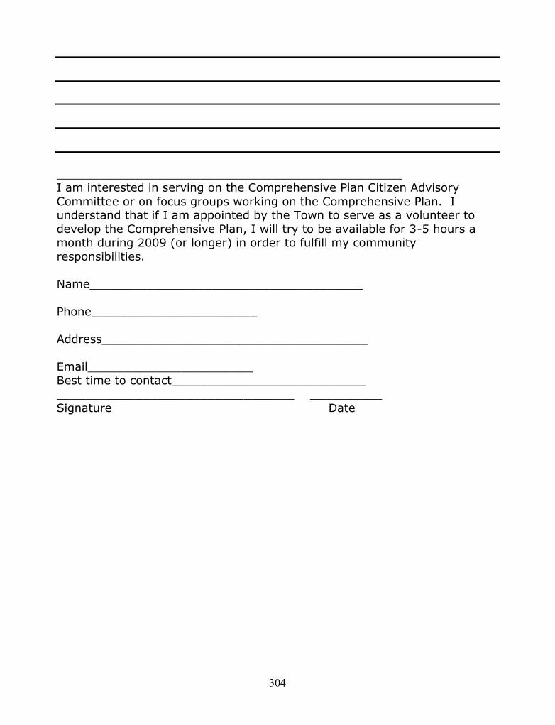
304
________________________________________________I am interested in serving on the Comprehensive Plan Citizen AdvisoryCommittee or on focus groups working on the Comprehensive Plan. Iunderstand that if I am appointed by the Town to serve as a volunteer todevelop the Comprehensive Plan, I will try to be available for 3-5 hours amonth during 2009 (or longer) in order to fulfill my communityresponsibilities.
Name______________________________________
Phone_______________________
Address_____________________________________
Email_______________________Best time to contact____________________________________________________________ __________Signature Date

305
Appendix 4.2 August, 2009 Listening Session Agenda, Workshop Questions
Willsboro Comprehensive Plan Steering Committee Summer CommunityListening Session
Agenda, Workshop Questions & Fact Sheet
Friday, August 14, 6:30-9:30 PM Saturday, August 15, 9:00 AM-12:00 AM
Commonwealth Fashions Cafeteria, 39 Myers Way just off of Route 22, Willsboro, New
York
First Half Hour Introduction & Welcome
Next Hour Small Group Round-Table Discussion of Straw-Man Questions
Next 20 Minutes Break Scribes Post Table ResultsAttendees walk around and review results
Half Hour Clarification/Discussion of Posted Issues and conditionsRank top 5 existing conditions, issues and concerns
Final Half Hour+ Discussion Q&AAdjourn
Goals for this workshop:
To obtain input from community on existing community conditions, including: overalldevelopment patterns, property development, shoreline and water quality impacts, farmlandand hamlet conditions. To hear directly from the residents their primary issues and concerns. To give an update on the upcoming community survey. To provide a periodic update to the community on the plan process.
Straw Man Questions for Small Group Work:1. In what ways is Willsboro different (physically, economically and culturally) than it was fiveyears ago? Ten years ago? How do you feel about these differences?2. As the community continues to grow, I would be concerned if we lost ____________.3. Please identify one issue about the way land is used or developed in Willsboro that you aremost concerned about _______________________.
4. Please identify one issue about the way lakes, rivers and ponds are used in Willsboro thatyou are most concerned about ___________________.5. Please tell us about land use, economic, or cultural issues that you are most concerned about inthe community:

306
Appendix 4.3 Community Survey
Willsboro Comprehensive Plan SurveyDear Citizens:The Town of Willsboro faces many challenges in regards to promoting growth, and protectingthe shorelines and rural character of our community. The members of the Town of WillsboroComprehensive Plan Steering Committee are in the early stages of developing a ComprehensiveLand Use Plan for the Town of Willsboro. We need your insight and input to ensure everypossible idea and concern is addressed in the Plan. Please take a few minutes of your valuabletime to complete this survey. Individual survey responses are confidential and will not be usedfor any other purpose.
Voice Your Opinion - It's Important!
Please mail completed surveys to the following addressno later than March 15, 2010:
Willsboro Comprehensive Plan Steering CommitteeC/O Town of Willsboro5 Farrell RoadWillsboro, NY 12996
Surveys can also be dropped off at the Town Hall during normal business hours: Mondaythrough Friday, 9-4.
The Members of the Town of Willsboro Comprehensive Plan Steering Committee are:
Bill Bardeen, Co-Chair John Oliver, Co-ChairGretchen Boardman Steve BenwayMark Bonfey Doug FerrisTommy Gilliland Anne LincolnGeorge Sayward Patty SchwennkerEd Smith Marty StrattonLori Lincoln-Spooner Phil CorellEdna Coonrod Josh BridgeBen Rowe As well as our many Agency and Organizational Partners

307
1. What are your reasons for living in Willsboro?Rank the following reasons in the order of importance to you with “1” being the mostimportant. Rank only those that apply.
Born hereNatural EnvironmentFamily/Friends are hereJob hereCost of LivingSmall Town LifeRecreational OpportunitiesOther: (please specify)
2. How much do you agree with each of the following statements?StronglyAgree
Agree Neutral Disagree Stronglydisagree
Don’tKnow/Unsure
The community is anaffordable place to liveChildren can afford to live inthe community once theygrow up and move out ontheir ownNew single-family residentialdevelopment will increasetaxes by increasing the needfor community services.Town approval of newdevelopment should be basedon the presence of adequateinfrastructure (roads, water,sewer, utilities).
3. In your opinion, how does Willsboro compare as a place to live to how it was five yearsago?
Much betterSomewhat betterStayed the same
SURVEY QUESTIONS

308
WorseMuch WorseUnsure/Don’t Know (please explain your answer):
4. How important are the following choices in making Willsboro a desirable place for youto live?
ExtremelyImportant
VeryImportant Important
NotImportant
Don’tKnow/Unsure
Availability of arts andcultureQuality of county andlocal servicesProperty tax ratesQuality/availability ofaffordable housingEmploymentopportunitiesAvailability ofshopping in the areaAccess to medical careEnvironmental qualityLack of crimeHow easy it is to gowalking/hiking/bikingRacial diversityFamily and friends arenearQuality of publicschoolsAvailability of localfoodAvailability of parksand recreation in theareaCommunity prideAccess to majorhighways and otherdestinationsSimilarity (age, race,income) of people inmy neighborhood

309
5. The Comprehensive Plan Steering Committee’s work is associated with the futuredirection of Land Use Planning in Willsboro. In Willsboro, from 2002 through 2009 theCode Enforcement Office reported an annual average of 16 single-family homespermitted in the Town of Willsboro. As Willsboro continues to grow, how importantare each of the following statements to you?
ExtremelyImportant
VeryImportant Important
NotImportant
Don’tKnow/Unsure
Limit new developmentto areas with existing orplanned roads, water andsewer.Discourage small lotdevelopment in ruralareas.Require grouping ofresidential and/orcommercial structures topreserve open space andagricultural land.Require developers toinclude outdoorrecreational space as partof their plans.Encourage developmentto be kept within orimmediately adjacent toexisting built-up areas.Encourage multi-useneighborhooddevelopment.Other: (please specify)
6. Are there any properties, scenic vistas, or shorelines within the community that you feelthe Comprehensive Plan Steering Committee should recommend be protected orpreserved for natural, open space, farmland purposes or as cultural resources?
Yes No If yes, please identify and describe which ones:

310
7. Please indicate your agreement with the following community land use goals. Willsboroshould:
StronglyAgree
Agree Neutral Disagree StronglyDisagree
Don’tKnow/Unsure
Preserve openspaceProtect historicsites and buildingsProtect air qualityProtect wetlandsProtect wildlifehabitats/travelcorridorsProtect farmlandsProtect scenicvistasProtect woodlandsProtect scenicroadsProtect streamcorridorsProtect ridgelinesProtect shorelinesPromote soilconservationProtect aquifers(ground-water/waterquality)Promote publicshoreline accessReduce lightpollution/ promotenight skiesOther (pleasespecify)

311
8. Should Willsboro seek development and growth in the following land uses?
StronglyAgree
Agree Neutral Disagree StronglyDisagree
Don’tKnow/Unsure
PermanentresidencesSecond homedevelopmentAffordableHousingLight industrySenior HousingHeavy industryAgribusinessCommercialDevelopmentDowntown ParkingForestryMarinas andFishingConservation andopen space areasWater andwastewater systemsNew recreationaland touristareas/facilities
9. Please indicate your agreement with the following statements in regards to the Town ofWillsboro’s Zoning and Subdivision Regulations:
Agree Disagree Unsure/Don’tKnow
I have read and reviewed the Willsboro zoning andsubdivision regulations.
I have applied at least once for a building permit formy Willsboro property(ies).
I have applied at least once for a variance for myWillsboro property(ies).

312
Agree Disagree Unsure/Don’tKnow
I have applied at least once for a subdivisionapproval for my Willsboro property(ies).
10. Please provide your comments on the experiences you’ve had with the permitting orvariance process within the Town of Willsboro.
11. My property (ies) is/are in the following district(s) within the Willsboro zoningordinance (check all that apply): Please reference Zoning Map of Willsboro on next page.
RL-1 - Residential - Low Density DistrictRL-2 - Residential - Low Density DistrictRL-3 - Residential - Low Density DistrictRL-5 - Residential - Very Low Density DistrictRM-1 Residential Medium Density DistrictRM-2 Residential Medium Density DistrictRM-3 Residential Medium Density DistrictRM-M - Residential - Medium Density Mobile Homes DistrictRR- Residential Rural Density DistrictLC-A - Land Conservation-Agriculture DistrictLC-R - Land Conservation-River DistrictLC-W - Land conservation-Woodland DistrictGB - General Business DistrictM - Industrial DistrictIC - Island Conservation DistrictSC - Stream Conservation DistrictHC-1 - Highway Commercial DistrictHC-2 - Highway Commercial DistrictUnsure

313

314
12. Please indicate your agreement with the following statements in regards to theAdirondack Park Agency Rules and Regulations:
Agree Disagree Unsure/Don’t Know
Willsboro is located within a State Park called theAdirondack State Park.
I have read and reviewed the Adirondack Park LandUse and Development Plan and Map.
I have applied at least once for a permit and/orjurisdictional determination from the AdirondackPark Agency for my Willsboro property(ies).
The Town of Willsboro has an approved“Adirondack Park Agency Local Land Use PlanningProgram.”
13. My property/ies is/are in the following APA land use area/s (check all that apply.)Please reference APA Land Use Map on next page.
HamletModerate IntensityLow IntensityRural UseResource ManagementDon't know

315

316
14. Willsboro should encourage the development of the following types of housing:
StronglyAgree
Agree Neutral Disagree StronglyDisagree
Don’tKnow/Unsure
Accessible housing forthe disabled/elderlyAffordable RentalhousingAssisted living forseniorsHomeless sheltersSingle family detachedhomesDuplex/triplex homesCondominiumsAffordable single-familyHousingSenior HousingHomelessShelter/EmergencyHousingMedical Need HousingHousing for previouslyhomeless persons,including victims ofdomestic violenceMobile Home Parks
15. Willsboro has 6,393 acres in the Agricultural District representing 23% of the landacreage in the Town. There are additional Agricultural Lands outside the District.Please indicate how important the following farmland issues are to you:
ExtremelyImportant
VeryImportant
Important NotImportant
Don’tKnow/Unsure
Limit increases onproperty taxes foragribusinessHelp withenvironmental

317
ExtremelyImportant
VeryImportant
Important NotImportant
Don’tKnow/Unsure
compliance forAgribusinessEstablish “Right toFarm” lawsSupport agriculturaldistrict developmentPay farmers bypurchasing theirdevelopment rightsDirect marketing offarm products toconsumersDevelop newagricultural productsand marketsConsumer "buy local"educationYouth agriculturaleducation (4-H)Farm neighboreducationEstate and successionplanning foragribusinessUtility cost reductionsfor agribusinessFinance programs foragribusinessEncourage service andsupport businesses forfarmersEncourage landownersand farmers to worktogether to managetillable farm land.Support the WillsboroResearch FarmSupport agricultural

318
ExtremelyImportant
VeryImportant
Important NotImportant
Don’tKnow/Unsure
and technical servicesthrough County, stateand federal agenciesSupport active Farmingwith all its sights,sounds and smells!Farm neighboreducationOther (please specify)
16. Do you claim farm income on your federal or state income tax form?Yes No
17. What is your residential status in Willsboro? Check all that apply:
Landowner Business ownerResident – full-time Resident – part-timeNon-resident Weekender
18. If you are a part-time resident: Do you plan to make Willsboro your full-time/primaryresidence within the next 10 years?
Yes NoUnsure Not applicable
19. How many (total) years have you lived in Willsboro?0-5 years 6-10 years11-20 years More than 20 years
20. For seasonal residents only: How many years have you been visiting in Willsboro?
0-5 years 6-10 years11-20 years More than 20 years
21. For seasonal residents only: Do you rent or own your home in Willsboro?Rent Own

319
22. On average, how many weeks each year do you reside in Willsboro?0-4 5-1516-28 29-52
23. How much land do you own in the community?Less than 1 acre 6-10 acres1-2 acres More than 10 acres3-5 acres Do not own land
24. What best describes your Willsboro home?Single family houseTwo-family dwellingMultiple family dwelling (3 or more)Single family apartmentBoarding houseOther
25. How many members of your household (including yourself) are in the following agecategories?
unde
r 5
5-9
10-1
4
15-1
9
20-2
4
25-3
4
35-4
4
55-5
9
60-6
4
65-7
4
75-8
4
Ove
r 84
Age inYearsAge inYears
26. What year were you born?
27. What is the highest level of education you have completed?Grade school Technical school certificationHigh school College graduate or higherSome college/technical school
28. What is your present employment status?Employed full-time Employed part-timeRetired Self employedStudent HomemakerUnemployed and seeking work Disabled or too ill to work
29. What best describes your occupation?

320
30. If you are a full-time resident of Willsboro and are employed either full or part time,how many miles (one way) do you travel to work?
0-10 miles More than 30 miles11-20 miles Not applicable21-30 miles
31. Into which range does your total annual household income fall?
Less
than
$10
,000
$10,
000
to $
14,9
99$1
5,00
0 to
$24
,999
$25,
000
to $
34,9
99$3
5,00
0 to
$49
,999
$50,
000
to $
74,9
99$7
5,00
0 to
$99
,999
$100
,000
to $
149,
999
$150
,000
to $
199,
999
$200
,000
or m
ore
Pref
er n
ot to
ans
wer
AnnualIncome
indollars
AnnualIncome
indollars
32. Briefly describe your vision for the community as you see it in 20 years.
33. Please provide in this space any further comments you wish to make to theComprehensive Plan Committee:
Thank you for taking the time to complete the Willsboro Comprehensive PlanCommunity Survey.
The Town of Willsboro Comprehensive Plan Steering Committee

321
* Minutes, reports and Comprehensive Plan materials are available at the Town’s website at:www.Willsborony.com/plan
* Stay in touch! Sign up for notices and news by emailing us at:[email protected]
This document was prepared for the New York State Department of Statewith funds provided under Title 11 of the Environmental Protection Fund

322
Appendix 4.4 Roundtable Technique Debriefing
Town of Willsboro Comprehensive Plan Methods AnalysisJuly 6, 2010 Debriefing Roundtable
Steering Committee Member:Please review the techniques and consider the advantages and disadvantages of each one inrelation to each other in terms of the following standards:
Engagement-How well did the technique:
connect you to your interests, help you to participate, connect you to the activity and, take up your whole attention?
Information Transfer-How well did the technique:
Help you through conversation, reflection or presentation of information toacquire new knowledge?
supply you with a new way of thinking about subjects or information that helpedyou to learn?
Dialogue-How well did the technique:
Encourage you to take part in serious conversations? Encourage you to take part in formal discussions? Encourage you to take part in serious conversations between people or groups that
may include differing points of views, interests or opposing sides?
1. August, 2009 Listening SessionsEngagement * Information Transfer * Dialogue
2. Development, Launch, Completion and Results of Community SurveyEngagement * Information Transfer * Dialogue
3. Discussions with Natural Science Subject Matter ExpertsEngagement * Information Transfer * Dialogue
4. Community Based Field Work and Development of GIS-Based Maps forCommunity Profile and Analysis WorkEngagement * Information Transfer * Dialogue
5. Visioning Sessions out in the Community and Straw man VisioningStatementEngagement * Information Transfer * Dialogue
6. June Work sessions with Straw man Versions and GIS Map Analysis todevelop Environment and Land Use RecommendationsEngagement * Information Transfer * Dialogue

323
Appendix 5.0a Willsboro Steering Committee Stakeholder Engagement Analysis
Appendix 5.0a Willsboro Steering Committee Stakeholder Engagement Analysis is an oversizeddocument and has been uploaded as a pdf file that it is available with the electronic version ofthis dissertation at the OhioLINK Electronic Theses and Dissertations Center,http://etd.ohiolink.edu.
Appendix 5.1a August Listening Session Final Report
Appendix 5.1a, August Listening Session Final Report, has been uploaded as a pdf file and isavailable with the electronic version of this dissertation at the OhioLINK Electronic Theses andDissertations Center, http://etd.ohiolink.edu.
Appendix 5.1b Generative Themes Allocation
Appendix 5.1b, Generative Themes Allocation, is an oversized document and has been uploadedas a pdf file that it is available with the electronic version of this dissertation at the OhioLINKElectronic Theses and Dissertations Center, http://etd.ohiolink.edu.
Appendix 5.2 Summary Report from Survey Monkey
Appendix 5.2, Summary Report from Survey Monkey, has been uploaded as a pdf file and isavailable with the electronic version of this dissertation at the OhioLINK Electronic Theses andDissertations Center, http://etd.ohiolink.edu.
Appendix 5.3a Visioning Session Final Report
Appendix 5.3a, Visioning Session Final Report has been uploaded as a pdf file and is availablewith the electronic version of this dissertation at the OhioLINK Electronic Theses andDissertations Center, http://etd.ohiolink.edu.
Appendix 5.3b Visioning Focused Coding Analysis
Appendix 5.3b, Visioning Focused Coding Analysis, is an oversized document and has beenuploaded as a pdf file that it is available with the electronic version of this dissertation at theOhioLINK Electronic Theses and Dissertations Center, http://etd.ohiolink.edu.


![The Second Coming of Jesus [The Promised Messiah] - AAIIL](https://static.fdokumen.com/doc/165x107/63216fb1537c10e83802a759/the-second-coming-of-jesus-the-promised-messiah-aaiil.jpg)