OPPORTUNITIES & CONSTRAINTS REPORT
133
OPPORTUNITIES & CONSTRAINTS REPORT June, 2021
-
Upload
khangminh22 -
Category
Documents
-
view
1 -
download
0
Transcript of OPPORTUNITIES & CONSTRAINTS REPORT

OPPORTUNITIES & CONSTRAINTS REPORTJune, 2021

Hensley Field Re-Use and Redevelopment Plan
TABLE OF CONTENTS
MARKET ANALYSIS AND ECONOMIC DEVELOPMENT POTENTIAL (EPS)03 3.1 Background 233.2 Project Location 233.3 Scope of Work 233.4 D/FW Metroplex Market Conditions 253.5 Residential Market 253.6 Office Market 283.7 Industrial Market 283.8 Retail/Commercial Strategy 293.9 Mixed Use Redevelopment Case Studies 293.10 Master Plan Scaling 29
MIXED-USE REDEVELOPMENT CASE STUDIES (EPS)04 4.1 D/FW Mixed Use Redevelopments 354.2 Airport and Base Redevelopments 424.3 Conclusions 52
HISTORIC AND CULTURAL RESOURCES (IES)05 5.1 Cultural resources at Hensley field 535.2 History of Hensley Field 535.3 Historic Preservation tools and Their opportunities and constraints 585.4 State and Federal Regulatory Compliance 655.5 Conclusion 67
LAND USE AND REGULATORY CONTEXT (MAS)02 2.1 Surrounding pattern of land use 112.2 Existing and Adjacent Zoning 112.3 Potential Future Zoning for Hensley Field 142.4 Community Assets 172.5 Existing Leases and Terms 21
EXISTING PLANS AND POLICIES (MAS)01 1.1 Environmental Protection & Sustainability 11.2 Social Equity 11.3 Economic Development 21.4 Mobility 2

Prepared for the City of Dallas - June 10, 2021 12:19 PM
TRANSPORTATION (F&P)07 7.1 Introduction 837.2 Site Access 857.3 Hensley Field Site 95
SITE CHARACTERISTICS AND CONTEXT (SWA)06 6.1 Executive Summary 696.2 Adjacent Property Ownership 696.3 Existing Conditions 716.4 Existing Tree Canopy & the Urban Heat Island 756.5 Watersheds & Water Quality 776.6 Lake Banks & Edges 796.7 Adjacent Park & Trail Systems 81
INFRASTRUCTURE (STANTEC)08 8.1 Water 1018.2 Wastewater 1038.3 Drainage & Water Quality 1058.4 Dry Utilities: Gas, Electric, Telecom 1068.5 Net-Zero Planning & Development 106
ENVIRONMENTAL AND GEOTECHNICAL CONDITIONS (TERRACON)09 9.1 Rubble Landfill 1079.2 Soil Excavation Areas 1079.3 Sediment 1089.4 Groundwater 1109.5 Per- and Poly-Fluoroalkyl Substances (PFAS) 1139.6 Geotechnical Conditions 115
FINANCIAL & IMPLEMENTATION OPTIONS (EPS)1010.1 Funding Sources 12710.2 Development and Governance Options 129

Hensley Field Re-Use and Redevelopment Plan 1
A review of key plans and policies adopted by the City of Dallas over the past 15 years establish clear direction for the future of Hensley Field. Table 1.1 provides a matrix that summarizes policies that could affect redevelopment of the former Naval Air Station. Virtually all of the plans communicate a common theme focused on Economic Viability, Environmental Protection and Social Equity, the “three pillars” of sustainability.
The City’s Comprehensive Land Use Plan (Forward Dallas) was prepared in 2006 and it is currently planned to be updated in 2021 to reflect current City policy. While it designates Hensley Field as an Industrial area, other policies within that Plan call for economic investment in South Dallas, the creation of pedestrian-oriented neighborhoods, green development, and an interconnected park and trail network.
1.1 ENVIRONMENTAL PROTECTION & SUSTAINABILITY Numerous plans over the past ten years have focused on the City’s most pressing environmental issues, including Climate Change, Heat Island Management, and the protection and expansion of the Urban Forest. The Comprehensive Environment and Climate Action Plan (CECAP) adopted in 2020, is the most comprehensive of these, looking at environmental and climate action through the lens of social equity. The Plan provides a policy framework meant to ensure a healthier and cleaner environment. Its principal goal is to reduce greenhouse gas (GHG) emissions by 43% by 2030 and 100% by 2050. The Plan provides 97 actions across eight sectors of which 45 are aimed at reducing GHG emissions.
The Plan calls for land use patterns that reflect more dense, walkable, transit connected neighborhoods and sets a target for all new construction from 2030 onward to be zero-net energy. It also promotes the concept of net zero neighborhoods, citing the redevelopment of Hensley Field as an opportunity for the City to create a carbon neutral district with in-district renewable energy. It states that Hensley Field “could then serve as a best practice example of Dallas’ leadership and innovation” in climate protection and resiliency. The Plan also calls for a city-wide network
of urban trails to link neighborhoods, the enhancement of healthy forests, parks and greens spaces to improve air quality, and an increase in the tree canopy to reduce Heat Island effects.
Other environmental plans, including Resilient Dallas (2018), the Urban Heat Island Management Study (2017) and the State of the Urban Forest (2015) reinforce the need to address climate change and public health through protection and expansion of the urban forest, introduction of green infrastructure, and equitable access to services.
1.2 SOCIAL EQUITYAs stated, many of Dallas’s plans address social equity as a principal goal, whether the Plan is focused on mobility, economic development or environmental sustainability. Equitable access to housing, quality, schools, health care, food, transportation and open space is a common theme among most of the plans, with a focus on areas with a concentration of poverty in South Dallas. The City’s Comprehensive Housing Policy of 2018 calls for public reinvestment with subsidies and revised Tax Increment Financing (TIF) policies to overcome patterns of segregation and concentrations of poverty in South Dallas. The Housing Policy promotes shared equity and mortgage assistance programs that allow buyers to build equity and wealth.
Access to healthy food is another common theme of social equity. The City of Grand Prairie’s Comprehensive Plan identifies the neighborhoods immediately adjacent to Hensley Field as Food Deserts, areas where low-income residents are located more than ½ mile from a supermarket and where there are more than 100 housing units within a census tract without a vehicle. Several other plans, including Healthy Food Dallas (2017) and Local Foods Local Places (2016), focus on the need to improve access to healthy food and to eradicate Food Deserts. Local food production and the use of productive landscapes in new developments is identified as a principal goal in several plans.
Resilient Dallas (2018) cites southern Dallas as a “health care desert”, calling for the City to partner on land
1 EXISTING PLANS AND POLICIES

Prepared for the City of Dallas - June 10, 2021 1:41 PM 2
acquisition and infrastructure improvements for the development of an Integrated Health Clinic to provide access to mental and behavioral health resources. The Dallas Cultural Plan (2018) encourages the City to create equitable and affordable arts and cultural programming in vacant city facilities in partnership with neighborhood-based small arts organizations.
1.3 ECONOMIC DEVELOPMENTForward Dallas calls for economic development and investment to be directed toward the Southern Sector of Dallas, noting that this part of the City accounted for just 25 percent of jobs in the City of Dallas in the year 2000, while comprising more than 50 percent of the city’s land area and the vast majority of vacant land in the city. The Plan proposes a strategy of steering targeted business and industrial development with high quality jobs to South Dallas to redress this imbalance.
Numerous other plans since Forward Dallas have focused on the need for enhanced investment in South Dallas, including the 2012 Grow South initiative by former Mayor Mike Rawlings. The goal of that plan was to “document, promote and advocate economic expansion of the City into the 185-square mile area, representing 45% of Dallas’s population, but only 15% of its tax revenue. The Plan identified a series of focus areas, several of which have experienced considerable investment over the past ten years (e.g., Pinnacle Park, Education Corridor/Inland Port).
Investment in parks and open space were highlighted in the 2016 Parks and Recreation Master Plan as an effective approach to economic development. The Park and Recreation Department undertook an economic value and benchmarking study, which showed that Dallas parks provide a 15-to-1 return on public investment, or $1.2 billion, each year that goes back to the local economy. The study found that about half of that value comes from tourism, while nearly a third comes from increases to real estate. It noted that trails generate the highest return on investment, at a rate of 50 to 1, and as such the Plan encourages new park-oriented development or redevelopment to capitalize on the economic value of parks.
1.4 MOBILITYTransportation policies in numerous City and regional plans call for a more balanced and equitable system of mobility. NCTCOG’s Mobility 2045 Plan promotes healthy communities by reducing the use of motor vehicles, which contribute to air pollution, congestion and safety issues. It calls for the improvement of roadway design to accommodate bicycles and pedestrians that can help reduce accidents and injuries. It emphasizes the health advantages of active transportation noting that walking –whether for utilitarian or recreational purposes –can help improve personal health, reduce traffic congestion, and reduce travel costs. Mobility 2045 also cites the potential for autonomous transit vehicles as a cost-effective approach to public transportation by using larger vehicles traveling longer distances and operating like trains but without the requirement of tracks, resulting in lower capital costs.
The Climate Action Plan establishes specific targets of new housing to be located in TOD locations: 10%-15% by 2030 and 30-35% by 2050. It calls for Single Occupant Vehicle (SOV) travel to shift from 88% to 79% by 2030 and to 62% by 2050. It proposes a City/DART partnership to fund and construct a series of mobility hubs to provide sustainable transportation options (e.g., electrified TNCs, EV charging using solar generation, public transport, micro-transit and micro-mobility) with Southern Dallas neighborhoods given highest priority for the initial hubs.
Other mobility plans and policies including Dallas’s Strategic Mobility Plan (Connect Dallas) and the City of Dallas Complete Streets Design Manual all promote compact growth and transit-oriented development that will achieve broader economic, equity and sustainability goals. The Complete Streets Vision Map provides a street typology for the entire City with five new street type classifications: Mixed Use Streets; Commercial Streets; Residential Streets; Industrial Streets; and Parkways. The Plan provides minimum and preferred widths for each street type and for each “zone” (i.e., pedestrian and street), of the roadway. The Plan also provides a Design Elements Priorities chart for each roadway type to guide design. Jefferson Street along the north edge of Hensley Field is mapped as an Industrial Roadway with On-Street Bicycle Facilities.

Hensley Field Re-Use and Redevelopment Plan
Figure 1.1
PURPOSE & VISION COMMUNITY DESIGN ECONOMIC DEVELOPMENT HOUSING OPEN SPACE & RECREATION TRANSPORTATION & MOBILITY SUSTAINABILITY & RESILIENCY SOCIAL EQUITY
COM
PREH
ENSI
VE E
NVIR
OMEN
T &
CLIM
ATE
ACTI
ON P
LAN
202
0
“Dallas is a leader in reducing emissions and addressing climate and environmental risk with effective, equitable and common-sense solutions.” The Plan provides a policy framework meant to ensure a healthier and cleaner environment. Its principal goal is to reduce GHG emissions by 43% by 2030 and 100% by 2050. The Plan provides 97 actions across 8 sectors of which 45 are aimed at reducing GHG emissions.
Land use patterns will result in more dense, walkable, transit connected neighborhoods. All new construction from 2030 onward will be zero-net energy. The City will promote the concept of net zero neighborhoods to achieve the goals of this action on a larger scale. Hensley Field is put forward in the Plan as an opportunity for the City to create a carbon neutral district with in-district renewable energy.
The City will build a city-wide network of urban trails that link neighborhoods with transportation hubs and economic centers. This network would be built upon trails, green space, and green infrastructure through recommendations from the Dallas Parks Master Plan and the Smart Growth Dallas initiative that also serve as critical mobility assets that connect neighborhoods to places of employment without the need for single occupancy vehicles.
Mode split goals should help meet and exceed the proposed targets of: • 10%-15% by 2030 and 30-35% by 2050 of new housing in TOD locations. • SOV travel mode shift from 88% to 79% in 2030 and from 88% to 62% in 2050. The City will work with DART to fund and construct a series of mobility hubs that provide sustainable transportation options (e.g., electrified TNCs, EV charging using solar generation, public transport, micro-transit and micro-mobility). Southern Dallas neighborhoods will be considered for the initial hubs.
Increase, enhance and maintain healthy forests, parks and green spaces that improve air quality.
Invest in programs through local community colleges to train and establish a local workforce that is focused on renewable energy technologies. Evaluate the potential for the city to make investments in energy storage technologies for both resilience and renewable energy development purposes.
Improve food access in neighborhoods with low food access. Facilitate partnerships between schools and non-profits to develop neighborhood-based growing initiatives and kitchen gardens. Reduce food miles by encouraging local food production and consumption.
CONN
ECT
DALL
AS S
TRAT
EGIC
M
OBILI
TY P
LAN
202
0
Connect Dallas outlines a roadmap to modernize the city's decision-making processes to ensure all transportation investments work toward an economically vibrant, sustainable, equitable city. The Plan provides a strategic transpoortation network that supports the CIty's housing, economic, equity and sustainability goals. The Plan focuses on actions to be taken in the next five years. It is still in Draft form, and is scheduled to be presented to the City Council in late 2020.
The Plan promotes compact growth and transit-oriented development. Through a Scenario Planning process, It emphasizes development around transit stops and on vacant and underutiized land in already developed areas with a greater intensity and mix of land uses. The Plan calls for the CIty to develop TOD design guidelines to promote high quality urban design, a variety of housing types, mixed-use development, and active transportation connections.
Integrate transportation investments, workforce development goals and economic developmemnt priorities.
Support the creation of affordable and varied housing options that meet the city's growing needs. Integrate transportation investments with land use and economic priorities to improve quality of life.
Improve safety for all modes of transportation. Leverage existing and emerging technologies to meet 21st century challenges. Integrate transportation investments with land use and economic priorities to improve quality of life. The Plan calls for the City to work with DART as part of its 2020 updated Transit System Plan to provide enhanced bus service. Focus on improving safety of streets on the High Injury Network (HIN), of which Davis Street near Hensley Field is one.
Reduce SOV mode share from 88% to 79% by 2030 and to 62% by 2050, consistent with the CECAP goal of reducing GHG emissions.
Provide a variety of travel options to encourage residents to travel by transit, biking or walking to reduce greenhouse gas emissions.
Provide safe, affordable access to opporutnies for all city residents
MOB
ILITY
204
5 (2
018)
The plan was adopted in June 2018 by the Regional Transportation Council, which serves as the policy body for the Metropolitan Planning Organization for North Central Texas. The principal purpose of the plan is to develop a transportation system that contributes to the region’s mobility, quality of life, system sustainability, and continued project implementation.
Reducing the use of motor vehicles, which contribute pollution to the air, promotes healthy communities. Lowering the number of cars and trucks on roadways can help lessen congestion and improve safety. Improving roadway design to accommodate bicycles and pedestrians can help reduce accidents and injuries.Encourage developers and local governments to work cooperatively using land use and complementary policies on existing and planned developments to increase and enhance access to regional transportation systems
The subject of economic development can be found throughout Mobility 2045, underscoring the importance of the relationship between the region’s transportation system and its economy. The increasing need to upgrade and maintain roadways, improve transit, rail, bicycle/pedestrian trails, and airports is essential to providing connectivity between communities within the region for economic development and growth.
The Plan supports the Regional Veloweb, a network of off-street shared-use paths (trails) designed for non-recreational trip purposes by bicyclists, pedestrians, and other non-motorized forms of transportation. The Veloweb serves as the regional expressway network for active transportation, and it extends the reach of the region’s roadway and passenger rail transit network for non-motorized transportation.
Improve the availability of transportation options for people and goods. As technology develops, there is also potential for autonomous transit vehicles to impact public transportation by using larger vehicles traveling longer distances, such as buses and trains. This type of service offers high flexibility in operation and may be a cost-effective alternative to traditional rail service in some operating environments.
Preserve and enhance the natural environment, improve air quality, and promote active lifestyles. Encourage livable communities which support sustainability and economic vitality.
Easy access to daily destinations and multiple transportation options contribute to the quality of life in a neighborhood, city, or region. In coordination with local governments and transportation partners, the North Central Texas Council of Governments aims to develop transportation infrastructure that is accessible to all
RESI
LIENT
DAL
LAS
2018
Dallas’ biggest resilience challenge is not the devastation of a tornado, flood, or other natural disaster..... Rather, it is the economic vulnerability of Dallas’ poor who struggle to provide for themselves and their families, weakening the community’s resilience.
The plan offers practical initiatives related to: Building economic mobility for Dallas' working poor; Nurturing healthy children; Investing in Dallas' low-income neighborhoods; and Expanding access to opportunity through improved public transport.
Improve transportation access to employment, housing, education, healthcare, and other essential services for Dallas residents.Collaborate with DART and major employers and stakeholders to create mechanisms to fund and operationalize first mile/last mile mobility solutions for major employment centers.
Promote partnership efforts to implement green infrastructure projects in neighborhoods disproportionately vulnerable to the impacts of the urban heat island effect, poor water quality, and poor air quality.
Partner on land acquisition and infrastructure improvements for the development of the Integrated Health Clinic in southern Dallas, providing access to mental and behavioral health resources and alleviating the adverse health impacts of living in a health care desert
TABLE 1.1: HENSLEY FIELD REUSE & REDEVELOPMENT PLAN - RELEVANT PLANS & POLICES

Prepared for the City of Dallas - June 10, 2021 1:41 PM 4
PURPOSE & VISION COMMUNITY DESIGN ECONOMIC DEVELOPMENT HOUSING OPEN SPACE & RECREATION TRANSPORTATION & MOBILITY SUSTAINABILITY & RESILIENCY SOCIAL EQUITY
COM
PREH
ENSI
VE E
NVIR
OMEN
T &
CLIM
ATE
ACTI
ON P
LAN
202
0
“Dallas is a leader in reducing emissions and addressing climate and environmental risk with effective, equitable and common-sense solutions.” The Plan provides a policy framework meant to ensure a healthier and cleaner environment. Its principal goal is to reduce GHG emissions by 43% by 2030 and 100% by 2050. The Plan provides 97 actions across 8 sectors of which 45 are aimed at reducing GHG emissions.
Land use patterns will result in more dense, walkable, transit connected neighborhoods. All new construction from 2030 onward will be zero-net energy. The City will promote the concept of net zero neighborhoods to achieve the goals of this action on a larger scale. Hensley Field is put forward in the Plan as an opportunity for the City to create a carbon neutral district with in-district renewable energy.
The City will build a city-wide network of urban trails that link neighborhoods with transportation hubs and economic centers. This network would be built upon trails, green space, and green infrastructure through recommendations from the Dallas Parks Master Plan and the Smart Growth Dallas initiative that also serve as critical mobility assets that connect neighborhoods to places of employment without the need for single occupancy vehicles.
Mode split goals should help meet and exceed the proposed targets of: • 10%-15% by 2030 and 30-35% by 2050 of new housing in TOD locations. • SOV travel mode shift from 88% to 79% in 2030 and from 88% to 62% in 2050. The City will work with DART to fund and construct a series of mobility hubs that provide sustainable transportation options (e.g., electrified TNCs, EV charging using solar generation, public transport, micro-transit and micro-mobility). Southern Dallas neighborhoods will be considered for the initial hubs.
Increase, enhance and maintain healthy forests, parks and green spaces that improve air quality.
Invest in programs through local community colleges to train and establish a local workforce that is focused on renewable energy technologies. Evaluate the potential for the city to make investments in energy storage technologies for both resilience and renewable energy development purposes.
Improve food access in neighborhoods with low food access. Facilitate partnerships between schools and non-profits to develop neighborhood-based growing initiatives and kitchen gardens. Reduce food miles by encouraging local food production and consumption.
CONN
ECT
DALL
AS S
TRAT
EGIC
M
OBILI
TY P
LAN
202
0
Connect Dallas outlines a roadmap to modernize the city's decision-making processes to ensure all transportation investments work toward an economically vibrant, sustainable, equitable city. The Plan provides a strategic transpoortation network that supports the CIty's housing, economic, equity and sustainability goals. The Plan focuses on actions to be taken in the next five years. It is still in Draft form, and is scheduled to be presented to the City Council in late 2020.
The Plan promotes compact growth and transit-oriented development. Through a Scenario Planning process, It emphasizes development around transit stops and on vacant and underutiized land in already developed areas with a greater intensity and mix of land uses. The Plan calls for the CIty to develop TOD design guidelines to promote high quality urban design, a variety of housing types, mixed-use development, and active transportation connections.
Integrate transportation investments, workforce development goals and economic developmemnt priorities.
Support the creation of affordable and varied housing options that meet the city's growing needs. Integrate transportation investments with land use and economic priorities to improve quality of life.
Improve safety for all modes of transportation. Leverage existing and emerging technologies to meet 21st century challenges. Integrate transportation investments with land use and economic priorities to improve quality of life. The Plan calls for the City to work with DART as part of its 2020 updated Transit System Plan to provide enhanced bus service. Focus on improving safety of streets on the High Injury Network (HIN), of which Davis Street near Hensley Field is one.
Reduce SOV mode share from 88% to 79% by 2030 and to 62% by 2050, consistent with the CECAP goal of reducing GHG emissions.
Provide a variety of travel options to encourage residents to travel by transit, biking or walking to reduce greenhouse gas emissions.
Provide safe, affordable access to opporutnies for all city residents
MOB
ILITY
204
5 (2
018)
The plan was adopted in June 2018 by the Regional Transportation Council, which serves as the policy body for the Metropolitan Planning Organization for North Central Texas. The principal purpose of the plan is to develop a transportation system that contributes to the region’s mobility, quality of life, system sustainability, and continued project implementation.
Reducing the use of motor vehicles, which contribute pollution to the air, promotes healthy communities. Lowering the number of cars and trucks on roadways can help lessen congestion and improve safety. Improving roadway design to accommodate bicycles and pedestrians can help reduce accidents and injuries.Encourage developers and local governments to work cooperatively using land use and complementary policies on existing and planned developments to increase and enhance access to regional transportation systems
The subject of economic development can be found throughout Mobility 2045, underscoring the importance of the relationship between the region’s transportation system and its economy. The increasing need to upgrade and maintain roadways, improve transit, rail, bicycle/pedestrian trails, and airports is essential to providing connectivity between communities within the region for economic development and growth.
The Plan supports the Regional Veloweb, a network of off-street shared-use paths (trails) designed for non-recreational trip purposes by bicyclists, pedestrians, and other non-motorized forms of transportation. The Veloweb serves as the regional expressway network for active transportation, and it extends the reach of the region’s roadway and passenger rail transit network for non-motorized transportation.
Improve the availability of transportation options for people and goods. As technology develops, there is also potential for autonomous transit vehicles to impact public transportation by using larger vehicles traveling longer distances, such as buses and trains. This type of service offers high flexibility in operation and may be a cost-effective alternative to traditional rail service in some operating environments.
Preserve and enhance the natural environment, improve air quality, and promote active lifestyles. Encourage livable communities which support sustainability and economic vitality.
Easy access to daily destinations and multiple transportation options contribute to the quality of life in a neighborhood, city, or region. In coordination with local governments and transportation partners, the North Central Texas Council of Governments aims to develop transportation infrastructure that is accessible to all
RESI
LIENT
DAL
LAS
2018
Dallas’ biggest resilience challenge is not the devastation of a tornado, flood, or other natural disaster..... Rather, it is the economic vulnerability of Dallas’ poor who struggle to provide for themselves and their families, weakening the community’s resilience.
The plan offers practical initiatives related to: Building economic mobility for Dallas' working poor; Nurturing healthy children; Investing in Dallas' low-income neighborhoods; and Expanding access to opportunity through improved public transport.
Improve transportation access to employment, housing, education, healthcare, and other essential services for Dallas residents.Collaborate with DART and major employers and stakeholders to create mechanisms to fund and operationalize first mile/last mile mobility solutions for major employment centers.
Promote partnership efforts to implement green infrastructure projects in neighborhoods disproportionately vulnerable to the impacts of the urban heat island effect, poor water quality, and poor air quality.
Partner on land acquisition and infrastructure improvements for the development of the Integrated Health Clinic in southern Dallas, providing access to mental and behavioral health resources and alleviating the adverse health impacts of living in a health care desert
TABLE 1.1: HENSLEY FIELD REUSE & REDEVELOPMENT PLAN - RELEVANT PLANS & POLICES

Hensley Field Re-Use and Redevelopment Plan
Figure 1.2
PURPOSE & VISION COMMUNITY DESIGN ECONOMIC DEVELOPMENT HOUSING OPEN SPACE & RECREATION TRANSPORTATION & MOBILITY SUSTAINABILITY & RESILIENCY SOCIAL EQUITY
DALL
AS C
ULTU
RAL P
LAN
2018
" Plan strategies focus on supporting artists and neighborhoods and cultural activities, with a purposeful shift in focus from building new buildings to "supporting creators, organizations and communities in a sustainable way". The vision for OCA: "An equitable, diverse and connected community, whose residents and visitors thrive through meaningful arts and cultural experiences in every neighborhood across Dallas.
Provide, create and incentivize the creation of spaces and places to encourage and allow arts and culture in Dallas to thrive and grow citywide. Support a portfolio of cultural incubators and shared production spaces. Cultural incubators and shared production spaces provide artists with shared equipment, facilities, technical assistance, and a collaborative social network.
Work with Department of Economic Development to include arts and cultural spaces and activities in major development projects (e.g. implement developer incentives to encourage inclusion of live/work space for artists). Encourage private partners (for profit and non- profit) to develop or make available spaces for studios, exhibit space, and performing and rehearsal space
The City can provide assistance in the form of low-interest loans and a streamlined application process for artists to purchase their own homes. Not only does this ensure that artists can remain in their neighborhoods, it also helps them build wealth as property values increase.
Model sustainability to the arts and culture community through OCA’s facilities and encourage and support the development of future sustainability in the broader arts and cultural sector.
Support the broadest range of art forms and creative producers, considering inclusivity, diversity and neighborhood impact to direct resources equitably to artists and organizations. Explore with neighborhood-based small arts organizations to create equitable and affordable programming in vacant city facilities (e.g., Women’s Museum)
CITY
OF G
RAND
PRA
IRIE
CO
MPR
EHEN
SIVE
PLA
N 20
18
The City of Grand Prairie should contain a mix of land uses that will foster sustainable economic vitality and provide a broad range of opportunities for living, recreation, shopping and business. Land uses should be distributed in a manner that enhances a sense of community and neighborhood identity. In addition, residents and visitors should have ready access to amenities that the City offers, such as recreation, shopping and cultural activities.
A balanced mix of land uses is needed to provide a strong tax base, adequate amenities, and demand for services. High quality development is a top priority for future development, regardless of land use. High Opportunity Areas are identified for the 260-ac site at MacArthur and I-30, which is targeted for high density mixed-use development. Jefferson Street east of MacArthur and northeast of Hensley Field is identified as an opportunity for commercial infill development.
Maintain, enhance, and promote the City’s natural amenities; including the City’s open space and Joe Pool Lake.
Public transportation is a top desire among many residents. Additionally, traffic congestion, both along major roadways and in neighborhoods, is a concern for many. MacArthur Blvd is identified as a scheduled regional roadway improvement to be widened from 4 to 6 lanes.
The neighborhoods surrounding Hensley Field are identified as Food Deserts, with low-income residents located more than 1/2 mile from supermarkets and with more than 100 housing units without a vehicle by census tract. The Future Land Use Plan lists a whole range of "Healthy Community" policies aimed at imrpoving access to fresh food and public health facilities.
COM
PREH
ENSI
VE H
OUSI
NG
POLIC
Y 20
18
This 2018 policy document calls for the creation and preservation of housing serving families at 30% - 120% of Dallas Area Median Income and sets annual housing production goals through 2021. It establishes three goals: 1) Create and maintain available and affordable housing throughout Dallas; 2) Promote greater fair housing choices; and 3) Overcome patterns of segregation and concentrations of poverty through incentives and requirements.
Housing Reinvestment Strategy focuses on: 1) Redevelopment Areas characterized by a known catalytic project that has submitted a request for funding that shows preliminary viability and will begin within the next 12 months; 2) Stabilization Areas at risk of displacement; and 3) Emerging Market Areas characterized as areas in need of intensive environmental enhancements, master planning and formalized neighborhood organization.
The Plan calls for the creation of 20,000 new units over 3 years (56% ownership and 44% rental) with City subsidies for families earning between 30% and 120% AMI. It calls for the City's TIF policy to include specified income band targets (currently the policy just states that 20% of units have to be affordable to those earning at or below 80% AMI).
Focus new housing in middle markets and build to the market values of the neighborhoods, not the mortgage capacity of the potential buyers, and provide assistance to the homebuyers via soft second mortgages to allow buyers to build equity while protecting the City through a secured lien position and a recapture policy that allows the City and assisted family to split the upside of any appreciation upon sale.
HEAL
THY
FOOD
DAL
LAS
2017
The scope of this study included: Define food deserts and review current initiatives. Highlight importance of non-traditional healthy food grocer alternatives in food deserts and Dallas’ role in leveraging resource partners. Review peer city best practices. Evaluate issues and potential areas of focus and stakeholder partners.
Areas immediatlely east of Hensley Field are designated Food Deserts. Policies include: Actively recruit grocers; enact community gardens and famers market ordinances that allow for sales of locally grown and produced food. Create Community Garden grant program.
In 2012, the State Comptroller estimated $11.1 billion annually in healthcare costs and productivity loss due to illnesses that are caused or worsened by poor nutrition. Potential Non-Profit Partners: North Texas Food Bank, Dallas Coalition for Hunger Solutions, Faith-based coalition, Bon Ton Farms, United Way, CHILDREN AT RISK, Texas Hunger Initiative, Crossroads, GROW North Texas
Almost 20% of the Dallas County population faces food insecurity and lacks needed fruits and vegetables in their diet (quality and quantity)

Prepared for the City of Dallas - June 10, 2021 1:41 PM 6
PURPOSE & VISION COMMUNITY DESIGN ECONOMIC DEVELOPMENT HOUSING OPEN SPACE & RECREATION TRANSPORTATION & MOBILITY SUSTAINABILITY & RESILIENCY SOCIAL EQUITY
DALL
AS C
ULTU
RAL P
LAN
2018
" Plan strategies focus on supporting artists and neighborhoods and cultural activities, with a purposeful shift in focus from building new buildings to "supporting creators, organizations and communities in a sustainable way". The vision for OCA: "An equitable, diverse and connected community, whose residents and visitors thrive through meaningful arts and cultural experiences in every neighborhood across Dallas.
Provide, create and incentivize the creation of spaces and places to encourage and allow arts and culture in Dallas to thrive and grow citywide. Support a portfolio of cultural incubators and shared production spaces. Cultural incubators and shared production spaces provide artists with shared equipment, facilities, technical assistance, and a collaborative social network.
Work with Department of Economic Development to include arts and cultural spaces and activities in major development projects (e.g. implement developer incentives to encourage inclusion of live/work space for artists). Encourage private partners (for profit and non- profit) to develop or make available spaces for studios, exhibit space, and performing and rehearsal space
The City can provide assistance in the form of low-interest loans and a streamlined application process for artists to purchase their own homes. Not only does this ensure that artists can remain in their neighborhoods, it also helps them build wealth as property values increase.
Model sustainability to the arts and culture community through OCA’s facilities and encourage and support the development of future sustainability in the broader arts and cultural sector.
Support the broadest range of art forms and creative producers, considering inclusivity, diversity and neighborhood impact to direct resources equitably to artists and organizations. Explore with neighborhood-based small arts organizations to create equitable and affordable programming in vacant city facilities (e.g., Women’s Museum)
CITY
OF G
RAND
PRA
IRIE
CO
MPR
EHEN
SIVE
PLA
N 20
18
The City of Grand Prairie should contain a mix of land uses that will foster sustainable economic vitality and provide a broad range of opportunities for living, recreation, shopping and business. Land uses should be distributed in a manner that enhances a sense of community and neighborhood identity. In addition, residents and visitors should have ready access to amenities that the City offers, such as recreation, shopping and cultural activities.
A balanced mix of land uses is needed to provide a strong tax base, adequate amenities, and demand for services. High quality development is a top priority for future development, regardless of land use. High Opportunity Areas are identified for the 260-ac site at MacArthur and I-30, which is targeted for high density mixed-use development. Jefferson Street east of MacArthur and northeast of Hensley Field is identified as an opportunity for commercial infill development.
Maintain, enhance, and promote the City’s natural amenities; including the City’s open space and Joe Pool Lake.
Public transportation is a top desire among many residents. Additionally, traffic congestion, both along major roadways and in neighborhoods, is a concern for many. MacArthur Blvd is identified as a scheduled regional roadway improvement to be widened from 4 to 6 lanes.
The neighborhoods surrounding Hensley Field are identified as Food Deserts, with low-income residents located more than 1/2 mile from supermarkets and with more than 100 housing units without a vehicle by census tract. The Future Land Use Plan lists a whole range of "Healthy Community" policies aimed at imrpoving access to fresh food and public health facilities.
COM
PREH
ENSI
VE H
OUSI
NG
POLIC
Y 20
18
This 2018 policy document calls for the creation and preservation of housing serving families at 30% - 120% of Dallas Area Median Income and sets annual housing production goals through 2021. It establishes three goals: 1) Create and maintain available and affordable housing throughout Dallas; 2) Promote greater fair housing choices; and 3) Overcome patterns of segregation and concentrations of poverty through incentives and requirements.
Housing Reinvestment Strategy focuses on: 1) Redevelopment Areas characterized by a known catalytic project that has submitted a request for funding that shows preliminary viability and will begin within the next 12 months; 2) Stabilization Areas at risk of displacement; and 3) Emerging Market Areas characterized as areas in need of intensive environmental enhancements, master planning and formalized neighborhood organization.
The Plan calls for the creation of 20,000 new units over 3 years (56% ownership and 44% rental) with City subsidies for families earning between 30% and 120% AMI. It calls for the City's TIF policy to include specified income band targets (currently the policy just states that 20% of units have to be affordable to those earning at or below 80% AMI).
Focus new housing in middle markets and build to the market values of the neighborhoods, not the mortgage capacity of the potential buyers, and provide assistance to the homebuyers via soft second mortgages to allow buyers to build equity while protecting the City through a secured lien position and a recapture policy that allows the City and assisted family to split the upside of any appreciation upon sale.
HEAL
THY
FOOD
DAL
LAS
2017
The scope of this study included: Define food deserts and review current initiatives. Highlight importance of non-traditional healthy food grocer alternatives in food deserts and Dallas’ role in leveraging resource partners. Review peer city best practices. Evaluate issues and potential areas of focus and stakeholder partners.
Areas immediatlely east of Hensley Field are designated Food Deserts. Policies include: Actively recruit grocers; enact community gardens and famers market ordinances that allow for sales of locally grown and produced food. Create Community Garden grant program.
In 2012, the State Comptroller estimated $11.1 billion annually in healthcare costs and productivity loss due to illnesses that are caused or worsened by poor nutrition. Potential Non-Profit Partners: North Texas Food Bank, Dallas Coalition for Hunger Solutions, Faith-based coalition, Bon Ton Farms, United Way, CHILDREN AT RISK, Texas Hunger Initiative, Crossroads, GROW North Texas
Almost 20% of the Dallas County population faces food insecurity and lacks needed fruits and vegetables in their diet (quality and quantity)

Hensley Field Re-Use and Redevelopment Plan
Figure 1.3
PURPOSE & VISION COMMUNITY DESIGN ECONOMIC DEVELOPMENT HOUSING OPEN SPACE & RECREATION TRANSPORTATION & MOBILITY SUSTAINABILITY & RESILIENCY SOCIAL EQUITYUR
BAN
HEAT
ISLA
ND
MAN
AGEM
ENT
STUD
Y 2
017
The Dallas Urban Heat Island Management Study, commissioned by the Texas Trees Foundation (in association with Georgia Institute of Technology's Urban Climate Lab), is among the first comprehensive heat management assessments focused on a major city and constitutes one component of a broader effort to enhance environmental quality, improve health and livability, and reduce heat mortality in Dallas.
The area around Hensley Field is in a zone where tree loss is occurring and where temperatures are increasing more than 1 degree F. Hensley Field and its environs have highest average termperatures of 98.4 to 98.7 degrees F.
Tree planting and preservation throughout the City of Dallas and Dallas County should serve as the principal adaptive strategy to lessen heat exposure and moderate rising temperatures over time. Expanded tree canopy is the most effective strategy available for heat management in Dallas. Potential policy tools to enhance green cover across Dallas include public incentives for tree planting and preservation, the establishment of minimum green cover standards by zoning class and a public and privately-funded tree planting campaign.
LOCA
L FOO
DS LO
CAL P
LACE
S 20
16
The Action Plan calls for Dallas to be a place where local food is more readily available to all residents; to better connect people and organizations working to improve the local food ecosystem in Dallas; to eradicate food deserts throughout the community (particularly in those areas with lower income populations); and to create a sustainable food policy advocacy group to ensure the regulatory framework continues to support the growing local food economy. The steering committee focused their efforts on strengthening local food and revitalization efforts in south Dallas.
A key goal of the Plan is to "Create Places that successfully support food production and education." One of the potential actions identified for this goal states: "Develop a program to require/incentivize the use of productive landscapes in new development projects throughout Dallas".
Dallas’s economic and geographic division is more starkly concentrated than is seen in many other places, where there are more often dispersed pockets of wealth, education and opportunity and other pockets of poverty, low educational attainment, and limited socioeconomic mobility. Geographically, the city is divided by the Trinity River, with most of the city’s wealth concentrated in the north and most of the poverty in the south.
The lack of a robust multi-modal transportation network also creates food access issues for poorer populations who may not have personal vehicles and therefore struggle to maintain access to fresh, affordable produce.
The first goal of the Plan is to "Expand healthy, affordable food access and education for all." with actions that include: creating collaborative kitchens, and gaining community buy-in through educational programs.
COM
PLET
E ST
REET
S DE
SIGN
M
ANUA
L 20
16
The vision of the Dallas Complete Streets Initiative is to build streets that are safe and comfortable for everyone: young and old; motorists and bicyclists; walker and wheelchair users; bus and train riders alike. The Complete Streets Design Manual provides policies and design best practice guidelines to City agencies, design professionals, private developers, and community groups for the improvement of streets and pedestrian areas throughout Dallas.
As small area and special area plans are prepared, Complete Streets principles should be incorporated to guide future infrastructure plans associated with development. Walkable, Mixed-Use Contexts are areas where a healthy balance of housing, jobs, and shopping exist in proximity with one another, allowing residents to live, work, shop, and play all in the same neighborhood. Public transit, bicycling, and walking are priorities in these areas, though cars continue to play an important role.
The City’s Tax Increment Finance (TIF) program is used to finance new public improvements in designated areas. The goal is to stimulate new private investment and thereby increase real estate values. Potential improvements include wider sidewalks, utilities, public landscaping, lighting, environmental remediation, demolition, and historic facades etc. The City’s TIF Districts provide design standards and criteria for these public improvements to provide for a consistent, unified design within the district.
The Complete Streets Vision Map provides a street typology for the entire City with five new street type classifications: Mixed Use Streets; Commercial Streets; Residential Streets; Industrial Streets; and Parkways. The Plan provides minimum and preferred widths for each street type and for each "zone" (i.e., pedestrian and street), of the roadway. The Plan also provides a Design Elements Priorities chart for each roadway type to guide design considerations .
A key element of the Complete Streets Vision is to incorporate a green approach to the roadway design process in order to reduce the impacts on the stormwater system and create an environment where safe, comfortable, and healthy streets are the preferred design choice.
DALL
AS P
ARKS
& R
ECRE
ATIO
N DE
PART
MEN
T CO
MPR
EHEN
SIVE
PLA
N 20
16
The vision for the future is for a comprehensive system of parks, trails, open spaces, and recreation facilities that sustains, inspires, and invigorates. The plan establishes thirteen strategic directions for the next decade and lays out a set of actions the Department can take to move each strategic direction forward.
Strive for a more beautiful park system. Making parks beautiful requires an attention to the quality of design in built structures, landscapes, the way they interact with each other, and how they interface with their surroundings. Considerations may include the sensitive and appropriate use of materials, plant palettes, and the inclusion of horticulture.
Encourage new park-oriented development or redevelopment to capitalize on the economic value of parks. Dallas parks provide a 15-to-1 return on public investment, or $1.2 billion, each year that goes back to the local economy. About half of that value comes from tourism, while nearly a third comes from increases to real estate. Trails generate the highest return on investment, at a rate of 50 to 1.
Dallas Parks and Recreation Department has a goal that 95% of all homes shall be within a ten-minute walk of a park, trail or open space by 2050. Currently, only 71% of the population is within a ten-minute walk.
The five most needed facilities citywide are senior centers, fitness centers, off-leash dog parks, computer labs, and open play spaces. Neighborhoods surrounding Hensley Field are not within walking distance of parkland,,nor are they accessibile by transit. The Plan highlights the importance of historically and significant open space and designates cemeteries as "important to the understanding of a community's past and a place of dignity and respect."
Use trails to improve connections between parks and transit. About a quarter of the parks in the Dallas system are within a half mile of a DART rail station and nearly all are within a half mile of a DART bus station. Yet, there is a lack of safe, easy multimodal connections between these parks and stations. This is of particular concern in areas with households that have no car available for shuttling people to and from parks.
A balanced ecosystem should have natural areas throughout the landscape, preferably connected together by greenways or linear parks. Intact natural systems perform multiple critical services beyond public enjoyment such as providing breathable air, drinkable water, a stable climate, and habitat; recycling waste; pollinating food crops; reducing negative stormwater, noise pollution, flooding, and greenhouse gas impacts; and lowering energy costs.
Expand recreation programs to target underserved demographic groups. Senior programs, before and after school programs, and adult fitness and wellness programs were the top three types of programs survey respondents indicated the Department should focus on in the future.

Prepared for the City of Dallas - June 10, 2021 1:41 PM 8
PURPOSE & VISION COMMUNITY DESIGN ECONOMIC DEVELOPMENT HOUSING OPEN SPACE & RECREATION TRANSPORTATION & MOBILITY SUSTAINABILITY & RESILIENCY SOCIAL EQUITY
URBA
N HE
AT IS
LAND
M
ANAG
EMEN
T ST
UDY
201
7
The Dallas Urban Heat Island Management Study, commissioned by the Texas Trees Foundation (in association with Georgia Institute of Technology's Urban Climate Lab), is among the first comprehensive heat management assessments focused on a major city and constitutes one component of a broader effort to enhance environmental quality, improve health and livability, and reduce heat mortality in Dallas.
The area around Hensley Field is in a zone where tree loss is occurring and where temperatures are increasing more than 1 degree F. Hensley Field and its environs have highest average termperatures of 98.4 to 98.7 degrees F.
Tree planting and preservation throughout the City of Dallas and Dallas County should serve as the principal adaptive strategy to lessen heat exposure and moderate rising temperatures over time. Expanded tree canopy is the most effective strategy available for heat management in Dallas. Potential policy tools to enhance green cover across Dallas include public incentives for tree planting and preservation, the establishment of minimum green cover standards by zoning class and a public and privately-funded tree planting campaign.
LOCA
L FOO
DS LO
CAL P
LACE
S 20
16
The Action Plan calls for Dallas to be a place where local food is more readily available to all residents; to better connect people and organizations working to improve the local food ecosystem in Dallas; to eradicate food deserts throughout the community (particularly in those areas with lower income populations); and to create a sustainable food policy advocacy group to ensure the regulatory framework continues to support the growing local food economy. The steering committee focused their efforts on strengthening local food and revitalization efforts in south Dallas.
A key goal of the Plan is to "Create Places that successfully support food production and education." One of the potential actions identified for this goal states: "Develop a program to require/incentivize the use of productive landscapes in new development projects throughout Dallas".
Dallas’s economic and geographic division is more starkly concentrated than is seen in many other places, where there are more often dispersed pockets of wealth, education and opportunity and other pockets of poverty, low educational attainment, and limited socioeconomic mobility. Geographically, the city is divided by the Trinity River, with most of the city’s wealth concentrated in the north and most of the poverty in the south.
The lack of a robust multi-modal transportation network also creates food access issues for poorer populations who may not have personal vehicles and therefore struggle to maintain access to fresh, affordable produce.
The first goal of the Plan is to "Expand healthy, affordable food access and education for all." with actions that include: creating collaborative kitchens, and gaining community buy-in through educational programs.
COM
PLET
E ST
REET
S DE
SIGN
M
ANUA
L 20
16
The vision of the Dallas Complete Streets Initiative is to build streets that are safe and comfortable for everyone: young and old; motorists and bicyclists; walker and wheelchair users; bus and train riders alike. The Complete Streets Design Manual provides policies and design best practice guidelines to City agencies, design professionals, private developers, and community groups for the improvement of streets and pedestrian areas throughout Dallas.
As small area and special area plans are prepared, Complete Streets principles should be incorporated to guide future infrastructure plans associated with development. Walkable, Mixed-Use Contexts are areas where a healthy balance of housing, jobs, and shopping exist in proximity with one another, allowing residents to live, work, shop, and play all in the same neighborhood. Public transit, bicycling, and walking are priorities in these areas, though cars continue to play an important role.
The City’s Tax Increment Finance (TIF) program is used to finance new public improvements in designated areas. The goal is to stimulate new private investment and thereby increase real estate values. Potential improvements include wider sidewalks, utilities, public landscaping, lighting, environmental remediation, demolition, and historic facades etc. The City’s TIF Districts provide design standards and criteria for these public improvements to provide for a consistent, unified design within the district.
The Complete Streets Vision Map provides a street typology for the entire City with five new street type classifications: Mixed Use Streets; Commercial Streets; Residential Streets; Industrial Streets; and Parkways. The Plan provides minimum and preferred widths for each street type and for each "zone" (i.e., pedestrian and street), of the roadway. The Plan also provides a Design Elements Priorities chart for each roadway type to guide design considerations .
A key element of the Complete Streets Vision is to incorporate a green approach to the roadway design process in order to reduce the impacts on the stormwater system and create an environment where safe, comfortable, and healthy streets are the preferred design choice.
DALL
AS P
ARKS
& R
ECRE
ATIO
N DE
PART
MEN
T CO
MPR
EHEN
SIVE
PLA
N 20
16
The vision for the future is for a comprehensive system of parks, trails, open spaces, and recreation facilities that sustains, inspires, and invigorates. The plan establishes thirteen strategic directions for the next decade and lays out a set of actions the Department can take to move each strategic direction forward.
Strive for a more beautiful park system. Making parks beautiful requires an attention to the quality of design in built structures, landscapes, the way they interact with each other, and how they interface with their surroundings. Considerations may include the sensitive and appropriate use of materials, plant palettes, and the inclusion of horticulture.
Encourage new park-oriented development or redevelopment to capitalize on the economic value of parks. Dallas parks provide a 15-to-1 return on public investment, or $1.2 billion, each year that goes back to the local economy. About half of that value comes from tourism, while nearly a third comes from increases to real estate. Trails generate the highest return on investment, at a rate of 50 to 1.
Dallas Parks and Recreation Department has a goal that 95% of all homes shall be within a ten-minute walk of a park, trail or open space by 2050. Currently, only 71% of the population is within a ten-minute walk.
The five most needed facilities citywide are senior centers, fitness centers, off-leash dog parks, computer labs, and open play spaces. Neighborhoods surrounding Hensley Field are not within walking distance of parkland,,nor are they accessibile by transit. The Plan highlights the importance of historically and significant open space and designates cemeteries as "important to the understanding of a community's past and a place of dignity and respect."
Use trails to improve connections between parks and transit. About a quarter of the parks in the Dallas system are within a half mile of a DART rail station and nearly all are within a half mile of a DART bus station. Yet, there is a lack of safe, easy multimodal connections between these parks and stations. This is of particular concern in areas with households that have no car available for shuttling people to and from parks.
A balanced ecosystem should have natural areas throughout the landscape, preferably connected together by greenways or linear parks. Intact natural systems perform multiple critical services beyond public enjoyment such as providing breathable air, drinkable water, a stable climate, and habitat; recycling waste; pollinating food crops; reducing negative stormwater, noise pollution, flooding, and greenhouse gas impacts; and lowering energy costs.
Expand recreation programs to target underserved demographic groups. Senior programs, before and after school programs, and adult fitness and wellness programs were the top three types of programs survey respondents indicated the Department should focus on in the future.

Hensley Field Re-Use and Redevelopment Plan
Figure 1.4
PURPOSE & VISION COMMUNITY DESIGN ECONOMIC DEVELOPMENT HOUSING OPEN SPACE & RECREATION TRANSPORTATION & MOBILITY SUSTAINABILITY & RESILIENCY SOCIAL EQUITYM
OBILI
TY 2
040
(201
6)
Mobility 2040 guides the implementation of multimodal transportation improvements, policies, and programs in the 12-county Metropolitan Planning Area through the year 2040. Mobility 2040 serves as a financially-constrained blueprint for this region’s long-term multimodal transportation needs.
Plan for land use-transportation connections, including a variety of land uses from natural areas to the urban core connected by multimodal transportation options through strategies such as smart zoning codes, green infrastructure, affordable housing, preservation of agricultural land, healthy communities, economic development tools, and innovative financing, etc. Respond to local initiatives for town centers, mixed-use growth centers, transit-oriented developments, infill/brownfield developments, and pedestrian-oriented projects
Mobility 2040 identifies approximately $118.9 billion in resources to fund transportation in the region through the year 2040. $24 billion is targeted to rail transit expansion, $2.8 billion to bus and paratransit; 2.9 billion to pedestrian and bicycle facilities, and $680 million to Sustainable Development and Transit Enhancements..
Encourage transportation programs and projects that provide appropriate and walkable access to the natural environment to support healthy lifestyles.
Mobility 2040 was developed amid growing concern about increased congestion, more restrictive air quality requirements, and the balance of tax- and toll-funded projects.... In order to make the most efficient use of available funds, Mobility 2040 recommendations were prioritized to first maximize the existing transportation system, then invest strategically in infrastructure improvements. High-speed rail corridors that have been recommended for at-grade service are located in active freight rail corridors. Project sponsors will work with corridor owners to accommodate passenger rail service.
Mobility 2040 includes policies, programs, and projects support a range of mobility options that can contribute to healthy, livable communities. I-30 is planned for managed lanes to support transit. Mobility 2040 proposes a robust network of active transportation systems to promote physical activity and more equitable communities. The Plan shows approximately 1,876 miles of shared-use path facilities in various stages of development.
NCTCOG seeks, at a minimum, to meet all state and federal regulations relating to nondiscrimination; however, it is the goal of the agency to go above and beyond basic requirements to create a transportation system that is beneficial to all residents of the region...the protected population would have access to 53 percent more jobs if the Mobility 2040 recommendations are built, compared to a decrease of 6 percent if the recommendations were not built.
STAT
E OF
THE
DAL
LAS
URBA
N FO
REST
20
15
The Texas Trees Foundation working with the City of Dallas and Davey Resource Group, Inc. prepared City of Dallas’ first Urban Forest Master Plan. The Plan serves as a road map for the City of Dallas, providing detailed information, recommendations and resources needed to proactively manage and grow the city’s tree canopy.
Dallas, with 37% impervious surface, is the 3rd fastest growing Urban Heat Island in U.S., right behind Phoenix! This exacerbates the flooding and air quality challenges that we face in becoming a resilient city known to recruit and retain the best of the best workforce. Dallas has a tree canopy of 29%. The U.S. Forest Service recommends 40%. New tree plantings are not keeping pace with tree removals and mortality adding to fragmentation.
Infrastructure is essential for economic development but the balance between the built and natural environments is critical in creating sustainable resilient cities. The return on investing in green infrastructure, especially trees, provides a 3:1 Return on Investment (ROI). Trees are a natural solution to water runoff, air quality, energy consumption, and mitigation of the urban heat island effect. They also protect and expand the life of the “gray,” or built environment.
Key recommendations include: Create comprehensive tree planting plans for watershed management, urban heat island mitigation, and streetscapes. Develop expanded minimum soil volume requirements for newly planted trees in urban areas to establish and sustain large canopy shade trees to full maturity. Develop and implement storm water management practices that involve trees and other green infrastructure techniques.
DALL
AS B
IKE
PLAN
20
11
The 2011 Dallas Bike Plan (Plan) provides a master plan and an implementation strategy for a new bicycle network, the Dallas Bikeway System, which will be made from designated on-street and off-street facilities. The Plan Mission is to: improve the safety, use and efficiency of the bicycle in the City of Dallas, and to better integrate the bicycle mode within the City and regional transportation system.
The development of the Dallas Bikeway System will be achieved within the context of executing the City’s Complete Streets Initiative, with the overall goal of having a balanced, integrated, safe, and efficient surface transportation system. The Bikeway Plan shows an off-street trail along the Hensley Field shoreline of Moutnain Creek Lake.
FORW
ARD
DALL
AS C
OMPR
EHEN
SIVE
PL
AN
2006
Forward Dallas is the City's current Comprehensive Plan, which will be updated in 2021. The 2006 Vision takes the themes and ideas of the city's residents and incorporates them into an image for the city which brings housing closer to jobs, creates more opportunity for economic development and social equity and takes advantage of the city’s many natural resources.
Hensley Field is designated as an Industrial Area in the Land Use Element. "These areas include a mix of low- and medium-density industrial buildings. They consist of industrial yards and campuses separate from other uses due to the nature of the enterprises. This type of area includes logistics and warehousing, industries with strong potential for growth. Urban design is oriented toward function rather than aesthetics".
Economic development should direct investment toward the Southern Sector of Dallas, while supporting key existing business districts. The Southern Sector accounted for just 25 percent of jobs in the City of Dallas in the year 2000. At the same time the Southern Sector accounts for about 50 percent of the city’s land area and it also holds the vast majority of vacant land in the city.
The public and private sectors will strive to create, rehabilitate and/ or redevelop deteriorating residential and commercial areas into vibrant places that will encourage and promote the quality of life already present in many Dallas neighborhoods. The city should accommodate a variety of housing types to appeal to people at all income levels and increase the opportunity for ownership-housing near jobs and shopping.
Residents will be encouraged to walk and exercise by providing pedestrian-oriented neighborhoods and an interconnected park and trail network that is integrated with nearby development.
Four Guiding Principles for Transporation: 1) Efficiency ensuring swift and cost-effective movement of goods and people inside Dallas and beyond; 2) Safety with timely access to housing, jobs, shopping, services and recreation; 3) Choice, with a full range of options including surface roads, public transit, freeways, sidewalks, and bikeways; and 4) Environment contributing toward cleaner air and water and environmentally friendly travel choices for everyone.
`
People from all neighborhoods, income levels and ethnicities should have access to public amenities, quality shcools, parks and open space

Prepared for the City of Dallas - June 10, 2021 1:41 PM 10
PURPOSE & VISION COMMUNITY DESIGN ECONOMIC DEVELOPMENT HOUSING OPEN SPACE & RECREATION TRANSPORTATION & MOBILITY SUSTAINABILITY & RESILIENCY SOCIAL EQUITY
MOB
ILITY
204
0 (2
016)
Mobility 2040 guides the implementation of multimodal transportation improvements, policies, and programs in the 12-county Metropolitan Planning Area through the year 2040. Mobility 2040 serves as a financially-constrained blueprint for this region’s long-term multimodal transportation needs.
Plan for land use-transportation connections, including a variety of land uses from natural areas to the urban core connected by multimodal transportation options through strategies such as smart zoning codes, green infrastructure, affordable housing, preservation of agricultural land, healthy communities, economic development tools, and innovative financing, etc. Respond to local initiatives for town centers, mixed-use growth centers, transit-oriented developments, infill/brownfield developments, and pedestrian-oriented projects
Mobility 2040 identifies approximately $118.9 billion in resources to fund transportation in the region through the year 2040. $24 billion is targeted to rail transit expansion, $2.8 billion to bus and paratransit; 2.9 billion to pedestrian and bicycle facilities, and $680 million to Sustainable Development and Transit Enhancements..
Encourage transportation programs and projects that provide appropriate and walkable access to the natural environment to support healthy lifestyles.
Mobility 2040 was developed amid growing concern about increased congestion, more restrictive air quality requirements, and the balance of tax- and toll-funded projects.... In order to make the most efficient use of available funds, Mobility 2040 recommendations were prioritized to first maximize the existing transportation system, then invest strategically in infrastructure improvements. High-speed rail corridors that have been recommended for at-grade service are located in active freight rail corridors. Project sponsors will work with corridor owners to accommodate passenger rail service.
Mobility 2040 includes policies, programs, and projects support a range of mobility options that can contribute to healthy, livable communities. I-30 is planned for managed lanes to support transit. Mobility 2040 proposes a robust network of active transportation systems to promote physical activity and more equitable communities. The Plan shows approximately 1,876 miles of shared-use path facilities in various stages of development.
NCTCOG seeks, at a minimum, to meet all state and federal regulations relating to nondiscrimination; however, it is the goal of the agency to go above and beyond basic requirements to create a transportation system that is beneficial to all residents of the region...the protected population would have access to 53 percent more jobs if the Mobility 2040 recommendations are built, compared to a decrease of 6 percent if the recommendations were not built.
STAT
E OF
THE
DAL
LAS
URBA
N FO
REST
20
15
The Texas Trees Foundation working with the City of Dallas and Davey Resource Group, Inc. prepared City of Dallas’ first Urban Forest Master Plan. The Plan serves as a road map for the City of Dallas, providing detailed information, recommendations and resources needed to proactively manage and grow the city’s tree canopy.
Dallas, with 37% impervious surface, is the 3rd fastest growing Urban Heat Island in U.S., right behind Phoenix! This exacerbates the flooding and air quality challenges that we face in becoming a resilient city known to recruit and retain the best of the best workforce. Dallas has a tree canopy of 29%. The U.S. Forest Service recommends 40%. New tree plantings are not keeping pace with tree removals and mortality adding to fragmentation.
Infrastructure is essential for economic development but the balance between the built and natural environments is critical in creating sustainable resilient cities. The return on investing in green infrastructure, especially trees, provides a 3:1 Return on Investment (ROI). Trees are a natural solution to water runoff, air quality, energy consumption, and mitigation of the urban heat island effect. They also protect and expand the life of the “gray,” or built environment.
Key recommendations include: Create comprehensive tree planting plans for watershed management, urban heat island mitigation, and streetscapes. Develop expanded minimum soil volume requirements for newly planted trees in urban areas to establish and sustain large canopy shade trees to full maturity. Develop and implement storm water management practices that involve trees and other green infrastructure techniques.
DALL
AS B
IKE
PLAN
20
11
The 2011 Dallas Bike Plan (Plan) provides a master plan and an implementation strategy for a new bicycle network, the Dallas Bikeway System, which will be made from designated on-street and off-street facilities. The Plan Mission is to: improve the safety, use and efficiency of the bicycle in the City of Dallas, and to better integrate the bicycle mode within the City and regional transportation system.
The development of the Dallas Bikeway System will be achieved within the context of executing the City’s Complete Streets Initiative, with the overall goal of having a balanced, integrated, safe, and efficient surface transportation system. The Bikeway Plan shows an off-street trail along the Hensley Field shoreline of Moutnain Creek Lake.
FORW
ARD
DALL
AS C
OMPR
EHEN
SIVE
PL
AN
2006
Forward Dallas is the City's current Comprehensive Plan, which will be updated in 2021. The 2006 Vision takes the themes and ideas of the city's residents and incorporates them into an image for the city which brings housing closer to jobs, creates more opportunity for economic development and social equity and takes advantage of the city’s many natural resources.
Hensley Field is designated as an Industrial Area in the Land Use Element. "These areas include a mix of low- and medium-density industrial buildings. They consist of industrial yards and campuses separate from other uses due to the nature of the enterprises. This type of area includes logistics and warehousing, industries with strong potential for growth. Urban design is oriented toward function rather than aesthetics".
Economic development should direct investment toward the Southern Sector of Dallas, while supporting key existing business districts. The Southern Sector accounted for just 25 percent of jobs in the City of Dallas in the year 2000. At the same time the Southern Sector accounts for about 50 percent of the city’s land area and it also holds the vast majority of vacant land in the city.
The public and private sectors will strive to create, rehabilitate and/ or redevelop deteriorating residential and commercial areas into vibrant places that will encourage and promote the quality of life already present in many Dallas neighborhoods. The city should accommodate a variety of housing types to appeal to people at all income levels and increase the opportunity for ownership-housing near jobs and shopping.
Residents will be encouraged to walk and exercise by providing pedestrian-oriented neighborhoods and an interconnected park and trail network that is integrated with nearby development.
Four Guiding Principles for Transporation: 1) Efficiency ensuring swift and cost-effective movement of goods and people inside Dallas and beyond; 2) Safety with timely access to housing, jobs, shopping, services and recreation; 3) Choice, with a full range of options including surface roads, public transit, freeways, sidewalks, and bikeways; and 4) Environment contributing toward cleaner air and water and environmentally friendly travel choices for everyone.
`
People from all neighborhoods, income levels and ethnicities should have access to public amenities, quality shcools, parks and open space

Hensley Field Re-Use and Redevelopment Plan 11
2 LAND USE AND REGULATORY CONTEXT2.1 SURROUNDING PATTERN OF LAND USEThe 738-acre Hensley Field site is bounded by East Jefferson Street on the north, the Dallas Global Industrial Center and Cottonwood Bay on the west, single-family residential neighborhoods of Dallas and Grand Prairie and Mountain Creek Lake on the south, and the Marine Corps Naval Reserve campus on the east. Figure 2.1 describes the diverse pattern of land uses that surround the property, from highly industrial and auto-oriented commercial uses along the Jefferson Street Corridor to the low-density single-family neighborhoods to the north, south and west.
Sharing the western boundary of Hensley Field is the Dallas Global Industrial Center, a 315-acre campus, consisting of approximately 4.7 million square feet of high bay warehousing and industrial buildings, with capacity for another 1.8 million square feet. The site is served by a rail spur connecting directly to the Union Pacific freight line that runs along the northern edge of Jefferson Street. The current major user on the property is a Home Depot Distribution Center. Up until 2012, the property served as an extension of the Naval Air Station at Hensley Field including the Naval Weapons Industrial Reserve Plant and one of the world’s largest airplane manufacturing facilities operated by the Triumph-Vought Aircraft Company and Lockheed Martin Marietta.
The eastern boundary of Hensley Field is a secured compound occupied by the Headquarters for the United States Marine Corps’ 2nd Battalion. It is adjoined by a mix
of industrial and automotive uses including a major car lot. Opposite Hensley Field, properties between Jefferson Street and the Union Pacific rail tracks are predominantly occupied by car sales lots, body shops and automotive repair businesses, operating out of industrial sheds or older structures.
Beyond the industrial and commercial uses along the Jefferson Street corridor, the land use transitions to residential in both Dallas and Grand Prairie. South of Hensley Field’s Diversion Channel, the Mountain Creek Lake subdivision is less than fifteen years old with Zillo indicating most existing homes selling for $150 to $200/square foot. West of S. 14th Street, the residential subdivisions date to the 1950s and 60s, with many homes selling for less than $150/square foot. North of Jefferson Street, the residential subdivisions between Bagdad Street and Beltline Road were constructed in the 1940s and 50s, with a mix of older and newly renovated homes at a variety of price points.
2.2 EXISTING AND ADJACENT ZONINGFigure 2.2 describes the existing zoning surrounding Hensley Field in both the cities of Dallas and Grand Prairie. Within Dallas, the Dallas Global Industrial Center (DGIC) is zoned Industrial Research (IR), which provides for Industrial, Wholesale Distribution and Storage uses with supporting Office and Retail. Density is permitted up to a 2.0 Floor Area Ratio (FAR) with heights up to 200 feet or 15 floors. The neighborhoods south and west of Hensley Field within the city limits of Dallas are zoned R-7.5(A) which allows for single-family residential lots of at least 7,500 square feet or approximately 6 dwelling units/acre.
Apart from the DGIC and the neighborhoods just south and west of Hensley Field, all of the remaining adjoining properties are within the City of Grand Prairie. The Marine Corps Reserve Center to the east of Hensley Field is zoned Heavy Industrial (HI), intended for “intensive industrial and manufacturing activities, which tend to emit certain offensive features, and which are the least compatible with other permitted uses within the community.”
Dallas Global Industrial Complex Aerial

Prepared for the City of Dallas - June 10, 2021 1:53 PM 12
1 mile
Mountain Creek Mountain Creek LakeLake
PrairiePrairieParkPark
MountainMountainCreekCreekLakeLakeParkPark
E Jefferson St.E Jefferson St.
E Main St.E Main St.
E Main St.E Main St.
CITY OF GRAND PRAIRIECITY OF GRAND PRAIRIECITY OF DALLASCITY OF DALLAS
S Be
lt Lin
e Rd
[1382
]S
Belt
Line R
d [13
82]
SE 1
4th
St.
SE 1
4th
St.
Bagd
ad R
dBa
gdad
Rd
McA
rthu
r Blv
d.M
cArt
hur B
lvd.
SE 1
4th
St.
SE 1
4th
St. Hensley Field - Project Boundary
AirportRunwayVacantCommercialEducation/Institutional/Semi-PublicAgriculturalFlood ControlResidentialIndustrialOfficeParks/Recreation
Figure 2.1: Land Use Context Source: NCTCOG Regional Data Center
0 1,000’ 2,000’
SCALE 1 in. = 2,000 ft. Figure 2.1: Land Use Context

Hensley Field Re-Use and Redevelopment Plan 13
1 mile
Mountain Creek Mountain Creek LakeLake
PrairiePrairieParkPark
MountainMountainCreekCreekLakeLakeParkPark
E Jefferson St.E Jefferson St.
E Main St.E Main St.
E Main St.E Main St.
CITY OF GRAND PRAIRIECITY OF GRAND PRAIRIECITY OF DALLASCITY OF DALLAS
S Be
lt Lin
e Rd
[1382
]S
Belt
Line R
d [13
82]
SE 1
4th
St.
SE 1
4th
St.
Bagd
ad R
dBa
gdad
Rd
McA
rthu
r Blv
d.M
cArt
hur B
lvd.
SE 1
4th
St.
SE 1
4th
St.
C
C
C
CCC
NS
NS
R-7.5(A)
PD
PD
PD
PD
A
A
R-5(A)
SF-4
SF-4
SF-1
SF-4
SF-4
SF-6
SF-2
2F
2F
2F2F2F
2F
PD
PD
PD
PD
PD
PD
GR
GR
GR
GR
GR
MF-1(A)
MF-1
MF-1
MF-1
MF-1
MF-1
IR
LI LI-LSLI
HI
Hensley Field - Project Boundary
City of Dallas ZoningCommercial Service: CSIndustrial Research: IRMultiple-Family: MF-1(A)Single Family: R-5(A), R-7.5(A)Planned Development: PD
City of Grand Prairie ZoningAgricultural: ATwo Family: 2FCommercial: CGeneral Retail: GRHeavy Industrial: HILight Industrial: LI, LI-SMulti Family: MF-1Single Family: SF-1, SF-2, SF-4, SF-6Planned Development: PD
Figure 2.2: Adjacent Zoning Source: City of Dallas GIS Services
0 1,000’ 2,000’
SCALE 1 in. = 2,000 ft.
Figure 2.2: Adjacent Zoning

Prepared for the City of Dallas - June 10, 2021 1:53 PM 14
Zoning along the northern edge of Jefferson Street opposite Hensley Field is Light Industrial (LI), which is intended for limited industrial uses, which significantly restrict outdoor activities and storage and where operations are conducted substantially within an enclosed building. Development in this district is permitted to a density of 2:1 FAR and a height of 50 feet. Of interest is a Planned Development District (PD#237), immediately north of Hensley Field along Jefferson Street and on both sides of the UPRR tracks, established in 1998 and which is subject to a “compatibility assessment with the Redevelopment Plan for Hensley Field.”
Beyond these industrial uses, Grand Prairie zoning around Hensley Field transitions to: Commercial (C) north of the UPRR, intended for automotive uses on sites that are in “generally less visible areas of the community”; to Multi-Family (MF-1) allowing for low-density residential up to 12 dwelling units/acre; to Two-Family duplexes (2F); and the dominant single-family residential (SF-4) districts with lot sizes of at least 7,200 square feet.
Grand Prairie’s Future Land Use Map which resides within its Comprehensive Plan (Figure 2.3) maintains the Light and Heavy Industrial uses to the north and east of Hensley Field, but indicates a transition from industrial to Commercial/Retail and Office use along the northern frontage of Jefferson Street, with pockets of High Density Residential and Mixed Use along the northern edge of the rail tracks and just west of the DGIC. Dallas’s Comprehensive Plan “Forward Dallas” was prepared in 2006 and will be updated in 2021. As such the future Land Use Plan for the Hensley Field area still indicates Transportation and Utility-related uses.
2.3 POTENTIAL FUTURE ZONING FOR HENSLEY FIELDGiven its current Industrial designation, Hensley Field will require a zoning change to accommodate the mix of urban uses that are envisioned for the property. The most appropriate zoning for the site is that of Planned Development District (PDD), the purpose of which is to “provide flexibility in the planning and construction of development projects by allowing a combination of land uses developed under a uniform plan that protects contiguous land uses and preserves significant natural features." (Source: SEC. 51A-4.702. of the Dallas City Code)
Currently, the City has over 1,000 recorded PDDs for a wide variety of project types on sites ranging from as small as a few acres to ones that are well over 1,000 acres. The Sustainable Development and Construction Department encourages “straight zoning” when feasible, recognizing that PDDs on large properties like Hensley Field, with special conditions and the need for a customized regulatory approach are often warranted. PDD zoning allows for regulations to be specifically tailored to the site. A site of the scale of Hensley Field, which will likely have several distinct districts (e.g., areas with a high density mix of uses, areas that might be lower density with predominantly residential use, and areas that are set aside for large campus users), could be divided into sub-districts, each with their own set of regulations. Often these regulations are tied to existing zoning districts, with the PDD specifically enumerating any exceptions to standard regulations.
Cypress Waters in northwest Dallas is a useful precedent for PDD zoning at Hensley Field. This 1,000 -acre mixed-use development achieved its PDD zoning in 2006, before development had taken place. The zoning established four large sub-areas, all of which apply the Zoning Ordinance’s MU-3 Mixed Use District regulations related to Permitted Uses (Figure 2.4). Yard Lot and Space Regulations related to setbacks and lot sizes also use the MU-3 zoning, with specific exceptions or changes set forth in the ordinance. Specific provisions for Off-Street Parking and Loading and Landscaping, as well as Street Cross Sections are provided, while Environmental Performance Standards are taken directly from the Code.
Given the general nature of this zoning, the Cypress Waters PDD requires that a Development Plan be approved by the City Plan Commission, prior to the issuance of any building permit, meaning that the project has required numerous cycles of Commission review and permitting as it has progressed over the past decade. This approach could also be considered for Hensley Field, unless the standards of its PDD were able to be developed with more specificity.
The Valley View-Galleria Area Special Purpose District (PDD#887) is an example of a more detailed PDD, where specific standards have been developed for multiple sub-areas. Rather than the more general MU zoning used by Cypress Waters, this PDD uses one or more of the City’s recently developed Form Districts which include more

Hensley Field Re-Use and Redevelopment Plan 15
Hensley Field - Project Boundary
Figure 2.3: City of Grand Prairie Future Land Use Map Source: City of Grand Prairie
0 0.5 1 mi.
SCALE 1 in. = 1 mile
Figure 2.3: City of Grand Prairie Future Land Use Map

Prepared for the City of Dallas - June 10, 2021 1:53 PM 16
specific urban design provisions that promote walkable urban density. Several of the sub-districts also include approved Development Plans. With the greater level of detail, applicants within this PDD are not required to submit a Development Plan for City Plan Commission approval, but rather a Site Plan for administrative review by the building official.
The ultimate approach to the crafting of the PDD zoning for Hensley Field should strive to achieve a balance between certainty and flexibility, ensuring that critical elements and relationships are achieved, while allowing for multiple solutions that are responsive to changing market conditions, thus limiting Plan Commission or City Council purview to significant changes or amendments.
Figure 2.4 Left: Cypress Waters PDD Zoning. Right: Illustrative Plan

Hensley Field Re-Use and Redevelopment Plan 17
2.4 COMMUNITY ASSETSHensley Field’s eccentric location at the far western edge of Dallas, and its historic role as a military airfield, places it relatively distant from many of the services that would normally be needed by a mixed-use community. The site is more proximate to many of the services provided by the City of Grand Prairie than those of Dallas. As shown in Figure 2.5, the property is located within the City of Grand Prairie Independent School District. Several elementary and middle schools are located within one mile of the site boundaries, including Hobbs William Elementary School to the south and James Fannin Middle School to the north. Grand Prairie High School is located approximately 1.5 miles to the northwest and the Young Women’s Leadership Academy, a K6-12 facility is situated one-mile south. Higher educational facilities in the vicinity include: Dallas Baptist University across Mountain Creek Lake to the southeast and Mountain View Community College, three miles east of the site in Dallas.
Figure 2.6 describes the site’s relationship with health care facilities. The Dallas Medical Center, which includes several major hospitals including Parkland Memorial, the Children’s
Medical Center, and the University of Texas Southwest Medical Center is approximately ten miles from Hensley Field. Baylor Scott and White Medical Center in Irving is located seven miles due north on MacArthur Boulevard. Parkland’s E. Carlyle Smith, Jr. Health Center is approximately three miles west of Hensley Field in Grand Prairie, providing physicals, preventive care check-ups, chronic disease management, sick visits and acute care to patients of all ages. Methodist Family Health Center is located near this facility providing similar services.
Access to healthy food in this part of the Metroplex is a critical issue cited by both the cities of Dallas and Grand Prairie. Grand Prairie’s Comprehensive Plan delineates several neighborhoods immediately north and west of Hensley Field as Food Deserts – areas that include “low-income residents located more than 1/2 mile from supermarkets and with more than 100 housing units without a vehicle by census tract”. Figure 2.7 delineates those neighborhoods and shows locations of supermarkets.
E. Carlyle Smith Jr. Health Center, Parkland Health System
Crockett Early Education School, GPISD
Terry’s Supermarket, East Main Street, Grand Prairie
James Fannin Middle School, GPISD

Prepared for the City of Dallas - June 10, 2021 1:53 PM 18
1mile
5 mile
IRVING ISDIRVING ISD
DALLAS ISDDALLAS ISD
DUNCANVILLE ISDDUNCANVILLE ISD
GRANDGRANDPRAIRIEPRAIRIE
ISDISD
CITY OFCITY OFGRANDGRANDPRAIRIEPRAIRIE CITY OFCITY OF
DALLASDALLAS
William B. Travis World William B. Travis World Language AcademyLanguage Academy
Hector P. Garcia Hector P. Garcia Elementary SchoolElementary School
John Adams John Adams MiddleMiddleSchoolSchool
Harmony Science Harmony Science Academey Grand PrairieAcademey Grand Prairie
Crosswinds Crosswinds High SchoolHigh School
Grand Prairie Grand Prairie Fine Arts Fine Arts AcademyAcademy
Grand Prairie Grand Prairie High SchoolHigh School
James Fannin James Fannin Middle SchoolMiddle School
Nancy J. Cochran Nancy J. Cochran Elementary SchoolElementary School
Moises E. Molina Moises E. Molina High SchoolHigh School
Mary McLeod Bethune Mary McLeod Bethune Elementary SchoolElementary School
Dallas College Dallas College Mountain View CampusMountain View Campus
Acradia Park Acradia Park Elementary SchoolElementary School
Immaculate Immaculate Conception SchoolConception School
Stephen F. Stephen F. Austin Austin ElementaryElementarySchool School
David Crockett Early David Crockett Early Education SchoolEducation School
Hobbs WilliamsHobbs WilliamsElementaryElementary
SchoolSchoolJuan N. Seguin Juan N. Seguin
Elementary SchoolElementary School
Young Women’s Young Women’s Leadership AcademyLeadership Academy
Bonham EarlyBonham EarlyEducation SchoolEducation School
DubiskiDubiskiCareerCareerHigh SchoolHigh School
Lyndon B. Johnson Lyndon B. Johnson Disciplinary Disciplinary Alternative Alternative Education Education ProgramProgram
Andrew JacksonAndrew JacksonMiddle SchoolMiddle School
South Grand PrairieSouth Grand PrairieHigh SchoolHigh School
Sam RayburnSam RayburnElementaryElementarySTEAM AcademySTEAM Academy
Barbara Bush Barbara Bush Elementary Elementary SchoolSchool
KennedyKennedyMiddle SchoolMiddle School
MillamMillamElementary SchoolElementary Schooland Ellen Ochoaand Ellen OchoaStem AcademyStem Academy
Ervin C. WhittErvin C. WhittFine Arts AcademyFine Arts Academy
HarmonyHarmonySchool of InnovationSchool of Innovation
Grand PrairieGrand Prairie
Dallas Dallas International International
UniversityUniversity
Dallas BaptistDallas BaptistUniversityUniversity
Lorenzo De Zavala Lorenzo De Zavala EnviromentalEnviromentalScience AcadmeyScience Acadmey
Lee ElementaryLee ElementarySchoolSchool
James James Bowie Bowie
ElementaryElementarySchoolSchool
Hensley Field -Project BoundaryHigher EducationK-12 SchoolsPrivate SchoolsGrand Prairie ISDIrving ISDDallas ISDDuncanville ISD
Figure 2.5: Educational Facilities Source: City of Dallas GIS Services
0 2,500’ 5,000’
SCALE 1 in. = 5,000 ft.
Figure 2.5: Educational Facilities

Hensley Field Re-Use and Redevelopment Plan 19
1 mile
5 m
ile
10 m
ile
Methodist Methodist Rehabilition Rehabilition
HospitalHospital
Methodist Dallas Methodist Dallas Medical CenterMedical Center
Children’s Medical Children’s Medical Center DallasCenter Dallas
UT Southwestern UT Southwestern Medical CenterMedical Center
William P. William P. Clements Jr. Clements Jr.
Univeristy Univeristy HospitalHospital
Baylor Scott & Baylor Scott & White Medical White Medical CenterCenter
Parkland Parkland HospitalHospital
Dallas BehavioralDallas BehavioralHealthCare HospitalHealthCare Hospital
Methodist Charlton Methodist Charlton Medical CenterMedical Center
CITY OFCITY OFGRANDGRANDPRAIRIEPRAIRIE CITY OFCITY OF
DALLASDALLAS
Hensley Field -Project BoundaryClinicHospitalMedicalMicrohospitalUrgent Care
Figure 2.6: Health Care Facilities Source: City of Dallas GIS Services
0 5,000’ 10,000’
SCALE 1 in. = 10,000 ft.
Figure 2.6: Health Care Facilities

Prepared for the City of Dallas - June 10, 2021 1:53 PM 20
AlbertsonsAlbertsons
El Rio Grande El Rio Grande Latin MarketLatin Market
Terry’sTerry’sSupermarketSupermarket
Supermercado Supermercado MonterreyMonterrey
El Rancho El Rancho SupermercadoSupermercado
KrogerKroger
Savers Cost Plus Savers Cost Plus SupermarketSupermarket
Baylor Scott & White Family Medical Center - Riverside
CITY OFCITY OFGRANDGRANDPRAIRIEPRAIRIE CITY OFCITY OF
DALLASDALLAS
1 mile
5 mile
Mountain Creek Lake
Cottonwood Soccer Fields
Pres
iden
t Geo
rge
Bush
Turn
pike Patriot
Soccer Field
Prarie Lakes Golf
Course
PrariePark
Dallas-Fort Worth National
Cemetery
Hensley Field -Project BoundaryGroceryFood Deserts
Food Desert - Low-income residents located more than 1/2 mile from supermarkets and with more than 100 housing units without a vehicle by census tract.
Source: City of Grand Prairie Comprehensive Plan
Figure 2.7: Food Access Source: City of Dallas GIS Services
0 2,500’ 5,000’
SCALE 1 in. = 5,000 ft.
Figure 2.7: Food Access

Hensley Field Re-Use and Redevelopment Plan 21
2.5 EXISTING LEASES AND TERMSFigure 2.8 describes the location of the current leases on the Hensley Field site. Most are of a short-term nature. For example, the City leases the runways to Jack Cooper Transport for the storage of vehicles produced at the General Motors plant in nearby Arlington; this lease could expire within 90 days of the City’s adoption of a redevelopment plan. Dallas Water Utilities (DWU) and the Office of Cultural Affairs (OCA) occupy the hangar buildings just west of the Officers Housing, under a lease formerly held by Energy Future Holdings (EFH). This lease and others that the City rents to its own departments are all on a short-term basis.
Only two long-term leases, the 40-acre lease in the southwest quadrant of the property to the State of Texas Military Department and the 22-acre lease to the US Air Force in the northeast quadrant are long-term, expiring in 2039 and 2043 respectively.
The Texas Military Department operates the Redmond Taylor Army Heliport for its Chinook fleet of helicopters that continue to provide support to the Department of Defense. Operations include: an aviation battalion that operates 6-15 helicopters from the site, utilizing an existing maintenance hangar; a readiness center operating out of a recently-renovated administration building adjacent to the diversion channel; and a wheeled vehicle maintenance facility. The department is currently pursuing a license agreement as part of a Phase One military construction program to improve an existing hangar at Naval Air Station Joint Reserve Base Fort Worth (NAS JRB), which would allow for some of the aviation activity to be removed from Hensley Field. This facility will be complete in 2023-24. At completion, aviation operations would be split between NAS JRB and Hensley Field, which would continue to provide maintenance of the helicopter fleet.
It is the department’s preference for all aviation operations to be relocated from Hensley Field to NAS JRB, but this would require an additional hangar to be improved and approval of a Phase Two military construction request. This request is underway, but a response will not be known until at least 2023, and the earliest time that all of the aviation activity would be relocated would be 2030.
Even if all aviation activity is relocated to NAS JRB, the readiness center and maintenance shop would likely remain.
The readiness center is home to the Texas Air National Guard and can attract up to 700 people to the site on weekends.
A secure boundary is required for continued operation of the site, under any of the future scenarios. If aviation continues at the site, adjacent development will need to comply with Department of Defense land use compatibility standards; light interference with aircraft operations and noise impacts on adjacent land uses need to be considered. The department is concerned about the impacts that it is currently having on the neighborhoods in Grand Prairie immediately across the diversion channel, with Lakecrest Drive a two-lane residential street being the only access to the facility. If redevelopment necessitates it, the Texas Military Department has stated that it is open to a land swap to accommodate the readiness center and maintenance shop.
The United States Air Force operates out of the 22-acre facility in the northeast quadrant of Hensley Field. Current operations are focused on communications and administration. There is no aviation component on the site. The facility includes a small fleet of vehicles with associated maintenance operations. The site has a secured perimeter. Currently the Hensley Field gate along Jefferson Street provides a first level of security with a second key-card entry at the facility itself. The USAF utilizes some parking beyond the facility for overflow needs.
The USAF maintains the east pond and adjacent field, although neither are regularly used as part of its operations. The west pond floods during storm events, causing Hensley Field Drive to be inundated. The USAF is in the process of preparing a facility plan for the site. Because the lease expiration is less than 25 years away, the USAF requires re-negotiation, prior to any major investment in the facility. The USAF goal is to renew the lease and remain at the site, as they feel that the campus operates very efficiently. They have stated that they have no plans to develop the area further as the facilities are adequate for their space needs, but that they would be open to divesting of the pond areas and their responsibilities related to the main gate in any lease renegotiation.

Prepared for the City of Dallas - June 10, 2021 1:53 PM 22
U.S.Air Force
22 acExpires
2043EFH
E Jefferson St.
E Main St.
Bagd
ad R
d.
Cam
den
Rd.
Crusader Dr.
Lakec
rest D
r.
CityServices
Texas Military40 ac
Expires 2039
Dallas Global Industrial
Center
Jack Cooper Transport
Mountain Creek Lake
Hensley Field -Project BoundaryLong Term LeaseShort Term Lease
Figure 2.8: Existing Leases Source: NearMap
0 500’ 1,000’
SCALE 1 in. = 1,000 ft.
Figure 2.8: Existing Leases

Hensley Field Re-Use and Redevelopment Plan 23
This report summarizes the analysis and conclusions of Economic & Planning Systems (EPS) regarding development opportunities for the Hensley Field property. The full Market Analysis is provided as a separate stand-alone document to this Opportunities and Constraints report.
3.1 BACKGROUNDHensley Field is a former U.S. Naval Air Station (NAS) located on Mountain Creek Lake in southwest Dallas. The property, owned by the City of Dallas and leased to the Navy, was decommissioned in 1998 under the Base Realignment and Closure (BRAC) process with most functions transferred to the Naval Air Station Joint Reserve Base Fort Worth.
Over the last 20 years, the City of Dallas has focused on industrial uses as recommended in the 2006 forwardDallas Comprehensive Plan. To date, the site’s full potential has been constrained by a yet to be completed environmental cleanup by the U.S. Navy, which retains full responsibility for remediation that will allow for a full range of redevelopment uses. To date, the property’s reuse potentials have not been realized with much of the site being used for storage of vehicles built at the nearby General Motors Arlington Assembly plant.
Through a number of recent planning initiatives, the City of Dallas is now seeking to redevelop Hensley Field for what is described as a “broader, more productive, and aspirational mix of uses.” These planning efforts, including the proposed forwardDallas Comprehensive Land Use Plan Update, Ongoing Economic Development Policy and Strategic Plan, Comprehensive Housing Policy, Resilience Plan, Dallas Cultural Plan, Connect Dallas Mobility Plan, and Environmental and Climate Action Plan are referenced as providing support for a more innovative redevelopment effort to build a diverse, mixed use, and walkable community.
The project’s mission is to “leverage the value of this City-owned asset to create an implementable plan that achieves community objectives related to economic recovery, social equity, and environmental sustainability.”
3.2 PROJECT LOCATIONHensley Field is located in far southwest Dallas south of East Jefferson Street and adjacent to Mountain Creek Lake. With the exception of the adjacent Dallas Global Industrial Center, the 738-acre former airfield is almost completely surrounded by the City of Grand Prairie as shown in Figure 3.1.
3.3 SCOPE OF WORKThe report is organized in five chapters following this Executive Summary as follows:
∙ Regional Growth Trends – This chapter of the report provides an overview of regional demographic and employment trends in the 11-county Dallas–Fort Worth-Arlington MSA or Metroplex, focused on Dallas and Tarrant Counties, the cities of Dallas and Fort Worth, and in the mid cities located between them.
∙ Market Area Growth Trends – This chapter looks more closely at demographic and housing market conditions in the South Mid Cities and in the Hensley Field Market Influence Area shown in Figure 3.2.
∙ Residential Markets – This chapter summarizes data on housing construction trends for the region and South Mid-Cities area. It also evaluates rental and for-sale housing market characteristics in the Hensley Field Market Influence Area more proximate to the site.
∙ Commercial Real Estate – This chapter contains an analysis of market data in the major non-residential real estate market segments to gauge the potential for office, industrial, and/or retail development at Hensley Field.
∙ Major Mixed-Use Redevelopments – This chapter reviews the development history and successes and challenges of other major mixed-use redevelopment projects including relevant efforts in the Dallas/Fort Worth metroplex and successful major airports and military base redevelopments in other cities with relevance to the Hensley Field setting.
3 MARKET ANALYSIS AND ECONOMIC DEVELOPMENT

Prepared for the City of Dallas - June 10, 2021 1:41 PM 24
Figure 3.2: Hensley Field Market Influence Area
Figure 3.1: Hensley Field Site Location

Hensley Field Re-Use and Redevelopment Plan 25
3.4 D/FW METROPLEX MARKET CONDITIONSThe Dallas-Fort Worth area or “Metroplex” is a robust and fast growing market for real estate development and investment. The 11-County MSA has a population of approximately 7.6 million, making it the fourth largest MSA in the United States. The GDP of the Metroplex is approximately $524 billion, making it the 6th largest economy in the U.S, similar in size to the Washington D.C. (#5, $541 billion); San Francisco (#4, $549 billion); and Chicago (#3, $689 billion) MSAs.
Dallas and Tarrant Counties are the urban centers of the MSA and continue to have strong population, housing, and job growth. Over the past 10 years, the two counties combined have added 65,000 people annually, almost equally distributed between the two. Dallas County has added an average of 11,500 housing units per year, and Tarrant County has added 9,400 per year.
The Dallas and Fort Worth areas have had steady appreciation in home values but are still notably more affordable than coastal cities. As of October 2020, the average home price was $238,000 in Dallas, $225,000 in Fort Worth, $230,000 in Arlington, and $230,000 in Grand Prairie.
Dallas and Tarrant Counties have experienced strong job growth that has supported the population and housing growth rates described above. Since 2010, Dallas County added nearly 200,000 jobs, or 20,000 per year at an annual rate of 1.7 percent. Jobs in Tarrant County also grew by 1.7 percent per year, adding 15,700 jobs per year during the same time period. The unemployment rate in both counties is around 8.0 percent due to the impacts of the COVID-19 Pandemic. During more normal economic times, the unemployment rate has been in the 4 to 6 percent range in both areas.
The Metroplex has a strong trend of outward expansion in all directions. Grand Prairie (pop. 204,000) and Arlington (pop. 393,000) are the two largest suburbs in the South Metroplex area and influence the market around Hensley Field. For the past 10 years Grand Prairie has added 730 housing units per year while Arlington has added 920 per year. To the south there are additional growing suburban and exurban communities including Mansfield (pop. 76,000), Cedar Hill (pop. 50,000), and Duncanville (pop. 41,000).
3.5 RESIDENTIAL MARKETAs a large infill site, the Master Plan may seek to increase the density compared to its surroundings to maximize the site’s yield and the number of housing units created. The urban centers and mature suburbs in the region have experienced an increase in multifamily development and infill projects, indicating strong demand for well-located multifamily housing, and an evolution in the market driven by numerous factors: decreasing land supply, less household wealth available for down payments, and a surge of young demographics with a preference for urban living.
∙ As a largely built out mature city, Dallas has had a large percentage of its construction in multifamily housing for the past 10 years, ranging from approximately 65 to 85 percent attached and multifamily construction annually.
∙ While the Fort Worth area is generally a lower density market, the share of single family homes in the city has steadily declined from 77 percent of the market in 2010 to 45 percent of the market in 2019. Correspondingly, multifamily construction is now approximately 40 to 55 percent.
∙ Arlington’s market is influenced by the growth of the University of Texas at Arlington and the demand for student housing. Nevertheless, the city has shifted from largely single family construction to 50 to 60 percent multifamily construction (2015-2019).
∙ Grand Prairie has seen a trend similar to Arlington and has transitioned from 70 or 80 to 100 percent single family construction (2010-2013) to approximately 60 to 80 percent multifamily construction (2016-2019).
In terms of market share and production numbers, the Dallas CBD and surrounding area (five mile radius) have captured the majority of the multifamily market share: 4,000 units per year since 2010, which is a third of the market. The North Dallas markets (North Dallas City, Richardson, Carrollton) accounted for another 20 percent of the market, or 2,400 units per year since 2010. In comparison, Grand Prairie and Arlington are smaller markets and have added 400 to 450 units per year of multifamily housing, and 369 and 510 units per year in single family housing, respectively.

Prepared for the City of Dallas - June 10, 2021 1:41 PM 26
HENSLEY FIELD RENTAL MARKET In evaluating the housing market, EPS defined a Market Influence Area with an approximately two to three mile area bounded by I-30 to the North, I-20 to the south, Highways 12 and 408 to the east and the Dallas/Tarrant County border (Highway 360) to the west previously shown in Figure 3.2.
EPS identified six new multifamily developments built between 2018 and 2020 in the Market Influence Area that are indicative of current rents and building characteristics. Rents range from $1.40 to $1.58 per square foot per month for 5 of the 6 projects surveyed as shown in Table 3.1. Each of these projects is built with 3-story wood frame construction with surface parking and/or tuck under parking. The Avila Heritage development has higher rents at $1.92 per square foot, but for larger and more luxurious townhome-style units.
HENSLEY FIELD FOR-SALE MARKETIn the for-sale market, current prices and development trends over the past 10 years in the Market Influence Area indicate good potential for for-sale homes with the right design and neighborhood characteristics.
∙ In 2020, the average new home price is $325,700 or approximately $142 per square foot. These figures are most representative of the Grand Prairie market, as nearly all of this market activity was west of Mountain Creek Lake in Grand Prairie.
∙ New construction prices within approximately two miles west and south of Hensley Field are 35 to 40 percent higher than the average resale price of $237,600.
∙ This sizable spread in prices indicates a large difference in age and quality of new housing compared to resales. There are also few new home opportunities in this area, with approximately 50 new home sales in 2020 compared to nearly 2,000 re-sales. New for-sale housing is almost entirely single family detached.
Grand Prairie has a wide range of home values. The lowest values are in the $200,000 to $250,000 range in the northern area of the city closest to Hensley Field. There are several recently built projects priced in the upper $200,000 to mid-$300,000 range as shown in Table 3.3. Further south in Grand Prairie, newer construction can be found in the upper $300,000 to low $400,000 range on lots ranging from approximately 5,000 to 6,000 square feet.
The Market Influence Area is largely developed, so current home absorption rates are difficult to gauge because subdivisions are nearly complete and fully sold. However, in the early and mid-2000s, the Market Influence Area had an annual absorption rate of approximately 1,000 homes per year.
Table 3.1: Recent Multifamily Projects, Market Area

Hensley Field Re-Use and Redevelopment Plan 27
Table 3.2: Market Influence Area Home Sales, 2020
Table 3.3: Recent Project Home Values
Table 3.4: Regional Office Market Inventory Sq. Ft. Trends

Prepared for the City of Dallas - June 10, 2021 1:41 PM 28
3.6 OFFICE MARKETThe Dallas and Tarrant County office market is comprised of 388.9 million square feet of space and is growing at 5.4 million square feet per year as shown in Table 3.4. The most active market is the Far North submarket along the North Central Expressway in Dallas, Addison, and west Plano. This area captured 32 percent of new office construction, adding 1.7 million square feet per year since 2010. The next largest submarket in terms of construction is Richardson/Plano with 13.5 percent market share of new construction, growing by 727,000 square feet per year.
The Mid Cities submarket stretches from Grapevine to the southern border of Tarrant County. The entire Mid Cities submarket is 45.2 million square feet and represents 12 percent of the entire 2-county market. Growth in this geographically large submarket varies however, and EPS divided the submarket into north and south areas with I-20 being the approximate division. In the northern portion of the market, closer to DFW Airport, office space grew by 558,000 square feet per year (10 percent market share). In contrast, the South Mid Cities submarket around Hensley Field, Grand Prairie, and Arlington grew more slowly, adding 155,000 square feet per year or 3.0 percent market share.
The office market around Hensley Field is comprised mainly of older Class B and C office space. Tenants are largely local small professional service firms, banks, and medical offices. As of the fourth quarter of 2020, vacancy in the Grand Prairie submarket averages over 35 percent, largely skewed by American Airlines vacating its 1 million square foot office facility in 2019. The construction pipeline contains a 150,000
square foot multitenant building near Ikea at I-20 and Highway 161, and two other 5,000 square foot buildings.
3.7 INDUSTRIAL MARKETThe industrial market in the DFW Metroplex and specifically around Hensley field is perhaps the strongest real estate market segment. Most of the demand is in the warehousing, distribution, and order fulfillment segments as retail continues to evolve, consolidate, and move online: “industrial is the new retail.”
The Dallas and Tarrant County markets have added 17.8 million square feet of industrial space over the past 10 years as shown in Table 3.5. The largest submarket is North Fort Worth with 21 percent market share, and 3.7 million square feet of annual inventory growth. The South Dallas submarket, just southeast of Hensley Field, has 19 percent of the market with 3.4 million square feet of annual inventory growth. Just west of Hensley Field is the Great Southwest Arlington submarket with nearly 114 million square feet of total inventory, and 16 percent market share. This submarket has added almost 3.0 million square feet per year since 2010.
The Great Southwest submarket includes the Dallas Global Industrial Center (DGIC), which is a 315-acre park planned for eight buildings and up to 4.3 million square feet of Class A warehouse and distribution space. The DGIC property was formerly the site of a Vought Aircraft facility building aircraft for the Navy. The property was acquired by NorthPoint Development and American Brownfields Corp in 2013. The most notable recent delivery at the DGIC is the 1.5 million
Table 3.5: Regional Industrial Market Inventory Sq. Ft. Trends

Hensley Field Re-Use and Redevelopment Plan 29
square foot Home Depot Distribution facility, which came online in the second quarter of 2020.
Just south of Mountain Creek Lake is the Mountain Creek Business Park which began development around the year 2000. To date, there are a total of 15 buildings with a total of 6.5 million square feet of space. Notable buildings built after 2015 include Ulta Cosmetics (670,863 sq. ft.), Mountain Distribution Center I (630,000 sq. ft.), and Mountain Distribution Center II (663,000 sq. ft.). Two additional buildings totaling 1.3 million square feet are also proposed.
3.8 RETAIL/COMMERCIAL STRATEGYIn its current condition, Hensley Field has limited retail potential for anything more than highway or arterial-fronted convenience retail or general commercial space. Larger scale retailers require a more accessible 360-degree trade area, and Mountain Creek Lake reduces the trade area access of this site from the south. While this area of Grand Prairie and West Dallas would benefit from an additional full service and major brand supermarket, the site is also not ideal for that due to the same trade area geographic limitations and lack of households in the two-mile trade area. As indicated in the project case studies, retail, supermarkets, and food and beverage businesses are an important tenant in a town center.
The size of the retail/commercial area(s) will be scaled and phased based on the amount and pace of residential development and major employer or institution recruitment. The last section in this Executive Summary relates housing growth on the property to supportable retail space, i.e., “retail follows rooftops.”
3.9 MIXED USE REDEVELOPMENT CASE STUDIESThe successful mixed use projects reviewed in this report have a wide range of development programs based on the community vision and the specific market context and attributes of each site and location. There are, however, a number of ‘lessons learned’ that can be applied to the Hensley Field context.
∙ The larger projects reviewed (500 acres or more) have a size and scale to be able to create a unique and
project specific development program separate and distinct from surrounding land uses.
∙ Attracting an institutional or large employer anchor as a first phase of development can provide a stimulus to creating an agglomeration of like type development. This was a major factor in the success of the Anschutz Medical Center (Aurora, CO), and at Mission Bay (San Francisco, CA).
∙ In some cases, a unique package of community amenities is needed to change or overcome prevailing area market conditions. The unique school development program and expansive open space amenities were a key to Stapleton’s (recently renamed Central Park) early success in Denver, CO.
3.10 MASTER PLAN SCALINGThis section provides input on the development and absorption potentials of Hensley Field. The purpose of these planning level estimates is to enable the planning team and process to consider the potential scale and timeframe of the Hensley Field redevelopment. These are not intended to be a vision for the property, or a directive on the mix of land uses in the plan, but to help gauge the relative levels of demand and absorption potential for major land use types. These estimates also do not consider a wider variety of land uses; the alternatives developed during the planning process will be evaluated in more detail at the appropriate time.
The amount and type of development that will be accepted by the market will vary according to the physical conditions and amenities on the site, and the relationships between the land use types recommended in the Master Plan and alternatives considered throughout the process. The initial development opportunities in the beginning phases will be influenced by the following conditions and strategies:
∙ Redevelopment and Remediation – Existing site impediments will need to be addressed including: airport runways demolished; trunk infrastructure planned for and financed; and remaining environmental clean-up completed to a level that allows the site to be ready for vertical development.
∙ Surrounding Land Uses – Hensley Field is located near several automotive salvage yards along Jefferson Street and near the TexGen Power Plant property that

Prepared for the City of Dallas - June 10, 2021 1:41 PM 30
is expected to be redeveloped. The site’s development potential will be enhanced by investment in an attractive entryway and enhanced gateway, as well as by plans to incentivize the redevelopment of these adjacent properties.
∙ Placemaking and Amenities – Development will be enhanced by investment in placemaking, design, and amenities that support the development of a mixed-use community. The success of the major redevelopment projects in other cities noted that these investments are essential to establishing a project with its own critical mass and character.
PRELIMINARY LAND CAPACITYThe Master Plan is addressing 738 acres of the Hensley Field site. To estimate the net developable acreage, two estimates are applied. First, a 70-acre area is assumed at this stage to be reserved for a large economic development anchor or institution, leaving 668 acres available for other development. Next, a reduction of 40 percent is applied to the gross acreage to account for physical requirements such as right of way and drainage, plus an allowance for parks and other amenities as shown in Table 3.6. The net developable acreage for Hensley Field is estimated at 401 acres.
The total capacity of the site for development is estimated for industrial and residential development in Table 3.7, as the land uses with the most market support. Office development is addressed separately later in this section due to its more limited opportunity as a standalone land use without the synergies from an economic development anchor. For industrial (primarily warehousing and distribution) development, the site could accommodate approximately 5.4 million square feet of development.
For a residentially oriented master planned community, the property could accommodate over 5,000 dwelling units, shown below with an approximately 50:50 mix of single family and attached and multifamily housing based on recent trends in Grand Prairie and Arlington. In Grand Prairie and Arlington, the mix of housing construction has been trending solidly to approximately 50 percent single family and 50 percent multifamily, primarily rental apartments.
With a 30-acre town center, there is land capacity for nearly 400,000 square feet of mixed-use development. The 0.3 FAR is intended to reflect a blend of single use and single-story commercial development such as a supermarket, plus other multi-story mixed use buildings.
RESIDENTIAL DEVELOPMENT POTENTIALSThese initial estimates of development potential are based on an analysis of residential construction trends and other large mixed-use developments in the region.
There is strong housing demand in the area, as Grand Prairie has added an average of 800 housing units per year over the past 10 years. Similarly, Arlington has added approximately 950 housing units per year. In addition, there is infill demand in nearby Dallas, plus growth in the further outlying suburbs south of Grand Prairie and Arlington. Using Grand Prairie as the base, we estimate demand for at least 1,000 housing units per year in this area as shown in Table 3.8.
If Hensley Field can capture one quarter (25 percent) to a little more than a third (35 percent) of this market, the site would absorb 250 to 350 units per year. As a reference, Viridian, a master planned community in Arlington, has achieved absorption of 200 to 250 units per year since 2012. This indicates an approximately 15 to 20 year absorption period for a residential development.
For initial planning, a mix of 50 percent single family detached housing on small lots (less than 5,000 square feet) and 50 percent multifamily housing (apartments) is suggested as a starting place. This is the approximate mix of new housing built in Grand Prairie and Arlington. In Dallas, the mix is closer to 80 percent multifamily citywide. Further south, development becomes more suburban at 70 to 80 percent single family detached.
Table 3.6: Site Area and Developable Acreage Estimate

Hensley Field Re-Use and Redevelopment Plan 31
The characteristics of recent multifamily and single-family construction indicate the potential for a wide range of housing prices and types, assuming that attention is placed on placemaking and design as in the other redevelopments profiled in this Report.
∙ Multifamily Rental Housing – The market for apartments is likely to be strong based on the surrounding demographics and major employers and need for workforce housing to support job growth. Current rents will limit densities to 3- to 4-story construction, with predominately surface parking. As the project becomes established or through financial subsidies and/or shared parking with other land uses, higher densities and structured parking could be achieved. If rent levels increase sufficiently over the
course of the development, higher density podium or “Texas wrap” style construction could become feasible without financial assistance.
∙ For-Sale Housing – In the initial development stages, for-sale housing is recommended to be weighted towards single family detached housing but with an increment of attached for-sale housing (townhomes). To maximize the site’s yield, single family detached lot sizes will need to be less than 5,000 square feet on average. These lot sizes are becoming more common in the Dallas-Fort Worth market in close-in locations. Preliminary pricing supportable in this area is estimated at $275,000 to $350,000 in 2021 dollars. Single family attached housing should be sized and priced under $300,000 to provide a diversity of product and opportunities for entry level housing.
Table 3.8: Hensley Field Residential Development Potentials
Table 3.7: Preliminary Site Development Capacity Estimates
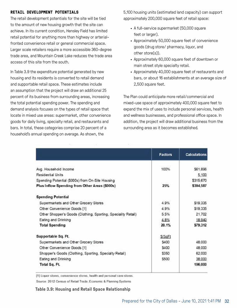
Prepared for the City of Dallas - June 10, 2021 1:41 PM 32
RETAIL DEVELOPMENT POTENTIALSThe retail development potentials for the site will be tied to the amount of new housing growth that the site can achieve. In its current condition, Hensley Field has limited retail potential for anything more than highway or arterial-fronted convenience retail or general commercial space. Larger scale retailers require a more accessible 360-degree trade area, and Mountain Creek Lake reduces the trade area access of this site from the south.
In Table 3.9 the expenditure potential generated by new housing and its residents is converted to retail demand and supportable retail space. These estimates include an assumption that the project will draw an additional 25 percent of its business from surrounding areas, increasing the total potential spending power. The spending and demand analysis focuses on the types of retail space that locate in mixed use areas: supermarket, other convenience goods for daily living, specialty retail, and restaurants and bars. In total, these categories comprise 20 percent of a household’s annual spending on average. As shown, the
5,100 housing units (estimated land capacity) can support approximately 200,000 square feet of retail space:
∙ A full-service supermarket (50,000 square feet or larger).
∙ Approximately 50,000 square feet of convenience goods (drug store/ pharmacy, liquor, and other store(s)).
∙ Approximately 60,000 square feet of downtown or main street style specialty retail.
∙ Approximately 40,000 square feet of restaurants and bars, or about 16 establishments at an average size of 2,500 square feet.
The Plan could anticipate more retail/commercial and mixed-use space of approximately 400,000 square feet to expand the mix of uses to include personal services, health and wellness businesses, and professional office space. In addition, the project will draw additional business from the surrounding area as it becomes established.
Table 3.9: Housing and Retail Space Relationship

Hensley Field Re-Use and Redevelopment Plan 33
The timing for a commercial center will be likely be dependent on when a supermarket would be feasible as an anchor. Currently, the unmet demand for grocery stores in the Hensley Field trade area is estimated at less than $1.0 million in annual sales, compared to supermarket sales targets of $25.0 million or more, indicating that there is no unmet demand or a gap in the market in this area that a new grocery store could fill. In order to attract a new supermarket, Hensley field would need to develop roughly 4,000 housing units or more to create enough demand. Alternatively, developers of the site could try to attract (relocate) an existing grocer seeking a new and more modern store when the project has become more established.
OFFICE DEVELOPMENT POTENTIALSIt will be challenging for Hensley Field to become a competitive office location without the synergies provided by a larger anchor firm or institution. The economic development strategy component of the planning process will address that potential. This area of Dallas and Grand Prairie has not attracted the level of office development and office-based business attraction as seen in Far North Dallas, Plano, and Las Colinas submarkets.
Without a broader economic development strategy, office development potentials could involve the following configurations:
∙ Office as part of a mixed-use component – “Town centers” in mixed-use projects, including those profiled here, often contain office space for small professional service firms and medical offices. The market for these is usually established later in the phasing and absorption of the development when there are sufficient households or “rooftops” to a) establish the place and b) generate demand for these services.
∙ Freestanding office or sites –Land for speculative office buildings or tenant recruitment could be reserved on the property. It should be planned however to be converted to another use if the market for office development does not materialize. The labor force in this area may be attractive for customer service and back office support functions that are part of larger corporations.
INDUSTRIAL DEVELOPMENT POTENTIALSThere is a clear and low-risk opportunity for industrial development at Hensley Field. The City of Dallas already has inquiries from developers to redevelop the property. There are numerous national and well capitalized developers active in this area that would be interested in and capable of acquiring and developing the property.
The Mountain Creek Industrial Park south of Mountain Creek Lake is a concrete example of the possibilities here, as is the Dallas Global Industrial Center (DGIC) immediately west. Mountain Creek has constructed an average of 566,000 square feet per year over the past five years. At DGIC, a 1.5 million square foot Home Depot distribution facility was completed in 2020.
The Greater Southwest Arlington and South Dallas industrial submarkets combined total 6.2 million square feet of annual construction, a proxy for industrial space demand. Assuming a 10 percent market share capture rate for Hensley Field indicates potential absorption of 620,000 square feet per year, consistent with what Mountain Creek is achieving currently. With a capacity estimate of 5.4 million square feet for the site, Hensley Field could be completely built with industrial space in less than 10 years from a shovel-ready site.
However, leading the phasing with industrial development is likely to preclude any mixed use or residential development, which would be a major tradeoff. The land requirements are large and would consume a significant portion of the site.
Table 3.10: Industrial Development Potentials

Prepared for the City of Dallas - June 10, 2021 1:41 PM 34

Hensley Field Re-Use and Redevelopment Plan 35
Table 4.1: Cypress Waters Existing Development, 2020
power plant. At that time, the City of Dallas annexed the 3,000 acre site including the power plant, lake, and adjacent properties. The North Lake utility is now owned by Luminant Power, and its three generation units are nearing the end of their operational life spans. Although in the City of Dallas, Cypress Waters is within the Coppell Independent School District (ISD). The district is highly regarded and is an attraction for homebuyers. Upon completion, the project is expected to include 4.5 million square feet of office and retail development, 10,000 multifamily housing units, three schools, parks, and a lakeside town center as illustrated in Figure 4.1.
Development History The land was purchased for development by Billingsley Company in 2004. The project had several roadblocks prior to receiving development approval. Although located in the City of Dallas, the site is completely surrounded by the City of Coppell, which along with the Coppell Independent School District (ISD) filed a number of lawsuits regarding the project’s potential impacts on city operations and the capacity of schools.
The project began construction in 2012, followed by initial development in the corporate campus that has seen over $500 million in investment since 2014. It is the national corporate headquarters for a number of major tenants
4 MIXED-USE REDEVELOPMENT CASE STUDIESThis chapter reviews the development history and successes and challenges of other major mixed use redevelopment projects. The first section covers recent relevant redevelopment efforts in the Dallas/Fort Worth metroplex, and the second section covers major airports and military base redevelopments with a development context or strategy of relevance to the Hensley Field setting.
4.1 D/FW MIXED USE REDEVELOPMENTSThe D/FW metroplex has several large-scale, mixed use development projects underway that provide some precedents for the Hensley Field Master Plan.
CYPRESS WATERSCypress Waters is a 1,000-acre mixed use site under development by Billingsley Company located at the northwest corner of LBJ/I-635 and Belt Line Road in northwest Dallas. The project is within the City of Dallas but almost completely surrounded by the City of Coppell. It is approximately five miles away from both Las Colinas and D/FW Airport.
Cypress Waters is a large redevelopment site fronting the 362-acre North Park Lake built in 1957 as a cooling reservoir by Dallas Power and Light (now TXU) for its new electric

Prepared for the City of Dallas - June 10, 2021 1:41 PM 36
Figure 4.1: Cypress Waters Site Plan
4 MIXED-USE REDEVELOPMENT CASE STUDIES

Hensley Field Re-Use and Redevelopment Plan 37
including Toyota Industries Commercial Finance, OneSource Virtual, Brinker International, and Smoothie King; and regional headquarters for AMN Healthcare, CoreLogic, Signet Jewelers, and Nokia.
A significant part of the project’s success attracting corporate office users (and triggering several build-to-suit office buildings) was the due to the City’s business attraction and recruitment efforts. Between 2015 and 2018, the City Council approved business development incentives agreements with most of the major tenants recruited to the site in the form of Chapter 380 grant agreements and/or business personal property tax abatement agreements.
As of 2020, the project is approximately 60 percent complete. The office development has been the strongest component with 3.3 million square feet completed or 74 percent of the planned 4.4 million square foot total. Multifamily housing absorption has been slower with 1,973 housing units built (163 affordable) out of 10,000 units planned. Given the pace of residential development, the retail component is also only 22 percent complete with 65,000 square feet built.
Development Financing
Like many large infill developments, the site lacked the necessary infrastructure for development to take place, as well as the funding to pay for its installation. The City of Dallas formed a Tax Increment Reinvestment Zone (TIRZ) in 2010 on 960 acres of the site to utilize tax increment financing (TIF) to provide funding to support the provision of public infrastructure necessary to deliver the first phases of vertical development (including affordable housing units). The TIRZ allocates 85 percent of the TIF property tax revenues over a 30-year time period for the City (as well as from 2014 to 2033 for Dallas County) up to a maximum $10.5 million contribution. In addition to infrastructure, the TIF District requires that 20 percent of all residential projects receiving revenues provide 20 percent affordable housing.
The Developer has also formed a Municipal Management District (MMD) as an additional development and financing tool for funding on site infrastructure. An MMD is a special district created by the State with the power to levy taxes, assessments, or impact fees on new development to pay for needed infrastructure.
Relevance to Hensley Field
Although in a different market context, Cypress Waters shares many traits with Hensley Field as noted below:
∙ Both projects are located on a redevelopment site adjacent to an older TexGen power plant at the end of its useful life.
∙ Both are located on a lake, built as a cooling reservoir for the power plant, providing an aesthetic amenity for the adjacent development, as well as a potential recreation amenity.
∙ Cypress Waters is located in a strong office location that is reflected in the project’s success to date; in contrast, Hensley Field is located within a strong industrial corridor.
∙ Retail uses, including the planned town center, have lagged as there have been insufficient rooftops within the project to trigger its development to date.
∙ The City formed a TIF district to support the provision of the initial phases of public infrastructure needed to deliver the first phases of vertical development; Hensley Field will also require similar public financial assistance to initiate development.
REDBIRDDeveloper Terrance Maiden of Russell Glen Development, and majority investor and co-developer Peter Brodsky are in the process of redeveloping the 110-acre Red Bird Mall site in southern Dallas near the intersection of US-67 and I-20.
Development History
The 950,000 square foot Red Bird Mall (later renamed Southwest Center Mall) opened in 1975, was and remains the only enclosed mall in the southern half of the City of Dallas. Originally developed around four department stores, the center has declined over the last 20 years as its anchor stores departed, starting with JCPenney’s in 2001, Dillard’s in 2006, Macy’s in 2017, and finally Sears in 2019.
The mall went into bankruptcy in 2008 and later into foreclosure. Since 2015, Peter Brodsky has been in the process of acquiring the property, starting with the in-line mall and former Dillard’s, JCPenney, and Sears stores. He has now acquired the majority property on the site.

Prepared for the City of Dallas - June 10, 2021 1:41 PM 38
The RedBird project has an approved $176 million development plan that is expected to include a scaled down amount of retail space as well as family-oriented entertainment, offices, apartments, hotels, and medical facilities. The first development use was development in 2017 of a 2,400 square foot Starbucks community café which has a commitment to hire and train young people from underserved neighborhoods in the surrounding area.
The development team is proceeding with a mixed-use development that includes the reuse of portions of the existing mall, some demolition and redevelopment, as well as additional density and infill on portions of the surrounding parking field.
Infrastructure investments include a street grid of private roads from Westmoreland Road to Pastor Bailey Drive including a new site entryway with green space and a number of commercial pads. TxDOT, as part of the Southern Gateway highway improvement project, will be adding a new exit on northbound US 67 at Camp Wisdom Road to improve access to the RedBird site.
The following additional tenant leasing and development projects are currently underway:
∙ UT Southwestern Medical Center – UT Southwestern has signed a 15-year lease for the former 150,000 square foot Sears building for an outpatient medical center and office space.
∙ Parkland Memorial Hospital Clinic - A second medical tenant, Parkland signed a 15-year lease for 43,000 square feet in the first level of the former Dillard’s for a primary care center.
∙ Chime Solutions – This black-owned Atlanta based human resources company has leased 52,856 square feet of the second level of the mall for a business process outsourcing (BPO) office with plans to hire 1,450 workers. The company was initially approved for a Chapter 380 Agreement for up to $2.0 million for creating 1,000 net new jobs. The agreement has been modified to allow installments up to $2.5 million for 1,450 net new jobs.
∙ Workforce Solutions – This employment and training provider has leased 30,000 square feet in the first level of the former Dillard’s.
∙ Other Commercial Leases – Frost Bank signed a 10-year lease on 3,000 square feet located in a 12,000 square foot freestanding building. Foot Locker has signed a 10-year lease for a 20,493 square foot store along the new green entryway.
In a separate development on the western portion of the site’s parking field, Palladium is constructing a $60 million, 300-unit four-story apartment project with structured parking. The 4 percent LIHTC project will contain 70 percent affordable units at 60 percent of AMI and 30 percent market rate units. The project also received $1.2 million in City CDBG and $5.0 million in HOME funds for gap financing.
RedBird Illustration by Omniplan

Hensley Field Re-Use and Redevelopment Plan 39
Development Financing
The City of Dallas has made a substantial public investment in the RedBird project. In 2016, the City approved a Chapter 380 Agreement that included a $2.4 million grant for property assembly. In 2018, the City approved an additional incentives package that included a conditional grant agreement for $10 million (from previous GO bonds) and a $12 million 15-year interest only loan for redevelopment costs. The City also committed up to $15.6 million in TIF over 15 years from the Mall Area Redevelopment TIRZ. The TIF funds generated were assigned back to the City to help pay back the $12 million loan.
The Mall Area Redevelopment TIRZ is a non-contiguous TIF area that includes two subdistricts, The Monfort-IH 635 Sub-District encompassing the Valley View Mall redevelopment area in North Dallas, and the Westmoreland-IH 20 Sub-District that includes the Red Bird Mall redevelopment area. The district is structured to allow for the transfer of TIF funds from the more affluent North Dallas site to the less affluent South Dallas site. Under the District’s financing plan, 10 percent of the Monfort Sub-District annual net increment will be transferred to the Westmorland Sub-District to facilitate revitalization and redevelopment of the former Southwest Center Mall area.
Figure 4.2: Collin Creek Mall Redevelopment. Existing mall outline shown in yellow.

Prepared for the City of Dallas - June 10, 2021 1:41 PM 40
The various components of the RedBird project are also using a number of additional financing tools and sources. The Developer received a $10 million New Market Tax Credit (NMTC) allocation in 2019. Capital One Community Renewal Fund also intends to provide $3 million in NMTC allocation to the project. Additionally, the Dallas Housing Finance Corporation acquired the land for the Palladium apartment project, issued bonds for project construction, and provided a ground lease for the vertical development. The City is also working with Peter Brodsky to close a Property Assessed Clean Energy (PACE) grant.
Relevance to Hensley Field
RedBird is the most significant redevelopment project in the less affluent southern quadrant of Dallas. The project has required a significant public investment to pay for redevelopment costs and to attract developer and tenant interest.
The developer has had notable success in attracting medical uses to the site, both clinics that serve the households in the market area, as well as uses tapping into the area workforce. He has also had some success “right sizing” the project for retail and commercial uses, including signing Foot Locker, Frost Bank, and Starbucks. The remaining challenge will be attracting sit down restaurants around the central open space amenity (the Lawn). The project has also been successful in attracting developer interest in building affordable housing units, although requiring a significant amount of City investment to be financially feasible.
COLLIN CREEK MALLThe Collin Creek Mall redevelopment is another example of a former enclosed regional mall under development as a mixed-use project in the D/FW region. The 110-acre site is located at the intersection of US-75 (Central Expressway) and President George Bush Turnpike in the City of Plano shown in Figure 4.2.
Development History
Collin Creek Mall opened in 1981 with five department store anchors including (in their most recent iteration) Macy’s, Mervyn’s, Sear’s, Dillard’s, and JCPenney’s, which closed sequentially over the 2008 to 2019 time period. In 2018, the 99-acre property was sold to Centurion American. In 2019,
the City of Plano approved Centurion’s proposed $1 billion redevelopment plan for the mall and surrounding property.
The proposed redevelopment plan includes 300,000 square feet of retail space and 40,000 square feet of restaurant space, down from the roughly 1.2 million square feet at the former mall. The project is also planned to contain 200,000 square feet of entertainment uses, 1.3 million square feet of office space, and a 200-room hotel. There will be a substantial residential component including 2,300 multifamily units, 500 single family units, and 300 senior independent living units, along with 8.9 acres of new park space.
One year into the project, most of the site activity has been focused on site work and demolishing portions of the former mall and anchor store buildings including Macy’s, Sear’s, Dillard’s, and Amazing Jakes (which had occupied the former Mervyn’s store). The central mall structure will be rebuilt as the centerpiece of the project along with new site amenities, including a water feature to the east and a park to the west. New development is planned to surround the central mall building on a new street grid and set of blocks to be developed as hotel, office, and multifamily residential development. Parking will be reconfigured in three levels of underground parking. The western portion of the site will be configured in a new residential neighborhood with approximately 400 single family homes including detached, duplex and townhouse units.
Development Financing
The City of Plano has pledged approximately $109 million in future tax revenue through a Tax Increment Redevelopment Zone (TIRZ). It has also provided a $10 million grant and committed to building $50 million in drainage improvements needed for the project that also benefits the surrounding area. Additionally, the City approved two public improvement districts (PID) formed by the developer that will levy an additional property tax on future development to help pay for infrastructure.
Relevance to Hensley Field
Similar to RedBird, a portion of the former mall is being redeveloped and repositioned for new land uses. However, in this market setting the former department stores have been demolished to allow for the development of much higher

Hensley Field Re-Use and Redevelopment Plan 41
densities as the higher rents support the cost of higher density construction types.
VIRIDIANViridian is a 2,083-acre new-urbanist master planned community under development by Johnson Development in northeast Arlington located north of Collins Street and Green Oaks Boulevard. The project is planned as a series of neighborhoods surrounding five lakes and connecting streams totaling over 500 acres along with an additional 800 acres of parks and open space. The project is planned to contain 4,200 residential housing units and 500,000 square feet of mixed-use commercial space in a town center setting including 200,000 square feet of commercial space, a boutique hotel, theater, and 700,000 square feet of multifamily housing over retail.
Development History
The project was started in 2011 as a Huffines Communities property with an initial plat of 180 lots. The site was sold to Johnson Development and Canadian based investors Tricon Capital Group in 2015 for $141 million.
The project currently has 11 active builders with homes priced from $300,000 to over $1.0 million. There are currently approximately 500 completed housing units. It contains a 141-acre neighborhood for 55 plus aged residents called The Elements at Viridian with courtyard and single family detached housing options. The exclusively senior community is now under development in the northeast section of the project. As of early 2020, there were approximately 40 homes completed. The town center has not yet been built. Depending on the location and the retail trade area characteristics, creating a new mixed use town center can be the most challenging aspect for this type of development.
A notable development feature of the Viridian project is a peninsula jutting out into the largest water body on the site, Lake Viridian that contains two anchor projects. The Lakeview Event and Conference Center is private event and conference center that is popular for weddings and other social events. The facility can seat 110 banquet style and up to 250 if the outdoor patio is utilized. Adjacent to the even center is the Gathering Church, a large church, and Overlook Park that contains a community beach.
Viridian residential street

Prepared for the City of Dallas - June 10, 2021 1:41 PM 42
Development Financing
Viridian has employed a complex public financing structure to finance the roughly $411 million in infrastructure costs and floodplain mitigation. The financing plan includes a Municipal Management District (MMD), Public Improvement District (PID), and TIRZ. The PID has been formed within the MMD to provide additional bonding capacity from special assessments in addition to the ad valorem taxes levied by the MMD. The City also formed a TIRZ, committing 85 percent of its tax increment along with participation from Tarrant County (75% participation), Tarrant County Hospital District (50% participation), and Tarrant County College (50% participation).
Relevance to Hensley Field
Viridian is a successful planned mixed-use community that is largely residentially focused with a range of housing products. It has capitalized on the water features of the project as an amenity for both residential development as well as commercial uses.
Stapleton aerial photograph looking west
4.2 AIRPORT AND BASE REDEVELOPMENTSThere are several successful urban infill redevelopments of former airports and other military facilities reviewed below as examples of what is possible at Hensley Field including Mueller Airport in Austin, Alameda Point and Mission Bay in the San Francisco Bay area, Stapleton and Fitzsimons in the Denver metro area, and Fort McPherson in Atlanta. These projects are evidence of what is possible and represent a wide range of reuse programs that were developed based on the community vision, market context, and the unique infrastructure and attributes of each site. The Hensley Field redevelopment shares many of the opportunities and constraints of these successful case studies and has its own unique challenges as well as noted in the summary of lessons learned.

Hensley Field Re-Use and Redevelopment Plan 43
STAPLETON/CENTRAL PARKStapleton is a major new urbanist master planned community built on the site of the former Stapleton International Airport in Denver, Colorado. The airport closed in 1994 and a master plan was completed in 1995 under the aegis of the Stapleton Development Foundation, a group of Denver civic leaders. The Stapleton Development Plan (often referred to as the “Green Book”), which called for integration of jobs, housing, open spaces, into a new mixed-use residential neighborhood fully tied into the existing city street grid and development pattern.
One of the largest redevelopment projects in the country, the 4,700-acre site was planned for 8,000 housing units, 4,000 apartments, 3.9 million square feet of retail, and 10 million square feet of office and industrial space. The project contains over 1,200 acres of regional parks and open space which together with the neighborhood parks accounts for more than one-third of the total site.
Development History
In 1995, the City and Denver Urban Renewal Authority (DURA) created the non-profit Stapleton Development Corporation (SDC) to maintain and lease the property and the authority to sell land consistent with the Plan. The SDC ability to initiate development was impeded by a lawsuit with the FAA over environmental remediation, demolition, and other disposition costs. Due to these and other challenges, the SDC in 1998 entered into a process to select a master developer for the project and chose Forest City Enterprises, Inc. to be its development partner. Forest City entered into an Exclusive Right to Negotiate (ENR) with SDC and finalized an agreement to purchase the remaining 2,935 acres for $123.4 million or approximately $1.00 per square foot over a 15-year time period. As part of the purchase agreement, the City agreed to complete the environmental remediation and demolition of remaining airport runways and facilities.
The residential portion of the project is nearing completion with over 7,500 completed for-sale homes in 15 neighborhoods with 15 schools and 50 parks. Brookfield (the current developer who acquired Forest City in 2018) has also completed 2,500 multifamily apartments, 2.6 million square feet of retail, 3.3 million square feet of industrial and flex, and 400,000 square feet of office space. In 2020, the community voted to change its long-standing name from Stapleton to Central Park.
Development Financing
The development agreement included a substantial public investment. Forest City advanced the front-end financing for regional infrastructure to be repaid by an innovative TIF agreement through DURA. During the first five years of development, 100 percent of the property tax increment was committed to Stapleton redevelopment costs. In each five-year period thereafter, the percentage of the total tax increment (sales and property) retained by the city increased to help pay for the rising operating costs associated with new residents for city services, such as police, fire, roadways, and utilities. The City’s retained portion of the tax increment reaches 53 percent in Year 20 and 100 percent when the TIF agreement expires in Year 25 which is 2023. To date, DURA has issued $462 million in bonds to help finance regional infrastructure improvements such as roads, parks, fire stations, schools and other public projects.
The City also allowed Forest City to establish a series of Title 32 Metropolitan Districts (similar to PIDs in Texas) and levy 50 mills in property tax on all new development to help pay for the local infrastructure costs. Although Colorado property taxes are relatively low, the additional 50 mills represent a 70 percent increase over the total combined mill rate of 72 mills within the City including the school district.
Relevance to Hensley Field
Stapleton/Central Park has been phenomenally successful in creating a new neighborhood district in the city distinct from the surrounding land uses with its own diverse mix of residents from young families to empty nesters. When the project started, it was adjacent to lower income neighborhoods experiencing disinvestment in the City of Denver to the west and similar neighborhoods in Aurora to the south, as well as industrial and warehouse development to the east. Two development components were identified as contributed to its success, its innovative school development program and its major parks, trails, and open space facilities.
The project has attracted a substantial number of families with school age children due to the high quality of the on-site public schools. SDC partnered with Denver Public Schools to build neighborhood schools on site at an early date before there were sufficient households on site to

Prepared for the City of Dallas - June 10, 2021 1:41 PM 44
populate them. An initial neighborhood elementary school and a Denver School of Science and Technology (DSST) served both Stapleton and the surrounding neighborhoods. Tax increment funds were used to help fund these facilities. Hensley Field will have an ability to capitalize on its location in the Grand Prairie Independent School District, which is recognized as a highly regarded district that would increase its market appeal to young families with school-age children.
The substantial parks and open space system were also an important amenity. The residential development is built in a traditional historical Denver urban pattern with small lots, alleys, detached sidewalks and home built to relate to the street. These higher densities are offset by the number of parks, open space and trails that is superior to many projects in other suburban locations.
FITZSIMONS MEDICAL CAMPUSThe Fitzsimons Medical Campus is an example of a former military facility converted to primarily institutional uses. The 577-acre Fitzsimons Army Medical Center (FAMC) was closed in 1995 as part of the BRAC process. The site is located at
I-225 and Colfax Boulevard in Aurora, Colorado, which is Denver’s largest suburb with a population of 375,000.
Development History
The City of Aurora created the Fitzsimons Redevelopment Authority (FRA) to manage the redevelopment and property acquisition process and develop a master plan for the property, which was completed in 1997. Because the site was in a relatively depressed area, the plan prioritized attracting a catalyst use to anchor the site and to create a market for the remaining property. The opportunity to attract the University of Colorado Health Sciences Center (UCHSC) to locate on the site with a branch campus emerged as this catalyst use.
UCHSC was previously located on a 30-acre site in the 9th and Colorado medical district in central Denver. The University had initially expressed interest in leasing the existing main hospital building at FAMC for administration uses as its existing medical school campus and hospital in Denver was built out with no room for expansion. As part of the redevelopment planning process, UCHSC became interested in a larger presence, and acquired 186 acres
Stapleton aerial photograph looking west

Hensley Field Re-Use and Redevelopment Plan 45
at the front door of the site for a more extensive second campus. In 1998, UCHSC and University of Colorado Hospital completed a joint master plan for its property that would relocate all of its education, research, service, and patient care programs from the central Denver site to Fitzsimons over a 12-year period.
In 2000, the University built a $170 million outpatient hospital and Cancer Pavilion partially funded by a grant from the Anschutz Foundation. Over the next five years, CU accelerated its relocation from the 9th and Colorado medical district, building new medical, nursing, and pharmacy schools at Fitzsimons as well as additional medical research facilities and specialty outpatient clinics. The University also agreed to sell 37 acres of its campus to Children’s Hospital, which also moved from the 9th and Colorado medical district and built a new $400 million 270-bed hospital and medical center in 2003 and a $230 million 10-story East Tower in 2012. Fitzsimons medical campus was renamed Anschutz Medical Center in 2006, in recognition of the $91 million donated by Philip Anschutz and the Anschutz Foundation.
The FRA acquired the remaining 391 acres of FAMC land and buildings from the Army in 1998 under an economic development conveyance (EDC). The development of FRA property included 15 acres for a state veterans’ home that was one of the first property sales in 1998. It also included additional medical related uses including 30 acres sold for a Veteran’s Administration Hospital that ultimately cost over $2.0 billion and was completed in 2018 after extensive delays.
The redevelopment master plan approved by the city called for the development of a 160-acre Fitzsimons Life Science District on the golf course property at rear of the site to attract private medical and science companies with relationships or synergy with the University’s research facilities and staff. The FRA has built two incubator buildings for medical and science startups and other technology transfers from the University’s research operations. It has been less successful attracting larger private companies and has recently repositioned the Life Science District property as an Innovation Park allowing for a wider range of uses.
Development Financing
Under the BRAC process, the University of Colorado was able to acquire its 186-acre site under a public benefit conveyance (PBC) for no cost. The FRA was able to purchase the remaining 391 acres from the Army under an economic development conveyance (EDC) for a nominal $1.85 million in 1998. The FRA has also received EDA grants for the construction of the two bioscience incubator buildings on the Innovation Campus site.
The City of Aurora has prioritized the revitalization of the arterial streets and neighborhoods surrounding the Anschutz campus. An urban renewal area was established in 2001 that included the Fitzsimons campus as well as commercial properties to the south of Colfax and to the west of Peoria. The Fitzsimons Urban Renewal Area assisted with the redevelopment at key intersections surrounding the campus with private development uses including the City’s Hyatt Regency Hotel and Conference Center and mixed-use TOD near the light rail station serving the campus. However, in 2014, halfway through the 25-year TIF financing period, it was apparent that additional funding would be needed to complete planned redevelopment projects surrounding the campus, so the original TIF district was bisected to create a new Fitzsimons II TIF district in order to extend the financing period for an additional 25 years.
Relevance to Hensley Field
The Anschutz Medical Center is an example of how a major institutional use can establish the viability of a redevelopment site for a mix of development uses not previously present in the market area. The University Medical School, hospital, and research institutes attracted other like uses including Children’s Hospital, VA Hospital, and State Veteran’s Home. The institutional anchors also spurred commercial and residential development on campus and in the surrounding urban renewal area.

Prepared for the City of Dallas - June 10, 2021 1:41 PM 46
MUELLERMueller is a Texas example of a successful airport redevelopment into a mixed-use infill community. The former 700-acre Robert Mueller Municipal Airport (RMMA) located in east-central Austin closed in 1999 after the City voted to build a new airport in the site of the former Bergstrom Air Force Base on the city’s east side.
The City of Austin completed the RMMA Redevelopment Master Plan and created the RMMA Plan Implementation Advisory Commission in 2000. The City’s goals for the Mueller Master Plan were to leverage the value of the land for economic development, environmental sustainability, and housing affordability. The community’s goals were the development of an inclusive and walkable mixed-use district. The Plan anticipated a mix of residential, commercial and retail developments, along with designated parks and green space. The RMMA Plan proposed 4,600 housing units, 4.2 million square feet of institutional and employment space, 650,000 square feet of retail uses, and 140 acres of open space.
Development History
The City then selected Catellus Development Group as a master developer (Catellus Austin LLC) and began negotiations on the Mueller Master Development Agreement
that was completed in 2004 along with zoning to implement the plan. A regional retail center was planned and built in 2005 on the northwest corner of the property next to I-35 as a first phase of development to jump start the project and to generate revenues for infrastructure and other redevelopment costs. The center is anchored by a number of retailers including The Home Depot, Best Buy, Olde Navy, and PetSmart.
Although not anticipated in the redevelopment plan, Ascension Seton Medical Center approached the City in 2003 about acquiring 32 acres of land at Mueller to build a 248-bed Children’s Medical Center. The Dell Children’s Medical Center opened in 2007 as one of the first commercial uses on the site. The hospital has attracted additional medical and institutional uses to the site including a Seton Administration Building that consolidated its administrative and executive employees at Mueller in 2008 and a 30-room Ronald McDonald House completed in 2011. A 14-acre University of Texas Research campus is under development to the north of the Medical Center with a Dell Pediatric Research Institute as its first tenant building.
The first residential development began in 2007. Currently, there have been over 5,000 homes completed in a range of product types and densities that exceeds the original estimate of 4,600 homes at buildout. Overall development is
Mueller aerial photograph

Hensley Field Re-Use and Redevelopment Plan 47
about 75 percent complete with (in addition to the housing) over 5 million square feet of commercial space and 140 acres of parks and open space having been built.
Approximately 25 percent of the housing is expected to be part of an affordable housing program based on shared equity and fixed appreciation rates available to households earning less than 80 percent of AMI for single family for sale housing and 60 percent of AMI for rental.
The project began development of a community oriented commercial center called the Market District in 2013 anchored by a new H-E-B Grocery Store. A pedestrian oriented commercial district is now in development along Aldrich Street close to Lake Mueller Park that includes an Alamo Drafthouse Cinema, The Thinkery Children’s Museum, and several restaurants.
Mueller is recognized by the U.S. Green Building Council as the world’s largest and Texas’ first LEED-ND, Gold neighborhood. The project has also attracted an impressive group of arts and cultural facilities that add to the richness of the community. The Thinkery Children’s Museum was one of the first tenants of the Mueller Town Center, and the Austin Independent School District built a performing arts complex in 2014 to serve the entire district including a 1,200-seat auditorium and 250-seat black box theater.
Development Financing
In 2003, the City created the Mueller Local Development Corporation (LDC) as a non-profit development to assist Catellus Austin LLC with infrastructure and other redevelopment costs. In 2006, the City approved a Chapter 380 Economic Development and Grant Agreement with the LDC to provide funding for the debt financing. The City agreed to commit $1.2 million per year up to an overall maximum of $23.1 million over a 20-year period ending in 2026. The primary source of funds was locally generated sales taxes from the Mueller regional commercial center backed as necessary with General Fund revenues.
The Austin City Council also created TIRZ #16 to finance the construction of public improvements that are necessary for the redevelopment of the 700-acre Mueller property. The tax increment from the City’s property tax was the sole dedicated funding source. The TIF funds flow to the
LDC, which uses both the TIRZ tax increment and Chapter 380 sales tax revenues, to pay for the debt service on the infrastructure bonds.
Relevance to Hensley
The Mueller Redevelopment was identified by the City as an example of a successful mixed-use redevelopment that could serve as a model for the Hensley Field Master Plan. Both projects are of a similar size. The Mueller site, although in the dynamic and fast-growing Austin market, was at the time in an area of the city that had not experienced significant new development and therefore needed to create its own market attraction. Keys to the development’s success include:
∙ Attraction of the Dell Children’s Hospital as an initial institutional anchor and on-site employer.
∙ Creation of a balanced community with a range of housing products and pricing, community serving retail, an attractive parks and open space system, and community and cultural facilities all contributed to the project’s development success.
∙ Selection of Catellus, a national development firm with a significant redevelopment expertise, as master developer to manage all aspects of implementing the plan.
The City’s commitment to provide up-front financing through tax increment and sales tax sharing to build the trunk infrastructure needed to support vertical development.
ALAMEDA POINTThe former 1,560-acre Naval Air Station Alameda was closed in 1997 under the BRAC process. The property is located largely on reclaimed land on Alameda Island in San Francisco Bay. The Navy reached an agreement for the transfer of the land to the City of Alameda for $108 million in 2006. The agreement obligates the Navy to complete environmental clean up to residential standards by 2022.
Development History
The Project was set within a redevelopment zone administered by the Alameda Reuse and Redevelopment Authority (ARRA). The City through ARRA firs selected Alameda Point Community Partners (APCP) in 2001 as the

Prepared for the City of Dallas - June 10, 2021 1:41 PM 48
master developer for a preliminary development concept calling for 1,700 housing units on the site. In 2006, APCP decided not to move forward with the plan concept and withdrew from the project. In 2007, SunCal Companies was chosen as a master developer for a smaller 770-acre phase of development and entered into an ENR towards a development agreement. However, the ENR was terminated by the City in 2010 based on a lack of progress as well a rejection by the voters of an initiative that would allow for the development of multifamily housing contained in the master plan.
After some delays, the City scaled-down its development plans for the site. The site includes more than 700 acres dedicated for open space including a 512-acre National Wildlife Refuge created on the former runways on the outer portion of the site jutting into the bay. The project is now envisioned as a seamless extension of the city with mixed use employment, residential, commercial, and recreational uses. Initial development has included re-use of existing hangar buildings to accommodate more than 70 businesses.
In 2014, the City completed a Town Center and Waterfront Precise Plan for a 150-acre site along the main entry and the waterfront land surrounding the historic Seaplane Lagoon. The primary goal of Plan is to create a compact, transit-oriented, mixed-use urban core that will leverage the existing assets and allow for future incremental development. Development broke ground on a 68-acre Phase I portion of the Town Center and Waterfront parcel in 2018 shown as Site A in Figure 4.3. Alameda Point Partners, led by Trammell Crow Residential, is building 637 housing units including 130 affordable units developed by Eden Housing, Inc.
Alameda Point aerial photograph
Figure 4.3: Alameda Point Site Plan

Hensley Field Re-Use and Redevelopment Plan 49
Development Financing
A redevelopment area was created early in the redevelopment effort to incorporate the entire base area in order to allow tax increment financing, tapping the values created by having existing uses added to the tax base, and to capture the tax revenues generated by new development. The revenues produced by interim or long-term reuse of existing hangars and industrial buildings also provided the City with a cash flow to fund ongoing disposition efforts and some improvements. Negotiations with selected master developers sought to use private capital as much as feasible, and land values were calculated as residuals of development proformas, with provisions for compensation tied to the success of development. In addition, the City created an infrastructure financing impact fee based on allocated shared cost of site and infrastructure development. The fee was approximately $1,000,000 per acre. This proved to be an impediment to development and was rescinded and replaced by a phase-by-phase infrastructure financing plan to be negotiated with developers of each phase.
Relevance to Hensley Field
Alameda Point is a former Naval Air Station with significant water-related amenities. Nevertheless, redevelopment has been protracted and challenging for several reasons:
∙ The base is located on an island and comprises about a third of the land area of the small City of Alameda, which had very little new development for decades. It was a heavy lift for the City.
∙ Due to the limited access to the island, and restriction imposed by the Navy under the terms of an Economic Development Conveyance, residential development was constrained, depriving the redevelopment effort of a strong sector of the market.
∙ Hensley Field does not share these particular constraints.
∙ The scale of project and the significant cost of early phase infrastructure and site improvements proved to be too daunting for a single master developer.
∙ Breaking the site down into smaller disposition phases while maximizing interim reuse has proved to be a more viable strategy. It remains to be determined if this will be the case with Hensley.
Figure 4.4: McPherson Site Plan

Prepared for the City of Dallas - June 10, 2021 1:41 PM 50
FORT MCPHERSONThe 485-acre Fort McPherson Army Base (“Fort Mac”) was designated for closure in 2005 under the BRAC process, and ultimately ceased operations in 2011. The property is located on US-29 in south central Atlanta, about halfway between downtown and Atlanta Hartsfield Airport.
Development History
In 2007, the McPherson Planning Local Redevelopment Authority (MPLRA) completed a redevelopment plan that called for a 127-acre science and technology park with a mix of complementary residential, retail, and office development, and preservation of the golf course as open space. In 2009, the Governor reformed the redevelopment authority as the McPherson Implementing LRA to acquire the property from the Army under an Economic Development Conveyance (EDC), and selected Macauley Investments as a master developer through a RFQ process. The property was planned to be sold to the LRA for $26 million.
In 2013, McCauley indicated it wished to withdraw from the project because it was unable to implement the proposed science and technology research park as its partners were not able to secure financing through the recession. The LRA then sought other investors in the project in order to pay for the property. In 2014, Atlanta Mayor Kasim Reed introduced Tyler Perry Studios (TPS) to the Fort Mac LRA as a potential investor and was able to renegotiate the purchase of the site from the Army with 330 acres being acquired by TPS for a film studio for $30 million and the remaining 145 acres retained by the LRA.
Actor/Producer Tyler Perry opened the $250-million Tyler Perry Studios in 2019, which is one of the largest production facilities in the country. It is located in the interior of the Fort Mac site that includes 40 buildings on the National Register of Historic Places, 12 purpose-built sound stages, 200 acres of greenspace and a diverse backlot.
The LRA continues to negotiate with developer Stephen Macauley for development of the remaining land. A part of the former base, the Forces Command Building, has been sold to be redeveloped for a new home for the US Food and Drug Administration (FDA) Atlanta offices. The LRA will sell the existing building to Easterly Government Properties, which will in turn renovate and lease to the FDA for both laboratory and office space.
Development Financing
The LRA and the Army agreed to a $26 million EDC for the property in 2009; however, the Great Recession slowed development interest and the selected master developer Stephen Macauley was unable to complete leases with a number of anticipated major tenants. As a result, he was unable to raise the funds needed for the property. The LRA was then faced with defaulting on the purchase agreement or finding new investors. Tyler Perry agreed to pay $30 million for 330 acres for the studio property which essentially gave the LRA the remaining 145 acres at no additional cost as shown in Figure 4.4.
Relevance to Hensley Field
The Fort Mac project is one of a number of large-scale redevelopments that have attracted interest for film and production studios and sound stages. The existing hangar facilities at Hensley Field may prove attractive for this reuse option as well. With a low basis in the land, the property can also be made available to a major anchor user at a discounted rate in exchange for the potential economic development returns.
MISSION BAYMission Bay is a 303-acre former Southern Pacific/Santa Fe Railyard (SPRR) on San Francisco Bay that closed in 1998. Catellus Corporation, a spinoff of SPRR, served as the master developer for the project on behalf of the railroad that retained ownership. The City commissioned the Mission Bay Project, a master plan for the site that envisioned a transit-oriented mixed-use community integrated into adjacent downtown San Francisco.
Development History
The University of California San Francisco (UCSF) acquired 43 acres in 2003 for medical research facilities. The medical campus includes the California Institute for Biomedical Research and Helen Diller Family Cancer Research Center. The medical center was expanded to include the UCSF Medical Center in 2015, with 289 beds serving three separate hospitals, UCSF Benioff Children’s Hospital San Francisco, UCSF Betty Irene Moore Women’s Hospital, and UCSF Bakar Cancer Hospital and Cancer Medicine Building. UCSF served as major catalyst for the redevelopment of the surrounding area. The site is now a nationally recognized

Hensley Field Re-Use and Redevelopment Plan 51
bioscience cluster. Alexandria, a private developer, has built over 300,000 square feet of biomedical space occupied by over 50 biotech companies including Bayer and Nektar Therapeutics. Development to date includes: 5,800 housing units, 2.6 million square feet of commercial space, 40-acres of parks, Mission Bay Conference Center, and the recently completed 18,000 seat Chase Center, the home of the NBA Warriors.
Relevance to Hensley Field
Mission Bay is a large redevelopment site in a hot market setting and could therefore be developed for a diverse mix of products. The City’s Mission Bay Project Plan called for a mixed use community of employment, housing, and community uses, including parks and open space. The project’s strong bioscience focus was largely the result
of the UCSF Medical Campus that attracted significant private sector biomedical uses as well. It benefited further from the development of San Francisco Giants waterfront baseball park, just north of the site, the area’s proximity to downtown San Francisco, light rail transit service, and several large scale waterfront redevelopment projects. Improved transit access and the improvement of Hensley’s underutilized waterfront as an amenity will be assets to its redevelopment. The attraction of a major catalytic use, such as UCSF in the case of Mission Bay, could also be significant in repositioning the site in the larger metro market.
Mission Bay Site in foreground

Prepared for the City of Dallas - June 10, 2021 1:41 PM 52
4.3 CONCLUSIONSThe selected projects reviewed above have a wide range of development programs based on the community vision and the specific market context and attributes of each site and location. There are, however, a number of ‘lessons learned’ that can be applied to the Hensley context.
∙ The larger projects reviewed (500 acres or more) have a size and scale to be able to create a unique and project specific development program separate and distinct from surrounding land uses.
∙ Attracting an institutional or large employer anchor as a first phase of development can provide a stimulus to creating an agglomeration of like type development. This was a major factor in the success of Fitzsimons and Mission Bay.
∙ Alternatively, development or sale of a large portion of the site to an individual user can create challenges for developing the remainder of the site. Fort McPherson sold 330 acres and existing facilities for a film and production studio in the center of the project that compromised the marketability of the remaining 145 acres.
∙ In some cases, a unique package of community amenities is needed to change or overcome prevailing area market conditions. The unique school development program and expansive open space amenities were a key to Stapleton’s early success. With its location in Grand Prairie ISD, Hensley Field has an opportunity to partner with the District to develop an educational development program that increases the project’s appeal to young families.
∙ All of the large-scale redevelopment projects required public financing or land write-downs to address extraordinary redevelopment, remediation, and/or infrastructure development costs. These sites, including Mueller, Stapleton, Mission Bay, Fitzsimons, and Alameda Point had a financing plan as part of the initial development agreement.

Hensley Field Re-Use and Redevelopment Plan 53
5.1 CULTURAL RESOURCES AT HENSLEY FIELD
THE OPPORTUNITYWhile City of Dallas-sponsored development projects are a common occurrence, the Hensley Field Plan Project presents a unique set of opportunities and constraints. Rarely does a city-sponsored redevelopment involve such a large, historically rich, City-owned property that possesses tangible and active ties to its history, as expressed through multiple, extant architectural, engineering and landscape resources. While the physical preservation of every existing resource at Hensley Field may not be possible, we believe that through a combination of preservation, reuse and commemoration, the most significant physical resources and even the less tangible histories of Hensley Field may be preserved, celebrated, respected and honored in ways that will establish a unique and palpable identity for Hensley Field. We understand that both the existing regulatory circumstances surrounding historic preservation in general, and the recently proposed legislation of House Bill 1474, tend to reinforce the status quo of not enabling cities to enforce protection of their historic resources. However, this Project offers great potential to further Dallas’ historic preservation goals as established in the Dallas Texas Historic Preservation Plan (1987 – 1988). These goals are:
∙ to protect, enhance, perpetuate and safeguard historic landmarks
∙ to stabilize and improve property values ∙ to foster civic pride in accomplishments of the past ∙ to protect the City’s attractions for tourists and visitors
∙ to strengthen the economy of the city ∙ to promote the use of historic landmarks
5 HISTORICAL AND CULTURAL RESOURCESWhile this chapter is focused on understanding the opportunities and constraints surrounding architectural and archaeological cultural resources presented in a more traditional development context, our multi-disciplinary Team will seek to leverage Hensley Field’s historic and cultural resources to support many other City of Dallas goals, such as local job creation, sustainable development and the recognition and celebration of diverse cultures.
5.2 HISTORY OF HENSLEY FIELD PRE-ANGLO AMERICAN SETTLEMENTHensley Field has a very rich and layered history with tangible ties that span from the region’s earliest pioneers to its most recent military history. Prior to development, the area was first used by small groups of nomadic hunter-gatherers that transitioned to the more sedentary Native American tribes that included Caddo-speaking peoples who controlled vast swaths of land ranging from the Western Cross Timbers located west of Fort Worth, to the Piney Woods of East Texas and beyond.
ANGLO AMERICAN SETTLERSBy the 1850s, widely scattered farmsteads dotted the rolling prairie that were spurred by a large federal land grant that came to be known as the Peters Colony. Early settlers in the area included the Huitt, Snow, Fuget, Hargis and Deckman families. Many members of these families were laid to rest at Fuget Cemetery, which was established on Rowland Huitt’s property in the 1850s. In the early 20th century, large landholders in the region included Dallas postmaster B.M. Burgher’s “Bluebonnet Farm” and an orphanage on a 200-acre farmstead operated as the Juliette Fowler Christian Home.
INITIAL ARMY AIR CORPS OCCUPATIONThe site for Hensley Field was selected by the U.S. Army Air Corps in 1921 to alleviate air traffic at the U.S. Army operated Love Field. The City of Dallas purchased 281 acres in 1928 from real estate developer Joe Goldberg and the heirs of B.M. Burgher for construction of the new airfield. When Hensley Field opened for training in the Summer 1929, the Field contained only one permanent structure: a three-story

Prepared for the City of Dallas - June 10, 2021 1:41 PM 54
Map of the Caddo Nation in Texas. Courtesy Texas Beyond History (texasbeyondhistory.net)
Sam Street’s Map, 1900

Hensley Field Re-Use and Redevelopment Plan 55
completed in 1938. The Grand Prairie area prospered from the opening of Mountain Creek Lake and constant activities at Hensley Field. New businesses, such as cafes, tourist lodges, and taverns, opened along Jefferson Street, the Bankhead Highway, and other local roads to serve airmen at the growing airfield and fishermen visiting the new lake. Initially, the Army considered using amphibian seaplanes, but this plan never came to fruition. Instead, the military would later use the lake waters for public spectacles and to train divers for rescue and salvage missions for aircraft wrecks.
EARLY 1940S THROUGH WORLD WAR IIThe use of the airfield drastically increased in the early 1940s with the development of the Dallas Naval Reserve Aviation Base, later called Dallas Naval Air Station (DNAS), at Hensley Field. In Spring 1941, the base began operations on 30.7 acres of land purchased from the City of Dallas by the U.S. Navy in the southeast quadrant of the present-day Hensley Field. Naval facilities included a 200-foot by 200-foot hangar with an attached administration building, paint and oil dope (lacquer) shop, repair shop, spray paint booth, gasoline distribution system, barracks, and a taxiway strip between the station and the airfield runways. Less than a year after opening, the base received one million dollars for expansion of Naval facilities to a property to the east. The Army Air Corps also received funding for expanding the airfield and for runway and taxiway improvements. Around the same time, the remaining 30 acres of the B.M. Burgher farm located at the western periphery of the airfield were purchased by Dallas and incorporated into Hensley Field to connect the airfield with the new aviation factory and extend existing runways further west. In 1943, the natural course of Cottonwood Creek was rerouted for expansion of the north-south runway to allow larger aircraft landings, such as bombers, and to support newer models of aircraft rolling off the nearby factory floor. An estimated 4.5 million cubic yards of dirt were moved for the project, resulting in the creation of the majority of the present-day shoreline for Hensley Field. The east-west runway created during the initial build phase of Hensley Field was eliminated at this time, leaving only three runways.
Hensley Field served as a critical training, supply, and support service base up through the Korean War. The escalation of World War II transformed the airfield from a reserve station to a “select base” for primary and advance flight training for cadets and officers. At the height of the
house, formerly used by the Juliette Fowler orphanage. It was re-purposed into the Army officer’s clubhouse and administration building. By Spring 1931, the base had added four runways, a large hangar that could hold up to 40 planes, a meteorological station, brick barracks, water works, and a sewage disposal plant.
Through the Great Depression and much of the 1930s, the airfield was mainly used for servicing visiting military planes and training reservist officers. A herd of sheep was kept at Hensley Field to reduce maintenance costs and provide extra income for soldiers through the sale of meat and wool. The Field received additional funding in 1932 to improve the flying field, replace the pumping plant and construct more living quarters, including two houses for officer’s quarters. The enlarged field of 311 acres was rededicated in 1934 in a two-day ceremony that included an airshow, dinner and dance. After additional runway improvements to the airfield by the Works Progress Administration (WPA), Hensley Field was servicing more planes annually than any other military field in the nation by 1939. The following year land was purchased for a 104-acre expansion of the airfield, and another 140 acres was purchased for the new North American Aviation Corporation (NAA) aircraft factory that would be located west of the base, today occupied by the Dallas Global Industrial Center (DGIC).
Historically, the land area of present-day Hensley Field was roughly bisected into two equal halves by Cottonwood Creek. From Hensley Field, Cottonwood Creek flowed east and confluenced with Mountain Creek near the base of the present-day lake dam and power plant, which were
1930s Aerial of Hensley Field and what would become Mountain Creek Lake

Prepared for the City of Dallas - June 10, 2021 1:41 PM 56
war, the DNAS was training between 400 to 500 students a month. Students spent weeks on the ground in classrooms learning the basics of flying before taking to the skies. The Naval base was considered a major asset for Dallas, as it paid $540,000 in salaries and expenses, most of which was spent locally. Although the Army had temporarily moved all ferrying operations to Love Field during the War, the Army still controlled and used the runways at Hensley Field for delivering planes coming from the nearby NAA plant. A feud between the Army and Navy ensued for control of the runways, which was not resolved until the end of the 1940s.
When the Naval base at Hensley Field was officially designated as a naval air station in 1942, the base gained higher status and members of the Naval women’s reserve or the Women Accepted for Volunteer Emergency Service (WAVES) were allowed to be assigned to the Dallas location. In 1945, there were 312 WAVES program women at DNAS. They were in charge of all records, training flight schedules, and they handled all Link Trainer flight simulator instructions. They also acted as storekeepers, radio controllers, gunnery instructors, aviation machinists, parachute riggers, and plane inspectors. In the early 1950s, 30 women of the Women’s Air Force Reserve (WAFS) would join Hensley Field operations as stenographers, instructors, dispensary helpers and legal clerks.
During the first few decades of the airfield, the Army and Navy held open houses for the public. One of the earliest of these public events at Hensley Field occurred in 1930.
The event included an air show, band music, stunt flying, inflation of a sausage balloon by the 88th Observation Squadron and a barbecue. Visitors were allowed to inspect the new facilities, foundations for future buildings, and planes used for training. Another air show performed a few years later had an estimated 100,000 spectators over the course of 2 days. Air shows typically included flying formations and aerial stunts using the latest models of aircraft. A dinner and dance for officers was held later at the Adolphus Hotel in Dallas. The 1940 Hensley Field open house included a display of a parachute hung from the hangar ceiling and kept open by a fan and visitor access to the foundations of new facilities. At the height of the war, open houses were still held to raise funds, but the public was restricted from taking pictures of the base and viewing planes used for training. On a few occasions, the events would include both Army and Navy soldiers, such as a 1942 dance featuring Ed Daniel’s Orchestra, the Career Girls, and members of the USO. The star attraction at a 1945 open house was the last SNJ-6 advanced trainer aircraft produced at the NAA factory. After the war, an Air Force Day show featured the Air Reserve, Air National Guard, and Civilian Air Patrol (CAP) participating in dogfights, aerobatics, formation flying, and strafing displays, which entailed attacking ground targets with low-flying aircraft using automatic weapons. Unlike shows during the war, visitors could take pictures of the airfield with the exception of the interior cockpits of new jet fighters and bombers. Visitors could pay “a cent a pound” for 20-minute rides on a 4-engine Douglas-DC-6.
1942 Aerial Photograph, Courtesy Texas Natural Resource Information System
1945 Aerial Photograph, Courtesy U.S. Department of Agriculture

Hensley Field Re-Use and Redevelopment Plan 57
Spectators attending this air show were estimated to number between 20,000 to 100,000. Later open houses featured model airplane competitions, beauty pageants, and aerial stunts.
POST-WORLD WAR IIThe end of World War II marked a shift of operations at Hensley Field. The Army moved from Love Field back to its facilities at Hensley Field and the Navy’s basic training program was discontinued. The airfield returned to its primary function as a training center for reserve pilots from the Army, Navy and Marines. Around 900 reserve pilots practiced at the field each weekend, contributing to an average of 5,000 takeoffs and landings per month. In 1946, the 181st Squadron of the Air National Guard began to operate from Hensley Field. The following year, the CAP moved to the airfield. The Navy began efforts to lease a part of Hensley Field that was expected to be released as surplus by the Air Force, which had split from the Army in 1947. The Air Force was to surrender a fourth of the building area and some flight-line facilities, and in return, the Air Force would retain all space used for the reserve training program and space utilized by the Air National Guard. In 1948 and 1949, the Navy and Air Force conducted a joint study of the base. The two military branches decided that $690,000-worth of improvements were needed to the Field, and the City of Dallas was asked to contribute $250,000 to supplement federal funds for this project. Improvements included lengthening the north-south runway from 5,200 feet to
7,500 feet to accommodate the Navy’s fast-landing Cutlass fighter produced at the neighboring Chance Vought Aircraft plant, formerly the NAA aviation factory. A part of Mountain Creek Lake was filled to extend the runway.
The Navy assumed control of Hensley Field from the Army in 1949, with certain areas reserved for the special use of the Air Force and National Guard, as previously agreed. Under the new agreement, the Navy was allowed to freely use the runways for testing jets, such as the twin engine Vought F7U, coming off the assembly line of the Chance Vought Aircraft plant. In addition, the Army would still be allowed to train reservists at Hensley Field. At the time, the airfield was considered to be the largest reserve training center in the nation. By 1952, Hensley Field encompassed 676 acres.
After the Army to Navy transition, the Air Force was quartered at the original Army Air Corps section of Hensley Field. As most of the facilities dated to the early years of the airfield, the Air Force received millions of dollars in federal funds for modernization of the base, which included the construction a new hangar for the Texas Air National Guard (TXANG). In 1955, the Hensley Field officers clubhouse was demolished. Other early Army Air Corps buildings at the airfield, such as the large hangar added to the airfield in 1930, were demolished to make way for newer facilities. The only buildings left untouched by this phase of base improvements were the two houses for officers and their families and the associated grounds containing the two ponds constructed in the early 1930s.
1960S TO PRESENTIn 1961, the new TXANG hangar was completed in an area between the former Army Air Corps campus and DNAS facilities. By 1988, the Navy owned 120 acres and lease-hold rights to 669 acres. The headquarters for the TXANG were located on a 1.92-acre tract granted by the City of Dallas. Another 38.73 acres were leased to the Texas National Guard Armory in the southwest quadrant of the airfield. In 1998, the DNAS was closed as part of the Base Realignment and Closure (BRAC) program, and reserve squadrons were transferred to the Fort Worth NAS. After its closure, DNAS buildings fell into disuse, and many were demolished in 2004 and 2005. Other buildings on the former Navy and Army campuses were re-purposed for private commercial enterprise or municipal use. Beginning in 2014, the runways and taxiways were used as overflow lots for car dealerships
1964 Aerial Photograph

Prepared for the City of Dallas - June 10, 2021 1:41 PM 58
and manufacturers. Currently, the TXANG is the primary military reserve force stationed at Hensley Field, in the far western corner of the Project site, next to the diversion channel and Mountain Creek.
As of 2019, the City of Dallas has embarked on the master planning process (referred to herein as the Hensley Field Plan, or the Project) that will usher in a major new chapter in the life of this place – bringing new vitality to it and the surrounding area. There is much to do prepare for a successful new chapter, including remediation (which is being undertaken by the Navy), and the preservation planning that will need to take places in phases, well after the Plan is complete in the Spring of 2021, and within the current historic preservation-related regulations and parameters, as described below.
5.3 HISTORIC PRESERVATION TOOLS AND THEIR OPPORTUNITIES AND CONSTRAINTS
NATIONAL REGISTER OF HISTORIC PLACES (NRHP) DESIGNATIONThe NRHP is the official federal list of districts, sites, buildings, structures, and objects significant in American history, architecture, archeology, engineering, and culture. Resources in this list have significance to the history of their community, state, or the nation. While the listing of a resource on the NRHP is mostly an honorific recognition of the resource’s significance, NRHP listed resources are afforded certain additional considerations during projects that require federal funding, licensing, or are on federal land. In addition, NRHP properties can qualify for certain Historic Preservation Tax Credit Programs. Placement of a property on the NRHP, however, does not place any restrictions on what a non-federal owner may do with or to the property.
During Navy and TXANG use of Hensley Field, a variety of coordination efforts with the Texas Historical Commission (THC) have been conducted for many of the buildings present within the DNAS and TXANG sections of Hensley Field. Initial coordination with the THC for Hensley Field transpired in 1993 and occurred as recently as 2014. Through an Open Records Request (ORR) filed with the THC in 2020 by IES, all relevant information from past THC reviews was obtained for Hensley Field. While past THC coordination and previously issued NRHP eligibility determinations will serve as a baseline for various resources at Hensley Field, many of the prior NRHP determinations will need to be re-evaluated by the THC to ensure the present conditions of each resource are appropriately considered. Through the ORR, it was confirmed that:
∙ The THC has determined that the two senior officer houses and adjacent ponds are eligible for listing in the NRHP in 1993. The two senior officer houses were determined individually-eligible for NRHP listing under Criterion A due to their association with the original founding of the air station and association with wartime activities of personnel attached to the DNAS. In addition, they are eligible under Criterion C, as they are good examples of a Southwestern variation of the standard War Department design for Company Officers Quarters. These two individually-eligible buildings and the associated two ponds were determined eligible for NRHP listing as a historic district under Criterion A as the final representation of the original construction at Hensley Field.
∙ In 1993, the THC determined that a second NRHP district was present within the southeast corner of Hensley Field that stretched across into the southwest corner of the DNAS. However, the vast majority of the buildings associated with this district have been demolished or are located outside Hensley Field. The Maintenance Hanger and Water Tower appear to be the only contributing resources remaining within Hensley Field.
∙ The THC has reviewed all buildings within the TXANG Guard Station within the secured facility north of Hensley Field Drive in the northeast corner of the property. THC determined that these buildings were not eligible for NRHP listing.
TXANG Hangar, built circa 1961

Hensley Field Re-Use and Redevelopment Plan 59
∙ The Navy did not place any restrictions or preservation covenants for any building within Hensley Field.
∙ In 2008, the 1941 Maintenance Hanger located near the south end of Hensley Field Drive was determined to have reverted back to City of Dallas ownership without any encumbrances.
∙ The majority of buildings at Hensley Field have been reviewed by the THC for NRHP eligibility.
Opportunities
While it is unlikely that any of the buildings or structures that have not yet been reviewed by the THC would possess more than “low to moderate” potential of being determined eligible for NRHP inclusion, it is possible that one or more of these resources could be considered eligible. The Hensley Field Plan Project presents the opportunity to conduct coordination with the THC to determine the potential NRHP eligibility for the few remaining buildings within Hensley Field, such as the TXANG Hangar and the Small Arms Magazines, that have not been formally reviewed by the agency. It should also be noted that the runways have not been formally evaluated by the THC, which are clearly a major component to the historical significance of Hensley Field.
Any additional NRHP eligible resources and or districts determined to be present within Hensley Field, will expand the opportunities for additional preservation, celebration and incorporation of these resources into the redevelopment plan.
LOCAL HISTORIC LANDMARK DESIGNATIONOften the most significant protection that can be afforded to a building is through local historic landmark designation. Unlike the NRHP, City of Dallas Landmarks and Landmark Districts are historically-significant resources to the City of Dallas that are protected by ordinances specific for an individual property or district. The evaluation criteria for determining landmark status are similar to those for NRHP eligibility but are specific to resources within the City. To qualify for landmark designation, the property must be recognized for its architectural significance, identification with a historically-significant person(s), economic or social heritage, significant architect or master builder, value to the community, or a combination of these things. Landmark historic districts are areas with a significant concentration of structures unified by their architectural style or related
historic events. Individual landmarks and historic districts are protected by City ordinances by their preservation criteria which is specific to the district or site. Historic designation as a City of Dallas Landmark is outlined in City Code Section 51A-4.501, but it is generally organized into an eight-step process beginning with research and application submittal to various committees, commissions, and City meetings/reviews. Once the historic designation process is complete, a Certificate of Appropriateness must be obtained before any work can begin on a property that is initiated or designated as a landmarked structure, or a property located within a landmarked historic district.
DNAS Executive Officer House, built circa 1932-1933
Opportunities
To date, no resources within Hensley Field have been evaluated for local historic landmark designation. By conducting an inventory and evaluation of resources within Hensley Field, the Project has the opportunity to the fulfill existing City of Dallas preservation goals to identify and designate historic landmarks.
Officially designating landmark properties and/or districts will afford the greatest level of protection to historic resources within Hensley Field. As the Hensley Field Plan Project is a City-sponsored project on City-owned land, there is an opportunity to set a stronger program of preservation than is often afforded in the case of private property ownership, where preservation is often at odds with the property owners’ desires.

Prepared for the City of Dallas - June 10, 2021 1:41 PM 60
HISTORIC PRESERVATION TAX CREDIT AND INCENTIVE PROGRAMSHistoric places and buildings are an essential and valuable part of our communities, as they represent our cultural heritage, provide a sense of place, stabilize and enhance local property values, foster environmental sustainability, promote smart development and walkable urban fabric, and spur tourism and economic growth. As building rehabilitation associated with preservation efforts can certainly present financial hurdles, federal and state tax credit programs offer powerful financial incentives for pursuing historic preservation and adaptive reuse efforts. These tax credit programs help finance preservation efforts by offsetting income tax or business tax liability as a dollar-for-dollar reduction. The Federal Historic Preservation Tax Incentive Program, for example, allows for a credit on federal income tax liability of 20 percent of qualified rehabilitation expenses. In addition, the Texas Historic Preservation Tax Credit allows for a credit on the Texas Franchise Tax or Texas Insurance Premium Tax of 25 percent of qualified rehabilitation expenses. The state tax credit may be used separately or in conjunction with the federal tax credit for rehabilitation. Combining these credits can provide tax credit for up to 45 percent of the qualified expenditures, making many projects possible that were never previously financially feasible. To qualify for federal historic tax credits, properties must be certified as a NRHP-eligible and for a building that will have a business or income-producing use. Conversely, state tax credits allow for the building to be used for non-profit uses. To obtain either the state and/or federal tax credit, the applicant must have a three-part application completed that ensures the property can be listed on the NRHP, describes the rehabilitation work to be performed, and documents the completed rehabilitation project.
The City of Dallas Historic Preservation Incentive Program was developed to encourage preservation of historic buildings as well as the revitalization of neighborhoods throughout the City. The program consists of tax exemptions, conservation easements and the transfer of development rights (TDRs). For qualifying historic rehabilitation projects and expenditures, including both labor and materials, the City offers tax exemptions that can be applied toward City property taxes.
The City should ensure that any eligible buildings at Hensley Field are listed on the NRHP, so that future developers at Hensley Field may avail themselves of these tax credits and other preservation-related incentives.
Opportunities
Currently, there are two historic buildings that have been identified as potential tax credit rehabilitation projects within Hensley Field. These buildings pertain to the DNAS Commanding Officer House and the DNAS Executive Officer House, that share a site just inside the current and historic main entry to Hensley Field. These buildings are the last remaining elements of the earliest military use of the property by the U.S. Army Air Corps beginning in 1928. In 1993, the two officer houses were determined individually eligible for NRHP listing under Criteria A and C. The officer houses in conjunction with the two associated ponds nearby were determined eligible for listing on the NRHP as a historic district under Criterion A.
Preliminary research indicates that the residences have retained the majority of their original historical integrity. The most significant change made to both houses was the addition of an entry way on the southeast wall of the solarium. This remodel appears to have occurred in the 1950s after the Navy assumed control of this area. Other noticeable alterations include modern central AC/heating, new light fixtures, awnings over the back entry, and the addition of car ports and cast concrete fencing. The kitchen of each house has recently been gutted and carpeting from a past remodel mentioned in the HABS reports was removed from both houses. The basement of the Commanding Officer House was remodeled and re-finished and was recently damaged by flooding. A visible hole in the roof of Executive Officer House has resulted in interior damage to the upstairs common bathroom. In addition, the front entry of the house has been altered from the original depicted in the 1932 plans. In consideration of these changes, the houses have retained their overall integrity and should still be considered eligible for NRHP listing. While the exact shoreline of the two associated ponds has changed slightly through the years, they still convey a high degree of integrity of setting, location and feeling that contributed to the earlier determination of the houses and the surrounding landscape and ponds as an NRHP-eligible district.

Hensley Field Re-Use and Redevelopment Plan 61
Although the City has specific requirements to determine if a building can qualify for the City of Dallas Historic Preservation Incentive Program, it is possible that future historic rehabilitation projects of properties within Hensley Field may have the ability to qualify for the tax incentive, which will increase the appeal for the preservation and adaptive reuse of such properties as Hensley Field redevelops.
Historic preservation and rehabilitation projects are powerful revenue and job generators that can create jobs ranging from preservation consultants, architects, landscape architects, construction workers and many others. Since 1978, the federal tax credit has revitalized over 41,000 vacant and underutilized buildings, created 2.5 million jobs, and spurred over $130 billion in private investment. Since 2015, over $1.2 billion in qualified rehabilitation expenditures have been certified by the THC under the state tax credit program.
Historic preservation and sustainability are natural partners. Preservation and reuse of historic buildings reduces resource and material consumption, puts less waste in landfills and consumes far less energy than demolishing buildings and constructing new ones. Over the past decade, advances in high performance or “green” buildings have been numerous, but primarily have focused on new construction. As a result, the preservation and adaptability of historic and older buildings has not always been at the forefront of the ‘green’ agenda. Historic buildings, although generally inherently less energy-efficient, can be upgraded with new technologies to maximize energy performance. Historic features such as specific window types can be repaired and restored for higher efficiency. In addition to saving existing resources and historic character, historic preservation means environmental, cultural and economic benefits for the City.
Constraints
The City, the THC, and the National Parks Service have very specific requirements for projects to qualify for state and federal tax credit programs and City tax incentives. Modification to the officer’s quarters and ponds that do not fit the Secretary of Interior Standards could disqualify the project for state and federal tax credits. Maintaining the historical setting is critical for a project to qualify for tax credits. For example, the ponds would need to maintain their general shape, location, and spatial relationship to the officer’s quarters. Adding additional non-historic buildings, improvements, additions, alterations to the officer’s quarters could also preclude any rehabilitation project from qualifying. Significant research, coordination, and early planning will need to be conducted to ensure a project can qualify, in addition to ensuring the rehabilitation work meets Secretary of Interior Standards.
INDIVIDUAL PRESERVATION ADAPTIVE REUSE OPPORTUNITIES AT HENSLEY FIELD & HISTORIC LANDSCAPE PLANNINGMany of the older buildings and structures within Hensley Field may not be considered individually-significant under local, state, or national criteria, therefore precluding them from being individually-eligible for listing on the NRHP, designated as local historic landmark, and/or included within any historic district. However, these elements are symbols of the prolonged presence and airfield operations by the military and are critical to the fabric of the historical landscape that is Hensley Field. The reuse and incorporation of these type of features will be equally critical to the preservation of more individually-significant resources or districts, as they will be paramount to maintaining the historical setting. Resources of this type could include:
∙ DNAS Maintenance Hanger ∙ DNAS Water Tower ∙ Helicopter Recalibration Compass ∙ TXANG Hanger ∙ Runways ∙ Small Arms Magazines ∙ Natural Features ∙ Fuget Cemetery ∙ Historical Markers
NAS Dallas Officer House Front Facade

Prepared for the City of Dallas - June 10, 2021 1:41 PM 62 Figure 5.1: Preservation & Adaptive Reuse Opportunities Location Map

Hensley Field Re-Use and Redevelopment Plan 63
As a prominent military airbase, the planned landscape of Hensley Field was meant to be seen from high altitude. Even from a high vantage point, it is easy to see the intentional and designed layout of runways and buildings, which are further connected by more subtle attributes like a water tower, small arms magazines, and minor support features. What we see today as the footprint of Hensley Field is the product of many decades and several military eras, which have drastically altered the airfield since its original design. Although this mixture of design plans, resources, and natural/modified land features has created a unique environment, it has also created a complex landscape that must be evaluated through a broad and multi-disciplinary approach. While it has yet to be evaluated, the many alterations of Hensley Field may have significantly impacted the integrity of the landscape to a degree that would prevent its eligibility for listing on the NRHP. Regardless of the NRHP eligibility status, Hensley Field contains a historic landscape. Thus, a comprehensive approach is needed to help create an understanding of how the natural resources and built environment interrelate and to identify what landscape themes and elements are most integral to Hensley Field. By seeking ways to incorporate, commemorate, and celebrate the historical and natural features into specific design elements in the Hensley Field Plan, individual iconic elements of Hensley Field can be given a second life through a redefined purpose and function, and the overall feeling and fabric of the Hensley Field landscape can be preserved through creative and historically sensitive master planning.
Opportunities and Constraints
The DNAS Maintenance Hanger could be adaptively reused to host community events as it historically did for airshows, open houses, and community engagement. Another potential opportunity would be to take advantage of the building’s current condition, which is partially been stripped down to its steel structure, and use the building as an open-air sports complex, community garden or food hall. The location and industrial feel of this building could also lend it to being used as a light rail station. However, a structural assessment of this feature would need to be completed to understand level of reuse potential.
The Water Tower could serve as a center of a rainwater collection system to help offset the watering needs for the landscaping, working farm, and other non-potable watering needs for the development. The tower could also be rehabilitated and used as part of a future on-site wastewater plant. However, a structural assessment of this feature would need to be completed to understand its level of reuse potential. At a minimum, the feature serves as a navigation, wayfinding, general point of reference, and visual anchor that would be visible across a wide area and would serve to preserve the historical setting.
DNAS Water Tower
NAS DNAS Hanger in background at airshow. Courtesy of U.S. Navy Naval Aviation News, Nov-Dec 1998

Prepared for the City of Dallas - June 10, 2021 1:41 PM 64
Unique features like the Helicopter Recalibration Compass at Hensley Field are important landmarks that help maintain the historical setting and feel of the old airfield. However, incorporating low-visibility landmarks can be a challenge for a design plan. Some opportunities might be to use the Compass Rose at the center of a traffic round-about or as an interesting element within a future park area, with accompanying interpretive information.
Buildings like the TXANG Hanger, which are currently in use and may require fewer major improvements to integrate into the redevelopment plan, have already sparked conversations about how local arts and national film companies could utilize the space for film production and set construction.
There are two THC Historical Markers commemorating the significance of Hensley Field. One is located at the Fuget Cemetery within Hensley Field and could readily be incorporated into the redevelopment plan as part of future landscaped open space around the cemetery. The other marker, pertaining to the military history of Hensley Field, is currently located adjacent to Hensley Field along Camden Road, just within the former DNAS entrance gate. As this historical marker pertains to the overall history of Hensley Field and not just the DNAS, this marker would be much more aptly-placed directly at the Hensley Field frontage, preferably nearest the gate at the Hensley Field Drive intersection with Jefferson Street. The relocation of the marker to Hensley Field and incorporating it into the redevelopment plan would promote the visibility of the marker and would help ensure the longevity of the marker as it would not be in danger of abandonment, inadvertent damage, removal, etc. (Currently, it is believed that the marker is not located on Navy property. The relocation of a
historical marker can be requested through the submittal of a basic Request to Relocate form to the THC. If the marker is located on Navy property, the transfer of this marker may be a challenge.)
The Runways at Hensley Field have changed through time as the airfield’s mission and military technology changed. However, the primary configuration of the runways was maintained and enhanced over the airfield’s use. Similarly, the shoreline along Mountain Creek Lake was either largely maintained since the military’s early use of the property or modified as a direct result of improvements to the airfield by the military. While retaining the entirety of the physical runway tarmac is likely not conducive to the overall redevelopment goals, replacing the runways with streets and/or landscape features that trace the historical location and alignment of a runway could contribute to the sense of the former airfield setting. To further highlight the historical military ties, the roads, parks, and other community features could be named in reference to specific military heroes, aircraft, or other topics specific to the Navy, Hensley Field, or the City of Dallas.
Helicopter Recalibration Compass
Hensley Field Historical Marker

Hensley Field Re-Use and Redevelopment Plan 65
Natural Features and signatures of the shoreline associated with the runway extensions and the diversion channel can be maintained and enhanced. For example, the current diversion channel, which has remained an undeveloped section of Hensley Field, is prime for being retained as a natural area. There is also the potential for re-creating the original Cottonwood Creek channel that once bisected Hensley Field and was a significant reason for the airfield’s original design.
The Fuget Cemetery is the only pre-military cultural feature that is currently known to exist within Hensley Field. Presently, and throughout the military’s use of Hensley Field, the area surrounding the Fuget Cemetery has largely remained untouched, having remained as passive open space along the shoreline of the lake. Continuing this trend of its use as green space would not only afford the cemetery a more reverent setting, but would also help preserve the historical setting of this particular area.
A Trail Network would not only connect the various elements of the overall development, but also provide access to the historical locations of specific cultural resources, which will facilitate interpretive opportunities to commemorate historical aspects of Hensley Field and the surrounding area that have been removed from the landscape. A common theme shared by many people who worked at Hensley Field or lived around the airfield during its military use was a pedestrian bridge that provided access to remote parking north of Jefferson Street. A review of historical aerial photographs indicate that the pedestrian bridge provided access to the NWIRP facility west of Hensley Field. Although this bridge may not have been directly associated within Hensley Field, shared memories like this are becoming less frequent with time, and are important for preserving the memory and heritage of the area. It is possible that the proposed trail plan for the redevelopment could include a new pedestrian bridge – or at least a significant crossing of Jefferson Street at or near the location of the original pedestrian bridge - in order to connect Hensley Field with the adjacent community. It could also be an opportunity for historical interpretation. Constraints associated with this bridge would include obtaining necessary permission from the owners of these adjacent right-of-way, including TxDOT and the Union Pacific Railroad.
5.4 STATE AND FEDERAL REGULATORY COMPLIANCE
Depending on the degree, type, and location of certain redevelopment recommendations and activities within Hensley Field, the Project may require varying levels of environmental and cultural resources compliance. From a cultural resources standpoint, the Project may need to comply with Section 106 of the National Historic Preservation Act (NHPA), the Antiquities Code of Texas (ACT), and the Texas Health and Safety Code (THSC). While compliance with state and federal law is mostly seen as an opportunity to ensure that cultural resources are fully considered throughout the planning phases of the Project, certain challenges and potential constraints could be encountered through the various federal and state compliance process.
SECTION 106 OF THE NATIONAL HISTORICAL PRESERVATION ACT (NHPA)The NHPA (54 U.S. Code [USC] 306101), specifically Section 106 of the NHPA (54 USC 306108), requires the State Historic Preservation Officer (SHPO), an official appointed in each state or territory, to administer and coordinate historic preservation activities, and to review and comment on all actions licensed by the federal government that will have an effect on properties listed in the NRHP or eligibility for such listing. Per 36 Code of Federal Regulations Part 800 (36 CFR 800), the federal agency responsible for overseeing the action must make a reasonable and good faith effort to identify cultural resources. Federal actions include, but are not limited to, construction, rehabilitation, repair projects, demolition, licenses, permits, loans, loan guarantees, grants, and federal property transfers. For example, if the project requires a Section 404 of the Clean Water Act (CWA) Nationwide Permit from the U.S. Army Corps of Engineers (USACE) or any type of federal funding, the project would be subject to NHPA Section 106 requirements.
These provisions may come into play if the shorelines (of the diversion channel, Mountain Creek and Mountain Creek Lake) surrounding a large part of the Hensley Field site are altered to improve accessibility to the water for all types of recreation and water sports, their ecological function and their aesthetic appeal.

Prepared for the City of Dallas - June 10, 2021 1:41 PM 66
ANTIQUITIES CODE OF TEXAS (ACT)The ACT, as outlined in the Texas Administrative Code (TAC) Title 13 Part II and the Texas Natural Resource Code (TNRC) Title 9 Chapter 191, requires that the THC staff review any action that has the potential to disturb historic and archaeological sites on public land. Actions that require review under the ACT include any construction program that takes place on land owned or controlled by a state agency or a state political subdivision, such as a city or a county, that exceeds 5 acres or 5,000 cubic yards of ground disturbance. If the activity occurs inside a designated historic district, affects a recorded archaeological site, or requires on-site archaeological investigations, review by the THC is required regardless of project size. As Hensley Field is on land owned by the City of Dallas, future development would require consultation with the THC under the ACT unless, the land is sold to private developers before ground disturbing work has commenced.
The ACT underscores the need to coordinate with THC, and the City’s and State’s historic preservation offices during the earliest planning phases of the Project, which is during this master planning process. The Plan should make clear recommendations as to next steps in this process, as this coordination will be needed beyond the master planning phase, and into the years-long implementation phase, when portions of the Hensley Field site will begin redevelopment.
TEXAS HEALTH AND SAFETY CODE (THSC)Under the provisions of the THSC, as amended by Senate Bill (SB) 1630, the owner of a property on which an unknown cemetery is discovered or on which an abandoned cemetery is located may not construct improvements to the property in a manner that would disturb the cemetery until the human remains interred in the cemetery are removed under a written order issued by the state registrar or the state registrar’s designee (THSC Section 711.004[f]). A person who discovers an unknown or abandoned cemetery shall file notice of the discovery of the cemetery with the county clerk of the county in which the cemetery is located and concurrently mail notice to the landowner on record in the county appraisal district no later than 10 days after the date of the discovery. The notice must contain a legal description of the land on which the unknown or abandoned cemetery was found and describe the approximate location of the cemetery and the evidence of the cemetery that was discovered. The county clerk shall send a copy of the notice
to the THC and file the notice in the deed records of the county, with an index entry referencing the land on which the cemetery was discovered.
In the case of the already-discovered Fuget Cemetery within Hensley Field in Dallas County, steps should be made as early as possible in the planning phases of the Project to investigate the general area of the Cemetery to ensure that all any unknown or abandoned graves are identified, so that the proper actions can be taken. The Plan should make a recommendation for the City of Dallas to undertake this process.
Opportunities
The goal of the federal and state regulations is to afford the space, time, and communicative avenues to ensure that a development process takes the necessary time to stop, look, and listen to gather an understanding of what cultural resources are present within a development footprint, to ensure those resources are properly documented, and to avoid, minimize, and/or mitigate any adverse impacts any significant resources. Although the planning and consideration of cultural resources have already been defined as a critical pillar of this redevelopment project, the federal and state regulations will look to ensure that the finalized development plan will comply with any applicable laws. Not only will completing these processes ensure that the Project complies with state and federal laws, but it will serve as additional avenue to ensure the resources important to the community are appropriately considered during the redevelopment of this City-owned property.
Since the early 20th century, 95 percent of the land within the project limits has been extensively modified and developed as part of improvements and expansions of Hensley Field. The remaining approximate 5 percent of the land within the project limits appears to have been far less disturbed by previous development. Since the 1990s, the THC has reviewed various improvements and property transfers at the field for impacts to archaeological resources. Through each review, the THC has typically not required an archaeological survey due to the widespread ground disturbances, as the agency believes it is highly unlikely that archaeological resources exist within the majority of Hensley Field. Through the ORR filed with the THC, it was confirmed that only one archaeological survey

Hensley Field Re-Use and Redevelopment Plan 67
has been conducted to date. This survey was conducted within the TXANG Guard Station within the northeast corner of Hensley Field. No archaeological sites were encountered during the survey. The only remaining areas within Hensley Field that could contain archaeological sites are within the far southwestern corner of the property south of the Cottonwood Creek diversion channel and directly adjacent to the Fuget Cemetery.
It is possible that the THC may require an archaeological survey of two portions of Hensley Field to assess for unrecorded archaeological sites and/or unmarked graves near Fuget Cemetery, which pre-dates the development of Hensley Field. While conducting a survey of these areas would be fulfilling a regulatory compliance requirement for the project, it would also serve as an opportunity to further highlight the history of the region prior to development of the airfield. Any archaeological findings or cemetery investigations could be used to expounded upon the existing histories and serve as opportunities to further engage the public.
Constraints
Through the regulatory compliance process, the state and federal agencies overseeing the cultural resources processes, may require that certain additional planning, consultation, avoidance, minimization, and/or mitigation be performed to appropriately offset any impacts to cultural resources. While it is anticipated that the redevelopment projects will have avoided or minimized many potential impacts to cultural resources through prior planning, it is possible that not all impacts to cultural resources can be avoided to the level necessary to allow the agencies to provide project approvals without the need to further studies, evaluations, documentation, and consultation. Any regulatory compliance requirements must be met before project construction, which can add and extend timelines prior to groundbreaking. Many constraints associated with regulatory compliance can be significantly reduced through thoughtful planning that fully considers cultural resources.
If a sufficient area cannot be designated as a non-development zone surrounding the Fuget Cemetery, research and/or archaeological investigations may be required by the THC. If it is determined that unmarked graves are present surrounding the Fuget Cemetery, design plans should be modified to avoid these areas.
5.5 CONCLUSION
The unique history and pattern of use of the Hensley Field site has created a colorful and layered history that embodies American adventurism, ambition, economic growth, and military prowess. Since the earliest settlers arrived to the height of Hensley Field’s military use, the land has served as an important economic stimulus for the area and was responsible for spawning new subdivisions and local industries for the surrounding rural communities that eventually grew into Grand Prairie. Without these histories, the growth of Grand Prairie and the greater Dallas area would not be what it is today. This layered history has created a story that must be told, celebrated and incorporated into Dallas’ plans for the redevelopment of Hensley Field in a clear and accessible way. Through a creative approach of land use planning, preservation and adaptive reuse, interpretation and oral histories, the story this place should be conveyed in a way that actively promotes Dallas’, Grand Prairie’s and Texas’ unique heritage.
Headstone at the Fuget Cemetery

Prepared for the City of Dallas - June 10, 2021 1:41 PM 68

Hensley Field Re-Use and Redevelopment Plan 69
Before beginning the planning and design process, baseline data must be gathered to guide the creation of the plan. Typical data includes the physical characteristics of the site including topography, boundary surveys, ownership, existing infrastructure, tree survey and existing structures within the study area.
The site, former Dallas Naval Air Station, also known as Hensley Field, is a 738-acre decommissioned air base that consists of extensive concrete runways, existing hangars, officer quarters and other miscellaneous buildings. The site is also home to a small cemetery on the western edge of the site adjacent to Cottonwood Bay.
Located in far west Dallas and surrounded by the City of Grand Prairie, the site sits on Mountain Creek Lake to the south and has rolling hillside views to the east. The lake, constructed in the 1930’s as the Mountain Creek Reservoir, is currently owned by TexGen for use by the Mountain Creek Power Plant. Historically underutilized, the lake has the potential to be a valuable resource and amenity for the future of Hensley Field.
GRAND PRAIRIEDALLAS
Mountain Creek Lake owned by TexGen
Dallas Global Industrial ParkHome Depot
Distribution Center
Mountain Creek Power owned by
TexGen
Jefferson Ave
SE 14th St
I-30
Cotto
nwoo
d Cree
k
Grand Prairie Reserves Center
LakelandHeights
Bella Lagos
Cielo Vista
6 SITE AND CONTEXT
Figure 6.1: Hensley Field Adjacent Property Owners and Municipalities
The redevelopment of Hensley Field offers an exciting opportunity to re-engage with the waterfront and the lake for regional public access and recreational use. Mountain Creek Lake can provide the same amenity for Southwest Dallas and the broader region as White Rock Lake does in East Dallas. A comprehensive waterfront trail system within the property with future linkages to Joe Pool Lake, Grand Prairie and other local destinations, is a possibility for this unique area.
6.2 ADJACENT PROPERTY OWNERSHIPThough fully within the City of Dallas, Hensley Field is surrounded on three sides by the City of Grand Prairie. The site sits on the 2500 acre Mountain Creek Lake which is owned by TexGen and is used to cool the adjacent Mountain Creek Power plant. There are a few long term leases on the property including the Texas Air National Guard and the U.S. Air Force, and a few City of Dallas Services such as Dallas Water Utilities (DWU) and Streets also operate on site.
The lake, though owned by TexGen, is managed and monitored by Texas Parks and Wildlife. Park spaces surrounding the lake are maintained and operated by both
6.1 EXECUTIVE SUMMARY

Prepared for the City of Dallas - June 10, 2021 1:41 PM 70
AMTRAK
TRE
Proposed Extension
Westmoreland Station DART
DFW
LOVE FIELD
DOWNTOWN DALLAS
11 miles
TARRANT COUNTY
DALLAS COUNTYIrving
Dallas
ArlingtonCockrell Hill
Grand Prairie
AERIAL* concentric ring = 1 mile (20 min walk)
* map extent = 11 mile radius
MOBILITY
Existing DART Rail
Proposed DART Extension
Rail Stations
TRE Rail
AMTRAK Rail
NCTCOG Proposed
Highways/Roads
Parks
Water Bodies
Cedar HillCedar HillDeSotoDeSoto
DuncanvilleDuncanville
DFW
LOVE FIELDLOVE FIELD
DOWNTOWN DOWNTOWN DALLASDALLAS
Figure 6.2: Site Location Map
the City of Dallas Parks and Rec department and the City of Grand Prairie Parks Department. Adjacent residents of the neighborhoods that line the lake have a strong sense of implied ownership due to their immediate proximity, as does Dallas Baptist University and the DFW National Cemetery.

Hensley Field Re-Use and Redevelopment Plan 71
LEGEND6.3 EXISTING CONDITIONSThe 738 acre Hensley Field site sits on the 2500 acre Mountain Creek Lake. The site is relatively flat and consists of concrete runways and natural grassland areas. It is relatively devoid of trees except upon the edges. There are several military buildings on site including hangars of various sizes, officer quarters, observation and water towers, as well as a pier that extends out into the lake. The conditions of the buildings vary and are discussed in the forthcoming Building Assessment. There is an existing historic cemetery in the north central portion of the site adjacent to Cottonwood Bay. This will remain and informational graphics could be added to explain the historic nature of the site. Additional elements on site include a helicopter calibration compass and magnet and small underground blast walls / chambers.
1’ Contour5’ Contour
Elevation
FeaturesImpervious Surface, including building footprints
Ponds at entry off Jefferson Blvd. Existing main hangar
Historic Officer housing buildings Main runway

Prepared for the City of Dallas - June 10, 2021 1:41 PM 72
Figure 6.3: Site Location Map
MOUNTAIN CREEK LAKE
COTTONWOOD CREEK

Hensley Field Re-Use and Redevelopment Plan 73
WWII hangar and observation tower
Fuget Cemetery
Insignia within hangar
Historic cemetery marker
View inside bunker Underground bunker and blast wall

Prepared for the City of Dallas - June 10, 2021 1:41 PM 74
Native grasslands
Native wildflowers found on site
Mesquite grove on southwestern edge of property near the canal
Native wildflowers found on site
Helicopter recalibration compass Helicopter recalibration compass

Hensley Field Re-Use and Redevelopment Plan 75
6.4 EXISTING TREE CANOPY & THE URBAN HEAT ISLAND
Dallas is the 3rd fastest growing Urban Heat Island in the U.S. with a tree canopy of 32%. The Texas Trees Foundation identifies District 3 as one of the districts in Dallas in greatest risk of losing tree canopy.
Hensley Field contains little natural vegetation on the site. The majority of the existing tree canopy exists around Cottonwood Bay and the canal that was cut into the site to connect Cottonwood Creek and Mountain Creek Lake in the early 1940s.
Mature trees are not only aesthetically pleasing, but are integral to ecologically diversifying the site. They provide habitat and a source of food for birds and other wildlife. Not only is there a need to preserve as many existing trees as possible, reforesting portions of the site is essential to reducing the overall heat island and expanding the urban tree canopy of Dallas. This reforestation of the site would help to remove carbon from the air, capture stormwater, improve soil health, bio-filtrate and absorb air particulate matter
and runoff pollutants and provide annual savings through energy conservation. Additionally, a reduction in the urban heat island can provide health benefits, including respiratory, cardiovascular and mental health improvements.
Current site tree canopy is estimated at 68.8 acres equaling 9.3% of the overall site, with an estimated 2750 existing trees. To achieve the goal of 40% UTC (urban tree canopy) coverage by 2050 per CECAP (Dallas’s Comprehensive Environmental & Climate Action Plan), the site would need to accommodate 12,860 trees at an average of 17 trees per acre.
137 138
COMPREHENSIVE ENVIRONMENTAL AND CLIMATE ACTION PL ANCOMPREHENSIVE ENVIRONMENTAL AND CLIMATE ACTION PL AN
WHY ECOSYSTEMS MATTER
In Dallas, there are 388 parks totaling 27,038 acres, plus the roughly 6000-acre Great Trinity Forest. These green spaces are not evenly distributed and only 60% of Dallas residents have access to a park within a half-mile walk of their homes. This is relatively low when compared to peer cities such as Chicago (97%), Seattle (94%) and Denver (84%).36
Increased temperatures and droughts have dire impacts on urban ecosystems, trees, and green spaces. In 2011, the drought killed approximately 5.6 million trees in urban areas across the state.37 Since much of Texas is covered in clay-rich soils that expand and contract when soil moisture is lost, it also resulted in schools and recreation centers closing more than two dozen athletic fields due to cracks in the soil of up to two feet deep.
Figures 29 and 30 compare tree canopy cover with average temperature, illustrating the impact trees have on ambient temperature. Open spaces including parks, urban forests, and prairies can deliver multiple benefits including reducing the urban heat island effect, sequestering carbon, managing flooding, as well as providing benefits to urban and migrating species in the form of habitat protection and biodiversity.
Ecosystem health, in turn, protects human health by providing benefits such as opportunities for activity that reduce stress, and increase overall mental and physical wellness.
Figures 31 and 32 on the following page, show existing open space and underutilized land (such as vacant properties) compared with areas prone to flooding (higher risk shown in pink). Areas with a higher risk of flooding already overlap with much of the City’s green infrastructure, but there are further opportunities to expand the network to mitigate flooding.
Solutions in this section build upon and strengthen ongoing initiatives to increase tree canopy, improve and increase park spaces, and promote community stewardship in partnership with other organizations. Dallas can significantly reduce the urban heat island effect by preserving and expanding the urban forest, in combination with increased use of light-colored materials in the urban realm.
122.727
77.4443
Average Temperature (F)
0 - 15%
Tree Canopy
Major Water Bodies
15 - 30%
30 - 50%
50 - 70%
70 - 100%
Figure 29: Tree canopy in DallasSource: Data from Texas Trees Foundation using 2009 imagery
Figure 30: Heat island in DallasSource: Data from NASA 2016Figure 6.4: Heat Island in Dallas. Source: CECAP, Data from NASA 2016
Hensley Field
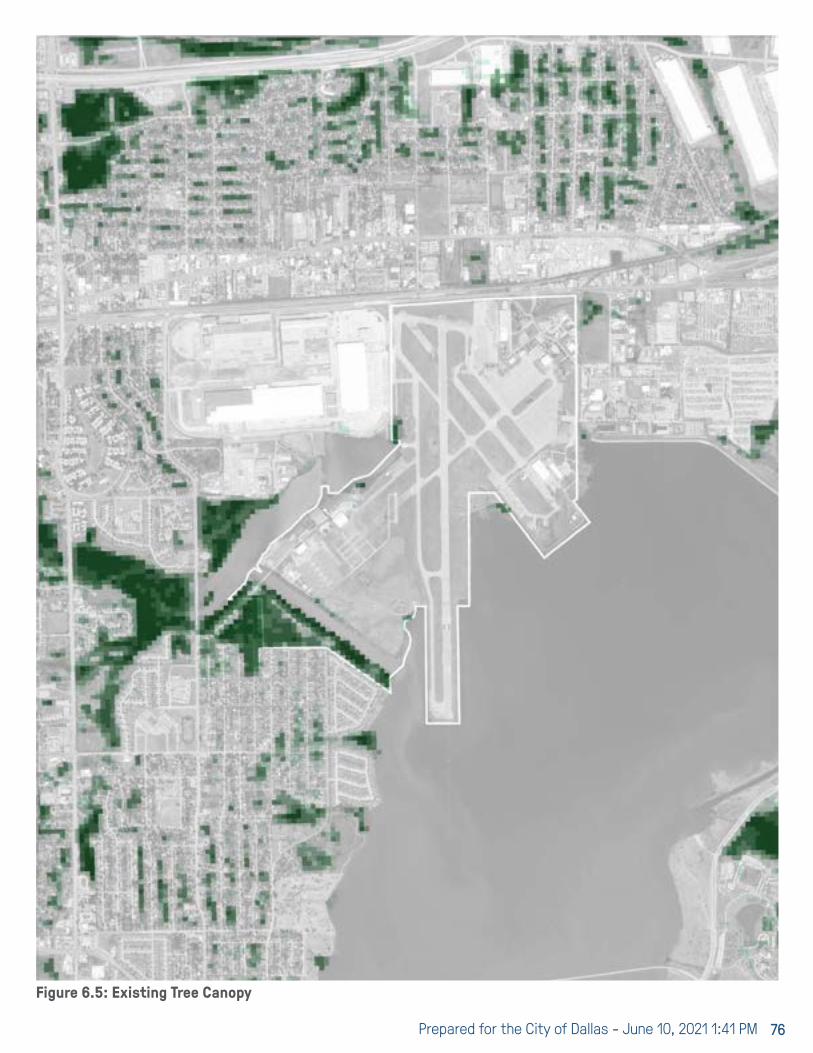
Prepared for the City of Dallas - June 10, 2021 1:41 PM 76
Figure 6.5: Existing Tree Canopy

Hensley Field Re-Use and Redevelopment Plan 77
LEGEND6.5 WATERSHEDS & WATER QUALITYA watershed is defined as the region draining into a river, river system, or other body of water upstream of a particular point.
Hensley Field falls within the Delaware Creek - West Fork Trinity River Watershed and the Cottonwood Creek - Mountain Creek Lake Watershed. The Fish Creek - Mountain Creek Lake Watershed to the south provides most of the water and sedimentation flowing into Mountain Creek Lake.
According to the Texas Water Development Board, Mountain Creek Lake controls a drainage area of 295 square miles.
The dominant land uses vary slightly throughout the watershed area, with residential areas covering the largest portion of most of the watersheds, and commercial/industrial areas comprising the dominant land use in others. In summary, the land use mix reflects that of a large urban area with some variations in category of dominance by geographic location.
Because the watershed is within an urban context, the sediment and nutrient loads carried by the water can be generalized based on similar urban places. Point source pollutants that can be identified and treated at the source are unlikely to be found in mature urban areas. As a result, water entering Mountain Creek Lake will likely contain the following major contaminants:
Sediment from roadways, construction projects, and residential properties; Nitrogen and phosphorous from fertilizers; Oil and organic contaminants from vehicles; Floatables from litter and wind blown garbage.
TCEQ and TPWD continue to monitor the watershed, sediment levels and contaminants within Mountain Creek Lake. Current known contaminants include E coli from contributing streams, PCBs, chromium, mercury and other metals, PAHs (polycyclic aromatic hydrocarmons) and cyanide. TCEQ has a current study underway to determine the measures necessary to improve water quality in Mountain Creek lake and restore the lake for recreational use. Further research will reveal the final opportunities and constraints regarding the overall water quality and usability of the lake within the Hensley Field design program.
Rivers & StreamsLakes, Ponds, & ReservoirsFlow Direction
Water Bodies
HUC12 Sub-Watersheds
Structures
Delaware Creek - West Fork Trinity WatershedCottonwood Creek - Mountain Creek Lake Watershed
Dam & SpillwayPower Station Discharge Point
Technical Support Document for TMDLs for Indicator Bacteria in the Cottonwood Creek, Fish Creek, Kirby Creek,
and Crockett Branch Watersheds Upstream of Mountain Creek Lake
9 August 2015
2.4.2 Analysis of Bacteria Data
Recent environmental monitoring within the TMDL watersheds has occurred at 11TCEQ monitoring stations (Figure 4). E. coli data collected at these stations over the seven-year period of 1 December 2003 through 30 November 2010 were used in assessing attainment of the primary contact recreation use as reported in the 2012 TexasIntegrated Report (TCEQ, 2013a) and as summarized in Table 2. Additionally, E. colidata collected at these stations over the seven-year period of 1 December 2005 through 30 November 2012 were used in assessing attainment of the primary contact recreation use as reported the Draft 2014 Texas Integrated Report (TCEQ, 2015b) and as summarized in Table 2. The 2012 and 2014 assessment data indicate non-support of the primary contact recreation use because geometric mean concentrations exceed the E. coli geometric mean criterion of 126 MPN/100 mL for the TMDL watersheds.
Figure 4. TMDL study area showing TCEQ surface water quality monitoring stations used to assess primary contact recreation.
Source: TCEQ (2012b)Figure 6.6: Watershed Surface Water Quality. (TCEQ 2012)

Prepared for the City of Dallas - June 10, 2021 1:41 PM 78
Figure 6.7: Watershed Context
DELAWARE CREEK - WEST FORK TRINITY RIVER WATERSHEDHUC-12 #120301020706
COTTONWOOD CREEK - MOUNTAIN CREEK LAKE WATERSHEDHUC-12 #120301020607
COTTONWOOD CREEK
O’GUINN CREEK
MOUNTAIN CREEK
DELAWARE CREEK
WEST FORK TRINITY RIVER
DAM & SPILLWAY
MOUNTAIN CREEK POWER STATION
MOUNTAIN CREEK
ARTESIAN CREEK
FISH CREEK
KIRBY CREEK
MOUNTAIN CREEK LAKE
FISH CREEK - MOUNTAIN CREEK LAKE WATERSHED
HUC-12 #120301020606

Hensley Field Re-Use and Redevelopment Plan 79
LEGEND6.6 LAKE BANKS & EDGES
Naturalized EdgeRiprapCut Canal, Steep SlopeAccreted Beach Fronting Riprap
Edge Type
Edge CharacterSoft: Sediment & VegetationHard: Concrete & Stone
Mountain Creek Lake is a valuable resource and amenity. Developed in the 1930s as the Mountain Creek Reservoir for the Mountain Creek Power Plant, the lake has been largely underutilized by the public, despite being stocked in 1986 with catfish, drum, crappie, bass and other game fish. The redevelopment of Hensley Field offers an exciting opportunity to re-engage with the waterfront and the lake for regional public access and recreational use; Mountain Creek Lake can provide the same amenity for Southwest Dallas and the broader region as White Rock Lake does in East Dallas. A comprehensive waterfront trail system within the property could provide future linkages to Joe Pool Lake, Grand Prairie and other local destinations.
The current condition of the lake edges surrounding Hensley Field vary based upon location. The areas around Cottonwood Bay tend to be a more naturalized lake edge, where as the areas adjacent to the runway are man made and supported with rip rap. Other locations are a combination of the two. Additionally, the area along the canal that was cut into the site during the 1940s presents another bank type with much steeper slopes that have naturalized over time. There are existing habitats with the Bay area and along the beach areas that are worthy of preservation. Opportunities to access the water and create park and wildlife areas are certainly feasible for this site and location. Prior to redevelopment, environmental data must be reviewed for understanding of historical site conditions and additional soil characterization samples will potentially be needed to get current data/understanding of conditions and potential soil management expectations.
Accreted beach area to the east of the runway extension
Lake edge at Cottonwood Bay. Invasive water hyacinth is being monitored
Canal sloped edge that has naturalized over time. Bank height 22’-41’

Prepared for the City of Dallas - June 10, 2021 1:41 PM 80
Figure 6.8: Lake bank conditions at and adjacent to Hensley Field
MOUNTAIN CREEK LAKE
Bella Lagos
COTTONWOOD CREEK
Lakeland Heights

Hensley Field Re-Use and Redevelopment Plan 81
LEGEND6.7 ADJACENT PARK & TRAIL SYSTEMS
Existing Trails, Off-StreetRegional Veloweb, ExistingRegional Veloweb, PlannedBike Trails, Planned
Trails
Natural & Recreational Land UseWater BodyPublic ParkOpen Space (Private or Institutional Use)
The Hensley Field master plan should seek to strike a balance between open space that creates habitat and open space that is highly usable and targeted to specific users and activities. The goal will be to minimize disruption to preserved areas by increasing the use of disturbed zones.
Per the Dallas Park & Recreation Comprehensive Plan of 2016, this area of far west Dallas is shown as an area outside of a walking and driving distance to a park. The Hensley Field redevelopment plan could not only meet the Trust For Public Land’s and Parks Departments goal to bring Dallasites within a 10-minute-walk of a park, but also serve to connect adjacent communities with park and trail access.
The following are Design Principles inherent in the vision for the open spaces of Hensley Field:
∙ Use less land to achieve the project goals; avoid unnecessarily displacing ecosystems and extracting resources.
∙ Incorporate multi-use over single-use design solutions.
∙ Make exercise enjoyable and convenient. ∙ Create engaging and connected networks by orchestrating a rich blend of cultured and natural spaces.
∙ Create opportunities for public and private investment to offset the cost of implementation.
∙ Enhance the site’s natural assets to leverage value and minimize project costs.
∙ Create bio-habitat corridors within urban precincts. ∙ Incorporate green technology including off-the-grid systems and storm water capture.
∙ Increase tree canopy in open spaces and greenways. ∙ Serve existing communities while establishing new ones.
∙ Make ecology inherent to the design. ∙ Strengthen the City of Dallas, City of Grand Prairie, and local neighborhoods, by increasing attractive living and working options through development of an iconic “postcard place.”
Hensley Field’s neighborhood parks and open space system should establish a compelling sense of place, a high level of active transportation access and routes, an enduring public
realm, and strong connections to and compatibility with surrounding community and site history.
Working with the Parks Department , Trust for Public Land, the Circuit Trail Conservancy, Texas Trees Foundation and NCTCOG, the Hensley Field master plan could achieve many goals put forth in the city and regions comprehensive plans for parks, recreation, trails and transportation.
Enhanced parks and trail system

Prepared for the City of Dallas - June 10, 2021 1:41 PM 82
Figure 6.9: Planned and existing transit network around Hensley Field
MOUNTAIN CREEK LAKE
LONE STAR TRAIL DOT TRAIL
GOOD LINK TRAIL

Hensley Field Re-Use and Redevelopment Plan 83
The transportation landscape in Dallas has quickly changed in the last 10 years. Doubling light rail and expanding transit services, increased multimodal options, and shifting transportation goals and policies are leading to a more sustainable and accessible city. New environmental and mobility goals are well timed with the development of the Hensley Field Master Plan.
As an infill development site almost the size of downtown Dallas (Figure 7.1), Hensley Field will be the newest transportation node in an evolving connected city and region. Building upon the Master Plan’s three pillars of sustainability (social equity, environmental protection, and economic viability), mobility and accessibility will play a pivotal role in the success of the project vision.
Hensley Field has the potential to come of age as autonomous vehicles are deployed, and principles toward transportation equity, safety, and multimodal priorities gain momentum. This report section addresses the current
transportation landscape, where Dallas plans to head, and what opportunities and constraints exist that will impact the Hensley Field Master Plan.
TRANSPORTATION LANDSCAPEDallas has set a new vision for how to measure and invest in the transportation network to increase mobility for all. The Connect Dallas Strategic Mobility Plan (SMP) is the newest guiding strategic plan for how Dallasites will move around their city and beyond. The SMP, along with the recent Dallas Environmental and Climate Action Plan, are looking to shift policies and planning around transportation and land use to increase multimodal mobility. A policy shift example is the goal to reduce single occupancy vehicle (SOV) commuting to 62% by 2050 (Figure 7.2).
The SMP identified key trends that will continue to impact mobility across the city: the Dallas region is growing, travel around Dallas is becoming increasingly difficult, the city’s needs are outpacing current resources, a notable portion of the population is aging, and there is an increasing need for
Figure 7.1: Size Comparison of Downtown and Hensley Field
7 TRANSPORTATION7.1 INTRODUCTION

Prepared for the City of Dallas - June 10, 2021 1:41 PM 84
equitable access to jobs. These findings and the aim toward more sustainable multimodal mobility align with the vision for Hensley Field.
With 41 people moving to Dallas a day, demographic shifts in the region translate to decreasing car ownership and vehicle miles traveled (VMT). There is an increasing reliance on the shared economy for transportation, including car share, bike share, ride share, and carpool (Figure 7.3). An increase in mobility options like Transportation Network Company (TNC) services Uber and Lyft, enables more accessibility
for households without a vehicle in urban areas. TNC trips, by households with and without personal automobiles, are partially replacing transit, bike, and walk trips, or adding new trips onto the network (Figure 7.4). New and replacement TNC trips have the potential to increase VMT, although Texas has been able to stay below the national average, potentially due to the state’s young population (Figure 7.5).
Figure 7.3: Increasing Mobility Options and Access to Mobility Options
Figure 7.2: SMP Future Modal Split Goals (Source-Connect Dallas Strategic Mobility Plan)

Hensley Field Re-Use and Redevelopment Plan 85
Figure 7.4: TNC Trips replace modes or add new trips
Figure 7.5: Vehicle Miles Traveled per capita (Source: Eno Center for Transportation)
site. Four primary highways, three significant arterial roads, and a handful of local bus stops are within a five-mile radius of the site. One Dallas Area Rapid Transit (DART) light rail station and one Trinity Rail Express (TRE) station are within a ten-mile radius of the site.
Driving is the only direct mobility option currently available. Hensley Field is a 18-20-minute drive to downtown, and a 28-minute drive to Fort Worth. Accessing Hensley Field by bus, light rail, or passenger rail is currently not possible.
Connectivity to the transportation network adjacent to the project site is also limited by bicycling, walking, and trail access. Currently there are no trails, on-street bicycle facilities, or sidewalks that connect to the Hensley Field site. Within a five-mile radius, segments of the regional Veloweb, a proposed regional shared use path system for walking and biking, exist to the north of the site in Grand Prairie. Connections to primary arterials, trails, transit service, and the Grand Prairie residential neighborhood north of the site is important.
7.2 SITE ACCESS
ROADWAY NETWORKDriving is the primary means of travel for most residents of the Dallas region. As a proposed mixed-use development, Hensley Field will generate a significant number of trips, likely onto the roadway network. As the project is on the outskirts of the city, multimodal travel across the metroplex is important to minimize roadway impacts. The road network near the Hensley Field site has roadway classifications from arterials to interstates and turnpikes. There are four main highways surrounding the site; Interstate (I)-30, one mile north of the site connects downtown Dallas with downtown Fort Worth, Interstate (I)-20, five miles south of the site connects the outer loop of Dallas, Interstate (I)-635, to the outer loop of Fort Worth, Interstate (I)-820, the President George Bush Turnpike (toll road), three and one-half miles to the west of the site connects the Dallas Fort Worth airport to I-20, and finally, Texas Loop 12 (TX-12 Loop), two and one-half miles west of the site connects northwest Dallas to I-20. These four highways connect through Grand Prairie to the Hensley Field area.
Prior to the COVID-19 pandemic, and drastically since the pandemic began, freight delivery has surged with individual package delivery to homes almost daily. More trips and miles travelled by small and medium delivery trucks add to the demand for roadway network space. With increased home delivery, drivers are making fewer errand trips, but VMT has not necessarily decreased, as drivers shift their habits to more social and entertainment outings.
While these factors play a role in the overall mobility of Dallas, the existing network will heavily influence transportation at Hensley Field. Multimodal access and connectivity to Southwest Dallas, Grand Prairie, and the Hensley Field site is currently limited. As noted in Figure 7.6, regional mobility concentrates on movement to downtown, but is limited via highway, rail, and bus near the Hensley Field

Prepared for the City of Dallas - June 10, 2021 1:41 PM 86
Figure 7.6: Regional Mobility

Hensley Field Re-Use and Redevelopment Plan 87
As single occupancy driving is the largest form of commuting in the area, congestion occurs along these highways. Table 7.1 lists 2019 annual average daily traffic (AADT) along highways near the site.
According to the Texas Department of Transportation (TxDOT) in 2018, all four of these primary highways were congested or moderately congested (Figure 7.7). An additional highway to the west, Texas 360 Toll, was also congested. Portions of I-20, Tx-12, and Texas 360 were among the 100 most congested roadway segments in the state of Texas in 2018. Future congestion predictions (Figure 7.8) indicate these roadways will experience further congestion, and Hensley Field traffic is not calculated into this prediction (TxDOT).
Three primary arterials connect with the site: Jefferson St, adjacent to the site, Mountain Creek Parkway along the eastern side of Mountain Creek Lake which turns into Illinois Ave, and Keist Blvd about 2.5 miles south. As noted in Figure 7.9, existing highways and arterial roads around Hensley Field will be improved within the next ten years. In addition, Hensley Field is adjacent to the Dallas Global Industrial Park and was designated by the North Central Texas Council of Governments (NCTCOG) as part of a Freight Oriented Development.
ROADWAY NETWORK AND THE HENSLEY FIELD MASTER PLANHighways and arterial roads near the Hensley Field site are included in the NCTCOG Mobility 2045 plan (Figure 7.9) and will be improved within the decade.
The following roadways defined as congested have planned improvements, such as widening and operational optimization, by 2030 to alleviate this congestion.
∙ Texas 360 Toll ∙ President George Bush Turnpike ∙ I-30 (west of President George Bush Turnpike) ∙ Tx-12 (between Illinois Ave and I-20) ∙ I-20
Roadway improvements have the potential to reduce congestion and travel times and enhance access to regional destinations. The collective roadway improvements around the site are a benefit to the project, but the recommended improvements were made without consideration of Hensley Field. At this time, it is uncertain whether the increased roadway capacity will be sufficient enough for the anticipated scale and density of the Hensley Field site. As the site’s trip generation has been unaccounted for, Hensley Field should consider efforts to minimize additional roadway network impact and further advocate for multimodal access to the project.
Although roadway improvements will occur, a major constraint is no direct freeway access from the site. The Hensley Field site provides an opportunity to design improved connections from Jefferson St to nearby highways. Increasing capacity, adding turn lanes, and other roadway reconfigurations along Jefferson St could improve roadway access.
Table 7.1: Annual Average Daily Traffic Volumes (*No data collection point near project site)Source: Texas Department of Transportation Open Data Portal, AADT Annuals

Prepared for the City of Dallas - June 10, 2021 1:41 PM 88
Figure 7.8: Future Congestion Map
Figure 7.7: 2018 Congestion Map

Hensley Field Re-Use and Redevelopment Plan 89
Figure 7.9: Roadway Improvements Map
TRANSIT NETWORKHighways and arterial roads near the Hensley Field site are included in the NCTCOG Mobility 2045 plan (Figure 7.9) and will be improved within the decade.
The Hensley Field site has the potential to be a state and national example of a transit-oriented development (TOD). The development site aligns with Connect Dallas Strategic Mobility Plan goals of promoting compact infill development with mixed land uses and multimodal connectivity. The Dallas Area Rapid Transit (DART) network includes bus routes (local, express, suburban, cross town, to rail station, and shuttle), 93 miles of light rail, 34 miles of passenger rail, 13 GoLink zones, two streetcars, and vanpool and paratransit services. GoLink zones align with Mobility on Demand (MoD) emerging mobility trends such as Uber and Lyft, where a user can request curb-to-curb transport using a mobile device.
Despite DART’s robust fleet, DART services currently do not reach the Hensley Field site and the City of Grand Prairie is not included in DART’s service area. Grand Prairie currently has limited transit services; the Grand Connection operates
shuttles that transport individuals over 60 years of age or have a physical or mental disability. Figure 7.10 highlights existing and proposed transit services near the Hensley Field site. The closest light rail station is the Red Line’s Westmoreland Station in Oak Cliff, a 7.5-mile drive from the project site. The closest commuter rail station is the Trinity Rail Express (TRE)’s Downtown Irving/Heritage Crossing Station in Irving, a 7.1-mile drive from the project site. TRE serves passengers between Dallas and Fort Worth and eight stops in-between. TRE runs six days a week from 4am/5am until midnight, with weekday peak morning and peak evening departures every thirty minutes, and once an hour mid-day and into the evening. Saturday service is once and hour and there is no current Sunday service. Although an Amtrak passenger line is near the Hensley Field site, it has no nearby stops. The nearest bus stop is along local route 376 at Keeneland Parkway and Gallant Fox Drive, a 3.6-mile drive from Hensley Field.
Long term planning to-date has not considered Hensley Field as a high-density mixed-use development and as such

Prepared for the City of Dallas - June 10, 2021 1:41 PM 90
Figure 7.10: Existing and Proposed Transit Network

Hensley Field Re-Use and Redevelopment Plan 91
Figure 7.11: Proposed High-Speed Rail Alignment Options

Prepared for the City of Dallas - June 10, 2021 1:41 PM 92
current proposed expansions to DART rail do not serve the Hensley Field site. There is potential for a high intensity bus route (bus rapid transit or BRT) along I-30, bringing high capacity transit within proximity to the site. The DART 2030 system plan also proposes improvements such as enhanced bus and rapid rail within a 10-minute drive of the site.
As noted in Figure 7.11, a high-speed rail alignment is currently being studied between Dallas and Fort Worth and aligns with NCTCOG’s Mobility 2045 plan. Potential alignments are near the Hensley Field site, but at this time a mid-point stop is proposed for Arlington, and not Grand Prairie or Hensley Field. The high-speed rail study is relatively early in the process, and a narrowed list of alignment options will not be selected until the spring of 2021. The high-speed rail potential is a long-term consideration that is not concrete enough currently to influence transit or rail recommendations near the Hensley Field site.
Although geographic expansion of rail and bus services is limited at this time, DART has been exploring innovative strategies to fill service gaps and collaborate with emerging technology such as on-demand services like GoLink and Uberpool. GoLink aims to be a service gap as a neighborhood shuttle available upon request in designated GoLink zones. Additionally, DART has partnered with Uber to provide Uberpool services, which also operate in GoLink zones. The Hensley Field project size is currently not in a GoLink zone. These innovative service options align with Mobility as a Service (MaaS), a concept that shifts toward empowering users to access, book, and pay for multiple mobility options from one digital platform.
TRANSIT NETWORK AND THE HENSLEY FIELD MASTER PLANGiven the potential size, residential density, and employment density at Hensley Field, there is significant opportunity for high capacity transit. In the long-term, DART light rail, high-speed rail, and a potential hyperloop could serve the Hensley Field site, quickly connecting it to Downtown Dallas, Fort Worth and other regional destinations. As shown in Table 7.2, the Institute of Transportation Engineers (ITE) and DART TOD Guidelines, there is an opportunity for a transit stop on the Hensley Field site. If the Hensley Field site provided close to 5,100 dwelling units it would warrant intermediate transit service, and 11,000 or more dwelling
units would warrant frequent transit service. The Federal Transit Authority provides small start and new start funding opportunities for fixed-rail projects with population densities medium or higher, which fall within the ITE and DART TOD Guideline thresholds.
Transit requires long-term planning, and Hensley Field has not been considered as a mixed-use high-density development node in recent transit planning efforts. As a result of not being considered in recent DART or regional transit service, the project has an opportunity to consider alternative interim solutions. With the evolving transit landscape, these interim solutions have the potential to be more flexible and stable transit options and would be a valuable addition.
Bus rapid transit (BRT), autonomous rapid transit, shuttle service, mobility on demand (MoD) services like GoLink and Uberpool zone expansions, and carsharing can connect to existing TRE and DART stations to facilitate transit access. Center running High-Occupancy Vehicles and BRT planned for I-30 provide an opportunity for Hensley Field to have a park-n-ride. Utilizing the nearby railroad right-of-way parallel to Jefferson St could further provide direct connection from the project site to the I-30/Loop 12 interchange. As the Hensley Field site is 738 acres, first and last mile connections to the short-term access points, such as bike share, micromobility, or neighborhood shuttle within the project site is crucial.
A major constraint for the site is the service gap for both existing and proposed transit services. Currently, no direct BRT or mobility on demand connection services are planned, but the DART system plan is currently being updated,
Table 7.2: Residential Densities Needed per Acre per Service Type

Hensley Field Re-Use and Redevelopment Plan 93
providing an opportunity for Hensley Field to advocate to expand GoLink zones and connecting services to BRT along I-30, along Jefferson Street, or bring BRT into the site.
Rail is a significant investment in comparison to interim solutions that are more flexible and stable in a fluctuating transit market. Pivoting from interim options to long-term high capacity transit could be a constraint for the site. The transit service gap provides an opportunity for the project to advocate for near-term and long-term transit solutions to the site. As a high-density mixed-use development with housing and employment, Hensley Field could be a transit-oriented development (TOD) node with equitable multimodal access. DART has a TOD policy and guidelines that can assist in the refinement of the project design.
The biggest constraint and opportunity for Hensley Field is long-term high capacity transit. Overall success of the site is dependent on the ability to plan for and secure short-term and long-term high capacity transit solutions.
BICYCLE, PEDESTRIAN, AND TRAIL NETWORKAccess to the Hensley Field site via walking and bicycling is crucial in achieving connected, high-density, sustainable, equitable, and safe multimodal goals that are included in recent planning efforts like the 2020 Connect Dallas Strategic Mobility Plan (SMP) and the Dallas Comprehensive Environmental and Climate Action Plan. Additional planning initiatives specifically geared toward bicycle and pedestrian mobility near the Hensley Field site include the 2011 Dallas Bike Plan, NCTCOG’s Regional Veloweb, and the 2005 Dallas Trail Network Plan.
Bicycle and pedestrian facilities and their surrounding environment produce different comfort levels than auto or transit facilities. Due to the surrounding environment, existing pedestrian and bicycle access is high stress due to high traffic volumes, traffic speeds, multiple auto lanes, limited or non-existent facilities, and potential conflict points such as driveways and railroad crossings. Hensley Field could implement low stress facilities. Low stress bicycle and pedestrian amenities are typically completely separated from automobile traffic such as an off-street trail or shared use path.
As shown in Figure 7.12, an extensive trail network is planned for the metroplex region, but currently there is limited bicycle, walking, and trail connectivity to the Southwest region of Dallas. Existing and proposed off-street trails and the Veloweb would be low or moderate stress facilities. As no on-street bicycle facilities exist at this time near the site, and sidewalks are limited, coupled with the roadway environment, this is a high stress walking and biking area.
Landscape barriers to the site include Mountain Creek Lake to the east and south, water channels to the south and west, and an east west running rail line parallel to Jefferson St. The lake is an amenity and draw of the site, but means the site is only accessible from the north and segments along the south, and west. Future access points could require a bridge. The railroad makes connectivity difficult for all travel modes as crossing opportunities are funneled together and can be dangerous or delayed.
BICYCLE, PEDESTRIAN, AND TRAIL NETWORK AND THE HENSLEY FIELD MASTER PLANImproving trail, bicycle, and pedestrian connectivity to the southwest region and the Hensley Field site will be critical in improving mobility to and from neighboring communities such as Grand Prairie.
The landscape barriers and limited existing trails is a constraint for the site but provides an opportunity to incorporate the scenic beauty of Mountain Creek Lake into an active transportation amenity. A possible 12-mile trail loop around Mountain Creek Lake will connect destinations and other trails, from one side of the lake to the other. The project provides an opportunity to advocate for more futures trails and on-street facilities to fill the gaps between currently proposed infrastructure. Proposed trails and on-street facilities can enable some transit access to existing transit stops and would provide excellent first and last mile connectivity if future transit service reaches the Hensley Field site.
Due to the lake and water channels along the eastern, southern and western portion of the site, access is primarily on Jefferson St. Pedestrians or individuals on bike seeking to access Hensley Field from Grand Prairie, both from the west or the residential neighborhood north have limited

Prepared for the City of Dallas - June 10, 2021 1:41 PM 94
Figure 7.12: Existing and Proposed Trails and On-Street Bicycle Facilities

Hensley Field Re-Use and Redevelopment Plan 95
In addition to crossing Jefferson St crossing the parallel railroad is currently funneled to a few intersections. The only sidewalk is on the southern portion of Jefferson St. from SE 14th St. but ends at the Hensley Field property line. At this time Grand Prairie has limited existing and proposed multimodal connectivity to the Hensley Field site despite being adjacent to the site. Grand Prairie plans to reconfigure Main Street, east of Hensley Field and one block north of Jefferson Street, as a gateway opportunity into the city with a roundabout that will discourage heavy truck traffic on Main Street. Heavy truck traffic could be diverted from Main Street to Jefferson Street. The project provides an opportunity to improve Jefferson Street conditions, particularly with Complete Street principles that provides space for people walking and biking, transit, and potential heavy trucks.
7.3 HENSLEY FIELD SITE
LAND USE AND TRANSPORTATION POLICIESThe Hensley Field redevelopment has a sustainability vision built on three pillars: social equity, economic vitality, and environmental protection. The alignment of land use and transportation policies play a key role in creating a sustainable project site. Recent planning and environmental efforts by the City of Dallas, NCTCOG, and DART regarding land use, transportation, and environmental policies and goals should be considered for Hensley Field (Table 7.3).
As the project is designed and the internal transportation network laid, takeaways from the above documents and industry best practices around multimodal performance measures, internal connectivity, parking, and curb management should be used.
MULTIMODAL PERFORMANCE MEASURESOften times developments of this scale are constrained by policies around significant impacts to the roadway network and minimum parking requirements. The SMP and Climate Action Plan mention the potential to move toward Vehicle Miles Traveled (VMT) and parking maximums, as a metric
Figure 7.9: Roadway Improvements Map
intersection and crossing opportunities. Access points along Jefferson are difficult and limited for people walking and biking, but provide an opportunity to reshape Jefferson St’s signals, railroad crossings, and create enhanced crossings.
As noted in Figure 7.13, of the four signalized intersections along Jefferson St. within the project area, only SE 14th Street has crosswalks.

Prepared for the City of Dallas - June 10, 2021 1:41 PM 96
Table 7.3: Planning and Policy Efforts toward sustainable land use and transportation goals

Hensley Field Re-Use and Redevelopment Plan 97
to reach modal split goals and high-density developments. The SMP also mentions introducing active mode analysis and multimodal mitigation strategies into the traffic impact analysis process, and curb management strategies. With this recent shift in land use and transportation policy in the Dallas region, Hensley Field has an opportunity to design to an optimal mix of land uses and densities that will lend toward the achieving goals of the SMP and new citywide mode split targets.
INTERNAL CONNECTIVITY AND DESIGNIn alignment with new City policies, Hensley Field can prioritize complete streets design that facilitates equitable and safe streets for all and promotes mobility options especially for short trips. A layered network approach, Figure 7.14, complements Complete Street design principles and could align with the city’s new Complete Street Design Manual. Layered networks recognize that multiple modes utilize the same streets and routes for different purposes, and certain streets should be prioritized for different modes. Streets that attempt to service people walking, biking, and wheeling will feel different than streets attempting to service freight delivery or automobile traffic. Internal connectivity and facility design across the site have the potential to be a state and national example of an accessible and thriving community for all ages and abilities.
Identifying destination nodes within the site and linking them
across modes is important in ensuring Hensley Field is a walkable, sustainable, and equitable community. The Climate Action Plan supports DART’s Mobility Hub infrastructure plan, designating space at nodes where all forms of transportation converge, and users can transfer among modes. A location that provides bike share, micromobility sharing such as e-scooters, car sharing, TNC pick-up or drop-off, limited parking, and shuttles or BRT to nearby transit stations. Partnership with new mobility providers or emerging modes is especially opportunistic in the short-term to connect residents and employees to nearby rail and transit services. Expansion of DART’s curb-to-curb on-demand service GoLink is an example of partnering with mobility providers around emerging mobility and could be implemented at the Hensley Field site.
PARKINGCurrently, the City of Dallas has traditional parking requirements, or parking minimums, which can require a large parking supply, often costly and an inefficient use of land. Parking minimums can stifle development. As Hensley Field is an isolated development, it is especially important to right-size parking supply to fit auto needs while supporting multimodal priorities.
No accompanying multimodal connectivity to the site is a constraint that could make Hensley Field heavily auto dependent and require a lot of parking and use of valuable land. An opportunity for balancing parking needs is the shifting mindset to put policies and infrastructure in place to reduce parking demand and make the case for less parking supply. Hensley Field as the opportunity to get ahead of emerging technology with electric vehicle parking, electric bikes, and flexible curb space by aligning with Climate Action Plan goals of installing 1,500 electric vehicle (EV) charging stations around the city. With the growth of EVs and forthcoming Connected Autonomous Vehicles (CAVs), understanding dynamic parking and curb space strategies will allow the site to remain agile in an uncertain future.
CURBSIDE MANAGEMENTEmerging mobility and technologies continue to grow, including mobility-on demand services like bike-share, micromobility (such as electric scooter share), car-sharing, ride sharing (such as TNCs Uber and Lyft), and Mobility As A Service (MaaS), electric vehicles (including electric
Figure 7.14: Layered Network Visualization goals

Prepared for the City of Dallas - June 10, 2021 1:41 PM 98
bicycle and buses), and CAVs (including personal vehicles, shared, and transit). With increasing mobility options and home delivery of individual packages, competition at the curb has increased. Curb management is the practice of implementing strategies that attempt to designate curb space for different uses throughout the day or week to achieve highest utilization of the precious space. Identifying the highest and best use of the curb by comparing is a critical element of dynamic curb spaces. As demonstrated by Figure 7.15, comparing curb space productivity to curb space allocation is one approach to find higher utilization. As mentioned in the parking section, dynamic use of the curb provides a higher efficiency of land use.
As Hensley Field takes advantage of emerging mobility options and identifies destination nodes within the site, there is also an opportunity to implement the most forward-thinking curb use strategies that create more equitable access and safety at the curb. Dynamic curb management allows the same space to be changed through the day or week to best fit transit, CAV, ridesharing, shared mobility, and bicycle and pedestrian demands. Hensley Field could identify activity nodes and zones that generate more trips to determine where curb management strategies are best implemented. Best practices from industry leaders such as ITE and NACTO demonstrate the importance of curbside management in serving all road users.
EMERGING MOBILITY AND CAVSSelf-driving personal automobiles, as well as autonomous
freight and shuttles are emerging on the mobility landscape. It is undetermined exactly when connected and autonomous vehicles (CAVs) will be the most dominate automobile mode, but they exist on roadways and campuses now. Planning agencies across the Country are slowly identifying actions and policies to prepare for this change. Local to Dallas, the NCTCOG has published recommendations for infrastructure updates and community considerations for CAV preparedness. The City of Dallas is focused on the following:
INFRASTRUCTURE: ∙ A digital map of roads, geography, traffic laws, policies, and zone restrictions.
∙ A cellular network that allows for vehicle-to-vehicle, vehicle-to-infrastructure, and vehicle-to-everything communication.
∙ An ability to collect real-time roadway and conditions data, send to vendor or control station, and update signals and roadway operations.
∙ An ability to wrangle and process the multitude of data received daily.
∙ A digital collection of stationary infrastructure, such as sidewalk conditions.
∙ A focus on maintenance, CAVs perform better with good striping, clear signage, and fewer potholes.
PLANNING ∙ Vision Zero: In the long-run CAVs have the potential to reduce traffic fatalities, but in the short-term conflicts between CAVs and individuals walking, and biking should be considered.
∙ Slow Lanes: CAVs might operate in designated lanes, and all other modes would operate in slow lanes to
Figure 7.15: Comparison of current curb space productivity to current curb space allocation along a San Francisco com-mercial corridor (Source-Fehr & Peers)

Hensley Field Re-Use and Redevelopment Plan 99
reduce conflict and increase predictability. ∙ Curb Management: Efficient use of the curb for drop-off/pick-up access and on-street parking for CAVs.
∙ Life-cycle cost analysis: Consider the life cycle long-term costs of a CAV network, both physical and digital infrastructure.
∙ Shared ride: Consider how shared or single occupancy use of CAVs would impact travel patterns.
Based on the above considerations Hensley Field has the opportunity prepare for CAVs in a safe, equitable, and sustainable manner. For example, as Hensley Field will be a walkable site, safely preparing for pedestrians to mix with CAVs is essential. Designing Hensley Field with the proper CAV infrastructure utilities is an opportunity to attract CAV users and shuttle systems. Parking and designated space for individual or shared autonomous vehicles, as well as autonomous shuttles provide the most opportunity for Hensley Field to provide on-site strategies and facilities for CAVs. As noted in the introduction and in curb management sections, like TNCs, CAVs have the potential to increase trips, and decrease on-street parking demand, but increase curb access for passenger drop-off/pickup.
Through curb management, slow lanes, vision zero, inclusion and other CAV considerations, the Hensley Field site could be well situated to handle large-scale CAV deployment for personal, shared, and public transit use.
Figure 7.16: TNC and CAV potential impacts on trips, and parking and curb demand (Source- Fehr & Peers)

Prepared for the City of Dallas - June 10, 2021 1:41 PM 100

Hensley Field Re-Use and Redevelopment Plan 101
The Hensley Airfield is a situated on 738 acres in west Dallas adjacent to the City of Grand Prairie south of East Jefferson Street with significant frontage to Mountain Creek Lake along the south and west. The site is a typical military base with several runways, taxiways, hangars, residential buildings, miscellaneous structures, and large parking fields.
In this initial phase of the project, the existing infrastructure on site and available off-site is being investigated for future development. The goal is to have a clear understanding of the domestic water, wastewater, storm sewer, electrical, gas, and telecommunications systems from an ownership / jurisdictional standpoint and to begin the process of determining what these existing facilities could support in early phases of development as well as identifying the processes required to provide utility service to the fully redeveloped 738 acres. The utilities serving the site as well as the responsible jurisdiction is summarized in Figure 8.1.
8.1 WATERHensley Field is located wholly in the City of Dallas in the Central Low Pressure Zone. Existing water infrastructure includes a 20” transmission main in Jefferson Street along the north side of the site. This is a dead-end line that extends west of the Hensley Field project boundary. The City of Dallas has indicated that recent projects to the north of Jefferson have improved the system by adding two connections on this transmission main. Distribution mains ranging in sizes from 8” – 16” loop through the eastern half of the property serving the various existing structures. All water mains on the Hensley Field property are private downstream of master water meters.
An existing water tower is located on the southeast corner of the property. The City of Dallas has indicated that they have no interest in incorporating this storage tank into their infrastructure. No further review or investigation as to the viability of the tank in the future development with
8 INFRASTRUCTURE
Name Email Phone Number
1 Water City of Dallas Richard Wagner [email protected] 214‐670‐3152
2 Water City of Grand Prarie Gabe Johnson [email protected] 972‐237‐8154
3 Wastewater City of Dallas David Lam [email protected] 214‐948‐5384
4 Wastewater City of Grand Prarie Gabe Johnson [email protected] 972‐237‐8154
5 Wastewater Trinity River Authority (TRA) John Durbin [email protected] 972‐975‐4357
6 WWTP (Central Regional WW) Trinity River Authority (TRA) John Durbin [email protected] 972‐975‐4357
7 Storm Sewer City of Dallas Lloyd Denman [email protected] 214‐948‐4354
8 Mountain Creek Lake On‐Site Park Manager Charlie Bradley 214‐333‐5321
9 Telephone Spectrum
10 Gas ATMOS Katana Yancey [email protected] 469‐571‐6824
11 Electric Distribution Oncor Shirley Holcomb [email protected] 469‐400‐5168
12 Electric Major Oncor Shirley Holcomb [email protected] 469‐400‐5168
13 Cable AT&T
14 Mountain Creek Lake Mountain Creek Power, LLC John Adams [email protected] 346‐318‐0261
15 Other
16
17
18
Owner ContactID Description Owner
Hensley Field Utility Contacts ‐ EXHIBIT 3.8
V:\2220\active\222012212\civil\due_diligence\Task 3.8\HF_Utility‐Contacts_12‐28‐20.xlsx EXHIBIT 3.8 1/8/2021
Figure 8.1: Utility Contacts
HENSLEY FIELD UTILITY CONTACTS
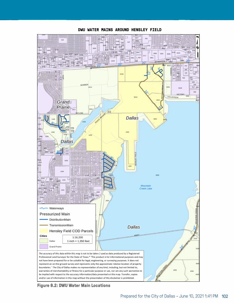
Prepared for the City of Dallas - June 10, 2021 1:41 PM 102
Figure 8.2: DWU Water Main Locations
DWU WATER MAINS AROUND HENSLEY FIELD
16"
8"
8"
6"
24"
8"16
"8"
16"
20"
12"
8"
6"
6"
12"
20"20"20"
30"
CA
MD
EN
HE
NS
LEY
FIE
LD
VICTORY
14TH
HARDY
14TH
MO
UN
TAIN
CR
EE
K
HE
NS
LEY
FIE
LD
MOUNTAIN
CREEK
BOMBER
JEFFERSON
SKYLINE
JEFFERSON
KIEST
VOLUNTEER
14TH
PEACE PRAIR
IE
MountainCreek Lake
2602
601
2010
1513
1501
122
2205
1818
2401
1405124
1402
0
1633
1774
1915
1502
2240
2627
2856
3000
3049
225
242
509
3606
3706
112
23302200
1350
1355
802
220
925
800
1017
1400
2904
1350
525
1390
1225
1631
1640
1822
2001
2608
9010
2000
200
2222
1402
513
242
25021
4006
537
403
3312
3216
3406
509
421
3543
3550
6900
2935
858
2010
1110
820
205
1
1905
1301
1201
1220
1505
1427
130
1423
1250
100
2602
2025
17141950
2100
2210
204
2330
205
411
28053149
413
300
3422
500
3501
3521
6900
706726
2266
2138
1505
790 810
1821
925
1002
1100
1204
2800
33
2600
1911
1635
1443
9314
1415
2602
1910
156
1515
19401930
1898
1750
1830
2620
23232336
300
25022628
2910
2801
3010
3024
3201
3018
4006
2624
3806
2951
2506
802
2038
1305
1899
1635
11291215
1320
2605
1200
1300
2501
1605
1510
1291717
1891
1821
2606
215 23022501
210
110
3008
8100
3200
314
3306
2800
502
403
519
417
7000
513
2118
1902
2017
1713
1501
1355
1307
310
2902
850
1102
2106
1901
1340
1200
1126
1310
1202
1101
1100
1629
2445
20992009
1750
1710
1917
1801
2229
2114
2218
238
505
2601
2617
2852
2717
2750
3730
402
3416
501
3520
3000
23412337
2134
1008
9999
1000
2510
850
813
1111
102
1004
2114
1913
1350
1430
1400
1417
1628
1725
2600
2214
2233
9150
2310 105
320
2521
3000
3223
3100
425
3545
3100
417
770
2502
2222
2317
2321
2099
1511
8981510
1309
1015
322
3001
1015
1000
1
1114
3302
1320
2305
1318
1
2202
1934
1511
9301
2600
2604
1800
202
205
1402
24012409
2738
301
410
3002
410
517
Dallas
Dallas
Dallas
Gra
ndPr
airie
GrandPrairie
DWU Water Mains Around Hensley Field
Waterways
Pressurized MainDistributionMain
TransmissionMain
Hensley Field COD ParcelsCities
Dallas
Grand Prairie
p4/26/2019
1 inch = 1,350 feet1:16,200
The accuracy of this data within this map is not to be taken / used as data produced by a Registered Professional Land Surveyor for the State of Texas.* ‘This product is for informational purposes and may not have been prepared for or be suitable for legal, engineering, or surveying purposes. It does not represent an on-the-ground survey and represents only the approximate relative location of property boundaries.’ The City of Dallas makes no representation of any kind, including, but not limited to, warranties of merchantability or fitness for a particular purpose or use, nor are any such warranties to be implied with respect to the accuracy information/data presented on this map. Transfer, copies and/or use of information in this map without the presentation of this disclaimer is prohibited.
EXHIBIT 3.8.1

Hensley Field Re-Use and Redevelopment Plan 103
respect to public infrastructure will be required. However, this tank could be utilized for irrigation as part of a private development.
The City of Dallas also has distribution serving an existing residential development to the southwest of Hensley Field adjacent to the City of Grand Prairie. This existing subdivision in Dallas connects at two locations to the Grand Prairie water line in Hardy Road. Both connections at Nina Drive and Sampsell Drive have metering facilities. Any development proposed south of the diversion channel and adjacent to this neighborhood would require a third connection to the Grand Prairie water line in Hardy with a similar metering station. At the time of this report, the available capacity of the Grand Prairie water line in Hardy Road is not confirmed.
The capacity available to the Hensley project from the Dallas Water Utility is unknown at this time but the team is working with the City of Dallas to determine available pressure and volume from the existing infrastructure. This work is ongoing and will be more developed as information is obtained.
The off-site existing water infrastructure will support initial phases of development at Hensley Field. The team is working with the City of Dallas to determine the magnitude of this development based on available capacity of the water system. As the program develops and more detailed phasing becomes available, the demands of the initial phase will be determined and compared to the available capacity. The on-site infrastructure may be utilized for initial phases but the transition to the ultimate layout of public infrastructure and converting services will need to be part of the planning process.
The existing water infrastructure is shown in Figure 8.2.
8.2 WASTEWATERAs with water, the City of Dallas currently serves portions of the Hensley Field site with mains ranging from 6” to 15” along the eastern portion of the site flowing to Jefferson Street. The TRA owns and operates one of the largest wastewater treatment plants in the region, approximately 2.5 miles northeast of Hensley Field. The Central Regional Wastewater System (CRWS) is located at 6500 W. Singleton immediately north of IH-30 adjacent to the confluence of the West Fork
Trinity River and Mountain Creek. This treatment plant serves a multitude of municipalities including Dallas and Grand Prairie. The TRA also operates the 27” to 30” concrete trunk line in Jefferson Street.
The Hensley Field wastewater collection system is made up of varying sized gravity sewer and force mains that are metered and that connect to the TRA 30” transmission main at Jefferson Street at the east side of the site. The City of Dallas has expressed the desire to not own or operate any lift station on the property for future development. This will be a design constraint since the site is relatively flat, sloping naturally from Jefferson Street to Mountain Creek Lake. The 30” TRA line in Jefferson Street at the existing connection has a flowline elevation of ±445 feet based on existing plans. The existing grade along the southern boundary primarily along the shoreline of Mountain Creek Lake is at ±460 feet. For an exclusive gravity system to work and assuming 10 feet of vertical fall in the wastewater system, the proposed wastewater trunk line from the north side of Mountain Creek Lake to the TRA 30” main in Jefferson Street would be a minimum of 12” to 18” in diameter pipe with slopes at the TCEQ minimum to maintain 2 ft/sec velocity flowing full. The ability to achieve the gravity flow system will ultimately depend on the horizontal distance to the most remote development to the south and the final grades of the development.
The TRA has provided the following information regarding the existing 30” transmission main in East Jefferson Street. The capacity is 4.2 million gallons per day (MGD). We are continuing to work with TRA to determine what portion of this capacity is available to Hensley Field and how the capacity is allocated. Preliminary calculations indicate the Hensley Field development would far exceed 4.2 MGD of wastewater flow. The downstream infrastructure will have to be upsized or an additional parallel line will have to be constructed. As the Hensley Field plans progress, the timing for this substantial system upgrade will be refined.
The existing wastewater infrastructure is shown in Figure 8.3.

Prepared for the City of Dallas - June 10, 2021 1:41 PM 104
Figure 8.3: DWU Water Main Locations
DWU SEWER MAINS AROUND HENSLEY FIELD
CA
MD
EN
HE
NS
LEY
FIE
LD
VICTORY
14TH
HARDY
14TH
MO
UN
TAIN
CR
EE
K
HE
NS
LEY
FIE
LD
MOUNTAIN
CREEK
BOMBER
JEFFERSON
SKYLINE
JEFFERSON
KIEST
VOLUNTEER
14TH
PEACE PRAIR
IE
MountainCreek Lake
2602
601
2010
1513
1501
122
2205
1818
1318
2401
1405124
1402
0
1633
1774
1915
1502
2240
2627
2856
3000
3049
225
242
509
3606
3706
112
23302200
1350
1355
802
220
925
800
1017
1400
2904
1350
525
1390
1225
1631
1640
1822
2001
2608
9010
2000
200
2222
1402
513
242
25021
4006
537
403
3312
3216
3406
509
421
3543
3550
6900
2935
858
2010
1110
820
205
1
1905
1301
1201
1220
1505
1427
130
1423
1250
100
2602
2025
17141950
2100
2210
204
2330
205
411
28053149
413
300
3422
500
3501
3521
6900
706726
2266
2138
1505
790 810
1821
925
1002
1100
1204
2800
33
2600
1911
1635
1443
9314
1415
2602
1910
156
1515
19401930
1898
1750
1830
2620
23232336
300
25022628
2910
2801
3010
3024
3201
3018
4006
2624
3806
2951
2506
802
2038
1305
1899
1635
11291215
1320
2605
1200
1300
2501
1605
1510
1291717
1891
1821
2606
215 23022501
210
110
3008
8100
3200
314
3306
2800
502
403
519
417
7000
513
2118
1902
2017
1713
1501
1355
1307
310
2902
850
1102
2106
1901
1340
1200
1126
1310
1202
1101
1100
1629
2445
20992009
1750
1710
1917
1801
2229
2114
2218
238
505
2601
2617
2852
2717
2750
3730
402
3416
501
3520
3000
23412337
2134
1008
813
9999
1000
2510
850
813
1111
102
1004
2114
1913
1350
1430
1400
1417
1628
1725
2600
2214
2233
9150
2310 105
320
2521
3000
3223
3100
425
3545
3100
417
770
2502
2222
2317
2321
2099
1511
8981510
1309
1015
322
3001
1015
1000
1
1114
3302
1320
2305
1318
1
2202
1934
1511
9301
2600
2604
1800
202
205
1402
24012409
2738
301
410
3002
410
517
Dallas
Dallas
Dallas
Gra
ndPr
airie
GrandPrairie
8"8"
24"
8"
8"
12"
8"
8"
8"8"
8"
15"
8"6"
8"10"
8"
8"
8"
8"
8"
10"
8"
12"
8"
10"
15"
8"
8"
10"
8"
8"8"
8"8"8"
DWU Sewer Mains Around Hensley Field
Waterways
Sewer Gravity MainCollectorInterceptorHensley Field COD Parcels
Cities
Dallas
Grand Prairie
p4/26/2019
1 inch = 1,350 feet1:16,200
The accuracy of this data within this map is not to be taken / used as data produced by a Registered Professional Land Surveyor for the State of Texas.* ‘This product is for informational purposes and may not have been prepared for or be suitable for legal, engineering, or surveying purposes. It does not represent an on-the-ground survey and represents only the approximate relative location of property boundaries.’ The City of Dallas makes no representation of any kind, including, but not limited to, warranties of merchantability or fitness for a particular purpose or use, nor are any such warranties to be implied with respect to the accuracy information/data presented on this map. Transfer, copies and/or use of information in this map without the presentation of this disclaimer is prohibited.
EXHIBIT 3.8.2
27’’ TRA30’’ TRA

Hensley Field Re-Use and Redevelopment Plan 105
8.3 DRAINAGE & WATER QUALITYThe Hensley Field site is part of the West Fork Trinity River drainage area (Figure A.1 from “Valuing Our Watersheds: A User’s Guide to North Central Texas Regional Ecosystem Framework”). The 738 acre site is part of two sub-basins with the southwest portion of the site in the Cottonwood Creek – Mountain Creek Lake sub-basin and the northeast portion in the Delaware Creek – West Fork Trinity River sub-basin. Mountain Creek Lake has primarily been used as a cooling reservoir for the Mountain Creek Power Plant, currently owned by TexGen Energy Company.
The southern sub-basin drains directly to Mountain Creek Lake. There is an underground stormwater collection system that discharges stormwater into the lake at several locations along the southeast portion of the site. Currently there are no detention or water quality facilities within this sub-basin.
The northeast sub-basin drains to the east through the
Copart Branch of Mountain Creek to Mountain Creek downstream of Mountain Creek Lake. This sub-basin also has an onsite underground stormwater collection system that outfalls to one of the existing ponds on either side of Constellation Road south of E. Jefferson Street or to the east side of the site where it discharges across the railroad tracks. The existing ponds provide a minimal amount of water quality for isolated drainage and a level of flood control as there appears to be storage available above the main pool water elevation.
Redevelopment on the site will need to incorporate low impact development strategies to detain and treat run-off. Bio-retention, bio-swales, rainwater harvesting, rain-gardens are examples of permanent Best Management Practices (BMPs) that could be utilized as the conceptual plans progress.

Prepared for the City of Dallas - June 10, 2021 1:41 PM 106
8.4 DRY UTILITIES: GAS, ELECTRIC, TELECOMThe dry utility providers have been contacted and more information will be available in the coming weeks. Natural gas will be supplied by ATMOS. Oncor will provide electricity to the site, and Spectrum and ATT will provide cable and telephone service. While there is existing infrastructure on the site that may be able to serve early phases of the redevelopment, the ultimate configuration of development will likely require rerouting and realignment.
8.5 NET-ZERO PLANNING & DEVELOPMENTThis type of planning provides a framework for minimizing carbon emissions associated with building energy use and transportation, water conservation, and waste management. The future infrastructure for Hensley will look to achieve net-zero emission goals by providing multiple options for the development. Strategies that will be more developed during the design phases include the following:
I. Smart grids where highly energy efficient loads are balanced with distributed energy sources such as solar, battery storage, and generators.
II. Sustainable transportation concepts as part of the street section design.
III. Water conservation systems such as rainwater collection, use of grey-water in buildings, reclaimed water for irrigation.
IV. Utilizing low impact development BMPs as discussed in the drainage and water quality section above.
V. Geothermal Closed Loop Grid –a heat transfer system for heating and cooling that is demonstrating economic viability for large scale residential development. Utility assignment would be within the street right-of-way; ultimate ownership for a project-wide system would need to be established.

Hensley Field Re-Use and Redevelopment Plan 107
The Navy began leasing the property on the west side of the City of Dallas in the 1940s, and operated a military air base on the site through the Base Realignment and Closure (BRAC) process. The Dallas Naval Air Station was among the first military bases to be closed under the BRAC program in the mid-1990s. Numerous rounds of site investigation and stages of environmental remediation have taken place on the site since the mid-1990s. Following is a high-level summary of environmental activity on the site divided into the following categories: Rubble Landfill, Soil Excavations, Sediment, Groundwater and Per- and Polyfluoroalkyl substances (PFAS). Please note that the PFAS summary includes soil, sediment, surface water and groundwater, and is broken into a separate discussion, as the Navy is still completing assessment to determine the extent of PFAS contamination on the site.
9.1 RUBBLE LANDFILLThe Rubble Landfill is an area on the southwestern portion of the site (see Figure 9.1). The Rubble Landfill was an area in which construction and demolition debris and minor amounts of chemicals were disposed on the site by the Navy.
The Rubble Landfill area is approximately seven acres in area and contained approximately 65,000 cubic yards of non-hazardous wastes and 20,000 tons of construction debris wastes. The areal extent of the Rubble Landfill soil contamination in excess of the residential Protective Concentration Levels (PCLs) was estimated at approximately 250 feet in diameter or 49,087 square feet with a depth of approximately 12 ft below ground surface (bgs).
The Rubble Landfill was excavated and disposed off-site at an appropriate commercial landfill by the Navy. Confirmation sampling following completion of excavation activities confirmed that the impacted soil and waste materials were removed from the site. The area was backfilled with select fill.
9.2 SOIL EXCAVATION AREASNumerous remedial excavations have been conducted on the site by the Navy. In the late 1990s, numerous oil/water separators and underground storage tanks were removed from the site. These excavations were collectively referred to as the “Miscellaneous Sites.” A second round of excavation was conducted on the site known as the 85 Sites and DRMO. Summary of soil excavation areas is provided below. The following summary intentionally excludes excavations conducted on portions of the former NAS Dallas that are not owned by the City of Dallas.
MISCELLANEOUS SITESThe Miscellaneous Sites refers to approximately 24 areas on the site in which oil/water separators, identified soil hotspots, underground storage tanks or a transformer storage yard had resulted in soil impacts. Following excavation, the areas were backfilled and restored to their previous condition with asphalt or concrete surfaces or native grasses. The various excavations ranged in depth from 2 to 16 feet bgs and were generally small in size. The majority of the excavations were less than 100 cubic yards in volume, with a few exceeding 100 cubic yards, and the largest comprising 860 cubic yards. These excavations and associated confirmation sampling meet the residential PCLs, and TCEQ does not require further action on these excavations.
9 ENVIRONMENTAL AND GEOTECHNICAL CONDITIONS
Figure 9.1: Rubble Landfill Location, ARCADIS, 2002

Prepared for the City of Dallas - June 10, 2021 1:40 PM 108
85 SITES AND DRMO EXCAVATIONSThe 85 Sites and DRMO Excavations were completed in the mid-2000s. This work consisted of the removal of 86 individual exceedance areas associated with various solid waste management units (SWMUs) on the site. Initial investigations conducted on the site identified one or more contaminants associated with these excavations including various metals, polychlorinated biphenyls (PCBs), chlorinated volatile organic compounds (VOCs), polynuclear aromatic hydrocarbons (PAHs), chlorinated pesticides, petroleum hydrocarbons or semi-volatile organic compounds (SVOCs).
The excavations ranged in depth from 3 to 28 feet, and the excavations were extended until satisfactory confirmation sample results were obtained. In many cases, the excavations extended until excavations began to merge into one larger overall excavation. Subsequent to excavation and confirmation sampling results indicating that residential PCLs were met, the excavations were backfilled with select fill. Based on the confirmation sampling, the TCEQ does not require further action on these excavation areas. Please note many of the SWMUs associated with these excavations also include impacted groundwater. The groundwater impacts are discussed in the groundwater section of this summary.
9.3 SEDIMENTTwo primary actions have been conducted on the site with respect to sediment issues identified. The first area is known as the Texas Air National Guard (TANG) ponds and associated ditches located on the northern portion of the site. The second is associated with contaminated sediments from the western adjacent former Naval Weapons Industrial Reserve Plant (NWIRP) now known as the Dallas Global Industrial Center (DGIC). The DGIC-related impacted sediment areas are identified as Cottonwood Bay and SWMUs 35 and 85, as they are located in Mountain Creek Lake adjacent to on-site SWMUs 35 and 85. Maps showing the locations of the various impacted sediment areas are provided in the attached Hensley Pond and Sediment Areas.
TANG PONDS AND ASSOCIATED DITCHESThe TANG ponds and associated ditches are located on the northern portion of the site, and sediments associated with the ponds were identified as having been impacted with lead (Figure 9.2). The ponds are identified as East and West for simple location identification.
Water entering the ponds was temporarily diverted and sediment material within the East and West Ponds were dewatered and solidified in order to remove the impacted sediment for off-site disposal. The remedial action by the Navy included the removal of the sediment from the TANG Ponds and an approximate 6-inch thickness of pond bottom.
Approximately 10,500 tons of sediment/sludge from the East Pond, 12,500 tons of sediment/ sludge from the West Pond, 300 tons of sediment/sludge from the Inlet Ditch, and 500 tons of sediment/sludge from the Outlet Ditch were solidified and removed from the site for off-site disposal. Closure confirmation samples were collected from the in-situ pond bottom soil utilizing a 50-foot by 50-foot sampling grid. Confirmation sampling confirmed that the remedial action removed lead impacted soils and the pond bottom. TCEQ does not require further action regarding the TANG pond sediments.
Site Location Map
Figure 9.2: TANG Ponds and Ditches Location

Hensley Field Re-Use and Redevelopment Plan 109
COTTONWOOD BAY AND MOUNTAIN CREEK LAKE SEDIMENTS (NWIRP/DGIC SWMUS 35 AND 85 SEDIMENT)Mountain Creek Lake includes a small upper lake referred to as Cottonwood Bay. Cottonwood Creek originally discharged into Mountain Creek Lake at SWMU 85 before the runway was extended and the diversion channel was installed. Water depths in the bay are relatively shallow, generally on the order of 5 feet or less. The approximately 75-acre Cottonwood Bay is primarily within the DGIC property boundary, with an approximately 4-acre sliver of the easternmost portion of Cottonwood Bay located on Hensley Field. The Diversion Channel is part of Hensley Field. The main body of Mountain Creek Lake, along with the adjacent power plant, is owned by TexGen.
The chemicals of concern (COCs) clearly attributable to Navy activities on the adjacent former NWIRP property (current Dallas Global Industrial Center, DGIC) consist of metals (cadmium, chromium, lead, nickel, silver, copper, zinc, antimony, and mercury), cyanide, and polychlorinated biphenyls (PCBs), specifically Aroclors 1242, 1254 and 1260.
The Mountain Creek Lake Sediment Response Action Plan (RAP), identified three distinct COC exceedance zones within Mountain Creek Lake and Cottonwood Bay.
The affected sediment zone within Cottonwood Bay (DGIC and City-owned property) encompasses an area of approximately 66.6 acres. The two sediment exceedance zones located in the northern portion of the main Mountain Creek Lake area (TexGen-owned property) encompass a total area of approximately 7.4 acres and are adjacent to Hensley Field Solid Waste Management Units (SWMUs) 35 and 85 (see Figure 9.3).
Sediment sampling conducted has shown a decreasing trend of COCs over time in each of the exceedance areas. This trend suggests that physical and biological processes are actively working to naturally recover shallow sediments back to a state in which the affected sediments are not bioavailable to wildlife utilizing the lake. The most likely physical, chemical, and biological processes that may be occurring to recovery:
∙ Contaminant burial: Natural deposition of increasingly clean sediments reduces the potential for contaminant exposure by gradual reductions in surface sediment concentrations over time.
∙ Reduced contaminant mobility: Sorption, metals precipitation, and other binding processes reduce contaminant mobility and bioavailability.
∙ Chemical or biological transformation: Contaminants can be converted to less toxic forms through biotic and abiotic transformation processes.
∙ Dispersion of particle-bound contaminants: Erosion, transport, and dispersion of particle-bound contaminants potentially benefit highly contaminated environments and lead to localized contaminant-concentration reductions.
The above related processes comprise the primary factors in a monitored natural recovery (MNR) response action approach. MNR involves leaving contaminated sediments in place and allowing ongoing aquatic sedimentary and biological processes to contain, destroy, or otherwise reduce the bioavailability of the contaminants in order to protect receptors (i.e. humans and wildlife).
Figure 9.3: Locations of Cottonwood Bay and SWMUs 35 and 85

Prepared for the City of Dallas - June 10, 2021 1:40 PM 110
Because MNR relies on natural processes, it is likely to be most applicable to sites, or portions of sites, where human or ecological risks are not immediate or substantial. Site assessment should be designed to demonstrate that contaminants are sequestered or otherwise controlled to adequately reduce human health and ecological risks, using multiple lines of evidence to reduce uncertainty.
In May 2014, based on surface sediment sampling results and an initial evaluation of MNR processes at the Site, ABMCIC (predecessor to DGIC) requested that the TCEQ consider a revised sediment response action plan (RAP) that modified the approved remedy from dredging to MNR for Cottonwood Bay and a portion of solid waste management unit (SWMU) 35, and from dredging to no further action at SWMU 85. TCEQ required additional testing, including extensive fish tissue sampling and analysis. Further study indicated that lines of evidence included a consistent reduction of surface sediment PCB concentrations over time, burial and isolation of elevated PCB concentrations, a depositional and stable sediment bed that is not prone to scour through wind or high energy events, and decreases in fish tissue PCB concentrations, all since the mid-1990s.
TCEQ approved the MNR approach for Cottonwood Bay and SWMU 85. TCEQ approved a partial MNR approach for SWMU 35, but also required dredging of hot spots. The hotspot dredging of SWMU 35 was completed by DGIC, and the TCEQ does not require further action in this area. The fish tissue studies identified several fish species which contained elevated concentrations of COCs, including common carp, channel catfish, freshwater drum, largemouth bass, smallmouth buffalo, white bass and white crappie. The MNR approach required the following institutional controls: (a) the current TDSHS fish consumption advisory, (b) “No Wake Zone” signage in Cottonwood Bay to reduce any potential sediment disturbance due to boat traffic, and (c) a restrictive covenant for off-site property or deed notice for on-site property describing the approximate location of buried affected sediments in Cottonwood Bay. The following page (Figure 9.4) is an electronic example of the TDSHS-required signs posted around the lake advising the public of the consumption advisory.
One of the Hensley Field redevelopment concepts included the restoration of Cottonwood Creek to its original channel
and the removal (filling in) of the diversion channel. The MNR remediation approach to the affected sediments has allowed impacted deeper sediments to remain in place in Cottonwood Bay (the original Cottonwood Creek channel) and SWMU 85, the former discharge point of Cottonwood Creek to Mountain Creek Lake. It should be noted that restoration of the original Cottonwood Creek would change water flow dynamics for both Cottonwood Bay and SWMU 85, which could result in remobilization of those deeper impacted sediments. Several stakeholders were involved in the MNR and fish tissue evaluation and approval of the partial dredging of SWMU 35, including TCEQ, USEPA, TDSHS, TexGen, United States Army Corps of Engineers and Texas Parks and Wildlife. Those same stakeholders would likely need to approve the reestablishment of Cottonwood Creek and removal of the diversion channel. The stakeholders may require dredging of both Cottonwood Bay and SWMU 85 to prevent remobilization of the impacted sediments. It should also be noted that additional fish consumption health advisory signs may be required to be posted within the planned development areas.
9.4 GROUNDWATERSeveral groundwater plumes impacted with chlorinated solvents are located in localized areas across the site. These plumes are associated with a portion of the solid waste management units (SWMUs) identified in the soil discussion above. These areas of impacted groundwater are currently being addressed by the Navy. Additionally, one groundwater plume originates on the western adjoining DGIC property and impacts groundwater in the northwest portion of the site, and is identified as Area of Concern 2 (AOC 2). DGIC maintains responsibility for remediation of this groundwater plume.
The locations of the various chlorinated solvent groundwater plumes are provided on Figure 9.5. A brief discussion of the status of the groundwater plumes is provided below. The summaries provided below are based on information provided by the Navy and DGIC from their 2019 annual groundwater monitoring reports. Please note that PFAS are discussed in the following section, as PFAS has been recently discovered on the site and is still being delineated.

Hensley Field Re-Use and Redevelopment Plan 111
Figure 9.4: TDSHS Fish Consumption/Health Advisory signs
DRAFT
10

Prepared for the City of Dallas - June 10, 2021 1:40 PM 112
AOC 2 (NWIRP/DGIC PLUME MIGRATING ONTO HENSLEY FIELD)AOC 2 is located on the northwestern portion of the site and consists of a chlorinated solvent plume that originates on the DGIC property migrating onto Hensley Field. The majority of Hensley Field consists of shallow alluvial sediments overlying shallow bedrock with a single groundwater zone overlying the bedrock. The AOC 2 area is located in an area of the site with three separate alluvial sequences overlying one another resulting in three distinct alluvial groundwater zones – shallow, intermediate and deep. DGIC is currently conducting periodic groundwater monitoring on the site and is planning to conduct remediation of the impacted groundwater in the near future. Redevelopment of this area prior to completion of remediation will require coordination with DGIC and their consultants to relocate monitoring wells or remediation equipment.
SWMU 17/BUILDING 1423 PLUMEThis plume had previously met the remediation goals;
however, trichloroethene (TCE), a chemical of concern (COC) for this plume was detected exceeding the Protective Concentration Limit during the September 2019 sampling event. Navy noted that the monitoring wells will continue to be sampled for three years of Post Response Action Care (PRAC) in accordance with the Compliance Plan for the original COCs. Navy has not responded with a plan forward since receipt of comments from TCEQ. As such, remediation of this plume is nearing completion, and is expected to be considered complete within the next few years. Please note that this plume has been identified as being impacted with PFAS, which is discussed in Section 5.
SWMU 17/BUILDING 1429 PLUMEThe southern portion of the plume remains impacted with TCE. Navy continues to conduct semi-annual groundwater sampling within the plume. Please note that this plume has been identified as being impacted with PFAS, which is discussed in Section 5. Since the chlorinated solvent plume is comingled with PFAS, and PFAS is currently in a remedial investigation phase of work, remediation plans for this plume have not been proposed. It is expected that both the chlorinated solvents and PFAS will be remediated following completion of the PFAS remedial investigation.
SWMU 18 PLUMECis-1,2-dichloroethylene (c-DCE) continues to be detected in one monitoring well. An enhanced monitored natural attenuation (EMNA) spot treatment pilot study has been conducted in a portion of SWMU 18, and has been successful in remediating groundwater in the spot treatment area. Please note that this plume has been identified as being impacted with PFAS, which is discussed in Section 5. Since the chlorinated solvent plume is comingled with PFAS, and PFAS is currently in a remedial investigation phase of work, remediation plans for this plume have not been proposed. It is expected that both the chlorinated solvents and PFAS will be remediated following completion of the PFAS remedial investigation.
SWMU 21 PLUMEBased on the current data, the majority of the monitoring wells sampled within the plume show stable, increasing or slightly decreasing trends for TCE. Please note that this plume has been identified as being impacted with PFAS, which is discussed in Section 5. Since the chlorinated solvent plume is comingled with PFAS, and PFAS is currently
Figure 9.5: Locations of Chlorinated Solvent Groundwater Plumes
SWMU 21
SWMU 18
SWMU 17 /Building 1423
SWMU 17 /Building 1429
SWMU 136 North
SWMU 79 /136 Central
SWMU 136South
SWMU 108SWMU 108
SWMU 85
SWMU 138
SWMU 86
³PGH P:\GIS\DALLAS_NAS\MAPDOCS\2019_NAER_BASEWIDE_AERIAL.MXD 11/26/19 JEE
1,000 1,0000Feet
AFFECTED PROPERTY MAP2019 RAER
FORMER NAS DALLAS, TEXAS
DATEDRAWN BY
CTO
N6945017F0316
J. ENGLISH 10/18/19DATECHECKED BY
K. GRIM 11/26/19FIGURE NUMBER
1A-1
_Former NAS Dallas
Tulsa
Austin
Houston
Wichita
El PasoFort Worth
San Antonio
Albuquerque Oklahoma City
Corpus Christi
§¦10
§¦35
T e x a s
N e w M e x i c oO k l a h o m a
K a n s a sC o l o r a d o
L o u i s i a n a
0 300Miles
Aerial photograph provided by ESRI's ArcGIS Online WorldImagery map service (© 2015 ESRI and its data suppliers).
Legend Former Gross PCLE Zone Outline
Gross PCLE Zone Outline
Existing Structure
Demolished Structure
Owned by City of Dallas
Owned by EthosEnergy Transferred from Exelon Corporation to City of Dallas Transferred from Navy to City of Dallas Transferred from Navy to City of Grand Prairie Transferred from Navy to U.S. Army Reserve

Hensley Field Re-Use and Redevelopment Plan 113
in a remedial investigation phase of work, remediation plans for this plume have not been proposed. It is expected that both the chlorinated solvents and PFAS will be remediated following completion of the PFAS remedial investigation.
SWMUS 79/136 CENTRAL PLUMEA small portion of the plume for this SWMU is located on the City of Dallas property. There is only one affected monitoring well located on City property within this plume. Based on groundwater monitoring, TCE had not been detected during the previous four monitoring events; however, TCE was detected above the PCL in September 2019. Concentrations of 1,2-dichloroethane (1,2-DCA) have decreased over the last several monitoring events but remain above the PCL. Please note that this plume has been identified as being impacted with PFAS, which is discussed in Section 5. Since the chlorinated solvent plume is comingled with PFAS, and PFAS is currently in a remedial investigation phase of work, remediation plans for this plume have not been proposed. It is expected that both the chlorinated solvents and PFAS will be remediated following completion of the PFAS remedial investigation.
SWMU 85 PLUMETCE concentrations were detected in two wells during the September sampling event slightly above the PCL of 0.005 mg/L. The September 2019 PFAS Groundwater Investigation documented the presence of PFAS in the SWMU 85 wells, but below cleanup goals. The monitoring wells within the plume will continue to be sampled, and the plume is expected to achieve cleanup goals within the next few years.
SWMU 86 PLUMETCE, c-DCE and vinyl chloride (VC) continue to be detected in the SWMU 86 monitoring wells above the applicable PCLs. Based on the current data, the detected COCs above PCLs show stable, slightly decreasing or slightly increasing trends. Please note that this plume has been identified as being impacted with PFAS, which is discussed in Section 5. Since the chlorinated solvent plume is comingled with PFAS, and PFAS is currently in a remedial investigation phase of work, remediation plans for this plume have not been proposed. It is expected that both the chlorinated solvents and PFAS will be remediated following completion of the PFAS remedial investigation.
SWMU 108 PLUMECOCs were not detected during the two 2019 sampling
events. Navy recommended three years of verification monitoring beginning in 2020. PFAS compounds were detected within the SWMU 108 plume; however, the detected PFAS concentrations did not exceed the applicable cleanup goals for the detected PFAS compounds. It is expected that the verification monitoring will result in closure of this SWMU.
SWMU 136 NORTH PLUMEMonitored Natural Attenuation (MNA) appears to have been effective in reducing the chlorinated solvent concentrations in this plume. COCs were not detected in the SWMU 136 North Plume monitoring wells in 2019, completing the required three years of compliance monitoring. Based on the completion of the compliance monitoring, Navy recommends that the RCRA Permit be modified to remove SWMU 136 North from additional sampling. Please note that this plume has been identified as being impacted with PFAS, which is discussed in Section 5.
SWMU 138 PLUMETCE and tetrachloroethylene (PCE) continue to be detected in the SWMU 138 monitoring wells above the applicable PCLs. Please note that this plume has been identified as being impacted with PFAS, which is discussed in Section 5. Since the chlorinated solvent plume is comingled with PFAS, and PFAS is currently in a remedial investigation phase of work, remediation plans for this plume have not been proposed. It is expected that both the chlorinated solvents and PFAS will be remediated following completion of the PFAS remedial investigation.
9.5 PER- AND POLY-FLUOROALKYL SUBSTANCES (PFAS)PFAS are a class of manmade synthetic chemicals that are a component of aqueous film forming foams (AFFF) used in firefighting in which petroleum fuels are involved (i.e. plane crashes). In general, PFAS have strong carbon-fluorine bonds, and their high molecular weight and solubility creates stable compounds resistant to environmental degradation processes. These compounds are considered emerging contaminants and are currently being investigated on the site. Two rounds of groundwater sampling/monitoring well installation have been conducted on the site and one round of soil, sediment and surface water sampling have been conducted. Navy is currently proposing additional sampling locations to further evaluate the extent and magnitude of

Prepared for the City of Dallas - June 10, 2021 1:40 PM 114
PFAS impact across Hensley Field. The attached Figure 9.6 provides a view of the approximate known extent of PFAS in groundwater as of October 2020. Please note that this is subject to change as additional data becomes available.
Use of AFFF to combat fires has been shown to release PFAS to the environment in close proximity to areas where these foams have been used. The Navy began distributing PFAS-containing AFFF in 1966. Firefighting training was conducted in the southwest portion of Hensley Field (north of the Rubble Landfill area) from the 1940s through the 1980s. Additionally, during the mid-1970s, a fire suppression system was installed in the northeast portion of the site, west of SWMU 21 and north of SWMU 17/Building 1423. The fire suppression system was in operation until site closure. These areas were the subject of the initial PFAS Groundwater Investigation conducted by Navy. Additional sampling was conducted and included groundwater, soil, sediment and surface water. A third area of impact was identified on the southern portion of the runway area on the site.
At present, the USEPA has established a Lifetime Health Advisory Level of 70 parts per trillion (ppt) in drinking water for two of the main PFAS compounds – perfluorooctanoic acid (PFOA) and perfluorooctane sulfonate (PFOS). The Department of defense utilizes a cleanup goal of 70 ppt for the additive concentrations of PFOA and PFOS (i.e. PFOA + PFOS = 70 ppt). Additionally, the TCEQ has established soil and groundwater protective concentration limits (PCLs) for 16 PFAS compounds. The TCEQ PCLs are based on Risk-Based Exposure Limits (RBELs) calculated for the compounds, and the TCEQ has not established PCLs or RBELs for PFAS compounds in either sediment or surface water. Since PFAS compounds were detected in both sediment and surface water it is expected that the Navy will need to calculate RBELs for both media.
PFAS IN SOILSoil sampling for PFAS to date has identified soil exceedances in a small area of the former firefighter training area, the non-potable water booster pump facility (i.e. AFFF distribution system), and the cash-rescue fire station. Each of these areas represents a potential source area for PFAS. As previously noted, Navy is conducting on-going investigation to evaluate the extent and magnitude of PFAS across Hensley Field. It is expected that Navy will complete soil delineation of these areas and that soil exceedances will be remediated (most likely through excavation and disposal of the soils) in the future following the completion of delineation.
PFAS IN GROUNDWATERGroundwater sampling to date has identified groundwater exceedances over a relatively extensive area of the site. As previously noted, Navy is conducting on-going investigation to evaluate the extent and magnitude of PFAS across Hensley Field. Note that the majority of the chlorinated solvent plumes (previously discussed) are located within the footprint of the known PFAS affected groundwater. It is expected that Navy will complete groundwater delineation and will develop a remedial action plan to remediate the groundwater. Although the PFAS plume maps prepared by Terracon showing the extent of on-site PFAS stop at the property boundary, please note that the PFAS impacted groundwater extends off-site and off-site delineation has not been conducted by the Navy as of yet, but is not expected to impact redevelopment of the site. Navy
Figure 9.6: Approximate Known Extent of PFAS in Groundwater, October 2020

Hensley Field Re-Use and Redevelopment Plan 115
anticipates working around redevelopment plans and within a redeveloped property to complete remediation.
PFAS IN SEDIMENTSediment sampling was recently conducted by Navy. PFAS compounds were detected in sediment samples; however, since PCLs and RBELs have not been established for PFAS in sediment, the Navy will likely have to calculate RBELs for comparison purposes. Once RBELs have been established, exceedances and potential remediation strategies can be evaluated.
PFAS IN SURFACE WATERSurface water sampling was recently conducted by Navy. PFAS compounds were detected in surface water samples; however, since PCLs and RBELs have not been established for PFAS in surface water, the Navy will likely have to calculate RBELs for comparison purposes. Once RBELs have been established, exceedances and potential remediation strategies can be evaluated. Based on initial reported concentrations of PFAS in surface water, it appears that there are sources of PFAS that are impacting surface water. It is expected that once the surface water data is confirmed, Navy will also develop a conceptual site model to remediate the sources of PFAS that are leading to surface water impacts.
9.6 GEOTECHNICAL CONDITIONSThe following pages provide a summary of findings for geotechnical considerations on site.

Prepared for the City of Dallas - June 10, 2021 1:40 PM 116 1 November 3, 2020
Visit theCLIENT PORTAL > to get the most out ofyour Stage1 experience!
Hensley Field Master Plan32.7397° N 96.9671° WGrand Prairie, Texas
McCann Adams Studio, PLLCAustin, Texas
Terracon Project No. 94205340November 3, 2020
Your Stage1 Representative:
Marcey J. FoxClient Service [email protected]
SUMMARY OF FINDINGS A summary for geotechnical considerations is provided on the cover for your convenience. This summary of our Stage1 opinions is very general. Please refer to the details in the report.
GEOTECHNICAL SITE RATINGSite rating is based on expected subsurface conditions and the project, or in the event the project is not known, general constructability.
Site contains above average constructability concerns. Typical construction for this project type is expected with some contingency for variation as described within this report.
Better Suited Less Suited
1 2 3
DRAFT

Hensley Field Re-Use and Redevelopment Plan 117
Hensley Field Master Plan Project No. 94205340
2 November 3, 2020
YOUR SITE
DEVELOPMENT DESCRIPTION
■ The proposed site covers approximately 1,100 acres and is planned to be developed as a mixed-use site.
■ The development will include office, residential and retail buildings of varying sizes as well as several parks, pedestrian plazas and open spaces. Improvements and possible extension of the shoreline along Mountain Creek Lake are also in the plan.
See INFORMATION SOURCES for a detailed list of sources used to generate this figure.
For interactive features visit:
client.terracon.com
6DRAFT
DRAFT

Prepared for the City of Dallas - June 10, 2021 1:40 PM 118
Hensley Field Master Plan Project No. 94205340
3 November 3, 2020
GEOLOGY
See INFORMATION SOURCES for a detailed list of sources used to generate this figure.
HISTORICAL AERIAL IMAGES SUMMARY
LOCATION DESCRIPTION
Site 1995-2019: The portion of the site located south of East Jefferson Street has been utilized as Hensley Field Military Base with associated structures and paved areas (including runways). The northern portion of the site is primarily developed with commercial and industrial structures and paved areas.
Environmental investigation and remediation of several areas of the site have been conducted and continue to be on-going and are addressed in a separate document.Remediation included the physical removal of contaminated materials. The extensive areas of soil excavation that have been conducted for remediation with emplacement of select fill and these areas may differ in geotechnical characteristics from surrounding native soils.
For interactive features visit:
client.terracon.com
6
DRAFT

Hensley Field Re-Use and Redevelopment Plan 119
The Site is located in the Coastal PlainPhysiographic Province of Texas. The Site is mappedwithin terrace deposits underlain by the Eagle FordFormation. Existing fill is anticipated on the project site. Expansive soils are commonly encountered in thisarea. Groundwater is likely to be encountered at 5 to 30feet below grade. Loose and/or unstable soils may be encountered.
FILLSandy Clay/Clayey Sand, Fat and Lean Clays.There are areas where the fill will be deeper due from contaminationclean-up.
SAND / CLAYEY SAND
SANDY CLAY / FAT CLAYwith seams of sand.
SAND
SHALEMay be encountered below 25 feet.
End of Expected Lithology at 70 feet
ANTI
CIP
ATED
GR
OU
ND
WAT
ER
MATERIAL DESCRIPTIONDEP
TH (F
eet)
LITH
OLO
GY
COMMENTS ON POTENTIAL VARIABILITY
5
10
15
20
25
30
35
40
45
50
55
60
65
70
The EXPECTED LITHOLOGY was prepared as a part of this Stage1 report. It should notbe utilized or distributed outside of this report. COMMENTS include, but are not limitedto, potential variability of geology, lithology, and groundwater as noted.
Hensley Field Master Plan
GEOTECHNICAL CONSIDERATIONS
Project No. 94205340
4
The EXPECTED LITHOLOGY noted below is subject to the CONFIDENCE ESTIMATE noted on the following page. The opinions of subsurface conditions arevery preliminary in nature. These opinions must be validated with site-specific exploration and testing. See METHODOLOGY AND LIMITATIONS for additionalclarification regarding the limitations to the following opinions and methods used to derive these opinions.
EXPECTED LITHOLOGYArea Represented: Entire Site
DRAFT

Prepared for the City of Dallas - June 10, 2021 1:40 PM 120
Hensley Field Master Plan Project No. 94205340
5 November 3, 2020
CONFIDENCE ESTIMATE
We have used a weighted average approach, please refer to METHODOLOGY AND LIMITATIONS.
SITE RATINGThe site was evaluated for the presence or potential presence of the following geotechnical challenges: Shallow bedrock, soft soils, expansive soils, variable topography, previous site usage, seismicity, and underlying geologic conditions such as karst or the presence of loess. Based on this evaluation we have assigned the Site a Site Rating as shown below. Please refer to our METHODOLOGY AND LIMITATIONS for more information about SITE RATING determination.
Based on the need for deep foundations to support the loads typically associated with similar project types, the potential for encountering buried debris on site, and the special care that will likely be required during demolition, we consider this Site to have above average constructability concerns and have assigned a Site Rating of 2.
FOUNDATION DESIGNThe exact type and characteristics of the structures at this site have not been determined yet. Preliminary plans indicate that high rise and mid-rise as well as one and two story buildings are considered. Some of these buildings may have one or several basement levels. The type of foundations to be used will depend on the buildings’ structural loads as well as the subsurface conditions within the footprint of the subject building. In general buildings with medium to high column loads (> 250 kips) should be supported by deep foundations founded in the primary Eagle Ford shale. Lightly loaded one and two story buildings can be supported by belled or straight shaft piers founded within 12 to 20 feet below grade if the soil conditions are suitable. Lightly loaded wood framed buildings may be supported on a conventionally reinforced or post tensioned slab on grade with interior and exterior grade beams (waffle type slab) placed on a prepared subgrade. Subgrade mitigation may be required to limit the magnitude of the moisture induced potential vertical movement (PVM) in areas of the site where expansive soils are present near the surface. The following table provides a guideline for very preliminary sizing of the foundation elements:
INCREASEDCONFIDENCE
We examined 10 historical projects within a 1-mile radius.
AVERAGECONFIDENCE
Available public data is consistent with our understanding of the area.
INCREASEDCONFIDENCE
Practitioner has local experience inexcess of 43 years.
Better Suited Less Suited
1 2 3
DRAFT

Hensley Field Re-Use and Redevelopment Plan 121
Hensley Field Master Plan Project No. 94205340
6 November 3, 2020
EB: End Bearing values SF: Skin Friction values
SITE AND CONSTRUCTION CONSIDERATIONS
SITE AND CONSTRUCTION CONSIDERATIONS NOTES
■ Based on publicly available topography maps published by the USGS, the site topography ranges from approximately elevation 515 feet to 445 feet msl.
■ A cursory review of the (publicly available) historical images indicates that portions of the site were previously developed. In our experience, there is an increased risk of encountering deleterious or unsuitable materials on a previously developed site.
■ The presence of a shallow water table is anticipated. Therefore, temporary casing of deep drilled shafts as well as dewatering of relatively deep excavations should be anticipated.
■ The overburden soils consist of expansive clays in parts of the site. The PVM associated with these soils can range between 2 and over 4 inches. Several methods are used in the DFW area to mitigate the effects of the expansive clays. Some of these methods include:
● Remove several feet of the clays and replace them with non-expansive soils such as sandy clays, clayey sands (select fill), flexbase or crushed Austin Chalk limestone that may be available from projects with excavations that extend into the limestone. The thickness of the non-expansive fill will be determinedduring the final geotechnical study. It may range between 2 and 10 feet.
FOUNDATIONS CONSIDERATIONS
Heavy and Medium Loads
Straight drilled shafts or auger cast in place piles founded into the shale
EB = 12,000 psf to 35,000 psfSF = 1,500 psf to 4,000 psf
Light Loads Straight or belled shafts founded within 20 feet below grade
EB = 3,000 psf to 6,000 psfSF = 0 psf to 1,000 psf
Wood-framedConventionally reinforced or Post-Tensioned slab on grade, or shallow foundations
EB = 1,000 psf to 2,500 psf
Subgrade Preparation Water injection, or removal and replacement of soils
Seismic Site Class: C
CONSIDERATIONS
Anticipated excavation equipment: Conventional
Presence of contaminated materials: The site is being remediated. Presence of undesirable materials that will need special handling should be anticipated.
Concern for karst: None.
NRCS mapped potential for concrete corrosion due to on-site soils Low to High
NRCS mapped potential for steel corrosion due to on-site soils Moderate to High
Mapped Faults on Site No
Mapped Faults within 0.5-mile of Site No
Mapped mines on Site No
Mapped loess on Site No
DRAFT

Prepared for the City of Dallas - June 10, 2021 1:40 PM 122
Hensley Field Master Plan Project No. 94205340
7 November 3, 2020
● Moisture conditioning the expansive clays by excavating and then replacing them in a controlled manner at a high moisture content and relatively low density to limit the swell potential. The moisture conditioned fill is then capped with flexbase. The thickness of the moisture conditioned fill should be determined during the final geotechnical study. It may range between 4 and 15 feet.
● Pressure inject the subgrade with water or chemicals to reduce the swell potential prior to the placement of the ground level floor slabs. Pressure injection is widely used in the DFW area to reduce the PVM. The thickness of the injection should be determined during the final geotechnical study. It may range between 7 and 15 feet.
● Structural floor slabs should be considered for building where the desired PVM is less than ½ inch. This can be accomplished by structurally supporting the ground level floor on deep foundations and providing a void between the expansive overburden soils and the concrete slab.
■ Portland cement concrete is used for roadways, drives, parking and flatwork in the DFW area. Roadway pavements sections are placed on a stabilized subgrade whereas pavements with light vehicular traffic may be placed on processed compacted soils.
SIGN ATUR E
GEOTECHNICAL CONSIDERATIONS and corresponding NEXT STEPS prepared by Brittany R. Hanly, M.E. and reviewed by:
Saad M. Hineidi, P.E.Senior Principal / Senior Geotechnical EngineerSaad. [email protected]
This document presents a preliminary opinion of geotechnical conditions under the authority of Saad M. Hineidi, Texas Engineering License Number 50812, on November 2, 2020. It is not to be used for design or construction purposes.
DRAFT

Hensley Field Re-Use and Redevelopment Plan 123
Hensley Field Master Plan Project No. 94205340
8 November 3, 2020
NEXT STEPS
GEOTECHNICALIn order to characterize the subsurface conditions for the different development projects within the development, we recommend that geotechnical explorations and geophysical survey be performed as the individual projects are identified. Geotechnical explorations will provide the necessary sampling and testing to provide design parameter recommendations while a geophysical survey improves the probability of detecting abnormalities between borings.
GEOPHYSICAL SURVEY
■ Shear wave velocity testing should be performed to determine the seismic site class.
■ A geophysical field survey should include Seismic Refraction testing by Refraction Microtremor (ReMi) methods to measure S wave velocity.
■ Ground Penetrating Radar (GPR) allows the identification of conditions underneath an entire area, as opposed to drilling and sampling soil borings which provide a finite extent of subgrade data at discrete locations. Locations of borings should be re-evaluated after the GPR data is reviewed.
GEOTECHNICAL EXPLORATION
■ Based on our experience within proximity to the project site, the number and depth of borings will depend on the type of building being considered and its location within the site. One boring should be advance for each 5,000 to 10,000 square feet of building footprint. For medium and heavily loaded buildings the borings should extend into the primary shale formation. For lightly loaded buildings they should extend to a depth of 20 to 35 feet. For open spaces, roadways and parking area to a depth of 10 feet below final grade.
■ Laboratory testing of the soils and rock obtained during field exploration will be required.
To complete the corresponding Next Steps for Geotechnical Services please contact Brittany Hanly at [email protected]
DRAFT

Prepared for the City of Dallas - June 10, 2021 1:40 PM 124
Hensley Field Master Plan Project No. 94205340
9 November 3, 2020
INFORMATION SOURCES
TERRACON DATA
Terracon has 24 historical geotechnical projects within 1-mile of the Site. Of those, the local practitioner reviewed select exploration projects to gain a better understanding of potential subsurface conditions. The geotechnical project locations are illustrated on the Client Portal.
AERIAL IMAGERY
Terracon reviewed the following readily available historical aerial images and street view images available on October 19, 2020, to develop a limited history of previous Site usage:
Aerial Images Google Earth Pro™
Street View ImagesGoogle Maps, Google Earth Pro™
The use of available aerial imagery resources is intended to help understand previous Site usage. These images are widely spaced in time. They should not be considered appropriate for identifying Site activities which may have impacted subsurface conditions. A more comprehensive review of aerial imagery and/or site interviews would be required to further evaluate previous Site usage.
Soil Survey Geographic U.S. Database
DRAFT

Hensley Field Re-Use and Redevelopment Plan 125
Hensley Field Master Plan Project No. 94205340
10 November 3, 2020
METHODOLOGY AND LIMITATIONS
LIMITATIONSThis report provides very preliminary opinions of siting and construction challenges that may be associated with the stated project plans for the stated property. Confirmation of opinions stated in this document is essential. Absence of a mapped resource does not mean that it is not present. Confirmation should include performing a site-specific evaluation consistent with the guidelines set forth in NEXT STEPS.
All parties are advised that any decisions or actions taken by any party based on the information contained herein, including decisions with financial implications are done solely at the risk of that party. By providing this information in this preliminary form, Terracon expressly disclaims any duties or obligations associated with the usage of this information for decision-making or design purposes.
In the event that changes to the nature, design, or location of the project, as outlined in this report, are planned, the preliminary conclusions and recommendations contained in this report shall not be used unless Terracon reviews the changes and eitherverifies or modifies the conclusions of this report in writing. As the project moves into the design phase, Terracon should be retained to develop and complete a scope of work that includes site-specific explorations as noted in NEXT STEPS.
Terracon and McCann Adams Studio, PLLC recognize we have entered into an agreement that may contain certain confidential or non-disclosure obligations relating to our services. McCann Adams Studio, PLLC recognizes, however, that although suchconfidentiality obligations may be in place, those obligations do not create an exclusive relationship between the parties nor do those obligations create an exclusive ownership right to McCann Adams Studio, PLLC relating to the data in question. Terracon has the unfettered ability to provide similar services to any other party and use any public or previously available data for the service of others, even if included as part of this report, but Terracon will refrain from disclosing confidential information of McCann Adams Studio, PLLC which is provided by McCann Adams Studio, PLLC to the extent required by any applicable non-disclosure agreement.
Terracon does not represent the imagery reviewed to be a complete historical record of previous Site usage, nor does Terracon validate the accuracy and sufficiency of the public domain sources that have been utilized.
METHODOLOGY
CONFIDENCE ESTIMATE OF EXPECTED LITHOLOGYTerracon has assigned confidence estimates for the datasets based on upon the engineer’s local practice in the vicinity of the Site.The engineer assigned a subjective confidence opinion of low, moderate, or high for each of the following categories:
● Historical Project Data● Local Experience● Public Data
Using a weighted averaging approach, we derived an overall confidence interval in which historical project data was weighted more heavily than local experience which was weighted more heavily than public data. Low confidence implies that the level of available data and/or consistency is such that little confidence can be placed in the Conceptual Geotechnical Model. Conversely, a high confidence ranking implies that sufficient data and consistency exists to derive a high confidence in the statement of expected conditions.
Regardless of the confidence ranking, actual conditions may vary significantly from the predicted conditions, and the expected conditions must be confirmed with site-specific exploration data, and significant variations from the expected conditions are possible.DRAFT

Prepared for the City of Dallas - June 10, 2021 1:40 PM 126
Hensley Field Master Plan Project No. 94205340
11 November 3, 2020
GEOTECHNICAL SITE RATINGThe site was evaluated for the presence or potential presence of the following geotechnical challenges: Shallow Rock, Soft Soil, Expansive Soil, Variable Topography, Previous Site Usage, Seismicity, and Underlying Geologic conditions such as Karst or the presence of Loess.
Conventional construction methods likely suitable. No obvious geotechnical and/or geologic constraints.
Project contains average constructability concerns. Typical construction for this project type is expected with some contingency for variation as described within this report.
Project contains above average constructability concerns. Geotechnical and or geologic constraints likely present that warrant further studies and/or mitigation beyond what is typical.
Anchor
Terracon Consultants, Inc. 8901 John W. Carpenter FWY, Suite 100 Dallas, TX 75247 (214) 630-1010 terracon.com
1 2 3 Better Suited Less Suited
1 2 3 Better Suited Less Suited
1 2 3 Better Suited Less Suited
DRAFT

Hensley Field Re-Use and Redevelopment Plan 127
This section of the report provides a summary of potentially available funding sources and financing strategies for addressing redevelopment costs associated with the Hensley Field Master Plan. Also included is a review of alternative governance entities and structures that could be created to implement the plan and for the lease or sale of properties for development.
10.1 FUNDING SOURCESPrivate development on the former military airfield will trigger extraordinary redevelopment costs that will need to be funded before development can take place. Although, the Navy is responsible for environmental remediation, the City as the current property owner, and/or a subsequent developer will need to fund any needed demolition and to extend trunk infrastructure to the site being developed or sold for development of commercial or residential land uses including road, water, wastewater and storm drainage improvements. The cost of these extraordinary improvements will need to be covered by redevelopment financing tools or other economic development incentives as allowed for by Texas State Statutes and as utilized by the City of Dallas as summarized below.
TAX INCREMENT FINANCINGTax increment financing is a tool used by cities or counties to finance public improvements and infrastructure within a defined area. Future tax revenues from participating taxing entities can be used to pay for improvements. The additional tax revenue produced from new development within the defined area (or zone) is referred to as the tax increment. For the area subject to TIF, the taxable increment base is set or “frozen” at a specified date, either when the zone is created or at a later point in time. After this date, any new tax revenues generated as a result in an increase in assessed value due to new development would be redirected to the TIF zone to pay for eligible project expenses (Figure 10.1).
TAX INCREMENT REINVESTMENT ZONEThe Tax Increment Financing Act (Chapter 311 of the Texas Tax Code) allows a city to create a Tax Increment Reinvestment Zone (TIRZ) for purposes of promoting
development or redevelopment when it is determined that such development would not occur through private investment in the foreseeable future. TIF funds can also be used to assist developers and investors with extraordinary costs related to urban construction projects. TIF-funded public improvements can include environmental remediation, demolition, utilities, landscaping, lighting, or other extraordinary redevelopment costs. The City of Dallas’ tax increment financing (TIF) program is administered by the Office of Economic Development, and there are 18 existing and active TIF districts throughout the city. The creation of new districts is considered based on set criteria and requires the approval of Dallas City Council.
TIRZs allow for the use of property tax increment from all taxing units within the zone including the city, county, school district, and any applicable special taxing districts. However, due to a number of legislative modifications and restrictions, participation by each taxing unit is now voluntary; each can choose to dedicate all, a portion, or to exclude its revenues from a TIF zone. TIRZs are generally in place for 20 to 25 years based on the expiration date established in the Plan. They can last longer if needed to allow for any bond obligations to be paid in full.
TAX ABATEMENTTax abatement is an agreement between a taxpayer and a taxing unit that exempts all or part of the increase in the value of the real property and/or tangible personal property from taxation for a period not to exceed 10 years. Dallas County allows for the abatement of up to 60 percent of business and personal property taxes for economic development projects. Dallas County has granted 63 tax abatements for economic development projects in the last three decades. Tax abatement is most commonly used for individual business recruitment. It should be noted that tax abatement is not allowed within tax increment zones and is generally less effective as an incentive for real estate-based development.
PUBLIC IMPROVEMENT DISTRICTA public improvement district (PID) is an assessment district formed in a defined geographic area to provide specific
10 FINANCIAL AND IMPLEMENTATION OPTIONS

Prepared for the City of Dallas - June 10, 2021 1:40 PM 128
types of improvements or maintenance that are financed by special assessments against the property owners within the area (Chapter 372 of the Local Development Code). A PID can be formed by cities or counties and are controlled by the governing body and not an independent entity. A PID can be formed to acquire, construct, and improve a wide range of public improvements including streets, sidewalks, utilities, drainage, landscaping, parks and other public facilities. In a city, a PID can be formed to fund one or multiple improvements, and can be created for noncontiguous areas. Forming a PID requires a petition to the local governing body signed by property owners representing more than 50 percent of the appraised value of taxable property subject to the assessment in the PID. They are most easily formed when there are a limited number of landowners and where these properties most directly gain a benefit from the funded improvements.
The City of Dallas Public Improvement District (PID) program allows for property owners to request special property tax assessments for the provision of services above typical City of Dallas levels. Working with City staff, each PID may
select its own budget and categories based on its goals and needs, subject to the Tax Code. This may consist of eligible supplemental activities such as marketing the area, providing additional security, landscaping and lighting, street cleaning, and cultural or recreational improvements. Each PID is operated by a designated management organization. There are currently 14 PIDs in the City of Dallas.
MUNICIPAL MANAGEMENT DISTRICTMunicipal Management Districts (MMDs) are special districts formed by state legislation under Chapter 375 of the Local Development Code or by special legislation codified into the Texas Special Districts Local Laws Code. An MMD may be formed to finance improvements and pay for services within that area. MMDs may impose ad valorem taxes, impact fees, special assessments, bonds, or other fees in accordance with the legislation creating the district. In general, MMDs generate revenue by issuing bonds for public improvements and paid for by property taxes, assessments, impact fees, or other revenue methods permitted in the MMD’s creation legislation. If allowed for in their formation, MMDs can be used jointly with TIF to finance area infrastructure. There
Figure 10.1: Tax Increment Financing Illustration

Hensley Field Re-Use and Redevelopment Plan 129
are currently five MMDs in the City of Dallas including Trinity River West, Cypress Waters, North Oak Cliff, University Hills and New Park.
IMPACT FEESImpact fees are one-time charges imposed by a city on residential and nonresidential development to pay for capital improvements needed to serve new growth. These fees are paid by developers and builders at the time of building permit. Impact fees are a method of shifting a portion of the attributable burden of the cost of new or expanded infrastructure away from existing taxpayers and on to new development itself.
There are over 20 states that have enabled impact fees to be levied on a range of public improvements including roads, utilities, drainage, parks and open space, municipal facilities, and in some cases affordable housing. However, impact fees in Texas (Chapter 395 of the Tax Code) are limited to water, sewer, streets, and drainage. The City of Dallas has not used impact fees to date. It does charge system connection fees for water and wastewater, which are similar to impact fees, but implemented under a separate statute.
CHAPTER 380 AGREEMENTSChapter 380 of the Texas Local Government Code provides legislative authority for Texas cities to establish and provide financial programs that promote state and local goals for economic development including creation of jobs and commercial development to expand the tax base. The City Council may establish programs and policies for making grants or loans or other economic development incentives to businesses or development entities.
The City of Dallas approved a Chapter 380 Agreement in 2016 for the RedBird redevelopment project that included a $2.4 million grant for property assembly, and amended the agreement in 2017 to include $10 million in grant funds (from previous GO Bonds) and $12 million 15-year interest free loan for redevelopment costs. The City of Austin granted Catellus Corporation, the master developer of Mueller, a Chapter 380 Grant, backed by a sales tax revenue shareback, to help finance initial infrastructure for the regional commercial center that was the first phase of development on the site.
10.2 DEVELOPMENT AND GOVERNANCE OPTIONSThis section identifies implementation options for development and disposition of the Hensley Field property, consistent with the expected development focus of the proposed master plan. The two options reviewed include soliciting a master developer for the site utilizing the Public/Private Partnership program through the Office of Economic Development. A second option would be for the City to form a Local Development Corporation or Municipal Maintenance District as a public non-profit development entity to oversee the development and to select third party developers for portions of the site.
MASTER DEVELOPERThe most common development model implemented for other large-scale airport and military base redevelopments across the country has been the selection of private development entity as a master developer. The private developer would be a development partner with the city responsible for horizontal development elements of the master plan such as redevelopment and demolition of undesired or outmoded facilities and installation of roads, utilities, and other infrastructure needed to support vertical development. The master developer would also be responsible for vertical development, that is construction of residential and commercial uses, either by building the planned development itself and/or by contracting with other developers and builders.
The master developer would be selected through a competitive development solicitation and negotiation process most often starting with response to a RFQ and/or RFP, and after selection, entering into an exclusive negotiating rights (ENR) process to determine the business terms of the property sale or lease and other terms of a development agreement.
The City of Dallas allows for selection of a master developer under its Public/Private Partnership Program (P/PP) which provides assistance to for-profit companies and developers to offset project or operational costs through a number of economic development incentives. The P/PP Program is intended to provide City support for development projects that have financial gaps or for projects that otherwise

Prepared for the City of Dallas - June 10, 2021 1:40 PM
represent a competitive situation for the City against non-Dallas locations. Under the P/PP Program, the city could provide a number of financing tools to address financing gaps including TIF, tax abatements, grants, loans and infrastructure cost-sharing, among others.
NON PROFIT DEVELOPMENT CORPORATIONAn alternative approach would be for the City to create a quasi-public development entity to work on its behalf to sell or lease portions of the site to end users or third-party developers. This could be done through a Municipal Management District (MMD) or a Local Government Corporation (LGC). An MMD has broader powers to act independently to raise revenues and levy taxes and assessment and to supplement revenues generated by a TIRZ and it considered the more applicable model for implementing a complex mixed use real estate project of the size and complexity of Hensley Field.
A LGC (Chapter 431 of Texas Transportation Code) is a more limited non-profit development corporation that could be formed to act on behalf of the City to raise capital; debt or equity for transportation; water and sewer infrastructure; economic development; recreation development; or other public projects. An LGC can serve as a tool to leverage private funding sources by engaging in private fundraising as a non-profit. It cannot create financial commitments of the City except as authorized by City Council to the LGC. Also, without a resolution of the City Council, an LGC cannot acquire property, issue bonds, or create another entity.