Detecting deforestation impacts in Southern Amazonia rainfall ...
This article was originally published in a journal published byElsevier, and the attached copy is provided by Elsevier for the
author’s benefit and for the benefit of the author’s institution, fornon-commercial research and educational use including without
limitation use in instruction at your institution, sending it to specificcolleagues that you know, and providing a copy to your institution’s
administrator.
All other uses, reproduction and distribution, including withoutlimitation commercial reprints, selling or licensing copies or access,
or posting on open internet sites, your personal or institution’swebsite or repository, are prohibited. For exceptions, permission
may be sought for such use through Elsevier’s permissions site at:
http://www.elsevier.com/locate/permissionusematerial
Autho
r's
pers
onal
co
pyOne island too many: reappraising the extent ofdeforestation in the Philippines prior to 1946
Greg Bankoff
Department of History, University of Auckland, Private Bag 92019, Auckland, New Zealand
Abstract
The extent to which parts of the Philippine archipelago were deforested prior to 1946 has received lessscholarly attention than it deserves. Unfortunately most of the forestry records of both the Spanish andAmerican colonial regimes were lost as a result of mishap and warfare. However, by sifting through hith-erto largely untapped archival sources in Manila and Washington as well as a considerable body of con-temporary commentaries, it is possible to reconstruct a much more accurate picture of the scale of forestloss and chart the growth of a commercial timber market during the second half of the nineteenth century.Attention is also drawn to a fundamental misconception about the effective size of the colonial state andtherefore the unit of analysis used to calculate previous attempts at forest cover and depletion. The exclu-sion or inclusion of Mindanao, the second largest island in the Philippines, has implications for both thetrue extent of deforestation under Spanish rule and the subsequent rate of forest felling during the ensuingAmerican period. Finally, the contention is made that the quality of forest cover data collected by manualmeans in the past is perhaps more accurate than previously acknowledged and requires more serious con-sideration in conjunction with material obtained by modern instrumentation.� 2006 Elsevier Ltd. All rights reserved.
Keywords: Philippines; Forestry; Spanish; American
The extent to which the Philippine archipelago has been deforested is proverbial and the pro-cess by which it happened seemingly well chronicled. Thus scholars have documented the decreas-ing extent of forest cover since 1950, particularly identifying the decades associated with the
E-mail address: [email protected]
0305-7488/$ - see front matter � 2006 Elsevier Ltd. All rights reserved.doi:10.1016/j.jhg.2006.06.021
www.elsevier.com/locate/jhg
Journal of Historical Geography 33 (2007) 314e334

Autho
r's
pers
onal
co
py
presidency of Ferdinand Marcos (1965e1986) with the highest rates of deforestation.1 While it isfreely admitted that forest decline was not restricted to the twentieth century, less attention hasbeen devoted to the colonial period. The few studies that have been done deal somewhat cursorilywith the three centuries of Spanish rule, concentrate more on the American administration, andare generally vague as to the extent of the deforestation that did take place.2 Where figures arecited, the generally accepted estimates of forest cover range from a little over 90 per cent at thecommencement of Spanish colonisation in 1565 to approximately 70 per cent at the change of co-lonial regimes in 1899, and about 60 per cent by the time of independence in 1946.3
None of these estimates, however, are based on Spanish material but rely on U.S. or externalsources for their calculations.4 While it is true that the colonial forestry records for both regimeswere largely lost, the Spanish through fire in 1897 and the American as a result of fighting in 1945,untapped material still remains in the form of archival sources in repositories in Manila andWashington as well as a considerable body of contemporary commentaries.5 Moreover, previousaccounts are based on a fundamental misconception about the effective size of the colonial stateand therefore the unit of analysis used to calculate forest cover. The exclusion or inclusion ofMindanao, the second largest island in the Philippines, has implications for both the extent of de-forestation under Spanish rule and the subsequent rate of forest felling during the ensuing U.S.period. The effect of treating the colonial and national states as synonymous has been to under-estimate the impact of human activity on the environment prior to the post-Second World Warlogging boom.
Exploiting the forests 1565e1946
The Philippines is an archipelago of about 7100 islands, the eleven largest of which comprise94 per cent of its total land area and the two most extensive, Luzon and Mindanao, account for
1 D. Kummer, Deforestation in the Postwar Philippines, Chicago and London, 1991.2 D. Roth, Philippine forests and forestry: 1565e1920, in: R. Tucker and J. Richards (Eds), Global Deforestation and
the Nineteenth-century World Economy, Durham, North Carolina, 1983, 30e49; R. Tucker, The commercial timber
economy under two colonial regimes in Asia, in: J. Dargavel, K. Dixon and N. Semple (Eds), Changing Tropical For-ests: Historical Perspectives on Today’s Challenges in Asia, Australasia and Oceania, Canberra, 1988, 219e229;R. Tucker, Managing subsistence use of the forests: the Philippines bureau of forestry, 1904e60, in: J. Dargavel andR. Tucker (Eds), Changing Pacific Forests Historical Perspectives on the Forest Economy of the Pacific Basin, Durham,
North Carolina, 1992, 105e115. A partial exception to this focus on the American period is Lesley Potter’s comparativestudy of forestry departments in Southeast Asia that does utilise Spanish primary material in her brief discussion of thePhilippines. L. Potter, Forests versus agriculture: colonial forest services, environmental ideas and the regulations of
land-use change in Southeast Asia, in: L. Tuck-Po, W. de Jong and A. Ken-ichi (Eds), The Political Ecology of TropicalForests in Southeast Asia: Historical Perspectives, Kyoto and Melbourne, 2003, 29e71.
3 On the various sources for forest cover and their relative reliability, see D. Kummer, Measuring forest decline in the
Philippines: an exercise in historiography, Forest and Conservation History 36 (1992) 186, 187.4 A partial exception, again, is Potter who comments on the extensive deforestation of Southern Luzon, Cebu and
Bohol based on Spanish sources. Potter, Forests versus agriculture (note 2), 39.5 G. Bankoff, ‘The tree as the enemy of man’: changing attitudes to the forests of the Philippines 1565e1898,
Philippine Studies 53, 1 (2005) 321e345.
315G. Bankoff / Journal of Historical Geography 33 (2007) 314e334
Autho
r's
pers
onal
co
py
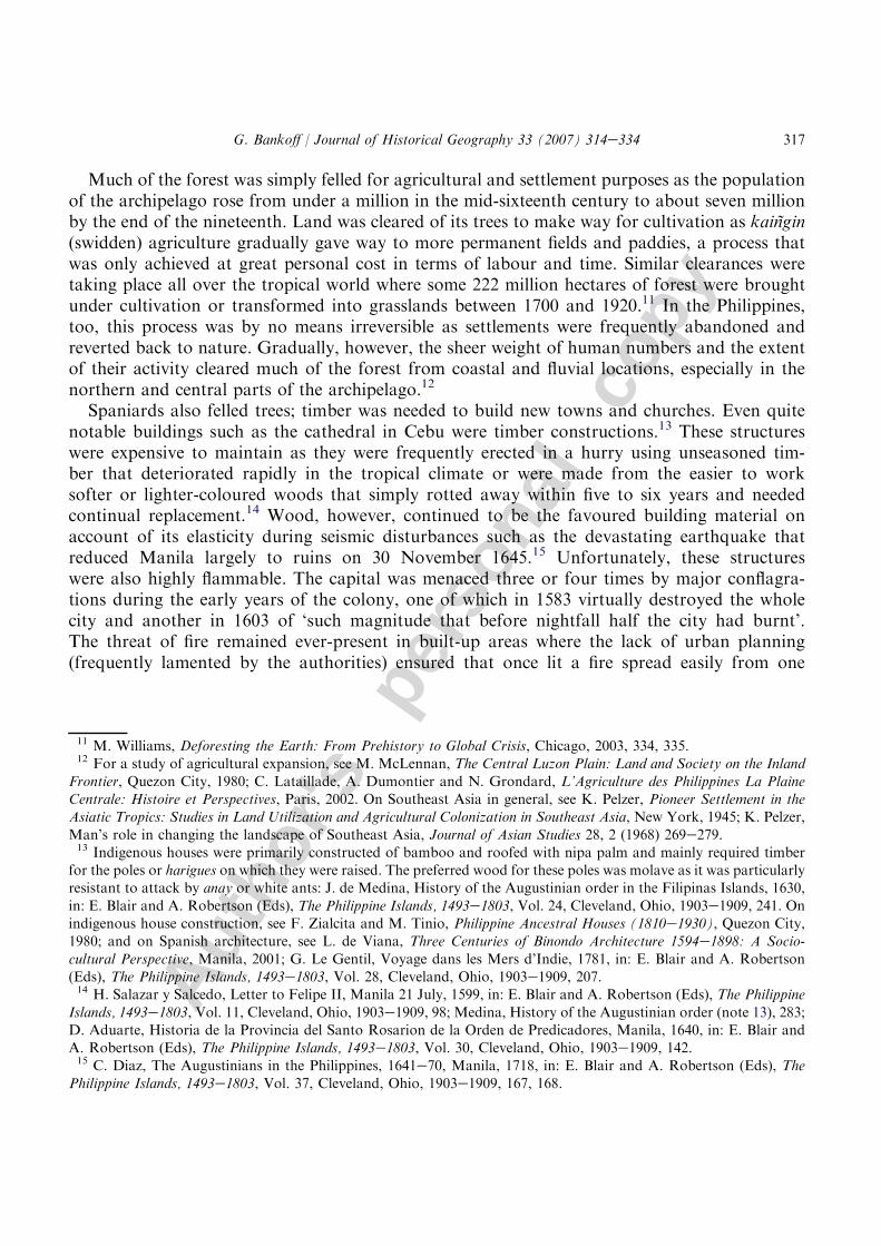
over two-thirds of its approximately 300,000 square kilometres. At the time of European contactin 1521, most of the landscape was covered in one of six types of forests. The principal family oftrees were dipterocarps, mainly large evergreens found on nearly all terrains from immediatelybehind the frontal beaches to altitudes of 800 m. They comprise a very varied number of speciesthat include valuable hardwoods such as amugis (Koordersiodendron pinnaturo), guijo (Shoreaguiso), kalumpit (Terminalia micocarpa) and yakal (Hopea malibato) as well as lesser qualityhardwoods like apitong (Dipterocarpus grandiflora), lauan (Shorea contorta) and tanguile (Shoreapolysperma). Next in significance was the molave forest composed of non-dipterocarp hardwoodssuch as balete (Ficus balete), ipil (Leucana leococephala), molave (Vitex parviflora) and narra(Pterocarpus indicus). These woods have been much sought after because of the hardness and du-rability of their timber and their suitability to shipbuilding, furniture and cabinet making. Theother forest types were more localised: mangrove on the mud flats at the mouth of rivers andalong the shoreline, beach forests (no longer extant) in coastal areas, pine forests in the uplandplateaus of northern and central Luzon and on Mindoro, and mossy-forests in the high mountainregions.6
Population density was low, under four persons per square kilometre, and there was no ev-idence of intensive land usage or extensive areas of human settlement.7 Spanish accounts werestruck both by the forest’s extent and its variety. Governor Miguel Lopez de Legazpi wrote toPhilip II soon after the establishment of the Spanish colony praising the ‘abundance of tim-ber’ to be found there, while others commented on the forest’s fecundity and the profusion of‘incorruptible woods’.8 While the discourse remains first and foremost one that celebrates thiswealth and plenitude throughout the seventeenth and eighteenth centuries, there are alreadyearly indications of localised deforestation, of mountains ‘almost everywhere destitute of for-ests’ and peaks ‘cleared and despoiled of trees’. There are complaints about the scarcity oftimber in Manila that suggest resources in the immediate surrounds of the capital were al-ready under some stress.9 Even the remarks that continue to extol the great stands of molaveor the extensive mountain forests tend to increasingly recede from the main centres of Spanishpower.10
6 H. Whitford, The Forests of the Philippines, Parts I and II, Manila, 1911, 17e32.7 L. Junker, Raiding, Trading, and Feasting: The Political Economy of Philippine Chiefdoms, Honolulu, 1999, 62.8 M. de Legazpi, Letter to Felipe II, Cebu, 26 June 1568, in: E. Blair and A. Robertson (Eds), The Philippine Islands,
1493e1803, Vol. 2, Cleveland, Ohio, 1903e1909, 242; M. de Legazpi, Relation of the Philippine Islands, Cebu, 7 July
1569, in: E. Blair and A. Robertson (Eds), The Philippine Islands, 1493e1803, Vol. 3, Cleveland, Ohio, 1903e1909, 225;A. de San Nicolas, L. de Jesus and J. de la Concepcion, General history of the discalced Augustinian Fathers, 1624,in: E. Blair and A. Robertson (Eds), The Philippine Islands, 1493e1803, Vol. 21, Cleveland, Ohio, 1903e1909, 197,
227.9 A. Quirante, Expedition to the mines of the Igorotes, Alingayen, 5 June 1624, in: E. Blair and A. Robertson (Eds),
The Philippine Islands, 1493e1803, Vol. 20, Cleveland, Ohio, 1903e1909, 267, 268; D. Perez, Relation of the Zambals,
1680, in: E. Blair and A. Robertson (Eds), The Philippine Islands, 1493e1803, Vol. 47, Cleveland, Ohio, 1903e1909,293.10 Perez, Relation of the Zambals (note 9), 292; P. Velasco, Later Augustinian and Dominican missions, Tondo, 16
April 1760, in: E. Blair and A. Robertson (Eds), The Philippine Islands, 1493e1803, Vol. 48, Cleveland, Ohio,1903e1909, 91.
316 G. Bankoff / Journal of Historical Geography 33 (2007) 314e334
Autho
r's
pers
onal
co
py
Much of the forest was simply felled for agricultural and settlement purposes as the populationof the archipelago rose from under a million in the mid-sixteenth century to about seven millionby the end of the nineteenth. Land was cleared of its trees to make way for cultivation as kaingin(swidden) agriculture gradually gave way to more permanent fields and paddies, a process thatwas only achieved at great personal cost in terms of labour and time. Similar clearances weretaking place all over the tropical world where some 222 million hectares of forest were broughtunder cultivation or transformed into grasslands between 1700 and 1920.11 In the Philippines,too, this process was by no means irreversible as settlements were frequently abandoned andreverted back to nature. Gradually, however, the sheer weight of human numbers and the extentof their activity cleared much of the forest from coastal and fluvial locations, especially in thenorthern and central parts of the archipelago.12
Spaniards also felled trees; timber was needed to build new towns and churches. Even quitenotable buildings such as the cathedral in Cebu were timber constructions.13 These structureswere expensive to maintain as they were frequently erected in a hurry using unseasoned tim-ber that deteriorated rapidly in the tropical climate or were made from the easier to worksofter or lighter-coloured woods that simply rotted away within five to six years and neededcontinual replacement.14 Wood, however, continued to be the favoured building material onaccount of its elasticity during seismic disturbances such as the devastating earthquake thatreduced Manila largely to ruins on 30 November 1645.15 Unfortunately, these structureswere also highly flammable. The capital was menaced three or four times by major conflagra-tions during the early years of the colony, one of which in 1583 virtually destroyed the wholecity and another in 1603 of ‘such magnitude that before nightfall half the city had burnt’.The threat of fire remained ever-present in built-up areas where the lack of urban planning(frequently lamented by the authorities) ensured that once lit a fire spread easily from one
11 M. Williams, Deforesting the Earth: From Prehistory to Global Crisis, Chicago, 2003, 334, 335.12 For a study of agricultural expansion, see M. McLennan, The Central Luzon Plain: Land and Society on the Inland
Frontier, Quezon City, 1980; C. Lataillade, A. Dumontier and N. Grondard, L’Agriculture des Philippines La PlaineCentrale: Histoire et Perspectives, Paris, 2002. On Southeast Asia in general, see K. Pelzer, Pioneer Settlement in theAsiatic Tropics: Studies in Land Utilization and Agricultural Colonization in Southeast Asia, New York, 1945; K. Pelzer,
Man’s role in changing the landscape of Southeast Asia, Journal of Asian Studies 28, 2 (1968) 269e279.13 Indigenous houses were primarily constructed of bamboo and roofed with nipa palm and mainly required timber
for the poles or harigues on which they were raised. The preferred wood for these poles was molave as it was particularlyresistant to attack by anay or white ants: J. de Medina, History of the Augustinian order in the Filipinas Islands, 1630,
in: E. Blair and A. Robertson (Eds), The Philippine Islands, 1493e1803, Vol. 24, Cleveland, Ohio, 1903e1909, 241. Onindigenous house construction, see F. Zialcita and M. Tinio, Philippine Ancestral Houses (1810e1930), Quezon City,1980; and on Spanish architecture, see L. de Viana, Three Centuries of Binondo Architecture 1594e1898: A Socio-
cultural Perspective, Manila, 2001; G. Le Gentil, Voyage dans les Mers d’Indie, 1781, in: E. Blair and A. Robertson(Eds), The Philippine Islands, 1493e1803, Vol. 28, Cleveland, Ohio, 1903e1909, 207.14 H. Salazar y Salcedo, Letter to Felipe II, Manila 21 July, 1599, in: E. Blair and A. Robertson (Eds), The Philippine
Islands, 1493e1803, Vol. 11, Cleveland, Ohio, 1903e1909, 98; Medina, History of the Augustinian order (note 13), 283;D. Aduarte, Historia de la Provincia del Santo Rosarion de la Orden de Predicadores, Manila, 1640, in: E. Blair andA. Robertson (Eds), The Philippine Islands, 1493e1803, Vol. 30, Cleveland, Ohio, 1903e1909, 142.15 C. Diaz, The Augustinians in the Philippines, 1641e70, Manila, 1718, in: E. Blair and A. Robertson (Eds), The
Philippine Islands, 1493e1803, Vol. 37, Cleveland, Ohio, 1903e1909, 167, 168.
317G. Bankoff / Journal of Historical Geography 33 (2007) 314e334
Autho
r's
pers
onal
co
py
dwelling to another.16 Even into the late nineteenth century: ‘One can say of the capital [and]of the provinces, that not a day passes without, unfortunately, a report of fires’.17 In thissense, Manila shared much in common (though not in scale) with that other great woodenconurbation, Tokugawa Edo, that was also subject to the twin hazards of fire andearthquake.18
Construction was not the only major demand upon timber resources as the Spanish neededships, lots of them, to defend their new possessions in the East. Maritime European powerswere continually on the look out for likely sources of ship’s timbers as domestic supplies dwin-dled. Teak (Tectona grandis), in particular, was specially valued for its extraordinary durabilityand for its resinous oil that protected vessels from fungal and animal attacks. While teak is notnative to the Philippines, early accounts of the islands were quick to appreciate the potential ofother timbers like molave for these purposes.19 Not only was there an ‘abundance of wood forall kinds of vessels’ but Filipinos proved to be ‘very skilful in making ships’. These were notjust smaller crafts and galleys but large ships as well. By 1616, six out of the seven galleons sta-tioned at Manila for its defence had been built in the islands.20 The amount of timber consumed innaval construction over the decades was substantial. Michael Williams estimates that a seven-teenth- or eighteenth-century European warship of 1000 tons required about 2000 mature oaktrees or the equivalent of timber from 16 to 20 hectares of woodland.21 In the Philippines, the
16 S. de Vera, Letter to Felipe II, Manila, 26 June, 1587, in: E. Blair and A. Robertson (Eds), The Philippine Islands,1493e1803, Vol. 6, Cleveland, Ohio, 1903e1909, 298; D. de Salazar, Letter to Felipe II, Manila 27 June, 1588,in: E. Blair and A. Robertson (Eds), The Philippine Islands, 1493e1803, Vol. 7, Cleveland, Ohio, 1903e1909, 66; Felipe
II, Decree ordering a grant to Domingo Salazar, Madrid 12 April, 1590, in: E. Blair and A. Robertson (Eds), The Phil-ippine Islands, 1493e1803, Vol. 7, Cleveland, Ohio, 1903e1909, 205; P. de Acuna, A. de Ribera, T. Almacan, A. deAlcaraz and M. de Madrid y Luna (1604), Letter to Felipe III, Manila, 30 June, 1604, in: E. Blair and A. Robertson(Eds), The Philippine Islands, 1493e1803, Vol. 12, Cleveland, Ohio, 1903e1909, 129; R.G. Fernandez, Manual del
Viajero en Filipinas, Manila, 1875, 173e178; X. Huetz de Lemps, Materiales ligeros vs. materiales fuertes; the conflictbetween nipa huts and stone buildings in 19th-century Manila, in: E. Ordonez (Ed.), The Philippine Revolution andBeyond, Vol. I, Manila, 170.17 El Comercio (30 April 1891). Accident or earthquake were not the only causes of fire; on arson, see G. Bankoff,
Crime, Society and the State in the Nineteenth Century Philippines, Quezon City, 1996, 73e75.18 W. Kelly, Incendiary actions: fires and firefighting in the Shogun’s capital and the people’s city, in: J. McClain,
J. Merriman and U. Kaoru (Eds), Edo and Paris: Urban Life and the State in the Early Modern Era, Ithaca and London,1994, 310e331; G. Clancey, Earthquake Nation: The Cultural Politics of Japanese Seismicity, 1868e1930, Berkeley, 2006.19 P. Boomgaard, Colonial policy in Java in transition 1865e1914, in: R. Cribb (Ed.), The Late Colonial State in
Indonesia: Political and Economic Foundations of the Netherlands Indies 1880e1942, Leiden, 1994, 117e138; Williams,
Deforesting the Earth (note 11), 348e350; Legazpi, Relation of the Philippine Islands (note 8), 59; A. de Mirandaola,Letter to Felipe II, 8 January, 1574, in: E. Blair and A. Robertson (Eds), The Philippine Islands, 1493e1803, Vol. 3,Cleveland, Ohio, 1903e1909, 225; F. de Sande, Relation of the Filipinas Islands, Manila, 7 June, 1576, in: E. Blair
and A. Robertson (Eds), The Philippine Islands, 1493e1803, Vol. 4, Cleveland, Ohio, 1903e1909, 59. Teak growsmainly on Java, and in Thailand and Burma.20 de Vera, Letter to Felipe II (note 16), 206; O. Corpuz, The Roots of the Filipino Nation, Vol. 1, Quezon City, 1989,
92, 93; S. de Pineda, Philippine ships and shipbuilding, Mexico, 1619, in: E. Blair and A. Robertson (Eds), ThePhilippine Islands, 1493e1803, Vol. 18, Cleveland, Ohio, 1903e1909, 180.21 Williams, Deforesting the Earth (note 11), 193. This figure may be overly conservative as Carla Phillips reaches
a similar figure of 25,900 codos (one codo¼ 56 cm) of wood equivalent to several thousand trees for a smaller vessel.C. Phillips, Six Galleons for the King of Spain: Imperial Defense in the Early Seventeenth Century, Baltimore, 1986, 80.
318 G. Bankoff / Journal of Historical Geography 33 (2007) 314e334
Autho
r's
pers
onal
co
py
scale of the endeavour can be partly estimated by the amount of labour required. Municipalitieshad to provide people to work in the shipyards or fell timber, the dreaded corte de madera. Themanpower required was immense: the masts of one galleon reputedly involved the efforts of sixthousand Filipinos for three months simply to transport them!22 So onerous were the labour ex-actions especially in the provinces closest to Manila that they were the cause of insurrections onmore than one occasion, with major revolts in 1614 and again in 1649.23
During the nineteenth century, state attempts to foster economic development and raise reve-nue through the promotion of agriculture led Spanish authorities to sell off what they regarded asunderutilised land, terrenos baldıos, literally barren or wastelands but actually mainly ‘state’ for-ests. A series of legislative measures was passed to facilitate their alienation and a forestry depart-ment, the second oldest in Southeast Asia, the Inspeccion general de Montes was created in 1863and charged with surveying each province and classifying which lands were best suited for culti-vation and which had better remain timbered for reasons of climate, health or hydrology.24 Cer-tainly, too, a timber market had emerged by mid-century. Wood for sale was primarilytransported by water to the capital as provincial markets remained relatively small and insignif-icant. Joseph Burzynski’s study of local shipping records for the period shows how what began asa fragmented, poorly ordered and inefficient trade in 1864 developed into a more coherent, betterstructured and increasingly specialised one by the late nineteenth century, a trade, moreover, in-creasingly synchronised and responsive to the forces of supply and demand.25
The stimulus for this market was the growth of Manila and, to a lesser extent, other urban cen-tres such as Cebu. The capital’s population tripled from 93,000 in 1814 to about 340,000 inhab-itants by 1896.26 The rapid urbanisation of the capital generated a strong demand for timber thatsoared in the aftermath of the great earthquakes that shook Manila in 1863 and again in 1880.Owners with substantial houses to repair turned to the market for the timber they required. Pricesrose and local merchants saw an opportunity to make substantial profits. Such was the devasta-tion in 1863, moreover, that it prompted a change in house design and the replacement of stone by
22 S. Pablo, Compulsory service by the Indians, 1620, in: E. Blair and A. Robertson (Eds), The Philippine Islands,
1493e1803, Vol. 19, Cleveland, Ohio, 1903e1909, 71e76; N. Cushner, Spain in the Philippines: From Conquest to Rev-olution, Quezon City, 1971, 117e126; H. de los Rios Coronel, Memorial y Relacion para su Magestad, Madrid, 1621,in: E. Blair and A. Robertson (Eds), The Philippine Islands, 1493e1803, Vol. 19, Cleveland, Ohio, 1903e1909, 203. The
manpower required seems excessive and probably refers to the total number of people involved over the three monthperiod.23 J. Vila, Condition of the Islands Manila, 7 October, 1701, in: E. Blair and A. Robertson (Eds), The Philippine
Islands, 1493e1803, Vol. 44, Cleveland, Ohio, 1903e1909, 126; Corpuz, The Roots of the Filipino Nation (note 20),
124e128.24 S. Vidal y Soler, Memoria sobre el Ramo de Montes en las Islas Filipinas, Madrid, 1874, 67, 68; R. Jordana y Mor-
era, Estudio Forestal acerca de la India Inglesa, Java y Flipinas, Madrid, 1891, 228, 242, 246. On the respective estab-
lishment of forestry services in Southeast Asia, see Potter, Forests versus agriculture (note 2).25 Vidal y Soler, Memoria sobre el Ramo de Montes (note 24), 32; J. Burzynski, The timber trade and the growth of
Manila, 1864e1881, Philippine Studies 50, 2 (2002) 171e180.26 J. Montero y Vidal, El Archipıelago Filipino y las Islas Marianas, Carolinas y Palaos: su Historia, Geografıa y
Estadıstica, Madrid, 1886, 157; J. Foreman, The Philippine Islands: A Political, Geographical, Ethnographical, Socialand Commercial History of the Philippine Archipelago and its Political Dependencies, Embracing the Whole Period of
Spanish Rule, New York, 1899, 355; B. Fenner, Cebu under the Spanish Flag, 1521e1896: An Economic-social History,Cebu, 1985, 130, 131; M. Foronda, Insigne y Siempre Leal: Essays on Spanish Manila, Manila, 1986, 135.
319G. Bankoff / Journal of Historical Geography 33 (2007) 314e334
Autho
r's
pers
onal
co
py
greater quantities of wood to give buildings extra flexibility to withstand seismic movements. Sogreat was the destruction on both these occasions that it proved a significant impetus to the timbermarket and encouraged the reckless felling of trees many of which were subsequently left to rot onmountain sides or beaches.27
A new commercialism begins to pervade attitudes and outlooks towards the forest in the secondhalf of the nineteenth century. On the one hand, the Indio (indigenous inhabitant) discovered hecould sell the timber he cut over what he needed for money. On the other hand, a new forest en-trepreneur appeared as a response to market forces, the contratista or timber contractor, himselfpart of a larger commercial class then emerging in the archipelago. As private demand exceededstate exactions for wood, it created a boom in licensed logging and a problem with illegal cuttingas profit constituted a powerful new force in forest destruction.28 The extent of this attitudinalchange is exemplified in an observation noted by one of the architects of Spanish forestry inthe Philippines, Sebastian Vidal y Soler. Previously old trees were revered as sacred and a personwould ask pardon before felling one. By the second half of the century, however, Vidal y Solerrecounts how: ‘it is a common enough opinion that the climatic conditions of the Archipelago im-prove at the same rate as the forest diminishes, and there is no lack of those [here] who see the treeas the enemy of man’.29
The American occupation of the archipelago in 1899 was effected through warfare that was of-ficially declared over in 1902 but actually continued until 1907. Undoubtedly some woodland wasdamaged during the fighting and more as a result of military policies that involved the destructionof crops and the concentration of populations but there appears not to have been any appreciableloss of forest cover due to campaigning.30 The ensuing four decades of American colonial admin-istration witnessed the implementation of many of the reforms and changes in forestry practicethat had long been advocated by Spanish forestry experts and led to a steady increase in theamount of timber cut especially in the decades following World War One.
The new U.S. administration soon became aware of the state of many of the islands’ forests.George Ahern, appointed first director of the Bureau of Forestry in 1900, noted how in the prov-inces round Manila ‘much timber has been cut’ and that ‘lumbermen are obliged to go quite a dis-tance from this city in order to find a suitable tract’. Dean Worcester, who rarely missed anopportunity to condemn the shortcomings of Spanish colonialism, noted the ‘incalculable dam-age’ already done: ‘The great island of Cebu is practically deforested and extensive areas on otherislands have suffered a similar fate with the result that in those regions firewood is scarce and dear,structural timber is almost unobtainable.and the run-off of surface water after rainfall is
27 Zialcita and Tinio, Philippine Ancestral Houses (note 13), 66, 67; Jordana y Morera, Estudio Forestal (note 24), 252,
253.28 Bankoff, ‘The tree as the enemy of man’ (note 5); E. Wickberg, The Chinese in Philippine Life 1850e1898, New
Haven and London, 1965, 104; Jordana y Morera, Estudio Forestal (note 24), 231, 275, 278.29 F. Colin, Labor Evangelica, 1663, in: E. Blair and A. Robertson (Eds), The Philippine Islands, 1493e1803, Vol. 40,
Cleveland, Ohio, 1903e1909, 70; T. Ortiz, Practica del Ministerio, 1731, in: E. Blair and A. Robertson (Eds), The Phil-ippine Islands, 1493e1803, Vol. 43, Cleveland, Ohio, 1903e1909, 105; Vidal y Soler, Memoria sobre el Ramo de Montes
(note 24), 37, 108.30 G. May, Battle for Batangas: A Philippine Province at War, New Haven and London, 1991, 177, 255, 256, 264, 265.
320 G. Bankoff / Journal of Historical Geography 33 (2007) 314e334

Autho
r's
pers
onal
co
py
altogether too rapid’.31 The previous regime was largely blamed for this deplorable state of affairs,one that had apparently continued despite recent political developments. Gifford Pinchot who vis-ited the archipelago in 1902 wrote how ‘lumbering in the islands has not changed in charactersince the Spanish administration and is still destructive to the forest’.32
By the turn of the twentieth century, Americans were fast exhausting even their own prolificdomestic timber reserves: per capita use reached 525 board-feet (1.24 m3) in 1906, an amountnot equalled then or since and total U.S. consumption of all wood products peaked the followingyear at 13.38 billion cubic feet (31.6 million m3). Forecasters and foresters alike talked with ur-gency of an impending crisis, a timber famine.33 Americans looked at their new colonial possessionwith such thoughts in mind and were suitably impressed by the amount of primary forest still leftto be commercially exploited. ‘The Philippine forests’, wrote Worcester on another occasion, was‘like money in the bank’. He went on to extol the myriad uses that the different types of timberand non-timber products could be used for in an article appropriately entitled Philippine ForestWealth. Molave and the other strong hardwoods when properly seasoned were virtually resistantto time and white ant, numerous other timbers produced handsome and durable finishes or madedesirable cabinet woods, palma brava produced fine fishing rods, the use of bamboo was ubiqui-tous and dye woods were to be had in abundance. There were good stands of gutta-percha, a pro-fusion of valuable gums and resins, extensive mangroves suitable for firewood, and tan bark linedthe shore for long distances. Even the forest nuts were commercially valuable in the production ofpaint and varnish or simply just to eat.34 A ceaseless flow of publications detailing the usefulnessof Philippine timber for every conceivable eventuality was a hallmark of the early decades of theAmerican period.35
31 G. Ahern, Compilation of Notes on the Most Important Timber Tree Species of the Philippine Islands, Manila, 1901,11; D. Worcester, Philippine forest wealth, American Forestry 21, 1 (1915) 5. Deforestation of the islands of Cebu and
Bohol was very extensive with as little as 6.6 or 11 per cent tree cover remaining in 1875. S. Vidal y Soler,Memoria de laColeccion de Productos Forestales Presentada por la Inspeccion General de Montes de Filipinas en la Exposicion Universalde Filadelfia, Manila, 1875, 39; E. Schneider, Commercial Woods of the Philippines: Their Preparation and Uses, Manila,
1916, 11. Fenner blames the wholesale felling of trees on ship, home and warehouse construction. Fenner, Cebu underthe Spanish Flag (note 26). More recently, farm abandonment has led to the unexpected re-growth of secondary andshrub forest on Cebu. D. Kummer, R. Concepcion and B. Canizares, Image and reality: exploring the puzzle of ‘con-
tinuing’ environmental degradation in the uplands of Cebu, The Philippines, Philippine Quarterly of Culture and Society31 (2003) 135e155.32 Report of the Forestry Bureau of the Philippine Islands, 1903, in: Fourth Annual Report of the Philippine Commis-
sion, Washington, 1904, 315. Pinchot was chief of the Division (later Bureau) of Forestry of the US Department of
Agriculture who visited the Philippines for three months in 1902 to draft what later became the Forestry OrganicLaw in 1904. He was particularly scathing of the Philippine Lumber and Development company operations on Mind-anao which he described as leading to ‘erosion of the most serious character on a surface so steep as to be totally unfit
for agriculture’ G. Pinchot, Breaking New Ground, Washington, DC and Covelo, California, 1998 (originally publishedin 1947), 226.33 Williams, Deforesting the Earth (note 11), 386e395.34 D. Worcester, The Philippines Past and Present, Vol. 2, London, 1914, 847; Worcester, Philippine forest wealth
(note 31), 1, 2.35 Ahern, Compilation of Notes (note 31); H. Miller, Commercial Geography: The Materials of Commerce for the
Philippines, Manila, 1911, 97e105; Whitford, The Forests of the Philippines (note 6); Schneider, Commercial Woodsof the Philippines (note 31).
321G. Bankoff / Journal of Historical Geography 33 (2007) 314e334
Autho
r's
pers
onal
co
py
More important, however, than the extent of the remaining forest coverage was its accessibility.No point in the islands was more than 50 to 75 miles distant from tidewater and the topographywas ‘rarely such as to present insuperable obstacles to the construction of railways’. The periodfrom the turn of the century to World War Two witnessed an enormous expansion of commerciallogging around the archipelago that did not so much begin with the Americans as developed intoa major export industry with markets mainly in the U.S.A., Japan, China and Europe.36 Toachieve these ends, logging operations were modernised with the logging engine and railwaylargely replacing the axe and carabao.37 The number of sawmills expanded from eight in 1916to 115 by 1936 and their annual log scale from 178,985 to 1,913,450 cubic metres over thesame period. Total annual lumber production rose from 94,000 to 2,500,000 cubic metres between1901 and 1940. In particular, the volume of timber cut from lesser quality dipterocarp hardwoods(such as apitong, lauan and tanguile) rose by over a thousand per cent while demand for non-dip-terocarp hardwoods (like ipil, molave or narra) remained constant or increased slightly.38 A rap-idly expanding population, moreover, sought new agricultural lands that were literally cut out ofthe forest with or without official consent, especially after the establishment of internal self-ruleduring the Commonwealth period (1935e1941).39
The Japanese, too, were determined to make full use of the archipelago’s forest resources dur-ing their brief administration of the archipelago between 1941 and 1945. Like the Americans, theywere not only interested in wood but also in non-timber products such as rattan, resins, gums,tannin, oils and medicinal plants. In the event, however, timber production during the occupationwas low, only a fraction of its pre-war levels despite the strenuous exertions made by Japaneseofficials to the contrary. Carlos Sulit estimates that monthly production averaged only about8255 cubic metres between 1942 and 1945 when the equivalent figures were 183,962 in 1941and 17,925 in the fiscal year immediately following liberation. The reasons for this extraordinarilypoor performance were blamed on a combination of factors that included the damage sustainedby mills and the difficulties they experienced in procuring spare parts, the progressive shortage ofcarabaos due to the indiscriminate slaughter of animals, the activities of guerrilla fighters thatconfined logging operations to only the most accessible forests, the unrealistically low scheduleof timber prices fixed by the Japanese that discouraged production, and the general apathy ofFilipinos for the occupation regime despite the nominal granting of independence under JoseLaurel on 14 October 1943.40
36 Schneider, Commercial Woods of the Philippines (note 31), 11; Bankoff, ‘The tree as the enemy of man’ (note 5).37 T. Collins, Testimony of Thomas Collins to the Philippine Commission, 12 May 1899, in: Report of the Philippine
Commission to the President, Vol. 2, Washington, 1901, 82; Schneider, Commercial Woods of the Philippines (note 31);R. Tucker, Insatiable Appetite: The United States and the Ecological Degradation of the Tropical World, Berkeley, Los
Angeles and London, 2000, 367e386; Potter, Forests versus agriculture (note 2), 53e57.38 Annual Report of the Director of Forestry of the Philippine Islands, 1924, Manila, 1925, 64; Annual Report of the
Director of Forestry of the Philippine Islands, 1936, Manila, 1937, 87, 88, 238, 239; F. Tamesis, Philippine forests
and forestry, Unasylva 2, 6 (1948) 320.39 T. Severo, F. Asiddao and M. Reyes, Forest resources inventory in the Philippines, Philippine Journal of Forestry
18, 1e4 (1962) 3; Williams, Deforesting the Earth (note 11), 370.40 C. Sulit, Forestry in the Philippines during the Japanese occupation, Philippine Journal of Forestry 5, 1 (1947) 35,
38, 39.
322 G. Bankoff / Journal of Historical Geography 33 (2007) 314e334
Autho
r's
pers
onal
co
py
The damage to the archipelago’s forests, however, far exceeded any level of destruction sug-gested by these production figures or by the unknown amount of timber sold on the black marketand cut in areas controlled by guerrilla forces. In the first place, the Japanese invasion precipitateda food shortage in the Philippines. Not self-sufficient in the pre-war period, the sudden halt to riceimports and fish products was already a problem by 1943 and matters only became worse the fol-lowing year as drought exacerbated the situation, especially in the cities. Attempts to increasefood production by permitting the cultivation of all ‘idle’ public and private lands led to an un-regulated explosion of swidden agriculture and to the clearance of many forest areas.41 Alwaysa practice decried by forestry officials since Spanish times, the areas affected by kaingin expandedrapidly as many people took refuge in mountainous regions.42 So great was the demand and sochronic the shortage for timber that trees in national parks and forest reserves were felled allover the islands resulting in extensive destruction of forest habitats. Forests, too, were also thescene of intense fighting, first in the defence of Bataan and Corregidor in early 1942 and then fol-lowing the return of American forces in October 1944. The sheer scale of the destruction and therandom indiscriminateness of the damage inflicted on the forest separate the Japanese occupationfrom all previous wartime experiences in the Philippines.43
Forest cover 1565e1946
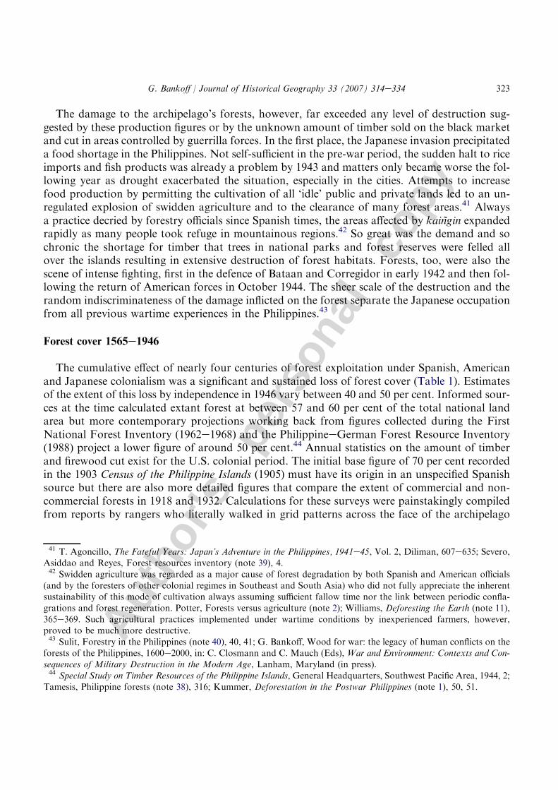
The cumulative effect of nearly four centuries of forest exploitation under Spanish, Americanand Japanese colonialism was a significant and sustained loss of forest cover (Table 1). Estimatesof the extent of this loss by independence in 1946 vary between 40 and 50 per cent. Informed sour-ces at the time calculated extant forest at between 57 and 60 per cent of the total national landarea but more contemporary projections working back from figures collected during the FirstNational Forest Inventory (1962e1968) and the PhilippineeGerman Forest Resource Inventory(1988) project a lower figure of around 50 per cent.44 Annual statistics on the amount of timberand firewood cut exist for the U.S. colonial period. The initial base figure of 70 per cent recordedin the 1903 Census of the Philippine Islands (1905) must have its origin in an unspecified Spanishsource but there are also more detailed figures that compare the extent of commercial and non-commercial forests in 1918 and 1932. Calculations for these surveys were painstakingly compiledfrom reports by rangers who literally walked in grid patterns across the face of the archipelago
41 T. Agoncillo, The Fateful Years: Japan’s Adventure in the Philippines, 1941e45, Vol. 2, Diliman, 607e635; Severo,Asiddao and Reyes, Forest resources inventory (note 39), 4.42 Swidden agriculture was regarded as a major cause of forest degradation by both Spanish and American officials
(and by the foresters of other colonial regimes in Southeast and South Asia) who did not fully appreciate the inherentsustainability of this mode of cultivation always assuming sufficient fallow time nor the link between periodic confla-
grations and forest regeneration. Potter, Forests versus agriculture (note 2); Williams, Deforesting the Earth (note 11),365e369. Such agricultural practices implemented under wartime conditions by inexperienced farmers, however,proved to be much more destructive.43 Sulit, Forestry in the Philippines (note 40), 40, 41; G. Bankoff, Wood for war: the legacy of human conflicts on the
forests of the Philippines, 1600e2000, in: C. Closmann and C. Mauch (Eds), War and Environment: Contexts and Con-sequences of Military Destruction in the Modern Age, Lanham, Maryland (in press).44 Special Study on Timber Resources of the Philippine Islands, General Headquarters, Southwest Pacific Area, 1944, 2;
Tamesis, Philippine forests (note 38), 316; Kummer, Deforestation in the Postwar Philippines (note 1), 50, 51.
323G. Bankoff / Journal of Historical Geography 33 (2007) 314e334
Autho
r's
pers
onal
co
pyand are as accurate as the process allowed for at the time. These same American reports have hith-erto been the only source for the unreconciled estimates on forestry during the late Spanish periodthat variously reckon forest cover at 65 per cent in 1890 and 70 per cent in 1903.45
In fact, much more elaborate figures do exist at least for the second half of the nineteenth cen-tury from which it is possible to reconstruct a clearer indication of the state of forest cover acrossthe archipelago. An attempt at systematically describing the provinces is first provided by RamonJordana y Morera’s Memoria sobre la Produccion de los Montes Publicos de Filipinas for1871e1872. Already largely deforested were the areas around Manila including Bataan, Cavite,Morong and the Isla de Corregidor (Fig. 1). Abra and Laguna, too, had lost much of their coverwhile Cebu and Bohol were largely denuded. The main timber producing areas at the time wereBulacan, Masbate/Ticao, Mindoro, Nueva Ecija, Pampanga, Romblon, Zambales and especiallyTayabas. Agriculture was encroaching upon the woodlands of Batangas, Isabela, Panay and theIlocos region. Usage was still mainly for local purposes in Camarines, La Union, Pangasinan,Lepanto, Tiagan and the Isla de Balabac. Primary forest was to be found only in central Luzon(Cagayan, Infanta and Nueva Vizcaya), parts of the Visayas (Siquijor, Negros, Samar and Leyte)and some of the smaller districts and island chains. The potential of Mindanao remained largelyunexplored.46 Accordingly, this report suggests that considerable areas of Luzon were deforestedprior to the twentieth century.
Table 1Forest cover and population 1565e1950 (based on the territorial extent of the present nation state)
Year Forest cover (ha.) Per cent cover Population
1565 27,500,000a 92 800,000b
1875 19,405,915c 70 6,173,632d
1903 20,740,720e 70 7,635,426f
1918 18,819,281f 64 10,314,310f
1932 16,950,873f 57 13,636,350f
1950 14,814,800g 50 20,275,000h
a Ibon, The State of the Philippine Environment, Manila, 2000, 2.b Junker, Raiding, Trading, and Feasting (note 7); a higher figure of 1,250,000 is given in Corpuz, The Roots of the
Filipino Nation (note 20), 29.c Vidal y Soler, Memoria de la Coleccion de Productos Forestales (note 31), 40.d Montero y Vidal, El Archipıelago Filipino (note 26), 156e160 data for 1877.e Census of the Philippine Islands (note 45).f Annual Report of the Director of Forestry of the Philippine Islands, 1932 (note 45), 676, 732e737.g Kummer, Measuring forest decline in the Philippines (note 3), 187.h J. Lahmeyer, Population Statistics. The Philippines: Historical Demographical Data of the Whole Country, 2003,
http://www.library.uu.nl/wesp/populstat/Asia/philippc.htm.
45 Annual Report of the Director of Forestry of the Philippine Islands, 1932, Manila, 1933, 732e737; Annual Report ofthe Philippine Bureau of Forestry, Manila, 1902; Census of the Philippine Islands, 1903, Vol. 1, Washington, 1905, 77.46 R. Jordana y Morera, Memoria sobre la produccion de los montes publicos de Filipinas en el ano economico de
1871e72, Boletin Oficial del Ministerio de Ultramar (27 November 1873) 6e9, (12 December 1873) 1e6, (27 December1873) 1e10, (12 January 1874) 1e10.
324 G. Bankoff / Journal of Historical Geography 33 (2007) 314e334
Autho
r's
pers
onal
co
py
Such a qualitative impression is only reinforced by the more descriptive account provided inSebastian Vidal y Soler’s Memoria sobre el Ramo de Montes that records how the destructionof the forest wrought by ‘axe and fire has no moment of repose’. He elaborated on the natureof timber extraction in the provinces of Tayabas and Nueva Ecija, the lost forest cover of Batan-gas, Cavite, the greater part of Bataan and nearly all the mountain sides of the Pacific west coast,and concluded that the ‘myth’ of an archipelago covered in an inexhaustible mantle of tropicalforest ‘could not be further from the truth’. Trees were cleared to make way for agriculture,used in construction and industry (especially cigar boxes), and destroyed by resin gatherers andcharcoal manufacturers. There was even the first stirring of a commercial export market, mainlyto China, equivalent in some years to 40 per cent of total timber sales in Manila.47 A pattern ofexploitation based on concentric circles of exploitation radiating out principally from Manila wasalready well established.
It is in the second half of the nineteenth century that the first tentative quantitative figureson forest cover and so the first estimation of the rate of deforestation can be calculated. Adetailed provincial breakdown of forest cover compiled by the Inspeccion de Montes waspublished in 1875 under the title Memoria de la Coleccion de Productos Forestales on the oc-casion of the Philadelphia Universal Exposition. For a start, this survey gauges the land sur-face of the Philippines at 27,732,995 hectares, a figure much closer to the actual one ofapproximately 30,000,000 hectares used in modern calculations and a distinct improvementon the previous estimates utilised by Paul de la Gironiere and Padre Manuel Buzeta. Basedon this surface area, the survey estimates that 19,405,915 or 70 per cent of the islands werestill forested. What the data make clear, however, is the extent of the loss that had occurredin central Luzon and the Visayas whose forests had already been reduced by as much ashalf.48 Such figures better corroborate the previously cited qualitative descriptions by contem-porary sources. A comparison of this 1875 data with that of 1918 and 1932 then permits in-sight into the relative loss of forest by region over the next half century or so (Table 2). Theexploitation of central Luzon and the Visayas continued apace, reduced to 36 and 40 percent, respectively, while the main focus of activity had shifted to the forests of northernand especially southern Luzon (Fig. 1). Of course, the reliability of these figures, especiallythe 1875 ones, must always cast doubt over such data but the consistency with which theyreflect general forest decline, with the understandable exception of the largely unexploredMindanao, is striking.
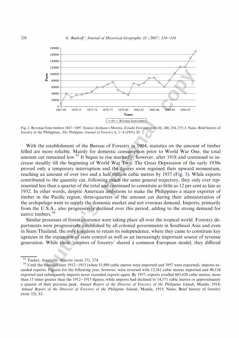
Unfortunately, more detailed data on the rate of further deforestation during the last quartercentury of Spanish administration have not yet been discovered but something of its scale is sug-gested by the amount of revenue collected by the forestry department on all cut timber. Whilea poor substitute for statistics on actual forest clearance, as such figures might increase for anynumber of reasons that have little to do with the rate of deforestation, they do nevertheless
47 Vidal y Soler, Memoria sobre el Ramo de Montes (note 24), 8, 11, 12, 27e29.48 Vidal y Soler, Memoria de la Coleccion de Productos Forestales (note 31). Gironiere and Buzeta calculated the sur-
face area of the archipelago at 24,000,000 hectares. P. Gironiere, Twenty Years in the Philippines, London, 1853;
M. Buzeta, Diccionario Geografico, Estadıstico, Historico de las Islas Filipinas, Madrid, 1850. The figure used in the1932 U.S. comparison is 29,629,600 hectares.
325G. Bankoff / Journal of Historical Geography 33 (2007) 314e334
Autho
r's
pers
onal
co
py
suggest an accelerating pace of operations. Revenue rose from a meagre 7624 pesos in 1867e1868to 170,000 pesos by 1896e1897 (Fig. 2). Some idea of the extent of non-commercial felling is sug-gested by the annual value of untaxed timber, that is wood ostensibly cut for people’s own usage.This was assessed at 300,000 pesos or 180 per cent greater than the total revenue generated by theInspeccion general de Montes in the financial year of 1896e1997.50
The figure cited in the Census of 1903 that estimates forest cover at 70 per cent, that is the samepercentage as estimated for 1875 before the surge in forest clearance during the late nineteenthcentury, seems unduly optimistic.51 The real extent of cover is probably closer to the 65 percent figure quoted in the Annual Report of the Bureau of Forestry for 1902 as modern loggingoperations really only intensified in the aftermath of World War One. Still, the Americans foundsubstantial stands of timber virtually untouched to marvel over. Primary evergreen forest coverwas estimated at over 10,000,000 hectares and could still be found on all the main islands ofthe archipelago except Cebu and Bohol. Nearly a further five million hectares were classified assecondary-growth forests. Mindanao with its 8,094,000 hectares (20 million acres), Mindoroand Palawan (Paragua) with 2,023,000 (five million) and the province of Cagayan with 809,400(two million) were singled out for their timber resources. On an early visit south, Ahern hadbeen impressed by trees standing 150 feet tall, with trunks clear of branches for upwards of80 feet and estimated that there was more than 10,000 cubic feet (283.2 cubic metres) of ‘magnif-icent timber’ per acre (700 cubic metres per hectare).52
Table 2Forest cover by region 1875e1932
Region 1875 1918 1932
Hectares Per cent Hectares Per cent Hectares Per cent
N. Luzon 4,368,000 76 3,496,060 62 2,867,962 51
C. Luzon 1,875,315 55 1,743,499 45 1,390,359 36
S. Luzon 2,338,200 72 1,694,734 57 1,153,627 39
Visayas 3,299,600 55 2,640,361 48 2,230,259 40
Mindanao 8,400,932 81 9,745,123 84 9,309,171 80
Total 19,405,915 70 18,819,281 64 16,950,873 57
Sources: Vidal y Soler, Memoria de la Coleccion de Productos Forestales (note 31); Annual Report of the Director of For-
estry of the Philippine Islands, 1932 (note 45). Note: North Luzon comprises Abra, Apayao, Batanes, Benguet and Ba-guio, Bontoc, Cagayan, Ifugao, Ilocos Norte, Ilocos Sur, Isabela, Kalinga, La Union, Nueva Ecija and Nueva Vizcaya;Central Luzon comprises Bataan, Batangas, Bulacan, Cavite, Laguna, Pampanga, Pangasinan, Rizal and Manila, Tar-
lac, Tayabas and Zambales; South Luzon comprises Albay, Camarines Norte, Camarine Sur, Catanduanes, Marindu-que, Romblon and Sorsogon; Visayas comprises Antique, Bohol, Capiz, Cebu, Leyte, Negros Occidental, NegrosOriental, Samar and Siquijor; and Mindanao comprises Agusan, Bukidnon, Cotabato, Davao, Lanao, Misamis Occi-dental, Misamis Oriental, Palawan (Paragua), Sulu, Surigao and Zamboanga.
50 Jordana y Morera, Estudio Forestal (note 24), 275, 278.51 Census of the Philippine Islands (note 45).52 Miller, Commercial Geography (note 35), 97; Schneider, Commercial Woods of the Philippines (note 31); G. Ahern,
The lesson of forestry in the Philippine Islands, in: Proceedings of the Second American Scientific Congress, Vol. 3,Washington, 1917, 492. In fact, the total land area of Mindanao was underestimated by nearly 15 per cent.
326 G. Bankoff / Journal of Historical Geography 33 (2007) 314e334

Autho
r's
pers
onal
co
py
Fig. 1. Philippines forest cover, 1908.
327G. Bankoff / Journal of Historical Geography 33 (2007) 314e334
Autho
r's
pers
onal
co
py
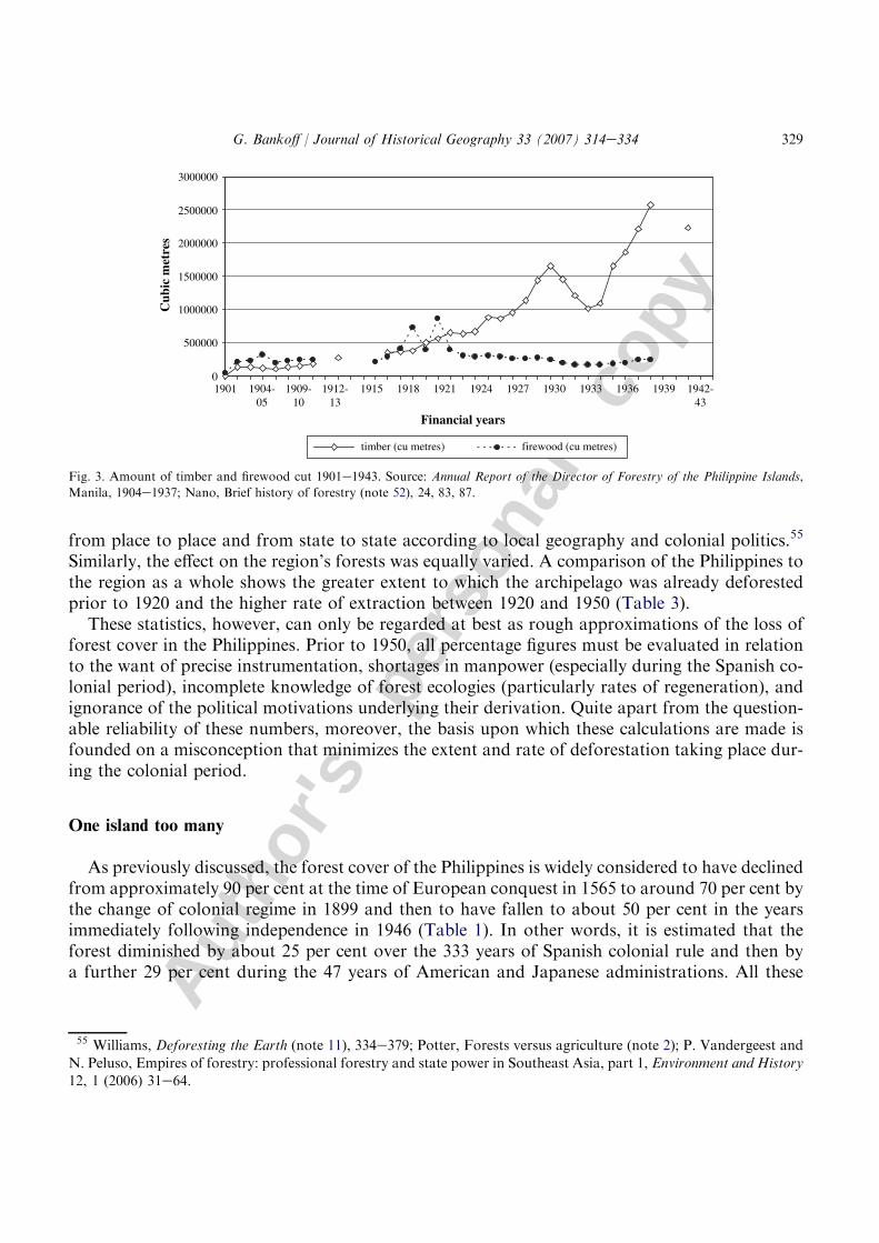
With the establishment of the Bureau of Forestry in 1904, statistics on the amount of timberfelled are more reliable. Mainly for domestic consumption prior to World War One, the totalamount cut remained low.53 It began to rise markedly, however, after 1918 and continued to in-crease steadily till the beginning of World War Two. The Great Depression of the early 1930sproved only a temporary interruption and the figures soon regained their upward momentum,reaching an amount of over two and a half million cubic metres by 1937 (Fig. 3). While exportscontributed to the quantity cut, following much the same general trajectory, they only ever rep-resented less than a quarter of the total and continued to constitute as little as 12 per cent as late as1932. In other words, despite American ambitions to make the Philippines a major exporter oftimber in the Pacific region, three-quarters of the amount cut during their administration ofthe archipelago went to supply the domestic market and not overseas demand. Imports, primarilyfrom the U.S.A., also progressively declined over this period, adding to the strong demand fornative timbers.54
Similar processes of forest clearance were taking place all over the tropical world. Forestry de-partments were progressively established by all colonial governments in Southeast Asia and evenin Siam/Thailand, the only kingdom to retain its independence, where they came to constitute keyagencies in the expansion of state control as well as an increasingly important source of revenuegeneration. While these ‘empires of forestry’ shared a common European model, they differed
0
20000
40000
60000
80000
100000
120000
140000
160000
180000
1867-68 1870-71 1873-74 1876-77 1879-80 1882-83 1885-86 1888-89 1894-95
Years
Pes
os
Revenue from timber
Fig. 2. Revenue from timbers 1867e1897. Source: Jordana y Morera, Estudio Forestal (note 24), 240, 254, 275; J. Nano, Brief history of
forestry in the Philippines, The Philippine Journal of Forestry 8, 1e4 (1951) 20.
53 Tucker, Insatiable Appetite (note 37), 374.54 Until the financial year 1912e1913 (when 53,989 cubic metres were imported and 3957 were exported), imports ex-
ceeded exports. Figures for the following year, however, were reversed with 12,261 cubic metres imported and 40,154
exported and subsequently imports never exceeded exports again. By 1937, exports totalled 603,620 cubic metres, morethan 15 times greater than the 1912e1913 figures, while imports had declined to 14,571 cubic metres or approximatelya quarter of their previous peak. Annual Report of the Director of Forestry of the Philippine Islands, Manila, 1914;
Annual Report of the Director of Forestry of the Philippine Islands, Manila, 1915; Nano, Brief history of forestry(note 52), 83.
328 G. Bankoff / Journal of Historical Geography 33 (2007) 314e334
Autho
r's
pers
onal
co
py
from place to place and from state to state according to local geography and colonial politics.55
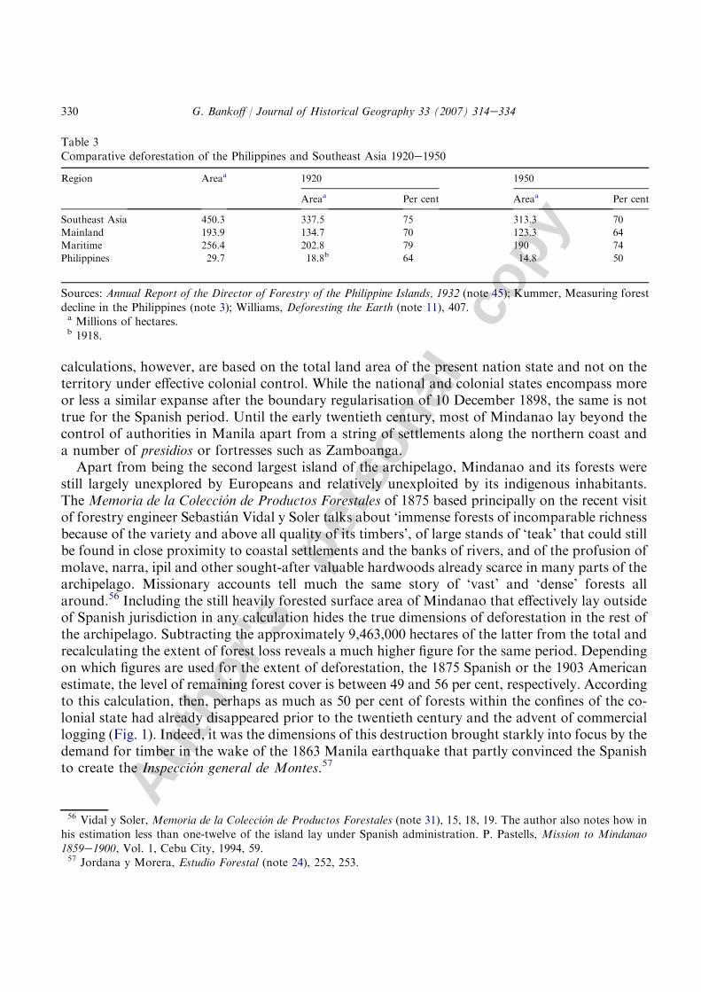
Similarly, the effect on the region’s forests was equally varied. A comparison of the Philippines tothe region as a whole shows the greater extent to which the archipelago was already deforestedprior to 1920 and the higher rate of extraction between 1920 and 1950 (Table 3).
These statistics, however, can only be regarded at best as rough approximations of the loss offorest cover in the Philippines. Prior to 1950, all percentage figures must be evaluated in relationto the want of precise instrumentation, shortages in manpower (especially during the Spanish co-lonial period), incomplete knowledge of forest ecologies (particularly rates of regeneration), andignorance of the political motivations underlying their derivation. Quite apart from the question-able reliability of these numbers, moreover, the basis upon which these calculations are made isfounded on a misconception that minimizes the extent and rate of deforestation taking place dur-ing the colonial period.
One island too many
As previously discussed, the forest cover of the Philippines is widely considered to have declinedfrom approximately 90 per cent at the time of European conquest in 1565 to around 70 per cent bythe change of colonial regime in 1899 and then to have fallen to about 50 per cent in the yearsimmediately following independence in 1946 (Table 1). In other words, it is estimated that theforest diminished by about 25 per cent over the 333 years of Spanish colonial rule and then bya further 29 per cent during the 47 years of American and Japanese administrations. All these
0
500000
1000000
1500000
2000000
2500000
3000000
1901 1904-05
1909-10
1912-13
1915 1918 1921 1924 1927 1930 1933 1936 1939 1942-43
Financial years
Cub
ic m
etre
s
timber (cu metres) firewood (cu metres)
Fig. 3. Amount of timber and firewood cut 1901e1943. Source: Annual Report of the Director of Forestry of the Philippine Islands,
Manila, 1904e1937; Nano, Brief history of forestry (note 52), 24, 83, 87.
55 Williams, Deforesting the Earth (note 11), 334e379; Potter, Forests versus agriculture (note 2); P. Vandergeest and
N. Peluso, Empires of forestry: professional forestry and state power in Southeast Asia, part 1, Environment and History12, 1 (2006) 31e64.
329G. Bankoff / Journal of Historical Geography 33 (2007) 314e334
Autho
r's
pers
onal
co
py
calculations, however, are based on the total land area of the present nation state and not on theterritory under effective colonial control. While the national and colonial states encompass moreor less a similar expanse after the boundary regularisation of 10 December 1898, the same is nottrue for the Spanish period. Until the early twentieth century, most of Mindanao lay beyond thecontrol of authorities in Manila apart from a string of settlements along the northern coast anda number of presidios or fortresses such as Zamboanga.
Apart from being the second largest island of the archipelago, Mindanao and its forests werestill largely unexplored by Europeans and relatively unexploited by its indigenous inhabitants.The Memoria de la Coleccion de Productos Forestales of 1875 based principally on the recent visitof forestry engineer Sebastian Vidal y Soler talks about ‘immense forests of incomparable richnessbecause of the variety and above all quality of its timbers’, of large stands of ‘teak’ that could stillbe found in close proximity to coastal settlements and the banks of rivers, and of the profusion ofmolave, narra, ipil and other sought-after valuable hardwoods already scarce in many parts of thearchipelago. Missionary accounts tell much the same story of ‘vast’ and ‘dense’ forests allaround.56 Including the still heavily forested surface area of Mindanao that effectively lay outsideof Spanish jurisdiction in any calculation hides the true dimensions of deforestation in the rest ofthe archipelago. Subtracting the approximately 9,463,000 hectares of the latter from the total andrecalculating the extent of forest loss reveals a much higher figure for the same period. Dependingon which figures are used for the extent of deforestation, the 1875 Spanish or the 1903 Americanestimate, the level of remaining forest cover is between 49 and 56 per cent, respectively. Accordingto this calculation, then, perhaps as much as 50 per cent of forests within the confines of the co-lonial state had already disappeared prior to the twentieth century and the advent of commerciallogging (Fig. 1). Indeed, it was the dimensions of this destruction brought starkly into focus by thedemand for timber in the wake of the 1863 Manila earthquake that partly convinced the Spanishto create the Inspeccion general de Montes.57
Table 3Comparative deforestation of the Philippines and Southeast Asia 1920e1950
Region Areaa 1920 1950
Areaa Per cent Areaa Per cent
Southeast Asia 450.3 337.5 75 313.3 70
Mainland 193.9 134.7 70 123.3 64
Maritime 256.4 202.8 79 190 74
Philippines 29.7 18.8b 64 14.8 50
Sources: Annual Report of the Director of Forestry of the Philippine Islands, 1932 (note 45); Kummer, Measuring forestdecline in the Philippines (note 3); Williams, Deforesting the Earth (note 11), 407.a Millions of hectares.b 1918.
56 Vidal y Soler, Memoria de la Coleccion de Productos Forestales (note 31), 15, 18, 19. The author also notes how inhis estimation less than one-twelve of the island lay under Spanish administration. P. Pastells, Mission to Mindanao
1859e1900, Vol. 1, Cebu City, 1994, 59.57 Jordana y Morera, Estudio Forestal (note 24), 252, 253.
330 G. Bankoff / Journal of Historical Geography 33 (2007) 314e334
Autho
r's
pers
onal
co
py
This misrepresentation of the colonial state, moreover, also has ramifications for the ensuingAmerican colonial period. After 1899, Mindanao needs to be factored back into all calculations soas to bring the land area of the colonial state more or less in line with that of the national one.58 Asalready discussed, forest cover further declined during the U.S. administration but the magnitudeof this loss is not properly reflected in terms of percentages. As the proportion of forest fell from ap-proximately 65e70 to about 50 per cent between 1903 and 1950, the total ‘effective’ land area of thePhilippines correspondingly increasedbya thirdwith the incorporationofMindanao into the colonialstate, an island ‘almost entirely covered in timber’.59 In other words, forest cover of a region one-thirdbigger decreased by a further 15e20 per cent. Moreover, this forest loss was selective as the loggingfrontier radiated further out from Manila to affect provinces in southern Luzon, Negros and laterMindanao.
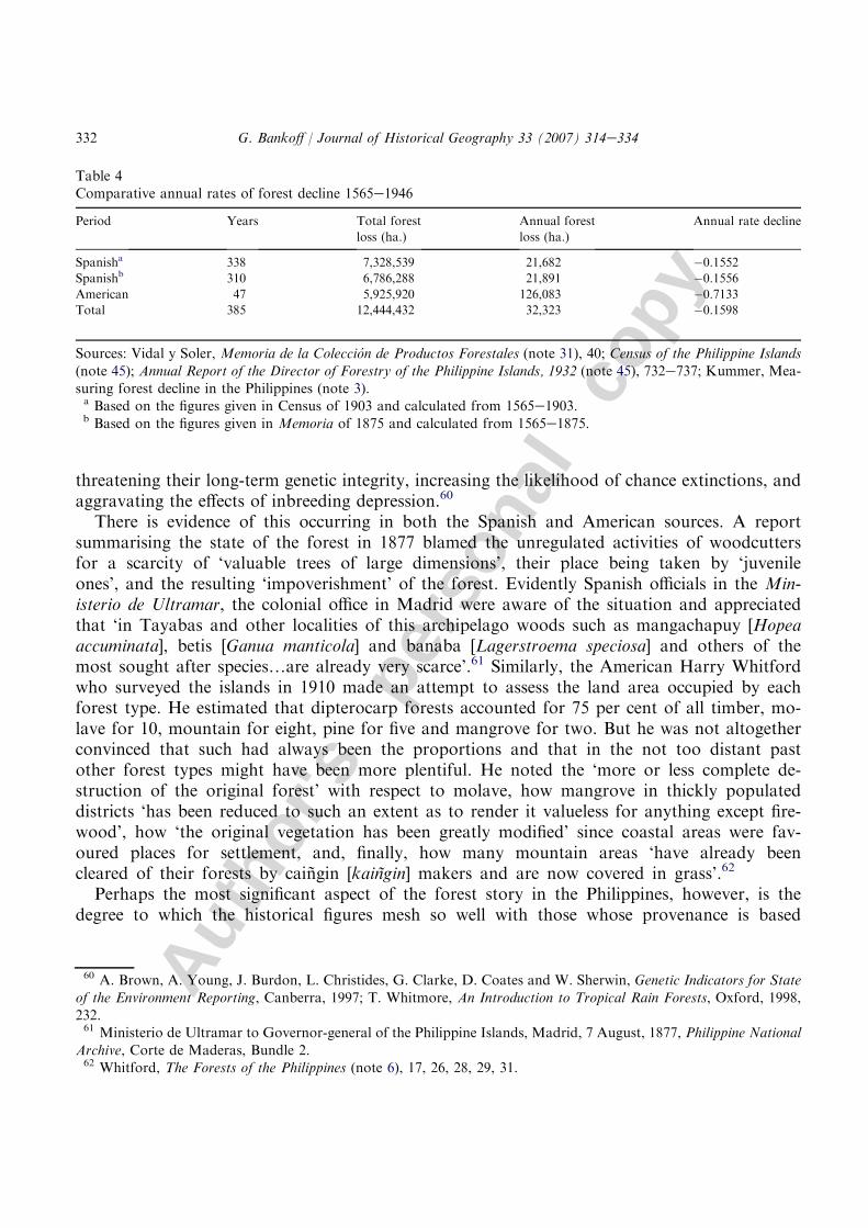
While there is no longer any dispute as to the basis on which calculations are made in the twen-tieth century, the real rate at which forest decline occurred is still concealed. Only a comparison ofthe average annual rate of forest decline over the entire colonial period presents a more accuratepicture of the accelerating rate of deforestation that took place during the American administra-tion of the archipelago. The average annual rate of forest loss rose from under 22,000 to over126,000 hectares or from 0.16 per cent over the more than three centuries of Spanish rule to0.71 per cent per annum during the corresponding American period (Table 4). All in all, the‘Mindanao factor’ has constituted a significant factor in distorting the true extent of deforestationduring both the Spanish and American periods.
Conclusion
Until recently, the majority of studies on tropical deforestation have concentrated on thepost-war period in that the accelerating loss of forest cover was seen as posing an immediatethreat to both local environments and people’s livelihoods. The importance of painstaking his-torical reconstructions was not fully recognised, not least because of the paucity of the data andits presumed unreliability. All this is changing, as scholars realise that the history of tropicalforests is of some significance to climate modelling and biodiversity loss and that non-instru-mental sources are perhaps more accurate than previously supposed. A fuller examination offorest decline in the Philippines during the colonial era provides yet another small piece inthis global jig-saw puzzle.
A particular feature of the historical data on the archipelago’s forests is the record it provideson genetic erosion. While forests were gradually cleared for agricultural and settlement purposes,certain timbers that had properties more conducive to human purposes were more readily felledthan others. Valuable hardwoods have long been sought after for their strength, durability andelasticity and were felled at much faster rates than the forest in general. Over time, such selectionled to a drastic decline in certain species and even to particular age groups within species,
58 It could be argued that Mindanao was not properly incorporated into the colonial state until the aftermath of the
Battle of Bud Dajo in 1906 or even the massacre on Bud Bagsak in 1913.59 Ahern, Compilation of Notes (note 31), 11.
331G. Bankoff / Journal of Historical Geography 33 (2007) 314e334
Autho
r's
pers
onal
co
py
threatening their long-term genetic integrity, increasing the likelihood of chance extinctions, andaggravating the effects of inbreeding depression.60
There is evidence of this occurring in both the Spanish and American sources. A reportsummarising the state of the forest in 1877 blamed the unregulated activities of woodcuttersfor a scarcity of ‘valuable trees of large dimensions’, their place being taken by ‘juvenileones’, and the resulting ‘impoverishment’ of the forest. Evidently Spanish officials in the Min-isterio de Ultramar, the colonial office in Madrid were aware of the situation and appreciatedthat ‘in Tayabas and other localities of this archipelago woods such as mangachapuy [Hopeaaccuminata], betis [Ganua manticola] and banaba [Lagerstroema speciosa] and others of themost sought after species.are already very scarce’.61 Similarly, the American Harry Whitfordwho surveyed the islands in 1910 made an attempt to assess the land area occupied by eachforest type. He estimated that dipterocarp forests accounted for 75 per cent of all timber, mo-lave for 10, mountain for eight, pine for five and mangrove for two. But he was not altogetherconvinced that such had always been the proportions and that in the not too distant pastother forest types might have been more plentiful. He noted the ‘more or less complete de-struction of the original forest’ with respect to molave, how mangrove in thickly populateddistricts ‘has been reduced to such an extent as to render it valueless for anything except fire-wood’, how ‘the original vegetation has been greatly modified’ since coastal areas were fav-oured places for settlement, and, finally, how many mountain areas ‘have already beencleared of their forests by caingin [kaingin] makers and are now covered in grass’.62
Perhaps the most significant aspect of the forest story in the Philippines, however, is thedegree to which the historical figures mesh so well with those whose provenance is based
Table 4Comparative annual rates of forest decline 1565e1946
Period Years Total forest
loss (ha.)
Annual forest
loss (ha.)
Annual rate decline
Spanisha 338 7,328,539 21,682 �0.1552Spanishb 310 6,786,288 21,891 �0.1556American 47 5,925,920 126,083 �0.7133Total 385 12,444,432 32,323 �0.1598
Sources: Vidal y Soler, Memoria de la Coleccion de Productos Forestales (note 31), 40; Census of the Philippine Islands
(note 45); Annual Report of the Director of Forestry of the Philippine Islands, 1932 (note 45), 732e737; Kummer, Mea-suring forest decline in the Philippines (note 3).a Based on the figures given in Census of 1903 and calculated from 1565e1903.b Based on the figures given in Memoria of 1875 and calculated from 1565e1875.
60 A. Brown, A. Young, J. Burdon, L. Christides, G. Clarke, D. Coates and W. Sherwin, Genetic Indicators for State
of the Environment Reporting, Canberra, 1997; T. Whitmore, An Introduction to Tropical Rain Forests, Oxford, 1998,232.61 Ministerio de Ultramar to Governor-general of the Philippine Islands, Madrid, 7 August, 1877, Philippine National
Archive, Corte de Maderas, Bundle 2.62 Whitford, The Forests of the Philippines (note 6), 17, 26, 28, 29, 31.
332 G. Bankoff / Journal of Historical Geography 33 (2007) 314e334

Autho
r's
pers
onal
co
py
more on current instrumentation and technology. Establishing rates of deforestation is a com-plicated business even with modern resources of satellite imagery and detailed silvicultural re-search on species growth and regeneration. Uncertainty about the derivation of historicalstatistics, ignorance of the methods by which particular figures were determined and of themotivations underlying their derivation, and the general lack of resources of colonial forestrydepartments are all factors that render any estimation of deforestation questionable. Yet whatis really striking about these figures is just how closely the historical reconstruction of thearchipelago’s forests, that is the assessment that by independence approximately half the totalland area was deforested, supports the figure reached by David Kummer projecting back-wards from the most comprehensive calibration of the islands’ forest resources published in1988.63 More than simply coincidental, this mutual affirmation suggests that the quality offorest cover data collected by manual methods, whether by the Inspeccion general de Montesin the 1870s or by the Bureau of Forestry in the 1920s is more accurate than generally sup-posed. It also calls into question the post-war estimates made by contemporary sources thatcalculated deforestation at closer to 40 per cent and lends weight to the claim that successivePhilippine governments have consistently inflated the extent of remaining forest cover for po-litical motivations.64 Not only do the historical data suggest that traditional surveys in thePhilippines are ‘useful’ estimates of deforestation but perhaps the same holds true of suchforest statistics in other parts of the tropical world.
Reappraising the extent of deforestation in the archipelago prior to 1946 reveals a muchmore complicated history than has previously been suggested. In particular, it is a narrativeintimately connected with the development of a core region and a state system that came laterto the Philippines than to any other major region of Southeast Asia, being associated with thepropagation of Catholicism and the establishment of Spanish colonialism after 1565.65 The‘story’ of the parallel development of state and forest decline are more readily traceable andhistorically documented here than elsewhere. In this sense, the islands provide an importantcomparative case study for similar processes taking place elsewhere. Moreover, the misconcep-tion upon which previous accounts of Philippine forest history have been based is indicative ofthe comparative neglect hitherto accorded to the historical reconstruction of deforestation. Theemphasis on post-war forest loss conceals the extent to which deforestation was also
63 Natural Forest Resources of the Philippines, Manila, 1988; Kummer,Deforestation in the Postwar Philippines (note 1);
Kummer, Measuring forest decline in the Philippines (note 3).64 Tamesis, Philippine forests (note 38); D. Kummer, Deforestation in the Philippines, 1950e2000, in: P. Boomgaard,
D. Henley and M. Ossweijer (Eds), Muddied Waters: Historical and Contemporary Perspectives on Management of For-
ests and Fisheries in Inland Southeast Asia, Leiden, 2006. Florencio Tamesis was the first director of the forestry depart-ment under the self-governing Commonwealth government in 1935.65 I wish to acknowledge the ideas of the late John Smail in respect to Spain and the formation of a core region in the
Philippines though I am unaware of anything he ever published to this effect. On the development of core regions andthe emergence of state systems in Southeast Asia, see G. Coedes, The Indianized States of Southeast Asia, Honolulu,1968; S. Tambiah, World Conqueror and World Renouncer: A Study of Buddhism and Polity in Thailand against a His-
torical Background, Cambridge, 1976; O. Wolters, History, Culture, and Region in Southeast Asian Perspectives, Singa-pore, 1982.
333G. Bankoff / Journal of Historical Geography 33 (2007) 314e334

Autho
r's
pers
onal
co
py
a significant factor in the past. In the case of the Philippines, this has largely been a matter ofseeing the colonial state as synonymous with the national one, of there being in a sense oneisland too many.
Acknowledgement
Research for this article was partly funded by the Netherlands Institute for Advanced Study(NIAS) as a fellowship-in-residence 2003/2004.
334 G. Bankoff / Journal of Historical Geography 33 (2007) 314e334
Copyright © 2022 FDOKUMEN