Onboard science software enabling future space science and space weather missions
14
Onboard Science Software Enabling Future Space Science and Space Weather Missions 1 1 U.S. Government work not protected by U.S. copyright. Michael L. Rilee Emergent IT; NASA/GSFC Mailstop 931, 28/s-207, Greenbelt, MD 20771; 301-286-4743; [email protected] Scott A. Boardsen Emergent IT; NASA/GSFC Mailstop 632, Greenbelt, MD 20771; 301-286-0837; [email protected] Maharaj K. Bhat Emergent IT; NASA/GSFC Mailstop 931, 28/s-207, Greenbelt, MD 20771; 301-286-1531; [email protected] Steven A. Curtis NASA Goddard Space Flight Center; Code 695, Greenbelt, MD 20771; 301-286-9188; Steven.A.Curtis @gsfc.nasa.gov Abstract – On the path towards an operational Space Weather System are science missions involving as many as 100 spacecraft (Magnetospheric Constellation, DRACO, 2010). Multiple spacecraft are required to measure the macro, meso, and micro scale plasma physics that underlies Geospace phenomea. Simultaneous multi point in situ measurements enable the determination of electric current in space and the discrimination of temporal and spatial phenomena. From these quantities, the structure and dynamics of Geospace may be modeled and better understood. We work towards the day when multi point, real time data might be gathered on Earth to produce maps and forecasts of Space Weather conditions. To be feasible, however, multiple spacecraft missions must be no more costly to operate than single spacecraft missions are today. Furthermore, communication availability places severe constraints on an entire mission architecture and hampers the resolution, coverage, timeliness, and hence, usefulness of spacecraft data. To address some of these constraints, we have been studying the possibility of performing some science data processing functions on board a pathfinding mission in NASA's Solar-Terrestrial Probe Line, Magnetospheric Multi Scale (MMS, 2008). The MMS mission involves four or five spacecraft, operating as one, that bring full suites of high resolution plasma diagnostic sensors to focus on Geospace phenomena involving plasma microphysics, i.e. sub-fluid length, time, and frequency scales. In the MMS baseline, totality of coverage, already likely to be hampered by communication availability, is sacrificed to obtain high resolution data in the vicinity of critical Geospace boundaries. Onboard computation enables the return of additional reduced data from regions immediately surrounding these important Geospace boundaries: data which may be critical to the correct understanding of boundary processes. Furthermore, onboard computation will enable high resolution reduced data for entire orbits to be sent to Earth. Going beyond onboard data reduction, sufficient onboard computation opens the possiblity of onboard autonomous science data management. For purposes ranging from instrument calibration, test, diagnosis, and through scientific discovery, the most fundamental data an instrument produces are often required. However, communications availability places limits on when and how much of this raw data may be transmitted to Earth. With sufficient onboard computational resources, intelligent systems may be implemented that recognize features in sensor data that are important for mission goals. These data may be selected for transmission to Earth at full fidelity, providing the best possible view of the phenomena. Data of lesser importance are more lossily compressed, with routine observations being compressed to summary statistics before transmission to Earth. This sort of autonomous science data management is an important step to science driven autonomous control of spacecraft instrumentation. In this paper we discuss our multi level approach to developing an onboard science analysis system that we are studying for potential use onboard the MMS mission. This analysis system will enhance MMS science by improving sensor coverage and by returning to Earth high-resolution data that would otherwise be discarded or not generated. Results of our work using Space Physics data sets from previous missions will illustrate our approach. TABLE OF CONTENTS 1. INTRODUCTION 2. A PROGRESSION OF SPACE SCIENCE MISSIONS 3. ONBOARD COMPUTING APPROACH 4. ONBOARD COMPUTING RESEARCH 5. SUMMARY 6. ACKNOWLEDGEMENTS 7. REFERENCES
-
Upload
independent -
Category
Documents
-
view
1 -
download
0
Transcript of Onboard science software enabling future space science and space weather missions

Onboard Science Software Enabling Future Space Science and Space Weather Missions1
1 U.S. Government work not protected by U.S. copyright.
Michael L. Rilee Emergent IT; NASA/GSFC Mailstop 931, 28/s-207, Greenbelt, MD 20771; 301-286-4743; [email protected]
Scott A. Boardsen
Emergent IT; NASA/GSFC Mailstop 632, Greenbelt, MD 20771; 301-286-0837; [email protected]
Maharaj K. Bhat Emergent IT; NASA/GSFC Mailstop 931, 28/s-207, Greenbelt, MD 20771; 301-286-1531; [email protected]
Steven A. Curtis
NASA Goddard Space Flight Center; Code 695, Greenbelt, MD 20771; 301-286-9188; Steven.A.Curtis @gsfc.nasa.gov
Abstract – On the path towards an operational Space Weather System are science missions involving as many as 100 spacecraft (Magnetospheric Constellation, DRACO, 2010). Multiple spacecraft are required to measure the macro, meso, and micro scale plasma physics that underlies Geospace phenomea. Simultaneous multi point in situ measurements enable the determination of electric current in space and the discrimination of temporal and spatial phenomena. From these quantities, the structure and dynamics of Geospace may be modeled and better understood. We work towards the day when multi point, real time data might be gathered on Earth to produce maps and forecasts of Space Weather conditions. To be feasible, however, multiple spacecraft missions must be no more costly to operate than single spacecraft missions are today. Furthermore, communication availability places severe constraints on an entire mission architecture and hampers the resolution, coverage, timeliness, and hence, usefulness of spacecraft data. To address some of these constraints, we have been studying the possibility of performing some science data processing functions on board a pathfinding mission in NASA's Solar-Terrestrial Probe Line, Magnetospheric Multi Scale (MMS, 2008). The MMS mission involves four or five spacecraft, operating as one, that bring full suites of high resolution plasma diagnostic sensors to focus on Geospace phenomena involving plasma microphysics, i.e. sub-fluid length, time, and frequency scales. In the MMS baseline, totality of coverage, already likely to be hampered by communication availability, is sacrificed to obtain high resolution data in the vicinity of critical Geospace boundaries. Onboard computation enables the return of additional reduced data from regions immediately surrounding these important Geospace boundaries: data which may be critical to the correct understanding of boundary processes. Furthermore, onboard computation will enable high resolution reduced data for entire orbits to be sent to Earth.
Going beyond onboard data reduction, sufficient onboard computation opens the possiblity of onboard autonomous science data management. For purposes ranging from instrument calibration, test, diagnosis, and through scientific discovery, the most fundamental data an instrument produces are often required. However, communications availability places limits on when and how much of this raw data may be transmitted to Earth. With sufficient onboard computational resources, intelligent systems may be implemented that recognize features in sensor data that are important for mission goals. These data may be selected for transmission to Earth at full fidelity, providing the best possible view of the phenomena. Data of lesser importance are more lossily compressed, with routine observations being compressed to summary statistics before transmission to Earth. This sort of autonomous science data management is an important step to science driven autonomous control of spacecraft instrumentation. In this paper we discuss our multi level approach to developing an onboard science analysis system that we are studying for potential use onboard the MMS mission. This analysis system will enhance MMS science by improving sensor coverage and by returning to Earth high-resolution data that would otherwise be discarded or not generated. Results of our work using Space Physics data sets from previous missions will illustrate our approach.
TABLE OF CONTENTS 1. INTRODUCTION 2. A PROGRESSION OF SPACE SCIENCE MISSIONS 3. ONBOARD COMPUTING APPROACH 4. ONBOARD COMPUTING RESEARCH 5. SUMMARY 6. ACKNOWLEDGEMENTS 7. REFERENCES
1. INTRODUCTION
Space science deals with what exists and occurs in the space environments. The enterprise of space science is nearing a threshold in the scope of its observations of Geospace. Geospace is that dynamic region wherein the Earth and its electromagnetic fields affect the interplanetary medium. The nature of the interplanetary medium is essentially dominated by the supersonic Solar Wind, except where influences, such as the Earth's, interfere. A general map of Geospace has been pieced together from observations obtained with spacecraft since the dawn of the space age. To go beyond this general map requires simultaneous multi spacecraft missions to resolve structures in space and time, which is not possible with single spacecraft missions. Space Science Foundation The foundation on which space science is built is the physics of plasmas. In plasmas, a sufficient number of particles have sufficient electrical charge so that the
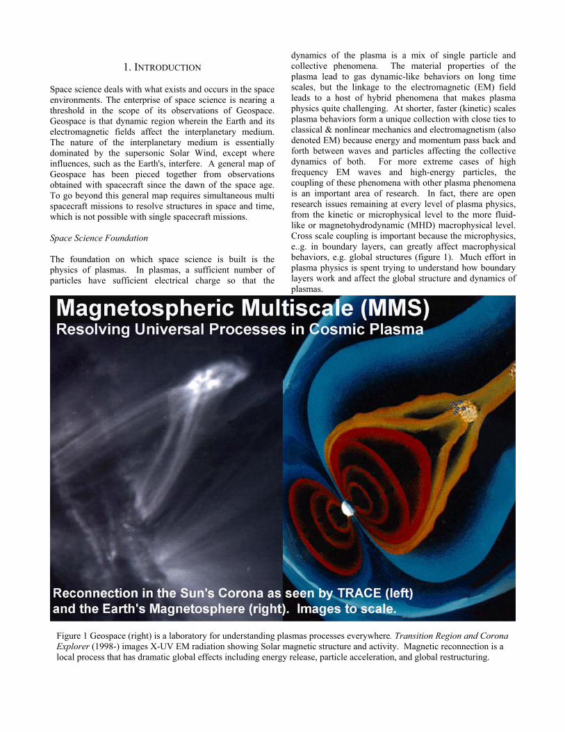
dynamics of the plasma is a mix of single particle and collective phenomena. The material properties of the plasma lead to gas dynamic-like behaviors on long time scales, but the linkage to the electromagnetic (EM) field leads to a host of hybrid phenomena that makes plasma physics quite challenging. At shorter, faster (kinetic) scales plasma behaviors form a unique collection with close ties to classical & nonlinear mechanics and electromagnetism (also denoted EM) because energy and momentum pass back and forth between waves and particles affecting the collective dynamics of both. For more extreme cases of high frequency EM waves and high-energy particles, the coupling of these phenomena with other plasma phenomena is an important area of research. In fact, there are open research issues remaining at every level of plasma physics, from the kinetic or microphysical level to the more fluid-like or magnetohydrodynamic (MHD) macrophysical level. Cross scale coupling is important because the microphysics, e..g. in boundary layers, can greatly affect macrophysical behaviors, e.g. global structures (figure 1). Much effort in plasma physics is spent trying to understand how boundary layers work and affect the global structure and dynamics of plasmas.
Figure 1 Geospace (right) is a laboratory for understanding plasmas processes everywhere. Transition Region and Corona Explorer (1998-) images X-UV EM radiation showing Solar magnetic structure and activity. Magnetic reconnection is a local process that has dramatic global effects including energy release, particle acceleration, and global restructuring.
Geospace Observation The principal methods to observe the Geospace and interplanetary media are in situ particle spectrometry and EM field measurement [1]. Particle spectrometers feature EM-based optics that allow the measurement of the distribution of particles within a 6-dimensional velocity-position phase space. EM field measurement uses sensors developed for low and high frequency signals. The structure of the particle phase space density and of the electromagnetic waveform and energy spectra are the key tools we use to understand the microphysics of a plasma. For the more fluid-like MHD behavior, high time resolution moments of the plasma phase space density and magnetometry suffice. For Geospace phenomena, where many physical processes are neither completely MHD nor completely kinetic, the understanding proceeds best when a range of time and length scales are available for study. For example, understanding energy transfer and particle energization in magnetic reconnection (figure 1) requires understanding the perhaps delicate balance obtained between a narrow kinetically dominated electric current sheet and external MHD-like, turbulent regions separating more quiescent layers. In situ measurement of plasma properties has been the mainstay of space science, but remote sensing has played a role as well. Remote sensing data often suffers ambiguities as multiple sources overlap in sensor response. Nonetheless, remote sensing instruments have provided information about the large-scale dynamics and processes underlying Geospace phenomena. Space borne radio experiments such as WAVES on the WIND spacecraft routinely monitor various radio emissions from the Sun, the interplanetary medium, and Geospace [2]. Active instruments such as the Radio Plasma Imager on board the Imager for Magnetopause-to-Aurora Global Exploration (IMAGE) also return information about the distribution of matter in their vicinity [3]. In addition, IMAGE hosts a number of applications of remote sensing technology to image the various portions of Geospace in UV and neutral atom emission. Ultraviolet (UV) imaging has proven useful in the study of the connection of magnetospheric with ionospheric phenomena. UV and neutral atom imaging have also provided the first global views of the matter distribution in the Earth's magnetosphere. Single point sensing, either in situ or remote, cannot adequately constrain our understanding of the space environment. Single point in situ measurements cannot distinguish between a stationary oscillation and a wave moving past. Single point remote measurements often lead to ambiguities, i.e. overlapping sources, that can be accounted for only with a priori knowledge or multi point measurement, e.g. tomography or interferometry [4]. Furthermore, the physics of these systems often deals with how system properties evolve or are correlated in space and time. For example, electric current depends on the spatial
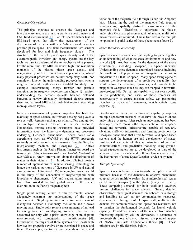
variation of the magnetic field through its curl via Ampère's law. Measuring the curl of the magnetic field requires simultaneous, spatially distinct measurements of the magnetic field. Therefore, to understand the physics underlying Geospace phenomena, simultaneous, multi point measurements are required. This is true across the multiple temporal and spatial scales of these phenomena (figure 2). Space Weather Forecasting Space science researchers are attempting to piece together an understanding of what the space environment is and how it works [5]. Another name for the dynamics of the space environment, including Geospace, is Space Weather. Understanding these dynamics and related hazards including the evolution of populations of energetic radiations is important to all that use space. Many space faring agencies support the development of a predictive capability that would allow the structure, dynamics, and hazards to be mapped in Geospace much as they are mapped in terrestrial meteorology [6]. Our current capability is not very specific in its predictions, and users of these forecasts act conservatively to ensure mission safety, e.g. postponing launches or spacecraft maneuvers, which entails some expense [7]. Developing a predictive or forecast capability requires multiple spacecraft missions to observe the physics of the underlying processes. After such an understanding has been developed, there remains the implementation of a space-based and terrestrial infrastructure capable of regularly obtaining sufficient information and forming predictions for Geospace phenomena that affect terrestrial and space-based systems and the human use and development of space. Prototypical elements of this infrastructure of sensors, communications, and predictive modeling using ground-based supercomputers are to be developed as part of the advance of space science, and in these elements we will see the beginnings of a true Space Weather service or system. Multiple Spacecraft Space science is being driven towards multiple spacecraft missions because of the demands to observe phenomena coupled across multiple scales, from microphysical scales (<100 km in Geospace) to the global (many Earth radii). These competing demands for both detail and coverage present challenges for space science. Greatly detailed observations place great demands on onboard data storage and handling as well as for communication resources. Coverage, i.e. through multiple spacecraft, multiplies the demand for communications and operations resources, not to mention the fundamental demands for launch vehicle capacity. To address the needs of the science from which a forecasting capability will be developed, a sequence of progressively more advanced missions are planned as part of NASA Sun-Earth Connections theme [8]. These missions are briefly described below.
The Future So far we have concentrated on those aspects of space science concerned with Geospace. However, as the human sphere of development in space expands outward, other aspects of the space environment come more sharply into view. A variety of solar disturbances, magnetospheres, and planetary bow shocks and wakes exist throughout the solar system: these provide glimpses into physics that might help us understand laboratory and astrophysical plasmas. A wide range of solar system bodies and surfaces exist which harbor answers and questions concerning the formation and evolution of the solar system. For example the asteroids hold great potential for research into the origins of our own and other planetary systems, as well as being a source of materials for the exploration and development of space. In the following, we will discuss a series of missions that illustrate the progression in capability required for progress in space science. Important technical challenges are identified, and the key role of onboard science software in meeting these challenges is identified. To conclude, we
summarize the current state of affairs, our own efforts to advance these technologies, and the direction to be taken in the future.
2. A PROGRESSION OF SPACE SCIENCE MISSIONS Cluster 2 and IMAGE represent the current state of the art in Geospace missions. Cluster 2 is a set of four identically instrumented independently operated spacecraft to study the small-scale plasma structures in key regions of Geospace. The four spacecraft each feature full suites of 11 plasma diagnostic sensors including both particle and EM field sensors [9]. Regarding onboard science processing, the Cluster Ion Spectrometry (CIS) experiment features several control processors and a data processing unit that can sum particle measurements onboard and form plasma moments [10]. This helps retain some information that would otherwise be lost, but some data analysis methods, e.g. iterative corrections due to spacecraft charging and return currents, are beyond the capabilities of the rad-hard processors utilized in the instrument.
Figure 2 Geospace phenomena focused on by Magnetospheric Multi Scale (MMS, cf. http://stp.gsfc.nasa.gov).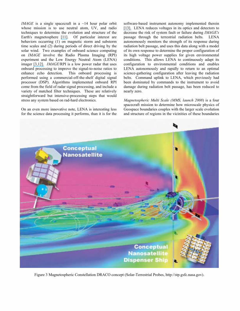
IMAGE is a single spacecraft in a ~14 hour polar orbit whose mission is to use neutral atom, UV, and radio techniques to determine the evolution and structure of the Earth's magnetosphere [11]. Of particular interest are behaviors occurring (1) on magnetic storm and substorm time scales and (2) during periods of direct driving by the solar wind. Two examples of onboard science computing on IMAGE involve the Radio Plasma Imaging (RPI) experiment and the Low Energy Neutral Atom (LENA) imager [3,12]. IMAGE/RPI is a low power radar that uses onboard processing to improve the signal-to-noise ratios to enhance echo detection. This onboard processing is performed using a commercial-off-the-shelf digital signal processor (DSP). Algorithms implemented onboard RPI come from the field of radar signal processing, and include a variety of matched filter techniques. These are relatively straightforward but intensive-processing steps that would stress any system based on rad-hard electronics.
On an even more innovative note, LENA is interesting less for the science data processing it performs, than it is for the
software-based instrument autonomy implemented therein [13]. LENA reduces voltages in its optics and detectors to decrease the risk of system fault or failure during IMAGE's passage through the terrestrial radiation belts. LENA autonomously monitors the strength of its response during radiation belt passage, and uses this data along with a model of its own response to determine the proper configuration of its high voltage power supplies for given environmental conditions. This allows LENA to continuously adapt its configuration to environmental conditions and enables LENA autonomously and rapidly to return to an optimal science-gathering configuration after leaving the radiation belts. Command uplink to LENA, which previously had been dominated by commands to the instrument to avoid damage during radiation belt passage, has been reduced to nearly zero. Magnetospheric Multi Scale (MMS, launch 2008) is a four spacecraft mission to determine how microscale physics of Geospace boundaries couples with the larger scale evolution and structure of regions in the vicinities of these boundaries
Figure 3 Magnetospheric Constellation DRACO concept (Solar-Terrestrial Probes, http://stp.gsfc.nasa.gov).

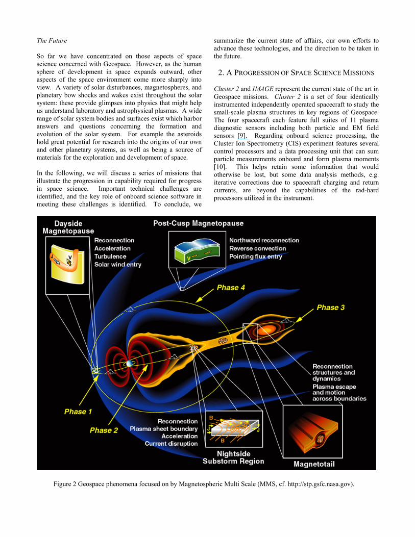
(figure 2) [14]. Particular emphasis is placed on the key processes of magnetic reconnection, particle energization, and turbulence. Cluster 2, in contrast, is a more general survey of the microphysical processes in Geospace. Also, MMS is to operate more as a single multiple element spacecraft including low bandwidth radio links for ranging and alarm communications for science event and fault triggers. At times MMS will be too far from Earth for efficient science data downlink, therefore data storage for two weeks of normal mode (three days burst) data is baselined. Though capable of producing more data than Cluster 2, the science downlink budget is currently set about the same. To rein in operations costs of this four spacecraft mission, various approaches towards ground and space based autonomy are of interest. The Magnetospheric Constellation Mission (MAGCON) Dynamic Response and Coupling Observatory (DRACO, launch > 2010) is a constellation of 50-100 spacecraft which is to address the flow of energy and how physical
processes and Geospace regions couple over a hierarchy of scales in the global context (figure 3) [15]. In addition to advances in low power electronics and lightweight science sensors, the aggressive application of methods of spacecraft autonomy are required for DRACO. The concept for nominal operations for this mission involves ground contact principally when the spacecraft are at perigee. Interspacecraft communication is not envisaged. Because the orbital periods of DRACO elements range from one to five days, spacecraft must be capable of detecting and correcting faults while operating for perhaps weeks at a time without ground intervention. Similarly, data acquired by a DRACO spacecraft stays in space until the spacecraft nears perigee. Without real-time downlink DRACO data will be suitable for analysis and diagnosis of Geospace phenomena after the fact but will not be able to provide input for near real-time Geospace state inference (nowcasting) or forecasting. The development of such capabilities might be substantially aided by enhancing the current DRACO concept by including onboard science reduction with a
ANTS: Mission Concept 2020
Earth
Lagrange Point Habitat
1. Assembly & release
2. Self propelled transit
6. A messenger carries findings to Earth when needed.
4. Swarm (Fly by) Operations
5. Repeat steps 3 and 4.
Messenger
Asteroid belt
3. Long-Range Operations
Asteroid(s)Messengers
Rulers
M. L. Rilee, EIT, S. A. Curtis, NASA/GSFC, 2001.IR Worker
MAG Worker
X-Ray Worker
Workers Workers
Workers
Figure 4 ANTS Main Belt Asteroid Survey (http:// ants.gsfc.nasa.gov)[17].
sufficiereal-tim The Soarray othat pr[16]. "snapshinvolviaspectsand mreceivespacecravoid best plthis enterrificmissiongiga-bithroughautomaroles. onboarperformfor thibaselingrand c In thisrequirincloser the abowe sawin theirhosted controlin autoan intethat isspacecrbandwiare fewgoes yspacecrdriven seek toto buildopportu The Au2020s)and boautono[17]. Tconcepasteroiddecademore tknown
ntly low power computing resource and downlink of e science.
lar Imaging Radio Array (SIRA, launch > 2015) is an f 16 or more low frequency radio receiver elements ovide data for synthetic aperture radio astronomy The objective of SIRA is to provide real-time ot" images of radio emitting disturbances chiefly
ng the Sun and the interplanetary medium. Some of the mission resemble DRACO, typically a mother ultiple daughter configuration are chosen. Radio rs and antennae must be supported so micro-aft, as opposed to nano-spacecraft, are envisaged. To
interference from terrestrial radio sources, SIRA is aced in distant orbits or libration points. However, hances the already difficult challenges of making its data volume available for analysis. Deep space s capable of producing many tens or a few hundred
ts of information a day with stringent real-time put requirements require new approaches in which ted data reduction and system autonomy play critical High bandwidth interspacecraft communication, the d cross-correlation of radio signals, and high ance onboard computing are enabling technologies
s mission. Automating the process of very-long-e-interferometry for aperture synthesis is a worthy hallenge.
section we have described a sequence of missions g a steady progression of capabilities. Yet on a
look, even as the number of spacecraft increased for ve and the capabilities of instrument suites increased, that the missions become more focused or pointed goals. We started with Cluster 2 and IMAGE, which a wide variety of instruments for which ground
is still significant, but also for which improvements mation and even autonomy have been made. MMS is rmediate step towards a distributed sensor platform to be no more difficult to operate than a single aft mission is today. MMS features higher dth instruments than IMAGE or Cluster 2, but these er and more specialized to mission themes. SIRA et further, requiring an even greater number of aft, but operating as a single instrument. This is of course by the nature of the scientific questions we answer, but also provides a steady ladder on which our technical capabilities for yet more challenging nities ahead.
tonomous Nano-Technology Swarm (ANTS, launch addresses a new set of challenges for space science th breaks and furthers the trend of specialization and mous operations mentioned above (figures 4 and 5) he ANTS Main Belt Asteroid Survey is an advanced
t that seeks to construct a resource atlas of all s of diameter greater than 1 kilometer during the
of the 2020s. There are thousands of asteroids, with han ten thousand with trajectories and little else about them. A single well-instrumented spacecraft
encountering asteroids one after another in a serial fashion is inadequate to this task. Instead, researchers have proposed a
swarm of a thousand or more specialized spacecraft operating as an insect colony analog to autonomously navigate the asteroid belt, characterizing a hundred or more asteroids each month. Human control of such a swarm is impossible using current techniques: individual spacecraft in ANTS will be autonomous spacefarers with specialized behaviors that optimize the capability of their particular function. Most ANTS will be Workers specializing in the use of a particular science sensor, e.g. an X-ray Fluorescence Spectrometer, an IR or multispectral imager (figure 5) or other applicable remote sensing device. Other elements of ANTS provide important collective functions: e.g. Rulers for command & control functions and Messengers for communications. The architecture for this concept is a topic of ongoing research, but it is clear that elements of ANTS will have to make decisions about the operation of science instruments, the choice of target asteroids, and navigation on a continual basis and without human intervention. Thus onboard science computation and complete system autonomy are fundamental requirements for ANTS.
Figure 5 ANTS Imaging Worker and asteroid Gaspra
ANTS
Trends and mission characteristics Tables 1 and 2 illustrate some of the characteristics of the missions discussed in this section. The trend towards larger numbers of spacecraft and large total data production capabilities are evident. If the attributes of these mission concepts indicate future needs, we notice that even as the number of spacecraft increase, the number of science instruments per spacecraft may very well decrease. This decrease may even reach the point where a fraction of a constellation of spacecraft are devoted to mission science sensors while a complementary fraction are devoted to mission enabling functions, in a word, infrastructure. For example, for SIRA a mother ship may provide high
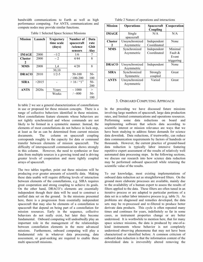
bandwidth communications to Earth as well as high performance computing. For ANTS, communications and compute nodes may provide similar functions.
Table 1 Selected Space Science Missions
Mission Launch Trajectory time scale
(days)
Number of spacecraft
/science sensors
Data rate Gbit/day
IMAGE 2000 ~1/2 1/6 7 Cluster
2 2000 ~ 2 4/44 8
1,4 MMS 2008 30,10
4/20 8
DRACO 2010 1/2-5 50-100 / 100-200
50-100
SIRA >2015 - > 16 / “1” 50-200
Years ANTS 2020s Weeks
~ 1000 / ~800
> 50-100
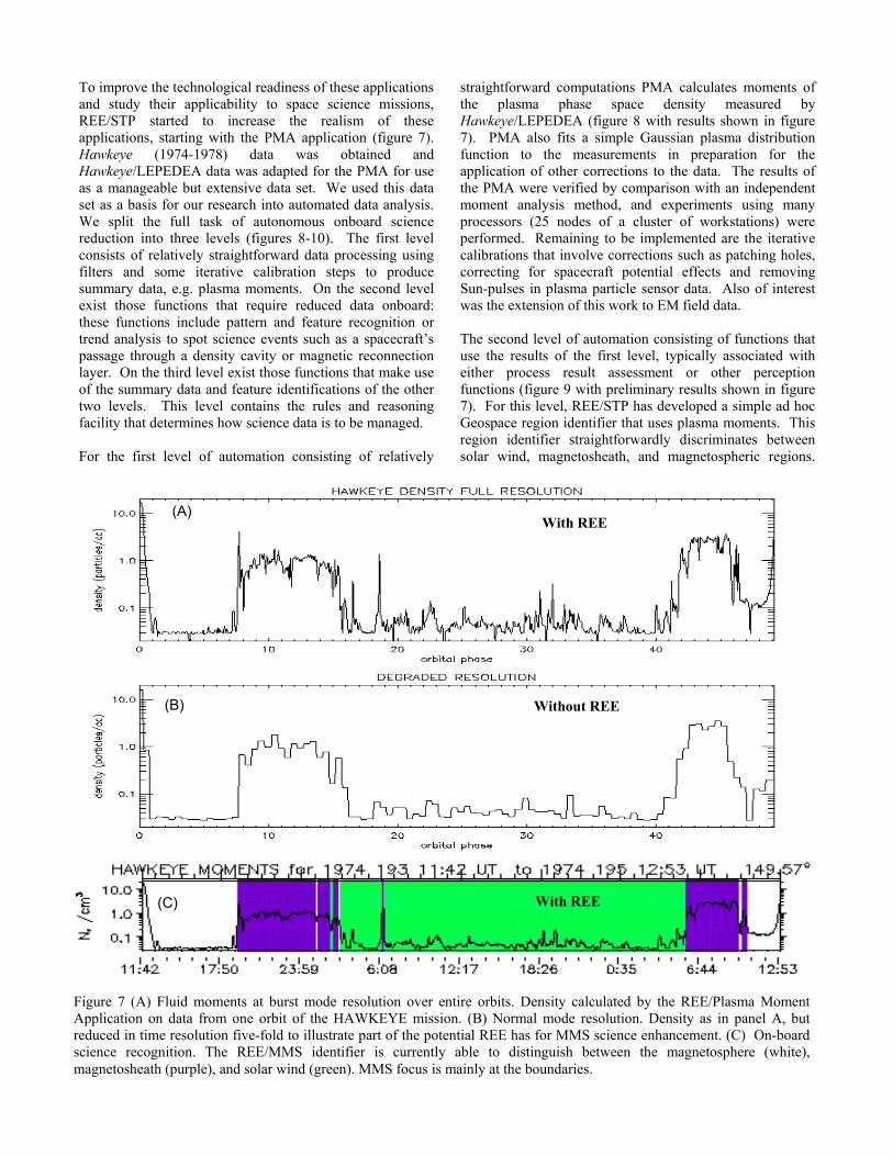
In table 2 we see a general characterization of constellations in use or proposed for these mission concepts. There is a range of collective behaviors identified in these missions. Most constellations feature elements whose behaviors are not tightly synchronized and whose commands are not likely to be formed in a symmetric manner. Instead, the elements of most constellations do not behave in lock-step, at least as far as can be determined from current mission documents. The column on spacecraft coupling corresponds roughly to the capacity for data or command transfer between elements of mission spacecraft. The difficulty of interspacecraft communication shows strongly in this column. However, the need to synthesize or fuse data from multiple sources is a growing trend and is driving greater levels of cooperation and more tightly coupled arrays of spacecraft. The two tables together, point out these missions will be producing ever greater amounts of scientific data. Making these data usable will require differing levels of interaction between elements of the constellations, e.g. SIRA requires great cooperation and strong coupling to achieve its goals. On the other hand, DRACO’s elements are essentially independent though their data will be used to construct a unified data set on the ground. In the missions presented here, there is a progression from essentially independent spacecraft that may also be elements of a constellation to spacecraft that depend on being part of a constellation for mission resources. Early in the sequence, collective behaviors do not really exist, but later they become fundamental. Onboard computing will undoubtedly play an important role in the management of the relationships between constellation elements in the more advanced missions. Furthermore, onboard computing will play a fundamental role in whatever data processing, data assessment, or goal-seeking are required to enable these multi spacecraft missions.
Table 2 Nature of operations and interactions
Mission Operations Spacecraft Coupling
Cooperation
IMAGE Single spacecraft
N/A N/A
Cluster 2
Unsynchronized Asymmetric
Independent Coordinated
None
MMS Synchronized Asymmetric
Independent Coordinated
Minimal Fault & Event
triggering DRACO Unsynchronized
Asymmetric Independent None
SIRA Synchronized Symmetric
Strongly coupled
Great
ANTS Unsynchronized Asymmetric
Varied Great
3. ONBOARD COMPUTING APPROACH In the preceding we have discussed future missions involving large numbers of spacecraft, large data production rates, and limited communications and operations resources. Performing some data reductions on board and implementing software that selects data according to scientific interest or mission relevance are ways that we have been studying to address future demands for science data downlink. Data reductions, if trustworthy, can reduce data communication requirements by factors of hundreds or thousands. However, the current practice of ground-based data reduction is typically labor intensive featuring repetitive expert assessment of the results of relatively well automated data processing steps. In the following sections, we discuss our research into how science data reduction may be performed onboard spacecraft while retaining the scientific value of the results. To our knowledge, most existing implementations of onboard data reduction act as straightforward filters. On the ground more elaborate processes are available, mainly due to the availability of a human expert to assess the results of filters applied to the data. These filters are often tuned in an iterative process or are adapted to particular portions of a data set in a rather labor intensive process (e.g. table 3). As problems are diagnosed and remedies developed, the data sets may be re-processed and re-filtered to produce better derivate data products. This cycle is often repeated many times and continues for years, indefinitely so far in some cases, as instrument properties change or are better understood. It is worthwhile to mention here, that for many space science missions, the data is produced by one-of-a-kind instruments whose behavior is not completely understood observing phenomena that may not have been characterized or identified before. A common criticism of onboard data reduction is that the information content of the downlinked data is irreversibly altered removing the

possibility of revising the process of constructing derivate data products, leaving one with essentially untrustworthy measurements.
Figure 6 Concept of a software agent
Actuators
Sensors
Agent
Reasoning
Action-Reaction
Perception
Environment
Table 3 Science Processing Characterization
Processing style
Processing strategy
Goal of processing
Direct Single process Single endpoint Iterative Multiple process Single endpoint Adaptive Multiple process Multiple options
We feel the key to addressing this issue is to improve the set of data processing algorithms available for use onboard spacecraft. In addition to the straightforward filters alluded to above, a means for assessing the quality both of data and of results must be implemented. Such an assessment function enables said filters to be tuned onboard the spacecraft in much the same way that the ground-based expert would tweak parameters in his analysis programs. A suitable framework for implementing these functions onboard is that of agent oriented programming. Intelligent software agents developed in this framework typically feature a means to perceive their working environment, a means to reason about and plan interactions with their environment, and a means to interact with the environment (figure 6). An onboard Science Agent's (SA) environment would be the science computing and data system made available to it. Its perception function could be model or neural net based or based on ad hoc rules (e.g. thresholds). The reasoning component of the SA could be based on fuzzy or other rule systems. In the near term, the actuation component for SA resides mainly in science data processing management and the management of its own portion of the downlink budget. The most direct example would be the triage of science data into classes for downlink with lossless compression, lossy compression, or only after onboard reduction. For the more advanced missions that we are moving towards in the out years, the SA's domain will grow to involve more of science data operations, to instrument operations, until finally the SA plays a central role in system operations.
4. ONBOARD COMPUTING RESEARCH The Remote Exploration and Experimentation (REE) project of NASA's High Performance Computing and Communications project sought ways to adapt commercial-off-the-shelf computing technologies to the rigors of space flight. Reasons for this approach include cost and the dramatic enhancement in computing power obtained (table 4). Technologies studied included the use of commodity processors for the high performance and low power consumption and software implemented fault tolerance (SIFT) [18]. With the use of commodity parts in the space environment, faults will occur at a much greater rate than with traditional radiation hardened space qualified
equipment. However, in many cases these faults do not affect the operation of the system or application software [19]. Some faults may be detected, screened, or even corrected by hardware or SIFT techniques. Some of these techniques date from the time when supercomputers started to consist of such large numbers of components that transient faults and failures became an expected part of normal operation. REE's Solar Terrestrial Probe (REE/STP) Science Application Team researched the benefits that fault-tolerant high performance onboard computation might provide to space science missions. To this end, and to produce computer codes that require intensive computation for testing REE testbed computers, REE/STP developed two applications that modeled certain space science data reductions: (1) cross correlations for Radio Astronomical
Table 4 Radiation Hardened vs. Commercial
CPU CLOCK MIPS MOPS
POWER YEAR
RAD6000 33 MHz 35 ~35 W ‘97
RAD750 150 MHz 300 ~35 W ‘02
PowerPC 604
200 MHz 300 ~13 W ‘97
PowerPC 7400
400 MHz 2000 ~16 W ‘99
IBM PowerPC
1000 MHz ~2300 ~ 5 W ‘02
Imaging (RAI) and (2) Plasma Moment Analysis (PMA). These calculations performed only the most intensive part of the data reductions modeled, and therefore neglected crucial steps required to construct real results from real data.
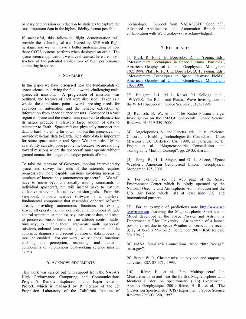
To improve the technological readiness of these applications and study their applicability to space science missions, REE/STP started to increase the realism of these applications, starting with the PMA application (figure 7). Hawkeye (1974-1978) data was obtained and Hawkeye/LEPEDEA data was adapted for the PMA for use as a manageable but extensive data set. We used this data set as a basis for our research into automated data analysis. We split the full task of autonomous onboard science reduction into three levels (figures 8-10). The first level consists of relatively straightforward data processing using filters and some iterative calibration steps to produce summary data, e.g. plasma moments. On the second level exist those functions that require reduced data onboard: these functions include pattern and feature recognition or trend analysis to spot science events such as a spacecraft’s passage through a density cavity or magnetic reconnection layer. On the third level exist those functions that make use of the summary data and feature identifications of the other two levels. This level contains the rules and reasoning facility that determines how science data is to be managed. For the first level of automation consisting of relatively
straightforward computations PMA calculates moments of the plasma phase space density measured by Hawkeye/LEPEDEA (figure 8 with results shown in figure 7). PMA also fits a simple Gaussian plasma distribution function to the measurements in preparation for the application of other corrections to the data. The results of the PMA were verified by comparison with an independent moment analysis method, and experiments using many processors (25 nodes of a cluster of workstations) were performed. Remaining to be implemented are the iterative calibrations that involve corrections such as patching holes, correcting for spacecraft potential effects and removing Sun-pulses in plasma particle sensor data. Also of interest was the extension of this work to EM field data. The second level of automation consisting of functions that use the results of the first level, typically associated with either process result assessment or other perception functions (figure 9 with preliminary results shown in figure 7). For this level, REE/STP has developed a simple ad hoc Geospace region identifier that uses plasma moments. This region identifier straightforwardly discriminates between solar wind, magnetosheath, and magnetospheric regions.
Figure 7 (A) Fluid moments at burst mode resolution over entire orbits. Density calculated by the REE/Plasma MomentApplication on data from one orbit of the HAWKEYE mission. (B) Normal mode resolution. Density as in panel A, butreduced in time resolution five-fold to illustrate part of the potential REE has for MMS science enhancement. (C) On-boardscience recognition. The REE/MMS identifier is currently able to distinguish between the magnetosphere (white),magnetosheath (purple), and solar wind (green). MMS focus is mainly at the boundaries.
With REE
Without REE
With REE
(C)
(B)
(A)
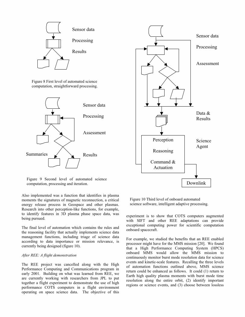
Figure 8 First level of automated science computation, straightforward processing.
Sensor data Processing Results
Sensor data Processing Assessment Data & Results Science Agent
Perception
Reasoning
Command & Actuation
Downlink
Figure 10 Third level of onboard automated science software, intelligent adaptive processing.
Figure 9 Second level of automated sciencecomputation, processing and iteration.
Summaries
Sensor data Processing Assessment Results
Also implemented was a function that identifies in plasma moments the signatures of magnetic reconnection, a critical energy release process in Geospace and other plasmas. Research into other perception-like functions, for example, to identify features in 3D plasma phase space data, was being pursued. The final level of automation which contains the rules and the reasoning facility that actually implements science data management functions, including triage of science data according to data importance or mission relevance, is currently being designed (figure 10). After REE: A flight demonstration The REE project was cancelled along with the High Performance Computing and Communications program in early 2001. Building on what was learned from REE, we are currently working with researchers from JPL to put together a flight experiment to demonstrate the use of high performance COTS computers in a flight environment operating on space science data. The objective of this
experiment is to show that COTS computers augmented with SIFT and other REE adaptations can provide exceptional computing power for scientific computation onboard spacecraft. For example, we studied the benefits that an REE enabled processor might have for the MMS mission [20]. We found that a High Performance Computing System (HPCS) onboard MMS would allow the MMS mission to continuously monitor burst mode resolution data for science events and kinetic-scale features. Recalling the three levels of automation functions outlined above, MMS science return could be enhanced as follows. It could (1) return to Earth high quality plasma moments with burst mode time resolution along the entire orbit, (2) identify important regions or science events, and (3) choose between lossless
or lossy compression or reduction to statistics to capture the most important data in the highest fidelity format possible. If successful, this follow-on flight demonstration will provide the technological trail blazed by REE with flight heritage, and we will have a better understanding of how these COTS systems perform when deployed on orbit. The space science applications we have discussed here are only a fraction of the potential applications of high performance computing in space.
5. SUMMARY In this paper we have discussed how the fundamentals of space science are driving the field towards challenging multi spacecraft missions. A progression of missions was outlined, and features of each were discussed. Taken as a whole, these missions point towards pressing needs for advances in automation and the reliable extraction of information from space science sensors. Geospace is a vast region of space and the instruments required to characterize its nature produce a relatively large amount of data to telemeter to Earth. Spacecraft can physically transport that data to Earth’s vicinity for downlink, but this process cannot provide real-time data to Earth. Real-time data is important for some space science and Space Weather tasks. Uplink availability can also pose problems, because we are moving toward missions where the spacecraft must operate without ground contact for longer and longer periods of time. To take the measure of Geospace, monitor interplanetary space, and survey the lands of the asteroids requires progressively more capable missions involving increasing numbers of increasingly autonomous spacecraft. We will have to move beyond manually issuing commands to individual spacecraft, but will instead have to institute collective behaviors that achieve mission goals. From this viewpoint, onboard science software is a low-level fundamental component that resembles onboard software already providing autonomous functions in existing spacecraft operations. For example, an autonomous attitude control system must monitor, say, star sensor data, and react to perceived sensor faults or true attitude control faults. Similarly, to enable these large-scale multi spacecraft missions, onboard data processing, data assessment, and the automatic diagnosis and reconfiguration of data processing must be enabled. For our work, we see these functions enabling the perception, reasoning, and actuation components of autonomous goal-seeking science mission agents.
6. ACKNOWLEDGEMENTS This work was carried out with support from the NASA’s High Performance Computing and Communications Program’s Remote Exploration and Experimentation Project, which is managed by R. Ferraro of the Jet Propulsion Laboratory of the California Institute of
Technology. Support from NASA/GSFC Code 588, Advanced Architectures and Automation Branch and collaboration with W. Truszkowski is acknowledged.
7. REFERENCES [1] Pfaff, R. F., J. E. Borovsky, D. T. Young, Eds., “Measurement Techniques in Space Plasmas: Particles”, American Geophysical Union, Geophysical Monograph 102, 1998. Pfaff, R. F., J. E. Borovsky, D. T. Young, Eds., “Measurement Techniques in Space Plasmas: Fields”, American Geophysical Union, Geophysical Monograph 103, 1998. [2] Bougeret, J.-L., M. L. Kaiser, P.J. Kellogg, et al., “WAVES: The Radio and Plasma Wave Investigation on the WIND Spacecraft”, Space Sci. Rev., 71, 5, 1995 [3] Reinisch, B. W., et al, “The Radio Plasma Imager Investigation on the IMAGE Spacecraft”, Space Science Reviews, 91: 319-359, 2000. [4] Angelopoulos, V. and Panetta, eds., P. V., “Science Closure and Enabling Technologies for Constellation Class Missions”, UC Berkeley, CA, 1998; in particular R. E. Ergun, et al., “Magnetospheric Constellation and Tomography Mission Concept”, pp. 29-35, therein. [5] Song, P., H. J. Singer, and G. L. Siscoe, “Space Weather”, American Geophysical Union, Geophysical Monograph 125, 2001. [6] For example, see the web page of the Space Environment Center which is jointly operated by the National Oceanic and Atmospheric Administration and the U.S. Air Force which lists at least nine U.S. and international partners. [7] For an example of predictions note http://www.sec .gov/rpc/msm featuring the Magnetospheric Specification Model developed at the Space Physics and Astronomy Department at Rice University. An example of a launch postponement due to Space Weather concerns is the recent delay of Kodiak Star on 21 September 2001 (KSC Release No. 106-1). [8] NASA Sun-Earth Connections, web: “http://sec.gsfc .nasa.gov”. [9] Burke, W. R., Cluster: mission, payload, and supporting activities, ESA SP-371, 1993. [10] Rème, H., et al, “First Multispacecraft Ion Measurements in and near the Earth’s Magnetosphere with Identical Cluster Ion Spectrometry (CIS) Experiment”, Annales Geophysique, 2001; Rème, H. R., et al, “The Cluster Ion Spectrometry (CIS) Experiment”, Space Science Reviews 79: 303–350, 1997.
[11] Burch, J. L., “Image Mission Overview”, Space Science Reviews 91: 1-14, 2000. [12] Moore, T. E., et al, “The Low-Energy Neutral Atom Imager for IMAGE”, Space Science Reviews 91: 155-195, 2000. [13] Johnson, M. A., M. L. Rilee, and W. Truszkowski, “Using Model-Based Reasoning for Autonomous Instrument Operation”, in the Proceedings of The 2001 IEEE Aerospace Conference, Big Sky, MT. [14] Burch, J. L., et al, “The Magnetospheric Multi-scale Mission... resolving fundamental processes in space plasmas,” Tech. Rep. NASA/TM-2000-209883, NASA Goddard Space Flight Center, December 1999. [15] Moore, T. E. et al, “The Magnetospheric Constellation Mission Dynamic Response And Coupling Observatory (DRACO): Understanding the Global Dynamics of the Structured Magnetotail,” NASA/TM —2001 –209985, Report of the NASA Science and Technology Definition Team for the Magnetospheric Constellation Mission DRACO, 2001. [16] SIRA Solar Imaging Radio Array -- Michael L. Kaiser, NASA/Goddard Space Flight Center, web: “http:// www-lep.gsfc.nasa.gov/sira/sira.html”. [17] Curtis, S., et al., “Autonomous Nano Technology Swarm”, in The 51st International Astronautical Congress, October 2000; “http://ants.gsfc.nasa.gov”. [18] Turmon, M., R. Granat, and D. S. Katz, "Software Fault Tolerance for High-Performance Space Applications", International Conference on Dependable Systems and Networks (FTCS-30 and DCCA-8), New York, New York, June 2000. [19] Rilee, M. L., S. A. Boardsen, M. K. Bhat, and S. A. Curtis, “The Effect of Faults on Plasma Particle Detector Data Reduction”, in the Proceedings of the 2001 IEEE Aerospace Conference, Big Sky, MT. [20] Curtis, S., et al., “Small satellite constellation autonomy via onboard supercomputers and artificial intelligence”, in The 51st International Astronautical Congress, October 2000.

Michael L. Rilee is a scientist with Emergent IT supporting the GSFC Laboratory for Extraterrestrial Physics and the Science Computing Branch of the GSFC Earth and Space Science Computing Division. For NASA’s Remote Exploration and Experimentation project he has lead development of the Plasma Moment Application and the Radio Astronomical Imager which are science data analysis applications designed for space borne supercomputers. He is currently researching a High Performance Computing System that may fly on Magnetospheric Multi Scale (launch 2007). At GSFC he has been active in Nano-Satellite technology development and the application of parallel computing to data analysis and astrophysical fluid simulation (PARAMESH). He received his Ph.D. and M.S. in Astrophysics (Plasma Physics) from Cornell University, and his B.A. in Astrophysics and Mathematics from the University of Virginia in Charlottesville, VA. Scott A. Boardsen is a scientist with Emergent IT at GSFC and has fifteen years of experience in Geospace research involving data analysis and modeling and in space mission support activities. He is currently in charge of the daily pointing plans for the imagers on the POLAR spacecraft. He is in charge of developing the simulation model of the radar echoes and plasma-grams for the Radio Plasma Imager on board IMAGE (launched 2000). He plays a key role in developing ISTP key parameter and orbit products and in making them accessible to the Geospace research community. He has a strong background in numerical analysis, computer modeling, and data visualization applied to many areas of endeavor, from data analysis, to in-strument modelling, to mission planning. He currently contributes to NASA’s Remote Exploration and Experimentation Program. Maharaj K. Bhat is a computational scientist with Emergent IT supporting the GSFC Laboratory for Extraterrestrial Physics and the Science Computing Branch of the GSFC Earth and Space Science Computing Division. He has extensive experience in computational fluid dynamics, parallel algorithm implementation, software development, and experimental techniques. He received his Ph.D. in
Aerospace Engineering from the University of Tennessee Space Institute, Tennessee in 1988. Steven A. Curtis has been the Head of the Planetary Magnetospheres Branch in the Laboratory for Ex-traterrestrial Physics at Goddard Space Flight Center for the past decade. He was a Principle Investigator in NASA’s Space Physics Theory Program (Global Magnetospheric Simulations) and in NASA’s Remote Exploration and Experimentation Program (advanced spacecraft onboard computing). He is presently Project Scientist for the 4-5 spacecraft Magnetospheric Multi Scale in which he has played a leading role in conceptualizing the science and spacecraft design implementation. His research interests include the global and mesoscale structure of the magnetosphere and its simulation, atmosphere-magnetosphere interactions, and wave-particle interactions in Geospace. He is particularly interested in the multiscale closure needed between theory and observations. He received his Ph.D., M.S., and B.S. in Physics from the University of Maryland.