New Planting Procedure - PUBLIC SUMMARY REPORT - RSPO
118
New Planting Procedure PUBLIC SUMMARY REPORT A Summary of the Socio-Environmental Impact, High Conservation Value and High Carbon Stock Assessments Conducted for New Developments Proposed by: NBPOL -HIGATURU OIL PALMSPOPONDETTA, Oro Province, Papua New Guinea, May 31, 2016
-
Upload
khangminh22 -
Category
Documents
-
view
0 -
download
0
Transcript of New Planting Procedure - PUBLIC SUMMARY REPORT - RSPO

New Planting Procedure
PUBLIC SUMMARY REPORT
A Summary of the Socio-Environmental Impact, High Conservation
Value and High Carbon Stock Assessments Conducted for New
Developments Proposed by: NBPOL -HIGATURU OIL
PALMSPOPONDETTA, Oro Province, Papua New Guinea,
May 31, 2016

Summary Report of SEIA and HCV Assessment of Higaturu Oil Palms Page 2 of 118
Table of Contents
1.0 Executive Summary .................................................................................................................... 5
2.0 Scope of the Planning and management ..................................................................................... 9
2.1. Organisational information and contact persons ................................................................... 9
2.2 Personnel involved in planning and implementation ............................................................. 9
2.3 List of legal documents, regulatory permits and reference documents ................................ 10
2.3.1 List of Reports .............................................................................................................. 10
2.3.2. List of Legal Documents ................................................................................................ 10
2.4 Location Maps .......................................................................................................................... 12
2.5. Area and time plan for new planting ................................................................................... 15
3.0 Assessment Process and Procedures ......................................................................................... 15
3.1 Assessors and their credentials ........................................................................................... 15
3.1.1 HCV Assessors .............................................................................................................. 15
3.1.2 SEIA Assessor ............................................................................................................... 17
3.1.3 HCS Assessors .............................................................................................................. 17
3.2 Assessment Methods .......................................................................................................... 18
3.2.1 HCV Assessment Methods ............................................................................................... 18
3.2.1.1 HCV Peer Review ....................................................................................................................... 22
3.2.2 HCS Assessment Method. ............................................................................................ 23
3.2.3 SEIA Assessment Method. ........................................................................................... 28
3.4 List of legal, regulatory and other guidance referenced ....................................................... 31
3.4.1 References Used in the SEIA ........................................................................................ 31
3.4.2 References Used in HCV ............................................................................................. 32
3.4.3 Reference Used In HCS ............................................................................................... 32
4.0 Summary of Assessments.................................................................................................... 32
4.1 Summary of SEIA Assessment ............................................................................................. 32
4.2 Summary of HCV Assessments. ....................................................................................... 36
4.2.1 HCV Outcomes and Justification...................................................................................... 42
4.2.2 HCS Outcomes and Justification ...................................................................................... 48
5.0 Internal Responsibility ........................................................................................................ 50
Appendix 1 List of Participants in Community Meetings .................................................................. 51
Appendix 2 Land Use Change Analysis Maps ................................................................................ 56

Summary Report of SEIA and HCV Assessment of Higaturu Oil Palms Page 3 of 118
List of Figures
Figure 1. HOP Organisational chart. ............................................................................................... 10
Figure 2 . Location map of Higaturu Oil Palms project sites. ........................................................... 12
Figure 3. Location map showing proposed mini-estates. ................................................................ 13
Figure 4. Soil map of proposed mini-estates. ................................................................................. 14
Figure 5. People from Kokoda Village discussing mammals they sighted in the area. ..................... 20
Figure 6. Focus group discussions underway. ................................................................................. 21
Figure 7. HCS plot design. .............................................................................................................. 26
Figure 8. Physical regions (CSIRO 1964) ......................................................................................... 38
Figure 9. Elevations map showing project area .............................................................................. 40
Figure 10. Landscape-level forests within the proposed areas,....................................................... 44
Figure 11. River bank erosion of Sambogo River. ........................................................................... 46
List of Tables
Table 1. Summary of areas proposed to be managed for HCV, HCS and develop into oil palm.......... 6
Table 2. Organisational information and contact persons. ............................................................... 9
Table 3. Personnel involved in planning and implementation. ......................................................... 9
Table 4. List of legal documents. .................................................................................................... 10
Table 5. Area and time plan for proposed new planting. ................................................................ 15
Table 6. Assessment timetable. ..................................................................................................... 18
Table 7. Locations of village interviews. ......................................................................................... 21
Table 8. Land Groups meeting Program. ........................................................................................ 29
Table 9. General HCV Findings. ...................................................................................................... 47
Table 10. Summary of HCV and HCS Assessments. ......................................................................... 48
Table 11. Summary of Tree Cover Loss in Proposed Areas 118
Abbreviations
ALS Assessor Licensing Scheme
AOI Area Of Interest
BBGI Biage Business Group Inc
CEPA Conservation & Environment Protection Authority
DLPP Department of Lands and Physical Planning
EoI Expression of Interest
FPIC Free Prior Inform Concept
GIS Geographical Information Systems.
GM General Manager

Summary Report of SEIA and HCV Assessment of Higaturu Oil Palms Page 4 of 118
HCV High Conservation Value
HCVMA High Conservation Value Management Area
HCS High Carbon Stock
HOP Higaturu Oil Palms
IFMP Integrated Forest Management Plan
ILG Incorporated Land Group
LLG Local Level Government
LO Landowner
LSS Land Settlement Scheme
LUCA Land Use Change Analysis
ME Mini Estates
MOA Memorandum Of Agreement
MOU Memorandum Of Understanding
NBPOL New Britain Palm Oil Limited
OPLD Oro Provincial Lands Division
QABB Queen Alexandra Bird wing Butterfly
POIG Palm Oil Innovations Group
RSPO Roundtable Sustainable Palm Oil
SABL Special Agriculture Business Lease
SEIA Socio-Environment Impact Assessment
TFT The Forest Trust
TSD Technical Services Division
VOP Village Oil Palm

Summary Report of SEIA and HCV Assessment of Higaturu Oil Palms Page 5 of 118
1.0 Executive Summary
This document is written to summarize in practical terms the methodology, results and
recommendations that have come forth from a series of assessments implemented as part of the
new planting procedures required by the RSPO for a proposed new oil palm development in Oro
Province, Papua New Guinea. This report summarizes the Social and Environmental Impact
Assessment, the High Conservation Value Assessment and a High Carbon Stock Assessment.
The studies assessed 31 proposed mini estates ranging in size from 18 to 584 ha / estate, with a
total area of 3259.38 ha. The studies were carried out between July and December of 2015,
including extensive field work and consultation with the landowning communities. As the
proposed developments are an expansion of long established plantations, consultations and
verification of land owning communities has long preceded the current assessments which only
bolster NBPOL s approach to Free and Prior Informed Consent as the only way to do business in
PNG.
The key findings as per the SEIA indicate that NBPOL has and is correctly implementing the
principle of FPIC by ensuring the legitimate land owners are duly identified and all landowners are
consulted on their terms. Never the less the study stresses the importance to work closely with
the verified land owner groups to register their land in order to establish a stable long term
business relation founded on the laws and legislation of PNG. The SEIA has delivered an action
plan in the form of an impact and aspect register which NBPOL has fully accepted to implement so
as to mitigate the negative impacts associated with revenue entering a formerly largely subsistence
society.
The HCV assessment identified 504.51 ha of areas containing the following HCVs present with the
proposed development areas:
-HCV 1 : which were patches of forest in sufficiently good condition to recover. Unfortunately, PNG
trees have not been classified using IUCN and CITES so levels of rarity or threat cannot be
determined by these standard measures. There was one ME where QABB caterpillars were sighted
and others where Pararistolachia vines were present.
-HCV 3 : there were a number of ecosystems in the Popondetta Plains that had little forest
remaining. Where these ecosystems overlapped with MEs, any remaining forested area was
prioritised as HCVMA.
-HCV 4 : there were many small watercourses that ran through the ME. These would require
riparian buffers to be maintained. Large rivers were excluded from the ME, however the buffers
between the ME and the banks of the large river would require active management to stop
deforestation and erosion of the banks.
-HCV 5 : there is a heavy reliance on forested areas by the community. Many of the forested areas
the community has chosen to reserve from development because these areas are required to meet
their basic needs.

Summary Report of SEIA and HCV Assessment of Higaturu Oil Palms Page 6 of 118
-HCV 6 : there were occasional cemeteries within the MEs. These would be enclaved. Also in
Kokoda the boundary ran up the side of the Kokoda track. The community wanted to preserve 2
tree widths of rubber trees to afford shade to the walkers.
The HCV assessment has provided management and monitoring recommendation to maintain and
enhance these HCVs within the proposed areas which NBPOL has fully accepted.
The HCS assessment found 163.1 ha of HCS Indicative Conserve areas in addition to those identified
as HCV. All other HCS areas overlapped with HCV areas and for practical purposes are names as
such. Stakeholder consultations with NBPOL and the community provided feedback regarding
several patches of HCV and HCV. Due to this HCS modifications made were made and provided in
the Integrated Forest Management Plan (IFMP) provided by both Daemeter and TFT. In total, nine
small and isolated patches (Low Prioirty) were changed from Indicative Conserve to Indicative
Develop. The small to medium size of most blocks posed new challenges to adapting the HCS
methodology, in particular we recommend raising the minimum area of isolated patches within the
block (i.e. >10ha), while reducing the minimum area requirement for physical connectivity to High
Priority forest patches (>100ha) outside the block (i.e. <10ha). All blocks exist in a landscape that
is actively used by local communities (High Risk) who own all of the land (customary ownership).
This is also a relatively High Forest Cover (>50) landscape. For these reasons it is critical that
community are engaged to build a development plan that they respect both within the blocks and
on their wider lands to avoid deforestation in the landscape while ensuring community rights and
aspirations. All of the HCS management recommendation were integrated with the HCV
management recommendations and delivered to NBPOL as an Integrated Management Plan which
NBPOL has fully accepted.
The below table summarizes the assessment results in terms of total area assessed, area of High
Conservation Value, area of High Carbon Stock Indicative Conserve and area to Develop in hectares.
Locations of each proposed location are given as centroids. A full breakdown showing areas of
overlap is provided in section 4.2 of this report.
Table 1. Summary of areas proposed to be managed for HCV, HCS and develop into oil palm.
No. Name
Total
assessed
(ha)
HCV (ha)
HCS
Indicative
Conserve
(ha)
Develop
(ha)
CENTROID
Latitude
CENTROID
Longitude
1 Akute 58.3 7 0 51.3 8° 47' 26.69" 148° 15' 20.15"
2 Aruka 101.3 14.7 3.7 82.9 8° 44' 14.09" 148° 26' 10.87"
3 Viviri 38 0 0 38 8° 43' 56.55" 148° 25' 38.56"
4 Ase 33.1 12.5 5.3 15.3 8° 39' 35.78" 148° 16' 24.11"
5 Bana 58.9 15.2 0 43.7 8° 45' 18.39" 148° 21' 0.00"

Summary Report of SEIA and HCV Assessment of Higaturu Oil Palms Page 7 of 118
6 Biage 343.3 21.5 5.3 316.5 8° 53' 54.25" 148° 44' 24.51"
7 Boruga
Pusute 74.1 0 26.8 47.3 8° 40' 49.61" 148° 11' 11.65"
8 Bouga 48.8 1.4 5.3 42.1 8° 48' 30.01" 148° 22' 20.65"
9 Hoemba 58.6 0 0 58.6 8° 46' 23.37" 148° 21' 29.26"
10 Hoka 31.9 0 0 31.9 8° 42' 49.94" 148° 25' 37.43"
11 Hopanda 39.4 1.6 0 37.8 8° 48' 3.76" 148° 26' 19.72"
12 Bakito
Extension 17.6 0 0 17.6 8° 48' 8.91" 148° 25' 59.27"
13 Isatapa 40.8 0 0 40.8 8° 44' 41.80" 148° 19' 48.83"
14 Jireka 1 316.5 95.1 0 221.4 8° 49' 22.09" 148° 25' 42.47"
15 Jireka 2 147.3 84.6 30.2 32.5 8° 48' 50.63" 148° 25' 47.94"
16 Joiha 25.21 0.01 0 25.2 8° 45' 30.01" 148° 25' 6.12"
17 Jopare 22.5 0.5 0 22 8° 48' 35.59" 148° 21' 42.62"
18 Mena
Extension 22.5 0 0 22.5 8° 47' 11.62" 148° 14' 29.58"
19 Mohamei 55.8 0 0 55.8 8° 48' 32.05" 148° 16' 20.63"
20 Serembe 426.4 32.9 71.7 321.8 8° 44' 26.91" 148° 0' 26.93"
21 Sesehota 84 0.3 0 83.7 8° 49' 20.05" 148° 18' 30.69"
22 Sigu 47 0 0 47 8° 41' 51.00" 148° 12' 46.92"
23 Sipari 70.4 0 0 70.4 8° 44' 28.93" 148° 23' 6.75"
24 Soropa 584.1 179.4 0 404.7 8° 40' 57.01" 148° 25' 32.61"
25 Darua 69.9 0 0 69.9 8° 47' 7.84" 148° 19' 57.18"
26 Takoh 43.3 7.6 0 35.7 8° 47' 10.98" 148° 20' 31.15"
27 UKD
Extension
22.7 0 0 22.7 8° 47' 4.53" 148° 25' 7.52"

Summary Report of SEIA and HCV Assessment of Higaturu Oil Palms Page 8 of 118
28 Sauma 22.6 0 0 22.6 8° 47' 20.41" 148° 25' 4.73"
29 Hasina 129.87 0 0 129.87 8° 47' 14.94" 148° 25' 57.97"
30 Ufenapa 123.9 14 13.5 96.4 8° 46' 33.52" 148° 24' 22.71"
31 Wuria
Purofafa 101.3 16.2 1.1 83.8 8° 45' 15.78" 148° 23' 53.38"
GRAND
TOTALS 3259.38 504.51 163.1 2591.77

Summary Report of SEIA and HCV Assessment of Higaturu Oil Palms Page 9 of 118
2.0 Scope of the Planning and management
2.1. Organisational information and contact persons Table 2. Organisational information and contact persons.
Company Name New Britain Palm Oil Limited
Subsidiary Higaturu Oil Palms
RSPO Membership Number: 1-0016-04-000-00
Company Address Higaturu Oil Palms
P.O Box 28
POPONDETTA
Oro Province
Papua New Guinea
Geographical Location E- 147°43 12 - 148°27 25
S- 8°34 28 - 8°55 30
Capital Status Foreign Investment
Type of Business Oil Palm plantation and milling
Status of Land ownership Customary land under Lease-lease Back
Contact Person Sander Van Den Ende Group Sustainability Manger
Paul Maliou Sustainability Manager ([email protected])
Mike Jackson General Manager ([email protected])
Total Area of new planting 3,261ha total area assessed, 504ha HCV, 152ha HCS, plantable
area 2605ha
2.2 Personnel involved in planning and implementation
Planning and implementation plans for new planting involves Lands Department, Sustainability
Department, TSD, GIS and New Development as per list below
Table 3. Personnel involved in planning and implementation.
Name Position
Sander van de Ende Group Sustainability Manager
Paul Maliou Sustainability Manager
Mike Jackson General Manager
Richard Tiamu TSD Manager
Brian Cazalet Head of Plantations
Pieter Schlesinger Estate Manager (New Development)
Benjamin Osa Lands Manager

Summary Report of SEIA and HCV Assessment of Higaturu Oil Palms Page 10 of 118
Figure 1. HOP Organisational chart.
2.3 List of legal documents, regulatory permits and
reference documents
2.3.1 List of Reports
• Notification of intent to the Conservation and Environment Protection Authority • Notification of intent to the Local Level Government Local stakeholders including
• FPIC Meeting Minutes
• MOUs with landowners setting out terms and conditions
• HCV Assessment Report by Daemeter Consulting July 2015
• SEIA Assessment Report by Narua Lovai August 2015 • HCS Assessment Report by TfT July 2015
2.3.2. List of Legal Documents
The following legal documents are referenced in this report. The Environmental Authority and
Local Level Government has been notified of the proposed developments and NBPOL has been
informed that under PNG law, individual developments under 1000 ha do not need permits nor
Environmental Impact Statements. All business registration requirements of land owner groups
will have to follow due process as required under PNG law.
Table 4. List of legal documents.
No Legal Document Issuing Authority Year
1 Environment Act Conservation & Environment Protection 2000
Group Sustainability Manager
Sustainability Manager
General Manager
Head of Plantations
Field Manager -New
Development
TSD Manager
Lands Manager GIS Manager

Summary Report of SEIA and HCV Assessment of Higaturu Oil Palms Page 11 of 118
Authority
2 Environment (Prescribe
Activities) Regulation
Conservation & Environment Protection
Authority
2002
3 Land Group Incorporation
(Amendment) Act
Lands Department 2009
4 Fauna ( Protection &
Control) Act
Conservation & Environment Protection
Authority
2014
5 Papua New Guinea
Logging Code of Practiced
Forestry Authority 1996
6 Papua New Guinea Lands
Act
Lands Department 1996

2.4 Location Maps
Figure 2 . Location map of Higaturu Oil Palms project sites.

Summary Report of SEIA and HCV Assessment of Higaturu Oil Palms Page 13 of 118
Figure 3. Location map showing proposed mini-estates.

Summary Report of SEIA and HCV Assessment of Higaturu Oil Palms Page 14 of 118
Figure 4. Soil map of proposed mini-estates.

Summary Report of SEIA and HCV Assessment of Higaturu Oil Palms Page 15 of 118
2.5. Area and time plan for new planting
Plantings will only proceed once all the NPP documentation has been approved by RSPO and has passed the 30
day period of public notification. Below is the expected timeframe of the proposed new plantings once the RSPO
requirements have been met.
The time bound plan for the development of total proposed area for development is is summarised below.
Table 5. Area and time plan for proposed new planting.
Name Planting Time Table
Bana, Biage, Hoemba, Bakito Extension, Isatapa, Joiha, Jopare, Mohamei, Serembe,
Sesehota, Sipari, UKD Extension 2016
Hoka, Soropa, Darua, Takoh, Hasina, Ufenapa, Wuria Purofafa 2017
Akute, Aruka, Viviri, Ase, Boruga Pusute, Bouga, Hopanda, Jireka 1, Jireka 2, Mena
Extension, Sigu, Sauma 2018
3.0 Assessment Process and Procedures
3.1 Assessors and their credentials
3.1.1 HCV Assessors
HCV assessment was conducted by Daemeter Consulting; the team consist of 8 people, a short biography of each
person is provided below.
Jules Crawshaw is the report writer on the Daemeter team. He is the Senior Forestry and System Manager at
Daemeter. He worked as a private consultant in forestry since 2010, conducting various work such as REDD project
and other sustainability projects in forestry. He has a Master Degree in Business Systems from Monash University
and a Bachelor of Forestry Science from University of Canterbury. He has been working in forestry since 1987.
Jules is an ALS provisionally licensed HCV assessor (ALS14006JC) and has conducted field work and written reports
for in excess of 15 HCV studies throughout Indonesia. He was also responsible for Reporting, Mapping & Project
Coordination.
From 2008 to 2010 he worked for APRIL Group as Strategic Planning Manager in Riau Andalan Pulp & Paper. Jules
Crawshaw received 1st place in the NSW Premiers Award for Business Management and Financial Performance in
2005 and also received FNSW CEO Commendation for Management of the Carbon Project in 2006.

Summary Report of SEIA and HCV Assessment of Higaturu Oil Palms Page 16 of 118
Surin Suksuwan has more than 14 years experience in natural resource management and biodiversity
conservation, with a particular interest in protected area planning and management, forest landscape
management and plant conservation. He has been involved in initiatives related to HCV development and palm oil
certification.
Surin is based in the Southeast Asia Office in Kuala Lumpur. Apart from English, Surin is proficient in Bahasa
Malaysia and Bahasa Indonesia. He has an MSc in Biodiversity and Taxonomy of Plants from the University of
Edinburgh and is a member of the World Commission on Protected Areas.
Mohammed Iqbal is biodiversity expert in Daemeter Consulting and has conducted bird surveys for High
Conservation Value Assessments since September 2009 including PT Wahau PT Tania Selatan palm oil plantation
(Wilmar group), Ogan Komering Ilir district, South Sumatra (September 2009), PT Asiatic Persada (Wilmar group)
Jambi (March-April 2010), APRIL group (Asia Pacific Resources Limited), Pulau Rupat, Riau (June-July 2010), and
Swakarsa Group (PT Dharma Satya Nusantara, PT Dharma Agrotama Nusantara, PT Dharma Inti sawit Nugraha, PT
Dewata Sawit Nusantara) (October 2011), and PT Dharma Intisawit Lestari (September 2012). He has regularly
published work in various internationally journals of Ornithology, including: Forktail, BirdingAsia, Wader Study
Group Bulletin, Stilt, Australian Field Ornithology and Kukila.
Tom Vigus is the vegetation expert in the Daemeter Team. After graduating from Bangor University, Wales, with
a BSc (Hons) Forestry in 1970 Tom has 45 years experience in working in the fields of Forestry and Conservation in
the Pacific Islands and northern Australia, including preparation of Management Plans for Major Australian
National Parks, Environmental Impact Assessments/Management Plans for many rural development proposals for
the World Bank and FAO and Feasibility/Design proposals for AusAID, including their implementation. Since
2009, Tom has worked HCV assessments for potential oil palm developments in PNG and social/smallholders
audits of all the RSPO certified oil palm companies in PNG and the Solomon Islands.
Jeffery Lawrence is the resource manager with the Yumicom Ltd. After graduating from the PNG University of
Technology, with a BSc Degree in Forestry in 2004 Jeffery has 11 years experience in working in the fields of
Forestry, Forest Industry and Conservation in PNG, namely Western Province, Madang, Milne Bay, Central
Province, Popondetta. His work included surveying 10% & 100%, ID of trees species, supervising harvesting, work
place safety in which Jeffery is certified safety officer and has level 1, 2 & 3 . Jeffery was involved in Forestry High
Carbon Stock Inventory Survey contracted under NBPOL. Jeffery has also been involved in HCVF within some of
these provinces he has worked in. Jeffery has had exposure in all forms of forest related operations which include,
Forest industries, forest conservation, working with recognised NGO s. He has been involved in input information
within a forest logging company in being accredited under the Forest Stewardship Council, his involvement and
experience is vast and wide. Jeffery knows his forest and is interested in knowing more about the natural forests,
he is very committed to forestry work, whatever the job involved Jeffery will do the job fully and reports all
findings accurately as possible.
Clement Bailey is a Freelance Forester and Environment professional in Papua New Guinea. After graduating
from PNG University of Technology in Lae, Morobe Province, Papua New Guinea, with a BSc (Hons) Forestry
in 2003. Clement has 11 years experience in working in the fields of Forestry, Conservation and Natural Resource
management in PNG, including preparation of Project Management Plans and Project proposals for Provincial
Governments, Community and Private organization, and Feasibility/Design proposals including their

Summary Report of SEIA and HCV Assessment of Higaturu Oil Palms Page 17 of 118
implementation. Clement has also attained an Advanced Certificate in Project Management at the University of
Queensland in 2011 and has been involved in many project management operations in West New Britain. Since
2009, Clement has assisted in worked HCV assessments with Tom Vigus for potential oil palm developments in
PNG on an occasional basis for RSPO certified oil palm companies in PNG. Clement also has vast experience in
Forest Certification Audit, Assessment and Implementation for Forest Stewardship Council (FSC) Certified Projects
in PNG. He currently providing advisory and consultancies in the management of Public utilities Programs for the
West New Britain Provincial Government, specific to Water Supply and Water Resource Management.
Indrawan Suradi is the GIS and Remote Sensing Manager at Daemeter Consulting, with more than a decade of
experiences in spatial analysis, geo-information management and remote sensing application.
He graduated from the Faculty of Forestry at the Bogor Agricultural University in 2002 and secured a scholarship
from the Dutch Government to attend the Professional Course on Geo-information Management in International
Institute for Geo-information Science and Earth Observation (ITC) in Enschede, the Netherlands, in 2005.
Indra has previously worked on spatial analysis using GIS as well as geo-database management in various
organisations, including the Center for International Forestry Research (CIFOR), the Nature Conservancy (TNC) in
Kalimantan and Sulawesi, Tropenbos International, and Daemeter. Indra s last positions were with UNDP-REDD+
Task Force and FAO-UNREDD programme as REL/MRV consultant, working on issues including spatial analysis
related to land cover monitoring, carbon accounting, and the development of reference emission levels.
Aji Sartono is a GIS technician at Daemeter Consulting, with almost a decade of experiences working in a number
of consulting firms and research organisations in Indonesia. He has extensive knowledge on mapping across the
archipelago as well as in geo-database development and maintenance.
Aji holds a degree and a diploma from the Forestry Faculties at the Winayamukti University in Bandung and Bogor
Agricultural University (IPB), respectively. He developed a case study in Tegal, Central Java, and conducted spatial
analysis of urban forest as the thesis for his bachelor degree.
3.1.2 SEIA Assessor
Narua Lovai is a Freelance Environment Management and Technical Writing Consultant. Mr Lovai has extensive
experience as an environmental management consultant to the private industry and the PNG Government. His
expertise and skills include strategic planning, organizational, personnel and financial management,
outcomes-based project management, policy formulation and revision, natural resources legislation compilation
and revision, baseline environmental data collection, waste management and cleaner technology, water pollution
assessment and mitigation, hydrological data acquisition and analysis, integrated catchment management,
biophysical environment impact assessment, socio-economic impact assessment, environmental compliance and
audit monitoring, stakeholder engagement for community development, and professional writing and editing.
3.1.3 HCS Assessors
Michael Pescott TFT Program Manager (lead). In his role as Program Manager for the The Forest Trust Mr
Pescott has been active in developing practical methodologies for assessing High Carbon Stock for the oil palm
industry. Mr. Pescott is an expert in corporate social responsibility; environmental and social assessments and
management systems; international trade and development; supply/value chain risk management; natural and
plantation forestry; project and program management; environmental and social policy

Summary Report of SEIA and HCV Assessment of Higaturu Oil Palms Page 18 of 118
Michael Hansby TFT Consultant, Hollow Wood Enterprises (Inventory and GIS Manager). Mr Hansby is a
Forester with extensive experience in inventories and GIS mapping. His strengths are in carrying out field work
and ensuring data integrity linked into map based applications.
Jeffery Lawrence and Clement Bailey provided invaluable field assistance. Their qualifications are mentioned
above.
3.2 Assessment Methods
In general the methodology for all assessments included the collection of both primary and secondary data.
Secondary data was mostly collected prior to the survey and used to guide the field assessment (which involved
the collection of primary data).
The total duration of the assessments was 6 months, between the periods June 2015-December 2015, including
desk top study and field work. The following study summarizes the field work portions of each consultancy
carried out.
Table 6. Assessment timetable.
Consultancy Time Period
HCV Assessment 3-14 July 2015
HCS Assessment 3-20 July 2015
SEIA 18-25 August 2015
HCV Consultation 14-21 October 2015
This does not include the extensive data exchange, analysis, review and peer review that took place from
June-December 2015 throughout this period.
3.2.1 HCV Assessment Methods
Secondary Data Collection
Secondary data was collected and analyzed during the planning phase of the assessment and included the
following:
Land Cover
For the assessment of HCVs 1-4, historical and present forest cover was assessed from satellite imagery. The
output of this was land cover maps which gave clear indications of the areas where the survey should be focused
during the full assessment. Land Cover mapping was undertaken by The Forest Trust , this information was
shared by both the HCV and HCS surveys.
Land Use Change
Land use change was assessed using a mixture of historical maps, satellite maps and field checks. The following
list summarizes the sources.
1) Land use maps: Forest Information Systems (1975) 2) Logging concessions: PNG Forest Authority Logging Concessions (2001) 3) Satellite Imagery: Google Earth (2003)

Summary Report of SEIA and HCV Assessment of Higaturu Oil Palms Page 19 of 118
4) Field investigation: Site visits, interview with landowners and government officials.
Topographical data
The Digital Elevation Model (DEM) produced by the Shuttle Radar Topography Mission (SRTM) was used for
defining general topography and slopes throughout the estate. HCV 4.2 utilizes this secondary data set to model
erosion potential.
Ecosystem Mapping
For the identification of HCV 3 (Rare or Endangered Ecosystems), Daemeter use the land system mapping
undertaken by the CSIRO, Australia (H. A. Haantjens et al, 1964) as a proxy for eco-systems.
Species Data.
Secondary data on species potentially present in the assessment area were extracted from references, field guides
and supporting data for indirect/direct identification. A species list including their conservation status was then
cross-referenced and augmented by experts that joined the field survey and by consulting community groups with
knowledge of the area and species likely present.
Social Cultural Data
Secondary data for assessment of HCV 5 and 6 were available from EIAs and Interim HCV Assessment reports
provided by the company, these described a range of social and economic classes, livelihoods, and village
infrastructure.
Primary Data Collection
The best source of information is provided by the field work. The field work was based around the following
taxonomic groups and disciplines required to identify the HCVs:
Plant surveys
Remaining natural forest areas were surveyed using a rapid assessment method that relied on informal transects.
Rapid semi-structured plant observations were made of trees and juvenile regeneration in all the MEs with forest
areas.
Mammals
The survey of mammals and other vertebrates of concern under HCV 1 was conducted using rapid assessment
techniques, combining (i) un/structured interviews with hunters, (ii) assessment of habitat quality (in combination
with the botany team), and (iii) direct (visual) and indirect (prints, calls, scat) sightings whilst undertaking habitat
assessments.
Community interviews were conducted at the village level (7 villages in the area of Kararata, Dobuduru, Bapuhi,
Ahora, Serembe, Kokoda). Interviews were conducted by showing Higaturu biodiversity pictures and photos
(Daemeter Consulting, 2015) to selected relevant respondents e.g. hunters and villagers. Respondents were asked
to point at available species, to indicate those that potentially exist and that never existed in the surrounding area.
An unstructured interview method was used to get accurate information for particular species.
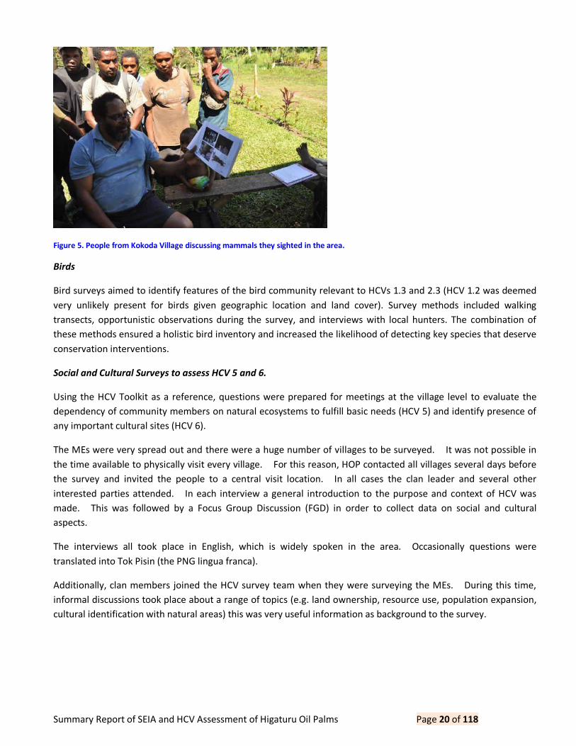
Summary Report of SEIA and HCV Assessment of Higaturu Oil Palms Page 20 of 118
Figure 5. People from Kokoda Village discussing mammals they sighted in the area.
Birds
Bird surveys aimed to identify features of the bird community relevant to HCVs 1.3 and 2.3 (HCV 1.2 was deemed
very unlikely present for birds given geographic location and land cover). Survey methods included walking
transects, opportunistic observations during the survey, and interviews with local hunters. The combination of
these methods ensured a holistic bird inventory and increased the likelihood of detecting key species that deserve
conservation interventions.
Social and Cultural Surveys to assess HCV 5 and 6.
Using the HCV Toolkit as a reference, questions were prepared for meetings at the village level to evaluate the
dependency of community members on natural ecosystems to fulfill basic needs (HCV 5) and identify presence of
any important cultural sites (HCV 6).
The MEs were very spread out and there were a huge number of villages to be surveyed. It was not possible in
the time available to physically visit every village. For this reason, HOP contacted all villages several days before
the survey and invited the people to a central visit location. In all cases the clan leader and several other
interested parties attended. In each interview a general introduction to the purpose and context of HCV was
made. This was followed by a Focus Group Discussion (FGD) in order to collect data on social and cultural
aspects.
The interviews all took place in English, which is widely spoken in the area. Occasionally questions were
translated into Tok Pisin (the PNG lingua franca).
Additionally, clan members joined the HCV survey team when they were surveying the MEs. During this time,
informal discussions took place about a range of topics (e.g. land ownership, resource use, population expansion,
cultural identification with natural areas) this was very useful information as background to the survey.

Summary Report of SEIA and HCV Assessment of Higaturu Oil Palms Page 21 of 118
Figure 6. Focus group discussions underway.
The Land Groups and Villages that were represented at each central venue. Representatives were brought to
central venues because the villages were too numerous to undertake separate interviews.
Table 7. Locations of village interviews.
Central Venue Land Group(s) Representative
Village
Kararata Hasina Clan Hanau
Jirekapa Bapera Clan Koruta
Ufenapa Clan Kararata
Bakitopa Clan Kararata
Sauha Clan Burususu
Jirekapa Clan Poro
Bouga Clan Bututu
Jopare Family Emboho
Siremi Hojekari Clan Siremi
Senani Clan Siremi
Aruka Clan Siremi
Soropa Plantation Inc. Siremi
Dobuduru Umotaha Clan Efia
Haugapa Clan Penji Pejari
Hoemba Clan Dobuduru

Summary Report of SEIA and HCV Assessment of Higaturu Oil Palms Page 22 of 118
Bana Ombari Clan Parahe
Jangorapa Clan Hombiriri
Sipari Clan Ango
Javiripa Uhepa Clan Ango
Sorupa Clan Ango
Purofafa Clan Barisari
Joiha Clan Barisari
Bapuhi Vevehupa Kendata Clan Hetune
Kahopa Mohamei Clan Ahire/Ijika
Vevehupa Sumita Clan Isuga
Ahora Sigu Clan Omba
Ase Clan Haveve
Barunapa Clan New Warisota
Serembe Arehu Clan Serembe
Ihogane Clan Serembe
Oga Clan Serembe
Ombora Clan Serembe
Saruva Clan Serembe
Kokoda Station Biage B. Group Inc. Kokoda
3.2.1.1 HCV Peer Review
In the HCV context, peer review is the process whereby an HCV assessment is evaluated by HCV expert(s) to
identify any shortcomings of the assessment process and output. The reviewer checks that:
• The HCV toolkit is used appropriately,
• HCV identification has been carefully evaluated by experts in the appropriate field and the logic explained,
• Management and monitoring recommendations follow current best practices and are fitting for the landscape and social context,
• Appropriate stakeholder consultation has taken place, and All of these are reflected in the HCV Assessment Report.
Upon receipt of the peer review, edits are made to address comments by the reviewer and a final draft is
produced. Daemeter used the ALS peer reviewer pool to assess our integrated HCV and HCS reports. The peer
review took place 1 -10 December 2015 and was signed off 17 December 2015. The peer reviewer was DWI R.
MUHTAMAN.

Summary Report of SEIA and HCV Assessment of Higaturu Oil Palms Page 23 of 118
3.2.2 HCS Assessment Method.
Community engagement FPIC, rights and Participatory Mapping
While the HCS methodology basis most its results on biometric methods, it stresses the importance of community
engagement with regards to HCS, in particular:
• Inform community of the purpose, involvement and potential outcome of HCS prior to field assessment
• Ensure community land ownership/customary rights boundaries are clearly identified through
participatory mapping
• The right of local peoples to give or withhold their free, prior and informed consent
Community land use, values and livelihoods are recognized through participatory mapping to ensure HCS
conservation does not adversely affect these rights/values and or HCS within the boundary and outside is not
impacted upon by community.
Inform and discuss the findings with the community prior to completion of integrated conservation land use plan
to ensure appropriateness and ongoing recognition and participation in management.
These activities were agreed and understood to be completed primarily by NBPOL and supported also by the HCV
assessment. TFT reviewed the progress of this during our assessment.
NBPOL have an established central procedure for new developments, including FPIC and community engagement.
This is adapted to each mill-plantation cluster, and for HOP is outlined in the Higaturu Oil Palm Mini Estate Project
Implementation , last amended 20-11-2014. The key steps in this process include;
• Initial unsolicited contact with land owners
• Land owners make an official invitation (expression of interest) to NBPOL
• Formal reply from NBPOL and a working committee is established with names and boundaries recorded
• Proposed area inspected and mapped by NBPOL together with land owners
The HCV assessment included a review of HCV 5 (community needs) and HCV 6 (cultural values), identified
through engagement with local communities or indigenous peoples. In addition, throughout the HCS assessment
local community members accompanied the field teams to assist with navigating to the plots, which also provided
an opportunity learn more about FPIC, rights and livelihoods.
Vegetation classification
Land-use / vegetation cover maps and tables
The area was classified according to the observed vegetation cover using a Geographical Information System (GIS),
ArcMap 10.0. Three main types of imagery were sourced and utilised for the initial vegetation classification:
• 5m resolution RapidEye imagery supplied by NBPOL
• 30m resolution (panchromatically sharpened to 15m) Landsat 8 satellite imagery • Georeferenced aerial imagery extracted from Google Earth Pro.

Summary Report of SEIA and HCV Assessment of Higaturu Oil Palms Page 24 of 118
This imagery represents a range of ages (time since capture) and a range of cloud cover percentages.
Subsequently no single data set was entirely suitable for the initial vegetation classification, and all three datasets
were utilised during this initial process.
RapidEye
The RapidEye imagery supplied by NBPOL was the primary source used for the initial vegetation stratification.
This imagery is three band (R,B,G) and had undergone false colour processing prior to being supplied by the client
for use on this project. Further supervised classification was performed in order to extract forest cover from the
image, aiding in the delineation of vegetation type boundaries.
Landsat 8
The study area was fortunate enough to be wholly contained on one image tile, minimising the need for the raster
pre- processing functions used to match multiple tile images for the purposes of analysis, such as histogram
matching. The tile used for this project was Path 95, Row 66, captured on 11/05/2014. This image possessed
the least amount of cloud cover.
Landsat 8 imagery has a multi-spectral pixel resolution of 30m and a panchromatic a pixel resolution of 15m. The
multi-spectral nature of Landsat 8 imagery allows an array of band combinations (or composite bands) to be
created, specifically enabling land cover and vegetation analysis to be undertaken.
The following composite datasets were created using Landsat 8 bands;
• Natural Colour panchromatically sharpened to 15m (Bands 2, 3, 4 and 8)
• 4 Band Natural Colour (5, 4, 3 and 2)
• Colour Infrared (Bands 5, 4 and 3)
A NDVI (normalised differential vegetation index) was created using the 4 band natural colour dataset using the
standard equation where;
����= (���������������� �������) ÷ (���������������� + �������)
Google Earth Pro
Google Earth Pro is a licenced version of Google Earth that allows high resolution images to be exported from the
software. Much of the study area was covered by high quality aerial photography, which was extracted and
georeferenced in ArcGIS. Although the resulting image tiles were mostly of high quality, this data was of little
practical use, being captured in 2010. In situations where comparison of all three image sources showed little
or no change in vegetation boundaries, the high quality images sourced from Google Earth Pro were used to aid in
vegetation boundary delineation.
The imagery acquired for this project were analysed to stratify the project by vegetation cover types. Stratification
involves classification of vegetation cover into areas of similar composition. The characteristics used to
differentiate strata were:
The remote sensing technicians implemented visual classification of the satellite images. This involves visually
assessing spectral frequency, image texture and reflectance characteristics. To assist in classification, the images
Summary Report of SEIA and HCV Assessment of Higaturu Oil Palms Page 25 of 118
were processed / enhanced using various techniques to increase the contrast within the images allowing easier
definition of stratum boundaries. Due to the high level of heterogeneity in species composition and tree size
distribution within the forested areas, visual interpretation of the images was the primary means of initial
stratification.
Following the site inspection, the initial stratification was verified and adjusted according observations made in
the field (as explained further in Chapter 4 of this report), including:
• Actual vegetation types observed at designated plot locations.
• Plot measurements of tree diameters, heights and species.
• Photographs taken at plot locations.
• General observations of vegetation types and condition from field inspection.
Forest Inventory Methods
Definition of carbon pools
High carbon stock (HCS) inventories measure the following carbon pool of above-ground biomass of large plant
species (defined as having diameter at breast height greater than or equal to 5cm). This includes both tree and
non-tree species.
The measured carbon pool includes stem, stump, branches, bark, seeds, and foliage. It excludes forest understory
including small diameter plant species (below 5cm diameter breast height), vines, epiphytes, and other non-tree
vegetation components such as:
• Below ground biomass, i.e. living biomass of roots.
• Deadwood.
• Litter. • Soil organic matter.
The HCS is a rapid carbon assessment methodology. Its purpose is to provide reasonably robust carbon estimates
with minimum measurement activity. Hence the focus is on measurement of large plant species which usually
comprise the large majority of biomass carbon. The other forest carbon pools are not measured because they are
either relatively small in size (e.g. forest understory) or difficult and expensive to assess (e.g. below ground
biomass).
Precision and accuracy targets
The recommended precision targets for the HCS assessment are:
Forest carbon stock inventories are planned for the purposes of attaining carbon stock estimates with 90%
confidence intervals to within 10% of the total carbon stocks for the designated above ground carbon pools1.
1 For example, if the total estimated forest carbon stocks were 600,000 tonnes, then the target precision levels would be 90%
confidence intervals of 60,000 tonnes.

Summary Report of SEIA and HCV Assessment of Higaturu Oil Palms Page 26 of 118
Variability within stratum may exceed the overall carbon precision target, provided the precision target for the
total carbon estimate is achieved.
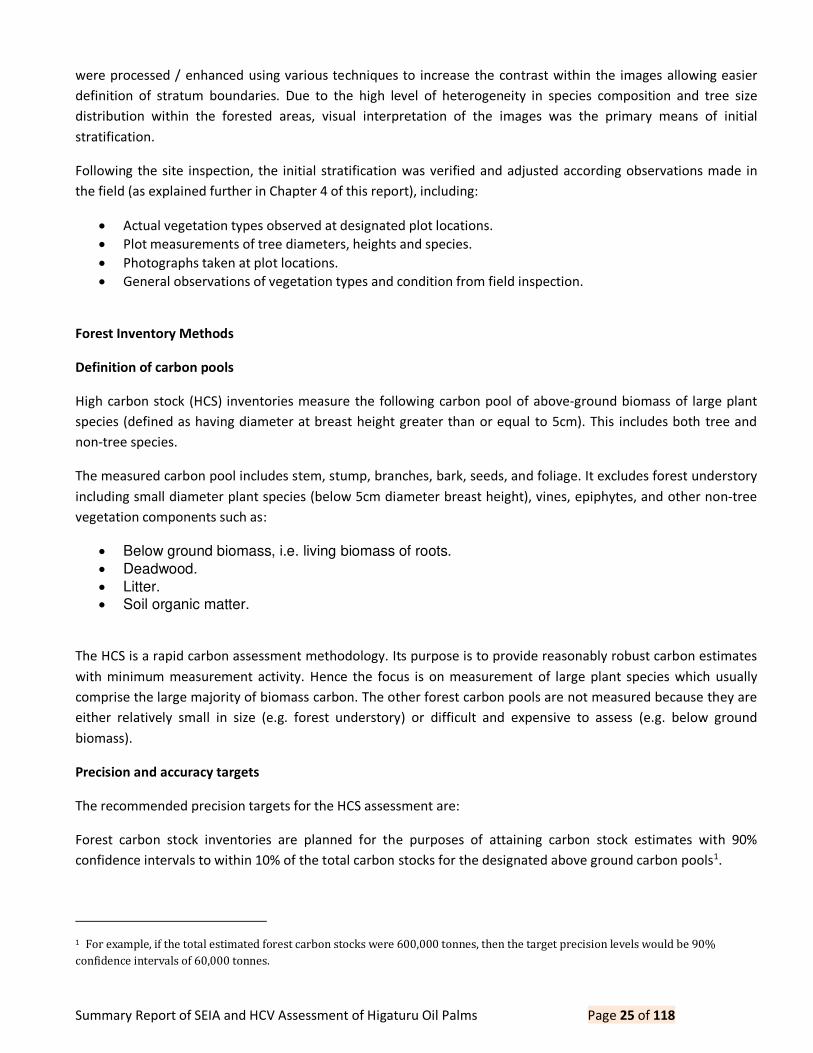
Plot size, sampling intensity and navigation
Carbon levels within the landscape were estimated from plots located within various vegetation cover types. Prior
to going to the field, random plots were located on preliminary vegetation cover maps. The factors taken into
account for planning plot locations were as follows:
The plot locations were planned to only pass through areas of predominately natural forest vegetation types, i.e.
• Medium density forest
• Low density forest • Young regenerating forest
• Scrub No High Density Forest areas were observed in image analysis, however, some was discovered during the
fieldwork (see below).
Based on experience in similar forest types and upon imperial prediction given the area and estimated variance
from the literature as well as experience in similar forest types, we can estimate the number of plots per strata.
This is a minimum of 5 plots and maximum of 50 plots per vegetation cover type, with an approximate target of
20-30 for each.
The plot shape used was concentric circular plots with areas of 0.05 and 0.01 hectares respectively. Small
diameter trees (<15cm DBH) were measured in the small plot. Large trees (>=15cm DBH) were measured in the
large plot.
Figure 7. HCS plot design.

Summary Report of SEIA and HCV Assessment of Higaturu Oil Palms Page 27 of 118
The measurement of plots were performed by two teams consisting of one person from TFT, two people from
NBPOL (surveyors and planning) and between 3 to 6 day workers from the local villages. Plot measurements were
complied into an MS Excel and then to MS Access database for further analysis.
A total of 108 plots were measured.
Tree measurement and carbon estimation methodology
DBH: All trees greater or equal to 15cm DBH were measured in the large plot. In addition to the large trees, all
trees greater than or equal to 5cm and less than 15cm DBH were measured in the small plot.
Species: All trees inside the plot were assessed for species.
Species were identified in the field according to their common (local name) name or botanical (scientific) name if
known
The common species names were classified into commercial timber groups.
The average specific gravity of commercial timber for each commercial group was obtained using global wood
density databases, including;
Ref: Zanne et al. Global wood density database.
Citation for the database: Zanne, A.E., Lopez-Gonzalez, G.*, Coomes, D.A., Ilic, J., Jansen, S., Lewis, S.L., Miller, R.B.,
Swenson, N.G., Wiemann, M.C., and Chave, J. 2009. Global wood density database. Dryad. Identifier:
http://hdl.handle.net/10255/dryad.235.
Stems per hectare:
Stems per hectares were extrapolated based on the plot size. The equation used is:
Stems per hectare = (Count of trees in the plot) / (Plot size in hectares)
Carbon content: The HCS assessment process uses allometric equations to estimate biomass and carbon.
Allometric equations help estimate characteristics of a tree that are difficult to measure by measuring correlated
attributes of the tree. Field sampling at Oro Bay areas measured DBH, which was then used to determine the
biomass of the entire plant above ground using allometric equations.
Allometric equations are typically developed from large samples to ensure they are accurate. Many allometric
equations exist around the world, some are specific to one forest type or tree species, whereas others are more
generic to cover a broader range of situations. Similarly there are global allometrics developed from tree sampling
around the world and locally developed allometrics.
Two equations for estimating carbon mass were used for comparison:
S. Brown (1997). Estimating biomass and biomass change of tropical forests: A primer . FAO Forestry Paper
134. ISBN 92-5-103955-0. Moist equation 3.2.3:
AGB = (42.69-12.8000*(DBH)+1.242*((DBH)^2))/1000

Summary Report of SEIA and HCV Assessment of Higaturu Oil Palms Page 28 of 118
Chave, J., C. Andalo, S. Brown, M. A. Cairns, J. Q. Chambers, D. Eamus, H. Folster, F. Fromard, N. Higuchi, T. Kira, J.
P. Lescure, B. W. Nelson, H. Ogawa, H. Puig, B. Riera, and T. Yamakura (2005). Tree allometry and improved
estimation of carbon stocks and balance in tropical forests . Oecologia. 145: 87 99.
AGB=Exp(-1.499+2.148*ln(DBH)+0.207*ln(DBH)^2-0.0281*ln(DBH)^3))/1000*(Wood Density)
See http://ctfs.arnarb.harvard.edu/Public/pdfs/MakanaConditEtAl.JTE2011.pdf
Palms have a different density and carbon function and therefore require a different calculation:
Palm Carbon (tonnes) = [Specific gravity] * DBH2/40000*(Palm height)*(Carbon conversion factor)
Note:
The specific gravity measures the bone dry density of the wood. For tropical tree species this value is an average
of 0.55 tonnes / green m3. For palms, specific gravity is assumed to be 0.247 tonnes / green m3.
Black palm density is known at 0.860139 and coconut is estimated at 0.6.
The carbon conversion factor estimates the carbon component of the vegetation biomass. This can be derived for
specific forest types or the IPCC standard value of 0.47 can be used.
The equation for estimating tree carbon mass per hectare is:
Total Carbon (tonnes/ha) = ([Tree Carbon]) / [Plot size in hectares]
The specific gravity was derived by species. The wood density ranges we are grouped into three generic
categories; low (<400kg/m3), medium (400-600 kg/m3) and high (600 kg/m3). Where the genus/species is
unknown we use medium range or about IPPC average equal to 0.55.
3.2.3 SEIA Assessment Method.
Secondary Data
The data collection, analysis and report writing was entirely carried out by Narua Lovai a social scientist with many
years of experience carrying out assessments for the mining and oil palm industry both for government and
voluntary standard compliance, including RSPO. The environment impact component of this assessment was
based on secondary data, and the consultant's accumulated knowledge and experience with environmental issues
typically related to the development of an oil palm ME. In comparison, the social impact assessment component
was carried out using secondary data, relevant information from the environment component as well as field data
gathered through consultative meetings, discussions and interviews with the interim ILG committee members, IGL
community members, and Oro Provincial Administration officers. Literature searches were conducted to
collate material relating to the biophysical and human environment of the location, latest RSPO information on
new plantings and operation of MEs in Oro and other oil palm growing provinces.
Primary Data
Three sets of questionnaires were prepared to obtain environmental and socio-economic data from landowners
and other stakeholders. One questionnaire was for the land owner group committees, another questionnaire was

Summary Report of SEIA and HCV Assessment of Higaturu Oil Palms Page 29 of 118
for land owner group members and the third one was for notable stakeholders within the area. The
questionnaires were primarily designed to assemble a basic outline of the predevelopment situation which both
HOP and the respective ME landowners intend to improve over time. In preparation for the fieldtrip the HOP
Lands Unit sent out formal notification on the SEIA to all the interim ILG committees and relevant Provincial
Government officials. After the fieldtrip, the data acquired was processed with relevant information from
literature searches, inputs from consultation with stakeholders as well as the knowledge and experience of the
consultant on MEs in the oil palm industry to compile the SEIA report. The land group meeting programme is
shown in the Table below, the list of attendees who participated in those meetings is provided in Appendix 1.
Stakeholder consultation was carried on the 14th 20th of October 2015 at various sites, consultation with local
landowners was held at each respective local meeting venues making easier for all the members to attend. On the
19th of October 2015 consultation was held at the HOP Training Academy and was attended by relevant
stakeholders, cooperatives and government agencies representatives. The consultation was to provide feed back
on the results of the HCV assessment and provide opportunities for communication and sharing the information,
opinion and suggestion between the company, stakeholders and government bodies.
Table 8. Land Groups meeting Program.
Date and Time Central Venue Proposed Estate Land Group Village Division
Tuesday Kararata Hasina Hasina Clan Hanau Embi
18-Aug-15 Sauma Jirekapa Bapera Clan Kararata Embi
9:00am UDK Extension Ufenapa Clan Kararata Embi
Ufenapa Ufenapa Clan Kararata Embi
Bakito Extension Bakitopa Clan Kararata Embi
Jireka I Jirekapa Clan Poro Embi
Jireka II Jirekapa Clan Poro Embi
Bouga Bouga Clan Bututu Embi
Jopare Jopare Family Emboho Embi
Wednesday Siremi Hoka Hojekari Clan Siremi Embi
19-Aug-15 Viviri Senani Clan Siremi Embi
9:00am Aruka Aruka Clan Siremi Embi
Soropa Soropa Plantation Inc. Embi
Thursday Dobuduru Takoh Umotaha Clan Efia Embi
20-Aug-15 Darau Haugapa Clan Dobuduru Embi

Summary Report of SEIA and HCV Assessment of Higaturu Oil Palms Page 30 of 118
9:00am Hoemba Hoemba Clan Dobuduru Embi
Hopanda Sauha Clan Dobuduru Embi
Bana Ombari
Ext. Bana Ombari Clan Parahe Embi
Isatapa Bana Ombari Clan Parahe Embi
Sesehota Jangorapa Clan Hombiriri Embi
Sipari Sipari Clan Ango Embi
Wuria Purofafa Purofafa Clan Barisari Embi
Joiha Joiha Clan Barisari Embi
Friday Bapuhi Mena Extension Vevehupa Kendata Clan Hetune Dobuduru
21-Aug-15 Mohamei Kahopa Mohamei Clan Ahire Dobuduru
9:00am Akute Vevehupa Sumita Clan Isuga Dobuduru
Saturday Ahora Sigu Sigu Clan Omba Ambogo
22-Aug-15 Ase Ase Clan Haveve Ambogo
9:00am Boruga Pusute Barunapa Clan
New
Warisota Ambogo
Monday Serembe Serembe Saruva Clan Serembe Sumbiripa
24-Aug-15 Arehu Igohane Clan Sumbiripa
9:00am Arehu Oga Clan Sumbiripa
Arehu Ohogo Clan Sumbiripa
Arehu Ombora Clan Sumbiripa
Arehu Aembara Clan Sumbiripa
Tuesday
Kokoda
Station Biage Biage B. Group Inc. Kokoda Mamba
25/8/2015
2015
10:00am

Summary Report of SEIA and HCV Assessment of Higaturu Oil Palms Page 31 of 118
Besides the consultations with primary land owners, there were meetings held with government and business
stakeholders. These are listed below.
Government Departments
• Eddie Malaisa - Provincial Wildlife and Environmental Officer
• Sebastian King Provincial Forestry Officer
• Champion Avediba Acting Agricultural Advisor
• Ward Councillors and Council Officials from Popondetta Urban LLG and Oro Bay Rural LLG
• Sam Vegogo Provincial Administrator
• Willie Paul Purari Deputy President of Higaturu LLG
• Ishmael Koneha CEPA representative
• Mary Fay Karong & Claire Tarawa Provincial Office of Conservation and climate change
• Silas Orowari Provincial Government Extension Officer
• Hon Evaurtius Bori Higaturu LLG President/Deputy Governor
• Merire Dubo Provincial Customary Lands Officer
Biage Business Group Representatives
• Chairman: David Soriu
• Director: Pastor Graydon Osivio
3.4 List of legal, regulatory and other guidance referenced
3.4.1 References Used in the SEIA
Bleeker, P., 1983, Soils of Papua New Guinea, CSIRO, Canberra, Australia.
Douglas Environmental Services, 2007, Environmental Assessment Report for the Smallholder Agriculture
Development Project PNG, Report to OPIC, Port Moresby, PNG.
Haantjens, H.A., 1964, General Report on Lands of the Buna Kokoda Area Territory of Papua and New Guinea,
CSIRO, Melbourne, Australia.
International Association for Impact Assessment, May 2003, Social Impact Assessment International Principles,
Special Publication Series No.2
Interorganizational Committee on Guidelines and Principles for Social Impact Assessment 1994, Guidelines and
principles for social impact assessment, Impact Assessment, vol.12, no. 2, pp.107 152.
Koczberski, G & Curry, G.N., 2007, Beneficiaries Assessment Report for the Smallholder Agriculture Development
Project PNG, Report to OPIC, Port Moresby, PNG.
Koczberski, G & Curry, G.N., 2007, Social Assessment Report for the Smallholder Agriculture Development Project
PNG, Report to OPIC, Port Moresby, PNG.
McAlpine, J.R., 1983, Climate of Papua New Guinea, CSIRO, Canberra, Australia.

Summary Report of SEIA and HCV Assessment of Higaturu Oil Palms Page 32 of 118
NBPOL, 2014, Annual Report for 2013, NBPOL, Mosa, West New Britain Province, PNG.
RSPO, 2013, Roundtable on Sustainable Palm Oil Principles and Criteria, RSPO Secretariat, Kuala Lumpur,
MalaySEIA.
RSPO, March 2008, RSPO PNG NIWG Principles and Criteria, RSPO.
RSPO, May 2010, RSPO New Planting Procedures - Guidance Document, RSPO.
3.4.2 References Used in HCV
Brown, E., N. Dudley, A. Lindhe, D.R. Muhtaman, C. Stewart. & T. Synnott (eds.). 2013. Common Guidance for the
Identification of High Conservation Values. HCV Resource Network.
Haantjens, H.A., S.J. Paterson, B.W. Taylor, R.O. Slatyer, G.A. Stewart & P. Green. 1964. Geology, Geomorphology,
and Land Systems of the Buna-Kokoda Area, Papua (with inset maps of Physical Regions, Regional Land Use
Potential, Lamington Land System-Distribution of Units, and Traverses and Sample Sites) Land Research Series No.
10. Commonwealth Scientific and Industrial Research Organisation, Melbourne, Australia.
E.T. Hammermaster and J.C. Saunders Forest Resources and Vegetation Mapping of Papua New Guinea , PNGRIS
Publication No.4, 1995
Menazza, S. 2010. Survey Regarding National Legal And Policy Measures Related To Indigenous And Community
Conserved Areas. The Nature Conservancy.
Parsons, M.J. 1992. The world s largest butterfly endangered: the ecology, status and conservation of
Ornithoptera alexandrae (Lepidoptera: Papilionidae). Tropical Lepidoptera 3(1): 33-50.
European Space Agency and Word Bank, EO World Study: New Guinea Oil Production Operational Document in
Support of the Smallholder Production in PNG. 2011
3.4.3 Reference Used In HCS
highcarbonstock.org/the-hcs-approach-toolkit/
Havel, J. 1975. Training Manual for Forestry College. Volume 3. Forest Botany. Part 2. Botanical Taxonomy.
Paijmans, K. 1975. Explanatory notes to the vegetation map of Papua New Guinea. No. 35. Commonwealth
scientific and industrial research organization
4.0 Summary of Assessments
4.1 Summary of SEIA Assessment
Awareness sessions where held by the company at all Villages within each separate area and including other
stakeholders on stakeholder related matters (dispute settling, environmental issues etc.). Hereby the customary
traditions were recognized by involving the communities representatives and clan leaders. There are clans which
reside or have interest in each of the expansion areas. Files are available showing the involved discussion process,
decision making process and if needed a settlement process and the consent process of involved stakeholders.

Summary Report of SEIA and HCV Assessment of Higaturu Oil Palms Page 33 of 118
Established boundaries are marked physically by pegs and on maps. This is also a requirement of RSPO P & C to
which HOP is already certified.
All the stakeholders are informed with regards to ongoing negotiations in regards to the proposed development of
the expansion.
Records indicate that presentations were made to the Local Provincial Administrations and LLG Representatives
from each separate area. This is included for all areas which will be part of the New Plantings.
There are records of meetings and includes participants from HOP and community representatives for each area.
There are also records of the history of communication on the proposed development and all meetings held with
the local communities.
A number of awareness sessions were also held with Land Groups and other local people forming the ILG from
December 2013 and March 2015. Altogether a large number of members of the local communities including Land
Groups attended these sessions. Both the benefits and negative impacts were discussed at each of these meetings
as well as explaining the ILG Process. There are attendance lists provided for each meeting with local people in
each extension area.
Observation: Copies of the meeting minutes were not included in the SEIA report however it is understood that
each meeting was minuted.
Of the proposed New Planting areas two are on state land these are Soropa and Biage (BBGI), all other extension
areas are customary land and owned by the local clans.
All ILG s can demonstrate ownership of land being developed through history of tenure and community agreement
to enter into lease arrangements once it has been decided to continue. State leases are held by both Soropa and
Biage (BBGI).
Boundaries of customary land are normally demarcated by natural features such as Roads, Rivers, trees, stones,
mountains etc. Boundaries for each expansion are identified and are located and marked via GPS and also
included in maps for all areas involved in the expansion.
There have been no known disputes with regards to the land involved in the proposed New Planting extensions.
HOP has a participatory conflict resolution method by first talking to involved parties and also recording minutes
of these meetings as per 2.2.4 The Company tries to implement the conflict resolution process by the involvement
of the Company Lands Officer dealing with complaints of the communities. He keeps track of the complaints and
visits the ILGs to settle any dispute. When conflict resolution in relation to state land cannot be settled accordingly
it becomes a process for the DLPP or the courts to settle. There are no conflicts recorded at this stage.
In all cases for ILG s it can be demonstrated that acceptable conflict resolution has taken place. Customary land
owners are able to obtain legal title as allowed under customary land registration (2009 amendment) act to their
clan owned land and then enter into lease agreements with HOP.
Maps are available (current) showing occupied state land, vacant state land and customary land. Maps are
available which indicate the extent of recognised customary rights and there are copies available of negotiated

Summary Report of SEIA and HCV Assessment of Higaturu Oil Palms Page 34 of 118
agreements detailing the process of consent in relation to the state land that was compensated for when bought
by the state and with current customary land in relation to the establishment of ILG s.
HOP is in the process of negotiating with customary landowners to acquire land for plantation expansion under
the Customary Land Registration (2009 amendment) act and Incorporated Land Group (2009 amendment) act
Process with regards to the land not under state leases. This process commenced in April 2015 and is ongoing as a
lease agreement has not yet been finalized and signed with each ILG. The FPIC component will be integrated into
the land lease process (the description of the awareness session on both positive and negative aspects of
development), with cooperation of an independent neutral party in this case Local Level Government (LLG) who
have appeared reluctant to be involved at this stage. However, Provincial Customary lands officers have been
involved in the land acquisition process for customary land.
Each concession put forward for New Planting expansions is very keen to start the process as soon as possible.
Some have expressed an interest in planting Oil Palm back in 2011.
Since April 2015 HOP commenced work on the Incorporated Land Group process with the landowner groups. The
initial step in the process was for the landowners to invite HOP to develop their land. HOP representatives meet
with the landowners and inspect the land to ensure it is suitable for oil palm cultivation. Awareness sessions have
been held with the landowners in the villages and hamlets or at a suitable location where all interested parties
may attend. A number of Local Government representatives were invited to attend the awareness sessions to
verify that FPIC is followed and also to explain possible negative environmental and social impacts to the
landowners. Three awareness sessions are held with the ILG. Following the awareness sessions consent is given by
the landowners for the company to assist in the formation of the ILG and to obtain title over the land. HOP
representative provides assistance to the landowners. The SEIA carried out indicated that Local communities were
in favor of the expansion due to the benefits it can bring to the local community/ies.
Observation: The SEIA presented did mention some of the ongoing issues which development of Oil Palm may help
to alleviate all areas and villages to some extent have similar problems. These include poor quality housing, no
fly/insect or odour control, no water tanks, poor pit latrines and suffer from a number of illnesses such as malaria,
intestinal and skin infections. Most have very poor access to health facilities in the area however the benefits
from the development of Oil Palm were not positively identified within the SEIA.
Observation: There did not appear to be any Cost Benefit Analysis completed nor any financial data provided.
Although the report did mention that due to time restraints a full socio economic has not yet been carried out.
MOU not yet prepared.
The minutes of any meetings are to be kept and are a tool to follow up on the awareness that is forwarded and to
check the FPIC component. (See observation above) This indicates that these agreements are entered into
voluntarily as minutes of any meetings are recorded. This information is to be recorded in English and Tok Pisin.
The Customary Land Registration system is a legal process under the Customary Land Registration (2009
amendment) act whereby customary landowners can form an ILG and obtain customary land title to their land. By
holding a recognised legal title the ILG can then enter into a Lease agreement with a company to develop that
land. HOP has a documented procedure to assist customary landowners to obtain leasehold title to their land.
The DLPP is the government department responsible for administering the Customary Land Registration (2009
amendment) act and the Customary Land Registration process ensuring that the rights of the customary
landowners are protected.

Summary Report of SEIA and HCV Assessment of Higaturu Oil Palms Page 35 of 118
At this stage the ILG s have not been formed officially. HOP has conducted formal meetings with Land Groups to
obtain information on membership of land owning clans and boundary mapping. This is jointly done with
government lands officers.
SEIA and HCV forest evaluations have been completed prior to the signing of lease agreements. All land under
evaluation for Leasing by customary landowners and sublease by state lessees does not include significant
amounts of identified HCV areas. Any areas that may contain HCV are mapped and set aside and will not be
developed for Oil Palm development. Any such areas are included in the HCV report.
Maps showing potential areas for Lease and subleases have been produced. Areas of vacant State owned land
are also identified on these maps.
A Social and Environmental impact Assessment has been conducted in relation to the areas of the proposed
expansion areas. This was completed by a local organisation (Narua Lovai). This assessment was completed and
report submitted in October 2015. This assessment includes a comparison of existing situation and impacts as a
result of expansion.
There were a number of concerns expressed by members of each group these included perceived unequal
sharing of the income generated between HOP and the ILG S. There were also concerns with regards to lack of
improvement of living conditions. They were also worried with regards perceived social deterioration with the
improvement of income and having more money available. This included use of alcohol and substance abuse near
the Mini Estate.
Other issues raised included contamination of water sources used for drinking, cooking and other practices by
residues from fertiliser and pesticide use.
This also included details of impacts and risks including the significance of the impacts/risks.
Through the existing RSPO system in place Environmental Aspects and Impacts are assessed and reviewed at least
annually for all areas under the control of HOP.
The environmental impact assessment included the development of infrastructure such as building new roads,
introducing drains and disposal of waste.
An Environmental Management plan has been prepared with regards to the submission for an application for an
Environmental Permit. This was prepared as a requirement of the RSPO P & C certification process.
Social Impacts are identified in part via the grievance process, ILG s and other parties for negative impacts and
through social interaction for positive impacts as reported in 6.5.
An action plan has been proposed in the SEIA and actions will be taken, time frames and responsibilities and
records in relation to any changes to procedures or implementation will be maintained.
As a result of the SEIA the following recommendations were made with regards to mitigating potential
environmental impacts.
• Conduct RSPO awareness in all ILG S
• Ensure Buffer zones are clearly marked and left intact
• Enrich species diversity in the buffer zones

Summary Report of SEIA and HCV Assessment of Higaturu Oil Palms Page 36 of 118
• Include cultivation of QABB vines in Buffer Zones
• Carry out water quality monitoring prior to site preparation
• Ensure proper disposal of all waste generated.
• There were also recommendations with regards to potential socio-economic aspects.
• Undertake full genealogy study of members of land owning clan
• Conduct base line household socio-economic survey of each community
• Verify that all clan members are kept informed of agreement negotiations (FPIC).
• Determine how clan members with VOP blocks on proposed ME will be handled
• Evaluate increases in land rental and FFB royalty rates would improve socio-economic welfare within the
ILG communities
• Ensure all members of each ILG understand the agreement prior to signing.
• Ensure priority for employment and contracts is given to the ILG community
• Investigate means of improving living conditions
• Arrange project planning and financial management training for ILG s
• Organise training and awareness on budgeting and saving
• Organise awareness sessions on alcohol and substance abuse as well as HIV for ILG and nearby
communities
• Promote sporting activities within ILG and nearby communities
HOP is aware about the FPIC and transparency in relation to dealings with customary landowners and has
incorporated this in its procedures.
The communities are represented by ILGs and also Local Administrators. Also the communities have given their
consent based on a full understanding of the matter/proposal and sufficient information is provided.
Each ILG has appointed a spokesperson to address these issues and to discuss on behalf of the ILG.
All documents are in English (the official language of PNG) but can be translated into local languages as necessary.
The above findings are e presented in the form of an aspect-impact plan with mitigation measures, indicators,
monitoring framework and responsible persons assigned. This detailed table is presented in the Summary of the
Management Plans which is also part of the NPP documentation.
4.2 Summary of HCV Assessments.
National / Regional Context
PNG has large expanses of pristine habitat, high levels of biodiversity, and low human population density. PNG
encompasses some of the world s last great tracts of mature tropical rainforest and largest coral reefs, including a
unique array of species that have evolved here in isolation. This has made PNG one of the world s most
important biodiversity hotspots.
The study area extends from Kokoda in the west to Oro Bay in the east, a relatively flat landscape where the
vegetation was once dominated by Lowland Rainforest. Some parties believe that the kunai grassland were
present thousands of years ago (as was the case in other areas in PNG), while others believe these are caused by
recent human influence. Today, the landscape is a mosaic of grassland areas, oil palm plantations, logged-over
regenerating forests and areas of remnant rainforest.

Summary Report of SEIA and HCV Assessment of Higaturu Oil Palms Page 37 of 118
Through a review of official data sources, satellite imagery, field inspections and interviews the HCV study verifies
that the entire area has been logged prior to November 2005. Based on the findings of this study there is no
liability of clearing HCV if the recommendations of this study are followed.
The area was once heavily forested and has been deforested by a mix of industrial logging and subsistence
agriculture. Industrial forestry continues in the area, although at considerably lower levels than in their heyday in
the 1970s. The major land use pattern throughout the area is the clearing of forest for subsistence agriculture
using fire; after several years of agriculture use, the gardens are now abandoned as the fertility has declined.
The kunai grassland (Imperata cylindrica) is the pioneer species, which is frequently burnt, destroying the seed
source for forest trees. Hence the forest is not able to recover and recolonize the ex-agricultural areas. As a
result, the forest area is shrinking quickly in the region.
The area to the east of the Kumusi River to Oro Bay is one of the three ecosystems that provide habitat for the
world s largest butterfly, Ornithoptera alexandrae, Queen Alexandra s Birdwing Butterfly (QABB). QABB is only
found in three areas of the Oro Province and is featured on the provincial flag. Adult butterflies feed on many
nectar sources but the caterpillar s only food source is the Pararistolochia dielsiana vine. The importance of
this butterfly underscores the need to preserve its forest habitat.
Landscape Context
Physical Regions
The proposed mini estate development sites are spread out to the southeast, northeast and west of Popondetta
town and are part of three physical regions (Haantjens, 1964):
the Kumusi-Mambare lowlands,
the Mt. Lamington-Hydrographers Range volcano region and
the Mambare River valley (where Kokoda is located) between the Main Cordillera of the Owen Stanley Range and
the Ajule Kajale Range.
Additionally, the Mambere Foothills region is located nearby, but does not have any MEs located within it. In
general, the area has great variation in land form and relief, while the detailed land forms are characterised by
erosion from numerous streams and very sharp crested ridges formed by landslips on irregularly steep slopes.

Summary Report of SEIA and HCV Assessment of Higaturu Oil Palms Page 38 of 118
Figure 8. Physical regions (CSIRO 1964)

Summary Report of SEIA and HCV Assessment of Higaturu Oil Palms Page 39 of 118
Alluvial plains of volcanic origin occupy large funnel-shaped areas north-east of Mt. Lamington, within the
Kumusi-Mambare lowlands. Their upper parts form sandy, high, and markedly dissected outwash fans that consist
of successive deposits from numerous eruptions of Mt. Lamington which is situated 21km south-west of
Popondetta town. The lower parts, including the area eastward of Popondetta Town to the coast and
south-eastward to Oro Bay, have a more normal flood-plain character and include waterlogged distributaries
plains where rivers draining from Mt. Lamington are unable to develop proper river mouths and discharge much
of their water and silt load via a system of distributary channels.
Mt. Lamington is a volcanic mountain with a summit of over 1500 m and is characterised by gentle, but strongly
dissected middle slopes of ash and lahar deposits between 120 and 900 m, and shallow but densely dissected
volcanic plains between 30 and 240 m altitude.
Elevation and Slopes
All the areas are on gently sloping areas at low elevations. Both these factors are prerequisites for oil palm
suitability.

Summary Report of SEIA and HCV Assessment of Higaturu Oil Palms Page 40 of 118
Figure 9. Elevations map showing project area

Summary Report of SEIA and HCV Assessment of Higaturu Oil Palms Page 41 of 118
Rivers
Rivers are mapped in in the figure above. The main rivers originating from the slopes of Mt. Lamington and
dissecting the Popondetta plains in a south-easterly direction from nearest to Popondetta and progressing
eastward are Banguho, Haijo, Hehere and Girua. Banguho, Haijo and Hehere connect into the Girua River farther
downstream and the latter then empties into the Solomon Sea coast 20km north-east of Popondetta.
Land Cover
Today, the landscape is a mosaic of grassland areas, oil palm plantations, logged-over regenerating forests and
areas of remnant rainforest.

Summary Report of SEIA and HCV Assessment of Higaturu Oil Palms Page 42 of 118
4.2.1 HCV Outcomes and Justification
HCV 1 Concentrations of Biodiversity Values
HCV 1.1 Protected areas
Findings in the AOI
There are no Protected Areas in the AOI, therefore HCV 1.1 is deemed to be Not Present
HCV 1.2 Concentrations of rare, threatened and endangered species
Findings in the AOI
Although there were HCV 1.2 mammals potentially present in the AOI. These wide ranging species could not be
attributed to any individual MEs.
The only HCV 1.2 bird species that was sighted was the Palm Cockatoo (Probosciger aterrimus). This was
external to the MEs and in reasonable quality forest. The forest that was in the adjacent ME (Bakito Extension)
was very degraded and therefore unlikely to be important as a bird habitat.
PNG plant species that were observed were all data deficient. The botanical team considered all these species to
be common in the area and unlikely to be considered HCV 1.2.
The confirmed presence of QABB in and around Ase ME indicates that HCV 1.2 is Present in the AOI.
HCV 1.3 Concentrations of endemic species
Findings in the AOI
The bird survey observed 23 species which are included in HCV 1.3.
In general PNG tree species have not been comprehensively classified into system other than their commercial
value. For this reason, forest areas were classified as HCV 1.3, where there was good regeneration of species
that are typically found in primary forest. There were many such areas in the MEs.
There are a number of endemic mammal species that are likely present in the AOI. These appear to be
disturbance tolerant species capable of making use of secondary forests (e.g., giant bandicoot, grey dorcopsis,
papuan forest wallaby).
For this reason, HCV 1.3 was deemed present in many MEs and are mapped and presented in the Notification.
HCV 1.4 Critical temporal concentrations of species
Findings in the AOI
Pararistolachia spp. vines are common throughout the lowland rainforest of the AOI. These vines are an essential
element of the QABB life-history The reduction in the extent of this habitat is seen as the major threat to QABB
survival. HCV 1.4 is therefore deemed Present in all forested areas within the AOI.

Summary Report of SEIA and HCV Assessment of Higaturu Oil Palms Page 43 of 118
HCV 2 Landscape Level Ecosystems and Mosaics
Both the HCV and HCS study have concluded that all of the proposed areas are not within landscape level forests.
The entire area has long been converted to its current day mosaic of grasslands and secondary forests. A
detailed study carried out by EO World and financed by the World Bank and European Space Agency in 2011 has
concluded the area has no primary forests left and is currently a relatively stable patchwork of grasslands and
secondary forests. A detailed land use change analysis of each of the proposed areas conducted as part of this
NPP confirms this.
Land Use Change Analysis
• A detailed land use change analysis of 31 proposed areas to be planted by NBPOL in Oro Province was carried
out. The analysis analysed land cover and tree cover loss within the proposed areas between the period of
2000-2015.
• The study found that all of the areas are anthropogenic and have been converted to a mosaic of grasslands
and secondary forests of varying ages before the time frame of the land use change analysis. Thus this study
concurs with the HCV analysis conducted by Daemeter which claims the area to be converted does does not
contain primary forest.
• A detailed study conduct by EO World, financed by the World Bank, also found no primary forests present in
the overall study area.
• The study found that the areas proposed to be converted are grasslands, scrublands and young secondary
forests including old garden areas and it is shown to be as such before the start of this analysis (2000)
• The study detected low levels of disturbance, a global average of - 3.8%, as indicated by tree cover loss, with
exceptions within the Ufenapa, Hopanda and Hasina where higher percentages of tree cover loss.
Subsequent analysis with high resolution imagery, Rapid Eye (5m) suggests that these tree cover losses were
due to traditional shifting agriculture and took place mostly in areas classified as young secondary forest .
• The study found a high correlation between lack of tree loss and medium and high density forest which the
HCV and HCS studies have earmarked for protection.
• The study suggests an array of GIS and satellite imagery analysis tools to monitor the efficacy of protection of
these areas once the remaining areas have been converted to oil palm.
• All maps are available for viewing in Appendi 2.

Summary Report of SEIA and HCV Assessment of Higaturu Oil Palms Page 44 of 118
Figure 10. Landscape-level forests within the proposed areas,

Summary Report of SEIA and HCV Assessment of Higaturu Oil Palms Page 45 of 118
As a first step the PNG toolkit suggests mapping the AOI and its connection to Intact Forest Landscapes (IFL). In
this map the IFL are confined to the mountain tops and there is no connectivity with the AOI.
Findings in the AOI
There is no intersection between the AOI with intact forested landscapes. For this reason, HCV 2 is deemed Not
Present.
HCV 3 Ecosystems and Habitats
HCV 3 requires systematic ecosystem mapping across a very wide area and in a manner that is comparable among
sites and by different assessment teams. In PNG, the distribution of ecosystem types is defined by climate,
soil/hydrological characteristics, human influences and landform features within a biogeographical unit. The Land
Research mapping program conducted by the Australian Government in the 1970s defined and mapped land
systems in PNG that that describe topographical, geological, climate, and hydrological factors, as well as soil and
resident species. These land systems are used by Daemeter as a proxy for ecosystems.
To classify ecosystems as Endangered Daemeter analysed past and expected future forest loss on the land
systems within the MEs.
To classify ecosystems as Rare, Daemeter analysed the area of forest in each land system compared with the
area of forest in the whole physiographic region. If the area of forest in a given land system is less than 1% of the
forest in the physiographic region2 then it is classified as Rare.
Findings in the AOI
Rare ecosystems are not extensive in the AOI landscape, but do exist. Rare forest ecosystems, which are
threatened because of agricultural expansion, exist in the Akute and Soropa MEs. No endangered ecosystems
were identified. HCV3 is therefore deemed Present based on the presence of rare ecosystems in the AOI. These
have been mapped and presented in the Notification.
HCV 4 Critical Ecosystem Services
HCV 4.1 Areas critical to water catchments
Findings in the AOI
Numerous small rivers are present throughout the AOI and a couple of MEs border large rivers. Communities are
dependent on all of these rivers. HCV 4.1 is therefore Present.
HCV 4.2 Areas critical for soil erosion
2 Physiographic Regions are discussed in Section 0.

Summary Report of SEIA and HCV Assessment of Higaturu Oil Palms Page 46 of 118
Figure 11. River bank erosion of Sambogo River.
The AOI (Wuria Purofafa ME) is on the LHS.
Findings in the AOI
Sesehota and Wuria Purofafa MEs are located next to large rivers where river bank erosion could impact
downstream communities. For this reason, HCV 4.2 is deemed to be present.
HCV 4.3 Areas critical for fire prevention
Findings in the AOI
HCV 4.3 is deemed Potentially Present based on the known capacity of forests with intact canopies and wetland
forests to resist fire. Although fire has not been a major issue in the region, it is thought that these forests could
become more important barriers to the spread of fire during extremely dry years.
HCV 5 Basic Needs of Local Communities
The Common Guidance considers the following as indicators of HCV 5:
• Access to health centres or hospitals is difficult,
• Most houses are built from, and household tools made from, locally available traditional/ natural materials,
• There is little or no water and electricity infrastructure
• People have a low capacity to accumulate wealth (living day to day )
• Farming and livestock raising are done on a small or subsistence scale
• Indigenous hunter-gatherers are present
• There is presence of permanent or nomadic pastoralists • Hunting and/or fishing is an important source of protein and income
• A wild food resource constitutes a significant part of the diet, either throughout the year or only during critical seasons
Almost all these indicators are present in the villages around the AOI.

Summary Report of SEIA and HCV Assessment of Higaturu Oil Palms Page 47 of 118
The community in this area is extremely reliant on the environment for meeting their basic needs. Most people
are subsistence farmers and there are very few people that earn their living in a cash economy (e.g. few people
worked in shops in town or as government employees). Purchased food and materials tend to be very
expensive.
Findings in the AOI
The communities living in and around the AOI are heavily reliant on natural areas for meeting their basic needs.
Just about every basic need is sourced from the environment. Therefore HCV 5 is deemed Present.
HCV 6 Cultural Values
Findings in the AOI
Cemeteries located inside proposed development areas and the WW2 site at Soropa are considered HCV 6,
therefore this HCV is deemed to be Present.
Table 9. General HCV Findings.
HCV Description Present Potentially
Present
Not
Present
1.1 Protected areas
1.2 Concentrations of rare, threatened and endangered
species
1.3 Concentrations of endemic species
1.4 Critical temporal concentrations of species
2
Natural ecosystems or ecosystem mosaics which are
large in extent, un-fragmented, form a significant
components of the landscape or are of significant
importance at a local, regional of national level, and
which contain most of the naturally occurring species.
3
Ecosystems that are naturally rare, have become rare
due to historical processes, or threatened by present or
future processes.
4.1 Areas critical to water catchments
4.2 Areas critical for soil erosion
4.3 Areas critical for fire prevention

Summary Report of SEIA and HCV Assessment of Higaturu Oil Palms Page 48 of 118
5 Sites and resources fundamental for the basic
necessities of local communities or indigenous peoples.
6
Cultural values critical to the traditional cultural identity
of local communities, including areas of cultural,
ecological, economic, religious or archaeological
significance.
4.2.2 HCS Outcomes and Justification
The HCS assessment found 163.1 ha of HCS Indicative Conserve areas in addition to those identified as HCV. All
other HCS areas overlapped with HCV areas and for practical purposes are names as such. Stakeholder
consultations with NBPOL and the community provided feedback regarding several patches of HCV and HCV. Due
to this HCS modifications made were made and provided in the Integrated Forest Management Plan (IFMP)
provided by both Daemeter and TFT. In total, nine small and isolated patches (Low Prioirty) were changed from
Indicative Conserve to Indicative Develop. The small to medium size of most blocks posed new challenges to
adapting the HCS methodology, in particular we recommend raising the minimum area of isolated patches within
the block (i.e. >10ha), while reducing the minimum area requirement for physical connectivity to High Priority
forest patches (>100ha) outside the block (i.e. <10ha). All blocks exist in a landscape that is actively used by local
communities (High Risk) who own all of the land (customary ownership). This is also a relatively High Forest Cover
(>50) landscape. For these reasons it is critical that community are engaged to build a development plan that
they respect both within the blocks and on their wider lands to avoid deforestation in the landscape while
ensuring community rights and aspirations. All of the HCS management recommendation were integrated with
the HCV management recommendations and delivered to NBPOL as an Integrated Management Plan which
NBPOL has fully accepted.
Table 10. Summary of HCV and HCS Assessments.
Proposed
Mini Estates HCV
HCV &
HCS
Conserve
HCV and
Indicative
Conserve
HCS
Indicative
Conserve
Plantable Total
Akute 0 7 0 0 51.3 58.3
Aruka 3.1 11.6 0 3.7 82.9 101.3
Viviri 0 0 0 0 38 38
Ase 0 12.5 0 5.3 15.3 33.1
Bana 0 15.2 0 0 43.7 58.9
Biage 13.9 7.6 0 5.3 316.5 343.2
Boruga
Pusute 0 0 0 26.8 47.3 74.1
Bouga 0 1.4 0 5.3 42.1 48.9
Hoemba 0 0 0 58.6 58.6
Hoka 0 0 0 31.9 31.9
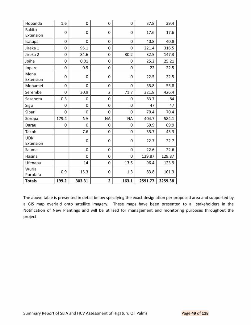
Summary Report of SEIA and HCV Assessment of Higaturu Oil Palms Page 49 of 118
Hopanda 1.6 0 0 0 37.8 39.4
Bakito
Extension 0 0 0 0 17.6 17.6
Isatapa 0 0 0 0 40.8 40.8
Jireka 1 0 95.1 0 0 221.4 316.5
Jireka 2 0 84.6 0 30.2 32.5 147.3
Joiha 0 0.01 0 0 25.2 25.21
Jopare 0 0.5 0 0 22 22.5
Mena
Extension 0 0 0 0 22.5 22.5
Mohamei 0 0 0 0 55.8 55.8
Serembe 0 30.9 2 71.7 321.8 426.4
Sesehota 0.3 0 0 0 83.7 84
Sigu 0 0 0 0 47 47
Sipari 0 0 0 0 70.4 70.4
Soropa 179.4 NA NA NA 404.7 584.1
Darau 0 0 0 0 69.9 69.9
Takoh 7.6 0 0 35.7 43.3
UDK
Extension 0 0 0 22.7 22.7
Sauma 0 0 0 22.6 22.6
Hasina 0 0 0 129.87 129.87
Ufenapa 14 0 13.5 96.4 123.9
Wuria
Purofafa 0.9 15.3 0 1.3 83.8 101.3
Totals 199.2 303.31 2 163.1 2591.77 3259.38
The above table is presented in detail below specifying the exact designation per proposed area and supported by
a GIS map overlaid onto satellite imagery. These maps have been presented to all stakeholders in the
Notification of New Plantings and will be utilized for management and monitoring purposes throughout the
project.

Summary Report of SEIA and HCV Assessment of Higaturu Oil Palms Page 50 of 118
5.0 Internal Responsibility
This document is the public summary of the integrated SEIA, HCV & HCS management for new developments of
Higaturu Oil Palms and has been approved by the management.
Signed by Narua Lovai, Independent Consultant for Social Environmental Impact Assessment:
30/05/15
Signed on behalf of Daemeter Consulting by Jules Crawshaw:
30/05/15
Signed on behalf of Tropical Forest
30/05/15
Signed for on behalf of Higaturu Oil Palms by:
31/05/2015 31/05/2015
Mike Jackson Paul Maliou
General Manager NBPOL-Higaturu Sustainability Manager

Summary Report of SEIA and HCV Assessment of Higaturu Oil Palms Page 51 of 118
Appendix 1 List of Participants in Community Meetings
VENUE KARARATA SIREMI DOBUDURU PARAHE
DATE 18/8/2015 19/8/2015 20/8/2015 20/8/2015
ATTENDEES Marie Thomas Marie Thomas Marie Thomas
Marie
Thomas
Marcellina Korike Genesius Abbah Morris Eruga Simi Sakalia
Angelus Palik Marcellina Korike Mathias Arura Edrick Penunu
Simi Sakalia Lindsay Esi Hillarian Arura Arston Kouma
Champion
Sorari Harold Hangosa Carson Jove Romas Oriri
Gibson Sorari Verni Esi Wilson Evari Bevan Wawata
Narua Lovai Augustin Jajata Kingston Joiha Genesius Abbah
Paul Maliou Justus Jajata Judy Gomba Eliuda Pilake
Lawrence. B Hamilton Toki Moses Oreuepa Charlie
Tasman Eko Dickson Huari Brian Garoja Jenifer
Isaac Hainta Victor Kekerapa
Nathaniel
Pisaembo Nancy Komba
Philip Nigel Alkin Siwua Mark Philip Sohupa Gabriel Chris
Donald Uveva Nickot Siwua Alfred Sanko Helen Kaepa
Alexander. U
George King
Owatia Andrew Sohupa Maria Ambo
Nigel King
Upena John Siwua Nelson Sohupa Hanson Bororiba
Ronney Jowopa Ramsay Siwua zechias Ajase Jairus Akiapa
George M
Uneva Jauva Siwua Euthycus Hopanda Adread
James Jri Mariwec Siwua Kati Arura Evelyn Aigapa
Judah Daniel Siwec Erick Boruga Hamphrey Hotopu

Summary Report of SEIA and HCV Assessment of Higaturu Oil Palms Page 52 of 118
VENUE KARARATA SIREMI DOBUDURU PARAHE
DATE 18/8/2015 19/8/2015 20/8/2015 20/8/2015
Isaac Tugon Homsy Owata Hollan Joraripa Taylor Ford Aigapa
Genesius Abbah Sam Usai Kipas Panduru Javii
Moses Porepa Joseph Herove Allan Okaja
Kaven Hopata Regina Pami John Sehopa
Romas Usai Elfreda Pami Marcellina Korike
Narua Lovai Edward Pami Angelus Palik
Angelus Palik Clay Pami Narua Lovai
Jance Hoemba Pol Toki
Henking Utari Genesius Abbah
Charley Hamps
Angela Hamps
George Hamase
Donah Hamase
Mary Arura
Eliuda Pilake
VENUE HETUNE AHIRE ISUGA OMBA
DATE 21/8/2015 21/8/2015 21/8/2015 22/8/2015
ATTENDEES Cesilia Koija Marie Thomas Eliuda Pilake
Nicholas
Ungajo
Angelus Palik Simi Sakalia Marie Thomas Wilson Barunapa
Daphne Koija Allan Virou Simi Sakalia Malcolm Barunapa
Eliuda Pilake Hayward Baruna Narua Lovai Winston Barunapa
Simi Sakalia Philemon Viori Angelus Palik Humphrey Sireka
Mavis. P Genesius Abbah Genesius Abbah Thomas Tovera
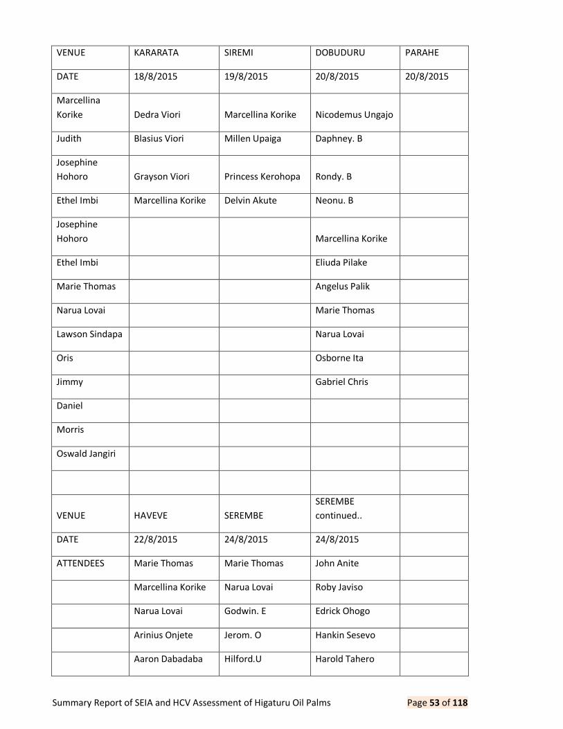
Summary Report of SEIA and HCV Assessment of Higaturu Oil Palms Page 53 of 118
VENUE KARARATA SIREMI DOBUDURU PARAHE
DATE 18/8/2015 19/8/2015 20/8/2015 20/8/2015
Marcellina
Korike Dedra Viori Marcellina Korike Nicodemus Ungajo
Judith Blasius Viori Millen Upaiga Daphney. B
Josephine
Hohoro Grayson Viori Princess Kerohopa Rondy. B
Ethel Imbi Marcellina Korike Delvin Akute Neonu. B
Josephine
Hohoro Marcellina Korike
Ethel Imbi Eliuda Pilake
Marie Thomas Angelus Palik
Narua Lovai Marie Thomas
Lawson Sindapa Narua Lovai
Oris Osborne Ita
Jimmy Gabriel Chris
Daniel
Morris
Oswald Jangiri
VENUE HAVEVE SEREMBE
SEREMBE
continued..
DATE 22/8/2015 24/8/2015 24/8/2015
ATTENDEES Marie Thomas Marie Thomas John Anite
Marcellina Korike Narua Lovai Roby Javiso
Narua Lovai Godwin. E Edrick Ohogo
Arinius Onjete Jerom. O Hankin Sesevo
Aaron Dabadaba Hilford.U Harold Tahero

Summary Report of SEIA and HCV Assessment of Higaturu Oil Palms Page 54 of 118
VENUE KARARATA SIREMI DOBUDURU PARAHE
DATE 18/8/2015 19/8/2015 20/8/2015 20/8/2015
Ronny Dabadaba Kingsley. E Planton Tithe
Robinson Omise Sebestian. E Susie Sesevo
Gibson Tinga Ahansis. U Dephney Tehera
Ricky Onjete Morica. E Hansley Sesevo
Nancy Onjete Esther. U Dulcie Sesevo
Simi Sakalia Elvi Pusembo Gelond Tehera
Edith Onjete Carson Pusembo Mackenton. O
Julie Onjete Enoch Pusembo Robertson. E
Gabriel chris Ray Daupa Murray. H
Beverly Suma Zebron. O
Remingius Eri Mathilda. O
Boney Eri Stella. E
Robray Eri John Schort. S
Boney Eri Andy Esege
Rubby Eri Diwos Egimbari
Priscilla Eri Sibeth Urevo
Robo Eri Shirley Egimbari
Alie Eri Benson Pusento
Danybray Kione Dura Pusento
Napoleon Ogapa Marcellina Korike
Jairus Haita Angelus Palik
Benjamin Haita Eliuda Pilake
Florence Ogapa Genesius Abbah
Rachael Haita

Summary Report of SEIA and HCV Assessment of Higaturu Oil Palms Page 55 of 118
VENUE KARARATA SIREMI DOBUDURU PARAHE
DATE 18/8/2015 19/8/2015 20/8/2015 20/8/2015
Benard Suvaki

Summary Report of SEIA and HCV Assessment of Higaturu Oil Palms Page 56 of 118
Appendix 2 Land Use Change Analysis Maps
1a.Serembe: Landsat 2000 as Baseline Data
1b. Serembe: Landsat 2015 with Treecover Loss
Serembe
0 0.3 0.6 0.9 1.20.15km
µ
New Dev_Proposals_region
Landsat_2000_00N_140E
RGB
Red: Band_3
Green: Band_2
Blue: Band_1

Summary Report of SEIA and HCV Assessment of Higaturu Oil Palms Page 57 of 118
1c. Serembe: Vege Map with Treecover Loss
Serembe
2
1
8
8
4
6
10
9
13
3
4
3
12
6
3
14
1
8
9
1310
2
1114
6
11
11
14
13
13
9
10
4
8112
666
12
89
96
11
8
9
8
2
3
2
1
82
106
4
1
2
93
13
14
14
8
4
6
1
8
6
10
10
12
12
111111
11
11
111211
12
11
3
13
13
1413
14
13
1313
11
13
1
6
9
8
6
13
11
9
3
0 0.3 0.6 0.9 1.20.15km
µ
New Dev_Proposals_region
Treecover_Loss (Hansen)
Treecover_Loss (Hansen)
Landsat_2015_00N_140E
RGB
Red: Band_3
Green: Band_2
Blue: Band_1
Serembe
2
1
8
8
4
6
10
9
13
3
4
3
12
6
3
14
1
8
9
1310
2
1114
6
11
11
14
13
13
9
10
4
8112
666
12
89
96
11
8
9
8
2
3
2
1
82
106
4
1
2
93
13
14
14
8
4
6
1
8
6
10
10
12
12
111111
11
11
111211
12
11
3
13
13
1413
14
13
1313
11
13
1
6
9
8
6
13
11
9
3
0 0.3 0.6 0.9 1.20.15km
µ
New Dev_Proposals_region
HCV_Final
HCS_Final
Treecover_Loss (Hansen)
Year of Disturbed
2001
2002
2003
2004
2005
2006
2007
2008
2009
2010
2011
2012
2013
2014
VegClassification
LandClass
Primary Forest
Transitional Forest
Advanced Secondary Forest
Secondary Forest
Old Garden
Kunai Grassland
Plantation (cocoa)
Plantation (hardwood)
Plantation (palm)

Summary Report of SEIA and HCV Assessment of Higaturu Oil Palms Page 58 of 118
2a. Aruka: Landsat 2000 as Baseline Data
2b. Aruka: Landsat 2015 with Treecover Loss
Aruka
Viviri
0 0.15 0.3 0.45 0.60.075km
µ
New Dev_Proposals_region
Landsat_2000_00N_140E
RGB
Red: Band_3
Green: Band_2
Blue: Band_1

Summary Report of SEIA and HCV Assessment of Higaturu Oil Palms Page 59 of 118
2c. Aruka: Vege Map with Treecover Loss
Aruka
Viviri 5
11
8
14
8
8
14
10
11
12
4
6
10
6
11
11
10
10
13
14
7
11
2
6
3
12
0 0.15 0.3 0.45 0.60.075km
µ
New Dev_Proposals_region
Treecover_Loss (Hansen)
Treecover_Loss (Hansen)
Landsat_2015_00N_140E
RGB
Red: Band_3
Green: Band_2
Blue: Band_1
Aruka
Viviri 5
11
8
14
8
8
14
10
11
12
4
6
10
6
11
11
10
10
13
14
7
11
2
6
3
12
0 0.15 0.3 0.45 0.60.075km
µ
New Dev_Proposals_region
HCV_Final
HCS_Final
Treecover_Loss (Hansen)
Year of Disturbed
2001
2002
2003
2004
2005
2006
2007
2008
2009
2010
2011
2012
2013
2014
VegClassification
LandClass
Primary Forest
Transitional Forest
Advanced Secondary Forest
Secondary Forest
Old Garden
Kunai Grassland
Plantation (cocoa)
Plantation (hardwood)
Plantation (palm)

Summary Report of SEIA and HCV Assessment of Higaturu Oil Palms Page 60 of 118
3a. Ufenapa: Landsat 2000 as Baseline Data
3b. Ufenapa: Landsat 2015 with Treecover Loss
Ufenapa
0 0.1 0.2 0.3 0.40.05km
µ
New Dev_Proposals_region
Landsat_2000_00N_140E
RGB
Red: Band_3
Green: Band_2
Blue: Band_1
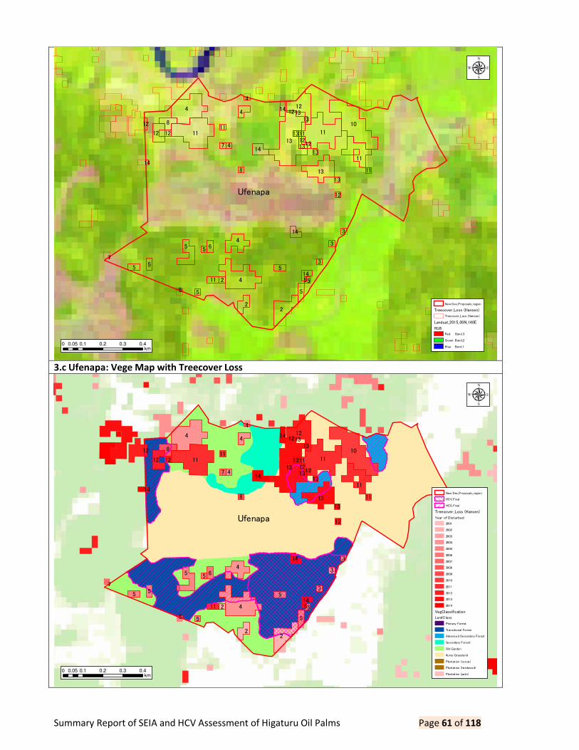
Summary Report of SEIA and HCV Assessment of Higaturu Oil Palms Page 61 of 118
3.c Ufenapa: Vege Map with Treecover Loss
Ufenapa
4
4
13
10
11 11
2
45
13
12
8
2
4
5
14
6
5
11
12
55
14
14
14
47
8
3
3
5
211
5
1312
3
5
12
13
11
1112
12
13
13
12
4
5
5
11
14
13
1213
7
0 0.1 0.2 0.3 0.40.05km
µ
New Dev_Proposals_region
Treecover_Loss (Hansen)
Treecover_Loss (Hansen)
Landsat_2015_00N_140E
RGB
Red: Band_3
Green: Band_2
Blue: Band_1
Ufenapa
4
4
13
10
11 11
2
45
13
12
8
2
4
5
14
6
5
11
12
55
14
14
14
47
8
3
3
5
211
5
1312
3
5
12
13
11
1112
12
13
13
12
4
5
5
11
14
13
1213
7
0 0.1 0.2 0.3 0.40.05km
µ
New Dev_Proposals_region
HCV_Final
HCS_Final
Treecover_Loss (Hansen)
Year of Disturbed
2001
2002
2003
2004
2005
2006
2007
2008
2009
2010
2011
2012
2013
2014
VegClassification
LandClass
Primary Forest
Transitional Forest
Advanced Secondary Forest
Secondary Forest
Old Garden
Kunai Grassland
Plantation (cocoa)
Plantation (hardwood)
Plantation (palm)

Summary Report of SEIA and HCV Assessment of Higaturu Oil Palms Page 62 of 118
4a. Sigu: Landsat 2000 as Baseline Data
4b. Sigu: Landsat 2015 with Treecover Loss
Sigu
0 0.09 0.18 0.27 0.360.045km
µ
New Dev_Proposals_region
Landsat_2000_00N_140E
RGB
Red: Band_3
Green: Band_2
Blue: Band_1
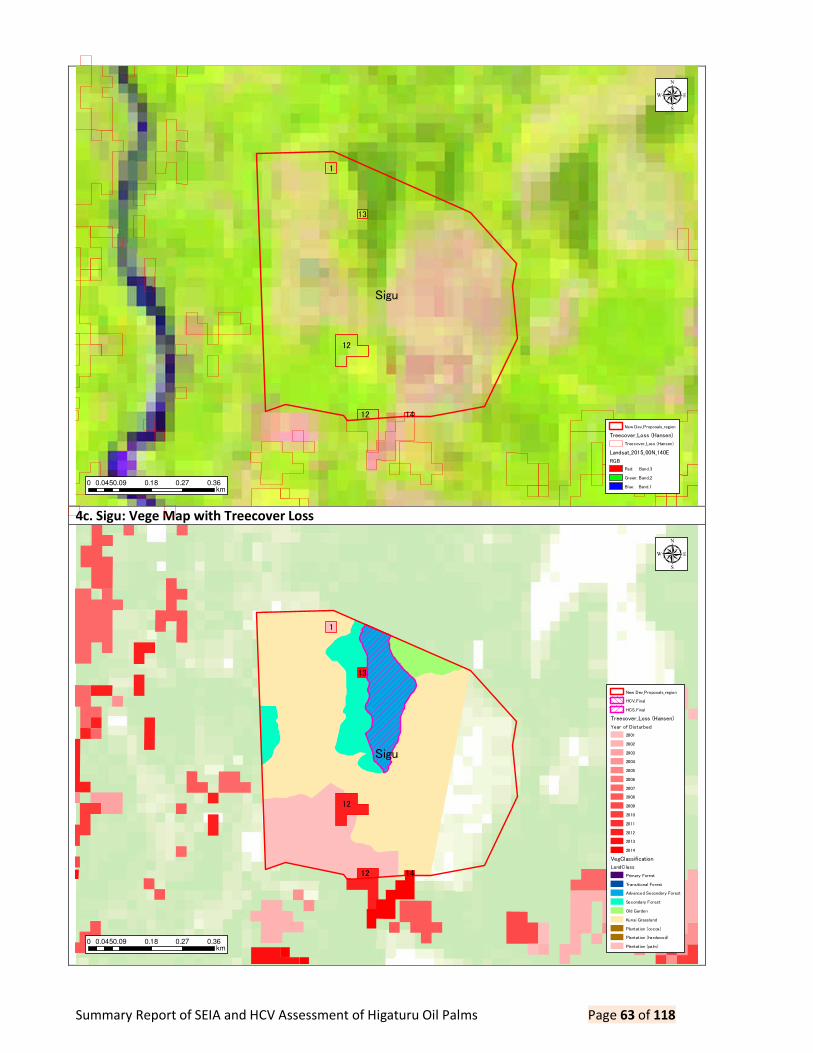
Summary Report of SEIA and HCV Assessment of Higaturu Oil Palms Page 63 of 118
4c. Sigu: Vege Map with Treecover Loss
Sigu
12
1
12
13
14
0 0.09 0.18 0.27 0.360.045km
µ
New Dev_Proposals_region
Treecover_Loss (Hansen)
Treecover_Loss (Hansen)
Landsat_2015_00N_140E
RGB
Red: Band_3
Green: Band_2
Blue: Band_1
Sigu
12
1
12
13
14
0 0.09 0.18 0.27 0.360.045km
µ
New Dev_Proposals_region
HCV_Final
HCS_Final
Treecover_Loss (Hansen)
Year of Disturbed
2001
2002
2003
2004
2005
2006
2007
2008
2009
2010
2011
2012
2013
2014
VegClassification
LandClass
Primary Forest
Transitional Forest
Advanced Secondary Forest
Secondary Forest
Old Garden
Kunai Grassland
Plantation (cocoa)
Plantation (hardwood)
Plantation (palm)

Summary Report of SEIA and HCV Assessment of Higaturu Oil Palms Page 64 of 118
5a. Mohamei: Landsat 2000 as Baseline Data
5b. Mohamei: Landsat 2014 with Treecover Loss
Mohamei
0 0.1 0.2 0.3 0.40.05km
µ
New Dev_Proposals_region
Landsat_2000_00N_140E
RGB
Red: Band_3
Green: Band_2
Blue: Band_1

Summary Report of SEIA and HCV Assessment of Higaturu Oil Palms Page 65 of 118
5c. Mohamei: Vege Map with Treecover Loss
Mohamei
2
14
13
12
7
12121412
0 0.1 0.2 0.3 0.40.05km
µ
New Dev_Proposals_region
Treecover_Loss (Hansen)
Treecover_Loss (Hansen)
Landsat_2015_00N_140E
RGB
Red: Band_3
Green: Band_2
Blue: Band_1
Mohamei
2
14
13
12
7
12121412
0 0.1 0.2 0.3 0.40.05km
µ
New Dev_Proposals_region
HCV_Final
HCS_Final
Treecover_Loss (Hansen)
Year of Disturbed
2001
2002
2003
2004
2005
2006
2007
2008
2009
2010
2011
2012
2013
2014
VegClassification
LandClass
Primary Forest
Transitional Forest
Advanced Secondary Forest
Secondary Forest
Old Garden
Kunai Grassland
Plantation (cocoa)
Plantation (hardwood)
Plantation (palm)

Summary Report of SEIA and HCV Assessment of Higaturu Oil Palms Page 66 of 118
6a. Ase: Landsat 2000 as Baseline Data
6b. Ase: Landsat 2105 with Treecover Loss
Ase
0 0.075 0.15 0.225 0.30.0375km
µ
New Dev_Proposals_region
Landsat_2000_00N_140E
RGB
Red: Band_3
Green: Band_2
Blue: Band_1

Summary Report of SEIA and HCV Assessment of Higaturu Oil Palms Page 67 of 118
6c. Ase: Vege Map with Treecover Loss
Ase
14
2
12
102
1313
12
12
11
13
11
11
0 0.075 0.15 0.225 0.30.0375km
µ
New Dev_Proposals_region
Treecover_Loss (Hansen)
Treecover_Loss (Hansen)
Landsat_2015_00N_140E
RGB
Red: Band_3
Green: Band_2
Blue: Band_1
Ase
14
2
12
102
1313
12
12
11
13
11
11
0 0.075 0.15 0.225 0.30.0375km
µ
New Dev_Proposals_region
HCV_Final
HCS_Final
Treecover_Loss (Hansen)
Year of Disturbed
2001
2002
2003
2004
2005
2006
2007
2008
2009
2010
2011
2012
2013
2014
VegClassification
LandClass
Primary Forest
Transitional Forest
Advanced Secondary Forest
Secondary Forest
Old Garden
Kunai Grassland
Plantation (cocoa)
Plantation (hardwood)
Plantation (palm)

Summary Report of SEIA and HCV Assessment of Higaturu Oil Palms Page 68 of 118
7a. BBGI: Landsat 2000 as Baseline Data
7b. BBGI: Landsat 2015 with Treecover Loss
BBGI
0 0.2 0.4 0.6 0.80.1km
µ
New Dev_Proposals_region
Landsat_2000_00N_140E
RGB
Red: Band_3
Green: Band_2
Blue: Band_1

Summary Report of SEIA and HCV Assessment of Higaturu Oil Palms Page 69 of 118
7c. BBGI: Vege Map with Treecover Loss
BBGI
6
3
78
14
10
14
13
2
99
4
1
6
112
1
13
13
4
1212
12
13
13
13
1413
13
13
1314
13
1414
14
12
0 0.2 0.4 0.6 0.80.1km
µ
New Dev_Proposals_region
Treecover_Loss (Hansen)
Treecover_Loss (Hansen)
Landsat_2015_00N_140E
RGB
Red: Band_3
Green: Band_2
Blue: Band_1
BBGI
6
3
78
14
10
14
13
2
99
4
1
6
112
1
13
13
4
1212
12
13
13
13
1413
13
13
1314
13
1414
14
12
0 0.2 0.4 0.6 0.80.1km
µ
New Dev_Proposals_region
HCV_Final
HCS_Final
Treecover_Loss (Hansen)
Year of Disturbed
2001
2002
2003
2004
2005
2006
2007
2008
2009
2010
2011
2012
2013
2014
VegClassification
LandClass
Primary Forest
Transitional Forest
Advanced Secondary Forest
Secondary Forest
Old Garden
Kunai Grassland
Plantation (cocoa)
Plantation (hardwood)
Plantation (palm)

Summary Report of SEIA and HCV Assessment of Higaturu Oil Palms Page 70 of 118
8a. Soropa: Landsat 2000 as Baseline Data
8b. Soropa: Landsat 2015 with Treecover Loss
Soropa
0 0.3 0.6 0.9 1.20.15km
µ
New Dev_Proposals_region
Landsat_2000_00N_140E
RGB
Red: Band_3
Green: Band_2
Blue: Band_1

Summary Report of SEIA and HCV Assessment of Higaturu Oil Palms Page 71 of 118
8c. Soropa: Vege Map with Treecover Loss
Soropa
4
8
6
4
9
9
2
12
4
4
4
3
4
4
12
0 0.3 0.6 0.9 1.20.15km
µ
New Dev_Proposals_region
Treecover_Loss (Hansen)
Treecover_Loss (Hansen)
Landsat_2015_00N_140E
RGB
Red: Band_3
Green: Band_2
Blue: Band_1
Soropa
4
8
6
4
9
9
2
12
4
4
4
3
4
4
12
0 0.3 0.6 0.9 1.20.15km
µ
New Dev_Proposals_region
HCV_Final
HCS_Final
Treecover_Loss (Hansen)
Year of Disturbed
2001
2002
2003
2004
2005
2006
2007
2008
2009
2010
2011
2012
2013
2014
VegClassification
LandClass
Primary Forest
Transitional Forest
Advanced Secondary Forest
Secondary Forest
Old Garden
Kunai Grassland
Plantation (cocoa)
Plantation (hardwood)
Plantation (palm)

Summary Report of SEIA and HCV Assessment of Higaturu Oil Palms Page 72 of 118
9a. Akute: Landsat 2000 as Baseline Data
9b. Akute: Landsat 2015 with Treecover Loss
Akute
0 0.1 0.2 0.3 0.40.05km
µ
New Dev_Proposals_region
Landsat_2000_00N_140E
RGB
Red: Band_3
Green: Band_2
Blue: Band_1

Summary Report of SEIA and HCV Assessment of Higaturu Oil Palms Page 73 of 118
9c. Akute: Vege Map with Treecover Loss
Akute
1
14
1
9
3
14
11 9
4
3
14
4
13
0 0.1 0.2 0.3 0.40.05km
µ
New Dev_Proposals_region
Treecover_Loss (Hansen)
Treecover_Loss (Hansen)
Landsat_2015_00N_140E
RGB
Red: Band_3
Green: Band_2
Blue: Band_1
Akute
1
14
1
9
3
14
11 9
4
3
14
4
13
0 0.1 0.2 0.3 0.40.05km
µ
New Dev_Proposals_region
HCV_Final
HCS_Final
Treecover_Loss (Hansen)
Year of Disturbed
2001
2002
2003
2004
2005
2006
2007
2008
2009
2010
2011
2012
2013
2014
VegClassification
LandClass
Primary Forest
Transitional Forest
Advanced Secondary Forest
Secondary Forest
Old Garden
Kunai Grassland
Plantation (cocoa)
Plantation (hardwood)
Plantation (palm)

Summary Report of SEIA and HCV Assessment of Higaturu Oil Palms Page 74 of 118
10a. Boruga Pusute: Landsat 2000 as Baseline Data
10b. Boruga Pusute: Landsat 2015 with Tree Cover Loss
Boruga Pusute
0 0.1 0.2 0.3 0.40.05km
µ
New Dev_Proposals_region
Landsat_2000_00N_140E
RGB
Red: Band_3
Green: Band_2
Blue: Band_1

Summary Report of SEIA and HCV Assessment of Higaturu Oil Palms Page 75 of 118
10c. Boruga Pusute: Vege Map with Treecover Loss
Boruga Pusute
9
0 0.1 0.2 0.3 0.40.05km
µ
New Dev_Proposals_region
Treecover_Loss (Hansen)
Treecover_Loss (Hansen)
Landsat_2015_00N_140E
RGB
Red: Band_3
Green: Band_2
Blue: Band_1
Boruga Pusute
9
0 0.1 0.2 0.3 0.40.05km
µ
New Dev_Proposals_region
HCV_Final
HCS_Final
Treecover_Loss (Hansen)
Year of Disturbed
2001
2002
2003
2004
2005
2006
2007
2008
2009
2010
2011
2012
2013
2014
VegClassification
LandClass
Primary Forest
Transitional Forest
Advanced Secondary Forest
Secondary Forest
Old Garden
Kunai Grassland
Plantation (cocoa)
Plantation (hardwood)
Plantation (palm)

Summary Report of SEIA and HCV Assessment of Higaturu Oil Palms Page 76 of 118
11a. Darau: Landsat 2000 as Baseline Data
11b. Darau: Landsat 2015 with Treecover Loss
Darau
Takoh
0 0.15 0.3 0.45 0.60.075km
µ
New Dev_Proposals_region
Landsat_2000_00N_140E
RGB
Red: Band_3
Green: Band_2
Blue: Band_1

Summary Report of SEIA and HCV Assessment of Higaturu Oil Palms Page 77 of 118
11c. Darau: Vege Map with Treecover Loss
Darau
Takoh
116
13
611
0 0.15 0.3 0.45 0.60.075km
µ
New Dev_Proposals_region
Treecover_Loss (Hansen)
Treecover_Loss (Hansen)
Landsat_2015_00N_140E
RGB
Red: Band_3
Green: Band_2
Blue: Band_1
Darau
Takoh
116
13
611
0 0.15 0.3 0.45 0.60.075km
µ
New Dev_Proposals_region
HCV_Final
HCS_Final
Treecover_Loss (Hansen)
Year of Disturbed
2001
2002
2003
2004
2005
2006
2007
2008
2009
2010
2011
2012
2013
2014
VegClassification
LandClass
Primary Forest
Transitional Forest
Advanced Secondary Forest
Secondary Forest
Old Garden
Kunai Grassland
Plantation (cocoa)
Plantation (hardwood)
Plantation (palm)
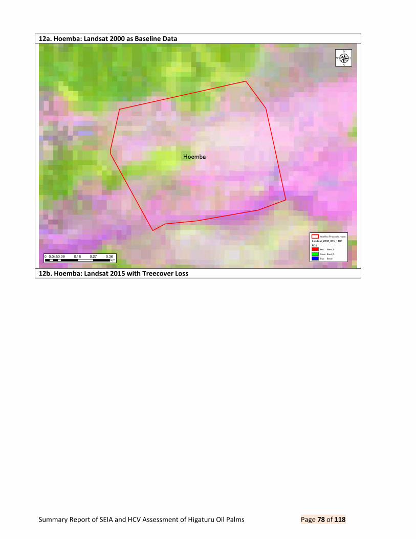
Summary Report of SEIA and HCV Assessment of Higaturu Oil Palms Page 78 of 118
12a. Hoemba: Landsat 2000 as Baseline Data
12b. Hoemba: Landsat 2015 with Treecover Loss
Hoemba
0 0.09 0.18 0.27 0.360.045km
µ
New Dev_Proposals_region
Landsat_2000_00N_140E
RGB
Red: Band_3
Green: Band_2
Blue: Band_1

Summary Report of SEIA and HCV Assessment of Higaturu Oil Palms Page 79 of 118
12c. Hoemba: Vege Map with Treecover Loss
Hoemba
11
13
0 0.09 0.18 0.27 0.360.045km
µ
New Dev_Proposals_region
Treecover_Loss (Hansen)
Treecover_Loss (Hansen)
Landsat_2015_00N_140E
RGB
Red: Band_3
Green: Band_2
Blue: Band_1
Hoemba
11
13
0 0.09 0.18 0.27 0.360.045km
µ
New Dev_Proposals_region
HCV_Final
HCS_Final
Treecover_Loss (Hansen)
Year of Disturbed
2001
2002
2003
2004
2005
2006
2007
2008
2009
2010
2011
2012
2013
2014
VegClassification
LandClass
Primary Forest
Transitional Forest
Advanced Secondary Forest
Secondary Forest
Old Garden
Kunai Grassland
Plantation (cocoa)
Plantation (hardwood)
Plantation (palm)

Summary Report of SEIA and HCV Assessment of Higaturu Oil Palms Page 80 of 118
13a. Hopanda: Landsat 2000 as Baseline Data
13b. Hopanda: Landsat 2000 with Treecover Loss
Hopanda
Bakito Extension
0 0.075 0.15 0.225 0.30.0375km
µ
New Dev_Proposals_region
Landsat_2000_00N_140E
RGB
Red: Band_3
Green: Band_2
Blue: Band_1

Summary Report of SEIA and HCV Assessment of Higaturu Oil Palms Page 81 of 118
13c. Hopanda: Vege Map with Treecover Loss
Hopanda
Bakito Extension
9
1
8
14
13
12
1
1
1
8
8
9
11
11
12
12
11
12
4
1
913
7
0 0.075 0.15 0.225 0.30.0375km
µ
New Dev_Proposals_region
Treecover_Loss (Hansen)
Treecover_Loss (Hansen)
Landsat_2015_00N_140E
RGB
Red: Band_3
Green: Band_2
Blue: Band_1
Hopanda
Bakito Extension
9
1
8
14
13
12
1
1
1
8
8
9
11
11
12
12
11
12
4
1
913
7
0 0.075 0.15 0.225 0.30.0375km
µ
New Dev_Proposals_region
HCV_Final
HCS_Final
Treecover_Loss (Hansen)
Year of Disturbed
2001
2002
2003
2004
2005
2006
2007
2008
2009
2010
2011
2012
2013
2014
VegClassification
LandClass
Primary Forest
Transitional Forest
Advanced Secondary Forest
Secondary Forest
Old Garden
Kunai Grassland
Plantation (cocoa)
Plantation (hardwood)
Plantation (palm)

Summary Report of SEIA and HCV Assessment of Higaturu Oil Palms Page 82 of 118
14a. Sauma: Landsat 2000 as Baseline Data
14b. Sauma: Landsat 2015 with Treecover Loss
Sauma
Hasina
UDK_Extension
0 0.075 0.15 0.225 0.30.0375km
µ
New Dev_Proposals_region
Landsat_2000_00N_140E
RGB
Red: Band_3
Green: Band_2
Blue: Band_1

Summary Report of SEIA and HCV Assessment of Higaturu Oil Palms Page 83 of 118
14c. Sauma: Vege Map with Landcover Loss
Sauma
Hasina
UDK_Extension
9
8
8
8
0 0.075 0.15 0.225 0.30.0375km
µ
New Dev_Proposals_region
Treecover_Loss (Hansen)
Treecover_Loss (Hansen)
Landsat_2015_00N_140E
RGB
Red: Band_3
Green: Band_2
Blue: Band_1
Sauma
Hasina
UDK_Extension
9
8
8
8
0 0.075 0.15 0.225 0.30.0375km
µ
New Dev_Proposals_region
HCV_Final
HCS_Final
Treecover_Loss (Hansen)
Year of Disturbed
2001
2002
2003
2004
2005
2006
2007
2008
2009
2010
2011
2012
2013
2014
VegClassification
LandClass
Primary Forest
Transitional Forest
Advanced Secondary Forest
Secondary Forest
Old Garden
Kunai Grassland
Plantation (cocoa)
Plantation (hardwood)
Plantation (palm)

Summary Report of SEIA and HCV Assessment of Higaturu Oil Palms Page 84 of 118
15a. Sipari: Landsat 2000 as Baseline Data
15b. Sipari: Landsat 2000 with Treecover Loss
Sipari
0 0.1 0.2 0.3 0.40.05km
µ
New Dev_Proposals_region
Landsat_2000_00N_140E
RGB
Red: Band_3
Green: Band_2
Blue: Band_1

Summary Report of SEIA and HCV Assessment of Higaturu Oil Palms Page 85 of 118
15c. Sipari: Vege Map with Treecover Loss
Sipari
9
8
10
8
0 0.1 0.2 0.3 0.40.05km
µ
New Dev_Proposals_region
Treecover_Loss (Hansen)
Treecover_Loss (Hansen)
Landsat_2015_00N_140E
RGB
Red: Band_3
Green: Band_2
Blue: Band_1
Landsat_2000_00N_140E
RGB
Red: Band_3
Green: Band_2
Blue: Band_1
Sipari
9
8
10
8
0 0.1 0.2 0.3 0.40.05km
µ
New Dev_Proposals_region
HCV_Final
HCS_Final
Treecover_Loss (Hansen)
Year of Disturbed
2001
2002
2003
2004
2005
2006
2007
2008
2009
2010
2011
2012
2013
2014
VegClassification
LandClass
Primary Forest
Transitional Forest
Advanced Secondary Forest
Secondary Forest
Old Garden
Kunai Grassland
Plantation (cocoa)
Plantation (hardwood)
Plantation (palm)

Summary Report of SEIA and HCV Assessment of Higaturu Oil Palms Page 86 of 118
16a. Isatapa: Landsat2000 as Baseline Data
16b. Isatapa: Landsat 2015 with Treecover Loss
Isatapa
0 0.09 0.18 0.27 0.360.045km
µ
New Dev_Proposals_region
Landsat_2000_00N_140E
RGB
Red: Band_3
Green: Band_2
Blue: Band_1

Summary Report of SEIA and HCV Assessment of Higaturu Oil Palms Page 87 of 118
16c. Isatapa: Vege Map with Treecover Loss
Isatapa
0 0.09 0.18 0.27 0.360.045km
µ
New Dev_Proposals_region
Landsat_2015_00N_140E
RGB
Red: Band_3
Green: Band_2
Blue: Band_1
Isatapa
0 0.09 0.18 0.27 0.360.045km
µ
New Dev_Proposals_region
HCV_Final
HCS_Final
Treecover_Loss (Hansen)
Year of Disturbed
2001
2002
2003
2004
2005
2006
2007
2008
2009
2010
2011
2012
2013
2014
VegClassification
LandClass
Primary Forest
Transitional Forest
Advanced Secondary Forest
Secondary Forest
Old Garden
Kunai Grassland
Plantation (cocoa)
Plantation (hardwood)
Plantation (palm)

Summary Report of SEIA and HCV Assessment of Higaturu Oil Palms Page 88 of 118
17a. Bana: Landsat 2000 as Baseline Data
17b. Bana: Landsat 2015 with Treecover Loss
Bana
0 0.1 0.2 0.3 0.40.05km
µ
New Dev_Proposals_region
Landsat_2000_00N_140E
RGB
Red: Band_3
Green: Band_2
Blue: Band_1

Summary Report of SEIA and HCV Assessment of Higaturu Oil Palms Page 89 of 118
17c. Bana: Vege Map with Treecover Loss
Bana 119
9
10
13
77
22
13
1310
0 0.1 0.2 0.3 0.40.05km
µ
New Dev_Proposals_region
Landsat_2015_00N_140E
RGB
Red: Band_3
Green: Band_2
Blue: Band_1
Bana 119
9
10
13
77
22
13
1310
0 0.1 0.2 0.3 0.40.05km
µ
New Dev_Proposals_region
HCV_Final
HCS_Final
Treecover_Loss (Hansen)
Year of Disturbed
2001
2002
2003
2004
2005
2006
2007
2008
2009
2010
2011
2012
2013
2014
VegClassification
LandClass
Primary Forest
Transitional Forest
Advanced Secondary Forest
Secondary Forest
Old Garden
Kunai Grassland
Plantation (cocoa)
Plantation (hardwood)
Plantation (palm)
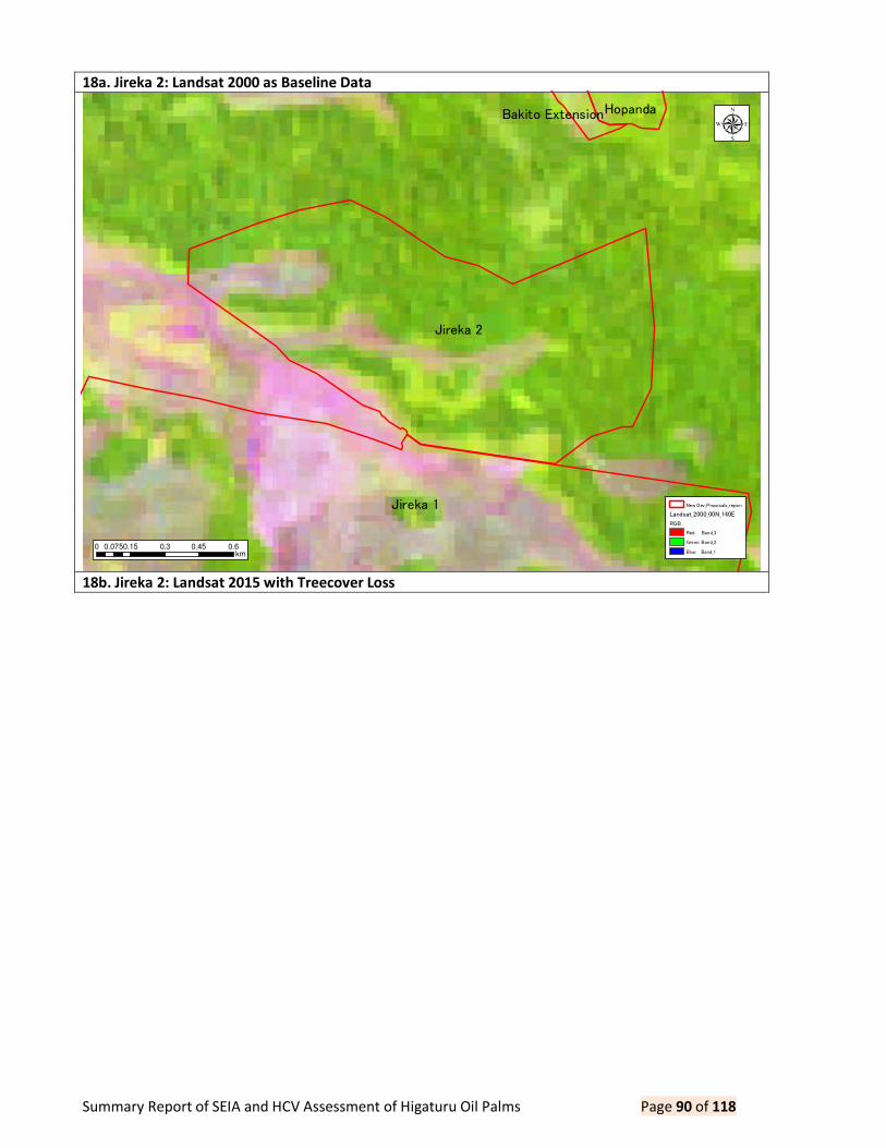
Summary Report of SEIA and HCV Assessment of Higaturu Oil Palms Page 90 of 118
18a. Jireka 2: Landsat 2000 as Baseline Data
18b. Jireka 2: Landsat 2015 with Treecover Loss
Jireka 1
Jireka 2
HopandaBakito Extension
0 0.15 0.3 0.45 0.60.075km
µ
New Dev_Proposals_region
Landsat_2000_00N_140E
RGB
Red: Band_3
Green: Band_2
Blue: Band_1

Summary Report of SEIA and HCV Assessment of Higaturu Oil Palms Page 91 of 118
18c. Jireka 2: Vege Map with Treecover Loss
Jireka 1
Jireka 2
HopandaBakito Extension
13
4
4 73
1
14
14
14
1
2
13
7
9
11 4
4
4
5
112
1
12
10
1110
10
13
13
1213
11
11
1
0 0.15 0.3 0.45 0.60.075km
µ
New Dev_Proposals_region
Landsat_2015_00N_140E
RGB
Red: Band_3
Green: Band_2
Blue: Band_1
Jireka 1
Jireka 2
HopandaBakito Extension
13
4
4 73
1
14
14
14
1
2
13
7
9
11 4
4
4
5
112
1
12
10
1110
10
13
13
1213
11
11
1
0 0.15 0.3 0.45 0.60.075km
µ
New Dev_Proposals_region
HCV_Final
HCS_Final
Treecover_Loss (Hansen)
Year of Disturbed
2001
2002
2003
2004
2005
2006
2007
2008
2009
2010
2011
2012
2013
2014
VegClassification
LandClass
Primary Forest
Transitional Forest
Advanced Secondary Forest
Secondary Forest
Old Garden
Kunai Grassland
Plantation (cocoa)
Plantation (hardwood)
Plantation (palm)

Summary Report of SEIA and HCV Assessment of Higaturu Oil Palms Page 92 of 118
19a. Takoh: Landsat 2000 as Baseline Data
19b. Takoh: Landsat 2015 with Treecover Loss
Takoh
Darau
0 0.09 0.18 0.27 0.360.045km
µ
New Dev_Proposals_region
Landsat_2000_00N_140E
RGB
Red: Band_3
Green: Band_2
Blue: Band_1

Summary Report of SEIA and HCV Assessment of Higaturu Oil Palms Page 93 of 118
19c. Takoh: Vege Map with Treecover Loss
Takoh
Darau
11
6
13
11 6
0 0.09 0.18 0.27 0.360.045km
µ
New Dev_Proposals_region
Landsat_2015_00N_140E
RGB
Red: Band_3
Green: Band_2
Blue: Band_1
Takoh
Darau
11
6
13
11 6
0 0.09 0.18 0.27 0.360.045km
µ
New Dev_Proposals_region
HCV_Final
HCS_Final
Treecover_Loss (Hansen)
Year of Disturbed
2001
2002
2003
2004
2005
2006
2007
2008
2009
2010
2011
2012
2013
2014
VegClassification
LandClass
Primary Forest
Transitional Forest
Advanced Secondary Forest
Secondary Forest
Old Garden
Kunai Grassland
Plantation (cocoa)
Plantation (hardwood)
Plantation (palm)

Summary Report of SEIA and HCV Assessment of Higaturu Oil Palms Page 94 of 118
20a. Mena Extension: Landsat 2000 as Baseline Data
20b. Mena Extension: Landsat 2015 with Treecover Loss
Mena Extension
0 0.075 0.15 0.225 0.30.0375km
µ
New Dev_Proposals_region
Landsat_2000_00N_140E
RGB
Red: Band_3
Green: Band_2
Blue: Band_1

Summary Report of SEIA and HCV Assessment of Higaturu Oil Palms Page 95 of 118
20c. Mena Extension: Vege Map with Treecover Loss
Mena Extension
1
11
0 0.075 0.15 0.225 0.30.0375km
µ
New Dev_Proposals_region
Landsat_2015_00N_140E
RGB
Red: Band_3
Green: Band_2
Blue: Band_1
Mena Extension
1
11
0 0.075 0.15 0.225 0.30.0375km
µ
New Dev_Proposals_region
HCV_Final
HCS_Final
Treecover_Loss (Hansen)
Year of Disturbed
2001
2002
2003
2004
2005
2006
2007
2008
2009
2010
2011
2012
2013
2014
VegClassification
LandClass
Primary Forest
Transitional Forest
Advanced Secondary Forest
Secondary Forest
Old Garden
Kunai Grassland
Plantation (cocoa)
Plantation (hardwood)
Plantation (palm)

Summary Report of SEIA and HCV Assessment of Higaturu Oil Palms Page 96 of 118
21a. UDK Extension: Landsat 2000 as Baseline Data
21b. UDK Extension: Landsat 2015 with Treecover Loss
Hasina
Sauma
UDK_Extension
0 0.075 0.15 0.225 0.30.0375km
µ
New Dev_Proposals_region
Landsat_2000_00N_140E
RGB
Red: Band_3
Green: Band_2
Blue: Band_1

Summary Report of SEIA and HCV Assessment of Higaturu Oil Palms Page 97 of 118
21c. UDK Extension: Vege Map with Treecover Loss
Hasina
Sauma
UDK_Extension
9
8 8
8
0 0.075 0.15 0.225 0.30.0375km
µ
New Dev_Proposals_region
Landsat_2015_00N_140E
RGB
Red: Band_3
Green: Band_2
Blue: Band_1
Hasina
Sauma
UDK_Extension
9
8 8
8
0 0.075 0.15 0.225 0.30.0375km
µ
New Dev_Proposals_region
HCV_Final
HCS_Final
Treecover_Loss (Hansen)
Year of Disturbed
2001
2002
2003
2004
2005
2006
2007
2008
2009
2010
2011
2012
2013
2014
VegClassification
LandClass
Primary Forest
Transitional Forest
Advanced Secondary Forest
Secondary Forest
Old Garden
Kunai Grassland
Plantation (cocoa)
Plantation (hardwood)
Plantation (palm)

Summary Report of SEIA and HCV Assessment of Higaturu Oil Palms Page 98 of 118
22a. Bakito Extension: Landsat 2000 as Baseline Data
22b. Bakito Extension: Landsat 2015 with Treecover Loss
Hopanda
Bakito Extension
0 0.075 0.15 0.225 0.30.0375km
µ
New Dev_Proposals_region
Landsat_2000_00N_140E
RGB
Red: Band_3
Green: Band_2
Blue: Band_1

Summary Report of SEIA and HCV Assessment of Higaturu Oil Palms Page 99 of 118
22c. Bakito Extension: VegeMap with Treecover Loss
Hopanda
Bakito Extension
9
8
14
13
11
8
8
9
12
12
12
4
913
7
0 0.075 0.15 0.225 0.30.0375km
µ
New Dev_Proposals_region
Landsat_2015_00N_140E
RGB
Red: Band_3
Green: Band_2
Blue: Band_1
Hopanda
Bakito Extension
9
8
14
13
11
8
8
9
12
12
12
4
913
7
0 0.075 0.15 0.225 0.30.0375km
µ
New Dev_Proposals_region
HCV_Final
HCS_Final
Treecover_Loss (Hansen)
Year of Disturbed
2001
2002
2003
2004
2005
2006
2007
2008
2009
2010
2011
2012
2013
2014
VegClassification
LandClass
Primary Forest
Transitional Forest
Advanced Secondary Forest
Secondary Forest
Old Garden
Kunai Grassland
Plantation (cocoa)
Plantation (hardwood)
Plantation (palm)

Summary Report of SEIA and HCV Assessment of Higaturu Oil Palms Page 100 of 118
23a. Sesehota: Landsat 2000 as Baseline Data
23b. Sesehota: Landsat 2015 with Treecover Loss
Sesehota
0 0.1 0.2 0.3 0.40.05km
µ
New Dev_Proposals_region
Landsat_2000_00N_140E
RGB
Red: Band_3
Green: Band_2
Blue: Band_1

Summary Report of SEIA and HCV Assessment of Higaturu Oil Palms Page 101 of 118
23c. Sesehota: Vege Map with Treecover Loss
Sesehota
11211
11
99
4
0 0.1 0.2 0.3 0.40.05km
µ
New Dev_Proposals_region
Landsat_2015_00N_140E
RGB
Red: Band_3
Green: Band_2
Blue: Band_1
Sesehota
11211
11
99
4
0 0.1 0.2 0.3 0.40.05km
µ
New Dev_Proposals_region
HCV_Final
HCS_Final
Treecover_Loss (Hansen)
Year of Disturbed
2001
2002
2003
2004
2005
2006
2007
2008
2009
2010
2011
2012
2013
2014
VegClassification
LandClass
Primary Forest
Transitional Forest
Advanced Secondary Forest
Secondary Forest
Old Garden
Kunai Grassland
Plantation (cocoa)
Plantation (hardwood)
Plantation (palm)
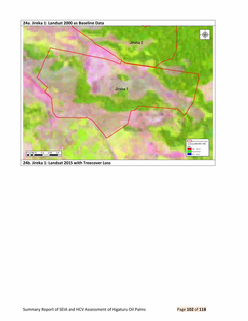
Summary Report of SEIA and HCV Assessment of Higaturu Oil Palms Page 102 of 118
24a. Jireka 1: Landsat 2000 as Baseline Data
24b. Jireka 1: Landsat 2015 with Treecover Loss
Jireka 1
Jireka 2
0 0.15 0.3 0.45 0.60.075km
µ
New Dev_Proposals_region
Landsat_2000_00N_140E
RGB
Red: Band_3
Green: Band_2
Blue: Band_1

Summary Report of SEIA and HCV Assessment of Higaturu Oil Palms Page 103 of 118
24c. Jireka 1: Vege Map with Treecover Loss
Jireka 1
Jireka 2
13
4 7
7
3
1
1
4
14
6
4
7
14
1
2
12
2
812
4
7
9
9
9
11
12
4
4
4
5
11
112
1
612
5
2
8
1
7
10
1110
10
11
12
14
13
14
13
13
12
11
0 0.15 0.3 0.45 0.60.075km
µ
New Dev_Proposals_region
Landsat_2015_00N_140E
RGB
Red: Band_3
Green: Band_2
Blue: Band_1
Jireka 1
Jireka 2
13
4 7
7
3
1
1
4
14
6
4
7
14
1
2
12
2
812
4
7
9
9
9
11
12
4
4
4
5
11
112
1
612
5
2
8
1
7
10
1110
10
11
12
14
13
14
13
13
12
11
0 0.15 0.3 0.45 0.60.075km
µ
New Dev_Proposals_region
HCV_Final
HCS_Final
Treecover_Loss (Hansen)
Year of Disturbed
2001
2002
2003
2004
2005
2006
2007
2008
2009
2010
2011
2012
2013
2014
VegClassification
LandClass
Primary Forest
Transitional Forest
Advanced Secondary Forest
Secondary Forest
Old Garden
Kunai Grassland
Plantation (cocoa)
Plantation (hardwood)
Plantation (palm)

Summary Report of SEIA and HCV Assessment of Higaturu Oil Palms Page 104 of 118
25a. Joiha: Landsat 2000 as Baseline Data
25b. Joiha: Landsat 2015 with Treecover Loss
Joiha
0 0.075 0.15 0.225 0.30.0375km
µ
New Dev_Proposals_region
Landsat_2000_00N_140E
RGB
Red: Band_3
Green: Band_2
Blue: Band_1

Summary Report of SEIA and HCV Assessment of Higaturu Oil Palms Page 105 of 118
25c. Joiha: Vege Map with Treecover Loss
Joiha
5
10
10
7
10
0 0.075 0.15 0.225 0.30.0375km
µ
New Dev_Proposals_region
Landsat_2015_00N_140E
RGB
Red: Band_3
Green: Band_2
Blue: Band_1
Joiha
5
10
10
7
10
0 0.075 0.15 0.225 0.30.0375km
µ
New Dev_Proposals_region
HCV_Final
HCS_Final
Treecover_Loss (Hansen)
Year of Disturbed
2001
2002
2003
2004
2005
2006
2007
2008
2009
2010
2011
2012
2013
2014
VegClassification
LandClass
Primary Forest
Transitional Forest
Advanced Secondary Forest
Secondary Forest
Old Garden
Kunai Grassland
Plantation (cocoa)
Plantation (hardwood)
Plantation (palm)

Summary Report of SEIA and HCV Assessment of Higaturu Oil Palms Page 106 of 118
26a. Bouga: Landsat 2015 as Baseline Data
26b. Bouga: Landsat 2015 with Treecover Loss
Bouga
Jopare
0 0.09 0.18 0.27 0.360.045km
µ
New Dev_Proposals_region
Landsat_2000_00N_140E
RGB
Red: Band_3
Green: Band_2
Blue: Band_1

Summary Report of SEIA and HCV Assessment of Higaturu Oil Palms Page 107 of 118
26c. Bouga: Vege Map with Treecover Loss
Bouga
Jopare
0 0.09 0.18 0.27 0.360.045km
µ
New Dev_Proposals_region
Landsat_2015_00N_140E
RGB
Red: Band_3
Green: Band_2
Blue: Band_1
Bouga
Jopare
0 0.09 0.18 0.27 0.360.045km
µ
New Dev_Proposals_region
HCV_Final
HCS_Final
Treecover_Loss (Hansen)
Year of Disturbed
2001
2002
2003
2004
2005
2006
2007
2008
2009
2010
2011
2012
2013
2014
VegClassification
LandClass
Primary Forest
Transitional Forest
Advanced Secondary Forest
Secondary Forest
Old Garden
Kunai Grassland
Plantation (cocoa)
Plantation (hardwood)
Plantation (palm)

Summary Report of SEIA and HCV Assessment of Higaturu Oil Palms Page 108 of 118
27a. Hasina: Landsat 2000 as Baseline Data
27b. Hasina: Landsat 2015 with Treecover Loss
HasinaSauma
UDK_Extension
0 0.15 0.3 0.45 0.60.075km
µ
New Dev_Proposals_region
Landsat_2000_00N_140E
RGB
Red: Band_3
Green: Band_2
Blue: Band_1

Summary Report of SEIA and HCV Assessment of Higaturu Oil Palms Page 109 of 118
27c. Hasina: Vege Map with Treecover Loss
HasinaSauma
UDK_Extension
4
2
1
2
2
1
4
2
8
711
2
4
9
5
7
13
11
14
11
10
5
6
5
1
6
1
5
6
5
2
2
2
13
14
14
13
5
2
108
14
11
1012
14
13
8
3
4
4
149 13
14
1
0 0.15 0.3 0.45 0.60.075km
µ
New Dev_Proposals_region
Landsat_2015_00N_140E
RGB
Red: Band_3
Green: Band_2
Blue: Band_1
HasinaSauma
UDK_Extension
4
2
1
2
2
1
4
2
8
711
2
4
9
5
7
13
11
14
11
10
5
6
5
1
6
1
5
6
5
2
2
2
13
14
14
13
5
2
108
14
11
1012
14
13
8
3
4
4
149 13
14
1
0 0.15 0.3 0.45 0.60.075km
µ
New Dev_Proposals_region
HCV_Final
HCS_Final
Treecover_Loss (Hansen)
Year of Disturbed
2001
2002
2003
2004
2005
2006
2007
2008
2009
2010
2011
2012
2013
2014
VegClassification
LandClass
Primary Forest
Transitional Forest
Advanced Secondary Forest
Secondary Forest
Old Garden
Kunai Grassland
Plantation (cocoa)
Plantation (hardwood)
Plantation (palm)

Summary Report of SEIA and HCV Assessment of Higaturu Oil Palms Page 110 of 118
28a. Viviri: Landsat 2000 as Baseline Data
28b. Viviri: Landsat 2000 as Baseline Data
Viviri Aruka
0 0.09 0.18 0.27 0.360.045km
µ
New Dev_Proposals_region
Landsat_2000_00N_140E
RGB
Red: Band_3
Green: Band_2
Blue: Band_1
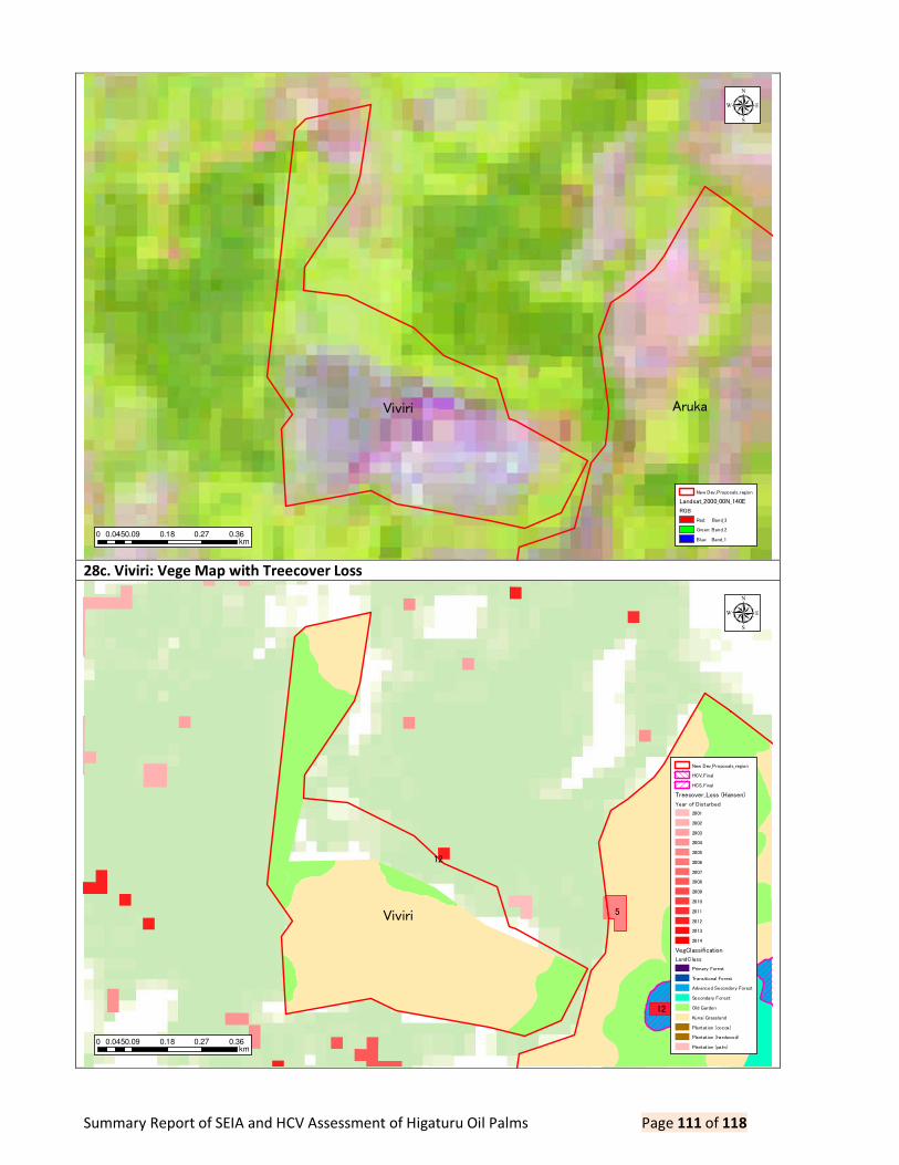
Summary Report of SEIA and HCV Assessment of Higaturu Oil Palms Page 111 of 118
28c. Viviri: Vege Map with Treecover Loss
Viviri Aruka
0 0.09 0.18 0.27 0.360.045km
µ
New Dev_Proposals_region
Landsat_2000_00N_140E
RGB
Red: Band_3
Green: Band_2
Blue: Band_1
Viviri Aruka5
12
12
0 0.09 0.18 0.27 0.360.045km
µ
New Dev_Proposals_region
HCV_Final
HCS_Final
Treecover_Loss (Hansen)
Year of Disturbed
2001
2002
2003
2004
2005
2006
2007
2008
2009
2010
2011
2012
2013
2014
VegClassification
LandClass
Primary Forest
Transitional Forest
Advanced Secondary Forest
Secondary Forest
Old Garden
Kunai Grassland
Plantation (cocoa)
Plantation (hardwood)
Plantation (palm)

Summary Report of SEIA and HCV Assessment of Higaturu Oil Palms Page 112 of 118
29a. Hoka: Landsat 2000 as Baseline Data
29b. Hoka: Landsat 2000 with Treecover Loss
Hoka
0 0.1 0.2 0.3 0.40.05km
µ
New Dev_Proposals_region
Landsat_2000_00N_140E
RGB
Red: Band_3
Green: Band_2
Blue: Band_1

Summary Report of SEIA and HCV Assessment of Higaturu Oil Palms Page 113 of 118
29c. Hoka: Vege Map with Treecover Loss
Hoka12
4
13
0 0.1 0.2 0.3 0.40.05km
µ
New Dev_Proposals_region
Landsat_2015_00N_140E
RGB
Red: Band_3
Green: Band_2
Blue: Band_1
Hoka12
4
13
0 0.1 0.2 0.3 0.40.05km
µ
New Dev_Proposals_region
HCV_Final
HCS_Final
Treecover_Loss (Hansen)
Year of Disturbed
2001
2002
2003
2004
2005
2006
2007
2008
2009
2010
2011
2012
2013
2014
VegClassification
LandClass
Primary Forest
Transitional Forest
Advanced Secondary Forest
Secondary Forest
Old Garden
Kunai Grassland
Plantation (cocoa)
Plantation (hardwood)
Plantation (palm)

Summary Report of SEIA and HCV Assessment of Higaturu Oil Palms Page 114 of 118
30a. Wuria Purofafa 1: Landsat 2000 as Baseline Data
30b. Wuria Purofafa 1: Landsat2015 with Treecover Loss
Wuria Purofafa
0 0.09 0.18 0.27 0.360.045km
µ
New Dev_Proposals_region
Landsat_2000_00N_140E
RGB
Red: Band_3
Green: Band_2
Blue: Band_1
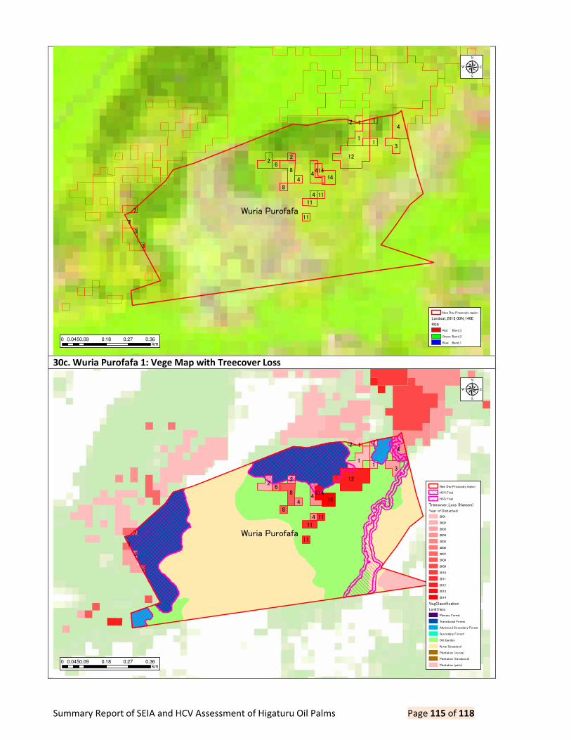
Summary Report of SEIA and HCV Assessment of Higaturu Oil Palms Page 115 of 118
30c. Wuria Purofafa 1: Vege Map with Treecover Loss
Wuria Purofafa
12
4
1
8
3
2
414
1
2
6
4
4
8
11
11
11
4
1
14
3
7
3
2 1
7
0 0.09 0.18 0.27 0.360.045km
µ
New Dev_Proposals_region
Landsat_2015_00N_140E
RGB
Red: Band_3
Green: Band_2
Blue: Band_1
Wuria Purofafa
12
4
1
8
3
2
414
1
2
6
4
4
8
11
11
11
4
1
14
3
7
3
2 1
7
0 0.09 0.18 0.27 0.360.045km
µ
New Dev_Proposals_region
HCV_Final
HCS_Final
Treecover_Loss (Hansen)
Year of Disturbed
2001
2002
2003
2004
2005
2006
2007
2008
2009
2010
2011
2012
2013
2014
VegClassification
LandClass
Primary Forest
Transitional Forest
Advanced Secondary Forest
Secondary Forest
Old Garden
Kunai Grassland
Plantation (cocoa)
Plantation (hardwood)
Plantation (palm)

Summary Report of SEIA and HCV Assessment of Higaturu Oil Palms Page 116 of 118
31a. Wuria Purofafa 2: Landsat2000 as Baseline Data
31b. Wuria Purofafa 2: Landsat2015 with Treecover Loss
Wuria Purofafa
0 0.09 0.18 0.27 0.360.045km
µ
New Dev_Proposals_region
Landsat_2000_00N_140E
RGB
Red: Band_3
Green: Band_2
Blue: Band_1
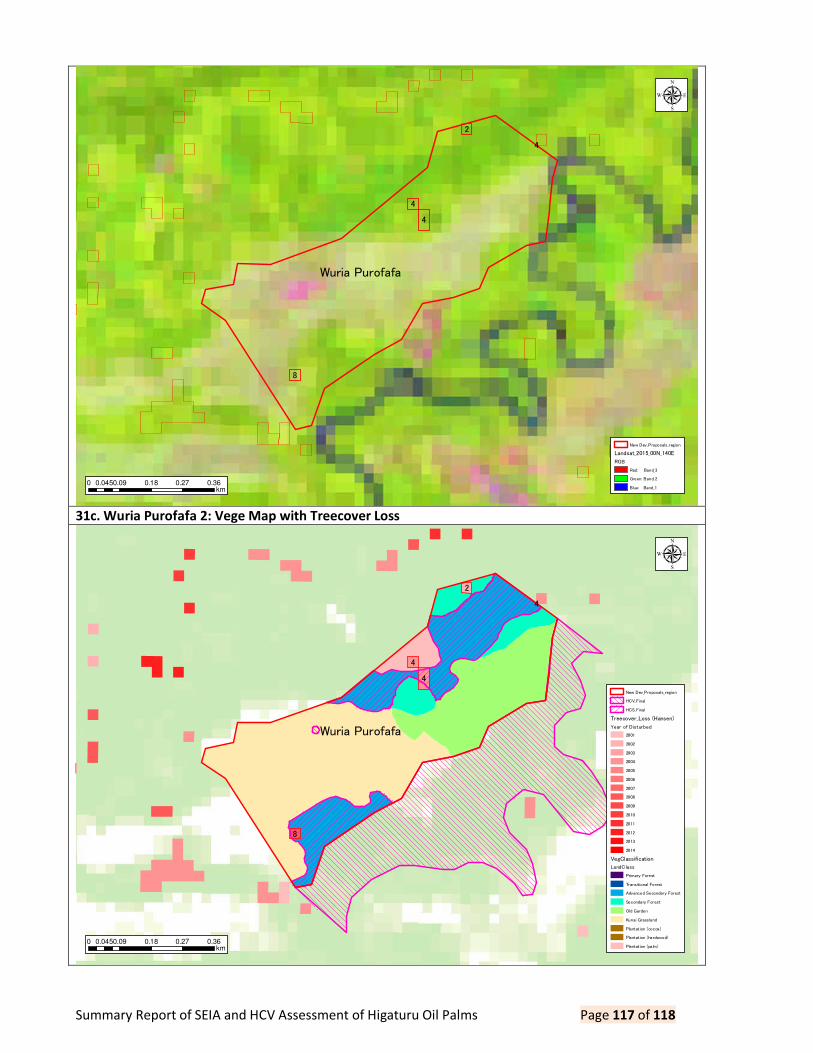
Summary Report of SEIA and HCV Assessment of Higaturu Oil Palms Page 117 of 118
31c. Wuria Purofafa 2: Vege Map with Treecover Loss
Wuria Purofafa
4
4
8
2
4
0 0.09 0.18 0.27 0.360.045km
µ
New Dev_Proposals_region
Landsat_2015_00N_140E
RGB
Red: Band_3
Green: Band_2
Blue: Band_1
Wuria Purofafa
4
4
8
2
4
0 0.09 0.18 0.27 0.360.045km
µ
New Dev_Proposals_region
HCV_Final
HCS_Final
Treecover_Loss (Hansen)
Year of Disturbed
2001
2002
2003
2004
2005
2006
2007
2008
2009
2010
2011
2012
2013
2014
VegClassification
LandClass
Primary Forest
Transitional Forest
Advanced Secondary Forest
Secondary Forest
Old Garden
Kunai Grassland
Plantation (cocoa)
Plantation (hardwood)
Plantation (palm)

Summary Report of SEIA and HCV Assessment of Higaturu Oil Palms Page 118 of 118
Table 11. Summary of Tree Cover Loss in Proposed Areas ID SITE_NAME AREA Y2001 Y2002 Y2003 Y2004 Y2005 Y2006 Y2007 Y2008 Y2009 Y2010 Y2011 Y2012 Y2013 Y2014 TOTAL
1 Serembe 426 2.356033 2.595579 1.695176 1.962985 0 2.089578 0 3.087462 1.514915 2.625264 2.241731 1.494933 3.301259 1.672519 26.637434
2 Aruka 101 0 0.010206 0.002558 0.093887 0.40408 0.154773 0.034847 0.628256 0.002506 0.511745 1.081893 0.187774 0.076048 0.684433 3.873006
3 Ufenapa 124 0 1.406561 0.26291 4.869003 1.779996 0.187749 0.098623 0.469379 0 2.68885 5.914188 2.19923 4.486326 1.079505 25.44232
4 Sigu 47 0.093881 0 0 0 0 0 0 0 0 0 0 0.731625 0.076043 0.04043 0.941979
5 Mohamei 56 0 0.276677 0 0 0 0 0.093856 0 0 0 0 0.469283 0.210721 0.532168 1.582705
6 Ase 33 0 0.274016 0 0 0 0 0 0 0 0.187786 0.238999 0.407558 0.396612 0.532379 2.03735
7 BBGI 343 0.37521 0.187608 0.375218 0.150333 0 0.750421 0.323134 0.217502 0.187611 0.37522 0 0.286996 1.092868 0.882926 5.205047
8 Soropa 584 0 0.0939 0.093897 2.723016 0 0.751207 0 1.40851 0.187802 0 0 0.281697 0 0 5.540029
9 Akute 58 0.938604 0 0.25485 0.097638 0 0 0 0 0.296068 0 0 0 0.000938 1.553202 3.1413
10 Boruga Pusute 74 0 0 0 0 0 0 0 0 0.093882 0 0 0 0 0 0.093882
11 Darau 70 0 0 0 0 0 0 0 0 0 0 0 0 0 0 0
12 Hoemba 59 0 0 0 0 0 0 0 0 0 0 0.187746 0 0.076036 0 0.263782
13 Hopanda 41 0.776506 0 0 0.027029 0 0 0 0.657098 0.657096 0 0.563231 0.62833 0.532247 0.608286 4.449823
14 Sauma 23 0 0 0 0 0 0 0 0.525082 0.938731 0 0 0 0 0 1.463813
15 Sipari 70 0 0 0 0 0 0 0 0.283479 0.281645 0.144465 0 0 0 0 0.709589
16 Isatapa 41 0 0 0 0 0 0 0 0 0 0 0 0 0 0 0
17 Bana 59 0 0.187751 0 0 0 0 0.187752 0 0.375503 0.32685 1.12651 0 0.367694 0 2.57206
18 Jireka 2 147 0.659708 0 0 1.126418 0 0 0.187737 0 0 0 0.295238 0.187736 2.280985 2.813217 7.551039
19 Takoh 43 0 0 0 0 0 0.154302 0 0 0 0 0.281601 0 0.152065 0 0.587968
20 Mena Extension 23 0.377555 0 0 0 0 0 0 0 0 0 0 0 0 0 0.377555
21 UDK_Extension 23 0 0 0 0 0 0 0 0 0 0 0 0 0 0 0
22 Bakito Extension 18 0 0 0 0 0 0 0 0 0 0 0 0 0 0 0
23 Sesehota 84 0.093857 0 0 0.000937 0 0 0 0 0.015011 0 0.187713 0.093857 0 0 0.391375
24 Jireka 1 317 1.220248 0.657057 0.75093 2.000478 0.187732 0.657056 2.440501 0.281595 0.563191 0.281599 0.572287 1.417878 0.152061 0.159938 11.342551
25 Joiha 25 0 0 0 0 0.066217 0 0.036583 0 0 0.205364 0 0 0 0 0.308164
26 Bouga 49 0 0 0 0 0 0 0 0 0 0 0 0 0 0 0
27 Hasina 130 1.783611 3.76268 0.034405 2.254939 0.637633 0.281623 0.563245 0.10009 0.18775 0.46482 1.274857 0.093875 0.713129 0.879352 13.032009
28 Viviri 38 0 0 0 0 0 0 0 0 0 0 0 0.001063 0 0 0.001063
29 Hoka 32 0 0 0 0.045224 0 0 0 0 0 0 0 0.187784 0.076052 0 0.30906
30 Wuria Purofafa 101 0.640115 0.49741 0.365603 1.366564 0 0.09388 0.055733 0.563286 0 0 0.37552 1.12657 0 0.456258 5.540939
31 Jopare 23 0 0 0 0 0 0 0 0.469314 0 0 0 0 0 0 0.469314
TOTAL 3,262 9.315328 9.949445 3.835547 16.718451 3.075658 5.120589 4.022011 8.691053 5.301711 7.811963 14.341514 9.796189 13.991084 11.894613 123.865156
RATE 0.29% 0.31% 0.12% 0.51% 0.09% 0.16% 0.12% 0.27% 0.16% 0.24% 0.44% 0.30% 0.43% 0.36% 3.80%