New Perspectives on Mississippian Occupations in West Tennessee and Northwest Mississippi: Recent...
21
NEW PERSPECTIVES ON MISSISSIPPIAN OCCUPATIONS IN WESTERN TENNESSEE AND NORTHWESTERN MISSISSIPPI: RECENT CHRONOLOGICAL AND GEOPHYSICAL INVESTIGATIONS AT CHUCALISSA (40SY1), SHELBY COUNTY, TENNESSEE Charles H. McNutt/ Jay D. Franklin,^ and Edward R. Henryk Investigations at Chucalissa (40SY1) in Shelby County, Tennessee, have been instrumental in establishing Missis- sippian period chronology for southwestern Tennessee and much of the surrounding region. Excavations conducted in 2003 produced a suite of new radiocarbon dates that has provided a refined developmental lineage of occupations in West Tennessee and northwestern Mississippi, while geo- physical investigations in 2011 have clarified our under- standing of the late prehistoric occupation of the site and validated suggestions of distinctive mound architecture in a region extending over a large portion of the Southeast. The central Mississippi Valley archaeological region extends from northwestern Kentucky at the confluence with the Ohio River south to its confluence with the Arkansas River (McNutt 1996b; Morse and Morse 1983). The best-known and most extensively published areas for Late Prehistory in this region are located on the west side of the Mississippi River in the Cairo Lowlands and St. Francis basin. On the east side of the river, Chucalissa is the most extensively studied Mississippian site between Wickliffe and Adams in northwestern Kentucky (just below Cairo, Illinois) and Winterville and Lake George in the southern Yazoo basin (well below the confluence of the Arkansas). Although only a small amount of the research at Chucalissa has been published formally, the impact of the site on the general culture history, architectural developments, and ceramic sequences of the late prehistoric period in West Tennessee and adjacent areas has been considerable. Generally available pub- lished sources relating to Chucalissa include Childress (1992); Childress and Wharey (1996); Dye (1998); Franklin and McCurdy (2006); Hartman (2010); Lahren and Berryman (1984); Lumb and McNutt (1988); Mainfort (1996, 1999, 2005); McNutt (1996a, 1996b, 2008); Morse and Morse (1983); Nash (1955, 1972); Parmalee (1960); Phillips (1970); Phillips et al. (1951); Rolingson (2004); B. Smith (1974); and G. Smith (1969, 1972, 1990, 1996). The most comprehensive of these are Hartman (2010), Lumb and McNutt (1988), and Nash (1972). Essentially, Chucalissa consists of a square plaza surrounded by a residence ridge and two mounds. The larger of the mounds (Mound A) is located at the north end of the plaza, the smaller (Mound B) on the west side of the plaza (Figure 1). In 2003, new chronological determinations were obtained for the major mound (Mound A or Unit 5) and for the "entrance trench" or southern residence ridge (Unit 3) at Chucalissa. Todd McCurdy and Steven Sharp, graduate students at the University of Memphis, conducted these projects under the supervision of Jay Franklin. In 2011, geophysical investigations were conducted at the site by Edward Henry of the University of Mississippi. Henry's work, employing electromagnetic induction (EM), ground- penetrating radar (GPR), and down-hole magnetic susceptibility, concentrated on the eastern half of the summit on Mound A as well as the west and south residence ridges. This paper incorporates these new data into current interpretations of the site and discusses their significance for the local region. History Previous Excavations The history of excavations at Chucalissa has been summarized recently by Hartman (2010), and much of the following relies on his work. The present section emphasizes work that pertains most directly to the new chronological data from the site. Originally known as the Barrett Farm site, Chucalissa was purchased from the estate of Dover Barrett by the ^Department of Earth Sciences, University of Memphis, Memphis, TN 38152. e-mail: [email protected] ^Department of Sociology and Anthropology, East Tennessee State University, 807 University Parkway, Johnson City, TN 37614-1700. e-mail: [email protected] •'Department of Anthropology, Campus Box 1114, One Brookings Drive, Washington University, St. Louis, MO 63130. e-mail: [email protected] Southeastern Archaeology 31:231-250
Transcript of New Perspectives on Mississippian Occupations in West Tennessee and Northwest Mississippi: Recent...
NEW PERSPECTIVES ON MISSISSIPPIAN OCCUPATIONS IN WESTERNTENNESSEE AND NORTHWESTERN MISSISSIPPI:
RECENT CHRONOLOGICAL AND GEOPHYSICAL INVESTIGATIONSAT CHUCALISSA (40SY1), SHELBY COUNTY, TENNESSEE
Charles H. McNutt/ Jay D. Franklin,^ andEdward R. Henryk
Investigations at Chucalissa (40SY1) in Shelby County,Tennessee, have been instrumental in establishing Missis-sippian period chronology for southwestern Tennessee andmuch of the surrounding region. Excavations conducted in2003 produced a suite of new radiocarbon dates that hasprovided a refined developmental lineage of occupations inWest Tennessee and northwestern Mississippi, while geo-physical investigations in 2011 have clarified our under-standing of the late prehistoric occupation of the site andvalidated suggestions of distinctive mound architecture in aregion extending over a large portion of the Southeast.
The central Mississippi Valley archaeological regionextends from northwestern Kentucky at the confluencewith the Ohio River south to its confluence with theArkansas River (McNutt 1996b; Morse and Morse1983). The best-known and most extensively publishedareas for Late Prehistory in this region are located onthe west side of the Mississippi River in the CairoLowlands and St. Francis basin. On the east side ofthe river, Chucalissa is the most extensively studiedMississippian site between Wickliffe and Adams innorthwestern Kentucky (just below Cairo, Illinois) andWinterville and Lake George in the southern Yazoobasin (well below the confluence of the Arkansas).
Although only a small amount of the research atChucalissa has been published formally, the impact ofthe site on the general culture history, architecturaldevelopments, and ceramic sequences of the lateprehistoric period in West Tennessee and adjacentareas has been considerable. Generally available pub-lished sources relating to Chucalissa include Childress(1992); Childress and Wharey (1996); Dye (1998);Franklin and McCurdy (2006); Hartman (2010); Lahren
and Berryman (1984); Lumb and McNutt (1988);Mainfort (1996, 1999, 2005); McNutt (1996a, 1996b,2008); Morse and Morse (1983); Nash (1955, 1972);Parmalee (1960); Phillips (1970); Phillips et al. (1951);Rolingson (2004); B. Smith (1974); and G. Smith (1969,1972, 1990, 1996). The most comprehensive of these areHartman (2010), Lumb and McNutt (1988), and Nash(1972).
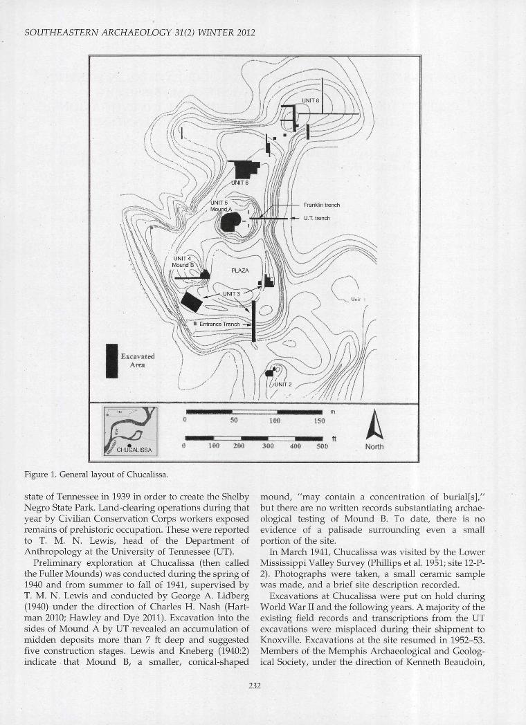
Essentially, Chucalissa consists of a square plazasurrounded by a residence ridge and two mounds. Thelarger of the mounds (Mound A) is located at the northend of the plaza, the smaller (Mound B) on the westside of the plaza (Figure 1). In 2003, new chronologicaldeterminations were obtained for the major mound(Mound A or Unit 5) and for the "entrance trench" orsouthern residence ridge (Unit 3) at Chucalissa. ToddMcCurdy and Steven Sharp, graduate students at theUniversity of Memphis, conducted these projects underthe supervision of Jay Franklin. In 2011, geophysicalinvestigations were conducted at the site by EdwardHenry of the University of Mississippi. Henry's work,employing electromagnetic induction (EM), ground-penetrating radar (GPR), and down-hole magneticsusceptibility, concentrated on the eastern half of thesummit on Mound A as well as the west and southresidence ridges. This paper incorporates these newdata into current interpretations of the site anddiscusses their significance for the local region.
History
Previous Excavations
The history of excavations at Chucalissa has beensummarized recently by Hartman (2010), and much ofthe following relies on his work. The present sectionemphasizes work that pertains most directly to the newchronological data from the site.
Originally known as the Barrett Farm site, Chucalissawas purchased from the estate of Dover Barrett by the
^Department of Earth Sciences, University of Memphis, Memphis, TN 38152. e-mail: [email protected]^Department of Sociology and Anthropology, East Tennessee State University, 807 University Parkway, JohnsonCity, TN 37614-1700. e-mail: [email protected]•'Department of Anthropology, Campus Box 1114, One Brookings Drive, Washington University, St. Louis, MO63130. e-mail: [email protected]
Southeastern Archaeology 31:231-250
SOUTHEASTERN ARCHAEOLOGY 31(2) WINTER 2012
0 too 200 300 400 500 North
Eigure 1. General layout of Chucalissa.
state of Tennessee in 1939 in order to create the ShelbyNegro State Park. Land-clearing operations during thatyear by Civilian Conservation Corps workers exposedremains of prehistoric occupation. These were reportedto T. M. N. Lewis, head of the Department ofAnthropology at the University of Tennessee (UT).
Preliminary exploration at Chucalissa (then calledthe Fuller Mounds) was conducted during the spring of1940 and from summer to fall of 1941, supervised byT. M. N. Lewis and conducted by George A. Lidberg(1940) under the direction of Charles H. Nash (Hart-man 2010; Hawley and Dye 2011). Excavation into thesides of Mound A by UT revealed an accumulation ofmidden deposits more than 7 ft deep and suggestedfive construction stages. Lewis and Kneberg (1940:2)indicate that Mound B, a smaller, conical-shaped
mound, "may contain a concentration of burial[s],"but there are no written records substantiating archae-ological testing of Mound B. To date, there is noevidence of a palisade surrounding even a smallportion of the site.
In March 1941, Chucalissa was visited by the LowerMississippi Valley Survey (Phillips et al. 1951; site 12-P-2). Photographs were taken, a small ceramic samplewas made, and a brief site description recorded.
Excavations at Chucalissa were put on hold duringWorld War II and the following years. A majority of theexisting field records and transcriptions from the UTexcavations were misplaced during their shipment toKnoxville. Excavations at the site resumed in 1952-53.Members of the Memphis Archaeological and Geolog-ical Society, under the direction of Kenneth Beaudoin,
232
RECENT INVESTIGATIONS AT CHUCALISSA
excavated 10 contiguous 10-x-lO-ft (3.1-x-3.1-m) unitssome 250 ft (76 m) north of Mound A in an areadesignated Unit 6. The deepest excavation unit wentdown more than 13 5-in (12.7-cm) levels to the bottomof the midden (Beaudoin 1953; Coleman 1963:370).
Between 1955 and 1958, excavations were conductedby the Memphis Archaeological and Geological Societyand the Tennessee State Parks Service under thedirection of Charles H. Nash. Nash established a sitegrid of 10-ft (3.1-m) squares based on a north-southcenter line that began at a datum south of the residenceridge and extended northward through the approxi-mate center of the large mound. Squares were des-ignated as either right (R; east) or left (L; west) of thecenterline and described by their southwest corner. Asquare with its southwest corner 50 ft (15.2 m) north ofthe centerline datum and 20 ft (6.1 m) east of the centerline would be designated 50R20, frequently abbreviat-ed as simply 5R2. Nash also reassigned unit numbers toareas of the site that had been distinguished previouslyby Lidberg. This grid and these unit designations arestill employed at Chucalissa.
Nash excavated two units and one trench on theresidence ridge south of the central plaza of the site.These three excavation areas were all ascribed to Unit 3.The trench, 65 fl (19.8 m) long and 12 fl (3.7 m) wide, wasoriented north-south and bisected the residence ridge onits southeast side. It was excavated to subsou (StratumrV). House floors, pits, and other features were exposedin the profile. This trench was subsequently coveredand served as the "Entrance Trench" to the site. Thedesignation "Entrance Trench" will be employed hereinto distinguish this excavation from others ascribed toUnit 3. It is this area that has provided much of the newchronological information for the site.
The remaining areas investigated between the years1955 and 1958 were Mound A (Unit 5) and Unit 2. OnMound A, Nash excavated a shallow trench (orientedeast-west) transecting the surface of the mound. Thiswas evidently an extension of the earlier trench dug byLidberg for UT. Unit 2 is located considerably to thesouth of the main plaza (see Figure 1) and is importantin discussing the latest occupation of the site.
In 1959-60, Tennessee State Parks excavated acircular unit on top of Mound A. Nash proposed thata perishable building be constructed on top of themound to function as a modern exhibit. The excavatedarea was intentionally circular in shape, examining thearea proposed for the perishable building—a Creek-style rotunda (Smith 1988:2). Only the area that was tobe impacted by this construction was investigated.
From 1960 to 1962, excavations were conducted inMound B, supervised by Charles Nash. An east-westtrench was extended through the center of the mound,and block excavations were expanded from the east(plaza) end of the trench.
During the period 1963-67, Nash supervised exca-vations in a 40-x-50-ft (12.2-x-15.2-m) block in Unit 6,slightly north of Mound A (and south of Beaudoin'sexcavations). The southwestern portion of this exca-vation (Unit 6SW) was later analyzed by Lumb andMcNutt. It is relevant to note that the early structures inthis excavation are of the wall-trench variety, and thatone (House 6) has unusually large wall trenches withits only exposed side measuring 25 ft (7.6 m) (Lumband McNutt 1988:51).
In 1968, Lou Adair and Linda DeLuca excavated twostructures near the south end of the eastern residenceridge, roughly east across the plaza from Mound B (seeFigure 1). Portions of two superimposed houses wereexposed. The lower house had shallow, single-set postson its north and east sides; no posts were found on theother sides. The structure measured 18 X 18 ft (5.5 X5.5 m) on a side. The shallow house provided a completewall line of single-set posts, an intact floor, and afireplace. This structure was much smaller, measuring10 X 10 ft (3.1 X 3.1 m) on a side (Adair 1968).
Gerald P. Smith directed major excavations forMemphis State University from 1969 to 1971 on thewestern half of the summit of Mound A (Unit 5). In1975, Smith resumed work on top of Mound A,excavating three small test trenches in the easternportion of the mound summit. These trenches suggest-ed to Smith the presence of a second building on theeast half of the mound.
In 1994, Chucalissa was designated a U.S. NationalHistoric Landmark by the National Park Service (Smithand McNutt 1992). With the exception of minor salvagework at the site (Bundy 2005; Gray 2004), no otherexcavations were conducted at the site until thosesupervised by Franklin in 2003.
Earlier Discussions of Chronology
In prefatory remarks to Nash's 1972 publication onChucalissa, Smith (1972) proposed the following phasesequence for Chucalissa, based in part on eightavailable radiocarbon dates and an archaeomagneticdate: Ensley (A.D. 1020?), Mitchell (A.D. 1200?), Box-town (early A.D. 1400s), and Walls (late A.D. 1400s intoearly 1500s). The archaeomagnetic date of 1410-1485(Wolfman 8-6-1974) is ascribed to the Walls phase,but its provenience is uncertain. The terminal datefor Walls was suggested by the complete absence ofhistoric period material at Chucalissa.
Lumb and McNutt (1988:155) had these same datesavailable for their study, which dealt primarily withNash's excavations in Unit 6 (north of Mound A) andwith Unit 2. Five of the radiocarbon dates were earlyUniversity of Michigan dates, for which the publishedstandard deviations had been doubled. In calibrating
233
SOUTHEASTERN ARGHAEOLOGY 31(2) WINTER 2012
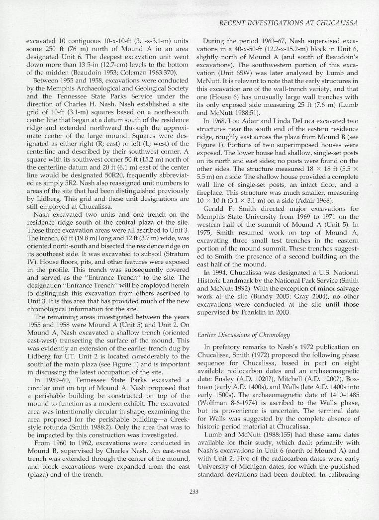
Table 1. Previous (prior to 2000) radiocarbon dates for Chucalissa.
Sample
M-787M-788Tx-6173Tx-6174
M-584
M-789'
Tx-6843
Tx-6170
1-5780Tx-6171Tx-6169Tx-6172
Tx-60781-5781
M-583
Tx-6842Gx-414
" C Yrs. ± c B.P.
350 ± 200"360 ± 150°470 ± 50490 ± 50
510 ± 200"
510 ± 200'
520 ± 70
530 ± 50
540 ± 90600 ± 150640 ± 60710 ± 60
760 ± 60765 ± 95
930 ± 200'
1110 ± 701600 ± 60
Cal. A.D. Yrs. ± 2o
1399-16921424-16641391-15181311-13591387-14891281-15281551-16341281-1528
1551-16341287-14931389-14461302-13661383-14481272-15201152-16441272-14131213-13331336-13981155-13161040-11101115-13291340-1396945-1274
769-1044332-596
Probability''
0.9040.9960.9120.130.8670.8820.1180.882
0.1180.9910.6810.3710.6290.9760.9831.0000.7290.2710.9450.1050.7820.1130.980
0.9760.990
Median Probability
1562154714371426
1416
1416
1403
1401
1389135813441287
12501238
1106
929466
Phase'
WaUsWallsWallsWalls
Walls
Walls?
Walls
Walls
BoxtownBoxtownBoxtownBoxtown
WallsMitchell
Ensley
EnsleyWoodland
Provenience
Unit 3, House 3 profile, base Stratum IUnit 3, Stratum I, post (very late)Unit 5, Mound A, next to last structureUnit 5, Mound A, next to last structure
Unit 3, House 3 floor, base Stratum I
Unit 3, above floor House 12, upperStratum III
Unit 4, Feature 7
Unit 3, House 14
Unit 6, House 6, Feature 96Unit 6, House 5Unit 6, sq 58ÜR80, midden. House 10?Unit 6, House 6, Feature 96
Mound A, next to last structureUnit 6
Unit 3, pit below House 12, upperStratum III
Unit 4, submound middenUnit 2, Feature 10, Stratum III
Note: All radiocarbon determinations made on wood charcoal.
'University of Michigan provides 2-CTB.P.; 1-aB.P. was used for calibrations.
""Only probabilities =: 0.1 are shown.
' Phase determinations based on stratigraphy and ceramics.
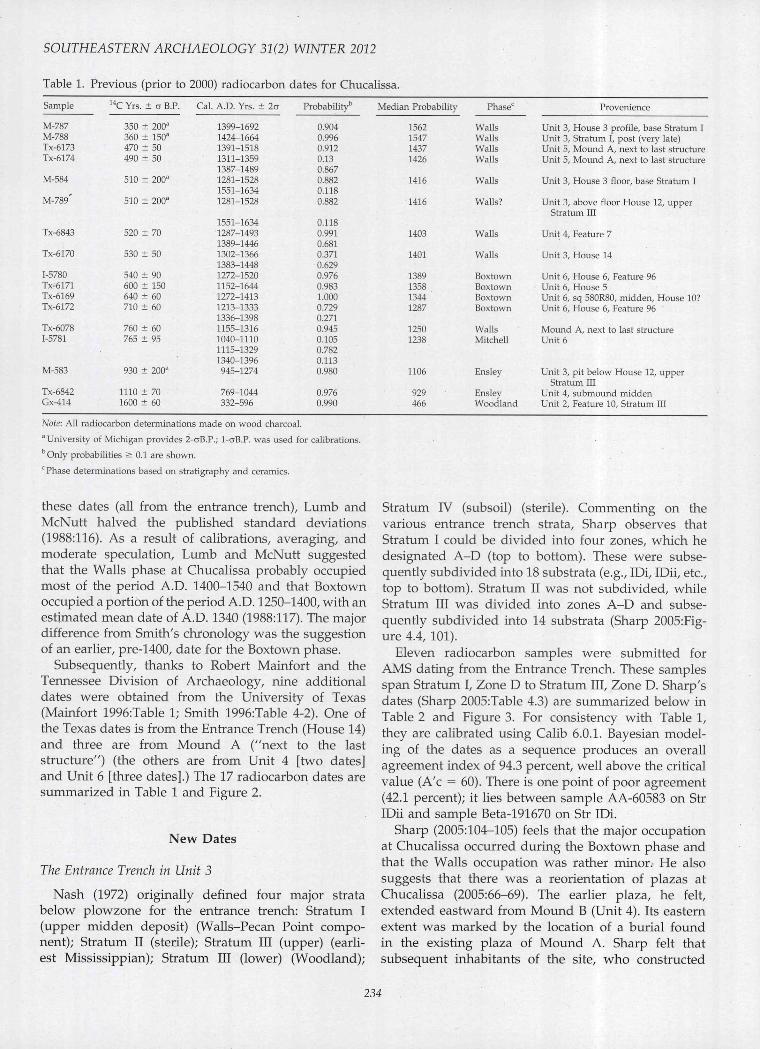
these dates (all from the entrance trench), Lumb andMcNutt halved the published standard deviations(1988:116). As a result of calibrations, averaging, andmoderate speculation, Lumb and McNutt suggestedthat the Walls phase at Chucalissa probably occupiedmost of the period A.D. 1400-1540 and that Boxtownoccupied a portion of the period A.D. 1250-1400, with anestimated mean date of A.D. 1340 (1988:117). The majordifference from Smith's chronology was the suggestionof an earlier, pre-1400, date for the Boxtown phase.
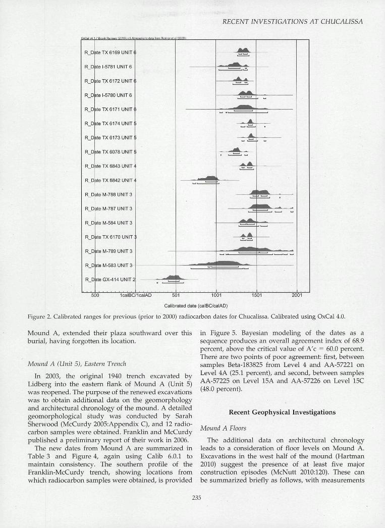
Subsequently, thanks to Robert Mainfort and theTennessee Division of Archaeology, nine additionaldates were obtained from the University of Texas(Mainfort 1996:Table 1; Smith 1996:Table 4-2). One ofthe Texas dates is from the Entrance Trench (House 14)and three are from Mound A ("next to the laststructure") (the others are from Unit 4 [two dates]and Unit 6 [three dates].) The 17 radiocarbon dates aresummarized in Table 1 and Figure 2.
New Dates
The Entrance Trench in Unit 3
Nash (1972) originally defined four major stratabelow plowzone for the entrance trench: Stratum I(upper midden deposit) (Walls-Pecan Point compo-nent); Stratum II (sterile); Stratum III (upper) (earli-est Mississippian); Stratum III (lower) (Woodland);
Stratum IV (subsoil) (sterile). Commenting on thevarious entrance trench strata. Sharp observes thatStratum I could be divided into four zones, which hedesignated A-D (top to bottom). These were subse-quently subdivided into 18 substrata (e.g., IDi, IDii, etc.,top to bottom). Stratum II was not subdivided, whileStratum III was divided into zones A-D and subse-quently subdivided into 14 substrata (Sharp 2005:Fig-ure 4.4, 101).
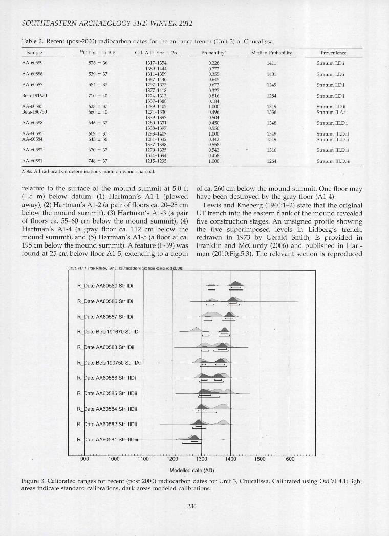
Eleven radiocarbon samples were submitted forAMS dating from the Entrance Trench. These samplesspan Stratum I, Zone D to Stratum III, Zone D. Sharp'sdates (Sharp 2005:Table 4.3) are summarized below inTable 2 and Figure 3. For consistency with Table 1,they are calibrated using Calib 6.0.1. Bayesian model-ing of the dates as a sequence produces an overallagreement index of 94.3 percent, well above the criticalvalue (A'c = 60). There is one point of poor agreement(42.1 percent); it lies between sample AA-60583 on StrIDii and sample Beta-191670 on Str IDi.
Sharp (2005:104-105) feels that the major occupationat Chucalissa occurred during the Boxtown phase andthat the Walls occupation was rather minor. He alsosuggests that there was a reorientation of plazas atChucalissa (2005:66-69). The earlier plaza, he felt,extended eastward from Mound B (Unit 4). Its easternextent was marked by the location of a burial foundin the existing plaza of Mound A. Sharp felt thatsubsequent inhabitants of the site, who constructed
234
RECENT INVESTIGATIONS AT CHUCALISSA
OxCal V4.1.7 Bronk Ramsey f2010l: r:5 Atmospheric data from Reimer el al f2009);
R
R
R
R_D
R.
R
R_
R
R
R
R.
R
R.
R.
R.
R
R
Date I
Date"
DbteTX 6169 UNIT (
1-5781 UNIT 6
DbteTX 6172 UNIT (
äte 1-5780 UNIT 6
P^teTX6171 UNIT
TX 6174 UNIT
pbteTX 6173 UNIT
P äte TX 6078 UNIT i
P äte TX 6843 UNIT'
P^teTX 6842 UNIT'
M-788 UNIT 3
M-787 UNIT 3
i-584 UNIT 3
pbteTX 6170 UNIT
PäteM-789UNIT3
PäteM-583UNIT3-
D äte GX-414 UNIT
Datei
Datei
500 1501 20011calBC/1calAD 501 1001
Calibrated date (calBC/calAD)
Figure 2. Calibrated ranges for previous (prior to 2000) radiocarbon dates for Chucalissa. Calibrated using OxCal 4.0.
Mound A, extended their plaza southward over thisburial, having forgotten its location.
Mound A (Unit 5), Eastern Trench
In 2003, the original 1940 trench excavated byLidberg into the eastern flank of Mound A (Unit 5)was reopened. The purpose of the renewed excavationswas to obtain additional data on the geomorphologyand architectural chronology of the mound. A detailedgeomorphological study was conducted by SarahSherwood (McCurdy 2005:Appendix C), and 12 radio-carbon samples were obtained. Franklin and McCurdypublished a preliminary report of their work in 2006.
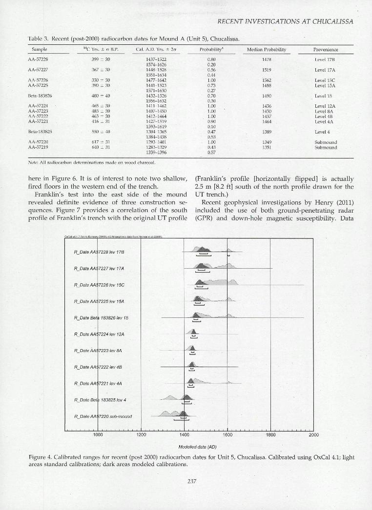
The new dates from Mound A are summarized inTable 3 and Figure 4, again using Calib 6.0.1 tomaintain consistency. The southern profile of theFranklin-McCurdy trench, showing locations fromwhich radiocarbon samples were obtained, is provided
in Figure 5. Bayesian modeling of the dates as asequence produces an overall agreement index of 68.9percent, above the critical value of A'c = 60.0 percent.There are two points of poor agreement: first, betweensamples Beta-183825 from Level 4 and AA-57221 onLevel 4A (25.1 percent), and second, between samplesAA-57225 on Level 15A and AA-57226 on Level 15C(48.0 percent).
Recent Geophysical Investigations
Mound A Floors
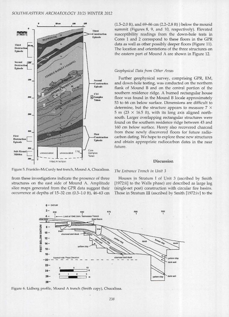
The additional data on architectural chronologyleads to a consideration of floor levels on Mound A.Excavations in the west half of the mound (Hartman2010) suggest the presence of at least five majorconstruction episodes (McNutt 2010:120). These canbe summarized briefly as follows, with measurements
235
SOUTHEASTERN ARCHAEOLOGY 31(2) WINTER 2012
Table 2. Recent (post-2000) radiocarbon dates for the entrance trench (Unit 3) at Chucalissa.
Sample
AA-60589
AA-60586
AA-60587
Beta-191670
AA-60583Beta-190750
AA-60588
AA-60585AA-60584
AA-60582
AA-60581
" C Yrs. ± a B.P.
526 ± 36
539 ± 37
584 ± 37
710 ± 40
623 ± 37660 ± 40
646 ± 37
609 ± 37643 ± 36
670 ± 37
748 ± 37
Cal. A.D. Yrs-. ± 2a
1317-13541389-14441311-13591387-14401297-13731377-14181224-13131357-13881289-14021274-13301339-13971280-13311338-13971293-14071281-13321337-13981270-13251344-13941215-1295
Probability'''
0.2280.7720.3550.6450.6730.3270.8160.1841.0000.4960.5040.4500.5501.0000.4420.5580.5420.4581.000
Median Probability
1411
1401
1349
1284
13491336
1348
13491349
1316
1264
Provenience
Stratum I.D.i
Stratum I.D.i
Stratum I.D.i
Stratum I.D.i
Stratum I.D.iiStratum II.A.i
Stratum ni.D.i
Stratum III.D.iiStratum III.D.ii
Stratum III.D.ii
Stratum III.D.iii
Note: All radiocarbon determinations made on wood charcoal.
relative to the surface of the mound summit at 5.0 ft(1.5 m) below datum: (1) Hartman's Al-1 (plowedaway), (2) Hartman's Al-2 (a pair of floors ca. 20-25 cmbelow the mound summit), (3) Hartman's Al-3 (a pairof floors ca. 55-60 cm below the mound summit), (4)Hartman's Al-4 (a gray floor ca. 112 cm below themound summit), and (5) Hartman's Al-5 (a floor at ca.195 cm below the mound summit). A feature (F-39) wasfound at 25 cm below floor Al-5, extending to a depth
of ca. 260 cm below the mound summit. One floor mayhave been destroyed by the gray floor (Al-4).
Lewis and Kneberg (1940:1-2) state that the originalUT trench into the eastern flank of the mound revealedfive construction stages. An unsigned profile showingthe five superimposed levels in Lidberg's trench,redrawn in 1973 by Gerald Smith, is provided inFranklin and McCurdy (2006) and published in Hart-man (2010:Fig.5.3). The relevant section is reproduced
OxCal V4.1.7 Bronk Ramsey <2010>; r:5 AtmosDherie data from Ri
Str IDii
Beta19(ll750StrllAi
StrlllDi
Str IIIDii
Date AA605a4 Str IIIDii
Date AA605a2 Str IIIDii
StrlllDiii
900 1000 1100 1200 1300 1400
Modelled date (AD)
1500 1600
Figure 3. Calibrated ranges for recent (post 2000) radiocarbon dates for Unit 3, Chucalissa. Calihrated using OxCal 4.1; lightareas indicate standard calibrations, dark areas modeled calibrations.
236
RECENT INVESTIGATIONS AT CHUCALISSA
Table 3. Recent (post-2000) radiocarbon dates for Mound A (Unit 5), Chucalissa.
Sample
AA-57228
AA-57227
AA-57226AA-57225
Beta-183826
AA-57224 •AA-57223AA-57222AA-57221
Beta-183825
AA-57220AA-57219
" C Yrs. ± a B.P.
399 ± 30
367 ± 30
330 ± 30390 ± 30
400 ± 40
465 ± 30483 ± 30463 ± 30416 ± 31
550 ± 40
617 ± 31640 ± 31
Cal. A.D. Yrs. ± 2o
1437-15221574-16261448-15281551-16341477-16421441-15231571-16301432-15261556-16321411-14621407-14501412-14641427-15191593-16191304-13651384-14381293-14011283-13291339-1396
Probability'
0.800.200.560.441.000.730.270.700.301.001.001.000.900.100.470.531.000.430.57
Median Probability
1478
1519
15621488
1490
1436143014371464 ,
1389
13491351
Provenience
Level 17B
Level 17A
Level 15CLevel 15A
Level 15
Level 12ALevel 8ALevel 4BLevel 4A
Level 4
SubmoundSubmound
Note: All radiocarbon determinations made on wood charcoal.
here in Figure 6. It is of interest to note two shallow,fired floors in the western end of the trench.
Franklin's test into the east side of the moundrevealed definite evidence of three construction se-quences. Figure 7 provides a correlation of the southprofile of Franklin's trench with the original UT profile
(Franklin's profile [horizontally nipped] is actually2.5 m [8.2 ft] south of the north profile drawn for theUT trench.)
Recent geophysical investigations by Henry (2011)included the use of both ground-penetrating radar(GPR) and down-hole magnetic susceptibility. Data
OxCal V4.1.7 Bronk Ramsey f2Q1Q): r 5 Atmospheric tJala from Reimer et al f20Q91:
R DateAA
R DateAAi
R DateAAi
R DateAAi
R Date Bet ) 183826 tev 15
R DateAAt
R DateAA.
R DateAAt
R DateAAt
7228 lev 17B
7227 tev MA
7226 tev 15C
7225 lev 15A
7224 lev 12A
7223 lev 8A
R DateAAi 7222 lev 4B
7221 lev 4A
R Date Bet j 183825 tev 4
7220 sub-mound
1000 1200 1400 1600
Modelled date (AD)
1800 2000
Figure 4. Calibrated ranges for recent (post 2000) radiocarbon dates for Unit 5, Chucalissa. Calibrated using OxCal 4.1; lightareas standard calibrations; dark areas modeled calibrations.
237
SOUTHEASTERN ARCHAEOLOGY 31(2) WINTER 2012
I-»«—I
TWrdDestructionEpisode
SecondDestrniEpisod
• 7ISS-icUon̂le I
300_
FirstDestructionEpisode
350
Sub-MoundMidd
VIound j "
len I
Intact A horizon
CoreSamplesTaken
Figure 5. Franklin-McGurdy test trench. Mound A, Chucalissa.
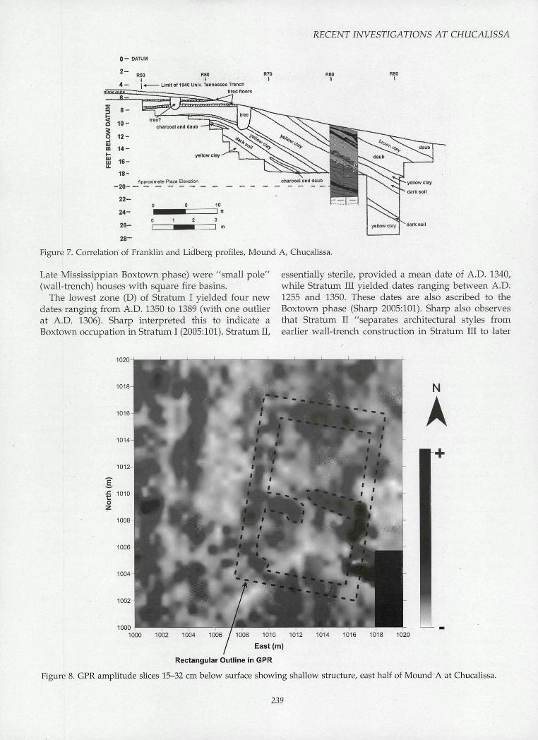
from these investigations indicate the presence of threestructures on the east side of Mound A. Amplitudeslice maps generated from the GPR data suggest their
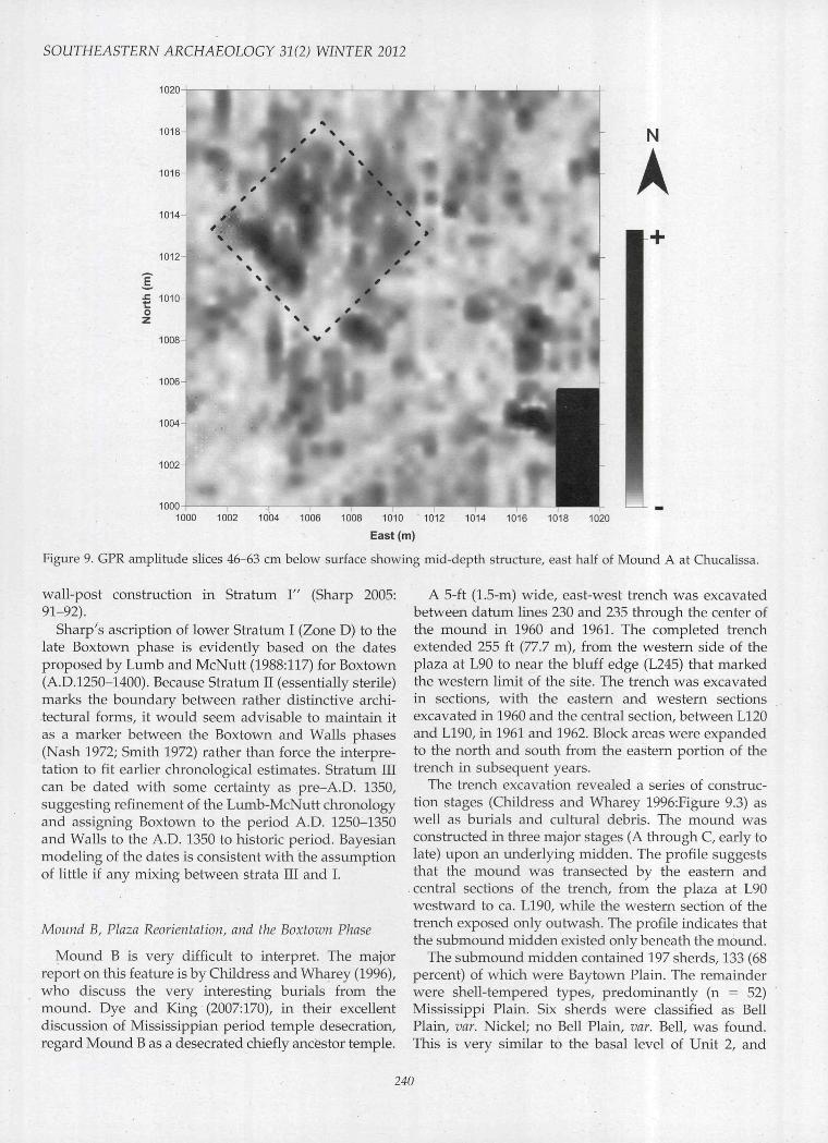
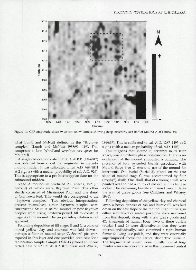
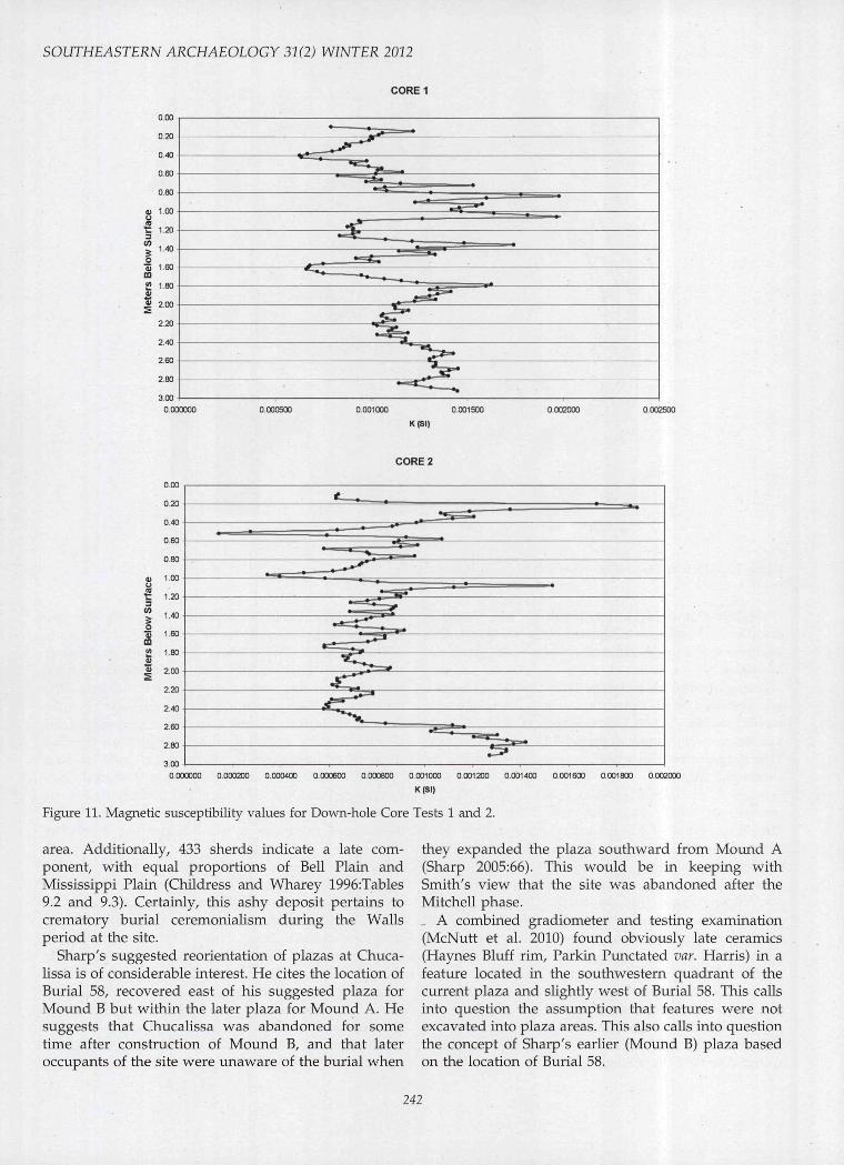
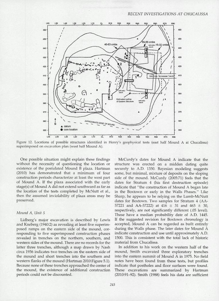
(1.5-2.0 ft), and 69-86 cm (2.2-2.8 ft) ) below the moundsummit (Figures 8, 9, and 10, respectively). Elevatedsusceptibility readings from the down-hole tests inCores 1 and 2 correspond to these floors in the GPRdata as well as other possibly deeper floors (Figure 11).The location and orientations of the three structures onthe eastern part of Mound A are shown in Figure 12.
Geophysical Data from Other Areas
Further geophysical survey, comprising GPR, EM,and down-hole testing, was conducted on the northernflank of Mound B and on the central portion of thesouthern residence ridge. A burned rectangular housefloor was found in the Mound B locale approximately53 to 66 cm below surface. Dimensions are difficult todetermine, but the structure appears to measure 7 X5 m (23 X 16.5 ft), with its long axis aligned north-south. Larger overlapping rectangular structures werefound on the southern residence ridge between 43 and160 cm below surface. Henry also recovered charcoalfrom these newly discovered floors for future radio-carbon dating. We hope to explore these new structuresand obtain appropriate radiocarbon dates in the nearfuture.
Discussion
Entrance Trench in Unit 3
Houses in Stratum I of Unit 3 (ascribed by Smith[1972:ii] to the Walls phase) are described as large log(single-set post) construction with circular fire basins.
occurrence at depths of 15-32 cm (0.5-1.0 ft), 46-63 cm Those in Stratum III (ascribed by Smith [1972:iv] to the
0 — DATUM
R50 R60 R70I I i
4 — I * Limit of 1940 Univ. Tennessee Trenonfired floors
R901
Figure 6. Lidberg profile. Mound A trench (Smith copy), Chucalissa.
238
REGENT INVESTIGATIONS AT GHUGALISSA
0 — DATUM
RSO R60
Limit of 1940 Univ. Tennessee Trenchfired floors
R701
Figure 7. Correlation of Franklin and Lidberg profiles. Mound A, Chucalissa.
R901
Late Mississippian Boxtown phase) were "small pole"(wall-trench) houses with square fire basins.
The lowest zone (D) of Stratum I yielded four newdates ranging from A.D. 1350 to 1389 (with one outlierat A.D. 1306). Sharp interpreted this to indicate aBoxtown occupation in Stratum I (2005:101). Stratum II,
essentially sterile, provided a mean date of A.D. 1340,while Stratum III yielded dates ranging between A.D.1255 and 1350. These dates are also ascribed to theBoxtown phase (Sharp 2005:101). Sharp also observesthat Stratum II "separates architectural styles fromearlier wall-trench construction in Stratum III to later
N
1020
1018
1016-
1014
1012
1010
1008
1006-
1004
1002
10001000 1002 1004 1006 / 1008 1010 1012 1014 1016 1018 1020
East (m)
Rectangular Outline in GPR
Figure 8. GPR amplitude slices 15-32 cm below surface showing shallow structure, east half of Mound A at Chucalissa.
239
SOUTHEASTERN ARCHAEOLOGY 31(2) WINTER 2012
1020
1018
1016
1014
1012
£ 1010
1008
1006^
1004-
1002-
10001000 1002 1004 1006 1008 1010 1012 1014 1016 1018 1020
East (m)
Figure 9. GPR amplitude slices 46-63 cm below surface showing mid-depth structure, east half of Mound A at Chucalissa.
wall-post construction in Stratum I" (Sharp 2005:91-92).
Sharp's ascription of lower Stratum I (Zone D) to thelate Boxtown phase is evidently based on the datesproposed by Lumb and McNutt (1988:117) for Boxtown(A.D.1250-1400). Because Stratum II (essentially sterile)marks the boundary between rather distinctive archi-tectural forms, it would seem advisable to maintain itas a marker between the Boxtown and Walls phases(Nash 1972; Smith 1972) rather than force the interpre-tation to fit earlier chronological estimates. Stratum IIIcan be dated with some certainty as pre-A.D. 1350,suggesting refinement of the Lumb-McNutt chronologyand assigning Boxtown to the period A.D. 1250-1350and Walls to the A.D. 1350 to historic period. Bayesianmodeling of the dates is consistent with the assumptionof little if any mixing between strata III and 1.
Mound B, Plaza Reorientation, and the Boxtown Phase
Mound B is very difficult to interpret. The majorreport on this feature is by Chüdress and Wharey (1996),who discuss the very interesting burials from themound. Dye and King (2007:170), in their excellentdiscussion of Mississippian period temple desecration,regard Mound B as a desecrated chiefly ancestor temple.
A 5-ft (1.5-m) wide, east-west trench was excavatedbetween datum lines 230 and 235 through the center ofthe mound in 1960 and 1961. The completed trenchextended 255 ft (77.7 m), from the western side of theplaza at L90 to near the bluff edge (L245) that markedthe western limit of the site. The trench was excavatedin sections, with the eastern and western sectionsexcavated in 1960 and the central section, between L120and L190, in 1961 and 1962. Block areas were expandedto the north and south from the eastern portion of thetrench in subsequent years.
The trench excavation revealed a series of construc-tion stages (Childress and Wharey 1996:Figure 9.3) aswell as burials and cultural debris. The mound wasconstructed in three major stages (A through C, early tolate) upon an underlying midden. The profile suggeststhat the mound was transected by the eastern andcentral sections of the trench, from the plaza at L90westward to ca. LI90, while the western section of thetrench exposed only outwash. The profile indicates thatthe submound midden existed only beneath the mound.
The submound midden contained 197 sherds, 133 (68percent) of which were Baytown Plain. The remainderwere shell-tempered types, predominantly (n = 52)Mississippi Plain. Six sherds were classified as BellPlain, var. Nickel; no Bell Plain, var. Bell, was found.This is very similar to the basal level of Unit 2, and
240
RECENT INVESTIGATIONS AT CHUCALISSA
1020
1018
1016-
1014
1012
1010
1008
1006
1004
1002
10001000 1002 1004 1006 1008 1010 1012 1014 1016 1018 1020
East(m)
Figure 10. GPR amplitude slices 69-86 cm below surface showing deep structure, east half of Mound A at Chucalissa.
what Lumb and McNutt defined as fhe "Baytowncomplex" (Lumb and McNutt 1988:99, 119). Thiscomprises a Late Woodland terminus post quem forMound B.
A single radiocarbon date of 1100 ± 70 B.P. (TX-6842)was obtained from a post that originated in the sub-mound midden. It was calibrated to cal. A.D. 769-1044at 2 sigma (with a median probability of cal. A.D. 929).This is appropriate to a pre-Mississippian date for thesubmound midden.
Stage A mound-flU produced 203 sherds, 192 (95percent) of which were Baytown Plain. The othersherds consisted of Mississippi Plain and one sherdof Old Town Red. This would also correspond to the"Baytown complex." Two obvious interpretationspresent themselves: either Baytown peoples wereconstructing Stage A of the mound or post-Baytownpeoples were using Baytown-period fill to constructStage A of the mound. The proper interpretation is notapparent.
Following deposition of fill stages B and C, a band ofmixed yellow clay and charcoal was laid down—perhaps a floor of mound stage C. Several pits wereexposed in this layer and one provided corn cobs for aradiocarbon sample. Sample TX-6843 yielded an uncor-rected date of 520 ± 70 B.P. (Childress and Wharey
1996:67). This is calibrated to cal. A.D. 1287-1493 at 2sigma (with a median probability of cal. A.D. 1403).
This suggests that Mound B, certainly in its laterstages, was a Boxtown phase construction. There is noevidence that the mound supported a building. Thepresence of four extended burials associated withMound Stage B or C attests to use of the mound forinterments. One burial (Burial 3), placed on the eastslope of mound stage C, was accompanied by four(trophy?) skulls. One skull, that of a young adult, waspainted red and had a chunk of red ochre in its left eyesocket. The remaining burials contained very little inthe way of grave goods (see Childress and Wharey1996).
Following deposition of the yellow clay and charcoallayer, a heavy deposit of ash and humic fill was laiddown on the east slope of the mound. Eight burials, ineither semiflexed or seated positions, were recoveredfrom this deposit, along with a few grave goods and420 fragments of human bone. Two of these burials(Burial 1 and 2) were distinctive in that they wereinterred individually, each contained a right humanfemur showing use-polish, and they were essentiallysuperimposed above the earlier, distinctive Burial 3.The fragments of human bone (mostly cranial frag-ments) were also concentrated in this presumed central
241
SOUTHEASTERN ARCHAEOLOGY 31(2) WINTER 2012
CORE1
K(SI)
CORE 2
0.000000 0000200 0001800 0002000
Figure 11. Magnetic susceptibility values for Down-hole Core Tests 1 and 2.
area. Additionally, 433 sherds indicate a late com-ponent, with equal proportions of Bell Plain andMississippi Plain (Childress and Wharey 1996:Tables9.2 and 9.3). Certainly, this ashy deposit pertains tocrematory burial ceremonialism during the Wallsperiod at the site.
Sharp's suggested reorientation of plazas at Chuca-lissa is of considerable interest. He cites the location ofBurial 58, recovered east of his suggested plaza forMound B but within the later plaza for Mound A. Hesuggests that Chucalissa was abandoned for sometime after construction of Mound B, and that lateroccupants of the site were unaware of the burial when
they expanded the plaza southward from Mound A(Sharp 2005:66). This would be in keeping withSmith's view that the site was abandoned after theMitchell phase., A combined gradiometer and testing examination(McNutt et al. 2010) found obviously late ceramics(Haynes Bluff rim. Parkin Punctated var. Harris) in afeature located in the southwestern quadrant of thecurrent plaza and slightly west of Burial 58. This callsinto question the assumption that features were notexcavated into plaza areas. This also calls into questionthe concept of Sharp's earlier (Mound B) plaza basedon the location of Burial 58.
242
RECENT INVESTIGATIONS AT CHUCALISSA
L60 L50 L40 L30 1-20 LIO CL RIO R20 R30 R40 R50 R60 R70 R80
J
L60 L50 L40 L30 L20 L10 CL R10 R20 R30 R40 R50 R60 R70 R80
Figure 12. Locations of possible structures identified in Henry's geophysical tests (east half Mound A at Ghucalissa)superimposed on excavation plan (west half Mound A).
One possible situation might explain these findingswithout the necessity of questioning the location orexistence of the postulated Mound B plaza. Hartman(2010) has demonstrated that a minimum of fourconstruction periods characterize at least the west partof Mound A. If the plaza associated with the earlystage(s) of Mound A did not extend southward as far asthe location of the tests completed by McNutt et al.,then the assumed inviolability of plaza areas may bepreserved.
Mound A, Unit 5
Lidberg's major excavation is described by Lewisand Kneberg (1940:2) as revealing at least five superim-posed ramps on the eastern side of the mound, cor-responding to five superimposed construction phasesrevealed in trenches on the northern, southern, andwestern sides of the mound. There are no records for thelatter three trenches, although a map drawn by Nashcirca 1956 indicates two trenches on the eastern side ofthe mound and short trenches into the southern andwestern flanks of the mound (Hartman 2010:Figure 5.1).Because none of these trenches approached the center ofthe mound, the existence of additional constructionperiods could not be discounted.
McCurdy's dates for Mound A indicate that thestructure was erected on a midden dating quitesecurely to A.D. 1350. Bayesian modeling suggestssome, but minimal, mixture of deposits on the slopingside of the mound. McCurdy (2005:71) feels that thedates for Stratum 4 (his first destruction episode)indicate that "the construction of Mound A began latein the Boxtown or early in the Walls Phases." LikeSharp, he appears to be relying on the Lumb-McNuttdates for Boxtown. Two samples for Stratum 4 (AA-57221 and AA-57222) at 416 ± 31 and 463 ± 30,respectively, are not significantly different (.05 level).These have a median probability date of A.D. 1445.If the suggested revision for Boxtown chronology isaccepted. Mound A can be regarded as built entirelyduring the Walls phase. The later dates for Mound Aindicate construction and use until approximately A.D.1500. This is consistent with the total lack of historicmaterial from Chucalissa.
In addition to his work on the western half of themound. Smith excavated three exploratory trenchesinto the eastern summit of Mound A in 1975. No fieldnotes have been found from these tests, but profilesindicate that postholes and floor surfaces were found.These excavations are summarized by Hartman(2010:91-92). Smith (1988) feels his data are sufficient
243
SOUTHEASTERN ARGHAEOLOGY 31(2) WINTER 2012
FRANKLINTEST
HENRYTEST
HARTMANFLOORS
Third 50DestructionEpisode
Second ioO|—DestructionEpisode I—
FirstDestruction |Episode
350
Sub-Mound i —Midden I
Al-5
intact A horizon
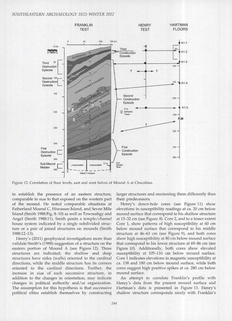
Figure 13. Correlation of floor levels, east and west halves of Mound A at Chucalissa.
to establish the presence of an eastern structure,comparable in size to that exposed on the western partof the mound. He noted comparable situations atFatherland Mound C, Hiwassee Island, and Seven MileIsland (Smith 1988:Fig. 8-10) as well as Towosahgy andAngel (Smith 1988:11). Smith posits a temple/charnelhouse system indicated by a single subdivided struc-ture or a pair of joined structures on mounds (Smith1988:12-13).
Henry's (2011) geophysical investigations more thanvalidate Smith's (1988) suggestion of a structure on theeastern portion of Mound A (see Figure 12). Threestructures are indicated; the shallow and deepstructures have sides (walls) oriented to the cardinaldirections, while the middle structure has its cornersoriented to the cardinal directions. Further, theincrease in size of each successive structure, inaddition to the changes in orientation, may indicatechanges in political authority and/or organization.The assumption for this hypothesis is that successivepolitical elites establish themselves by constructing
larger structures and reorienting them differently thantheir predecessors.
Henry's down-hole cores (see Figure 11) showelevations in susceptibility readings at ca. 20 cm belowmound surface that correspond to his shallow structureat 15-32 cm (see Figure 8). Core 2, and to a lesser extentCore 1, show patterns of high susceptibility at 60 cmbelow mound surface that correspond to his middlestructure at 46-63 cm (see Figure 9), and both coresshow high susceptibility at 80 cm below mound surfacethat correspond to his lower structure at 69-86 cm (seeFigure 10). Additionally, both cores show elevatedsusceptibility at 105-110 cm below mound surface.Core 1 indicates elevations in magnetic susceptibility atca. 138 and 180 cm below mound surface, while bothcores suggest high positive spikes at ca. 280 cm belowmound surface.
An attempt to correlate Franklin's profile withHenry's data from the present mound surface andHartman's data is presented in Figure 13. Henry'sshallow structure corresponds nicely with Franklin's
244
RECENT INVESTIGATIONS AT CHUCALISSA
third construction episode and Hartman's Floor Al-2.This shallow floor is incredibly close to Smith's originalestimate (shown as dotted lines in Figure 12). Henry'smiddle structure would correspond to the floorestablished during the late part of Franklin's secondconstruction episode and Hartman's Floor Al-3. Hen-ry's lower structure has no obvious correlate inFranklin's data and may correspond to an early stageof Hartman's Floor Al-3. Henry's floor at ca. 105 cmbelow mound surface corresponds to Hartman's FloorAl-4 and, if Franklin's Stratum 12 were a destructionepisode, would correspond to a floor on Stratum 11.Unlike the "destruction episode" of Stratums 25 and27, Stratum 12 did not contain large amounts of daubbut rather represents a sheet midden episode inter-spersed between basket loading episodes. Henry'sdown-hole data in Core 1 suggests a floor at ca.180 cm below mound surface. This has no obviouscorrelate in Franklin's data but corresponds nicely withHartman's Floor Al-5. Henry's cores suggest activity atca. 280 cm below mound surface. This may correspondto the feature (F-39) discovered in the western half ofthe mound at a depth of ca. 275 cm below moundsurface and may correspond to the floor established byFranklin's first construction episode.
In short, there is firm evidence that Mound Asupported two structures during most of its existence.There are at least suggestions that these structures mayhave been constructed as pairs.
The Chucalissa Sequence
Terminal Late Woodland: Ensley Phase
A terminal Late Woodland occupation characterizedpredominantly by Baytown Plain has been postulatedfor Chucalissa (Nash 1972:2,10) and designated asthe Ensley phase by Smith (1972:v-vi). Whereas thisoccupation has never been isolated satisfactorily, thereis some suggestion that it may underlie Unit 2 at thesouthern end of the site. Ironically, this same unitapparently contains the latest occupation at Chucalissa(Lumb and McNutt 1988:105-109).
This complex may also underlie the small mound(Mound B or Unit 4) at Chucalissa. Slope wash from themound subsequently covered later deposits. This wasnot noted during the excavations at Mound B, and aconfusing picture of the "sub-mound midden" resulted(Childress and Wharey 1996:73). Smith feels thatMound B was probably initiated during this period(Smith 1972:vi).
Sharp (2005:87) feels evidence for the Ensley phaseexists in the Entrance Trench (Urüt 3) at the top ofStratum IV, resting on subsoil. Sharp did not obtainnew dates on this level but appears to accept the M-583
determination. Smith, relying on vessel form, regardsthis phase as "Early Mississippian" (1972:3); Lumb andMcNutt, relying more on temper type, regard it asWoodland (1988:119).
Early Mississippian: Mitchell Phase
A later occupation, designated the Mitchell phaseby Smith (1972:v), contains both Mississippi Plain andBaytown Plain pottery, with a strong dominance ofBaytown. The initial construction phase of Mound B(Stage A) shows less mixture than the "sub-moundmidden," with sherds of Baytown Plain (n = 192),Mississippi Plain (n = 10), and Old Town Red (n = 1).
Childress and Wharey (1996) state that this ceramiccomplex corresponds nicely with Lumb and McNutt's(1988:119, 135) "Chucalissa-Baytown." To the extentthat these authors felt this complex might exist in thelowest midden levels in Unit 2, this is correct.However, Lumb and McNutt err in attributing thebasal level ceramics of Unit 6SW to the "Chucalissa-Baytown" complex, because too much Bell Plain ispresent.
Lumb and McNutt (1988:49) suggest that a well-made circular floor, one of the earliest floors encoun-tered in Unit 6SW (Feature 48), might indicate aresidential structure dating to the Mitchell phase. Nowall trench was associated with this floor. No othernonceramic artifacts were found to be diagnostic of thisphase. Madison points (both elongate and isosceles)occur, as do antler points, bird-bone awls, thin dis-coidals, celts, and gorgets. Corn agriculture is alsopresent. Burials tend to be extended, with heads to theeast or southeast (Lumb and McNutt 1988:119).
Middle Mississippian: Boxtown Phase
The Boxtown phase follows the Mitchell phase andcomprises the remains in Stratum III of the EntranceTrench. Recent examination by the senior author ofceramics assigned to Stratum III indicates a dominanceof Mississippi Plain (n = 585), followed by BaytownPlain (n = 182), with a fair showing of Bell Plain (n =81). Decorated types include Parkin Punctated (n = 10),Barton Incised (n = 4), two examples each of OwensPunctated and Old Town Red, and single specimens ofKent Ihcised and Larto Red Filmed. This assemblagesuggests slight, but not extensive, mixing.
Mound B, at least in its latter stages, was a Boxtownphase construction. Extended burials resting on theslope of Stage C, including one accompanied by severalskulls, can be attributed to either the end of the Boxtownphase or the beginning of the subsequent Walls phase.
Several wall-trench houses in the lower levels of Unit6SW apparently mark a Boxtown occupation. One of
245
SOUTHEASTERN ARCHAEOLOGY 31(2) WINTER 2012
these (Structure II) was very large—its only exposedwall line was 7.6 m in length (Lumb and McNutt1988:50). These authors feel that they "can at leastspeculate that this represents an early 'big man's' houseand that the location of this structure was subsequentlymoved somewhat to the south, where repeatedreconstructions resulted in the main platform mound(Mound A) at the site" (1988:51). This stiructure mayalso mark a seat of Boxtown ceremonialism.
Barton Incised is dominant over Parkin Punctated inthese levels. Owens Punctated and Old Town Red alsooccur. A stronger representation of Bell Plain (ca. 27percent) may indicate later occupation than that inStratum III of the Entrance Trench. Examples ofFortune Noded, Ranch Incised, and various paintedtypes probably indicate downward mixing (Lumb andMcNutt 1988:67). Mississippi Plain var. Boxtownappears during this period but does not yet occur ingreater than expected numbers (Lumb and McNutt1988:70). Nonceramic artifacts apparently continuefrom the previous phase.
Confusion regarcling the term "Boxtown Phase" and"var. Boxtown" must be addressed. The Boxtownphase was defined formally by Smith (1972:iv-v).Although he did not use the term "variety Boxtown,"in this definition, he comments that the "Neeley's FerryPlain in the Boxtown component is quite distinct fromthat of the Walls phase variety in that crushed shellcomposes only about 10 to 20% of the paste and theexterior is normally partly polished to burnished ratherthan merely smoothed (̂ 1972:iv)." This distinction isused by Lumb and McNutt (1988:19-20) in theirdefinition of Mississippi Plain, var. Boxtown. Oddlyenough. Smith (1972:v) does use "Neeley's Ferry var.Boxtown" in his discussion of the Ensley phase. Thedistinction being made by Smith is apparently based onan analysis of material from 630R110, a square in Unit 6lying northeast of Nash's excavations in Unit 6 (seeLumb and McNutt 1988:91-92) and well to the north ofMound A. We can find no evidence that Smith actuallyisolated a concentration of var. Boxtown in Stratum IIIof the Entrance Trench.
Largely due to the presence of wall-trench housesand the minor occurrence of var. Boxtown in Level 5 ofUnit 6, and the assumed association of var. Boxtownwith wall-trench houses in Stratum III of the EntranceTrench, Lumb and McNutt (1988) attributed theirBoxtown ceramic complex to the Boxtown phase. Thiswas unfortunate and quite probably incorrect.
The "Boxtown ceramic complex" is more properlydefined on the basis of material from level 4 in Unit 6SW,where var. Boxtown displays a signiflcant concentration(Lumb and McNutt 1988:54—72). This complex, however,is probably associated with the early portion of the Wallsphase. The presence of a single-set post structure inLevel 4 is in keeping with this assumption. To some
extent, this responds to concerns raised by Mainfort(1996:174) about this complex.
Late Mississippian: Walls Phase
Mound A was constructed during the Walls phase.In at least its upper levels two structures occupied thesummit of the mound. The changing orientations ofstructures on the eastern side of Mound A mayrepresent attempts by subsequent political leaders toimpose their stamp on the architecture on Mound A.These eastern structures have yet to be investigated.
Major changes in domestic architecture occur. Single-set post houses with circular hearths become charac-teristic and there is some evidence that floors wereslightly depressed.
Based on Unit 6SW, the ceramics involved in the"Boxtown complex" of the early Walls phase atChucalissa include approximately 70 percent Missis-sippi Plain (with a moderate dominance of var.Boxtown), 25 percent Bell Plain, and 5 percent Bay-town. Approximately 15 percent of the pottery isdecorated, with Parkin Punctated constituting some75 percent of this. Minor amounts of Barton Incised,Owens Punctated, Ranch Incised, Old Town Red,Avenue Polychrome, Hollywood White or NodenaRed and White, and Walls Engraved are also present(Lumb and McNutt 1988:55, 67). Based on oursuggested chronological revisions, this complex maybegin ca. A.D.1350 and continue into the early A.D.1400s.
Sharp (2005:76-79) devotes considerable effort toanalyzing the pottery from Stratum I in the EntranceTrench. He is concerned about a statement regardingthe Walls phase to the effect that "Bell Plain has afrequency of about 40% at the beginning of theoccupation at Chucalissa and increases to slightly over50% by the end of the occupation.... Neeley's Ferryranges from about 45% at the beginning of theoccupation to about 30% by the end (Nash 1972:iii)"(Sharp 2005:76) (this statement is properly attributed toSmith [1972:iii] instead of Nash). Sharp examinedavailable sherd counts by Nash for Stratum I andfound Mississippi Plain comprised 59 percent. BellPlain 27 percent, and Baytown 14 percent. This wasquite the opposite of the statement attributed to Nash.Sharp does not address the relatively large proportionof Baytown, which indicates appreciable mixing.
The senior author has been unable to duplicateSharp's sample, but such data as he can find agreeclosely with Sharp's findings (including the sizableproportion of Baytown Plain). Nash's troublesomeestimates were, in all probability, based on earlierexcavations by Beaudoin (1953), who described veryheavy concentrations of Bell Plain rather than analyses
246
RECENT INVESTIGATIONS AT CHUCALISSA
of the Entrance Trench. And, as will be seen, they canbe verified elsewhere on the site.
The ceramics in Unit 6 Levels 2 and 3 are roughlycomparable to those from Stratum I in the EntranceTrench but evince considerable increases of Bell Plainat the expense of Baytown (Lumb and McNutt 1988:57,70). Lumb and McNutt defined two ceramic complexesbased on these strata: Chucalissa-Bell I and Chucalissa-Bell II (1988:120-121). The possibility of mixturebetween these complexes must be acknowledged. Theyspan the remainder of the Walls phase as it isrepresented at Chucalissa, from the early fifteenth tothe mid-sixteenth centuries.
Chucalissa-Bell I, defined on the basis of Levels 3 and2 in Unit 6SW and the lower midden of Unit 2, containsapproximately equal proportions of Mississippi Plainand Bell Plain, with Bell Plain slightly dominant overMississippi Plain, var. Chucalissa (the main coarse-paste, shell-tempered type at Chucalissa). ParkinPunctated continues as the dominant decorated type.Barton Incised, Owens Punctated, Rhodes Incised, OldTown Red, and Walls Engraved occur and variouspainted types are apparently represented. A widevariety of handle forms are present, mainly strap,ribbon, and arcaded varieties.
Few changes in nonceramic artifacts can be noted.Madison points continue, but elongate forms decreasein frequency. There appears to be a shift from bird boneto mammal bone awls.
Chucalissa-Bell II is present in the upper levels andplow zone of Unit 6SW and Unit 2. Bell Plain varietiesdominate over Mississippi Plain varieties, attaining aratio of 70:30 in the uppermost levels of Unit 2. ParkinPunctated remains the dominant decorated form, withFortune Noded, Manly Punctated, Kent Incised, RanchIncised, Wallace Incised, and possibly HollywoodWhite being concentrated in these levels. Painted typesin general may show a decline in the uppermost levels.Triangular and appliqué handles occur, as do interiorlybeveled rims. Nodena points appear as a minor form;other nonceramic artifacts apparently continue fromearlier periods.
Certainly, major changes took place at Chucalissabetween the Boxtown and Walls phases. For differentreasons. Smith (1973:8) and Sharp (2005:66-69) both feltthe site was abandoned between these phases, althoughwe do not feel the evidence for this is compelling. Inany event, the extended burial format of the Boxtownphase in Mound B was dramatically altered during theWalls phase, marked by flexed or seated burials and anashy deposit containing a great number of human bonefragments. That the ash layer provides evidence fordesecration of cremated remains during the Wallsphase, as suggested by Dye and King (2007), seemscompelling, but the exact time of this event is difficultto determine.
Somewhat more than 3,000 sherds were collectedfrom the surface and upper part of the site whenwalkways were established along the western, south-ern, and eastern elevations of the residence ridge. Thedegree to which this comprises a representative samplecan be questioned on the basis of the rather largeproportion (ca. 20 percent) of decorated sherds, but thecollection also contains 1,200 sherds of Bell Plain, 1,126sherds of Mississippi Plain, and only 137 sherds ofBaytown Plain. Parkin Punctated is very plentiful (n =266), as are other late types. The large number of latesherds collected from the upper parts of the residenceridge and the deep midden deposits in Unit 6excavated by both Nash and Beaudoin argue for aconsiderable population during the Walls phase,contrary to Sharp's (2005:104-105) suggestion.
Unit 2 appears to be one of fhe latest occupationareas of Chucalissa (Lumb and McNutt 1988:121).There are indications of single-post houses, but nowall trenches. The Bell Plain dominance over Mis-sissippi Plain attains a ratio of ca. 70:30 in theuppermost levels of fhe Unit 2 midden.
The "classic" Walls phase sites lie some 16 km to thesoutheast, in DeSoto County, Mississippi. These siteshave been discussed in some detail by Smith (1990) andMcNutt (1996b, 2008). The relationship between Chu-calissa and the Mississippi sites has been questioned byMainfort (1999:175-176). His objections have been dealtwith extensively by McNutt (2008). Of particularimportance is Lumb and McNutt's earlier assertion(1988:130, 135) that the Chucalissa-Bell II complexcorresponds closely to Level 2 in both cuts made atthe Walls site by Phillips et al. (1951:243-248). TheChucalissa-Bell II complex represents the latest Wallsphase at Chucalissa, but not the very latest Walls phaseas it exists in Mississippi (Lumb and McNutt 1988:135;McNutt 2008:137). If this interpretation is correct, thereis a developmental lineage of the Walls phase extend-ing roughly two centuries from (1) the misnamedBoxtown ceramic complex at Chucalissa, to (2) theChucalissa-Bell I complex at Chucalissa, to (3) theChucalissa-Bell II complex and Level 2 at the Walls sitein Mississippi, to (4) the earlier classic Walls phase sites(Cheatham and Woodlyn) in northwestern Mississippi,and possibly (5) later Walls phase occupations at Walls,Irby, and Norfolk.
Finally, we cannot close this section on the Wallsphase without reference to "the elephant in the room."Nine kilometers to the northeast of Chucalissa lies theDeSoto Park Mounds site (now called ChickasawHeritage Park). Until recently, the two sites wereapparently linked by a wide bottomland. The DeSotoPark site, largely destroyed by Fort Pickering in themid-1800s, once had a large mound facing eastwardacross a plaza defined by three mounds. Threeadditional mounds apparently belonged to this com-
247
SOUTHEASTERN ARCHAEOLOGY 31(2) WINTER 2012
plex. The main mounds at Chucalissa and two of theclassic Mississippi Walls sites (Cheatbam and Wood-lyn) face southward across their plazas, althoughMound B at Chucalissa does face eastward. Verylimited tests at DeSoto suggest a Walls phase occupa-tion (Weaver 1982), but this is very poorly documented.In any area synthesis, the presence of, and ignoranceabout, this major site must be acknowledged; Chuca-lissa may well be understood most properly as asecondary center.
Summary
Excavations conducted in 2003 by Sharp andMcCurdy, under the direction of Jay Franklin, obtained23 new AMS dates for Units 3 and 5 at Chucalissa. Allof the new dates from the Entrance Trench (Unit 3)were earlier than any of the dates from Mound A (Unit5). Preliminary reports (McCurdy 2005; Sharp 2005)provided these dates but interpreted them on the basisof estimates made by Lumb and McNutt in 1988 basedon an earlier set of eight radiocarbon dates. The newdates provide evidence for not only a revised chronol-ogy for Chucalissa but also a two-century develop-mental lineage of the Walls phase of southwesternTennessee and northwestern Mississippi: Ensley phase(A.D. 1000?), Mitchell phase (A.D. 1200-1250), Boxtownphase (A.D. 1250-1350), and Walls phase (A.D. 1350-1550).
Analyses of Units 3 and 5 suggest continuousoccupation from the Boxtown through Walls phases,with major activity at the site occurring during theBoxtown phase. Mound A is apparently associatedwith the post-Boxtown Walls phase and it is quiteprobable that paired structures existed on the moundfor much of its existence. Ther.e is reason to believe thatthe residence ridge continued in use during the Wallsphase but that major occupation shifted to the north ofMound A.
Mound B is associated with the Boxtown phaseoccupation of the site. The distinctive wall-trenchstructure designated Structure II, located in Unit 6directly north of Mound A, may have been a locus forceremonial activity during the late Boxtown phase. Thepossibility of site abandonment at the end of theBoxtown phase has been alluded to. Although theauthors do not feel this to have been the case, it remainsa very real possibility.
Geophysical investigations performed by Henry(2011) demonstrate that Mound A supported twostructures during most of its existence; there aredefinite suggestions that these structures -were con-structed in pairs. Henry's work has validated Smith'soriginal suggestion (1988) of multiple structures onmounds extending from the Appalachians to the
Mississippi River and from the Angel site in south-western Indiana to the Grand Village of the Natchez atFatherland in Mississippi.
Notes
Acknowledgments. The authors wish to thank Robert Connollyand Jeffrey Mitchem for their very constructive comments.Mitchem provided a Herculean review, including manyeditorial suggestions. Such positive and professional com-mentary is deeply appreciated. Derek Hamilton and Chris-topher Bronk Ramsey led the senior author through the basicsof Bayesian analysis with profound patience. Finally, ThomasPluckhahn has accepted many last-minute changes andadditions to this study with greatly appreciated tolerance.
References Cited
Adair, Lou C.1968 Original unpublished field notes for excavations on
eastern Unit 3, Chucalissa. Manuscript on file, G. H. NashMuseum, Memphis.
Beaudoin, Kenneth L.1953 A Report of Excavations Made at the T. O. Fuller Site,
Shelhy County, Tennessee, Between March 8, 1952 andApril 30, 1953. Privately printed manuscript. Memphis,Tennessee. Manuscript on file, C. H. Nash Museum,Memphis.
Bronk Ramsey, Christopher2009 Bayesian Analysis of Radiocarbon Dates. Radiocarbon
51(l):337-360.Bundy, Paul D.2005 Data Recovery Associated with the Expansion of a Concrete
Drainage Structure, North and West of the Primary Moundat the Chucalissa Site (40SY1), Shelby County, Tennessee.Department of Anthropology, University of Memphis.Submitted to Department of Environment and Conserva-tion, Division of Archaeology, Nashville, Tennessee.Copies available at G. H. Nash Museum, Memphis.
Childress, Mitchell R.1992 Mortuary Vessels and Comparative Ceramic Analysis:
An Example from the Chucalissa Site. SoutheasternArchaeology 11:31-50.
Childress, Mitchell R., and Camille Wharey1996 Unit 4 Mound Excavations at the Ghucalissa Site, 1960-
1967. In Mou7ids, Embankments, and Ceremonialism in theMidsouth, edited by Robert C. Mainfort, Jr., and RichardWalling, pp. 64-77. Arkansas Archeological SurveyResearch Series No. 46, Fayetteville, Arkansas.
Goleman, Beverley R.1963 A History of State Parks in Tennessee. Educational Service,
Tennessee Department of Conservation, Nashville.Dye, David H.1998 An Overview of Walls Engraved Pottery in the Central
Mississippi Valley. In Changing Perspectives on the Archae-ology of the Central Mississippi River Valley, edited byMichael J. O'Brien and Rohert C. Durmell, pp. 80-98.University of Alabama Press, Tuscaloosa.
248
REGENT INVESTIGATIONS AT GHUGALISSA
Dye, David H., and Adam King2007 Desecrating the Sacred Ancestor Temples: Chiefly
Conflict and Violence in the American Southeast. InNorth American Indigenous Warfare and Ritual Violence,edited by Richard J. Chacon and Rubén G. Mendoza,pp. 160-181. University of Arizona Press, Tucson.
Franklin, J. D., and Todd D. McCurdy2006 A Radiocarbon Chronology for Mound A [Unit 5] at
Chucalissa in Memphis, Tennessee. Tennessee Archaeology2(1):32^5. Electronic document, http://frank.mtsu.edu/.
• Accessed April 12, 2011.Gray, Jay W.2004 Data Recovery along the Circumplaza Ridge (Unit 3) at the
Chucalissa Site (40SY1), Shelby County, Tennessee: Resultsfrom the 1999 Renovations Project. Department of Anthro-pology, University of Memphis. Submitted to Depart-ment of Environment and Conservation, Division ofArchaeology, Nashville, Tennessee. Copies available atC. H. Nash Museum, Memphis.
Hartman, Christopher Juston2010 An Assessment of the Mound Summit Investigations at
Mound A (Unit 5), Chucalissa (40SY1), Shelby County,Tennessee. Friends of Chucalissa Special Publication No. 1Memphis.
Hawley, Marlin F., and David H. Dye2011 George A. Lidberg and Depression Era Archaeology in
Tennessee. Southeastern Archaeology 30:399-412.Henry, Edward R.2011 Geophysical Investigations of Three Areas at Chucalissa
Mounds (40Syl), Shelby County, TN. Edward R. Henry,Oxford, Mississippi. Submitted to Friends of Chucalissa,Memphis. Copy on file, C. H. Nash Museum, Memphis.
Lahren, Craig H., and Hugh E. Berryman1984 Fracture Pattens and Statures at Chucalissa (40SY1): A
Biocultural Approach. Tennessee Anthropologist 9:15-21.Lewis, Thomas M. N., and Madeline D. Kneberg1940 Master Plan Pertaining to the Excavation and Preser-
vation In Situ of Prehistoric Remains Contained in ShelbyNegro Park, Memphis, Tennessee. Manuscript on file,Frank H. McClung Museum, University of Tennessee,Knoxville.
Lidberg, George A.1940 Description and Explanation of the Archaeological Site
at Shelby Negro State Park. Manuscript on file, Frank H.McClung Museum, University of Tennessee, Knoxville.
Lumb, Lisa C, and Charles H. McNutt1988 Chucalissa: Excavations in Units 2 and 6, 1959-67.
Occasional Paper No. 15. Memphis State UniversityAnthropological Research Center, Memphis.
Mainfort, Robert C, Jr.1996 Late Period Chronology in the Central Mississippi
Valley: A Western Tennessee Perspective. SoutheasternArchaeology 15:172-181.
1999 Late Period Phases in the Central Mississippi Valley: AMultivariate Approach. In Arkansas Archaeology: Essaysin Honor of Dan and Phyllis Morse, edited by Robert C.Mainfort, Jr. and Marvin D. Jeter, pp. 143-167. Universityof Arkansas Press, Fayetteville.
2005 A K-Means Analysis of Late Period Ceramic Variationin the Central Mississippi Valley. Southeastern Archaeology24:59-69.
McCurdy, Todd D.2005 Renewed Excavations at Chucalissa: Mound A Revis-
ited. Unpublished master's thesis. Department of An-thropology, University of Memphis.
McNutt, Charles H.1996a Upper Yazoo Basin. In Prehistory of the Central
Mississippi Valley, edited by Charles H. McNutt,pp. 155-185. University of Alabama Press, Tuscaloosa.
1996b The Central Mississippi Valley: A Summary. InPrehistory of the Central Mississippi Valley, edited byCharles H. McNutt, pp. 187-293. University of AlabamaPress, Tuscaloosa.
2008 Late Mississippian Phases in the Central MississippiValley: A Commentary. Southeastern Archaeology 27:122-143.
2010 Addendum. In An Assessment of the Mound SummitInvestigations at Mound A (Unit 5), Chucalissa (40SY1),Shelby County, Tennessee, by Christopher Juston Hartmanpp 119-121. Friends of Chucalissa Special PublicationNo. 1, Memphis.
McNutt, Charles H., Andrew M. Mickelson, and H. TerryChilds
2010 Phase I Survey of Site 40SY1, Shelby County: July 2010.Department of Anthropology, University of Memphis,Memphis. Submitted to Tennessee Division of Archaeol-ogy, Nashville.
Morse, Dan F., and Phyllis A. Morse1983 Archaeology of the Central Mississippi Valley. Academic
Press, New York.Nash, Charles H.1955 The Fuller Mounds. Tennessee Archaeologist 11:49-53.1972 Chucalissa: Excavations and Burials Through 1963. Occa-
sional Paper No. 6. Memphis State University Anthropo-logical Research Center, Memphis.
Parmalee, Paul W.1960 Vertebrate Remains from the Chucalissa Site. Tennessee
Archaeologist 16:85-90.Phillips, Philip1970 Archaeological Survey in the Lower Yazoo Basin, Mis-
sissippi, 1949-1955. Vol. 60, Papers of the PeabodyMuseum of Archaeology and Ethnology. Harvard Uni-versity, Cambridge.
Phillips, Philip, James A. Ford, and James B. Griffin1951 Archaeological Survey in the Lower Mississippi Alluvial
Valley, 1940-1947. Vol. 35, Papers of the PeabodyMuseum of American Archaeology and Ethnology,Harvard University, Cambridge.
Rolingson, Martha Ann2004 Prehistory of the Central Mississippi Valley and the
Ozarks after 500 B.C. In Southeast, Handbook of NorthAmerican Indians, vol.14, edited by Raymond D. Fogel-son, pp. 534-544. William C. Sturtevant, general editor.Smithsonian Institution Press, Washington, D.C.
Sharp, Steven Michael2005 A Re-interpretation of Occupation Chronology of the
Unit 3 Entrance Trench, Chucalissa (40SY1), Tennessee.Unpublished master's thesis. Department of Anthropol-ogy, University of Memphis.
Smith, Bruce D.1974 Middle Mississippi Exploitation of Animal Popula-
tions: A Predictive Model. American Antiquity 39:274-291.
249
SOUTHEASTERN ARCHAEOLOGY 31(2) WINTER 2012 •
Smith, Gerald P. 1990 The Walls Phase and Its Neighbors. In Towns and1969 Geramic Handle Styles and Gultural Variation in the Temples along the Mississippi, edited by David H. Dye and
NorthernSector of the Mississippi Alluvial Valley. Occasianai Cheryl Anne Cox, pp. 135-169. University of AlabamaPapers No. 3. Memphis State University Anthropological Press, Tuscaloosa.Research Center, Memphis. 1996 The Mississippi River Drainage of Western Tennessee. In
1972 Explanatory Note. In Ghucalissa: Burials and Excavations Prehistory of the Gentral Mississippi Valley, edited by C. H.through 1963, by Charles H. Nash pp. ii-vii. Occasional McNutt, pp. 97-118. University of Alabama Press, Tuscaloosa.Papers No. 6. Memphis State University Anthropological Smith, Gerald P., and Charles H. McNuttResearch Center, Memphis. 1992 National Register of Historic Places Registration Form for
1988 Architectural Form and Function on Mississippian Chucalissa 40SY1. On file, C. H. Nash Museum, Memphis.Platform Mounds in the Lower Mississippi Drainage. Weaver, Guy G.Paper presented at the Southeastern Archaeological 1982 De Soto Park Site: Preliminary Investigation. Manu-
• Conference, New Orleans. script on file, C. H. Nash Museum, Memphis.
250

Copyright of Southeastern Archaeology is the property of Southeastern Archaeological Conference and its
content may not be copied or emailed to multiple sites or posted to a listserv without the copyright holder's
express written permission. However, users may print, download, or email articles for individual use.