Native navigation traditions in Mexico Central Plateau: a study between archaeology and ethnology
12
1 Native navigation traditions in Mexico Central Plateau: a study between archaeology and ethnology Alexandra Biar University of Paris1 Panthéon-Sorbonne Paris, 75005 France E-mail: [email protected] Abstract In the Americas, long before the Conquest, existed various native navigation techniques (coastal, lacustrine and fluvial), aboard numerous and diversified wooden boats. Among these, stands one that was made by carving a tree trunk: the dugout canoe. As an evidence of human ingenuity, it acquired its importance by being the bridge between land and water, representing the bond between the human and the aquatic world. Similarly, this means of transportation played a primordial part in the native civilizations as it was involved in daily activities at different levels: transportation (people, goods, raw material), natural resource exploitation (hunting, gathering and fishing), rituals and war. These activities implied the organization of the lacustrine areas, thanks to adapted facilities such as channels, piers, bridges and warehouses. In Mexico’s Central Plateau, in the endoreic basins of Mexico and Pátzcuaro, flourished two of the most powerful contemporaneous and rival empires in all Mesoamerica: the Mexica and the Tarascan (Fig.1). Based on their respective lacustrine surroundings and specific methods, they accomplished the edification of their capitals, Tenochtitlan and Tzintzuntzan, through the use of navigation. Nowadays, some remains of these antique and powerful civilizations naval technology still exists, allowing us, thanks to a multidisciplinary method, to approach a broad vision of their history and transformation. Key words: cross-cultural, navigation, Americas, Mexico, dugout, naval, technology Introduction Contrasting with other civilizations of the ancient world such as those of the Mediterranean or South-East Asia, Mesoamerican cultures are not particularly renowned for their maritime history or naval architecture. We owe the first in-depth studies of Mesoamerican navigation in the 1980s to the British archaeologist Norman Hammond, who focused largely on the transportation of goods
-
Upload
univ-paris1 -
Category
Documents
-
view
3 -
download
0
Transcript of Native navigation traditions in Mexico Central Plateau: a study between archaeology and ethnology
1
Native navigation traditions in Mexico Central Plateau: a study between
archaeology and ethnology
Alexandra Biar University of Paris1 Panthéon-Sorbonne Paris, 75005 France E-mail: [email protected]
Abstract
In the Americas, long before the Conquest, existed various native navigation techniques (coastal, lacustrine and fluvial), aboard numerous and diversified wooden boats. Among these, stands one that was made by carving a tree trunk: the dugout canoe. As an evidence of human ingenuity, it acquired its importance by being the bridge between land and water, representing the bond between the human and the aquatic world. Similarly, this means of transportation played a primordial part in the native civilizations as it was involved in daily activities at different levels: transportation (people, goods, raw material), natural resource exploitation (hunting, gathering and fishing), rituals and war. These activities implied the organization of the lacustrine areas, thanks to adapted facilities such as channels, piers, bridges and warehouses.
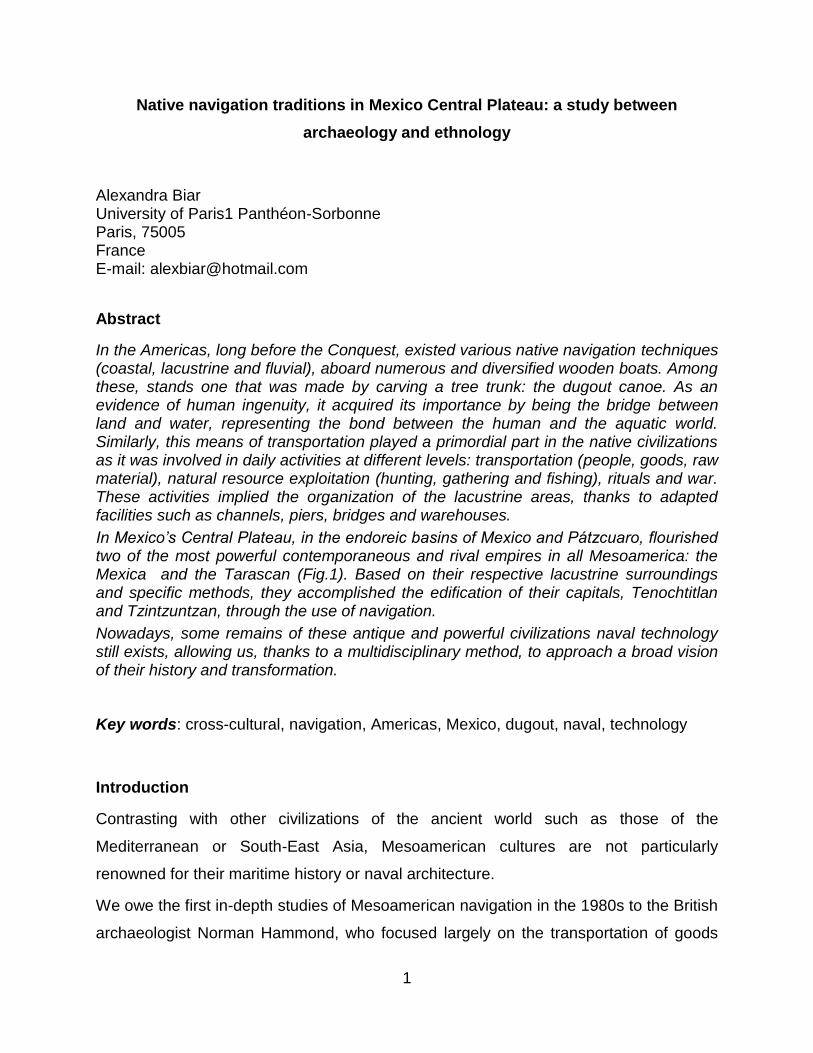
In Mexico’s Central Plateau, in the endoreic basins of Mexico and Pátzcuaro, flourished two of the most powerful contemporaneous and rival empires in all Mesoamerica: the Mexica and the Tarascan (Fig.1). Based on their respective lacustrine surroundings and specific methods, they accomplished the edification of their capitals, Tenochtitlan and Tzintzuntzan, through the use of navigation.
Nowadays, some remains of these antique and powerful civilizations naval technology still exists, allowing us, thanks to a multidisciplinary method, to approach a broad vision of their history and transformation.
Key words: cross-cultural, navigation, Americas, Mexico, dugout, naval, technology
Introduction
Contrasting with other civilizations of the ancient world such as those of the
Mediterranean or South-East Asia, Mesoamerican cultures are not particularly
renowned for their maritime history or naval architecture.
We owe the first in-depth studies of Mesoamerican navigation in the 1980s to the British
archaeologist Norman Hammond, who focused largely on the transportation of goods
2
and traffic along the entire coastline of the
Gulf of Mexico and the Yucatán Peninsula.
Historical sources show us that, along this
maritime navigation studied by Hammond,
another very important form of navigation
existed, on rivers and lakes. Unfortunately,
few researchers bore attention to these
freshwater examples, even though, according
to the cultural ecology theory, numerous
writers, such as Sanders and Price (1968),
have confirmed that they favored the
development of highly complex social
structures. It is indeed in the center of the closed-water basins of Mexico’s central
plateau that we see the flourishing of successive great civilizations such as
Teotihuacan, the Mexica s and the Tarascans, and a key correlation between their
development and lake navigation has been systemically asserted. Nevertheless,
scientific investigation about the dugout canoe as an indispensable tool in a navigation
system, specifically in the Basin of Mexico, is only due to Margaret Leshikar as late as
1982. She wrote her PHD Thesis about a dugout canoe discovered in 1959 during a
preventive excavation in the heart of Mexico City, using this artifact as an important
source to collect new data about the Mexica Empire’s organization.
Unfortunately, concerning the Tarascan Empire, there exist no scientific investigation
about the navigation system or the dugout canoes, even if nowadays, some of the Lake
Pátzcuaro fishermen still use this traditional craft to work. The only evidence we have
comes from the CREFAL, an international organism founded in1951 by the UNESCO to
approach and educate isolated community about sanitary, social and educative
problems. This is why all the available investigations bear on the fishermen’s skills and
way of life, rather than on navigation techniques.
Due to the perishable raw materiel used to build the canoes and most lacustrine
installations, wood, archaeological remains are scarce. The only examples of
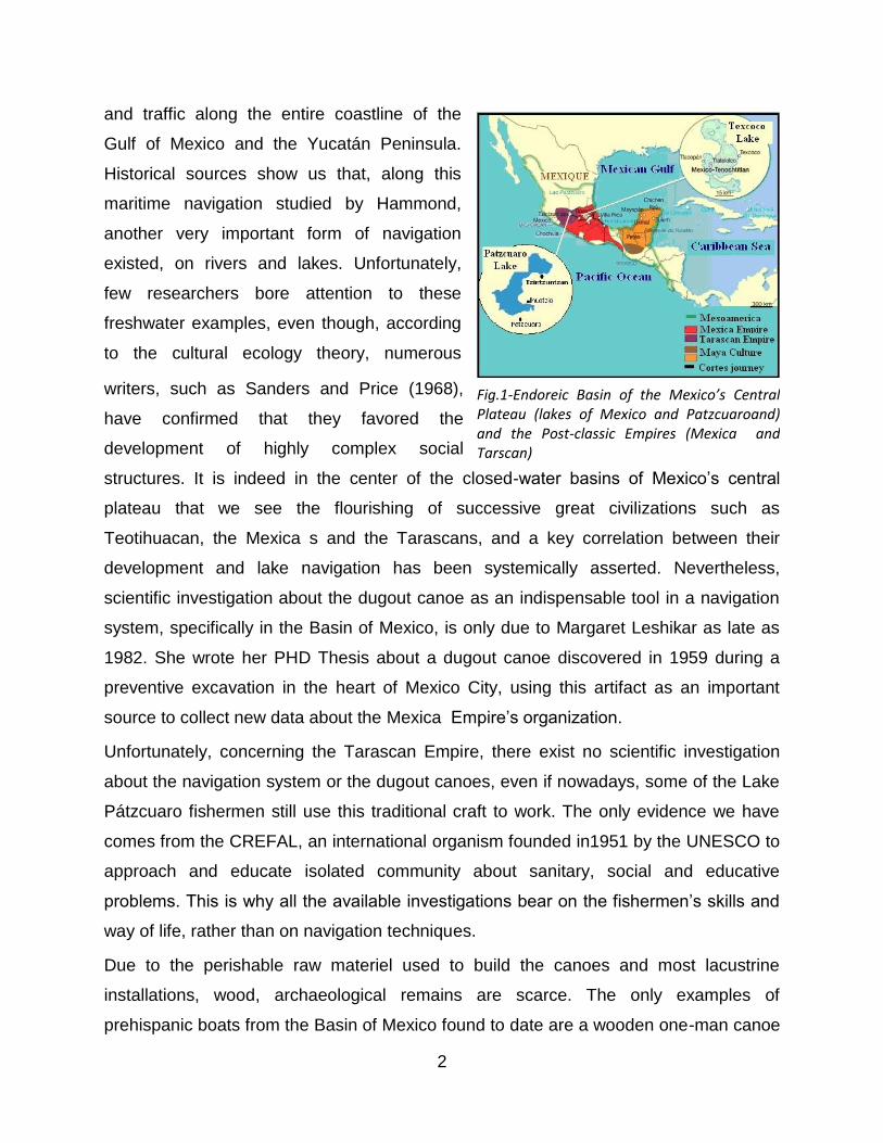
prehispanic boats from the Basin of Mexico found to date are a wooden one-man canoe
Fig.1-Endoreic Basin of the Mexico’s Central Plateau (lakes of Mexico and Patzcuaroand) and the Post-classic Empires (Mexica and Tarscan)
3
on display in the Mexica Hall of the National Anthropology Museum (Fig.2a) and a
miniature model found in Offering 41 of the Templo Mayor (Fig.2b), though we know
other similar examples have been found in other parts of Mesoamerica, in Belize for
instance. The single-person canoe of the Anthropology Museum was discovered in the
1960s along the actual Calzada de Tlalpan. Judging from its dimensions and carrying
capacity, we can estimate it was able to carry about a ton of weight – by our reckoning,
after studying similar examples, a vessel able to transport large monoliths, such as
several Mexica monuments. Tying together several canoes could of course allow for
larger and heavier charges. But this implies sufficient breadth, both of the canoe and of
the canals along which it travelled. This is why ethnology and history are the best way to
compensate the shortcomings of archaeological research, because native navigation in
Xochimilco canals and in Lake Pátzcuaro (Michoacán) is always practiced.
Fig.2a-Dugout canoeof Tlalpan causeway in the Mexica Hall of the National Anthropology Museum, Meico City - A.BIAR
Fig.2b-Miniatures models founds in Offering 41 of the Templo Mayor, Templo Mayor Museum
General environment adaptation
Establishment
Around 1325, two of the main Mesoamerican empires founded their capital in direct
connexion with a lacustrine environment. Tenochtitlan, capital of the Mexica Empire,
was built on a small island within Lake Texcoco. Tzintzuntzan, capital of the Tarascan
Empire, was established on the northeast shore of Lake Patzcuaro. In order to assert
themselves as the centers of the two powerful empires later confronted by the
Conquistadors, both cities’ inhabitants had to learn to dominate their environment – to
exploit it to economic, political and religious ends. Not only did they took maximum
4
advantage, like their contemporaries and others before them, of one-man canoes
carved from a single log of wood, but they developed complex technological systems in
order to control their lakeside world, the supply of goods and the growth of towns and
cities. But each one, due to their distinct location, used the lake with different goals.
Mexica space engineering
The Mexica s soon shaped their environment to suit their needs and to consolidate their
power. The major hydraulic works that they and their neighbors on the lakes of the
Valley of Mexico engineered fulfilled different objectives.
The first and best documented of these was clearly to reclaim land from the lakes using
the ingenious system of ‘Chinampas ’ and canals, artificial physical extensions of pre-
existing islands. As is well known, the invention of Chinampas is probably due to the
inhabitants of Lakes Xochimilco and Chalco, in the south of the Mexico Basin, and was
intended originally as a means of developing intensive agriculture. It is worth
remembering here something clearly illustrated in the Plano en Papel de Maguey, which
is that the Chinampas of Tenochtitlan served not only as plots of cultivated land, but
also as a residential zone, implying control over the soil dampness.
The second objective of Mexica engineering was to control the disastrous fluctuations
in lake water levels, by constructing canals, dykes and even aqueducts - public works
that also helped reduce the (previously high) water saline levels. The benefits these
environmental changes brought complemented each other, but needed daily
maintenance, with the use of lake crafts and a large, well organized labor force.
The canals of the island of Tenochtitlan, which earned the city the nickname of Venice
of the New World, crisscrossed the entire metropolis, creating a grid-like landscape
structure and allowing fast communication both within and outside the city. Thanks to
the historian Edward Calnek (1972) and the architect Jorge González Aragón, we know
that two kinds of canals existed: regular ones that followed labyrinthine [maze-like]
routes and which measured up to two meters width, and main canals, facing East-West
and measuring 3-5 meters in width. When we consider that the largest Aztec monoliths
– such as the goddess Tlaltecuhtli weighing 12 tons and measuring 4.19 x 3.62 m –
5
were transported on the lake and to the city’s heart, it stands to reason that some of the
principal canals must have been at least 6 meters wide.
The main canals, epitomized by the famous Acequia Real (Royal Channel) that ran
along the length of today’s Corregidora Avenue in Mexico City Historic Centre, were
ideal for carrying large boats - used as much for transporting tribute items to
Moctezuma’s palace as for bearing religious monuments and processional celebrants.
By contrast, the regular canals carried a still larger volume of smaller boats with their
daily loads of passengers and goods. Of course, we shouldn’t forget that a significant
part of urban traffic took place on land, suggesting the existence of fixed and moveable
bridges – a fact confirmed in the accounts of the Spanish defeat during the Sad Night.
The broad and lengthy causeways connecting the island of Tenochtitlan with the
mainland served several purposes: first, as a means of communication by land;
secondly, they acted as dykes to hold the water at bay, and complemented the great
stone levee-bridge constructed under the leadership of Nezahualcóyotl, the wise king of
Texcoco. The three main causeways were those from Tepeyac (to the north), Tlacopan
(to the west) and Iztapalapan (to the south). It’s worth noting that this last one was built
by the Xochimilcas, clear proof of the political power of the Mexica s and of their
influence over neighboring peoples.
A fourth, smaller, causeway was that of Chapultepec. This uniquely supported the
aqueduct constructed in the decade following 1420 and re-built on the orders of
Nezahualcóyotl two decades later, supplying fresh water to the island city of
Tenochtitlan, surrounded by salty water. In the construction and maintenance of these
great public works, it’s obvious that single-man canoes played a key role, helping to
ferry materials and every-day goods.
It’s impossible to imagine life in Tenochtitlan and the coastal communities of the Basin
of Mexico without navigation. While navigation is hardly mentioned in the historical
accounts of great hydraulic works, its crucial role is evident from the descriptions of
daily life and commerce, first and foremost in the southern lakes of Chalco and
Xochimilco. As a matter of fact, the pictographic and historical documents describe the
movement of products along lacustrine routes that remained in use even into the first
half of the 20th century, as in the case of the Canal de la Viga. These routes were
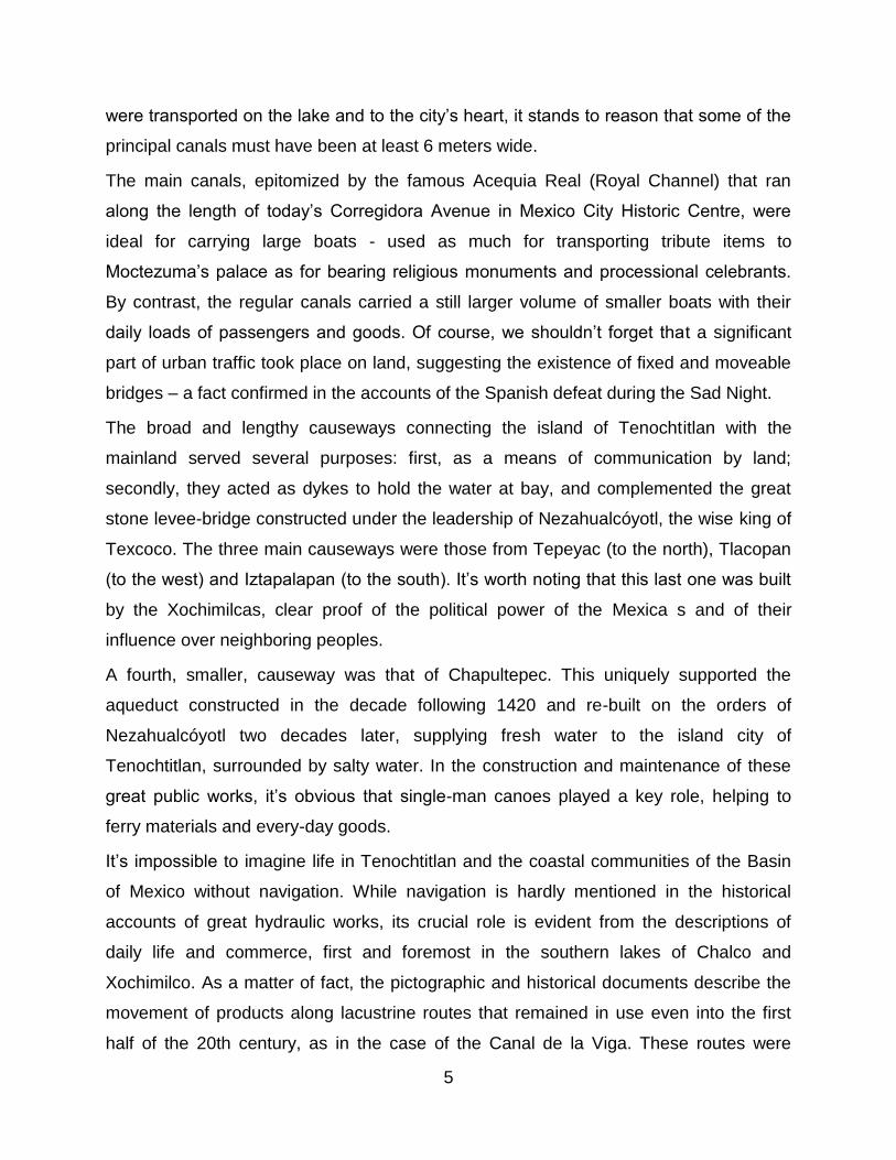
6
privileged with installations such as harbors and jetties to control the flow of people and
goods. Cortés (1983) wrote:
‘At each entrance to the city, where the canoes unload [...] there are houses
where live officials in charge of supervising and taxing every product […]’
This organization level demanded the construction and fitting-out of facilities and
buildings tailor-made for the moving, storing and monitoring of goods and people by
government authorities. These installations included (Fig.3):
Harbors: natural or artificial havens
suitable for the (un) loading of cargo and
(dis) embarkation of passengers by boat,
and for carrying out maintenance.
Quays: places suitable for loading
goods and people.
Port installations are in effect groupings of
architectural structures that combine
several complementary roles: custom
points for the receipt and control of goods;
warehouses and storage facilities; stalls
and posts for buying and selling; jetties for
the transfer of goods from dry land to lake
transportation, etc. The construction of
these facilities requires both manpower and materials (wood, stone, lime, etc.).
Unfortunately, to date, few archaeological remains exist of such facilities, making it
harder to draw firm conclusions regarding their construction and purpose.
Given their importance to the Mexica economy and government, more archaeological
work is badly needed in the search for port installations, several of which should be
located at the periphery of Tenochtitlan and the surrounding lake shores.
A quay is generally an impermanent construction requiring considerable space, with a
jetty whose size would be relative to the breadth of the canal serving it and to the
volume of goods passing through. The archaeologist Francisco González Rul (1998)
Fig.3-Location of nautical installations in the lake of Mexico that contributed to the control and regulation of canoe traffic in the Post-classic period.
7
identified two types of quay: stone and wood. Remains of these have been found under
the present Palacio Nacional of Mexico. We also have a few descriptions of them in
historical records from the 16th and 17th centuries, and litho-/photographs from the 19th
and 20th centuries. On the site of the famous prehispanic and colonial quay (pic 10) at
the corner of Alhóndiga Street and Corregidora Avenue stands today a stone bridge,
evocative of Mexico City’s bygone lakeside past.
Dockyards: military or private establishments dedicated to boat building, repair,
maintenance and equipment. These facilities had to be located near large bodies of
water and must have resembled hangars, capable of housing several small canoes as
well as larger, more important vessels.
Fray Bernardino de Sahagún (1978) refers to these last items in his description of the
ceremonies and sacrifices at the disposal site of Pantitlán, in the center of Lake
Texcoco: ‘When all were sacrificed, we took all the offerings... and we carried them to
the place where the lake is called Pantitlán, which is found not far from the dockyards.’
And later (Book 2, Florentine Codex) he indicates:
‘and when [the fire priest] had cast away [papers in an incense ladle], then they
turned the boat about [...] And when they had come to reach Tetamacolco, where
there had been embarking at the place of embarkation, thereupon there was
bathing; then there was [returning] on the part of each [boat].’
What’s interesting in these passages is the specific reference to places for the keeping
and return of craft, and in particular those for ritual or military use, suggesting the
existence of different types of lakeside storage facilities around the Basin of Mexico –
for trade, for military purposes and for religious ceremonies. It would also imply different
types of boats, for specific uses. We know, for example, that some vessels were of
large dimensions, used in festivals to carry the priests with their offerings, or the
emperor and his court. According to historical sources, these boats were kitted out with
benches and awnings to offer protection from the sun and the rain. We may then
contemplate the existence of larger canoes, or even of rafts.
Finally, we should also recall the probable existence of large vessels for military use, as
mentioned in the accounts of the Noche Triste (Sad Night) and of the victorious sally of
8
the Mexica against the Spanish at the beginning of the siege of the city. The simple fact
that the Conquistadors had to build brigantines proves the critical role these were to
play in achieving eventual control of the lakes.
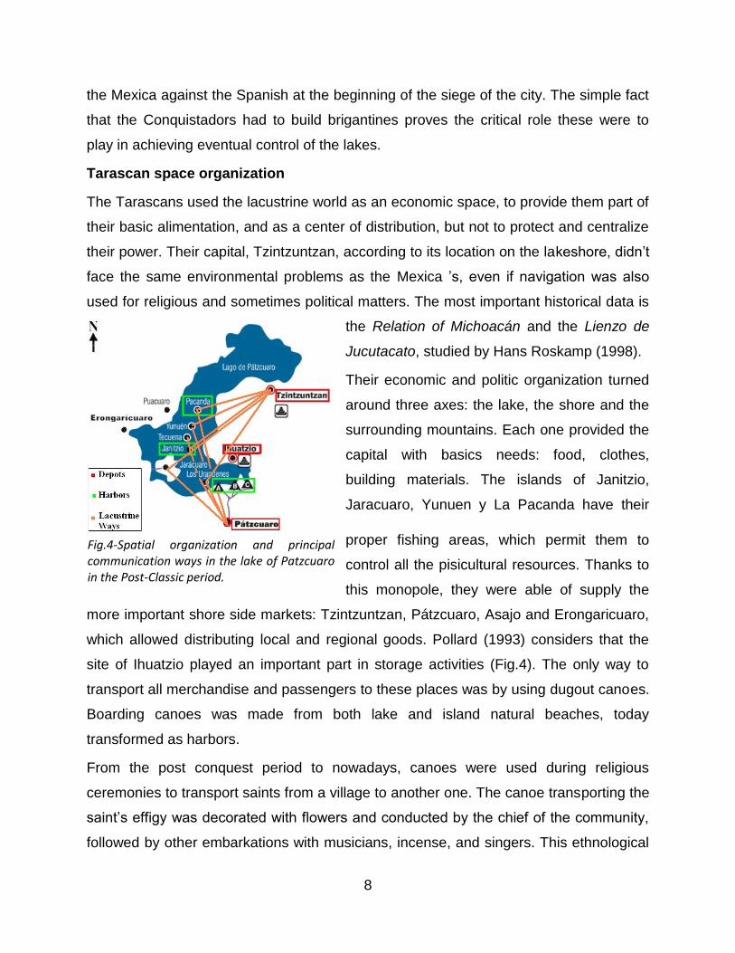
Tarascan space organization
The Tarascans used the lacustrine world as an economic space, to provide them part of
their basic alimentation, and as a center of distribution, but not to protect and centralize
their power. Their capital, Tzintzuntzan, according to its location on the lakeshore, didn’t
face the same environmental problems as the Mexica ’s, even if navigation was also
used for religious and sometimes political matters. The most important historical data is
the Relation of Michoacán and the Lienzo de
Jucutacato, studied by Hans Roskamp (1998).
Their economic and politic organization turned
around three axes: the lake, the shore and the
surrounding mountains. Each one provided the
capital with basics needs: food, clothes,
building materials. The islands of Janitzio,
Jaracuaro, Yunuen y La Pacanda have their
proper fishing areas, which permit them to
control all the pisicultural resources. Thanks to
this monopole, they were able of supply the
more important shore side markets: Tzintzuntzan, Pátzcuaro, Asajo and Erongaricuaro,
which allowed distributing local and regional goods. Pollard (1993) considers that the
site of Ihuatzio played an important part in storage activities (Fig.4). The only way to
transport all merchandise and passengers to these places was by using dugout canoes.
Boarding canoes was made from both lake and island natural beaches, today
transformed as harbors.
From the post conquest period to nowadays, canoes were used during religious
ceremonies to transport saints from a village to another one. The canoe transporting the
saint’s effigy was decorated with flowers and conducted by the chief of the community,
followed by other embarkations with musicians, incense, and singers. This ethnological
Fig.4-Spatial organization and principal communication ways in the lake of Patzcuaro in the Post-Classic period.
9
evidence allows us to imagine the native ceremonies, including matrimonial ceremony
where the pretender had to navigate to the island to receive blessings from his family in
law before marrying his wife. This sacred bond between religion and navigation is the
same, even if more important in the Tarascan life and ritual than among the Mexica s.
But as exemplified in the Mexica ritual calendar, numerous ceremonies involved
lacustrine rituals or navigation.
Finally, we just have a testimony of a naval battle between the lords of the lakeshore
city against the island lords:
“Las embarcaciones se dividen en tres grandes flotas mandadas cada una por
uno de los principes […] Hirépan dirige sus proas rumbo a Jaracuaro. Hiquingari
lleva la dirección de Janitzio. Tangaxhuan hace deslizar sus ágiles piraguas […]
en las playas de Pacanda. […] El aire cubrió de flechas, el silencio del lago fue
interrumpido por una estruendosa gritería, y cuando las embarcaciones llegaron
al abordaje, se oía el duro choque de las macanas […] y bien pronto, el agua
cristalina se tiño con la sangre de los heridos y de los moribundos” (Ruiz, 1891,
Chapter XVIII)
This event, as the “Noche Triste” (Sad Night) in Mexico, reveals the naval military power
of these empires. Both of them used their aquatic environment as an economical,
political, religious and military way to build, assert and maintain their power. The arrival
of the Spaniards in the 1520’s ruined for good the equilibrium created by these two
empires.
Vessel typology
The 16th century sources tell us much about the vessels used by the Mexica s and their
neighbors, from the construction materials they used, through their shape and trim, to
details such as their form of propulsion, carrying capacity and uses. A careful analysis
of the data suggests that, as in the case of the boats spotted by Columbus on the open
Caribbean Sea, those of the Basin of Mexico were mainly one-man canoes.
10
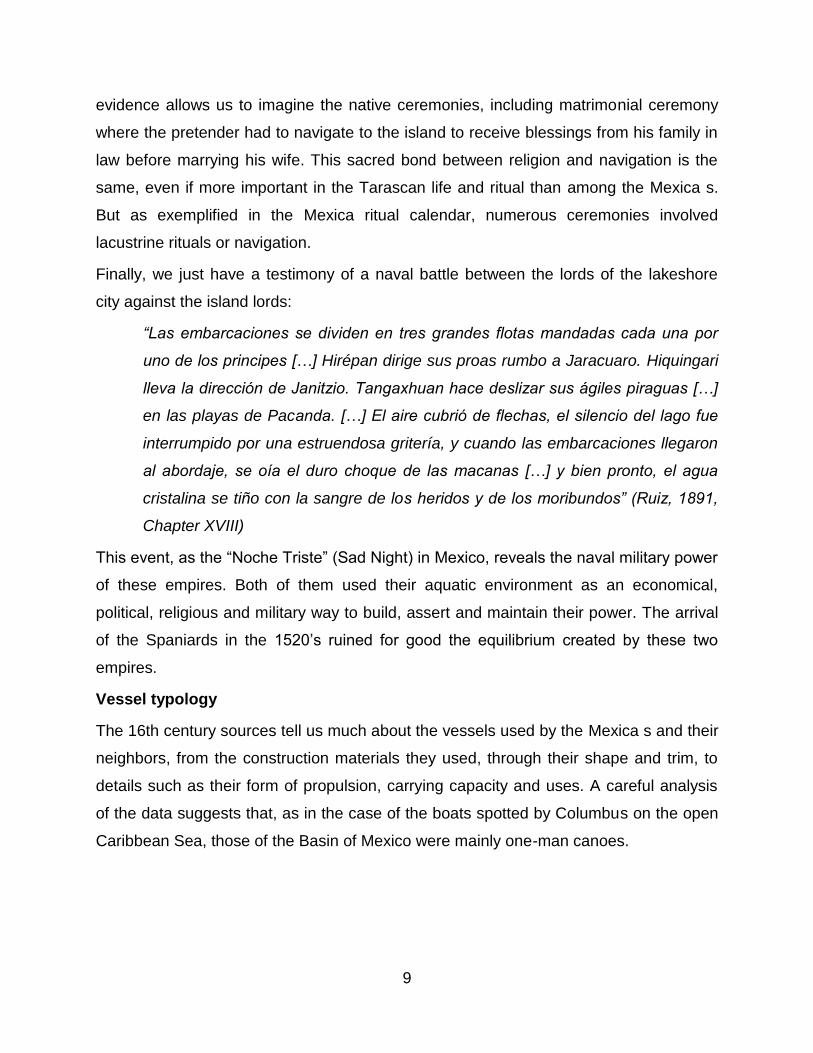
Based on detailed study of the different depictions of canoes represented in the codices
– some of which show a wide variety of shapes and styles even on a single page - we
are today in a position to draw up a typology of canoes in use in the basins of Mexico
and Patzcuaro in the 15th and 16th centuries, including a list of sources consulted for
this study, amounting to 63 identified boats (Fig.5).
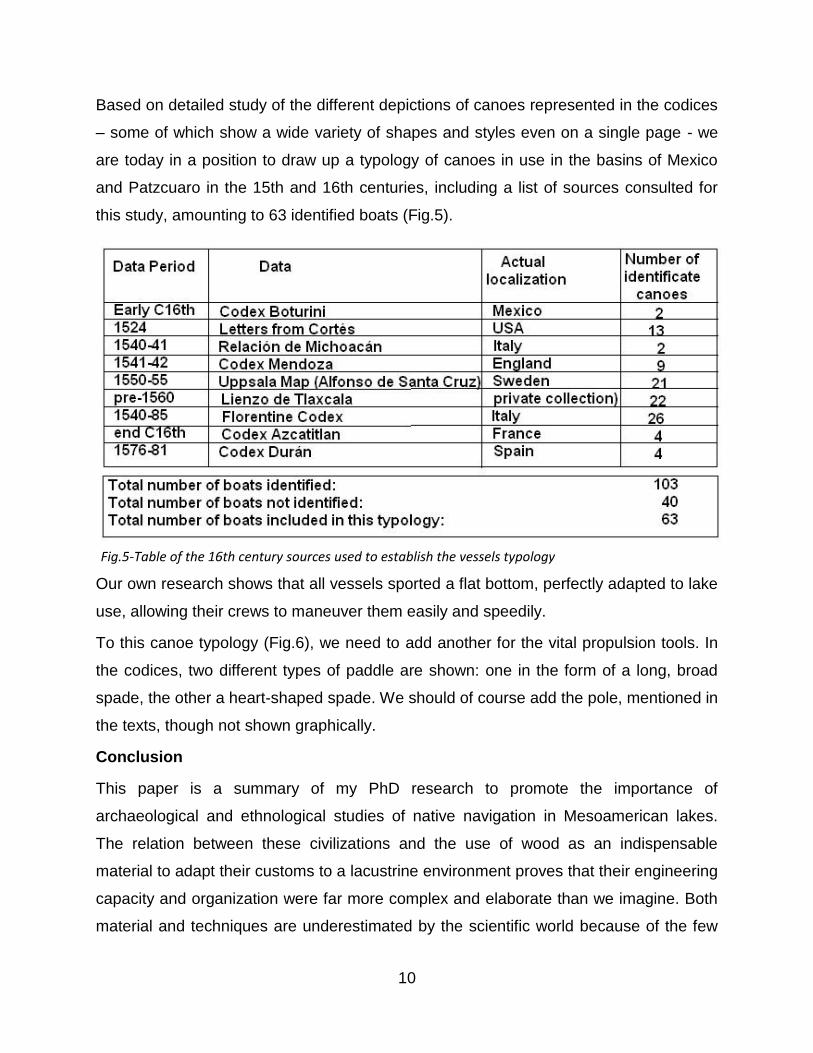
Our own research shows that all vessels sported a flat bottom, perfectly adapted to lake
use, allowing their crews to maneuver them easily and speedily.
To this canoe typology (Fig.6), we need to add another for the vital propulsion tools. In
the codices, two different types of paddle are shown: one in the form of a long, broad
spade, the other a heart-shaped spade. We should of course add the pole, mentioned in
the texts, though not shown graphically.
Conclusion
This paper is a summary of my PhD research to promote the importance of
archaeological and ethnological studies of native navigation in Mesoamerican lakes.
The relation between these civilizations and the use of wood as an indispensable
material to adapt their customs to a lacustrine environment proves that their engineering
capacity and organization were far more complex and elaborate than we imagine. Both
material and techniques are underestimated by the scientific world because of the few
Fig.5-Table of the 16th century sources used to establish the vessels typology
11
archaeological remains. This is why a multidisciplinary approach is necessary. These
native navigation traditions are about to disappear because the world is changing too
fast for these communities, to be able to adapt every aspect of their culture and
traditions. I hope to be able to organize, with the help of the Mexica n archaeologist,
Mariana Favila, to create a symposium around the theme of Native’s navigation tradition
in the Americas to. It will be interesting to join specialists of navigation in one place to
highlight this underestimate aspect of our investigations.
Fig.6-Typology of Mexico’s Central Plateau canoes: a first attempt to identify and classify canoe styles shown in the historical sources. Pictures map and table: A.BIAR
Bibliography
BIAR, A., 2011, La navigation Mexica dans la lagune de Mexico : navigation et prise du
pouvoir, master thesis, Université Paris1 Panthéon-Sorbonne, Paris
CALNEK, E., 1972, Settlement patterns and chinampa agriculture at Tenochtitlan.
American Antiquity, vol. 37, nùm. 1
CORTES, H., 1983, Cartas de Relación, Porrúa, Sepan Cuantos, México
12
FAVILA VAZQUEZ, M., 2011, La navegación en la Cuenca de México durante el
Postclásico tardío: la presencia de la canoa en el entramado social Mexica , license
thesis, ENAH, México
GONZALEZ RUL, F., 1998, Urbanismo y arquitectura en Tlatelolco, colección científica,
seria antropología social, INAH, México D.F.
HAMMOND, N.,1981, Classic Maya Canoes. The International Journal of Nautical
Archeology and underwater exploration, nùm. 10 (3), pp.173-185
LESHIKAR, M., 1982, The Mexica canoe: an archeologicaland historical study of its
design, uses, and significance, PhD thesis, University of Texas, Austin
POLLARD, H., 1993, Tariacuri’s legacy, the prehispanic Tarascan State, University of
Oklahoma Press, Ed Norman and London
ROSKAMP, H., 1998, La historiográfica indígena de Michoacán: el lienzo de Jucutacato
y los títulos de Carapan, Research School CNWS publication, Vol.72, School of Asian,
African and American Studies, Leiden University, Holland
RUIZ, E., 1891, Michoacán: Paisajes, tradiciones y leyendas, Oficina Tip. De la
Secretaria de Fomento, Mexico, D.F.
SANDERS, W. T. and Barbara J. PRICE,1968, Mesoamerica: the evolution of a
civilisation, Random House, New York
SAHAGUN, B. de, 1978, Florentine Codex, Dibble et Anderson, The school of American
research and the University of Utah, Etats-Unis
Biography
Alexandra Biar started her studies in archaeology in 2005 at the University of Bordeaux3 to obtain, three years later, a Bachelor in Art History & Archaeology. She started a Master in the University oh Paris1 Panthéon-Sorbonne in 2008, her thesis was supervised by Eric Taladoire, Leonardo Lopez Lujan y Eric Rieth, and titled Navigation in the Basin of Mexico in the Post-classic period. She graduated in 2011 with honours. After beginning her investigations on this theme, she decided to extend her research on the Basin of Pátzcuaro for her PhD, which is supervised by Brigitte Faugère.