Monthly Status Report Template
33
1 GOESR3 Final Report Reporting Period: July 2017 – June 2020 (3-year project period) Team Lead: Steven Miller (CSU/CIRA) Team Members: CIRA: Curtis Seaman, Jeremy Solbrig, Yoo-Jeong Noh, Kyle Hilburn, Jason Apke, Matt Rogers RAMMB: Don Hillger, Deb Molenar, Bill Line Federal Partners: Bill Ward (ESSD Chief, NWS Pacific Region Headquarters) Additional Collaborators: Chad Gravelle (Operations Proving Ground); Amanda Terborg (AWC); Mark DeMaria (NHC) Project Title: Developing an Environmental Awareness Repertoire of ABI Imagery (‘DEAR-ABII’) to Advise the Operational Weather Forecaster Project Number: 476 Project Overview: The goal of this GOES-R Develop an Environmental Awareness Repertoire of ABI Imagery (‘DEAR- ABII’) project was to maximize the vast potential of the new GOES-R sensor technology by leveraging the tremendous information content offered by GOES-R in the domains of space, time and spectrum, distilling it into a suite of visually intuitive and value-added imagery products. The GOES-R ABII products were made available to operational centers and National Weather Service (NWS) forecasters in the AWIPS-II display environment. Specific goals of this project were as follows: • Demonstrate true color imagery for GOES-R ABI by leveraging Himawari-8 AHI to produce a synthetic hybrid atmospherically corrected (SHAC) green band (following Miller et al., 2016, and preceding developments by Hillger et al. (2011) and Miller et al. (2012)). This product has been shown to provide superior scene interpretation over conventional visible-band imagery, particularly in terms of aerosol/cloud and surface feature analysis. • Apply the Dynamic Enhancement Background Reduction Algorithm (DEBRA) dust enhancement over the southwestern US, and expand to handle low cloud and fog over complex backgrounds. This work includes the building of cloud-cleared spectral detection test databases. • Expand the GeoColor data fusion product (demonstrated in the GOES-R Satellite Proving Ground) to GOES-R ABI, merged with VIIRS Day/Night Band city lights and DEBRA-based dust/low- cloud/fog detection. Couple GeoColor with GOES Lightning Mapper to depict lightning activity over developing convection in a one-stop product. Executive Summary
-
Upload
khangminh22 -
Category
Documents
-
view
0 -
download
0
Transcript of Monthly Status Report Template

1
GOESR3 Final Report Reporting Period: July 2017 – June 2020 (3-year project period) Team Lead: Steven Miller (CSU/CIRA) Team Members: CIRA: Curtis Seaman, Jeremy Solbrig, Yoo-Jeong Noh, Kyle Hilburn,
Jason Apke, Matt Rogers RAMMB: Don Hillger, Deb Molenar, Bill Line
Federal Partners: Bill Ward (ESSD Chief, NWS Pacific Region Headquarters)
Additional Collaborators: Chad Gravelle (Operations Proving Ground);
Amanda Terborg (AWC); Mark DeMaria (NHC) Project Title: Developing an Environmental Awareness Repertoire of
ABI Imagery (‘DEAR-ABII’) to Advise the Operational Weather Forecaster
Project Number: 476
Project Overview: The goal of this GOES-R Develop an Environmental Awareness Repertoire of ABI Imagery (‘DEAR-ABII’) project was to maximize the vast potential of the new GOES-R sensor technology by leveraging the tremendous information content offered by GOES-R in the domains of space, time and spectrum, distilling it into a suite of visually intuitive and value-added imagery products. The GOES-R ABII products were made available to operational centers and National Weather Service (NWS) forecasters in the AWIPS-II display environment. Specific goals of this project were as follows:
• Demonstrate true color imagery for GOES-R ABI by leveraging Himawari-8 AHI to produce a synthetic hybrid atmospherically corrected (SHAC) green band (following Miller et al., 2016, and preceding developments by Hillger et al. (2011) and Miller et al. (2012)). This product has been shown to provide superior scene interpretation over conventional visible-band imagery, particularly in terms of aerosol/cloud and surface feature analysis.
• Apply the Dynamic Enhancement Background Reduction Algorithm (DEBRA) dust enhancement over the southwestern US, and expand to handle low cloud and fog over complex backgrounds. This work includes the building of cloud-cleared spectral detection test databases.
• Expand the GeoColor data fusion product (demonstrated in the GOES-R Satellite Proving Ground) to GOES-R ABI, merged with VIIRS Day/Night Band city lights and DEBRA-based dust/low-cloud/fog detection. Couple GeoColor with GOES Lightning Mapper to depict lightning activity over developing convection in a one-stop product.
Executive Summary
2
• Transition from AHI to ABI and demonstrate multispectral cloud/snow enhancement algorithm for monitoring of snow field and lake ice changes.
• Incorporate the 1.38 micron ‘cirrus’ band to numerous daytime algorithms to improve decoupling of scene constituents for snow and dust products. Examine the utility of this band in the context of thin-over-thick (2-layer) cloud detection enhanced imagery.
• Develop Pacific Region tailored applications in normalized difference vegetation index (NDVI) for island enhancement, air mass characterization (e.g., atmospheric river enhancement) leveraging the 3 ABI vapor bands, and examine methods for identifying volcanic fog (VOG). These developments can occur with ABI or AHI, depending on coverage.
• Work closely with NWS and Satellite Liaisons at various operational centers as listed in Collaborators to help demonstrate and assess operational utility of the multi-spectral imagery products, modifying them according to user feedback and Liaison recommendations.
FY17 and FY18 (Year 1 + 2): Project Achievements
FY17 (1 July 2017 – 30 June 2018): Special DEAR-ABII Achievements
1. GeoColor Development: Ancillary data sets for the atmospheric correction, viewing geometry, surface elevation, nighttime lights, land/water masking and scene classification for use in the true color and GeoColor imagery have been developed for both the GOES-R/S checkout location (95 °W longitude) and the operational GOES-East location (75.2 °W longitude).
2. On 18 December 2017, when NESDIS announced that “GOES-16 is officially GOES-East”, NESDIS used a full-disk GOES-16 GeoColor imagery for their press release. (Figure 1)
3. Soon after it became available via AWIPS, GOES-16 GeoColor imagery was also frequently used by NWS forecasters, especially to highlight smoke events and dust detection over the Atlantic. Within a few months, GOES-16 GeoColor started to be used regularly by NWS WFOs and National Centers. The CIRA DEAR ABII Team received frequent positive feedback from NWS WFO forecasters. On 14 September 2017, Bryan Ruby, Information Technology Officer at the NWS WFO Sioux Fall, South Dakota, summarized his experience with using GeoColor in the following tweet:

3
4. GOES-16 ABI captured the total solar eclipse that crossed the contiguous U.S. on 21 August 2017. It is important to note that non-trivial modifications had to be made to the Rayleigh-correction used in CIRA’s synthetic true color imagery to account for the loss of radiation within the eclipse shadow, providing the best view of the eclipse from any satellite (Figure 2). Ancillary data from NASA, which predicted the solar obscuration as a function of space and time, was leveraged to adjust the magnitude of the Rayleigh corrections (which assume full-sun). This imagery was used by numerous media outlets and a special CIRA website was created for viewing this imagery: http://rammb.cira.colostate.edu/misc/solar_eclipse_2017/ The GOES-R Program Office was provided the modified synthetic true color imagery in real-time, along with several animations and/or videos that were widely shared on traditional and social media outlets. Steve Miller and Dan Lindsey were interviewed by the media about this imagery, and it provided great fodder for our GOES-16 Loop of the Day website: http://rammb.cira.colostate.edu/ramsdis/online/loop.asp?data_folder=loop_of_the_day/goes-16/20170821000000&number_of_images_to_display=200&loop_speed_ms=100 The CIRA GeoColor solar eclipse imagery (full disk animation) made it onto the NESDIS/StAR home page (on 21 August 2018). NESDIS/StAR gave the CIRA GeoColor team very special credit in the figure caption of this imagery: “The animation was generated from GOES-16 imagery by the StAR GOES imagery team using the award-winning work of the CIRA-RAMMB team to output full color images.” Feedback from the GOES-R Program Office was very positive: “Dan, Curtis, and everyone . . . what an incredible eclipse day! Thank you so much for your hard work to bring these images to the public. The traffic on our sites is unbelievable--I think people are really inspired to see these images. My sincere thanks,” -Renata Lana ([email protected]) “I second that, Renata! This is team work at its best! Excellent job!” -John Leslie ([email protected]) Media outlets that shared the GeoColor ABI eclipse imagery included: Time Magazine: http://time.com/4909517/total-solar-eclipse-moon-shadow-video/ The Huffington Post: http://www.huffingtonpost.com/entry/total-solar-eclipse_us_599b157fe4b06a788a2ab10a The Denver Channel (Denver ABC affiliate): http://www.thedenverchannel.com/news/eclipse/icymi-the-moment-the-moon-eclipsed-the-sun 9News (Denver NBC affiliate): http://www.9news.com/news/eclipse/cool-videos-from-scientists-at-csu-track-eclipse-shadow/466536683
5. CIRA’s Fire Temperature RGB was first developed at CIRA for VIIRS and was transitioned
to ABI during the FY17 DEAR ABII project period. It received much positive feedback from the user community. CIRA and SPoRT collaborated with Chad Gravelle (OPG) to make the Fire Temperature RGB one of the standard RGBs in AWIPS. GOES-16 GeoColor and Fire Temperature products became popular for wildland firefighters who used the imagery for tracking fires.
4
6. ABI Cloud/Snow Discriminator algorithm: During year 1 (FY17), two versions of the
daytime VIIRS Cloud/Snow Discriminator algorithm were successfully developed for ABI: a “binary” discriminator that highlights all clouds in yellow and snow and ice in white, and a “high/low” discriminator that colors clouds by height, with yellow low clouds, orange mid-level clouds, and magenta high clouds. Improvements to these algorithms for both over land and over water (i.e., sea ice) have been made in the past year.
7. GOES-17 ABI First Light Images: Dan Lindsey and Steve Miller worked with Harris to obtain
data and create the GeoColor imagery for the GOES-17 ABI first light image release, which occurred on 31 May 2018. The full disk GOES-17 GeoColor image can be seen on this NESDIS webpage: https://www.nesdis.noaa.gov/content/goes-17-releases-%E2%80%98first-light%E2%80%99-imagery-its-advanced-baseline-imager-abi
8. During FY17, the CIRA/RAMMB Satellite Loop Interactive Data Explorer in Real-time (SLIDER) website became the principal public-facing demonstration utility for DEAR-ABII products.
9. A manuscript written by Steve Miller et al. detailing the Dynamic Enhancement with Background Reduction Algorithm (DEBRA) was accepted by the Journal of Geophysical Research: Atmospheres on 12 December 2017: Miller, S. D., Bankert, R. L., Solbrig, J. E., Forsythe, J. M. & Noh, Y.-J. [2017]. A Dynamic
Enhancement with Background Reduction Algorithm: Overview and Application to Satellite-Based Dust Storm Detection. Journal of Geophysical Research: Atmospheres, 122. https://doi.org/10.1002/2017JD027365
This publication was designated as a “Journal Highlight” by Zhanqing Li, the Editor of JGR: Atmospheres, when it appeared on-line on 3 January 2018. According to JGR, “Highlights include enriched and related content of notable journal articles presented on Eos org AGU org AGU On Demand and in AGU journals.”
10. In September 2017, GOES-16 GeoColor imagery became part of the imagery depicted on the Science on a Sphere (SoS) in real time.
11. CIRA/RAMMB worked with writers from the New York Times to provide customized GOES-16 GeoColor imagery covering the time frame 5-11 September 2017 showing three simultaneous hurricanes in the Atlantic basin, including Hurricane Irma. The story was on the front page of their website on the morning of 12 September and can be viewed here: https://www.nytimes.com/interactive/2017/09/12/us/hurricane-irma-satellite-images.html
12. During the entire FY17 / Year 1 reporting period, CIRA’s GOES-16 GeoColor Imagery was used extensively by the media (Newspapers, TV Broadcasts). See Section 4 at the end of this Final Report.
5
FY18 (1 July 2018 – 30 June 2019): Special DEAR-ABII Achievements
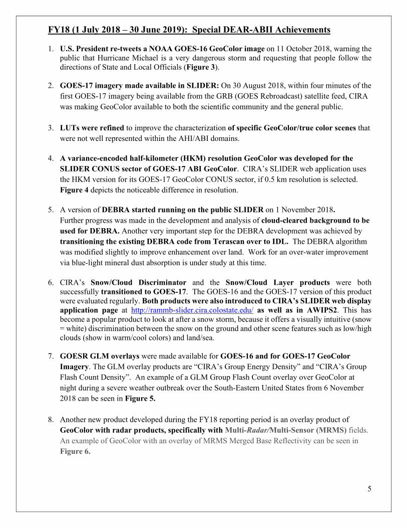
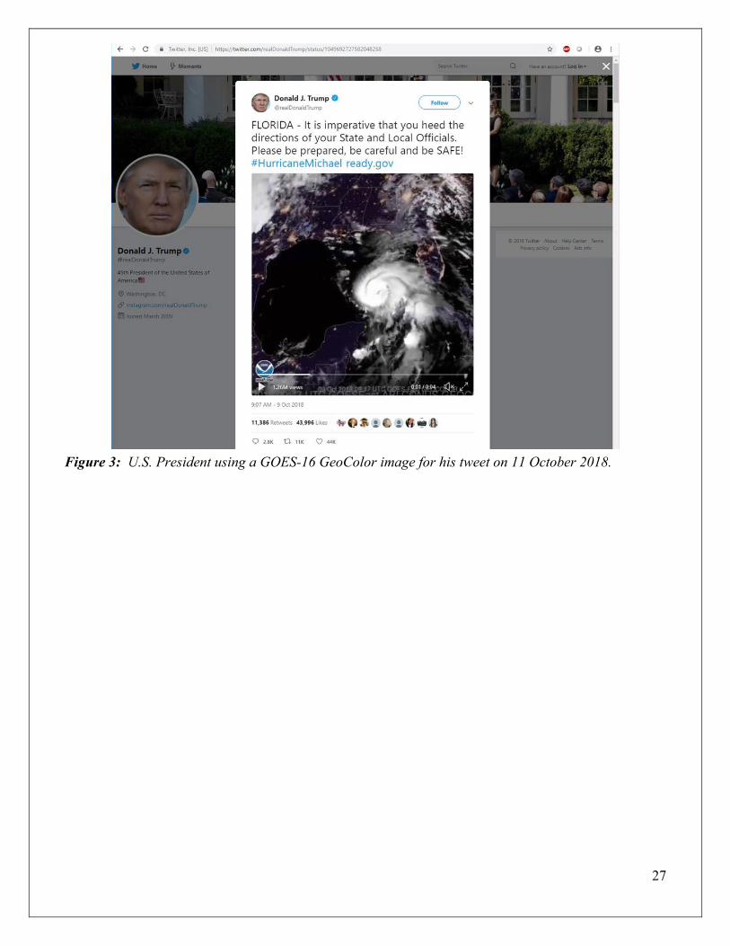
1. U.S. President re-tweets a NOAA GOES-16 GeoColor image on 11 October 2018, warning the public that Hurricane Michael is a very dangerous storm and requesting that people follow the directions of State and Local Officials (Figure 3).
2. GOES-17 imagery made available in SLIDER: On 30 August 2018, within four minutes of the
first GOES-17 imagery being available from the GRB (GOES Rebroadcast) satellite feed, CIRA was making GeoColor available to both the scientific community and the general public.
3. LUTs were refined to improve the characterization of specific GeoColor/true color scenes that were not well represented within the AHI/ABI domains.
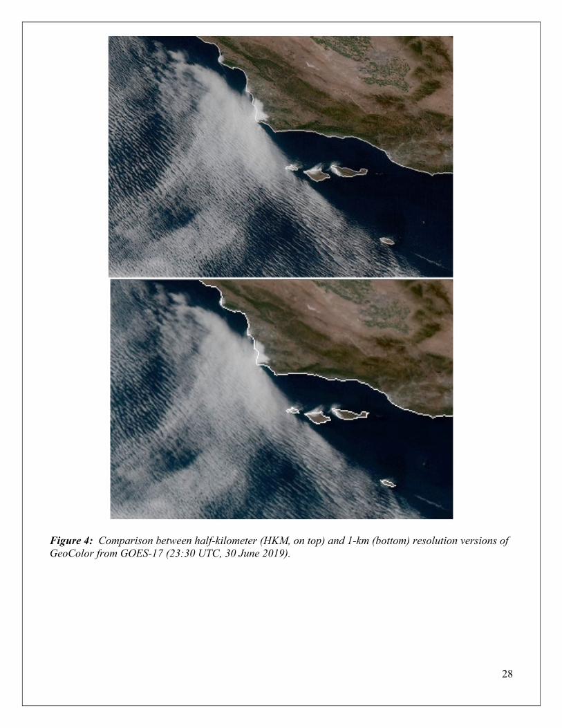
4. A variance-encoded half-kilometer (HKM) resolution GeoColor was developed for the SLIDER CONUS sector of GOES-17 ABI GeoColor. CIRA’s SLIDER web application uses the HKM version for its GOES-17 GeoColor CONUS sector, if 0.5 km resolution is selected. Figure 4 depicts the noticeable difference in resolution.
5. A version of DEBRA started running on the public SLIDER on 1 November 2018. Further progress was made in the development and analysis of cloud-cleared background to be used for DEBRA. Another very important step for the DEBRA development was achieved by transitioning the existing DEBRA code from Terascan over to IDL. The DEBRA algorithm was modified slightly to improve enhancement over land. Work for an over-water improvement via blue-light mineral dust absorption is under study at this time.
6. CIRA’s Snow/Cloud Discriminator and the Snow/Cloud Layer products were both successfully transitioned to GOES-17. The GOES-16 and the GOES-17 version of this product were evaluated regularly. Both products were also introduced to CIRA’s SLIDER web display application page at http://rammb-slider.cira.colostate.edu/ as well as in AWIPS2. This has become a popular product to look at after a snow storm, because it offers a visually intuitive (snow = white) discrimination between the snow on the ground and other scene features such as low/high clouds (show in warm/cool colors) and land/sea.
7. GOESR GLM overlays were made available for GOES-16 and for GOES-17 GeoColor Imagery. The GLM overlay products are “CIRA’s Group Energy Density” and “CIRA’s Group Flash Count Density”. An example of a GLM Group Flash Count overlay over GeoColor at night during a severe weather outbreak over the South-Eastern United States from 6 November 2018 can be seen in Figure 5.
8. Another new product developed during the FY18 reporting period is an overlay product of GeoColor with radar products, specifically with Multi-Radar/Multi-Sensor (MRMS) fields. An example of GeoColor with an overlay of MRMS Merged Base Reflectivity can be seen in Figure 6.

6
9. A new research application for GOES-R ABI products started to be explored by the DEAR-ABII Team: “Optical Flow in GOESR ABI GeoColor.” The Atmospheric Motion Vectors (AMV) necessary for the Optical Flow were derived from a sequence of (typically 3) GOES-R Images. Preliminary tests have been performed on GeoColor Imagery depicting gust fronts/dust storms, supercells, and multiple high-impact hurricanes. Different types of algorithms are being tested (LK, Affine LK, 8-Parameter LK, and Fanrebäck).
10. New progress was made in the development and analysis of Cloud-Cleared Background products, enlisting the help of a NOAA Hollings Scholar, Angela Burke.
11. During the FY18proejct period, work on a publication of the GOES-R synthetic true color product began and a manuscript was submitted to J. Atmos. Ocean. Tech.,
12. By the end of June 2019, the full list of multispectral imagery products available on SLIDER for GOES-16/17 included:
Multispectral Imagery • GeoColor (CIRA) • Shortwave Albedo (CIRA) • Dust DEBRA (CIRA) • Snow/Cloud (CIRA) • Snow/Cloud-Layers (CIRA) • Split Window Difference (10.3 µm – 12. 3 µm)
Multispectral RGB Composites • Natural Color (EUMETSAT) • Airmass (EUMETSAT) • Day Cloud Phase Distinction (JMA) • Nighttime Microphysics (EUMETSAT) • Day Snow/Fog (EUMETSAT/NASA SPoRT) • Dust (EUMETSAT) • Fire Temperature (CIRA) • Natural Color-Fire (CIRA) • Ash (EUMETSAT) • SO2 – Sulfur Dioxide (JMA)
13. On 12 February 2019, examples of CIRA’s GOES-17 GeoColor imagery was shared with the
media to celebrate the declaration of GOES-17 (GOES-West) as operational. The director of the National Weather Service, Louis Uccellini, posted an animation of CIRA’s GOES-17 GeoColor product, highlighting the utility of GOES-17 to monitor weather for Alaska and the West Coast of the U.S. https://www.nesdis.noaa.gov/content/goes-17-now-operational-here’s-what-it-means-weather-forecasts-western-us

7
14. On 12 February 2019, the NESDIS homepage posted an article titled “It’s official: GOES-17 is now operational as NOAA’s GOES West satellite” which came with a large GOES-17 GeoColor imagery of the Northern Hemisphere (from 9 February 2019). https://www.nesdis.noaa.gov/content/goes-17-now-operational-here’s-what-it-means-weather-forecasts-western-us
15. On 22 May 2019, @NOAAResearch congratulated CSU for being selected to host CIRA. The tweet came with a GeoColor image loop of the solar eclipse event from 21 August 2017. https://twitter.com/NOAAResearch/status/1131236028965052421
Final Year Milestones (FY19 / Year3) and Project Deliverables
FY19 / Year 3 Project Period: 1 July 2019 – 30 June 2020 Milestone 1: Continued near-real-time demonstration of core products in AWIPS/NAWIPS and on the web. Conduct validations of products against independent observations. Core Product: GeoColor August 2019, Steve Miller submitted a manuscript on GeoColor Algorithm Description to the
Journal of Atmospheric and Oceanic Technology (JTECH). Manuscript title: GeoColor: A Blending Technique for Satellite Imagery. It was accepted and published in March 2020. https://doi.org/10.1175/JTECH-D-19-0134.1.
Steve Miller visits Korea Meteorological Administration, South Korea: The week of 11-15 November 2019, Steve Miller traveled to South Korea to visit the National Meteorological Satellite Center (NMSC), Korea Meteorological Administration (KMA; meeting their new Director, Hyun-Kyun Kim), and the Seoul National University. He gave several seminars on GOES-R ABI and Himawari AHI satellite algorithm development and capabilities, and collaborated with South Korean university and government scientists at these institutions.
Special RAMMB/CIRA GeoColor Sector for NHC Media Desk (July 2019):
As requested by Mark DeMaria, Chief of the Technology and Science Branch (TSB) at NOAA's National Hurricane Center, RAMMB/CIRA implemented real-time processing and dissemination of a special AWIPS2 GOES-16 GeoColor product sector. The data covers the NHC Atlantic Basin domain and is being used in briefings from the NHC Media Desk
Meteosat/SEVIRI-version of GeoColor provided to OPC: The CIRA team developed a version of
GeoColor specifically for Meteosat Second Generation (MSG) satellites (Meteosat-8 and Meteosat-11). As the SEVIRI imager on MSG lacks both the blue and green visible channels, the daytime component of SEVIRI GeoColor is based on EUMETSAT’s “Enhanced Natural Color” product, which removes the cyan coloration of ice clouds and snow. After successful demonstration of the product on SLIDER, NWS Ocean Prediction Center (OPC) forecaster Michael Folmer requested the product be delivered to OPC for display within NAWIPS. A 96-color version of SEVIRI GeoColor

8
for both operational MSG satellites compatible with NAWIPS is now being delivered to OPC via LDM.
GeoColor was used for the 2019 CAMP2Ex and 2019 PISTON ship cruise operations—high
profile NASA/DoD field campaigns: The CIRA team, with help from Dan Lindsey (NOAA/NESDIS), supplied a special sector for CAMP2Ex and PISTON. GeoColor imagery was used extensively by many of the forecasters for the field campaign as part of their regular forecast duties. Figure 7 an example of a typical slide used for the daily briefing. http://rammb.cira.colostate.edu/ramsdis/online/himawari-8.asp#PISTON_Experiment
ABI and VIIRS imagery of Alaska fires provided to Congress: A congressional committee asked
NASA for satellite imagery of wildfires in Alaska during the spring of 2019. CIRA provided two videos to fulfill this request: a nearly month-long loop of VIIRS Fire Temperature RGB images (25 June-17 July 2019) from both S-NPP and NOAA-20, and a 5-day loop of GOES-17 GeoColor images (6-10 July 2019). The VIIRS Fire Temperature RGB images provide high-resolution views of the numerous hot spots and the GOES-17 GeoColor loop shows the thick smoke that blanketed most of Alaska in early July (Figure 8).
Steve Miller is currently serving as part of the NASA LANCE Users Working Group, which fields near real-time data (primarily NASA assets, but also Suomi-NPP and most recently, GOES-R ABI) for various purposes, including support of the NASA Disasters Program and the NASA Worldview website. Miller suggested that instead of re-developing its own ABI true color product for Worldview, NASA should consider adopting GeoColor for this purpose. Discussions are ongoing to determine the logistics and feasibility of this concept, which would provide a positive example of how the two agencies can work together to benefit end-users. Significant progress is being made toward enabling this capability with the assistance of Matt Jochum and NASA-side Worldview Developer, Ryan Boller.
The GOES-R Program Office continued to use CIRA’s GeoColor imagery products daily: • On its webpages • GOES-R Program Office Newsletters • Fact Sheets, twitter, and other promotional materials • GeoColor imagery and imagery loops are part of most GOES-R management presentations
GeoColor is available on the NESDIS GOES-East and NESDIS GOES-West Viewer websites:
https://www.star.nesdis.noaa.gov/GOES/conus.php?sat=G16 and https://www.star.nesdis.noaa.gov/GOES/conus.php?sat=G17
NOAA Managers (Stephen Volz, Louis Uccellini, Pam Sullivan, Neil Jacobs, Tim Walsh, Lori
Brown) highlight GeoColor as part of their presentations at the 2019 Joint Satellite Meeting in Boston, 30 September – 4 October 2019.
Core Product: Snow/Cloud Discriminator and the Snow/Cloud Layer products
The Snow/Cloud Layer products are running in SLIDER as well as in AWIPS2.
Snow/Cloud Layer products are being evaluated regularly by CIRA Scientists and Operational Forecasters. NWS forecasters at WFO Buffalo (BUF) use this product regularly.

9
WFO BUF requested Snow/Cloud-Layers product in AWIPS. It is now being sent to the NWS Eastern Region via the LDM. Following the GOES-R/JPSS Proving Ground Summit in February, we received a request for the Snow/Cloud-Layers product from Aaron Jacobs (WFO Juneau). Unfortunately, the Juneau, AK forecast area is outside the GOES-17 CONUS domain, and the full disk images are too large to distribute via LDM. We have been working with Joe Zajic (TOWR-S) and the Satellite Book Club to implement the product on the new AWIPS Cloud. Training on this product has commenced, and a Quick Guide has already been posted to the VISIT website: http://rammb.cira.colostate.edu/training/visit/quick_guides/
Improvements made to the Snow/Cloud Layer Product. Steve Miller, Jeremy Solbrig and Curtis Seaman developed improvements to the Binary Snow/Cloud and Snow/Cloud-Layers products to reduce “false alarms”. In particular, low liquid clouds over water surfaces had a tendency to appear white (as snow) or with a pale bluish tint, instead of the desired yellow. This issue has now been resolved (Figure 9). In addition, modifications were made to the Snow/Cloud-Layers product to reduce saturation in the magenta coloration of high clouds. These corrections were made to the products on SLIDER as well as in AWIPS.
Core Product: GOES-16/17 Fire Temperature RGB and Natural Color-Fire
products
The products have been standardized for use in AWIPS and are easily displayed through the “on-the-fly” RGB capability available to all AWIPS users.
Very Popular within the operational NWS/WFO forecasters (especially California!).
Fire Temperature RGB imagery loop was presented by the Director of the NWS, Louie Uccellini, as part of the presentation he gave at the 2019 Joint AMS-EUMETSAT Satellite Conference in Boston, MA, on 30 September 2019.
Based on discussions with Brad Pierce, at the 2019 Joint AMS/EUMETSAT Conference in Boston, CIRA’s Fire Temperature RGB was used extensively by flight operations during the FIREX-AQ campaign, conducted during summer 2019 over the US. The product was particularly useful in identifying nascent small fires in the southeast US. Brad plans to write up a summary of this campaign and acknowledge CIRA, the Fire Temperature RGB, and the SLIDER interface for critical support of this important joint NOAA/NASA research program
International collaboration: Recipes for the Fire Temperature RGB and Natural Color-Fire RGB have been provided to Yizhe Zhan at the New Zealand MetService for use on both GOES-17 and Himawari-8 data. The request for the recipes was a direct result of C. Seaman’s presentation at the Asia-Oceania Meteorological Satellite User’s Conference (AOMSUC) in Melbourne, Australia in December 2019. During and after the conference, it was revealed that MetService forecasters utilize SLIDER in their operations on a daily basis. A visit to the MetService headquarters in Wellington, NZ after the conference revealed that 3 of the five forecasters on duty were actively monitoring SLIDER
10
at their workstations. Forecasters also requested the JMA Day Cloud Phase Distinction RGB be added to the Himawari domain on SLIDER, and this request was fulfilled in January 2020.
Review provided for Fire Temperature RGB “Job Aid”: C. Seaman reviewed a “job aid” developed by K. White and K. Fuell (NASA SPoRT) discussing the basic science behind the Fire Temperature RGB as it applies to GOES-R ABI. Job aids are intended for operational users to learn the basics of the RGB via real-time data at their workstation. C. Seaman was selected as the subject matter expert (SME) as he was the original developer of this RGB product.
Core Product: DEBRA Dust Product GeoColor with Dust Signature “Signal Imprinting”: During the reporting period, work continued on a new overlay product that combines GeoColor with dust-detection (either via the traditional split-window “12-11 micron BTD” or the DEBRA product) through a special technique described in the brand-new Miller et al. JTECH publication as “Signal Imprinting”. On 10 March 2020, the peer-reviewed science article “GeoColor: A Blending Technique for Satellite Imagery,” was published in the Journal of Atmospheric and Oceanic Technology (JTECH) as an open-access paper:
Miller, S. D., D. T. Lindsey, C. J. Seaman, and J. E. Solbrig, 2020: GeoColor: A Blending Technique for Satellite Imagery. J. Atmos. Ocean. Tech., 37(3), 429-448, https://doi.org/10.1175/JTECH-D-19-0134.1. The basic concept of signal imprinting is to modulate the base image (in this case, GeoColor) RGB components in a way that is governed by an algorithmically-identified feature (e.g., dust, snow, etc.). In the case of the split-window, used for dust detection, a scaled and normalized version of the split-window difference is used to augment the R/G and suppress the B components of the GeoColor image, imparting a yellow tonality to only those pixel locations where the split-window difference is deemed significant as an indicator for lofted dust.
Transitioning the existing DEBRA code from Terascan over to IDL has now been completed. This transition will expedite future revisions, debugging, and innovations on DEBRA by coupling it to the powerful IDL toolkit. A significant accomplishment!
Latest Improvements to DEBRA: The DEBRA algorithm was modified to reduce false alarms and improve dust detection over water surfaces. Examples of the improvements are shown in Figure 10.
The DEBRA algorithm improvements made are:
Background suppression improvements: We found that there were detection issues for dust over the southwest US for ABI. We tested several components of the algorithm including the cloud mask, the dust scaling bounds, and the background suppression data. We found that the scaling bounds and the background suppression data were combining to cause problems with dust detection. To address this, we limited the impact of the background suppression by applying bounds to the standard minimum such that the background must either fall between 75% and 125% of the standard minimum or be truncated to that range. For ABI, this results in a range of allowable background values between -1.25 and 0.75. This was applied to both the 12-11 and 8.5-11 brightness temperature differences. Doing so prevents anomalous background values to cause sub-optimal performance.
11
Application of over-water algorithm: DEBRA is not currently optimized for over-water dust detection, but there have been requests to improve DEBRA in this area, especially for monitoring of the SAL. We worked on refining the over-water algorithm using only tests based on infrared spectral differences. These tests use different scaling than those used over land. The algorithm applies two IR difference tests, then uses a winner-takes-all approach where the test that shows the strongest value is used for the enhancement. We are currently examining new daytime logic that uses dust coloration due to spectrally variable scattering in the visible wavelengths as an additional test and hope to deliver and updated algorithm later this year. An important background step will be examination of the rayleigh-corrected reflectance values used in the normalized dust ratio over-water.
Core Product: Optical Flow The CIRA DEAR-ABII Team continued its work on Optical Flow in GOESR ABI. Different types of Optical Flow algorithms are currently being tested (LK, Affine LK, 8-Parameter LK, and Fanrebäck). During the past reporting period, optical flow on GeoColor imagery was done by using a pre-packaged code called Butterflow. For the initial validation we are using the red band and Channel 07. Efforts continue to validate and tune optical flow produced with 1-min ABI data to render a dense field of atmospheric winds. (Figure 11).
Milestone 2: Begin near real-time demonstration of augmented core products and custom-tailored products in AWIPS/NAWIPS and on the web.
Real-time demonstration of most DEAR-ABII products happens via
RAMSDIS online and on SLIDER (available to the public): http://rammb.cira.colostate.edu/ramsdis/online/loop_of_the_day/ https://rammb-slider.cira.colostate.edu/
GeoColor with Multi-Radar/Multi-Sensor (MRMS) overlay on SLIDER:
GOES-16 CONUS sector with MRMS product overlay: • Merged Base Reflectivity (Quality Controlled) • Reflectivity at Lowest Altitude • 1-hour Precipitation Accumulation • Surface Precipitation Type • Precipitation Rate
GOES-17 CONUS sector with MRMS product overlay: • Merged Base Reflectivity (Quality Controlled)
Milestone 3: Continue supplying materials to satellite training partners.
CIRA Participation in the 10th Asia-Oceania Meteorological Satellite Users’ Conference
(AOMSUC), held from 2-7 December 2019, in Melbourne, Australia. Curtis Seaman gave two presentations on the latest developments of CIRA’s Satellite Loop Interactive Data Explorer in Real-time (SLIDER) titled: “SLIDER: A website for viewing global, full-resolution satellite imagery in
12
realtime”, one for the “AOMSUC Training Event on Satellite Data and Product Application” and one for the “AOMSUC Conference”. Several forecasters who attended the Training Event told Curtis “that learning about SLIDER was the highlight of the event”!
18-29 November 2019: Paraguay and Uruguay Workshop Workshop report received from José Manuel Gálvez, SRG at NOAA/NWS/NCEP/WPC.
Good morning, I wanted to share with the group the two reports from the Workshops conducted in Paraguay and Uruguay, which have been cleared by NOAA. I'm sending the reports to the list of the participants invited to the last call. But I'm also including a few people that were key to the success of the workshops. Special thanks to these folks: Bernie Connell (CIRA), Marcial Garbanzo and Anthony Segura (University of Costa Rica), Diego Souza (INPE), Dan Lindsey (NOAA), Curtis Seaman (CIRA), Scott Lindstrom (CIMMS/U. Wisconsin) and Natalia Donoho (NOAA). Your contributions on the development of the case studies, and shared slides in some cases, were essential to improve the service provided to our NWS partners in South America. Thank you for the team work and happy holidays! Jose
Extensive use of GeoColor imagery by NESDIS Public Relations: • GOES-R Program Office Newsletter:
https://www.goesr.gov/downloads/multimedia/newsletters/GOESRQ32019NewsFINAL.pdf • GOES-R Program Office “Fact Sheets”
https://www.goes-r.gov/resources/education.html • @ NOAA Satellites Twitter
https://twitter.com/NOAASatellites Example: On November 18th, the @ NOAA Satellite page depicted 31 GeoColor imagery (mostly loops), 4 Snow/Cloud Layer RGB, and 5 Fire Temperature RGB imagery.
Milestone 4: Work with Satellite Liaisons to coordinate NWS recommendations to NOAA/OSPO for operation transitions.
GeoColor and other DEAR-ABII products are making their way into operations! National Centers, Regional HQs, and WFOs are using our core products.
1) AWIPS RGB telecon, 5 December 2019: (Lindsey, Foster, Gravelle, Molenar, Line, Miller):
Chad Gravelle comment: reviewed GeoColor, noted its widespread usage…this is the future of RGB…very powerful visualization. Could transcend satellite and change the game.
2) From: Andy Just - NOAA Federal <[email protected]>
Andrew Just, ForecastBuilder Manager, Techniques Development Meteorologist, NWS Central Region Headquarters SSD Date: Thu, Sep 26, 2019 at 9:50 AM Subject: Re: GeoColor data outage "Even though it's (i.e. GeoColor) not operational, in my opinion, it's far superior to any of the operational RGB products, at least for what I want to see. It would be great to see this become an operational product at some point. "

13
3) February 2019: Western Region Headquarters implemented LDM data access which disseminates GeoColor to individual WR NWS forecast offices. Instructions to ingest and display the product in AWIPS2 D2D were sent out as well.
4) DoD Dugway Proving Ground Meteorology Division in Dugway, UT requested access to
GeoColor. LDM data access for that site was implemented in February. Instructions to ingest and display the product in AWIPS2 D2D were sent out as well.
5) NWS forecaster at NWS Buffalo, NY used SLIDER Snow/Cloud RBG for information about the ice cover on Lake Erie and Lake Ontario (called it ‘breathtaking’). Also used for case studies and workshops. (Figure 12).
6) Fire Temperature RGB was used during FIREX-AQ (see under Milestone 1, under Core Product Fire Temperature RGB). FIREX-AQ, a large field program (summer 2019) joint between NOAA and NASA, involved many flights to various fire events to study smoke and air quality impacts in situ. It turns out that the Fire Temperature RGB was one of the “go-to” products used by the forecasters.
7) GeoColor imagery was used extensively by forecasters for the CAMP2Ex Field Campaign in
summer 2019 (see under Milestone 1, under Core Product GeoColor).
8) Fire Temperature RGB and SLIDER use revealed by GEO-XO Fire & Smoke Workshop: In preparation for the development of the next generation satellite constellation, the GEO-XO Program held a series of workshops to gauge user needs. During the Fire & Smoke Workshop in June, several forecasters in attendance provided high praise of the Fire Temperature RGB. Alex Tardy (WFO San Diego) called the Fire Temperature RGB “the best tool we have” for detecting and monitoring fires. (Robert “Zeke” Ziel and Jennifer Jenkins [Alaska Fire Service] also praised the product, but were referring to the VIIRS versions, which are more widely used at high latitudes.) Dan Thompson and Geoff Marshall, forecasters in Canada, revealed that they make use of imagery on SLIDER on a daily basis. The overall consensus of attendees is that the next generation of satellites should have the spatial resolution of VIIRS combined with the temporal sampling of ABI.
Milestone 5: Prepare/submit 1-2 publication(s) on selected DEAR-ABII products and illustrative use-cases based on Satellite Liaison and forecaster interactions.
Miller, S. D., D. T. Lindsey, C. J. Seaman, and J. E. Solbrig, 2020: GeoColor: A Blending Technique for
Satellite Imagery. J. Atmos. Ocean. Tech., 37(3), 429-448, https://doi.org/10.1175/JTECH-D-19-0134.1. Note: This GeoColor publication is an important contribution of DEAR-ABII to the community, and will serve as a launching point for the NASA-ROSES A.33 proposal, where we will propose to explore higher-order versions of GeoColor with new information layers!
Grasso, L. D., D. E. Bikos, and S. D. Miller, 2018: Observations of lower tropospheric water vapor
structures in GOES-16 ABI Imagery. JGR-Atmospheres, 123(24), 13,625-13,642, https://doi.org/10.1029/2018JD029220 .
14
Note: This publication highlights the unexpected capability of the 1.38 micron cirrus band on ABI to detect low-level water vapor features in cases when upper atmosphere is dry coupled with high-altitude terrain, demonstrated in this case over parts of Mexico.
Discussion of operational transition readiness for any project outcomes
1. GeoColor – Operational Transition Readiness On 13 July 2017, GOES-16 GeoColor imagery started to be provided to forecasters in AWIPS/NAWIPS. NWS WFO Salt Lake City immediately posted on Twitter a short animation of the product as viewed in their AWIPS with a comment of their appreciation for receiving this product. In Fall 2018, GOES-17 CONUS GeoColor RGB product was made available in AWIPS2. February 2019: Western Region Headquarters implemented LDM data access which disseminates GeoColor to individual WR NWS forecast offices. Instructions to ingest and display the product in AWIPS2 D2D were sent out as well.
According to the CIRA Training Team: By the end of June 2020, GeoColor was available everywhere in the NWS and the National Centers, distributed through the various NWS Regional Offices (via LDM). It is still waiting to become an “official product”. Transition of GeoColor to operations: Based on several requests from NWS forecasters for GeoColor to become an operational Baseline product, CIRA has been working with Dan Lindsey to identify the best pathway to operations. GeoColor received approval from the SPSRB to become an operational product. However, there is no formal stated requirement for GeoColor to be produced by the GOES-R Program. As a result, it is unclear which group at NOAA would become responsible for the product. One option we are exploring with Joe Zajic (TOWR-S) and the Satellite Book Club, is to run GeoColor on the new AWIPS Cloud. This would allow forecasters throughout the NWS to have access to GeoColor, provided they have access to the Cloud. Here is an example of GeoColor imagery directly being used by forecasters (NYup.com): On 20 February 2019, Glenn Coin (NYup.com) posted GOES-16 GeoColor imagery loop from 20 February 2019 15:36 UTC with a text warning about “A massive winter storm hitting every state in the eastern U.S. will just graze Upstate New York. The storm is expected to bring 1 to 3 inches of snow to Upstate today, with a potential for a light coating of ice tonight before temperatures warm. Winter weather advisories are in place for much of Upstate through Thursday morning. Heavy snow is expected from Oklahoma through the Northeast, according to the National Weather Service.” https://www.newyorkupstate.com/weather/2019/02/massive-winter-storm-will-just-graze-upstate-ny.html AWIPS RGB telecon, 5 December 2019: (Lindsey, Foster, Gravelle, Molenar, Line, Miller): Chad Gravelle comment: reviewed GeoColor, noted its widespread usage…this is the future of RGB…very powerful visualization. Could transcend satellite and change the game.
15
From: Andy Just - NOAA Federal <[email protected]> Andrew Just, ForecastBuilder Manager, Techniques Development Meteorologist, NWS Central Region Headquarters SSD Date: Thu, Sep 26, 2019 at 9:50 AM Subject: Re: GeoColor data outage "Even though it's (i.e. GeoColor) not operational, in my opinion, it's far superior to any of the operational RGB products, at least for what I want to see. It would be great to see this become an operational product at some point. "
2. Fire Temperature RGB Product - Operational Transition Readiness By the end of June 2018, all NWS/WFOs were receiving the GOES-16 Fire Temperature product. The RGB Fire Temperature Quick Guide was posted on-line at: http://rammb.cira.colostate.edu/training/visit/quick_guides/Fire_Temperature_RGB.pdf Very positive feedback has been received, from several WFOs. Examples of WFOs using this product and positive feedback can be found in some tweets. NWS WFO Memphis https://twitter.com/NWSMemphis/status/984861794584973312 NWS WFO Albuquerque: https://twitter.com/NWSAlbuquerque/status/986384274394898433 By December 2018, CIRA’s GOES-16 Fire Temperature and CIRA’s GOES-16 Natural Color-Fire (aka Day Land Cloud Fire RGB) products were transitioned to GOES-17. The products were standardized for use in AWIPS and are easily displayed through the “on-the-fly” RGB capability available to all AWIPS users via SBN.
3. Snow/Cloud Layer products - Operational Transition Readiness By June 2019, CIRA’s Snow/Cloud Discriminator and the Snow/Cloud Layer products have both been introduced to CIRA’s SLIDER web display application page as well as into AWIPS2. It is used by several WFOs (Like WFO BUF) and ingested via LDM.
Additional Information
1. Special Awards CO-LABS Governor’s Award for High-Impact Research: The Colorado Laboratories (CO-
LABS) 2017 Governor’s Award for High-Impact Research ceremony was held at the Denver Museum of Nature and Science on the evening of 5 October 2017. S. Miller, D. Lindsey and C. Seaman were one of four Colorado-based research teams recognized for “projects having a significant impact on society” as a result of research performed as part of this project. Video of the

16
event has been posted on the CO-LABS website (http://co-labs.org/news/2017-governor-s-awards) and a video highlighting the research performed by the team has also been posted on YouTube (https://www.youtube.com/watch?v=pb4CFMRceMk).
2017 CIRA Research and Service Initiative Award: Steve Miller and Curtis Seaman won the 2017 CIRA Research and Service Initiative Award for “Outstanding contributions to scientific research: True-Color Imagery from GOES-16”. (July 2017).
2017 NASA Honor Award - GOES-R Team Group Achievement Award: Steve Miller and
Dan Lindsey were part of a large team recognized for the 2017 NASA Honor Award - GOES-R Team Group Achievement Award for “Excellence resulting in the successful GOES-R satellite launch, providing the nation's foundation for the world's highest quality weather monitoring and forecasting.”
2. Interaction with Operational Partners – • CIRA’s GOES-16/17 ABI GeoColor imagery was used regularly by NESDIS News
https://www.nesdis.noaa.gov/news-articles-archive?page=1 • National Center requests for CIRA’s GeoColor product were received from:
The Aviation Weather Center, Ocean Prediction Center, Weather Prediction Center, the Anchorage Volcanic Ash Advisory Center.
• National Weather Service (NWS) requests for AHI GeoColor products were received from: NWS Alaska Region, NWS Pacific Region.
• The CIRA team worked closely with Michael Folmer, Satellite Liaison at NOAA/NWS WPC/OPC/TAFB and NOAA/NESDIS SAB, over the entire reporting period. In December 2017, CIRA fixed an N-AWIPS problem Michael Folmer had reported, regarding a geographical offset on the CONUS GeoColor. GeoColor is very popular with forecasters at OPC and AWC. The OPC official Twitter feed has shared numerous examples of GeoColor imagery on social media in recent weeks (https://twitter.com/NWSOPC).
• Since the GOES-16 data flow began around 1 March 2017, CIRA has been working closely with
NWS partners to make sure GeoColor and other CIRA imagery is displaying properly in their AWIPS and NAWIPS systems.
• CIRA GOES-16/17 DEAR-ABII products are being depicted as the main satellite image example in GOES-R Program Office “Fact Sheets”, which were published in June 2019:
• Satellite Training Quick Guides covering DEAR-ABII products were produced by CIRA’s Training Team:
The RGB Fire Temperature Quick Guide was posted on-line at: http://rammb.cira.colostate.edu/training/visit/quick_guides/Fire_Temperature_RGB.pdf

17
The Day Land Cloud Fire RGB Quick Guide is available here:
http://rammb.cira.colostate.edu/training/visit/quick_guides/QuickGuide_GOESR_DayLandCloudFireRGB_final.pdf
The Snow/Cloud-Layers Quick Guide is available here: http://rammb.cira.colostate.edu/training/visit/quick_guides/GOES_Cloud_Snow_Discriminator_Quick_Guide_20190814.pdf
• National Weather Service WFO NWS Albuquerque provided the following feedback when
asked about their use of GeoColor: “to my knowledge everyone is using this imagery, or has at least loaded it into a procedure of some sort. It is particularly useful for both day and night applications.
-Daniel Porter (SOO, NWS Albuquerque)
• GOES-16 GeoColor imagery was frequently used by NWS forecasters to highlight smoke events. Like the ones during the heavy wildfire smoke event over the western part of the USA in September 2017.
• GOES-16 GeoColor was also used by WFO forecasters for the detection of low-level clouds / fog events and could be found mentioned in Area Forecast Discussions, like by WFO Boulder on 2 February 2018: Area Forecast Discussion National Weather Service Denver/Boulder CO 934 AM MST Fri Feb 2 2018 .SHORT TERM...(Today and tonight) Issued at 426 AM MST Fri Feb 2 2018 Areas of fog exist from the northern sections of Denver northward to Fort Collins and Greeley area. Most of this so far has been rather patchy, but also persistent over the northeastern sections of Denver with the light wind regime. GOES Geocolor product also showing this area of fog/stratus quite nicely with thin enough high clouds.
• Mike Stavish, SOO, WFO Medford, Oregon, informed CIRA (19 July 2018) that his WFO
forecasters use CIRA’s GeoColor product for their forecasts all the time: From: Michael Stavish - NOAA Federal <[email protected]> Date: Thu, Jul 19, 2018 at 12:45 PM Thought I'd shoot this your way. Forecaster Brett Lutz shown. Fyi, we are always watching the Geocolor. Great for smoke. Always getting questions from forecasters - "Why isn't this a baseline product in AWIPS???"
• Idaho Department of Environmental Quality use of Smoke Imagery from CIRA: Sara Strachan of the Idaho Department of Environmental Quality updated the Idaho Satellite Smoke Analysis on 23 August 2018 to include a GOES-16 GeoColor image from CIRA’s SLIDER display tool. See https://idahodeq.maps.arcgis.com/apps/MapSeries/index.html?appid=caa25aa20f754286a73eeb61dcd9fb9d
18
• WFO forecaster Glenn Coin (NYup.com) used a GOES-16 GeoColor imagery from 20 February 2019 15:36 UTC to post a warning about “A massive winter storm.”
• On 6 September 2017, CIRA was contacted by Fire Spatial Analyst Chuck McHugh from Missoula, MT requesting Fire Temperature data from CIRA. His request was fulfilled on the same day by CIRA’s Fire Temperatur image specialist Curtis Seaman.
From: McHugh, Charles -FS <[email protected]> Sent: Wednesday, September 6, 2017 8:12 AM To: Miller,Steven Subject: GOES-16 Fire Temperature Data Hello, I work at Fire Sciences lab in Missoula, MT. The Rice Ridge Fire in Montana made 50-60,000 acre plus run overnight on Sept 4-5. I was wondering about the possibility of obtaining the Fire Temperature data from the GOES -16 satellite and if your group may be able to assist in this? I was wondering if it might be possible to use this data to reconstruct the fire progression over a series of days using the fire temperature or IR Data from this satellite? Thank you for your time and consideration in this request. Professionally, Chuck McHugh
• C. Seaman has collaborated with NASA SPoRT on the development of a Quick Guide for
forecasters discussing the Fire Temperature RGB as applied to the GOES-R ABI. The Fire Temperature RGB was first developed at CIRA for VIIRS and has since been applied to ABI with much positive feedback from the user community. Perhaps, it could be said to have “spread like wildfire”. CIRA and SPoRT have also collaborated with Chad Gravelle (OPG) to make the Fire Temperature RGB one of the standard RGBs in AWIPS.
• The Japan Meteorological Agency (JMA) has adopted CIRA’s AHI true-color algorithm to display their version of GeoColor.
• The Korea Meteorological Administration (KMA) expressed strong interest in adopting CIRA’s true-color algorithm for imagery from their Geo-KOMPSAT-2A AMI.
• The South Korean Air Force sent one of their Lead Air Force Aviation Weather Forecasters to
CIRA with the goal to learn as much as possible about Satellite Meteorology applicable to Aviation Hazards and Aviation Weather Forecasting. Major Hyekyong Kim visited CIRA from 1 August 2018 – 30 January 2019. The CIRA Meteorological Satellite Application Team worked closely with Major Kim during her visit. Training of Major Kim on GOESR DEAR ABII aviation-related products was one of the highest priorities during her time at CIRA.
• Recipes for the Fire Temperature RGB and Natural Color-Fire RGB have been provided to Yizhe
Zhan at the New Zealand MetService for use on both GOES-17 and Himawari-8 data. The request for the recipes was a direct result of C. Seaman’s presentation at the Asia-Oceania Meteorological Satellite User’s Conference (AOMSUC) in Melbourne, Australia in December 2019. During and after the conference, it was revealed that MetService forecasters utilize SLIDER in their operations on a daily basis. A visit to the MetService headquarters in Wellington, NZ after the conference revealed that 3 of the five forecasters on duty were actively monitoring SLIDER at their workstations.
19
Forecasters also requested the JMA Day Cloud Phase Distinction RGB be added to the Himawari domain on SLIDER, and this request was fulfilled in January 2020.
• The United Kingdom Met Office expressed interest in CIRA’s true-color algorithm for their future
European geostationary satellites (Meteosat Third Generation, MTG).
• Australian Bureau of Meteorology (BoM) used Himawari-8 AHI RGB Fire Temperature and GeoColor imagery.
Support of true color real-time production at NOAA and NESDIS for Outreach and Communication
• GOES-R Program Office’s Quarterly Newsletter prints multiple examples of GeoColor imagery in each newsletter (example: Figure 13)
• CIRA GOES-16/17 DEAR-ABII products are being depicted as the main satellite image example in GOES-R Program Office “Fact Sheets”, which were published in June 2019: GeoColor: Fact Sheet on “Hurricane Monitoring”
https://www.goes-r.gov/education/docs/fs_hurricane.pdf
Fire Temperature RGB: Fact Sheet on “Fire Detection and Characterization” https://www.goes-r.gov/education/docs/fs_fire.pdf
Volcanic Ash (EUMETSAT) RGB: Fact Sheet on “Volcanic Ash Detection” https://www.goes-r.gov/education/docs/Factsheet-Volcanic_Ash.pdf
• GOES-16 GeoColor image now on the new webpage banner of NOAA CLASS at https://www.bou.class.noaa.gov/saa/products/welcome;jsessionid=50E06D5A0319104DEB13BA14A3E44EFE
• CIRA GOES-16 and GOES-17 GeoColor imagery is used regularly by NESDIS News
https://www.nesdis.noaa.gov/news-articles-archive?page=1
• NOAA Satellites (@ NOAASatellites) continued to regularly tweet CIRA’s GOES16/17 ABI GeoColor imagery and other CIRA DEAR-ABII products to highlight special weather events.
• GOES-16 and GOES-17 True Color/GeoColor imagery is heavily used in the GOES-R Program
Office GOES-R Quarterly Newsletter, including on the cover pages.
• NWS WFO Offices frequently use CIRA’s GeoColor to publish special weather events.
• Daily ABI loops are being posted on CIRA’s webserver and are frequently downloaded by NESDIS for their use.

20
The majority of CIRA’s “ABI Loop-of-the-Day” are GeoColor and other DEAR-ABII product loops: http://rammb.cira.colostate.edu/ramsdis/online/loop_of_the_day/
3. Conference/workshop participation – Miller, S. D., 2017: Satellite Algorithm Development Research Theme -- The Return of True Color to
Geostationary Satellites, CIRA Executive Board Meeting, 7 July 2017, Fort Collins, CO. Miller, S.D. and C. J. Seaman, 2017: A Sight for Sore Eyes: Bringing Back True Color Imagery for the
New Generation Weather Satellites, CIRA Research Initiative Award Ceremony, 28 July 2017, Fort Collins, CO.
Lindsey, D. T, and S. D. Miller, 2017: GOES-16: A New Era in Geostationary Satellite Observations, ATS/CIRA Colloquium, Colorado State University, Fort Collins, CO, 25 August 2017.
Lindsey, D. T., 2017: GOES-16 GeoColor Product in real-time on Science on the Sphere (SoS). Invited Webinar, 21 September 2017.
Szoke, E., D. Bikos, B. Connell, R. Brummer, H. Gosden, S. D. Miller, J. Tores, C. J. Seaman, D. T. Lindsey, D. Hillger and D. Molenar, 2017: Future Directions for CIRA’s NWS Proving Ground Activities Now That GOES-16 Is Operational. 42nd Annual NWA Meeting, Garden Grove, CA, 18-21 September 2017
Schmit, T. J., M. Gunshor, D. T. Lindsey, S. D. Miller, K. Bah, J. Daniels, S. Goodman, 2017: An Early Look at the Imagery from the Advanced Baseline Imager (ABI) on GOES-16. EUMETSAT Meteorological Satellite Conference, 2-5 October 2017, Rome, Italy. (presented by D. T. Lindsey)
Lindsey, D. T., S. D. Miller, T. J. Schmit, S. Goodman, 2017: Operational Use of GOES-16 Imagery by the National Weather Service. EUMETSAT Meteorological Satellite Conference, 2-5 October 2017, Rome, Italy.
Miller, S. D., D. T. Lindsey, T. J. Schmit, C. J. Seaman, D. W. Hillger, R. L. Brummer, 2017: Where East Meets West: How Himawari-8 Enables True Color Capabilities for GOESR-ABI. EUMETSAT Meteorological Satellite Conference, 2-5 October 2017, Rome, Italy. (presented by D. T. Lindsey)
Seaman, C., S. Miller, D. Lindsey and D. Hillger: Multispectral imagery applications for the new generation of geostationary satellites. Oral presentation. EUMETSAT Meteorological Satellite Conference, Rome, Italy, 2-6 October 2017.
Seaman, C., and Coauthors: Connecting with operational forecasters in the GOES-16 era via the NOAA Satellite Proving Ground program. Poster presentation. EUMETSAT Meteorological Satellite Conference, Rome, Italy, 2-6 October 2017.

21
Rogers, M., S. D. Miller, L. Grasso, J. Haynes, Y-J. Noh, J. Forsythe, M. Zupanski, and D. Lindsey: New GOES-R Risk Reduction Activities at CIRA. Poster. AGU Fall Meeting 2017, New Orleans, LA, 11-15 December 2017.
Miller, S. D., D. T. Lindsey, C. J. Seaman, J. E. Solbrig, Y. J. Noh, L. D. Grasso, and K. P. Micke, 2018: Advanced Imagery Applications Development for GOES-16 ABI. AMS 14th Annual Symposium on New Generation Operational Environmental Satellite Systems, Special Session on GOESR, 9 January, Austin, TX.
Lindsey, D. T., S. D. Miller, C. J. Seaman, and S. J. Goodman, 2018: Highlights of the First Year of GOES-16 Imagery. AMS 14th Annual Symposium on New Generation Operational Environmental Satellite Systems, Development and Communication of Next-Generation Satellite Information for Forecasting Extreme Weather—Part II, 9 January, Austin, TX.
Micke, K. P., S. D. Miller, D. W. Hillger, R. L. Brummer, S. Finley, N. D. Tourville, D. A. Molenar, D. T. Lindsey, 2018: SLIDER: A Satellite Imagery Looper Capable of Viewing Every Pixel of GOES-16 Imagery in Real-Time Over the Web. AMS 34th Conference on Environmental Information Processing Technologies, Session: Visualization Techniques for Climatology and Meteorology, 9 January, Austin, TX.
Miller, S. D., L. Grasso, J.Haynes, Y-J. Noh, J. Forsythe, M. Zupanski, D. Lindsey, R. Brummer, J. Solbrig, 2018: New GOES-R Risk Reduction Activities at CIRA. Poster. AMS 14th Annual Symposium on New Generation Operational Environmental Satellite Systems, Special Session on GOESR, 9 January, Austin, TX.
Szoke, E., D. Bikos, B. Connell, H. Gosden, S. Miller, J. Torres, R. Brummer, D. Lindsey, D. Hillger, D. Molenar, and C. Seaman, 2018: An Update on CIRA’s NWS Proving Ground Activities: Advancing New Satellite Products into Operations. 29th AMS Weather and Forecasting Conference, 5 June 2018, Denver, CO.
Miller, S. D., Y.-J. Noh, D. T. Lindsey, C. J. Seaman, J. M. Forsythe, J. M. Haynes, and L. D. Grasso, 2018: Aviation-Relevant Satellite Research and Algorithm Development at CIRA. FAA Aviation Weather Research Program (AWRP) Review Meeting, 10-11 July 2018, Boulder, CO.
Miller, S. D., C. J. Seaman, Y.-J. Noh, D. T. Lindsey, J. M. Forsythe, J. F. Dostalek, J. R. Torres, and K.
P. Micke, 2018: CIRA Development of Alaska-Relevant Satellite Applications from Suomi-NPP, JPSS-1 and GOES-R. ACCAP Virtual Alaska Weather Symposium, 22 August. Remote presentation.
Miller, S. D., W. C. Straka III, C. J. Seaman, and J. R. Torres, 2018: NOAA-20/Suomi-NPP Pairing
Offers a Practical "Encore" for the VIIRS Day/Night Band. Current and Future Meteorological Satellite Systems and Data Access Conference Session, EUMETSAT Meteorological Satellite Conference, 17-21 September, Tallinn, Estonia.
22
Miller, S. D., 2018: Advanced Imagery Applications for the GOES-16/17 Advanced Baseline Imager. NOAA/ESRL CSD Seminar, 26 September 2018. (https://www.esrl.noaa.gov/csd/seminars/)
Miller, S. D., J. M. Forsythe, L. Grasso, J. Haynes, Y.-J. Noh, M. Zupanski, R. Brummer, J. Solbrig, D.
T. Lindsey, 2018: New GOES-R Risk Reduction Activities at CIRA. CIRA Connect Workshop at NOAA/ESRL, 5 October 2018, Boulder, CO
Lindsey, D. T.: GOES-R ABI: A New Tool for Observing Convection. Poster presentation including
CIRA imagery. 2018 AGU Annual Fall Meeting, Washington, DC, 10-14 December 2018. Lindsey, D. T.: Advancing Satellites Through Observations. NOAA Booth presentation (included CIRA-
produced imagery). 2018 AGU Annual Fall Meeting, Washington, DC, 10-14 December 2018. Miller, S. D., C. J. Seaman, J. Solbrig, J. Apke, K. Hilburn, J. M. Forsythe, J. Haynes, Y.-J. Noh, S.
Longmore,2018: Overview of aviation-forecast relevant CIRA satellite algorithm developments. US Air Force Major Kerrin Caldwell – visit to CIRA, Fort Collins, 18 December 2018.
Miller, S. D., C. J. Seaman, J. Solbrig, J. Apke, K. Hilburn, S. Longmore, Y.-J. Noh, 2018: Developing
an Environmental Awareness Repertoire of ABI Imagery (‘DEAR-ABII’) to Advise the Operational Weather Forecaster. FY18 GOES-R Risk Reduction – Science Project Review, CIRA, Fort Collins, 19 December 2018
Micke, K., 2019: Exciting New Features, Products, and Satellites Added to SLIDER Satellite Imagery
Looper. AMS 35th Conference on Environmental Information Processing Technologies, Phoenix, AZ, 6-10 January 2019.
Miller, S. D., et al.: 2019: Developing an Environmental Awareness Repertoire of ABI Imagery (‘DEAR-
ABII’) to Advise the Operational Weather Forecaster. Mike Stringer (Assistant System Program Director - GOES-R Program Office) and Kevin Fryar (Chief of Staff - GOES-R Program Office) visit to CIRA. Fort Collins, 26 March 2019.
StAR/RAMMB Federal Employees and CIRA Research Scientists, 2019: “CIRA Research Highlights”
including a variety of different DEAR-ABII products. Pam Sullivan (GOES-R System Program Director), Alexander Krimchansky (GOES-R Program Systems Engineering Lead), and Mike Clark (NOAA Office of Management and Budget), visit to CIRA. Fort Collins, 29 April 2019.
C. Seaman, C., 2019: SLIDER: A website for viewing global, full-resolution satellite imagery in real-
time. 10th AOMSUC, Melbourne, Australia. 2-7 December 2019 Miller, S. D.,2019: GOES-R ABI Research and Applications Development: Lessons Learned from
Himawari-8 AHI and Practical Benefits to the Weather Forecasting Community. Seminar at the Korean Meteorological Administration, Seoul, South Korea, 15 November 2019.
Miller, S. D.,2019: Geocolor—Taking Value-Added Satellite Imagery to the Next Level in the GOES-R
Era. 2019 Joint AMS EUMETSAT Satellite Conference, Boston, MA. 28 September - 04 October 2019.

23
Seaman, C., 2019: Polar Slider: A Website for the Display of Global Polar-Orbiting Satellite Data in Near Realtime. 2019 Joint AMS EUMETSAT Satellite Conference, Boston, MA. 28 September - 04 October 2019.
Szoke, E., 2019: Some Lessons Learned from the CIRA GOES-R Proving Ground Effort. 2019 Joint AMS
EUMETSAT Satellite Conference, Boston, MA. 28 September - 04 October 2019. Tourville, N., 2019: CIRA Specialized Satellite Data Products and Visualization Tools for GOES, JPSS
and Himawari. 2019 Joint AMS EUMETSAT Satellite Conference, Boston, MA. 28 September - 04 October 2019.
Miller, S. D., C. J. Seaman, D. T. Lindsey, Y.-J. Noh, J. Apke, J. E. Solbrig, 2019: GOES-R ABI
Research and Applications Development: Lessons Learned from Himawari-8 AHI and Practical Benefits to the Weather Forecasting Community. Invited seminar at the Korean Meteorological Administration, Seoul, South Korea, 15 November 2019.
J. Torres, 2020: The utility of JPSS and GOES fire weather products and applications in the operational
forecasting environment. 2020 Annual AMS Meeting. Boston, MA, 12-16 January 2020
S. Miller, 2020: Satellite Imagery: A Developer’s Perspective. JPSS/GOES-R Proving Ground and Risk Reduction Summit. NCWCP, College Park, Maryland, 24-28 February 2020
J. Apke, 2020: Dense Optical Flow Applications for Operational Users. JPSS/GOES-R Proving Ground
and Risk Reduction Summit. NCWCP, College Park, Maryland, 24-28 February 2020
4. Outside project publicity – The American Meteorological Society (AMS) homepage featured a GOES-16 GeoColor image in an article on the recent Nor’easters that impacted the east coast of the U.S., written for The Front Page Blog (http://blog.ametsoc.org/) (on 29 March 2018). PHYSICS TODAY from May 2019 published an article on ”Meteorologists predict better weather forecasting with AI” by Alex Lopatka, using a high-resolution GeoColor image depicting Hurricane Harvey over the Texas coastline in August 2017. Lopatka writes about how “more advanced estimates of atmospheric conditions depend on merging the knowledge gained from humans and computers.” Physics Today 72, 5, 32 (2019); https://doi.org/10.1063/PT.3.4201 NCAR/UCAR used a GeoColor image for the cover page of their report on climate change on 23 January 2019: https://news.ucar.edu/132649/major-northeastern-snowstorms-expected-continue-climate-change BBC requested CIRA’s GeoColor Imagery for a Documentary About Florida: On 6 December 2018, CIRA/RAMMB was contacted by BBC, which was working on a documentary about Florid. BBC requested some of the original, high-resolution GeoColor imagery to use in the documentary about Hurricane Florence from 2018, and Hurricanes Irma, Katia, and Jose from 2017. Himawari-8 True Color Imagery used by BBC: 30 July 2018: Himawari-8 AHI True Color imagery using the CIRA Hybrid, Atmospherically Corrected (HAC) true color algorithm has been provided to

24
the BBC for an upcoming TV series, “Earth From Space”. The imagery is being provided by JMA, with credit to NOAA/NESDIS and CIRA.
CIRA/RAMMB worked with writers from the New York Times to provide customized GOES-16 GeoColor imagery covering the time frame 5-11 September 2017 showing three simultaneous hurricanes in the Atlantic basin, including Hurricane Irma. The story was on the front page of their website on the morning of 12 September 2019 and can be viewed here: https://www.nytimes.com/interactive/2017/09/12/us/hurricane-irma-satellite-images.html
Use of CIRA GeoColor Imagery in Jardine Lloyd Thompson Insurance Publication: CIRA GeoColor imagery depicting the strong Nor’Easter storm (“Superbomb”) from 3-6 January 2018 was utilized in a December 2018 publication by Chicago-based Jardine Lloyd Thompson, a financial services company serving the insurance industry.
CIRA GeoColor Imagery displayed at the Harvard University Museums of Science and Culture: Alex Griswold, a video producer who works for the exhibits department at the Harvard University Museum of Science and Culture, contacted CIRA and asked for GOES-16 full disk high-resolution GeoColor images, covering the time period of 25 August 2017 through 4 October 2017 at a temporal resolution of 15 minutes.
List of media which we know of that they published DEAR-ABII products:
EOS, BBC, CNN, CNN’s The Situation Room, Discover Magazine, Washington Post, New York Times, The Atlantic, The Guardian, Time Magazine, USA Today, National Public Radio, NOVA/PBS, Al Roker’sThe Today Show, Weather Channel, ACCU Weather, Denver Post, 9News, NBC, ABC news, Fox News, AXIOS Newsletter, Earther, Vox, Business Insider, Palm Beach Post, Huffington Post, The Australian, Japanese TV Company TV-Asahi.
5. Journal articles – Miller, S. D., D. T. Lindsey, C. J. Seaman, and J. E. Solbrig, 2020: GeoColor: A Blending Technique
for Satellite Imagery. J. Atmos. Ocean. Tech., 37(3), 429-448, https://doi.org/10.1175/JTECH-D-19-0134.1
Grasso, L. D., D. E. Bikos, and S. D. Miller, 2018: Observations of lower tropospheric water vapor
structures in GOES-16 ABI Imagery. JGR-Atmospheres, 123(24), 13,625-13,642, doi: 10.1029/2018JD029220.
Broomhall, M., L. Majewski, V. Villani, I. Grant, and S. D. Miller, 2019: Correcting Himawari-8
Advanced Himawari Imager data for the production of vivid true colour imagery. J. Atmospheric Ocean. Technol., 36(3), 427-442, https://doi.org/10.1175/JTECH-D-18-0060.1. Lindsey, D. T., S. Nam, and S. D. Miller, 2018: Tracking oceanic nonlinear internal waves in the
Indonesian seas from geostationary orbit. Rem. Sens. Environ., 208, 202-209, https://doi.org/10.1016/j.rse.2018.02.018.

25
Miller, S. D., R. L. Bankert, J. E. Solbrig, J. M. Forsythe, and Y.-J. Noh, 2017: A Dynamic Enhance- ment with Background Reduction Algorithm: Overview and Application to Satellite-Based Dust Storm Detection. JGR-Atmospheres, 122(23), 12,938–12,959, doi.org/10.1002/2017JD027365. Note: this DEBRA publication was designated as a “Journal Highlight” by Zhanqing Li, the Editor of JGR: Atmospheres. JGR Highlight Title: “Addition by Subtraction: Raising the Bar for Satellite Imagery”. Full JGR highlight text: https://eos.org/editor-highlights/addition-by-subtraction-raising-the-bar-for-satellite-imagery
Key Graphics Please see following pages!

26
Figure 1: The first SHAC true color/GeoColor image from GOES-16 in its new (final) position at 75.2 °W. GOES-16 was now officially called GOES-East. (Image time: 2000 UTC, 12 December 2017).
Figure 2. GOES-16 ABI captured the total solar eclipse: The figure shows CIRA/RAMMB’s GOES-16 GeoColor product from 1802 UTC on 21 August 2017, when the moon’s shadow covered the central U.S. Full animation of the solar eclipse: http://rammb.cira.colostate.edu/misc/solar_eclipse_2017/
27
Figure 3: U.S. President using a GOES-16 GeoColor image for his tweet on 11 October 2018.
28
Figure 4: Comparison between half-kilometer (HKM, on top) and 1-km (bottom) resolution versions of GeoColor from GOES-17 (23:30 UTC, 30 June 2019).

29
Figure 5: GLM Group Flash Count overlay over GeoColor at night (SLIDER display) during a severe weather outbreak over the South-Eastern United States from 6 November 2018 at 6:17 UTC.
Figure 6: GOES-16 GeoColor from 14 December 2018 at 18:12 UTC with an overlay of MRMS Merged Base Reflectivity.

30
Figure 7: CAMP2Ex weather briefing slide from 7 June 2019. The weekly briefing material shows GeoColor imagery from the CAMP2Ex field experiment area.
Figure 8: CIRA GOES-17 GeoColor product shows the thick smoke that covered much of Alaska due to strong fire activity during July 2019 (Image date: 0300 UTC, 10 July 2019).

31
Figure 9: Examples of the Binary Snow/Cloud Discriminator product before (right) and after (left) corrections were made to the appearance of low clouds. Note the reduction of false alarms for sea ice (blue/white) in the New version. This product was designed to show all clouds in yellow during the daytime.
Figure 10: GOES-16 DEBRA images before (left) and after (right) improvements to the algorithm. Note the “false alarm” yellow coloration in the “before” image along the coast of Mexico and in clouds off the US West Coast. These artifacts have been removed in the “after” image.

32
Figure 11: Optical Flow for improved Atmospheric Motion Vectors.
Figure 12: GOES-16 imagery from CIRA’s Snow/Cloud-Layers in SLIDER showing a severe winter storm over western New York from 30 January 2019. (used by WFO BUF)

33
Figure 13: Title page of the GOES-R Program Office quarterly Newsletters, from January – March 2019: https://www.goes-r.gov/downloads/multimedia/newsletters/GOES-RQ1-2019NewsletterFinal.pdf