Mitigating Location Privacy Attacks on Mobile Devices using ...
15
Mitigating Location Privacy Attacks on Mobile Devices using Dynamic App Sandboxing Sashank Narain College of Computer and Information Science Northeastern University, Boston, MA, USA Email: [email protected] Guevara Noubir College of Computer and Information Science Northeastern University, Boston, MA, USA Email: [email protected] Abstract—We present the design, implementation and eval- uation of a system, called MATRIX, developed to protect the privacy of mobile device users from location inference and sensor side-channel attacks. MATRIX gives users control and visibility over location and sensor (e.g., Accelerometers and Gyroscopes) accesses by mobile apps. It implements a PrivoScope service that audits all location and sensor accesses by apps on the device and generates real-time notifications and graphs for visualizing these accesses; and a Synthetic Location service to enable users to provide obfuscated or synthetic location trajectories or sensor traces to apps they find useful, but do not trust with their private information. The services are designed to be extensible and easy for users, hiding all of the underlying complexity from them. MATRIX also implements a Location Provider component that generates realistic privacy-preserving synthetic identities and trajectories for users by incorporating traffic information using historical data from Google Maps Directions API, and accelerations using statistical information from user driving experiments. The random traffic patterns are generated by mod- eling/solving user schedule using a randomized linear program and modeling/solving for user driving behavior using a quadratic program. We extensively evaluated MATRIX using user studies, popular location-driven apps and machine learning techniques, and demonstrate that it is portable to most Android devices globally, is reliable, has low-overhead, and generates synthetic trajectories that are difficult to differentiate from real mobility trajectories by an adversary. I. I NTRODUCTION Mobile smartphones are presently the primary means for users globally to communicate, access information and even interact with the physical environment. These devices are equipped with an increasingly large number of precise and sophisticated sensors. These sensors vastly improve the quality of the user’s interaction with the environment, but also pose significant threats for privacy breaches as they directly or indi- rectly leak private information about their users. The leakage of location information from the GPS sensor, for instance, has been a fast growing privacy concern. The commercial GPS hardware available in modern smartphones is capable of triangulating a user’s position within an accuracy of 3 meters. This leakage enables more sophisticated threats such as tracking users, identity discovery, and identification of home and work locations. Motivation: The current protections against location tracking mostly revolve around obfuscating the users’ location. Several research works have proposed solutions that induce noise in the location data [1], [2], [3], [4], [5]. Others have devised solutions that sends the real location with several dummy locations or within a data-set, and uses the response pertaining to the real location [6], [7], [8], [9], [10], [11]. Others have proposed stripping off all identifying information about a user before sending the real location data in order to protect the user’s privacy [12], [13]. Unfortunately, these solutions still leak information about their users and can be combined with other information (e.g., census data) to infer user identities and their locations [14], [15]. Moreover, incomplete or incorrect implementations of these solutions make them vulnerable to location discovery attacks. Mobile operating systems also try to prevent undesired location tracking by implementing per- missions that all apps must request for accessing location data. These measures, however, are not very effective in preventing location tracking because users are unaware of an app’s privacy practices and are often careless about granting such permissions. Also, no protections exist against sensor side- channels (e.g., from Accelerometers and Gyroscopes) even when they are now known to leak location information [16], [17], [18], [19], [20]. An alternative protection against location tracking is the generation of synthetic location trajectories [21], [22] that are independent of users real locations [23], [24]. These trajec- tories guarantee location privacy because it is not possible to derive the user’s location from them, however, they risk denial of service if an adversary detects that the trajectories are fake. To be effective against detection, these trajectories must emulate real movements and routes by incorporating real user transitions, movement schedules, traffic information and driving behavior. Synthetic, yet realistic, mobility trajectories are important as they have the potential to eliminate privacy leaks and also enable the understanding of how users’ location information is exploited by mobile apps. Approach: The proposed MATRIX system is designed to address privacy protection weaknesses in Android. To de- tect leakage from location and sensor data, it implements a PrivoScope service to monitor and analyze apps patterns for accessing location and sensor APIs. PrivoScope provides users with real-time notifications and a graphical interface to display how apps access their location information and permissionless sensors (e.g., the time of location access, the accuracy of the location data received, the rate a sensor was sampled, arXiv:1808.04490v1 [cs.CR] 13 Aug 2018
-
Upload
khangminh22 -
Category
Documents
-
view
5 -
download
0
Transcript of Mitigating Location Privacy Attacks on Mobile Devices using ...

Mitigating Location Privacy Attacks on MobileDevices using Dynamic App Sandboxing
Sashank NarainCollege of Computer and Information Science
Northeastern University, Boston, MA, USAEmail: [email protected]
Guevara NoubirCollege of Computer and Information Science
Northeastern University, Boston, MA, USAEmail: [email protected]
Abstract—We present the design, implementation and eval-uation of a system, called MATRIX, developed to protect theprivacy of mobile device users from location inference and sensorside-channel attacks. MATRIX gives users control and visibilityover location and sensor (e.g., Accelerometers and Gyroscopes)accesses by mobile apps. It implements a PrivoScope service thataudits all location and sensor accesses by apps on the deviceand generates real-time notifications and graphs for visualizingthese accesses; and a Synthetic Location service to enable usersto provide obfuscated or synthetic location trajectories or sensortraces to apps they find useful, but do not trust with theirprivate information. The services are designed to be extensibleand easy for users, hiding all of the underlying complexity fromthem. MATRIX also implements a Location Provider componentthat generates realistic privacy-preserving synthetic identitiesand trajectories for users by incorporating traffic informationusing historical data from Google Maps Directions API, andaccelerations using statistical information from user drivingexperiments. The random traffic patterns are generated by mod-eling/solving user schedule using a randomized linear programand modeling/solving for user driving behavior using a quadraticprogram. We extensively evaluated MATRIX using user studies,popular location-driven apps and machine learning techniques,and demonstrate that it is portable to most Android devicesglobally, is reliable, has low-overhead, and generates synthetictrajectories that are difficult to differentiate from real mobilitytrajectories by an adversary.
I. INTRODUCTION
Mobile smartphones are presently the primary means forusers globally to communicate, access information and eveninteract with the physical environment. These devices areequipped with an increasingly large number of precise andsophisticated sensors. These sensors vastly improve the qualityof the user’s interaction with the environment, but also posesignificant threats for privacy breaches as they directly or indi-rectly leak private information about their users. The leakageof location information from the GPS sensor, for instance,has been a fast growing privacy concern. The commercialGPS hardware available in modern smartphones is capableof triangulating a user’s position within an accuracy of 3meters. This leakage enables more sophisticated threats suchas tracking users, identity discovery, and identification of homeand work locations.Motivation: The current protections against location trackingmostly revolve around obfuscating the users’ location. Severalresearch works have proposed solutions that induce noise in
the location data [1], [2], [3], [4], [5]. Others have devisedsolutions that sends the real location with several dummylocations or within a data-set, and uses the response pertainingto the real location [6], [7], [8], [9], [10], [11]. Others haveproposed stripping off all identifying information about a userbefore sending the real location data in order to protect theuser’s privacy [12], [13]. Unfortunately, these solutions stillleak information about their users and can be combined withother information (e.g., census data) to infer user identities andtheir locations [14], [15]. Moreover, incomplete or incorrectimplementations of these solutions make them vulnerable tolocation discovery attacks. Mobile operating systems also tryto prevent undesired location tracking by implementing per-missions that all apps must request for accessing location data.These measures, however, are not very effective in preventinglocation tracking because users are unaware of an app’sprivacy practices and are often careless about granting suchpermissions. Also, no protections exist against sensor side-channels (e.g., from Accelerometers and Gyroscopes) evenwhen they are now known to leak location information [16],[17], [18], [19], [20].
An alternative protection against location tracking is thegeneration of synthetic location trajectories [21], [22] that areindependent of users real locations [23], [24]. These trajec-tories guarantee location privacy because it is not possibleto derive the user’s location from them, however, they riskdenial of service if an adversary detects that the trajectoriesare fake. To be effective against detection, these trajectoriesmust emulate real movements and routes by incorporating realuser transitions, movement schedules, traffic information anddriving behavior. Synthetic, yet realistic, mobility trajectoriesare important as they have the potential to eliminate privacyleaks and also enable the understanding of how users’ locationinformation is exploited by mobile apps.Approach: The proposed MATRIX system is designed toaddress privacy protection weaknesses in Android. To de-tect leakage from location and sensor data, it implements aPrivoScope service to monitor and analyze apps patterns foraccessing location and sensor APIs. PrivoScope provides userswith real-time notifications and a graphical interface to displayhow apps access their location information and permissionlesssensors (e.g., the time of location access, the accuracy ofthe location data received, the rate a sensor was sampled,
arX
iv:1
808.
0449
0v1
[cs
.CR
] 1
3 A
ug 2
018

and whether the app was in foreground or background). Theservice is designed to hide all the underlying complexityfrom the users and provide them an intuitive interface tohelp them make more privacy informed decisions about pro-viding synthetic location data to apps using MATRIX oruninstalling/disabling apps they do not trust. PrivoScope alsoimplements a permission-protected API that allows securityapps installed on the device to get real-time information aboutwhich apps access private location and sensors information.
To protect against leakage of location data, MATRIX im-plements a Synthetic Location Service that gives users thecapability of setting their privacy preferences for each installedapp. The service dynamically and seamlessly sandboxes appsinstalled on the device to receive obfuscated or synthetic feedsas specified by the user. The synthetic feeds are generatedsuch that they are difficult to distinguish from real ones byan adversary. To this end, we model user identities and theirmovements between locations through Finite State Machines(FSM) with probabilistic transitions connecting states. Thetransitions between states represent routes that are generatedfrom graphs constructed from real road networks. Thesesynthetic routes are made realistic by generating a randomizedschedule (path in the FSM) using Linear Programming thatsatisfies each state’s preferences in terms of time spent,and expected arrival in those states. We further incorporatetraffic information from historical traffic APIs such as GoogleMaps Directions API, generate accelerations and speeds usingQuadratic Programming based on statistical information fromuser driving behavior, and also add noise to the synthetic datato emulate real GPS data, in addition to incorporating walktimes and idle times.Contributions: Our contributions are as follows:• MATRIX is the first system, to the best of our knowledge,
to implement an efficient and extensible auditing systemfor the Android ecosystem. It audits all location andsensor accesses by all apps on the device to detectleakages, generates real-time notifications and graphs forvisualizing these accesses in an easy and intuitive manner.
• MATRIX gives users the capability to change their pri-vacy preferences and provide obfuscated or synthetictrajectories to installed apps. It is the first system, inour knowledge, to generate realistic synthetic identitiesand trajectories to protect users’ privacy. We show thatgenerating such trajectories is feasible by incorporatingtraffic information. The trajectories are randomized yetsatisfy realistic schedule constraints using a randomizedlinear program, and match statistical characteristics ofuser driving behavior using a quadratic program.
• MATRIX is an extensible system integrated within An-droid without modifications to the operating system,nor requires rooting. It will be extended to incorporateother sensitive APIs, e.g., Wi-Fi, Telephony, Camera andMicrophones to provide users a holistic view of accessesto their private information. It can also be used by securityapps and researchers to identify which apps misuse/leakprivate location and sensors information, by analyzing
an app’s accesses and injecting synthetic honey-data toobserve if it is used in contexts not authorized by users.
• We extensively evaluated MATRIX to validate systemperformance and reliability, and realism of synthetic tra-jectories. Testing 1000 popular Android apps, we reportnegligible impact in performance and reliability. For 10popular location-driven apps, we report that MATRIXis undetected while at least one app could detect non-MATRIX mobility patterns. Our user study involving100 users indicates that the synthetic trajectories aredifficult to differentiate from real traces visually, withmore users confusing synthetic trajectories to be real.Our machine learning evaluation indicates that most well-known algorithms fail to differentiate between real andsynthetic trajectories with an average accuracy of 50%(comparable to an algorithm that uses a coin-flip), withjust one algorithm achieving an accuracy of 63% inguessing if a trajectory is synthetic.
II. LOCATION PRIVACY IN ANDROID
This section provides a background on Android location andsensor APIs, the current Android privacy protection schemesand their weaknesses.
A. Android Location & Sensor APIs
The MATRIX system audits all location and sensor accessesand updates the location information reported to an app insome contexts. There are a standard set of Android APIs thatprovide this information.
Location information can be accessed using fourdifferent APIs. The LocationManager is thedefault API available in all versions of the AndroidSDK. The FusedLocationProviderClient,FusedLocationProviderApi (deprecated) andLocationClient (deprecated) are provided by GooglePlay services as recommended closed source alternativesthat consume less battery for higher accuracy data. Allthese APIs contain request* and remove* calls (e.g.,requestLocationUpdates in LocationManager)that enable apps to register and unregister for continuouslocation updates. Once registered, location information is sentasynchronously to the listeners based on the criteria set by theapp (e.g., quality, rate, latency). These managers also containadditional methods such as getLastKnownLocationin LocationManager that can return a location updateimmediately.
Sensor information (e.g., Accelerometers and Gyroscopes)can be accessed using the SensorManager API. It isimportant to note that access to these sensors does not requirepermissions in any versions of Android. Also, these sensorscan be accessed by apps in the background without anynotification or visual cues to the user.
B. Weaknesses in Privacy Protections
Android implements some location privacy protectionschemes to give users the capability to control how and
whether certain apps can access their location information.These schemes are not sufficient for protecting a user’s privacy.Some of the weaknesses are discussed below. Note that theseweaknesses are labeled (W#) for ease of referring to them inthe next section.Weak Permissions Model (W1): Android specifiestwo permissions for limiting access to the user’slocation information: ACCESS_FINE_LOCATION andACCESS_COARSE_LOCATION. The former allows appsto access high accuracy location information, while thelatter provides obfuscated information to hide the user’s reallocation. The permissions model is a good step in notifyingusers of location access, however, this protection is limited asusers have an option to always allow access. This means thatthe user will not be notified about location access again evenif the app’s context has changed, i.e., location is accessedfrom another activity or from a service, or a previouslybenign app is updated with a privacy intrusive version.Non-existent Auditing Capabilities (W2): Android does notprovide a framework to audit how apps access a user’s privateinformation. Also, App stores (e.g., Google Play Store) do notprovide enough information about the privacy practices of anapp. Without any privacy-related knowledge, users are morethan likely to install and use an app if they require the servicesprovided by that app.Weak Location Activity Notification (W3): The Androidoperating system displays a notification icon on the notifi-cation bar of the device, whenever any app requests contin-uous location updates. An adversary can easily bypass thisprotection by using an alternative method for location ac-cess. One example is the getLastKnownLocation call inLocationManager which can be invoked numerous timesfor receiving continuous location updates. Another exampleis exploiting the permissionless sensors like Accelerometers,Gyroscopes and Barometers to infer user locations. Boththese methods do not display any notifications of access.Furthermore, the notification simply indicates that some apphas access to location and no further information is given tothe user to make privacy-aware decisions.Restricted Privacy Preferences (W4): Android does not pro-vide the capability for users to define their privacy preferencesfor apps installed on their device. Users can deny locationaccess to certain apps by disallowing location permissions,however, certain apps may then deny service to the users.There are situations in which users may not wish to disclosetheir locations, in particular at some moments in time, and stillrequire the services of the app. One example of this is whenthe app is turned-off or in the background.Weak Location Granularity Settings (W5): Androidimplements a location obfuscation scheme that hidesa user’s real location from apps requiring just theACCESS_COARSE_LOCATION permission. This obfuscatedlocation still leaks information about the user’s location. Thereis currently no mechanism for users to completely hide theirlocation by providing synthetic information to untrusted apps.
III. HIGH-LEVEL APPROACH
MATRIX is an extensible system designed to address sev-eral location privacy protection weaknesses in Android. It usesthe Android design paradigms for easy integration into theAndroid ecosystem with minimal changes. MATRIX hides allimplementation complexity from the end-users to make thesystem easy to use and intuitive. The system comprises of threemodules: an App-activity PrivoScope Service, a SyntheticLocation Service, and a Synthetic Location Provider.
The App-activity PrivoScope Service monitors and analyzesapps patterns of location and sensor API accesses. It isdesigned for end-users, researchers and security apps desiringto assess the privacy posture of installed apps on the device.To the best of our knowledge, this service is currently theonly one to provide an efficient auditing capability in Android.End-users can view all location and sensor access informationas intuitive graphs. Other apps can get real-time audit eventsvia a permission protected secure API (W2). The service alsodisplays real-time visual notifications of location and sensoraccess activity to users. The notification bar is updated when-ever any app accesses these sensors and displays informationabout which apps are actively accessing what sensors on thedevice (W3). The architecture of PrivoScope is described inSection IV-B.
The Synthetic Location Service provides an interface to theuser to set their location privacy preferences for all installedapps. This service implements three settings for location gran-ularity: Block level, City level and Synthetic Locations (W4).The architecture of this service is described in Section IV-C.The last module, the Synthetic Location Provider providesthe Synthetic Location Service obfuscated/synthetic locationswhenever the service requests for it. To the best of ourknowledge, this provider is currently the only one to generaterealistic privacy-preserving synthetic identities and mobilitytrajectories for protecting users’ privacy (W5). The techniquesfor modeling synthetic identities and movements are describedin Section V.
The Synthetic Location Service relies on the default An-droid permission manager for managing location permissions,however, it restricts location access to background apps bydefault. Instead of completely denying location information, itdetects if the requesting app is in the background and providesit the last location fix that the app received in foreground toprevent it from tracking users (W1).
Figure 1 shows how MATRIX integrates into the Androidecosystem. The PrivoScope Service and Synthetic LocationService are implemented as system services that start at deviceboot and are registered in the system server registry. Theseservices implement all the protections that ensure that onlyauthorized apps can use their functions. Apps installed onthe device interact with these services using APIs providedby the PrivoScope Manager and Synthetic Location Manager.These managers are loaded into each app’s process andcommunicate with the corresponding services. At the userlevel, MATRIX implements a PrivoScope GUI that provides

HARDWARE ABSTRACTION LAYER (HAL)HARDWARE ABSTRACTION LAYER (HAL)
Camera HAL
GPS HAL
GraphicsHAL
AudioHAL
Other HALs
SYSTEM SERVICES
Camera Service
LocationServices
PrivoScopeService
SyntheticLocation Service
Other Services
SYSTEM SERVICES
Camera Service
LocationServices
PrivoScopeService
SyntheticLocation Service
Other Services
APPLICATION FRAMEWORK
Camera Manager
Location Manager
PrivoScopeManager
SyntheticLocation Manager
Other Managers
APPLICATION FRAMEWORK
Camera Manager
Location Manager
PrivoScopeManager
SyntheticLocation Manager
Other Managers
USER & SYSTEM APPS
CameraGoogleMaps
PrivoScopeLocation
PreferenceOther
Applications
USER & SYSTEM APPS
CameraGoogleMaps
PrivoScopeLocation
PreferenceOther
Applications
LINUX KERNEL
Camera Driver
GPSDriver
Display Driver
AudioDriver
Other Drivers
LINUX KERNEL
Camera Driver
GPSDriver
Display Driver
AudioDriver
Other Drivers
Fig. 1: MATRIX integration into the Android ecosystem.
a graphical interface to the users to analyze the app’s privacypractices, and a Location Preference GUI that enables usersto set their location privacy preferences. These also use thePrivoScope and Synthetic Location Managers to communicatewith the corresponding system services.
IV. MATRIX ARCHITECTURE
This section describes the architecture of the Privo-Scope and Synthetic Location services implemented for theMATRIX framework.
A. API Call Interception
Previous mitigation systems (excluding Boxify [25]) wereimplemented by either modifying the Android source code,using rooted devices, or using third party frameworkssuch as the Xposed Framework [26]. The Xposed frame-work adds an extended app_process executable in the/system/bin folder of the device on installation. Thisextended app_process adds an additional jar file to theclasspath and calls methods even before the main method ofZygote is called. This enables apps to intercept method callsthat are otherwise inaccessible from an app’s process.
MATRIX uses the Xposed framework to intercept locationand sensor API calls. One example usage in our context isintercepting the requestLocationUpdates method ofLocationManager to generate an event every time an apprequests location updates. This event contains all the relevantinformation about the request and sent to PrivoScope for
(a) PrivoScope Notification Bar (b) App Selection Activity
(c) App Detail Activity (d) Accelerometer Timeline
Fig. 2: Example screenshots of the PrivoScope GUI.
logging and notification. Using the framework is both nec-essary and advantageous due to the following reasons: (1)Xposed has the capability to intercept external APIs likeGoogle Play Services which is currently not possible bymodifying the Android source or by rooting, (2) the frameworkis supported and has a consistent API for different versionsof Android ensuring portability and ease of development,and (3) the framework does not require a rooted device tofunction properly. We developed a simple tool that automatesthe installation of Xposed and MATRIX through a customrecovery (e.g., TWRP [27]) without rooting the device. TheXposed framework and TWRP recovery are both open-sourceand consistently analyzed and updated by a large communityof Android users, making them quite reliable.
B. The App-activity PrivoScope Service
At a high level, the PrivoScope service uses the Xposedframework to intercept all location and sensor APIs, generatesevents containing the audit details, adds the events to adatabase and displays real-time usage notifications to the end-user. The service also exposes a permission protected API thatother security apps can register to get real-time and archived

Location Service
Location Manager
Location Service
Location Manager
ApplicationLocation Service
PrivoScope
DB
Notification
Event Creator
PrivoScope
DB
Notification
Event Creator
PrivoScope Manager
PrivoScope Service
1
8
2
3
4
5
7
Check Access
SecurityApplication
6
Fig. 3: Architecture diagram of the PrivoScope service.
audit events. It also implements a GUI interface for the users toanalyze app behavior on their device. The motivation is to helpusers make privacy aware decisions regarding installed apps.Figure 2 shows example screenshots of the PrivoScope GUI,where Figure 2a shows the PrivoScope real-time location andsensor usage notification, Figure 2b shows a list of installedapps sorted by most recent access of location and sensor APIs,Figure 2c shows links to an app’s permissions and accessdetails, and Figure 2d shows a timeline of Accelerometeraccess by an app at different times. This timeline can beset to display accesses in the past month, week, day, or acustom number of hours. Note that an app’s life-cycle iscolor coded to help users differentiate between foreground andbackground accesses. Here, blue indicates that the app was inthe foreground while gray would indicate background access.The evaluation and performance analysis of PrivoScope isreported in Section VI-B.
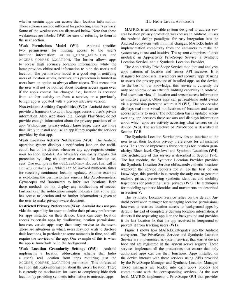
The architecture of the PrivoScope service fora requestLocationUpdate method call fromLocationManager is shown in Figure 3. Note thatwe abstract away from the low level implementation detailsand Android’s internal complexities in this paper forsimplification. Also note that the architecture is genericacross all location managers and the sensor manager and weuse LocationManager here just for illustration purposes.Like all other Android services, PrivoScope implementsa manager called PrivoScopeManager that exposespublic APIs to other apps and a system service calledPrivoScopeService that performs all the securitysensitive operations and checks if apps have appropriateaccess rights for their services.
The control flows like this: An app requests continu-ous location updates using the requestLocationUpdatemethod call from LocationManager. The manager andthe privileged LocationManagerService validate theapp’s access by checking its requested permissions 1©. Onceaccess is validated, the API call interception service generatesan event containing all relevant information to be loggedfor auditing. All private user information contained by therequest are ignored. For example, this specific event would
Location Service
Location Manager
Location Service
Location Manager
ApplicationLocation Service
Synthetic Location
LocationProvider
Location Listener Proxy
Synthetic Location Manager
Synthetic Location
LocationProvider
Location Listener Proxy
Synthetic Location Manager
Synthetic Location Service
1
2
3
4
5
Location Listener
7
6
Fig. 4: Architecture diagram of the Synthetic Location service.
contain the system time, the app package name, the ac-tivity invoking the request, whether the app is backgroundor foreground, the requested location provider, and the re-quested accuracy and sampling rate 2©. This event is thensent to the PrivoScopeManager for logging using anaddAuditEvent method call exposed by the manager3©. The PrivoScopeManager forwards this event to thePrivoScopeService which validates whether the pack-age name in the event is the same as the package nameof the app making the request. This ensures security asonly apps generating an event can add the event. The eventis discarded if the package names do not match and aSecurityException is thrown. In case of a successfulmatch, the event is added to the service’s database 4©. ThePrivoScopeService also sends this event to a Notifi-cation service that keeps track of all active apps accessinglocation and sensor APIs and updates the notification bar withthis new event information 5©. The PrivoScopeManagerexposes a requestAuditEvents method call that otherapps on the device can register for receiving real-time auditevents. This call is protected using a custom permission calledGET_AUDIT_EVENTS and apps must request this permissionfor access. The PrivoScopeManager sends the event to allregistered apps that receive this event asynchronously usinga AuditEventListener callback interface 6©. Based onwhether this event was successfully added to the databaseor not, the addAuditEvent method call returns a booleanvalue to the LocationManager 7©. Note that steps 3© to7© execute in a new thread to ensure that the app functionalityand the performance is not impacted by PrivoScope. After step3©, the requestLocationUpdate method call simplyterminates as its return type is a void. The other method callsand managers return the expected values and their functionalityis not updated by PrivoScope 8©.
C. The Synthetic Location Service
The architecture of the Synthetic Location service is shownin Figure 4, again in the context of receiving location up-dates from the LocationManager API. Like PrivoScope,this architecture is generic across all the location man-
agers. The Synthetic Location service implements a man-ager called SyntheticLocationManager that exposespublic APIs to other apps and a system service calledSyntheticLocationService that manages and pro-tects the database storing the user location preferences, andconnects with the LocationProvider to request obfus-cated/synthetic locations.
The control flows like this: When an app requestscontinuous location updates (with the correct permis-sions) using the requestLocationUpdates call fromLocationManager, the first steps that occur are the listenerregistration (cf. Section II-A) and addition of the audit eventto the PrivoScope service’s database (cf. Section IV-B). 1©,2©. After registration is completed, all the location fixes
generated by the LocationManagerService are typi-cally sent asynchronously to the app’s LocationListener,PendingIntent or LocationCallback implementa-tion. In MATRIX, these location fixes are intercepted by aLocationListenerProxy that proxies it to the app’slistener. The proxy works by hooking the Location ob-ject that is used by all the managers to send locationfixes to the app’s listener. This enables it to modify thelocation object before the app loads the information us-ing the get* method calls (e.g., getLatitude() andgetLongitude()) 3©. The LocationListenerProxyrequests the SyntheticLocationManager to provide anupdated location for the app, based on the app’s locationpreference set by the user. The manager forwards this re-quest to the SyntheticLocationService that maintainsand protects the database storing the user location prefer-ence for each app 4©. The SyntheticLocationServicelooks up the user’s location preferences in the database,and communicates with the LocationProvider to requestan obfuscated/synthetic location if the user has chosen toreceive such location information for the app. The defaultpreference set for an app requesting fine location is blocklevel obfuscated data (500m) 5©. An updated location objectis returned to the SyntheticLocationService whichforwards it to the SyntheticLocationManager. TheSyntheticLocationManager sends this location to theLocationListenerProxy that updates it before the appaccesses the location 6©, 7©.
The Synthetic Location service currently provides four set-tings for per-app location privacy: High Accuracy, Block LevelAccuracy, City Level Accuracy, and Synthetic Locations. Notethat the High Accuracy and Block Level Accuracy optionsare only available for apps requesting fine location usingthe ACCESS_FINE_LOCATION permission. This is becauseapps that use ACCESS_COARSE_LOCATION permissionsalready receive coarser location data than that provided bythe two options. The high accuracy option set for an app tellsthe service to not obfuscate or synthesize locations for thisapp. For block level and city level accuracy, we extendedthe default Android LocationFudger implementation tosupport different grid resolutions. The implementation is incom.android.server.location.LocationFudger
(a) Real Location (b) App Selection Activity
(c) Location Preference (d) Synthetic Location
Fig. 5: Example screenshots of the Synthetic Location GUI.
under the Android source tree [28]. We analyzed this codeto find that the real location information is obfuscated intwo steps. First, a random offset is applied to the locationto mitigate against accurate detection of grid transitions whena user crosses a grid boundary. This offset is changed slowlyover time (e.g., once every hour) to mitigate against locationinference attacks. Second, the primary means of obfuscationis to snap the offset data (already mitigated against gridtransitions) to a grid. This grid radius chosen by most recentversions of Android is 2000m. We found this technique to beeffective against location inference attacks. The current gridradius settings for block level and city level accuracy are 500mand 5000m, respectively.
Figure 5 shows screenshots, illustrating the Synthetic Loca-tion service for a GPS tracking app. Note that this app is usedfor demonstrating how the service works because it displaysthe user location on the screen, and it is not a malicious app.Figure 5a shows the test app displaying the user’s real location,Figure 5b shows the list of installed apps that request locationpermissions, Figure 5c shows the location privacy preferencefor the test app being changed to synthetic, and Figure 5d
shows the test app now displaying a synthetic location inanother city. This synthetic location is provided based on thetime of the day and a realistic GPS trajectory generated forthe user for that specific day.
V. GENERATING SYNTHETIC IDENTITIES
This section provides a detailed description of our techniquefor generating unique and realistic privacy-preserving syntheticidentities and mobility trajectories for each user using theMATRIX system.
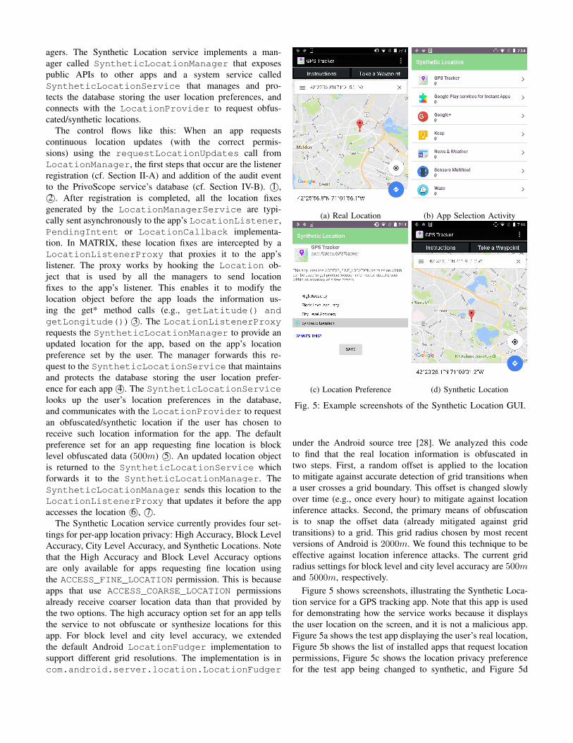
A. Modeling User States
A user’s synthetic mobility patterns are defined as anautomated probabilistic state machine with a finite set ofS states Q = {Q0, . . . , QS−1}. The states, in this context,represent a set of tuples {(Loc(Qi), tmin,i, amin,i, amax,i)},where Loc(Qi) is the geographic coordinates of state Qi,tmin,i is the minimum time spent in the state, and amin,i,amax,i are the lower and upper time bounds for arrival at thestate. The geographic coordinates of the states are obtainedfrom OpenStreetMap by parsing the ‘building’ and ‘amenity’tags [29], [30] of all ways and nodes for the given area.For instance, a ‘Home’ state can be chosen as a way ornode in OpenStreetMap whose building type is one of thefollowing: ‘apartments’, ‘house’, ‘residential’, or ‘bungalow’.Similarly, a ‘Work’ state can be chosen from the ‘commercial’or ‘industrial’ tags. The other attributes are used for schedulingthe user’s activity for each day and set based on typical timesthat these activities occur. Note that the attributes are set todefault values when they are unimportant for a state, i.e.,tmin,i = 0, amin,i = 00:00:00, and amax,i = 23:59:59.In the simplest form, a state machine may contain just twosynthetic states Q = {Q0, Q1}, where Q0 = ‘Home’ and Q1 =‘Work’. We label these as significant states as the user spendsmost of their time in one of these states. The geographiccoordinates Loc(Q0) and Loc(Q1) are randomly chosen fromthe list of all locations with the relevant tags. Assuming no‘Work from Home’ scenarios, the probabilities P (Q0) andP (Q1) of occurrence of these states is taken to be 1.
The state machine is made more realistic by adding syn-thetic states like Q2 = ‘School’, Q3 = ‘Gas Station’, Q4
= ‘Lunch’ and Q5 = ‘Dinner’. We label these as tran-sitional states because a user will temporarily visit thesestates when transitioning between significant states (i.e., Q0
and Q1). For any transitional state Qi, the geographic co-ordinates Loc(Qi) is selected from a set of locations Loc= {Loc1, . . . , LocN} with the relevant tags, such that itsdistance is shortest from the significant states, i.e., Loc(Qi) =arg minL∈Loc d(L,Loc(Q0)) + d(L,Loc(Q1)). Note that, un-like significant states, visits to transitional states are occasionalbased on some specific frequency of occurrence. This fre-quency, denoted by fi, is derived from a uniform distributionU(l, u) with l and u as the bounds for the frequency of visitsto that state (e.g., once a week to once a month). In caseof ‘Gas Station’ specifically, the system chooses a randommileage m and gas capacity c, and calculates the frequency as
HomeQ0
HomeQ0
WorkQ1
DinnerQ5
Gas Station
Q3
SchoolQ2
LunchQ4
0.111.0
0.14
1.0
0.14
0.08 1.0
0.99
0.01
0.78
0.89
Fig. 6: Example of a simplified finite state machine simulatinga user’s movements based on some transition probabilities.
the number of days a user can travel between the significantstates before the gas level goes below 1/4th of capacity, i.e.,f3 = int( 0.75mc
d(Loc(Q0),Loc(Q1))+d(Loc(Q1),Loc(Q0))). Assuming W
workdays in a year, the probability of occurrence for any tran-sitional state Qi is then calculated as P (Qi) = (W/fi)/W .
The transition probability between states Qi and Qj , de-noted by χi,j , is equivalent to the compound probability of thetwo independent states, i.e., P (χi,j) = P (Qi)P (Qj). The fol-lowing conditions determine if a state Qi can transition to stateQj : (1) Qi is a significant state and the originating state for Qj ,(2) Qj is a significant state and the destination state for Qi, or(3) the two states originate from the same significant state Qs
and distance d(Loc(Qs),Loc(Qi)) < d(Loc(Qs),Loc(Qj)).The significant states are always connected and their prob-abilities are calculated as P (χ0,1) = 1 −
∑S−1i=2 P (χ0,i)
and P (χ1,0) = 1 −∑S−1
i=2 P (χ1,i), respectively. All othertransitions have a probability of 0.
Note that users can go for ‘Lunch’ in the afternoon and‘Dinner’ in the evening from the ‘Work’ state. If we use thesame ‘Work’ state for both transitions, the probabilities aresplit when they clearly are different transitions. To addressthis, the ‘Work’ state is internally represented as two states:Q1a for afternoon and Q1e for evening. Also note that themodel described here is for weekdays, and a similar model iscreated for weekends with a different set of states (e.g., theuser may leave from ‘Home’ to watch a ‘Movie’, eat ‘Dinner’and return ‘Home’).
Figure 6 provides an intuition for our automated finite statemachine model. This specific model comprises of 6 states Q ={Q0, · · · , Q5} and their transition probabilities are shown. Wesee that it is possible to transition from state Q0 to states Q1,Q2 or Q3. As the transition probability P (χ0,1) is 0.78, themodel should typically choose state Q1 ≈ 8 times out of 10.This makes sense as a user will mostly go to ‘Work’ from‘Home’ but may sometimes need to drop their kids to ‘School’or fill up gas at a ‘Gas Station’.
B. Modeling Mobility Trajectories
The finite state machine generated for each user is used tosynthesize mobility trajectories for the user every day. This isa 3 step process: (1) synthesize the user states for the entire

day, (2) synthesize the schedule to satisfy the time constraints,and (3) synthesize the trajectory based on the schedule.
Synthesizing the user states: The state machine of a useris loaded every day to generate a route of the states theuser will visit that day. This route always starts and endsat the initial state Q0 (‘Home‘) and traverses through Q1
(‘Work‘), i.e., R = [Q0, . . . , Q1, . . . , Q0]. The first state Q0
can transition to any connected state Qi based on the transitionprobabilities of Q0. The state Qi can then transition to any ofits connected state Qj based on the transition probabilitiesof Qi, and so forth forming a chain that ends at the finalstate Q0. Note that the construction technique of the statemachine ensures that this route traverses through Q1. LetP (χi) = {P (χi,0), . . . , P (χi,S−1)} denote the set of alltransitional probabilities of state Qi. To obtain the next state,the system first derives a random transitional probability froma uniform distribution P = U(0, 1). This probability P is thencompared with the cumulative probabilities of all transitionsin P (χi). A state Qj is selected if P lies between the previousstate’s cumulative probability and its cumulative probability,i.e., P (X ≤ χi,j−1) < P ≤ P (X ≤ χi,j).
Synthesizing the schedule: A realistic schedule shouldsatisfy the time constraints set for every state in a user’s statemachine, such as arriving at work between 8am and 9amor dropping children to school before 8:30am. The scheduleshould also satisfy the amount of time spent in each state,such as working for at least 8hrs. The schedule should alsoaccount for the time spent in transitioning from one state to thenext, such as driving for 0.5hrs to get from home to work.All these constraints can be formulated as linear equalitiesor inequalities, therefore, defining the problem of schedulingas a Linear Program (LP). Let tai and tdi be the arrival anddeparture times at/from state Qi. The above constraints canbe formulated as follows: arriving at state Qi between 8amand 9am is formulated as 8am < tai ≤ 9am, specifying thatthe user works at least 8hrs is formulated as tdi+1− tai ≥ 8.0,and the time spent in transitioning from home to work isformulated as tai+1 − tdi = 0.5. Naturally, all the times arespecified in UTC for consistency and bounded by the day’slimits (i.e., 00:00:00 - 23:59:59).
This set of linear equality and inequality constraints definea convex polytope of all the schedules satisfying the stateconstraints, and the transition time constraints between thestates. Let T = (ta1 , t
d1, . . . , t
aS , t
dS) denote a vector of all the
arrival and departure time instants for a route containing Sstates. One simple way of finding a point on this polytope isby defining an objective function for the vector T with randomcoefficients, i.e., c = (c1, . . . , cS) where ci ∈ [−1, 1]. Lett(χi,j) denote the total time spent in transitioning betweentwo states Qi and Qj . Also, recall that tmin,i specifies theminimum time spent in state Qi and amin,i, amax,i specifythe time bounds of arrival at the state (cf. Section V-A). Usingabove attributes, the LP is formally defined as:
MaximizeS∑
i=1
(citai + cit
di ) where ci ∈ [−1, 1]
Subject to: amin,j < taj ≤ amax,j for j = 1, 2, . . . , S
tdj+1 − taj ≥ tmin,j for j = 1, 2, . . . , S − 1
taj+1 − tdj = t(χj,j+1) for j = 1, 2, . . . , S − 1
Solving this LP identifies a corner of the polytope but nota random element within it. If the coefficients of the objectivefunction were repeated, the LP will output the same schedule.To address this, we compute a random point within the poly-tope by finding different corners of the polytope using randomcoefficients and then computing a random linear combinationof these corners. More precisely, let C = {C1, . . . , CN}denote a set of N corners of the polytope obtained usingrandom coefficients, and let r = {r1, . . . , rN} denote a setof positive random numbers such that
∑Ni=1 ri = 1. The
random solution defining the user’s schedule for that day isthen calculated as Schedule =
∑Ni=1 riCi.
Note that as synthesizing the schedule using LP requirespre-calculated transition times t(χi,j), the system calculatesthis time using the ‘pessimistic’ traffic model of Google MapsDirections API. The departure time is chosen as the mean ofthe time constraints for the start state. This typically gives us aworst case transition time between two states and can be usedfor scheduling. Note that for synthesizing the final trajectory,the ‘best guess’ traffic model is used which provides moreaccurate traffic representation.Synthesizing the route between two states: The routebetween two synthetic states is generated using a graphG = (V,E) constructed for the area. The system uses theDijkstra’s algorithm to find the fastest route between the states,using the length and speed limit information present in eachvertex. The resulting route is split into multiple waypointsbased on turns and stop signs (extracted from OpenStreetMap).These waypoints are given as input to the Google MapsDirections API to obtain historical traffic information about theroute. The departure time is specified based on the schedulegenerated for that day. The route obtained from the GoogleAPI consists of multiple steps and can be represented asR = [r1, . . . , rS ], where S denotes the number of steps.Each step ri is attributed with geographic and traffic relatedinformation ri = (B, dstep, tstep)i, where B is the list ofgeographic coordinates of this step, dstep is the length of thisstep, and tstep is the time to traverse this step.
To generate realistic trajectories, all steps of a route mustincorporate user driving behavior while also adhering to thestep’s traffic constraints, i.e., dstep and tstep. To understanduser driving behavior, we analyzed 400 driving routes collectedfrom 2 drivers and 4 phones (LG Nexus 5, LG Nexus 5X,Samsung Note 4, and Google Pixel). These routes covered adistance of ≈ 1400kms in a major city of USA consistingof both highway and internal roads, as well as peak andoff-peak hours. The acceleration and speed information wereextracted from these routes for every second to analyze their

0 1 2 3 4 5 6
Absolute Accelerations (m/s2)
(a) Real Accelerations
0 1 2 3 4 5 6
Absolute Accelerations (m/s2)
(b) Synthetic Accelerations
Fig. 7: Distribution of the absolute values of accelerations forboth Real (µ = 0.61, M = 0.34, σ = 0.79) and Synthetic(µ = 0.61, M = 0.32, σ = 0.78) routes.
distribution. We found the speeds to be randomly distributed,however, the absolute values of accelerations approximateto an exponential distribution (mean µ = 0.61, medianM = 0.34, and standard deviation σ = 0.79) shown inFigure 7a. Note that the distribution is an approximationand not truly exponential because µ < σ, where µ = σ isa property of exponential distributions. Analyzing individualroutes, the range of means of absolute accelerations, denotedby [ ¯|a|min,
¯|a|max], varied between 0.1m/s2 and 1.1m/s2.The range of standard deviations of absolute accelerations,denoted by [σ(|a|)min, σ(|a|)max], were between 0.4m/s2
and 1.1m/s2. The bounds of all acceleration values, denotedby [amin, amax], were between −7m/s2 and 7m/s2. Themeans of the accelerations were ≈ 0m/s2 for every route.
The above constraints can be formulated as a list ofequalities and inequalities, this time defining a non-linearconstraint optimization problem. Such problems can be solvedby using Sequential Quadratic Programming (SQP) methods.Let a = (a1, . . . , aN ) denote a vector of acceleration valuesfor each step, where N denotes the travel time of the step,i.e., N = int(tstep). Let v0 denote the initial speed cominginto this step and v = (v1, . . . , vN ) denote a vector of speedscalculated from v0 and the vector a. The objective of thisoptimization is to find an optimal vector a that minimizes|v − (dstep/tstep)| < ∆ to adhere to the traffic constraints,where v is the mean of vector v, and dstep, tstep representthe step’s distance and time. The ∆ is a threshold thatdetermines whether the minimized objective function valueis acceptable. All rejected optimizations are retried with ahigher number of iterations till a valid solution satisfyingthe threshold is found. We observed that this optimizationtypically yields an optimal vector a that approaches the lowermean bound of the absolute accelerations ¯|a|min, for mostoptimizations. To address this, we derive a new lower meanbound for every route from a uniform distribution and usethe following range for optimization: [ ¯|a|rand, ¯|a|max], where¯|a|rand = U( ¯|a|min,
¯|a|max − δ), and δ is a small constant toensure that ¯|a|rand < ¯|a|max. The optimal vectors ai for everystep i are merged to represent the route’s accelerations. Notethat a bounded constraint of the form x1 ≤ x ≤ x2 can be
rewritten as (x2−x)(x−x1) ≥ 0 for simplifying the constraintfor the solver. Using above attributes, the route optimizationfor each step is formally defined as:
Minimize |v − (dstep/tstep)|Subject to: a = 0
( ¯|a|max − ¯|a|)( ¯|a| − ¯|a|rand) ≥ 0
(σ(|a|)max − σ(|a|))(σ(|a|)− σ(|a|)min) ≥ 0
σ(|a|)− ¯|a| ≥ 0
Bounds: amin ≤ aj ≤ amax for j = 1, 2, . . . , N
Some additional constraints applied to the optimization arethat v0 = 0 for the first step and vN = 0 for the laststep of the route. The optimization is improved by providingan initial guess of bounded accelerations from a gaussiandistribution N (v′, 2), where µ = v′ is the mean step speed,i.e., v′ = dstep/tstep, and σ = 2m/s is the standard deviationof the speed. Figure 7b shows the distribution of the absoluteaccelerations generated for synthetic trajectories. We can ob-serve that the parameters and shape of the distribution closelyfollows the parameters and shape of the real distribution.
Note that this work uses a linear model for synthesizingwalks from a state’s coordinates to a graph vertex, and viceversa. The vertex containing a point nearest to the state’scoordinates is chosen, and the driving route is started/stoppedat this point. This simple model assumes a constant walkingspeed as our main focus was on driving. We plan to studymodels for generating realistic walk patterns in the future. Alsonote that as GPS accuracy varies, a small random gaussiannoise is added to each coordinate of the final trajectory.
VI. EVALUATION
In this section, we evaluate MATRIX using the followingmetrics: the portability, stability and performance of the sys-tem, and the detection of synthetic trajectories by popularlocation-driven apps, by regular users, and by Machine Learn-ing algorithms.
A. System Portability and Stability
MATRIX is compatible with Android KitKat and on-wards. It has been tested to work on Xposed Framework APIversions 82 to 89 (current) which are compatible with theabove Android versions. This implies that MATRIX can beported to ≈ 94% of all Android devices globally (based oninformation from the Android Dashboard [31] as of August10, 2018).
The system’s stability was evaluated on 4 smartphones andthe results are shown in Table I. The evaluation was performedusing 1000 popular apps on Google Play Store that requestedlocation permissions or accessed the sensors. All the appshad a minimum rating of 4.0 and a minimum vote countof 10, 000 users. These 1000 apps were successively runtwice using an automated UI application exerciser tool calledAndroid Monkey [32], once on a stock Android version ofthese smartphones and then with MATRIX installed on thesame phones. The tool was configured to stress test each app’sactivities to monitor how many additional apps crash or fail to

TABLE I: Results of the Stability evaluation for MATRIX us-ing 1000 popular Android apps on 4 smartphones.
Phone Version Installed Success Failure
HTC One M7 Lollipop 1000 892 1081000 894 106
HTC One M9 Marshmallow 985 796 189985 791 194
LG Nexus 5 Lollipop 1000 938 621000 944 56
LG Nexus 5X Marshmallow 1000 851 1491000 848 152
execute. The same settings were used for both tests (seed = 1,num events = 2500) to ensure that the same pseudo-randomevents were generated.
The first row for each phone in Table I shows the testresults for the stock version and the second row showsthe test results for MATRIX. All the apps installed andran on every phone except for 15 apps on the HTC OneM9 (possibly due to compatibility reasons). The number ofsuccessful monkey runs are very similar in both the testswith the stock version performing better on two phones andthe MATRIX version performing better on the other two. Weanalyzed the errors/crashes manually to check for Xposed orMATRIX specific errors and did not find any. This validatesthat MATRIX remains stable and runs as expected for differentdevices, OS versions, apps and in heavy use.
B. System Performance
MATRIX was extensively evaluated for performance over-heads occurring from the most expensive operations of thesystem. We identified 3 potential performance bottlenecks inour system: (1) the API call interception function using theXposed framework; (2) the add audit event function of thePrivoScope service; and (3) the location provider function ofthe Synthetic Location service. We implemented a test app thatinvoked these functions 1 million times to test performance.The execution time was calculated as the difference betweentwo System.nanoTime method calls placed immediatelybefore and after the function execution. The API interceptionbottleneck is caused by the Xposed framework loading andhooking method calls. To evaluate its performance, we createdan empty method inside our system and hooked it using theXposed framework.
Table II shows the mean µ, standard deviation σ and maxi-mum time of execution for the three functions on a LG Nexus5 and a LG Nexus 5X. The API interception function usingthe Xposed framework averaged about µ = 0.2ms on both thephones, which is negligible from a usage perspective. The addaudit event function of PrivoScope had a low µ for both thephones (4.3ms and 3.2ms, resp), and its performance is alsoacceptable. The location provider function of the SyntheticLocation service had a relatively higher µ and σ for the Nexus5 (µ = 11.1ms, σ = 7.7ms). We believe this overhead is dueto database lookups performed by the service to check thelocation preferences for the app. Overall, the entire system canrun with an average overhead of 15.6ms on the Nexus 5 and
TABLE II: Results of the Performance evaluation of MA-TRIX for 2 smartphones.
Phone Service Mean (µ) Std (σ) Max
Nexus 5Xposed Hook 0.2 ms 0.3 ms 17.1 msAdd Audit Event 4.3 ms 3.8 ms 67.1 msUpdate Location 11.1 ms 7.7 ms 87.6 ms
Nexus 5XXposed Hook 0.2 ms 0.15 ms 5.7 msAdd Audit Event 3.2 ms 1.6 ms 26.8 msUpdate Location 5.7 ms 1.5 ms 16.0 ms
9.1ms on the Nexus 5X which should have a negligible impacton the user experience. The sum of worst case performancesoverhead at 171.8ms on the Nexus 5 should also not affectuser experience since such overhead occurs rarely.
C. Detection of Synthetic Trajectories
1) Detection by Popular Mobile Apps: We evaluated thismetric using 10 popular location-driven apps (listed in Ta-ble III) on Google Play Store. These apps rely heavily onlocation data to provide their services to users. The evalu-ation was performed by feeding these apps three types ofsynthetic location data and monitoring their behavior. In test1 (Synthetic), the synthetic trajectories were generated usingthe techniques described in Section V-B. In test 2 (HS), thetrajectories from test 1 were time compressed by a factor of5 such that the user appeared to move 5 times faster (e.g.,at 300km/h in a 60km/h speed zone). In test 3 (HS+T),the trajectories from test 2 were perturbed by large noises(≈ 1000m) such that the user appeared to teleport to differentlocations very quickly. The expected results was that apps thatdetect fake location should be able to easily detect the HS andHS+T trajectories, but not Synthetic trajectories.
Table III shows the results of the three tests for our testapps. None of the apps were able to detect synthetic locationsin the Synthetic trajectories test. Even for HS and HS+Ttrajectories test, with the exception of Ingress, none of theother apps detected the presence of high speed and noisysynthetic locations. Ingress did not ban us from playing thegame, however, it denied points when it detected that theuser was moving too fast or teleporting. Pokemon Go isalso known to ban users, however, we did not get bannedduring our tests even after capturing many Pokemons usingthe noisy data. This is likely because the ban threshold isset to high to prevent users from going to a higher levelby cheating. All the remaining apps kept performing theirfunctions without detecting the presence of the synthetic data.Note that Waze and Google Maps navigation operated properlyfor HS but became unstable for HS+T, which was expectedas they constantly updated the routing information based onthe teleported locations.
These observations indicate that popular location-drivenapps fail to check validity of the received data. Some ofthese apps (Ingress, Pokemon Go, Foursquare and GoogleMaps) check whether the MockLocationProvider [33]is enabled on the device. Some apps rely on other schemesto limit user abuse (e.g., Foursquare detects and limits rapid

TABLE III: Results of the Synthetic Trajectories detection test on 10 popular Android apps that rely on location data.
App Name Category Rating Synthetic High Speed (HS) HS+Teleport (HS+T)Ingress Adventure Game 4.3 X Detected DetectedPokemon Go Adventure Game 4.1 X X XGeocaching Health & Fitness 4.0 X X XGlympse Social 4.5 X X XFamily Locator Lifestyle 4.4 X X Xhappn Lifestyle 4.5 X X XYelp Travel & Local 4.3 X X XFoursquare Food & Drink 4.1 X X XWaze Maps & Navigation 4.6 X X UnstableGoogle Maps Travel & Local 4.3 X X Unstable
(a) Real Driving Route
(b) Generated Synthetic Trajectory
Fig. 8: An example of the similarity between a real route anda generated synthetic route.
TABLE IV: Cumulative results of the User Study on Mechan-ical Turk sorted by the number of noisy trajectories correctlylabeled.
Noisy Surveyors Real Trajectories Synthetic TrajectoriesReal Synthetic Real Synthetic
0 100 65.1% 34.9% 66.0% 34.0%1 91 65.4% 34.6% 65.9% 34.1%2 72 65.7% 34.3% 65.4% 34.6%3 54 68.3% 31.7% 64.4% 35.6%
check-ins). This means that they rely on simple checks butdo not implement algorithms for detecting synthetic data. Theonly app that checked location validity in our set was Ingress,and it was unable to detect any discrepancies in the synthetictrajectories generated by our system.
2) Detection by Regular Users: We evaluated this metricby conducting two separate user studies: one comprisingof a group of 12 students from a university and anothercomprising of 100 users from Amazon Mechanical Turk [34].The intuition behind two studies was to understand the resultsfrom two perspectives; one of users who know the area very
well and another of users unaware of the area. The universityarea was chosen so that the students were aware of its trafficcongestions. The study asked the users to visually analyze amix of 20 real and synthetic trajectories and label them as‘Real’ or ‘Synthetic’ based on their observations. Figures 8aand 8b show an example of a real route and a synthetictrajectory used for the study. The green marker marks the startlocation, the white markers are 500m apart, and the red markermarks the stop location. These markers display the time thevehicle was at the given location.
The trajectories were created as follows: First, we drove10 unique routes close to the university area, each startingand ending at different locations and times of the day. Eachroute can be represented as R = [n1, . . . , nL], where n isa node and L is the number of nodes in the route. Eachnode ni is attributed with timing and geographic informationni = (ti,Loc(ni)), where ti is the timestamp and Loc(ni) isthe node’s geographic coordinates. Next, we generated 10 syn-thetic routes similar to the 10 real routes using the timestampof the first node (i.e., t1) and geographic coordinates of theend nodes (i.e., Loc(n1) and Loc(nL)) for each route R. Thetrajectories were shuffled so they appeared in a random order.For mechanical turk, we added three very noisy trajectorieswhich looked obviously synthetic to find users who did nottake the study seriously.University Students Study: For the real trajectories, ≈64.2% of the trajectories were labeled as ‘Real’ and the restwere labeled as ‘Synthetic’. For the synthetic trajectories,≈ 65.8% of the trajectories were labeled as ‘Real’ and therest were labeled as ‘Synthetic’. Note that more users of thisstudy confused the ‘Synthetic’ trajectories to be ‘Real’.Amazon Mechanical Turk Study: For the real trajectories,≈ 68.3% of the trajectories were labeled as ‘Real’ and therest were labeled as ‘Synthetic’. For the synthetic trajectories,≈ 64.4% of the trajectories were labeled as ‘Real’. Theabove results are for 54 users who detected all the obviouslynoisy trajectories. Table IV shows the cumulative results ofthe mechanical turk study based on the number of noisytrajectories detected by the users. We can see that the resultsare not significantly different even for all 100 users, however,more users labeled ‘Synthetic’ as ‘Real’.
The results indicate that it was difficult for the users todifferentiate between synthetic and real driving trajectories.There was confusion in both groups regarding their validity.
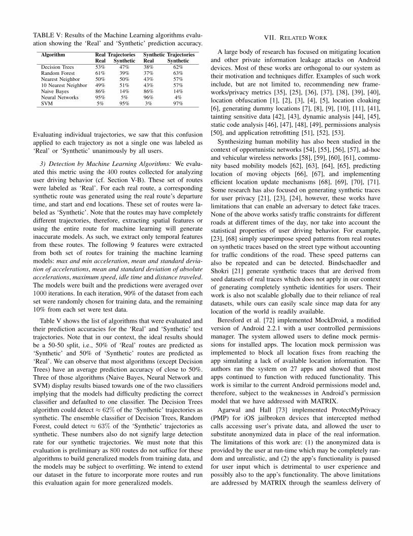
TABLE V: Results of the Machine Learning algorithms evalu-ation showing the ‘Real’ and ‘Synthetic’ prediction accuracy.
Algorithm Real Trajectories Synthetic TrajectoriesReal Synthetic Real Synthetic
Decision Trees 53% 47% 38% 62%Random Forest 61% 39% 37% 63%Nearest Neighbor 50% 50% 43% 57%10 Nearest Neighbor 49% 51% 43% 57%Naive Bayes 86% 14% 86% 14%Neural Networks 95% 5% 96% 4%SVM 5% 95% 3% 97%
Evaluating individual trajectories, we saw that this confusionapplied to each trajectory as not a single one was labeled as‘Real’ or ‘Synthetic’ unanimously by all users.
3) Detection by Machine Learning Algorithms: We evalu-ated this metric using the 400 routes collected for analyzinguser driving behavior (cf. Section V-B). These set of routeswere labeled as ‘Real’. For each real route, a correspondingsynthetic route was generated using the real route’s departuretime, and start and end locations. These set of routes were la-beled as ‘Synthetic’. Note that the routes may have completelydifferent trajectories, therefore, extracting spatial features orusing the entire route for machine learning will generateinaccurate models. As such, we extract only temporal featuresfrom these routes. The following 9 features were extractedfrom both set of routes for training the machine learningmodels: max and min acceleration, mean and standard devia-tion of accelerations, mean and standard deviation of absoluteaccelerations, maximum speed, idle time and distance traveled.The models were built and the predictions were averaged over1000 iterations. In each iteration, 90% of the dataset from eachset were randomly chosen for training data, and the remaining10% from each set were test data.
Table V shows the list of algorithms that were evaluated andtheir prediction accuracies for the ‘Real’ and ‘Synthetic’ testtrajectories. Note that in our context, the ideal results shouldbe a 50-50 split, i.e., 50% of ‘Real’ routes are predicted as‘Synthetic’ and 50% of ‘Synthetic’ routes are predicted as‘Real’. We can observe that most algorithms (except DecisionTrees) have an average prediction accuracy of close to 50%.Three of those algorithms (Naive Bayes, Neural Network andSVM) display results biased towards one of the two classifiersimplying that the models had difficulty predicting the correctclassifier and defaulted to one classifier. The Decision Treesalgorithm could detect ≈ 62% of the ‘Synthetic’ trajectories assynthetic. The ensemble classifier of Decision Trees, RandomForest, could detect ≈ 63% of the ‘Synthetic’ trajectories assynthetic. These numbers also do not signify large detectionrate for our synthetic trajectories. We must note that thisevaluation is preliminary as 800 routes do not suffice for thesealgorithms to build generalized models from training data, andthe models may be subject to overfitting. We intend to extendour dataset in the future to incorporate more routes and runthis evaluation again for more generalized models.
VII. RELATED WORK
A large body of research has focused on mitigating locationand other private information leakage attacks on Androiddevices. Most of these works are orthogonal to our system astheir motivation and techniques differ. Examples of such workinclude, but are not limited to, recommending new frame-works/privacy metrics [35], [25], [36], [37], [38], [39], [40],location obfuscation [1], [2], [3], [4], [5], location cloaking[6], generating dummy locations [7], [8], [9], [10], [11], [41],tainting sensitive data [42], [43], dynamic analysis [44], [45],static code analysis [46], [47], [48], [49], permissions analysis[50], and application retrofitting [51], [52], [53].
Synthesizing human mobility has also been studied in thecontext of opportunistic networks [54], [55], [56], [57], ad-hocand vehicular wireless networks [58], [59], [60], [61], commu-nity based mobility models [62], [63], [64], [65], predictinglocation of moving objects [66], [67], and implementingefficient location update mechanisms [68], [69], [70], [71].Some research has also focused on generating synthetic tracesfor user privacy [21], [23], [24], however, these works havelimitations that can enable an adversary to detect fake traces.None of the above works satisfy traffic constraints for differentroads at different times of the day, nor take into account thestatistical properties of user driving behavior. For example,[23], [68] simply superimpose speed patterns from real routeson synthetic traces based on the street type without accountingfor traffic conditions of the road. These speed patterns canalso be repeated and can be detected. Bindschaedler andShokri [21] generate synthetic traces that are derived fromseed datasets of real traces which does not apply in our contextof generating completely synthetic identities for users. Theirwork is also not scalable globally due to their reliance of realdatasets, while ours can easily scale since map data for anylocation of the world is readily available.
Beresford et al. [72] implemented MockDroid, a modifiedversion of Android 2.2.1 with a user controlled permissionsmanager. The system allowed users to define mock permis-sions for installed apps. The location mock permission wasimplemented to block all location fixes from reaching theapp simulating a lack of available location information. Theauthors ran the system on 27 apps and showed that mostapps continued to function with reduced functionality. Thiswork is similar to the current Android permissions model and,therefore, subject to the weaknesses in Android’s permissionmodel that we have addressed with MATRIX.
Agarwal and Hall [73] implemented ProtectMyPrivacy(PMP) for iOS jailbroken devices that intercepted methodcalls accessing user’s private data, and allowed the user tosubstitute anonymized data in place of the real information.The limitations of this work are: (1) the anonymized data isprovided by the user at run-time which may be completely ran-dom and unrealistic, and (2) the app’s functionality is pausedfor user input which is detrimental to user experience andpossibly also to the app’s functionality. The above limitationsare addressed by MATRIX through the seamless delivery of

realistic synthetic locations to apps without requiring constantinteraction with the user.
Liu et al. [74] implemented Personalized Privacy Assistant(PPA) for rooted Android devices. This system is a modifiedApp Ops permission manager that displays an app’s recentrequests and the frequencies of requests in the past 7 days.The system uses this information to generate daily privacynudges to motivate users to interact and change their privacysettings. We believe that this information provided to usersis not sufficient to make any kind of privacy-aware decisions.Additional context is required to determine if an app is misus-ing the information (e.g., time and duration of those requests,was the app in the background?). PrivoScope addresses thelimitations by providing much more context to the users anddisplaying them in a way that it is easier for the users to graspand visualize these accesses.
Zheng et al. [61] propose an agenda driven mobility modelthat considers a person’s daily social activities for motion gen-eration. They derive this agenda from the National HouseholdTravel Survey (NHTS) database by the U.S. Department ofTransportation. The first agenda and all subsequent activitiesare based on the NHTS activity distribution, and addresses arepicked at random from many addresses for the correspondingactivity. The start time of the first agenda determines the sched-ule for the entire day and each activity starts immediately afterthe mean dwell time+longest transition time from previousactivity. The route between two activities assumes a longestpossible time given by the Dijkstra’s algorithm. This workhas several limitations (all addressed by MATRIX) that aretrivial to detect: (1) the addresses are picked at random withoutaccounting for distances (e.g., gas station may be miles awayfrom regular route), (2) the routes do not incorporate any trafficinformation and are always static, and (3) the routes do notincorporate any driving behavior and likely assume a constantspeed of motion.
Fawaz and Shin [35] implemented LP-Guardian, a privacyprotection framework modifying the Android source code. Theframework changes location granularity of installed apps basedon the threat posed by the app and its location granularityrequirements. It automatically coarsens the location to a citylevel if it identifies a request from an A&A library, the app isin the background, or the app is a weather app. It synthesizesthe location for fitness apps but preserves features of the actualroute such as the distance traveled. The framework supplies asynthetic location if it determines that it is not safe to releasethe location. This work has the following limitations that areaddressed in MATRIX: (1) the preservation of route featurescan lead to inference of the user’s real locations, and (2) unlesschosen very carefully, the synthetic traces generated from realfeatures will not snap to streets (e.g., different street lengthsand curvatures) and can be detected as synthetic.
VIII. CONCLUSION
We presented MATRIX, a system that addresses currentprivacy protection weaknesses in Android, provides users witha tool to analyze how apps access their private information,
and the capability to provide obfuscated/synthetic data tountrusted apps. We demonstrated that MATRIX is portable tomost Android devices globally, is reliable, has low-overhead,and generates privacy-preserving synthetic trajectories that aredifficult to differentiate from real mobility trajectories by anadversary.
REFERENCES
[1] M. E. Andres, N. E. Bordenabe, K. Chatzikokolakis, and C. Palamidessi,“Geo-indistinguishability: Differential privacy for location-basedsystems,” in Proceedings of the 2013 ACM SIGSAC Conferenceon Computer & Communications Security, ser. CCS ’13, 2013.[Online]. Available: http://doi.acm.org/10.1145/2508859.2516735
[2] N. E. Bordenabe, K. Chatzikokolakis, and C. Palamidessi, “Optimal geo-indistinguishable mechanisms for location privacy,” in Proceedings ofthe 2014 ACM SIGSAC Conference on Computer and CommunicationsSecurity, ser. CCS ’14, 2014. [Online]. Available: http://doi.acm.org/10.1145/2660267.2660345
[3] R. Shokri, G. Theodorakopoulos, C. Troncoso, J.-P. Hubaux, andJ.-Y. Le Boudec, “Protecting location privacy: Optimal strategy againstlocalization attacks,” in Proceedings of the 2012 ACM Conference onComputer and Communications Security, ser. CCS ’12, 2012. [Online].Available: http://doi.acm.org/10.1145/2382196.2382261
[4] Y. Wang, D. Xu, X. He, C. Zhang, F. Li, and B. Xu, “L2p2: Location-aware location privacy protection for location-based services,” in 2012Proceedings IEEE INFOCOM, March 2012.
[5] C. A. Ardagna, M. Cremonini, S. D. C. di Vimercati, and P. Samarati,“An obfuscation-based approach for protecting location privacy,” IEEETransactions on Dependable and Secure Computing, Jan 2011.
[6] B. Hoh and M. Gruteser, “Preserving privacy in gps traces viauncertainty-aware path cloaking,” in In Proceedings of ACM CCS 2007,2007.
[7] R. Kato, M. Iwata, T. Hara, A. Suzuki, X. Xie, Y. Arase, and S. Nishio,“A dummy-based anonymization method based on user trajectorywith pauses,” in Proceedings of the 20th International Conference onAdvances in Geographic Information Systems, ser. SIGSPATIAL ’12,2012. [Online]. Available: http://doi.acm.org/10.1145/2424321.2424354
[8] H. Kido, Y. Yanagisawa, and T. Satoh, “An anonymous communicationtechnique using dummies for location-based services,” in ICPS ’05.Proceedings. International Conference on Pervasive Services, 2005.,July 2005.
[9] H. Lu, C. S. Jensen, and M. L. Yiu, “Pad: Privacy-area aware,dummy-based location privacy in mobile services,” in Proceedingsof the Seventh ACM International Workshop on Data Engineeringfor Wireless and Mobile Access, ser. MobiDE ’08, 2008. [Online].Available: http://doi.acm.org/10.1145/1626536.1626540
[10] A. Suzuki, M. Iwata, Y. Arase, T. Hara, X. Xie, and S. Nishio, “A userlocation anonymization method for location based services in a realenvironment,” in Proceedings of the 18th SIGSPATIAL InternationalConference on Advances in Geographic Information Systems, ser. GIS’10, 2010. [Online]. Available: http://doi.acm.org/10.1145/1869790.1869846
[11] T. H. You, W. C. Peng, and W. C. Lee, “Protecting moving trajectorieswith dummies,” in 2007 International Conference on Mobile DataManagement, May 2007.
[12] A. Pingley, N. Zhang, X. Fu, H. A. Choi, S. Subramaniam, and W. Zhao,“Protection of query privacy for continuous location based services,” in2011 Proceedings IEEE INFOCOM, April 2011.
[13] B. Hoh, M. Gruteser, H. Xiong, and A. Alrabady, “Enhancing securityand privacy in traffic-monitoring systems,” IEEE Pervasive Computing,Oct 2006.
[14] R. Shokri, G. Theodorakopoulos, J. Y. L. Boudec, and J. P. Hubaux,“Quantifying location privacy,” in 2011 IEEE Symposium on Securityand Privacy, May 2011.
[15] H. Zang and J. Bolot, “Anonymization of location data doesnot work: A large-scale measurement study,” in Proceedings ofthe 17th Annual International Conference on Mobile Computingand Networking, ser. MobiCom ’11, 2011. [Online]. Available:http://doi.acm.org/10.1145/2030613.2030630

[16] J. Han, E. Owusu, L. Nguyen, A. Perrig, and J. Zhang, “Accomplice:Location inference using accelerometers on smartphones,” in Communi-cation Systems and Networks (COMSNETS), 2012 Fourth InternationalConference on, Jan 2012.
[17] Y. Michalevsky, A. Schulman, G. A. Veerapandian, D. Boneh,and G. Nakibly, “Powerspy: Location tracking using mobiledevice power analysis,” in 24th USENIX Security Symposium(USENIX Security 15). USENIX Association, 2015. [On-line]. Available: https://www.usenix.org/conference/usenixsecurity15/technical-sessions/presentation/michalevsky
[18] S. Nawaz and C. Mascolo, “Mining users’ significant driving routeswith low-power sensors,” in Proceedings of the 12th ACM Conferenceon Embedded Network Sensor Systems, ser. SenSys ’14. ACM, 2014.[Online]. Available: http://doi.acm.org/10.1145/2668332.2668348
[19] S. Narain, T. D. Vo-Huu, K. Block, and G. Noubir, “Inferring userroutes and locations using zero-permission mobile sensors,” in 2016IEEE Symposium on Security and Privacy (SP), May 2016.
[20] A. Mosenia, X. Dai, P. Mittal, and N. Jha, “Pinme: Tracking asmartphone user around the world,” IEEE Transactions on Multi-ScaleComputing Systems, 2017.
[21] V. Bindschaedler and R. Shokri, “Synthesizing plausible privacy-preserving location traces,” in 2016 IEEE Symposium on Security andPrivacy (SP), May 2016.
[22] A. Machanavajjhala, D. Kifer, J. Abowd, J. Gehrke, and L. Vilhuber,“Privacy: Theory meets practice on the map,” in Proceedings of the2008 IEEE 24th International Conference on Data Engineering, ser.ICDE ’08, 2008. [Online]. Available: http://dx.doi.org/10.1109/ICDE.2008.4497436
[23] J. Krumm, “Realistic driving trips for location privacy,” in InternationalConference on Pervasive Computing. Springer, 2009.
[24] R. Chow and P. Golle, “Faking contextual data for fun, profit, andprivacy,” in Proceedings of the 8th ACM Workshop on Privacy inthe Electronic Society, ser. WPES ’09, 2009. [Online]. Available:http://doi.acm.org/10.1145/1655188.1655204
[25] M. Backes, S. Bugiel, C. Hammer, O. Schranz, and P. vonStyp-Rekowsky, “Boxify: Full-fledged app sandboxing for stockandroid,” in 24th USENIX Security Symposium (USENIX Security15). Washington, D.C.: USENIX Association, 2015. [On-line]. Available: https://www.usenix.org/conference/usenixsecurity15/technical-sessions/presentation/backes
[26] Xposed Framework, “The Xposed Framework Source Code,” https://github.com/rovo89/XposedInstaller, 2017.
[27] TeamWin, “TeamWin - TWRP,” https://twrp.me/about/, 2017.[28] Android, “The Android Source Code,” https://source.android.com/
source/, 2017.[29] OpenStreetMap, “OpenStreetMap Building Key,” http://wiki.
openstreetmap.org/wiki/Key:building, 2017.[30] ——, “OpenStreetMap Amenity Key,” http://wiki.openstreetmap.org/
wiki/Key:amenity, 2017.[31] Android, “Android Dashboards,” https://developer.android.com/about/
da\shboards/index.html, 2018.[32] ——, “UI/Application Exerciser Monkey,” https://developer.android.
com/studio/test/monkey.html, 2017.[33] ——, “Android Mock Location Provider,” https://developer.android.
com/guide/topics/location/strategies.html#Mock\Data, 2017.[34] Amazon, “Amazon Mechanical Turk,” https://www.mturk.com/mturk/
welcome, 2017.[35] K. Fawaz and K. G. Shin, “Location privacy protection for smartphone
users,” in Proceedings of the 2014 ACM SIGSAC Conference on Com-puter and Communications Security, ser. CCS ’14, 2014.
[36] B. Krupp, N. Sridhar, and W. Zhao, “Spe: Security and privacy enhance-ment framework for mobile devices,” IEEE Transactions on Dependableand Secure Computing, 2015.
[37] I. Bilogrevic, K. Huguenin, B. Agir, M. Jadliwala, M. Gazaki,and J.-P. Hubaux, “A machine-learning based approach to privacy-aware information-sharing in mobile social networks,” Pervasiveand Mobile Computing, vol. 25, 2016. [Online]. Available: http://www.sciencedirect.com/science/article/pii/S1574119215000231
[38] B. Deva, S. R. Garzon, and S. Schnemann, “A context-sensitive privacy-aware framework for proactive location-based services,” in 2015 9thInternational Conference on Next Generation Mobile Applications, Ser-vices and Technologies, Sept 2015.
[39] K. Fawaz, H. Feng, and K. G. Shin, “Anatomization andprotection of mobile apps’ location privacy threats,” in 24th
USENIX Security Symposium (USENIX Security 15). USENIXAssociation, 2015. [Online]. Available: https://www.usenix.org/conference/usenixsecurity15/technical-sessions/presentation/fawaz
[40] S. Oya, C. Troncoso, and F. Perez-Gonzalez, “Back to the drawingboard: Revisiting the design of optimal location privacy-preservingmechanisms,” in Proceedings of the 2017 ACM SIGSAC Conferenceon Computer and Communications Security, ser. CCS ’17, 2017.
[41] L. Zhang, Z. Cai, and X. Wang, “Fakemask: A novel privacy preservingapproach for smartphones,” IEEE Transactions on Network and ServiceManagement, June 2016.
[42] W. Enck, P. Gilbert, B.-G. Chun, L. P. Cox, J. Jung, P. McDaniel,and A. N. Sheth, “Taintdroid: An information-flow tracking system forrealtime privacy monitoring on smartphones,” in Proceedings of the 9thUSENIX Conference on Operating Systems Design and Implementation,ser. OSDI’10. Berkeley, CA, USA: USENIX Association, 2010.[Online]. Available: http://dl.acm.org/citation.cfm?id=1924943.1924971
[43] M. Sun, T. Wei, and J. C. Lui, “Taintart: A practical multi-level information-flow tracking system for android runtime,” inProceedings of the 2016 ACM SIGSAC Conference on Computer andCommunications Security, ser. CCS ’16. New York, NY, USA: ACM,2016. [Online]. Available: http://doi.acm.org/10.1145/2976749.2978343
[44] M. Xia, L. Gong, Y. Lyu, Z. Qi, and X. Liu, “Effective real-time androidapplication auditing,” in 2015 IEEE Symposium on Security and Privacy,May 2015.
[45] Y. Zhou, X. Zhang, X. Jiang, and V. W. Freeh, “Taming information-stealing smartphone applications (on android),” in Proceedings of the4th International Conference on Trust and Trustworthy Computing,ser. TRUST’11. Berlin, Heidelberg: Springer-Verlag, 2011. [Online].Available: http://dl.acm.org/citation.cfm?id=2022245.2022255
[46] S. Arzt, S. Rasthofer, C. Fritz, E. Bodden, A. Bartel, J. Klein,Y. Le Traon, D. Octeau, and P. McDaniel, “Flowdroid: Precisecontext, flow, field, object-sensitive and lifecycle-aware taint analysisfor android apps,” in Proceedings of the 35th ACM SIGPLANConference on Programming Language Design and Implementation,ser. PLDI ’14. New York, NY, USA: ACM, 2014. [Online]. Available:http://doi.acm.org/10.1145/2594291.2594299
[47] F. Wei, S. Roy, X. Ou, and Robby, “Amandroid: A precise andgeneral inter-component data flow analysis framework for securityvetting of android apps,” in Proceedings of the 2014 ACM SIGSACConference on Computer and Communications Security, ser. CCS’14. New York, NY, USA: ACM, 2014. [Online]. Available:http://doi.acm.org/10.1145/2660267.2660357
[48] M. Backes, S. Bugiel, E. Derr, S. Gerling, and C. Hammer, “R-droid:Leveraging android app analysis with static slice optimization,” inProceedings of the 11th ACM on Asia Conference on Computer andCommunications Security, ser. ASIA CCS ’16. New York, NY, USA:ACM, 2016. [Online]. Available: http://doi.acm.org/10.1145/2897845.2897927
[49] K. Lu, Z. Li, V. P. Kemerlis, Z. Wu, L. Lu, C. Zheng, Z. Qian,W. Lee, and G. Jiang, “Checking more and alerting less: Detectingprivacy leakages via enhanced data-flow analysis and peer voting,” inThe Network and Distributed System Security Symposium, ser. NDSS’15, 2015.
[50] J. Jeon, K. K. Micinski, J. A. Vaughan, A. Fogel, N. Reddy, J. S.Foster, and T. Millstein, “Dr. android and mr. hide: Fine-grainedpermissions in android applications,” in Proceedings of the SecondACM Workshop on Security and Privacy in Smartphones and MobileDevices, ser. SPSM ’12. New York, NY, USA: ACM, 2012. [Online].Available: http://doi.acm.org/10.1145/2381934.2381938
[51] B. Davis and H. Chen, “Retroskeleton: Retrofitting android apps,”in Proceeding of the 11th Annual International Conference onMobile Systems, Applications, and Services, ser. MobiSys ’13.New York, NY, USA: ACM, 2013. [Online]. Available: http://doi.acm.org/10.1145/2462456.2464462
[52] P. Hornyack, S. Han, J. Jung, S. Schechter, and D. Wetherall, “TheseAren’T the Droids You’Re Looking for: Retrofitting Android toProtect Data from Imperious Applications,” in Proceedings of the 18thACM Conference on Computer and Communications Security, ser.CCS ’11. New York, NY, USA: ACM, 2011. [Online]. Available:http://dx.doi.org/10.1145/2046707.2046780
[53] S. Zhu, L. Lu, and K. Singh, “Case: Comprehensive applicationsecurity enforcement on cots mobile devices,” in Proceedings of the14th Annual International Conference on Mobile Systems, Applications,

and Services, ser. MobiSys ’16. ACM, 2016. [Online]. Available:http://doi.acm.org/10.1145/2906388.2906413
[54] J. Ghosh, S. J. Philip, and C. Qiao, “Sociological orbit aware locationapproximation and routing in manet,” in 2nd International Conferenceon Broadband Networks, 2005., Oct 2005.
[55] K. Lee, S. Hong, S. J. Kim, I. Rhee, and S. Chong, “Slaw: A newmobility model for human walks,” in IEEE INFOCOM 2009, April 2009.
[56] F. Ekman, A. Keranen, J. Karvo, and J. Ott, “Working day movementmodel,” in Proceedings of the 1st ACM SIGMOBILE Workshop onMobility Models, ser. MobilityModels ’08, 2008. [Online]. Available:http://doi.acm.org/10.1145/1374688.1374695
[57] D. Karamshuk, C. Boldrini, M. Conti, and A. Passarella, “Humanmobility models for opportunistic networks,” IEEE CommunicationsMagazine, December 2011.
[58] C. Tuduce and T. Gross, “A mobility model based on wlan traces andits validation,” in Proceedings IEEE 24th Annual Joint Conference ofthe IEEE Computer and Communications Societies., March 2005.
[59] D. R. Choffnes and F. E. Bustamante, “An integrated mobility and trafficmodel for vehicular wireless networks,” in Proceedings of the 2Nd ACMInternational Workshop on Vehicular Ad Hoc Networks, ser. VANET ’05,2005. [Online]. Available: http://doi.acm.org/10.1145/1080754.1080765
[60] M. Kim, D. Kotz, and S. Kim, “Extracting a mobility model fromreal user traces,” in Proceedings IEEE INFOCOM 2006. 25TH IEEEInternational Conference on Computer Communications, April 2006.
[61] Q. Zheng, X. Hong, J. Liu, D. Cordes, and W. Huang, “Agenda drivenmobility modelling,” Int. J. Ad Hoc Ubiquitous Comput., Dec. 2010.[Online]. Available: http://dx.doi.org/10.1504/IJAHUC.2010.030000
[62] X. Hong, M. Gerla, G. Pei, and C.-C. Chiang, “A group mobilitymodel for ad hoc wireless networks,” in Proceedings of the 2NdACM International Workshop on Modeling, Analysis and Simulationof Wireless and Mobile Systems, ser. MSWiM ’99, 1999. [Online].Available: http://doi.acm.org/10.1145/313237.313248
[63] B. Li, “On increasing service accessibility and efficiency in wirelessad-hoc networks with group mobility,” Wirel. Pers. Commun., Apr.2002. [Online]. Available: https://doi.org/10.1023/A:1015597108458
[64] K. Herrmann, “Modeling the sociological aspects of mobility inad hoc networks,” in Proceedings of the 6th ACM InternationalWorkshop on Modeling Analysis and Simulation of Wireless andMobile Systems, ser. MSWIM ’03, 2003. [Online]. Available:http://doi.acm.org/10.1145/940991.941014
[65] M. Musolesi and C. Mascolo, “A community based mobilitymodel for ad hoc network research,” in Proceedings of the 2NdInternational Workshop on Multi-hop Ad Hoc Networks: From
Theory to Reality, ser. REALMAN ’06, 2006. [Online]. Available:http://doi.acm.org/10.1145/1132983.1132990
[66] Y. Tao, C. Faloutsos, D. Papadias, and B. Liu, “Prediction andindexing of moving objects with unknown motion patterns,” inProceedings of the 2004 ACM SIGMOD International Conference onManagement of Data, ser. SIGMOD ’04, 2004. [Online]. Available:http://doi.acm.org/10.1145/1007568.1007637
[67] J. Zhou, H. V. Leong, Q. Lu, and K. C. K. Lee, “Optimizing updatethreshold for distance-based location tracking strategies in moving objectenvironments,” in 2007 IEEE International Symposium on a World ofWireless, Mobile and Multimedia Networks, June 2007.
[68] O. Wolfson and H. Yin, Accuracy and Resource Consumptionin Tracking and Location Prediction, 2003. [Online]. Available:https://doi.org/10.1007/978-3-540-45072-6 19
[69] Z. Ding, L. Guo, and X. Meng, “Adaptive location update mechanismfor network-constrained moving objects in changeful traffic conditions,”in 2009 Tenth International Conference on Mobile Data Management:Systems, Services and Middleware, May 2009.
[70] Y. K. Huang, I. F. Su, L. F. Lin, and Y. C. Chung, “Efficient processingof updates for moving objects with varying speed and direction,” in2013 IEEE 27th International Conference on Advanced InformationNetworking and Applications (AINA), March 2013.
[71] Y.-K. Huang, “Indexing and querying moving objects withuncertain speed and direction in spatiotemporal databases,”Journal of Geographical Systems, Apr 2014. [Online]. Available:https://doi.org/10.1007/s10109-013-0191-6
[72] A. R. Beresford, A. Rice, N. Skehin, and R. Sohan, “Mockdroid:Trading privacy for application functionality on smartphones,” inProceedings of the 12th Workshop on Mobile Computing Systems andApplications, ser. HotMobile ’11. New York, NY, USA: ACM, 2011.[Online]. Available: http://doi.acm.org/10.1145/2184489.2184500
[73] Y. Agarwal and M. Hall, “Protectmyprivacy: Detecting and mitigatingprivacy leaks on ios devices using crowdsourcing,” in Proceeding of the11th Annual International Conference on Mobile Systems, Applications,and Services, ser. MobiSys ’13. New York, NY, USA: ACM, 2013.[Online]. Available: http://doi.acm.org/10.1145/2462456.2464460
[74] B. Liu, M. S. Andersen, F. Schaub, H. Almuhimedi, S. A. Zhang,N. Sadeh, Y. Agarwal, and A. Acquisti, “Follow my recommendations:A personalized privacy assistant for mobile app permissions,” in TwelfthSymposium on Usable Privacy and Security (SOUPS 2016). Denver,CO: USENIX Association, 2016. [Online]. Available: https://www.
usenix.org/conference/soups2016/technical-sessions/presentation/liu