Mills & Rajala (2011) Interpreting a ceramiscene landscape – the Roman pottery from the Nepi...
20
This pdf of your paper in TRAC 2010 belongs to the publishers Oxbow Books and it is their copyright. As author you are licenced to make up to 50 offprints from it, but beyond that you may not publish it on the World Wide Web until three years from publication (April 2014), unless the site is a limited access intranet (password protected). If you have queries about this please contact the editorial department at Oxbow Books ([email protected]).
Transcript of Mills & Rajala (2011) Interpreting a ceramiscene landscape – the Roman pottery from the Nepi...
This pdf of your paper in TRAC 2010 belongs to the publishers Oxbow Books and it is their copyright.
As author you are licenced to make up to 50 offprints from it, but beyond that you may not publish it on the World Wide Web until three years from publication (April 2014), unless the site is a limited access intranet (password protected). If you have queries about this please contact the editorial department at Oxbow Books ([email protected]).
An offprint from
TRAC 2010
Proceedings of the Twentieth Annual
THEORETICAL ROMAN ARCHAEOLOGY CONFERENCE
which took place at
The University of Oxford25–28 March 2010
edited by
Dragana Mladenović and Ben Russell
© Oxbow Books 2011ISBN 978-1-84217-452-4

Contents
Preface ........................................................................................................................................ iv
Interpreting a Ceramiscene Landscape – the Roman Pottery from the Nepi Survey ProjectPhilip Mills and Ulla Rajala.......................................................................................................1
In excelsissimo loco – An Approach to Poliadic Deities in Roman ColoniesMarion Boos .................................. .......................................................................................... 18
Globalisation, Consumerism and the Ancient Roman Economy: A Preliminary Lookat Bronze and Iron Production and ConsumptionMelissa L. Ratliff ................ ...................................................................................................... 32
Meaningful Insula: Bridging the Gap between Large and Small Scale Studies of Urban Living ConditionsHeini Ynnilä ..................... ........................................................................................................ 47
Doors in Domestic Space at Pompeii and Herculaneum: A Preliminary StudyM. Taylor Lauritsen .. ............................................................................................................... 59
Approaching Architectural Recycling in Roman and Late Roman VillasBeth Munro ........................ ...................................................................................................... 76
Nineteenth-Century Labour Figures for Demolition: A Theoretical Approach to Understand the Economics of Re-useSimon J. Barker .................................. ..................................................................................... 89
Cloth and Clothing from Cemeteries in NoricumKarina Grömer and Eva Hölbling-Steigberger ......................................................................102
Pinning Down Identity: The Negotiation of Personhood and the Materialisationof Identity in the Late Iron Age and Early Roman Severn EstuaryCaroline Pudney .......... .......................................................................................................... 115
British Emigrants in the Roman Empire: Complexities and Symbols of Ethnic IdentitiesTatiana Ivleva .................. ....................................................................................................... 132
Interpreting a Ceramiscene Landscape – the Roman Pottery from the Nepi Survey Project
Philip Mills and Ulla Rajala
Introduction
Ceramic evidence is one of the more permanent markers of human endeavour found in field survey. The recording of ceramic densities together with fabrics and forms allows us to map the human manipulation of a landscape over time especially in relation to the economic, social and political spheres.
Chronological characterization and settlement analysis are often based on pottery (e.g. Lock et al. 1999; Fentress 2000; Millett 2000b). Whilst the problems related with the use of unstratified surface material in archaeological research are widely acknowledged (cf. Millett 2000a; Patterson 2006: 17–24), ceramic evidence is structured in such a way that useful insights can be made through the systematic quantitative and qualitative analysis of an assemblage. We hope to demonstrate this by highlighting the theory and methodology behind a recent study of the Roman field walked material from the Nepi survey in central Italy.
Witcher (2006) has critiqued the lack of theoretical and interpretative developments in Italian landscape archaeology, particularly regarding survey projects. Much of his critique highlights inadequately reported methodologies applied in an uncritical and atheoretical manner. In this article we will promote the theoretically founded interpretations of survey material.
Even though archaeological survey has a long tradition in Italian archaeology (cf. Cozza and Pasqui 1981; Cambi and Terrenato 1994: 13–43; Quilici and Quilici Gigli 2004: 63–66), the South Etruria Project between the 1950s and 1970s (cf. Potter 1979) created the methodological example for landscape archaeology. British landscape studies shifted the concentration on to rural settlement and this emphasis has allowed wider regional studies together with analyses of the economy, land use and landscape changes (Barker 1995a). These developments resulted in multiperiod and multidisciplinary regional surveys of the 1970s and 1980s that were facilitated by the general methodological refinements of Mediterranean surveys (e.g. Mattingly 2000).
Landscape as a concept has allowed theoretical refinement of the interpretation of both landscape and survey material and its distribution. It is acknowledged that landscapes in the past were constructed and conceptualized and the totality of geographic features, human activities and human perception created idealised landscapes (Knapp and Ashmore 1999). The difference, connectedness and overlap between somatic, perceived, existential, architectural and sensual spaces allow the interpretation of past landscapes using humans, their corporeality, conceptual thinking and intentionality as explanatory principles (Tilley 1994). However, the interpretation of landscape-wide activities requires evidence that relies on surface distributions from archaeological survey projects (e.g. Gillings and Sbonias 1999).
The Nepi Survey Project (di Gennaro et al. 2002; Rajala 2006; di Gennaro et al. 2008) that carried out a surface collection in the territory of Nepi (ancient Nepet), north-west of Rome in 1999 and 2000 under the umbrella of the Tiber valley project (Patterson and Millett 1998;
2 Philip Mills and Ulla Rajala
Patterson et al. 2000; Patterson 2004; Coarelli and Patterson 2008), provides such evidence. The ‘Romanisation of a Faliscan town’ project, funded by the British Academy, analysed the Roman pottery and ceramic building material (CBM) from this survey in order to study the character and continuity of Roman rural and suburban settlement around this minor Roman town. Here these results are used to test a theoretical framework which defines a ceramiscene landscape and applies Lynch’s (1960) elements of urban form together with functional pottery analysis in its characterization.
A ceramiscene landscape
An influential approach to the study of landscapes is Ingold’s (1993) concept of ‘taskscape’, which can be defined as a socially constructed space of human activity in the form of the areas of everyday actions understood as having spatial boundaries and delimitations for the purposes of analysis. It is of key importance that the taskscape as well as the landscape are considered as cumulative entities perpetually in process rather than in a static or otherwise immutable state. Taskscapes are created through agency, human choice and action against the physicality of real landscapes (Van Hove 2004), underlining the spatiality of human activities that ceramic distributions can map (Rajala in press). Taskscapes also emphasize the temporality of different activities, the dating of which over large survey areas is largely dependent on ceramic material.
Clearly the aspects of the taskscape that can be understood and studied through archaeological analysis are as affected as any other aspect of evidence by the biases inherent in material usage and survivability. Thus we have developed the concept of the ‘ceramiscene’, defined as the landscape that is created, manipulated and experienced by the manufacturing, usage and disposal of material of deliberately fired clay, a definition that excludes more ephemeral and friable materials such as mud brick and daub. This concept is clearly a specific view of the taskscape, and as such can be taken on its own terms, but can also be developed with the parallel studies of the other antique landscapes of production, use and disposal which may be retrieved to greater or lesser extents – such as the ‘lithoscene’ (lithics) or ‘sideroscene’ (iron).
Most of the material preserved from Roman times is ceramic based – ceramic vessels and ceramic building materials. An assemblage collected during surface survey in the Mediterranean is usually dominated by ceramic materials. There are inevitably lacunae in surviving material types compared to excavated assemblages: for instance, metal, glass and ecofacts are much more likely to perish on the land surface. Thus a ceramiscene landscape is a useful term to explicitly recognise that much of the interpretation and experience of a surveyed landscape is based on a restricted view of the past. Therefore, it can be argued that the ceramics can be a key proxy for Roman action as the agents within the landscape. The ceramiscene also ties the concepts of landscape, consumption and discard together and provides theoretical framework for analysing social constructs, such as identity (Sterry 2008) and Romanisation (Lepot 2010), through material distributions.
Roman countryside and Lynch’s image of the city
We here propose to adopt the elements suggested by Lynch (1960) for reading the cityscape and using them to articulate the distinctively constructed Roman rural landscape and conceptualize the relationships between physical landscape, cultural constructs and surface
Interpreting a Ceramiscene Landscape 3
survey material. Lynch’s (1960) concepts of the legibility of the city have previously been applied to reading the use of ceramic building materials and the roofscape of the ancient city (Mills 2006). When superimposed to the Roman rural landscape, this conceptualization combined with the methodological tools of functional pottery analysis makes it possible to characterize the ceramiscene landscape.
The spatial aspect of our theoretical framework is to test the idea that Roman landscapes in Italy were being urbanised to a degree. In recent studies the Roman countryside has been to some extent contrasted with the Roman cities (e.g. Garnsey 1998; Keay et al. 2004; Taylor 2007). In addition, Goodman (2006) has argued that periurban space was an essential part of Roman urban fabric. Even if there were clear distinctions between the city, the urban periphery and the countryside during Roman times (Goodman 2006: 2), her application of the Central Place Theory (Goodman 2006: 55) could allow expanding the urban periphery over the whole hinterland of an urban centre (cf. Christaller 1933; Wallerstein 1974; see also McInerray 2006). This expansion is also justified by the exploitative or symbiotic nature between towns and their territories during Roman times (cf. Millett 1991: 175). Similarly, just as the Roman house may be said to be a representation of and a tool for the social shaping of patron–client economic transactions (cf. Wallace Hadrill 1994), the rural landscape may be seen transformed, dominated and acculturated by road building (Ashby 1927), land surveying (Dilke 1971) and villa building (Ackerman 1990; Wallace-Hadrill 1998), and idealised by urbanized Roman authors like Varro, Virgil and Columella in their literary works (cf. Wolf 1987; Doody 2007).
Lynch (1960) proposed five types of physical elements within the city that facilitate and limit human activities and behaviour:
• Paths: the channels through which the observer customarily, occasionally or potentially moves.
• Edges: linear elements not used or considered paths by the observer. • Districts: sections of the city identified by different common characteristics and
perceived as having a two dimensional extent, accessible to the observer. • Nodes: the strategic points around a city that the observer can enter and which are the
foci to and from which they are travelling. • Landmarks: the reference points that the observer does not enter.
It should be noted that elements within the city could fulfil more than one function, depending on different observers.
These concepts have been developed, particularly by Hillier and Hanson (1984), into a space syntax theory and methodology. They introduced hierarchies within elements, especially in relation with paths. They showed how paths could penetrate districts and how these paths, or streets, could be distinguished hierarchically by width, accessibility and directionality. Their hierarchy included thoroughfares, distinguished by their width, straightness and open access, and narrower and winding residential streets opening up onto thoroughfares and placing restrictions on the types of traffic. These concepts emphasized connectivity, the relations between the parts of a space, and permeability, the easiness of moving directly through a district.
We can say that the Roman development of the countryside, especially on the periphery of towns, would have needed to have maximised the legibility of the landscape, to facilitate the large scale movement between and within the landscape and cityscape. The suitability of this framework to assess Roman rural landscapes is demonstrated through the results of the Nepi Survey Project.
4 Philip Mills and Ulla Rajala
Nepi and the Nepi Survey Project
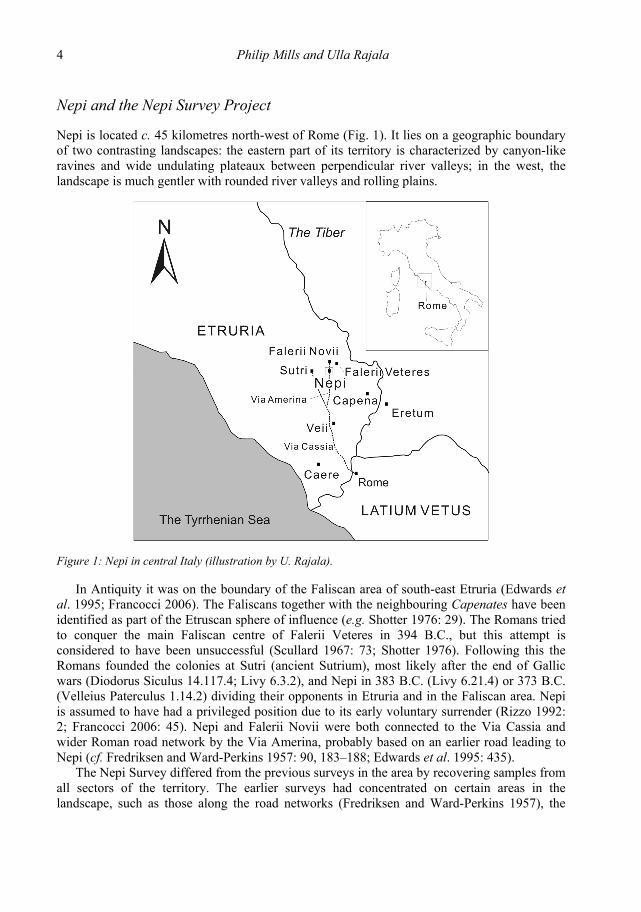
Nepi is located c. 45 kilometres north-west of Rome (Fig. 1). It lies on a geographic boundary of two contrasting landscapes: the eastern part of its territory is characterized by canyon-like ravines and wide undulating plateaux between perpendicular river valleys; in the west, the landscape is much gentler with rounded river valleys and rolling plains.
Figure 1: Nepi in central Italy (illustration by U. Rajala).
In Antiquity it was on the boundary of the Faliscan area of south-east Etruria (Edwards et al. 1995; Francocci 2006). The Faliscans together with the neighbouring Capenates have been identified as part of the Etruscan sphere of influence (e.g. Shotter 1976: 29). The Romans tried to conquer the main Faliscan centre of Falerii Veteres in 394 B.C., but this attempt is considered to have been unsuccessful (Scullard 1967: 73; Shotter 1976). Following this the Romans founded the colonies at Sutri (ancient Sutrium), most likely after the end of Gallic wars (Diodorus Siculus 14.117.4; Livy 6.3.2), and Nepi in 383 B.C. (Livy 6.21.4) or 373 B.C. (Velleius Paterculus 1.14.2) dividing their opponents in Etruria and in the Faliscan area. Nepi is assumed to have had a privileged position due to its early voluntary surrender (Rizzo 1992: 2; Francocci 2006: 45). Nepi and Falerii Novii were both connected to the Via Cassia and wider Roman road network by the Via Amerina, probably based on an earlier road leading to Nepi (cf. Fredriksen and Ward-Perkins 1957: 90, 183–188; Edwards et al. 1995: 435).
The Nepi Survey differed from the previous surveys in the area by recovering samples from all sectors of the territory. The earlier surveys had concentrated on certain areas in the landscape, such as those along the road networks (Fredriksen and Ward-Perkins 1957), the

Interpreting a Ceramiscene Landscape 5
Treia watershed east of Nepi (Potter n.d.), the area of an Istituto Geografico Militare (I.G.M.) map sheet (Morselli 1980) or selected smaller areas of pre-Roman importance (e.g. Selmi 1978; di Gennaro and Stoddart 1982; Camilli et al. 1995; Cifani and Munzi 1995).
The study area was defined by the hypothetical territory of a Thiessen polygon centred on Nepi. This territory was sampled by drawing transects along the cardinal directions radiating from the town along the grid of the Nepi sheet of the I.G.M. map. This sampling method has been shown to allow the prediction of trends in local settlement patterns (Barker 1988; Barker and Rasmussen 1988; Vullo and Barker 1997). Because four cardinal directions in the Nepi area correlate to a large extent with the past and present road network, transects were also drawn along the intercardinal directions to avoid excessive bias resulting from the Roman modifications of the landscape. The result was a series of transects one kilometre wide and up to five kilometres from the town.
In 1999, the areas in the close proximity to Nepi were walked, comprising 92 field units, mainly fields, parts of fields or pastures. In September 2000, the main focus was on selected areas on the boundary of the study area. In total, 141 units were sampled. Available land was studied by field walking at intervals of 10–20 metres. A subjective grab sample was collected from observed concentrations on these fields, assumed to be sites. At the previously known sites the collection was based on a modified traverse and stint method (Liddle 1985: 9).
Methodology for defining Lynch’s concepts
The transferral of Lynch’s model to the Roman rural landscape requires the definition of the five elements in a particular case study area. The characteristics of physical landscape lend geographic definitions for Lynch’s paths, edges and landmarks. In addition, the very nature of the Roman roads allows classifying them hierarchically. Human settlements at different levels of settlement hierarchy and other sites of human activity are natural foci, nodes in Lynch’s terminology. Districts can be separated by unifying/separating geographic entities or by the distribution of material culture that was passed through different nodes.
The sites recognised in a survey are the nodes of the Roman rural landscape. In Mediterranean surveys a site is often defined as a concentration of finds that has a higher density than the relative minimum required. It is acknowledged that interpreting sites on the basis of survey results is not simple due to the existence of ‘haloes’, post-depositional spreading, and ‘non-sites’, archaeological background noise (Coccia and Mattingly 1992). In addition, continuous deep ploughing since the 1950s has spread the finds and made scatters larger, of lower density and poorer quality (cf. Whitman 1981: 278).
The basic site typology applied for the Roman survey material is that of the South Etruria Survey. The finds from huts, the poorest sites, consisted only of pottery sherds and tiles. Villas were differentiated from farms by more elaborate structures and a higher quality of finds including patterned wall plaster, mosaic tesserae, marble veneer and large amounts of fine glass or window glass (Kahane et al. 1968: 154). In addition, large villas were separated from the standard ones by their size (cf. Potter 1992). This classification was used for Romans sites in the Nepi Survey with the renaming of huts as ‘minor sites’. Tombs and burials were defined as such either by their rock-cut structures or by clearly defined small scatters of roof tile and/or pottery in the areas associated with known cemeteries.
In the large scale British surveys attempts were made to ‘neutralise’ the classifications by using area and density as the basis of classifications and defining ‘small’, ‘medium’ and ‘large’

6 Philip Mills and Ulla Rajala
scatters with ‘light’, ‘medium’ or ‘heavy’ densities (e.g. Barker 1995b). Alternatively, the Americans introduced the idea of siteless survey (Thomas 1975) in which changing find densities are mapped across a grid as a way to expose human activity. These ideas resulted in gridded surveys and presentations of continuous distributions of artefacts in the Mediterranean surveys (e.g. Bintliff and Snodgrass 1985; 1988; Gillings and Sbonias 1999). The pre-Roman emphasis of the Nepi Survey Project and the presentation of activity zones in the survey area geared the recording and collection systems towards neutral classifications and the resulting pre-Roman analysis partly towards a siteless study of overall distributions (Rajala 2002; Rajala in press).
The current study requires the evaluation of the nodes. Whilst the bulk of the material is from fields, and not assigned to sites, this article discusses the material from the identified sites in order to test the variability of the Roman sites/nodes by type. The application of Lynch's other elements provides a useful means of articulating other spatial relationships which can be explored by extrapolating those determined for the nodes. Thus, paths and boundaries may be determined by the relative flow of goods from specific sources, i.e. specific fabrics may appear in collection units in greater (for paths) or smaller (for boundaries) proportions than would be expected. Districts can be defined by extant topographical features such as ravines as well as reconstructed features such as the routes of Roman roads. It seems reasonable to expect the ceramic evidence to reflect activities of any nodes within districts, albeit somewhat disturbed by modern land usage and partitioning, which can be to some extent allowed for by the underlying structures in the pottery recovered.
The range of activities reflected by a ceramic assemblage encompasses quite a wide area of human endeavour – and stratified material has proven a very successful tool for understanding status and function for different types of sites. In this article these tools are applied to reading the landscape and presenting the ceramiscene through Lynch’s elements. The methods of ceramic analysis applied here are developed from the work of Evans (2001) relating to functional analysis. He has assigned pottery vessels into defined functional categories (e.g. amphorae, flagons, jars, storage jars, mortaria, bowls, dishes, lids). The examination of the ratios (by minimum number of rims and rim equivalents) of the different functional groups by site type has produced a very powerful tool to determine site type and status. His work has been applied to stratified samples from Britain, but the potential for application to non-British sites and survey material is apparent. One problem in not using non-stratified material is that any control for changes over time is lost. Similarly, comparative data sets from excavated sites in Italy need to be compiled in order to properly test the site types suggested here. It is also important to use groups with somewhat more than the 15 rims suggested by Evans as the bare minimum by which this method can be applied. Where there are not enough rims a further tool for determining status is the comparison (by number of sherds and weight) of the ratios of the pottery assemblage broken down into ware types, following the definitions of Booth (2000) that were also utilised by Evans (2001). Combining this functional analysis with ware distributions and site classifications provides a foundation for characterizing the distribution of goods and defining the districts on the basis of shared qualities or distribution networks.
Lynch’s elements and the temporality of the nodes
The dissected landscape around Nepi gives natural possibilities and restrictions to movement, i.e. it creates paths and edges (Fig. 2). The Roman roads, mainly the Via Amerina and local
Interpreting a Ceramiscene Landscape 7
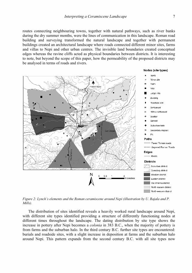
routes connecting neighbouring towns, together with natural pathways, such as river banks during the dry summer months, were the lines of communication in this landscape. Roman road building and surveying transformed the natural landscape and together with permanent buildings created an architectural landscape where roads connected different minor sites, farms and villas to Nepi and other urban centres. The invisible land boundaries created conceptual edges whereas the ravine cliffs acted as physical boundaries between districts. It is interesting to note, but beyond the scope of this paper, how the permeability of the proposed districts may be analysed in terms of roads and rivers.
Figure 2: Lynch’s elements and the Roman ceramiscene around Nepi (illustration by U. Rajala and P. Mills).
The distribution of sites identified reveals a heavily worked rural landscape around Nepi, with different site types identified providing a structure of differently functioning nodes at different times throughout the landscape. The dating distribution by site type shows the increase in pottery after Nepi becomes a colonia in 383 B.C., when the majority of pottery is from farms and the suburban halo. In the third century B.C. further site types are encountered: burials and roadside sites, with a slight increase in deposition at farms and the suburban halo around Nepi. This pattern expands from the second century B.C. with all site types now

8 Philip Mills and Ulla Rajala
showing evidence of occupation. This settlement expansion is observed throughout South Etruria (Di Giuseppe 2008: Fig. 1). Most site types are at their peak in the first century A.D., except burials. There is a slight decline in the second century, mainly at the expense of farms with a continued decline in deposition on cemetery sites. All sites are drastically curtailed in the third century, when the sharp decline is observed throughout the region (Potter 1979; Carandini and Cambi 2002: 218; Patterson 2006: 74–77; Witcher 2008), with burials, roadsides and minor settlement sites finally disappearing by the fourth century A.D.
This third-century decline sees the urban halo wane in real terms although its importance proportionally intensifies; it stands for approximately half of the total pottery deposition. This suggests a population movement towards the urban centre at this stage. There is a small increase in the later fourth century, seen at ‘building’ type sites. This peak is short-lived, with a drop in the fifth century and a final peak in the mid sixth century, mainly in the urban halo, which is the only presence from the seventh century onwards in this surface collection. These late Roman peaks conform to a large extent to the known periods of late antique rural settlement both locally (Potter and King 1997: 46) and elsewhere in Tyrrhenian Italy (Francovich and Hodges 2003: 31–53) where the devastation of the Gothic war in the sixth century and the militarization of the landscape by the seventh century A.D. confined population into defendable centres.
Districts and paths of consumption
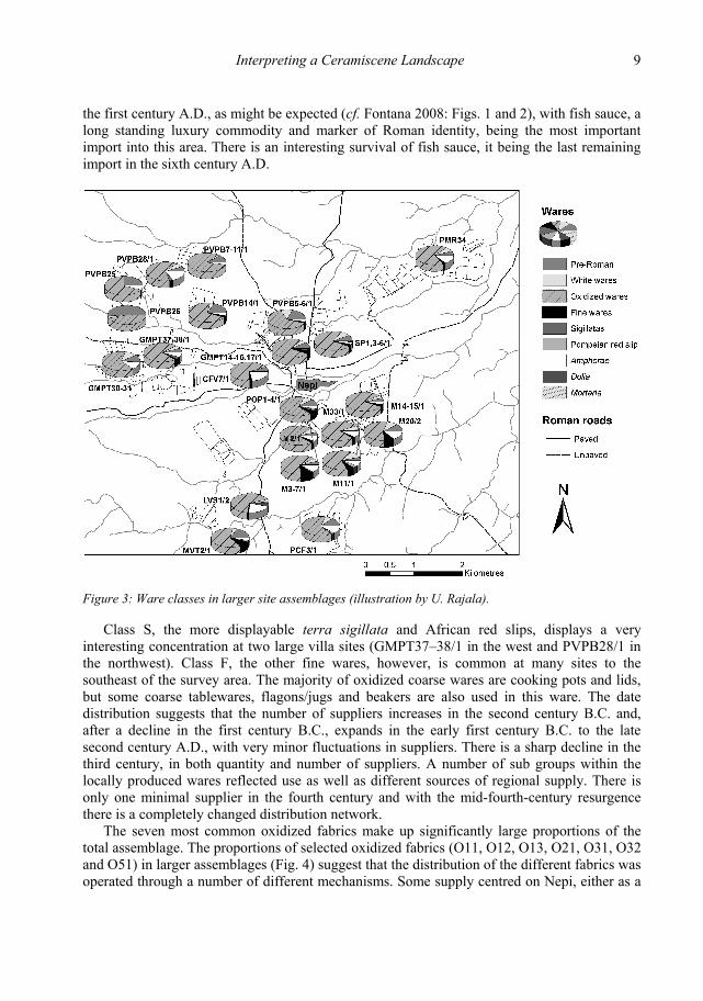
The wares (defined following Booth 2000) and functions encountered in the survey material help to classify the types of nodes and pinpoint the routes of supply. Although we first look at the assemblage as the whole, the distribution of ware classes (Fig. 3) seems likely to follow the structure seen at any sites within the districts.
The dominant ware class in this assemblage is the oxidized coarse wares (Class O00 at 73%), which is no surprise as cooking pots and ‘utilitarian’ wares are mainly in this ware class. The value for amphorae (Class A) at 5.59% is the same as for the Tiber Valley Project (5.6%, Di Giuseppe et al. 2008: Fig. 2). The proportion of mortaria (Class M) is low at 0.35%, but this is common in central Italy (cf. Celuzza 1985: 220). The levels of fine wares (Class F) and terra sigillata and African red slips (Class S), combined at 3%, are what would be expected at a base level rural site in the UK (Evans 2001) – not necessarily in central Italy. The fine wares represent 39.7% of the material of the Tiber Valley Project (Di Giuseppe et al. 2008: Fig. 2). This is a significant variation, which can be mostly accounted for by the proximity of fine ware production sites within the survey areas around Veii (cf. Di Giuseppe 2008: Fig. 10; Bousquet et al. 2008: Fig. 7). The lack of fine wares may suggest the lack of demand at the highest status sites and the emphasis on agricultural production around Nepi.
Amphorae have an interesting concentration around Nepi and to the south with points of strong presence in the northwest, in the west and to the northeast. This pattern is consistent with the marketing of amphorae through the central point of Nepi to the larger rural sites, which could then act as a secondary source for amphorae (presumably a secondary trade in amphorae themselves, rather than their contents). It is not surprising that the most variety of supply is exhibited at large villas and suburban halos, reflecting the status of these sites. The most important supply is from North Africa, with Spanish amphora the second most important source. The lack of a first century B.C. peak would suggest that Nepi at this period was perhaps not fully integrated into the emerging Roman supply network. The imports increase hugely in
Interpreting a Ceramiscene Landscape 9
the first century A.D., as might be expected (cf. Fontana 2008: Figs. 1 and 2), with fish sauce, a long standing luxury commodity and marker of Roman identity, being the most important import into this area. There is an interesting survival of fish sauce, it being the last remaining import in the sixth century A.D.
Figure 3: Ware classes in larger site assemblages (illustration by U. Rajala).
Class S, the more displayable terra sigillata and African red slips, displays a very interesting concentration at two large villa sites (GMPT37–38/1 in the west and PVPB28/1 in the northwest). Class F, the other fine wares, however, is common at many sites to the southeast of the survey area. The majority of oxidized coarse wares are cooking pots and lids, but some coarse tablewares, flagons/jugs and beakers are also used in this ware. The date distribution suggests that the number of suppliers increases in the second century B.C. and, after a decline in the first century B.C., expands in the early first century B.C. to the late second century A.D., with very minor fluctuations in suppliers. There is a sharp decline in the third century, in both quantity and number of suppliers. A number of sub groups within the locally produced wares reflected use as well as different sources of regional supply. There is only one minimal supplier in the fourth century and with the mid-fourth-century resurgence there is a completely changed distribution network.
The seven most common oxidized fabrics make up significantly large proportions of the total assemblage. The proportions of selected oxidized fabrics (O11, O12, O13, O21, O31, O32 and O51) in larger assemblages (Fig. 4) suggest that the distribution of the different fabrics was operated through a number of different mechanisms. Some supply centred on Nepi, either as a

10 Philip Mills and Ulla Rajala
manufacturing centre or – more likely – as a marketing node. Some seem to avoid the core around Nepi, perhaps as they are marketed through other centres or competing with products marketed at Nepi. At least one distribution pattern is the result of the period in which it was made and consumed.
Figure 4: The proportions of selected oxidized fabrics from larger site assemblages (illustration by U. Rajala).
Of the selected oxidized fabrics, fine sandy fabric O11 can be found in reasonable quantities in sites around Nepi. A possibility is that the production source was to the east, with Nepi acting as a centre of re-marketing to the surrounding sites. A larger quantity of material seems to be directed to higher status sites. Coarse sandy fabric O12 is present at small levels on most sites. The marketing of quartz and volcanic tempered fabric O13 seems to be quite low at Nepi, comparable to the more rural sites. Lime tempered fabric O21 is only present in sizable quantities at the road side site M14–15/1. This and the strongest presence of the O11 at this site suggest that it was connected to a different supply network than sites along the Via Amerina and those to the northwest. This may result from it being located southwest from the known coarseware kiln site of San Biagio (Potter, n.d.: F26; Bousquet et al. 2008: 642–643). Volcanically tempered fabric O31 is mainly found on M14–15/1 as well as the urban halo sites of SP1,3–6/1 and POP1–4/1. Organically tempered fabric O51 is a later fabric and its distribution is restricted to those sites still occupied in the later periods, although it is interestingly absent from the outskirts of Nepi.
Interpreting a Ceramiscene Landscape 11
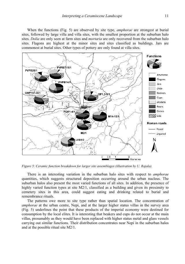
When the functions (Fig. 5) are observed by site type, amphorae are strongest at burial sites, followed by large villa and villa sites, with the smallest proportion at the suburban halo sites. Dolia are only seen at farm sites and mortaria are only recovered from the suburban halo sites. Flagons are highest at the minor sites and sites classified as buildings. Jars are commonest at burial sites. Other types of pottery are only found at villa sites.
Figure 5: Ceramic function breakdown for larger site assemblages (illustration by U. Rajala).
There is an interesting variation in the suburban halo sites with respect to amphorae quantities, which suggests structured deposition occurring around the urban nucleus. The suburban halos also present the most varied functions of all sites. In addition, the presence of highly varied function types at site M2/1, classified as a building and given its proximity to cemetery sites in this area, could suggest eating and drinking related to burial and remembrance rituals.
The patterns owe more to site type rather than spatial location. The concentration of amphorae at the urban centre, Nepi, and at the larger higher status villas in the survey area (Fig. 5) underlines the point that these products of the imperial economy were destined for consumption by the local elites. It is interesting that beakers and cups do not occur at the main villas, presumably as they would have been replaced with higher status metal and glass vessels carrying out similar functions. Their distribution concentrates near Nepi in the suburban halos and at the possible ritual site M2/1.

12 Philip Mills and Ulla Rajala
The roads radiating out of Nepi created the backbone of the Roman ‘path’ network with the Via Amerina the first among them. Along these routes it is easy to define the urban, periurban and rural districts (Fig. 2) around Nepi. The cliffs of the promontory of Nepi define the core urban area and the suburban halos in the north (SP1,3–6/1) and in the southwest (POP1–4/1) represent the periurban districts along and between the major roads. The possible ritual site M2/1 across the ravine from Nepi with its suburban halo and the funerary sites towards the northeast represent a clearly definable funerary district. The roadside site M14–15/1 with its well-defined supplies represents the rural settlement district in the east delimitated by the ravines. The district in the south is defined by the incoming Via Amerina whereas the rural areas in the west and northwest with their large villas were in a more rolling setting. Interestingly, the areas in the west had also a higher proportion of pre-Roman material. The areas in the northeast were distinctive due to the thinness of surface material.
Conclusions
This paper shows the applicability of Lynch’s (1960) model for the legibility city to the Roman rural landscape and its usefulness in conceptualizing a ceramiscene landscape. Detailed pottery analysis and landscape archaeology are a well-established pairing in survey archaeology, and the inclusion of Lynch’s elements helps to transform classification into a theorized landscape characterization. The Roman material collected during the Nepi Survey allowed a localised analysis of the manufacture, use and discard of ceramic materials in a territory where Lynch’s key elements – nodes, paths, edges and districts – are easily geographically defined. It is hoped that this approach has acted as a possible step in the development of the theoretical framework called for by Witcher (2006).
Nepi itself, on its cliff-defined promontory, can be seen as a local landmark upon which the surrounding suburban areas were looking. The Roman main and secondary roads created a network of pathways through the landscape connecting different sites to Nepi and neighbouring towns; the existence of further local roads could be hypothesized on the basis of site locations on the plateaux. Buildings, minor sites, farms, villas, large villas, burials, tombs, cemeteries, road side settlements and other site types were the nodes in this landscape outside the central urban node of Nepi. The ravines in the east and the streams to a lesser extent in the west created edges between different districts. The main districts were urban centre and its suburban halo but the pottery distributions in the northwest, east and along the Via Amerina enhanced separate rural districts.
The ceramiscene landscape discussed here is first and foremost an economic landscape that reflects agricultural and commercial activities. Nepi and its environs developed into a villa economy, and benefited from the wider trading networks of the empire. This ceramiscene shows the demand and consumption at different sites, defining and being defined by their status and function in local networks. It also shows their ability to acquire, distribute and redistribute the supplies from different kiln sites in the region and consume widely circulated trade commodities during the times of expansion, intensification, regression, centralisation and eventual deconstruction of the Roman rural landscape.
School of Archaeology and Ancient History, University of Leicester McDonald Institute for Archaeological Research, University of Cambridge
Interpreting a Ceramiscene Landscape 13
Acknowledgements
This research was carried out under concession from and in close collaboration with the Soprintendenza archeologica per l’Etruria meridionale under the supervision of Dott.ssa Daniela Rizzo. The survey was supported and assisted by the British School at Rome and its staff together with the mayor and personnel of the Comune di Nepi. The authors are grateful to Simon Stoddart, the director of the original Nepi Survey, for his support and want to thank the British Academy and McDonald Institute for Archaeological Research, Cambridge, for granting funding for the original fieldwork. Dr Rajala ran the survey as part of her PhD research with financial support from multiple sources including the British Academy, the Academy of Finland (grant no. 44638), New Hall College, Cambridge European Trust and the Finnish Cultural Foundation. ‘The Romanisation of a Faliscan Town’ project was kindly financed by the British Academy and received assistance from the British School at Rome, the Museo Civico di Nepi and its director Stefano Francocci, as well as Museo Archeologico dell’Agro Falisco (Civita Castellana) and its staff. Last but not least, this article could not have been written without the work of the survey teams of 1999 and 2000.
Bibliography
Ancient Sources Diodorus Siculus (Translated by C. H. Oldfather 1963). Bibliotheca Historica. London: W. Heinemann. Livy (Translated by B. O. Foster 1967). Ab urbe condita. London: William Heinemann. Velleius Paterculus (Edited by W. S. Watt 1988). Historiarum ad M. Vinicium consulem libri duo.
Leipzig: Teubner.
Modern Sources Ackerman, J. S. 1990. The Villa: The Form and Ideology of Country Houses. London: Thames and
Hudson. Ashby, T. 1927. The Roman Campagna in Classical Times. London: E. Benn. Ashmore, W. and Knapp, A. B. 1999. Archaeological landscapes: constructed, conceptualised, ideational.
In W. Ashmore and A. B. Knapp (eds.) Archaeologies of Landscape. Contemporary Perspectives. Oxford: Blackwell: 1–30.
Barker, G. 1988. Archaeology and the Etruscan Countryside. Antiquity 62: 772–785. Barker, G. 1995a. Landscape archaeology in Italy – Goals for the 1990s. In N. Christie (ed.) Settlement
and Economy in Italy 1500 BC to AD 1500. Papers of the Fifth Conference of Italian Archaeology. Oxbow Monograph 41. Oxford: Oxbow: 1–12.
Barker, G. 1995b. A Mediterranean Valley. Landscape Archaeology and Annales History in the Biferno Valley. London: Leicester University Press.
Barker, G., and Rasmussen, T. 1988. The archaeology of an Etruscan polis: a preliminary report on the Tuscania project. Papers of the British School at Rome 56: 25–42.
Bintliff, J. and Snodgrass, A. M. 1985. The Cambridge/Bradford Boeotian Expedition: The first four years. Journal of Field Archaeology 12: 123–161.
Bintliff, J. and Snodgrass, A. M. 1988. Mediterranean City and the Survey. Antiquity 62: 57–71. Booth, P. 2000. The Oxford Archaeology Pottery Recording System. Oxford Archaeology, unpublished
manual. Bousquet, A., Felici, F. and Zampini, S. 2008. Produzione e circolazione del materiale ceramico nella
media valle del Tevere in epoca imperiale e tardoantica. In F. Coarelli and H. Patterson (eds.) Mercator Placidissimus – The Tiber Valley in Antiquity: New Research in the Upper and Middle River Valley. Rome, 27–28 February 2004. Quaderni di Eutopia 8. Rome: Quasar: 621–654.
14 Philip Mills and Ulla Rajala
Cambi, F. and Terrenato, N. 1994. Introduzione all’archeologia dei paesaggi. Rome: La Nuova Italia Scientifica.
Camilli, A., Carta, L., Conti, T. and De Laurenzi, A. 1995. Ricognizioni nell’Ager Faliscus meridionale. In N. Christie (ed.) Settlement and Economy in Italy 1500 BC to AD 1500. Papers of the Fifth Conference of Italian Archaeology. Oxbow Monograph 41. Oxford: Oxbow: 395–402.
Carandini, A. and Cambi, F. 2002 (eds.) Paesaggi d’Etruria. Valle dell’Albegna, Valle d’Oro, Valle del Chiarore, Valle del Tafone. Rome: Storia e Letteratura.
Carlucci, C. and De Lucia, M.A. 1998. Le antichità dei Falisci al Museo di Villa Giulia. Rome: ‘L’Erma’ di Bretschneider and Ingegneria per la cultura.
Celuzza, M. G. 1985. Opus doliare. In A. Ricci (ed.) Settefinestre. Una Villa schiavistica nell’Etruria romana II. Villa e suoi Reperti. Modena: Panini: 220–221.
Christaller, W. 1933. Die zentralen Orten in Süddeutschland. Jena: Karl Zeiss. Cifani, G. and Munzi, M. 1995. Considerazioni sugli Insediamenti in Area falisca. I Periodi arcaico e
tardoantico. In N. Christie (ed.) Settlement and Economy in Italy 1500 BC to AD 1500. Papers of the Fifth Conference of Italian Archaeology. Oxbow Monograph 41. Oxford: Oxbow: 387–394.
Coarelli, F. and Patterson, H. 2008 (eds.) Mercator Placidissimus – The Tiber Valley in Antiquity: New Research in the Upper and Middle River Valley. Rome, 27–28 February 2004. Quaderni di Eutopia 8. Rome: Quasar.
Coccia, S. and Mattingly, D. 1992 (eds.) Settlement history, environment and human exploitation of an intermontane basin in the central Apennines: the Rieti survey, 1988–1991, part 1. Papers of the British School at Rome 60: 213–290.
Cozza, A. and Pasqui, A. 1981. Carta archeologica d’Italia (1881–1897). Materiali per l’agro falisco. Forma Italiae II:2. Florence: Leo S. Olschki.
di Gennaro, F., Cerasuolo, O., Colonna, C., Rajala, U., Stoddart, S. and Whitehead, N. 2002. The city and territory of Nepi. Papers of the British School at Rome 70: 29–77.
di Gennaro, F., Rajala, U., Rizzo, D., Stoddart, S. and Whitehead, N. 2008. Nepi and territory: 1200 BC–400 AD. In F. Coarelli and H. Patterson (eds.) Mercator Placidissimus – The Tiber Valley in Antiquity: New Research in the Upper and Middle Valley, Rome, 27–28 February 2004. Quaderni di Eutopia 8. Rome: Quasar: 879–888.
di Gennaro, F. and Stoddart, S. 1982. A review of the evidence for prehistoric activity in part of South Etruria. Papers of the British School at Rome 50: 1–21.
Di Giuseppe, H. 2008. Assetti territoriali nella media Valle del Tevere dall’epoca orientalizzante a quella repubblicana. In F. Coarelli and H. Patterson (eds.) Mercator Placidissimus – The Tiber Valley in Antiquity: New Research in the Upper and Middle River Valley. Rome, 27–28 February 2004. Quaderni di Eutopia 8. Rome: Quasar: 431–465.
Di Giuseppe, H., Bousquet, A and Zampini, S. 2008. Produzione, circolazione e uso della ceramica lungo il Tevere in epoca repubblicana. In F. Coarelli and H. Patterson (eds.) Mercator Placidissimus – The Tiber Valley in Antiquity: New Research in the Upper and Middle River Valley. Rome, 27–28 February 2004. Quaderni di Eutopia 8. Rome: Quasar, 587–620.
Dilke, O. A. W. 1971. The Roman Land Surveyors : an Introduction to the Agrimensores. Newton Abbot: David and Charles.
Doody, A. 2007. Virgil the farmer? Critiques of the Georgics in Columella and Pliny. Classical Philology 102: 180–197.
Edwards, C., Malone, C. and Stoddart, S. 1995. Reconstructing a gateway city: the place of Nepi in the study of south-eastern Etruria. In N. Christie (ed.) Settlement and Economy in Italy 1500 BC to AD 1500. Papers of the Fifth Conference of Italian Archaeology. Oxbow Monograph 41. Oxford: Oxbow: 431–440.
Evans, J. 2001. Material approaches to the identification of different Romano-British site types. In S. James and M. Millett (eds.) Britons and Romans: advancing an archaeological agenda. CBA Research Reports 125. York: Council for British Archaeology : 26–35.

Interpreting a Ceramiscene Landscape 15
Fentress, E. 2000. What are we counting for? In R. Francovich and H. Patterson (eds.) Extracting Meaning from Ploughsoil Assemblages. The Archaeology of Mediterranean Landscapes 5. Oxford: Oxbow: 44–52.
Fontana, S. 2008. South Etruria Survey revisited: le anfore, un tentative analisi quantitative. In F. Coarelli and H. Patterson (eds.) Mercator Placidissimus – The Tiber Valley in Antiquity: New Research in the Upper and Middle River Valley. Rome, 27–28 February 2004. Quaderni di Eutopia 8. Rome: Quasar: 655–670.
Francocci, S. 2006. L’antica Nepi in età romana. In S. Francocci (ed.) Archeologia e Storia a Nepi I. Quaderni del Museo Civico di Nepi 1. Nepi: Ente Nepi: 45–65.
Francovich, R., and Hodges, R. 2003. Villa to Village: the Transformation of the Roman Countryside in Italy, c. 400–1000. London: Duckworth.
Frederiksen, M. W. and Ward Perkins, J. B. 1957. The ancient road systems of the central and northern Ager Faliscus (Notes on southern Etruria, 2). Papers of the British School at Rome 25: 67–203.
Garnsey, P. 1998. Cities, Peasants and Food in Classical Antiquity: Essays in Social and Economic History. Ed. by W. Scheidel. Cambridge: Cambridge University Press.
Gillings, M. and Sbonias, K. 1999. Regional survey and GIS: the Boeotia Project. In M. Gillings, D. Mattingly and J. van Dalen (eds.) Geographical Information Systems and Landscape Archaeology. The Archaeology of Mediterranean Landscapes 3. Oxford: Oxbow: 35–54.
Goodman, P. J. 2006. The Roman City and its Periphery. From Rome to Gaul. London/ New York: Routledge.
Harris, W. V. 1971. Rome in Etruria and Umbria. Oxford: Clarendon Press. Hillier, B. and Hanson, J. 1984. The Social Logic of Space. Cambridge: Cambridge University Press. Ingold, T. 1993. The temporality of the landscape. World Archaeology 25: 152–174. Kahane, A., Murray Threipland, L. and Ward-Perkins, J. B. 1968. The Ager Veientanus, North and East
of Veii. Papers of the British School at Rome 36: 1–218. Keay S., Millett M., Poppy S., Taylor J. and Terrenato N. 2004. New approaches to urbanism in the Tiber
Valley. In H. Patterson (ed.) Bridging the Tiber. Approaches to Regional Archaeology in the Middle Tiber Valley. Archaeological Monograph of the British School at Rome 13. London: The British School at Rome: 223–236.
Lepot, A. 2010. GIS and artefact distribution: A case study on regional cooking wares in northern Gaul. In A. Moore, G. Taylor, E. Harris, P. Girdwood and L. Shipley (eds.) TRAC 2009: Proceedings of the Nineteenth Annual Theoretical Roman Archaeology Conference, Michigan and Southampton 2009. Oxford: Oxbow: 41–52.
Liddle, P. 1985. Community Archaeology. A Fieldworker’s Handbook of Organisation and Techniques. Leicester: Leicestershire Museums, Art Galleries and Records Service.
Lock, G., Bell, T. and Lloyd, J. 1999. Towards a methodology for modelling surface survey data: the Sangro Valley Project. In M. Gillings, D. Mattingly and J. van Dalen (eds.) Geographical Information Systems and Landscape Archaeology. The Archaeology of Mediterranean Landscapes 3. Oxford: Oxbow: 55–65.
Lynch, K. 1960. The Image of the City. Cambridge (Mass.): The MIT Press. McInerney, J. 2006. On the border: sacred land and the margins of the community. In R. M. Rosen and I.
Sluiter (eds.) City, Countryside, and the Spatial Organization of Value in Classical Antiquity. Mnemosyne, Supplements 279. Leiden: Brill: 33–59.
Mattingly, D. J. 2000. Methods of collection, recording and quantification. In R. Francovich and H. Patterson (eds.) Extracting Meaning from Ploughsoil Assemblages. The Archaeology of Mediterranean Landscapes 5. Oxford: Oxbow: 5–15.
Millett, M. 1991. Roman towns and their territories: an archaeological perspective. In J. Rich and A. Wallace-Hadrill (eds.) City and Country in the Ancient World. London: Routledge: 173–193.
Millett, M. 2000a. The comparison of surface and stratified artifact samples. In M. Pasquinucci and F. Trément (eds.) Non-destructive Techniques Applied to Landscape Archaeology. The Archaeology of Mediterranean Landscapes 4. Oxford: Oxbow: 216–222.

16 Philip Mills and Ulla Rajala
Millett, M. 2000b. Dating, quantifying and utilizing pottery assemblages from surface surveys. In R. Francovich and H. Patterson (eds.) Extracting Meaning from Ploughsoil Assemblages. The Archaeology of Mediterranean Landscapes 5. Oxford: Oxbow: 53–59.
Mills, P. J. E. 2006. The Ancient Mediterranean Trade in Ceramic Building Material: A Case Study in Carthage and Beirut. PhD thesis. University of Leicester.
Morselli, C. 1980. Sutrium. Forma Italiae VII:7. Florence: Leo S. Olschki. Patterson, H. 2004. Introduction. In H. Patterson (ed.) Bridging the Tiber. Approaches to Regional
Archaeology in the Middle Tiber Valley. Archaeological Monographs of the British School at Rome 13. London: The British School at Rome: 11–28.
Patterson, H., di Gennaro, F., di Giuseppe, H., Fontana, S., Gaffney, V., Harrison, A., Keay, S. J., Millett, M., Rendeli, M., Roberts, P., Stoddart, S. and Witcher, R. 2000. The Tiber Valley Project: the Tiber and Rome through millennia. Antiquity 74: 395–403.
Patterson, H. and Millett, M. 1998. The Tiber Valley Project. Papers of the British School at Rome 66: 1–20.
Patterson, J. R. 2006. Landscapes and Cities: Rural Settlement and Civic Transformation in Early Imperial Italy. Oxford: Oxford University Press.
Patterson, J. R. 2008. Modelling the urban history of the Tiber Valley in the Imperial period. In F. Coarelli and H. Patterson (eds.) Mercator Placidissimus – The Tiber Valley in Antiquity: New Research in the Upper and Middle River Valley. Rome, 27–28 February 2004. Quaderni di Eutopia 8. Rome: Quasar: 487–498.
Potter, T. W. n.d. An Archaeological Field Survey of the Central and Southern Ager Faliscus. Unpublished manuscript.
Potter, T. W. 1979. The Changing Landscape of South Etruria. London: Elek. Potter, T. W. 1992. Reflections of twenty-five years’ fieldwork in the Ager Faliscus. Approaches to
landscape archaeology. In M. Bernardi (ed.) Archeologia del paesaggio II. Florence: All’Insegna del Giglio: 637–666.
Potter, T. W., and King, A. C. 1997. Excavation at The Mola di Monte Gelato: a Roman and Medieval Settlement in South Etruria. Archaeological Monograph of the British School at Rome 11. London: The British School at Rome.
Quilici, L. and Quilici Gigli, S. 2004. Introduzione alla topografia antica. Bologna: Il Mulino. Rajala, U. 2002. Human Landscapes in Tyrrhenian Italy. GIS in the Study of Urbanisation, Settlement
Patterns and Land Use in South Etruria and Western Latium Vetus. PhD thesis. University of Cambridge.
Rajala, U. 2006. Le ricerche della Scuola Britannica a Nepi: Indagini e prospettive. In S. Francocci (ed.) Archeologia e Storia a Nepi I. Quaderni del Museo Civico di Nepi 1. Nepi: Ente Nepi: 86–94.
Rajala, U. in press. Political landscapes and local identities in Archaic Central Italy – interpreting the material from Nepi (VT, Lazio) and Cisterna Grande (Crustumerium, RM, Lazio). In S. Stoddart and G. Cifani (eds.) Landscape, Ethnicity and Identity in the Archaic Mediterranean Area. Oxford: Oxbow.
Rizzo, D. 1992. Le necropoli di Nepi. Immagini di 10 anni di ricerche archeologiche. Nepi: Comune di Nepi.
Rizzo, D. 1996. Recenti scoperte nell’area di Nepi. In G. Maetzke and L. Tamagno Perna (eds.) Identità e Civiltà dei Sabini. Atti del XVIII Convegno di Studi Etruschi ed Italici, Rieti-Magliano Sabina, 30 Maggio -3 Giugno 1993. Florence: Leo S. Olschki: 477–494.
Selmi, R. 1978. Presenze preistoriche nel Bacino idrografico del Treia. In Atti del secondo Convegno dei Gruppi Archeologici di Lazio. Rome: Gruppo Archeologico Romano: 55–59.
Shotter, D. C. A. (1976) Rome, the Faliscans and the Roman historians. In T.W. Potter (ed.) A Faliscan Town in South Etruria. Excavations in Narce 1966–71. London: The British School at Rome: 29–35.
Sterry, M. 2008. Searching for identity in Italian landscapes. In C. Fenwick, M. Wiggins and D. Wythe (eds.) TRAC 2007: Proceedings of the Seventeenth Annual Theoretical Roman Archaeology Conference, London 2007. Oxford: Oxbow: 31–43.
Interpreting a Ceramiscene Landscape 17
Suaria, L. 2005. Nepi. Tesori, Storia e Leggende d’Italia. Viaggio alla ricerca dei luoghi testimoni di storia, leggende e aneddoti in Italia 10. Viterbo: Historia.
Thomas, D. H. 1975. Nonsite sampling in archaeology: up the creek without a site? In J.W. Mueller (ed.) Sampling in Archaeology. Tucson: University of Arizona Press: 61–81.
Tilley, C. 1994. A Phenomenology of Landscape. Places, Paths and Monuments. Oxford: Berg. Van Hove, D., 2004. Time and experience: taskscapes with GIS, Internet Archaeology 16,
http://intarch.ac.uk/journal/issue16/vanhove_index.html (Accessed in July 2010). Vullo, N. and Barker, G. 1997. Regional sampling and GIS: The Tuscania Survey Project. In I. Johnson
and M. North (eds.) Archaeological Applications of GIS. Proceedings of Colloquium II. UISPP XIIIth Congress. Forlì, September 1996. Sydney University Archaeological Methods Series 5 (CD-ROM).
Wallace-Hadrill, A. 1994. Houses and Society in Pompeii and Herculaneum. Princeton: Princeton University Press.
Wallace-Hadrill, A. 1998. The villa as cultural symbol. In A. Frazer (ed.). The Roman Villa: Villa Urbana. Philadelphia: University of Pennsylvania: 43–54.
Wallerstein, I., 1974. The Modern World System. New York: Academic Press. Whitman, E. M. 1981. The lower Liri valley: problems, tends and peculiarities. In G. Barker and R.
Hodges (eds.) Archaeology and Italian Society. Papers in Italian Archaeology 2. BAR International Series 102. Oxford: Archaeopress: 275–288.
Witcher, R. 2006. Broken pots and meaningless dots? Surveying the rural landscapes of Roman Italy. Papers of the British School at Rome 74: 39–72.
Witcher, R. 2008. The Middle Tiber Valley in the Imperial period. In F. Coarelli and H. Patterson (eds.) Mercator Placidissimus – The Tiber Valley in antiquity: New Research in the Upper and Middle River Valley. Rome, 27–28 February 2004. Quaderni di Eutopia 8. Rome: Quasar: 467–486.
Wolf, A. 1987. Saving the small farm: agriculture in Roman literature. Agriculture and Human Values 4: 65–75.