
Mediating between qualitative and quantitative representations for task-orientated human-robot...
7
Dublin Institute of Technology ARROW@DIT Conference papers School of Computing 2007-01-01 Mediating between qualitative and quantitative representations for task-orientated human-robot interaction. Michael Brenner Albert-Ludwigs-University, Freiburg John Kelleher Dublin Institute of Technology, [email protected] Nick Hawes University of Birmingham Jeremy Wya University of Birmingham Follow this and additional works at: hp://arrow.dit.ie/scschcomcon Part of the Computer Engineering Commons is Article is brought to you for free and open access by the School of Computing at ARROW@DIT. It has been accepted for inclusion in Conference papers by an authorized administrator of ARROW@DIT. For more information, please contact [email protected], [email protected]. is work is licensed under a Creative Commons Aribution- Noncommercial-Share Alike 3.0 License Recommended Citation Bremner, Michael: Mediating between qualitative and quantitative representations for task-orientated human-robot interaction. Proceedings of IJCAI-07, Hydrabad, India, 2007.
Transcript of Mediating between qualitative and quantitative representations for task-orientated human-robot...

Dublin Institute of TechnologyARROW@DIT
Conference papers School of Computing
2007-01-01
Mediating between qualitative and quantitativerepresentations for task-orientated human-robotinteraction.Michael BrennerAlbert-Ludwigs-University, Freiburg
John KelleherDublin Institute of Technology, [email protected]
Nick HawesUniversity of Birmingham
Jeremy WyattUniversity of Birmingham
Follow this and additional works at: http://arrow.dit.ie/scschcomconPart of the Computer Engineering Commons
This Article is brought to you for free and open access by the School ofComputing at ARROW@DIT. It has been accepted for inclusion inConference papers by an authorized administrator of ARROW@DIT. Formore information, please contact [email protected],[email protected].
This work is licensed under a Creative Commons Attribution-Noncommercial-Share Alike 3.0 License
Recommended CitationBremner, Michael: Mediating between qualitative and quantitative representations for task-orientated human-robot interaction.Proceedings of IJCAI-07, Hydrabad, India, 2007.
Mediating Between Qualitative and Quantitative Representationsfor Task-Orientated Human-Robot Interaction
Michael BrennerAlbert-Ludwigs-University
Freiburg, [email protected]
Nick HawesSchool of Computer Science
University of Birmingham, [email protected]
John KelleherDublin Institute of Technology
Dublin, [email protected]
Jeremy WyattSchool of Computer Science
University of Birmingham, [email protected]
AbstractIn human-robot interaction (HRI) it is essential thatthe robot interprets and reacts to a human’s utter-ances in a manner that reflects their intended mean-ing. In this paper we present a collection of noveltechniques that allow a robot to interpret and ex-ecute spoken commands describing manipulationgoals involving qualitative spatial constraints (e.g.“put the red ball near the blue cube”). The result-ing implemented system integrates computer vi-sion, potential field models of spatial relationships,and action planning to mediate between the contin-uous real world, and discrete, qualitative represen-tations used for symbolic reasoning.
1 IntroductionFor a robot to be able to display intelligent behaviour wheninteracting with humans, it is important that it can reasonqualitatively about the current state of the world and possiblefuture states. Being an embodied cognitive system, a robotmust also interact with the continuous real world and there-fore must link its qualitative representations to perceptionsand actions in continuous space. In this paper, we present animplemented robot system that mediates between continuousand qualitative representations of its perceptions and actions.
To give an impression of the robot’s capabilities, consider ahypothetical household service robot which is able to acceptan order to lay the dinner table such as “put the knives to theright of the plate and the forks to the left of the plate.” Therobot has to interpret this utterance and understand it as a goalit must achieve. It has to analyse its camera input to find theobjects referred to in the owner’s command and it must alsointerpret the spatial expressions in the command in terms ofthe camera input. Finally, it must plan appropriate actionsto achieve the goal and execute that plan in the real world.In this paper, we present a system that is able to accomplishsuch tasks. In our domain we use cubes and balls in place ofcutlery as our robot’s manipulative abilities are limited (seeFigure 7). In this domain our system acts on commands such
as, “put the blue cube near the red cube” and “put the redcubes and the green balls to the right of the blue ball”.
We are particularly interested in the consistent interpre-tation and use of spatial relations throughout the modalitiesavailable to a robot (e.g. vision, language, planning, manip-ulation). For their different purposes, these modalities usevastly different representations, and an integrated systemmust be able to maintain consistent mappings between them.This is a hard problem because it means mediating betweenthe quantitative information about objects available fromvision (e.g. where they are in the world), the qualitativeinformation available from language (e.g. descriptionsof objects including spatial prepositions), the qualitativeinformation that must be generated to reason about actions(e.g. hypothetical future configurations of objects), andthe quantitative information required by an action systemin order manipulate objects. Additionally, when a robotinteracts with humans, mediation capabilities must extendacross system borders: the robot must be able to interpretthe intended meaning of human input in terms of its ownrepresentational capabilities and react in a way that reflectsthe human’s intentions. Our system makes the followingcontributions in order to tackle these problems:
i) Planning-operator driven interpretation of commands:we describe a generic method which uses formal planningoperators to guide the interpretation of commands in naturallanguage and automatically generates formal planning goals.Referential expressions in the goal are kept for “lazy” reso-lution by the planner in the context of a given world state.This allows replanning to dynamically adapt behaviour with-out having to re-evaluate commands.ii) Spatial model application: we use potential field modelsof spatial prepositions to generate qualitative representationsof goals that satisfy a human command. This model accordswith the ways that humans talk about spatial relations[Costello and Kelleher, 2006]. This approach allows us togenerate discrete solutions that fit typical human descriptionsof continuous space.
Although the individual techniques are still somewhat limited
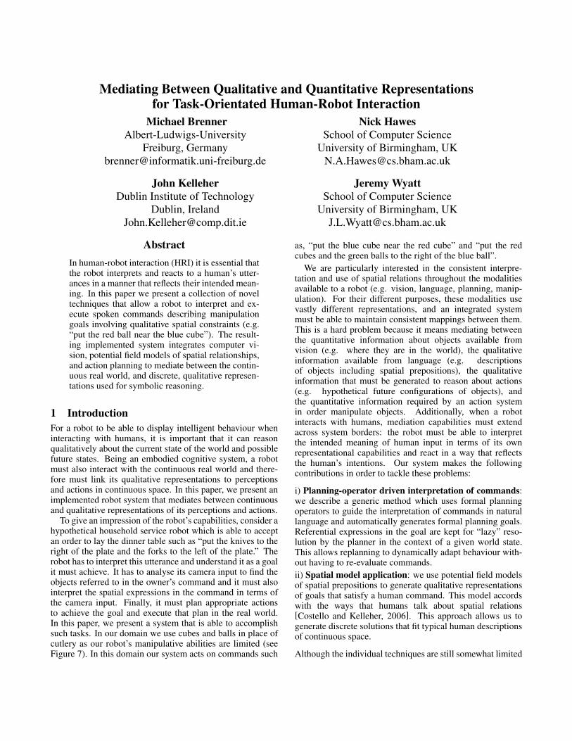
Figure 1: The system architecture.
in scope, by combining them we provide each component inthe architecture access to more information than it would havein isolation. Thus, the overall system is able to demonstrateintelligent behaviour greater than the sum of its parts.
In the following section we describe our robot platform andthe system architecture. We then expand on this in sections§4 (planning domain), §5 (command interpretation), §6 (po-tential field models for spatial relations) and §7 (qualitativespatial information from vision). Finally §8 presents an ex-ample of the functionality of the complete system.
2 Relation to Previous WorkThe work presented in this paper is related to various sub-fields of robotics and artificial intelligence. In particular it isclosely related to human-robot interaction and situated lan-guage understanding [Kruijff et al., 2006]. We do not fo-cus solely on the process of understanding an utterance, butinstead examine the steps necessary to mediate between thevarious representations that can exist in systems that must acton the world as a result of a command in natural language.
In terms of gross functionality there are few directly com-parable systems, e.g. those presented in [Mavridis and Roy,2006] and [Mcguire et al., 2002]. Whereas these systemsspecify complete architectures for following manipulationcommands, we focus on a particular aspect of this behaviour.As such our approach could be utilised by existing systems.For example, it could be used in layer L3 of Mavridis andRoy’s Grounded Situation Model [2006] to produced dis-crete, categorical encodings of spatial relationships.
There are many plan-based dialogue systems that are used(or potentially usable) for HRI (e.g., [Sidner et al., 2003;Allen et al., 2001]). Most such systems try to exploit the con-text of the current (dialogue) plan to interpret utterances. Weare not aware, however, of any system that, like ours, actu-ally uses the formal action representation from the planningdomain to resolve referential expressions in at least a semi-formal way. Critically, the “guidance” provided by the plan-ning domain leads to a logical representation of the commandthat the planner can reason about. For example, the planneris able resolve referential expressions as part of the problemsolving process. This can be significant in dynamic environ-ments: if a situation changes then the planner can resolve thesame referential expression differently.
3 ArchitectureTo enable a robot to follow action commands such as thosedescribed in the introduction, we break the problem into anumber of processing steps. These steps are reflected by thedesign of our overall processing architecture, which can be
(:action put:parameters
(?a - agent ?obj - movable ?wp - waypoint):precondition (and
(pos ?obj : ?a)(not (exists (?obj2 - movable) (pos ?obj2 : ?wp))))
:effect(pos ?obj : ?wp))
Figure 2: MAPL operator put for placing objects.
seen in Figure 1. Our system is based on a combination of aniRobot B21r mobile robot and a table-mounted Katana 6Mrobotic arm. Mounted on the B21r is a pan-tilt unit support-ing two parallel cameras which we use for visual input. Fromthese cameras we create a 3D representation of the scene us-ing depth information from stereo to instantiate a collectionof simple object models. To produce actions, informationfrom vision is fed into a workspace-based visual-servoingsystem along with instructions about which object to grasp,and where to put it. Actions are limited to pick and place.This suffices for the current experimental scenarios.
4 Planning Domain
For the purpose of this paper, a simple ontology was designedwhich consists mainly of agents and objects. Objects may bemovable or not. They can have properties, e.g. colours, thatcan be used to describe them or constrain subgroups of ob-jects in a scene. Positions of objects in a scene are describedby waypoints. Concrete instances of waypoints are generatedon-the-fly during the problem-solving process (cf. §7). Re-lations between waypoints include near, right of, and left of.Despite being quite simple, this ontology allows us to repre-sent complex situations and goals. Moreover, it is very easyto extend to richer domains. For example, adding just onenew subtype of movable objects would enable the robot todistinguish between objects that are stackable.
The ontology has been modelled as a planning domain inMAPL [Brenner, 2005], a planning language for multiagentenvironments based on PDDL [Fox and Long, 2003]. MAPLis suitable for planning in HRI because it allows us to modelthe beliefs and mutual beliefs of agents, sensory actions, com-municative actions, and different forms of concurrency. Al-though these features make MAPL highly suitable for human-robot interaction, in this paper we mostly use the ADL sub-set of MAPL. Figure 2 shows the operator for placing ob-jects. Note that MAPL uses non-boolean state variables, e.g.(pos obj), which are tested or changed with statements like(pos obj : ?wp). Thus, in MAPL there is no need to state thatthe robot no longer holds the object after putting it down (astatement which would be necessary in PDDL).
Currently, no planner is available that is specifically de-signed for MAPL. Instead, we use a compiler for transform-ing MAPL into PDDL and back. This enables us to use astate-of-the-art planner in our system without losing the de-scriptive power of MAPL; the planning system used currentlyis FF [Hoffmann and Nebel, 2001].

5 Converting Linguistic Input to MAPLIn AI Planning, goals are typically formulated in (a subset of)first-order logic, i.e. as formulae that must hold in the stateachieved by the plan (see, for example, the definition of goalsin the ADL subset of PDDL [Fox and Long, 2003]). Humans,however, usually use imperative commands, like “clear the ta-ble”, when communicating goals. One reason for verbalisingan action command instead of a goal description could be thatthe former provides a very compact representation of the lat-ter by means of its postconditions, i.e. the immediate changesto the world caused by the action. Speaking in AI Planningterms, if the action “clear table” has an ADL effect saying thatafter its execution “there exists no object that is on the table”,the action name plus its parameters is a much simpler meansto convey that goal than the effect formula. What complicatesthe matter is that, in contrast to AI planners, humans usuallydo not use unique names for objects, but refer to them in ex-pressions that constrain the possible referents (i.e. “the redball” instead of object17). Altogether, the “human way”to describe goals can be described as goal = action + param-eters + reference constraints.
Deliberative agents that have ADL-like action representa-tions can exploit this goal description scheme when tryingto understand a natural language command: after matchingthe verb phrase of a command with an appropriate planningoperator, this operator can be used to guide the further un-derstanding of the command, namely determining the actionparameters and reference constraints.
We will illustrate this process with the command “put theblue cubes to the left of the red ball”. Our system parsesthe command using a simple English grammar and a chartparser. The parse tree of the example command describes thephrase as a verb, followed by a nominal phrase and a prepo-sitional phrase (V NP PP). When the system detects the verb“put”, it is matched to the planning operator put (cf. Figure2). The subsequent interpretation procedure is specific to thatoperator and aims at determining the constraints describingthe three parameters of the operator, ?a, ?obj and ?wp. Thisprior knowledge drives the interpretation of the phrase andsimplifies this process significantly. In our example, the NPis interpreted to describe the object ?obj that is to be movedwhile the PP describes the target position ?wp. The follow-ing logical constraint on the parameters ?a, ?obj and ?wp isfound (in which ?obj1 is the landmark1 object in relation towhich the goal position is described):
(blue ?obj) !(type ?obj : cube) !"?wp1. ((left-of ?wp ?wp1) ! "?obj1. ((red ?obj1) !
(type ?obj1 : ball) ! (pos ?obj1 : wp1)))
Additionally, the interpretation states that all objects satisfy-ing the constraints on ?obj must be moved. This quantifica-tion becomes visible in the final translation of the commandinto a MAPL goal, shown in Figure 3 (where type constraintsare transformed into the types of the quantified variables).
One important aspect of the natural language command isthat it refers both to the goal state (where should the blue
1For the rest of the paper we will refer to the object or objectsthat should be moved as the target, and the object or objects that areused to define the desired position of the target as the landmark.
(forall (?obj - cube) (imply(and (initially (blue ?obj)))(exists (?wp - waypoint)
(exists (?obj1 - ball ?wp1 - waypoint) (and(initially (red ?obj1))(initially (pos ?obj1 : ?wp1))(initially (left-of ?wp ?wp1))(pos ?obj : ?wp))))))
Figure 3: Automatically generated MAPL goal for “put theblue cubes to the left of the red ball”
cubes be put?) and to the initial state (the reference con-straints determining the objects). It is crucial for the planningrepresentation to be able to model this difference, otherwisecontradictory problems may be generated. For example, thecommand “put down the object that you are holding” pro-vides two constraints on the object’s position: that it is heldby the robot now, but is on the ground after plan execution.Therefore, MAPL supports referring back to the initial statein the goal description as shown in Figure 3. The facts thatmust hold after execution of the plan are described by the ef-fect of the put action. In our example, this effect describesthe new position of the object in question.
It is important to realise that the goal descriptions gener-ated by this process still contain the referential expressionsfrom the original command, i.e. they are not compiled awayor resolved directly. Instead they will be resolved by the plan-ner. We call this “lazy” reference resolution. It enables therobot to dynamically re-evaluate its goals and plans in dy-namic situations. If, for example, another blue cube is addedto the scene, the planner will adapt to the changed situationand move all of the blue blocks.
6 Computational Models of Spatial CognitionTo act on the kinds of action commands we are interested in,the robot must be able to translate from the qualitative spatiallinguistic description of the location to place the object, toboth a geometric description of the location that can be usedby the manipulation system (i.e. a geometric waypoint posi-tioned in the robot’s world), and a logical description for theplanning domain (i.e. a symbolic representation of this way-point and its relationships with other waypoints). This trans-lation involves constructing computational geometric modelsof the semantics of spatial terms.
Spatial reasoning is a complex activity that involves at leasttwo levels of representation and reasoning: a geometric levelwhere metric, topological, and projective properties are han-dled; and a functional level where the normal function of anentity affects the spatial relationships attributed to it in a con-text. In this paper we concentrate on the geometric level, al-though using functional spatial information would not requireany significant changes to our overall system.
Psycholinguistic research [Logan and Sadler, 1996; Regierand Carlson, 2001; Costello and Kelleher, 2006] indicatesthat people decide whether the spatial relation associated witha preposition holds between and landmark object and the re-gions around it by overlaying a spatial template on the land-mark. A spatial template is a representation of the regions ofacceptability associated with a given preposition. It is centred

on the landmark, and for each point in space it denotes the ac-ceptability of the spatial relationship between it and the land-mark. Figure 4 illustrates the spatial template for the prepo-sition “near” reported in [Logan and Sadler, 1996].
1.74 1.90 2.84 3.16 2.34 1.81 2.13
2.61 3.84 4.66 4.97 4.90 3.56 3.26
4.06 5.56 7.55 7.97 7.29 4.80 3.91
3.47 4.81 6.94 7.56 7.31 5.59 3.63
4.47 5.91 8.52 O 7.90 6.13 4.46
3.25 4.03 4.50 4.78 4.41 3.47 3.10
1.84 2.23 2.03 3.06 2.53 2.13 2.00
Figure 4: Mean goodness ratings for the relation near.
If a computational model is going to accommodate thegradation of a preposition’s spatial template it must de-fine the semantics of the preposition as some sort of con-tinuum function. A potential field model is one widelyused form of continuum measure [Olivier and Tsujii, 1994;Kelleher et al., 2006]. Using this approach, a spatial tem-plate is built using a construction set of normalised equationsthat for a given origin and point computes a value that repre-sents the cost of accepting that point as the interpretation ofthe preposition. Each equation used to construct the potentialfield representation of a preposition’s spatial template modelsa different geometric constraint specified by the preposition’ssemantics. For example, for projective prepositions, such as“to the right of”, an equation modelling the angular deviationof a point from the idealised direction denoted by prepositionwould be included in the construction set. The potential fieldis then built by assigning each point in the field an overall po-tential by integrating the results computed for that by point byeach of the equations in the construction set. The point withthe highest overall potential is then taken as the location thatthe object should be placed at to satisfy the relationship.
7 Qualitative Representations from VisionThe previous sections have discussed the representation weuse for planning, how we translate action commands into goalstates in this representation, and how we model spatial rela-tionships. This section describes a process that produces aninitial state description for the a planning process by applyingthese techniques to mediate between geometric visual infor-mation and the symbolic planning representation.
We break the task of generating a state description fromvision and language into three steps: converting informationabout visible objects into a symbolic representation, addinginformation about specific spatial relationships to this repre-sentation, and generating new information required by theplanning process. These last two steps use potential fieldmodels in two different ways. The first applies them to knownwaypoints in the world to generate logical predicates (e.g.
for rel in goal relationships dofor wpl in waypoints do
initialise scene scadd landmark wpl to scfor wpt to in waypoints# wpl do
add waypoints# wpl # wpt to s as distractorscompute field pf for rel in scheck value val of pf at wptarget
if val > 0 thenadd (rel wpt wpl) to state
Figure 5: Algorithm for generating spatial relationship rel.
“left of”) for the planning domain. The second applies a fieldto a single known waypoint to generate a new set of way-points that all satisfy a predicate for the planning domain.
The first step in the process of interpreting and acting upona command is to translate the information directly obtain-able from vision into our planning domain. This is done ina straight-forward way. For each object in the world we gen-erate a description in the language of the planning domain.Each object is represented in the planning domain by an IDwhich is stored to allow other process to index back into thegeometric vision representation via the planning representa-tion. Representing an object involves describing its colourand type (information which is directly available from our vi-sion system). To position the object in the world we must alsoplace the object at a waypoint. To do this we add a waypointto the planning domain at the centre of the object’s boundingbox on the table. Waypoints are also represented by a storedID that can be used access its position in the real world, sothat later processes can use this information.
The second step in the process of generating an initial stateis to add information about the spatial relations of the way-points to the planning problem. This allows the planner toreason about how moving objects between waypoints changestheir spatial relationships. Rather than add information aboutall of the spatial relationships that exist between all of thewaypoints, we focus only on the relationships included in thegoal state because any additional information would be irrele-vant to the current task. Thus our approach is explicitly task-orientated. The algorithm we use is presented in Figure 5.In this algorithm, distractors represent points in the potentialfield that may influence the field in some way (e.g reducingits value, or altering its extent).
The final step of the initial state generation process is toadd additional waypoints in order to give the planner enoughsuitable object locations to produce a plan. This is neces-sary because the waypoints from the previous step are all ini-tially occupied, and may not satisfy the spatial constraints inthe goal description. To add waypoints, we first ground thetarget description (e.g. “the blue cubes” from “put the bluecubes left of the red ball”) in the visual information to pro-vide a count of the number of objects that must be moved.We then find the waypoint for the landmark object (e.g. “thered ball”), and generate the required number of waypoints inthe potential field around the landmark for the given spatialrelationship (e.g. “left of”). The algorithm we use to gen-erate the new waypoints is presented in Figure 6. Because
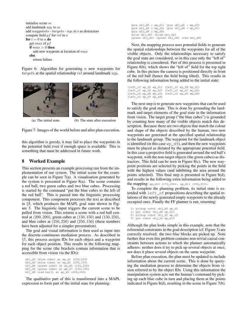
initialise scene scadd landmark wpl to scadd waypoints - targets - wpl to s as distractorscompute field pf for rel in sfor i = 0 to n do
get max of pfif max > 0 then
add new waypoint at location of maxelse
return failure
Figure 6: Algorithm for generating n new waypoints fortargets at the spatial relationship rel around landmark wpl.
(a) The initial state. (b) The state after execution
Figure 7: Images of the world before and after plan execution.
this algorithm is greedy, it may fail to place the waypoints inthe potential field even if enough space is available. This issomething that must be addressed in future work.
8 Worked ExampleThis section presents an example processing run from the im-plementation of our system. The initial scene for the exam-ple can be seen in Figure 7(a). A visualisation generated bythe system is presented in Figure 8(a). The scene containsa red ball, two green cubes and two blue cubes. Processingis started by the command “put the blue cubes to the left ofthe red ball”. This is passed into the linguistic processingcomponent. This component processes the text as describedin §5, which produces the MAPL goal state shown in Fig-ure 3. The linguistic input triggers the current scene to bepulled from vision. This returns a scene with a red ball cen-tred at (200, 200), green cubes at (150, 150) and (150, 250),and blue cubes at (250, 250) and (250, 150) (these numbershave been adjusted for a simpler presentation).
The goal and visual information is then used as input intothe discrete-continuous mediation process. As described in§7, this process assigns IDs for each object and a waypointfor each object position. This results in the following map-ping for the scene (the brackets contain information that isaccessible from vision via the IDs):obj_d0 (blue cube) at wp_d1 (250,250)obj_d2 (blue cube) at wp_d3 (250,150)obj_d4 (green cube) at wp_d5 (150,250)obj_d6 (green cube) at wp_d7 (150,150)obj_d8 (red ball) at wp_d9 (200,200)
The qualitative part of this is transformed into a MAPLexpression to form part of the initial state for planning:
(pos obj_d0 : wp_d1) (pos obj_d2 : wp_d3)(pos obj_d4 : wp_d5) (pos obj_d6 : wp_d7)(pos obj_d8 : wp_d9)(blue obj_d0) (blue obj_d2)(green obj_d4) (green obj_d6) (red obj_d8)
Next, the mapping process uses potential fields to generatethe spatial relationships between the waypoints for all of thevisible objects. Only the relationships necessary to satisfythe goal state are considered, so in this case only the “left of”relationship is considered. Part of this process is presented inFigure 8(b), which shows the “left of” field for the top rightcube. In this picture the camera is positioned directly in frontof the red ball (hence the field being tilted). This results inthe following information being added to the initial state:
(left_of wp_d5 wp_d1) (left_of wp_d9 wp_d1)(left_of wp_d5 wp_d3) (left_of wp_d7 wp_d3)(left_of wp_d9 wp_d3) (left_of wp_d5 wp_d9)(left_of wp_d7 wp_d9)
The next step is to generate new waypoints that can be usedto satisfy the goal state. This is done by grounding the land-mark and target elements of the goal state in the informationfrom vision. The target group (“the blue cubes”) is groundedby counting how many of the visible objects match this de-scription. Because there are two objects that match the colourand shape of the objects described by the human, two newwaypoints are generated at the specified spatial relationshipto the landmark group. The waypoint for the landmark objectis identified (in this case wp_d9), and then the new waypointsmust be placed as dictated by the appropriate potential field.In this case a projective field is generated around the red ball’swaypoint, with the non-target objects (the green cubes) as dis-tractors. This field can be seen in Figure 8(c). The new way-point positions are selected by picking the points in the fieldwith the highest values (and inhibiting the area around thepoints selected). This final step is presented in Figure 8(d),and results in the following extra information being added tothe mapping: wp_d10 (172,200), wp_d11 (156,200).
To complete the planning problem, its initial state is ex-tended with left_of propositions describing the spatial re-lations of the newly generated empty waypoints to the alreadyoccupied ones. Finally the FF planner is run, returning:
0: pickup robot obj_d0 wp_d11: put robot obj_d0 wp_d112: pickup robot obj_d2 wp_d33: put robot obj_d2 wp_d10
Although the plan looks simple in this example, note that thereferential constraints in the goal description (cf. Figure 3) arecorrectly resolved: the two blue blocks are picked up. Notefurther that even this problem contains non-trivial causal con-straints between actions to which the planner automaticallyadheres: neither does it try to pick up several objects at once,nor does it place several objects on the same waypoint.
Before plan execution, the plan must be updated to includeinformation about the current scene. This is done by query-ing the mediation process to determine the objects from vi-sion referred to by the object IDs. Using this information themanipulation system acts out the human’s command by pick-ing up each blue cube in turn and placing them at the pointsindicated in Figure 8(d), resulting in the scene in Figure 7(b).
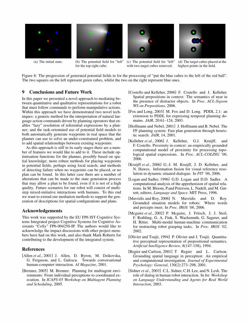
(a) The initial state. (b) The potential field for “left”for the top right cube.
(c) The potential field for “left”with two target cubes removed.
(d) The target cubes placed at thehighest points in the field.
Figure 8: The progression of generated potential fields in for the processing of “put the blue cubes to the left of the red ball”.The two squares on the left represent green cubes, whilst the two on the right represent blue ones.
9 Conclusions and Future WorkIn this paper we presented a novel approach to mediating be-tween quantitative and qualitative representations for a robotthat must follow commands to perform manipulative actions.Within this approach we have demonstrated two novel tech-niques: a generic method for the interpretation of natural lan-guage action commands driven by planning operators that en-ables “lazy” resolution of referential expressions by a plan-ner; and the task-orientated use of potential field models toboth automatically generate waypoints in real space that theplanner can use to solve an under-constrained problem, andto add spatial relationships between existing waypoints.
As this approach is still in its early stages there are a num-ber of features we would like to add to it. These include op-timisation functions for the planner, possibly based on spa-tial knowledge; more robust methods for placing waypointsin potential fields, perhaps using local search; and methodsof detecting failure when no waypoints can be placed, or noplan can be found. In this latter case there are a number ofalterations that can be made to the state generation processthat may allow a plan to be found, even if it is not of a highquality. Future scenarios for our robot will consist of multi-step mixed-initiative interactions with humans. To this endwe want to extend our mediation methods to support the gen-eration of descriptions for spatial configurations and plans.
AcknowledgementsThis work was supported by the EU FP6 IST Cognitive Sys-tems Integrated project Cognitive Systems for Cognitive As-sistants “CoSy” FP6-004250-IP. The authors would like toacknowledge the impact discussions with other project mem-bers have had on this work, and also thank Mark Roberts forcontributing to the development of the integrated system.
References[Allen et al., 2001] J. Allen, D. Byron, M. Dzikovska,
G. Ferguson, and L. Galescu. Towards conversationalhuman-computer interaction. AI Magazine, 2001.
[Brenner, 2005] M. Brenner. Planning for multiagent envi-ronments: From individual perceptions to coordinated ex-ecution. In ICAPS-05 Workshop on Multiagent Planningand Scheduling, 2005.
[Costello and Kelleher, 2006] F. Costello and J. Kelleher.Spatial prepositions in context: The semantics of near inthe presence of distractor objects. In Proc. ACL-SigsemWS on Prepositions, 2006.
[Fox and Long, 2003] M. Fox and D. Long. PDDL 2.1: anextension to PDDL for expressing temporal planning do-mains. JAIR, 20:61–124, 2003.
[Hoffmann and Nebel, 2001] J. Hoffmann and B. Nebel. TheFF planning system: Fast plan generation through heuris-tic search. JAIR, 14, 2001.
[Kelleher et al., 2006] J. Kelleher, G.J. Kruijff, andF. Costello. Proximity in context: an empirically groundedcomputational model of proximity for processing topo-logical spatial expressions. In Proc. ACL-COLING ’06,2006.
[Kruijff et al., 2006] G.-J. M. Kruijff, J. D. Kelleher, andN. Hawes. Information fusion for visual reference reso-lution in dynamic situated dialogue. In PIT ’06, 2006.
[Logan and Sadler, 1996] G.D. Logan and D.D. Sadler. Acomputational analysis of the apprehension of spatial rela-tions. In M. Bloom, P.and Peterson, L. Nadell, and M. Gar-rett, editors, Language and Space. MIT Press, 1996.
[Mavridis and Roy, 2006] N. Mavridis and D. Roy.Grounded situation models for robots: Where wordsand percepts meet. In Proc. IROS ’06, 2006.
[Mcguire et al., 2002] P. Mcguire, J. Fritsch, J. J. Steil,F. Rothling, G. A. Fink, S. Wachsmuth, G. Sagerer, andH. Ritter. Multi-modal human-machine communicationfor instructing robot grasping tasks. In Proc. IROS ’02,2002.
[Olivier and Tsujii, 1994] P. Olivier and J. Tsujii. Quantita-tive perceptual representation of prepositional semantics.Artificial Intelligence Review, 8(147-158), 1994.
[Regier and Carlson, 2001] T Regier and L. Carlson.Grounding spatial language in perception: An empiricaland computational investigation. Journal of ExperimentalPsychology: General, 130(2):273–298, 2001.
[Sidner et al., 2003] C.L. Sidner, C.H. Lee, and N. Lesh. Therole of dialog in human robot interaction. In Int. Workshopon Language Understanding and Agents for Real WorldInteraction, 2003.