Mapping Moral Geographies: W. Z. Ripley's Races of Europe and the United States
23
Mapping Moral Geographies: W. Z. Ripley’s Races of Europe and the United States Heather Winlow Department of Geography, Bath Spa University, Bath, United Kingdom Racia and anthropometric cartography produced and reinforced biological, intellectual, and moral hierarchies and was situated within wider scientific racial discourses of the late nineteenth and early twentieth centuries. The practice of mapping ‘‘race’’ based on the widespread collection of anthropometric measurements occupied both European and New World anthropologists and geographers. My discussion centers on the work of American economist and anthropogeographer, W. Z. Ripley, who in 1899 published a widely acclaimed text on The Races of Europe. This work is contextualized and informed both by Victorian obsessions with categorizing racial hierar- chies and by specifically American racial discourses that included concerns over increasing immigration from southern and eastern Europe and the threat immigration posed to the Anglo-Saxon ruling elite. Using the conceptual framework developed by J. B. Harley and other recent contributions to critical cartography, this article focuses on Ripley’s use of cartographic images to support his tripartite racial scheme for Europe, and explores his projection of a ‘‘moral geography’’ onto European and, in turn, American landscapes and popu- lations. Central to this analysis are the links between anthropogeography, environmentalism, heredity, and American immigration, all key elements in Ripley’s racial science. Key Words: immigration, moral geographies, power of maps, racial and anthropometric cartography, social construction of race. W illiam Zebina Ripley (1867–1941) was an in- fluential American economist and anthropo- geographer whose work utilized cartography to manipulate, represent, and legitimate racial categories. Ripley’s promotion of a tripartite racial scheme for Europe in The Races of Europe (1899b) has undergone scrutiny by Higham (1963) and Soloman (1956) within the wider context of American racial science, but the geographical, and specifically cartographic, elements of his work, por- traying an intimate link between race and space, remain unexplored. Ripley’s work merits attention from geogra- phers because the links between human development and the environment are central to his racial science, and because his racial theories and cartographic depictions had an impact on the following generation of anthro- pologists and geographers in Europe and the United States (Huntington 1915; Fleure and James 1916; Peake 1916; Fleure 1918; Taylor 1927). Ripley’s work can be situated within wider discourses on race and cartography. Here I consider Ripley’s car- tographic depictions from the perspective of recent critical investigations into the historical representation of race by human geographers (Jackson 1987, 1989, 1994, 1998; Kobayashi 2003) and I critique his maps using the theoretical framework developed by J. B. Ha- rley to show that maps should be viewed as cultural texts and that they contain power (Harley 1988a, 1988b, 1990, 1992, 2001). Following a brief note on methodology, the first half of the article is divided into two sections: focusing firstly on racial representation, classification, and mapping, including cartographic theory (Harley 1988a, 1988b, 1990, 1992, 2001; Rundstrom 1991; Wood 1993; Sparke 1995, 1998; Del Casino and Hanna 2000; Hanna and Del Casino 2003), imperial mapping (Harley 1988b; Edney 1991, 1993, 1997; S. Ryan 1996; Clayton 2000), and racial and anthropometric cartography (Winlow 1999, 2001); and secondly on ideas surrounding assim- ilation and racial decline in the United States within the context of increasing immigration from southern and eastern Europe (Handlin 1948; Solomon 1956; Higham 1963; Gordon 1964; Ward 1971; Limerick 1987; Ha- nnah 2000). The second half of the article involves a close critique of Ripley’s work and focuses on constructing and map- ping the races of Europe and on Ripley’s construction of ‘‘moral geographies’’ (Driver 1988, 1992) relating to racial distributions in both Europe and the United States. Ripley’s work makes links between urban envi- ronment, class, and social and moral factors (including suicide and divorce), but a central element is his focus on race. His construction of moral geographies for Eu- rope was translated to a metaphorical mapping of new settlement patterns in the United States where inferior race types were perceived as being linked to social ills (Ripley 1908a, 1908b, 1913). Annals of the Association of American Geographers, 96(1), 2006, pp. 119–141 r 2006 by Association of American Geographers Initial submission, April 2004; revised submissions, March and June 2005; final acceptance, July 2005 Published by Blackwell Publishing, 350 Main Street, Malden, MA 02148, and 9600 Garsington Road, Oxford OX4 2DQ, U.K.
Transcript of Mapping Moral Geographies: W. Z. Ripley's Races of Europe and the United States
Mapping Moral Geographies: W. Z. Ripley’s Racesof Europe and the United States
Heather Winlow
Department of Geography, Bath Spa University, Bath, United Kingdom
Racia and anthropometric cartography produced and reinforced biological, intellectual, and moral hierarchiesand was situated within wider scientific racial discourses of the late nineteenth and early twentieth centuries.The practice of mapping ‘‘race’’ based on the widespread collection of anthropometric measurements occupiedboth European and New World anthropologists and geographers. My discussion centers on the work of Americaneconomist and anthropogeographer, W. Z. Ripley, who in 1899 published a widely acclaimed text on The Races ofEurope. This work is contextualized and informed both by Victorian obsessions with categorizing racial hierar-chies and by specifically American racial discourses that included concerns over increasing immigration fromsouthern and eastern Europe and the threat immigration posed to the Anglo-Saxon ruling elite. Using theconceptual framework developed by J. B. Harley and other recent contributions to critical cartography, thisarticle focuses on Ripley’s use of cartographic images to support his tripartite racial scheme for Europe, andexplores his projection of a ‘‘moral geography’’ onto European and, in turn, American landscapes and popu-lations. Central to this analysis are the links between anthropogeography, environmentalism, heredity, andAmerican immigration, all key elements in Ripley’s racial science. Key Words: immigration, moral geographies,power of maps, racial and anthropometric cartography, social construction of race.
William Zebina Ripley (1867–1941) was an in-fluential American economist and anthropo-geographer whose work utilized cartography
to manipulate, represent, and legitimate racial categories.Ripley’s promotion of a tripartite racial scheme for Europein The Races of Europe (1899b) has undergone scrutiny byHigham (1963) and Soloman (1956) within the widercontext of American racial science, but the geographical,and specifically cartographic, elements of his work, por-traying an intimate link between race and space, remainunexplored. Ripley’s work merits attention from geogra-phers because the links between human developmentand the environment are central to his racial science, andbecause his racial theories and cartographic depictionshad an impact on the following generation of anthro-pologists and geographers in Europe and the UnitedStates (Huntington 1915; Fleure and James 1916; Peake1916; Fleure 1918; Taylor 1927).
Ripley’s work can be situated within wider discourseson race and cartography. Here I consider Ripley’s car-tographic depictions from the perspective of recentcritical investigations into the historical representationof race by human geographers (Jackson 1987, 1989,1994, 1998; Kobayashi 2003) and I critique his mapsusing the theoretical framework developed by J. B. Ha-rley to show that maps should be viewed as cultural textsand that they contain power (Harley 1988a, 1988b,1990, 1992, 2001).
Following a brief note on methodology, the first half ofthe article is divided into two sections: focusing firstlyon racial representation, classification, and mapping,including cartographic theory (Harley 1988a, 1988b,1990, 1992, 2001; Rundstrom 1991; Wood 1993; Sparke1995, 1998; Del Casino and Hanna 2000; Hanna andDel Casino 2003), imperial mapping (Harley 1988b;Edney 1991, 1993, 1997; S. Ryan 1996; Clayton 2000),and racial and anthropometric cartography (Winlow1999, 2001); and secondly on ideas surrounding assim-ilation and racial decline in the United States within thecontext of increasing immigration from southern andeastern Europe (Handlin 1948; Solomon 1956; Higham1963; Gordon 1964; Ward 1971; Limerick 1987; Ha-nnah 2000).
The second half of the article involves a close critiqueof Ripley’s work and focuses on constructing and map-ping the races of Europe and on Ripley’s construction of‘‘moral geographies’’ (Driver 1988, 1992) relating toracial distributions in both Europe and the UnitedStates. Ripley’s work makes links between urban envi-ronment, class, and social and moral factors (includingsuicide and divorce), but a central element is his focuson race. His construction of moral geographies for Eu-rope was translated to a metaphorical mapping of newsettlement patterns in the United States where inferiorrace types were perceived as being linked to social ills(Ripley 1908a, 1908b, 1913).
Annals of the Association of American Geographers, 96(1), 2006, pp. 119–141 r 2006 by Association of American GeographersInitial submission, April 2004; revised submissions, March and June 2005; final acceptance, July 2005
Published by Blackwell Publishing, 350 Main Street, Malden, MA 02148, and 9600 Garsington Road, Oxford OX4 2DQ, U.K.
Methodology
The methodological approach adopted here rests onthe acceptance of Harley’s theories about the relation-ship between maps and power, and on understandingmaps as cultural texts that can be deconstructed (Harley1988a, 1988b, 1990, 1992, 2001). The Races of Europeacts as a pivotal case study to illustrate how cartographycould be used to elucidate racial and anthropometricgeographies in relation to American concerns. The de-velopment of Ripley’s geographical work, and the widerinfluence of his ideas, is contextualized through hispublished papers and those of his contemporaries, andfrom archival information held at Harvard Universityand the Massachusetts Institute of Technology (MIT).These archives include short biographies and obituariesof Ripley, personal correspondence, and newspaperclippings. Archives, whether personal or institutional,cannot be regarded as a full record of events (Ogborn2003a, 2003b) due to a process of ‘‘selection and de-struction’’ (Ogborn 2003b, 13). In discussing state ar-chives, Ogborn has observed that what information iskept and what is destroyed depends on the priorities ofthe time and the people keeping the archives—ideasthat can be extended to other archival forms, includinguniversity archives. He has also emphasized the impor-tance of social and political power relations in the pro-duction of both institutional and personal archives. As arespected male academic, and a member of Bostoniansociety, Ripley had a degree of power, and he played,what was regarded at the time as, a valuable role in theinstitutions in which he worked and in wider society.Although the archives relating to Ripley cannot be as-sumed to be a full and complete record, it is possible touse the available materials to elucidate his publishedworks and, to some extent, gauge his wider influence onthe dissemination of racial theories. It is useful here tosound a cautionary note about the extent to which it ispossible to fully interpret the past, and thus my accountmay offer one of several readings of Ripley’s racial the-ories and his cartographic output.
Racial Representation, Classification, andMapping
Critical geographers, among others, have in recentyears come to understand the idea of ‘‘race’’ as sociallyconstituted over time. Kobayashi (2003) has traced thehistorical links between racialization and spatializationwith particular focus on key developments in geographyas a discipline. She argues that the idea of race as we now
understand it can be traced to developments in scientificthinking during the Enlightenment. In particular shenotes that Immanuel Kant’s stress on the links betweenskin color and distance from the equator fed into newways of thinking about race. His assumption of linksbetween darker skin color and inferior intellectualqualities reflected a moral hierarchy of both peoples andplaces and played into the interests of colonialism. As arespected academic and holder of a Chair in Geographyin Europe, Kant’s lectures on geography strongly influ-enced the next generation of researchers (Livingstone1992a; Kobayashi 2003). Other elements of Enlighten-ment thought also stressed the links between environ-ment and human development. For example,Montesquieu’s The Spirit of the Laws (1748) emphasizesthat ‘‘the cultural characteristics that shape and condi-tion humanity were molded by environmental factors,like climate and soil’’ (see Livingstone 1992a, 122).Travelogues of the eighteenth and nineteenth centuriesalso incorporated ‘‘the conventional judgment . . . thatwarmer climates encouraged moral sloth, while colderones stimulated intellectual vigor’’ (Driver 1988, 278). Itwas not until the nineteenth century, however, that theidea of discrete race types, linked to geographical region,became more strictly delineated. Biddis (1979) hasnoted that before 1800 the term race had been used as arough expression to convey ethnic lineage, but that overthe first half of the nineteenth century the word assumedan additional sense that initially appeared more scien-tific.
During the early part of the twentieth century geog-raphers continued to be informed by the scientific racismof the late nineteenth century, but issues surroundingrace were largely ignored following World War II. Ko-bayashi (2003) has noted that despite the defeat ofNazism and the rejection of racism following the war,there was a systematic ‘‘denial’’ of the issues of racewithin geographical circles, with dehumanized spatialscience playing the dominant role in human geography.In the 1960s and 1970s, there was some focus on raceand space, with race issues largely viewed in terms ofspatial inequalities. Following the critical turn in thediscipline in the 1980s and early 1990s, which involveddeliberate attempts to integrate both Marxist and hu-manistic geographies (Kobayashi 2003), there has beenwidespread recognition of race as a ‘‘social construct’’(Jackson 1987, 1989, 1994, 1998). Acceptance of thistheory has resulted in a diverse range of studies on raceand space, including a focus on whiteness (Bonnett1993, 1996a, 1996b), on the creation of hegemoniclandscapes (Anderson 1987, 1988, 1991), and on vari-ous forms of historical racial representation.
Winlow120
Jackson has stressed the need for a historical basis forcontemporary debates on issues of race and racism(Jackson 1987, 1989, 1994, 1998). There now exists awide-ranging geographical literature on how the exotic‘‘other’’ was historically portrayed through various formsof representation. Studies by geographers and other so-cial scientists have focused on travel writing (Pratt 1992;Mills 1993; Blunt 1994; McEwan 1994, 1995; Morin1998), museum exhibitions (Sheppard 1986; Driver1994), photography (Edwards 1990, 1992; Driver 1994;Rothenberg 1994, 1999; J. Ryan 1994a, 1994b, 1995,1998), and navigational logbooks (Driver 2004)—allforms of representation that have conventionally beenregarded as scientific and neutral. Through these formsof cultural representation, whites were constantly rep-resented as superior, while the non-white exotic otherwas portrayed as inferior, biologically, mentally, andmorally. Ideas of racial hierarchy were constructed andlegitimated through Victorian racial science: physicalanthropometry allowed race to be ‘‘measured’’ andclassified. In turn these racial constructions were sup-ported through various forms of representation (Winlow2001). J. Ryan, for example, noted that photography wasused to support the classification of racial ‘‘types’’ thatlegitimized and reinforced ‘‘popular stereotypes of exoticdifference’’ (1994b, 165).
I am particularly concerned with the ways in whichcartographic discourse has reinforced these racial stere-otypes. A number of scholars have focused on the waysin which western cartographies have ‘‘erased’’ nativegeographies from the landscape (Harley 1988b, 2001;Sparke 1995, 1998; S. Ryan 1996; Clayton 2000),thereby portraying overseas territories as awaiting oc-cupation. My focus here instead is on the reinscribing ofthe landscape (both of Europe and of the New World)with racial categorizations by western scientists duringthe late nineteenth and early twentieth centuries.
The mapping of race was inextricably linked to thedevelopment of racial theorizations and was born out ofthe Victorian obsession with classifying and categorizing(and dividing into hierarchies) not only plants and ani-mals, but also human beings (Duncan 1993). Beforeexamining the cartographical tradition, it is necessary totrace some of the ways in which ideas of race wereconstructed.
Measuring ‘‘Racial Essence’’
The idea of race has a complex history, and in theVictorian period, as today, the term race had confusedmeanings (Biddis 1979). From the 1850s, evolutionarytheories, debates over the origin of the human species,
and the monogenism (unity of man) versus polygenism(races as separate species) debate shaped British scien-tific thinking (Stepan 1982; Bowler 1986). Closely alliedto these developments emerged the idea of a number ofdiscrete racial groups or types largely based on physicalappearance. Of specific relevance to geography as anemerging discipline was the persistence of environmentaldeterminism that frequently portrayed races as humanresponses to environmental conditions.
In the latter half of the nineteenth century, themeasurement of racial traits became increasingly domi-nant in physical anthropology (Winlow 2001). Somemeasurements had been developed previously but theybecame more prominent as evolutionary theories be-came widespread. For example, phrenology (or craniol-ogy) was developed by Franz Joseph Gall (1758–1828)and by Johann Gaspar Spurzheim (1776–1832) in thelate eighteenth century (Kidd 1995). Phrenology wassoon manipulated by scientists, as illustrated by the workof Samuel George Morton, a supporter of polygenism,who measured cranial capacity for the various races andconstructed racial hierarchies based on these measure-ments (Gould 1978, 1981). Similarly, the developmentof the ‘‘facial angle’’ by Dutch anatomist and painterPeter Camper, devised in 1792 to promote more accurateportraiture, had by 1830 been elevated to a majorprinciple of racial classification by French surgeon andnaturalist Prosper Garnot. He had used this measureextensively to classify Oceanic peoples studied on Louis-Isidore Duperrey’s 1822–1824 expedition funded by theParis Geographical Society (Staum 2000). Variations onCamper’s facial angle had been devised by GeorgesCuvier and Etienne-Geoffroy St Hilaire in 1795. In ad-dition, the physiognomist Johann Casper Lavater usedfacial angles to define progression from lower animals tothe Greek ideal.
The use of the cephalic index, which is the breadth ofskull expressed as a percentage of the length, was pro-moted by the Swede Anders Retzius in 1840, and ‘‘thismeasurement became the mainstay of anthropometrythroughout the remainder of the century’’ (Harris 1968,99). The use of cranial capacity and cephalic index weremanipulated to illustrate the claim that ‘‘worth can beassigned to individuals and groups by measuring intelli-gence as a single quantity’’ (Gould 1981, 20). Othercharacteristics, such as hair type and stature, were alsomeasured and ‘‘were subjected to mathematical com-putation in the belief that such measurable externaltraits tracked some internal racial essence’’ (Livingstone1992b, 38).
These measurements were often constructed intoracial hierarchies, indicative of the generally adopted
Mapping Moral Geographies: W. Z. Ripley’s Races of Europe and the United States 121
progressionist (as opposed to Darwin’s ‘‘branching tree’’)view of evolution (Bowler 1986). This was the idea thatraces could be ranked on a continuous scale of civiliza-tion and was applied not only to biological difference butalso to cultural and social difference. Moral assumptionsabout race were often made. For example, Livingstone(1991, 419) has described Morton’s ranking of racebased on cranial capacity as an instance of the produc-tion of ‘‘moral statistics.’’
The Power of the Map
Evolutionary theories, measurements of racial traits,and environmental determinism influenced the newlyemerging disciplines of anthropology and geography.Membership of anthropological and geographical socie-ties overlapped1 (Livingstone 1992a), and mapping ra-cial classifications formed a crucial practice linking thetwo disciplines. Livingstone (1992a, 225) noted that thewhole business of ‘‘what might be called anthropometriccartography was a project that was taken up with varyingdegrees of ideological gusto by anthropologists and ge-ographers alike.’’ This is illustrated by the work of severalwell-known individuals including Griffith Taylor (1919,1921, 1927) in Australia, Ellsworth Huntington (1915)in the United States, and Herbert John Fleure (1918,1926) in Britain, as well as Ripley himself. This trend isalso clear in the pages of geographical and anthropo-logical journals; for example, maps of racial traits werepublished in the Journal of the Royal AnthropologicalInstitute of Great Britain and Ireland by British racialtheorists including John Beddoe, James Tocher, and JohnGray (Winlow 2001). Whether originally from a geo-graphical or an anthropological background, these indi-viduals can be described as anthropogeographers whoworked at the intersection of the two disciplines andwere interested in the geographical distribution of an-thropometric traits, or the relationship between race andspace. The cartographies of race that emerged from thejuncture between geography and anthropology can beanalyzed within Harley’s (1988a, 1988b, 1990, 1992,2001) conceptual framework and his emphasis on un-derstanding the map as an ideological tool.
Harley’s work on the deconstruction of the map (nowwell known among geographers) provides some means ofunderstanding how the power of the map was harnessedto legitimize and reinforce racial taxonomies. Maps areoften regarded as neutral and scientific and are seen as‘‘mirrors of nature’’ accurately reflecting the world(Harley 1992, 234). The fact that maps became an ac-ceptable part of academic discourse meant that theirlegitimacy went unquestioned for many years. It is now
widely acknowledged among human geographers thatmaps are ‘‘cultural texts’’ reflecting the wider social,cultural, and political milieu of society. Harley, Wood(1993), Pickles (1992, 1995, 2004), and Crampton(2001) have urged that cartographers need to reevaluatemapping within this context. Pickles (1995, 2004) andCrampton (2001, 2003) have further emphasized theneed for ongoing research agendas in critical cartographyin relation to continuing technological developments.The development of scientific cartography since thepostwar period, through for example geographic infor-mation systems (GIS), has meant that the social andcultural production of maps continues to be ‘‘writtenout’’ (Pickles 2004, 280).2
Cartography exerts power, both internal and externalto the map ‘‘text’’ (Harley 1992). Internal power iscontained within the map text, the key to which can beunderstood as ‘‘cartographic progress’’ and which in-cludes the use of sign-systems, which highlight andsuppress elements through the use of shading, lines,and projection, resulting in the hierarchicalization andstandardization of the landscape (Harley 1992, 244;Pickles 1992, 2004; Wood 1993). Wood’s explanations ofthe emergence of cartographic sign-systems and his focuson the links between signifier and signified provide botha theoretical and a practical framework for understand-ing maps as narratives as well as the ways in which mapsare naturalized. The signifier (element in the map text)becomes confused with the signified (element beingrepresented); however, it is not only the internal lin-guistic elements of the map that need to be open tocritical analysis. Maps do not exist in a void. Behindmost maps is a patron; historically, the monarchy, thegovernment, and the Church have all initiated map-making endeavors for their own ends. External ‘‘power isexerted on cartography’’ (Harley 1992, 244), is oftencentralized and bureaucratic, and is imposed from above.
Sparke (1995, 1998) has taken these arguments fur-ther, contending that Harley’s approach can be under-stood more in terms of ‘‘demythologizing’’ the map, ortaking the ‘‘myth’’ of cartographic objectivity and criti-quing the notion of a map as a transparent window.Sparke noted that ‘‘in contrast to demythologization, adeconstructive approach to maps is better understood asa responsibility towards the context of cartography’’(1995, 4) and an understanding of cartography as dy-namic and linked to wider social processes. This em-phasis on the dynamism of maps stems in part fromRundstrom’s early emphasis on ‘‘process cartography’’ asan additional basis for map interpretation on top ofHarley’s approaches. This focus on process—stressingmapping as ‘‘performed’’—is particularly relevant for
Winlow122
studies of non-text-based cartographies of indigenoussocieties (Rundstrom 1991; Sparke 1995, 1998). Rund-strom argued that process cartography involves bothsituating the artifact within the mapmaking process andplacing this process in the context of intracultural andintercultural dialogues over a longer time span.
Similar ideas around performance have been taken upin Hanna and Del Casino’s work on the use and pro-duction of tourism maps (Del Casino and Hanna 2000;Hanna and Del Casino 2003). They stress the centralimportance of ‘‘intertextuality’’ in understanding thedeeper meanings of cartographies constructed for thetourist gaze, and they explore relationships betweentourism maps, spaces, and identities. Intertextuality in-volves consideration of the wider discourse and influenceof other texts on a map and the idea that maps can havemultiple readings in different times and places. Situatingthe map as an individual artifact in its historical contextis therefore not enough by itself.
In the discussion following, I apply Harley’s theories ofthe internal and external power of maps to Ripley’s racialcartography and consider the processes involved inconstructing the final images. In terms of internal power,Ripley adopted a coherent system of representationthroughout The Races of Europe, adopting systems ofshading and division that emphasized his racial catego-ries. His work was supported through external power,which included the still widely-held myth that maps arenatural products, and also the ideological values of latenineteenth-century society, which emphasized the rela-tionships between climate, race, and morality and pro-moted the neutrality of science. In terms of the processesinvolved in the production of his maps, Ripley incor-porated a wide range of statistical data, gathered fromanthropologists across Europe, on which he based hisracial divisions. This practice fed into the internal ele-ments of the map text and resulted in the portrayalof particular peoples occupying particular geographicspaces.
The Creation of Imperial Space
Recently, scholars have recognized that ‘‘[c]arto-graphy was an important tool of imperial expansion andtechnology of abstraction’’ (Clayton 2000) and haveexamined the creation of ‘‘imperial space’’ that imposedEuropean systems of mapping onto native territories.Edney (1991, 1993, 1997) evaluated the creation ofabstract imperial space in British India through trigo-nometrical survey, and the production of standardizedmaps of the whole continent. A number of projects—including the Great Trigonometrical Survey, which be-
gan in 1802, and The Atlas of India, which began in 1825and was produced over eight decades—privileged west-ern nationalizing cartographies at the expense of localand regional native knowledges. In a similar vein, S.Ryan (1996) argued that the Australian interior wasrepresented as an ‘‘empty space’’ by nineteenth-centuryBritish surveyors and cartographers unfamiliar with thenative environment and culture. Clayton, in his focus onmapping the Pacific Northwest from the late eighteenthto mid-nineteenth centuries, critiqued S. Ryan’s as-sumption that the process of imperial mapping was thesame everywhere, and argued that ‘‘imperialism involvedprocesses of differentiation as well as these universalistformulations of imperial right and territory. Imperialspace was constructed as exclusively British, or Spanish,as well as rightfully western’’ (Clayton 2000, 329). Al-though the processes of colonization and mapping dif-fered between locations, a common feature was theassumption that native knowledge systems were inferiorto European systems.3
These critiques of colonial mapping have valuablydemonstrated the ways in which cartographies have re-inforced notions of the overseas and alien other andadded to critiques of representations within culturalgeography. They demonstrate how western processesof mapmaking created cartographic ‘‘silences’’ (Harley1988b) in relation to native groups and cultures. Butalongside this erasure of ethnic groups from the land-scape there has also been a history of racial cartographythat has involved the deliberate portrayal of differencewithin the map text, a form of mapping that has alsoserved to reinforce notions of otherness.
Racial and Anthropometric Cartographies
The cartographic representation of race, or the in-scription of the landscape with racial difference, has along tradition. Examples include medieval mappaemundi,which portrayed the exotic other through the represen-tation of ‘‘monstrous races’’ on the outermost edges ofthe civilized world (Friedman 1981; Woodward 1987; S.Ryan 1996), and old world maps of the Renaissanceperiod containing representations of ‘‘savage’’ races inthe marginalia (Harley 1988a, 1992). These ‘‘symbols of‘otherness’ assumed the form of a bizarre racism’’ (Harley1988a, 299). Racial cartography has also included thelabeling of areas such as ‘‘Chinatown,’’ ‘‘niggerheadcreek,’’ and ‘‘Jew Point’’ on maps, legitimizing in turn theuse of such derogatory names (Harley 1990) and re-flecting the dominant white cultural hegemony (And-erson 1987, 1988).
Mapping Moral Geographies: W. Z. Ripley’s Races of Europe and the United States 123

The ways in which the cartographic image was uti-lized by anthropogeographers in the Victorian period todelineate and legitimate racial groups can be dividedinto the two general categories of racial and anthropo-metric cartographies. I apply the concept of ‘‘racial’’mapping to those representations where the author hasattempted to prove the existence of several discreteraces, each combining a number of traits such as statureor pigmentation. This approach occurs in the work of W.Z. Ripley, but is also prevalent in Griffith Taylor’s (1919)‘‘zones and strata’’ approach to understanding race,where the migration and settlement of racial groups iscrudely equated to geological formations at a world scale(Winlow 1999). In contrast, the label ‘‘anthropometric’’is applicable to the cartographic portrayal of individualtraits (without necessarily being assigned to a definableracial group). Ripley was largely concerned with delin-eating European types, but he also produced many mapsthat focused on single racial characteristics, includingcephalic index, stature, and pigmentation. Work byBritish physical anthropologists, including John Beddoe,John Gray, and James Tocher, and by the geographerHerbert John Fleure, was also characteristic of this trend(Winlow 2001).
American anthropogeographers were informed bysocial and scientific developments in Europe, including avariety of evolutionary theories and attempts at racialclassification. Although these discourses were central toRipley’s work, a number of specifically American con-cerns also influenced his scientific thinking, as discussedin the following section.
Assimilation or Racial Decline?
In the late nineteenth century, racial discourse in theUnited States concentrated on issues of Americancharacter and national identity, but the debates took ondifferent nuances in accordance with geographical lo-cation. In the South the predominant racial discoursehas historically focused on the divisions and differencesbetween the black and white populations (Limerick1987) related to major political issues including theabolition of slavery and, in the twentieth century, blackcivil rights. After the Civil War (1861–1865) freed slaveswere given the right to vote, which resulted in moreblack voters than white in the South. Feeling underthreat, whites in power in the 1890s systematically de-nied blacks suffrage by means of discriminatory devicessuch as poll tax and literacy tests. Laws for racial seg-regation were passed (Jenkins 1997), an issue in whichthe northeastern elites, who had supported the abolitionof slavery, did not intervene (Livingstone 1987b, 138).
Racial segregation did not come to an end until after theCivil Rights Movement of the 1950s and 1960s.4
In American ideological thought, the West has tra-ditionally been linked to national identity, following thepublication of Frederick Jackson Turner’s frontier thesisin 1893. The stereotype remains of white pioneerspushing back the boundaries of civilization and tamingthe wilderness—and the natives (Limerick 1987). In thepopular imagination the frontier is still largely regardedin terms of conflicts between whites and Indians, andwestern history is portrayed as having finished in 1890with the ‘‘closing’’ of the frontier. Throughout thenineteenth century the ‘‘Indian problem’’ had dominatedmuch debate, and a number of laws were passed tospatially isolate Indian populations. Indians were re-garded as inferior and savage in comparison to whitepioneers, but reformers in the 1890s argued that ‘‘Indi-ans could escape their initial stage of civilization andmove upward to meet whites’’ (Limerick 1987, 199). AsIndians existed in limited numbers, they were perceivedas less of a threat than blacks, Asians, and southeasternEuropeans. Although much discourse continues to focuson this bipolar division between Indians and whites, theracial diversity of the West was more complex than oftenportrayed, and there existed a racial mixture at leastequal to the diversity of the northeastern cities. Forexample, from the mid-nineteenth century Chineseimmigration had been encouraged to provide cheaplabor for the construction of railways, such as the CentralPacific Railroad (Limerick 1987, 264–66; Ninkovich2001). Initially perceived as an economic benefit in theWest, by the 1880s white westerners increasingly viewedthe growing Chinese population in a negative light, re-sulting in the 1882 Chinese Exclusion Act (Limerick1987, 264). Concerns about immigration were also adominant theme of racialist discourse taking placeamong northeastern elites in the 1890s and after theturn of the century, a theme that is developed furtherbelow.
The geographical discourse of racialization thus fo-cused on different issues (black suffrage in the South, the‘‘Indian problem’’ in the West, and immigration fromsouthern and eastern Europe in the northeast) and waslinked to regional political and economic concerns.Despite political and regional differences, much of theoverarching racial rhetoric was similar. Jenkins (1997,xix) refers to an American tradition of ‘‘stigmatizingdangerous outsiders, defined in terms of race or religion.’’Similar ideas are expressed by Hannah (2000) who ap-plied David Sibley’s (1995) theories on psychologicalgeographies to late nineteenth-century American dis-courses on race, and to the work of the political econ-
Winlow124
omist Francis Amasa Walker in particular. Sibley arguedthat feelings of insecurity (among the dominant socialgroup) usually result in exclusionary practices. Hannah(2000, 211) has stated that these feelings were central toimmigration restriction and to the confinement of In-dians to their ‘‘proper place’’ in the American landscape,further noting that both immigrants and Indians wereperceived as ‘‘reservoirs of inferior blood’’ who posed athreat to the American social body. A critical differencewas the role that these groups were expected to playwithin American society: immigrants came to fill aneconomic niche, and were expected to become citizensand acquire political power, whereas Indians were gen-erally viewed as members of ‘‘domestic dependent na-tions’’ (Hannah 2000, 213).
Throughout the nineteenth century, immigration tothe United States increased steadily, reaching unprece-dented levels by the 1890s. The religious ideas and moralvalues expressed by Unitarianism and Transcendentalismwere dominant in New England in the early part of thecentury, and the human ability to improve and progressin a favorable environment was stressed frequently. Ineconomic terms, population growth had always beenimportant in writings on political economy and was seenas an indicator of vigor and health (Hannah 2000).Immigration was thus regarded as an important demo-cratic principle and an economic good. Until the latenineteenth century, migration was largely from northernEuropean countries including England, Germany, andHolland, comprising groups generally perceived as An-glo-Saxon in racial character who came to be categorizedas ‘‘old’’ immigrants (Handlin 1948; Solomon 1956;Ward 1971). There was also a high rate of Irish (pre-sumed ‘‘Celtic’’ in racial origin) migration and it wasassumed that this group, like others, could be assimilatedinto the host American population (Solomon 1956). Bythe 1890s, immigration had greatly increased fromsouthern and eastern Europe, including Italy, Russia, andthe former Austro-Hungarian Empire. These groups,regarded as ‘‘new’’ immigrants, had previously inhabitedthe American imagination in the form of a few vagueethnic stereotypes (Higham 1963).5
During the 1880s, the northeastern cultural elitebegan to fear that their society was under threat, in partbased on data collected through the ninth (1870) andtenth (1880) censuses. Under Francis Amasa Walker,these two censuses included questions on foreign par-entage and place of birth, thereby allowing distinctionbetween old and new immigrants, as well as the inclusionof data on numbers of blacks, Indians, and whites thathad been a feature of the U.S. census since its inception(Hannah 2000). The rapid increase in foreign immigra-
tion began to be regarded as a problem, alongside fearsabout the increasing rates of divorce and suicide, and alow birth rate among the Anglo-Saxon population.Concerns were expressed over whether the new immi-grants, generally regarded as biologically and culturallyinferior to the old immigrants, could be culturally as-similated into American society (Handlin 1948; Solo-mon 1956; Ward 1971).
‘‘Assimilation’’ was a term loosely used to refer to thecreation of a specifically ‘‘American’’ society in the NewWorld, and the discourse of assimilation covered amultitude of cultural and biological concepts. Despiteconfusion over the use of the term, Gordon (1964)identified two dominant theories in late nineteenth-century American thought: Anglo-conformity and the‘‘melting pot.’’6 Anglo-conformity involved renunciationof the immigrants’ ancestral culture in favor of the be-havior and values of the core group (Anglo-Saxons) andtheir institutions, language, and cultural patterns. Themelting-pot theory emphasized the biological merger ofother immigrant groups and the blending of cultures intoa new American type, a concept that formed the basis ofF. J. Turner’s frontier thesis (1894, first expounded in1893). These ideas were central to the formation ofAmerican national identity and democracy, as separatefrom European heritage. Notably, Turner’s doctrinefailed to include the new immigrants; thus at one ex-treme the interpretation of the melting-pot theory couldbe seen as new immigrants melting into the culture ofthe host society, becoming indistinguishable from Anglo-conformity (Gordon 1964).
Another development related to racial discourse wasthe rise of American nativism, which John Higham(1963) defined as an anti-foreign spirit, involving thehostility of American nationalists to new European im-migrants, and uniting concepts of nationalism and eth-nocentrism. From the 1850s, several types of nativismhad emerged (anti-Catholic, anti-radical), but progres-sively nativist thought veered toward racism. This waslinked to the evolution of race consciousness and the‘‘race prejudice’’ of the times (Livingstone 1987b, 122).The 1880s and 1890s marked a period when nationalistsmoved away from a generally positive outlook on race toa more defensive one, indicating the initial phase of‘‘racial nativism.’’
The circulation of such nativist ideas increased, andbecame more plausible, when linked to immigrationpolicies. It is perhaps useful to look at the influence ofFrancis Amasa Walker (1840–1897), a contemporary ofRipley, in this context. Born in Boston to a New Englandfamily, Walker was involved in the circles of New Eng-land high culture throughout his life. He fought four
Mapping Moral Geographies: W. Z. Ripley’s Races of Europe and the United States 125

years in the Civil War, worked as the chief of the Bureauof Statistics in the U.S. Treasury Department, and wasappointed Superintendent of the ninth (1870) and tenth(1880) censuses. From 1881, he was the second Presi-dent of MIT (Hannah 2000).
Walker initially accepted the need for immigration oneconomic grounds, but as major sources of immigrationshifted to southern and eastern Europe, his opinionsdarkened, in stride with others among the cultural elite(Hannah 2000). In turn, Walker’s arguments, whichwere based largely on statistical findings, influencedothers within these circles. Walker had initially becomeconcerned about increased immigration in 1870, and hissuspicions were confirmed by data from the census of1880, which showed the marriage rate among ‘‘natives’’to be lower than that among new immigrants, and thecensus of 1890, which revealed that 5.25 million peoplehad migrated to the United States between 1880 and1890 (Solomon 1956). In 1891 Walker published a paperentitled ‘‘Immigration and Degradation,’’ which (re-flecting Malthusian influence) claimed that the arrival ofnew immigrants had caused a shock to the ‘‘principle ofpopulation,’’ impacting negatively on the native popu-lation (Solomon 1956, 76; Hannah 2000, 182). Thisimplied that, as the birth rate was decreasing among theolder immigrants, the newer immigrants might outbreedthis population, reversing the normal effects of naturalselection. By the first few years of the twentieth centurythese ideas had become inflated into the idea of racesuicide (Higham 1963).7
Within three years of publication of Walker’s originalthesis, the Immigration Restriction League of Boston wasformed (1894). The young Brahmins who formed theorganization held strong views on the economic, social,and intellectual aspects of the immigration question. Anumber of economists, including Ripley, had respondedto Walker’s call for restriction, accepting his economicarguments and his racial condemnation of existing im-migrants (Solomon 1956). The conception of the re-strictionist crusade deepened in the first decade of thetwentieth century and had now moved far from the rootsof traditional Brahmin humanitarianism.
Constructing the Races of Europe
William Zebina Ripley
Although the aim of my discussions below is to pro-vide a critical analysis of Ripley’s anthropometric car-tography, as opposed to an in-depth bibliographical study,it is useful to provide some brief details about Ripley’sacademic development to contextualize his work. Ripley
was part of the Boston Brahmin tradition that formed theruling elite in the United States throughout the nine-teenth century and was composed of white familieswhose heritage could be traced back to the Puritans.They were assumed to be of Anglo-Saxon stock (Liv-ingstone 1987b) and thus part of the old immigration.Indeed, several prominent racial scientists, includingRipley (n.d.) and Huntington (Huntington and Radsale1935; Huntington 1937) traced their own ancestries inorder to demonstrate their Anglo-Saxon roots. Whitemen of this background were socially advantaged andoften ended up working in government or in academia.During the late nineteenth century, the men working forgovernment and influencing policy decisions were dis-proportionately from the northeastern states (Hannah2000). Ripley’s biography appears typical for a man bornin Boston in this time period. In religion he was Uni-tarian, he attended public school in Massachusetts, andstudied and taught at prestigious institutions, receivingdegrees from MIT (civil engineering) and Columbia(PhD in political economy 1893). He later worked atboth institutions, teaching political science (1893–1895), sociology, and economics at MIT (while Walkerwas President), and at Columbia he was Prize Lecturer inanthropogeography (1893–1899) lecturing also in soci-ology (1899–1901). In 1901 he began teaching at Ha-rvard, initially in economics, later becoming Professor ofeconomy. He was elected to the Nathaniel Ropes Chair(1911) and remained at Harvard until his retirement in1933. Ripley was awarded honorary degrees by Columbia(1929), Wisconsin (1930), the University of Rochester(1931), and Bucknell University (1931), and was Presi-dent of the American Economic Association (1933) (seeTechnology Review 1902; Harvard Alumni Bulletin 1933;New York Times 1933; American Economic Review 1952;Dictionary of American Biography 1973).
In the field of anthropogeography Ripley was bestknown for his book, The Races of Europe, in which hesuggested a tripartite racial scheme for Europe that waswidely supported in anthropogeographical circles byindividuals such as Ellsworth Huntington (1915) inAmerica, Herbert John Fleure (Fleure and James 1916;Fleure 1918) and Harold Peake (1916) in Britain, andGriffith Taylor (1927) in Australia. Ripley’s eminence inthe field of Victorian anthropology is attested by the factthat in 1908 he received the prestigious Huxley Me-morial Medal, the first American to gain this award. Onthe occasion of receiving this award he presented a paperon ‘‘The European Population of the United States’’(1908a; later published in The Atlantic Monthly, 1908b,as ‘‘Races in the United States’’). His concerns with theracial makeup of the nation are further illustrated by his
Winlow126
involvement with the Immigration Restriction Leaguein 1909. Ripley’s career as an economist overlappedwith his interests in anthropogeography, and included anumber of volumes on corporate economics (Ripley1905), on the regulation of railroads (Ripley 1907, 1912,1915), and on financial corruption (Ripley 1927).
The diversity of fields in which Ripley taught andresearched is typical of this transitional period thatpreceded the full formation of specialized academic dis-ciplines and experts. His career was similar to that ofWalker in a number of aspects: an interest in politicaleconomy, overlapping periods of scholarship at MIT, anda concern with the statistical mapping of society. Wecannot define Ripley solely as a geographer in the wayspossible for academics working only a few years later,such as Ellsworth Huntington. A number of links can,however, be drawn between his economic interests andhis concern with anthropogeography. As noted, politicaleconomists had traditionally regarded immigration as aneconomic good. In the New England climate of the1890s where these ideas began to be challenged, theracial threat of immigration came more to the forefront.Understanding the racial character of different groups ofthe human race seemed necessary for fully understand-ing this threat, a concern that appears to have influ-enced Ripley’s publication of The Races of Europe. ThusRipley’s influence on the following generation of race-scientists and anthropogeographers, and his emphasis onthe geographical distribution of race, qualifies him as aninfluential figure in the history of geography.
Tripartite Racial Scheme
Concerns surrounding the development of race type,racial migration, and physical influences were central toAmerican geography. An example is the work of EllenChurchill Semple (1911), a student of Freidrich Ratzel,who was responsible for circulating the ideas Ratzel haddeveloped in Anthropogeographie (1881) to U.S. scholars.Ratzel’s book suggested conceptual foundations forhuman geography, and incorporated ideas on the rela-tionships between migration, isolation, space, andenvironmental determinism (indicating the influence ofMoritz Wagner) as well as the concepts of Lebensraum(living space) and Grossraum (large space; Livingstone1987b, 1992a), ideas that could be used to defend Eu-ropean imperialism, and could also legitimate westwardexpansion in the United States.
Ripley’s approach can be described as a meeting pointbetween geography and physical anthropology. LikeSemple, Ripley’s work was informed both by concepts ofenvironmental determinism and by elements of evolu-
tionary theory. His writing was largely situated within theenvironmentalist conception of development, as illus-trated in The Races of Europe, although his later an-thropological work contained increasingly hereditariannotions, coinciding with increased concerns over thedecline of the American character. The Races of Europewas first disseminated as a series of public lectures(Ripley 1897–1899) given at the Lowell Institute inBoston, set up in the 1836 will of John Lowell Jr., a manwho had ‘‘believed in strengthening the ‘moral qualities’and ‘intelligence and information’ to maintain theprosperity of the region’’ (Rossiter 1971, 606). Ripley’slectures received coverage in local papers such as TheBoston Herald and The Boston Transcript, and thus manyof his racial theories were disseminated to the generalpublic (Boston Herald 1896a, 1896b; Ripley Papers 1896a,1896b, 1896c).
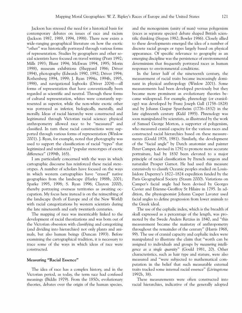
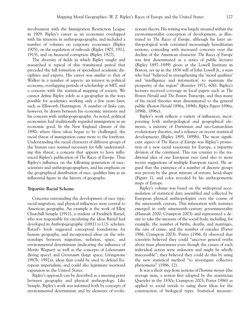
Ripley’s work reflects a variety of influences, incor-porating both anthropological and geographical ele-ments, a mixture of Darwinian and neo-Lamarckianevolutionary theories, and a reliance on recent statisticaldevelopments (Ripley 1895, 1899b). The most signifi-cant aspect of The Races of Europe was Ripley’s promo-tion of a new racial taxonomy for Europe, a tripartitedivision of the continent. This ran counter to the tra-ditional idea of one European race (and also to morerecent suggestions of multiple European races). He ar-gued that the existence of a number of discrete groupswas proven by the great mixture of stature, head-shape(Figure 1), and color revealed by his anthropometricmaps of Europe.
Ripley’s volume was based on the widespread accu-mulation of statistical data assembled and collected byEuropean physical anthropologists over the course ofthe nineteenth century. This infatuation with statisticsemerged in early nineteenth-century governmentality(Hannah 2000; Crampton 2003) and represented a de-sire to take the measure of the social body, including, forexample, the number of births, deaths, and marriages,the rate of crime, and the number of suicides (Porter1986; Crampton 2003). Porter (1986, 6) observed thatscientists believed they could ‘‘uncover general truthsabout mass phenomena even though the causes of eachindividual action were unknown and might be whollyinaccessible’’; they believed they could do this by usingthe new statistical method ‘‘to investigate collectivephenomena’’ (1986, 12).
It was a short step from notions of l’homme moyen (theaverage man, a notion first adopted by the statisticianQuetelet in the 1830s; Crampton 2003; Porter 1986) asapplied to social trends to using these ideas for theconstruction of biological types. Statistical measure-
Mapping Moral Geographies: W. Z. Ripley’s Races of Europe and the United States 127
ments such as correlation, first conceived by FrancisGalton as a statistical law of heredity, and concepts of‘‘standard deviation’’ and ‘‘normal law’’ developed byKarl Pearson in 1894 (Porter 1986) soon became rou-tinely applied to anthropometric measurements and tosocial problems. Ripley’s work used statistics in two ways:to draw conclusions about the biological race types inEurope, and to link social and moral issues to thesetraits, as discussed further below. His delineation ofphysical type is the focus of the remainder of this section.
To distinguish racial character, Ripley argued thatthree stages of statistical differentiation were necessary:distribution of separate individual traits, their associationwith one another into different types, and the existenceof a hereditary character of these types that justified theterm race. This method was derived from French an-thropologist Paul Topinard8 who, in recognition of thediversity within each race, had developed the notion of‘‘pure race’’ and ‘‘type.’’ The notion of type incorporated
a ‘‘physical ideal’’ that would be better marked in somemembers of the group than others (Stocking 1968). Thesocially constructed nature of these categories is evidentin Topinard’s eventual conclusion, by 1879, that indi-viduals did not seem to fit the racial type, an observationreflected in Ripley’s recognitions that race was ‘‘an ab-stract conception’’ and ‘‘rarely, if indeed ever, do wediscover a single individual type in every detail. It existsfor us nevertheless’’ (Ripley 1899b, 111–12). Stocking(1968, 57) noted: ‘‘Paradoxically, the more precise andextensive the observation and the measurement ofmankind, the more tenuous was the ‘reality’ of the racesthey served to define’’ and that ‘‘faith in type was hard togive up.’’ Although Topinard and Ripley both recognizedthat no perfect type existed, this aspiration prevailed.
Ripley’s attempts to delineate the races of Europeincluded lengthy discussions on the importance of vari-ous forms of measurement and he concluded that themost reliable methods were, in order, cephalic index,
Figure 1. Cephalic index for Europe. Source: Ripley 1899b.
Winlow128

pigmentation, and stature. A map of cephalic index forEurope (Figure 1) revealed that in the western area, ‘‘allthe extremes of head form known to the human race arecrowded together’’ (Ripley 1899b, 53) and convincedRipley of the existence of a number of permanent racetypes. He regarded cephalic index as more reliable thanpigmentation, as he perceived the latter as more sus-ceptible to environmental influence, reflecting Darwin-ian ideas. A number of European anthropogeographersinfluenced Ripley’s work, including British anthropolo-gist John Beddoe (1885, 1905, 1912), who had carriedout extensive anthropological investigations based oncephalic indices and pigmentation characteristics, andwhom Ripley (1899b, ix) described as ‘‘a constant sourceof inspiration.’’9 Ripley’s attachment to cephalic indexwas not accepted by all; American anthropologist FranzBoas in particular chastised him for his reliance on thisindicator (Stocking 1968). Despite this reliance, Ripleyrejected links between head form and intelligence andwarned: ‘‘Let us beware of such ascriptions of a mo-nopoly of virtue or intellect to any given race, howevercomforting they may be to us who are of Teutonic de-scent’’ (Ripley 1899b, 214). Throughout The Races ofEurope, and in papers published around this date, Ripleyadopted a cautious approach to discussions of racial hi-erarchy and he demolished the unscientific use of theterm Aryan race (on both racial and linguistic grounds)that had been used indiscriminately by scientists since1861.
Based on statistics generated across Europe, Ripleyconstructed three European races: the Teutonic, theAlpine, and the Mediterranean. It was assumed thatevery individual belonged to one of these categories orresulted from an intermixture of them. Ripley’s Teutonicrace was situated in northwest Europe, with a center ofdispersion in Scandinavia, and was characterized by along head (dolichocephalic), aquiline nose, tall stature,light eyes, and generally blond hair. The Alpine10 raceconsisted of people with broad heads (brachycephalic),of medium stature, generally stocky build, with hair andeyes intermediate between the Teutonic and Mediter-ranean races. The Alpine type allegedly predominated inthe alpine areas of central Europe and was assumed tohave had Eastern roots. The Mediterranean (or Iberian)race occurred everywhere south of the Pyrenees and wascharacterized by slender and agile people, with dark hairand eyes, and a long head form. The early dolichoce-phalic type found in Europe in the late Stone Ages was,according to Ripley, a predecessor to his Mediterraneantype, an argument that was supported by H. J. Fleure(1926). Ripley posited a common Africanoid origin forthe Teuton and Mediterranean races, arguing that the
Teutons had branched off at an early stage, acquiringblond characteristics and a taller stature over manygenerations as they migrated north, a theory that restedon the assumption that the dolichocephalic head-formwas a more permanent characteristic than pigmentation.
Ripley’s tripartite scheme won acceptance amongEuropean and new world anthropogeographers (Hunt-ington 1915; Fleure and James 1916; Peake 1916; Fleure1918; Taylor 1927). According to Isaiah Bowman, TheRaces of Europe was read by American anthropogeogra-phers William Farabee and Roland Dixon, and wasconsulted by many involved in the Versailles TreatyConference of 1919 (Bowman 1936). The argumentsadvanced in the Races of Europe were greatly enhancedby Ripley’s use of racial and anthropometric cartography,to which I now turn.
Mapping the Races of Europe
Historians have considered Ripley’s development of atripartite racial scheme for Europe (Stocking 1968;Stepan 1982) but their accounts have ignored the visualaspect of his work. The cartographic representations thatappeared alongside his anthropogeographical descrip-tions played a vital role in legitimating and reinforcinghis racial categorizations and in emphasizing the ideathat particular racial groups inhabited particular spaces.
Ripley gave careful consideration to the cartographicmethod adopted in The Races of Europe. Although boththe sources of information and the original maps variedconsiderably, Ripley adopted a method that rendered alldata comparable. He devised a scheme of shading wheremaps incorporated modified scales in order to maintain asystematic scheme of representation. Many maps wereredrawn (many by Ripley’s wife, Ida), adopting statisticalmethods, for, as Ripley argued: ‘‘the visual impressionmust, so far as possible, conform to the representedfacts’’ (Ripley 1899b, vii).
In September 1899, Ripley separately published anarticle entitled ‘‘Notes on Map Making and GraphicRepresentation’’ in the quarterly publication of theAmerican Statistical Association. This paper addressedissues of color, shading, legend, and mapmaking tech-niques, and reflected Ripley’s concern with the appro-priate portrayal of statistics in visual form. He stronglyemphasized the importance of using a graduated colorseries in representing continuous data, such as those forsuicide rates. For Ripley, anthropometric data of the kindpresented in The Races of Europe necessarily constituteda graduated series, since factors such as cephalic index,stature, and hair color would always be part of a somaticcontinuum. However, the wide acceptance of maps as
Mapping Moral Geographies: W. Z. Ripley’s Races of Europe and the United States 129

mirrors of nature (Harley 1992) alongside Ripley’s de-velopment of cartographic sign-systems (Wood 1993) fordepicting race allowed Ripley to naturalize these racialdivisions in cartographic form.
The views expressed in ‘‘Notes on Map Making’’(Ripley 1899a), and the collation of the maps in TheRaces of Europe, illustrate an attempt to be vigorouslyscientific and accurate and reflected Ripley’s desire torepresent the racial truth, which through his anthropo-metric cartography (and its reliance on statistics) in-volved the objectification of human individuals.Although Ripley eliminated the types of bias discussedabove he had no means of testing the original anthro-pometric statistics that had originated from manysources and been acquired in a variety of different ways.(For example, there were several methods for observingpigmentation.) Although a fundamental element ofRipley’s work was that racial traits were measured torepresent an average type, records of combinations of
traits within individuals were not kept. This amalgam ofresults is illustrative of the ‘‘social construction’’ of race.The measurement of different traits could producewidely varying results, depending on the racial theorythe writer wished to prove. Indeed, French anthropolo-gist Joseph Deniker had posited ten races for Europebased on similar anthropometric data (Stepan 1982).
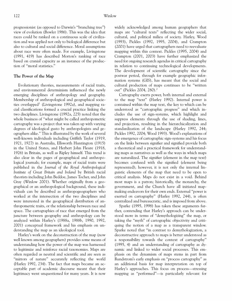
In support of his racial divisions Ripley producedanthropometric maps for various European countriesincluding Germany, Italy, and Scandinavia as discussedhere. Germany was generally regarded as exemplifyingthe Teutonic population, but Ripley stressed at leastthree divisions as shown in Figure 2. He argued that thenorthwest consisted of the same pure blond Teuton asScandinavia (where, illustrating his acceptance of envi-ronmental determinism, he argued that the Teutonicrace could be found in its ‘‘maximum purity’’ due togeographic isolation; 1899b, 205). Further south, pig-mentation variations reflected a change in population
Figure 2. Relative frequency of brunette types for Germany. Source: Ripley 1899b.
Winlow130
from Teutonic to an intermediate type between Teutonand Alpine (with blue eyes and brown hair), then, far-thest toward the equator, the Alpine type. These con-clusions reveal a particularly dramatic environmentalistreading and imply that migration to a new area wouldresult in racial adaptation in terms of pigmentation. Theportrayal of increasing darkness of pigmentation fromnorth to south is particularly dominant in this map, andcould serve to reinforce widespread assumptions of abiological racial hierarchy, where more advanced racesare associated with the climate of the northern latitudes.The visual clarity of the map was reinforced throughRipley’s system of classification that divided pigmenta-tion data into even categories: 5–10 percent, 11–15percent, and 16–20 percent. Visually this system im-posed a sudden break between one category and thenext. If pigmentation occurred on a continuous scale,however, where did the division between one race andthe next lie? These divisions were purely arbitrary(Stocking 1968).
The physical delineation of these artificial boundariesin the map text lent scientific credibility to racial divi-sions. Here, the internal power of the map text lies in theimposition of geometrical divisions on the populationand the landscape, as well as the use of shading thatreinforces color divisions. In terms of external power, thisdepiction fitted into traditional assumptions, includingKant’s theories that pigmentation is related to distancefrom the equator. The map reinforced the widespreadassumptions in European and American racial sciencethat environment was in large measure responsible forshaping racial character. This assumed pattern of physi-cal difference in relation to climate led to what Living-stone has termed ‘‘moral climatology’’ where it wasassumed that biological as well as mental/moral at-tributes were directly linked to climate—hence a wide-spread medical and anthropological literature thatassumed the inferiority of those living in the Tropics(Livingstone 2001). Ripley aimed to avoid making linksbetween biological and intellectual attributes in TheRaces of Europe but his later work betrayed moralisticassumptions, as shown in the following section.
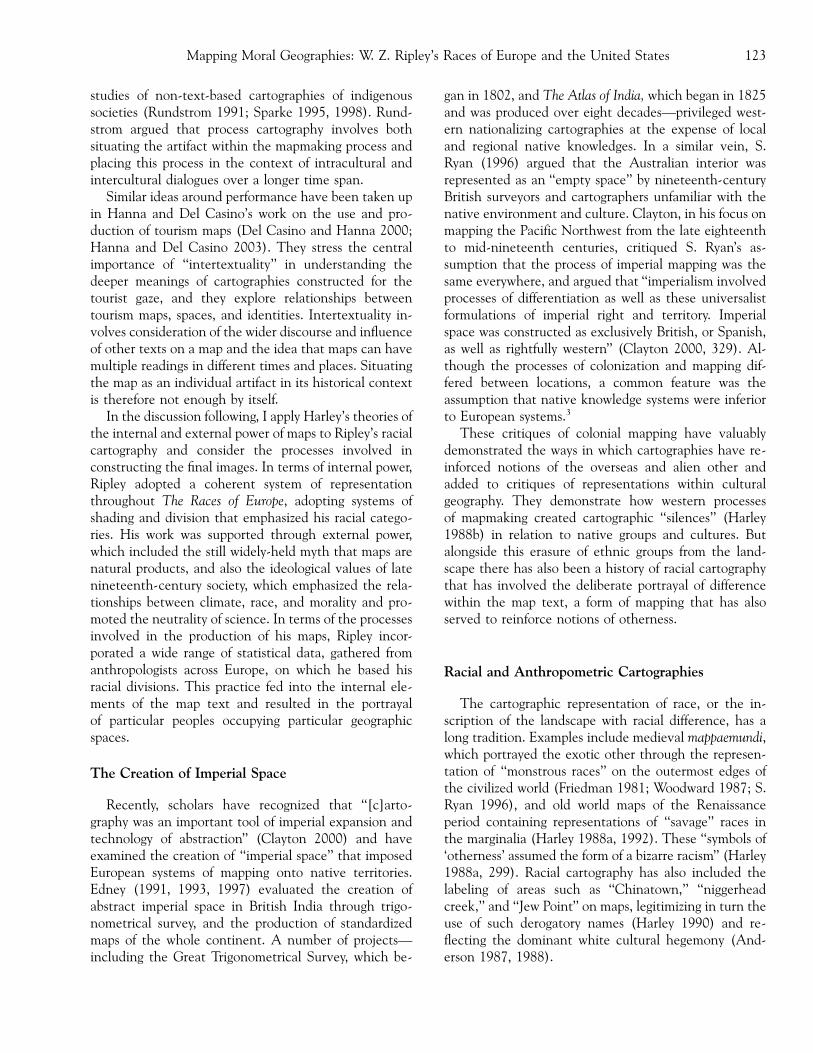
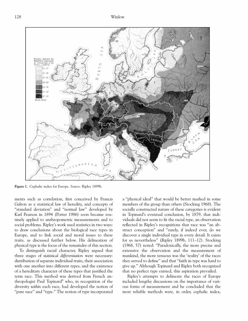
Ripley’s construction of a racial topography for Italystressed the geographical, and, in turn, racial division ofthe country into two distinct regions: Alpine in thenorthern mountainous areas and Mediterranean in thesouth. Ripley correlated data collected by Ridolfo Livi(with whom he corresponded between 1895 and 1899;see Livi 1895–1899) to produce three maps: of cephalicindex (Figure 3), of pigmentation, and of stature. Again,these maps of Italy contain internal power through theuse of sign-systems, including shading and systematic
graphical divisions, and the three maps combine topresent an apparently unquestionable picture of racialtruth. Livi’s collection of 294,271 observations of ce-phalic index across the country equated with a regionalgeography of race that influenced Ripley’s work. Thespatial element, or the link between race and geography,is reinforced through the portrayal of anthropometricstatistics in cartographic form (Figure 3).
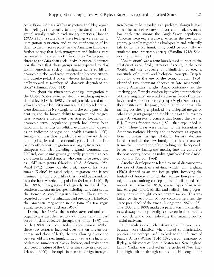
Ripley considered Switzerland to be dominated by theAlpine type but with some Teutonic influence in theNorth (assumed to have invaded along principal water-courses) so that stronger Alpine characteristics appearedin the southeast and southwest. Figure 4, representingpigmentation statistics for Switzerland, was constructednot only through the judicious use of map shading toportray statistical anthropometric information, but alsothrough the application of Beddoe’s (1885, 1905, 1912)‘‘nigrescence index,’’ an artificial construct of racial dif-ference based on a mathematical formula (Winlow2001). Beddoe had previously used this index in his ownpigmentation maps of Britain (1885, 1905) and Europe(1905) and Ripley was fully aware of this work. Thisstatistical manipulation of data was part of the process ofproduction and contributed to the internal power of themap text.
Ripley’s deployment of his racial taxonomy plainlyoverrode his awareness of the abstracted and con-structed nature of his racialized scheme. His anthro-pometric cartography highlights, augments, andsummarizes his written text. Ripley’s maps contain in-ternal power and his maps and text are mutually rein-forcing. Indeed, his concern to represent the data fairlyshows that Ripley was fully aware of the influence ofcartographic representation. His maps were also sup-ported by external power manifested in the cultural ac-ceptance that races did exist (and were not constructed),that they could be identified scientifically, and that theycould be hierarchically classified, physically, mentally,and morally. The existence of other anthropometricmaps, such as those based on Beddoe’s nigrescence in-dex, indicate some degree of intertextuality in Ripley’swork, where other cartographic representations fed intothe way he produced his maps, showing that the processof production is important for the final representation.Ripley also conveyed the geographical element ofEuropean races to a degree not previously shown.Anthropometric data were collected across differentcountries in Europe, and the spatial distributions of thesedivisions became more evident through the manipula-tion (or what Gould [1978, 505] termed unconsciousdata ‘‘finagling’’) and production of these statistics incartographic form.
Mapping Moral Geographies: W. Z. Ripley’s Races of Europe and the United States 131

Ripley’s maps cannot be viewed as stand-alone arti-facts, but need to be considered in the wider context ofphysical anthropometry and the representation of thisform of data. Indeed, his images formed part of a widercartographic discourse of race, as demonstrated not onlyby his reliance on Beddoe’s nigrescence index, but also byhis influence on the production of other anthropometricand racial maps. This is illustrated through a number ofmaps relying on Ripley’s tripartite division of Europe, in-cluding Huntington’s maps of world distribution of energy(human energy perceived as related to climate) and ofcivilization, in Civilization and Climate (1915); Peake’s(1916) representations of maps before and after the firstsiege of Troy, which depicted Nordic (corresponding toRipley’s Teuton), Alpine, and Mediterranean types; andTaylor’s (1919) zones and strata scheme.
Ripley’s moral geographies
Great Britain has its ‘‘white man’s burden’’ to bear in Indiaand Africa; we have ours to bear with the American Negroand the Filipino. But an even greater responsibility with us,and with the people of Canada, is that of the ‘‘Anglo-Saxon’s burden,’’so to nourish, uplift, and inspire all theseimmigrant peoples of Europe that, in due course of time,even if the Anglo-Saxon stock be physically inundated bythe engulfing flood, the torch of its civilization and idealsmay still continue to illuminate the way.
—Ripley (1908b)
Higham’s (1975, 24) contention that ‘‘a number ofpatrician intellectuals turned the Anglo-Saxon traditioninto a defensive attack on immigrants’’ seems particu-
Figure 3. Cephalic index for Italy.Source: Ripley 1899b.
Winlow132

larly pertinent to Ripley’s later writings, in his pater-nalistic comments toward other races and his use ofrhetoric to imply the advanced civilization of the Anglo-Saxon group. By 1908, Ripley was more closely involvedin the construction of links between physical racialcharacter and social and moral values. In Races of EuropeRipley’s cartographic constructions had been used ef-fectively to demonstrate the existence of a tripartitescheme in Europe. His later anthropogeographical workdrew on these assumptions and involved a metaphoricalmapping of social and moral geographies onto the U.S.landscape.
The term moral geographies refers to the social be-havior of individuals who were spatially situated in par-ticular areas. Driver (1988, 1992) examined theassumptions made by nineteenth-century reformers andsocial scientists about the links between environmentand social issues, and the moralistic judgments middle-class commentators made about the behavior of theworking classes living in overcrowded Victorian cities.He points out the role of statistics in collecting demo-graphic, medical, and political information in theeighteenth century but notes that ‘‘it was not until the1830s that statistics became closely identified with thesocial or moral sciences’’ (Driver 1988, 277), around thetime that a number of statistical societies emerged in
England and in the United States.11 Problems of ‘‘pau-perism, crime, ill-health, drunkenness, delinquency anddegeneracy’’ (Driver 1988, 277) were seen as part of awider problem of antisocial behavior and were associatedparticularly with urban environments.
Ripley’s (1908a, 1908b) moral geographies of theUnited States incorporate the discourses of morality,health, and space noted by Driver (1988) and Kneale(1999), but Ripley’s approach is significantly differentbecause he linked these ideas to the racial makeup of thepopulation. Thus assumptions of moral superiority andinferiority are made not only on class, but on race-basedgrounds. The racial divisions that Ripley applied to theU.S. population had already been delineated through theuse of cartography in The Races of Europe. His later workbuilt on these already constructed divisions and he be-gan to imply that, hand-in-hand with a biological hier-archy, there existed a moral and intellectual hierarchy ofraces.
Ripley’s increasingly hereditarian ideas on the cul-tural, moral, and racial superiority of the Anglo-Saxongroup are developed in his 1908 Huxley Memorial Lec-ture (1908a). The notion of the ‘‘racial other’’ is para-mount, and the new immigrants, who were spatiallylocated in the ghettos of eastern cities, were constructedas outsiders. This aspect of Ripley’s work is indicative of
Figure 4. Relative brunetteness for Switzerland. Source: Ripley 1899b.
Mapping Moral Geographies: W. Z. Ripley’s Races of Europe and the United States 133
the trend that originated in Western Europe of labelingpeople as insiders or outsiders using both social andspatial referents, a trend that was recognized by Foucault(as discussed in Philo 1992; and by Sibley 1995). Ripleydescribed the population of Europe as sedimentary, andconversely he termed the races of the United States‘‘eruptive,’’ resulting not from slow processes of growthby deposit but by ‘‘violent and volcanic dislocation’’(Ripley 1908a, 221; 1908b, 745) or a ‘‘lava-flow’’ ofmigrants. This type of geological analogy became apopular metaphor in racial descriptions, and was latersystematically applied to the evolution of world races andlanguages by Griffith Taylor (1919, 1921; Winlow 1999).Ripley viewed America as ‘‘artificial and exotic’’ (italicsadded) and immigrants as a ‘‘horde’’ whose numbers hadbeen increasing rapidly year by year. Metaphors of ‘‘in-vasion’’ were reflected in newspaper reports on Ripley’sarticle.12 The New York Times (1908b) reported: ‘‘Prof.Ripley declared that there is a danger of the submer-gence of the English stock in North America by reason ofthe influx of other races from the Continent of Europeand the Anglo-Saxon birth rate.’’ Some newspaperheadlines were quite sensational, and included: ‘‘OurForeign Human Deluge’’ (New Orleans Picayune 1908)and ‘‘Will the Anglo-Saxon type disappear in the UnitedStates?’’ (Baltimore Sun 1908). The New Orleans Pica-yune noted that Italian immigrants constituted an armyfor the year of 1907, and described the Slavs, Huns, andRussians as a great horde. It was observed that ‘‘the effectsof such a deluge of foreign invasion, peaceable as it is, aregoing to be enormous . . . some of our States will beoverrun by foreigners.’’ The article concluded, ‘‘Can weregard the influx of these enormous hordes of foreigners,not a few of whom may be classed as barbarians, withouta certain degree of anxiety and alarm?’’ (New OrleansPicayune 1908, italics added). A couple of reports re-jected this pessimistic stance. In the Baltimore Sun, onejournalist observed: ‘‘The American of today is a com-posite. . . . Whatever may be the appearance of theAmerican in the year 2100, we may be sure that he willbe self-reliant and efficient and be able to take care ofhimself.’’ The New York Times (1908a) noted that ‘‘sec-ond-generation citizens of foreign stock are among themost successful and typical Americans’’ and that ‘‘themelting pot is doing its work admirably.’’ Despite thesefew reports, the prevailing view was negative and soughtto cultivate readers’ fears.
Ideas of assimilation were thus evident in popularrepresentation as well as in scientific writing. Ripley’swriting was infused with a mixture of assimilation the-ories that suggested both biological and cultural assimi-lation. In discussions on language use he referred to
Cincinnati and Milwaukee as cities that had experiencedhigh levels of German migration but were now ‘‘Ameri-canized,’’ with the loss of the parent language by thesecond or third generation. This illustrates an element ofAnglo-conformity in his work, but he also noted that the‘‘parent stock became visibly diluted’’ (Ripley 1908b,752; italics added), implying some biological change.Indeed he regarded intermarriage between new immi-grant groups (such as between English and German) assigns of successful assimilation, illustrating the influenceof the melting-pot theory.
Other immigrant groups were viewed in a less favorablelight. Ripley (1908b, 756) described the tendency to settlein neighborhoods with those from the same origin countryas ‘‘race instinct’’ (reflecting the influence of Walker’sthesis), an explanation that naturalized ethnic segregationwithin the cities but ignored the contribution of socialfactors. Concentration of new immigrants in the ghettosof northeastern industrial cities was generally attributed to‘‘ignorance of opportunity’’ and ‘‘lack of occupationalskills,’’ overlooking the demand for low-paid unskilledlabor that had attracted immigrants to these areas (Ward1971, 55). Ripley equated immigrant ghettoization withsocial problems, including divorce, suicide, and poverty.
The emphasis on ethnic segregation in Americancities and on related social problems can be perceived asa moral geography that was further supported by a 1913map highlighting the immigrant ‘‘problem’’ (Figure 5).This image, based on 1910 census data and published inThe New York Times, shows the percentage of ‘‘foreignborn whites in the total population.’’ The darkestshading shows a population of between 25 and 30 per-cent foreign-born whites and indicates that the highestproportions of recent white immigrants had settled ineastern and northeastern states, including New York,New Jersey, Massachusetts, and Connecticut, and in twomore westerly northern states, North Dakota and Min-nesota (where labor was needed for mining raw materi-als). The use of dark shading to highlight the immigrantproblem is similar to that used in The Races of Europe,where darker shading was used to denote the Mediter-ranean types. The map accompanied a newspaper article,‘‘Census Figures Disclose Grave Racial Problem’’ (Ripley1913), in which Ripley described the concentration ofimmigrants as ‘‘alien colonies’’ and ‘‘undigested lumps ofimperfect civilization in our midst.’’ References to sav-agery and civilization reflected earlier discourses of Eu-ropean colonialism, where it was feared that contactwith other races would corrupt white Europeans13 (e.g.,through the acclimatization debate).
Ripley’s constructions of moral geographies of theU.S. landscape had their foundations in The Races of
Winlow134
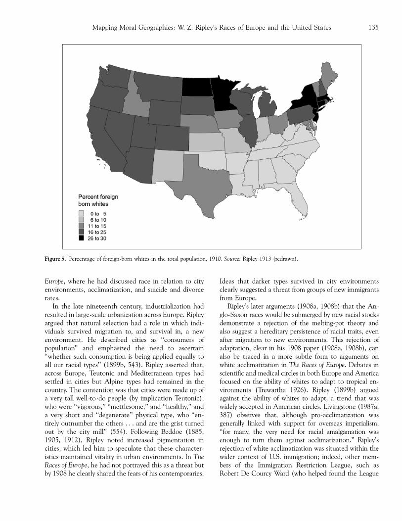
Europe, where he had discussed race in relation to cityenvironments, acclimatization, and suicide and divorcerates.
In the late nineteenth century, industrialization hadresulted in large-scale urbanization across Europe. Ripleyargued that natural selection had a role in which indi-viduals survived migration to, and survival in, a newenvironment. He described cities as ‘‘consumers ofpopulation’’ and emphasized the need to ascertain‘‘whether such consumption is being applied equally toall our racial types’’ (1899b, 543). Ripley asserted that,across Europe, Teutonic and Mediterranean types hadsettled in cities but Alpine types had remained in thecountry. The contention was that cities were made up ofa very tall well-to-do people (by implication Teutonic),who were ‘‘vigorous,’’ ‘‘mettlesome,’’ and ‘‘healthy,’’ anda very short and ‘‘degenerate’’ physical type, who ‘‘en-tirely outnumber the others . . . and are the grist turnedout by the city mill’’ (554). Following Beddoe (1885,1905, 1912), Ripley noted increased pigmentation incities, which led him to speculate that these character-istics maintained vitality in urban environments. In TheRaces of Europe, he had not portrayed this as a threat butby 1908 he clearly shared the fears of his contemporaries.
Ideas that darker types survived in city environmentsclearly suggested a threat from groups of new immigrantsfrom Europe.
Ripley’s later arguments (1908a, 1908b) that the An-glo-Saxon races would be submerged by new racial stocksdemonstrate a rejection of the melting-pot theory andalso suggest a hereditary persistence of racial traits, evenafter migration to new environments. This rejection ofadaptation, clear in his 1908 paper (1908a, 1908b), canalso be traced in a more subtle form to arguments onwhite acclimatization in The Races of Europe. Debates inscientific and medical circles in both Europe and Americafocused on the ability of whites to adapt to tropical en-vironments (Trewartha 1926). Ripley (1899b) arguedagainst the ability of whites to adapt, a trend that waswidely accepted in American circles. Livingstone (1987a,387) observes that, although pro-acclimatization wasgenerally linked with support for overseas imperialism,‘‘for many, the very need for racial amalgamation wasenough to turn them against acclimatization.’’ Ripley’srejection of white acclimatization was situated within thewider context of U.S. immigration; indeed, other mem-bers of the Immigration Restriction League, such asRobert De Courcy Ward (who helped found the League
Figure 5. Percentage of foreign-born whites in the total population, 1910. Source: Ripley 1913 (redrawn).
Mapping Moral Geographies: W. Z. Ripley’s Races of Europe and the United States 135
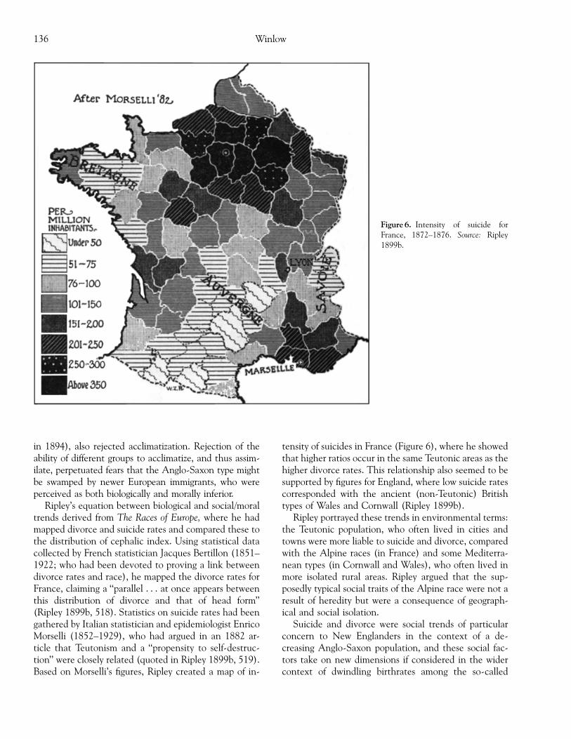
in 1894), also rejected acclimatization. Rejection of theability of different groups to acclimatize, and thus assim-ilate, perpetuated fears that the Anglo-Saxon type mightbe swamped by newer European immigrants, who wereperceived as both biologically and morally inferior.
Ripley’s equation between biological and social/moraltrends derived from The Races of Europe, where he hadmapped divorce and suicide rates and compared these tothe distribution of cephalic index. Using statistical datacollected by French statistician Jacques Bertillon (1851–1922; who had been devoted to proving a link betweendivorce rates and race), he mapped the divorce rates forFrance, claiming a ‘‘parallel . . . at once appears betweenthis distribution of divorce and that of head form’’(Ripley 1899b, 518). Statistics on suicide rates had beengathered by Italian statistician and epidemiologist EnricoMorselli (1852–1929), who had argued in an 1882 ar-ticle that Teutonism and a ‘‘propensity to self-destruc-tion’’ were closely related (quoted in Ripley 1899b, 519).Based on Morselli’s figures, Ripley created a map of in-
tensity of suicides in France (Figure 6), where he showedthat higher ratios occur in the same Teutonic areas as thehigher divorce rates. This relationship also seemed to besupported by figures for England, where low suicide ratescorresponded with the ancient (non-Teutonic) Britishtypes of Wales and Cornwall (Ripley 1899b).
Ripley portrayed these trends in environmental terms:the Teutonic population, who often lived in cities andtowns were more liable to suicide and divorce, comparedwith the Alpine races (in France) and some Mediterra-nean types (in Cornwall and Wales), who often lived inmore isolated rural areas. Ripley argued that the sup-posedly typical social traits of the Alpine race were not aresult of heredity but were a consequence of geograph-ical and social isolation.
Suicide and divorce were social trends of particularconcern to New Englanders in the context of a de-creasing Anglo-Saxon population, and these social fac-tors take on new dimensions if considered in the widercontext of dwindling birthrates among the so-called
Figure 6. Intensity of suicide forFrance, 1872–1876. Source: Ripley1899b.
Winlow136

Anglo-Saxon population. Ripley had produced maps ofsuicide and divorce in The Races of Europe, which couldlater be used in support of immigration restriction.Plainly, Ripley’s science cannot be separated from itssocial context. In racial measurement and environmen-tal influence Ripley found resources to explain to his ownsatisfaction the social phenomena of suicide and divorce,reinforced through the internal elements of the map textincluding data categorization and use of shading, thusnaturalizing this assumed link between physical distri-bution of race traits (cephalic index) and social prob-lems. This process of mapping both physical traits andsocial statistics contributed to the creation of moralgeographies in the United States, and descriptions offloods or hordes of immigrants from southern and east-ern Europe to the northeastern cities implied a loss ofAnglo-Saxon groups who, as well as experiencing de-creasing birth rates, were more susceptible to suicide anddivorce.
By the early twentieth century Ripley’s constructionof a moral geography linking racial character with issuesof social concern had been firmly transferred to the U.S.landscape, and the construction of the alien other withinthe home population was consolidated in his HuxleyMemorial Lecture (1908a). Like other New EnglandersRipley came to support the notion of race suicide and ofimmigration restriction on racial as well as economicgrounds. Solomon (1956, 130) asserts that Ripley be-came ‘‘caught in the web of racist thinking’’ and that TheRaces of Europe was open to xenophobic misuse, andHigham (1963) notes that his threefold division was apowerful tool for nativists, as the Mediterranean andAlpine categories corresponded roughly with new im-migration. The naturalization of these racial divisionsthrough cartographic portrayal strongly supported thesesocial constructions, and Ripley’s metaphorical mappingof European race traits onto the U.S. landscape served toreinforce notions that particular races belonged in par-ticular places.
Conclusion
This study of Ripley’s cartographic products demon-strates how the landscapes of Europe and the UnitedStates were inscribed with racial categorizations, rein-forcing notions of otherness. The cultural production ofmaps has been demonstrated in examples of anthropo-metric cartography from The Races of Europe. A closefocus on the cartographic processes and the resultingartifacts reveals the power inherent in Ripley’s cartog-raphy. The hierarchicalization of the landscape occurredthrough the manipulation and division of racial data—
resulting in geometrical divisions in the map text—andthrough the use of shading systems to reinforce the as-sumed link between environment and race. Ripley’smaps thus contained an internal power, which conveyedan image of coherence, obscuring the statistical manip-ulation involved in their production and legitimating hisracial classifications.
The naturalization of these divisions through thedevelopment of systems of signification and, externally,the acceptance of maps as neutral tools accurately rep-resenting reality further reinforced the idea that racescould easily be delineated and situated in space. Otherforms of external power were manifested in the accept-ance of racial type and the belief that Victorian systemsof biological measurement could reveal these types.Contained within, and inseparable from, nineteenth-century race science was the assumption that races couldbe hierarchically classified. Anthropogeographers foundno difficulty in applying these assumptions to Ripley’stripartite scheme, and his cartography reaffirmed andlegitimated such notions. Ripley’s maps cannot beviewed solely as historical artifacts but can also be in-terpreted as part of a wider discourse. His maps bothbuilt on and fed into other representations of race.
The production of a moral geography, erected on aseemingly robust scientific cartography, was a persistentfeature of Ripley’s work. Maps of suicide and divorcerates and their association with the cephalic index areillustrative of this preoccupation. The assumption thatmental character is connected with externally measur-able attributes was common throughout nineteenthcentury racial science. Ripley’s discussion of immigra-tion, which assumed links with social problems in U.S.cities, provided examples of a moral geography that drewsustenance from the generation of moral statistics. Hissocial concerns were therefore inseparable from his racialscience.
Acknowledgments
I would like to thank Professor David Livingstone forhis input into this research project, and Dr John Robb,two anonymous referees, and the section editor forcomments on drafts of this article. Thanks also to thecurators in the MIT and Harvard archives for their as-sistance in gaining access to materials of relevance to thisproject.
Notes
1. As Livingstone (1992a, 162–66, 221–22) has observed, inthe first half of the nineteenth century in Britain several
Mapping Moral Geographies: W. Z. Ripley’s Races of Europe and the United States 137
members of the Royal Geographical Society (RGS) werealso members of the Ethnological Society, and in 1851 ge-ography and ethnology were established as section E in theBritish Academy for the Advancement of Science (BAAS).Although anthropology and geography later became sepa-rated, many links between these areas continued, includingthe acceptance of environmental determinism and its im-pact on racial development.
2. For a brief review of recent developments in critical car-tography, see Perkins (2004).
3. Sparke (1995, 1998) recognizes the important links be-tween colonialism and cartography, but argues that as wellas focusing on the hegemonic construction of imperialspace, counter-mappings, or antihegemonic mappings, needalso to be considered. These become apparent through re-reading the map text. Resistant voices portrayed throughcartography include the maps drawn by Shawnadithit, thelast of the Beothuk in Newfoundland, Canada (Sparke1995), and the 1987 trial in the Supreme Court of BritishColumbia, where representatives of two First Nations (theWet’su-wet’en and the Gitxsan) brought a land claimagainst the government (Sparke 1998). Rundstrom (1991)discusses the ways in which the Inuit communities of ArcticCanada have resituated themselves as part of the carto-graphic establishment through the production of a map in1987, which recorded 8,000 Inuit names of places that hadusually been transmitted through oral memory.
4. Owen Dwyer (2003) has examined the memorialization ofthe Civil Rights Movement in Alabama through a focus ontourism literature and maps, and from the standpoint thatmaps and monuments are both viewed as mirrors on theworld. He argues that these representations show the civilrights movements as a won cause but do not critique furtherinequalities existing in society.
5. Ward (1971) has observed that the distinction made be-tween old and new immigrants was a loose one, and was notclosely tied to time of arrival or to length of residence ofindividual migrants.
6. Gordon (1964) also identified a third trend of ‘‘culturalpluralism’’ but this only formed a minor departure on dis-cussions of assimilation in this period. This concept wasmore progressive in outlook, stressing political and eco-nomic integration, but allowing for preservation of signifi-cant elements of the culture of the immigrant groups.
7. Fears about racial degeneration continued for several dec-ades; in the 1930s President Franklin D. Roosevelt, influ-enced by eugenicists such as Madison Grant, increasinglyvoiced fears about race suicide and about the degeneratestocks entering the country during his presidency (Brechin1996, 233).
8. Topinard was influenced by the polygenist notion of ‘‘he-reditary racial essence,’’ where it was assumed that pureraces could be distinguished from hybrid races (Stocking1968)
9. Ripley also regarded stature as heavily influenced by envi-ronmental change (again reflecting Darwinian ideas) andargued that inhabitants of mountainous areas, where foodwas scarce, would be shorter than inhabitants of areaswhere food was plentiful. These discussions also contained aneo-Lamarckian element, whereby stature could be affectedby artificial selection resulting from ‘‘modern social life,’’where choice of occupation was governed by ‘‘hereditary
necessity’’ (Ripley 1899b, 85). Thus a greater stature couldbe expected from police and ironworkers, as compared totailors or shoemakers.
10. By defining this group as ‘‘Alpine,’’ Ripley returned toLinnaeus’s nomenclature, rejecting the term Celtic, whichhe felt would falsely suggest links between race and theCeltic language and culture.
11. Statistical societies were formed in London (London Sta-tistical Society) and Manchester and other towns and citiesin the United Kingdom during the 1830s and 1840s (Driver1988). In the United States, the American Statistical So-ciety was formed in 1839 (Hannah 2000).
12. Selected newspaper clippings survive in the Harvard Ar-chives, but more extensive research in this particular areamay reveal further newspaper commentary resulting fromRipley’s racial theories.
13. Threats to the racial character of the nation were seenas resulting not only from the increase in immigrant num-bers but from intermixture with ‘‘inferior’’ races. Ideas ofdegeneration (Stepan 1985) and miscegenation (Living-stone 1987a, 1992c) prevailed. Ripley himself argued that‘‘crossing between highly evolved varieties or types tendedto bring about reversion to the original stock’’ (Ripley1908b, 754–55). This again reflected the increasing para-noia among American scientists during the period sur-rounding issues such as interracial marriage.
References
American Economic Review. 1952. William Zebina Ripley.42:514.
Anderson, Kay J. 1987. The idea of Chinatown: The power ofplace and institutional practice in the making of a racialcategory. Annals of the Association of American Geographers77:590–98.
FFF. 1988. Cultural hegemony and the race definition proc-ess in Chinatown, Vancouver: 1880–1980. Society andSpace 6:127–49.
FFF. 1991. Vancouver’s Chinatown: Racial discourse in Can-ada, 1875–1980. Montreal: McGill-Queen’s UniversityPress.
Baltimore Sun. 1908. Will the Anglo-Saxon type disappear in theUnited States? 1 December.
Beddoe, John. 1885. The races of Britain—A contribution to theanthropology of Western Europe (1971 Reprint). London:Hutchinson.
FFF. 1905. Color and race. The Huxley Memorial Lecture.The Journal of the Royal Anthropological Institute of GreatBritain and Ireland 35:219–50.
FFF. 1912. The anthropological history of Europe: Being theRhind Lectures for 1891. Paisley, U.K.: Alexander Gardner.(Orig. pub. 1891.)
Biddis, Michael. 1979. Images of race. Leicester, U.K.: LeicesterUniversity Press.
Blunt, Alison. 1994. Travel, gender, and imperialism: Mary Kings-ley and West Africa. London: Guilford.
Bonnett, Alistair. 1993. Radicalism, anti-racism and representa-tion. London: Routledge.
FFF. 1996a. Anti-racism and the critique of ‘‘white identi-ties.’’ New Community 22 (1): 97–110.
Winlow138
FFF. 1996b. Forever ‘‘white’’? (Orig. pub. 1891.) Challengesand alternatives to a ‘‘racial’’ monolith. New Community 13(2): 173–80.
Boston Herald. 1896a. Prof. Ripley’s Lectures. 14 November.FFF. 1896b. Types of European races. 18 November.Bowler, Peter J. 1986. Theories of human evolution. Oxford, U.K.:
Blackwell.Bowman, Isaiah. 1936. Letter to Ripley, 1 December. Ripley
Papers, Harvard University Archives, HUG4745.11 (box 1,folder 6).
Brechin, Gray. 1996. Conserving the race: Natural aristocracies,eugenics, and the U.S. conservation movement. Antipode28 (3): 229–45.
Clayton, Daniel. 2000. The creation of imperial space in thePacific northwest. Journal of Historical Geography 26 (3):327–50.
Crampton, Jeremy. 2001. Maps as social constructions: Power,communication, and visualization. Progress in Human Ge-ography 25 (2): 235–52.
FFF. 2003. Cartographic rationality and the politics of geo-surveillance and security. Cartography and Geographic In-formation Science 30 (2): 135–48.
Del Casino, Vincent, Jr., and Stephen P. Hanna. 2000. Repre-sentations and identities in tourism map spaces. Progress inHuman Geography 24 (1): 23–46.
Dictionary of American Biography. 1973. William ZebinaRipley. Suppl. 3, 1941–1945: 632–33. New York: CharlesScribner.
Driver, Felix. 1988. Moral geographies: Social science and theurban environment in mid-nineteenth century England.Transactions of the Institute of British Geographers 13:275–87.
FFF. 1992. Geography and power: The work of Michel Fou-cault. In Critical essays on Michel Foucault, ed. P. Burke,147–56. Aldershot: Scolar.
FFF. 1994. Geography, empire, and visualization: Makingrepresentations. Research Paper 1, Department of Geog-raphy, Royal Holloway, University of London.
FFF. 2004. Imagining the Tropics: Views and visions of thetropical world. Singapore Journal of Tropical Geography 25(1): 1–17.
Duncan, James. 1993. Sites of representation: Place, time, andthe discourse of the Other. In Place/ culture/ representation,ed. James Duncan and David Ley, 39–56. London: Rout-ledge.
Dwyer, Owen J. 2003. Memory on the margins: Alabama’s CivilRights journey as a memorial text. In Mapping tourism, ed.Stephen P. Hanna and Vincent Del Casino Jr., 28–50. Min-neapolis: University of Minnesota Press.
Edney, Matthew H. 1991. The atlas of India 1823–1947: Thenatural history of a topographic map series. Cartographica28 (4): 59–91.
FFF. 1993. The patronage of science and the creation ofimperial space: The British mapping of India, 1799–1843.Cartographica 30 (1): 61–67.
FFF. 1997. Mapping an empire: The geographical constructionof British India, 1765–1843. Chicago: University of ChicagoPress.
Edwards, Elizabeth. 1990. ‘‘Photograph types’’: The pursuit ofmethod. Visual Anthropology 3 (2–3): 235–58.
FFF, ed. 1992. Photography and anthropology, 1860–1920.New Haven, CT: Yale University Press.
Fleure, Herbert John. 1918. The racial history of the Britishpeople. Geography Review 5:216–31.
FFF. 1926. Wales and her people. Wrexham: Hughes and Son.Fleure, Herbert John, and T. C. James. 1916. Geographical dis-
tribution of anthropological types in Wales. Journal of theRoyal Anthropological Institute of Great Britain and Ireland46:35–154.
Friedman, John Block. 1981. The monstrous races in medieval artand thought. Cambridge, MA: Harvard University Press.
Gordon, Milton. 1964. Assimilation in American life: The role ofrace, religion, and national origins. New York: Oxford Uni-versity Press.
Gould, Stephen J. 1978. Morton’s ranking of races by cranialcapacity: Unconscious manipulation of data may be a sci-entific norm. Science 200:503–9.
FFF. 1981. The mismeasure of man. London: Penguin.Handlin, Oscar. 1948. Race and nationality in American life. Bos-
ton: Little, Brown.Hanna, Stephen P., and Vincent Del Casino Jr., eds. 2003. Map-
ping tourism. Minneapolis: University of Minnesota Press.Hannah, Matthew G. 2000. Governmentality and the mastery of
territory in nineteenth-century America. Cambridge, U.K.:Cambridge University Press.
Harley, J. Brian. 1988a. Maps, knowledge and power. In Theiconography of landscape: Essays on the symbolic representa-tion, design, and use of past environments, ed. Denis Cosgroveand Stephen Daniels, 277–312. Cambridge, U.K.: Cam-bridge University Press.
FFF. 1988b. Silences and secrecy: The hidden agenda of car-tography in early modern Europe. Imago Mundi 40:57–76.
FFF. 1990. Cartography, ethics and social theory. Carto-graphica 27:1–23.
FFF. 1992. Deconstructing the map. In Writing worlds: Dis-course, text and metaphor in the representation of landscape, ed.Trevor Barnes and James Duncan, 231–47. London: Rout-ledge. (Originally pub. 1989. Cartographica 26 (2):1–2.)
FFF. 2001. The new nature of maps: Essays in the history ofcartography, ed. Paul Laxton. Baltimore: Johns HopkinsUniversity Press.
Harris, Marvin. 1968. The rise of anthropological theory. London:Routledge and Keegan Paul.
Harvard Alumni Bulletin. 1933. Professor Ripley resigns. 17 Feb-ruary.
Higham, John. 1963. Strangers in the land: Patterns of Americannativism, 1865–1925, 2nd edition. New York: Atheneum.(First edition published 1955.)
FFF. 1975. Send these to me: Jews, and other immigrants inurban America. New York: Atheneum.
Huntington, Ellsworth. 1915. Civilization and climate. New Ha-ven, CT: Yale University Press.
FFF. 1937. Once more: What’s in a name. Norwich, CT:Huntington Family Association Publication.
Huntington, Ellsworth, and Martha Radsale. 1935. After threecenturies: A typical New England family. Baltimore: Williamsand Wilkins.
Jackson, Peter. 1987. Race and racism: Essays in social geography.London: Allen and Unwin.
FFF. 1989. Maps of meaning. London: Routledge.FFF. 1994. Black male: Advertising and the cultural politics
of masculinity. Gender, Place, and Culture: A Journal of Fem-inist Geography 1 (1): 49–60.
FFF. 1998. Constructions of ‘‘whiteness’’ in the geograph-ical imagination. Area 30 (2): 99–106.
Jenkins, Philip. 1997. A history of the United States. London:Macmillan.
Mapping Moral Geographies: W. Z. Ripley’s Races of Europe and the United States 139
Kidd, C. 1995. Teutonist ethnology and Scottish nationalist in-hibition, 1780–1880. The Scottish Historical Review 74 (1):45–68.
Kneale, James. 1999. ‘‘A problem of supervision’’: Moral geog-raphies of the nineteenth-century British public house.Journal of Historical Geography 25 (3): 333–48.
Kobayashi, Audrey. 2003. The construction of geographicalknowledge: Racialization, spatialization. In Handbook ofcultural geography, ed. Kay Anderson, Mona Domosh, StevePile, and Nigel Thrift, 544–56. London: Sage.
Limerick, Patricia Nelson. 1987. The legacy of conquest: The un-broken past of the American West. New York: Norton.
Livi, Ridolfo. 1895–1899. Letters to Ripley, Ripley Papers, Ha-rvard University Archives, HUG 4745.5 (box 1).
Livingstone, David N. 1987a. Human acclimatization: Perspec-tives on a contested field of inquiry in science, medicine,and geography. History of Science 25:359–94.
FFF. 1987b. Nathaniel Southgate Shaler and the culture ofAmerican science. Tuscaloosa: University of Alabama Press.
FFF. 1991. The moral discourse of climate: Historical con-siderations on race, place, and virtue. Journal of HistoricalGeography 17 (4): 413–34.
FFF. 1992a. The geographical tradition: Episodes in the historyof a contested enterprise. Oxford, U.K.: Blackwell.
FFF. 1992b. Never shall ye make the crab walk straight: Aninquiry into the scientific sources of racial geography. InNature and science: Essays in the history of geographical knowl-edge, ed. Felix Driver and Gillian Rose, 28, 37–48. London:Historical Geography Research Group of the Royal Geo-graphical Society with the Institute of British Geographers.
FFF. 1992c. The preadamite theory and the marriage of scienceand religion. Philadelphia: American Philosophical Society.
FFF. 2001. Race, space and moral climatology: Notes towardsa genealogy. Journal of Historical Geography 28 (2): 159–80.
McEwan, Cheryl. 1994. Encounters with West African women:Textual representations of difference by white womenabroad. In Writing women and space, ed. Alison Blunt andGillian Rose, 73–100. London: Guilford.
FFF. 1995. ‘‘The mother of all the peoples’’: Geographicalknowledge and the empowering of Mary Slessor. In Geog-raphy and imperialism: 1820–1940, ed. Morag Bell, RobinButlin, and Mike Heffernan, 125–50. Manchester, U.K.:Manchester University Press.
Mills, Sara. 1993. Discourses of difference: An analysis of womens’travel writing and colonialism. London: Routledge.
Morin, Karen M. 1998. British women travelers and construc-tions of racial difference across the nineteenth centuryAmerican West. Transactions of the Institute of British Geog-raphers 23 (3): 311–30.
New Orleans Picayune. 1908. Our foreign human deluge. 5 De-cember.
New York Times. 1908a. The earliest man. 17 December.FFF. 1908b. Views from Boston. 20 November.FFF. 1933. Prof. Ripley quits post at Harvard. Ripley Papers,
Harvard University Archives, HUG 4745.11 (box 2, folder13).
Ninkovich, Frank. 2001. The United States and imperialism. Ox-ford, U.K.: Blackwell.
Ogborn, Miles. 2003a. Finding historical data. In Key methodsin geography, ed. Nicholas J. Clifford and Gill Valentine,101–15. London: Sage.
FFF. 2003b. Knowledge is power: Using archival work tointerpret state formation. In Cultural geography in practice,
ed. Alison Blunt, Pyrs Gruffudd, Jon May, Miles Ogborn,and David Pinder, 9–20. London: Arnold.
Peake, Harold. 1916. Racial elements concerned in the firstsiege of Troy. Journal of the Royal Anthropological Institute ofGreat Britain and Ireland 46:154–72.
Perkins, Chris. 2004. Cartography—Cultures of mapping:Power in practice. Progress in Human Geography 28 (3):381–91.
Philo, Chris. 1992. Foucault’s geography. Environment and Plan-ning D: Society and Space 10:137–61.
Pickles, John. 1992. Texts, hermenuetics and propaganda maps.In Writing worlds: Discourse, text and metaphor in the repre-sentation of landscape, ed. Trevor Barnes and James Duncan,193–230. London: Routledge.
FFF. 1995. Ground truth: The social implications of geographicinformation systems. New York: Guilford.
FFF. 2004. A history of spaces: Cartographic reason, mappingand the geo-coded world. London: Routledge.
Porter, Theodore. 1986. The rise of statistical thinking: 1820–1900. Princeton, NJ: Princeton University Press.
Pratt, Mary Louise. 1992. Imperial eyes: Travel writing and trans-culturation. London: Routledge.
Ripley, William Zebina. 1895. Geography as a sociological study.Political Science Quarterly 10:636–55.
FFF. 1897–1899. The racial geography of Europe: A soci-ological study of Europe (Lowell Institute Lectures). Ap-pletons’ Popular Science Monthly 50:454–68, 577–94, 757–80; 51: 17–34, 192–209, 289–307, 433–53, 613–35, 721–29; 52: 49–68, 145–70, 304–22, 469–86, 591–608; 53:163–76, 338–52, 721–45.
FFF. 1899a. Notes on map making and graphic representa-tion. Quarterly Publications of the American Statistical Asso-ciation 47: 75–326.
FFF. 1899b. The races of Europe: A sociological study. Lon-don: Kegan Paul, Trench, Trubner.
FFF. 1905. Trusts, pools and corporations. Boston: Ginn.FFF. 1907. Railway problems. Boston: Ginn.FFF. 1908a. The European population of the United States
(The Huxley Memorial Lecture for 1908). Journal of theAnthropological Institute 38:221–40.
FFF. 1908b. Races in the United States. Atlantic Monthly102(6): 745–59.
FFF. 1912. Railroads: rates and regulations. New York: Long-mans, Green.
FFF. 1913. Census figures disclose grave racial problem:Analysis of recently published statistics concerning ourpopulation shows the big increase in the foreign born inthis country and the difficulties in assimilating immigrants.New York Times, 22 June.
FFF. 1915. Railroads: finance and organization. New York:Longmans, Green.
FFF. 1927. Main Street and Wall Street. Boston: Little,Brown. (new ed. 1972, with foreword by Maurice Moonitz.Lawrence, KS: Scholars Books.)
FFF. n.d. The Ripleys and their name. Ripley Papers, HarvardUniversity Archives, HUG 4745.11 (box 1 folder 6).
Ripley Papers. 1896a. European races studied; Their an-thropological history to be presented by Professor W. Z.Ripley in the Lowell Institute Course. Newspaper clip-ping, Harvard University Archives, HUG4745.11 (box 2,folder 12).
FFF. 1896b. Origin of population in Europe: Interest-ing lecture by Prof. W. Z. Ripley in the Lowell Institute
Winlow140
Course. Newspaper clipping, Harvard University Archives,HUG4745.11 (box 2, folder 12).
FFF. 1896c. Three European race-types described. Newspa-per clipping, Harvard University Archives, HUG4745.11(box 2, folder 12).
Rossiter, Margaret W. 1971. Benjamin Silliman and the LowellInstitute: The popularization of science in nineteenth-cen-tury America. New England Quarterly December: 602–26.
Rothenberg, Tamar Y. 1994. Voyeurs of imperialism: The Na-tional Geographic magazine before World War II. In Geog-raphy and empire, ed. Anne Godlewska and Neil Smith,155–72. Oxford, U.K.: Blackwell.
FFF. 1999. National Geographic’s world: Politics of populargeography 1888–1945, PhD diss., Rutgers University.
Rundstrom, Robert A. 1991. Mapping, postmodernism, indige-nous people and the changing direction of North Americancartography. Cartographica 28 (2): 1–12.
Ryan, James. 1994a. Photography, geography, and empire, 1840–1914, PhD diss., Royal Holloway, University of London.
FFF. 1994b. Visualizing imperial geography: Halford Mac-kinder and the Colonial Office Visual Instruction Commit-tee, 1902–11. Ecumene 1:157–76.
FFF. 1995. Imperial landscapes: Photography, geographyand British overseas exploration, 1858–1914. In Geographyand imperialism 1820–1940, ed. Morag Bell, Robin Butlin,and Michael Heffernan, 53–79. Manchester, U.K.: Man-chester University Press.
FFF. 1998. Picturing empire: Photography and the visualizationof the British empire. Chicago: University of Chicago Press.
Ryan, Simon. 1996. The cartographic eye: How explorers sawAustralia. Cambridge, U.K.: Cambridge University Press.
Semple, Ellen Churchill. 1911. Influences of the geographic envi-ronment on the basis of Ratzel’s system of anthropogeography.New York: Henry Holt; London: Constable.
Sheppard, Ben. 1986. Showbiz imperialism: The case of PeterLobengula. In Imperialism and popular culture, ed. JohnMackenzie, 94–112. Manchester, U.K.: Manchester Uni-versity Press.
Sibley, David. 1995. Geographies of exclusion: Society and differ-ence in the West. London: Routledge.
Solomon, Barbara Miller. 1956. Ancestors and immigrants: Achanging New England tradition. Cambridge, MA: HarvardUniversity Press.
Sparke, Matthew. 1995. Between demythologizing and decon-structing the map: Shawnadithit’s New-found-land and thealienation of Canada. Cartographica 32 (1): 1–21.
FFF. 1998. A map that roared and an original atlas: Canada,cartography and the narration of nation. Annals of the As-sociation of American Geographers 88: 463–95.
Staum, Martin S. 2000. The Paris Geographical Society con-structs the other, 1821–1850. Journal of Historical Geogra-phy 26 (2): 222–38.
Stepan, Nancy. 1982. The idea of race in science: Great Britain,1800–1960. London: Macmillan.
FFF. 1985. Biological degeneration: Races and proper plac-es. In Degeneration: The dark side of progress, ed. J. Cham-berlin and S. Gilman, 97–119. New York: ColumbiaUniversity Press.
Stocking, George W. Jr. 1968. Race, culture, and evolution. Chi-cago: University of Chicago Press.
Taylor, Griffith. 1919. Climatic cycles and evolution. Geograph-ical Review 8 (6): 289–328.
FFF. 1921. The evolution and distribution of race, culture,and language. Geographical Review 11:54–119.
FFF. 1927. Environment and race: A study of the evolution,migration, settlement of and status of the races of man. Oxford,U.K.: Oxford University Press.
Technology Review. 1902. M.I.T. Technology Review 4:212–213.
Trewartha, Glen T. 1926. Recent thoughts on the problem ofwhite acclimatization in the Wet Tropics. Geographical Re-view 16:467–78.
Turner, Frederick Jackson. 1894. The significance of the frontierin American history. In The structure of political geography(1969), ed. Roger E. Kasperson and Julian V. Minghi, 132–39. Chicago: Aldine.
Walker, Francis A. 1891. Immigration and degradation. The Fo-rum 11:634–43.
Ward, David. 1971. Cities and immigrants: A geography of changein nineteenth century America. New York: Oxford UniversityPress.
Winlow, Heather. 1999. Cartographic representations of race: c.1850–1930, PhD diss., Queen’s University, Belfast.
FFF. 2001. Anthropometric cartography: ConstructingScottish racial identity in the early twentieth century. Jour-nal of Historical Geography 17 (4): 507–28.
Wood, Denis. 1993. The power of maps. London: Routledge.Woodward, David. 1987. Medieval mappaemundi. In The history
of cartography, volume one: Cartography in prehistoric, ancientand medieval Europe and the Mediterranean, ed. Brian Harleyand David Woodward, 286–370. Chicago: University ofChicago Press.
Correspondence: Department of Geography, School of Science and the Environment, Bath Spa University, Newton Park, Newton St Loe, Bath,BA2 9BN, U.K., e-mail: [email protected].
Mapping Moral Geographies: W. Z. Ripley’s Races of Europe and the United States 141