M. Serlorenzi, A De Tommasi_"SITAR - Sistema Informativo Territoriale Archeologico di Roma. A...
11
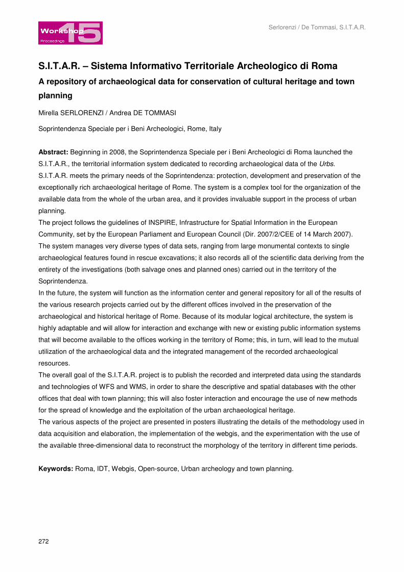
Serlorenzi / De Tommasi, S.I.T.A.R. 272 S.I.T.A.R. – Sistema Informativo Territoriale Archeologico di Roma A repository of archaeological data for conservation of cultural heritage and town planning Mirella SERLORENZI / Andrea DE TOMMASI Soprintendenza Speciale per i Beni Archeologici, Rome, Italy Abstract: Beginning in 2008, the Soprintendenza Speciale per i Beni Archeologici di Roma launched the S.I.T.A.R., the territorial information system dedicated to recording archaeological data of the Urbs. S.I.T.A.R. meets the primary needs of the Soprintendenza: protection, development and preservation of the exceptionally rich archaeological heritage of Rome. The system is a complex tool for the organization of the available data from the whole of the urban area, and it provides invaluable support in the process of urban planning. The project follows the guidelines of INSPIRE, Infrastructure for Spatial Information in the European Community, set by the European Parliament and European Council (Dir. 2007/2/CEE of 14 March 2007). The system manages very diverse types of data sets, ranging from large monumental contexts to single archaeological features found in rescue excavations; it also records all of the scientific data deriving from the entirety of the investigations (both salvage ones and planned ones) carried out in the territory of the Soprintendenza. In the future, the system will function as the information center and general repository for all of the results of the various research projects carried out by the different offices involved in the preservation of the archaeological and historical heritage of Rome. Because of its modular logical architecture, the system is highly adaptable and will allow for interaction and exchange with new or existing public information systems that will become available to the offices working in the territory of Rome; this, in turn, will lead to the mutual utilization of the archaeological data and the integrated management of the recorded archaeological resources. The overall goal of the S.I.T.A.R. project is to publish the recorded and interpreted data using the standards and technologies of WFS and WMS, in order to share the descriptive and spatial databases with the other offices that deal with town planning; this will also foster interaction and encourage the use of new methods for the spread of knowledge and the exploitation of the urban archaeological heritage. The various aspects of the project are presented in posters illustrating the details of the methodology used in data acquisition and elaboration, the implementation of the webgis, and the experimentation with the use of the available three-dimensional data to reconstruct the morphology of the territory in different time periods. Keywords: Roma, IDT, Webgis, Open-source, Urban archeology and town planning.
-
Upload
beniculturali -
Category
Documents
-
view
0 -
download
0
Transcript of M. Serlorenzi, A De Tommasi_"SITAR - Sistema Informativo Territoriale Archeologico di Roma. A...
Serlorenzi / De Tommasi, S.I.T.A.R.
272
S.I.T.A.R. – Sistema Informativo Territoriale Archeologico di Roma
A repository of archaeological data for conservation of cultural heritage and town
planning
Mirella SERLORENZI / Andrea DE TOMMASI
Soprintendenza Speciale per i Beni Archeologici, Rome, Italy
Abstract: Beginning in 2008, the Soprintendenza Speciale per i Beni Archeologici di Roma launched the
S.I.T.A.R., the territorial information system dedicated to recording archaeological data of the Urbs.
S.I.T.A.R. meets the primary needs of the Soprintendenza: protection, development and preservation of the
exceptionally rich archaeological heritage of Rome. The system is a complex tool for the organization of the
available data from the whole of the urban area, and it provides invaluable support in the process of urban
planning.
The project follows the guidelines of INSPIRE, Infrastructure for Spatial Information in the European
Community, set by the European Parliament and European Council (Dir. 2007/2/CEE of 14 March 2007).
The system manages very diverse types of data sets, ranging from large monumental contexts to single
archaeological features found in rescue excavations; it also records all of the scientific data deriving from the
entirety of the investigations (both salvage ones and planned ones) carried out in the territory of the
Soprintendenza.
In the future, the system will function as the information center and general repository for all of the results of
the various research projects carried out by the different offices involved in the preservation of the
archaeological and historical heritage of Rome. Because of its modular logical architecture, the system is
highly adaptable and will allow for interaction and exchange with new or existing public information systems
that will become available to the offices working in the territory of Rome; this, in turn, will lead to the mutual
utilization of the archaeological data and the integrated management of the recorded archaeological
resources.
The overall goal of the S.I.T.A.R. project is to publish the recorded and interpreted data using the standards
and technologies of WFS and WMS, in order to share the descriptive and spatial databases with the other
offices that deal with town planning; this will also foster interaction and encourage the use of new methods
for the spread of knowledge and the exploitation of the urban archaeological heritage.
The various aspects of the project are presented in posters illustrating the details of the methodology used in
data acquisition and elaboration, the implementation of the webgis, and the experimentation with the use of
the available three-dimensional data to reconstruct the morphology of the territory in different time periods.�
Keywords: Roma, IDT, Webgis, Open-source, Urban archeology and town planning.

15th International Conference on “Cultural Heritage and New Technologies“ Vienna, 2010
273
S.I.T.A.R. – Sistema Informativo Territoriale Archeologico di Roma: A repository of
archaeological data for conservation of cultural heritage and town planning
SITAR is a project launched by the Soprintendenza Speciale per i Beni Archeologici di Roma (the acronym
of which is SSBAR) aimed at recording archaeological data. Following the the European Parliament and
European Council INSPIRE structure, Infrastructure for Spatial Information in the European Community, and
the technological Guide lines of the Italian Ministry of Cultural Heritage, SITAR will be able to meet the
scientific research requirements as well as those of the institutions in charge of city planning, by recording all
the administrative and scientific data deriving from the whole range of the investigations and sharing it using
a web-publishing platform based on OGC standards, also WFS and WMS technology, with the institutions in
charge of city planning.
Fig. 1 – An example of actual relationships between the ancient Urbs and the contemporary City (Copyright: MiBAC – Soprintendenza Speciale per i Beni Archeologici di Roma).
Day by day, Rome – like all other western metropolitan cities – lives a divide between its quick developing
rhythm (Fig. 1) and the eternal question on how much its historical skylines must be preserved and how
much the new contemporary architectures should shadow the ancient ones. Rome has probably a bigger
responsibility than all the other cities of the world, not because wants to maintain a Rome-centred vision of
history or because, as it is often mistakenly said, Italy has 50%?, 60%?, 70% or 80%? (… these are just
numbers, for us …) of the world heritage monuments, but because in Italy there has been a widespread
culture of ruins’ conservation since the XVI (sixteenth) century (Fig. 2).

Serlorenzi / De Tommasi, S.I.T.A.R.
274
Fig. 2 – An historical view of the mausoleo of Cecilia Metella along the ancient via Appia, one of the most popular roman age monuments of Rome (Copyright (c) Davis Museum and Cultural Center, Wellesley College 2010).
Fig. 3 – “Via dell’Impero. Nascita di una strada” (Copyright: www.museicapitolini.org).

15th International Conference on “Cultural Heritage and New Technologies“ Vienna, 2010
275
There were law-constraints established in the so called STATUTI for the preservation of ancient monuments
a long time before the Italian unification of 1861. But it is in 1939 that the first national legislation about
heritage landmarks was promulgated. It was an extraordinary law both for the historical context in which it
was promulgated and for the modernity and actuality of the principles it established.
The ruins, the churches, the medieval castles, or the aristocratic palaces of the modern age are integral
parts of many towns, they are the identity system of the nation, and everybody, from any cultural
background, gives them a huge value; they are the country main patrimony.
Although Rome‘s conservation is extraordinary, the town was not exempted from some of the crucial
passages of the post-war urban spread (Fig. 3) which have deeply marked and in some cases scarred the
town.
Many public or private transformations, restorations, change of use acts or building of new areas have
pierced Rome above or underground, in the historical centre and in the suburbs (Fig. 4).
Fig. 4 – Contemporary archaeological surveies in the developing Suburbs of Rome (Copyright: MiBAC – Soprintendenza Speciale per i Beni Archeologici di Roma).
As Prof. David Bibby says “Whatever the viewpoint, the special challenge presented by archaeology in an
urban environment has become a motor, an impulse-giver, for development and innovation – in project
design, excavation philosophy and technology. The insight into the material culture of historical towns and
cities provided by urban archaeology has augmented our understanding of their historical development
across all social classes”.
In the last few years an important role has been played by Urban Archaeology even though it isn’t always
gone hands by hands with the methods of archaeological evaluation and the new technological devices from
nearby scientific fields.

Serlorenzi / De Tommasi, S.I.T.A.R.
276
Even though Rome has developed a sophisticated Urban Archaeology using modern technology and the
synergy of professional people and universities, yet it has not a social mission and it has not designed its
deep hermeneutical function.
This is the background against which the Soprintendenza Speciale per i Beni Archeologici di Roma, one of
territorial Offices of italian Ministry for Cultural Heritage, deals with its institutional mission. It guarantees the
safeguard of the archaeological heritage of the city and its metropolitan territory and it participates, because
of its primary function, to the planning of the urban and architectonical evolution of the historical centre and
the suburbs.
This is also the background for the governance of the territory against which the Soprintendenza of Rome
started the SITAR Project to carry out the first Geographic Archaeological Information System of Rome. The
first project aim is to digitize all scientific and administrative data stored in the office paper archives and
produced daily during the archaeological and geological researches.
On an operative point of view, we must remember that the archaeological information is very complex. We
need to know it, manage it and communicate it. For this reasons we need all new web-based technologies,
possibly open-source, which can achieve well built and flexible information architectures. The web-
applications, like a webgis for example, guarantee an implementation and quick update of the system
functions and they don’t require special hardware and software equipments.
So beginning in 2008 the SSBAR launched the S.I.T.A.R., a Project for recording, managing, archiving,
using and exchanging archaeological territorial data.
As a project and a System created and developed by SSBAR itself, S.I.T.A.R. meets the primary needs of
the Soprintendenza: protection, development and preservation of the exceptionally rich archaeological
heritage of Rome.
SITAR ‘s main goal is to provide invaluable support in the process of urban co-planning, shared with the
others public Administrations.
The Project SITAR follows the guidelines of INSPIRE, Infrastructure for Spatial Information in the European
Community, set by the European Parliament and European Council (Dir. 2007/2/CEE of 14 March 2007),
and the national standards issued by italian Ministry of Cultural Heritage for codifing public GIS projects and
the new approches to the analisys of archaeological heritage (in example, the recent guidelines for the
Archaelogical evaluation or for the study and control of Seismic Risk on archaeological buildings).
The SITAR will function as the information center and general repository for all of the results of the various
research projects carried out by the different offices involved in the preservation of the archaeological and
historical heritage of Rome.
Because of its modular logical architecture, the system is highly adaptable and will allow for interoperability
and data exchange with new and up-to-date systems that will become available to the offices working in the
territory; this, in turn, will lead to the mutual utilization of the archaeological data and the integrated
management of the recorded archaeological resources.
In details, the SITAR is a unique, multi-tasking tool for the organization of the available scientific and
administrative data from the whole of the urban area of Rome.
15th International Conference on “Cultural Heritage and New Technologies“ Vienna, 2010
277
As an Information System, SITAR brings together many various types of data sets, ranging from large
monumental contexts to single archaeological features found in rescue excavations done in the territory of
Rome.
The overall goal of the S.I.T.A.R. project is to publish the recorded and interpreted data using the standards
and technologies OGC compliant, as the WFS and WMS standards, in order to share the descriptive and
cartographic databases with the other offices that deal with town planning. This will also foster a true
interaction with others public Information Systems and encourage the search, study and use of new analitics
methods for the spread of knowledge and the exploitation of the urban archaeological heritage.
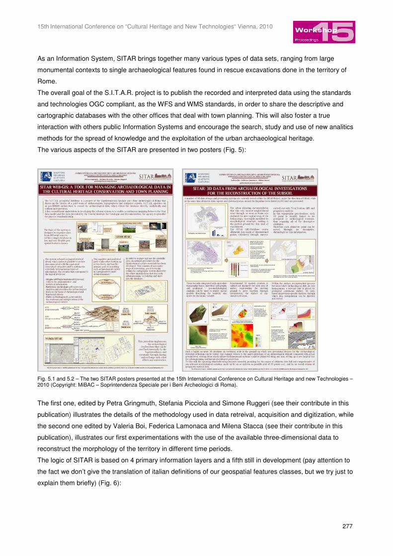
The various aspects of the SITAR are presented in two posters (Fig. 5):
Fig. 5.1 and 5.2 – The two SITAR posters presented at the 15th International Conference on Cultural Heritage and new Technologies – 2010 (Copyright: MiBAC – Soprintendenza Speciale per i Beni Archeologici di Roma).
The first one, edited by Petra Gringmuth, Stefania Picciola and Simone Ruggeri (see their contribute in this
publication) illustrates the details of the methodology used in data retreival, acquisition and digitization, while
the second one edited by Valeria Boi, Federica Lamonaca and Milena Stacca (see their contribute in this
publication), illustrates our first experimentations with the use of the available three-dimensional data to
reconstruct the morphology of the territory in different time periods.
The logic of SITAR is based on 4 primary information layers and a fifth still in development (pay attention to
the fact we don’t give the translation of italian definitions of our geospatial features classes, but we try just to
explain them briefly) (Fig. 6):

Serlorenzi / De Tommasi, S.I.T.A.R.
278
Fig. 6 – Logical schema of primary five levels of SITAR (Copyright: MiBAC – Soprintendenza Speciale per i Beni Archeologici di Roma).
– the s.c. ORIGINI DELL’INFORMAZIONE: the administrative and scientific information of every single
archaeological digging or geophisical/geological survey (in others words the sources of information);
– the s.c. PARTIZIONI ARCHEOLOGICHE: the scientific description of the archaeological findings even if
fragmentary, following the chronological or functional criteria;
– the s.c. UNITÀ ARCHEOLOGICHE: derived by the logical union of more ‘partizioni archeologiche’ which
together makes an archaeological complex (for example a specific building );
– the s.c. DISPOSITIVI DI VINCOLO: the law-constraints which punctually preserve the important
monuments but not their contexts;
– finally, the s.c. POTENZIALE ARCHEOLOGICO (we try to translate it with “archaeological potential”): it is
generated by the logic union and super-interpretation of the base layers. Local authorities and institutional
bodies must bear the ‘potenziale archeologico’ map in mind when working on the urban development of a
territory.
In the SITAR information architecture the four primary levels correspond to well structured archives which
includes all corresponding spatial data shown in the map of the various features classes.
The archive of ‘ORIGINI INFORMATIVE’ guarantees the fundamental data recording of every single
research intervention, or preservation or study carried out on Rome’s territory.
The archive of ‘PARTIZIONI ARCHEOLOGICHE’ is a kind of Cadastre database finalized to the census of
the archaeological and historical presences in the territory of Rome. As said, it uses all types of data and it
allows we to quickly record different types of information.
The ‘UNITÀ ARCHEOLOGICHE’ correspond to the textual and spatial descriptions of the whole monument,
its peculiarities and details. They show their actual and original dimensions.
The ‘UNITÀ ARCHEOLOGICHE’ become the new conceptual detail from which we can move towards the
topographical reconstruction of the ancient settlements, also to allow the new town to respect the old
settlement and create an innovative relationship with it.
The ‘UNITÀ ARCHEOLOGICHE’ will become the basis for the analysis of the archaeological evaluations
which are a predictive tools to plan both the preserving of ancient deposits and the co-planning of new

15th International Conference on “Cultural Heritage and New Technologies“ Vienna, 2010
279
settlements. Bringing together the old and the new data on the same map will give city planners a deeper
knowledge of the urban territory.
After two years of work, most of which spent on planning the system, the SITAR workgroup has digitized
about 10.000 records. We are now recording a new set of data coming from an exchange with the University
of Roma-Sapienza and this exchange project shows us how to optimize human and financial resources
(Fig. 7).
Fig. 7 – An example of interoperability between the SSBAR' SITAR Project and the Atlante of Ancient Rome edited by University "Sapienza" of Rome – Cattedra di Archeologia e Storia dell'Arte Greca, Prof. A. Carandini. An overview of the urban center in roman age, inside the Aurelian walls (Copyright: MiBAC – Soprintendenza Speciale per i Beni Archeologici di Roma | University "Sapienza" of Rome – Cattedra di Archeologia e Storia dell'Arte Greca, Prof. A. Carandini).
The SSBAR has now established new graphic standard criteria which must be followed also by each
independent researcher on the territory of Rome. The data collected and sent to the Soprintendenza will
automatically feed the system.
Today the information technology science develops very quickly and to keep the pace our system should be
aligned progressively with the concept of the over and over self-expanding ‘cloud computing’.
We also need to develop the extraordinary potentials of 3-D informations which many dedicated softwares
already support and that we think will be the near future of GIS.

Serlorenzi / De Tommasi, S.I.T.A.R.
280
We also think that the future of the systems will be tied to the new forms of geo-social networking developed
thanks to the huge investments made by the giants of global communication (such as Google, Microsoft,
etc.) (Fig. 8).
Fig. 8 – An idealization of the SITAR' idea of geo-socialnetworking: working and thinking both individually and toghether, but in the same framework (Copyright: http://lavitadellalavandaia.splinder.com).
The general public is fascinated by the huge amount of geographical, cultural and commercial informations it
can retrieve from the web and the social networking, because it satisfies its need to individually process
public data.
So the new frontier of urban archaeology is also to become a social network capable of being again a
cultural element of great appeal and capable to educate the Citizens in order to share the destiny of our
cultural heritage.
We believe that this is the only way to really preserve the historical landscapes because it will be the same
people to want it.
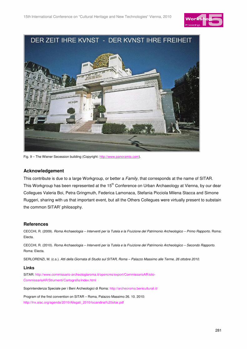
We want to thanks all Persons that every day work with us at the SITAR project and, like us, are thinking that
… (Fig. 9):
15th International Conference on “Cultural Heritage and New Technologies“ Vienna, 2010
281
Fig. 9 – The Wiener Secession building (Copyright: http://www.panoramio.com).
Acknowledgement
This contribute is due to a large Workgroup, or better a Family, that corresponds at the name of SITAR.
This Workgroup has been represented at the 15th Conference on Urban Archaeology at Vienna, by our dear
Collegues Valeria Boi, Petra Gringmuth, Federica Lamonaca, Stefania Picciola Milena Stacca and Simone
Ruggeri, sharing with us that important event, but all the Others Collegues were virtually present to substain
the common SITAR’ philosophy.
References
CECCHI, R. (2009). Roma Archaeologia – Interventi per la Tutela e la Fruizione del Patrimonio Archeologico – Primo Rapporto. Roma:
Electa.
CECCHI, R. (2010). Roma Archaeologia – Interventi per la Tutela e la Fruizione del Patrimonio Archeologico – Secondo Rapporto.
Roma: Electa.
SERLORENZI, M. (c.s.). Atti della Giornata di Studio sul SITAR, Roma – Palazzo Massimo alle Terme, 26 ottobre 2010.
Links
SITAR: http://www.commissario-archeologiaroma.it/opencms/export/CommissarioAR/sito-
CommissarioAR/Strumenti/Cartografia/index.html
Soprintendenza Speciale per i Beni Archeologici di Roma: http://archeoroma.beniculturali.it/
Program of the first convention on SITAR – Roma, Palazzo Massimo 26. 10. 2010:
http://lnx.aiac.org/agenda/2010/Allegati_2010/locandina%20sitar.pdf

Serlorenzi / De Tommasi, S.I.T.A.R.
282
National conference of the GARR – Torino, Politecnico 28. 10. 2010: http://www.garr.it/eventiGARR/conf10/programma.html
http://www.garr.it/eventiGARR/conf10/docs/detommasi-abs-conf10.pdf
http://www.garr.it/eventiGARR/conf10/docs/serlorenzi-pres-conf10.pdf
Rathaus 17. 11. 2010: http://www.stadtarchaeologie.at/?page_id=725
http://www.stadtarchaeologie.at/?page_id=889
http://www.stadtarchaeologie.at/?page_id=886

![LA RÉFORME TERRITORIALE [territorial reform in France]](https://static.fdokumen.com/doc/165x107/63226a8f63847156ac069dfc/la-reforme-territoriale-territorial-reform-in-france.jpg)


![L'organisation territoriale dans le nord-ouest de la péninsule ibérique (VIIIe-Xe siècle): vocabulaire et interprétations, exemples et suggestions [2009]](https://static.fdokumen.com/doc/165x107/631fe5ebfdf36d7df603732f/lorganisation-territoriale-dans-le-nord-ouest-de-la-peninsule-iberique-viiie-xe.jpg)