M. Arbach, G. Charloux, H. Dridi, I. Gajda, S.M. Âl-Murayh, C. Robin, S.F. al-Sa'îd, J....
42
ARCHÄOLOGISCHE BERICHTE AUS DEM YEMEN BAND XIV Sonderdruck aus © 2015 Deutsches Archäologisches Institut Der Autor/die Autorin hat das Recht, für den eigenen wissenschaftlichen Gebrauch unverän- derte Kopien dieser PDF-Datei zu erstellen bzw. das unveränderte PDF-File digital an Dritte weiterzuleiten. Außerdem ist der Autor/die Autorin berechtigt, nach Ablauf von 24 Monaten und nachdem die PDF-Datei durch das Deutsche Archäologische Institut der Öffentlichkeit kosten- frei zugänglich gemacht wurde, die unveränderte PDF-Datei an einen Ort seiner/ihrer Wahl im Internet bereitzustellen.
Transcript of M. Arbach, G. Charloux, H. Dridi, I. Gajda, S.M. Âl-Murayh, C. Robin, S.F. al-Sa'îd, J....

Archäologische BerichteAus Dem Yemen
BAnD XiV
sonderdruck aus
© 2015 Deutsches Archäologisches institutDer Autor/die Autorin hat das recht, für den eigenen wissenschaftlichen gebrauch unverän-derte Kopien dieser PDF-Datei zu erstellen bzw. das unveränderte PDF-File digital an Dritte weiterzuleiten. Außerdem ist der Autor/die Autorin berechtigt, nach Ablauf von 24 monaten und nachdem die PDF-Datei durch das Deutsche Archäologische institut der Öffentlichkeit kosten-frei zugänglich gemacht wurde, die unveränderte PDF-Datei an einen ort seiner/ihrer Wahl im internet bereitzustellen.


DEUTSCHES ARCHÄOLOGISCHES INSTITUT S. an aʿ - ʾ
South Arabia and its Neighbours. Phenomena of Intercultural Contacts
14. RENCONTRES SABéENNES
HERAUSGEGEBEN VON IRIS GERLACH
REICHERT VERLAG WIESBADEN 2015

Bibliografische Information der Deutschen Nationalbibliothek
Die Deutsche Nationalbibliothek verzeichnet diese Publikation in der Deutschen Nationalbibliografie; detaillierte bibliografische Daten sind im
Internet über http://dnb.d-nb.de abrufbar.
© 2015 Dr. Ludwig Reichert Verlag Wiesbadenwww.reichert-verlag.de
ISBN: 978-3-95490-087-9Alle Rechte vorbehalten.
Satz & Bildbearbeitung: Punkt.Satz, Zimmer und Partner, BerlinGedruckt auf alterungsbeständigem, pH7 neutralem Papier.
Printed in Germany.
XII, 222 Seiten mit 125 AbbildungenEinband: Alabasterbüste (Beitrag Prioletta: S. 153 fig. 16 a);
Münze (Beitrag Stein: S. 204 Abb. 8; © Martin Huth); Terrakottafigur (Beitrag O’Neill: S. 114 fig. 4, 3)

IntroductIon
Since 2007, the archaeological and epigraphic mis-sion in the Province of Najrān has been working under the supervision of Prof. Christian Robin and Prof. Saʿ īd al-Saʿ īd. This paper is an attempt to pres-ent the preliminary results of the first four field sea-sons1. The mission has been sponsored by the Saudi Commission for Tourism and Antiquities (Riyāḍ), the French ministry of Foreign Affairs (Paris), the French Embassy in Riyāḍ and the French National Center for Scientific Research (CNRS-UMR 8167 »Orient et Méditerranée«, Ivry sur Seine).
For three years, the scope of our activities has been extended to both the wādī Najrān area and the foot-hills along the edge of the desert, north of the wādī Najrān. Three geographical areas for their graffiti and petroglyphs have been investigated (fig. 1):• the wādī Najrān;• the Jabal Kawkab, north of Najrān;• the wādī Taṯlīṯ, north-west of Najrān, in the Aʿsīr
province.
We mainly focused on rock art sites located along the ancient caravan roads running alongside the Rubʿ al-Ḫālī desert. In these sites, we began regis-tering the rock inscriptions and petroglyphs in a sys-tematic way. The aims of this study were manifold:
• understand the evolution of the settlement pat-tern in the wādī Najrān;
• study the layout of the main caravan roads and the origin of the people passing by during pre-Islamic times according to onomastics, scripts and languages attested in rock inscriptions;
• publish all the graffiti and engravings in order to improve the corpus of these rock inscriptions and petroglyphs and facilitate the access and under-standing of these sites.
Our purpose was not so much the discovery of new sites as the reinvestigation in a more systematic way of several localities mentioned in former archaeolog-ical works. Indeed, the high number of rock art sites in this area has attracted many scholars since the 1950s. The results of the Philby-Ryckmans-Lippens expedition in 1951 (fig. 2) were published in multi-ple reports or advanced studies2. The collected mate-rial served as a basis for the first synthesis on Ara-bian rock art by Emmanuel Anati in the late 1960s3. Later, Albert Jamme published inscriptions from Bi rʾ Ḥimā4. In the late 1970s, the region has been surveyed by Juris Zarins, who localized numerous graffiti sites5. Eventually, a Saudi expedition carried out by Kabawi in the 1990s dealt specifically with the Najrān region and wādī al-Dawāsir rock art6.
But in spite of all these surveys, none of these sites are fully known. The only systematic study
1 The transcription is the following: Najrān = modern name, Nagrān = ancient name. – Some results have already been published; see Robin 2008; Robin 2010a; Robin 2010b; Schiettecatte 2010a.
2 Ryckmans 1953; Lippens 1956; Van den Branden 1956.
3 Anati 1968a; Anati 1968b; Anati 1972; Anati 1974.4 Jamme 1965; Jamme 1966.5 Zarins – Murad – [al-]Yaish 1981; Zarins 1982; Zarins
– Kabawi – Murad 1983.6 Kabawi et al. 1996, 65–72.
Mounir Arbach – Guillaume Charloux – Hédi Dridi – Iwona Gajda – Ṣāliḥ Muḥammad Āl Murayḥ – Christian Robin – Saʿīd Fāyiz [al-]Saʿīd – Jérémie Schiettecatte – Sālim Ṭayrān
RESULTS OF FOUR SEASONS OF SURVEY IN ThE PROVINCE OF NAJRāN (SAUDI ARABIA) – 2007–2010

12 Mounir ArbAch et Al.
cisely the kind of work we thought necessary in the Najrān area to better understand this type of sites and their meaning.
ArchAeologIcAl SettIng
The Najrān Valley
The valley of Najrān has been regularly visited and explored since the end of the 19th century. Joseph halévy was the first to describe the ruins of this area and more specifically those of al-Uḫdūd, the ancient Nagrān8. he was followed by h. St. John B. Philby in 1936, and the expedition Ryckmans-Philby-Lip-pens in 19519. In the early 1980s, the valley was surveyed with the aim of drawing an inventory of
9 Lippens 1956; Ryckmans 1981.
of a site was conducted by Mutsuo Kawatoko in 2002 at al-Ḫušayba, in the Jabal Kawkab7. There, the Japanese mission undertook an exhaustive reg-istering of graffiti on a single spot. This is pre-
7 Kawatoko 2005; Kawatoko – Tokunaga – Iizuka 2005.8 halévy 1877.
Fig. 1 Map of the region of Nagrān with the sites mentioned in the text
Fig. 2 āʿn halkān 1. Lippens’ signature engraved in 1951

13Results of fouR seasons of suRvey in the PRovince of nagrān (2007–2010)
from the main site by an asphalt road. It has already been mentioned by Zarins14.
The site leans against the Jabal al-Ḥumr and is about 220 m long (from North to South) and 140 m wide (from East to West). It comprises several dwell-ing structures as well as hydraulic structures on the lower slopes of the mountain.
The dwelling area stretches over ca. 1 ha. About twenty architectural structures are visible on the surface. They are made up of squared granite stones held together with a mud mortar. Generally one sin-gle course of stone is visible on the ground. Three structures can be distinguished. The first one, south of the site, comprises many rooms and stretches over 260 m2. A second one is a monumental terrace built 90 m SSE of the site, on the mountain slope. It is 10 m long, 6 m wide and 1.2 m high. The third one is located on the northeastern part of the site. It is a large square building, ca. 10 m × 10 m, divided in three parts (a central room bordered by two lateral areas). Its corners are reinforced with protruding walls (fig. 3). This monumental structure is made
the archaeological sites of the kingdom10. On that occasion, a sounding was carried out in al-Uḫdūd and completed in 198211. Since 1997, al-Uḫdūd is excavated under the patronage of the Saudi Com-mission for Tourism and Antiquities12.
Few discoveries are now to be expected in the val-ley. Not that previous explorations have been car-ried out in a systematic way, but the soaring urban-ization and the spread of cultivated areas make the archaeological remains hardly visible and there is alas little hope to clarify the settlement process in this area. Our work in the valley was therefore lim-ited to the visit of already known sites. Except the well-known ancient town of al-Uḫdūd, currently excavated13, these are:
Al-Uḫdūd al-Janūbī
Al-Uḫdūd al-Janūbī (or al-Uḫdūd South) is no more than the southernmost extension of al-Uḫdūd, about 300 m south of the fortified city. Today, it is cut off
10 Zarins – Murad – [al-]Yaish 1981.11 Zarins – Kabawi – Murad 1983.12 [al-]Zahranī et al. 2001; [al-]Zahranī et al. 2002; [al-]
Zahranī et al. 2005; [al-]Zahranī et al. 2006.
13 For a synthesis on the archaeological and epigraphic data on Najrān: Schiettecatte 2010a.
14 Zarins – Murad – [al-]Yaish 1981, 24; Zarins – Kabawi – Murad 1983, 25 pl. 16.
Fig. 3 Al-Uḫdūd al-Janūbī. View of the main building

14 Mounir ArbAch et Al.
Fig. 4 Al-Uḫdūd al-Janūbī. Pottery found on surface [see table 1]
15Results of fouR seasons of suRvey in the PRovince of nagrān (2007–2010)
which they abut. The western wall is 20 m long, the eastern one 12 m long. The wall is preserved up to 1.2 to 1.5 m high and is made of seven courses of granite stones. Stones are held together by a strong pinkish mortar with mineral inclusions. On its west-ern end, a small canalization was created so as to lead the excess water toward cisterns. This dam circumscribes a 340 m2 area that could have been used as a cistern. The inner side of the wall, as well as the rock surface, is covered with a dense, water-proof mortar.
Three additional cisterns were built on the slope of the mountain, west and downstream of the dam. The first one is watered by the excess water com-ing from the canalization west of the dam. The sec-ond and the third cisterns are semi-circular and lean against the rocky slope. The first one is 24 m2, the second one 30 m2. They are watered by a trench excavated in the rock. The cisterns and the canal-izations are plastered with the same dense mor-tar than the dam. They are all built with the same blocks of granite as the dam.
On a boulder 7 m north of the dam, a Sabaic inscription, al-Uḫdūd 35, commemorates the build-ing of the hydraulic structures, probably at the end of the 2nd cent. AD. A photograph of this text has
of large granite blocks, up to 0.8 m long when the building material of the other structures did not exceed 0.5 m long. This building could have had a public or religious function.
Pottery has been collected on the ground. It is rela-tively uniform, the dominating feature being a red or black and red ware with chaff temper; the shapes are either jars with a thin wall and a ring base (table 1; figs. 4, 2. 3. 5–7. 13) or large open bowls (figs. 4, 8. 10–12). More seldom are the coarse greenish wares, generally jars (fig. 4, 1). These wares are similar to those attested on the main site of al-Uḫdūd and were surely contemporary with these (ca. 3rd cent. BC – 3rd cent. AD). Greenish wares are comparable to those found in Makaynūn, al-Ġuraf, Raybūn I or Biʾr Aʿlī in layers dated from the turn of the Chris-tian era15, in the layers of the »Middle Period« of Biʾr Aʿlī (2nd–5th cent. AD)16 or in those of the 1st cent. BC to the 2th cent. AD in Šabwa (Level VIII–X)17.
Beside the houses, remains of hydraulic structures are still visible on the lower slopes of the Jabal al-Ḥumr. Several cisterns were watered by a dam or a retaining wall built across a shiʿb (gully).
The dam is 34 m long; it is made up of two walls separated one from the other by a large boulder on
15 Sedov – Saqqaf 1996, 55; Sedov 1997, pls. 41 k. o; 44 b; Akopian 2010, 143 figs. 61, 547. 548.
16 Sedov 2010, 375.17 Badre 1991, 252–259.
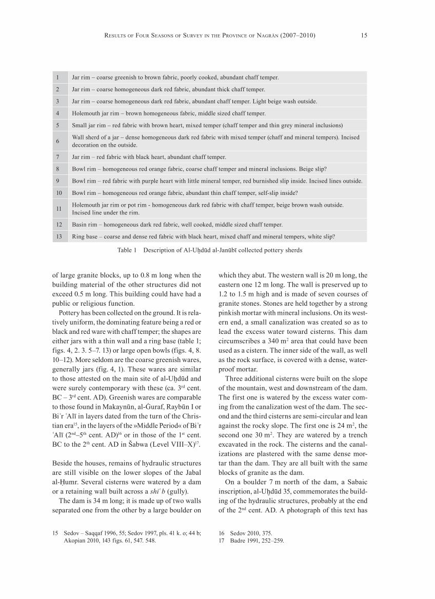
Table 1 Description of Al-Uḫdūd al-Janūbī collected pottery sherds
1 Jar rim – coarse greenish to brown fabric, poorly cooked, abundant chaff temper.
2 Jar rim – coarse homogeneous dark red fabric, abundant thick chaff temper.
3 Jar rim – coarse homogeneous dark red fabric, abundant chaff temper. Light beige wash outside.
4 holemouth jar rim – brown homogeneous fabric, middle sized chaff temper.
5 Small jar rim – red fabric with brown heart, mixed temper (chaff temper and thin grey mineral inclusions)
6 Wall sherd of a jar – dense homogeneous dark red fabric with mixed temper (chaff and mineral tempers). Incised decoration on the outside.
7 Jar rim – red fabric with black heart, abundant chaff temper.
8 Bowl rim – homogeneous red orange fabric, coarse chaff temper and mineral inclusions. Beige slip?
9 Bowl rim – red fabric with purple heart with little mineral temper, red burnished slip inside. Incised lines outside.
10 Bowl rim – homogeneous red orange fabric, abundant thin chaff temper, self-slip inside?
11 holemouth jar rim or pot rim - homogeneous dark red fabric with chaff temper, beige brown wash outside. Incised line under the rim.
12 Basin rim – homogeneous dark red fabric, well cooked, middle sized chaff temper.
13 Ring base – coarse and dense red fabric with black heart, mixed chaff and mineral tempers, white slip?

16 Mounir ArbAch et Al.
ond time during the reign of Ilīsharaḥ Yaḥḍub, ca. 250 AD (Ja 577).
The deities mentioned in this text are either local (ḏu-Samāwī) or Sabaean ( Aʾlmaqah). The epithet »master of the Rock of [Rag]matum« is interesting since Ragmatum was the name of the former main city in the wādī Najrān, before it was replaced by the city of Ẓirbān/Nagrān, in the middle of the 1st mil-lennium BC20. Ragmatum is also mentioned in the genealogies of the »Book of Genesis« as Raʿmat (Gen XX).
Qarn az-Zaʿfarān
The second noteworthy site in the valley is Qarn az-Zaʿfarān 1, also named al-Durayb (N17.52365° – E44.26431°; fig. 1). It has been described in the frame of the General Survey of the Province in the early 1980s21. Where the explorer noticed almost twenty structures, only two stone podiums remain today in a fenced area. Recent buildings and the extension of cultivated areas have sadly destroyed most of the ancient remains.
The site is located at the foot of a rocky outcrop, on the edge of an asphalt road. Two ancient rectan-gular structures come through the ground. Walls are made up with large squared granite blocks, up to 1 m long.
The first structure, south, is 10.6 m × 10.1 m and its peripheral wall is 1.2 m thick. The inner space is divided in two by a 0.7 m thick wall. The second building, north, is 7.8 m × 7.9 m and its peripheral wall is 0.66 m thick in its eastern part, 0.75 m in the southern section. The inner space is divided in two. A 1 m × 2 m stone podium is built in the SW corner. In the middle of the southern wall, a door-step is still visible.
These two buildings closely resemble the domes-tic structures in al-Uḫdūd. According to their archi-tecture, they may be contemporary. Since this place has been used to dispose of modern rubble, the mate-rial found on the ground is very scanty. Only a sin-gle jar ring base and two fragments of steatite ves-sels with handles have been collected.
already been published by Zarins18. A new reading of this text has recently been published by Chris-tian Robin with detailed pictures19.
The inscription has eight lines; it is ca. 0.75 m long and 0.70 m high.
Transcription:1 Hwf ṯʿt Yhs2ʿ bn Gdnm
2 ʿ[qb] mlk S1b[ʾ] b-Ngrn w-b-ʾ=3 [rḍ ..... ]w-ʾtm w-gbl s2ʿbn ḏ-4 […]w w-hs2 (qr)n krf-5 [hmw b-rdʾ ʾ]lh-hm[w ḏ-S1]mwy-(ḏ-)6 [Kʾbtn w-ʿ]ṯtr S2r[qn] w-ʾlm=7 (qh) b[ʿl ʾw]m w-ḏ-[S1]m[w]y-bʿl-Ẓ=8 r [Rg]mt[m]
Translation:»hawfāʿathat Yuhashīʿ ibn Gadanum, | go[vernor] of the king of Sabaʾ in Nagrān and in the La|[nd of … …], and the assembly and the whole commune of ḏu-|[… … have buil]t and achieved their cis-tern| [with the help of] their god ḏu-(ʾl)-Samāwī ḏu-|[Kaʾbatān, of Aʿ]ṯtar Šāriqān, of Aʾlma|qah ma[ster of Aʾwā]m and of ḏu-(ʾl)-Samāwī master of the Rock of [Rag]matum«.
Comments:hawfāʿathat Yuhashīʿ is already known in two other inscriptions (Ja 565 and CIh 1) dated from ca. 175 AD. The lineage ḏu-Gadanum is an aris-tocratic family in Maryab (today Mārib), the capi-tal city of Saba .ʾ
The main interest of this text is that it gives the yet most ancient date for the domination of Sabaʾ over Nagrān. Previously to the 2nd century, the oasis was an autonomous principality, more or less in close link with the kingdom of Saba ,ʾ and then with the one of Maʿīn. After having been included in the Sabaean kingdom in the 2nd century AD, the Abyssinians competed with Sabaʾ for the domi-nation of the valley, when Aksum took control of the Tihāma coastal plain in the 3rd century AD, and made incursions in inner South Arabia. Sabaʾ had to reconquer the oasis twice: once during the reign of Šaʿrum Awtar, ca. 225 (Ja 635), and a sec-
18 Zarins – Kabawi – Murad 1983, pl. 41A.19 Robin 2010b, 90–94.
20 Schiettecatte 2010a.21 Registration number 217-65 (ad-Dreeb), Zarins – Murad
– [al-]Yaish 1981, 24 pl. 8.

17Results of fouR seasons of suRvey in the PRovince of nagrān (2007–2010)
a narrow pass. There, a natural pond is surrounded by rocky outcrops and many graffiti are engraved on rock panels. About 10 m above the pond, two rock panels are engraved with a few thamudic graffiti and a huge number of carvings. These depict hands, ibexes and hunting scenes including dogs and hunt-ers equipped with spears (fig. 5).
From Bi rʾ Ḥimā to the Jabal Kawkab
The Biʾr Ḥimā and Jabal Kawkab areas (figs. 1. 6), about 100 km north of Najrān, are less affected by modern urban development than the wādī Najrān, and contain many rock art sites. It was therefore chosen to be the core of our systematic recording of rock carvings. Two kinds of rock art sites may be distinguished:• The stopping places along the main desert track,
characterized by the presence of water, either wells or spring. Biʾr Ḥimā and al-Ḫušayba are good examples of this category.
• In contrast, sites with rock carvings but without any water resource, such as āʿn Jamal and āʿn halkān.
Not far east from this site, on a rocky outcrop, a rock art site was already mentioned by the Philby-Ryckmans-Lippens expedition and partly published by Jamme22. We registered it as Qarn az-Zaʿfarān 2 (N17.52342° – E44.26650°).
Six rock panels are carved with graffiti and petro-glyphs. The first panel, to the North-East end shows anthropomorphic figures. Twenty meters west, three other rock panels show South-Arabian graffiti. Ten meters south-west, the South-Arabian inscription Ja 1013j, bordered on both sides by an ibex, men-tions the building of a road in the second half of the 1st millennium BC. Another rock panel (Ja 1012) pre-sents the same kind of inscriptions, ca. 35 m south.
Umm al-Ayādī
Located outside the valley of Najrān, 58 km north-west of Najrān, a rock art site is called Umm al-Ayādī (N18.05615° – E44.13598°; fig. 1). It is only a hun-dred meter from the asphalt road, walking back up
Fig. 5 Umm al-Ayādī. Graffiti
22 Jamme 1966.

18 Mounir ArbAch et Al.
Fig. 6 Detailed map of the Jabal Kawkab area with the main surveyed sites
Fig. 7 al-Ḫušayba. Watered point

19Results of fouR seasons of suRvey in the PRovince of nagrān (2007–2010)
23 Kawatoko – Tokunaga – Iizuka 2005.
anthropomorphic figures, three palm-trees and one ibex). The inscription Ja 1028 was written by the qayl Šaraḥʾ īl ḏū-Yazʾan during the punitive strike against the city of Nagrān, in the year 523. Many engravings and graffiti in this site may be contem-poraneous with the inscription.
Al-Ḫušayba
The site of al-Ḫušayba is the second example of a watered point around which a high quantity of graf-fiti and petroglyphs has been carved.
Al-Ḫušayba (N18.49854°, E44.621°) is located midway along a narrow gorge (šiʿb) in the east-ern end of the Jabal Kawkab. It is a small cirque, hollowed out in the sandstone outcrop and being a temporary watering hole (fig. 7). Therefore, this site was a potential stopover for travellers and caravans walking round the Jabal Kawkab on their way to or from Biʾr Ḥimā, 33 km to the South-East. The cirque is 30 m wide and many rock panels have been carved with graffiti and petroglyphs.
This site has already been partly studied by a Jap-anese expedition headed by Kawatoko, in the early 2000s. They realized an almost systematic study of the eastern half of the site23. We completed the work for the northern and western part by individualiz-ing 29 rock panels showing all together 23 petro-glyphs and 230 graffiti. Due to the strong erosion of the lower panels of the northern part of the site, many graffiti are no more legible today.
Biʾr Ḥimā
Biʾr Ḥimā is located 90 km north-east of Najrān, in a low depression within sandstone outcrops. There, groundwater is easily reached and several wells have been dug, making this place a stopover along the desert trail.
Two groups of graffiti and carvings are visible on two distant sandstone outcrops, both concen-trated around the large South-Arabian inscriptions Ry 507 and Ja 1028.
The first group, Biʾr Ḥimā 1 (N18.24392°, E44.46292°), is scattered on an isolated outcrop, c. 20 m high and 90 m in diameter, located east of the depression. Three dry stone tower tombs in an advanced stage of decay are visible on the top of this outcrop. A recent necropolis stretches along the site. On the North face of the outcrop, together with the large inscription Ry 507, we counted 43 graffiti (South-Arabian and Thamudic) and two petroglyphs (a dromedary and a ridden horse).
The second group, Biʾr Ḥimā 2 (N18.24923°, E44.45184°), is located 1.3 km E-NE of the first group, in the western part of the depression, 150 m from the wells. here, the edge of the sandstone pla-teau forms a steep slope, about 20 m high. At the foot of this slope, seven dry-stone tower-tombs are visi-ble. On the steep slope, over a length of 45 meters, beside the 4-meter-long inscription Ja 1028, there are 15 South-Arabian and Thamudic graffiti, 11 South-Arabian monograms – among these, the one of Yazʾan, the lineage of Šaraḥʾ īl Ašwa ,ʿ author of Ja 1028, appears twice –, six Arabic graffiti and 95 petroglyphs (67 dromedaries, 18 horse riders, six
Fig. 8 āʿn Jamal. Rocky spur

20 Mounir ArbAch et Al.
ʿān Jamal
āʿn Jamal (N18.29694°, E44.51460°) is a sandstone outcrop located 8.5 km north-east of Biʾr Ḥimā and 25 km South-West of al-Ḫušayba. This rocky spur is an easily recognizable landmark along the track leading from Biʾr Ḥimā to al-Ḫušayba (fig. 8). Unlike both these sites, there is no water available at āʿn Jamal. On the eastern end of the outcrop, one can see one of the most important concentra-tion of rock engravings and graffiti in the area. It stretches around the rocky ridge and on the boul-ders at the foot of the ridge over a length of 200 m.
Altogether, we counted 245 petroglyphs of many kinds (palm-trees, ostriches, ibexes, oryxes, drome-daries, horse riders, anthropomorphic figures, hunt scenes, erotic scenes, feet, hands, various symbols, etc.), as well as 438 graffiti in South-Arabian, Tha-mudic and Arabic.
ʿān halkān
The site of ʿ ān halkān constitutes the eastern extent of the Jabal Kawkab, 34 km North-East of Biʾr Ḥimā and only one kilometer from the watering hole of al-Ḫušayba. In this site, we numbered 91 petro-glyphs and 380 graffiti and inscriptions including the well-known Sabaic inscription Ry 508. More-over, although they are sparse, graffiti and petro-glyph pepper the way between āʿn halkān and al-Ḫušayba, without breaking off.
The area of āʿn halkān can be divided into three zones, each one being a concentration of rock engravings:
āʿn halkān 1 (N18.50266°, E44.62987°) – This rocky spur stands out from the sand c. 150 m east from the foot of the Jabal Kawkab. The inscription Ry 508 appears on a panel on its north-east face, c. 8 m high. All around, over a length of 18 m, seven South-Arabian inscriptions and graffiti are to be found, as well as nine monograms, five petroglyphs (a palm-tree, a bowman and three dromedaries) and a recent graffiti valuable for the knowledge of the historiography of the site (fig. 2).
āʿn halkān 2 (N18.4986°, E44.63069°) is the very eastern end of the Jabal Kawkab, c. 500 m south of āʿn halkān 1. 142 graffiti and ten petro-glyphs are scattered on rock panels at the foot of the outcrop. Both South-Arabian and Thamudic are
attested. Among the petroglyphs, one can observe hunt scenes, horse riders and animals (dromedar-ies, oryxes, bovids). Besides, 22 dry stone tombs are still to be seen in this area, 19 in the sandy area down the outcrop and three at the top of the out-crop, c. 100 m above the surrounding plain. Most of the tombs are cylindrical in shape, two are square. When visible, the funerary chamber is either cir-cular or rectangular and bounded by vertical slabs. Two tombs have a tail, the longest one being 65 m long and linked to one of the tomb built on the crest. It is made up with 29 dry-stones cylindrical blocks. These structures have been in use for a long period of time, from the 3rd to the 1st millennium BC24.
At the top of the outcrop, over a leaning, smooth panel, close to the eastern end of the tail of the tomb, several South-Arabian graffiti have been engraved. Two of them are monograms of the name of the god Kahl. The first is isolated (MN1537), the second is included in ṣʾġr ḏ-Khl (MN1544). In this context, the word ṣʾġr – most probably a common noun, rather than a proper noun – could designate a cat-egory of the faithful. This monogram of Kahl is
Fig. 9 Schematic map of the archaeological context of āʿn halkān 2 sanctuary (scale 1 : 4000)
24 Crassard et al. 2010; McCorriston et al. 2011.

21Results of fouR seasons of suRvey in the PRovince of nagrān (2007–2010)
already attested on the coins and inscriptions from Qaryat al-Fāw.
In the area of āʿn halkān 2, we also noticed the presence of an open-air sanctuary (fig. 9). At the foot of the rocky spur, a stone seat is turned toward the east. This sturdy structure is made of dry stones, basalt and sandstone (figs. 10. 24). The most sig-nificant detail is the name of the god ḏu-Samāwī incised on the seating stone25. 7 m to the east, a tiny natural outcrop of sandstone forms a kind of natu-
ral stela. It bears a petroglyph and a badly eroded inscription we were unable to read. The axis of the seat and the stela is facing the east and the rising sun (fig. 11).
On a rock panel nearby, the qayl Šaraḥʾ īl Yaqbul ḏū-Yazʾan reported his visit by having his mono-gram engraved – monogram of S2rḥʾ l; above it: Gdlt-Mʿwyt; to the right: monogram of Yzʾn; to the left: Y|qbl (two lines), under it: Gdn-Gḏmt (Gadan Gaḏīmat).
Fig. 10 āʿn halkān 2. Stone seat with the name of god ḏū-Samāwī incised on it (scale 1 : 25)
25 The hypothesis of a reemployed engraved stone in a more recent, opportunistic structure has been envisaged. Nevertheless, it is hard to believe: The stone bearing the inscription on the seat is the only graffiti mention-ing a deity in the whole area and we are to believe that
this exception is explained by the fact that it was put on this seat purposely. Since there are more than 140 graf-fiti on the single site of āʿn halkān 2, the probability that somebody reemployed the only name of a deity in the site to set up this seat is highly unlikely.

22 Mounir ArbAch et Al.
Fig. 11 āʿn halkān 2. Plan of the open-air sanctuary (scale 1 : 100)
āʿn halkān 3 (N18.50824°, E44.63706°) is an iso-lated sandstone outcrop rising out of the sand, ca. 920 meters east of āʿn halkān 1, and with a perim-eter of 100 m. This outcrop is covered with many graffiti (names written in Thamudic or South-Ara-bian) and petroglyphs (hunt scenes, animals, riders, etc.). On the west side, a rock panel depicts an ibex hunt involving walking hunters, riders and dogs
(Fig. 12). But the most outstanding panel is on the eastern side of the outcrop. There, animals and graf-fiti cover a much more ancient depiction of tall and slender men, some of them standing up with open arms and a spiky headgear, other swaying and bear-ing a curved object (weapon?) in the right hand and peculiar instruments in the left hands (possibly a shield and two spears) (Fig. 13).

23Results of fouR seasons of suRvey in the PRovince of nagrān (2007–2010)
Fig. 12 āʿn halkān 3. Ibex hunt depicted on a rock panel
Fig. 13 āʿn halkān 3. Large rock panel

24 Mounir ArbAch et Al.
26 Sayed 1988.27 This inscription is to be published in Robin – Ṭayrān
2012.
5 m above the wādī bed, on the right bank. Imme-diately to its left a shorter contemporary text has been recently noticed by Aʿbd al-Munʿim Sayyid26.
In the course of the visit, we were fortunate enough to find a second royal inscription unnoticed up to now, Murayġān 3, written during the reign of the same king, Abraha. It is located 400 m north of the place where the valley opens onto the plain27.
Finally, at the mouth of the valley, there are many rock panels showing a huge number of graffiti either in South-Arabian or Thamudic script. They are frequently overlapped or accompanied by petro-glyphs of horse riders (fig. 15). Since all of them
TaṯlīṯBeside the region of Najrān, two sites have been explored in the Province of Aʿsīr, close to the wādī Taṯlīṯ: Murayġān and al-Ḥamḍa (fig. 1).
Abʾār Murayġān
Abʾār Murayġān is located 230 km north of Najrān, 31 km west of Taṯlīṯ (N19.53052° – E43.78033°). It is a small valley within granite outcrops, ca. 1 km long, dotted with wells and therefore a suitable place to stop (fig. 14).
This resting place was already known for the presence of the royal inscription Ry 506, noticed 60 years ago, and dated from the reign of Abraha. It is approximately 400 m past the entrance of the valley, where the valley bends toward the west, ca.
Fig. 14 View of Abār Murayġān area

25Results of fouR seasons of suRvey in the PRovince of nagrān (2007–2010)
29 Robin 1996, col. 1198.
making them resemble aurochs28. Some overlap-ping pictograms with different degrees of erosion suggested that these paintings had been made over a long period of time. Graffiti attest that some of these drawings clearly date back to the 1st millen-nium BC and the beginning of the Christian era, as confirmed by the appearance of horse riding, a practice that developed in Arabia at the turn of the Christian era29. Nevertheless, no more can be said as for the date of the first paintings. The presence of auroch-like depictions could indicate, if this hap-pens to be true, that these paintings were realized as early as the 3rd millennium BC, at the latest.
are depicted with a sword, they could be the depic-tion of the warriors, maybe those who accompanied Abraha in his military campaigns in Central Ara-bia mentioned in both the royal inscriptions from Murayġān.
Al-Ḥamḍa
The village called al-Ḥamḍa is located c. 180 km north-west of Najrān, 55 km south of Taṯlīṯ, in the Aʿsīr province.
Not far from this village, a large granite outcrop, Jabal al-Ṣafā ,ʾ forms a small bump. About 200 m to the south-west of this outcrop, the walls of a rock shelter, Ġār al-Ḥaras (N19.04380° – E43.57915°), are covered with painted graffiti and pictograms.
These are Thamudic and South-Arabian graffiti, geometrical signs and animal depictions such as camels and bulls painted in red or black (fig. 16).
The black, maybe simply charcoal, is used to depict horse riders equipped with spears, camels with rounded hump and symbols of unknown sig-nificance.
The red pigment is used for Thamudic graffiti, grids, camels with triangular hump, and bulls either with lyra-shaped horns or large semi-circular horns
28 See for comparison the aurochs engraved in the Saʿda and Radāʿ areas (Yemen) in Inizan – Rachad 2007, 144 fig. 64; 228 fig. 186.
Fig. 15 Abār Murayġān. horse rider and Thamudic inscription engraved
Fig. 16 Al-Ḥamḍa. Auroch representation painted on a rock ceiling

26 Mounir ArbAch et Al.
rock engrAvIngS from Ḥimā-kAwkAb AreA
Location
Geologically, the Ḥimā-Kawkab region belongs to the ›Wajid sandstone‹, a Paleozoic formation con-sisting in a series of hills cropping out to the west of the Precambrian Arabian Shield and partly cov-ered with quaternary deposits on the east. These deposit take the form of an expanse of sand abut-ting onto sandstone reliefs. These reliefs are heav-ily eroded by the wind, and deeply incised by f lash-floods.
When walking from Biʾr Ḥimā to āʿn halkān along the boundaries of this sandstone range, graf-fiti and petroglyphs are to be seen almost every-where. Nevertheless, the bulk of them are concen-trated in a few sites. These sites are outcrops on the edge of the desert, easily accessible, being largely visible for people passing by and not remote places. The engravings take place in the first few meters, sometimes in highest places but rapidly seldom as one gets higher.
Superimposing petroglyphs or graffiti is a com-mon practice. Different reasons can be put forward to explain such behaviour: either no importance was assigned to ancient carvings or the symbolic value of a rock art site was so attractive that it was cho-sen to leave an imprint there even over an older one, rather than doing it further away.
Techniques
A basic observation of these graffiti and petroglyphs reveals different execution techniques (fig. 17). Nev-ertheless, the aim is always the same: making the petroglyph or the graffiti contrast with the back-ground of the rock by removing the dark patina of the rock surface and exposing the lighter sub-surface31.
Removing the surface has been done in different ways, be that by:
the SyStemAtIc Study of the SIteS In the Ḥimā-kAwkAb AreA: method
Biʾr Ḥimā, āʿn Jamal, al-Ḫušayba and āʿn halkān are well preserved; they offer an opportunity to deal with the layout of the desert trails and the people who trod along them. Therefore the French-Saudi mission in Najrān launched a systematic study of these rock art sites, in order to:1. set every carving in its general context;2. draw up an onomastic corpus representative of
the area;3. quantify the use of different scripts in a given
place so as to determine what group of popu-lation was involved.
Such an approach has already been undertaken recently in different parts of Saudi Arabia, be that by Kawatoko in al-Ḫušayba (2005), Sālim al-Qaḥṭānī in the Jabal al-Qana (2007), Sulaymān Ḏuyayb in Sakākā and Jubba (2000 and 2002)30 or Ḫālid Iskūbī in the Taymāʾ area (1999). The increase of these local inventories makes it possible, eventually, to draw the map of the roads as well as the map of scripts used in pre-Islamic Arabia.
To cope with the large amount of carvings in these sites, a registration method has been set up, so as to record the information in a systematic, precise and efficient way.
Our first concern was to register the precise loca-tion of each inscription and petroglyphs either with a GPS or a total station. All these points are mapped in a GIS.
Each petroglyph and inscription is individualized, labelled with a serial number, measured and pho-tographed. The inscriptions have been read on the field. Data are gathered within a set of databases. Altogether, we registered almost 1500 engravings since 2007.
Each of these sites is to be presented in detail in exhaustive catalogues. Therefore, our aim is not so much to present these engravings in detail here as to focus on general observations and ideas about their production, dating, and meaning.
30 See also [al-]Saʿūd – [al-]hadlaq – Khān 2005. 31 On the weathering process of sandstone: Judd 2009, 6 f.; and more specifically on the constitution of desert var-nish: Coque-Delhuille 1994.

27Results of fouR seasons of suRvey in the PRovince of nagrān (2007–2010)
Most of the petroglyphs depict figurative ele-ments (figs. 18. 19) such as human beings, animals or trees, and only few of them take the form of geo-metric shapes.
Among the corpus of animals, we listed drom-edaries (116 subjects or group), ibexes and oryxes (30), bovids (18), ostriches (12), equids (eight, apart from mounted horses), dogs (five), snakes (two), and 33 undetermined animals. human beings split up into different categories: men (54), women (23), horse riders (105), and limbs (three hands and two feet). Besides, one can see six palm-trees and three grid patterns.
A noticeable feature is the absence of representa-tion of herds of sheeps and goats. Daily life scenes were avoided from these rock engravings.
Camels
Camels (dromedaries) appear on 116 scenes, either isolated or in groups. They are drawn in differ-ent styles ranging from rough images to realistic depictions (figs. 18, 3. 4). Within this range, stylis-tic features recur and made it possible to draw up two main categories:• naturalistic depictions of the animals, by skilled
artists. The animal is shown in profile, with the four legs in slight perspective, the massive body contrasts with the thin legs, the neck is curved. These large-size depictions usually exceed 1 m in length and sometimes approach full size. The rock is generally pecked on the whole surface of the body, sometimes only partly pecked so as to introduce a contrast between the differ-ent anatomical elements (fig. 19);
a. linear engraving; it can be simply done by scratching or incising the sandstone with a hard and sharp stone;
b. pecking or hammering the sandstone with a hard stone or a pebble so as to delineate the outline of the subject or the letter;
c. excavating a large hollow surface, a time-consuming technique that allows more subtle images. It might have been done by pecking the sandstone over the whole delineated area and by smoothing it by scraping the rock. It was mainly used for the body of animals and anthropomorphic figures.
The soft sandstone on which petroglyphs have been carved and the simplicity of execution did not call for the use of specialized tools, even if we can-not exclude the use of metal artefacts or hard stone taken from elsewhere.
No painted depiction have been observed in the Ḥimā-Kawkab area, nervertheless this technique is not unknown in the area. It was mentioned on the site of al-Ḥamḍa in the Taṯlīṯ area; it is also attested in the Saʿda and Ḏamār regions in Yemen.
Typology, Style and Composition
The 1473 isolated engravings are divided in two categories: 1106 inscriptions and 367 petroglyphs being either isolated depictions or scenes involving several characters and/or animals. All the types of petroglyphs are already known in the Arabian Peninsula. We will deal further with inscriptions in the next chapter, only petroglyphs are con-cerned here.
Fig. 17 Three carving techniques of graffiti in the Ḥimā-Kawkab area

28 Mounir ArbAch et Al.
Fig. 18 Main animal species encountered on rock panels during the 2007–2010 surveys

29Results of fouR seasons of suRvey in the PRovince of nagrān (2007–2010)
mudic inscription (l-Ndbm) possibly linked to the mounted camel is engraved beside it.
Both these depictions call for comments. Mounted camel depictions are very seldom compared to more than a hundred mounted horse representations. This could be linked to factors characterizing the time these engravings were done, be that the greatest value lent to horses, or an iconographic repertoire for rock art subjects that excluded some common depictions such as mounted camels, excepted in specific cases. The very meaning of these specific cases – here illus-trated by what seems to be a man ridding a camel and an open-handed figure on a camel – are still obscure.
Dromedaries also appear in raiding or hunting scenes. Fifteen of these scenes have been registered, ten for the sole site of āʿn-halkān 1. Michael C. A. Macdonald has convincingly pointed out that a distinction has to be done between hunting scenes, where archers on foot are shooting arrows at camels, and raiding scenes where horse riders equipped with exaggeratingly long lances had to touch the cam-el’s flank with the lance head in front of comrades witnessing the capture, a practice well described in the Johann L. Burckhardt and Alois Musil reports in the 19th and early 20th centuries33.
Although of small dimensions, camel hunting scenes always depicts the dromedary in a realistic way while raiding scenes are much more schematic. If we are to agree that »wild camels died out in Ara-bia at the end of the second millennium BC«34 to the benefit of domesticated ones, or at least that wild camels ceased to be hunted to the benefit of capture when its domestication was mastered, therefore, the opposition between realistic and schematic depic-tion could correspond to a chronological evolution.
Ibexes and Oryxes
Ibexes appear on 22 scenes, generally isolated, sometimes in group. Oryxes are more seldom, being attested eight times, and always isolated. There are ten ibexes and four oryxes at āʿn Jamal, seven ibexes and four oryxes at āʿn halkān 1, four ibexes at al-Ḫušayba and only one ibex in Biʾr Ḥimā 2.
• Schematic depictions where the silhouette is simply outlined and only the area of the hump is pecked. The emphasis is put on the hump to the detriment of other features, taking the shape of a triangle or a knob. The animal is viewed in profile, with only two legs, the head is generally undersized, and the hump and tail are sometimes adorned with a tuft of hirsute hairs (fig. 17 c). These are generally of small dimensions, rarely exceeding 30 cm in length or height.
Almost half of the corpus of dromedaries comes from āʿn Jamal with 51 occurrences, to 21 in Biʾr Ḥimā, seven in al-Ḫušayba and 37 in āʿn halkān. Large depictions are all located in āʿn Jamal. Most of the scenes involving dromedaries depict the ani-mal in a quiet context, either alone or in herds. Much more interesting are the few depictions of mounted or hunted dromedaries.
Mounted dromedaries are convincingly attested twice, in Biʾr Ḥimā 1 and āʿn Jamal, maybe a third time in Biʾr Ḥimā 2 but erosion makes it unclear. The first one (MN578)32 shows a schematic animal with an oversized body. The hump is topped with a schematic human figure with extended arms and large open hands. One of the hands is linked to the neck of the dromedary by a rein. The second one (MN50) is a much more realistic depiction of a run-ning dromedary ridden by a long-haired rider. This scene overlaps a hunting scene which seems to be older, considering the distinct patinas, and therefore bears no relation to it. On the other hand, a Tha-
32 »MNXXX« correspond to the figure/inscription num-ber recorded in the database of our mission.
33 Macdonald 1990; Macdonald 2012; see also Burckhardt 1831; Musil 1928.
34 Macdonald 2012.
Fig. 19 āʿn Jamal. Realistic camel representation

30 Mounir ArbAch et Al.
Bovids
18 bovids have been registered, eight at āʿn Jamal, eight at āʿn halkān, and two at al-Ḫušayba. They can be divided in two categories:
The first category is only attested at āʿn halkān with four petroglyphs. They are small and crude out-lines, not exceeding 30 cm in length and 20 cm in height, recognizable by the curved spine and short protruding horns. These figures are displayed on rock panels beside other animals and/or humans; it is not possible to determine whether these panels were conceived in one go or not.
The second category comprises naturalistic depic-tions (fig. 18, 5). Most of these are large, from 40 up to 200 cm long and 30 to 95 cm high. The technique varies from a single outline to the complete remov-ing of the rock surface over the whole figure, with an intermediary consisting in removing the surface only on the head, neck and legs to introduce a con-trast. None of these has a hump; this excludes the depiction of Bos indicus. The shape of the horns is diverse. Some are short and rounded, similar to the one of the domesticated Bos taurus. Others are large with angles. This feature could well depict the wild Bos primigenius, it can also be a simple emphasis put on a specific feature of the animal without realism, such as the emphasis sometimes put on the horn of ibexes or the hump of dromedaries.
These large bovids depictions are frequently cov-ered by or adjoined with later petroglyphs and/or graffiti; their dark patina contrasts with the one of these later engravings. This could be an evidence, at least for some of them, of an earlier date, proba-bly back to the 2nd millennium BC or earlier, before the rise of the epigraphic habit.
Three depictions associate the animal with humans. One of these (MN49), from āʿn Jamal, is a hunt scene showing an archer squatting behind a long-horned bull (fig. 20, 1). This scene could con-firm that this kind of bovid with jagged horns was a wild species. On the opposite, a short rounded-horn bovid on a scene at āʿn halkān (MN1196) is followed by a walking man hanging a stick in the left hand and possibly being a cattleman. here the scene obviously represents a domesticated animal. A similar scene is also depicted on the main panel at āʿn Jamal (MN807) (fig. 20, 2).
Ibexes are almost always depicted in a schematic way, their profile being simply represented by a single line (fig. 18, 8). The animal is shown in pro-file, with its short tail down, as if quiet, and with long semicircular horns. This last feature is some-times considerably exaggerated. Only one of these (MN197), in Bi rʾ Ḥimā 2, is carefully represented; it is carved with dynamism, showing a male in slight perspective. Its horns are serrated, it is bearded, and the fur on the neck and chest is shown by vertical strokes. This depiction lays on the right of inscription Ja 1028. It has exactly the same weathering as the inscriptions and petroglyphs of this rock panel and was probably done at the same time; it would there-fore be dated to the beginning of the 6th century AD.
All the ibexes have small dimensions, rarely exceeding 30 cm × 30 cm. An exception is a large-size ibex (MN476) engraved on the inaccessible upper part of a rock at āʿn Jamal. The ibex appears nowadays upside down, showing that the rock on which it was engraved fell down from the rocky mountain after being carved. Many petroglyphs and inscriptions have been carved on this – now isolated – rock there after. This is one of the rare evidence of a relative chronology on the site.
Oryxes are generally drawn schematically (except fig. 18, 9). As ibexes, they are small, only the outline is carved, and the only differences are the long tail and the long linear horns. In two cases (MN856 and MN861), both from ʿ ān halkān 1, they are carved in a more realistic way, the surface of the rock being removed over the whole animal. They are also larger (c. 50 cm × 45 cm and 70 cm × 60 cm).
If most of ibexes and oryxes are peacefully depicted, they also happen to be hunted, on four occasions. A fleeing oryx (or a gazelle?) is being hunted by a man on foot bearing an undetermined weapon (MN894); another ibex is shown with a spear driven into the side but no hunter is visi-ble. Oryx hunt is either done on foot with bow and arrows (MN861), or on horse with a short weapon (MN843). As in the camel hunt involving bows, the bow-hunted oryx is realized in a more realistic way, whereas the one hunted by a rider is schematic. As it seemed to be the case with camels, realistic carv-ings of oryx could well be an older rock art tradition.
Gazelle, oryx and ibex hunts are still attested by western travellers in Saudi Arabia in the 20th century35.
35 Butler 1909, 523; Philby 1923, 258.

31Results of fouR seasons of suRvey in the PRovince of nagrān (2007–2010)
Two petroglyphs from ʿ ān halkān and ʿ ān Jamal show a wild animal. In the second case, it is hunted by two horse riders. This animal has a long rounded tail and clawed paws. It could be seen as a feline representation (fig. 18, 6).
Men
horse riders apart, 57 drawings showing men have been registered: three at Biʾr Ḥimā; 27 at ʿ ān Jamal, 21 at āʿn halkān, and six at al-Ḫušayba.
Except for six of them, they are all drawn in a schematic way, combining sticks, one for the trunk and head, two for the arms and two for the legs. They are sometimes equipped with a spear, a sword or a bow (fig. 20, 1). These schematic representa-tions, carelessly carved with simple incisions, are either isolated, or part of hunt scenes and erotic scenes (fig. 20, 4).
In six cases, more realistic and meticulous depic-tions are made by removing the surface of the rock over the whole character. The man has a sinuous body and is generally tall and slender. This style has been used to represent hunters, a crowned man (MN800 is a slender man who stands up with open arms and a spiky headgear; he bears a spear [?] in the left hand), standing men overlapping a large bovid, and a cattleman (fig. 20, 2). If some of these scenes are apparently anterior to later inscriptions written next to them or overlapping their body, oth-ers might be contemporary, considering the shade of the patina. No chronological indication can be inferred from these realistic drawings.
Apart from these representations, three self-por-traits are depicting men taking part to the punitive strike against Nagrān, in the year 523. One (MN189) is a man standing next to the inscription Ja 1030 at Biʾr Ḥimā 2, and probably the author of the text (Tmmm ḏ-Ḥḍyt). he is depicted from the front, except the head and the feet in profile. he is stripped to the waist and only bears a loincloth. A sword is sheathed on his side. A second one (MN216), almost identi-cal but for the spear in his right hand, is engraved next to the inscription Ry 514 at ʿ ān halkān and can be identified as the author of the inscription (Tmm Yzd). A third one (MN184) is climbing a palm-tree at Biʾr Ḥimā 2 (see below, under »Palm-trees«).
Ostriches
13 ostriches have been registered, three at āʿn Jamal, eight at āʿn halkān, and one at al-Ḫušayba. They are almost all drawn in the same rough style, with two strokes for the legs, one for the neck, and a circle for the body (fig. 18, 1). Their height does not exceed 40 cm. Only one ostrich (MN3) has been carefully and differently carved in a realistic way, with a curved neck and a few individualized feath-ers (fig. 18, 2).
In two cases, ostriches appear in hunt scenes as the target. In the first one (MN898), a rider with a long lance charges at an ostrich; in the second one (MN943), two people with an undetermined object – probably a weapon – in hand are surrounded by camels. One of these men holds his weapon (?) out, directly toward an ostrich next to him. Both these scenes are covering more ancient petroglyphs and they almost bear no patina. This fact, together with the presence of a mounted horse, pleads for a recent date, most probably posterior to the Christian era, at least for both of these scenes. The certainty that ostriches were attested in Saudi Arabia until the mid-20th century36 does not give any chronological limit to these depictions.
Other animals
A few categories are very sporadic; these are dogs, equids, snakes and felines.
Only five occurrences of dogs have been regis-tered (one at āʿn Jamal, four at āʿn halkān). They are roughly executed, with the ears prinking up and a raised, rounded tail (figs. 12 et 18, 7). They are either displayed in a pack of four dogs, or asso-ciated with a man, facing an ibex or involved in hunts (fig. 12).
Eight quadrupeds, very roughly carved, have no specific feature making it possible to identify them. Some could well have been equids but no distinction can be made between donkeys and horses.
Two simple wavy lines could be interpreted as snakes; they are both from al-Ḫušayba. Their length does not exceed 40 cm.
36 Wallin 1854, 189; Philby 1923, 250; Glueck 1944, 12; Thesiger 1959, 231 f.

32 Mounir ArbAch et Al.
ter being a real person rather than a deity. Both the letters and the woman are carved in a same, spe-cific way, making the link between the two ele-ments indisputable.
In three cases, these women are involved in erotic scenes (fig. 20, 4). In two other cases, they are in the middle of raiding/fighting scenes. We are to believe, as it has been demonstrated by Macdon-ald, that this kind of representation can be seen as the depiction of cheerleaders, »urging on their men-folk to ever-greater valour«38.
The homogeneity in these women representations, their association with South-Arabian script and with horseman lead us to think that they may date from the end of the 1st millennium BC/beginning of the Christian era.
Limbs
In a few cases, human limbs have been engraved, being either hands (two at āʿn Jamal, one at al-Ḫušayba) or feet (one at āʿn Jamal, fig. 17, 1).
Palm-trees
Six palm-trees depictions have been registered: three at Biʾr Ḥimā 2, two at āʿn Jamal, and one at āʿn halkān 1.
Two from Biʾr Ḥimā 2 (MN379 and MN380) and those from āʿn Jamal (MN297 and MN432) are engraved in the same way (fig. 20, 6): A verti-cal line constitutes the trunk, and palms are des-ignated by parallel lines turned downward or per-pendicular to the trunk, or by curved lines turned upwards. They are 30 to 70 cm high. These drawings are generally associated with dromedaries engraved in a schematic way.
In two cases (MN213 at ʿ ān halkān 1 and MN184 at Biʾr Ḥimā 2), palm-trees are much more realis-tic, with the trunk narrowing from bottom to top, a bunch of curved lines for the palms and a line ended by a circle for the panicles or the bunch of dates. In Ḥimā, the artist made it more lively by adding a man climbing the trunk. A graffito next to him gives his name (Mrṯd ḏ-Rḥb). It is quite pos-
horse riders
Together with dromedaries, horse riders are one of the most favourite depicted subjects. More than a hundred scenes involved horsemen: four at Biʾr Ḥimā; 53 at āʿn Jamal, 38 at āʿn halkān, and ten at al-Ḫušayba.
The style is always schematic, both the horse and the rider being drawn by evocative incisions (fig. 20, 3), two/four sticks for the legs of the animal, one for its spine, one for the head, one for the torso of the rider and generally a long horizontal incision above the rider to show the lance he is bearing. In rare occasion, the depiction is slightly more detailed, with the outline of the animal entirely incised.
These horsemen are frequently shown isolated, sometimes in raid scenes involving the capture of dromedaries, and less frequently in confrontation between two cavalrymen.
As mentioned above, horse riding developed in Arabia at the turn of the Christian era. Therefore, this iconographic theme might be considered as a recent one.
Women
Petroglyphs showing women are much more sel-dom. Only 17 have been registered, most of them at āʿn Jamal (12). One comes from Biʾr Ḥimā and four from āʿn halkān.
The style is once again schematic: Women are seen from the front, hands raised, with long hair curving on either side of the head. They are sys-tematically broad-hipped and the pubis is some-times suggested by a shallow hollow in the rock.
These women are most of the time shown as iso-lated figures and interpreting their significance is hazardous, as it has been explained by Macdon-ald37. It has been suggested by some that they were goddesses, dancing-girls, or simply an expres-sion of male interest in the female forms. Against the hypothesis of goddesses, we can mention the petroglyphs (MN100) (fig. 20, 5) showing a woman surrounded by the letters of the personal name Aʿmmīkahal, most probably the one of this char-acter. This name speaks in favour of the charac-
37 For a precise and complete synthesis on this topic, see Macdonald 2012.
38 Ibidem.

33Results of fouR seasons of suRvey in the PRovince of nagrān (2007–2010)
Fig. 20 Different kind of representations of humans (n°1–5); palm-trees and grids (n°6–7)

34 Mounir ArbAch et Al.
name. For the bulk of them, the execution is care-lessly done, and the intervention of a lapicide very unlikely, which means in contrast that many people were familiar with writing during Antiquity. Never-theless, a few inscriptions have been carved with care, according to the palaeographic style of the moment and providing us with chronological elements.
South-Arabian Inscriptions
South-Arabian inscriptions are mainly proper names, be that single names (e. g.: Nṣrm, Ns2wn, Lḥy ṯʿt, etc.) or compound names (e. g.: Nḥr Ns2wn). They are sometimes completed with a lineage name or a filiation (e. g.: ʾs1dm bn Qdrn), and in a few cases, with a family or clan name (e. g.: Mḏḥgm ḏ-ʿbly, ʾlbḥr ḏ-Ḥẓrm).
Some of the theophoric names include the name of deities venerated in Arabia deserta such as the god Yaġūṯ (MN1538: ʿbdyġṯ)40, the goddess al-ʿUzzà, using the article -l- or -hl- (MN63: ʿbd-l-ʿzy or MN167: ʿbd-hl-ʿzy ḏ-Gnʾ)41, and the god Kahl from Qaryat al-Fāw (MN100: ʿmkhl, MN101: Khln bn Ḫld, MN391: Ḫlkhl).
Only 12 texts are more than names and can be set back in their historical context; two of them are not published. The main inscriptions in the
sible that this man is the author of the petroglyph. Both these realistic palm-trees are located next to large 6th-century inscriptions, Ry 508 for the first, Ja 1028 for the second. They show the same kind of patina and it is possible that they have been carved at this time by members of the expedition against the city of Nagrān.
Geometric Figures
Finally, rare geometric patterns have been iden-tified (fig. 20, 7), all coming from the same site, āʿn Jamal. These are made of one or several jux-taposed squares subdivided by their diagonals and their medians. The meaning of such a pattern can-not be determined. Since they appear systemati-cally on horizontal surfaces, they could well have been used as game boards, the counters being small stones, seeds or else.
Inscriptions
Inscriptions are distributed as above (table 2).As reflected by the short size of most of these texts
and the high rate of single-line inscriptions, most of the inscriptions are just graffiti displaying a proper
39 They are concentrated on the east side of al-Ḫušayba. This area has been almost exhaustively studied by the Japanese expedition in the early 2000s (Kawatoko – Tokunaga – Iizuka 2005). The mention of these texts in the table aims at reflecting the diversity of languages. On the west side of al-Ḫušayba site, we noticed two inscriptions that could have been Nabatean ones. Their state of preservation makes it uncertain.
40 See also Ryckmans 1956, 10.41 About the article hl-, see Ryckmans 1956, 10 f. (ʿbd hl-ʿzy
or ʿbdhlʿzy). The same article has also been noticed in a text unearthed in al-Uḫdūd by ʿ Awāḍ al-Zahrānī, with the theophoric name hl-ʾlt.
Type Average length Average height Rate of single- line inscriptions
Rate of 3-line inscriptions and more
South-Arabian: 779 (+16 monograms)
55 cm (min.: 8 cm; max.: 405 cm)
22 cm (min.: 4 cm; max.: 124 cm) 82,6 % 4 %
Thamudic: 232 50 cm (min.: 10 cm; max.: 227 cm)
15 cm (min.: 3 cm; max.: 49 cm) 91,0 % 2,1 %
Arabic: 65 61 cm (min.: 11 cm; max.: 222 cm)
28 cm (min.: 7 cm; max.: 80 cm) 93,8 % 3,1 %
Nabatean: 339
Undetermined: 11
Table 2 Distribution of inscriptions

35Results of fouR seasons of suRvey in the PRovince of nagrān (2007–2010)
Louvre 12/3) and ṣʾġrt (Ry 509/7). The very mean-ing of ṣġrt / ṣʾġrt is not precisely known: the Sabaic Dictionary translates it as »lesser folk / menu peo-ple« in Ry 509 and does not exclude the possibility of ṣġrt being a proper noun in Louvre 121.
MN1429 (fig. 21)
L. 24 cm; h. 18 cm; height of letters c. 5 cm. Text with three lines incised on the roof of a rock
crevice at the foot of the north side of the cirque at al-Ḫušayba. According to the content, this text is the oldest one dated in the Ḥimā-Kawkab area. It has been discovered in 2007.
1. Whbʾl bn2. Mʿhr qyl3. Rdmn
1. Wahabʾīl, he of (the lineage2. of) Maʿāhir, qayl 3. of Radmān.
Comment:The qayls of the tribe Radmān from the lineage Maʿāhir, are already known by several inscriptions found in the highlands of Yemen and dated to the 1st–3rd centuries AD (among them: Ba-Ba al-Ḥadd 2 and 4, M. Banū Bakr 55, MAFRAY-Qāniya 2, 4 and 11, MAFRAY-ḏī-Ḥadīd 1 and 2, MAFRAY-al-Miʿsal 1–4, MAFRAY-al-Maktūba 1, MAFRAY-Sāriʿ 6, CIh 658, YMN 14). They are Ḥimyarites and their territory is located south-east of Ẓafār. The name Wahabʾīl was the one of at least three qayls of the tribes Radmān and Ḫawlān:
area are Ry 507 and Ja 1028 in Biʾr Ḥimā 1 and 2, and Ry 508 in āʿn halkān 1 (Jabal Kawkab). They all have the same author, the qayl Šaraḥʾ īl Yaqbul ḏū-Yazʾan, and have been written in 523 AD while the ḥimyarite army besieged Nagrān. Seven shorter texts are contemporaneous with these long inscrip-tions and have been written by followers of the qayl: Ja 1030, Ja 1031a, Ja 1032 in Biʾr Ḥimā 2 and Ry 512 à 515 in āʿn halkān 1 (Jabal Kawkab). Two unpub-lished texts (MN243 in āʿn halkān 2 and MN1429 in al-Ḫušayba) have been noticed.
MN243
L. 62 cm; h. 34 cm; height of letters c. 10 cm. Text with three lines incised on a loose stone slab
at the bottom of the slope. It has been discovered in 2009 during our 3rd field season.
A 1 Klbn mqtwy ḏ-G= Kalbān officer of ḏu-Ga=
2 d(n) ṣʾġr dan the Young (?)
B 1 ʾ…(b) … 2 Ṯwbt ʿwḏt Mʿwyt Ṯawbat Aʿwḍat
Muʿāwiyat
Comment:It is hard to say whether these three lines belong to a single text or to two different texts. The sec-ond option is more likely since the engraving is less steady after the word ṣʾġr.
Both the texts should be contemporary, most probably from the time of the king of Sabaʾ and ḏū-Raydān.
Gd(n): in spite of the uncertain reading of the end, this is probably the lineage Gadanum (Gdnm, here without mīmation), well known in the area of Najrān42.
ṣʾġr: this word can qualify ḏ-Gdn (meaning »the Young«, but we would then rather expect ṣʾġrn), it could also be a title or a position of ḏ-Gdn, or a proper name. ṣʾġr is only mentioned as a position in the graffiti MN1544 (see above). It could be a title if we regard it as the singular of the words only known in the plural ṣʾġrt (CIh 537 + RES 4919 =
42 Robin 2010b, 90–94.
Fig. 21 al-Ḫušayba. Inscription MN1429

36 Mounir ArbAch et Al.
or tried to do so, thus it was necessarily at a time when Ḥimyar and Sabaʾ were unified, and therefore when Ḥimyar was bordering the valley of Nagrān.
It is well known that Nagrān enjoyed autonomy in the tribal alliance headed by Maʿīn until the end of the 1st cent. BC; it is also known that the king of Sabaʾ appointed a governor ( āʿqib) in Nagrān about the year 175 AD. But between c. 25 BC and c. 175 AD, nothing is known about the political status of Nagrān. We can put forward the hypothesis that Ḥimyar took control of the oasis during the reign of Karibʾīl Bayān. Under his rule, a tragic invasion happened in the Jawf valley, led by the kingdom of Ḥaḍramawt; Mārib suffered destructions, probably due to the same kingdom. It is quite possible that a ḥimyarite control over Nagrān could have been the cause or the consequence of this Ḥaḍrami invasion.
hypothetically, we suggest that »Wahabʾīl qayl of Radmān« in al-Ḫušayba was Wahabʾīl Aʿmdān and that he came to Nagrān in the frame of military operations aiming at extending the ḥimyarite dom-ination over the oasis. It is possible that Wahabʾīl Aʿmdān died during this expedition.
Thamudic Inscriptions
The second group of graffiti is written in at least two North-Arabian scripts usually called Thamu-dic. Although it is considered as North-Arabian, these scripts could have been widely used by peo-ple throughout most of the western part of Ara-bia, inscriptions in the Ḥimā-Kawkab area being a southern variant. Up to now, there is no indication that people who wrote these graffiti were coming from Northern Arabia.
Generally, Thamudic inscriptions are clustered together, either beside South-Arabian inscriptions or on separate rock-panels. They are almost systemat-ically proper names, most often a single name, and sometimes compound names.
In al-Ḫušayba, two Thamudic inscriptions are of great interest. The first one, MN1456, mentions the »nfs1 Rb« (funerary monument of Rab), the second one, MN1459, mentions »nfs1 Hfr« (funerary mon-ument of hafr). The word nfs1, »funerary monu-ment«, could indicate the interment in the neigh-bourhood of al-Ḫušayba of two people who used to live there, or passed away when crossing the area. If there is no grave visible in al-Ḫušayba, many
1. Wahabʾīl ʿAmdān (son of Madīkarib Yuhamgid): MAFRAY-ḏī-Ḥadīd 2; Qāniya 16 (unpubl.); MAFRAY-al-Miʿsāl 7 and 9. he is the con-temporary of a king named Karibʾīl, prob-ably Karibʾīl Bayān son of Ḏamarʿalī Ḏarīḥ (c. 85–100 AD) (see MAFRAY-ḏī-Ḥadīd 2).
2. Wahabʾīl Yaḥuzz: Banū Bakr 56; MAFRAY-al-Dimn 1; Quṭnān 2 = Bāfaqīh – Bāṭāyiʿ 13; al-Maḍbī 1 (unpubl.). According to al-Maḍbī 1, he was the contemporary of Yuhaqīm son of Ḏamarʿalī Ḏarīḥ (c. 85–100 AD). Therefore, he was active at the same time than Wahabʾīl Aʿmdān. Since he is only mentioned in the Banū Bakr area, it is likely that he only exer-cised authority over the tribe of Ḫawlān, while descendants of Wahabʾīl ʿ Amdān ruled the tribe of Radmān.
3. Wahabʾīl Yaḥuzz son of ʿAmmīyadaʿ Yuhaḥmid: MAFRAY-Sāriʿ 2; MAFRAY-Sāriʿ 6 (dated from 72 of the Radmān era, i. e. 146–147 AD); Ja 629; Ir 5; MAFRAY-al-Miʿsāl 1, 10–15 and 17; MAFRAY-Qāniya 10.
In the inscription MN1429 from al-Ḫušayba, Wahabʾīl is either the first or the third one. The first one is very likely. he used to live at a time when Ḥimyarite and Sabaean kingdoms were unified, and this would be in agreement with the presence of a Ḥimyarite in the Najrān region. Moreover, Wahabʾīl Aʿmdān probably died prematurely. he could have died during this expedition and be remembered through this inscription. Indeed, as mentioned below, some inscriptions from al-Ḫušayba remem-ber deceased that were probably buried in the neigh-bourhood.
The hypothesis that Wahabʾīl in MN1429 was the third one, Wahabʾīl Yaḥuzz, is less convincing. Inscriptions mention this qayl in the frame of dif-ferent conflicts threatening his tribe. Nevertheless, we are not ruling out the idea that he could have joined long-distance expeditions, before or later on.
One last question: how is it that a qayl of Radmān, originally from the highlands of Yemen, is to be found in Nagrān? It is unlikely that a ḥimyarite prince set out on travel to enjoy himself or to increase his wealth. he only could have been in Nagrān area in the frame of a military expedition, for a diplomatic issue, or to run the oasis. Except for a diplomatic assignment, the presence of Wahabʾīl in Nagrān means that Ḥimyar took control of Nagrān

37Results of fouR seasons of suRvey in the PRovince of nagrān (2007–2010)
These small texts fit much more easily into chrono-logical periods and can be of great help when trying to define a relative chronology of the petroglyphs:• informed methods: These are of no help in Ara-
bia since they rely on the testimony of rock art-ists, either still living or through ancient texts. None of these exists in our context;
• direct methods: They consist in physical methods used to date the desert varnish (patina). None of these has been attempted in rock art context in Arabia; they only applied to more ancient period (Pleistocene, early/mid-holocene)44.
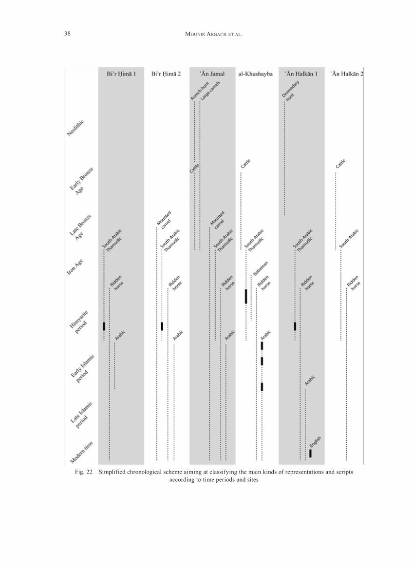
• formal methods: They depend on the subject depicted and the presence/absence of these sub-jects at certain times. They generally provide us with terminus post/ante quem, absolute dates, and large period of times (fig. 22). We mentioned the possible depiction of aurochs (Bos primigenius), a species that disappeared in Arabia in the course of Early Bronze Age. They are concentrated in āʿn Jamal and could be a terminus ante quem for the first drawings on the site. Conversely, the depiction of domesticated cattle (Bos taurus) pro-vides us with a terminus post quem correspond-ing to the beginning of its domestication, that is to say from the 6th millennium BC onwards45. Similarly, images of palm-trees (Phoenix dactylif-era) as a domesticated species would be posterior to the early 3rd millennium BC, when it started to be cultivated in Arabia; images of mounted dromedaries (Camelus dromedarius) would be dated from the end of the 2nd millennium BC onwards, the alleged period for its domestica-tion; drawings of hunted dromedaries by arch-ers on foot from the site of āʿn halkān could conversely be dated previously to this time (see above); and images of ridden horses would be dated from the turn of the Christian era onwards, when this practice developed in Arabia46. Graffiti and inscriptions as well can be dated either by the mention of a date in the inscrip-tion (e. g. Ja 1028, Ry 507, Ry 508 all dated from AD 523, KhShB-Ar 3, KhShB-Ar 14 and KhShB-Ar 12, respectively dated from AD 648, 728 and 1247), by close relation to a dated inscription (Ry 512–515; Ja 1030–1032, contemporary with Ja 1028, Ry 507 and Ry 508), by historical con-
dry-stone turret-tombs have been built in the sur-rounding area and could have been the burial place of these people.
Arabic Inscriptions
Arabic inscriptions are less numerous than both Thamudic and South-Arabian ones, reflecting a pos-sible decline of this specific epigraphic habit. In a few cases, these are religious formula (declaration of faith). But most of these inscriptions are gener-ally names with or without filiation, and sometimes preceded by a call for God’s blessing.
The written form is relatively regular, homoge-neous, and characteristic of the first centuries of the Muslim era. This is confirmed by two dated inscriptions already published in the report of the Japanese expedition at al-Ḫušayba. The first one (KhShB-Ar 3) is the second oldest dated Arabic inscription known until now (Jumādā 27 A.h., spring AD 648). The second one (KhShB-Ar 14 = MN1248) is dated to 110 A.h. (AD 728/9). This epigraphic habit is also attested later since an Ara-bic inscription from al-Ḫušayba (KhShB-Ar 12) is dated to the year 645 A.h. (AD 1247/8).
Some thoughtS About grAffItI And PetroglyPhS
When Were These Petroglyphs and Graffiti Engraved?
Ascribing an absolute date to the petroglyphs pre-sents many difficulties, not to say is almost an illu-sion. Nevertheless, some techniques provide indi-cations about large periods of time. These are sum-marized by Tony Judd in his study of rock art of the Eastern Desert in Egypt, adapting those proposed by Paul S. C. Taçon and Christopher Chippindale in an Australian context43. We will consider them below so as to catch a glimpse of chronological ele-ments. Besides, we must consider a feature pecu-liar to Arabia, the close relation, at least geograph-ically, between petroglyphs and rock inscriptions.
43 Judd 2010; Taçon – Chippindale 1998.44 Coque-Delhuille 1994; Coque-Delhuille 1998.
45 hadjouis 2007; Martin – McCorriston – Crassard 2009.46 Robin 1996, col. 1198.
38 Mounir ArbAch et Al.
Fig. 22 Simplified chronological scheme aiming at classifying the main kinds of representations and scripts according to time periods and sites

39Results of fouR seasons of suRvey in the PRovince of nagrān (2007–2010)
50 Judd 2010, 76.51 McCorriston et al. 2011
linked with some of these funerary structures. The second archaeological element is the pres-ence of an open-air sanctuary dedicated to ḏū-Samāwī at āʿn halkān 2 (see above). This deity is mentioned from the mid-1st millennium BC (inscription Maʿīn 2 for example) down to the early centuries of the Christian era. The open-air sanctuary falls within this period. Archaeological methods confirm the chronologi-cal range given by the formal methods but are of no help in trying to precise these dates;
Beside these methods giving absolute dating, the stratigraphic and weathering methods provide us with relative chronology. The first is a study of the superposition of carvings. The second is the exam-ination of how dark patinas are (the darker being the older). Both methods are generally combined when considering a rock panel. They can hardly be used to confront distant petroglyphs since the formation of patina can be accelerated depending on the orientation of the panel and its exposure to several factors (dominant winds, sun, etc.). These methods have been concluding in two contexts: 1) We already noticed that the large and realistic depictions of bovids do generally show dark patina and that most of them are covered by lighter – there-fore more recent – inscriptions, be that hunt scenes or domesticated cattle. Therefore, we are to believe that this could be an evidence of a Neolithic/Bronze Age date for these large drawings. 2) The same is true for large and realistic depictions of dromedar-ies at āʿn Jamal; these are covered by later graffiti and their patina is darker than the one of these later engravings. They probably predate the Iron Age and the development of the epigraphic habit. This would be corroborated by the statement mentioned above that realistic dromedaries also appear in camel hunt scenes, a kind of representation that we attributed to the Bronze Age. On the opposite, schematic depic-tions of dromedaries have generally the same kind of patina as graffiti and might be contemporary with Iron Age, himyarite or Islamic period.
text (MN1429, from the 1st cent. AD), or by their palaeographic style (e. g. Kufic Arabic, attested in āʿn Jamal, Biʾr Ḥimā 1 & 2, al-Ḫušayba). To a lesser extent, the period of use of an alphabet is also meaningful (South-Arabian and Thamudic were in use during Iron Age and the first centu-ries of Christian era, Nabatean during the Late Iron Age and the Early Christian era, Arabic from the 7th century onwards);
• comparative methods: They depend on paral-lels with other rock art sites which can be dated. In Arabia, two typologies with chronological anchoring have been proposed, the first one by Anati47, the second one by Madiha Rachad48. None of these are convincing and if many paral-lels can be drawn between rock art sites through-out Arabia, no chronological evidence could be obtained by this method yet49.
• archaeological methods: They »depend on plac-ing the rock art in an environment that can be dated by archaeological means«50. In the Ḥimā-Kawkab area, few elements can be put forward. The most significant ones are the dry-stone tower tombs located on most of the rocky outcrops in the area, with significant concentrations near the sites Biʾr Ḥimā 1 & 2 and āʿn halkān 2. In the first one, three tombs are capping the outcrop where most of the texts are inscribed, in Biʾr Ḥimā 2, a cluster of tombs is visible at the foot of the engraved rock panels. In āʿn halkān 2 tombs are located at the foot of the outcrop and on the crest, about 100 m above the ground. Thanks to excavations in Yemen, this kind of tomb proved to be built and (re-)used over a long time-span, from the 3rd to the 1st millennium BC51. In the absence of excavation in the Ḥimā-Kawkab, no one can tell whether these tombs have been built during Bronze or Iron Age, and it is not pos-sible to associate them with some of the petro-glyphs and/or graffiti. The only clue is the two funerary Thamudic inscriptions from al-Ḫušayba mentioned above, probably dating from the Iron Age/early Christian era; they could possibly be
47 Anati 1968a; Anati 1968b; Anati 1972; Anati 1974.48 Inizan – Rachad 2007.49 For a critical review of M. Rachad’s chronology, see
Schiettecatte 2010b, 141 f.

40 Mounir ArbAch et Al.
52 Zarins – Murad – [al-]Yaish 1981, 24 pl. 9.
Arabian inscriptions are also testimonies of peo-ple coming from distant regions of South-Arabia. We mentioned the qayl of the tribe Radmān in the 1st cent. AD. There is also a huge number of graf-fiti and inscriptions palaeographically characteristic of the Ḥimyarite period, which have probably been done, in a large majority, by the followers of the qayl Šaraḥʾ īl Yaqbul, son of Šuriḥbʾīl Yakmul ḏū-Yazʾan, coming from Ḥimyar, at the time he was heading the military expedition against Nagrān (523 AD).
What has Dictated the Choice of the Places for These Engravings?Where water is available, it is obvious to find a large amount of graffiti or petroglyphs. These sites (Biʾr Ḥimā and al-Ḫušayba for example) appear as rest-ing places on the main roads between the foothills and the desert. however, it is much more surpris-ing to find a huge concentration of graffiti, inscrip-tions or petroglyphs in much more remote places, cut off from water resources, like at āʿn halkān or āʿn Jamal.
how are we to explain the presence of such a con-centration in these isolated places?
A first hypothesis would come from their geo-graphical location and their natural shape. These sites are landmarks along the track, offering a view-point and were useful to orient oneself. As such, these places where strategic and could have attracted groups of people.
A second hypothesis would be that these loca-tions had a symbolic value. It is based on two argu-ments. The first one is the discovery of 24 funer-ary structures at āʿn halkān (figs. 9. 23), dating from the Bronze or Iron Ages (cf. supra). A second clue is the discovery of the open-air sanctuary at āʿn halkān (figs. 9–11. 24). This kind of sanctuary is not unique in the region. It can be compared to the one mentioned in the early 1980s by Zarins as Kaʿbat Najrān, down the wādī Najrān52. At the foot of a rocky outcrop, stones form half a circle around a large standing stone. Both these sites belong to a category of simple open-air sanctuaries located along the trails followed by local nomad popula-tions or caravans.
Who Realised These Petroglyphs and Graffiti?
It is uneasy to determine precisely what the origin of the authors was. They have been executed on a long time span, running from the Bronze Age – maybe earlier – down to the Islamic period. If we cannot have a clear picture of the involved protag-onists for each period, some insights are made pos-sible by iconography, scripts and onomastics.
Iconography shows the presence of people wan-dering in the area in the early periods (Bronze Age or earlier). These are hunters tracking down aurochs, dromedaries and ibexes, with bows and arrows. These are also cattleman appearing on large engrav-ings. No species characterizing the more ancient wet mid-holocene has been noticed in the area.
It is quite possible that representations of horse riders with long lances carrying out a raid for drom-edaries have been done by people living in the area so as to commemorate their catch in a recent period (Ḥimyarite or early Islamic period).
Besides, iconography shows the temporary pres-ence of people passing by, such as warriors, either on foot or riding horses. This is not surprising since large South-Arabian inscriptions mention the encampment of the Ḥimyarite army in the neigh-bourhood in the 6th century AD. The same situation can be observed further to the north, at Murayġān, where the two South-Arabian inscriptions describ-ing the campaigns of Abraha in Central Arabia in the mid-6th century AD are surrounded by hundreds of names and cavalrymen.
Much more enlightening are the inscriptions. We mentioned the presence of both Thamudic and South-Arabian texts. These scripts could indicate the presence of two groups of local populations with distinct traditions and coexisting in the same area. They also could indicate that one of these groups have been indigenous and the other simply passing-by (pastoral communities or caravans).
South-Arabian onomastics reveals the presence in the area of both local and foreign people. Ono-mastics is not specifically characteristic of what is usually observed in South-Arabia: most of the names are made of a single element. This could be a local characteristic. Moreover, deities appear-ing in theophoric names are the Arabian goddess al-ʿUzzā and the gods Yaġūṯ and Kahl venerated in Qaryat al-Fāw, 200 km to the North. But South-

41Results of fouR seasons of suRvey in the PRovince of nagrān (2007–2010)
Fig. 23 āʿn halkān 2. Cairn with a long tail made of stone piles
At ʿ ān Jamal, if there is no tomb or open-air sanc-tuary, it is noteworthy that, in the neighbourhood, the rock panels suitable for engravings remained blank. The concentration of petroglyphs and graf-fiti had manifestly a meaning. The rocky spur of āʿn Jamal was probably not a stopping place on the caravan road, since it is only 7 km from the wells of Biʾr Ḥimā. This geographical landmark was obvi-ously a symbolic place recognized as such since a remote period, Bronze Age or earlier, and it kept this status several millennia long, for people living in the neighbourhood or passing by.
The presence of a necropolis as well as the sanc-tuary reflects, in some way, the symbolic value this kind of site could have had for the mobile popula-tions of Southern and Central Arabia. This sym-bolic value may explain why we find a lot of graf-fiti and petroglyphs despite the absence of water. The necropolis could have played this role in the first place. It would have been a significant meet-ing point for a specific group of population. Later on, this function could have been perpetuated with the laying out of a sanctuary. This would explain the long period of use attested by the petroglyphs and inscriptions, from the Bronze Age until the Islamic period at āʿn halkān.
Fig. 24 āʿn halkān 2. Seat from the open-air sanctu-ary

42 Mounir ArbAch et Al.
Address
Mounir Arbach – Guillaume Charloux – Christian Robin – Jérémie SchiettecatteCNRS, UMR 8167 « Orient & Méditerranée »27, rue Paul Bert94204 Ivry-sur-Seine cedex France
AbbrevIAtIonS
Akopian 2010 A. M. Akopian, Les fouilles du secteur 4, in: J.-Fr. Salles – A. V. Sedov (eds.), Qāni .ʾ Le port antique du Ḥaḍramawt entre le Méditerranée, l’Afrique et l’Inde. Fouilles russes 1972, 1985–1989, 1991, 1993–1994, Indicopleustoi, Archaeologies of the Indian Ocean (Turnhout 2010) 123–148
Anati 1968a E. Anati, Rock Art in Central Arabia 1. The »Oval-headed« Peo-ple of Arabia, Bibliothèque du Muséon 50 (Leuven 1968)
Anati 1968b E. Anati, Rock Art in Central Arabia 2. 1. Fat-Tailed Sheep in Ara-bia; 2. The Realistic-Dynamic Style of Rock-Art in the Jabal Qara, Bibliothèque du Muséon 50 (Leuven 1968)
Anati 1972 E. Anati, Rock-Art in Central Arabia 3. Corpus of the Rock Engrav-ings, Publications de l’Institut orientaliste de Louvain 4 (Leuven 1972)
Anati 1974 E. Anati, Rock-Art in Central Arabia 4. Corpus of the Rock Engrav-ings, Publications de l’Institut orientaliste de Louvain 6 (Leuven 1974)
Badre 1991 L. Badre, Le sondage stratigraphique de Shabwa (1976–1981), Syria 68, 1991, 229–314
Burckhardt 1831 J. L. Burckhardt, Notes on the Bedouins and Wahabys. Collected During his Travels in the East (London 1831)
Butler 1909 S. S. Butler, Baghdad to Damascus via el-Jauf, Northern Arabia, The Geographical Journal 33, 1909, 517–535
Coque-Delhuille 1994 B. Coque-Delhuille, Caractéristiques, genèse et signification des vernis désertiques. L’exemple du Yémen, in: Les milieux arides et semi-arides. héritages et dynamiques actuelles. Colloque en l’hon-neur du Pr. R. Coque (Fontenay-Saint-Cloud 1994) 259–287
Coque-Delhuille 1998 B. Coque-Delhuille, Le milieu naturel de la région de Bayhân, in: J.-Fr. Breton – J.-Ch. Arramond – B. Coque-Delhuille – P. Gentelle, Une vallée aride du Yémen antique. Le wâdi Bayhân (Paris 1998) 3–53
Crassard et al. 2010 R. Crassard – h. Guy – J. Schiettecatte – h. hitgen, Reuse of Tombs or Cultural Continuity? The Case of Tower-Tombs in Shabwa Gover-norate (Yemen), in: L. Weeks (ed.), Death and Burial in Arabia and Beyond. Multidisciplinary Perspectives, BARIntSer 2107 = Soci-ety for Arabian Studies Monographs 10 (Oxford 2010) 173–177
Ḏuyayb 2000 S. Ḏuyayb, Dirāsat li-nuqūsh ṯamūdiyya min Jubba bi-hāʾil (al-Riyāḍ 2000)

43Results of fouR seasons of suRvey in the PRovince of nagrān (2007–2010)
Ḏuyayb 2002 S. Ḏuyayb, Nuqūsh ṯamūdiyya min Sakākā: Qā Furayha, wa-l-Tuwayyir, wa-l-Qadīr (al-Riyāḍ 2002)
Glueck 1944 N. Glueck, Wâdī Sirḥân in North Arabia, BASOR 96, 1944, 7–17hadjouis 2007 D. hadjouis, La faune des grands mammifères, in: M.-L. Inizan
– M. Rachad (eds.), Art rupestre et peuplements préhistoriques au Yémen (Sanaa 2007) 51–60
halévy 1877 J. halévy, Voyage au Nedjran II. De Sana à Nedjran, Bulletin de la Société de Géographie (series 6), janv.-juin 1877, 466–479
Inizan – Rachad 2007 M.-L. Inizan – M. Rachad (eds.), Art rupestre et peuplements pré-historiques au Yémen (Sanaa 2007)
Iskūbī 1999 Kh. Iskūbī, Dirāsat taḥlīliyya muqārana li-nuqūš min manṭaqat Rum janūb gharb Taymāʾ (al-Riyāḍ 1999)
Jamme 1965 A. Jamme, Research on Sabaean Rock Inscriptions from South-western Saudi Arabia (Washington 1965)
Jamme 1966 A. Jamme, Sabaean and hasaean Inscriptions from Saudi Arabia (Rome 1966)
Judd 2009 T. Judd, Rock Art of the Eastern Desert of Egypt. Content, Com-parisons, Dating and Significance, BARIntSer 2008 (Oxford 2009)
Kabawi et al. 1996 A. Kabawi – M. Khan – A. al-Zahrani – A. al-Mubarak – M. as-Sumer – M. al-Shawti, Comprehensive Rock Art and Epigraphic Survey (1990), Atlal 14, 1996, 55–72
Kawatoko 2005 M. Kawatoko, Archaeological Survey of Najran and Madinah 2002, Atlal 18, 2005, 45–59
Kawatoko – Tokunaga – Iizuka 2005 M. Kawatoko – R. Tokunaga – M. Iizuka, Ancient and Islamic Rock Inscriptions of Southwest Saudi Arabia I. Wādī Khushayba, The Middle Eastern Culture Center in Japan and Research Institute for Languages and Cultures of Asia and Africa (Tokyo 2005)
Lippens 1956 Ph. Lippens, Expédition en Arabie centrale (Paris 1956)Macdonald 1990 M. C. A. Macdonald, Camel hunting or Camel Raiding?, ArabAEpigr 1,
1990, 24–28Macdonald 2012 M. C. A. Macdonald, Goddesses, Dancing Girls or Cheerleaders?
Perceptions of the Divine and the Female Form in the Rock Art of Pre-Islamic North Arabia, in: I. Sachet – Ch. Robin (eds.), Dieux et déesses d’Arabie. Images et représentations, Orient et Méditer-ranée 7 (Paris 2012) 261–297
Martin – McCorriston – Crassard 2009 L. Martin – J. McCorriston – R. Crassard, Early Arabian Pastoral-ism at Manayzah in Wâdî Sanâ (hadramawt), Proceedings of the Seminar for Arabian Studies 39 (London 2009) 271–282
McCorriston et al. 2011 J. McCorriston – T. Steimer-herbet – M. harrower – K. Williams – J.-F. Saliège – A. Bin ʾ Aqîl, Gazetteer of Small-Scale Monuments in Prehistoric hadramawt, Yemen. A Radiocarbon Chronology from the RASA-AhSD Project Research 1996–2008, ArabAEpigr 22, 2011, 1–22
Musil 1928 A. Musil, The Manners and Customs of the Rwala Bedouins, Ori-ental Explorations and Studies 6 (New York 1928)
Philby 1923 h. St. J. B. Philby, Jauf and the North Arabian Desert, The Geo-graphical Journal 62, 4, 1923, 241–259

44 Mounir ArbAch et Al.
[al-]Qahtānī 2007 S. [al-]Qahtānī, Nuqūsh Jibāl al-Qana f ī Muḥāfaẓa Taṯlīṯ (al-Riyāḍ 2007)
Robin 1996 Ch. J. Robin, Sheba II. Dans les inscriptions d’Arabie du Sud, in: J. Briend – E. Cothenet (eds.), Supplément au Dictionnaire de la Bible 70 (Paris 1996) col. 1043–1254
Robin 2008 Ch. J. Robin, Joseph, dernier roi de Ḥimyar (de 522 à 525, ou une des années suivantes), Jerusalem Studies on Arabic and Islam 32, 2008, 1–124
Robin 2010a Ch. J. Robin, L’Arabie à la veille de l’islam. La campagne d’Abraha contre La Mecque ou la guerre des pèlerinages, in: J. de La Genière – A. Vauchez – J. Leclant (eds.), Les sanctuaires et leur rayonnement dans le monde méditerranéen de l’Antiquité à l’époque moderne. Actes, Cahiers de la Villa »Kérylos« 21 (Paris 2010) 213–242
Robin 2010b Ch. J. Robin, Najrān vers l’époque du massacre. Notes sur l’histoire politique, économique et institutionnelle et sur l’introduction du christianisme (avec un réexamen du Martyre d’Azqir), in: J. Beau-camp – F. Briquel-Chatonnet – Ch. Robin (eds.), Juifs et chrétiens en Arabie aux Ve et VIe siècles. Regards croisés sur les sources, Centre de Recherche d’histoire et Civilisation de Byzance. Mono-graphie 32 = Le Massacre de Najrān II (Paris 2010) 11–37
Robin – Ṭayrān 2012 Ch. J. Robin – S. Ṭayrān, Soixante-dix ans avant l’Islam, l’Arabie toute entière dominée par un roi chrétien, in: CRAI 2012, 525–553
Ryckmans 1953 J. Ryckmans, Inscriptions historiques sabéennes de l’Arabie cen-trale, Le Muséon 66, 1953, 319–342
Ryckmans 1956 J. Ryckmans, Aspects nouveaux du problème thamoudéen, Studia Islamica 5, 1956, 5–17
Ryckmans 1981 J. Ryckmans, Al-Ukhdud. The Philby-Ryckmans-Lippens Expedi-tion of 1951, Proceedings of the Seminar for Arabian Studies 11, 1981, 55–63
[al-]Saʿ ūd – [al-]hadlaq – Khān 2005 A. [al-]Saʿ ūd – A. [al-]hadlaq – M. Khān, Taqrīr Masaḥ Mawāqaʿ Jubba bi-hāʾil, Atlal 18, 2005, 127–137 [arabe]; 39–42 [anglais]
Sayed 1988 A. M. Sayed, Emendations to the Bir Murayghan Inscription Ry 506 and a New Minor Inscription from There, Proceedings of the Sem-inar for Arabian Studies 18, 1988, 131–143
Schiettecatte 2010a J. Schiettecatte, L’antique Najrân. Confrontation des données archéo-logiques et des sources écrites, in: J. Beaucamp – F. Briquel-Cha-tonnet – Ch. Robin (eds.), Juifs et chrétiens en Arabie aux Ve et VIe siècles. Regards croisés sur les sources, Centre de Recherche d’histoire et Civilisation de Byzance. Monographie 32 = Le Mas-sacre de Najrān II (Paris 2010) 11–37
Schiettecatte 2010b J. Schiettecatte, Recension: Inizan M.-L. et Rachad M. 2007. Art rupestre et peuplements préhistoriques au Yémen. Sanaa: Centre français d’archéologie et de sciences sociales. 242 p., Paléorient 35, 1, 2010, 141–143
Sedov 1997 A. V. Sedov, Die archäologischen Denkmäler von Raybun im unte-ren Wādī Dauʾan (Ḥaḍramaut), Mare Erythræum 1, 1997, 31–106

45Results of fouR seasons of suRvey in the PRovince of nagrān (2007–2010)
Sedov 2010 A. V. Sedov, Stratigraphy and Development of the Site. Prelimi-nary Remarks, in: J.-Fr. Salles – A. V. Sedov (eds.), Qāni .ʾ Le port antique du Ḥaḍramawt entre le Méditerranée, l’Afrique et l’Inde. Fouilles russes 1972, 1985–1989, 1991, 1993–1994, Indicopleustoi, Archaeologies of the Indian Ocean (Turnhout 2010) 371–380
Sedov – Saqqaf 1996 A. V. Sedov – A. Saqqaf, Al-Guraf in the Wadi ‘Idim. Notes on an Archaeological Map of the hadramawt 2, ArabAEpigr 7, 1996, 52–62
Taçon – Chippindale 1998 P. S. C. Taçon – C. Chippindale, An Archaeology of Rock-Art Through Informed Methods and Formal Methods, in: C. Chippin-dale – P. S. C. Taçon (eds.), The Archaeology of Rock-Art (Cam-bridge 1998) 1–10
Thesiger 1959 W. Thesiger, Arabian Sands (repr. harmondsworth 1991)Van den Branden 1956 A. Van den Branden, Les textes thamoudéens de Philby I. Inscrip-
tions du sud, Bibliothèque du Muséon 39 (Leuven 1956)Wallin 1854 G. A. Wallin, Narrative of a Journey from Cairo to Medina and
Mecca, by Suez, Araba, Tawila, al-Jauf, Jubbé, hail and Nejd in 1845, Journal of the Royal Geographical Society 24, 1854, 115–207
[al-]Zahrani et al. 2001 A. [al-]Zahrani –S. [al-]Mishari – A. [al-]Nafisa – A. [al-]Yahya – A. [al-]Basyuni, Preliminary Report on the Excavations of al-Ukhdoud, Najran. Second Season 1417 A.h., Atlal 16, 2001, 13–21 [engl.]; 13–35 [ar.]
[al-]Zahrani et al. 2002 A. [al-]Zahrani – S. [al-]Mishari – A. [al-]hammad – A. [al-]Yahya – A. [al-]Amri, Preliminary Report on the Excavations of al-Ukh-doud, Najran. Third Season – 1421 A.h./2000 A.D., Atlal 17, 2002, 13–16 [engl.]; 13–28 [ar.]
[al-]Zahrani et al. 2005 A. [al-]Zahrani – S. [al-]Mishari – A. [al-]Yahya – K. [al-]hafi – A. A. |al-]hammad – M. [al-] hamoud, Al-Ukhdoud Excavation (Najran). 4th Season – 1422 A.h./2003 A.C., Atlal 18, 2005, 11–17 [engl.]; 11–33 [ar.]
[al-]Zahrani et al. 2006 A. [al-]Zahrani – S. [al-]Mishari – A. [al-]hammad – K. [al-]hafi – M. [al-]hamoud – h. [al-]Atibi, Brief Report on al-Ukhdoud Exca-vations. 5th Season – 1424 A.h./2004 AD, Atlal 19, 2006, 11–13 [engl.]; 11–33 [ar.]
Zarins 1982 J. Zarins, Early Rock Art of Saudi Arabia, Archaeology 35, 6, 1982, 20–27
Zarins – Murad – [al-]Yaish 1981 J. Zarins – A. Murad – Kh. [al-]Yaish, The Second Preliminary Report on the Southwestern Province, Atlal 5, 1981, 9–42
Zarins – Kabawi – Murad 1983 J. Zarins – A. Kabawi – A. Murad, Preliminary Report on the Najrān/Ukhdûd Survey and Excavations (1402/1982), Atlal 7, 1983, 22–40
SourceS of IlluStrAtIonS
All the figures: Copyright Saudi-French Archaeological and Epigraphic Mission in Najrān.

46 Mounir ArbAch et Al.
SummAry
A survey conducted between 2007–2010 in the Najrān region by the Saudi-French Project aimed to reinvestigate in a systematic way several archae-ological and epigraphical sites mentioned in for-mer archaeological studies (Philby – Ryckmans – Lippens, Zarins, and Kawatoko expeditions). Areas
located to the north of the Najrān oasis were tar-geted in particular: these were the Jabal Kawkab and Taṯlīṯ, as well as the wādī Najrān. Five sur-vey seasons led to reevaluations of previously pub-lished works and new first-rate discoveries, which are detailed in the following paper.
كان المسح الذي تم القيام به بين عام 2007 وعام 2010 في
منطقة نجران من قـبل المشـروع السـعودي الفرنسـي يهدف
إلى االستقراء من جديد وبطريقة منتظمة في عدة مواقع
)فيلبي، أثرية سابقة أثرية وإبيغرافية مذكورة في دراسات
رايكمانس، ليبنس، وزارينس، وحملة كاواتوكو االستكشافية(.
وعني بالمناطق الواقعة في شمال واحات نجران خاصة وهي:
جبل كوكب، وتثليث، وكذلك وادي نجران. وقد أدى التقصي
طيلة خمس مراحل إلى تقييم جديد ألعمال منشورة سابقا وإلى
اكتشافات حديثة ذات نوعية من الدرجة األولى نتناولها في
هذه المقالة بالتفصيل.
ملخص

VORwORT IX
FOREwORD XI
MounIr ArbAch
SYnCHROnISME EnTRE MaʿĪn, SaBaʾ ET naŠŠĀN. D’APRèS UNE NOUVELLE INSCRIPTION DU VIIIe S. AV. J.-C. . . . . . . . . . . . . . . . . . . . . . . . . . . . . . . . . . . . . . . . . . . 1
MounIr ArbAch – GuIllAuMe chArlouX – hédI drIdI – IwonA GAjdA – Ṣāliḥ Muḥammad āl Murayḥ – chrIstIAn robIn – sAʿīd Fāyiz [Al-]sAʿīd – jéréMIe schIettecAtte – sālim Ṭayrān
RESULTS OF FOUR SEASONS OF SURVEY IN THE PROVINCEOf najRĀn (SaudI aRaBIa ) – 2007–2010 . . . . . . . . . . . . . . . . . . . . . . . . . . . . . . . . . . . . . . . . . . . . 11
VIttorIA buFFA
SHAPE VERSUS wARE. THE SOUTH ARABIAN STRAw TEMPERED OVOID STORAGE JARS 3RD CEnT. BC – 5TH CENT. AD . . . . . . . . . . . . . . . . . . . . . . . . . . . . . . . . . . . . . . . . . . 47
chrIstIAn dArles
KHOR RORĪ – SuMHuRaM – MOSCHa LIMEn : dES REMpaRTS pOuR La pEuR, POUR LE PRESTIGE OU POUR LA VANITé ? MORPHOLOGIES ET TECHNIqUES DE CONSTRUCTION . . . . . . . . . . . . . . . . . . . . . . . . . . . . . . . . . . . . . . . . . . . . . . . . . . . . . . . . . . . . . . . . . . . . . 63
serGe Frantsouzoff
HORSE-BREEDING IN ANCIENT YEMEN. SOME NEw SUGGESTIONS . . . . . . . . . . . . . . . . . . . 87
norbert nebes
dIE InSCHRIfTEn dES ŠaYYĀṭuM vOM ǦaBaL BaLaq aL-qIBLĪ und auS dEM WĀdĪ aL-ǦufaYna In dER OaSE vOn MĀRIB . . . . . . . . . . . . . . . . . . . . . . . . . . . . . . 95
d’Arne o’neIll
TERRACOTTA FIGURINES FROM THE MĀRIB OASIS. A PRELIMINARY OVERVIEw . . . . . . 109
AleXIA PAVAn
TRADE AND COMMERCIAL ROUTES ALONG THE INDIAN OCEAN FROM THE EARLY CENTURIES BC TO THE BEGINNING OF CHRISTIAN ERA. NEw LIGHTS FROM THE INDIAN POTTERY DISCOVERED AT SUMHURAM (SULTANATE OF OMAN) . . . . . . . . . . . . . 121
INHALTSVERZEICHNIS

VIII Inhaltsverzeichnis
dAnA PIetsch – Peter Kühn
NEw METHODOLOGICAL IMPULSE FOR ARCHAEOLOGY: SEDIMENT AND SOIL RESEARCH IN ANCIENT YEMEN . . . . . . . . . . . . . . . . . . . . . . . . . . . . . . . . . . . . . . . . . . . . . . . . 135
AlessIA PrIolettA
THE CASIS PROJECT. NEw INSCRIPTIONS IN THE MUSEUMS OF YEMEN . . . . . . . . . . . . . . . 143
AMIdA sholAn – IwonA GAjdA
a nEW ḤIMYaRITIC InSCRIpTIOn fROM ŠIBĀM KAwKABĀN DATED TO THE YEaR 487 Of THE ḤIMYaRITIC ERa . . . . . . . . . . . . . . . . . . . . . . . . . . . . . . . . . . . . . . . . . . . . . 161
AleXAnder sIMA (†) / hrsG Von wAlter w Müller
ZUR DIALEKTOLOGISCHEN EINORDNUNG DES SPÄTSABÄISCHEN . . . . . . . . . . . . . . . . . . . . . 171
Peter steIn
DIE ALTSÜDARABISCHEN MINUSKELINSCHRIFTEN AUF HOLZSTÄBCHEN IN DER SAMMLUNG DES OOSTERS INSTITUUT IN LEIDEN . . . . . . . . . . . . . . . . . . . . . . . . . . . . 193
chrIstIAn weIss – roMAn Koch – IrIs GerlAchA MICROFACIAL AND GEOCHEMICAL PROVENANCE STUDY OF A CaLCaREOuS SInTER fROM YEḤa/nORTHERn ETHIOpIa . . . . . . . . . . . . . . . . . . . . . . . . . . . . . . 213