€lR|$ - SPREP
291
@ (Qi U NEP rRt€@lll mlmr €lR|$ J.C. Pernetta and P.J. Hughes (Eds.): lmplications of expected climate changes in the South Pacific region: an overview UNEP Regional Seas Reports and Studies No. 128 Prepared in co-operation with .rr -- D.^ ^- t-at : SPREP @ ASPEI t. bqo !\\? UNEP 1990
-
Upload
khangminh22 -
Category
Documents
-
view
4 -
download
0
Transcript of €lR|$ - SPREP
@(QiU NEP
rRt€@lll mlmr€lR|$
J.C. Pernetta and P.J. Hughes (Eds.):
lmplications of expected climate changes
in the South Pacific region: an overview
UNEP Regional Seas Reports and Studies No. 128
Prepared in co-operation with
.rr --D.^ ^-
t-at:SPREP
@ASPEI
t. bqo
!\\?
UNEP 1990

N'ote : Ttris doeumtont was preparcd uncler p,ojccl FP15102",82-14 as a oeintrjhurim of thc OcCanc and Coasul Arcos.Frog,ramme Activity Ccntre (OCAPAC) rn rhe Glohal Clim*te Change Ptog.r.alurnc of tho Lrnitcd NalionsEnvironrncnt hoglramrnc (UNEP), with thc co-opcralion pf the Asrxrciation of South Faciliic Environmcnmllnstiturions (ASPEI).
Thc {cri'gnntions ernployed and ih€ rtrcscntation of the rnaterial in tho docunrcnr do not imply ttrc c*pr.ossion ofany opinirrn whalsocvcr oo the port,oJ tfNEP or ASPEI concerning thc lcgal $tatu* of aoy Srarc, Territnry" ciryor 'axea, or ils au6oritiss. or conccrning tho delimiluutm qf iF firnnticrs ol bountlaric,s. Tha document corrainsthc vicw.s exprcsscd lry, rhe aut-hors acting in thr'ir indi,ridufll capacities and may nol nece$sari,ly rcflcot rlae viewsrf UNEP sr ASPEI.
For,,bihliogrdJthic lturpases lhis darunteat mgy he cited a.s:
rtNEF: Fernctta,,J.C., and'F.J. liughos (Eds.); Imptication,s of cxpecte.d ctimaBeha4ges in 0re south paciriric,re,gion:
an overuiew. IINEP Rcgional sca.\ Rqpnrts and srudies No. l2B. uNEp, lgg0.

@ftjUNEP
Rt€@lll
J.C. Pernetta and P.J. Hughes (Eds.):
lmplications of expected climate changes
in the South Pacific region: an overuiew
UNEP Reglonal Seas Reports and Studies No. 128
Prcpred ln cmperatlon wlth
t-.-ft
t-,.-
til-tt@
ASPEI
UNEP I9gI
PREFACE
In spite of uncertainties surrounding rhe predicted climate changes, greenhouse gases seem to have accumulatedin the aunosphere to such a level that tlrc changes may have staried already and their continu,arion may r,uw b€inevitatlc.
The environmental problems associated with the potential impact of expected climate changes nuy prove to 69among the maja environmental problems facing tlie marine environment and adjacent coastal areas in the near future.Thcrefore, in line with the Decisiorr of tlre Fourteendr session of the UNEp Go'e6ipt council on ,,Global climatechange"r, the Oceans and Coasal Areas Programme Activity Centre (OCA/"AC) of Ur.lgp hunched and supporred anumber cf activities dcsigned to assess ttr- potenrial impcct of climate changes and to assist the Govemments inidentification and implementation of suitabie response measures which may mitigate the negative consequences of rheimpact.
In 1987' Tas!. Teams on Implications of Clirnate Change were established for six rcgions covered by tfic Ul.lEpRegional Seas hogramme (Mediterranean, Wider Caribbean, South Pacific, Easr Asian Seas, South Asian Seas andSouth-East Prcific). The Task 'Ieam for 0re South Pacific region was Fintly spor,sored by UNEP, the Association ofSouth Pacific Environmental Institutions (ASPED and by the South Pacific Regional Environment P,rgrzmme (SpREp),with ASPEI coordinating rhc work of rhe Task'l'eam.
The initial objective of the Task Tevams was to prepare regional overviews and site specific case studies on thepossible impact of pedicted climare changes on the ecological systems, as well as on lhe socio-economic stmctures andactivities of their respective regions. The overviews and case stldies were expected:
- to examine the possible effccts of the sea level changes on the coastal ecosystems (deltas, estuaries,wetlands, coastal plains, coral reefs, mangroves, lagoons, erc.);
- to examine the possible effccts of temperature elevations on the tenestrial and aquatic ecosyslems,including thc possiblc effects on economically imporranr species;
- to examine the lnssible effects of climatic, physiographic and ecological changes on tlre socio-economicstructures and activities: and
- !o dercrmine areas or systems which appear to be most vulnerable to the above changes.
The regional surdies were intended to cover the marine environment and adjacent coasrd areas influenced byor influencing the marine environmenl
The regional studies pnepared by the Task Teams were planned o be presented o the intcrgovernmental meetingsconvened in dte framewort of the relevant Regional Seas Action Plans in order to draw the countries' artention ro theproblems associated with expected climate change ard to Fompt their invotvement in development of policy optionsand response measures suiable for their region.
The site specific case sutdies developed by ttre Task Teams were planned to be presented to national seminars.
oltce the initial objective of the Task Teams (imprct surdies) is achieved, they concentrate on providingassisunce to national autlrorities in defining specific policy options and suitable response measures.
A preliminary vcrsion of this publication was the basic working document of a special intergovernmental meetingconvened by SPREP, ASPEI urd UNEP in mid-1989 in Manhall islands for the 19 island States of the Sourh hcificto consider their policy options, suitable rcsponse mcchanisms and additional site specific case sludies o be developcd2.
t uttEplocoEc/tat20.
2 Repott of fio SPC/I NEP/ASPEI Intorgovornmenal rneotirB orr dimatic change and sea level rbe in the Sogth pacifr (Majuro,
17-20 July l0@), SPC, 1S09.

-fi-
T6e p;DrufoE w mseil bu,Irffi, I€. Fuaon sriil FJ. A$n on t E49 O" moft cndd o$ W&gfntEPJtAiEItEREB fn* fiErr m @ticntiw.d'trds futp h frG 'Sod [tdfr0 :rqtiq" lSF, Tl$t Xlnm.oofurifii$ UG Xirrrffi @rn,goOmndr. G. l44rtmr". P,; Eqgfry, tlr Sulli{ffir P" R{l&,,L E-lntn' 4d'It{|Sofumna mc rycn milesrn'sd,,Fltilrsd ftr e$miubt EhflbTlsel oFevfrummrl tfiEgffi! UdFqt{Ftrnrusil.
-lll-
EDITORIAL F]OREWORD
In latc 1986 thc Occ'ans and Coartal Arcas Progranmc Activity C.cntre (OCA/PCA) of theUnitod Nations Enviroament Programne (UNEP) propoced to the Association of South PacificEnvirmmcntal Institutims (ASPEI) thc formation of a rcgionel tasl tcam to inrrestigatc thc potentiatimpacts of globalwarning on thc idand countrics of thc South Pacific, A taEk tcam was formd andover thc last two ycars 19 individuals &om nine lutitutions aad fine difrerent cormtrics bavecoatributed the rcvic*t of available data, and individual sitc-spccific casc studies rclevant to thcregron, which are contained in th's vslrrrn6.
In mid-1988 at the Intergovernmental Mccting held in Noumcg Ncw Cdcdonia to considcrthe work progr.mme of the South Pacifrc Regional Ervironmental Programmc (SPREP) apreliminary reF)rt of the team's work was prcscnte4 At this nerting thc suggcstion was nadc thatfollowing completion of the work a spccial Intergorcrnneatal Mecting should bc hcld ofreprescntatives of the SPREP mcmbcr countries to revicw the lilcly impads of globsl warning andto plan futurc oours€rs of action.
Ths preliminary report was e:panded, revircd and presented to ths Joint Mccting of the TaslTean on Implications of Climatic Changcs in thc Meditcrrancan and thc Co-ordinators of TastTeams for the Caribbcaa South-East Pacifig South Pacific, East Asian Seas and South Asian SeasRegions held in Split, Yugoslavi4 in Octobcr 1988. Subcequently additional studics werc completcdand a popular booklet, entitlcd'A Climate of Crisis', on thc potcntial i-paas was produccd. Thcscdocuments were then prossnted to an Intergovernmental Meeting of SPREP member countries heldin Majuro, Republic of thc Marshall IsladE in luly 1989. This neeting recommended variouscours€s of actiou induding the preparation of eigbt country studies. The mepti"g also passcd a strongresolution n^tling on the industrialised nations to providc tecbnical and financial assistance tocountries such as thc smaller island nations of the Pacific, q/hich have contributcd little to thegreenhousc problem but c/hich are lilely to bc severely impactcd
To date no other region has held such a m6pring of high lcvel government officials andscientific advisors and the SPREP region therefore prorrides a model which may be follmd in othcrRegional Seas Progranme Areas. Several of thc larger dcnelopcd countrics in the rcgion altcadyhavc in placc national progranmes of awareness raitino, inpact prediction, planning and policy-making. For the smaller dcreloping countries of thc Pacific fuasin, such national progrem'ncs mayplace tm great a strain on thcir lirnilsd manpower and financial resouroes. The task team tbereforehas a role to play in assisting the implementation of the recommendations of the Majuro mcotin&sincc thro'gh its work thc team males available to smaller countries hcfing scicntfic manpowcr theskills and eryertise ne€cssary to conduct an appraisal of individual country policy and planning necds.
ln line with IJNEP's desire to foster intcr-regional cooperation and linkageg representatiyesof the South Asian and C.aribbean task teams participatcd as obscwers in the Majuro mccting,sharing their similar conserns and erperiences with thc Pacific islands represcntatives. In Decembcr1988 the co-ordinator of the task tean for the Pacific region was aske4 togcther with a nember ofthc Mediterranean task team, to visit the Rcpublic of thc Maldircs and prepare a report on proposcdassistance from UNEP to the Government of thp Mddiws in planning for dimatic clangc. ThcMddivian islands and the atoll states of the Pacific arc phpically rrcry similar, and face similarinpacts resulting from global warming The nced fff ir161-linkage and sharing of erycrienccs ietherefore ob,r,ious.
Thc prasent volune contains the results of the South Pacific task team's c/ork betwEcn March19&7 and March 198q it repres€nts a first attempt at idcnti$ing thc potentid impacts of gtobdwarning and sea level risc which rnight be expeded to affcct thc countries of thc Pacffic Basin. Notall impacts will bc evenly felt throughout the region, with thoec irnpacts of importane to small atollsbcing quitc difrerent from thosc which can be cpected on the higher islands of Melancsia.Neverthelesg no country within thc region catr crysct to energe unscathed from thc changcs whichfacc the region over thc coming decades. It is tincly therefore that nationd appreirals should bcundertaken to more spccifically idcnti$ thcc impacrs which are applicable to particular areas and
-lv-
oountries and determine the likely economic and social costs of those impacts. Equally important willbe the development of policy and plenning alternatives to assist the governments of the region inmitigating the expected impacts. The next phase of the task team's work aims to address these issues
at a national level.
The first two papers in this rsport provide an overview of the potential impacrs of climaticchange in the region as a whole, and the Frst paper concludes with recommendations for futureinrrestigationq many of which are already being implemented. The ne{ seven papers examine at aregional or sub'regional level likely impacts on specifig often inter-related aspccts of the physicatbiologicat social and economic environment: these are dinate, the phpical environments of atollsand tropical riverine lowlandg island groundwater resourceE agricultural crops and Pacific islands
social, culturai and economic systems. The remaining papers are site-specffic casc studies whichconcentrate on the litely impacts of sea level rise on a diverse range of coastal locations throughoutthe region. The concludi'g papcr addresscs the likely effects that climatic change w'dl have onagricultural production in the highlands of Papua New Guinea.
John Pernetta and Philip Hughes
Aryust 1989

ACre{OWLEDGEMENTS
The tasl tean members wish to placc on l"oqd rheir apprcciation of the financial supportSTotd"d- this work b ocA/PAc and the qontributione of nany inaiviauab to the ptovision ofinformation and personal cqreriences which have beed utilised in the prcparation
"i i-y of thepapcrs containcd in this reput.
ryping o.f the many drafts was undertatcl without complaiat by Mary George aad Kwanilftgo; their patiencc and accuracy is gratefrrlly acrnowlcdged Uy o" "ditorr,
i" i. uJ rnu"aito.i"fassistarce of Pam Flanncryand the cartographic serviccs oiv.goti Bouauta
-vr-
CONTENTS
Overview of potential impacts of climatic change in the SPREP region
ASPEI Tash Tean members
Projected clirnate change and spa level rise: a relative inpact rating for the countries
of the Pacific lesin.John C. Pernetta
Possible oonsequenoes of climatic warming in Papua New Guinea with implications for
the tropical southwest Pacific area
Glenn McGregor
The effect of sea level rise on atolls and motu
Marjorie Sullivan and John Pernetta
Climate change and island grounds'ater resouroes
Robert W. Buddemeier and June A' Oberdorfer
The effects of sea level rise on tropical riverine lowlands
John ChapPell
Plant ecophpiological information for contingency thinking in the southwest Pacific
in face of the greenhouse phenomenon
Clive Hackett
The greenhouse effect the impact of sca level rise on low coral islands in
the South PacificJohn Connell and Peter RoY
Social and culturd impact: a changing Pacific?
Maev O'Collins
potential impacts of projected sea level rise on Pacific island states (Cook Islands' Fiji'
Kiriba{ Tong4 and Western Samoa): a preliminary report
Patrick Nunn
Recent coastline changes and their implications for future changes in the Cook Islands' Fiji"
Kiribati, the Solomon Islands, Tonga" Tuvalu, Vanuatu and Western Samoa
pstrid lrlunn
The potential inpacts of projected climatic change and sea level rise on Tongatapu,
Kingdom ofTongaD.H.R. Spennemann' L.H. Belz and G' Byrne
The impacts of possible global warming generated sea lcvel rise on selected coastal
environments in PaPua New GuineaIro Bualia and Marjorie Sullivan
De.lraic tloodplains: the Fly River and the mangroves of the Gulf of Papuq
Papua New GuineaJohn C. Pernetta and Patrick L. Osborne
68
76
116
L49
161
1q3
-vu-
thc cffccts of rca lcwl dse m raised cmd and higb islands' Marjoric Sullivan
Tbc impacts of sca lcwl risc o a lowJying coastal landscape in Papua New Guinea
a casc sudy from the Gulf of PaPua
LcoBualia
Thc effects of sea lenrcl cbange on Port Morqsby and Iac urban arcas, Papua New Guinea
Mujorie Sullivao
Murik Latcs and the mouth of the Scpik River, Papua New Guinea
Phitip Hugles and tro Bualia
Carterct islandcrs at the Atolls Rcsettlement Schenq a reslDnsc to land loss and
po'pulation gfowthMaevO'Collins
climatic chrnge and agricultural producti.n ia 1f,s highlands of Papua New Guinea
Phitip Hugh€s and Mariorie Sullivan
2r8
n4
238
243
TN
2{l

'96
eozrrrtE
hB#hr4i2
nl
- Ylll '
cio$sAsY
parsrtcarbondiddEdqreps- Cokius (c aenigFtilo)
aillioqttelcF,lfinetlcs
mGficB
Hlmi6,otBqlurcilffi$Wlntrr$tare tilmotrcscnbicnctrre*
dogcos aqdninrrres of &nituile
NodtNhd$outhdcgrecs ad dinmce of lmgiturlo
East andSf,c6t
?t,!N&s
Y['E&W
-l-
OVER,VIEW OF POTENTIAL IMPACTS OF CLIMATIC CHANGE IN THE SPREP REGION
ASPEI Task Tesm Members
BACKGROUND
An Internadonal Conference was convened by UNEP/WMO/ICSO in Ocmber 1985 to assess therole of carbon dioxide and other atmospheric constituents with similar properties, on climatic change, andthe consequential, associated environmental and socio-economic impacts. Scientific consensus has beenreached that increased concentrations of greenhouse gases in the atmosphere will cause significantchanges to the earth's biosphere within the next few decades.
If present trends continue, the change in level of greenhouse gases in the amosphere would beequivalent o a doubling of carbon dioxide from p,re-industrial levels by around the year 2030. This ispredicted to cause a warming of global average temp€ratures of between 1.5 and 4.j.C. This in tum willlead to sea level rise through a combination of factors involving, thermal expansion of the sea ice meltand changes in dbedo. The extent of this consequent sea level rise is subject to some disagreemenn;estimates vary from the ultra conservative of a rnere 20 cm to estimates of several metres. Estimates varvaccording to the input parimreters of the models used.
l,ocal variations may be expected as evidenced by the global, spatial differences of the time bywhich maximum sea level was achieved following the climatic arnelioration post the most recent glacialmaximum. Local variations will be enhanced by existing and future changes in tectonic patterns whichresult in sonp Pacific islands currently sinking, others rising.
Recognising the potentially enormous environmental, social and economic impacts which couldarise from quite small changes in existing sea levels many countries have esiablished nationalprograrnmes !o examine and evaluate pot€ntial impacn on coastal systenrs and plan accordingly.Cognizant of the importance of sea level changes to the small island states of the Facific Basin. andcognizant further of the inability of most Pacific island sutes o independently evaluate potential impacts,ASPEI proposed in September 1986 to initiate and undertake a rcgional review of potential impacts. Thisproposd was financially supported by the Coastal and Oceans hogramme Activity Centre (OCA/PAC)of UNEP, through rhe sourh Pacific Regionat Environment programme (spREp).
OBJECTIVES
To examine on a regional basis the potential effects of projected sea level changes on the coastalecosystems' including reefs, lagoons, mangrov€s, coastal river flood plains.
To examine the pmsible etTecs of climatic change (particularly remperature elevations) on thetfrrcstrial and aquatic ecosystems, with spccial rcfererce o the effects on economically irnportantspecies.
To examirp the potentid effec6 of climatic, physiographic and ecological changes on the socio-economic structures and activities of the south prific staes and rsritories.
To identify primary areas of need in erms of further research and contingency planning.
WORKPLAI{ AI{D TIMETABI€
A working group of principal investigators was established in l9E7 ro co-ordinan inpucs fromspecialisa in the region. Each sub-group has used tlre projections of sea level rise as adgpted by theregional seas progriurune of UNEF.
-2-
To dee reserchers have prepared case studies covering individual asp€cts of the projected
changes as ttrey might be expected b affect particular locations. Case study reports are contained in this
daunrcnt A fogr day meting was held in April 19EB at which the regional overview was prepared for
submission to frc 4th consultative nrceting and SPREP Inter-Covemrnental meeting in Jurre 1988.
The nport identifies reas of immediatc regional conctrn for research srd monitoring. It presents
recormnendations for imnediate and nrcdium term actirns on the part of SPREP.
RESULTS: IDENTIFICATION OF POTENTIAL IMPACTS
Climaticimgrce
Model
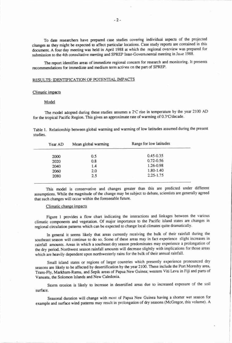
The rnqdel adopted during these surdies assumes a 2'C rise in temperature by the year 2100 AD
for the ropical Pacific Region. Ttris gives an aproximate rate of wrnring of 0.3'C/decade.
Table 1. Relationship between global warming and warming of low latinrdes assumed during the present
studies.
Yer AD Mean global warming Range for low latiudes
2000zWOz0/,O20ffi2080
0.50.81.4
2.O
2.5
0.45-0.3s0.72-0.561.26-0.981.80-1.402.25-r.75
This rnodel is conservative and changes greaterr than this are predicted under different
assumptions. While the magnitude of the change may be subject to debate, scientists are generally agreed
that such changes will acur within the foreseeable future.
Climatic chanee impacts
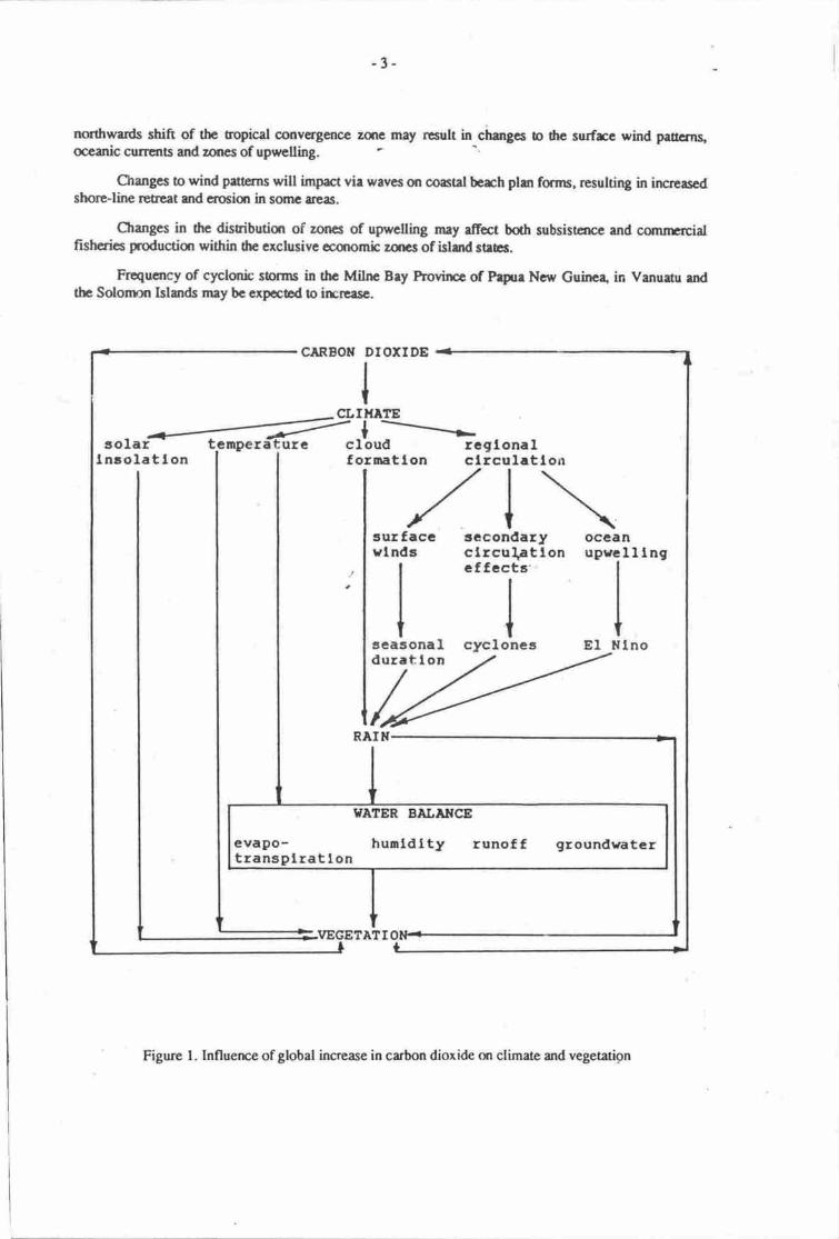
Figure 1 provides a flow chart indicating the interactions and linkages between the various
climatic iomponens and vegetation. Of major importanc€ to the Pacific island states are changes in
regional circulation patbrns which can be expected to change laal climates quirc dramatically'
In gerrral it seems likely that areas currently receiving ttre bulk of their rainfall during the
southeast season will continue to do so. Sorne of these areas may in fact experience slight increases in
rainfall amqmts. fueas in which a southeast dry season predominates may experience a prolongation of
the dry p€riod. Northwest season rainfall irmounts will decrease slightly with implications for those areas
which are heavily dependent upon northwesterly rains for the bulk of their annual rainfall'
Small island states or regions of larger countries which presently experience pronounced dry
seasons are likely o be affected by desertification by the year 2100, These include the Port Moresby area,
Trans-Fly, Markiram-Ramu, and Sepik arcas of Papua New Guinea; w€stem Viti Levu in Fiji and parts of
Vanuau, the Solonnn Islands and New Caledonia.
Storm p.rosion is likely to incrcase in deserdned areas due to increased exposure of the soil
surfrce.
Seasonal &gation will churge with most of Papua New Guinea having a shorter wet season for
example ard surfrce wind patrerns may result in prolongation of dry seasons (McGregor, this volume). A
-3-
northwads shift of the tropical convergenoe zqre may result in changes o drc surfrc wind paucrns,oceadc currcnts and zones of upwelling
Grurgcs to wind p$erns will imprct vie waves on coatal bech plur forrns, resulting in furcreasedshore-line retrcat and eroeian in somc rreas.
Changcs in the disuiburisr of zoncs of upwclling may affcct botb subsistence and cormrrcialfishcrics production within he exclusive ecanomic zsrcs of island suas.
Frequency of cplonb storms in thc Milnc Bry hovilrc of Papue Ncw Guirca, in Vanuetu endthc Solornon Islads rnay be cxpoced to irrcrease.
CARBON
CL
DIOXIDE
III
II{ATE
solai :=- r
-r-riture cloud rcgtonal
Insolat ton f ornatlon clrcut.attorr
surfaccvlnds
III
taeasonaldurat I on
recondary occanclrcu\atlon upvclllngt\
cffecta'IIt+cyclones El Nlno
I/EGETATI
I|ATER BALAIICE
evapo- hunldlty runoff groundvatcrtransplrat lon
Figure l. Influence of global increase in carbon dioxide on climate and vegetation
-4-
Water balance: changes !o botlh rainfall patterns and temperature may be expected to have animpact on terrestrial biological and human communities through changes in evapo-transpiration rates,humidity, run-off and groundwater supplies. Impacts will vary according to the secondary circulationpatterns in the atmosphere and the extent to which these are changed.
Increased temperature will increase evapo-transpiration rates thus increasing drought stress inareas of current water limitation. In areas where wilting of agricultural crops is currently a seriousproblem an increase in the number of wilting days per annum may be expect€d.
VeBetadonal impacts; direct impacs of climatic change on veg,etation include vegetationalresponses to carbon dioxide directly; to temperanrre and to wat€r balance. The latter two sources ofimpact can be expected to vary greatly on a geographic basis dependent upon local changes in circulationpattems and rainfall. Temperature and water balance changes will however have the greatest impact onvegetation, both natural and anthropogenic.
Vesetation responses to carbon dioxid€: potentially enhanced growth of some species due toincreased carbon-dioxide levels, and reduced ranspiration losses due to changes in pattems of stomatalopening, rnay occur. The relative importance of these effects is difficult to quantify at tlre present timeand is better assessed via a global rather than a regional approach.
Vepetation responses to temperature rise: altitudinally delimited vegetation zones will rise byaround 330 m but the time lag for the vegetation response following temp€rature rise is unknown.
Alpine grassland habitas will be decreased in Papua New Cuinea by more than 50% and will beconfined to no more tl an 10 isolated areas. Such habitats are not found elsewhere in the region butconesponding decreases in the vegetation formations at higher altitudes on smaller islands will occur.
l.ower and mid-montane rainforest from 1,400-2,300 m a]titude (communities which are alreadyunder threat from land use pressures) will experience increased human impacts due to improvedproductivity in this altitudinal zone.
The savannah/lowland rainforest boundary will change towards savannah, and in general marginalecotones and relict habitats will be decreased or disappear, the extent of this problem on a regional basisis unknown.
VeSetation responses to chanSed rainfall panems: on a regional basis a decrease in the extent ofcoastal freshwater wetlands may be expected since most areas will be subject to sea level rise coupledwith changes in freshwater inputs. Exceptions in Papua New Guinea are the Fly, Sepik-Ramu, Vanapaand Musa basins which can be expected to become wetter hence increasing tlre area of inland wetlands.This vegetational change will be a dynamic interaction benreen changed climate and sea level risecausing inundation of low altitude coastd wedands.
Soil impacts
Under warmer and drier conditions which will occur in some areas increased capillarity inlimestone island soils may change the sodium, calcium balance in the soil hence reducing soil fertility.
Under conditions of increased rainfall, higho rates of erosion from agriculurral and urban landuse might be expected in areas where land use practices are not designed to reduce soil loas.
Impacts on agriculture and folestrv
Vertical shifts of the position of mem annual isotherms will extend the altitudinal limit ofimportant subsistence crops. This will rccur through an increase in the length of the growing seascl athigheraltitudes; reduction in thenumber of days of frost; increased yield and reduced dme to harvest(Hughes & Sullivan, this volunn). Since the present limits to agriculnre conespond to climatic limits
-5-
reflecting land pressure in the highlands of Papua New Guine4 subsistence farmers can be expected toextend their agricultural rctivity to higher altitudes.
Such changes in land use rney have profound imprcts on human demographic pattems in thehighlands of New Cuinea but will have lesser imprcs in other Prcific island states where rlrc areas ofland ouside the current attiurdinal limis of agricufur* are absent or greatly restricted in extent. Increasedsubsistence activity will result in reduction of the extent of upper msrtane forests which canrrot beexpected to respond with a cqresponding upwards attitudinal strift as rapidly as human rctivity pafterns.
Forest plantings of Pdruls carabaca in rain shadow areas may be adversely affected by decreasedrainfall, as will many cornmercial and subsistence crops which may require inlgation. lrrigation may besuccessfully increased as a respotlse to crop wilting only in those areas where surface run-off and/orunderground aquieers provide a large enough water resource. It is likely that in most areas affected byincreased drought these nvo sources win prove inadequate for such purposes.
Changed temperature regimes 3part from their direct effects on crop plans may be expected toinfluence agricultural production through changes in other componens or trrl naturauagricultural sysrem.Agricultural crops which arc stressed by increased temperature andlor changed ninfall inay become moresusceptible o diseases particularly pathogenic diseases such as brcterial witt Ttre gernration time ofpests may be changed such that rnore thut one generation may affect a single crop gelneration hence theimpacs rnay h changed' Pollination and seed set may be adversely arrectea'in species which arepollinated by animals through changes to the natural poltinatm populations.
The nature of the resource may itself be changed, winged beans for example set tuben only undercertain conditiqrs of temperanre and water avaitiuitity. 5t*t r"rtitity @articularly males) may beadversely affected by increased tempera0rre.
The balance between plantation and small-holder production of imponant cash crops may beaffecte4 thus causing changes to natiorral economies. Coffee in the highlands of papua New Guinea forexample is currently grown by both small and large scale producers. An upward altitudinal shift willfavour increased small-holder puduction on somewhat lte"po slopes than the larger ptantatio,nproduction which at present is located on the lower, fla[er,
".il.y flmrs. Small holder coffee is of agenerally rnore variable qudity than that produced through plantation sysrcms.
Imoacs on health and comfort
- Diseases: in ganeral__epidemiological patterns can be expected to change as a consequence ofchanged climatic patterns. warnEr, drier con-ditions as predictei !o (xcur in sonrc are,as may result inincreased wind borne dust, hence an irpreasc in respiraory inflammatiorvinfections. The patterns ofirrcidence of TB, other respiratory diseases and skin infectisrs can bc expected n change with increasesoccurring in areas of higher rainfall and humidity.
Perhaps the rnost dramatic change !o health pa[erns is likely to occur through changes in thedisributio patterns of disease vectors, in particular mosquitcs.
Altitudinal shifts in the disribution of the nrosquito vector of malaria can be expected to result inircreased inciderre of malaria in thu highly populatcd highlands of papua New Guipa. Thescpopulatians are cunently at and bcyond the altinrdinal timit of drc mcquio vectc which may wellbeconr endemic in these areas in thc fu0re. This imprct is unlitcly !o be important clscwhere in thcPacifrc since malaria is confined to Melanesia rnd irr the solomqrs rnd vanuanr no rnajor centrcs ofpopulaticr are found outside the altitudinat limit of the v€br.Other regicrdly irnpatant vectfi borne discases irclude filaricis and dengue fever. Areas which
experience irrcrEascd rainfall srd extendcd wa seasllns are lihely o erperhncc extcndcd brcedingseasons fc the rnsquito vectors and hence irrcrcased frequency of outbreebend crses of ficsc diseases.Areas wlrece srch discases ae currently of low froquency re gcnerrlly radrr dry wih distinctly scascrrlrainfall" they are untikely to cxpcrience increascd irrcioences oi theso iir".*r.
Human comforc at highcr rltitudes whcrc fuel wood is uscd erEnsively for heating dweltingsirEr'ascd Emperamrcs may result in rcduccd ftrel-wmd use wirh co*Gqucnt fr,ow on effecsln crnu of
-6-
reduced forest cleararrce and reduction in respiratory infections. The reductisr in forest cleatance, f *y,is likely to be counter-balanced by increasod clearing for subsistence agricul0ral productian.
Low-lying areas, which re currently inhabite4 may become untenable due to rnore frequent and
longer-lasting flooding pattems.
Cyclone destruction of human habitation and infra-strucure can be expected to incrcase regionally
as areas not cunently in the cyclone belt become subject to such episodic evens due to a northwards shift
ofthe ropicd convergence zone.
The Relative Srain Index is a npasure of the suitability of local climates for human comfort Ittakes ino rccount both temperature and rclative humidity and is related therefore to sweat production in
humans as a temperaure rcgulatory mechanism. In general terms there will be a ubiquitous deterioration
of climate from the point of view of human comfort throughout the region. This will be panicularly so in
areas of current high humidity (see McGregor, this volurne, for a nrore detailed discussion of this index
and is application).
Changes in temperatue and humidity affect work efficiency and whilst this may be uncsttrollable
in an extemal environnsrt, buildings are frequendy envirottmentdly controlled. Mcre buildings willrequire air-conditioning, hence increased power consumption. Changes to architectural design and
economic costs will be necessary consequences of this change. We can expcct therefcre that workers in
the primary sector will have reduced productivity whilst worters in the service, industrial and
commercial sectors will require irrcreased environmental contnol if current productivity is to be
maintained. Sorne areas within the region are currently close to the limit of comfortable conditions for
habitation, many of these will exceed this limit under the climatic regimes predicted (McGregor, this
volume).
SEA LEVEL RISE
Background
Assuming a global rise in temperaturc of between 2 and 4'C by the year 2100 we can expect a rise
in sea level as a consequerre of thermal exparnion of the oceans, ard ice melt. The present case studies
are based on an assumption of a I m rise in sea level by around the year 2050. It is further assunred that
the rise will continue beyond this daa. Again this figurc is conservative and other estimates suggest an
irrcrease in sea level of up to 4.5 m by the end of the next cenury.
As with climatic change it seems realistic to assume that sea level rise will occur, whu is at issue
is the magnitude and rate of the rise. Again models used for predictions of sea level rise can only be
developed on a global scale and hence are considered outside the scope ofthis report.
Impacts
Coastal inundation
Permanent coastal inundation may be expected to occur to a significant ext€nt in areas where the
coastal profile is flat or gently sloping. The extent and nature of land loss is estimated in a number of case
studies (Bualia & Sullivan; Hughes & Bualia; Nunn, this volunre)'
Inundation may be expected to be economically important in the region, given the disribution offertile agricultural areas at or close to present sea level; the number of roads on smaller islands which lie
in close proximity to the sea and the number of lowJying urban centres in the region.
There will be an overall decrease in the extent of low-lying wetlands, with a corresponding
decrease in freshwater species diversity and abundance for most carchrnents except possibly the Fly and
Sepik-Ramu systems of Papua New Guinea (see abovet.
Inundation of coastal agricultural areas will result in increased agriculnrral activirjes inlan4frequently in arcas of increased slope with consequent increases in erosion and soil fertiuty problems.
By and large the biggest estumine/deltaic systems in the region are backed by relatively flatcoastal plains, coastal regression may be extensive in such areas resuldng in reduced triuitaa for somespecies of conservation concern such as crmodiles and urrtles.
Inundation of outlyi,rg islands and loss of land above the high tide mark may result in loss ofexclusive economic rights over extensive areas of the marine environrnent,
Coastal floodins
Episodic flooding of the coastal zone may be expocted to increase both in frequency andgeographically as a consequence of irrrcased cyclonic activity. Flooding can be expected to have impactson slorrn water drainage and sewage cisposal systems in urban areas.
Flooding may be exp€cted to have deuimenral effects on recruitrnent o populations of saltwatercrQcodiles and other species where reproductive success is largely determined Uy-"gg mortality due 16flmding of nqsls.
Extension of the periods of inundation may render coastal arens, particularly in areas of beachridges backed by swamp uninhabitable in the long-term (see Bualia; Hughes & Bualia, this volume).
Chanses to coastal morlhologv
The case studies presented in this repon are all predicated on the assumption that coral growthr"tes will keep pace with rising sea level and hence that existing barrier reefs will continue to provide thesanre level of protection to ttre coastlinc as they do at present. Should this assumption not be correct thenincreased wave action may result in an exaggeration of both the rate and extent ;f the impacts discussedbelow.
The impact of globat changes to carbon dioxide availability on the growth of symbiotic algae andhence the hermatypic, reef-building corals is not known. A rise in temperature will decrease the solubilityof carbon dioxide, but irrcrease the solubility of calcium carbonate, the consequences of these twoprocesses for symbiotic algal growth and reproduction and hence skeleton formation are not known.Similarly the changes in species composition which might result from changed temperature regimes anddeeper water have not been evaluated to date. Changes in species composition r.y aff..t the degree ofprotection afforded a coast; may affect the rate of storm damage and herpe the rate of sand production.
It is clear that depositional coastal prccesses witl be affected by any rise in sea level and thefollowing figure illusnarcs the componens of this sub-system. whilst sediment deposition will continuein estuarine and deltaic areas, berhes will tend to lose sedimens to off-shore sinks resulting in increasedrates of shore-line regrcssion.
As illusuated above an increase in sea level will result in increased volunres of the sediment sinksin the system causing rcduced fluxes between sinls. Overall, beaches with a stable beach plan formwhich cunently receive sediment inputs via longshore drift will, under increased sea level receive lowerinputs of sediment resulting in consequent beach erosion and shaeline rereat. The extent of this rereatwill depend upon tlre profile of the terrestriaUmarine inter-frce and the current importance of sedinrennderived from longshore drifr
Depending upon the rate of sedinrent input into the coastal system from riverine sources thesystem can be expocted to stabilise only if sea level iself stabilises, and only following filling of theransiory sinls in the system (esurarine and beach sints). In areas of rcduced rainfall riverine sedimentinputs may be reduced further exacerbating coastal erosion. In areas of higher rainfall sediment rnputsmay not be significantly increased depending on the nature of the vegetation cover.
Beach plan forms will be changed by changing wave pa$erns resulting from modification ofregional and sub-regional wind patterns. Such changes will have important to patterns for coastal marinecommunities of sea grasses, coral llats and algal beds. These processes can be expected to be ofimportance along the coasts of all pacific high islands.
-8-
llvctlhc acd(a.3 ?tI,
tlood 9l.tr .t.l(lrcaa.rcd h volor,
,a
Bct|.rtn ./rtalt tc rlBt + LoDgttor. 6al ft+a..ch il.Dorltlon-.s.dlrnt torr(tacra.r.d (t.do...d
Ir vol[Il tr r.t.,It
Off-.hot. Occratc .l.t(lncttttod lo volE-,
{rCduc.d (trc.rr.d,a rrtc, tt| ratc,
ItD.ach aroalo!
It.horaltaG ratacrt
Figure 2. Conscquences of sca level rise on coastal sediment flux
Coral aolls ad cays may bc expected to decrease in sizc and/or be eroded entircly as a result ofaccclerated loss of sand o off-shore sinls. Even if coral growth rates wcrc to keep prce wittr sea levelrise it seems unlitely thu sand production would be suffrcient to keep focc boft *ith rcccloated lossftom the systcm as r whole and the inqeased irolunr of the lagooral sink (see Figure 3).
Saline inuusiqr
In esnrarine iuEas an inland exteruion of the tidal prism ma7 be expected. In coastal plainssaltwaEr oontamination of the groundwater may have profound effecB on both the suitability of areas forhuman occupation and upon the nature of the vegetation.
WaE table elcvation
A risc rn sea level will cause a rise in water table which may have important consequences forfreshwatcr lcnscs whictr currently float on saline watcr bodies. In the case of sand and limesone aquifersthis will result in a signifrcant decrease in the volunp of the fresh water aquifer both for humancursumption and agricultural use,
lnss or reduction in the volurre of freshwater rcsouroes may rcnder small aoll and linesoneislands uninhabitable long beforc the loss of material results in land loss.
At least one urban cente (Kavieng) close o sca level in the Pacific derives is drinking water froma linrstone aquifer. This centre and others like it rnay be significantly affectcd by reducrion in thevolurne of water supplies for human urc.
Compression of dre marine ten'esfiaUtransition
Changes in coastal vegetation following sea level rise and inundation may be dramatic, in areascurently havitg a flat coastal plain (Pemeua & Osbome, this volume). The distribution and zonation ofvegltatioo in particular mangroves, will be attered Zonation is likely to be compressed, resulting notonly in an overall reduction in the extent of such transitional habitats but extensive reduction in thesceward rcres.
SAND LOSSTO OCEAriilcsttrx
CAY
FORtrATto|l
SAflO
oEPOSrTloll
-9-
+--sa||o FonrATroflAr|D TNA,|SPORT
t30LAr€o l.tcno-aToLLSAT{D CORAL PATCHES
PREVA|LII{G wtflo €_otRECTTON (-
l.-l::::s"i""^' l.o*. o,f
Eru::'f'ri:tr-:-ttn
t----{a.s.LiEEFfLAT
- 9tR€CTtOflsn oF conlL| | cnowrx
Figure 3. simplified diagram of sand genesis, bansport and loss from atorl slstems
such coastal habiat reduction will result in.rmporunt changes to the distribuoon of wild speciesof flora and fauna of subsistence and commercial importancg -a"; general loss of estuariney'mangrovespecies' In general both individual species abundance ana species richness will decline.
Turbiditv
Turbidity in dre coastal zone is linked with rainfatl and soil erosion, increased turbidity may affectprimary producers, including corals, sea grass€s and macro-algae. Increased turbidity in the coastal zoneis likely 0o beconre a -pronounced p.bl"r in smaller israia
"msystems with high density humanpopulatiors' Following inundation of coastal plairu hillslopes *il iave !o be brought into production andrc-location of setdemen6 on slopes will tak; pkce, both'procorr *il result iriincreas'Jmobility ofsoils and sedirnents and their transport ino trre coastar marine systenl
SOCIO.ECONOMIC EFFECTS
Background
Both climatic change and rise in sea levet will have profound economic and social impacts. Theextent of these impacts will be great for Pacific island states where land areas are generally small,insularity is high, and the length of the coast is consequently great. For most pacific islands coastallaations are favoured for human habitatist, for road .*it*"tioi, for large scale plantation agricuturrc,and for the development of secondary industry. coastal erosion and inundation will thereforc not onlyaffect marine based human activities -but
witt also impinge upon all i6pects of human survival in suchsitu.'nions.
whilst some imprcts may be countered by changes to pattems of human activity other impactsmay' be impossible for the economies of small island itates o absorb. where modified d";-f";;;strategies can be adopted to mediate or obviate the described impacts, these should be adopte<iimmediately and island governments and administrations shourd incorporate consideration of futurecoastal changes into the planning process.
- 10-
Climaticallv relatsd imoacc
Urban cerrtrcs in areas of prcdicted higher rainfall will need to invest large sums in storm run-offdreinage systens; flood concol worts and sewage disposal systen$.
Given the predicted increase in cyclone frequarcy, episodic damage to engineered structues canbe expected to become a significant economic burden for some states. Chmges in achitecnral &signshould be considercd to minimise potential imprcs from such events.
Loss of agriculturally productive land will have economic costs not merely in terms of lostproduction but in terms of the costs of bringing other areas perhape less suited o agriculture intoprodrction. Such changes will have imporunt consequenoes for land use practices which must berndiflied to suit the environrner'tal charrceristics of different land types.
Whfut irrigation schemes might be s€isn as a pot€ndd answer to problems of agricultural watersupply in areas i&ntified as becoming drier, such schemes should be approrhed with caution as theymay povide little more than a short-terrn solutim which would become impossible to maintain in thenrdiurn arrd longer term future, urd in areas of increased capillarity may corrtribute to soil salination.
The pauern of marine productivity in the region can be expocted to change, hence zones ofupwelling which currently support important pelagb fisheries may rnove, resulting in both positive andnegative ecsromic cons€querrces for smdl island states. This imprct may be fundamental to a number ofthe smaller states whose sole or maja source of export inconp is mrine-pelagic fisheries.
Impoaant changes may be anticipated in the hydro-electric power generating potential of differentareas as rainfall paBerns change. Power dcmands will be affected particularly in areas where air-curditioning is dready necessary. Such areas will require morc air-conditioning in the future, henceirrreasing pow€f, demmd. These changes may rcsult in some major urban centres becomingeconomicdly insupportable by the end of the next cenory.
a.r'eas which cunently experience a prolonged dry season will become drier and such areas mayexperience Doth donpstic and industrid water supply problems. These problems may be particularlycritical for centes wherc hydro-power generation is dependant on the same source as the domestic watersupply.
Climatic changes will generally advenely affect the tourist potential of many Pacific island states,althorgh changed wind regimes may improve the quality of some arcas such as Port Moresby through a
longer sailing season. Adverse affects will have substantial impacs on dre ecsromies of the smallernati6rs, dependent upon tourist income,
Sea level rise
Sdine cmtamination of drinking wat€r supplies can be expocted to become a major economicproblem for aoll and raised lirpstone islands, for populations on coastal plains and for urban ceoftsdependent upon quifer water supply on high islands. Such imprts will be felt economically throughhigher costs of dternate supplies of drinking water.
Rising saline water tables may adversely affect agricultural production particularly on atoll islandswhich may becorne uninhabitable resulting in out-migration and economic and social costs ofresettlement.
Ecmomic costs for maintaining existing engineered structures such as roads, sea walls, piers,
harbours, whrves, houses, hotels, sewage systems, storm and waste water disposal, and bridges will rise.Futue structuncs should be planned taking into account rising sea levels.
Resetlenrent and out-migration can be expected to have major social and economic costs bothwithin island states and regionally. For some of the smaller atoll based nations out-migration may meanresettlement in another country with consequent costs both to the original and the recipient state. Globaland rcgional solutions will be required o this problern
- ll -
Associatcd with rcscttlemcnt, bdh !.!i"l *d psychological trauru will be experienccd,resettlcrncnt progr|lnmes tlrcrefce shouu bc dGignod o minimisc Juch trrume Rcsenlerncnt will oftenalso involve m4ia charges to lirb style md economic practiccs and schcmes should bc plannedrcccdingly (O'Collins, this volunrc).
ln some circumstarrces, resettlernant will bc e gradral proccss, involving increased out-migrationof disprqctionatc numbers of younger rpmbers of ttrc comrnunity. Those kit behind will be likely tobe older' less economically active and curscquently rnore dependcnt fq their survival qr extcrnalsupport. (See Morarrta 198E, for a disctssion of dre imprct of out-migration on homc communities)*.
Local pprluions will need to adjust frcir management prrctices in relation !o changes in lurd andmarine rBsourc4s. Traditional methods and bcal tnowicage ni"y tot bc appopriarc mc n'6'y crcps mayneed to be inroduced Extemal assistance will be neded to train local farnrrs and extcnsiqr officers !orespond o the changes in their environmenl
Changes to the locd disribution md abundarcc of mrinc urd coasral nwouroes can be expectedto have majoreconomic imprcts at the local enti subsisEnce bvels. In sonre instenccs major comnprcialr€sources srch as prewns and &ep water snapper nay be affectcd rcsulting in chggcs L t116 16a .r,Cnatimal economies.
loss of small orrtlying islands through acceleratcd erosion will nran loss and/or reduction in thcsize of exclusive economic zones. Japan hrs derpnstratcd thu this must be taken seriolsly bycmstructing an rtificral island on an outlying ttef sysEm whcrc erocion hrd renroved thc land abovehigh water mark. This inprct is potentially of major importarpc lo the smell€r abll island saes ofMicronesia ard Polynesia but may bc erpoctod o impect even larger high island stacs.
All economic changes regrdless of whether u|€s€ ue due o climarc or sea levet rise will rcsult ina need fc major budgetary re-allocatirrn on e national and regional scale. The involvenrnt of th€rEtropolitill countries in planning fa such changes is imperativc since resctrlersnt will imprcr uponthose countries an the prcifrc Rinr, paniculrrty New zerllttt.Aand Arsrafia"
lnss of cultural heritage will @cur, not only as a consequenc€ of movenEnt and resederentisolating people from their traditional islands end land but duough the inundation of impct'tarchaeological and anthropological sies.
Iarxl'values will change as people becone aware of the impacts of rising sea level, within nationsthis will result in subsuntial oconomic rnd social change. tn nnng developed-urban centres subsuntialinsurance claims may prove an ecqlomic burden.
FUTURE RESEARCH
Introduction
As indicated in the title this is a preliminry rcport which aims to identify por€nrial impacsresulting from global climatic change and sea level risl in thc counries of the prcific Basin. It isthercfore neither a definitive stat€m€nt of what will happen, nor a statenrnt of precisely when it willoccur. It was recognised by nrcmbers sf ths rerk eam hat a considerable amount of aiaitionat wutcould be undertaken o frrtrer definc tlre imprcts srd o estimate in more deail the scale of such imp4.The details provided irelow indicate two levels of furdrer wort.
l' The first involves a continuation of present activities to expmd the geogrrphic coverage of treexisting approaches and to investigate in a similar manner certain as-pecs which have not beenconsidered to date.
r[Morauta, L., 1984' I-eft Behind in the vilage. Boroko: Instiarte of Applied Social and EconomicResearchl.

-t2-
2. The second involves the implementation of data oriented progranrmes of field researchdesigned to answer specific questions rised during the present work.
Extension of present activities: regional reviews
The climatic case sudy is limited in geographic coverage, it can be extended in two ways;fintly to cover other parts of the region; secondly through a comparison of selected sets ofwarm and cold yearr for the mid-Pacific basin, regional circutation patterns and local climaticconditions can then be predicted with greater accuracy.
The use of the relative strain index can be extended to cover all major urban centres in Prcificisland states, hence providing a regional picture of expected changes to human comfort
Crop physiological tolerances need to be investigated and the working group meeting agreedthat the physiological 0olerance, and present geographic distribution/imponance of thefollowing crops would be investigated and compared with predicted future clirnatic patterns.
l.
2.
3.
Commercial crops:Subsistence staples:Subsistence & small-scale
commercial crops:
sugar, tobacco, coco4 robusta coffee.mro, sweet potato, cassava.
tomatoes, ginger, pawpaw, citrus, cowpeas.
4.
5.
6.
7.
8.
9.
Review of coral reef growth rates, and potential chmges to species composition resulting fromdifferential growth; temp€rahle r.olerance and ia influence on growth rates.
Atoll sand budgets and aquifers; existing data needs o be regionally reviewed and refinenpntsto predictions of impacs made as a matter of uryency. lt was felt by the working group thatthis island type was one of dre most susceptible to massive impacts within the region.
Sonre attempt needs to be made to assess the impacs of climatic change on the environnrent ofshallow water lagocns using existing data sources where possible.
An attemPt should be made to assemble a geog;aphic data-base for Pacific island natisrsrelevant to sea level change. This needs o include number of islands, land areas, coastlinelangth, populatian density and areas of exclusive economic zures at the very leasL
Urban case studies of the kind undenaken by the University of the South Pacific team shouldbe exrcnded to other centres within the region where possible.
Continued monioring of the Atolls Resettlernent scheme should be undertaken.
Specific data-oriented case studies
Identified as major systems requiring further detailed study in the field were rhe foltowing (inorder of priority):
ccal atolls;raised limestone islands;mangroveV es tuarine systems ;
floodplains;small high islands.
It was suggested hv the working group meeting that triplicarcs of erch system should be studied inMelanesiq Micronesia and Polynesia and that each snrdy should be undertaken in an agreed identicalformat by each team of around eight individuals.
-13-
Each research team should include geomorphologists, social geographers/anthropologists, andbiologisa and should be asked to answef, specific objectives with regard o each major system. Thuspriorig questions for examinatiqr in aolls fc example relate o sand movenren6 and sanrl budges,aquifer size and location and he extent of agriculnral use of the aquifer. Plur and profile mapping isrequired logether with geomorphic mapping, prepration of a vegetation/land us€ map and interviewswith local people to ascertain the traditional knowledge base concerned with currerts sand movementerosion and stam problems.
RECOMMENDATIONS TO THE FOURTI{ CIfNSULTATIVE MEETING
The task team rcommends that the 4th consultative nreting adop the following resolutions.
This meeting endorses the continuation of the studies initiated through ASPEI on potential impactsof climatic change end sca level rise on the countries of the Pacific Basin end recommends to lhefnter'Governmental Meeting GGM) that thet meeting continuc to support the work of thc TaskTeam to extend the geogrephic coverage and nature of the present work.
The meeting further recommends that the IGM and sponsoring egencies should support t'rnanchllythe implementation of programmes of field date collection 8s the secrnd phsc of the work of thetask team during the next bienniun.
The meeting further recommends thet the blend governmcnts snd Adminhtrations teke note of thepotential problems whhh nay srirc rs t consequ€ncc of global climetic cbanges and incorporetcappropriat€ considcrations into their environmental and development phnning proces!,es.
-14-
PROJECTED CLIMATE CHANGE AND SEA LEVEL RISE: A RELATIVEIMPACT RATINGFOR THE COI.JNTRIES OF THE PACIFIC BASIN
John C. PernettaUnivenity of Papua New Guinea, Port Moresby, ppua New Guinea
INTRODUCTION AND GEOGRAPHY OF THE REGION
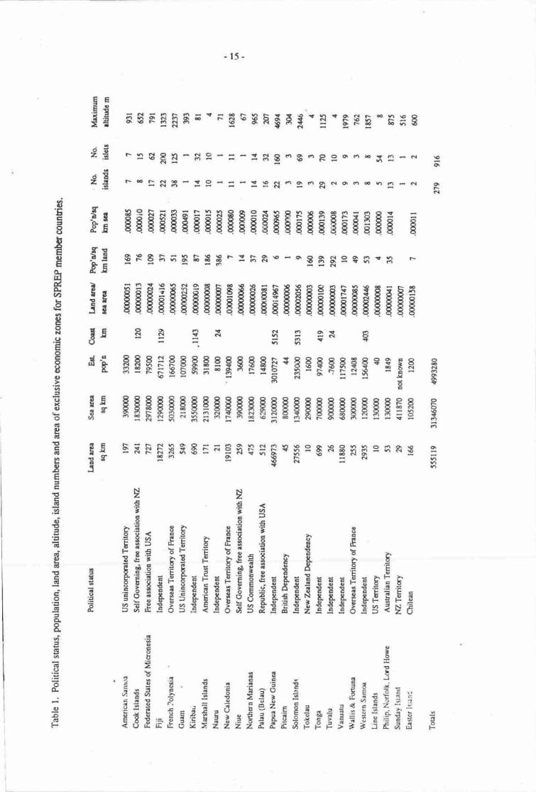
Excluding the countries of the Pacific Rim and those of the South East Asian Seas Region such asthe Philippines, the Pacific Basin irrcludes a number of independent rnicro-states, dependencies andterritories of major powers such as the United States, France, United Kingdom, Australia and New7*aland.
Table 1 provides some basic data for these 'political entities' (hereafter referred to as 'countries')including land area; area of the exclusive economic zones (sea area), population size and ratios betweenthese paramet€rs. It can be seen that for most of the 25 'counries' the land area is insignificant in globalterms (ust over 500,000 1pz); E5% of this area is conuined within the boundaries of Papua New Guinea.
ln contrast the areas of the exclusive economic zones ane considerable (Figure 1). An isolated aollas small as I km2 and having no neighbouring islards represerts an area of marine resources coveringsome 125,000 km2. For most Pacific countries land forms less than 0.001% of the area within theexclusive economic zones. It is hardly surprising thereforc that most countries of the region depend uponmarine resource exploitation both fm subsistence and commercid use. Many countries in Micronesiadepend heavily on pelagic fish resources such as tuna as a major source of income for development.
Coastal lengths have not been calculated for most countries as these are unreliable, the variationbeing dependent on the scale of the maps used to nreasure the coast. This source of error is compoundedwhere the insularity is high, as in Micronesia. Islands vary frorn low lying atolls at or below 4 m abovesea level to high volcanic islands with steep profile, island relief is important in terms of both coastalinundation and rainfalVrun-off pattems herce the impacts of climatic change will differ in islands ofdiffering relief.
Population levels, in terms of density are high for most of the smaller srates (up to 386people/km2;. Again the absolute numbers of people are small in global rerms. Some of the smallestmicro-states in the world both in terms of land area and in population are found in the pacific Basin.
Any change in sea level is likely to have profound effects upon the economic viability of thesemicro-states, both through land loss, and locs of exclusive economic rights at the periphery of theirexisting national boundaries. Both impacts will be highly significant economically.
ISLAND TYPES
The islands of the Pacific are divided into several major categories having different susceptibilitiesto changes in sea level resulting from global warming. Table 2 presents a country by country analysis ofisland type and size based on data contained in the Review of the Protecred Areas System in Oceania andthe Commonwealth Science Councils' Science for Technology for Development. Since different islandsgenerally have quite different susceptibility to changes in sea level the island types are briefly describedbelow.
-15-
* :1 g R ! - $ I - = - : S g - g -P g.D - € X r'' F Gl
F o r- (\! ? - t O < - F ! rO ct |'r Ctr-6io;=--d--Rsl<t\m6lnc4rcl
FSFEFS; "F$snF$H* -'l'E$ 5-E; g
5E=o.5 I*3E=
-d€
:oEze
I6
qiF6l
f: HEEgEEEEggIE$EEgEEEEgEgi If: gpgF;aEEEr-rF&---B$$esfr{R FE.g - rn : -.{
!l gEgEgHEgFFgEEggHFEEEg*gsEE
3E E g 3 x $ f; ?F e
'$E FgF;EgSgsEsegH-FcgsEEg-s€E g
;g gEFEEEFEFEHEEFgEHFggHEEEiE E
aEc=8bEE|lEo.ET&q.U'
€c,goNOEoEoIou75IJx!)
odteGI
!trGI
eIE-tr€cGt
ao'cta'Elcl6ip6E
EcdEoct
=a&0=sa({t()
=o.
-'gD
-
gg 5FF$$$Er;ERs*$*F=s*EanesRE fr5
DEE Estr:8. E- -€ F-
fg:€gF€i i s E, E*E FE E F;tF € g E gE FrE:E$sfe*gE:eseEee{*€FEF_E E.3gE$€EgEI,i.q€E 3; d s3 3 s 5 r 3 r 5 sgg glgggSgf E $ 6
.g
$ru-i:t.r. : .! . E E - o j
= I g 9 .! .! '5 9 ;rEeE F € 5 Ea: 5 EE*;t:.'cip-oqis : ,i,E EgtrF= -=;?s;;;cgs"e5€;; iEEiFs;Ee'EFiilFg; s
-16-
6ool,
Or,q&O.v,q)ta€o>rHEE=o€n,tqqt)oorLao)Lotc.-gt)toag!toF
F
iqa.EooIEoql9.C)E
r-aoooTJtr5o(){)F.:q,L.=c0
o II{zo
to
Ilc0o0
l-:llt. I
-t:la =\a<\.'!:
io3o
| .'t'rEl!lI i, :'t' t| 3.- t
, t'.'gi,!,'ioaoIaJ!5o
t--:II
€.,a:
IaI
otJ3
IIt
II
<l!l
.- |III
T5:
=$;i :..9'
--t
4i3l
!
. -'o't
:Ia?--- --III.,I
t
t9.30ii
: <la3r
, ig't;l.i.a:t
'ar
taJ!ro
a3IJ
a-a
F
aa
,
nJI!t
IJ
!?9-
/-,rG
53Iat
d?.
U::-ts^ s/ \\o
1/!vl| '/!
.a'o
a.,aJ',!
OIazo:I
..oa,I.FaFac!Fa.!go
,taa
a
t.t3t;a'aaI
Caat
ttItIt,tt,
i!:ii i-::I F:JI raa. ol-I t ..
6
iriilqttlil)
tto
\\ \\
\
\ \
a
G
f
/ i(;:--- -;34
-17 -
Volcanic
Generally high islands of predom:nantly volcanic origin, these islands iue some of the highest inthe Pacific with a generally steep prof,ile and rapid oceanic dropoff into deeDer wa6rs.
Mixed
Thrs category covers those islands of essentially a volcanic core with raised sedimentary facies,usually reef limestone' and larger istands of complex geology such as New Caledonia and New Guinea.
Metamorphic
This category is relatively unimponant and covers islands composed of variable geological origingenerally of small size.
Coral
Such islands are composed of raised [nrestone of coral reef origin, soils are generally much poorerthan those of the preceding three types and surface freshwater is gener-a[y absent. rrestrwater for drinkingand agriculture is obtained from the subtenanean freshwater lens.
Atolls
Atolls are coral reefs growing on subnrcrged volcanic cones (Guyots). when present, aloll islandsare piles of coral sand heaped onto the surface of the reef flat; called cays or motu such islands aregenerally no more than 4 m above present sea level and are formed in long nalrow strips either entirelyenclosing a c€ntral lagoon or forming a series of small islets around its periphery. Such iilands are highlysusceptible to total desrucdon through hurricanes, are biotrcally impoverished and freshwater is confinedto a small undergrornd lens. Many such islands are cunently uninhabrted and they presently r3presenr amarginal habitat for human existence.
Volcanic md metamorphic
Oimarc change is likely to be more important than sea level changes, although local impactsresulting from flooding of low lying agricultunl iand and urban centres may be severe.
Mixed
Generally smaller islandS of this rype consist of a. steep sided volcanic cone or cones withsurrounding raised limestone flatlands on which nrost urban, ransport and agricultural land ."nds to beconcentrated' Sea level rise impacts are likely !o be severc oepenaini on the otat land area and the heightof the coral platfrnrs. In sorp rnstances urban watcr supplies uJooir"a from aquifer sources in thelimestone, these are likely to be contaminated by sea water.
This category also contains the largest islands which are the least likety o suffer in terms of theproportion of land lost due to sea level rise although such effets may be lc,caliy seyere and imponant tocenain spccific coastal habitas including sw:rmps and wedands. For larger istands changes intemperatuE and rainfall may profoundly affect bottr agricultural rctivity and the disribution of naturalbiomes.
-18-
Table 2. Island t1rye by country, SPREP rcgion. Areas are in f#, dtitudes are in rn
lrhdtpc
Volcrlic Marmorphic Mircd Rdtodcad Atoll Uatncl TolrlCald.y
NmhcalMrrirlgMdc 13
ilcearrcr 5nllgc O*ltLgllonl|iindc AERroSc t1465
GrofdmbcrItfrra rrcrRelgcl&rarltibr&Rrqo
Bchu
l,l
I5'll
393
l,frdcr | 2 (nrn (6+)3 6 (ll2)39ilhrarltr J ll.60 (0.5) t.5Rrlg" 933n 0.65-{7 0.$1.9.1l'ft.!iliudG [l24'l O I2lRn3c <S?fr|
Fldcrgd $ucrdlrficoocdr
Nfdcr t ,l 7 (266.r)n l0 095) 59Mcrarree 8.60 1.20 (Ol8) f.6 0.tR.ragc 1,7-ty 0.1-Zt 0.0616 0.049-1.6lr{cra rttitude /Ot.gO |TJO 3.35 6lRngc lS2-791 d-30 Ll4 6l
It[rrrlull lrludrNumbcr 5 (10E5)2t (lll8) 33lvtcen uee 0.ti (0.15) 6.1Rrngc 0.l6l.t 0J-16lvlc.! dlitudc <l0m ? 3.35Rragc LU
Prpur Ncw GuincrNun$cr C25r2l | 7 (ltt rrl (160) 149Mcra rrce 325,t t4Offinl (0.42)3
Rnge 7.9-3/t52O O+lll0lvterl rldtudc l3E6 145911 t3lRrngc 50-3123 1G370
Solomm IslendrNunrbcr 26 6 (t5)6 4 83 (139)125
Mceo erce l&t.20 lE86.E0 35210 130.25
Rrnge +53% 2W4243 29475 3-386Mcztr rltitrdc 1031.50 1325.50 7t.30 2?:2.50
Rengc 374-2331 fl219-1432J @91.5 [65-380]
Vro$rtu-Nunrbcr 18 9 (15)9 ll (6t)4?
Mcen erce 168 905Rrngc [8.9.{l.fl 3F0,-393'l
Meetr rltitud 870 917 162.4 237
Reogc ll5-t4961 32Glt79 6-366 64494
- t9-
Cd|trtry
NorqldcirIttdcrItlcl rrrrnrr;cItLd!r!bd.hSe
Arrr dio TrriEhrtddrrMlrlrnrfr{GMorrr[b&Rrqc
N.ZT6itdi.rl'frdcrllou rrcrnr4clfaarlindcRrqc
FjilftdcrMcrnrceRrryc}ialrlifidaRrlgc
Toogrtddcrl{cen lcrRrngeMcel ddrudcRrogc
NiucNu$GrMeen rrceRugcMcrn rLitrdeRrgc
Wdlir&FuuulftdcrMcurnrIrotcMcra rtriudcRangc
WcgcmSrmNurdcrMcrn rtpeR|!gg
- lv{cendtitdcRengc
*h"ic:nsrmoNumbcrMcan rmeRaogcMeetrltiMcRergc
Volcric Maooetic
2o25
[ol2{,.1uIr{L3Oq
36
2&t1657'J0
2CHr5
515.50133in
BE 16
69)'?Gl)57.7O?-al6
2Avtzu
l6r7.t2
0.r2-x!t?9L1o
37-r(BO
t3
t32l
Itr.sl
[3rel
lfirod Rdt d.qd
(6F (9)6.r6fr.1t ttL3,J67-16t00 012-1196&r& 6tffll3&16:lt +loa
t .(as+!ll8t.a tLn71-to'/4 7:t-5t3t{10 t9.70*t'gt lJ-2t3
xtl?.70
0*al5a
I'.ax
IB2l
13661
7
tq3l
@)16 t:lJ9
0.1610123
n-/70
2ZJ0.{l 0z}
0i${I'|9 02{1426.let74
Uilro*r
't3
Tdd
(lzt2l
(196)rr
t2
2t
6t
Il25el
16'rl
2tt
gt96
'15550l1*752
7Tts.&
1.75-lt2l795.750-1t57
5
3E.92
2.6135554
6l-931
2t.45
0.&zl4.503{
-20-
Couilry
To&ahuNunrbcrItdcen rcrR.qggIthrndtitrdcRrngc
TbYrtuNutnbgllcrn ercanraSoIt aE rttitu&Raugc
KiribrtiNus0crtfcrn rrteRmgcMeal dtitudcR|trgi
Liac ldandrNudGrMcurrerRrrycMcra rltitrdc
' Rrogo
C@tLtedrNrnbcrttcrarrtrRragcMcea elirudcRrq8c30.dt2
Flcad PolyrcsirNtobctMcelurrRrngcMcrn rftindcRmgc
PitcaimMmbcrMcu rrprRrlgtMcen dtiludcRaagc
E dor [8hadNurScrlr{cen rreeRengcMcenrtitdcRuge
Volcrnis Mcumorphic Mired Brised conl AloU Untnown Toial
Qntt(0.0r)3.422-5.4
41
(63)t3.05
l.&3.9
(r27)3
l3TI8.U
Il37l
(6)32t4.40
o.&ruzw
105-1259
It45l
t3o4l
I1.30
535J'lIt.4{485
.lt7
2-183(}8
95{33
12.At
o.+56<l0m ?
(re)r7I 1.70
O2.f9ILfi't-Et
1t.90
0.3-{J7.707-E
6
12tt
51llll
(r0e)r6(5.1)349.t-321
5rd)+9
(5o+)l(0.06)3
, r2l
(4e)7(0.6),to.+9.t
(63D77u90l-943
3.9l.t{5
20.6t
0.55-0.7.l
tll.2l
(67)e
o36)33
(54)5
(69+)15
3 [5erll22n3t
t36ol
Ittzl
t33l
(2)l2
ll66l
l2e&6001

-2r -
Coral
Raisd linestone islands will bc affected to varying degres rcco,rding to their present heightabove sea level; for lower lying islands, changes to ttre aquifer lornbined widr rccelerated erosion willresult in many such islands becoming uninhabitable
Atolls
such islands wil! be moct profoundly affected both in terms of lms of freshwater lenses; land lossand increased frequency of episodic destruction through hurricsres. Most such islands will beconreuninhabitable by the middle of the next cernry if predicied sea level rises occur. Since maximum altinrdeis usually no more than 4 m above sea level, small rises wiII result in rapid restriction of the volume ofthe freshwater lens.
IMPACTS ON COUNTRIES
From an examination of Table 2 it is clear that he countries of the South pacific vary in theirinsularity and the composition of their islads. Assessing impacts in spocific "rr"
,tcy areas hasprovided insights ino the na0rre of likely imprcs and allows assessnEnt ol the rclative susceptibility ofisland types. Impacts will be Sreatest ftrarotis and least for lage conrinenta d. volcanic islands. Imprtswill be Sreat€r m smaller islands than on larger ones, it is possibre thercforc to rneasure the relativeoverall impacts, country by country in ternu of both insutarity, island type and lard area.
Insularity was measured in terms of total land area and number of islands, where atolls werescored as single islands ever though they might be composod of many smaller islets. The log of this wasthen taken and values adjusted to a range of five units.
Relative size of the counry was nreasured in terms of thc log of btel area agein adjused o arange of five unib.
Relative relief was rrrud by dividing rhe marimum altitude by the land area taking a rogrithmicvalue and adjusting to a scale of five uniB.
The relative susceptibility of amlls and raisod coral islands rnrits their inclusion as I s€pararcphrase within the algorithm. chuly the propcticr of these istands tlpes will affect the extenr to whichcountries are likely to be impacted hencc dts numbqr of alolls srd rrarr oe number of raised coral islandswas divided by fie toul number of islmds, scaled to five.
The components re given in Table 3 by country. The indcx ruy b€ written rs follows:
Inpact level - ls-{trog(rca/no islands) + bg(orar hrd rrea) + rog(nurimumdtituderhnc erea)l + t{(totat atdt noc + l/2 nos co..] isunosyorel nurnber or iirlnasi x st
This p'ovides approximately equal weighting for altitrde, island numben, total lmd '.ea
srdisland type and resuls in dre following ranking rot pacirrc Islard countries.
-22-
;qOF
qEoo
F. Sg gN - gs-F-:ss oR-3oE-€n14.{F B-
5 $ $ s I € r I s s 3 E E t e q qE E q I qqq q I aE 6 i;; a. i E g d j "i d.d io.d = dod d- 9g E -E
Eg *$E;$s!3EPnFa5gIaE3:sPgEEs 35
r RsBFaFER$R=€Fqs{ €i&iq fl!8 qE ;.4 ii - f ;:ri-;i:i J.n-i| G:+ - e,i -:t.it'i - -: -: ci vi -
Eqe;EEqi€qEqEqqqEqsFq !qqq qtcr - - o G| !t q - Gl { tQGrr n -m O 'i d r;.til CiO Ci t'i Yi O
: s91 !il5l*:I:5:I5=::85338$
c- <FdhqeniiEFgfi$*F= aREHBesRg 8eeNsEH*e= 8...-.8 tr E
e8q88 FS8 I ESlq eAq R: Gi; ci r.i o ri + Giar elo cl -l Ficj n - diC o o tQ.'r o (t h o
I € € RnR q E q q aqq € fiqq q 8E E iiq q € q E=EE; g{ i+. ++dq+-T"d TTd "qi-: ;<t -:r'i
5s8:e38€sBq6s qEqEEEqtes{3 R-.jET99 +;.i;9dCqd+ gdCaoqiri<t ;s
F S F $ FH E o F $ *gR $ H* - ! * EFE - E;g $
*
:a*ss5HR3$53F9!$:H3$F3!!3F €:
E6HTi GE€E=r6tr1b r u qg EE 6 i € . ,' q € EgtSp€EeE g 5 € Ee! s .ilg{o..
=!: I = € ?3+-F- =dI'i.E'r*ig g Fs EeE;ErEFis ;r e:;i!gE$*
qr. fEEo=ox,
E
.r€ev>tEn
.$aa
E$<.5
Et\i'trd,€-'
E
SE
.=oi= 26€889, Ep=!Et qsoxC'EEQ)
o
g
C\I
a(J
U€ic)DF
-23 -
Country
Category A
Tokela'rManhall IslandsTrr.taluI-ine IslandsKiribati
Category B
Federated States of MicronesiaAusralian TerritoriesPalau (Belau)PiEairnNaunrFr.:rrch PolynesiaCook IslandsNiueTmga
Category C
NZ TenitoriesAmerican SamoaFUiNew CalefuniaNorthern MrianasSolomon Islands
Cetegory D
Vanua0rWallis & FutunaEasterPapuaNew GuineaGuamWestern Samoa
Inpectlevel
18.7
1E.65
r7.9216.;rz15.06
13.6213.6r13.47
r 3.4513.2212.65t2.4212.08rr.77
10.93
r0.699.%9.689.2E
9.r9
8.758.68E.3lE.l3t.047.62
Comments
hofound impactsmay result in thesestates ceasingto exisl if the worsrcase scenarios apply
Severc impacts willcause economic andsocial disruption withinter-isiand movenrentof populations, andout migration.
Moderate to severe impactswill occur:tocallydevastating. Major changesto crop production systems,demographic patterns andsocial infrastructures.
Impacts locally severeto cdastrophicrequiring considerableforward planning on alaal and sub-regionalIevel.
Category A countries are composed entirely of atolls and raised corat islands which will bedevastated if projected rises occur and consequently such states may ceasc to contain habitable islands.
Category B countries are composed of atolls, and other island types. l,oss of arolls will result insignifrcant population movements to smaller high islands suaining in many insrances an already over-burdened agriculu"rd production system. These countries will require substurtial outside iusistance andconsiderable out-migration may be expected 0o occur to the rim countries of Australia and New Zealmd,.It is unlikely that many of these small island countries witl survive in their presenr social and economicform.
Category C countries are composed of a greater number of high islands and impacts will be locallysevere affecting urban centres and ransport systems. Agriculnual land will be disproportionately lost:hrough inundation of productive flood plain and coastal areas in these countries. Again extensiye inter-ishnd and out-migration can be expected.
Categt4v D countries will be the least affeercd in terms of major disruptions resulting frominundatisr md loss of islands. I-ocal climatic change may be expected to dfct agricuttumt production
-u-
resulting in changes to export cash crop productivity. Inundation of low lying coastal aeas will reducethe extent of eristing mangrove stands and coastd wedands. Within island rclrnaticr of poople will resultin some significant local social tensions. The epidemiology of diseases such as malaria will be alteredwitlr sonp significant social and economic consequences.
CONCLUSIONS
All Pacific States will be significantly affected through the loss of ouuying islands. Such lossesmay be unimponant in terms of lard area but will result in a substantial reductisr in the size of theexclusive economic zones @EZs). This problem has already been addressed bv Japan which has takensteps to ensure continued righs o areas at the southern exfemity of that country's EEZ by consrucdqrof artificial islands in place of eroding nuural islands.
Whilst it might be concluded on the basis of population size that in a global context dre potentialloss of Pacific rnicro-states constitutes an insignificant component of changes resulting from climate andsea level change such a view takes no account of the loss of human culuual divenity. It is important torecognise that Melanesia contains one third of the worlds languages ard that loss of human culturalgroupings within the Pacific through amalgamation and incorpcation into neighbouring states represenna significant loss of the human heritage.
Regionally severe problems of social and cultural disruption can be predicted as pqulations movefrom eroding, waterless atolls and coral islands, fint to neighbouring high islands and then toneighbouring rim countries. It is imperative that the problem of 'ecological refugees' be addressed at aregional level, particularly as the neighbouring rim countries of Ausralia and New Taaland can beexpected to be the target destinations for such refugees.
Economically all countries will be adversely afftrcted by changing climatic patterns causingalterations to existing agricultural systems of production. Climatic changes will result in increased cosBto the economy through generation and consumption of rnore electricity, whilst freshwater availabilitl,will change with consequences for human settlement.
-25 -
POSSIBLE CONSEQUENCES OF CLIMATIC WARMING IN PAPUA IYEIW GUINEA WTTHIMPLICATIONS FOR THETROPICAL SOUTHWEST PACIFIC AR.EA
Year AD Global warming'C Range for low latitudes
Glenn R. McGregorunivenity of papua New Guinea port Moresby, papua New Guinea
INIRODUCTION
A number of climate change scenarios have boen developed basd on possible global rates ofdecdd temperate increase. These rates arc related to continued emissions of atmosptreic greenhousegases. The three global temperaturc chmge scenrios are
1. low scenario - 0.06'0decade;2. middle scenario - 0.3.Cldecade;3. upper scenario - 0.8.C/dccde.
In dditist to the global scenarios a number of regional a latitudinal scenarios hive also beenproposed. These latitudind scenarios ere necessary since the magnitude of COz forced temperarurechange will vary latitudinally due mainly o ice-albedo effects. b.e"tust Emperanre irrcreases areexpected for the polar latitu&s while the smaltest changes are expected for the tropicat and sub nopicallatitudes (C30'North and South).
Taking the middle scenario of O.3'C/decade and the 0 - 30' tatitudinal temperature change of 0.9 160.7 tinps the global average a timetable of warming for the tropical latitudes matbe estimated(Table l).
Table l- low latitude temperai.ure change scenario based sr nrean global warming rate of 0.3.C/Decade.
20002020z0/,O206020E02lu0
0.50.81.4
2.02.53.4
0.45 - 0.350.72 - 0.s61.26 - 0.98r.80 - 1.402.25 - r.753.06 - 2.3E
The resulb pteryted in Table I re in ganeral agrterrnt with the range of temperatue increasespltdicted by General Circulation Models (GCMs) for tle low latiurdes (Mmabe & \iyeatSeral4 l9g0;Wilson & Mirchell, 19E7;.
The effecs such temperarure changes will have on low latiode climates is not yet wellestabtished. However there appean to be a genaal ccrsensus that the humid tropics and semi arid/subhumid bopics will borh be impacted in similar ways (table 2).
Of the three tropical climate zones the semi-arid and sub humid rcgions which are already highlys'rsceptible to climatic variability arc likely o be impacted rhe most given a change in climate. Somearcas that are sensitive to curr€nt climatic variability with associated negative impacts are likely therefore
-26-
to find that periods of prolongod drought with inplicatiqrs for dsertificatior will boconre exacerbated"For the humid trqics, an area which in sonE crses already suffers from excess rainfall, high humiditiesard tempcratures, climate changes could have important implications for flood management, humancomlbrt and disease.
Table 2. Pmsible CQ forced climarc changes for the humid and semi arid/sub humid tropics
Climate parameter Humid Semi-aridSub humid
Temperaturc
Precipitation totals
Pr,ecipitation intcnsity& freo.uency
Evaporation
l-3'C increase
5-20% increase
Increased ineruitybut not frequency
Irrcrease by sannmagnitu& as
precipitation,irrrcased tendencyto drought sness
Expansion ofzoneof tnopicaldisurbance genesis
1-3'C increase
Increase, but geo-graphically variable inmagnitude, decreases insome areas
Increased intensitybutnot ftequency
Incrcase withincreased droughtstress in areas thatwill experienceprecipitation decreases.
Increase likelihoodof tropicalcyclone impact
Tropical cyclones
Although broad statements such as those above concerning likely climate change related impactsare useful, the cenral issue of climarc chmge impact :rssessment is o determine the nature of likelyimprcs for reas at the sub regianal or colmtry level. It is these sub-regional impact assessments whichwill be of most use to regional governments in developing policies thu will address the projected CO2forced climate change.
This paper is therefore concerned specifically with evaluating likely changes in the magnitude anddistribution of rainfall in Papua New Guinea with implications for the rest of the southwest Pacifictropical zone. As Papua New Guinea possesses a range of ropical sub-climates generally representativeof those found elsewhere in the tropical southwest Pacific results for the Papua New Guinea region maybe applicable to other areas throughout the southwest Pacific. In addition to rainfall the impact oftemperature increases on human comfort is also highlighted in this paper.
PRESENTMETEOROLOCICALCONTROLS ON CLIMATE IN PAPUA NEW GUINEA
Three large scale circulation systems presently dominate the climate of the region surroundingPapua New Guinea. These are -
l. The Hadley cell circulation which is a thermally driven rnean meridional circulation;
2. Polar or extended low pressure troughs of great npridional extsnt, and
-27 -
3. The Walkercirculation which is a large scale east-iastcirculation systsm
Both dte Hadley ard extendcd nuidional trough systcm re rcsponsible for thc trnspfit of hcarenergv from the tnopics o higlrcr lrtiurdcs. Thc \Mdkcr circutation brings cool mist air frrom dr e<EnPacifrc ino the regtm of tlre westem Prcific where it is heabd and supplkd with npisure. Thc gencratarea of westcrn Melanesie is 0rcreforc dominat€d by suurg convcction which is drermally drivclr by bodrncridional ard zonal circuletions (Figurc l).
Al0iotgh thcre se short transitimd Friods bet*wr sa!s(ns, tso distinct sars{ms erist in PrpraNew Guinea Thc sesons st'rchcd to thc pciticring of hc cquarid uough (which licc bctcrcar 6cnorthem and soutlrccn rneridiqrd Hrdlcy circulations) rclative to thc hcatirrr of the Papre New Guincaland mass. '
Hodlr
foller clrcu loflon
-ro t
crrcurono]
,.a,.J
II
r{o EI
tao c\FOU
Figure f . Modet of generd atrnosphcric circulation in the Melanesian area (taken frrom Fals f983)
-28 -
The 'southeast' season lasting from May to October is dominated by southeasterly flows (thenades) emanating from a sub-tropical ridge at 25' to 30'S. This southeasterly flow extends equator-waxdin a divergent stream (Falls, 1983). At approximately tle position of the equator this divergentsoutheasterly flow is turned northeastwards at the southern rnons@n shear line to become thesouthwesterly flow of the southwest monsoon affecting the Philippines archipelago. Generally the meanmonthfy rainfall during the 'southeast' season in Papua New Guinea is low, however for areas backed bymountains and lying nornnl !o the southeasterly flow rainfall is at a maximum during the southeastseason.
With the onset of the southern summer the equatorial uough begins to develop in the southernhemisphere. At the same time the northern equatorial trough weakens and the band of westdiescontained between t}te northern and southern equatorial roughs extends southward ancl eastward of theirsouthern 'winter' posiion to affect Melanesia (Falls, 1983). With theie developments the southeasterlytrades are weakened and pushed further south. This short transitional period is followed by the'northwest' season.
By the beginning of December equatorial westerlies have peneuated the region overlying PapuaNew Cuinea and remain dominant over Papua New Guinea until March. During this season meanmonthly rainfall is between 250 and 300 mm in January (McAlpine et al.,1983) in sharp contrast to meanmonthly rainfall of 100-150 mm for July in the southeast season. Areas of maximum rainfall during the'northwest' season are those lying across the northwesterly flow and exerting maximum orographiceffect.
CONSEOUENCES OF GL,OBAL WARMING
Rainfall
Several approaches for assessing likely rainfall distributions as a result of CO2 forced globalwarming are available. These are:
application of results of general circulation models (Manabe & Wetherald l9E0; Mitchell,19E7);
comparing ensembles of warm ard cold years in terms of their rcspective rainfall anomalies ordepanure from long term means (Wigley et al.,1980; Williams, 1980; Namias, 1980; Pittock& Salinger, 1982);
using established linkages between atmospheric circulation and climate to ascertain howclimates will change given a specified change in atmospheric dynamics, ard
the use of historical analogues u regional climate reconstructions of globally wiumer periodsto model future warmer conditions.
As pointed out by Pitlock & Salinger (1982) each of these approaches has limitations as none ofthem arc based on a perfect analogy. However, despite the various limitations the combinarion of resultsfrom individual approaches may allow some fint order estimates of possible regional climate changes tobe made. This is of course contingent upon result agr€ement between results of different the ap'proaches.
Presented below are the resuls of three of the above approaches in an atrempt to shed some lighton possible CO2 forced changes in rainfall distribution speciflrcally for Papua New Guinea and moregenerally for the ropical southwest Pacific.
1.
2.
3.
4.

-29 -
General Circulation Models
The confidence that can be plrced in the rcsults of General Circulation Models (GCMs) d€pendson the degree to which th€ GCM is based on physical principles. Civen the difficulty of moCltingcomplex feedback relationships between the atmosphere urd ocem systems, and the problem ofrepreserting clouds in GCMs, the resuls produced by GCMs to dare, can not be interpreted literally.This is especially true with reference to precipitation changes A further limitation of GCMs is rhat thiyprescnt an equilibrium picture of CO2 fonced climate change without revealing details of the transientresponse of climate to CO2 forcing. A frrll rcview of GCM .iimitation will not be given here but thereader is referred to Dickinson (1986) and Wigley (1988).
Daspite the deficiencies in GCMs there are some broad-scale GCM resulu which can be used asindicators of likely climate change. These have been summarised by Wigley (l9gg) and include suchglobal changes as warming of the lower tropospherc, incrcased precipitation, cmling of the stratmphere,and warming of the ropical upper troposphere. Alihough some confidence exisB in these globalpredictions the GCMs fall down at the regional scale, the scale rhat is of immediate interest to individualgovernrnents for assessing likely climarc imprcts ar"ising from increascd grcenhouse gas concentrations.Problems in predicting climate changes at the regional scale arise due to fie coane resolution of theCCMs, thus they do not take into irccount small scale climatic processes which interact in a number ofways to influence rcgional cloudiness, precipitation and zones of cyclogenesis. Additionally complexinteractions between orographic and climatic processes which are important at the regicnal scale areusually sinplified in GCMs.
As regional scde assessments ar€ one of the principal objectives of making imprct statenpntsconcerning COZ forced climate change it seems that GCM results are of little use forthis-task, Howeverin the absence of other methods for predicting likely changes in climaa pararrierers, CIpeciallypr€cipiultion, GCMs can be used to develop scenarios of possible future climate.
Presented below is a conprison of results from two GCMs. The purpose of the comparison is oestablish if the two GCMs exhibit compatible rcsults wift rcfercnce to precipitation changes for thePapua New Guinea - southwest Pacifrc area. The relative degree of convergerre or divergence of the twoGCM rnodel resrrlts will influerre the degree of confidcncc that can be plrced in any climae changescenarios based on GCM results.
A number of GCMs exist These inctude tlre GISS nrcdel (Hanscn d at.,l9E4), the GFDL rnodel(Manabe & Stouffer, 1980) the CCM model (Washingon & Meehl, 1984) and tre UKMO model (Wilson& Mirchell, l9E?). Of these 0re equilibrium results fa a 2xCO: siuratiqr for dre lauer two models willbe reviewed here. As noted by Wigley (19E8) the 'control run' of drc CCM rnodcl has not bcen assessedas to its accurrcy for simulating cmtemptrary climar at the rcgional level. The UKMO nrodel hasundergone control runs and has reproduced most of thc main features of observed temperature andprecipiation. Wilson & Mitchell (19t7:13325) in frct cqrsidcr ftat fte modcl simulation of prEsenrclimate is as good as md often beuer than that of other models used m sudy rh€ effecs of enhanced COz.Various features of tlre nvo GCTViS d! comparcd in Tablc 3.
Results of the two GCMs werc compared by dividing the aea encompassed by the poins 135.80'S' 135'E l5'S, 135'W o'S ard 135'W l5'S into eight reas of 23.5' letiurdc by ?.5' longiurde. Thechanges in procipitation for each 23.5' x ?.5' aee wa compued for drc two modcls. Rcsuls forDecember to January (wet season) and Junc b August (dry seasqr) simulations arc shown in Table 4.What is immediaely apparent is thc lrgc variatisr in precipitatiar changes over vcry shon distences inthc COvt Model. This has also bcen notod by wigley (19E8) in a similar study fa dre McditcrruresrBasin and is attribued !o serious dnfecs in dn physbs of rhc models. Daspirc this a comprison ofchanges in prccipiation u depbtod by the two nrodels msy s€rve a r gui& o the lftely dircction ofchange in precipitatiur givcn a CO2 forccd global warnring.
-30-
Tabte 3. Comparison of various feaures of two GCM models.
S/ashington andMeehl model (CCM)
Wilson udMiahellnpdel (IJKMO)
Atmospheric mode!
Ocean modelCloud prescription
Sea ice modelSnow albedo
Ice dbedo
9 layer, 15 waverhomboidal, spectral
50 m simple mixed layerClouds with precipitation
One slab thermo-dynamic0.t independent ofdepth or latitude.Snow albedo if snowcovere4 0.70 for bre icc
11 layer,5'latiude 7.5'longiurde, grid50 m mixed layerCloud prediction for bothcsrvective andlayer cloud withprecipiadonEnergy bdance.Vries with depth.
0.06 unfrozensea, 0.7 over land ice.
Table 4. Comparison of results from two GCMS of likely precipitation changes (mmd-l; for 2 x CO2situation.
GCM modelWashington and Meehl Wilson andMitctpll
Season ArcaDJFABcDEFGH
JJAABcDEFGH
-2(Nw) + 2 (SE)
O(Nw), + 4(SE)+2
+l(NW), + 2(SE)-2(Nw), + 3(SE)+3(NW), + l(SE)
+3(NW), -l(S),O(SE)+1(NW),O(SE)
-1(l.IW), + 1(SE)+l(NW), + 2(SE)0(hIW), + l(SE)
+2-2(Nlv), + l(SE)
+2+1
+1
-2(Nw), + 2(SE)0+l
NW +l+l(NW), + 3(SE)+l(NW), + 2(SE)
-l-1
-l(Nw), + l(SE)0(Nw), + l(SE)
+l0
+l(NW), - l(SE)+l+2-1
Generally both models show the same direction of change in precipitation (i.e. increase ordecrease) for the eight 23.5'x 7.5' areas for both seasdr simulations. Both in boft seasonal simuldions,show large internd variation in the direction of change in precipitation with up to 4 mmd-l differcnce
-31-
between the northwestem ald southeastern pans of the rea A, for example. Of the trro GCMS thewiftin aea dilferences in precipitation change ue smaller for the uKMo rnodel.
From the rcsults presented in Table 4 little can be said about achal magniardes of precipitationchange. However common feanres of the nyo GCM rcsults do suggest that there maybe little change ora possible decrease in precipitatiol over Papua New Guinea fu the period JJA with little change duringthe period DJF. The JJA scenario developed here has implications for Papua New Guinea. If there aredecreases in rainfall fs the JlA period this will force the orought srress presently experienced in thesedry season months. For areas east of Papua New Guinea both JJA and DJF simulations reveal possibleincreases in precipitation on the whole but do indicate that some areas may experience decrease in theDFJ period
Although the exrct nature and magnitude of seasonal changes in precipiation can not be detailedusing present GCM resuls the GCMs do indicate that some change in regional precipitation patrerns mayoccur. If there are decreases in precipiiation amounts in the dry season months of June to September thiswill force drought stress in these npnths and have implications for rain-fed agriculture. This problemwill be further exacerbated rf such areas also experience decreased wet season precipiution, as it is thewet season rains which rcstore soil rnoisuue deficits built up during the preceding dry season. Thisscenario has implication not only fm areas dependent on rain-fed agriculture but aiso settlementsdependent on rain-fed water supply for donrestic and indusrial use and power generation. ln contrastareas that may experience irrcreased precipitation, are likely o be faced with problems of flmd anderosion rnanagement. If increased rainfails are brought by an increased frequerry of ropical cyclones,tropical cyclone induced damage to small istands and coastal developments in general is likely m alsoirrcrease.
The major meteorological controls on climate for Papua New Guinea have been discussed above.It is considered here that what is importanr for determining future climates in Papua New Guinea is notwarming on a regional scale but the global disribution of C02 forced warming. It is believed that thedifferential warming of polar and equaorial regions, witl fie fornpr experiencing greater :elativewarming, will result in an exaggsation of the present asyrnmetry of the northern and southernhemisphere circulations with the southern hemisphere circulation increasing in strength relative to thenorthem hemisphere. Such asymmetry will develop as a product of the ponouncemert of the presentlarger Antarclic-Equalor temp€raufe differential compared to the Arctic-Equator temperaturedifferential.
Flohn (1980) has estimated for a drastically reduced ice coverage in Arctic latitudes and a yearround emperanre increase of 7'C in the Arctic thar the nqthern subtropical high pressure belt wouldshift from the present nnan position of 37'N to 4345.N. It is believed that 0re poe ition of the southemsubuopical high pressure belt will rcmain at its present position of 3l'S. If such a large shift of thenorthern subropical high pressure zone ccurs, rhe position of the metmrological equator and hence thezone in which the average nsidonal wird component changes, will also be shifted north.
A greater displacemant is expected in the southern sumnrer months (the present Papua NewGuinea 'northwest' season). The implications of such a displacement for the climate of the 'nonhwest'season in Papua New Guinea are considerable. With the displacement of the nreorologicat equatc o 9-l0'N the zone of rxlist westerly air containod between the monsoon shear lines and respcrsible for theirrcreased rainfall amounB would be displaced north of the Papua New Guinea landmass. As acqrsequence the equaorial rains of the southern sununsr corresponding to the present northwestrnonsoon in Papua New Guinea would only rarely penerate south of the equaor. Under such a set ofconditions decrcases of sumnrer 'northwect' season rainfall amounts may be experienced in Papua NewGuinea. Moreover this situation would be exacerbated in the mid Pacific by a probable increase inequatorial upwelling due to the grelrtar intensiry of the southern Hadley circulation causing a reduction inoceanic evaporation and thus rainfall south of the equator. This situation would rnosr likely rcach itsmaximum at the height of the nonhern sumrner when the meteorological equat<lr rerehes its northern
-32 -
ntost latiulde. Northward displrcemant of the rneteorological equator in the northern summer wouldpossibly bring the southrn monsoon shear line 0o lie somewhere over Papua New Guinea resulting inweather conditims similar to that presently experierred in the ransitian period between the 'southeast'and 'northwest' seasons. The summer time npnths of December to February could possibly becomedominated by periods of fine weather with light variable winds or'doldrums'.
Rainfdl in this period would be reduced in comparison to present amounts. The major implicationof this set of conditions would be the disappearance of the 'nonhwest' monsoon over Papua New Cuineaand the failure of the 'wet' season. With this set of circumstances Flohn (1980) believes that the moisturebearing west€rly would also not reach Indonesia and northern Ausualia.
On a seasonal basis thereforc maximum climarc impacts would mcur in the 'northwest' or 'wet'season. Most areas in Papua New Guinea prcsently experience rainfall maxima during the 'northwesl'season nronths of December to March. This is especidly so for areas that presently possess a distinct'dry' season in the months of May to Ocober when southeastaly flows predominate. For these areas thefailure or disappearance of the 'wet' season will mean the extension of the 'dry' season. The irnpositionof thqse conditions may lead to severe reductions in present mean annual rainfall amounts.
In contrast to the possible disappearance of the 'northwest' s€ason with a nrean global warming of4'C and the developnrnt of a prurounced asymnrtry in the ocear-atrrnsphere circulation system, the'southeast' season is likely o remain urchangod apan from a decrease in the intensity of thesoutheaserly trade flow due to a weahening of the intensity of the subtropical high pessure zone.Assuming the intensity of the southeasterly flow fdls only slightly and the associated surface sress windvector rcmains ner its pr€sent level the vertical flow component within the oceanic Ekman layei wili be
suffrcimt to sustain aean upwelling. This will maintain surfrce water temperaurres below airtemperatures. In such a case the sensible heat flux will be directed to the cean surface, relative humiditywill increase and evaporation decrease sharply. Air flowing over cooler waters (relative to the air) willremain stable with no increases in rainfall arnounts even though surface water temperatures may haverisen. Flohn (1984) has summrised the climatic effecs of oceanic upwelling (Table 5). The extensionuf the period and possibly the zone of upwelling in the equatorial Prcific will have major implications forthose islands in the mid Prcific such as Kiribati and Line Islands which already experience low rainfallamunts due to the onshore effects of oceanic upwelling. However these fuure climatic impacts may beimignificant for these countries if a sea level rise of I m is rcalised (Pernena this volunrc).
fueas in Papua New Guinea that prcsently experience 'southeast' se:Lson rainfall minima willcqttinue to do so givcn the likely set of developnrnts described above. Litewise the sratru gzo will bepresewed in arcas currently with 'southeast' s€ason rainfall maxima-
Table 5. Clirnatb effecn of upwelling (Flohn, 19M)
Clirnatic paranEter Climatic effect
Sensible heat (enthalpy)
ConvectisrCloudirrcss, rainfdlVerticel morpnum exc hmgeSurfrce windspecdSanration deficithccipiteblc wrrcrEvrpuetion
Downward fluxstabilisation of airSuppressedSuPP'ressedReducedlowHigh (80% +)L,ow (20 - 301/m2)Suongly roduced
-33-
Discussed so far have been the likely changes in the large scale meteorological connols on climatein Papua New Guinea due to a 4'C warming of the global climate. Climatic warming srd an associatedasymmetric ocean atnpsphere circulation system are likely to have impacts on secondary circulationswhich affect short term weather panems nxrrc so than the long term climate.
Associated with the southern monsoon shear line mentioned previousty is the development of lowpressurc disturbances. These disturbances are most frequent in summer when they develop in thesouthern monsoon shear line which is coincident with the equatorial trough lying south and southeast ofthe southeastern tip of Papua New Guinea at about 13' to 16'5. Disturbances do not develop north of 5.Sdue o negligible vorticity as a result of the Coriolis force being reduced ro zero at the equator. presentlyPapua New Guinea is little affected by these low pressure tropical disturbances in conrrast to the SolomonIslands where tropical cyclones are well known. However with an increased mean global temperature of4'C and northward displacement of the equatorial rough in the southern summer the zone of low pressur€disturbance genesis could be brought into the region of the Pacific ocean lying off the North SolomonIslands and also into the nordt:rn parts of the Solomon sea around 9'-lOS between the Papua NewGuinea mainland and the Solomon Islands.
A nonhwards shift of the zone of low prcssure disturbance genesis could well have implicationsfor areas in the North Solomons Islands and alurg the nonhern coast of the southeastem tip of papuaNew Cuinea. Disturbances, if generated in the area west of the North Solomons, or in the northern partsof the Solomon sea will move southwards gaining intensity. Though the genesis of low pressuedisturbances in these areas arie uncornmon presently, the northwards summertime displacement of theequatorial trough and related zone of cyclone genesis may result in a greater number of cyclonesimprcting the Milne Bay, D'entrecasEaur and t ouisade archipelago areas. Possible future cycloneurcls may resemble that of cyclone Hannah which caused considerable darnage in the Tufi-Milne Bayarcan 1972.
If a northward displacement of the zone of cyclone genesis does not eventuate the increased seasurface temperatures associated with global warming could result in an increase in tlre intensity oftropicd cyclorrcs and an associated increase in their destructive power from wind, storm surge andflmding effects. Further sea surface t€mperaiure increases may result in a southern extension of the zoneof tropical cyclone genesis, with tropical cyclones being able to push further sorrth than at present.
The above discussion has been directed at assessing the possible changes of the rneteorologicalcqltrols on climate in Papua New Guinea given a mean global warming of 4'C. It should however besressed that the possible &velopnrns outlined above are those to be expected following a continuum ofchange from present conditions and do not r€present a set of conditions thar will suddurly precipitate.
h should also be stness€d fiat it has been assuned in this discussion that a pronounced asymmeryin the southern hemisphere circulation and the maintenance of the mean poaition of the southern subtropical high will be the predominant respsrses to nrean global warming o 4'C. However it should bernentioned that if the southern sub ropical high does rnove sourhwards, and this is favoured by Pitock &Salinger (1982) due to considerations of baroclinb insubility but not Flohn (1980), then the southeasterlytrade season would in frct decrease widr associated increases in thc length of tlrc wet season. Obviouslydetermination of the likcly bchavioru of the sub-tnopical high pr€ssue belt is crucial for assessing rhercsponse of tropical southwest Pacific climates to global warming. Another imporunt determinant ofclimatic vuiability in the trryical souhwest Pacifrc is the behaviour of he southern oscillation (acompslent of the zond Walkcr circulation) which in its negative phase (i.e. a high prcssure anomaly overthe Indo-Melanesian arca) is rcsponsible for thc onset of El Nifio events. lf in a globally warmer situationthe area of maximum convergenoe and convctive &scent is maintained over the Indo-Melanesian a:eathen he wesErn Prcific wllt remain dr cea of larye scale cqrvective rctivity and high rainfall. As thewestem ascending arm of the Walker circulation is driven by both dynamic and thernral forces anincrease in surficial heating (0nrmal forces) in the Indonesian area drrc o higher temperatues may bgenough o offset any decreasc in dynamic forces that may be associaed with globat warming and zonesofconvergence.
-v-
If however thc dynemic foces (i.e. convergence) are predominant in driving the western arm ofWdkcr circulati<n and thus mrintrinfury thc pocitivc phasc of the southcrn oscillation then decreases inc(nycrgcnoc will result in r grearcr ftcqucncy of southem ccillrtiqr negtive phase acurrcnces. In suchr siuretion El Nifio likc evcnts wift prolurgod drwghs in the wesem Pacifrc and anomalqrsly high midPrcifk rrinfsll will be r p,rcdominant feature of frrure CO2 forced uopicd climatcs in the southwestPacifrc rcgm.
Pr,edictios based on warm sd cold yec cnsembles
This analysis is based on a conparison of the climatic variability between a set of cold and warmycan. The basic assumptiqr inherent in such an approrch is that warm yer circulation sysEms will giveu indicatim of thoae circulation-climae sysrcms that may be cxpected fc a warmer global siuration.Piuock & Srlinger (1982) believe thu tte main drawback with such an andogy is 0rat individual warmyears ar€ a product of a short erm variability of the climate system not the result of a progtessive changeof the climate system due !o a forcing frcor. Wigley ct al. (l9t$ however rgue that internalcorsislency of drc dynamics of warm years will produce similar climatic effeb for an ensemble of wrnryean. Based on this argum€nt enscmbles of wann years nay be used to indicate possible scenarim for a
warnEr earth (Wigley at al., l9t0).
The enscmble of warm and cold yean used in this analysis for the soudrem hemispherc are thoseidentifred by Piaock & Salinger (1982). The warm yeus u€ 1957, 1961, 1968, 1970, 1973, 1975 andl9?7. The cold yean re 195t, 1959, 1963, 1964, 1965, 1969,1976. 'Cold' and 'warm' here refers to
@arnres bclow srd abovc nran surfrce temp€rauuBs for the annual time series 1957 to 1978 for llisland statiqrs in fte southern ocem and l l stations located or the Antarctic continent.
The gemrd method a@ted in fiis warm cold year ensemble approrch was that for six coastalstations thrughout Pryua New Guinca a rainfdl uromaly index was cdculaad. This was done bycdculating rnean md sundard deviatim of annual rainfall (January o December) for erch station.Dcparnues of individual yearly rainfall from the long tmm mean value werc divided by the standarddeviatiqt. Such a procedure poduces a narnalizod dcprtue and reduces the inherent spatial andtempord vriability of ropical rainfall (Hacken & Hastenradr, l9E6) which is a result of ia highlylaalised natur€. An overall Papra New Guinca rainfall anomaly index was produced by taking ttre sixstatidr mean. As Papua New Guinee rai'rfall is seasonal in nahrrc the year was broken into threeaproximatcly 120 day periods in an attempt o highlight any pronourced contrast between anomalypatt€ms for the dry ad wet seasons. Fu erch station 120 day rainfall anomaly indices were alsocdculated. Unfatunately this analysis is only rcstricted o a cqrsideration of lowland sites as frequantbreats in the annual rainfall tirrp series for Highlands statims procluded thc irclusion of those stations inthc andysis. As therc is little spatial cohererrce of rainfall between lowland and highland sites as has
boen shown by McAlpirr et al. (1983) fie resuls presennd here may differ to those poduced if highlandstatims were included in the analysis.
Once rainfall anomaly indices had been calculated for warm and cold year ensembles npan warmard cold 120 day and yerly indices for each statidr werc tested for significant differences by means ofthe sudents 't' test. The results are presented in Table 6.
What is apparcnt from Tabh 6 is that the annual Papua New Guinea rainfall anomaly issignificantly different between warm and cold year ensembles. This also applies to the individual stationsof Kaviang and Madang. An interesting feature of this analysis is the results for Madang and Lre. ForLrc signifrcant differences are rcvealed for all 120 day periods but not for the annual average index. Theoppmite is true for Madang. This result is probably a function of the anomdy trend for individual 120
day periods (Table 7).
Table 7 is of value and may bear implicatiqts for likely rends of rainfall at the analysed stationsassuming dte analogy is true that the climatic conditians of a warm year ensemble rcpresents possiblefuure climatic cstditions fs a warmer globe. Generdly for the annual anomaly index the warm yearensemble indicates positive deprtures i.e. greater precipitation amounts than the long ierm rnean where
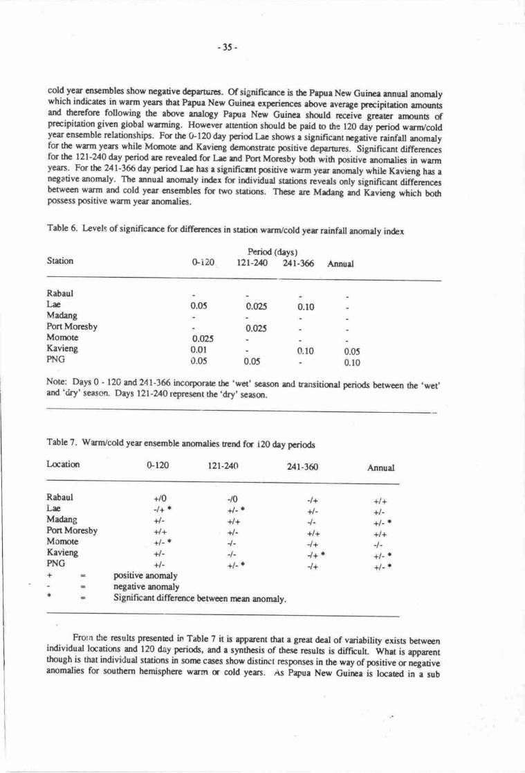
cold yer €nsembles show negative dcprorcs. Of significarce is the Prpua New Guinea rnnual anomatywhich indicates in warm yean that Prgra New Guinca expericnces above average precifitation anrour6ard thercfore following the above analogy Papra Ncw Guinee should rcci"e grca6r amounb ofprcipitation given global wrming. However attention should be pald o the 120 A"y poioe wrn/coldyear ensemble rclationshipc. Fq the Gl20 day p€riod Lre shows a significant rngative rainfell anomalyfor the werm years while Momote and Kavieng derrcnstrate positive Oeparores. SigniRcant differercesfor the l2l-240 day period are revealod fq L* md Port Morcsby bo61 wirh positivJaromalies in warmyean. For tn Ul-16 day period I ae hrs r significmt pcitive warm yer anomaly while Kavieng has anegative anomaly. The annual mornaty in&x for individual statinns reveals only iignificant differcnccsbetween warm and cold year ensembles fq two stations. Tlrcse are Mrdang md Kavieng which bodrpossess positive wrm year anomalics.
Table 6. Levels of significarrce for differences in statisr wrm/cold yer rainfall anomaly index
-35-
Period (days)Gi20 l2l-2n Ut-ffi AnnurlStation
RabaulLnMadangPort MoresbyMornoteKaviengPNG
:*
0.0250.010.05 0.05
o.to o.os0.10
0.025 o.to
0.025
Note: Days 0 - 120 and 241-366 irrcorporae thc 'wet' season and transitiqral periods between the ,wet,and 'dry' season. Days l2l-240 rcpresent the .dry' s€rsqr.
Table 7. warm/cold yer ensemble anomalies rend fr i20 day periods
Lcatisr 0-120 tzt-?/J0 ur-}fi Annud
RabaulLreMadangPort MoresbyMornoteKaviengPNGf-
+/0J+*+l-4++l- i+l-+l-
-t0+l- t+/++l--t--t-+l- |
-l++l-1-+l+-l+-l+ t-l+
+l++l-+l-'+l+1-+l- r+l- ]
rl
positive anomalynegative anomalySignificmt difference betrreen nnan anomaly.
Frorn the results presented in Table 7 it is ap'parent rhat e great deal of variability exists betweenindividual laatisrs and 120 day periods, and a synthcsis of these resuls is diffrcult. Wtrat is eparentthough is that individual stations in sorne cases show distinct responses in the way of pocitive c negativeanomalies for soufitern hemisphere wirm (r cotd yers. As Ppua New Guilra is locaed in a sub
-36-
equatorial position, and its climate is influenced by the seasonal movement of the Inter Tropical
Convergence Zone, rainfall anomalies are likely to be also influenced by components of the northern
hemispherc circulation, especially the behaviour of the nonhem hemisphere sub uopical high pressure
belt. This fact and the fact that this analysis is based on southem hemisphere warm and cold years may
account for the variability of the trends shown in Table 7. Additionally, given globa! warming and Papua
New Guinea's location and the likelihood that the present asymmetry of the southern hemisphere
circulation will become pronounced and the southern hemisphere will remain cold relative to the northern
hemisphere, the cold year ensemble may be more indicative of future trends in rainfall. If this is the case
Papua New Guinea would expect to rcceive less rainfall with global warming.
Svnthesis
The above analyses have produced a small degree of convergence of the results for the GCM and
arnospheric dynamic - climate relationship approaches although the latter most likely represents an
extreme scenario of possible climate change. Both these approaches indicate that Papua New Guinea
may experience decreases in rainfall for the dry season months of June to August, with wet season
precipitation totals remaining close to their present levels. For other locations east of Papua New Guinea
increases in precipitation may be generally experienced but decreases should not be discounted for some
areas. l,ocations likely to be imprcted the most are those that presentiy possess a sub-humid climate and
a distinct June to August dry season. Possible decreases in June to August precipitation aflrcunts may
result in incrcased drought stress during these periods. This is likely !o be exacerbated by increased
evapotranspiration rates assmiated wi th increased temperatures.
Results of the warm cold year ensemble analysis show little convergence with results from the
orher two approaches. What is apparert is the intra-regional variability of the response of rainfall towarm and cold years. This makes any staternent on the likely fends of rainfall for the area of interest
bassJ on tiris type of analysis tenuous. If however global warrning does result in a unipolar glaciation,
with the southem hemisphere possessing a greatef pole to equator temperature differential than the
northem hemisphere, then the analogy that a warm year ensemble is indicative of future circulationsystems given global warming may not hold rue. In this case a cold year ensemble may be mone
appropriate for modelling future trends with net precipitation decreases expected fu Papua New Guinea
and possibly the rest of the Pacific.
Temlpraturc
Numerical modelling studies indicate that CO: forced climatic warming will result in greater
temperature increases at the poles than at the equatorid regions. For the latter a warming of 2'-3'C has
been predicted. Prcsented in Table 8 are probable future mean annud temperatures for a variety ofcentres tfuoughout Papua New Guinea-
Probably the greatest impact a 2'C warming will have wilt be on humst activity, especially human
comfon. Presently moct of coastal Papra New Guinea is classifired accrding to the Terjung
classification (McA-lpine et al., 1983) as experiencing sultry days and warm nights. Such conditions are
considered moderately uncomfontable. Temperature increases of up to 2'C in coastal areas are likely orcsult in a transition to sulry conditions both day and night, a condition prcsently experienced in the
Bismark Archipelago and Milne Bay areas. A transitjon to such conditions will render most coa-stal iueas
uncomfortable.
This contention is further reinforced by a consideration of the Relative Srain Index (RSI). The
RSI is an index of human comfort, and is the ratio of the amount of sweat evaporation necded fs comfort
to the amcmnt of evaporation possible in the given circumstances. In practice discomfort is experienced
with RSI values in excess of 0.3.
Shown in Table 9 are the present and funrre RSI values for a number of coastal oentres throughout
Papua New Guinea* Calculations of future RSI values have been based on a 2'C terpera[re irrcrease
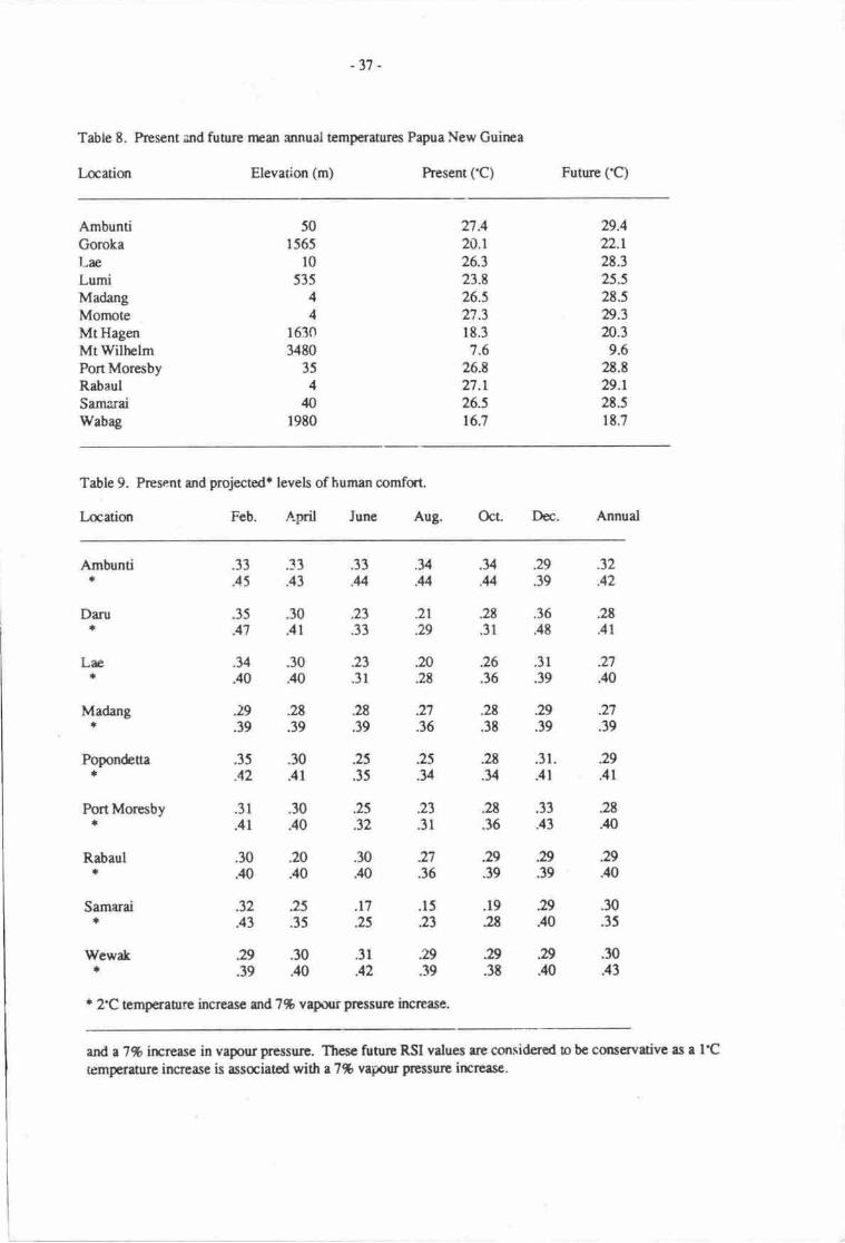
-31 -
Table 8. hesent and funrre nran annual t€mperatures Papua New Guirpa
I.ocuiqr Elevation (m) hesent (.C) Future fC)
AmbuntiGorokaLreLumiMadangMornoteMtHagenMtWilh€lmPortMorcsbyRabaulSamaraiWabag
501565
l0535
44
16303480
354n
1980
n.420.126.323.t26.527.318.37,6
26.8n.L26.st6.7
29.422.12t.325.528.529.3n.3
9.62E.E
29.r2t.518.7
Table 9. Present ad projectedr levels of human comfat.
I-aatiqr Feb. April lune Aug. Oct. Dcc. Annual
Ambuntir;
Madang+
Popondeue*
Port Moresby*
Rabaul*
Samarairf
WewakI
r 2C temperatre inqease md?% vrpoorprcssurc increase.
ard a7% irrcrcase in vapour pressure. Thcse frrrrrc RSI values rc mnsidered o be coscrvativc as a l'Ctemperature increase is assaiatod with r 7% vapour prcssurc incrcese.
.y .34 .29 .32
.4 .4 .39 .42
.2r .28 .36 .2t
.29 .31 .48 .4r
20 .26 .3r Il.2t .36 .39 .40
.33 .33 .33
.45 .43 .U
.3J .30 .23
.47 .41 .33
.y .30 23
.40 .40 .31
.29 .28 .28
.39 .39 .39
.35 .30 25A2 .41 .35
.31 .30 25
.41 .40 .32
.30 20 .30
.40 .40 .40
.32 .25 .r7
.43 .35 .25
29 .30 .31.39 .40 .42
Darua
Ln+
27.39
.29
.4r
.28
.,10
.29
.,m
.30
.35
.30
.43
.n .2s .29
.36 .38 .39
25 .2t .31..v .y .41
.23 28 .33
.31 .36 .41
.27 .29 .29
.36 .39 .39
.15 .19 #)23 2E .40
29,929.39 .3t .40

-38-
On a mean annual basis most coastal centres in Papua New Guinea pesently exper.ienceconditions belcw the discomfort level. Values for Samarai and Wewak however Ao inaicite that sonrediscomfort is presently experierred in these areas. An appreciation of the seasonal march of humancomfort is given by the bimonthly values shown in Table 9. This denronstrates that most coastal stationspossess great variability in comfort levels with the dry season rnonths of June to August the mostcomfortable. However a ransition to equatorial temp€ratures 2'C trigher than presant-ones with anassociated rise in vapour pressure will drastically reduce the periods of comfort and in sonr cases resultin all yeu round discomfort This is dernonstrated well for the case of port Moresby which presently hasa well defined period of June to ocober when conditions are comfortable as rated uy trte nsi. F4uatorialwarming of 2'C however will result in these dry season rnonths becoming marginally urcomfortable.Tlre situation will be much wone for Ambunti, Madmg, popondetta, Rabaul and wewak.
Generally global warming will result in marted changes !o the seasonal disnibution of comforttlroughout the southwest Pacific. Perhaps the major implications of an increase in discomfort levels arefor the major coastal commercial certres throughout the equatorial and southwest pacific. Althoughsome natural acclimatisation to the irrcreased temperatures may offset sone of the projected discomfort,great€st impacts will be felt by worters in the primary secttrs of the economy. Ouaide work willbeconrc more stressful with perhaps an alteration in the houn of work required so as to avoid the mostuncomfortable and sressful times of the day. There will also be implications for the secondary andt€rtiary sectors of the economy. If an equitable indos climate is to be maintained for indoor workers aconunensurate increase in air conditioning above the present levels is likely to be required. SuchrequiremenB are most likely to be greatest in buildings that are presently 'undrr air condidoned'. Relatedto this will be an incrcase in energy consumption for air conditioning and a consequent economic cost.
warming of up to 2'C will result in an altitudinal shift of mean annual isotherms. As tenperauresabove 500 m asl. are strongly controlled by altitude, as opposed to physiographic effeca at low altitude(below 500 m) sites, and the present rman annual environmental lapie rate is 6'C/km a 2.C warming willresult in an altitudinal shift of mean isotherm position by approximltely 333 m. Areas at 100-350 m willtherefore be subject to a temperature rcginr sirnilar o that presently experienced at coastal locations.Such an altitudinal shift wilt have implicarions for the fuhue altiurdinil limits of agricultural production,the health of naturd vegetation and mean annual warer budgets. (See Hughes & Suilivan, this volunr).
Vegetation
As the present disnibution of namral vegetadon above 500 m appears to be controlled bytemperature as evidenced by the well developed altitudinal zonarion of major vegetation associations(Pajimans' 1916) a shift in the boundary of uper rnontane forcst may occur with global warming. Ar€tum to a vegetation distribution pattern similar to that of the Hypsithermal, as discussed by Bowler clal. (1916) and Flanley (1985), may be likely. However the relativeiy rapid ransition, r,o 2.C warmer rhanpresent compared to that during Holocene warming, is expected to have more of a negative impact on thenatural vegetation than a positive one. The vegetation may be impacted in nvo ways. Firstly aspreviously discussed a rnean global warming of 4'C is expected to poduce a net reduction in rainfalltotals in Papua New Guinea. By mid to late next century rainfall reginres are expected to be significantlydifferent from present ones. while the opponunity may exist for an altitudinal shift in the forest limit dueto general tempera$re increase it is believed that reduction in rainfall amounts will impose sufficientmoisturc stress to curb any significant altitudinal shift of the forcst limit Secondly due to the projectedrapid change in temperanrre relative to the Holocene, ecotonal areas may experience significant changesin ecosystem dynamics. Cenerally vegetation in marginal environrnents, where limiting faclors aredominant in determining plant distribution, is expected to experience some stress. The stress magnitudeand the degree to which it will affect current pattrems can not be determined at this stage without adetailed consideration of the physiology of the major component species of the dominant plantassociations occupying marginal areas.
-39-
CONCLUSION
A consideration of the likety ctimatic ftspons€ to a global wrnring has revealed that changes tothe meteorological controls of climate are likely. The meteorological conrols on climate are expected tobe signifrcantly different by the end of the 2lst century. By this time the climate of Papua New Cuineaand the southwest Prcific is expeced to be sonrwhat different compared to the presenL Changes in therrteorological contnols will be manifest by possible changes irr precipiution amounts and disributions inthe southwest Pacific. Areas litely o be imprced severely and subject to increased drought frequencyand magniarde are fiose drat pres€ntly experience southeut seasql rainfall minima. This has seriousimplications for the fuure dlocation of waer resouroes in these areas. These problems are expected toirrcrease with a change of the nrcteorologicd conrols on climate in the southwesr Pacific. Convenelyareas that may experierrce an incrcase in rainfall amounb wili be frced with flood managernent problems.Increased rainfall amounb may also lead to higlrer rates of erosion. This has implications fm the designof future flmd protection works.
Equaorial wrming of 2'C will have a number of impacu on vegetation zonation, the verticaldistributist of temperature and human comfort. A vertical shift of the position of the nrean annualisotherm associated with the prcseot aldrrdinal limit of agricultural production by 333 m willcanceptuaily result in an ircrease in the potential area available for agricultural production. However, ifthere is a net reduction in rainfall iunounb conunensurate with a change of the meteorological conuols onclimate, his rnay offset any future perceived irrcreased levels of agricultural production and the expnsionof agriculurral productiur zones in present marginal areas.
Human comfort will be significurtly affected by an equaorial warming of 2'C. Although somenatural acclimatisation may be expected increased Emperatues and arnosplreric vapour pressurcs arelikely to increase levels of discomfat significantly above present ones. This will Ue especiatty true foqinhabitans of coastal environments. ln coastal built up areas increased levels of human discomfon willhave implications for worker productivity, energy consumption and capital expenditure for themaintenance of equitable indmr climatcs.
The evidence from nunerical nrodelling studies that increased atmospheric CO2 levels will force achange in the mean global climate is mounting. Also the fact that global warming will have significantimpacts at the regional scale cannot be denied For the southwest Pacific although the impacts of achanging global climate will not be as great as droce projected for mid o high latitu& environmen$, thelikely impacts of a 2'C regional warming and morc importantly a nrcan global 4'C warming withassociated implications for the meteaologicd controls on climate should not be ignored.
The consequences of climatic warming discussed above arc considered !o be of major significancein terms of their socio-ecqromic imprcs. These consequences should be taken into rccount if a sensibleaprorch to the fuure utilisation of the southwest Pacific's climatic nesources is desired and the responseto climatic change planned for.
REFERENCES
Augusbson, A.S. & V. Ramanathan ln7. A radiative cqtvective model surdy of the COz climateproblems. Joumal of Atmospheric Sciences 34:448451.
Bowler, J.M., G.S. Hope, JN. Jennings, G. Singh & D. Walker 1976. Late Quatrnary climates ofAustrdia and New Guinea. Quaternary Research 6:356394.
Dickinsor\ R'E. 1985. How will climate change? n.2061270 in B. Bolin er al. (Eds.), The greenhouseeffect, climate change and ecosystems. Scope Vol. 29. Jotrn Wiley & Sons, Chichester.
Fdls, R. 1983. Meteorological controls on climate and weather. In McAlpine et al. The climate ofPapua New Guinea. Ausralian National University Press, Canberra.

-40-
Flenley, J.R. 19t5. Relevance of Quaternary palynology and geomorphology in the tropics andsubuopics. Pp.37t in I. Douglas & T. Spencer (Eds.), Envirormental change and tnopicalgeomaphology. George Allen & Unwiq lordon.
Flohn, H. 1980. Possible climatic consequerrces of a man made global warming. International Instiurrefor Applied Systems Research RR-80-30.
Flolm, H. 1984. Climatic Bela in the case of a unipolr ghiation. qp. 609-620 in N.A. Momer & W.Karlen (Eds.), Climatic changes on a yearly o millenid basis. D. Reidel Publishing, l.ancaster, UK.
Hackett, E.C. & S. Hastenrath 19E6. Mechanics of Java rainfall. Monthly Weather Review. I 14:745-752.
Hans€n, J. & D. Johrum 1981. Climate irprct of increasing aurnspheric carbon dioxide. Science213'957-966.
McAlpine, J. & G. Keig with R. Fdls 1983. The climate of Papua New Guinea. Ausralian NationalUniversi ty Press, Canberra.
Manabe S. & R.T. Wetherald 1980. On the distribution of climate change resulting from an increase inCOz cmtent of the atmoephere. Journal of Atnmspheric Sciences 37:99-118.
Mirchell, Jf.B. 19E7. Simulation of climate change due to increased atmospheric CO2. TheMeteorologicd Magazine I I 6: 361 -376.
Mirchell" J.F.B. & G. L,upon i984 A 4 x COz integration with prescribed changes in sea temperaures.Pr,ogress in Bionptoorology 3 :353-374.
Pajimans, K. 1976. The vegetation of Papna New Guinea. Australian Natiqral Univenity hess,Canberra.
Pitock" A.B. & M. Salinger 1982. Towards rcgional scenarios for a COz warned earth. ClimateChange 4:2340.
Rownree, P-R. & J. Walker 197t. The effects of doubling the COz concentration on radiative -convective equilibriun Pp. l8l-l9l in J. William (Ed"), Carbon dioride climate and society.Pergamon Ress, [,ondon.
Wigley, TM.L. 1988. Fuhre climatc of thcMeditcrranean Basin with prrticular emphasis on changes inprecipiation. Joint rrceting of the tast Earn on implications of climatk changes in the Mediterranean,Split, Yugoslavia 3-t Ocobcr 1988. In press LJNEP/RSRS.
Wigley, T.M.L., P-D. Jones, & PJv{. Kelly 1980. Scenario for a wanr! high - CO2 world. Nature 283:-17-21.
Wilsott C.A. & J.F.B. Mirch€lt 19E7. A 2 x C'O2 climate sensitivity experiment with a global climarcmodel including a simple ocean. Journal of Crophysics Research 92(D I I ): I 33 I 5- I 3343.
-41: !,'
THE EFFECT OF SEA LEVEL RISE ON ATOLLS AND MOTU
Marjorie$ullivan agd John Pernetta :t dUniversity of Papua Ne* Gdfte&P6*{vforesbg.Papua Ner{ Guinea'
i., F ,-f-
Coral islands g*Tgrally &ur within 30' @r and South of the "itt*or.
They are ,bestdeveloped in the Indo-$cif,rc province and are les#eBensive in the Atlantic province-(€aribbean to
Pacific the diversity of nO srucuresl i:t:: -it tb:east towards the central Peific
,::1.
. In conrasg-h theThe shoreline of the
INTRODUCTION -1
Gulf of Eilatgupports only ftinging reefs fl-oya &western Indi& Ocean support ftinging, reefs andStoddart, 198f,) while the Maldives are rfiade up pflridge @avieset a1.,1971). The Andaman Islandtecionic plate-boundary and also contains atollsextgnsive anddiverse reef forms.
Conditisns favouring coral growtb and reef
required (see 6.9. Bird, lQE4:253; Stoddan, 1969).less than l0O rnetres (Wiens, 1962:ll) ard most
growth has taten place (W l(9; Stoddan, Itherefore agaigst a background sea level,of csrtinued r$e in sea level are here withwhich are developed on reef platforms. i
I
Islands in the1971, 1984;
risrqg from a submirinebcated on ilr-acrive
kitshe Pacific-Ifi&d are!:li.s.{ 'i
,abP' .'iAnd'include warm
to permit lightients are also
occurs at depths ofivhich have continued to
:'itofil rcefs have developedsea level. The effecs
well-oxygenated water of*qnderate saliniry and low turbiliry,penetration. $ufficient iarbon dioxide for symbiotic $gal
,the islands (motu or cays)
coRAL REEF. FORMS AND ISLANpS
The islrnds associ'{iiO with reefs have a variety of forms which reflecr t}re obndiuqris qf coralgrowth and brnakdown. @nstructional processes involve ttre{p*ard and ortward glrolfth 6fn*fs 'inothe zone of water tubulefce. As reef buflding proceedsi sedinrents deriv'ed &on reef erosion beconebankd up against the fl$ oi massive rpefs (Bir4 l98l:ZSay. Considerable quantities of broken re€fmaterial may &cumulalr'tgainst $re rcef flanls andon lagoon floon, from where they are availhblefor redistribution througfiggl the reef sysqtn\ and fordhe building of emeryent islands. Reef e.rosiqr oproduce such debris occtiibtt both formafional and e*rcrgent levels (Davies, lV1271; StoOaarC tiZO,1982), and supplies san4 peb$'nnd tbulders from whiih beachc and small islands or rnour;arcconstructed. Raised or emerge[furd etd€s severely to produce such dsbrjs (\Miens, lgt2:18), butalthough sonre of the debris {ft+ fonhs rnolu is derived from emergf,d.reaS,)6e51D nor 6bird,
i ,! ,,I :'-'r j
-42-
Pvffif.. Lit:]*l .
lj'iidilf iTt:l
-' c,gq)
,tt, O0 .'
E8I.bE'e,a,or;E.tt I
zA,Ho*C\R
to\c):F.E
lffi ,ilffiEI E,., Eu' c0-Erd
5,g
kocto€(:rl
o.2(\{aIEF! ;liit{,fl eEi-llil AF*-ffi ii
i
o.,?Io1.ffimttdry
orrf). .l ,.
I\t
ffi
orf)A
G
E
E

-43-
i9E4:271), and the accumulation of sediment to form low islands des not r€quire any relative shift insea level.
Coral recfs have been tratiitionally divided following Darwin's classification into fringing reefs,barrier reels and atolls. Subsequent more systematic studies of reef island forms however havedemonstrated the necessity for an amplification of this classification. One such scheme which takesinto account coral reef landforms is that of Davies (t972:72), which is pressnted here in a slightlymodified form.
Coral Landforms With No Central Lagoon
Fringing reefsBarrier reefsPlatform reefsParch or ribbon reefsCoral pinnacles or knolls
Conl Landforms With a Central I-aeoon
Oceanic atollsShelf atollsCompound atollsFaroes or micro-atolls
While the classification of reef forms into these categorics is rclatively simple, the classificationof low islands or motu is more difficult. Such islands form as the result of sedinrent rccumulation onall types of reef platrornr, but are found most frequently on patch or ribbon reefs and atolls. Patch reefstend to form downwind of massive reefs (Bird, 1984:271; Robers, 1983), in areas of less favourablecoral growth conditions, and ribbon reefs occur near the outer margins of barrier reef systems (Orme etal., 1978). Atolls occur in oceanic locations and on outer shelf margins.
ATOIIS
Wiens (1962:l l) noted that atolls are: 'all more or less continuous reefs surrurnding a distincttydeeper lagoon with or without lagmn reefs .. which rise from a sea bocom which is too deep for thegrowth of coral reefs.' Atolls are of three types (Bird 19&4:26I; Davies, 1972:72\.
(i) Oceanic atolls, with volcanic foundations, fornp;d on submarine basdtic volcanes of theCentrd Prcific, on andesitic volcanoes nearer Eo ttre continental shelf margins (see e.g.Wiens, 1962:13), or based on oceanic ridges, where sea level rim or t€c!fiiic subsidcncehave led to fornpr fringing reeh developing into ring-shaped aoll recfs;
(ii) Shelf aolls arising from continental shelf ueas in watcr less dran 550 m deep;
(iii) Compound atolls - rings which enclose the relics of earlicr aolls,
Wiens' definition of atolls excludes reefs without a lagoon, ard raised csal islsrds without acentral dcpression. Aolls however occur at r vriety of scales and are highly vriabb in forrn Theymay have secondary pools, ponds or depressions, and in sorrE atolls fonrpr lagours have become filledwith sodinent, and are reduced to swamps or bogs. Aolls may be conpletely submrine feanres notsupponing islands, when trey arc commcnly referred to as bants q shods (Wiens, llb2: t l).
Guilcher (1971) described the &velopnurt of faroes in thc Cornoro Islands and the Maldiveswherc these rwf forms have also been described by Eibl-Eibesfel& (1965) and Davies ct al. (1971).He suggested that farces developed from parh reefs and that they may devclq frrthcr.o form thc
-M-
foundations of atolls (Guilcher, 1971:66, 86). If Stoddart & Scoffin's (1979) observation that upwardgrowdt in faroes or micro-atolls is determined by the lowest tidal water levels, and if water temperaturerises do not inhibit coral growth, rising sea levels may in fact lead to the increased growth of faroes ormicro-aolls.
In addition to the variation in aoll forrn, high islands may be surruunded by fringing reef (e.g.Raromga), or be encircled by a brrier reef (such as Truk and Uvea), in which case they are describedby many writers as'almost atolls'(Wiens, 1962:16). Such situations demonstrate stages in thedevelopnrcnt of atolls which are commonly the submerged, raised or partly raised coral fringes tu alagoon. They are highly variable in both form and (where known) their ages of formation. Intectonically active areas where raised atolls occur, the lagoon floor becomes merely a depression, andthe landform may not be recognised or classified as an atoll.
Atolls are common in the central Pacific, but do not occur in the Marquesas, nor in theGilapagos Islands where thek absence, and the absence of other significant coral landforms, can bereadily explained by the upwelling of cold oceanic water (see e.g. Stoddart, 1969). The largest aollsard aoll islands in the Pacific occur in the Marshall Islands of Micronesia and further south along actain strerching southeast through Kiribati, Tuvalu, Tokelau, the Society tslands and the TuamotuIslands.
The shape andelongation of aolls varies considerably, but has been shown to retlect basementcontours and the lineamens of tectonic zones (Wiens, 1962:18). The living reef tends to grow towindwar4 and aoll reef plaforms ae generally widest towards the prevailing wind.
Aoll reefs are made up of a series of concentric zones which vary in form depending onwhether they are dominantly windward or leeward. These zones, which were describect for example byWiens (1962:47ffl, Eibl-Eibesfeldr (1965) and Stoddart (1969) include.
(i)
(ii)
(iii)
(iv)
Outer slope. The steeply descending outer slope of the reef below the point of abundantliving coral and coralline algae, ar about 30 m depth.
Reef front. The upper seaward face of the reef, with abundant living coal and corallinealgre. This zone, which slopes down to 15 to 30 nL may include a shelf-like bench orterrce. The fam is variable, from smooti profiles to grooved and ridged spur systems.
Seaward reef margin. The edge of the reef platfum characterised by an algal ridge cut bysurge channels,
Reef flat. The upper reef surfrce which is expoaed or awash at high tide. This surface maysupport islands. The reef flat sedimena are comrnonly zoned from the outer (seaward) sideto the inner (lagoon) margin, rcross either or both a seaward berch and a lagoon beach.Sedinrcns tsnd to be coarser (gravelly) on the outer or seaward maryins and finer (sandy) onthe inner margins. Induated beachrock is comrnon on reef flat berches.
lagoon reef margin. This zone is commonly poorly defined.
Lagoon slope. \\e cord slope into the lagoon, which is highly variable in form, andcomrnonly dominated by soft corals and non-hermatypic forms.
LagooaJloor. The flat to variably undulating base of the lagoon deprcssion. This may haveccal md algal tnolls or promircnccs (bioherms).
(v)
(vi)
(vii)
Atoll diarpEr and lagoor depth are relatcd. Mclean OW) noted that larger atolls may havelagmn deeths in excess of 50 m. In such cases there is generally a depth related sequence ofsedimentary frcies.
_45_
Most atolls have at least shallow reef channels or passages through the coral'eefs to the innerlagoons. Deep navigable passages also occur but are relatively rare (Wiens, 1962:32\. passesganerally olcur on the leewarC side of atolls, and patch reefs or reef spurs occur at the lagoon mouthsof such passes. These channels or passages are related to the complex interaction between limestonesolution, wave action, abrasion, and scour, and may develop from the grooves and surge channelsnoted on the reef fronts and seaward reef margins of most atolls (Wiens , 1962:i2l;Roberts, l9g3).
When the reef is open sedrrnents may be swept through the channels. lr, such cases patch reefsand knolls are comrnon in thc lagoon (Wtens, 1962:77\. Where reefs form a more complete encirclingstrucrLre, sediments accumulate in the lagoon and coral prominences are less cornmon.
THE LIVINC REEF
As noted above coral reefs are found in areas where mean annual water temperatures do not fallbelow 24'C; where oxygen levels are high and where light penetration is sufficienifor svmbiotic algalgrowth' It is however important to note that the geographic disnibution of coral reefs and thegeomorphic form of individual reef structures is in p:ut a reflection of the growth form andrequirements of the hermatypic coral colonies comoosing the reef. Coral reef gto*th is therefore afunction of individual colony growth rates, which vary from genus to genus, ancl locality to locality;combincd with the rate at which interstiual spaces are filled by bioclastic sediments, often a function ofthe growth rates of other biotic components of the reef system.
All reef systems display zonition of their communitres with seaward communities differing incomposition and diversitv fror,. tiose at the reef crest, on the reef flat and on the lagoonal edges of thereef itself. Each community diffen in is rate of upwud and outward growth as a function if tjrecumbined conrnunity g:owth v,'hich reflecs the species charackrising each zone. Any factor whichchanges the aoiotic iactors charasteristic of each mjcro-habirat will affect the zonation andconsequentl y reef growth.
The consolidated reef upon which the living comm,rnity of corals grow is composed of thelithified skeletons of coral colonies and other organisms, sediments of varlng particle size all or mostof which may be cenrented trigcther initially through the action of encrusting Coralline algae and laterthrough the processes of recrystatisation of the calcium carbonate materials. Buddemeier & Smith(1988) estimate that sediments generally rcount for up to 50% of the total consolidated reef volume.Much of the fine sedinrent produced in reef areas is derived from algal growth, puricularly llalined,a,which may be rcsponsible for a considerable portion of the intentitial bioclastic sediment in pacificreef structurcs.
Sediments arc also produced by sorm action and by processes of biodegradation through theactions of boring organisms such as sponges, molluscs and other species which weaken living coralskeletons and in the process produce large volumes of fine paniculate material. The process of reefformation and maintenance, i.e. reef growth, is a dynamic inreracdon between the biololical processesof cqal colony growth and degradation and the production of sedimenrs by reef associatid organisms.
It is often assumed that 'coral reefs' may keep pace with accelerated sea level rise simply byupwrd growth of the coral community, however a limit to upward growth may be reached wheresediment production fails to fill the interstices of the coral communities skeleul srructures and hencethe community itself fails to provide a sufficiendy stable base on which the living community maycontinue to exist, The maximum rates of reef growth discussed by Buddemeier & Smith (l9gg), forexample' represent probable l;mits for the combined interaction of the two processes. They suggestthat Pacific rcefs may weli not kcep up with projected rises in sea level. Any tacor which upsets thepresent balance between coral growth and reef sediment production might therefore be expected todttr the ability of the cummunity to ,rspond to increasing sea level.
-46-
Changes in the coral community composition may well occur under the changed environmentalconditions predicted to following global warming and sea level rise. The typical zonation patterns
described by many authors and outlined above represent sub-communities of algal and coral genera
and species adapted to micro-habitat conditions which vary across existing reef structures. A rising sea
level might be expected therefore to result in the upward growth of the sea ward reef slope community,a community characterised by massive branching forms, growing below the level of high wave energy.
Such forms produce a skeletal matrix which napa and retains little fine sediment thus forming an
unsuitable substratum for upward growth of the reef as a whole, unless external sediment and largermaterials are periodically added to the community through storm damage.
A factor of more critical importance to coral communities in terms of combired reef growth iswater temperature. Not only does temperature limit the global distribution of coral reefs, it can alsohave significant consequences for the health of the coral community. Most corals in tlrc tropical Indo-Pacific are currently growing at or neiu their thermal limits of tolerance and an increase in watertemperature might be expected to cause significant lowering of growth rates as a consequence ofthermal stress. Coral bleaching and death, often associated with other forms of s8ess is known !ooccur as a consequence of temperaftre stress, and the widespread die-off of several coral genera in the
Maldives during June, July and August 1987 is thought to have been due to the anomalous hightemperatures recorded for the Indian Ocean (1.5'C above normal) at that tinre (Perneca & Sestini,1989).
Under conditions of increased global temperature it might be expected that coral growth rates
will be reduced and the communiry composition changed such that the corals wrll no longer be capable
of keeping pace with increasing sea level rise. Temperature stress may be significantly less imponantin oceanic atoll systems, where lagoonal water exchange with the surrounding ocean is adequatel;high, thus maintaining a lower temperature in the lagoon.
For fringing reefs behind barrier reefs, and for micro-atolls and faroes in enclosed atollstructures where water exchange is [mited, the problem may be severe. ]dorc importantly however, ifthe global ocean temperature rises beyond the thermal limits for hermatypic coral growth (perhaps 1.5-2'C above present tropical water temperanrres) we might expect that trorrical reefs rvill no longer reach
an upper limit determined by tidal exposure but ;ather an upper limit Cetermined by temperanrre.Sunken or submerged reefs may therefore predominate between 20' Nonh anl South of the equaor.Clearly there is a need for a detailed evaluation of the cunent data base relating to thermal tolerancelimits of hermatyoic corals (Jones et al., 1976) and more detailed data relating to the present watertemperature regimes in Pacific atoll lagoons.
Any frctor affecting th: growth, suwival and local disribution of coral gerrera and species maybe expectod to cause changes in communiry growth rates, and henc€ affect the consolidation and
upward growth of the reef as a whole. Once reef gowth patterns change, local current reginrs are
altered and sand movements between sinls change such changes may threaten the cays or nrotu whichr€st on reef flas and form the basis for a number of Prific anC rndian Ocean Island States.
LOW ISLANDS: CAYS OR MOTU
low islands, known as cays in the Caribtean and nrctu in the Pacific, are islards built up on acsal reef basg as distirct from high islands which ha.re a corc of energent bedrock. Such islands are
common on atolls, where groups of thrce to five islands commonly reflect tlre underlying atollstructure. Islands comprising sedinrents rccumulated on reef flas rarely errrge more than a fewrnetres above sea level - maximum elevations on such islands being about 4 m.
Low islands may be formed on at least one end of erch rcef sector on abll; with channels
cutting through the encircling reef, in leeward locations wherc coral debris can rccumulate. On aollswith abundant sediment supply and low energy zones due to wave refraction, numeruus islands are
developed. Not all atoll reef platfornu support cays.
-47 _
Moo developnpnt
Motu are composed of sedimcnts derived from the breakdown of reefs, and are characterised bya sequence of sediments of variable grain sizes (Wians, 1962.8; Bir4 l9g4:275). The mostcctspicuous fearures of low islands are storrn or cyclone wave-generated bouldery beach ridgescomprising gravel or boulder ramparts, which may rise more than 6 m above sea level. Sorm activityis important in depositing the coarse beachridge sed.irnents which form the basis of cay developmenl
Following debris deposition, primary colonising plants become established, followed by palmsand casuarinas, to form a stable cay. Beachrock cementation at the water table level assists formation.The island configuration may change due to climatic changes (Bird, 1984:275), or during exceptionalstorms it may change abruptly, or whole cays may be swept away. Mclean (1977) notid that in theIndoPacific motu are mainly found sr windward reef flats, whiG in the Caribbean sand cays occurrnore coilunonly on leeward reef flats.
The sequence of landforms and sedirnents whic.h are typical of cays and low islands (seeFigure 2, aftet Bird" 1984:2?5), are a shingle ridge on the windward side, and a sandy flat on theleeward side of the reef flat. on the lee side of rcef parches refracted waves converge, preventingdebris being swept over the lee side of reef islands, and maintaining the existence of low sand islands.In the northern Great Barrier Reef area Flood & Scoffin (19?8:5sff) described a conmon pattern ofreef sediments comprising three facies:
(i) rim deposits of broken coral composed of branching corals on the windward side andmassive colonies of corals on the leeward sides of shingle ramparts or boutder tracts;
(ii) a thin blanket of sand-sized coral and algal fragments across the reef flats and lagoons;
(iii) leeward sand cays formed by refracted wave reworking of fine sandy materials from reefbreakdown, which may become very stable if they are cernented to form beachrock.
Most of the systematic investigations of low islands and rnotu have been canied out within theGreat Barrier Reef formation in northern Australia, where there are a variety of low island forms.Thom et a/' (1978:37ff) have presented a mode! of cay developmenr since the pleistocene in whichthey noted that the configuration of the eroaional Pleistocene-Ho-locene surface, the areal extent of thatsurface and a complex of hydrodynamic and biological facton affect the island form. They alsoobserved that high energy reefal wave conditions have predominated throughout the Holocene, and thatsuch conditions favour the deposition ofcoarse sedirnents.
Stoddart et al. (1978) proposed a classification of low sandy islands based on size, elevation,sedimenary material and degree of vegetation differentiation. Thri demonstrated that as such islandsincreased in size, there is a sorting of sediments into zones, and an associated increase in vegetationdiversity. The most complex sand cays tend to occur inshore, not on the outermost ribbon reefs of theGrcat Barrier Reef complex, and are classified as low wmded islands. Such islands show stronglyhorizontally sorted sedirnents, ranging from fine sands to boulders, comrnonly support a centralnrangrove swamp' and may have re-cenpnted b€achrock along the shorelines. The comp-lex interactionbetween mainland and continental island provenance, and the complex ecological controls andinteractiqts between sea levels, mainland stream velocities, sediment loads and colonisers indetermining the form of low islands wer,e noted by orme et ar. (r91g).
The rcural location and form of sand cays is determined by local condirions. It has been notedfor instance from Heron Island (Flood, 1986) that cays change in itrape reflecting regionat wind patternchanges, and consequant changes in sand movement. Guilcher noted only four imatt cays and nobeachrock in Comoro roefs, and related the existence of sand islands to sources and relative availabilityof sand (Guilcher,lg7l:71-72). The four sand cays were siruated near gaps in the barrier, either
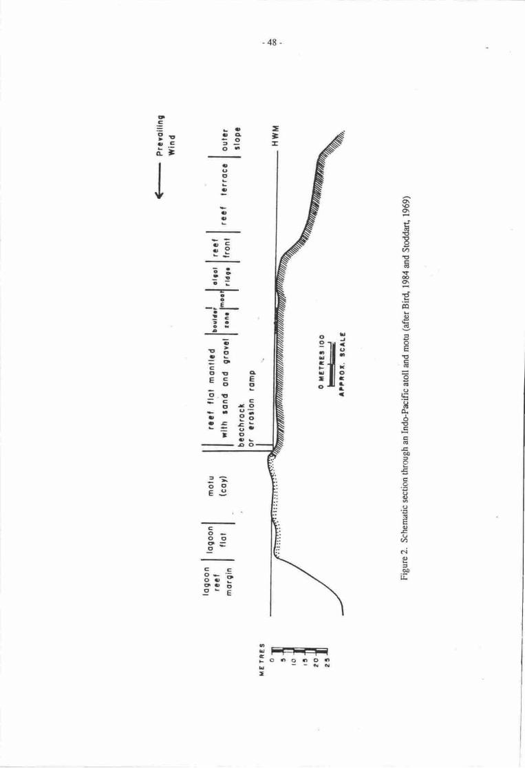
-48-
-=-
!lDoctE9o-
OG
!u.,Ct=
vo\\oo\
c('ttE(?,1,Fq€(dEr
ta
e(rl-oEEFga{()
rE
so.6.tCEEarl
oo5e€treoo)a()
E(ut(Jrt)
ciga.Et&
illcEC'
C.ts.':-:o€:C'I'L5C,
3!
3a,0
at
oat
ID!reOL
=oCotrEC-ctC'.!|
=c t'ra3rtt!-
!
E35!
l'o
--!-!:taora
co-oo3=
Ce3: go,p oct- E
S -=-f=iooorro.n
u--ifilI
-49_
adjacent !o a passage or on tlre margins of shallower intemrptions, and Guilcher suggested that this isrelated to wave refra:tion. Iangshore drift from any directron is halted Uy wavei renrcEd as theysweep into the pass, so they beat upon both transverse shorelines. Guilcher also notod that manyPacific motu occur in similar depositional situations.
Estimates of the rate of accrction of calcium carbonate sedimentary products from reefs havebeen made (Smith, 1978). He noted that reefs and reef sedimenc were a quantitatively significantglobal sink for calciunt and abor"rt 6 x l0l2 mol. of calcium carbonate arc precipitated armually. Ofthis about 13% is poduced in the South Pacific. An unknown quantity of reef material is reduced toclastic sediments annually. The rurnover time for the production of srrch sedirnenB from cyclingcalcium is estimated at tens of thousands of years (Hatcher er C., 1987), but occun at a maximum ra6on shallow windward reef flats and in enclosed lagoons.
stoddart (1965), reporting on the r€-survey of British Honduras reefs and cays after HurricaneHanie in October 1961, noted that dead reef debris had been moved onto reef crests and island shores.Fresh shingle and coral rubble had been piled up ryainst the vegetation on the windward side ofislands. sorne small dunes had accumulated on hurricane deposiad sandsheer.
On many a0oll motu in the Pacific it has been noted th$ severe storns have completely aleredthe position and configuration of the cays - commonly exposing beachroct which ii taken as anindication of the location and extent of fonner cays (see e.g. Baines & Mcl-ean, lg/6).
Beachrock can also be desroyed by the impact effecs of wave carried debris as was no6d byStoddart (1965) during Hurricane Hauie. He also noted rhat by 1965 this had rc-lithified andsolidified, enhancing the island's stability. Recovery tinn from a hurricane was estimated at 20-30years, and Stoddan noted tiat cays are in general built up by cyclones rather rhan destroyed-
ln the Papua New Guinean region moiu are generally located on atolls, which are in turnconcentrated on the margin of the Pacific lithologicat plate (Scott, 1983). In a survey of cays, Guilcher(197l:72) noterl that the barrier extending 300 km eastward off the sourh coast of papua New Guinea ispoor in cays - Great Daugo (Fishermans) and Uttle Daugo Islands being the orrly two he irtentified.
Waar tables and freshwater sources on low islands
Lnw islands are charrcterised by the absence of surface water souroes. The high porosity oftheir sand or shingle sedimentry cov€r, and of the un&rlying reef limestones generally tesuts in rapidpercolation of prccipitated water from the grurnd surface (Wians, 1962:31?). *ater is held bycapillary action in the soil layen, and basd groundwater is storcd in urrconsolidated sediments and inthe porous linnstsre. A lens of freshwater fed from the overlying sedinrnts, and roughly proportionalto the size of the island occurs in cays or low islands of about 1.4 or more hectres 6liiens, t96Z:McArthur & Wilson, 1967:32\. Groundwater is fresher lowards the lagoon and brackish seaward.While fteshwater entem the groundwater storage through infilration and percolation, s€awat€f, ent€rsthrough cracks and crevices in tlre reef stnrcu[€, and infilrates through the very porous seawardboulder ridges (Wiens, I 962:69,323).
There is a density separatiat and freshwatcr lenses float on a seawater base. The position andvolunp of the lens vary with tidat changes, and with local hydrological conditions. Ttre lens shrinksduring periods of low rainfall, and swells following rainy periods. As 0re hcad of freshwater spreadsout its depth becomes less, resulting in a lens beneath the island surfrce thickest near the centne andthinning towards the coastal mrgins.
Guilcher (1971:73) noed that subaerial krst developnrent murrcd during Pleistocerp low sealevel phases in many aloll forms, and Weins (1962:18) ard Stoddrt & Taylor (1971) similarlyrecorded active kant developnnnt in energod refs. Thc voids so fornred arc important in funnellingfreshwater into vadose or phreatic cavities, with the implication that differcnces in active cavity formmay be ahibuted o weUdry climatic flucnratiqrs and to fluvial rctivity. Linpstsre porocity is highly

-50-
variable both spatidly and empordly. Mashall & Jacobsen (1985) observed both vadose and phreaticfreshwaer diagorcsis on Tarawa Aloll, and described a repetitive seguenoe from bores of cemented top(cay rwk), which forms a prtial aquiclude, urrconsolidated scdiment which provides a perchedaquifcr, and corals and leached linrstone of last interglrcial age with vadose and phreatic cavities. Itis likely that a sirnilar pauem (rccurs on otlrcr atolls.
Groundwater occumelrce is controlled by reef geology, tidal flucoations, precipitation andisland and reef geomery, and these variables have been used in models to predict the occurrerrce offreshwater lenses and their behaviour under conditions of rising sea level. Oberdorfer & Buddeneier(19E6) and Buddenreier & Oberdorfer (this volunre) noted that island and reef hydrology areheterogeneous, and have provided models for assessing fresh groundwater rcsources on low iitanas,and have discussed the likely impacts of potentid climatic change and sea level rise on such freshwaterlenses.
TIIE LIKELY EFFECTS OF RISDTG SEA LEVELON REEF LANDFORMS
Growth rates of coral atolls and islands
One rclevant question in any consideration of the effect of a continually rising sea level is theeffect on coral rcef growth. Coral reef growth is primarily in response to light availability (Sato, lgBS)and is highest just below the surface water layen. Manhall & Jacobsen (1985) noted that coral growthkept pace with sea level rise during the rnost rapid rises in the early Holocene when rates of accrctionwerc measured at 5-8 m/1000 yean.
There have been a variety of estimates of average and maximum rates of both coral growrh andvertical reef accretion, and the question of maximum rate of rccretion is vital to any projection ofcoastal process and rnorphological changes which occur in response to rising sea levels. Wiens(1962:90) noted tha on average individual coral colonies grow upwards and outwards at about I m/40years or 2.5 r/100 years. Reefs grow morc slowly due to the compounded effecs of storm damageand recovery, the interaction between the growth of coral and algal mantles and the rate of clasticsediment pro{uction to fill the interstices of the reef platform. He noted normal rues of reef growth of0.5 0o 2 m/lm year-s (consistent with those recorded by Marshall and Jacobsen), but quoteJ extremegrowth rates (Wiens, 1962:91) of 30 n/lffi yean.
Buddemeier & Hopley (1988) point out that predictions of reef growth rates musr take inoaccount the sructure of tlre reef community, and the likely acurrence of local events such as cyclonesor predator attrcls, which would temporarily inhibit reef growth. They notod that alrhough rising sealevels generally favour rcef growth, this growth may not keep up with prcdicted sea leveirises due toglobal wrming (Buddemeier & Hopley, 1988:4). Buddemeier & Smirh (1988) cited predicted sealevel rises of l5+3 mm annually over the next century, anl comnented that this is five times grearerthan the nrodal rates of vertical accretion on rcef flas (about I r/lm years), and 50% greater thancurrcntly rneasured maximum rates, although ttrey rcknowledge that Holocene data indicate thatvertical reef growth rates of 14 m/100 yea$ are possible. Rates of reef acrerion greater than 0.8 n/100years were noted by Hopley & Kinsey (1988:l9l) to ccur comrnonly only u deprhs grearer than 5 m,and they suggest higher rates are unlikely to occur on reef surfaces affected by rising sea levels. Theyalso point out that recf growth is unlikely o be susrained if water remperatures teactr lO'C (Hopley &Kirney, l9E8:200), which would occur rcrcrs much of the pacific with globat warming.
As early as 1962, Wiens (1962:134) expressed concern about the fate of atolls and low islandsdeveloped on aolls on a world wide scale, should sea levels continue to rise. He described a likelysequence of iandform changes which would not change in the light of more recent observations of lowislands. Continually rising sea levels will produce gradually rising beach ridges, higher towards thesea, on the lagmnal side of atolls as land pushes inwards owards ttre lagoon. This witl result in a
-51-
slope from the top of the lagoonal beach ridge towards the central depression, down which sedimentwill move, gradually fitling the cental depression and forming islands with swampy interiors. Henoted that this effect will be exacerbated on occupied atolls by the digging of raro pits in the swampydepressions.
He also commented that at average Holocene rates of sea level rise, most present land on atollsivould be inundated, and most present reef islands desroyed within the next 5,000 to 6,000 years.During the first half of this century however, Wiens (1962:134) noted that rhe rise in sea level 'hasamounted to 2 to 3 inches ... Were the earth's temperatures to increase and the sea level rise at thesame rate most atolls would be awash or at least largeil :omprised of saline swamps within a thousandyears.' In commenting on the tate of atoll islands, hc roted 'the migration of the land area lagoonward... will probably end with their (atoll islands) being pushed back across the reef into the depths of thelagoon.'
It should however be noted that such predictions appear to be based on an assumption that coralgrowth will not keep pace with sea level rise. lt is possible that in many siruadons coral growth will beable o keep pace with even rapidly rising sea levels, perhapn with changed reef composition and forrryif such rises occur no more rapidly than 3 m/100 years. This will depend however on a number ofbiological factors.
- In such a situation the removal of surface sediments may be followed by the upward
growth of coral, and tlre development of submerged atoll structures.
The social implications of this for populations resident on the moru are neverthelessconsiderable. Removal or displacement of the low island land is inevitable, even if a later result is theformation of a new island land mass.
Sea level rise - a model of chanee in atolls and cavs
Given the present state of knowledge of the formation and subsequent changes in atolls and lowislands, it is possible to develop two simple models of changes which are likely to occur should sealevel continue to rise, or !o rise then stabilise.
Assuming coral growth keeps pace with sea level rise.
low island sediments will be swept either into atoll lagoons in two stages: (a) to give salineswampy depressions, and (b) to give submerged ring-shaped clean coral reefs, with asediment store in the cenral depression, or off the leeward margins of patch reefs. In thecase of patch reefs on a shallow shelf zone, this sediment will be stored on the leeward sideof the reefs.
Coral growth will be re-established, and there will be an upward and outward growrh,resulting in the extension of atoll rings, and possibly the enlargement of patch or ribbonr@fs, to form faroes, and of faroes to form incipient atolls.
These reef flats may bear ephemeral low islands, but such islands are unlikely to esublishstable vegetation communities or !o maintain a lens of fresh groundwater.
lf the sea level rise slows or stabilises, there will be a re-establishmenr of cays on arolls,including cays on the leeward side of lagoons due to the supply of stored sediment.
Therc will be island growth on the leeward side of patch and ribbon reefs and a possiblerapid development of cays on the windward side of such reefs if they lie downwind of reefscurrently bearing cays.
I
(i)
( ii)
(iii)
(iv)
(v)
(vi)
- 52-
The end result will be of a gain in low island land area, but in other thsr the cur€nt locationsof low islands, and with the subsequent slow development of freshwater lenses. Biologicalcomrnunities, which nuy take 20-30 yean to rc-qstablish, will regain stabiliry srly when therate of sea level rise falls. Such islands will normally be less suitable for human habitationthan they arc at presenl
Assuming coral growth does nat keep pace with sea level ise.
Atoll islands will (a) becone saline swampy islands, then (b) undergo submergence,followed by a lagging upwrd and outward growth of rcef.
There will be accelerated upward and ounlard growth of faroqs and patch reefs, but aJ ar.ateinsufficient to support cay developrnent.
Iow islands will be swept from atolls and rceft, which will resunn a lagging growth.
Mainland coastlines which are presently protected from storm waves by offshore aolls andcays will become subject to slorm wave erosion as ttre protective barrier is removed.
The overall effect of this will be a significant loss of land.
2.
(i)
(ii)
(iii)
(iv)
(v)
In either casg for raised atoll and reef islands, the situations will be highly variable, dependingon present elevation, and whether or not these islands support fringing reefs. Fo all such islands thefollowing changes can be predicted:
(0 There will be a rise in saline wat€r tables.
(ii) Sediments will be swept away by tidal action if sea level rises to their basal layers.
(iii) If coral plaforms are submerged there will be a re+stablishment of coral growttr" as in I or2 above.
FUTURERESEARCH
Little is known of the nature and distribution of atolls, or of the form or dynamics of sand caysin Melanesia- hffler (1977) summarised the form and broad disribution of reefs, and Ollier (1975) andOllier & Holdsworth (1970) have described some aspects of reef island geomorphology in Papua NewGuinea. Little specific biophysical research however has been carried out on the reef islands, and noneon cays.
As Buddemeier & Smith (1988) have note4 human beings are now in effect carrying out a largescale geophysical experiment to observe the effects of sea level rise. In order to effectively observechanges, and to predict the far-reaching results of such changes, baseline information is needed forPacific atolls and motu.
It is therefore proposed that an inventory be carried out, in which motu and atolls are mappedfrom existing topographic maps, satellite imagery and airphoos. For some countries such data mayalready exist and should therefore be synthesised. For other countries, particularly in Melanesia, suchdata are lacking, and in the case of Papua New Guinea, for example, selected atolls in the Manus,Milne Bay or North Solomons Provinces should be investigated to determinq atoll areas andelevations, soil and sediment cover, vegetation cover, population dynamics, land use, gardeningmethods, and needs, sources and methods of obtaining freshwater. For such sand cays the landforms,sediment depth, vegetation sequences, freshwater sources and nature and extent of beachrock shoulddso be investigated.
-s3_
These data would provide:
a baseline assessment from which to monitor changes in land area, shoreline form,vegetation, freshwater availability, soil moisture content and salinity changes, with changesin sea level;
tests of models developed elsewhere in the Pacific;
a basis for the prediction of later or exacerbated effects.
REFERENCES
Baines, G.B.K. & R.F. Mclean 1976. Sequential studies of hurricane deposit evolution at FunafutiAtoll. Marine Gmlogy 21:M1-8.
Bir4 E.A. 1984. Coasts. AusEalian National University hess, Canberra.
Braitlrwaite, CJ.R. 1971. Seychelles reefs: stnrcture and development. In: Regional variation inIndian Ocean coral reefs. Zoological Society of London SymposiunU 28:39-63.
Braithwaite, CJ.R. 1984. Geology of the Seychelles. Pp. 17-38 in D.R. Stoddilt (Ed.), Biogeographyand ecology of the Seychelles Islands. Junh The Hague.
Buddemeier, R.w. & D. Hopley 1988. Turn-ons and turnoffs: causes and mechanisms of theinitiation and termination of coral reef growth. Proceodings of the 6th Intemational Coral ReefSymposiunl Townsville (in press).
Buddemeier, R.W. & S.v. Smith 1988. Coral reef growth in an era of rapidly rising sea level:predictions and suggestions for long-term reserch. Coral Reefs 7:51-56.
Davies, I.L. L972. Geographical variation in coastal development. Oliver Boy( Edinburgh.
Davies, P.S., D.R Stoddart & D.C. Sigee 19?1. In: Regional variation in Indian Ocean coral reefs.Zoological Society of London Symposium 28:217-59.
Eibl-Eibesfelalt, I. 1965. Land of a thousand atolls. Trinity Press, London.
Flood" P.G. 1986. Sensitivity of coral cays to climatic variations, southern Grcat Banier Reef,Ausralia. Coral Reefs 5:13-18.
Flooq P.G. & T.P. Scoffin 1978. Reefal sediments of the northem Great Barrier Reef. In: TheNortiern Great Barrier Reef. Philosophical Transactions Royal Society, Iondon A291:55-? t.
Guilcher, A. 1971. Mayotte banier reef and lagoon, Comoro Islands, as compued with other barrierreefs, atolls and lagoons in the world. In: Regional variation in Indian Ocean coral reefs. ZoologicalSociety of l.ondon Symposium 28:65-86.
Hatcher, 8.G., J. Imberger & S.V.Smith 1987. Scaling analysis of coral reef systems: an approach toproblems of scale. Coral Reefs 5:171-El.
Hopley, D. & D.w. Kinsey 1988. The effects of a rapid short-term sea-level rise on the Great BanierReef. Pp. 189-201 in G.L Pearman (Ed.), Greenhouse. Planning for climatic change.Commonwealth Scientific and Indusrial Research Organization, Australia & EJ. BriU, I-eiden.
Jones, O. & R. Endean 1977. Biology and geology of coral reefs. Academic Press, New York.
Jones, R.S, RJI. Randall & H. Miller 1976. A study of biological imprct caused by nanual and man-induced changes in a ropical reef. U.S. Environmental Agency, Ecological Research Series No.EPA-600 I 3-? 6-U21, 2@ pp.

-54-
[.6ffler, E. 1977. The Geomorphology of Papua New Guinea. Ausralian National University Press,
Canberra.
loya, Y. & L.B. Slodobkin 1971. The coral reefs of Eilat Gulf of Eilat, Red Sea. In: Regionalvariation in Indian Ocean coral reefs. Zoological Society of London Symposium 28:117-39.
McArthur, R.H. & E.O. Wilson 196?. The theory of island biogeography. Princeton, New Jersey.
Mcl-ean, R.F. 1977. Unpublished course notes. University of Canterbury, Chrisrchurch.
h{clean, R.F. & D.R. Stoddart 1978. Reef island sediments of the northern Creat Barrier Reef. In:The Northern Great Barrier.Reef. Philosophical Transactions Royal Society, London A291:101-117.
Manhall, J.F. & G. Jacobsen 1985. Holocene growth of a mid-Pacific atoll: Taraw4 Kiribati. CoralReefs 4:11-17.
Oberdorfer, J.A. & R.W. Buddemeier 1986. Coral-reef hydrology: field studies of wat€r movernentwithin a barrier reef. Coral Reefs 5:7-12.
Oberdorfer, J.A. & R.W. Buddemeier 1988. Climatic change: effects on reef island resourcesProceedings of the 6th International Coral Reef Symposium, Townsville (in press).
Ollier, C.D. 1915. Coral island geomorphology - the Trobriand Islands. Zeitschrift furGeomorphologie N.F. 19: 164-90.
Ollier, C.D. & D.K. Holdsworth 1970. Some caves of Kitava, Trobriand Islands, Papua. Helictite8:29-38.
Orme, O.K., P.G. Flood, & G-E Sargent. 1978. Sedimentation rends in the lee of ouEr ribbon reefs,Nortlern Region of the Great Barrier Reef Province. In: The Northern Great Barrier Reef.Phi losophical Transactions Royal Society, London A29 1 : 85-99.
Pernetta, J.C. & G. Sestini 1989. Mission to the Republic of the Maldives to prepare a proposal for anin-depth study of the potential impact of expected climatic changes on the natural environment andthe socio-economic structures and activities of the Maldives including the identification of responseoptions which may be suitable and available to avoid or instigate the expected negative impact of theclimatic changes. Report of the Mission UNEP, Regional Seas, 100 pages.
Roberts, HlI. 1983. Shelf margin reef morphology. A clue to major off-shelf sediment transportroute, Grand Cayman Islan4 West Indies. Aolls Research Bulletin 263:.l-9.
Sato, M. 1985. Mortality and growth of juvenile coral Pocillopora damicornis Linnaeus Coral Reefs4:27-33.
Scott, G.AJ. 1983. A model for the development of types of atolls and volcanic islands on the Pacificlithospheric plate. Atolls Research Bulletin 260l-23.
Smith, S.V. 1978. Coral reef area and the contributions of reefs to pr@esses and resources of theworld's oceans. Nature 273:225-6.
Stoddart, D.R. 1965. Re-survey of hunicane effects on the British Honduras reefs and cays. Nature207:589-92.
Stoddart, D.R. 1967. Geology and ecology of Aldabra Atoll, Indian Ocean. Atolls Research Bullerin118:l-141.
Stoddart, D.R. 1969. Ecology and morphology of Recent coral reefs. Biological Review 44:433-98.
Stoddart, D.R. 1970. Coral islarnds of the Western Indian Ocean. Atolls Research Bulletin 136:l-224.
-55-
Stoddart D.R. 1971 . Geotogy and mmphology of refs. In: Regional vaiation in Indian Ocean coral
reefs. Zmlogicd Sociay of lordon Sympcium23:l-64.
Stoddart, D.R. 1982. Cay of the Belize barier reef and lagmn. Atolls Research Bulletin 256:l-75.
Stoddart, D.R. 19E4. Coral reefs of the Seychelles and adjacent regions- In D.R. Stoddart D.R. (Ed'),
Brogeography and ecology of the Seychelles Islands. Junb The Hague.
Stoddart, DR., R.F. Mclean, & D. Hoptey 1978. Geomurphology of reef islands, northern Great
Banier Reef. In: The Northern Great Barier Reef. Philosophical Transrctions Royal Society,
london B2t4:39-6i.
Stoddart, D.R. & T-P. Scoffin 1919. Microatolls: review of fornu origin and terminology. AtolhReseach Bulletin 24/-: | - 12.
Stoddart, DR. & J.D. Taylor 197f. Geography and ecology of Diego Grcia Atcrll, Chagos
Archipelago. Atolls Research Bulletin 149:l-237 '
Thom, 8.G., G.K. Orne & H.A. Polach lnt. Dritling investigations of Bewick and Smpleton
Islands. In: Thc Nortlrern Creat Barrier Reef. Philosophical Transactions Royd Srriety, Londen
A29t-.1i-54.
\r/iens, HJ. 1962. Atoll envilsment and ecology. Yale University hess, New Haven.
-56-
CLIMATE CHANGE AND ISLAND GROTJNDWATER R.ESOURCES
Robert W. Buddemeierlawrence Livermore National Laboraory, Livernrcre, CA USA 94SSl
June A. OberdorferDepartrnnt oiGeology, San Josc State Univenily, San Jose, CA USA 95192
INTRCIDUCTION
The purpme of thir paper is to identify the implications of climate change for island waterresources, with particular rcference to th€ goundwater;esources of small coral-reef islands. In order toalrive at a set of prrctical rccommendations for assessing vulnerabilities and identifying practical andappropriate rcspqlse strategies, we first briefly sumnurise the current state of lnowledge and uncertaintyabout the climate of the future. We then describe the general facon controlling island water resourcesard how they may be influerrced by the predicted climate r;hanges. A nrore detailed description of tlrenature and mcurrence of fresh groundwater lenses on small islands is followed by a discussiqr ofpotential climatc change impacts, and finally by a list of actions that can bc taken ro evaluare and (to theextent possible) safeguard rvat€( rcsources.
PROSPECTS FOR CLIMATE CHANGE
It is generally acceped that the Earth's climate is or soon will be warmirig as a result of theGrcenhouse effect The origin and nature of the Greenhouse phenomenon is adequately describedelsewhere; for the purpos€s of this paper we will simply ourline the best presently available prcdictionsabout the nature of fuure climate and the rates of change.
Tbe presant versions of the large General Circulation Models (GCMs) used to predict futureclimate suggest that a doubling of the pre-industrial atmospheric carbon dioxi&.concentration wouldincrease the global av€rage tetilperatune by 3-5'C once @ean temperaturcs have equilibrated withatmospheric changes (MacCrrcken, 198E). The 'doubled CO2' is a somewhat arbitrary case used forcomputer simulations, but it is realistic in the sense that many scientists believe that we are unlikely toavoid reaching Greenhouse effect levels that are equivalent to a doubling of CO2. The atmosphericcarbon dioxide concentration is now about 125% of the pre-industrial level. The rates of increase inatmospheric concentrations of other Greenhouse gases - including methane, chlorofluorocarbons andnitrous oxide - iue greater than that of COz, and it is estimated that their combined warming effects willequal the warming due to CO2 before the middle of the nexr century.
Hansen et al. (1988) have attempted to model the rate of temperature rise, taking into account boththe effecs of Greenhouse gases other than CO2 and the thermal inenia of the oceans. They suggest thatglobal average temperatures could warm at a relatively steady rate ro about 0.5 to 3.0'C (most probablevalue, 1.5'C) above the pr€sent value by the year 2050. This wiil be in addition to the approximately0.5'C warming that is believed to have occurred between 1850 and 1980 (Jones, 1988).
An isstre of parricular concetn to island nations is the rise in sea level that is expected toaccompany the warming - a combineC result of thermal expansion of ocean water and the mr:ling of landice. Titus (1988) has sumrnarised the various estimates that have been made for sea level at the year2100; they range from <0.5 to >3.0 m above pr,esent sea level, but there is general agreement that thernost probable range of values is 0.5-1.5 rn The ex:rct pattern of sea level rise is not known, but it se:mslikely that it will increase gradually, with the highest rates of rise crcurring at least a few decades into the21st cenr,rry. Although global sea level rise will be very significant in the long rerm, local sea level
-57-
effects due !o changes in atmospheric pressure and ocean circulation paEems may be dominant over thenext fiw drtxades.
At rnore detailsd levels af prediction there are very large urcatainties; the srngle point ofagreemi trt is that the future climate will be significantly differcnt from the present for most if not alllccatists. .^Jthnugh it is oelieved that warming rnay be slightly less in the tropi"s rhan at higher larirudes,there is virtually no agr€lnent among the different GCMs and palaeoclimate surdies .nnc"-ing factrorssuch as temperahre, wind and rainfall at local or regional levels in a warmer climate (Grorch, lggg).Emmuel (1987) has suggested that tropical cyclones might incrcase in intensity as a resuli of sea-surfrcewarming; Holland et a/. (1988) consider it likety that cyclone rctivity will increase irr the central SoudrPacific, but cauticn that detailed predictions are not possible. Broecker (l9g?) has raised the importantlnint that altlrough global averages may change gradually, regional pacerns of atnrcspheric or oceaniccirculation mav unctergo abrupt tran:ritions. It is possible o devilop scenarios for climate change(Picoct, 1988) or to use analogues from our present expcrience (e.g, El Nifio cmditions: Meehl &WashingorL 1986). Such exercises can be cxtnemely- useful for assessing vulnerabilities and reviewingpossible fu0rre needs and responses, but it is extremely important to keep in mind that such sccnariosrepresent pvssible ourcotrEs and not reiiabte predictions.
In sur'nery, ihe climate change predictions that we can currentty consider reasonably reliable areas follows.
2.
Globd everage tempcraurps will increase at a rate between 0.1 and 0.S.C/decade _ but iocal orregional changes rnay be grcater or less and may occur either lndually or abruptly.
Glo0al sea level will slowty increase its rate of rise from present values (l-2 mnrryear) tovalues that may reach lG20 mn/year by the socond hrlf of the 2lsr century. A to1al increaseof 0.5-1.5 rn over the next century seems likely, although greater or lesser changes cannor beruled oul
It is reasonaf:le io exfrect that the range. frequency and intensity of ropical cyclones willgenerally increase, but we cannd predict probable changes at specific locations.
Changes in the pattems of rainfall, winds, ocean currents, and upweliing are likely, but therates anri locations of specific changes cannot be predicted at present.
3.
4.
It is important to assess potential effects of ciimate change on our resources and socieues on thebasis of present knowledge. However, much effort is being devoted to climate monitoring and modelling,and we can exp€ct irrreased understanding over the coming years and decades. It is therefore extremelyimportant that plans and assessments be reviewed and updated regularly in the lighr of expenence andnew knowledge' In the sections that follow we will attempt to provide information and recommendationsthat will be usefirl in the future as well as at present.
ISLA}ID WATER RESOTJRCES
Before considering the nature of small island groundwater bodies in nrore 6srait, we will fintexamine the components of the basic hydrologic cycte with special reference to islands. This has twopurposes: fttsq o identify those aspects that are sensitive to various forms of climate and sea levelchange, md secon4 o identi$' iirose that are subject to human manipulation.
Islands va,a from those with populations that cunently make no use of groundwater, through thevarious stages of using groundwater either for non-pouble supplies (washing, irrigation) or as a reservesupply in dry periods, to thcse where pe,'ple routinely withdraw a substantjal fraction of their watersupply from the ground- Botlr population increase and economic development tenci to increase demandfor water, anC may also result in actions rhat affect supply. The possible eft'ecs of climate change orvariability and human rcsponses must be viewed in the context of future changes in the economic anddemographic si nration.
-58-
l.
The supply to a groundwaer body is lnown as recharge, and on an average basis it is given by:
Recharge - Rainf aU - Evapouanspiration - Ruroff
As we have already discusse4 rainfall rnay be exp€cteo o change with changing clirnate, but we
crrnently have no reliable-predictions about dre nature of chrnge. We can aiso note that there is little that
people can do to influencgrainfall on a laal basis. Evapotranspiration tET) is the loss of surface water
or soif moisture through evaporation and/or planr respiration. It is a ccmplex function of temperafure,
rarliant energy, relativi humidity, wind spee4 and amor,;rt and type of vegetation, but the depenoence on
temperaturB-ls sufficiently strong so that ET losses will very probably increase as temperaure rises.
Runoff 1e.g. surfce water flow into ttre aean) may be significant for high islands, but is generally
treated as negtigiblc for small' lorv islands.
Rainfall can lead o recharge only if it falls on a land surface, and recharge can qeale and
replenish a potabls water body onty if ttrere is r suitable aquifer maerial underlying the land surface. Ifan islard ?.ccret€s new land rea it nray eventually suppcrt a larger gronndwater lens; however, loss of
effecdve land area because of coastal ermion or flooding wiilr sea water rnay reduce the quality or
qu4tity of potable groundwaEr. This is a serious corrern in view of 0re p'redictions of nsing sea level
and possible increased sorm rcti'rity.
Recharge is rhe fresh (ptable) warcr rhat rcaches the island wat€r table after percolating through
tlp soil, urC is ttrus the sole source of supply for the potable groundwater body. A number of other
proccsses may act to redrlce the gronndwaer inventmy'
Oudlow b 61e 6gean - dris naurral prooess puts an upper limit qr the amount of potable
grogndweu rhat car be stored in a given gmlogic strucbre; it tends to increase as the
in"*Oty of gfoqndwarer increas€s, urd may beconr the underground equivalent of runoff
when recharge rales are much nnre rapid than the rate at which the groundwater lens can reach
hydraulic equiUUrium witr the surrounding ocean. Oudlow is probably relatively insensitive to
"iorg.s in itimatic paramercrs other than the amount ar:d intensity of rainfdl. Human effects
.* J* likely to bo slight, although nrajor construction, excavation or dredging projecb have
the potcntial b alEr ttr hydrogmlogb environnrent of the groundwater.
Nanrral degradation - these arc the proaesses by whbh mixing of the potable groundwater with
ocean wd€r increases salinity and eventually rcndcrs the water nonpotabic. In rnosr locations
tidally-induced oscillations in *ater elevations cause mixing of fresh and salt water into a
brrckish 'transition 25rne' at the bouom and edges of ttre potable water lans (Oberdrfer &
Buddcnpier, in press). This is a relatively corslant process, ard is unlikell to change
significantly as a result of either climate churge nr human intervention (except for large-scale
alicratiqr oi the physbal environncng. A less frequent nahral degrdation npchanism is salt-
watcr intrusidr as a result of flooding from higher sea level (e.9., storm surges)' It seems
probable that 61is type of occurrenoc will irrcrease, at least in sonp locations, as a result of
rising sea level ard irpreasing tropical cyclone rctivity. Human actions that raise or lower the
elevatiqrs of coastal surfrcs can make inland areas more c less vulnerable to flooding, and
shqelines car in sOnr locCiOns be 'arrnured' to resist eroeimal loSses'
Artificial degradetion - Humm rctivities can result in dre loss of the use of groundwater in a
vriety of uriys, such rs contamination widr wasE, s€wage' pesticides or peEoleum products,
cr from poor wetcr mmagenEnt prrctices that utificially enhance sdtwater intrusion (see for
exanple Volker ct at., t985). Pqularion gowth increases boilt thc potentia! for cmtamination
and 11ic prcssutG for excessive grorndwater withdrawal" akhough drese are not directly
ruribuubb tc climate chmge.
2.
3.
-59-
4. Withdrawal - Human extraction of groundwater is limited in the short term by the amount ofpotable water present and in the lcng term by the differences trerween unavoidabte naturallosses (outflow, saltwater mixing) and rechrge. Although man controis this term in ttrehydrologic budget, ultimately nature conuols the potential size of rhis term and therefore theextent of water use by man. Climate change can alter the availability of water for withdrawal -by changes in factors such as rarnfall, ET and land area - and can also change the demand bymodifying human and crop water requircments.
Befcrc proceeding to a nrlre detailed discussion of groundwater lens characteristics, we musr notesome important differ€nces between small-island groundwater bodies and the aquifen on larger landrnasses. In tlte laner situation the sustainable yield (potential wiihdrawal) of a groundwater body is onlysotnewhat less than the average annual recharge, and there are few pracdcal limitations sr the amount ofrecharge the groundwater body can accept s the time pattern of withdrawal. This is because large-islandor continental groundwater residence times are long compared with the small island case, and oudlowand natural degradation are typicatly very small frrctions of the total water volume. By contrasE r11e
island groundwater indy tloats on the surrounding seawater and the aquifer material only extends a fewmetnes above sea level, so there is a severe limit to how much fresh water can be 'stacked up' in the smallisland lens. Protracted heavy recharge will increase the rate of outflow, prov:ding a subtenaneanequivalent of runoff loss. Further, 'Ie continuous process of saltwater mixing means that the potable tenswill shrink if recharge is intemrpted; in extreme cases, some islands support potable lenses only duringthe rainy season (when it isn't needed!). Thus, island groundwater resources will not necessarily increasiin proportion to increases in rainfall and they may be vulnerable to changes in rainfall (recharge) pattern- longer or more frequenl dry seasons can cause serious water supply problems even if auerige iainfallremains the same or increases.
FRESHWATER LENS OCCURRTNCE
Fresh groundwatcr is present on islands because dre geologic material acts as a catchment for;nfiltrated rainwater, delaying its discharge into the surrounding oc€an. Freshwater in ocean islandstEcuni as a lens of freshwater floaEng, due to density Cifferences, atop saline ocean water that perrneaestire porous gmlogic substrucEre of the island. In addirion to flow produced by mounding of water withinthe islan4 ddal variations in the surrounding ocean act as a driving force that producC time-dependentvariattons and flow within the freshwater lens. Small islands and coastal regions of lar.ger islands aregenerallv most strongly affected by tidal influences because of their physical proxirnity to the ocean tides.
The rad:tional conceptual model of island groundwater (Ecurence has been the Ghyben-Herzberg[,ens (Figure l), which is generally reated mathematically in resource assessnrens with the Dupuiiassumption of horizontal flow (Vrcher, 1988; Hunt & Peterson, 1980). This conceptual model probiblyworks well for islands that are relatively homogeneous on .. field scale (some large volcanic islands andperhaps raised coral islands are in this categtry because the geologic materials have undergone similarhistories)' This type of gruundwater body is assumed to have a number of feanrres that are quiteimportant for resource evaluation and management. Fint, outflow is assumed to Gcur at tlre islandmargin, in or imnrediately below the intertidal zone (see arrows, Figure l). Flow is predominantlyhorizontal, except for a downward component near tlre centre of the lens. Because of the relationshipbetween fresh water and cean waer densities, the lens contains an amaunt of fresh water approximatelyequivdant to a lens depth (below rrpan sea level) forty times the head (elevation of the waer table abovencan sea level). Tidal mixing is often considered negligible or small, and generally is treated assigntticant primarily at the Lsland maryins (see the depicrion of transition zone width in Figure l). Wateruble tidal fluctuations a'e expected to decrease (and their tinn lag behind the ocean rue to incrcase)raprdly as one moves away from the shoreline (whearraft & Buddenreiea lggl).
An rltemative to the Ghyben-Henbag-Dupuit (GI{D) conceptual model for low aoll islandstakes into rcoount the heterogeneity of the geologic matenals nnd the observed tidal signal response in;sland wells (Wheatcraft & Bu<idemeier, l98l; Herman et al.,1986;OMorfer & Buddemeier, in press).The recent geologic his0ory rf most atolls includes subaerial exposure of the carbonate reef structureduring Pleistoene low smnds of the sea. If the Pleistocene reei's were exposed n areas of high
-60-
IIII
Figure l- Depiction of a traditional Ghyben-Herzberg lens nrodel of aoll island groundwater in ahomogeneous rnedium. Notc the prredominantly horizonul water flow, with loss at dre island margins. Asmall ransition zone of brackish water occurs at the botom of the lens, and is prorayed as widening neartle margins where tidal mixing is presumably morc effective. From Hunt & peterson (19g0).
rainfal[ rainwater dissolution of the limesone creeted a karst opography which, combined withconstnrctional variations, gave the heterogeneous geologb materials a re.y ttgtt and variably disnibutedpermeability. Geologic logging of borchotes on reefs and islands indicates that solution urrconformitiesidentified with the most rclent Pleistocene low sea level typically cr;cur i-2Sm below sea level in mostteconically stable areas (e.g. Hopley, 1982). Overlying
-these Pleistocene deposis are semi- to un-
consolidated Holmene deposits, primarily sand and gravel-sized cor.rl reef rubble. Where mqasuremen*have been made, this Holocene aquifer often has lower perrneability (by one to two orders of magnitude)than the Pleistocene aquifer (Whearcraft & Buddemeier, l98l; OUeiOorfer & Bcddemeier, l9g5), and it isthese Holocene materials that retain most of the freshwater.
The hydrodynamic consequences of this trvo-layer, pernreability-contrast system can be inferredfrom the system shown schematically in Figury 2. The tidal signal is propagated rapidly and effircientlythrough the high-permeabitity Pleistocene aquifer and then verticaty ororgrt n" Hoiocene aquifer over amuch shorter distance than the horizontal distance from shoreline (Hunt & petenon, l9g0; Herma n et al.,1986). This induces a pattern of oscillating vertical warer movemenr that is inconsistent with thehorizontal flow assumptions generally associated with the GHD lens model. From a practical standpoinr,the primary mechanism for the 'loss' of potable water from the system i: not oudlow of freshwater at theisland margins, but rather loss to degradation by downward mixing intr, .he saline water below the lens.One important result is that this process creates a very broad r"niition zone of mixed fresh and salinewater, and thus reduces the potable water inventory. In the past, fresh groundwater assessments basedsolely on tlre height of the water table above sea level and the Ghyben-Hirzberg relationship for densitydifferences have often grossly over+stimated the arnount of water resource availabte because they failedto It4:ognise the extent, of the ransition zone. It is important to realise that freshwater head is controledby the integrated total of freshwater in the system and not by the satinity of the water; one metre of purefreshwater and 2 m of a 50vo seawater mixture will both produce the same head, but the former E potaUteand the laner is not. Figure 3 shows vertical salinity contours plotted from a calibrated model of islandfreshwater distribution (oberdorfer & Buddemeier, in press). Not" that the 507o scawarer conrour(roughly indicative of the depth of an equivalent amount of pure freshwater) extends nearly to l0 mdepth, but that there is essentially no potable warcr ( <<sEo seawater) in the system.
-61 -
Figure 2. Simplified skerch of a layered-aquifer island. The Pleisocene formation below tfre solutionunconformity is highly perncable and transmits the tidal signal to the bo[om of the Holaene aquiferacross the entire width of fie island. The Holocene sediments are less permeable and contain a thin lens
of freshwater that is tidally mixed into the underlying permeable aquifer. The lagoon-to-ocean flowindicated is based on observations of net lagoon-ocean heads at Enewetak Atoll (Buddemeier, 1981).
Groundwater
-5
-10
-15-172500 3000 3500
Distance frommodel boundary (m)
Figure 3. Salinity contours (percent seawater) for a layered-aquifer groundwater system (Enjebi Island,Eneweuk Atoll) as modelled by Oberdorfer & Buddemeier (in prcss) using a calibrared nrlmerical model.Parameters used: present sea level and tide range, recharge = O.SnVyr (l/3 of mean annual rainfall), anddispersivity = 0.01.
MSL =oo6O^-oE(D->ooc.cro(5tic('otrl-r6otr
Elr
,IoFrolt,,600 m
VVW Solution unconformlty
Dominrnt dirrtionof net water llow
T Holoceno rsdimontr

- 62-
Grqrndwarcr bodies 0rat csrform o the layered-4uifer nrodel rather thm the homogcneous-island GHD model will have ottrer distinguishing characwristics. Perhaps mmt obviously, there will notbc srong or consistent rrends in wrter iable tide lag or efficiancy as a function of distance from shore(Herman et aI., l9E6), These pararnet€rs, and water uble salinity as well, re likely to exhibit muchgnater spatial variation because of increased sensitivity to het€rogeneity in the aquifen. Similarly, thefresh water is not rnccssarily deepest in the georrtric centre of thc lens, as wurld be the normal GHDassunption. Net water flux is not rrccessarily limited primarity to the shallow island mrgins, and may beinfluenced by thc hydrodynamically active marine sedinrent-water systems (Buddemeier & Oberdsfer,19t6; in press). For examplg Figure 2 d€picts a siuration in which a cross-island head due to wave ser-up(e.g' 'ponding' in an encloscd lagmn) drives a flow through tlre permeable Pleistocene aquifu, ennainingthe freshwater as it is mixed downward by tidal pumping (Buddemeier, l98l).
The magnitude of the wat€f, resource available will depend upon complex interactions of a varietyof factqs, especially those outlined as follows.
Amount of rccharqe fromrainfall
To a fint approximatian, 0te greater the rainfall, the greater the amount of recharge. Low rainfallatolls such as Enewetak (rainfall = 1.5 m/yr) may exhibit relatively poor potable water lenses and extrernevriatiqr between islands lBuddenreier, 1981), while high rainfall atolls such as Majuro (3.4 nvyr) mayhave very extensive freshwater lenses (fuihony, l9E7; Hamlin & Anthony, l9g7).
Surface soils st caal islands typically have such high infilnation rares that very little rainfall islqt to surface runoff- Water that inFrlrates, however, rnay be removed frrom the ground by evaporationor nanspiration by plans; thus, the tyAe ard abundance of vegetation can play a role in affecting themagnitu& of effective rccharge. Fa recharge to @cur, rainfall must exceed evapotranspiration for longenough so thu the soil column rerches field capcity (effective saurration) and water flbws through thisoil pores rather than filling thern Small, intermittent rains (e.g. squall rctivity) may therefore be lesseffecti're in producing recharge than the sarrE amount of rain concentrated in a singie susBined storm.Rainfall pattenL as well as amount, influences recharge.
Both recharge efficiency and evapotranspiration may be modified by man as he modifiesvegetation, soil type or ttre distribution of impermeable surfaces such as roads, buildings and airstrips.Such modificaticts rrray eit-her enhance or diminish groundwater rcsouroes - if the runoff from newconstructicm is directed into the ocean or onto areas of the island that do not support a potable watrr lens,the water is lost. However, if runoff (from an ainrrip for example) is collced and directed o anappropriate infilration site, the concsntrat€d recharge may provide more groundwater than would existnaturdly. In rnost unaltered island envirmmernts, effective recharge of the lens is likely to be somewherebetween one-third and two-thirds of the ntal rainfall.
Island size
l:rger island size provides both a larger surface area fs infilnation and a larger volume of porousrnedium for retention of the watcr. Very nrrow strip islands typically do not have a potable warer lens.On islands where groundwater flow is primarily horizontal, edge effece - the loss of porable waterresorces to tidd mixing along the shoreline - would be more predominant, whereas the vertical flowexperienced by most Pacific atoll islands rcduces the relative importance of edge effects (Oberdorfer &Buddenreier, in press). Reducing island width does reduce the volume of the lens, but not itsdisproportionat€ly as might be expected with a classic Chyben- Herzberg lurs. Figure 4 compares fielddau from a variety of aoll islands to assess the degree !o which island width and rainfall affectfreshwaterrelention. The moderatecorrelation (r= 0.72\ betweer lens size and the ratio of rainfall toisland width suppcts the contentist that rainfall and island size play significant roles in determiningrechargg but that other frcton are also imponant.
-63-
Tidal ranee
Grcater tidal ranges us liLely to generate more vertical flow, resulting in greater mixing of freshand salirp water. while the effect of this will be less noticeable in largg high islands and in islandswhere hsizontel flor dominates, aoll isturds with similar strucurcs and rainfall patterns should showan increasingly broad transition zmre, and hence less potable resource, with increased tidal range.
Tne of geoloeic material
Higher permeabiiity geologic materials will permit the rapid ouiflow of freshwqter, while lowerpermeability sediments will retain ihe waer to a grcaterdegnee, thus permining the formation of a fiickerlais @uddemeier & Obcrdcfer, in press). Extremely low pernreability, however, can make itimprrctical to extract water ftom the formation. Finer grained deposits from the lower-eneryy, lagoonalside of islands can combine relatively high porosity with low perrneability and thus creat" a thicko l*sin that portion of the islan4 and highly lithified formations (such as algal ridge strucures) can act as low_permeability brriers 3o groundwaEr [lovemenl Because reef and island sedimentary structu€s are non-homogeneous and stratified over small distances compared with istand dimensicrs, the deails ofgroundwater occurrence will depcnd on local conditions. Atthough basic principles can assist indescriptiut and undectanding. there is no substitue for welldesigned local resource surveys.
0 2.0 2.s 3.0 3.s 4.0
Log island width (m)
Figure 4' Thc rado of fresh watcr lens thickness (distance from water table to 50% seawater isochlor, m)to rirean annual rainfall (m) plotted against tog island width (nr; minimum dimension at locarion offreshwater lens). Island data are forTarawa (TA; Lloyd er af. 1980), pingelap (pl; Ayers er at_ t9S4).Satawan (SA; Ayen & Clayshulte 1983), Majuro (lr{A; Hamlin & Anthony, 198?), Kwajetein (K\to; Hunr& Peterson 1980), Enjebi (EN: Buddemeier & Holladay l9?7), Diego darcia (DC; pirC Toups l9E3).and Tongatapu (fO; Hunt l9?9). In order of decreasing estimated retiaUility, tens depth data are based ensalinity profiles from nested peizometers (soiid circtes) and open boreholei (solid diamond) or on valuesestimated from fresh water head (solid riangle) or surface resistivity surveys (open triangle).
12
ee10cGI
E8JccS6E
54o-o!t?2oJ
y-6-94x-14.38{r - o.72)
-64-
Watcr qudity
fuiy process that negatively affecs ttn qudity of the grurndwaEr has the potential for reducingthc wstgr's utility as a r€sfluce. Both anhropogenic sources (waste dispcal, agriculural prrctices,salnvaer upcodng due o overpumprge) ad natural cmtamination (salnyaer ovenvash of islandsgenerated by slorm sulges, saltwarr upconing due to high evryoration from surface ponds) can make thewaEr unfit for use until clearsed ei0rer by naural washout a by human intcrventbn.
CTIANGING CLIMATE: GROUNDV/ATER CONSEOUENCES AND VI.JLNERABILITIES
The variety of scenarios for the consequences !o groundwaer of climatic change are numerous,both because of locd variations in island groundwater rcsourses and because of urrcertainties in the exrctpatt€rns and magniudes of clirnate chuge. However, basic hydrologic principles in combination withour generd knowledge of the directions of climate change pennit us !o outline the major issues that needatlention.
Recharge
Changing rainfdl and temperaure patems will dter dre arnount of water available for recharge.Higher Emperantres will cause nror€ evapotranspiration; wheths reinfall will increase enough bcompensab fr this is not currently pedictable for specific laatiqrs. If rechrge or rainfall decnease,islands that currently have small potable portiurs of their lenses will be particularly susceptible; a
drcrcase in recharge could nran thc abserrce of potable water available for withdrawd after naturallcses. If rainfall pattcrns were to change so fiat precipitation, regardless of quantity, were to fall duringless reliable or shorter rainy seascrs, leaving longer perids witlrout rain, tren a crisis could occur as bothdemand and pumpage increased during the dry season and excessive with&awals were made from adcpleting lens. IncreCIed seasonal swings in lens size would be likely to pronpte additianal mixing offiresh and saline water, thus further limiting the resource. Islands mmt vulnerable o these problems arethose that now experience seasonal degradatiar of water quality or have rtrought-induced water supplyproblems. I-ocal assessnrcnt of potential problems must cdrsid€r changes in demand that will result fromfuare poprlariut changes, and the potential effects of human alteration of the island vegetation or surfacecharrcteristics.
Island size
Over longer tinp scales of decades or rnore, rising sea level may be expected to erode coastlinecand flood lowJying portions of islands. It is urcler to what extent island rccretion will be able o keepup widt sea level incrcases (Hopley & Kinsey, l98t). Decreased island size will mean less surfre areafor infiltrrtisr and potcntidly a smaller volunp of aquifer available for the storage of fresh water. If thepopulaticr is not reduced in proportion to thc changing anea, a grcater proportion of the island rnight alsothen bc coverod with impcmrcable surfres. As noted above, this could either enhance or furtherdiminish grurndwater recharge. Vulnerability o climate change will be greatest for islands that are
particularly low in elevation or small in area.
Water ouality
Dccreasing lens size due to either of the effecb discussed above would tend also to decrease waterquality by maling any groundwat€r dsvelopment more likely to produce some upconing of saline water.ln addition, if the climrtc wcre to change so that sevene storms becarp more frequent, then over-0opingof the island wift salt war€r by sttrm surge waves could contaminate the lens more often, while rising sea
level would effectively reduce the mrgnitude of the sorm nocessary !o cause flooding. While in sorne
cases r€covery can progress fairly quickly (Oberdorfer & Buddemeier, 1984), storm-csrtaminatedgrcundwater may be unusable for r period of months c* longer. Grcata pqulation density (fromdecreasod anea as well as from population growth) may intensify the anrount of antlnopogenic
-65-
cmtamination from wasE and possibly from the usc of nrcre rgriculnual chemicals o incrcascproductivity.
In spite of uncertainties and the imprtance of unique local corditions, we cat sununrisc sonEganeral guidelines for evaluating the vulnerability of small island goundwrtcr systsms to climatc change.This summary will then lead into tlre rwomnrndati<rns rna& fm rtion in he final section of the paper.Attention to the evaluation, protection and matagenEnt of groundwaEr resources Eay h especiallyimportant if:
t groundwaEr is now relied upon for essential wat€r supplies;I the existing water supply is marginal or subject o deterioration drning dry seasons a droughs;* there is no reliable informatisr qr the extent or quality of the groundwaEr supply;r demands for groundwaEr ar€ erp€cted to increase in the future (and especially if the demandsare relatively inelastic) ;* tlrc islsrd is rclatively small, or has a relatively smatl groundwaEr lans;* the islan4 andespecially its coastling has relatively low reliefabove highest high ti& level;* th€ island is in or adjacent to a rcgion of tropical cyclone rctivity; and* ilrere is or will be a significant population or economic resotuce dependent on the watersupPly.
While rpst Prcific islands probably fall into one or nrore of drese categories, such a list can serve!o establish priorities for evaluation ard planning.
RECOMMENDATIONS FOR POLICY AND PREPARATION
The potential consequences of climarc change are serious, and deserve thoughtrul attention.Because environnrntal change will be relatively rapid, planning urd preparadsr should stat now.However, tlte situation is not an immediate crisis, as some of tre effects - prticularly global sea level rise- will take decades to have maju imprcts on any but the rnost vulnerable iocalities. During this tinp wemay expect that our understanding of the naturc and rate of climate change will improve imnrcnsely. Wecan now say tiut climate change and rising sea level threaten the low islalds of the world, but we do nctyet know if they are necessarily doorrrcd. We contend thu dre pmdent coune of action is to un&rstandthe nahre of our essential resources, to evaluaE their possible vulnerability to climate change, and to takethose actions that will serve both to improve our pregent situation and to proect us in tlre fubre. Carefuland conservative managencnt of our resources in the present environnrnt is the most impatmt fint steptowild preparing fu future deterioration, and will permit us to take the rnost effctive advantage of ourexperience and steadily improving predictive abilities.
We recommend the following policies be adopad and implemented by the appropriate locatgovernnrents, regional consollia and intenrational agencies.
i. Island grouirdwater resouroes should be surveyed and evaluated. Such an evduation should besufficiertly thorough to determine not only the size of the potable water resource, but also itsvariability over tinrc, the primary frtors cmtrolling size and variability, urd the mechanismsby which these frctors exert fieir control (e.9. whether it is nrore accurately describcd as alayered-aquifer or a GHD system). Existing survey results should be critically evduared !oensure that conclusiqrs are not based on unjustified assumpions (e.9. calculation of potablewater resource ftom groundwater elevationc alone). Priorities for such surveys or reviewsshould be based on the degree o which fie grurndwrter is now a critical resoure and on drepopulatiut or economic resourcre that would be at risk if it were to fail.
2. Islands that draw an groundwaler resourcm should have basic mmeenEnt and nnnioringprograms so that records are kept of the key variables - rainfall" simple indicators of potablewater quantity and quality, and sonp estimate of water with&awal.

3.
-66-
Islmd topography should be suweyed, particularly widr reference to the elevation of the areasthat overlie potable wat€r resources and the peripheral areas that separate them from ttre ocean.The goal of this effort is o identi$ particularly flood-prorn areas that might be readilystructurally protect€4 and o establish a data base against which o evaluab the significance offuure improvemenb in sea level rise predictiors.
Develo'pment, construction and land use, both present and futurg should be evaluated for theirpotential impu or rccharge and water quality. Laws or policies should be developed toproEct the common walsr resource.
A nrechanism should be established fa regular review of plurs and policies in the light ofchanging knowledge and predictions corcerning climate change.
In addition to the foregoing technical and management-oriented rccomnpndations, there aresocial and political issues that are clearly critical to our adapution to a changing environment.One such issue is the limitation of population or population density; another is education (at alllevels) to preparc people tro conserve theirresources ad adapt to change.
REFERENCES
Anthony, S.S. 1987. Hydrogeochemistry of a small lirnesone island: Laurq Majuro Aoll, MarshallIslands. University of Hawaii, Masters Thesis, l14 p.
Ayers, J.F. & R.N. Clayshulte 1983. Reco,nnaissance-level investigation of salt-water intrnsion on KutuIsland, Satawan Atoll, Truk Sute. Water and Energy Research Institure of the Westem pacific.Universiry of Guam.
Ayers, J.F., H.L. Vacher, R.N. Clayshulte, D. Stout & R. Stebnisky 1984. Hydrogeology of Deke Island,Pingelap Atoll, Easern Caroline Islands. Technical Report 52, Water and Energy Research Institute ofthe Western Pacific, University of Guam.
Broecker, w.s. 1987. unpleasant surprises in 0re Greenhouse? Nature 3,2| 123-126.
Buddemeier, R.w. 1981. The geohydrology of Enewetok Atoll islands and reefs. Proceedings of the 4thInternational Coral Reef Symposium I :339-345.
Buddemeier, R.w. & G.L. Hollday, 1977. Atoll hydrology: island groundwater characteristics and theirrelationship to diagenesis. Proceedings of the 4th Intemational Coral Reef Symposium 2:167-l?4.
Buddemeier, R.w. & D. Hopley in prcss. Turn-ons and tum-offs: causes and mechanisms of theinitiation and termination of coral reef growth. Proceedings of the 6ttr Inrernational Coral ReefSymposiunL Townsville, Australia 1988.
Buddemeier, R.W, & J.A. Oberdorfer 1986. Internal hydrology and geochemisry of coral reefs and atollislands: key to diagenetic variations. Pp.9l-ll1 in J.H Schroeder & B.H. hrrser (Eds.), Reefdiaganesis. Springer-Verlag, Heidelberg.
Buddemeier, R.w. & J.A. Oberdorfer in press. Hydrogeology and hydrodynamics of coral reef porewaters. Proceedings of the. 6th International Coral Reef Symposium, Townsville, Australia, 1988.
Emanuel, K.A. 1987. The dependence of hurricane intensity on climate. Narure 326:483485.
Grorch, S.L. 1988. Regional intercomparisons of general circuladon model predictions and historicalclimate data. Technical Report TR04 l, US Department of Energy, Carbon Dioxide Research Division,washington D.C., 291 pp.
Hamlin, S.N. & S.S. Anthony 1987. Ground-waer resources of the Laura Area, Majuro Atoll, MarshallIslands. Water Resources Investigations Reprrt 874047, U.S. Geological Survey, Honolulu, Hawaii,69 pp.
4.
5.
6.
-6t -
Han$an,.J.,J.Forg, A. Leis, D. Rin4 s. Lc$edcff, R. Ruedy, G. Russell & p. stonc l9tt. Gbbalclimatic.charges a forpcasa by Goddard Instinra ror sprce duraes tlueedimcnsiond model. rournarof Geophysical Reseach gf@g):gg4t -9j64.
Herman, M.E., R.W. Buddenpisr & s.w. wheatcraft 19E6. A layercd aquifer model of aoll islandhydrology: vdidatiqr of aconpurer sirnuletiqr. iournal offryaniGy &4:i03_i22.Holland' GJ', J'L' McBride & L. Nicholls 198t. Alsralian rcgicr Fpi".l cyclorrcs and the greenhouseeffect'
-Pp' 438-455 T 9. t Fearman (Ed.), Greentrou;i;l#iil iorcrimaiicrrarga commonweatttrScientific and Industrial Resemch Orgarization, Ausralia, a e. j]itiu, Leiden, Hollard.
Hophy, D' l9t2' The gm-morphology of he Great Barrier Reef: Quaernary developnrnt of coral reefs.John Wiley lnterscience, New yort. -
Hopley, D' & D'w. Kinsey l9E8 The effectr of short-tcrrr sea-level risc on the Greu Banier Reef. pp.189-20r in G' I. Fearman (Ed-), Greenhouse plannin_g ror ct-imaa change. corn-on*Jtr, scientificand Industrial Research Orgarizatiort ausmlii & E. i Brill,
-Ireid€n, Holland.
Hunt' B' 199. An aralysis of groundwater r€s(x|Ices of Tongaapu Islan4 Kingdom of Tonga. Journalof Hydrology40:ItS-M.
Hunt' CJ)' & Fr. Feerssr l9t0' Gronndwstsrr€souccs of Kwajrlein Islan4 Manhall Islands. wacrReso.rces Rescach ccnre Technical RepctNo. rz6 uni"enity'orna*ar, Honolulu.Jones' P'D' l98t' Hemisphcrb surfrce rir tcrnperaarc vnirtions: r€cent trends and update to 19g7.Journal of Climarc l:65.{{60.
Lloy4 J'w', J'c' Milcs, GR. Chessman & Sf.-Bugg 19E0. A ground-warcr r€sorces study of a prcificOcean atoll - Tarawa, Gilb€rt Islands. WatF ncsoqrces" guindn, Arnerican Warer Resea,chAssaietbn l6:64G653.
Maccrrcken' M'c' 19E8. scenrioc for future-climae change: results of GClvl simulatioru. TechnicalReport ucRL- l0ol44, I:wrcnce Livernrcre N"tir;Jldd;;ii"u**, califania.Meehl' c'A'' & w'M. washingon 1986' Tropicalgsponse to irrcrcased co2 in a GOr{ with a simpiemixed eean layer: similarities to an obaerrodPrinc ivarm e"enl r"rsruy wcarher Review I 14:667-674.
oberdorfer, J'A'' & R.w. Buddenrier 19E4. Atou island contamination: rapid recovery from saltwaterintrusidr, hoceedings of the 2?rh Annual Meeting of Ar.odd;;?engirfunj c*rdg-ir[, Boston.oberdorfer' J'A & R.w' Buddemeier 1985. Coral reef hydrogeology. proceedings of the SthInternational Coral Reef Congess 3r3Il4l2.oberdorfer, J'A. & R.w. Buddenrcier- in press. Climae ch-ange: effec$ on island rcsources. proceedings
of the 6th Internarional coral Reef syrrposium, TownsvifleJnustralia t9ss.Piumk' A.B' 19tt. AStuaf and anticipated changes in Ausralia's climaE. PT'. 35-51 in G.I. pearman
qld')' Cre4nhouse: planning for cliniate changel Common*eafo Scientilic and lndustrial ResearchOrganization, Australia, & E. J. Brill, Leid€n, Holland.
PRC Toups 1983' Final engineering stldy- to:".T11e yl!€r slppfy alemarives and groundwarcr yieldat D-iego carcia' BIO-T' Report -to u.S. Naval Faciliti"; ilffi".ing comrnur4 prcific Division.PRC Toups, Orange, Califomia
Titus' J'G' (Ed.) 1988-. -Greenhousc effect, sea level rise and coastal wetlands. U.S. EnvilonmentalProt€ction Agency, Washington, D.C.
vacher, H'L' 1988. Dupuit-Ghyben-Herzbery analysis of stripistand lenses. Geological Saiety ofAmerican Bulletin 100:580-59 l.volker, R'E', M'A. Marino & DE. Rolson 19E5. Transition zone width in grounc water of ocean a3oll.Journal of Hydraulic Engineering I I l:6j9-676.
wheatcraft, S.w. & R.w. Buddereier 1981. Atoll island hydrology. Ground water l9:31l-320.
-6t-
THE T)FFECTS OF SEA LEVEL RISE ON TROPICAL RIVERINE LOWLANDS
John ChaPPellDeparrnent of Biogeography & Geonmrphology, RSPrcS, Australian Narional Univenity,
Caninna, Ausralia
INTRODUCTION
Tropical lowlands and coastd floodplains are amongst the most populated and productive lands in
the world. They also are highly vulnerable to changes of sea level. Rising sea level will cause riverfloodwaters to invade floodplains more frequently, as well as causing tidal flmding of estuarine and
coastal plains. Both factors affect tlre ecology and agricultural potentid of these lands.
The extent to which tidal and fluvial flooding is increased by a given rise of sea level is affected
by facors such as floodplain slope, both downstream and laterally away from the river, and the form ofriver levees. Flooding also is affected by the extent to which floodplain sedinpntation can keep pace
with rising tidal and flood levels. Figure I illusuates this for a system where tidal effects extend wellupstream. In this simple example, it is assumed that the plain beween the i,rlanri tidd limit and the rivermouth lies just above high spring-tide water level (HSWL) in the adjacent river, and that beyond the tidallimit the plain is graded to the level of a standard floo4 such as the mean annual flood.
The effects of flmding and sedimentation, given a rise of sea level, are iliustrated in Figure 1.
Withorrt sedimentation, tidal flooding will extend across all land up to the new hig.h spring tide level(contour h in Figure l). The degree to which flulial flooding ircreases upsueam depends on the
flmdplain slope, and the new position of ttre high-tide shoreline. Figwe I shows the posiuon of the new
floodplain surface as it would be if sedimentation kept pace with sea level rise. The volutne of new
sediment, which would be required for the floodplain to keep pace with rising sea level, can be calculated
from a series of cross sections.
To estimate the changes which might happen if sea level rises in futur€, the rate of sediment input
to floodplains should be measured. Figure I illustrates the simple concept of sedinpnadon keeping pace
with sea level rise. Real cases are likely to be more complex. New sedinrent is not likely to be
distributed uniformly, particularly if its rate of supply is insufficient for the floodplain deposition to keep
pace. Further, the tidal part of the river is likely to change, because the channel will adapt to increased
flows caused by overbank tidal flooding. T'his may affect the hydrology and sedimentation within and
beyond the tidal reaches.
The problem may be addressed using computer moilels based on hyCrological and
geomorphological processes, and channel hydraulics. In the author's view, our knowledge is inadequate
at present to make reliable models, and the actual behavioru of riverine frwlands under various conditions
of past sea levei changes shouid be examined. The Holocene period (the last 10,000 years) is most
appropriate, as sea level was rising rapidly until about 6,500 years ago, and has been relatively stationary
since. Present riverine lowlands evolved during this period, and their behaviour during the rising sea
level phase is recorded in shallow subsurface deposits.
Following an outline of the Holocene perio4 this paper discusses two e,ramples of the effects ofHolocene sea level changes on tropical riverine lowlands. These cases arc cliosen to illustrate the way in
which response to sea level rise varies with tidal tehaviour as well as sedrment input.
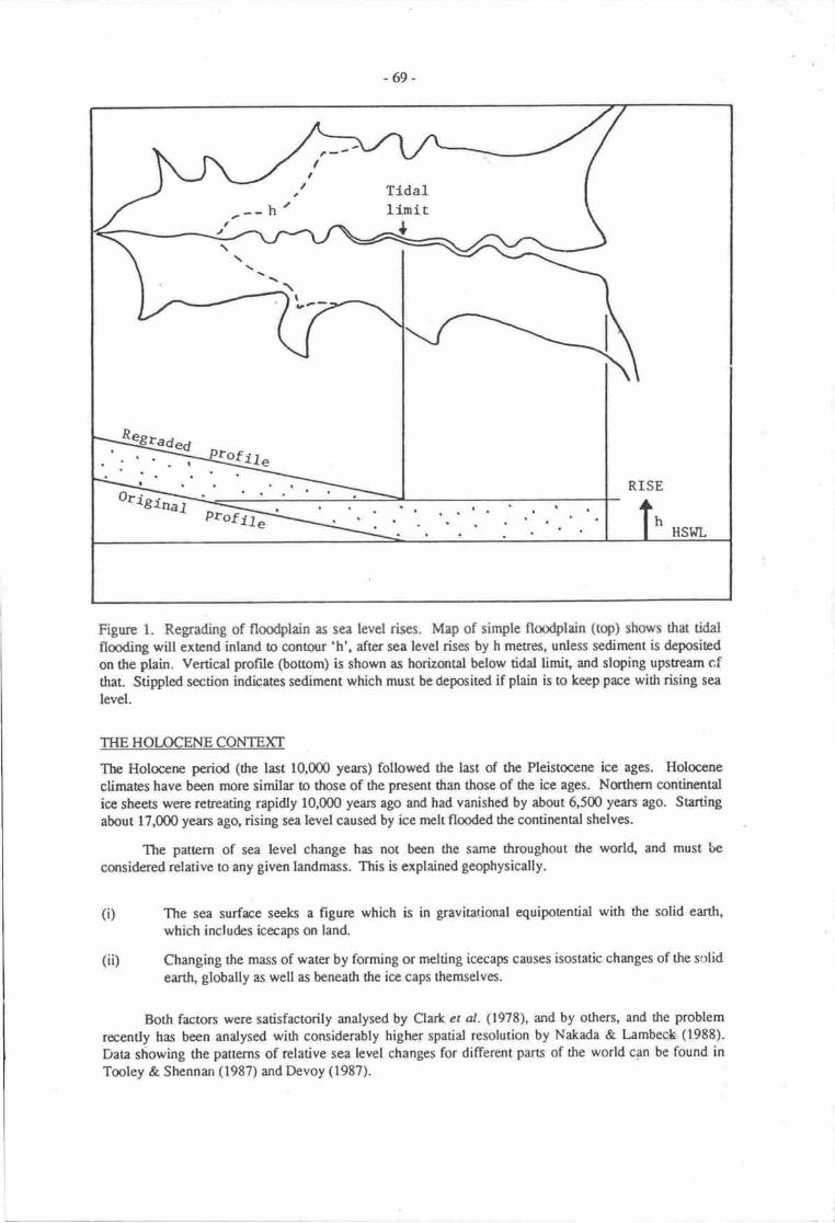
-69-
Figure 1. Regrading of fioodplain as sea level rises. Map of simple floodplain (top) shows that tidalflooding will extend inland to contour 'h', after sea level rises by h metres, unless sediment is deposited
on the plain. Vertical profile (bouom) is shown as horizontal below tidal limit, and sloping upstream cfthat. Stippled section indicates sediment which must be deposited if plain is to keep pace with rhing sea
level.
THE HOTOCENE CONTEXT
The Holocene perioa (the last 10,000 years) followed the last of the Pleistocene ice ages. Holocene
climates have been morc similar m those of tlre present dran those of the ice ages. Northern continental
ice sheets were retreating rapidly 10,000 yean ago and had vanished by about 6,500 yean ago. Starting
about 17,000 years ago, rising sea level caused by ice melt flooded the continental shelves.
The pattern of sea level change has not been the same throughout the world, and must be
csrsidered relative to any given landmass. This is explained geophysically.
The sea surface seeks a figure which is in gravitational equipotential with the solid earth,
which includes icecaps on land
Changing the mass of water by forming or melting icecap causes isostatic changes of the solidearttL globally as well as beneatlr the ice caps themselves.
Both factors were satisfactorily analysed by Clark et al. (1978), and by others, and the problem
recently has been analysed with considerably higher spatial resolution by Nakda & L:mbec*- (1988).
Data showing the patterns of rclative sea level changes for different parts of the world can be found inTooley & Shennan (1987) andDevoy (1987).
(i)
(ii)
t
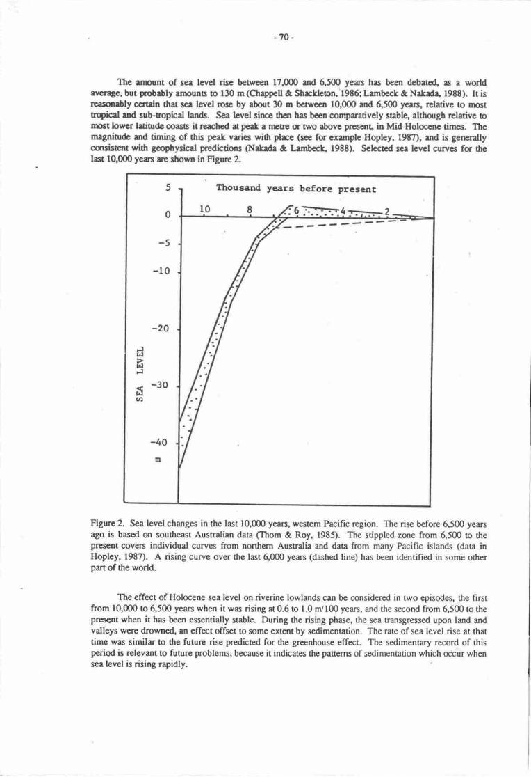
-70-
The anpunt of sea level rise between 17,(n0 and 6,500 yean has bcen debate4 as a worldatrerage, but pobrbly ennunb b f30 m(Chappcll & Shrckhlon, l9E6; krnbeck & Nakad4 1988). Ir isrcasonrbly ccrtsin that sca levcl rocc by about 3O m bcrrecn 10,000 and 5,500 years, relative to nnsttnqical rnd sub-oopicd lands. Sea hvel sfurce drcn has bcen corpratively stable, although rclative bnrrt brvaf lrtiodc ooasB it reached at pcet a nEtrt or two above presant, in Mid-Holoccnc times. Themrgni$& and timing of this pcak varies widr plrce (sce for exemple Hopley, l9E7), and is generallycmsistent with gcophysicaf pedktions (Natada & I-enrbect, 198E). Sclected sca level curves fa thclast 10,000 years re shown in Figure 2.
Figurc 2. Sea level changes in the last 10,000 ysrs, western Pacific rcgion. The rise before 6,500 yearsago is based on southeast Australian data (Thom & Roy, 1985). The stippled zone from 6,500 o thepr€sent @vers individual curves from northern Australia and data from many PaciFrc islands (data inHopley, 1987). A rising curve over the last 6,000 years (dashed line) has been identified in some otherpart of the world.
The effect of Holocene sea level on riverine lowlands can be considered in two episodes, the hrstfrom 10,000 to 6,500 years when it was rising at 0.6 to 1.0 nr/100 years, and the second from 6,500 to theprcs€nt when it has been essentially stable. During the rising phase, the sea transg,ressed upon land andvalleys were drowned" an effect offset to some extent by sedimentation. The rate of sea level rise at thattime was similar to the future rise predicted for the greenhouse effect. The sedimentary record of thisperiod is rclevant to future problems, because it indicates the panerns of sedinrentation which occur whensea tevel is rising rapidly.
before present
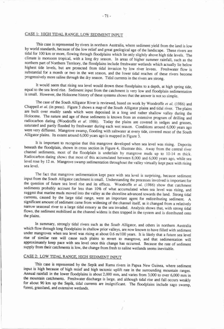
-7r
This case is represented by rivers in northern Australia where sediment yield from the land is lowby world skndards' bccause of the low relief and grec goological age of the landscape. These rivers aretidal for 100 km or mnl4 flowing through floodplains which iie anly slighrly above trigh tide levels. Theclimate is rnonsoon trqical, with a long dry season. In areas of higher iu.nr, rittru, such as thenorthern part of Nathern Tenitcy, the flmdplains include freshwater wetlands which actually lie belowhighest tide levels, but are protect€d from tidal invasion by low river levees. Freshwater flow issubstantial fa a msrth tr two in the wet season, and the lower tidal rerches of these rivers becomeprogressively more saline thmugh the dry season. Tidal currents in the rivers gp srong.
It would seem that rising sea level would drown the.se floodplains to a depth, at high spring tide,equal to the sea level rise. Sediment input from the catchment is very low and nooaptain-seOirnentationis small. However, the Holocene hisory of these systems shows that the arrsrn* is noi so simple.
The case of the South Alligaor River is reviewed, based on work by Woodroffe er al. (19g6) andChappell ct al. (in Fess). Figure 3 shows a map of the South Alligatu plains rnd tidal river. The plainsare built over muddy sands which were deposited in a tong ana rather shallow valley during theHolocene. The naurre and age of these sedinpnts is lnown from an extensive program oi criuing anaradiocarbon dating (woodroffe et al. 1986). Today the plains are covered
-in iedges and grasses,
sahreted and partly flooded by freshwater during erch wet iearon. Conditions .ro*i6,000 yJars agowere very different. Mangrove swamp, floding with salnvater at every tide, covered rnost of the SouthAlligatorplains. Is extslt amund 6,000 ycan ago is mapped in Figure 3.
It is important o recogrise that this mangrove developed when sea level was rising. Depositsbeneath the floodplain, shown in cross section in Figure 4, illustrate this. Away from the ientral riverchannel scdiments, most of the flmdplain is underlain by mangrove muds up ro 10-14 m thick.Radiocarbon dating shon's that most of this rccumulated between g,Om ana 6,00d years ago, while sealevel rose by 12 m' Mangrove swamp sedinpntation throughout the valley virtually i"pt p.J" with risingsea level.
The frct that mangrove sedirnentation kept pace with sea lcvel is surprising, because sedimentinput from the South Atligaor catchment is small. Understanding tre praesses involved is important forthe question of funre sea level rise and is effecs. woodroffe et al. (1986) show rhat catchmentsediments probably account fu less than l0% of what accumulated when sea level was rising, andsuSSest that marine muds moved into the valley as the shoreline advanced towards the land. Snong tidalcutrents' caused by the large tidal range, were an important agent for redistributing sediment. Asignificant arnount of sediment carne from widening of thl channel itself, as ir changed riorn , relativelynalow seasonal river to a large tidal esnary as the sea invaded. Analysis shows tiat, with strong tidalflows, the sodiment mobilised as the channel widens is rhen trapped in the system and is distributed ontothe plains.
In summary, strongly tidal riven such m dre South Alligator, and others in nonhern Ausnaliawhich flow through long floodplains in shallow prior valleys, at" not" known to have filled with sedimentunder mangroves when sea level was rising at about 0.6 dl00 yean. It is likely that a fuurre sea levelrise of similr rate will cause such plains to revert to mangrove, and that sedinrentatiqr willaproximately keep pre with sea levet once this change has acuned. Because the rate of sed.imentsupply from their catchnEnts is low, the change from fresh to saline wetlands seems ineviable.
CASE 2: LOW TIDAL RAIIIGE HIGH SEDIMENT IMUT
This case is represented by the Sepik and Ramu riven in Papua New Guine4 where sedinrentinput is high becausc of high retief and high teconic uplift rarc in the surounding mountain ranges.Annual rainfall in thc loryer floodplains is abour 2,000 mng and varies from 3,000 tJ o"", 6,000 mm inthe rnountain catchrEn$._ Freshwater discharge is large. and although tidal rise and fall occurs weaklyfor about 90 km up the Sepik, tidal currerts are insignificrnt. nr- nooaptains include sago swamp,forest, grasslan( and extensive wetlands.
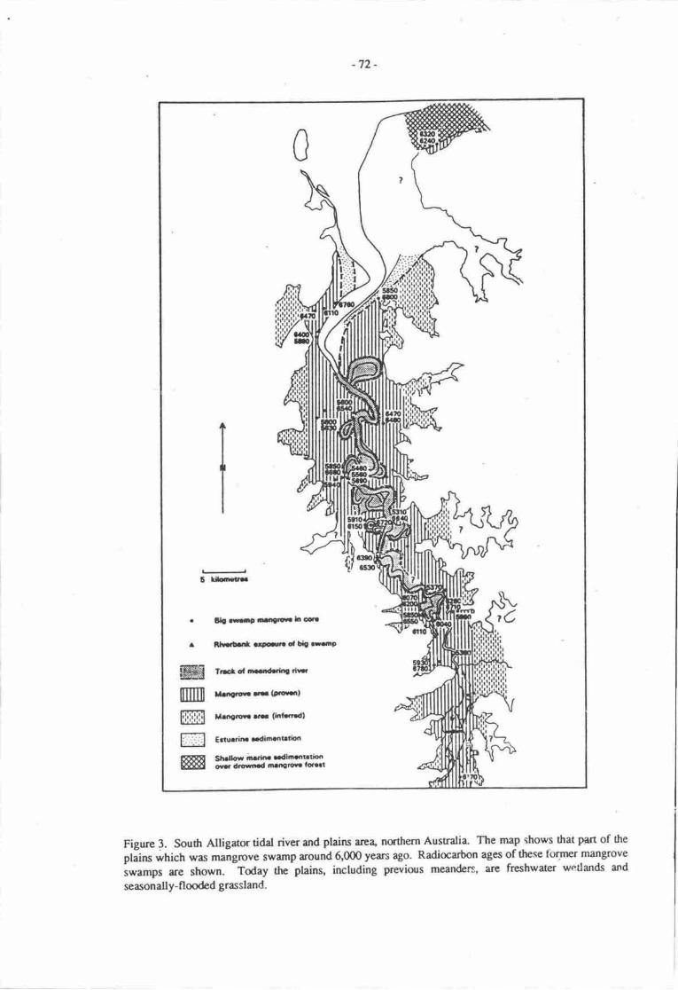
-72-
6 u{rtr!
. ll!ffie aa.reraltcdf
r iirlbrl .rFrto, li|t.taio
t6
ffi Tlrcrorlrrrlrledorrirr
m l|.',3rof,..-(P.!s.rt
m Moe,w.... (ldf..tdl
Effi
Crtll.rinr aadinafirdbn
Sh.lhil ;n .h. ..dlffirbtiooour dtofiad nanetoua lo.a.i
Figure 3. South Alligaor tidal river and plains arca, northern Australia. The map shows that PtJt of the
plains which was mang,rcve swamp around 6,000 years a8o. Radiocadon ages of these tbrmer mangrove
i*"*p, are shown- Today the plains, inctuding previous meanders, are freshwater wetlands and
seasonally-flooded grassland.
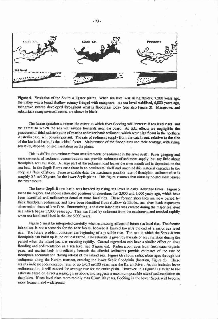
-73 -
Ftgure 4. Evolution of the South Alligia pleiru. Whcn rce lcvcl wrs rising rpkiln 7,S ytur 4qthc valley was a broad shallow cstrrry fringod with mangrove. As sce tevel strbilisoq 6ffi fcur rfo,mangrcve swamp developcd dttoughout wh.t is ftooddain todey (se rlso Figun 3). IfaArcrrc, dsubsurfrc mangrove scdimt, rre slrwn in blrk
The firure qucstiur cffierns 6c cxrcc b ntich rivcr flooding will irsrasc if rcr bvd rircr, ndthe extsnt to which the sca will invrdc torrlands nerr thc coast As tidal cficsts re negligibtc, 6cprocess€s of tidal rcdistributlJn of mrinc md rivtr bank scdincnt, whhh were slpifrcent h thc ncrhcrnAustralia casc, will be unimpstant Thc rac of scdinpnt supply ftom the cabfuislq reletive to 6c tizcof the lowlard basiq is the critbd facln. Mainenarce of thc flmdplains and drch cology, widr &hgsea level, depends on sedinentation m rhc plains.
This is difficult o estimae from npairrcnrnr of sodincnt in drc rivcr iuclf. Rivcr garging mdnrasuremens of sodinsnt cqrccntratiqrs co provide estimates of scdiment supply, but sry lidc rboutfloodplain rccumulatiqt. A large pat of ilrc redircnt load lcavcs the river nnuth ard is dcpocitod cr rhcsea bctl In the Sepik-Runu case then is no contincntal shclf and much of tris mreriel cascdes b thcdeep sea floa offshqe. F'rom available.lata' the maximum pocsible rae of floodplain sodinrntaiqr isroughly 0.3 m/100 years for the lower Sepik plains. This figure assumes that virtuetly no scdirEnt lav6the river mouth.
The lower Sepik-Ramu basin was invaded by rising sea level in early Hotoccnc tirncs. Figurc 5maps thc region, md shows estimated positirxrs of strorelines fa 2,(D0 md 6,000 ycans ago, which hrycboen identified and ndiocarbondated at sonr bcalities. These former shorclirps ilt rrow buricd bythick floodplain sedirnenr, and havc becn idatifid from shallow drillholes, urd rivcr bmk clpoeiucsobserved at tirnes of low florv. Summarising, a shallow inland sea was crcacd during thc meja sce bvdrise which began 17,000 years ago. This was fillcd by sodimcnt from thc crtchmcnt, urd rwodod rpidtywhen sea level stabilised in the last 6000 years.
Figure 5 must bc inerpreted carefully when estimating cffecs of future sea levd rise. Thc forrrcrinlarut sea is not a scenario for the rra future, because it fornrod owards the end of a majr sca levclrise. The futlre problem conccms the beginning of a possible rise. The rate at which thc Selik-Ramufloodplain can build up is the critbal factor. One estimate is giran by the rate of rcumulatbn during ftep€riod when the inland sea was receding rapidly. Coastd rcgrcssion can have a similar efrect on rivcrflmding and sedinpnation as a sea bvel rise (Figure 6a). Radiocarbon ages ftom frcshwarer ffganbpeab and marine beds immediately bcneuh the alluvial sedinpnts provide estimetcs of the ratc offlmdplain accumulation during retreat of dre inland sea. Figure 6b shows radiocarbon ages through thesediqrents along the Keram transect, crossing the lower Sepik flmdplain (location, Figure 5). Theseresults indicate sedinrentation rates of up 0o 0.3 m/100 years near the Keram River. As this includes lcveesedimenutiorL it will exceed dre average rate for the entire plain. However, this figure is similar to theestimae based on direct gauging given abovg rnd suggests a maximum possiblc rate of sedircnEtion onthe ptains. lf sea level rises more rapidly than 0.3nr/100 years, flooiling in the lower Sepik will beconrrnore fiequent and widesprcad

-74-
Figure 5. Geology, and Holocene shorelines, in the lower Sepik-Ramu region, Papua New Cuinea- Ashallow inland sea formed during the period of rapid sea level risg before 6000 yean 4go. This shallowsea receded rapidly when sea level stabilised Former shorclines are inferred from coastal deposisbeneath flmdplain sediments; these radiocarbon-dated at some sites. Rates of river sedimentation can begauged at dated sites.
CONCLUSIONS
The conclusions of this paper are simple: if we are are to estimate the effecs of a possible futuresea level rise, the effects of the last major sea level rise should be investigated. This commenced 17,000years ago and finished 6,500 years ago. The interval betrveen about 8,000 and 6,000 is most relevant forproblems of coastal and riverine lowlands, as deposis from ttri; perid lie directly beneath the modernlowlands. These studies of the past should be included in any local or regional future-orientedprogtammes of investigation.
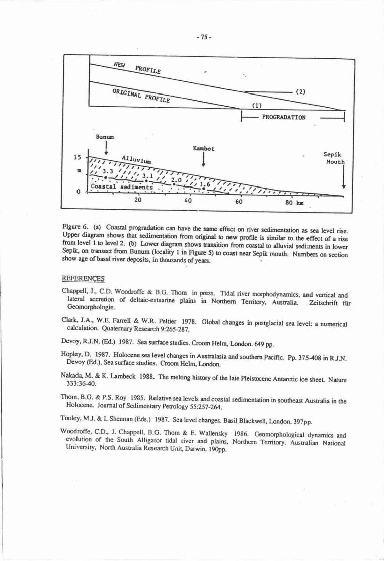
}{R,lnoerre
onrc]% (2,
PROGRAIIATION
15
D
0 ! t,:1 ,,t r'.tfu
-75 -
Figure 6' (a) Coasat progradation cat have 6e sanr effect on river sedimentrion as sea levcl rise.upper diagram shows that sedimentation from original to rEw profile is similer o the effat of a risefrom lerrel I o level2. (b) Lower diagnm shows tsansition hom coasal o alluvial sediirrnb in lowersepdc on trilNect from Bunum (locality I in Figure D o coast near Scpik mouth. Numbers on sectionsbow age ofbasd river deposis, in thousands ofyers.
REFERENCES
Chappell J', c'D' woodroffe & B.G. Thom in press. Tidat river morphodynamics, and vertical andlatcral rccretiqr of deltaic-estuarine plains in Nqttrern Tenitry, Australia' Zeitschrift fiirGeomorphologia
clark' J'A', v/'E' Farrcll & w.R- Peltier 1978. Global changes in postglacial sea levet: a nunrericalcalculation. Quaamary Research 9:265-297 .
Devoy, RJ.N. (Ed) 1982. Sea surfrce studies. Crmm Helrr1 Lmdon. 649 pp.
Hopley, D. 1987- Holocene sea level changes in Ausnalasia and southern prcific. h). 3?s-{0t in RJN.Devoy @d.), Sea surface studies. Croom Helnu l_ondon
Natad4 M' & K. L-amb€ck 198t. The melting history of the lue Pleisocene Anhrctic icc sheer Nature333:36-40.
TET' B'G' & P'S' Roy 1985. Relative sea levels and coastal sedinrcntation in southeast Austrrlia in theHolcene. Joumal of Sedimentary perology SS.257-2&.
Tooley, MJ. & I. Shennan (Eds.) 1987. Sea level changes. Basil Blackwell, landon. 39?pp.
woodroffe, C'D" J. Chappell, B.C- Thom & E. wallensky 1986. Gmmorphological dynarnics andevolution of the South Alligator tidal river and plains, Nonhern Tenitory. nustratian NationatUniveniry, North Australia Research Unit, Darwin. l90pp.
-76-
PLANT ECOPHYSIOL(X;ICAL INFORMATION FOR CONTINGENCY THINKING IN THESOUTHWEST PACIFIC IN FACE OF THE GREENHOUSE PIIENOMENON
Clive HsckettDivision of Tropical Crops and Pasturcs, Comnpnwedth Scientific and Indusrial Research Organization
(CSIRO), Crrndy Roa4 StLucia, QId4067, Austrdia
SUMMARY
It is suggested that the best way for Southwest Pacific countries !o prepre for greenhouse effectsso far as plant ecophysiological responses are cqrcemed is to construct or improve relevant informationsystsns which will be vduable whether or not the greenhouse phenonrcnon materidises.
Standardised plant ecophysiological data-sets should be prepared at an appropriac scde, and theseshould cover fuelwm4 fmest, and weed spocies, as well as crops. In relation o climate data theinformation systems should include long nrns of rcnrd data so that the effecb of climate variability canbe assessed. Provision for long runs of synthetic climate data should also be made so that hypotheticalscenarios can be examined. Whatever land data are strxed should be directty nraningful so far as plantproduction is concerned-
Given such information sysenui, a variety of methods can be used fa predicting plantperformance under different types of greenhouse imprct Sonp of these nrthods can be operatedmanually or merely by eye. However, problems which the expertise or data immettiately available maynot highlight should not be overlooked. Among those mentioned are losses due to pests and diseasesarising from possible increased weather variability, and alteration in soil biology, upon which subsistencefood systems heavily depend.
Ten formal recomrnendations are made. Wherever possible, these favour work which can be de-centralised and redily adapted to local needs and perceptions.
INTRODUCTION
The ASPEI Task Team recomnrended to the LrNEP meeting in SPLIT in October 1988 on impactsof the greenhouse phenornenon that work be done on the geographic distributiorr, imgrriance, andecophysiological olerance of a range of commercial, smallholder, and subsistence crops. This reponsuggests a strategy for such work.
The strategy is based on the view that the most helpful rtion would be to crcate techniques forhandling plant information which will be useful whether or not the grecnhouse phenomenon manifestsitself as feared. This strategy should be relatively easy to pursue because interest in the ecophysiologicalcharacteristics of plant species is already strong due to concern about the conservation of fmd productionsystems and development of the marketing and processing of plant products.
This report offen a philosophical basis for the work propose4 discusses some simple and somemore complex means by which it can be conducted and ten formal recomrnendations are made. Thephysiological effects of raised carbon dioxide levels on plant production are not discussed because it isconsidered (a) that they are unlikely to be negative and (b) that the nature of the benefits which may beobtained are too unpredictable at Fesent to allow for in planning processes.
The relevance of the proposals to rror€ immediate problems of plant production and land-useplanning will be readily apparent. However, these aspects re rarely referred to below because that wasnot the prime purpose of this reporl
-77 -
CHOICE OF SCALE
- Contingency thinking about dre impact of the grcenhouse effect on plant production in theSouthwest Pacific is likely to begin with simple questions such as 'How will yiefAs'* affected in thepresent locations of crop species?' and 'where might optimal performance occur if conditions dochange?'
Following closely upon such questions would be a group which focuses around farming systems,such as 'How might mixes of species be affced by simpdeffects such as a rise in temperature?' and .Ifcstditions beconr nrore variable for month !o month and year to year, would the existing mixes ofspecies cope with that?'.
Behind the second set of questions would conn a third set relating to socieeconomicconsiderations, such as '!ow readily will podrrcers perceive what is happening to the environment and 16their production systems?'. 'How well cm they be ixpected to adapt bi usini their own experience andresources?', and 'Might some of the effects be so marked that efioru to respond might liad to socialcmflict in sorp form?'.
- Because these questions range rcrGs many people, many places, many factors, and many species,care has 0o be given in choosing a scale fa woiking on thim. For deaiing with planvenvironrnentrclationships, which this repon is almost exclusively cqrcerned with, therc are fonr broad scales or levelsto chome from (Hacket' 1983). These levels are defined in relation to the content of general-purposedascriptians of plant species, namely l-evel A - ctrecklists of narnes, l.evel B - dictionary intries, I-evel C- chapten and articles, and Level D - nnnographs.
Sudy of differcnces benveen the content of plant descriptions at rhese levels has shown that l,evelC is well suited o broad-sweep examination of thi type of problem being consi&red here. The typicall'evel c desoiption is of course textuel and does not lend irself well to dirccr use in formal studies, butstandardised level C descriptions can be prepared which can serve analytical thlnking very well. Anexample of such a description follows and is used o show that very simple ncthods of aisessment can bequite informative about possible plant responses to potential greenhouse impacs in the Southwest pacific.
A SAMPLE PLANT DATA-SET
The dau-set for sweet potao shown in Figure I was derived from one prepared for a landevaluation project fu Papua New Guinea - see Bellamy (1936) and Hackec (l9gga). This particularrepresentation of the dau'set comes from 'Manual ECOPHYS' (Hacketg 1988b), which is a system forryking rapid coane predictions of pedormance by hand, using worlsheers and look-up tables. In all,Hackett (1988a, 1988b) contain 18 such data-sets for crops g.in in the Southwest pacific - see Table Ifor a list.
Explanation of the origin of the dsscription shown in Figure I and the conventions and symbolsused in is preparation can be found in Hackec (1988a, 1988b). All that needs to be said here is rhat (a)as far as possible all such descriptions were built up from expert knowledge of the species, (b) the focusof the format shown herc is the limiation rating gn - o m tb;, (c) use of Liebig's Law of rhe Minimum(Browrrc, 1942; Hackett, 1988a: Chapten 4 A, l0) o estimae perfmnrance which gave surprisingly gmdryoltt' and (d) the prediction Process was Ested many times by 'blind' t*tttoar lHacken, lggEa:Chapter l0).
To illustrate how such data-sets can be- used to consider greenhouse effects simply by eye,reference will be made here to a small selection of the facon covered*in Figure l.
Sequential examination of the subsets of dara marked '**' iil Figure I shows the tcllowing forsweet potato (Hackett, 1984; l98S).
If increased rainfall produced poorer soil aeradon, yields in many arcas would tend to fallunless the growers could compensate in some way
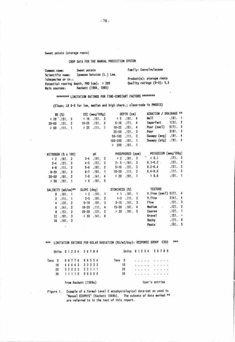
-78-
Src€t potlto (stocagc |.ots)
ctr 0 Il fon ntE utj& Pf,Eolfilfl srSIElt
Cfi| n.r: S|tCt PotrtoSclmtlflc nc: lpru brtrtas (t.) Ln.*ubcerclg or c{.:Potmtlrl tutlng drpth, P*0 (cr): ) 200
lrln rclrccr: lLchtt (lgtl. l3!5)
Fufly: Cqrvolrtlaccrc
hodrt(:): 3totalo tut3Qualfty rrtln$ (0-9): 5,5
rhiFllFFr tIllIAItfl RlTlltgs FoR TII€-COFT|XT HCTots 3!|r n!3
(Cher; tt 0-! for lor, dfun ard h{gh chrrr-; chsr+odr ln PfFRIS)
rs (t)< 20'.!5!. 3
20-60 . !t!. 2
)60.!t!. I
cf0 (rq/1009)( t0 .!5!. 3
10-25.!3!.2)25 .!l!. I
tl3-r .!9!. 3
t-5 . !5!. 3
5-6.!0!.2c-t .!0!. t?-t .!r!. II t .!81. 5
lITR0Ggl (t x 100)
< 2 .!5!. 3
2-t .!2!. 3
a-t .!t!. 3
t-20 . !0!. 3
20-50 .!0!. 2
r 50 .!0!. I
SAtllllil (rS/o)r SOP€ (deg)
0 .!0!. | (2 .!0!. I
2 .!l!. I 2-5 .!0!- 2
a . !3!. 2 5-10 . !0!. 3
0 .!l!. 2 l0-?0 .!l!. I! . !5!. ? 20-30 . l2!. 5
t2 .!t!. t ) 30 .!{!. 0
|l.!9!.3
0EPIll (cr) AEf TIOI / 08 lilA6t rt( 5 .!9!. r llll .!0!. I
5-10 . !?!. { IrPcrfct | !:!. 2
t0-25 .!5!. I Poon (rrc'l) 5!?!- 3
25-50 .!2!. 3 ?or 3!6!. 3
50-100 .ll!. 2. Sru+Y (q) .!9!- |100-200 .!0!. I Snrpy (stg) .!9!- |> 200 .!0!. I
Ptl6Pft0n0s (pF) P0TISSIUT (ree/10091
<2.!8!. 3 ' <0.1 .!t!. 3
2- 5'-.!61: 3 0.1-0.2 .!3!. 3
5-10 .!3!. 3 0.2-0.( .12!. 2
t0-20 .!l!. 2 0.1-0.0 .!t!. 2
) 20 .!0!. t r 0.6 .!0!. I
STffIflESS (t) IEXTURE
( | .!0!. I V.flnc (srcl) 5!?1. Il-3.!t!.2 V.flnc 2!t!. {
3-15.!t!.3 tlnc .!3!.315-30 .!l!. I hdlur .!2!. 2
r 30 .!8!. 5 Corrso .!?!. I
Gravtl . !5!.rockY .!!!. 6
?c.ts .!0!. 5
.rs LIttTATlil R/lTIllGS FoR 50t R RA!IAT[Q({ (rJldldayl: REliP0ilSE 6Rq,P C3G2 r$
Unltr 01231 56r89 llnlts 01231 56?t9
Tens
Fror llrckctt (198&.) User's entnles
Flgr.lce l. txarpk of r fonu'l level C ecopltpiologicrl dcta-et rs u:ed ln'larrurl EC0Pttls' (Heckett lgssb). The subsets of data rarkad rtrre rufcmcd to ln ths text of thls report.
0 8t7?6 66551t0 {{{{3 3333320 32222 2211130 rltl0 00000
Tens 0
t020
30
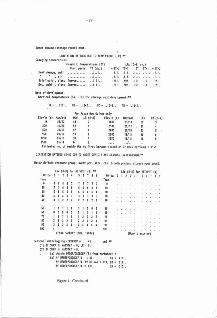
-79 -
Sreet potato (storage roots) cort.o
LITTTTTIfl RAIIIGS ['E IO ISIPERATUR€ ( C) E'0ugiq tc.peraturer:
Tlrtshold tcrpcratur.es (lT) LRs (0-9, cv.)Pl.nt plrts n (dq) (=tI-2 TT-l TT TI+t >cIT+2
[Grt dilqr, ioil' ' ''lf
| | tt lt lt lt tl! ! rt tt rt tl tl.4...
8rief cold. plart lcrvec...... ..! 3!,. .!9t. .!9!. .!6!. .!i!. .10!.Ext.cold ,phnt lerycr...... ..!t!.. .19!. .!!!. .!6!. .!3!.,.!0!.
bte of dcrloemt:Crdlnrl t.rylrrturcr (I - D) for stcrgc rroot developxrt:a
.TA - ..!10!.. IE - ..!2a!.. TC - ..!2t!.. T0 - ..!3t!..
tor Prprr ilar eilrna arlytlcv'n (r) lrx/rin rus U (0-S) Elev'n (r) iu/rtn flts U'(0-S)
0 3?122 ta t tt00 ?31t3 3s 3
300 {120 5t I 2to0 22ln , 30 It00 ,0119 52 t tr00 zllto 23 5
300 28111 53 | 2?00 til 8 15 6t200 261t6 50 | 2850 tS/ I 15 6
1500 25111 l| 2 .... ..1..Estlntcd no. of rcekly llfs to fft.rt hrrcst (brsed qr 2?-rek oFt{rll) = ll50
LITITATIq RIIIICS (0-8) q,E T0 rATEn offtcll fio sErsoiAt tfATEtrocclilG'r
|!ten deflclt rcspq|sG grdrp: s|ttt,ot. 3tor. rts Grorth phrses: stomge root deml.
l,"b (0-8) fo. rfrlrrr 111 o Us (0-8) for |EI|PEI (t)lfnlts0|2ta 5C?tt Unlts0t23 | S6?89
Tens Tcns0 rStt? ?tltt 0
t0 ?7600 66665 t020 555t5 55att 2a
30 tf.t3 3t!33 30
{0 332tt 2222 | t0
50 ttttt tt000 50
60 00000 0tttt 60?0 ttttl 1222 2 70!0 22222 ttt33 !090 3t3t! 3ttft 90
100 | ' t00
. (Frc llrc|rrtt 13fi. 19E8.) (User.s artnics)
Seasonal r.terlogglq (CI0ROEP : 15 cr) rr(l) tf SrRP ln }IATSTIT = 0, Lf, = 0.(2) lf S,RP in tfAIliTlI ) 0,
. (r) obtatn Of,O€p/c80gtEp (t) frc tfockstreet ?
(b) rf m0EP/cffHEP t ( 80, L[ = {!6!.lf 0RDEP/CR0R0EP t r= itr ard ( 133. t"R = 2!{1.lf 0R|)€P/Ciln0EP t )' t33. LR = 0t0!.
Figurc l. Continued
-t0-
If thc sea encrorched on croppcd land by undorground ssepage of salE swoet potato would bee:Ecctcd to bc reasonably olennr (though pdarability might dcclinc).
Risc in Enpcraturc would hasten rae of davelopmant in cool aeas but dccrease it in rcaswhich rre dreedy hot
Modcst changes in ninfall could havc nciceable effcs even without any change inscasonality c variability becausc yicld of sbrrgc rmts of swect potato is favoured by mildwaEr strcss.
Increase in seasonal waerlogging would rct be compleely disastnous, but the decline in yieldwould be substantial anugh to require greatr energy inputs to mounding and dirching wherepossible.
Table l. Crops for which standardis€d to Level C descriptioru were prrparcd for the PNG landevaluation project. Sce Hrkett (l98te Chryter 3) fa arthas and citations.
bananacashewcassaYa
ooconutcoffe (rrabica)coffe (robusta)taruta (Padanus sp.)mangooil palm
potatosago pdmsweet potato
tmfit(Xanthosofzd sp.)taK)winged beanyam ($eater)yam (lesscr )
(Copies of tlrese descriptions are availablc from tlrc present author at the Division of Tropical Crops andPastures, CSIRO, St Lucia Qld 4067. The description for oil palm remains unprblished.)
Without using formal analysis of data-sec of this type, four morc obsenvations can be made.
Bocause the optimum tempcrau[e for rats of crop developnrnt differ ber*een spocies, achange in temperature will affect species in a mixed cropping system diffuently, which nreansthat thc timing of human rctivities and food supply would be pur <xrt of kilter by a temperanrrerisc unless the growers could move their gardcning systems ,o a higher elevation (such a movemight rarely be possible bcause of social frtas or advene slopes in the higher regions).
Whether or not human co'mmunities could adjust to the temperahue changes by rnovement,there would be a underlying tendency of crops !o move of tlreir own rccord rather like pieceson a chessboard starting to rcr independently of the playen.
The tendency of crops to nrove in this way could raise seriouq problems for enterprises forwhich a major capital invesunent has been made on the 'squales' currently occupied by thesecrops.
Specid att€ntion would need to be given to food supply in the lowlands because several cropsarc highly intolerant of salt (e.g. yams), some are intolerant of waterlogging (e.g. cassava), andsome may already be close to their linrit of tolerance !o high teqlerature (e.g. bananas).
hoblems such as these can be productively explored by hand by employing the methods containedin Hrckat (1988b), using Hackeu (l98ta) as r brck-up for explanation, references and otherroquirermns. The rpxt section indicates what can be done u,ith computer systems, especiatly when agmgraphic information syst€m (GIS) is available.
-tr-
USE OF A GEOCRAPHIC INFORMATION SYSTEM
During the hnd evrluatio'n rojct fa pNG which hrs bccn rcfcrrod to rbovc e cmputcrircdresqrrEe information systsm wrs crcrtod cdled PNGRIS. Oycr 4500 rcsourcc mapping unia (RMUr)werc recognise4 and for erch of thcsc he type of infrmatim slrovn in Figun 2 wrs stfild m p61jmdcomputeN.
Afirchod to PNGRIS is e frcility cdled PNG ECOPHYS which was wrincn by tr[s S-l{. Cuddy,CSIRO, Canbcrrr using Level C nrthods dacribcd by Hacter (lgt8r). This frcility rllowr src o nreba coarse predictim of the performrrce of dnrost my highcr plart spccicr fu which onc hes e date-sa oftlE type slrorvn in Figure l.
Figure 3 gives ur exenplc of drc orrput frrom PNG ECOPHYS. Detailcd cxplmrtkn of thc weysuch ougut was rrrived at cen be found in Hrckcu (l9tta) l9t8b), but it can bc scn from Figurc 3 61atPNG ECOPHYS produces an dnnst transper€nt stat€fli€nt of thc limilrti<ns to pcrfornracc in erhRMU and irdicates dre liLely collective impact of dre limitrtiqrs aftcr allo'ving fa scassral vrrirtians.
In rclation to groenhouse imprca nd oahcr problcrne c questions, a grtet bencfit obained fromjoint use in dris way of PNGRJS and PNG ECOPHYS (or similerly merchcd *t4es) is the capebility toscm quickly eross mmy spccicrs md many plrces. This ceiables iltc mind to mske gr alnnctinsantanous preliminary estimrtc of the fcasibility of subsistcncc agrbulturc md snulltnldcrcashcropping in the reas considerod
For such paired prckages to be most useful in relation o grecnhousc effects, one needs ur ability!o create hypotheticd climatk scenarim. Wifr PNGRIS, it is already pcsiblc ro crcrte imaginry RMUSand m examine relatively sinple questions such as the furplicuicrs for oil palm of a charge in rainfall 61tmpcraturc at its cur"nt locations. But thc crration of new conditions for the whole counry or even fmjust a province is not possible yet an an automatic basis. To gen€rarc such r frcility wolti Uc a majorrcsearch task because some factors have rnse thm me firrction in thc conpuer programi and becarsethe prescnt climate detabase in PNCRIS uses only manthly daa and mgkes no alo*arcc ya forvariability. Also, !o examine greenhousc impacts, one would have to seare hngthy imeginry runs ofweather data and devise rules for doing that.
On he brigher sidc, howevcr, it is already possible to use the existing systerns for pgtice incmcepntdising the managenrcnt problcms planners would frce. One could srypose, fa exernple, that aprticular village will be inundatcd by thc sea and drc population will hrvc o nro"e inlmd a firthralong the coast. Surply working out the qucstions nccdcd to be put o r GIS in tlrc frcc of such asinration leeds b vduable training in logic and multidisciplinary thinking. Experiancc shows thd hrdlyanyone errcrB€s from such m erercisc without hrving rtreir perccptiqrs of the locations and the pfannin!poblems cursiderably enhanccd. The oppornrnities GIS's grve in this way for inqrctivc iee"nitt!repres€nt one of their nnat vduable quditics.
CAUTTONARY NOTES
A Sreat darger in plmniry fa grenhousc in&rced chrnges will bc thc cn&ncy fq adviscrs ocolrccatralc on their own expcrtisc md for importmt questions b drop down thc discrplinrry crrcksbeiwecn fte expcrts. This scctiqr rbs o conEct fc this t€ndcrcy so fr c ptart coptrysiology iscmc€mod.
Beginning with climatic considcratiqrs, it has o be renrmbered tha in addition to presentlyoverlooking rainfatl variability, PNGRIS and PNG ECOPHYS do not cansidcr froct, snow, or cycloncs.If climate dm beconn mse vuiablc snap froso and snowfall could occur more frrequcnrty in hgtrcraltinrde scrs of P4ur Ncw Guincs evcn if Empcrailres rise, Clclones might bconrc morc ncqocnrand they might bcgin to occur in locuicrs which arc cunently cyclone-frree. To ovcrlook climatic factors

-E2-
?tovlsf0tEntcr
14 CBt S.pitI lLrlt RMU No. 350
tlr.toE.ATEA
I d.f 17.in St(5 dcr 7 rln e64 ro tf,
NATURAL RESOURCES SOII,s
solt I rftgdrlttttoltEst roB ttqy/t'cty (<tltoeli idr.t.ty d..p (50't@c,oUtt|rCf lF.r"t ctty dr.lndl€|gf lfl trtly rld to tlr tr.tSl|.llltt lcrCAtrc &l rlS (>25 ..{,llrsE SAl.t tlod.r.tr (20.64)
lElcttd rcld$[lrlff laxC lld fft Lq, (<t0 E{)ItjS€ Stlrf Lq. ' (€OI)
S&trlfY lcrCAllOl EICII lllCr (>6 r.d)lllsE strl lfCr (t{d,I flllfifl Lo. (O.21)
AYATL rrAtEl Gprtrl0.6 cr Lo.0.50 cr lldretr0-lO cr llodf,rtr
AVATL tt^tEl CrtrcttY0.25 €. La0-50 cr l|dr.t.o-lql Gr ltodr.t.
0.25 cr v.ry td0.50 cr Vrly td0.1@ cr Very tqr
,|ll rES€Rt/E lllirl
ALTTIIDE|rrl IE9TII TE?
t-rr(ty <16 r to tO-26 -orf lclt lfitirtt.r. d.f,.t. d.flclt
lLF^ll4 Io ttoodl.ro c lnrdrtlalExtat f l t
tOlL lrqd.tfrt|.tt to lFdctty 4dnrd, d.f.tcty |. th.rcdrollr rldr fl.rr t.snJn.d nboltr
0':.trqcptriodcr.t.ty godned roltr rldr .ttcr.d I horltdr-!d to. (<.5G1 r,boit br ..trr.tfqr EI|.E
lrrtoittrcrtr. ttdlffcrrltl.t.d. Etty rhr(tc roltr drldr rcs6tGt to ra.adr( tfrtst.r rtrcr
VEGEIAfIfl S.. Lrd lr..tlrdfu-crqnrd tdtrd hlit ton.t
| ?65tttE ffTl rrr3
I a* rrddr.t mlnfrtt
I lllrfift tld.r.t. (0.2-0.5t, rlr IES€llG llodf|t.lv^tl t llod.r.t. (10-20 ppt lErunE re fl|rEEll r iod.f,.t. (0.2-0.6 r.€t Tgnn€ 9.3 v.ry fl|rCtDlllLllY id.f.t. lllol Flfrl lo Fdtcr30tL ! tbtortlr.ittsTfltfGSS lod.r.tcty .tdry/rocty (3-151,OEPTT Y..y A.tto. (<6c.)0r tUlGE t.tl-dr.lmdl€AcItc llrtty eld to rG^r.t AV IL ra l€R ClrlCtlY
AV IL P llodr.tc (10.20 pf) tErnn€ TP tr.d|rr€lcll ( llodcr.t. (0.2.0.6 r.6, fExnn€ stl roctefolllttTl tlodcr.tc Alllc FIX.I Ic prdtrr
RURAL POPTJLATION AND VILLAGES
x.tca Fc[tca lot.trr05 17tt 5J92
tqLat9
4
f1657 76
5161
1lE 1(
6l0
ll0
l2
?!40u0
t(X
1592tZ Ft:qr../rq trE2 panc{rq tr
lot.( Pgrt.tlql
Olrt J uPrl(I rln|llr2 A.rr&tr e! ufiegrnJEr
t0 talrtrll Y|,rrL tt2 trr|t 213 YXilr !
olrt I |||'|trJ ur^,|c4 Clct^qrl5 Jrr€7 KALAAJ I
12 L(x€Ifil5 x€Llc(x16 Ylfilrtf{
Dittn 29 Ylrlll95
tl3'74'nilE
. ll4a2
0lrrn !0 ttlPrt(19tj
r592810526r232
c5 t6tt2' 25rQ. t565t 1?2,9{ 2lel]7 2nt6 t!12 Eta, t]9
t(9 16lla tn67 79i2
af 'rt240 (nl
coffcctCaC€O'.$b.tc.trrt./copaa
Totlt Vltt.gci 11[@rctrotdr
lctfvity Io lfot.trglccrfoodcropefidtcrtttapi!!
lllofcrl |tcrrrtrl|| rd hltta ylth n* oc tE rtnrturrlomt|!t
IEX TTFE Co.ra. ifi.ln d a.dlrrt.rT
g,ec 20-X 4rslA.lE rlgh f6-t@ rutff|tt
frrrrt !50-2dt r
0.{0 r12.t0 d.sc25-t9 A*
LAND USE
.ltso. llf^
Fru ltcfl o€rastrYTot.l Popsl.tlqrD|I|V qt Tot.t
^rc.ocllty qr rlj..d. Ar..
u[ rrs€ lfiEtstwrf6Ld
tEGICfiII
44 rq kr . lGlt of totrt rer
llrt|f. of t.tt rd drort Fod/.d 91r.r
rq.s.3stsrEr(E r/sf
r|rALLt(t Et ECOOTTC Acnvtwlotrt iq.B.lrotd. t6t
Itcuscfiol&ActlvltY Io rot.t
I trltm ,|d...t. (0.2-0.5$ 'Ilr r€sEnE iod.rtt.lvrtl t lldrrte (10.20 pp! lgnft tct FlmErcl I iod.f,.t. (0.2.0.6..*, fErnf€ sl Y-? llilEtotttLtlY lld.f.r. Alll(l Fllrt lo p.6t-
SOIL 2 oyttrq.pt.SrfllESS tot .to?/rcty (<t:)o€?Tt llodriltrty d..p ($.lqkrlOf lu/C€ l+.rfcctty dr.ln d
Figure 2. The description of RMU 350, Ilasr sepik province, in r},e PNGRIS
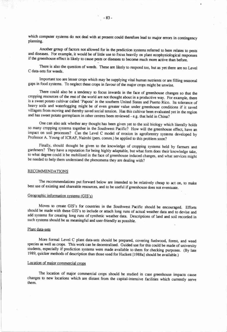
-t3-
which conqrtcr systcttt$ do mt dcd wiilr rt pref.irt could drcrtfse lcrd io rneir crrus in cantingencyptanning.
Anothcr gmrp d frcrcrs mt rlbnrcd for in drc prcdicticr syttams refcrred !o hcrc relncc !o p6Bad discascr. Fc cxerryh, it would be of lislc uEG to fau hcevily m plnt eophysiological rcrponscrif ttr gccnhorse cffct is likcly to clusc pcstr or dircrscr b bemt muctr nur rctive Om bcfqe.
Th€!'c is dso thc qucstiur of wcc&. Tlrcsc uc likcly to respord too, but rs yet th61t re no LcvclC dau-sas fawe&.
Importztt too &ie lcrser crops which may bc sr4plying vitel humzr nuricnts or re filling scrs61tslSaps in fod syscms. To rrcghct tlrccc crqc in frvour of thc mqic ctop6 might bc unwise.
Thcre could dso be r tandcrry o faus inwrrds in thc frcc of grecnhousc churycs so ilrat drecmpPing rlsorrluc3 of thc rcrt of thc wald rrc nd thought rbqrt in e prooucti"e wey. Faixemplc, tlrcreis a sweet potab cultivs cdtcd 'Ppote' in the sordrcrn Unibd Sacs alrd puerto Rico. Is tolersrcc ofheavy soils and watcdogging migh bc of cvcn gcetlr vrluc undcr grc.nhousc conditi{Jns if it savedvillagcn from moving rnd thcreby srvod saial tensiorl Hrs this cultivu bcan cvalurrod yet in thc rcgi63rand has swoct potab genrylasm in odrcr cenres bccn rcvicwcd - c.g. thu hcld in chhr?
One can elso ask whcdrcr any trought hrs boen glvcn yet to thc soit biology which litcrally holdsso nuny crcpping syslems togethcr in thc Southwest Prcific? How will ttrc gecirtrorsc cffecq have urimpct on soil processes? Cur thc Lcvel C nodel of ercinn in agrofores-ry systsms developcd byhofessor A. Young of ICRAF, Nairobi (pcrs. canrn) bc ryplicd o this problcm smr?
Finrlly, should drought bc grvan b tlrc tnowlodgc of aopping systcms held by fannas 6dgrdetus? Thcy heve a reputetion for being highly rdapabla lut wtret fqm das their knowledge teke,to what degrae corild it bc rpbitiscd in tre frce of grecnhousc induccd changes, and what scrvicas mightbe neded to help thcm undentnd ttr phenunare they rrc dcrlio8 with?
RECOMMENDATIONS
Thc rpcommcndatiqrs put fawad bolow arc intcndod b be relatively cheap b rct 61r, !o makcb6t uss of cxisting rnd shrmblc nanruroqi, md to bc uscful if grcenhousc d65 nd c"cnuraa.
Geonraohic infannation systcrns (GIS'sl
Moves b crcarc GIS's fa connrbs in dl€ Southwest kific should bc arcouraged. Effortsshould bc madc with drcsc GIS's o includa s $ach long runs of acnral weathcr dete and o ocris" araadd systems for creating bng runs of synthaic weather dstN. Dcscripiors of lmd md soil rcordcd insuch systcms sh$ld bc as nrningful md user-friendly rs poasiblc.
Plmt data-sas
Mce fcmd l-evel C plmt dat+sets should be prcparod, covcring fuelwood, fqpst, md weedspecics re wcll rs crW6. This wort cm bc dcccnbatilcd" Guidcd usc for this corld be madc of univcrsityshrdcns, espccislly if prrediction systerns wcrc made eveil,ablc ro them fo chccking purposcs. (By latc1989' quictcr npthods of &scriptior than thce uscd for Hactcr [l98tel shogld tc i"aimfe.l
Locatim of major cornmcrcirl croDs
Thc locetion of mejc comnprcial aopc shorld be sardied in cae greenhouse imprcs cansechanges b new locations which rre disunt ftom the capital-intcruive facilities which cunrntly servethcrn
Pr,ovincc: f4 Errtscpik RMU3S
-84-
th}b g Tq-Yrr.Wr-
Sdlroq Si&rrt If DS CS DE Dl NI t[ AP E !- ST TB arcrctDtDlrD*L
51
61
I
J5Ittat72!
ttII513723
.l,..l
:i9..l
.l9..t
22I2232222
,allzrt.t22ll2rttla.l23.a!r2221rr2l 2rt.lllz I22t2r1232 2 - 2 2'2 2 t3a-2t223t2-2t22-2
t3atat93at{t3333at33
J5t2art2rtt2-5552211213325 J 5 | a 2 | 2 ! '!955a. 12222.tiJ.l 2-222t225 5 5 r 3 I | 2 . 1...tJ 5 S 2 2 | 2 I I 2 3 't 255522222232ss53a2lr2!2t5t32212222
22-322.32222
63t211225312tt2251. l2a2523t22t2ta.273125rllrzaz722r12a2622222127t2t2212712t221/
633liopOfrEe!. LaBrDrFfG llo&rCrrrm lloadLPrrrb IiO$toFlE llothrrS.l..pffi llortrr.TrrL l,lodrraTrr t{od.d3YE llli.r l&drrnYnlG llbtr
3Al$*aa4rBllrl. LNBlolarF{G LaCfraarr l,g,lRorro lrlitS.goFE LaSY!.rpoto l-aT&!tr LaTro LilYE,tttt r LaYo.lcs Lor
tt3 t rodtcdrBa!|lrBurlrP[.lGCrrcrhroS{oFlESrttaFrtoTrldrTrroYE,gr!&rYro,bs
Lt|,ilDNItfitItfilloal{rlLaIrfilnfl
6661l94t6451613ta6
I
66,Itt76t7
IIII
PR-Frovipoodc*il - Grt{crril gupoodo
BS-BclrontioeDE- DcFbNI - NittDg.tAP- Avdlrtlc phoqtmuISA - Sdility (udF*dblhb nMU -6d&df|Eoth€l$b)lSL- SloFTE - Tcrur:
[BC - Brid cold; EC - ErtFd.d 6U (dt€( Far i! eir RllU r oiucd froo 6c $le)l
flfu-InrEl&gdrgfrittI-gt*myriaffitittctdill
CE -Crir a<fojoqrtlYDf.-Dnirjcpu-pHEl( -Erctn3e$lcp.rlduE
ST-$diESR-So|[illiilio
RD - R* ddcrtto?@cltwL - Wirr lotsilg (rEr3 Dd|b)
ItD - Hc.r.hntcWD - Wdlf&ficit (uor!.utf
Figue 3. Exemple of an ccophysicel evaluation of r Resourcc Mapping Unit (RMU) in
PNGRIS using PNG ECOPHYS

ri$E6[Et:lsqdFt[auEvtr,nAnsr GurlAltcf rAT[rsl
TshfidtqlrF
-8s -
fhdqbqHL frryl
t FIII' r A3('ilD rFxA.rftr+sotrD I trtc
.ll.t.
aaa44,{t.la11- tt3. ',.
t'77It22't3
.66f241,2
7t {*tt
5.r t5 a
tru
99
114aaal.Ial1,tr3..att-:iiJ..i!.r22
rrltt.....r.
15 t 456{.i..,15!,
.1179t:5U..tl!r....
{55
ir aan9-5 3312t2 t.126t la l2106 39 tl
.tJn55nt5n
l6926,.105
t5r,7766 t2'li I7r.
66 5'l65 9,5
. . 9-.2
It 6166 r05
;i;;6656iiii6666
,5 6t t.- 365 t
I t r..21Et. J655
tlaa4,all.l1a1.6?77.2t22.
:-r'ra93
66664f11,9 i 9,9,6E65r
.66 -,. 11. tt ?J.56
lb! d|d rd E,bhE rb &ird h Esd3&biiG.ll$!oEQ,@||da.lFtl-l{tdFdsro(E!S.)B.tEdrtlil'b*Fe!!6w-:udga'4_rda tlrfit oo.0NR.t*dcdlotuShdrliliryqiL
,,.'n

-t6-
Performmce oredictiqr svstems
Ptoductiqr ard disributiqr of sirrple manual and comprter-based sysrcms fc predicting plantperfcmancc shorld be suppctd with rights given to users to make modifications and to see the
rnodified versions. (As nrntianed above, PNG ECOPHYS was written in KnowhdgeMan language and
is tied very closely to PNCRIS. A BASIC version of PNG ECOPHYS is being develo@ which willpennit local adapation and operation quite seprate from GIS's. Ideally, rnanagemert and economicoverlays should be desigrred for these systems to allow for inputs, costs, ard prices. No such overlayexists yet fa fic systcms referred o trcrc.)
Pests ard diseass
Since dl objecs and phenonura can be viewed and undentood u different scales, thought shouldbc given to whetlier pes6 ard diseases can be usefully described at a scale equivalent to lcvel C inrelation to the greanhouse effecl If pess and disease of the Southwest Pacific can be treated in this way,the resulting nndels of behaviour could then be used locally with crop information and with GIS's.
Cultivars
A rcview should be mde of cultivan available in germplasm oentres which may be of help in the
frce of greenhouse effecs.
Soil bioloq_Y_
An assessnpnt should be ma& of the possible imprct of climarc changes m soil biology and soilbiochemistry. The relevance and availability of simple rnodels for coarse-scale assessment of thisproblem should be examined.
cromina sYstems
Using an appropriate scale, formal descripiur and classification of cropping systerns should be
fostered with the aim of (a) understanding their componerts and sraegies, O) assessing their robustness
and transferability in the frce of greenhouse changes, and (c) identifying needs for par-ticular types ofplant materid or crcp protectidr o help sustain them in the fuure.
Infamal lnowledge-base
It should be considered how a greater understanding of the raditional knowledge-base, decision-making, and person-trrperson knowledge-ransfer systems used by crop producers in the Southwest
Pacific could be harassed in ttre frce of the greenhouse effect
Time-schedules and bu&etinq
If these proposals are considered useful, their total implications in terrns of time and costs shouldbe assessed before any work is undertaken. To effect this, the proposds could be grouped according totime-horizons, priority and benefits if the predicted greenhouse changes do not evenbrate. Spreading ofwork rcross agencies ard countries should be csrsidered, and the additional cost of undertaking the
proposed work should dso be defined as well as possible.
coNcluprNc Norq
The lack of reference above to the wort of FAO and other highly experienced agencies in the
sphere of crop description and land evaluation is due solely o the deadline imposed for this report.
Hackeu (l9EEa) cont?i?s a wide range of references and fully acknowledges the lines of thinking drawn
-t7 -
on in this brief review. Recently a global rcview of agricultural land evaluation md rclated research
activities was ma&, and ttre resulting volume (Bunting, 1987) contains pointen which may be of value inttre SouthwestPrcific in the future.
ACKNOWLEDGEMENTS
I am vay grateful to Mr J-R. McAlping CSIRO for valuable suggestions on a draft of this report.
REFERENCES
*Bellamy, J.A. 1986. PNG: invenbry of nanral resouroes, poprlation disribution, and land use.
CSIRO Division of Water and Land Rescrurces, Naurral Resources Series No. 6. CSIRO, Melbourne.
Bunting, A.H. 1987. Agriculnrral environments: characterisation, classification and rnapping, CABI,Wallingfor4 U.K.
Browne, C.A. 1942. Liebig and the Law of the Minimum. Pp.7l-82 in F.R. Mulon (Ed.), Liebig and
after Liebig: century of progress in agriculural chemistry. American Association for the Advarrementof Science, Washingon.
*Hrckett, C. 1984. Tabular descriptions of crops gown in the ropics. l. Sweet potato (Iponroea
bataras tl-.l krn). CSIRO Division of Water and Land Resources, Technical Memorandum No.E4l13. CSIRO, Canberra.
fHackett, C. 1985. Notimai relationship's between plants and the environment: 1. Sweet potao(Ipomoea batatas tl-.l km:). CSIRO Division of Water and Land Resources Technical MemorandumNo. 85/5. CSIRO, Canberra-
*Hackett, C. 198?. Revised modules for a famal system of describing plant species at ltvel C andestimating their performance. CSIRO Division of Water and Land Resources Technicd MemorandumNo. E7l6. CSIRO, Canbena.
*HrcketE C. 1988a. Matching plants and land: development of a general broadscale system from a cropproject for Papua New Guinea. CSIRO Division of Water and l-anrt Resources, Natural Resources
Series No. I1,. CSIRO, Melboume.
Hackett, C. 1988b. Manud ECOPHYS. CSIRO Division of Tropical Crops & Pastures, Brisbane.
Mimeo and lmse-leaf.
McAlpine, J"R'. & G. Keig with R. Falls 1983. Climate of Papua New Guinea. Ausralian NationalUnivenity Press, Canberra.
(* Supplied now from the Divisian of Tropical Crops and Pastures, CSIRO, St Lucia Qld 4067.)
-8t-
THE GREENHOUSE EF'FECT: THE IMPACT OF SEA LEVEL RISE ON LOw CORALISLANDS IN THE SOUTH PACIFIC
John Connell and Pcter RoyUnivecsity of Sydney, Sydney, Auscalia
If ttc geenhousc effect raises sca levels by I metre it will vltrally do away with Kiribati ifwhet the scicntiss say now is goiry to be true. In 50 c 60 yean my country will not be6crc. (Pr,esident I. Tabai, Kiribati, September 1988)
The cnviruurpntal chuge caused by industrial progress in thc develqed world mayslowly drown this unique paradise in is entirety. (hesident M. Gayoom, Maldive Islands,1987)
We are an endangered nation (Presid€nt M. Gayoorn, 1988)
BACKGROI.JII{D
No environnpntal issue has capured public and private imaginations throughout the world morethan the 'Greenhouse effect' has over the past 12 rnonths. Indee4 perhaps no environmental issue hasever stimulaed such global intfrest and spawned such a recent vriety of popular and academic accounrsof firture scenri6, although the tcnn itself was coined before the end of tre nineteenth cenury. Therearc at lcast two rcasqls for this widespread intercsc the cataclysmic effects forcast by the prophets ofdoom at4 the urrcertainty oyer the rcnral effecs md funue rates of climate change. Scientific studieshave increasingly begun to draw important and csrsistent cqrclusions about fuure trends, and point othe regions where the greenhorrse effect will cause the rnost sevsre problems. This paper examines someof these trends in the conErt of South Prcific atoll states n'here the imprcts are likely to cause substantialsocial, economic and political problems, and where such problems may begin to emerge around the startof the rnxt cenury.
For most coastal dwellen around the globe there will be the option of rctreating inland to higherground. In sonrc countries, especially those with rich agricultural lard urd dense populations in lowdeltaic plains, enonnous economic and social dislaations can be expecte4 but the most exreme situationwill be faced by small cean island saes occupying low coral islands on atolls. Here high land does notexist and whole populations nuy be displrced and left country-less. This paper focuses on the fourPaciFtc atoll-sbtes of Kiribati, Marshall Islands, Tokelau and Tuvalu, which are entirely composed oflow-rclief atolls (Figure 1). It has recendy ben saed that these states 'will be devastated if projectedrises occur and consequently such states may cease !o canuin habitable land' @emetr4 this volunrc l3).Thc focus is thereforc appropriete.
To gauge tlre exrcnt of the imprct we adopt as a convenient scenario a sea level 1 m higher than atpresent in 50 years time; it is not intended as a prediction of what will happen. In this scenarig averagerates of sea level rise for the fuCIre (about 20 mnVyear) are similar 0o those docunented by geclogistsduring the Postglacial Ma.ine Transgression (PMT), about 18,000 to 6,000 years ago, when the sea roseat an average rate of 12-15 mrn/year (Thom & Roy, i985; Devoy, 1987). Gmlogical data from tbe pastthus providcs a basis for nrcdelling future rends (Figure 2).
The paper does not consider in any deuil the issues that affect atolls when they are only part oflrger multi-island states that include high islands, such as the Federatcd Sutes of Micronesia (FSM),Frerrch Polynesia or the Coot Islands (Figure l). There are two reasons for this, the first being that itmay be possible to divert resouroes from larger island.s with sronger economies to provide sfrecial fundsand sraegies for atoll islands within the sanp stare. This is the case in the French Polynesian aoll chainof the Tuanrotus (Connp[, 1986: 53-4). Secordly, and npre importantly, the existence of high islands ormuch larger land masscs such as in Papua Ncw Guinea and the S:lomon Islands prov:de atoll dwellen
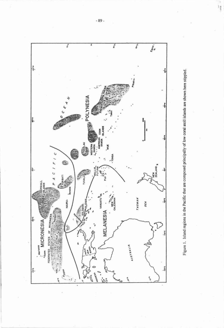
tq
-89-
El)o.a6
el).cF
'oEot,tsv,Etrall6
I(aEo()
'ob6o()tr.E
E6
eEo(,t)att
.rlt(,IE()a!Ao€tratroooertg3qa
.:e=oo]L
t o'i
a2JUx
D
rIib
.aI
u,UJzoEI
rEo-it
. '..9
a
-4?a2I
t
-90-
with migratiolt options within states. Most of the discussion that follows, and particularly that concerningKiribati and Tuvalu, is also exremely relevant for both the Maldiies (for a recent review see pernena &Sestini, 1989) and Ausualia's Indian Ocean Territory, the Cocos-Keeling Islands, whose sinrations 6:every similar. The paper reviews past developnents ard problems in Ore atoll states and speculates on thepotential impaca of climate change on fu$re developnrent snaegies.
ISLAND POPI.JLATIONS
The four atoll states are quite different in language, culture, hisory and in their physicalenvironmenl Tuvalu and Tokelau se pirt of Folynesia; drc Manhall Islands and Kiribati are inMicr,onesia. The state of Tuvalu consise of nhe coral aolls and reef islends widr a otal land area of nomorc than A krnz, spread over a disance of 590 krn Kiribati has 20 populaed atolls (including Banaba)ani a land area of 700 bn2, but nnre than half of dris (363 kmz) is on Christmas Islurd (Kiritimati) rcnrc3,500 kilonretres away from Tarawa, drc national capltel. The Mrshall Islands hes 24 populated aolls,but most of the population lives in the capital M{uro, a ur Ebeyg cloce 0o tlre American missile rangeon Kwajalein atoll. The popnlation density in T*elau Clable 1) is significanrly less than in the ottrerthree states, partly becarse of substantid migration to New ?r:rlanq where a majority of Tokelauans nowlive.
Kiribati is the easternmct and southernnpst part of Micronesia. Tuvalu, once 0re Ellice Islands, is partof Polynesia, and there are indications that colonisation there may have been as r€cent as the sixteendrc€ttury (Munro, 1982:7) not long before the great Spanish explorer, Mendana, sighed at least one
HOLOCENESEA LEVEL
CHANGE aL
ooo\o
?\ti
b--€--6r9-f - I
lVaterdepth
I
flcue 2' Foltowing the last glaciation, Holocene sea levels rose rapidly (the pfM) to a maxinum abour6000 yean ago, then subitised or fell slightly. Predicted greenhouse effects may cause a renewed sealevel rise at a similar rate to the pMT.
-91
of the aolls in 1568. Further nath QuirG sightod thc Kiribari aioll of Butaritui in 1606, bur it was notuntil fte 1820s drat Europcrn contrct bcgm o influencc thc uajccmy of dcvelqmenr The Tokelauatou of Atafu was fint sightcd by Europeans in 1765, wtren it was uninhabitc4 but at second conlact inl79l it was inhabitcd. Tokelau was severely affeced by the Penrvian labour radc of rtre lg6os which lodto a drastic reductisr in thc pryulation (Maurlc, l98l). Spmish voyagcrs reached the Marshall Islands inthe seveneerth cenurry md there was considerable contact with ;ad;rs, whalers and missionaries fromthe eighteenth c€nhry onwards. After thc sccond world wr the Manhall Islands becanrc pa't of th€united Statcs administered Trust Tenitory of the Pacifrc Islands. Tuvalu becanre indcpendcnt in l9?tard Kiribati in l9?9. The Mrshall islandr has a degree of autonomy, heving rchievedindcpenderre inassociation with dre USA in 1984' T*thu remains a Ncw Zcaland i,-ir*y -a rokelauansL citizensof New Zealand-
Table l. Atoll starepopulations
ManhallIslands Kiribatia Tokelau Tuvaluc
Occupied aolls
Total population
Mean aollpopulatior
Mean population(excluding cenral atoll)
Population densiry ftmz)
24
43,335(1e88)
1,905
?l9b
u2
l6
61,t86(1e85)
3,284
2,299
27
3
1,690(1986)
s63
563
56
9
7,y9(1979)
El7
653
2E7
Note: ArEas are land areas. Since lagoons provide maritinre rresources, variable lagoan areas are alsoimponanr Populations have grown significantly since the cer6uses to which these data refer.a' These data refs to tlte Gilbcrts only, thus excluding Banabr and dre Unc Islands.b' This figure excludcs the populations of both Majuro (irrluding l-aura) and Kwajalein (includingEbeye).
c' In 1983 m infornral c€nsus of Tuvalu wes undertaken; this head count gave a to,al population of8'364 within Tuvalu, of whom 2,620 were on Funafuti. A formal ceosus is due to be held in 19E9.
TI{E GREENHOUSE EFFECT
- The build-up of indusrial gases in the eartlu atmoephere over the past 30 o 40 yean is now welldocurrented (Bolin er al , l9E6 Pittock, 1988; Pearnran, l98t). The resulting .Grpenhouse
effecr, isexRlted to raisc temperaturBs over much of the earth's surface and bad to a rise in rhe levels of rheworld's oceans. Initiolly dre latter wilt conp about ttuough expansion of surface wa1g6 in the oceans andTElti$ of mountain glrciers (Bolin al al., 1986); not ontil rnu.tt t"ter will nrelting of rhe pola ice sheetssignificantly augnEnt tlre ocean volunps (Bud4 lggt).
Becausc of utrc€rtainty cortcerning the panern and exent of future hcating of the eardr,s surfaceand the rate at which hcat witl be absorbed by the ceans (Pirtab lgtg; Tuckcr, lg8g), rates ofexpansion of thc acens cannot be d€Erminod with any rcuracy. Ex&rrc scanarirx for the next 50yean range fr'orn virtually no change in mean sea levcl !o an elevatiqr nuny nEtrls higher (Hoffnra4
- 92-
1984; de Robin, 1986). In Ausrdia, values reprasenting an interrnediate range of 0.2-1.4 m rise in thenext 50 years have been adopted in order to consider possible implications of greenhouse for the funre(Pearman, 1988). The period of 50 yean was chosen because it is the upper limit of nost planning tirne-scales. The UNEP agreed scenarios for rcgional reviews arc 20 cm by the year 2035, md 1.5 m by 2100.
The basic impact effect of a grcenhouse induced rise in sea level is for low lying lands to beinundatedand forcoasts toerode (Short, 1988; Thom & Roy, 1988). Erosion, as opposed to inundation,is likely to be moet sev€re on shorelines compced of unconsclidated sediment exposed to storm waveasack on high-energy coasts. Here, a gradual rise of mean sea level will progressively lift the zone offlmding, storm wave set-up and surge effects to new levels thus eroding areas hithero csrsidered safe,Human responses will vary depending on the values of the coastal land under attack and the resourcesavailable to provide protective measures (Roy & Thom, 1987). In Pacific atoll sBtes where resources arevery limited, the provision of expensive engireering works will not be a commonly available option. Arecent expert meeting (UNEP, 1988) stated that 'engineering solutions (such as large dykes and walls) arenot likely to represent a realistic long-term solution o the problem of rising sea level, except in veryspecial cases. Social adapation and land-use change will be the most appropriate responses to sea levelrise' (UNEP, 1988 p.161).
ORICIN OF ATOLLS
Atolls are accumulations of the remains of calcareous reef-forming organisms usually arrangedinto a rim around a cennal lagoon, found in tropical ocean waters within 20' ladnrdes of the equator. Thegeological origins and geomorphologicai feabres of atolls are reviewed by Sullivan & Perneua (thisvolume), but most coral atolls comprise a succession of old weathered limestones that form an irregularsubstrate on which the most recent (Holc,cene) deposits have accumulated (see Figure 2 in Wheatcraft &Buddemeier, 1981). Intertidal and shallow subtidal areas that form the atoll rims and reef flas arecotrr,posed mainly of coarse coral detrinrs; these deposim reach thicknesses up o 25 m (Wheabraft &Buddemeier, 1981; Davies & Hopley, 1983), but in some cases, such as Mauiva in French Polynesia(Pirazzoli & Montaggioni, 1986), may be as thin as 2 m. Reef-rim deritus becomes finer towards Brelagoon (e.g. Ayers & Vacher, 1986) where tlre main sediment types are biogenic sands and calcareousmuds (Figure 3a and b).
Variations in coral assemblages and growth styles reflect exposue of atoll margins to prevailinguade winds (Wiens, 1962; Hopley, 1982). Typically, atoll rims are higher and narrower and reef flats arebetter developed on high-energy, windward coasts (Wiens, 1962). Here, slorm waves deposit coralrubble that progrades lagoon-ward in washover lobes (Wiens, 1962). Storm ridges and spis of coarserubble that build above sea level act as nuclei around which grow small islands (motu) (Figure 3c).
Radiocarbon dating studies (Davies & Hopley, 1983; Horiey, 1982; Hopley & Kinsey, 1988;Manhall & Jacobson, 1985) show that, in most cases, upward reef growth lagged behird rising sea levelduring the Postglacial Marine Transgrcssion (PMT). It was not until one or two millennia after sea levelstabilised that reef building corals rerched shallow sub-tidal depths; herc living corals became vulnerableto storm erosion, at least on windward coasts. Much of the rubble that the storms generated is washedlandwards. This rubble together with in situ reef beconps cernented in the int€rtidal zone to create reefflats (Figure 3b), forming the foundation for islands of cdcareous sand nd cord rubble built above sealevel (Hopley, 198?).
Islands on atoll rims vary enormously in size and shape but all are composed of mixtures ofcoraValgal rubble and calcareous sand and rarely rise more than 3 m above mean sea level (Wiens,1962). Cementation in the intertidal and even supratidal zone (Montaggioni & Pirazzoli, 1984)undoubtedly contribute to tieir stability. However, the occurrence of exposed and eroding outcrops ofbeachrock/coral conglomerate on the one hand and newly formed boulder ridges and sand spis on theother indicate that islands are constantly changing shape (Wiens, 1962; Hopley, 1987).
ATO.I.L ISLANDS
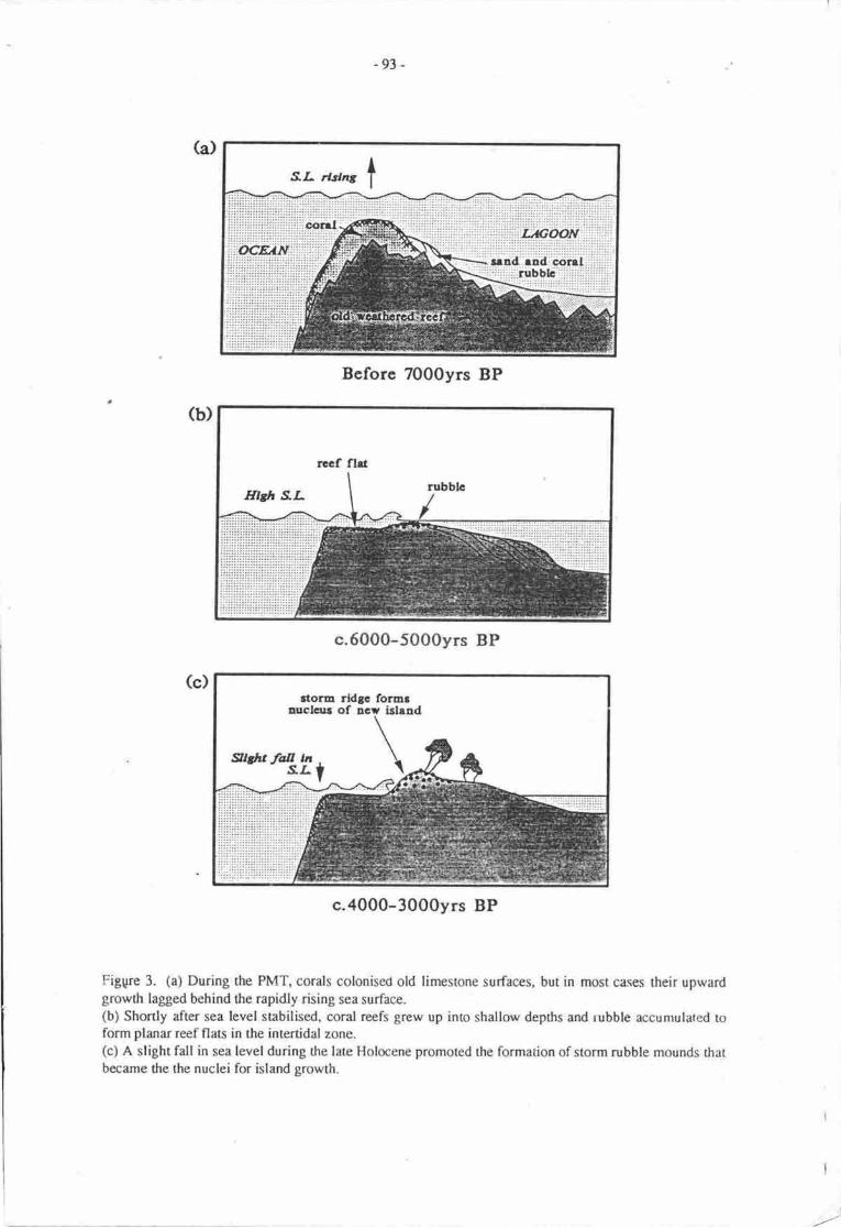
-93 -
Figgre 3. (a) During the PMT, corals colonised old limestone surfaces, but in most cases their upwardgrowth lagged behind the rapidly rising sea surface.(b) Shortly after sea level stabilised. coral reefs grew up into shallow depths and rubble accumulated toform planar reef flats in the intertidal zone.(c) A slight fall in sea level during the late Holocene promoted the formation of storm rubble mounds thatbecame the the nuclei for island growth.
Bcforc 7000yrs BP
c.6000-5000yrs BP
c.4000-3000yrs BP
l
-94 -
The building of aoll superstructures, especially islands, results from a combinarion of prcesses ofsmall scale erosion and accretion, that can be observed on a day n day basis, interspened by catasrophicchanges caused b1r extremely viok'nt siornrs (cyclones and hunicanes) that occur quite rarely. Series ofbeach ridges and recurved spits shorr that islands with these feanres have undergane a net building oraccretionary phase sometime during rhe last 2,00-3,000 yers. In contrast, features that indicatecontemporary erosion include tidal channels intersecting islands and 'makatea' surfaces around islandmargins and on reef flats.
ISLANDECOI.,OGY
The terrestrial flora (and fauna) of atolls is of limited species divenity, espocially in comprisonwith high islands. Wiens (1962) points out that species numbers vary considerably between islands andthere seems to be a airect relationship bemeen diversity and island size and rainfall (Wians, 1962: Table21, Fig. 91). Some islands are reported to have more than 100 plant species (including many that wereintroduced by Europeans) but only a few are commonly used for food. The main food crops are
coconuts, breadfruit, taro and pandanus. ln wetter conditions crops such as bananas are also cultivated.
Swamp taro and Cyrtosperma are sensitive to salinity changes and grow in low areas, usuallymanually excavated (taro pits), in the central depressions of islands; on occasion, notably after slorms,salinity causes a substantial reduction in taro productivity (e.g. [*vin, 1976; Bates & Abbott, 195E).
The capacity of the islands to support human populations is closely tied to the existence ofpermanent ground water (Wiens,1962). Islands about 1.5 ha and 200 m in diameter (Clou4 1952;Wiens, 1962), contain a permanent lens of fresh water. The volurne of this lens is roughly pruportionalto the surface area of the atoll. Other facton influencing fte charrcter and behaviour of the freshwaterlens include annual rainfall, perreability of the rocks beneath the island and mixing due to storm or tideinduced pressure gradients (Buddemeier & Holladay, 19?7; Ayers & Vrher, 1986; Jacobson & Taylor,1981; see also Buddemeier & Oberdorfer, this volume).
In Kiribati, where grornd water is the main sourcre of drinking wat€r on nrost islands, populationshave been fmced to migrate temporarily to arcas with higher rainfall. On Eauripit cyclone disruption ofgroundwater supplies has forced bathing in salt water (L.evin" 1976| However, the rnost severc dueat topernanent water supplies is not frrom climatic frcon directly, but ruher from marine processes thatcause coastal erosiqr and incrcase dre frequence of strm overs,ash. Figue 4 showr in generalised fonrlthe relatimship benveen the dinrnsions of the ground waer lens and island size, exp,ressod in urms ofwidth, and illustrates dre dramatic effect of a 2Wo reduction in island width which roduces by half drevolume of freshwater. Thus any decline in island rea has a very dramatic influence on the availability offreshwater supplies.
While coastal erosion is closely linked to raised sea levels in general thories such as thatproposed by Bruun (19E8), quantitative rclationships have yet o be established for coral islards. Clearly,for a given rise in sea level, the arnount of crosion will dcpend on the composition urd height of aparticular islan{ is exposure to wave attack and current :rmion and the frequency and intensity ofstonns. Corrceivably, in fie next 50 years tr so, greenhouse effect shoreline ermion rates in the order ofl-2rnlyear could reduce he dinrensions of sonre prcsently inhabited islands to the lnint wherc theirground water supplies would no longer support viable ecosystems or p€rman€nt habiution .
THE ATOLL STATES
Coral reefs with their low sandy islets provide the rrost limitcd ra.rge of resources forhuman existence and the nrost tenuous of habitats for man in the Pacific. Thc soil isinfertile lacking humus, and fresh ground water is very linied- Maintaining a livelihmdis a considerable ask for man. (Thomas, 1963:36)
Abll life, albeit witlrout reference !o marine nesources, represents a situation *here subsistenceproduction was often extrernly difficult and dre tasts of generating ury rerl surplus eyen more difficult
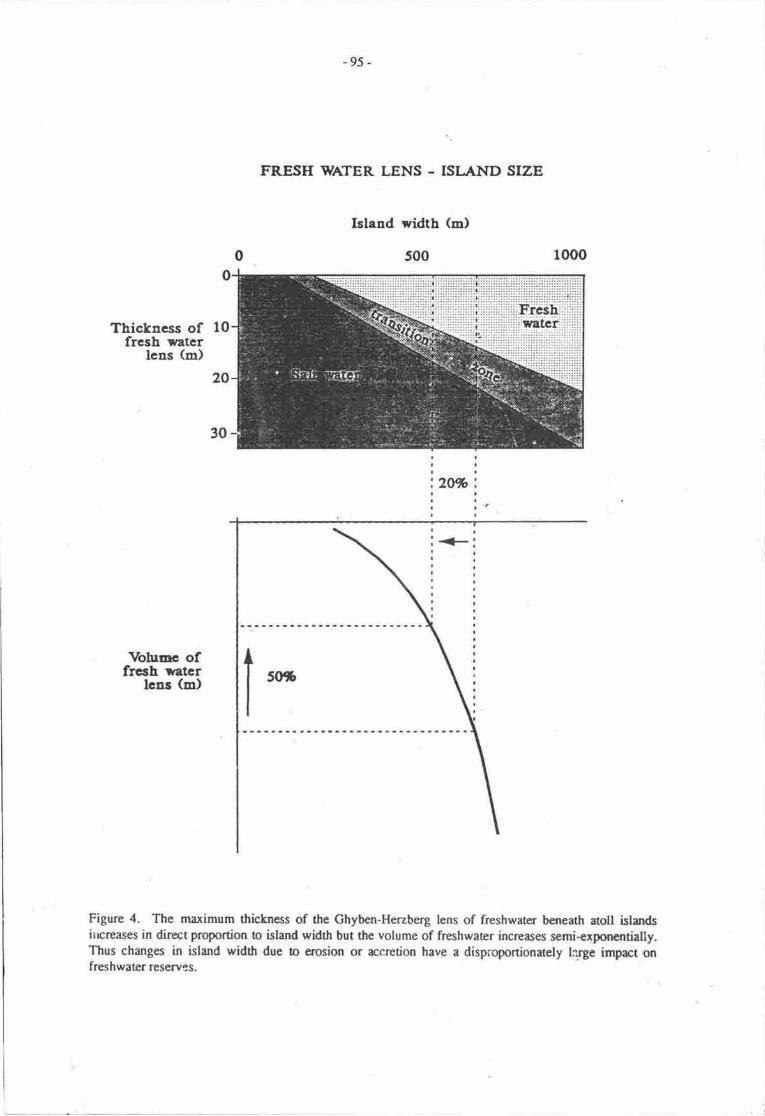
-95-
FRESH WATER LENS . ISI-AND SIZE
Island width (m)
s00
Ttickness offrcsh *ater
lens (m)
2W
Vohrnc offrech *stcr
lenr (m)
Figure 4. The maximum thickness of the Chyben-Herzberg lens of frcshwater beneath atoll istandsitcreases in direct proportion to island width but the volume of frcshwater increases semi+xponantially.Thus changes in island width due b erosion or accrction have a disproportionately lcrge imprct onfreshwater reservrs.

-96-
(Bayliss-Smith,1977:327-8). Aoll life was always fc fiom that portnved in images of the suppooedlyidyllic Prcific islands. The naurre of society and economy in island groups where hazar4 hunger anddisease punctraad perids of well-being and where population growth was carefully cqrtrolled srd warsin punuit of both land md power were comrnon, especially in Kiribad, rhe Manhall Istands and Tokelau,was quite different frorn the Western idyllic view.
Atolls vry enormously in land and lagmn aea; in rainfall, and in flora and fauna. Their ability tosupport human popularions differs as does therr ability to prcvide sonre form of diversified development.Sonp atolls are smdl, aid, drought-prone and overpopulato4 as in the central Gilbert Islands chain, butwhere such conditions do not occur the potential for development is often quite differort. Nonetheless, incomparison with high islands, the diversity of resources is limited and natural hazards are usually but notalways, mone severc in their impacts; recurrent hazards such as &oughts, hurricanes and tsunamis havehad an important demographic and cultural role in the four atoll states (Vayda, 1959). In the past manyetolls have been depqulatod and repopulud following episodic evenB md migrations of various kinds(Alkire, l97t:28-30). In rccent tinrs Osborne has provided a vivid description of the dying phases of thesmall comrnunity st Merir atoll, Palau: 'the islurd is dying .. the women are too old o cultivate taro inany quantity and the rrr-n cannot keep the coconut groves clear' (Osborne, 196:49). Five years later theisland was depopulate4 with the few survivors having rmved to the mainland of Palau, an option onlyopen to atoll dwellers in political liaison with lrger islands and states. Generally, atoll populationsdeveloped cultural ties with other alolls so that, during periods of populatirrn-resourue i:nbalance, theirproximity o each other enabled economic exchange, personnel mobility and. on the rrcgative side,warfare and raiding (Alkirc, 1978:94).
Beyond these inherent constraints to subsistence producdon the rnodern era has increasinglydemonstrated the tyrannies of distarce that have rcstriced cmt€mporary develcpment. Aolls are tiny,with limited nesources, often distant from erch other and remoE fiom more substantial land masses.AtoU stat€s consequently face a host of developnrent problerns, often in rnore iroentuated form than inother island micro-states (Connell, 1988a). These problems inclu& limited skills, small domestic marketsize, high cost of imports and exports, restricted diversiry of expolts and subsuntial administrative cosL;leading to large trade deficits, balance of payrnents problems and c.rnsiderable dependerrc€ or foreign aidand technical assistance. In l9&4 fa example exports from Tuvalu r*ere valued at A$31.2,0@ andimports cost AS3,965,000; for the Manhall Island.s in 1987, US$3.61 rdllion and US$32.25 million; in1985 for Kiribati, A$6,06 million and A$21.58 million; and in Tokelau in 1984, A$2E,000 andA$145,000 respectively. In each case this discrepancy is worsenirrg ard ato[ sat€s have nroved rapidlyinto situations of extreme dependence on the outside wodd, pri:narily for aid, concessional rade andmigration opporurnities.
Aoll populations arc generally small in absolute terms, only tire few urban centres havesubstantial populations and these four aoll stales arc among tlre smallest island micro-states in the world-At an early stage in colonial history these rcsource-poor islands became sigirilicantly dependent on theoutside world for consuner goods, inciuding firodstrrffs (e.g. Munro, 1989). By the 1890s in bothKiribati and Tuvalu, pacifrcatiur, population growth and changing aspiraticrs had resulted in overseaslabour migration being dascribed as 'the only alternative to sta;vation' (Mrcdrrnal4 1982:53) in the sensethat population and donrstic resources were already recognised !o be in some degree of imbalance.Indeed in Kiribati and Tuvalu the Malthusian spectre had ben sighted; mid-nineteenth cenrury Tuvaluans'were genuine Malthusians. They fearcd that unless the poprlation was kept Cown rhey would nor havesufficient food' (cited by Bedford & Munro, 1980:3). A cenurry later 'few countries of the South Pacificserve to remind one so well of the so-called 'Malthrsian dilemma' as the two countries undercqtsideration with their rapidly expanding population pressing agairrst a limited and non-expanding srockof natural resources' (Fairbain, 1976:l). The situation was and is marginally better in the less denselypoprilated Marshall Islandc and Tokelau.
In every case modern health facilities and medicines have rssulred in niore rapid naturalpopulatict irrcrease in npst aloll situations; infants are more likely to survive. and diseases arc less likelyo be fatal, whih rnodcrn family planning is largely absent in the aroll states. Even during rhe early1940s, at a tinp when the r€settlemeot of Gilbertese islandcrs in the Phoenrx Islarrds appeiued successful,is instigata, H-E. Maude, noted that 'colsrisation npasures are rn fact palliatives only and for morep€rrnment nEans of population csrfol we must lmk elsewhere. The ultimate lrcpe for the Gilberlese
-97 -
people probably lies in drastic prryulation control' (Marde, l96E:342). For r tirn:, in tre late 1960s,Kiribati appeared to have a successful family planning sche.rp but it was shortlive( as was the case inTuvalu. The Manhall Islands now has one of dre fastest growing prrprlations of any san in the wald;widesprcad adoption has reduced the perceived nad for family plarming. As roll populatiurs increlsc,the problem of satisfying basic needs (e-g. housing, wrtcr and food) from lad resources also increascs.Although there has been little reseach on the humsr carrying caprcities of atolls (and it is invariably ruethat therc are p,rssibilities of agricultural intensification, vrietal improvement, and fishing &velopnrcnt),in a number of cases populaticr densities have reached extnemely high levels /Tabte 1) and develcpmentprospoc6 are limited. All atoll residents now demand some cash irronr for iems srch as clothes, fishhmls and kerosane). In sonr excepional cases, where pqulation densities, as on Eauripik in Fe&ratodSutes of Micronesia (FSM), have increased to the extent that all cocsruts produced arc eafer rattrer thanmarketed as copra (the only pmsible agriculnral export), the constrainrs are particulrly severe (tcvin,1976). In this case, locally ganerated irrconp is earned almost entirely from handicraft producticr.Eauripik may be exrenn (with a population densiry of 950 persons/km2 in 1980), but its limir€ddevelopnrnt options reflect the essential problems of atoll developrnenl
Throughout dre aoll states, the limited agriculnral base of the raditional €conomy has declined incolonial and post-colonial times. The nrost dramatic docline has bcen in the dominant base of thateconomy, the uro pits, one of the more lal,,our-intcnsive rgriculoral jystenu in the wmld and rndindication of the inherent diflrculty of local agriculnrd production. In urban areas, notably in Ma.;uro,relatively few are now left. Artisanal fisheries have expcriencod a similar but lcss dramuic transition,which has followed the dcpletian of in-shore an4lagmn specbs, indirectly conributing o the necessityfor rnorc labour-interisive Frshing practices. In every case thcre appears to have been r dechne in lcalproduction per capita, pralleled by a transition o imported food especially rice, which has followedchanging tastes, prcfercnces, c{rny€Nlience ard so on This traruition has becn so subsuntiel thu in eachstate, impored foods and drinks now constiutte about 35% of dl imports by value, a substantial drain ondorrrcstic resouroes. This is rxlst extrcme in the Marshall lslsrds wherc r recent rcliable estimatesugS,ests that 7 5% of dl food consumed in the country is importcd (Marslwll Islurd,s f ouna| 13 January1989).
Limited subsistence agricultural productiwr has been dramatically emphasised since rhenineteenth cenEry by the 'cocqlut overlay' (Bedfont, 198O48) that has transfornnd the economy ofatolls by enabling participation, however limite4 in the international ecornmy through copra productionard sales. In the Tuamotu amlls of Frcrrch Polypsia cconut plantation werc directly rcsponsible for thecomplete disrypearurce of the forrmr agriculural economy (Ravault, 1982). This solc hisoric Comsticsourc€ of income, copra productioq has continuod ino the present, atrhough in recent yean productiurdoes not appear to have grown significantly. Nonetheless, even on the more urbanised islands, irrcludingMaiuro, copra is still produced because of its caprcity for dfuectly generating some cash irronp. Therelative significance of copra inconrcs for househotd and netiond incomes has doclined howev€r,especially in the post-war yea$, as atoll dwellcrs havc discovcrod that they havc a me{rop ecstomy,and that this single crop has a falling pice on the world market Ncessry activities, srrch as cocdtutreplmting, are often postponed indefinialy and cqra production offers an incrcasingly frryih basis frthe consuuction of a nrcd€m ecqlomy.
Though fish and otlrer mrine resources have often becn donnsticalty matetd on a small scale,marine r€souces have rarely been exportod from the atoll statts. In rece'nt yem, however, here has beensome expansion of dornestic fishing flee6, oftcn iluoughirint venoue oper:atiens, and fish have bcconr agrow:ng sounoe of national incorre, pnrcipslly in Kiribati and Tuvdu. Mrrh mar irnpmtmt has b€enthe leasing of fisheries walers for the fles of ovenscas fuhing vessels, irrludirE, for a brief perioC treleasing of Kiribati wacrs b the Soviet Uniur (Doulma& l9E7; Tabai, 19t7a). Through vriqrs bilatcraland multilaeral aSreetmnts, fishcries hascs now rcpr?scnt a major source of donstic inconr for theatoll states. Income is however, substrntidly less thur the value of drose fisherbs. Evcn thc combinationof revenue from fisheries and copra does not providr high reurms for tre rtoll states, npst of whosenatimal irrcomes arE now exErnally generaed in a rpn-rade nunner.
All aoll states ce part of the intcrnuiqral economy, and the aspirrtions of aotl people aregcnerdly those of peoplc elsewhere, including; improved serviccs healft, cdrratian; remunerativeemploynrnt opporurnities, and consumer goods such as inrporrcd foo4 clothes, outbord mobl!,
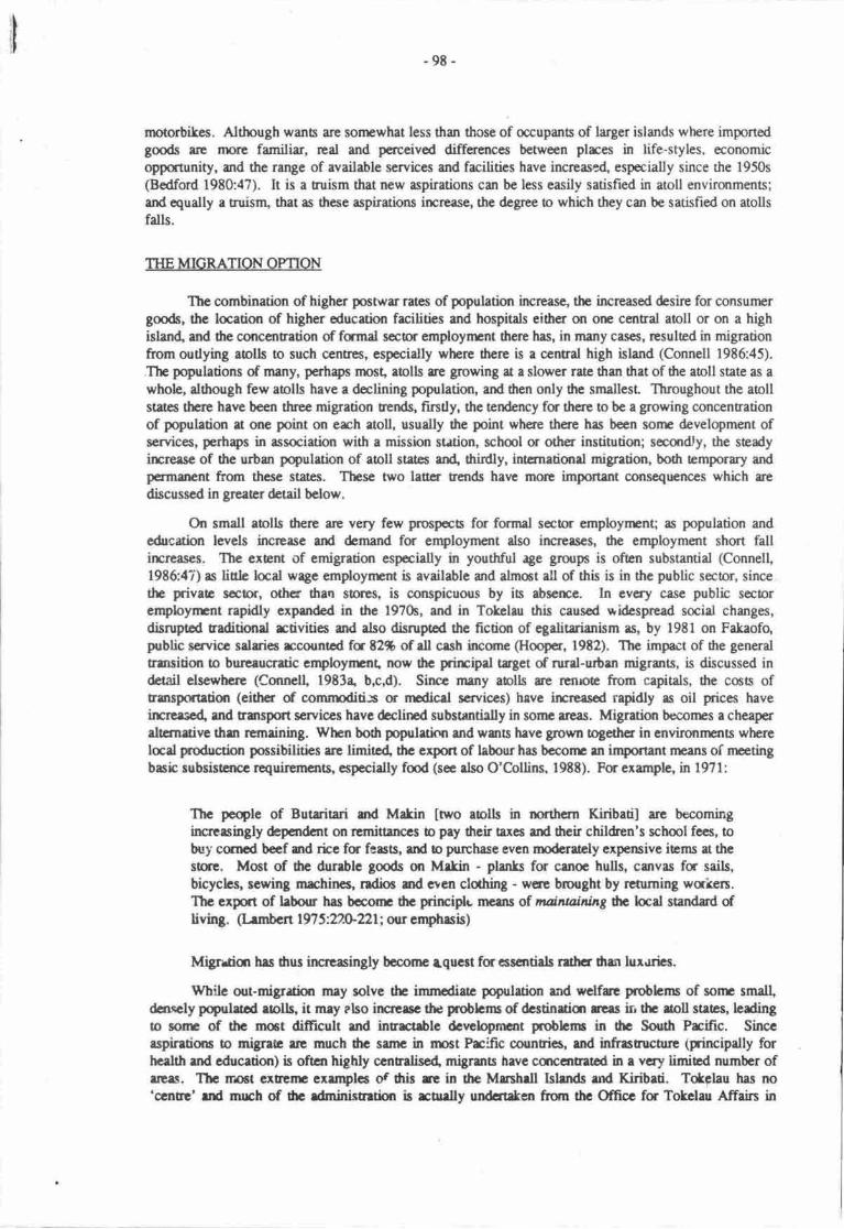
-98-
rnotorbikes. Although wants are sonrwhat less than those of occupan6 of larger islands where importedgmds are nnre familiar, real and perceived differences between plrces in life-styles, economicorpportunity, and the range of available services and facilities have incrcas'i, especially since the 1950s(Bedford 1980:47). It is a ruism that new aspirations can be less easily satisfied in aoll envirorments;and equally a tnrism, that as these aspiruions irrcrease, the &gree to which they can be satisfied on atollsfalls.
TTIE MIGRATION OPTION
The combinarion of higher postwsr rates of population increase, the increased desire for consunergm&, the location of higher oducation facilities and hospitals either on orr centrd atoll or on a highislan{ and fte concentration of famd sectm employnEnt th€r€ has, in rnany cases, resulted in migrationfrom outlying ablls to such centres, especially where there is a central high island (Connell 1986:45)..The populations of many, perhaps rnost, atolls re growing at a slower rate than that of the atoll state as a
whole, although few aolls have a declining population, and dten only thc smallesl Throughout the aollstatcs ttFre have been three migration trends, findy, the tendency for there o be a growing concentrationof population at orrc point on erch atoll, usually the point where there has bcn sonr development ofscrvices, perhaps in association with a mission station, schol or other institution; securdly, the seadyfurcrerse of the urban populuion of aoll stat€s an4 thirdly, intcrnationd migration, boft temporry andpcrmment from thcsc states. These nro laucr fcn& harrc more important oonsequences whbh rediscusscd in greater detail bclow.
On small atolls there are very few pnoepecs for formal sctc ernployrrFnt; as population andcducatbn levels irrcrcase ard &mand for employrn€nt also increrscs, the employment short fallircreases. Tlre exEnt of emigration espocially in youthful rge groupc is often substantid (Connell"l9t6:47) as liule laal wage employnrnt is available and almmt all of this is in the public sector, sincethe privaa soctotr, othcr han sffi€q is conspicuous by is abserrce. In evcry case public secorenpbynrnt rapidly expan&d in thc 1970s, and in Tokelar this caused *idcspread social changes,disruptod traditiond rctivities and also disrupted thc ftction of egditcianism as, by l9El on Fakaofo,prblic scrvicc salrics rccountcd fq t2% of dl cesh incone (Hoopcr, 19t2). Ttr€ impact of the generaltrmsitim o bueaucratic empbynrnt, now thc prfurcipd trget of rurd-urban migrurts, is discussed indaail elsewhqe (Cqup[ 1983a, bp,d). Sfurcc many ablls eE r€nr@ from capitds, 0re ccb oftrmsporntim (eithcr of comrnoditi:s or mcdicel scnrices) have ircrerscd raprdly as oil prices haveLrrersc{ rnd trmsport services have doclined sulstfitirlly in sonr rreas. Migntion bccorps a cheaperdtcrnative thgr rcrneining. WlFn bodr populrtion rnd wsrts heve grown togettrcr in envirurnsrts wherelcd prodrction possibilities are limitc{ thc expat of labour has bcconr m important npans of rrcetingbask subsistcoce r€qufuerrunts, espccidly fmd (sec also O'Collins, l9t8). For example, in l97l:
Thc peqle of Butaritari md Makin [two aolls in northcrn Kiribati] arc becomingincrersingly depcndcnt on remitanccs o pry their exes .rd their childr,en's schml fees, tobuy ccnod bef sd rbc fq fersts, ud o purcbase cven nroderalely cxpensive icms at thestd?. Moet of dtc &rrble goods ur Mrkin - flanfs for cenoc hulls, csrvas fu saih,bicych.r, sewing mrhincs, rrdios md cren clching - wcne bmrght by tttuming wcken.Thc cxport of lebour has bccom hc principl'! nrcms of nuinuining hG hcrl standad ofliving. (trmtcn 197 5:Db22l ; utr emphrsis)
Mignticr hrs dtus inccasingly bcconp r.qucst forcssantials rahct fim lur,rbs.
Whilc out-migrrti<n mey solvc thc immodiatc population and wclfuc problem of sorrl small"danrcly pqulecd $olls, it mry elso incrprrc the poblcms of dcstinuian rtes in thc aoll strer, lsding!o sorrc of thc mat diffrcult md inrraeble dcvcbprurt problcmr in $G South Prcific. Sinc!rspintiou to migrrc rrc much thc sarnc in nmet kific countrics, rnd infrrsmcnue @rincipdly forlrcrlth and c&rcation) is oftcn highly ccnralisc4 migrsna have cocantretod in e vcry limicd number ofupes. Thc m6t cxurnE exrnplcs or fiiE rc in thc Mrshdl Ishds rnd Kiribrti. Tokplau has no'certts!' rnd mrch of $c edninistntln is rtu-lly urdartrk€n from thc Officc for Tokclau Atrein in
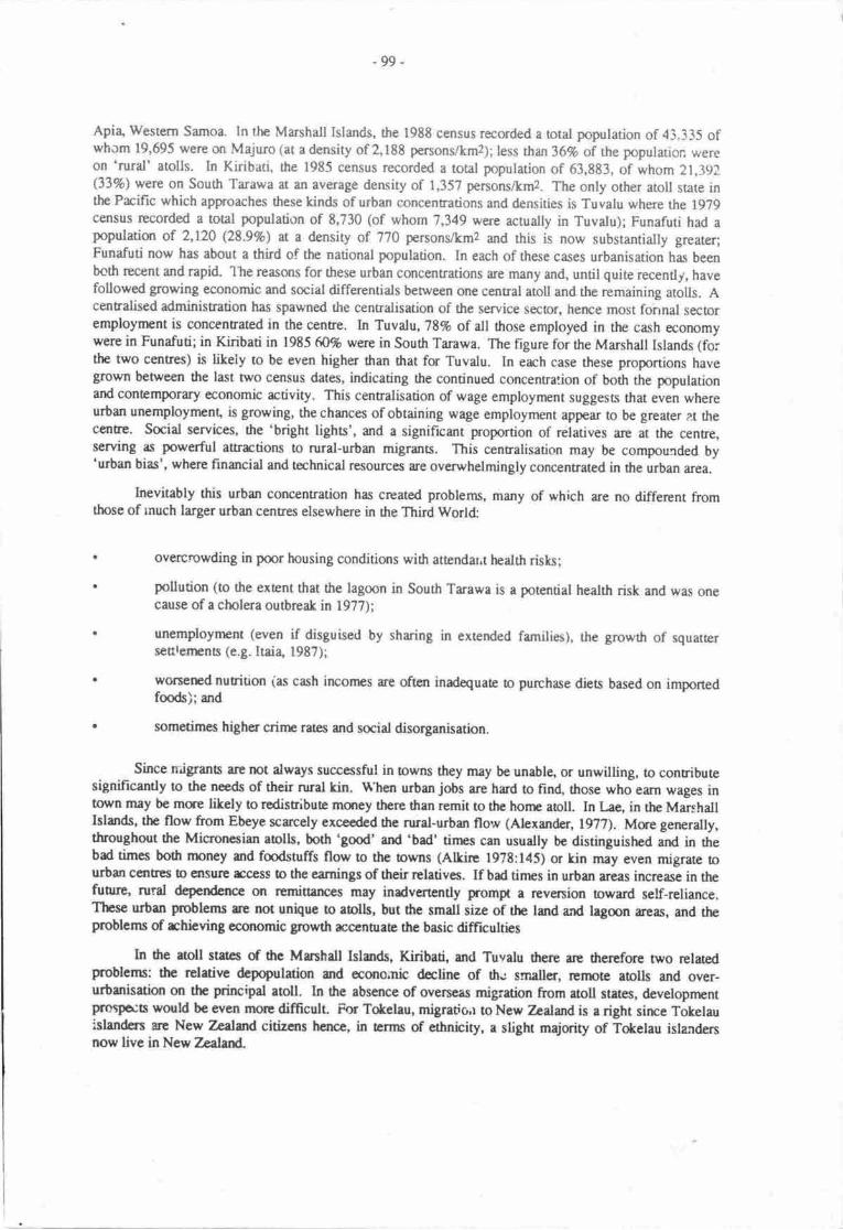
-99-
Apia, Western Samoa. In ttre Marshall Islands, the 1988 census recorded a rotal population of 43.335 ofwhom 19,695 were on Majurolat adensity of 2,188 persons/kmz;;less than 36% of the popularion wereon 'rural' atolls. In Kiribati, the 1985 census recorded a rotal population of 63,883, of whom 21,_191(33%) were on South Tarawa at an average density of 1,357 penons/km2. The only other atoll sute inthe Pacific which approaches these kinds of urban concentrations and densities is Tuvalu where the 1979census recorded a total population of 8,730 (of whom'7,349 were actually in Tuvalu); Funafuti had apopulation of 2,120 (28.9%) at a density of 170 personVkmz and rhis is now substantially greareriFunafuti now has about a third of the national population. In each of these cases urbanisation has beenboth recent and rapid. 'lhe reasons for these urban concentrations are many and, until quite recently, havefollowed growing economic and social differentials between one central atoll and the remaining atolls. Acentralised administration has spawned the centralisation of the service sector, hence most fonnal secloremployment is concentrated in the centre. In Tuvalu, '18% of all those employed in the cash economywere in Funafuti; in Kiribati in 1985 (t0% were in South Tarawa. The figure for the Marshall Islands (fo;the two centres) is likely to be even higher than that for Tuvalu. In each case these proportions havegrown between the last two census dates, indicating the continued concentra:ion of both the populationand contemporary economic activity. This centralisation of wage employment suggesLs that even whereurbanunemployment, isgrowing, thechances of obtaining wage employment appear to be greater a.t thec€nE€' Social services, tte 'bright lights', and a significant proportion of relatives are at the centre,serving as powerful aErrctions to rural-urban migrants. This centralisation may be compourded by'urban bias', where financial and technical resources are overwhelmingly concen8ated in the urban area.
Inevitably this urban concentration has created problems, many of which are no different fromthose of lnuch larger urban centres elsewhere in ttre Third World:
overcrowding in poor housing conditions with attendar.t health risks;
pollution (to the extent that the lagoon in South Tarawa is a potential health risk and was onecause ofa cholera outbreak in 1977);
unemployrnent (even if disguised by sharing in extended families), the growth of squauersettrenEnE (e.g. Itai4 1987);
worserrcd nutrition (as cash incomes re often inadequate to purchase dieu based on importedfmds);and
sometirnes higher crirne rarcs and social disorganisation.
Since niigrants are not always successful in towns they may be unablg or unwilling, to conributesignificantly to the needs of their nral kin. tr\hen urban jobs are hard to find, those who earn wages intown rnay be mse likely to redistribute mqrey there than remit to the hone atoll In l,ae. in the MarshallIslands, the flow from Ebeye scarcely exceeded the nral-urban flow (Alexander, 1977). Mue generally,throughout ttre Micronesian aolls, both 'good' and 'bad' tirnes can usually be distinguished and in thebad times both rnoney and fmdstuffs flow to the owns (Alkirc l97t:145) or kin may even migrate tourban centres b €nsur€ rcoess to the earnings of their rclatives. If bad tinps in urban areas increase in thefuoue, rural dependence on rcminances may inadvertently prompt a reversion toward self-reliance.These urban Foblems ee not unique to ablls, but the small size of the land and lagmn aeas, and theproblems of rchieving economic growrh accenurate the basic difficulrics
In dte aoll states of the Mrnhdl Islsrds, Kiribati, and Tuvalu trere arc therefore two relatedpoblems: the relativc &population and eono.nic decline of th.; smaller, rernote atolls and over-urbanisation on the principal atoll. In the absence of overseas migration hom atoll states, developnrntprosfts would be even morc difficult. For Tokelau, migratio.r toNew ?:alalrrdis a right sirre Tokelauislanden ue New TrAWrd citizens hence, in arms of ethnicity, a slight majority of Tokelau isla,rrdersnow live in Ncw Zealard-
- lm-
the idea of permanent emigration, involvlng a s€vef,ance of many ties with r\e honr islandand of seeking one's for$ne elsewhere, is well established in Tokelau life and thought. Forthe pa-st 70 years or so it appears to have ben acce,pted ... that some of nearly every group
of siblings must ralu ('emrgrae') simply because the local resources are seen as
insufficient. (Hmper & Huntsman, 1973:403{)
Migration from the Mrshdl Islands (and hom the Federated States of Micronesia) to the USA ispossible under the terms of the Compact of Free Association; indeed dre island states were anxious to
ensure that such a clause be in the Ccmpact. There arc currently few Micronesians in the United States
(Connell, 1988b) yer this may well change in the frrture to the extent that, as for Tokelau, Micronesianresidents of the United States may ouhumber 'the folks back home' (Marshall, 1979:10-l l).
Both Kiribati and Tuvalu specifically train a proportion of the national population for overseas
migration through their Marine Training Schmls. Apart from overseas seanren (representing 3% ad l7orespectively of the de facto population of Tuvalu and Kiribati), there were almost 722 (8.2%) Tuvaluans
ard 1,278 (2%) I-Kiribati employed on Nauru at the tjnre of the last censuses. The number of l-Kiribation Nauru has declined between 1979 and 1985 and will docline further and will end in about a decade,
with the eventud closure of tlre phosphate mine. Both countries ha"e sought res€ttlement and oveneasemploynrent oppornrnities and Tuvalu has fmmally located a handful of worktrs in New Zealand underexisting shon-term schemes. In the immediate future, however these two countries do not have long-term
overseas mi gration (or resettlenrent) opporurnities.
Movenrent overseas both reduces the pressure sr local rcsources and provides a substantia! cash
flow from remittances. When phosphate mining on Nauru ends, the developnrent problems of Kiribatiand Tuvalu will be considerably worsened, because of the loss of remit:ance income, the inc:easedpopulation pressure on resources as these worken and their families rerurn, and the influerrce of these
returned migrants, hithero employed in tlre urban-industrial sector, on the values and attitudes of the
national population.
The sigRificance of international migration for Kiribati and Tuvalu is apparent not only in the flowof remittances but also in changing local auitudes to intemational migration. In prc-war yean the
colonial adminisnation decentralised part of the population of the morc dansely pqulated Gilben Islands
to the Phcenix Islands group to the east (Maude, 1968; Knudson, 1977). At mrrch the same time groups
of villagen from Vaitupu in Tuvalu purchased land in Fiji fu their own private rcsenlenpnt (Koch,1978). L&al and colonid perceptions of population density and donpstic developnutt prospects wer€quite similar. For various neasons seulcnpnt of fie Phoenix Islands was unsuccessful and the senlerswere agdn transplantod, this time to the then British colony of the Solornon Islands, where they and theirdescendants remain. In Kiribati these settlers ar€ now viewed quite differantly from in the past:
ln earlier days they wcre the unfortunate ones who did not have suffFrcient land. Now ourvalues have changed. Sealing overseas beyond the oceans of our islands is some0dng to be
sought after. Why? Because our population :s still growinE,. So now, many consider thentthe resettled ones, the forurnate ones and they considcr us to be the unforhrnate ones.
(Schutz & Tenten, 1919:127)
Permanent internationd migration is increasingly viewed by many atoll dwe[en, though certainlynot all, as a key solution to many development problems.
Toleration and errouragement of international migration in Pacific atoll states is a function of itsimpact in reducing population pressure on scarce resources; attitudes o individual fteedom of movenrent
and, above all, the substantial flow of reminances thu follows internatimd migration. The flow ofremittances to Kidbati and Tuvalu an{ !o a lesser cxtent, Tckelau is large and increasingly crucial tohousehold and national welfare. Migration and remittances have tended to create an appetite for impotedconsumer goods, which has driven up wages. The rcmaining remi8ances, are, however mainly investedin stores or in the agricultural sector. However rural investment opportunides are normally so few that
migration is from a family perspective a rnorc lucrative investrnent than anything available at home,
- 101-
remittances can only be invested in increase4 if not necessarily improved, consumption. Although rhereare widespread assumgtions that remitrances emphasise dependency and produce nurl smgnation(Connell, 19E0) opportunities ftr emigratior and remitances are highly valued by islanders thmselvesand freedom of npvemert is given high piority. Migration is often linked or sponsorcd, with householdsor extended kinship units planning for and encouraging the migration of particular individuals, o theextent that in the smallest states, such as Tokelau and Tuvalu, Marcus has suggested the ernergelce of anew institution, the 'transnational corporation of kin', allowing kin groups to colonise and exploiteconomic opportunities across a wide range of environrnents (Marcus, l98l). Such behavircur is rnostapparent where domestic sources of inconre are least adequaE. In all South Prcific states, including theatoll statss, there have been no attempts to restrict international migration; rather have there beenatrempts to gain grcater concessionary migration oppornrnities overseas.
ln more dramatic form the growing perception of the household returns from migration has led toincreasing fertility rates, as least as dcumenaed in tlre case of Nanumea atoll in Tuvalu, where:
parerts actively hope to produce remittarce eamers and most feel that this necessitateshaving more than one son. As src worun said of her only son 'Orre is not enough. If hegoes away !o v,ork, tlpre is no one to look after nre here. If he stays and cares for rne, nocrte etrns any money overseas'. Another wonran rccognised thu her husband had beenright to insist that they rral.ed more children ... 'He said that if we had many children wemight have a smart one who could go on to school and get good work. He will be our roadto money and imported gmds'. (Chambers, 1986:28734)
This phenomenon has also been observed in other small islands that have becone dependent anremitunces hom migrans (Connell 1988a:29) and indicates not anly that family planning is unlikely obe chosen as a solution to developnrent but that popularion pressure on resouroes may wonen in theabsence of intern ational rrri gration opponuni ties.
It is scarcely surprising then that individuel migrans and hous"holds and also many observershave viewed the future of the aoll sEtes in ternrs of ircreased levels of international migratrcn. Arelatively recent rBvicw by Cutle of the possibilities for economic growth in Kiribati and other larger,less rcnrote and better endowed countries in the South Pacific concludcd that sustained increases irinconres would essentiatly bc po:sible only through greater dependence on migrarion:
The case of Kiribati exemplifies tlre dilemma in is starkest form. Even with fie mostqtimistic view of the poasibilities for fisheries or further developnnnt of thc coconutindusfy, the conclusion must be that continued ccnomic growth from is own resources isimpossible.
The rcceptance of a no-growdr opticn may be the mly rcalistic option for the smallcounries.
Nogrowtlr need not be synonynnus with poverty if the poesibility is established for peoplein stationry cqromies to miSrate ei0rer temporarily or pernranently It is even rnorediffrcult wher. whole sBtcs are placed in the poeition of having o chmcc betwcn, m drcme hail4 rcsricdng opportunitics fc their nationals to those avrilablc within their ownboundaries an4 or. thc otlpr, crerding thc rmgc md choicc of qporunitieo opcn oittdividuals by cioscr integraticr widr larger economics u thc possiblc cast of soneatEnuation of their natiand rnd culrunl idcntity.
lA policy of unrcsuictcd brrptrary tx pcrmarcnt migration b nEbopoliran cqrnficslwutld sccfii b be the aily onc that gives thc peqle of tlp small island counuice the chmcco clroce indivifud paths of dcvclopncnt within the wid.r wodd co'nmrniry. (Crstlcl9t*135-5)
ru2 -
Specifically contrasting Tuvalu with Tokelau, where Tokelauans can move freely a- citizens toNew Zealan4 Bertram has concluded:
For Tuvalu, where the British and the local elite ogether managed to push through atransition to formal independence, the key role for the new state will now be to recruit anew patron and to seek out new opporurnities for Tuvaluan labour urd capitat to penetratethe rest of the world. Closed country models, whether in the political or econornic reaftrlsimply do not fit the Pacific of the 1980s. (Bertram, l9g7:29)
Denied peilnanent overseas migration opportunities, unlike almost all other sutes in Micronesiaand Polynesia, Kiribati and Tuvalu have hitherto found opportunities in Nauru and on foreign ships. Afunre in which these decline or even Cisappear poses imnrense problems, not only in rehabilirating andaccommodating rnigrant workers but in coping without their reminances. As a former AustralianCommissioner to Fiji and Tuvalu noted: the people of Kiribati and Tuvalu shoulC be seen as 'economicrefugees' (Keith-Reid, 1984). It is ino that arcna that the iaclson Review of Ausralian foreign aid(committee to Review the Australian overseas Aid program [cRAoAp], l9g4) stepped.
The brief 'Executive Summary' of the Review auached sufficient importance !o the problems ofKiribati and Tuvalu to givelhem a special sigrrifircance denied to all other states except Australia's formercolony Papua New Guinea.*
Kiribati with a population of 6O,000 and Trrvalu w;th a popularion cf 8.Ctr0 have specialproblems. Their rernote and rninute land areas are heavily populated. They depend verymuch on remittances from their emig.ants and on foreign aid. Their long termdevelopment prospects are discoungng. In view of strt$tural problems which are-beyonatheir control and beyorul thc reach of aid, Australia should mak available timitedopportunities for inunigration from Kiribati andTuvalu. (cRAoAp l9g4:E)
The main body of the text scarcely extended on this summary although the Review singled outTuvalu as having 'a unique combination of minute size, tiny population and an almoet total lack ofresot[ces. It is a state without internal economic viability, and it will have to remain dependent onremittances and aid' (CRAOAP 19t4:l7l); it was also identified as having additional problems of landshortage, urban drift and high you0r unemploynrent (CRAOAP 1934:l7l). Kirib;d was seen asexemplifying the poblems of distance and communications; 'the country consists of islands with a totalland irrea of 690 km2, spread over a sea area of 3.5 millio;r km2 and rernote from the nearest developedcountry markef (CRAOAP 1984: 17 I ). Although the Review did not specificatly identify orher problemsin Kiribati those listed for Tuvalu are equally apparEnt in that country. Urban migration is particularlyserious in Kiribati and resulted in the unusual srd rather dramatic response oi formatty allocatingunskilled urban governnrent employnnnt by island quotas (Cormell, 1983a). Likewise communicationsproblems are at least as serious in Tuvalu, where the withdrawal in l9E3 for financial reasons of a limiteddomestic seaplane service resulted in the departure of Peace Corps volunteeis from every island exceptFunafuti, the capital. Though this aspect of the report was never &bated c acted upor in Ausraliq andthe more recent Fitzcerald Report (Arrsualian Government" 1988) rejected the possibility of anyconcessionary schenrc for Pacific Islandcn, it is indicative of the growing perception of severedevelopment problems in Kiribati and Tuvalu and the rcle that internaticrral migration might play inresolving thern Nonetheless a former Governrnent Economist and Planning OfRcer of *iritratl trassimply stated' 'Emigration, as proposed by the 'Jackscr rrport' is not an answer. This would result onlyin the removrl of the best of one of thc country's few resources i.e. its skilled labour, tJ serve othercountries and frrther frusuarc Kiribati development' (Pollar{ l9t?:6). Though there is sona truth in this
I Editors' fmtnote. The independent statc of Papua New Guinea is forrrcd from the Ausualian colonyof Papua (forrrrly a British colony) and the Trust Territnry of New Guinea (fornuly a German colony).
.103-
view, migration from Kiribati already occurs and there is no obvious shoruge of skilled labour that wouldbe sorved by rcducing migration.
Alongside the conribution of remiuances, a further substantial finarcial suppqt for nationalinconres of atoll stat€s is overseas ai4 welfare payments, subsidies and compens"tion payrrrnts ofdifferent kinds. So substmtial ae aid funds that the atoll states of Kiribati, Tuvalu md Tokelau,alongside Niue and the Cmk Islands, have been conceptualised as the Migrant Remittance Aid Based(MIRAB) states, where migrant remiuarrces and aid are the nnst important bases of the c6gromy an4through these flows, a government bureaucrrcy has beconn the prirrcipal source of wage and salryemployment (Berram & Waners, 1985). In the Manhall Islands direci exremal ruS) su-pport for greeconomy is even more subsuntial. Aid dependence has teket some unusual forms. In l9t? Tuvaluestablished an aid Trust Fund of A$27 million composed of direct cash donations 6om Tuvaru,stradidcnal aid donon. This fund is rnanaged by a subsidiary of the Ausralian bank, Vy'espac, and if it issuccessful Tuvalu will be able to live off the umual interest, thus disJensing with cqrventiqrat annual aiddelivery. The rnoney will be invested in a low-risk spread oi assets, including fixed-intepst funds,equities and property. The fund should enable Tuvalu tc cle:n its re.:unent deficit md contribute o long-tern: financial viability by earning an annual interest alnost mat of curent aid receips (Fisk & Mellor,1986)- The donors will have some abilitv t(, rmnitor the effectiveness of this fund in cantributing tonational developmenl In some rcspects the Trust Fund is based on the nearby srccess of the RevenueEquaiisation Resenre Fund (RERF), derived from historic phosphate revenue in Kiribati (Bertrarn,1986:820; Pollar4 1987). This fund is managed by a Lnndon ncrchant ban! supervisec by a Kiribaticommiftee chaired by the Finance Minisnr. In 1984 Kiribati received ext€rnal aid of A$i3.j million(vastly in excess of is exports) md received A$5.5 million from the RERF; a further $A512,ffi0 wasgenerated hom the lease of I u?cking station on Christsnas Island. 'Iokelau received New Zealand aid forthe frrnancial year 1985-86 ro rhe value of trlZi3.l million, and in 19t5, Tuvaftr received ai,l of A$4.6million. The Manhall Islands received a vastly grcater sum dran all of these from he United Statesalone. Cnly a very small proportion of the national income of atoll states is gen€rated within thosecountries, through comnrcdity, mainly copra and also postage stamp, exporti but is dcpendent onconcessionary extsnal support. However the concessisrary trade agreenEnts of the South prcific AreaRegional Trade and Economic Co-operation Agreenrnt (SPARTLCA) have poved of no use to counrriesthat manufrcture little (Tabai 1987b) and none of dte smt€s has any manuirctured erporrs. Aolls andaoli sarcs have moved a very long way from any sembla..ce of self-reliancc. Moreovi they have gonebeyond the traditiond support of coral clusters to d@rdenc€ on much mae disant nations.
T}IE IMPACT OF GREENHOUSE EFFECTS
Preoious sections have examined the difficulties of developrncnt in atolls and atoll statcs and notedthat there has been increasing rccotuse to migruion as the prcferred individual and household solutian totle challenge of developnrn! whilst Jp sars themselves have tended to boconp more dependent onovereeas aid- Rising sea levels can only wonen the probtems of rhieving developnnnt in atdl statesthough fie extent of the changes will vary rcmporally ar4 spatially in wayi fiat ue nor y-a prcdictabh.As noted previously there will bc ctimatic changes, in tfrms of differerres in minfall 6d s-torm freqrrcrrcyand rises in air and sea tempcreures. Coasal ersion may irrcreasc if sca level rise acceleretes beyogrdthe upwrd growth of corals ard this erosion will probably bc rcccntuared by drc grcacr froqucrry ofstonns. Slowly but inexonbly rtrere will bc critical envfuonmental ctrongej of an'unlnown rate anddimension.
ln some countries it will be exrenrely difficult b sssrs whd dtc :rnpacts will be. Theirrtertnopical cqrvergence zone is likety 6 shift rmthwrds, changing thc disribution of zones ofupwelling, urd hence alering the disribution of fish sbcts md Oui Ritreries. Sonr arees, includingpats of Papua Nw Guinea end Fiji, may erpaiance r dcgrce of dcscrtification (Baincs, l9t8; sce alsoMcGregor, this volume) At r local level funuc changcs .rc e\ren mqc diffrcult b asscss:
The consequenccs of changed climarc, irrlrding misod rir rnd scr Erlpcratu€s for thephysiol:gy of plano md animals md theh eobgbrl intcr-rclationshipc can only bcguessed at d this stagc. Ecologicsl lxtr€sses, too, will change. Thc fallcn lcrvca md
-10t-
nrigs which are the vegetation liner of forest and gnssland, for instance, will decay evenfaster than now, exposing bare ground rnorc readily to water erosion. (Baines, 19E8:9)
On atolls the relatively simple ecosystems enable some cqrclusions to be made with a greater
dcgree of certainty. A number of specific changes that affect atolls can be separately distinguished and
examined in four principal areas. These are, fintly, the drowning of barrier reefs, secondly, fte inrusionof saltwaer into coastal groundwater supplies; thirdly, the erooion of areas of flat lan4 and fourthly,storm damage to coastal installations, such as port facilities. Touism is not a source of irrcome in my ofthe atoll states under considerarion hence the disruption of coastal tourist facilities, which is likely tooccur elsewhere, will not b€ significant, though these problems will ceriainly discourage any futuredevelopments in that area.
The intrusion of sdtrvater into groundwater lenses will have direct effects on agriculture and onthe supply of potable water. The most obvious effects on agriculture will be through increased salinity intaro pits, lower productivity of the taro and hence a greater disinclination to continue with this labour-intensive agricultural activity. Increased salinity is also likely to lead to the decreased productivity of allother crops, including coconuts, pandanus and breadfruiu. Although coconuts and pandanus are
relarively salt-resistant, increased sdinity such as in coastal arcas of Thailand (Edey, 1985), has reducedproducrivity and killed off palms. There apper to have been no sodies of the relationship betrveen
salinity and agricultural productivity in the South Pacific region, although no species of fauna or florawill gain from increased salinity. lt seems likely that increased salinity will rcduce the potability ofgroundwater which, for most atolls, is currently of considerable significance, although prcfe'ence isusually given to reinwater for drinking. If incrcased salinity is combined with any long-term decline inrainfall, as is possible in some areas, the results will be even more serious, since the cost of waterpurification and desalination is extremely high. On some of the &ier atolls, including urban areas such as
Majuro, water supply is already a cntical problem. (ln the extrefile case of Nauru water is intermittendyimported). If and when groundwater becomes no longer potable human habiution will no longer be
effectively possible.
Erosiqr will both reduce the areas of land on atolls urd, because of their minimal elevation,incrcase thc swampiness and salinity of areas that remain above sea level. Areas imrnediarcly at risk willbe those areas that have previously been reclaired from thc sea, including patts of south Tarawa, andcauseways such as those between Betio and Bairiki in Kiribati and in Majuro. This loss of land willdirecdy affect rctivities and infrastructure, agriculture, hou;ing, road.t and'aintrips and will inevitablylead o a decline in agricultural production, increa.ed competition for scarce land in urban areas and nrcrre
disputes over land tenure. (Foru.rnately, the custom in many atolls, of land tenure being organised bystrips acrms the aoll from lagorn to ocean, is lil.ely to reduce the severity of such cmrflicts). The loes ofland will lead o a related decline in handicnft materials suclr as wood, pardanus and of firewoo4 whichis already in extremely short supply in urban areas such as Tarawa. Changes to reef ecology may have
far reaching impacts on anisanal fisheries.
lrn?acts are likely thereicre to lead to a substantial decline in agriculord pioduction, a possible
decline in fisheries productior, and a loss of vital water, rimber and firewmd nesourses. thus reducing thepot€ntial of the few resources in which tr-re atolls and aioll states currently demonsrate a degr:e of self-reliance. These problems will i'rcrease over tirne, and one extrer.rely pessimistic scenario even sug,ges8
that 'it is conceivable that sorne beselines for tenitorial seas and Exclusive Economic Zones would ha.,'rt
to be altered, decreasing the area of exclusive righs for marine nesources and reducing potential income'(Matos & Tifr-ln, 1938:51; c.f. Pernetta, 1988). These effects will mcur alongside cantinued rapidpopulation growth, and an irrcrease itt population pressure m existing resources, unless the changes
contribute to increased self reliancc in some other area this will lead tn an acceleration of the prcsent
pr@ess of dependence on metropolitan stetes. Within countries it is litely to frrnh€r encourage rural-urban migraion in search of the 'fast money' of wages and salaries rather than the increasingunpredicubility of agiicultural md fisheries inconps.
-105-
DEVELOPNGNT ALTERNAT YEq
There are altematives to the trends of population migration, dependency and over-urbanisation inthe aolls of the South Pacific but climate change will make such alternatives difficult to realise.Manhall (1979:11) has suggested one possibility, that'outer-island communities may undergo ademographic revitalisation as educated migrants, longing o re-establish their culural and ethrric roors,forego the urban centres and work owards building a new economic future in ttreir horne communities'.While there have always been minority movenEnb to re-esablish cultural identity, tlcse have not provedto be sn adequate sole basis for developmarl Where solutions exist they must be in the area of economicdeveloprnent and job provision. Yet even now there are massive constraints.
In Kiribati, a series of policies have been developed in an attempt to achieve more balanceddevelopment, including; improved rural education with the inclusion of raditional and practical skills;increased copra prices, by subsidy; the development and expansion of district centres, involvingdecentrdisation of government; and possible resettlement of the distant and sparsely settled Line IslandJ.The developrnent of the Line Islands, and especially Christmas Islan( has recenrly been given newemphasis in an auempt to decenralise population and development and reduce the high level ofurbanisation. Moves to establish vocauonal education in both Kiribati ald Tuvalu have been thwaned byoppoition from parents demanding a curriculum that includes the rcademic training that offers somepossibiliry of urban bureaucratic employment. In each of the aoll states there has been a focus onimproved fisheries and agriculore, to increase self-reliance, but success has been minimal; emphasis hasmoved away from agriculuue and marketing infrastmcure is minimal. Developnrent plans in each of thestatres haye been exceptianally difficult o trarulate into practice.
It is improbable that atoll sBtes can ever achieve a significant degree of self-reliance unless otallynew modeis fa developnrnt are dopted or significant new rcsources discovered. They are currentlyircapable of moving away from the present massive dependence on migration, aid and imported goods.The necessary elenpnts of policy rcdirection are clear: ag,icultural developnrcnt policies that stressdiversificatircn, food crop production and the use of new varieties of cash and s,rbsistence crops, landtenure reform and the taxadon of unused agricultural land; increasing concentration on the exploitationand dcvelopnrnt of the marine resources thu re the only obvious base of both export growth andimproved nurition; transpon and energy poticies that move away from the use of non-renewablenesolrces; job decenrdisation and dlaatisr (alang Kiribati lines); improved infrastructure such aswhsfs std eid poss; increascd emphasis on family planning. Sclf-reliance entails rcducing dependenceon imported 'necessities' including fcods, oil products, capital equipment, and expertise and this involveschanging consumption patterns es well as increasing local productive caprcity. Policies would be neededto chmge living styles at givcn inconrc levels - using taxes, pricc policies, dvertising, and perhaparatiming. This might also itrvolve increasing national ownership of asses and improving nation.alcryrcity for negotiaing with trrnsnational corporations and nntnopoliun countries, especially, in thiscontext, those with fishing flects (c.f. Sc€rs, 1977). In shoG self-reliance cntails a nDrB selectiveaporch to cxtcrnal influences of dl kinds. Fs aoll states he probbms of rchieving a grcatsr degree ofsclf-relimcc are severe. Self-reliance runs counter to the develqm€nt trerds of 0rc pct-war decades, isprofoundly unscrrctive (Benranu l9t7:2t), requires suble political authority in what are currently 'soft'stat6 srd is inherently unlilely !o occur.
A nnvernent oward thc sclf-suffkicrrcy in Aoll Stres, wi0r a rcduction of aid and r€m:Eanceswotld bc difFrcult and painful cspccially fs thc yCIrng as they run countcr o perceived tends inttltropolitsn countries. In nnot places young peopbs aspiruiurs arc firmly directed towards thercquisititxt of nrodcrn goods m4 s hs bccn argucd fs 6c small island of Rauma 'with dre prestigegivel o 'fceigr' goods, it is doubdrl thcrefors thu Rcumans would want o bc sclf-sutficient, even ifthet wclr a possibility' (Plang 19?E:174). In Tikopia Firdr (lgl:69) staes thd ,from such a level ofdependcnce on impcted goods it bccornes diffrcult to rctrGat widrout un€ap and a sanse of deprivatim'.ln Furapc, tog villagen are not inuestod in @uaE subsistence, nr ev€n 'the right b subsisEnce' butrahcr they dcsirc 'continucd rnd ircrearsd rcoess to the gmds ard prartigc piovided by enploynrent'(FeErs€o, 199:37). Whih thcsc stetcrncric refer specifically o small islands nther thsr aolls, sncheaiodcs ere bocoming ruc of nnst rreas within the Pacifc, policy pre.scripions that faus antirely onsclf'relisrce, rre unlikely b bc tlkcn in fuii due o thc dcmands fc ilre prestige associaad widr
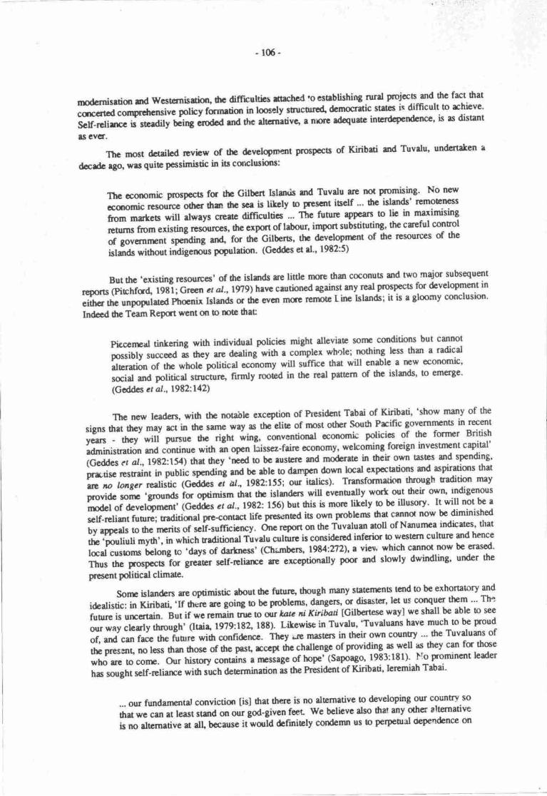
-106-
modsnisrrim srd wcsutnisdklr, fie difficultirx sachcd 'o estrblishing rurat rolcc5;nd.fic fact ftat
cqrrrtcd compdrcnsivi pothy farnetim in loscly srucugp4 denrocruic statcs is difficult 16 rchievc'
Sclf-rclirrcc ir stcrdily Cirg;rd"d grd thc rttcnra6vc t n,'E @uarc inerdcpendence' is ls disunt
ts evcf.
ThGrnost&tdlcdrevbwofthcdevclqmentp(ospccbofKiribatimdTuvdu,undertakerrrdcrdc l8p, wrt quie pcssimistic in its cqrclusirns:
The cconomb troAp€cts fu the cilbcrt IsledE md Tuvatu arc not promising' No new
cqromic t"*uto'o,rtot thgr dre sce is litcly b prescllt iself "' 6c ishtds' rcmoE"tlcss
from matcs *ru d*"y, glcetc difficultics .-- ftte n tt"" appcars to lic in maximising
Ehrrns f1gm existing ro*u*r, the export of labour, import substitutirB' the crcfirl control
of governrrent rp.foing and fo, drc Gilberts, the dcvelopnnnt of the resources of the
isl;ds without indigenous pqulation' (Geddes et d'' 1982:5)
But thc .existing resoult'es' of ttre islsrds ce little nuc tlran coconuts and nvo nnajor subsequent
rcports (piphfd lgti; Green ct aI.,1979')have cantbned against rny real prc'pects for development in
eithcr thc unpoprlatcd ptrcnit Islands or thc evcn mu.G rerlDtc Linc Islands; it is a gloomy conclusion'
Indcd ilrc Tcam Report went on b rctc drat
Pieccnpal tinkering with individual policics might alleviaP ** conditions but cannot
possibly succeed i tt"y are dealing with a compler whole; rrcthing less than a tadical
aleratbn of ttp whole political economy will suffrcc that will enable a new economic'
social and political struc0|Ie' ffnrty rooted in thc real pattcrn of fte islads' to emerge'
(Goddes aal.,1982;:1421
The new leaders, wift th notable exception of Presidcnt Tabai of Kiribati, 'show many of the
signs that fhcy may act in the same way as thaelite of nrost otEr South Prcific governfiEnts in recelt
years - thcy will pursue thc right wing, corventional economic policicc of ore forrner British
administration urd continue with an open leisscz-faire economy, welcoming foreign investnrent capital'
(Geddes et d.,l9il2:154) that drcy 'neod to b rusEre ard nrcderate in their own tastes and spending'
p*;risc rcstraint in public spelraing and bc^able to dampcrt downlocal expoctrtions and aspirations thu
i*e no longcr realistic-(c;&s ,l aL, tg82rl55; ourilrtlcs). Trmsformrtknt through tradition may
proyids sonrc 'grounds i'' o,ptimism rhal ttr islandcrs will evenoally work o't tlreir orvrq mdigenous
rnodel of &velqrnent' tceddes a al.,1982:156) but 0ris is mort likely o be illusory' It will not be a
self-reliant fuilre; o"ai,n*"r pre-contrt life pres,,rnad its own p'oblems drat canno' now be diminished
by appeals !o dle nErits of sclf-sufficl*V. d* r€port on the Tuvaluan aroll of Nanumea indbates' that
tlrc .pouliuli myrh,, in which rrditional Tuvalu culorc is considcrpd inferior to western culture and hence
laal cusoms uerong o o"yt or dat.lllssE' (chambers, 19&42272), a vie* which cannot now be e'rased'
Thus the Fospccts for greaEr self-rclialrcc' ue cxccptionally pmr md slowly dwindling' under the
ptscnt politicd climate.
sonp islandcrs are opimistb rbout tre frrurre though many statetrEnb tend to be exhortat'ory and
idealistic: foi Kiribatl 'If trcre se goltlg b bc problems' Oang"tt, 9t disaster' let us conqu€f them "' The
fuurre is urrcertain. iut if wc remain true to .,tr tttc ni Kirifuti 1cilbcrtese wayl we shall be able o see
our way clerly through' otaia, f9?9:18e l8t). Likcwise in Tuvalu, 'Tuvaluans have much to be poud
of, d can face ttre irnrre wift con6det.". if*y i-rc mast€rs in their own country "' the Tuvduans of
rhe prescnL no less dran drocc of the pssq rctpt tilc challcnge-of pnoviding as well as they can fa thme
who are !o corE. Our history contains . *ti.gu of trope;(Sapoago, 1983:181): ltl pominant leader
hac sought self-relialrce with snch deermination as oe ne.iaent of Kiribati, Ieremiah Tabai'
... our fgndansrtat convictidl [is] hat ttrere is no alternative O developing our countr-Y-so
that we can at least r,-C on o- lod-gi""n feeL We believe also drat any otler altemative
is no altcrnative at all" becrusc it wouia definitely condemn us to perpcbral oependence on
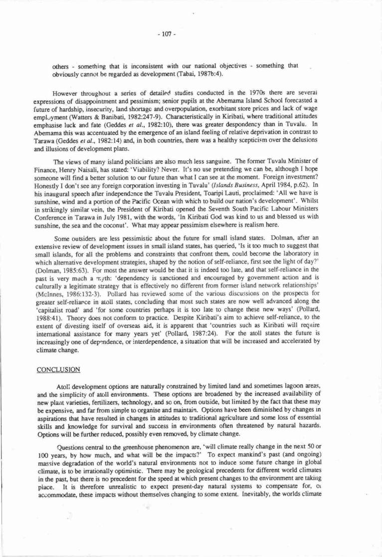
-lm-
others - sonrething that is inconsistent with our national objectives - something that
obviously canoot be rcgarded as developnent (Tabai, 1987b:4).
However throughout a series of dctaihd snrdies conducted in the 1970s there are several
expressiurs of disappoingnerit and pessimism; scnior pupils at the Abenuma Island School forecasted a
fuuse of hardship, insecurity, land shortage and overpopulation, exorbitant store prices and lack of wage
empl.rynrcnt (Waners & Buribati, 1912l.247-9). Characteristically in Kiriba6 where raditiond aninrdes
emphasise luck md fate (Ceddes et al., l9t2:10), there was greater despondency than in Tuvalu. InAbemama this was rcc€ntuated by the enrgence of an island feeling of relative deprivation in contrast to
Tarawa (Geddm et al.,1982:14) an( in both countries, there was a hedthy scepticism over the delusions
and illusions of development plans.
The views of many island politicians are also much less sanguine. The former Tuvalu Minister ofFinance, Hanry Naisali, has state& 'Viability? Never. It's no use pretending we can be, although I hope
someone will find a better solution to our future than what I can see at the moment. Foreign investment?
Honestly I dryl't see any foreign corporation investing in Tuvalu' (lsland.s Busiaess, April 1984, p.62). Inhis inaugural speech after independ:nce the Tuvalu President, Toaripi Lauti, proclaime* 'All we have is
sunshine, wind and a ponion of the Prcific Ocean with which to build our nation's development' . Whilst
in strikingly similr vein, the President of Kiribati opened the Seventh South Pacific Labour Ministers
Conference in Tarawa in July l9El, with the words, 'ln Kiribati God was kind to us and blessed us with
sunshine, the sea and the coconut'. Whu may appear pessimism elsewhere is rcalism here.
Sonn ousiders are less pessimistic about the fuhrre for small island states. Dolman, after an
extensive review of developmant issues in smdl island starcs, has queried, 'Is it too much to suggest that
small islands, for all the problems and constraints that confront thenr, could becorne thc laboratory in
which altemative developnent strategies, shaped by the notion of self-reliance, fitst see the light of day?'
(Dolman, 1985:63). For rnost the answer would be that it is indeed too late, and that self-reliarrce in the
past is very much a ryth: 'dependency is sanctioned and errouraged by governnrent action and is
culturally a legitimate strategy that is effectively no different from former island nenvork relationships'(Mclnnes, 1986:132-3). Pollard has reviewed some of tJre various discussions on the prospecu forgreater self-reliance in atoll states, concluding that most such states iue now well advanced along the
'capitalist road' and 'for sonp countries perhaps it is too late to change these new ways' (Pollard,
1988:41). Theory does not confsm to practice. Despite Kiribati's aim to achieve self-reliance, to the
extent of divesting iself of overseas ai{ it is appiuent that 'countries such as Kiribati will reqrtire
international assistance for many years yet' (Pollar( 1981.24). For the atoll states fie future isirrreasingly one of dep^ndence, or interdependence, a siuratist that will be increased and accelerated by
climate change.
CONCLUSION
Aoll developnrent options are naturally constrained by timited land ad sometimes lagoon areas,
and the simplicity of atoll environnme. These options are broadened by the ircreased availability ofnew plart vrieties, fertilizcn, tcchnology, and so ott, hom ouBid€, but limited by the fact that these may
bc expansive, and far from simple to organise and mainuin. Options have been diminished by changes tn
aspirations thu have resulted in changes in aniurdes o traditiqral agriculture and sorne loss of essentid
skills rnd knowlodge for survivd and success in environrnents often threatened by natural hazards.
Options will be further reduce4 possibly everi rermve4 by climate change.
Questions c€ntral to dre greenhouse phenonrenon iue, 'will climate really change in the next 50 or
l0O yean, by horv much, urd what will be dre impacts?' To expect mankind's past (and ongoing)
massive degradation of the world's natural environnrenb not to induce sone future change in globd
clinu6, is to be inationally optimistic. There may be geological precedents for different world climates
in fre past, but tlrere is no precedent for the speed at which pesent changes to the environment are taking
place. It is thereforc unrealistic to expect present-day nabral systems to compensab for, or
ac'uomrnodate, these impacts without themselves changing to some extent. lnevitably, the worlds climate
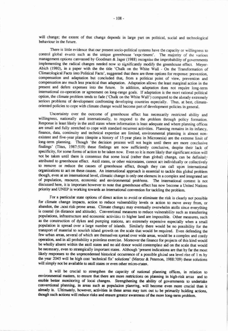
-108-
will change; 6c ertent of that chmge d€pends in lage part m politicad social srd technologicalbchaviour in thc future.
Ttse is little evi&ncc drat qr present socio-political systems have the capacity or willingness octrltrol global events such as the unique grrenhouse 'expcriment'. The maprity of the variousrnanagerrcnt ophns canvassod by fuman & Jagcr (19t8) recognise the improbability of govemmentsinphrrenting tlrc radicd changes ncded now to signifrantly rnodiry the greenhouse effect. Meyer-Abich (19t0), in a p4er with tbc 0rc dtle 'Chatl on the white wa[ - On tre Transformation ofClimaologicd Frca ino Foliticd Ftrts', suggestod that thcre are tluee opticrs for resporue gnevention,cunpensatiot and adapation but corrcludcd th4 ftom r politicar point of view, preventiqr mdcompatsatiut re much bss prrctical than daptatisr. Adaptetian albws the least marginal action in trepfEsent and defqs expenses ino the fuure. In addition, rdaptation docs not r€quire long-termintcnrational ceoperatian a agrcemcnt on long-rurge gods. If adapatior is the mmt ratiqral politicaloptim, the climae problem tends to fde ('Chelk on tlre Whia wsll') conrpared o the aheady exrenrclyscrius pr,oblems of &velopnurt confronting &veloping counries especially. Thus, at best, climate-qicnad policies to cope widr climate change would become part of developnrnt policies in general.
Urcertainty over the oueotrE of grenhouse cff*t has necessarily resticted ability andwillingness, nuiondly rrd intcrnrtiqrally, to respolrd to the lr,oblem through policy formation.Rcsponse is hast likcly in thc aoU strtes whcrc informaion is hast @uaE and where planning officesue small utd fully srerchcd to cope wih sturdard rccur€nr rctivities. Plurning remains in its infancy,finance, dota continuity and tshnhd expertisc rc limitc4 envirsrmcntal plmning is alnpst non-cxistcnt and fitt-yearplms (dcspia r history of lS-yer plar.s in Microrcsia) re dre-extreme linrit oflog-term planning. nlough 'the dcisirxr proc€ss will not bcgin until there are npre csrclusiveftrdingp' (Ti0ts, l9t7:519) thcsc findings arp now sufficiently corclusive, dcspie their lrck ofspecifrcity' fm sonr fonns of rtion b be rqken now. Evcn so it is nrore likely tlrar significart action willnot bc t*en until thrc is oonscnsus that sonr laal (radrcr rhar global) chmge, can bc definitct;'ruribuad o grenhousc effct. AbU stilcs, or odrer mbrost tcs, ctnnot rct individually or collectivelyto llttx)ve or rcduce thc canscs of grenhousc cffct, though they can call upon internationalorgrnis$ions to rct m thcsc ceucs. fui ingnationrt ryprcrch is cssattial to Bkle this global problcmthough, wcn rt m internetiond hvcl, climtic chmgc is only qr elcrrent in r corplcx md integraed setof pqulrtim, ne$oulpc, economic rnd cnvirqurpntel probtcnrs. ThG inerneti<xrd contcxt is notdiscusscd hcrt, it is importmt howcvcr to ndc thet grccnhdnc cffcct hrs mw bccorr a Unied Nationsprfority rnd LJNEP is wating bwrr& m intcrnetisral cmvarirn fa trkling the probhrn
Fc r perticulr strtc op&ns of diret rtim to rvoid or eliminea dre risk is clcarly no possiblefa clirnet chrnge impc, rctirn o rcducc nrluebility levels c rction to ril)ve away fronq orrbildflt the;:nctrisk-pmc aers. Ctimre chmgai mry evuonlly wenhclm uolls sine everyrhingir oastrl (in diEtancc rnd rltitude). Ccrventimrl nrsnrs b rcduce vulncnbiliqv such as rm.i."tingpopulrtianr, infrrstrucuuc md corpmic rctivitics o highct lend rrc inpossibh. (Jthcr rpasures, suchrs thc cquructlm of dykcr ad prmping st tftxrs, rl: cxupn:ly cxperuivc cspcirlly whcn r smallpqulrtict ir sgcd ovct t largc numbcr of irlrnds. Similrly tlrcre would bc no poesibility for drctrrupfit d rut rirl o rnurish irlmd growth on the rcrlc that would bc rcquirod. Even &fcnding thcfery urbm acaq scvcrd of which [t thcnEclvc rp.cd ovcr wllc ltrs, *ouH bc r conplcx md catlyopcntiott rnd in dI pmbebitity e pointlcu ercrcisc. Morpover tlr finsrcc fa prt{cca of fiis kind wouldbc wholly rbsctl wihin thc eoll 3tstai md no rkl dooc would curtcnphe rid m thc scale that wouldbc mcssry, cvca b rercgicrlly importart strr6. Alhorgh 'prcscrt indbdims re thrt by fr thc nroctlitcly rcrponrcr to drc unpcodanbd hbtoric.l ccurcrpe of r pocsiblc ghiret sce lcvcl rire of I m bythc yerr 2O{5 wtll bc hb[ cct 'Ecluricel frr' solutios' (Merpcr at Facrsqr, lgtt:709) hcsc solutiqrswill rimply not bc evrihbb o roll strtcs 6eycn odrcr micro-rtu.
It will bc crucirl to strlngfi€n thc caprcity d netirnrl plmnfug officcs, in relatim ocnvirmncrtrl mrttlrr, to cruurc dret drae rc nre rcnrictimc ur plnning in highrisk rreas md tocoablc bctttr truribiqS of bcri chmgcr. Stcngthahg drc rbility of governrmra to urdcfi*ccanvcntimrl plmning, in utu ruch s poprd&in phnning, will bcoonp cycn ilrE cnrciel thm itrhedy b. UltitnrGln ho*cvcr, giviticr h thcrc rrtrs nry tsrn out tu bc prinerily holding rti;rs,thflSh nrch rtirns will roduoc rirkr ud cnruc arcru rwrttEss of thc nuc long-Em pngbl€rn.
-109-
Increased cmigration must thercfore inevitably be seen as one rtsporlsc o climare change, aresponse that builds on existing rends but that depends alrnost entirely on the polkies of nntnopotitanstates' Nevertheless as the title of a rcview of the possibility of a cqrcessionary Ausualian migrationscheme implies - Australia's Next Bcat People? (Howlat, 1985) - Islanden could ultimately rakemigration matten ino their own hands. Based qr the experience of existing migration from the SouthPacific to Australia and New Tnalurd the buit of potential migrarts from Kiribui and Tuvalu woqld beyoung' with some education, and would find employmant rcasonably easily; nuover only a smallproportion of the population would initially chooae to migrate. Hastings (19t4) has concluded thc'.itshould not be any great economic budcn o this country o subsidise a substurtial poportion of isl4dpeoples - perhQs all of them in a few insunces - but should we do?' His concem was that tlnte ae gravedangen in selective migration policies and that much larger countries, such as pryua New Gui6a and thcSolomon Islands, rnight subscquently demand the same pivileges. This was ttr principal concem of theAusralian Deprrrnnt of Immigration and Ethnic Affam in l98l whan ntigratim policies werc beingreviewed, and probably of the FitzGerdd Commiuee in 1988. Therc is tlren likely o be signifrcurtoppcition to concessionary migration at ihe rnonrnt though, in tinp, when the inpacts of greenhouseeffect becomes apparent this may d€cline. Concessionary migratirxr schenrs may h grmtod in otherpotsntial destinatiqrs such as New Zealand or even the Unirod States. They are unlitely wittrin the SouthPacific.
ResettlenEnt poses particular problems. ln pre-war tinps thc nsatlemcnt of Gilbcrtcse o hcPhoenix Islands was evenurally urxuccessful so rhu the reseuled popuhtim wrs cubscqucntly hmsfenodto the Soloman Islands (Knudson, 197?). Resettlenr€nt l'rom rolls has ottrawisc rn"oC eioU areUcnino very different €nvirxurEn6, inposing consirlera,ble seial, pcychologicrl grd sonptinrs cmomiccGB' as they canfrott I v€ry different cconomb, political md biologicd cnvinxmlnt The cmscnsus oftlp few studies that exist of thesc kinds of resettbnrng is thu a varicty of poblarrs oocur.s outlined byO'Collins (this volunr).
All the evidence sug8es6 that the scriors dcvelopnnnt poblens expcrbnccd in ilrc aoll sucscannot @uately be nrt evcn now by intemal policbs or regicrrl co+pcrrtion md fiat highcr bvels ofaid will not contribute b ecorxlmic growth (as oppoacd o inprowd welfrre). mis is clcertydemonsuated in the case in Niue which has orc of the highcst bvels of pcr capita tid in thc wqld srdalso rne of the highest rates of emigration. Whiist therc is much evidencc fc widcsperd social andeconomic disadvanages o high levels of oversars migration, in thc smelhst stltcs, such rs Tokeleu,thcre re substantid gains from migruion thu cannot be realiscd by othcr nnms. whcrc expccatiors ofapprdpriae lifestybs continue to forge futh€r ahead of South Prcific cconqnic realities, thc migrationresponse becornes even riltr€ p,obable undcr dtc inprct of climrtc chmge. In histcic titrps tto11dwellcrs w€tt exbenrly mbile and fn frrom insular; rncn and w<rncn mvod rcadily bctwcn islmds insearch of ncv lan4 diseasc-free sies, mrnirgc pertrlerq trade goods, and so qr. In thb wry ronrc islsrdswere populaa4 acpoput6terl and laucr rcpopulatcd Mobility iaclf ws rccponsiblc fa Osnognphicsurvival; without nrobility, adaptatim and churgc nrcrc irryocsibb. It is r phanmcaon of canannpcrrytimes thu South Prific populations are growing, and politicrl hudrrics ud pclicics minimir l66rj-distancc migration. Withort thc flexibility that his kind of rrsctlemnt migraricr provfolcs, Guncertainties sd limitatims of aoll mvironmcns rc emphasiscd rnd eidrcr nuc pcrmstcnt migntkn(usudly to urban areu elscwhcrc) c m urccrtein aacnOcnce rcplrccc it Tlre ere of grcrt Micrurccisrard Folyrsian voyrgcs may bc orm but thc fuure may nmcthclar lb m distmt slrqls.
Iong befor€ thc ccntcnrycry implicatfons of dre grecnhousc efrcct wcrc rcogoiscd drc choicc ofaprogtar dcvelopnrnt streEgies fo'aoll strEs hd ceusod oopcrn. Fcw uruld stlce hrvc cvtr hdsuch limicd Fspccts fc dcvelopnurg have grined so liole from compaary bctmlosicsl clnngcbut hrve rscdhcloss becom so depcndcnt sr thc ougi& ruld. Now it is cvcn nrqc cnrcirl fa tbcrebbe a focus on devclopnrant issrn in atoll strEs. withflt frrficr rubstmtid crurrrl erristrncg, thcrc islinle doubt thu poqh who wcrt orrcc describcd rs rerl rnd poiartid 'mmic rtfirger' will boconp,in lcss hrn ftfty yerrs' t ncw goup of 'cavirmmnld refugc', c, r rrggerbd arcwtsc 'cob3icrlrcfitgecs' (Fcmcu& l98t). It is extcnrty unlitaly thr Gins ukcn within rhc loll ile rlm wiUellry thir domy fqwsL As suggcrtd by Rrncnr (lgtS) thc bnp of nrch 'ologforl reftrya' murtbc ddrcssd m r lqianrl besis, ringlc mmry Ed bil&rrl ryEutc re rrnlibly b opcrt?setisfactcily udcr fic cnhmacd sucss irdlccd by climlc chngc.
-110-
REFERENCES
Araxan&r, WJ. 1977. Asymrtry in urbm-rural relationships in the Mushall tslands: an enquiry intothe relationship betwen Ebeye and l-ae. Unprblished paper !o ASAO Conference, Monterey.
Alkire, WJ{. 197t. Coral Islsrders. AIIM Publishing Corporation Arlingtur heighs, USA.
Australian Governnstt 1988. Report or the C-ommite to Advise on Ausralia's Immigration Policies.Australiarr Governnrnt Publishing Sen icg Canberra.
Ayers, J.F. & H.L. Vacher 1986. Hydtogeology of an atoll island: a concepud rnodel from detailedstudy of a Mkrorrcsian example. Cround Water 24:185-198.
Baines, C. 1988. Environnpnt, traditions and ccanomb developnent in the Pacific Islands. Unpublishedp4cr to fte Pacifrc Envirurmmtal Confercrrcg Conunonwealth InstiEte, London.
Bates, M. & D. Abbot 1958. Cora; Island. Portrait of an aoll. Scribners, New yuL
Bayliss-Smift, T.P. 1977. Energy use and ecorrcnic dcvelopnrnt in Pacific conrmunities. Pp. 3l?-359in TP. Bayiiss-Smith & R.G. Ferchcm (Eds.), Subaisterrce and survrvd rural ecology i'r the Prcific.Acdo.mic Rrcss, Lqdon.
g€dfor( R.D. 1980. Demographic processes in smdl islands: he case of inernal migration. n.27-Sgin H.C. Brooifpld (Ed.), Fopul*ion-environnpnt relatr,,,rs in tsopical islards: rhe case of ECItern Fiji.UNESCO, Pris.
Bedfqd, R.D. & D. Munro 19t0. Histrical brckground. Pp. l-13 in: Repct on the results of theccilrus of drc populatan of Tuvdu. Funrfuti Tuvalu.
Bqtrrnl G. 1986. 'Susteinebh Lrevelopmcnt' in Prcifrc micro-economies. World Developnrnt14:E09-822.
Bcnrrm, C. 19E7. Tttc politk.l ccmomy of docolonisation srd nationlmd in small Pacific societies.b. 1G29 in A. Hoopcr ct aJ. (Eds.), Chss and culure in dre Sourh Prcific. Insti$te of Prcific Studies,Univemity of drc South Prcific, Suva"
gcrtrsn, G. & R. Wetcn 1985. Thc MIRAB ec(nomy in Soudr Prcific microstaes. Prcific Viewpoint26:497-519.
Bolin, 8., BR. Doos, J. Jagcr, & R.A. Warrbk (Eds.) 1936. Thc greenhousc cffct, clirnatb change rrdccocyst rilr. Scopc 29, John Wiley, Oricestcr.
Bruun, P. 1988. The Bruun rule of ersion by seaJevel rise: a discussion m lrge-scale nyo-and three-dimansional usrge. Journd of Corstel Rescarch 4:626448.
Bud4 W.S. 198t. The expeed sc*levcl rise ftrom climatb warming in the Antarctic. Pp. 74-82 in G.IPermat (Ed), Greentrouss plemring for climetic chmgc. Comnnnwealth Scientific and IndustialReseerch Orgmizetion, Autrdie ll EJ. BriU, lridcq Hollurd.
Buddenricr, R.w. & G. Holhdry 1917. Adl hydrobgy: islard groundwaEr characteristics and theirrcletictship o diegcmccis. nocooCings of tlre Third Inematisrd Cral Recf Symposium, Miami,Fldde, pp. 167-173.
Cg0c L.v. 1980. The eqromb contsrl h. lm-136 in R.G. ward & A. Prmror (Eds.), South Pacificrgrfoill0re, choicc atd ccrurrins. Austrelian National University Press srd Asian DevelopnrntBnk, Cnbcrn md Msrih
Chrmtcrs, A 1984. Nrnunpe Atoll.cconomy: social change in Kiribeti urd Tu',alu. DeveloprrcntSudirx Ccnrg Monograph No. 6 Ausrrlian National University, Cmbcrra.
Chrnbcc, A" 1986. Rcpoducticr in Nmurpe (Tuvrlu): m atrnogrphy of fertility and binh.Univcoity of Araklrn( Dcprurcnt of Auhropology, Wo*ing prper No. 72.

-lil
Cloud' P'8. 1952. heliminary repct on rhe gmlogy anj mrine environments of Onotoa Atoll, GilbertIslands. Atoll Research Bulletin 12.
Commitee D Review dre Ausnalian Overseas Aid Program 1984. The Australian overseas Aid hogram.Australian Governnpnt Fublishing Service, Canberra.
Conrcil, J. 1980. Reminances srd rural developnpnt, migration dependency an'l inequality in the SouthPacific. Developnnnt Snrdies Centrc, Occasional Paper No. 22, Ausrdian Hitionat University,Canberra.
Conrcll, J. l98Ja. Migration, emJrloyment and development in tirc South Pacific. Counry Report No. 7,Kiribati. South Prcific Cor.^mission and International L,abour Organisation, Noumea.
Ccnnell' J. l9E3h. Migration, employnrent and developnrent in the South pacific. Countrr.Report No. g,Manhall Islands. South Prcific Commission anc Intemational l,abour Organisation, Noumea.
Connell, J. 1983c. Migration, employnnnt and development n rhe South Pacific. Counrry Report No.18, Tokelau. South Pacific Commission and International Labow Organisation, Nournea.
Conmll, J. 1983d. Migration, employment anc developnrent in the South Pacific. Country Report No.19, T':valu. South Prcific Commission and International labour Organisation, Noumea.
Connell, J. 1986. Pqulation, migration and problems of atoll development in the South pacific. pacificStudies 9:41-5t.
Connell, J' 1i8Ea" Sovereignty anC snrvival. Island. nucrostat€xt in rhe Third World. Department ofGeography, Monograph No. 4 Univenity of Sydney.
Connell, J' 1988b' Migration, employment and developnrnt in the Sorth pacific Report. CountryReport No. 24, Nortlr Anrrica. South Pacific Commmission and International I-abour Organisation,Nournea
Curry, J.R.' F'P' Shepard & i{.H. veeh l9?0. Late Quarcrnary sea level studies in Micronesia:CARMARSEL expedition. Geological Society of America Bulletin El:1865-1880.
Davies' PJ. & D. Hopley 19t3. Growth fabrics and growth rares of Holocene reefs in the Great BarrierReef. BMR Joumal of Ausralian Geotogy and Geophysics g:23?_251.
de Robin, G. 1986. Changing sca level projecting thc rise in sea level caused by wanning of theatmosphere. ln Botin ct a/. (Eds.), The greenhouse effect, climatic change and ecosystems. Scope 29,John Wiley, Chicestcr.
Devoy, RJ.N. (Ed.) 19E7. sea surfrce sodies - a global view. croom Helnu London.
Dolman, AJ. 19E5. Pardise lost? The past performance and fuuue prospecs of small island developingcountries. h' 4()'69 in E. Dommen & P. Hein (Eds.), SBtes, microstat€s and islands. Croom Hetm.I-mdon.
Doulman, D. 1987. The Kiribati-soviet Union fnhing agr€errnt Pacific Viewpoint 2t:20-39.
Edey, EJI-il{. 1985. Evaluation of m4ior agriculuuat probhms in Samul Songkhram provincg Thailand.Grcduae School of Environnpntel Scicnce Envirqrmental R€port, No. 21, Monash University,Melbourrr.
Fairbrirn, I. 1976. Emplcynrnt in thc Gilb€rt md Ellice Islands. South prcific Comrnissirm, Nounna-
Fiah', R. 1971. Economic aspoc6 of modernization in Tikopir. h. 47-57 in L.R. Hian & C.Jryawardcnr (ids.), Anttu'opolcgy in occania" Angus and Roberaon, Sy&rey.
Fist' E-K. & C. Mella 1986. Tuvalu Tnrst Fund Apfaisal Snrdy. ADAB pacific Regional TeamRcportNo. 16 Sydrcy.

-ttz-
Geddes, W-H., A. Chambers, il. Se*'ell, R. Lawrence & R. Watten 1982. Islutds on the line. Team
report. ANU Development Studies Centre, ANU Ecsromy: Social Chmge in Kiribati and Tuvalu,
Monograph lio. l, Australian National Univosity, Cmberra.
Goo<iman, G.T. & J. Jager 1988. The development of an awareness of a rped o respmd o climatic
change. Fint meeting of Expert Group on Climatic Change urd Sea level Rise, Comnr,nwealth
Secreuriat, Landon.
Green, L.P., M.S. Bukhari & R. Lawrence 1979. Decentralisation in the Cilb€rt Islands. Develcpment
Planning Unit, University College, Lodon.
Hasrings, P. 1984. Door may open for rush from Prcific slums. Sydrry Morning Heral4 19 March.
Hoffman, J.S. 1984. Estimates of future sea level rise, Pp. 79-103. in Barth, M.C. & J.G. Titus (Eds.),
Greenhouse effect and sea level rise - a challenge fs this ganeration. Van Nontrand Reinhol4 New
York.
Hooper, A. 1982. Aid and dependency in a small Pacific tenitory. Working Paper No. ti2. Departnrntof Anthropology, Univenity of AucUand.
Hooper, A. & J. Huntsmsrn 193. A derngraphic history of dre Tokelau Islands. Journal of the
Polynesian Saiety 82:366411.
Hopley, D. 1982. Geomorphology of the Great Banier Reef: Quatemary dcvelopnrnt of cord rcef. John
Wiley, New Yort
Hopley, D. 198?. Evidence of 15,000 years of sea level change ir ropical Queensland. h. 93-104 in D.
Hopley (Ed.), .A,ustrdian sea levels in the last 15,000 years: a review. Occasional Paper No. 3,
Department of Geography, Janrs Cmk University rf North Queenslanq Townsville.
Hopley, D. & D.W. Kinsey 1988. The effect of a rapid shot-term sea level rise on the Grcat BarierReef. Pp. 189-201 in G.I. Perman (Ed.), Greenhousc plmning for climate change. Ct mrnonwealth
Scientific and Industrial Research Organization, Ausralia & EJ. Brill,Iriden, Holland-
Howlett, D. 1985. Australia's next boat people? The need for a concessionary migration policy forKinbati and Tuvalu. Unpublished paper to 20th Institr.e of Australian Geographers Conference,
ilrisbane.
Itaia, M. l9?9. Rebirth. The threshold and the future. h. l8l-18E in A. Talu ct al. (Eds.), Kiribati.Aspects of hisory. Institute of Pacific Studies, Univenity of the South Pacific, Suva
Itaia, M. 1987. Squaaers cn South Tuawa, Kiribati. W.2C6229 in L. Mason & P. Herc,riko (Eds.), In
search of a honr. Instinrte of Pacific Studies, University of the South Pacific, Suva.
Jacobson, G. & FJ. Taylor 1981. Hydrogeology of Tarawa atoll, Kiribari. Bureau of MinerdRescuces, Geology and Geophysks, Recotd l98l/31, Canbena.
Keith-Rei4 R. 1984. Australia's new visim of irlands. Islands Business 10(6) July:66.
Knudson, K.E. 19?7. Sydney Islan4 Titiana and Kamateai: Soull.ern Gilbertese in the Phoenix and
Solomon Islands. Pp. 195-241 in M"D. Lieber @d.), Exiles and migrants ia Ocesria" Univenity ofHawaii Press, Honolulu.
Koch, K-F. l9?9. I-ogS in rhe currcnt of .he sea Neti l-ifuka's stry of Kioa and thc Vaitupt colonisb.
Australian Nationd Univenity hess, Canberra"
Lambec B. 1975. t.lakin and the ouside world- Pp. ?12-285 in V. Carroll (Ed.), Pacifi: aollpopulaticrs. Univenity of Hawaii hess, Honolulu.
levin, MJ. f976. Eauripik pop..rlrtion struchu€. Unpublished Fh.D. thesis, Univcrsity of lvlichigan.
[.ove, G. 1gS7. Cyclone sttrm. surges: pre ard pct Greenhousc. Grccnhousc t7 Cmference, Monash
Univenity, 19E7.
-ll3-
Macdonald. B. 1982. Cinderellas of the Empire. Towards a history of Kiribatj and Tuvalu. AustralianNational tlniversity Press, Canbena.
lvlclnnes, L. 1986. water on vatulele. Environment, community and development.(Hons) rhesis, Univenity of Sydney.
Unpublished B.Sc.
Marcus, G-E. 198 l. Power on fte extreme periphery; the perspective of Tongan elites in the modemworld systern Pacific Viewpoint 22:48-&.
Manhall,M. 1979' EducationanddepopulationonaMicronesianAtoll. Micronesical5:l-ll
Manhall, J'F' & G. Jacobson 1985. Holocene growti of a mid-Pacific atoll: Tarawa, Kiribati. CoralReefs 4:l l-17.
Matos, C' & Tiffin, D. 1988. Greenhouse effect. Frightening predictions for aroll narions. IslandsBusiness 14( I 0) October:46-5 l.
Mauoe, H.E. 1968. of islands and men. oxford univenity press, Melbourne.
Maude, H.E' 1981. Slaves in pandise. The Peruvian labour rade in polynasia 1862-1864. Institute ofPacific Srudies, Univenity of the South pacific, Suva.
Mercer, D.C. & J'A. Peterson 1988. Ausnalia and the greenhouse effecl rhe sciencey'policy rlebate. pp.708-724 in C.l. Pearmar (Ed.), Greenhouse: planning for climate change. Commonwealth Scientificand Indusrial Research organization, Ausnalia & EJ. Brill, lriden, Holland.
Meyer-Abich. K.M. 1980. Chalk on the white wall? On the Eansformarion of climatological facts intopolitical frcts. In J.Ausubel & A.K. Biswas (Eds.), Climatic constraints and human affairs. pergamonPress, Oxfod.
Montiggioni' Lf- & P'A' Pirazzoli 1984. The signifrcance of exposed coral conglornerations fromFrerrh Polynesia (Pacific Ocean) as indicrton of recent relative sea-level changes. Coral Reefs 3:29-42.
Munro, D. 1982. The I ^goon Islands. A hisory of Tuvalq 1820-1908. Unpublishecl ph.D. thesis,Macquarie University, Sydney.
Munro, D. 1989' Migration and the shitt o &pendence in Tuvalu. A historical perspective. In J. Copnell(Ed.)' Migruion and developmant in dre South Prcific. National Developrn:nt Sludies Cenrre, pacificResearch Monograph, Ausrdian National Univers:ty, Canbena, (in prcss).
Osborne' D. 1966. The archcology of the Palar Islands: an intcnsive study. Bishop Museum BulletinNo.23O, Hsrolulu.
Perman, G.I. 19t8. Grccohouse grses: evidance fa atnnsphcric changes anrl anthropogenrc causes. pp.3-21n G.I. Feannan (Ed.), Grenhorsc: planning fc climate chmge. Comnrcnwealth Scientific andIndturiel Research Organizatim, Ausbalia &, E.J. Brill, biden, Holland.
PemeE& J.C. & G. Sestini 1989. Mission o the Re,public of the Maldives to prcparc a proposal for anindepdt shrdy of the pot ntial imprct of expectcd climatic changes on the nrtural environment an,J thesociocmornk stuctulEs end rctivitics of the Maldivcs including the idcntification of responseoptions whbh mey bc suitrble md evailabh o evoid or instigae the expeced neguive imprt of theclimatic chalges. Repat of the Mission UNEP, Regicral Scas, 100 pages.
FercN:s€o, G.T. 1979. Exarnal politics, intemal economics and Pcrapean saial formation, AmericanEtrnologist &254.
Pirazlf,tt P.A. lt. Lf. Monurgimi 1986. Latc Holocene see-level changes in tln northwesr Tuamou.rlslaili$, Frcrrch Polynesie Qnernry Research 25:350-368.
Piehford, J. t9t1. Decerrratisation in Kiribati. Tarawa.
- ll4 -
PiEoch A.B. 198t. Actual and mtbipeed changes in Ausralia's climare, h. 3t-51 in C I. perman(Ed"), Greenhousc: planning for climate change. Commolwealth Scientific and Indusfial ResearchOrganization, A,ustrdia & EJ. Brill, Iridcn, Hoiland
Plant, C. 19?7. Thc develop'rent dilemma. h. 173-lE9 in C. Plant (Ed,), Rouma: spl^r islarlt.Insititute of Prcific Stud:es, Univenity of the South pacific, Suva.
Pollar4 S. 19E7. The viability and vuhrerability of a small island srate: the case of Kiribati. NationalCentre for Derrelopment Studies, Islands/Australia Working Paper No. 87/1,1, Australian NationalUniversity, Canberra.
hllar4 S. 1988. A0oll economies. Issues and strategy options for develqment. Nafional Centre forDevelqment Studies, IslurdVAustralir Working Paper No. 88/5, Australian Natiqral University,Canbcrra.
Ravault, F. 1982. Populuian, land occupurcy and agri-foodsurffs in the Tuanntu Archipelago. P1l, 94-98 in Regional Technicd Meting on Aoll Cultiration. SPC Techaical Paper No. 180, Sou:h pacificCommission, Noumer.
Roy, P.S. g B.G. Thom l9E?. Sea-level rise - an eminent threat? 8th Australasian Conference oncoastd and ocean Engirnering, The Institution of Engineers, Launcestsn, 186190.
Saporgo, E. 1983. Poet-war developnrnt. h. l4Gl52. in H. Lurcy (Ed.), Tuvalu. A history. Instituteof Pacific Studies, Uruversity of the South pacific, Suva.
Schofield, I.C. L977. Late Holccene sea-level, Gilb€rt and Ellice Islands, West Central pacific Ocean.New Zealand Journal of Geology and Goophysics 20:503-529.
Scholl, D.W, F.C. Craighead & S0river, M. 1969. Florida subrnergence curve revisiie& its relation ocoastal sedimentation rates. Science I 63 : 562-i64.
Schutz. B. &R. Tenten 1979. Adjustnpnt. Problemsof growthardchange, lt92ro 19,f4. pp. 106-12'Iin A. Talu, ar c/. (Fds.), Kiribati. Aspects of hrstory. Instiurte of Prcific Studies, Lrniversity of theSouth Pacific, Suva.
Seas, D. 1977. The new nraning of developnrcnt. Intcrnational Development Review 19:2-7 .
Short, A.D. 1988. Areas of Australia's coast prone !o sea-level inundation. h. 93-104 in G.I. pearmanGd.), Creenhouse: planning for climatc change. Commonwealth scientifrc and Indusrial ResearchOrganization, Australia & EJ. BriU, L€iden, Holland"
Tabai, I. 1987a. The ethics of developnrent a Kiribati view. Pp. 4G49 in S. Stratigos & pJ. Hughes(Eds'), The e0rics of development: the Prcific in the 2lst century. University of Papua New Guineahess. Port Morcsby.
Tabai, I. lgE?b. The righr to development. I-tnpublished paper, Evau Foundation Conference on HumanRighs in the South Pacific, Sydney.
Thom, B.G. & P.S. Roy 1985. Relative sea-levels and coastal sedlnenBtion in southeast Ausralia in theHolmene. Journal of Sedimentary Perology 55:257-264.
Thonu B.G. & P.S. Roy 1988. Sea-level rise and climate: lessons from the Holocene. Pp. 17?-188 inG.l. Pearmur @d.), Greenhouse: planning for climate nhange. Commonwealth Sciertific and tndustrialResearcir,Srganization, Australia & EJ. Brill, l:iden, Holland.
ThomA, W.L. 1963. The variety of physical environmenb among Pirci;-ic islards. Pp. 7-37 in F.R.Fosberg (Ed.), Man's plare in rhe island ecosysrcm. Bishop Museum p;$s, Homlulu.
Tir"s, J.G. 1987. The greenhouse effect rising sea tevel and society's response. n.294-341in RJ.N.Devoy @d.), Sea surface studies - a global view. Croom HelnU [,ondon.
-ils-
Tucker, C,B. 19E6. Climate rno<ieltir'g: how does it *ork? tp.?2-3t in C.L pearman (EC ). Greenhouse:planning for climate charrge. Comrnonwealth Scicirtilic urd Industrial Resealch Crrgarizatim,Ausralia & Ej. Brill l*iden, Holland.
TJNEP 1988. ioint mecting of dre 'I ast Tei-m on imptiuations of Ciimate ;hanges in the Medirenaneanard tbe Co-ordinators of Tast Teams ri.rr he Canibbean South-East Pcific, South prrfiq East AsianSeas and Soutlt Asian Seas Rqions. Report of the Meaing LINEP (X.AyWE?IZS. 27 pages, 58r-t-lCX€S.
Vayda AP. 1959. Polyrvesian culnrd dis:ibutions in new penpctive. American Anthropoloeist6l:t17-828.
watters, R. & K. Banibati 19E4. Abemama. Ausralian National Univenity Developnrcnt StudiesCenng Amll Economy: Social Charge in Kiribati and Tuvalu, Monograph No. 5, Austraiian National[.lniversity, Canberra.
wheatcraft, S.w. & R.w. Buddnnrcier 1981. Aoil island hydrology. Ground waler t9:3lt-320.
Wiens, H.J. 1962. AolI environrrcnt and ecology. Yale Univenity Press, New llaven and London.
Yonekura' N., \'. Matushima Y. Maeda & H. Kayanrr 1984. Holocene sea-r:vel changes in the southernCook Islands. In ASugrmura (Ed.), Sea-level changes and tectonics in the Middle paciRc. Departmentof Earth Scierrces, Frculty of Science, Kobe Umversity.
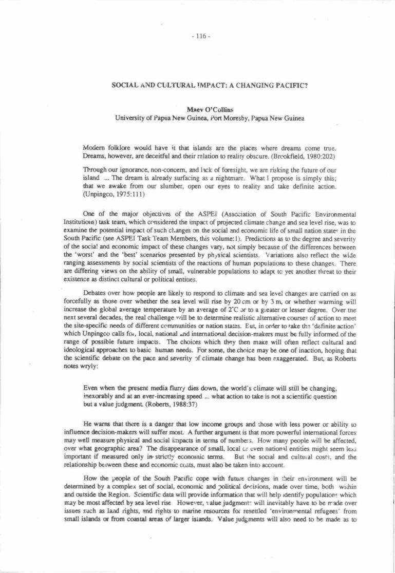
116 -
SOCHL AND CIJLTURAL IMPACT: A CHANGINC PACIFIC?
Mnev O'CollinsUniversity of Papua New Guinea, Port Moresby, Papua New Guinea
Modern folklce would have it that islands are the plrces where dreams come true.Drcarns, however, are deceitful and their rclation to realiry obscure. (Brmkfrel( 1980:202)
Thmtgh our ignorance, non{onccm, and lrck of fuesight, we are risking the fuurre of ourislmd ... The &eam is already surfacing as a nightmre. What I propose is simply this;&at we awake ftun our slumber, open our eye$ to rcality and take definite actisr.(Urpingco, l9?5:lll)
One of the major objectivcs of the ASPEI (Asso:iuion of South Pacific EnvironmentalInstitutioa) task tcuru which considered thc imprt of projecad climate chmge and sea level rise, was toexamine the potential imprct of such chmges on the socirl and economic life of small nation state. in theSouh Prific (sec ASPEI Task Team Mcmbers, this volume:l). Predictions as to tho degree and severityof thc social md cconomb furpact of trcse changes vary, rct simply because of the differences betweenthc 'wcst' md the 'best' sccnarios prescrit€d by phyrhal scientists. Vriatims also reflect the widerdlging rssessments by social scientists of the reactions of human populations o these changes. Thereare diffaing vbws on the ability of small, vulncrable populations to adapt tc yet anofier tlreat !o theirexistcncc as distinct culurral c politicd cntitres.
Debatcs over how peoplc re likely o respond o climae and sea level chorges ue carried on as
fuccfitlly as tlronc over whcthcr thc scr lcvel wilt risc by 20 cm r by 3 r& m whether warming willirpreesc thc globd rveragc Empcrature by an rvcrage of 2'C Jr to e gieater or lesscr degree. Over tnenext scverd decdes, the rcal challange *rill be o determinc rcdistic altenrative courses of action to nnettb sitc-spacifr necds of different commnnitics c nation states. Eut, in orrtcr to rakc th.l 'definite rction'which Unpingco cdls for, local, nuiqrd .nd internatisral dccisim-makers must be fully infornrd of thermgc of possible fuore inprcs. Thc choiccs which they then make will ofen rcflect cultural andideologicsl ryporchcc o brsic humen ncds. For sonr, thc ctnic€ mry bc qp of inrction, hoping thatthe scicntific dcbrc sr the prcc md scverity ef climerc chmge hrs boen exaggerated. But, as RobertsnoEs wryty:
Evcn whcn fic peser* modir flurry dics down, thc wqld's climate will still be changing,tncranbly md rt sr erpr-ilrcrcrsing rpccd ... whrt rctiqr o trkc is not a scbntific questiurirut r vduc judgrrnt (Robcrt, l9tt:37)
Hc wrnu thet there is e derycr thet low irrconr grflps md fio6c with less power or ability roinfluarcc &cision-mrkcts will sufrer nmt- A ftrrthcr rrgunrnt is that more prrcrfirl inernational forcesmey well trcisunc phnicd rrd socirl irnprcb in ermr of numbss. How many peoplc will bc affectc4ovcr whr gcographic rrea? Tlr disrypeerarc of smrll lcd ci Even nstiond cntitics mrght seem ler;importmt if nrrcurcd only in srictly oconornic tcrms. But rhc socrd rnd culurid cosn. urd therrletianrhip betwecn thcsc srd ecrmmic c{sts, must dlo bc takcn ino rccount.
How thc iroplc of thc Souft Prifrc cope with fuauc chengcs in thcir enihoilrEnt will be
daamincd by r complex sct of saiel" ecorpmic rnd 2oliticd dicisinns, mrde over ting both withinrnd qrtsidc dr Region. Scicntific drtr will trovide infcrmti:n tht will hclp danify poprluion: whichray bc mo6t rffoctal by sce lcvel risc Howerrtr, r'aluc judgmart: will ineviubly hrvc to be rrarte overissuco srch rs lgtd rights, and righe to meinc rEsrxrrcss for re.cculod 'envirsrrrrntal rcfugces' fromsmrll islstds c ftom corsul uprs of lrScr itirds. Vdue;udgrrurts will dso ncod o be made as o
-117-
which commumty or group o!'isfun& should rccaive tre dminisrative c finrncid suppat which nuy
be required if thcy arc to remain whelt trey ue, rathsr than rescttle.
This paper will faus on sorrr of the weys in which communitics srd nui:n stetc$ might Espond
tp rhe changei which will affect, r.ot only the resources at thcir dispoeal but the rbility 9f poplc orulnage hese resources. Becausc of dre wide rargc of potential inprE, r cffiaponding rangc ofpossibte adaptations must also be considcred by physhal, ocorpmic rnd said plmncn an"l by
community, national, and international decisiqt-makers'
For some countries or geographic rcgkns within a country, land locs mly bG so sev€re ihst
massive out-migration will be the only long term solution. However, for nwry odrcrs solutions may bc
found which do not involve total separation of grorpc of pcople ftom dreir traditimal horrelands. In
general pl6ning terms, key questions will be: What rrngc of choices and altematives do we havc? Over
tutr"t p"tioa of tirne ? what warning will we have? whece should we start?
The ASpEI task team examined a number of poosibic scenric in whbh therc could well bc a
cqrsiderable anount of choice fu 'atrisk' poprlaticrs. [n sonr situations:
Local populations will need o adjust their managenrent prrtices to chrnges in land and
marine resourc€s. Traditional npttrods ard local tnowtedge rnay not be apgopriarc and
r1gw crop6 may need rc be incoduced. Extcrnal assistance will be necded to train locsl
farnrrs and extension officen o respond to the churges in their cnvirorurEnL (ASPEI
Task Team Members, this volumel l)
On the otler hsr( as Nunn (dris votumc:134) conciudes, the potential impact for sont coral aolls
and other tow-lying islands will leave liule rmm for altcmuive mangonEnt practiccs and 'permanent
settlenren6 may need !o be abatdoned as sea level rises'-
Given he wide range of environnpnal satings urd of possible responscs, it would bc foolhardy to
attempt to provide a 'blue print' or rnodel fr social impact manaS,emcnt' Nevertheless, there are a
number of general issues reiated to urban and nral planning md the povisinn of smid services which
cur be *"finy considercd. A number of saieties in the Sorrth Prcific also providc valuable lessurs frorn
their own experierres of migrUian and of voluntary q' involuntry rclcation.
TI{E EFFECT ON EXISTING MANAGEMET'IT SYSTzuS
Any atternpt to prcdict the likely social imprcS of climate change and sca level rise must bcgin by
lmking ar existing resouce managenrnt and the saial cqrtcxt in which environrsrtal changes will
occur. Existing practiccs have developed over tinp srd as a rcsult of culurd s cnvironrnenul pressues.
Communities have hrned to cope and adapt o chmge, bodr from within ard outsi& their imnediate
environmenl This sugges6 that particuta social, economic a infrasuuc[rrd changcs cannot hcsrsidcred in isolation fa, as Powell cautirons:
The social base 6gr whbh raditional mtnrgcrrlcnt systetrc Qc:ate must bc consfulerod"
This is generally ar inegratcd suboistence sys@rn in whbh irdividual roles rc assigned
and behlviogr c6x16.olbd by social, politbal md rintd pacticcs ad obligatiuts b the
group as a wholc. @owell, l9E2:125)
Climate churge. orodrrctivity and human comfort
Anrong the socio-ecqromic frctors which will hrve to bc taken into rccornt is the way in which
changes in temperature affect human productivity. Whu will be tre pluuring krylicatiqls of furcreasod
average temperanr€s, in tcnns of emptoynrnt, hqning, and 0re provisiur of education' health or
sporting frcilities? McGrcgor concludes thac
- llg -
Humm cornfort w^ll be significantly affecttd by an eqnalorid warming of 2'C. Althoughsome naturd rcclimitisation may be expected increased emp€raturcs and atnrusphericvapour pressurcs ae litely to increase levels of discomfcrt significantly above presentstes. This will be espeially rue fq inhahiturts of coastd cnvirtrtnrcns. In coastal builtup arcas increased levels of human discomfort will havc itnplkatims for worterproductivity, ercrgy consumption and capiul expendinre for thc maintenance of equitableindotr climatqs. (McGregor, this volume:39)
For many island and coastal communities, changes in life-styles will be nocessary if people are ocope with the warnpr temp€raores. Formd school or wort tinrcs rnay neod to be adjusted for higherdaily temperarures and dris may nEan a change in levels of p,roductivity. New designs and maerials forhoncs or worlrylrces rnay n€ed to be developed Those who desigr sporting facilities ind sportsprogrammes will also have to trke into rcoount higher average temp€ra0fes.
YeL in specific areas, climate change may rctually improve general living conditions. Hughes &Sullivan (this volume) suggest that, in some respcts at least, the changes may be beneficial for those intbe highlarvls rcgion of Papna New Guinea Incrcassd production of both subsistence and cash cropscould occur as rising t€mperatures mak; it possible for some crqs to be grorvn at higher altitudes. Withan increased nesource base, previously marginallv productive areas may be able to sustain a greatlyirrcreased and healthier population. On the cther hur( changes in the disribution of disease vectors,such as mosquitoes, may lerl to an incrcased incidence of malaria filiarisis and dengue fever (ASPEITask Team Memtrn, this volunr:S).
Health. education and community services
Health, education and other services will need to be srengthened !o cope with changingcommunity needs. The psychological and social stresses which may be experienced by those mostaffected will also have !o be taken into rccounl Individual or grcup identity is maintained through asense of continuity, of links with the past. What will be the imprct on individual or group identity ifcustomary prrctices can no longer bc followed - if sacred sites md mcestial buriat grounds arcabandoned or disappear?
An important question is: how do we preparc the next ganeration for the changes in theenvironmental resource base which may acur?
School syllabuses will need to be revised to include information on the possible effects of globalwarming in general and the local changes in the environment which have occuned and which ue likely tooccur in the futu-ne. This updating and rcvision *rf text books will be necessary at all levels and willrequire increased input from physicai and social scientists as more evidence becomes available on thepace and type of changes which are taking plrce.
Planners, adminisrators and political decision-makers will all require greater rccess toinformation. This means that government and non-government agencies must begin to include thisinformation and its planning implications in raining programmes for those who will be involved inadministra'ion and management in the future.
Just as teachers and healtit workers will need o be reoriented to the changes $,hish are tekingplace in their societies, urban and rural planners will also have to rc-assess long term plans to ensure thatinfrastructural, economic and social developments take ino account the potential imprcts.
Dlsaster peparedness will need o include consideration of possible changes in buildingregulaiions, and in the siting and construction of wharves and bridges. Communities may need todevelop earlv warning systerns for hurrilanes or the increased danger of local flooding or land slips.Severe erosion may endanger previously stable slopes where, as the ASPEI TasL Memben (thisvolume:4) noted 'land use practrces are not designed to reducr soil loss'.
-ll9-
Hcddr scrvicc md hcrlth cduclin
Ttrining of lrdth wortcrs lrd community hcrlft ofuc.tkxr prognmr6 will rlso n63d b bcrevised if they rc to kccp prcc with ncw frbn which will rffct thc n"Atl or mar pqgrnirns. esnoted erlicr, melarir a othct inscct banc discrscs rnry bcconr endcnric in rces *tr.n tnsc *tlprcviously unhrlm or qrly e mftxx prr6hn (ASPEI frst teem Membcrs, thir volunp:j). Methods ofwrst dispocd will heve b bc mdtotGd to eraurc thet previarsly roccptable prrcticcs do i.ot po6c rthrcs to humrn populeticrs.
Chmging cfrnmunity hcelth rrJ culurnl prcticcr ir e slow and difficult prcccss. In a sgpiaywhcrc pcoph ncnrelly bury tltcir de4 it mry bc unthinkrblc o qucstian whalrcr thir prrcticc shouldcmtinue. Yct' in bl[rd communiticc whcrc chmgcs ln unocrgooirc wrer lcvcls * t"iing plrcc endwtrre thc tnDunt of land rveilablc fa survivrl necds may Ue aiministring, thc unthinteblc may hevc robe considcrcd and ncw solutiom found which will be rccepable to the comnunity.
Trditiand hceldr prrcocar frcqucntty mrtc usc of hcrt plents a odrer rcsources end thcrvailability of drcsc lts{xrpcs mey rtta. In sorr situuitxrs, puticulrr plants c trrcs could bcorr morrabnrndant (x nc'Y spccics of plma cnrbh ttc bcd rcsourcc brsc. At ilrc sanrc tinq otlrcr nrcdicinrl grsacred plans may bconr sce?e <r direpper artirely.
Nutritional chmscs
clinatc warming srd incr:rsod salinity in roll rcquifcn rnd corstal swamps will bring rboutchanges in tb type am quantity of food rcsourpes. Nuritiond adeputions will have !o bc madc by tqcalcommunities md drere re implications also for dre natcting md disributian of puoduce, within udbetween countrics and regions of thc world.
What are thc likely adepteticrs which wilt have to bc rn dc? Orcc rgain thcre is rn simplcanswer' For some gnqp6' tlrcre may be a significant lo,s of land s of particult'st4le fmd crope. FaotheN, improvcd food resources may acnrally ncan a richcr md lmrc varied'dia. Changcs insubsistencc fmd resources may lerd o changes in agriculturel methods srd in housefrold mmagementprrctices. The inroduction of sweet potdo ino whu is rrcw Pagra Ncw Guincr is m oftquoted exampleof how earlier communities adoeErt r new food oop ard how this rfferd drcir cntirc it of life. Inmore nocent tirrcs, communities in aws wbre taro was the mejor rmt crrp hrvc had to changc to othcrroot crops when tao blight d€stnoy€d fmd garrdcns.
In many communities dronghout thc Pecifrc. c.ssave hrs tatcn ovcr as e major stele md hasdisplaced yams and tro which had bcen cultivaed trrditionally (sec Thamar & Ttmas,'I9g5 for adiscussion of the ncw and inportant role of cassava). In addiiqr, inroduccd westcrn foods re nowp'redominmt and preferred iems in daily dics cven whcrc traditionrl crop6 rrc still grown. McCurchcsrdrcunrcnb for Pdar (19E5:1t4) dttt 'Taro rcmains m inportant symbolic etcnrnt-in e cuslomary feast,but rbe is usually served as well'. In tt€ highlands of Prpua New
-Guinca 'tinnod fish .nd rigc, c? now
bogeht with mmey ernod from wage labou a frcrn thc salc of cash cropo such rs coffec or pyr€thrwn,ard similar changes hrve ccuned iluoughout thc Regiur.
Yet' in ueas wherc seasonal variatims in the availebitity sd qurntity of food supplies createsigniftcant fmd shortages' managemcnt practices may involve dccisiqrs rcgding wtro *rorii cat first q'who should go hungry. Highcr hvels of mrlnurrition hrve bcen rcpodcd rrrdrg r numbcr of isladcommunities where population increases have put artditional srcsscs on rvaitabli food rcso'rces. Indiscussing the culural 'value judgnrns' which will inlluence he managenrnt decisiqrs which mayhave to be made, Payne obscrved thac
Failure to meet 6e additiqral chellenge of e bad year, with r concomitrnt slrortage of fmdwhich coirrcidcs wifr peek labour neds, htroduccs . deglc of unccrtdnty-about thcsusainability of drc family in ilre futurc. This is important boceusc melnuridon of any urcnpmber of a femily may be cithcr the result of such r chmce cvent acurring, fi the

-r?,-
initicing event which starts off a sequence of effecB, €nding with the death of several
,rprrrbers, or perhaps with a decision io sell land, or to move, or ev€n dre destructiqr of the
whole family. (Payne, 1985:?9)
The urrertainty that periodic severe food shortages might inded drreaten the sustainability of the
family was a m4or reason giverr by Carteret Islanden for their decision to resettle (O'Collins, this
volume:Vl7-2i0) In addition, thme who dccided o rnigrate to the A0olls Resettlenrent Scheme on
Bougainville Island produce surplus food which is shipped brck to the hone islards to supplement the
fmd-produced thera fFood shortages continue to theat€n the survival of those who remain on the
Carterets. In March 1989, sorms urd high seas inflicted heavy damage on food gardens and the National
Disaster Centre, in addition o providing ernergency fmd supplies, discussed with the Nor0r Solomons
provincial Government the pmsibility of evacuating the islanders to Bougainville'l
Other groups may be able to develop srategies for nrore intersive use of existing land or adopt
new crop6 or obt in food resources from outside the area which will sustain the population over tinre.
Whatever decisions arc made, it is clear that site specific solutions to nutritiond needs will, as Brown
points out (1985:238) 'have to be compatible with practices at the locd level'. For example, in areas of
iow populatiur density on mainland Papua New Guinea, ap,pnpriate rnanagemcnt strategies may be quite
different from those suitable fr small islands. Pernetta and Osbome csrclude that in a sparsely
;npulated rea such as the Fly River flmdplain.
The effects of sea level rise on the people living in the rea are litely to be small. They arc
thoroughly accustonrcd to coping with dramatic flucnrations in water level, populations are
low and food is abundant. (Pernera & Osborne, this volume:2lS)
ln other areas, where communities have only recently moved down to the coast, the affect of sea
level rise may also b€ minimal, particularty if they have retained rights to land or naturd resourcres
further hland. For any imprct assessnrent, the important site-specific variable will be the relative balance
between the needs of the population, changi'tg rescurce base, and people's access 0o resources.
Pooulation pressure on existing. resources
prior 19 colonial contacts in the Pacific, nuny relatively isolated co'nmunities appeared !o have
been able to mahtain populations at fairly stable levels. Available evidence suggests that culturdly
accepgble birth control-practicqs were common trroughout the Region and served o maintain a balance
between population levils rnd available food resources. In some siurations this was a tather fragile
balance andmigration histories are often linked to stories of ervirsrmental disasten. In his discussion of
aoll populations, Bayliss-Smith poins out that:
... the more extreme solutions of famirre and emigration may op€rate only after fte
ccurrence of disniptions to the 'normal' carrying caprcity ef the environment fo[owing
such natural disasters as hurricanes and droughs. At odrer tinres sonre regulation of
rr:rmben occurs, enabling the population to remain below the level where fmd supplies
besome exhausted. (Bayliss-Smith 1975a:293t
Following colonial conacq inroduced diseases and labour migration threatened the
oopulatiorVresource balance which had been maintaine4 albeit sonpwhat pru'ariously, tluoughout the
RJgion. New conters with ttre ouaide world brougirr devastating diseases which threaened tlre survival
of many comrnunities. [:ter, as Western medicine and health sewices were inroduce4 he decline in
population was 4rrested. However, the accompanying breakdown of traditiqral binh contnl practices
meant ttrat fenility and infant survival rats increase4 although food resources remained unchange4 or
even declined. The depopulation and repopulation of orrturg Java (Bayliss-Smith, 1975h) reflects a
similar demographic hisiory to tlat of the Carterct Islanrrs (O'Collins, this volrrme:247'nq. [For further
discussions oi de-ogr"phii changes in Pacific island populations see Canoll (195), and Bayliss-Smith
& Feachem (1977).1
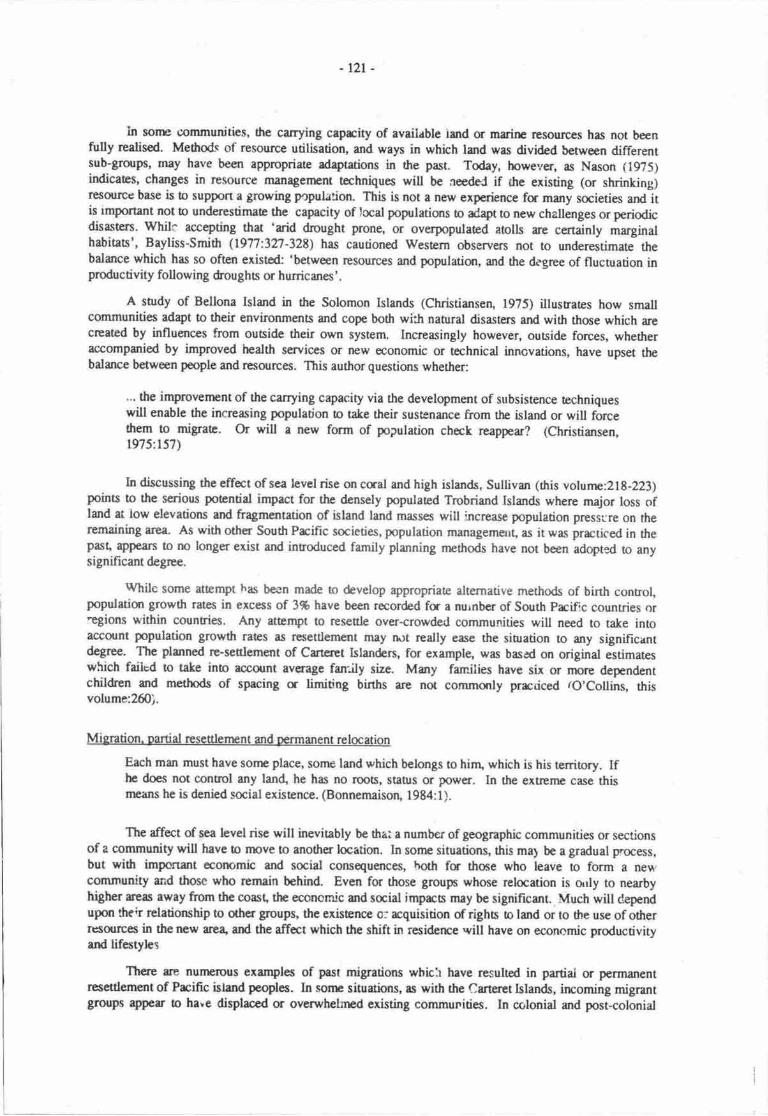
-rzt-
In sore communities, the carrying caprcity of available iand or marine rcsources has not beenfully realised. Methods of resource utilisation, and ways in which land was divided between differentsub-groups, may have been appropriate adaptations in the past. Today, howevetr, as Nason 11975)indicates, changes in resource managenrent techniquc will be aeedeJ if the existing (or shrinking)resourcc base is to support a growing pcpulation. This is not a new experience fa many societies and itis rmportant not to underestimate the capacity of local poprlations to ad4pt ro new challenges or periodicdisasters. Whilc accepting that 'arid drought prone, or overpopulated atolls are certainly marginalhabitaB', Baytiss-Smith (1977:327-328) has cautioned Western observers not to underestimate thebdance which has so oflen existsd: 'between rcsourses and poputatian, and the degree of fluctuation inproductivity following drou ghs or hurricanes' .
A sutdy of Bellona Island in the Solomon Islands (Chrisriansen, 1975) illustrates how smallcomrnunities adapt to their environmens and cope both wi:h natural disasters and wittr thoee which arecreated by influances from oubide their own system. Incrcasingly however, outside forces, whetheraccompanied by improved health services or new economic or technical innovations, have upset tlrebalance between people and resources. This author questions whether:
.'. the improvernent of the carrying capacity via the development of subsistence techniqueswill enable the increasing population to tate their susrenance from the island or will forcethem to migraa. Or will a new form of population check reappear? (Christiansen,1975:.157\
In discussing the effect of sea level rise on cqal and high islands, Sullivan (this volunre:218-223)points to the serious potential impact for the densely populated Trobriand Islands where major loss ofland at low elevations and fragmentation of island land masses will ncrease population prcssi:re on theremaining area. As with other South Prcific societies, population nunagemeut, as it was practiced in thepasq appean to no longer exist and inuoduced family planning nrethods have not been adopted to anysignificant degrce.
tVhile some attempt has becn made to develop appropriate alternative methods of birth control,population growth rates in ercess of 3% have been recorded fs a nurnber of South Prcific countries or'egions within countries. Any attempt to resettle over-crowded communities will need to take inloaccount population growth rates as resettlement rnay rut really ease the sinration to any significantdegrce. The planned re-settlement of Carteret Islanders, for examplg was based on original estimateswhich faiied to take into account average farrjly size. Many farnilies have six or rnore dependentchildren md methods of spacing a limidng births are not conrmonly prrcdced ro'Collins, thisvolume:260).
Migration. Dartial resettlenrent and Dermanent relocation
Each man must have sonr place, sonre land which belongs to hinr, which is his tenitory. Ifhe does not contnol any lan4 he has no roos, stabrs or power. ln he extreme case thismeans he is denied social existence. (Bonnemaison, 1984:l).
The affect of sea level rise will ineviably be drat a number of geographic communities or sectionsof a community will have to move to another location. In sonre situations, this ma1 be a gradual p'ocess,but with impoflant ecorr,mic ard smial consequences, both for those who leave to form a ne\^'community and those who remain behind. Even for those groups whose relocation is orly to nearbyhigher treas away from the coast, the eccnornlc urd saial impacs may be significant. Much will dependupon their relatioruhip to oth€r groups, the existence o: acquisition of righs o land or to the use of otherrtsources in the new are4 ard the affect which the shift in residerce .vill have on economic productivityard lifestyles
There are nunrerous examples of past migrations which have resulted in partiai or permanentresettlement of Prcific island peoples. ln some situations, as with the Carteret Islands, irrcorning migrantgroups appes to have displaced or overwhelmed existing communities. In cc'lonial and post-colonial
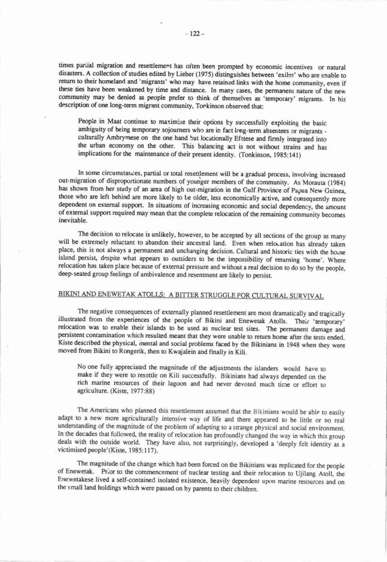
r22 -
times pariial migratian and rese$lement has often been promptcd by economic irrcentives or naurraldisasters. A collection of studies edited by Lieber (195) disringuishes between 'exiles' who are unable torctum to their honpland and'migrants' who may have retained links with the honre community, even ifthese ties have been weakened by time and distance. In many cases, the permelenr naure of the newcommunity rnay be denied as people prcfer to thinL of themselves as 'temporary' migrants. In hisdnscripian of orp long-term migrant community, Tonkinson observed thafi
People in Maat continue to manimise their options by successfully exptoiting the basicambiguity of being temporary sojourners who arc in frct lcng-term absentees or migrants -culturally Ambryrrse on the me hand but locationally Efatese and firmly inegrated intothe urban ecornmy on the other. This balancing rct is not withot s6ains and hasimplications for the maintenance of their present idartity. (Tonkinson, 1985: l4l)
In sorne circumstarces, partial or total resettlement will be a gradual pnocess, involving increasedout-migration of disproportionate numbers of younrger members of the community. As Morauta (19g4)has shown from her study of an area of high out-migration in the Gulf Provire of eapua New Guinea,those who are left behird are more likely to tre older, less economically rctive, and consequently moredependent on external support. In siurations of increasing economic and social dependency, the unountof extemal support required may mean that the comptete relocation of the remaining .ornrnunity becomesinevitable.
The decision to relocate is unlikely, however, o be accepted by all sections of the group as manywill be extremely reluctant to abandon their ancestral land. Even wtpn relo-ation has already takenplace, this is not always a permanent and unchanging decision. Cultural and histmic ties with the hoineisland persist, despite what appean to outsiders to be the impossibility of returning 'home'. Whererelocation has taken place because of external pressure and without a real decision to do so by the pmple,deep-seated group feelings of ambivalence and resentrnent are likely o penist
BIKINI AND ENEWETAK AToLts: A BrrrER STRUGGLE FoR cwruRel- surRvrveL
The negative consequences of externally planned resettlenrent ar€ most dramatically and tragicallyillustrated from the experierces of the people of Bikini and Enewerak Atolls. Their .temporry'relocation was to enable their islands to be used as nuclear test sites. The permanent damage andpersistent contamination which resulted ncant that they were unable to return honp afrcr the tests enderl.Kiste describod the physical inental and social problems frced by the Bikinians in l94B when they werernoved ftom Bikini to Rongerik, then to Kwajalein and finally in Kili.
No one fully appreciated the magnitude of the adjusunents the islanden would have tomake if they were to r€settle on Kiti successfully. Bikinians had always depended on therich marine resources of their lagoon and had never devoted much time or effon toagriculture. (Kiste, 1977:88)
The Americans who planned this resettlement assumerl that the Bikinians would be able to easilyadapt to a new more agriculturally intensive way of life and there appeared to be little or no realunderstanding of the magnitude of the problem of adapting to a strange physical and social environment.ln the decades that followed, the reality of relocation has profoundly changed the way in which this groupdeals with the outside world. They have also, not surprisingly, developed a 'deeply felt identity as avictimised people'(Kiste, 1985: I 1?).
The magnitude of the change which hart been forced on the Bikinians w,ts replicated for the peopleof Enewetak. Pr^or to the comrnencement of nuclear rcsdng arrd their relocation to Ujilang Atoll, theErrewetakese lived a self+ontained isolated existence, heavill,dependent u;rrn marine .eroui.., and onthe small land holdings which were passed on by parents to their children.
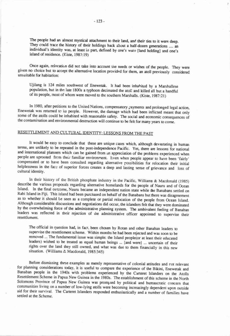
-123-
The peqle had an dmost mystical attachment o treir lan4 an(l their ties io it were deep.They could rrce the histry of their holdings back about a halfdozen ganerations .... anindividual's identity was, at least in part, defined by one's wato llmd fr*t, and one'sisland of residence. (KisE, 1987:19)
Orrce again, relocatir,n did not take ino account the neds or wishes of the people. They weregiven no choice but to accept the alternative location providnd for them, an aroll prreviously consideredunsuitable fu habitation:
Ujilang is lV4 miles southwest of Enewetak. It had b€en inhahircd by a Marshallesepopulation, but in ttre late 1800s a t)?hoon decimated the atoll and killed all but a handfulof its people, arost of whom were moved to fte souhern Mrshalls. (Kiste, l9t7:21)
In 19E0, after petitions o the United Nations, compensatory rraymenrs and prolanged legal action,Erpwetrk was rcturned te irs people. However, the damage which had been inflicted -eani ttrat onlysome of fte atolls could be inhabited with rcasonable safety. The social and economic cansequeoces ofthe contamination and environmental destruction will continue ro be felt for many years to corp.
It would be easy to conclude that these arc unique cases which, although devastating in humanterms, ane unlikely to be repeatod in the post-independerrce Prcific. Yeq therJare lessons ior nationaland internationd plannen which can be gained from an appreciuion of the problems experienced whenpecple arc uprooted ftcm their familiar environrrrnt. Even when poople ;W* o have been .fairly,compensated fr to have been consulted rcgarding alternative Jossibilities fs relocatiqr their initialhelplessness in the fac.: of superior forces creates a deep and lasting sense of grievance and loss ofculnual identity.
In their history of the British phosphate indusrry in the Prcific, Williams & Macdonald (19g5)describe the various proposals regarding alternative homelands fa the people d Nauru and of OcesrIsland. In the final ourconp, Nauru becanp an in&pendent nation state while he Banabans settled onRabi Island in Fiji. This island hd been purchased on behalf of the Banabans but frrere was disagreementas to whether it should be seen as a complete or partial relocation of the peqle from Ocean Island.Although considerable.discussions and negotiatiqrs did occur, rhe islanden fen ttrat they werc dominatedby the ovenrrhelming force of the adminisuuive planning system. The ambivalent filing of Banabanleaders was rcflected in their rcjection of rire adminisnative officer appointed o srforvise theirresettlement.
The official in question ha4 in fact, been chmen by Rotar and other Banaban leaders nsupervise the resettlenstt schenre. within months he had been rejected and was soon to 5,gremoved.-' The fundarnenal issue was simple: the Island peoph(or at least their educatedleaders) wished to be treated as equal human beings ... [and were] ... uncertain of dreirrighc over the land they still owne4 and what was due to dtem financially in this newsituation. (Williams & Macdonald, 1985:345)
Before dismissing these exarnples as nuely rcpresentative of colonial attiurdes and not relevanrfor planning consideruions today, it is useful to compar€ the experience of the Bikini, Enewetak andBanaban people in the 1940s with problems experienced by the Carteret Islanders on the AtollsResettlement Schenrc in Papua New Guinea in 0re 1980s. The esabtishnrnt of this scheme in the NorthSolomons hovince of Papra New Guinea was prompted by political and burcaucratic concern thatcommunitiqs living on a number of low-lying atolls were becoming inoeasingly dependent upon ootsideaid for their survivd- The Carteret Islanden resporrded e'nthusiastically and a-number of families haveseded at fte Scheme.
tu-
D6piE th€ir initisl positivc rcspmsc, nrmy scttlcn hevc conplaincd about what they perceive as
r lrk of rssistarcc from thc projd co-adinatcr and govcrnnrnt ertcosion officers. A scrae ofdiscomfort that thcy rc no lorger in conrol of h€h cnvirum€nt and arc dcpcndcnt an outsiders appears
to bc e rneju causc for thc dissatisfrctions which ur crpresscd" As onc settbr cxplained:
... pcqlc wcce &rid thcy muH lac dtcir righb to thc liule lmd that was available on theislmds ild ultinccly bc left withant lrud rights u rll. While he oould scc that cvennrallyficy wurld heve b leavc their islsnds md it was oeEcr o put prcssurc rn the ProvincialGovcrnrurt to trtc immcdidc rtkn o scctrc agriculud land fu cash cropdevcloprcnt, dhces hrd bcconp tired of waiting. Weiting in r sense, just as they hadwrird brck on thc Crcrcts fa thc Ablls Encryrisr b conE, hinging supplies.(O'Co[ins, this volurr:267)
CONCLUSION: P{.ANNING FOR AN IJNCERTAIN FUTI.JRE
This prycr hes ortlincd sonr of tha likely social urd culuml impecb whictr should be considenedin futurc local natisral md rcgiond plrniry fc populations affced by climate change md sea levelrisc.
I-cd populatims witt necd to adjust thcir life stylc and mangern€nt practices in rclation olevels of comforq edrc*i<xr and hcrlth n€&, md changa in hrd md mrim rcsouroes. Traditionalmthods md bcrl lnowlcdge may mt be epropriaa rnd new sraegies fa mrking rnaximum use ofavailable rcsouroes mullt bc dcvebped" Excmd assistancc will probably bc rcquircd o enable bothrcoidenu and urtu and rural extcnsion wortgs o respurd apprcpriately o chmges as they occur.
In some sihntidrs this may rrudly brd o innovrtivc and rnore productive use of the eristingtrsouroc hsc. Fc cxanph, if mriculurc ald qurculure tcchniques scr€ srroessfully inaoduced to araoll lagm this mry m*e it poesible io sustrin lrgcr populations. It may evan be possible to exportfood surpluses b lcss prroductive areas. Mce intcnsivc susaineble manrgenEnt prrctices may make itpossiblc fa rclatively smrll reas d land to support existing populations. Mae imaginuive changescculd involve tltc devclqnut of lew vdirtbs of scewee4 cf taro which can be grown in a more salinewaEr lens, srds m whbh food crops csr bc grown in thc hgoon.
While es Nunn (this volune:146) corcludes, 'fonrard planning would offsct thc enrmity of theifiiprct', fc many goups 'tlrere rypears to bc no feasible way of avoiding the impct of fuore sea levelrise'. For a number of island communitbs, panial or completc relrcuim may be tre only long tcrmsolution"
Th€re is ofen r temptation to thint only in strk dematives such as 'fight or l"light': stay whilethc water engulfs onc's honrland or abardon corphely thc land of on€'s anoestfis. Ofen the process
will be mixed with some possibility of changing land usage fc those who renrain, s(trne rsver€nts backard fcth banreen a re-settlement arca <x rrec ald the hcrpland and some permanent relocation.
The experionce of fie Catcret Islsrdqs (O'Collins, tris volurrc:247-270, has shown that it maynot b€ possiblc io fully urtkipar thc massive churgc in lifcstyh which will occur following the movefrom a self<ontaine.J isolaed island hone. For sonr communities a larger groups, relocation has andwill mean e gra&d abandonnpnt of culurd identity and even ther very existence as m independentnatiqr statc. Plannen will have to be aware .hat erch sinration .r,ill have to b: assessed over time and thatdFrc is no modcl whbh can complaely predict dp fuure impact of clima-e change and sea level rise onprtbularpooples. Ttis gives addcd wcight to the conclusion by Brookfield and Bcdford that:
The rcal rrcaning of populatiolr ud environncntal planning is therefqe the need omticipate, <r rt lcast dlow for, the unexpoccd. This is true .t dl levels of planning, but isof grearest significance in ranslating plans o smdl areas, and to rndividual projects.(Brmltreld & Bedfor4 L98O:DZ)
-125-
REFERENCES
Bayliss-SmidU TP. l95e Thc Ccntrd Polynxim oudier populatians sirce Europcan contrcL Pp. 28C343 in V. Crroll @d.), Prific roll populatims. Univcrsity of Hawrii Press, Hsrolulu.
Bayliss-Smith, TP. 1975b. Ontsrg Jrvr dcpopuletion and repqulatlur. h. 417-484 in V. Caroll(Ed.), Prific aoll poplaticrs. Univenity of Hawaii Prress, Flonolulu.
Bayliss-Smi0r,T P. 197'1. Encryy usc rnd cconomic development in Prcific communities. Pp. 317-359 inTP. Bayliss-Smith & R.G. Fcachcm (Eds.), Subsisancc and survival: rurd ccology in the Pacific.Acdemic hress, Lsdon.
Bayliss-Smith, TP- 19E2. The ecology of agriculturd systems. Cambridge University Press, Cambridge.
Bonrnmaisqr, J. 1984. Saial rnd cultural aspccs of lad tenure. h. 1-5 in P. L:rmouv (Ed-), IJndtenure in Vanuanr. Univcrsity of the South Prcific, Suvs.
Brookfrel4 H.C. 19t0. The Fiji surdy: testing thc MAB approrh. Pp.117-204. in H.C. Brookfield(Ed.), Fopulation-envircnnEnt relations in tropicd islands: the crsc of eastern FUi. MAB TechnicalNotes 13. UNESCO, Pris.
Brookfield, H.C. & R.D. B€dfad 19t0. Fannulahg guidclfurs fa population programrcs and
envir,onmcntal mmagenEnt in snall island regions . n.205-223 in H.C. Broolfkld (Ed.), Population-:nvironrncnt reluiors in tropicrl islands: thc casc of easern Fiji. MAB Tchnical Notes 13. UNESCO,Paris.
Brow& A. B. 1985. The ropics andnutrition. W.U-253 in DJ. Caul,e & K.H. Schwerin (Eds.), FooderErgy in ropicd eoocystems. Gqdon and Brerch Science Publishers, New Yort.
Christianscq S. 1975. Subsistcrre on Bellona Island (Mungiki). Nuimal Museum of Denmark in co-operation witlr the Royal Danish Geographical Society, Copenhagen.
Helfrich, P. & R. Ray 19E7. Research at Enewctak Atoll: a historicai penpective. Pp. l-16 in D.M.Deveney, E.S. Reesc, B.L. Burch, & P. Helfrich (Eds.), Thc natural history of Eneweuk Atoll. UnitedSaas Deparunent of Energy, United Sutes.
Kistq R.C. 1977. Thc rclocatisr of thc Bilini Marshallcse. h. 8l-120 in M-D. Iriber (Ed.), Exilesand migrants in Occania The University Press of Haweii, Honolulu
Kistc, R.C. 19E5. Identiry md relocatiqr: the Bikini case. Pacific Viewpoint 2(1):llCl9E.
Kistc,R.C. 19E7. Historyof the peopleofErpwaakAtoll. Pp. l7-2SinD.MDevaney,E.SReese,B.LBurch, & P. Helfrich (Eds.), The nuural hisory of Enewetak Aoll. Depanrrnt of Energy, UnitedSncs.
Liebcr, M.D. (Ed.) 1977. Exiles ard migrants in Ocemia- The University hess of Hawaii, Honolulu.
McCutchesr, M. 19t5. Reading the tao cards: cxplaining agrhultural change in Palau. Pp. 167-188 inD,J. Caule & K.W. Schwcrin (Eds.), Food cnergy in trqical e,cosystems. Gordon and Breach SciencePublishen, New Yo*.
Morauta L. 19t4. I-eft behind in the village: economic ard socid conditions in an area of highoutmigration. lnstitue of Applied Saial and Economic Reseuch, Boroko, Papra New Guinea.
Nason, J.D. 19|5. The srength of thc land: community perccption of population on Enl Atoll. Pp. I l7-159 in V. Carroll @d), Prcific atoll populations. University of Hawaii hess, Honolulu.
Payrn, P. 1985. Nutritiqrd adaputitx in man: socid djrstmena and their nuritiond implications. Pp.
7l-t7 in Sir Kenneth Blartcr &.J.C. Watrrlow (Eds.), Nuritimal adapation in man. John Libbey,Lmdon.

- 126-
Powell, J. 1982. Trrditimal managcnEnt and conscrvatim of vegetatiur in Papua New Guinea Pp. l2l-133 in L. Maaute, J.C. Pcrnctte ll W. Heaney (Eds.), Tradit'rond cqrservation in Papua New Guinea:inplicuions for today. Instituc of Applicd Socid rnd Ecorcmh Rcsearch. Monogrryh 16, Boroko,PrpuaNcw Guinca
Robcrts, A. 198t. Thc grccnhousc cffccl Arena 85 (Sumnpr l98E):37-39
memm, R.R & P.Ivl. Thornas" 19t5. Crssrva and change in Prcific Islmd food systsns. W. 189-226in DJ. Cadc & K.W. Schwcrin (EJs.), Fmd encqgy in Eopicd ecosystems. fuon and BrcrchScic'rrcc hblishcrs, Ncw Yort
Tmkinsat' R. 1985. Fqcvcr Anbrymesc? Identity in a rclaatcd community, Vanuatu. PrcifrcVicrypoint, 2( l): I 39- I 59
Uryingcq N.R. 1975. Tbc nditix fring Guam todry. Pp. 107-ll9 in R.W. Force & B. Bishop (Eds.),Thc hprt of urbn ccnoes in drc Prcifrc. Prcifr Scbncc Associdion, Honolulu.
Willirms, M. & B. M*dmd4 19E5. Thcphosph.toers. Mclbourne Univcrsity Press, Melbourne.
tn-
POTENTIAL IMPACTS OF PROJECI'ED SEA LEVEL RISE ON PACIFICISLAND STATES CTHE COOK ISLANDS, ruI, KIRIBATI, TONGA AND
WESTERN SAMOA): A PRELIMINARY REPORT
Patrick D. NunnUniversity of the South Pacifis, Suva Fiji
INTRODUCTION
The work discussed in this first of two reports is the result of investigations by the University ofthe South Prcific team in ;o-operation with governmental contacts in urban centres as follows: S.rva,Labasa and Savusaw (Fiji), Apia (Western Samoa), Nuku'alofa and 'Ohonua (Tonga) and Tarawa(Kiribati). Interviews with government offrcials and othen in appropriate positions were carried out byall rcsearchers. Copies of the insructions given to student assistants engaged in data sourceidentificatiqr, data acquisitiqr and interviewing can be obtained by writing to the author at theDepartment of Geography, University of rhe south pacifiu, p.o. Box 1168, suv4 Fiji.
Mst authorities believe that sea level will rise over the next hundred years perhaps by as much as3.5 m as the result of the so-called 'greenhouse effect'. The consequences of this sea level rise on pacificislands will be substantial and should be the subject of some foward planning. The aim of the workreported below was to seek some indication of the nature of these effects. Since the project was initiatedonly in November 1987, the results reported arc not as wide-ranging or as detailed as those whjch wouldevennrate from a longer,.tcrm surdy.
The most visible and probably the most imrnediate eftect of sea level rise on pacific islandcoasts will be in terms of land loos. This is also one of trr easiest effects to predict accurately and thusfornpd a large part of the work carried out
METHODS OF INVESTICATION
Over such a shut tinr pcriod as was set for the prcliminary investigation no field surveys roproduce original data were conteinplated, and the main source of information rryas map6 at suitablecsltour intervals. Linear interpolation between existing conlou$ and map tlatunu supplenrented by aparticular investigator's knowledge of the area covered by ttre map, allowe<l the conshuction of fowcfritours each representing a tinr{€pendent scenario of fuurre sea hvel rise as follows.
(a) Csrtour u 20 cm (0.2 m) or 0.6? feet (8 inches); he medium scerario for the year 2(I,lS.(b) Contour u 50 cm or 1.5 feet (1 fooq 8 inclres); the high scenario for the yen ?n25.(c) Cmour at 1.5 m or 5 feet; the nredium scenario for rhe year 2100.
(d) Contour u 3.5 m or 11.5 feet; tlre high scenario fc the year 2100.
For this wort, it was necessary o find rnap,s with an existing contour inerval equal to or less than5 m or 15 feet in order to allow linear interpolation to proce€d ad the conrours nanred above (a-d) o becmstructod. Once conloun at these intervals had bcen construcrp4 it was possible o quantify imprct rntcrrns of the area of lstd loss. To do this, student reserchers countrd squares on graph paper of specifiedsizc betwcen erh constructcd contorr and mry daurm; squarc werc convened to squ[e kilometres ornEu€s by the senia rescarchen using maps scales. Each arca was then divided on the basis of land-uset'?cs to enable the quantitative imprct to bc prescnted in tenms which an: readily convertible to nreasuresof cconomic imprct. Th€sc m€fhods are dctailod in the insEtctions given !o s$d€nts and the resul6 arediscussed below.
-r2t-
DATA SOI'RGS AI\TD DATA ACQTIUIUION
Thc biggcrt problcm crmunarcd in drir surdy wrr finding suibbh tnryc. Ministries of hnds ardSurvryr in thc vrious counricr of thc sordy rcgin ylcldcd litth suitabh nutcrid. Anutg thc urbutrerr invcstigno4 mly Nuku'rlofe rd Suve qplently brd m4 oovcr.ge rt l:1,000 with suttable
oorlorr htcrvrlr. No mryc of rurrl rrers in my of thc counric undcr study could bc found at suitable
rcdet dtluryh uryublishod gofirorphologitrl mapo mdc fr o$er prpoccs dbwed somc uscfulsadics of mdl islads in FUi b bc mdc. Hrd nse tirE bc.!r rvrihbh, rpprorhcs o sqm of the
lqgc'rttcts' durg t|r inlmds' corsB rnly hevc ban pofinblc in thir omtext, rs rney hrve been
omtat with cansulting rchitca and agfurccrs, bscd both within md ouallc thc regtan, who have
wortod on prrticutr pojea.
In rnmy cscs, thc mrp drrup rnd nrdpd of cmtour cmstructim wgrc not specified m the map
so carcfrd cbls wcrc crrkd out to Gnsurr tru thc ctxiloun wcre rerlistic. Where mry datrm was
unspccifio4 it wrs assunrcd to bc nEm high wru; m nnst islends in tlr rcglxt undcr surdy, this level isaprcxim*cly 0.5 m ebovc rrcan sca lcvcl" thc nut commqr globd mry dmrm.
On few mrys ws it poesibb o cdculec 6c 0.2 m rnd 0.5 m cortoun. In urtan u€as, thepra€noe of see wdls comnrmly rcnC€rtd thac crntours ccimidcnt widt rup datun
Thc prrcisim of d.tr resulting from squrre counting wihin acrs bon@ by construct€d contoursrrd m4 dr$m ir dcpadcnt in fic finrt imtrncc on thc rcurry d tlt qigind mep and ftc pocisionwi0r which thc cristing ctrrtlxtm wcc c(nsurrc&A In nuny crs6 it is not possibh to sscss thismmingfully ddrough lr rccuruy nting is given fu dl thc Esule rs r rorgh guide o data qudity.
Mrrch tinr w.s spcnt by projct invcstigrtrs scuching through vut colloctions of unpublishadmape, often urrcudogud and visiting vuious govcrnrncntd rnd rrcn-govemtuttd agencics in the hope
of nnding suiteblc matcrid. TIre tilr: spcnt in dtis rtivity would not need o bc rcpeatcd werc thisprojet o bc continuod in nrore dcttil in drc firture sincc qtfunum date sourccs have bcn identified- tnFiji, Tonge rrd Wesrrn Srrpq thcrc wclc hc Minisrics of larls ad Survey (or similr). Acunptfrcnsivc scurlt of thc Kiribui govcrnrcnt rrchives in Trrawa by asurdcnt rtscucherrevealed nosuiteble nupe, dtlnrgh it is posriblc that srch uc tcpt clscwlrcrc, in Ncw Zcdmd a Australia forcrrnple.
Thc mrys rucd in 0ris surdy wclr, in rrrt irutrmos, mlde frecly rvrilrbh o rescarchcrs, and it isr pbqurc o rlnowlcdgc thc hclp, co{pcfidm rili interest of thc vrrions bodics cryrcemed.
RRSTJLTS
Thc rcsults of thc wct on lnd lo6s md oficr imprcu of sca level risc rre pesentod below as a
scries of scprne cas€ sedies. Thc lrnd-usc catcrBorics usod in Table l-13 rre defincd as follows -
(a) Agriculftal (tuEludirry grasslands).
(b) Forest (including arers of widely-sprced bees, such .s cooonut prlms, not otlrcrwise classifiable).
(c) Mangovcs (including swsnpy arr not otherrpise classifirble).
(d) Rcsidcntial (furcluding settlenrcnts with wide-sprccd houses not othcrs/ise classiftable).
(e) Intusriel.(f) Cmmscial.(g) CIltrs (as spccified).
Mct of thc case studies describcd bclow we^€ choscn bcarse tlrcy are r€presentetive of a
prticular sa of geogrryhical conditions and dtc conclusions drawn corccming the imprct of funre sea
level rise may tlrerefore bc rp'pliod o similar siuretiom. The casc studies end ihc siuratims they typrfyarc rs follows -
-rn- :
Rarotongq Cmk IslandsHigh volcanic island with extensive coastal plain fringed by a beach ridge: only a fringing reefoffshorc (similar to Moqea and Tahiti Nui, French Polynesia, Savai'i in Western Simoa,Kadavu in Fiji).
Beqa, fijiSmall volcanic islard with nurow coastal plain, highly variable offshore reef configuration.
Cicia FijiSmall volcanic island with peripheral Qnakatea) limestone; only a fringing reef offshore (similar!o Lakeba in Fiji, Ruru0r in the Austral Islands, Mangaia and Aitutaki in the Cmk Islands).
Moalq FijiLarge volcanic island with narrow coastal plain and both fringing and banier reef offshore.
Vaoa fijiModerate height limesone island with upland agriculure and variable offshorc reefconfigrnation (similar to Niuaoputapu, Tonga).
Vaulele, FijiLow linesone island with lowlan4 often swamplan4 agnculture; variable offshore reefconfiguration (similar to nuny tnre atolls, also Vava'u and rongaapu in Tonga).
Labasq FijiTown at della head threatened both by shoreline retrear and impounding of sediment innrrowly-constricted valleys (similar to many smaller settlements on Viti Levu and Vanua Levuin Fiji, and on Upolu in Western Samoa).
Savusavu, FiiiTown developed along narrow coastal plain threatened by impounding of steep narn)w valleys atits rear as well as shoreline retreat (similar to many settlements on Viti Lew and Vanua levu inFiji, and in parts of Vanuahr and Solomon Islands).
Trawa, KiribatiRibbon atoll (similar to nrost others in Tuvalu ard Kiriba6 fte northern Cook Islands, and theisland motus of French Polynesia and elsewhere).
Nafanua TongaArtificial harbour threatened from rear but considerable protection afforded already by naurallysteep cliff character of fre shseline (similar o ctffed limestone coasts elsewhere in Tonga, onTmgatopu and Vava'u fq instancg in the southern Cook Islands and eastem Fdi).
Nuku'alofa TongaLarge urban centre to be co,nsidered a case by itself.
Apia Western SamoaLarge urban centre to be considered a case by itself.
Cook Islands - Raroonsa
Suitable conlour maps of 0re Cook Islands wer€ not sufficiently detailed o allow anything otherthan the cmstruction of the 1.5 m contour (Figure l, Table l), and dataquality is not high. Undoubtedlyhigher4uality daa could be found on the island ieelf.
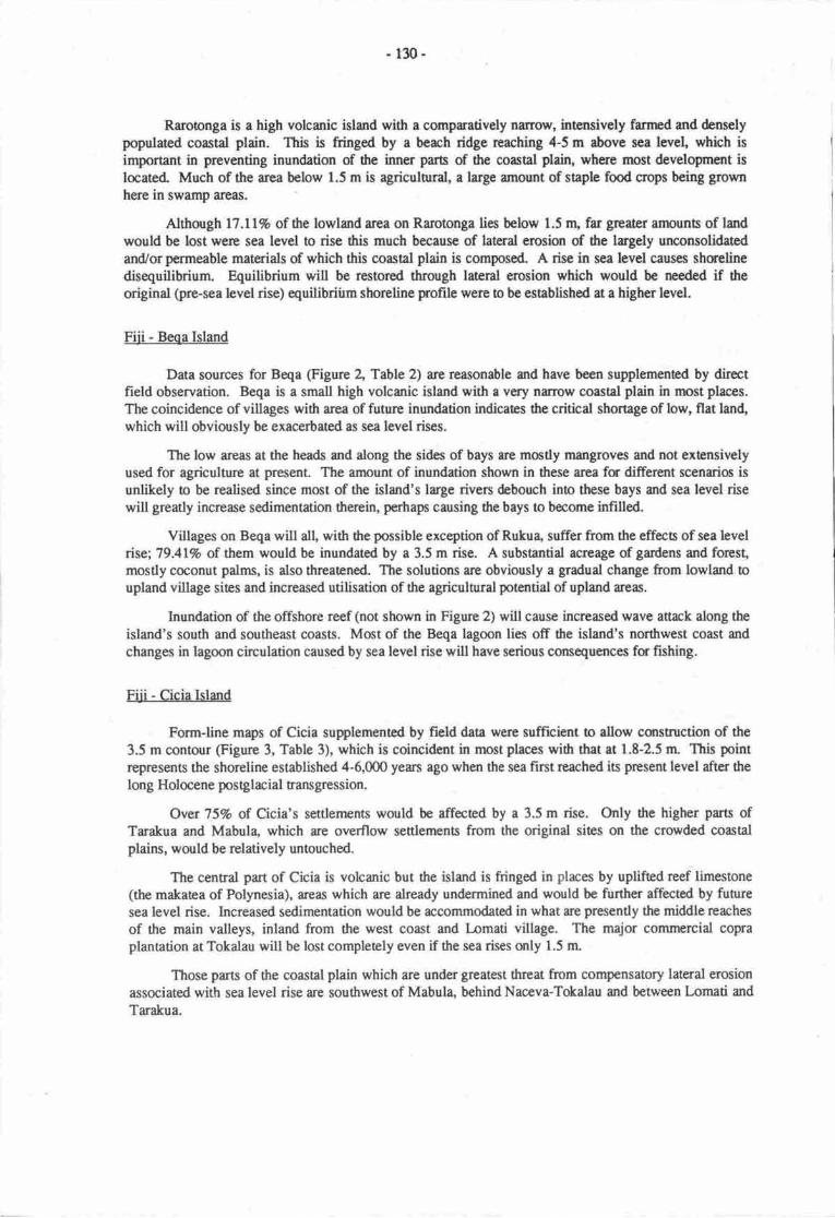
- 130-
Rarotonga is a high volcanic island with a comparatively narow, intensively farmed and denselypopulated coastal plain. This is fringed by a berch ridge rcaching 4-5 m above sea level, which isimportant in preventing inundation of the inner parn of the coastal plain, where most develorpment is
located. Much of the area below 1.5 m is agriculnral, a large amount of staple food oops being grownhere in swamp areas.
Although 17.Ll% of the lowland area on Rarotonga lies below 1.5 r\ far greater amounts of landwould be lost were sea level to rise this much because of lateral erosion of the lagely unconsolidatedand/or perrneable materials of which this coastal plain is composed. A rise in sea level causes shmelinedisequilibrium. Equilibrium will be restored through lateral erosion which would be needed if the
original (prc-sea level rise) equilibriirm shoreline pofile were to be established at a higher level.
Fiii - Beqa Island
Data sources for Beqa (Figure 2, Table 2) are reasonable and have been supplemened by directfield observation. Beqa is a small high volcanic island with a very narow coastal plain in most places.
The coincidence of villages with area of future inundation indicaes ilre critical shortage of low, flat lan4which will obviously be exacerbated as sea level rises.
The low areas at the heads md along the sides of bays are mostly mangroves and not extensivelyused for agriculrure at present. The amount of inundation shown in these area for different scenrios isunlikely to be realised since most of the island's large rivers debouch ino these bays md sea level risewill greatly increase sedimentation therein, pertrap causing the bays to become infilled.
Villages on Beqa will all, wittr the possible exception of Rukua, suffer from the effecn of sea levelise;79.41% of them would be inundated by a 3.5 m rise. A substantial asreage of gardens and forest,mostly c@onut palms, is also threatened. The solutions are obviously a gradual change from lowlmd oupland village sies and increased utilisation of the agricultural potential of upland areas.
Inundation of the offshore reef (not shown in Figure 2) will cause increased wave attnck along theisland's south and southeast coasts. Most of the Beqa lagoon lies off the island's northwest coast and
changes in lagoon circulation caused by sea level rise will have serious consequences for fshing.
FUi - Cicia Island
Form-line maps of Cicia supplemented by field data were sufficient to allow cqrstruction of the
3.5 m contour (Figurc 3, Table 3), which is coincidant in most places with that at 1.8-2.5 m. This pointrepresents the shoreline established 4-6,000 yea$ ago when the sea first reached is present level after the
long Holocene postglacial transgtession.
Ovet 75% of Cicia's settlernents would be affected by a 3.5 m rise. Only the higher parts ofTarakua and Mabula, which are overflow settlements from the original sites on the crowded coastalplains, would be relatively untouched.
The ceatral part of Cicia is volcanic but the island is fringed in places by uplifted reef limestone(the makatea of Polynesia), areas which are already undermined and would be further affected by futuresea level rise. Increased sedimentation would be accommodated in what are presently the middle reaches
of the main valleys, inland from the west coast and lnmati village. The major commercial copraplantation at Tokalau will be lost completely even if the sea rises only 1.5 m.
Those parts of the coastal plain which are under greatest threat from comp€nsatory lateral erosionassociated with sea level rise are southwest of Mabula, behind Naceva-Tokalau and between Lomati and
Tarakua.
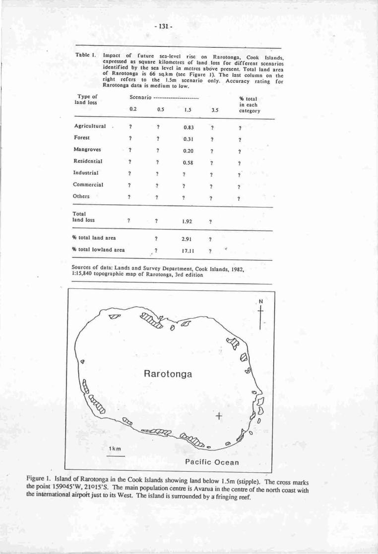
-l3r-
Tablc l- lmpact of futurc sca-tcvct risc on Rarotooga, Cook Islaads.crprcrccd rs squarc kilodrctrcs of tand.loss for -diifcrcot
sccnariosidcntificd by thc acr tcvcr io mctrcs ab<ivc prcscnt. rot"l lana arcaof -Rarotongo is 66 sq,km (scc Figurc l), Ttrc last columo on thcright rcfcn to thc t.Jm sccnario only, Accuracy ,uting forRrrotonge data is mcdium to low.
Typc oflatrd lors
Sccnario
o.2 0.5 r.5 3.5
$ toralin cachcatctory
Agricultural
Forcst
It'|aagrovcs
Rcsidcatial
Iadustrial
Commcrcial
Othcrs
,,
?
?
?
?
?
?
?
?
?
?
?
2
?
2
1
?
?
?
?
1
?
'l
?
?
?
?
,
0.t3
0.31
0.20
0.Jt
?
?
7
Totallrad loss t.92
q6 total land area
$ total lowtand arcr
1
71
7
?
2.9t
l7.tl
Sourccs of data; Lrnds aod Survcy Dcpartmctrt, Cook lslaads. 1962,t:15,8'f0 topographic map of Raroronga, 3rd cdition
Pacific Ocean
Figure l. Island of Ralotonga in the Cook htands showing tand below l.5m (sdpple). The cross ftr1,the point 159o45'w, 2lols's. The main population cent"-is n"r.a in the cenbe of the norttr coast withthe inunational airpoit just to its west. Tle island is surrounded by * fringing reef.
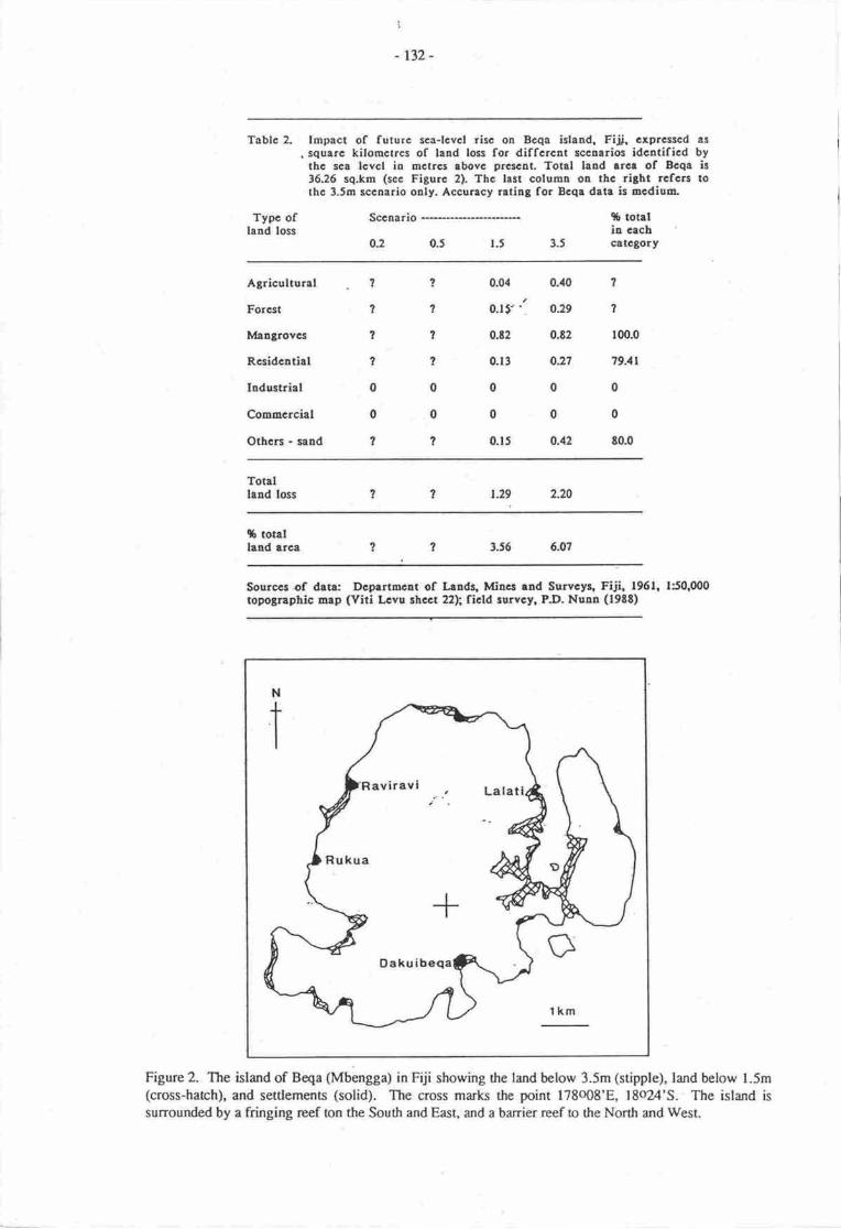
I
- tlz-
Toblc ?- Impact of futurc sca-lcvcl risc on Bcqa island, Fiji, cxprcsscd as
. squrrc kilomctrcs of land loss for diffcrcnt eccntriog idcntificd bythc sca lcvcl iu mctrcs tbovc prcsctrL Totsl LrBd arca of Bcqa is36J6 sq.km (ecc Figurc 2). Thc last columa o! thc rlght rcfcrs tothc 3.5o lccnario oaly. Accurecy rrting for Bcqa date is ncdium.
Tygc of Sccnario 96 totallead toss in erch
O.2 0J l.t 3.t cttcSory
Agricultural 1 ? 0.04 0.a0 ?
Forcat ? ? 0.tf'1 O:9 ?
It algrovcs 7 1 Ot2 0.E2 100.0
Rcsidcutial ? I 0.13 O27 79.{l
Iodustrial00000Comncrcial 00000Othcrs - sand ? ? 0.15 0.12 t0.0
Totallaad loss ? 1 l-29 2.20
$ totallrad arca ? 2 3J6 6.07
Sourcce of data: Dcprrto€nt of lands, lrfilg rod Swvcyq Fiii. 1961, 150,000topograpbic map (Viti L€vu shcct 22h ficld rurvcy, P.D. Nuu (l9tt)
Figure 2. The island of Beqa (Mbengga) in Fiji showing the land below 3.5m (stipple), land below l.5m(cross-harch), and settlemena (solid). The cross marks the point 178o08'8, 18o24'S. The island issufiounded by a fringing rcef ton the South and EasL and a barrier reef to tlre North and West
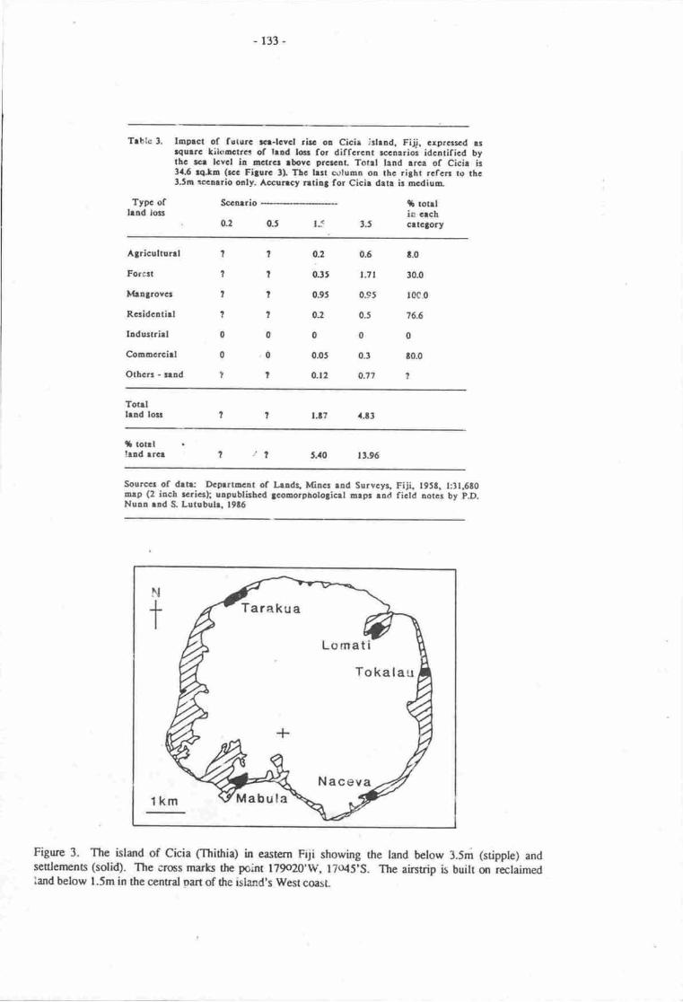
-r33-
Trble 3. Iopoct of fsturc rcr-lcvcl ritc oa Cicir irlrad. Fijj, crprcr:cd rrrqutrc kilooctrcs of lrad lc for diffcrcnt rceoarios idcntificd bythc rct lcvcl in 6crer lbovc arctcoL Totrl land arca of Cicir ir34.6 rqla (rcc Filurc tI Thc lrll crrtuna o! thc rigbt rcfcrr ro thct.5n rcclrrio only. Accurrey ntilj for Cicir drta ic racdium-
Typc oflrad lots
Sccarrio
(L2 0J I_<
9l totrlio crchcrtcto(y3.5
Agiculrunl
Forcct
Ivhljrovcr
Rcridcarirl
hdustrirl
Councrcirl
Othcn - rud
0.6 t.0
r.7t t0.0
035 r0c.0
0.5 76.6
000.3 t0.0
0.77 ?
?
II1
0
0
1
?
I1
1
0
o
?
o2
0J5
0.9t
02
0
0.05
0.t2
.l.ttl.t7Totrlhld losr
(b tonllrnd trcr .t, 5.40 t3.96
Sourccr of drtr: Dcglrrncnt of l,radq lfincr ud Survcyg Fiji t95S. l:3t,6E0orp (2 irch rcricrh uapublirhcd jcooorpbologicet aepr rnd fietd notcr by p.D.Nurn ud S- Lutubull l9t6
N
t
lkm
Tarakua
Lomati
Tokalau
NacevaMabula
Figurc 3. The island of Cicia (Ihifiia) in eastern Fiji showing the land bclow 3.5m (stipple) andsetrlen€nb (solid). The crcs marks the point l79(r20'W, l?o45'S- The airstrip is built on rcctaimediand below l.5m in the central Dart of the island's West coast
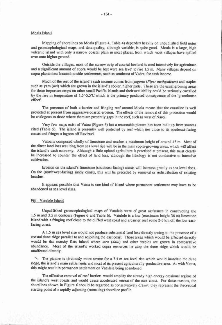
r34 -
MSaIA Island
Mryping of shorclines on Moala (Figure 4, Table 4) depended heavily on unpublished field notesard geomorphological mapc, and dau qudity, ddrough variabte, is quite gmd. Moala is a large, highvolcaric island with only a nanow coastal plain in most places, from which rnost villages have spilledover mto highergrund-
OrisiAe dre villageq nrcet of the narrow strip of coa*tal loryland is used intensively for agricul[rreand a significant amqmt of copra would bc hst were sca lever b rise 15 n Many villages depend oncqra planations located outsirle scrlercnB, such es southeat of Vadra, for cash incorre.
Mrch of ftc rest of the island's cash inconrc comcs fromlugana (Pipr nuthystiatm\ and st4lessuch rs yun (rrvt) which are gtowa in the islurd's cmlcr, higher parts. These arc the usual grorving areasfor thcse important crcpc on other snall Fcific islands and'their availability could be seriously curtailedby the rise in tempcrau€ of 1.515.5t which is dre dmary prodictod consequenoe of the'greenhouseeffecl'.
The prcsence of both a barrier and fringing reef around Moala means that the coastline is wellprotectcd at fesent from aggressive coastal erosion. Thc cffcts of tre removal of this prot€ction wouldbc matogons o thooe where thcrc are prescntly gaps in the reef, such as west of Naroi.
Vcry fan, maps cxist of Vatoa (Figure 5) but a reasonable picture has been built up from sourcescitod (Table 5). The island is prcsantly well protccted by reef which lies close to is southeast-fringcoas6 and fringcs a lagmn offRaviravi.
Vaoa is composed wholly of linpsone rnd rcrches a maximum height of a;orrnd 45 rn Most ofthe diroct land lms rcsulting from sea level rise will be in the main copra-growing areas, whbh will affectthc island's cesh ecqromy. Altirougt' a liole upland agriculturc is practised at prcsent, this must cleartybe increascd to countcr thc efrect of land loss, although the lithology is not conductive o inrcnsivecultivatiqr.
Erosim st the island's limesone (surtheast-facing) coasts will increase greatly as sea level riscs.ort the (northwest-facing) sandy coasb, this will be preceded by removal or rcdisribution of existingbeaches.
It apprs possible that Vaoa is anc kind of island where permarcnt settlerrenr may have to beabandoned as sea level riscs.
Fiji - Vetuhle Island
Unputlished geonnrphological maps of Yaurlele werc of great assisance in constructing the1.5 m and 3.5 m conoun (Figure 6 rnd Table 6). Vatulele is a low (maximum height 36 m) limesoneislrnd with a fringing ref closc o frc cliffod w6t coast and a banier rcef some 2-3 km off the low east-frcing oast
A t.5 m sea level risc would not produce substantial land loss dirccdy owing to the prescnce of acoastal dune ridge parallel o and adjoining the east ooirsl Those areas which would be affected directlywouid bc thc marshy flats inland whqe uro (dak, afi other staples are grown in comparativerbundance. Moet of the island's worted copra resources iie atop the dune ridge which would beunaffeted directly.
\ The picurre is obviousiy more severe for a 3.5 m sea ievel rise which would inundate the duneridge, the island's main satlenunts and mct of its present agriculturally-poductive area. As with Varoa,this might rrsult in perrnanent settlement on Var.rlele being abandoned.
Thc effective rcmoval of reef barrier:" would amplity the already high-energy erosional regirr ofthe island's west coasts and would cause accelerated retreat of the east coast. For these reasons, dteshorclines shown in Figure 6 should bc regarded as conservatively drawn; they represent the thecreticalstarting point of :r rapidly adjusting (rcr,eating) shoreline proFrle.
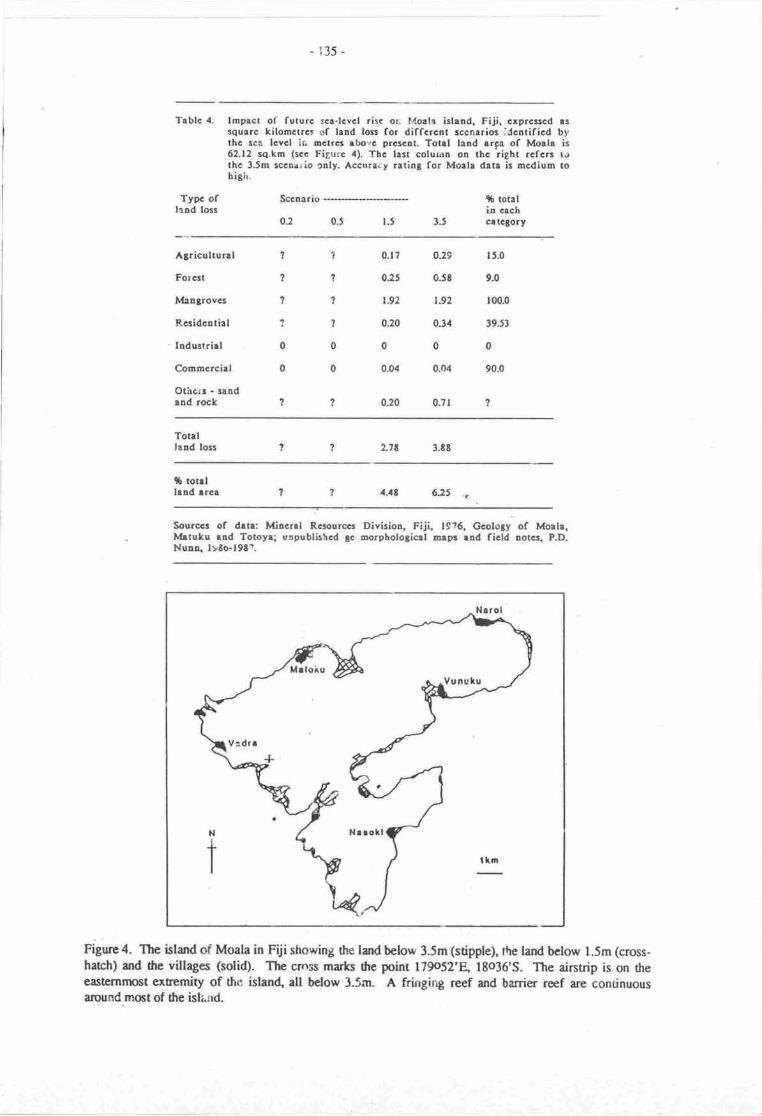
- 135 -
Tablc 4. lmpact of futurc ac!-lcvcl risc or: Moale islrnd, Fiji, crprcsscd assquarc kilomctrcs of land tosr for diffcrcnt sccnlrio3 idcntificd bythc sca lcvcl ir. Dctr6 lbovc pr€scot, Totgl land rrga of Morla is62.12 rq.km (scc Figurc 4). Thc lrst colurnn oB thc righ! rcfcrr t.rthc 3.5m lccnario only. Acorraiy rating for Morla data is mcdium tohigh.
TYPc oftaad loss
Sccnario
0.2 0.5 r.5 3-5
$ totalin crchc!tcSory
Agricultur!l
Forcst
Ivlrngrovcs
Rcsidcotial
'Ioduslrirl
Commcrciel
Othcrr - randrnd roc&
1??111?r00o0
0.17
0:5
r.92
0.20
0
0.04
0:0
029
0.58
r92
034
0
0.04
0.7I
15.0
9.0
100.0
39.53
0
90.0
?
Totrllaad loss L?E 3.EE
tb rotrllend trcr a.a8 6:5 .(
Sourccr of drtr: Mincnl Rsourcct Divitior, Fiji. t9?6. Gcololy of Morlr.Ivlrtu&u rad Totoyr; uopublishcd gc arorpbologicrl arpr rnd ficld notcr. PD.Nuao, ltto-l9tt.
Frgure 4. The island of Moala in Fiii showing the land below 3.5m (stipple), the land below l.5m (cross-harch) and the villages (solid). The cros marls rhe point 179o52'B 18036'5. The aintrip is on rheeastcmn$t extremity of the islan4 all bclow 3.5m. A frfurging rcef and barrier ref arc continuous:tfirund m()st of fie isla;rd.
- 136-
Trblc l. tE rct of frtnr: g-lcvcl rirc oo vrlq irludr Fiji. crprclcd u{urrc lilooctrcr of hrd losr for diffr,rcnt rccrrri,or idcltifio<t bytlc s lcvcl lr Etrcr rbovc 9.!nrcrt. Totli l.r!d trcr of Vrtol ir{.15 rqh (*c Fijuc t). Thc lul coluan ot tbc ritht rcfcc lo thc3.5n slrrio ody. Accuncy rati.t for Vrtoo detr ir oGdilrl tolor.
Typc oflrad los
Scclrrio
0: tJIJOJ
t rorrlil cechcalctory
Agicoltur.l
Forcrt
lbljrovct
Raidolthl
IldutrirlCorncrcirl
othco
- lrad
- blrc rocl
0
?
0
1
0
0
0
t0
7
0
0
0
0.19
0
0.0,1
0
0
0.02
7
000.6r I000.09 r(r90000
o.oa ?
0.lr 7
Torrllrnd le't 0-45
S tordlud rrca lo.t l'?
Sourccr of dln: LE.A Prttcdoa, 1967, Topotnpbicrl Survcy of V.tor lrhld,S& Iru Grodp (l:rl,tfl)).
Figure 5. The island of Vatoa in soulheast Fiji showing dre land below 3.5m (stipple), ihe land belowl.5m (cross-hach), and dre villages (solid). The cross mar&s the point l78ol3'W, 19o50'S-
r37 -
Aftlrdocda of ScdirB drirftns wEtrr ftorl Jh.llory *tU$ ofrn cmrrlhled wi6 lce wtcr,crhitllrge qr vrtrlcle.l[rrently rytnoc o ninwurcofdtma, whi{fi lr clcrlty bc t}Tc ofnnvc similrrly.siurruJ islord canurnrniticr rhorH mtc.
Fiii - Lrb8se town
Lrb$r is thc kgcrt urtn canuc sr vnur Lcw btmd i! Ffi rd hr inportlt frrrctimr s rP"t ryrytty fa export of crsh cropa, espcielly sugrr ** -Irb*.
(Figurc Z) is lancd cloc o thchcrd of r la4e dcltq thc prrodrctivc nrtr dr.*r,i-rr .ri p.a"t"c uy r numbcr of rce wrllr. Tlnc lrryerivrr syscms ' the wribrnl !"b*i md Qrwr - -i"y ino air <r md in ftcfu rlluvirl vdcyrboutt&d by drc bwesi M-{lop. h Fi$lt€ r, mt or-tn to* oo in rtE inun diac rEr ir gro*n.Figure 7 slro*s thc 1.5 m nd 3.5 rn cmoun requtuctd rc p"tnriaco by nry ovcrrye of the ucr"The wrilcvu, Ilbtsl and Qrwe hrve ben cortributing suffici3r1 s.dinslt trr drc Lrbese oo.,t Eoenablc it o progredc ovcr thc hst fcs millcnnir- war sce tia o ri!c, thc mein effct in Ernu of lrdlcs would bc thc lndwT Pggl of drc prcrcnt slracline. Thir wqrld dso cluc rivcr rodi mt 'dy"E"_P lcont impounaca in thc Srrilevu, Lrhtr nd eewe;dhyr, rn cffct whbh wqrld lcevc thcsiE of Lebrce itrGlf virturlly uninhrbitebh. It voold rrrc Ircncly fs {rc pro&crivity d rtc vrlleyrwhich, like se mmy rbng viti Lcvu'r nf,lh co.rt, provlb dtl o,.io elcnrm in 0,e illrd,r crdreconomy. As scs level bcgm rirhg h thc lrf d! fnstnodcc$lc cfc would bc _ indr" in lqge-mrgniEdc flood fraqucrry T fu vrllcys, which wqrld ceruc irseri auruel frilsrc or d rugrr ca:erd shqt-armaukhnrntof drc elluvirl crpctTtn itryact in arms of lmd loes on Labrsr brt'rn iaclf @gnrc & Trblc 7) wrs dctermirpd fromdcteild lard;usc mapPh.g on good qudity brsc nrq. Nerrty gor-of 0r. rrwc would bc inunrlrcd in 6c3'5 msccn'arb' butthc sic-would otviousty bc rbmdonod Ltt b.d fic sce lcvcl rwbcd dl$ hcthqfq rcrsans stlod rbovc.
- with such a lrrye corrlrl frront4c, ibrgonn:nt of drc sito ppcrrs the qrly
feasiblc option. Thc high grurnd immoaiercty to 6G m;l'J* *r-t ror,n $ouH bc suitebh farelocation.
Fiii - Savusaw own
Sawsevu is laead qr thc rqrthcnr ri& of Vmue Levu islm4 soes frmr Irbur (rc rbovc). Itis smallcr drgr Lrbesa' ddtough of propatirnrl imeorrrmc ro its hifialrrd rnd *d"l,"d rlury enrfi)w corstd plain. j{s rrrch it is tpicd of rnury scdcflsrts m islnds whcc rtpre ara no cxtsnsivecoastd fbts avribble fa scclcnsrt It shontd bc;obd ftrr dur rnTrbb g,Gr;r,g b it-c 9 rrc insqu& nctrcq not squse kilonptes u with thc othcr t$hs.
- .- ltl*gh ncarty helf thc own would tlrcmticelly bc inundrbd *rrc rcr lcvel to rise 3.5 miTahlc E)' oc ineounaing of rcdinprt bthind fu hrdrftds-tr*.d"g shrelirc *ouu r.r* grcacrproblems b d|G towtr lSnrcsartlr lying rbove 3.5 m. Thcse*nra u. nurifcsrd rr m imgsc in rhcextcnt md ft'o1uarcy of lqgc'qrgnir.rdc ftm& d mur mvcourt a'cntr nrch rr hdslidcr.
Kiribnti - Tnwe rroll
Althorgh nc dircct ciginrl infannetkn $out rho imprct of fuu'c ccr larcr rirc in Kiribrti co'ldbe oheine4 wing to r lrt of prirnry sotucaf it is clcrr ti"t rr.*r. rll, whcrc drc cepital Bdriti irsiurarc4 excmpliEcs rhe island t!"c.
sfurc nnet mid-@cm (6cnic) <s do mt risc n,rch lbevc 3i rn' dE iqrct of r scr tcvd ri,"of that magriurdc on lendlcr will clerty be grcrE drm fa ny odrcr crrc rnrdy pccancd in ftirr!?ort Thc snull si'!, 6 drc nnos, c nnd-rcef islar, wUf ;dcr rtificid ,froi.fi* poedmprohibitively apensivc.
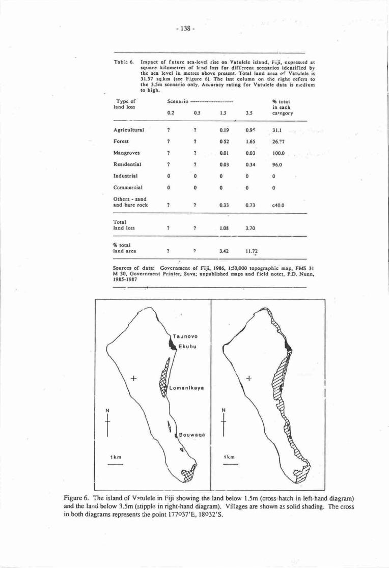
- 138-
Tabl:6. Impact of futurc rce-lcvcl risc on Vrtulctc islend. Fiji. crprcased r:tquerc kilornctrcr of laad losr for differclr rccnrrios idcatificd bythc rca lcvcl in mclrcs lbovc prcicll Totrl lrnd lrca of Vrtulclc is31.57 rq.km (scc Figurc 6). Tbc lrt coluon on thc riSbr rcfcrr rorhc 3.5m lccaario oaly. Accurrcy rrtiot for Vrtulclc deta is arcdiumto hi8h.
Tygc ofland lols
Sccaario
o.2 0.5
rb totelin cechcil.cgofy
Agriculturrl
Forcat
Itllelgrovcs
Rcsrdcatirl
Industriel
Commcrciel
OthcB - r!!deod barc rocl
0.9< 3t.t
1.65 26.11
0.0, [email protected]
0.3. 96.0
0000
0.73 c40.0
1
I7
1
0
0
? 0.t9
? 052
? 0.0r
? 0.03
0000
0.33
Totrllaad loss t.0t 3.70
$ totelland trcr tt.72
Sourccs of drtr: Govcromcat of Fiji 19t6. 150.000 topo3nphic nlp, FlvlS 3lM t0. Govcruncat Psiotcr, Suvr; uapnblirbcd orp3 rnd ficld ootca, P.D. Nunn.r9t5-19t7
Figure 6. The island of Vrtulele in Fiji showing the land below l.Sm (cross-hatch in left-hand diagram)and the land below 3.5m (stipple in right-hand diagram). Villages are shown as solid shading. The crossin both diagrams rcpresents t\e point 177037'E,,18o32'S.
Ta u novo
Lomanlkayr
Bouwaqa
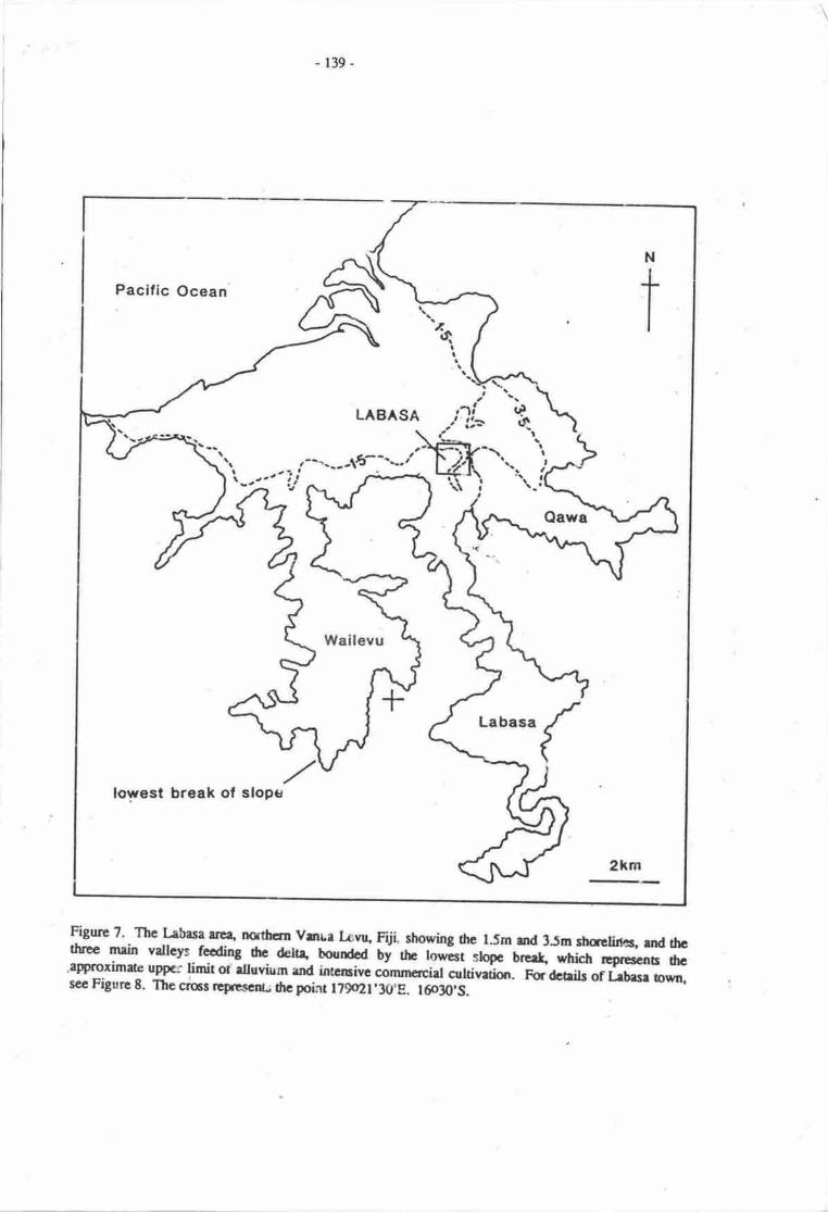
- 139-
Pacific Ocean
lowest break of sloptr
-r-".---16--"-"-.:"?i n- l-
N
tg:
III
LABASA
Labasa
{
2km
-FiSurc 7' The Lrbasa rrcq northcm vrnua E"q fiji shorrirrg the l-5m md 3Jn *celines,
'nd frcttuee mrin valtcys focding frc deltA bourrdod Uy rfro fo*it s@ brc{ wlrich ,og**e O"
'approximae uppcr limit ot rltuvium rod intamirc cirunacia ornivrrirn. Fr&aib ortrnsr oum,scc Figurc 8. Thc cnsr rcpcscru fte point l?9qll'30'8. l@30,S

- 140-
Trblc ?. lag.cr of fltrrrc *r-lcvcl rirc oa lrb.r torq Vrtur lrvu. Fiji,crprc'od 13 rqlrr€ tiloactrcr of lrad lc for diffcrca.r rcearriolidcarifir{ b, thc F lcvcl il ctrcr rbovc prctc|rt. Totrl hld rrceof l,ebel ir rpgroriutcly 0:t rqla (roc Filurcr ? rrd lI TLc t.rtcolunn ol ttc rigt rcfcrr ro ttc 3-5a lccarrio o!ly. Acclrrcyrrtilt for hb.! drtr it tiSL
Typc oflrld ls
Scclrrio .
02 3.50.5
I torllil crclcrtetory
Atricultuqrl
Forcrt
lltl3rovcr
Rcridcrrid
Iadnrtrirl
- port-rchicd
Oonmcrciel
Othcn - rcrviccr
- oPcD tDtcc
- cducrtioo
0
0
0
?
?
I
t?
0
0
0
I?
I?
0.002
7
2
0000000.0rJ oltt.
0-q,2 0.006
0.01t 0.0{t
0.010 0.10,a
0.0r9
0J0{ Ofir6
0.00t 0.01.t
Totrllrad loss 0.072 0.25t'
rl rotrtlead arcr 25.71 t9-6{
Sourccr of 4lrn: Miairrry of hrd:, FijL t96t, plus of Lrtrrr radrurroundiaj lrcr (l:lJta} rugglcocanry ioforantiol by B. lvlesieaial
Figure E. Labasa town, Fiji (see also Figurc ?) showing the l.5m and 3.5m contours. The river flowsnordtwards, the broken line represents the town boundary.
SlEnEq-:S

-l4t-
C'oilrctions bawcen nntus. such rs dlc BctbBrirfi ceuFway on Tarewa, will be incrcasinglysubject to scverc croeiqr and pcriodic inundation rs sce lcvel u"git r tiiirrg rta r-i qui-"kty be rcnderedunusablc.
The inundation of thc atoll rocfs offslrqs will result in greater wrve €nergy on se shoreline and areduction-in thc supply of rcef-rwt &hs o the strorelirn; uoll erecu will cause a shap increase in theeroaion of the acan-frcing sidcs of noius.
The hiSh rclierrce of atoli cornmunices on groundwater fm drinking and fr agrbulture, espciallyin pits dug down into thc freshwater hrrs, must be lessencd if 0re sea level rise is not o necessitateabandsuncnt of 0re atolls within thc ncxt 50 prs; red:rction in vclurrc of the lens will odrerwise havedisasu',ous effects.
Ttrc sccnarios of impact on aolls are the urcst severc discussed and it is recomrrsrded thatimnrcdiae plans fc rese'rement re drawn up by drc appopriae aufiaitics.
Tmga - Nafanua harbour
The harbour bf.fig* 10) is lrgely artifrcial ord was consrruced to serve the needs of theisland of 'Eu4 of which 'oroua is the larg-est settlenpnt. The o"tign of the harbour with a wharf 2 m inheight sppeas able o rccomnod.tc a sce tevel ris€ wirh less ffitms thsr elsewhere (Table 9), accrclusior which applies elsewlrre on 'Eua on rcoount of is ganerally cliffod coasr
- - Flooding along the river valley o the southeast of rhe wharf is alnealy a problern and one whichwould be exrcerbated by thc see level rise. Th sorrunertial centne of ioharua would be largelyuntouched by a 3.5 m sea level rise.
Tqrsa - Nuku'alofa
O*ing to tre availability of suitable maps, thc study of Nuku'alofa is one of the nnst derailed casestudies in this r@rl l9.'1jf. (Figure 11) is the capital of the Kingaom of ronga and is situated onthe low-lying northern side of rangatrpr islm( whicl is composed entirely of lirrestone and superficialdeposits.
As can be soen from diagram Nl (Figurc ll Table l0), mct of the 0.2 m and 0.5 m sea level riseTTttiT would rnt apparently affect the ienual part of Nutu'alofa on accounr of eristing sea walls,dthough once these have been overtopped' severe effects in rerrns of land los: m the commercial districtand one of the npet imponant culural reas in Tonga will ensure. However sirce the town is based onraised lirnestoner p€nebatim of sea water may renda the sea walls frrnctionless.
The major port oea of Nuku'aloth (Flgur€ ll, diagram N2, and Table lt) is also bordered by aseawall, but this will not prove as effective a banier o iriundation and rnost of dte map area would beinundated if sea level rose 3.5 m. Ttris area ircludes rnany nya,ocarton storage frcitities and facilities forme manufrcUre of many light indusrial and otha products.
A representative area of suburbs in Nrrku'alofa (Figure ll, diagram N3, and Table 12) was alsoexamined' The coastline hert is not seawall-protecrd ana trre c.2 m and 0.j m shaelines have beentrrced through the mai4roves and debris which comprise m.st of it As with arca N2, nearly half thisarea would bc inundated by a 1.5 m sea level rise, nearly all by a rise of 3.5 m.
The highest parts of Tongatapu lie in the island's south and southwest an4 if the sea level begins1o
rise' it seems likely that relocation of Nuhr'alofa in these directiqrs will have to tate plrce. lt seemsimperative however to deternine the effects of sea level rises of various magniurdes on shoretine retreat,much of which will corne about in response to not as a direct manifestation of sea level risc. owing tothe-low-lying and crpced charrcEr of T.ngaapr's nonh coast, ir prcservation in its present condidonwill beconrc increasingry erposive urd probabty incrcasingry ineffectve.
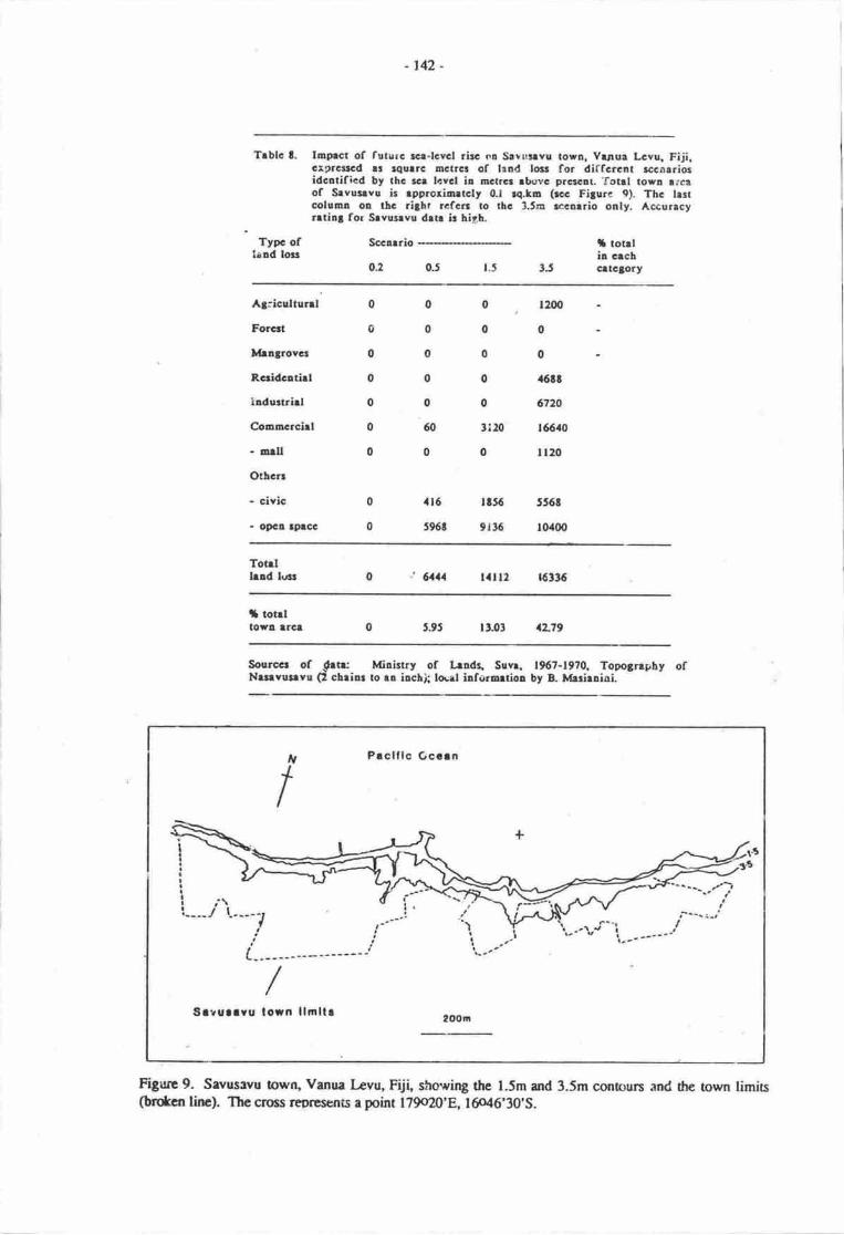
-r42-
Trblc t. InFct of futurc rcr-lcvcl rirc ol Srvulrvu towa. Ytrur Lcvu, Fiji.crgra$cd rr rqurrc nctr6 of ltad lolt for diffcrent rccnrrioridcatificd by thc rcr tcvcl il octrcr rbovc prsr.!r.'fotrl torn trcrof Srvulvs ir rpprorioetcly 0.1 re.to (rcc Fi3ure 9). Thc tr3tcoloo! oD llc ri3ht rcfcrr to $c 3.til rccarrio ooly. Accurtcyrrtir; for Srvultvu dlr ir f,igh.
Typc oflrad loar
Socarrio
0.2 0J t.5 ?5
i totrlil crcbGrt€torlf
A3:icultnnl
Forcrt
Itlrlgrovcr
Rceidcltirt
ladurtrirl
Oooocrcirl
- orllOtbcn
- civic
- oDC! t9.CG
0 . t200
00000 a6tt
0 6720
3i20 t56lo
0 ll20
rt56 556t
9rt6 10400
0
0
0
0
0
0
0
0
0
0
0
0
@
0
ar6
596t
Tot.lhnd &s ' 614 tail2 |6t36
il totrltor! lrcl rtJ3 aL79
Sourocr of {1131 Mirirtry of lrdr, Suvq t967-19?0. Topo3nphy ofNrr.vulvu (l chriu to ra ilcl| lourl iafotutiol by B. ltrrirnial
FiS,ltc 9. Sevusrvu towtr, Venua Levu, Fdi" showing thc l.Sm ild 3.5m cont$urs and dte town limits(bdcn lirE). Thc cross rsprcsents a point 179c20'8,16o46'30'S.
tV
tPrclflc Occrn
twr\/ ,-yt - .---. i-l'.--. t.,t r, '. :-v
a---
/Srruarru lorn llrnllr
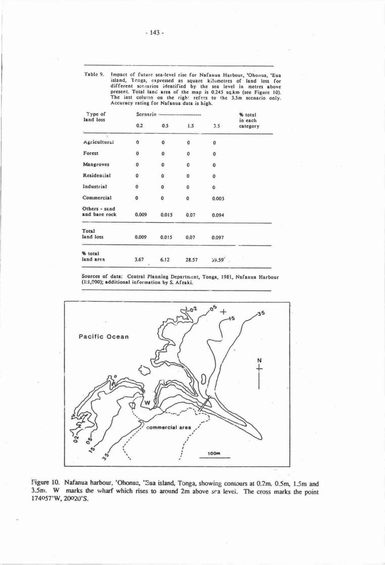
.r43-
Trblc 9. lmpact of futurc sca-lcvcl ricc for Nafanur Harbour. 'Ohorrur. .Eutislald. 'lon6a, cxprcsscd tr squ.rc litrrmctrcr of tand los fordiffcrcnt lccorrior identificd by. thc sce lcvcl io octrct tbovcprc!.nt. Total hn<i rrcr of lhc a.p ir 0.2.t5 rq.km (rcc Figurc t0).Thc irit column or rhc rith: rcfcrs to lhc 3.5m rccalrio onty.Acrcuncy rrtiBg for Nefraur drtr ir higb.
Typc ofhad loss
Sccnario
0.2 0.5 tJ 1.5
rh totllia crchcrtctory
Agricultural
For6t
lvha3rovcs
Rccidcarial
Iodu:trirt
Comncrciel
Otbcr - saodrld brrc rock
000000000000000000
0
0
0
0
0
0.003
0.G}40.0r5 0.0?
Totrllead locs o.qx) 0.0r5 0.097
|f totrll.rad rrc.r i9.s9(3.67 6r2
Sourccr of drtr: Ccttnl Phaaial Dcptrtmcat. Ton3e. l9Et. Nrfrnur Hrrbour(l:1,0{X}[ rdditioart iaforortion by S. Afcrki
Pacific Ocean
Figure 10. Nafanua harhur, 'Ohonua, 'Eue islen4 Tonga, showing conlounl at 0.2rn, 0.5nr, l.5m and3.5m. W mfits the wharf which rises to around 2m above sra levei. The cross marks the point174057'w' 20020's.
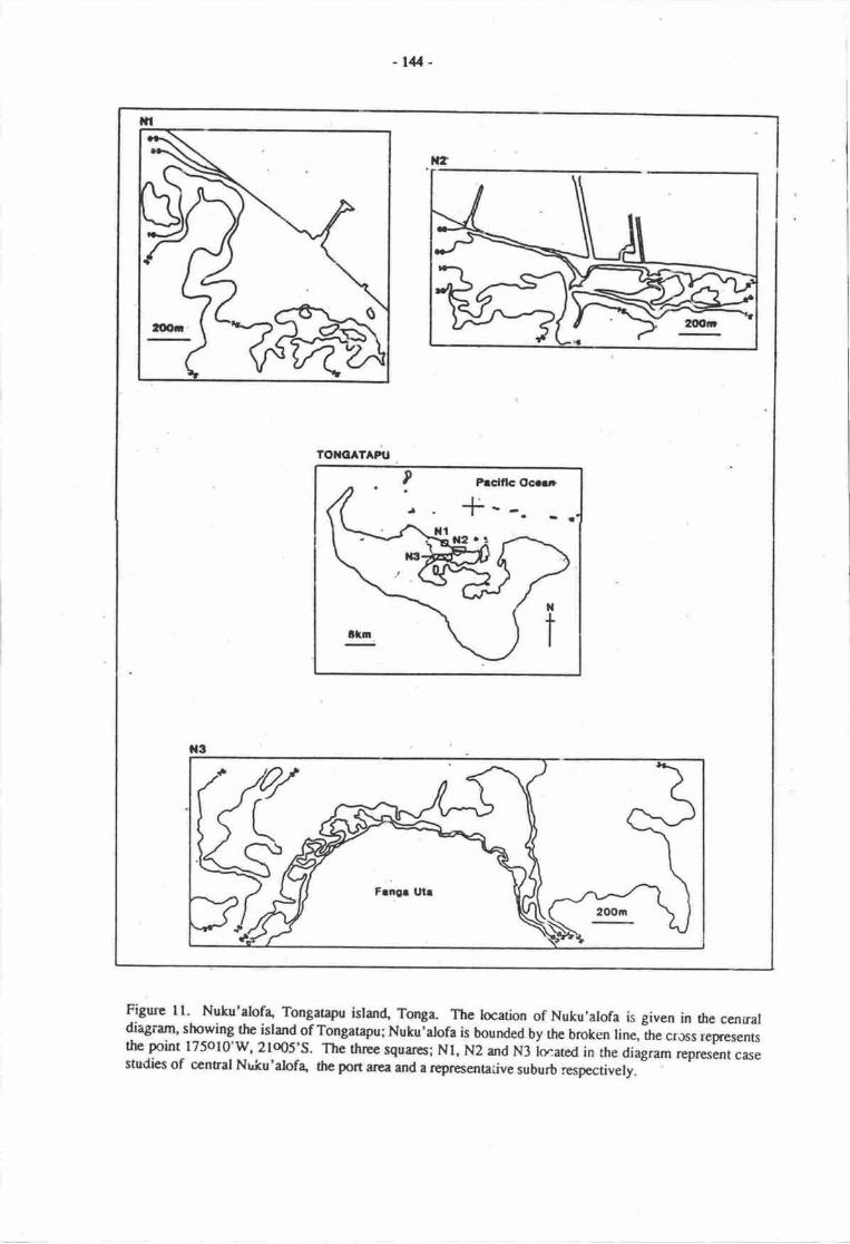
-r44-
TO}ICATAPU
Figure 11. Nuku'alofa' Tongarapu istan4 Tonga- The location of Nuku'alofa is given in the cenraldiagram, showing thc island of Tongatapu; Nuku;alofa is bounded by the broken line, the crJss representsthe point l75ol0'w, 21o05:s. The three squares; Nl, N2 and N3 iocated in the diagram represent casestudies of ccntral Nrrku'alofa, the port area and a representaiive suburb respectively.
-r45-
Trblc 10. togrcl oa frtrrc rcr-leltl tirc .. Grrl.rl Nrtr'rlCq Toqrup'r.idrrd. To1.t. Gr9rar.d at trat. tiLcls.r rf lrd lc fcdilfcrclr *c..rlc ldcrdfld bt rh t.| kYCl L Elrcr .lotcprctc.L To{|l bod rrcr of Or nrp (Nll b o.tl |q1. (tc. Filtrclll Tf. hn oob.. tr itr .Llt rcfclt ro rlc 3Jr e||rb ody.Accrr.cy rrrLl for Xrtr'.lofr (Ntr.har b lillt.
tlpc ofhld lo||
Seurrio
0:'J
IJqti |o|rli! tr,clcrrcla.t
Alricrltr|tlFccil
llrrt.ourr
lcd&!thl
Irdrrtrirl
Coolccirl
Orlcn
- Royrl ?rhcc
- lotrl Toab
- prtt
00000tle00orlt 0rll 0.011
0004.019 0.129 0.421
0
o
0
oflt0
0!o9
0
0
0
0
0
0
0.0t2
orar
03t
otaTorrlhld 16 0.02 0rt 1Sr7
l aot l l|rdarct o! Ea9 La7
'lrblc ll. hgoct of frtsrc r.r-lcvcl rbc or tlc .ri.gora rrcr,of, t{rrltllofr.. Tocptrpn irhld Toqr. crrrcd .r r4!.rt tilouct?Ga of lud lofor diffcrclt nlrrb klc.riflcd bt ric rcr lcvcl il rctr6 rboveDsq.aa, Totrl L|rd rr.. of tlo o.t 0{2) ir G?t rqlr {rc Figrrcll). Thc i.:t aloo! or tl3 3iatl rcfcn ro rbc 15c E!.rio orly.Accuncy rrrila for Nglstlolr (N2l drrr ir fitL
6Ll7tTrt!.ro
Sorrc r of dro: ?orld tlerllt Orfrebtior. l:lrO ro of Xrtrblc(l"Toltrtrpr. Tolrc l9!t: lql dcrr[ ty i Af.tl rrd Y. Tbctl
Tyac rflrld 16
Socotri,o
0.2 t5IJ0.t
I lo|rlir crclGrtclort
A3ricslrrnl
Forcrt
Mro5iovcr
Rcrid.e.irl
Iadurrrirl
C.ooocrcirl
Oli.E - rchoollld chrcl
o 0.T., o.ilt
00000Ot 0.00t u.ool
0J3t 0.110 o:tt0.06r c.06a 0.0t0
0.0t9 0.0$ q05t
o.ott 0.0?: o.t66
o
o
o.(x)t
0.00t
0.004
0.005
0.0rt
Tot|llild 16r 0.0.' 0.t74 0J1r, o.7to
t tot|l lrldtrca $= r.t9 5.tl 2L3l {z3l
sou.cr3 of d.t!: tYorld Hcrlrh !'lrlrBit.i:o!. l:;.iloo r.p of Nutr'rlof+To!3.t 9u. Toaf l9tl: lo€ll dctri! by A Afcrti rnd v. Tircli
9r.ot
-146-
A rnore detailed assessrnent of the potential impacts of sea level rise m Nulu'alofa is presented inthe case study by Spenneman et al- (this volurre).
Trblc 12. lmprcr of futurc rcr.lcwcl tirc on thc Ftotr - Hrvctu-Loto-lftteikr suburb of rostt€.o Nulu'rlolr, Toa3rtrpu ithad. Tontr.crprcas.d lr rqlrrc tilooctrs of trad locr for diffcrcat rccorriocidcatificd by thc t . lcvcl in tnctrca lbovc prcrcDt. Toul had rrcrof tbc D.p (N3) ir 2t2 rq.lo (rcc Fitorc ll). Th€ trir colum oorhc rilbt rcfcrs ao tbc 3.5n !.c!.rio oalt. Accurlcy rrtio3 forNuku'rlofe (N3) drh ir tiaL
Typc oflrnd lorr
Sccnrrio
0.2 1.5
i ror|lin crchcrralory
Agriculture'
Frrcst
Mengtovcr
Rcridcatirl 0.0a5
Industriel 0
Comsrcrciel 0
Otbctr . rcboolrtrd coEouoity ccntre
0.or
0
0.0{t
o000o.oat 0.0{3
o:r5 0.ato
o00.003 0.@3
0
0
0.020
r.t2t
0
c.@t
0,0r r
Totrllead loat
'r rot.l hldafca oa Etp r5J5
Sourccr of drtr Vorld HcdtL Orleai||rior, t:1.000 a.p of Ntlu.rlofr,Toa3etepu. Tour t93l; locrl ilffiErrioa by S Afcrki rod V. Tirli
Western Samoa - Aoia
Apia (Figure 12. Table 13), the capital of W€stern Samoa, occupies a ruunow coastal plain fringedpartly with rntngroves, around a harbour which lies opposite a prominent brcak in the reef. Most of tlremangroves would be inundated were sea level to rise slightly, but if this increased to 1.5 r\ then most ofthe comrnercid centre of Apia would be inundate4 including the peninsula leading to Mulinu'u Point,where the governrnent buildings and many large horcls are situated. A 3.5 m sea level rise would not addmuch to this picture although the dispend of sedirnent and water coming down the steep, narow valleysof the Gasegase, Mulivai and Vaisigano rivers behind the town would become rncreasinglyproblematical. The solution to the lacer may be to pipe the drscharge of these rivers away from the town.
coivct-ustolls@It is clear that, if the sea level rises in thc next 50-100 years irs predicte4 the economic
consequences for Pacific island nations will be enormous. However, in many cases, for:ward planningwould offset tlre enormity of the irnpacq althuugh in other cases, prinurily thoce of presently-inhabitedatolls, there appears to be no feasihle way of avoiding the impact of future sea level rise.
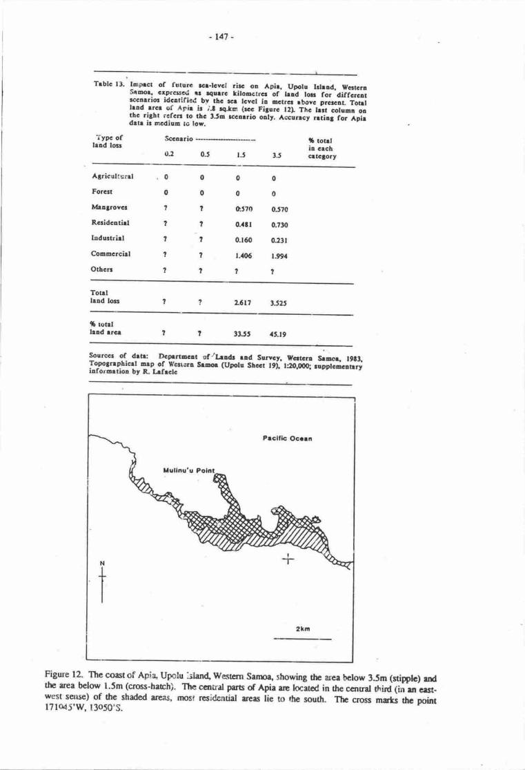
-t47 -
Trblc 13. laprct of futurc r€r-rcvcr rirc ol Apir. uporu rrrrad, wcrtcraseuor' crprc*cri $ tqurrc lirooctrcr-of-rrad ro. ror'ciiicicarrccnrric idclrificd_by thc tcr rcvet ir ocrrcr rbovc prc|"rt. Totrrlrnd rrct of Apir ir ;f 4.tm (rc Filorc t2I Thc f*r coiuni-onthc ritht rcfc' to thc 3JD rcclrrio oalty. Accuncy ntiat for ipiedrtr ir mcdium to lor.
Typc ofhld lost
Sccatrio
0, 3-50.5
i totrlia crchcrlGtory
Agricultunl
Forcat
Iv|lntrovct
Rcridcrtirl
Iodurtrirl
Corurcrchl
Ottcrt
0000c570 0.570
0000?????tt??l
o..tr 0.1n
0.160 0:3t
l.{06 t.99,1
Totrllald lolr a6[7 3l.25
rb rotrlhad rrcr 33.tt 4J.t9
sourccr of- drtr: DcFrtEGrt ofllrldr ud Survcy, vcrtcrl Srnoq r9t!,To_gojrrpf,icrr anp of rrc*cra slao (uporu shccr t9i tro.oq rieer.i.iiryiaforortioa by F- kfrclc
Figure 12. The ooastof Apia Upatu rlen4 Westcrn Sanroa showing tlp area bclow 3.5m (sdpplc) mdthe area belorr l.5m (cross-hach). The canrat par6 of Apia rre tcnatoC in rhe ccnral UtfC 1in m e13t-west selNe) of the shaded aneas, most residential areas lie to rhe south. The cross marts the pointl7lo45'q 13050,s.
-14t-
In all cases, forcknowL:dge is mt cnurgh; frsightod and maybe unpqulr decisions need o be
taken smn. Sorn sp"cifrc r€commendrti(ms re r follows:
that a mnre ind4dl study of ilrc pocntial impect of firture sce level risc on Prcific islutds bc
ccried out as e fkxity;
ttrat quantitative data on sediment and waer discharge of major rivers close to importstsettlerren6 be gathcred ard inprt ino modcls which rri: ablc to pedict lutdscpc rcsponse to
bodr sca level nsc and enperature rise;
that contingency pluts be drawn up fcr the movenrnt or reimetion of major Prific islardsettlenrns to arcas where they will not bc affectod by funre sca level rise;
that Pacific island govemments fcm r joint consultative hody to reach decisions based on
available data
ACKNOqrI.-EDGE},GI.|"IS
I wish to rhmk the fcllorring for their participation in this projecl Reseaxch assistanu Ms. Rafat
/ li (USP); surdsrt reseachen:Mr. So.kai Afeaki (Tonga), Mr. Roger Hazelman (Western Sarna), Ms.
Rasela I-afaele (Western Samoa), Ms. Bernadette Masianini (Fiji), Ms. Ruei Radovu (Fiji), Ms. Christine
Sgorns (Flji), Mr. Kianteata Teabo (Kiribati), Mr. ViliarE Tiseli (Tonga); research associates: Mr.Imam .A,li (USP), Dr. Satish Choy (USP), hofessor W.C. Chree (USf), Mr. Russell Fenney (Ftji), Mr.
Saimone Hclu (Tqrga), Dr. Asesela Ravuvu (USP), Mr. Alf Simpscr (Fiji), Ml. Abueti Takaio
(Kiribati), Dr. Randy Thaman (USP), Mr. Auseralia Titimrea (Western Samoa), Mr. Sione Tmgilava(Tonga), and Mrs. Helga Trrchet Vande-Voorde (Fiji)
It should be noted that participation in dris project das not imply agreenrnt with ia majafindings nor the conclusions &awn by the odrer participurs. Ultimatc responsibility fa thc cqttenB ofthis report lies widr the eam leader.

-14)-
R'ECEI{T COASTLINE CHANGES AND THF,IR IIITPLICATIONS FOR FUTURE CHANGES INTHE COOK ISLAI\DS' ruI, KIRIBATI, THE SOLOMON ISLANDS, ToNcA,l UVALU,
VANUATU A\D WESTERN SAIITOA
Petrick NunnUmvenity of fie S^uttr pacific, Suva. Fiji
AIMS OF THIS INVESTIGATION
The fi.-st part of this study, reported elsewhere (Nunn, 1988a; this volune) g"ve details of theimpacs of sea levei rises of 0.2 m and 0.5 m (the mcdium and high scenarios fi ne year 2oZS -Hcffman, 1983) and 1.5 m srd 3.5 m (ttre nredium and high scenar-cs ftrr the year 2100 - Hoirrnan, t9g3;for a selection of coastal environnrnb in the South Prcifii rcgion. The envirqrments selected are listedin Nunn (this volume:129) and the resuls summa.ised in TabG t.
When this fint part of the snrdy had b€€n completed it was folt that rather than conrinue toexamine the firture imprs of global warming, fire priority for the uland pacific \ras to gatherinformation corrcerning recent envitonmental changes, thJmselves pmsibly the effecs of global wari:ring,then to use these as examples to illusrae likely future imprcts, especially those other thanstraightrorwrd land loss, on.which the fint part of this surdy had concentrated.
The second part of rhis project haC the following aims.
(a) To examine how sea level had changed along South Pacific coasts since 1900. Such informadon isurgently needed because no long-term tide gauge data arc available for the region. The ncaresr arein Honolulu, Hawaii and New Zealanl and inarpolation across such largi di;tances is a poorsubstitute for direct nrq$urement within the area.
1b) To -ecord and andyse the important environmental changes associated with recent sea level changesin order that fuure changes may be anticipated with more certainty than has hitherto been possible.
(c) To combine the infonnation obtained from (a) and (b) above with rhat frcm the firsr part of thisproject in uder to produce a summary of likely fuure impacts of global warming on the region,scoasts and a series of prirriues for fuure research and planning.
M;rHOpS O! reIIGA_1]ON
The airps of research .verc b be fulfilled by administering a questionnaire in tle locallanguage/diaiect to the elderly inhabiturs of coasul settlemenrs throughout the South pacific. Thequssticnnaire (interview sheet) was divided into three paru. Students who were to administer thequestiorr,raire were familiarised with it through lectures in Suva and a practice session at the islandvillage of Sema about 50 km west of Suva. Copies of the interview sheet used in this study can beobtained by writing to the author at the Department of Geography, Univenity of the South pacific, p.O.Box I168, Suva, Fiji
The fnst pan of the questionnaire was intended to gadrer background data on the settlement. Thestudent was requircd to draw a map, explain wha: ty,pe of shorcline fronted the seElenrent (hard rock,sand beach' cliff or other), t*'hether any aruficial structures (e.g. seawalls, groynes, harbour facil.lties)existe4 describe what sort of vegetation occuned rlong the shorc and whether any had been plante.lspecificdly for purposes of coastal protection, give details of pesent tidal range horizontaly and;ertically, and to discuss the charrctcr and disgrositjon of coral reefs offshae
150 -
Tablc 1. Summary of results of imprct in terms of land loss on selecrcd coastal environments in the'South Prcir.c (see Nunru this volume; Nunn, 1988a). Numbers in prentheses ad percentages of the otalislan{ urban or map area where appropriate. All data are in hn2.
Site Toal land loss by year and sceirario2025 (medium) 2025 (high) 2100 (rnedium) 2100 (high)
ApiaBeqaCiciaLabasaMoaiaNafanuaNuku'alofalNuku'alofa2Nuku'alofa3RarotangaSavusawSuva5TarawaVatoaVanriele
.O.t tr.rl<0.1 (2.5)<0.1 (5.5)
0.1 (3.1)
<0.1(0.2)
:
<0.1 (6.1)<0.1(3.?)o.2(22.3\0.3 (1s.9)
<0.1 (6.0)0.1(0.5)
2.6 (33.6)1.3 (3.6)1.9 (5.4)0.1 (25.7)2.8 (4.5)0.1(28.6)0.1 (17.3)0.3 (42.3)0.9 ('f4.4)1.9 (2.9)4
<0.1 (13.0)4.1(22.9)
0.5 (10.1)l.l (34)
3.5 (45,2)2.2 (6.r\4.8 (14.0)0.3 (8e.6)3.e (6.3)0.1 (39.6)0.6 (58.8)0.7 (91.0)1.9 (19.6)
<0.1 (42.8)7.9 (44.4)
0.9 (20.7)3.1 (rr.7)
I Cenrai Nuku'alofa2 Pmt area3 Suburb of Fango - Havelu - Loto - Mataika4 17.l% of the otd lowland area5 Peninsula urban area only
The second part of the questionnaire was based on the extended interviewing of elderly persons.The crieria which interviewees had to satisfy was that they had been born in ttre village or had rnovedthere, perhaps from an adjacen! now abandone4 settlement, when they werc v€ry young. The age(s) orthe penon(s) ftom whose memories the questions in the second part were nnswercd was recorded and theaverage age used to calculate rates of shoreline changes based on these and ctata rcquired in the third partof the questionnaire (see below).
Following an explanatory statement translated by the stud,int researcher, questions were askedabout drinking water sorrrces and quality, changes in easddifficulty of fishing off the village front,changes in the dependdnce upon seafood in normal diets, changes in the potential of the offshore reefs as
sources of foo4 changes caused by tropical cyclones (hurricanes) to the coastline, perceived changes inropical cyclone frequency, perceived changes in precipitation and temp€rature, seismic characte- of thearea (already known, but here clarified for purposes of identifying the tectonic nature of the island), andchanges in sea level. The latter enquiry comprised a series of questions asking abour changes in low tideant high tide levels (in case sea level change was explainable solely by changes in tidal range) since thedme when interviewees were young, changes c ver the last five years, changes in settlement pattern, and aseries of questions designed to confrm the direction of sea level change :rnd acquire details of thecharrcter of this change {e.g. whether it was unidirectional, uniform or variable). Questions were alsoa:ked about why informants thought sea level had (na) changed (in case a local facror was well-known),what will happen in future, whether relocation of the settlement had been considered and what obstaclssthere were, if any, to this.
Stud'cnts werc instructed rnt o take the questionnaire to the interviews they condrir:ted but to fillin the answers to the questiurs when tl,e interviews were concluded. The negative effect which rhe sight
- l5l
of the questionnaire would oe likely to produce tn elderly inhabiunts of rural villages was csrsiilered ofar outweigh the chances ofstudens answerilg the questians erroneously.
lhe third part of the questiannaire required the elderly informants to indicate approximately wherethe low tide lcvel had boen in their ycuth. Surdent reseachers were then required !o rrpasure thehorizontal an1 vertical disarres between old low tide lano and pnesant low tide level in order to getrneasurcs of net lateral sea level change and net veitical sea level change.
OUALITY OF Tr{E RESLJLTS
The use of social-scientitic research tnris such as questionnaires in the gathering of natural-scientific data is uncomrnon and poses a serifl of unique problems. The principal of these is theimprec:sion wiih which rneasurernens are made in this ivay; comparatively large enor margins, perhapslO% ue tc be expecte4 sr4 clearly, in sonp cases it is possible that measurenpnt is even of ttre wrongsign. The recognitiot of such problems is made doubly ditficult by variation in ability and experience oistudent inftrviewen, the vriation in rccall ability of elderly inErviewees, and the complexity ofparticular coastal environnrents.
Although the data have been 'cleaned' by removing observations which, upon discussion with theshrd€nt interviewers, were cleady errcneous or misinterprete4 some sron undoubtedly remain hidden.It is believed that by discussing t\e results on the basec of national and regional averages, the effct ofsuch errons will be minimised and a true, albeit generaliset! picture will emerge of recent shorelinechanges in the South Pacific.
Althotgh scientific t€rrns were kept to a minimum in intervieus, it is possible that erron havecrept into the results because of translation difficulties and a lack of undenanding of questions oy elderlyinformants. Such problems, howevef,, appear to have been minina:: shrdent interviewers reportedenthusiastic and co-operative responses frorr^ interviewees in prrcticatly every instance.
It is believed that the results presented below are generally of a high quality and" although theirdeficiericies must not be overlmked, of a reasonahle degree of apflicabiliry o a region where data of thiskind can be obtained by no other means.
RESULTS - RECENT SEA LE'YEL CHANGES
Most coastal sertlements were selest€d fa this suney because they re laated on tectonicallystable islands or parb of islands: in other words, those places where the land level is neither rising oifalling, at least at not such a rapid rate as to negate ttre inter;retation which could be plrced on slrcrelinechanges. By way of checking this ass.rmpion, 1l settlements were selcted in tectonically unstable arcaswhere, because cf regional lithoeph':ric plate movernents, uplift is occurring at compararively rapid rates.These ptaces were selected qr the islands of Ambrym, Malakula and Malo in Vouatu and onNiuatqutapu in Tonga. At norc ot'hese places was a recent sea !eve! rise repone4 probably becausethe land is being uplifted at much faster rates tlian sea level has been rising.
Data refering to recent sea level changes were obtained from 59 settlements, including the 1l inunstable areas. The raw data are listed in Table 2 and are summrised belorp and in Table 3 for eachisland nation represented. Racs of shoreline and sea level change were calculated using 0re average ageof intervie* ees in each coastal settlenpnt (see above).
Rates of lateral inundation are probably the most irccurat€ of those <iata obtained which refer to sealevel change and therefore the best for inna-rcgional comprison. Rates of vertical sea level change havebeen gready exaggerated as the result of a number of faclon, the most inryo,rtant of which is undoubedlyerosion (tidal scour) of the cld low ride level once it was abandoned and a new low tide level at a higherelevation established Such data would aiso be panicularty susceptible !o rneasuremert error. They are,however, useful in that they csrfirm the ovcrail trend of sea level change in dre area and reveal muchabout the type artd effic.arcy of nearshae and coasal pKrcesses in particulr praces. They are also usefulin a comparative sense.
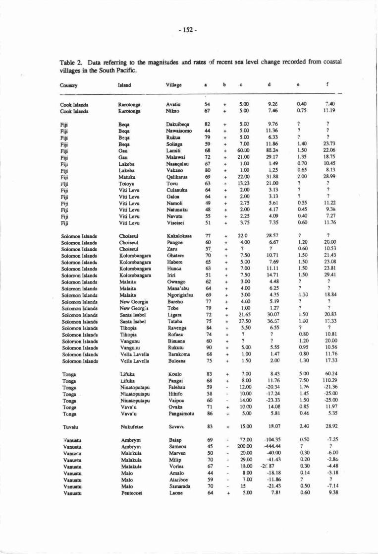
-rs2-
Trble 2. Drtr rcfcrrirg b th rn{nitudcs rnd rdcs of resclrt se. level chmge rncorded ftom coastal
vill4cs in tlr SouthPrcift.
Coliry Idrd Vilbgo
Coof bbdtCotldrdr
S<lmbbodrSolm lrlrl&SdmlrlrndrSolmlrhldrSdmoldrndrSolmolrhndrSdmrn lrhdrSolmo lrlrodrSdmro lrbndrSolmn lrbndrSolmlrlndrSclmo IrludrSclqma ldrodrSdmrIilldrSolama lrlrdrSclma ldradrSolqmolrbndrSdqml Iden&Solmno hhadeSolcrpl Idrndr
VuurlrVrurtrVrau!:uVrnrtrVuuurVraunrvtlrlhlV|!uirVeauar
f.lolonLluolp
B.CrBcqrBe11
BlqrOilCltrLrt brLrtcbrM|!firTdoyrViti bruViti kwViti LcwViti LovnViti LcrnViti Lrw
ChoiradChcir.ulCbd.atlKoloa$ra3rnKolmbrnguKolc$rngrnKdortrlgrrrMrbirrMrldrt|Mdritrt{il ClccgirNcw Crcag;rSlnu Is$clSrau hebclTitoprTitodrVuguauVrngu:uVcllr l^rvclhVcllr lrvclle
UnltrUtutrNiurtoptrpuNiurtoptrpuNiurtogrtrytVrvr'uVwr'u
l,fuhfcrrc
AdrynAnbrylnM&fdrMdrhdrMrbbhMrbMdoMrloPcotccort
AvdiuMbo
O*utcqtItreimRuhrSoliegrI-sitiMdrwriNur4druVrtrDQlifmtrTourGdrauhrCrloNmliI{nnuhrNrvuurVircirci
KrfrlotnhlgocZrntOltasHrbcrrHurrrIdriG*ugoMru'$uNgcigirflrBrdroTdcUgrnTrtrbrRrvcagrRof*rBioorRuluurBrnbrnBulcrnr
KculoPngriFdcbuHihifoVriFrOv.trhgdffiu
Savrvs
BrirpSrmrMrrveoMilipVorlcrAmrloAtrdbocSrnredrLroc
+ 5.S+ J.fi)+ 5.@+ 7.(D+ 60.00+ 21.fi)+ l.(D+ l.(D+ 2L@+ 13.21
+ 2.(D+ 2.00+ 2.15+ 2.(D
+ 2.25+ 115
+ 2LO+ 4.00+?+ 7J0+ 5.fl)+ ?.00+ ?50+ 3.fl)+ 1.0+ 3.(D+ 4.tI)+ I.fr)+ 21.65+ 275O+ 5J0+?
+ J.@+ l.fr)+ 1.50
+ 7.(D
+ t,fi)- 12.00- lc.(x)- l4.m+ 1000
- 5.q)
0.l|{) ?.{)0.75 lt.l9
t??lt'll.4o 23.731.50 xL6t.35 l t.?t0.70 10.45
0.65 t.l32.m 2t.99??1l??0.55 tl.n0.45 9.3b
0..n 7.n0.60 11.75
1?1.20 20.m0.60 10.53ljo 2t.131.50 23.S1.50 23.il1.50 8.11,|??'t1.30 lt.t4????1.50 20.83r.00 t:.33??o.to l0.tl1.20 20.000.95 10.55
0.t0 11.76
1.30 17.33
5 00 &.24?.50 110.29
t.?6 -21.x1..15 -25.O1.50 -25.m0.t5 ll.t0.,16 5.35
L& 2t.v2
0.50?
0.300.200.E)0.1,{?
0.500.60
-7.25?
5.m-2.to.{..tt-3.rt
?
-7.1 4
9.3t
5. + 5.G)6;l + J.d)
n6i7.7055
63JI62616917797275u71
@906t75
83
6t59Jt607l6
9.X1.5
9.76I 1.35
6.33t l.t5t8.2.D.t7
1.19
r.253l.tt2l.m
3.133.135.611.17.1.09
7.35
2ts76-61
?
10.71
7.69n.llI'1.?l1.Q6.8,1,15
5. 19
r.n9.m35.5?655?
?
5.55t.112.0c
t.43l1.76
-20.t4-t7.u-23.3314.0tJ.8l
lt.o7
FiiiFiiFiiFiiFiiFiiFiitFiiiFiiiiriiFiiiFiiFiiFijiFiiFiii
t2uwI6t7767toe53g&4S.lt55
5l
l5.m
ToqlTmgrToErToogrToqlTcpToagr
Tirvdu t3
e4550?067u5970&
- ?2.m -101.35- 2m.m 111.14- 20.m -10.00- 29.m .41.'f3
- 1t.00 -2( t1- 8.m -l8.lt- ?.m -ll.t6- lJ -21.13
+ 5.0 7.tt
-153-
WrllSrmftdmStmWd.la SrhrWcLta Stm
Savri'iSrni'iS.vd'iUpoft,
g)+??1.$t2.41l + l.C) l.tl l.ls f6tl9+??0.t0 1356O + ?Ofi) l0l.'5 3.q) |3.at
AveFrtrInSrrb
Kcylocotum: -r Tim rpu ovcr lhk$ ra lovcl brir.rvirru rrr dronrc4 thrt ir tb rvcrqr rto of thc viU4o irfomrrb Dirc rio o: g ls,r:i ctrrlo over tiar rpr, thrt ir ridal (+) r htli4 ( )c Muinlm $ocliac irudrtha 6 cffitls (n) ir r lrrorrt (cril-eufp prnlbl) ED I rsrtc htab ti& hvtl.d Mrrintn nr. d lrrcnl ioadrrio (cdycrr) trlarlrr.d fim r ld c. Rlai d furdim ar[.!cc u i!di.:t d by m3rtivr
figunr.e Muinrm vcnicrl rir c frll of *r lcvol (tn) r high tid. hvd.f Muimrm
Two ses of obscwations wel! mrde in he CooL Islnds, boft on Rrobnga (scc Nunq thisvolume:l29 for envircnmcntd andogucs). At bodr phcs, sce level bes bc€n rising for 67 yean at lcastThis has caused coastrl inundation at ln aver.gc rats of 8.4 cnr/ycr zd vcrtbd scr level risc rt rnaversge aFarent rare of 9.3 mnr/year.
Of sixecn ses of observuions ftom Fiji" sir wcrs fton the crst ard wert corsts of ftc nain isLndof Viti l.ew, thc r€mrinds from ncaty rslmds md rprcccntativc islsrds in dr disturt l-ru groop. Sea
level has ben rising in Fiji for et bast t2 yean. This hrs bccn mr.ifcstod by cosstal inundatim rt maverage raE of 15 cr/pr md vcrticd sce level risc rt rn rveragc .ppeftnt rdc of 15.2 mrvyeer. Ofnote is the shqelim rt llmiti qr Geu isLr"l which has rctreacd 50 m in the hst 6t yern. Thesc ret€ctonic rcasorls to suppocc thar thc high nts of apprcnt ser levcl risc rt Qalikmre on Matuku(29 mm/yer) may havc becn rmplificd by lad subsisurcc.
'Iwanty observrticns wcr? obtaincd riroughout the Sobr.rm Islerds, ercludieg tlrccc islmdswhich ae bctieved to be least cconicdly sabh (Gueialcanrl md San Cristohal). Obscrvations wer€distributed fairly evenly throughout the restof the group with thrEr frorn Choiscul, two from Sarta Isrbel"ttnec from Maiaita, hro from outlying Tikopn h the far east of thc group, dd tcn from vaious islands inthe New Gecgia archipel4o. Sea hvel has becrr rising rhroughout hc Sobnrst Islsrds for at best 90yean. This has causeci coastal inu:dation at ur rycrage rate of 10.8 cmlyer and verticd sce lwel risc atan average apparent raE of lt mm/ycar. ltates of sea level risc exhibil surprisirgly sirrdlarity throughoutthe Solonpn Islands. High raes of inundatkn cn thc rnrtlr coast of Sente Isabcl (Ligrra and Tateba; mayhave been anptified by local subsidencc.
Of sevem observuions obtairEd fa Tonga, thrce wcrc from the unstablc island of Niuatopuapr.Exciuding thosc drta, the remain&r ftm tlr stable (in the shc tcrm) corsts of Vavl".r and Lifute (intln Ha'apei group) indicae trat:ea levcl hrs bcar rising frx at least t6 yean. The rver4e rac of lacrdinundatian has ben l0 cn/year and the li,erege sppercnt rrtc of sce level risc hrs Wn 47 mr/year. tfthe daa ftom Lifute are exclud4 thc hucr rrtc bccorrts 8.7 mr/prr whbh is believod b bc mo'erealistic for he group as a whule. It is suspectcd thrt profound chenges in legur currents r€sultod frornses level risc rt the Lifuka sitcs resulting in lagox-f1olr scc{r: s$rd mining mry dso hrvc cmnibutod toiirc high fig:rcs obtained hqe. All sitcs on Niurloprtryu fudicrte r trletive rce hvel fall rcsulting inlateral shoreline exEnsion at ln averegc mte of fr.! clniyes rrd rn &vcragc appsrcnt sce lcvel fall u rrate of 23.8 m;rvyca, which, intcrestingly, is considcrably highcr 0ran rrtcc infcryat front archeologicelstudiL's of the islard.
,Jrly one observatiqr camc ftrom rhe soll netion of Tuvdu. This wrs ftom the islmd ofNuliufarc frrom wluch it appears ftat scr level has bcen rising fcr 8i yers, cruslng leard inudati<xr rt Irale of lt cm/year drd rn ryps€nt sca leve! rise of 29 rrnrlyear. 'flsc rpsuls rrc rcaarded rs less
diable thsr the rest becsusc thcy ocrive from oniy orrc plrc. Afcc, doll coastlirps re notoriouslychangqable environnpns with erosiqr md shorclin: rebeat on one coest commnly being marhed bycoastal progradatiolr an mother nearty.
Althangh data were collected from ninc sies in Vanuatu, cight scs of tbcsc rvcre fiom thcunstabh istands arrl orrly one s€t, ti'qn Fenecmt (Lenne village), wr frorn m appuatdy stablc corstlincwherr sca level has bccn riiing fo 64 ycm at h$t. A iac for ldlral inrndrtim of ?.8 cm/year and rlappar€ntratd of "ea level rise of 9.4 nn/yer was cdculatod f.a l.sre but ilsc fgurcs nuy hrve bcen

-154-
reduced considerably in magnitu& by uplifr Of the unstable coasts in Vanuahr, all record a relative sealevel fall over ihe last 70 years at least. An average rate for coastal extension of 88 cm/year is obtained as
is an average apparent sea level fall at a rate of 5.2 mm/year. The highest raes of coastal extensiqr occuron Ambrym island and are probably corrclatable with the highest uplift rares among 0re islands sanpled.
Four obsenations were made in Western Sarnoa, ore on Upolu and three on Savai'i. Sea level has
been rising in Wester.t Sanpa for u least 7l years. This has caused ar average rate of lateral shorelineinundation of 51.4 cmlyea but this figure is based qr only two data and is greatly influenced by ttrat forSatalo where a rate of inundation of over 100 cm/year was recordod. This is the highest rate recorded inthis survey and reflects the gentle sea floor gradient offshore of Satalo. The average ryparcnt rate of sealevel rise is 26.4 mm/year in Western Sanroa
It is believed that the corrected rcgional averages in Table 3 are rccurate and regionally applicablefigures given the constrainb of the snrdy and the nethods used. The figurc of 10.4 crnlyear for theaverage rate of inundation along stable coasts'could be used as a bssis for planning. The figure of14.5 mn/year for sea level rise has, as staEd above, been greatly amplified by sea floon scour and otherpr@esses. This rate of apparant vertical sea level rise (14.5 mm/yer) is high compared with raEsobtained from tide gauges along the region's peripheny: at Honolulu, Hawail a raE of 0.7 mm/y.ar hasbeen rccorded since 190 (Pirazzoli, 19E6X at Wellington, New ZcalanG a rate of 1.6 mnr/year has beenrcorded since 1900 (Hannah, 1988); and at Pago Pago in Ansican Saloq a 3Gyear record indicates arateof 2 mm/year(fr,omdatain Pirazzoli, l9t6).
RECENT COASTLINE EIWIRONMENTAL CHANGES
Supplementary data collected during the suwey described above are lised in Table 4. These dataderive from 75 coastal settlements, including all those from which data listed in Table 2 and described inthe prcceding section originate. Of these 75 sites, 12 ue located in teconicdly unstable areas and haveexperienced a rclative sea level fall recently. The remainder have been affected by sea level rise.
These dau (Table 4) chracterisc the types of shoreline protection found throughout the regionan4 as such, can be used as the basis for recomnpndationu conccrning artificid shrctures. Details aboutchanges in well usage and well water quality were also collcte4 as were data relating to perceivedchanges in nrean annual precipitation and nran annual temp€rature recently. Information was alsoderived about obstrcles to settlement relocation. 'ihe rcsults are summarisod below.
Artificial itructures alonq the shor€line
Out of 63 settlernens which have experierrced a sea level rise recently, 33 (52.4%) had nopresently effective form of artifici"l protection against shoreline erosion, although many had once erectedstnrctures but these had ben maJe rodundant by sea level rise. Of these 63 settlenrnts, 12 (19%) hadseawalls made of cenrcnt, sand and stones, but these w€re rrot as wholly imperrneable as a concrete wallwculd be. Many had deteriorated since initirl constructi^n, and most werc the result of local-cea(settlencnQ initiatives rather than national (centrd governnrnt) sponsorod projects. Thirteen (20.6%) ofthese settlements had seawalls made of loose stone;, commonly cual htcks, piled ur top of each otherSuch seawalls were wholly the result of local initiatives and had frequently' proved ineffective inpreventing shoreline erosion for rnore than a yer. Lines of sticks, comnronly bamboo and coconut palmwere used for shoreline protiction in four (6.3%l of drese s€ttlenrcnts. Rubbish md debris piled up o,n theshorcward side of such lines of sticks gave additional nrotection but this did not arnount to a markedlyeffective combination. Groynes had been used in nvo (3.2%) of the setrlcnrnB to trap sand and thusreDlenish '&e eroding berch. In both these sites, one on an atoll the exercise hd been successful overone 6 two decades. A cortcrete seawall built wifi ccnEal govemrEnr funds existed in only one (1.6%)of the 63 rurd settlerrnts which had experiarced a sea level rise recmtly.

-155-
Table 3. Data chracterising sea level risc in the South pacific
Nation Ratc of inunJation(cnVyear)
Rrte of apparent verticalsea lcvel rise (mnVycarr'
Coot IslandsFijiSolomon IslmdsTangalTuvalu3Vanua[r4Western SarmaRegional(urrcorecte&)
Regional(corrected)
t.415.010.t10.0It.07.t
51.4
L7.3
10.4
9.315.2
It.0t.72
7).O9.4
26.4
16.6
14.5
I2
3
4
5
6
7
t
Excluding d ata from NiuatoputapuExcluding data from LifukaBased m only orc obaervatiqrExcluding data from Ambrym, Malakula and Malq and thus based cn urly orrc obscrvuionBasod m nvo greuly ditrering figuresAli data listod re usedUnrepresentative data from Tuvalu and Wesrrn Sanrcr excludedUnrepreseruative date from Tuvalu exclu@
It is cbr from these resuls that much effort is being uscd in constructing rtificial stnrcares inthe reglon, but dtat these are invrriably of an inappropri3te design r made of unsuitablc materials sobcconn rryidly ineffective. It must be possible to draw up and distribua 0roughout rural seclenpnn inthe regiorq plans for seawalls built to last longer than thce ar prcscnt being canstnrctcd which can f.emade locdly with the minimum of pofessrcnal er ntise and ccL The use of groynes in bcachreplenishnrnt should be encourago4 as should tlre building of ertifbial structur€s to protcct theshc'eline. In the midsr. of this, however, orp must mt loce sight of thc litelihood trat rtificial structut€scan provide mly shot-term fotction urd that the longer-erm soluti<n in moet ceses appers to 69relocatim of settlements inland and/or higher up.
I'lanral forms of shoreline proectiql
Although many Pacific island coass have nahrd protectkxr rgrinst crsior, thcsc data wcrecolleced with reference cnly to drcse types of vegeatim which hrd bcn plrnad &libcraely by hcalpoplc almg thc ccastline in odcr b try anC prcvant or rcducc tre rate of slrqctinc erqinn.
Ottof thc 63 seulenrns which hsl experier.ced a ser level risc rcantly, 37 (587%) harl plmtcdnohing to try rnd sop associatod shoreline eroeiqr. Of th6c j7, Zj (316.5%) rlso hd no artificirlsL'uchrrcs (sec above) so r€ficscnt seGldneflts whcit nothing was bcing donc in Decembcf l9t8 -February l9t9 to try and p,revant rhoeline emeion rnd any Aher effects of scr level risc. In nnst casgsthis is not thc rmult of ind;bncc but of ignnncc rbout thc oedons rveihbb fa prrticulrr stselincenvitDnm€nb rnd their likely efficsy. Agruu this is ro arca whcrc 4propira irutructfon is crlGd fa.
Of tho'se seubrpns which hrd plsrtod neunrl corstd protcctiqr. scveo (26.996 or ll.l% of hctaal expcriancing r dsc in sca lcvcl) hd lmtcd grrss md rhrubo, 25 (96.2% s 39.7%) hd plmrodtrees, md up (3.t% a 1.6%) hrd drftd magsve$. Trcs, prticularty seltwrcr-totcrnt spocbs, rrethc tttct succcssfirl fanm of protetivc vegctetirn but rrc not, rs wi&ly bclicvc4 wlnlly effctivc. Anerarple of thc frottt of thc school rt Ucuruvmue qr Vii [.evu's erst corlt in Fiji wrs docunatcd byNunn (l9Etb) who fourd drrt 15 m of slrqclirr rctcl, nprcs.nting r lors of 3,50 m3 of nrlctirl, had
- 156-
occurrpd in 3O yers sirrcc saltwater-bl€rant trpes (Fic'u bcnjomilu nd Casuorirc cquintifolb) hdbtcn planted. Thcre is clearly potcntial for grcarr oducrtion about thc cffectivc spccics fr particular
shoreline envirqrrEnts in the South Prcific urd perhaps evcn the tlbtributim of sceds and sc.odlings from
national centres.
fabb 4. Supplenrntary data relating to r€c€nt envronnental churges experienced in coastal villages in
the South Pacifrc.
Cdrllrytsl.trdVithgclbcdcfs
AvrtiuNiIrc
00
22dr5r2
+20lo2+2o2+l+l+1+0+0+0+0+2+0+0+0+0+0+0+ 2,1o2030l+2
1'
n/rUTd.00drdrdruln/r+dr0
n/r0t
;
23 n/r12 r'r0 n/e
2-002ilr-2ilt12 dr0 n/e
0 n/r00t,2 dr0+l-0n/l0-2-
000-0-0,0-0-
FijiFrjiFi:iFrjiFijiFUiFijiFijiFijiFijiFijiFijiFijiFjiFijiFijiFijiFijiFijiFUiFijiFijiFijiFiji
0
000000
0
00000
0
0)0200t/
0
+
0+++
+
+++
+
+
+
+
i+
0++
+
+
t
l++00
+
+00?
++
+
l0+
0+
l
0 dr n,:0 dr n/r0 de nlt2 ilr n/r0 n/r Dl.2 da ty't0 nie !,Jr
2 nlt t,a122 olt n/|0 n/r nl.0 ilz n/e
0 u/a n/.? Rlz n/r0 n/a da0 n/a n/t2ahdt2 ilt D/i2ilttrh0 nir n/r0222 oh n/r
Cmt lclaldrCmt lehtrds
Kirib:ti
Solqnos IslradsSolomon lrlendsSolornon islands
Solomon blandsSolomon lslaadsSolomon lelands
Solornon lsleadrSolonrcn lslenCsSolomon IslandtSolomon IslrndrSolomon lslandsSolornon Islands
Solsnon IslerdsSolor:,on IslendsSolomol Islands
Solqnon Islands
Solomon IslardeSolqr,on Islan4s
Soloupn rslard;
Sclomon IslsndsSol.rrnot lslrnosSolqnon Isl.nd8
RrrotonglRrrctooSr
BoqrBcqrBeqeBoqrBoqrGruGruGeuhtobrl:kcbeMrtrIuMrurhrTcoyrTcoyrTotoyeToloyrViti lrwViti l-curViti LenrViti l-evnViti L,cvu
Viti [,ewViti l,ewViti Lcnr
Ttnrrr
ChoirculChoisculChoisculKolornbrogaraKdombengenKolornbenganKolornbragrnMs:ri!rMrhitrMrleiteNcw GcogirNew CccgiaSantr IsahelSrtrL lsrbclTikoleTikopieTikopieVrnguauVrngunuVelle Le VclleVclle La VcllaVclle Le Velh
Drfuibcqe 0
Neccve INrwriromo IRrrfur ISolhgr 2hniti 0Mrlewri INrevurdi INenqdru 0Vrtem 0lrwtridrtu 0
Qrlihur IDrrwnnlu 0Kcrci ITow 2,1
Udu 0
Oilrnuhr 0Grlq 0
Neirnrruvunr 0Nemoli INetunulu 0Nevuur IUcunivrnue IViscis.i I
+0
;+0
?
+
+
Bikcnibcu
Krf;robn 0Pugoc 0Tznt 0
Ghrtere 2
Hrbcre 0Husda 0
hiri 2
Gwengo 2
Mene'atrr 3
Ngoigiefru 2
Bareho 0Tobc 0
Ugrn 3
Tetebe 0
Nrnn D
Rrvcngr 2
Rof*r 2
Binrem 0
Fllu[r 2
Benlornr 0Bulcrne 0Ugrmbr 0
;0
-is7 -
TongrToegrToaxpTongtTongrTongtToagrTon!FlbogrToDgr
'iuvrlu
T\lvelu
VenuatuVeaueErVenurorVrarnErVrnua0rVelueurVenurnrVenue0,t
VeouehrVraueor
Wcstcm S.mmWc*cm SanrcWcgcra SamcWcC.ern Serns
UfrtrUtufrh-iurtoptrpuNiurloputrFlNiuraopupnToogpteprTootrtrpuTongrteprrVrvt'uVrvr'u
FuarfutiI\.uh^trctrc
AmbrymAmbrymAmbrymMdehilrMalehirMehblaMrloMeloMrloPcatccort
Srni'iSrvri'iSrvri'iUpolu
K.lloProgriFdohru3Hihifo3Vripoe3KobvaiNiurrrurTelefo'ouOvakePsegainofn
AlrprSevrvc
E i.fSrmcou3Irrrrf3Mrwcn3MilifVodcs3A"rrlo3At{iboc3Srrnrndr3Lroc
AvroFegoInSrlelo
t23120000000000020nltozo00
0000+0++++0+00n/e0
20nltn/ralt0007
2
tJzuzdril.UTn/enlzn/rila0
00+
ila0nla+0
+
+0+0
0I
0++
t+0++0++++
+
++
t
0
Key to columns:Note that detarls of thc lcngth of tirnc to which answcrr refer rre given in Aoocndir 1. columa 4a Artificisl rhorclinepmtcclion:0-noac, l -ccmcd,send endgonos,2- 6toc6rnd6oorel blakc,3- sticks,4- groyues,5 -
COnrgtGl,C SCeWallb [anlml corerel protcctiol plenr.d delibenr.ly: 0 - Done, I - gnrs end $nrbs,2 - trecs,3 - mangnvcsc Chioge in the number of_wells used-for drinking wter: 0 - *ill the rernc numbcr ia use, "+" - rfore in trs€, "-" - 1.". ,o ur",
'l/r - Dot applicablc, drinking water hiu ncvcr c{rne fronr gellsd $.ta$. in thc quelity of ddnkin-g waterfmm wclls: 0 - no cherge, "-" - qudity inprovod, '-" - qualiry dcteriantcd, da -
dnnhng wa.t.r hls lcvcr conE from wcllse Chengc iu thc ennuel amnrnt of ninfrll: 0 - m chrnge, "+" - rmrc rehfrll todry then beforc, "-" - lcss r.inlall roCiy ih.tr
be5or.f Clrlogc i-n $c equeJ tcmFnturc: 0 - no chrngc, "+" - ho[cr todey thrn bcforc, "-" - coolcr todey thao beforeg Neorn of qbqclcs in thc wey of qrcvjnS uc v-itlegc to higher grouo,l: 0 - no oliereclcq I - culrutit obstcles, 2 - physrcat
obdrlcg,3 - legd Foblcms (c.g. led tcnure) -
Notcs:I Dcocnda on ridal conditior.? Rglen ro r lake ir rhe villrge urcd fc drinking wucrJ Plecc whiclr hes cxpcricnccd e rclrtive ca levcl fell recenrty
00t,40-
00o200olJ3,4 r,23l?dr000OD/l30000
20d.tJ.000a/rde000+02+
0000
Well us_ase drd well water oualiN
Of those 63 settlements which have expericnced a sea Ievel rise recently, only 29 had oncedepended anCior Fresendy depend on well wat€r ftr drinking Twenty three of the..se Zg (79.3%) r@rtedthat the same number were still in use now comparcd with the tirne when etderly mforments were young(on average, 66 yean ago), and one (3.4%l report€d that more were nolv in use.
There are of cr:une many rcasons for changes in well usage and Inany settlenrents wilic:r peJnrtedciecliniag usage had received altemative forms uf :iupply iuch ss Fiped water or rainwater storage :anLi.In many cas€s, howev€r, th'decrease in deperderre on wells frx drinking water had to do win thedeteriirrating qualitv of that water, and l( ci'rhc 2? (69.6%) re;\orted that rvell water qualiry has gotworre recently. In many of these cases. it is possible that thrs had ?o dt' with pollutiur of the freshwaterlens s water table as sea ievel ro'se. The F.?.iEt number experien..ing this effect is indet.rminate lrom thedata oollected in this project.
i58 -
It is interesting thet in those islands whrch are being uplifted, and thus experiencing a relarive sealevel fc!I, five out of l0 (50%) seltlements which use wells for drinking waEr report rhat the quatity ufthat watr. has irnproved over time and anly one out of 10 (10%) note that water quality has deteri,ratedrecently. This suggests that rclative sea level change is srongly conelated with changas in well waterqudity which, in nrrn implies that a r::ajor cause of deteriorating qualiry of wel! water along Soutr pacificcoasts recently has been the rcgit ,ral sea level rise.
Perclllea cnang:s in orecioitation ana te
No data of sufficient riuration have been anall'sed rc give an accrrrate picture of rccertpltrcipitation and temperature treds. Another problem in the South Pacific regi.rn is that rtata ofsufficient duration re available in urly a few places and their distribution is too irregular o yield a truepicture of regional churgcs.
Qrcstions were asked in this survey about changes in precipitation and tempe.rabre bur it isadmiuod ilrat the rcsulb u€ open to many inarpreations and nay be rcgarded as .rmslg the nrostdubious cf the data colhcted in ths survey. Results arc summrised in Tcble j.
In terms of precipitation, it is interesting that, excluding nations with two or less data, all agreethat overall it has become wetl€r (pocipitatiar has furcreascd) wrth the exception ot Fiji. liowever, thecloscness of the totals for ttrosc respondeirts favouring weuer or drier csrditions today undoubtedlyindicars fte lrck of a clear rcgiond trend and a considerable d-grce of inua-rcgional variation.
Temperanue changes apper to have been more clearly perceived with the great majority ofrespondents rn lhose'nations with nmre than four data believing that it has becone hotter recently. Thegeogrryhicd distribution md the strength of this majcrity suggests that ir may reflect, in part, an ictualregional trend. As such, it agres with global tcmperaure Llnds (e.g. Jorcs, et al.,19g6).
An attcntDt !t o/€rcorE such a suggestian was made by analysing radimqrde temperature data forthe Soudt Pacific which show an undoubed recent temperature rise in the lower roposphere (Table 6).
Tropoepherk warming in tie South Prcific is probably malched in broad terms by gnound and sea-surfrce tcmp€ratues in tl.e regior. Although insuffrcient long-term daa are available from the isla'rds,thc former tr€nd is supporad by grcund 'remp€rature analyses for New 7*almd,'a rise having beenexperienccd firoughout the whole r€gion &ring 1935-19?9, Emp€ratures climbing by l.C over rheseyers' (Sdinger & Gunn, lTlS:397). Sea-surfrce lerp€raurcs in the Sourh Pacific have risen by 0.5-l.OC since l9l2 (Follerd et al.,l9t4).
Poosibilities of s€trlcrEnt relocation
Althotgh nnet coasul communities studied in this survey had discussed fie possibility ofrelocating tlreir satlemcnt elsewhere as a response o sea level rise and associated shseline erosiorL nonecmt8mplaGd suc.ir a move in dre funrnediate future rlthqrgh many se:tleirpnts had besn nrigrating siowiyirJard fc dcced6.
The pocsibility of scclcnrnt relcaliqr is undoubtedly se: !o increase in thc t'unre so quesrignswere askcd about tlre natur€ cf obstrclis, if any, in the way of rnoving scttlenrcnts to a new site, inlandrnd/s higher, .t present. Forty ttrnee scttlemcnts which had experienced a sea level rise recently (68%)had no baniers o relocation. Culuual obstrlcs o relaatiqr were puanrrunt urly in F'.ji and Tu.,alu(9.5< of !otd); being pplicrble to 21% of settlenrens in Fiji. Physical obstacles were rie rbstimportrnt in only two places (3.2% of otal).
This type of infornratio.r is impctmt berausc it illustralcs dr.: magninrde and variery of problemswhich rney frcc sculerrsrb wifiin thc iegion desiring o rebcatc m the same island in the fuore.kobbms sppcr flx'st rcuE in Fiji urd it rnay be a'ppropnaE for a ccmprcfiensive review cf drqs; to bemrdcmw.
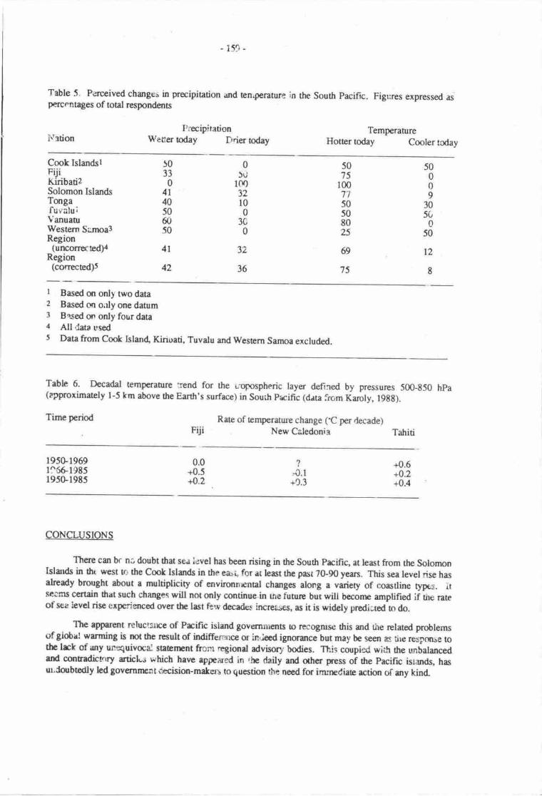
159 -
Table 5. Perceived change" in precipiration and ten.perature in the south pacific.percFntages of otal respondents
I{rionFrecip!ration
We6er today Drier today
Figrres expressed as
TemperahrreHotter todav Cooler tcdav
Cook IslandslFUiKiribati2Solomon IslandsTongafuv aluiVanuanrWesterr Sirnoa3Region
(urEorrected)4Region
(corrected)s
50009
3050
050
12
I
50'75
r007't50508025
69
75
05ri
1m32l00
3C0
32
36
50330
4l40506050
4l
42
I Based an only two data2 Based on o.rly one datum3 Brsed on only forrr data4 All.Jata used5 Data from cook Isla'4 Kiriuati, Tuvalu and wesErn samoa excluded.
Table 6. Decadal tempera$rc :end for the rope5pSeric layer defired by pressures 500-g50 hpa(approximately l-5 km above the Earth's surface) in Sourh Prcific (dara irom Iiaroly, lggg).
Time period Rate of temperature change (.C per decade)FUi New Catedonia Tahiti
19501969lt.56lt85195G1985
?
.{.r+C.3
0.0+0.5+0.2
+0.6+0.2+0.4
CONCLUSIONS
There can br nc doubt that sea level has been rising in the South Prcific, at leasr from tlre Solomonlslands in tht west !c the Cook Islands in the easi, for at least the past 70-90 years. This sea levet rise hasalredy brorrght about a multiplicity of environnpnral changes along a variety of coastline types. irseems c€rtain that such changes will not only continue.in tne future bur will bccone amplified if trre rateof sea ievel rise expe'nenced over the last few decades incrc€.:;es, as it is widely predi;rcd rr do.
The apparent reluc$rrce of Prcific isiand governnie{rrs trl r€o$use ttris and rhe related problemsof giobal warming is not the result of indifferince or in,"ieed ignorance but may be seer ar .Jre respflise tothe lrck of any unequivocd. staEnpnt from regional advisory bodies. Thls coupied wirlr the unbalancedard conradictnry anicLs which have appcued in ,he daily and other press of the pacific isrands, hasu.dmbtcdly led govcmnrntii€cision-maten to question rr\e ned fon im:rrdiate action of any kind.
- 160-
ACKNOWLDCEMENTS
This surdy was partidly f.rndod by the Univcrsity of drc South Paific under research grant 0706-StOZ TtE prrJject was co<)rdinred by Dr Patrick Nunn. and ti,e rescarch grant firnds were awardedjointty b hirtr' Prrofessor Ascsela Ravuvu ard Ms. Taiarnoni Tonganna. Thirty me students of theUniwnity assisted in this shrdy ard 128 elderly inr-ormants duoughout the regiou gave freely of theirtfurrc mdtnowiedge.
BEFEBENCES
Follan4 C.K., D.E. Partcr & F.E. Kates 19E4. Worldwidc mrine E nperahre fluctuaticns 1656-1981.Nanuc 31O67G673.
Harmdr, J. l9Et. nnalnis of npan ser level trerds in New Zealsrd firrm historical tide data. New7*alard Dc?artrrrnt of Survey and l-and Infrmation Report 2-
Hofftnan, J., D. Keyes & J. Tiurs 1983. Projecting fuure sea level rise: rrthodology, estimates o theyear 2l@, and rcsearch needs. 2nd edition (revised). Governnrcnt Printing OfFrce, Washington DC.
Jon6, P.D., T.MI. Wrgley & P.B. Wright 19t5. Globd t€rpcranrre vriations betwt*n lE6l md 1984.Naurrc 32?l430{V..
Karoly, DJ. l9tt. Evidence of recer.i temperaturc rends in tbe Souo\em hemisphere. Pp 52-59 in G.LItarnm (Ed), Greenhouse: planning for climatc change. C.ommonwealth Scicntific and IndustrialResearch Ckganization, Australia & EJ. Brill,Ieide& Holland.
Nunn, P-D. 1988a. Future sea hvel rise in the Paciic. Univenity of the South Pacific, School of Socia!ard Ecmomic Developmenl, Wotking Paper 12.
Nunn, PD. 1988b. Fiji. Pp 43542 in H.JI. Walker (Ed.), Artificid structures anci the shoreline.Kluw€tr, Dordrecht.
Pirazzoli, P.A. 1986. Seular uends cf relative sca level (RSL) changes indicatod by tide-gauge records.Journai of Coastal Research l:l-26.
Salingcr, MJ. & J.M. Gunn 1975. Recent climate ,varming around Nen, Zealand. Naure 256:396398.
-16l-
THE POTENTIAI,IMPACTS OF PROJECTED CLIMATTC CHANGE AND SEA LEVEL RISEON':'ONGATAP[I, XINGDOM OF TONGA
- D.H.I( Spcnnemrnn
Department of hehistory, Research School of Pacific -S,tudies,
Ausralirr Nrti@al Univcrsity, Cmberra,AuSlr'afra
LJI. BclzP.O. Bor 908, NuLu'dofa, Kin3dom of Tonga
G. ByrnrRiedel & Byrnc Crnsulting Engincas Pty. IJd., EostDoncasEr, Melbcrme, Australia
ABSTRACT
This surdy addresses the poentid inpra a rise in rcietive sca level mey have qr tlpisland of Tongatapu, Kingdom of Tange Thcse imprcts ac both beneficid end dctrimentalto fie well-being of the Tongm pooplc.
Mrch of Nuku'abfa is locetcd an tb grurnd of r fqnrer lagmn eltrrrcq which hadbecorn closed during the lae Hcilacne. Bccausc of inaensive archcological suwey andexcavation wort, tb history of this cntrancc is fairly weU un&rstmd and prrt'cctions cur bemade as a basis for discussion of dtc efrcts of a future risc in rclaivc sca hvel.
It can bc foresegn that the prcssur on lanO nesourcc will increase exponantidly,caused by naoral populati<n growth, inurdation of gadcncd lurd and inundatirn ofresidential arcas, which will need to bc relcalcd.
The corals of the fringing reefs re likely to rc<olonisc prasenrly abanclxred reef flasand to commerpe reef grnwth rapidly. If the projectri sca lcvcl nse is equal to s less 0rant mm/year then we can expect that the Fescnt recf conditions can be maintainod and nomaja uhange in the wave rction on tb slprc will b€ cxpcriared-
This surdy providcs only r gencrd qrtline of prescnt bn*ledge and idcntifEs short-comings in the data basc, which should bc fill€d in wrdr furth€r rescarch o suengthm dreprojections.
nlI&alusuaN
The assurned.ce :aric
Civen the general considerations mde in tlre lst report of the ASPEI task team and in Buddereier;nd Oberdorfer (this volurn), the continuation of globd warming of the atmmplrcre seerns c€f,tain to occurand the sea level is certain to rise. No accurare prodiction as to the spoed md magniodc of fie sea level risecan be made. Various scenad x of the effecs oi ihe global grenhouse gas gcncrared climatic cl.ange havebeen put forwad. A surdy by U.SNational Resem"h Council Cartm Dioxide Assessrncnt C-ommi[cc(1983) estirnatcd a possible rise cf 0.7 m +' 0.25 by the yeu 2n5. Tttc NRC Committee on EnginceringIr:nplicarions of Changes in Relative Mean Sea l*vel (1987) has used three scenuim for tLe year 2085 (i.e.
- 162.
almost lCC yeus): a rise of 0.5 m, 1.0 m "nd 1.5 m. For the purposcs of the present studv these same threescenarios have been used.
ThsJtudv
Based on the data available to date, this study attempts to predict the potelitral impacts a rise inrelative sea le'rel would have at these three heights. It reconstructs the extent of the new shorelices in theNuku'alofa ownship area and discusses the potential imprct of the inundation on human hauitation,sanitauon, naniral resources, and archaeological heritage.
The data
The data used in this study derive from various sources, mainly geology, coastal morphology, andarchacology. fhe sea level data utilised here, most of which are as yet unpublishe4 have been accumulatedby the arrthors during past and present research projects and consultarrcies (Spennemann, 1986a-e, l9g?a, inprep a.). The other data have been drawn from penonal cbservarions and from consuttancy reports held inthe Cenral Planning Department in Tonga.
The study area
The islands of Tonga are situated in the South West Pacifrc some 780 km east of Fiji, -900 kmsouthwest of Sanroa ard' -2,2ffi km northwest of New ZealanJ. They comprise l? | islands. of which about36 are currendv inhabited. The modem political boundaries, as defirpd by King Taufa'ahau Tupou I (l?97-1893) and amended by Taufa'ahau Tupou IV (1918 - ), cover the area from 15- ro 23' 30, S and from 173"to 177' W (Tongan Government Gazette 2 t55l 24.8.1E87) Tlr archipelago exrends in a NNE-SSWdirection and is commonly divideC into four groups (from north to south): the Niuas (I.Iiuaoputapu andfiiuafo'ou), the Vava'u Group, the Ha'apai Croup and the Tongatapu Crorrp. Eighty-five km southwest ofTongatapu is the isolated, now uninhabite4 island of 'Ata.
The detailed discussion on the following pages will be limited to Tongatapu, and especially to thearea of Nuku'alofa township (Figure 1), as this is the most highly populated island and the one for whichmost data exist. Several observations and conclusions from this discussion can be applied to other islands inTonga and beyond.
TtrE GEoLocIcAL Al'..D GEOGRAPHICAL BAcKcRoUND oF ToNcATApu
The Tongan islands lie on the rnostly submarine Tonga-Kermadec Ridge, which is a majorbathymetnc r'eau[e extending over 1,300 km from New Zealand to west of Samoa, fornred by thesubduction zone of the Pacific plate sliding under the Indo-Australian plate. The islands are of three iy,1les,running in two parallel chains along the Tonga trench, which extends aitimes to a deprh of 10,500 m.
An "lastern chain of islands, sitting on the rElative shallow foraru piatforrtl, consists of reefal coralliirnslone underlain by older volcanic rocks (Tongatapu, IIa'apai, Vava'u.1. In some instances the'rnderlying volcanic rocks are expose4 su..:h as on Nomuka and 'Eua.
A wesiern chain of rctive volcanoes sits on the Tofoa Ridge and is separated frrom the chain ofcoral iilnesone islands by a trough up !o 1,80c m deep (e.g. Tofoa Late, Kao).
A r'hain of active submarine volcanoes, which erupt spasmodic:Jly and form unstable islandsco'rsistirtg of votcanic ash and pumice (e.g. Fonuafo'ou [Falccn or Jack-in-the-box Island], MetisShoal) croiacides with dre chain of visible volcanoes.
l.
2.
3.

163
B K'*lh'rc.iho
y'"L^/-
liq* l' Map of Tongatapu, Kingdom of Tonga, showlng the locations mentioncrl in drc tert Thc f.ameindicater the location of Figures Za 6.
Geoloqv of Torreataou
l'he linrstoncs of rurgatapr are reefal in origin and of (?) ptiocene o Reccnt age. As various oilexploration wells have shown, dre timesones vary in thicLrcss fiom i50 m on thc nortlr .o about 250 m onthe south srde of the ist'and. The core of the ishna underlying oe reera fimesone is rormoc by Miocanevolcanoclastics, which have been cored to a dcpth of 1,500 m.
Morphologically ry i-sland is bw-llng and undulauing, with occasional higher brolls. The hixfi,stelevatiqrs are in the southeast a:td nowhere do these erceea 6i n,. Fiom rhe so-udreast the island sbpesgently down lo the northern 'nangrove-fringcd coastl.ne. For the .nct part thc coast is cliffed (rihr coart),the highest (up to 35 m) being found in * *u-* The central pon or tr," i.rma ii occ"piJby i shallorrfagoon (Fanga 'uta, which excePt for a channel at.i6 no(ireasi:rnargin, is entirely errclosa. by lrnd. Theisland is surrounded by a reccnt coral recf which varies in width rromi few nners in dre south b over 7 kmon the northern shore; here a shaflow reef flat extcnds out to sea-
Penetrating rainwater has washed ollt nurneous cayems anci crves in thc reefal lingtrnre, cn:alng akant landscape with dolines- There caves ene lnost accessible in the easlern part of rongataprl whcrcas theformations in the western pan are mainly subtcrranean and have been 9p1, occasionally erpc,red in thccours,e of quarrying.
iix soit series iravc bcen distinguishc.d: threc of thcm derivrd cirectty from andesitic vohanic ash o'tephra (L:paha' valni' Fahefa); onc fiont rc{eposited tsphra G'a:ai), and two derived from marirr deosi6(Nuku'dofa [coasal sandj, Sopu 0agonal deposia]). Tie votcanic soits exist in varirs phases drycnding
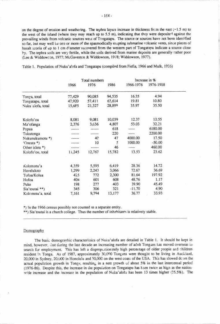
- rc4'
or the degree of erosim and weathering. The tcphra layers increce in thickness frr.m the east (-1.5 m) to
rhe west of the island (where ttrey may rerh up to 5.5 m), indicuing drat they were deposite'l- against the
prevailing wirds from volcuric sourpes we$t of Tongat4u. The sdlrce c soruces have mt been id€ntifiedso far, but may well Le one or rnore crf the spasmodically eruping submaine volcanic ven6, sine pieces ofbasalt scoria of rrp !o I cm d;ameter rwovered from the wesErn part of Tongat4ou indicae a source close
by. The tephra soils are very fertile, while the soils derived from mrine deposis are generally rather poor
(I-ee & Widdowron, l9?7; McGaveston & Widdowsqr, l9'it; Widdowson, 1977).
Table 1. Populatiorr of Nuku'alofa and Tongat4u (compiled from Fiefia, 1966 atd Mulk, 1935)
Total numbers1966 1976 1986
lncreasc in %19661976 1976-r988
Tong+ otalTongatapu, totalNuku aiofa, otal
Kolofo'ouMa'ofangaPopraTukuongaNukunukumour r)'Oneata *)Other isles *)Kolofo'ou, total
Kolomotu'aHavelulotoTofoa/KoluaHofoaPukeSia'toutai **)Kolc,rnotu'a, total
12.37 1C.55
53.03 32.2r6180.0022W.W
4000.00 17.50r0m.m -50.00
460.0013.53 23.62
77,42947,9n15,6E5
t,ot12,376
90,0tJ57,41121,327
9,ffi13,636
94,53563,6142E,899
10,0394,W7
6lt220
47
:46
15,782
6,4193,0662,3m
60840332r
13,L77
16.35
19.Er
35.n
4.9410.8035.50
14.7236.69
r97.92l.l7
45.494.90
33.93
4C
l0
r\u5
4,359l,2y)
4254Ul9ty5
7,161
12,767
5,5952,U3
772601271306
9,7s4
28.3672.67E1.6448.7639.90
-11.70
36.77
t) In the 1966 census possibly not counted as a separate entity.+r) Sia'toutai is a church college. Thus the number of inhahitants is relatively stable.
Demoerap.hy
The basi.; demogra;rhic characterisrics of NuLu'alofa are detailed in Table L It should be kept inmind, however, ,irat d.ring the last decade an increasing number of adult Tongans Las moved overseas irr
search for employment. This has left a dispropcrtionrtely high percattage of older people and children
resident in Tonga. As of 1987, approximately 30,0fn Tongans were thought to be living in Aucliiarrd,
20,000 in Sydney, 20,U00 in Honolulu and 30,000 on the west coasr of the USA. This has slowed dc-,vn the
actual population growth in Tonge, resulting in a nett growth uf about 5% in the last intercensal period
(19?6-E6). Despite this, the increase in the population on Tongatapu has been twice as hign as the natiotr-
u,ide irrrease and the increase in the population of Nuku'alofa has been 13 times higher (35.5%). The
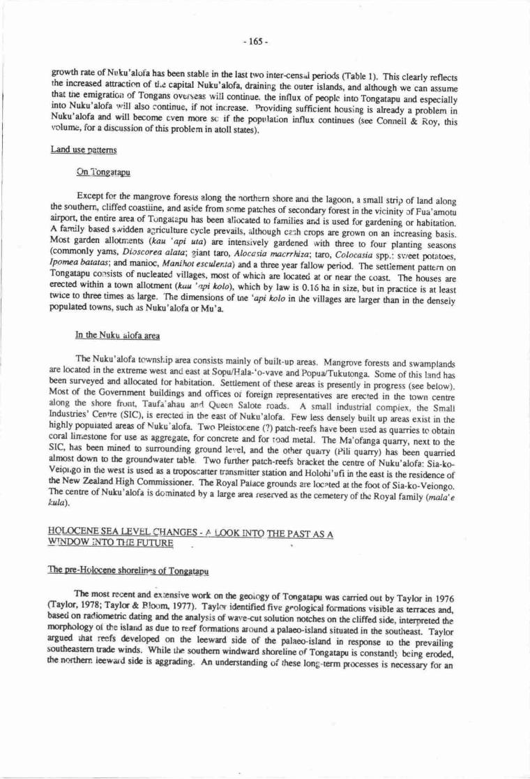
-165-
grcwttt rate of Nuku'alofa has been stable in thelast two inter-cens.l periods (Table l). This clearly reflectsthe increased afiraction of tl.e capital Nuku'alof4 draining ttre ouei islards, and altirough we can assumethat me emigration of Tongans overf,eas will continue ni innux of people into Tongatapu and especiallyinto Nuku'alofa will also continue, if not increase. uroviding sutficieni housing is
-alreaay a problem inNuku'alofa srd will beconrc ev€n rnor€ sc if the population influx continues liee conneit & Roy, this
volume, for a discussion of this pmoblem in aoll states).
Larxl use pauerns
Qn lbngatro
Except for the mangrcve forcsu along tlre northern shore ano fie lagoon, a small strip of land alongthe southerr! cliffed coastiine, and aside from sonre patches of secondary forest in the vicinii of Fua,amofirairpon the entire arca of Tongatapu has been allocated to families andis used for gardenini or habitation.A family based s'ividden agriculture cycle prevails, although ceih crops tre grown on an increasing basis.Most garden allotn:ens (kau 'api uta) are intensively gardened
"in nt"e to four planting se;rsons(commmly yams, Diascorea alata; giant tro, Atocasia ntacrr&za; l:rto, Colocasio ,pp., sr'/eet potatoes,Iponua bantas; and manioc, Manilnt esculenta) and a three year fallow period. The settlenrent patt€in onTongatapu coasisb of nucleated villages. rnost of which are locaterl at or near the coasL The houses areerected within a town allotnpnt (kuu',Ipt tolo), which by law is 0.16 ha in size, but in prrctice is at leasttwice to three times as large. The dinpnsions of ure 'api holo in the villages are larger than in the denselypoputatcd towns, such as Nuku'alofa or Mu'a.
In the Nuku rrlofa area
The Nuku'alofa township area consisb mainly of built-up arcas. Mangrove forests and swamplandsare located in the extrenre west anci east at Sopu/Hala-'o-vave and Popua/Tukutonga- Sonre of this land hasbeen surveyed and allocated for habitation. Settlement of these areas is presentty in progress (see below).Mct of the Govemnpnt buildings and offices of forcign rcpresentatives are er€cr€d in the town centrealong the shore frunt Taufa'ahau anrt Queen Salote roads. A small industrial compiex, the SmallIndustries' Centre (SIC), is er€cted in the east of Nuku'alofa. Few less densely built up areas exist in thehighly populaEd areas of Nuku'alofa- Two Pleisocene (?) parch-reefs have been useo as quarries tc obtaincoral lirr'estsre for use as aggrcgate, for concreE and for t'raa metat. The Ma'ofanga qu'"rry, next to theSIC, has been mined to surrounding ground le.rel, and the oths quarry (pili quarry) has been quarriedalnnst dovn o the groundwater table. Two further parch-reefs brrctet the cenue of Nuku,alofa: Sia-ko-veigr4o in the west is used as a troposcattcr Fansmitter station and Holohi'ufi in the east is the residence ofthe New Tzalmrd High Commissioner. The Royal palace grounds are laated at the fmt of Sia_ko_Veiongo.The centre of Nuku'alofa is dominated by a large arca reserved as the cenptery of u*tu Royal family (mala,ekala).
EEWW SM rW ffiNGES - A MM TT{E PAST AS AWThe Dre-HolccEre shorelines of Tonqatapg
The most rcccnt and irrnsive wort qr the goicrgy of Tangatagr was carried out by Taylor in 1926(Taylor, l97t; Tayla & llmnr 197?). Taykr iOentineA nve g.ological formations visible as rerrrces m4bascd on radionrtic dating rtd tlre nalysis of wave+ut solutior trorctres on the cliffed si&, interp,reted drernrpholog oi the island as due !o reef formarions aound a palaco-island siurated in dre southeast. Taylortr8ud that reefs developed on dre leewrd side of ttre palaoo-island in respons€ to tle prevailingrcuthcastcm tradc winds. while *n soudrem windward shoretine of Tcrgatagr is ionsuntll being erode4thc northcrn lcwad side is agrading. An undcrsturding of rhese long-erm Focesses is necessary for an
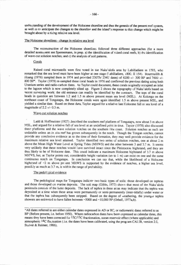
- 165-
understurding of thc dcveloprurt of the Holaarc shor€lirF md tlruc thc gcrcsis of thc pescnt reef sysEnlas well as to antkipae the chengcs o thc slueline rnd dtc islsrd's rcrsponsc to this chzrgc which might bebrought about by a rising relcive sca lcvel.
lbg-Hoioc€ne shorclines - charge in relative sca
The reconstnrctim of the Holocae sha€lim{ followod thrce differcnt approrches (for a nuedetailcd tuSGSSr{Eot sec Spaternmn, in prtp. a) the identifrcatiqr of rgiscd ccal reefs, b) Se ideatificationof wave+ut solution notclrcs; and c) the andysis of soil pa@rns.
e.orals
Raised cmd microaolls were frst noed in tne Nutu'alofa area by Labitladiere m 1793, whoremarted tha the sea level must have been higher at flie saBe 0,abilladiare, rt00: tr 154). Bourrouillh &Hoang (1976) sampled firem in 1974 srd p'rovided zlffhl2yU dates) of 6200 +/- 300 BP and 76{,N +/-800 BF. Taylor (1978) re-sampled these coral heads in 1976 ard cqrfirmed the previous dating using bothUranium series and radio+arbon Caes. As Taylor could docurmnt, these corals oiginally occupied ur inlcto dte lagmn which is rnw cornpletcly siltod up. Figure 2 shows the topography of Nulu'alofa based on€oent surveying wort: the old entrerrcie can redily bo id€ntifi€d by dre contours. The ops of ilre caalheads in question are between 1.2 and 1.5 m above prEsent mean sea level (MSL). At Kolonga on thenortheast coast of Tongatapu, the Holocerp corals were again identified 1.5 m above prcsent MSt, ardyielded a similar date. Based on these dr3, Taylor aryued for a rclative late Flolaene fall or sea level of amagniurde of 2.2 +l-0.3 m.
Wave-cut solution notches
' Ladd & Hoffmeister Qgn) Jescribed the southem reef platform of Tongatapg now about 3 m abgve
IUSI. and argued for a rclative fall of sea level at an undefined pint in tine. Tayior (19?8) also discussedthese plaforms and the wave solution ncrches on the soudrern Intl coast. Sclution notches as such sreundatable unless an in situ rcef has grown subsequently in t}e notch. 'fhough the Tongan notches, cannotprovide any conclusive evidence as to the time of their formation, they may well provide eviderrce for $remaximum relative sea level aaained. Taylor identified two series oi solution notches, one at about 2 mabove the Mean High Water I-evel at Spring Tides (MHWS) and *re other between 3 and 3.? rn It soemsvery unlikely that these nomhes r+'ould !:ave sunvived intrct sirrce tlre Pleistocene higtuan4 and they arethus lilely to be of Holocene date. This could indicae a maximum Holocene highsand of 3.7 m aboveMIfVS, but, as Taylu points out, considerable height variatian (uu to I m) can exist on one and the sanrecontinuous norch on Tongatapu. In conclusion we can say that, while the litelihood of a Holocenehighstend of -2 m above pn iert MHWS is supported by the eviderrce of notches, a higher sea level,possiLiy as much as 3.7 nu is within the range of probability.
The oedolegica! eviglence
The pedological map for Tongatapu indicate two basic types of soils: those devetoped on tephrasand those developed on marine deposis. The soit map (Gibbs, 1972) shou s that most of the Nuku'alofapeninsula consis6 of the lauer deposits. The lrck of tephra in these areas may indicate that the tephra wasdegnsited at a time when these areas werie permanently or semi-permanently (inter-tidally) under warer orthat the tepha has subsequantly been stripped. Based on the degree of weathering, the youngcr tephrashowers ue estimated to have fallen between -5000 and -10,000 BP (Orbell, i977ab).
*All dates referred to are either cdendr dans expressed in AD or BC, or radionretric dates referred to as
BP (Before present, i.e. beforc 1950). Where radiarbon dates have been expressed as calendar dat€s, thismeans they have been conecEd 161L\ll3gfractionation, ooean reservoireffect (where applicable) andatmospheric l4C fluutuation (.i.e. the daes have been calibratorl using the program CAtIB, version 2.C,Staiver & Reinrcr, 1986).
-16r-
Brscdm thc eveitrblcdeawtcm dvrec rhcfolhrhg t6rbdcrrccs fuTcngtryr:
-tmO BP (-ffit BC): Highcst d.!od Holccnc rcr lcvel htncr thn 2.2 m rbove MITftrS, poeribh r hlgh'*s 3.7 n ebovc MIIWS.
-66m BP (-4a00 BC): The fanu l1omrl qitrrnt I Nutu'rlife ic dry r low ridc, ceruing tlrc poritcslofuu crri.l lEr& !o dic ofr. Thir dcc"tarcr wrw rtkxr h thc bisht md rlrrl thc cumau. {hc frra16hgoon.l cnbma bcgitrE o rih in. Th rce larcl ir 2.2 m higha rhm todry.
-50@ DP (-3000 BC): Sornc cantt o thc rccfr md (IrGNGnt) ndtlt nordrwcst of Nutu,rlofr dic d.Thc sce lcve! is .r lcasr 0.5 m higlra thm odry.
-21008P (7(P5@ BC): Thc lagosrd muth is rtmost corrylacly sedcd ofr r hiSh wrs tcwl Thc rcelercl is slightly highcr drgr it is today. Thc wacr cxclugc in thc lrgof,t bcooltg rcrriccd rnd thc srlinityof hc lagmn dcreascs.
-1E00 BP (2ff) AD): Thc forns lrSpmd firrr t Nutu'rlofr is conplctcly blctcd r Mlfgrg. 11t"shcelfurc is rs high rs it is todey. Thc prss*c carmtrg thc wcctcnr pocbtof thc legool with ilrc ersrc:nlntct md ultimeely with thc scr beins b rilt in duc ur docralc h wrrcr exctrmsl r proo6s whiclr itstill cmtinuing todey.
sircc -1E00 BP (200 AD): Mina rdjusumttl crly.
Chanqe in thc odecoflvironrnatt
Ttte pcdologbd map fr thc routlrern clrd of thc Per EeE d Fnge 'Utr lagoo strcwt thc urecovercd wift va;ni urd Fahcfr soils, both of cphrr prrent nuerial. A dcposit of nrinilcrivod ilrc Sop'soils is locaed along thc shor:linc, aaining r maxi'nurn- widh of rbcut 569 rn Moet of thc Sopn soilsbclong b thc bamy phasc, widr a smrll clcrgeod pakct of srttd lancd I thc sc{th-western distributiqrarea of the marine dcpoci6. Given tlp lantion of ilris serd pockct, dircctly oppoeitc the fq.lg' lrgoorrlenmncc u Nulu'dofa, it is likely thet it has bccn forrrt u ar rctive berct. (ibnn berch ridge?). SfreU;recovered ftom this t€rch buded undemcath m archrcologicrl sia harrc shown that thc berh fcnrcdbetween 72m utd 6300 BB whbh agrccc wcll wi6 thc dstcs obtdncd frrom thc caals in Nutu'rlofa.
F,vid€nc€ from shells conteircd in pehistric shcll mid&ns indiceas that ovcr tfuE thc lrgmpl€nvircnment was seedily chenging frrom opelr watcr corditions b fic prresant-dey lrgwr. This csn bcdauncntod by the relative proeordon md sizc disributian d two cnvirqunrnally scnsitive shcllfishspocies, Ardan tfi' G$radm. $lhila ,ttfura which is dcpen&nt cn an unresuicted flow of scewrtcrad is very scnsitivc o chzrges in thc sslinity of thc weEr, gradur[y did ort, G$rariua whbh plefcnshclercd cnvfummenB rnd whrch can survivr nrcrc brrtish curdirions, bearne nnre rbundant(Spcnnemann, l9E6c, 1987a). Detaild invcstigAins havs stm\rn that, alrhough he ovcrall rnvirmnentalchmge was lincar, it acurrcd in r serics of minc flncaratbu with mceopen wrtcrcsrditiqrs giving wryo shelared conditions and vicc vcrs (spcnncmemr, unprblidrcd drte).
Ti{E IMPACTS OF A FOTENTIAL SEA iJ./ELRISE
neE-eunrlatiu
When discussing the effecB of r rclativc ser lcvel char6; an Torgetrpu, trc tlrpes of inun,latirnrFcd b be distinguished: the inurd*im cnrsod dirwtly by thc rise in rellivc see hvel q'diroct rnundetirn'),dtat is, by the sea hvel at tlE c.o.st, rnd the relarcd risa of hc guurdwtcr trble in the inlurd areas('indircct inundatict'), Bearsc of thc pcnneability of ilrc conl linsrrnc, my rire in reladvc sce brcl willcsuse t ccrtsponding risc in thc groundwrter tablc floating qr thc seswrEr. This risc in thc grurndrvrrr

-168-
table will cars- the inundatkn of low-lying areas which ur bounded by highcr land Thus, in the case offongatryu, a heighening of thc coastal protection walls is no telpc against rising sea level, but may help todleviac the cffecs of tidal rncvcmenc.
In addition o these two basic tlTes of inundation, a third effect needs o be taken into rcounr whichcauscs Enporry inundati<xt of land lying up to 0.5 m above MSL. lr is possible for extensive sheet-flooding b ccur afur tor€ntid rainfdl, espocially in the case of the low-lyrng areas, as lor example inHa'aFiho villagc, wherc shallow puddles thus crEated can extcnd over several hundred squil€ rrpEts,evaporeting ovcr tinr. Groundwater flucnuians have becn ruribr"d for the reclairnsd tidal ftas at Sopu(Sraatmans, 1954), whera it has been drrunrnrd that 75 mm of rainfalt causod thc groundwatef, table !orisc by 375 mm thc next day. Commonly th groundwaer bvel would have attained its pre-rainfall levelafter'6 to 7 days. It can bc anticipatod drat e rise in rclative sca srd groundwater level will create this effectin areas so far unaffectd making them inhapitable and unusable fa a variety of agricultural purposes.
Exentof inundation
Before discussing the extcnt of inundatiqr causod by a rise in relative sea level, it is worth examiningthc rcfecnce lcvel o which the data re relaed_
Mean sea level rnean hiqh water level sgrinss md the aoundwater level
Thr following uralysis is besed mainly qr detailcd contour plans fc Nutu'alofa- In the course ofthc Nuku'dofr rJrbrn Sewerrye md Drainage Pr,oject (B€lz, 19M) r daaibd spot levelling of Nuku'alofaownship was undertrken by L. Belz. The individuel level data'vere ploted onro air photo$drs at a scaleof l:1000. These conbur dars, kept at ilre laal WI{O office wcre copied in l9t6
-Uy o* of the au*ron(DHRS) qrb anotbr airphco at a scale 1:5000, which forms the basis of Figures 2 to 6. The conoun dotx)t rEf€r b lrEtres above MSL, but o nEucs above the old Minisry of l-urds, Survey mci NanyalRcsourccs (MISNR) d8urn, which is 0.914 m abovc dre British Adrniralty chart datum arU b.rSO m abovefesalt MSL. Thus all cqrtours plouod in Figures 2 o 6 arc in fast 0.l5ti m higher dran originally srated.This discrepancy was discovered aft€r thc coniours had becn trre4 and cannot be amended wittrout goingback b thc origind data- Given the quite uneven topography of the areq it seemed advisable to refrainftom lhcarly interpolating the rccurate 0.5, 1.0 and 1.5 m (above pr€sent MSL) contoun and !o :ise the0.65, 1.15 and 1.65 m contour:s instead.
As mentione4 these daa refer to rrpan sea level, however, tidal rang,e must be taten inlo rccountwhen discussing the areas affected by direct inundation. This tidal rmge, however, is different inside thelagoct and et Nuku'rlofa harbour. The npan high *ater level at spring tirles is 0.6 m above MIL atNuku'ebfa herbour, whbh nrans in prrcticel tcrn s that at sping tides (nvice about every 4 wecks) ul el€a0.6 m ebovp MSL beconps inundecd. For thc puposc of this shrdy, local effocts of currents andrccumulatim of waF due to wird prutslrt? will be excludod. Ttpsc frctas obviously need to be taken inorcoflnt in any frrore rnoe dctailod investigetfun.
Thc lagoanal rcrn te,l lcvel (lrerrcefcth 'ML{,') is .bout 0.10 m rhove MSL (at thc peace CorpsOfEcc, a thc lagoonal slrce of Nuku'rlofr), which is mainl;' duc o e.ffects of nrceting and rcsuicrcd wcergxchmgc. Mean l^rgoand Wrts l-cvcl at spring tid6 is rbour 0.15 m above MLL. Any changc in MSL atNutu'elofa hrtottr is cxpccd to hcye effocts on the MIL, but &e cxtent of this is urrler ar pres€nt (soesccticn 'Irprct orr thc walcr reginc of Fmgr 'Uta l4otn').
Whercas thc warr hvel of thc lagmr is lcss exposed to tidal flrctuatiorrs than thc sea t:vel atNuku'rbfr hrtour, thc lcvcl of thc grurnd waEr tablc is cven nse sabb. Tidal flucorations, albeit verysmlil, can bc notd (Hunq lglg), but cm bc ignorpd for thc pres€nt aseessrrEnr While the table cf thegroundwlcr lcns in crntrrl 'fongrtryu is rbout 0.45 m abovc N!SL, it is only -0.05 m above MSL on theNuku'rlofr pcninsule, r difrcrencc whbh can bc negbctcd rt thc pr€s€nt le"el of detail. Thus thc ievel ofdtc 8rqrrtd watct lcns in Nuhr'rbfa can be oquaed widr MSL for thc prnposes of the present sordy.
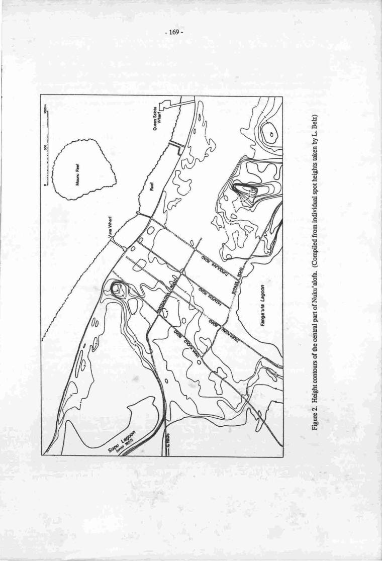
-169-
Nc,trlj>racttHEtoo
.g
Bql
€Ece.E
Ego()
do6.,{=2oEA
E$o€bE2'gEtlo0EEcig=fl
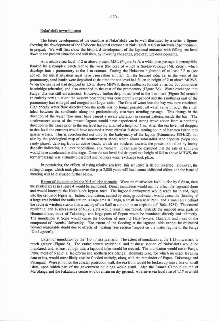
- 170-
Nuku' alofa township area
The future development of the coastline at Nuku'alofa can be well illusnated by a series a figuresshowing the development of the Holocene lagoonal entrance at Nuku'alofa at 0.5 m intervals (Spennemann,in prep.a). We will fust show the hismrical development of the lagoonal entrance with falling sea leveldown o the present situation and will then, by inverting the series, predict future developments.
At a relative sea level of 2 m above present MSL (Figure 3e-f), a wide open passage is perceptible,flanked by a complex patch reef o the west (the core of which is Sia-koVeiongo [ML Zion]), whichdevelopn into a promontory at the 4 m contour. During the Holocene highstand of at least 2.2 m (see
above), the initial situation must have been rather similar. On the leeward side, i.e. to the west of thepromontory, sand banls were deposited at the time the sea level had fallen to height of 2 m above MIIWS.When the sea level had dropped to 1.5 m above MHWS, these sandbanks formed a narrow but continuousbeachridge (chernier) and also extended to the east of the promonory (Figure 3d). Water exchange inloFanga 'Uta was still unrestricted- However, a further drop in sea level to the 1 m mark (Figure 3c) createdan entirely new situation: the westem beaclnidge was considerably expanded and the sandbanks east of thepromontory had enlarged and merged ino larger unis. The flow of water into the bay was now restricted-High energy water flow directly from the north was no longer possible; all water came through the smallinlets between the sandbants along the predominately east-west trending passage. This change in thedirection of the water flow must have caused a severe alteration in current patterns inside rhe bay. Thesouthwestern coast of the preselt lagmn would have experienced stnong wave action from a northedydirection in the times prior to the sea level having attained a height of 1 m. After the sea level had droppedo that level the currents would have assumed a more circular fashion, turning south of Kanatea Island intoquieter waters. This is corroborated not only by the bathymetry of the lagoon (Kimmerer, 1984:12), butalso by the pedological map of the southwestern shore, which shows substantial sand deposits (Sopu soil,sandy phase), deriving from an active beach, which are bordered towards the present shoreline by loamydeposits indicuing a quieter depositional environment. It can also be expected that the rate of silting-inwould have accelerated at ttris stage. Once the sea level had dropped to a height of 0.5 m above MHWS, theformer passage was virnrally closed off and no more water exchange took place.
In posurlating the effects of rising relative sea level this sequence is all but inverted. However, thesilting changes which took place over the past 2,000 years will have some additional effecg and the issue ofmoating will be discussed further below.
Extent of inundation bv the '0.5 m' rise scenario. Were the relative sea level to rise by 0.65 nf thenthe shaded areas in Figure 4 would be inundated. Direct inundation would mainly affect the lagoonal shoreand would intemrpt the Nuku'alofa bypass road. The lagoonal embayment would reach far inland, rightinto the centre of Ngele'ia. Indirect inundation, caused by rising groundwater, would cause the flooding ofa large rea behind the radio station, a large area at Fanga, a small area near Pahu, and a small area behindthe cable & wireless station (for a tracing of the 0.65 m contour on an airphoto, c.f. Belz, 1984). The centralresidential and business areas of Nuku'alofa would remain unaffected. Outside the mapped are4 parts ofHoumakelikao, most of Tukuonga and large parts of Popua would be inundated directly and indirectly.The inundation at Sopu would cause the flooding of most of Hala-'o-vave, Hala'ano and most of thecompound of 'Atenisi Univenity. The extent of the flooding at the lagoonal side cannot be estimatedbeyond reasonable doubt due to effecs of moating (see section 'Impact on the water regime of the Fanga'Uta Lagoon').
Extent of inundation by the '1.0 m' rise scenario. The extent of inundation at the l.l5 m scenario ismuch greater (Figure 5). The entire central residential and business section of Nuku'alofa would beinundate4 and at least at high tide, a lagoonal inlet would be created. The inundation would cover Fang4Pahu, moct of Ngele'ia, Kolofo'ou and northem Ma'ofanga. Houmakelikao, for which no exact levellingdaia exists, would most likely also be flooded entirely, along with the remainder of Popu4 Tukutonga andPatangata. Were it not for the coastal protection wall, the sea-front would be broken up into a line of smallislets, upon which part of the government buildings would stand. Also the Roman Catholic church ofMa'ofanga and the Fakafanua centre would remain on dry ground. A relative sea level rise of 1.15 m would
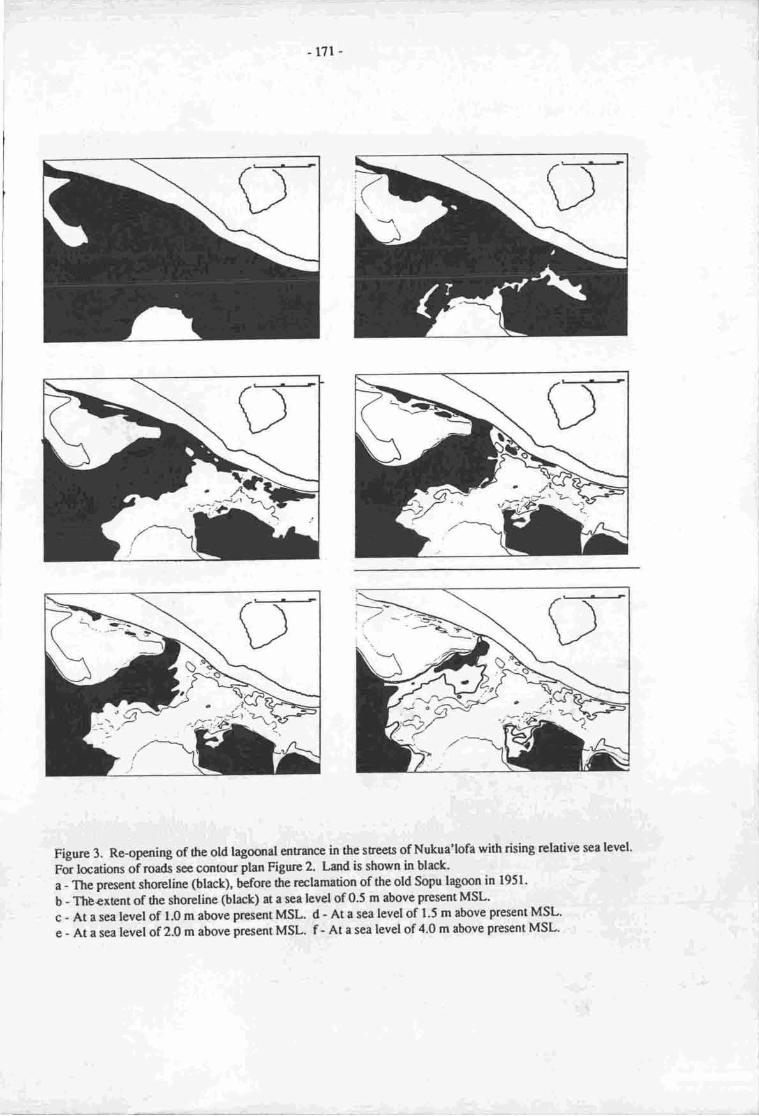
17l
Figure 3. Re-oporing of rhe old lagoonal entrance in the sreets of Nukua'lofa with rising relative sea level.
For locations oiroads see cqrtour plan Figurc 2. Land is shown in black.
a - The present shoreline (black), befote the reclamation of the old Sopu lagoon in 1951-
b - Thbextent of flre shoreline (black) at a sea level of 0.5 m above present MSL'
c - Atasealevelof 1.0mabovepresentMSL. d- Ata sea levelof 1.5 m above presentMSL'
e- Atasealevel of 2.0 m above pruentMSL. f - Atasea levelof 4.0 m above present MSL.
-172-
Figure 4.' Extent of inundltion at a relative sea tevel rise of 0.5 m above present MSL. Contouring:after WHO data; basemap: Topographic map l:25,000, sheet 21.
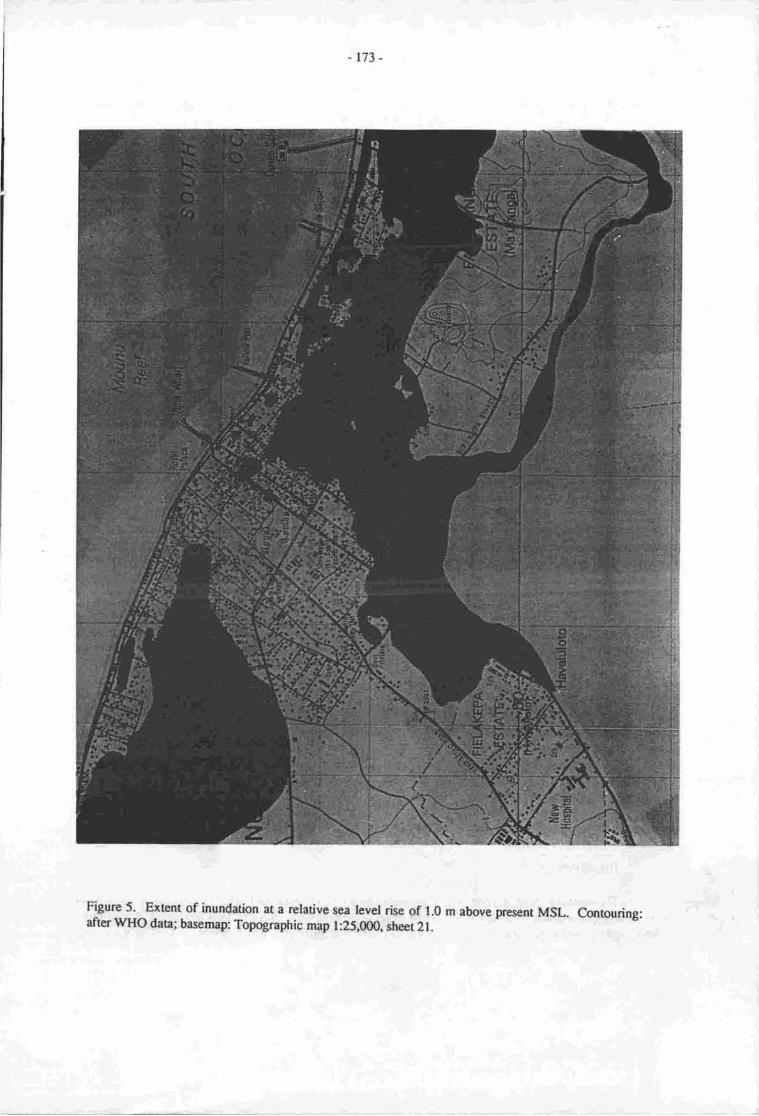
-r73_
Figurc 5. Extent of inundation at a relative sea level rise of 1.0 m above prese-nt MSL. Contouring:after 1VHO data; basemap: Topqgraphic map l:25,(X)0, slrct 21.
-r74-
effectively create an island out of the southem prt of Ma'ofanga, which would include the area of the SIC.The newly erected Tongan National Centre would also be severely affected by a 1 m rise. The formercompound of the USP, the Government Print€ry and the area of Taufa'ahau road north of Mangaia would belargely unaffected. The inundation of Sopu would extend almost to the southwestern foot of Sia-ko-Veiongo.
Extent of inundation bv the '1.5 m' rise scenario. The most serious of the three scenarios, a rise inrelative sea level by 1.65 m (Figure 6) adds only small areas to the areas already inundated by the 1.0 mscenario. The additional areas would be the Palace grounds, The Government Printery, Fakafanua Centre,Roman Catholic Church of Ma'ofanga and most of Taufa'ahau road. The ground west of the compound ofthe USP and the mala'e tzla would still not be inundated.
The Nuku' alofa waterfront
The foreshore protection wall cannot stop the indirect inundation of low-lying areas behind the wall,as this inundation will result from the rising groundwater table, but it will greatly reduce tidal movement, ascan be documented by the closed off part of Sopu lagoon. Given the tidal range of +/- 0.6 nl this gives agreat amount of protection. Thus the wall will prevent the formation of a new lagoonal enEance, along thelines of the Holocene enEance, which would dramatically alter tire tidal and currenr pattems inside Fanga'Uta lagoon.
Sopu reclamation
A good illusration of how the environment of low-lying areas might change with a relative rise insea level is the old Sopu lagoon. Until l95l this was an embayment at Sopu, west of the centre ofNuku'alof4 which consisted mainly of tidal flats. The area was blocked off by a dam to stop the influx ofsea-water and to allow for sedimentation due to surface run-off and for gradual desalinisation of the area.The sea-wall actively reduced the tidal range inside the closed-off part of the lagoon and the area rurnedbrackish. Several plantation trials were undertaken !o assess the suitability of the land for growing variousfood plans such as sweet potatoes and giant taro. Some planrs, especially giant taro, did well in the firstyear, but became overgrown by weeds in the following seasons. Due to the storm effects of cyclone 'Isaac'in 1982, the dam was breached at various places and sea-water again flooded the area, causing the die-offofall salinity-sensitive plants, and effectively causing reversion of the area to the 1951 status. The suitabilityof the area for root crops, the main Tongan staple food, has been reduced to nil (Straatmans, 1954; Nor,1983; Wolterding, 1982).
The Kolovai-Faui mudflats area
The northem shoreline of Tongatapu, from Hofo4 directly wes[ on Sopu, tn Kolovai at the westemtip of Tongatapu, is a low-lying area, bordered by extensive mangrove stands. Seaward of the mangrovesare extensive intertidal sand and mudflats, reaching 3 km out to sea. The land slopes gently to the sea, withmost being below I m above HWL. The only clearly visible shoreline is the -2 m contour, which can beeasily recognised in most areas about 300 to 500 m inland from the present high water mark. A large scaleloss of gardening land can be predicted in this area. An increase in relative sea level would cause a retreatof the shoreline and would cause the mangrove communiry to migrate inland. Although mangrovescommonly grow slowly, the environment would be likely to remain similar to the present setting, were it norfor increasing destruction of mangroves for fire-wood. The mangroves are being cut back at an increasingrate especially in the vicinity of the villages, which is particularly damaging as mangroves act as a sedimenttrap stabilising the shoreline.
The offshore islets
The northern shore of Tongatapu is protected by a fringing coral reef, which has grown to the presentmean water spring tide level (MLWS). A rise in relative sea level is likely to have beneficial effects in theshon term as the corals are likely to quickly colonise reef plaforms which are now dead in the centre

\-r75-
Figure 6.. Extent of inundation at a relative sea level rise of 1.5 m above present MSL. Contouring:after WHO data; basemap Topographic map l:25,0(X), sheer 2t.
-r76-
(c.f. similarprojections for the Great Banier Reef: Hopley & Kinsey, 1988). Ir can be expecteq however,that recf growth ql arcas with soft substrate will not tate ptace for some time. The potential effec6 of thisrcef growth largely d€p€nd on the rate of sea level rise; if ttre rise is in excess of 8 mm/year, which is aboutthe growth rate corals may reach under optimal cond.itions, then the coral may not teep up with the rise butyill have !o catch up at a later stage, if and when the sea level has slabilised- The history of Holocene sealevel change has shown that corals could not keep up with rising relative sea levels oi tz.l mm/year (J.Ellison pers.comm.), but had_ to 'caEh-up'. In thi tfuee scenariJs evaluated by the .NCR Committee onEngineering Implications of Charges in Relative Mean Sea Level' (1987) a linear in6ease of sea level overthenext 100years, wouldoccur atra0es of 5, 10and 15 mm/yearrespectively. whilecoral maywell beable to keep up with a sea level rise in the 0.5 m scenario (5 mnr/year),1t is untkety to be able to keep up inthe other sce,narios.
. THt has implications for the assessment of the wave energy, since lessened protection by anincreasingly submerged fringing coral reef will result in an increased impact of waves on tie northern shoreof Tongatapu, which in trn may bring about erosion of the shore.
Another issue concems the sand cays situated on the fringing reef. Most of the islets offshore ofTongatapu are low-lying, witlt a maximum height of less than 5
*m. while some consist of a raised
Pleistocene (?) reef' such as velitoa Hihifo, velba Hahake, Motutapu, Fukave and Nuku, the majority aresand cays, such as Fafa Malino4 Pangaimotu, Makaha'a, Oneata, trtanima polo'4 Alakipeau, Tufaka andTau' An increase of relative sea level will cause increased erosion, especially on the windward sides. Mostof the islets are wedge-shaped with a slightly degrad.ing, cliffed eastern and southeastern side and anaggrading gently sloping western shore. A comparison belween the situation of 1957 and that 30 years onhas shown that up to 30 m of shoreline have been lost on some of the islands, most of it due to cyclonicstolTn swges (Spennemann' 1987b). The effecn of cyclone 'Isaac' have been studied by woodroffeirq3llwho could document that in numerous instances the loss of high ground has been substantial compared withthe sinration 15 yers erlier (Stoddart, 1975). Althougtr coasiat iegradation usually leads to aggradation atthe leeward side, the land so formed is commonly very low-lying ind prone to tidal flooding and floodingby cyclonic surge. The speed of this erosion is very likely o in.i.*. due to increased wave action. someislets, such as Monuafe (-0'6 m above MHWS) are likeiy to be completely destroyed and converred intointertidal sand banks. while increased reef growth will biing about an increased amount of detritus, whichwill most likely be deposited at wave node poins, where the sand cays are locate4 it is also likely to occurpredominantly in the intertidal level. Thus the likely scenario is that the islets will in fact expand in area butwill be dramatically reduced in height. Those smali sand cays which have a deep drop-off on their lee-wardside, such as Pangaimotu, can be expected to experience a nlt loss of sand. This scenario :lssumes that thecoral reef growth is capable of keeping up with the increase of relative sea level. If this is nor the case, thenthe wave pattern can be expected to change, which in tum may bring about the re-deposition and relocationof the sand cays. The flexibility of the present configuration of-sand cays can U" t igt -tigt t"d by rhea.ppearTce and disappeuance of a small sand cay, Iniu, between Pangaimotu and Manima, which at thetime of d'Entrecasteaux's visit to Tonga (l?93) had become vegetabi, but which has d.isappeared againsince (Labillardiere, 1800: II ll3-134).
The re-deposition or re-formation of sand cays, with perhaps an increased area but a decreasedoverall height' will have severe repercussions on the suitabiliry of iuch sand cays for human habitation.while at present the larger of the sand cays are capable of sustaining a human population by providing themwith a ground water lens, the overall loss in height will put this lens at risk.
'T-he lower heigrrt impties an
increased vulnerabilty of the islets to wash oter during i cyclonic tidat surge, which, aside-from creatingstruchral damage to habitation, will cause the salinisation of the freshwater lens to the point of unsuitabilit|for human consumption.
The southem and south-eastern (/i&n) shore
The southern and southeastern shore is by and large cliffed facing the southeastern oceanic swellpounding against the shore. Several pocket beaches exist in the south, white large beaches exist in the easlDue to coralline algae thriving in the constant spray, the fringing reef has gior"n above HWL and has
.r77 -
formed nroated pools. widr rising relative sea leve! it can be erpectod that coastal retreat will occur andthat the berches will be shir'ted inland. [n sonp pirces the poclet'beaches are very n-o* *in a s,"ep cliffface at the brck' so that an lncrease in relative sea level may rcsult in a net loss of sand at that location. Aswith the corals on the nathern fringing reef, rising sea levei "nr,
u" "*p".ted
o be benefrcial, at least in fieshort irerrn" and m rcvialise caal gro*tt. l
The Farrga 'Uu laeoon
]'he firtrun of the iagocn:t I ""ty compler issue, which needs to be studied separately and in muchgreal€r detail than was possibie in thc franrwort of this reporr The data available fI-"ar1,i!,'rqs g,zmn era/'' 19t4) a'e insufficient !o provide a detailed predictivn. Given dre seluitiviry of this issue, only a fewgeneral conunents will be made.
Fanga 'Uta lagoon consist of nvo pockes, the Nutu'alofa-pea secor and the Mu,a-l.ongoemesector' which are connectcd by a narrow arnt dre Fanga Kakau lagmn. A wide lagonal entrance connec6the Mu'a-l'ongotenE secta widr the sea. At present, a cral rceia the lagocral mouth rpstricb the waterexchange and prevents .ny vessels larger dran la-unches from antering dle lagoon. Another restriction to thed<lai flow mcuN at the eastern entrance to Fanga krkau lagoo,q wn[n is rapidly sihing in. Both passagesseem to have beconrc increasingly blocked over the p^t on" hundred ye&-s, as previously large (up to 40 mlorg) double-hulled sailing caJroes were regularty entering the laoon to bs bcrhed at locations, in bothpockets of the lagoon, such as pea in the w€xit rnd Mu'a in dre east.-
i' rise in relative sea level can be expected !o incrcase the tidal flushing of both lagmnal pockets,wiich is currently quirc rcstricted in the Pea sectc (Table 2), leading to a rpan residence time of the waerof nrore than 20 days.
Table 2. Measured (*) ard estimated ti..ar range of Fanga'ura lagon, Tongat4u
taality Tidal range Refercnce
i Haveluloo2 Kanatea uea
' 3 Ferce Corps Office4 offMa'ofanga5 offFolatra6 Maa'aho Islet7 Kauvai8 Tatakarnotonga9 offHoil0 off Nukunukunptull Nuku'alofa wharf
R.CarEr, pers. conrm.Braley 1979Belz 1984Z.ilrn, ct aI, lg8/.Connell ct al. l9E5Connell ct aI. L98S
Connell et al.1985Connell et al. l9tSConnell ctal.l9tSAdmiralty Tide Chars 1977
0.35 t0.20 |0.30 |0.13 r0.170200.79 r0.790.850.851.20 r,
_- without comPut€r modeuing, fte extent of the fl<nding at the lagmnal sitp cannot be estimated Dueto e'frecs of nnating, the lagmnal nean water hvel (MLLiat dre Ferce Caps C)ffrce is presently about0.10 to 0.15 m abovc MSL u Nuku'alofa sca-frront. Ar ovcrall risc in rclstive see level br *r" order of0.5 m would irrrcase the tidal flushfury of dre lagmn and drus tlrc tidat mnge, but w<iuid also reduce tpeffect of rnating. Hmce it rs quite feaible that !o some exbnt thse hpo effecs would cmcel erch otberoir!: Howevcr' it is quie within the range of cx;rccutims tha reef growdr at rhe prcscnt lagmnal entrancewill be revitalised to srch 8rr €xEot dru the reef will keep up widr sea le..,el rise of 5 mrnlyer (0.5 m

-r?t-
sccnrio)r If this is dre casc, then the tidal paucrn in the lagoon is not likely o change dramatically, but maybe erpectcdlOsny- roughlt wi&in the present lilni6
It should bc kept in mind, howwcr, dra$an,ex,qd incrcasc of relative scaJp,vdlwill also incrcase the,levcl of thc gurndrrater lens, whbh will qauct hundatirxr of low-lying relt,. ftb will cause sevftproblems espccialty at $e lagmnal slror_e of Nutu'alofa (see abor-e) md: &t gs rillaga of pea arrdHa'tbiho, largc parts of which arc in naqhrl reas. A good indication of fratr prcbtems is he fapt $aflargc parts of thcse villagcs are ftequer*ly inul4atd following onen@,reinfalt-. To a lesser erBrq thevillages of Nuhfteob Folohq andHoi will be similrly affected"
Alth$gh largcty beyond the scope of this paper, he print should be raised as to what extena anincrease of firl f,ushing of the lagmn would bc berpfrcial m rcurally desirable. Overloading of the peasocor with nutrienB, derivod from sewcrage rnd othcr efflucnts, has rlready caused excessive sea-gil$s:grcwth in the rcuthernn$t prt of the s€cffi qd, brs resulrd in the die-off of several nnllusc speeies,which up to ttlcll had provided m imptrtant food resqucc for the popglation (sec bobw '[m' act oR oau'alresourccs'). If both the resrictiur of wrEr erchrrryc ilrd tlE influx of nurieno oontinue dal bloomr arda collapec of thc lagoanal ecooystan rre poosibb. This is conrpoundod by the cut-brek of-rnangrotrs forfirwcod npntiorpd fc the Kdovai-Fuei rea which occuns at sr cy€n greak mt€ at the shoreJ of Fariga'Ute lryool In a single Ycrr, bctwcn nkt-1986 rnd mid-1987, the mangrove comrruoity at Ha'ateiho wascut brct on e wi& frurt for abqrt l0 rn Cmstruction of habitation at marginal aeas has furtlrerconpounded thc elfct $ thc lagomal strue of Nuku'rbfe it has caused the destruction of alrmst the entirems|8rove community in the area At drc new scttlcrnent of Popua (fourdod l9t2) thc pr,eviously largelyint*t mmgrove forest has bcn roduccd o a frrcdqr of in previous exhL
Imorctm humst h$itrtiql
Nuku'alofa: dirpct imlnct
If the rclative sea level riscs as assumed in the three scenarioo actually occur then ryproximately thefoltowing arcas in ccnBrl Nuku'alofa, (Le. betwr:en Sopu in rhe west end rhe Shell dcpot in'rL east), will beinundatod: rl srel of 0.t3 km2 in drc case of a rise of b.oS m; 3.3u km2 in the case of a rise of 1.15 m; and4'U llnz in tb cese of a risc of 1.65 n The exrnt of imprct under thc ttue sccnari,x is likely ro be asfolbws:
BoJc{r.tirl cqrscqucnccs of tlrc '0.5' m scenario. As can bc scen irom Figure 3, a risc in rel*ive sealerrel of 0.65 m will rt-'sult in extesivc inundation rt trc lrgoural shorrs, wi'it inemrpt ttre Nutu,alofabprss roed rnd will crcatc inundeod and wet rrers in thcicntrp of Nutu'alofa, spritting rhe ccntre ofNutu'rkrfr ftom roudrcesrcrn Mr'ofmga Although thc connecting roads csr be buili s*aised ,hould."s,it cgt bc itnagfutcd drrt drc wet a;rc will impcdc oc communiition flow md might create a divisionbenPen Kobfo'ory'Ngele'ie and sqrtlreestcrn *e'ofarga, whbh does not exist a pr*Jrr
Pqtc{rtid cqrscqluences of fic '1.0' m risc scenario. A relative sea lev;l rise of l.li m would causethc inrydetion of r lrrge prt of central Nutu'alofa, causod by the raised groundwater able. In add.itign,brr€ntirl ninfalls will turn ereas which tu mrginally abovc sca level inoluagmires. Since this scei.rarioaffrcts nnst of thc resid€ntid, business srd drninisfudve districs, it will also affect the efficiercy of theSovcmmcnt dcprfiEnts. Seyarrl govcrntrEnt buildings are likely to be inundated thc Electric power
tlrc Tcrga Tclccom gation, Ministry of worts, and tnc radio station A3Z Not urly will access todtc-buildittgs rendoing m highcr ground beomc rnce probbmatic, but they will elso be'rr*rr" *a .*uisohtad nrd expocod b wfud faccs rs sunounding buildings on lower gr,urnd will trc givcn up and salinityscnsitive ttes, luch rs mergo (Mangifcra itdica) a breadfruit (Artocarpus altilis), will dic off. Evencccru6 (Cocos nttcifcral cenrpt exist in standing selt wrEr (scc beltrw). The-so.rtheastcrn area ofMr'ofige will bc isobtl4 md rccss ro ir will rnecA o be by toaq by bridge c hy raised rord. ThcfuGchqE protctkn wort should Frvcnt my opening of rtrc oid hgoonel cntrmoe and shculd preyent I&rmrtic ctrrtui in clncnt prucnri inside Fmge-'Utr la3ur. Thc b;p$s road from eueer Srloc wharf toftc slc will bc inEruptod md will raluin: b bc nisod anto r oern irr. .to which hartoun et pr6ent the
- 179-
large BP and Shcll ta-rk farms locatqi at Toulfi will be inundate4 as well as, possihly, the coconutpnocessing plmt.
The irrcrease in dle extent of inundation
:3.f_y111]_9- i TTa '-t-:o.lpo"Iyely-marginal, bur ir will affect rnost of the remaininggovemment departnren8, such as the Minisry of I-ands, Survey arrd Naural Resources, t5e Treasury, theTongaDevelopment Bank Building (with Crown law offrce ard-Cenral planning oepannrcng. It should bepointed out thar witr the '1.5'm se€nano, a slorm surge is very likely to wash o"* n" op of the Nuku,alofatbrcshore proection wall.
Nuku' alofa: rndirecl rmpac!
A perusal of the oemographic data pesented in Table I clearly indicates that the population ofNuku'alofzr has been growing at a much higher rate than the rest of ronia, The growrh of Nuku,alofa haspredominantly taken place in new settlenrent areas, such as Popua or tututonga,L in existing seflementslocatod on the outskftts of Nuku'alofa, such as Tofoa and Har eluloto. This growth pa6ern, which takes upmore and more h,rticulturaUagricultural land, has obvious implications for the future. Given the timitatioeof the availability of arable lano compared with the steadily growing population, the pressure on arable landis kely to irrrease anrtay, regardless of the exEnsior, Jr vilhies. The extension of villages due topopulation growth adds further pressure. If dre cenral and liw-lying parr of Nuku'afofa, mainlyKolofo'ou, Fasi, t-Igele'ia and (mrthern) Ma'ofanga, beconrc inundated by the rising groundwater table,ther' thc people tikely n move out of ilre arer will increase even further ttre pessure-oi agriculural landsumrunding Nuku' alofa-
A simple aritfrrp-tic approximation puts this into perspective: In 1969 Nuku'alofa spread acrossapproximately 5-27 krn2 (excluding Sia'toutai, Hofoa and Puie) and the population density was -3,17gpeaons/km2' By l9t7 tre lea occupied by housing or industrial prernises had grown to approximately9'40 km2 with r population density of 3,039 penonslt-z (figures obtained from ai-r photography anci fieldsllrveys' As can be seen,.the populrtion density has stayed relatively stable althougtr ti.e resiclentiat area hadalmost doubleo" Undcr the three scenarioa use4 0.t3, 3.30 and a.3i km2 of gro.]n hnd will need to be re-allocated to aacomrnodae the people who will have to leave their inundated land. Based on an averagepopulation density of 3,100 people/krn2, this involves the rclocation of appnoximaely 2,500, 10,000 or13"500 people. It should be borne in mind thar thesc figures are for central Nutu'aloia only, and do notinclude the people living on the low-lying areas of Popuiand Tukuonga (at present -g50 people) who wiilbe affer'ted by a sea level rise at ue 0.65 m level md who will require resettlenrcnt.
The case of low-lyiu areas
The arer nnst prone to imprct by even a limitod rise in rclative sea level arc those low-lying reaswhich :'t Fesent can be csrsidered marginal for settlernent orrther uses. Three outstanding examples willbe given.
Il4!a-'o-vave and Hda'ano' Two settlensrts which are laated on low-lying grurnd sorrth of Sopr.Most of the teirain bclo-ngsro the Holocene precursor of the Sopu lagmr, ana mci of the ground is lessftan 0'5 m above MHws. This area has seen some severe (temporary) inr^ndation in tre rdcnt past, fromv'hich some data can be drarrn. Dnring the flcoding cause{- try
-tre sbrm surge created by cyclone .Isaac,
large parts of these two sctthments (up to 300 m inland) werc inudated ara emporarily *rol,a !o swafip.The inundation causod he Minisry of FIealLh to renove the people o higher grurnd for fear of an ou6reakof epidemic disca:es. Although dtg vitlagenr were offered ponooent allocadon of land an higrrer ground atth€ oth€r Gnd of ttre own (et popur, sce belorv) only a few families deided to ,mve.
r
'Acnisi tlniverqity' The campus of 'Atcnisi Univcrsity is crected on swampland adacent to Hak -'o-vave. krye prts of the cempus 8t! swtmpy aftcr heavy rainfall. Rcclamation has been undertaten onsite panly by excavating pords and using lhc excavaed matcrial as fill and putty by bringing in coralgravel as fill.
-180-
PooudTulubnsa Aftcr cyclone 'Isaac' stru* in 1982" severd families, who had lost their homes,were given new lstd et Popua, eest of Nuku'alofa. ln 1987 over 600 people lived there. This rea cqrsistsmainly of mangrora swrnp ftoode4 ff at least soating wet due to fte raised groundwat€r table at springtidcs. A tongue of firn land covered with volcanfo ashderived soil extends into tlc mangrcve swarnp. Theinitid housing in this art,a was located entircly on the firm ard perennial dry land A raised roadwayconnects this setrbnrnt rea widr the northern coast road- Howev€r, the population in this area has grownvery rapklly due o niw anivals srd sonr squatting, so that large rrcc of new 'land' had becn surveyedsd allocue4 whbh cmsist mtirely of mangrove s!/amp. Some housing has already bem erected in Jrisnewly dlocatod ueq ed infill processcs ae in progress, using co'ral rubble, sawdrst and soil (Figurc 6).
In all threc cases the elevation of ttp land is 0.5 m above MHWS. Most of the ground is alrcadyurned ino a quagmire afer heavy rainfdl when the ground is soaked with water and surfrce water rernainsuntil it evapsaEs. .Any increase in relative see level will cause constmtlv swampy conditions.
Asi& from 6ese three areas, in rcent years rnore and rmre hqrscs have been built on the margin ofthe lagoott. Sonp of tlp a€a on which these houses have been erected is subnrrged during the wet season(about December b April'|, and swampy or dryish during the dry seasfir. In the usual developnnnt of suchhousing, a building is erected on a artificially raised ground, while the surrounding area ol tte 'ryr kolo isleft at or below water level. orre sufficient funds have been obtaine4 the infilling is rcsurned.
It is of course technically srd finarrcialty feasible to heighten the land area of these suburts, keepingpace with he increasing sca lewl. However, one major aspect in dte docision-making prooess about the fateof frris marginal housrng is the coet effrciency of such a nrasrrre. The main limitation on Torgatapu is theavailability of fill materid, be it cord gravel" csal sand or soil. The lauer commodity is the scarcest on theislst4 since coral gravel can be obtained by quarrying the remaining parch reefs, and cord sand can bemined in dune formations end prticularly offshorc (c.f. Tiffr& 1982; Gauss ct al., !983). Soil, andespecidly 0opeoil, however, is in limited suppln and usually urly available whcn a new quary is openedand the sur,'rce is sriped of its soil cover. Regrettably, in recent yean the quarrying of prehistnricmonutrcnts has started (see below), which has enornous repercussions for the hisorical heritage of Tonga"But even this volunrc of soil is very limited.
In the noNdal course of events the land o be raised is Rlled with coral gravel and covered with soil.While the coral grevel fill undcmeath thc building is comnrurly conpactod, dte fill surrounding the house isrxrt. Thus the soil gafually dispcrscs betwecn rhe crevices left by the coral aggregarc, crcating a net lo6s ofopsoil cover. ldeally, fre ccal gravel fill should bc corpacted as well, or covered with coral surd o fillthe crevices and thm covcred wifr topcoil.
If it can be positively shown that the relative sea bvel will risc o 0.5 m in the near future, then alrge armunt of fill will be ne€dcd b maintain the p'resent land level at the maginal habitation laatians, letalqte o inprove tre present sioatim. As shown abovg any increase of relative sea level is also likely r.o
severely affect the csntral disrict of Nutu'alofa. It can be anticipaad that lrge amounc of fill will berceded to maintain thc satrs qrn in central Nulu'al,ofa until the rise in relative sea level has excee&d0.7 m above pres€nt MHWS rd vcry large rrca of Nuku'alofa beconp swampy. In the light of this. andin the light of 0te limitod soil resources, the option to abandon, or at least to suspen4 frrtlr€r serlenrent ofthese maginal areas should be considered. Options exist o creatc canal estates in these arcas (Connell et41., 19ti), 0rat is, b dig deep chanrpls urd o utilise the excavated materid as fill o raisc the level of thesurmunding t€rrain.
Other areas
Three ahcr reas where sorn impaca mighr occur warrant nrntisr.
Kgbvei:rSgi. Save for the villages on the Kolovai-Iknokupolu peninsula, all the viliages aelocated well above the 2 m mart so that no impact qr human habitatirn would be felt in this area. Orr dtepeninsula, thc low lying parts of thc villages of Kolovai, tsanokupolu and Ahau are likely o be affected by arisc of rclative sea level in the magnitude of I rn-
-l8l-
Souteru nd rou&e$tsm du. Nqr of th! villrycs ir built diraly an thc rhsc rd m inpea mhumm hrbftrin cgr bc mticipod, howwc, nunpromhrid Sronds lc lcetd r drc brtr of fiGbesb. wi6 itErlrsiry rclrtivc rct lcvcl, drcrc hrhb mry b wrrhod mt by 6re rid6 c by rumsufgcs' which mry cvcnnnlly mnkc recrrry thc tnrbnnsrt d drcrc cnruixi.r fr'drcr ine-nrsrr
A0Elb_ulgl It ir cqrccivabh thr evanonlly thc utilisrrlm of drc ofrrlrqr irh6 ar tornismltstrs will herc o be abm&no4 rr rhccc isht mry be pnonc o bc wcr_tq$ry by cychic tidel sur8a.
Imort on fte tr,catmcrit md dismcd of smitry wrses Oy LloydH. Bclz)
Ttrc trcamrnt-srd diryosd nf ssritry wrstct - thc sitrtian in lgEE
To d$e, rn municipel scwrgc colloctior syrEm exira in Nuku'rbfr. A fcry polr-flurh rnd pitlatrincs exist but *.?*,t of scw4e drpos.l syrrcmri rc m-circ md utilsc rcpdc 6L soil rblorltiansysEms. The rcrsms fa thc usc of m-sie scwrgc dispcrl s$Ens is thc low cicvuians of Nutu'rloflsd dre un&sirrbility of scwryc colloctim ryrcmr uhich ge comdcEly r prtirlly undcr wrg. Thcexcepimdly high lcrcl of nuinEmcc such syrurs sould requirc-o prwcci inmtrtim re rinply ncractfo:al in e devekping netin (Bcla 19t4). Thc pirripb of rcmrgc dtspcrt enployed rt prcscnt is oget the efflwnt ino thc Sr,otrnd rnd bcp it tlgr so drrt nrnml brariel Ocgr.ddim orrcr tirrc cenneutrdiz8 and purify ilrc wast6. Thc prvcntiur of @lutiar of drc ground *L is . go.l bcymd thcfescnt finsrcid cpebilitbs of rhc pcqle, srd hes no sigrificmt imprt ar uhc prblic lrcrlilr of ilrc pooplc,given fta the low-lying rnars te siueted qr thc odgcs of the grurnd-wucr lcnc (scc belov), gcrlrr1ywhcre no drinking wrtcr is prrocurcd.
The effccs of rising groundwrrr lcvcl on scwaqc disposal svstcrs
Thc only reas tha wilt bc scrirndy rficctod by thc risc in scr tcvel will bc tlncc rrers in which thccornpfi€nts of scwrye dbposd systcms will bc rll a pertially hundud" Any uurs whae tlrc gmndwacrlerd (nnan sca lcvel plus 0.i m) riscs o within I m from the surfs will bc affccted b rcmc dcglre. Asthe wiler lcvcl riscs sd advurccs up the sloping slrqelirrcs in rficctGd rcrs, it will inundale cdstingsewagc trai|tnEnt frcilitics. This dvlrcc will r.Le m r difrcrant chrrccr in the Soprr swrmp from thu intlrc generd Nuku'rbfa rrear borndod b'thc llgoqr, such rs Foeue, prtru rnd Hrrclu
A gradual ri|c in thc goundwrE levcl, such rs will actrin Sqq wilt gndudly rcdgce rhc rbilrt ,
of the soak-rway b funotian: tidel cffocts will mr be greet in thir rrc&
A smr! scrhus cffcct \l'ill bc cxpcriarcod whn e grrduel risc of wla lcvcl is reonplriod by tidrlrctiolL es will acur rlcrg tlr cdgcs of thc lrgmr. Thc cfier of 61c tid.s will recnurec tr" irnpictl ofhighcr sea hrrcl end nndcr thc aork-ewry ncr.ir:rctirrrl much stxmr firr thc garcrrl risc in wrts( lewl' would indicea. The dcgre of hcs of frrrction,of thc mrk-awey will fn€rdly bc resaidcd wi6, ttEmaximurn levels rcrchcd by thc tide. As socln rs thc cftlucnt is prevcnod nom gong into tl: grcund by eehigh tidc water lcvel, the cfluent will puldlc sr rhe go,rn4 couplccly Ocsooyinl all rhe furrction of thesoak-away. Even befine dre effluenc bcgin to puddb sr hc grounC t13 risc da LU of ttr gmrnd weterwill creatc r landcriry effoctof thc sork-twryr. This cxchrr3e of wetsr in thc sork-rwry will ultimeclyrcsult in much greaee 8rrruns of nutrhne being flushcd inb drc lagoon and, wcn witfr Oe incr€as;circulation in dre lagoot by the grcaer rrrntmb of wetsr bcing crch31jod cvay dry, will rceult in r nurchEreillr poesibility of algd bboms in thc lrgoan Som of thc cffecs of thir nuricnt polludan cou6 bcrcduced by mangrovc c plurt scrming but it ls dor$cd thet, givcn thc pest r6rd of mlrgrorcdestrtrctim, dret this could be rchbvcd" Ttrcrc wouid be poblm widt thc nxaccity of edvtrcing thesctlen as tlt watcr lcvcl rocc. Furftcr phnbel ebvrtitn fellucs, witt 61c tllrdmci tn fcm Orainagcchmrrcls, would probeb^y nr*c drir pocodurc oo difficult ro bc rscd"
In thc sutdy of thc effcu of inundetirn m thc scwage dispooal syscm thc cffcts on the s€ptic tmtand the soak-rway must bc cognlbed scemrty.
- 182-
r The functions and operation of the septic tank will not be affected by ttrc rise in the ground wateruntil the ground water level reaches either the inlet r the outlet pipe. When the groundwaer either enEnthe tank or prevenb ttre effluent from leaving the tank, because of ia higher surfrce elevation, the septictank can no lurger furrction and 0re systert must be abandoned.
r The sotk-aways' ability to functiqr will normalty be impaired and then nerly completelydestroyed while the septic tant is still functioning perfectly. Several fun:tions of the soak-away must beconsidered herc:
i) the disposal of the effIuent by allowing its passage ino fre ground-
ii) the biological treatnrent of the effluent destroying any pathogens.
iii) the dispocal of the effluent in an acceptable numner ftnm a qualiry of living point of view. Thisnrcans disposal with no snrlls, breeding of mcquitoes, effluent contrct or exposure. to anirnals, nounsightly conJitions o pollutiur of the environnrent.
The exact effect of the rising ground waer table on the capacity of soak-aways both in their ability tohandle the volunres of effluent, and o reduce the outflow of baceria and nutrienm, can only be guessed at.The characteristics of the soil and the resulunt mat or slime banier 0rat is fonrpd at the drainrock-soilinterfre limits the amount of effluent per unit area that can be h"ndled. The high ground water soilabsorption systems that are in use in the high grumd water aeas in Nuku'alofa at the pres€nt time have thelower portions of this rock-soil interfrce under water or under water tidally. The soak-away is acombination of the hole surrounding the septic tant and the existing ground surfrce surrounding the septictank. Tne actuai functioning of the above and below water portiurs, on a unit process basis, is unknown. Itis quite possible that the underwater secrion of the soak-away when subjecttd !o tid€s cannot develop aslinrc mat because of the continual brckflushing. tf rhis is the case rhe tidal soat-awa1n could handlematerially nrorc volurne per unit area.
Summarv
In the affected reas the most s€rious effect of the rise in dre grurnd water will be the destruction ofthe sewage treaunent systems ability to keep the septic unk effluent in the ground. This will allow tidalsloshing and exporure of raw effluenLs. This erposure of the effluents to human and animal conact willdesroy the effectiveness of the systenu as they now exist, forcing the devetopment of alternate nrethods forthe safe disposal of human sanitary wastes or the abandonrnent of the arcas so affected. Therc is littlequestion that altemate rnethods of safely disposing of human sanitary wastes can be developed, just as thehigh ground wat€r sewage disposal systems cunently being utilised were dcvelo@. Sewage collectionsystems have already been developed which are partially u completely submerged in water. Were srrch apipod collection system to be csrstructe4 however, the maintenance problems could be erpected to worsenin direct proportion to the incrcasing subrnergence of the piping. If th" people chmse !o, or are forued to,live on the land which is gradually being inundatc4 and adapt o the changing condirions, a real challengewill be presented to sanitary engineers to develop a system to protect thc public health of the affectedpeople. However, the developnrnt of the proc€ss€s, appropriate both in terms of tlreir maintenancepotential at a local level and finmcial expendinue required, will take time and is likely to be erpensive.
@rc,es
Ttngatapu, being a cqal linpsrqre islad at most 65 m high, wirh a mrd base up to 250 m thick,possesses a fresh watcr lcns (Ghyben-Herzberg lens) floating on top of sdt water wi$ a higher specificgravity 0.AS compared with 1.0 lcm3 for fresh water). The ground water lens rerches a tlrickness ofabout 20 m ar the centre of Tongat4u and seps out at he edges of the islard. The lens is antiretyrecharged by rainfall. Due to the permeability cf thc soil" alnnst no surfrce nrn-off @curs and streams donrt exisL Despttc the high permeability, at m6t 25% ot the rainfall reaches ttrc frcsh water lens ftIunt,1979; Lao, 1979; Pfeiffer & Stach, 192; Spennemanq in pr€p. b).
-1t3-
Because of thc relatively small sizc of Tangetapu, muptd wift thc orrcrall lrck of high mountainoqmnges whfoh would rct ss bdnbrs, no predicteble uogrryhic rainfall peuanrs exisr niinfaU is highlylocatif4 caused by rain-loaded clords pmducing rein whcrever drey are pshod by thc winds, a pafiem olintra-island vaiation in rainfall nocd by Kermedy (1959:23). 'this siuritim is e:qccrbaod qr thc smallislets and sand cays off Tongatagr, whre thc litelihood of rain, aid thus gogndwau rcchqge, is elensmaller. During most of 1987 rein fell qr drc islct of Fefa, alttrongh it nined quie hcrvily on Fangaimour(4 km south east) sttd thc mainland. Such r highly laalised rainfall disriiutisr oOay cnaanten Urecommerctal su@ess of holtray lesffts, which arp forc€d b rcly on the gurnd water lcns, m in its
"bserrc€,to fenw drinking *,ater from thc mrinlanL
As already mentime4 the gruurdwaErr€sorrcc of the off-slroe isles are likely to be redoced dueo the reducdon in size (abo*e HwL) ard height of drc islas. Tfu level of ttre heshwater/seawater interfrein the sand/coral base will risc with the sea level. Sfurcc thcre wi[ bc less supra-tidal lend rea availablg trefreshwater lens will bc smdler, ard since it cmtinuously flows out !o thc se4 it will also be shallower andin mcry areas closer to the surface. Th6c islets which will increase in rer rre litely to beconr muchlower, and thus more prone to cyclonic/storrn surges washing ovcr Ore isla rnd connminatirg thcgroundwater lens with sdt-water. Since hc groundwaer lcns is rechargod solely by rrinfrll it will tekc rconsiderable tinrc for dre groundwaer hns to racovcr. Tlrcse urticipatoa ctrcs rrc also predictable forseveral islstds in the Ha'apai grurp, mating thern nnrc reliant m the collection and rt-rgu of ninwater.But as can be shown by the crample of Fafe thc supply of rainwarer is not predicurblc i thet it is wellwithin the range of expectatirns drat several of the isler wiu bcconre incai"Ul" of sustaining a humanpopulation.
Irnprct on natural resources
Mrirp environnnnt
One of thc tenefrcid asp*6 of thc proired sca lcvel risc would be thc creuiqr of netr, ineddalueas and lagond cmbaynrnts, which will boconre fic habita of sevcr.l shcu-tish rrd crrb specics, whichin orn will bc eveilable fa human consunptkn. This is importart as thc prcccnlG$ruiumpopulatiixrsshow evidcnce of humen over-cxploitation (Spcnncmzrn, t9t6c; l9t7r). Wolrrding ifg8gl hn describcdd|c effects of the loes of shcllfish bc& in dre forn:: Sopu legon on thc subsistence ccaromy of Hofoa andSop villagcs, which ultimrEly bd o incrcrrc{ srd drneging, pnsssnrc 61r thc fish grd shellfrsh resourLcsof dte fringirry recf.
If thc flrshing in thc leg@n incrcas€!, it will heve effec on thc survivrl of shc[fish spccics. If thcarchaeological thta of drc past Hoiocerp sce lcvel clrenge rrc oy gullc, wc cm cxpoct r revcrs4 of thcprocesses surdied rc far (Spenmmmq 1987c, Spcnrcmenn, in prep. c). lf thc sce tcvit risc is bebw 0.5 nuwe rnay expect an incrcasing salinity of thc lagom, which will gmit At'qtrra antiquta (Turgrn: kzloa' alo expand trcir habita fronr the tagoonal rnuth furthcr ino thc lagoor. At the srrt retc .s Atudaraexpands, G(ruiwtt tu&lurnlG$rarian pcctinatnm (Tcrgan: ro'o) will &crcsc. Sirr€ thc lter shcllfishspocies is the smalhr of the two' we can expcct m increasc in thc rvailebh shellfuh productim" Wc caratso pedia trat the incrcesod tirhl ralgc will lcd o bcttcr flushing of thc lagoo iltd ; r red'ctisr in lrcconcentration of nutrieno rnd pollutarc in thc Pcr sockr. Brscd qr this, wc Jrr rlso erpcct trzt G$rariurwill renrn'r^l thcir previous habit$ i.l thc Fer sccta of thc legur.
lnserscd fltshing of thc hgom is rlrc lftdy 5 hew bcncficiel cfr*a an hc brediry of fish in fulagour, prwid.d thn brceding grono& in th mngmres rc not cntircly dcstoycd
Imprton rrrdcnin&h$l
Ttc iryg m grd.nfuu lnd cqrisB of dirsct hnd tcs due o hundetirn md f,mdirt3, nd ofsccqtdary cficca ruch rs r highcrrmirhrn lordiry ndimrrsod srliais$in in thercwly crc;1d j1qdndrcrs, rodrciru 6c ruirrbility of 6e rfiectcd land fr gldlain8 purpoccs.
-1t4-
Tempcrry inundatim duc to heary rainfdl resulb in r tcnporry devation of the gound-wacrtablc. Comnnnly the groundwaer kvel wqrld have auainod is prc*ainfdl Fvel aftcr 6 o 7 days. It canbe anticipatod that a rise in relauve sca and groundwatar hvel rvill dso cltrtc this effect in areas so farunaffecte4 making them also unsuitable fa agriculural trirposes in the trditiond, mann€r. Various frrrit-trees, such as nungo and breadfruit, arc v€ry scnsitive to (pefinancnt) stalrding watlr of ury kind urd willdie off. Cconut palms ad Panfuntu, which can survive a flooding of th€ir rmts with fresh watcr, willshotv a stunted growtt ad a greatly reduced yicl4 In addition, a salinisation of thc soil of tficse nwnaryinal areas is likely b occur during the &y scirs{)o, when thc capillry ectbn of thc soi! draws upgroundwater with e higtrcr sait conEnt then bcforc. This excess sdt will cvcntually bc depositd ur dresurfacc (predicted by Sraatmans, l9ta).
However, a pocsibly benefrcial aspect of the fresh-waer inundation of sonr areas will be that it willbe feasible to grow swanp taro (Cyrnspcntu) n thoEe ar€as, as well as in ueas with slightty brrckishwat€r. It would be even cmceivable to set up proper swamp tro gardens, by artiftcially dcepening theinundated or mrshy reas urd using dre excavated soil as fill elsewhere.
Anodrer applicatian o be investigated would bc the cstablishrEnt of fresh-waer aquaculEre (fqexample for the frshTilapia), sa up in artifrcially dcp€ned ueas inundated by thc rising groundwater table.
Since dl land on Tongatapu, save for tre parches of forest rt thc airpat, has drcady been atlaatodas grden lan4 a shortage of lstd is predicuble sr the basis of the naturel poprlaion growth. The shortageof iand is expected to increase if large tracts of presently grdened land teconp unusable benause of risingsea level" for example in the arca between Fatai and Masilanpa at the northwestcrn shore of Tongatapu.This pressure on the land resources will increase even frrther, as pcople may nced o be rclocaed frominundated or swampy reas and additional garden lsrd neods to be couverted into housing reas.
The increase in temperaure is likely o bring about sonp changes in the growth patterns ofvegetation in general and of agriculnud crops in particular, as the average soil tempcrature will also beaffected- An overall incrcase of 2 to 3'C is likely tc create or Tongatapu a ctimate similar !o Vava'u, whilethe climate of Vava'u will resemble rnore the present climate of Niuaoputapu. This change in the€mp€raorre regitrE is likely to have beneficial effecs on sonE crops and detrinpntal effects on others.
Impact orr uchaeolosical sites
In the case of imprcs on the Tongur culnrd heritage, which forms a unique part of the waldcultural heritage, the increase in rclative sea level will have severe inrplications becanse the future of mostarchaeolog-cal sies is at risk. Two tynes of damage can be foreast i) dhect damage caused by inundationand increas€d tidal rctiviry ond; ii) furdirect damage carsed by 0re destruction of sites as a rcsult of counter-reasures to stop inundation of land reas.
Direct damage
Several imnortmt "rrchaeological sites are laaled in low lying reas, such the sia lvu lupe $igwrsnaring mounds) at Popu4 Sopu and Fatai. ttre berhrck quarries at varitxrs berches of Tongatapu md onoffshore islets, and the large scde l6th (?) cenory land rcclamation site atMu'a.
Sia lvu lupe. The rulers of Tonga, the Tr.'i Tonga erctcd circular artifrcial pladorms in thenumgrove swamps to catch wild pigeons. Thesc sites. which are not very numerous and which belonged opeople from the top of the social pyrami4 are sometimes interconnected with raised walkways, which areabout 0.2 m abovc prcsenr gtound level. Some nf these sites are alrealy under threat by the presentextensifri of Popua ownship and the ong'ring infill of lan( which is resulting in the levelling andobiiteration of some sites.
Beachrock ouarries. A common type of archaeological site is the berch-rock quarry. from wheresone slabs were procured for &e construction of the stcre-faced chiefly and royal nmbs in various parts of
-185-
Tonga. On Tangatarpu thcse quarrics cxist mainly sr tlre offshorc islas (c.g. Pangeimou, Monrtapu, Fafa,l{akaha'a) and at Ha'atafu, Niubua md Ha'abiho (southern coast). A risc of nietivc sc8 level is likely ohave two effvcts on the berch-rwk quarries: (i) subnnrgiug them udcr watsr, rnd thus obliierating thcmfrom view; and (ii) a change in sedin.entation patcms might bring rbout trc dcpocition of sand on to ofthe qurries, causing a new formation of berch rrck, obliterating the trres of thc quarries eltog€thcr.
Wha"t at IAu a. The wharf tt Mu'a is an artificial land fill, which took plrcc during the lSth or earlyl6th cennry. It is a low-lying area on the seaward si&, partly frcod wirh largc beach-rock slaba, frromwhich protnr&s a large pier constructed of stone-, the only one of its kind in Tonge
The mcreased wave actict, caused by a higher sea level and r lessened pro@ction by the fringingreef (see above), will dramaticrlly increasc shorelinc erosion on thc windwarC sides of many of the ofrlrorrislets of Tongatapu and will in:rcrsingly destnoy archaologicd sias. A cornpuisor bctwecn thcarchaeological situation of 1957 and that 30 years laer has shown that up o 30 m of strqelirrc have benlost on sonr of thc islsrds, nDst of it duc o cyclonic stffm surges (Spennemann, t9t7b). This prwcss islitely to continue with increased sped- In additicr, a iisc in relative scr level will furcrerse the frequencyof tidd washing rcrocs entire isle6. lt can be rnticipatod drrt most of the rclrecological sitcs sr theoffshore isles will be either conpbtely dcsbo)€.Ior scvecly drmegod
Indirect damage
A relative rise in sca level will result in r hcevily ircrcrs€d need for land fill o hcightcn ttrc gorrdlevel. At pr€sent, cad nrbble is obtainod ftr fill of low{ying areas at the lagmnal wetcr frrurr About 0.3to 0.5 m of cmal gravel is applio4 upon which a 0.2 o 0.4 m thick layer of toptoil is tr4cd" To sonrexEnt ttis tqsoil is quarried from thc top er"ss of newly opened quarries. but also from achrcologfodsites, notably house and burial rpun&. This process, which has started very recently, is likely to cqrtinue.Since the mounds form the maja source of informetion about the Tongan culnret treriage bctween 0r€ crdof the Lryita p€riod (about 200 AD) ard the earty European contsct Qrtc lSth century AD), we cananucipale that the dcsruction of thc npunds will bad b r compbc wipe-crt of 15ffi yean of Torganhisto'y. The opcning of rpw limesmnc quarries, as well rs thc qcning of sand qurries fs dre procurcrnentof fill materid, is also likely b scvcrely aff*t the archrcclqgicd h€ritagc (c.f. Spcnrrmann, 198641986e). ln ordcr !o retain as much agricultural land as possiblc it can bc articipated drrt thc grcwth ofvillages along thc shorelines will cqrtinue. As 'safe' sies will be rcquirod in thc frrturc the new seulemsnEwill have o bc plrced m elevations highcr than 2 m abovc IIWL. This, however, is tlrc laetisr of thc sitcsof thc l-apiu culhre, which re,pescns fic fint humm occupetirrn of the Tongan rchipehgo (-l3m B.C.to AD200). In fte prescnt 'ncmal' counle qf villagc exEnsims, numben of dresc sitas hrve aheady bce,ldestroye4 but we can anticipatc thrt mct, if not rll wiU bc dcsEoy€d in thc coursc of frrure housemnstruction.
It is very likely that thoce prcstigirrus lcheologicd sies, such rs the lngi ard thc Ha'armgrnwhich form tourisi dtractions (Speurenrern, 19874 l9t7e), will srrvivc ttr primry grd resrdr--destnrction, but thtt nDst othcr sitcs will bc eithcr &sroyed a scverely dernrgo4 rGsultirB h s trcrrndouslocs of Tongm netiond hcritagc.
OTIIER FOTENTIAL IMPACTS OF CLIMATIC CHANGE OTTIER THAN SEALE\TEL RJSE
@R.infdl
Tangrtrpu is m rnull md bo fht to dcvdop chrrly ddbrd miqo*linrcs nd thcrtfqc tbrainfdl inansity vrics *ithout ny rcgulrity tkouShoril thc irhad" Thc log-Ern nnud nsr faNuku'rlofa strtim b lJl6 ndycu. Thc hng-arm n:an nurthly ninfdl vuicr ftom e pcr& of 235 mrnin M.rdr to I bw of 93 mm in Jsrc" Howtva, hc stndrrd &vietims rc bcwa 65S nd I I f 95 of fu
,
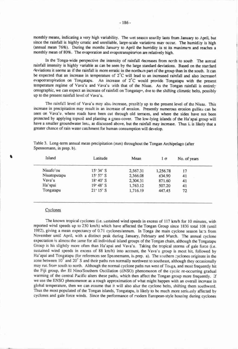
I
-lt6-
rnonfily means, indicating a very high vriability. The wet seascn usuelly lass from Jmuery to April, butsince the rainfall is highly enatic and unreliabh, laryre-scale variations may occur. The humidity is high(annual nrcm 76%). During the months January o April the humidity is at its maximun and rcrches amonthly ncan of t0%. The evaporaticr and evapotranspiration are relrtively high.
ln Se Tonga-wide penpective the intensity of rainfall docreases from north to south The annualrainfdl inensity is highly variable as can be scen by dre large stadard dcvidiorrs. Basod o,n 0re sandarddeviations it sems as if the rainfall is more erratic in the northern part of the group than in the south. It canbe expected that an increase in tenperature of 2"C will lead to an furcr€ascd rtiofell and also increased.evapotranspiration or Tongatryu. An increase of 2'C would p'rovide Tongatapu with tre presenttemp€raure regime of Vava'u and Vava'u '.vith that of the Niuas. As the Tongan rainfall is entirell'oreographic, we can exp€ct an incrcase of rainfall on Tongatap'r, due to the shifting climatic bels, possiblyup to the prcsent rainfdl level of Vava'u.
The rainfall level of Vava'u may alst increase, possibly up to the pres€nt level of the Niuas. Thisincrease in precipitation rnay result in ur incrcase of erosisr. Prresentty nutrtrxls crocion gullies can beseen on Vava'u, where roads have been cut through old terrrces, ard where fie sides have not beenprotected by applying opsoil and planting a gnss-cover. The low-lying islands cf the Ha'apai group willhave a smdler groundwater len;, as discussed above, but the rainfall may incrcase. Thus i: is likely rhat aglearer chance of rain water catchrEnt fr human consumption will develop.
Table 3. I-ong-term annual nran precipitation (mm) Oroughout the Tongan Archipclago (afrerSpennemann, in prep. b).
Island Latitude Mean lo No. of yeans
Niuafo'ouNiuaoputapuVava'uHa'apaiTongatapu
15'34' S
15'57' S
l8'40' s19'4E' S
2l'15'S
2,567.312,366.092,W.311,763.121,716.19
1,256.78d34.90t71.60507.20447.45
t74l4l4l72
Cyclones
The known ropicd cyclones (i.e. susrained wind speeds in excess of I 17 knr/h for l0 minutes, withreported wind speeds up to 230 km/h) which have affcted the Tmgan Group since 1830 total tOE (until1982), giving a mean exp€ctancy of 0.71 cyclones/annum. In Turga ihe main cyclone season lals fromNovember until April, with a distinct peak durirrg January, February and March. The annual cycloneexpectation is almosr the same for all individual island goups of the Tongan chain, although the TongaapuGroup is hit slightly more often than Ha'apai and Vava'u. Taking the ropicat stonns of gale force (i.e.sustained wind speeds in excess of 88 km/h) into account, the Vava'u group is most hit, followed byHa'apai and Torrgatapu (for referances see Spennemann, irr prep. a). The southern ;yclures originate in thezone between 10" and 20" S and their paths run normally northwest to southeast, although they occasionallymay run from south o north. Although the normal cyclone paths run west of Toirg4 and most fiequently hitthe Fiji 8rcuP, the El Ninc/Southern Oscillation (ENSO) phenomenon of the cyciic reccurring gradualwarming of the central Prcific dters tlrese paths, which then affect the Tongan group morc hequently. ifwe use the ENSO phenomenot as a rough approximation of rrhat might happen with an overall increase inglobal temperaurte, then we can assunre that it will also alter the cyclone belts, shifting them southward.Thus the most populated of the Tongan islands, Tongatapu, is likely o be much rnore serit .rsly affected bvcyclones and gale force winds. Since the performarce of rrodern European-style housing during cyclones
-lt7-
h8l bcn rathcr p6. in thc prst (Olivcr & Rcudm, l9t2; Lrtcrtet, l9t2), tlpr Eod o be urdsrrkca oqrsurt futurc cyclure-poof horsing.
Saial cqrsoquErccs
Larxl cnure
It can bc crpectod thr rny relantiqr pmgr.mr6 undcrtrtcn by thc govcflmt mey bc n:t byapsthy std reluctlrrcc to ttprrc. As cen bc dmungrad by drc crcc of tttc ftooding of Hde-'ovnre in thcwake of cyclurc Isrr in 1984 mmy frrrilics rEfrrs€d b rcccpt ne* lmd ur frighcr gund rnd pf,ared 16rcmein rt theu aigind plrccs, dtlnugh it wrs pointcd ortt to thcm dru such r nooOin-g colld hryar agrin.
Increa;ing populrtim, inundatin of grdcning lad std relantirn of residattial rrcas will&amaticrlly incrcese thc pcssure qr the limibd lmd resoorccs. It crn bc nticipecd 6ret thir incrcscdFessurc may led to thc utilisatiqr dlend by nuc pcopla srd 6us o r rlrctcning d thc frllon, pcriod inthe swid&n cychs rnd to r gr€atcr exhansticr of thc soil nutricnb. In rddirion, rmp said cnsior cm bcanticipatcd bctwccn thoce familics who still havt lsrd rnd thosc who have het thcir lmd-
Hedth
Hedth problems can be anticipatcd if resfotential lgr4 which is now dry, orms sw.mpy, u hotrsing insuch areas prescntly caus€s fc exanple r hlgh€r rarc of respiratry prroblamr @cw, l9Z9). to rOait*, t
"avenge tsmpcraturc is litcly to rice, which in conj.urction widr I high grumdwr6r tabh anil tcnporary,rain-induced ilmding, will provide breeding grounds fa mmquitocs, e frct rlrcedy obscrvcd as rconsequercc of the chsure of Sopu lagocr (Wolarding, l9t2:ll). Increascd nrocquio n-u-U*r md nsefavonrebb living corditiors fc speies not yct Fesst (such s ,arcpblcs) to"y io"iao thc cnvircnnpntfor vectors and rcsult h sr irrreasc in discascs such rs dargrr fcver zrd poosibly i"ct rnetrria (c.f. similerprojections for Ausralia: Liehnc, lgtt).
Tourism
As rnst of the tourist rlsrxts up locst€d m the offslrorc islea, ttrcy rc pronc b my etfects ofrclative sea level change. Aside from gcoglaphicrl altcratians of the islcts,-drc rlsats rney wcll bcconrrue dependent m imporEd drinking wdcf, s th groundwacr hnses boconrc Edrccd in size.
whereas mmt of the reseot rtsotrts, with dte exccpion of 0re rtsct .m 'ABtr, do not rE?res€{rt vastcapital expenditnre' e rise in reletive soe level should bc tetcn ino rccount in thc bcatfon of rr"w r'sor*and hotcl buildings. The tqography of Torryatapu is highly divcrse u r mkro levcf which prmis smellscale dcratinns of satings in fidcr b rchieve merimum rcurity. A case in;nint ii trc pfrnnoA .Cbownhince' Hotel dirEtly east of Hololti'ufi 8t Popua" While hc prcscnt laetim rt dre bcchfrurt is urly about0.6 m above HWI' a location aborrt &m inlmd h$ m clevatitn of ryproximacty 1.2 to 1.5 m aboveH\TL.
a4!IC4
Given the fact tra a sigrificmt rise in rclative sea level is lilcly b ccur in drc fqesecablc fuuge,some poinn follow which have o be takcn ino consideration in fuure plrnning.
r TongataPu is r cord lfuncstonc islmd- Any increasc in hc relatiye scr lcvel will rcsult in anincrease of dre lcvel of the goundwatcr tabb.
i Moct of the presant ceprtel srd adminisruive oentre is below 1.0 m rbwe MSL. Thus et sortsuge in the futnre it cen be anticipatcd thrt thc grourdwaer bvel u lfuht'rbfe will rise eboveFres€il stEt levcl;

-188-
Quite sorne tinc before this happens tlre foundatiqrs of the buildings will be imrrened in watcr,which may cause erosion of some struchues.
For the following discussist it is assumed that therc is no desire b; govemmant or f.e community torela:ate the entire capitrl. Thus it follows thu:
* Although it is ecoromically viable tc ereci rnost buildings qr lower ground, for which fie capitdexpcnditure will be wriaen off after 30 years, -t should be asked whedrer this is a suitable strategyfor public buildings, as it would create a lqecy of higher cosb for the futurc.
* It would be advisable to er€ct all i'ew public and gcvernnEnt buildings on higher ground,oreferably higher than 2 m above IIML.
* Possible locations wo:rld be in the area east and southeast of the mala'e kula.
* 'Ihe selection of such a location woul4 in the imnediat€ fuure, apply to the proposed newParlianpnt house an4 possibly, the new Palace.
* 'Ihe corrstnrction of new Government buildings on higher ground also irnplies that the focd pointof Nuku'alofa may be shifted gradually away from the presantly prestigious waterfront to highergrounds.
* Higiter grounds, however, rnay be occupied by housirg. The prcsent pressure on housing inNuku'alofa is certain to increase as both the overall population increases and as rnorc and nprepeople leave the outer islards for the arrcnities of NuLu'alofa-
The available land-fill on Tongatapu consists of coral, sand (quarried from the berches or offshore)and soil. While coral limestone can be procured on Turgatapu in a fairly unrestrictcd illanner, and whilecoral sand may be quarried offshorc, the availability of soil and especially fertile tr4soil is limited. While itis technically feasible !o infi[ large areas of marginal and swamp lan4 rt :s o be asked whether the
'rrlisation of limited soil rescrurces as landfill is justifiable in view of the long-term develqment of theTongan nadon as a whole, since:
+ Increasing water-level will require further infi[ to maintain the s;atus quo.
* It can be anticipated that every new heightening of ttrc ground level will be accompanied by a
new layer of soil, preferably opsoil.
ilIlrus the allmation of mengrcve swamp fq habiution, as is current prrctice in areas of Popraand Hala-'eva','e neds !o be r€-asressed. These arcas canrnt be mainteined as frture habitationaeas unless a largc cxpendiure is made fa a drastic pnlgramrne of infilling, considerationshould be given to suspending firture expursion of thcse seulenenb.
r However, the.c arc viable dtematives, such as the &velopment of canal estates, which couldpovide a solution.
The anticipatcd chmge in climaric conditions is likefy Lr have the folicrving negative impccts:
An inrrease in sea-surfrce temperau[e is likely o shift ryclqre bels souihward. ThrnTungatapu, the nost populaed islard, h likely to experierre a higher Aequency of cyclonec.
In consequ"ncc of this, srd the rathcr pmr cyclone performarne of current nrod€fir housing inTonga, the Government may want !o stress the rFcd fc cyclone-prmfing of all modern housing.
-189-
The incrcased rainfall level in Vava'u cur be expected lead to an increase in erosion, especially inroad'cuts and the like. This danger of lrge scale erosigr can be averted by nrasures such asapplying opsoil onto the sides of the cuts and planting a got€ctive cover of grass thus arrestingsrrrface run-off.
ln the case of Tongan cultural heritage, which forms an important part of tre world cultual heritage,the increase in sea level will have sevsre implications, as outlined above. The govemnrnt may need toundertake affirmarive rction to protect the heritage where possible.
OUTLOOK
The case study presented herc has idmtified sonrc of the problems lbngatapu may be faced u.itft ifthe sea level rises in the neu funrre. Although broad outtines can be skerched for the three scenarios, thedata base is generally too limited to permit morc detailed and reliable predictions. Obviously nnre workneeds to be done to place tlrese predictions on a more secure fmting. This applies particularly o theassessment of the impact on the lagoonal environnrn! the impact of clinntic change on agriculture and thepolential imprct on social conditions.
ACKNOWLEDCMENTS
Gill Byrne (Melboume) and John Overton (Human Geography, Australian National Univenity)commented on an earlier draft of the paper, which is gratefully rcknowledged.
REFERENCES
Admiralty Tide Tables 1977. Admiralty Tide Tables. Vol. 3, Prific Ocean. Hydrographer of the Navy,Taunton, Somersel
Belz, L.H. l9&4. Nuku'alofa sanitation and reclarnation. Nlinistry of Healrh, Nuku'alofa.
Bourouilh, F. & C.T. tloang 1976. ttranirrm-Thsiu.n age of some corals from Turgatapu, mga Islands,S.W' Pacific. Intemational Symposium on Geodynamics in the S.W. Prcific. Noumea-New Caledonia.Absract 5.
Braley, R.D. 1979. Penaeid prawns in Fanga'uta [,agoon, Tongatapu. Pacific Science 33:315 - 321.
Connell, Eddie, Riedel & Byrne (Pty Ltd.) 1985. Causeways feasibility shrdy, Fanga Kakau, Tonga.Report QR 63. East Doncaster, Victoria, Australia.
Fiefia, S.N. 1966. Report on the resuls of the 1966 census. R.S. Wallbank, Governrpnt printer,Nuku'alofa:
Gauss, C.A., J. EaCe & K. Lewis 1983. Geophysicat and sea bed sampling surveys for constructional sandin Nuku'alofa Lagoon, Tongatapg Kingdom of Tonga. South Pacific Marine Geologica! Notes 2(10):15.5-185.
Gibbs, H.S. 1972. Soil map of Tongatapu Islan4 Tcrga. Scale l:100.000. Nz Soil Bureau Map 81. NZSoiI Bureau, DeparUrrnt of Scientific and Indusfid Research, Wellingtur.
Hopley, D. & D.W. Kinsey 1988. The effects of rapid short-term sea hvel rise on the Greu Barrier reef.Pp. lt9-201 in G.I.Pearman @d.), Greenhouse. Planning for climaric change. Comrnonwealth Scientificand Indusrial Research Organization, Australia & E.J.Brill,london.
Hunt, B. 1979. Analysis of the groundwater resoruses of Tongatapu, Tonga. Journal of Hydrology 40: 185-196.
- 190-
Interdict 1982. Improvement of low-cost housing in Tonga ro wirlrstand hurricanes and earthquakes. Studyand rcomnrendations prcpared for the Office of U.S. Foreign Disaster Assistance. Agency forInternational Developncng Washington. Csrtract PDC-O024-C-00-1113-m0. Interdict, Dallas.
Kennedy, T.F. 1959. Geography of Tonga. R.S.V/allbank, Governrnent Prinrer, Nuku'alofa-
Kimrrct?r, WJ. 19E2. Circulation and hydrology. In L.P. Zann, W.J. Kimrnerer & R.E. Brock @ds.), Theecology of Fanga 'Uia lagmn, Tongatapu, Tonga. Sea Grant Co-operative report UNIHI-SEAGRANT-cR-84-04. Instiurte of Marine Resources, Univenity of the south pacific, suva.
Kingdom of Tonga lg/6. Census of population and housing. Vol. I, Government Printer, Nuku'alofa.
Labilladiere, M. 1800. Voyage in search of I-a Perouse performed by ader of the constituent assembly,during the yean 1191,1792,1793 and 1794. J.Stockdale, London.
Lad4 H.S. & J.E. Hoffmeister 1927. Recent negative shift in the strandline in Fiji and Tonga. Journal ofGeology 35:542-56.
Iao' Ch. 1979. Groundwater resourcres study of Tongatapu. Tonga Water Board DevelopmenL AssigmentRepon. World Health Organisation. Regional Offrce for the Western Pacific. TON/BSI\,1/001-E. UNDPNo. TON/75I004.
[€e, R. & J.P. Widdowson 19?7. Thc potassium status of some reprcsentarive soils from the Kingdom ofTonga- Tropical Agriculture (Trinidad) 54:251-263.
Liehng P.F.S., 198E. Climatic influences on mosquito-boine diseases in Australia. pp. 624-638 inG.IPearman (Ed.), Greenhouse. Planning for climatic change. Commonwealth Scientific and IndustrialResearch Organization, Australia & EJ. Brill, tnndon.
Ludwig, H-F. 1980. Evaluation of degree of impairment of Fanga'uta lagoon ecology and formulation ofprogranuE of protctive measurcs. Urban Sewerage and Drainage, Nuku'alofa" Tonga. World HealthOrganisation - Regional Office for the Western Pacific. TON/BSW002-E. UNDP No. TON/79I003.91p.
McGaveston, D.A. & J.P V/iddowson 19?8. Comparison of six extractants for determining availablephosphorus in soils from the Kingdom of Tonga. Tropical Agriculture (Trinidad) 52:14l-148.
Mulk, SJ\'I.I. 1987. Population Census 1986, Bulletin l. Statistics Deparunent" Nuku'alofa.
National Research Cnuncil (U.S.) Committee on Engineering Implications of Changes in Relative Mean SeaLevel 19E7. Responding to changes in sea level. National Academy Press, Washington.
Na, SM. 1982. Tonga. The Sopu reclamation area and community forestry. Asia Pacific Foresrlndusries Developmant Group. Project RAS/78/010, Working paper 10, FAO, Kuala Lumpur.
Nuku'alofa Tide Chart 1985. Nuku'alofa Tide chart. Depr of Meteorology, Nuku'alofa.
Oliver, J', & G.F. Reardon 1982. Tropical Cyclone 'Isaac'. Cyclonic impact in the context of the societyand ecoromy of the Kingdom of Tonga. Disaster Investigation Report 5, Cenre for Disaster Studiei,James Cmk University, Townsville.
OrbeU, G-8. 1977a" The soil panern of Tonga. Pp. 13-16 in P. Widdowson (compiler), Proceedings of theKingdom of Tonga Soil and lanxl Use Seminar. New Zealand Soil Bureau, Department of Scientiric andIndustrial Reserch- Gcvernnpnt Printer, Wellingon.
Orbell, G.E. 1977b. Discussion. Pp. 35-36 in P. Widdowson (compiler), hoceedings of the Kingdom ofTonga Soil and l-arxl Use Seminar. New Zealand Soil Bureau, Deparurent of Scientific and InJustrialResearch. Government hinter, Wellingon.
-l9r-
Pfeiffer, D. & L.w. Stach 1972. Hydrogeology of the island of Torrgatapu, Kingdom of Tonga, SouthPacific. Geclogisches Jahrbuch C4, l-13.
Reardon, O.L & J' Oliver 1982. Repo;t on damage caused by cyclone Issac in Tonga. Cyclone TestingStation Tehnical Report 13. James Cook Uni', enity CyclonJ Sructural Testing Stai'on, Townsville.
Rew, A.W. 1979. Hor:sing options for Tonga: 1980-19E5. Britich Technical Co-operation. Typescript onfi lc. Central Planning Departnent, Nuku' alofa.
Spennemann, D.H.R. 1986a. Archaeologicat fieldwork in Tonga 1985-86. preliminary report on thearchamlogical acdvides during the 1985/86 field season of rhe Tongan Dark Ages Reserch hogramme.Tongan Dark Ages Research hcgramme Report 7. Ausnuian National Univenity prinEry, Canbena.
Spennemanrr, D.H'R' 1986b. Zum gegenwaertigen Stand der archaeologischen Forschung auf den Tonga-Inseln. Ergebnisse und Penpektive.i. (TDARp-Repon l). Anthropos gl, 19g6, 4og4gi.
Spennemann, DJ{.R. l9E6c. An analysis of the size of Ggrarium sPp. she[s coltected on Tongatapu,Kingdom of Tonga during the 1985/E6 field season of the Tongan oatt nges Research hogramme.Osteological Report DRS 37 (1985). Ms. on file. oeparnnent of prehistory, RSpacS, .A,ustralianNational Uni versity, Canberra.
Spennemann, D.H.R. 1986d. Archreological sites on the Marakr'eua Heights, Tongatapu, Tonga-Consultancy repat prcparcd for the Cenral Planning Deparunent, Nuku'alofa, ringiorn nf Tonla.Nuku'alofa 1986. Ms. on file. Centrai Planning Oepartmeni Nutu'alofa, Kingdom of Tinga.
Spennemann, D.H-R. 1986e. The Kolovai sand ridge, Tongatapu, Tonga. Consultancy report prepared forthe Centrd Planning Deparfinent, Nuku'alofa, Kingdom oi Tonga. Nuku'alofa 19g6. Ms. on file.Cennal Planning Department, Nuku'alofa, Kingdom of Tonga.
Spennemann, D.H.R. 1987a" Availability of shellfish nesources on prehisoric Tongatapu, Tonga: effects ofhuman predation and changing ervironment. Archaeology in oceania 22(3):g1-x.
spennemann, D.H-R. 1987b. The imprct of cTclonic stllge on uchaeological sires in Tonga. Bulletin ofthe lndo-Pacific Prehistory Association 7 :j S -g7 .
spennemann, D.HR. 1987c. The extensisr of Popua township (Tongatapu, Kingdom of Tonga) and itsimpact on the archaeological sites in the area. Archaeologic"l imprct statenrent and outline of a culturalmanagemert plan fcr the preservation of a group of four sia heu lupe (Pigeon snaring mounds). gl pp.Ms. on file' Ministry of l-ands, Survey and Natural Resources, Nuk;'alofa; Kingdom if tong".
Spennemann, D.H.R. 1987d The developnrent of the Ha'amonga Trilithon Historic park: The Ha,amongaHistoric Ttail. Projct study prepared for the Ministry of Lands, Survey and Natural Resources, centralPlanning Department and the Tcnga visittr Bureau. Ministry of l-ands, Survey and Natual Resources,Occasional Paper. Government printer, N utua, alofa-
Spennemann, D.H-R. 1987e. Feasibility study on improving tourist attractions, notably historic andrchaeological sites within the Kingdom of Tonga. Consultancy sudy prepared for th€ dretariat of *reTourism Council of the South Pacific (TCSP). Draft final repott.
-3 vols., 613 op. !Is. on file,
Secrcuriat of rhe Tourism Councii of 0re Soudr prcific, Suva, Fiji.
Spennemann, D.H.R., in prep. a. Early and latcr prehistory of the Tongan Islands. Volume I: a study insettlenEnt and subsistence patterns, with special emphasis on Tongatapu. phD thesis, Depanment ofPrehistory, RSPacS, Ausralian National Univenity, Canberra-
Spennemann, D.HR. in prep. b. Supportive.Study D(: Analysis of rainfall panems on Tongatapu l8gg tol9t7 and their implications for ibe prchisoric water supply and settlernent pattenrs. In: Early and laterprehistory of the Tongan Islands. \tolume IL2: Supportive Studies.
-phD thesis, Depament of
hehisory, RSPacS, Ausualiur National Univers ity, Canberra-
- rvz-
Spennemann, D.HR. in prep. c. Supportive Snrdy VII: A dirchronic surdy of the availability of shellfishr€sources on Tongatau, Tcga: effects of human predation and changing anvironnrnJ on Atdataantiqun md GSrriun sp. In: Edy anl Laar Prehistory of the Tongan Islands. Vclunre II-2:Supportive Surdies. PhD thesis, Department of Prehisory, RSPrcS, Ausralian Nationd Univenity,Canberra.
Stoddtrt, D.R. 1975. Sand cays of Tangaapu. Atoll Research Bulletin l8l. Smithonian Instiurtion,Washingon D.C.
Straatrnans, W. 1954. Reclamation of tidal mud flatr in Tonga. South Prcific Commission TechnicalPper 53. .couth Pacific Commissiqr, Nounra.
Suiver, M. & PJ. Reimer 1986. A computer pro[ram for radiocrbon age calibration. Radiocarbon?3:l@;2-fi30.
Taylor, F.W. 1978. Quaternary tectonic and sea level history, Tanga and FijL Southwest Prcific. PhDthesis, Cornell Univenity,Ithaca, New York. (University Micro-films Internationd 78-17776).
Taylor, F.W. & A.L. Bloom 197?. Coral reefs m t€ctonic blocts, Tmga Island Arc. Proceedings of theThird International Cord Reef Symposiurn VoL 2, Gevt,logy, W.276281. Rosentiel School of Marineand Atrnospheric Scierrce, University of lvliami.
Tiffin, D.L. 1982. Kolovai Ridge sand survey, Kingdom of Tonga. Cmise r@rt 54. UNDP ProjectRAS/81.'102, Investigation of mineral po'rntial of the South Pacific. Prepared for CCOP/SOPAC wortprogramrr€ CCSP- 1/TG.6. UNDP, Bankgok.
Widdowson, I.P. ln7. Evaluation of the nutrient saus of Tongm soils using glasshouse pot trials. Pp.62-68 in P. Widdowson (compiler), Proceedings of the Kingdom of Tonga Soil and Lanrl Use Seminar.New Zealand Soil Bureau, Department of Scientific and Industrial Research. Government Printer,Wellingon.
Wolterding, M. 1983. Ecological description and analysis of low-lying areas in northern Tongatapu.UNDAT, Suva.
Woodroffe,C.D. i983. TheimpactofcyclonelsaaconthecoastofTmga. PacificScience3T:181-210.
Zann, L.P., W.J. Kimmercr & R.E. Brock 1984. The ecology of the Fanga'Uta lagoon, Tongatapu, TongaCooperati,re Report. UNIHI-SEAGRANT-CR-84-04. Institute of Marine R€sources, Univenity of the
South Pacific, Suva.
193 -
TI{E IMPACTS OF POSSIBLE GI,OBAL WARMING GENEN,ATED SBA LEVEL RISE ONSELECIED COASTAL ENVIR,OT{IIENTSIN PAPUA NEW GTJII{EA
Leo Bualie & Mrrjoric Sullivanuniversity of papra New Guinea, prt Moresby, papur New Guinea
INTRODUCTION
Based on a coruervative estimate of an overall rise in wqld-wide sea level of I m by the year2050, an atrempt was made to assess the overall effect of such a sea lwel rise on the coastline of papuaNew Guinea- This was done by mryping a new shoreline ar the basis of existing opographic maps ara scde of l:100,o0 widl a contour interval of 40 n These mapc, the laryest r".r. ,"r[, available forthe wbole of Papua New Guinea' were used for tlris exercise. rbr a very few areas where larger scalemaps or additional contour infmnation is available such sour;es wene also used.
Cloud-free LANDSAT satellite imagery of Papua New Guinea is available, covering about halfthe coastline' rhis imagery was use4 together with lorp air photographs and penonal knowledge ofthe coastal zone to deternrine the gercral form of the coastline. rrorioese data a t m contour line wasinterpolated between the present shorcline rrd the near-shore 40 m contour position. In general onrocky cliffed or sloping (emosiural) shqelines the I m level was inrerpolaad appro^,mate-ly l/40 ofthat distance inland. on coastal areas wherc a nanow coastal plain (either r-ri-"t or &frsitional)exists between tle shorcline and any near-coastal hillslope -n", ttra I m contour line was intrpolateall2o of the distarce inland 0o the 40 m conour line.
It is clear that given the res,ources available for tris preliminary study, our rc-construction is acrude estimarc of any likelT future coastline. In the followlng discussion rrfcrerre is madc to lengthand types of coastline which will be alfecte4 rather rhan o .r"t fikely 16 be inundated.
It is imnndiately apparant drat inundation of coasnl environnrnb will be a, widespreadphenonrenur in Papra New Guinea the extsrt of which will be dictarod uy prti*Jr..i** ,o.t a.underlying stnrctur€' existing landforrq slope, rhc distribution of deposited ieairpnt , and the localwater table levels.
Coastlircs wefe classified into three broad categona rccording o the degree of inundation -
Neglieible where 0rere was fi) discernibte land area likely ro be inundaed by a I m rise in sealevel, mapping on a scde of l:1C0,000. Such arnas, which are ienerauy rwky strorelines affeced byrecent tectonic uplife or conuolled by enestrlal hillslope processes, wifl in'frct ruffer a shoelineregrcssim of lass than 20 m in 0rese circumstarrces.
Moderate wherc the otal land area likely to be inundated was discernible when mapped at ascale of l:100,000, but comprised eitlrer discrete land areas each of less thm I km2, s a ,^oastal srip ofany length dong the strarline but lcss than jO m wi&.
Severe wherc contiguous land areas in excess of I km2, or srips of coastline nrore than 500 mwide would be affectod by inurdation.
r -19{-
RISING SEA LEVEL O\IBAIJ. GEOMORPHIC EFECT
Tb rllnlb of thc coulim rmmrructln G runlrrrircd h Ffurc l.Thc Erl laE6 of fu ryr Ncry Guinr coltlhc hcMirg drc provipirl irhn&, whcnmrsrd o l:l(Effi rcrle nryr, b lT,lmtn Cfrbk l). Of dr* rdrl lcngth, rproximecly
aJOfn uiu bc rficrd dtb nodctldy c rvcrcly, r dcfincd lbove, lret fr rroui'26% d fucchcorrrlir of drccrrywill bc fccncd bvryiry dclxccr by rignificmtinrmdrti<n
Lmdfam tylpr rficrd
In wurotry fu effccr of drc prodictcd rce lcvcl rirc qr oouul lrndfrrn typ6, thc excrcisch[ ba crrid qrt wilhot rocmpdtry to trodict thc chmgcs wlrir*r mey ccur m itivc csal recfs,utd thc corcqurtcficc$ m ttc{sltn wrvc cnvinnnpB.
Fivc lmdfam tyPcr a cotplcxcs wcce idcntificd rs &taq which *ould sufrcrprticulrly ftomr I m rirc h rce brd. Thcsc lc:
. dcltric flmdpleinr;t rrld brricr md l1goo lmdfcm canrplcrcs;+ cml lollr ndceyr Iscrlcvcl;I niscd ccrl ishn&;r high ful$rds.
Deltric flmdpleins
Thesc makc up nrmt of thc corsal zqp of Prpur New Guinee which wqrld be rficctod by amej<r cce hvel risc. Thcy acur at tlr mouths of rtl thc mejc rivem antcring tl: Gulf of papuq and atthc ry|t! of thc Scpit lrd Remu Rivers (scc c.g. Ltfflcr lVlT M t983; nercivrl tl. Wornasley,195). This lgrdfcrr conplex ir thcrcfac rcl*ivcly vcry widcsprced rlorg thc soothcrn coastlinc ofth Prpue New Guince mrinlm4 whccc it eqmts fq nrorc than .11096 of thc corstet lcngfi, md lessittpctutt m thc nadt€m corstline, c thc cor*lim of te rnaja islmds, whcrc it rnekcs-up-less thg1l0fb of fu slrorc lcngthr.
Thcac rc dcpocitiurrl hndfam compbxcs, with fluvial and coastal depoeitional prcccssescmtributing sodimans o 6c lmdfam corrylcres. Such aeas re litely o sufier major inprct d6 toinundetio' w8tc( trbla within tlrccc hndfmm complcxcs rre high, md should sea te"ei rise by arrlEt cxEnsive ltrs d Aet-lyirg lrrd on thc dclaic floodplains wilt bc subjoct o liquefrction due torising wrartabhs, md cmsGqucnt episodic corstal croeim. In rdditisr, thc ofrshore *aters in the Gulfof Papa le relatively shdlow, md e I m irrunkxr of sea watcr wilt place a proprtionally highweighting e{iusur:nt m this port of the slraelirc, comparod wirh the adjustnrcnt fitefy in deeper wateroff thc nmh coast urd sunounding the Bismarck Arc islands. Strorelines along he Cuf are rhus likelyto subrrcrge fulh€r widr fte incunion of sea waEr, errcerbating the effect of the sea level rise.
Srrch ueas are mainly covered with mangrove d swamp forest (Fetr 1983; Fercival &Wonrcrslcy, 1975), ard the effcs on this lardfornr t'?e re discussed with special reference 0o thePurri dclta uca t y Osbcnc & Penretra (this volune).
Srrd brnhr and lecom coasa
Thc sample sea chosen to excnpfiry dris coastal typc is the coastlirp in the Murik l-akes area,East Scpft Provincc. As will acur fa dclt ic floodplains, r I m risc in scr levcl will have a profoundeffcct qr mury of tt'c d.positionrl fetrcs which makc up 0ris lmdfsm conplex, md will ls:essicatcthc re-lartist of villrgcrs whocc hod will bc rffead This is discussod by Hughes & Bualia, 61isvolurE, with spccirl refcrcrcc o populcinr nd lmd tlrc (scc cslRo and DpI l9g7).
-r95-
dE'-uR
a.Eg,a€pE$ioo .rrEE(llX6zqlXEHtrE8EA{)E€.E .go600E it)
ez.E
l,q,
Q') c|E
J
;s$! ctt
6EE-E€hlu<ql
EF8g:gsE.EGtr
o><€idgV'5Fs.E5€.85
.&Co.-oSg8oo tu€EE>()Ego.d.
!,5o0
t&
196 -
Tabh l. Approximate conposition of the P4ua New Guinea coastline, as landform types.
PapraNewGuineacoastline
17,100 kms
Deltaic floodplainsand brrierJagooncompleres
4,250 krns
(2s %)
klmds andatolls
4,180 krns
(u %)
Coral atolls and cays at sea level
These will suffer virnral destruction from a sea level rise, unless coral growth can keep pacewith the rising sea level. f'he effect on this landform type will be thc lcs of land and cf he alreaoylimited supplies of fresh water for people dwelling on such islands. The effects of ihis, particularly thesocial implications of this otal loss of land arca are discussed by O'Collins (this volunn).
Raised coral islErds
The sample area chosen for this case study is Kiriwina Islan( the largest island in the TrobriandGroup (L0filer L971;Ollter 1975;Ollier & Holdsworth, 1970). A I m rise in sea level will not onlycause inundatian of a major proportiqr of the lowJying and swampy land which makes up half of theislan4 but will cause salinatiqr of the island's fresh groundwater resource. This is discussed bySullivan, this volume.
High islands
There se a vnriery of small high islands making up part of the totd Papua New Guinean landarea, and the islands chcen as joint casc sftdy examples are Lihir Island in New Ireland Province, andMisima Island in Milrr Bay hovirce (see NSR 198? ard in prep.). On such islands the total land losswill be small, but tlre reluive lcs of economic resources and infrastnrcture will be high. This isdiscussed by Sullivan, this volunr.
It was noted abovc that in the coastline mapping exercise ur approximate assessrrnt was madeof the relative prqortions of the Papua New Guinean coastline occupied by each lmdfam type, mdthcse are summarised in Table 1. It can be noted from this able that rhe disribution of landform typeswhich will be affected vries marttdly between hovinces. Deltaic floodplains and sand banier andlagmn complexes occur mainly in West and East Sepit, Western and Gulf Provinces, whilc small highislands and coral islands G atolls occur in the rnain island Provirrees of Madang, Morohe and MilneBay, and in all the island Provinces.
Oli{ER EFFECTS OF SEA LEVEL RISE
The effects of sea level rise and consoquent loss of coastal land in Papua New Guinea can besummariscd undcr the following:
' bss of useful land;I loss of frcsh water ad raditional economic resourpes;I damage o roads and other infrastructure;
' damage o villages.
_rm_
Ioss of land
Togaher with lan4 itself a valuable r€$ourpe fa subsistence or cash cropping, for hunting andguhedng, fc pig husbandry or for security, other nesource$ on it will be lost, primarily bushlandresourc€s, irrcluding fmd plana ard building materials. There ue likely to be land pressurc problemsin higNy populaed coastal reas of dre country, such as the Sepik mouth, cral atolls and cays andsorrc of the smaller high islards. In such areas, intensified use of the rcmaining tand may lead to soilfertility depletion which in tum will lead o decreased crop yields.
Loss of fresh water and traditional cconomic resources
A I m risc in sea level will result in salt water incunion inb 0re groundwater rcsources of manyisland and floodplain communities. without additiond fietd evidsnce it is not possible o predict theextent of dtis impact, but coastal villagers in many parts of Pryua New Gufurea are already frced withthc problem of wells becoming bractish during dry periods, and groundwatcr salinity will rise as sealevels risc.
Thoc€ traditional rEstrtroes which will bc nret directly affected by a rise in sea level are sagosunds md mangove fress. Sago is an imprtart fmd sourpc and building material in many coasularcas, prticuirrly around dtc Gulf/lVesErn and Scpik reas. Ercessive salt waEr inrusiqr willdcplca his imponant restxtrcq by redrcing dre erent of brrkish waler zones, fucing sago standsinto nse restriced reas upclope. Mangrove forcs6, which provide in dremselves valuable buildingtimbcn md fircwoo4 rlso harbour ottrer food sourE€s such as various types of molluscs andcrustacesrs, as well as nurscry sites for mmy marirrc orgamisms.
Coral reefs, rwk phdrms and othcr iil€rtidal rm\' shoreline featres, provide niches for foodsourses such as variqrs molluscs and fsh. Mury rocky shoreline feaoues and coral reef complexes(until ftey re-adjust to high€r sca hvels) will be inundarc4 thus desroying litord ccosystems. Livingreefs may suffer from increesed scdinrcntation md uubidity thu will inhibit coral growth. l,oss ofimportant food rcsources from such areas is anticiparcd.
Damage o rods and other coctal infrasructure
Rugged t€rr.in end limited constnrctiqr funding in Papue New Guinea heve resulted inrelatively linle rod constructim having bccn csrid out in inlad arcas for my coastat l<rality whereevefl e nrrrcry corstal plain exisS. C-onseqrrcntly coasal c?its, psrticulaly thce fringed withdcpositiutd hndfcms rc relativcly well scrvicod with roads. Rising sca lcvel will however bedisestruts b srrch infrastrucurc, md nrcncy spcnt b safegurrd roads thrcatclrcd by rising sca will benIr|Cy wastsd.
Whrves srd otlrcr corctsl instdl.tkns will dso be dircctly affectod by rising sealevels, and relitely to suffcr from a tl causc nuja scdimcnuirn resulting ftom changed patterrs of coastal erosionand &positim.
Damagg..lo urtm or villrrc cenres
Rcccfilcmtrt of villagcs clscwhac is fqrscan due o inundatfom. Therc will be a prticulartroblcm fa villagcs cl.rrccristic of thc sondrcrn PrpuaNcw GuirErr coagOine, whae rows of horsesarc comnpnly corstrucrd suppatod ur polcs ovcr the tidal zsre. Saial poblcnrs will rise directly insuch insEnces, whcrc prrticulr clms mey hold lsd rights only doog the coast, in ucas whcre otdittundetiat il mticiprtod Anaryrs o rccsnb pcopb rftctld direurly by bcs of villagc lurd is likeiyorccultin lmd dispu6.
Uttsr ccntcr rio*cdm fftc corct lr rbo likcly o suffcr remmdous infrstrucurnl loeses mdco$qu.nt furrid strrin ar r rault of ririry rcr hryeb. Sonp rclcrtim of urtn ccnrcs isrdiciprrd widr cmrcqu.nt high canp€nsrtim oof6 fa rcw lmd r4uisitian litely.
-l9E-
SI'MMARY OFEFFECTS
It can be seen from the case studies that the effects of a rising sea level will be most profoundfor poople living an depositional landforms on aneas at and just above sea level, and which are notbrcked by rising land. It is also wcth rnting that these are generally favoured areas of occupation,since such localities provide good access 0o fishing zones as well as to gardening land.
The overdl inrpacts csr be evaluated also in economic and provincWpolitical terms. There isunequal disribution of rcsources in fte country, urd those Provinces which wifl be directly affected bythe loss of coastal land will suffer to varying degrees. Hig,rly populated areas which are ienerauy notwell off in terms of ccmomic developnnnt (Murik Lakes, Milne 3ay Islands) are likel! to be rpstaffected.
The relative effects of a sea level rise have been summarise<t for the 14 coutal hovinces ofPapua New Guinea (Table 2). irovinces such as Gulf and Western hovince which will loseproportionally higher areas of land than any ohers are also those with low incomes 6d little developedinfrastrucu[e tr en.rble drem o withstand major social and economic changes. Areas along theEastAVest Sepik Coastline will also be severcly affecte4 and are sintitariy already fmagiallydisadvantaged
Table 2. coasal hovinces of papua New Guinea showing the appoximate perpentageof their corstlines whbh will bc affced by inundation (delrak Rmapuins and hgdnand sadspit complexes), or will be affectod o a varying extent (srnall high islands, reefislands and atoll$), this extent unlnown in the case of very small islands and aolls.
PROVINCE lcngth ofcoastline
(km)
% coastal lengtho be inundated
% coastal lengchaffected o varying/unlcnown extent
West SepikEast SepikMadangMorobeOroMilne BayCentrdGulfWeslcr:r
MrnusNew IrelandENBWNBN.Solonpns
uo490
10001020550
3430930
14401330
550u@lll0rc2nrm0
5040
2202
n95
100
530
4525
60t
50a5l0l0l0r
r l-rrgc numbcrs of rtolls, proportion is m undercstimatc.
REFERENCES
CSIRO Austrrlia @ivisicr of Water .nd f^urd Rcsources) end DPI Papna New Guinea (La,ndUtilizafian Scctim) 1987. Ppua New Guinca Inventory of Naural Resources populationDisributiqr grd I-and Usc. Codc Fihs, 7 volurms.
Ldffltr, 8.. 1977, The gcomorphology of Papur New Guinea. Ausualian Naisral University hess,Cmberra-

- 199-
Naffd Systerns Research NSnl Pty. Ld. r$7. Misime ProjectEnviuunental ptm. placer pNG Ry.Ltd., PoftMor€sby.
Nauml Sysems Research (NSR) Pty. Ltd in prep. Lihir Gold projct Environmentd ptan KennecouLtlL, Fort Moresby.
ollier, c-D. 1975. Coral islmd geomorphology - flre Trobrisrd lslads. zeitschrift frr GeornorphologieN'F.19:164.90.
Ollier, C-D. & D.K. Holdswordr 19?0. Sorr caves of Kitavr, Trobriand Islards" papa. Helictite8:29-38.
Fercival, M. & J.S.Wsnenley l9?5. Flaisticsrnd *ology of the nangrove vegetation of papra NewGuinea Botany Bulletin No.8, Departrnent of Foub, pi"ison of Botany, Lrc. )
Pet, T. (Ed") 1983. The hrari - ropici eovironlnctlr of a high Fainfall river basin. ManograptrireBiologice 51, Jmk, Thellague.
-200-
DELTAIC F-T,OODPLAINS: THE MAI{GROVES OF THE GULF OF PAPUAAND THE FLY RIVER., PAPUA NEW GUINEA,
Jobn C. Pernette & Pstrick L. OsborncUniversity of Papua New Guinea Port Moresby, Papn New Guinea
INTRODUCTION
The island of New Guinea is geologically young, being formed as a rcsult of orogenic and tectonicactiviry at the northern extremity of the Australian landmass. Ihe southern half of the island is fonrpdfrom uplift of the Australian continenul shelf which has collided wift the island arcs running fromSulawesi out into tne PaciFlc. Iow-lying coastrl plains are more extelsive on the southern side of the
island than in the north and consequently the impact of sea level changes wili tend !o be greater on this
side of the islend (Bualia & Sullivan, 0ris volume).
Furthermae, the rprthern coast, is for much of its length currantly undergoing uplift, whilst incsrtrast the southern side, particularly around the Gulf of Papra is sinking. Geomorphic changes willtherefore end o acc€ntuate (over the long term) rathcr fian diminish any inpacts resulting fromirrcrearcd sca level on this side of the islurd.
The purposc of this cas€ study is to examirr potcntial imprcts of sea level rise on two majorcoastal habitet tlTes: mengroves and lowlevel swamp foresr Within Papua New Guinea, the mangrovesfringing dre Gulf of Papra (Figure 1) comprise some of the rpst extensive stands of lngely unexploitedmrngrove forest urywhere in thc world, whilst the floodplain of the Fly River forms an extensive systemof lowJying habitaa and ecotones which contrast widt the majority of New Guinea which is covered inrain fucst
THEMA}.IGROVES FRTNGING THE GTJLF OF PAPUA
Rcccnt qeolo{icsl historY
Thc coastal area of tlre Gulf of Papua sppess to have ben a rcgion of continuous shatlow marinedrpositiur througtrout dre Mc.sozoic and Tcrti8ry eras. LifiEston€s probably of reeral origin and fonnedin the lower Miaene re comrrn in lhe hrari Dela area indicating that at that time the present deltaicarca was sonr distarrce from the pnescnt slrorelinc (Khal t974). Middle and Upper Miocene sedirnents
arc mrinly mrrls urd mudstones with sorE evidencc of errrgence and erosion. During fte Quaternarypcriod ttp southwcstein scctiqr of the area was subcidi:rg with volcanic enrptions occurring in the East
Quaemrry dcposits includc frcics indbative of dluviel lakcs, freshwder swamp6, tidal flats and beachpleiru idiceting occillatians betwecn ft,eshwatcr, esararine rrd liaord environnrnts (Ruxon, 1969).
A bffc nob sitcd WNw of Baimunr on thc Ere River rcveabd 1,700 m of Pliacne ard Pleistaenescdfuncnts; the thiclncss of thcsc scdifiEnb furcrpasc eastwards indicaing meted subsidence inrclrtivdy rwcnt tirrn (Arc, 1969). ort rhc bssis of such datr Thom & Wright (1982) posnlate thatnrod.n: dcpocitiurd cnvironnpnts rre si:nilu to tlrcsc whhh have prevailed throughout the area overth lat five millim yean. They quotcd quotod Rurtsr (1969) rs follows:
'.... thc corstd nrrgin of the (hmri) delts rrce is subsiding in association with regkrnd crustaldownwrpirE bot thc ccstlim ir rardly rdvncing scewrrds bccause the dcpoeition rac hom the Puraridrinrgc ir rc grct'
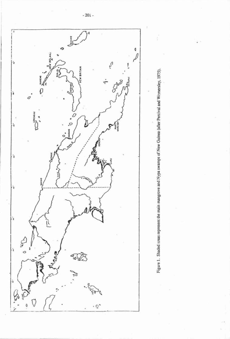
-20t -
0
/
rt\o\>r(,e,91 tr()BEqlGt
tsd€GI
ql(utrt()
'lr)zoaoEqt
'o(lAz€E6tu
eaotr5ltrtr(llEo€Eoogo.goId
8€6.Eu)
-.ig-ooE.
/Itt
;'\-
i/,0
@\ F
l\
0,trt

-2m-
g\r\o\
Ec)(.}
=J!C;(E
Efb€Itr=o-c,z(llaoG'o.o!to)!'trox.u
I
Eort)5trIe€€'toE
=oE6cie-
.sog.
o5a.oa-
o
tt7oq
!
ct
MN,
$ga?gH
F2
EE
g
r
t -.il
-?03-
Modern eeomorpholosv
The area under_consideration (Figures 2 and 3) covers a substantial sector ofthe ccntral southerncoast of Pryua N:w Guinea and is travened by several major riven. To the east, the purari has anexiensive deltaic ststem of distributries with thre major r,iier-dominated channels. Both the pie andEra Rivers in dle central section of the area have lower flows and lend to be more tidally influenced. 'lhewestern end of the Gulf ls dominated by the Kitori, omati and rurarna Rivers. tnii oettaic complexexhibits -rany oI the envircnmental and morrrhological characterisrics of the Ganges-Brahmaputra arrdIrrawaddy dcltas (see wright et al', L974). In
.terms of tidal range and wave regirne all three complexesare similar whilst the discharges of the Purari and Inawaddy tin"^ are comparable (Thom & \4 right,1982).
To the easr of the region the shorelin' is comptsed of a nafiow plain (1-2 km wide) of beachridges frc''ting freshwater swamps which merge ino alluvial ptains with locally rccumulating peats inarcas of pmr drainage. ,Thom & wrighr (1982) suggest some westwards ,"*riking of nedium to finesands (Figure 3). The Purari deltaic plain has well-develope.i levees up to 2 m high along the mainchannels in is fr'eshwatet rerches. Aerial ph<xographs revial a mozaic of freshwater swarnps, swampforest and rain forest on the elevated areas.
The tower deltaic plain is chancterised by brackish watnr cond,iticns at least occasionally gradinginto the mqe saline conditions of the less rtivedistributary channels. per & Luceru (1979) md Cragg(19t3) hav: defined the limit between thes€ two ecologrcat unirs as coir,cid.ing with the lower limit forthe distributi<rn of the freshwater re/- Phr,.gmites *ariand the upper limit of sonneruia caseolaris md,Pandanus sp indet. Tl'c range of interstitial water salinities n"* tir" bounoary of the lower dehic plainis betwecn I ard 7.j ppt (petr & Lucero, 1979).
In'disributary cnirilrcrs wherc river flow dominates the aquatic errvirronmert (e.g. the Ivo-Urika)'he rncrphology of river rnouths cnanges rrom vear tc yeiu with conse4uent changes in the patterns ofdisributisr of sand ard smaller particles and dynamic ciranges to the balance of erosion and accreiion. Iris comrnon thercfore tro erEounter sections of coastliue whire maure rnangrov€ forest is being steadilyeroded due o local changes in patter:ls of sedirpnt depmition.
The wesEm sectim of this region is compoccd of an extensive complex of funnel-shaped estuariesand deltas dominabd by tidal pK)oesses, with channels bccoming moderately sinuous upstream (wright eral" 1914) urd mudJaden wat€rs being circula$ uv tides leiding to vertical accrCtion of mangrovecovered tidal flats. tidal ridges extend offshore to a depth Jr +o * In tide-dominated estuaieslry.tq"t" low, typically baween 0.25-0.5mscc-l also tlaically reversing with tre tide frhom &wright' 1982). Generally such chanrrcls are deeper (10 m) man river io^in"r"a -es (i4 m).
Figure 3 iuustratec the distributior: of subsuata within the area; topcrgrapl,ic det"il is sparse withcqrt(rur data baseJ on 40 m inervals md a few spot height data scaaered-o"et'ttr" area. Any arcmpt !omake dcailed estimates of lrnd loss whhh mighl mcur due o a 20 cm or even a l.j m rise in sea levelT d*tt d tc' feilure given the present data. However it is possible ou the basis of known distributionsof vegetation qpes in rclation t^ pres€nt salinity regimes to aelimit zdnes of marine influence and giventhe gencral topography ts obtain some esrimate cf dre impact tlf fuure sea leiel rise.
Vegetation tvlns
Femcival & Wonrsrrley (19?j) suggrst drat there erc apprcrrnutely 37 species of murgrove inPapua New Guinee, The h'gh spocics divcrsity resulting nom ure prcscrce of bcth Australian floralcfenrnc such rs osbornia and Asrar gcrur\ indeed nu orrrv Asian mangrove gcnus abseni frrom dreislard of Nw Guinca k Ken&lis. In rddithn to mrngroves, r€rn strktg r wide vaiety of othcr plmtgenerr gc found in cloee rssq.iuirr u'itlr mmgrovcs, of tlrcsc perhas ilre npct imbrtart from asuhistcncc cconomic vhu/pdnt i$ the s.go plm Ltetroqlon ssgl..
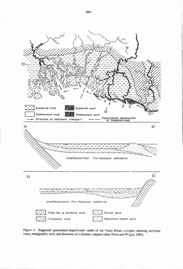
-2M -
\^
?zti "/./,
[:\\----\u,/JE> *r7-'TT
\
f] Subrqueour mud= subaerirt mud ffi
EffiSubaerial sand
Subaqucous sand
-.+ Dircction or scciimcnr rr.nsporr o%P';iB$;,o1i%113:t'on
a
\
e,a
bUndiffercnristed Pre-Holccene sedimenls
Fl
Undif f ercntlared Pre - Hoiocene sedime;lts
,6NF] Tidat ftar & oftshorc mud E Ftuviar sand
Fioodplain mud Nearshore-beach sand
Figure 3. Suggested generalised depositional rnodel of the Durari deltaic corrplex showing sedinrenttvpes, stratigraphic unis ard directions of scdinrent Lansport (after Thom and Wiighr, 1982).
-205-
Estinatm of dre extrnt of mangrovc forest in ftc Gutr R'ovince vdy. Hillis (19'i6) estimaed thattherc arc ryproximaely 121,500 ha of Rhizophcacee fqest, 26,730ta of pure lVypa paln paijmans(1969) on the basis of Firestry Map No. l3?3 estimated 13,499 ha of mangrove s"i"-p; l i9,t00 ha ofmixedmangrcve swamp faest; 67,m ha of mixed mangfi)veAlpa swanrps;4t,50 hz tf Nypswampand :56'600 hr of freshwat€r stvamp foresr Padmans recogniscd 5 majc assaiations including scnridominated by Avicernia; woodland dominaEd b1, Rruguicra intersperscd with Rhizoplwra ard, a wi&veiety of otlrcr species; tV;'pa association; low forest pre,rlominantly of Son*rotia ertd Avicennia ard, amid-height association predominantly conposed of Rhiz.zptnrawith sonre Bruguiera.
The nature of thc mangrove community differs from area to a€a deparding upon a variety offactas. In general mangrove communities arc charrceristic of slrcelines protoc6d Uy bfomt barrierreefs; along shaclines running prrdhl o theprevailing winds; 4d in a:as of rctive accretion. percival& wonssley (195) point our that 'a mangrove swamp on a stable shoeline will tend !o be lessextensive in widft thsr one nn an rccretive shoreline' and the mangroves cf 0re purari delta are noexceptioa. In the dcltaic aea of the Purari disributaries maryrcve swamps extend sonr 35 km inlandaom the coast whilst fur6er west in tlre cea of thc Turarna River the extcnt is considerably less(Figure 1).
Mangrove e uc*$l!qg_g!d!O1t!glg!
Zmatkn rnd succession art intinraaly relaed in nrangrove €cmystcra, rnd es percival &wonrenley (1975) note, mangroves do not carac shorelinc rccrption but may rccelcrae the pocessthrough furcrcrsing the ratc of dcpoaition of suspendod macrials. Hencc piar€€r mangrcve species maydter thc nahue of drc substratum rnd as I oon$equcnoc are thcrnsclves rrplrod by cher sptcics in theprocess of successiqr. or sable shcelincs whcre the rdc of rccretion is low thc zonation iharacteristicof mangrove communities beconrc cornpresrod into r retiuively narrow fringe baween the 'rrarine andt€rrestrial cornmunities. In rtiwly rcrtting areas mang1lv6 &E riore extGnsive and the zsresitdividurlly widcr. The mangror€ sysems fringrng the Gulf Province fall ino the lacer carcgory.
Areas subftrt€d to diffcring degrecs of salt watcr inundedm may be divirtcd i,ro five ma.iorclasses: ueas inundated by dl high tidcs; rers inundarod by rll medium irigh tidcs; areas inun&ted byall normal high tides; scs inundatcd by spring tid.s ard areas inundrrod by cxceptbnrl high tides. NonumSrcves can withstsrd otal inundation by salt *arr. Thc rmst rcsistant mmgroves r" rt ose c4ableof withsturding inundation of their rmt sysr.ms by all mcdium high tides and include memb€rs of th€gff;rcta Aicctuia ari bruuruia. Artas inundated by ncmal high tidcs are charrceris dby Rhizcplorawlnb Brugukra is found arly in those ces inurdetld by spring tides. In ueas inundatod crlyoccaionally the mangrove ootrununty u dominatpd by Brugubra gywwnhiza md Rgzoptvraapkulata
Alproaching r mslgrovc $rd frorn dre scia thc fint zslc encounered is dominued by SorneratiaaIDa which tmy h inundarod qr r'leily baris, howercr m rnost maurc\rc domineod corstlines thcscaward zone is ncmally coceoccA 6 Aviccruna turlna sr th scswrd edges, oeing rcplrccd by f.alfu alol! 6c rmutha of tidet crccts, thig zorre in u;reting Ecrs may e,rtcnd up !o 750 m inisra.
Rhizaplora for-sts &veJop bdtid thc pionering spccica nrcntionod abovc with R. nugonstabcing nue salt-watcr tolcrnt trn R. apicdata. In this zare dt substrrtr are inundead by nonrral highdi&s. I-adwnd of this zmc in tbc rers inundtd by spiing md exccprirnally high tirbs thc com-"nityis dominatcd by Bruguhra, whilst in totr arcrs Ccriops fiictctr fqru e trftr'rd fringc o thc nrergroveconrnunity.
i'n iE ti;U:rg !!!ttgtc of gp Outs of @ua tIn Nyp srs:ilin nccun in r.-crs rloqsideddd:$rmr flmdod by thc hi#$ qing tid6. It is tlrcrcfurt rt- indicair of bnchish wru caditiqti.Msryrol6roe.uioo fc &c Kitffi Rivcr aer h33bcca dacribcd in daril by Flovd O9f,7) md fr tllRrri Dctt8 6y &rgg ( tgeg).
C.Ldli at transart ftrom 6c scrward aige t-r fu tmdwsd ride of rhc nnryrovc cunnuniry,whilst it rryft mfctn to tln gcnen! pffcnr CcscriUcC aFve i f,irced by lcd cmdiECin of accretion,emcioq roill fttrltltr furpub nrd tltd ffircrrcs , No sing.b trnm pfih v.'urld snfu, 6:rcfac o
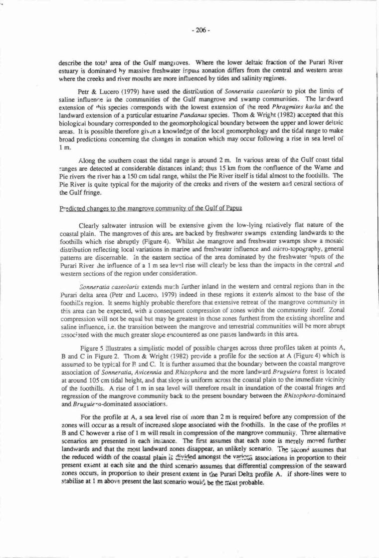
-206-
describe the totar area of ttn Gulf rnan$oves. Wtse the lower delaic frrction of the Purri Riveresurary is dominated hy massive freshwater inpuu zmration differs from the centrd and western areas
where the creeks and river mouths arc nrore influenced by tides antl salinity regints.
Petr & Lucero On9) have used the distribution d Sowuratia caseolaris to plot the limia ofsaline influence fut the comrnunities of the Gulf mangrove md swamp communities. The la:dwrdextension of rhis species corresponds with the lowest exEnsion of rhe reed Phragmites karka ut{ thelandwud exension of a prticular esnrrine Pandanus species. Thom & Wright (1982) rcepcd that this
biologicai bourdary corresponded to the geomtrphological boundry bewee'n the upper and lower deiuicarcas. It is possible thereforc gitun a knowledge of dre local goorprphology ard the tidd range to make
broad predictions conceming the clranges in zonatiqr which may occur following a risc in sea level oftm.
Along the southern coast the tidal rurge is around 2 rn In various areas of tlie Gulf coast tidal:anges ce detected u considerabh distances inl.rnd; thus 15 km from the confluence of the Wame and
Pie rivers the river has a 150 cm trdal range, whilst the Pie River iself is tidal almost to the fmtldlls. The
Pie River is quite typical for the majority of the creeks and riven of the western anC cenEal sectious ofthe Gutf fringe.
pedicted changes to the mangrove community of the Gulf of Pepua
Ctearly saltwater intrusion will be extensive givan tlre low-lying reiatively flat nature of the
coastal plain. The nurngroves of dris arei. are brcked by freshwater swamps extending landwards o the
foothills which rise abruptly (Figue 4). Whilst Jre mangrove and freshwat€r swamps show a mosaic
distributisr rtflecting local variations in marirre and freshwater influence and rnic.ro-opography, ganeral
patterns are discernable. in the eastern sectio,r of the area dominated by the freshwater ;nputs of the
Purari River .he influence of a 1 m sea lev:l rise will clerly be less than the funpaca in the cennal "nd
western sections of the rcgton under consideration.
Sonrcratia caseolaris extslds much iurther inland in the western and central regions than in the
Purari delta area (PeE and [,ucero, 1979) indeed in thcse rcgians it exten ls alnrost to the base of tiefmthills region. It seems highly probable therefore that extensive retreat of the mangrove communrty in
this area can be expected with a consequent compressior of zones within the community itself. Zondcompression will not be equal but may be greatest in those zones furthest from the existing shoreline and
saline influence, i.e. the nansition between the mangrove and terrestrial communities will te morc abrupt
associated with the much greater slope ercountered as one passes landwards in this area"
Figure 5 illusrates a simplistic model of possible charges across three profiles uken at points A,B urd C in Figure 2. T[om & Wright (1982) prcvide a profile fur the section at A (Figure 4) which isassumed oo be t1pi.:al for F iind C. It is further a$umed that the boundary' between the coastd mimgrove
association of Sonneratia, Aviceruia md Rhizoptwra an6 the nrore landr"ard Bruguiera forest is laatedat around 105 cm tidal height, and drat slope is unifrm rcross ihe coastal plain to the immediue vicinityof the toothills. A rise of 1 m in sea level will therefore result in inundation of the coastd fringes anC
regressiur of the mangrove comrnunity bact to the p'rescnt boundry bctwecn tlrc. Rhizoploradominatedard B ruguie -adominated associatims.
For the profrle at A, a sea levet risc of rnore than 2 m is requirod before any compr€ssion of $ezanes will occur as a result of increaced slope assmiatcd wiilr the fmftills. In the casc of the profiles at
B and C however a rise of I m will result in compression of he mangrove communiiy. Three alrcrnativescenarioc are presened in each insiance. The fitst assunres that erch zone is maely nnved furthcrlandwards and drat the rncnt landward zones disappear, an unlikely scctloio. Tr: secqrct assumes dratthe reduced width of the coastd plein is ClylCSd anDntst thc vgig;,i tssaietiors in proportior to theirPresent exidnt at erh sie ard dre third sccnario essurn6 that differentjal cornpression of the seawardzqres occur, in proportion to their pr€sent extant in the nmri Delra profih A. If shore-lincs were tostabilisc at 1 m above present the last scenuio would bc dra:r.nt gobable.
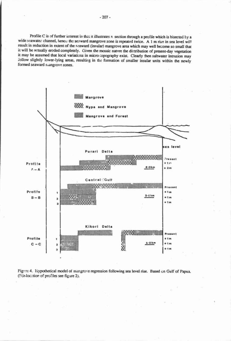
-2At -
Profile C is of fruthcr irrtercst in thai it ilustrlEs N scctbo ercugh e profilc whbh is bisctod by awide seawater channel, lrna: ths eccward rnangrove zone is repcatcd twice. A I m risa in sca lerrel willresult in r€duction in ex,cnt of the *eewrrd (insuls) mrrgrcvc rse which rney *tll bcconp so small rhuit will bc actrally erodod complctely. Givcn thc msaic nturc 6c disributim of pccscntday vqctrtislit may bc rssumcd that locd varitions in niruopography cxisr Clearly rhcn srlnrecr intrusi<n mey
lollow slightly lowcr-lying areas, rcsulting in dre formuiqr of smallcr insulr unis wi&in dre newlyfomtd seaward rdngroyc zucs.
llflllllll r"ne'o'"
il$& *rr. rnd rrnsrovr''% t.norovt rnd Forrcl
Kllorl D.ltrilililililililllilllllllllllll
e .Otn
?aatri tal|n+l|t|+ l,r
Figr:re a. liypothetical model oi nungnrve regression folbwing sce lcvcl rise. B.sod an Gulf of Papua"(Rhloc:tio'n of protiles sce Frgure 2).
Proll lrA-A
Prof llc8-B
t2
t
t.6t|n
P.aa.ntalrratil+l!t
Pu rrrl O.ltr
Grnlrrl ,.:Guli
,M

-208-
Assumotions undcrlyinS thc model
It should be pointed qtt that in the above mo&l ntm of the d-mamic frcon prcsently qerating inrhis system have been change4 thus it is assumod fiat sedinpnt irpus wiil cmtinue rt much the sarnc
level ar.d that crusal downwarping lead,ing b sinking of the coast wrll continue at its present rat€. It was
noed above that sedinrnt inpua are p,resently suffrciently larye to compensate for cnstal downwarpingard ined the coastlinc is advancing over at least prt of its hngth uound the Gulf. (It is also erodingelsewhcre.)
McGregor (this volunr) suggests that increased rainfdl in the caehmats qill occur as a result ofglobd weming, hence incrcasod crosioa rnsy be expoced to oocur ud sedlment in5rts will increase.
Sinking of the coutline is also likcly to increase due o ttp increaced weight of warer resulting from the
irrreascd sea level. Wtrfter dtesc two councr-acting forces will in frt balance is unknown. It wouldafer rmlitely that furcr€ased sedim€nt inp'rs will be sufficient b countff the inqeasod rate of sinking.It is poesible 0rcrcfore thet regression of the coastline in this alea may hdecd be morc extensive than the
fesent model sugges6.
ASSOCIATEDIMPACTS
The mangrove communities form a spcidised habitat for a variety of aganisms including several
species of birds and fish whbh are confined to these habita6. Any reducticn in habiat aree in the GirlfPr.rv-rce mangrcves will lerd o reduction in specics diversity and possible lms of some species totally.
The fuh communities of mangroves in the Purari Delta are describod in sonp detail by Haines(1979) who lhts sonp 49 spchs from Z families in tie freshwatcr reaches of the river and delta. Liem& Haines (1977) list 143 spocies from 48 familic from fie esuairc uaa ot ilte hrrri-Kikori deltaiccomplex. Most riverine spccic-r ue also found in thc estuarine artas, whilst scrre congeneric replacennntis sccn when thc estuarinc and freshwater fish flrnas are comparod. Sixty duee fish species arc dcscribodas teing csturinc, 59 as marine and 15 as rivering any ru.uctior in the ertcnt of thc mmgrove hab:taswill significently rcduce fish species diversity in dris rea Both individual density and species diversityof estrarinc species are litely to dcclinc wih sonr species disappcring rltogeber.
In additim to troviding .mportant fish aqd wildlifc rcsqrrces for thc poople of the area (Liem &Heines, 1979; Hairps & Stevens, 19E3), sonp rcsources such as bsramundi end ttE mud crab Scyllascrrata rre cqnmrcidly exploited. The mud crab li'zes and breds in the mangrove associations herrce
any retrction in habitu will result in a reduction in ttre sizp of the popului<xr which can be explcited.Brramundi, Latcs calctifcr breeds in coastd wsErs ard migntcs whitst still juvenih to freshwater fsgrowth :o mannity. fuain rrductlxr in suitable corsal .rabitats could result in a rdtrctim in the laalpopulatiurs of ftis species. Whilst ilrc cx&nt to whbh this mmgrovc sysem is utiliscd es a nursery are,e
fa marinc fish species is not lno*n; it is knovn that it fams m irponant nurscry for penrcid prawns
@rusher, 1933; Gwyther, l9t3) which ae commercidly rrwlcd in the Gulf of Papua" The extent towhich rcdrrction in mangtove habitrb will rrJuce nuscry arces end hcncc ro&rcc thc curying cryacity ofthe environnent fc juvenih prawns is unlrrown" it rnay be presumcd howwcr fiat fie offshae rreas
where pr:awrc grow and mrErc will furcrerse in rel ryhethcr thc reduced mmgrovc hrbitats will p,ovi&sufficicnt rrce fc irrcreesed br€odir4 and herrcc furcxles€d poptdstkn sizc ovenll is unknown. It wuldscan rnprobeble ed r dccline in this resourcc migltt ttc crpcctcd"
Thc freshwrer wfike- Cancnoclutys tucalpta is r largc speies which breeds exEnsively in tidalatd othcr crccls and is found rs frr up ri-er ls Wrbo m dte Purart Bolh the eggs ard aduls are
ertacivcly ct&fl throughout thc arce rnd up to 40,m0 eggs mry be sold durirg erh bnpoding season at
Kikai mrytct By far thc grertcst pqulatln dcnsities of ilris species re found from the lowcrfrcshwrtcr rcrhcs of rivcrs through thc esnnrine ms ftirying thc Gulf. Breeding bunows aeexcrvacd on sgrd bnrts, hcrrcc thc populatiurs of ftc spcclcs are prcbebly limitcd ct Otc prcsctlt tinr by
ihe evailrbility of suitrblc ncsting sibs. It wqrld sem thrt by ud lrrgc thc rrce of available nest sitcs
will bc rffecod b sonE snreU dcgrtq dtrough rcductbn in dre csturine habitrt will cmcattrrte rdilt
-N-
poPul$iml lcrding o higbr ntrtalitics of rdrlts tlril,Eh inccased c4auc in fishiry nca. Thc specicsis of smp cqucrvrtim ccrrcem btiry found mly dqrg thc sorthcrn c.orss of Nar Guirca ad in thcNsftero Tcrritory of A:rstrrlie md bclrry iltc solc cxtent itprcsantrtive of itr frmily.
Thc humm populrtion or this rtg whiht rrr large is &pa:dcnt m tlrc nrangrove and assoc;atorllul{IrB6 fa a considcreblc propction of frir sut'.iistcnce raquirenrna. The staph carrrohy&ate souroeis Lletroxylon sagu, tlre ra;o palm which i! Eedcd o obtain strrch. Whilst sago will grow in brckishwaEr hebitsts it is largely confinod to the freshw.t€r swampc behind thc sdinc mmgrove cunmunitiet,my reductiut in thc extcni of this zone will havc pofound effects on thc distribution and abundancc ofthis maj<r humm crErgy s<ruroe.
Similrrly dypa pdm providcs thrtchirg mstedds md nungroves trovid. rimbcr for houscconstructln. Whilst it is unlitcly that thc ldcr two rcsourcGs will be rcducod to the exte-rt ilrataltcrnrtivc materids worrH havc o bc use4 t\eir lcrl disribution mry well be affectcd such thar sorrpclans c landrcwning llloutr mey ftrd tlrernsclvcs without rcccss to thcsc rpsources sr their own land-hqles k*aod in closc ploxinity b tlrc prcscnt stueline srd with onty limied acccss or usufructrightsto arcas in d|c currcnt swrmp fqest habia6 rmy frnd thc the shift in zsratior results in lcs olthecqnmulities treditimsl sNgo s{xuses. Scirt ensirns ue likety o be gernratod by differential loss ofr€scrrrces bawcen communitie.
A furthcr plobhm which mry well rcsult in drc nccessrty for nnving cutt€nt villages in coastallaatiqs rclrte o frcchwatcr rccEs. villeges in his rea rcly cittrr on freshwrlcr runoff, rainwaer (insmall quantity) rnd wells fa ftinking md wrahirg wanr. Most wells in thc lower delta area are ;lightlybrrckish at thc prescnt tirne, harcc rry risc in sca lcvel riay r6ult in increased diffrculty for sucircfiurunitics n obtein poablc w.tcr. A populatiar shift landwrds might therefon be anticipaed topresagc thc rcuni inundetior dcoastrlly hcrtcd villaf sias. Again rlr abscn:e of ownership righs osuieble land rrcrs inlf,rd may result in iairl t nsims.
TFm FLY RIVER rrs W AND_|-IISSACIAIED wETL^r.rpS
The Fly ?hdsm (Batru 193; is m excnsive stable shelf comprising thc vast olains and wetlandsassocirted with th€ Fy md Stricklmd Riven and dtc limestonc plateaur io dre northwest of the towlands.The plrdc.m acupbs nerly r third of ihc mrinhnd of Papue New Guinea (Figure 5 arrd 6).
Gersal festura
Thc Fly Riner is l,l2Okm bng with ao .vcr.!ge discharge of appoximately 6,000m3/sec. Itsdrainage basin is only 76,000 km2 and is high discharge results from heavy and penisent rainfall in ttreupper carchmant" There are naicr clfunatic urd ecological diffaenics betweefl the upper, middle ardlo*,cr rerhcs of the Fly Rincr. The rnoct signifrant differercc is bcrreen exccdingly high annualrainfall with litle scrsanrlity in the Uppcr Fly and lower, markcdly scasoral ninfdll in the Middle andI-o*,crrerhcs of thc rivcr. R.ainfall varics from4.7m at Kiunga b 11.9m nearTabubil. The highrainfall in the carchtpnt ree b respnsibb for thc averege annual nrnoff through the Fly Riverexeeeding tht of cven the Amrzm River (Trble l). Downsrearn rainfall diminishes with rpan annualvalues of 2.6 n and 2.1 m $ Bossct and Danr rcspectively.
'Ilte river is navigrble as far as K-g* rpproximar.ely 800 km from its npurh. The gradient n islowcr course b crrenrly gentlc as Kiunga L less dran 20 m above sea level (AnorU 1965) (Figure 7).Tlp nver is tidel for 250 km upouBam urd typically rivcr bcd lcvel in a straight reach at Kiunga is only7.5 m above sea level. Rapid anri signifrcant water level changes (rrp o 15 m) may occtn iq rhe vicinityof Kiunga.
-2r0
TABUBIL
. KIUNGA
LAKEMURRA
LAKEloo
480ssET.
ILAKE IPANCUA Yerill
I JunctionL. DAVAHBU PAPUA NEW GUINEA
IRIANJAYA
acorrl?llY ot"r. u"xa.
Ft8ure 5 Mrp of Papre Ncs Guinca shT wing drc two largest rivers in the country: tlrc Fly and rlre Sepikend l.rb Murray srd the St ickland River.
ta\
-t
,lMltlE SITE
!II
iI
_\_^A
$e
r1
il
KILOIIETRES
ro'loBo
New Guineo
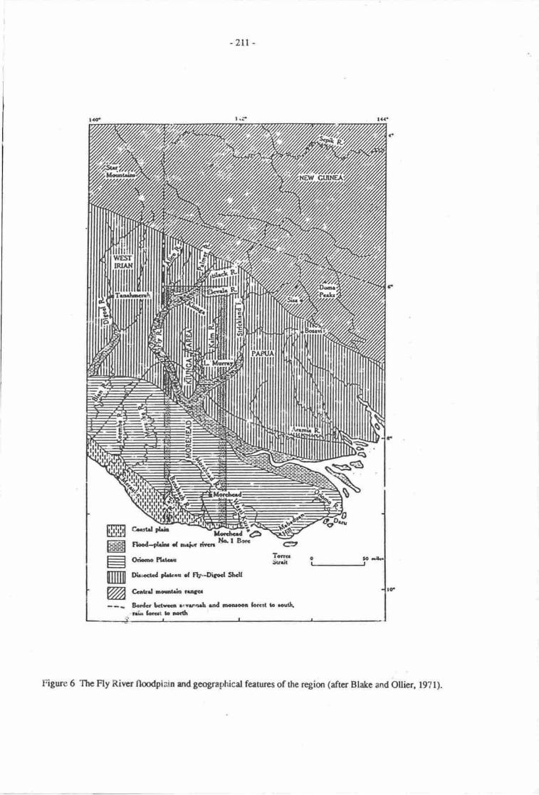
-zLt -
FL.d-tLb .t Fdt( dr.il l'lo' r B€G
oric Ptrta
eTcmStr.ii O t0d6
tlwcctcd ?l&.. .f Fb-UFd S[dl
Ga|ld lcteh ru3cr
Bcdc bars svuqrf, rnd oooroel Sorgt b FoGrri.r LrGat L rro
fiffiE.:L-g-als---1
mWA
Figurc 6 The Fly River flmdpiain and geographical featues of the region (after Blake and Ollier, l9?l).
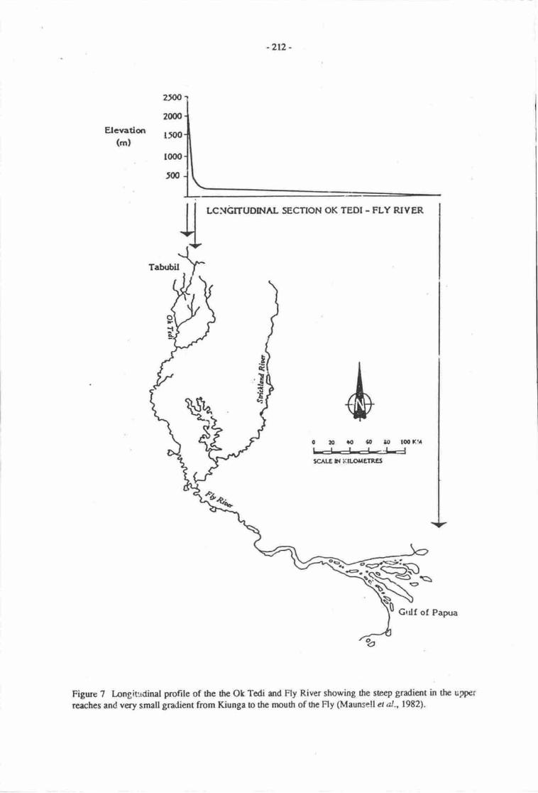
-2r2-
LGNGITUDNAL SECTION OK TEDI - FLY RIYER
020rot,,|/,
tc r.Glf Kll.ortrEln]et
tsGrrlf of Papua
Figure 7 longitudinal profite of the dre Ok Tedi and Fly River showing the steep gradient in the upper
reaches and very small gradient from Kiunga lo the rnoudr of the Fly (Maunsell et al.,l9E2l.
2frO
2000
Elevatiqr I,OO
(m)
, l(xro
5@
Tq
T
E
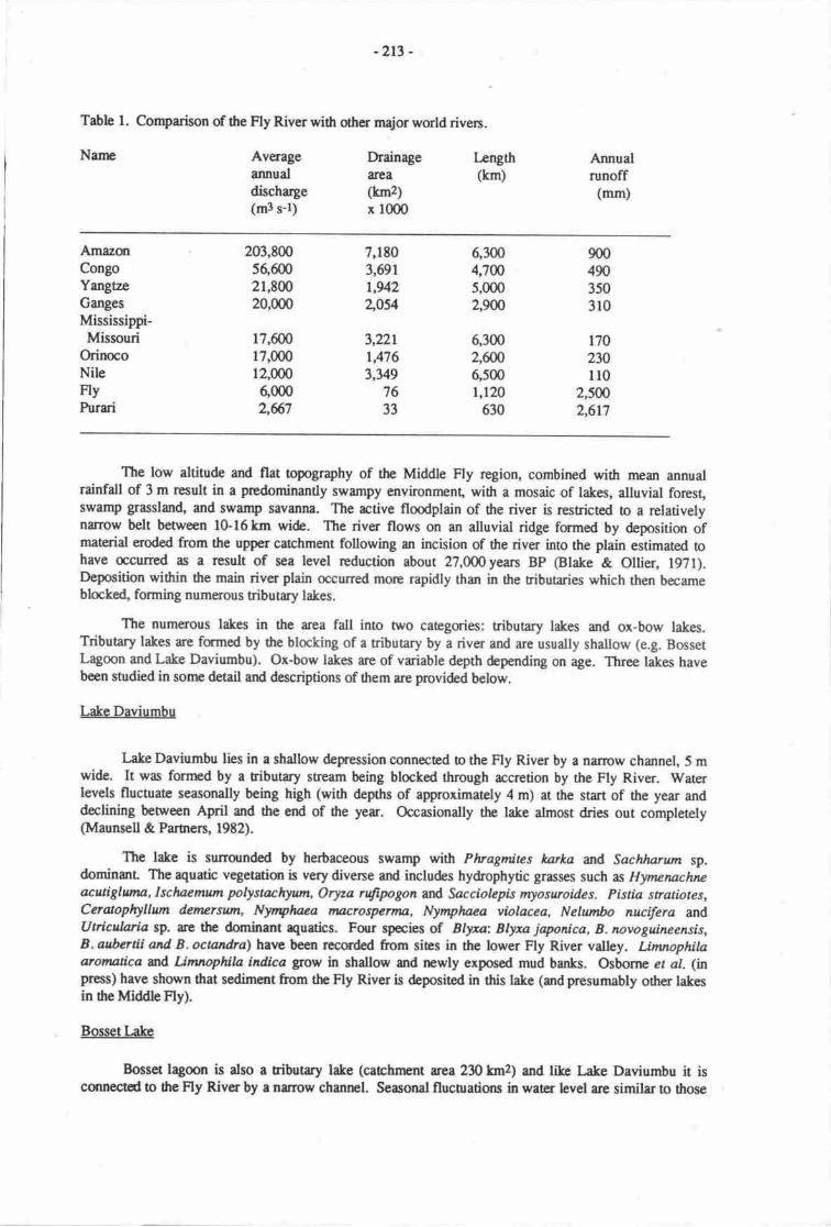
-2r3 -
Table l. Comparison of the Fly River with otha major world rivers.
Narp Averageannualdischarge(m3 s-l)
Drainagearea(km2)x 1000
Length(krn)
Annualrunoff
(mm)
AmazonCongoYmgtaeCangesMississippi-Missouri
OrinocoNileFlvPurari
203,8005660021,90020,000
17,60017,00012,0006,0002,67
7,1803,691t,942zos4
3,22LrA763,349
7633
6,3004,7W5,0002,9W
6,3002,ffi6,5001,120
630
170230110
2,sffi2,617
The low altitude and flat opography of the Middle Fly region, combined with mean annualrainfall of 3 m result in a predominantly swampy environment, with a mosaic of lakes, alluvial forest,swamp grassland, and swamp savanna. The rctive floodplain of the river is resricted to a relativelynarrow belt between 10-l6km wi&. The river flows on an alluvial ridge formed by deposition ofmaterial eroded from the upper catchment following an incision of the river into the plain estimated tohave occurred as a result of sea level reduction about zT,OOOyean BP (Blake & Ollier, l9?1).Deposition within the main river plain occurred more rapidly than in the ributaries which then becameblocke4 forming numeK)us tributary lakes.
The numerous lakes in the area fall into two categories: tributary lakes and ox-bow lakes.Tributary lakes ue formed by the blocking of a tributary by a river and are usually shallow (e.g. BossetLagoon and Lake Daviumbu). Ox-bow lakes are of variable depth depending on age. Three lakes havebeen studied in sonre detail and descriptions of them are provided below.
LakeDaviumbu
Lake Daviumbu lies in a shallow depression oonnected b the Fly River by a nanow channel, 5 mwide. It was forrned by a ributary stream being blocked through accretion by the Fly River. Waterlevels fluctuate seasonally being high (with depths of approximately 4 m) at the start of the year anddeclining between April and tlre end of he yeu. Occasionally the lake almost dries out completely(Maunsell & Partnen, l9t2).
The lake is surrounded by herbaceous swamp with Plvagmites karka and Sachlwrtrn sp.dominanr The aquatic vegetatior is very divene and includes hydrophytic grasses such as Hynunacbe*cutiSlunu, Isclaenum polystachyum, Oryza nSpgon arld Sacciolepk myoswoides. Pistia stratiotes,Coatophyllum derErsunt, Nyntphaea trurcrosrymu, Nymphaea vlolacea, Nelumbo nucifera md.Utricularia sP. u€ the dominant aquatics. Four species of Blyxn: Blyxa japonica, B. novoguineensis,B. aubertii and B. ocnndra) hane been recorded from sies in the lower Fly River valley. Limnophitaaromatica nd Lirnnophila indica grow in shallow and newly exposed mud banfis. Osborne et al. (npress) have shonn 0rat sediment from the Fly River is depositod in this lake (and presumably other takesin the Middle Fly).
Bossetkke
Bosset lagoon is also a tributry lalce (carchnrnt tea230hn2) and like Lake Daviumbu it isconnectcd !o dte Fly River by a narow channel. Seasonal flucEations in water level are similar to those
9004903503r0
-2r4 -
described for Lake Daviumbu. Maunsell et al. (L982) recorded a ganeral lake depnh of 4.2 m. I-ocalpeople at the time of their visit recalled water levels up to 2 m higher. This lake dries out on occasions
and hence a possible water level range of over 6 m is indicated. Subsistence gardens can be established
on the lake bed during periods of low water. The lake is surrounded by herbrceous swamp and the
aquatic vegetation is similar to that found in Lake Daviumbu.
Lake Murray
The largest lake in Papua New Guinea Lake Murray (surface arca &7 km2) lies in a shallowdepression (maximum depth 7 m) in the Y formed by the Srickland and Fly Rivers. The lake is drained
by the Herbert River, a tributary of the Strickland River. Lake Murray is subject to marked seasonal
flucnrations in water level. Consequently plant development along the very lutg shoreline (over
2,000 km) is seasonal. During the period of low water (November-January) vast areas of barren mud are
exposed. The water then is very turbid and the submeryed and linoral vegetation is poorly developed.
Following the rains, the lake fills, becomes lqss turbid and a diverse aquatic vegebtion develops.
The aquatic plants then occur in two broad zones: an outer zone dominated by Nymphoides indica withsome Nymplnea nouchali, Ceratophyllum &mersut4 Pktia srrafiotes an4 more rarely, Blyxatrovoguineensis. The inner zone consists of hydrophytic grasses, such as Ecffinachloa pracstans andLeersia hexandra, with sonre lpottuea aquatica, Azolla pinnata Ludwigia adscendens, Polygonumattenuatun and Utricularfa sp. Lirvopdla indica occurs on newly exposed mud and in shallow water,
The seasonal fluctuation in water level also affects the water chemistry and primary production of the
phytoplanklon.
As 0re water level falls beween April and December pH, alkalinity, conductiviry, total hardness
and the concentration of suspended solids increase. Similarly, the concentrations of calcium, magnesiurn,
sodium and potassium increase during this period of falling water levels (for full details, see Osbome er
al.,1987).
With the onset of the rains, the lake fills rapidly. This filling process is due not only to inflowfrom the surrounding carchment and rainfall on the surface of the lake but also, more interestingly, to the
reversed flow of the Herbert River. Current meter records from a station in the Herbert River show
clearly periods of reversed flow (Natural Systems Research, 1987). These periods of revened flow are
accompanied by depressed water temperatures. The temperature of the Strickland River water is cooler
than that in Lake Murray. This flow reversal clearly demonstrates the low-lying, flat nature of the
landscape in this Trans-Fly uea.
The Lower Flv River and Delta/Estuary
In the l.ower Fly region, mangroves and sago swamps are the dominant vegetation zones in an
esilary over 80 km wide, with some species extending up to 300 km up the Fly River. The soils on the
islands in 0re esurary are subject to tidal inundation, are poorly drained, high in salt content and alkaline.
The mouth of the Fly River is best described geologically as a tidal delta- It cannot be characterised as a
true estuary, nor as a river delu because of its transientty polyhdine structue and strong current regime.
The degree of marine penetration is severely limited for much of the year by high river discharge. This
results in the almost total absence of a true marine (m estuarine) benthic community over much of the
delta. Such organisms only occur near the seaward edge of the delta. The zone of saline influence moves
seasonally, and many of the pelagic animals with it, depending on their salinity lolerance and habitatpreferences.
Human resource use in the Middle Fly
Seventy-four thousand people (1980 census) live within the Fly drainage area. Those of the
Middle Fly are Boazi and Zimakani peoples; those of the Delta area are Kiwai. The Boazi and Zmakaniare hunter-gatherers operating in the wedands and savanna of the Middle Fly. Habitable land is scarce,
with only ccasional small hills of firm ground rising above the floodplain swamps. Even so, most
villages are subject to periodic flooding. Cultivation is difficult and sago is harvested from the
-2r5 -
surrounding swamp forests. The main factors limiting agriculural production arc acid and infertile soils,poor drainage and flooding. Crocodile, wallaby, deer, fstr and freshwater prawns provide an abundanceof protein foods. Cash crops include rubber, crocodile skins and baramundi (Lates calcarifer). Therelative abundance of nuritious fmd supports relatively large populations where high ground isavailable: Bosset (600 people), Kaviananga (Lake Daviumbu) (470 people).
At the mouth of tle Fly River, the Kiwai people are also primarily hunter-gatlreren living on fish,crocodiles urd dugong. There is also some cultivation of banana ooconuts and taro.
The Fly River and its associated waterways are used extensively for ransport, both at thesubsistence level and to supply and export materials from dre large Ok Tedi mine in the upper catchrnenr
PREDICTED IMPACTS OF A RISE IN SEALEVEL
Hydrological considerations
Knowledge of the hydrology of the Fly River system is totally inadequate and specific predictionsof the effecs of a rise in sea level are extremely difficult to make and a detailed hydrographic andhydrologic survey of the Middle and lnwer Fly River is urgantly required. However, a number ofganeral conclusions can be drawn. Undoubtedly an increase in sea level will result in a raised water tableover much of this low-lying area* The people and organisms inhabiting this vast wetland are accuslomedand adapted to marked flucbrations in water levels. The magnitude of these water level fluctuations isunlikely o change. However, the maximunr" minimum and mean levels will all be recorded at higherwater levels than at pres€nt. Given the scant information available it is impossible to even hazard a guessby how much these levels might increase. Consequently, lakes such Bosset, which dry out occasionally,will do so less frequently. Arcas that are only flmded rarely will be flooded morc frequently. Similrly,areas that arc not flooded by high water levels at present, may well be in the future. These water level
.changes will result in a reduction of the area available for habitation and cultivation. This loss will becounter-balanced by an increase in the availability of aquatic food resources ifonly through the increasedarea of open water.
We know very little about the physicorhemical and biological effecs of water level changes.Osborne et al. (1987\ showed that, in Lake Murray, water chemistry and phyoplanktonic productionvuied martedly with seasonal changes in water depth. Aquatic plant distributions were also affected.Following a I m rise in sea level, it is likely that these water level fluctuations (and the related effecs)will continue. However, with higher water levels, and given the very flat topography of the area, themagnitude of fluctuations may be rcduced and greater siability in water,levels may resulL
Both the Strickland and the Fly Rivers carry large sedirnent loads. Furthermore, the constructionand operation of large mines in the upper catchnpnts of both rivers is likely to add significant amounts tothe riverine suspended solids. Naturally-derived ncrcury in the Strickland-t ake Murray system occurs insufficiendy high concenradons in both camivorous fish and hurnans as to cause concern. Similarly,other metals occur in high concentrations and these concentrations are likely !o increase with the miningactivity in the upper catchments of both rivers. Osborne et al. (in press) and Natural Systems Reserch(1987) have demonsnated that the suspended solids canied by these large riven ue deposited in theadjacent lakes. With regard to sea level rise an important question is whether higlcr river levels willresult in increased sediment deposition in the middle Fly lakes and LakeMurray. Following a I m rise insea level tidal effecs will be ext€nded further upstrearn This will rcsult in grcaler sedirnent deposition,through reduced flow rates, in the tidal reaches of the river.
The effects of sea level rise on the people living in the area re likely o be small. They arethoroughly accusbmed o coping with dramatic fluctuations in water level, populations arc low and foodis abundanr Villages which rc flooded now are likely to be flooded nore frequently in the furure.Girtn the paucity of high gmund this may result in sorne compression of village sias. I-ocal effects mayfurclude flooding of installations such as crwodile farms. Interpnetation of SPOT imagery could assist inmpping low and high water levels, riverine inpu6, lard-use, yegetation md arcas of sedimentd4osition.
-216 -
SUMMARY
The mangrove habitats fringing the Gulf of Papua are likely to undergo substantial reduction inarea, with compression of existing zones as a result of seaJevel rise. Consequent upqr this will be theloss of resources or loss of access to such resourc€s on the part of some communities. Consequent socialtensions may be envisaged. The reduction in nursery areas for penaeid prawns may have significantimpacb on the size of this commercial resource and the fish community will both decrease in diversityand possibly also in abundance. Reduced access to pouble water is likely to be a major problem fonhuman communities located in close proximity to the present coast. The people living in the Middle andI-ower Fly River areas are accustomed o marked fluctuations in water level and seasonal flooding. It islikely that following a rise in sea level flmding of the lowJying land along the Fly River will be morefrequent and of longer duration. This will affect the availability of land (alrcady in short supply) forhabitation and cultivation. The loss of agriculnral land may be compensated for by an increase in aquaticreiources through the increase in flooded aeas. Consideration should be given to a detailed study of howsediment depoeition in I-ake Murray and the lakes of the middle Fly region, particularly with regrd Onrcrcury and heavy rnetals, may change with higher river levels.
REFERENCES
Anon 1965. Teritory of Papu4 Annual Report for 1963-64. Govemrnent hin0er, Canberra.
APC, (Australian Petnoleum Company Pty.Ltd.). 1969. Final rcport Era-Pie-Purari Seismic ReflectionSurvey D-1. United Geophysical Corporation Pany 130.
Bain,J.H.C. 1973. Asummaryof themainstructualelementsof PapuaNewGuinea.h. 147-6linP.J.Coleman @d.), The Western Pacific: Island Arc, Marginal Seas, Geochemisry, Perth.
Blake, D.H. & C-D. Ollier 1971. Alluvial plains of the Fly River Papua. Zeitschrift fiir Geomorphologie.N.I. Suppl., Bd- 12, l-17. CHECK WTru MES.
Cragg, S. 1983. The mangrove ecosystem of the Purari Delta. pp. 269-282. In Petr, T. (Ed), The Purari- tropical environment of a high rainfall river basin. Jun\ The Hague.
Floyd, A.G. 1917 . Ecology of the tidal foresb in the Kikori-Romilly sound area Gulf of Papua. EcologyReport No. 4, 59 pp. Papua New Guinea Department of Primary Industry, Division of Botany, Lae,Papua New Guinea.
Frusher, S-D. 1983. The ecology of juvanile penaeid prawns, mangrove crab (Scylla senata) and thegiant freshwater prawn (Macrobrachium rosenberg| in the Purui Delta. Pp. 341-354 in Petr, T. (Ed),The Purari - ropical environment of a high rainfall river basin. Junk, The Hague.
Gwyther, D. 1983. The importance of the Purari River Delta o the prawn rawl fishery of the Gulf ofPapua. Pp. 355-366 in Petr, T. (Ed), The Purari - ropical environmert of a high rainfall river basin.Monographiae Biologicae 51, Junk, The Hague.
Haines, A.K. 1979. An ecological survey of fish of the lower Purari River syst€m, Papua New Guinea.Purari River (Wabo) Hydroelecric scheme, Environmental Studies Vol. 6. Office of Environment andConsenration, Waigani, Papua New Guinea.
Haines, A.K. & R.N. Stevens 1983. Subsistence and commercial fsheries. Pp. 385408 in Petr, T. (Ed),The Purari - tropical environment of a high rainfall river basin. Monographiae Biologicae 51, Junk,The Hague.
Hillis, W.E. 1976. The production of mangrove extract in the delta region of Papua. Empire ForestryReview 35:420-435.
Khan, A.M. L974. Palynology of neogene sediments from Papua (New Guinea). Sratigraphicboundaries. Pollen and Spores 16:.265-284.
l-:',r-217 -
Lienu D.S. & A.K. Hrines 197?. The ecologicd significarrc and economic importmce of thc mangrweand esuarinc communities of Gulf Provincc, Papua New Guinea. Purari River (Webo) Hydroebcrkschemc Envirmmcntal Surdies Vcl. 3. Officc of Environnnnt and Conservaticr, Waigani, Papua NewGuinea.
Maunsell & Parurrs 1982. Ok Tedi Envirmmental Surdy, 6 Volunrs, Ok Tedi Mining Lt<!., Melbounr.
Naural Sysems Research, 19E7. Porgera Gold Project Envirorurpntal Plan, Porgera Joint Ventue, PortMoresby.
Osborne P.L., JJI. Kyle & M. Abramski 1987. Effrcs of seasond wanr level changes on the chemicalan! biological iimnuiqy of Laftc Murray, Pryna New Gufurea- Ausralian Journd of Marine andFreshwater Reseach 38, 397-40E.
Osborne PI., N.V.C. Pol,nin & K. Nicltolson In pess. Geochemical trrces of riverine influence on a
trqical laeral lake. Verh. Incrnat. V€rein. Lirnnol, SEE PADDY,
peijmans, K. 1969. Vcgetation andccology of the Kercma-Vailda area. In Ruxton, B.P. (Ed.),I-ands ofthe Kerema-Vailala area Papua New Gurnea. I:nd Research Series No 23. h. 95-116.Commqrwedth Scientific md Indusrirl Rcsearch Organizatiur, Melbourrp, Ausralia- SEE PADDY.
Percival, M. & J.S. Wonrenley 1975. Floristics and ecolcgy of the mangrove vegetation of Papra NewGuinea- Papua New Guinea National Herbariunu [.ae, Papua Ne'v Guinea.
Petr, T. & J. l,ucero 1979. Sago palm (Mctrorylon sagu) salinily loleranc€ in thc Purari River Delta. Pp.
10l-106 in Petr, T. (Ed.), Ecology of the Purari River Catchnrnt Purari River fVabo) Hy&electricscheine, Environmental Surdies Vol. 10. Ofhce of Environnrnt and Conservation, Waigani, Papua
New Guirpa"
Ruxton, B.P. 1969. Regiond description of thc Kerema-Vailala area. In Ruxton, B.P. (EJ.), Lands ofthe Kerema-Vailala area, Papua New Guinea. Ilnd Research Series No. 23 Part II: 9-16.
Commsrwealth Scientific and Indusrial Rescrch Organizatict, Melbourre, Ausralia-SEE PADDY.
Thom, B.G. & L.D. Wright 1982. Geonnrphology of he Purari Delta. Papra New Guinea. hrariRiver (Wabo\ Hydroelectric schenre, Envirsrmental Surdies Vol. 17. Office of Environnpnt and
Couservatiso, Waiguri, Papue New Gufupa.
Wright, L.D., J-D. Coleman & M. Erickson 194. Analysis of major river systems and their deltas:
nnrphologic and process comparisans. Louisiara State Univenity. Coastal Surdies Instiurte Technical
ReportNo.156.
' - it.;..-9.'.i6:'a:il.. . -. -t!'
' ' ., *l:; :.\-"- .,:,.::;'s.
-2lt-
THE EB.FECT OF SEA LEVEL RISE ON R,AISED COR,AL AFID HIGH ISLAIIIDS
university of papuallffff#ltr"by, papua Ncw Guinea
In dtc SGoGrd wcrvi.gw of drc Prpueltcw Guis corstlinc (Burlia & Sullivan, th* volurne), fivcloarcm t'?cE wcrc idantifiGd u trarr whbh woub suffcr prrticulrly fr,om a I m risc in sca levelThasc re:
t dcltric floo$lain$ with mn!rcve r swunp fcest;* lagmr md srodspit lndfcm conplcxes;i ctrrl colls and cays st re lwel;I rdscd cad islands;I high islads.
h &is p'tclininary sbrdy thc cf;hcts of e I m dsc in scr bvel are cqrsidcoed for two of theseladfqrr tt'pes, rdscdcc.t lrd high fulmds.
RAISED CORAL ISI.AI{DS
Coml islend fmnrs
corel brscd islatds rsrociacd with rccf provirccs rre of a varicy of forrrs which reflect thecmdidms d conl growdr md breatdown md teorric pnoccssci. cmsrucdona p*ocesses involve theY"'ld std crtwad grondr of carl refs, into ttre zml of watcr nubulerrcc. nir praroorns are thusdcvclopod ncr 3Gr bvcl but-mey crncrge fiom thc wrrr if t"y r" nfucd Ectsd.ity, * if sca levelfrlls' ryisd r emcrgcd Ecfs r islzrds nuy be uplifrd dntru ri - nnrc r€ctffiic phases, and thusmay euain vrying elevrtiqu.
Ar ref buildft8 pocccds rt ccr level, cxEnNive sodirrurts derived ftrom rcf erosian are bankodup rgeinst thc flnb of nr$ivc rlcft (Bird, 19&{:25{) rna 3rcr-qumtitics d brokcn ref maerialeumubc {dEt d|G rcd qs-tft3 nd an lrgur flom, no"t *h* tlrcy re rvrilrbk for redisributiorthroughout the rcf zsrc, * fg fu buildn;g of enaScnr blrds. Ref crocion o poduce such debris(rccu$ u bodr famrim:rt and cmcrgart levcrr goirir, r972:7r), rnd supprie srnd, pebbles andbouldcrs from which bcrics ma ctrufl isterds fi crys *-*n tnnra Rriscd-csal apdr; severely !orodrcG dchis (witN, l962lt), howarcr rs Bird nlrea trnc,zii"rutorrg some of dre &bris whichfanr cmt baGd idrodl is dcrivcd firom cnrcrgod reft, nnct is not, md thc rccuqrtation of sedimcnt t<lfam low islnds nd cayr doer rnt rquire ccrmism c ury rclrtivc-strin in scr hvct.Ablb md hf, itFq a crl$ wtich urin clcvuisrs of qrly r few nuts rbove sea lcvel andwhich rc thcrcfqc prrtic,ulrly vutmorc b 6c cfrcc8 of my .t*h sca hvel" have bccn corsideredrcprrrcly by sullivn & Pcrnctr (this rolunr). In this ruray tL
"r"q, of see bvcl risc m raiscd coralislmds' lendfcnn which se lcg dirctty ftctcd by ructr rrr-g*, * considercd"
Reircd canl irlndr
Thc lrylc ter clr.rcn fc thir crrc rnrdy ir Kiriwinr Isle4 lrc trgcst istnd ir rhc Trobri$dGrurp'Miln BryProvircc (reFirure l). TbTrcbrird Isl&ds re locatai'm rtrc w@dt; Ri6gc, rrcll &finod lubmrirc ridgc h thc-nath of Milr Bry provirceaofu teris:tg;;Lofflcr, 1977:tz3)
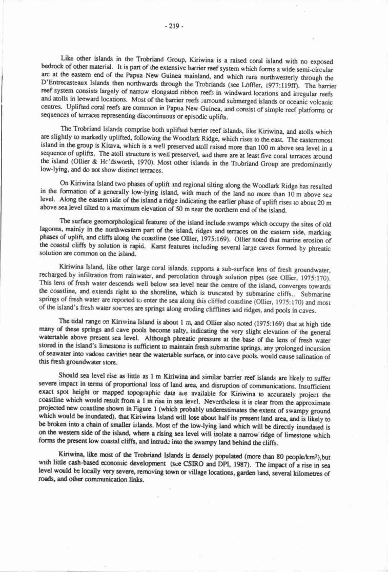
-2r9 -
LiLe other islan& in the Trobdand Group, Kiriwina is a raised coral island with no exposedbodrock of otlrcr material. It is part of ihe extcnsive burier reef sptem which frrms a wide semi-circrrlararc at the easErn end of fie Papua New Guinea mainlan4 and which runs northwesterly orough theD'Entr€casteaux Islsrds then northwards hrough the Trobriands (scc l,offler, t977:ll9fi). The barrierreef system consists targely of narrow elongated ribbon reefs in windward locations and irregulr reefsarKl atous in leeward locations. Most of the brrier rcefs ;unound submerged islands or oceanic volcarricc€nEes. Uplifted caal reefs ar€ conunon in Papua New cuinea and cqrsist of simple reef pladams orsequenoes of Erraces reprcsenting discontinuous or epirodic uplifs.
The Trobriand Islands comprise both uplifted banier reef islands, like Kiriwina and atolls whicharc slightly o martedly upliftc4 following the Woodlart Ridge, which rises to the.easl The easrernnrostisland in the group is Kinv4 which is a well preserved aoll raised more ttran 100 m above sea level in as€quence of uplifs. The atoll structure is we[ preservul and there arc at hast five coral tenaces aroundthe islad (ollier & Hcldswon[ 1970). Most other islands in the Trubriand Group are predominantlylow-lying, and do not show distinct terrrces.
o't Kiriwina Island two phases of uplift rnd regional tilting along the wmdlart Ridge has resultedin the famation of a generally lonJying islzr4 with much of the land no nxx€ than lOm above sealevel. Al'urg the eastem side of hc islsrd e ridge indicating the erlier phase of uplift rises to about 20 mabove sea level tilted !o a maximum elevation of 50 m n"a dte northern end of the isiand.
Thc surfrce gomcphologicat feetures of the island irrclude swamps which occupy the sites of oldlagoons, mainly in drc norttrwesGrn part of thc islan4 ridges ard Errirc€s qr the eastern sidc, markirgphases of uplift ard cliffs rlmg the coastline (see Ollier, tgTS:t69). OUi€r nored drat marine erosiqr ofthe corstal clift by solution is rpid. Kant features including several large caves formed by phreaticsolution are comrnon on the island-
Kiriwina Islan4 like odrer large mral islands, supporG a sub-surfrce lens of fresh groundwater,recharged by infilratian from rrinwarcr, urd peccotation through solution pipes (see Ollier, lg5:170).This lens d fush waer dcscends well below sca levet ncar ttt" centre of thi itr*d,
"on""rg"s, tonyads
thc coastline, and exEnds right o the shorelinc, which is trur€ated by submrine cliffs.. Submarinesprings of fresh w.er arB r€portcd to eilcr ttre sca along this cliffed coasttine (Ollier, 1975:170) and moctof the islurd's fresh water sou:ccs ue springs along eroding clifflines and ridges, and pmls in caves.
Thc tidd rmge on Kinwine Islud is rbout I :rt md Ollicr rlso nrtod (1975:169) trat at high tidemany of tltsc springs md crvc pods bcconr salty, indicating thc very slight etevation of thc teneralwrcrtabh above presant see levcl. Aldrough pbrcatic prcssure at rhc brse of the bns of ftesh waterstored in thc islend's lircstons is sufficient o meintain frcsh submarine springs, ary polonged irrunionof seawatcr into vadoee cevitjes ncr the wetcrtabh surfrcc, a into cave pools. woula causelalination ofthis frcsh gronndrvarcr snre.
Shodd sea level risc as tittb rs I m Kiriwina md similr barrier rcef islsrds are likely !o suffers€vcne irryact in erms of propctionsl loss of tand [ec .nd disruptior of communbations. Insuffrcientexact spot hcight or t*ry bpogaPhic dao are available fc Kiriwina b accurat€ly project thecoastlinc which wouH rcsult from r I m risc in sca hvel. Nevcnhelcss it is clcr from 0rc ryproximateP|I)ioctd trw coastlirr shown in Figrne I (which prrobrbly undcrestimaas the extsnt of swampy groundwhich wonld bc inundrEd), drat Kiriwine Islad will hc rbqrt hrlf its prcsc6t lsnd lrca, ara is j1ety tobG brotsn ino a chein of smrllcr islads. Most of thc lowJyiry lsrd whhh will bc ototry inundatcd isut thc wasErn side of the islrn4 whcrc r rising sca levct will isolaa . nrrrw ri6ge of linpstom whichfqna hc prcfcnt low corsal cliffi, rrd intru& inb thc swrrrrPy lmd behind ttrc clitrs.
Kiriwina likc npat of the Trobrirnd Islmds is &nscly pqulacd (nnae than 80 pco,ph/km2),butwtdt liulc crsh-bccd cqromk dcve@nrnt (sr* CSIRO :nC ppt, lgSZ). Tbe imprciof I risc in scelcvel wold be locdly very scvcrE, rcrmving bwn a village lcetions, guoar tanG scvcral kilorptcs ofrods, end odrr communicrtfun lints.
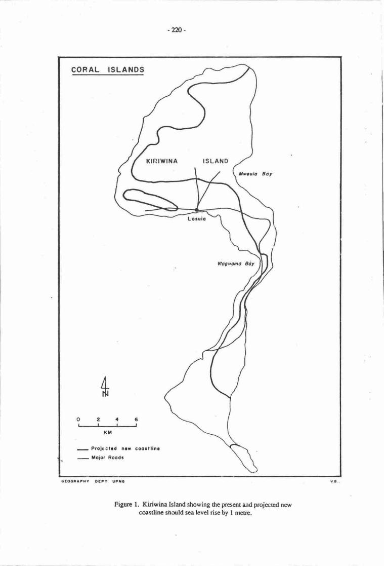
-xn -
COR AL ISLANDS
Krnrw|l{A ISLAND
Itoala Eoy
Eogwoan &iy
t( tt
- Prolcctrd n.r coo3llln.
- Moior Roodr
6eoota?r{v oErl. u"ro
Figurc l. Kiriwina Island showing the present and projected newcoastlinc should sea level rise by I metre.
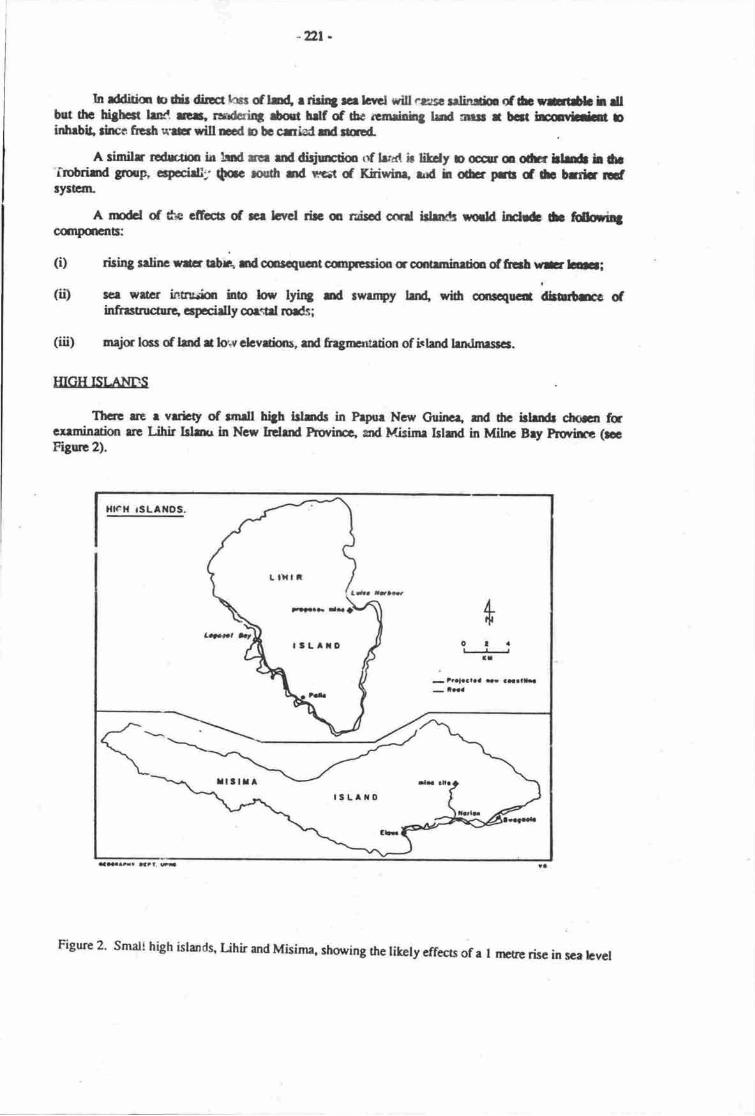
-tlr -
In rddido b dit die hcs dh{ r tid4 a lcrcl rill l.rrrs! tr]litrtir of lb ngtib h dlbut thc biStcr lur. rer, rudcri4 ad hdf of 6c rca&itt trad nur r bcrt hrddt binhrbit ltrcc frerh ?r|s dll Ed o be cniad rd ed.
A similr tdm h H ne raddrjrcdo rf lrrxt b liHy D @ o ofu lld L t'Irobdrtd gup, cecddlt $ac rofi rd rr.1 d Kidwlr+ rd h e prtt d tb tfiir ldrytEtrL
A tdd of dte cfiuctr d g lcvcl rb o r&i$d cfid fuhr8 tilld ldr& b fuh3colpaEnt|:
(i) ftinS rrlir rlcr t$R rd oorqucot oqcsim a silmfuurir dftab w- b;(ii) rcr wrcr intn&rir iob h,w lyi4 rd rwrlrpt/ tzt{ ?idr srqocil dtute of
trtr*ructtrc, crpccidly u*d ro*;(iii) neirhcs dlndrb*clcvainr" ad fingrurrrion of hlndlrftImrrrcs.
IIIGH ISI.AT.ItrS
Tlxle lt r vrdcty of rndl hth ldrdr in Fryor Ncs Otilrcr nd 6c idd choa fucHmiuim rrc r ihir Islar ln Ncr krdd nsvincr. snd Misinr Islnd in Mihc Bry prrovirn (nItSsc 2).
HlcH rSLAtlDS.
I.fql
olail
- lYalaalaa F aat.lLa
ItLIIO
tlxtt
arqr- lx
TSLAXO
Figure 2' smali high islands' uhir and Misima, shoring thc likely effecrs of a I nrtre risc in sce levcl
-2n -
These islands were chosen bcause they exemplify the variation in small high islands in papraNew Guinea. Misima Island is rclatively stable with a cenral cce developed on ncannrphic rocks, anda tenaced coastal fringe ur uplifted coralline limestorp (NSR, l9S7). Uhir tslan4 which is a volcanicislan4 is tyaicd of many isisrds on the Pacific Island Arc in that it is un&rgoing gradual uplift ftrom theeast, a process which is tilting the islan4 and causing slow inundatim of is western side (NSR in prep.).
Mct of Misima Islad's coastline comprises low cliffs on uplifed coralline linpstone. A sealcvel rise of I m would mate litde diffcrencc to Jris cliffed coastline. Soctions of the islard's shmlinehowever comprise sandy m gravelly berch ard beachrifte complexes, rnd the roads which exist on theIsland have, wherever possibh, been constrwed on the cr€sts of berchridges, rutrer than qr the brokenlimesone surfaces above the low cliffs.
Although the absolute cffect of a rise in sea level is the sanp on high islurds as on the rockyshorcline seclors of the mainland or large islards, the relative effect of the rennval of part rf the coastalzqre of such small islands is cansiderable.
On Misima Island this effct will involve the removal of part of the island's limited infrastructure.The major town ql Misima Islard is Bwagoia, at its eastern €n4 I port town cloce to sea level, and 61istovrn is linked by road to villages dang dre soudrern coastlirp at ttc east€m end of the island. Like manysuch roads the southern coast rod on Misima Island is built on the lowest coral tenrces and at the brckof gravelly berches. much of it on lsrd whbh wilt be panially inundated should sea level rise by I m. Infrct, the sitc of tlrc recent major eornmic dcvelopnrnt on Misime Islan4 a goldmine, is linkod oBwagoia by this coastal road, thmrgh dre coasal village of Nariur. Thc road will b€ reconstructcd andupgnrdd as part of the mining pn{ecL ard witl be left as a majrx link in frc island's transptrt networtwhan mining cease$, in 10 o 15 ycan. Nuiaq Bwagoir and the road rc all likely ro be partiallyinundated by a sea level rise, vith consoqu€nt dirruptim to economic rctivity qr the islad"
It is worth noting that infrastrucu€ now being plarned fs tbc prqosed mining and towndevelopnrnt would be wisely corc€nmtod qr the caal ternrc€s, not on tre berchridges bchind sfttchesof depocitional coastline, like that near Narian.
On Lihir Islurd the coastal ines nrost likeiy !o suffer inundatbn due ur a rise in sea level is thesubsiding western si& of the island. This is dre part of the island frrdrast frrom the proposed gold minewhich is likely o be e,rublished an the islan4 and thus furthest from proposcd ecqromic activity. It ishowever that part of the island whbh currently povides thc major part d thc island's sago - a plmt ofcqrsiderablc trrditianal ecmomic imprtance, sincc it is usqt ia roonog fc virnrally iU rtro island'sbuildings, ad for the shucen which cover the window openings in the wrlls of houscs, as well as beingan occasiond fmd scurce. Small sago swarp,s acu in thc coastal rcachcs of virurally all thc stneams onthe westcm side of the islan4
In the Envirmmental Plan for the propoced Lihir Gold Prct'ect (NSR in prcp.), auentim was drawnto the impctance of sago swamps tc dro Uhir Geonomy, erd dtc imprt of thc propoeod mirn ur sagoswamps was 8ssesscd As rnost of thc sago swrmps arc on thc wet€rri sidc of Orc islan4 rhc proposedmine will in fact have liule efifect m sago rcsouroer. A I m rise in sca lcvel howevcr will have the effetof destnoying boft thc prescnt sago swamps qr thc wesern sirte of thc islrn4 ad rhc road whbh allowsaccess to this resource, and betwecn villages. Undoubtodly dre presance of sago swarry,s sr thc west€nrside of the island is largely due to tlre fact that that si& of the islurd is subnrcrging. A rising sea lerelwill re-inforce this efrect, and will, initidly at least, frcilitra thc crrcnsbn inlurd of sonre sego swamps.This will affct rccess however, .nd will nocessitate reconsidcratiqr of orrnecship of sago stands. Morri'nporuntly, the area of sago will diminish if ftc risc in sca larel combinod wifi dte continuod grrdualtebtlic tilting of the islmd forss the corstlinc up rgainst dc stcp hillslopes which rise b thc island'sdr:ainrge dividc.
As on Misimr, the absoluc efbct of a I m risc in sce bvcl will be srnell in enru of lmd bst, butin reletivc emc fie emomic effects on Lihir wilt be grcaer 0rrn on the meinlrrd m thc lrge islgrds ofPrpua Ncw Guiner.
-x23 -
SUMMARY OFEFFFCTS
It can be scn ft,om thc exenplcc of Kiriwina Misimr md Lihir Islards that the eifecs of a I mrise in sca level wouH have scverc ccanomig if not lrrul prcssur€ effct qr niscd csal and small highislands in Papue Ngrv Guinea. Daailed.ssc$srcnt of lano locscr rcquire ficHwalq rs does a &fmitiveas$xtsrEnt of the effect m tcsh groundw.trr sfrrocs. It is clear hcrwever from this peliminary su.dythat dtlnugh pric warning md thc ccuoqucnt c.rrftl plmnirg of thc sitin3 roads and otherinfrasftc0rc rr, dhvieE some of thc direct coc of r risc in sce lcvel, thc incvitabh poportional locsof lad and speific resqrccs will be seycrc tr. dresc small island-.
REFERENCES
Bird, E.Cf. 19E4. Coasa. Ausrrlian Ndi.m.l Univcrrity hrcss, C.rnbcrrr.
Davies, lL.1972. Ccographical vriarsr in coastal .levclopnrent. Olivcr Boy( Edinburgh.
L0ffler, E. 1977. The gomcphobgy of Prpne Ncw Guins. Austrrlirn Nrtiqral Univenity hesi,Canberra
Natural Systems Research (NSR) FJ. IJt (in prcp.) Lihir Gdd hoirt Envirqurrnul plm. KannecoaLtd., Port Moresby.
Ollicr, C.D. lyts. Carl ishtd gmmorphology - thc Trcbriend Islgrdc. Zeischrift fttr C,ornorphologi€N.F.19:164-90.
Ollicr, C.D. it D.K. Holjswaft 1970. Sonr crvee of Kitavr Trobrirnd blnds, pryur- Hclbtitc t:29-3t.
wiens, H"r. 1962. Atou cnvircilrsrt md ccology. yrlc univcnity prcss, New Havcn.
-2U -
THE IMPACTS OF SEA LEVEL R,ISE ON A LOW.LYING COASTAL LANDSCAPE INPAPUA NEW GI/INEA: A CASE STUDY FROM THE GLJLF OF PAPUA
ko EualirUniversity of Papua New Cuinea, Fort Moresby, Papua New GuinEa
INTRODUCTION
In tte first €port by ttre ASPEI task tearn a number of m4ior imprcts expected to result frorn uryrise in sea level were identifred, inciuding: coastal inun&tion, coastd flooding, changes to coastalgeomaphology, sdirn intrusion, water table elevation, and compression of the nrsrindcrrestrialtransition. Such inprcs are expoctod to be particularly severe in areas whcre fie coastline profih is flator gently sloping. Sonp land types would be more severcly affected than others, including dr,luicfloodplains and surd barrier and lagmn landform complexes.
In Papua Ner*'Guinea dre Gulf of Papua is one aea where tlrcsc conditions aply extensively andwhere the imprct of sea level rise is exDcctad to be particulrly severe isce for example Bualia &Sullivan, this volunr; kmeua & Osborne, drrs volume). this case strdy prcssnts the firdiirgs of an
investigation of the likely impacts of sca level rise on e 70 km long, lowJying strerch of coastline in Gulfhovince extending fr,om Kerema in the cast t ) neetr the irnuth of the hrri River in the west (Figue 1).
Data concerning he biophysical socid and ecsromic setting of the shrdy arca were takenprimrily from the PNG Resa,uce Inform-tion System TPNGRIS) pepared by CSIRO/DPI (1987) and the
earlier CSIRO I-urd Systems Repcvt for the Kerenu-Vailala area (Ruxton ct al.,1969r. The surdy area is
covered by several CSIRO/DPI Resource Mapping unis (RMUs), and fltve of these @MIIs 91, 135, 138,
139 and 267), which were rcpresentative of tre rangc of biophysical, socid srd economic settings(Figure 2), were chosen for mae detailed investigation (llualia, 1989).
Six days were spent in the field in the study area, during which time observations rvere made of a
wi& range of landform types md their assu.ciated senlenpnt sd lad use patterns. Villagers wereinterviewed about their resoursg use activities, and any changes which have occurred in the poeirion ofthe shoreline in the ncent histcicd pCIt. In a number of places profiles scross beach ridges were
surveyed, from the low water mark to the brck swtunps inland.
Back in Port Morcsby the probable positiur of the new shoreline following a I m rise in sea levelwas plcred on the i:100,000 topographic shees and the amounts of land that wculd be lost by inunCadonwere estirnated. The liftely biophysical, social and ecvnornic impacts of such e rise in sea level were also
cmsidered.
ENVIRONTfiNTAL SETTING
B ioghysical environnpnt
Figure 2 summarises sonre of the physical features of dre surdy area trat are discussed brieflybelow. The main feetures shown are landfam, vegetation, soils and present/potential lurduse. Ihiscross-soction is for the coastal plain environnnnt.
Geomo$ilrolosv
The study rea is part of the vast plain found in this prt of the country. It is difficult to determineprecise altitrdes above sea level from the l:10 00 opographic maps becausc tlre cotrtour interval is40 n There re, however, several spot heighb within the study rea, none of which exceeds 10 m.
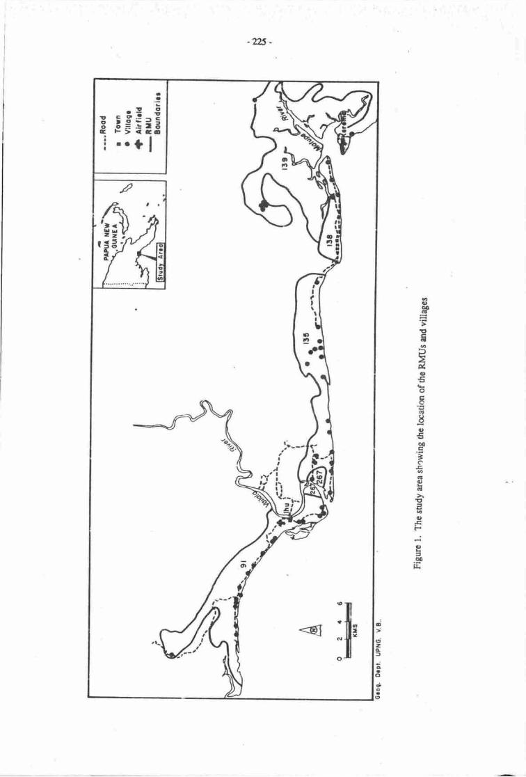
-225 -
aa,oo.E
EE0
ilo€o
r!
;=to0c'tco€oH
EEat,tEF
.':E2a0E
!- !.: 5
irO+J=6 5=:-6c F><Ga! ..1|
I'-It
.lIti
.a
,'f=1?r
gao0oa(,
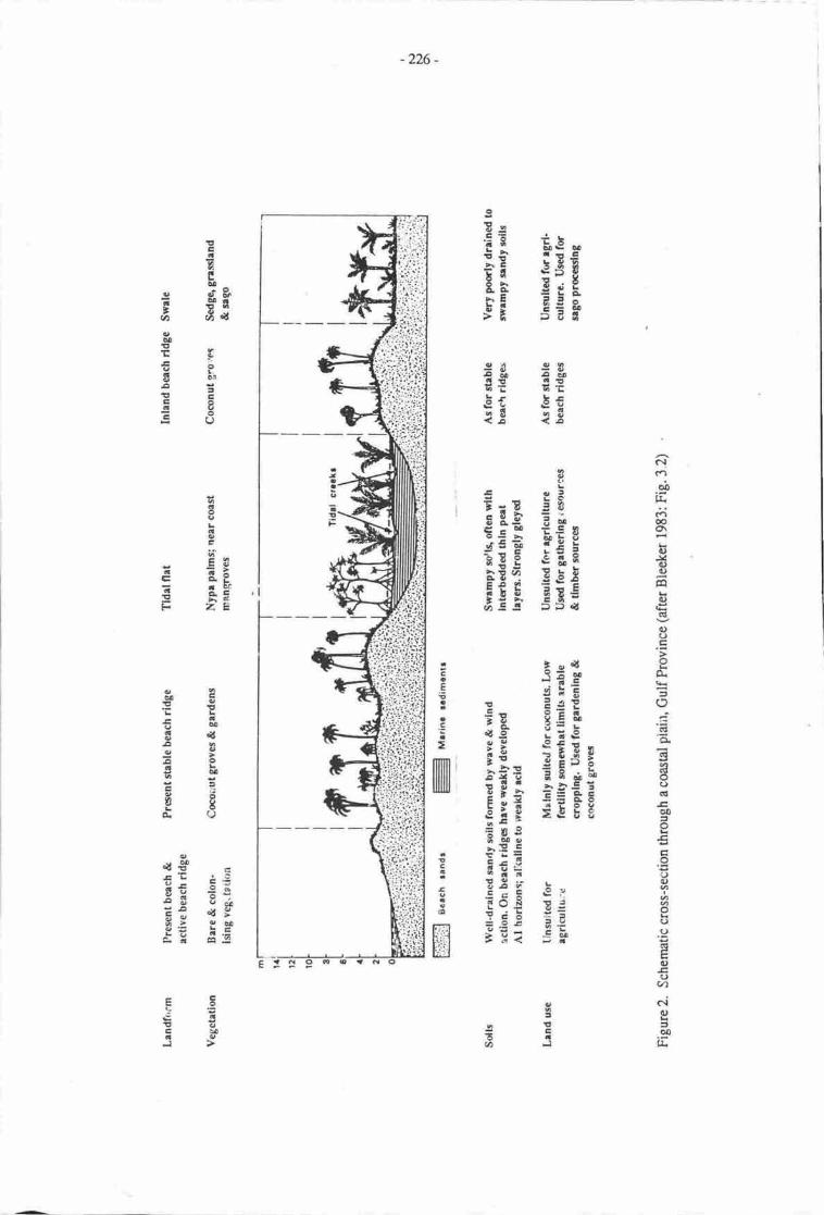
g
E:
iistEJ E SE F
-226 -
'":';'f' - :.',
' .i :.i:. :!: :
'.ii::-r 't:::'
z"tiit1.'i;.i)'j.?.
i.i'# fr$ ;i"i! iE
;i.':i.i.r.$
:i:i:'rt::i::jiiii;:;l:i
(\(-l
obl&c.i6o\Eo,
J4o)q)
Fq
6)
GI
{)(-)tr
o"
=oCg
asarltoo(l
o0
o€tr
Ic)
().9
q)Ec)(/)
ciq)
=oltiT
g
I -ii=E EE
E li E s n
f ; E gi;
FEE Ei€
:aao
altF
i+E:t=F
5c lEg
iigi5?lh.: :
E€*E: H .E r!:i ;E3ii 5F
ca
;oaEaE
finmililil1I txt ll
a
Ioa6
1r'r.- |
t1t I
o:l
-E=c35
cav,!b!-oOMUC
tta3*
It.oo
=E
IIE.a
cb!!tL
co
ECt
IL6cE
Egl=YCC=
G o.i=au5 ac.:= h6F ZE
c9!PE
Eoo6{56sgA9gg'E?fiiIfi
o€n c
!; €E;i ;y3; !,uEE gE
etr-- =€€rtateJ
-2n -
All CSIRO/DPI RMUs arc described as having r relief of less than l0 rr1 md none of the rea is norerhan about 10 rn" and most of it is less than 2 m above sea level.
The major landfam qryes in the sordy uea ar€ beach ridge complexc ad beach pl,ains, mangioveswanryE and associated tidal flats, and fr,eshwatcr, non-tidal swamps. Table l, which was derived fromRuxbn's (1969) geomorrphological mry for he Kerema-Vailala areq shows the landform compositiontype, md area of each by each RMU.
Table 1. Landform composition, and aeas of each type (km2), by RMU.
RMU Areaof RMUNo. (sq.km.)
landform composition.(tne & area [sq-km])
Beach ridge &beach plains
Brrckish & saltwat€r tidal flats
Fresh water Fresh watertidal swamps non-tidal swamps
139
91138
267135
Total
3537.5
42
r05.5
3
5
62
l5
i:
70
103
56l36
4
n2
30
0.5
;
31.5
The beach ridge complexes are long, parallel sand ridges (both active and stable under currentconditions) and swdes, with laal relief of up to 2 m high, but gradnally decreasing inland to form a levelor gently undirlating plain. Most of the surd here is moine in origin. The swales ae generally swamps,with tidd s€eks and sanding waEr. The level to gently undulating beach plain has extrernely low relief,and slopes are of less than orrc degree.
The mangrove swamps and associated tidal flas occur mainly at the river mouths, especially thoseof the Maurpe Riva @MU 139) and the Vailala River (RMU 267). The tidal flats are subject to dailysalt and brackish water inundation. The fresh water swamps have forrned on fonner tidd flats, built up ofesbaxine deposis which comprise lagoonal mu4 silt and local pear
The berches re prograding slightly, especially at the western end of the study itrea, as a directresult of the supply of sediments from rivers entering the Culf of Papua and transported by lurgshoreddft. The absence of high €nergy wave inpact on the coist has also enhanced the pograding of theb€ach. One important frctor which is perhapo important in &tennining the wave environment in tte arcais the presence of rather shallow waters. This npans that the pofoit at which waves break is a fair disunc,eoffshore and thus there is liule direct imprct of breaking waws qr frre coastline.
ClimaE
The area erperiences high rainfall in the period between the npnths of May-Augusl The rnesrarmual ninfall is about 3,500-4,000 mrn Soil moisturc storage is rarely depleted below two thirds of themaximum capacity and the annual water surplus stands between 1,000 and 3,000 mm pet year. The levelof mmthly rainfall is heavy (wet) and all months have mue than 200 mm. The rnaximum and minimumtemperatures experienced in the sody area are 32-30'C and 23-19'C respectively.
Vegetation
The vegetation on the coast reflects o a luge extent the present inundation status of the are4which is defined as the extent of the area subject to inundation within the RMU, expressed as apercentage of the toral area of the RMU.
-228 -
In the snrdy area curent information extraced from the PNGRIS (1987) shows thaE as expectdmore than 80% of the uea designated as rnangrove swamp is affected by tidal fiooding. Fo berh ridge
complexes and beach plains, less 0ran 2W of the area is affected by long-term inundation. Such
inundation may last fc periods of up !o 4 to 6 msrths, but water levels are generally shallow (less than
0.25 m) and the area is subject to drying out for short periods. Inundation is usually restricted to the wet
season, but areas with high dry season rainfall may also be affected at that time.
Three dominant vegetation types are found in the study area: terrestrial forest, swamp vegetation
and mangrove forcst. The first type is medium crowned forest on plains and fans, and where there are
well to imperfectly draine{ deep soils that are either not flooded or flmded infrequantly m fm short
periods only. The waEr table remains well below the surface most of the year, and pools of water may
form during heavy rains and remain for several days. Littoral forest is confined to the coastal sandy
beach ridges and more or less permanently swampy swales. Generally these forests are well'drained but
parts are inundated in the wet season due to lack of surface runoff. The permanent swampy swales have
floating and submerged water plan$ in their deepest parB, and swamp grasses, reods, sago palrL pandans
and swamp woodland in progressively shallower water. Mangrove forest, ttre third vegetation type, is
restricted to river mouths where large quantities of fine sediment are deposited and the fieas are subject
to tidal flooding.
Soils
The PNGRIS has provided detaited information of the types of soils found in the area. Basically,
most of the soils are either poorly drained or pennanently saturated. They are also undifferentiated inprofile. Fine textured soils are restricted !o tidal estuaries and swamps, while the sandy textured soils are
predominant in the coastal beach ridges and beach plains.
Socio-economic environment
Settlement pattem
Field observations in ttris study of the settlement pattern, confirm ttrat reported by McAlpine(1969). Two distinct types of settlements are found in the sudy area, both of which are directly related to
land-use and landform associations. On the linoral and alluvial plains settlement is nucleate4
particularly on the coastal beach ridges where villages are by PNG standards, relatively large. Villages
are usually situabd on the first stable beach ridge near 0te sea (Figures | &.2).
Where villages are situated in the riverine alluvial areas they are built on levees; where they are
siurated in the deltaic alluvial areas, they are raised on stils along the tidal channels. Village settlements
in the alluvial environment are considerably more scatter€d than those of the coastal beach ridges. Where
the beach ridge environment extends furthest inland village clustering increases, and this is probably a
direct result of a greater area of suitable land being available for subsistence cropping. Convenely,
where the beach environment is narrowest villages tend to be of equal size, of smaller than average
population size, and evenly distributed along the coast rather than clustered.
Population. land and resource use
In 1980 the otal population of the five RMUs in the study area was about 7,413, occupying an
area of some222 km2 The disribution of this population is such that RMU 91 has the highest (3,235)
followed by RMU L35 (2,432),RMU 138 (886), RMU 139 (738) andRMU 267 (r22).
Land use in the two most populated areas is such that RMU 91, 39 kr0 has low to very low land
use intensity. In RMU 135, 5 km2 of the area is subject to very high land use intensity with tree crops,
particularly coconut plantations, while 13 km2 has very low landuse intensity ad 26 km2 rcmained
unused. On the whole there seems to be a generally low intensity land use in the area. It is worth noting
that of the222 km2 of land in the snrdy area,as a whole 68% ot 152 km2 is virtually unused land. This is
due to pmr drainage of the soil as evident when we look at the inundation exlent which is morc than 80%
in RMUs 139 and 267. ln the other thre RMUs, less than 20% of the land is subject to permanent or
frequent inundation by flood waters.
-229 -
A proportionately high percentage (72%) of the population in the five RMUs is engaged in foodcrop poduction, both for their own consumption and for selling locally if there is a surplus. They grow agreat variety of food crops such as banan4 taro, yam, pawpaw, cassav4 sugarcane, corn and greens such
aibika. Other tree crops planted c husband,cd arc sago which is the staple food, and breadfruit. Theyalso grow a lot of betelnut. Gardening is done ur a shifting cultivation basis, tlre fallow perid rangingfrom l-2 yean. The villagers rarely garden close to where they stay. Informants interviewed in the
coastal villages of Petoi, Mei I & 2, and Uaripi, 3-5 tm west of Kerema (Figure l) all said they lay claimto garden lurd (and therefore their customary land as well) up in the head waters of the Matupe River.The Siviri and Karaeta villages, close to Kerema town, also have land in this rea. Pmple travel up the
river to garden and may on mcasions stay for a couple of days in dreir gardens before returning to theirvillages.
Fishins
This is alrnost a daily activity, weather permining. A large proportion of the population (717o) is
engaged in it. Fishing is canied out aiso in the lagmn. The villagen fish particularly for iheir ownconsumption and only sell when therc is a surplus. Crabs and frrsh in the tidal flats also provide an
important food source.
Saso
This is the staple food for the villagers, and the palm is grown both in the beach ridge complexes
and swales and also in the swampa. Not only does sago palm provide an important fmd source, but thepeople also use the leaves and the trunk for building houses. Mangrove is another important buildingmaterial.
Water
Rain water is the major source of fresh water for the villagen. Some of the villagers have roofrunoff tanls. During the dry season, they get it from streams. At Araimiri Vocational School (15 kmwest of Kerema) and Siviri village, ground water extraction by hand pumps was noted. The water table
in the area, urd in fact the whole deltaic Joodplain in the Gulf and Western Provinces, is high - probably
less than 2 m below the surface. This source of water is brackish and thus unfit for drinking.
Other economic activitis
The following is a summary of o*',etr economic activities carried out by the villagen. The maincash crop in the area is coconut. Figa.-es from the PNGRIS indicate that 72% of the population are
engaged in copra pmoduction. Aboat 227c rear pigs, 2L% gtow spices, 6Vo grow coffee, 2.4% ue intocaitle business,2.l%o grow rubber and0.l2% grow cocoa.
TTIE IMPACTS OF SEA TEVEL RISE
The possible physical consequences, and thus enyironmental impacts resulting from a rise in sea
level, can be considere4 rccording to Titus et al. (1984), under three categories; shoreline retreat"
temporary flooding and salt intrusion. Perhaps the rnost serious environrrental consequence in the GulfProvince would be the inundation, and in places erosion, of thousands of square kilomeres of swanpsand other wetlands.
Sea level rise causes shorelines to retreat both becarse land lying below future sea level will be
permanently inundated ard because erosion of the nearby land will increase. According o Tiars et al.(19E4), the partbular nrethod appropriate for estimating shoretine r€treat at given poinr on ttre coistlinedepends upon topo$aphy, beach composition, wave climatg sediment supply srd available hisoricddat&
-2N-
Modellins the effecc of sea level rise
With respect to retrearing c eroding shcelines, there ue several differcnt shoreline responeconcepts trat cur be used to model the rcsulting shaeline eonfiguration as a function of sea level rise
(Kana et al., 1984). The simplest to quantify is the inundation concept, whercby pre+xisting oonburs
above shmelines are used o project new shorelines. Herc, slope is the conrolling factor, such that
shorelines with steep slopes will experience little horizontal displrcunent of dre shore. Gently sloping
shorelines will experience much broa&r rea of inundatiorn. The inundatiolt cmcept, in fact, is the
preferred methodology to apply for irmnobile substrat or rwky or armourcd shorelines, or where the
shoreline is exposed to active wave actiot or strqlg currents.
Acconding to Kana et aI. (1984), the analysis becomes more complicated when dealing withmobile sediments such as sand-sized materid along beaches. [n such sibrations, Kana e, al. (1984) used
the Bnrun's (1962) model to predict shoretirp profile adjustment to a change in waEt elevation. The
model hypothesised thu a typicd corrave-upward profile in tre neanhore zone will maintain isconfiguration, but the profrle will be ranslated landward and upward as sedirnenb erode near the oldwater level and setle in deeper wate.r offshorc as the shoreline encroaches landwrd.
From my knowledge of the snrdy uea' I have been able to present here some fint approximations
of the manner in which shoreline will rereat and also impacts that are likely o be erperienced some
kilornetres inland from the coasl
Permanent inundation
As far as shoreline retreat is conceme4 permanent inundation of land resulting from sea level rise
is perhaps the easiest to quantify according to Kana et al. (l9M\. This is because the approach employed
here utilises the known contour lines on the map o project the the extent of inundation. It can also be
takeri as a first approximation of the likely 'new' coastline. This is without consideration of the
contribution of coastline erosion which is very important in shorelirp rctreat.
On the basis of the interpolated I m contour line (Figure 3) re-drawn from the 1:100 000
topographic base map of Papua New Guine4 the land areas that are likely to be lost due to permment
inundation when sea level rise by I rr1 have been calculated for tlre relevant RMUs are as follows: RMU91, E km2; RMU 135, E km2; RMU 138, 3 km2
In these circurnstances, a total of 27 villages might have to be partially or totally relocated, as
these are within the area designated as that expected to be inundated by a I m rise in sea level. Most ofthe settlements are on the first vegetated stable beach ridge adjacent to the sea
Coastal erosion
Increased coastal erosion will come about as the elevated sea level will continue to ercde back the
coastline to maintain the beach profile. Theorctically, aftera new equilibrium is achieve4 erosion may
slow down to its nmmd rate. To make sensible estimates of the magnitude of this problenu knowledge
of the physical conrolling factors mentioned above are again vital.
The most important element to consider here is the beach profile. This consideration is needed to
see how the elevated sea level will affect the beach both in plan and forq as sediments are eroded,
transported and deposited at rates 0rat were perhaps never experierrced before on the coast. The results
from the beach profile survey at several locations along the coast showed that there is great consistency in
slope angles. This is such that from the high water mark GIWM) to the low water mark (LWM), the
slope was 4 degrees, and from the high water mark to the back of the present active beach ridge, the slope
was 2 degrees. From the data obtaine4 a general beach profile for the study area was drawn (Figure 4).
What is expected to happen o the beach profile is that, after a sea level rise, the beach profile that
existed prior to the rise will be restored (but its location will be further inland) through wave action
eroding away the upper part of the beach and depositing the material at the bottom of offshore waters.
These effects could be counter-balanced if there is increased sediment supply to the coilst (especially

-23r -
slG}
ts
Eaa|l)ttrrua
C)
tu
G'It)a@E'to
c:a0cttooE
Etuxil,qooctt
e()tr
(uJ{tF..it,hot,t&
.,zcloOo
iil=
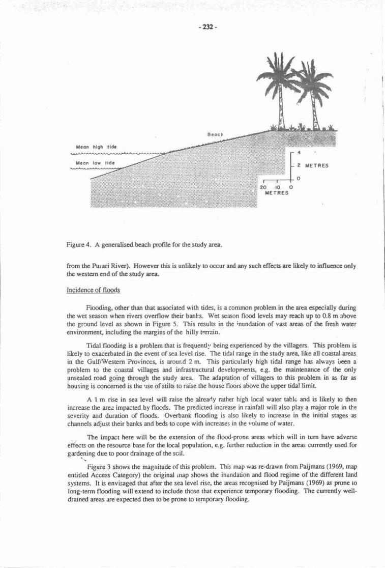
-42-
Figure 4. A generaliscd bcach profih for the surdy area.
from the Rurri Rivcr). However this is unlikcly o occur ard any such effects are litely o influence onlythe western end of the suldy are&
Incidence of floodl
Flmding, other than that associated with tides, is a common problem in the area espocially duringthe wet season when rivers overflow their banks. Wet season flood levels may rcrch up to 0.8 m rbovethe ground level as shown in Figure 5. This rcsults in the inundation of vast arces of thc fresh warcrenvironment including the margins of the hilly t:rrain.
Tidal flooding is a problem that is frequently being experietrced by dte villagen. This problem islikely to exacerbated in the event of sea level rise. The tidal range in tlrc smdy arca' tike all coastal arcas
in the GulfA#estern Provinces, is arour.d 2 rn This particularly high tidal range has always i-roen aproblem to the coastal villages and infrasfuctural developm.€nts, e.g. tlre mainbnance of thc onlyunsealed road going $rough the sody area- The adaptation of villagers to dtis problem in as fr as
housing is concemed is the ue of stile to raise the house floon above the upper tidal limir
A I m rise in sea level will raise the alrearly rather high locd water tablc, and is likely to dtenincrease the area impacted by floods. The predicted increase in rainfall will also play a major role in the
severity and duration of flmds. Overbank flooding is also likely o increase in fie initial stages as
channels adjust their banks and beds to cope with increases in the volume of water.
The impact here will be the extension of the flood-prone areas which will in tum have dveneeffects on the r€source base for the locd population, e.g. further reduction in the arcas currcntly used forgardening due to poor drainage of the soil.
Figure 3 shows the magnitude of this problem. This rnap was redrawn fmm Paijmans (1969, map
enritled Access Category) the origind rnap shows the inundation and flmd regime of the different land
sysrems. It is envisaged that after the sea level rise, the areas recognised by Paijmans (1969) as prcne to
long-term flooding will extend to include those that experience temporary tlooding. The currendy well-drained areas are exp€cted then to be prone !o temporary flooding.
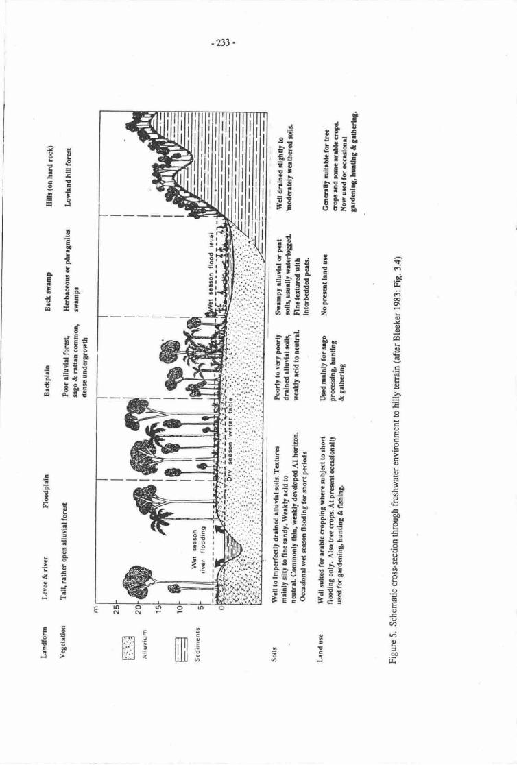
-233 -
F
ilifii5g jEIc
?Ei:2=5Ea
#5
aE!Esg E
Ei55 E
;E i g E
; g; E iFfg Fei!€ gE-i;i irEEi! s ls
!ETaEC|.
-bF3MoI iFZ UIc tB
a(.1
d)qr
rtt€o\
(l)J4IFA
.!BHcG'tsc)
h
oEC)EE.9trc)!q)GI
'EaL,€o0to€o()()
()(,GI
u(Jv),t;q)
=oO
l&
E
r;;*;F€ EE€
l I;E
iSriE
iiiiFiiEiEiIiE;FEE Fgi
CaEtoEE
Lg?:Icn,u*
:hL:{E3i9a,JF
otttcC.lEa
EF:=Eg300.OJ
IDoat
r
HILI;
-2y -
Table 2 below shows frntly the cun€nt situation in terms of the areas 1sq.km) that ex;:erienceflmding of varirus durations, ard secondly what the likely sinration will be after sea level rise, whichwill exend tre rcspective flood-prone areas. The increase in the areas prone to flmds of varying durauonextends beyond the boundaries of ttre RMUs as can lie seen from Figure 3. The likely impacts areenvisaged o bc wi&spread.
Table 2. hesent rd projctcd flooding corditions (areas in km2)
Prescnt curditions Projected conditions
RMU Long-nnn Shono rbd€rate Well&ained l,ong-termNo. flooding Arm flooding flooding
Short to moderatearm flmding
t24
35
103
t36
4E
ult4
E
u35
5
5.5
2s9
9t7.5
62315
149
r39138
26791
l-15
:3
Total u5
lalt water intrusion
Sdt warer intrusion resultfug hom sca hvel rise will affect water rcsources bo:h on the surfrce "ndin aquifers (Iitrs a 4r., l9t4). In this surdy arca the problem is Lkely o manirbst iaelf in rhe manner
d€scribcd below. In thc brrckish grd solt waer tidal flats, particutarly RMU 91, extension of thisenviroiln€nt type is litely o occur as sdt waer intruces surire chanrpls rrd un&rground resenrrin.My own estimaE, based m Tabb 1, is ttrat this brrkish anvirurmart, which curently covers 70 km2,mey incrcrsc in &Ga, thus irr:lrding parts u rll of the adjoining 30 km2 of fresh water. non-tidal swampenvxT"nttEnL
In $c bcrch ridge complexas and berh plains of dre other RMUs, dre intrusion of salt water intnrquiftzs will rcsult in dre watcr soutcc bccoming brrckish. This will rffect particularly prople thar rely tosonrc erent on grourd waEr ftr fr,csh wrtcr supplics..
ENVIRONMENT.\L IMPACTS: A SUMMARY
Tlre snviroilrEntal inpacts which are likely to result from the urticipated sea level rise, are relatedo the physical consequarces of strrytlinc r"ueat, ixreased floodir,g, and sdt water intrrriion discussedabove. Thc strts of anticipoai impects thu will bc felt by 6c loud population sr sununarised below.
Wrcrrcsources
Sdt wau intqtsim will scvercly affet hc wrtcr res(rurc,es of ilre k*.d peoph, espocidly theirsurfrcs wrrcr supplics. A loa cf thc lael pcople get trcir water supply from srearas and also fromr.infdL which is sucd in druns.
Grqtid wrtrr is rn under-utiliscd rcsorroe rd ficld obse:vubn showoC, only hvo crues, both onbcach rltgc imdfann, wlur ground wrcr wrr rcuelly used; n Araimiri Vocetiqrel School arxi at SiviriVillage clce o own Tlr wrg extrircbd hac "r usuairy brrckish srd is used tlrererore only forwrshing.
Any pmbL,ru widr thc wrtlrnes{iln}6 in thc ser re litely o be mitigated ul sorre extent by tirepudic'tcd fuscrec in rrinfr;i fa thc rr.r-
-235 -
i-cs oi iand
The loss ol land is perhaps the most important environrnental impact that will be faced by thepeople. This will result from coastal erosion and reneating shoreline, iucreased flo<xiing and theintrusion of saltwater, changir.g the sdiniry and alkal;r.ity of the soil and thus rendeiing land now used forgrowing fmr' alrd cash crops unsuitable for cultivation. The problem will manifest itself in the mannerdesribcd below.
;ienlenpnt
On the basis of the interpolaed I m contour line, (Figure 3), the fint arbirary mark of any likelyfuure coastline, a total of l7 villages with a :otal populatiqr of 3,240 are within the boundrries of thearca which will be subject to partial or lotal inundrti{rn from a I m rise in sca level.
Taking into consideratior frequent and long-term flooding, together with 0re problem of coastalerosion that will to a great€r a lesser exEnt dictatre the new coastline, another 26 villages with a totalpopuluior of 3,3l2people will be affecred.
Given the above sinration, we re looking at a population of about 6,500 people, many of whomwill have lo vrate their current scttlenpnt areas and cstablish themselves else where, particularly onhigher gmrnd which is a fair distance inland. In RMUs 91 and 135, people may still be able to setrle inthe anas designated as subject o mtderate and shat-term flocding, building their houses on stils to raisethe house floors above the upper tidal limit. From the limit€d available infr,rmatioa regarding customaryland ownership in the RMU:, it is highly litely that relatively tbw of ttre lmal people will still actually beresiding on their own land after tre sea level rise.
Asricultural land
Itoductivc lanC totals just about 70 km2 in the five RMUs, or 32% of the entire area. The rest ofthc RMUs arc marginal in drat they are pocly drained arx! are subject to occasional flooding. Thismakes it diffrcult for the locat popdatiql to put the land into producdve use.
Gudening is r major e,v€ry&y rtivity and is rnarnly {one orr the presant sable beach rittges ardalso on inlan.! bercn ridgcs. ln tlr cvent of a sea level rise, total inundation, incrcrse flmding and saltwater intrusisr are likely !o reJuce dre rvailablc agricrrltural land- Pmple may still be able o garden inthe areas dcsignated rs slrort-moderate erm flmding areas, particularly in RMUs 9l ard 135. But therewill cf cc.rne be thc problan ryain of conflicting land-use, i.e., that benveen sathnpnt and grdening.
Pcopb wiU dso frce thc praDlcm of slrctage of suinble land !o grow uher cash crope , eg., coftee,ter, rubber, csor, spbcs and ooconuL Mct small holdcr cocqrut plantatians are within rhc area highlyvuherable to the impacs of sca lcvcl risc. A csrsidcrablc lo.s in nnnary crms is anticipatcd for thiseconomic rctivity whfoh is vcry impctant to thc villagers.
Infrastrucurc
Ttt€se is not nlch in thc way of infrrsructurd dcvelopnants in the snrd;' area that wili be likely tobe imprct€d- The mly rmserled rord which runs through the study uea, will atmct cer.ainly ber€ndscd unusabb rs t r€sult of taal inundrtion et sevcral points, urd elso from coastline erosion andlang-tcrrn flooding as cm be sen ftrom Figrrres I & 3. Relocating the road sonp distance inland will stillpoec poblcms with imprs rcsulting trom shat-nrcdcraE t€rm noods.
trkrpmr own is mainly m r scrics of hrd rock rllgcs rbout 20 m above sea level. The airporthow€vcr, which is built an ftc coestrl plrin t m clevrtion of about 1.5 rn above see level, is likely to besubjcct to t[x! frqucnt rnd long-cnn flooding, which will rnatc it less servberblc. Cosstal ersionduing the rainy pcriods rnd rough scss bctwccn the rnontlu of May-August is already causirg damage odt? efuport, prticulrly d thc [fui hint
-2%-
Foodcrourcct
Ttc uiciped rcr bvd rirc witl hrrc iflplicaftru o bot dE lmd md nrdnc brscd foodnl|flrca.
Lrtd-brrcd
$" ir tb *lflc fmd, pviding rbeut 7596 of ttr diary cgtohydrrtc of hc larl villages. ThcpJn drc Fovidcr prvidc| buildftU rnetahl fa housct. The cxrnslm of dre brekish md tidtltwrnpr P irludc pra a "ll of fic frtsh weu swrnps (Flgurcs 2 &, 5) will mcan thc loss of hqgestr& of nSo' prticulsrty in RMU 139. Thcrc is lilcly o bc r conprtssicr of the bw srlinitytrilmt fa growing rrgo tr rgrinst the hilly Errafurs,
Fa lmd-bscd food rcrourccs, thc rtdnctkn h agriculural lmd will sinply nErn a reduction infmdprcdrctidt lluc|ccd inhsity of hnd usc ir tikoly to exrccrtac dris prob-6 rs lsrd is degradedb I ttrS? d|r fu mil fcrtility ddlh6. Otlr poblcmr thet mry bc expoced to r€sult fr,oln this will be attq h thc nutitknd strnrs of drc bcel popuhtim
Merincbercd
Irdrir rcs(xuc€s gr mticiplcd b bc cnhrnccd rs well u rdverscly affecad
Fbhing' lib grdsdng, is m c,rcrydey rctivity, wcethcrpamiuing. Widrogt prcper lnowbdge oftlE tnrfuF rcs{xrces found in thc offslrorc wlET, I cm only tnatc e gctrcnal staEnEnt trere regarai.rl g1isrtivig. Fishhg ir donc boft in thc hgpon end out in thc opon sca. In the cwnt of a sci levefrisecoutd crqin nd subecquant dcpositioo of scditrstc rt thc botom of the reth€r shallow offi-slrqewrEni ir exptod. This is lilely b hrve sonr implicatiols qr thc merine rEsources, especirlly fhh, intb zm (wi6in 2 tm offslruc) where nnct of thc fishnrg is canied our
Mollucs md cnbs which tlnivc in the tidal flats may rcurally be enhsrced with he extension ofth brr&ish md srlt wrtcr tidal res. With dds, thc nrngove cnvironrEnt, prticulany at RMU 139 islikcly o cxgrd inlr4 thc excnt o which rhir rney ccur is not certdn, butl occrcrsc in the exbnt ofthistrbitet rnay dvcncly affcct Frwn Eso.rcc$ in thc Gulf of pry'a
ST,'MMARY
It can bc scn frronr the casc shtdy that thc effccts of r rising see lcvel will be mct profound f61thoce villegen who rrc now occupying thc d€Docitiqral lsrdforms just above see level and not brctod byrising lmd It is wcth rcting that thpse rp generally favoured areas of occupaticr, since such localitiesprovidc god rcccss to thc ftshing zdter rs wcll rs to garrd:ning lan4
Thc owrrll irprcts of see level cen rlso be cveluacd in economic ard prrovincirVpoliticl tcnns.This &erdy disdvmtrgcd province iq crrns of ccorpmic dcvclqrnrnt atd ttre provision of essentialscrvicce o dtc pcoplc, may be ptrccd in m rvcn warc siuratkrn.
REFERENCES
Bleckcr, P. 19t3. Soils of Papur Nery Guinea Ausrrlian National University press, Canberra-
Bntun, P. 1962. Sce-loret rise as a canse of shore eroaion. Jornal of Warerways and Harbon Division,Et(WIVI):ll7-130.
Bualir' L. r9E9. The funprca of global warming induced sca lercl rise on coastal environnrcnts in papuaNew Guirce B.A. (tlqrs.) thesis, univemty of ppua Nw Guinea port Moresby.
CSIRO/DPI 1987. Papra Ner, Guinca Inventory of Nauual Resources, Pquluion Disribution andLmd Usc. Codc Files, 7 volurncs, Commqrwcrlth Scientific and Indrstial Research Organization,Cmbern A Ifcperrnart of Primary Ind$ry, port Mcesby.
-at -
xI|+ T.w, ,. Mbhcl" Mo. Irrycr & tr- hn 1904. Tb phydsl i4c d g brcr ftc in 6c lrrof chrl.3tm' sou6 cnlinr. h. lqt-lto h M.c. rrt ir.c. rrr-tEt.r c@i; cfrct ndrcr hra! rira r chdhrgc fa thb gulin_ vrn Nmud Rdnhd4 Nes yqt
McA$inc' J-R- 1969. clinrb of the Kccmrvdlrlrrcr. h B"p. turnn, p. Bldc, BJ. La6 tx.YcAbittc' K. Peijnlnr & R. Pullcn r m& of fu Kascyrildr Arc+ Tfi1rv d hpr Nc*Guirr. Lrd Racadt Scricr No. 23, Cmrmscdfi Scinrific nd lftruirl RcrcrchOrgrtizrde, Melbounre.
Prijnru' IL 1960. vcrqlg rd ol4y of 6c Kcaarvdldr ree In Bp. Rr'h, p. Blcb, BJ.F*tt Jr. :'tcAldnc, K pdjna' & n. hlco. Irds of th. Kerrm+veileh Ar"r T',riry ofPrpur Ncn' Guirel Lrrd Rcrcrch scds No.23, Commwelth Scicrift md tddrid RcscrchOrgrnizetion, Mclbounr.
R'urbn, BP. 1960. Comcptrotogy of thc Kgcmr-vrileh scr In Bp. Ruxorr p. Bbctc(, BJ.I-alr,JR. McNdm' IL Priittrsrl it R. hrlho. Lme of drc l&corvrilrh Arcr Tclrimry Jra,r. x"*Guitlr. I-md R'ccarctr Scri6 No. 23, Cmmrcdt Scir:nrif* nd Indurrhl Rcraclrorglriz.dgt Mclbounp,
Rurh' BP- P. Blcctr, BJ. I.dt J.R- lvlcAbiE, K Prijmrtr & n. pullco 196g. I-rdr of dFKcccmr-vrildr Arer T1",""y of Pepre Ncr auian r-i ncr".nct Scrics No. 23, cornnrnwcd6Scicnrific rnd rndussgl Rcrclch Oggrizrtim, Mclbonr.
TiOq J.G. M.C. Brnh" MJ. Gibbs, J.S Hoftia1 rt M. Kcnr:y lgta. An overvbu, of r; crurcr ndcftccB cf rca lcvcl rirc. h l-j6 in M.C. grnh lt J.C. Tior (Edr.), Gralousc;ftrt-nd scr tcvclrisc r chelhngc fcr thb ga'c"rrim. van Narurd Rrinhol4 xw vqt
-238 -
THE EFFECTS OF SEA LEVEL CHANGE ON PORT MORESBY AND LAEUR.BAN AREAS. PAPUA NEW GTIINEA
Marjorie SullivanUnivenity of Ptpua New Guinea
BACKGROLIND
In terms of social and direct infrastructural cosrs the effects of a sea level rise will be relativelygreater in highly populated and developed urban areas than in rural areas. An assessment has been madeof the likely impacts of projected sea level rises on the two major cities in Papua New Guinea, PortMoresby, the capital city, on an erosional section of the south coast" and Lae, near the mouth of theMarkhamRiver on the north coast.
STUDY METHOD
Draft copies of topographic maps of both Port Moresby and [.ae city areas re available at a scaleof 1:2,000. These maps are drawn with a surveyed contour interval of 2 rG but with some irregularlyinterpolated contour lines at closer intervals where such data are available. Buildings and roads whichexisted in Port Moiesby n 197'7 are included on the maps of that crty, and for Lae these details are up todate o 1984.
These maps were u;ed as the basis for the estimation of the likely impact of various projected sea.
level rises. Contou-- lines at 0.5, 1.0, 1.5 and 2.0 m werc drawn onto the l:2,000 shects, and newcoastlines produced for a sea level rise of those magnitudes. These are presented in Figures I and 2.
The areas of urban land which would be inundated or rendered useless, uhe lengths of made roads,and numbers of the buildings which would be affected by each projected sea level rise were not€d. Theseresults are surnrnarised below.
Since 1977 there has been considerable urban growth in the foreshore zone of Port Moresby. Acomprison of 1987 airphotos of sample ane$ near Hanuabada, Ela Beach and Koki Village witn the1977 maps indicate that the nrrmber of buth formal and informal buildings in tlre study area had increasedby about 10%. Accordingly the numbers obtained from counting all buitdings on the 1977 map r.,ereincreased by l0%. ln the case of Lae the 1984 data are used as the increase in the number of buildings inthe intervening period is likely to have been small.
The population esrimates for both cities are based on an average of seven occupants for a formaldwelling, and l0 occupants for an informal dwelling (King & Devi, 1986). It should be suessed thatthese population figures are crudely determined and thus are rough approximations.
In addition to the direct physical impacts of inundation and erosion on buildings, roads and otherinfrastrucurre items such as wharves, sea walls, water supply and sewerage systems and storm waterdrains, there will be an incrcase in indirect impucts such as a progressive rise in water tables and theincreasing inability of slorm water drains and sewerage systems to cope with loe,Cs at high tides.
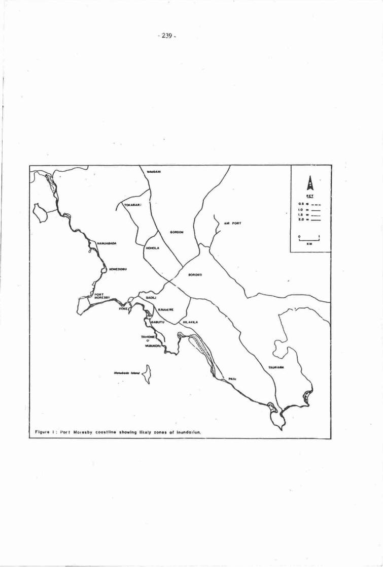
-239 -
Itg
l.O.-l.a.*
oaIt
Flgurc l: Ito.t Xor.rbt coc.tlln. tl|o!|ilg lltat soe.r ct liu|dotlca
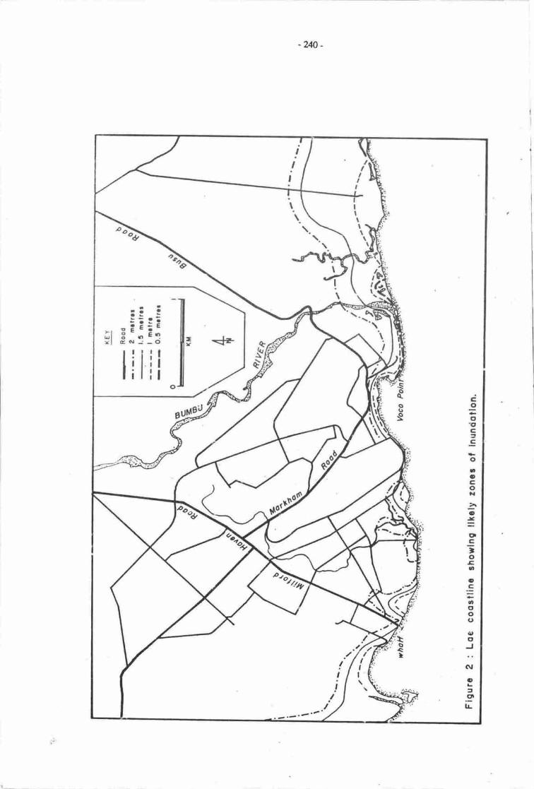
-2&_
t
!!
II,
tLIIItlr\\
,l
(
eve
.: iii:i;l E'- ErYl cNJ-O
1')-'q
Cgottc2EoaoCox3o
=CIE;oEao
.:=
ooo(,
{,o
:GI
oaglL
\al
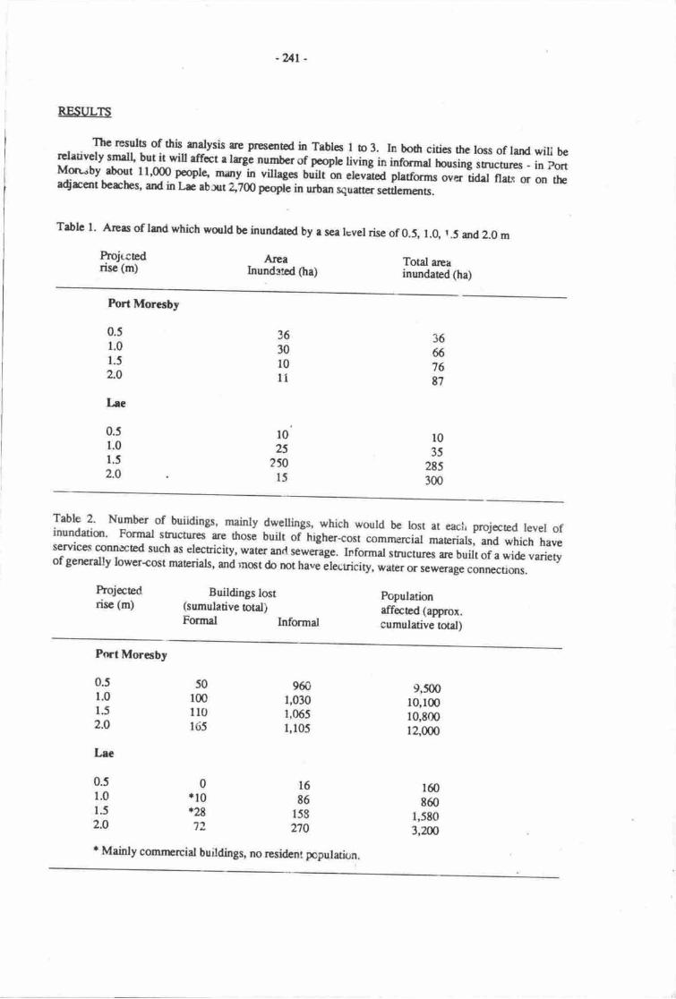
REST'LTS
The resulc of this- an{Ysis ae presented in Trblcs I o 3. In bodr cities the loss of land wiu b€relatively smdl' but il will effet a hgl number of pcqb living in #ormar horsing strucrur". - in ponMon';by about 11,000 pooplc tnury in villages built sr eleviJ fr"ro. over tidal flalc or on rheadjrmt berches, and in L^c ab*t 2,200 pcople in urban ,qu*,oi"men6.
Trble l. Arers of land which wo.rd bc inundated by e sea lcvel rise of 0.5, 1.0, r .5 and 2.0 m
Projtcedrise (m)
-ur.
Aleahundrted Oa)
Total areainundated (ha)
Fort Moresby
3667687
l035
285300
3630l0u
l025
2sol5
0.51.01.5
2.0
Lee
0.51.0
1.5
2.O
Table 2' Number of buiidings, mainly dwellings, which would be rost at eaci, projccred tevel ofinundatiqr' Formal structu€s are those built oitrigrrer-cost **.€r.ia maErials, and which haveserviceq connected such as electricity, water anrl r"*J.g". ffor*J st*ctues are built of a wide varietyof gerrrally lower+ost materials, and mqt do not have Jlecuicity, w*, o, sew€rage connecuons.
Projected Buildings lostrise (m) (sumulative otal)
Fonnal Infonral
Populationaffected (approx.cumulative total)
Port Morerby
0.s 501.0 1001.5 1102.O l6j
9601,0301,065I,105
9,50010,10010,90012,000
160
8601,5803,2m
16
E6158
270
0+10*29
7?
Lrc
0.51.0
r52.0
t Mainly comnrcrciat buildings, no resident population.
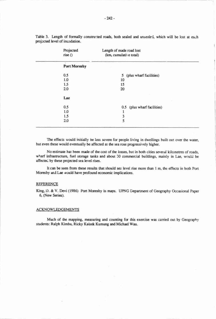
-2{2 -
Table 3. Length of fmmally construced roeds, both seded ard unsealeC, which will be lost at eaihFojectod hvel of inundatiqr.
Projecrcd Lcngth of made road lostrisc 0 (lrr1 cumulative total)
PrtMoraby
0.51.01.5
2.0
5 (plus whrf facilities)r0l5m
0.5 (plus wharf frcilities)I3
5
The effes would initially be less sevene for peo,ple living in dwellings built out over the water,but even the.se would ev€ntually bc affected as the sea rcse Fogressively higher.
No estimaa has been made of the cost of thc loases, but in both cities several kilometres of roads,w\arf infrasructur€, fircI storage tants rnd abort 30 comnprcial buildings, nainly in lle, would beafrect*, by 6esc projeced sca bvel rises.
It cgt be seen frun $csc results that shculd sca level risc npre than I nu the effecB in both PortMuesby mJ Lre wouH have profound conomic inptications.
REFERENCE
King D. & V. Devi (1986) Fort Macsby in mapa. UPNG Deprtnrcnt of Geography Occasional Paper6, (Nerr Seties).
ACKNOWLEDGEMENTS
Mrch of dte mpping, measuring and counting fc this exercisc was carried out by Geographysad€ns: Ratpfi Kimbq Ricky KaisekKumung grdMichmlWau.
Lec
0.51.0
1.5
2.0
-u3 -
MURIK LAKES AND THE MOUTH OF TIIE SEPIK RIVER
Philip Hughes & Leo Bualieuniversity of papua New Guinea, port Moresbv, paDua New Guinea
IIVTRODUCTION
At the mouth of the Sepik Rivei, the longest river in Papua New Guinea (see table in pernena &Osborne), there is a complex of deltaic floodplain and nrangrove swamps covering about l,l60km2(Figure l). This area is constricted along its intand margin, abour 40 km from thJcoast, by bedrockranges. The study area presently supports a population of about 2, g00 people
The following brief rcount of the biophysical, social and economic setting is taken fromCSIRO/DPI (1987). The prediction'of likely impact are based on an usumed I m rise in sea tevel. Thebase map for Figure I was drawn from the 1:100,000 topographic sheets. It is imgossible to determineprecise altiud€s above sea level from the topographic sheeu asthe contour intenal used is 40 m. Therearc however several spot heighs marked within the study are4 and none of these exceeds 9 rn All of theCSIRO/DPI Resources Mapping Units (RMUs) are described as having a rclief of <10 m. On the basis ofthe topographic evidence and the RMU descriptions presanted below it is concluded tl;tt nor€ of .Jris areais more than about 10 nr, and most of it is less than 2 rn, above sea level.
The coastline is formed by a nanow zone of beach and beach ridge turrain backed by mangroveswlunps' estuarine plains and beach ridge plains which extend inland for about 20 km. The near-;oastatzone is dominated by extensive mangrove swamps which cover aboutll% of the study area yer supportabout 70% uf its rcsident population (especially Kaup Lagoon IRMU 37.{] and Murik Lagoon IRMU2801). About E0% oi this rea is subject to tidal inunaation and areas suitable for settlemlnr are verylimircd.
Imrnediately behind the coastal zone is a sparsely secled plain (RMU 8l), g0% of which ispermanently or frequently inundated by fiuodwaters from the Sepik River. At the eastern end rf thestudy arsa the coastline is brked by rnoderately weli-drained berch ridges and beach plain (RMU E2)which comprises about 4% of the surdy rea md supports abont l0% of is population. rurtho int-da3ain, along dre Sepik River, are frreshwaer brclswampe and alluvial plairu (RMU 279) which supportabout 16% of the population.
The major subsistence and comnprcial activity is filhing in the coastal lagocrs, rivers and rhe sca.Subsistencc gardens and pig'raising p'rovide up o 50% or uri rma requirements of people other thanthose living in the mangrove s\ramps. Sa8lo, gro*n in freshwaEr swamps, is a r..ajor souo" of food-cop.", coffee, cocoa and rubber provide small but imporant sources of cash income.
The folloring dcscriptions of thc RMUs are taten from CSIRODPI (tgt7), province 14, EastSepik (Tables I ard 2)' Thc population dora arc b;sed on the 1980 ccnsu.s. Thc rotal population at thattime wre \145 md thc average pquluiur clmsity was 2 pcophftm2. Assu:ning a rate of increase of2.5% pq annum' the national avrerage, and drat tbre has uccn no net migntion, hI present popularion ofthc shldy area is ebout 2,t00. Economic rctivity refen o production for cash sale, not subsistelrce use.
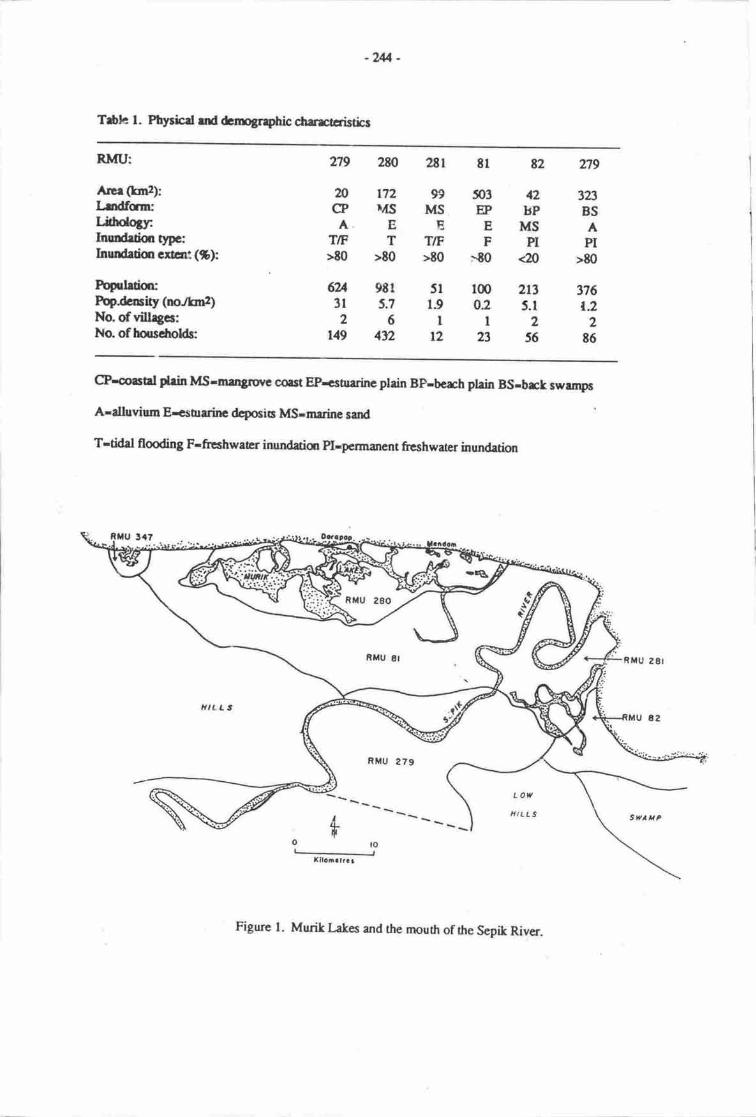
-2U -
T$le l. Ptlrsfod rd emogrrphic cbrectcristics
RMU:
AnrGmr):r rdf,cm:Ljdrdottr:Inundetir, O*-Inundetim crlar: (S):
hpdrticFop^dcity (norknz)No. of villrgc:No. of harsdroHs
n9 280
nn2CP D{S
A. ET/F T>E0 >t0
6U 9E1
31 5.726
r49 4t2
ur 8l 82 ?]tg
99 503 42 323I\,tS EP BP BSEEMSA
TIF F PI PT>E0 >90 <n >90
5t l@ 2r3 37619 0.2 5.1 r.2ll22
12 23 56 86
@-mal phin MSrnu4Sluvc corst EP<oruinc plain BP-bcrh plein BS-brck rwup6
A-dluvium Er.stnrinc dcposia Ms-mrdnc sard
T-tidal flooding F-freshwaEr inundatior pl-pcrmanent freshwater inundatiqr
,IILL'
RMU 279
svaHF
Figure l. Mudt l-akes and the nrouth of the Sepik River.
-us -
fable 2, Vegetation, hnd use and econon:c retiviq
RMU 279 (Kaup Lagcon)Vegetation: Swamp wmdtand wirh murgroveLand usc & snaU holder economic activify:
About 50% cf the land is used at a low level of intensity. About 9096 of househokis engage in sonreconomic activity, especially cc;oa (81%), food obps (79%), fhhing, (75%) coconuts (t5%), pigs(50%), spices (29%) and coffee (2t%).
RMU 2t0 (Mudk Lagoon)Vegetatiou: Mangrove forcstLand use & small holder economic activity:
Most of the iand is virurally unused. The crly ecanomically significmt activitv is fishing, by about48% ofhouseholds.
RMU 2El 0n'atam l-agoon)Vegetation: Mangrove with swamp wmdland.Lsnd use & smrlt holder ecunomic ectivity:
5% of the lard is used for sago production srd the rest is virurally unusod. All households engage infishing and l0 our of 12 in foud crop production.
RMU tTVegetation: Swamp wmdland with herbaceous swamp vegeution & swamp grasslandLend us€ & smatl holder ccunomic ectivity:
14% of ttp land is used for sago producticr and the rest is viftually urrused. Alrnost all householdsengage in some econor'ric activity, especially fishing (96%), coconL,ts (E3%), pigs 174%) and foodcrops (48%).
RMU t2 (Broken Water Bay)Vegetation: Wmdland with grasslano and linoral forestLand use & snall holder rconomic rctivity:
About 43% of tte land is used at a low to extnenrly low level of intensity. Abour 80% of householdsengage in some economic ar:tivity, especially fishing (s0%), coconuts (59%) fmd crops (.57a/o), pigs(45%t, rubber (18%) end coffe (14%).
RMtt 279Vegetation: Swamp woodland with herbaceous su,'amp vegetatim and swamp fuest.Land usc & small holder economic rctivity:
About 64% of the land is used for sago pnrduction ano rhe r€st is v;tually unusod. Abour 85% oftruseholds engage in sonre ecqrcreic rctivity, especially fmd crops (El%y fishing (SW), cocor.ut(17%) and pigs (14%).
IMPACTS OF RISN{G SEA LEVEL
The areas of productive land which ue not or are only slightly affected by inundation are verysmall, probably less han 2A% of the total area. Hence a I m rise in sca level would have a severe andpossibly cuasoophic irnpact olr tlr subsi.stence srd conu'nercial economy, and the sertlement pauems ofthe area. This imprct would conr about thrcugh an inland extensiqr of the area subject to tidalinundation and increased flooding of inland areas due m rising waEr tables md overbank flooding. Theefteca of flooding would be especially severe if the sea were to rise at mae tham 0.3 nyl00 years (seeChappel!, this volunrc).
-2$-
Rising sea levels will cause erosion of the slroreline, puuing coastal settlenrents atrish Especiallyvulnerable will be vilrages. on sand beach rirrg€s g*g d;dd;; rm: Exampres of such vilagesarc Duapm (population about 260) ana radaar 6opul-atior ruiri iaol which are'loca,"o-on rhe low,narow sand banier which encloses Murik Lakes ffigure f l.Grcundwarer on sand bfri€rs and around estuaries will become taincd wirh brackish weler andalternative waer sup'piies will have o be founrl
All of these impacts combircd wiU make the surdy area virtually uninhabitable ad rnost of thepopuluiqr will have to be rc-locatod ur adjrcent arcas of higher gn *a or frgttrer afield.
REFERENCE
csIRo/DPI 1987' PapuaNew Guinea Inventay of Nan'al Resources, Fopulation Distribution and LmdUse. Code Files, Z volurnes, Carberra & pmMortsby. - --' ' vl'sr.uv' vr.turuul'(,
-2117 -
CARTERET ISLANDERS AT THE ATOLLS RESETTI EMENT SCHHVIE: A RESPONSE TOLAND LOSS AND POPULATION GROWTH
universitv of papua *"* fffLor:l'nr#r"ruy, papua New cuinea
Growing cash crops and making grdens re the plans we have in mind. This we believewill cause a change in our lifestyle. InsEad of spending mmt times out in the sea fishingwe will spend time grdening or doing necessarydringJo keep us occupied (views givenat a meeting m 29 April 1992, at Har Islan4 in the Carerct Group to discuss reseolernnt).
INTRODUCTION
Estimates as to the ertent of ;ea level rise over the next 20 yers vary from only 20 cm to severalmehes' Nevertheless, :nany island nations in rhe south Pacifrc r" .rr"ray ,*a.. oi tlre far-reachingsocial and economic impact, particularry on coastal villages 'd low-lying isimds, of even snrall changesin sea levels' witirin the next lu o 20 1ers, lines of caonut" and other food or cash crops maydisapoear ino the sea; schools and other frcilities close to th: shcre may have o be relaato<l; roa&,wharves and ainrips rnay be damaged or even oully desroyed
y'-l even more &amatic std far-rerching impact has bcen a growing awaxsness arnong .temporary,migrants fror'r villages locaEa u sea lcvel olr trrey may nor te aitc to rebrrn home as the piece of landwhich they had called 'honp, may no larger exisl
Among the npst vulnerable of populatiom in the south Pacifr re thooe living on small low-lyingatolls' wherc land available for food or cash crqa is aheady diminishing at a dme when populationgrowth is increasing pressr|Ie qr land for both subsistercc and economic pr<;duction. In the past out-migration has provided one solution to land shortage but usually even long-Erm migranc still hokfonprd o pmsible return orrctircment to heir tronp isuna whaiwilt happen, however, if island landloss is so severe that a tror€ massive md rrnrc ptrmanent rtlocuion must be considcrod?
This study of the Alolts Rcseuhnrnt Schcnr in tle Nordr Solonpns provfurcc of ppua NewGuirna illustrates dre decisions canfronting, both dtc smrll grqrpe or.tou dwcllers md also laal andnatiqrd government poticy-nratcn and planmn. Thc lucr i*iu"gin b plar fc prpnlations which aein danger of losing their land bccausc of sca bvcl rise md for whorn-e new hornclsrd must be found. Forsome island people the exent of the impact is less severc rs thcy have reas of lsd welt above sca lcvelbut in many of the smaller atolls in rhe western Prcific, to the norfi of Bougainville and Buta islands (seeFigures I and 2), increasing cnosiqr of the shceline and damagc a ai"gi^g recn o"o ,t" p35t 20 to 30yean has lcnt urgancy o pqosds forrcscclensru
In the case of thc Crterct q Kilinailar grurp, lard los and populauon growth have lcd mperiodic food slutages-srd this wrs r rnaja rrctr in p*roJitg u*rr o" Natlr solormns pr,ovircirlGovernnrnt and island leadcn that imnrcdirrc sepc should b€ Ek; to bcgin the pocess oi ro"tu"n,-,on mainland Bougainvillc Island
Sonrces of informatim jor rhis surdy includc parol report by Austrrlian administrarirrc officcrsover the period 1950 to lgl5; North solomors Govcrnment;p*- *crninur^ or ttpetings; iirterviewswitlt island leaden, setders, govermEnt and nm-govcrnnrnt officials; ficld rcpms no1n "frtortur" -asocial wo(t studcnts; ard othcr information which wrs obtsinqr dudng sevcral visis by dre audrm to thcAtolls Rescltbnrnt Sclrenrc.
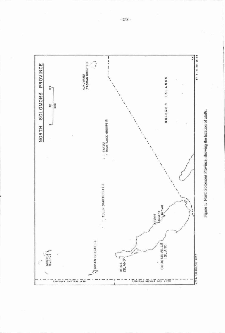
-248 -
dgd!
oEts
-ga,€GO
'oEoa,oG!
6k
eoE6ov,Etoz.:0)aqo
l&
tto-
:
-0-ooo
trlJclJz.r1=|n(9foo
:ltffr^ouJ oilvllur t:lfa ' ltLlr'ouJ trltllla rtlr l'iv:|
ozJo
!:f,ct
ELoGctv(,o:J?ir
*eF=
IFdlElrlFc()z,=JtF
t -" -'
tocl(t4-=<=-*?i=
IzdtI=2lr,urE(,
a:I
trJoz.;oEo-
qnzo=oJov,
-FEoz.
'.'<oEE.6gz9
c'
'F
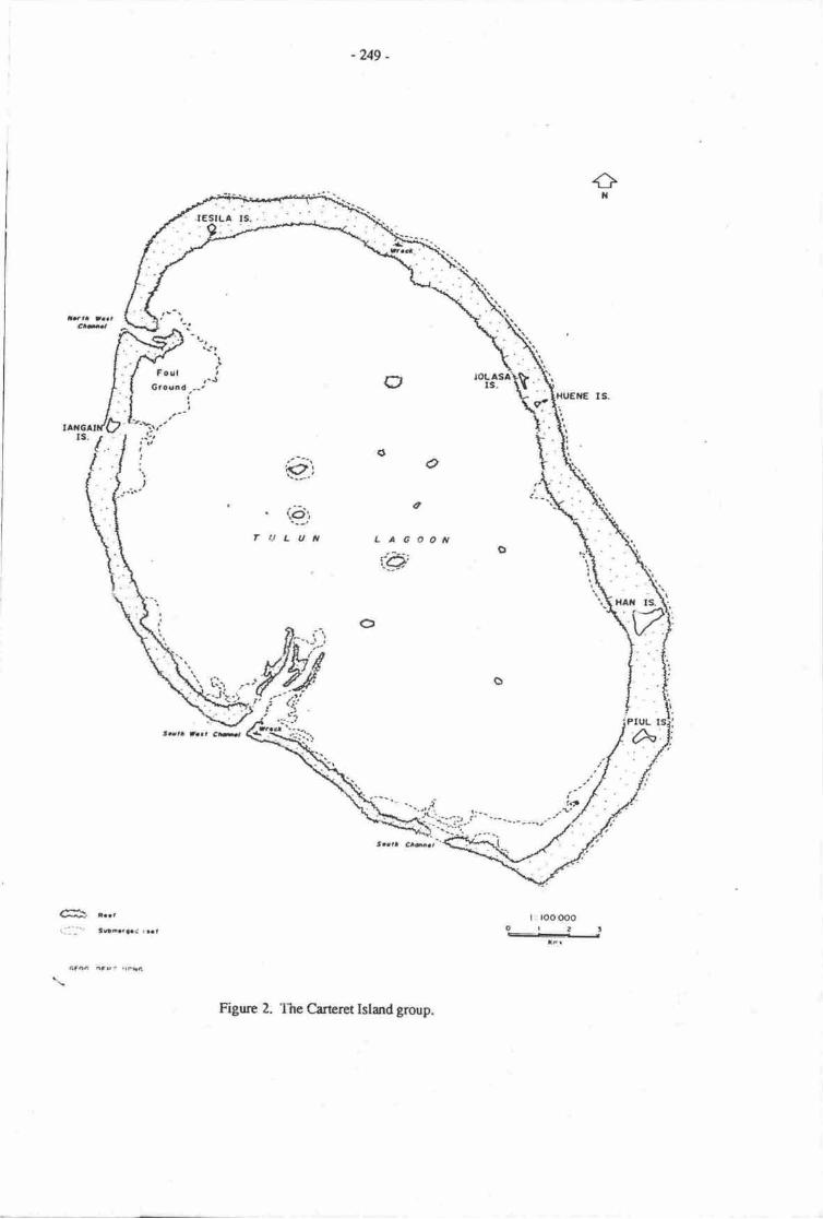
-u9.
+t{
lqaa J..r.6tm,
F.0lGtoarard a
!-,
Ial,
r'.1a
a
(t o
a
oorlLAG
t'a'
o
6t r.rr!:: _-:- t a...f,aad rst
6f,tF nFot rtFi{l
€iQiLUt
. r \rt.adr) J.J,. *t
totl th.,
Figmc 2. The Cireretleidgrolpi
-zfi -
The outer islands of North Solomons province
The Crteret Islands are part of the Islands Ceruus Division of f,uka Disuict in the NorthSolomons hovince of Pryua New Guinea (Fig,re 1). This Cens,rs Divisior includes, to the east of Bukalsland' the outlying T{TT urd Mortlock grcups, with the Crterea to rhe nonr\east, Nuguria or Feadislands to tfie north, and Niss vr and Malum islands to the nathwest- The total land mea of these islandsis about 49 km2 with a resident poprlaticr density of about 100 penonVkm2 (this compares with l l/km2for Nordr Solom:ns hovfurcc as a whole). In 1980 dre resicent population of rhe Outeilslands was 4,gg?citi:ens, 2Al2 mabs md L475 females Oiational Statistical Offfu, 1982a.:2). Many adurts, especiallymales, have left 0re islands to wort in othr parts of the North solomons hovince or elsewhere in papuaNew Cuinea- In 1980 about 35.6% of rll adult males were absent and more than half (53.a%) of thercsident populaticr was under l8 yean of age (National Statistical Office l982b:13).
The islurds are all a considerable disunce (100 to 5m km) away from rhe mainland ofBougainville and aidpoa, community schmls and ports of call are sparsely scattered throughout theisland groups. Economically these atolls are less ceveloped with very scant rcsources and no steady cashincone as sales of copr4 shells, beche{e-mer and o*reirrsh products depend on regulr sea Eanspon toKieta on Bongainville Isl:nd- While improvements in communication have occurred in recent years, withths instelldien of radio links and nnr:thly visits to each islar.d by the vessel Atolls Enterprise they haveremained as isotated Polynesian and Melanesien outlien far off in the ocean.
Their small population and lrck of eco.onic potential has nreant that many of the remorer islandswerc rarely visited by government administratrs exoept when attention was drawn 0o ihem by repcts 6fsevsne food shortages; destruction causod by slorms, epidemics (whmping cough, influenza or nreasles);or plagux of rats and other pe,sts which often followeda ship's visit
The islands were :riefly under German Administration prior to World War I and later cane underAustralian Tru:tesnip
-ultil rhis was internrprcd by ttre occupation of sornc of the major islards hy the
Japanese during Wrrld War 2.
Following World war 2 when the Australian Administratron re-esteblished patrols in the late1940s, sonc :nthusiastic patrol offrcers wene struck by the happy and tranquil existence apparentiyen;cyod in many of the arotls. ottrers noted tlie growing prolems oiiand shonaic and poprlation growthand th€ possibility of reseulenrnt !o ease population pEss'Jres bcgan o ue scriurity considered.However, as one patrol offic€r rcported (Scbir€, 2nd June 1960) the Mortlock islanders were firr,rlyoppced to any move to mother area and this vicw rvas also expressed by other island leaders who feareda loss of cultural identity arrd drat they would be swaliowed up an the mainland. .{t ihe sane tine theidea remained thu one day, in the disant future this might have to be considered.
The Carteret Islandcrs were the mc sriking excepticr b this general rcjection of adminisuationsprnsored proposds ior relocation. By the laa 1960s they were reponea o h,avl a unanimous desire fo.resettlement as 'heavy seas have devastatcd garden land and tre* o an obvious shoitage of fmdcrops'(Letter from KJ. Hanrahan Assisarrt Disrict Cornrnissioner to the District Commissioner atSohano, Buka Island an I lth Januarv 1968).
@[giqr. social sructure climate
The Cancra Islands (also known as the Kilinailau r Tulun Islands) ue laated aproximuely I iSkms northeast of Buka Island in thc Nath Srilonnns Plovine. They consisr of a gro1rp of six smallislrnds formed hom a rrised coral reef which cncirchs an oval shapcd lagmn 20k; lmg and 15 krnwidc (Figurcs 2 ed 3). Five of rhcsc islands se inhabited (Han, Piui tangain" Iolassa and iesila) with atotrl land mass of lcss than 200 acres (E0 he), only 55% of which is suitrble for agricultural r tnec cropprodrction (Figurc 3)' The 1982 Nationd Fopulation Census recadcd a rcsident population of 672 out ofa tael pqulrtiqr of 1,05t.
- 25r
Many of the 376 absentees (36% of the total population) are adult males wmking on BougainvilleIsland or in other parts of Papua New Guinea. Therc is little employment as such on the islands andresidents rely heavily on remittances from worting relatives to supplement their neagre cash incomes.They also rely on the monthly visits of the AtoJts Enterprisc crtrying gmds o *to.k th" island radestores' Durir.g December and January therc is an influx ol'returning reria"ns bringing large quantities offood and ot-her items to sharc with their families back at honc.
Lying close c the Equator with temperabrcs generally around 30.-35.C the main climaticvariatiqrs relate to the northwest uade winds which prevail between November and April and it is duringthis period that storms 'ard rccompany-ing heavy rainfau are likely ro occur. This addsio the problems ofregular marketing of sea or agricultural produce as welt as iegular visic to the islard by health,comrnerce or other governnrcnt extension officers.
Histmical background
One of the earliest rccorded descriptions of this group of atolls was in 176? when Captain philipCarteret recrded having sighted a group of nine islands and having observed sonc of lhe nren from theislands who cane near to his ship in one of dreir boats. tn Carterct'i Voyage Round the world Iz6-Iz69(edited by Helen wallis, 1965: 17 /-178), a fmtnote refen to the inhabitan6 as 'descendants of refugeeswho fled many years ago from Buka'. A surrcy cf the islanrts carried out in 1964 by government officers@edmond et al.,1965:r-2) incruded the following history of the group.
The Carteret Islands, also known as ttre Kitnailau group, consisr of six islands of which five areinhabited. They are located approximately I l0 km (70 miles) northeast of Buka Island at a latitude of 4.45'S and longiurde 155'2OE.
The islands are rcurally an atoll group, being t-orrrred from a raiserialmost in a circle with a diameter of 20 km (rwelvJmiles). They are lowduring the northwest season sections are llooded by ireavy seas.
The islands are populated by descendanis of invaden from Buka Island (mainly from the Hanahanarca' northeastem sector_of Bu.ka), arrd the spoken language Halia is the same ,r tt.t spokan by theIlanahan people. The physical smruIE, colour of skin, habie and custons of the Carteiets pcrple isclosely akin to rhat of the Buka people.
I-egend has it that long befare the advent of ttre European, the islands were inhabited by peopte ofPolynesian stock. The Buka people knowing that rhe islands exis=d, conducted three invasions cf thernThe fint' two wene repulse4 but the ririr4 ma& by overwhelming numben, was successful. Theindigenous men wele slaughtered and thek wornen taten by thc conquerms who qhen proceeded to sertleon the islands. The ord radrtions of the Carteret Islanders arc that in fre past the people who lived ontheir islands were Polynesians like the Mortlor:k ani Tasman Islanden, and that the invasions refened toabove rxcurred t|re t^, forr hundred yean a8o. Trade and other inrerchanges betrreen the Caterets andBr:ka hav€ continued sirre that tinp an4 although the Crteret version of uana is slightly differelt, thelc;al language pre-school m the cartsets us€s Halia language Erhing materials.
-- Careret society is a marilineal clan based systern, with two distinct matriclans and a number ofF".gu Sroupings within rhese. Memuen of a clan conrc togeth€r to pr€parc for larger marriage orfuneral cerenronies 6u1 deilv hsks ard rctivities are rnainly canieo oui on a family/h-ousehold basis.Traditiond lineage leaden were appointed as village officials by the Australien Administration as theywere influentid ad respect€d men, who were oftcn skitted fisherrnen and cana builden.
The 1li'64 survey repon described thc traditional tlge of housing as being built directly on the sarrdwih an arch combinlng roof urd wcls of sago palm haves. This prrctice hasconrinued although thosewih readier aocess to cash have imported timber to build raiscd houses. wood has always been in shonsupply and much use is made of drifnvoo4 material frrom wrecled ships m other debriq washed up on thereef.
coral reef and are anangedlying with swamp areas and
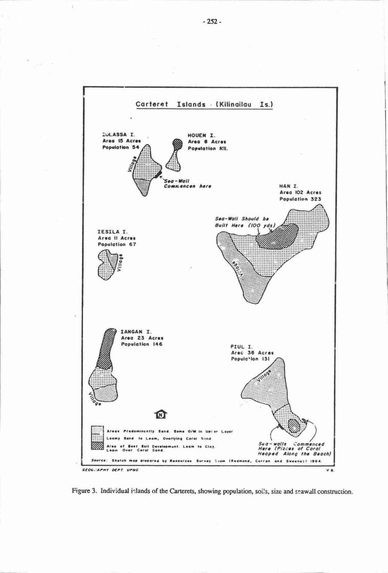
-252-
Corlcret Islonds ( Kilinoitou Is.)
:uLASSl f.Arao 15 Acror
lrouEfl I.Arlc t AcrerPotrlollon Nll.Poprlotbn 3{
S.a-VatlCoaearcaa ,rara HAil T.
Arco lO2 AcrrrPopulotlon 12S
IESTLA T.Arro ll lcnrPopulcllon 6?,4t
€i:li$Ni3:::::::t >
IAX6AiI I.Areo 2J AcrcrPopslatlon l{6 PIUL I.
Arrc 3E AcrerPopslo.loa l5l
ltaa. traa9rlie.tlt t.ia. t.-. O/I In Utf.r L!t.rLao.t lana la Loo.. Or.rltlil Carat S.na
ar.a at laal t.ll O.ralct-.nt, Lcli to Clot,Laa. atvar Cc.rl S.ia.
S.o - aolt, CommoncodHoro (Pico'or of CorolH.op.d AlonC lh. Soochl
Cs.roi aall Sraanatt ttaa.ttoaca.' llatgi -a) )aaeaaaa !t eaaactca. tcrvat l.oi llaaocna.
S.o-Uoll Sho.tld boEallt Horo (lOQ yd-s)
cEoa,laPxt oEPf. uFtc
Figure 3. Individual irlands of the Cartercts, showing population, soils, size and seawall construction.
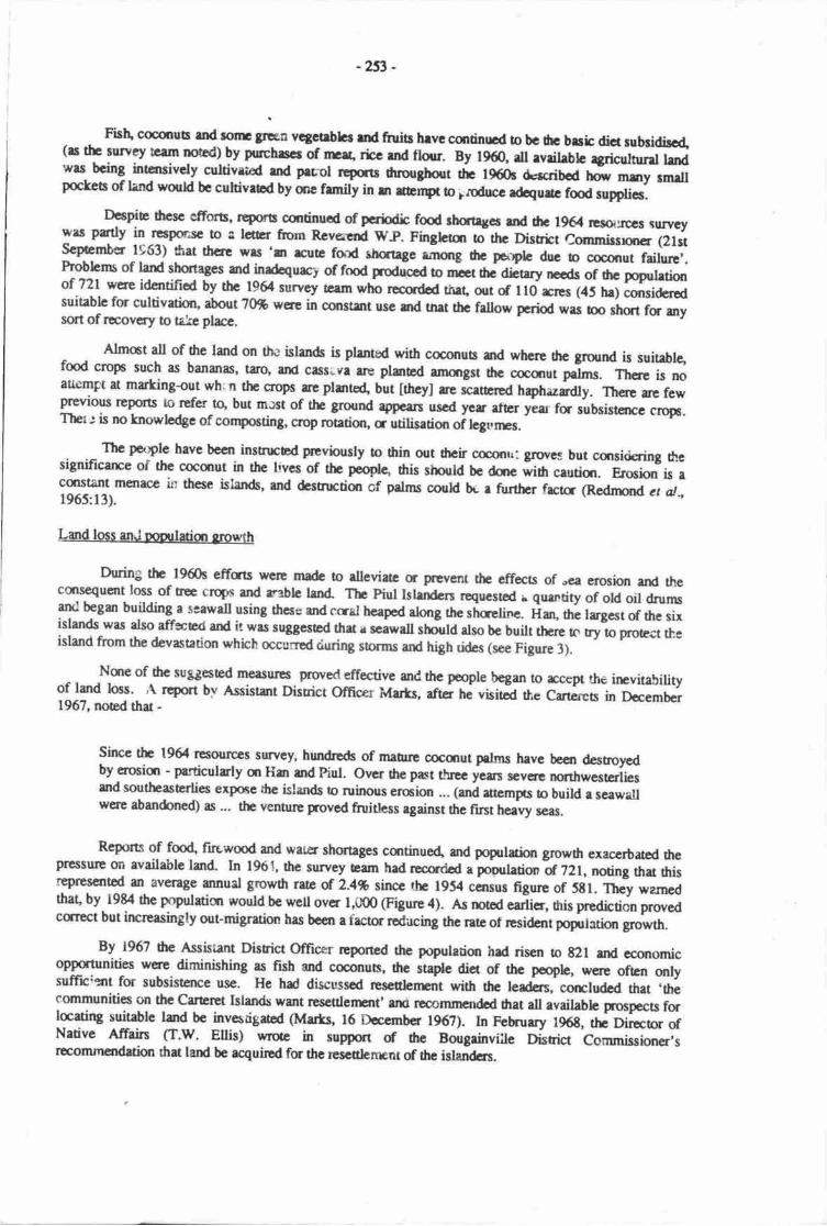
-253 -
Fislu cocqruts TLT* g;n vcgct$lq md fruit hrvc cmrinuod o bc drc brcic dict rubddilo4(rs tlr survey rGrnr no*d) by purchrscc of meg ric€ md flour. By 1960, dl rdfrUfc r3ricultml Imdwrs- bcing intensivcly-cultivrrod rnd pcnl 5lgry dnorryhorrt fu 1960! drscribcd ldw mly rn,.ttpoc'tes of land wouH bc cultiveod by anc fmrily in rn rrcnpt to ircducc rdaque fmd supplies.
Despie ficsc etrorb' rcporls cqrtinucd of pcrixlic food shctrgcs ltd drc 196rl r3g:rp3.c surycywes putly in rcspmsc b a lc@r ftom Rcvcrcnd WP. Finglaan tothc Disrict Conrmissrqrcr (2lstscpiemb€r 1963) &at tlrae was 'm truE food rhcage .i*g thc panplc drc b c(rcqrut failu*,.Problcms of land slrortagesand in{cqucr* of fmd Fd"e"d o oiatc aicury neods of hc popgletimof 721 were idcntified b| ttrc 1964 survey team who racordod rhar, olt of ll0 rrcs (4s 11g) cqrsidcrodsuiiablc fm cultivatirxl about ?Ofr werc in consrant usc srd tnat thc frllow ecdod wrs oo;'t*, fm urysort of rccovery o ta.kc place.
Almct all of thc lmd on thr ishn& is plentod with cocsrus md whcre tlrc ground is suitablgfood crops such as bananas, taro, urd cass;.vr rrc plmted afixrrgst thc caanut p"Lr. Therc is noaudmFt at mfrking{ut wh: n thc crops re plzrtd but lthcy] rre rceetea haphazrdly. Thsc ue fewprevions r@orts o rpfer to, but mxt of the groud .pe"rt- used yer fier year fa subsistcrrce cropc.Ther: is no knowbdge of conposting, crop roation, cutitis"ti* oir"gurro.
Thc pa:ple havc bccn inshrcEd ptvinusly to fiin out dreir ccon\: grwcs but ccrsidring thesignificarce of the cocqrut in thc livcs of ttr poofle, dris should bc dme wih ceutiqr. Ercsi<ln is acqrstant mcnace in th€se islands, and &struction of prlms couH br r furthcr frctc (Rednrord cr cl.,1965:13).
@During the 1960s effcts were madc o rlleviatc tr prcvcnt the effects of ,ca eroEion anl thecqrsequent loss of tr€e croFs and rable hnd- Tbc Piul Islelrdcn roqucsted r qurntity of old oil dnrms
19 b"g- building a soawall using thcse and ccal hcsped along rhc straetirrc. lian, urc largest of the sixislands was also affeced and it was suggcsed thar r scawell rtdtu also bc built there to t yio p-e.t tt ,island from the devastation whhh mcurred &xring storms and hrgh drtes (see Figure 3).
Nqre of thc suggesed me.sul€s nrov{gflect19 urd thc poople began o rccep rhe irrvitabilityq lgtd mt. ,\ rlpdt bv Assistrnt Disrict officer Msts, .ftet d visitcd the crrcres in December1967, noed rhat -
Sircc thc 1964 resourccs survey, hundreds of manue cocdrut prlms have been destnoy€dby croeicr - perticulrly qt Han md Piul. orrcr thc past rlnoc ycar scvcr€ nsttrwcsterliesutd southeaserlies expore thc islands o ruinous ercion ... (ari.trcmpts b build e seawattwerc abandoned) as ... the ventur€ provcd fruitless rgainst thc fint nce*vy seas.
Reports of fm4 firewood and water slratages csrtinue4 ard poprlatfon grow6t execerbatcd thePfessur€ on available land- In 1961, the survey eam had rccord.d a poprlation k 72t, noting rhat 61is
ieprescntod an average srnual fowdr rrte of 2.4% since tb 1954 ocnsus figure of 5tl. They warncdthat' by l9&4 tlre pcrpulatiur would be well over l,(D0 @igure 4). es notod earlicr, his prediction provedcqrect but ircreasingly ont-migruion has bceo a facts rcdu,cing the ret! of residcnt populrtion growth.
By 1967 dre Assistant Disuict offrcer rcportcd the pqulatiur hrd risen to t2l and economicoppcnmities n'cre diminishing as fish ard coconub, Urc itaptc dia of thc popb, wcre often orlysuffic:zrt for subsistence usc. Hc hd discusscd res€tbnEnt with fte leadcrs,- colrcludcd that .thecsnmunitics on thc CarEr€t Islands want rcseqlenstt' lm roconrmcndod trat all aveilablc pnospects fataating suitablc lsd bc invesrigatcd (M8rl6, 16 Doccmbcr 1962). In Februrry 196t, rhe Dircctor ofNative Atr8irs Cr.w. Eltis) nrrotc in support d tre Bougrinviile District Commissioner'srromrncndation fiat land bc acquired fc the resctdenpnt of drc ielandcrs.
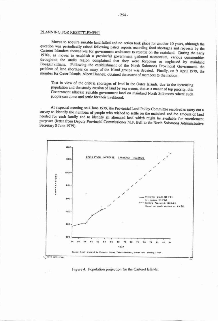
PLANNING FOR RESETTTEMENT
Moves to rcquire suiable land failed and no action took pL"" fo, another l0 yean, although thequestion was periodically raised fouowirg patrrol-repas tooruing fmd shortago -6 ruqoo,, by theCarteret Island€rs thernselves ror governnrcnt assistance o t"."uti on the maintana. During the early1970s, as moves to establish a provinc;al governrnent gathered momenturn, varbus oommunitiesthroughout the aolls region complained tnat _Srev *Jr" forgoaer, or negtoced by mainlardBougainvillians. Following the establishrnent of the North Soilornons provincial Govemncnt, fteprobl.em
-of.land shortages on runy of the island groups was debatod- Finally, on 9 April 1979, thernember for Outcr Islands, Albert Hanneo, obtained fte assent of members to the nntion -
That in view of- tre critical shortages of lznd in the outer Islands, due 19 the i+creasingpopulation and the steady erosion of land by sea wate,rs, ftat as a matrer ortp pti.ity, oi,Governnsrt alocaE suitable goverilrElt land on mainland North Solonpns wheze suchprople can conre and settle for their livelihmd-
At a special rrceting on 4 June 1979, 0re Provincial l-arxl Policy C-ommicee resolvcd b carry our asurv€y to identify the numbers of people who wished to settle on ttre mainland and tte rmountot lardneedd for each family and o idcntiry all alienated land which rurrr u" "r"il.ur"'#L*r*,-,purpoBes (leter frrom Deputy hovfurcial Commissioner lI.F. Belt to the Nortr Solomorn A&ninisrativeSecrearyEJune 1979).
-2v -
FOPi.iLTT|oI IiICREASE. CANTERET ISLATOS
-
zoEbli!. !,at. ltlta-aa.(n. rsm.2-a rf,l
--- CgrL fcr. t-t tDCa-aa.
lL..a o rfrtt wr.rr at I a t6l
. !o rr le !z t{ a3 Sa ro tt ta tlYf,A'
Sscr: G'Sr t.F..a l, i.s.c. twr.' t.ci (R.add . Ce- a.{
Figure 4. Population pmjection for dre Carteret lslands.
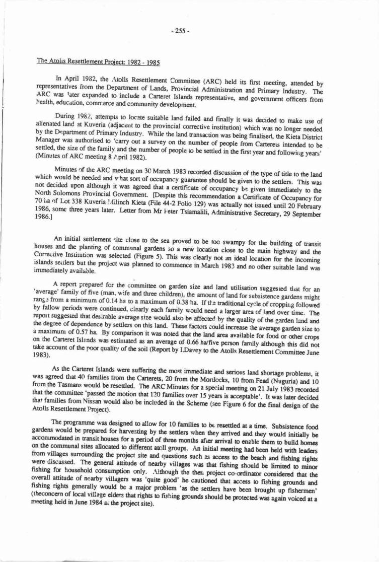
-255 -
Lt April 1982, the ,\tolls Rcse[tem€nt comminee (ARc) held ia fint nrceting, attend€d byrepresentatives from the Deparurrcnt of Lands, hovincial naminisration and primary Industry. The1R9. *ry tater erpanded o includc a care-ret klands represcntativg and governrEnt officers froml'ealth, education, conmerce and community &velopment-
During 1982, attempts o locate suitable land failcd md finally it was decidcd o make use ofalienated land at Kuveria (adjrcurt o the provincial conective institution) which was no lo,ngcr ncd€dby the Deparrnent of himry Indusry. q/t,iL th" land transrtion was being finaliser! tre Kieta DistrictManager was authorised b 'carry out a suwey_on the number of peqle fr,sn cartcrers intended to bcseale4 the size of the family and ttrc number of people o te setttei in the fint year and followirig yers,(Minutes of ARC meeting g tril l9t2).
Minutes of the ARC meeting on 3c March l9t3 reorded discusshr of rhe t)"e of tith o thc lurdwhich would be needod ard v'hat sort of oacupary gutranEc shodd bc givan o thc seulen. This wasnot decided upon although it was agresd ttra e. ccniticatc of occupmcy b? givcn immediatcly o fieNorth solonpns hovirrcial Governmenr [Despia this recommcndatiqr-e c*frcetc or occop-cy ro,70 ha of Iot 338 Kuveria Lfilirrb Kiea (File ll-z rono r29l was roally not issued until 20 Februry
l3|lrt"* threc vers latEr. r-6rtr from Mr leter Tsiamaliil Adnrinisrati"c socrerary, ig sep6mb€r
An initid seulerrrnt ciE cl6e b the sca p,roved to b€ bo swanryy fm the building of r4sithouses ard the planting of communal gardans so a rrw lauian cloac b *F rnain highway md thecorrccdve Institution was sclectod (Figure 5). This wrs clcarly noi an i&el bceofl rd o" incomingislands seitlen but the roj€ct was plannea !o coriln€nce in March l9E3 md no otlrcr suirable Imd wasimnrcdiately available.
A report prepaed for thc comminee on gandcn size and lm<l utilisrtion suggesrcd dral for an'average' fanily of five (man, wife ad ftrE childrenl, the arnount of lard for subsistcnce gardens mightrm8:fuomeminimumof0.14ha tormaximumof 0.3the. If tl=rrrditifirlcyehof croppirrgfollowedby fallow pcrkds were lntinuc4 clearly cach family *'oura ncou e lcger area of lard wer tinr. Thcreport suSSetted thrt desilble avertge sizc wouldabb be affcud bi ttr" quality of trre g;en land andthe degree of dependence by sculers on this lmd" Ttrac facton ccrri itrcressc ,t;;;;"*n size !oa maximum of 0'57 ha- By compaison it was notcd dru thc lrnd arcs evaikblc for foi i ctcn.rop,m tlrc cartcret tslaads was estinrated rs rn lvcrtge of 0.66 hcfivc pcrsdl frmily rlfrcugh tlris did nottake^rccount of thc Fstr quality of thc soil Gcpat uy l.Davey o rhe iolls Rcsculen-nt c-ommiue Jurrc19E3).
As the carerd l|nat were sufiering the nnct imnrediatc rnd scriorrs land shortage problcrns, itwas agred that 40 famitics horn thc cmcrc6, 20 from rhc Morrlocrs, l0 from F"d G.ilg"rir) dd l0ftom the Tasmms world bc rcscalod- Thc ARc MinuEs i;;;;il nreting m 2l July l9t3 rcantcd9* tr commiuc 'passcd th motion firt 120 families ovcr it;;is rccprrbh,. It was ld.r dccidedthat familics from Nissan wouH also bc irrcludcd in tlt schenr"tsce rigure b for drc nnJ Lio, of theAtolls Res€ttbrtnt prrolect).
The programnrc wrs dcsigncd o rllow fs l0 femilia o be rcsctdcd rt e drrc. subsisEncc f6dgandcns wqrld bc Prcryryd fc havesting by thc scttlcn *h- dr.t;nir"d md rh€y wqrld initielly bcrccomrDdttGd in trattsithouscs for r pcriod of tluoc rurths rfrcr rrivel o cnrblc hcm b build l,.r.on the communal sitcs dlanod o difrcrent rbu group6. Anlntdd--;cdrE hrd b€t rEtd wirh hdcrsftom villagcs surrounding ilre projrxr sitc md quoscqu ruch rs rccsE b dF bcrch rtd firhhg riglu:T diT*$ The genenl rttitu& of nczby villagcs ws nJ fittt"t rhxld bc limibd b min''fishing fa hqrschold consumprian anly. .uti*grr d" t!t* p*i*, cosdinrtr cmridcrod hrt thcovcrall rniur& of rcarty villegcrs wt 'guie god' hc c.uti
"roi thet rcccss o ftshing grurnds d
Tlting righs generatly wurld be r rnai<r problcm 'rs thc sctthrs have becn ut*O-'"in rr-r,o,r,(thcmccrn of locd villagc el&rs thrt riths -"
n*nnu gro,n dr ri;ld bc trdcc6d w6 rgain voied u rrn€cdr€ held h Junc t9E4 er rtrc prolrt slel.
-256 -
to0
tlh
-oilLJA F., oLJD
I€IoEo
ao
t OFF HIfl{
ri'tt;te€r*ig;
€j*(l
T
|iEa,G()u,EtEctiJe,a&.a
It,toAGI
EEclux(r,vit)EooIL
F;r
c.!ocE'=yooil-l14 l-l uU II(H
e0oioI

-?s7 -
On l0 Novernber 1983, e $/hite Paper o'arlining the golicy of the North Solomqrs hovincialGovemnrnt on the resettlenrnt of aolls peoples on rhe-rnainland was endorsed- A pojecr coordinatorwas rypointed an4 desplte administrative, budgetary and general managerrcnt problems, the projectgraduatly took shape. Frcilities and initial infrastructure were desigrcd- and implemented under rhesupervisian of the project rlmrdinator and the A.RC. These included roads, communal fmd gardens, maid post and residence, ard lO transit houses. A community cenEe, wells antl a communal water supplywere planned for the next phase of the projecl.
Arrangenrcns were made for schml age children to atr€nd ihe Catholic Missic.n schor,l at Manetai.An aid post orb€riy was rypointed and it uras agreed that the aid post would also be available for use by,laal villagers.
visits by the Kieta Distrbt Manager o the outrr Istands pr,rvided more detailed information as tothe willingness of nqr-Cartset tslands to rcseule. Ra,ent storms and incrcasing land erosion cnd fmds':ortages hal influenced Cartcret families to mrke rtre decision to move but others found the idea off,ermarient relocation impossible to aocept. Concern was exFressed by Mortlock and Tasrran Islandersover the absence of fishing righa and over pmsible problems of security if they resetrled at Kuvcria.They finally decidod thu they wanted to rctain the right o participate but not at this srage.
At dte ARC rrrceting held on Z August 1983, it wa; agreed that Nissan Islanders, especially fromthe Tanaheran area' would also be included in the schenp. ns A. problems experianced Uf*e Cartereawere the most pressing it was decided that the initial group would consist of l0 Catt-et families.
Discussions as to tlrc assisl.arre to be g;ven by various govefirment exte,nsisr services took placear*l it was noted that healtlt, education, pnmary industry, corrunerce and community development woullall be involve4 particulaliy after the initial settling in period.
The realitv of resettle.nent
In August 1984, the fint group of settlers from the Carteret lslands arrived at the AtousResettlement Schenp- The departt'-e of these funilies from their honp islands and their arrival andwelcorne by officials and laal villagers at Kuveria was a significant event both for the atolls peoples, andfor 'hose rcsponsible fs the plannurg and impienrentation oi *r ptolect.
It had been recognised by memben of the ARC and orhers involved in the poject that the senlersmight experience some cultural dislocation, especially those who had left their istand homes for the frsrtime. However, the full extent of tl.e impact on individuats and families of this rslocarion to a cornpletelynew environment wils not anticipated-
The families, and par-ticularly those rnembers errgaged in clearing and establishing fmd gardensard in building houses, had ro become used !o many new food crops, ne* buitding materijs and differenttechniques. Upon anival the farnilies had ro :rJcustom thcmselves to living *nd", an iron roof, out ofsight of &e sea and surrounded by unfamiliar and rather frightening thick bush. The presence of theCorrcctive Institrrtion added to tre desire lo keep close together and inlreased dependence on the projectceordinator and relatives for advice and gurdancc.
Children had to walt 6 km to sctmol and this was a great ciistance for those who had had noopportunity to welk any distance on tleir small aolls. Road raffic hazards, for those who had noer:perience of mads or vehiculr traffic; fear of snakes for those who had no experience of v;alking snpaths through thicl' bush; and ttre experience of being surrounded by tall trees, all required individual mrlcommunity adjustnrcnr
In many ways' Carteret wornen ha,l the most d;fficult adjustment to make. Atthough thein is amarilineal sociery, men make all the public docisions and are m(re likely to speat ai any publicneetings. Muty women, particularly older wonren and those who have not been awayhom the islands,don'Jt speak either Tat Pisin or Engiish and scr were less able o fully understana *re decisions being madeon behalf of the family by the male heads of household.
-258-
INOUSTRIAL
Soorco: Sorvat bt Londa Dapo?fmanl Aroro, X. S. P. Aprll 1906.
Figure 6. L^mds @artnrcnt plan of the resatlenpnt schenre area
T$
O 2() .rO
l|al raa
IIlrr1:lrtltlrIIIIIIIIII
g,
Y
(,
J
E,
-
c R T R E s
. l"o'"'*l'j'?''ffi"*o1
EECRTATIONAL%t
ComErunity Holl L)COUHERCIAL
INOUSTRIAL 6 Lobourcrrs RtrldoncrXltch.n "oililn.. l,
"iit*,o toif.r I HOUStno
E
c,
--
-259 -
Thc probhms of adapting to a n€w envfuoilrEnt for which mct memben of the family had littleor no prcparation lrEtrt drat the tinptable f6ri fuiHing a new Crteret Village, establishing fmd gardensard rnving from thc ransit houses had b b€ considerably extended- Many wonrn sat for long periodsof tirne thinking about their island honrs. on Sundays drly would often risk the 20 minute watk throughEifying all res urd bush o rerch the seashore ard ga"e ior houn out !o sea lowards rhe atols.
The setthrs furnd the dia of sweet pourto and dre unavailability of coconuts and fish anotherdifficult adjustntnt but they were pleased with rhe ease wirh which fmd could be g.;;. o6er familyrnembers old ne trat the rnain reason they tud been determined o take this opporirnity 1o rcsettle wastheir concern fc their children ard grandchildren. Most of the settlers adapted tr-.*"liy quickly to tlrmany unfamilir and challcnging tasks which they faccd in this n"* en"ironment ura onri one funilyrcturned honrc at ilrat tinn.
In Augrrst 1985, when a group of five third-year agriculture snrdens carried out a study of foodgarden end th€ social impact of resettlement, the settlers t rA uo" living in their new village for severalnronths' Flcwers and fruit rees obained from nearby villages had been planted berween tlie houses andthroughout the area. Extensive food gardens had be€n ptantq,l; gardens which provided not only for ninehouseholds t'ut also enablod qumtities of vegetables o u" seni uact to the cartera Islands at regularintervals on the Arclls Enterprise. The scttlers had chosen three representatives to work with the co-ordinator and other exension officers in the gerrral rnanagement and rurther aevelopnnnt of the schemeand a number of saial arrC managemanr problems had been discussed and resolved.
During the field survey' information was gatherecl from community rnembers, government andnon-government officials and other intormants. Crops grown in fmd garderu and arounJ the village sitewere recorded and the fm<l grdens were mapped. Discussisrs with heads of households and theirfamilies helped nremirss of the team to undersand the frcors which influenced the decisiorr to leave theCaneret Islands l's Kuveria' the challenges which faced the senlers during their Frnt yeer at the schenp,and their hopes of fuuue socrai and economic benefis for their children and grandchilrlren.
The description of the Aolls Resettlenrcnt Schenre which follows is exracted from the teamreport (Kutmg et al.,1987).
(T. Kutang, J. Selwyn, A. Siau, E. Tade srd M. Wairiu)
Thc Ablls Resettlenpnt Scherr is locatcd 30 km from Arawa, along tlre Kiea-Buka Highwaye{irc€ot io the Kuveria Cancctive Instiotion.
t rndfams. climate and veoaetion
The rcsettlenrnt sclrcmc is located on a relict alluvial plain of volcanic origin, with a steepgradicnt and up b I km wi&. Relief is gencrally low, up o l0 m locally. the plain is generally welldraine4 with minor slvampy areas, and is backod by hills rising n 40 rn This rei falls within rhe largerSiwai land sysEm of elongated plateaus with incised parallel "itrn (Scct ct at.,1967:2g).
Th€ erud rainfall u Kuveria ranges f^om 2,500 to 3,000 mrn the wet months being May o!p@T!" while the dry nurtls are frrom Novembcr to March. The amual relative humidity rangm from7o to t0%- Thc marimum Erpcrilure range is between 7l' and34t, while the mrnimum is uetwee,r zl.ud U'C, rnrually (McAlpturc, lffit :62-7O1.
Tbc native vegcatirxr qr the siE wrs ull foresr since reinfall never falls below 130 mm eachnvndl fte fcest is not subjecEd to wtH sress and ha attafured climax commonly dominaed by viletd Ponutia trDcs wifi tall grasscs (Suchanon robwttutrigrowing alcng he river banks.
Sripc chbrocis in meize plzrs and chlororic spot on pesnus wcre oboerved in sonp gardens,lu88csutB bw potassium and/c rnagnesium t"ru_lr. Sempres of gaden soils have been tested by tlreFresh Fmds Soction of the Division of Primary Indrsry ha tWo* givcn to tre Atolls ResetttensntCommiuce (Niemis. l9t5).
-2fr -
Thc land is suitablc fr rll clqs as thc scuhn ae the first b clear drc ptimary fue;t an4 unlikeo6cr asby lm4 it hr rrct bocn sevcrely distrH by humm activity. trauch of the land next 0o thcscdcrrslt has becn cqrvcrcd ino caos md cocqrut plantetirns. Howev€r, thc Provirrial Governmentvints lhc scnlqs to grow food crops mly rnd rrct cesh crcps as it is poposed $at fi€ settlers will growcesh cropr on anoth€r sitc of 1,000 ha laatod et Mabiri.
Many of he crqs grown are urber crops, with bsran4 sugar carc and sonrc rnaize. Initiat gardenprcpraikm involves slash and burn npthods dftouglL where weds have invadcd p'rcviously cleared lardburning is rrrely practbed pria lo plmting. The seulen do not practice muhhing a conpmting and itwas obscrved hat the sarr pbce of land is uscd again aftcr hancsting of ttrc prcvious food aop. '.hisprrctice reflccs the settler's gadening prrctices qr their home islands.
Nitloger\ phocphorus" calciun, mmgarcsc and magnesiu.n levels are sufficient to supptrtfavourable plant yields but soil tests by the Analytical Service of Bougainville Cryper l-trl. indicated alur potassium availability in the soil. This is a publem as this type of sandy loam soil requires an N/Kratio of Oiz to liz for adoquae swe€t potalo yield- Cassava requires a similar N/K ratio to produce a highnumbcr of well fcrrEd 0rben. The potassiunr cohEnt is mo&rate b good for the growth of bananas.Othcr nutriens are sufficient but their availability vsries from field to frcld (sce also the 'second Reporton Soils' to thc Ablls Reseclensrt Usnmidoe by A. Nianis, Frcsh Fmds Offrcer, Divisiolr of Primarylndustry,7 May l9B5).
Cottsidering dl these factcs, mulching ard composting should be practicod and the burning ofgnss€s md ryplicuion of ashcs should bc encouraged. This would help to maintain the soil structuewhila reducing brhing of nutriants; retard weed growth and conserve water and moisture, by reducingfree drainage of water. Seagrass or sea weed are rich in potassium and could be applied as well, althoughthe rcsuls shonld be nroniored carefully as there may then bc a pn$lem with hrgh sodium (Na) levels.
If Ore above agriculural prrctices arc not canied txrt, the use of crop rotation and fallow syslemsshould bc emphasised as urber cropr rerrove large quantities of nutrieats from the soil. If the p^esantsy"tem of cultivation used by the sertlers is not nrodified the result will be a rapid decline in the nurientcql'€nt of tLe soil. The intensive land utilisatirrn which will be requirvl as the numben of settlersirrcrease should also be talen ino rccount
Physical,;uting and infras.tructqg
Ten ransit houses have been provided to house newly arrived s€ttl€rs while their own houses arebeing construced. These houses are of modern materials with iron rmfing, prefabricaed walls andtimber flocs. Erch house has a separac bush materid kiehen and waer unks beside dre yansit housescollect rainwater which the CarErct settlen and newly arriv.d Nissan families depcnd on for drinkingand cooking food- Six oilea have also been built at the brck of rhe transit area. An aid posr errdirccomrndarion fa the aid post orderly and his family is provideJ, a community cenre has just beencompleted and' a well has recently boen dug. Nine houses, made of timber and local materials have beenbuilt as the fint stage of the new Carteret 'village' (Figure 5).
Prior to the anival of Jre fint group of setders an area of ground near the transit houses rvascleared and food gardens werc prepared fa usc by the settlen during the hnt few monrhs.
A lateral road has been constructed from the Buka highway through the Schenre, past the transithouses to the Crt€ret village. Other roads provide rcc€ss to the aid post and the uderly's house; thecomrnunity c€ntre; the garden areas; the site for the Nissan Island settlenrnt; the boundry of the KuveriaCorrective Institutiqr, and the river. At the mo:rent thene is no road linking tre settlenrent to the beachwhich is about nrenty minutes wdk along a trrck through forest and othet vegetaticr.
The neaest community schml is at Maneai" 6 km away and rade sttres are tocated in nearby
'lages, almg dre highway, and at the Corrective Institutiqr.
Although fie original estimae was that the settler €amilies would have dr average family size of:e childrcn, the average number of chil&en per family is much higher, being clcer o six. In adrtitiortsettlen follow thc normal Melanesian custom of rccomnodating other relatives so the average

-26r -
household size is nrore than nine nrembers. M&ied sons and daughten and their children, also live withsome of the semler families. As the numbers of school-age children increase there will be a need oprovidc a community school at 0re scheme, prticularly if the planned 120 families are settle4
Lcadership and socid srucure at 0re schenp
The seulers have esgblished a commitee at the Aolls Resetlemenr scheme which is responsiblefor village affiin md the well-being of the aolt settle$. Thene are three representatives from thecrteret isladers and odren will be added from the recently arrived Nissan goup.
The village commifiee usually ncets with the project co-ordinator to bring up proposals andproblems faced by dre satlers. The project coordinator also meets with the church leaders and clanleaders !o discuss the prqgress of the seulers. The clan leader is a member of the village committee and isthe spokesman for the villagers in nrcetings. Any proposal brought forward by the settlen is taken by theproject co-ordinator to the provincid Atolls Resettlement Committee for consideration and possibleimplernentation.
E&rcatio'n
The children from the nine Carteret families who enrolled at the Maneai Catholic communityschml had to beconre used to walking along the main highway six km b ard from the school. Thechil&en were not familir with the experience of taking part in large cluses and group sports andrecreationd activities. The older wornen were unfamiliar with the idea of adult education and since theirarrival, a DPI nuritionist has begun visiting dre settlement to teeh the modrers and young women aboutfood and nurition.
Housim
Living in the transit houses which had ccrugated iran rmfs and other introduc€d buildingmaterids was a strange experience for most families m4 as sonre seden pointed ouE they were veryfrightened the frst time they heard heavy rain beating on the rmf.
In their new village, building houses on posts and making use of timber for walls and flmring wasan unfamiliar task for mostmale settlen as wood was scarce on the atolls. The village houses re madeof local materials, with sago leaves used for rmfing and walls, and timber for the flooring. Six toiletswere p'rovided at the ransit houses but once the settlers moved o their own houes on the permanent sit€,they were epectod o build their own toilets. At tre tfurp of our visig ttris had not yet been done,rlthongh some scslers had dug holes in prepration for the construction of oilets.
Health
A major change hae ben in the heal8r of the childrq. Wheri the families anive4 rnany of the'chil&en showed signs of rnalnutrition. The aid post records md the oomnerrts of the seulen indicate th*tbe children src now much healthier. One s€ttbr statcd that -
We are now rcally happy because th€ health of ou childrren has improved geatly ad thisis motherrcason why we arc not going brck to the Cartffet Istands. This is olu new home.
Living arrav from the sea
An imporunt change in dre lives of the settlcrs has becn tru they have settled in an area which issome distarrce from thc sea Inst€ad of fuhing hey are now spcnding mct of dreh tinr gardening urdiryroving thcir village. Sonp npn have plans o build canocs and bcEn fishing but tris will depend onwhether rea$y villges give drem fishing rights. At 6e monpnt they do not fish very often so tlere areno immcdiateproblems rcluing b rccc$s.
-262 -
Economic activities
The Cart€ret settlqs do not have any cash crops as yeu cocoa, poultry, plg and vegetabbproduction will be the settler's sourse of ircorre, as plarmed by the North Solomons ProvincialGovernrrent
At the tinp of our visit, therc werc no shops or other economic rctivities within the A0ollResettlement Schenc. Most of the settlen interviewed sressed thu drey would like o have a sourte ofirrcorne as soon as possible. Sonp stated trat the North Solorpns h,ovincial Governnnnt was planning
o provide the seulers witb blocks of land at Mabiri so that they could grow cocoe
A Eade store business had been proposed by the Carterct Island group but had been delayed due tothe lack of business knowledge and skills to nunage the store. Most of the settlen are unfamilir withany t)'pe of business operation so if this project is started without adequate help from business
developnnnt offi@rs, it seems litely o fail.
Other social changes
The payment of bride price is unfamiliar in ttre radition of the Carteret people and some tension
recently acurred when a male member of a Carteret family manied a girl from a nerby village and her
family demanded bride price.
The Community Centre (which was ne:r completior) will be irnportant as it will provide a focalpoint and meeting plrce where provincial government, DPI extensior\ hedth and other goverrnrnent
officers can meet with ttre settlers regardless of the weather. It is also o be used for churctu youth and
women's activities and settlement meetings.
Familv food gardens
The otal area under food garden cultivation at the setdement is about 3.5 ha and tttis has been
developed by the nine households in less than a year, while they were also settling in o their new
environment and building their honps. The tools used in cultivating dre food gardens are forks, spades,
bush knives, shovels and axes.
The fmd crops grown in these gardens are mainly for consumptior md not for sale. In cultivatingthese gardens the families have faced tasks which were not familir to thern Mct famities had never
used tools such as spades, foks, and hoes. Sorne unfamiliar crops such as sweet potato, cassava, new
varieties of taro, banma and new types of green vegetables, were unfamiliar to the settlen.
In addition, the mounding and holing methods of planting were unfamilir to the setders. It was
their first experience of making sweet potato mounds using a hoe and using a fort to hanrest swoet potato
tubers from the soil. Garden size or arcas are much larger than those on the Careret Islstds. Moreover,
they have had o clear the bush and fell big uees using axes. One Carteret settler told us that -
Back in the Carteret islands we don't have big rees like these ones at the settlenant Now
we have to clea dre bush and cut down the rWicat rainforcst which is a very difficult uskand for some of us it is our first time to do this job.
The roles of family members in gardening have also been changd rnen now carry out sorne
garden preparation usks which used to be done by wornen. The small urdergrowth within the clea land
is cleared by the husband wife and older children of the family. firis is followed by males, usually the
husburd and older sors, clearing 0re forest recs which is a heavy job. The females help by cutting snullbranches off tle fallen forest rees using bush knives. After clearing the lan( mounds are made fm sweet
potab and cassavq holes for taro, chinese taro, banana sucken, ccotlut md sago. These usks are
carried out by both men and wonrsn with the females planting the food crqs. Garden mainlenance such
as weeding and 'earthing up' of exposed orbers or corms is done by both sexes md both males and
females hrvest ilte food crops.
-263 -
It is not customary for dre sealer famities to help each other in garden work and house building;wort is usually carried out as a household unit (dris retlecb the social structrrre described for the carterctsociety in l96f).
Incrcased divenitv in fmd croo production
It was interesting to observe drat the varieties of fmd crops grown m the resettlement area aremuch nrorc diverse than to those grown on the atolls. This is shown in Table l.while rorne of the 'new' crops had occasionaiiy been grown an the carterets, nrany were btallyunlinown' It was clear drat the settlcrs (urd particrilarly thc-women) werc hrppy to ry out new fmdcrops' Fruit trees and flowers were also planEd orrtside the garden plots, in and arounJ the houses.Setlen comrnented thu many root crops and fruis were much ritgo than those grown on,the islands.
Each household selected dter own garden sites and decided on the number of garden plos o becultivated rhere was great variation in thi nurnber of plots cultivated and the ora ata per household(Table 2)' In acditiog small parchcs of raro srd fruit t ees ,rerc planted near and around the.houses. Thenumber of garden plots ry horsehold ranged trsn one !o five and dre total area cultivatod per house6oldfrom approximately 1,330 0o 7:\9 ^'- Mct gardcns conuined several food crops although some smallnrono{rop plob were observed (Figures 7 and g).
Arrc r lOO n?
J-0 toi
nlrad go.dan
loror bcncno.
chaaara
lorotraalgololo
Arro rlOO n2
Irlx
P rq.Arao'a3aoa?
O lor
folol (ogprorimot.) 3aOO m2
IJigurc 7. Household D, gardens showing crop distribution.
-2fl-
dr.d|.raan
forcnooodloro
torraataa r'til ttato
Attc ' 22!O nZ md lo?a.n
r|lar'eana
Gaatoro
Tolol (opprorimolc) leSO m2 O(}o
Figure 8. Household G, gardens showiqg crop distribution.

-265 -
Table l. Comparison of mopc grown on the Carteret Islards 24 mdat the Ato;ls Resettlenrent Scherne
Carteret Islands Atoll Resettlenrnt Scheme
BananaBreadfruitCassava (occasionally)Chinese taroCoconutGreen vegetables(limited)PawpawTuo
Less i'amiliar crops now grovm by seulen include:
BananaBre:dfruitCassavaChinese taroCoconutGreen vegetablesPawpawTaro
,{,maranthus
Chinese taroGingerMaizePeanutPineappleSugar caneSweet potatoTomatoYam
(In addition to rnany new varieties of leafy vegetables, tobacco, bamboo and betelnut p.lms arealso planted by the Carteret settlers.)
The amount of tinp and energy expended by settler hrruseholCs ur developing t'rrxJ gardens variedgreatly. Sorre clearly followed the pauems estahlished at harne of developing
^ number of ,smaller
grdens while others seized the opporuraity to garden a mush larger arca ihan would have been possibleon the atoUs. The garda,s of households D and G re illustrated to show rhe variation in garden plots(Figures 7 and 8).
Fuhne needs urd possible problems
Most of the problems raised hy the sefiIen concem long erm needs. They wanr a school to bebuilt at fte settlement; a road to tle berch; fishing nghs; and involvemeot in cash crop production so astro earn sorne cash income, raher then relving so much cr 'wantoks'. They are concerned about the neetifor a clean water supply but tire well which was under constructio:r at tlre time of our visit and theplanned communal water tank should cater fm future needs in this rcgard.
Altnough nuny parents were happy about the marked improvenrnt in their children's health andnutritional stabrs, it seerted that the diet was based largely on quantity rather rhan quality. The settlenwerc obviorrsly gating enough (or even excess) starchy foods and some gre,ens from their food gardens,but inadequaE arnunb of protein were the main problern Some of dre older men we interviewedetqressed corFern about the !rck of protein and a few families were beginning to raise chickens (free-range). If the propooed poultry ard piggery pnrjrxn eventuate, these witl be
"ery important sources of
ProEin as well as a Bossible cash inconr:. In addition the settlers come trom a community heavilydcpendent qt marine rcsources (fish) for food. Fish would supplernent their probin diet if they weregueanteed fishing righa at their new settlement.
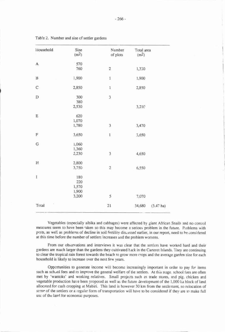
-2f6 -
Table 2. Number and size of settler gardens
Household Size(m2)
Number Total area
of plos (m2)
1,330
1,900
2,E50
3,2rC
3,4'70
3,650
4,650
6 550
5707ffi
G
D
E
H
Total
1,900
2,850
300380
2,530
6201,0701,780
3,650
1,0601,3602,230
2,8003,750
180
2201,5701,9003,2m 5 7,070
2t 34,680 (3.:t? ha)
Vegeubles (especially aibika and cabbages) were affected by giant African Snails and no conrrolmeasures seem to have been taken so this may become a serious problem in the future. Problems withpesB, as weli as problerns of decline in soil fertility dise ussed earlier, in our report, need to be consideredat this time before the number of settlen increases and the problem worsens.
From our observations and interviews it was clear that the settlers have worked hard and theirgardens fiE rrruch larger than the gardens they cultivated hrck in the Carteret Islands. they are continuingto clear the tropical rain forest towards the beach to grow more crops and the average garden size for eachhousehold is likely to increase over the next few years.
Op'pcrtunities to generate income will become increasingly important in order to pay for itemssuch as sch.rol fees and to imfrrove the general welfare of the settlers. At this suge school t-ees are oftenrnet by 'wantoks' and working relatives. Small projects such ar trade stores, and pig. chicken andvegetable production hal'e been proposed as well as the future development of the 1,000 ha block of landallocated for cash cropping at Mabiri. This land is however 30 km from the sertlement, so relocation ofscme of the settlers or a regular form of transportation will have to be considered if they are tn make fullusc of the land tbr economic purposes.
-267 -
lrlost settlers want ro he involvd in the cash economy and do appreciate help from ertensiorrofficers but, from their point of view, this aspect is not being emphasised bv the provin"ial goue--ent.
The settlers say t'1at at presenr rhey do nol face any problemi vrith nearby villages. Futurerelations are hard to predict, populad<.'n increaser and involvement in the cash economy may affect therelationship of senlers with surounding villages. In addition conflict may arise hetween diiferent atollgroups, particularty ii'population increases put pre\sure sn a'ailable gardening lan,l.
Overall, we noted &at the nine tamilies in the small Carteret vitlage .,vere very h"ppy. They havebuilt house", planted t'lorvers and fruit trees around tFre village a:rd established lugi fmd gardens. Thefamilies that we inten'iewed told us that they felt it was their new home and that thiy are mirch oetter offtJran when they lived back on the Caterets. They trave plenty tc eat and their children are healthier thanbefore so they are determined to make a permenent home on the scheme, despite their longing for tirefamiliar environment and their relatives on th.: atolls.
After a long perio<t of struggle with the problem of food shortage and the pressures of their newenvironment the families are now pleasrd with what they produce. They are fuil of hope anddetermination and fris is evident liom the increasing size of food gardens that they are cultivating.
One rnust not be too optimistic at this tirne a.s it is proposed that families from Nissan, Tasman andMortlock Islands will settle at the same sitr and irr future there may be problems, due to land shortage forfood gardens' As the population increases, the consequent rtanger of r decline in soil fertiliry is likely obecome important. It will be some time before these prcblems occur so. for the momenL the settlen areconvinced that they have made the right deision to leave thc Carteret Islands and make a new home arthe atolls ReseElemenr Scheme.
THE CARTERET E)GERIENG: MOVING INTO THE CaSH ECONOMY
The gencral lack of defined econonric opportunities and or any govemment action regarding theacquisition of additional land for cocoa and copra production continued tlyoughout 1986. Two sociatwork stuCents stayed on the project sin rn August 1986 and reported that although most settlers were stillpleased that they could grow garden producc they were beco'n ng nrore aware of the limited nature ofthese activities and of their continuing Jependency on the project co-ordinator for advice and on rclativesworking in Arawa and elsewhere for financial assistance.
The setders expressed their concem about the delay of planne( community economic activitieswhich are to lnclude a fishing project to be operaed by Nissan Island settlers; . r.d. store project whichis to be operated by the Carteret Island settlers, anci ttn Mabiri ceoa and copra project. The setrlersmentioned that from the time they settled in they were told they would be involved in these projecs butsirrce r\at time they have not been informed of any progress (August & Kalamoroh, field report, t9g6;.
Women at the Scheme were now much more interested in commencing some sort of club and inorganrsing both saial and economic activities. They felt rn need however, of assistance from adulteducation and women's activitie: offlrccn and lacked the conficlence to take the iniiiative themselves.The view was exprcssed again and again that withoui more contact frr.rm exrension workers they felt lostund it was clear that on the hovincial Governrnent side the initial enthusiasm to assist the settlers toadapt io a new environnrenr had lmt momen0rm.
When I last visited ttre projecr rn September 198?, two of the original senler families had returned'horne' o the Carteret Istands because they were frusnaed with the long dehys in finatising land forccoa and copra production at Mabiri. One settler told me that people were afraid they would lose theirrights tc the linle land that wr available on the islands an,r uhimety be letr without land rights it att.While he could see that evenrually they would have ro leavc the islands and that it was bener a1 putpresstue on the Prorincial Governm€rrt to t!k; imrnediate actron to secure agricultural land fcr cash cropdevelopmeng others had hecorne dred of waiting. Waiting in e sense, jusr as rhey had waited back on theCarterets for the Atolls [,nterpr-r.ic to come bringing supplies.
-268-
Thc projcct co-qdinrrr who hed wortod widt thc origind Aolls Rcsadensrt Committee b srarttb Sdsc hd rlso hst his inithl arthusiesm rnd q: could fclrse I garcnl fecling of initatbn that drercttlcn scnrcd o bc rtill vcr,' dcpandant m ottsidc r$istrrcc. Tlre reality dr.t rdaptatirxr ro a newGnvi(rmlt b rcificr r smooft nc r rrpid process sccnrd b havc becn forgottar md that the seclershd rccotrylishod dl thc initid trstr of csoblishing grrdars lrd building rcw houses with rclative easc.
By Scptcmba l9t7 ho*cvcr, it hd bcn asFcd drat nse dcisivc actim was needcd orl ilrerllocetisr of rgncutnml bhcks o thc scubn erd 0trt a rrcw pojcct co-ordinnor *ould be enrustedwi$ tlE trsk of lhking thc scttlcts with governnrnt and other crtcnsion officcn. At a gencral nrcaingrcrrc dtcrntivc srnsll scrb p'rojccs wcrt discussod with the scubrs ard plaru fcr a community schooland youth md wmran's rctivitics wcrc considercd
A tour of the Aolls by the North Solonurs Administrative S€s€{ery md other ser.ior govemmentofficials hrd shown that land loss was continuing on rhc Cstrres. Thc community schml had had o berelaaod std thosc who werc frmilir with dE islan& reported dret there hd been further loss ofc(ptxrut trEs md rrable lan.L So, whcttrcr in thc immediatc futur" r in fic lcrger terrrt, substmtialrcsarlcnsrt of mqt ot'drc pquletion is irrvitablc.
FINAL COM}IENTS: LESSONS FOR OTIIER LOW-LYTNG ISLAND GROUPS
Parol rcports from thc 1950s dccribed thc Carterct Islanders as enerpising indepcndent :reophwho wene som as showing a 'much greata degrse of independancrr of thought and action ttran mainlandpcople'yet still living'dangcnously and clce to mrginal subsistence' (A.K. Jrctson,27l7l50r. By1961, a rcport bv Parol O'ffic€r Rahforg who visicd th Carterets in hccrnbff of dlat year, showed thatplanning for dtc islanders had begun rs, dcspitc all thcir effats to limit ttrc inroads of the sea, it wascmsidcred that -
Wha apSrus o be necessary is for a deisive step to be ma& to move the people for rheirou'n good, for like mytrcdy unwilling to leave their honr, they will p'robably never aglee
. o such s step being nudc.
Sorp 25 years later, the rcdity of resettlcnpnt has povrded a new and morc severe challenge othe self-sufficiency and indcpendence of thesc atoll dwellers. What is needed by policy-makers, plannersand pojet tnanagers is an undentanding of thc ambivalerce they fel when confronted with the prospectof baving thcir island honrs and rn imaginative Plan of Actisr !o cnebh trem to remain a self-reliantpeople with the confidence md resources io managc their new environnrnL
REFERENCES
Atolls Division File l96Gl98l. DeEol rcpfrts, correspondence urd reptrts frrom govemment ofhcers andchurch worters prior o tlre forrnetion of the Aolls Reseclenrnt Committce. Department of the NonhSolomons, Arawa.
Atolls Resettlement Cornmiuee 1982-19t5. Minutes of meetinggcorresponderrce and reports to theCommitee. Departrcnt of the Nonh Solomqrs, Arawa.
August C.A L. Kalanroroh 19E6. Fieldwork report qr rip the Atolls Resettlenpnt Schenre, August-September. Typescripr
Davey, I. 1983. Atolis reseitlencnt gardcn lurd utili's1i6pt. Mimmgraphed.
Hindel!, R. 1983. Rcport on the soil of the proposed fmd garden for the Atolls Resetrlement Scherne,Kuveri4 North Solomons Provirrce. A report b the Chairman, Aolls Resettlenrnt ScheyneCommitte€,I Dccember.
Kutmg, T., J. Selwyn, A. Siau, E. Tade & W. Wairiu 19S7. Aolls Resettlernent Scheme, NorrhSolomons Pr,ovince. In M. O'Collins @d.), Rapid rural appraisal case studies of small farmhgsystcms. Deprmnnt of fuithropology and Sociology, Univenity of Papua New Guinea.
-2f, -
McAbina J. R. 1967. Clitnrc of Bougrinvilc rtd Bub Islnd$. Pp. 62-70 in n. M. Scoc a aL,l^mdrof Bougrinvillc md Bun Irlndq Prpor-Ncr Guircr. Comnarrvcrlh Scicntific md In&rtidRcscgch Orgmization, Melbqrrrc.
Natiqnl St{istic.l OtEcc l9t2r Finel figucr: c€nmr unitpopuletial. Nodr Solorurs Ployfurcc. FrtMacsby.
National Stdisticd Offte l9t2b. Pnovilrcid Drt. SWEtrt Runl Cmrmunity Rcgisu, Na'\ SolonursProvince. Pm Mc'rcsby.
Niards, A- 1985. Sccsd nFort md qr soils b dre Atdls Rcsctlenrant Cornmiccc. Dcpartrrnt ofPrirury Industry, Anwe 7 Mey. tvtimoogrphcd-
Nor$ Solonur hovircid Gwcrnnrcnt 19t7. Report of thc Administretive rd Assisrmt SccrariesTqr of the Atolls l5dr - lSfi August 1987. Minngraphcd
O'Collins, M. 19t5. Atolls Rescclclrnt Sclrcnp: pftlirninry rcpdt following field visit 2iltnl -29185. tvtimcoerryhcd.
O'Collins, M. (Ed.) 19t6. Carcctt Islmdln l [p Alolls Rcecubnrnt Schcnr: depting to r ncw w.yof life. Mirrrognphcd-
O'Collins, M. (Ed.) l9t7 Rryfl rurd rypraisel: cesc sqldica of srnetl system" Deperurrnt ofAnttnopology and Sociobgy, Univclsity of Pepre Ncw Gufurer.
Rcdmm4 H. J., J. Currm & T. Swccne,v 196,4. Recourccs suFvcy, Cercra Irlnds, BougainvilleDisrict Report to thc Disrbt Csnmissiorrr. Minrognphcd
Scoc, R M. 1967. Soils of Bougrinvilh md Bukr Islan&. h. 105-120 in R. M. Scou a al. Lsrds ofBougainville sd Butr klmds, Prpue-Nerv Guincr" Comnurwerlth Scicntific ard Indrstrid RccerrchOrgnizetion, Melbounrc.
Scoo, R. M., P. B. Hcyligen, J. R. ItIcAlpine, J. C. Surnden & J. G. Speighr 1967. In R. M. Scott el at.I-utds of Bougainville md Butr Isiandc Pqr*Ncw Guine& Commonrr-nlth Scientifi, gd IndusrialResearch Orgmization, Melbonnp. Iirxls of Borgainvilb sd Buke Islends, Prpue- New GuineaLand Reseach SerL's No. 20.
-270-
CLIMATIC CHANGE AND AGRICULTURAL PRODUCTION IN THE IIIGHLANDS OFPAPUA NEW GT]INEA
Philip J. Hughes & Merjorie Sullivenuniversity of Papua New Guinea" port Moresby, papua New Guinea
INTRODUCTION
About l'2 million people, one third of the population of Papua New Guinea live in the highlandsabove l'400 m asl in a series of large intermontane basins and valleys, and on plateurx and hiilslopesabove tlrem (Figure l). The following irccount of population and land use is drawn from Brmkfield(1964), Brmkfield with Hart (1971), Brown (1978) and Golson (tg77\.
Thes: poptrlous highland communities live in extensive anthropogenic grasslands whosebeginnings date brck 9,000 yers (Golson 1977, Golson & Hughes 1980j. They iubsist largely oncultivated crops, the most impatant of which is the sweet ptato (Iponaea barans). There isconsiderable variatisr in agricultural prrctices throughout this large area, however the separation of sweetpotato from the mixed plantings of other crops such as sugar cane, taro, yarq beans and green, leafyvegetable is normal practice (Golson 1977:6U2). Preparuion of the grassland soils ttloujn tilage iswidesprcad and the staple, sweet potato, is commonly grown in nroun&-or in ftat-bed plors fo*nneC withina grid of garder diaht*.
Poprlation densities are commonly in the order of 40 penons&m2 and locally may rise 16 lfi andeven 200.
Althorgh the sweet potab md sone recently intnoduced crops are g,rown by communities livingup n 2,770 rq the most productive areas are in a vertically and laterally res:riceC zqre below this. Four-fiftlts of the population lives in a series of internronane valleys between 1,400 ra and 2,000 m (Golson1977:607). The nrcst important of these highly productive areas ane, from east ro west, Goioka-Asaro,Chimbq the Wahgi Valley, Wabag and Tari (Figure l).
Temperature declines with altiurde and above about 2,000 m there is a noticable decrease iuagriculural productivity, the nature of which is described in greater detail below. Jr$t as the zone ofclose settlenstt and most productive cultivatiqr is sharply OetimiteA abovg so it is equally sharplydelimiEd below, over an altitudinal range of about 1,225-1,525 m (Golson 1977:6O7)" T6e reasons forthis have less to do with temperauue than with other local and regional factss. The intermontane valleybofioms do not go below ttris altitudinal range and communities living below this range do so on theoutward-facing sides of the morrntain rang$ which delimit tlese valleys. Ottrer facton includecharactenstically steep and rugged tenain, persistent cloudiness, prcneness to druught and high inciderrceof malaria (Brootfield 1964:31-4).
The prcsent climate of 0re highlands varies systematically along a gradient fr,om east to west, andthese vriations are reflected in the settlenrnt paficrns and agriculnral systems. The highlands bet-,r.een1,400 and 3,S0 m have a nrean annual maximum temperature of about 24'C zndnrean annual minima ofabout l3'C (McAlpine et ai., 1983:16O161). Seasonal variation in both temperabre and humidityreginrs is not mrked. Ground fro'sts are likely o occur abo.,e about 1,5fr) rq ther inciderrce andseverity increasing with elevatisr. Frosts are mtre likely to occur during prolonged dry periods and inphystoglryhic locations conducive to their developnrnt such as upland valleys subject o cold audrarnage and ridges leading to rnnane arcas.
-nr -
It'rcApinc ct al (l9t!:l6o 16l) divi.tc rhc highle& clinrtb rcsilrE inro trc-nria cJellcs: lc.trrurnranc subhumid G)"c t) srdlowq ilntrE h,mftl Oyleg).Iowcc nantane subhumid. Thc rer_in_ F."r* highlDds eouod Gaotr nd-r+rqr-rog.,erDcciucs rclerively low ronual ninfrl (l,jG'am nrnl wifr rndlril.ly hth grooll],. .l{cal
rmud wru surpluscs tro fi,t lrge, but roil u*corc ir oly vcry tlely dcphiod; a-Slrl"*tr.Lorycr tmtta-foqi( This clinre clrr rpcrds owr rut of rln crt of,s$Hr:c1
$oryn h Fr8urc l. Rdnfrll in ficsc rrct is bc*cr 4(m u 35666 -...niGo.d[ht o'Yrderlt' Hoality. It'Icn mnurt wacr rurplus rc hi3! rd dtlrt 1lc m ccn,'Ers fughr
Rr thc ptrpotcE of his surdy thc lighhe is dirtlcd ino thtc uthcr hm t*o ,m6: Grlrun,ccntd nd wcsun.
In dp ersam zoe' whictr cxds from est of Keinzrur to crsr of ffie (Fignrc l),.hadlsybdoms re gencnlly u e brrcr .ltind", l,2s.lJm rn, ther ebcwlsc Lr 6c highL;s. rt i, mrc hrstb bc/est rainfrll lcas fran 2,O0 mrq rrd e distinct dry scrson ftrom May until Norcmbcr. Ttue rehoquent pcnods of soil tmfuutrc-st-css dudng 6c dry lcadr nd chfrt pcriods of dronglt re corm,n.The erstcrn zqr is chrrccriscd by srnell scrc of dcoecly pqulrod vrllcy bcan-lmd, Gspccirllyrlong tlrc malr rivcrs, sulrurndcd by exEnsive rces of rprsci.y itp,rr""a grrsslrrd Moisure suess isr nodcncly tsrcG liniting frtc sr rgricduml usc of tris; ;nsslrnds, cvcr fc norsorc-stresstolcrmt crqs such rs lruo?t Potsto rd tepiocr (r cssrvt tn pretristfric tinrcr extcnsive ',ctr
of lsrdwere tcrrrccd to nrrin soil nnisure in thc gsdcn bods (sullivm'ct al., l9t6l,The ccntral zm€, ftom Gaoka in the west to Madi in tbc cast, is chrctriscd by highcr ninfal,rveraging about 2,5@ mfi\ .ttd thc dry scrson is very much lccs purourrccd Soil rncirture iucrs is verysurch lcss a problcrn lrd.drought arc inftraluart Thc vattcy ticrs nd thpcc bclow 2,6p0 m in thiszdre are thc npst podrrctive m thc regior rtd thcy support tlrhighcst populrttm dersitics. Exenplcc ofhtgh,ly p'roductive ard hcevily pop|llaEd areas irclfr dlc Acire-eslo Vrlley, Chimbu, lre wrhgiVrlley bctwccn Kudjip xd Mt Hagen rd rhc lri Vrlhy ncrrWrbg.
l*tr rrtst agein the rdnfall ir evcn hrghcr u 3,fi)G3,i00mnr, 6crc b vcry linh grmelvriability in ic distributisr and rcil nnisuue socss ii urrcomrffir. Ho*rvcl. h" qh;,rirrr.n rccul*in incrcased chudincss whkh o sorr dcgrc Thilirr ptmt gtowtlr, irrcluding drrt of crqs. Maeirportently, much of thc wesern zsrc is ebovc 2,0(X) nri i.e. fove oc rgriculorllly mt prroductivedtio& rmge (Figurc l). Fr tlsc rcrsons tllc populrtion danriticc 6 gancrrlly lowct rhrn thcc h rhcccnrd zonc. Thc crcc?dql is thc hcevily popnted Tri Brsin wtric,h [ -"ir-nort [y,t-.litc thcccntrd zme than it is likc drc rpstof ti€ wcsEn zo!.
Thc hiShlsttds rpr slro*'n in Figurc I T- lrlng . covcr of grrrrlnd .nd otlrcr rndyqogenktlpes of vegetatim ools rbqrt ?,700km1. Of this, rbout S,Zm Ln2 * 74% of rll rout is below2'(n0 m' wcst of Mount Hagen tlrcrc rre scvcrrl lqgc trrcts d irrd wtrich rrc dnroot cntircly rbovcaOF. and yhich trrycthc( btsl $out 1,350 tm2. rtcsc it cr,rd! thc birgur-Klrdce see which hg arndcrrtcly high pqultim &nrity rd thc Ielibu gte wtrae ttc pqurrin anriry iril*. 1t tlrertst ofthe surdy alee dl but drc hrghcst vrllcy side rlcpcs rc below 2,m0 rn.
Subsiscncc crctx
Tcnpcrrurre doclhcs with rldnrdc, md bcansc of dds thcrc is r po3rcssivc &crcrac upwrdcbo& in fic numbcr of fmd oopc thl can bc gFowrr nd m thcir ybl&. Ar n -xmpie
of tl c tands wehave uscd dan collccd from gtd.n sunvcyr in dre_hrgcrr vdicv qnicd qrt rs Frr of 61c porgcn goldFoject arvirsur:ntal plrmiry surdy (Hugher & sultii'm lgtD: Thc rldt|dhd zor covcd by o'Isody' 1,9ffi @2'4SO 4 is prcciscly thu whktr we rrgc bcbw wilt h tl[fi &lndcrlly dcctod by mytccperarure risc. o|rf kgcrl inr.estigrriom rrod rs fuh strong point thc detrilcd rrdy of rubsireoe
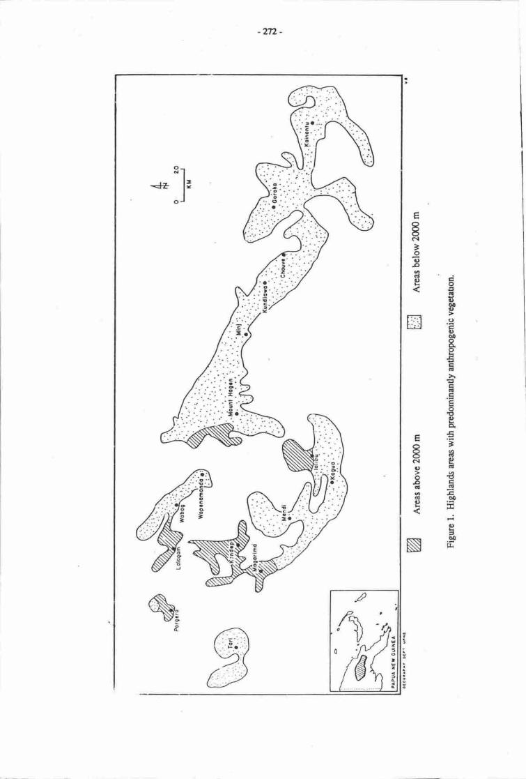
-n2-
E
t(\l'oCToaCltg 6a
5C)o!gItio!
BEEI(!
Eia!trEa<t
B.€
'3e|lt.8tal5o0
tjeaooIL
Eat-o(1oooqlacll)
-* .]'
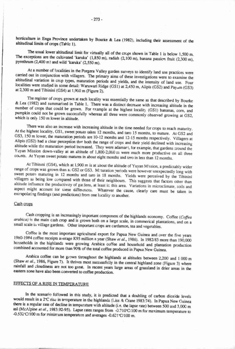
-n3 -
hstiqlu[e in Enga Piovlc9 underttcn by Bourte & Lee (19t2), irchding thcir assessment of therltindind limir of clopc (Tahle l).
Thc usud lowcr altinrdinal limit for virtually rll of thc cn4c shown in Table I is betow 1,500 rnThc exceptions rre the cultivatcd 'tanka' (1,t50 m), radish (el'm m), banana passicn fruit (2,300 m),pF€thrun (\ag rr,) and wild .ksuka' (2,550 m).
At r number of localitbs in fie Forgera valley gardcn surveys to identify land use practices werecaried out in conjunction with villagen. The primary-aims of these investig"ion. *o" o examine thedtiEdind varietion in cnp qPcs' maturatiur periods and yields, and the intensity of land use. Fourlcdlles were studipd in sonp detail: wruwari Ridge (GSlj at Z,lso rn, Alipis (GSz) and payam (GS3)at 2"3m m and Tibinini (GS4) at 1,900 m (Figure 2).
The register of croprs grov,m at cach la-ality was essentially fre sann as trat d€scribed by Bourte& ka (1982) and summarised in Table l. There was r distinct d€credse with increasing altitude in thenumber of clops that could be grown. For *ample at the highest tocalit) (GSl) baranas, corn, andpumpkin could not be grovm successfully whercas all three were commonty obsrved growing at GS2,which is crty 150 m lower in altitudc.
There was also an incrcase with increasing altitude in rhe tinp needcd for crops to reach maturity.llllte higttest locdity, GSl, swed potao tahes 12 rmnths, anl tro 15 months, to manre. At GS2 andcS3' 150 m lower, the mauretiqr pcriods are lG12 rurths and 12-15 months respectively. villagen atAlipis (GS2) had a clear percepoon thar both E *g" of crops and dreir yield declinea wi*r increasingaltitude while thc maturation period incrpasod. Tlrey were adamri fc example, that gardens round theYiryan Mission dorrn'valley at an altitude of 1,80b-2,0@nl wefie much morc prodictive on all threecoLnts. At Yuym sweet potab matures in about eight rnonths and trro in less than 12 months.
At Tibiruni (cS4), which at 1,900 m is at about the altitude of Yuyan Mission, a predictably widerrange of cropt was Srown than a. GS2 or GS3, M.:turation priods *er. in*""o un.*p.t"aty lurg withsweet potato maturing in 12 rnanths and taro in 18 nnnths. Yields were perceiv.A Uy trr" Tibininivillagen as being low cc'mpared with thme of their reighboun. rt i, ,ugg"it, ttrat frcon other thanaltitude influence the productivrty of garCens, at least in ttris area. variations in micralimate, soils andaspect might rccount tor tircse differcr,ces. Whatever tle cause, clearly care must b€ raken inertrapolaring findings (and predbtixs) from orn lucaliry ro another.
Cash crqp
Cash croping is an increasingly important componerr of thc highlands eoonomy. Coffee (Cofieaarabica) is dre main cash crq and is grown botlr on a trge scale, in comnrerical plantations, and on asmall scale irr village grdens. other impqtarrt crq6 are cardamon, tca and
"egetabies.Coffec is the most important agricuttural export fa Papua New Guinea and over the five years
198G1984 coffee receipts average K95 million a year (Shaw cr at., lg86). In l9Ezg3 more rhan 190,0mhouseholds in the highlands were growing Arabica coffec and household and planation prodrctioncombined rccounEd for mae thsr 90% of the otal coffee poduced in papua New tiuinea.
Arabica coffee can be govm tiuorghout tlre highlands at altitudes between 2,200 and I 000 mts.ht:-" 4'., 1986, Figure ?). It thrives rnst succ{ssnruy in the central highland zone (Figure 3) wherereinfdl and ;budirpss rre not bo geat, In rwcnt yers large areas of grasslard in drb; areas in theea;tarn zme lrave atso bcen converEd to coffoe productiur.
EFFECTS OF ARISE IN 1EMPERATURE
In he scenm'o follon'ed in dris snrdy, it is prodicted thet a doubling of carbon dioxide levelswodd result in a 2.C rise in temperahue in the highlaruis Giss & Crane 1983i4). In papua New Guineatlse is a ngular rate of_decline in emperatue wirh altinlde (i.e. the lrycc rate) baween 500 and 3,00C masl (McAlpine ct al-,1983:9-95). kpse rates rimges from -0.? loO'100 m for maximum tpmperanre to{.532'0100 m fs nrininum tcmperarure and averqges {.621t/lo rn
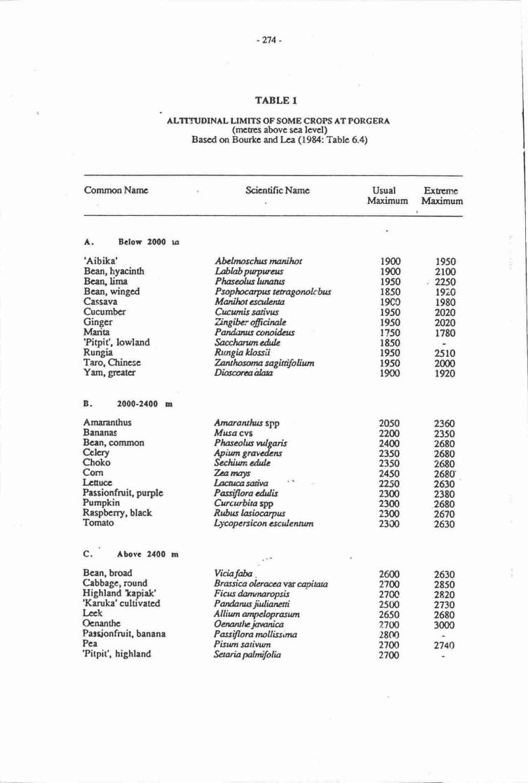
-274
TABLE T
ALTNruDINAL LIMITS OFSOME CROPS ATPORCERA(rnctcs abovc sca lcvcl)
Bascd on Bourke and ka (f 984: Tablc 6.4)
CommonNanrc ScicntificNamc Usual ExtemcMaximum lvlaximum
A. Bclow 21100 ro
'Aibika'Bcan, hyacinthBcan,limaBcan, wingcdCassavaCucrrmbcrGingcrMarita'Pitpit', lowlandRungiaTaro, CtrincseYam, grcatcr
B. 2000-2rt00 u
AmaranthusBananasBcen, comrnonCclcryChokoCornLcuuccPassionfruit, purplcPumpkinRaspbcrry, blackTomato
C. Abovc 2400 m
Bean, broadCabbage, roundHighland tapiak''Kanrka' cultivatcdLcckOcnanthcParionfruit, bananaPca'Pitpit', highland
Afulnpschus nunihotL&labpupwasPlweolsslunatusPsopluaryus t*agorcbbuMoilotcsadenuCrcnis sotivttsTingifurofrcirulePandaus arcifutsfuaJwuncdulcRungiaklosiiTatlpwu sagiaifoliumDiatahlu
AnararuIussgpMusa cvsPluscohswlgarisApiwr grancdensSuhiumeduleTanafLutasadvaPasifloraetulisCurcurbiusppRfius lasiocaryusLy'c ope n ic o n esc uI e wum
ViciafafuB rassiu oluaaa vt qitataFicus danmaropskPanfuruts jWianatiAlliumanpclopraswtOcnanhe inonicaP ass ifl ora noll iss ttnaPiswrsativumSaariaNnilolia
190019001950l8s019C0r950195017501850195019501900
19502100
. 2250t920198020202020r780
251020001920
205022Wzffi235023502450z2l,A2300230023002300
23602350268026802680268026302380268026702630
zffi21ffi270(r2500265027ffi280027W27W
263028502820273026803000
274A
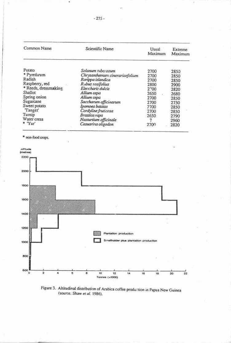
-275-
CommonName ScicntificNamc Usual ExhemcMaximum Maximum
Potatot PyrcthrumRadishRaspbcrry', rcd* Recds, drcssmakingShallotSpring onionSugarcancsurcctpotatoTanget'
TumipWatercrcss+ 'Yar'
Solanwt tuberoswtC hrysantlwuan ci nc rariaefo I i mtRoripaislandcaRttbus rosilolfusElffihaisdulcisA0inrcryAIIiunryfucchananoffcinarwnIpneafuausCordylircrtuicosaBrasiurryNasanfinaffcinalcCnswrinaoligdon
2700 285027W 285027@ 28s02800 29002:W 28202650 26802700 285027W 27307700 285027ffi 285026s0 2790? 29ffi2700 . 2820
* non-fmdcropc.
Altrhrd.(rn tr.a)
ro l?To.rna! ( rfd)Ol
Figure 3. dtitudinat disribution of Arabica coffee production in papua New Guinea(source: Shaw cr4r. 19g6).
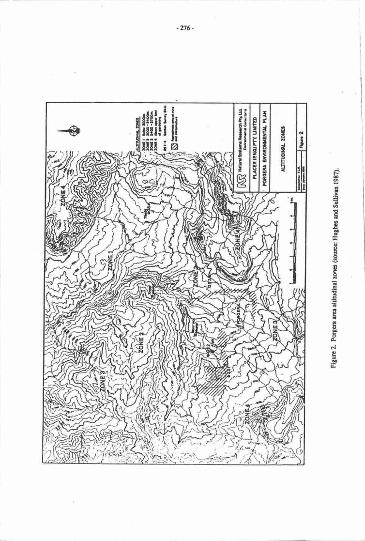
-n6-
€o\Et=.nrtEal3o!aEa,
3oQ
IeR(!E
.ct5
c€IdEt)0cbA
Cri
e9oo]L
iriiriiE
te;F-xiiit
EI:t
Egos
3II
I
atsF
IE
5
--*Jr\ ur
SJ
'41 vi -r\1'r.':t'f=.
-271 -
Wi,Jr a rise of 2'C in air temperature there r*ould be a corresponding altiurdinal increase of 320 min plesent'day Emperature regimes. Put simply, the average annual temperature at any given placewou! -l rise by 2'C and in '.\e highlancls people could move ulslope throrgh a vertical aislnce of about300 m anq stiii maintain dreir present temp€(ature regim..
Implications for subsistence and cash cropping
Taking into rccount onty the impa'r r.rf temperature change, it is likely that presently highlyproducuve areas belou' ?,CS'J m would unde;go littie change, except for low altitude areas in the .astwhich ma1 become even less productive Jue to irotter conditions. The upper limit of the most highlyproductive zone would rise to about 2,300 m and this wouLi ooen up eithei previously less productivelyused or new arcas of forested land fs intensivg productive use. tn the eastern and cenEal zones mostsuch land would be on comparatively tteeply sloping mountainous terrain above the major intermontanebasins and factors such as steepners, thin and unstable soil cover and cloudiness will make such lands lessproductive for both subsistence and castr (e.g. coffee) cropping than might otherwise be expected- Inthese circumstances we would erpoct the expansion in arei unCIt cofro to be mainly in the form ofsmall-hulder plos rather dtan commerical ptantations. Our estimate from the topogiaphic maps andpersond observations throughout the highlands is tfiat there would be an increase bf lUout l0% in drearea of rnore highly productive IanC-
The most dramatic tikely effect would be in the western zone wherc large areas of valley bouornland presently of marginal ot low pro<iuctivity, simply be,.ause it is above {ooo nt could come intointel'sive use. for both subsistence gardening and possibly coffee. In perhaps as much as 50% of thehigher altitude area marked on Frgure I the only major consrainr to muih grearer productivity isaltituddlow t€mperaure.
Just as the 'rpper limit of highly prcductive cultivation would rise by 300 nL the upper limit othi.ch the staple crop, sweet potato, could be grcwn would rise from aDout ez0G2,g00 m to more tran3,00O m. This would result in an estirnaEd incrcase of LE2W in the area of land that could bc broughtgradually into agricultural production for dre first tinre ever.
The overall effect of a rise in temperature therefore would be to increase both the otal area of landthat could be used for agriculture (by about 10-10%) and the arca that could be used highly productivelyfor both subsistence and coffee gardening (by about 30%).
The erample of Poreera
The agriculturally moet productive part of the Porgera vailey tcxiay is the uppernrcst part of7's.e | (below 2,000 m) shoun on Figure 2. Productivity as measured by thi range of crops, yields andlength of maturation periods is much higher ar. Yuur Mission than, for examplg at Alipis. A zgnse in0emperature and the concomiunt 3S m risc in the upper timit of the most highty producrive zone wou'Jnrean that most of 7nne2 would bec.:me much more highly productive than it ii no*. The present upp,rlimit tu which agricuinre is currently pracuced is about 2,400 m (the upper timit of Zone 2t, and it woutdbe possible to ext€nd this to about 2.?00 m wi0rout changing presenr agronomic practices. Such anextention would encompass Zonr 3 as marked un Figure 2.
very little coffee is grown in the Porgera Valley ar present. Carrad (1982:150) estim::red that inthe early 1980s oniy 5% of households in the valley grew coffee. All of this would have corrp fromplantings in Znne I below 2,000 m. With a rise in tempe'3mre it woutci be possible ro grlw coftee inmuch ofZone 2.
" 'fhus even in a relatively sraall valley such as Porgera a rise in terrrperature and consequent changein the ahitudinal limits and trroductivity of crops wrruld have a rirajor impacr
-278 -
Imolications for social and demograohi^ chanee
Therc is little doubt thu thesc changes would be beneficial fr the highlands regions as a wholgespocially if the potentid 'profits' from increased production of both subsstence anilcash crop6 wercchannelled into rctivities aimed at improving the social and cononic conditions of their communities.Provided the rate of population irrcrease did not oustrip the rate at which the newly-created 'productivity'could be harrrcsse4 the prcsent trend towards increasd tand pressure and assaiated social srife could beeased or in places even halted. Presentty disad.'antaged people living on marginally-productive lands athigher dtitudes would benefit most ftrom improved production.
If the temperaure nses as projected, ttre populuion of the highlands will probably irrrease at aEt"J'tar rate than it would have had the temperaare not changed appreciabty. Inevitably fierc will bc adegree of demographic redisribution and social disruption, however the prehisoric and post-Eurf,?eancqlt ct evidence suggests strongly that highlands people arc nor only capable of adapting o changes butindeed {rat they thrive on change.
OTHER EFFECTS
Because conditims would be warnnr, there is a very rcal possibility ttrat diserses srrctr as malariawould move upslope and that, for examplg many of dre valle5 which cur.entty have a low irrcidence ofmalaria would become highly matarial. Such a possibitity would be enhanced if the postulatcd irnreasedproductivitv w:ls accornpanied by increased population densities. Gorecki (1979), ior eramplg rrguedthat periods of abandonnrcnt of the normally highly popunted Wahgi Valley floor and othcr highiardvalleys in the recent prehisoric past (i.e. the last 250 years) was the result of the sprcad of cpidemics,possibly malaria-
Throughout this study we have argued that changes will occur caused solely by an increasc intemperature. Temperauue changes would also be acompanied by changes in ,ithcr paramctcrs such ashumidity, rainfall and consequently soil nroisure. An increase in temperaurrc would result in inc*4'cdpotential evaporanspiradon and without increased rainfall therc would be a decrease in soil noistureavailability. It is unlikely that rainfalt and soil moisture will decline to a poinr of inhibiting plant growthanywhere but in the eastern highlands. If, as Glenn McGregor argue) for clsewhere in-fapga NewGuirea' increased temperahre is rccompanied by decreased rainfall in already seasonal areas, this mighthave a mejor deleterious effect on agricultural productivity, esJrecially at rhe eastern end of the highlands.
II\4PACT ON NATUR,AL ETWTRONMENT
Any climatic warming ,vould result in gradual upslope movement in the montane forest vegetaionand sub-alpine grass and shrubland zones. Such naurral changes would be very slorv and might notbecone evident for decades. The upper limit of the lower npntane forqst, which extends up to ab11rtl'50Ge000 m (Johns l9?7), would rise to about 1,8m-2,300 m. This would however be matcired by thecven morc rapidrise in the upperlimit of the intensively used and'most highly productive agricutturalzsre. Tirus it is unlikely that there woulC be any extention of the are I of this forest type, which hassuffered the brunt of human imprct through clearance over the lasr 9,C00 yean. Indeed-ii is tikety tratthe rate of destruction of thts aiready endangercd ecological zone would accelerate.
The upper limit of the mid montane forest zone would gradually rise from 2,700-3,000 m to 3,0m-3'300 m- This would be matched by the concurrent and probably even more rapid rise in the practicableupper limit of agriculture and this faest rype would certainil' not expand in arca and would probably berernoved at an even greater rate tran under present environnrcntal conditions.
The upper rnntane forest would remain relatively unaffecrcd by human impact- Its prcsentaltitudi'tal range is relatively narrowr from 2,7003,000 m up to ahrt 3,200 m. There are only very smallarcas of mountein tops higher than this and an upwards change of 300 m in its attiurdinal range wouldresult in a very drarnaticdecrease in its totd area and geographic disuibuuon.
I
-Tn -
There would be an even morc drailztic dccreasc in tlrc otal area and geographic distribution of thcsub alpine and alpfur grasslands and shrublzrds. Thcy would d:appear from mosiof papua New Guinceard would be well representod crly around the sumrnits of Mt Wilhclm and Mt Giluwe.
REFERENCES
Boutte' M. & D. I ea 1982. Subaistcrrcc lrortirlloue. tn B. Cana4 D. I-ea & IC Talyage (Eds.), Erglfoundations fa developmant Depertmcilt of Geography, Univenity of New Enghnd, er.ia"fe.
Brwknd4 H.C. 1964. Thc occrloggr of highlr.d scclenrnt tuncdr:sr Anduopologist 66 (4, prt 2):2G38.
Brmuiel4 H.C. wih D. Fart lg7l. Metncsia: a goographical intcrprcuricr of rn istand wctd.Medruan, London.
Browq P. 1978. Hignland peopbs d Nerr Guinea Cambrfttge University Pr,esq Cambridge.
Crra4 B- 1982. Thc ocmomy. In B. Crrnd D. Lca & K Trlyaga (Eds.), Enga, forndations fordcvebprrrnt D€pr:rEnt of Gcogrrhy, univesity of New England, Afirddalc.
Golson' J. 1977. t'ro Klorn d thc top: rgrbultunt inensification in thc New Guinca highlards. In J.Allen, J. Golrcn & R. Jmcs (Eds.), sunda & satrul. Acedemic press, London.
Ctr€cki P-P. 1979- nopulatrn gowth rnd aburdonmcnt of swamplands: e New Guinca highl&dscxample. Journal & la Soci6td dcs Oclaristcs 63:9?-107.
Golsor\ J. &' PJ. Hughts 1980. Ttre appc.rarc of plant rnd animal donrsrication in New Cnrinar-Journal de la Sai6t6 des Oc6anisas 69:2g4-303.
Hughes' PJ. & M.E Sultivm 1987. terxl usc !firdy. eppenaix ? in Netural Sysams Rcscach pty IJdThe Porgera Crold Projccr Environmntrl Pleq Vdunr C. Forgcra Joint Vcnture, porr Mcmby.
Johns, RJ. 1977. llre vegctation of P4ue Nery Guinea Papua llew Guinea Faestry Colkge Bulolo.
Liss, PS. & AJ. Crrne 1983. Mil-mdc cartsr dioxidc and ciimatic change: a rcvicw of scianrificproblems- CreoBooks, Ncwiclr, uK.
McAlping Jx- & G. Kcig, with R. Frlls l%3. Climatc of Papua New Cuirra Austrrlian NsrionalI rniversity Press, Catbenz-
Sha% D., R.}f. Borrrtc, S. BdL & B. Sbew 1986. Irrplbetiqrs or rtE 19g6 oubrcrt of coffe rcst inPepua New Ouircr IstrndE/Attshlir wcthg PTcr t0l5, Nrtiooat Ccnre fc Devebpnrcn3 Strdics,Australian Ndanl Unft'ctrity, Crnbcrn
Sullivan, M.8., PJ. Huglra, & J. Clolsfi 1986. h'chisuic enginccn of thc Arona valley. Scfrre inNew Guirpa 12:2741.
lssued and printed by:gt'.iUg Oceans and Coastal Areas Programme Activity CentretrNt,P United Nations Environment Programme
Additional copies of this and olher publications issued bythe Oceans and Coastal Areas Programme Activity Centre
can be oblained from:
Oceans and Coastal Areas Programme Aclivity CentreUniled Nalions Environment Programme
P.O. Box 30552NairobiKenya