Long-term Occupation of Cerro Chijcha, Upper Desaguadero Valley, Bolivia
10
L ONG-TERM OCCUPATION OF CERRO CHIJCHA,UPPER DESAGUADERO V ALLEY ,BOLIVIA Scott C. Smith, Maribel Pérez Arias, Adolfo E. Pérez Arias, and Andrea Flores Pérez This article reports preliminary data from a survey of the archaeological site of Cerro Chijcha, a low mountain located in the community of Chijcha, municipality of Jesus de Machaca, Ingavi Province, Department of La Paz, Bolivia. We documented significant occupation stretching from the Middle Formative Period (800–200 B.C.) through the Inca Pacajes Period (A.D. 1450–1532). The extent and density of occupation, particularly during the Tiwanaku (A.D. 500–1100) and Inca Pacajes periods, suggests that Cerro Chijcha was a regionally important ceremonial site. Este informe reporta los datos preliminares de una prospección arqueológica realizadaen el sitio denominado Cerro Chijcha, ubicado sobre una montaña de la comunidad del mismo nombre, municipalidad de Jesús de Machaca, Provincia Ingavi del Departamento de La Paz, Bolivia. Durante la prospección hemos documentado una ocupación que data aproximadamente desde el Periodo Formativo Medio (800–200 A.C.) hasta el Periodo Inca Pacajes (1450–1532 D.C.). La extensión y la densidad de la ocupación, particularmente durante los periodos Tiwanaku (500–1100 D.C.) e Inca Pacajes, sugiere que Cerro Chijcha fue un sitio ceremonial importante a nivel regional. O ngoing research in the Upper Desaguadero Valley of Bolivia is exploring the development of social complexity in the southern Lake Titicaca basin and, specifically, the emergence and expansion of the Tiwanaku state between A.D. 500 and A.D. 1100 (Janusek 2013). Drawing on both full-coverage settlement surveys and intensive excavation at four major sites in the region, this work has investigated the emergence of sedentary communities during the Middle Formative Period (800–200 B.C.) at Iruhito Ñawpa Pacha, Journal of Andean Archaeology, Volume 34, Number 1, pp. 107–116. Copyright # 2014 Institute of Andean Studies. All rights reserved. Scott C. Smith, Department of Anthropology, Franklin & Marshall College, P.O. Box 3003, Lancaster, PA 17604-3003 ([email protected]) Maribel Pérez Arias, Department of Anthropology, University of Pittsburgh, 3302 WWPH, Pittsburgh, PA 15260 ([email protected]) Adolfo E. Pérez Arias, Carrera de Arqueología, Universidad Mayor de San Andrés, La Paz, Bolivia ( fi[email protected]) and Andrea Flores Pérez, Carrera de Arqueología, Universidad Mayor de San Andrés, La Paz, Bolivia (permarcalypso@ gmail.com) 107
Transcript of Long-term Occupation of Cerro Chijcha, Upper Desaguadero Valley, Bolivia
LONG-TERM OCCUPATION OF CERRO CHIJCHA, UPPER DESAGUADERO
VALLEY, BOLIVIA
Scott C. Smith, Maribel Pérez Arias, Adolfo E. Pérez Arias, and Andrea Flores Pérez
This article reports preliminary data from a survey of the archaeological site of Cerro Chijcha, a low mountain locatedin the community of Chijcha, municipality of Jesus de Machaca, Ingavi Province, Department of La Paz, Bolivia. Wedocumented significant occupation stretching from the Middle Formative Period (800–200 B.C.) through the IncaPacajes Period (A.D. 1450–1532). The extent and density of occupation, particularly during the Tiwanaku (A.D.500–1100) and Inca Pacajes periods, suggests that Cerro Chijcha was a regionally important ceremonial site.
Este informe reporta los datos preliminares de una prospección arqueológica realizadaen el sitio denominado CerroChijcha, ubicado sobre una montaña de la comunidad del mismo nombre, municipalidad de Jesús de Machaca,Provincia Ingavi del Departamento de La Paz, Bolivia. Durante la prospección hemos documentado una ocupaciónque data aproximadamente desde el Periodo Formativo Medio (800–200 A.C.) hasta el Periodo Inca Pacajes(1450–1532 D.C.). La extensión y la densidad de la ocupación, particularmente durante los periodos Tiwanaku(500–1100 D.C.) e Inca Pacajes, sugiere que Cerro Chijcha fue un sitio ceremonial importante a nivel regional.
Ongoing research in the Upper DesaguaderoValley of Bolivia is exploring the development
of social complexity in the southern Lake Titicacabasin and, specifically, the emergence and expansionof the Tiwanaku state between A.D. 500 and A.D.
1100 (Janusek 2013). Drawing on both full-coveragesettlement surveys and intensive excavation at fourmajor sites in the region, this work has investigatedthe emergence of sedentary communities during theMiddle Formative Period (800–200 B.C.) at Iruhito
Ñawpa Pacha, Journal of Andean Archaeology, Volume 34, Number 1, pp. 107–116. Copyright # 2014 Institute of Andean Studies. All rights reserved.
Scott C. Smith, Department of Anthropology, Franklin & Marshall College, P.O. Box 3003, Lancaster, PA 17604-3003([email protected])Maribel Pérez Arias, Department of Anthropology, University of Pittsburgh, 3302 WWPH, Pittsburgh, PA 15260([email protected])Adolfo E. Pérez Arias, Carrera de Arqueología, UniversidadMayor de San Andrés, La Paz, Bolivia ([email protected])and Andrea Flores Pérez, Carrera de Arqueología, Universidad Mayor de San Andrés, La Paz, Bolivia ([email protected])
107

(A. Pérez Arias 2004; Pérez Arias et al. 2010; M. PérezArias 2005, 2007), the development of a regionallyinfluential multi-community polity at KhonkhoWankane during the Late Formative Period (200B.C.–A.D. 500) (Janusek 2008, 2013; Januseket al. 2003; Lémuz Aguirre 2011; Marsh 2012;Ohnstad 2013; Smith 2009, 2013), the expansionof the Tiwanaku state into the Upper DesaguaderoValley after A.D. 500 (Janusek 2013; Smith 2014),the emergence of new identities and modes of com-munity organization in the wake of the collapse ofTiwanaku around A.D. 1100 (Zovar 2012), and theincursion of the Inca state into the region betweenA.D. 1450 and A.D. 1532 (Zovar 2012)(Figure 1a). One of the central research objectivesof this work has been to investigate theDesaguadero River as a route of movement forpeople and llama caravans traveling between theLake Titicaca basin and important areas to thesouth, including the Lake Poopó and Cochabamba
regions. Excavation and surface survey at the riversidesite of Iruhito has demonstrated continuous occu-pation for several millennia, suggesting the sustainedimportance of the river both for productive econom-ies and as a corridor of movement and exchange. Ourpreliminary survey at Cerro Chijcha, located 25 kmdownriver from Iruhito, was designed to explorethis idea at another point along the river. Theresults of this survey, reported here, suggest a similarpattern; Cerro Chijcha was first occupied during theMiddle Formative Period and enjoyed continuousoccupation through the Inca Pacajes Period.Importantly, the data indicate that Cerro Chijchabecame particularly influential during the TiwanakuPeriod, suggesting that the Tiwanaku state focusedits political efforts on gaining access to theDesaguadero River (Smith 2014).Cerro Chijcha is a low mountain about 3.5 km2 in
extent, situated 3 km east of the Desaguadero Riverand some 40 km southeast of the southern shore of
Figure 1. (a) Chronological chart for the Central Andes and the southern Lake Titicaca basin (after Janusek 2008: 19, Figure 1.7);(b) map of the southern Lake Titicaca basin showing geographic features and sites discussed in the report, Map by Scott C. Smith.
Ñawpa Pacha: Journal of Andean Archaeology Volume 34, Number 1
108
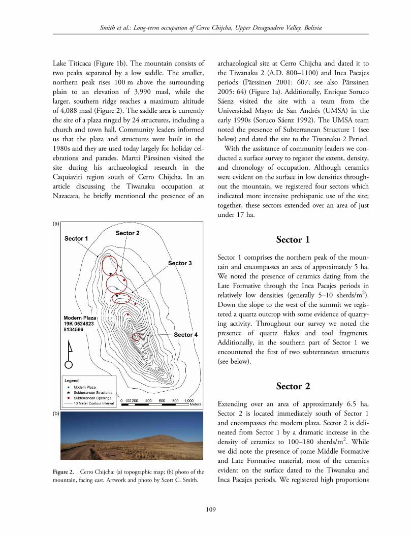
Lake Titicaca (Figure 1b). The mountain consists oftwo peaks separated by a low saddle. The smaller,northern peak rises 100 m above the surroundingplain to an elevation of 3,990 masl, while thelarger, southern ridge reaches a maximum altitudeof 4,088 masl (Figure 2). The saddle area is currentlythe site of a plaza ringed by 24 structures, including achurch and town hall. Community leaders informedus that the plaza and structures were built in the1980s and they are used today largely for holiday cel-ebrations and parades. Martti Pärssinen visited thesite during his archaeological research in theCaquiaviri region south of Cerro Chijcha. In anarticle discussing the Tiwanaku occupation atNazacara, he briefly mentioned the presence of an
archaeological site at Cerro Chijcha and dated it tothe Tiwanaku 2 (A.D. 800–1100) and Inca Pacajesperiods (Pärssinen 2001: 607; see also Pärssinen2005: 64) (Figure 1a). Additionally, Enrique SorucoSáenz visited the site with a team from theUniversidad Mayor de San Andrés (UMSA) in theearly 1990s (Soruco Sáenz 1992). The UMSA teamnoted the presence of Subterranean Structure 1 (seebelow) and dated the site to the Tiwanaku 2 Period.With the assistance of community leaders we con-
ducted a surface survey to register the extent, density,and chronology of occupation. Although ceramicswere evident on the surface in low densities through-out the mountain, we registered four sectors whichindicated more intensive prehispanic use of the site;together, these sectors extended over an area of justunder 17 ha.
Sector 1
Sector 1 comprises the northern peak of the moun-tain and encompasses an area of approximately 5 ha.We noted the presence of ceramics dating from theLate Formative through the Inca Pacajes periods inrelatively low densities (generally 5–10 sherds/m2).Down the slope to the west of the summit we regis-tered a quartz outcrop with some evidence of quarry-ing activity. Throughout our survey we noted thepresence of quartz flakes and tool fragments.Additionally, in the southern part of Sector 1 weencountered the first of two subterranean structures(see below).
Sector 2
Extending over an area of approximately 6.5 ha,Sector 2 is located immediately south of Sector 1and encompasses the modern plaza. Sector 2 is deli-neated from Sector 1 by a dramatic increase in thedensity of ceramics to 100–180 sherds/m2. Whilewe did note the presence of some Middle Formativeand Late Formative material, most of the ceramicsevident on the surface dated to the Tiwanaku andInca Pacajes periods. We registered high proportions
Figure 2. Cerro Chijcha: (a) topographic map; (b) photo of themountain, facing east. Artwork and photo by Scott C. Smith.
Smith et al.: Long-term occupation of Cerro Chijcha, Upper Desaguadero Valley, Bolivia
109
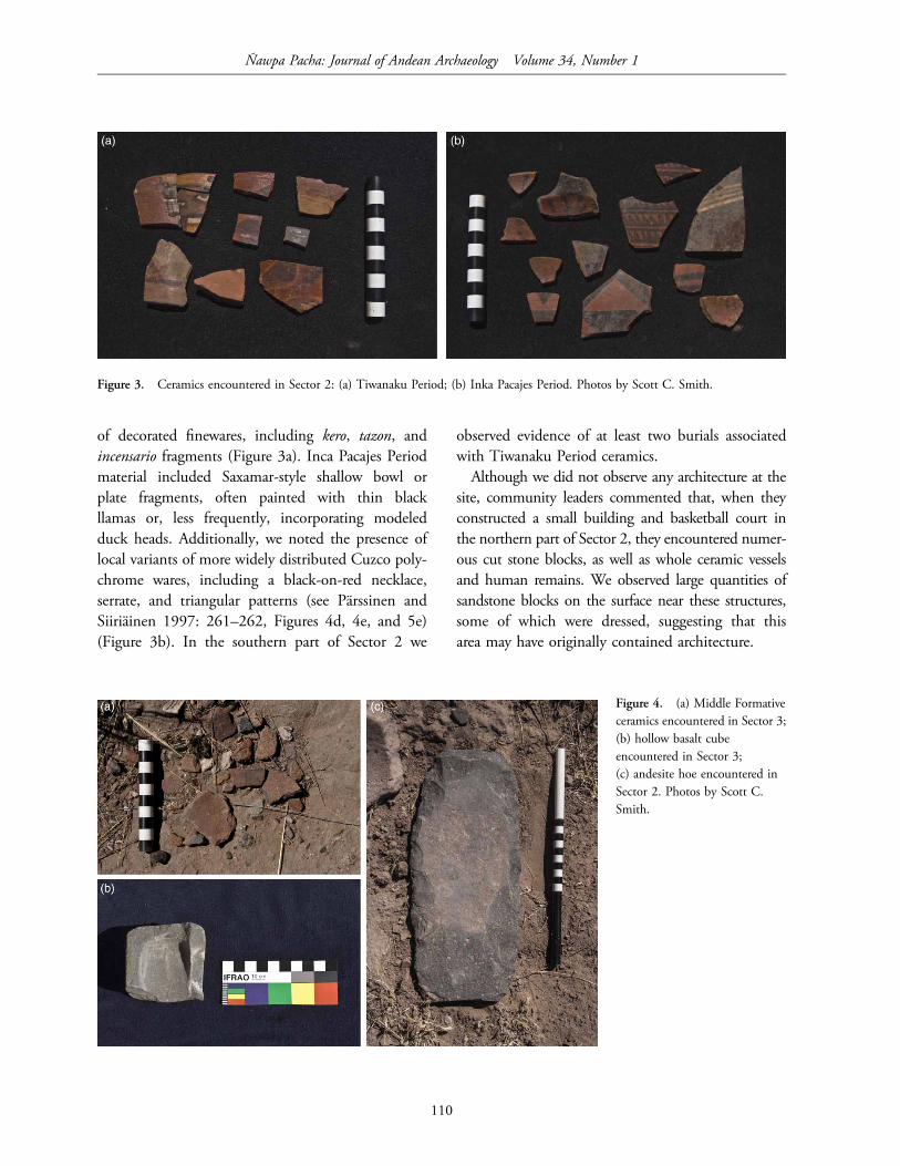
of decorated finewares, including kero, tazon, andincensario fragments (Figure 3a). Inca Pacajes Periodmaterial included Saxamar-style shallow bowl orplate fragments, often painted with thin blackllamas or, less frequently, incorporating modeledduck heads. Additionally, we noted the presence oflocal variants of more widely distributed Cuzco poly-chrome wares, including a black-on-red necklace,serrate, and triangular patterns (see Pärssinen andSiiriäinen 1997: 261–262, Figures 4d, 4e, and 5e)(Figure 3b). In the southern part of Sector 2 we
observed evidence of at least two burials associatedwith Tiwanaku Period ceramics.Although we did not observe any architecture at the
site, community leaders commented that, when theyconstructed a small building and basketball court inthe northern part of Sector 2, they encountered numer-ous cut stone blocks, as well as whole ceramic vesselsand human remains. We observed large quantities ofsandstone blocks on the surface near these structures,some of which were dressed, suggesting that thisarea may have originally contained architecture.
Figure 3. Ceramics encountered in Sector 2: (a) Tiwanaku Period; (b) Inka Pacajes Period. Photos by Scott C. Smith.
Figure 4. (a) Middle Formativeceramics encountered in Sector 3;(b) hollow basalt cubeencountered in Sector 3;(c) andesite hoe encountered inSector 2. Photos by Scott C.Smith.
Ñawpa Pacha: Journal of Andean Archaeology Volume 34, Number 1
110

Sector 3
This occupation is situated immediately south ofSector 2 and extends over an area of approximately5 ha. Although Sector 3 is situated immediately adja-cent to Sector 2, we separate the two areas of occu-pation for two reasons. First, topographically, Sector3 is located on a low, broad shoulder above Sector2, in a spatially distinct area of the mountain.Second, while the Tiwanaku and Inca Pacajes
material continued in high density in Sector 3 wealso observed increased frequencies of MiddleFormative and Late Formative ceramics. Theseincluded examples using paste recipes that incorpor-ated high quantities of thick fiber and large opaquequartz inclusions (Figure 4a). These pastes are charac-teristic of the Middle Formative Period to the northon the Taraco Peninsula and in the UpperDesaguadero Valley at Iruhito (Pérez Arias et al.2010; Steadman 1999) (Figure 1b). Late Formative
Figure 5. Subterranean Structure 1: (a) plan; (b) photo of the entrance, facing west; (c) photo of the interior of the entrance shaft, facingwest. Artwork and photos by Scott C. Smith.
Smith et al.: Long-term occupation of Cerro Chijcha, Upper Desaguadero Valley, Bolivia
111
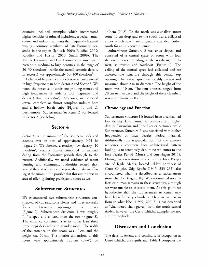
ceramics included examples which incorporatedhigher densities of mineral inclusions, especially mus-covite, and surface treatments that frequently featuredwiping—common attributes of Late Formative cer-amics in the region (Janusek 2003; Roddick 2009;Roddick and Hastorf 2010; Smith 2009). TheMiddle Formative and Late Formative ceramics werepresent in medium to high densities, in the range of30–50 sherds/m2, while the overall ceramic densityin Sector 3 was approximately 50–100 sherds/m2.Lithic tool fragments and debris were encountered
in high frequencies in both Sector 2 and Sector 3. Wenoted the presence of sandstone grinding stones andhigh frequencies of andesite tool fragments anddebris (10–20 pieces/m2). Moreover, we observedseveral complete or almost complete andesite hoesand a hollow, basalt cube (Figures 4b and c).Furthermore, Subterranean Structure 2 was locatedin Sector 3 (see below).
Sector 4
Sector 4 is the summit of the southern peak andextends over an area of approximately 0.25 ha(Figure 2). We observed a relatively low density (10sherds/m2) ceramic scatter comprised of materialdating from the Formative periods through to thepresent. Additionally, we noted evidence of recentburning and community authorities related that,around the end of the calendar year, they make an offer-ing at the summit. It is possible that this summit was anarea of offering during prehispanic times as well.
Subterranean Structures
We encountered two subterranean structures con-structed of cut sandstone blocks and three naturallyformed subterranean openings in our survey(Figure 2). Subterranean Structure 1 was roughly“T” shaped and entered from the east (Figure 5).The entrance contained a series of at least threestone steps descending to a wider room. The widthof the entrance to this room was 40 cm and theheight was 50 cm. The interior dimensions of thisroom were approximately 120 cm (E–W) by
140 cm (N–S). To the north was a shallow annexsome 40 cm deep and to the south was a collapsedannex which may have originally extended farthersouth for an unknown distance.Subterranean Structure 2 was cross shaped and
consisted of a central space or room with fourshallow annexes extending to the northeast, north-west, southwest, and southeast (Figure 6). Theceiling of the central space had collapsed and weaccessed the structure through this central topopening. The central space was roughly circular andmeasured about 2 m in diameter. The height of theroom was 110 cm. The four annexes ranged from70 cm to 1 m deep and the height of these chamberswas approximately 60 cm.
Chronology and Function
Subterranean Structure 1 is located in an area that hadlow density Late Formative ceramics and higherdensity Tiwanaku and Inca Pacajes ceramics, whileSubterranean Structure 2 was associated with higherfrequencies of Inca Pacajes Period material.Additionally, the trapezoidal form of the annexesreplicates a common Inca architectural patternleading us to tentatively date these structures to theInca Pacajes Period (Morris and von Hagen 2011).During his excavations at the nearby Inca Pacajessite of Kjula Marka, located 14 km northeast ofCerro Chijcha, Stig Rydén (1947: 233–235) alsoencountered what he described as a subterraneanstone chamber (Figure 1b). We encountered no arti-facts or human remains in these structures, althoughwe were unable to excavate them. At this point wehypothesize that the subterranean structures mayhave been funerary chambers. They are similar inform to what Isbell (1997: 206–211) has describedas “chambered shaft graves” from the north-centralAndes, however, the Cerro Chijcha examples are notcut into bedrock.
Discussion and Conclusion
The density, extent, and continuity of occupation atCerro Chijcha are significant. Table 1 compares the
Ñawpa Pacha: Journal of Andean Archaeology Volume 34, Number 1
112

Cerro Chijcha occupation to other significant archae-ological sites in the Upper Desaguadero Valley. CerroChijcha was an important site during the Middle andLate Formative periods and gained regional
prominence during the Tiwanaku period. At thatpoint it was the largest and most densely occupiedsite in the Upper Desaguadero Valley. The high fre-quency of decorated finewares and the presence of
Figure 6. Subterranean Structure 2: (a) plan; (b) photo of interior niche, facing south. Artwork and photo by Scott C. Smith.
Table 1. Comparison of the area of occupation (in hectares) through time at Cerro Chijcha with selected sites in the UpperDesaguadero Valley
Site Middle Formative Late Formative Tiwanaku Early Pacajes Pacajes Inca
Cerro Chijcha 5.0 5.0 11.5 11.5
Iruhito 3.0 4.0 4.0 2.0
Nazacara (Pärssinen 2005) 3.5
Pajcha Pata (Pärssinen 1999) 3.75
Kjula Marka (Lémuz Aguirre 2011) 7.0
Khonkho Wankane (Smith 2009) 7.0
Pukara de Khonkho (Zovar 2012) 20.0
Simillake 1.2 1.2
La Casilla (Stanish et al. 1997) 4.0 4.0
Chontacollo (Stanish et al. 1997) 3.0 3.0
Tanka Tanka (Stanish et al. 1997) 50.0
Note: The Cerro Chijcha estimates do not include the lower density Sector 1 (5.0 ha) and Sector 4 (0.25 ha) occupations.
Smith et al.: Long-term occupation of Cerro Chijcha, Upper Desaguadero Valley, Bolivia
113

several burials led us to hypothesize that the site was,at least to some extent, ceremonial in function. Theextensive Tiwanaku presence at Cerro Chijcha hasimplications for our understanding of the processesunderlying the expansion of the Tiwanaku state.The inland site of Khonkho Wankane has longbeen considered the regional center of Tiwanakupower in the Desaguadero Valley, but recent exca-vations at the site have established that KhonkhoWankane was primarily occupied during the LateFormative Period and use of that site declinedduring the Tiwanaku Period (Janusek 2013; Smith2013). The most extensive Tiwanaku occupationsdocumented to date are located along theDesaguadero River at Cerro Chijcha and Iruhito,which suggests that control of the river was an impor-tant factor in Tiwanaku political strategy (Smith2014). The ceremonial and regional political impor-tance of Cerro Chijcha seems to have continuedduring the Inca Pacajes Period.The presence of relatively high frequencies of ande-
site hoes and hoe fragments is also regionally signifi-cant. We encountered similar frequencies in ourexcavations at Iruhito, located 25 km to the northwestalong the river. The most likely source for the andesiteis Ccapia, located approximately 50 km to the
northwest near where Lake Titicaca empties intothe Desaguadero River (Figure 1b). At both Iruhitoand Cerro Chijcha we encountered little evidence ofprimary reduction of andesite raw material. Mostflakes were removed from finished tools, suggestingthat these tools were produced elsewhere andimported to Cerro Chijcha and Iruhito. This leadsus to hypothesize that the Desaguadero River wasan important trade route for finished andesite toolsfrom the area around Ccapia in the north. Bandy(2005) has also identified a trade route whichmoved finished agricultural implements, made ofolivine basalt rather than andesite, from the westernLake Titicaca basin south and east across the TaracoPeninsula beginning in the Middle FormativePeriod. This suggests the existence of a fairly extensivetrade network that moved finished agriculturalimplements throughout the region.Also apparent is the potential importance of Cerro
Chijcha as an observation point. From the summit ofthe southern peak the entire Upper DesaguaderoValley is visible (Figure 7). The archaeological sitesof Khonkho Wankane, Iruhito, and Nazacara wouldhave been visible. Additionally, one can clearly seeseveral larger, more distant mountains includingSajama to the south, Ccapia to the northwest, and
Figure 7. View of the UpperDesaguadero Valley from theslope of the southern prominenceon Cerro Chijcha, facingnorthwest; the Quimsachatamountain range is visible in thebackground. Photo by Scott C.Smith.
Ñawpa Pacha: Journal of Andean Archaeology Volume 34, Number 1
114

Illimani to the northeast. It is possible that this widermountainous landscape held religious significance forceremony participants at Cerro Chijcha (Smith2012).This research is preliminary but it demonstrates the
regional importance of Cerro Chijcha from theMiddle Formative through the Inca Pacajes periods.During the Middle and Late Formative periodsCerro Chijcha was one of a number of similarlysized centers located throughout the southern LakeTiticaca basin and possibly participated in a basin-wide trade network. During the Tiwanaku Periodthe site grew dramatically in size and density of occu-pation, suggesting that it may have been important toTiwanaku efforts to expand into the UpperDesaguadero Valley. The hypotheses suggested bythe Cerro Chijcha data require further testing andwe hope in the future to build on this preliminarywork with a regional settlement survey and programof excavations at the site center.
Acknowledgments
First and foremost we thank Ciriaco Inda fromIruhito for accompanying us on several trips toCerro Chijcha and introducing us to the communityauthorities. We also thank the community authoritiesof Cerro Chijcha: Valeriano Pucho Quispe, JiliriMallku; Ignacio German Loza Chinche, MallkuOriginario Zona A; Augustín Pucho Aspi, MallkuOriginario Zona B; Isaac Cosme, Jiliri QuillqaMallku; and Francisco Aspi Lupa, Thaqui Kamani.Thanks to Carlos Lémuz Aguirre for providing akey reference. We would also like to thank JerryD. Moore and two anonymous reviewers who pro-vided excellent comments. Any errors remain ourresponsibility.
References Cited
Bandy, Matthew S.2005 Trade and social power in the southern Titicaca
Basin Formative. In Foundations of power in theprehispanic Andes, edited by Kevin J. Vaughn,Dennis Ogburn and Christina A. Conlee,
pp. 91–111. Archeological Papers of theAmerican Anthropological Association,Jay K. Johnson, general editor. The AmericanAnthropological Association, Arlington.
Isbell, William H.1997 Mummies and mortuary monuments: a postproces-
sual prehistory of central Andean social organiz-ation. University of Texas Press, Austin.
Janusek, John W.2003 Vessels, time, and society: toward a ceramic
chronology in the Tiwanaku heartland. InTiwanaku and its hinterland: archaeology andpaleoecology of an Andean civilization, Vol. 2,edited by Alan L. Kolata, pp. 30–91.Smithsonian Institution Press, Washington,D.C. and London.
2008 Ancient Tiwanaku. Cambridge University Press,Cambridge.
2013 Jésus de Machaca before and after Tiwanaku: abackground to recent archaeology at KhonkhoWankane and Pukara de Khonkho. In Advancesin Titicaca Basin archaeology, Vol. 2, edited byAlexei Vranich and Abigail R. Levine, pp.7–22. Cotsen Institute of Archaeology, LosAngeles.
Janusek, John W., Arik T. Ohnstad, and Andrew P.Roddick2003 Khonkho Wankane and the rise of Tiwanaku.
Antiquity 77(296). Electronic document, http://antiquity.ac.uk/ProjGall/janusek/janusek.html(Accessed August 1, 2013).
Lémuz Aguirre, Carlos2011 Patrones de asentamiento aequeológico en el área
de influencia del sitio de Khonkho Wankane.Nuevos Aportes 5: 31–70.
Marsh, Erik J.2012 The emergence of Tiwanaku: domestic practices and
regional traditions at Khonkho Wankane andKk’araña. Ph.D. dissertation, Department ofAnthropology, University of California, SantaBarbara.
Morris, Craig, and Adriana von Hagen2011 The Incas: lords of the four quarters. Thames &
Hudson, London.Ohnstad, Arik2013 The stone stelae of Khonkho Wankane: inventory,
brief description, and seriation. In Advances inTiticaca Basin archaeology, Vol. 2, edited byAlexei Vranich and Abigail R. Levine, pp. 53–66.Cotsen Institute of Archaeology, Los Angeles.
Pärssinen, Martti1999 Pajcha Pata de Caquiaviri. Evidencias sobre el
Smith et al.: Long-term occupation of Cerro Chijcha, Upper Desaguadero Valley, Bolivia
115

nuevo complejo arqueológico de Alto Formativoen la Provincia de Pacajes, Bolivia (0–375D.C.). Revista Española de AntropologíaAmericana 29: 159–205.
2001 Tiwanaku IV en Nazacara, Bolivia. Boletín deArqueología PUCP 5: 605–624.
2005 Caquiaviri y la provincia Pacasa: desde Alto-Formativo hasta la conquista Española (1–1533).Producciones CIMA, La Paz.
Pärssinen, Martti, and Ari Siiriäinen1997 Inca-style ceramics and their chronological
relationship to the Inca expansion in the southernLake Titicaca area (Bolivia). Latin AmericanAntiquity 8(3): 255–271.
Pérez Arias, Adolfo E.2004 Autonomía y dinámica social en los Andes: proceso y
desarrollo socioeconómico en Irohito, Bolivia.Licenciatura thesis, Carrera de Arqueologia,Universidad Mayor de San Andres, La Paz,Bolivia.
Pérez Arias, Maribel2005 Características de la economía de subsistencia en
contextos de los períodos Formativo y Tiwanaku enel sitio de Irohito—Bolivia. Licenciatura thesis,Carrera de Arqueologia, Universidad Mayor deSan Andres, La Paz, Bolivia.
2007 Utilización de la fauna en la economía domésticade Irohito (contextos Formativo y Tiwanaku).Nuevos Aportes 4: 5–28.
Pérez Arias, Adolfo E., Scott C. Smith, and Maribel PérezArias2010 Iruhito: a rural riverside community in the
Tiwanaku heartland. Paper presented at the75th Annual Meeting of the Society forAmerican Archaeology, St. Louis, Missouri.
Roddick, Andrew P.2009 Communities of pottery production and consumption
on the Taraco peninsula, Bolivia 200 B.C.–300A.D. Ph.D. dissertation, Department ofAnthropology, University of California, Berkeley.
Roddick, Andrew P., and Christine A. Hastorf2010 Tradition brought to the surface: continuity,
innovation and change in the Late Formativeperiod, Taraco Peninsula, Bolivia. CambridgeArchaeological Journal 20(2): 157–178.
Rydén, Stig1947 Archaeological researches in the highlands of Bolivia.
Elanders Boktryckeri Aktiebolag, Göteborg.Smith, Scott C.2009 Venerable geographies: spatial dynamics, religion,
and political economy in the prehistoric LakeTiticaca Basin, Bolivia. Ph.D. dissertation,Department of Anthropology, University ofCalifornia, Riverside.
2012 Generative landscapes: the step mountain motifin Tiwanaku iconography. Ancient America 12:1–69.
2013 Late Formative period spatial organization atKhonkho Wankane, Bolivia. In Advances inTiticaca Basin archaeology, Vol. 2, edited byAlexei Vranich and Abigail R. Levine, pp. 23–44.Cotsen Institute of Archaeology, Los Angeles.
2014 Tiwanaku political strategy in the UpperDesaguadero Valley, Bolivia. Poster presented atthe 54th Annual Meeting of the Institute ofAndean Studies, Berkeley, California.
Soruco Sáenz, Enrique1992 Informe de la prospección arqueológica en Villa
Anta, provincia Pacajes. Textos Antropológicos 3:27–40.
Stanish, Charles, Edmundo de la Vega M., Lee H.Steadman, Cecilia Chávez Justo, Kirk L. Frye, LuperioOnofre Mamani, Matthew T. Seddon, and PercyCalisaya Chuquimia1997 Archaeological survey in the Juli-Desaguadero area,
Lake Titicaca Basin, Peru. FieldianaAnthropology, Chicago.
Steadman, Lee H.1999 The ceramics. In Early settlement at Chiripa,
Bolivia: research of the Taraco ArchaeologicalProject, edited by Christine A. Hastorf, pp.61–72. University of California ArchaeologicalResearch Facility, Berkeley, California.
Zovar, Jennifer M.2012 Post-collapse constructions of community, memory, and
identity: an archaeological analysis of Late IntermediatePeriod community formation in Bolivia’s DesaguaderoValley. Ph.D. dissertation, Department ofAnthropology, Vanderbilt University, Nashville,TN.
Ñawpa Pacha: Journal of Andean Archaeology Volume 34, Number 1
116