Liquor Licensing (Dry Areas) Regulations 2012 - South ...
383
Historical version: 7.3.2013 to 1.5.2013 [2.5.2013] This version is not published under the Legislation Revision and Publication Act 2002 1 South Australia Liquor Licensing (Dry Areas) Regulations 2012 under the Liquor Licensing Act 1997 Contents 1 Short title 4 Interpretation 5 Dry areas (section 131 of Act) 6 Plans of dry areas Schedule—Aberfoyle Park Area 1 Schedule—Adelaide Area 1 Schedule—Adelaide Area 2 Schedule—Adelaide Area 3 Schedule—Adelaide Area 4 Schedule—Adelaide Area 5 Schedule—Angaston Area 1 Schedule—Angaston Area 2 Schedule—Ardrossan Area 1 Schedule—Arno Bay Area 1 Schedule—Barmera Area 1 Schedule—Barmera Area 2 Schedule—Barmera Area 3 Schedule—Barmera Area 4 Schedule—Barmera Area 5 Schedule—Basham Beach Area 1 Schedule—Beachport Area 1
-
Upload
khangminh22 -
Category
Documents
-
view
1 -
download
0
Transcript of Liquor Licensing (Dry Areas) Regulations 2012 - South ...

Historical version: 7.3.2013 to 1.5.2013
[2.5.2013] This version is not published under the Legislation Revision and Publication Act 2002 1
South Australia
Liquor Licensing (Dry Areas) Regulations 2012 under the Liquor Licensing Act 1997
Contents 1 Short title 4 Interpretation 5 Dry areas (section 131 of Act) 6 Plans of dry areas
Schedule—Aberfoyle Park Area 1
Schedule—Adelaide Area 1
Schedule—Adelaide Area 2
Schedule—Adelaide Area 3
Schedule—Adelaide Area 4
Schedule—Adelaide Area 5
Schedule—Angaston Area 1
Schedule—Angaston Area 2
Schedule—Ardrossan Area 1
Schedule—Arno Bay Area 1
Schedule—Barmera Area 1
Schedule—Barmera Area 2
Schedule—Barmera Area 3
Schedule—Barmera Area 4
Schedule—Barmera Area 5
Schedule—Basham Beach Area 1
Schedule—Beachport Area 1

Liquor Licensing (Dry Areas) Regulations 2012—7.3.2013 to 1.5.2013 Contents
2 This version is not published under the Legislation Revision and Publication Act 2002 [2.5.2013]
Schedule—Beachport Area 2
Schedule—Berri Area 1
Schedule—Berri Area 2
Schedule—Bordertown Area 1
Schedule—Brighton Area 1
Schedule—Ceduna and Thevenard Area 1
Schedule—Ceduna and Thevenard Area 2
Schedule—Christies Beach Area 1
Schedule—Clare Area 1
Schedule—Clare Area 2
Schedule—Clare Area 3
Schedule—Clare Area 4
Schedule—Coffin Bay Area 1
Schedule—Coober Pedy Area 1
Schedule—Cowell Area 1
Schedule—Cummins Area 1
Schedule—Edithburgh Area 1
Schedule—Elliston Area 1
Schedule—Fisherman Bay Area 1
Schedule—Gawler Area 1
Schedule—Gawler Area 2
Schedule—Gawler Area 3
Schedule—Gawler Area 4
Schedule—Gawler Area 5

7.3.2013 to 1.5.2013—Liquor Licensing (Dry Areas) Regulations 2012
Contents
[2.5.2013] This version is not published under the Legislation Revision and Publication Act 2002 3
Schedule—Glenelg Area 1
Schedule—Glenelg Area 2
Schedule—Glenelg North Area 1
Schedule—Golden Grove Area 1
Schedule—Goolwa Area 1
Schedule—Goolwa Area 2
Schedule—Goolwa Beach Area 1
Schedule—Grange Area 1
Schedule—Hahndorf Area 1
Schedule—Hallett Cove Area 1
Schedule—Hallett Cove Area 2
Schedule—Hallett Cove Area 3
Schedule—Hallett Cove Area 4
Schedule—Hallett Cove Area 5
Schedule—Hallett Cove Area 6
Schedule—Hayborough Area 1
Schedule—Henley Beach Area 1
Schedule—Henley Beach Area 2
Schedule—Henley Beach South Area 1
Schedule—Kadina Area 1
Schedule—Kadina Area 2
Schedule—Kimba Area 1
Schedule—Kingscote Area 1
Schedule—Lobethal Area 1

Liquor Licensing (Dry Areas) Regulations 2012—7.3.2013 to 1.5.2013 Contents
4 This version is not published under the Legislation Revision and Publication Act 2002 [2.5.2013]
Schedule—Loxton Area 1
Schedule—Loxton Area 2
Schedule—Loxton Area 3
Schedule—Lyndoch Area 1
Schedule—Maitland Area 1
Schedule—Mannum Area 1
Schedule—Mannum Area 2
Schedule—Mannum Area 3
Schedule—Mannum Area 4
Schedule—Mannum Area 5
Schedule—Meningie Area 1
Schedule—Middleton Area 1
Schedule—Millicent Area 1
Schedule—Millicent Area 2
Schedule—Moana Area 1
Schedule—Moana Area 2
Schedule—Moonta Area 1
Schedule—Moonta Area 2
Schedule—Moonta Bay Area 1
Schedule—Moonta Bay Area 2
Schedule—Moonta Bay and Port Hughes Area 1
Schedule—Morgan Area 1
Schedule—Morphett Vale Area 1
Schedule—Mount Barker Area 1

7.3.2013 to 1.5.2013—Liquor Licensing (Dry Areas) Regulations 2012
Contents
[2.5.2013] This version is not published under the Legislation Revision and Publication Act 2002 5
Schedule—Mount Barker Area 2
Schedule—Mount Gambier Area 1
Schedule—Mount Gambier Area 2
Schedule—Mount Gambier Area 3
Schedule—Mount Gambier Area 4
Schedule—Mount Gambier Area 5
Schedule—Mount Pleasant Area 1
Schedule—Murray Bridge Area 1
Schedule—Nairne Area 1
Schedule—Naracoorte Area 1
Schedule—Naracoorte Area 2
Schedule—Noarlunga Centre Area 1
Schedule—Normanville Area 1
Schedule—North Adelaide Area 1
Schedule—Nuriootpa Area 1
Schedule—Oaklands Park Area 1
Schedule—Paringa Area 1
Schedule—Peterborough Area 1
Schedule—Port Adelaide Area 1
Schedule—Port Adelaide Area 2
Schedule—Port Augusta Area 1
Schedule—Port Augusta Area 2
Schedule—Port Augusta Area 3
Schedule—Port Broughton Area 1

Liquor Licensing (Dry Areas) Regulations 2012—7.3.2013 to 1.5.2013 Contents
6 This version is not published under the Legislation Revision and Publication Act 2002 [2.5.2013]
Schedule—Port Broughton Area 2
Schedule—Port Elliot Area 1
Schedule—Port Elliot Area 2
Schedule—Port Hughes Area 1
Schedule—Port Hughes Area 2
Schedule—Port Kenny Area 1
Schedule—Port Lincoln Area 1
Schedule—Port Neill Area 1
Schedule—Port Noarlunga Area 1
Schedule—Port Noarlunga Area 2
Schedule—Port Noarlunga Area 3
Schedule—Port Pirie Area 1
Schedule—Port Pirie Area 2
Schedule—Port Victoria Area 1
Schedule—Port Vincent Area 1
Schedule—Port Vincent Area 2
Schedule—Prospect Area 1
Schedule—Renmark Area 1
Schedule—Renmark Area 2
Schedule—Robe Area 1
Schedule—Robe Area 2
Schedule—Salisbury Area 1
Schedule—Seacliff Area 1
Schedule—Seacliff Area 2

7.3.2013 to 1.5.2013—Liquor Licensing (Dry Areas) Regulations 2012
Contents
[2.5.2013] This version is not published under the Legislation Revision and Publication Act 2002 7
Schedule—Seacliff Area 3
Schedule—Seacliff Area 4
Schedule—Semaphore Area 1
Schedule—Semaphore Area 2
Schedule—Semaphore Area 3
Schedule—Semaphore Area 4
Schedule—Spalding Area 1
Schedule—Stansbury Area 1
Schedule—Stansbury Area 2
Schedule—Stirling North Area 1
Schedule—Strathalbyn Area 1
Schedule—Strathalbyn Area 2
Schedule—Streaky Bay Area 1
Schedule—Tanunda Area 1
Schedule—Tumby Bay Area 1
Schedule—Two Wells Area 1
Schedule—Unley Area 1
Schedule—Venus Bay Area 1
Schedule—Victor Harbor Area 1
Schedule—Victor Harbor Area 2
Schedule—Victor Harbor Area 3
Schedule—Victor Harbor Area 4
Schedule—Waikerie Area 1
Schedule—Wallaroo Area 1

Liquor Licensing (Dry Areas) Regulations 2012—7.3.2013 to 1.5.2013 Contents
8 This version is not published under the Legislation Revision and Publication Act 2002 [2.5.2013]
Schedule—Wallaroo Area 2
Schedule—Wallaroo Area 3
Schedule—Wallaroo Area 4
Schedule—Wattle Park Area 1
Schedule—West Beach Area 1
Schedule—Whyalla Area 1
Schedule—Whyalla Area 2
Schedule—Williamstown Area 1
Schedule—Williamstown Area 2
Schedule—Wilmington Area 1
Schedule—Woodcroft Area 1
Legislative history

7.3.2013 to 1.5.2013—Liquor Licensing (Dry Areas) Regulations 2012
[2.5.2013] This version is not published under the Legislation Revision and Publication Act 2002 1
1—Short title These regulations may be cited as the Liquor Licensing (Dry Areas) Regulations 2012.
4—Interpretation (1) In these regulations, unless the contrary intention appears—
Act means the Liquor Licensing Act 1997;
container means the container in which liquor is sealed so that it cannot escape but does not include packaging in which the container is sold;
private land means any land that is not a public place within the meaning of the Act;
revoked long term regulations means the Liquor Licensing (Dry Areas—Long Term) Regulations 1997;
road includes a street, avenue, terrace, lane, crescent, court, place or other land set aside for the carriage of vehicular traffic.
(2) Unless the contrary intention appears, a reference in these regulations to a road is a reference to—
(a) the carriageway of the road; and
(b) the footpaths (if any) of the road; and
(c) a median strip or traffic island (if any) or any other land separating carriageways of the road; and
(d) any other land adjoining or adjacent to the carriageway of the road being land that has been reserved for the purposes of the road.
(3) For the purposes of these regulations, a wine cask will be taken to have been opened if the tap comprising part of the container is protruding through the external carton.
(4) Subject to subregulation (5), where, on the commencement of these regulations, a description or plan of an area in a Schedule is substantially the same as a description or plan of an area in the revoked long term regulations immediately prior to the commencement of these regulations, a reference in that description or plan to a road, land parcel, land use, geographical location, physical feature or other thing is to be interpreted as at the time the reference was first included as part of the description or plan in the revoked long term regulations.
(5) A reference included in a Schedule after the commencement of these regulations is to be interpreted as at the time of its inclusion.
(6) For the purposes of subregulation (4), a description or plan of an area does not cease to be substantially the same as a description or plan in the revoked long term regulations by reason only of differences in headings, setting-out, references to other provisions of the regulations, spelling or other non-substantive matters.
5—Dry areas (section 131 of Act) (1) Subject to subregulation (2), the consumption of liquor or the consumption and
possession of liquor are prohibited in accordance with each Schedule in the areas described in the Schedule during the periods specified in the Schedule.

Liquor Licensing (Dry Areas) Regulations 2012—7.3.2013 to 1.5.2013
2 This version is not published under the Legislation Revision and Publication Act 2002 [2.5.2013]
(2) The prohibition does not extend to any private land within an area described in a Schedule.
(3) Unless the contrary intention appears, the prohibition in a Schedule of the possession of liquor in an area does not extend to—
(a) a person who is genuinely passing through the area if—
(i) the liquor is in the original container in which it was purchased from licensed premises; and
(ii) the container has not been opened; or
(b) a person who has possession of the liquor in the course of carrying on a business or in the course of his or her employment by another person in the course of carrying on a business; or
(c) a person who is permanently or temporarily residing at premises within the area or on the boundary of the area and who enters the area solely for the purpose of passing through it to enter those premises or who enters the area from those premises for the purpose of leaving the area; or
(d) such other persons (if any) who are specifically excluded by a Schedule.
6—Plans of dry areas (1) The Schedules set out plans of some of the areas described.
(2) If the description of an area in a Schedule does not coincide with the plan of the area, the description will be taken to be correct.

7.3.2013 to 1.5.2013—Liquor Licensing (Dry Areas) Regulations 2012
Aberfoyle Park Area 1—Schedule
[2.5.2013] This version is not published under the Legislation Revision and Publication Act 2002 1
Schedule—Aberfoyle Park Area 1
1—Extent of prohibition
The consumption of liquor is prohibited and the possession of liquor is prohibited.
2—Period of prohibition
8 pm on each day to 6 am on the following day until 6 am on 11 September 2016.
3—Description of area
Reserve area in Aberfoyle Park, as follows: commencing at the point at which the western boundary of Carrickalinga Boulevard, Aberfoyle Park, meets the southern boundary of Taylors Road, then westerly along the northern boundary of Aberfoyle Park High School and the Hub Sports Centre to the eastern boundary of Park Avenue, then northerly in a straight line across Taylors Road West to the south-eastern corner of the allotment of private land that lies on the corner of Taylors Road West and Brook Drive (on the northern side of Taylors Road West and on the eastern side of Brook Drive), then northerly along the eastern boundary of that allotment and the row of adjoining allotments to the north-eastern corner of the northernmost such allotment, then westerly along the northern boundary of that allotment to Brook Drive, then north-westerly and westerly along the northern boundary of Brook Drive to the northern boundary of the next allotment of private land that adjoins that boundary of Brook Drive (being an allotment joining the western end of Brook Drive), then westerly along the northern boundary of that allotment to the north-western corner of that allotment, then northerly along the fence line that crosses the creek that lies to the north of the allotment to the south-western corner of the southernmost allotment adjoining the western boundary of the westernmost portion of Delta Crescent, then easterly and north-easterly along the southern boundary of that allotment and of Delta Crescent to the south-western corner of the next allotment of private land adjoining that same boundary of Delta Crescent, then generally easterly and north-easterly along the southern boundaries of that allotment and all adjoining allotments of private land (and of Canberra Drive and Wilma Court) to the southern boundary of the Aberfoyle Campus Schools, then north-easterly and easterly along that southern boundary and the southern boundaries of the adjoining allotments of private land (the boundaries approximately indicated by a fence and then by a pathway) to the western boundary of Hub Drive, then south-easterly and southerly along the western boundary of Hub Drive to the north-eastern corner of the next allotment of private land adjoining that western boundary of Hub Drive, then westerly along the northern boundaries of that allotment and all adjoining allotments of private land (and of Redcraze Street) to the eastern boundary of Carrickalinga Boulevard, then north-westerly, westerly and southerly along the road boundary on that side of Carrickalinga Boulevard to the point of commencement.

Liquor Licensing (Dry Areas) Regulations 2012—7.3.2013 to 1.5.2013 Schedule—Aberfoyle Park Area 1
2 This version is not published under the Legislation Revision and Publication Act 2002 [2.5.2013]

7.3.2013 to 1.5.2013—Liquor Licensing (Dry Areas) Regulations 2012
Adelaide Area 1—Schedule
[2.5.2013] This version is not published under the Legislation Revision and Publication Act 2002 1
Schedule—Adelaide Area 1
1—Extent of prohibition
The consumption of liquor is prohibited and the possession of liquor is prohibited.
2—Period of prohibition
Continuous until 30 October 2014.
3—Description of area
The area in Adelaide bounded as follows: commencing at the point at which the prolongation in a straight line of the eastern boundary of West Terrace intersects the northern boundary of North Terrace, then easterly along that boundary of North Terrace to the western boundary of the Skate Park, then northerly, easterly and southerly around the western, northern and eastern boundaries of the Skate Park to the northern boundary of North Terrace, then easterly along that boundary of North Terrace to the eastern boundary of Montefiore Road, then northerly along that boundary of Montefiore Road to the northernmost boundary of Festival Drive, then easterly along that boundary of Festival Drive to the point at which it meets the northernmost boundary of the built structures comprising and adjacent to the Adelaide Convention Centre Complex, Hyatt Hotel and Adelaide Festival Centre, then generally easterly, northerly and easterly along that boundary to the north-eastern corner of the Adelaide Festival Centre built structures, then in a straight line by the shortest route to the north-western corner of Government House, then easterly along the northern boundary of Government House and the prolongation in a straight line of that boundary to the eastern boundary of Kintore Avenue, then northerly along that boundary of Kintore Avenue to the southern boundary of Victoria Drive, then generally easterly along that boundary of Victoria Drive to the western boundary of Frome Road, then in a straight line by the shortest route to the south-western corner of Botanic Park, then generally easterly along the southern boundary of Botanic Park to the point at which it meets the western boundary of the Botanic Gardens, then generally southerly, south-easterly and southerly along the western boundary of the Botanic Gardens to the northern boundary of North Terrace, then easterly along that boundary of North Terrace to the point at which it meets the northerly prolongation in a straight line of the western boundary of East Terrace, then generally southerly and easterly along that prolongation and the western boundary of East Terrace to the northern boundary of South Terrace, then westerly along that boundary of South Terrace to the eastern boundary of West Terrace, then northerly along that boundary of West Terrace (and the prolongation in a straight line of that boundary) to the point of commencement—
(a) excluding the grounds of The University of Adelaide, the University of South Australia and the Institute of Medical and Veterinary Science; and
(b) excluding the Adelaide Festival Centre.

Liquor Licensing (Dry Areas) Regulations 2012—7.3.2013 to 1.5.2013 Schedule—Adelaide Area 1
2 This version is not published under the Legislation Revision and Publication Act 2002 [2.5.2013]

7.3.2013 to 1.5.2013—Liquor Licensing (Dry Areas) Regulations 2012
Adelaide Area 2—Schedule
[2.5.2013] This version is not published under the Legislation Revision and Publication Act 2002 1
Schedule—Adelaide Area 2
1—Extent of prohibition
The consumption of liquor is prohibited and the possession of liquor is prohibited.
2—Period of prohibition
The prohibition applies during the following periods:
(a) from 6 am on 1 December 2012 to 12.01 am on 2 December 2012;
(b) from 7 am on 2 March 2013 to 12.01 am on 3 March 2013;
(c) from 7 am on 11 March 2013 to 12.01 am on 12 March 2013.
3—Description of area
The area in and adjacent to the City of Adelaide bounded on the north by the River Torrens, on the west and south by Port Road and on the east by the railway reserve running between Port Road and the River Torrens (immediately to the east of the Old Adelaide Gaol).


7.3.2013 to 1.5.2013—Liquor Licensing (Dry Areas) Regulations 2012
Adelaide Area 3—Schedule
[2.5.2013] This version is not published under the Legislation Revision and Publication Act 2002 1
Schedule—Adelaide Area 3
1—Extent of prohibition
The consumption of liquor is prohibited and the possession of liquor is prohibited.
2—Period of prohibition
9 am on 31 December 2012 to 5 am on 1 January 2013.
3—Description of area
The area in and adjacent to the City of Adelaide bounded as follows: commencing at the point at which a straight line by the shortest route between the north-eastern corner of the Adelaide Festival Centre built structures and the north-western corner of Government House intersects the western boundary of King William Road, then northerly along that boundary of King William Road to the southern boundary of War Memorial Drive, then generally south-westerly, north-westerly and westerly along that boundary of War Memorial Drive to the eastern boundary of Montefiore Road, then southerly along that boundary of Montefiore Road to the northernmost boundary of Festival Drive, then easterly along that boundary of Festival Drive to the point at which it meets the northernmost boundary of the built structures comprising and adjacent to the Adelaide Convention Centre Complex, InterContinental Hotel and Adelaide Festival Centre, then generally easterly, northerly and easterly along that boundary to the north-eastern corner of the Adelaide Festival Centre built structures, then south-easterly along a straight line by the shortest route joining that corner with the north-western corner of Government House to the point of commencement.


7.3.2013 to 1.5.2013—Liquor Licensing (Dry Areas) Regulations 2012
Adelaide Area 4—Schedule
[2.5.2013] This version is not published under the Legislation Revision and Publication Act 2002 1
Schedule—Adelaide Area 4
1—Extent of prohibition
The consumption of liquor is prohibited and the possession of liquor is prohibited.
2—Period of prohibition
6 pm on 31 December 2012 to 7 am on 1 January 2013.
3—Description of area
The area in and adjacent to the City of Adelaide bounded on the north by Rundle Road, on the east by Dequetteville Terrace, on the south by Bartels Road and on the west by East Terrace.


7.3.2013 to 1.5.2013—Liquor Licensing (Dry Areas) Regulations 2012
Adelaide Area 5—Schedule
[2.5.2013] This version is not published under the Legislation Revision and Publication Act 2002 1
Schedule—Adelaide Area 5
1—Extent of prohibition
The consumption of liquor is prohibited and the possession of liquor is prohibited.
2—Period of prohibition
12 noon on 18 January 2013 to 1 am on 20 January 2013.
3—Description of area
The area in and adjacent to the City of Adelaide bounded on the north by the southern boundary of Glover Avenue, on the east by the western boundary of West Terrace, on the south by the northern boundary of Sir Donald Bradman Drive and on the west by the eastern boundary of the railway corridor that extends from the northern boundary of Sir Donald Bradman Drive to the southern boundary of Glover Avenue (being the eastern boundary of Lot 17 of Filed Plan No. 1485).

7.3.2013 to 1.5.2013—Liquor Licensing (Dry Areas) Regulations 2012
Angaston Area 1—Schedule
[2.5.2013] This version is not published under the Legislation Revision and Publication Act 2002 1
Schedule—Angaston Area 1
1—Extent of prohibition
The consumption of liquor is prohibited and the possession of liquor is prohibited.
2—Period of prohibition
From 10 pm on each day to 8 am on the following day, until 8 am on 22 January 2018.
3—Description of area
The area in Angaston bounded as follows: commencing at the point at which the northern boundary of Dean Street intersects the western boundary of Schilling Street, then north-westerly along the western boundary of Schilling Street and the prolongation in a straight line of that boundary to the northern boundary of Murray Street, then south-westerly along that northern boundary of Murray Street to the eastern boundary of Middle Street, then north-westerly along that boundary of Middle Street and the prolongation in a straight line of that boundary to the northern boundary of Newcastle Street, then south-westerly along that boundary of Newcastle Street to the southern boundary of Lot 708 DP 1573, then generally south-westerly and north-westerly along the southern boundary of Lot 708 and of the adjoining allotments (Lot 103 DP 23247, Lot 102 DP 23247, Piece 53 DP 45842 and Lot 54 DP 45843) to the eastern boundary of Penrice Road, then north-westerly along that boundary of Penrice Road to the point at which it intersects the prolongation in a straight line of the northern boundary of Lot 753 DP 1573, then generally south-westerly along that prolongation and boundary of Lot 753 to the point at which it meets the north-eastern boundary of Lot 269 FP 172530, then north-westerly and south-westerly along the north-eastern and north-western boundaries of Lot 269 and the prolongation in a straight line (across Murray Street) of the north-western boundary of that Lot to the southern boundary of Murray Street, then south-easterly along that boundary of Murray Street to the south-eastern boundary of Piece 91 of FP 170445 (the north-western boundary of South Terrace), then south-westerly along that boundary of Piece 91 and the prolongation in a straight line of that boundary to the southern boundary of Fife Street, then south-easterly along that southern boundary of Fife Street to the western boundary of Washington Street, then south-westerly along that boundary of Washington Street to the southern boundary of Lindsay Street, then in a straight line by the shortest route to the point at which the southern boundary of Holmes Street meets the eastern boundary of Lot 11 FP 14788, then south-easterly along that southern boundary of Holmes Street to the western boundary of French Street, then north-easterly along that boundary of French Street to the western boundary of Sturt Street, then north-westerly along that boundary of Sturt Street to the point at which it intersects the prolongation in a straight line of the northern boundary of Dean Street, then easterly and north-easterly along that prolongation and boundary of Dean Street to the point of commencement.

Liquor Licensing (Dry Areas) Regulations 2012—7.3.2013 to 1.5.2013 Schedule—Angaston Area 1
2 This version is not published under the Legislation Revision and Publication Act 2002 [2.5.2013]

7.3.2013 to 1.5.2013—Liquor Licensing (Dry Areas) Regulations 2012
Angaston Area 2—Schedule
[2.5.2013] This version is not published under the Legislation Revision and Publication Act 2002 1
Schedule—Angaston Area 2
1—Extent of prohibition
The consumption of liquor is prohibited and the possession of liquor is prohibited.
2—Period of prohibition
From 10 pm on each day to 8 am on the following day, until 8 am on 22 January 2018.
3—Description of area
The area in Angaston (generally known as Angas Recreation Park) bounded as follows: commencing at the point at which the western boundary of Park Road meets the south-eastern boundary of Washington Street, then south-easterly along that western boundary of Park Road to the point at which the northern boundary of Lot 29 DP 2861 meets the eastern boundary of Lot 137 FP 173228, then south-easterly along that eastern boundary of Lot 137 to the northern boundary of Lot 51 DP 5086, then south-westerly and south-easterly along the northern and western boundaries of Lot 51 to the northern boundary of Gramp Avenue, then generally south-westerly along that boundary of Gramp Avenue to the eastern boundary of Radford Road, then north-westerly along that boundary of Radford Road to the south-eastern boundary of Washington Street, then north-easterly along that boundary of Washington Street to the point of commencement.

Liquor Licensing (Dry Areas) Regulations 2012—7.3.2013 to 1.5.2013 Schedule—Angaston Area 2
2 This version is not published under the Legislation Revision and Publication Act 2002 [2.5.2013]

7.3.2013 to 1.5.2013—Liquor Licensing (Dry Areas) Regulations 2012
Ardrossan Area 1—Schedule
[2.5.2013] This version is not published under the Legislation Revision and Publication Act 2002 1
Schedule—Ardrossan Area 1
1—Extent of prohibition
The consumption of liquor is prohibited and the possession of liquor is prohibited.
2—Period of prohibition
From 10 pm on each day until 8 am on the following day, until 8 am on 7 August 2016.
3—Description of area
The area in Ardrossan bounded as follows: commencing at the point at which the north-eastern boundary of Second Street intersects the south-eastern boundary of Oval Terrace, then north-easterly along that boundary of Oval Terrace to the north-eastern boundary of First Street, then south-easterly along that boundary of First Street to the north-western boundary of West Terrace, then north-easterly along that boundary of West Terrace and the prolongation in a straight line of the portion of that boundary that runs north-easterly in a straight line from First Street, to the north-eastern boundary of Dinham Drive, then south-easterly along that boundary of Dinham Drive to the north-western boundary of Bridge Road, then north-easterly and northerly along that boundary of Bridge Road to the south-western boundary of Parkview Terrace, then in a straight line by the shortest route (across Bridge Road) to the point at which the south-eastern boundary of Bridge Road meets the south-western boundary of Park Terrace, then south-easterly along that boundary of Park Terrace and the prolongation in a straight line of that boundary to the low water mark on the western side of Gulf St Vincent, then generally south-westerly along that low water mark to the north-eastern side of the Ardrossan Jetty, then generally south-easterly, south-westerly and north-westerly around the outer boundary of the jetty (so as to include within the area the whole of the jetty and the area beneath the jetty) back to the low water mark on the south-western side of the jetty, then generally south-westerly along that low water mark to the point at which it is intersected by the prolongation in a straight line of the north-eastern boundary of Second Street, then north-westerly along that prolongation and boundary of Second Street to the point of commencement.

Liquor Licensing (Dry Areas) Regulations 2012—7.3.2013 to 1.5.2013 Schedule—Ardrossan Area 1
2 This version is not published under the Legislation Revision and Publication Act 2002 [2.5.2013]

7.3.2013 to 1.5.2013—Liquor Licensing (Dry Areas) Regulations 2012
Arno Bay Area 1—Schedule
[2.5.2013] This version is not published under the Legislation Revision and Publication Act 2002 1
Schedule—Arno Bay Area 1
1—Extent of prohibition
The consumption of liquor is prohibited and the possession of liquor is prohibited.
2—Period of prohibition
From 11 pm on 31 December 2012 to 8 am on 1 January 2013.
3—Description of area
The area in and adjacent to Arno Bay bounded as follows: commencing at the point at which the low water mark on the western side of Spencer Gulf is intersected by the prolongation in a straight line of the south-eastern boundary of Section 320 Hundred of Boothby, then south-westerly along that prolongation and boundary of Section 320, the south-eastern boundary of Lot 254 of FP 178666 and the prolongation in a straight line of the south-eastern boundary of Lot 254 to the south-western boundary of Piece 103 of DP 79319, then generally north-westerly along that boundary of Piece 103 to the point at which it meets the south-eastern boundary of Lot 101 of DP 79319, then in a straight line by the shortest route to the point at which the northern boundary of Lot 254 of FP 178666 meets the western boundary of the Lot (the northernmost point of Lot 254), then easterly in a straight line along the portion of the boundary of Piece 103 of DP 79319 that extends easterly from that point, and easterly along the prolongation in a straight line of that portion of the boundary, to the eastern boundary of Creek Road, then south-westerly along that boundary of Creek Road to the point at which it meets the northern boundary of Lot 254 of FP 178666, then generally south-easterly and easterly along that boundary of Lot 254 to the point at which the northern boundary of Lot 254 meets the western boundary of Section 344 Hundred of Boothby, then northerly along that boundary of Section 344 to the southern boundary of Lot 7 of DP 35379, then north-westerly, north-easterly and south-easterly along the southern, western and northern boundaries of Lot 7 to the point at which the northern boundary of Lot 7 meets the western boundary of Lot 6 of DP 35379, then generally north-easterly and north-westerly along that boundary of Lot 6 to the north-western boundary of the Lot, then north-easterly along the north-western boundary of Lot 6, and the prolongation in a straight line of that boundary, to the point at which the prolongation intersects the south-western boundary of Lot 27 of DP 55099, then south-easterly along that boundary of Lot 27 to the south-eastern boundary of the Lot, then in a straight line by the shortest route to the point at which the north-western and south-western boundaries of Section 359 Hundred of Boothby meet, then south-easterly along the south-western boundary of Section 359, and the prolongation in a straight line of that boundary, to the point at which the prolongation intersects the north-western boundary of Section 317 Hundred of Boothby, then generally north-easterly along that boundary of Section 317 and the north-western boundary of Piece 3 of DP 68273 to the point at which the north-western boundary of Piece 3 meets the north-eastern boundary of Section 412 Hundred of Boothby, then north-westerly along that boundary of Section 412 and the prolongation in a straight line of that boundary to the south-eastern boundary of Piece 2 of DP 68273, then generally north-easterly along that boundary of Piece 2 to the point at which it meets the north-western boundary of Lot 1 of DP 68273, then north-easterly along that boundary of Lot 1 and the prolongation in a straight line of that boundary to the low water mark on the western side of Spencer Gulf, then generally southerly along the low water mark to the point at which it meets the

Liquor Licensing (Dry Areas) Regulations 2012—7.3.2013 to 1.5.2013 Schedule—Arno Bay Area 1
2 This version is not published under the Legislation Revision and Publication Act 2002 [2.5.2013]
commencement of the breakwater that forms the eastern wall of the Arno Bay marina, then southerly along the outer boundary of the breakwater to the end of the breakwater, then in a straight line by the shortest route (across the entrance to the marina) to the outer boundary of the eastern end of the breakwater that forms the southern and western walls of the marina, then generally southerly, westerly and north-westerly along the outer boundary of that breakwater back to the low water mark on the shore on the western side of the marina (so as to include the whole of the marina and each of the breakwaters in the area), then generally south-westerly along the low water mark to the north-eastern side of the Arno Bay jetty, then south-easterly, south-westerly and north-westerly around the outer boundary of the jetty (so as to include the whole of the jetty and any area below the jetty in the area) back to the low water mark on the south-western side of the jetty, then generally south-westerly and southerly along the low water mark to the point of commencement.

7.3.2013 to 1.5.2013—Liquor Licensing (Dry Areas) Regulations 2012
Arno Bay Area 1—Schedule
[2.5.2013] This version is not published under the Legislation Revision and Publication Act 2002 3


7.3.2013 to 1.5.2013—Liquor Licensing (Dry Areas) Regulations 2012
Barmera Area 1—Schedule
[2.5.2013] This version is not published under the Legislation Revision and Publication Act 2002 1
Schedule—Barmera Area 1
1—Extent of prohibition
The consumption of liquor is prohibited and the possession of liquor is prohibited.
2—Period of prohibition
Continuous until 29 July 2017, provided that where—
(a) an event of historic, cultural, traditional or major community significance is held in the area; and
(b) the consumption and possession of liquor in the area (or a defined portion of the area) are authorised for a specified period for the purposes of the event by The Berri Barmera Council,
the prohibition does not apply in the area (or defined portion of the area) during that specified period.
3—Description of area
Barwell Avenue.


7.3.2013 to 1.5.2013—Liquor Licensing (Dry Areas) Regulations 2012
Barmera Area 2—Schedule
[2.5.2013] This version is not published under the Legislation Revision and Publication Act 2002 1
Schedule—Barmera Area 2
1—Extent of prohibition
The consumption of liquor is prohibited and the possession of liquor is prohibited.
2—Period of prohibition
Continuous until 29 July 2017, provided that where—
(a) an event of historic, cultural, traditional or major community significance is held in the area; and
(b) the consumption and possession of liquor in the area (or a defined portion of the area) are authorised for a specified period for the purposes of the event by The Berri Barmera Council,
the prohibition does not apply in the area (or defined portion of the area) during that specified period.
3—Description of area
Bice Street between Barwell Avenue and Sturt Street.


7.3.2013 to 1.5.2013—Liquor Licensing (Dry Areas) Regulations 2012
Barmera Area 3—Schedule
[2.5.2013] This version is not published under the Legislation Revision and Publication Act 2002 1
Schedule—Barmera Area 3
1—Extent of prohibition
The consumption of liquor is prohibited and the possession of liquor is prohibited.
2—Period of prohibition
From 8 pm on each day to 8 am on the following day, until 8 am on 29 July 2017, provided that where—
(a) an event of historic, cultural, traditional or major community significance is held in the area; and
(b) the consumption and possession of liquor in the area (or a defined portion of the area) are authorised for a specified period for the purposes of the event by The Berri Barmera Council,
the prohibition does not apply in the area (or defined portion of the area) during that specified period.
3—Description of area
The area in Barmera generally known as Sedunary Park, being the area bounded on the north-west by Dean Drive, on the north-east by Whitmore Avenue, on the south by Nookamka Terrace and on the south-west by Pascoe Terrace.


7.3.2013 to 1.5.2013—Liquor Licensing (Dry Areas) Regulations 2012
Barmera Area 4—Schedule
[2.5.2013] This version is not published under the Legislation Revision and Publication Act 2002 1
Schedule—Barmera Area 4
1—Extent of prohibition
The consumption of liquor is prohibited and the possession of liquor is prohibited.
2—Period of prohibition
From 8 pm on each day to 8 am on the following day, until 8 am on 29 July 2017, provided that where—
(a) an event of historic, cultural, traditional or major community significance is held in the area; and
(b) the consumption and possession of liquor in the area (or a defined portion of the area) are authorised for a specified period for the purposes of the event by The Berri Barmera Council,
the prohibition does not apply in the area (or defined portion of the area) during that specified period.
3—Description of area
The area in and adjacent to Barmera bounded as follows: commencing at the point at which the prolongation in a straight line of the north-eastern boundary of Foot Avenue intersects the south-eastern waterline of Lake Bonney, then south-easterly along that prolongation to the north-western boundary of Dean Drive, then generally south-westerly along that boundary of Dean Drive to the point at which it meets the north-eastern boundary of the short bitumenised access road (immediately to the north-east of the Lake Bonney Yacht Club car park) that extends at right angles to Dean Drive part of the way to the Lake Bonney waterline (approximately in line with the prolongation in a straight line of the northern end of Laffer Street), then north-westerly along the north-eastern boundary of that bitumenised access road and the prolongation in a straight line of that boundary to the south-eastern waterline of Lake Bonney, then generally north-easterly along that waterline of Lake Bonney to the point of commencement. The area includes the whole of any wharf, jetty, boat ramp or other structure projecting into Lake Bonney from within the area (as well as any area beneath such a structure).


7.3.2013 to 1.5.2013—Liquor Licensing (Dry Areas) Regulations 2012
Barmera Area 5—Schedule
[2.5.2013] This version is not published under the Legislation Revision and Publication Act 2002 1
Schedule—Barmera Area 5
1—Extent of prohibition
The consumption of liquor is prohibited and the possession of liquor is prohibited.
2—Period of prohibition
From 8 pm on each day to 8 am on the following day, until 8 am on 29 July 2017, provided that where—
(a) an event of historic, cultural, traditional or major community significance is held in the area; and
(b) the consumption and possession of liquor in the area (or a defined portion of the area) are authorised for a specified period for the purposes of the event by The Berri Barmera Council,
the prohibition does not apply in the area (or defined portion of the area) during that specified period.
3—Description of area
The area in Barmera generally known as the Barmera Skate Park (the Skate Park that lies between Dean Drive and Nookamka Terrace immediately to the north-east of the Barmera Monash Football Club Oval), being the area containing skating structures and other facilities bounded on the south-east, south-west and north-west by a low barrier fence constructed of logs and on the north-east by a chain-link fence (the south-western fence of an in-line skating hockey rink) and the prolongation in a straight line of the fence line of that chain-link fence to the south-eastern boundary of Dean Drive.

7.3.2013 to 1.5.2013—Liquor Licensing (Dry Areas) Regulations 2012
Basham Beach Area 1—Schedule
[2.5.2013] This version is not published under the Legislation Revision and Publication Act 2002 1
Schedule—Basham Beach Area 1
1—Extent of prohibition
The consumption of liquor is prohibited and the possession of liquor is prohibited.
2—Period of prohibition
From 6 pm on 30 December 2012 to 6 am on 2 January 2013.
3—Description of area
Commencing at the point at which the western boundary of Basham Beach Road, Middleton, intersects the southern boundary of the railway reserve for the Victor Harbor Tourist Railway, then south-easterly along that boundary of Basham Beach Road to the northern boundary of Lot 96 FP 166155, then south-westerly, south-easterly and north-easterly along the northern, western and southern boundaries of Lot 96 to the western boundary of Basham Beach Road, then south-easterly along that boundary of Basham Beach Road and the prolongation in a straight line of that boundary to the low water mark of Encounter Bay, then generally south-westerly, southerly, south-easterly, easterly, southerly, south-westerly and north-westerly along the low water mark to the prolongation in a straight line of the western boundary of Lot 2 DP 52281, then northerly along that prolongation and boundary of Lot 2 to the southern boundary of Lot 1 DP 52281 (the southern boundary of the Port Elliot Caravan Park), then generally easterly, south-easterly, north-easterly and northerly along that boundary of Lot 1 and the eastern boundary of Lot 858 FP 166107 to the northern boundary of Lot 858, then south-westerly along the northern boundary of Lot 858 and the northern boundaries of the adjoining allotments to the eastern boundary of the railway reserve for the Victor Harbor Tourist Railway, then generally north-easterly along that boundary of the railway reserve to the point of commencement.

Liquor Licensing (Dry Areas) Regulations 2012—7.3.2013 to 1.5.2013 Schedule—Basham Beach Area 1
2 This version is not published under the Legislation Revision and Publication Act 2002 [2.5.2013]

7.3.2013 to 1.5.2013—Liquor Licensing (Dry Areas) Regulations 2012
Beachport Area 1—Schedule
[2.5.2013] This version is not published under the Legislation Revision and Publication Act 2002 1
Schedule—Beachport Area 1
1—Extent of prohibition
The consumption of liquor is prohibited and the possession of liquor is prohibited.
2—Period of prohibition
The prohibition applies during the following periods:
(a) from 12.01 am to 7 am on each day, from 26 December 2012 to 31 December 2012 (inclusive);
(b) from 12 noon on 31 December 2012 to 12 noon on 2 January 2013.
3—Description of area
The area in Beachport, generally known as Centennial Park, comprising Lot 2 DP 41193.


7.3.2013 to 1.5.2013—Liquor Licensing (Dry Areas) Regulations 2012
Beachport Area 2—Schedule
[2.5.2013] This version is not published under the Legislation Revision and Publication Act 2002 1
Schedule—Beachport Area 2
1—Extent of prohibition
The consumption of liquor is prohibited and the possession of liquor is prohibited.
2—Period of prohibition
From 12 noon on 26 December 2012 to 12 noon on 2 January 2013.
3—Description of area
The area in and adjacent to Beachport comprising the following roads and other areas:
(a) Railway Terrace between the south-eastern boundary of McCourt Street and the north-western boundary of Beach Road;
(b) Chambers Street and Somerville Street between the south-eastern boundary of McCourt Street and the southern boundary of Lagoon Road;
(c) Lagoon Road between the eastern boundary of Somerville Street and the western boundary of Beach Road;
(d) Henty Street;
(e) Lanky Street;
(f) Foster Street between Railway Terrace and the southern boundary of Lagoon Road;
(g) the area commencing at the point at which the prolongation in a straight line of the southern boundary of Lagoon Road intersects the low water mark on the western side of Rivoli Bay, then westerly along that prolongation to the western boundary of Beach Road, then generally northerly, north-easterly and northerly along that boundary of Beach Road to the southern boundary of Alfred Court, then along the prolongation in a straight line of that southern boundary of Alfred Court to the low water mark on the western side of Rivoli Bay, then generally south-westerly along the low water mark to the point of commencement.


7.3.2013 to 1.5.2013—Liquor Licensing (Dry Areas) Regulations 2012
Berri Area 1—Schedule
[2.5.2013] This version is not published under the Legislation Revision and Publication Act 2002 1
Schedule—Berri Area 1
1—Extent of prohibition
The consumption of liquor is prohibited and the possession of liquor is prohibited.
2—Period of prohibition
Continuous until 29 July 2017, provided that where—
(a) an event of historic, cultural, traditional or major community significance is held in the area; and
(b) the consumption and possession of liquor in the area (or a defined portion of the area) are authorised for a specified period for the purposes of the event by The Berri Barmera Council,
the prohibition does not apply in the area (or defined portion of the area) during that specified period.
3—Description of area
The area in and adjacent to Berri bounded as follows: commencing at the point at which the northern boundary of Riverview Drive is intersected by the prolongation in a straight line of the eastern boundary of Martins Bend Road, then generally south-easterly along that prolongation and boundary to the point at which the road first turns easterly parallel to the northern bank of the River Murray, then in a straight line by the shortest route to the northern bank of the river, then generally westerly along the northern bank of the river to the point at which the northern bank meets the eastern boundary of Lot 6 DP 44333 (the pumping station), then north-westerly, south-westerly, north-westerly and south-westerly along that boundary of Lot 6 to the eastern boundary of Lot 10 DP 50410, then north-westerly and south-westerly along the boundary of Lot 10 to the western boundary of the Lot, then south-easterly along the western boundary of Lot 10 and of Lot 108 DP 49267 to the northern bank of the River Murray, then south-westerly along that bank of the river to the eastern boundary of Lot 106 DP 49267, then generally north-westerly, south-westerly and south-easterly around the boundary of Lot 106 back to the northern bank of the River Murray, then generally south-westerly along that bank of the river to the point at which the bank is intersected by the prolongation in a straight line of the southern boundary of Section 130 Berri IA, then south-westerly along that prolongation and boundary of Section 130 to the western boundary of the Section, then north-westerly along the western boundary of the Section and the prolongation in a straight line of that boundary to the northern boundary of Draper Road, then generally north-easterly along that boundary of Draper Road and the prolongation in a straight line of that boundary to the eastern boundary of Crawford Terrace, then south-easterly along that boundary of Crawford Terrace to the northern boundary of Riverview Drive, then generally north-easterly, easterly and north-easterly along that northern boundary of Riverview Drive to the point of commencement. The area includes the whole of any wharf, jetty, boat ramp or other structure extending into the River Murray from within the area described above (other than the Berri Bridge south of the northern bank of the river).

Liquor Licensing (Dry Areas) Regulations 2012—7.3.2013 to 1.5.2013 Schedule—Berri Area 1
2 This version is not published under the Legislation Revision and Publication Act 2002 [2.5.2013]

7.3.2013 to 1.5.2013—Liquor Licensing (Dry Areas) Regulations 2012
Berri Area 2—Schedule
[2.5.2013] This version is not published under the Legislation Revision and Publication Act 2002 1
Schedule—Berri Area 2
1—Extent of prohibition
The consumption of liquor is prohibited and the possession of liquor is prohibited.
2—Period of prohibition
Continuous until 29 July 2017, provided that where—
(a) an event of historic, cultural, traditional or major community significance is held in the area; and
(b) the consumption and possession of liquor in the area (or a defined portion of the area) are authorised for a specified period for the purposes of the event by The Berri Barmera Council,
the prohibition does not apply in the area (or defined portion of the area) during that specified period.
3—Description of area
Vaughan Terrace.


7.3.2013 to 1.5.2013—Liquor Licensing (Dry Areas) Regulations 2012
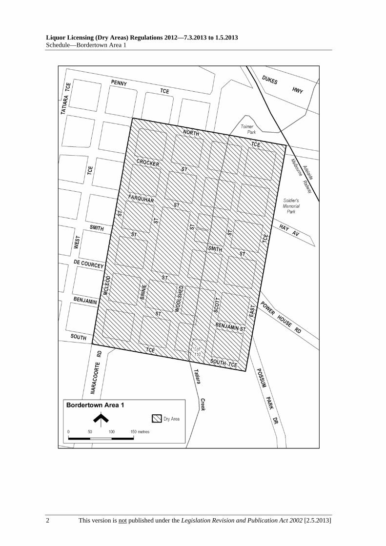
Bordertown Area 1—Schedule
[2.5.2013] This version is not published under the Legislation Revision and Publication Act 2002 1
Schedule—Bordertown Area 1
1—Extent of prohibition
The consumption of liquor is prohibited and the possession of liquor is prohibited.
2—Period of prohibition
Continuous, provided that where—
(a) an event of historic, cultural, traditional or major community significance is held in the area; and
(b) the consumption and possession of liquor in the area (or a defined portion of the area) are authorised for a specified period for the purposes of the event by The District Council of Tatiara,
the prohibition does not apply in the area (or defined portion of the area) during that specified period.
3—Description of area
The area in Bordertown bounded as follows: commencing at the point at which the western boundary of McLeod Street intersects the northern boundary of North Terrace, then south-easterly along that boundary of North Terrace to its intersection with the prolongation in a straight line of the eastern boundary of East Terrace, then south-westerly along that prolongation and boundary of East Terrace, and the prolongation in a straight line of that boundary, to the southern boundary of South Terrace, then north-westerly along that boundary of South Terrace (and the southern boundary of Lot 110 FP 215634) to the point at which the southern boundary of South Terrace meets the western boundary of Naracoorte Road, then in a straight line by the shortest route (across South Terrace) to the point at which the northern boundary of South Terrace meets the western boundary of McLeod Street, then north-easterly along that western boundary of McLeod Street to the point of commencement.
Liquor Licensing (Dry Areas) Regulations 2012—7.3.2013 to 1.5.2013 Schedule—Bordertown Area 1
2 This version is not published under the Legislation Revision and Publication Act 2002 [2.5.2013]
7.3.2013 to 1.5.2013—Liquor Licensing (Dry Areas) Regulations 2012
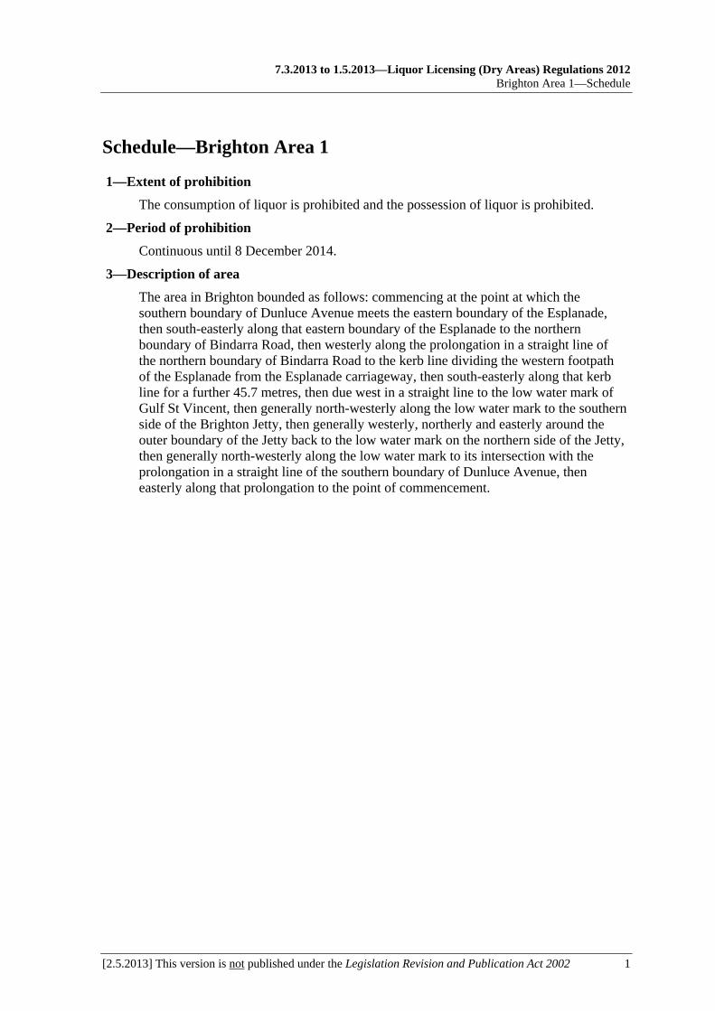
Brighton Area 1—Schedule
[2.5.2013] This version is not published under the Legislation Revision and Publication Act 2002 1
Schedule—Brighton Area 1
1—Extent of prohibition
The consumption of liquor is prohibited and the possession of liquor is prohibited.
2—Period of prohibition
Continuous until 8 December 2014.
3—Description of area
The area in Brighton bounded as follows: commencing at the point at which the southern boundary of Dunluce Avenue meets the eastern boundary of the Esplanade, then south-easterly along that eastern boundary of the Esplanade to the northern boundary of Bindarra Road, then westerly along the prolongation in a straight line of the northern boundary of Bindarra Road to the kerb line dividing the western footpath of the Esplanade from the Esplanade carriageway, then south-easterly along that kerb line for a further 45.7 metres, then due west in a straight line to the low water mark of Gulf St Vincent, then generally north-westerly along the low water mark to the southern side of the Brighton Jetty, then generally westerly, northerly and easterly around the outer boundary of the Jetty back to the low water mark on the northern side of the Jetty, then generally north-westerly along the low water mark to its intersection with the prolongation in a straight line of the southern boundary of Dunluce Avenue, then easterly along that prolongation to the point of commencement.

Liquor Licensing (Dry Areas) Regulations 2012—7.3.2013 to 1.5.2013 Schedule—Brighton Area 1
2 This version is not published under the Legislation Revision and Publication Act 2002 [2.5.2013]

7.3.2013 to 1.5.2013—Liquor Licensing (Dry Areas) Regulations 2012
Ceduna and Thevenard Area 1—Schedule
[2.5.2013] This version is not published under the Legislation Revision and Publication Act 2002 1
Schedule—Ceduna and Thevenard Area 1
1—Extent of prohibition
The consumption of liquor is prohibited and the possession of liquor is prohibited.
2—Period of prohibition
Continuous until 6 December 2017.
3—Description of area
The area in and adjacent to Ceduna and Thevenard bounded as follows: commencing at the point at which the northern boundary of the Eyre Highway intersects the prolongation in a straight line of the eastern boundary of Hastings Road, then southerly and south-westerly along that prolongation and boundary of Hastings Road to the north-eastern boundary of Decres Bay Road, then in a straight line by the shortest route across Decres Bay Road to the point at which the north-western boundary of Lot 25 DP 45533 meets the south-western boundary of Decres Bay Road, then south-westerly along that north-western boundary of Lot 25, and the prolongation in a straight line of that boundary, to the low water mark of Bosanquet Bay, then generally north-westerly, south-westerly, north-westerly, north-easterly and northerly along the low water mark to the point at which it is intersected by the prolongation in a straight line of the eastern boundary of Section 197 Hundred of Bonython, then northerly along that prolongation and boundary of Section 197 to the northern boundary of the Section, then in a straight line by the shortest route to the northernmost corner of Section 265 Hundred of Bonython, then generally southerly along the eastern boundary of Section 265 (the western boundary of the Eyre Highway) to the point at which it is intersected by the prolongation in a straight line of the northern boundary of Lot 12 DP 54370, then easterly (across the Eyre Highway) along that prolongation to the western boundary of Lot 12, then south-easterly and easterly along the western and southern boundaries of that Lot to the southern boundary of Lot 20 DP 55492, then easterly along the southern boundary of Lot 20 to the western boundary of Lot 21 DP 55492, then north-westerly and north-easterly along the western and north-western boundaries of Lot 21 to the western boundary of Section 231 Hundred of Bonython (the railway reserve), then south-easterly along that boundary of Section 231 to the southernmost corner of the Section, then in a straight line by the shortest route to the point at which the north-western boundary of Section 237 Hundred of Bonython meets the south-western boundary of the Section, then south-easterly along the south-western boundary of Section 237 (the railway reserve) to the northern boundary of the Eyre Highway, then easterly along that boundary of the Eyre Highway to the point of commencement. The area includes any jetty, wharf, ramp or other structure projecting into the sea beyond the low water mark from the area described above, as well as any area beneath such a structure.


7.3.2013 to 1.5.2013—Liquor Licensing (Dry Areas) Regulations 2012
Ceduna and Thevenard Area 2—Schedule
[2.5.2013] This version is not published under the Legislation Revision and Publication Act 2002 1
Schedule—Ceduna and Thevenard Area 2
1—Extent of prohibition
The consumption of liquor is prohibited and the possession of liquor is prohibited.
2—Period of prohibition
Continuous until 6 December 2017.
3—Description of area
The area adjacent to Ceduna and Thevenard comprising Lot 617 FP 180649.


7.3.2013 to 1.5.2013—Liquor Licensing (Dry Areas) Regulations 2012
Christies Beach Area 1—Schedule
[2.5.2013] This version is not published under the Legislation Revision and Publication Act 2002 1
Schedule—Christies Beach Area 1
1—Extent of prohibition
The consumption of liquor is prohibited and the possession of liquor is prohibited.
2—Period of prohibition
6 pm on each day to 6 am on the following day, until 6 am on 11 September 2016.
3—Description of area
The area at Christies Beach bounded as follows: commencing at the point at which the prolongation in a straight line of the southern boundary of Benny Avenue intersects the low water mark of Gulf St. Vincent, then generally north-easterly and northerly along the low water mark to the mouth of Christie Creek, then generally easterly and north-easterly along the southern bank of Christie Creek to its intersection with the prolongation in a straight line of the eastern boundary of Fletcher Drive, then south-westerly and southerly along that prolongation and the eastern boundary of Fletcher Drive to the northern boundary of Gulfview Road, then easterly along that boundary of Gulfview Road to its intersection with the prolongation in a straight line of the eastern boundary of Grundy Terrace, then generally southerly along that prolongation and the eastern boundary of Grundy Terrace, Sydney Crescent, Grundy Terrace and Witton Road to the intersection between the eastern boundary of Witton Road and the southern boundary of Benny Avenue, then westerly along that southern boundary of Benny Avenue and the prolongation in a straight line of that boundary to the point of commencement, but excluding the Christies Beach Caravan Park.

Liquor Licensing (Dry Areas) Regulations 2012—7.3.2013 to 1.5.2013 Schedule—Christies Beach Area 1
2 This version is not published under the Legislation Revision and Publication Act 2002 [2.5.2013]

7.3.2013 to 1.5.2013—Liquor Licensing (Dry Areas) Regulations 2012
Clare Area 1—Schedule
[2.5.2013] This version is not published under the Legislation Revision and Publication Act 2002 1
Schedule—Clare Area 1
1—Extent of prohibition
The consumption of liquor is prohibited and the possession of liquor is prohibited.
2—Period of prohibition
From 9 pm on each day until 8 am on the following day, until 8 am on 4 March 2017.
3—Description of area
The following areas of road in Clare:
(a) Main North Road between the northern end of the northern bridge on Main North Road (the bridge located between Daly Street and Blanche Street) and the southern end of the southern bridge on Main North Road (the bridge located between Lennon Street and Bank Street);
(b) Old North Road between Lennon Street and Main North Road;
(c) Mill Place between Old North Road and Main North Road.


7.3.2013 to 1.5.2013—Liquor Licensing (Dry Areas) Regulations 2012
Clare Area 2—Schedule
[2.5.2013] This version is not published under the Legislation Revision and Publication Act 2002 1
Schedule—Clare Area 2
1—Extent of prohibition
The consumption of liquor is prohibited and the possession of liquor is prohibited.
2—Period of prohibition
From 9 pm on each day until 8 am on the following day, until 8 am on 4 March 2017.
3—Description of area
The following parks and reserves in Clare:
(a) the area (known as Burke Park) bounded on the west by Farrell Flat Road, on the south by Old North Road, on the east by a stone cliff that extends northerly (then westerly) from the northern boundary of Old North Road from a point approximately 30 metres east of the eastern boundary of Farrell Flat Road, and on the north by that same stone cliff and by the westerly prolongation of the cliff line to the eastern boundary of Farrell Flat Road;
(b) the area (known as Burton Street Reserve) bounded on the west by Strickland Street, on the south by Burton Street and on the east and north by the western and southern banks of the Hutt River;
(c) the area (known as Ennis Park) bounded on the west by Main North Road, on the south by the northern wall of the Clare Town Hall, on the east by Old North Road and on the north by the fence forming the southern boundary of the adjoining private land (ANZ Bank);
(d) the area (known as Hentschke Park) bounded on the south by Essington Avenue, on the east by Powell Street and on the north and west by the fence line forming the southern and eastern boundaries of the adjoining private land;
(e) the area (known as Lions Park) bounded on the north by Victoria Road, on the west by Hope Street, on the south by the fence forming the northern boundary of the adjoining Dept. of Defence land and on the east firstly by the western bank of the creek that runs northerly from the Dept. of Defence land to the Hutt River and thereafter by the western bank of the Hutt River;
(f) the area (known as Maynard Park) bounded on the south by Pioneer Avenue, on the east by Christison Avenue, on the north by the fence forming the southern boundary of the Clare Swimming Centre and on the west by the eastern bank of the Hutt River;
(g) the area (known as Sanders Park) bounded on the north by Lennon Street, on the west by Main North Road, on the south by the northern bank of the Hutt River and on the east by the fence forming the western boundary of the adjoining ETSA land.


7.3.2013 to 1.5.2013—Liquor Licensing (Dry Areas) Regulations 2012
Clare Area 3—Schedule
[2.5.2013] This version is not published under the Legislation Revision and Publication Act 2002 1
Schedule—Clare Area 3
1—Extent of prohibition
The consumption of liquor is prohibited and the possession of liquor is prohibited.
2—Period of prohibition
From 9 pm on each day until 8 am on the following day, until 8 am on 4 March 2017.
3—Description of area
The following car parks in Clare:
(a) the area (known as the Blanche Street Carpark) bounded on the north by Blanche Street, on the west and south by the eastern and northern banks of the Hutt River and on the east by the building line forming the western boundary of the adjoining private land;
(b) the area (known as the Thomas Hart Carpark) bounded on the east by Scott Street, on the north by the broken raised kerb line forming the southern boundary of the adjoining private car park, on the west by Old North Road and on the south by the fence forming the northern boundary of the adjoining private land;
(c) the area (known as the Gleeson Street Carpark) bounded on the west by Strickland Street, on the south by Gleeson Street, on the east by the western bank of the Hutt River and on the north by the fence line forming the southern boundary of the adjoining private land.

7.3.2013 to 1.5.2013—Liquor Licensing (Dry Areas) Regulations 2012
Clare Area 4—Schedule
[2.5.2013] This version is not published under the Legislation Revision and Publication Act 2002 1
Schedule—Clare Area 4
1—Extent of prohibition
The consumption of liquor is prohibited and the possession of liquor is prohibited.
2—Period of prohibition
From 9 pm on each day until 8 am on the following day, until 8 am on 4 March 2017.
3—Description of area
The Inchiquin Lake and Melrose Park area in Clare bounded as follows: commencing at the point at which the northern boundary of Melrose Avenue intersects the eastern boundary of Phoenix Avenue, then generally north-westerly along that boundary of Phoenix Avenue to the northern boundary of Ashton Drive, then north-easterly along that boundary of Ashton Drive to the point at which it meets the western boundary of allotment 2 of DP 52125, then generally north-westerly, westerly, northerly, north-easterly, easterly and south-easterly along the boundary of allotment 2 of DP 52125 (generally along the rear of the housing allotments that face Phoenix Avenue, across Brook Avenue and then around the Inchiquin Lake area) to the point at which the boundary of allotment 2 meets the western boundary of White Hutt Road, then generally southerly along that boundary of White Hutt Road to the northern boundary of Melrose Avenue, then generally north-westerly along that boundary of Melrose Avenue to the point of commencement.


7.3.2013 to 1.5.2013—Liquor Licensing (Dry Areas) Regulations 2012
Coffin Bay Area 1—Schedule
[2.5.2013] This version is not published under the Legislation Revision and Publication Act 2002 1
Schedule—Coffin Bay Area 1
1—Extent of prohibition
The consumption of liquor is prohibited and the possession of liquor is prohibited.
2—Period of prohibition
9 pm on 31 December 2012 to 8 am on 1 January 2013.
3—Description of area
The area in and adjacent to the town of Coffin Bay bounded as follows: commencing at the point at which the prolongation in a straight line of the northern boundary of Section 665 Hundred of Lake Wangary intersects the low water mark of Coffin Bay, then generally northerly, easterly, southerly, south-easterly and north-easterly along the low water mark to the point at which it is intersected by the prolongation in a straight line of the western boundary of Section 131 Hundred of Lake Wangary, then southerly along that prolongation and boundary of Section 131 to the northern boundary of Lot 57 DP 54186, then generally south-westerly and south-easterly along the northern and south-western boundaries of Lot 57 to the point at which the south-western boundary is intersected by the prolongation in a straight line of the north-western boundary of Section 273 Hundred of Lake Wangary, then south-westerly along that prolongation and boundary of Section 273 to the point at which it meets the eastern boundary of Section 295 Hundred of Lake Wangary, then south-westerly, north-westerly, north-easterly and north-westerly along the north-eastern and northern boundaries of Section 295 to the western boundary of the Section, then southerly along the western boundaries of Section 295, Lots 212 and 211 of DP 71703, Lot 101 of DP 56785 and Lot 6 DP 25759 to the northern boundary of Section 665 Hundred of Lake Wangary, then generally westerly, north-westerly, northerly and westerly along the northern boundary of that Section to the point at which it meets the eastern boundary of Section 667 Hundred of Lake Wangary, then westerly along the northern boundary of Section 667, the northern boundary of Section 665 Hundred of Lake Wangary and the prolongation in a straight line of the northern boundary of Section 665 to the point of commencement. The area includes the whole of any jetty, boat ramp or other structure that projects below the low water mark from within the area described above (as well as any area beneath such a structure).

Liquor Licensing (Dry Areas) Regulations 2012—7.3.2013 to 1.5.2013 Schedule—Coffin Bay Area 1
2 This version is not published under the Legislation Revision and Publication Act 2002 [2.5.2013]

7.3.2013 to 1.5.2013—Liquor Licensing (Dry Areas) Regulations 2012
Coober Pedy Area 1—Schedule
[2.5.2013] This version is not published under the Legislation Revision and Publication Act 2002 1
Schedule—Coober Pedy Area 1
1—Extent of prohibition
The consumption of liquor is prohibited and the possession of liquor is prohibited.
2—Period of prohibition
Continuous.
3—Description of area
The area at Coober Pedy bounded as follows: commencing at the point at which the prolongation in a straight line of the southern boundary of Flinders Street intersects the western boundary of Hutchison Street, then southerly along that boundary of Hutchison Street to the northern boundary of the Stuart Highway, then generally westerly along that boundary of the Stuart Highway to the south-eastern boundary of Malliotis Boulevard, then generally north-easterly along that boundary of Malliotis Boulevard to its intersection with the prolongation in a straight line of the south-western boundary of Reilly Street, then north-westerly along that prolongation and boundary of Reilly Street to the northern end of Reilly Street, then in a straight line to the nearest point on the northern boundary of Paxton Road, then generally north-easterly along that boundary of Paxton Road to its intersection with the western boundary of Cameron Drive, then northerly, easterly and northerly along that boundary of Cameron Drive to the southern boundary of Post Office Hill Road, then generally north-westerly along that boundary of Post Office Hill Road to its intersection with the prolongation in a straight line of the western boundary of Gough Street, then generally north-westerly along that prolongation and boundary of Gough Street and the prolongation in a straight line of that boundary to the northern boundary of Seventeen Mile Road, then north-easterly along that boundary of Seventeen Mile Road to the western boundary of Chadwick Road, then generally northerly and north-easterly along that boundary of Chadwick Road and Marquardt Road to the south-western boundary of Rankin Drive, then westerly and northerly along that boundary of Rankin Drive to the south-western boundary of Hillman Road, then north-westerly along that boundary of Hillman Road and the prolongation in a straight line of that boundary to the north-western boundary of Morousen Drive, then north-easterly along that boundary of Morousen Drive to its intersection with the prolongation in a straight line of the north-eastern boundary of Kunoth Street, then south-easterly along that boundary of Kunoth Street to the north-western boundary of Lockwood Avenue, then north-easterly along that boundary of Lockwood Avenue to the south-western boundary of Beinke Drive, then north-westerly along that boundary of Beinke Drive and the prolongation in a straight line of that boundary to the north-western boundary of Morousen Drive, then north-easterly along that boundary of Morousen Drive to the prolongation in a straight line of the north-eastern boundary of Goldsworthy Street, then generally south-easterly and southerly along that boundary of Goldsworthy Street to its intersection with the north-western boundary of Hutchison Street, then north-easterly along that boundary of Hutchison Street to its intersection with the prolongation in a straight line of the north-eastern boundary of Hospital Road, then generally south-easterly and southerly along that boundary of Hospital Road to its intersection with the prolongation in a straight line of the northern boundary of allotment 2056 FP 40339, then generally westerly along that prolongation and northern boundary of allotment 2056 to the eastern boundary of McDougal Road, then in a straight line by the shortest route across

Liquor Licensing (Dry Areas) Regulations 2012—7.3.2013 to 1.5.2013 Schedule—Coober Pedy Area 1
2 This version is not published under the Legislation Revision and Publication Act 2002 [2.5.2013]
McDougal Road to the north-east corner of allotment 100 DP 43027, then generally westerly along the northern boundary of allotment 100 and Town allotment 38 to the eastern boundary of Hutchison Street, then southerly along that boundary of Hutchison Street to the northern boundary of Umoona Road, then generally easterly along that boundary of Umoona Road to its intersection with the prolongation in a straight line of the north-eastern boundary of Jewellers Shop Road, then generally south-easterly along that prolongation and boundary of Jewellers Shop Road to its intersection with the prolongation in a straight line of the south-eastern boundary of Matrix Avenue, then south-westerly along that prolongation and boundary of Matrix Avenue to the point at which the Avenue turns south-easterly, then in a straight line by the shortest route across Matrix Avenue to the north-east corner of the Water Conservation Reserve (Lot 1 DP 29267), then generally westerly, southerly and easterly along the northern, western and southern boundaries of the Reserve to the intersection between the southern boundary of the Reserve and the prolongation in a straight line of the eastern boundary of Wills Street, then southerly along that prolongation and eastern boundary of Wills Street to the northern boundary of Grey Street, then easterly along that boundary of Grey Street to its intersection with the prolongation in a straight line of the eastern boundary of Bass Street, then southerly along that prolongation and boundary of Bass Street and the prolongation in a straight line of that boundary of Bass Street to its intersection with the southern boundary of Flinders Street, then westerly along that southern boundary of Flinders Street and the prolongation in a straight line of that southern boundary to the point of commencement, but excluding the following areas:
(a) Lots 2126 and 2127 Deposited Plan No. 38624;
(b) Section 454 Out of Hundreds (Coober Pedy);
(c) Oxiana Oval and the adjacent change rooms on Lot 1 Deposited Plan No. 32949, being the oval and change room area on that Lot that is enclosed by a metal fence and by the northern, eastern and southern outer walls of the adjacent change rooms.

7.3.2013 to 1.5.2013—Liquor Licensing (Dry Areas) Regulations 2012
Coober Pedy Area 1—Schedule
[2.5.2013] This version is not published under the Legislation Revision and Publication Act 2002 3


7.3.2013 to 1.5.2013—Liquor Licensing (Dry Areas) Regulations 2012
Cowell Area 1—Schedule
[2.5.2013] This version is not published under the Legislation Revision and Publication Act 2002 1
Schedule—Cowell Area 1
1—Extent of prohibition
The consumption of liquor is prohibited and the possession of liquor is prohibited.
2—Period of prohibition
9 pm on 31 December 2012 to 8 am on 1 January 2013.
3—Description of area
The area in and adjacent to Cowell bounded as follows: commencing at the point at which the prolongation in a straight line of the northern boundary of Hornhardt Road intersects the western boundary of Turnbull Road, then easterly along that prolongation and northern boundary of Hornhardt Road, and the prolongation in a straight line of that boundary, to the low water mark on the western side of Franklin Harbour, then generally south-westerly and southerly along the low water mark to the northern side of the breakwater that forms the northern wall of the enclosed swimming and boat launching facility located approximately in line with Main Street, then generally easterly, south-easterly and westerly around the outer boundary of the swimming and boat launching facility (so as to include in the area the whole of the facility, including the breakwaters or other structures forming the walls of the facility and any wharf, jetty or boat ramp forming part of or connected to those structures) to the point at which the southern boundary of the breakwater that forms the southern wall of the facility meets the low water mark on the shore, then generally southerly and south-westerly along the low water mark to the point at which it is intersected by the prolongation in a straight line of the southern boundary of Stening Road, then westerly along that prolongation and boundary of Stening Road to the point at which it meets the western boundary of Turnbull Road, then northerly along that western boundary of Turnbull Road to the point of commencement. The area includes any breakwater, wharf, jetty, boat ramp or other structure not mentioned above that projects below low water mark from within the area as well as any area beneath any wharf or jetty forming part of the area.

Liquor Licensing (Dry Areas) Regulations 2012—7.3.2013 to 1.5.2013 Schedule—Cowell Area 1
2 This version is not published under the Legislation Revision and Publication Act 2002 [2.5.2013]

7.3.2013 to 1.5.2013—Liquor Licensing (Dry Areas) Regulations 2012
Cummins Area 1—Schedule
[2.5.2013] This version is not published under the Legislation Revision and Publication Act 2002 1
Schedule—Cummins Area 1
1—Extent of prohibition
The consumption of liquor is prohibited and the possession of liquor is prohibited.
2—Period of prohibition
From 9 pm on 31 December 2012 to 8 am on 1 January 2013.
3—Description of area
The area in and adjacent to Cummins bounded as follows: commencing at the point at which the eastern boundary of Lot 11 of DP 85166 (the western boundary of Lot 99 of FP 180131) meets the southern boundary of Warrow Road, then in a straight line by the shortest route across Warrow Road to the southern boundary of Lot 550 of DP 66791, then generally easterly and north-easterly along the boundary of Lot 550 to the point at which it meets the north-eastern boundary of Lot 22 of DP 79231, then in a straight line by the shortest route to the south-western boundary of Lot 189 of FP 180221, then south-easterly, easterly and northerly along the boundary of Lot 189 to the point at which the eastern boundary of the Lot is intersected by the prolongation in a straight line of the northern boundary of Section 80 Hundred of Cummins, then easterly along that prolongation and boundary of Section 80 to the eastern boundary of the Section, then southerly along the eastern boundary of Section 80 to the south-eastern corner of the Section, then in a straight line by the shortest route to the southern boundary of Section 68 Hundred of Cummins, then generally easterly along that southern boundary of Section 68 to the point at which it is intersected by the prolongation in a straight line of the north-western boundary of Lot 601 of DP 87427 (the south-eastern boundary of Lot 17 of DP 18745), then south-westerly along that prolongation and boundary of Lot 601 to the south-western corner of the Lot, then in a straight line by the shortest route to the northern corner of Lot 1 of DP 85937, then south-westerly along the north-western boundary of Lot 1 to the western corner of the Lot, then in a straight line by the shortest route to the eastern corner of Lot 7 of DP 18745, then south-westerly along the south-eastern boundary of Lot 7 to the westernmost corner of Lot 600 of DP 87427 (the northern corner of Lot 2 of FP 16692), then south-easterly, south-westerly, south-easterly and south-westerly along the south-western boundary of Lot 600 to the southern corner of Lot 24 of DP 50626 (so as to exclude Lot 600 from the area), then in a straight line by the shortest route to the northern boundary of Lot 143 of FP 180175, then generally north-westerly and south-westerly along the boundary of Lot 143 to the point at which it meets the north-western boundary of Lot 52 of DP 53199, then generally south-westerly along the boundary of Lot 52 to the south-eastern corner of Lot 802 of FP 209177, then north-westerly along the south-western boundary of Lot 802 and the prolongation in a straight line of that boundary to the eastern boundary of Lot 111 of DP 67442, then north-easterly, westerly and northerly along the boundary of Lot 111 to the point at which it meets the eastern boundary of Lot 11 of DP 85166, then generally northerly, westerly and northerly along that boundary of Lot 11 to the point of commencement.

7.3.2013 to 1.5.2013—Liquor Licensing (Dry Areas) Regulations 2012
Edithburgh Area 1—Schedule
[2.5.2013] This version is not published under the Legislation Revision and Publication Act 2002 1
Schedule—Edithburgh Area 1
1—Extent of prohibition
The consumption of liquor is prohibited and the possession of liquor is prohibited.
2—Period of prohibition
From 10 pm on each day until 8 am on the following day, until 8 am on 22 October 2013.
3—Description of area
The area in and adjacent to Edithburgh bounded as follows: commencing at the point at which the prolongation in a straight line of the northern boundary of Beach Road intersects the low water mark on the western side of Gulf St Vincent, then generally south-easterly, southerly and south-westerly along the low water mark (including around the outer boundary of any groyne, breakwater, jetty, boat ramp or other structure extending out to sea so as to include in the area the whole of that structure and any area beneath it) to the point at which the low water mark is intersected by the prolongation in a straight line of the southern boundary of Whiting Drive, then north-westerly and westerly along that prolongation and boundary of Whiting Drive to the point at which it is intersected by the prolongation in a straight line of the western boundary of Tuna Avenue, then northerly along that prolongation and boundary of Tuna Avenue to the southern boundary of Panfry Terrace, then westerly along that boundary of Panfry Terrace and the prolongation in a straight line of that boundary to the point at which it intersects the prolongation in a straight line of the western boundary of Park Terrace South, then northerly along that prolongation and boundary of Park Terrace South and the western boundary of Park Terrace North to the point at which the western boundary of Park Terrace North intersects the prolongation in a straight line of the northern boundary of Beach Road, then easterly along that prolongation and boundary of Beach Road and the prolongation in a straight line of that boundary to the point of commencement.

Liquor Licensing (Dry Areas) Regulations 2012—7.3.2013 to 1.5.2013 Schedule—Edithburgh Area 1
2 This version is not published under the Legislation Revision and Publication Act 2002 [2.5.2013]

7.3.2013 to 1.5.2013—Liquor Licensing (Dry Areas) Regulations 2012
Elliston Area 1—Schedule
[2.5.2013] This version is not published under the Legislation Revision and Publication Act 2002 1
Schedule—Elliston Area 1
1—Extent of prohibition
The consumption of liquor is prohibited and the possession of liquor is prohibited.
2—Period of prohibition
From 9 pm on 31 December 2012 to 8 am on 1 January 2013.
3—Description of area
The area in and adjacent to Elliston bounded as follows: commencing at the point at which the prolongation in a straight line of the north-western boundary of Section 417 Hundred of Ward intersects the low water mark on Waterloo Bay, then generally south-easterly, southerly, westerly and south-easterly along the low water mark to the point at which it is intersected by the prolongation in a straight line of the western boundary of Section 405 Hundred of Ward, then northerly along that prolongation and boundary of Section 405, the western boundary of Section 7 Hundred of Ward and the western boundary of Section 68 Hundred of Ward, to the northern boundary of Section 68, then in a straight line by the shortest route to the point at which the western and southern boundaries of Section 384 Hundred of Ward meet, then northerly along the western boundary of Section 384 to the point at which it meets the north-eastern boundary of the Section, then in a straight line by the shortest route (across Flinders Highway) to the point at which the eastern boundary of Colton Back Road meets the northern boundary of Flinders Highway, then generally northerly and north-westerly along the eastern boundary of Colton Back Road to the point at which it is intersected by the prolongation in a straight line of the northern boundary of Silo Road, then south-westerly along that prolongation and boundary of Silo Road to the western boundary of Lot 41 of DP 72507, then generally northerly and westerly along the western and southern boundaries of Lot 41 to the point at which the southern boundary of the Lot meets the eastern boundary of Flinders Highway, then generally southerly and south-easterly along that boundary to the point at which it is intersected by the prolongation in a straight line of the north-western boundary of Section 417 Hundred of Ward, then south-westerly along that prolongation and boundary of Section 417, and the prolongation in a straight line of that boundary, to the point of commencement. The area does not include any jetty, boat ramp or other structure projecting below the low water mark from within the area described above.

Liquor Licensing (Dry Areas) Regulations 2012—7.3.2013 to 1.5.2013 Schedule—Elliston Area 1
2 This version is not published under the Legislation Revision and Publication Act 2002 [2.5.2013]

7.3.2013 to 1.5.2013—Liquor Licensing (Dry Areas) Regulations 2012
Fisherman Bay Area 1—Schedule
[2.5.2013] This version is not published under the Legislation Revision and Publication Act 2002 1
Schedule—Fisherman Bay Area 1
1—Extent of prohibition
The consumption of liquor is prohibited and the possession of liquor is prohibited.
2—Period of prohibition
From 10 pm on each day to 8 am on the following day, until 8 am on 16 April 2015.
3—Description of area
The area in Fisherman Bay bounded as follows: commencing at the point at which the prolongation in a straight line of the western boundary of Section 962 Hundred of Mundoora intersects the northern boundary of Lot 9 DP 50577, then southerly along that prolongation and boundary of Section 962 to the southern boundary of Lot 9, then generally westerly along that boundary of Lot 9 to the southern boundary of Lot 8 DP 50577, then north-westerly along that boundary of Lot 8 to the southern boundary of Lot 9 DP 50577, then north-westerly and westerly along that boundary of Lot 9 to the eastern boundary of Lot 6 DP 50577, then generally northerly, westerly and southerly around the eastern and northern boundaries of Lot 6 and the northern and western boundaries of Lot 5 DP 50577 back to the southern boundary of Lot 9 DP 50577 on the western side of Lot 5, then generally westerly along the southern boundary of Lot 9 to the point at which it meets the southern boundary of Lot 3 DP 50577, then generally westerly, southerly and westerly along the southern boundary of Lot 3 to the point at which it meets the south-eastern boundary of Section 555 Hundred of Mundoora, then south-westerly along that boundary of Section 555 to the point at which it meets the southern boundary of the children's playground on Section 555, then north-westerly along the southern boundary of the playground to the north-western boundary of Section 555, then north-easterly along that boundary of Section 555 to the northern boundary of Lot 3 DP 50577, then generally easterly along the northern boundary of Lot 3 and of Lot 9 DP 50577 to the point at which the northern boundary of Lot 9 meets the western side of the Fisherman Bay boat ramp, then generally northerly, easterly and southerly around the seaward boundary of the ramps and central pontoon that make up the boat ramp (so as to include the whole of the boat ramps and central pontoon in the area), back to the northern boundary of Lot 9 on the eastern side of the boat ramp, then generally southerly and easterly along the northern boundary of Lot 9 to the point of commencement.

Liquor Licensing (Dry Areas) Regulations 2012—7.3.2013 to 1.5.2013 Schedule—Fisherman Bay Area 1
2 This version is not published under the Legislation Revision and Publication Act 2002 [2.5.2013]

7.3.2013 to 1.5.2013—Liquor Licensing (Dry Areas) Regulations 2012
Gawler Area 1—Schedule
[2.5.2013] This version is not published under the Legislation Revision and Publication Act 2002 1
Schedule—Gawler Area 1
1—Extent of prohibition
The consumption of liquor is prohibited and the possession of liquor is prohibited.
2—Period of prohibition
7 pm on each day to 7 am on the following day, until 7 am on 17 May 2017.
3—Description of area
The area in Gawler bounded as follows: commencing at the point at which the western boundary of Julian Terrace intersects the northern boundary of Bridge Street South, then south-westerly along that boundary of Bridge Street South to the western bank of the South Para River, then generally northerly, north-easterly, north-westerly, south-westerly and northerly along that same bank of the River to the point at which it crosses Fourteenth Street, then south-easterly, easterly and north-easterly along the southern boundary of Fourteenth Street to the point at which it meets the south-western boundary of Lot 675 FP 211461, then generally south-easterly, easterly and north-easterly along the south-western, southern and eastern boundaries of that Lot to the southern boundary of Scheibener Terrace, then generally easterly and north-easterly along that boundary of Scheibener Terrace to the southern boundary of Tod Street, then easterly along that boundary of Tod Street to the point at which it meets the south-western boundary of Whitelaw Terrace, then generally south-easterly and southerly along that boundary of Whitelaw Terrace and Julian Terrace to the point of commencement.
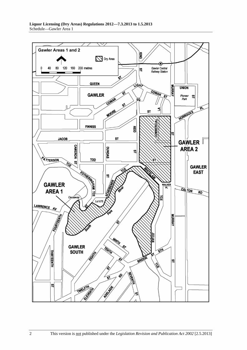
Liquor Licensing (Dry Areas) Regulations 2012—7.3.2013 to 1.5.2013 Schedule—Gawler Area 1
2 This version is not published under the Legislation Revision and Publication Act 2002 [2.5.2013]

7.3.2013 to 1.5.2013—Liquor Licensing (Dry Areas) Regulations 2012
Gawler Area 2—Schedule
[2.5.2013] This version is not published under the Legislation Revision and Publication Act 2002 1
Schedule—Gawler Area 2
1—Extent of prohibition
The consumption of liquor is prohibited and the possession of liquor is prohibited.
2—Period of prohibition
7 pm on each day to 7 am on the following day, until 7 am on 17 May 2017.
3—Description of area
The area in Gawler bounded on the south by the northern boundary of Walker Place and the north-eastern boundary of Whitelaw Terrace, on the west by the eastern boundary of Reid Street, on the north by the southern boundary of Finniss Street, and on the east by the western boundary of Murray Street.
See the plan in Schedule—Gawler Area 1.


7.3.2013 to 1.5.2013—Liquor Licensing (Dry Areas) Regulations 2012
Gawler Area 3—Schedule
[2.5.2013] This version is not published under the Legislation Revision and Publication Act 2002 1
Schedule—Gawler Area 3
1—Extent of prohibition
The consumption of liquor is prohibited and the possession of liquor is prohibited.
2—Period of prohibition
7 pm on each day to 7 am on the following day, until 7 am on 17 May 2017.
3—Description of area
The area in Gawler hatched in the plan in this schedule.

Liquor Licensing (Dry Areas) Regulations 2012—7.3.2013 to 1.5.2013 Schedule—Gawler Area 3
2 This version is not published under the Legislation Revision and Publication Act 2002 [2.5.2013]

7.3.2013 to 1.5.2013—Liquor Licensing (Dry Areas) Regulations 2012
Gawler Area 4—Schedule
[2.5.2013] This version is not published under the Legislation Revision and Publication Act 2002 1
Schedule—Gawler Area 4
1—Extent of prohibition
The consumption of liquor is prohibited and the possession of liquor is prohibited.
2—Period of prohibition
Continuous until 17 May 2017.
3—Description of area
Julian Terrace between Bridge Street South and Walker Place.
Whitelaw Terrace between Walker Place and Tod Street.
Murray Street from Dead Man's Pass to Murray Road ford.


7.3.2013 to 1.5.2013—Liquor Licensing (Dry Areas) Regulations 2012
Gawler Area 5—Schedule
[2.5.2013] This version is not published under the Legislation Revision and Publication Act 2002 1
Schedule—Gawler Area 5
1—Extent of prohibition
The consumption of liquor is prohibited and the possession of liquor is prohibited.
2—Period of prohibition
Continuous until 17 May 2017.
3—Description of area
The area in Gawler hatched in the plan in this schedule.
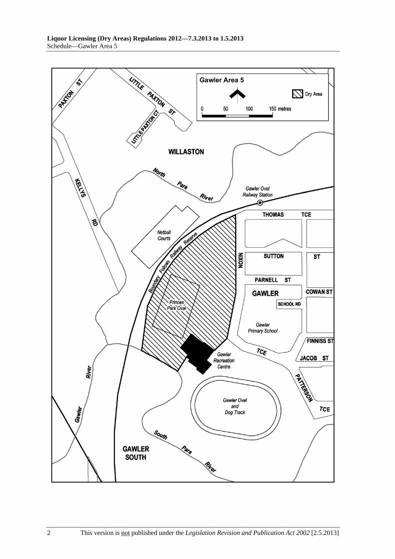
Liquor Licensing (Dry Areas) Regulations 2012—7.3.2013 to 1.5.2013 Schedule—Gawler Area 5
2 This version is not published under the Legislation Revision and Publication Act 2002 [2.5.2013]

7.3.2013 to 1.5.2013—Liquor Licensing (Dry Areas) Regulations 2012
Glenelg Area 1—Schedule
[2.5.2013] This version is not published under the Legislation Revision and Publication Act 2002 1
Schedule—Glenelg Area 1
1—Extent of prohibition
The consumption of liquor is prohibited and the possession of liquor is prohibited.
2—Period of prohibition
Continuous until 8 December 2014, but excluding the following periods:
(a) any day or days during that period on which a festival, exhibition, show or other event is held within the area if it—
(i) is of historic, traditional or cultural significance or significantly promotes tourism; and
(ii) has been authorised by the City of Holdfast Bay for the purposes of these regulations;
(b) 9 pm on 31 December 2012 to 8 am on 1 January 2013 (the period during which the prohibition described in Schedule—Glenelg Area 2 applies).
3—Description of area
The area in Glenelg bounded as follows: commencing at the point at which the eastern boundary of Colley Terrace intersects the northern boundary of Augusta Street, then southerly along the eastern boundary of Colley Terrace and the prolongation in a straight line of that boundary to the southern boundary of Jetty Road, then westerly along that southern boundary of Jetty Road and Moseley Square and the prolongation in a straight line of that boundary to the eastern boundary of the South Esplanade (the north-western corner of Allotment 1 DP 30338), then generally south-westerly along the eastern boundary of the South Esplanade to the point at which it meets the northern boundary of Kent Street (the south-western corner of Section 5785, Hundred of Noarlunga), then westerly along the prolongation in a straight line of the northern boundary of Kent Street to the low water mark of Gulf St Vincent, then generally northerly along the low water mark (including the low water mark around the outer boundary of any breakwater or groyne) to the entrance to the Patawalonga River, then generally south-easterly, easterly, northerly, easterly and northerly along the southern and eastern bank of the River to the point at which the eastern bank of the River intersects the prolongation in a straight line of the southern boundary of St Anne's Terrace, then easterly along that prolongation to the western boundary of Adelphi Terrace, then southerly along that western boundary of Adelphi Terrace and the prolongation in a straight line of that boundary to the southern boundary of Anzac Highway, then westerly along that boundary of Anzac Highway to the eastern boundary of Colley Terrace, then southerly along that boundary of Colley Terrace to the point of commencement. The area includes the Glenelg Jetty and any other jetty, wharf, mooring, dock or other structure (apart from the Patawalonga Weir) projecting into the Gulf or River from the area described above, as well as any area beneath such a structure.

Liquor Licensing (Dry Areas) Regulations 2012—7.3.2013 to 1.5.2013 Schedule—Glenelg Area 1
2 This version is not published under the Legislation Revision and Publication Act 2002 [2.5.2013]

7.3.2013 to 1.5.2013—Liquor Licensing (Dry Areas) Regulations 2012
Glenelg Area 2—Schedule
[2.5.2013] This version is not published under the Legislation Revision and Publication Act 2002 1
Schedule—Glenelg Area 2
1—Extent of prohibition
The consumption of liquor is prohibited. The possession of liquor is prohibited, and the prohibition extends to possession in each of the circumstances referred to in regulation 5(3).
2—Period of prohibition
9 pm on 31 December 2012 to 8 am on 1 January 2013.
3—Description of area
The area in Glenelg bounded as follows: commencing at the point at which the eastern boundary of Colley Terrace intersects the northern boundary of Augusta Street, then generally easterly along the northern boundary of Augusta Street (including around the western, northern and eastern boundaries of Torrens Square) to its intersection with the eastern boundary of Brighton Road, then southerly along that boundary of Brighton Road to the northern boundary of Dunbar Terrace, then easterly along that boundary of Dunbar Terrace to the point at which it meets the western boundary of First Avenue, then in a straight line by the shortest route (across Dunbar Terrace and Maxwell Terrace) to the point at which the southern boundary of Maxwell Terrace meets the eastern boundary of Fortrose Street, then westerly along that boundary of Maxwell Terrace to the eastern boundary of Brighton Road, then southerly along that boundary of Brighton Road to its intersection with the prolongation in a straight line of the southern boundary of High Street, then generally westerly along that prolongation and boundary of High Street to the point at which the prolongation in a straight line of that southern boundary of High Street intersects the western boundary of Moseley Street, then northerly along that boundary of Moseley Street to the southern boundary of College Street, then westerly along that boundary of College Street and the prolongation in a straight line of that boundary to the western boundary of St John's Row, then northerly along that boundary of St John's Row to the southern boundary of South Esplanade Lane (the northern boundary of Lot 101 FP 6859), then westerly along that boundary of South Esplanade Lane to the eastern boundary of the South Esplanade, then south-westerly along that boundary of the South Esplanade to the northern boundary of Kent Street, then westerly along that boundary of Kent Street and the prolongation in a straight line of that boundary to the low water mark of Gulf St Vincent, then generally northerly along the low water mark (including the low water mark around the outer boundary of any breakwater or groyne) to the entrance to the Patawalonga River, then generally south-easterly, easterly, northerly, easterly and northerly along the southern and eastern bank of the River to the point at which the eastern bank of the River intersects the prolongation in a straight line of the southern boundary of St Anne's Terrace, then easterly along that prolongation to the western boundary of Adelphi Terrace, then southerly along that western boundary of Adelphi Terrace and the prolongation in a straight line of that boundary to the southern boundary of Anzac Highway, then westerly along that boundary of Anzac Highway to the eastern boundary of Colley Terrace, then southerly along that boundary of Colley Terrace to the point of commencement. The area includes the Glenelg Jetty and any other jetty, wharf, mooring, dock or other structure (apart from the Patawalonga Weir) projecting into the Gulf or River from the area described above, as well as any area beneath such a structure.

Liquor Licensing (Dry Areas) Regulations 2012—7.3.2013 to 1.5.2013 Schedule—Glenelg Area 2
2 This version is not published under the Legislation Revision and Publication Act 2002 [2.5.2013]

7.3.2013 to 1.5.2013—Liquor Licensing (Dry Areas) Regulations 2012
Glenelg North Area 1—Schedule
[2.5.2013] This version is not published under the Legislation Revision and Publication Act 2002 1
Schedule—Glenelg North Area 1
1—Extent of prohibition
The consumption of liquor is prohibited. The possession of liquor is prohibited, and the prohibition extends to possession in each of the circumstances referred to in regulation 5(3).
2—Period of prohibition
From 12.01 am on 26 January 2013 to 12.01 am on 27 January 2013.
3—Description of area
The area in Glenelg North, generally known as Tarniwarra Park, comprising the following areas:
(a) Lot 61 DP 54589;
(b) the area (Lot 60 DP 54589 and other land) bounded as follows: commencing at the point at which the western boundary of the carriageway of North Esplanade meets the southern boundary of the first diagonal bitumenised car parking bay that lies on the western side of North Esplanade to the north of Cygnet Court, then southerly along that western boundary of the carriageway of North Esplanade to the point at which it meets the north-western boundary of the carriageway of Cygnet Court, then south-westerly along that boundary of the carriageway of Cygnet Court to the northern boundary of the first bitumenised car parking bay that lies (at right angles to the carriageway) on the western side of Cygnet Court to the south of North Esplanade, then north-westerly and south-westerly along the north-eastern and north-western boundaries of that parking bay and south-westerly along the north-western boundaries of the adjoining bays to the point at which the north-western boundaries of those adjoining bays meet the eastern boundary of a narrow walking path that runs between the parking bays and a beach retaining wall, then generally northerly for approximately 50 metres along the eastern boundary of that path to the point at which it meets a broader paved pathway, then in a straight line by the shortest route to the point of commencement.

7.3.2013 to 1.5.2013—Liquor Licensing (Dry Areas) Regulations 2012
Golden Grove Area 1—Schedule
[2.5.2013] This version is not published under the Legislation Revision and Publication Act 2002 1
Schedule—Golden Grove Area 1
1—Extent of prohibition
The consumption of liquor is prohibited and the possession of liquor is prohibited.
2—Period of prohibition
Continuous until 15 September 2013.
3—Description of area
The area at Golden Grove and Wynn Vale bounded as follows: commencing at the point at which the north-western boundary of The Golden Way meets the south-western boundary of Asgard Drive, then generally north-westerly along that boundary of Asgard Drive to the south-eastern boundary of Atlantis Drive, then generally south-westerly along that boundary of Atlantis Drive to the north-eastern boundary of The Grove Way, then in a straight line by the shortest route to the point at which the southern boundary of Aeolian Drive meets the south-western boundary of The Grove Way, then north-westerly along that boundary of The Grove Way to the point at which it meets the prolongation in a straight line of the northern boundary of Lot 57 of Deposited Plan No 54563, then generally south-westerly and southerly along that prolongation and the northern and western boundaries of Lot 57 and the prolongation in a straight line of the western boundary to the southern boundary of Aeolian Drive, then generally westerly along that boundary of Aeolian Drive to the south-eastern boundary of Elysium Drive, then generally south-westerly and south-easterly along that boundary of Elysium Drive to the north-western boundary of The Golden Way, then north-easterly along that boundary of The Golden Way to the point at which it intersects the prolongation in a straight line of the north-eastern boundary of Surrey Farm Drive, then generally south-easterly, easterly and north-easterly along that prolongation and boundary of Surrey Farm Drive to the south-western boundary of The Grove Way, then generally north-westerly and northerly along that boundary of The Grove Way to the point at which it intersects the north-western boundary of The Golden Way, then generally north-easterly along that boundary of The Golden Way to the point of commencement.

Liquor Licensing (Dry Areas) Regulations 2012—7.3.2013 to 1.5.2013 Schedule—Golden Grove Area 1
2 This version is not published under the Legislation Revision and Publication Act 2002 [2.5.2013]

7.3.2013 to 1.5.2013—Liquor Licensing (Dry Areas) Regulations 2012
Goolwa Area 1—Schedule
[2.5.2013] This version is not published under the Legislation Revision and Publication Act 2002 1
Schedule—Goolwa Area 1
1—Extent of prohibition
The consumption of liquor is prohibited and the possession of liquor is prohibited.
2—Period of prohibition
Continuous until 14 June 2017.
3—Description of area
The area adjacent to Goolwa, encompassing the Goolwa Skate Park and an abutting car park, bounded as follows: commencing at the point at which the southerly prolongation in a straight line of the line of the western wall of the Goolwa Sports Stadium intersects the northern boundary of Glendale Grove, then westerly along that boundary of Glendale Grove for a distance of 140 metres, then northerly in a straight line at right angles to that boundary of Glendale Grove for a distance of 65 metres, then easterly in a straight line parallel to the northern boundary of Glendale Grove to the northerly prolongation in a straight line of the line of the western wall of the Goolwa Sports Stadium, then southerly along that prolongation, wall and the southerly prolongation in a straight line of the wall line to the point of commencement.

Liquor Licensing (Dry Areas) Regulations 2012—7.3.2013 to 1.5.2013 Schedule—Goolwa Area 1
2 This version is not published under the Legislation Revision and Publication Act 2002 [2.5.2013]
Goolwa Area 1

7.3.2013 to 1.5.2013—Liquor Licensing (Dry Areas) Regulations 2012
Goolwa Area 2—Schedule
[2.5.2013] This version is not published under the Legislation Revision and Publication Act 2002 1
Schedule—Goolwa Area 2
1—Extent of prohibition
The consumption of liquor is prohibited and the possession of liquor is prohibited.
2—Period of prohibition
From 6 pm on 30 December 2012 to 6 am on 2 January 2013.
3—Description of area
The area in Goolwa bounded as follows: commencing at the northern corner of Lot 500 DP 67581, then south-easterly along the north-eastern boundary of Lot 500 and the north-eastern boundaries of the adjoining Lots to the eastern corner of Lot 1 DP 62245, then in a straight line by the shortest route across Hays Street to the north-western boundary of Lot 210 FP 166584, then north-easterly along that boundary of Lot 210 and the north-western boundary of Lot 2 FP 11114 to the north-eastern boundary of the Lot, then in a straight line by the shortest route across Cutting Road to the westernmost corner of Lot 3 FP 11114, then north-easterly along the north-western boundary of Lot 3 to the south-western boundary of Lot 500 DP 66808, then north-westerly along that boundary of Lot 500 and the south-western boundary of Lot 190 TP 150401 to the north-western boundary of Lot 190, then north-easterly along that boundary of Lot 190 and the prolongation in a straight line of that boundary to the point at which the prolongation intersects the centre line of Laurie Lane, then north-westerly along that centre line and the prolongation in a straight line of that centre line to the point at which it intersects the prolongation in a straight line of the south-eastern boundary of Lot 7 DP 46829, then south-westerly along that prolongation and boundary of Lot 7 to the north-eastern boundary of Lot 215 TP 150401, then north-westerly along that boundary of Lot 215 to the westernmost point at which it ceases to have a common boundary with Lot 12 FP 103236, then north-westerly along the south-western boundary of Lot 12 to the westernmost corner of the Lot, then in a straight line by the shortest route across Porter Street to the point at which the north-eastern boundary of Lot 138 TP 150401 changes direction, then south-easterly along the north-eastern boundary of Lot 138 and the north-eastern boundaries of the adjoining Lots to the eastern corner of Lot 155 TP 150401, then in a straight line by the shortest route across Wildman Street to the northern corner of Lot 166 TP 150401, then in a straight line by the shortest route across Porter Street to the western corner of Lot 500 DP 67581, then north-easterly along the north-western boundary of Lot 500 to the point of commencement.


7.3.2013 to 1.5.2013—Liquor Licensing (Dry Areas) Regulations 2012
Goolwa Beach Area 1—Schedule
[2.5.2013] This version is not published under the Legislation Revision and Publication Act 2002 1
Schedule—Goolwa Beach Area 1
1—Extent of prohibition
The consumption of liquor is prohibited and the possession of liquor is prohibited.
2—Period of prohibition
From 6 pm on 30 December 2012 to 6 am on 2 January 2013.
3—Description of area
The area in Goolwa Beach and Goolwa South (generally known as the Goolwa Beach car park) bounded as follows: commencing at the north-eastern corner of Section 279, Hundred of Goolwa, then westerly and southerly along the northern and western boundaries of Section 279 to the northern boundary of Section 367, Hundred of Goolwa, then southerly and easterly along the western and southern boundaries of Section 367 to the south-eastern corner of the Section, then in a straight line by the shortest route to the south-western corner of Section 368, Hundred of Goolwa, then easterly and northerly along the southern and eastern boundaries of Section 368 to the southern boundary of Section 278, Hundred of Goolwa, then northerly and westerly along the eastern and northern boundaries of Section 278 to the north-western corner of the Section, then in a straight line by the shortest route across Goolwa Beach Road to the point of commencement.


7.3.2013 to 1.5.2013—Liquor Licensing (Dry Areas) Regulations 2012
Grange Area 1—Schedule
[2.5.2013] This version is not published under the Legislation Revision and Publication Act 2002 1
Schedule—Grange Area 1
1—Extent of prohibition
The consumption of liquor is prohibited and the possession of liquor is prohibited.
2—Period of prohibition
Continuous until 1 July 2013, but excluding any day or portion of a day during which—
(a) a festival, exhibition, show or other event of historic, traditional or cultural significance or that promotes tourism is held within the area; and
(b) the consumption and possession of liquor within the area are authorised for the purposes of these regulations by the City of Charles Sturt.
3—Description of area
The area at Grange bounded as follows: commencing at the point at which the southern boundary of Lot 2 of Filed Plan No. 42, Hundred of Yatala, meets the eastern boundary of the Esplanade, then westerly along the prolongation in a straight line of that boundary of Lot 2 FP 42 to the low water mark, then northerly along the low water mark to the southern side of the Grange jetty, then westerly, northerly and easterly around the outer boundary of the jetty (so as to include all parts of the jetty and any area beneath the jetty) back to the low water mark on the northern side of the jetty, then northerly along the low water mark to its intersection with the westerly prolongation in a straight line of the northern boundary of Lot 14 of Filed Plan No. 96, Hundred of Yatala, then easterly along that prolongation to the point at which the northern boundary of Lot 14 meets the eastern boundary of the Esplanade, then southerly along that eastern boundary of the Esplanade to the point of commencement.

Liquor Licensing (Dry Areas) Regulations 2012—7.3.2013 to 1.5.2013 Schedule—Grange Area 1
2 This version is not published under the Legislation Revision and Publication Act 2002 [2.5.2013]

7.3.2013 to 1.5.2013—Liquor Licensing (Dry Areas) Regulations 2012
Hahndorf Area 1—Schedule
[2.5.2013] This version is not published under the Legislation Revision and Publication Act 2002 1
Schedule—Hahndorf Area 1
1—Extent of prohibition
The consumption of liquor is prohibited and the possession of liquor is prohibited.
2—Period of prohibition
From 9 pm on each day to 9 am on the following day, until 9 am on 1 July 2017, excluding any day or portion of a day during which—
(a) an event of historic, traditional, cultural or major community significance is held within the area; and
(b) the consumption and possession of liquor within the area are authorised for the purposes of these regulations by The District Council of Mount Barker.
3—Description of area
The area at Hahndorf bounded as follows: commencing at the point at which the eastern boundary of that portion of Auricht Road that runs approximately north/south meets the prolongation in a straight line of the south-western boundary of that portion of Auricht Road that runs approximately north-west/south-east, then north-westerly along that prolongation and the south-western boundary of the latter portion of Auricht Road and the south-western boundary of Haebich Lane to the end of Haebich Lane, then in a straight line by the shortest route to the point at which the south-western boundary of Wittwer Street meets the north-western boundary of Hereford Avenue, then north-westerly along that south-western boundary of Wittwer Street to the end of the Street, then in a straight line by the shortest route to the south-eastern boundary of Boehm Drive at the south-western end of that Drive, then generally north-westerly and north-easterly around the south-western and north-western boundaries of Boehm Drive to the south-western boundary of Mount Barker Road, then generally north-westerly and westerly along that boundary of Mount Barker Road to its intersection with the south-eastern boundary of River Road, then north-easterly along the prolongation in a straight line of that boundary of River Road to the northern boundary of Mount Barker Road, then generally easterly and south-easterly along that boundary of Mount Barker Road to the point at which it meets the fence forming the north-western boundary of the Carl Nitschke Carpark, then north-easterly, south-easterly and south-westerly along the line of that fence as it forms the north-western, north-eastern and south-eastern boundaries of the car park back to the north-eastern boundary of Mount Barker Road (so as to include the car park within the area), then south-easterly along that boundary of Mount Barker Road to the point at which it intersects the prolongation in a straight line of the north-western boundary of Victoria Street (the south-eastern boundary of Lot 21 DP 82), then north-easterly along that prolongation and boundary of Victoria Street to its intersection with the prolongation in a straight line of the north-eastern boundary of Church Street, then south-easterly along that prolongation and boundary of Church Street to the south-eastern end of Church Street, then in a straight line by the shortest route to the north-eastern boundary of Valma Avenue at the north-western end of that Avenue, then south-easterly along the north-eastern boundary of Valma Avenue and the prolongation in a straight line of that boundary to the south-eastern boundary of Windsor Avenue, then south-westerly along that boundary of Windsor Avenue and the prolongation in a straight line of that boundary to the south-western boundary of Mount Barker Road, then north-westerly along that boundary of Mount Barker Road to the

Liquor Licensing (Dry Areas) Regulations 2012—7.3.2013 to 1.5.2013 Schedule—Hahndorf Area 1
2 This version is not published under the Legislation Revision and Publication Act 2002 [2.5.2013]
point at which it intersects the eastern boundary of that portion of Auricht Road that runs approximately north/south, then southerly along that boundary of that portion of Auricht Road to the point of commencement.

7.3.2013 to 1.5.2013—Liquor Licensing (Dry Areas) Regulations 2012
Hallett Cove Area 1—Schedule
[2.5.2013] This version is not published under the Legislation Revision and Publication Act 2002 1
Schedule—Hallett Cove Area 1
1—Extent of prohibition
The consumption of liquor is prohibited and the possession of liquor is prohibited.
2—Period of prohibition
8 pm on each day to 8 am on the following day until 8 am on 8 June 2013.
3—Description of area
The area in Hallett Cove hatched in the plan in this schedule.

Liquor Licensing (Dry Areas) Regulations 2012—7.3.2013 to 1.5.2013 Schedule—Hallett Cove Area 1
2 This version is not published under the Legislation Revision and Publication Act 2002 [2.5.2013]
7.3.2013 to 1.5.2013—Liquor Licensing (Dry Areas) Regulations 2012
Hallett Cove Area 2—Schedule
[2.5.2013] This version is not published under the Legislation Revision and Publication Act 2002 1
Schedule—Hallett Cove Area 2
1—Extent of prohibition
The consumption of liquor is prohibited and the possession of liquor is prohibited.
2—Period of prohibition
8 pm on each day to 8 am on the following day until 8 am on 8 June 2013.
3—Description of area
Commencing at the point at which the southern boundary of Opala Court, Hallett Cove, joins the eastern boundary of Capella Drive, then generally south-westerly along the eastern boundary of Capella Drive to the northern boundary of the Hallett Cove Linear Park walkway and bicycle track, then generally south-easterly along the northern boundary of the walkway and bicycle track to its intersection with the prolongation in a straight line of the southern boundary of Rodeo Court, then north-easterly along that prolongation of the southern boundary of Rodeo Court to its intersection with the western boundary of Lighthouse Drive, then generally north-westerly, northerly and north-easterly along that boundary of Lighthouse Drive until meeting the south-western corner of the first housing allotment (allotment 200) on that boundary, then north-easterly and easterly along the western and northern boundaries of allotment 200 and the northern boundaries of the adjoining allotments (allotments 199 to 194) to the western boundary of Coorabie Crescent, then north-westerly and north-easterly along that boundary of Coorabie Crescent to the southern boundary of Coorabie Reserve, then generally westerly and north-westerly along that boundary of the Reserve to the point at which it meets the eastern boundary of Lot 340 DP 10699, then south-westerly along that boundary of Lot 340 to the southern boundary of Opala Court, then south-westerly and westerly along that boundary of Opala Court to the point of commencement.

Liquor Licensing (Dry Areas) Regulations 2012—7.3.2013 to 1.5.2013 Schedule—Hallett Cove Area 2
2 This version is not published under the Legislation Revision and Publication Act 2002 [2.5.2013]

7.3.2013 to 1.5.2013—Liquor Licensing (Dry Areas) Regulations 2012
Hallett Cove Area 3—Schedule
[2.5.2013] This version is not published under the Legislation Revision and Publication Act 2002 1
Schedule—Hallett Cove Area 3
1—Extent of prohibition
The consumption of liquor is prohibited and the possession of liquor is prohibited.
2—Period of prohibition
Continuous until 8 June 2013.
3—Description of area
The area (generally known as the Hallett Cove Shopping Centre) in Hallett Cove bounded on the south-east by Lonsdale Road, on the north-east by Ramrod Avenue, on the north-west by Zwerner Drive and on the south-west by Patpa Drive.

Liquor Licensing (Dry Areas) Regulations 2012—7.3.2013 to 1.5.2013 Schedule—Hallett Cove Area 3
2 This version is not published under the Legislation Revision and Publication Act 2002 [2.5.2013]

7.3.2013 to 1.5.2013—Liquor Licensing (Dry Areas) Regulations 2012
Hallett Cove Area 4—Schedule
[2.5.2013] This version is not published under the Legislation Revision and Publication Act 2002 1
Schedule—Hallett Cove Area 4
1—Extent of prohibition
The consumption of liquor is prohibited and the possession of liquor is prohibited.
2—Period of prohibition
Continuous until 8 June 2013.
3—Description of area
Portion of the area known as the Coastal Walking Trail at Marino and Hallett Cove, together with other land, as follows: commencing at the western boundary of the northern end of Esplanade, Marino, then generally south-westerly and southerly along the western boundary of Esplanade to the southern end of that road, then in a straight line by the shortest route to the southern boundary of Jervois Terrace at the point which it intersects the western boundary of Shaftesbury Terrace, then westerly along that southern boundary of Jervois Terrace to the western boundary of Marine Parade, then generally south-westerly, southerly and south-easterly along the western boundary of Marine Parade and the southern boundary of Murto Road to the western boundary of The Cove Road, then generally south-westerly and southerly along that boundary of The Cove Road to the point at which it intersects the northern boundary of Westcliff Court, then westerly, north-westerly, south-easterly, south-westerly and north-easterly around the outer boundary of Westcliff Court to the southern boundary of Westcliff Court Reserve (Lot 33 Cove Road, CT 5406/175), then easterly along that southern boundary of the Reserve to the western boundary of The Cove Road, then southerly along that boundary of The Cove Road to the point at which it intersects the prolongation in a straight line of the northern boundary of Grey Road, Hallett Cove, then westerly along that prolongation and boundary to its intersection with the prolongation in a straight line of the western boundary of Kooraweera Street, then southerly along that prolongation and boundary of Kooraweera Street to the northern boundary of Nungamoora Street, then westerly and south-westerly along that boundary of Nungamoora Street and the western boundary of Murnada Street to the southern end of Murnada Street, then in a straight line by the shortest route to the western boundary of Boonga Street, then southerly along that boundary to the northern boundary of Peera Street, then westerly along that boundary and the prolongation in a straight line of that boundary to the western boundary of The Esplanade, then south-westerly along the western boundary to the southern end of The Esplanade, then in a straight line by the shortest route to the western boundary of the northern end of Clifftop Crescent, then generally south-westerly, southerly and south-westerly along that boundary to the southern end of Clifftop Crescent, then in a straight line by the shortest route to the northern boundary of the Hallett Cove Conservation Park at the point on that boundary that is closest to the western end of South Avenue, then westerly along that boundary of the Conservation Park and the prolongation in a straight line of that boundary to low water mark on Gulf St Vincent, then generally north-easterly along the low water mark to a point closest to the northern end of Esplanade, Marino, then in a straight line by the shortest route to the point of commencement.

Liquor Licensing (Dry Areas) Regulations 2012—7.3.2013 to 1.5.2013 Schedule—Hallett Cove Area 4
2 This version is not published under the Legislation Revision and Publication Act 2002 [2.5.2013]

7.3.2013 to 1.5.2013—Liquor Licensing (Dry Areas) Regulations 2012
Hallett Cove Area 5—Schedule
[2.5.2013] This version is not published under the Legislation Revision and Publication Act 2002 1
Schedule—Hallett Cove Area 5
1—Extent of prohibition
The consumption of liquor is prohibited and the possession of liquor is prohibited.
2—Period of prohibition
Continuous until 8 June 2013.
3—Description of area
Portion of the area known as the Coastal Walking Trail at Hallett Cove and Lonsdale, together with other land, as follows: commencing at the point at which the northern boundary of Cormorant Drive, Hallett Cove, intersects the western bank of the Field River, then generally south-westerly and southerly along that boundary of Cormorant Drive to its intersection with the northern boundary of Gull Street, then westerly along that boundary and the prolongation in a straight line of that boundary to the western boundary of Albatross Walk, then generally southerly along that boundary of Albatross Walk to the northern boundary of Petrel Close, then generally westerly and south-westerly along that boundary of Petrel Close and the prolongation in a straight line of that boundary to the northern boundary of Balboa Drive, then generally westerly and southerly along that boundary to the point at which the southern boundary of Balboa Drive meets the north-western boundary of Lot 334 DP 54164, then south-westerly along that boundary of Lot 334 to the southern boundary of the Lot, then in a straight line by the shortest route to the point at which the prolongation in a straight line of the western boundary of Chrysler Road intersects the northern boundary of Sigma Road, then westerly along the prolongation in a straight line of that northern boundary of Sigma Road to the low water mark of Gulf St Vincent, then generally north-easterly along the low water mark to the western bank of the Field River, then south-easterly along that bank to the point of commencement.

Liquor Licensing (Dry Areas) Regulations 2012—7.3.2013 to 1.5.2013 Schedule—Hallett Cove Area 5
2 This version is not published under the Legislation Revision and Publication Act 2002 [2.5.2013]

7.3.2013 to 1.5.2013—Liquor Licensing (Dry Areas) Regulations 2012
Hallett Cove Area 6—Schedule
[2.5.2013] This version is not published under the Legislation Revision and Publication Act 2002 1
Schedule—Hallett Cove Area 6
1—Extent of prohibition
The consumption of liquor is prohibited and the possession of liquor is prohibited.
2—Period of prohibition
From 8 pm on each day to 8 am on the following day, until 8 am on 8 June 2013.
3—Description of area
The area in Hallett Cove generally known as Olivier Terrace Reserve, comprising Lot 1 DP 73147, Lot 148 DP 10898 and Section 1682 Hundred of Noarlunga.

Liquor Licensing (Dry Areas) Regulations 2012—7.3.2013 to 1.5.2013 Schedule—Hallett Cove Area 6
2 This version is not published under the Legislation Revision and Publication Act 2002 [2.5.2013]

7.3.2013 to 1.5.2013—Liquor Licensing (Dry Areas) Regulations 2012
Hayborough Area 1—Schedule
[2.5.2013] This version is not published under the Legislation Revision and Publication Act 2002 1
Schedule—Hayborough Area 1
1—Extent of prohibition
The consumption of liquor is prohibited and the possession of liquor is prohibited.
2—Period of prohibition
From 6 pm on 30 December 2012 to 6 am on 2 January 2013.
3—Description of area
The area in and adjacent to Hayborough generally known as the Chiton Rocks Surf Lifesaving Club car park and the adjacent beach, being the area bounded on the north by the northern boundaries of Lot 469 DP 3482 and Lot 440 DP 3207, on the west by the prolongation in a straight line of the western boundary of Lot 433 DP 3207, on the south by the low water mark of Encounter Bay and on the east by the prolongation in a straight line of the western boundary of Lot 463 DP 3482.


7.3.2013 to 1.5.2013—Liquor Licensing (Dry Areas) Regulations 2012
Henley Beach Area 1—Schedule
[2.5.2013] This version is not published under the Legislation Revision and Publication Act 2002 1
Schedule—Henley Beach Area 1
1—Extent of prohibition
The consumption of liquor is prohibited and the possession of liquor is prohibited.
2—Period of prohibition
Continuous until 1 July 2013, but excluding any day or portion of a day during which—
(a) a festival, exhibition, show or other event of historic, traditional or cultural significance or that promotes tourism is held within the area; and
(b) the consumption and possession of liquor within the area are authorised for the purposes of these regulations by the City of Charles Sturt.
3—Description of area
The area at Henley Beach bounded as follows: commencing at the point at which the northern boundary of Marlborough Street meets the eastern boundary of Hundred Plan 106100941 (the south-western corner of Lot 52 of Deposited Plan No. 52636, Hundred of Yatala), then westerly along the prolongation in a straight line of that northern boundary of Marlborough Street to the low water mark, then northerly along the low water mark to its intersection with the westerly prolongation in a straight line of the southern boundary of Lot 235 of Filed Plan No. 13, Hundred of Yatala (the Grange Sailing Club), then easterly along that prolongation to the point at which it meets the eastern boundary of Hundred Plan 106100940 (the south-western corner of Lot 235 FP 13), then southerly along that eastern boundary of Hundred Plan 106100940 and of Hundred Plan 106100941 (the western boundaries of the Lots to the south of Lot 235 FP 13) to the point of commencement.

Liquor Licensing (Dry Areas) Regulations 2012—7.3.2013 to 1.5.2013 Schedule—Henley Beach Area 1
2 This version is not published under the Legislation Revision and Publication Act 2002 [2.5.2013]

7.3.2013 to 1.5.2013—Liquor Licensing (Dry Areas) Regulations 2012
Henley Beach Area 2—Schedule
[2.5.2013] This version is not published under the Legislation Revision and Publication Act 2002 1
Schedule—Henley Beach Area 2
1—Extent of prohibition
The consumption of liquor is prohibited and the possession of liquor is prohibited.
2—Period of prohibition
Continuous until 1 July 2013, but excluding any day or portion of a day during which—
(a) a festival, exhibition, show or other event of historic, traditional or cultural significance or that promotes tourism is held within the area; and
(b) the consumption and possession of liquor within the area are authorised for the purposes of these regulations by the City of Charles Sturt.
3—Description of area
The area at Henley Beach bounded as follows: commencing at the point at which the northern boundary of Gilmore Road meets the eastern boundary of the Esplanade, then westerly along the prolongation in a straight line of that northern boundary of Gilmore Road to the low water mark, then northerly along the low water mark to the southern side of the Henley jetty, then westerly, northerly and easterly around the outer boundary of the jetty (so as to include all parts of the jetty and any area beneath the jetty) back to the low water mark on the northern side of the jetty, then northerly along the low water mark to its intersection with the westerly prolongation in a straight line of the northern boundary of Lot 21 of Filed Plan No. 288, Hundred of Yatala (a public car park), then easterly along that prolongation and boundary of Lot 21, and the easterly prolongation in a straight line of the boundary, to the eastern boundary of Seaview Road, then southerly along that boundary of Seaview Road to the northern boundary of Main Street, then easterly along that boundary of Main Street to the point at which it intersects the western boundary of Military Road, then in a straight line by the shortest route (across Main Street) to the point at which the southern boundary of Main Street intersects the western boundary of Military Road, then westerly along the southern boundary of Main Street to the eastern boundary of Seaview Road, then southerly along the eastern boundary of Seaview Road to the point at which it meets the southern boundary of Lot 29 of Filed Plan No. 583, Hundred of Yatala, then in a straight line by the shortest route (across Seaview Road) to the western boundary of Seaview Road, then northerly along that boundary of Seaview Road to the point at which it meets the northern boundary of Lot 2 of Filed Plan No. 583, Hundred of Yatala (the southern boundary of a car park and reserve area), then westerly along that northern boundary of Lot 2 and the northern boundary of Lot 1 of Filed Plan No. 583, Hundred of Yatala, to the point at which the northern boundary of Lot 1 meets the eastern boundary of the Esplanade, then southerly along that eastern boundary of the Esplanade to the point of commencement.
See the plan in Schedule—Henley Beach Area 1.


7.3.2013 to 1.5.2013—Liquor Licensing (Dry Areas) Regulations 2012
Henley Beach South Area 1—Schedule
[2.5.2013] This version is not published under the Legislation Revision and Publication Act 2002 1
Schedule—Henley Beach South Area 1
1—Extent of prohibition
The consumption of liquor is prohibited and the possession of liquor is prohibited.
2—Period of prohibition
Continuous until 1 July 2013, but excluding any day or portion of a day during which—
(a) a festival, exhibition, show or other event of historic, traditional or cultural significance or that promotes tourism is held within the area; and
(b) the consumption and possession of liquor within the area are authorised for the purposes of these regulations by the City of Charles Sturt.
3—Description of area
The area at Henley Beach South bounded as follows: commencing at the point at which the western boundary of Lot 11 of Deposited Plan No. 2378, Hundred of Yatala, meets the southern boundary of that Lot, then westerly along the prolongation in a straight line of the southern boundary of Lot 11 to the low water mark, then northerly along the low water mark to its intersection with the westerly prolongation in a straight line of the northern boundary of Lot 32 of Filed Plan No. 143397, Hundred of Yatala (the southern boundary of the east-west portion of the Esplanade), then easterly along that prolongation and boundary of Lot 32, and the easterly prolongation in a straight line of the boundary, to the western kerb of Seaview Road, then southerly along the western kerb alignment of Seaview Road to its intersection with the easterly prolongation in a straight line of the southern boundary of Lot 100 of Deposited Plan No. 44683, Hundred of Yatala, then westerly along that prolongation and boundary of Lot 100 to the western boundary of that Lot, then southerly along the western boundaries of the Lots to the south of Lot 100 to the point of commencement.

Liquor Licensing (Dry Areas) Regulations 2012—7.3.2013 to 1.5.2013 Schedule—Henley Beach South Area 1
2 This version is not published under the Legislation Revision and Publication Act 2002 [2.5.2013]

7.3.2013 to 1.5.2013—Liquor Licensing (Dry Areas) Regulations 2012
Kadina Area 1—Schedule
[2.5.2013] This version is not published under the Legislation Revision and Publication Act 2002 1
Schedule—Kadina Area 1
1—Extent of prohibition
The consumption of liquor is prohibited and the possession of liquor is prohibited.
2—Period of prohibition
From 9 pm on each day to 6 am on the following day, until 6 am on 20 October 2014.
3—Description of area
The area in Kadina bounded as follows: commencing at the point at which the northern boundary of Doswell Terrace intersects the eastern boundary of Hay Street, then south-easterly along that eastern boundary of Hay Street and the prolongation in a straight line of that boundary to the point at which it meets the southern boundary of Frances Terrace, then north-westerly along that boundary of Frances Terrace to the eastern boundary of Moonta Road, then south-westerly along that boundary of Moonta Road to the point at which it meets the prolongation in a straight line of the southern boundary of Railway Terrace, then north-westerly along that prolongation and southern boundary of Railway Terrace and the prolongation in a straight line of that boundary to the western boundary of Russell Street, then north-easterly along that boundary of Russell Street to the southern boundary of Frances Terrace, then north-westerly along that boundary of Frances Terrace to the point at which it intersects the prolongation in a straight line of the northern boundary of Doswell Terrace, then north-easterly along that prolongation and boundary of Doswell Terrace to the point of commencement.


7.3.2013 to 1.5.2013—Liquor Licensing (Dry Areas) Regulations 2012
Kadina Area 2—Schedule
[2.5.2013] This version is not published under the Legislation Revision and Publication Act 2002 1
Schedule—Kadina Area 2
1—Extent of prohibition
The consumption of liquor is prohibited and the possession of liquor is prohibited.
2—Period of prohibition
From 9 pm on each day to 6 am on the following day, until 6 am on 20 October 2014.
3—Description of area
The area in Kadina known as Apex Park, (the area bounded on the north by Gurner Street, on the east by Rendell Street, on the south by Wearn Street and on the west by the eastern boundaries of the adjoining private land) being Section 2839, Hundred of Wallaroo.

7.3.2013 to 1.5.2013—Liquor Licensing (Dry Areas) Regulations 2012
Kimba Area 1—Schedule
[2.5.2013] This version is not published under the Legislation Revision and Publication Act 2002 1
Schedule—Kimba Area 1
1—Extent of prohibition
The consumption of liquor is prohibited and the possession of liquor is prohibited.
2—Period of prohibition
From 9 pm on 31 December 2012 to 8 am on 1 January 2013.
3—Description of area
The area in and adjacent to Kimba bounded as follows: commencing at the point at which the prolongation in a straight line of the eastern boundary of Railway Terrace intersects the northern boundary of Tola Road, then westerly along the northern boundary of Tola Road to the point at which it is intersected by the prolongation in a straight line of the north-western boundary of Seal Road, then south-westerly along that prolongation and boundary of Seal Road to the northern boundary of Haskett Road, then westerly and south-westerly along that boundary of Haskett Road, and the prolongation in a straight line of that boundary, to the southern boundary of Buckleboo Road, then south-easterly along that boundary of Buckleboo Road to the north-western boundary of Cant Road, then south-westerly along that boundary of Cant Road to the point at which it is intersected by the prolongation in a straight line of the south-western boundary of Freeth Road, then south-easterly along that prolongation and boundary of Freeth Road, and the prolongation in a straight line of that boundary, to the south-eastern boundary of Eyre Highway, then generally north-easterly along that boundary of Eyre Highway to the southern side of the intersection at which Eyre Highway, South Terrace and Railway Terrace meet, then in a straight line by the shortest route (across the intersection) to the south-western end of the south-eastern boundary of Railway Terrace, then generally north-easterly along the south-eastern boundary of Railway Terrace to the south-western boundary of Kimba Terrace, then south-easterly along that boundary of Kimba Terrace to the north-western boundary of Eyre Highway, then generally north-easterly along that boundary of Eyre Highway to the south-western boundary of Grund Road, then north-westerly along that boundary of Grund Road to the south-eastern boundary of Railway Terrace, then generally north-easterly and northerly along that boundary of Railway Terrace, and the prolongation in a straight line of that boundary, to the point of commencement.


7.3.2013 to 1.5.2013—Liquor Licensing (Dry Areas) Regulations 2012
Kingscote Area 1—Schedule
[2.5.2013] This version is not published under the Legislation Revision and Publication Act 2002 1
Schedule—Kingscote Area 1
1—Extent of prohibition
The consumption of liquor is prohibited and the possession of liquor is prohibited.
2—Period of prohibition
From 4 pm on 15 February 2013 to 10 am on 17 February 2013.
3—Description of area
The area in and adjacent to Kingscote bounded as follows: commencing at the point at which the south-western boundary of Murray Street intersects the north-western boundary of Osmond Street, then north-easterly along the north-western boundary of Osmond Street and the prolongation in a straight line of that boundary to the point at which it intersects the northern boundary of Telegraph Road, then easterly along the northern boundary of Telegraph Road and the prolongation in a straight line of that boundary to the low water mark of Nepean Bay, then generally easterly and south-westerly along the low water mark to the point at which it is intersected by the prolongation in a straight line of the south-western boundary of Murray Street, then generally north-westerly along that prolongation and boundary of Murray Street to the point of commencement. The area includes any wharf, jetty, boat ramp, breakwater or other structure projecting below low water mark from within the area described above (and any area beneath such a structure).

Liquor Licensing (Dry Areas) Regulations 2012—7.3.2013 to 1.5.2013 Schedule—Kingscote Area 1
2 This version is not published under the Legislation Revision and Publication Act 2002 [2.5.2013]

7.3.2013 to 1.5.2013—Liquor Licensing (Dry Areas) Regulations 2012
Lobethal Area 1—Schedule
[2.5.2013] This version is not published under the Legislation Revision and Publication Act 2002 1
Schedule—Lobethal Area 1
1—Extent of prohibition
The consumption of liquor is prohibited and the possession of liquor is prohibited.
2—Period of prohibition
7 pm on each day to 7 am on the following day, from 7 pm on 9 December 2012 to 7 am on 30 December 2012.
3—Description of area
The area in and adjacent to Lobethal bounded as follows: commencing at the point at which the western boundary of Mill Road meets the north-western boundary of the Adelaide to Lobethal Road, then generally northerly along that boundary of Mill Road and the prolongation in a straight line of that boundary to the point at which it is intersected by the prolongation in a straight line of the northern boundary of Pioneer Avenue, then easterly along that prolongation and boundary of Pioneer Avenue to the point at which it meets the north-western boundary of Main Street, then generally north-easterly and easterly along that boundary of Main Street and the northern boundary of the Lobethal to Mount Torrens Road to the point at which that northern boundary is intersected by the prolongation in a straight line of the eastern boundary of Frick Street, then southerly along that prolongation and boundary of Frick Street to the point at which it is intersected by the prolongation in a straight line of the southern boundary of Kumnick Street, then westerly along that prolongation and boundary of Kumnick Street to the eastern boundary of Ridge Road, then southerly and south-westerly along that boundary of Ridge Road to the point at which it meets the northern boundary of the Lobethal to Woodside Road, then in a straight line by the shortest route to the point at which the eastern boundary of Golf Links Road meets the southern boundary of the Lobethal to Woodside Road, then generally south-westerly along that boundary of Golf Links Road to the point at which it is intersected by the prolongation in a straight line of the southern boundary of the sewage pond in Lot 200 of DP 71985, then westerly along that prolongation to the eastern boundary of Lot 200, then generally north-easterly along that eastern boundary to the north-eastern boundary of Lot 200, then north-westerly along the north-eastern boundary of Lot 200 and the prolongation in a straight line of that boundary across Jeffery Street to the north-western boundary of Jeffery Street, then north-easterly along that boundary of Jeffery Street to the southern boundary of the Lobethal to Woodside Road, then westerly along that boundary of the Lobethal to Woodside Road to the south-eastern boundary of the Adelaide to Lobethal Road, then south-westerly along that boundary of the Adelaide to Lobethal Road to the point at which it is intersected by the prolongation in a straight line of the western boundary of Mill Road, then northerly along that prolongation to the point of commencement.

Liquor Licensing (Dry Areas) Regulations 2012—7.3.2013 to 1.5.2013 Schedule—Lobethal Area 1
2 This version is not published under the Legislation Revision and Publication Act 2002 [2.5.2013]

7.3.2013 to 1.5.2013—Liquor Licensing (Dry Areas) Regulations 2012
Loxton Area 1—Schedule
[2.5.2013] This version is not published under the Legislation Revision and Publication Act 2002 1
Schedule—Loxton Area 1
1—Extent of prohibition
The consumption of liquor is prohibited and the possession of liquor is prohibited.
2—Period of prohibition
Continuous until 9 August 2014, provided that where—
(a) an event of historic, cultural, traditional or major community significance is held in the area; and
(b) the consumption and possession of liquor in the area (or a defined portion of the area) are authorised for a specified period for the purposes of the event by the District Council of Loxton Waikerie,
the prohibition does not apply in the area (or defined portion of the area) during that specified period.
The District Council of Loxton Waikerie may not grant authorisations applicable to areas in Loxton under these regulations in relation to more than 5 events in any 12 month period.
3—Description of area
The area in Loxton, comprising East Terrace and additional land, as follows: commencing at the point at which the north-western boundary of Pioneer Walk intersects the prolongation in a straight line of the south-western boundary of Lot 241 of Filed Plan No. 178257, then south-easterly along that prolongation and boundary of Lot 241 and the north-eastern boundary of East Terrace to the point at which the north-eastern boundary of East Terrace meets the north-western boundary of Bookpurnong Terrace, then in a straight line by the shortest route to the point at which the south-eastern boundary of Bookpurnong Terrace meets the north-eastern boundary of Kokoda Terrace, then in a straight line by the shortest route to the point at which the south-western boundary of Kokoda Terrace meets the north-eastern boundary of Tobruk Terrace, then in a straight line by the shortest route to the point at which the south-western boundary of Tobruk Terrace meets the south-eastern boundary of Bookpurnong Terrace, then in a straight line by the shortest route to the point at which the north-western boundary of Bookpurnong Terrace meets the south-western boundary of East Terrace, then north-westerly along that boundary of East Terrace to the north-western boundary of Scenic Drive, then south-westerly along that boundary of Scenic Drive to the point at which it meets the north-western boundary of Pioneer Walk, then north-easterly along that boundary of Pioneer Walk to the point of commencement.

Liquor Licensing (Dry Areas) Regulations 2012—7.3.2013 to 1.5.2013 Schedule—Loxton Area 1
2 This version is not published under the Legislation Revision and Publication Act 2002 [2.5.2013]

7.3.2013 to 1.5.2013—Liquor Licensing (Dry Areas) Regulations 2012
Loxton Area 2—Schedule
[2.5.2013] This version is not published under the Legislation Revision and Publication Act 2002 1
Schedule—Loxton Area 2
1—Extent of prohibition
The consumption of liquor is prohibited and the possession of liquor is prohibited.
2—Period of prohibition
10 pm on each day to 6 am on the following day until 6 am on 9 August 2014, provided that where—
(a) an event of historic, cultural, traditional or major community significance is held in the area; and
(b) the consumption and possession of liquor in the area (or a defined portion of the area) are authorised for a specified period for the purposes of the event by the District Council of Loxton Waikerie,
the prohibition does not apply in the area (or defined portion of the area) during that specified period.
The District Council of Loxton Waikerie may not grant authorisations applicable to areas in Loxton under these regulations in relation to more than 5 events in any 12 month period.
3—Description of area
The area in Loxton bounded as follows: commencing at the point at which the north-western boundary of Pioneer Walk intersects the prolongation in a straight line of the south-western boundary of Lot 241 of Filed Plan No. 178257, then north-easterly along that boundary of Pioneer Walk and the prolongation in a straight line of that boundary to the north-eastern boundary of William Street, then south-easterly along that boundary of William Street to the north-western boundary of Bookpurnong Terrace, then north-easterly along that boundary of Bookpurnong Terrace to the south-western boundary of Railway Terrace, then in a straight line by the shortest route (across Bookpurnong Terrace) to the south-eastern boundary of Bookpurnong Terrace, then south-westerly along that boundary of Bookpurnong Terrace to the point at which it meets the north-eastern boundary of Kokoda Terrace, then in a straight line by the shortest route (across Bookpurnong Terrace) to the point at which the north-western boundary of Bookpurnong Terrace meets the north-eastern boundary of East Terrace, then north-westerly along that boundary of East Terrace and the south-western boundary of Lot 241 of Filed Plan No. 178257 and the prolongation in a straight line of that boundary of Lot 241 to the point of commencement.
See the plan in Schedule—Loxton Area 1.


7.3.2013 to 1.5.2013—Liquor Licensing (Dry Areas) Regulations 2012
Loxton Area 3—Schedule
[2.5.2013] This version is not published under the Legislation Revision and Publication Act 2002 1
Schedule—Loxton Area 3
1—Extent of prohibition
The consumption of liquor is prohibited and the possession of liquor is prohibited.
2—Period of prohibition
10 pm on each day to 6 am on the following day until 6 am on 9 August 2014, provided that where—
(a) an event of historic, cultural, traditional or major community significance is held in the area; and
(b) the consumption and possession of liquor in the area (or a defined portion of the area) are authorised for a specified period for the purposes of the event by the District Council of Loxton Waikerie,
the prohibition does not apply in the area (or defined portion of the area) during that specified period.
The District Council of Loxton Waikerie may not grant authorisations applicable to areas in Loxton under these regulations in relation to more than 5 events in any 12 month period.
3—Description of area
The area in Loxton bounded as follows: commencing at the point at which the south-western boundary of Pyap Street meets the north-western boundary of Bookpurnong Terrace, then north-westerly along that boundary of Pyap Street and the prolongation in a straight line of that boundary to the north-western boundary of Murray Street, then north-easterly along that boundary of Murray Street to the south-western boundary of East Terrace, then south-easterly along that boundary of East Terrace to the point at which it meets the north-western boundary of Bookpurnong Terrace, then south-westerly along that boundary of Bookpurnong Terrace to the point of commencement.
See the plan in Schedule—Loxton Area 1.


7.3.2013 to 1.5.2013—Liquor Licensing (Dry Areas) Regulations 2012
Lyndoch Area 1—Schedule
[2.5.2013] This version is not published under the Legislation Revision and Publication Act 2002 1
Schedule—Lyndoch Area 1
1—Extent of prohibition
The consumption of liquor is prohibited and the possession of liquor is prohibited.
2—Period of prohibition
From 10 pm on each day to 8 am on the following day, until 8 am on 22 January 2018.
3—Description of area
The area in Lyndoch bounded as follows: commencing at the point at which the prolongation in a straight line of the north-western boundary of Lot 304 DP 23019 meets the north-eastern boundary of Barossa Valley Way, then south-easterly along that boundary of Barossa Valley Way to the north-western boundary of Lot 102 DP 45594, then north-easterly and south-easterly along the north-western and north-eastern boundaries of Lot 102 to the north-western boundary of Lot 91 FP 173100, then north-easterly, south-easterly and south-westerly along the north-western, north-eastern and south-eastern boundaries of Lot 91 to the south-western boundary of Lot 91, then in a straight line by the shortest route (across Barossa Valley Way) to the point at which the north-western boundary of Lot 11 FP 100287 meets the eastern boundary of that Lot, then southerly along the eastern boundary of Lot 11 and the eastern boundaries of the adjoining lots to the south-eastern boundary of Lot 7 FP 100286, then south-westerly along that south-eastern boundary of Lot 7 and the prolongation in a straight line of that boundary to the north-eastern boundary of the railway reserve (Piece 2 DP 58768), then generally north-westerly along that boundary of the railway reserve to the south-eastern boundary of Gilbert Street, then in a straight line by the shortest route across Gilbert Street to the point at which the north-eastern boundary of the railway reserve on the northern side of Gilbert Street meets the north-western boundary of Gilbert Street, then generally north-westerly along the north-eastern boundary of the railway reserve to the north-western boundary of Lot 304 DP 23019, then north-easterly along the north-western boundary of Lot 304 and the prolongation in a straight line of that boundary to the point of commencement.

Liquor Licensing (Dry Areas) Regulations 2012—7.3.2013 to 1.5.2013 Schedule—Lyndoch Area 1
2 This version is not published under the Legislation Revision and Publication Act 2002 [2.5.2013]

7.3.2013 to 1.5.2013—Liquor Licensing (Dry Areas) Regulations 2012
Maitland Area 1—Schedule
[2.5.2013] This version is not published under the Legislation Revision and Publication Act 2002 1
Schedule—Maitland Area 1
1—Extent of prohibition
The consumption of liquor is prohibited and the possession of liquor is prohibited.
2—Period of prohibition
Continuous until 7 August 2016.
3—Description of area
The area in Maitland bounded as follows: commencing at the point at which the southern boundary of Gardiner Terrace intersects the prolongation in a straight line of the eastern boundary of Walter Street, then north-easterly along that prolongation and boundary of Walter Street, and the prolongation in a straight line of that boundary, to the northern boundary of Rogers Terrace, then north-westerly along that boundary of Rogers Terrace to its intersection with the prolongation in a straight line of the western boundary of Caroline Street, then south-westerly along that prolongation and boundary of Caroline Street, and the prolongation in a straight line of that boundary, to the southern boundary of Gardiner Terrace, then south-easterly along that boundary of Gardiner Terrace to the point of commencement.

Liquor Licensing (Dry Areas) Regulations 2012—7.3.2013 to 1.5.2013 Schedule—Maitland Area 1
2 This version is not published under the Legislation Revision and Publication Act 2002 [2.5.2013]

7.3.2013 to 1.5.2013—Liquor Licensing (Dry Areas) Regulations 2012
Mannum Area 1—Schedule
[2.5.2013] This version is not published under the Legislation Revision and Publication Act 2002 1
Schedule—Mannum Area 1
1—Extent of prohibition
The consumption of liquor is prohibited and the possession of liquor is prohibited.
2—Period of prohibition
From 11 pm on each day to 8 am on the following day, until 8 am on 23 May 2017.
3—Description of area
The area in Mannum known as the Mannum Showground (Lot 124 North Terrace, Mannum), being the area bounded on the north-east by North Terrace, on the north-west, west and south-west by Boronia Street and Douglas Street and on the south-east by Hardy Street (but excluding the area owned by the Mannum Football Club Inc (Lot 126 Boronia Street, Mannum)).

Liquor Licensing (Dry Areas) Regulations 2012—7.3.2013 to 1.5.2013 Schedule—Mannum Area 1
2 This version is not published under the Legislation Revision and Publication Act 2002 [2.5.2013]

7.3.2013 to 1.5.2013—Liquor Licensing (Dry Areas) Regulations 2012
Mannum Area 2—Schedule
[2.5.2013] This version is not published under the Legislation Revision and Publication Act 2002 1
Schedule—Mannum Area 2
1—Extent of prohibition
The consumption of liquor is prohibited and the possession of liquor is prohibited.
2—Period of prohibition
From 11 pm on each day to 8 am on the following day, until 8 am on 23 May 2017.
3—Description of area
Anna Street between Randell Street and William Street.
The stairway (generally known as "the Golden Stairs" between Anna Street and Randell Street, adjacent to Shearer's Carpark.
Randell Street (and Purnong Road) between William Street and River Road.

7.3.2013 to 1.5.2013—Liquor Licensing (Dry Areas) Regulations 2012
Mannum Area 3—Schedule
[2.5.2013] This version is not published under the Legislation Revision and Publication Act 2002 1
Schedule—Mannum Area 3
1—Extent of prohibition
The consumption of liquor is prohibited and the possession of liquor is prohibited.
2—Period of prohibition
From 11 pm on each day to 8 am on the following day, until 8 am on 23 May 2017.
3—Description of area
The car park in Mannum (generally known as Shearer's Carpark) situated between Randell Street and Anna Street, being Lots 33 and 34 Deposited Plan No. 1091, Hundred of Finniss and Lot 435 of File Plan 208811, Hundred of Finniss.

Liquor Licensing (Dry Areas) Regulations 2012—7.3.2013 to 1.5.2013 Schedule—Mannum Area 3
2 This version is not published under the Legislation Revision and Publication Act 2002 [2.5.2013]

7.3.2013 to 1.5.2013—Liquor Licensing (Dry Areas) Regulations 2012
Mannum Area 4—Schedule
[2.5.2013] This version is not published under the Legislation Revision and Publication Act 2002 1
Schedule—Mannum Area 4
1—Extent of prohibition
The consumption of liquor is prohibited and the possession of liquor is prohibited.
2—Period of prohibition
From 11 pm on each day to 8 am on the following day, until 8 am on 23 May 2017.
3—Description of area
The area in Mannum known as Mary Ann Reserve (together with abutting land and structures), being the area bounded on the north-east by the south-west boundary of Lot 10 of File Plan 21817 (Bowling Green), on the north-west by River Lane, on the south-west by the north-eastern boundary of Certificate of Title Volume 5799 Folio 318 (24 River Lane) and on the south-east by the River Murray, together with the whole of any wharf, jetty, boat ramp or other structure projecting from that area into the River.
See the plan in Schedule—Mannum Area 3.


7.3.2013 to 1.5.2013—Liquor Licensing (Dry Areas) Regulations 2012
Mannum Area 5—Schedule
[2.5.2013] This version is not published under the Legislation Revision and Publication Act 2002 1
Schedule—Mannum Area 5
1—Extent of prohibition
The consumption of liquor is prohibited and the possession of liquor is prohibited.
2—Period of prohibition
From 11 pm on each day to 8 am on the following day, until 8 am on 23 May 2017.
3—Description of area
The area in Mannum known as Arnold Park, situated between Randell Street and the River Murray adjacent to the south-western boundary of River Road, being Lot 93 File Plan 213066, Hundred of Finniss.
See the plan in Schedule—Mannum Area 3.


7.3.2013 to 1.5.2013—Liquor Licensing (Dry Areas) Regulations 2012
Meningie Area 1—Schedule
[2.5.2013] This version is not published under the Legislation Revision and Publication Act 2002 1
Schedule—Meningie Area 1
1—Extent of prohibition
The consumption of liquor is prohibited and the possession of liquor is prohibited.
2—Period of prohibition
Continuous until 21 December 2017, provided that where—
(a) an event of historic, cultural, traditional or major community significance is held in the area; and
(b) the consumption and possession of liquor in the area (or a defined portion of the area) are authorised for a specified period for the purposes of the event by The Coorong District Council,
the prohibition does not apply in the area (or defined portion of the area) during that specified period.
3—Description of area
The area in and adjacent to Meningie bounded as follows: commencing at the point at which the prolongation in a straight line (across Princes Highway) of the southern boundary of Lot 100 DP 56693 (Motel) intersects the eastern boundary of Princes Highway, then generally south-westerly along that boundary of Princes Highway to the northern boundary of Albert Road, then easterly along that boundary of Albert Road to the western boundary of Bonney Street, then in a straight line by the shortest route (across Albert Road) to the point at which the western boundary of Bonney Street intersects the southern boundary of Albert Road, then westerly along that boundary of Albert Road back to the eastern boundary of Princes Highway, then generally south-westerly and southerly along that boundary of Princes Highway to the southern boundary of Bowman Street, then in a straight line by the shortest route (across Princes Highway) to the point at which the southern boundary of South Terrace meets the western boundary of Princes Highway, then generally northerly and north-easterly along that boundary of Princes Highway to the point at which it meets the southern boundary of Narrung Road, then south-westerly along that boundary of Narrung Road to its intersection with the prolongation in a straight line (across Narrung Road) of the eastern boundary of Section 374, Hundred of Bonney, (Caravan Park), then north-westerly along that prolongation and boundary of Section 374 to the southern boundary of Section 378, Hundred of Bonney, then south-westerly and north-westerly along the southern and western boundaries of Section 378 and the prolongation in a straight line of the western boundary of that Section to the low water mark on the eastern shore of Lake Albert, then generally north-easterly along the low water mark of Lake Albert to the point at which it intersects the prolongation in a straight line of the southern boundary of Lot 100 DP 56693 (Motel), then south-easterly along that prolongation and boundary of Lot 100 and the prolongation in a straight line of that boundary (across Princes Highway) to the point of commencement. The area includes any jetty, wharf or other structure projecting into Lake Albert from the area described above, as well as any area beneath such a structure.

7.3.2013 to 1.5.2013—Liquor Licensing (Dry Areas) Regulations 2012
Middleton Area 1—Schedule
[2.5.2013] This version is not published under the Legislation Revision and Publication Act 2002 1
Schedule—Middleton Area 1
1—Extent of prohibition
The consumption of liquor is prohibited and the possession of liquor is prohibited.
2—Period of prohibition
From 6 pm on 30 December 2012 to 6 am on 2 January 2013.
3—Description of area
The area in and adjacent to Middleton bounded as follows: commencing at the point at which the prolongation in a straight line of the western boundary of Basham Beach Road intersects the high water mark of Encounter Bay, then north-westerly along that prolongation and boundary to the point at which it is intersected by the prolongation in a straight line of the southern boundary of Set Road, then north-easterly along that prolongation and boundary of Set Road to the western boundary of Seaview Avenue, then generally south-easterly and north-easterly along that boundary of Seaview Avenue to the point at which it meets the eastern boundary of Lot 101 DP 10654, then south-easterly along that boundary of Lot 101 to the south-western corner of Lot 19 DP 3145, then generally north-easterly along the south-eastern boundary of Lot 19, the south-eastern boundaries of the adjoining Lots and the northern boundary of Ocean Parade to the south-eastern corner of Lot 133 FP 166507, then generally north-easterly and northerly along the easternmost boundaries of Lot 133 and the adjoining Lots (including the eastern boundary of Dover Road) to the north-eastern corner of Lot 39 DP 3262, then in a straight line by the shortest route to the north-western corner of Lot 160 DP 9417, then easterly along the southern boundary of the Esplanade to the western boundary of Lot 3 DP 13398, then northerly, easterly and southerly along the western, northern and eastern boundaries of that Lot to its south-eastern corner, then along the northern boundary of Section 345, Hundred of Goolwa, (the southern boundary of Surfer's Parade) to the point at which it is intersected by the prolongation in a straight line of the eastern boundary of Lot 39 DP 6156, then along that prolongation to the point at which it intersects the high water mark of Encounter Bay, then generally westerly and south-westerly along the high water mark to the point of commencement.


7.3.2013 to 1.5.2013—Liquor Licensing (Dry Areas) Regulations 2012
Millicent Area 1—Schedule
[2.5.2013] This version is not published under the Legislation Revision and Publication Act 2002 1
Schedule—Millicent Area 1
1—Extent of prohibition
The consumption of liquor is prohibited and the possession of liquor is prohibited.
2—Period of prohibition
Continuous until 3 May 2017, but excluding any day or portion of a day during which—
(a) an event of historic, traditional, cultural or major community significance is held within the area; and
(b) the consumption and possession of liquor within the area are authorised for the purposes of these regulations by the Wattle Range Council.
3—Description of area
The area in Millicent bounded as follows: commencing at the point at which the prolongation in a straight line of the north-eastern boundary of Railway Terrace intersects the south-eastern boundary of Short Street, then south-westerly along that boundary of Short Street to the point at which it intersects the prolongation in a straight line of the south-western boundary of Davenport Street, then north-westerly along that prolongation and boundary of Davenport Street to the south-eastern boundary of Kentish Place, then generally south-westerly, north-westerly and north-easterly along the south-eastern, south-western and north-western boundaries of Kentish Place (so as to include the whole of Kentish Place within the area) back to the south-western boundary of Davenport Street, then north-westerly along that boundary of Davenport Street and the prolongation in a straight line of that boundary to the south-eastern bank of the drain that runs parallel to, and lies between, North Terrace and Ridge Terrace, then north-easterly along that bank of the drain to the point at which it intersects the prolongation in a straight line of the south-western boundary of CT 5685/491, then south-easterly along that prolongation and boundary of CT 5685/491 to the north-western boundary of North Terrace, then north-easterly along that boundary of North Terrace to its intersection with the prolongation in a straight line of the north-eastern boundary of Railway Terrace, then south-easterly along that prolongation and boundary of Railway Terrace (and the prolongation in a straight line of that boundary) to the point of commencement.


7.3.2013 to 1.5.2013—Liquor Licensing (Dry Areas) Regulations 2012
Millicent Area 2—Schedule
[2.5.2013] This version is not published under the Legislation Revision and Publication Act 2002 1
Schedule—Millicent Area 2
1—Extent of prohibition
The consumption of liquor is prohibited and the possession of liquor is prohibited.
2—Period of prohibition
Continuous until 3 May 2017, but excluding any day or portion of a day during which—
(a) an event of historic, traditional, cultural or major community significance is held within the area; and
(b) the consumption and possession of liquor within the area are authorised for the purposes of these regulations by the Wattle Range Council.
3—Description of area
The area in Millicent known generally as the Millicent Domain Playground and Skate Park, being the area bounded as follows: commencing at the point at which the south-eastern boundary of Ridge Terrace intersects the prolongation in a straight line of the line of the kerb that forms the south-western boundary of the Millicent War Memorial Civic and Arts Centre car park, then south-easterly along that prolongation and kerb line, and the prolongation in a straight line of that kerb line, to the north-western bank of the drain that runs parallel to, and lies between, North Terrace and Ridge Terrace, then south-westerly along that bank of the drain for 175 metres, then in a straight line by the shortest route to the south-eastern boundary of Ridge Terrace, then north-easterly along that boundary of Ridge Terrace to the point of commencement.


7.3.2013 to 1.5.2013—Liquor Licensing (Dry Areas) Regulations 2012
Moana Area 1—Schedule
[2.5.2013] This version is not published under the Legislation Revision and Publication Act 2002 1
Schedule—Moana Area 1
1—Extent of prohibition
The consumption of liquor is prohibited and the possession of liquor is prohibited.
2—Period of prohibition
Continuous until 11 September 2016.
3—Description of area
Commencing at the point at which the northern boundary of Robertson Road intersects the eastern boundary of the Esplanade, then southerly along the eastern boundary of the Esplanade to its intersection with the northern boundary of Nashwauk Crescent, then easterly along that northern boundary of Nashwauk Crescent to the point at which it meets the eastern boundary of Griffiths Drive, then in a straight line by the shortest route across Nashwauk Crescent to the southern boundary of the car park and reserve area opposite the southern end of Griffiths Drive, then generally south-westerly and westerly along that boundary of the car park and reserve area and the southern boundary of Moana Crescent to the eastern boundary of the Esplanade, then southerly along that eastern boundary of the Esplanade to the southern boundary of the Esplanade, then westerly along the southern boundary to the western boundary of the Esplanade, then northerly along the western boundary to the southern boundary of the car park, then westerly along the southern boundary of the car park to the sea-wall that forms the western boundary of the car park, then in a straight line by the shortest route to the high water mark, then generally southerly along the high water mark to its intersection with a fence extending from high to low water mark at a point approximately in line with the westerly prolongation of Macquarie Street, then westerly along that fence to low water mark, then generally northerly along low water mark to its intersection with the prolongation in a straight line of the northern boundary of Robertson Road, then easterly along that prolongation to the point of commencement.
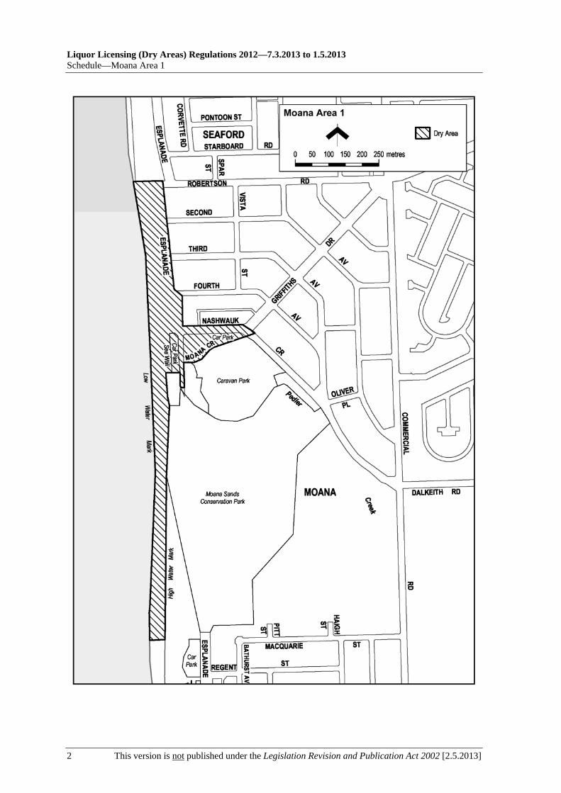
Liquor Licensing (Dry Areas) Regulations 2012—7.3.2013 to 1.5.2013 Schedule—Moana Area 1
2 This version is not published under the Legislation Revision and Publication Act 2002 [2.5.2013]

7.3.2013 to 1.5.2013—Liquor Licensing (Dry Areas) Regulations 2012
Moana Area 2—Schedule
[2.5.2013] This version is not published under the Legislation Revision and Publication Act 2002 1
Schedule—Moana Area 2
1—Extent of prohibition
The consumption of liquor is prohibited and the possession of liquor is prohibited.
2—Period of prohibition
Continuous until 11 September 2016.
3—Description of area
The part of Section 589, Hundred of Willunga, west of the portion of the Esplanade that lies between the Moana Sands Conservation Park and Wentworth Street, that is constructed as car parks, together with the toilet block situated between the car parks.

Liquor Licensing (Dry Areas) Regulations 2012—7.3.2013 to 1.5.2013 Schedule—Moana Area 2
2 This version is not published under the Legislation Revision and Publication Act 2002 [2.5.2013]

7.3.2013 to 1.5.2013—Liquor Licensing (Dry Areas) Regulations 2012
Moonta Area 1—Schedule
[2.5.2013] This version is not published under the Legislation Revision and Publication Act 2002 1
Schedule—Moonta Area 1
1—Extent of prohibition
The consumption of liquor is prohibited and the possession of liquor is prohibited.
2—Period of prohibition
From 9 pm on each day to 6 am on the following day, until 6 am on 20 October 2014.
3—Description of area
The area (known as Queen Square) bounded on the north-west by William Street, on the south-west by Robert Street, on the south-east by Henry Street and on the north-east by George Street.

Liquor Licensing (Dry Areas) Regulations 2012—7.3.2013 to 1.5.2013 Schedule—Moonta Area 1
2 This version is not published under the Legislation Revision and Publication Act 2002 [2.5.2013]

7.3.2013 to 1.5.2013—Liquor Licensing (Dry Areas) Regulations 2012
Moonta Area 2—Schedule
[2.5.2013] This version is not published under the Legislation Revision and Publication Act 2002 1
Schedule—Moonta Area 2
1—Extent of prohibition
The consumption of liquor is prohibited and the possession of liquor is prohibited.
2—Period of prohibition
From 9 pm on each day to 6 am on the following day, until 6 am on 20 October 2014.
3—Description of area
That portion of parkland (known as Polgreen (Apex) Park) and road reserve that is bounded on the south-east by Frances Terrace, on the north by Bay Road and on the south-west by Caroline Street (including the triangular portion of road reserve bounded on the south-west by Polgreen (Apex) Park, on the south-east by Frances Terrace and on the north by Bay Road) together with the footpaths of Frances Terrace, Bay Road and Caroline Street immediately abutting that parkland and road reserve.
See the plan in Schedule—Moonta Area 1.


7.3.2013 to 1.5.2013—Liquor Licensing (Dry Areas) Regulations 2012
Moonta Bay Area 1—Schedule
[2.5.2013] This version is not published under the Legislation Revision and Publication Act 2002 1
Schedule—Moonta Bay Area 1
1—Extent of prohibition
The consumption of liquor is prohibited and the possession of liquor is prohibited.
2—Period of prohibition
From 9 pm on each day to 6 am on the following day, until 6 am on 20 October 2014.
3—Description of area
The area in Moonta Bay bounded as follows: commencing at the north-eastern corner of Piece 92 of Filed Plan 200058 (a point on Bay Road approximately 30 metres east of the Moonta Bay deli), then north-easterly in a straight line across Bay Road to the south-western corner of the Moonta Bay caravan park, then generally north-westerly along the western boundary of the caravan park to the point at which it meets the northern boundary of the car parking and recreation area that lies to the west of the caravan park (the southern boundary of the concrete path that borders the car parking and recreation area on its northern and western sides), then generally south-westerly, westerly, southerly and south-easterly around the northern and western boundaries of the car parking and recreation area (the southern and eastern boundaries of the concrete path) to the western corner of Piece 92 of Filed Plan 200058, then north-easterly and easterly along the northern boundary of Piece 92 to the point of commencement. The area includes any building or other structure within the area.

Liquor Licensing (Dry Areas) Regulations 2012—7.3.2013 to 1.5.2013 Schedule—Moonta Bay Area 1
2 This version is not published under the Legislation Revision and Publication Act 2002 [2.5.2013]

7.3.2013 to 1.5.2013—Liquor Licensing (Dry Areas) Regulations 2012
Moonta Bay Area 2—Schedule
[2.5.2013] This version is not published under the Legislation Revision and Publication Act 2002 1
Schedule—Moonta Bay Area 2
1—Extent of prohibition
The consumption of liquor is prohibited and the possession of liquor is prohibited.
2—Period of prohibition
From 9 pm on each day to 6 am on the following day, until 6 am on 20 October 2014.
3—Description of area
The Moonta Bay jetty, including—
(a) any steps or other structures attached to the jetty; and
(b) the area beneath the jetty and any such structures.
See the plan in Schedule—Moonta Bay Area 1.


7.3.2013 to 1.5.2013—Liquor Licensing (Dry Areas) Regulations 2012
Moonta Bay and Port Hughes Area 1—Schedule
[2.5.2013] This version is not published under the Legislation Revision and Publication Act 2002 1
Schedule—Moonta Bay and Port Hughes Area 1
1—Extent of prohibition
The consumption of liquor is prohibited and the possession of liquor is prohibited.
2—Period of prohibition
12 noon on 31 December 2012 to 7 am on 1 January 2013.
3—Description of area
The area in and adjacent to Moonta Bay and Port Hughes bounded as follows: commencing at the point at which the northern boundary of North Terrace, Moonta Bay, intersects the eastern boundary of Coast Road, then generally south-westerly along that eastern boundary of Coast Road and the prolongation in a straight line of that boundary to the point at which the prolongation intersects the southern boundary of Harry's Point Road, Port Hughes, then north-westerly along the southern boundary of Harry's Point Road to the point at which it meets the eastern boundary of Snell Avenue, Port Hughes, then generally south-westerly along that boundary of Snell Avenue and the prolongation in a straight line of that boundary to the point at which it intersects the southern boundary of Minnie Terrace, Port Hughes, then generally westerly along that boundary of Minnie Terrace to the eastern boundary of West Terrace, Port Hughes, then generally south-westerly and southerly along that boundary of West Terrace and the continuation of West Terrace (past South Terrace) to the northern boundary of Section 2031 Hundred of Wallaroo, then north-westerly along that boundary of Section 2031 and the prolongation in a straight line of that boundary to the low water mark on the eastern side of Spencer Gulf, then generally northerly and north-easterly along the low water mark to the point at which it is intersected by the prolongation in a straight line of the northern boundary of North Terrace, Moonta Bay, then south-easterly along that prolongation and boundary of North Terrace to the point of commencement. The area includes any jetty, boat ramp or other structure projecting below low water mark from within the area described above (as well as any area beneath such a structure).

Liquor Licensing (Dry Areas) Regulations 2012—7.3.2013 to 1.5.2013 Schedule—Moonta Bay and Port Hughes Area 1
2 This version is not published under the Legislation Revision and Publication Act 2002 [2.5.2013]

7.3.2013 to 1.5.2013—Liquor Licensing (Dry Areas) Regulations 2012
Morgan Area 1—Schedule
[2.5.2013] This version is not published under the Legislation Revision and Publication Act 2002 1
Schedule—Morgan Area 1
1—Extent of prohibition
The consumption of liquor is prohibited and the possession of liquor is prohibited.
2—Period of prohibition
From 4 pm on 31 December 2012 to 9 am on 1 January 2013.
3—Description of area
The area in Morgan bounded as follows: commencing at the point at which the prolongation in a straight line of the southern boundary of Section 432 Hundred of Eba intersects the waterline on the north-western side of the River Murray, then generally north-westerly, westerly and north-westerly along that prolongation and boundary of Section 432 to the south-eastern boundary of Railway Terrace, then generally north-easterly along that south-eastern boundary of Railway Terrace to the point at which it meets the northern corner of Section 484 Hundred of Eba, then generally north-easterly along the north-western boundary of Section 433 Hundred of Eba to the northernmost boundary of Section 429 Hundred of Eba, then north-easterly along that boundary of Section 429 and the prolongation in a straight line of that boundary to the waterline on the north-western side of the River Murray, then generally south-westerly along the waterline of the River to the point of commencement, but excluding Sections 483, 484 and 485 Hundred of Eba.


7.3.2013 to 1.5.2013—Liquor Licensing (Dry Areas) Regulations 2012
Morphett Vale Area 1—Schedule
[2.5.2013] This version is not published under the Legislation Revision and Publication Act 2002 1
Schedule—Morphett Vale Area 1
1—Extent of prohibition
The consumption of liquor is prohibited and the possession of liquor is prohibited.
2—Period of prohibition
8 pm on each day to 6 am on the following day until 6 am on 11 September 2016.
3—Description of area
Reserve area in Morphett Vale, as follows: commencing at the point at which the south-eastern corner of the southern end of Alexander Avenue, Morphett Vale, meets the western boundary of the railway reserve that adjoins the eastern boundary of Alexander Avenue, then southerly along that western boundary of the railway reserve (the boundary approximately indicated by the line along which the land rises sharply to the level of the railway reserve) to the point at which the boundary of the railway reserve meets the eastern boundary of Albert Terrace, then in a straight line by the shortest route across Albert Terrace to the north-eastern corner of the northernmost allotment of private land adjoining the western boundary of Albert Terrace, then generally south-westerly along the northern boundaries of that allotment and the adjoining allotments (and the western boundary of the final such allotment) to the northern boundary of Yeldham Drive, then generally westerly and south-westerly along the northern boundary of Yeldham Drive to the north-eastern corner of the next allotment of private land adjoining the northern boundary of Yeldham Drive, then generally westerly and south-westerly along the northern boundaries of that allotment and the adjoining allotments to the eastern boundary of Main South Road, then northerly along that boundary of Main South Road to the south-western corner of Lot 12, Main South Road, then north-easterly and northerly along the southern and eastern boundaries of Lot 12 to the point at which the eastern boundary meets the southern boundary of Timothy Road, then easterly and north-easterly along that boundary of Timothy Road to the southern boundary of the first allotment of private land that adjoins that same side of Timothy Road, then north-easterly along the southern boundary of that allotment to its south-eastern corner, then northerly along the eastern boundary of that allotment and the two adjoining allotments to the north-eastern corner of the second adjoining allotment, then easterly along the southern boundary of the adjoining allotments and the southern boundary of Alexander Avenue to the point of commencement.

Liquor Licensing (Dry Areas) Regulations 2012—7.3.2013 to 1.5.2013 Schedule—Morphett Vale Area 1
2 This version is not published under the Legislation Revision and Publication Act 2002 [2.5.2013]

7.3.2013 to 1.5.2013—Liquor Licensing (Dry Areas) Regulations 2012
Mount Barker Area 1—Schedule
[2.5.2013] This version is not published under the Legislation Revision and Publication Act 2002 1
Schedule—Mount Barker Area 1
1—Extent of prohibition
The consumption of liquor is prohibited and the possession of liquor is prohibited.
2—Period of prohibition
From 9 pm on each day to 9 am on the following day, until 9 am on 1 July 2017, excluding any day or portion of a day during which—
(a) an event of historic, traditional, cultural or major community significance is held within the area; and
(b) the consumption and possession of liquor within the area are authorised for the purposes of these regulations by The District Council of Mount Barker.
3—Description of area
The area at Mount Barker bounded as follows: commencing at the point at which the north-western boundary of Flaxley Road meets the north-eastern boundary of Bollen Road, then north-westerly along that boundary of Bollen Road to the point at which it meets the southern boundary of Memorial Drive, then generally easterly, north-easterly, northerly and north-easterly along that boundary of Memorial Drive to the point at which it meets the south-western boundary of Lot 67 DP 55544, then south-easterly along that boundary of Lot 67 to the south-eastern boundary of the Lot, then north-easterly in a straight line along the south-eastern boundary of Lot 67 and the adjoining allotments to the south-western boundary of Lot 11 DP 58933, then north-westerly along that boundary of Lot 11 to its intersection with the prolongation in a straight line of the south-eastern boundary of Lot 2 DP 45954, then north-easterly along that prolongation and boundary of Lot 2 to the westernmost boundary of the TAFE College/Cinema complex car park, then generally north-westerly, north-easterly and north-westerly along the outer boundary of the car park to the south-eastern boundary of Dumas Street, then north-easterly along that boundary of Dumas Street to the eastern boundary of the TAFE College/Cinema complex car park, then generally south-easterly, southerly, easterly and southerly along the eastern boundary of the car park to the northern boundary of Lot 11 DP 58933, then easterly along that boundary of Lot 11 to the western boundary of Adelaide Road, then southerly along that boundary of Adelaide Road to the point at which it meets the north-western boundary of Flaxley Road, then generally south-westerly along that boundary of Flaxley Road to the point of commencement.

Liquor Licensing (Dry Areas) Regulations 2012—7.3.2013 to 1.5.2013 Schedule—Mount Barker Area 1
2 This version is not published under the Legislation Revision and Publication Act 2002 [2.5.2013]

7.3.2013 to 1.5.2013—Liquor Licensing (Dry Areas) Regulations 2012
Mount Barker Area 2—Schedule
[2.5.2013] This version is not published under the Legislation Revision and Publication Act 2002 1
Schedule—Mount Barker Area 2
1—Extent of prohibition
The consumption of liquor is prohibited and the possession of liquor is prohibited.
2—Period of prohibition
From 9 pm on each day to 9 am on the following day, until 9 am on 1 July 2017, excluding any day or portion of a day during which—
(a) an event of historic, traditional, cultural or major community significance is held within the area; and
(b) the consumption and possession of liquor within the area are authorised for the purposes of these regulations by The District Council of Mount Barker.
3—Description of area
The area at Mount Barker, consisting of the Mount Barker Linear Park and adjacent land, bounded as follows: commencing at the point at which the eastern boundary of Adelaide Road meets the southern boundary of Lot 11 FP 19499, then generally north-easterly, north-westerly and north-easterly along that southern boundary of Lot 11 and the adjoining allotments to the southern boundary of the car parking area on the southern side of the Civic Centre, then generally north-easterly along that boundary of the car parking area to the western boundary of Lot 2 FP 11944, then south-easterly along that boundary to the fence on the southern side of the buildings on that Lot, then north-westerly along that fence line to the western boundary of Newland Street, then south-easterly along that boundary of Newland Street to the southern boundary of Lot 2, then in a straight line by the shortest route across Newland Street to the southern boundary of Lot 261 FP 9509, then generally north-easterly and south-easterly along the southern boundary of Lot 261 and the adjoining allotments (and in a straight line by the shortest route joining those southern boundaries across Hutchinson Street and MacLaren Street) to the western boundary of MacFarlane Terrace, then generally north-westerly and northerly along that boundary of MacFarlane Terrace to the southern boundary of Kia Ora Street, then easterly along the prolongation in a straight line of the southern boundary of Kia Ora Street to the eastern boundary of MacFarlane Terrace, then generally southerly and south-easterly along that boundary of MacFarlane Terrace to the western boundary of the railway reserve that intersects MacFarlane Terrace at the north-eastern end of Hampden Road, then south-westerly along that boundary of the railway reserve to the north-eastern boundary of Lot 201 FP 9336 (the western boundary of MacFarlane Terrace), then generally north-westerly and south-westerly along that boundary of Lot 201 and the adjoining allotments (and in a straight line by the shortest route joining those boundaries of the allotments across Hutchinson Street, Newland Street and Hack Street) back to the eastern boundary of Adelaide Road, then northerly along that boundary of Adelaide Road to the point of commencement.
See the plan in Schedule—Mount Barker Area 1.

7.3.2013 to 1.5.2013—Liquor Licensing (Dry Areas) Regulations 2012
Mount Gambier Area 1—Schedule
[2.5.2013] This version is not published under the Legislation Revision and Publication Act 2002 1
Schedule—Mount Gambier Area 1
1—Extent of prohibition
The consumption of liquor is prohibited and the possession of liquor is prohibited.
2—Period of prohibition
Continuous until 7 November 2017.
3—Description of area
The area in Mount Gambier hatched in the plan in this schedule.
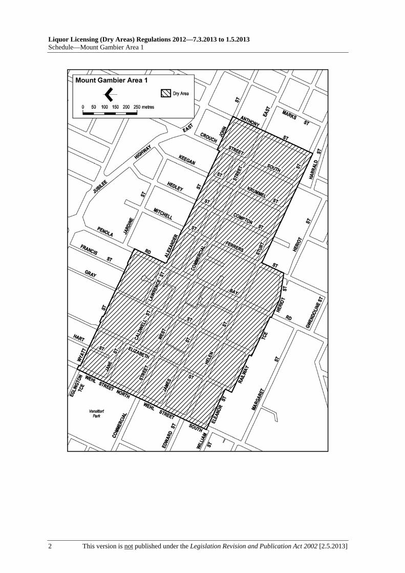
Liquor Licensing (Dry Areas) Regulations 2012—7.3.2013 to 1.5.2013 Schedule—Mount Gambier Area 1
2 This version is not published under the Legislation Revision and Publication Act 2002 [2.5.2013]

7.3.2013 to 1.5.2013—Liquor Licensing (Dry Areas) Regulations 2012
Mount Gambier Area 2—Schedule
[2.5.2013] This version is not published under the Legislation Revision and Publication Act 2002 1
Schedule—Mount Gambier Area 2
1—Extent of prohibition
The consumption of liquor is prohibited and the possession of liquor is prohibited.
2—Period of prohibition
Continuous until 7 November 2017, but excluding any day or portion of a day during which—
(a) an event of historic, cultural, traditional or major community significance is held within the area; and
(b) the consumption and possession of liquor within the area are authorised for the purposes of these regulations by the City of Mount Gambier.
3—Description of area
The area in Mount Gambier, known as Vansittart Park, bounded on the north by Eglington Terrace, on the west by Victoria Terrace, on the south by Commercial Street West and on the east by Wehl Street North, but excluding that portion of the Park (the portion consisting of the oval, netball courts and adjacent areas) defined in Schedule—Mount Gambier Area 3.

Liquor Licensing (Dry Areas) Regulations 2012—7.3.2013 to 1.5.2013 Schedule—Mount Gambier Area 2
2 This version is not published under the Legislation Revision and Publication Act 2002 [2.5.2013]

7.3.2013 to 1.5.2013—Liquor Licensing (Dry Areas) Regulations 2012
Mount Gambier Area 3—Schedule
[2.5.2013] This version is not published under the Legislation Revision and Publication Act 2002 1
Schedule—Mount Gambier Area 3
1—Extent of prohibition
The consumption of liquor is prohibited and the possession of liquor is prohibited.
2—Period of prohibition
Continuous until 7 November 2017, but excluding any day or portion of a day during which—
(a) an event—
(i) of historic, cultural, traditional or major community significance; or
(ii) that is a sporting event conducted by the North Mount Gambier Football Club, Western Border Football League, Mount Gambier Cycling Club or Mount Gambier Bowling Club,
is held within the area; and
(b) the consumption and possession of liquor within the area are authorised for the purposes of these regulations by the City of Mount Gambier.
3—Description of area
The portion of Vansittart Park in Mount Gambier (consisting of the oval, netball courts and adjacent areas within the Park) that is enclosed within a chain-link fence that commences at a point adjacent to the north-east corner of the netball courts and proceeds westerly parallel to Eglington Terrace, then southerly parallel to Victoria Terrace, then easterly and southerly around the northern and eastern boundaries of the cycling club rooms, then generally south-easterly along the eastern boundary of the car park and the northern boundary of the bowling club rooms and bowling greens, then generally easterly, north-easterly and northerly along the northern and western boundaries of Vansittart Park Gardens, then northerly along the western boundary of the playground area to the point of commencement.
See the plan in Schedule—Mount Gambier Area 2.


7.3.2013 to 1.5.2013—Liquor Licensing (Dry Areas) Regulations 2012
Mount Gambier Area 4—Schedule
[2.5.2013] This version is not published under the Legislation Revision and Publication Act 2002 1
Schedule—Mount Gambier Area 4
1—Extent of prohibition
The consumption of liquor is prohibited and the possession of liquor is prohibited.
2—Period of prohibition
Continuous until 7 November 2017.
3—Description of area
The portion of Dimjalla Park near Mount Gambier known as Dimjalla Skate Park, being the rectangular portion of land adjacent to Attamurra Road and Jubilee Highway East that consists of a skateboard arena, car park and reserve area enclosed within a chainwire security fence (the western boundary of which runs parallel to Attamurra Road approximately from Jubilee Highway East to the prolongation in a straight line of the southern boundary of Genoa Street and the southern boundary of which runs parallel to Jubilee Highway East approximately from Attamurra Road to the prolongation in a straight line of the eastern boundary of Lewis Avenue).


7.3.2013 to 1.5.2013—Liquor Licensing (Dry Areas) Regulations 2012
Mount Gambier Area 5—Schedule
[2.5.2013] This version is not published under the Legislation Revision and Publication Act 2002 1
Schedule—Mount Gambier Area 5
1—Extent of prohibition
The consumption of liquor is prohibited and the possession of liquor is prohibited.
2—Period of prohibition
Continuous until 7 November 2017.
3—Description of area
The area in Mount Gambier, known as A F Sutton Park, bounded on the north by Wireless Road West, on the east by Acacia Street, on the south and south-east by O'Connor Drive, on the south by Creek Street and on the west by Perriam Street.

Liquor Licensing (Dry Areas) Regulations 2012—7.3.2013 to 1.5.2013 Schedule—Mount Gambier Area 5
2 This version is not published under the Legislation Revision and Publication Act 2002 [2.5.2013]

7.3.2013 to 1.5.2013—Liquor Licensing (Dry Areas) Regulations 2012
Mount Pleasant Area 1—Schedule
[2.5.2013] This version is not published under the Legislation Revision and Publication Act 2002 1
Schedule—Mount Pleasant Area 1
1—Extent of prohibition
The consumption of liquor is prohibited and the possession of liquor is prohibited.
2—Period of prohibition
From 10 pm on each day to 8 am on the following day, until 8 am on 22 January 2018.
3—Description of area
The area in Mount Pleasant bounded as follows: commencing at the point at which the south-eastern boundary of Melrose Street meets the south-western boundary of Pentloes Road, then south-easterly along the south-western boundary of Pentloes Road to the north-western boundary of Showground Road, then south-westerly along the north-western boundary of Showground Road to the north-eastern boundary of Saleyard Road, then in a straight line by the shortest route to the point at which the north-western boundary of William Street meets the north-western boundary of Herriot Road, then south-westerly along the north-western boundary of William Street and the north-western boundary of Isaac Street to the point at which that boundary of Isaac Street meets the south-western boundary of Lot 58 FP 217853, then north-westerly along that south-western boundary of Lot 58 to the south-eastern boundary of Melrose Street, then south-westerly along that boundary of Melrose Street to the point at which it intersects the prolongation in a straight line of the eastern boundary of Lot 92 FP 170566, then northerly along that prolongation and boundary of Lot 92 to the point at which that boundary of Lot 92 meets the boundary of Lot 93 FP 170566, then generally north-easterly, south-westerly, north-easterly, north-westerly and north-easterly along the boundary of Lot 93 to the north-western boundary of Lot 94 FP 170566, then north-easterly along that boundary of Lot 94 to the north-western boundary of Lot 96 FP 170566, then north-easterly and south-easterly along that boundary of Lot 96 to the point at which it meets the north-eastern boundary of Lot 1 DP 23269, then south-easterly along that boundary of Lot 1 to the point at which it meets the north-western boundary of Lot 32 FP 24077, then north-easterly along that boundary of Lot 32 and the north-western boundaries of the adjoining lots to the south-western boundary of Lot 7 DP 54667, then north-westerly along that boundary of Lot 7 to the point at which it meets the south-eastern boundary of Lot 182 DP 76537, then generally easterly along that boundary of Lot 182 to the point at which it meets the south-western boundary of Talunga Park Road, then in a straight line by the shortest route across Talunga Park Road to the north-eastern boundary of the Road, then north-westerly along that boundary of the Road to the point at which it meets the north-western boundary of Lot 643 FP 169582, then generally north-easterly, south-easterly, north-easterly and south-easterly along the boundary of Lot 643 to the point at which it meets the north-western boundary of Lot 637 FP 169576, then in a straight line by the shortest route to the south-western boundary of Lot 4 DP 15632, then generally northerly, north-easterly and south-easterly along the boundary of Lot 4 to the point at which it meets the north-western boundary of Melrose Street, then north-easterly along that boundary of Melrose Street to the point at which it meets the south-western boundary of Section 81 Hundred of Talunga, then north-westerly, north-easterly and south-easterly around the south-western, north-western and north-eastern boundaries of the Section back to the north-western boundary of Melrose Street, then in a straight line by the shortest route across Melrose Street to the

Liquor Licensing (Dry Areas) Regulations 2012—7.3.2013 to 1.5.2013 Schedule—Mount Pleasant Area 1
2 This version is not published under the Legislation Revision and Publication Act 2002 [2.5.2013]
south-eastern boundary of the Street, then south-westerly along that boundary of the Street to the point of commencement. The area does not include the CFS building complex and car park on Lots 92 and 93 FP 170566.

7.3.2013 to 1.5.2013—Liquor Licensing (Dry Areas) Regulations 2012
Murray Bridge Area 1—Schedule
[2.5.2013] This version is not published under the Legislation Revision and Publication Act 2002 1
Schedule—Murray Bridge Area 1
1—Extent of prohibition
The consumption of liquor is prohibited and the possession of liquor is prohibited.
2—Period of prohibition
Continuous until 29 March 2017.
3—Description of area
The area in Murray Bridge bounded as follows: commencing at the point at which the south-eastern boundary of Bridge Street meets the south-western edge of the River Murray, then generally south-easterly along that edge of the River to the point at which it intersects the prolongation in a straight line of the south-eastern boundary of the southern portion of Jaensch Road, then generally south-westerly, westerly and north-westerly along that prolongation and boundary of the southern portion of Jaensch Road and the prolongation in a straight line across Sturt Reserve Road of that boundary to the north-western boundary of Sturt Reserve Road, then north-easterly along that boundary of Sturt Reserve Road to the western boundary of Lot 82 DP 55455, then generally north-westerly and north-easterly along that boundary of Lot 82 to the western boundary of the northern portion of Jaensch Road, then generally north-easterly and north-westerly along that boundary of the northern portion of Jaensch Road to the point at which it meets the south-eastern boundary of Mary Terrace, then in a straight line by the shortest route to the point at which the south-western boundary of East Terrace meets the north-western boundary of Mary Terrace, then south-westerly along that boundary of Mary Terrace and the prolongation in a straight line of that boundary to the south-western boundary of Swanport Road, then south-easterly along that boundary of Swanport Road to the south-eastern boundary of Lot 514 FP 167329, then south-westerly along that boundary of Lot 514 and the south-eastern boundary of Lot 463 FP 167278 to the north-eastern boundary of Verdun Road, then north-westerly along that boundary of Verdun Road and the prolongation in a straight line of that boundary to the north-western boundary of Standen Street, then south-westerly along that boundary of Standen Street to the north-eastern boundary of Flavel Terrace, then generally north-westerly along that boundary of Flavel Terrace and the prolongation in a straight line of that boundary to the north-western boundary of Adelaide Road, then south-westerly along that boundary of Adelaide Road to the north-eastern boundary of Charles Street, then north-westerly along that boundary of Charles Street to the south-eastern boundary of Lot 102 DP 70324, then north-easterly in a straight line along the south-eastern boundary of that Lot and of the adjoining Lots to the north-eastern boundary of Lot 20 FP 27435, then north-westerly along the north-eastern boundary of Lot 20 to the south-eastern boundary of Clara Street, then north-easterly along that boundary of Clara Street to the north-eastern boundary of McHenry Street, then north-westerly along that boundary of McHenry Street to the south-eastern boundary of Lot 103 DP 1295, then north-easterly along that boundary of Lot 103 to the north-eastern boundary of the Lot, then north-westerly along the north-eastern boundary of Lot 103 and of Lot 102 DP 1295 to the south-eastern boundary of Lot 14 DP 1295, then north-easterly along the south-eastern boundary of Lot 14 and the prolongation in a straight line of that boundary to the north-eastern boundary of Mannum Road, then north-westerly along that boundary of Mannum Road to the north-western boundary of Section 941, Hundred of Mobilong (the south-eastern

Liquor Licensing (Dry Areas) Regulations 2012—7.3.2013 to 1.5.2013 Schedule—Murray Bridge Area 1
2 This version is not published under the Legislation Revision and Publication Act 2002 [2.5.2013]
boundary of Park Terrace), then north-easterly, north-westerly and north-easterly along that north-western boundary of Section 941 and the prolongation in a straight line of that boundary to the northern boundary of Lot 2 DP 40450 (the southern boundary of Hume Reserve Road), then generally easterly along that boundary of Lot 2 to the western boundary of Section 1327 Hundred of Mobilong, then northerly and north-easterly along that boundary of Section 1327 and the prolongation in a straight line of that boundary to the south-western edge of the River Murray, then generally south-easterly along that edge of the River to the point of commencement. The area includes any wharf, jetty, boat ramp or other structure (other than a bridge across the River) extending into or over the River from the area described above.

7.3.2013 to 1.5.2013—Liquor Licensing (Dry Areas) Regulations 2012
Murray Bridge Area 1—Schedule
[2.5.2013] This version is not published under the Legislation Revision and Publication Act 2002 3


7.3.2013 to 1.5.2013—Liquor Licensing (Dry Areas) Regulations 2012
Nairne Area 1—Schedule
[2.5.2013] This version is not published under the Legislation Revision and Publication Act 2002 1
Schedule—Nairne Area 1
1—Extent of prohibition
The consumption of liquor is prohibited and the possession of liquor is prohibited.
2—Period of prohibition
From 5 pm on each day to 5 am on the following day, until 5 am on 1 July 2017, excluding any day or portion of a day during which—
(a) an event of historic, traditional, cultural or major community significance is held within the area; and
(b) the consumption and possession of liquor within the area are authorised for the purposes of these regulations by The District Council of Mount Barker.
3—Description of area
Lot 52 of Filed Plan No 157387 (Certificate of Title Volume 5723 Folio 446) and Piece 91 of Filed Plan No 216711.

Liquor Licensing (Dry Areas) Regulations 2012—7.3.2013 to 1.5.2013 Schedule—Nairne Area 1
2 This version is not published under the Legislation Revision and Publication Act 2002 [2.5.2013]

7.3.2013 to 1.5.2013—Liquor Licensing (Dry Areas) Regulations 2012
Naracoorte Area 1—Schedule
[2.5.2013] This version is not published under the Legislation Revision and Publication Act 2002 1
Schedule—Naracoorte Area 1
1—Extent of prohibition
The consumption of liquor is prohibited and the possession of liquor is prohibited.
2—Period of prohibition
From 7 pm on each day to 7 am on the following day, provided that where—
(a) an event of historic, traditional or cultural significance or that significantly promotes tourism is held in the area; and
(b) the Naracoorte Lucindale Council authorises, for the purposes of the event, the consumption and possession of liquor in the area (or a defined part of the area) for a specified period during the event,
the prohibition does not apply in the area (or defined part of the area) during the specified period.
3—Description of area
The area in Naracoorte bounded as follows: commencing at the point at which the eastern boundary of McRae Street meets the western boundary of Gordon Street, then north-easterly along that boundary of Gordon Street to the western boundary of Jones Street, then north-westerly along that boundary of Jones Street to the southern boundary of Robertson Street, then north-easterly along that boundary of Robertson Street and the prolongation in a straight line of that boundary to the eastern boundary of Rolland Street, then south-easterly along that boundary of Rolland Street to the northern boundary of Hinckley Street, then north-easterly along that boundary of Hinckley Street to the western boundary of Gore Street, then north-westerly along that boundary of Gore Street to the southern boundary of Smith Street, then south-westerly along that boundary of Smith Street to the point at which it is intersected by the prolongation in a straight line of the western boundary of Sandstone Avenue, then northerly along that prolongation and boundary of Sandstone Avenue to the southern boundary of the railway reserve that lies between Ormerod Street and Park Terrace, then generally westerly and south-westerly along that southern boundary of the railway reserve to the northern boundary of Macdonnell Street, then generally south-easterly and easterly along that boundary of Macdonnell Street and the northern boundary of Ormerod Street to the eastern boundary of McRae Street, then south-easterly along that boundary of McRae Street to the southern boundary of Smith Street, then south-westerly along that boundary of Smith Street to the eastern boundary of Magarey Crescent, then south-easterly along that boundary of Magarey Crescent to the northern boundary of Church Street, then south-easterly along that boundary of Church Street to the western boundary of McRae Street, then in a straight line by the shortest route to the point of commencement.


7.3.2013 to 1.5.2013—Liquor Licensing (Dry Areas) Regulations 2012
Naracoorte Area 2—Schedule
[2.5.2013] This version is not published under the Legislation Revision and Publication Act 2002 1
Schedule—Naracoorte Area 2
1—Extent of prohibition
The consumption of liquor is prohibited and the possession of liquor is prohibited.
2—Period of prohibition
Continuous.
3—Description of area
Commencing at the common boundary of the Naracoorte Creek, the Naracoorte Caravan Park and the Naracoorte Swimming Lake, then westerly along the western edge of the Naracoorte Creek for 170 metres, then southerly for approximately 200 metres to the common corner of the boundary fences of the Jubilee Nature Park, Naracoorte Swimming Lake and Naracoorte Primary School Reserve, then southerly along the boundary fence line of the Naracoorte Primary School Reserve and Naracoorte Swimming Lake for approximately 127 metres to a corner at the entrance to the Naracoorte Swimming Lake, then easterly along the boundary fence line of Naracoorte Swimming Lake and Wortley Oval for approximately 202 metres to the common corner of the boundary fences of Wortley Oval, Naracoorte Swimming Lake and Naracoorte Caravan Park, then easterly along the fence line between Naracoorte Caravan Park and Naracoorte Swimming Lake for approximately 46 metres to a corner, then generally northerly along that fence line to the point of commencement.


7.3.2013 to 1.5.2013—Liquor Licensing (Dry Areas) Regulations 2012
Noarlunga Centre Area 1—Schedule
[2.5.2013] This version is not published under the Legislation Revision and Publication Act 2002 1
Schedule—Noarlunga Centre Area 1
1—Extent of prohibition
The consumption of liquor is prohibited and the possession of liquor is prohibited.
2—Period of prohibition
Continuous until 11 September 2016.
3—Description of area
The area in Noarlunga Centre hatched in the plan in this schedule.

Liquor Licensing (Dry Areas) Regulations 2012—7.3.2013 to 1.5.2013 Schedule—Noarlunga Centre Area 1
2 This version is not published under the Legislation Revision and Publication Act 2002 [2.5.2013]

7.3.2013 to 1.5.2013—Liquor Licensing (Dry Areas) Regulations 2012
Normanville Area 1—Schedule
[2.5.2013] This version is not published under the Legislation Revision and Publication Act 2002 1
Schedule—Normanville Area 1
1—Extent of prohibition
The consumption of liquor is prohibited and the possession of liquor is prohibited.
2—Period of prohibition
10 pm on each day to 6 am on the following day, until 6 am on 2 August 2017.
3—Description of area
Commencing at the point at which the southern side of the Normanville jetty intersects with the low water mark, then generally south-westerly along the low water mark to the mouth of the Bungala River, then along the northern bank of the river to its intersection with the western boundary of the caravan park, then generally north-easterly, northerly and easterly along the western and northern boundaries of the caravan park to the point at which the northern boundary joins the northern boundary of the tennis courts, then in a straight line by the shortest route to the south-eastern corner of Lot 137 of part Section 1014, Hundred of Yankalilla, then north-westerly along the southern boundary of that lot and the prolongation in a straight line of the southern boundary of that lot to the low water mark, then generally south-westerly along the low water mark to the northern side of the Normanville jetty, then north-westerly, south-westerly and south-easterly along the northern, western and southern sides of the Normanville jetty to the point of commencement.

Liquor Licensing (Dry Areas) Regulations 2012—7.3.2013 to 1.5.2013 Schedule—Normanville Area 1
2 This version is not published under the Legislation Revision and Publication Act 2002 [2.5.2013]

7.3.2013 to 1.5.2013—Liquor Licensing (Dry Areas) Regulations 2012
North Adelaide Area 1—Schedule
[2.5.2013] This version is not published under the Legislation Revision and Publication Act 2002 1
Schedule—North Adelaide Area 1
1—Extent of prohibition
The consumption of liquor is prohibited and the possession of liquor is prohibited.
2—Period of prohibition
Continuous until 30 October 2014.
3—Description of area
The area in North Adelaide bounded as follows: commencing at the point at which the eastern boundary of Mills Terrace intersects the southern boundary of Barton Terrace West, then north-easterly along that boundary of Barton Terrace West to the western boundary of O'Connell Street, then south-easterly along that boundary of O'Connell Street to its intersection with the prolongation in a straight line of the southern boundary of Barton Terrace East, then north-easterly along that boundary of Barton Terrace East to the western boundary of Lefevre Terrace, then south-easterly along that boundary of Lefevre Terrace to its intersection with the prolongation in a straight line of the southern boundary of Kingston Terrace, then north-easterly along that boundary to a point on that boundary that is the shortest distance from the southern boundary of the western end of Kingston Terrace East, then north-westerly in a straight line to the southern boundary of the western end of Kingston Terrace East, then north-easterly along that boundary to the western boundary of Mann Road, then south-easterly along that boundary of Mann Road to the point at which it intersects the prolongation in a straight line of the northern boundary of MacKinnon Parade, then south-westerly, south-easterly, south-westerly and north-westerly along that prolongation and boundary of MacKinnon Parade to the northern boundary of Finniss Street, then south-westerly along that boundary of Finniss Street to the eastern boundary of Frome Road, then north-westerly along that boundary of Frome Road (and the prolongation in a straight line of that boundary) to the northern boundary of Melbourne Street, then in a straight line by the shortest route to the point at which the western boundary of Frome Road meets the western boundary of Sir Edwin Smith Avenue, then south-westerly along that boundary of Sir Edwin Smith Avenue to the northern boundary of Pennington Terrace, then generally north-westerly and westerly along that boundary of Pennington Terrace and Montefiore Hill to the eastern boundary of Strangways Terrace, then north-westerly, south-westerly, north-westerly and south-westerly along that boundary of Strangways Terrace to the eastern boundary of Mills Terrace, then north-westerly, north-easterly, north-westerly, north-easterly, north-westerly, north-easterly and north-westerly along that boundary of Mills Terrace to the point of commencement.

Liquor Licensing (Dry Areas) Regulations 2012—7.3.2013 to 1.5.2013 Schedule—North Adelaide Area 1
2 This version is not published under the Legislation Revision and Publication Act 2002 [2.5.2013]

7.3.2013 to 1.5.2013—Liquor Licensing (Dry Areas) Regulations 2012
Nuriootpa Area 1—Schedule
[2.5.2013] This version is not published under the Legislation Revision and Publication Act 2002 1
Schedule—Nuriootpa Area 1
1—Extent of prohibition
The consumption of liquor is prohibited and the possession of liquor is prohibited.
2—Period of prohibition
From 10 pm on each day to 8 am on the following day, until 8 am on 22 January 2018.
3—Description of area
The area in Nuriootpa bounded as follows: commencing at the point at which the northern boundary of Railway Terrace meets the eastern boundary of Tanunda Road, then in a straight line by the shortest route across Tanunda Road to the south-eastern corner of Lot 2 FP 2257, then north-westerly along the southern boundary of Lot 2 FP 2257 and the southern boundary of Lot 14 DP 26721 to the south-eastern boundary of Lot 26 DP 63967, then generally north-easterly along the south-eastern and eastern boundaries of Lot 26 to the point at which the eastern boundary of Lot 26 meets the eastern boundary of Barossa Street, then generally north-easterly along the eastern boundary of Barossa Street to the southern boundary of Gawler Street, then in a straight line by the shortest route across Gawler Street to the northern boundary of that Street, then south-easterly along the northern boundary of Gawler Street to the eastern boundary of Second Street, then north-easterly along the eastern boundary of Second Street and of Krieg Street (and the prolongation in a straight line of the eastern boundary of Krieg Street) to the northern boundary of Oswald Street, then south-easterly along the northern boundary of Oswald Street (and the prolongation in a straight line of that boundary) to the eastern boundary of Murray Street, then north-easterly along the eastern boundary of Murray Street to the point at which it meets the northern boundary of Lot 478 FP 172739, then south-easterly along the northern boundary of Lot 478 to the western boundary of Lot 130 DP 43207, then north-easterly and south-easterly along the western and northern boundaries of Lot 130 to the northern boundary of Lot 514 FP 172775, then south-easterly along the northern boundary of Lot 514 and the northern boundary of Section 667 Hundred of Moorooroo to the eastern boundary of Section 667, then south-westerly along the eastern boundary of Section 667 to the point at which it meets the northern boundary of Penrice Road, then north-westerly along the northern boundary of Penrice Road to the point at which it is intersected by the prolongation in a straight line of the western boundary of Lot 1 DP 7218, then in a straight line by the shortest route to the point at which the north-eastern boundary of Lot 51 DP 36626 meets the eastern boundary of that Lot, then south-westerly along the eastern boundary of Lot 51 to the point at which it meets the northern boundary of Lot 449 FP 172710, then north-westerly and south-westerly along the northern and western boundaries of Lot 449 to the northern boundary of Lot 62 FP 35775, then generally north-westerly, south-westerly and southerly along the northern and western boundaries of Lot 62 to the point at which the western boundary of Lot 62 meets the northern boundary of New Road, then south-easterly along the northern boundary of New Road and the prolongation in a straight line of that boundary to the point at which it intersects the prolongation in a straight line of the eastern boundary of William Street, then south-westerly along that prolongation and boundary of William Street to the northern boundary of Railway Terrace, then generally north-westerly along that boundary of Railway Terrace to the point of commencement.

Liquor Licensing (Dry Areas) Regulations 2012—7.3.2013 to 1.5.2013 Schedule—Nuriootpa Area 1
2 This version is not published under the Legislation Revision and Publication Act 2002 [2.5.2013]

7.3.2013 to 1.5.2013—Liquor Licensing (Dry Areas) Regulations 2012
Oaklands Park Area 1—Schedule
[2.5.2013] This version is not published under the Legislation Revision and Publication Act 2002 1
Schedule—Oaklands Park Area 1
1—Extent of prohibition
The consumption of liquor is prohibited and the possession of liquor is prohibited.
2—Period of prohibition
Continuous until 8 June 2013.
3—Description of area
The area in Oaklands Park bounded on the west by Morphett Road, on the south by Sturt Road, on the east by Diagonal Road and on the north by the northern boundary of the Marion Shopping Centre/Bunnings Warehouse car park (being the south-eastern and southern boundaries of Lot 61 DP 52571; the southern boundaries of Lot 3 DP 59367, Lot 220 DP 56981, Lot 42 DP 56981 and Lot 31 DP 56981; the portion of the southern boundary of Lot 21 DP 52571 that lies to the east of the eastern boundary of Community Plan 21155; and the eastern and southern boundaries of Community Plan 21155), but excluding any building within the area other than any part of a building that is set aside for car parking.

Liquor Licensing (Dry Areas) Regulations 2012—7.3.2013 to 1.5.2013 Schedule—Oaklands Park Area 1
2 This version is not published under the Legislation Revision and Publication Act 2002 [2.5.2013]
7.3.2013 to 1.5.2013—Liquor Licensing (Dry Areas) Regulations 2012
Paringa Area 1—Schedule
[2.5.2013] This version is not published under the Legislation Revision and Publication Act 2002 1
Schedule—Paringa Area 1
1—Extent of prohibition
The consumption of liquor is prohibited and the possession of liquor is prohibited.
2—Period of prohibition
Continuous until 8 December 2013.
3—Description of area
Murtho Road.


7.3.2013 to 1.5.2013—Liquor Licensing (Dry Areas) Regulations 2012
Peterborough Area 1—Schedule
[2.5.2013] This version is not published under the Legislation Revision and Publication Act 2002 1
Schedule—Peterborough Area 1
1—Extent of prohibition
The consumption of liquor is prohibited and the possession of liquor is prohibited.
2—Period of prohibition
Continuous until 11 December 2013.
3—Description of area
The area in Peterborough bounded as follows: commencing at the point at which the southern boundary of Main Street meets the eastern boundary of Silver Street, then southerly along that boundary of Silver Street to the point at which it meets the northern boundary of the railway reserve (the southern boundary of the allotment on which the Federal Hotel is situated), then in a straight line by the shortest route across Silver Street to the point (approximately in line with the southern boundary of the Federal Hotel allotment and approximately 10 metres to the west of Silver Street) at which a chain mesh fence that runs between Silver Street and Hurlstone Street commences, then generally westerly along that chain mesh fence to the end of the fence (approximately 25 metres to the east of Hurlstone Street on the southern side of the old Orroroo (disused) railway line), then westerly along the prolongation in a straight line of the fence line to the eastern boundary of Hurlstone Street, then in a straight line by the shortest route diagonally across Hurlstone Street to the point at which the southern fence line of Rotary Park meets the western boundary of Hurlstone Street, then generally westerly and north-westerly along the southern fence line of the Park, the adjoining private property and the land on which the South Australian Railway Institute tennis courts and Hall are situated to the point at which that southern fence line is intersected by the prolongation in a straight line of the eastern boundary of Torr Street, then northerly along that prolongation and boundary of Torr Street to the point at which the eastern boundary of Torr Street meets the southern boundary of Kitchener Street, then easterly along that boundary of Kitchener Street to the eastern boundary of Howard Street, then southerly along that boundary of Howard Street to the northern boundary of Main Street, then easterly along that boundary of Main Street to the western boundary of Cotton Road, then southerly along the prolongation in a straight line of the western boundary of Cotton Road to the southern boundary of Main Street, then westerly along that boundary of Main Street to the point of commencement.

Liquor Licensing (Dry Areas) Regulations 2012—7.3.2013 to 1.5.2013 Schedule—Peterborough Area 1
2 This version is not published under the Legislation Revision and Publication Act 2002 [2.5.2013]

7.3.2013 to 1.5.2013—Liquor Licensing (Dry Areas) Regulations 2012
Port Adelaide Area 1—Schedule
[2.5.2013] This version is not published under the Legislation Revision and Publication Act 2002 1
Schedule—Port Adelaide Area 1
1—Extent of prohibition
The consumption of liquor is prohibited and the possession of liquor is prohibited.
2—Period of prohibition
Continuous until 1 January 2017 but excluding any day during that period on which a festival, exhibition, show or other event is held within the area if it—
(a) is of historic, traditional or cultural significance or significantly promotes tourism; and
(b) has been authorised by the City of Port Adelaide Enfield for the purposes of these regulations.
The City may not grant more than 3 authorisations in relation to this area in any calendar year.
3—Description of area
The area in Port Adelaide hatched in the plan in this schedule.

Liquor Licensing (Dry Areas) Regulations 2012—7.3.2013 to 1.5.2013 Schedule—Port Adelaide Area 1
2 This version is not published under the Legislation Revision and Publication Act 2002 [2.5.2013]

7.3.2013 to 1.5.2013—Liquor Licensing (Dry Areas) Regulations 2012
Port Adelaide Area 2—Schedule
[2.5.2013] This version is not published under the Legislation Revision and Publication Act 2002 1
Schedule—Port Adelaide Area 2
1—Extent of prohibition
The consumption of liquor is prohibited and the possession of liquor is prohibited.
2—Period of prohibition
Continuous until 1 January 2017, but excluding any day during that period on which a festival, exhibition, show or other event is held within the area if it—
(a) is of historic, traditional or cultural significance or significantly promotes tourism; and
(b) has been authorised by the City of Port Adelaide Enfield for the purposes of these regulations.
The City may not grant more than 3 authorisations in relation to this area in any calendar year.
3—Description of area
The area in Port Adelaide bounded as follows: commencing at the point at which the prolongation in a straight line of the eastern boundary of Minories Street meets the northern boundary of the railway reserve immediately to the south of the southern end of Minories Street, then generally south-westerly along that northern boundary of the railway reserve to the low water mark on the eastern side of the Port Adelaide River, then generally northerly along the low water mark to the southern boundary of the dock that lies immediately to the north of the railway reserve (commonly known as Old Port Canal), then generally north-easterly, northerly and south-westerly along the low water mark on the southern, eastern and northern boundaries of that dock, then northerly along the low water mark of the River to the point at which it intersects the prolongation in a straight line of the northern boundary of that portion of Allotment 200 of DP 49128 that runs south-west/north-east, then north-easterly along that prolongation and portion of the northern boundary of Allotment 200 and the northern boundary of Allotment 1001 DP 47800 to the western boundary of Minories Street, then north-easterly along the prolongation in a straight line of the northern boundary of Allotment 1001 to the eastern boundary of Minories Street, then south-easterly along that boundary of Minories Street and the prolongation in a straight line of that boundary to the point of commencement.


7.3.2013 to 1.5.2013—Liquor Licensing (Dry Areas) Regulations 2012
Port Augusta Area 1—Schedule
[2.5.2013] This version is not published under the Legislation Revision and Publication Act 2002 1
Schedule—Port Augusta Area 1
1—Extent of prohibition
The consumption of liquor is prohibited and the possession of liquor is prohibited.
2—Period of prohibition
Continuous until 1 December 2013.
3—Description of area
The area in and adjacent to Port Augusta bounded as follows: commencing at the point at which the prolongation in a straight line of the southern boundary of Section 778, Hundred of Davenport intersects the low water mark on the eastern side of Spencer Gulf, then generally north-easterly and south-easterly along that prolongation and boundary of Section 778 and the southern boundaries of Allotment 16 DP 19131, Allotment 844 FP 186546 and Allotment 17 DP 19131 and the prolongation in a straight line of the southern boundary of Allotment 17 to the eastern boundary of Yorkey's Crossing Road, then south-westerly along that eastern boundary of Yorkey's Crossing Road to the southern boundary of Section 575, Hundred of Davenport, then south-easterly along that southern boundary of Section 575 and the southern boundary of Section 568, Hundred of Davenport to the south-eastern corner of Section 568, then in a straight line by the shortest route to the south-western corner of Section 554, Hundred of Davenport, then south-easterly along the southern boundary of Section 554 and of Section 547, Hundred of Davenport to the south-eastern corner of Section 547, then north-easterly along the western boundary of Prosser Street and the prolongation in a straight line of that boundary to the southern boundary of Section 1077, Hundred of Davenport, then generally south-easterly along that southern boundary of Section 1077 and of Section 775, Hundred of Davenport to the point at which that boundary of Section 775 meets the northern boundary of Depot Creek Road, then generally north-easterly and south-easterly along that boundary of Depot Creek Road to its intersection with the prolongation in a straight line of the western boundary of Section 772, Hundred of Davenport, then south-westerly along that prolongation and western boundary of Section 772 and the western boundary of Allotment 5 of DP 27316 to the eastern boundary of Racecourse Road, then generally south-westerly, southerly, south-easterly and easterly along that boundary of Racecourse Road and the southern boundary of Piece 9 DP 27316 to the south-eastern corner of Piece 9, then in a straight line by the shortest route (across the adjacent road and railway reserves) to the north-western corner of Allotment 841 FP 186543, then generally southerly along the eastern boundary of Abbatoir Road to the northern boundary of the Eyre Highway, then in a straight line by the shortest route to the point at which the southern boundary of the Eyre Highway meets the eastern boundary of Northern Power Station Road, then generally southerly along that boundary of Northern Power Station Road to the northern boundary of Allotment 8 DP 55700, then generally north-westerly along that boundary of Allotment 8 to the eastern boundary of Power Station Road, then south-easterly along that boundary of Power Station Road to its intersection with the prolongation in a straight line of the northern boundary of Allotment 5 DP 55666, then generally westerly along that prolongation and northern boundary of Allotment 5 and the northern boundary and prolongation in a straight line of the northern boundary of Section 1247, Hundred of Davenport to the low water mark on the eastern side of Spencer Gulf, then generally north-easterly, northerly, north-westerly, north-easterly and northerly along
Liquor Licensing (Dry Areas) Regulations 2012—7.3.2013 to 1.5.2013 Schedule—Port Augusta Area 1
2 This version is not published under the Legislation Revision and Publication Act 2002 [2.5.2013]
the low water mark to the point of commencement. The area includes any jetty, wharf or other structure (apart from a bridge described in Schedule—Port Augusta Area 2) projecting into the Gulf from the area described above, as well as any area beneath such a structure.
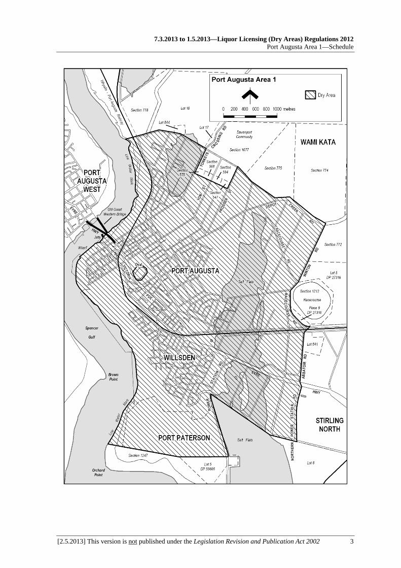
7.3.2013 to 1.5.2013—Liquor Licensing (Dry Areas) Regulations 2012
Port Augusta Area 1—Schedule
[2.5.2013] This version is not published under the Legislation Revision and Publication Act 2002 3


7.3.2013 to 1.5.2013—Liquor Licensing (Dry Areas) Regulations 2012
Port Augusta Area 2—Schedule
[2.5.2013] This version is not published under the Legislation Revision and Publication Act 2002 1
Schedule—Port Augusta Area 2
1—Extent of prohibition
The consumption of liquor is prohibited and the possession of liquor is prohibited.
2—Period of prohibition
Continuous until 1 December 2013.
3—Description of area
The whole of the bridge across Spencer Gulf at Port Augusta (between the areas defined in Schedule—Port Augusta Area 1 and Schedule—Port Augusta Area 3) known as the Port Augusta Highway One Bridge.
The whole of the bridge across Spencer Gulf at Port Augusta (between the areas defined in Schedule—Port Augusta Area 1 and Schedule—Port Augusta Area 3) known as the Old Great Western Bridge.


7.3.2013 to 1.5.2013—Liquor Licensing (Dry Areas) Regulations 2012
Port Augusta Area 3—Schedule
[2.5.2013] This version is not published under the Legislation Revision and Publication Act 2002 1
Schedule—Port Augusta Area 3
1—Extent of prohibition
The consumption of liquor is prohibited and the possession of liquor is prohibited.
2—Period of prohibition
Continuous until 1 December 2013.
3—Description of area
The area in and adjacent to Port Augusta bounded as follows: commencing at the point at which the prolongation in a straight line of the western boundary of Tiver Street intersects the low water mark on the western side of Spencer Gulf, then north-westerly along that prolongation and western boundary of Tiver Street to the southern boundary of Caroona Road, then generally south-westerly along that boundary of Caroona Road to the eastern boundary of Shack Road, then generally southerly, south-westerly, westerly, south-westerly and westerly along that boundary of Shack Road to the point at which it meets the eastern boundary of Blanche Harbour Road, then in a straight line by the shortest route to the point at which the southern boundary of Caroona Road meets the western boundary of Blanche Harbour Road, then in a straight line by the shortest route to the south-eastern corner of Allotment 104 DP 50393, then generally northerly along the eastern boundary of Allotment 104 and of Allotment 103 DP 50393 to the point at which the eastern boundary of Allotment 103 meets the southern boundary of Shirley Street, then south-westerly along that boundary of Shirley Street to its intersection with the prolongation in a straight line of the western boundary of Kittel Street, then generally northerly along that prolongation and western boundary of Kittel Street and the prolongation in a straight line of that boundary to the northern boundary of the Eyre Highway, then easterly along that northern boundary of the Eyre Highway to the western boundary of Slade Road, then northerly along that boundary of Slade Road to the southern boundary of Old Tarcoola Road, then north-westerly along that boundary of Old Tarcoola Road to the point at which it meets the southern boundary of the railway reserve, then generally north-easterly and easterly along that boundary of the railway reserve to the low water mark on the western side of Spencer Gulf, then generally south-westerly, south-easterly, southerly and south-westerly along the low water mark to the point of commencement. The area includes any jetty, wharf or other structure (apart from a bridge across the Gulf) projecting into the Gulf from the area described above, as well as any area beneath such a structure.

Liquor Licensing (Dry Areas) Regulations 2012—7.3.2013 to 1.5.2013 Schedule—Port Augusta Area 3
2 This version is not published under the Legislation Revision and Publication Act 2002 [2.5.2013]

7.3.2013 to 1.5.2013—Liquor Licensing (Dry Areas) Regulations 2012
Port Broughton Area 1—Schedule
[2.5.2013] This version is not published under the Legislation Revision and Publication Act 2002 1
Schedule—Port Broughton Area 1
1—Extent of prohibition
The consumption of liquor is prohibited and the possession of liquor is prohibited.
2—Period of prohibition
From 10 pm on each day to 8 am on the following day, until 8 am on 16 April 2015.
3—Description of area
The area in Port Broughton bounded as follows: commencing at the point at which the prolongation in a straight line of the southern boundary of South Terrace intersects the low water mark of Spencer Gulf, then generally northerly along the low water mark to the point at which it is intersected by the prolongation in a straight line of the northern boundary of Section 525 Hundred of Mundoora, then easterly along that prolongation and boundary of Section 525 and the prolongation in a straight line of that boundary to the eastern boundary of West Terrace, then southerly along that boundary of West Terrace to the northern boundary of James Street, then easterly along the northern boundary of James Street and the prolongation in a straight line of that boundary to the eastern boundary of East Terrace, then southerly along that boundary of East Terrace to the northern boundary of Lot 90 T 210602, then easterly along that boundary of Lot 90 to the point at which it is intersected by the line of the western fence of the tennis courts on Lot 90, then southerly along that line of the western fence of the tennis courts to the point at which the line intersects the northern boundary of Bay Street, then westerly along that boundary of Bay Street to the eastern boundary of East Terrace, then southerly along that boundary of East Terrace to the southern boundary of Edmund Street, then westerly along that boundary of Edmund Street to the eastern boundary of West Terrace, then southerly along that boundary of West Terrace to the northern boundary of South Terrace, then in a straight line by the shortest route to the point at which the southern boundary of South Terrace meets the eastern boundary of Dalling Street, then westerly along the prolongation in a straight line of the southern boundary of South Terrace to the point of commencement.

Liquor Licensing (Dry Areas) Regulations 2012—7.3.2013 to 1.5.2013 Schedule—Port Broughton Area 1
2 This version is not published under the Legislation Revision and Publication Act 2002 [2.5.2013]

7.3.2013 to 1.5.2013—Liquor Licensing (Dry Areas) Regulations 2012
Port Broughton Area 2—Schedule
[2.5.2013] This version is not published under the Legislation Revision and Publication Act 2002 1
Schedule—Port Broughton Area 2
1—Extent of prohibition
The consumption of liquor is prohibited and the possession of liquor is prohibited.
2—Period of prohibition
From 10 pm on each day to 8 am on the following day, until 8 am on 16 April 2015.
3—Description of area
The area in Port Broughton, generally known as the Port Broughton Boat Ramp, bounded as follows: commencing at the point at which the eastern boundary of Section 1037 Hundred of Mundoora meets the southern boundary of the Section, then northerly along the eastern boundary of Section 1037 to the north-eastern boundary of the Section, then north-westerly along that north-eastern boundary and the prolongation in a straight line of the boundary to the low water mark of Spencer Gulf, then generally westerly, south-westerly and easterly along the low water mark around the seaward boundary of the seawall protecting the boat ramp and car parking area to the western side of the break in the seawall forming the entrance to the boat ramp, then in a straight line by the shortest route (across the entrance) to the eastern side of the entrance, then generally easterly and southerly along the low water mark to the point at which it is intersected by the prolongation in a straight line of the southern boundary of Section 1037 Hundred of Mundoora, then easterly along that prolongation and boundary of Section 1037 to the point of commencement.
See the plan in Schedule—Port Broughton Area 1.


7.3.2013 to 1.5.2013—Liquor Licensing (Dry Areas) Regulations 2012
Port Elliot Area 1—Schedule
[2.5.2013] This version is not published under the Legislation Revision and Publication Act 2002 1
Schedule—Port Elliot Area 1
1—Extent of prohibition
The consumption of liquor is prohibited and the possession of liquor is prohibited.
2—Period of prohibition
From 10 pm on each day to 6 am on the following day, until 6 am on 29 July 2017.
3—Description of area
The area in and adjacent to Port Elliot bounded as follows: commencing at the point at which the eastern boundary of Rosetta Terrace meets the southern boundary of North Terrace, then easterly along that boundary of North Terrace to the point at which it meets the western boundary of Mason Street, then in a straight line by the shortest route (across North Terrace) to the point at which the northern boundary of North Terrace meets the western boundary of Frederick Street, then northerly along the western boundary of Frederick Street to the point at which it intersects the northern boundary of Regent Street, then easterly along that northern boundary of Regent Street and the prolongation in a straight line of that northern boundary to the eastern boundary of Montpelier Terrace, then south-easterly along that boundary of Montpelier Terrace to the northern boundary of Rosina Crescent, then north-easterly along the northern boundary of Rosina Crescent to the western boundary of Lot 53 Deposited Plan 27840, then north-westerly along the western boundary of that Lot to the southern boundary of Lot 1010 Deposited Plan 52390, then easterly along that boundary of Lot 1010 to the western boundary of Lot 66 Deposited Plan 30324, then southerly along the western boundary of Lot 66 and the western boundary of Lot 865 Filed Plan 166114 and the prolongation in a straight line of that boundary of Lot 865 to the southern boundary of North Terrace, then easterly and north-easterly along that boundary of North Terrace and the southern boundary of the Victor Harbor - Goolwa Road to the northern boundary of the access road from the Victor Harbor - Goolwa Road to the Port Elliot Caravan Park, then south-easterly along the northern boundary of the access road to a car parking area on the northern side of that road, then around the outer boundary of the car park (so as to include the car park in the area) to the northern boundary of a walking track leading from the car park in an easterly direction to the beach, then generally easterly along the northern side of that walking track to the point at which the track reaches the beach, then in a straight line by the shortest route from the eastern end of the track to the low water mark on Encounter Bay, then generally easterly, south-westerly, northerly, south-westerly, south-easterly and westerly along the low water mark (including around the seaward boundary of any wharf, jetty, breakwater, boat ramp or other structure projecting below low water mark) to the point at which the low water mark is intersected by the prolongation in a straight line of the eastern boundary of Merrilli Close, then northerly along that prolongation and boundary of Merrilli Close and the eastern boundary of Rosetta Terrace to the point of commencement. The area does not include the Port Elliot Caravan Park (Lot 1 Deposited Plan 52281 and Lot 858 Filed Plan 166107).

Liquor Licensing (Dry Areas) Regulations 2012—7.3.2013 to 1.5.2013 Schedule—Port Elliot Area 1
2 This version is not published under the Legislation Revision and Publication Act 2002 [2.5.2013]

7.3.2013 to 1.5.2013—Liquor Licensing (Dry Areas) Regulations 2012
Port Elliot Area 2—Schedule
[2.5.2013] This version is not published under the Legislation Revision and Publication Act 2002 1
Schedule—Port Elliot Area 2
1—Extent of prohibition
The consumption of liquor is prohibited and the possession of liquor is prohibited.
2—Period of prohibition
From 6 pm on 30 December 2012 to 6 am on 2 January 2013.
3—Description of area
The area in and adjacent to Port Elliot bounded as follows: commencing at the point at which the eastern boundary of Lot 26 of DP 74300 meets the northern boundary of Railway Terrace (approximately 50 metres west of the western boundary of Bennett Road), then easterly along the northern boundary of Railway Terrace to the western boundary of Carfax Street, then northerly along that boundary of Carfax Street to the point at which it is intersected by the prolongation in a straight line of the northern boundary of Battunga Avenue, then generally easterly, south-easterly and easterly along that prolongation and boundary of Battunga Avenue and the prolongation in a straight line of that boundary to the eastern boundary of Rosetta Terrace, then southerly along that boundary of Rosetta Terrace to the northern boundary of Barbara Street, then easterly along that boundary of Barbara Street to the point at which it intersects the eastern boundary of Hutton Street, then southerly along that boundary of Hutton Street to the northern boundary of Merrilli Place, then easterly along that boundary of Merrilli Place to the point at which it is intersected by the prolongation in a straight line of the eastern boundary of The Esplanade, then south-easterly along that prolongation and boundary of The Esplanade to the western boundary of Lot 101 of DP 46201, then south-easterly and easterly along the western and southern boundaries of Lot 101 and the southern boundaries of the adjoining Lots to the western boundary of The Strand, then northerly along that boundary of The Strand to the point at which it intersects the southern boundary of Torrens Street, then in a straight line by the shortest route (across The Strand) to the point at which the southern boundary of Murray Place meets the eastern boundary of The Strand, then easterly and north-easterly along that boundary of Murray Place to the point at which it meets the prolongation in a straight line of the southern boundary of Freeling Street, then north-easterly along that prolongation of the southern boundary of Freeling Street to the point at which it intersects the low water mark of Horseshoe Bay, then generally south-westerly, south-easterly, south-westerly and westerly along the low water mark to the point at which the low water mark is intersected by the prolongation in a straight line of the eastern boundary of Lot 26 of DP 74300, then northerly along that prolongation of the eastern boundary of Lot 26 to the point of commencement. The area includes the whole of any wharf, jetty, boat ramp, breakwater or other structure that projects below the low water mark from within the area described above (as well as any area beneath such a structure).

Liquor Licensing (Dry Areas) Regulations 2012—7.3.2013 to 1.5.2013 Schedule—Port Elliot Area 2
2 This version is not published under the Legislation Revision and Publication Act 2002 [2.5.2013]
7.3.2013 to 1.5.2013—Liquor Licensing (Dry Areas) Regulations 2012
Port Hughes Area 1—Schedule
[2.5.2013] This version is not published under the Legislation Revision and Publication Act 2002 1
Schedule—Port Hughes Area 1
1—Extent of prohibition
The consumption of liquor is prohibited and the possession of liquor is prohibited.
2—Period of prohibition
From 9 pm on each day to 6 am on the following day, until 6 am on 20 October 2014.
3—Description of area
The area in Port Hughes bounded as follows: commencing at the north-western corner of Section 1896, Hundred of Wallaroo (on which the Port Hughes deli is situated), then easterly along the northern boundary of that Section to the north-eastern corner of the Section (adjoining Minnie Terrace), then north-easterly in a straight line across Minnie Terrace to the point at which the northern boundary of Minnie Terrace meets the southern boundary of the car parking area that lies between Minnie Terrace and the beach, then generally north-easterly, north-westerly, south-westerly, north-westerly and south-westerly along the southern, eastern, northern and western boundaries of the car parking area to the northern side of the entrance to the Port Hughes jetty, then generally westerly, southerly and easterly around the outer boundary of the jetty (so as to include within the area the whole of the jetty and any steps or other structures attached to the jetty, as well as the area beneath the jetty and any such structures) back to the southern side of the entrance to the jetty, then generally south-westerly, south-easterly and north-easterly along the boundary of the car parking and road area that lies to the south-east of the jetty (the area bounded on the west by the beach, on the south by the northern boundary of a lawn and picnic area and on the east by the western boundary of the Port Hughes caravan park) to the southern boundary of Section 1896, Hundred of Wallaroo, then north-westerly and north-easterly along the southern and western boundaries of that Section to the point of commencement.

Liquor Licensing (Dry Areas) Regulations 2012—7.3.2013 to 1.5.2013 Schedule—Port Hughes Area 1
2 This version is not published under the Legislation Revision and Publication Act 2002 [2.5.2013]

7.3.2013 to 1.5.2013—Liquor Licensing (Dry Areas) Regulations 2012
Port Hughes Area 2—Schedule
[2.5.2013] This version is not published under the Legislation Revision and Publication Act 2002 1
Schedule—Port Hughes Area 2
1—Extent of prohibition
The consumption of liquor is prohibited and the possession of liquor is prohibited.
2—Period of prohibition
From 9 pm on each day to 6 am on the following day, until 6 am on 20 October 2014.
3—Description of area
The bitumenised car parking area and turning circle immediately to the south of the western portion of the area defined in Schedule—Port Hughes Area 1 (being the parking area and turning circle situated approximately between the western end of South Terrace and the beach and at the northern end of an access road providing access from West Terrace).
See the plan in Schedule—Port Hughes Area 1.


7.3.2013 to 1.5.2013—Liquor Licensing (Dry Areas) Regulations 2012
Port Kenny Area 1—Schedule
[2.5.2013] This version is not published under the Legislation Revision and Publication Act 2002 1
Schedule—Port Kenny Area 1
1—Extent of prohibition
The consumption of liquor is prohibited and the possession of liquor is prohibited.
2—Period of prohibition
From 9 pm on 31 December 2012 to 8 am on 1 January 2013.
3—Description of area
The area in and adjacent to Port Kenny bounded as follows: commencing at the point at which the prolongation in a straight line of the eastern boundary of Lot 1 of DP 29315 intersects the north-eastern boundary of Main Street (Flinders Highway), then south-westerly along that prolongation and boundary of Lot 1 to the eastern boundary of Lot 2 of DP 29315, then south-westerly along that eastern boundary of Lot 2 and the prolongation in a straight line of that boundary to the low water mark on the northern side of Venus Bay, then generally south-easterly, northerly and easterly along the low water mark to the point at which it is intersected by the prolongation in a straight line of the eastern boundary of Lot 17 of DP 4405, then north-easterly along that prolongation and boundary of Lot 17 to the northern boundary of the Lot, then north-westerly along the northern boundaries of Lots 17, 16 and 15 of DP 4405 to the eastern boundary of Lot 12 of DP 4405, then northerly along the eastern boundary of that Lot, and the eastern boundaries of Lots 11 and 10 of DP 4405, to the northern boundary of Lot 10, then westerly along that boundary of Lot 10 to the eastern boundary of Sunny Street, then northerly along that boundary of Sunny Street and the western boundary of Piece 101 of DP 88280 to the point at which the western boundary of Piece 101 is intersected by the prolongation in a straight line of the north-eastern boundary of Lot 288 of FP 180320, then north-westerly along that prolongation and boundary of Lot 288 to the north-western boundary of the Lot, then south-westerly along the north-western boundary of Lot 288 to the north-eastern boundary of Section 68 Hundred of Wright, then north-westerly and south-westerly along the north-eastern and north-western boundaries of the Section to the point at which the north-western boundary meets the north-eastern boundary of Lot 200 of DP 84488, then north-westerly along that boundary of Lot 200 to the north-western boundary of the Lot, then south-westerly along the north-western boundary of Lot 200 and the prolongation in a straight line of that boundary to the point at which that prolongation intersects the north-eastern boundary of Main Street (Flinders Highway), then north-westerly along that boundary of Main Street to the point of commencement. The area does not include any jetty, boat ramp or other structure projecting below low water mark from within the area described above.

Liquor Licensing (Dry Areas) Regulations 2012—7.3.2013 to 1.5.2013 Schedule—Port Kenny Area 1
2 This version is not published under the Legislation Revision and Publication Act 2002 [2.5.2013]

7.3.2013 to 1.5.2013—Liquor Licensing (Dry Areas) Regulations 2012
Port Lincoln Area 1—Schedule
[2.5.2013] This version is not published under the Legislation Revision and Publication Act 2002 1
Schedule—Port Lincoln Area 1
1—Extent of prohibition
The consumption of liquor is prohibited and the possession of liquor is prohibited.
2—Period of prohibition
Continuous until 18 December 2013, provided that where—
(a) an event of historic, cultural, traditional or major community significance is held within the area; and
(b) the consumption and possession of liquor within the area (or a defined portion of the area) are authorised for a specified period during the event by the City of Port Lincoln,
the prohibition does not apply in the area (or defined portion of the area) during that specified period.
The City of Port Lincoln may not grant authorisations in relation to more than 3 events in any 12 month period.
3—Description of area
The area in Port Lincoln bounded as follows: commencing at the point at which the prolongation in a straight line of the northern boundary of Lot 2 FP 3800 intersects the low water mark on the western side of Spencer Gulf, then generally southerly and south-easterly along the low water mark to the western side of the Town Jetty, then around the outer boundary of the Jetty back to the low water mark in the eastern side of the Jetty, then south-easterly, easterly, northerly and easterly along the low water mark to its intersection with the prolongation in a straight line of the eastern boundary of Lot 60 DP 53037, then southerly along that prolongation to the northern boundary of Lot 60, then generally westerly, southerly and westerly along that boundary of Lot 60 to the point at which the boundary of Lot 60 meets the eastern boundary of Porter Street, then generally south-westerly along that boundary of Porter Street to its intersection with the southern boundary of Liverpool Street, then north-westerly along that boundary of Liverpool Street and the southern boundary of Hallett Place to the eastern boundary of New West Road, then south-westerly along that boundary of New West Road to its intersection with the prolongation in a straight line of the western boundary of Tennyson Terrace, then generally north-westerly along that prolongation and boundary of Tennyson Terrace and the western boundary of Gloucester Terrace to the point at which that western boundary of Gloucester Terrace intersects the prolongation in a straight line of the northern boundary of Bishop Street, then north-easterly along that prolongation and boundary of Bishop Street to the eastern boundary of Lot 8 FP 105569, then generally north-westerly and northerly along the eastern boundary of Lot 8 and the eastern boundaries of the adjoining allotments (including the eastern end boundary of Walker Street) to the point at which the eastern boundary of Lot 2 FP 3800 meets the northern boundary of that Lot, then along the prolongation in a straight line of the northern boundary of Lot 2 to the point of commencement.

Liquor Licensing (Dry Areas) Regulations 2012—7.3.2013 to 1.5.2013 Schedule—Port Lincoln Area 1
2 This version is not published under the Legislation Revision and Publication Act 2002 [2.5.2013]

7.3.2013 to 1.5.2013—Liquor Licensing (Dry Areas) Regulations 2012
Port Neill Area 1—Schedule
[2.5.2013] This version is not published under the Legislation Revision and Publication Act 2002 1
Schedule—Port Neill Area 1
1—Extent of prohibition
The consumption of liquor is prohibited and the possession of liquor is prohibited.
2—Period of prohibition
From 9 pm on 31 December 2012 to 8 am on 1 January 2013.
3—Description of area
The area in and adjacent to Port Neill bounded as follows: commencing at the point at which the prolongation in a straight line of the south-western boundary of Section 194 Hundred of Dixson intersects the low water mark on the western side of Spencer Gulf, then north-westerly along that prolongation and boundary of Section 194 to the western boundary of the Section, then in a straight line by the shortest route to the point at which the eastern boundary of Section 195 Hundred of Dixson meets the south-western boundary of that Section, then north-westerly along the south-western boundary of Section 195 to the north-western boundary of the Section (the south-eastern boundary of Kinnaird Street), then in a straight line by the shortest route to the eastern corner of Lot 55 of DP 80902, then south-westerly along the south-eastern boundary of Lot 55 to the eastern boundary of Coast Road, then northerly, north-westerly and northerly along that boundary of Coast Road to the point at which it meets the northern boundary of Coneybeer Terrace, then in a straight line by the shortest route across Coast Road to the western boundary of Coast Road, then due west in a straight line for 200 metres, then due north in a straight line to the northern boundary of Section 54 Hundred of Dixson (the southern boundary of the Port Neill Access Road), then easterly along that boundary of Section 54 and the prolongation in a straight line of that boundary to the eastern boundary of Coast Road, then northerly along that boundary of Coast Road to the point at which it meets the northern boundary of Section 120 Hundred of Dixson, then south-easterly, north-easterly and southerly along the northern and eastern boundaries of Section 120 to the point at which the eastern boundary of the Section is intersected by the prolongation in a straight line of the northern boundary of Section 136 Hundred of Dixson, then easterly along that prolongation and boundary of Section 136, and the prolongation in a straight line of that boundary, to the low water mark on the western side of Spencer Gulf, then generally south-easterly, easterly, south-westerly, easterly, southerly and south-westerly along the low water mark to the point of commencement. The area includes any jetty, wharf, boat ramp, breakwater or other structure projecting below low water mark from within the area described above, as well as any area beneath such a structure.


7.3.2013 to 1.5.2013—Liquor Licensing (Dry Areas) Regulations 2012
Port Noarlunga Area 1—Schedule
[2.5.2013] This version is not published under the Legislation Revision and Publication Act 2002 1
Schedule—Port Noarlunga Area 1
1—Extent of prohibition
The consumption of liquor is prohibited and the possession of liquor is prohibited.
2—Period of prohibition
Continuous until 11 September 2016.
3—Description of area
The area in and adjacent to Port Noarlunga bounded as follows: commencing at the point at which the southern boundary of Saltfleet Street meets the eastern boundary of Section 1647 Hundred of Noarlunga, then southerly along that eastern boundary of Section 1647 to the southern boundary of the Section (the northern boundary of Clarke Street), then westerly along the southern boundary of Section 1647 to the western boundary of the Section, then north-westerly along the western boundary of Section 1647 and the prolongation in a straight line of that boundary to the point at which the prolongation is intersected by the prolongation in a straight line of the southern boundary of Lot 86 FP 151862, then south-westerly along that prolongation of the southern boundary of Lot 86 to the low water mark on the eastern side of Gulf St Vincent, then generally north-westerly along the low water mark to the point at which it is intersected by the prolongation in a straight line of the northern boundary of Lot 87 FP 151863, then north-easterly along that prolongation of the northern boundary of Lot 87 to the south-western boundary of the Esplanade, then generally south-easterly and easterly along that boundary of the Esplanade and the southern boundary of Saltfleet Street to the point of commencement. The area does not include any part of the Noarlunga Jetty (or any area beneath the jetty), or any land used for the purpose of carrying on a business1, that falls within the area described above. Note—
1 Private dwellings are already excluded by regulation 5(2) which provides that a prohibition in this Schedule does not extend to private land in an area. Private land is defined in regulation 4 to be land that is not a public place within the meaning of the Liquor Licensing Act 1997. A public place is defined by the Act to be a place to which the public has access. This would include the parts of a shop or other business premises to which the public has access but would not include private dwellings.


7.3.2013 to 1.5.2013—Liquor Licensing (Dry Areas) Regulations 2012
Port Noarlunga Area 2—Schedule
[2.5.2013] This version is not published under the Legislation Revision and Publication Act 2002 1
Schedule—Port Noarlunga Area 2
1—Extent of prohibition
The consumption of liquor is prohibited and the possession of liquor is prohibited.
2—Period of prohibition
8 pm on each day to 6 am on the following day until 6 am on 11 September 2016.
3—Description of area
The area at Port Noarlunga known as the Jubilee Park Reserve (together with adjacent land) bounded as follows: commencing at the point at which the low water mark on the southern side of the Onkaparinga River intersects the eastern side of the Saltfleet Street Bridge, then generally south-easterly along that side of the Bridge and along the eastern boundary of Saltfleet Street to the point at which the eastern boundary of Saltfleet Street meets the northern boundary of Britain Drive, then easterly in a straight line to the low water mark on the western side of the Onkaparinga River, then generally northerly and westerly along the low water mark on that side of the Onkaparinga River to the point of commencement, but excluding the Jubilee Park Reserve Adventure Playground (as defined in Schedule—Port Noarlunga Area 3).
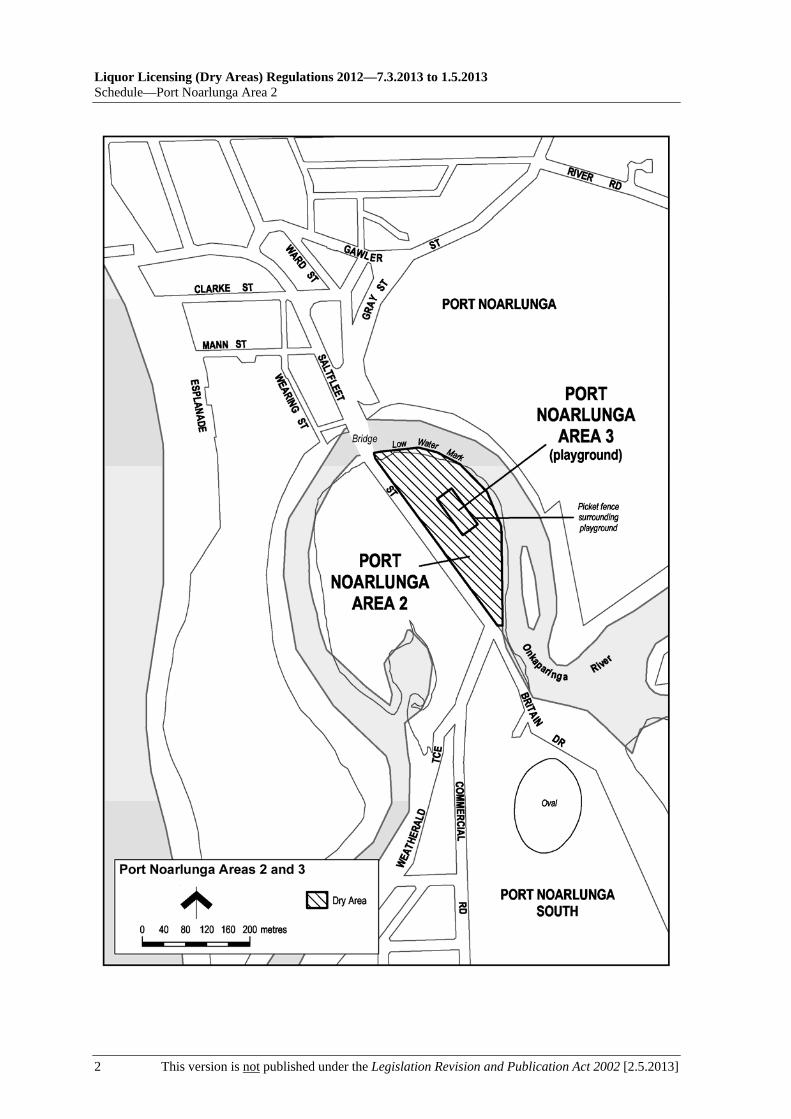
Liquor Licensing (Dry Areas) Regulations 2012—7.3.2013 to 1.5.2013 Schedule—Port Noarlunga Area 2
2 This version is not published under the Legislation Revision and Publication Act 2002 [2.5.2013]
7.3.2013 to 1.5.2013—Liquor Licensing (Dry Areas) Regulations 2012
Port Noarlunga Area 3—Schedule
[2.5.2013] This version is not published under the Legislation Revision and Publication Act 2002 1
Schedule—Port Noarlunga Area 3
1—Extent of prohibition
The consumption of liquor is prohibited and the possession of liquor is prohibited.
2—Period of prohibition
Continuous until 11 September 2016.
3—Description of area
The area at Port Noarlunga as follows: that portion of the Jubilee Park Reserve (and adjacent land) defined in Schedule—Port Noarlunga Area 2 that is enclosed within a picket fence and is known as the Jubilee Park Reserve Adventure Playground.
See the plan in Schedule—Port Noarlunga Area 2.


7.3.2013 to 1.5.2013—Liquor Licensing (Dry Areas) Regulations 2012
Port Pirie Area 1—Schedule
[2.5.2013] This version is not published under the Legislation Revision and Publication Act 2002 1
Schedule—Port Pirie Area 1
1—Extent of prohibition
The consumption of liquor is prohibited and the possession of liquor is prohibited.
2—Period of prohibition
Continuous until 14 July 2017, provided that where—
(a) an event of historic, cultural, traditional or major community significance is held in the area; and
(b) the consumption and possession of liquor in the area (or a defined portion of the area) are authorised for a specified period for the purposes of the event by the Port Pirie Regional Council,
the prohibition does not apply in the area (or defined portion of the area) during that specified period.
The Port Pirie Regional Council may not grant authorisations under these regulations in relation to more than 12 events per calendar year.
3—Description of area
The area in Port Pirie bounded as follows: commencing at the point at which the prolongation in a straight line of the south-eastern boundary of Mary Elie Street intersects the western boundary of Lot 120 DP 53026 (the north-eastern boundary of Main Road), then north-westerly, northerly and north-easterly along the boundary of Lot 120 to the point at which it meets the eastern boundary of Lot 402 DP 75081 (a Railway Reserve), then in a straight line by the shortest route to the eastern edge of the wharf on the western side of the Port Pirie River, then north-westerly along that edge of the wharf to the point at which it meets the southern side of a T-shaped jetty projecting from the wharf into the River (at a point immediately to the east of a fenced playground in Flinders View Park), then around the outer boundary of the jetty back to the wharf on the northern side of the jetty (so as to include the whole of the jetty in the area), then in a straight line by the shortest route to the western boundary of Lot 402 DP 75081 (the Railway Reserve), then generally north-westerly and northerly along that western boundary of Lot 402 to the point at which it is intersected by the prolongation in a straight line of the southern boundary of George Street, then westerly along that prolongation of the southern boundary of George Street to the western boundary of Ellen Street, then southerly along that boundary of Ellen Street to the northern boundary of David Street, then westerly along that boundary of David Street to the point at which it intersects the western boundary of Gertrude Street, then southerly along that boundary of Gertrude Street to the point at which it intersects the southern boundary of Alexander Street, then south-westerly along that boundary of Alexander Street to the eastern boundary of The Terrace, then southerly along that boundary of The Terrace to the northern boundary of Memorial Drive, then north-easterly along that boundary of Memorial Drive to the point at which it meets the western boundary of Gertrude Street, then south-easterly along that boundary of Gertrude Street and the prolongation in a straight line of that boundary to the point at which it intersects the south-eastern boundary of Mary Elie Street, then north-easterly along that boundary of Mary Elie Street and the prolongation in a straight line of that boundary to the point of commencement. The area includes any area beneath a wharf or jetty included in the

Liquor Licensing (Dry Areas) Regulations 2012—7.3.2013 to 1.5.2013 Schedule—Port Pirie Area 1
2 This version is not published under the Legislation Revision and Publication Act 2002 [2.5.2013]
area, but excludes the Northern Festival Centre (Section 1285 Hundred of Pirie) and any land used for the purpose of carrying on a business.1 Note—
1 Private dwellings are already excluded by regulation 5(2) which provides that a prohibition in this Schedule does not extend to private land in an area. Private land is defined in regulation 4 to be land that is not a public place within the meaning of the Liquor Licensing Act 1997. A public place is defined by the Act to be a place to which the public has access. This would include the parts of a shop or other business premises to which the public has access but would not include private dwellings.

7.3.2013 to 1.5.2013—Liquor Licensing (Dry Areas) Regulations 2012
Port Pirie Area 1—Schedule
[2.5.2013] This version is not published under the Legislation Revision and Publication Act 2002 3


7.3.2013 to 1.5.2013—Liquor Licensing (Dry Areas) Regulations 2012
Port Pirie Area 2—Schedule
[2.5.2013] This version is not published under the Legislation Revision and Publication Act 2002 1
Schedule—Port Pirie Area 2
1—Extent of prohibition
The consumption of liquor is prohibited and the possession of liquor is prohibited.
2—Period of prohibition
Continuous until 14 July 2017, provided that where—
(a) an event of historic, cultural, traditional or major community significance is held in the area; and
(b) the consumption and possession of liquor in the area (or a defined portion of the area) are authorised for a specified period for the purposes of the event by the Port Pirie Regional Council,
the prohibition does not apply in the area (or defined portion of the area) during that specified period.
The Port Pirie Regional Council may not grant authorisations under these regulations in relation to more than 12 events per calendar year.
3—Description of area
The area in Port Pirie bounded as follows: commencing at the point at which the prolongation in a straight line of the north-western boundary of Three Chain Road intersects the low water mark on the southern shore of the Port Pirie River, then south-westerly along that prolongation and boundary of Three Chain Road to the south-western boundary of Main Road, then north-westerly along that boundary of Main Road to the south-eastern boundary of Mary Elie Street, then north-easterly along the prolongation in a straight line of the south-eastern boundary of Mary Elie Street to the north-eastern boundary of Main Road, then south-easterly along that boundary of Main Road to the point at which it intersects the prolongation in a straight line of the south-eastern wall line of the Royal Port Pirie Yacht Club building, then north-easterly along that prolongation and wall line of the Club building, and the prolongation in a straight line of the wall line, to the low water mark on the southern shore of the Port Pirie River, then generally easterly along the low water mark to the point of commencement, but excluding the John Pirie Bridge and any land used for the purpose of carrying on a business.1 Note—
1 Private dwellings are already excluded by regulation 5(2) which provides that a prohibition in this Schedule does not extend to private land in an area. Private land is defined in regulation 4 to be land that is not a public place within the meaning of the Liquor Licensing Act 1997. A public place is defined by the Act to be a place to which the public has access. This would include the parts of a shop or other business premises to which the public has access but would not include private dwellings.

Liquor Licensing (Dry Areas) Regulations 2012—7.3.2013 to 1.5.2013 Schedule—Port Pirie Area 2
2 This version is not published under the Legislation Revision and Publication Act 2002 [2.5.2013]

7.3.2013 to 1.5.2013—Liquor Licensing (Dry Areas) Regulations 2012
Port Victoria Area 1—Schedule
[2.5.2013] This version is not published under the Legislation Revision and Publication Act 2002 1
Schedule—Port Victoria Area 1
1—Extent of prohibition
The consumption of liquor is prohibited and the possession of liquor is prohibited.
2—Period of prohibition
From 10 pm on each day to 8 am on the following day, until 8 am on 6 December 2017.
3—Description of area
The area in and adjacent to Port Victoria, bounded as follows: commencing at the point at which the prolongation in a straight line of the northern boundary of Marshall Road intersects the low water mark on the eastern side of Spencer Gulf, then generally northerly, north-easterly and northerly along the low water mark to the point at which it is intersected by the prolongation in a straight line of the northern boundary of Section 292 Hundred of Wauraltee (the prolongation in a straight line of the southern boundary of Moorara Drive), then easterly along that prolongation and boundary of Section 292 to the eastern boundary of the Section, then southerly along that eastern boundary of Section 292 to the north-eastern boundary of Section 269 Hundred of Wauraltee, then generally southerly along the western boundary of the caravan park to the point at which that boundary is intersected by the prolongation in a straight line of the south-western boundary of Lot 91 TP 131601, then south-easterly along that prolongation to the north-western boundary of Victoria Terrace, then north-easterly along that boundary of Victoria Terrace and the prolongation in a straight line of that boundary to the north-eastern boundary of Kuhn Terrace, then south-easterly along that boundary of Kuhn Terrace to the point at which it is intersected by the prolongation in a straight line of the south-eastern boundary of Passat Street, then south-westerly along that prolongation and boundary of Passat Street to the north-eastern boundary of Main Street, then south-easterly along that boundary of Main Street to the north-western boundary of Wilson Terrace, then in a straight line by the shortest route to the point at which the south-western boundary of Main Street meets the north-western boundary of Wilson Terrace, then north-westerly along that south-western boundary of Main Street back to the south-eastern boundary of Passat Street, then south-westerly along that boundary of Passat Street to the south-western boundary of Rogers Terrace, then north-westerly along that boundary of Rogers Terrace to the eastern boundary of Edwardes Terrace, then generally southerly along that boundary of Edwardes Terrace to the northern boundary of Marshall Road, then westerly along that boundary of Marshall Road and the prolongation in a straight line of that boundary to the point of commencement. The area includes the whole of any wharf, jetty, breakwater, boat ramp or other structure projecting below low water mark from within the area described above, as well as any area beneath such a structure.


7.3.2013 to 1.5.2013—Liquor Licensing (Dry Areas) Regulations 2012
Port Vincent Area 1—Schedule
[2.5.2013] This version is not published under the Legislation Revision and Publication Act 2002 1
Schedule—Port Vincent Area 1
1—Extent of prohibition
The consumption of liquor is prohibited and the possession of liquor is prohibited.
2—Period of prohibition
10 pm on each day to 8 am on the following day, until 8 am on 19 June 2014.
3—Description of area
The area in Port Vincent bounded as follows: commencing at the point at which the eastern boundary of Lot 47 DP 61751 meets the western boundary of Marina Drive, then generally south-westerly along that boundary of Marina Drive and of Marine Parade North to the point at which the western boundary of Marine Parade North meets the southern boundary of Lot 1 FP 128918, then westerly along the southern boundary of Lot 1 to the eastern boundary of Lot 26 FP 3593, then southerly along that eastern boundary of Lot 26 and of the adjoining Lots to the northern boundary of Lot 32 FP 17100, then easterly along that northern boundary of Lot 32 to the western boundary of Marine Parade North, then southerly along that boundary of Marine Parade North to the north-eastern boundary of Lime Kiln Road, then north-westerly along that boundary of Lime Kiln Road to the point at which it intersects the prolongation in a straight line of the western boundary of Kempe Street, then south-easterly along that prolongation and boundary of Kempe Street to the northern boundary of Parsons Street, then south-westerly along that boundary of Parsons Street to its intersection with the prolongation in a straight line of the western boundary of Talbot Road, then south-easterly along that prolongation and boundary of Talbot Road to the northern boundary of Cameron Street, then south-westerly along that boundary of Cameron Street to the eastern boundary of Adonis Road, then generally north-westerly, westerly and south-easterly around the boundary of Adonis Road back to the northern boundary of Cameron Street, then generally south-westerly, southerly and north-easterly around the boundary of Cameron Street back to the western boundary of Adonis Road, then south-easterly and south-westerly along that boundary of Adonis Road to the northern boundary of Lulu Court, then generally north-westerly, southerly and south-easterly around the boundary of Lulu Court back to the western boundary of Adonis Road, then south-westerly along that boundary of Adonis Road to the northern boundary of Ventnor Street, then generally westerly to the western end of Ventnor Street (the point at which it meets the eastern boundary of Lot 202 DP 62958), then southerly, easterly and south-easterly along the western and south-western boundaries of Ventnor Street to the north-western boundary of Main Street, then in a straight line by the shortest route across Main Street to the northern corner of Lot 152 DP 6070 (Bennett Park), then south-westerly, south-easterly and north-easterly along the north-western, south-western and south-eastern boundaries of Lot 152 to the south-western boundary of Wauraltee Road, then south-easterly along that boundary of Wauraltee Road to the north-western boundary of The Esplanade, then south-westerly along that boundary of The Esplanade to the north-eastern boundary of McPharlin Avenue, then north-westerly along that boundary of McPharlin Avenue to its intersection with the prolongation in a straight line of the south-eastern boundary of Ponder Parade, then south-westerly along that prolongation and boundary of Ponder Parade to the south-western end of that boundary, then in a straight line by the shortest route to the point at which the south-western boundary of Bennett Street meets the north-western boundary of The

Liquor Licensing (Dry Areas) Regulations 2012—7.3.2013 to 1.5.2013 Schedule—Port Vincent Area 1
2 This version is not published under the Legislation Revision and Publication Act 2002 [2.5.2013]
Esplanade, then south-westerly along that boundary of The Esplanade to the point at which it meets the boundary between Lot 6 DP 40247 and Lot 14 DP 43811, then south-easterly along the prolongation in a straight line of that common boundary to the point at which it intersects the low water mark on the western side of Gulf St Vincent, then generally north-easterly, easterly, north-westerly, westerly, north-westerly, northerly and north-easterly along the low water mark to the southern side of the entrance to the Port Vincent Marina, then along the low water mark inside the marina back to the entrance on the northern side of the marina, then generally north-westerly along the low water mark on the outer side of the northern breakwater of the marina to the point at which the breakwater continues north-westerly inland above the low water mark, then north-westerly along the outer boundary of the breakwater as it continues north-westerly inland to the eastern boundary of Lot 103 DP 54608, then generally south-westerly, north-westerly, south-westerly and north-westerly along the eastern and southern boundaries of Lot 103 to the eastern boundary of Lot 47 DP 61751, then southerly along that boundary of Lot 47 to the point of commencement. The area includes the public boat ramp and pontoon inside the Port Vincent Marina and any wharf or jetty outside the marina extending from the area described above, but does not include the Port Vincent Caravan Park (Lot 4 DP 24058) or any part of a jetty or mooring (other than the public boat ramp and pontoon) inside the Port Vincent Marina.

7.3.2013 to 1.5.2013—Liquor Licensing (Dry Areas) Regulations 2012
Port Vincent Area 1—Schedule
[2.5.2013] This version is not published under the Legislation Revision and Publication Act 2002 3

7.3.2013 to 1.5.2013—Liquor Licensing (Dry Areas) Regulations 2012
Port Vincent Area 2—Schedule
[2.5.2013] This version is not published under the Legislation Revision and Publication Act 2002 1
Schedule—Port Vincent Area 2
1—Extent of prohibition
The consumption of liquor is prohibited and the possession of liquor is prohibited.
2—Period of prohibition
10 pm on each day to 8 am on the following day, until 8 am on 19 June 2014.
3—Description of area
The reserve in Port Vincent that lies between Chester Avenue and Ford Avenue, being the whole of the land contained in Lot 145 DP 6071.
See the plan in Schedule—Port Vincent Area 1.


7.3.2013 to 1.5.2013—Liquor Licensing (Dry Areas) Regulations 2012
Prospect Area 1—Schedule
[2.5.2013] This version is not published under the Legislation Revision and Publication Act 2002 1
Schedule—Prospect Area 1
1—Extent of prohibition
The consumption of liquor is prohibited and the possession of liquor is prohibited.
2—Period of prohibition
From 2 pm to 11.59 pm on 21 January 2013.
3—Description of area
The area in Prospect bounded as follows: commencing at the point at which the western boundary of Braund Road intersects the northern boundary of Gladstone Road, then generally easterly along the northern boundaries of Gladstone Road and Alpha Road to the point at which the northern boundary of Alpha Road is intersected by the prolongation in a straight line of the eastern boundary of Larwood Lane, then generally southerly along that prolongation and boundary of Larwood Lane, the eastern boundary of Union Street and the prolongation in a straight line of that boundary of Union Street to the southern boundary of Flora Terrace, then westerly along that boundary of Flora Terrace to the western boundary of New Street, then southerly along that boundary of New Street to the northern boundary of Kintore Avenue, then easterly along that boundary of Kintore Avenue to the point at which it is intersected by the prolongation in a straight line of the western boundary of Old Street, then southerly along that prolongation and boundary of Old Street to the northern boundary of Pulsford Road, then easterly along that boundary of Pulsford Road to the point at which it is intersected by the prolongation in a straight line of the western boundary of Darmody Street, then southerly along that prolongation and boundary of Darmody Street to the northern boundary of Milner Street, then easterly along that boundary of Milner Street to the point at which it is intersected by the prolongation in a straight line of the western boundary of Prospect Terrace, then southerly along that prolongation and boundary of Prospect Terrace to the southern boundary of Gloucester Street, then westerly along that boundary of Gloucester Street to the eastern boundary of Prospect Road, then generally northerly along the eastern boundary of Prospect Road to the point at which it meets the northern boundary of Labrina Avenue, then in a straight line by the shortest route to the point at which the southern boundary of Rose Street meets the western boundary of Prospect Road, then generally southerly along the western boundary of Prospect Road to the southern boundary of Marian Place, then westerly along that boundary of Marian Place to the western boundary of Braund Road, then generally northerly along the western boundary of Braund Road to the point of commencement.


7.3.2013 to 1.5.2013—Liquor Licensing (Dry Areas) Regulations 2012
Renmark Area 1—Schedule
[2.5.2013] This version is not published under the Legislation Revision and Publication Act 2002 1
Schedule—Renmark Area 1
1—Extent of prohibition
The consumption of liquor is prohibited.
The possession of liquor is prohibited except by a person who owns, leases, works on or is staying on a vessel moored to any part of the area and—
(a) who enters the area solely for the purpose of boarding the vessel; or
(b) who enters the area from the vessel solely for the purpose of leaving the area.
(This exception is in addition to the general exceptions in regulation 5(3)).
2—Period of prohibition
7 pm on each day to 7 am on the following day, until 7 am on 8 December 2013.
3—Description of area
The area bounded by the north-western boundary of James Avenue and Murtho Street, the south-western boundary of Fifteenth Street, the south-eastern boundary of Pyap Street (including the north-easterly prolongation in a straight line of that boundary to the western bank of the River Murray), the western bank of the River Murray (including the outer boundary of any wharf, jetty, boat ramp or other structure extending into the river), and the north-eastern boundary of Section 260, out of Hundreds, County of Hamley (including the north-westerly prolongation in a straight line of that boundary to the north-western boundary of James Avenue).
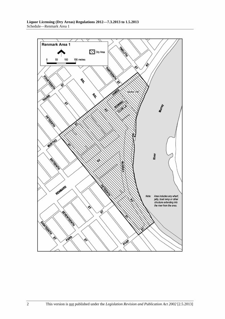
Liquor Licensing (Dry Areas) Regulations 2012—7.3.2013 to 1.5.2013 Schedule—Renmark Area 1
2 This version is not published under the Legislation Revision and Publication Act 2002 [2.5.2013]

7.3.2013 to 1.5.2013—Liquor Licensing (Dry Areas) Regulations 2012
Renmark Area 2—Schedule
[2.5.2013] This version is not published under the Legislation Revision and Publication Act 2002 1
Schedule—Renmark Area 2
1—Extent of prohibition
The consumption of liquor is prohibited and the possession of liquor is prohibited.
2—Period of prohibition
7 pm on each day to 7 am on the following day, until 7 am on 8 December 2013.
3—Description of area
The area in Renmark known as the Renmark Skate and Recreation Park, being the area comprising Lot 702 of DP 55041, Lot 124 of DP 29974 and Lot 1 of FP 14131.

Liquor Licensing (Dry Areas) Regulations 2012—7.3.2013 to 1.5.2013 Schedule—Renmark Area 2
2 This version is not published under the Legislation Revision and Publication Act 2002 [2.5.2013]

7.3.2013 to 1.5.2013—Liquor Licensing (Dry Areas) Regulations 2012
Robe Area 1—Schedule
[2.5.2013] This version is not published under the Legislation Revision and Publication Act 2002 1
Schedule—Robe Area 1
1—Extent of prohibition
The consumption of liquor is prohibited and the possession of liquor is prohibited.
2—Period of prohibition
12 noon on 31 December 2012 to 12 noon on 1 January 2013.
3—Description of area
The area in and adjacent to Robe bounded as follows: commencing at the western end of the northern boundary of Dawson Drive, then in a straight line by the shortest route to the low water mark of Guichen Bay on the eastern side of the entrance to Fox's Lake, then in a straight line by the shortest route (across the entrance) to the low water mark on the western side of the entrance, then generally westerly along the low water mark to the eastern side of the entrance to Lake Butler, then in a straight line by the shortest route (across the entrance) to the eastern boundary of the breakwater on the western side of the entrance to the lake, then northerly, north-easterly, westerly and south-westerly around the outer boundary of the breakwater back to the low water mark on the shore on the western side of the breakwater, then generally north-westerly and southerly along the low water mark to the point at which it is intersected by the prolongation in a straight line of the southern boundary of Evans Cave Road (the northern boundary of Section 363 Hundred of Waterhouse), then generally easterly along that prolongation and boundary of Evans Cave Road, and the prolongation in a straight line of that boundary, to the eastern boundary of Robe Street, then northerly along that boundary of Robe Street to the southern boundary of Beacon Hill Road, then generally easterly along that boundary of Beacon Hill Road to the point at which it meets the north-eastern boundary of Lot 5 of DP 78111, then generally south-easterly and easterly along that boundary of Lot 5 and easterly and north-easterly along the northern boundary of Section 289 Hundred of Waterhouse to the eastern boundary of Section 289, then in a straight line by the shortest route to the south-western corner of Lot 11 of DP 64831, then easterly along the southern boundary of Lot 11 and the prolongation in a straight line of that boundary to the point at which the prolongation intersects the eastern boundary of Nora Creina Road, then northerly along that boundary of Nora Creina Road to the point at which it meets the southern boundary of Wildfield Road, then generally easterly along that boundary of Wildfield Road and the prolongation in a straight line of that boundary to the point at which the prolongation intersects the northern boundary of Southern Ports Highway, then generally north-westerly and south-westerly along that boundary of Southern Ports Highway and the northern boundary of Main Road to the eastern boundary of Dawson Drive, then generally north-westerly and westerly along that boundary of Dawson Drive to the point of commencement. The area includes any wharf, jetty, boat ramp, breakwater or other structure projecting below low water mark from within the area described above (as well as any area beneath such a structure).
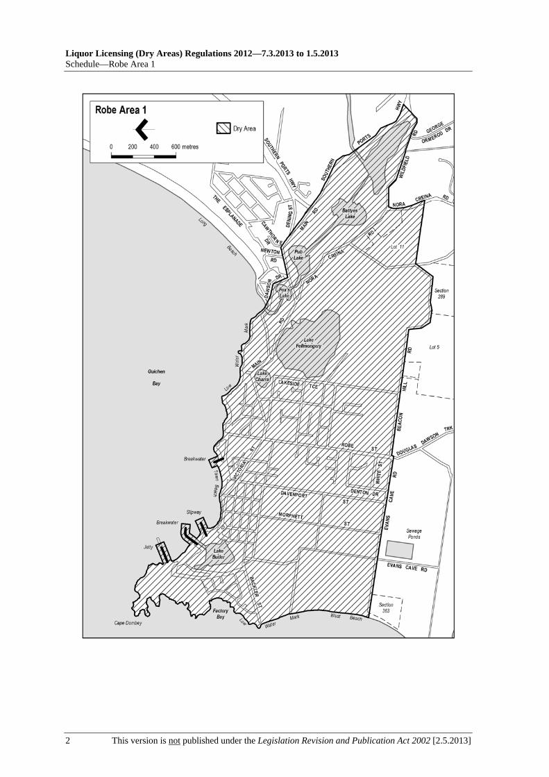
Liquor Licensing (Dry Areas) Regulations 2012—7.3.2013 to 1.5.2013 Schedule—Robe Area 1
2 This version is not published under the Legislation Revision and Publication Act 2002 [2.5.2013]

7.3.2013 to 1.5.2013—Liquor Licensing (Dry Areas) Regulations 2012
Robe Area 2—Schedule
[2.5.2013] This version is not published under the Legislation Revision and Publication Act 2002 1
Schedule—Robe Area 2
1—Extent of prohibition
The consumption of liquor is prohibited and the possession of liquor is prohibited.
2—Period of prohibition
12 noon on 31 December 2012 to 12 noon on 1 January 2013.
3—Description of area
The area in and adjacent to Robe bounded as follows: commencing at the western end of the northern boundary of Dawson Drive, then in a straight line by the shortest route to the low water mark of Guichen Bay on the eastern side of the entrance to Fox's Lake, then generally north-easterly along the low water mark to the point at which it is intersected by the prolongation in a straight line of the northern boundary of Section 573 Hundred of Waterhouse, then easterly along that prolongation and boundary of Section 573 to the eastern boundary of the Section, then generally southerly and south-westerly along that boundary of Section 573 to the north-eastern boundary of Section 390 Hundred of Waterhouse, then south-easterly along that boundary of Section 390 to the point at which it is intersected by the prolongation in a straight line of the northern boundary of Dennis Avenue, then easterly along that prolongation and boundary of Dennis Avenue, and the prolongation in a straight line of that boundary, to the point at which the prolongation intersects the western boundary of Lot 223 of FP 205569, then generally south-westerly and southerly along that boundary of Lot 223 and the prolongation in a straight line of that boundary to the point at which the prolongation intersects the south-eastern boundary of Southern Ports Highway, then south-westerly along that boundary to the western boundary of Lot 2 of FP 9707, then southerly along that boundary of Lot 2 to the southern boundary of the Lot, then generally north-westerly and south-westerly along the northern boundary of Southern Ports Highway and the northern boundary of Main Road to the eastern boundary of Dawson Drive, then generally north-westerly and westerly along that boundary of Dawson Drive to the point of commencement.

Liquor Licensing (Dry Areas) Regulations 2012—7.3.2013 to 1.5.2013 Schedule—Robe Area 2
2 This version is not published under the Legislation Revision and Publication Act 2002 [2.5.2013]

7.3.2013 to 1.5.2013—Liquor Licensing (Dry Areas) Regulations 2012
Salisbury Area 1—Schedule
[2.5.2013] This version is not published under the Legislation Revision and Publication Act 2002 1
Schedule—Salisbury Area 1
1—Extent of prohibition
The consumption of liquor is prohibited and the possession of liquor is prohibited.
2—Period of prohibition
Continuous until 18 October 2014, provided that where—
(a) an event of historic, cultural, traditional or major community significance is held in the area; and
(b) the City of Salisbury authorises, for the purposes of the event, the consumption and possession of liquor in part A or part B of the area (or a defined portion of part A or part B) for a specified period during the event,
the prohibition does not apply in that part of the area (or defined portion of that part) during the specified period.
No more than 4 authorisations may apply in relation to part A of the area, and no more than 4 in relation to part B, in any 12 month period.
In this clause—
part A, in relation to the area to which the prohibition applies, means that part of the area that lies between the Council office building and the Home Assist building and James Street, as shown in the plan in this schedule labelled "Salisbury Area 1 Authorised Areas";
part B, in relation to the area to which the prohibition applies, means that part of the area comprising Lots 1 and 2 of Filed Plan No 37216 (see the plan in this schedule labelled "Salisbury Area 1 Authorised Areas").
3—Description of area
The area in Salisbury generally known as the Salisbury Town Centre, being the area bounded on the north by the southern bank of the Little Para River, on the east by Commercial Road, on the south by Wiltshire Street and Park Terrace, and on the west by Salisbury Highway.

Liquor Licensing (Dry Areas) Regulations 2012—7.3.2013 to 1.5.2013 Schedule—Salisbury Area 1
2 This version is not published under the Legislation Revision and Publication Act 2002 [2.5.2013]

7.3.2013 to 1.5.2013—Liquor Licensing (Dry Areas) Regulations 2012
Salisbury Area 1—Schedule
[2.5.2013] This version is not published under the Legislation Revision and Publication Act 2002 3


7.3.2013 to 1.5.2013—Liquor Licensing (Dry Areas) Regulations 2012
Seacliff Area 1—Schedule
[2.5.2013] This version is not published under the Legislation Revision and Publication Act 2002 1
Schedule—Seacliff Area 1
1—Extent of prohibition
The consumption of liquor is prohibited and the possession of liquor is prohibited.
2—Period of prohibition
Continuous until 8 December 2014.
3—Description of area
The area in Seacliff bounded as follows: commencing at a point on the eastern boundary of the Esplanade that is 130 metres north of the northern boundary of Wheatland Street, then southerly along that eastern boundary of the Esplanade to a point 126 metres south of the southern boundary of Wheatland Street, then due west in a straight line to the low water mark of Gulf St Vincent, then generally northerly along the low water mark to a point that is due west in a straight line from the point of commencement, then due east in a straight line to the point of commencement.

Liquor Licensing (Dry Areas) Regulations 2012—7.3.2013 to 1.5.2013 Schedule—Seacliff Area 1
2 This version is not published under the Legislation Revision and Publication Act 2002 [2.5.2013]

7.3.2013 to 1.5.2013—Liquor Licensing (Dry Areas) Regulations 2012
Seacliff Area 2—Schedule
[2.5.2013] This version is not published under the Legislation Revision and Publication Act 2002 1
Schedule—Seacliff Area 2
1—Extent of prohibition
The consumption of liquor is prohibited and the possession of liquor is prohibited.
2—Period of prohibition
Continuous until 8 December 2014.
3—Description of area
Wheatland Street between the eastern boundary of the Esplanade and the eastern boundary of Marine Parade.


7.3.2013 to 1.5.2013—Liquor Licensing (Dry Areas) Regulations 2012
Seacliff Area 3—Schedule
[2.5.2013] This version is not published under the Legislation Revision and Publication Act 2002 1
Schedule—Seacliff Area 3
1—Extent of prohibition
The consumption of liquor is prohibited and the possession of liquor is prohibited.
2—Period of prohibition
Continuous until 8 December 2014.
3—Description of area
The car park at Seacliff bounded on the south by the northern boundary of Kingston Park, on the east and north by the Esplanade and on the west by the foreshore.


7.3.2013 to 1.5.2013—Liquor Licensing (Dry Areas) Regulations 2012
Seacliff Area 4—Schedule
[2.5.2013] This version is not published under the Legislation Revision and Publication Act 2002 1
Schedule—Seacliff Area 4
1—Extent of prohibition
The consumption of liquor is prohibited. The possession of liquor is prohibited, and the prohibition extends to possession in each of the circumstances referred to in regulation 5(3).
2—Period of prohibition
From 12.01 am on 26 January 2013 to 12.01 am on 29 January 2013.
3—Description of area
The area in and adjacent to Seacliff bounded as follows: commencing at the point at which the western boundary of Marine Parade meets the southern boundary of Young Street, then southerly along the western boundary of Marine Parade to the point at which it meets the southern boundary of Lot 7 FP 148929, then westerly along the southern boundary of Lot 7, the southern boundary of Lot 8 FP 148929, and the prolongation in a straight line of the southern boundary of Lot 8, to the low water mark on the eastern side of Gulf St Vincent, then generally northerly along the low water mark to the point at which it is intersected by the prolongation in a straight line of the southern boundary of Young Street, then easterly along that prolongation to the eastern boundary of the Esplanade, then southerly along that boundary of the Esplanade to the northern boundary of Lot 1 FP 148929, then easterly and southerly along the northern and eastern boundaries of Lot 1 to the northern boundary of Lot 2 FP 148929, then easterly along that boundary of Lot 2 to the western boundary of Lot 4 DP 3030, then northerly along that boundary of Lot 4 to the southern boundary of Young Street, then easterly along that boundary of Young Street to the point of commencement.


7.3.2013 to 1.5.2013—Liquor Licensing (Dry Areas) Regulations 2012
Semaphore Area 1—Schedule
[2.5.2013] This version is not published under the Legislation Revision and Publication Act 2002 1
Schedule—Semaphore Area 1
1—Extent of prohibition
The consumption of liquor is prohibited and the possession of liquor is prohibited.
2—Period of prohibition
Continuous until 1 January 2017 but excluding any day during that period on which a festival, exhibition, show or other event is held within the area if it—
(a) is of historic, traditional or cultural significance or significantly promotes tourism; and
(b) has been authorised by the City of Port Adelaide Enfield for the purposes of these regulations.
3—Description of area
The area in Semaphore, known as the Semaphore foreshore, bounded as follows: commencing at the point at which the prolongation in a straight line of the northern boundary of Hall Street intersects the western boundary of the Esplanade, then south-westerly along that boundary of the Esplanade to the point at which it intersects the prolongation in a straight line of the southern boundary of South Terrace, then north-westerly along that prolongation to the low water mark of Gulf St Vincent, then generally north-easterly along the low water mark to the southern side of the Semaphore Jetty, then generally north-westerly and south-easterly around the outer boundary of the Jetty back to the low water mark on the northern side of the Jetty (so as to include in the area the whole of the Jetty and the area beneath the Jetty), then generally north-easterly along the low water mark to the point at which it intersects the prolongation in a straight line of the northern boundary of Hall Street, then south-easterly along that prolongation to the point of commencement.


7.3.2013 to 1.5.2013—Liquor Licensing (Dry Areas) Regulations 2012
Semaphore Area 2—Schedule
[2.5.2013] This version is not published under the Legislation Revision and Publication Act 2002 1
Schedule—Semaphore Area 2
1—Extent of prohibition
The consumption of liquor is prohibited and the possession of liquor is prohibited.
2—Period of prohibition
Continuous until 1 January 2017, but excluding any day during that period on which a festival, exhibition, show or other event is held within the area if it—
(a) is of historic, traditional or cultural significance or significantly promotes tourism; and
(b) has been authorised by the City of Port Adelaide Enfield for the purposes of these regulations.
3—Description of area
The area in Semaphore bounded on the south by the prolongation in a straight line of the northern boundary of Hall Street, on the west by the western boundary of Allotment 103 DP 42723, on the north by the prolongation in a straight line of the northern boundary of Derby Street and on the east by the western boundary of the Esplanade.


7.3.2013 to 1.5.2013—Liquor Licensing (Dry Areas) Regulations 2012
Semaphore Area 3—Schedule
[2.5.2013] This version is not published under the Legislation Revision and Publication Act 2002 1
Schedule—Semaphore Area 3
1—Extent of prohibition
The consumption of liquor is prohibited and the possession of liquor is prohibited.
2—Period of prohibition
Continuous until 1 January 2017.
3—Description of area
Sections 491 and 364, Hundred of Port Adelaide, but excluding any building, or part of a building, situated within that area.


7.3.2013 to 1.5.2013—Liquor Licensing (Dry Areas) Regulations 2012
Semaphore Area 4—Schedule
[2.5.2013] This version is not published under the Legislation Revision and Publication Act 2002 1
Schedule—Semaphore Area 4
1—Extent of prohibition
The consumption of liquor is prohibited and the possession of liquor is prohibited.
2—Period of prohibition
The prohibition applies during the following periods:
(a) from 12 noon on 31 December 2012 to 12 noon on 1 January 2013;
(b) from 12 noon on 26 January 2013 to 12 noon on 27 January 2013.
3—Description of area
The area in Semaphore and Exeter comprising Semaphore Road between the eastern boundary of the Esplanade and the prolongation in a straight line of the marked centre line of Causeway Road.


7.3.2013 to 1.5.2013—Liquor Licensing (Dry Areas) Regulations 2012
Spalding Area 1—Schedule
[2.5.2013] This version is not published under the Legislation Revision and Publication Act 2002 1
Schedule—Spalding Area 1
1—Extent of prohibition
The consumption of liquor is prohibited and the possession of liquor is prohibited.
2—Period of prohibition
From 12 noon on 16 February 2013 to 12 noon on 17 February 2013.
3—Description of area
The area in and adjacent to Spalding bounded as follows: commencing at the point at which the southern boundary of Davies Terrace meets the eastern boundary of the Spalding to Clare Road, then in a straight line by the shortest route (across the Spalding to Clare Road) to the point at which the southern boundary of Trelyn Road meets the western boundary of the Spalding to Clare Road, then generally north-westerly and northerly along that boundary of Trelyn Road to the point at which it meets the southern boundary of the Jamestown to Spalding Road, then in a straight line by the shortest route (across the Jamestown to Spalding Road) to the point on the northern boundary of the Jamestown to Spalding Road at which the western boundary of Lot 538 of Filed Plan No. 187050 meets the northern boundary of Lot 537 of Filed Plan No. 187049, then easterly, southerly, easterly and north-easterly along the southern and eastern boundaries of Lot 538 to the point at which the eastern boundary of that Lot intersects the prolongation in a straight line of the northern boundary of Lincoln Avenue, then south-easterly along that prolongation and boundary of Lincoln Avenue and the prolongation in a straight line of that boundary to the point at which it intersects the eastern boundary of Edgeware Avenue, then south-westerly along that boundary of Edgeware Avenue to the point at which it meets the northern boundary of Howley's Crossing Road, then generally south-easterly, north-easterly and southerly along that boundary of Howley's Crossing Road and the prolongation in a straight line of that boundary to the southern boundary of Borve Hill Road, then south-westerly and westerly along that boundary of Borve Hill Road to the eastern boundary of the Burra to Spalding Road, then in a straight line by the shortest route (across the Burra to Spalding Road) to the point at which the southern boundary of Davies Terrace meets the western boundary of the Burra to Spalding Road, then north-westerly along that southern boundary of Davies Terrace to the point of commencement.

Liquor Licensing (Dry Areas) Regulations 2012—7.3.2013 to 1.5.2013 Schedule—Spalding Area 1
2 This version is not published under the Legislation Revision and Publication Act 2002 [2.5.2013]

7.3.2013 to 1.5.2013—Liquor Licensing (Dry Areas) Regulations 2012
Stansbury Area 1—Schedule
[2.5.2013] This version is not published under the Legislation Revision and Publication Act 2002 1
Schedule—Stansbury Area 1
1—Extent of prohibition
The consumption of liquor is prohibited and the possession of liquor is prohibited.
2—Period of prohibition
From 10 pm on 31 December 2012 to 8 am on 1 January 2013.
3—Description of area
The area in and adjacent to Stansbury bounded as follows: commencing at the point at which the prolongation in a straight line of the south-eastern boundary of Stormbird Street intersects the low water mark on the western side of Gulf St. Vincent, then south-westerly along that prolongation to the south-western boundary of Anzac Parade, then north-westerly along that boundary of Anzac Parade to the northern boundary of Towler Street, then westerly along that boundary of Towler Street to the western boundary of Weaver Street, then northerly along that boundary of Weaver Street and the prolongation in a straight line of that boundary to the south-western boundary of Anzac Parade, then generally north-westerly and westerly along that boundary of Anzac Parade and the southern boundary of North Terrace to the western boundary of Parrington Street, then along the prolongation in a straight line of the western boundary of Parrington Street to the southern boundary of Dalrymple Terrace, then easterly along that boundary of Dalrymple Terrace to the western boundary of Adelaide Road, then in a straight line by the shortest route to the point at which the southern boundary of Bayview Road meets the eastern boundary of Adelaide Road, then generally easterly and north-easterly along that boundary of Bayview Road to the point at which it meets the southern corner of Lot 17 DP 5864, then north-easterly and northerly along the western boundary of Lot 1 DP 37028 to the northern boundary of the Lot, then easterly along the northern boundary of Lot 1 and the prolongation in a straight line of that boundary to the low water mark on the western side of Gulf St. Vincent, then generally south-easterly along the low water mark to the northern side of the Stansbury Jetty, then north-easterly, south-easterly and south-westerly around the outer boundary of the jetty back to the low water mark on the southern side of the jetty (so as to include in the area the whole of the jetty and any area beneath the jetty), then south-easterly along the low water mark to the northern side of the breakwater that forms the northern wall of the enclosed boat launching facility immediately to the south-east of the jetty, then generally north-easterly, south-easterly and south-westerly around the outer boundary of the boat launching facility back to the low water mark on the shore on the southern side of the facility (so as to include in the area the whole of the facility, including the breakwaters and the area between them), then generally south-westerly and south-easterly along the low water mark to the point of commencement.


7.3.2013 to 1.5.2013—Liquor Licensing (Dry Areas) Regulations 2012
Stansbury Area 2—Schedule
[2.5.2013] This version is not published under the Legislation Revision and Publication Act 2002 1
Schedule—Stansbury Area 2
1—Extent of prohibition
The consumption of liquor is prohibited and the possession of liquor is prohibited.
2—Period of prohibition
From 10 pm on 31 December 2012 to 8 am on 1 January 2013.
3—Description of area
The area in Stansbury bounded on the north by South Terrace, on the east by Weaver Street, on the south by Park Terrace and on the west by the prolongation in a straight line of the western boundary of Lot 692 FP 196114.


7.3.2013 to 1.5.2013—Liquor Licensing (Dry Areas) Regulations 2012
Stirling North Area 1—Schedule
[2.5.2013] This version is not published under the Legislation Revision and Publication Act 2002 1
Schedule—Stirling North Area 1
1—Extent of prohibition
The consumption of liquor is prohibited and the possession of liquor is prohibited.
2—Period of prohibition
Continuous until 1 December 2013.
3—Description of area
The area in and adjacent to Stirling North and Port Augusta bounded as follows: commencing at the north-western corner of Allotment 5 DP 27316, then generally easterly along the northern boundary of Allotment 5 to the north-eastern corner of the Allotment, then in a straight line by the shortest route to the north-western corner of Section 763, Hundred of Davenport, then generally easterly and southerly along the northern and eastern boundaries of Section 763 to the south-eastern corner of the Section, then southerly along the prolongation in a straight line of the eastern boundary of Section 763 (across Railway Terrace and the adjacent railway reserve) to the southern boundary of the railway reserve, then generally north-easterly along that boundary of the railway reserve to the western boundary of Great Western Plains Road, then south-easterly along that boundary to the point at which it meets the prolongation in a straight line of the northern boundary of Allotment 36 DP 34454, then generally south-easterly and south-westerly along that prolongation and the northern and eastern boundaries of Allotment 36 to the south-eastern corner of the Allotment, then in a straight line by the shortest route (across Allotment 33 DP 17997 and Quorn Road) to the north-eastern corner of Allotment 505 FP 21299, then generally south-westerly along the eastern boundary of Allotments 505, 504, 503 and 512 of FP 21299 to the south-eastern corner of Allotment 512, then in a straight line by the shortest route (across the railway reserve and McConnal Road) to the north-eastern corner of Allotment 5 DP 17996, then generally south-westerly along the eastern boundary of Allotment 5 and the prolongation in a straight line of that boundary to the southern boundary of the Eyre Highway, then generally north-westerly along that boundary of the Eyre Highway to the point at which it meets the northern boundary of Allotment 2 DP 44849, then generally north-westerly along that boundary of Allotment 2 and the northern boundary of Allotment 1 DP 44849 to the north-western corner of Allotment 1, then in a straight line by the shortest route (across Power Station Road) to the north-eastern corner of Allotment 8 DP 55700, then generally north-westerly along the northern boundary of that Allotment to its intersection with the eastern boundary of Northern Power Station Road, then generally northerly along that boundary of Northern Power Station Road to the point at which it meets the southern boundary of the Eyre Highway, then in a straight line by the shortest route to the point at which the eastern boundary of Abbatoir Road meets the northern boundary of the Eyre Highway, then generally northerly along the eastern boundary of Abbatoir Road to the north-western corner of Allotment 841 FP 186543, then in a straight line by the shortest route (across the adjacent road and railway reserves) to the south-eastern corner of Piece 9 DP 27316, then generally westerly, north-westerly, northerly and north-easterly along the southern boundary of Piece 9 and the eastern boundary of Racecourse Road to the western boundary of Allotment 5 DP 27316, then north-easterly along that boundary of Allotment 5 to the point of commencement.

Liquor Licensing (Dry Areas) Regulations 2012—7.3.2013 to 1.5.2013 Schedule—Stirling North Area 1
2 This version is not published under the Legislation Revision and Publication Act 2002 [2.5.2013]

7.3.2013 to 1.5.2013—Liquor Licensing (Dry Areas) Regulations 2012
Strathalbyn Area 1—Schedule
[2.5.2013] This version is not published under the Legislation Revision and Publication Act 2002 1
Schedule—Strathalbyn Area 1
1—Extent of prohibition
The consumption of liquor is prohibited and the possession of liquor is prohibited.
2—Period of prohibition
The prohibition applies during the following periods:
(a) from 9 pm on each day to 6 am on the following day, until 6 am on 12 February 2014, provided that where, for the purposes of an event of historic, cultural, traditional or community significance, Alexandrina Council authorises the consumption and possession of liquor in the area (or a defined part of the area) for a specified period during the event, the prohibition does not apply in the area (or defined part of the area) during that specified period;
(b) from 7 am to 9 pm on 14 December 2012.
3—Description of area
The area in Strathalbyn bounded as follows: commencing at the point at which the south-eastern boundary of North Parade meets the north-eastern boundary of West Terrace, then south-easterly along that boundary of West Terrace to the north-western boundary of Adams Street, then north-easterly along that boundary of Adams Street and the prolongation in a straight line of that boundary to the north-eastern boundary of Edinburgh Road, then north-westerly along that boundary of Edinburgh Road to the end of the road, then in a straight line by the shortest route to the point at which the south-eastern boundary of South Terrace meets the south-western boundary of Parker Avenue, then along the continuation of that straight line across South Terrace to the north-western boundary of South Terrace, then north-easterly along the north-western boundary of South Terrace to the south-western boundary of East Terrace, then north-westerly along the south-western boundary of East Terrace to the south-eastern boundary of North Parade, then south-westerly along the south-eastern boundary of North Parade to the point of commencement.

Liquor Licensing (Dry Areas) Regulations 2012—7.3.2013 to 1.5.2013 Schedule—Strathalbyn Area 1
2 This version is not published under the Legislation Revision and Publication Act 2002 [2.5.2013]
7.3.2013 to 1.5.2013—Liquor Licensing (Dry Areas) Regulations 2012
Strathalbyn Area 2—Schedule
[2.5.2013] This version is not published under the Legislation Revision and Publication Act 2002 1
Schedule—Strathalbyn Area 2
1—Extent of prohibition
The consumption of liquor is prohibited and the possession of liquor is prohibited.
2—Period of prohibition
The prohibition applies during the following periods:
(a) from 9 pm on each day to 6 am on the following day, until 6 am on 12 February 2014, provided that where, for the purposes of an event of historic, cultural, traditional or community significance, Alexandrina Council authorises the consumption and possession of liquor in the area (or a defined part of the area) for a specified period during the event, the prohibition does not apply in the area (or defined part of the area) during that specified period;
(b) from 7 am to 9 pm on 14 December 2012.
3—Description of area
The area in Strathalbyn comprising the following roads:
(a) Ashbourne Road between the south-western boundary of West Terrace and the prolongation in a straight line of the south-western boundary of Queen Street;
(b) Queen Street between Ashbourne Road and Coronation Road;
(c) Coronation Road between the prolongation in a straight line of the south-western boundary of Queen Street and the south-western boundary of West Terrace;
(d) Stowe Court between Coronation Road and West Terrace;
(e) West Terrace between the prolongation in a straight line of the south-eastern boundary of Coronation Road and the prolongation in a straight line of the north-western boundary of Ashbourne Road.
See the plan in Schedule—Strathalbyn Area 1.

7.3.2013 to 1.5.2013—Liquor Licensing (Dry Areas) Regulations 2012
Streaky Bay Area 1—Schedule
[2.5.2013] This version is not published under the Legislation Revision and Publication Act 2002 1
Schedule—Streaky Bay Area 1
1—Extent of prohibition
The consumption of liquor is prohibited and the possession of liquor is prohibited.
2—Period of prohibition
From 6 pm on 31 December 2012 to 8 am on 1 January 2013.
3—Description of area
The area in and adjacent to the town of Streaky Bay bounded as follows: commencing at the point at which the prolongation in a straight line of the eastern boundary of Linklater Street intersects the low water mark on the southern side of Blanche Port, then generally easterly along the low water mark to the point at which it is intersected by the prolongation in a straight line of the western boundary of Philip Street, then south-easterly along that prolongation and boundary of Philip Street to the northern boundary of Wells Street, then south-westerly and westerly along that boundary of Wells Street to the eastern boundary of Linklater Street, then northerly along that boundary of Linklater Street and the prolongation in a straight line of that boundary to the point of commencement. The area includes the whole of any jetty, boat ramp or other structure that projects below the low water mark from within the area described above (as well as any area beneath such a structure).

Liquor Licensing (Dry Areas) Regulations 2012—7.3.2013 to 1.5.2013 Schedule—Streaky Bay Area 1
2 This version is not published under the Legislation Revision and Publication Act 2002 [2.5.2013]

7.3.2013 to 1.5.2013—Liquor Licensing (Dry Areas) Regulations 2012
Tanunda Area 1—Schedule
[2.5.2013] This version is not published under the Legislation Revision and Publication Act 2002 1
Schedule—Tanunda Area 1
1—Extent of prohibition
The consumption of liquor is prohibited and the possession of liquor is prohibited.
2—Period of prohibition
From 10 pm on each day to 8 am on the following day, until 8 am on 22 January 2018.
3—Description of area
The area in Tanunda bounded as follows: commencing at the point at which the northern boundary of College Street meets the western boundary of Murray Street, then north-easterly along the western boundary of Murray Street to the southern boundary of Lot 731 FP 172182 (the northern boundary of Bridge Street), then north-westerly, north-easterly and south-easterly along the southern, western and northern boundaries of Lot 731 back to the western boundary of Murray Street, then south-westerly along that boundary of Murray Street to the point at which it meets the northern boundary of Bridge Street, then in a straight line by the shortest route across Murray Street to the point at which the eastern boundary of Murray Street meets the northern boundary of Hobbs Street, then generally south-easterly along the northern boundary of Hobbs Street and the prolongation in a straight line of that boundary to the north-western boundary of the railway reserve, then generally south-westerly along that boundary of the railway reserve to the northern boundary of Basedow Road, then in a straight line by the shortest route across Basedow Road to the point at which the southern boundary of Basedow Road meets the western boundary of the railway reserve, then generally southerly and south-easterly along the western boundary of the railway reserve to the point at which that boundary meets the southern boundary of Lot 74 DP 58229, then in a straight line by the shortest route to the northern boundary of the eastern end of Fiedler Street, then generally south-westerly and north-westerly along the northern boundary of Fiedler Street and the prolongation in a straight line of that boundary to the western boundary of Murray Street, then north-easterly along the western boundary of Murray Street to the northern boundary of Theodor Street, then north-westerly along the northern boundary of Theodor Street and the prolongation in a straight line of that boundary to the western boundary of Maria Street, then generally north-easterly along the western boundary of Maria Street (including around the southern, western and northern boundaries of Goat Square, so as to include the whole of the Square within the area) and the prolongation in a straight line of that boundary to the northern boundary of Elizabeth Street, then north-westerly along that boundary of Elizabeth Street to the eastern boundary of Langmeil Road, then north-easterly along that boundary of Langmeil Road to the point at which it meets the southern boundary of Lot 670 FP 172121, then south-easterly along that boundary of Lot 670 and the southern boundary of Lot 672 FP 172123 to the point at which that boundary of Lot 672 meets the western boundary of Bilyara Road, then in a straight line by the shortest route across Bilyara Road to the point at which the eastern boundary of Bilyara Road meets the northern boundary of College Street, then south-easterly along the northern boundary of College Street to the point of commencement.

Liquor Licensing (Dry Areas) Regulations 2012—7.3.2013 to 1.5.2013 Schedule—Tanunda Area 1
2 This version is not published under the Legislation Revision and Publication Act 2002 [2.5.2013]

7.3.2013 to 1.5.2013—Liquor Licensing (Dry Areas) Regulations 2012
Tumby Bay Area 1—Schedule
[2.5.2013] This version is not published under the Legislation Revision and Publication Act 2002 1
Schedule—Tumby Bay Area 1
1—Extent of prohibition
The consumption of liquor is prohibited and the possession of liquor is prohibited.
2—Period of prohibition
From 9 pm on 31 December 2012 to 8 am on 1 January 2013.
3—Description of area
The area in and adjacent to Tumby Bay bounded as follows: commencing at the point at which the prolongation in a straight line of the northern boundary of Section 353 Hundred of Hutchison intersects the low water mark of Tumby Bay, then generally southerly, easterly, south-easterly, southerly and westerly along the low water mark to the point at which it is intersected by the prolongation in a straight line of the northern boundary of Section 355 Hundred of Hutchison, then westerly along that prolongation and northern boundary of Section 355 and the southern boundary of Piece 501 DP 85629 to the point at which the southern boundary of Piece 501 meets the eastern boundary of Thuruna Road, then generally northerly, north-easterly and northerly along that eastern boundary of Thuruna Road to the point at which it intersects the northern boundary of Dutton Terrace, then westerly and northerly along that boundary of Dutton Terrace to the point at which it meets the southern boundary of Bratten Way, then in a straight line by the shortest route (across Bratten Way) to the southern boundary of Lot 65 DP 59150, then generally north-westerly, north-easterly and south-easterly along the south-western, north-western and north-eastern boundaries of Lot 65 to the point at which the north-eastern boundary of Lot 65 is intersected by the prolongation in a straight line of the western boundary of Lot 101 DP 78505, then northerly along that prolongation and boundary of Lot 101 to the northern boundary of the Lot, then easterly along the northern boundaries of Lot 101, Section 817 Hundred of Hutchison and Section 353 Hundred of Hutchison and the prolongation in a straight line of the northern boundary of Section 353 to the point of commencement. The area includes the whole of any wharf, jetty, boat ramp, breakwater or other structure extending below low water mark from within the area described above, as well as any area beneath such a structure.
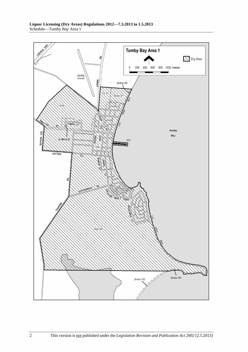
Liquor Licensing (Dry Areas) Regulations 2012—7.3.2013 to 1.5.2013 Schedule—Tumby Bay Area 1
2 This version is not published under the Legislation Revision and Publication Act 2002 [2.5.2013]

7.3.2013 to 1.5.2013—Liquor Licensing (Dry Areas) Regulations 2012
Two Wells Area 1—Schedule
[2.5.2013] This version is not published under the Legislation Revision and Publication Act 2002 1
Schedule—Two Wells Area 1
1—Extent of prohibition
The consumption of liquor is prohibited and the possession of liquor is prohibited.
2—Period of prohibition
From 5 pm on 14 December 2012 to 5 am on 15 December 2012.
3—Description of area
The area in and adjacent to Two Wells comprising Old Port Wakefield Road between Gawler Road and Drew Street.


7.3.2013 to 1.5.2013—Liquor Licensing (Dry Areas) Regulations 2012
Unley Area 1—Schedule
[2.5.2013] This version is not published under the Legislation Revision and Publication Act 2002 1
Schedule—Unley Area 1
1—Extent of prohibition
The consumption of liquor is prohibited and the possession of liquor is prohibited.
2—Period of prohibition
From 4 pm on 23 January 2013 to 1 am on 24 January 2013.
3—Description of area
The area in Unley and adjacent suburbs bounded as follows: commencing at the point at which the eastern boundary of Wood Street, Millswood, meets the northern boundary of Jasper Street, then easterly along the northern boundary of Jasper Street and the prolongation in a straight line of that boundary to the eastern boundary of Westall Street, Hyde Park, then northerly along that boundary of Westall Street to the northern boundary of Esmond Street, then easterly along that boundary of Esmond Street to the eastern boundary of Mann Street, then northerly along that boundary of Mann Street to the southern boundary of Park Street, then easterly along that boundary of Park Street to the point at which it is intersected by the prolongation in a straight line of the eastern boundary of Russell Street, then northerly along that prolongation and boundary of Russell Street to the southern boundary of Opey Avenue, then in a straight line by the shortest route to the south-eastern corner of Allen Grove, Unley, then northerly along the easternmost boundary of Allen Grove to the southern boundary of Thomas Street, then westerly along that boundary of Thomas Street to the point at which it is intersected by the prolongation in a straight line of the eastern boundary of Queen Street, then northerly along that boundary of Queen Street to the southern boundary of Mary Street, then westerly along that southern boundary of Mary Street to the eastern boundary of King William Road, then southerly along that boundary of King William Road to the point at which it is intersected by the prolongation in a straight line of the northern boundary of Albert Street, Goodwood, then westerly along that prolongation and boundary of Albert Street to the eastern boundary of Weller Street, then southerly along that eastern boundary of Weller Street and the eastern boundary of Wood Street, Millswood, to the point of commencement.

7.3.2013 to 1.5.2013—Liquor Licensing (Dry Areas) Regulations 2012
Venus Bay Area 1—Schedule
[2.5.2013] This version is not published under the Legislation Revision and Publication Act 2002 1
Schedule—Venus Bay Area 1
1—Extent of prohibition
The consumption of liquor is prohibited and the possession of liquor is prohibited.
2—Period of prohibition
From 9 pm on 31 December 2012 to 8 am on 1 January 2013.
3—Description of area
The area in and adjacent to the town of Venus Bay bounded as follows: commencing at the point at which the northern boundary of Section 77 Hundred of Wright meets the northern boundary of Lot 62 DP 34608, then generally southerly, south-easterly, north-easterly, easterly and northerly along the boundary of Lot 62 (the boundary that borders the western, southern and eastern sides of the town) to the point at which the common boundary of Lot 62 and Lot 3 FP 6331 meets the southern boundary of Venus Bay Road, then in a straight line by the shortest route (across Venus Bay Road) to the south-western corner of Lot 58 DP 34994, then in a straight line by the shortest route to the eastern boundary of the Lot, then generally north-easterly and north-westerly along that boundary of Lot 58 to the northern boundary of the Lot, then generally south-westerly, westerly and north-westerly along that boundary of Lot 58 and the northern boundary of Lot 57 DP 34994 to the south-eastern boundary of Lot 53 DP 34138, then north-easterly along that boundary of Lot 53 to the north-eastern corner of the Lot, then in a straight line by the shortest route to the north-eastern corner of Lot 146 TP 652302, then north-westerly and south-westerly along the northern and western boundaries of that Lot the point at which the western boundary meets the northern boundary of Section 77 Hundred of Wright, then generally westerly along the northern boundary of Section 77 to the point of commencement.


7.3.2013 to 1.5.2013—Liquor Licensing (Dry Areas) Regulations 2012
Victor Harbor Area 1—Schedule
[2.5.2013] This version is not published under the Legislation Revision and Publication Act 2002 1
Schedule—Victor Harbor Area 1
1—Extent of prohibition
The consumption of liquor is prohibited and the possession of liquor is prohibited.
2—Period of prohibition
The prohibition applies during the following periods:
(a) from 10 pm on each day to 8 am on the following day, until 8 am on 11 November 2013, excluding the period from 8 am on 16 November 2012 until 10 am on 24 November 2012 (the period during which the prohibition described in Schedule—Victor Harbor Area 4 applies); and
(b) from 3 pm to 10 pm on 31 December 2012; and
(c) from 8 am to 9 am on 1 January 2013.
3—Description of area
The area in and adjacent to Victor Harbor bounded as follows: commencing at the point at which the north-western boundary of Hindmarsh Road intersects the southern bank of the Hindmarsh River, then generally north-easterly along that bank of the Hindmarsh River to the low water mark of Encounter Bay, then generally south-westerly along the low water mark to the point at which it meets the northern boundary of the area defined in Schedule—Victor Harbor Area 3 (the prolongation in a straight line of the northernmost boundary of the bitumenised car parking area immediately to the north of the skating arena of the Victor Harbor Skate and Youth Park), then generally north-westerly, south-westerly and south-easterly around the northern, western and southern boundaries of that area back to the low water mark of Encounter Bay, then generally southerly along the low water mark to the eastern side of the causeway linking Granite Island to the mainland, then in a straight line by the shortest route to the low water mark on the western side of the causeway, then generally westerly, south-westerly, southerly and south-westerly along the low water mark to the point at which it is intersected by the prolongation in a straight line of the south-western boundary of Harbour View Terrace, then north-westerly along that prolongation and boundary of Harbour View Terrace to the point at which it is intersected by the prolongation in a straight line of the north-western boundary of Kent Drive, then generally north-easterly, northerly and north-westerly along that prolongation and boundary of Kent Drive to the point at which it is intersected by the prolongation in a straight line of the south-eastern boundary of a foot bridge across the Inman River (being the foot bridge closest to the mouth of the river), then north-easterly along the line of that south-eastern boundary of the foot bridge across the river to the south-western boundary of the Victor Harbor Beachfront Holiday Park, then generally south-easterly and north-easterly along the boundary of the park to the south-western boundary of Inman Street, then north-westerly along that boundary of Inman Street and the prolongation in a straight line of that boundary to the north-western boundary of Victoria Street, then north-easterly along that boundary of Victoria Street to the south-western boundary of George Main Road, then north-westerly along that boundary of George Main Road to the northern bank of the Inman River, then westerly along that bank of the river to the point at which it is intersected by the prolongation in a straight line of the western boundary of Lot 57 of FP 20694, then north-westerly along that

Liquor Licensing (Dry Areas) Regulations 2012—7.3.2013 to 1.5.2013 Schedule—Victor Harbor Area 1
2 This version is not published under the Legislation Revision and Publication Act 2002 [2.5.2013]
prolongation to the kerb line on the south-eastern side of Bay Road, then generally north-easterly along that kerb line to the kerb line on the south-western side of George Main Road, then in a straight line by the shortest route across George Main Road to the north-eastern boundary of that road, then south-easterly along that boundary of George Main Road to the north-western boundary of Victoria Street, then north-easterly along that boundary of Victoria Street to the south-western boundary of Oval Road, then generally north-westerly along that boundary of Oval Road to the point at which it is intersected by the prolongation in a straight line of the north-western boundary of Lindsay Street, then generally north-easterly along that prolongation and boundary of Lindsay Street and the north-western boundaries of Acraman Street and Carlyle Street to the point at which the north-western boundary of Carlyle Street intersects the north-eastern boundary of Cornhill Road, then south-easterly along that north-eastern boundary of Cornhill Road to the north-western boundary of Hindmarsh Road, then north-easterly along that boundary of Hindmarsh Road to the north-eastern boundary of Peace Avenue, then north-westerly along that boundary of Peace Avenue to the south-eastern boundary of Broadway Terrace, then north-easterly along that boundary of Broadway Terrace to the south-western boundary of Renown Avenue, then south-easterly along that boundary of Renown Avenue to the north-western boundary of Hindmarsh Road, then generally north-easterly along that boundary of Hindmarsh Road to the point of commencement. The area includes the whole of any wharf, jetty, boat ramp, breakwater or other structure that extends below low water mark from within the area (as well as any area beneath such a structure), but does not include that part of the causeway to Granite Island that lies below low water mark (for that part of the causeway see Schedule—Victor Harbor Area 2).

7.3.2013 to 1.5.2013—Liquor Licensing (Dry Areas) Regulations 2012
Victor Harbor Area 1—Schedule
[2.5.2013] This version is not published under the Legislation Revision and Publication Act 2002 3


7.3.2013 to 1.5.2013—Liquor Licensing (Dry Areas) Regulations 2012
Victor Harbor Area 2—Schedule
[2.5.2013] This version is not published under the Legislation Revision and Publication Act 2002 1
Schedule—Victor Harbor Area 2
1—Extent of prohibition
The consumption of liquor is prohibited and the possession of liquor is prohibited.
2—Period of prohibition
The prohibition applies during the following periods:
(a) from 10 pm on each day to 8 am on the following day, until 8 am on 11 November 2013; and
(b) from 8 am on 16 November 2012 to 10 am on 24 November 2012; and
(c) from 3 pm to 10 pm on 31 December 2012; and
(d) from 8 am to 9 am on 1 January 2013.
3—Description of area
The whole of Granite Island to low water mark, together with the whole of the causeway linking the mainland and Granite Island (apart from the part of the causeway above the low water mark on the mainland - see Schedule—Victor Harbor Area 1) as well as any area beneath the causeway. In addition to the causeway, the area also includes the whole of any wharf, jetty, boat ramp, breakwater or other structure extending below low water mark from Granite Island, as well as any area beneath such a structure.

Liquor Licensing (Dry Areas) Regulations 2012—7.3.2013 to 1.5.2013 Schedule—Victor Harbor Area 2
2 This version is not published under the Legislation Revision and Publication Act 2002 [2.5.2013]

7.3.2013 to 1.5.2013—Liquor Licensing (Dry Areas) Regulations 2012
Victor Harbor Area 3—Schedule
[2.5.2013] This version is not published under the Legislation Revision and Publication Act 2002 1
Schedule—Victor Harbor Area 3
1—Extent of prohibition
The consumption of liquor is prohibited and the possession of liquor is prohibited.
2—Period of prohibition
Continuous until 11 November 2013, excluding the period from 8 am on 16 November 2012 to 10 am on 24 November 2012 (the period during which the prohibition described in Schedule—Victor Harbor Area 4 applies).
3—Description of area
The area in and adjacent to Victor Harbor comprising a skating arena and playground generally known as the Victor Harbor Skate and Youth Park (together with adjoining road, car parking and other areas) (being portion of the area enclosed by the western boundary of Bridge Terrace, the prolongation in a straight line of Peace Avenue, the low water mark and the prolongation in a straight line of Cornhill Road) bounded as follows: commencing at the point at which the western boundary of Bridge Terrace is intersected by the prolongation in a straight line of the northernmost boundary of the bitumenised car parking area immediately to the north of the skating arena, then south-easterly along that prolongation and boundary and the prolongation in a straight line of that boundary to the low water mark of Encounter Bay, then south-westerly along the low water mark to the point at which it is intersected by the prolongation in a straight line of the fence line of the northern fence of the tennis courts that lie immediately to the south of the skating arena and adjoining playground, then north-westerly along that prolongation and fence line and the prolongation in a straight line of that fence line to the western boundary of Bridge Terrace, then north-easterly along that boundary of Bridge Terrace to the point of commencement.
See the plan in Schedule—Victor Harbor Area 1.

7.3.2013 to 1.5.2013—Liquor Licensing (Dry Areas) Regulations 2012
Victor Harbor Area 4—Schedule
[2.5.2013] This version is not published under the Legislation Revision and Publication Act 2002 1
Schedule—Victor Harbor Area 4
1—Extent of prohibition
The consumption of liquor is prohibited and the possession of liquor is prohibited.
2—Period of prohibition
From 8 am on 16 November 2012 to 10 am on 24 November 2012.
3—Description of area
The area in and adjacent to Victor Harbor bounded as follows: commencing at the point at which the north-western boundary of Hindmarsh Road intersects the southern bank of the Hindmarsh River, then generally westerly, north-easterly and north-westerly along that bank of the Hindmarsh River to the point at which it is intersected by the prolongation in a straight line of the northern boundary of Dinan Road, then easterly along that prolongation and boundary of Dinan Road and the prolongation in a straight line of that boundary to the western boundary of Laxton Street, then generally south-westerly and south-easterly along that boundary of Laxton Street, the south-western boundary of Adare Avenue and the prolongation in a straight line of the south-western boundary of Adare Avenue to the south-eastern boundary of Hindmarsh Road, then generally south-westerly along that boundary of Hindmarsh Road to the point at which it intersects the northern bank of the Hindmarsh River, then along that bank of the Hindmarsh River to the low water mark of Encounter Bay, then generally south-westerly and southerly along the low water mark to the eastern side of the causeway linking Granite Island to the mainland, then in a straight line by the shortest route to the low water mark on the western side of the causeway, then generally westerly, south-westerly, southerly and south-westerly along the low water mark to the point at which it is intersected by the prolongation in a straight line of the south-western boundary of Harbour View Terrace, then north-westerly along that prolongation and boundary of Harbour View Terrace to the point at which it is intersected by the prolongation in a straight line of the north-western boundary of Kent Drive, then generally north-easterly, northerly and north-westerly along that prolongation and boundary of Kent Drive to the point at which it is intersected by the prolongation in a straight line of the south-eastern boundary of a foot bridge across the Inman River (being the foot bridge closest to the mouth of the river), then north-easterly along the line of that south-eastern boundary of the foot bridge across the river to the south-western boundary of the Victor Harbor Beachfront Holiday Park, then generally south-easterly and north-easterly along the boundary of the park to the south-western boundary of Inman Street, then north-westerly along that boundary of Inman Street and the prolongation in a straight line of that boundary to the north-western boundary of Victoria Street, then north-easterly along that boundary of Victoria Street to the south-western boundary of George Main Road, then north-westerly along that boundary of George Main Road to the northern bank of the Inman River, then westerly along that bank of the river to the point at which it is intersected by the prolongation in a straight line of the western boundary of Lot 57 of FP 20694, then north-westerly along that prolongation to the kerb line on the south-eastern side of Bay Road, then generally north-easterly along that kerb line to the kerb line on the south-western side of George Main Road, then in a straight line by the shortest route across George Main Road to the north-eastern boundary of that road, then north-westerly along that boundary of George Main Road to the point at which the north-eastern boundary of George Main Road

Liquor Licensing (Dry Areas) Regulations 2012—7.3.2013 to 1.5.2013 Schedule—Victor Harbor Area 4
2 This version is not published under the Legislation Revision and Publication Act 2002 [2.5.2013]
meets the eastern boundary of Lot 11 DP 14245 (Victor Harbor High School), then north-easterly, north-westerly, north-easterly, north-westerly and south-westerly along that boundary of Lot 11 to the point at which it meets the south-eastern boundary of Kullaroo Road, then north-easterly along the south-eastern boundary of Kullaroo Road and the prolongation in a straight line of that boundary to the north-eastern boundary of Oval Road, then south-easterly along that boundary of Oval Road to the north-western boundary of Lindsay Street, then generally north-easterly along that boundary of Lindsay Street and the north-western boundaries of Acraman Street and Carlyle Street to the point at which the north-western boundary of Carlyle Street intersects the north-eastern boundary of Cornhill Road, then south-easterly along that north-eastern boundary of Cornhill Road to the north-western boundary of Hindmarsh Road, then north-easterly along that boundary of Hindmarsh Road to the north-eastern boundary of Peace Avenue, then north-westerly along that boundary of Peace Avenue to the south-eastern boundary of Broadway Terrace, then north-easterly along that boundary of Broadway Terrace to the south-western boundary of Renown Avenue, then south-easterly along that boundary of Renown Avenue to the north-western boundary of Hindmarsh Road, then generally north-easterly along that boundary of Hindmarsh Road to the point of commencement. The area includes the whole of any wharf, jetty, boat ramp, breakwater or other structure that extends below low water mark from within the area (as well as any area beneath such a structure), but does not include that part of the causeway to Granite Island that lies below low water mark (for that part of the causeway see Schedule—Victor Harbor Area 2).

7.3.2013 to 1.5.2013—Liquor Licensing (Dry Areas) Regulations 2012
Victor Harbor Area 4—Schedule
[2.5.2013] This version is not published under the Legislation Revision and Publication Act 2002 3


7.3.2013 to 1.5.2013—Liquor Licensing (Dry Areas) Regulations 2012
Waikerie Area 1—Schedule
[2.5.2013] This version is not published under the Legislation Revision and Publication Act 2002 1
Schedule—Waikerie Area 1
1—Extent of prohibition
The consumption of liquor is prohibited and the possession of liquor is prohibited.
2—Period of prohibition
From 10 pm on each day to 8 am on the following day, until 8 am on 15 December 2016, provided that where—
(a) an event of historic, cultural, traditional or major community significance is held in the area; and
(b) the District Council of Loxton Waikerie authorises, for the purposes of the event, the consumption and possession of liquor in the area (or a defined part of the area) for a specified period during the event,
the prohibition does not apply in the area (or defined part of the area) during the specified period.
No more than 4 authorisations may apply in relation to the area, or part of the area, in any 12 month period.
3—Description of area
The area in Waikerie bounded as follows: commencing at the point at which the western boundary of Burns Street intersects the southern boundary of Jemison Street, then easterly along that southern boundary of Jemison Street to the western boundary of Strangman Road, then in a straight line by the shortest route across Strangman Road to the point at which the eastern boundary of Strangman Road meets the southern boundary of Dowling Street, then north-easterly along that southern boundary of Dowling Street and the prolongation in a straight line of that boundary to the northern boundary of Civic Avenue, then north-westerly along that boundary of Civic Avenue to the eastern boundary of Crush Terrace, then north-easterly along that boundary of Crush Terrace to the point at which it meets the prolongation in a straight line of the southern boundary of White Street, then in a straight line by the shortest route to the point at which the eastern boundary of Annells Street meets the northern boundary of White Street, then north-westerly along that boundary of White Street to the eastern boundary of O'Loughlin Street, then north-easterly along that boundary of O'Loughlin Street to the point at which it meets the north-eastern boundary of Allotment 29 T701301, Hundred of Waikerie, then in a straight line by the shortest route across O'Loughlin Street to the southern corner of Allotment 22 T701301, Hundred of Waikerie, then north-westerly along the south-western boundary of Allotment 22 and of Allotment 179 T701301, Hundred of Waikerie, and the prolongation in a straight line of that boundary of Allotment 179 across Goodchild Street, to the northern boundary of Goodchild Street, then south-westerly along that boundary of Goodchild Street to the eastern boundary of Peake Terrace, then north-westerly along that boundary of Peake Terrace to the southern boundary of Ross Street, then north-easterly along that boundary of Ross Street to its intersection with the prolongation in a straight line of the eastern boundary of Rowe Street, then generally north-easterly along that prolongation and boundary of Rowe Street to the southern bank of the River Murray, then generally north-westerly along that bank of the River Murray (and around the outer boundary of any wharf, jetty, boat ramp or mooring

Liquor Licensing (Dry Areas) Regulations 2012—7.3.2013 to 1.5.2013 Schedule—Waikerie Area 1
2 This version is not published under the Legislation Revision and Publication Act 2002 [2.5.2013]
extending into the river beyond the river bank) to a point level with the north-western end of Edgar Bartlett Drive, then in a straight line due south-west to the southern boundary of the carriageway of the formed road that runs parallel to, and is immediately to the south-west of, Edgar Bartlett Drive, then south-easterly along that boundary of the carriageway of that road, and the prolongation in a straight line of that boundary, to the eastern boundary of the carriageway of Leonard Norman Drive, then generally north-easterly, easterly and south-easterly along that boundary of the carriageway of Leonard Norman Drive to the point at which it meets the northern entrance from Leonard Norman Drive to the Lions Park caravan parking area and oval, then in a straight line by the shortest route to the outer boundary of the road that circles the oval, then generally south-westerly and south-easterly along the outer boundary of that road around the western side of the oval (so as to include the whole of the oval in the area) to the western side of the entrance to the oval from Peake Terrace, then in a straight line by the shortest route across Peake Terrace to the southern boundary of Peake Terrace, then generally easterly and south-easterly along that boundary of Peake Terrace to the northern boundary of Coombe Terrace, then south-westerly along that boundary of Coombe Terrace to the western boundary of Henderson Street, then in a straight line by the shortest route across Coombe Terrace to the point at which the southern boundary of Coombe Terrace meets the western boundary of Pflaum Terrace, then south-westerly along that boundary of Pflaum Terrace to the northern boundary of Thompson Street, then in a straight line by the shortest route across Thompson Street to the point at which the southern boundary of Thompson Street meets the western boundary of Campbell Terrace, then generally southerly and south-easterly along that boundary of Campbell Terrace (and along the western boundary of the roundabout at the eastern end of Campbell Terrace) to the northern boundary of Lawrie Terrace, then generally westerly along that boundary of Lawrie Terrace to the point at which it meets the prolongation in a straight line of the western boundary of Burns Street, then generally south-westerly along that prolongation and western boundary of Burns Street to the point of commencement.

7.3.2013 to 1.5.2013—Liquor Licensing (Dry Areas) Regulations 2012
Wallaroo Area 1—Schedule
[2.5.2013] This version is not published under the Legislation Revision and Publication Act 2002 1
Schedule—Wallaroo Area 1
1—Extent of prohibition
The consumption of liquor is prohibited and the possession of liquor is prohibited.
2—Period of prohibition
Continuous until 20 October 2014.
3—Description of area
The area in Wallaroo known as Centenary Square, being the area bounded on the north-east by Owen Terrace, on the north-west by the fence marking the south-eastern boundary of the grounds of the Coronation Croquet Club Inc., on the south-west by the north-eastern boundary of the railway reserve and on the south-east by Irwine Street.
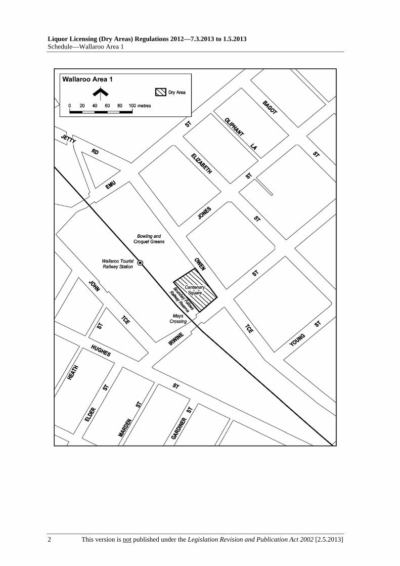
Liquor Licensing (Dry Areas) Regulations 2012—7.3.2013 to 1.5.2013 Schedule—Wallaroo Area 1
2 This version is not published under the Legislation Revision and Publication Act 2002 [2.5.2013]

7.3.2013 to 1.5.2013—Liquor Licensing (Dry Areas) Regulations 2012
Wallaroo Area 2—Schedule
[2.5.2013] This version is not published under the Legislation Revision and Publication Act 2002 1
Schedule—Wallaroo Area 2
1—Extent of prohibition
The consumption of liquor is prohibited and the possession of liquor is prohibited.
2—Period of prohibition
Continuous until 20 October 2014.
3—Description of area
The portion of Owen Terrace between the eastern boundary of Emu Street and the western boundary of Irwine Street.

7.3.2013 to 1.5.2013—Liquor Licensing (Dry Areas) Regulations 2012
Wallaroo Area 3—Schedule
[2.5.2013] This version is not published under the Legislation Revision and Publication Act 2002 1
Schedule—Wallaroo Area 3
1—Extent of prohibition
The consumption of liquor is prohibited and the possession of liquor is prohibited.
2—Period of prohibition
From 9 pm on each day to 6 am on the following day, until 6 am on 20 October 2014.
3—Description of area
Commencing at the point at which the north-western boundary of Heritage Drive, Wallaroo, meets the south-western boundary of the Wallaroo Sailing Club, then north-westerly and north-easterly along the south-western and north-western boundaries of the Sailing Club to the north-eastern boundary of the Sailing Club, then north-westerly along the prolongation in a straight line of the north-eastern boundary of the Sailing Club to the low water mark, then generally south-westerly, westerly, northerly, south-westerly, southerly and south-westerly along the low water mark to the prolongation in a straight line of the western boundary of Section 322, Hundred of Wallaroo (Foreshore Reserve), then south-easterly along that prolongation and boundary to the fence line forming the southern boundary of Section 322, then generally north-easterly, easterly and north-easterly along that fence line and the continuation of that fence line along the northern boundary of the Seafarers Recreation Centre and adjoining reserve areas to the north-western boundary of Heritage Drive, then north-easterly along that north-western boundary of Heritage Drive to the point of commencement.

Liquor Licensing (Dry Areas) Regulations 2012—7.3.2013 to 1.5.2013 Schedule—Wallaroo Area 3
2 This version is not published under the Legislation Revision and Publication Act 2002 [2.5.2013]

7.3.2013 to 1.5.2013—Liquor Licensing (Dry Areas) Regulations 2012
Wallaroo Area 4—Schedule
[2.5.2013] This version is not published under the Legislation Revision and Publication Act 2002 1
Schedule—Wallaroo Area 4
1—Extent of prohibition
The consumption of liquor is prohibited and the possession of liquor is prohibited.
2—Period of prohibition
12 noon on 31 December 2012 to 7 am on 1 January 2013.
3—Description of area
The area in and adjacent to Wallaroo and North Beach bounded as follows: commencing at the point at which the prolongation in a straight line of the northern boundary of Woodforde Drive, North Beach, intersects the low water mark on the eastern side of Spencer Gulf, then north-easterly and south-easterly along that prolongation and boundary of Woodforde Drive to the point at which it meets the northern boundary of Islesworth Street, North Beach, then generally easterly and northerly along that boundary of Islesworth Street and the prolongation in a straight line of that boundary to the northern boundary of Rupara Road, North Beach, then easterly along that boundary of Rupara Road and the prolongation in a straight line of that boundary to the point at which the prolongation intersects the eastern boundary of Hopgood Road, North Beach, then generally south-easterly and south-westerly along the eastern boundary of Hopgood Road and the eastern boundary of North Beach Road to the point at which the eastern boundary of North Beach Road meets the northern boundary of the Wallaroo to Alford Road, then north-easterly along that boundary of the Wallaroo to Alford Road to the point at which it is intersected by the prolongation in a straight line of the eastern boundary of Bowman Road, Wallaroo, then southerly and south-westerly along that boundary of Bowman Road, the eastern boundary of Sharples Road, Wallaroo, and the prolongation in a straight line of the eastern boundary of Sharples Road to the southern boundary of Magazine Road, Wallaroo, then generally north-westerly and westerly along that boundary of Magazine Road to the south-western boundary of Cresco Road, Wallaroo, then generally north-westerly along that boundary of Cresco Road and the prolongation in a straight line of that boundary to the point at which the prolongation intersects the low water mark on the eastern side of Spencer Gulf, then generally north-easterly along the low water mark to the commencement of the southern breakwater at the entrance to the Copper Cove Marina, then north-westerly along the outer boundary of the breakwater to its north-western end, then in a straight line by the shortest route (across the entrance to the marina) to the northern boundary at the western end of the northern breakwater at the entrance to the marina, then easterly along the outer boundary of the breakwater back to the low water mark on the shore on the northern side of the marina, then generally northerly and north-westerly along the low water mark to the point of commencement. The area includes the whole of any wharf, jetty, breakwater, boat ramp or other structure projecting below low water mark from within the area described above (as well as any area beneath such a structure).

Liquor Licensing (Dry Areas) Regulations 2012—7.3.2013 to 1.5.2013 Schedule—Wallaroo Area 4
2 This version is not published under the Legislation Revision and Publication Act 2002 [2.5.2013]

7.3.2013 to 1.5.2013—Liquor Licensing (Dry Areas) Regulations 2012
Wattle Park Area 1—Schedule
[2.5.2013] This version is not published under the Legislation Revision and Publication Act 2002 1
Schedule—Wattle Park Area 1
1—Extent of prohibition
The consumption of liquor is prohibited and the possession of liquor is prohibited.
2—Period of prohibition
Continuous until 12 July 2017.
3—Description of area
The area in Wattle Park and Stonyfell (known as the Kensington Road Lookout) bounded as follows: commencing at the south-western corner of Lot 2 of Filed Plan No. 130056, then easterly along the southern boundary of that Lot and the prolongation in a straight line of that southern boundary to the eastern boundary of the Kensington Road Road Reserve, then northerly along that eastern boundary of the Road Reserve to the point at which it meets the southern boundary of Certificate of Title Register Book Volume 5560 Folio 32 (537 Kensington Road), then generally westerly and northerly along that boundary of CT 5560/32 for a distance of 66.37 metres, then in a straight line across Kensington Road to a point on the eastern boundary of Certificate of Title Register Book Volume 5324 Folio 562 (526 Kensington Road) that is 65.59 metres north along that boundary from the south-eastern corner of that land, then generally southerly, south-easterly and southerly along that eastern boundary to the south-eastern corner of CT 5324/562, then in a straight line by the shortest route to the north-western corner of Lot 2 of Filed Plan No. 130056, then southerly along the western boundary of Lot 2 to the point of commencement.

Liquor Licensing (Dry Areas) Regulations 2012—7.3.2013 to 1.5.2013 Schedule—Wattle Park Area 1
2 This version is not published under the Legislation Revision and Publication Act 2002 [2.5.2013]
Wattle Park Area 1

7.3.2013 to 1.5.2013—Liquor Licensing (Dry Areas) Regulations 2012
West Beach Area 1—Schedule
[2.5.2013] This version is not published under the Legislation Revision and Publication Act 2002 1
Schedule—West Beach Area 1
1—Extent of prohibition
The consumption of liquor is prohibited and the possession of liquor is prohibited.
2—Period of prohibition
Continuous until 1 July 2013, but excluding any day or portion of a day during which—
(a) a festival, exhibition, show or other event of historic, traditional or cultural significance or that promotes tourism is held within the area; and
(b) the consumption and possession of liquor within the area are authorised for the purposes of these regulations by the City of Charles Sturt.
3—Description of area
The area at West Beach bounded as follows: commencing at the point at which the eastern boundary of Seaview Road meets the northern boundary of Adelaide Shores Caravan Park (the south-western corner of Strata Plan No. 4034), then westerly along the prolongation in a straight line of the northern boundary of the Caravan Park to the low water mark, then northerly along the low water mark to its intersection with the westerly prolongation in a straight line of the northernmost boundary of Hundred Plan No. 105100652, then easterly along that prolongation and boundary of the Hundred Plan, and the easterly prolongation in a straight line of the boundary, to the eastern boundary of Seaview Road, then generally southerly along that boundary of Seaview Road to the point of commencement.

Liquor Licensing (Dry Areas) Regulations 2012—7.3.2013 to 1.5.2013 Schedule—West Beach Area 1
2 This version is not published under the Legislation Revision and Publication Act 2002 [2.5.2013]

7.3.2013 to 1.5.2013—Liquor Licensing (Dry Areas) Regulations 2012
Whyalla Area 1—Schedule
[2.5.2013] This version is not published under the Legislation Revision and Publication Act 2002 1
Schedule—Whyalla Area 1
1—Extent of prohibition
The consumption of liquor is prohibited and the possession of liquor is prohibited.
2—Period of prohibition
From 9 pm on 31 December 2012 to 8 am on 1 January 2013.
3—Description of area
The area in and adjacent to Whyalla bounded as follows: commencing at the point at which the prolongation in a straight line of the western boundary of Lot 100 of DP 61444 intersects the low water mark on the western side of Spencer Gulf, then northerly along that prolongation and boundary of Lot 100 to the northern boundary of the Lot, then north-easterly along the northern boundary of Lot 100 to the point at which it meets the northern boundary of Lot 101 of DP 61444, then generally north-easterly along that boundary of Lot 101 to the north-eastern corner of the Lot, then generally north-westerly, north-easterly, north-westerly and north-easterly along the boundary of Lot 100 of DP 61444 (including around the outer boundary of Lot 340 of DP 33299 so as to exclude Lot 340 from the area) to the point at which the north-western boundary of Lot 100 (the south-eastern boundary of Broadbent Terrace) meets the south-western boundary of Cudmore Terrace, then in a straight line by the shortest route (across Cudmore Terrace) to the point at which the south-eastern boundary of Wallack Terrace meets the north-eastern boundary of Cudmore Terrace, then generally south-easterly along that boundary of Cudmore Terrace and the north-eastern boundary of Buttlingarra Way to the south-western corner of Section 394 Hundred of Randell, then north-easterly along the north-western boundary of Section 394, and the prolongation in a straight line of that boundary, to the south-western boundary of Section 420 Hundred of Randell, then south-easterly along that boundary of Section 420, and the prolongation in a straight line of that boundary, to the low water mark on the western side of Spencer Gulf, then generally southerly along the low water mark to the commencement of the breakwater forming the north-eastern wall of the Whyalla marina, then south-easterly and south-westerly along the outer boundary of the breakwater to the end of the breakwater, then in a straight line by the shortest route (diagonally across the entrance to the marina) to the outer boundary of the north-eastern end of the breakwater forming the south-eastern and south-western wall of the marina, then south-westerly and north-westerly along the outer boundary of the breakwater back to the low water mark on the shore on the south-western side of the marina (so as to include the whole of the marina and the whole of each breakwater in the area), then generally south-westerly along the low water mark to the point of commencement. The area includes any jetty, wharf, breakwater, boat ramp or other structure projecting seaward from within the area described above, as well as any area beneath such a structure.


7.3.2013 to 1.5.2013—Liquor Licensing (Dry Areas) Regulations 2012
Whyalla Area 2—Schedule
[2.5.2013] This version is not published under the Legislation Revision and Publication Act 2002 1
Schedule—Whyalla Area 2
1—Extent of prohibition
The consumption of liquor is prohibited and the possession of liquor is prohibited.
2—Period of prohibition
From 12 noon on 26 January 2013 to 12.01 am on 27 January 2013.
3—Description of area
The area in and adjacent to Whyalla bounded as follows: commencing at the point at which the prolongation in a straight line of the north-eastern boundary of Roberts Terrace intersects the low water mark on the western side of Spencer Gulf, then north-westerly along that prolongation to the north-western boundary of Lot 100 of DP 61444, then generally north-easterly, north-westerly and north-easterly along the boundary of Lot 100 of DP 61444 (including around the outer boundary of Lot 340 of DP 33299 so as to exclude Lot 340 from the area) to the point at which the north-western boundary of Lot 100 (the south-eastern boundary of Broadbent Terrace) meets the south-western boundary of Cudmore Terrace, then in a straight line by the shortest route (across Cudmore Terrace) to the point at which the south-eastern boundary of Wallack Terrace meets the north-eastern boundary of Cudmore Terrace, then generally south-easterly along that boundary of Cudmore Terrace and the north-eastern boundary of Buttlingarra Way to the south-western corner of Section 394 Hundred of Randell, then north-easterly along the north-western boundary of Section 394, and the prolongation in a straight line of that boundary, to the south-western boundary of Section 420 Hundred of Randell, then south-easterly along that boundary of Section 420, and the prolongation in a straight line of that boundary, to the low water mark on the western side of Spencer Gulf, then generally southerly along the low water mark to the commencement of the breakwater forming the north-eastern wall of the Whyalla marina, then south-easterly and south-westerly along the outer boundary of the breakwater to the end of the breakwater, then in a straight line by the shortest route (diagonally across the entrance to the marina) to the outer boundary of the north-eastern end of the breakwater forming the south-eastern and south-western wall of the marina, then south-westerly and north-westerly along the outer boundary of the breakwater back to the low water mark on the shore on the south-western side of the marina (so as to include the whole of the marina and the whole of each breakwater in the area), then generally south-westerly along the low water mark to the point of commencement. The area includes any jetty, wharf, breakwater, boat ramp or other structure projecting seaward from within the area described above, as well as any area beneath such a structure.


7.3.2013 to 1.5.2013—Liquor Licensing (Dry Areas) Regulations 2012
Williamstown Area 1—Schedule
[2.5.2013] This version is not published under the Legislation Revision and Publication Act 2002 1
Schedule—Williamstown Area 1
1—Extent of prohibition
The consumption of liquor is prohibited and the possession of liquor is prohibited.
2—Period of prohibition
From 10 pm on each day to 8 am on the following day, until 8 am on 22 January 2018.
3—Description of area
The area in Williamstown bounded as follows: commencing at the point at which the prolongation in a straight line of the south-eastern boundary of Victoria Terrace intersects the western boundary of George Street, then generally north-easterly along that boundary of George Street to the western boundary of Queen Street, then north-westerly along that boundary of Queen Street to the point at which it is intersected by the prolongation in a straight line of the western boundary of Margaret Street, then north-easterly along that prolongation and boundary of Margaret Street to the point at which the western boundary of Margaret Street is intersected by the prolongation in a straight line of the northern boundary of Lot 7 FP 100253, then south-easterly along that prolongation and boundary of Lot 7 to the western boundary of Lot 101 DP 65093, then north-easterly, south-easterly and south-westerly along the western, northern and eastern boundaries of Lot 101 and south-westerly along the eastern boundaries of Lot 60 DP 64657 and Lot 151 DP 26382 to the southern boundary of Lot 151, then westerly along the southern boundary of Lot 151 and the southern boundary of Lot 23 FP 100258 to the point at which the southern boundary of Lot 23 is intersected by the prolongation in a straight line of the eastern boundary of Lot 22 FP 100258, then generally south-easterly along that prolongation and boundary of Lot 22 and the eastern boundaries of the adjoining allotments (Lots 54-59 DP 37) to the point at which the eastern boundary of Lot 59 DP 37 meets the northern boundary of Mount Crawford Road, then in a straight line by the shortest route across Mount Crawford Road to the point at which the north-western boundary of Lot 90 DP 65276 meets the southern boundary of Mount Crawford Road, then south-westerly along that boundary of Lot 90 to the south-eastern boundary of Lot 91 DP 65276, then south-westerly along the south-eastern boundary of Lot 91 and the south-eastern boundaries of Lots 92 and 86 DP 65276 to the point at which the south-eastern boundary of Lot 86 meets the south-western boundary of Lot 33 DP 65276, then in a straight line by the shortest route across Lot 86 to the south-eastern boundary of Lot 85 DP 65276, then south-westerly and westerly along the south-eastern and southern boundaries of Lot 85 to the point at which the southern boundary of Lot 85 meets the south-eastern boundary of Victoria Terrace, then south-westerly along that boundary of Victoria Terrace and the prolongation in a straight line of that boundary to the point of commencement.

Liquor Licensing (Dry Areas) Regulations 2012—7.3.2013 to 1.5.2013 Schedule—Williamstown Area 1
2 This version is not published under the Legislation Revision and Publication Act 2002 [2.5.2013]

7.3.2013 to 1.5.2013—Liquor Licensing (Dry Areas) Regulations 2012
Williamstown Area 2—Schedule
[2.5.2013] This version is not published under the Legislation Revision and Publication Act 2002 1
Schedule—Williamstown Area 2
1—Extent of prohibition
The consumption of liquor is prohibited and the possession of liquor is prohibited.
2—Period of prohibition
From 10 pm on each day to 8 am on the following day, until 8 am on 22 January 2018.
3—Description of area
The area adjacent to Williamstown, generally known as Queen Victoria Jubilee Park, being Lot 1 FP 100290.

Liquor Licensing (Dry Areas) Regulations 2012—7.3.2013 to 1.5.2013 Schedule—Williamstown Area 2
2 This version is not published under the Legislation Revision and Publication Act 2002 [2.5.2013]

7.3.2013 to 1.5.2013—Liquor Licensing (Dry Areas) Regulations 2012
Wilmington Area 1—Schedule
[2.5.2013] This version is not published under the Legislation Revision and Publication Act 2002 1
Schedule—Wilmington Area 1
1—Extent of prohibition
The consumption of liquor is prohibited and the possession of liquor is prohibited.
2—Period of prohibition
From 12 noon on 26 January 2013 to 4 pm on 27 January 2013.
3—Description of area
The area in and adjacent to Wilmington bounded as follows: commencing at the south-western corner of Section 538 Hundred of Willochra, then northerly along the western boundary of Section 538 and the western boundary of Section 539 Hundred of Willochra to the northern boundary of Section 539, then easterly along the northern boundary of Section 539 and north-easterly along the north-western boundary of Section 535 Hundred of Willochra to the point at which the north-western boundary of Section 535 is intersected by the prolongation in a straight line of the north-eastern boundary of Lot 618 FP 184700, then generally north-westerly along that prolongation and boundary of Lot 618 and the north-eastern boundary of Lot 617 FP 184699 to the point at which that boundary of Lot 617 and the north-western boundary of Lot 1 DP 26677 meet the south-western boundary of Oval Road, then generally north-westerly along that boundary of Oval Road to the southern boundary of Horrocks Pass Road, then easterly along that boundary of Horrocks Pass Road to the south-western boundary of Horrocks Highway (the north-eastern corner of Section 565 Hundred of Willochra), then in a straight line by the shortest route (across Horrocks Pass Road) to the point at which the northern boundary of Horrocks Pass Road meets the south-western boundary of Gunyah Road, then north-westerly along that boundary of Gunya Road to the point at which it is intersected by the prolongation in a straight line of the north-western boundary of Beautiful Valley Road, then north-easterly along that prolongation and boundary of Beautiful Valley Road to the north-eastern boundary of Section 10 Hundred of Willochra, then south-easterly along the prolongation in a straight line of that boundary of Section 10 to the south-eastern boundary of Horrocks Highway, then south-westerly along that boundary of Horrocks Highway to the south-western boundary of Alexis Road (the north-eastern boundary of Section 361 Hundred of Willochra), then south-easterly along that south-western boundary of Alexis Road to the point at which it meets the eastern corner of Lot 710 DP 48405, then south-westerly along the south-eastern boundary of Lot 710 to the north-eastern boundary of Gogler Road, then north-westerly along that boundary of Gogler Road to the point at which it is intersected by the prolongation in a straight line of the north-western boundary of Parkville Avenue (the south-eastern boundary of Section 577 Hundred of Willochra), then south-westerly along that prolongation and north-western boundary of Parkville Avenue (the south-eastern boundaries of Sections 577, 581 and 578 Hundred of Willochra) to the north-eastern boundary of Horrocks Highway, then in a straight line by the shortest route (across Horrocks Highway) to the easternmost corner of Section 608 Hundred of Willochra (the point at which the north-western boundary of Wilds Way meets the south-western boundary of Horrocks Highway), then south-westerly along the south-eastern boundary of Section 608 to the eastern boundary of Section 538 Hundred of Willochra, then southerly and easterly along the eastern and southern boundaries of Section 538 to the point of commencement.


7.3.2013 to 1.5.2013—Liquor Licensing (Dry Areas) Regulations 2012
Woodcroft Area 1—Schedule
[2.5.2013] This version is not published under the Legislation Revision and Publication Act 2002 1
Schedule—Woodcroft Area 1
1—Extent of prohibition
The consumption of liquor is prohibited and the possession of liquor is prohibited.
2—Period of prohibition
8 pm each day to 6 am on the following day, until 6 am on 11 September 2016.
3—Description of area
Reserve area in Woodcroft, as follows: commencing at the point at which the southern boundary of Pimpala Road, Woodcroft, meets the western boundary of Dressage Avenue, then westerly along the southern boundary of Pimpala Road to the point at which it meets the eastern boundary of the first allotment of private land on that side of Pimpala Road, then generally southerly and south-easterly along the eastern boundaries of that allotment and the adjoining allotments and road reserves (including the eastern boundaries of Stables Lane, Cleveland Court, Grooms Way, Polo Court, Bay Place, Headland Crescent and Farriers Way) to the fence marking the north-western boundary of the pine tree plantation, then north-easterly along that fence line to the point at which it first meets the southern boundary of an adjoining allotment of private land (being an allotment bounded on the north by Dressage Avenue), then generally westerly and north-westerly along the southern boundaries of that allotment and the adjoining allotments and road reserves (including the southern boundaries of Connemara Way and Caspian Court) to the south-western corner of the southernmost allotment adjoining the western boundary of Caspian Court, then generally north-westerly and northerly along the western boundaries of that allotment and the adjoining allotments and road reserves (including the western boundaries of Sandalwood Grove and Piaffe Lane) to the north-western corner of the westernmost allotment adjoining the northern boundary of Piaffe Lane, then generally north-easterly along the northern boundary of that allotment and the adjoining allotments to the western boundary of Dressage Avenue, then northerly along the western boundary of Dressage Avenue to the point of commencement.

Liquor Licensing (Dry Areas) Regulations 2012—7.3.2013 to 1.5.2013 Schedule—Woodcroft Area 1
2 This version is not published under the Legislation Revision and Publication Act 2002 [2.5.2013]

7.3.2013 to 1.5.2013—Liquor Licensing (Dry Areas) Regulations 2012
Legislative history
[2.5.2013] This version is not published under the Legislation Revision and Publication Act 2002 1
Legislative history
Notes
• This version is comprised of the following: Regulations 25.10.2012 Aberfoyle Park Area 1
25.10.2012
Adelaide Area 1
25.10.2012
Adelaide Area 2
15.11.2012
Adelaide Area 3
15.11.2012
Adelaide Area 4
15.11.2012
Adelaide Area 5
15.11.2012
Angaston Area 1
15.11.2012
Angaston Area 2
15.11.2012
Ardrossan Area 1
25.10.2012
Arno Bay Area 1
6.12.2012
Barmera Area 1 25.10.2012 Barmera Area 2 25.10.2012 Barmera Area 3 25.10.2012 Barmera Area 4 25.10.2012 Barmera Area 5 25.10.2012 Basham Beach Area 1
6.12.2012
Beachport Area 1
6.12.2012
Beachport Area 2
6.12.2012
Berri Area 1 25.10.2012 Berri Area 2 25.10.2012 Bordertown Area 1
14.2.2013
Brighton Area 1
25.10.2012
Ceduna and Thevenard Area 1
6.12.2012
Ceduna and 6.12.2012

Liquor Licensing (Dry Areas) Regulations 2012—7.3.2013 to 1.5.2013 Legislative history
2 This version is not published under the Legislation Revision and Publication Act 2002 [2.5.2013]
Thevenard Area 2 Christies Beach Area 1
25.10.2012
Clare Area 1 25.10.2012 Clare Area 2 25.10.2012 Clare Area 3 25.10.2012 Clare Area 4 25.10.2012 Coffin Bay Area 1
15.11.2012
Coober Pedy Area 1
7.3.2013
Cowell Area 1 15.11.2012 Cummins Area 1
6.12.2012
Elliston Area 1 6.12.2012 Fisherman Bay Area 1
25.10.2012
Gawler Area 1 25.10.2012 Gawler Area 2 25.10.2012 Gawler Area 3 25.10.2012 Gawler Area 4 25.10.2012 Gawler Area 5 25.10.2012 Glenelg Area 1 15.11.2012 Glenelg Area 2 15.11.2012 Glenelg North Area 1
6.12.2012
Golden Grove Area 1
25.10.2012
Goolwa Area 1 25.10.2012 Goolwa Area 2 6.12.2012 Goolwa Beach Area 1
6.12.2012
Grange Area 1 25.10.2012 Hahndorf Area 1
25.10.2012
Hallett Cove Area 1
25.10.2012
Hallett Cove Area 2
25.10.2012
Hallett Cove Area 3
25.10.2012
Hallett Cove Area 4
25.10.2012
Hallett Cove Area 5
25.10.2012
Hallett Cove 25.10.2012

7.3.2013 to 1.5.2013—Liquor Licensing (Dry Areas) Regulations 2012
Legislative history
[2.5.2013] This version is not published under the Legislation Revision and Publication Act 2002 3
Area 6 Hayborough Area 1
6.12.2012
Henley Beach Area 1
25.10.2012
Henley Beach Area 2
25.10.2012
Henley Beach South Area 1
25.10.2012
Kadina Area 1 25.10.2012 Kadina Area 2 25.10.2012 Kimba Area 1 6.12.2012 Kingscote Area 1
20.12.2012
Lobethal Area 1
1.11.2012
Loxton Area 1 25.10.2012 Loxton Area 2 25.10.2012 Loxton Area 3 25.10.2012 Lyndoch Area 1
15.11.2012
Maitland Area 1
25.10.2012
Mannum Area 1
25.10.2012
Mannum Area 2
25.10.2012
Mannum Area 3
25.10.2012
Mannum Area 4
25.10.2012
Mannum Area 5
25.10.2012
Meningie Area 1
20.12.2012
Middleton Area 1
6.12.2012
Millicent Area 1
25.10.2012
Millicent Area 2
25.10.2012
Moana Area 1 25.10.2012 Moana Area 2 25.10.2012 Moonta Area 1 25.10.2012 Moonta Area 2 25.10.2012 Moonta Bay Area 1
25.10.2012
Moonta Bay 25.10.2012

Liquor Licensing (Dry Areas) Regulations 2012—7.3.2013 to 1.5.2013 Legislative history
4 This version is not published under the Legislation Revision and Publication Act 2002 [2.5.2013]
Area 2 Moonta Bay and Port Hughes Area 1
15.11.2012
Morgan Area 1 20.12.2012 Morphett Vale Area 1
25.10.2012
Mount Barker Area 1
25.10.2012
Mount Barker Area 2
25.10.2012
Mount Gambier Area 1
1.11.2012
Mount Gambier Area 2
1.11.2012
Mount Gambier Area 3
1.11.2012
Mount Gambier Area 4
1.11.2012
Mount Gambier Area 5
1.11.2012
Mount Pleasant Area 1
15.11.2012
Murray Bridge Area 1
25.10.2012
Nairne Area 1 25.10.2012 Naracoorte Area 1
14.2.2013
Naracoorte Area 2
14.2.2013
Noarlunga Centre Area 1
25.10.2012
Normanville Area 1
25.10.2012
North Adelaide Area 1
25.10.2012
Nuriootpa Area 1
15.11.2012
Oaklands Park Area 1
25.10.2012
Paringa Area 1 25.10.2012 Peterborough Area 1
25.10.2012
Port Adelaide Area 1
25.10.2012
Port Adelaide Area 2
25.10.2012
Port Augusta Area 1
25.10.2012
7.3.2013 to 1.5.2013—Liquor Licensing (Dry Areas) Regulations 2012
Legislative history
[2.5.2013] This version is not published under the Legislation Revision and Publication Act 2002 5
Port Augusta Area 2
25.10.2012
Port Augusta Area 3
25.10.2012
Port Broughton Area 1
25.10.2012
Port Broughton Area 2
25.10.2012
Port Elliot Area 1
25.10.2012
Port Elliot Area 2
6.12.2012
Port Hughes Area 1
25.10.2012
Port Hughes Area 2
25.10.2012
Port Kenny Area 1
6.12.2012
Port Lincoln Area 1
25.10.2012
Port Neill Area 1
15.11.2012
Port Noarlunga Area 1
20.12.2012
Port Noarlunga Area 2
25.10.2012
Port Noarlunga Area 3
25.10.2012
Port Pirie Area 1
25.10.2012
Port Pirie Area 2
25.10.2012
Port Victoria Area 1
6.12.2012
Port Vincent Area 1
25.10.2012
Port Vincent Area 2
25.10.2012
Prospect Area 1 20.12.2012 Renmark Area 1
25.10.2012
Renmark Area 2
25.10.2012
Robe Area 1 6.12.2012 Robe Area 2 6.12.2012 Salisbury Area 1
25.10.2012
Seacliff Area 1 25.10.2012 Seacliff Area 2 25.10.2012

Liquor Licensing (Dry Areas) Regulations 2012—7.3.2013 to 1.5.2013 Legislative history
6 This version is not published under the Legislation Revision and Publication Act 2002 [2.5.2013]
Seacliff Area 3 25.10.2012 Seacliff Area 4 6.12.2012 Semaphore Area 1
25.10.2012
Semaphore Area 2
25.10.2012
Semaphore Area 3
25.10.2012
Semaphore Area 4
6.12.2012
Spalding Area 1
31.1.2013
Stansbury Area 1
6.12.2012
Stansbury Area 2
6.12.2012
Stirling North Area 1
25.10.2012
Strathalbyn Area 1
1.11.2012
Strathalbyn Area 2
1.11.2012
Streaky Bay Area 1
6.12.2012
Tanunda Area 1 15.11.2012 Tumby Bay Area 1
15.11.2012
Two Wells Area 1
1.11.2012
Unley Area 1 20.12.2012 Venus Bay Area 1
6.12.2012
Victor Harbor Area 1
25.10.2012
Victor Harbor Area 2
25.10.2012
Victor Harbor Area 3
25.10.2012
Victor Harbor Area 4
25.10.2012
Waikerie Area 1
25.10.2012
Wallaroo Area 1
25.10.2012
Wallaroo Area 2
25.10.2012
Wallaroo Area 3
25.10.2012
Wallaroo 15.11.2012

7.3.2013 to 1.5.2013—Liquor Licensing (Dry Areas) Regulations 2012
Legislative history
[2.5.2013] This version is not published under the Legislation Revision and Publication Act 2002 7
Area 4 Wattle Park Area 1
25.10.2012
West Beach Area 1
25.10.2012
Whyalla Area 1 6.12.2012 Whyalla Area 2 6.12.2012 Williamstown Area 1
15.11.2012
Williamstown Area 2
15.11.2012
Wilmington Area 1
20.12.2012
Woodcroft Area 1
25.10.2012
• Please note—References in the legislation to other legislation or instruments or to titles of bodies or offices are not automatically updated as part of the program for the revision and publication of legislation and therefore may be obsolete.
• Earlier versions of these regulations (historical versions) are listed at the end of the legislative history.
• For further information relating to the Act and subordinate legislation made under the Act see the Index of South Australian Statutes or www.legislation.sa.gov.au.
Legislation revoked by principal regulations
The Liquor Licensing (Dry Areas) Regulations 2012 revoked the following:
Liquor Licensing (Dry Areas—Long Term) Regulations 1997
Liquor Licensing (Dry Areas—Short Term) Regulations 1997
Principal regulations and variations
New entries appear in bold. Year No Reference Commencement 2012 203 Gazette 30.8.2012 p4096 1.9.2012: r 2 2012 218 Gazette 25.10.2012 p4781 25.10.2012: r 2 2012 220 Gazette 1.11.2012 p4820 1.11.2012: r 2 2012 221 Gazette 1.11.2012 p4824 1.11.2012: r 2 2012 222 Gazette 1.11.2012 p4826 1.11.2012: r 2 2012 223 Gazette 1.11.2012 p4828 1.11.2012: r 2 2012 229 Gazette 15.11.2012 p5032 15.11.2012: r 2 2012 230 Gazette 15.11.2012 p5036 15.11.2012: r 2 2012 231 Gazette 15.11.2012 p5039 15.11.2012: r 2 2012 232 Gazette 15.11.2012 p5045 15.11.2012: r 2 2012 233 Gazette 15.11.2012 p5050 15.11.2012: r 2 2012 234 Gazette 15.11.2012 p5052 15.11.2012: r 2

Liquor Licensing (Dry Areas) Regulations 2012—7.3.2013 to 1.5.2013 Legislative history
8 This version is not published under the Legislation Revision and Publication Act 2002 [2.5.2013]
2012 235 Gazette 15.11.2012 p5056 15.11.2012: r 2 2012 241 Gazette 29.11.2012 p5260 29.11.2012: r 2 2012 244 Gazette 6.12.2012 p5437 6.12.2012: r 2 2012 245 Gazette 6.12.2012 p5440 6.12.2012: r 2 2012 259 Gazette 13.12.2012 p5605 13.12.2012: r 2 2012 260 Gazette 13.12.2012 p5607 13.12.2012: r 2 2012 261 Gazette 13.12.2012 p5610 13.12.2012: r 2 2012 262 Gazette 13.12.2012 p5612 13.12.2012: r 2 2012 274 Gazette 20.12.2012 p6247 20.12.2012: r 2 2013 2 Gazette 31.1.2013 p167 31.1.2013: r 2 2013 9 Gazette 7.2.2013 p269 7.2.2013: r 2 2013 12 Gazette 14.2.2013 p405 14.2.2013: r 2 2013 23 Gazette 7.3.2013 p762 7.3.2013: r 2
Provisions varied
New entries appear in bold.
Entries that relate to provisions that have been deleted appear in italics. Provision How varied Commencement
rr 2 and 3 omitted under Legislation Revision and Publication Act 2002
25.10.2012
Schs Adelaide Areas 2—5 inserted by 230/2012 r 4 15.11.2012 Angaston Area 1
cl 2 varied by 233/2012 r 4 15.11.2012 Angaston Area 2
cl 2 varied by 233/2012 r 5 15.11.2012 Arno Bay Area 1 inserted by 241/2012 r 4 29.11.2012 Basham Beach Area 1
inserted by 241/2012 r 5 29.11.2012
Beachport Areas 1 and 2
inserted by 245/2012 r 4 6.12.2012
Bordertown Area 1 cl 2 varied by 9/2013 r 4 7.2.2013
Ceduna and Thevenard Area 1
substituted by 244/2012 r 4 6.12.2012
Ceduna and Thevenard Area 2
inserted by 244/2012 r 4 6.12.2012
Coober Pedy Area 1 cl 2 varied by 23/2013 r 4 7.3.2013
Coffin Bay Area 1 inserted by 234/2012 r 4 15.11.2012 Cowell Area 1 inserted by 229/2012 r 4 15.11.2012 Cummins Area 1 inserted by 241/2012 r 6 29.11.2012 Elliston Area 1 inserted by 245/2012 r 5 6.12.2012

7.3.2013 to 1.5.2013—Liquor Licensing (Dry Areas) Regulations 2012
Legislative history
[2.5.2013] This version is not published under the Legislation Revision and Publication Act 2002 9
Glenelg Area 1 cl 2 substituted by 232/2012 r 4 15.11.2012
Glenelg Area 2 inserted by 232/2012 r 5 15.11.2012 Glenelg North Area 1 inserted by 245/2012 r 6 6.12.2012 Goolwa Area 2 inserted by 241/2012 r 7 29.11.2012 Goolwa Beach Area 1
inserted by 241/2012 r 7 29.11.2012
Hayborough Area 1 inserted by 241/2012 r 8 29.11.2012 Kimba Area 1 inserted by 241/2012 r 9 29.11.2012 Kingscote Area 1 inserted by 274/2012 r 4 20.12.2012 Lobethal Area 1 inserted by 220/2012 r 4 1.11.2012 Lyndoch Area 1
cl 2 varied by 233/2012 r 6 15.11.2012 Meningie Area 1 substituted by 260/2012 r 4 13.12.2012 Middleton Area 1 inserted by 241/2012 r 10 29.11.2012 Moonta Bay and Port Hughes Area 1
inserted by 231/2012 r 4 15.11.2012
Morgan Area 1 inserted by 262/2012 r 4 13.12.2012 Mount Gambier Area 1
cl 2 varied by 221/2012 r 4 1.11.2012 Mount Gambier Area 2
cl 2 varied by 221/2012 r 5 1.11.2012 Mount Gambier Area 3
cl 2 varied by 221/2012 r 6 1.11.2012 Mount Gambier Area 4
cl 2 varied by 221/2012 r 7 1.11.2012 Mount Gambier Area 5
cl 2 varied by 221/2012 r 8 1.11.2012 Mount Pleasant Area 1
cl 2 varied by 233/2012 r 7 15.11.2012 Naracoorte Area 1 substituted by 12/2013 r 4 14.2.2013 Naracoorte Area 2
cl 2 varied by 12/2013 r 5 14.2.2013 Nuriootpa Area 1
cl 2 varied by 233/2012 r 8 15.11.2012 Port Elliot Area 2 inserted by 241/2012 r 11 29.11.2012 Port Kenny Area 1 inserted by 245/2012 r 7 6.12.2012 Port Neill Area 1 inserted by 235/2012 r 4 15.11.2012

Liquor Licensing (Dry Areas) Regulations 2012—7.3.2013 to 1.5.2013 Legislative history
10 This version is not published under the Legislation Revision and Publication Act 2002 [2.5.2013]
Port Noarlunga Area 1
substituted by 260/2012 r 5 13.12.2012
Port Victoria Area 1 inserted by 245/2012 r 8 6.12.2012 Prospect Area 1 inserted by 259/2012 r 4 13.12.2012 Robe Areas 1 and 2 inserted by 245/2012 r 9 6.12.2012 Seacliff Area 4 inserted by 245/2012 r 10 6.12.2012 Semaphore Area 4 inserted by 245/2012 r 11 6.12.2012 Spalding Area 1 inserted by 2/2013 r 4 31.1.2013 Stansbury Areas 1 and 2
inserted by 241/2012 r 12 29.11.2012
Strathalbyn Area 1 cl 2 substituted by 223/2012 r 4 1.11.2012
Strathalbyn Area 2 cl 2 substituted by 223/2012 r 5 1.11.2012
Streaky Bay Area 1 inserted by 245/2012 r 12 6.12.2012 Tanunda Area 1
cl 2 varied by 233/2012 r 9 15.11.2012 Tumby Bay Area 1 inserted by 235/2012 r 5 15.11.2012 Two Wells Area 1 inserted by 222/2012 r 4 1.11.2012 Unley Area 1 inserted by 261/2012 r 4 13.12.2012 Venus Bay Area 1 inserted by 245/2012 r 13 6.12.2012 Victor Harbor Area 1
cl 2 substituted by 218/2012 r 4 25.10.2012 Victor Harbor Area 2
cl 2 substituted by 218/2012 r 5 25.10.2012 Victor Harbor Area 3
cl 2 substituted by 218/2012 r 6 25.10.2012 Victor Harbor Area 4 inserted by 218/2012 r 7 25.10.2012 Wallaroo Area 4 inserted by 231/2012 r 5 15.11.2012 Whyalla Areas 1 and 2
inserted by 245/2012 r 14 6.12.2012
Williamstown Area 1 cl 2 varied by 233/2012 r 10 15.11.2012
Williamstown Area 2 cl 2 varied by 233/2012 r 11 15.11.2012
Wilmington Area 1 inserted by 262/2012 r 5 13.12.2012
Historical versions 25.10.2012 1.11.2012 15.11.2012 29.11.2012 (electronic only) 6.12.2012

7.3.2013 to 1.5.2013—Liquor Licensing (Dry Areas) Regulations 2012
Legislative history
[2.5.2013] This version is not published under the Legislation Revision and Publication Act 2002 11
13.12.2012 (electronic only) 20.12.2012 31.1.2013 7.2.2013 (electronic only) 14.2.2013