Deprivation and social exclusion in Argyll and Bute Report to the Community Planning Partnership
lable at ScienceDirect
Journal of Archaeological Science 37 (2010) 577–593
Contents lists avai
Journal of Archaeological Science
journal homepage: ht tp: / /www.elsevier .com/locate/ jas
Late Holocene vegetation and palaeoenvironmental historyof the Dunadd area, Argyll, Scotland: chronology of events
R.A. Housley a,b, S.P.E. Blockley a,*, I.P. Matthews a, A. MacLeod a, J.J. Lowe a, S. Ramsay c,J.J. Miller c, E.N. Campbell b
a Department of Geography, Royal Holloway, University of London, London, TW20 0EX, UKb Department of Archaeology, University of Glasgow, Glasgow, G12 8QQ, UKc GUARD, University of Glasgow, Glasgow, G12 8QQ, UK
a r t i c l e i n f o
Article history:Received 17 November 2008Received in revised form12 October 2009Accepted 16 October 2009
Keywords:HoloceneEnvironmental changeTephrochronologyPalynologyPlant macrofossilsHekla 1947ADHekla 1510ADRadiocarbon datingBayesian-based age modelling
* Corresponding author.E-mail address: [email protected] (S.P.E. B
0305-4403/$ – see front matter � 2009 Elsevier Ltd.doi:10.1016/j.jas.2009.10.023
a b s t r a c t
This paper focuses on the chronology and environmental significance of a sediment sequence from analluvial locality in the vicinity of the historic site of Dunadd, Scotland. It outlines the rationale andstatistical validity of an age model derived for a sequence of floodplain sediments from which detailedpollen-stratigraphical and plant macrofossil records have been derived. A series of radiocarbon dates arecalibrated using a Bayesian modelling approach, the results of which can be refined by incorporating twoindependent age estimates based on tephra layers of known age. Analysis of the entire floodplainsequence for volcanic glass shards revealed the presence of discrete but geochemically very similartephra layers within the upper (late Holocene) part of the sequence. Comparison with publishedgeochemical data obtained from Icelandic tephras of historical age indicates strong statistical correlationswith the Hekla 1947 AD and Hekla 1510 AD. While the Hekla 1510 AD tephra has previously beenreported from sites within Britain and Ireland, the Dunadd sequence affords the first record of the Hekla1947 AD tephra layer within Scotland. When the ages and stratigraphic positions of both tephra layersare incorporated into the Bayesian age model, an overall centennial to decadal precision for the lateHolocene is achieved, with archaeological and environmental transitions discriminated with highest-likelihood age uncertainty ranges of 20–50 years at 95% confidence. The local environmental record isassessed in the light of this new chronological framework: the data support previously reportedproposals for two periods of significant climatic deterioration with increased wetness, the first during theearly Medieval period and the second during the late 16th and 17th centuries AD.
� 2009 Elsevier Ltd. All rights reserved.
1. Background and aims
This paper is devoted to the late Holocene chronology and envi-ronmental record of the area close to the historic site of Dunadd, in theKilmartin Glen, Scotland (Fig. 1). This site was the royal centre for theearly Scottish kings of the kingdom of Dal Riata between c. 600 and900 AD (Lane and Campbell, 2000). Following the demise of its regalimportance, the area has continued to be settled through to thepresent day. Little is known about the degree to which the rise and fallof Dal Riata may have been influenced by environmental factors, orwhether subsequent events, such as the social and economicupheavals of the 18th century, impacted significantly on the localenvironment and landscape (Housley et al., 2004). In an attempt to
lockley).
All rights reserved.
throw light on these matters, samples collected from a sequence ofnearby floodplain sediments have been examined for evidence ofchanging sedimentary environment and local vegetation cover. In thispaper, the available chronological data are presented and then inte-grated using a Bayesian statistical approach to generate an age model.The age model is then used to underpin interpretations of the lateHolocene palaeoenvironmental history of the area.
Disentangling natural environmental from human-inducedsignals reflected in archaeological and geological records isfrequently difficult. Constraints include the low temporal resolu-tion of some stratigraphic sequences and uncertainties over theintegrity or precision of associated age estimates. The difficultiesare particularly acute when attempting to resolve the precise orderof events that occurred during episodes of abrupt environmentaltransition. Few geological dating methods or stratigraphicalcontexts permit events to be ordered with a decadal to centennialaccuracy. Radiocarbon dating can provide precise age estimates for
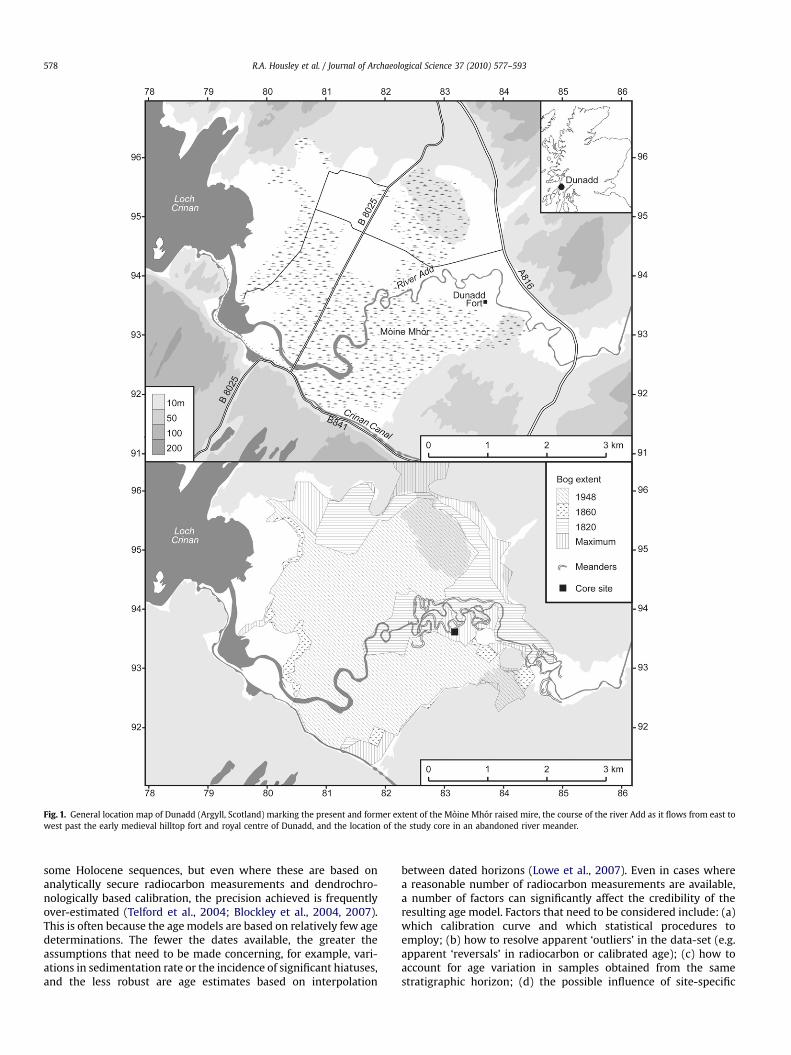
Fig. 1. General location map of Dunadd (Argyll, Scotland) marking the present and former extent of the Moine Mhor raised mire, the course of the river Add as it flows from east towest past the early medieval hilltop fort and royal centre of Dunadd, and the location of the study core in an abandoned river meander.
R.A. Housley et al. / Journal of Archaeological Science 37 (2010) 577–593578
some Holocene sequences, but even where these are based onanalytically secure radiocarbon measurements and dendrochro-nologically based calibration, the precision achieved is frequentlyover-estimated (Telford et al., 2004; Blockley et al., 2004, 2007).This is often because the age models are based on relatively few agedeterminations. The fewer the dates available, the greater theassumptions that need to be made concerning, for example, vari-ations in sedimentation rate or the incidence of significant hiatuses,and the less robust are age estimates based on interpolation
between dated horizons (Lowe et al., 2007). Even in cases wherea reasonable number of radiocarbon measurements are available,a number of factors can significantly affect the credibility of theresulting age model. Factors that need to be considered include: (a)which calibration curve and which statistical procedures toemploy; (b) how to resolve apparent ‘outliers’ in the data-set (e.g.apparent ‘reversals’ in radiocarbon or calibrated age); (c) how toaccount for age variation in samples obtained from the samestratigraphic horizon; (d) the possible influence of site-specific
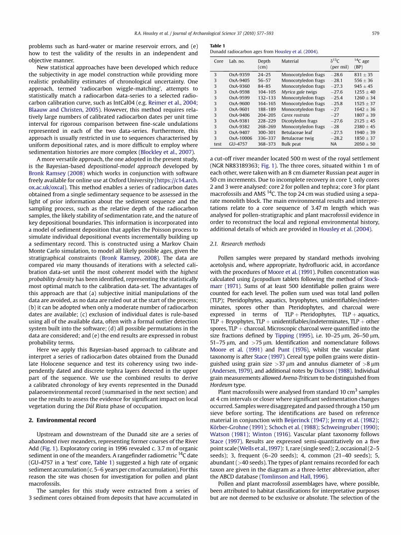
Table 1Dunadd radiocarbon ages from Housley et al. (2004).
Core Lab. no. Depth(cm)
Material d13C(per mil)
14C age(BP)
3 OxA-9359 24–25 Monocotyledon frags �28.6 831 � 353 OxA-9405 56–57 Monocotyledon frags �28.1 556 � 363 OxA-9360 84–85 Monocotyledon frags �27.3 945 � 453 OxA-9598 104–105 Myrica gale twigs �27.6 1255 � 403 OxA-9599 132–133 Monocotyledon frags �25.4 1260 � 343 OxA-9600 164–165 Monocotyledon frags �25.8 1525 � 373 OxA-9601 188–189 Monocotyledon frags �27 1642 � 363 OxA-9406 204–205 Carex rostrata �27 1807 � 393 OxA-9381 228–229 Dicotyledon frags �27.6 2125 � 453 OxA-9382 268–269 Monocotyledon frags �28 2380 � 453 OxA-9407 300–301 Betulaceae leaf �27.5 1940 � 393 OxA-10006 336–337 Betulaceae twig �28.2 1850 � 37test GU-4757 368–373 Bulk peat NA 2050 � 50
R.A. Housley et al. / Journal of Archaeological Science 37 (2010) 577–593 579
problems such as hard-water or marine reservoir errors, and (e)how to test the validity of the results in an independent andobjective manner.
New statistical approaches have been developed which reducethe subjectivity in age model construction while providing morerealistic probability estimates of chronological uncertainty. Oneapproach, termed ‘radiocarbon wiggle-matching’, attempts tostatistically match a radiocarbon data-series to a selected radio-carbon calibration curve, such as IntCal04 (e.g. Reimer et al., 2004;Blaauw and Christen, 2005). However, this method requires rela-tively large numbers of calibrated radiocarbon dates per unit timeinterval for rigorous comparison between fine-scale undulationsrepresented in each of the two data-series. Furthermore, thisapproach is usually restricted in use to sequences characterised byuniform depositional rates, and is more difficult to employ wheresedimentation histories are more complex (Blockley et al., 2007).
A more versatile approach, the one adopted in the present study,is the Bayesian-based depositional-model approach developed byBronk Ramsey (2008) which works in conjunction with softwarefreely available for online use at Oxford University (https://c14.arch.ox.ac.uk/oxcal). This method enables a series of radiocarbon datesobtained from a single sedimentary sequence to be assessed in thelight of prior information about the sediment sequence and thesampling process, such as the relative depth of the radiocarbonsamples, the likely stability of sedimentation rate, and the nature ofkey depositional boundaries. This information is incorporated intoa model of sediment deposition that applies the Poisson process tosimulate individual depositional events incrementally building upa sedimentary record. This is constructed using a Markov ChainMonte Carlo simulation, to model all likely possible ages, given thestratigraphical constraints (Bronk Ramsey, 2008). The data arecompared via many thousands of iterations with a selected cali-bration data-set until the most coherent model with the highestprobability density has been identified, representing the statisticallymost optimal match to the calibration data-set. The advantages ofthis approach are that (a) subjective initial manipulations of thedata are avoided, as no data are ruled out at the start of the process;(b) it can be adopted when only a moderate number of radiocarbondates are available; (c) exclusion of individual dates is rule-basedusing all of the available data, often with a formal outlier detectionsystem built into the software; (d) all possible permutations in thedata are considered; and (e) the end results are expressed in robustprobability terms.
Here we apply this Bayesian-based approach to calibrate andinterpret a series of radiocarbon dates obtained from the Dunaddlate Holocene sequence and test its coherency using two inde-pendently dated and discrete tephra layers detected in the upperpart of the sequence. We use the combined results to derivea calibrated chronology of key events represented in the Dunaddpalaeoenvironmental record (summarised in the next section) anduse the results to assess the evidence for significant impact on localvegetation during the Dal Riata phase of occupation.
2. Environmental record
Upstream and downstream of the Dunadd site are a series ofabandoned river meanders, representing former courses of the RiverAdd (Fig. 1). Exploratory coring in 1996 revealed c. 3.7 m of organicsediment in one of the meanders. A rangefinder radiometric 14C date(GU-4757 in a ‘test’ core, Table 1) suggested a high rate of organicsediment accumulation (c. 5–6 years per cm of accumulation). For thisreason the site was chosen for investigation for pollen and plantmacrofossils.
The samples for this study were extracted from a series of3 sediment cores obtained from deposits that have accumulated in
a cut-off river meander located 500 m west of the royal settlement(NGR NR83189363; Fig. 1). The three cores, situated within 1 m ofeach other, were taken with an 8 cm diameter Russian peat auger in50 cm increments. Due to incomplete recovery in core 1, only cores2 and 3 were analysed: core 2 for pollen and tephra; core 3 for plantmacrofossils and AMS 14C. The top 24 cm was studied using a sepa-rate monolith block. The main environmental results and interpre-tations relate to a core sequence of 3.47 m length which wasanalysed for pollen-stratigraphic and plant macrofossil evidence inorder to reconstruct the local and regional environmental history,additional details of which are provided in Housley et al. (2004).
2.1. Research methods
Pollen samples were prepared by standard methods involvingacetolysis and, where appropriate, hydrofluoric acid, in accordancewith the procedures of Moore et al. (1991). Pollen concentration wascalculated using Lycopodium tablets following the method of Stock-marr (1971). Sums of at least 500 identifiable pollen grains werecounted for each level. The pollen sum used was total land pollen(TLP); Pteridophytes, aquatics, bryophytes, unidentifiables/indeter-minates, spores other than Pteridophytes, and charcoal wereexpressed in terms of TLPþ Pteridophytes, TLPþ aquatics,TLPþ Bryophytes, TLPþ unidentifiables/indeterminates, TLPþ otherspores, TLPþ charcoal. Microscopic charcoal were quantified into thesize fractions defined by Tipping (1995), i.e. 10–25 mm, 26–50 mm,51–75 mm, and >75 mm. Identification and nomenclature followsMoore et al. (1991) and Punt (1976), whilst the vascular planttaxonomy is after Stace (1997). Cereal type pollen grains were distin-guished using grain size >37 mm and annulus diameter of >8 mm(Andersen, 1979), and additional notes by Dickson (1988). Individualgrain measurements allowed Avena-Triticum to be distinguished fromHordeum type.
Plant macrofossils were analysed from standard 10 cm3 samplesat 4 cm intervals or closer where significant sedimentation changesoccurred. Samples were disaggregated and passed through a 150 mmsieve before sorting. The identifications are based on referencematerial in conjunction with Beijerinck (1947); Jermy et al. (1982);Korber-Grohne (1991); Schoch et al. (1988); Schweingruber (1990);Watson (1981); Winton (1916). Vascular plant taxonomy followsStace (1997). Results are expressed semi-quantitatively on a fivepoint scale (Wells et al.,1997): 1, rare (single seed); 2, occasional (2–5seeds); 3, frequent (6–20 seeds); 4, common (21–40 seeds); 5,abundant (>40 seeds). The types of plant remains recorded for eachtaxon are given in the diagram as a three-letter abbreviation, afterthe ABCD database (Tomlinson and Hall, 1996).
Pollen and plant macrofossil assemblages have, where possible,been attributed to habitat classifications for interpretative purposesbut are not deemed to be exclusive or absolute. The selection of the

R.A. Housley et al. / Journal of Archaeological Science 37 (2010) 577–593580
habitat classification for each taxon was governed by the type ofhabitat in which the plant is primarily found. Habitat classificationfollows Aichele et al. (1992), Clapham et al. (1989), Grime et al. (1990),Hubbard (1968), Jermy et al. (1982), Stace (1997) and Watson (1981).
2.2. Results
Only selected results are presented here: sediment composition,macro-charcoal, and plant macrofossils in Fig. 2; pollen and sporesin Fig. 3. Summary plots of habitat-related taxa are presented inFigs. 4 and 5 for, respectively, the plant macrofossils and the pollen/spores/micro-charcoal. All the measured cereal type grains weredetermined to be Hordeum type. To facilitate comparisons betweenresults the same assemblage zone boundaries are used in Figs. 2–5,priority in assigning zonal boundaries was given to changes in plantmacrofossil assemblages, and sediment composition. Five succes-sional zones have been identified (DD-1 to DD-5) with zoneboundaries at depths of 300, 200, 90 and 23 cm. Age estimates forthese boundaries derived from the age modelling proceduresdescribed below, are in Table 3. The characteristics of the zones aresummarised as follows:
– Zone DD-1 (347–300 cm) before 3123–2765 cal BP: This zone ischaracterised by a high mineral sediment component, highabundances of woodland macrofossils (Fig. 4), in particularthose of Alnus, Betula, Polypodium and Quercus (Fig. 2). Wood-land, followed by pollen/spores from open ground and inde-terminate habitats are the most frequently representedcomponents (Fig. 5). The lower basal boundary marks thebeginning of organic sedimentation in the meander; the upperzone boundary is marked by the decline in woodland macro-fossils and a rise in aquatics (Figs. 2, 4).
– Zone DD-2 (300–200 cm) 3123–2765 to 1753–1573 cal BP: Inthis zone the mineral sediment input is high, in contrast
Fig. 2. Sediment composition and plant macrofossil diagram from core 3, selected taxa onlyon changes in pollen, macrofossil content, or sediment composition. The main phase of actiTroels-Smith (1955).
aquatic macrofossil and invertebrate counts show slightlyelevated levels relative to previous values (Fig. 4). The declinein woodland components appears to be concentrated in thefollowing plant macrofossil taxa: Betula pendula, Betulaceaeand Polypodium, but not Alnus glutinosa (Fig. 2). Very littlechange may be discerned in the habitat grouped pollen/sporerecord compared to the preceding zone (Fig. 5). The upperboundary of DD-2 is marked by a major decline in the mineralsediment component and a change in core lithology.
– Zone DD-3 (200–90 cm) 1753–1573 to 1021–899 cal BP: DD-3coincides with the royal occupation of Dunadd (believed tocentre on the period from c. 600–900 cal AD; Lane andCampbell, 2000). Mineral sedimentation values drop markedly(Figs. 2, 4). The zone shows a complex interplay of woodland,aquatic, marsh and waterside, and heath and bog plantmacrofossils (Fig. 4). Within the pollen spectra (Fig. 5) there aremore changes in the woodland, marsh and waterside, and openground components than previously: woodland values decline,whereas marsh and waterside, and open ground increase. Theupper boundary is marked by (Fig. 4): a rise in mineral sedi-mentation, a change in core lithology, a rise in woodlandmacrofossils (mostly Betula, Fig. 2) and a brief peak in macro-charcoal; parallel changes in pollen (Fig. 5) include a rise inwoodland and heath and bog pollen/spores, and a decline inthose of marsh and waterside. This is clearly shown by thesharp decline in Cyperaceae pollen counts (Fig. 3).
– Zone DD-4 (90–23 cm) 1021–899 to 60–44 cal BP: In this zonemany macrofossil habitat classes (Fig. 4) increase their repre-sentation, e.g. aquatics (Glyceria fluitans), woodland (Betula)and marsh and waterside (Juncus) values all rise (Fig. 2).However, few of these increases are reflected in the pollen/spore counts (Fig. 5): e.g. aquatic values stay low, woodlandvalues fluctuate, and marsh and waterside values decline.Heath and bog pollen/spores counts increase to a mid-late
. Horizontal axis is 1–5 scaled abundance score. Assemblage zone boundaries are basedvity at Dunadd, between c. 600 and 900 cal AD, is highlighted. Lithology symbols after
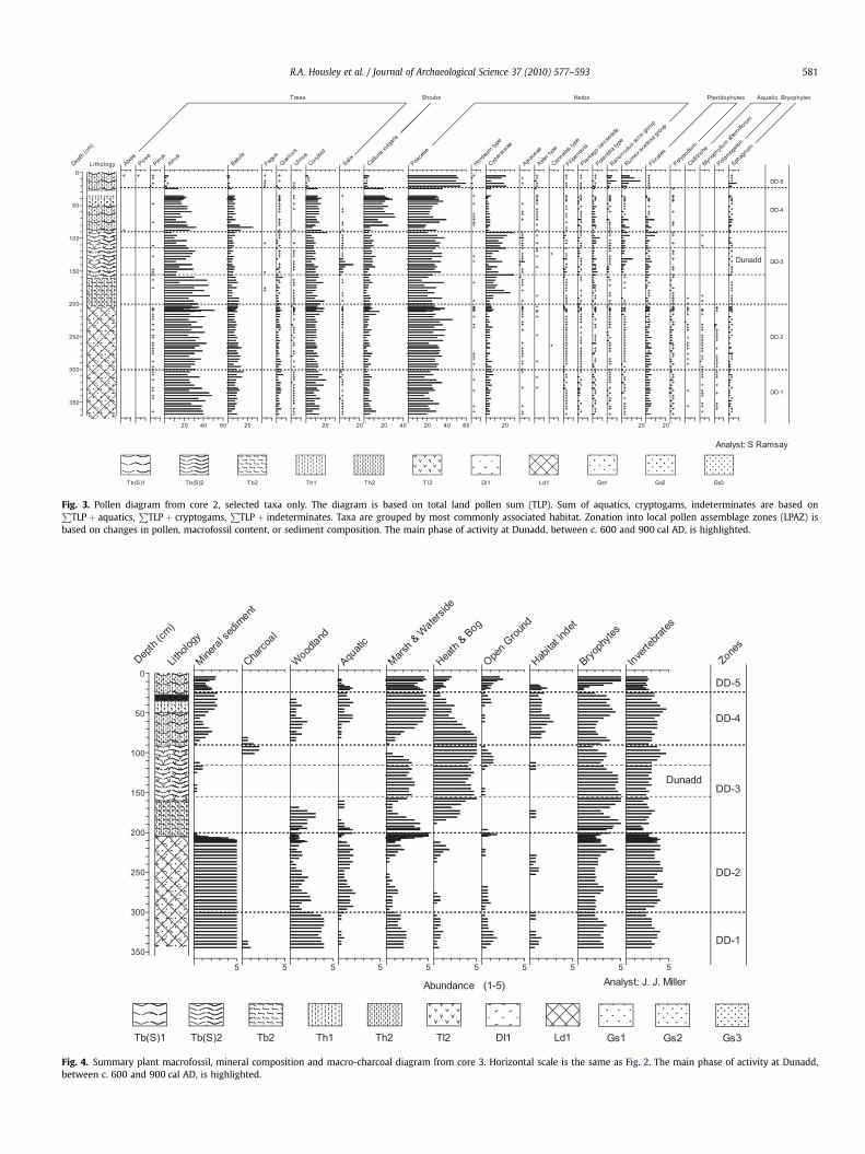
Fig. 3. Pollen diagram from core 2, selected taxa only. The diagram is based on total land pollen sum (TLP). Sum of aquatics, cryptogams, indeterminates are based onP
TLP þ aquatics,P
TLP þ cryptogams,P
TLP þ indeterminates. Taxa are grouped by most commonly associated habitat. Zonation into local pollen assemblage zones (LPAZ) isbased on changes in pollen, macrofossil content, or sediment composition. The main phase of activity at Dunadd, between c. 600 and 900 cal AD, is highlighted.
Fig. 4. Summary plant macrofossil, mineral composition and macro-charcoal diagram from core 3. Horizontal scale is the same as Fig. 2. The main phase of activity at Dunadd,between c. 600 and 900 cal AD, is highlighted.
R.A. Housley et al. / Journal of Archaeological Science 37 (2010) 577–593 581
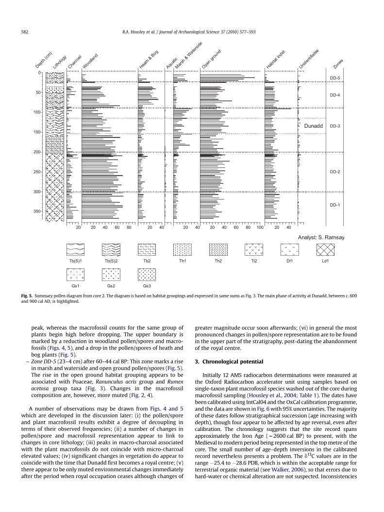
Fig. 5. Summary pollen diagram from core 2. The diagram is based on habitat groupings and expressed in same sums as Fig. 3. The main phase of activity at Dunadd, between c. 600and 900 cal AD, is highlighted.
R.A. Housley et al. / Journal of Archaeological Science 37 (2010) 577–593582
peak, whereas the macrofossil counts for the same group ofplants begin high before dropping. The upper boundary ismarked by a reduction in woodland pollen/spores and macro-fossils (Figs. 4, 5), and a drop in the pollen/spores of heath andbog plants (Fig. 5).
– Zone DD-5 (23–4 cm) after 60–44 cal BP: This zone marks a risein marsh and waterside and open ground pollen/spores (Fig. 5).The rise in the open ground habitat grouping appears to beassociated with Poaceae, Ranunculus acris group and Rumexacetosa group taxa (Fig. 3). Changes in the macrofossilcomposition are, however, more muted (Fig. 2, 4).
A number of observations may be drawn from Figs. 4 and 5which are developed in the discussion later: (i) the pollen/sporeand plant macrofossil results exhibit a degree of decoupling interms of their observed frequencies; (ii) a number of changes inpollen/spore and macrofossil representation appear to link tochanges in core lithology; (iii) peaks in macro-charcoal associatedwith the plant macrofossils do not coincide with micro-charcoalelevated values; (iv) significant changes in vegetation do appear tocoincide with the time that Dunadd first becomes a royal centre; (v)there appear to be only muted environmental changes immediatelyafter the period when royal occupation ceases although changes of
greater magnitude occur soon afterwards; (vi) in general the mostpronounced changes in pollen/spore representation are to be foundin the upper part of the stratigraphy, post-dating the abandonmentof the royal centre.
3. Chronological potential
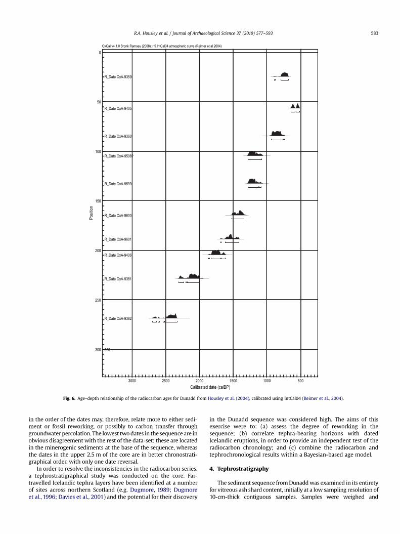
Initially 12 AMS radiocarbon determinations were measured atthe Oxford Radiocarbon accelerator unit using samples based onsingle-taxon plant macrofossil species washed out of the core duringmacrofossil sampling (Housley et al., 2004; Table 1). The dates havebeen calibrated using IntCal04 and the OxCal calibration programme,and the data are shown in Fig. 6 with 95% uncertainties. The majorityof these dates follow stratigraphical succession (age increasing withdepth), though four appear to be affected by age reversal, even aftercalibration. The chronology suggests that the site record spansapproximately the Iron Age (w2600 cal BP) to present, with theMedieval to modern period being represented in the top metre of thecore. The small number of age–depth inversions in the calibratedrecord nevertheless presents a problem. The d13C values are in therange �25.4 to �28.6 PDB, which is within the acceptable range forterrestrial organic material (see Walker, 2006), so that errors due tohard-water or chemical alteration are not suspected. Inconsistencies
300
R_Date OxA-9382
R_Date OxA-9381
R_Date OxA-9406
R_Date OxA-9601
R_Date OxA-9600
R_Date OxA-9599
R_Date OxA-9598?
R_Date OxA-9360
R_Date OxA-9405
R_Date OxA-9359
50010001500200025003000
Calibrated date (calBP)
0
50
100
150
200
250
300
Posi
tion
OxCal v4.1.0 Bronk Ramsey (2008); r:5 IntCal04 atmospheric curve (Reimer et al 2004)
Fig. 6. Age–depth relationship of the radiocarbon ages for Dunadd from Housley et al. (2004), calibrated using IntCal04 (Reimer et al., 2004).
R.A. Housley et al. / Journal of Archaeological Science 37 (2010) 577–593 583
in the order of the dates may, therefore, relate more to either sedi-ment or fossil reworking, or possibly to carbon transfer throughgroundwater percolation. The lowest two dates in the sequence are inobvious disagreement with the rest of the data-set: these are locatedin the minerogenic sediments at the base of the sequence, whereasthe dates in the upper 2.5 m of the core are in better chronostrati-graphical order, with only one date reversal.
In order to resolve the inconsistencies in the radiocarbon series,a tephrostratigraphical study was conducted on the core. Far-travelled Icelandic tephra layers have been identified at a numberof sites across northern Scotland (e.g. Dugmore, 1989; Dugmoreet al., 1996; Davies et al., 2001) and the potential for their discovery
in the Dunadd sequence was considered high. The aims of thisexercise were to: (a) assess the degree of reworking in thesequence; (b) correlate tephra-bearing horizons with datedIcelandic eruptions, in order to provide an independent test of theradiocarbon chronology; and (c) combine the radiocarbon andtephrochronological results within a Bayesian-based age model.
4. Tephrostratigraphy
The sediment sequence from Dunadd was examined in its entiretyfor vitreous ash shard content, initially at a low sampling resolution of10-cm-thick contiguous samples. Samples were weighed and
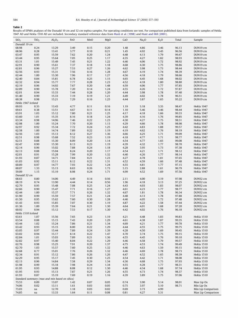
Table 2Results of EPMA analyses of the Dunadd 19 cm and 52 cm tephra samples. For operating conditions see text. For comparison published data from Icelandic samples of Hekla1947 AD and Hekla 1510 AD are included. Secondary standard reference data from Hunt et al. (1998) and Hunt and Hill (2001).
SiO2 TiO2 Al2O3 FeO MnO MgO CaO Na2O K2O Total Sample
Dunadd 19 cm68.98 0.24 13.29 3.49 0.15 0.20 1.48 4.86 3.46 96.13 DUN19 cm68.96 0.28 13.41 3.77 0.10 0.21 1.45 4.92 3.45 96.56 DUN19 cm63.47 0.95 15.59 7.62 0.20 1.24 4.48 4.13 1.79 99.47 DUN19 cm63.44 0.95 15.64 7.05 0.25 1.17 4.35 4.27 1.82 98.93 DUN19 cm63.31 1.01 15.49 7.45 0.21 1.22 4.46 4.06 1.72 98.92 DUN19 cm62.91 0.90 15.61 7.37 0.18 1.18 4.68 4.30 1.75 98.86 DUN19 cm62.81 0.96 15.27 7.53 0.27 1.26 4.62 3.98 1.73 98.44 DUN19 cm62.56 0.93 15.31 7.56 0.16 1.28 4.67 4.19 1.74 98.39 DUN19 cm62.44 1.00 15.30 7.96 0.17 1.27 4.56 4.18 1.79 98.66 DUN19 cm62.40 0.84 15.81 6.78 0.25 1.15 4.65 4.45 1.68 98.02 DUN19 cm62.32 0.94 15.77 7.77 0.28 1.23 4.52 4.18 1.80 98.80 DUN19 cm62.19 0.96 14.92 7.67 0.20 1.48 4.59 4.06 1.77 97.85 DUN19 cm62.09 0.90 15.78 7.20 0.14 1.24 4.55 4.26 1.72 97.87 DUN19 cm62.01 0.94 15.33 7.44 0.28 1.20 4.44 3.98 1.78 97.40 DUN19 cm61.40 0.90 15.33 7.19 0.19 1.21 4.49 4.02 1.78 96.51 DUN19 cm60.38 0.98 15.21 7.29 0.16 1.25 4.44 3.87 1.65 95.22 DUN19 cmHekla 1947 Iceland69.93 0.35 13.43 4.77 0.11 0.16 1.19 5.18 3.35 98.47 Hekla 194769.61 0.38 13.51 4.67 0.11 0.14 1.10 5.46 3.46 98.44 Hekla 194763.91 1.03 15.12 7.80 0.21 1.25 4.17 4.18 1.66 99.33 Hekla 194763.60 1.01 15.35 8.16 0.18 1.24 4.39 4.16 1.76 99.85 Hekla 194763.34 0.98 14.96 7.46 0.22 1.23 4.30 4.27 1.75 98.51 Hekla 194762.98 1.00 15.24 7.70 0.20 1.13 4.29 4.66 1.78 98.98 Hekla 194762.97 0.92 15.34 7.72 0.24 1.25 4.42 4.83 1.88 99.57 Hekla 194762.58 1.00 14.74 7.89 0.22 1.19 4.19 4.62 1.76 98.19 Hekla 194762.56 1.03 15.13 8.12 0.27 1.36 4.66 4.25 1.71 99.09 Hekla 194762.51 0.98 15.68 7.52 0.23 1.19 4.18 4.77 1.71 98.77 Hekla 194762.51 0.88 15.30 8.09 0.20 1.14 4.54 4.77 1.65 99.08 Hekla 194762.47 0.90 15.30 8.13 0.23 1.19 4.39 4.32 1.77 98.70 Hekla 194762.14 0.96 15.02 7.88 0.24 1.18 4.28 3.95 1.73 97.38 Hekla 194762.13 0.88 15.04 8.24 0.20 1.17 4.54 4.21 1.71 98.12 Hekla 194762.01 0.91 15.28 7.99 0.20 1.32 4.40 4.26 1.77 98.14 Hekla 194761.93 0.87 14.71 7.84 0.21 1.23 4.27 4.78 1.81 97.65 Hekla 194761.03 0.92 15.11 8.12 0.22 1.31 4.52 4.59 1.66 97.48 Hekla 194760.89 0.97 14.77 7.93 0.22 1.24 4.55 4.81 1.77 97.15 Hekla 194760.07 1.33 15.13 8.63 0.26 1.73 5.15 2.88 1.61 96.79 Hekla 194759.09 1.15 15.19 8.98 0.24 1.71 4.99 4.52 1.69 97.56 Hekla 1947Dunadd 52 cm68.63 0.80 14.06 4.49 0.14 0.56 2.11 4.00 3.19 97.98 DUN52 cm68.19 0.74 13.90 4.44 0.14 0.56 1.96 4.18 3.13 97.25 DUN52 cm62.79 0.95 15.48 7.08 0.25 1.24 4.43 4.03 1.83 98.07 DUN52 cm62.66 0.90 15.47 7.71 0.16 1.27 4.61 4.23 1.77 98.77 DUN52 cm62.44 1.00 15.37 7.71 0.26 1.32 4.67 1.81 1.78 96.34 DUN52 cm61.90 0.99 15.59 7.57 0.21 1.24 4.48 4.13 1.78 97.88 DUN52 cm61.50 0.95 15.62 7.60 0.30 1.28 4.46 4.05 1.72 97.48 DUN52 cm61.43 0.93 15.85 7.07 0.30 1.19 4.87 4.22 1.58 97.44 DUN52 cm61.36 1.00 15.39 7.64 0.21 1.30 4.64 4.01 1.68 97.20 DUN52 cm60.92 0.94 15.12 7.53 0.17 1.30 4.42 4.02 1.76 96.18 DUN52 cmHekla 1510 Iceland63.61 1.07 15.56 7.65 0.23 1.19 4.21 4.48 1.83 99.83 Hekla 151063.54 0.88 15.15 7.43 0.20 1.29 4.61 4.38 1.87 99.35 Hekla 151063.44 1.02 15.24 7.86 0.21 1.34 4.69 4.21 1.77 99.78 Hekla 151063.42 0.93 15.15 8.00 0.22 1.29 4.44 4.55 1.75 99.75 Hekla 151063.05 0.97 15.44 7.89 0.24 1.39 4.28 4.50 1.69 99.45 Hekla 151063.02 0.94 15.17 8.14 0.22 1.47 4.70 3.74 1.75 99.15 Hekla 151062.84 1.01 15.03 7.89 0.21 1.36 4.55 4.45 1.76 99.10 Hekla 151062.82 0.97 15.40 8.04 0.22 1.29 4.46 4.58 1.79 99.57 Hekla 151062.76 0.98 15.25 7.91 0.20 1.37 4.75 4.53 1.74 99.49 Hekla 151062.70 1.03 15.57 7.60 0.25 1.32 4.46 4.63 1.59 99.15 Hekla 151062.68 0.77 15.01 7.76 0.26 1.32 4.46 4.69 1.78 98.73 Hekla 151062.34 0.91 15.12 7.86 0.26 1.26 4.47 4.52 1.65 98.39 Hekla 151062.29 0.95 15.17 7.45 0.30 1.25 4.54 4.42 1.71 98.08 Hekla 151062.13 0.96 14.84 7.58 0.29 1.34 4.36 4.68 1.75 97.93 Hekla 151061.98 0.99 15.18 7.98 0.24 1.34 4.55 4.28 1.77 98.31 Hekla 151061.95 0.93 14.88 8.08 0.12 1.30 4.46 4.34 1.68 97.74 Hekla 151061.95 0.93 15.13 7.87 0.21 1.26 4.55 4.73 1.74 98.37 Hekla 151061.93 0.87 15.19 7.69 0.19 1.16 4.39 3.89 1.75 97.06 Hekla 1510Standard summary (max and min based on silica)73.53 0.09 13.07 1.42 0.07 0.05 0.74 3.90 5.14 98.01 Max Lip Ox74.06 0.02 13.11 1.61 0.03 0.05 0.75 3.97 5.10 98.71 Min Lip Ox73.03 na 12.70 1.18 0.03 0.02 0.69 3.73 4.99 Min Lip Comparison74.85 na 13.33 1.64 0.11 0.08 0.81 4.27 5.31 Max Lip Comparison
R.A. Housley et al. / Journal of Archaeological Science 37 (2010) 577–593584
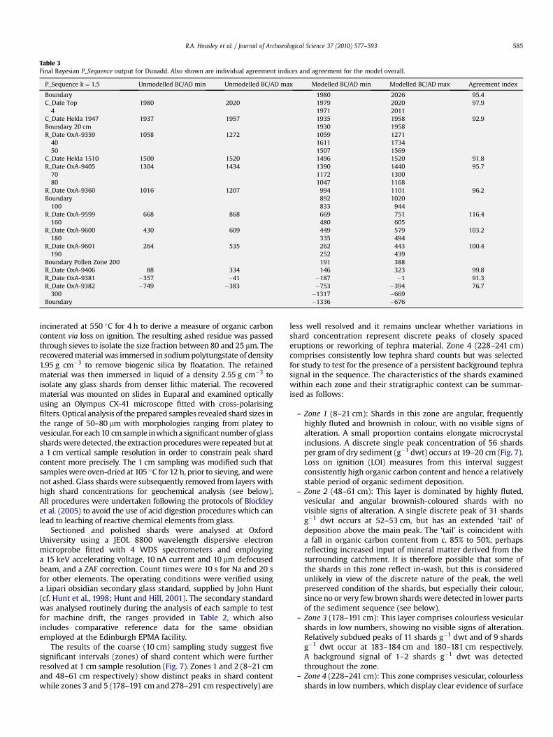
Table 3Final Bayesian P_Sequence output for Dunadd. Also shown are individual agreement indices and agreement for the model overall.
P_Sequence k ¼ 1.5 Unmodelled BC/AD min Unmodelled BC/AD max Modelled BC/AD min Modelled BC/AD max Agreement index
Boundary 1980 2026 95.4C_Date Top 1980 2020 1979 2020 97.9
4 1971 2011C_Date Hekla 1947 1937 1957 1935 1958 92.9Boundary 20 cm 1930 1958R_Date OxA-9359 1058 1272 1059 1271
40 1611 173450 1507 1569
C_Date Hekla 1510 1500 1520 1496 1520 91.8R_Date OxA-9405 1304 1434 1390 1440 95.7
70 1172 130080 1047 1168
R_Date OxA-9360 1016 1207 994 1101 96.2Boundary 892 1020
100 833 944R_Date OxA-9599 668 868 669 751 116.4
160 480 605R_Date OxA-9600 430 609 449 579 103.2
180 335 494R_Date OxA-9601 264 535 262 443 100.4
190 252 439Boundary Pollen Zone 200 191 388R_Date OxA-9406 88 334 146 323 99.8R_Date OxA-9381 �357 �41 �187 �1 91.3R_Date OxA-9382 �749 �383 �753 �394 76.7
300 �1317 �669Boundary �1336 �676
R.A. Housley et al. / Journal of Archaeological Science 37 (2010) 577–593 585
incinerated at 550 �C for 4 h to derive a measure of organic carboncontent via loss on ignition. The resulting ashed residue was passedthrough sieves to isolate the size fraction between 80 and 25 mm. Therecovered material was immersed in sodium polytungstate of density1.95 g cm�3 to remove biogenic silica by floatation. The retainedmaterial was then immersed in liquid of a density 2.55 g cm�3 toisolate any glass shards from denser lithic material. The recoveredmaterial was mounted on slides in Euparal and examined opticallyusing an Olympus CX-41 microscope fitted with cross-polarisingfilters. Optical analysis of the prepared samples revealed shard sizes inthe range of 50–80 mm with morphologies ranging from platey tovesicular. For each 10 cm sample inwhich a significant number of glassshards were detected, the extraction procedures were repeated but ata 1 cm vertical sample resolution in order to constrain peak shardcontent more precisely. The 1 cm sampling was modified such thatsamples were oven-dried at 105 �C for 12 h, prior to sieving, and werenot ashed. Glass shards were subsequently removed from layers withhigh shard concentrations for geochemical analysis (see below).All procedures were undertaken following the protocols of Blockleyet al. (2005) to avoid the use of acid digestion procedures which canlead to leaching of reactive chemical elements from glass.
Sectioned and polished shards were analysed at OxfordUniversity using a JEOL 8800 wavelength dispersive electronmicroprobe fitted with 4 WDS spectrometers and employinga 15 keV accelerating voltage, 10 nA current and 10 mm defocusedbeam, and a ZAF correction. Count times were 10 s for Na and 20 sfor other elements. The operating conditions were verified usinga Lipari obsidian secondary glass standard, supplied by John Hunt(cf. Hunt et al., 1998; Hunt and Hill, 2001). The secondary standardwas analysed routinely during the analysis of each sample to testfor machine drift, the ranges provided in Table 2, which alsoincludes comparative reference data for the same obsidianemployed at the Edinburgh EPMA facility.
The results of the coarse (10 cm) sampling study suggest fivesignificant intervals (zones) of shard content which were furtherresolved at 1 cm sample resolution (Fig. 7). Zones 1 and 2 (8–21 cmand 48–61 cm respectively) show distinct peaks in shard contentwhile zones 3 and 5 (178–191 cm and 278–291 cm respectively) are
less well resolved and it remains unclear whether variations inshard concentration represent discrete peaks of closely spacederuptions or reworking of tephra material. Zone 4 (228–241 cm)comprises consistently low tephra shard counts but was selectedfor study to test for the presence of a persistent background tephrasignal in the sequence. The characteristics of the shards examinedwithin each zone and their stratigraphic context can be summar-ised as follows:
– Zone 1 (8–21 cm): Shards in this zone are angular, frequentlyhighly fluted and brownish in colour, with no visible signs ofalteration. A small proportion contains elongate microcrystalinclusions. A discrete single peak concentration of 56 shardsper gram of dry sediment (g�1 dwt) occurs at 19–20 cm (Fig. 7).Loss on ignition (LOI) measures from this interval suggestconsistently high organic carbon content and hence a relativelystable period of organic sediment deposition.
– Zone 2 (48–61 cm): This layer is dominated by highly fluted,vesicular and angular brownish-coloured shards with novisible signs of alteration. A single discrete peak of 31 shardsg�1 dwt occurs at 52–53 cm, but has an extended ‘tail’ ofdeposition above the main peak. The ‘tail’ is coincident witha fall in organic carbon content from c. 85% to 50%, perhapsreflecting increased input of mineral matter derived from thesurrounding catchment. It is therefore possible that some ofthe shards in this zone reflect in-wash, but this is consideredunlikely in view of the discrete nature of the peak, the wellpreserved condition of the shards, but especially their colour,since no or very few brown shards were detected in lower partsof the sediment sequence (see below).
– Zone 3 (178–191 cm): This layer comprises colourless vesicularshards in low numbers, showing no visible signs of alteration.Relatively subdued peaks of 11 shards g�1 dwt and of 9 shardsg�1 dwt occur at 183–184 cm and 180–181 cm respectively.A background signal of 1–2 shards g�1 dwt was detectedthroughout the zone.
– Zone 4 (228–241 cm): This zone comprises vesicular, colourlessshards in low numbers, which display clear evidence of surface

0 50 100 150 200 250 300
0 20 40 60 80 100
8
10
12
14
16
18
20DUN-19
0 20 40 60 80 100
48
50
52
54
56
58
60
DUN-52
0 20 40 60 80 100
178
180
182
184
186
188
190
0 20 40 60 80 100
228
230
232
234
236
238
240
0 20 40 60 80 100
278
280
282
284
286
288
290
ZONE 1
ZONE 2
ZONE 3
ZONE 4
ZONE 5
1 cm SHARD COUNT REFINEMENT10 cm TEPHRA RANGEFINDERS
ZONE 1
ZONE 2
ZONE 3
ZONE 4
ZONE 5
STRATIGRAPHY
**
**
Shards per 2 cubic cm
Shards per gram of dry sediment
Colourless tephra shards Brownish tephra shardsKEY: ** WDS EPMA analyses has been obtained on these tephra layers
TbS1 Th2 Gs1 Gs3 Th1 TbS2 Tl2Wood fragment
Tb2Ld1Dl1 Gs2
0
50
100
150
200
250
300
350
Dep
th (c
m)
DUN-19
TEPHRA SHARD IMAGES
DUN-52
Fig. 7. 10 cm scan and 1 cm detailed shard counts (per 1 g dry weight for 1 cm) against depth for the observed Dunadd tephra, plotted against core stratigraphy (symbols afterTroels-Smith, 1955). Also shown are examples of tephra shards from Dunadd-19 and Dunadd-52.
R.A. Housley et al. / Journal of Archaeological Science 37 (2010) 577–593586
damage. A peak of 13 shards g�1 dwt was detected at 239–240 cm while a background signal of 3–4 shards g�1 dwt wasdetected throughout the zone.
– Zone 5 (278–291 cm): In the initial coarse-resolution study,both clear and brown shards were detected, whilst only clearshards were recovered from the 1 cm samples. A small peak of15 shards g�1 dwt was detected at 278–279 cm, which does notaccord with the ‘peak’ shard count of the coarse-resolutionstudy (280–290 cm). There is a background signal of 1–2 shardsthroughout the zone, whilst all observed shards showedevidence of surface modification.
In conclusion, little confidence can be attached to the dataobtained from zones 3–5, due to the lack of pronounced shard peaks,the persistent background signal of low shard numbers and the poorpreservation of many of the shards. It is not possible on availableevidence to demonstrate that discrete and volcanic events are rep-resented by these data; it seems more likely that they representcontinuously reworked material. More confidence can be attached tothe discrete peaks identified in Zones 1 and 2, however, and thesewere therefore selected for further study, including geochemicalanalysis.
5. Geochemical analysis of tephra layers
Glass shards were extracted from the Dunadd meander sedi-ment sequence at horizons 19–20 cm and 52–53 cm, the locationsof peak shard concentrations within tephra zones 1 and 2 respec-tively. Adopting the lower limit of 95% for analytical totals of majorelement ratios derived from Icelandic distal tephras (recommendedby Hunt and Hill, 1993), 16 shards from the 19–20 cm peak (here-after termed Dunadd-19) and 10 from the 52–53 cm peak (Dunadd-52) yielded acceptable data (Table 2), with most of the analyticaltotals in the range 97–98 wt%. These results are comparable withanalytical totals obtained from Holocene tephra deposits in Iceland(Larsen et al., 1999). The geochemical data conform to expectedranges for the chemistry of purely vitreous Icelandic ash samples.There was no evidence of microcrystalline inclusions in the shardsanalysed which can distort chemical data obtained from distal ashshards. The geochemical analyses derived from the two upperDunadd tephra layers are therefore regarded as suitable for statis-tical comparison with published data for known Icelandic eruptionsthat have generated distal ash.
The chemical data obtained from the two Dunadd meandertephra layers are very similar (Table 2). Both represent the products
45 55 65 75
01
23
4
TiO
2
SiO2
45 55 65 75
1213
1415
1617
Al 2O
3
SiO2
45 55 65 75
01
23
45
6
MgO
SiO2
45 55 65 75
24
68
1012
CaO
SiO2
45 55 65 75
23
45
67
Na 2
O
SiO2
45 55 65 75
12
34
K2O
SiO2
45 55 65 75
24
68
1014
FeO
t
SiO2
A sk ja 1875A DE y jafallajokull 1821A DHek la 1104A DHek la 1158A DHek la 1300A DHek la 1510A DHek la 1845A DHek la 1947A DDunadd 19cmDunadd 52cm
0
2
4
6
8
10
12
40 45 50 55 60 65 70 75 80
SiO2
K2O
+N
a2O
DUN19cmDUN52cmHekla 1947Hekla 1510Askja 1875Eyjafallajokull 1821Hekla 1104
Hekla 1158Hekla 1300Hekla 1845
a
b
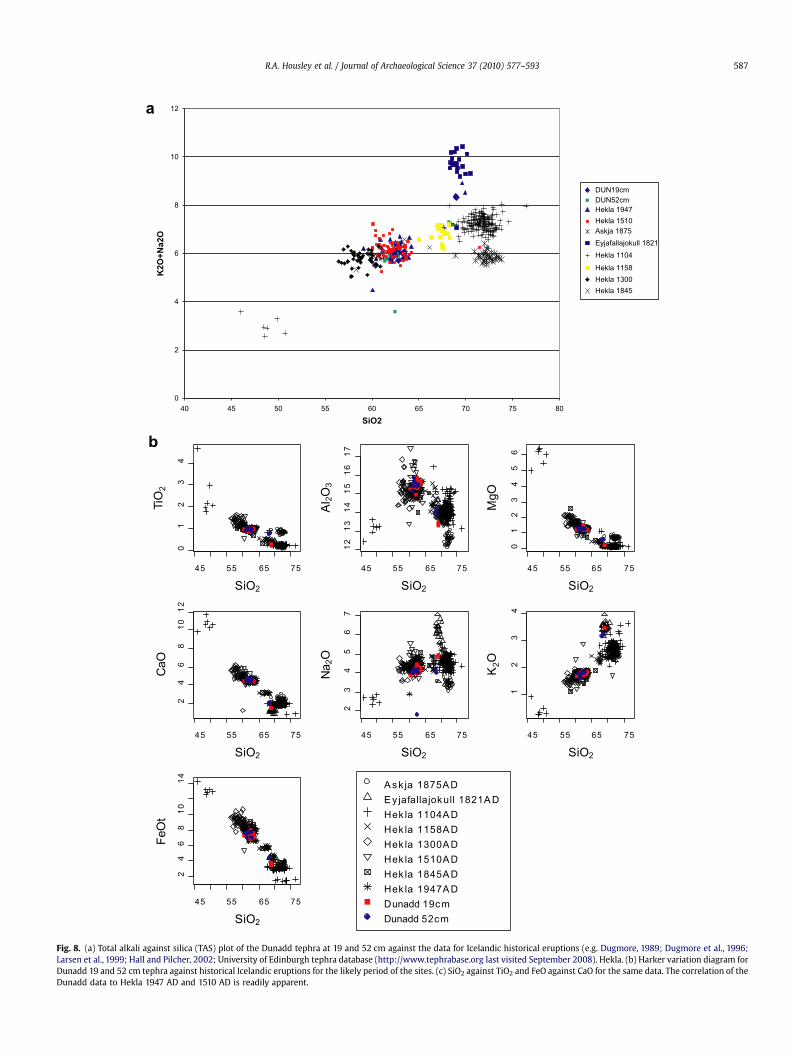
Fig. 8. (a) Total alkali against silica (TAS) plot of the Dunadd tephra at 19 and 52 cm against the data for Icelandic historical eruptions (e.g. Dugmore, 1989; Dugmore et al., 1996;Larsen et al., 1999; Hall and Pilcher, 2002; University of Edinburgh tephra database (http://www.tephrabase.org last visited September 2008). Hekla. (b) Harker variation diagram forDunadd 19 and 52 cm tephra against historical Icelandic eruptions for the likely period of the sites. (c) SiO2 against TiO2 and FeO against CaO for the same data. The correlation of theDunadd data to Hekla 1947 AD and 1510 AD is readily apparent.
R.A. Housley et al. / Journal of Archaeological Science 37 (2010) 577–593 587

45 50 55 60 65 70 75
01
34
SiO2
TiO
2
Askja AD 1875Eyjafallajokull AD 1821Hekla AD 1104Hekla AD 1158Hekla AD 1300
Hekla AD 1510Hekla AD 1845Hekla AD 1947Dunadd 19cmDunadd 52cm
56 58 60 62 64
0.6
0.8
1.0
1.2
1.4
1.6
SiO2
TiO
2
2 4 6 8 10 12 14
2
2
46
810
12
FeO
CaO
A sk ja AD 1875E y jafallajokull AD 1821Hek la AD 1104Hek la AD 1158Hek la AD 1300
Hek la AD 1510Hek la AD 1845Hek la AD 1947Dunadd 19cmDunadd 52cm
6 7 8 9 10 11
3.5
4.0
4.5
5.0
5.5
6.0
6.5
FeO
CaO
c
Fig. 8. (continued).
R.A. Housley et al. / Journal of Archaeological Science 37 (2010) 577–593588
of silicic eruptions – predominately andesitic to dacitic – with small,more-evolved sub-populations trending to dacitic in the case ofDunadd-52 and to trachydacitic in the case of Dunadd-19. These dataare consistent with volcanic products originating from Iceland,which is the predominant source of late Quaternary ash layersdetected in sites in Britain and Ireland.
The radiocarbon chronology suggests that the upper metre of theDunadd core most likely spans the last 1000 years. At least 24 Icelandicsilicic eruptions are known to have been emitted from Icelandicvolcanic centres during that interval (Larsen et al.,1999), including thewell-known Hekla eruptions of 1947 AD, 1845 AD, 1510 AD, 1300 AD,1158 AD and 1104 AD, as well as eruptions of Askja in 1875 AD and ofEyjafjallajokull in 1821 AD. Many of these eruptions are known to havedeposited distal ash in northern Britain and Ireland (e.g. Dugmore,1989; Dugmore et al., 1996; Larsen et al., 1999; Hall and Pilcher, 2002;Wastegård, 2002). The Dunadd results were statistically comparedwith a database of geochemical data for proximal Icelandic eruptivematerial and their corresponding distal ashes available at theUniversity of Edinburgh (http://www.tephrabase.org).
The geochemical similarity of the Dunadd ash layers and theirlargely andesitic and dacitic composition suggest that they areproducts of the same volcanic source. The results were comparedwith geochemical data obtained from Icelandic eruptions ofhistorical age except for the Hekla 1845 AD eruption for which theonly data currently available are from ash deposits on the FaroeIslands (Wastegård, 2002). Total alkali-silica bi-plots (Le Bas et al.,1986) indicate close affinity of the Dunadd data with the transi-tional-alkali products of Hekla (Fig. 8a), while FeO/SiO2 and CaO/SiO2 totals plotted in a Harker variation diagram (Fig. 8b; a plot ofall major oxides against silica) suggest a separation of the Dunadd,Hekla 1947 AD and 1510 AD data from those of other Hekla prod-ucts. For clarity, plots of TiO2/SiO2 and FeO/CaO ratios are high-lighted (Fig. 8c) as these clearly separate the Dunadd and Hekla1947/1510 AD from the remaining Hekla products, and suggesta clear correlation of Dunadd-19 with Hekla 1947 AD and Dunadd-52 with Hekla 1510 AD The results are also compatible with modelsof formation of Hekla magma, which are generated by partialmelting of the crust leading to mixing of silicic and basaltic magmas

-8-6
-4-2
02
46
810
-8-6
-4-2
02
46
-10
-5
0
5
1st canonical axis2nd canonical axis
3rd
cano
nica
l axi
s
Group 'DUN19cm'Group 'DUN52cm'Group 'Hekla1947'Group 'Hekla1510'Group 'Askja1875'Group 'Eyjafallajokull1821'Group 'Hekla1104'Group 'Hekla1158'Group 'Hekla1300'Group 'Hekla1845'
Fig. 9. Log-ratio canonical analyses of the Dunadd tephra at 19 and 52 cm against the data for Icelandic historical eruptions. All log ratios are to Al2O3, after Pollard et al. (2006);using the geochemical software OXCOMP, see Lowe et al. (2007) and Turney et al. (2008).
R.A. Housley et al. / Journal of Archaeological Science 37 (2010) 577–593 589
(Sverrisdottir, 2007). Over the historical period this has generatedtephras with very similar whole rock chemistries but which aredistinguishable only on variations in FeO, CaO and TiO2 content,which is also the case with the Dunadd material. Moreover the veryclose chemical similarity of Hekla 1947 and 1510 AD is well docu-mented in the literature and is mirrored in the Dunadd samples.
These conclusions were also tested using canonical analysis(Fig. 9) of the data after the results for each element were log-ratiotransformed to Al2O3. The data were plotted using the 1st, 2nd and3rd canonical axes, i.e. three linear transforms of the data, wheresamples with similar ratios of elements show very similar canonicalscores for each axis, a procedure commonly adopted usingdiscrimination function analysis (see e.g. Lowe et al., 2007; Pollardet al., 2008). These methods have the advantage of summarising thescatter and overlap tendencies using all of the available data. Theresults indicate a discrete cluster of the Dunadd, Hekla 1947 AD andHekla 1510 AD data, a tendency also displayed when log-ratiotransforms of the most discriminative chemical oxides are exam-ined. For example, bi-plots of log-ratio SiO2–TiO2 values (Fig 8b) forthe combined Dunadd tephra clearlyexhibit the best match betweenDunadd and Hekla 1947 AD and Hekla 1510 AD, when compared toall the Icelandic data. In the light of the available evidence, therefore,it is concluded that the two tephra layers detected in the lateHolocene part of the Dunadd record are most likely to have beenderived from the Hekla 1510 AD and 1947 AD volcanic eruptions.
6. Age model construction
The majority of the calibrated radiocarbon dates from theDunadd sequence (Table 1; Fig. 10) show a reasonably coherentage–depth plot; two notable exceptions, however, are the twolowermost dates, suggesting an age reversal from the mediantrend in excess of c. 500 cal years. This evidence, together with theavailable sedimentological, tephrostratigraphical and biostrati-graphic information from the site, suggests that the lower part ofthe Dunadd sequence, below 270 cm, may have been significantlyaffected by sediment reworking and possibly groundwater influx.Down-working of younger material into the soft sediments at the
base of the sequence is also possible. For these reasons, an agemodel is developed only for the upper 312 cm of the sequence,and the lower part is excluded from further consideration in thispaper.
The 10 radiocarbon determinations obtained from the upper312 cm of the sequence appear to form a generally linear trend,within the broad uncertainties of calibrated radiocarbon data(Fig. 10). The discrepancies in the upper 100 cm of the sequence are,however, not resolved by calibration. These may reflect the influ-ence of reworked older organic material, as an increased minero-genic component in the upper sediments suggests the influx ofalluvial material (see below). It is difficult, however, to judge thecoherency of the data-set and the degree to which individual valuesrepresent statistical ‘outliers’ merely by eye-balling the plotteddata, especially because the probability densities of calibratedradiocarbon dates are not normally distributed. Bayesian-based agemodelling approaches have therefore been developed to deal withthis problem (Buck et al., 1991), and are now widely employed inarchaeological and Quaternary stratigraphic studies (e.g. Baylisset al., 1997; Blockley et al., 2004; Petrie and Torrence, 2008;Wohlfarth et al., 2006; Blockley et al., 2008).
Here we employed formal models developed by Bronk Ramsey(2001, 2008) that assume that age increases with depth and thatany sedimentation rate between dated horizons is equally likely(the uniform prior). The models incorporate tests of coherencybetween the IntCal04 calibration data-set and the age–deptharrangement of the suite of Dunadd radiocarbon ages. The twoindependently dated (historical) tephra layers provide a further testof the validity and coherency of the model results. The tephra layerswere assigned an arbitrary depositional time uncertainty of�5 years, a value considered realistic in view of (a) estimates of therate of sedimentation for corresponding intervals indicated by theradiocarbon data and (b) the very tightly constrained peaks intephra distribution. Bayesian modelling was conducted using theP_Sequence approach in OxCal (Bronk Ramsey, 2008). This simu-lates incremental deposition, an element of which is random, usingPoisson equations, and allows the operator to define the relativedepth positions at which the radiocarbon measurements are

Boundary300
R_Date OxA-9382
R_Date OxA-9381
R_Date OxA-9406
Boundary Pollen Zone 200
R_Date OxA-9601
R_Date OxA-9600
R_Date OxA-9599
R_Date OxA-9598?
Boundary
R_Date OxA-9360
R_Date OxA-9405
C_Date Hekla 1510
R_Date OxA-9359?
Boundary 20cmC_Date Hekla 1947
4
Boundary
01000200030004000Modelled date (BP)
0
100
200
300
Pos
ition
OxCal v4.1.0 Bronk Ramsey (2008); r:5 IntCal04 atmospheric curve (Reimer et al 2004)
C_Date Top
Fig. 10. Bayesian age–depth model (youngest at top) for the Dunadd radiocarbon data and inferred historical ages for the Dunadd tephra, based on the correlations (above) to Hekla1947 AD (19 cm) and Hekla 1510 AD (52 cm). The applied model is a P_Sequence depositional model using a low k factor applied using the OxCal 4.0 software (Bronk Ramsey, 2008).The uppermost radiocarbon date in this sequence is rejected from this model and appears to be reworked into the sequence at a later date. This age model is accepted as the finalchronology for the Dunadd record.
R.A. Housley et al. / Journal of Archaeological Science 37 (2010) 577–593590
incorporated into the model. This approach, which integrates theavailable chronological and stratigraphic information to determinethe most likely age–depth relationship, has been tested usinga number of simulated records of varying deposition rate and ina range of sedimentary scenarios, including records which haveadditional age–depth constraints, such as tephra layers (Blockleyet al., 2007, 2008). In all cases the model performed well.P_Sequence simulation requires specification of the number ofdepositional increments added per unit depth interval, which canbe constrained by applying a limiting parameter, termed k. Theappropriate value of k to use is not known, but can be varied
iteratively to test which value generates coherent results (seeBlockley et al., 2007 for details). In the Dunadd study, a k factor of1.5 depositional events per cm per year was employed, which isa conservative value that does not over-constrain the model,allowing the depositional rate to be set by the radiocarbon andtephra data. Constraining the model more tightly is more appro-priate for sequences characterised by regular incremental sedi-mentation, such as annually laminated archives. The k factorcontrols the rigidity with which age–depth models can be con-strained, i.e. the level of flexibility permitted when varying thedeposition rate; it does not set the deposition rate itself.

RoyalOccupation
CH-2
CH-1
DD1
DD2
DD3
DD4
DD5
-50450
9501450
19502450
29503450
Cal a
ge
B
P
0 20
Charcoal
0 20 40 60 80
Woodland
0 20 40
Heath
0 20 40
Marsh
0 20 40 60 80
Open
Fig. 11. Summary pollen diagram scaled using the age model from this study with associated age error bars. CH-1 and CH-2 represent peaks in microscopic charcoal; zoneboundaries and period of royal occupation of Dunadd are also marked.
R.A. Housley et al. / Journal of Archaeological Science 37 (2010) 577–593 591
The P_Sequence output (Fig. 10) suggests the uppermost radio-carbon date (OxA-9539) in the Dunadd data-set to be too old, possiblyas a result of the deposition of reworked (secondary) macrofossils inthis part of the sequence. This date was least compatible with theradiocarbon data-set as a whole and is therefore rejected. When thisdate is excluded and the model re-run, the results suggest a relativelyeven depositional rate for the sequence. Combining tephra historicalages with the radiocarbon information using this Bayesian-basedapproach allows 95% confidence ranges to be significantly narrowed.For the upper part of the record, the age model generates highestprobability density uncertainty ranges of between 20 and 50 years atthe 95% confidence level. This rises to 100 to 200 years with 95%uncertainty for the remainder of the sequence.
7. Palaeoenvironmental synthesis
The combined tephrostratigraphical and radiocarbon evidence, aswell as the LOI, pollen-stratigraphic and plant macrofossil datasuggest that the lowermost part of the Dunadd sequence (zones DD-1and DD-2) may have been affected by sediment reworking. Bycomparison, the upper part of the sequence appears much lessproblematic, with little direct evidence for significant sedimentreworking, while the two preserved tephra layers discussed aboveappear to represent primary air-fall events. This distinction isconsidered important when assessing the taphonomy of the palae-obotanical remains and their palaeoenvironmental significance.
The fact that the pollen/spore and plant macrofossil data do notproduce consistent linked patterning strongly suggests that there isheterogeneity in the macrofossil and pollen input sources. Plantmacrofossils would be expected to derive from the local or perhapsthe extra-local environment (Jacobson and Bradshaw, 1981) bywhich we mean the actual investigation site and its very immediatevicinity. However, reworking in zones DD-1 and 2, and to a lesserextent in DD-4 and DD-5 could mean that some plant macrofossils
were carried in currents from sources higher in the Add catchment.Differences in macrofossil and pollen counts may, in part, be due todifferences in differential preservation (e.g. Juncus which is onlyusually recognised in macrofossil assemblages and only very rarelyas pollen), though this cannot account for all the differences. Someof the pollen/spores and the micro-charcoal may derive from extra-local and regional sources (sensu Jacobson and Bradshaw, 1981) andnot just the immediate sampling environment. Dry woodland trees(e.g. Pinus, Quercus, Ulmus) are present in small counts andalthough wet woodland taxa (Alnus, Betula, Salix) dominate theassemblages, other input sources need consideration. The RiverAdd passing close to the royal centre of Dunadd would haveprovided a source of transport for a waterborne vegetationcomponent bringing pollen/spores and macrofossils from greaterdistances upstream; that said the Add only extends for 15 kmupstream. The Moine Mhor may be a ‘great bog’ (as the Gaelic nameimplies) and thus an important source of the vegetation input tothe study site but multiple input sources are needed to explain thedifferences between the pollen/spore and macrofossil signals; localinflux cannot solely account for the observed patterning. Thesetaphonomic influences complicate interpretations of the data interms of their palaeoenvironmental significance.
These complexities notwithstanding, there are clear, persistenttrends and important sudden shifts in the data that may have morethan local plant successional significance. The timing of thesechanges is crucial, and hence they are best viewed using themodelled temporal (Fig.11) rather than depth scale (Figs. 4, 5). Thereis a long-term gradual decline in percentages of woodland taxathroughout zones DD-1 to DD-3 which is accelerated within DD-3 atc.1515–1385 cal BP. The opposite trend can be seen in the percentageof open ground taxa, the evidence suggesting progressive decline inlocal woodland cover. The royal occupation of Dunadd is thought tohave commenced about 100 years after this accelerated change inthe landscape, and a causal connection cannot be ruled out (see
R.A. Housley et al. / Journal of Archaeological Science 37 (2010) 577–593592
below). The decline in woodland taxa and increase in open ground issharply reversed at around 1000–900 cal BP, very close in timing tothe end of the royal occupation period. The very pronounced rise intree pollen percentages (from less than 30 to c. 65% total land pollen)is unlikely to represent natural vegetation succession; such a rapidchange is more likely to reflect interference in vegetation cover byhumans, perhaps the abandonment of previously-exploited areas topermit re-invasion by trees.
The charcoal records suggest that fire may have had at leasta significant temporary effect on the local vegetation. Based on themacro-charcoal evidence, on-site burning at the study site is confinedto the base of zone DD-1 and at 900–1020 cal BP, close to the DD-3/DD-4 zone boundary (Fig. 4). The micro-charcoal records suggestmore general burning in the vicinity (Figs. 5, 11), with perhaps moreintense local fires at around 1900–1700 cal BP. Macklin et al. (2000)have argued that the fire record in the west of Scotland is determinedmore by climate than by anthropogenic activity, although individualpeaks on single sites maycome from the burning of local vegetation ordomestic fires. Blackford and Chambers (1991) argue for a climaticdownturn with greater levels of precipitation in the ‘1400 BP DarkAges’, or 540 AD (Chambers et al., 1997) period, which would bereflected in lower levels of burning. This is indeed the case here, forthe lowest micro-charcoal records occur in zone DD-3, dated to c.1750–1550 to 1020–900 cal BP, encompassing Blackford and Cham-bers (1991) and Chambers et al.’s (1997) proposed climatic downturn.Only very minor increases in micro-charcoal abundance coincidewith the phase of human occupation of the royal centre of Dunadd.The highest counts of micro-charcoal occur at the DD-2/DD-3boundary (c.1750–1550 cal BP); charcoal phase 1, CH-1 in Fig.11), andthe other in the latter half of zone DD-4 (c. 550–250 cal BP; CH-2 inFig. 11). CH-2 coincides with elevated levels of Calluna vulgaris pollen(Fig. 3). This may reflect burning of the Moine Mhor surface in theperiod after c.1020–900 cal BP, which would encompass the MedievalWarm Period. CH-1 occurs just before the accelerated decline inwoodland, previously noted.
The zone DD-4/DD-5 zone boundary (23 cm) is marked by a verypronounced rise in open ground pollen/spores and macrofossils. Thechange from heath and bog to marsh and waterside macrofossilsmay be a reflection of a second marked period of climatic wetnessand could be considered a regional response to the ‘Little Ice Age’(Barber et al., 2000). The chronological model proposed for theDunadd sequence suggests otherwise since the timing of this changeis c. 60–45 cal BP (c. 1890–1905 cal AD). Subsequent studies painta rather more complex picture, with some arguing for a series ofshifts to climatic wetness that affected a large swath of Europe (e.g.Charman et al., 2006) while others point to strong regional vari-ability in peat records obtained from Scotland (Langdon and Barber,2005). A number of studies have concluded that Scottish bog recordsshow evidence of climatic cyclicity (e.g. Chambers et al., 1997;Langdon et al., 2003; Langdon and Barber, 2005), though they do notconform in suggested cyclic frequency. The marsh and watersidemacrofossil summary record (Figs. 4, 11) may point to a degree ofcyclicity, however the overall pattern does not support such a view.
8. Conclusions: the imprint on the record of the royaloccupation of Dunadd
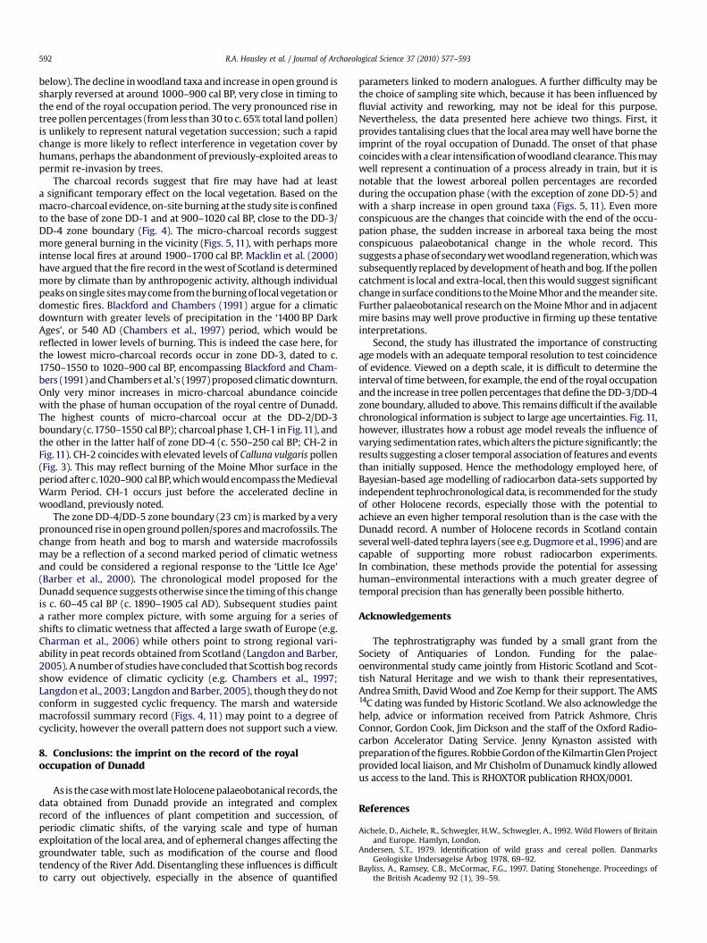
As is the case with most late Holocene palaeobotanical records, thedata obtained from Dunadd provide an integrated and complexrecord of the influences of plant competition and succession, ofperiodic climatic shifts, of the varying scale and type of humanexploitation of the local area, and of ephemeral changes affecting thegroundwater table, such as modification of the course and floodtendency of the River Add. Disentangling these influences is difficultto carry out objectively, especially in the absence of quantified
parameters linked to modern analogues. A further difficulty may bethe choice of sampling site which, because it has been influenced byfluvial activity and reworking, may not be ideal for this purpose.Nevertheless, the data presented here achieve two things. First, itprovides tantalising clues that the local area may well have borne theimprint of the royal occupation of Dunadd. The onset of that phasecoincides with a clear intensification of woodland clearance. This maywell represent a continuation of a process already in train, but it isnotable that the lowest arboreal pollen percentages are recordedduring the occupation phase (with the exception of zone DD-5) andwith a sharp increase in open ground taxa (Figs. 5, 11). Even moreconspicuous are the changes that coincide with the end of the occu-pation phase, the sudden increase in arboreal taxa being the mostconspicuous palaeobotanical change in the whole record. Thissuggests a phase of secondary wet woodland regeneration, which wassubsequently replaced by development of heath and bog. If the pollencatchment is local and extra-local, then this would suggest significantchange in surface conditions to the Moine Mhor and the meander site.Further palaeobotanical research on the Moine Mhor and in adjacentmire basins may well prove productive in firming up these tentativeinterpretations.
Second, the study has illustrated the importance of constructingage models with an adequate temporal resolution to test coincidenceof evidence. Viewed on a depth scale, it is difficult to determine theinterval of time between, for example, the end of the royal occupationand the increase in tree pollen percentages that define the DD-3/DD-4zone boundary, alluded to above. This remains difficult if the availablechronological information is subject to large age uncertainties. Fig. 11,however, illustrates how a robust age model reveals the influence ofvarying sedimentation rates, which alters the picture significantly; theresults suggesting a closer temporal association of features and eventsthan initially supposed. Hence the methodology employed here, ofBayesian-based age modelling of radiocarbon data-sets supported byindependent tephrochronological data, is recommended for the studyof other Holocene records, especially those with the potential toachieve an even higher temporal resolution than is the case with theDunadd record. A number of Holocene records in Scotland containseveral well-dated tephra layers (see e.g. Dugmore et al.,1996) and arecapable of supporting more robust radiocarbon experiments.In combination, these methods provide the potential for assessinghuman–environmental interactions with a much greater degree oftemporal precision than has generally been possible hitherto.
Acknowledgements
The tephrostratigraphy was funded by a small grant from theSociety of Antiquaries of London. Funding for the palae-oenvironmental study came jointly from Historic Scotland and Scot-tish Natural Heritage and we wish to thank their representatives,Andrea Smith, David Wood and Zoe Kemp for their support. The AMS14C dating was funded by Historic Scotland. We also acknowledge thehelp, advice or information received from Patrick Ashmore, ChrisConnor, Gordon Cook, Jim Dickson and the staff of the Oxford Radio-carbon Accelerator Dating Service. Jenny Kynaston assisted withpreparation of the figures. Robbie Gordon of the Kilmartin Glen Projectprovided local liaison, and Mr Chisholm of Dunamuck kindly allowedus access to the land. This is RHOXTOR publication RHOX/0001.
References
Aichele, D., Aichele, R., Schwegler, H.W., Schwegler, A., 1992. Wild Flowers of Britainand Europe. Hamlyn, London.
Andersen, S.T., 1979. Identification of wild grass and cereal pollen. DanmarksGeologiske Undersøgelse Årbog 1978, 69–92.
Bayliss, A., Ramsey, C.B., McCormac, F.G., 1997. Dating Stonehenge. Proceedings ofthe British Academy 92 (1), 39–59.

R.A. Housley et al. / Journal of Archaeological Science 37 (2010) 577–593 593
Beijerinck, W., 1947. Zadenatlas Der Nederlandsche Flora, Ten Behoeve Van DeBotanie, Palaeontologie, Bodemcoutuur En Warenkennis, Omvattende, Naast DeInheemsche Flora, Onze Belangrijkste Cultuurgewassen En VerschillendeAdventiefsoorten. H. Veenman, Wageningen.
Blaauw, M., Christen, J.A., 2005. Radiocarbon peat chronologies and environmentalchange. Applied Statistics 54, 805–816.
Barber, K.E., Maddy, D., Rose, N., Stevenson, A.C., Stoneman, R., Thompson, R., 2000.Replicated proxy-climate signals over the last 2000 yr from two distant UK peatbogs: new evidence for regional palaeoclimate teleconnections. QuaternaryScience Reviews 19, 481–487.
Blackford, J.J., Chambers, F.M., 1991. Proxy records of climate from blanket mires:evidence for a Dark Age (1400 BP) climatic deterioration in the British Isles. TheHolocene 1, 63–67.
Blockley, S.P.E., Lowe, J.J., Walker, M.J.C.,Asioli, A., Trincardi, F., Coope, G.R., Donahue, R.E.,Pollard, A.M., 2004. Bayesian analysis of radiocarbon chronologies: examples fromthe European Late-glacial. Journal of Quaternary Science 19, 159–175.
Blockley, S.P.E., Pyne-O’Donnell, S.D.F., Lowe, J.J., Matthews, I.P., Stone, A.,Pollard, A.M., Turney, C.S.M., Molyneux, E.G., 2005. A new and less destructivelaboratory procedure for the physical separation of distal glass tephra shardsfrom sediments. Quaternary Science Reviews 24, 1952–1960.
Blockley, S.P.E., Blaauw, M., Bronk Ramsey, C., van der Plicht, J., 2007. Building andtesting age models for radiocarbon dates in Lateglacial and Early Holocenesediments. Quaternary Science Reviews 26, 1915–1926.
Blockley, S.P.E., Ramsey, C.B., Lane, C.S., Lotter, A.F., 2008. Improved age modellingapproaches as exemplified by the revised chronology for the Central EuropeanVarved Lake, Soppensee. Quaternary Science Reviews 27, 61–71.
Bronk Ramsey, C., 2001. Development of the radiocarbon calibration program.Radiocarbon 43, 355–363.
Bronk Ramsey, C., 2008. Deposition models for chronological records. QuaternaryScience Reviews 27, 42–60.
Buck, C.E., Kenworthy, J.B., Litton, C.D., Smith, A.F.M., 1991. Combining archaeolog-ical and radiocarbon information: a Bayesian approach to calibration. Antiquity65, 808–821.
Chambers, F.M., Barber, K.E., Maddy, D., Brew, J., 1997. A 5500-year proxy-climateand vegetation record from blanket mire at Talla Moss, Borders, Scotland. TheHolocene 7, 391–399.
Charman, D.J., Blundell, A., Chiverrell, R.C., Hendon, D., Langdon, P.G., 2006.Compilation of non-annually resolved Holocene proxy climate records: stackedHolocene peatland palaeo-water table reconstructions from northern Britain.Quaternary Science Reviews 25, 336–350.
Clapham, A.R., Tutin, T.G., Moore, D.M., 1989. Flora of the British Isles. CambridgeUniversity Press, Cambridge, New York.
Davies, S.M., Turney, C.S.M., Lowe, J.J., 2001. Identification and significance ofa visible, basalt-rich Vedde Ash layer in a Late-glacial sequence on the Isle ofSkye, Inner Hebrides, Scotland. Journal of Quaternary Science 16 (2), 99–104.
Dickson, C.A., 1988. Distinguishing cereal from wild grass pollen: some limitations.Circaea 5, 67–71.
Dugmore, A.J., 1989. Icelandic volcanic ash in Scotland. Scottish GeographicalMagazine 105, 168–172.
Dugmore, A.J., Newton, A.J., Edwards, K.J., Larsen, G., Blackford, J.J., Cook, G.T., 1996.Long-distance marker horizons from small-scale eruptions: British tephra depositsfrom AD 1510 eruption of Hekla, Iceland. Journal of Quaternary Science 11, 511–516.
Grime, J.P., Hodgson, J.G., Hunt, R., 1990. The Abridged Comparative Plant Ecology.Unwin Hyman, London, Boston.
Hall, V.A., Pilcher, J.R., 2002. Late-Quaternary Icelandic tephra in Ireland and GreatBritain: detection, characterization and usefulness. The Holocene 12, 223–230.
Hubbard, C.E., 1968. Grasses: A Guide to their Structure, Identification, Uses, andDistribution in the British Isles. Penguin, Harmondsworth.
Housley, R.A., Campbell, E., Miller, J.J., Ramsay, S., 2004. A high-resolution study ofhuman impact and land use around the first millennium AD royal centre atDunadd, Argyll. In: Housley, R.A., Coles, G. (Eds.), Atlantic Connections andAdaptations: Economies, Environments and Subsistence in Lands Bordering theNorth Atlantic. Symposia of the Association for Environmental Archaeology, No.21, pp. 12–26.
Hunt, J.B., Hill, P.G., 1993. Tephra geochemistry: a discussion of some persistentanalytical problems. Holocene 3, 271–278.
Hunt, J.B., Hill, P.G., 2001. Tephrological implications of beam size-sample sizeeffects in electron microprobe analysis of glass shards. Journal of QuaternaryScience 16, 105–117.
Hunt, J.B., Clift, P.D., Lacasse, C., Vallier, T.L., Werner, R., 1998. Interlaboratorycomparison of electron probe microanalysis of glass geochemistry, in: Saunders,A.D., Larsen, H.C., Wise Jr., S.W. (Eds.), Proceedings of the Ocean DrillingProgram, Scientific Results, Vol. 152.
Jacobson, G.L., Bradshaw, R.H.W., 1981. The selection of sites for palaeovegetationalstudy. Quaternary Research 16 (1), 80–96.
Jermy, A.C., Chater, A.O., David, R.W., 1982. Sedges of the British Isles. BotanicalSociety of the British Isles, London.
Korber-Grohne, U., 1991. Bestimmungsschlussel fur subfossile Juncus samen undgramineen-fruchte. Probleme Der Kustenforschung im Sudlichen Nordseege-biet 18, 169–234.
Lane, A., Campbell, E., 2000. Dunadd: An Early Dalriadic Capital. Oxbow Books, Oxford.Langdon, P.G., Barber, K.E., 2005. The climate of Scotland over the last 5000 years
inferred from multiproxy peatland records: inter-site correlations and regionalvariability. Journal of Quaternary Science 20, 549–566.
Langdon, P.G., Barber, K.E., Hughes, P.D.M., 2003. A 7500-year peat-based palae-oclimatic reconstruction and evidence for an 1100-year cyclicity in bog surfacewetness from Temple Hill Moss, Pentland Hills, southeast Scotland. QuaternaryScience Reviews 22, 259–274.
Larsen, G., Dugmore, A.J., Newton, A.J., 1999. Geochemistry of historical-age silicictephra in Iceland. The Holocene 9, 463–471.
Le Bas, M.J., Le Maitre, R.W., Streckeisen, A., Zanettin, B., 1986. A chemical classifi-cation of volcanic rocks based on the total alkali-silica diagram. Journal ofPetrology 27, 745–750.
Lowe, J.J., Blockley, S.P.E., Trincardi, F., Asioli, A., Cattaneo, A., Matthews, I.P., 2007.Age modelling of late Quaternary marine sequences from the Adriatic:towards improved precision and accuracy. Continental Shelf Research 27,560–582.
Macklin, M.G., Bonsall, C., Davies, F.M., Robinson, M.R., 2000. Human-environmentinteractions during the Holocene: new data and interpretations from the Obanarea, Argyll, Scotland. The Holocene 10, 109–121.
Moore, P.D., Webb, J.A., Collinson, M.E., 1991. Pollen Analysis. Blackwell Science,Oxford, Malden, MA.
Petrie, C.A., Torrence, R., 2008. Assessing the effects of volcanic disasters on humansettlement in the Willaumez Peninsula, Papua New Guinea: a Bayesianapproach to radiocarbon calibration. Holocene 18, 729–744.
Pollard, A.M., Blockley, S.P.E., Lane, C.S., 2006. Some numerical considerations in thegeochemical analysis of distal microtephra. Applied Geochemistry 21,1692–1714.
Pollard, A.M., Blockley, S.P.E., Lane, C.S., 2008. Reply to the comment on ‘‘Somenumerical considerations in the geochemical analysis of distal microtephra’’, byNicholas J.G. Pearce, Charles A. Bendall and John A. Westgate. AppliedGeochemistry 23, 1365–1366.
Punt, W., 1976. The Northwest European Pollen Flora, I: Parts 1–7. Elsevier,Amsterdam, New York.
Reimer, P.J., Baille, M.G.L., Bard, E., Bayliss, A., Warren, B.J., Chanda, B.J.H.,Blackwell, P.G., Buck, C.E., Burr, G.S., Cutler, K.B., Damon, P.E., Edwards, R.L.,Fairbanks, R.G., Friedrich, M., Guilderson, T.P., Hogg, A.G., Hughen, K.A.,Kromer, B., McCormac, G., Manning, S., Bronk Ramsey, C., Reimer, R.W.,Remmele, S., Southon, J.R., Stuiver, M., Talamo, S., Taylor, F.W., van der Plicht, J.,Weyhenmeyer, C.E., 2004. IntCal04 terrestrial radiocarbon age calibration, 0–26 cal kyr BP. Radiocarbon 46, 1029–1058.
Schoch, W.H., Pawlik, B., Schweingruber, F.H., 1988. An Atlas for the Determinationof Frequently Encounter and Ecologically Important Plant Seeds. Haupt, Berneand Stuttgart.
Schweingruber, F.H., 1990. Anatomie Europaischer Holzer: Ein Atlas Zur Bes-timmung Europaischer Baum-, Strauch-, Und Zwergstrauchholzer. Haupt, Berneand Stuttgart.
Stace, C.A., 1997. New Flora of the British Isles. Cambridge University Press,New York.
Stockmarr, J., 1971. Tablets with spores used in absolute pollen analysis. Pollen etSpores 13, 614–621.
Sverrisdottir, G., 2007. Hybrid magma generation preceding Plinian silicic eruptionsat Hekla, Iceland: evidence from mineralogy and chemistry of two zoneddeposits. Geological Magazine 144 (4), 643–659.
Telford, R.J., Heegaard, E., Birks, H.J.B., 2004. All age-depth models are wrong: buthow badly? Quaternary Science Reviews 23, 1–5.
Tephrabase, 2008. http://www.tephrabase.org [accessed September 2008].Tipping, R., 1995. Holocene evolution of a lowland Scottish landscape: Kirkpatrick
Fleming. Part II, regional vegetation and land-use change. The Holocene 5,83–96.
Tomlinson, P., Hall, A.R., 1996. A review of the archaeological evidence for foodplants from the British Isles: an example of the use of the archaeobotanicalcomputer database (ABCD). Internet Archaeology 1. http://intarch.ac.uk/journal/issue1/tomlinson_toc.html.
Troels-Smith, J., 1955. no. 10. Karakterisering af lose jordarter. Characterization ofUnconsolidated Sediments, iv. Series, Vol. 3. Geological Survey of Denmark,Copenhagen.
Turney, C.S.M., Blockley, S.P.E., Lowe, J.J., Branch, N.P., Mastrolorenzo, G., Swindle, J.,Nathan, R., Pollard, A.M., 2008. Geochemical characterisation of Quaternarytephras from the Campanian region. Italy. Quaternary International 178,288–305.
Walker, M.J.C., 2006. Quaternary Dating Methods. John Wiley and Sons, Chichester.Wastegård, S., 2002. Early to middle Holocene silicic tephra horizons from the Katla
volcanic system, Iceland: new results from the Faroe Islands. Journal ofQuaternary Science 17, 723–730.
Watson, E.V., 1981. British Mosses and Liverworts: an Introductory Work, with FullDescriptions and Figures of over 200 Species, and Keys for the Identification ofAll Except the Very Rare Species. Cambridge University Press, Cambridge.
Wells, C., Huckerby, E., Hall, V., 1997. Mid- and late-Holocene vegetation history andtephra studies at Fenton Cottage, Lancashire. UK. Vegetation History andArchaeobotany 6, 153–166.
Winton, A.L., 1916. The Microscopy of Vegetable Foods, with Special Reference tothe Detection of Adulteration and the Diagnosis of Mixtures. John Wiley andSons, New York.
Wohlfarth, B., Blaauw, M., Davies, S.M., Andersson, M., Wastegård, S., Hormes, A.,Possnert, G., 2006. Constraining the age of Lateglacial and early Holocene pollenzones and tephra horizons in southern Sweden with Bayesian probabilitymethods. Journal of Quaternary Science 21, 321–334.
Copyright © 2022 FDOKUMEN