Kesehatan Mental Dalam Perspektif Psikologi - Rocky Valentino
(This is a sample cover image for this issue. The actual cover is not yet available at this time.)
This article appeared in a journal published by Elsevier. The attachedcopy is furnished to the author for internal non-commercial researchand education use, including for instruction at the authors institution
and sharing with colleagues.
Other uses, including reproduction and distribution, or selling orlicensing copies, or posting to personal, institutional or third party
websites are prohibited.
In most cases authors are permitted to post their version of thearticle (e.g. in Word or Tex form) to their personal website orinstitutional repository. Authors requiring further information
regarding Elsevier’s archiving and manuscript policies areencouraged to visit:
http://www.elsevier.com/copyright
Author's personal copy
Late Holocene glacier expansion in the Cariboo and northern Rocky Mountains,British Columbia, Canada
Malyssa K. Maurer a,*, Brian Menounos a,b, Brian H. Luckman c, Gerald Osborn d, John J. Clague e,Matthew J. Beedle a, Rod Smith f, Nigel Atkinson g
aGeography Program, University of Northern British Columbia, Prince George, British Columbia V2N 4Z9, CanadabNatural Resources and Environmental Studies Institute, University of Northern British Columbia, Prince George, British Columbia V2N 4Z9, CanadacDepartment of Geography, University of Western Ontario, Ontario N6A 5C2, CanadadGeoscience Department, University of Calgary, Calgary, Alberta T2N 1N4, CanadaeDepartment of Earth Sciences, Simon Fraser University, British Columbia V5A 1S6, CanadafGeological Survey of Canada, Calgary, Alberta T2L 2A7, CanadagAlberta Geological Survey, Edmonton, Alberta T6B 2X3, Canada
a r t i c l e i n f o
Article history:Received 12 June 2012Received in revised form20 July 2012Accepted 24 July 2012Available online
Keywords:HoloceneGlacier advanceEnvironmental reconstruction
a b s t r a c t
Castle Creek Glacier in the Cariboo Mountains of British Columbia remained close to its Little Ice Agelimit for most of the past 1500 years, without significant recession until the 20th century. This conclusionis based on radiocarbon-dated detrital and in-situ plant material overrun by the glacier, and the sedi-mentary record from informally named Oneoff Lake, which received clastic sediments only when CastleCreek Glacier crossed a hydrologic divide 330 m upvalley of the Little Ice Age limit. Plant macrofossilsrecovered from the transition between basal inorganic silt and overlying organic silty clay in a sedimentcore from the lake indicate that the glacier first retreated behind the divide ca. 10.92e9.70 ka. Ages of8.97e8.61 and 5.58e5.53 ka on detrital wood from the glacier’s forefield may record earlier advances, butthe first unequivocal evidence of glacier expansion is from an overridden stump with an age of 4.96e4.45 ka. Continuous accumulation of gyttja within Oneoff Lake, however, indicates that Castle CreekGlacier did not cross the hydrologic divide at any time during the first half of the Holocene. Glacigenicsediments began to accumulate in the lake between 2.73 and 2.49 ka, indicating that Castle Creek Glacierexpanded beyond the hydrologic divide at that time. A coincident advance is also recorded in thenorthern Rocky Mountains of British Columbia at Kwadacha Glacier, which overran a vegetated surface at2.69e2.36 ka. Clastic sedimentation in Oneoff Lake ceased soon after the Bridge River volcanic eruption(2.70e2.35 ka), indicating that Castle Creek glacier retreat to a position upvalley of the divide at thattime. Sedimentation resumed before 1.87e1.72 ka when the glacier advanced again past the hydrologicdivide. Following a second retreat, Castle Creek Glacier advanced across the divide a final time at ca. 1.54e1.42 ka. The snout of the glacier remained less than 330 m upvalley of the Little Ice Age moraine untilthe early twentieth century when annual moraines indicate rapid frontal recession to a position upvalleyof the hydrologic divide. These data collectively indicate that glaciers in the Cariboo Mountains of BritishColumbia nearly achieved their all-time Holocene limits as early as 2.73e2.49 ka and climatic conditionsin the early 20th century abruptly ended a 1500-year period favoring glacier expansion.
� 2012 Elsevier Ltd. All rights reserved.
1. Introduction
Reconstructing the history of past glacier margins remains a keymethod to infer the timing,magnitude, and duration of past climaticchange inmountain environments. However, several problems limit
the use of conventionalmethods for documenting glacier activity. Inthe Northern Hemisphere, glacier advances of the seventeenth,eighteenth, and nineteenth centuries were generally the mostextensive of the Holocene (Davis et al., 2009), and terminalmoraines that demarcate the position of glaciers during earlieradvances are obscured or absent. Sheared tree stumps preserved ingrowth position in a glacier forefield may provide calendar ages forintervals when the trees were overridden by glaciers (Luckman,1995), but they do not indicate the spatial or temporal extent of
* Corresponding author. Tel.: þ1 778 879 3289.E-mail address: [email protected] (M.K. Maurer).
Contents lists available at SciVerse ScienceDirect
Quaternary Science Reviews
journal homepage: www.elsevier .com/locate/quascirev
0277-3791/$ e see front matter � 2012 Elsevier Ltd. All rights reserved.http://dx.doi.org/10.1016/j.quascirev.2012.07.023
Quaternary Science Reviews 51 (2012) 71e80
Author's personal copy
glacier advance downvalley of the site where the trees were killed.Sediment cores from proglacial lakes can provide continuous proxyrecords of upvalley glacier activity (Leonard and Reasoner, 1999),but the lakes may also receive sediment from non-glacial sources,which can confound the interpretation of their records.
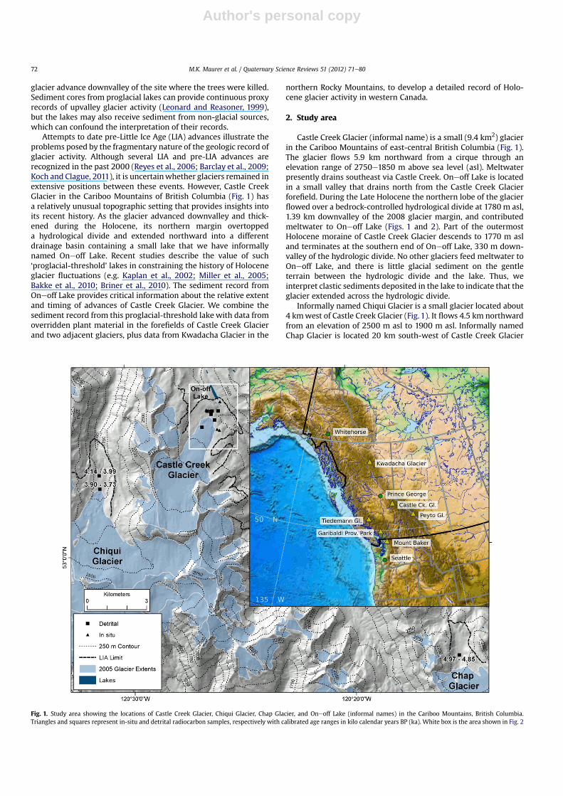
Attempts to date pre-Little Ice Age (LIA) advances illustrate theproblems posed by the fragmentary nature of the geologic record ofglacier activity. Although several LIA and pre-LIA advances arerecognized in the past 2000 (Reyes et al., 2006; Barclay et al., 2009;Koch and Clague, 2011), it is uncertainwhether glaciers remained inextensive positions between these events. However, Castle CreekGlacier in the Cariboo Mountains of British Columbia (Fig. 1) hasa relatively unusual topographic setting that provides insights intoits recent history. As the glacier advanced downvalley and thick-ened during the Holocene, its northern margin overtoppeda hydrological divide and extended northward into a differentdrainage basin containing a small lake that we have informallynamed Oneoff Lake. Recent studies describe the value of such‘proglacial-threshold’ lakes in constraining the history of Holoceneglacier fluctuations (e.g. Kaplan et al., 2002; Miller et al., 2005;Bakke et al., 2010; Briner et al., 2010). The sediment record fromOneoff Lake provides critical information about the relative extentand timing of advances of Castle Creek Glacier. We combine thesediment record from this proglacial-threshold lake with data fromoverridden plant material in the forefields of Castle Creek Glacierand two adjacent glaciers, plus data from Kwadacha Glacier in the
northern Rocky Mountains, to develop a detailed record of Holo-cene glacier activity in western Canada.
2. Study area
Castle Creek Glacier (informal name) is a small (9.4 km2) glacierin the Cariboo Mountains of east-central British Columbia (Fig. 1).The glacier flows 5.9 km northward from a cirque through anelevation range of 2750e1850 m above sea level (asl). Meltwaterpresently drains southeast via Castle Creek. Oneoff Lake is locatedin a small valley that drains north from the Castle Creek Glacierforefield. During the Late Holocene the northern lobe of the glacierflowed over a bedrock-controlled hydrological divide at 1780 m asl,1.39 km downvalley of the 2008 glacier margin, and contributedmeltwater to Oneoff Lake (Figs. 1 and 2). Part of the outermostHolocene moraine of Castle Creek Glacier descends to 1770 m asland terminates at the southern end of Oneoff Lake, 330 m down-valley of the hydrologic divide. No other glaciers feed meltwater toOneoff Lake, and there is little glacial sediment on the gentleterrain between the hydrologic divide and the lake. Thus, weinterpret clastic sediments deposited in the lake to indicate that theglacier extended across the hydrologic divide.
Informally named Chiqui Glacier is a small glacier located about4 kmwest of Castle Creek Glacier (Fig. 1). It flows 4.5 km northwardfrom an elevation of 2500 m asl to 1900 m asl. Informally namedChap Glacier is located 20 km south-west of Castle Creek Glacier
Fig. 1. Study area showing the locations of Castle Creek Glacier, Chiqui Glacier, Chap Glacier, and Oneoff Lake (informal names) in the Cariboo Mountains, British Columbia.Triangles and squares represent in-situ and detrital radiocarbon samples, respectively with calibrated age ranges in kilo calendar years BP (ka). White box is the area shown in Fig. 2
M.K. Maurer et al. / Quaternary Science Reviews 51 (2012) 71e8072
Author's personal copy
and flows 2.6 km northward, through an elevation range of2600e2000 m asl.
Kwadacha Glacier (12.6 km2) is an outlet glacier of the LloydGeorge Icefield in the northern Rocky Mountains (Figs. 1 and 3). Itflows 6.4 km south-southeast from 2500 m asl to its 2009 terminusat 1615 m asl. A prominent end moraine and trimline 3.0 kmdownvalley from the 2009 snout clearly demarcate the recentmaximum extent of the glacier (Figs. 3 and 4). Based on itsdownvalley position and unvegetated state, this moraine isassumed to date to the end of the LIA.
3. Methods
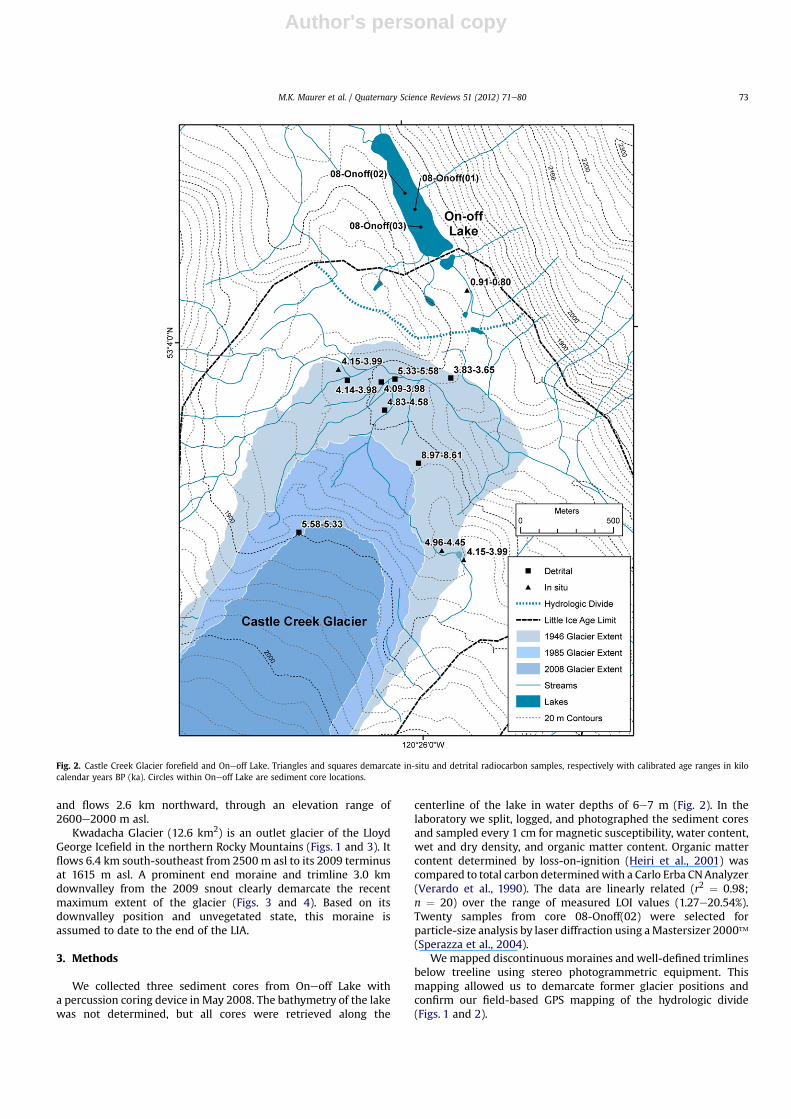
We collected three sediment cores from Oneoff Lake witha percussion coring device in May 2008. The bathymetry of the lakewas not determined, but all cores were retrieved along the
centerline of the lake in water depths of 6e7 m (Fig. 2). In thelaboratory we split, logged, and photographed the sediment coresand sampled every 1 cm for magnetic susceptibility, water content,wet and dry density, and organic matter content. Organic mattercontent determined by loss-on-ignition (Heiri et al., 2001) wascompared to total carbon determinedwith a Carlo Erba CNAnalyzer(Verardo et al., 1990). The data are linearly related (r2 ¼ 0.98;n ¼ 20) over the range of measured LOI values (1.27e20.54%).Twenty samples from core 08-Onoff(02) were selected forparticle-size analysis by laser diffraction using aMastersizer 2000�(Sperazza et al., 2004).
We mapped discontinuous moraines and well-defined trimlinesbelow treeline using stereo photogrammetric equipment. Thismapping allowed us to demarcate former glacier positions andconfirm our field-based GPS mapping of the hydrologic divide(Figs. 1 and 2).
Fig. 2. Castle Creek Glacier forefield and Oneoff Lake. Triangles and squares demarcate in-situ and detrital radiocarbon samples, respectively with calibrated age ranges in kilocalendar years BP (ka). Circles within Oneoff Lake are sediment core locations.
M.K. Maurer et al. / Quaternary Science Reviews 51 (2012) 71e80 73

Author's personal copy
Ecesis at the Castle Creek Glacier forefield was estimated in2002 by sampling seedlings located mid-way between the ice frontlimit defined by 1946 and 1959 aerial photography. Tree cores takenfrom the oldest living trees growing on the moraines located at thesouth end of Oneoff Lake provide a minimum age for the moraine.
Samples from the outer rings of sheared in-situ tree stumps andlarge woody debris in the forefields of Castle Creek, Chiqui, Chap,and Kwadacha glaciers provide estimates of the time of glacieradvance (Figs. 1e4). Wood samples from the glacier forefields andterrestrial macrofossils from the lake sediment cores were radio-carbon dated at the Keck Carbon Cycle accelerator mass spec-trometry (AMS) Facility at the University of California Irvine.Calibrated age ranges of samples (2s) in kilo calendar years BP (ka)were determined using CALIB 5.02 (Stuiver et al., 2005).
The study area in the Cariboo Mountains is near the limits ofreported air-fall tephra plumes of both the Mazama and BridgeRiver eruptions (Mathewes and Westgate, 1980; Clague, 1981). No
discernible tephra layers were seen in deposits within the glacierforefields or in the sediment cores, but we located two zones withnon-visible concentrations of glass shards within each lake sedi-ment core using sequential smear slide analysis. The shards wereisolated from the lake sediments and analyzed for major elementsusing the wavelength-dispersive spectrometer JEOL JXA-8200electron microprobe at the University of Calgary.
4. Results
4.1. Sedimentology and bulk physical properties of the sedimentcores
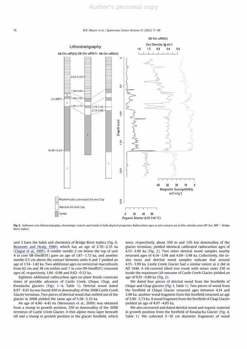
The three sediment cores fromOneoff Lake range in length from1.7 m to 2.1 m. The sediments consist of gyttja and rhythmicallylaminated to massive inorganic silt and clay that we subdividedinto seven lithostratigraphic units (Fig. 5). A 1.5 mm interval of
Fig. 3. Locations of Kwadacha Glacier and Lloyd George Icefield in the northern Rocky Mountains, British Columbia. Triangles and squares represent in-situ and detrital radiocarbonsamples, respectively with calibrated age ranges in kilo calendar years BP (ka). White box is the area shown in Fig. 4.
M.K. Maurer et al. / Quaternary Science Reviews 51 (2012) 71e8074
Author's personal copy
gyttja was preserved at the tops of the cores, but was too thin tosample for analysis. Cores 08-Onoff(02) and 08-Onoff(03) containall seven units, whereas core 08-Onoff(01) contains only the uppersix units.
Units 1, 3, 5, and 7 are light gray silt and clay (Fig. 5). Unit 7 isrhythmically laminated, whereas units 1, 3, and 5 are massive.Units 2, 4, and 6 are gyttja. A 3-cm-thick bed of gyttja occurs inthe middle of unit 3 in core 08-Onoff(03), the core with thehighest sedimentation rate. The bulk physical properties of thisbed are similar to those of the other gyttja units. Boundariesbetween units are sharp, with the exception of the boundarybetween units 5 and 6, which is gradational. Units 1, 3, 5, and 7contain little organic matter and have low water contents andlow carbonenitrogen ratios. They are denser, coarser, and havehigher magnetic susceptibilities than the units 2, 4, and 6(Fig. 5).
4.2. Radiocarbon ages and tephras
Tephras and eight radiocarbon ages on terrestrial macrofossilsprovide chronologic control for the sediment cores (Fig. 5, Table 1).Plant fragments 0.5 cm above the boundary between units 1and 2in core 08-Onoff(02) yielded a calibrated radiocarbon age of10.92e9.70 ka. Glass shards at 141 cm in unit 2 in core 08-Onoff(02)are similar in character to those of Mazama tephra (Hallet et al.,1997), which dates to 7.67e7.51 ka (Zdanowicz et al., 1999). Werecovered insufficient glass for conclusive microprobe finger-printing, but the geochemistry of the shard we did collect isconsistent with a Mazama source (Fig. 6). A conifer needle 0.5 cmbelow the contact between units 2 and 3 in core 08-Onoff(03)returned an age of 2.73e2.49 ka, and another conifer needle at thetop of the organic bed in unit 3 from the same core yielded an age of2.70e2.36 ka. Glass shards recovered fromwithin 1 cm of the top of
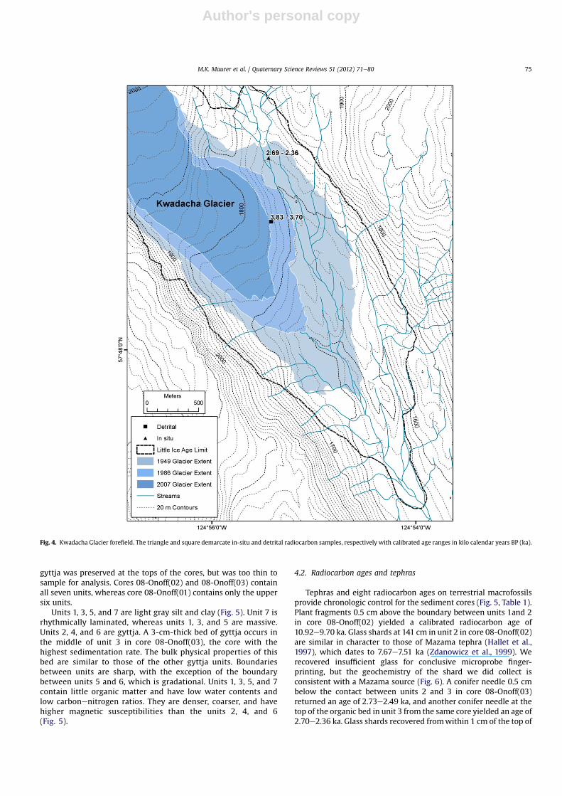
Fig. 4. Kwadacha Glacier forefield. The triangle and square demarcate in-situ and detrital radiocarbon samples, respectively with calibrated age ranges in kilo calendar years BP (ka).
M.K. Maurer et al. / Quaternary Science Reviews 51 (2012) 71e80 75
Author's personal copy
unit 3 have the habit and chemistry of Bridge River tephra (Fig. 6;Reasoner and Healy, 1986), which has an age of 2.70e2.35 ka(Clague et al., 1995). A conifer needle 2 cm below the top of unit4 in core 08-Onoff(01) gave an age of 1.87e1.72 ka, and anotherneedle 0.5 cm above the contact between units 6 and 7 yielded anage of 1.54e1.42 ka. Two additional ages on terrestrial macrofossilsfrom 62 cm and 38 cm within unit 7 in core 09-Onoff(01) returnedages of, respectively, 1.06e0.98 and 0.62e0.53 ka.
Eighteen additional radiocarbon ages on plant fossils constraintimes of possible advances of Castle Creek, Chiqui, Chap, andKwadacha glaciers (Figs. 1e4, Table 1). Detrital wood dated8.97e8.61 kawas found 450m downvalley of the 2008 Castle CreekGlacier terminus. Two pieces of detrital wood thatmelted out of theglacier in 2008 yielded the same age of 5.58e5.33 ka.
An age of 4.96e4.45 ka (Menounos et al., 2009) was obtainedfrom a stump in growth position, 350 m downvalley of the 2008terminus of Castle Creek Glacier. A thin alpine moss layer beneathtill and a stump in growth position in the glacier forefield, which
were, respectively, about 350 m and 1.05 km downvalley of theglacier terminus, yielded identical calibrated radiocarbon ages of4.15e3.99 ka (Fig. 2). Two other detrital wood samples nearbyreturned ages of 4.14e3.98 and 4.09e3.98 ka. Collectively, the in-situ moss and detrital wood samples indicate that around4.15e3.99 ka, Castle Creek Glacier had a similar extent as it did inAD 1946. A till-covered tilted tree trunk with intact roots 230 minside the maximum LIA moraine of Castle Creek Glacier yielded anage of 0.91e0.80 ka (Fig. 2).
We dated four pieces of detrital wood from the forefields ofChiqui and Chap glaciers (Fig. 1, Table 1). Two pieces of wood fromthe forefield of Chiqui Glacier returned ages between 4.14 and3.98 ka; another wood fragment from this forefield returned an ageof 3.90e3.73 ka. Awood fragment from the forefield of Chap Glacieryielded an age of 4.97e4.85 ka.
We also recovered and dated detrital wood and organic materialin growth position from the forefield of Kwadacha Glacier (Fig. 4,Table 1). We collected 5e10 cm diameter fragments of wood
Fig. 5. Sediment core lithostratigraphy, chronologic control, and trends in bulk physical properties. Radiocarbon ages at unit contacts are in kilo calendar years BP (ka). BRT ¼ BridgeRiver tephra.
M.K. Maurer et al. / Quaternary Science Reviews 51 (2012) 71e8076
Author's personal copy
melting out of the terminus of the glacier in 2009. No trees growhigher in the valley today. One of these samples returned an age of3.83e3.70 ka. At a second site, about 600 m to the north (Fig. 4),a meltwater gully exposed 1e2 m of till underlain by 20e30 cm ofgravel and amixture of gravel, soil, and alpinemoss. Several buds ofalpine moss from an individual plant stem returned an age of2.69e2.36 ka.
The estimated ecesis interval at Castle Creek Glacier is 20e30years. Using this estimate, we determined that the oldest livingtrees on the Castle Creek Glacier moraines located at the south endof Oneoff Lake colonized themoraine surface about AD 1880e1890.This age is close to the end of the Little Ice Age when most glaciersin western Canada reached their maximum, all-time Holocenelimits (Menounos et al., 2009).
5. Discussion
5.1. Holocene glacial record in the Cariboo and northern RockyMountains
The stratigraphy of the Oneoff Lake cores and radiocarbon agesfrom the lake cores and the glacier forefield allow us to determinethe history of Castle Creek Glacier during the Holocene (Fig. 7). By10.92e9.70 ka Castle Creek Glacier had retreated upvalley of the
hydrologic divide and no longer discharged meltwater into OneoffLake. Detrital wood samples dating to 8.97e8.61 ka and5.58e5.33 ka record times when the glacier was relativelyrestricted in extent and perhaps expanded into a forest, but the firstunequivocal evidence for Holocene expansion of Castle CreekGlacier is an overridden stump dating to 4.96e4.45 ka.
In-situ radiocarbon ages of wood and plant fossils of4.15e3.99 ka indicate either a second advance of Castle CreekGlacier or a continuation of the expansion at 4.96e4.45 ka. Detritallogs collected in the forefield of Chiqui Glacier yielded agescomparable to the age of overridden plant matter at Castle CreekGlacier and thus indicates that more than one glacier in the CaribooMountains advanced at that time. Castle Creek Glacier, however,failed to reach the hydrologic divide 1.39 km downvalley of its 2008position during these advances. These data demonstrate that noHolocene advance was more extensive than those of the LateHolocene.
The sediment record from Oneoff Lake indicates that CastleCreek Glacier first advanced past the hydrologic divide and waswithin 330 m of its Holocene maximum position at 2.73e2.49 ka.Accumulation of clastic sediments within Oneoff Lake from 2.73to 2.49 ka until 2.70e2.35 ka (Bridge River tephra) indicates thatCastle Creek Glacier terminated downvalley of the hydrologicdivide during that interval. Unit 3 lacks the rhythmic structure that
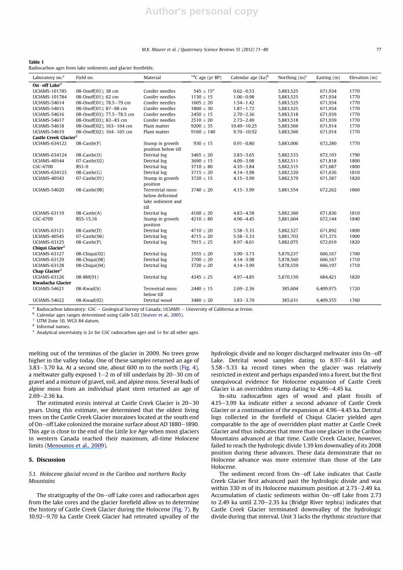
Table 1Radiocarbon ages from lake sediments and glacier forefields.
Laboratory no.a Field no. Material 14C age (yr BP) Calendar age (ka)b Northing (m)c Easting (m) Elevation (m)
Oneoff Laked
UCIAMS-101785 08-Onoff(01); 38 cm Conifer needles 545 � 15e 0.62e0.53 5,883,525 671,934 1770UCIAMS-101784 08-Onoff(01); 62 cm Conifer needles 1130 � 15 1.06e0.98 5,883,525 671,934 1770UCIAMS-54614 08-Onoff(01); 78.5e79 cm Conifer needles 1605 � 20 1.54e1.42 5,883,525 671,934 1770UCIAMS-54615 08-Onoff(01); 87e88 cm Conifer needles 1860 � 30 1.87e1.72 5,883,525 671,934 1770UCIAMS-54616 08-Onoff(03); 77.5e78.5 cm Conifer needles 2450 � 15 2.70e2.36 5,883,518 671,939 1770UCIAMS-54617 08-Onoff(03); 82e83 cm Conifer needles 2510 � 20 2.73e2.49 5,883,518 671,939 1770UCIAMS-54618 08-Onoff(02); 163e164 cm Plant matter 9200 � 35 10.49e10.25 5,883,566 671,914 1770UCIAMS-54619 08-Onoff(02); 164e165 cm Plant matter 9160 � 140 9.70e10.92 5,883,566 671,914 1770Castle Creek Glacierd
UCIAMS-634122 08-Castle(F) Stump in growthposition below till
930 � 15 0.91e0.80 5,883,006 672,280 1770
UCIAMS-634124 08-Castle(O) Detrital log 3465 � 20 3.83e3.65 5,882,533 672,193 1790UCIAMS-40544 07-Castle(02) Detrital log 3690 � 15 4.09e3.98 5,882,511 671,818 1800GSC-6700 RS1-9 Detrital log 3710 � 80 4.35e3.84 5,882,515 671,687 1800UCIAMS-634123 08-Castle(G) Detrital log 3715 � 20 4.14e3.98 5,882,520 671,636 1810UCIAMS-40543 07-Castle(01) Stump in growth
position3720 � 15 4.15e3.99 5,882,579 671,587 1820
UCIAMS-54620 08-Castle(08) Terrestrial mossbelow deformedlake sediment andtill
3740 � 20 4.15e3.99 5,881,554 672,262 1860
UCIAMS-63119 08-Castle(A) Detrital log 4160 � 20 4.83e4.58 5,882,360 671,836 1810GSC-6709 RS5-15,16 Stump in growth
position4210 � 80 4.96e4.45 5,881,604 672,144 1840
UCIAMS-63121 08-Castle(D) Detrital log 4710 � 20 5.58e5.33 5,882,527 671,892 1800UCIAMS-40545 07-Castle(06) Detrital log 4715 � 20 5.58e5.33 5,881,703 671,375 1900UCIAMS-63125 08-Castle(P) Detrital log 7915 � 25 8.97e8.61 5,882,075 672,019 1820Chiqui Glacierd
UCIAMS-63127 08-Chiqui(02) Detrital log 3555 � 20 3.90e3.73 5,879,237 666,167 1700UCIAMS-63129 08-Chiqui(08) Detrital log 3700 � 20 4.14e3.98 5,878,560 666,167 1710UCIAMS-63128 08-Chiqui(04) Detrital log 3720 � 20 4.14e3.99 5,878,559 666,197 1710Chap Glacierd
UCIAMS-63126 08-BM(01) Detrital log 4345 � 25 4.97e4.85 5,870,150 684,421 1820Kwadacha GlacierUCIAMS-54621 08-Kwad(b) Terrestrial moss
below till2440 � 15 2.69e2.36 385,604 6,409,975 1720
UCIAMS-54622 08-Kwad(02) Detrital wood 3480 � 20 3.83e3.70 385,631 6,409,355 1760
a Radiocarbon laboratory: GSC e Geological Survey of Canada; UCIAMS e University of California at Irvine.b Calendar ages ranges determined using Calib 5.02 (Stuiver et al., 2005).c UTM Zone 10, WGS 84 datum.d Informal names.e Analytical uncertainty is 2s for GSC radiocarbon ages and 1s for all other ages.
M.K. Maurer et al. / Quaternary Science Reviews 51 (2012) 71e80 77
Author's personal copy
characterizes unit 7, perhaps because the glacier did not extendbeyond the hydrologic divide long enough to contribute enoughsediment to the lake to produce deposits with internal structure(Souch, 1994). The presence of a thin organic bed with an age of2.70e2.36 ka in unit 3 suggests that Castle Creek Glacier retreatedupvalley from the hydrologic divide for a short time during thisperiod and is consistent with our argument that Castle CreekGlacier did not reach far beyond the hydrologic divide between2.73e2.49 ka and 2.70e2.35 ka.
After deposition of Bridge River tephra at 2.70e2.35 ka, CastleCreek Glacier retreated an unknown distance upvalley from thehydrologic divide and the lake began to accumulate gyttja. The
glacier advanced beyond the hydrologic divide again just after1.87e1.72 ka and retreated shortly thereafter, before it expandedover the hydrologic divide a final time just before 1.54e1.42 ka. Itoverran a tree 100 m downvalley of the hydrologic divide at0.91e0.80 ka (AD 1160e1049).
The earliest aerial photographs, taken in AD 1946, show thatCastle Creek Glacier terminated 1.02 km downvalley of its 2008position and 370m upvalley of the hydrologic divide. Successive icefront positions in the vicinity of the hydrologic divide are markedby a sequence of 15e16 well-developed annual moraines (Reid,2011) that record an average rate of recession of 14e15 m yr�1.The distance between the glacier terminus in AD 1946 and thefirst of these annual moraines, dated to 1957, yields a similaraverage rate of recession of 14.2 m yr�1 (Beedle et al., 2009).
Based on these data we estimate that glacial meltwater lastentered Oneoff Lake sometime in the early 1920s. This estimate isconsistent with the minimum limiting age of AD 1880e1890s forthe stabilization of the Holocene terminal moraine that extendsacross the lake near its inlet. These data imply that Castle CreekGlacier remained within 330 m of its maximum Holocene limitfrom 1.54e1.42 ka until the beginning of the twentieth century(Fig. 7).
5.2. Regional comparison
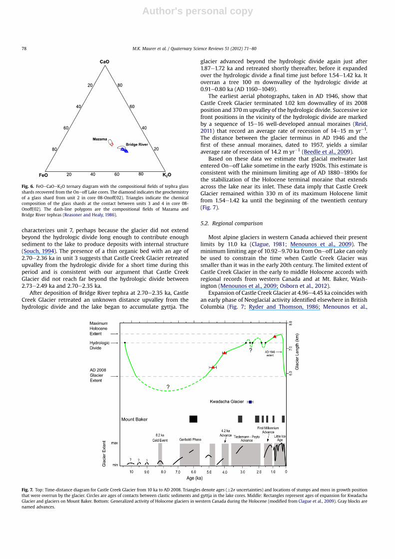
Most alpine glaciers in western Canada achieved their presentlimits by 11.0 ka (Clague, 1981; Menounos et al., 2009). Theminimum limiting age of 10.92e9.70 ka from Oneoff Lake can onlybe used to constrain the time when Castle Creek Glacier wassmaller than it was in the early 20th century. The limited extent ofCastle Creek Glacier in the early to middle Holocene accords withregional records from western Canada and at Mt. Baker, Wash-ington (Menounos et al., 2009; Osborn et al., 2012).
Expansion of Castle Creek Glacier at 4.96e4.45 ka coincides withan early phase of Neoglacial activity identified elsewhere in BritishColumbia (Fig. 7; Ryder and Thomson, 1986; Menounos et al.,
Fig. 6. FeOeCaOeK2O ternary diagram with the compositional fields of tephra glassshards recovered from the Oneoff Lake cores. The diamond indicates the geochemistryof a glass shard from unit 2 in core 08-Onoff(02). Triangles indicate the chemicalcomposition of the glass shards at the contact between units 3 and 4 in core 08-Onoff(02). The dash-line polygons are the compositional fields of Mazama andBridge River tephras (Reasoner and Healy, 1986).
Fig. 7. Top: Time-distance diagram for Castle Creek Glacier from 10 ka to AD 2008. Triangles denote ages (�2s uncertainties) and locations of stumps and moss in growth positionthat were overrun by the glacier. Circles are ages of contacts between clastic sediments and gyttja in the lake cores. Middle: Rectangles represent ages of expansion for KwadachaGlacier and glaciers on Mount Baker. Bottom: Generalized activity of Holocene glaciers in western Canada during the Holocene (modified from Clague et al., 2009). Gray blocks arenamed advances.
M.K. Maurer et al. / Quaternary Science Reviews 51 (2012) 71e8078
Author's personal copy
2009). We assign slightly younger ages, ranging from 4.15e3.99 kato 3.83e3.65 ka, to the ‘4.2 ka Advance’, an advance of alpineglaciers recognized at many sites in western Canada (Menounoset al., 2008).
Corroborating evidence for glacier expansion near the end of the4.2 ka Advance is provided by sediment cores recovered from a lake100 kmwest of Kwadacha Glacier in the northern RockyMountains(Menounos et al., 2008). A dated interval of clastic sediments in thecores and the age of the detrital wood found at Kwadacha Glacier(3.83e3.70 ka) overlap the ages of detrital from Castle Creek andChiqui glaciers.
The advance of glaciers in the Cariboo Mountains between2.73e2.49 ka and 2.70e2.35 ka broadly correlates with glacieradvances elsewhere in western Canada, the northern RockyMountains, Alaska, and the US Pacific Northwest. The first expan-sion of Castle Creek Glacier over the hydrologic divide just before2.73e2.49 ka coincides with the PeytoeTiedemann Advancerecognized throughout western Canada (Ryder and Thomson,1986;Luckman et al., 1993; Menounos et al., 2009; Koehler and Smith,2011). Overridden alpine vegetation dating to 2.69e2.36 ka atKwadacha Glacier indicates that glaciers also expanded in thenorthern Rocky Mountains during the PeytoeTiedemann Advance(Fig. 7). Glaciers in Alaska (Fig. 1) advanced around 3.3e2.9 ka and2.2e2.0 ka (Barclay et al., 2009), and glaciers in the Canadian arcticexpanded to near their Little Ice Agemaximumpositions around 3.5to 2.5 ka (Briner et al., 2009). Deming Glacier onMount Baker in theCascadeMountains ofWashington (Fig. 1) advanced into a forest ca.3.24e3.0 ka and again at 2.35e2.15 ka (Fig. 7; Easterbrook andDonnell, 2007; Osborn et al., 2012). Collectively, these data indi-cate that glaciers throughoutNorthAmerica expanded at least twiceduring the period 3.0e2.0 ka and that at least some of them reacheddownvalley almost as far as during the Little Ice Age.
The advances of Castle Creek Glacier at 1.87e1.72 ka and again at1.54e1.42 ka coincide with an advance of Deming Glacier at1.82e1.71 ka and possibly another at 1.53e1.42 ka (Osborn et al.,2012). These two events fall within the First Millennium Advance(1.8e1.1 ka) recognized throughout maritime British Columbia andAlaska (Fig. 7; Reyes et al., 2006). The Castle Creek Glacier recorddemonstrates that glacier activity during the First MillenniumAdvance was not limited to maritime environments. Like theinterval 3.0e2.0 ka, the First Millennium Advance was not a singleevent, but one characterized by regionally coherent phases ofexpansion and retreat. These first millennium advances are alsorecognized outside western North America (Davis et al., 2009).
The overridden tree 100 m downvalley of the hydrologic divideat Castle Creek Glacier with an age of AD 1040e1160 is consistentwith evidence for an early Little Ice Age advance at this time else-where in western Canada and at Mount Baker, Washington(Luckman, 2000; Koch et al., 2007; Osborn et al., 2012). Stabiliza-tion of the terminal moraine at Castle Creek Glacier around AD1880e1890 is also close to the time that glaciers on the south side ofMount Baker achieved their maximumHolocene size (Osborn et al.,2012). Like glaciers in southern British Columbia, Castle CreekGlacier rapidly retreated in the twentieth century during a periodof warm dry conditions (Menounos, 2006; Koch et al., 2007).
5.3. Significance of the Cariboo Mountains glacial record
Castle Creek Glacier was more extensive throughout the past1500 years than it has been since the 1920s. This fact highlights theanomalous nature of twentieth century climate in relation to theprevious 1500 years. Furthermore, the relative stability of CastleCreek Glacier over that 1500-year period argues against thehypothesis that substantial fluctuations in its length might resultsimply from stochastic weather events over periods of hundreds of
years (Reichert et al., 2002; Roe, 2011). Finally, these data indicatethat advances during the past three millennia in the CaribooMountains were comparable in extent to those of the Little Ice Age.
The detail and resolution acquired in this study would not havebeen possible without the use of evidence from a proglacial-threshold lake located close to the Castle Creek Glacier’s Holo-cene maximum position. Other studies have used similarproglacial-threshold lakes to improve constraints on glacier activityduring the Holocene (Mercer, 1968; Miller et al., 2005; Bakke et al.,2010; Briner et al., 2010). We found that the position of thethreshold and the lake relative to the maximum Holocene extentdetermined the interval in which detailed information could begathered. In our study the position of the hydrologic divide allowedsediment from Oneoff Lake to record information about theglacier’s activity only after 2.73e2.49 ka. Targeting similar topo-graphic situations in other regions could potentially provide thesame detail for other periods of the Holocene.
6. Conclusion
An early Neoglacial expansion of glaciers in the CaribooMountains of east-central British Columbia commenced at about4.96e4.45 ka. These glaciers and Kwadacha Glacier in the northernRocky Mountains advanced again at about 4.15e4.00 ka. CastleCreek Glacier first extended across a hydrologic divide 1.39 kmdownvalley of its 2008 terminus after 2.73e2.49 ka. This advance iscoeval with an advance of Kwadacha Glacier and with advances ofother glaciers throughout British Columbia. Castle Creek Glaciersubsequently advanced and retreated at least twice, at ca.1.87e1.72 ka and 1.54e1.42 ka, reaching to within 330 m of itsmaximum Holocene limit. After 1.54e1.42 ka Castle Creek Glacierremained within 330m of its Little Ice Age maximum position untilthe early twentieth century. Our data demonstrate that glacieradvances during the past three millennia were similar in extent tothe maxima achieved in the late Little Ice Age. The favorable co-location of an alpine glacier terminus, a hydrologic divide, anda sedimentary basin is not unique to our study area, thus themethodology utilized in this study could be applied elsewhere torefine the time, duration, and extent of past glacier advances.
Acknowledgments
Our paper benefitted from valuable input from the journalreferees Jason Briner andNicolaj Krog Larsen.We thank K. Adams, H.Luckman,H.Haines, andR.Wheate forhelp in thefield, andW.Arnott(University of Ottawa) for logistical support. Funding for our researchwas provided by the Natural Sciences and Engineering ResearchCouncil of Canada (NSERC), the Canadian Foundation for Climate andAtmospheric Sciences (CFCAS), and the Canadian Foundation forInnovation (CFI). This paper is ESS publication #20120159.
References
Bakke, J., Dahl, S.O., Paasche, Ø., Simonsen, J.R., Kvisvik, B., Bakke, K., Nesje, A., 2010.A complete record of Holocene glacier variability at Austre Okstindbreen, northNorway: an integrated approach. Quaternary Science Reviews 29, 1246e1262.
Barclay, D.J., Wiles, G.C., Calkin, P.E., 2009. Holocene glacier fluctuations in Alaska.Quaternary Science Reviews 28, 2034e2048.
Beedle, M.J., Menounos, B., Luckman, B.H., Wheate, R., 2009. Annual push morainesas climate proxy. Geophysical Research Letters 36, L20501. http://dx.doi.org/10.1029/2009GL039533.
Briner, J.P., Davis, P.T., Miller, G.H., 2009. Latest Pleistocene and Holocene glaciationof Baffin Island, Arctic Canada: key patterns and chronologies. QuaternaryScience Reviews 28, 2075e2087.
Briner, J.P., Stewart, H.A.M., Young, N.E., Philipps, W., Losee, S., 2010. Usingproglacial-threshold lakes to constrain fluctuations of Jokobshavn Isbrӕ icemargin, western Greenland, during the Holocene. Quaternary Science Reviews29, 3861e3874.
M.K. Maurer et al. / Quaternary Science Reviews 51 (2012) 71e80 79
Author's personal copy
Clague, J.J., 1981. Late Quaternary geology and geochronology of British Columbia,Part 2: summary and discussion of radiocarbon-dated Quaternary history.Geological Survey of Canada Paper 80-35, 41.
Clague, J.J., Evans, S.G., Rampton, V.N., Woodsworth, G.J., 1995. Improved age esti-mates for the White River and Bridge River tephras, western Canada. CanadianJournal of Earth Sciences 32, 1172e1179.
Clague, J.J., Menounos, B., Osborn, G., Luckman, B.H., Koch, J., 2009. Nomenclatureand resolution in Holocene glacial chronologies. Quaternary Science Reviews28, 2231e2238.
Davis, P.T., Menounos, B., Osborn, G., 2009. Holocene and latest Pleistocene alpineglacier fluctuations: a global perspective. Quaternary Science Reviews 28,2021e2033.
Easterbrook, D.J., Donnell, C.B., 2007. Glacial and volcanic history of the NooksackMiddle Fork, Washington. Geological Society of America Abstracts withPrograms 39 (4), 12.
Hallet, D.J., Hills, L.V., Clague, J.J., 1997. New accelerator mass spectrometry radio-carbon ages for the Mazama tephra layer from Kootenay National Park, BritishColumbia, Canada. Canadian Journal of Earth Sciences 34, 1202e1209.
Heiri, O., Lotter, A.F., Lemcke, G., 2001. Loss on ignition as a method for estimatingorganic and carbonate content in sediments; reproducibility and comparabilityof results. Journal of Paleolimnology 25, 101e110.
Kaplan, M.R., Wolfe, A.P., Miller, G.H., 2002. Holocene environmental variability insouthernGreenland inferred fromlakesediments.QuaternaryResearch58,149e159.
Koch, J., Clague, J.J., 2011. Extensive glaciers in northwest North America duringMedieval time. Climatic Change 107, 593e613.
Koch, J., Clague, J.J., Osborn, G.D., 2007. Glacier fluctuations during the pastmillennium in Garibaldi Provincial Park, southern Coast Mountains, BritishColumbia. Canadian Journal of Earth Sciences 44, 1215e1255.
Koehler, L., Smith, D.J., 2011. Late-Holocene glacial activity in Manatee Valley,southern Coast Mountains, British Columbia, Canada. Canadian Journal of EarthSciences 48, 603e618.
Leonard, E.M., Reasoner, M.A., 1999. A continuous Holocene glacial record inferredfrom proglacial lake sediments in Banff National Park, Alberta, Canada.Quaternary Research 51, 1e13.
Luckman, B.H., 1995. Calendar-dated, early ‘Little Ice Age’ glacier advance at RobsonGlacier, British Columbia, Canada. The Holocene 5, 149e159.
Luckman, B.H., 2000. The Little Ice Age in the Canadian Rockies. Geomorphology 32,357e384.
Luckman, B.H., Holdsworth, G., Osborn, G.D., 1993. Holocene glacier fluctuations inthe Canadian Rockies. Quaternary Research 39, 144e155.
Mathewes, R.W., Westgate, J.A., 1980. Bridge River tephra: revised distribution andsignificance fordetectingold carbonerrors in radiocarbondatesof limnic sedimentsin southern British Columbia. Canadian Journal of Earth Sciences 17, 1454e1461.
Menounos, B., 2006. Anomalous early 20th century sedimentation in proglacialGreen Lake, British Columbia, Canada. Canadian Journal of Earth Sciences 43,671e678.
Menounos, B., Clague, J., Osborn, G., Lakeman, T., Luckman, B.H., Minkus, R., 2008.Western Canadian glaciers advance in concert with climate change circa 4.2 ka.Geophysical Research Letters 35, L07501. http://dx.doi.org/10.1029/2008GL033172.
Menounos, B., Osborn, G., Clague, J.J., Luckman, B.H., 2009. Latest Pleistocene andHolocene glacier fluctuations in western Canada. Quaternary Science Reviews26, 2049e2074.
Mercer, J.H., 1968. Variations of some Patagonian glaciers since the Late-glacial.American Journal of Science 266, 91e109.
Miller, G.H., Wolfe, A.P., Briner, J.P., Sauer, P.E., Nesje, A., 2005. Holocene glaciationand climate evolution on Baffin Island, Arctic Canada. Quaternary ScienceReviews 24, 1703e1721.
Osborn, G., Menounos, B., Ryane, C., Riedel, J., Clague, J.J., Koch, J., Clark, D., Scott, K.,Davis, P.T., 2012. Latest Pleistocene and Holocene glacier fluctuations on MountBaker, Washington. Quaternary Science Reviews 49, 33e51. http://dx.doi.org/10.1016/j.quascirev.2012.06.004.
Reasoner, M., Healy, R., 1986. Identification and significance of tephra encounteredin a core from Mary Lake, Yoho National Park, British Columbia. CanadianJournal of Sciences 23, 1991e1999.
Reichert, B.K., Bengtsson, L., Oerlemans, J., 2002. Recent glacier retreat exceedsinternal variability. Journal of Climate 15, 3069e3081.
Reid, E.M., 2011. The Formation of Small Scale Glacial Flutes: a Case Study of theCastle Creek Forefield, Cariboo Mountains, B.C. M.Sc thesis, University ofWestern Ontario London, ON.
Reyes, A.V., Wiles, G.C., Smith, D.J., Barclay, D.J., Allen, S., Jackson, S., Larocque, S.,Laxton, S., Lewis, D., Calkin, P.E., Clague, J.J., 2006. Expansion of alpineglaciers in Pacific North America in the first millennium A.D. Geology 34,57e60.
Roe, G., 2011. What do glaciers tell us about climate variability and climate change?Journal of Glaciology 57, 567e578.
Ryder, J.M., Thomson, B., 1986. Neoglaciation in the southern Coast Mountains ofBritish Columbia: chronology prior to the late-Neoglacial maximum. CanadianJournal of Earth Sciences 23, 273e287.
Souch, C., 1994. A methodology to interpret downvalley lake sediments as recordsof Neoglacial activity: Coast Mountains, British Columbia, Canada. GeografiskaAnnaler 76, 169e185.
Sperazza, M., Moore, J.N., Hendrix, M.S., 2004. High-resolution particle size analysisof naturally occurring very fine-grained sediment through laser diffractometry.Journal of Sedimentary Research 74, 736e743.
Stuiver, M., Reimer, P.J., Reimer, R.W., 2005. CALIB 5.2. http://calib.qub.ac.uk/calib/.Verardo, D.J., Froelich, P.N., McIntyre, A., 1990. Determination of organic carbon and
nitrogen in marine sediments using the Carlo-Erba NA-1500 analyzer. Deep-SeaResearch 37, 157e165.
Zdanowicz, C., Zielinski, G., Germani, M., 1999. Mount Mazama eruption:Calendric age verified and atmospheric impact assessed. Geology 27,621e642.
M.K. Maurer et al. / Quaternary Science Reviews 51 (2012) 71e8080
Copyright © 2022 FDOKUMEN