Landscapes of the Slave Trade in Senegal and The Gambia
11
Landscapes of the Slave Trade in Senegal and The Gambia by Thomas A. Wikle and Dale R. Lightfoot Photographs by the Authors Introduction Upstream from the pier at Albreda a tiny speck of land interrupts the Gambia River’s otherwise featureless surface. Shaded by a few baobab trees, crumbling stone walls are all that remain of a 17 th cen- tury fort built by the British on tiny James Island. Within the fort’s outer wall are foot- prints of former military barracks, adminis- trative areas, and storage rooms. Three hundred years of weathering and erosion have reduced the island’s size, sweeping away evidence of gun batteries once guarding the fort’s perimeter. Tranquility returns as the last tourist boat returns to Albreda. A hundred miles to the north, near Africa’s westernmost point, the rug- ged cliffs of Gor ee Island are visible south of Dakar, Senegal’s capital city (Figure 1). Caf es and souvenir vendors greet visitors disembarking from passenger ferries at the island’s small harbor. Gor ee has no auto- mobiles. Located a short walk from the harbor and waterfront are narrow streets winding among colorful houses built in the French colonial style. The island’s popula- tion of 1,000 includes artisans, shop own- ers, and others seeking a reprieve from the traffic and noise of Dakar. The quiet serenity of James Island contrasts sharply with the shouts of chil- dren playing near Gor ee’s harbor. While the human imprint on James Island has changed little since being abandoned by the British in 1829, Gor ee has adapted to Figure 1. Senegal and The Gambia. 14 Focus on Geography Volume 57, Number 1
Transcript of Landscapes of the Slave Trade in Senegal and The Gambia

Landscapes of the Slave Trade in Senegal andThe Gambia
byThomas A. Wikle and Dale R. Lightfoot
Photographs by the Authors
Introduction
Upstream from the pier at Albreda atiny speck of land interrupts the GambiaRiver’s otherwise featureless surface.Shaded by a few baobab trees, crumblingstone walls are all that remain of a 17th cen-tury fort built by the British on tiny JamesIsland. Within the fort’s outer wall are foot-prints of former military barracks, adminis-trative areas, and storage rooms. Threehundred years of weathering and erosion
have reduced the island’s size, sweepingaway evidence of gun batteries onceguarding the fort’s perimeter. Tranquilityreturns as the last tourist boat returns toAlbreda. A hundred miles to the north,near Africa’s westernmost point, the rug-ged cliffs of Gor�ee Island are visible southof Dakar, Senegal’s capital city (Figure 1).Caf�es and souvenir vendors greet visitorsdisembarking from passenger ferries at theisland’s small harbor. Gor�ee has no auto-mobiles. Located a short walk from the
harbor and waterfront are narrow streetswinding among colorful houses built in theFrench colonial style. The island’s popula-tion of 1,000 includes artisans, shop own-ers, and others seeking a reprieve from thetraffic and noise of Dakar.
The quiet serenity of James Islandcontrasts sharply with the shouts of chil-dren playing near Gor�ee’s harbor. Whilethe human imprint on James Island haschanged little since being abandoned bythe British in 1829, Gor�ee has adapted to
Figure 1. Senegal and The Gambia.
14 Focus on Geography Volume 57, Number 1

streams of domestic and internationaltourists who browse local artwork, dine atpicturesque caf�es and take leisurely strolls.Although seemingly worlds apart, theislands share a shadowy and ignominiouspast. Driven by the demand for labor inthe Americas, James and Gor�ee Islandswere transformed from early Europeansettlements into prisons for holding andprocessing tens of thousands of enslavedAfricans before their transport overseas.Separated from their families and packedinto dim and poorly ventilated rooms, thecaptives endured weeks of waiting. Somenever left these islands, succumbing tosuicide, disease, or mistreatment by theircaptors.
This article explores James and Gor�eeIslands as unique cultural landscapes thatreveal and interpret events and placesassociated with slavery in West Africa.The collection represented by these islandsand nearby Fort Bullen, together withassociated museums, display every facet ofthe encounter between Africa and Europefrom first contact through the abolitionperiod, including structures, artifacts,documents and stories from slavers andslaves—men, women and children—aswell as the role of African middlemen andthe impact on and reactions from the localpopulation. While not among Africa’smost significant slave ports, James andGor�ee Islands have achieved internationalrecognition as symbols of slavery’simpacts on Africa and Africans. Both arerecognized as UNESCO World Heritagesites. For visitors hoping to understand thelegacy of slavery in West Africa, theislands are enduring reminders of incom-prehensible cruelty and suffering inflictedby humans on other humans.
Geographic Overview
Senegal and The Gambia are locatedwithin a tropical zone bounded by the drySahel to the north and wetter forestedareas of Guinea to the south. Two rivers,the Senegal in the north and the Gambiain the south define the region geogra-phically. With a population of about 13million and a land area of 76,000 squaremiles, Senegal lies at the westernmost edgeof Africa. Across much of its landscape arelow, rolling hills that rise in the southeast.The country’s population is extremelydiverse with ethnic groups that include theWolof, Fula and Serer (Searing 2003). Sur-rounded on the north, south and east bySenegal and just 28 miles wide, The Gam-bia is continental Africa’s smallest country,
having just 4,363 square miles. Its borderfollows the Gambia River for 200 milesinland as defined by an 1889 treatybetween Great Britain, which controlledThe Gambia, and France, which controlledthe encircling territory of Senegal. In termsof topography, The Gambia is part of alow plateau that decreases in elevationtowards the Atlantic coast. A third of thecountry’s mostly rural population of 1.2million resides in Banjul, its capital (Goluband Mbaye 2009). Like Senegal, The Gam-bia is comprised of several ethnic groupssuch as the Wolof, Mandinka, Fula, andSarahuley.
Historical Context
Historical accounts show that slaveryexisted in West Africa for hundreds ofyears before European occupation. Africankingdoms engaged in slave trading andAfrican elites held slaves. During the Mid-dle Ages, slaves were transported by Arabcamel caravans along hazardous landroutes extending northward through theSahara (Ross 2011). The institution of slav-ery was well-established when the regionfell under the control of the Mali and laterthe Songhai Empires between the 15th and17th centuries. Most slaves were prisonerstaken during battles between warringtribes or those who had become financialdebtors who worked to gain their free-dom.
Beginning in the early 16th century,Portuguese, Spanish, Dutch, French andBritish plantations in the newly colonizedAmericas generated a significant demandfor manual labor. Having been assignedcontrol over sea routes between Africa andthe West Indies by the 1497 Treaty ofTordesillas with Spain, the Portuguesebegan trading slaves taken from WestAfrican tribes in exchange for cloth, cook-ing utensils, and other products (Steinberg2010). A triangular pattern of production,transportation and consumption emergedas slaves carried by ship from Africa weretraded for sugar, cotton and cacao in theAmericas (Inikori and Engerman 1992).Raw materials were then loaded on shipsbound for Europe. A portion of the profitswere exchanged for finished goods—cloth,weapons, iron—that were traded with tri-bal leaders in Africa for more slaves. Thedemand for slaves remained high sinceproduction in the Americas was expand-ing and a slave’s life on plantations wasbrutal and often relatively short.
Britain’s involvement in West Africa’sslave trade began through a royal charter
granted by Queen Elizabeth following thepurchase of trade rights on the GambiaRiver from Portugal in 1588 (Cyr 2001).Established in 1660 to exploit Gambia’sgold fields, the Royal Africa Company(RAC) became the focus of Britain’s slaveindustry, with exclusive rights in coastalAfrica. Initially, the British supplied slavesto colonies controlled by the Spanish andPortuguese. However, with demand fromBritish settlements growing, the supplychain shifted to the West Indies (Jamaica,St. Christopher, and Barbados) and later tothe American Colonies. Initially, slaveships operated out of London and Grave-send, but as profits grew they began sail-ing from additional ports such as Bristol,Devon, Dartmouth, Liverpool, Guernsey,Lancaster, and Portsmouth. With assis-tance from the Army and Royal Navy, theRAC established coastal fortifications inAfrica to protect slave interests and, by the1760s, Great Britain was the largest sup-plier of slaves to the Americas.
Fearing disease such as malaria andyellow fever, Europeans relied on Africansto make forays into the interior to pur-chase or kidnap slaves. Captives weresometimes marched hundreds of mileswith their hands tied behind their backsand necks connected by wooden poles inlines of 30 to 40. Because of their effi-ciency, rivers such as the Senegal andGambia emerged as strategically importantfor transporting slaves. Chained in groups,slaves were moved downriver on boats orsmall sailing ships to coastal areas wherethey were purchased by European traderswho, in turn, sold them to ship captains.Since ships were rarely filled to capacity ata single location, slaves were collected andstored, sometimes for weeks, at fortifiedstations such as James and Gor�ee Islands.During the 18th century, slavers operatingout of Senegambia exported an estimated6,000 slaves per year (Barry 1998).
To maximize profits during the “Mid-dle Passage” across the Atlantic, slaveswere tightly packed in ship’s holds. Suffer-ing from unsanitary conditions and dis-ease during the five-to-eight week journey,slave mortality averaged ten percent. Alarge number of West African slavesshipped to the British colonies before theAmerican Revolution passed throughCharleston, South Carolina before beingsold at the city’s slave markets (Cohn1985). Many were put to work in ricefields where they suffered from malariaand enteric diseases (McCandless 2011).With high death rates, demand for “ideal”slaves—tall and healthy males between 14
Spring 2014 Focus on Geography 15

and 18—reached 100 to 200 pounds ster-ling, about $11,000 to $23,000 U.S. dollars(Sciway 2013). Measured by today’s finan-cial standards, slavery had become amulti-billion dollar industry.
James Island
As one of the first European traderoutes into Africa, the Gambia River beginsas a deep estuary navigable by ocean-goingships for 120 miles upstream and for 80additional miles by smaller ships. Lookingupstream from the river’s mouth reveals aninviting natural harbor that served as awaypoint for ships of many nations. Inaddition to facilitating the movement ofslaves, the river served as a key artery for
transporting goods such as vegetable gum,peanuts and animal hides.
Located about 20 miles upstream fromthe Gambia River’s mouth, James Islandappears like a pebble within a wide swathof moving water. Initially claimed byBritain, the island was unoccupied whensettlers from Courtland and Semigallia(a Polish-Lithuanian vassal state in thearea of modern Estonia) established asettlement and small fortification there in1651. Ten years later the island was cap-tured by the British who renamed it tohonor James, the Duke of York (later KingJames II of England). Although just a fewacres in size, the British considered theisland’s location as ideal for maintainingcontrol over movement on the river. Pass-
ing ships were required to pay the island’sgovernor a tax on all goods carried. Dur-ing its occupation, the British constructedseveral buildings on James Island includ-ing the governor’s house, slave quarters,storage rooms, barracks, and a three-storytower serving as a lookout for approach-ing ships. Three batteries, each with fivecannon, were constructed outside the mainfortification, two facing downriver andone upriver. The island’s principal weak-ness was its lack of a spring. Although theisland had a cistern for collecting rainwa-ter, most freshwater had to be transportedby boat from the river’s shoreline (Armit-age 1928).
Located two miles downstream fromJames Island on the river’s north bank,Albreda was established as a French slavestation in 1681. Eventually the proximityof Albreda to the British fort on JamesIsland became a source of tension betweenthe two countries, leading to frequent con-flicts. Between 1695 and 1778 the islandchanged hands several times (Carlos andKruse 1996). Finally, in 1778 the fort andits buildings were severely damaged byexplosives planted by the French.Although the island was again occupiedby the British military, the fort was notrebuilt. Albreda remained under Frenchcontrol until 1857 when it was transferredto the British and used as a police station.A military visit to Albreda in the early1850s summarized conditions at the time.
On landing, we found the heat fromthe burning sands almost overpowering;cottages and huts were scattered through awood, but the jungle and rank vegetationsurrounding the town prove prejudicial tohealth in the wet season
(O’Conner 1852, p. 420).
Today most visits to James Islandbegin at Albreda (see Figure 1). Albreda’soldest building is a church built by thePortuguese. A few other structures offer aglimpse of the village’s appearance duringthe 1800s such as the stone Francaise d’Af-rique Occidentale Building, also called“The Factory.” Built as a fortified slave sta-tion near the river’s edge, the three-storybuilding featured a store on the first floorand living quarters on upper floors. A fewbuildings have been adapted to new usesincluding the Maurel Fr�eres Building, con-structed by the British in the mid-1880sand restored in 1996. This building nowserves as a museum representing slavetrading on the Gambia River throughmaps, drawings, and the display of
Figure 2. Statue at Albreda, near James Island; an indictment of Global Slavery.
16 Focus on Geography Volume 57, Number 1

Figure 3b. A portion of the ruined fortress on James Island.
Figure 3a. Arrival at James Island in The Gambia.
Spring 2014 Focus on Geography 17

historical artifacts such as iron manacles.Outside is a replica of the small ships usedfor transporting slaves downriver. Withthe exception of a restaurant located nearthe waterfront, there is little infrastructureserving tourism. Near Albreda’s historicalstructures is a statute, erected in 1998, thatdepicts a human figure with outstretchedarms and broken chains hanging fromeach wrist. The globe used for the figure’shead and the statement “Never Again” atits base offer strong rebuke to the globalinstitution that first brought Albreda andJames Island into the world economy(Figure 2).
Albreda and the neighboring villageof Juffureh were relatively unknownbefore publication of Alex Haley’s novelRoots which identified Juffureh as theMandinka village where Haley’s ancestorKunta Kinte was held by slave tradersbefore being transported across the Atlan-tic Ocean. Juffureh’s significance in Rootsand Albreda’s role as the gateway toJames Island have brought internationalattention to these isolated places.
The trip to James Island—also knownlocally as Kunta Kinteh Island—by motor-ized pirogue lasts 20 minutes. Near thedock on the island’s northeast side a fewrusting cannon mark the location of theformer North Battery. South of the dock akiosk shelters a map and model showing
the island’s buildings as they appeared inthe late 1700s. Visitor’s gain access to thefort’s interior using a pathway through asection of wall destroyed by French mines.Looking downward from the bastion, thelayout of rooms can be seen through thearrangement of stone walls, interrupted ina few places by rectangular window open-ings (Figure 3a, Figure 3b). Cut from later-ite, the blocks in the fort’s walls are heldtogether with mortar made from crushedoyster shells. Portions of the fort’s upperlevel remain intact, including some cornerbastion floors once occupied by soldiers.Most of the site is in ruin, damaged ini-tially by fighting in 1695 and the 1720s,and destroyed again in 1778. What theFrench failed to dismantle during this lastseizure has been degraded by erosion andtime. Still, many spaces that once heldslaves—men, women and children—arestill intact and locally interpreted byguides and by signs marking “Slave Yard”or “Women’s Quarters.”
Following pathways that windthrough stone walls, one can imagine howthe island was viewed differently by Euro-peans and Africans. The island’s locationfar from other English settlements inAfrica contributed to a sense of fearamong soldiers and other residents whomaintained constant readiness to thwartattacks. Among Africans imprisoned there,
the island became one waypoint along ajourney punctuated by fear and uncer-tainty. Crowded in small cells, the captivesendured weeks waiting for slave ships.Among nearby tribes that launched attacksagainst the fort, the island represented animpious alliance between foreign invadersand their African collaborators. To slavetraders stationed at nearby Albreda theEnglish fort was perceived as a threat totheir economic interests and a barrier toFrench expansion in West Africa. Touristswho encounter James Island today havetheir own reactions, colored by a contem-porary understanding of the weight of thisplace and the human suffering thatoccurred here. According to local guides,visitors feel uncomfortable touring the siteand many of them cry.
Today, James Island and the formerFrench village of Albreda have emergedas memorials to the hardship suffered byAfricans and international symbols repre-senting the inhumanity of slavery. Unfor-tunately, recognition has not protectedthe island from more recent threats. Ero-sion and flooding along the island’sperimeter has erased evidence of gunbatteries and storage buildings that oncestood outside the fort (Figure 4). Effortsto preserve James Island are ongoing. In2003, the island was designated a UNE-SCO World Heritage Site. Nearby resi-dents have worked to slow the rate ofdegradation and to take measures to pro-tect historic structures. Rock and woodenpilings have been added along the shore-line to mitigate erosion while structuralsupports have been installed to stabilizethe fort’s exterior walls (Gijanto 2013)(Figure 5).
Britain’s Anti-slavery Movement
In 1807, the British outlawed slaveryand began enforcing abolition by captur-ing and impounding or destroying slaveships off Africa’s western coastline. Theresulting decrease in supply brought dra-matic increases in the price of slavesand an expansion of French, Portugueseand Spanish involvement in the slavetrade. To enforce abolition and stop thetransportation of slaves in coastal waters,the Royal Navy formed the West AfricanSquadron (McGowan 1990). Ironically,after decades of protecting the businessof slavery, James Island became theRoyal Navy’s principal fortification forenforcing abolition by preventing shipsfrom gaining access to Gambia Riverslave routes.
Figure 4. James Island, The Gambia.
18 Focus on Geography Volume 57, Number 1

Recognizing that a site near themouth of the Gambia offered a superiorlocation to control river access, British mil-itary planners recommended the construc-tion of a new fortification. In 1815, SixGun Battery was established on St. Mary’sIsland near the river’s south bank (Jarrett1951). The battery featured six 24-inch can-non installed on rails and protected by astone parapet. Constructed on a mosquito-infested marsh, land for the gun batteryand settlement of Bathurst (now Banjul)was leased from local tribal leaders inexchange for a yearly payment of ironbars. By 1818, Bathurst’s population hadgrown to 600, including 80 soldiers andmany freed slaves. Soon after the batterybecame operational, however, it was dis-covered that rogue slave ships could enterthe river by sailing near its north bank andoutside the range of the battery’s cannon.To address this issue a new fortification
Figure 5. Attempt to stabilize erosion of the northeast shoreline of James Island.
Figure 6. Bathurst and Ft. Bullen.
Spring 2014 Focus on Geography 19
was constructed on the river’s north bankin 1827 (Figure 6).
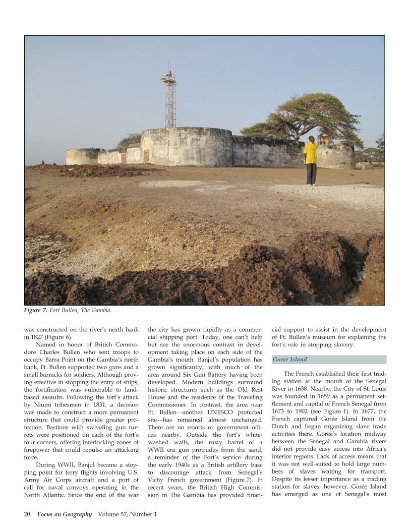
Named in honor of British Commo-dore Charles Bullen who sent troops tooccupy Barra Point on the Gambia’s northbank, Ft. Bullen supported two guns and asmall barracks for soldiers. Although prov-ing effective in stopping the entry of ships,the fortification was vulnerable to land-based assaults. Following the fort’s attackby Niumi tribesmen in 1831, a decisionwas made to construct a more permanentstructure that could provide greater pro-tection. Bastions with swiveling gun tur-rets were positioned on each of the fort’sfour corners, offering interlocking zones offirepower that could repulse an attackingforce.
During WWII, Banjul became a stop-ping point for ferry flights involving U.S.Army Air Corps aircraft and a port ofcall for naval convoys operating in theNorth Atlantic. Since the end of the war
the city has grown rapidly as a commer-cial shipping port. Today, one can’t helpbut see the enormous contrast in devel-opment taking place on each side of theGambia’s mouth. Banjul’s population hasgrown significantly, with much of thearea around Six Gun Battery having beendeveloped. Modern buildings surroundhistoric structures such as the Old RestHouse and the residence of the TravelingCommissioner. In contrast, the area nearFt. Bullen—another UNESCO protectedsite—has remained almost unchanged.There are no resorts or government offi-ces nearby. Outside the fort’s white-washed walls, the rusty barrel of aWWII era gun protrudes from the sand,a reminder of the Fort’s service duringthe early 1940s as a British artillery baseto discourage attack from Senegal’sVichy French government (Figure 7). Inrecent years, the British High Commis-sion in The Gambia has provided finan-
cial support to assist in the developmentof Ft. Bullen’s museum for explaining thefort’s role in stopping slavery.
Gor�ee Island
The French established their first trad-ing station at the mouth of the SenegalRiver in 1638. Nearby, the City of St. Louiswas founded in 1659 as a permanent set-tlement and capital of French Senegal from1673 to 1902 (see Figure 1). In 1677, theFrench captured Gor�ee Island from theDutch and began organizing slave tradeactivities there. Gor�ee’s location midwaybetween the Senegal and Gambia riversdid not provide easy access into Africa’sinterior regions. Lack of access meant thatit was not well-suited to hold large num-bers of slaves waiting for transport.Despite its lesser importance as a tradingstation for slaves, however, Gor�ee Islandhas emerged as one of Senegal’s most
Figure 7. Fort Bullen, The Gambia.
20 Focus on Geography Volume 57, Number 1

prominent tourist attractions and an acces-sible symbol of slave history that has beenvisited by many world leaders.
Located about two miles southeast ofDakar, the island is roughly a half-milelong and slightly less than a quarter-milewide with high bluffs made of basalt onits south end (Figure 8). Gor�ee was settledby Wolof fishermen and goat herders whocalled it Ber and was first occupied byEuropeans when the Portuguese estab-lished a stone chapel there in the 15th cen-tury. In the late 1500s, the island wascaptured by the Dutch and subsequentlypurchased from a local tribal chief. Gor�eeis believed to have been named for GoereeIsland in Holland or possibly for “GoedeReede,” meaning good harbor. Indeed, theisland’s harbor is among its most impor-tant physical features. Gor�ee changedhands several times among the Dutch,French and British before falling underFrench rule from 1677 until Senegal’s inde-pendence in 1960 (Andrews 1915).
It is no accident that Gor�ee waschosen as a slave fortification. Like theBritish, the French built slave stations onislands to prevent escape and as adefense against attack from other slavetraders or groups of armed Africans. Theisland also offered a small but useful har-bor for mooring large ships. A few dozen
buildings were constructed there to tem-porarily incarcerate captives until theycould be loaded onto arriving slave ships.Some of Gor�ee’s slaves were used on theisland. Female slaves worked as domesticservants while men were assigned to con-struction projects such as crushing rockfor the island’s two forts. Others workedat the docks, loading and unloadingships. The island was also home to freedslaves and some of mixed African andEuropean descent.
Local promoters of Gor�ee Island haveclaimed that 15 to 20 million slaves passedthrough the island on their way to theAmericas (Ndiaye n.d.). Historical researchsuggests, however, that only about 26,000slaves had been brought to Gor�ee by thetime slavery was abolished in the 19th cen-tury (Curtin 1972). Most historians insideand outside of Senegal have downplayedthe role of the island in the slave trade,noting that Gor�ee, though a transit point,paled in comparison to slave sites in TheGambia and elsewhere in Senegal andWest Africa.
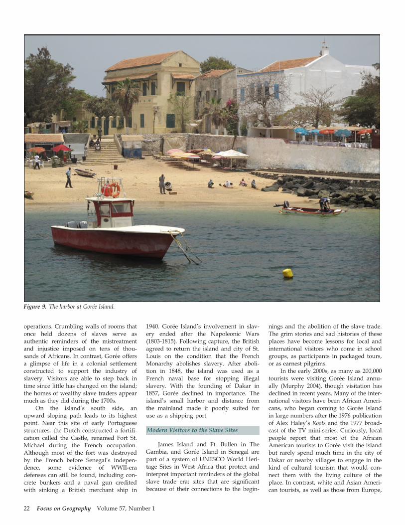
The passenger ferry from Dakar takes30 minutes to reach the small harbor onGor�ee Island’s northeast side (Figure 9).At the island’s northern extreme is Estr�eesFort, built by the French in 1677 andnow a museum featuring interpretive
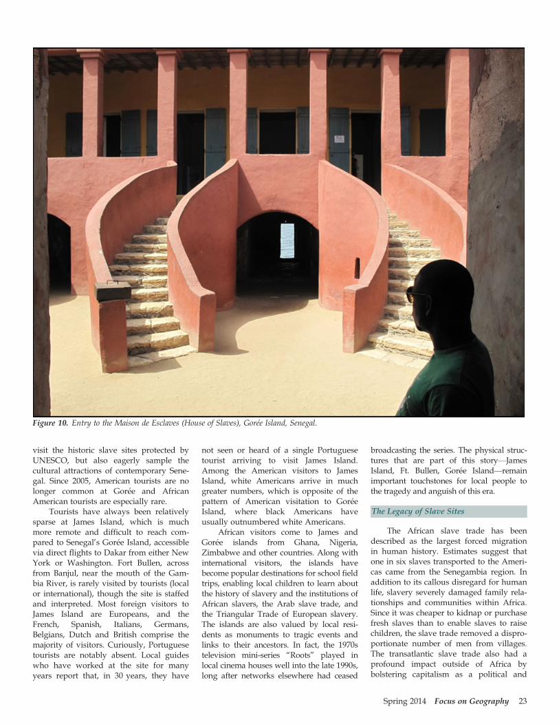
materials that explain the island’s history.The developed portion of Gor�ee is a zigzagof narrow streets with colorfully paintedhouses once owned by wealthy slave trad-ers. Near its eastern shoreline, a streetpasses a large wooden door that opens tothe courtyard of Maison des Esclaves(House of Slaves), built as the house of awealthy Senegalese M�etis (mixed race)woman in the late 1700s and operated as amuseum since 1962 (Figure 10). Inside arecells measuring roughly 30 square feet thateach held 16-18 slaves. Smaller cells underthe sloping staircases held those being pun-ished for resisting their plight. Before theirshipment to Gor�ee, slaves were classifiedby age, sex, and tribal group and brandedwith the insignia of their trading company.Held with shackles and chains, males wereseated with their backs against cell walls. Anarrow vertical opening provided lightand ventilation in each room. Outside, anopen courtyard enabled buyers to viewcaptives as sale prices were negotiated.
An ominous feature of Maison desEsclaves was its central corridor leading tothe “Door of No Return.” Visitors are toldthat slaves taken through this door wereloaded onto waiting ships for the journeyacross the Atlantic, though the real pur-pose of the door, and the whole structure,has been debated by historians, who char-acterize the famous exit as only a symbolictouchstone to the past. Many historiansdoubt that the house was used to incarcer-ate captive slaves. It was built rather latein the slave trade era and probably con-tained only the house slaves of the ownerwho lived there. Captive slaves awaitingtransport were more likely held at otherlocations on Gor�ee Island. Despite ques-tions raised about the myth of Maison desEsclaves, it holds value as a place ofmemory; local boosters continue to pro-mote the building as an emotional shrineto slavery, and UNESCO lists the house asan important historical location (Murphy2004).
Compared to James Island,unchanged since its abandonment by theBritish, Gor�ee Island has remained avibrant community. Houses once ownedby wealthy slavers now serve as restau-rants, hotels and shops. Gor�ee has takenadvantage of its proximity to Dakar inemerging as a tourist attraction. For visi-tors interested in the legacy of slavery,James and Gor�ee Islands offer contrastingbut complementary perspectives. The visi-tor to James Island can visualize the fort’srole in projecting power and control as aforward outpost of European slavery
Figure 8. Gor�ee Island is a major tourist attraction.
Spring 2014 Focus on Geography 21
operations. Crumbling walls of rooms thatonce held dozens of slaves serve asauthentic reminders of the mistreatmentand injustice imposed on tens of thou-sands of Africans. In contrast, Gor�ee offersa glimpse of life in a colonial settlementconstructed to support the industry ofslavery. Visitors are able to step back intime since little has changed on the island;the homes of wealthy slave traders appearmuch as they did during the 1700s.
On the island’s south side, anupward sloping path leads to its highestpoint. Near this site of early Portuguesestructures, the Dutch constructed a fortifi-cation called the Castle, renamed Fort St.Michael during the French occupation.Although most of the fort was destroyedby the French before Senegal’s indepen-dence, some evidence of WWII-eradefenses can still be found, including con-crete bunkers and a naval gun creditedwith sinking a British merchant ship in
1940. Gor�ee Island’s involvement in slav-ery ended after the Napoleonic Wars(1803-1815). Following capture, the Britishagreed to return the island and city of St.Louis on the condition that the FrenchMonarchy abolishes slavery. After aboli-tion in 1848, the island was used as aFrench naval base for stopping illegalslavery. With the founding of Dakar in1857, Gor�ee declined in importance. Theisland’s small harbor and distance fromthe mainland made it poorly suited foruse as a shipping port.
Modern Visitors to the Slave Sites
James Island and Ft. Bullen in TheGambia, and Gor�ee Island in Senegal arepart of a system of UNESCO World Heri-tage Sites in West Africa that protect andinterpret important reminders of the globalslave trade era; sites that are significantbecause of their connections to the begin-
nings and the abolition of the slave trade.The grim stories and sad histories of theseplaces have become lessons for local andinternational visitors who come in schoolgroups, as participants in packaged tours,or as earnest pilgrims.
In the early 2000s, as many as 200,000tourists were visiting Gor�ee Island annu-ally (Murphy 2004), though visitation hasdeclined in recent years. Many of the inter-national visitors have been African Ameri-cans, who began coming to Gor�ee Islandin large numbers after the 1976 publicationof Alex Haley’s Roots and the 1977 broad-cast of the TV mini-series. Curiously, localpeople report that most of the AfricanAmerican tourists to Gor�ee visit the islandbut rarely spend much time in the city ofDakar or nearby villages to engage in thekind of cultural tourism that would con-nect them with the living culture of theplace. In contrast, white and Asian Ameri-can tourists, as well as those from Europe,
Figure 9. The harbor at Gor�ee Island.
22 Focus on Geography Volume 57, Number 1
visit the historic slave sites protected byUNESCO, but also eagerly sample thecultural attractions of contemporary Sene-gal. Since 2005, American tourists are nolonger common at Gor�ee and AfricanAmerican tourists are especially rare.
Tourists have always been relativelysparse at James Island, which is muchmore remote and difficult to reach com-pared to Senegal’s Gor�ee Island, accessiblevia direct flights to Dakar from either NewYork or Washington. Fort Bullen, acrossfrom Banjul, near the mouth of the Gam-bia River, is rarely visited by tourists (localor international), though the site is staffedand interpreted. Most foreign visitors toJames Island are Europeans, and theFrench, Spanish, Italians, Germans,Belgians, Dutch and British comprise themajority of visitors. Curiously, Portuguesetourists are notably absent. Local guideswho have worked at the site for manyyears report that, in 30 years, they have
not seen or heard of a single Portuguesetourist arriving to visit James Island.Among the American visitors to JamesIsland, white Americans arrive in muchgreater numbers, which is opposite of thepattern of American visitation to Gor�eeIsland, where black Americans haveusually outnumbered white Americans.
African visitors come to James andGor�ee islands from Ghana, Nigeria,Zimbabwe and other countries. Along withinternational visitors, the islands havebecome popular destinations for school fieldtrips, enabling local children to learn aboutthe history of slavery and the institutions ofAfrican slavers, the Arab slave trade, andthe Triangular Trade of European slavery.The islands are also valued by local resi-dents as monuments to tragic events andlinks to their ancestors. In fact, the 1970stelevision mini-series “Roots” played inlocal cinema houses well into the late 1990s,long after networks elsewhere had ceased
broadcasting the series. The physical struc-tures that are part of this story—JamesIsland, Ft. Bullen, Gor�ee Island—remainimportant touchstones for local people tothe tragedy and anguish of this era.
The Legacy of Slave Sites
The African slave trade has beendescribed as the largest forced migrationin human history. Estimates suggest thatone in six slaves transported to the Ameri-cas came from the Senegambia region. Inaddition to its callous disregard for humanlife, slavery severely damaged family rela-tionships and communities within Africa.Since it was cheaper to kidnap or purchasefresh slaves than to enable slaves to raisechildren, the slave trade removed a dispro-portionate number of men from villages.The transatlantic slave trade also had aprofound impact outside of Africa bybolstering capitalism as a political and
Figure 10. Entry to the Maison de Esclaves (House of Slaves), Gor�ee Island, Senegal.
Spring 2014 Focus on Geography 23

economic force in Europe and projectingpower and control (see Mitchell 2002;Church and Coles 2007). Countries such asGreat Britain became wealthy as a resultof the inexpensive supply of raw materialsand labor.
Historians will continue debating therelative importance of Gor�ee Island andthe authenticity of Maison des Esclaves.Despite its controversy, however, Gor�ee’sHouse of Slaves has remained a powerfulinternational symbol. Maison des Esclavesand its “Door of No Return” have beenvisited by world leaders ranging fromNelson Mandela to Pope John Paul II.Three U.S. Presidents have visited the site,most recently Barack Obama (with FirstLady Michelle Obama) in June 2013.Although not as well-known and muchless accessible—but with unquestionedauthenticity—James Island in The Gambiahas grown in popularity, in part becauseof organized travel packages with namessuch as the “Roots Tour.” Althoughinvolved only in the abolition phase of theslave era, Ft. Bullen has also emerged as asymbol of righting a wrong and has beenincorporated into the protected system ofhistoric slave sites in West Africa.
Thousands of visitors travel to Jamesand Gor�ee Islands each year, hoping tounderstand hardships endured by theirancestors, or curious to learn more aboutthe history of these sites, enabling them tomake personal connections with the placesinvolved. A few historic structures on theislands offer a glimpse of suffering experi-enced by captives who were separatedfrom their families and held inside tinyrooms before being loaded on ships, neverto return. For most, slave landscapes onJames and Gor�ee Islands generate power-ful emotions. Beyond their role in repre-senting the inhumanity and cruelty ofslavery, these unique sites document earlyaccess to the interior of Africa and symbol-
ize the transplantation of culture thatresulted from the African Diaspora.
References
Andrews, C.M. 1915. Anglo-French Com-mercial Rivalry, 1700-1750: The WesternPhase, I. The American Historical Review20(3): 539–556.
Armitage, C. 1928. The Gambia Colonyand Protectorate. Journal of the RoyalSociety of Arts 76(3944): 810–818.
Barry, B. 1998. Senegambia and the AtlanticSlave Trade. Cambridge: Cambridge Uni-versity Press.
Carlos, Ann M. and Kruse, J.B. 1996. TheDecline of the Royal Africa Company:Fringe Firms on the Role of the Charter.The Economic History Review 49(2): 291–313.
Church, A. and Coles, T. 2007. Tourism,Power and Spaces. New York: Routledge.
Cohn, R.L. 1985. A Symposium on theAtlantic Slave Trade. The Journal of Eco-nomic History 45(3): 685–692.
Curtin, Philip D. 1972. The Atlantic SlaveTrade: A Census. Madison, WI: Univer-sity of Wisconsin Press.
Cyr, R. 2001. Twentieth Century Africa.Lincoln, NE: iUniverse.
Inikori, J.E. and Engerman, S.L. 1992. TheAtlantic Slave Trade: Effects on Economies,Societies, and People of Africa, the Americasand Europe. Durham, NC: Duke Univer-sity Press.
Gijanto, J. 2013. Stabilization and Tourismat the Gambia River’s Atlantic TradeSites: The James Island Conservation andSurvey Project. [http://www.diaspora.illinois.edu/news0909/news0909-3.pdf]
Golub, S.S. and Mbaye, A.A. 2009.National Trade Policies and Smugglingin Africa: The Case of Gambia and Sene-gal. World Development 37(3): 595–606.
Jarrett, H.R. 1951. Bathurst: Port City ofthe Gambia River. Geography 36(2): 98–107.
McCandless, P. 2011. Slavery, Disease andSuffering in the Southern Lowcountry.New York: Cambridge UniversityPress.
McGowan, J. 1990. African Resistance tothe Atlantic Slave Trade in West Africa.Slavery and Abolition: A Journal of Slaveand Post-Slave Studies. 11(1): 5–29.
Mitchell, W.J.T. 2002. Landscape and Power.Chicago: University of Chicago Press.
Murphy, John. 2004. Powerful Symbol,Weak in Facts. Slavery: A ThrivingTourist Trade Has Been Built Aroundthe Dubious Historic Role of a SenegalIsland. The Baltimore Sun, June 30, 2004.[http://www.baltimoresun.com/news/bal-slavery0630,0,7878935.story]
Ndiaye, Boubacar Joseph. No date (n.d.).The Slave Trade at Gor�ee-Island and ItsHistory. Dakar, Senegal: Dakar PortAuthority.
O’Conner, L.S. 1852. Three Weeks in Gam-bia. United Service Magazine (November):412–425.
Ross, E. 2011. A Historical Geography ofthe Trans-Saharan Trade, pp. 1–34 In G.Kr€atli and G. Lydon (eds), The Trans-Saharan Book Trade: Manuscript Culture,Arab Literacy and Intellectual History inMuslim Africa. Leiden, The Netherlands:Koninklijke Brill.
Searing, J.F. 2003. West African Slavery andAtlantic Commerce: The Senegal River Val-ley, 1700-1860. Cambridge, UK: Cam-bridge University Press.
Sciway. 2013. The African Slave Trade andSouth Carolina [http://www.sciway.net/hist/chicora/slavery18-2.html]
Steinberg, P. 2010. Lines of Division, Linesof Connection: Stewardship in theWorld Ocean. Geographical Review 89(2):254–264.
24 Focus on Geography Volume 57, Number 1