Land Use Patterns in the Brazilian Amazon: Comparative Farm-Level Evidence from Rondônia
28
Human Ecology, Vol. 32, No. 2, April 2004 ( C 2004) Land Use Patterns in the Brazilian Amazon: Comparative Farm-Level Evidence From Rondˆ onia John O. Browder, 1,4 Marcos A. Pedlowski, 2 and Percy M. Summers 3 Since the 1970s the Brazilian Amazon has received over 1 million migrant farm households from other regions of the country, many of whom were at- tracted to government-sponsored frontier settlement programs that offered free tropical forest land. As a result, pressures on tropical forests have inten- sified along several settlement corridors throughout the region. Despite their importance as agents of landscape change, surprisingly little is known about the land use practices of these farmers. This paper briefly reviews the research literature on smallholder land use patterns in Amazonia, describes the recent history of one important agricultural land settlement program in the western Brazilian Amazon state of Rond ˆ onia, and, based on 240 household surveys conducted in three separate settlement locations in the state, highlights key differences in land use patterns among the rural population. Typologies of farming systems are presented on the basis of cluster analysis of land use data and ANOVA tests. The findings indicate considerable complexity and hetero- geneity in smallholder farming systems. Spatial variations in farming system types may be due to geographic differences in soil regimes, the social histories of specific communities, and site-specific responses to exogenous variables. KEY WORDS: agricultural development; land use; Amazon; Rond ˆ onia; Brazil. 1 Urban Affairs and Planning, Virginia Polytechnic Institute and State University, Blacksburg, Virginia 24061. 2 Universidade Estadual de Norte Fluminense, Campos dos Goitacages, RJ 28013-310, Brazil. 3 Environmental Design and Planning, Virginia Polytechnic Institute and State University, Blacksburg, Virginia. 4 To whom correspondence should be addressed; e-mail: [email protected]. 197 0300-7839/04/0400-0197/0 C 2004 Plenum Publishing Corporation
Transcript of Land Use Patterns in the Brazilian Amazon: Comparative Farm-Level Evidence from Rondônia
P1: FLT
Human Ecology [huec] PP1142-huec-481858 March 9, 2004 10:2 Style file version Nov. 19th, 1999
Human Ecology, Vol. 32, No. 2, April 2004 ( C© 2004)
Land Use Patterns in the Brazilian Amazon:Comparative Farm-Level Evidence From Rondonia
John O. Browder,1,4 Marcos A. Pedlowski,2 and Percy M. Summers3
Since the 1970s the Brazilian Amazon has received over 1 million migrantfarm households from other regions of the country, many of whom were at-tracted to government-sponsored frontier settlement programs that offeredfree tropical forest land. As a result, pressures on tropical forests have inten-sified along several settlement corridors throughout the region. Despite theirimportance as agents of landscape change, surprisingly little is known aboutthe land use practices of these farmers. This paper briefly reviews the researchliterature on smallholder land use patterns in Amazonia, describes the recenthistory of one important agricultural land settlement program in the westernBrazilian Amazon state of Rondonia, and, based on 240 household surveysconducted in three separate settlement locations in the state, highlights keydifferences in land use patterns among the rural population. Typologies offarming systems are presented on the basis of cluster analysis of land use dataand ANOVA tests. The findings indicate considerable complexity and hetero-geneity in smallholder farming systems. Spatial variations in farming systemtypes may be due to geographic differences in soil regimes, the social historiesof specific communities, and site-specific responses to exogenous variables.
KEY WORDS: agricultural development; land use; Amazon; Rondonia; Brazil.
1Urban Affairs and Planning, Virginia Polytechnic Institute and State University, Blacksburg,Virginia 24061.
2Universidade Estadual de Norte Fluminense, Campos dos Goitacages, RJ 28013-310, Brazil.3Environmental Design and Planning, Virginia Polytechnic Institute and State University,Blacksburg, Virginia.
4To whom correspondence should be addressed; e-mail: [email protected].
197
0300-7839/04/0400-0197/0 C© 2004 Plenum Publishing Corporation
P1: FLT
Human Ecology [huec] PP1142-huec-481858 March 9, 2004 10:2 Style file version Nov. 19th, 1999
198 Browder, Pedlowski, and Summers
INTRODUCTION
From 1970 to 2000 the population of Brazilian Legal Amazon regionrose from 5.3 million to 20.1 million (cf. Laurance et al., 2001) in the largestfrontier expansion of the twentieth century. While most of this populationgrowth occurred in the region’s burgeoning towns and cities (Browder andGodfrey, 1997), significantly 6.3 million people inhabited rural areas by 2000,most engaged in small- and medium-scale farming. By the early 1990s itwas estimated the Amazon supported 500,000 small farm households, eachclearing, on average, 1 ha of forest per year (Homma et al., 1992 cited inLaurance et al., 2001, p. 307). Although small farmers are not the only agentsof forest destruction (other sources, e.g., larger ranchers, mining and loggingoperations, and public works projects, accounted for about 65% of forestarea converted before 1990 (Browder, 1988)), their role is significant andgrowing.
Tropical deforestation has been associated with the emission of green-house gases (Detwiler and Hall, 1988; Fearnside, 1997, 2000; Woodwell,1990), the loss of biological diversity (Fearnside, 1999; Wilson, 1988), anddegradation of local watersheds. By 2000, satellite data indicated that mini-mally 10% of the region’s natural forest cover had been converted (InstitutoNacional de Pesquisas Expaciais [INPE], 2002), and a larger percentage de-graded by selective logging (Johns, 1988; Uhl et al., 1991) and low-gradesurface fires (Nepstad et al., 1999). Despite their importance as agents oflandscape change in the Amazon Basin, surprisingly little is known aboutthe land use patterns of the region’s rural population and the factors thatinfluence their land use decisions. In this paper we briefly review the small,but growing, research literature on land use patterns of the farming sectorin the region. The history of contemporary land settlement in the westernAmazon state of Rondonia is summarized, and then we report the findingsof household-level surveys conducted in three agricultural settlements in thestate. We describe different land use patterns and identify household-levelfactors associated with those patterns.
Our research suggests considerable limitations on the validity of dy-namic land use change models developed solely from cross-sectional casestudy data and the corresponding need for additional longitudinal and com-parative survey research. In our comparative cross-sectional research wefind significant heterogeneity even within comparable cohort groups foundat closely located research sites. Internal household characteristics (e.g., lotsize, available household labor supply, years on lot), while important factorsin most land use change models clearly have not explained enough of thevariation in land use patterns to reliably predict future trends. Finally, exter-nal factors are likely to play a much greater role influencing household land
P1: FLT
Human Ecology [huec] PP1142-huec-481858 March 9, 2004 10:2 Style file version Nov. 19th, 1999
Land Use Patterns in the Brazilian Amazon 199
use decisions than are generally acknowledged in most household-level casestudies published to date.
REVIEW OF THE CASE STUDY RESEARCH LITERATURE
Several excellent household-level studies of smallholder land use inAmazonia have been published in recent years, a selection of which arereviewed here to identify the range of explanations ventured by survey re-searchers. Most of these studies are based on single case-study “snapshots,”providing cross-sectional data from which dynamic processes of land usechange are inferred, although a few researchers have been assiduously fol-lowing the same populations for many years (e.g., Marianne Schmink, EmilioMoran, Richard Bilsborrow).
Theoretically, most of the land use research literature to date has beeninformed by three different perspectives. Arguably the most influentialmovement in the analysis of land use in Amazonia arises from neoclas-sical economics. With its emphasis on the concepts of “rationality” and“utility maximization,” the neoclassical economic tradition (NET) assertsthat farmers manage the landscape as they would any other useful resourceto maximize utility constrained by exogenous (market and environmental)and endogenous (household labor) characteristics. In its simplest form, theNET model posits that increasing capitalization of agriculture is accom-panied by a generalized shift, often through a series of progressive stages,from subsistence-oriented polycultures, to increasingly more commercialcrop monocultures. In addition, the NET encompasses the powerful con-cept of the bid rent model of von Thunen, which has focused a great dealof attention on the role that accessibility plays in deforestation. A secondconceptual approach that has gained a foothold in Amazonian field studiesemerges from the work of Chayanov (Thorner et al., 1986). Demographersbuilding upon Chayanov have focused on the “domestic life cycle” and elab-orate trajectories of land cover change not unlike the NET. However, unlikethe NET, this framework emphasizes the role of family dynamics in farmingsystems changes. A third approach, political ecology, has also been quiteinfluential in studies of environmental change. This framework has linkedlocal processes of environmental degradation to social class and gender dif-ferentiated exploitation, government policies to promote export production,external debt and associated structural adjustment, and to the transnation-alization of agriculture (Collins, 1986; Stonich, 1993; Wood and Schmink,1979).
Among the most comprehensive household-level research projects arePinchon (1996, 1997) and Marquette (1998) in the Northeastern Ecuadorian
P1: FLT
Human Ecology [huec] PP1142-huec-481858 March 9, 2004 10:2 Style file version Nov. 19th, 1999
200 Browder, Pedlowski, and Summers
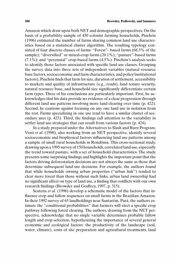
Amazon which draw upon both NET and demographic perspectives. On thebasis of a probability sample of 450 colonist farming households, Pinchon(1996) estimated the number of farms sharing common land use character-istics based on a statistical cluster algorithm. The resulting typology con-sisted of four discrete classes of farms: “Forest”- based farms (68.3% of thesample); “diversified” or mixed-crop farms (20.1%); “pasture”-based farms(7.1%); and “perennial” crop-based farms (4.5%). Pinchon’s analysis seeksto identify those factors associated with specific land use classes. Groupingthe survey data into three sets of independent variables (natural resourcebase factors, socioeconomic and farm characteristics, and policy/institutionalfactors), Pinchon finds that farm lot size, duration of settlement, accessibilityto markets and quality of infrastructure (e.g., roads), land tenure security,natural resource base, and household size significantly differentiate certainfarm types. Three of his conclusions are particularly important. First, he ac-knowledges that his data provide no evidence of a clear progression throughdifferent land use patterns involving more land clearing over time (p. 422).Second, he cautions against focusing on any one land use in isolation fromthe rest. Farms specializing in one use tend to have a similar cluster of sec-ondary uses (p. 423). Third, the findings call attention to the variability insettler land use strategies that can result from various factors (p. 424).
In a study prepared under the Alternatives to Slash and Burn Program,Vosti et al. (1998), also working from an NET perspective, identify severalsocioeconomic and biophysical factors influencing land use patterns amonga sample of small rural households in Rondonia. This cross-sectional study,drawing upon a 1995 survey of 150 households, correlated land use, especiallythe trend toward pasture, with a set of household characteristics. The studypresents some surprising findings and highlights the important point that thefactors driving deforestation decisions are not always the same as those thatdetermine subsequent land use decisions. For example, the authors foundthat while households owning urban properties (“urban link”) tended toclear more forest than those without such links, urban land ownership hadno significant affect on type of land use, a finding that conflicts with our ownresearch findings (Browder and Godfrey, 1997, p. 315).
Scatena et al. (1996) develop a schematic model of the factors that in-fluence crop and fallow sequences on small farms in the Brazilian Amazon.In their 1992 survey of 65 landholdings near Santarem, Para, the authors es-timate the “conditional probabilities” that farmers will elect a specific croppathway following forest clearing. The authors, drawing from the NET per-spective, acknowledge that no single variable determines probable fallowlength and crop selection, hypothesizing the importance of several generaleconomic and ecological factors: the productivity of the landscape (soil,water, climate), costs of site preparation and agricultural treatments, land
P1: FLT
Human Ecology [huec] PP1142-huec-481858 March 9, 2004 10:2 Style file version Nov. 19th, 1999
Land Use Patterns in the Brazilian Amazon 201
availability, labor availability, age structure of families and their subsistencerequirements, and various local economic conditions (e.g., land values, credit,off-farm income, commodity markets) (p. 37).
Jones et al. (1995), using cross-sectional data from a 1991 survey of 83small-scale multiproduct farms in Ouro Preto municipality of Rondonia,estimate the production functions of several agricultural land use activities.Their aim was not to predict specific land use sequences over time, but ratherto examine the determinants of gross farm income and deforestation. Theauthors found evidence of increasing income returns to scale in cattle. How-ever, they indicate that cattle income appears to be a “hedge” that permitsmore extensive cultivation of subsistence food crops, rather than providing aspringboard for investing in more risky perennial crops, suggesting a possible“target income” response by farmers (p. 183). Moreover, they found that de-forestation appears to be driven more strongly by crop profitability than byprofitability of cattle production. While the authors affirm that “Rondonianfarmers appear to be making economically thought-out land-use choices”(p. 183), they concede that income maximization and capital accumulationby themselves are not the sole criteria used by farmers in making land usedecisions. Once farmers earn a “target income” from one activity (e.g., cat-tle), they diversify into other activities (e.g., plant annual crops) to reducethe risk of household food scarcity.
Emilio Moran’s work (1989; Moran et al., 2001) has been especiallyinfluential in framing much of the recent demographic and human ecologi-cal approaches to Amazon land use studies. For example, McCracken et al.(1999), working with Moran, propose a household evolution model com-posed of five stages that link changes in household composition to differentgeneralized land uses. Their model assumes that settlers arriving in the fron-tier are relatively similar in regard to household age and composition andtheir initial land use strategy focuses on annual cash crop production. Overtime, families that are able to accumulate capital from annual cropping be-gin to diversify into cattle and perennial crops. Families that are unable tocapitalize remain dependent on annual crops. While the specific land usetrajectory of any given household may be influenced by exogenous factorsover time or “period effects,” the most important determinant of land usestrategy is the amount of available household labor.
Perz’s research (2000) finds that “demographic factors exert significanteffects on land use and land cover change” (p. 10). On the basis of a 1996survey of 261 farms in Uruara, Para, Perz found that selected householdlife cycle variables positively correlated with three different farming sys-tems (based on the area in perennial crops, pasture, and secondary forest).He also verified the importance of nondemographic variables, especiallydistance to market, number of farms owned, land title status, and use of
P1: FLT
Human Ecology [huec] PP1142-huec-481858 March 9, 2004 10:2 Style file version Nov. 19th, 1999
202 Browder, Pedlowski, and Summers
credit. In addition, he calls attention to the aging of the colonist populationof Amazonia, most of whom arrived in the 1970s as young families and whoare now retiring and turning over their properties to a “second generation”of land owners. Given the modified landscapes that these new land ownersinherit, their land use decisions may be different from those inferred fromsurveys of first-generation pioneer farmers.
A very recent, yet unpublished study (Pan et al., 2001) presents thepreliminary findings of a 9-year follow-up survey of the same sample frameused in Pichon’s study, providing one of the few examples of a longitudinal(1990–99) rural household study. Several long-term trends emerge: the pro-gressive subdivision of original farms and corresponding reduction in meanfarm size (to fewer than 20 ha); the doubling of the sample population due tonatural growth and in-migration; the continued clearing of forest for pasture,perennials, and annuals; a greater proportion of land in perennials and annu-als than in 1990; and socioeconomic differentiation in which wealthier farmsmove toward expansion of pasture area and cattle herd (Pan et al., 2001). Sig-nificantly, the authors acknowledge that socioeconomic influences on landuse (perhaps as opposed to strictly demographic variables) are “complex,”suggesting the need for further study.
Other work by political ecologists Collins (1986) and Stonich (1993)points to the structural determinants of small farm land use change in ef-forts to explain the high rates of small farm failure. Although not specifyinga typology of farm-level land use pathways, Collins (1986) proposes a syner-gistic model relating colonist differentiation (toward poverty) with processesof ecological degradation in the Brazilian Transamazon, Northeast Ecuado-rian Amazon, and the Tambopata Valley region of the Peruvian Amazon.Drawing upon secondary sources, namely Moran (1974, 1981), Smith (1981),and Wood and Schmink (1979), Collins notes that colonists participatingin the government’s Transamazon colonization program did not enter theregion with comparable skills, experience, and capital, a finding that seem-ingly contradicts the later work of McCracken et al. (1999). Rather, colonistswere initially segmented into two groups, “brokers and clients,” according toMoran. From the onset of their Amazonian experience, then, smallholderswere differentiated in their capacities and access to resources, and presum-ably reached land use decisions on the basis of different situationally specificcriteria. One would not expect to find, therefore, a single land use decision-making function applicable to most households.
A more exhaustive review and synthesis of research literature is pre-sented in Angelsen and Kaimowitz (1999), who examine trends emergingfrom over 140 economic models (including many specified at the householdlevel) analyzing the causes of tropical deforestation. The growing interest inhousehold-level survey-based research is not without critics. For example,
P1: FLT
Human Ecology [huec] PP1142-huec-481858 March 9, 2004 10:2 Style file version Nov. 19th, 1999
Land Use Patterns in the Brazilian Amazon 203
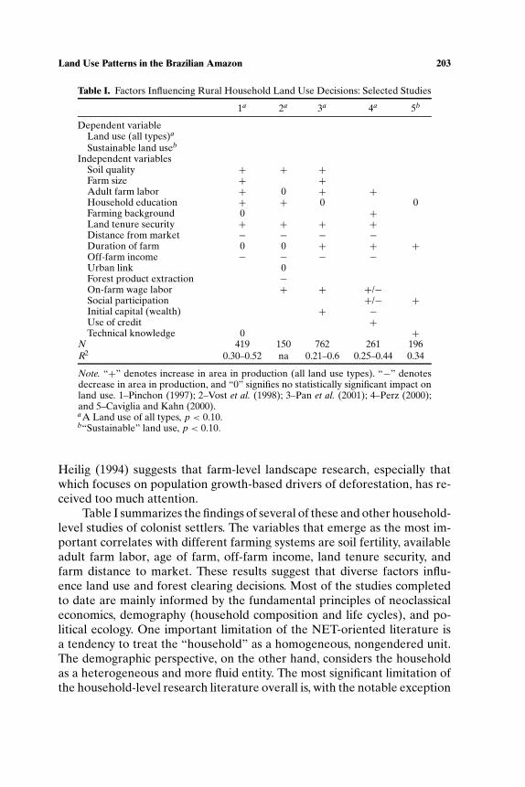
Table I. Factors Influencing Rural Household Land Use Decisions: Selected Studies
1a 2a 3a 4a 5b
Dependent variableLand use (all types)a
Sustainable land useb
Independent variablesSoil quality + + +Farm size + +Adult farm labor + 0 + +Household education + + 0 0Farming background 0 +Land tenure security + + + +Distance from market − − − −Duration of farm 0 0 + + +Off-farm income − − − −Urban link 0Forest product extraction −On-farm wage labor + + +/−Social participation +/− +Initial capital (wealth) + −Use of credit +Technical knowledge 0 +
N 419 150 762 261 196R2 0.30–0.52 na 0.21–0.6 0.25–0.44 0.34
Note. “+” denotes increase in area in production (all land use types). “−” denotesdecrease in area in production, and “0” signifies no statistically significant impact onland use. 1–Pinchon (1997); 2–Vost et al. (1998); 3–Pan et al. (2001); 4–Perz (2000);and 5–Caviglia and Kahn (2000).aA Land use of all types, p < 0.10.b“Sustainable” land use, p < 0.10.
Heilig (1994) suggests that farm-level landscape research, especially thatwhich focuses on population growth-based drivers of deforestation, has re-ceived too much attention.
Table I summarizes the findings of several of these and other household-level studies of colonist settlers. The variables that emerge as the most im-portant correlates with different farming systems are soil fertility, availableadult farm labor, age of farm, off-farm income, land tenure security, andfarm distance to market. These results suggest that diverse factors influ-ence land use and forest clearing decisions. Most of the studies completedto date are mainly informed by the fundamental principles of neoclassicaleconomics, demography (household composition and life cycles), and po-litical ecology. One important limitation of the NET-oriented literature isa tendency to treat the “household” as a homogeneous, nongendered unit.The demographic perspective, on the other hand, considers the householdas a heterogeneous and more fluid entity. The most significant limitation ofthe household-level research literature overall is, with the notable exception
P1: FLT
Human Ecology [huec] PP1142-huec-481858 March 9, 2004 10:2 Style file version Nov. 19th, 1999
204 Browder, Pedlowski, and Summers
of Pan et al., 2001, that the dynamics of landscape change are not easilyinferable from static one-time case studies. As such, the literature suggeststhat researchers are still unable to accurately simulate or predict the landuse pathways of small farmers over time.
A BRIEF HISTORY OF CONTEMPORARY SETTLEMENTIN RONDONIA
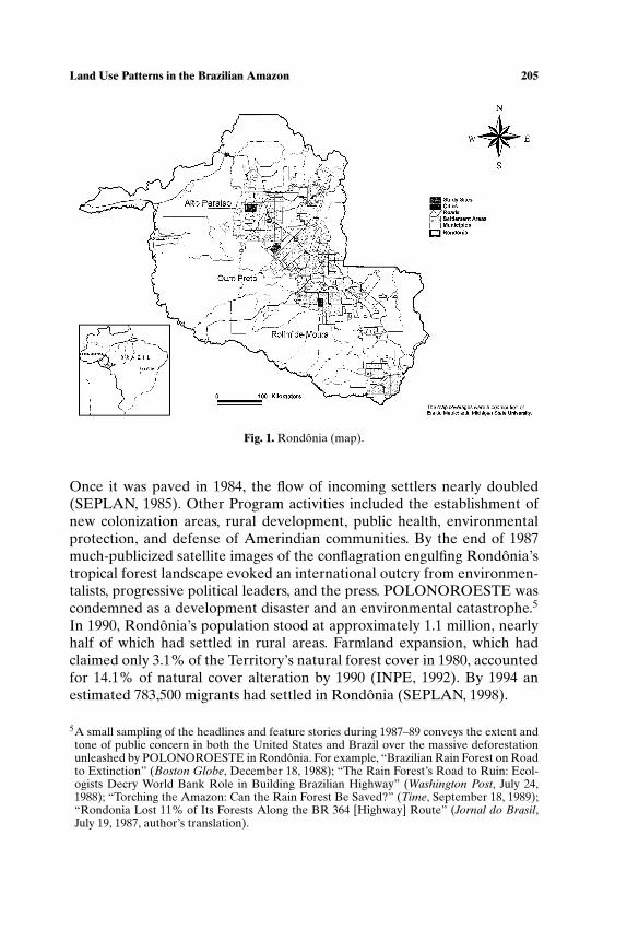
Until the 1970s the Federal Territory of Guapore (now State ofRondonia) was a distant backwater with fewer than 100,000 inhabitants andwith little economic significance, except briefly during the later years of theAmazon rubber boom (Browder and Godfrey, 1997, pp. 164–175; FundacaoCultural do Estado de Rondonia, 1993; Gomes da Silva, 1984; Pinto, 1993;Weinstein, 1983). By the early 1970s the Brazilian military government facedthe dilemma of what to do with a growing landless rural population that hadbeen displaced from sharecropping arrangements by the agricultural trans-formation of the South and Southeast from medium-sized, labor-intensivecoffee farms to large-scale, mechanized soybean plantations, a transfor-mation that the government had promoted in the previous decade (Bakx,1987; Browder and Godfrey, 1997; Millikan, 1988; Mueller, 1980; Quandt,1986). During the 1970s an estimated 2.5 million displaced rural workersleft from just one state, Parana, alone (Mahar, 1989, p. 52; Martine, 1988).Anxious to deflect the growing tide of landless migrants away from Brazil’salready bulging nearby metropolitan centers (Rio de Janeiro and Sao Paulo),Rondonia was hastily opened to new settlement as part of the government’sAmazon regional development program—POLAMAZONIA (Fig. 1). Ini-tial government efforts to regulate the rapid settlement of Rondonia intosix planned colonization areas were overwhelmed from the start, as tensof thousands of landless migrants poured into the Territory on the dirt roadthat would become a paved interstate highway (BR 364). From 1971 to 1985,the population of Rondonia grew at an average annual rate of 16%, from111,000 to 1,122,800 (IBGE, 1974; Secretaria de Planejamento para o Es-tado de Rondonia [SEPLAN], 1985), in what the Washington Post calledthe “greatest land rush since the settling of the American West” (Bridges,1988).
In 1981 the Brazilian government secured a loan from the World Bankto partially finance the $1.5 billion Northwest Region Development Pro-gram (POLONOROESTE). Intending to “help bring order to the large,spontaneous migratory flow to the Northwest” (World Bank, 1981, p. iii),the centerpiece of the Program was the construction of an all-weather high-way (BR 364) linking the Territory to Brazil’s national highway system.
P1: FLT
Human Ecology [huec] PP1142-huec-481858 March 9, 2004 10:2 Style file version Nov. 19th, 1999
Land Use Patterns in the Brazilian Amazon 205
Fig. 1. Rondonia (map).
Once it was paved in 1984, the flow of incoming settlers nearly doubled(SEPLAN, 1985). Other Program activities included the establishment ofnew colonization areas, rural development, public health, environmentalprotection, and defense of Amerindian communities. By the end of 1987much-publicized satellite images of the conflagration engulfing Rondonia’stropical forest landscape evoked an international outcry from environmen-talists, progressive political leaders, and the press. POLONOROESTE wascondemned as a development disaster and an environmental catastrophe.5
In 1990, Rondonia’s population stood at approximately 1.1 million, nearlyhalf of which had settled in rural areas. Farmland expansion, which hadclaimed only 3.1% of the Territory’s natural forest cover in 1980, accountedfor 14.1% of natural cover alteration by 1990 (INPE, 1992). By 1994 anestimated 783,500 migrants had settled in Rondonia (SEPLAN, 1998).
5A small sampling of the headlines and feature stories during 1987–89 conveys the extent andtone of public concern in both the United States and Brazil over the massive deforestationunleashed by POLONOROESTE in Rondonia. For example, “Brazilian Rain Forest on Roadto Extinction” (Boston Globe, December 18, 1988); “The Rain Forest’s Road to Ruin: Ecol-ogists Decry World Bank Role in Building Brazilian Highway” (Washington Post, July 24,1988); “Torching the Amazon: Can the Rain Forest Be Saved?” (Time, September 18, 1989);“Rondonia Lost 11% of Its Forests Along the BR 364 [Highway] Route” (Jornal do Brasil,July 19, 1987, author’s translation).
P1: FLT
Human Ecology [huec] PP1142-huec-481858 March 9, 2004 10:2 Style file version Nov. 19th, 1999
206 Browder, Pedlowski, and Summers
Although initially projecting a hefty internal rate of return of 22% oninvestments in POLONOROESTE (World Bank, 1981, p. 47), by 1987 theWorld Bank had virtually acknowledged that the Program had failed. “De-spite the intentions and safeguards of the Northwest project designs, defor-estation has accelerated sharply and uptake of sustainable farming systemshas been less than expected” (World Bank, 1987, p. i).
In 1992 the World Bank approved a second loan for $167 millionto support the Rondonia Natural Resources Management Project(PLANAFLORO). The original goal of PLANAFLORO was to encour-age the intensification of agriculture in areas that had already been set-tled with the expectation that increasing incomes would reduce the incen-tive to clear more forest (Mahar and Ducrot, n.d.). A plan dividing thestate into six different “agroecological and economic zones” was elabo-rated (SEPLAN, 1998). A program to support community-based conser-vation and development was also established in 1994 targeted to farmersgroups (Browder, 2002). Nongovernmental organizations that were vocifer-ous critics of POLONOROESTE were added to the new program’s advi-sory panel. The language used to define the goals of the Project shifted awayfrom the decidedly “developmentalist” ideology of POLONOROESTE toembrace at least the spirit of the environmental conservation and sustain-able development of the 1990s. The Project would assist the Brazilian gov-ernment: to institute policy reforms aimed at propitiating a coherent struc-ture of incentives for sustainable development; to conserve biodiversity;to protect conservation units, indigenous, forest, and extractive reserves;and to develop intensive and integrated systems of permanent agri-culture, agroforestry, and forest management systems (World Bank,1995).
Despite these noble intentions, implementing PLANAFLORO provedto be an administrative nightmare involving dozens of federal, state, and localgovernment agencies, the World Bank, the UNDP, the FAO, community or-ganizations, and other non-governmental entities. In 1995 a group of NGOssponsored by Friends of the Earth (FOE) petitioned the World Bank to con-vene an “Inspection Panel” to review claims of irregularities associated withPLANFLORO (FOE, 1995). The Panel’s report, calling for a series of re-medial “monitorable [sic] actions,” combined with critical midterm Projectevaluations (Bursztyn, 1996; Deusdara Filho and Hummel, n.d.; Lino deJesus, 1998), indicated that the effectiveness of the zoning plan, the manage-ment of protected areas, and initiatives to promote sustainable agriculturaldevelopment in settled areas had fallen far short of expectations. By 1998,Rondonia’s estimated population stood 1.4 million and 23.5% of the state’snatural forest vegetation had been cleared mainly by small farmers (InstitutoBrasileiro do meio Ambiente, 1999).
P1: FLT
Human Ecology [huec] PP1142-huec-481858 March 9, 2004 10:2 Style file version Nov. 19th, 1999
Land Use Patterns in the Brazilian Amazon 207
Table II. Characteristics of Project Study Sites in Rondonia
Characteristic Nova Uniao Alto Paraiso Rolim de Moura
Location 62◦35′ W × 10◦50′ S 63◦20′ W × 9◦35′ S 62◦47′ W × 11◦40′ SElevationa 100–225 110–369 250Average annual 1600–1700 2000–2100 2000–2250
rainfall (mm)Main soil typeb PE 3/Rec Pva 13/Rd 3d PE 9/Ce 23c
Vegetation cover TTSMF f TTSMF TTSMFSample size (farms) 97 82 61aMeters above sea level (IBGE, Elevation maps, 1974).bProjeto Radambrasil. Mapa Exploratorio de Solos, 1:1000,000, 1979.cEutrophic yellow–red podsols with patches of eutrophic litolic soils.dAlic yellow–red podsols with patches of distrophic litolic soils.eEutrophic yellow–red podsols and nonhydromorphic cambisols.f Transitional tropical seasonal moist forest.
STUDY SITES AND RESEARCH METHODOLOGY
To ascertain the land use patterns and ultimately the long-term pro-cesses of landscape change among the small farmers of Rondonia, we con-ducted a rural household-level survey in 1992. Three different settlementsites were selected from the 26 extant settlement areas in Rondonia in 1992(Fig. 1): Ouro Preto D’Oeste (now Nova Uniao), Alto Paraiso, and Rolim deMoura. A stratified random sample of 240 households was selected, and bothmale and female household heads were interviewed by trained Brazilian re-searchers using a standardized 18-page questionnaire. The characteristics offarm households surveyed were generally similar in all three sites (Table II).Yet distinct land use patterns emerged from each site as indicated in ourcluster analysis, below.
FARM-LEVEL LAND USE PATTERNS IN RONDONIA:A DESCRIPTIVE CLUSTER ANALYSIS
In this section four land-use typologies were generated through a sta-tistical clustering technique and differences between clusters were assessedwith ANOVA and chi-square tests on the basis of several household charac-teristics. A hierarchical technique, Ward’s Method, was used to establish thenumber of clusters, initial cluster centers, and identify outliers. The clusterswere based on the proportion of the deforested farm area in a specific landuse. Households were reclustered using a nonhierarchical method (k-means)with cluster centers as initial seed points to generate our final land use ty-pology. To identify factors that may influence household land use decisions,
P1: FLT
Human Ecology [huec] PP1142-huec-481858 March 9, 2004 10:2 Style file version Nov. 19th, 1999
208 Browder, Pedlowski, and Summers
a series of household characteristics were correlated with each cluster. Theresults of these analysis-of-variance (ANOVA) tests are reported below.We attempt to closely replicate the analysis conducted by Pinchon (1996)to facilitate comparison of the Ecuadorian and Brazilian Amazonian ru-ral populations. The analysis examines different land use combinations onthe basis of the percentage of cultivated (deforested) farm area allocatedto perennial crops (mainly coffee and cacao, but also various fruit and palmspecies), temporary crops (mainly upland rice, maize, cowpeas, and manioc),and pasture (including fallow land), while secondary forest (generally olderthan 7–10 years) was grouped with primary forest. Table III lists the criteriaused to classify farms by land use type, and the cluster types.
The first typology consists of four land use clusters characterizing thethree study sites combined (Fig. 2) Initially, four land use clusters emergedfrom the combined survey data: Cluster 1, “pasture intensive,” in which 86%
Table III. Criteria for Classification of Land Use Clusters
Land use type Code Criteria
Annual crop-basedsystemsAnnuals A >60% of deforested land allocated to annual cropsAnnual-pasture AT >40% of deforested land allocated to annual crops,
>20% allocated to pasture, and <20% allocatedto other uses
Annual-perennials AP >40% of deforested land allocated to annual crops,>20% allocated to perennials, and <20% allocatedto other uses
Annual-mixed AM >50% of deforested land allocated to annual crops,>20% allocated to both pasture and perennials
Perennial crop-basedsystemsPerennials P >60% of deforested land allocated to perennial cropsPerennial-annuals PA >40% of deforested land allocated to perennials crops,
>20% allocated to annuals, <20% allocatedto pasture
Perennial-mixed PM >50% of deforested area allocated to perennials,>20% allocated to both pasture and annuals
Pasture-based systemsPasture T >60% of deforested land allocated to pasture grassPasture-annuals TA >40% of deforested land allocated to pasture,
>20% allocated to annuals, <20% allocatedto perennials
Pasture-perennials TP >40% of deforested land allocated to pasture, >20%allocated to perennials, <20% allocated to annuals
Pasture-mixed TM >50% of deforested area allocated to pasture, >20% ofdeforested area allocated to both annuals andperennials
Mixed crop system M Each land use represented by >20% but <50% ofdeforested area
P1: FLT
Human Ecology [huec] PP1142-huec-481858 March 9, 2004 10:2 Style file version Nov. 19th, 1999
Land Use Patterns in the Brazilian Amazon 209
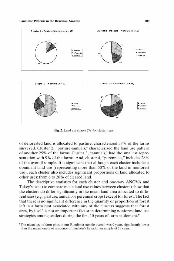
Fig. 2. Land use shares (%) by cluster type.
of deforested land is allocated to pasture, characterized 38% of the farmssurveyed. Cluster 2, “pasture-annuals,” characterized the land use patternof another 25% of the farms. Cluster 3, “annuals,” had the smallest repre-sentation with 9% of the farms. And, cluster 4, “perennials,” includes 28%of the overall sample. It is significant that although each cluster includes adominant land use (representing more than 50% of the land in nonforestuse), each cluster also includes significant proportions of land allocated toother uses: from 6 to 26% of cleared land.
The descriptive statistics for each cluster and one-way ANOVA andTukey’s tests (to compare mean land use values between clusters) show thatthe clusters do differ significantly in the mean land area allocated to diffe-rent uses (e.g., pasture, annual, or perennial crops) except for forest. The factthat there is no significant difference in the quantity or proportion of forestleft in a farm plot associated with any of the clusters suggests that forestarea, by itself, is not an important factor in determining nonforest land usestrategies among settlers during the first 10 years of farm settlement.6
6The mean age of farm plots in our Rondonia sample overall was 9 years, significantly lowerthan the mean length of residence of Pinchon’s Ecuadorian sample of 13 years.
P1: FLT
Human Ecology [huec] PP1142-huec-481858 March 9, 2004 10:2 Style file version Nov. 19th, 1999
210 Browder, Pedlowski, and Summers
Clusters were compared not only according to the proportion (%) ofland allocated to each land use class, but also in relation to several otherhousehold variables (Table IV). For example, two clusters (clusters 1 and 3)differed significantly in terms of “farm size” (farm area): the largest farmsaveraging 95.8 ha, specialized in intensive pasture (i.e., cattle ranching)—cluster 1. The smallest farms, averaging 51.2 ha, specialized in annual crops—cluster 3. The total amount of land deforested also differed significantlybetween most clusters, with cluster 1 (Pasture Intensive) having three timesmore deforested land than cluster 3 (Annuals). The size of cattle herds, notsurprisingly, was strongly linked to the pasture land use type, with cluster 1being significantly larger in mean herd size (mean = 42 animals) than theother clusters.
Perhaps most interesting are those findings for which differences be-tween clusters were not statistically significant. For example, while the avail-ability of unremunerated household labor (i.e., unpaid family workers) is afrequently asserted driver of land use differentiation in the farming systemresearch literature, the Rondonia analysis found that none of the clusterswere significantly different on the basis of number of working age house-hold members (ages 11–65 years), and, only one pair of clusters (clusters 1and 2, both pasture-based farming systems), was significantly different onthe basis of total family size. This finding seems to suggest that householdsize does not uniformly influence land use patterns. It is interesting that inPinchon’s Ecuador study smaller families were also associated with largerfarm areas allocated to pasture (Pinchon, 1996).
Another important finding is that the period (i.e., years) of residenceon the farm lot does not significantly differ among clusters, suggesting thatdifferent age cohorts within a cross-sectional data base do not reliably bench-mark distinct stages in a land use progression over time. This finding pointsto some reconsideration of the notion of life cycle stages emphasized bysome of the demographic-oriented research (McCracken et al., 1999). Athird variable, the number of urban and rural properties owned by surveyrespondents, was not significantly different among land use classes. This issurprising, given the differences in land use patterns between rural-basedand urban-based farm land owners observed by the lead author in earlierresearch (Browder and Godfrey, 1997). A fourth variable, social participa-tion rates (i.e., involvement in production-oriented farmer associations), wasalso found not to be significantly different among land use types, suggestinga revisitation of other earlier research (Caviglia and Kahn, 2000).
Chi-square tests were also run on several other household variables(Table V): the percentage of households (1) owning more than one ruralproperty; (2) having at least one member working off-farm; (3) having se-cure land tenure; (4) receiving rural credit; and (5) owning at least one urban
P1: FLT
Human Ecology [huec] PP1142-huec-481858 March 9, 2004 10:2 Style file version Nov. 19th, 1999
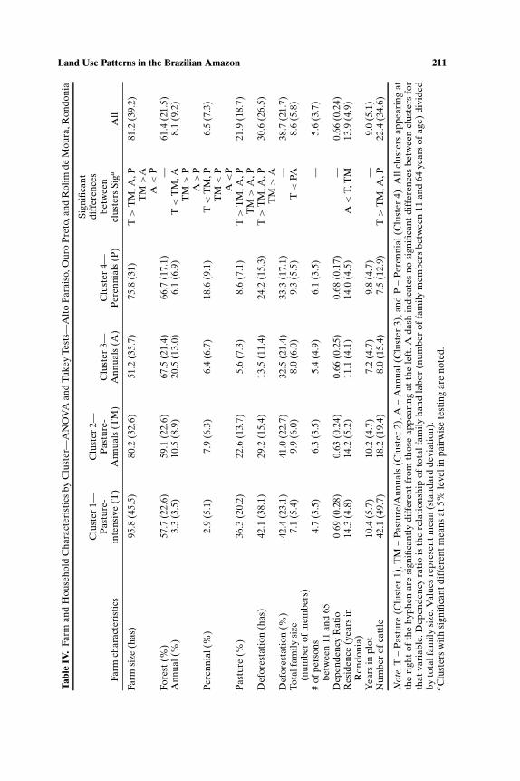
Land Use Patterns in the Brazilian Amazon 211Ta
ble
IV.
Farm
and
Hou
seho
ldC
hara
cter
isti
csby
Clu
ster
—A
NO
VA
and
Tuke
yTe
sts—
Alt
oP
arai
so,O
uro
Pre
to,a
ndR
olim
deM
oura
,Ron
doni
a
Sign
ifica
ntC
lust
er1—
Clu
ster
2—di
ffer
ence
sP
astu
re-
Pas
ture
-C
lust
er3—
Clu
ster
4—be
twee
nFa
rmch
arac
teri
stic
sin
tens
ive
(T)
Ann
uals
(TM
)A
nnua
ls(A
)P
eren
nial
s(P
)cl
uste
rsSi
gaA
ll
Farm
size
(has
)95.8
(45.
5)80.2
(32.
6)51.2
(35.
7)75.8
(31)
T>
TM
,A,P
81.2
(39.
2)T
M>
AA<
PFo
rest
(%)
57.7
(22.
6)59.1
(22.
6)67.5
(21.
4)66.7
(17.
1)—
61.4
(21.
5)A
nnua
l(%
)3.
3(3.5
)10.5
(8.9
)20.5
(13.
0)6.
1(6.9
)T<
TM
,A8.
1(9.2
)T
M>
PA>
PP
eren
nial
(%)
2.9
(5.1
)7.
9(6.3
)6.
4(6.7
)18.6
(9.1
)T<
TM
,P6.
5(7.3
)T
M<
PA<
PP
astu
re(%
)36.3
(20.
2)22.6
(13.
7)5.
6(7.3
)8.
6(7.1
)T>
TM
,A,P
21.9
(18.
7)T
M>
A,P
Def
ores
tati
on(h
as)
42.1
(38.
1)29.2
(15.
4)13.5
(11.
4)24.2
(15.
3)T>
TM
,A,P
30.6
(26.
5)T
M>
AD
efor
esta
tion
(%)
42.4
(23.
1)41.0
(22.
7)32.5
(21.
4)33.3
(17.
1)—
38.7
(21.
7)To
talf
amily
size
7.1
(5.4
)9.
9(6.0
)8.
0(6.0
)9.
3(5.5
)T<
PA8.
6(5.8
)(n
umbe
rof
mem
bers
)#
ofpe
rson
s4.
7(3.5
)6.
3(3.5
)5.
4(4.9
)6.
1(3.5
)—
5.6
(3.7
)be
twee
n11
and
65D
epen
denc
yR
atio
0.69
(0.2
8)0.
63(0.2
4)0.
66(0.2
5)0.
68(0.1
7)—
0.66
(0.2
4)R
esid
ence
(yea
rsin
14.3
(4.8
)14.2
(5.2
)11.1
(4.1
)14.0
(4.5
)A<
T,T
M13.9
(4.9
)R
ondo
nia)
Yea
rsin
plot
10.4
(5.7
)10.2
(4.7
)7.
2(4.7
)9.
8(4.7
)—
9.0
(5.1
)N
umbe
rof
catt
le42.1
(49.
7)18.2
(19.
4)8.
0(1
5.4)
7.5
(12.
9)T>
TM
,A,P
22.4
(34.
6)
Not
e.T
–P
astu
re(C
lust
er1)
,TM
–P
astu
re/A
nnua
ls(C
lust
er2)
,A–
Ann
ual(
Clu
ster
3),a
ndP
–P
eren
nial
(Clu
ster
4).A
llcl
uste
rsap
pear
ing
atth
eri
ght
ofth
ehy
phen
are
sign
ifica
ntly
diff
eren
tfr
omth
ose
appe
arin
gat
the
left
.Ada
shin
dica
tes
nosi
gnifi
cant
diff
eren
ces
betw
een
clus
ters
for
that
vari
able
.Dep
ende
ncy
rati
ois
the
rela
tion
ship
ofto
talf
amily
hand
labo
r(n
umbe
rof
fam
ilym
embe
rsbe
twee
n11
and
64ye
ars
ofag
e)di
vide
dby
tota
lfam
ilysi
ze.V
alue
sre
pres
entm
ean
(sta
ndar
dde
viat
ion)
.aC
lust
ers
wit
hsi
gnifi
cant
diff
eren
tmea
nsat
5%le
veli
npa
irw
ise
test
ing
are
note
d.

P1: FLT
Human Ecology [huec] PP1142-huec-481858 March 9, 2004 10:2 Style file version Nov. 19th, 1999
212 Browder, Pedlowski, and Summers
Tabl
eV
.Fa
rman
dH
ouse
hold
Cha
ract
eris
tics
—C
hi-S
quar
eTe
stB
etw
een
Clu
ster
s
%O
fhou
seho
lds
wit
hin
each
clus
ter
Farm
Clu
ster
1—P
astu
reC
lust
erC
lust
erC
lust
erP
ears
onch
arac
teri
stic
(int
ensi
ve)
2—P
astu
re-m
ixed
3—A
nnua
ls4—
Per
enni
als
Mea
nχ
2va
luea
Rur
alP
rope
rtie
sb21
.611
.713
.617
.216
.50.
41O
ff-f
arm
empl
oym
entc
31.2
23.4
29.2
22.4
26.3
0.61
Lan
dte
nure
secu
rity
d49
.457
.336
.451
.751
.30.
37C
redi
te1.
31.
30
1.7
1.3
0.94
Pla
ntna
tive
tree
spec
iesf
11.7
19.5
16.7
32.8
19.9
0.02
4a
Fore
stex
trac
tion
g32
.545
.537
.556
.943
.20.
036a
Urb
anco
nnec
tion
h37
.020
.925
.022
.728
.80.
115
Soci
alpa
rtic
ipat
ioni
35.5
54.5
34.8
46.6
44.4
0.09
Not
e.C
lust
er1
–P
astu
re(T
);C
lust
er2
–P
astu
re-A
nnua
ls(T
M);
Clu
ster
3–
Ann
uals
(A);
Clu
ster
4–
Per
enni
als
(P).
asi
gnifi
cant
diff
eren
cebe
twee
ncl
uste
rsat
the
leve
lof0
.05.
b%
Ofh
ouse
hold
sw
ithi
nea
chcl
uste
rth
atha
vem
ore
than
one
rura
lpro
pert
y.c %
Ofh
ouse
hold
sw
ithi
nea
chcl
uste
rth
atha
veat
leas
tone
mem
ber
ofth
eho
useh
old
wor
king
off-
farm
.d%
Ofh
ouse
hold
sw
ithi
nea
chcl
uste
rth
atha
vefu
llte
nure
secu
rity
(leg
alla
ndti
tle)
.e %
Ofh
ouse
hold
sth
atre
ceiv
edcr
edit
last
year
wit
hin
each
clus
ter.
f %O
fhou
seho
lds
that
plan
ted
nati
vetr
eesp
ecie
s(a
tlea
ston
ena
tive
tree
spec
ies—
cere
jeir
a,ce
dro,
cedr
oro
sa,s
erin
ga,o
rca
oba)
.g%
Ofh
ouse
hold
sth
atex
trac
ted
atle
asto
nefo
rest
prod
uctw
ithi
nea
chcl
uste
r.h%
Ofh
ouse
hold
sth
atha
veat
leas
tone
urba
nho
useh
old.
i %O
fhou
seho
lds
that
part
icip
ate
inat
leas
tone
type
ofru
rals
ocia
lorg
aniz
atio
nor
asso
ciat
ion.
P1: FLT
Human Ecology [huec] PP1142-huec-481858 March 9, 2004 10:2 Style file version Nov. 19th, 1999
Land Use Patterns in the Brazilian Amazon 213
property. Although these variables may influence household land use deci-sions, none were found to be significantly different between land use clusters.Interestingly, two land use clusters (perennial and pasture) were significantlydifferentiated among farmers who have planted native tree species and ex-tracted forest products on their farms. We posit that a household member’sknowledge of native tree species and use of forest resources may play animportant role in determining some nonforest land use patterns.
When the household-level survey data were separated by municipal-ity, some interesting differences in the analysis emerged. These local-levelresults are summarized by municipio in the following pie charts.
Alto Paraiso
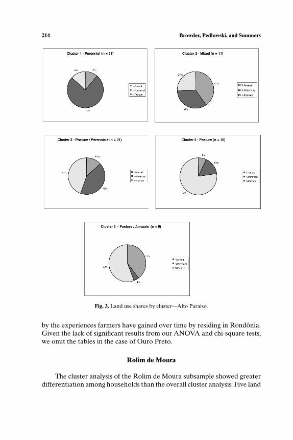
The household sample in Alto Paraiso was sorted into five land useclusters on the basis of the criteria specified (Table III). As in the othermunicipios, the dominant land use system in Alto Paraiso is cattle ranching.However, this settlement area is distinctive among the three in having thelargest number of farms engaged in predominantly perennial cropping landuse systems (Fig. 3).
Differences in farm area (“plot area”), household size, years on farm,and social participation were not significantly associated with any clusters.Moreover, multiple rural property ownership, off-farm employment, landtenure security, credit consumption, and natural resource knowledge werenot significantly different between cluster pairs. Interestingly, the percentof households that extracted at least one forest product and the percentof households that owned at least one urban property were significantlydifferent, suggesting, in the latter case, that the “urban connection” may bea factor influencing rural household land use in Alto Paraiso.
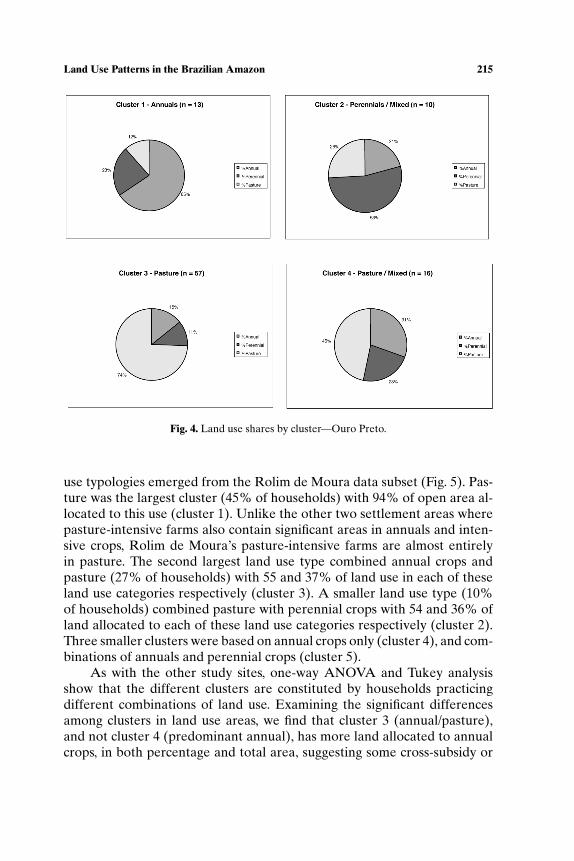
Ouro Preto D’Oeste (Now Nova Uniao)
Four land use types emerged from the cluster analysis of the OuroPreto household sample (Fig. 4). Cattle ranching is the predominant landuse type, where 59% of farms had 74% of their cleared area in pasture.However, like Alto Pariaso, the pasture-based farms in Ouro Preto alsocontained significant areas (26% of area cleared) in other land uses (annualsand perennials), indicating a tendency toward a more mixed farming strategy.
Interestingly, apart from farm size, only one other variable (years inRondonia) proved to be significant, suggesting that land use strategies byfarmers in Ouro Preto, but not in the other settlement areas, are influenced
P1: FLT
Human Ecology [huec] PP1142-huec-481858 March 9, 2004 10:2 Style file version Nov. 19th, 1999
214 Browder, Pedlowski, and Summers
Fig. 3. Land use shares by cluster—Alto Paraiso.
by the experiences farmers have gained over time by residing in Rondonia.Given the lack of significant results from our ANOVA and chi-square tests,we omit the tables in the case of Ouro Preto.
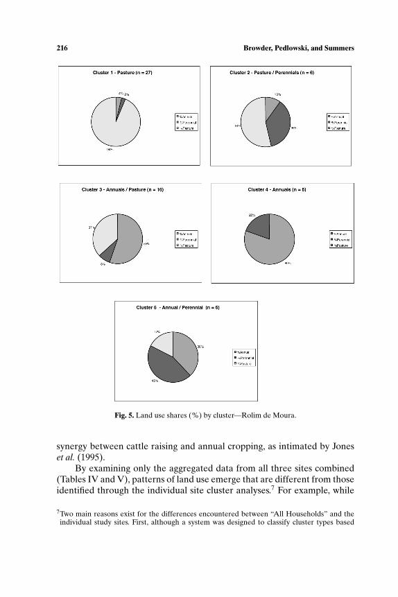
Rolim de Moura
The cluster analysis of the Rolim de Moura subsample showed greaterdifferentiation among households than the overall cluster analysis. Five land
P1: FLT
Human Ecology [huec] PP1142-huec-481858 March 9, 2004 10:2 Style file version Nov. 19th, 1999
Land Use Patterns in the Brazilian Amazon 215
Fig. 4. Land use shares by cluster—Ouro Preto.
use typologies emerged from the Rolim de Moura data subset (Fig. 5). Pas-ture was the largest cluster (45% of households) with 94% of open area al-located to this use (cluster 1). Unlike the other two settlement areas wherepasture-intensive farms also contain significant areas in annuals and inten-sive crops, Rolim de Moura’s pasture-intensive farms are almost entirelyin pasture. The second largest land use type combined annual crops andpasture (27% of households) with 55 and 37% of land use in each of theseland use categories respectively (cluster 3). A smaller land use type (10%of households) combined pasture with perennial crops with 54 and 36% ofland allocated to each of these land use categories respectively (cluster 2).Three smaller clusters were based on annual crops only (cluster 4), and com-binations of annuals and perennial crops (cluster 5).
As with the other study sites, one-way ANOVA and Tukey analysisshow that the different clusters are constituted by households practicingdifferent combinations of land use. Examining the significant differencesamong clusters in land use areas, we find that cluster 3 (annual/pasture),and not cluster 4 (predominant annual), has more land allocated to annualcrops, in both percentage and total area, suggesting some cross-subsidy or
P1: FLT
Human Ecology [huec] PP1142-huec-481858 March 9, 2004 10:2 Style file version Nov. 19th, 1999
216 Browder, Pedlowski, and Summers
Fig. 5. Land use shares (%) by cluster—Rolim de Moura.
synergy between cattle raising and annual cropping, as intimated by Joneset al. (1995).
By examining only the aggregated data from all three sites combined(Tables IV and V), patterns of land use emerge that are different from thoseidentified through the individual site cluster analyses.7 For example, while
7Two main reasons exist for the differences encountered between “All Households” and theindividual study sites. First, although a system was designed to classify cluster types based
P1: FLT
Human Ecology [huec] PP1142-huec-481858 March 9, 2004 10:2 Style file version Nov. 19th, 1999
Land Use Patterns in the Brazilian Amazon 217
farm size is significantly different among various land use clusters in the ag-gregated sample, it is only significantly different between pasture and annualand perennial clusters in the Ouro Preto individual site data. Conversely,while the percentage of farm lot in forest emerges as significantly differentbetween pasture and perennial and mixed systems in Alto Paraiso and be-tween annual and annual–perennial systems in Rolim de Moura, it does notappear to be significantly different among any land use systems in the ag-gregated sample. These discrepancies point to the importance of examiningfiner scale, localized differences in land use patterns and acknowledging theconsiderable diversity of patterns within settlement areas. Among those dif-ferences, several are noteworthy and warrant further discussion (Tables VIand VII)
DISCUSSION
In our cluster analysis of land use data collected from household sur-veys, several distinct combinations of agricultural land use emerge from thispopulation of small-scale farmers in Rondonia. We found that although thefarmers were planting similar crops, the combinations of crops and size ofthe areas planted were wide-ranging. Consequently, a somewhat differenttypology of farming systems emerged for each study site.
Several patterns emerge from these cluster and ANOVA analyses. First,the largest land cover on these 10–12-year-old first-generation farms wasstill primary forest, ranging from 57 to 68% of farm property areas. Futurehousehold research that is able to reconstruct the history of forest clearingsand land uses should reveal much about the factors determining landscapechange in this frontier. Second, during the first decade of settlement theprevalence of pasture—the single largest active land use in all three sites—isnotable. Pasture and cattle raising are integral components of virtually all ofthe diverse farming systems found in Rondonia. Third, there are, however,important differences in prevailing land uses among the study sites. Amongthe three sites the largest proportion of farmland devoted to pasture (28.9%)was found in the Rolim de Moura study site. The largest fraction of farm-land allocated to annual cropping (10.3%) was found in Ouro Preto. And,the largest share of farmland planted in perennial crops (13.0%) was found
on the percentage of land allocated to each land use (Table III), the thresholds specified aredifferent between study sites. For example, a cluster classified as TA (Pasture/Annuals) wouldhave 54% of cleared land in pasture and 36% in annuals in Rolim de Moura, while the relativeproportions would be 42% in pasture and 44% in annuals in Alto Paraiso. Second, there is ahigher probability of finding significant differences between the means of variables in largersamples (All Households) than in smaller samples (individual study sites). This explains whymore significant differences appear in the former than in the latter.
P1: FLT
Human Ecology [huec] PP1142-huec-481858 March 9, 2004 10:2 Style file version Nov. 19th, 1999
218 Browder, Pedlowski, and Summers
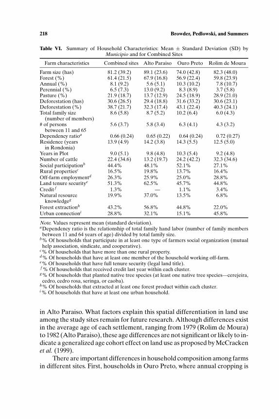
Table VI. Summary of Household Characteristics: Mean ± Standard Deviation (SD) byMunicipio and for Combined Sites
Farm characteristics Combined sites Alto Paraiso Ouro Preto Rolim de Moura
Farm size (has) 81.2 (39.2) 89.1 (23.6) 74.0 (42.8) 82.3 (48.0)Forest (%) 61.4 (21.5) 67.9 (16.8) 56.9 (22.4) 59.8 (23.9)Annual (%) 8.1 (9.2) 5.6 (5.1) 10.3 (10.2) 7.8 (10.7)Perennial (%) 6.5 (7.3) 13.0 (9.2) 8.3 (8.9) 3.7 (5.8)Pasture (%) 21.9 (18.7) 13.7 (12.9) 24.5 (18.9) 28.9 (21.0)Deforestation (has) 30.6 (26.5) 29.4 (18.8) 31.6 (33.2) 30.6 (23.1)Deforestation (%) 38.7 (21.7) 32.3 (17.4) 43.1 (22.4) 40.3 (24.1)Total family size 8.6 (5.8) 8.7 (5.2) 10.2 (6.4) 6.0 (4.3)
(number of members)# of persons 5.6 (3.7) 5.8 (3.4) 6.3 (4.1) 4.3 (3.2)
between 11 and 65Dependency ratioa 0.66 (0.24) 0.65 (0.22) 0.64 (0.24) 0.72 (0.27)Residence (years 13.9 (4.9) 14.2 (3.8) 14.3 (5.5) 12.5 (5.0)
in Rondonia)Years in Plot 9.0 (5.1) 9.8 (4.8) 10.3 (5.4) 9.2 (4.8)Number of cattle 22.4 (34.6) 13.2 (19.7) 24.2 (42.2) 32.3 (34.6)Social participationb 44.4% 48.1% 52.1% 27.1%Rural propertiesc 16.5% 19.8% 13.7% 16.4%Off-farm employmentd 26.3% 25.9% 25.0% 28.8%Land tenure securitye 51.3% 62.5% 45.7% 44.8%Credit f 1.3% — 1.1% 3.4%Natural resource 19.9% 37.0% 13.5% 6.8%
knowledgeg
Forest extractionh 43.2% 56.8% 44.8% 22.0%Urban connectioni 28.8% 32.1% 15.1% 45.8%
Note. Values represent mean (standard deviation).aDependency ratio is the relationship of total family hand labor (number of family membersbetween 11 and 64 years of age) divided by total family size.
b% Of households that participate in at least one type of farmers social organization (mutualhelp association, sindicate, and cooperative).
c% Of households that have more than one rural property.d% Of households that have at least one member of the household working off-farm.e% Of households that have full tenure security (legal land title).f % Of households that received credit last year within each cluster.g% Of households that planted native tree species (at least one native tree species—cerejeira,cedro, cedro rosa, seringa, or caoba).
h% Of households that extracted at least one forest product within each cluster.i % Of households that have at least one urban household.
in Alto Paraiso. What factors explain this spatial differentiation in land useamong the study sites remain for future research. Although differences existin the average age of each settlement, ranging from 1979 (Rolim de Moura)to 1982 (Alto Paraiso), these age differences are not significant or likely to in-dicate a generalized age cohort effect on land use as proposed by McCrackenet al. (1999).
There are important differences in household composition among farmsin different sites. First, households in Ouro Preto, where annual cropping is
P1: FLT
Human Ecology [huec] PP1142-huec-481858 March 9, 2004 10:2 Style file version Nov. 19th, 1999
Land Use Patterns in the Brazilian Amazon 219
Table VII. Summary of ANOVA Tests for Significant Differences Between Land Use Clustersby Municipio and for Combined Sites
Variables Combined Sites Alto Paraiso Ouro Preto Rolim de Moura
Farm size (has) T > TM, A, P — T > A, P —TM > A
A < PForest (%) — T < P, M — A > APAnnual (%) T < TM, A M > P, TP, T A > P, T, PM AT > T, TP
TM > P TA > T, TP, P P > T AP > TA > P T < PM
Perennial (%) T < TM, P P > M, T, TA P > A, T, PM T < TP, APTM < P TP > TA T < PM TP > AT, A
A < P AT < APA < AP
Pasture (%) T > TM, A, P T > P, M, TP, T > A, P T > TP, A, APTA > A, P TA AT > A, AP
TA > M, PTP > P
Deforestation (has) T > TM, A, P T > P, M, TP — T > ATM > A
Deforestation (%) — T > P, M — AT > ATotal family size T < TM — —
(number of members)# of persons — — — —
between 11 and 65Dependancy ratioa — — —Residence A < T, TM — —
(years in Rondonia)Years in Plot — — T > A —Number of cattle T > TM, A, P T > P, M, TP — T > TPSocial participationb — — — —Rural propertiesc — — —Off-farm employmentd — — —Land tenure securitye — — AT, A > AP, TPCredit f — — —Natural resource P > T — — —
knowledgeg
Forest extractionh P > T P > TA — —Urban connectioni T, TA > M, TP — —
Note. ANOVA tests significant at 0.05 level. A – Annuals, AP – Annual/Perennial, AT –Annual/Pasture, M – Mixed, PA – Perennial/Annual, T – Pasture, TA – Pasture/Annual, TP –Pasture/Perennial.aDependency ratio is the relationship of total family hand labor (number of family membersbetween 11 and 64 years of age) divided by total family size.
b% Of households within each cluster that participate in at least one type of social organization(association of mutual help, cooperative, and sindicate).
c% Of households within each cluster that have more than one rural property.d% Of households within each cluster that have at least one member of the household workingoff-farm.
e% Of households within each cluster that have full tenure security (legal land title).f % Of households that received credit last year within each cluster.g% Of households that planted native tree species (at least one native tree species—cerejeira,cedro, cedro rosa, seringa, or caoba).
h% Of households that extracted at least one forest product within each cluster.i % Of households that have at least one urban household.

P1: FLT
Human Ecology [huec] PP1142-huec-481858 March 9, 2004 10:2 Style file version Nov. 19th, 1999
220 Browder, Pedlowski, and Summers
prevalent, contain the most working age members (6.3 per household), whilehouseholds in Rolim de Moura, where pasture is the most important landuse, contain the fewest adults (4.3 per household). Second, although land usesystems within individual study sites were not significantly differentiated onthe basis of household composition, differences in land use and householddemographics between study sites were significant, suggesting some degreeof spatial heterogeneity in the rural population of the frontier. Third, whilepasture was the largest land use among farmers in all three study sites, nearlyhalf of the land use types that were significantly different from each otherinvolved combinations of crops or mixed systems (e.g., pasture–annuals,annuals–perennials). Most farms cannot be readily classified by any singleland use (e.g., perennials, pasture).
The ANOVA tests produced some interesting results as well (Table VII).First, several variables related to land use patterns in other studies, reviewedabove, did not emerge as significant in this analysis. For instance, there wereno significant differences between land use types related to social participa-tion (membership in farmers organizations), land tenure security (except inRolim de Moura), and credit use. Nor were there any significant differencesbetween land use types in relation to asset ownership (possession of morethan one rural or urban property), except in Alto Paraiso, or in householdswith members working off-farm. Moreover, there were no significant dif-ferences among clusters in terms of domestic labor force size (number ofworking age household members), suggesting a reexamination of the influ-ence of household demographic factors on land use. These findings, based onsimple ANOVA and chi-square tests, must be regarded as preliminary, sub-ject to the limitations of these techniques. We do not rule out the possibilitythat these variables are influential in determining land use patterns amongthe rural population. Among the variables that did prove to be significantlydifferent in the overall sample were farm size, total household size (as op-posed to domestic labor force size), duration of residence in Rondonia, and,most interestingly, knowledge of native trees and forest product extraction.Perennial tree crop-based farmers exhibited significantly greater knowledgeof native forest tree species than pasture-based farmers. The ways in whichfarmers learn about forest resources may be an influential factor influencingtheir land use decisions.
CONCLUSIONS
A small, but growing research literature focusing on agricultural landuse patterns and the processes of landscape change in the Amazon Basinhas emerged over the last 10 years. While most of the research has aspired
P1: FLT
Human Ecology [huec] PP1142-huec-481858 March 9, 2004 10:2 Style file version Nov. 19th, 1999
Land Use Patterns in the Brazilian Amazon 221
to accurately characterize the dynamic process of landscape change in theserural communities, on the whole, the greatest contribution to date has beentaxonomic—an improved understanding and classification of the land usesystems in place. The literature remains inconclusive about the dynamicsand processes of small farmer land use decision-making.
In this paper, we have provided the first classification of agriculturalland use practices observed on a sample of 240 farms in three different set-tlement areas in the western Brazilian Amazon state of Rondonia. On thebasis of household surveys, we ascertained the amount of land farmers haveallocated to different productive uses (perennial and annual cropping, pas-ture) and obtained survey data describing several household characteristicsidentified in other studies as important factors influencing small farmer landuse decisions. Following other studies, we performed cluster and ANOVAanalyses of the entire data set, and also of each individual study site sepa-rately. Unlike other studies on the basis of similar household surveys drawnfrom a single settlement site we sampled households from the same ruralpopulation at three different settlement locations, providing a comparativeanalysis.
It is somewhat surprising that several household characteristics found inother ANOVA studies to be correlated with land use patterns were not signif-icantly associated with specific land use types in our Rondonia study. Socialparticipation, land tenure security, off-farm employment, and credit use werenot significantly different among farmers pursuing different farming strate-gies. However, we do not dismiss these factors as potentially important de-terminants of land use decisions. Household size and duration of residence inRondonia were significantly different among selected land use clusters. Aninteresting correlation between forest resource knowledge/forest productextraction and perennial cropping strategies was inferred from our analysis.
The Rondonia survey data suggest three themes: First, significant dif-ferences do exist among land use types, but those types are not reliably orconsistently differentiated by conventional predictors emanating from theNET, demography, and political ecology literatures (e.g., household demo-graphics, diversity of capital holdings, secure land tenure, off-farm employ-ment, and social participation). Other factors, presently unspecifed, play alarge role in determining land use patterns. Second, our findings suggestthat the process of land use change is not a linear progression through apredictable sequence of stages. Cluster types are not constituted by similarfarm age cohorts. Third, our study also supports two of Pinchon’s findings.First, while farms are significantly distinguishable on the basis of land usecharacteristics or crop choices (perennial, pasture, annual), focusing on anyone land use in isolation from the others is likely to produce a false typology.Farms specializing in one use tend to have a similar cluster of secondary uses
P1: FLT
Human Ecology [huec] PP1142-huec-481858 March 9, 2004 10:2 Style file version Nov. 19th, 1999
222 Browder, Pedlowski, and Summers
(p. 423). Second, our findings call attention to the variability in settler landuse strategies and the heterogeneity in the rural populations inhabiting theimperiled rain forest region. Finally, a sufficient understanding of the factorsinfluencing farmer land use decisions is lacking. These decisions are likelyto be complex and highly varied among rural households. Models that seekto accurately predict deforestation and land use pathways at the regionalscale await the completion of additional household level research that isboth longitudinal in scope and qualitative in approach.
REFERENCES
Angelson, A., and Kaimowitz, D. (1999). Rethinking the causes of deforestation: Lessons fromeconomic models. The World Bank Research Observer 14(1): 73–98.
Bakx, K. (1987). Planning agrarian reform: Amazonian settlement projects, 1970–86. Develop-ment and Change 18: 533–555.
Bridges, T. (1988, July 24). The rain forest’s road to ruin. The Washington Post.Browder, J. O. (2002). Conservation and development projects in the Brazilian Amazon:
Lessons from the Community Initiative Program in Rondonia. Environmental Manage-ment 29(6): 750–762.
Browder, J. O., and Godfrey, B. J. (1997). Rainforest Cities: Urbanization, Development, andGlobalization of the Brazilian Amazon, Columbia University Press, New York.
Bursztyn, M. (1996). PLANAFLORO, Avaliacao de Meio Termo (primeira versao), Brasilia,Brazil. Unpublished technical report.
Collins, J. (1986). Smallholder settlement of tropical South America: The social causes of eco-logical destruction. Human Organization 45(1): 1–10.
Detwiler, R. P., and Hall, C. A. S. (1988). Tropical forests and the global carbon cycle. Science239: 42–47.
Deusdara Filho, R., and Hummel. A. C. (n.d). Avaliacao do Programa Agropecuario de Flo-restal de Rondonia (PLANAFLORO), Conservaacao e Protecao Ambiental (Unidades deConservacao de Uso Direto). Unpublished consultant report provided by SEPLAN, PortoVelho.
Fearnside, P. M. (1997). Greenhouse gases from deforestation in Brazilian Amazonia: Netcommitted emissions. Climatic Change 35(3): 321–360.
Fearnside, P. M. (1999). Biodiversity as an environmental service in Brazil’s Amazonian forests:Risk, value and conservation. Environmental Conservation 26(4): 305–321.
Fearnside, P. M. (2000). Global warning and tropical land-use change: Greenhouse gas emissionfrom biomass burning, decomposition and soils in forest conversion, shifting cultivationand secondary vegetation. Climatic Change 46(1/2): 115–158.
Friends of the Earth (1995). Painel de Inspecao do Banco Mundial sobre o PLANAFLORO,Friends of the Earth, Porto Velho.
Fundacao Cultural do Estado Rondonia (1993). Compendio de Historia e Cultura de Rondonia,Governo do Estado de Rondonia, Porto Velho.
Gomes da Silva, A. (1984). No Rastro dos Pioneiros: Um Pouco da Historia Rondoniana,Secretaria Estadual da Educacao, Porto Velho.
Heilig, G. K. (1994). Neglected dimensions of global land-use change: Reflections and data.Population and Development Review 20(4): 831–859.
Homma, A. K. O., Walker, R. T., Scatena, F., de Conto, A., Carvalho, A., da Rocha, A.,Ferreira, C., and dos Santos, A. (1992). A dinamica dos desmatamentos e das queimadasna Amazonia: uma analise microecono, ica. Unpublished report, EMBRAPA, Belelem,Brazil.
P1: FLT
Human Ecology [huec] PP1142-huec-481858 March 9, 2004 10:2 Style file version Nov. 19th, 1999
Land Use Patterns in the Brazilian Amazon 223
Instituto Brasileiro do Meio Ambiente. (1999). Deforestation, Rondonia, Brazil. Unpublishedtables.
Instituto Brasileiro de Geografia e Estatıstica (1974). Anuario Estatıstica do Brasil, IBGE, Riode Janeiro, Brazil.
Instituto Nacional de Pesquisas Espaciais (1992). Deforestation in Brazilian Amazonia, SaoJose dos Campos, SP.
Instituto Nacional de Pesquisas Espaciais (2002). Monitoramento da floresta AmazonicaBrasileira por satellite, 1999–2000. Retrieved March 20, 2002, from www.inpe.br.informacoes eventos/amz1999 2000/prodes/html
Johns, A. D. (1988). Effects of “selective” timber extraction on rain forest structure and com-position and some consequences for frugivores and folivores. Biotropica 20(1): 31–37.
Jones, D. W., et al. (1995). RESOLVE Farming in Rondonia. Technical report. Oak RidgeNational Laboratory.
Laurance, W. F., Albernaz, A. K. M., and da Costa, C. (2001). Is deforestation accelerating inthe Brazilian Amazon? Environmental Conservation 28(4): 305–311.
Lino de Jesus, E. (1998). Relatorio Final de Avaliacao dos projetos de Iniciativas Comunitarias(PICs) Implementados pelo PLANAFLORO UNDP consultant report, Porto Velho.
Mahar, D. (1989). Government Policies and Deforestation in Brazil’s Amazon Region, Mono-graph, The World Bank, Washington, DC.
Mahar, D., and Ducrot C. (n.d.) Land-Use Zoning on Tropical Frontiers: Emerging LessonsFrom the Brazilian Amazon. Unpublished manuscript.
Marquette, C. M. (1998). Land use patterns among small farmer settlers in the NortheastEcuadorian Amazonia. Human Ecology 26(4): 573–598.
Martine, G. (1988). Changes in Agricultural Production and Rural Migration, Monograph, In-stituto de Planejamento Economico e Social, Brasilia, Brazil.
McCracken, S. D., Brondizio, E. S., Nelson, D., Moran, E. F., Siqueira, A. D., and Rodriguez-Pedraza, C. (1999). Remote sensing and GIS at farm property level: Demography anddeforestation in the Brazilian Amazon. Photogrammetric Engineering and Remote Sensing65(11): 1311–1320.
Millikan, B. H. (1998). The Dialectics of Devastation: Tropical Deforestation, Land Degradation,and Society in Rondonia, Brazil, Unpublished Master Thesis, Department of Geography,University of California, Berkeley.
Moran, E. (1974). Pioneer Farmers of the Transamazon Highway: Adaptation and AgriculturalProduction in the Lowland Tropics, PhD Dissertation, University of Florida, Gainesville.
Moran, E. (1981). Developing the Amazon: The Social and Ecological Consequencesof Government-Directed Colonization Along Brazil’s Transamazon Highway, IndianaUniversity Press, Bloomington.
Moran, E. (1989). Adaptation and maladaptation in newly settles areas. In D. A. Schumann andW. L. Partridge, (eds.), The Human Ecology of Tropical Land Settlement in Latin America,Westview Press, Boulder, Co, pp. 20–42.
Moran, E., McCracken S., and Brondizio. F. (2001). The Developmental Cycle of DomesticGroups and Its Impact on Deforestation Rates in the Amazon, Conference paper, IndianaUniversity, Bloomington.
Mueller, C. C. (1980). Recent frontier expansion in Brazil: The case of Rondonia. In Barbira-Scazzochio, F., (ed.), Land, People, and Planning in Contemporary Amazonia, CambridgeUniversity Press, Cambridge, UK, pp. 141–153.
Nepstad, D. C., Verissimo, A., Alencar, A., Nobre, C., Lima, E., Lefebvre, P., Schlesinger, P.,Potter, C., Moutinho, P., Mendoza, E., Cochrane, M., and Brooks, V. (1999). Large-scaleimpoverishment of Amazonian forests by logging and fire. Nature 398 (6727): 505.
Pan, W., Murphy, L., Sullivan, R., and Bilsborrow, R. (2001). Population and Land Use inEcuador’s Northern Amazone in 1999. Intensification and Growth in the Frontier, Unpub-lished manuscript, University of North Carolina.
Perz, S. G. (2000). Household demographic factors and life cycle determinants of land use inthe Amazon. Paper presented at the Congress of the Latin American Studies Association,Miami, FL, March 16–18, 2000.
P1: FLT
Human Ecology [huec] PP1142-huec-481858 March 9, 2004 10:2 Style file version Nov. 19th, 1999
224 Browder, Pedlowski, and Summers
Pinchon, F. J. (1996). Land-use strategies in the Amazon frontier: Farm evidence from Ecuador.Human Organization 55(4): 416–424.
Pinchon, F. J. (1997). Settler households and land-use patterns in the Amazon frontier: Farm-level evidence from Ecuador. World Development 25(1): 67–91.
Pinto, E. P. (1993). Rondonia: Evolucao Historica, Expressao e Cultura, Ltda, Rio de Janeiro,Brazil.
Quandt, C. (1986). Technical and Social Changes in an Export-Oriented Agricultural Region:Coffee and Soy in Northern Parana, 1935–1985, Monograph, Graduate School of Archi-tecture and Urban Planning, University of California, Los Angeles.
Scatena, R. R., Walkers, A., Homma, J., Conto, C., Ferreira, R., Carvalho, A., Neves da Rocha,A., Moreira dos Santos, P., and Mourao de Oliveira. (1996). Cropping and fallowing se-quences of small farms in the terra firme landscape of the Brazilian Amazon: A case studyfrom Santarem, Para. Ecological Economics 18: 29–40.
Secretaria de Planejamento para o Estado de Rondonia (1985). Projecao Populacional, PortoVelho, Rondonia.
Secretaria de Planejamento para o Estado de Rondonia (1998). Zoneamento como instrumentopara o desenvolvimento sustentavel na Amazonia, Porto Velho, Rondonia.
Smith, N. J. H. (1981). Colonization lesson from a tropical forest. Science 214 (13): 755–761.Stonich, S. (1993). “I am Destroying the Land!”: The Political Ecology of Poverty and Environ-
mental Destruction in Honduras, Westview Press, Boulder, CO.Uhl, C., Verıssimo, A., Mattos, M. M., Brandino, Z., and Vieira, I. C. G. (1991). Social, eco-
nomic, and ecological consequences of selective logging in an Amazon frontier: The caseof Tailandia. Forest Ecology and Management 46: 243–273.
Vosti, S., Witcover, A., and Carpentier, C. L. (1998). Arresting Deforestation and ResourceDegradation in the Forest Margins of the Humid Tropics: Policy, Technology and Insti-tutional Options for Western Brazil, The International Food Policy Research Institute,Washington, DC.
Weinstein, B. (1983). The Amazon Rubber Boom: 1850–1920, Stanford University Press,Stanford.
Wilson, E. O. (ed.) (1988). Biodiversity, National Academy Press, Washington, DC.Wood, C. H., and Schmink, M. (1979). Blaming the victim: Small farmer production in an
Amazon colonization project. Studies in Third World Societies 7:77–93.Woodwell, G. M. (1990). The role of forests in determining the composition of the atmosphere.
World Bank Forest Policy Issues Paper, Washington, DC.World Bank (1981). Brazil: Northwest regional development program, first phase, agricultural
development and environmental protection project. Staff Appraisal Report No. 3512b-BR.World Bank (1987). Brazil, Northwest I, II, and III technical review. Final Report.World Bank (1995). Brazil. Rondonia Natural Resources Management Project (Loan 3444-
BR). Report on the Status of Implementation. December 15, 1995.