KINGSFORD TOWN CENTRE HERITAGE REVIEW JULY 2016
55
KINGSFORD TOWN CENTRE HERITAGE REVIEW JULY 2016 Prepared for Randwick Council By COLIN BRADY ARCHITECTURE + PLANNING
-
Upload
khangminh22 -
Category
Documents
-
view
1 -
download
0
Transcript of KINGSFORD TOWN CENTRE HERITAGE REVIEW JULY 2016

KINGSFORD TOWN CENTRE HERITAGE REVIEW JULY 2016
Prepared for Randwick Council By COLIN BRADY ARCHITECTURE + PLANNING

2 KINGSFORD TOWN CENTRE HERITAGE REVIEW COLIN BRADY ARCHITECTURE + PLANNING
Contents 1.0 Introduction 2.0 Historic Background to
the Kingsford Town Centre. 3.0 Statement of Significance 4.0 Review of Contributory Sites. 5.0 Recommendations for Conservation of Significance 6.0 Implementation of Recommendations APPENDIX 1 STATE HERITAGE REGISTER LISTING FOR 424-436 ANZAC PARADE O’DEAS CORNER Cover Image. Children’s’ Street Parade Reno Theatre Kingsford 1946 [ Image source: trove.nla.gov.au/work/9521993 Hood Collection Part 1: Sydney Streets, buildings, people , activities and events ]

3 KINGSFORD TOWN CENTRE HERITAGE REVIEW COLIN BRADY ARCHITECTURE + PLANNING
1.0 Introduction. As part of Randwick City Councils Kingsford Town Centre Review, Colin Brady of Colin Brady Heritage + Planning has been requested to re-evaluate the status and condition of the existing heritage item O’Dea’s Corner at Nos. 424-436 Anzac Parade, in conjunction with the status and condition of contributory facades and any other buildings not previously identified. The findings of the review are intended to inform the Kingsford Town Centre Review including strategies and directions for the town centre’s future. Kingsford Town Centre occupies the area identified in Randwick Council Comprehensive Development Control Plan [DCP] 2013 as shown in Fig 1, comprising properties to the western side of Anzac Parade from a point opposite the University of NSW continuing south to the Gardeners Road intersection and returning west along Gardeners Road to the two properties at the western corner of Day Lane; sites to the eastern side of Anzac Parade from Barker Street to the Rainbow Street intersection; and properties in the triangulated block bounded by Anzac Parade, Bunnerong Road and Sturt Street and in the wedge shaped junctions of Anzac Parade and Rainbow Street and Anzac Parade and Sturt Street Kingsford.
Fig 1 Extent of Kingsford Town Centre shown in Randwick Council Comprehensive Development Control Plan 2013 identified my heavy outline.

4 KINGSFORD TOWN CENTRE HERITAGE REVIEW COLIN BRADY ARCHITECTURE + PLANNING
2.0 Background to the Kingsford Town Centre. Indigenous Settlement Recent exposure of Aboriginal artefacts in the vicinity of Anzac Parade at Kensington north of the study area has confirmed the pre-European focus of Indigenous inhabitants on the Botany Sand Beds aquifer. The sand beds extending from the ridge line dividing the Botany Bay and Port Jackson catchments to the north of Kingsford provided an extensive landscape of lagoons, sand ridges, coastal plant species and fauna. Even after European settlement of Farm Cove in 1788 indigenous inhabitants remained in the Botany Sand Beds area as a large native population roaming the gullies and foreshores and living off the prolific game of the area. 1 The current review acknowledges the Indigenous history of the study area and recommends that all future works accommodate potential archaeological finds in the study area.
1 W B Lynch & F.A Larcombe: Randwick 1859-1976

5 KINGSFORD TOWN CENTRE HERITAGE REVIEW COLIN BRADY ARCHITECTURE + PLANNING
2.1 Establishment of movement routes across the Botany Sand Beds. Movement across the sand beds remained difficult for Indigenous and European inhabitants. The preferred route of travel from Botany Bay to Port Jackson was the ridge line to the east paralleling the coast and the high ground to the north between the water sheds to both bodies of water. Now identified as the routes of Aboriginal pathways, the high ground provided the line of the Colonies earliest tracks and later roads, including the South Head Road from 1805 and the Frenchmans Road branching south toward the high ground of later Randwick and the descent into the Coogee Valley a noted source of timber prior to 1830. Evidence of this landscape is able to be experienced in Randwick Environmental Park to the east of the study area.
Fig.2 Randwick Environmental Park to the east of Kingsford Town Centre illustrates the topography, flora, fauna and lagoons encountered in the Botany Sand Beds prior to European settlement. [Image source: Randwick Council]

6 KINGSFORD TOWN CENTRE HERITAGE REVIEW COLIN BRADY ARCHITECTURE + PLANNING
2.2 Controls on Development of the Botany Sand Beds. European settlement about the northern shore of Botany Bay was initially driven by the sourcing of lime from Aboriginal middens, the establishment of market gardens along the silted foreshore and development of fishing villages. These activities were hindered by poor road links to the Sydney settlement. Much of the northern extent of the Botany Sand beds was incorporated within the 1500 acres established as the Sydney Common by Governor Macquarie in 1811 extending from the line of Old South Head Road to the current line of King Street Randwick North. The southern areas of the Botany Sand Beds were similarly isolated from settlement by the proclamation of the Church and Schools Estate by Governor Darling in 1826 and to the west the Lachlan and Waterloo Estates. Controls on land use in these estates prohibited establishment of noxious industries along the Botany Stream leaving much of the Botany Sand Beds isolated from the expansion of settlement in the first half of the 19th Century. 2.3 Establishment of Bunnerong Road Governor Macquarie had sought to control the wholesale annexation of land about Sydney and to ensure a source of fresh water to replace the, by then putrid, Tank Stream. A number of secondary trails linked outposts of settlement to the South Head Road. Prominent among these were the Frenchman’s Road leading along the coastal ridgelines east of the Common to the burial site of French Explorer La Perouse’s Chief Surgeon overlooking Botany Bay. Near this site Macquarie had a watchtower constructed in 1820 to control smuggling through the remote bay. Prior to this a track extended west from the Frenchman’s Road. Identified as the Mudbank and considered dangerous by 1813, this track, initially funded by local settlers, was later improved by Governor Macquarie partly to improve access to recreational facilities establishing on the north shore of Botany Bay. By 1833 the track was replaced by what became Bunnerong Road running north south to the west of the Frenchmans Road. This second track meandered diagonally across the Sydney Common and the Sydney Water Catchment, its poorly defined route subject to frequent obliteration by windblown sand. Other activities in the area tended to detract from the quality of the setting. The plentiful supply of fresh water attracted processing industries; in particular the activities of Simeon Lord who in 1815 built a fulling mill2 on the Botany Stream, Lords land grants in the area were in 1823 increased with an additional grant of 600 acres (2.4km2). The growing impact on the stream flow and the waters of Botany Bay saw restrictions placed on industry about the Botany Stream. Extension of the Sydney water supply to the Lachlan Swamps (now Centennial Park), saw the swamps dedicated as a water reserve in 1830 and the Botany Lakes in 1857. Bans upon development of the sand aquifer would remain in place until the Nepean Water Supply Scheme became active in 1887.
2 Fulling is the first stage in the production of cloth - fulling mills using water driven stampers to beat
and clean raw cloth.

7 KINGSFORD TOWN CENTRE HERITAGE REVIEW COLIN BRADY ARCHITECTURE + PLANNING
Fig 3. The route of Bunnerong Road is arrowed extending south past the Randwick Racecourse across the Sydney Water Reserves dotted with lagoons feeding the Botany Stream seen running diagonally to the left. [Image source: Sands Six Mile Circuit Map of the city and suburbs of Sydney 1876-77 Mitchell Library]

8 KINGSFORD TOWN CENTRE HERITAGE REVIEW COLIN BRADY ARCHITECTURE + PLANNING
2.4 Settlement of the Water Reserves Settlement of the water reserves commenced from both sides of the Botany Stream. New residential areas to the west accompanied establishment of industries and market gardens along the more established Botany Road extending south from Redfern to Botany Bay. Development from the east was slowed by limited transport along Bunnerong Road and the continuing availability of more desirable land about the ridgeline location of Randwick served by tramways. By the 1880’s a tram line from Sydney to Randwick occupied the northern end of Bunnerong Road by then renamed Randwick Road. The line diverted south east into Allison Road skirting the northern perimeter of Randwick Racecourse. The continuation of Bunnerong Road remained substantially undeveloped with scattered residences and trades related to the expanding horse racing industry at Randwick and Kensington racetracks.
Fig.4. This image of the Botany Sand Beds, taken prior to construction of Dacey Garden Suburb, illustrates the degraded nature of the lands formerly within the Sydney Water Reserves. [Image source: William Applegate Government Printer: Dacey Gardens Suburb – issued by the [NSW] Housing Board. Sydney 1918].

9 KINGSFORD TOWN CENTRE HERITAGE REVIEW COLIN BRADY ARCHITECTURE + PLANNING
2.5 The Kensington Model Suburb In 1889 the Australian Cities Investment Corporation Ltd, seeking to promote sales of the newly released Sydney Water Reserves, announced a design competition for development of Kensington. The winning entry titled Rus In Urb by Vernon, Joseland, Oxley and Mocatte was announced in June 1889 closely preceded the depression of the early 1890’s. The initial subdivision of the Model Suburb of Kensington was offered for sale on Saturday 11 April 1891 as the Kensington Freehold Estate with frontages to Doncaster Avenue and cross streets leading to Bunnerong Road /Eastern Avenue. By 1900 sales had resulted in rows of freestanding houses near the junction of Randwick and Bunnerong Roads. Only one residence Woodstock was recorded in Bunnerong Road at this time. [Ref Sands Directory 1900] Extension of the Sydney tram service beyond the junction of Randwick and Alison Roads occurred in December 1901. The new tram line, running from Kensington to Little Bay, improved access to the sparsely populated area of South Kensington and the open sand hills beyond the Kensington Racetrack. Estate subdivisions at South Kensington began in 1904 with the Crown Lands Kensington Auction. Subsequent estate sales were concentrated in the period 1910 – 1919. The junction of Bunnerong Road with Rainbow Street and Gardeners Road increased in prominence after 1913 when a tramline along Gardeners Road linked Bunnerong Road with Botany Road to the west. The first sales of land in the locality of this junction occurred in 1904 with the Crown Lands Kensington Bay View Estate accessed from Rainbow Street occupying the rising ground to the eastern side of the junction. Subsequent Estate Sales in the vicinity of the road junction at South Kensington included the Snape Park Estate 1910, South Kensington Estate Sale – Browning Road and Snape Street of 1915 and the Pinnacle Estate South Kensington of 1917. Further incentive for development of South Kensington came from the establishment of the Daceyville Garden Suburb to the south. Following establishment of the State Housing Board under the Housing Act of 1912 an ambitious welfare housing estate was planned south of the Bunnerong Road, Gardeners Road intersection. The initial stages of this development further increased the demand for retail and service buildings in the locality. An illustration of John Sulman’s master plan published in 1915 shows the by then existing shop/ residences to the west side of Bunnerong Road South Kensington optimistically extending to the Gardeners Road intersection. The details of these buildings are more accurate than the location.

10 KINGSFORD TOWN CENTRE HERITAGE REVIEW COLIN BRADY ARCHITECTURE + PLANNING
Fig 5 Illustration of Dacey Garden Suburb 1915 showing shop residences at lower right constructed to the western side of Bunnerong Road. [Image source: NSW State Records Office]
Fig 6. The junction of Bunnerong Road and Gardeners Road c. 1915 showing the shop residences included in the illustration of the Dacey Garden Suburb at Fig.5. [Image source: NSW Government printer image now at Mitchell Library]

11 KINGSFORD TOWN CENTRE HERITAGE REVIEW COLIN BRADY ARCHITECTURE + PLANNING
2.6 South Kensington and Jack O’Dea Instrumental in the development of South Kensington was the entrepreneur and racing identity Jack O’Dea. John (Jack) Henry O’Dea 1875-1945 was born on 27 November 1875 in the Ahaura District of Reefton New Zealand. O’Dea came to Australia about 1890 settling in Melbourne. In 1895 at 19 years of age O’Dea was running a successful business in Prahran Victoria. An enthusiastic better on horse racing, O’Dea became a bookmaker and moved to Woollahra in New South Wales where he married Margaret (Mary) Donoghue on 16 July 1903. The O’Deas settled in Eastern Avenue Kensington. Becoming a foundation member of the Pony Bookmakers association in May 1906, Jack O’Dea held a bookmakers licence at Randwick for more than 30 years. [Sydney Sportsman] O’Dea business interests focused on development of the still largely vacant area then named South Kensington [and later Kingsford]. O’Dea built the first ‘shop residences’ at South Kensington on Bunnerong Road these including the remaining buildings at O’Deas Corner 1912 [424-436 Anzac Parade Kingsford]. O’Dea is credited with construction of over 100 houses in South Kensington prior to 1922 basing his developments on the Model Suburb of Kensington by this time considerably diluted from its original concept.
Fig 7. Jack O’Dea caricature in The Sportsman. [Sydney Sportsman Wed 3 Oct 1923 P.6 at trove NLA]
O’Dea combined real estate development with his bookmaking activities and in 1910 entered Randwick Council. In conjunction with his book making and real estate activities O’Dea was associated with Schools of Arts and debating societies. This appears to have influenced the form of his development at O’Deas Corner the building group incorporating street front shops, residences above and a theatre. O’Deas Democratic Theatre was initially a partially open air venue, being progressively altered to a large capacity theatre. The theatre accommodated film, musicals and community balls from 1914 forming a focal point for the developing residential area of South Kensington.

12 KINGSFORD TOWN CENTRE HERITAGE REVIEW COLIN BRADY ARCHITECTURE + PLANNING
Fig 8. O’Deas Corner buildings 424-436 Anzac Parade Kingsford [Image source: Colin Brady Architecture + Planning]

13 KINGSFORD TOWN CENTRE HERITAGE REVIEW COLIN BRADY ARCHITECTURE + PLANNING
2.7 Consolidation of South Kensington Despite the near cessation of building construction in Australia after the Gallipoli campaign, development of South Kensington appears to have proceeded through the First World War years of 1914-18. Prior to renaming as Anzac Parade in 1917, development of the village along Bunnerong Road combined rows of shop/residences with groups of freestanding residences. In 1914 Donald McKenzie applied for a hotel licence, the substantial Hotel Kensington at the junction of Bunnerong Road and Rainbow Street being designed by Architects Robertson and Marks.
Fig.9. Kensington Hotel, later the White House Hotel Kingsford, seen in a record card from the 1930’s [Image source: Noel Butlin Collection ANU.]
Growth of the suburban streets to the east and west of Anzac Parade and development of Daceyville beyond South Kensington [now Kingsford] was so rapid that houses from the early 1900’s fronting Bunnerong Road within the South Kensington village area were, by the early 1920’s, converted to shops with main street facades appended to street frontages.
Fig.9 394 Anzac Parade showing Federation Style House arrowed with later Inter- War shop front. [Image source: Colin Brady Architecture + Planning]

14 KINGSFORD TOWN CENTRE HERITAGE REVIEW COLIN BRADY ARCHITECTURE + PLANNING
Fig. 10. Development to the eastern side of Anzac Parade included the above buildings erected in 1918 at right and in the 1920s at left. The above image taken in 1946 may be compared with the contemporary photograph below. [Image Source: trove.nla.gov.au/work/9521993 Hood Collection Part 1: Sydney Streets, buildings, people, activities and events.]
Fig. 11. 345-351 Anzac Parade. [Image source: Colin Brady Architecture + Planning]

15 KINGSFORD TOWN CENTRE HERITAGE REVIEW COLIN BRADY ARCHITECTURE + PLANNING
Fig.12. Buildings to the western side of Anzac Parade erected during the Inter War years here seen in 1946. [Image source: trove.nla.gov.au/work/9521993 Hood Collection Part 1: Sydney Streets, buildings, people , activities and events]
Fig.13. The Kingsford Odeon Theatre formerly the Democratic and then the Reno Theatre here seen in 1947. [Image source: trove.nla.gov.au/work/9521993 Hood Collection Part 1: Sydney Streets, buildings, people, activities and
events ]

16 KINGSFORD TOWN CENTRE HERITAGE REVIEW COLIN BRADY ARCHITECTURE + PLANNING
The progressive construction of shop fronts to existing residences the replacement of others with two storey shop residences and the infill of open sites established a substantially two storey street frontage to both sides of Anzac Parade by the mid 1920’s. Accelerated development of the 1930’s saw extension of the retail street frontages about the [Nine Ways] roundabout at the junction of Gardeners and Bunnerong Roads, Anzac Parade and Rainbow Street. New construction included continuation of retail street frontages to the northern side of the roundabout [also known as Maloney’s Corner] and construction of substantial bank buildings to Anzac Parade - again some simply providing new street fronts to existing buildings.
Fig 14. The western side of Anzac Parade at the junction with Gardeners Road [Maloney’s Corner] showing later Inter- War construction maintaining the two storey street frontages of earlier 20
th Century shop / residences.
[Image source: 1951, English, Photograph edition: Maloney's Corner, Kingsford (taken for L.J. Hooker Ltd.) Reproduction rights owned by the State Library of New South Wales]

17 KINGSFORD TOWN CENTRE HERITAGE REVIEW COLIN BRADY ARCHITECTURE + PLANNING
By the 1940s; the urban setting of Kingsford was a cohesive setting of retail and commercial frontages defining both sides of Anzac Parade and returning to the immediate frontages of side streets and cross routes including those to the northern side of the Nine Ways Roundabout.
Fig.15. 1943 aerial image of Kingsford, showing the established suburb resulting from 30 years of rapid development. [Image source: 1943 aerial survey of Sydney Six Maps NSW Mapping]

18 KINGSFORD TOWN CENTRE HERITAGE REVIEW COLIN BRADY ARCHITECTURE + PLANNING
Fig.16. Maloney’s Corner at the intersection of Anzac Parade and Gardeners Road viewed looking northwest in 1951 [Image Source: 1951, English, Photograph edition: Maloney's Corner, Kingsford (taken for L.J. Hooker Ltd.) Reproduction rights owned by the State Library of New South Wales]
2.8 Post War Development Post- War development of Kingsford was initially limited, the impetus for change arising from construction of the University of NSW on the former Kensington Race Course at the northern end of Kingsford. Beyond this a period of deterioration and maintenance of shop fronts accompanied the transition of suburban Sydney from tram stop main streets catering for a wide range of retail and commercial services to larger retail centres such as Bondi Junction and Belmore Road Randwick. The end of tram services in 1961 and the burning down of the Kingsford Odeon [former Reno and Democratic Theatres] highlighted the change of both
function and character in the main streetscape of Kingsford.
Fig 17 Nine Ways roundabout c.1960 illustrated in Randwick Council Kingsford Town Centre Strategy 2013 prepared by Lawrence Consulting Toowoomba QLD.

19 KINGSFORD TOWN CENTRE HERITAGE REVIEW COLIN BRADY ARCHITECTURE + PLANNING
Establishment of the Castellorizian Club on the site of the former Democratic/Reno/Odeon Theatre reflected the change in the demography of Kingsford with increased European migration after World War 2. The Club was in turn demolished in the early 21st Century and replaced by a residential apartment complex. The process of facade alteration begun in the early 1920’s has continued as shops, restaurants and specialty commercial services apply new frontages to early 20th and Inter- War buildings. Surviving examples of early main street construction have remained as rows and individual examples, largely evident above near continuous street awnings. The infill of traditional inset verandas and applications of paint over much original face brick, stone and rendered detailing has rarely acknowledged the aesthetic qualities of remaining early street fronts. 3.0 Statement of Significance The Kingsford Town Centre is culturally significant as a setting of early 20th Century retail and commercial street front buildings, many constructed as shop/residences in the years immediate to the First World War and retaining detailing, form and groupings representative of later Federation and Inter- War Architecture. The Town Centre in form and evolution is associated with the social aspirations of successive groups of Australian society of the 20th Century beginning with the Anglo Celtic population of Federation Randwick closely associated with the horse racing industry and enjoying the amenity of emerging technologies including cinemas and, electric tramways. Subsequent patterns of migration provided distinct changes to the cultural setting of Kingsford. The town centre is now culturally diverse, due to migration from Greece during the 1940’s and 50’s and later student migration from Asia. Changes in population density and residential and dining preferences have altered the urban setting of the town centre. Social change and the response of development to the location on a major transport route has provided a setting of remnant historic forms juxtaposed with substantially larger residential flat buildings of varied form detail and massing. In contrast to the more intact residential settings of Kingsford beyond the town centre, the evidence of the history and early aesthetic character of Kingsford town centre is secondary to the emergent setting and as such retains a key role in the definition of place. Remaining early 20th Century fabric records the main street townscapes of suburban Sydney in the immediate decades following Federation and the associated optimism, growth and identity that accompanied nationhood. Remaining fabric from the early 20th Century is considered significant in identifying the evolution of Kingsford from initial development of the early 1900’s to the current streetscapes and as a representation of aesthetic principles of suburban town centres of the early 20th Century.

20 KINGSFORD TOWN CENTRE HERITAGE REVIEW COLIN BRADY ARCHITECTURE + PLANNING
4.0 Review of Contributory Sites. The following streetscape review identifies items previously listed as of contributory and or local significance and includes additional sites considered to have contributory value to the heritage significance of the town centre.
Fig.18 Kingsford Town Centre showing disposition of contributory heritage items and listed heritage items. Heritage Items - highlighted in mid brown. Contributory Items - highlighted in yellow.

21 KINGSFORD TOWN CENTRE HERITAGE REVIEW COLIN BRADY ARCHITECTURE + PLANNING
Anzac Parade East Side
Address
Description
Recommendation
372-388 Anzac Parade Chastom Court [Image source: Colin Brady Architecture + Planning]
C.1931 Inter War Georgian Tiled roof with paired gables above grouped timber windows separated by detailed pilasters.
Maintain as contributory building conserved in full.
394 Anzac Pd. at the corner of Harbourne Lane. [Image source: Colin Brady Architecture + Planning]
Inter War shopfront to Federation residence
Add to schedule of contributory buildings.
414- 422 Anzac Pd. [Image source: Colin Brady Architecture + Planning]
Inter War parapeted central bay above triple windows with bracket supported awning. Canted window bays with shingle facing below sills and cruciform glazing panel to remaining windows on left hand side. Outer bays are set beneath bracketed hipped roofs extending down from line of main roof.
Maintain facade, building form and finishes back to principle ridge line

22 KINGSFORD TOWN CENTRE HERITAGE REVIEW COLIN BRADY ARCHITECTURE + PLANNING
Address
Description
Recommendation
418-422 Anzac Pd.- Regent Hotel [Image source: Colin Brady Architecture + Planning]
Inter-War hotel [Licence granted1931] with inter war Georgian Revival stylistic influences. Originally face brick now painted with bracketed eaves above multi paned double hung sash windows, projecting flat roofed shingle faced bay windows to the chamfered street corner and leadlight fanlights to side entry doors.
Maintain as contributory building conserved in full.
424-436 Anzac Pd O’Deas Corner [Image source: Colin Brady Architecture + Planning]
Corner group of shop/residences of Federation Freestyle and Federation Arts and Crafts Style erected 1912 and previously extending to 448 Anzac Parade and including the Democratic Theatre.
Maintain and restore overall building group with cohesive ground floor shop fronts. Limit new development to rear service wing areas of building.
462 Anzac Pd. [Image source: Colin Brady Architecture + Planning]
Inter War residential flat building with ground floor shop. Face brick with raised parapet incorporating frieze panel now painted render with projecting pilasters to upper floor and parapet. Rectangular plan form bay windows retain some leadlight glazing
and shingle cladding.
Maintain volume of building to full structural bay depth – incorporating front room at each level. Limit development to adjacent site to the north to same height and depth.

23 KINGSFORD TOWN CENTRE HERITAGE REVIEW COLIN BRADY ARCHITECTURE + PLANNING
Address
Description
Recommendation
474-476 Anzac Pd. Tyreel Buildings [Image source: Colin Brady Architecture + Planning]
Inter War 1920’s One half intact with face brick and diamond patterned timber casements. Both halves have shingled bays shaded by bracketed tiled window hoods.
Maintain facade with restoration of full elevation
478-486 Anzac Pd. [Image source: Colin Brady Architecture + Planning]
Inter-War two storey shops with residences above. Retains elements of detailed parapet including projecting pilasters, the southern building retains retaining original casement windows with others significantly altered.
Maintain facade with restoration of full elevation.
522 Anzac Pd [Image source: Colin Brady Architecture + Planning]
Federation shop front parapet features recessed swag motif above original arched window with double hung timber sashes.
Facade compromised by adjacent Post Modern elevation. Limited remaining fabric could be replaced by new fabric of high design and urban design quality.
24 KINGSFORD TOWN CENTRE HERITAGE REVIEW COLIN BRADY ARCHITECTURE + PLANNING
Address
Description
Recommendation
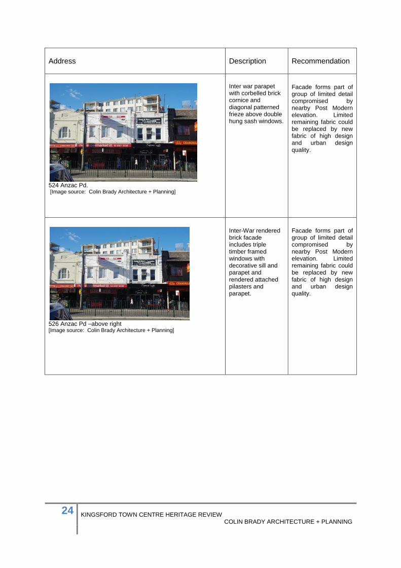
524 Anzac Pd. [Image source: Colin Brady Architecture + Planning]
Inter war parapet with corbelled brick cornice and diagonal patterned frieze above double hung sash windows.
Facade forms part of group of limited detail compromised by nearby Post Modern elevation. Limited remaining fabric could be replaced by new fabric of high design and urban design quality.
526 Anzac Pd –above right [Image source: Colin Brady Architecture + Planning]
Inter-War rendered brick facade includes triple timber framed windows with decorative sill and parapet and rendered attached pilasters and parapet.
Facade forms part of group of limited detail compromised by nearby Post Modern elevation. Limited remaining fabric could be replaced by new fabric of high design and urban design quality.

25 KINGSFORD TOWN CENTRE HERITAGE REVIEW COLIN BRADY ARCHITECTURE + PLANNING
Anzac Parade West Side Address
Description
Recommendation
385-389 Anzac Pd [Image source: Colin Brady Architecture + Planning]
Interwar classicist revival style building substantially intact The location was previously known as Maloney’s Corner.
Maintain volume of building to full structural bay depth – retaining the front room at each level.
367-373 Anzac Pd. [Image source: Colin Brady Architecture + Planning]
Federation shop/residences Originally with post supported ground floor awnings. High parapets have rough cast inserts between brick pilasters and bowed parapet capping above inset arched verandah openings.
Maintain volume of building to full structural bay depth – retaining the front room at each level.
Late Federation Arts and Crafts style compromised by poor alteration to first floor window opening. Strong overall form related to similar forms to opposing side of the road.
Add to list of contributory buildings Maintain facade with restoration of full elevation. Locate any additions behind principle ridgeline.

26 KINGSFORD TOWN CENTRE HERITAGE REVIEW COLIN BRADY ARCHITECTURE + PLANNING
Address
Description
Recommendation
345-351 Anzac Pd. [Image source: Colin Brady Architecture + Planning]
345-351 Anzac Pd. parapet detail. [Image source: Colin Brady Architecture + Planning]
Federation Arts and Crafts Style completed 1918. Symmetrical elevation is compromised by poor cohesion of paint colours.
Maintain facade with restoration of full elevation. Locate any additions behind principle ridgeline.

27 KINGSFORD TOWN CENTRE HERITAGE REVIEW COLIN BRADY ARCHITECTURE + PLANNING
Address
Description
Recommendation
317-323 Anzac Pd. [Image source: Colin Brady Architecture + Planning]
Inter War late Federation incorporating decorative brick pedimented parapets, leadlight casement windows with flat hoods
Maintain facade with restoration of full elevation. Maintain volume of building to full structural bay depth – retain the front room at each level.
315 Anzac Pd. [Image source: Colin Brady Architecture + Planning]
Inter-War retaining late Federation and Inter War Classicist influences Well detailed face brick and flat awning over casement windows.
Maintain facade with restoration of full elevation. Maintain volume of building to full structural bay depth – retain the front room at each level.
279-287 Anzac Rd [Image source: Colin Brady Architecture + Planning]
Inter-War building retaining late Federation detailing. Well detailed face brick and recessed arched vearadahs. Some original shop fronts remaining.
Add to schedule of contributory facades. Maintain facade with restoration of full elevation. Maintain volume of building to full structural bay depth – retain the front room at each level.

28 KINGSFORD TOWN CENTRE HERITAGE REVIEW COLIN BRADY ARCHITECTURE + PLANNING
5.0 Recommendations for Conservation of Significance 5.1 Findings of the Review 5.1.1 The establishment of South Kensington later Kingsford took place in a notably short period from 1900 to the early 1920’s. Establishment of the town centre and related suburb were prompted by extension of the Sydney metropolitan tram system beyond the Randwick Racecourse along Bunnerong Road to Little Bay in December 1901. 5.1.2 Demand for house sites in the area began with the Kensington Model Suburb sales of the 1890s. These were identified by entrepreneur and racing identity Jack O’Dea as a basis for new housing and shop/ residences at South Kensington. O’Dea continued the model suburb concept into degraded lands of the Botany Sand Beds. O’Dea’s interest in cultural activities and benefaction aided the development of South Kensington as a town centre. O’Dea provided social amenity in the Democratic Theatre completed in conjunction with shop/residences at O’Deas Corner between 1912 and 1915. This, the expansion of housing estates and reliable employment at the Randwick and Kensington Race tracks provided the basis for rapid consolidation of the town centre by the 1920’s. 5.1.3 The continuing expansion of South Kensington and nearby Dacey Gardens through the Inter – War years saw residential sites in the town centre progressively converted to retail frontages by overlay of shop frontages. The later Inter-War period saw more substantial commercial buildings occupy remaining open sites including those at Maloney’s Corner to the southern end of the Town Centre and the former stables and feed wholesalers at the northern, racecourse end of the town centre. 5.1.4 Between 1900 and 1960 Kingsford Town Centre established and maintained a cohesive two storey setting of shopfronts and shop / residences exhibiting styles of the Federation and Inter War periods set within common alignment and varied scale. The assembly of varied styles retained cohesion through common proportions and external finishes, largely of face brick and moulded render. 5.1.5 Changes in demography, demand for residential accommodation, patterns of shopping and frequency of dining out, substantially altered the urban form of Kingsford Town Centre from the 1960’s onwards. The contemporary Kingsford Town Centre exhibits a wide variety of built forms, characterised by recent apartment buildings rising substantially and intermittently above the historically established street frontage of 2 storey forms with raised parapets conforming to a three storey height of contemporary construction. 5.1.6 To a limited degree, the continuity of street awnings and largely narrow fronted premises serve to mitigate the overbearing nature of recent apartment buildings, as does the complexity of signage associated with the profusion of restaurants in the town centre.

29 KINGSFORD TOWN CENTRE HERITAGE REVIEW COLIN BRADY ARCHITECTURE + PLANNING
5.1.7 Change from a tram based system of transport to buses and private vehicles and removal of overhead wiring has reduced the visual clutter of the Anzac Parade carriageway although median fencing, traffic lights and parking sign posts have limited the visual benefits of simplified overhead wiring. Further visual clutter may be anticipated with the current construction of a new light rail system. 5.1.8 The change of Kingsford Town Centre from a broad service ‘high street’ to a specialised enclave of, largely Asian cuisine, restaurants has been a significant factor in the aesthetic character of the Town Centre. The dominance of restaurant activities has provided a dynamic setting at night with brightly illuminated street frontages. 5.1.9 These changes have been accompanied by a continuation of facade replacement evident from the early Inter War years.

30 KINGSFORD TOWN CENTRE HERITAGE REVIEW COLIN BRADY ARCHITECTURE + PLANNING
5.2 Recommendations Based upon the historic background and observed status of existing fabric the following recommendations are made to maintain the heritage significance of Kingsford Town Centre. 5.2.1 New works should maintain and reinstate the emphasis of street corners and cross routes. These are characteristics of the historic townscape that have been eroded by later 20th Century development. New infill buildings to corners should reinforce historic height lines remaining at and adjacent to intersections.
1970’s infil building at corner of Meeks Street and Anzac Parade [Image source: Colin Brady Architecture + Planning]
5.2.2 Infill works should maintain the scale and proportions of building articulation. Many infill works defer to pragmatic construction ignoring the solid to void ratios and proportions of historic frontages, and the interplay of material finishes.
1990s infill development to western side of Anzac Parade [Image source: Colin Brady Architecture + Planning]
31 KINGSFORD TOWN CENTRE HERITAGE REVIEW COLIN BRADY ARCHITECTURE + PLANNING
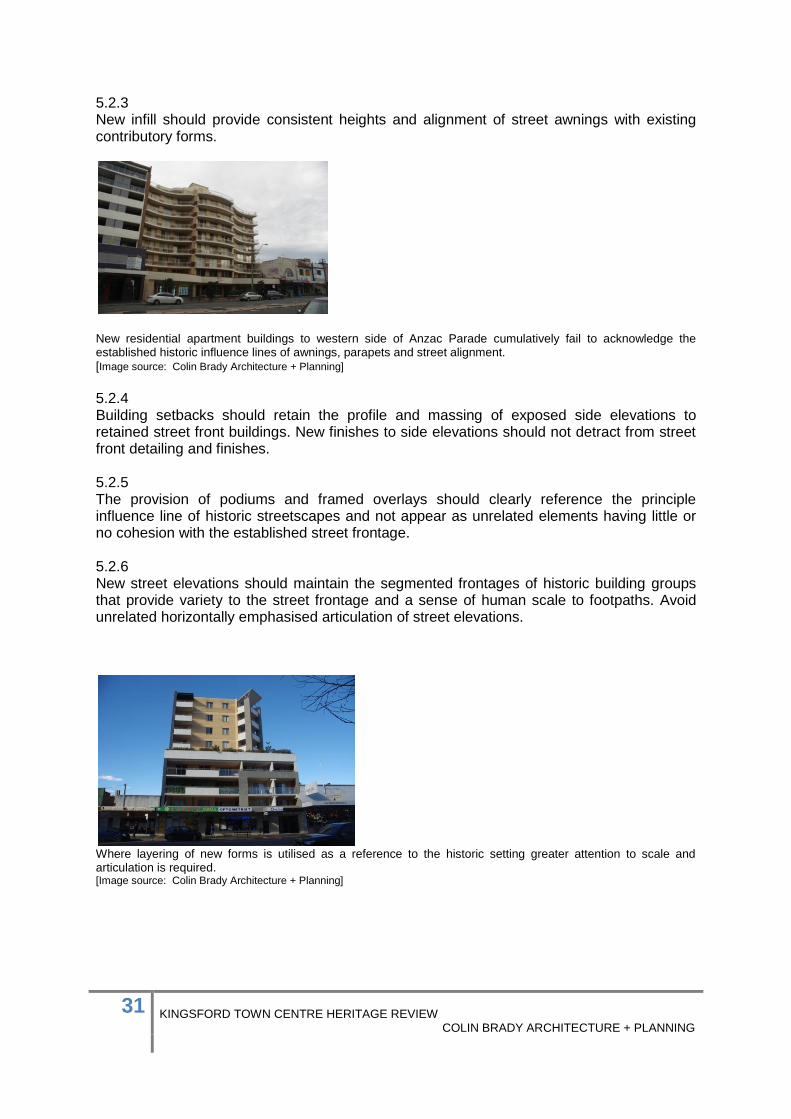
5.2.3 New infill should provide consistent heights and alignment of street awnings with existing contributory forms.
New residential apartment buildings to western side of Anzac Parade cumulatively fail to acknowledge the established historic influence lines of awnings, parapets and street alignment. [Image source: Colin Brady Architecture + Planning]
5.2.4 Building setbacks should retain the profile and massing of exposed side elevations to retained street front buildings. New finishes to side elevations should not detract from street front detailing and finishes. 5.2.5 The provision of podiums and framed overlays should clearly reference the principle influence line of historic streetscapes and not appear as unrelated elements having little or no cohesion with the established street frontage. 5.2.6 New street elevations should maintain the segmented frontages of historic building groups that provide variety to the street frontage and a sense of human scale to footpaths. Avoid unrelated horizontally emphasised articulation of street elevations.
Where layering of new forms is utilised as a reference to the historic setting greater attention to scale and articulation is required. [Image source: Colin Brady Architecture + Planning]

32 KINGSFORD TOWN CENTRE HERITAGE REVIEW COLIN BRADY ARCHITECTURE + PLANNING
5.3 Facade Retention The remaining fabric from the early 20th Century is now of limited extent in the overall streetscape and likely to be further reduced by ongoing residential development. Where contributory buildings are identified as having significant street facades the following measures are recommended to maintain the significance of the identified fabric. 5.3.1 The substantial depth of sites to both sides of Anzac Parade provides opportunity for considerable development that retains historic street frontages in depth. The notion of facade retention was and remains predicated on the conservation of fabric in a meaningful way, including presentation in depth and not as a thin veneer of single wall thickness. 5.3.2 The form and articulation of existing historic street frontages require that these be retained to a minimum of the first structural bay and or first room to preserve inset verandas, expressed side elevations, roof forms and overall modelling of the built form. 5.3.3 The retention of street frontages requires a commensurate level of restoration to reinstate the primacy of the historic fabric in the context of the streetscape. Restoration should enhance the quality of finishes, form and detail thus balancing the impact of larger works set back from the retained fabric. 5.3.4 Retained fabric should not be ‘ghosted’ through the application of monochromatic colour schemes, the removal of detail from openings, deletion of historic signage, unsympathetic replacement of awnings, shop fronts and lighting and the enclosure of openings. 5.3.5 Retained fabric should not be neutralized by incorporation in new works as empty spaces without function or screened by planting, signage or other new works.
Facade retention at Bondi Junction retaining original street faced as an open frame. [Image source: Colin Brady Architecture + Planning]

33 KINGSFORD TOWN CENTRE HERITAGE REVIEW COLIN BRADY ARCHITECTURE + PLANNING
5.3.6 A high degree of interpretation should be included in retained fabric utilizing elements of historic content, signage, lighting and finishes relating to the known history of the building and its setting. 5.3.7 Retained detail, signage and finishes should provide a patina of age in retained facades.
Successive layers of signage to shop parapets on eastern side of Anzac Parade Kingsford. [Image source: Colin Brady Architecture + Planning]
5.3.8 New services should be discretely integrated within and behind retained street frontages and not above awnings.
Exposed air conditioning units above street awnings to eastern side of Anzac Parade. [Image source: Colin Brady Architecture + Planning]

34 KINGSFORD TOWN CENTRE HERITAGE REVIEW COLIN BRADY ARCHITECTURE + PLANNING
5.3.9 New signage should be set below the street awning or on the front downturn of the awning. Signage above the awning level detracts from the detail and quality of historic fabric.
Signage fixed to upper parapet on western side of Anzac Paraded [Image source: Colin Brady Architecture + Planning]
5.3.10 Street elevations should maintain a continuity of colour schemes limiting variation to awning signage.
Widely contrasting colour schemes to western side of Anzac Parade. [Image source: Colin Brady Architecture + Planning]

35 KINGSFORD TOWN CENTRE HERITAGE REVIEW COLIN BRADY ARCHITECTURE + PLANNING
6.0 Implementation of Recommendations To assist in conservation of Kingsford Town Centre’s Heritage Significance it is recommended that. 6.1 Clauses in the DCP for the adjacent Kensington Town Centre Part 4.2.6 Contributory Buildings be incorporated into the DCP for Kingsford Town Centre. 6.2 Buildings identified as of contributory significance in this review and not currently included in schedules of contributory buildings are included in those schedules. 6.3 Recommendations included in this review are incorporated into the Kingsford Town Centre DCP. 6.4 Opportunities for interpreting the cultural diversity of Kingsford Town Centre within historic and contemporary built fabric should be supported.

36 KINGSFORD TOWN CENTRE HERITAGE REVIEW COLIN BRADY ARCHITECTURE + PLANNING
APPENDIX 1 STATE HERITAGE REGISTER LISTING FOR 424-436 ANZAC PARADE O’DEAS CORNER

37 KINGSFORD TOWN CENTRE HERITAGE REVIEW COLIN BRADY ARCHITECTURE + PLANNING
ITEM DETAILS
Name of Item
O’Deas Corner
Other Name/s Former Name/s
Group previously included Democratic Theatre [now demolished]
Item type
Built
Item group
Row of Shops with residences above
Item category
Group/Collection: Main Street retail with residences above. Category: Retail /Residential Parish: Alexandria County: Cumberland Local Govt. Area: Randwick Local Aboriginal Land: La Perouse
Area, Group, or Collection Name
O’Deas Corner
Street number
424-436
Street name
Anzac Parade [formerly Bunnerong Road]
Suburb/town
Kingsford Postcode 2032
Local Government Area/s
Randwick
Property description
Building group at 424-436 Anzac Parade Kingsford are two storey shop residences facing Anzac Parade and returning to Middle Street Kingsford. The buildings are the remaining element of a longer row including the Democratic Theatre located toward the southern end of the row.
Location - Lat/long
Latitude
-33.921 Longitude 151.224
Location - AMG (if no street address)
Zone
Easting Northing
Owner
Current use
Retail/residential
Former Use
Retail/residential

38 KINGSFORD TOWN CENTRE HERITAGE REVIEW COLIN BRADY ARCHITECTURE + PLANNING
Statement of significance
The building group at 424-436 Anzac Parade Kingsford, identified as O’Deas Corner, is significant as a well detailed example of a Federation shop / residence group defining suburban main streets of the Federation era and in particular those served by Sydney’s expanding tram network. The building group previously included the Democratic Theatre and an additional shop/ residence to the southern end. The building group retains substantial detailing in the Federation Arts and Crafts and Federation Freestyles. The building group is associated with noted local resident Frank O’Dea – bookmaker, real estate developer and promoter of cultural activities in the foundation years of South Kensington later renamed Kingsford. O’Dea’s Democratic Theatre previously within the building group provided a family theatre catering for film, stage performances, musicals and community balls through to its later evolution, first as the Reno Theatre and then the Odeon Cinema destroyed by fire in 1965. The replacement of the theatre by the Castellorizian Club in the 1970’s maintained the community focus initially established by O’Deas Democratic Theatre.
Level of Significance
National
State
Local
DESCRIPTION
Designer
Not known
Builder/ maker
Not known
Physical Description
Of two storey masonry construction the shop/residences belonging to the O’Deas Corner group at 424-436 Anzac Parade Kingsford are two storey shop/ residences facing Anzac Parade and returning to Middle Street Kingsford. The buildings are the remaining element of a longer row including the Democratic Theatre located toward the southern end of the row. The remaining group have first floor elevations defined by deep set verandas within face brick arches incorporating quarry faced stone voussoirs and keystones [now painted]. Raised parapets incorporate panels of deep green glazed brick set between brick pilasters and face brick panels now painted. Parapets are raised at the corner and above two shops appearing to have been at the centre of the Anzac Parade elevation. Moulded render spheres and classical brackets decorate the parapet capping. The parapet is chamfered at the return corner to Middle Street and bears the title O’Deas Corner 1912 in raised Arts and Crafts style lettering. Metal suspension rods support deep metal clad awnings appearing to have been altered several times. Ground floor level shopfronts are of post war form and detail largely from the 1960’s-70’s. Little original detail is evident at this level.

39 KINGSFORD TOWN CENTRE HERITAGE REVIEW COLIN BRADY ARCHITECTURE + PLANNING
Interiors have not been inspected.
Physical condition and Archaeological potential
The remaining elements of the building group are in good condition with substantial alteration of street level shop fronts and interiors and of the overall exterior to 434-436 Anzac Parade. The potential for uncovering archaeological remnants should be considered when carrying out any works on 424-436 Anzac Parade Kingsford.
Construction years
Start year 1911
Finish year 1912
Circa
Modifications and dates
Reconstruction of Democratic Theatre c. 1920’s. Demolition of theatre after fire in 1965. Demolition of southern end to group. C 1965 Construction of Castellorizian Club C. 1973 Alterations to shop fronts – 1960’s Alteration to street elevations adjacent to Castellorizian Club c. 1990’s.

40 KINGSFORD TOWN CENTRE HERITAGE REVIEW COLIN BRADY ARCHITECTURE + PLANNING
HISTORY
Historical notes
Historical Timeline Development of the area followed lifting of restrictions on lands within the Sydney Water Reserves extending from the former Sydney Common south to Botany Bay. In 1889 the Australian Cities Investment Corporation Ltd announced a design competition for development of Kensington. The winning entry titled Rus In Urb by Vernon, Joseland, Oxley and Mocatte, announced in June 1889, preceded the depression of the early 1890’s. The initial subdivision of the Model Suburb of Kensington was offered for sale on Saturday 11 April 1891 as the Kensington Freehold Estate about Doncaster Avenue and cross streets leading to Bunnerong Road /Eastern Avenue. Extension of the Sydney tram service beyond the junction of Randwick and Alison Roads occurred in December 1901, improving access to the sparsely populated area of South Kensington and the open sand hills beyond the Kensington Racetrack. Estate subdivisions at South Kensington began in 1904 with the Crown Lands Kensington Auction. Subsequent estate sales were concentrated in the period 1910 – 1919. John (Jack) Henry O’Dea 1875-1945 was born on 27 November 1875 in the Ahaura District of Reefton New Zealand. O’Dea came to Australia about 1890 settling in Melbourne. In 1895 at 19 years of age O’Dea was running a successful business in Prahran Victoria. An enthusiastic better on horse racing O’Dea then became a bookmaker. Moving to Sydney soon after, Jack O’Dea married Margaret (Mary) Donoghue on 16 July 1903 at St Francis Roman Catholic Church Paddington. Mary was born in Sydney 1881 the daughter of Hugh Donoghue, publican, and his wife Bridget nee Leo. Jack’s sister in law Eva O’Dea was the witness. At the time both parties lived in Woollahra. The O’Deas soon after moved to Kensington, dwelling at 11 Eastern Avenue Kensington. Jack O’Dea became a foundation member of the Pony Bookmakers association in May 1906, holding a bookmakers licence at Randwick for more than 30 years. [Sydney Sportsman] O’Dea became involved in development of the still largely vacant area then named South Kensington [and later Kingsford]. O’Dea built the first ‘shop residences’ at South Kensington on Bunnerong Road, these including the remaining buildings at Anzac Parade identified as O’Deas Corner 1912 [ 424-436 Anzac Parade Kingsford]. O’Deas activities included the building of over 100 houses in South Kensington O’Dea based his developments on the Model Suburb of Kensington, by this time considerably diluted from its original concept.

41 KINGSFORD TOWN CENTRE HERITAGE REVIEW COLIN BRADY ARCHITECTURE + PLANNING
O’Dea combined real estate development with his bookmaking activities and entered Randwick Council in 1910, when the ward he represented was practically a sand hill. In conjunction with his book making and real estate activities O’Dea was associated with Schools of Arts and debating societies. This appears to have influenced the form of his development at O’Deas Corner. Initial listings of the shop residences forming O’Deas Corner occur from 1914 [Sands Directory]. Whilst most occupants of the building are listed as retail shops a newspaper reference of that year identifies O’Dea’s newly completed Democratic Theatre at Bunnerong Road South Kensington. Subsequent records identify the Democratic Theatre both as a venue for live performances and film. The first licence for a picture theatre in Kensington is recorded in 1914 at Eastern Avenue, the then location of O’Dea’s residence. Subsequent listings of the building group identify the picture theatre from 1916 onwards. Later images show the, by then Odeon theatre, set between matching street frontages to both sides. The images support the theatre having initially been of similar form to the remaining street elevations or closely related in style. A series of operators are recorded for the theatre. On 11 September 1923 a send-off was held at the Democratic Theatre for Mr & Mrs Jack O’Dea, an image of the event labelled as the Kensington School of Arts may actually show the interior of the Democratic Theatre as it then stood. Records indicate successive operators of the Democratic Theatre through the Inter- War years with adjacent business remaining small retail undertakings. In 1927 Wilson and Smith are recorded as the previous operators of the Democratic Theatre and in 1929 the Democratic Theatre is noted as the subject of a visit by politicians inspecting the Australian Raycophone sound equipment. In November 1932 the theatre was purchased by business man Bill Lowe together with the Kensington Kinema and Dacey Gardens theatres. The announcement [possibly incorrectly] noted Lowes intent to rename the Democratic as the Hollywood and the Kinema as the Reno Theatre. Lowes ownership was dissolved in 29 April 1933, the Sydney Truth announcing the opening of the Reno Theatre at the site on 6 May 1933 with a Western Electric Sound System. Records of the theatre from this period indicate a capacity of 1,387 patrons identifying this as the theatre seen in images of the 1940’s and distinctly of later construction to the shop fronts on either side. The Reno Theatre remained in operation as a family theatre including live pantomimes, musical comedy and film screenings until 21st May 1947. The theatre reopened the following day as Kingsford Odeon operated by Acme Theatre Circuit and continuing under this name until destroyed by fire on 20 October 1965. It is not clear if the shop front on the southern side of the theatre was also burnt. The ruins were demolished to enable construction of the Castellorizian Club. This was in turn

42 KINGSFORD TOWN CENTRE HERITAGE REVIEW COLIN BRADY ARCHITECTURE + PLANNING
demolished in the early 21st Century to be replaced by a residential apartment complex. Seven of the original shop/residences of O’Deas Corner remain, those to the southern end adjacent to the residential apartment complex having been extensively altered with sandstone facing at street level and metal slat cladding to the first floor. The remaining five shopfronts retain original first floor detailing with localized alteration. All have been extensively altered at ground floor with varied later 20th Century shopfronts beneath what appears to be the original suspended awning.
THEMES
National historical theme
Developing Australia’s Cultural Life 8.10.4- Developing Australia’s Cultural Life pursuing excellence in the arts and sciences.
State historical theme
Creative Endeavour- exemplar of an architectural style.
APPLICATION OF CRITERIA

43 KINGSFORD TOWN CENTRE HERITAGE REVIEW COLIN BRADY ARCHITECTURE + PLANNING
Historical significance SHR criteria (a)
The site of O’Deas Corner, at 424 - 436 Anzac Parade Kingsford, has historical associations with the early establishment of South Kensington as a speculative suburb responding to extension of the Randwick tram service in 1901. The remaining shop/residences are recorded as the first in the suburb and demonstrate the entrepreneurial undertakings of prominent citizens during the rapid expansion of Sydney’s suburbs during the Federation era. The building records the establishment of new residential suburbs in south eastern Sydney in the period 1885-1915 following commissioning of the Nepean Water Supply System and removal of restrictions on industrial activities adjacent to the Sydney Water Reserves to the west The buildings at O’Deas Corner, 424-436 Anzac Parade Kingsford, in their scale and streetscape setting retain evidence of the form and detailing of shop/residences established in conjunction with expansion of Sydney’s tramways of the late 19th and early 20th Centuries.
Historical association significance SHR criteria (b)
The O’Deas Corner buildings, at 424-436 Anzac Parade Kingsford, have association with the early entrepreneur and notable citizen of Kensington John (Jack) Henry O’Dea 1875-1945.
Aesthetic significance SHR criteria (c)
The O’Deas Corner buildings, at 424-436 Anzac Parade Kingsford, demonstrate aesthetic characteristics of the Federation Freestyle and Federation Arts and Crafts styles. External detailing includes arched veranda recesses quarry faced stone voussoirs and keystones, glazed and face brick detailing, raised parapets and detailed metal suspension rods to awnings. ODEAS BUILDING 1912 is defined by raised lettering to the splayed corner elevation identifying the locality.
Social significance SHR criteria (d)
The building group has high social significance as the remaining elements of a building group including The Democratic Theatre, later Reno Theatre and Odeon Theatre providing a pivotal element of society in Kingsford from 1914-1965.
Technical/Research significance SHR criteria (e)
The subject building group demonstrate the technical skills of brick making in the Federation Era and technical information common to shop residences of the period.
Rarity SHR criteria (f)
The building group are the earliest shop residences in Kingsford and rare in the degree of architectural detailing of street elevations
Representativeness SHR criteria (g)
The building group is representative of Federation shop residences combining Federation Arts and Crafts and Federation Freestyle architecture. The group retains a number of key features of the styles including the use of glazed and face brick with sandstone to external elevations.

44 KINGSFORD TOWN CENTRE HERITAGE REVIEW COLIN BRADY ARCHITECTURE + PLANNING
Integrity
The building group has been extensively altered at street level and to the exterior of the southern two street fronts. Despite these changes the core form and substantial external detail remain to the prominent street corner and street frontages.
HERITAGE LISTINGS
Heritage listing/s
Randwick LEP 2012

45 KINGSFORD TOWN CENTRE HERITAGE REVIEW COLIN BRADY ARCHITECTURE + PLANNING
INFORMATION SOURCES
Type Author/Client Title Year Repository
Media Trove Newspapers 1895-1955
Various Publications
1895-1955
National Library of Australia
Book Kensington, N.S.W. : New South Wales University Press [in association with] Randwick Municipal Council, c1985.
Randwick A Social History
1985 Bowen Library Maroubra Junction
Research Colin Brady Architecture + Planning
2016 Randwick Council
Council research
Randwick Council
RECOMMENDATIONS
Recommendations A Heritage Impact Statement should be provided to accompany any development application for major works to the building. Any additions and alterations shall be in accordance with the relevant planning controls.
SOURCE OF THIS INFORMATION
Name of study or report
Kingsford Town Centre Heritage Review Year of study or report
2016
Item number in study or report
N/A
Author of study or report
Colin Brady
Inspected by
.
NSW Heritage Manual guidelines used?
Yes No
This form completed by
Colin Brady Date 04.08.2016

46 KINGSFORD TOWN CENTRE HERITAGE REVIEW COLIN BRADY ARCHITECTURE + PLANNING
IMAGES
Image caption
Kingsford Odeon
Image year
1947 Image by Acme Theatres Image copyright holder
NLA Ref Hood- 21172
Reno-Odeon Theatre in 1947 with street frontages of O’Deas Corner building group at left and right.

47 KINGSFORD TOWN CENTRE HERITAGE REVIEW COLIN BRADY ARCHITECTURE + PLANNING
IMAGES
Image caption
Kingsford Reno Theatre interior 1946
Image year
1646 Image by Acme Theatres Image copyright holder
NLA
Reno Theatre interior 1946 - the theatre then forming part of O’Deas Corner building group.

48 KINGSFORD TOWN CENTRE HERITAGE REVIEW COLIN BRADY ARCHITECTURE + PLANNING
IMAGES
Image caption
Current map locating 424-436 Anzac Parade Kingsford
Image year
2013 Image by Google Maps Image copyright holder
424-436 Anzac Parade Kingsford
424-436 Anzac Parade
Kingsford
Anzac Parade

49 KINGSFORD TOWN CENTRE HERITAGE REVIEW COLIN BRADY ARCHITECTURE + PLANNING
IMAGES
Image caption
Historical Aerial Imagery of 424-436 Anzac Parade Kingsford with the adjacent Democratic Theatre
Image year
1943 Image by NSW Mapping
NSW Mapping Image copyright holder
NSW Mapping
Democratic Theatre
O’Deas Corner

50 KINGSFORD TOWN CENTRE HERITAGE REVIEW COLIN BRADY ARCHITECTURE + PLANNING
IMAGES
Image caption
424-436 Anzac Parade Kingsford at left with former location of Democratic Theatre at centre of image.
Image year
2016 Image by Colin Brady Image copyright holder

51 KINGSFORD TOWN CENTRE HERITAGE REVIEW COLIN BRADY ARCHITECTURE + PLANNING
IMAGES
Image caption
Jack O’Dea, Randwick’s Cultured Bookmaker
Image year
1926 Image by
Sunday Times Sydney NSW 25 April 1926
Image copyright holder
National Library of Australia

52 KINGSFORD TOWN CENTRE HERITAGE REVIEW COLIN BRADY ARCHITECTURE + PLANNING
IMAGES
Image caption
424-436 Anzac Parade Kingsford, showing elevation at corer of Middle Street with O’DEAS CORNER 1912 in raised Arts & Crafts lettering to chamfered parapet.
Image year
2016 Image by Colin Brady Image copyright holder

53 KINGSFORD TOWN CENTRE HERITAGE REVIEW COLIN BRADY ARCHITECTURE + PLANNING
IMAGES
Image caption
424-436 Anzac Parade Kingsford, showing first floor detailing viewed looking east.
Image year
2016 Image by Colin Brady Image copyright holder

54 KINGSFORD TOWN CENTRE HERITAGE REVIEW COLIN BRADY ARCHITECTURE + PLANNING
IMAGES
Image caption
424-436 Anzac Parade Kingsford, showing southern end of building group at centre left with later façade alterations
Image year
2016 Image by Colin Brady Image copyright holder

55 KINGSFORD TOWN CENTRE HERITAGE REVIEW COLIN BRADY ARCHITECTURE + PLANNING
IMAGES
Image caption
424-436 Anzac Parade Kingsford, showing northern side return to Middle Street viewed looking southwest.
Image year
2016 Image by Colin Brady Image copyright holder